Embed Size (px)
Citation preview

11 December 2008 P. Everaers, Eurostat, Directorate D
Data Requirements and Conceptual Framework for Agricultural Statistics
Discussion P. Everaers (Eurostat)
‘Agriculture – environment linkages including land use’

11-Dec-2008
Overview
The conceptual framework : agriculture and environment, land use : a mind setter, but not yet a conceptual model
To operationalize ;choices to be made, start with the basic entities
Starting from where : a practical approach land use : the LUCAS example.
Questions for discussion

11-Dec-2008
Elements of a conceptual model (in sociological research terminology)
Choice of entities
Choice of indicators and subsequently variables and items
Scheme of possible relations
In a context : paradigma

11-Dec-2008
Conceptual model : Operationalisation
Theoretical concept
Theory» indicator
Paradigma
Measurement
theory variable
» item

11-Dec-2008
What we have : the conceptual framework
Is a mind map

11-Dec-2008
The context will lead to the theoretical concepts and determine the (core) variables : there are at least three starting points
1.Supply and utilization of agricultural products Early warning Efficient Market system
2.Poverty and Hunger reduction Food security
3.Agricultures effect on the environment Climate change

11-Dec-2008
Or to start from the current situation in agricultural statistics request the choice of a context
Nothing or very poorly developed, marginally functioning
NSDS as basis: to be adapted
Developed systems
To search for the common denominator

11-Dec-2008
The basic entities : the fundamental choice that at the end defines the quality of the integrated system we are aiming for.
We have to use the entity that facilitates all aims
Survey base
Based on administrative sources
Based on ‘more advanced’ techniques

11-Dec-2008
Relation between the basic entities
Area/Parcel
Person/family/Household
Farm/holding
Spatialcoordinates

11-Dec-2008
The example of LUCAS : Land Use Cover Areal frame Survey

11-Dec-2008
What is LUCAS?
LUCAS is a field sample survey for collecting data on land cover/use and agro-environmental indicators
Organised by Eurostat every 3 years
LUCAS data is used for producing harmonised land cover/use data for EU countries
Main data users are DG ENV, DG JRC, DG ENTR, DG ARGI, DG REGIO and European Environment Agency

11-Dec-2008
What is LUCAS?
LUCAS is a field sample survey for collecting data on land cover/use and agro-environmental indicators
Organised by Eurostat every 3 years
LUCAS data is used for producing harmonised land cover/use data for EU countries
But can also be used to collect and link with a lot of other information

11-Dec-2008
1 100 000 points
Photointerpretation:
Classification in
7 strata
Ground survey
Parameters•Land cover•Land use•Transect, •etc.Dissemination
FOREST AREA
GRASSLAND
CEREALS
SHRUBLAND,
ARTIFICIAL NON BUILT-UP AREAS
BARE LAND
OTHER PERMANENT CROPS
NON PERMANENT INDUSTRIALCROPSOTHER WOODED AREA
BUILT-UP AREAS
WATER
PERMANENT CROPS
ROOT CROPS
FODDER CROPS
DRY PULSES, VEGETABLES ANDFLOWERS
LUCAS data collection process
Sample of 260,000 pts
11-Dec-2008
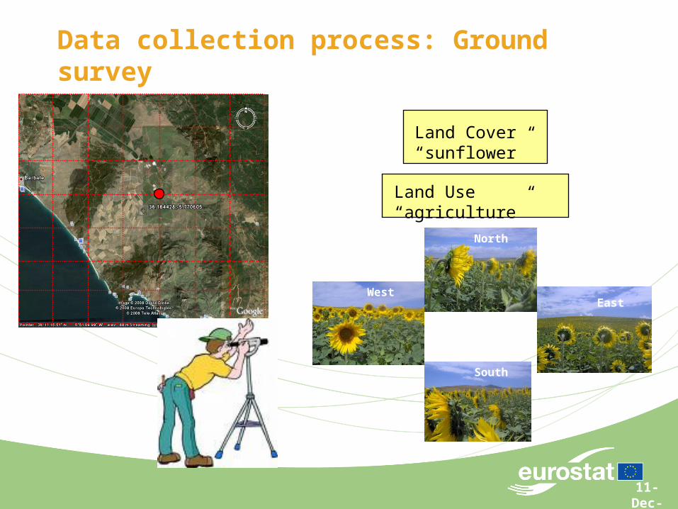
WestEast
North
South
Land Cover “sunflower”
Land Use “agriculture”
Data collection process: Ground survey

11-Dec-2008
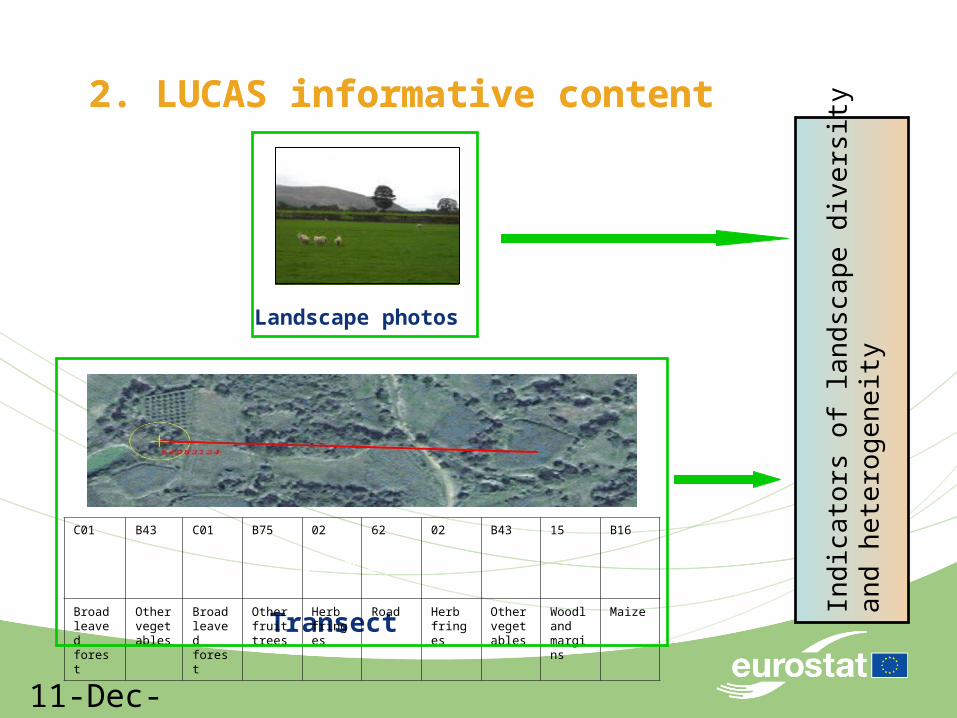
1. LUCAS informative content
Land cover and land use
FOREST AREA
GRASSLAND
CEREALS
SHRUBLAND,
ARTIFICIAL NON BUILT-UP AREAS
BARE LAND
OTHER PERMANENT CROPS
NON PERMANENT INDUSTRIALCROPSOTHER WOODED AREA
BUILT-UP AREAS
WATER
PERMANENT CROPS
ROOT CROPS
FODDER CROPS
DRY PULSES, VEGETABLES ANDFLOWERS
Lucas 2006 – Land cover statistics
11-Dec-2008
250 m eastwards
Transect
C01 B43 C01 B75 02 62 02 B43 15 B16
Broadleaved forest
Other vegetables
Broadleaved forest
Other fruit trees
Herb fringes
Road Herb fringes
Other vegetables
Woodland margins
Maize
2. LUCAS informative content
Ind
ica
tors
of l
and
sca
pe d
iver
sity
a
nd h
ete
rog
en
eity
Landscape photos
2. LUCAS informative content

11-Dec-2008
Spatial coordinates as starting point for an integrated data base
Spatial coordinates
to be included in
Orthogonal photographs : info on sample frame Remote sensing : info on land and soil, events Surveys : info on persons, households, farms, holdings Observations : info on soil, eco system, environment Administrative sources : info on production, sales, trade

11-Dec-2008
Multiple users !!
LUCASMultipurpose
platform
Key customers:• DG ENV• DG JRC• DG ENTR• DG AGRI• DG REGIO• EEA
INSPIRESpatial Metadata
Land use Data CentreEEA
Shared EnvironmentalInformation SystemDG ENV
GMESGEOLANDDG ENTR
Technical supportDG JRC
SOIL SAMPLE

11-Dec-2008
Questions / points for discussion
What do we miss when we measure on the household level? Can we manage with aggregated information
The strategy should distinguish levels of implementation according to the context (paradigma) in combination with the level of development (nothing to poor systems – NSDS – developed systems), and accordingly should use different levels of conceptual models.
One global model, is this possible ?

11-Dec-2008
Q and D : Cont’d
The entity to start with in the integrated (conceptual and data) model is on the spatial level : the spatial coordinate or the area code
Is the current draft strategy in its conceptual model maybe too much developed country oriented : should we not focus on the MDG related actions?
A layered conceptual model, also from the point of view of feasibilty for introducing the strategy seems to be needed

11 December 2008 P. Everaers, Eurostat, Directorate É
Thank you