Embed Size (px)
Citation preview
Mountain Areas in Europe – Final Report
189
10. Typologies of European mountain areas This chapter brings together data and information presented in the previous chapters, with the aim of providing a diagnosis in the form of three typologies of the mountains of the study area, based on available quantitative information. 10.1 Principles for typology development Chapters 4, 5, 6, 7 have presented a number of profiles and trends within the mountain regions of the study area. The compilation and analysis of this information is a key element of the process to fulfil one objective of the project: to propose typologies of mountain areas in Europe. We have developed three typologies in order to have different composite perspectives on mountain areas, according to the following themes:
• social and economic capital; • infrastructure, accessibility and services; • land use and land covers.
The social and economic processes taking place in mountain areas are often described. As shown in Chapter 5 and discussed also in Chapter 9, these areas have to struggle with difficult demographic processes (e.g., overageing of population, migration processes) and economic situations (e.g., lack of investment, agriculture remaining as an important sector). The typology on ‘social and economic capital’ draws on data presented in Chapters 5, 6 and 7. The aim of the typology on ‘infrastructure, accessibility and services’ is to provide insight into public infrastructure supply such as universities and airports, as well as linear transport infrastructure as road and railway networks. It brings together many of the issues presented in Chapter 7. The environment is one of the most important fields of concern in mountain areas. Hence, a typology on ‘land use and land covers’ takes into account different aspects of land covers and uses, and environmental potentials, drawing mainly on data from Chapter 4. The typologies are based on statistical approaches and constructed at the level of national massifs, i.e. groupings of mountain municipalities, on the basis of high/low values for a set of indicators; the threshold values are explained below. Since some data are missing for some countries (Annex 1), it has not been possible to use cluster analysis or other multi-variate techniques to construct the typologies. 10.2. Typology for social and economic capital Three quantitative variables are used for the typology on social and economic capital: population density, population trend and access to markets. Other relevant indicators were also considered, but did not change the overall picture significantly. The three selected dimensions are divided into the categories shown in Table 10.1.
Mountain Areas in Europe – Final Report
190
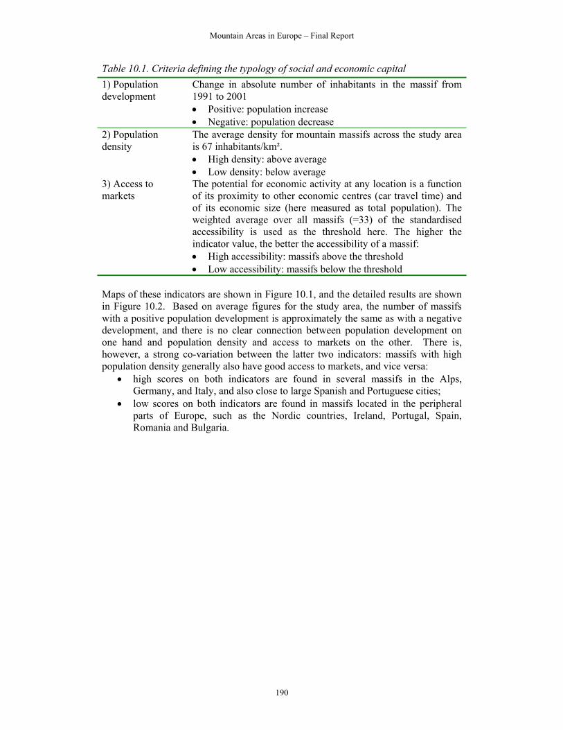
Table 10.1. Criteria defining the typology of social and economic capital 1) Population development
Change in absolute number of inhabitants in the massif from 1991 to 2001 • Positive: population increase • Negative: population decrease
2) Population density
The average density for mountain massifs across the study area is 67 inhabitants/km². • High density: above average • Low density: below average
3) Access to markets
The potential for economic activity at any location is a function of its proximity to other economic centres (car travel time) and of its economic size (here measured as total population). The weighted average over all massifs (=33) of the standardised accessibility is used as the threshold here. The higher the indicator value, the better the accessibility of a massif: • High accessibility: massifs above the threshold • Low accessibility: massifs below the threshold
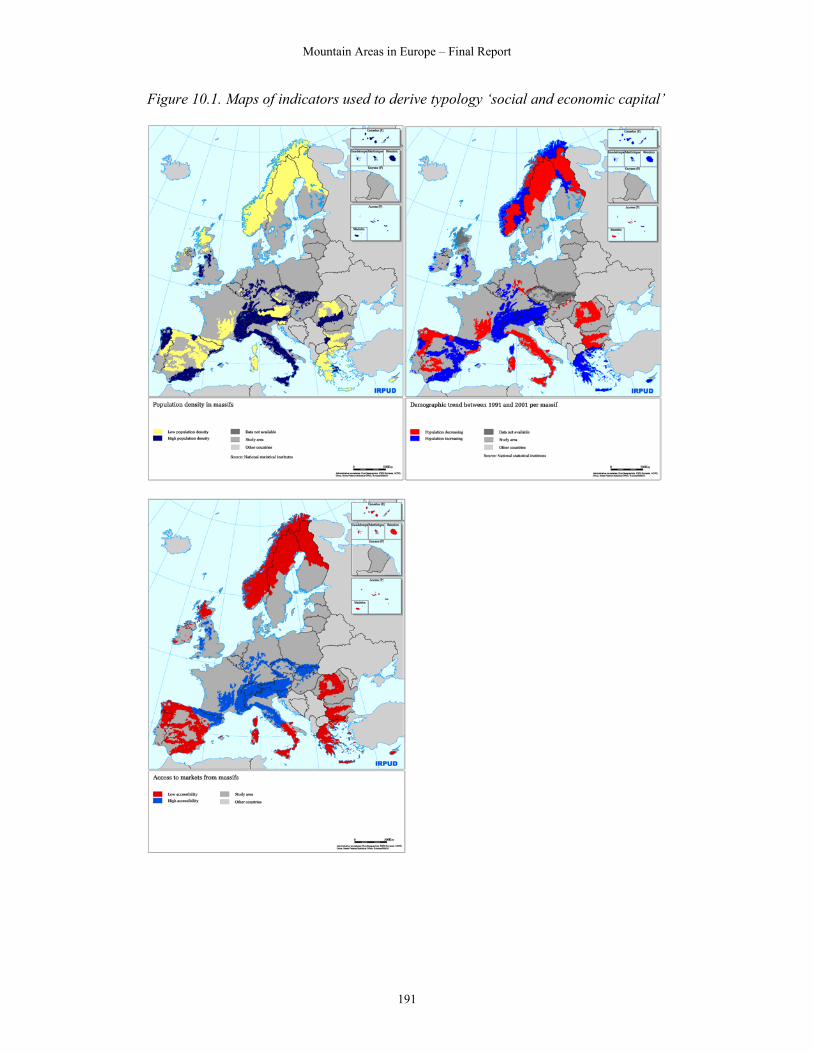
Maps of these indicators are shown in Figure 10.1, and the detailed results are shown in Figure 10.2. Based on average figures for the study area, the number of massifs with a positive population development is approximately the same as with a negative development, and there is no clear connection between population development on one hand and population density and access to markets on the other. There is, however, a strong co-variation between the latter two indicators: massifs with high population density generally also have good access to markets, and vice versa:
• high scores on both indicators are found in several massifs in the Alps, Germany, and Italy, and also close to large Spanish and Portuguese cities;
• low scores on both indicators are found in massifs located in the peripheral parts of Europe, such as the Nordic countries, Ireland, Portugal, Spain, Romania and Bulgaria.
Mountain Areas in Europe – Final Report
191
Figure 10.1. Maps of indicators used to derive typology ‘social and economic capital’
Mountain Areas in Europe – Final Report
192
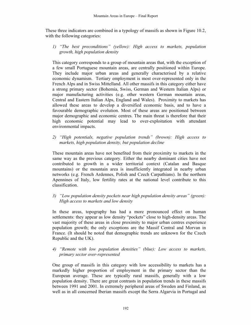
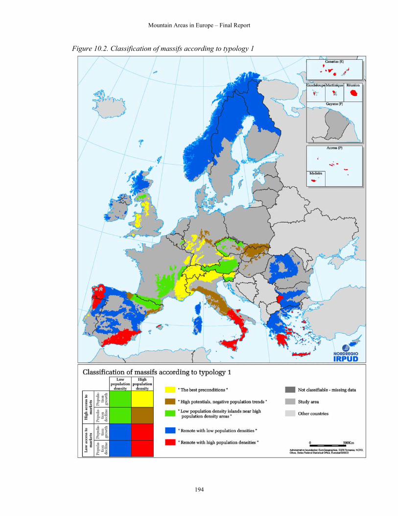
These three indicators are combined in a typology of massifs as shown in Figure 10.2, with the following categories:
1) “The best preconditions” (yellow): High access to markets, population growth, high population density
This category corresponds to a group of mountain areas that, with the exception of a few small Portuguese mountain areas, are centrally positioned within Europe. They include major urban areas and generally characterised by a relative economic dynamism. Tertiary employment is most over-represented only in the French Alps and in Swiss Mittelland. All other massifs in this category either have a strong primary sector (Bohemia, Swiss, German and Western Italian Alps) or major manufacturing activities (e.g. other western German mountain areas, Central and Eastern Italian Alps, England and Wales). Proximity to markets has allowed these areas to develop a diversified economic basis, and to have a favourable demographic evolution. Most of these areas are positioned between major demographic and economic centres. The main threat is therefore that their high economic potential may lead to over-exploitation with attendant environmental impacts.
2) “High potentials, negative population trends” (brown): High access to
markets, high population density, but population decline
These mountain areas have not benefited from their proximity to markets in the same way as the previous category. Either the nearby dominant cities have not contributed to growth in a wider territorial context (Catalan and Basque mountains) or the mountain area is insufficiently integrated in nearby urban networks (e.g. French Ardennes, Polish and Czech Carpathians). In the northern Apennines of Italy, low fertility rates at the national level contribute to this classification.
3) “Low population density pockets near high population density areas” (green):
High access to markets and low density
In these areas, topography has had a more pronounced effect on human settlements: they appear as low density “pockets” close to high-density areas. The vast majority of these areas in close proximity to major urban centres experience population growth; the only exceptions are the Massif Central and Morvan in France. (It should be noted that demographic trends are unknown for the Czech Republic and the UK).
4) “Remote with low population densities” (blue): Low access to markets,
primary sector over-represented
One group of massifs in this category with low accessibility to markets has a markedly higher proportion of employment in the primary sector than the European average. These are typically rural massifs, generally with a low population density. There are great contrasts in population trends in these massifs between 1991 and 2001. In extremely peripheral areas of Sweden and Finland, as well as in all concerned Iberian massifs except the Serra Algarvia in Portugal and

Mountain Areas in Europe – Final Report
193
the Iberic System in Spain, populations have decreased. In contrast, all Irish and Greek massifs falling into this category have experienced population increases. The other massifs with low access to markets and low population densities have more varied profiles. While the Swedish and Norwegian massifs have very high employment in the public sector, all remaining mountain areas in this category have a large manufacturing sector. These massifs are situated in Scotland (UK), central Spain, northern Greece, Bulgaria, Finland and Sweden.
5) “Remote with high population densities” (red): High density, low access to
markets
Massifs with low access to markets and high population densities are found mostly in Southern Europe, surprisingly enough in areas situated further away from the European core than the previous category. Population decline mainly characterises the Italian and Portuguese massifs in this category, while there is population growth in the corresponding mountain areas in Greece, the Canary Islands and the Baleares. The areas with population growth in this category have a significant tourism sector. In all other massifs, with population decline, the primary sector is over-represented.
At the level of massifs, there is no clear core-periphery trend, and most countries show a great diversity of situations. This reflects particularly the fact that, as shown in Chapter 5, the clearest demographic characteristic of mountain areas is the extreme diversity of situations encountered within individual massifs. The variety of situations within massifs is a particular challenge for policymakers, and also for research. A new major effort for data collection is necessary with regard to taking the current study forward and to analysing socio-economic challenges at a lower geographical level.
Mountain Areas in Europe – Final Report
194
Figure 10.2. Classification of massifs according to typology 1
Mountain Areas in Europe – Final Report
195
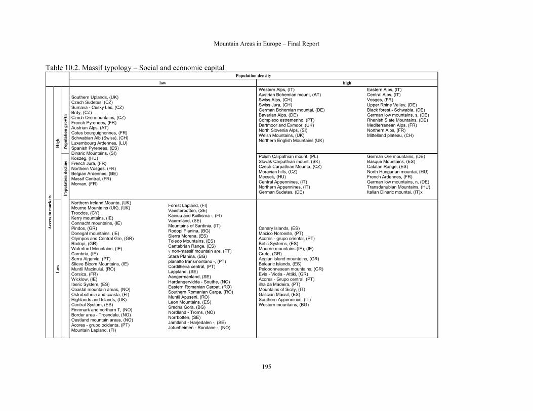
Table 10.2. Massif typology – Social and economic capital Population density
low high
Popu
latio
n gr
owth
Western Alps, (IT) Austrian Bohemian mount, (AT) Swiss Alps, (CH) Swiss Jura, (CH) German Bohemian mountai, (DE) Bavarian Alps, (DE) Complexo estremenho, (PT) Dartmoor and Exmoor, (UK) North Slovenia Alps, (SI) Welsh Mountains, (UK) Northern English Mountains (UK)
Eastern Alps, (IT) Central Alps, (IT) Vosges, (FR) Upper Rhine Valley, (DE) Black forest - Schwabia, (DE) German low mountains, s, (DE) Rhenish Slate Mountains, (DE) Mediterranean Alps, (FR) Northern Alps, (FR) Mittelland plateau, (CH)
Hig
h
Popu
latio
n de
clin
e
Southern Uplands, (UK) Czech Sudetes, (CZ) Sumava - Cesky Les, (CZ) Brdy, (CZ) Czech Ore mountains, (CZ) French Pyrenees, (FR) Austrian Alps, (AT) Cotes bourguignonnes, (FR) Schwabian Alb (Swiss), (CH) Luxembourg Ardennes, (LU) Spanish Pyrenees, (ES) Dinaric Mountains, (SI) Koszeg, (HU) French Jura, (FR) Northern Vosges, (FR) Belgian Ardennes, (BE) Massif Central, (FR) Morvan, (FR)
Polish Carpathian mount, (PL) Slovak Carpathian mount, (SK) Czech Carpathian Mounta, (CZ) Moravian hills, (CZ) Mecsek, (HU) Central Appennines, (IT) Northern Appennines, (IT) German Sudetes, (DE)
German Ore mountains, (DE) Basque Mountains, (ES) Catalan Range, (ES) North Hungarian mountai, (HU) French Ardennes, (FR) German low mountains, n, (DE) Transdanubian Mountains, (HU) Italian Dinaric mountai, (IT)x
Acc
ess t
o m
arke
ts
Low
Northern Ireland Mounta, (UK) Mourne Mountains (UK), (UK) Troodos, (CY) Kerry mountains, (IE) Connacht mountains, (IE) Pindos, (GR) Donegal mountains, (IE) Olympos and Central Gre, (GR) Rodopi, (GR) Waterford Mountains, (IE) Cumbria, (IE) Serra Algarvia, (PT) Slieve Bloom Mountains, (IE) Muntii Macinului, (RO) Corsica, (FR) Wicklow, (IE) Iberic System, (ES) Coastal mountain areas, (NO) Ostrobothnia and coasta, (FI) Highlands and Islands, (UK) Central System, (ES) Finnmark and northern T, (NO) Border area - Troendela, (NO) Oestland mountain areas, (NO) Acores - grupo ocidenta, (PT) Mountain Lapland, (FI)
Forest Lapland, (FI) Vaesterbotten, (SE) Kainuu and Koillisma -, (FI) Vaermland, (SE) Mountains of Sardinia, (IT) Rodopi Planina, (BG) Sierra Morena, (ES) Toledo Mountains, (ES) Cantabrian Range, (ES) v non-massif mountain are, (PT) Stara Planina, (BG) planalto transmontano -, (PT) Cordilheira central, (PT) Lappland, (SE) Aangermanland, (SE) Hardangervidda - Southe, (NO) Eastern Romanian Carpat, (RO) Southern Romanian Carpa, (RO) Muntii Apuseni, (RO) Leon Mountains, (ES) Sredna Gora, (BG) Nordland - Troms, (NO) Norrbotten, (SE) Jamtland - Harjedalen -, (SE) Jotunheimen - Rondane -, (NO)
Canary Islands, (ES) Macico Noroeste, (PT) Acores - grupo oriental, (PT) Betic Systems, (ES) Mourne mountains (IE), (IE) Crete, (GR) Aegian island mountains, (GR) Balearic Islands, (ES) Peloponnesean mountains, (GR) Evia - Viotia - Attiki, (GR) Acores - Grupo central, (PT) ilha da Madeira, (PT) Mountains of Sicily, (IT) Galician Massif, (ES) Southern Appennines, (IT) Western mountains, (BG)

Mountain Areas in Europe – Final Report
196
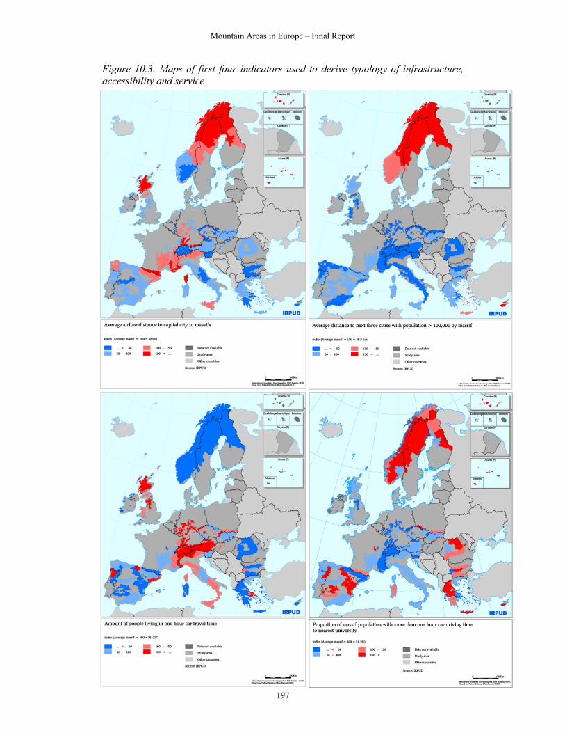
10.3 Typology for infrastructure, accessibility and service The typology ‘infrastructure, accessibility and services’ is a combination of several indicators, obtained by a multi-criteria analysis. This typology is dedicated to measuring the quality of infrastructure, the level of services of social facilities and the level of accessibility of a region. In general, it deals with a region’s infrastructure supply. Table 10.2 shows the hierarchy of the indicators and their weights in brackets. The measures of accessibility take into account two spatial levels (national and regional), trying to capture the different dimensions. Table 10.3. Criteria defining the typology of infrastructure, accessibility and services
National level (40 %) Airline distance to national capital cities
Airline distance to next 3 cities >100,000 inhabitants (50 %) Accessibility (40 %)
Regional level (60 %) Amount of people living in a 1 hour travel time (based on car travel) (50 %)
Education (60 %) Proportion of massif population with more than 1 hour car driving time to nearest university Services (30 %)
Health (40 %) average airline distance to next hospital by massif
Roads (50 %) Density of roads by massif Rail (30 %) Density of railways by massif Transport
infrastructure (30 %) Airports (20 %) Travel time to nearest airport by massif
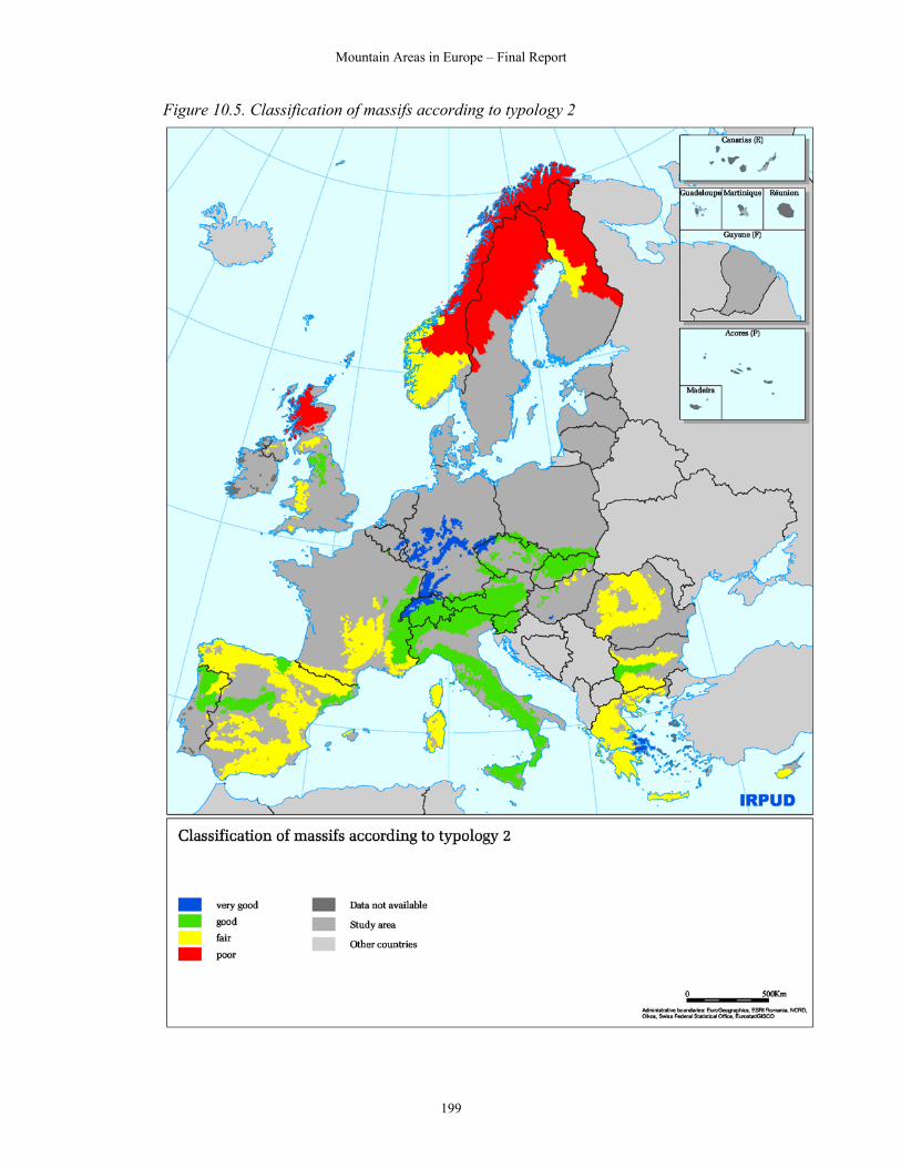
Accessibility to universities is calculated by Ai= ∑w*d-β where: w = amount of students and d = travel time. Peripherality measures to facilities by car (standardised at national averages) are calculated the same way as the accessibility to universities, except that one factor does not represent the amount of students, but the total population. The maps of the indicators are provided in Figures 10.3 and 10.4, and the resulting typology is shown in Figure 10.5. It divides the massifs into four categories based on their distance to the national capital, their population density, the distances to universities and hospitals, travel time to nearest airport, and the density of the road and rail network. The analysis compares mountain massifs to each other, not to the EU 27+2 average. There are of course different patterns for each of these indicators, but taken together a core-periphery pattern is evident.
Mountain Areas in Europe – Final Report
197
Figure 10.3. Maps of first four indicators used to derive typology of infrastructure, accessibility and service

Mountain Areas in Europe – Final Report
198
Figure 10.4. Maps of second four indicators used to derive typology of infrastructure, accessibility and service
Mountain Areas in Europe – Final Report
199
Figure 10.5. Classification of massifs according to typology 2

Mountain Areas in Europe – Final Report
200
As shown in Figure 10.4 and Table 10.3, most massifs that score ‘very good’ or ‘good’ extend from the Northern English Mountains down to Sicily in the west and Slovakia in the east. The Alps are included, as are the Carpathians, the Sudetes, all German massifs and the Ardennes. There are also three Spanish, two Portuguese, and two Bulgarian massifs in this group. Massifs with a ‘fair’ accessibility to infrastructure and service are located in a circle around the two first groups. The category is dominated by massifs in Greece, Bulgaria, Romania, and Spain. The Massif Central and the Mediterranean Alps in France are also included, as are the Southern Uplands and Wales in the UK, massifs on the south coast of Norway, and Ostrobothnia and the coastal hinterland in Finland. Massifs with ‘poor’ accessibility to infrastructure and service are found north of these, in the Highlands and Islands (UK) and in Norway (all except three), Sweden (all massifs) and Finland (all but one). This clearly illustrates that these countries are extremely peripheral in the European context. Finally, it should be noted that the transition zones around mountain areas are far more accessible than the massifs themselves. Table 10.4: Massif typology – infrastructure, accessibility and services
Very good (-80 – 30) Massif range Country code Index value
Italian Dinaric mountains IT -79.3
Mittelland plateau CH -44.4
Belgian Ardennes BE -2.9
Rhenish Slate Mountains (German part) DE -0.9
Luxembourg Ardennes LU -0.8
Black forest - Schwabian and Frankonian Alb DE 8.2
German low mountains, northern part DE 12.8
Mecsek HU 14.7
Swiss Jura CH 15.2
German Ore mountains DE 20.3
German low mountains, southern part DE 21.1
Czech Ore mountains CZ 24.3
Evia - Viotia - Attiki GR 25.0
Upper Rhine Valley DE 28.4 Good (30 - 90) Schwabian Alb (Swiss) CH 33.8
Swiss Alps CH 37.4
Bavarian Alps DE 37.8
Basque Mountains ES 38.9
German Sudetes DE 41.6
Transdanubian Mountains HU 46.1

Mountain Areas in Europe – Final Report
201
Central Alps IT 47.9
Western mountains BG 48.3
Northern English Mountains UK 48.7
Czech Carpathian Mountains CZ 49.1
Catalan Range ES 55.1
Dinaric Mountains SI 57.3
Southern Appennines IT 57.9
Brdy CZ 58.6
Northern Appennines IT 60.0
Cotes bourguignonnes FR 60.4
Austrian Bohemian mountains AT 60.9
Vosges FR 64.1
Austrian Alps AT 64.3
Mountains of Sicily IT 64.3
Macico Noroeste PT 64.6
Czech Sudetes CZ 65.8
Central Appennines IT 66.0
French Ardennes FR 66.4
North Slovenia Alps SI 67.4
Western Alps IT 69.3
Northern Vosges FR 69.6
German Bohemian mountains DE 71.8
Northern Alps FR 76.8
Slovak Carpathian mountains SK 77.2
French Jura FR 78.0
Eastern Alps IT 79.3
Sredna Gora BG 83.4
Sumava - Cesky Les CZ 83.5
Polish Carpathian mountains PL 84.9
Moravian hills CZ 85.5
Polish Sudetes PL 85.7
Cordilheira central PT 87.3
Central System ES 88.0 Fair (90 - 150) Cantabrian Range ES 91.9
North Hungarian mountain areas HU 92.4
Stara Planina BG 93.7
Oestland mountain areas NO 93.9
Mediterranean Alps FR 94.3
Rodopi GR 94.6

Mountain Areas in Europe – Final Report
202
Spanish Pyrenees ES 96.1
Massif Central FR 96.5
Galician Massif ES 97.5
Southern Romanian Carpathian mountains RO 98.5
Betic Systems ES 99.2
Muntii Apuseni RO 100.6
Welsh Mountains UK 101.6
Rodopi Planina BG 102.4
Mountains of Sardinia IT 102.7
Peloponnesean mountains GR 104.9
Northern Ireland Mountains UK 106.2
non-massif mountain areas PT 106.2
Balearic Islands ES 112.1
Eastern Romanian Carpathian mountains RO 112.8
Iberic System ES 113.2
Planalto transmontano - Beirao PT 114.0
Olympos and Central Greece GR 117.3
Pindos GR 117.8
Corsica FR 119.4
Sierra Morena ES 121.2
Koszeg HU 123.0
Morvan FR 124.8
French Pyrenees FR 125.1
Leon Mountains ES 125.4
Toledo Mountains ES 128.9
Southern Uplands UK 132.0
Ostrobothnia and coastal hinterland FI 137.0
Coastal mountain areas NO 138.0
Crete GR 138.4
Troodos CY 139.0
Hardangervidda - Southern mountain areas NO 139.4
Dartmoor and Exmoor UK 140.8 Poor (150 – 270) Vaermland SE 151.5
Jotunheimen - Rondane - Dovre NO 152.2
Highlands and Islands UK 156.8
Border area - Troendelag NO 157.1
Aangermanland SE 164.7
Kainuu and Koillisma - Hill region FI 167.3
Vaesterbotten SE 168.4

Mountain Areas in Europe – Final Report
203
Jamtland - Harjedalen - Dalarne SE 168.5
Norrbotten SE 181.1
Forest Lapland FI 191.2
Lappland SE 213.6
Nordland - Troms NO 216.0
Mountain Lapland FI 251.4
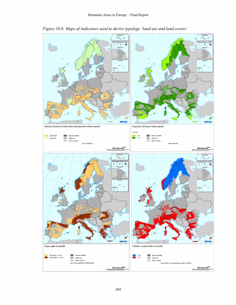
Finnmark and northern Troms NO 269.6 10.4 Typology for land use and land covers The methodological approach concerning the typology ‘land use and land covers’ is similar to that for social and economic capital. Table 10.4 shows the table used to derive the typology. Table 10.5. Grid to define typology of land use and land covers
Climatic contrast index Low High
Slope flat
Slope rough
Slope flat
Slope rough
Share of forests high
Arable land > grassland Share of
forests low
Share of forests high
Relative balance of arable land and grassland Arable land <
grassland Share of forests low
The following thresholds were used to derive the indicators:
• Share of forests high = over 30% of area covered by forests • Rough slope = over 4.1% average slope in massif (value based on the mean
slope for mountain areas within the study area) • Climatic contrast index over or under 50 (value based on a natural break in the
data, with a leap from 44 to 69 in the values) The maps showing the indicators are shown in Figure 10.5, and the resulting typology in Figure 10.6 and Table 10.5.
Mountain Areas in Europe – Final Report
204
Figure 10.6. Maps of indicators used to derive typology ‘land use and land covers’

Mountain Areas in Europe – Final Report
205
Figure 10.7. Classification of massifs according to typology 3
Mountain Areas in Europe – Final Report
206
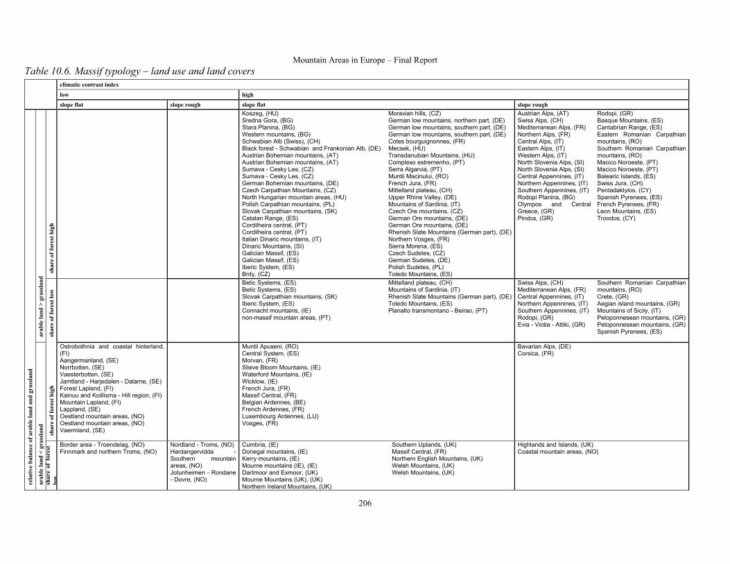
Table 10.6. Massif typology – land use and land covers climatic contrast index
low high
slope flat slope rough slope flat slope rough
shar
e of
fore
st h
igh
Koszeg, (HU) Sredna Gora, (BG) Stara Planina, (BG) Western mountains, (BG) Schwabian Alb (Swiss), (CH) Black forest - Schwabian and Frankonian Alb, (DE) Austrian Bohemian mountains, (AT) Austrian Bohemian mountains, (AT) Sumava - Cesky Les, (CZ) Sumava - Cesky Les, (CZ) German Bohemian mountains, (DE) Czech Carpathian Mountains, (CZ) North Hungarian mountain areas, (HU) Polish Carpathian mountains, (PL) Slovak Carpathian mountains, (SK) Catalan Range, (ES) Cordilheira central, (PT) Cordilheira central, (PT) Italian Dinaric mountains, (IT) Dinaric Mountains, (SI) Galician Massif, (ES) Galician Massif, (ES) Iberic System, (ES) Brdy, (CZ)
Moravian hills, (CZ) German low mountains, northern part, (DE) German low mountains, southern part, (DE) German low mountains, southern part, (DE) Cotes bourguignonnes, (FR) Mecsek, (HU) Transdanubian Mountains, (HU) Complexo estremenho, (PT) Serra Algarvia, (PT) Muntii Macinului, (RO) French Jura, (FR) Mittelland plateau, (CH) Upper Rhine Valley, (DE) Mountains of Sardinia, (IT) Czech Ore mountains, (CZ) German Ore mountains, (DE) German Ore mountains, (DE) Rhenish Slate Mountains (German part), (DE)Northern Vosges, (FR) Sierra Morena, (ES) Czech Sudetes, (CZ) German Sudetes, (DE) Polish Sudetes, (PL) Toledo Mountains, (ES)
Austrian Alps, (AT) Swiss Alps, (CH) Mediterranean Alps, (FR) Northern Alps, (FR) Central Alps, (IT) Eastern Alps, (IT) Western Alps, (IT) North Slovenia Alps, (SI) North Slovenia Alps, (SI) Central Appennines, (IT) Northern Appennines, (IT) Southern Appennines, (IT) Rodopi Planina, (BG) Olympos and Central Greece, (GR) Pindos, (GR)
Rodopi, (GR) Basque Mountains, (ES) Cantabrian Range, (ES) Eastern Romanian Carpathian mountains, (RO) Southern Romanian Carpathian mountains, (RO) Macico Noroeste, (PT) Macico Noroeste, (PT) Balearic Islands, (ES) Swiss Jura, (CH) Pentadaktylos, (CY) Spanish Pyrenees, (ES) French Pyrenees, (FR) Leon Mountains, (ES) Troodos, (CY)
arab
le la
nd >
gra
ssla
nd
shar
e of
fore
st lo
w
Betic Systems, (ES) Betic Systems, (ES) Slovak Carpathian mountains, (SK) Iberic System, (ES) Connacht mountains, (IE) non-massif mountain areas, (PT)
Mittelland plateau, (CH) Mountains of Sardinia, (IT) Rhenish Slate Mountains (German part), (DE)Toledo Mountains, (ES) Planalto transmontano - Beirao, (PT)
Swiss Alps, (CH) Mediterranean Alps, (FR) Central Appennines, (IT) Northern Appennines, (IT) Southern Appennines, (IT) Rodopi, (GR) Evia - Viotia - Attiki, (GR)
Southern Romanian Carpathian mountains, (RO) Crete, (GR) Aegian island mountains, (GR) Mountains of Sicily, (IT) Peloponnesean mountains, (GR) Peloponnesean mountains, (GR) Spanish Pyrenees, (ES)
shar
e of
fore
st h
igh
Ostrobothnia and coastal hinterland, (FI) Aangermanland, (SE) Norrbotten, (SE) Vaesterbotten, (SE) Jamtland - Harjedalen - Dalarne, (SE) Forest Lapland, (FI) Kainuu and Koillisma - Hill region, (FI) Mountain Lapland, (FI) Lappland, (SE) Oestland mountain areas, (NO) Oestland mountain areas, (NO) Vaermland, (SE)
Muntii Apuseni, (RO) Central System, (ES) Morvan, (FR) Slieve Bloom Mountains, (IE) Waterford Mountains, (IE) Wicklow, (IE) French Jura, (FR) Massif Central, (FR) Belgian Ardennes, (BE) French Ardennes, (FR) Luxembourg Ardennes, (LU) Vosges, (FR)
Bavarian Alps, (DE) Corsica, (FR)
rela
tive
bala
nce
of a
rabl
e la
nd a
nd g
rass
land
arab
le la
nd <
gra
ssla
nd
shar
e of
for
est
low
Border area - Troendelag, (NO) Finnmark and northern Troms, (NO)
Nordland - Troms, (NO) Hardangervidda - Southern mountain areas, (NO) Jotunheimen - Rondane - Dovre, (NO)
Cumbria, (IE) Donegal mountains, (IE) Kerry mountains, (IE) Mourne mountains (IE), (IE) Dartmoor and Exmoor, (UK) Mourne Mountains (UK), (UK) Northern Ireland Mountains, (UK)
Southern Uplands, (UK) Massif Central, (FR) Northern English Mountains, (UK) Welsh Mountains, (UK) Welsh Mountains, (UK)
Highlands and Islands, (UK) Coastal mountain areas, (NO)

Mountain Areas in Europe – Final Report
207
To a large extent, this typology of massifs is like a classical ecological classification, and will have particular value when combined with the other typologies. It contains seven groups of massifs:
1) forested middle mountains: these mainly comprise the relatively low and low-angle Hercynian mountains that stretch from the Jura to the Carpathians of Slovakia, as well as a number of Spanish ranges, the Dinaric mountains of Slovenia and the Stara Planina of Bulgaria;
2) steep forested mountains: these are the steep ‘Alpine mountains’ forested at lower altitudes, but usually extending up to an alpine zone, sometimes with glaciers: the Alps, Apennines, Pyrenees, Cantabrican mountains, Romanian Carpathians, and Balkans;
3) low-angle open Iberian mountains: the Betic and Iberic Systems and Toledo mountains of Spain;
4) open low-angle Mediterranean mountains: the mountains of Sicily, Crete and the Peloponnese in Greece;
5) cold forested mountains: the mountains of Finland, Sweden and the Oestland mountains of Norway;
6) northern low-angle oceanic mountains: the glaciated mountains of Ireland, the UK, and most of Norway.