Embed Size (px)
Citation preview

4-1 July 2007
Chapter 4: Visual Character and Shadows
A. INTRODUCTION The visual character of an area is defined by its urban design and its visual resources; visual character can also be affected by shadows cast in an area. This chapter considers the potential of the proposed action to affect the visual character of the project site and surrounding study area and evaluates the potential for the proposed action to cast shadows on resources of concern within the study area.
Many of the elements of the proposed action would consist of renovation of existing plant elements or construction of structures less than 50 feet in height (e.g., the carbon addition facilities would consist of underground storage tanks, a canopy overhead, and a small 14-foot by 30-foot control building. The polymer addition facilities would be located within the centrate building constructed as part of the Phase II Upgrade). Accordingly, most components of the proposed action would not result in notable changes to the appearance of the WPCP or new shadows. Therefore, this chapter focuses on the potential effects of the new egg-shaped digesters that would be constructed on the additional parcel at a height of approximately 130 feet above grade as part of the proposed action (the two-digester scenario) as well as the additional two digesters that are analyzed as a potential future action (the four-digester scenario).
B. METHODOLOGY
VISUAL CHARACTER
The 2001 City Environmental Quality Review (CEQR) Technical Manual defines the following elements as collectively forming an area’s urban design: block form and street pattern; building arrangement; building bulk, use, and type; streetscape elements; street hierarchy; and topography and natural features. Visual resources are defined as unique or important public view corridors, vistas, or natural or built features. Visual resources can include views of the waterfront, public parks, landmark structures or districts, or natural resources. This chapter provides an assessment of the area’s urban design and visual resources, together referred to as visual character.
An assessment of urban design should consider whether a project would result in a building or structure substantially different in height, bulk, form, setback, size, scale, use or arrangement than exists; or if the project would change the block form, street hierarchy, affect street walls, curb cuts, pedestrian activity or other streetscape elements, or if an existing street would be demapped or a new street mapped. In terms of visual resources, a proposed action may significantly and adversely affect visual resources if the action would affect the public’s ability to view and enjoy those resources. An analysis of visual resources should consider whether new above-ground development or changes in the bulk of above-ground development in an area that includes significant visual resources would significantly and permanently obstruct important views or vistas or would significantly affect the public’s enjoyment of waterfront views.

Hunts Point WPCP
4-2
The visual character analysis focuses on impacts from the proposed construction of the egg-shaped sludge digesters on the vacant 4.3-acre parcel to the northwest of the existing Hunts Point WPCP site (adjacent to Viele Avenue and Manida Street).1 Publicly accessible views of the 4.3-acre parcel are primarily limited to the immediately surrounding streets and the new Barretto Point Park, and the area where impacts would be expected to occur has, therefore, been defined as being within approximately 400 feet (see Figure 4-1). This analysis also takes into account longer views south on Barretto and Manida Streets because they provide direct view corridors into the additional parcel. Lastly, the analysis considers potential effects on the proposed South Bronx Greenway.
The analysis addresses each of the composite elements for existing conditions and the future without and with the proposed action for the year 2014, when the proposed action is expected to be complete. The analysis first assesses the potential for the proposed action, which would consist of the construction of two egg-shaped digesters, to affect visual character. An assessment of the four-digester scenario is also included in this chapter.
SHADOWS
Following the guidelines of the CEQR Technical Manual, a shadow analysis considers shadows for four representative days of the year: March 21st/September 21st, the equinoxes; May 6th, the midpoint between the summer solstice and the equinox (and equivalent to August 6th); June 21st, the summer solstice and the longest day of the year; and December 21st, the winter solstice and shortest day of the year. In identifying potential effects, CEQR focuses on uses and users of open spaces, landscaping and vegetation, and, if there are historic resources, features or details that are both sunlight-dependent and make such resources significant. CEQR methodology defines the analysis period to be the period from 1½ hours after sunrise to 1½ hours before sunset.
The CEQR Technical Manual identifies the following as situations when a significant shadow impact may occur:
• Substantial reduction in sunlight where a sensitive use is already subject to substandard sunlight (i.e., less than the minimum time necessary for survival);
• Reduction in sunlight available to a sensitive use from more to less than the minimum time necessary for its survival;
• Substantial reduction in sunlight to a sun-sensitive use or feature; and
• Substantial reduction in the usability of an open space.
The determination of impact significance is based on an assessment of how a project’s shadows specifically affect individual resources of concern; that is, the analysis considers the project’s incremental shadow as well as the total shadow on resources of concern, and for each resource assesses the potential impact. The shadows analysis discusses the potential shadows from all
1 As discussed above, the carbon addition facilities would consist of structures less than 50 feet in height
and would therefore not result in changes to visual character. The polymer addition facilities would be located within the centrate building to be constructed as part of the Phase II Upgrade and would also not have the potential to result in changes to visual character. Therefore, these facilities are not discussed further in this chapter.

VIELE AVE.
OAK PT. AVE.
RANDALL AVE.
E. BAY AVE.
RYAWA AVE.
HA
LLEC
K S
T.
FA
ILE S
T.
MA
NID
A S
T.
CO
ST
ER
ST
.
BR
YA
NT
AV
E.
MARKET ST.BA
RR
ET
TO
ST
.
TIF
FA
NY
ST
.
DR
AK
E S
T.
CA
SA
NO
VA
ST
. WH
ITT
IER
ST
.
LON
GF
ELLO
W A
VE
.
FA
RR
AG
UT
ST
EX
BAYVIEW AVE.
CR
AV
EN
ST
.
TR
UX
TO
N S
T.
WO
RT
HE
N S
T.
HUNT POINT AVE.
E A S T R I V E R
12.18.06
Hunts Point WPCP Visual Character - Key To Photographs
Figure 4-1
SCALE
0 1000 FEET
N
1
16
1312
1514
9
21
10 17
6
E
D
C
4
7 8
20
11
5
3
24
22
18
2
B
19 A
23
1
A
Project Site Boundary
Study Area Boundary (400-Foot Perimeter)
Photo View Directionand Reference Number
Rendering View Directionand Reference Letter

Chapter 4: Visual Character and Shadows
4-3
four digesters (the two that would be constructed as part of the proposed action and the additional two that could be constructed under the four-digester scenario).
SHADOW SCREENING
A shadow screening analysis was performed following the guidelines of the CEQR Technical Manual to identify those open spaces or historic resources that could be affected by shadows from the proposed action. To identify resources of concern, the potential maximum length of the shadows is first considered. The maximum shadow length factor considers both the length and the direction of shadows for each analysis day. Shadows are longest in length on the December analysis day, when the maximum shadow length factor is equal to 4.3 times the height of the building. This occurs at the beginning and end of the analysis period, when shadows are cast in a northwest and northeast direction, respectively. Towards midday, as the sun rises in the sky, the shadow length factor is reduced to 2.07 times the height of the building. The proposed egg-shaped digesters would be 130 feet in height and therefore would have a maximum shadow length of approximately 1,840 feet at the beginning and end of the December analysis day.
Shadow lengths for the remainder of the analysis periods are shorter than they are in December. However, the daytimes are longer, resulting in longer analysis periods and, therefore, a larger area of potential shadows. For example, on the December analysis day, shadows are cast up to 43º east and west, but in June, shadows are cast up to 108º east and west. Therefore, on the June analysis day shadows could potentially reach more resources of concern than in December. A combination of the maximum shadow length and direction on each of the four analysis days provides a “shadow sweep”—that is the maximum possible distance and size of the shadows for each of the four analysis days. After the maximum shadow sweep of the proposed action is de-termined, open spaces and sun-sensitive historic resources within the shadow sweep are iden-tified. To ensure that all resources of concern are identified, the shadows screening included the potential shadow sweep for the two digesters proposed under the proposed action and for the additional two digesters that could be constructed under the four-digester scenario.
Barretto Point Park, including the 1.2-acre parcel that will be mapped as parkland and transferred to New York City Department of Parks and Recreation (NYCDPR) for inclusion in Barretto Point Park when the area is no longer needed for construction staging, is the only open space within the shadow sweep for the new egg-shaped digesters. Barretto Point Park includes an open lawn area, a sand and pebble beach, planting areas, an active recreational area, including volleyball and basketball courts, a waterfront promenade, and an amphitheatre. In addition, a vegetative buffer has been planted along the north, east and southeast edges of the park. NYCDPR has not yet designed the 1.2-acre addition to Barretto Point Park.
The proposed Ryawa-Viele Connection of the Bronx River Greenway, further described below in Section D, “The Future Without the Proposed Action,” would involve the implementation of streetscape improvements consisting of a 24-foot planted buffer, the introduction of a bikeway along the perimeter of the project site, and extensive street plantings. The proposed connection will be dedicated to active uses without opportunities for passive recreation, such as seating area or benches. As the connection is for active uses, potential shadows on the proposed greenway will be briefly described below (i.e., active open spaces are less sensitive to incremental shadow increases).
The nearby Tiffany Street Pier would be out of range of the shadow sweep. No historic resources with significant features that depend on sunlight (e.g., stained glass windows) and no historic landscapes are located within the area surrounding the Hunts Point WPCP or the vacant 4.3-acre

Hunts Point WPCP
4-4
parcel proposed for plant construction. Therefore, the shadow analysis in this chapter considers the effects of project-related shadows on Barretto Point Park and the 1.2-acre future addition to Barretto Point Park. The shadows analysis discusses the potential shadows from all four digesters (the two that would be constructed as part of the proposed action and the additional two that could be constructed under the four-digester scenario).
C. EXISTING CONDITIONS
VISUAL CHARACTER
PROJECT SITE
The 39-acre existing Hunts Point WPCP site is located on the East River waterfront roughly between Tiffany and Halleck Streets in the Hunts Point neighborhood of the Bronx. Ryawa Avenue borders the site on the north. The existing plant consists of numerous low-rise buildings, sludge digesters, sludge storage tanks, settling tanks, and aeration tanks. Most of the existing structures are not visible from the adjacent streets because of their low height and location near the southern portion of the site, along the shoreline. Structures most visible from the surrounding area include the three-story main building on Ryawa Avenue and a tall sludge storage tank (approximately 65 feet above grade) located on the shoreline. Although a grouping of 12 low-rise sludge thickeners—circular tanks connected in a grid—are on the site located near Ryawa Avenue, a thick buffer of trees along the street hides their presence.
The main building on Ryawa Avenue is a boxy brick structure with mechanical equipment on the roof and large industrial windows (see view 1 of Figure 4-2). As part of the Phase I Upgrade, the main building is being expanded with a five-story east addition and a smaller wing on the west. This expansion is near completion. The five-story addition is clad in red brick with mechanical equipment on the roof (see view 2 of Figure 4-2). Jersey barriers and chain link fencing surround the construction site. A site entrance west of the main building is marked by a security kiosk and more chain link fencing (see view 3 of Figure 4-3). Some additional low-rise buildings and the large sludge storage tank farther back in the site are visible in the vicinity of the entrance. Along Ryawa Avenue, the site frontage is bordered by chain line fencing, some of which is capped with barbed wire, and trees in front of the sludge thickeners.
A second entrance to the site is located on the 4.3-acre parcel at the intersection of Ryawa Avenue and Manida Street. Jersey barriers and chain link fencing mark the entrance (see view 4 of Figure 4-3). A paved drive leading into the site serves as parking. Construction trailers are clustered around the entrance drive, and tall wood utility poles run through the site.
The vacant 4.3-acre parcel (the location of the proposed egg-shaped sludge digesters) is a slightly rolling, rectangular parcel bordered by Manida Street on the east and Viele Avenue on the north. Chain link fencing borders the site’s street frontages. It is the approximate size and shape of one of the surrounding city blocks, with the Ryawa Avenue entrance drive forming the southern edge and a private, dirt extension of Barretto Street forming the western boundary. The 4.3-acre parcel and the adjacent 1.2-acre parcel currently consist of weeds and a construction staging area (currently used for the Phase I and II Upgrades), and are filled with rubble piles, construction equipment, some trees, and wood utility poles and lighting (see views 5 and 6 of Figure 4-4).

Hunts Point WPCP
12.12.06
Visual CharacterProject Site
Figure 4-2
View east on Ryawa Avenue from Manida Street 1
2View west on Ryawa Avenue from Whittier Street

12.12.06
Hunts Point WPCP
Visual CharacterProject Site
Figure 4-3
3
4
Project site entrance at Ryawa Avenue and Coster Street
View west from Ryawa Avenue at Manida Street

12.12.06
Hunts Point WPCP
Visual CharacterProject Site
Figure 4-4
5
6
View northwest from Manida Street near Ryawa Avenue
View of the construction staging area from Barretto Point Park

Chapter 4: Visual Character and Shadows
4-5
STUDY AREA
Urban Design The visual character of the study area is largely defined by the urban design characteristics of the area. The predominant urban design characteristics of the Hunts Point area are the low scale, boxy and/or rectangular buildings, most of which are faced in brick and built to the lot line creating a consistent streetscape. The majority of the buildings house active industrial uses. The streets are laid out in a utilitarian grid pattern. The majority of the vehicular traffic is related to the industrial uses; often streets are blocked by vans or large trucks. All of these urban design elements contribute to the overall industrial character of the area.
In keeping with the general urban design of the Hunts Point area, the study area surrounding the WPCP is a predominantly industrial area of low-rise factories, warehouses, and scrap yards that has been developed in a street grid with wide two-way avenues running east-west and narrow one-way streets running north-south. The street grid creates long rectangular blocks. The area’s topography is slightly hilly with a noticeable peak on Viele Avenue around Manida and Barretto Streets where Barretto Point Park is located. There is a softer rise in elevation on East Bay Avenue around Coster Street.
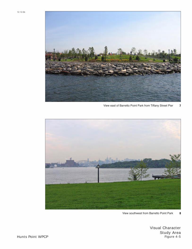
Adjacent to the project site on Viele Avenue is Barretto Point Park, an oasis of green open space amidst the otherwise industrial landscape of low-rise masonry buildings. This site was once overgrown with tall grasses and some trees, but has been transformed into a park containing basketball courts, play equipment, a natural amphitheater, a boat launch, landscaping, a waterfront promenade, a newly created salt marsh, and an open lawn area (see Figure 4-5). A partially restored public pier is located at the intersection of Tiffany Street with Viele Avenue (the Tiffany Street Pier) adjacent to Barretto Point Park. The shoreline and adjacent street were once garbage strewn but have been cleaned up; new sidewalks have also been constructed as part of Barretto Point Park (see view 9 of Figure 4-6). West of the pier, a large industrial complex occupies the waterfront. Chain link fencing with barbed wire borders the site, and the entrance is guarded. Boxy brick buildings with loading docks and an industrial stack are located back from Tiffany Street behind paved parking lots (see view 10 of Figure 4-6).
Parking lots and the presence of heavy trucks are defining features of the streetscape, along with metal security gates on building entrances and metal fencing. Tall wood utility poles are common through the area. Except for some scattered street trees and grassy strips along the sidewalks, the only vegetation in the study area is found within Barretto Point Park with some additional vegetation on the WPCP site and additional parcel. The study area does not experience much pedestrian activity, which contributes to the desolate industrial character. This sense of underutilization and isolation is enhanced by the waterfront location, where the shoreline is not publicly accessible except at Barretto Point Park, and by a building stock of low-rise structures that provides open expanses of sky over the industrial landscape.
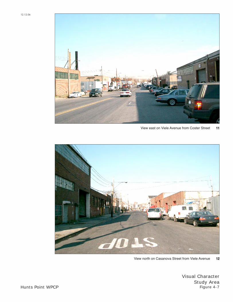
Buildings in the study area are one-story, boxy brick factories, auto-body repair shops, and warehouses. The majority are nondescript structures with large vehicular entrances covered with roll-down metal gates (see Figures 4-7 through 4-9). Windows tend to either be small openings or large industrial strip windows. Metal grills cover most windows and roll-down metal gates secure pedestrian entrances. Some buildings have chain link fencing around their roofs, and applied signage is scattered throughout the area. Interspersed among the factories and warehouses are scrap metal and storage yards. These open lots tend to be enclosed with chain link or corrugated metal fencing. The repetition of building forms and materials, the lack of
12.12.06
Hunts Point WPCP
Visual CharacterStudy Area
Figure 4-5
7
8
View east of Barretto Point Park from Tiffany Street Pier
View southwest from Barretto Point Park

12.12.06
Hunts Point WPCP
Visual CharacterStudy Area
Figure 4-6
9
10
View east from Tiffany Street at Viele Avenue
View west from Tiffany Street and Viele Avenue
12.12.06
Hunts Point WPCP
Visual CharacterStudy Area
Figure 4-7
11
12
View east on Viele Avenue from Coster Street
View north on Casanova Street from Viele Avenue

12.12.06
Hunts Point WPCP
Visual CharacterStudy Area
Figure 4-8
13
14
View north on Barretto Street from Viele Avenue
View north on Manida Street from Viele Avenue

12.12.06
Hunts Point WPCP
Visual CharacterStudy Area
Figure 4-9
15
16
View north on Coster Street from Viele Avenue
View north on Coster Street from Ryawa Avenue
Hunts Point WPCP
4-6
exterior ornamentation, and the presence of roll-down metal gates creates a homogeneous industrial streetscape, in which streets are relatively indistinguishable from each other. The blockfronts on Manida Street and Viele Avenue facing the vacant 4.3-acre parcel contain buildings characteristic of the area (see Figure 4-10).
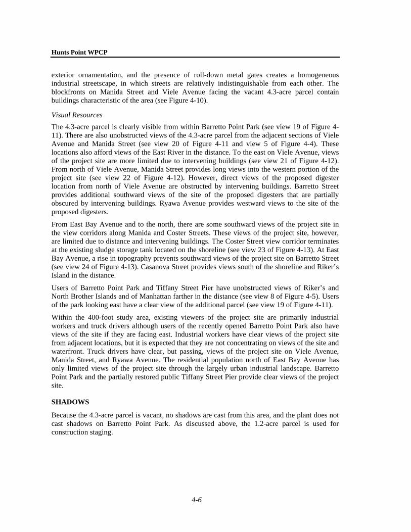
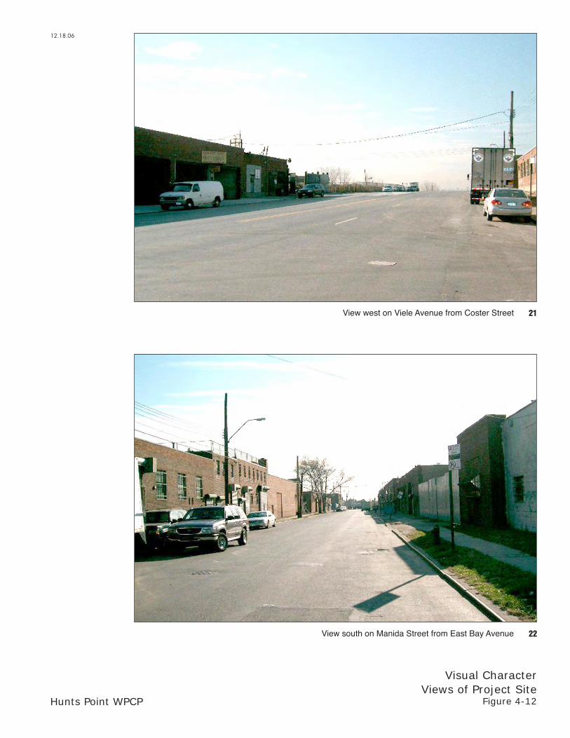
Visual Resources The 4.3-acre parcel is clearly visible from within Barretto Point Park (see view 19 of Figure 4-11). There are also unobstructed views of the 4.3-acre parcel from the adjacent sections of Viele Avenue and Manida Street (see view 20 of Figure 4-11 and view 5 of Figure 4-4). These locations also afford views of the East River in the distance. To the east on Viele Avenue, views of the project site are more limited due to intervening buildings (see view 21 of Figure 4-12). From north of Viele Avenue, Manida Street provides long views into the western portion of the project site (see view 22 of Figure 4-12). However, direct views of the proposed digester location from north of Viele Avenue are obstructed by intervening buildings. Barretto Street provides additional southward views of the site of the proposed digesters that are partially obscured by intervening buildings. Ryawa Avenue provides westward views to the site of the proposed digesters.
From East Bay Avenue and to the north, there are some southward views of the project site in the view corridors along Manida and Coster Streets. These views of the project site, however, are limited due to distance and intervening buildings. The Coster Street view corridor terminates at the existing sludge storage tank located on the shoreline (see view 23 of Figure 4-13). At East Bay Avenue, a rise in topography prevents southward views of the project site on Barretto Street (see view 24 of Figure 4-13). Casanova Street provides views south of the shoreline and Riker’s Island in the distance.
Users of Barretto Point Park and Tiffany Street Pier have unobstructed views of Riker’s and North Brother Islands and of Manhattan farther in the distance (see view 8 of Figure 4-5). Users of the park looking east have a clear view of the additional parcel (see view 19 of Figure 4-11).
Within the 400-foot study area, existing viewers of the project site are primarily industrial workers and truck drivers although users of the recently opened Barretto Point Park also have views of the site if they are facing east. Industrial workers have clear views of the project site from adjacent locations, but it is expected that they are not concentrating on views of the site and waterfront. Truck drivers have clear, but passing, views of the project site on Viele Avenue, Manida Street, and Ryawa Avenue. The residential population north of East Bay Avenue has only limited views of the project site through the largely urban industrial landscape. Barretto Point Park and the partially restored public Tiffany Street Pier provide clear views of the project site.
SHADOWS
Because the 4.3-acre parcel is vacant, no shadows are cast from this area, and the plant does not cast shadows on Barretto Point Park. As discussed above, the 1.2-acre parcel is used for construction staging.

12.12.06
Hunts Point WPCP
Visual CharacterStudy Area
Figure 4-10
17
18
View east on Viele Avenue from Manida Street
View north on Manida Street from Ryawa Avenue

Hunts Point WPCP
Visual CharacterViews of Project Site
Figure 4-11
20View east on Viele Avenue from Tiffany Street
19View east from Barretto Point Park
12.18.06
Hunts Point WPCP
Visual CharacterViews of Project Site
Figure 4-12
22View south on Manida Street from East Bay Avenue
21View west on Viele Avenue from Coster Street
12.18.06

Hunts Point WPCP
Visual CharacterViews of Project Site
Figure 4-13
23
24
View south on Coster Street from East Bay Avenue
View south on Barretto Street from East Bay Avenue
12.18.06

Chapter 4: Visual Character and Shadows
4-7
D. THE FUTURE WITHOUT THE PROPOSED ACTION
VISUAL CHARACTER
PROJECT SITE
In the future without the proposed action, construction of the Phase II Upgrade is expected to be completed in 2008. Phase II includes the demolition of the existing electrical substation building located along Ryawa Avenue at Bryant Avenue and the construction of two new buildings on the existing plant site. A main electrical substation will be located on the site’s southwest portion at the shoreline, and a 60-foot stack will be constructed as part of the new substation for the emergency generators. An alkalinity building, one-story in height with a brick façade similar to the other buildings on the site, will be located at the site’s eastern boundary. These two structures will be in keeping with the industrial character of the project site and study area. Since interior views of the existing plant are mostly limited from the surrounding area, it is not expected that the two new, low-rise buildings will be visible outside their immediate vicinities. Although the 60-foot stack may be visible from the surrounding area, it would be in keeping with the visual character of the study area, where the existing sludge storage tank on the site is visible and a stack on the industrial property west of the Tiffany Street Pier is clearly visible. The main building will be complete.
STUDY AREA
Within the 400-foot visual study area, the Ryawa-Viele Connection of the South Bronx Greenway could be constructed by the year 2011. This project, as described in the South Bronx Greenway master plan, would involve the implementation of improvements along a portion of Viele Avenue (between Barretto Point Park and Manida Street), Manida Street (between Viele and Ryawa Avenues), and Ryawa Avenue (from Manida Street to approximately Halleck Street). The conceptual plan for this element of the greenway includes improvements consisting of a 24-foot planted buffer between the plant site and the sidewalk along Ryawa Avenue, the introduction of a bikeway along all three streets, and extensive street plantings. The Ryawa-Viele Connection will improve the streetscape adjacent to the plant site. The planted buffer along Ryawa Avenue is expected to screen the plant. It is anticipated that the introduction of this project would increase the number of viewers in the study area.
SHADOWS
In the future without the proposed action, the additional parcel will continue to be vacant, and the 1.2-acre area will continue to be used for construction staging through the end of Phase II. No new shadows will be cast on Barretto Point Park or the proposed Ryawa-Viele Connection of the South Bronx Greenway.

Hunts Point WPCP
4-8
E. PROBABLE IMPACTS OF THE PROPOSED ACTION
VISUAL CHARACTER1
TWO-DIGESTER SCENARIO
Project Site The proposed action would include improvements along the western portion of the existing Hunts Point WPCP site, including equipment renovation, replacement, and upgrades to existing facilities. The proposed action would include use of 4.3 acres for construction of two egg-shaped sludge digesters, a digester gallery, and an emergency generator. The adjacent 1.2-acre area would be transferred to NYCDPR for incorporation into Barretto Point Park when it is no longer needed for construction staging. A new gas holding tank would be constructed south of the new digesters—on the western portion of the existing Hunts Point WPCP site—to replace the old gas holding tank, located in the southwest corner of the facility. The new tank would be approximately 50 feet tall.
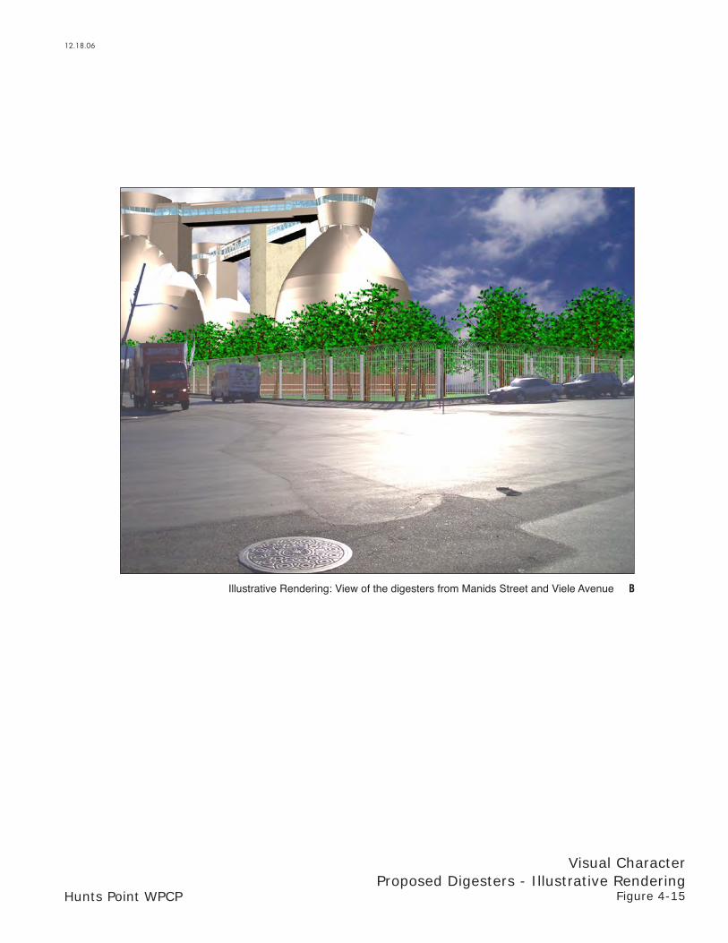
The two egg-shaped sludge digesters would be located at the southern end of the 4.3-acre parcel along Manida Street, just north of Ryawa Avenue. Constructed on a currently vacant site, they would alter the visual character of the additional parcel. They would be 130-foot-tall egg-shaped structures connected at the top by a walkway. The exterior shell of the digesters would be stainless steel, finished to minimize glare. From a one-story base building, the digesters would bulge outward and then taper at the top, where a penthouse would cap each structure. The penthouses would be conical in shape with an encircling strip window. The base building would have walls marked with concrete and brick banding and glass curtain walls similar to the buildings constructed under the Phase I and Phase II Upgrades. Elevator and stair towers would connect the walkway and penthouses to the ground. The site would be landscaped, with a vegetative buffer planted along the western edge adjacent to Barretto Point Park.
Study Area The renovation, replacement, and upgrades to existing facilities on the interior of the plant site would be consistent with the industrial character of the study area, and changes on the existing plant site would largely not be noticeable, as most of the plant interior is not visible from the study area due to distance and intervening buildings.
Rising 130 feet tall, the proposed two egg-shaped digesters would be prominent additions to the study area. Illustrative renderings of the digesters (the four-digester scenario) are provided in Figures 4-14 through 4-18. While they would be in keeping with the area’s industrial character, the height and bulk of the digesters would be much greater than the relatively low-lying industrial buildings in the area surrounding the plant. Because it is an industrial area, there are few viewers or views that would be affected. However, for Barretto Point Park users looking east toward the 4.3-acre additional parcel on which the digesters would be constructed, there
1 As discussed in the Methodology section, above, the carbon addition facilities would consist of
structures less than 50 feet in height and would therefore not result in changes to visual character. The polymer addition facilities would be located within the centrate building to be constructed as part of the Phase II Upgrade and would also not have the potential to result in changes to visual character. Therefore, these facilities are not discussed in this chapter.

Illustrative Rendering: View east from within Barretto Point Park A
Hunts Point WPCP
Visual CharacterProposed Digesters - Illustrative Rendering
Figure 4-14
12.18.06
Illustrative Rendering: View of the digesters from Manids Street and Viele Avenue B
Hunts Point WPCP
Visual CharacterProposed Digesters - Illustrative Rendering
Figure 4-15
12.18.06

Illustrative Rendering: View south on Manida Street from north of Viele Avenue C
Hunts Point WPCP
Visual CharacterProposed Digesters - Illustrative Rendering
Figure 4-16
12.18.06

Illustrative Rendering: View south on Manida Street from Randall Avenue D
Hunts Point WPCP
Visual CharacterProposed Digesters - Illustrative Rendering
Figure 4-17
12.18.06

Illustrative Rendering: View south on Coster Street from Oak Point Avenue E
12.18.06
Hunts Point WPCP
Visual CharacterProposed Digesters - Illustrative Rendering
Figure 4-18
Chapter 4: Visual Character and Shadows
4-9
would be a potential for a significant adverse impact on visual character. Figure 4-14 shows the view of the digesters (four-digester scenario) from within Barretto Point Park.
The transfer of land from NYCDEP to NYCDPR to create Baretto Point Park and the planning for Baretto Point Park were both undertaken in the context of design work for the use of the 4.3-acre parcel for the egg-shaped digesters. The two projects were contemporaneously planned. It was conceived that the design of Barretto Point Park would transition from its industrial surroundings to the waterfront. The potential significant visual character impact would be very limited. No views of or access to the waterfront would be affected. Only views looking east from the park would be affected. The impact would not significantly impact park users’ enjoyment of the park and there are no significant shadows impacts. Further, the final design of the digesters’ exterior will be completed, with input from the community, to enhance and convey the modern, innovative architectural style associated with this particular wastewater technology, as was done at the Newtown Creek WPCP. A vegetated buffer has been established between Barretto Point Park and the area of the proposed digesters to partially screen the digesters when constructed and create an appearance of the digesters as emerging in the distance behind a foreground of dense plantings. The vegetated buffer within the park and bordering the plant would include a mix of large shade trees, understory trees, a line of pine trees for winter screening, and a wide field of tall wildflower meadow mix. However, due to the height of the digesters, the significant visual character impact cannot be fully mitigated (see Chapter 22, “Unavoidable Significant Adverse Impacts”). There would be no significant adverse impact on visual character from the Tiffany Street Pier where views would be at a distance and not intrusive, nor from the proposed greenway, from which views would be transient and at a distance from most vantage points.
In addition, the Mayor’s Office and NYCDEP are working with the Hunts Point community to increase both open space and visually attractive environments in the study area. NYCDEP is working with the Hunts Point community to identify a community open space amenity (see information about the Hunts Point Community Investment Project in Chapter 1, “Project Description” and Chapter 23, “Environmental Justice”) in recognition that the plant and its long-term construction have placed a burden on the community, including the potential visual impact associated with the proposed digesters. The Hunts Point Vision Plan, South Bronx Greenway, roadway traffic improvements, and future additions to Barretto Point Park are among the efforts being pursued by the City within the Hunts Point community.
For industrial workers, the visibility of the 130-foot-tall egg-shaped digesters would be variable depending on where they are located due to intervening buildings, topography, and distance. On Viele Avenue and Manida Street adjacent to the site, the digesters would be prominent but it is expected that the workers would not be concentrating on views of the site (see Figure 4-15). From farther north and east on those streets, intervening buildings would partially block views, and the digesters would become background objects seen in the distance through a largely industrial landscape. On other streets—Casanova, Barretto, and Coster—the digesters would be less visible due to intervening buildings (see Figures 4-16, 4-17, and 4-18). Truck drivers also have clear views of the project site on Viele Avenue, Manida Street, and Ryawa Avenue but these views are fleeting. Therefore, there would be no potential significant adverse impacts on these viewers.
FOUR-DIGESTER SCENARIO
As with the two egg-shaped digester scenario, the four-digester scenario would introduce new prominent structures on a formerly vacant site. While these structures would be in keeping with

Hunts Point WPCP
4-10
the industrial character of the site and study area, as described above they would also be substantially taller and bulkier than the surrounding industrial buildings and there would be a potential significant adverse impact for park users looking east toward the four egg-shaped digesters. There would be no significant adverse impact on visual character from the Tiffany Street Pier where views would be at a distance and not intrusive, nor from the proposed greenway, from which views would be transient and at a distance from most vantage points.
From north of Viele Avenue, intervening buildings would partially block views. From the northern edge of the study area and from farther north, the visibility of the digesters would be lessened by distance and intervening buildings. Therefore, there would be no potential significant adverse impacts on these viewers.
SHADOWS
The shadows analysis discusses the potential shadows from construction of four digesters.
As detailed below, the digesters would cast new shadow on Barretto Point Park and the construction staging area in the morning hours of each of the four analysis days. Due to the location of the digesters to the south and east of the park, the largest shadows cast by the digesters would be at the beginning of each analysis period. The shadows from the digesters would move in a southeast direction and decrease in size throughout the morning hours (see Table 4-1 and Figures 4-19 through 4-22).
Table 4-1Shadow Duration on Open Space Resources
March 21
7:36 AM-4:29 PM EST
May 6 7:27 AM-6:18 PM
DST
June 21 6:57 AM-7:01 PM
DST
December 21 8:51 AM-2:53 PM
EST Shadows on Barretto Point Park
Enter 7:36 AM 7:27 AM 6:57 AM 8:51 AM Exit 9:45 AM 10:15 AM 9:45 AM 10:15 AM
Duration 2 hr 9 min 2 hr 48 min 2 hr 48 min 1 hr 24 min Shadows on the 1.2-acre Construction Staging Area (Future Addition to Barretto Point Park)
Enter 7:36 AM 7:27 AM 6:57 AM – Exit 9:45 AM 10:15 AM 9:45 AM –
Duration 2 hr 9 min 2 hr 48 min 2 hr 48 min – Notes: EST—Eastern Standard Time DST—Daylight Saving Time September 21 is the equivalent of March 21, but 1 hour later. August 6 is the equivalent of May 6.
It is anticipated that shadows from the digesters on the South Bronx Greenway Ryawa-Viele Connection would be limited to the late afternoon and evening hours and would mainly fall on the Manida Street sidewalk and bikeway. As described above, the connection will be devoted to active uses and new shadows in this limited portion of the greenway would not significantly impact the usability or enjoyment of this resource. Therefore, there would be no potential significant adverse shadow impacts on this resource from the four-digester scenario.

RYAWA AV
MA
NID
A S
T
CO
ST
ER
ST
FA
ILE S
T
Barretto Point Park
Tiffany Street Pier
E a s t R i v e r
Future Open Space
VIELE AV
BA
RR
ET
TO
ST
TIF
FA
NY
ST
CA
SA
NO
VA
ST
Proposed Digesters
Parcel Boundaries
Open Space
Construction Staging Area - Future Open Space
Time
7:36 AM EST
9:01 AM EST
3.29.07
Hunts Point WPCP
Shadow DiagramMarch 21 Analysis Day
Figure 4-19
N
SCALE
0 200 FEET

RYAWA AV
MA
NID
AS
T
CO
ST
ER
ST
FA
ILES
T
Barretto Point Park
VIELE AV
BA
RR
ET
TO
ST
TIF
FA
NY
ST
CA
SA
NO
VA
ST
TiffanyStreetPier
FutureOpen Space
E A S T R I V E R
3.26.07
Hunts Point WPCP
Shadow DiagramMay 6 Analysis Day
Figure 4-20
N
SCALE
0 200 FEETProposed Digesters
Parcel Boundaries
Open Space
Construction Staging Area - Future Open Space
Time
7:27 AM DST
9:03 AM DST

RYAWA AV
MA
NID
AS
T
CO
ST
ER
ST
FA
ILES
T
Barretto Point Park
VIELE AV
BA
RR
ET
TO
ST
TIF
FA
NY
ST
CA
SA
NO
VA
ST
TiffanyStreetPier
FutureOpen Space
E A S T R I V E R
3.26.07
Hunts Point WPCP
Shadow DiagramJune 21 Analysis Day
Figure 4-21
N
SCALE
0 200 FEETProposed Digesters
Parcel Boundaries
Open Space
Construction Staging Area - Future Open Space
Time
6:57 AM DST
8:31 AM DST

RYAWA AV
MA
NID
AS
T
CO
ST
ER
ST
FA
ILES
T
Barretto Point Park
VIELE AV
BA
RR
ET
TO
ST
TIF
FA
NY
ST
CA
SA
NO
VA
ST
Proposed Digesters
Parcel Boundaries
Open Space
Construction Staging Area - Future Open Space
Time
8:51 AM EST
10:02 AM EST
Hunts Point WPCP
TiffanyStreetPier
FutureOpen Space
E A S T R I V E R
3.26.07
Shadow DiagramDecember 21 Analysis Day
Figure 4-22
SCALE
0 200 FEET
N

Chapter 4: Visual Character and Shadows
4-11
MARCH 21—ANALYSIS PERIOD 7:36 AM TO 4:29 PM EST
On the March 21 analysis day (and on the equivalent day of September 21), shadows from the four proposed egg-shaped digesters would be cast on the eastern half of Barretto Point Park. At 7:36 AM Eastern Standard Time (EST) on March 21 or 6:36 AM Eastern Daylight Time (EDT) on September 21, the beginning of the analysis period, the digesters would cast shadows on portions of the eastern half of the park (see Figure 4-19). Throughout the morning hours, the shadows would decrease in size and approximately an hour and a half after the start of the analysis period, at 9:01 AM EST, only two of the digesters would cast a very small shadow on the park. These shadows would be limited to the southeastern corner and a small section of the eastern edge. The shadows from the digesters would completely exit the park by 9:45 AM.
At the beginning of the analysis period, the southern two digesters would cast new shadows on the northeastern section of the construction staging area (the future addition to Barretto Point Park). The shadows cast by the digesters would move quickly and approximately an hour and a half later, at 9:01 AM EST, only one of the digesters would cast a small amount of new shadow on the northeastern corner of construction staging area.
Shadows from the digesters would completely exit Barretto Point Park and the construction staging area by 9:45 AM.
MAY 6—ANALYSIS PERIOD 7:27 AM TO 6:18 PM DST
At the beginning of the May 6 and August 6 analysis period, 7:27 AM EDT, three of the digesters would cast shadows on a small section of the southeastern portion of the park (see Figure 4-20). The southernmost digester would not cast shadows on the park. The shadows from the three digesters would primarily be limited to the southeastern area of the park. The shadows would move quickly across the park and by 9:03 AM only the northernmost digester would cast new shadow on the park.
The three southernmost digesters would cast new shadows on the construction staging area at the beginning of the analysis period. These shadows would also move quickly and by 9:03 AM only one of the digesters would cast new shadows. The new shadows would primarily be limited to the northern half of the construction staging area.
The shadows cast by the digesters would completely exit both Barretto Point Park and the construction staging area by 10:15 AM.
JUNE 21—ANALYSIS PERIOD 6:57 AM TO 7:01 PM DST
On June 21 (the summer solstice), the sun is directly overhead and shadows are generally short throughout much of the day; however at the beginning and end of the analysis period, the shadows are at their longest. At the beginning of the analysis period, 6:57 AM DST, the two northernmost digesters would cast shadows on the southern section of Barretto Point Park (see Figure 4-21). The new shadows cast by the digesters would quickly decrease and by 8:30 AM DST only the northernmost digester would cast new shadows on the park (see Figure 4-21).
At the beginning of the June analysis day, 6:57 AM DST, the southernmost three digesters would cast new shadows on the construction staging area. Since this is when shadows are longest in length and greatest in size for the June analysis day, the digesters would cast new shadows on approximately half of the construction staging area, though by 8:30 AM DST only

Hunts Point WPCP
4-12
one of the digesters would cast new shadows on the construction staging area. This new shadow would only reach a small section of the eastern edge.
Shadows from the digesters would completely exit Barretto Point Park and the construction staging area by 9:45 AM.
DECEMBER 21—ANALYSIS PERIOD 8:51 AM TO 2:53 PM EST
December 21, the winter solstice, is the shortest day of the year. On this day, shadows are longest on account of the sun’s low position in the sky. Therefore, the digesters would cast their longest shadows at the start of the analysis period, 8:51 AM EST (see Figure 4-22). At this time, all four of the digesters would cast new shadows on the eastern and northern areas of Barretto Point Park; these shadows would completely exit the park by 10:15 AM, an hour and 24 minutes later.
On the December analysis day, shadows from the four digesters would not reach the construction staging area.
CONCLUSIONS
The digesters would be prominent additions to the study area and would be in keeping with the area’s industrial character. However, the height and bulk of the egg-shaped digesters (both the two- and four-digester scenarios) would be much greater than the relatively low-lying industrial buildings in the area surrounding the plant and would result in a limited potential significant adverse impact on the visual character of park users’ views of the digesters east from Barretto Point Park. There would not be potential adverse impacts on other viewers.
Construction of the digesters (either two or four) would not result in potential significant adverse shadow impacts to Barretto Point Park or to the construction staging area (future park area). The shadows would be limited to the morning hours and to the eastern half of the park. After the morning hours, both Barretto Point Park and the construction staging area would receive full sunlight throughout the rest of the day since there is open water to the south and west and no other shadow-casting structures exist. Therefore, there would not be a significant reduction in the amount of sunlight on the park or in the usability of the park, and no significant adverse shadows impacts are expected. Shadows from two digesters would be less than the new shadows introduced by four digesters.