Embed Size (px)
Citation preview

®
Sponsored by
An OGC Framework for Smart Cities: An OGC Framework for Smart Cities: Urban PlanningUrban Planning
93rd OGC Technical Committee
Tokyo, Japan
George Percivall, OGC
3 December 2014
Copyright © 2014 Open Geospatial ConsortiumCopyright © 2014 Open Geospatial Consortium

OGC®
An OGC Framework for Smart Cities: An OGC Framework for Smart Cities: Urban PlanningUrban Planning
• “OGC Smart Cities Spatial Information Framework” OGC Document 14-115, draft OGC White Paper
• Built from these activities:– “Making Location Work for Smart Cities – the Case for Location
Standards,” OGC - Directions Magazine webinar– Discussions and Presentations to DWGs in Calgary TC– Survey of Smart City Standards Activities:
• JTC 1, ITU, ISO, BSI, DIN, others
– Survey of CityGML implementations
• Objective: mature the White Paper into a Best Practice based on DWG discussions and implementation
Copyright © 2014 Open Geospatial Consortium
OGC®
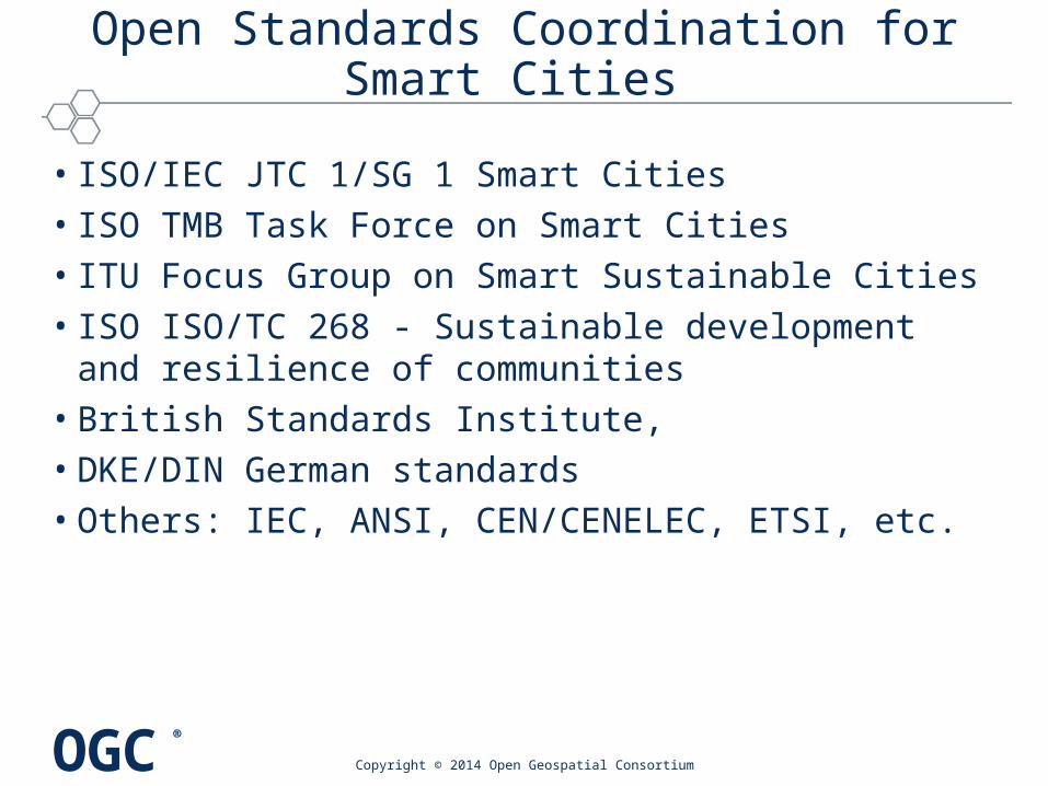
Open Standards Coordination for Smart Cities
• ISO/IEC JTC 1/SG 1 Smart Cities• ISO TMB Task Force on Smart Cities• ITU Focus Group on Smart Sustainable Cities• ISO ISO/TC 268 - Sustainable development and resilience
of communities• British Standards Institute, • DKE/DIN German standards• Others: IEC, ANSI, CEN/CENELEC, ETSI, etc.
Copyright © 2014 Open Geospatial Consortium

OGC®
Smart Cities Spatial Information FrameworkSmart Cities Spatial Information Framework
White Paper Themes•Smart Cities are high-density generators of innovation and information.•Location information is a major enabler of Smart City technology benefits.•Benefits of smart technology must be judged by benefits to residents•Reuse and repurpose is vital to urban resilience•Open standards are needed for interoperability, efficiency, application innovation and cost effectiveness.
Copyright © 2014 Open Geospatial Consortium

OGC®
Smart Cities Spatial Information ViewpointsSmart Cities Spatial Information Viewpoints
• ISO/IEC 10746, Information Technology — Open Distributed Processing — Reference Model (RM-ODP)– Enterprise Viewpoint: definition of Smart City, Indicators for assessing the
value of deploying the technology, and enterprise components for the information system of a Smart City
– Information Viewpoint, spatial information and data needed in Smart City
– Services Viewpoint interfaces and workflows pertinent to a achieve interoperability using a service oriented architecture for a Smart City
– Deployment Viewpoint, identifying approaches for deploying the Spatial Information Framework in cities.
• An Annex provides a summary of standardization activities regarding Smart Cities.
– The architecture in the main body of the white paper aims to build on and contribute back to the activities of the SDOs.
Copyright © 2014 Open Geospatial Consortium

OGC®
Smart Cities Spatial Information ThemesSmart Cities Spatial Information Themes
• Smart Cities are high-density generators of innovation and information• Location information is a major enabler of Smart City technology
benefits.• Benefits of smart technology must be judged by benefits to residents• Reuse and repurpose is vital to urban resilience• Open standards are needed for interoperability, efficiency, application
innovation and cost effectiveness.
(Graphic from Steve Liang, University of Calgary)

OGC®
What’s so smart about Smart Cities?
• A Smart City provides effective integration of physical, digital and human systems in the built environment to deliver a sustainable, prosperous and inclusive future for its citizens. – Source: BSI PAS 180 - Smart Cities Vocabulary
• How are “smarts” applied in cities– To improve emergency response and resource management.
• Centralized command and control system
– To enhance citizen access to the city information to inform individual and collective decision making• Autonomous actors in an ecosystem
Copyright © 2014 Open Geospatial Consortium Smart City Information Enterprise

OGC®
The Death and Life of Great Smart Cities
• “Cities have the capability of providing something for everybody, only because, and only when, they are created by everybody.” – The Death and Life of Great American Cities, Jane Jacobs
• “Go out there and see what works and what doesn’t work, and learn from reality. See how people actually use spaces, learn from that, and use it.” – Physical architect Jan Gehl recalling Jane Jacobs
• Smart city information development based on Jacobs– Open Information– Iterative Development– Indicators of what’s important
Copyright © 2014 Open Geospatial Consortium Smart City Information Enterprise

OGC®
Indicators for city services and quality of life
Copyright © 2014 Open Geospatial Consortium Smart City Information Enterprise

OGC®
Example Indicators from ISO 37120Example Indicators from ISO 37120
ISO 37120 indicators involve geospatial and sensors
•Recreation indicator: Outdoor recreation space– Square meters of public outdoor recreation space per capita
•Energy indicator: Renewable energy sources– Percentage of total energy derived from renewable sources, as a
share of the city's total energy consumption
•Environment indicator: Noise pollution – Noise pollution shall be calculated by mapping the noise level Lden
(day-evening-night) likely to cause annoyance
Copyright © 2014 Open Geospatial Consortium Smart City Information Enterprise

OGC®
Smart City Application AreasSmart City Application Areas
Each SDO has a similar list of application areas:•Utilities - Smart Grid, Smart Water, etc.•Sanitation•Intelligent Buildings•Intelligent Transportation•Health•Public Safety and Security•Environmental Protection•Emergency Services•Education•Urban Planning•Open Data
Copyright © 2014 Open Geospatial Consortium Smart City Information Enterprise

OGC®
Copyright © 2014 Open Geospatial Consortium
China’s Smart City Pilots: A Progress Report
Pu Liu and Zhenghong Peng, Wuhan University
IEEE Computer, October 2014

OGC®
ITU Focus Group on Smart Sustainable CitiesITU Focus Group on Smart Sustainable Cities

OGC®
Smart City Enterprise ComponentsSmart City Enterprise Components
Copyright © 2014 Open Geospatial Consortium
Elected Officials
Population
Data
Analyticsand Models
Data Access
Geospatial
Data
City Sensor Webs
Sensor networks
Public
Crowdsourcing
Phones, Wearables
Health
Metadata
Catalogs, Semantics
Sensing Layer
DataLayer
Data Ingest and Quality Checking
OtherData
Enterprise Data
Urban/Municipal Database
BusinessLayer
Visualization and Decision Support
ApplicationLayer
EconomicData
Intelligent buildings
Intelligent transportation
Open data
Environmental Protection
Public safety and security Urban planning
UtilitiesEmergency Services EducationSanitation
Municipal Employees
Clo
ud
hoste
d re
sou
rces
Secu
rity S
yste
m
Smart City Information Enterprise

OGC®
Spatial information is pervasive and primary
• Geography Markup Language (GML) – the international XML standard for spatial data on the web.
• CityGML - open data format for the storage and exchange of virtual 3D city models and semantics
• IndoorGML - modeling indoor spaces for navigation purposes.
• LandXML - civil engineering and survey data for land development and transportation
• Building Information Models (BIM) using ISO, BuildingSmart and OGC standards
Source: Thomas Kolbe, Berlin TU
Information Viewpoint

OGC®
CityGML Standards FamilyCityGML Standards Family
• CityGML Standard– Version 2.0 – current adopted version – Version 3.0 Standards Working Group underway
• INSPIRE Data Specification on Buildings – Buildings Theme as in Annex III of the EU INSPIRE Directive– 3D representations of buildings using CityGML– Basis of visualization of noise mapping
• National 3D standard in The Netherlands – OGC Best Practice: CityGML ADE - Dutch 3D Standard
• Additional profiles are underway– 3D National Data Model for Kingdom of Bahrain
Copyright © 2014 Open Geospatial Consortium

OGC®
CityGML ImplementationCityGML Implementation(Thanks to Claus Nagel for input)(Thanks to Claus Nagel for input)
• Berlin 3D City Model - one of the world's largest city models.– 560,000 fully textured building models in Level of Detail 2 (LoD2) and more than 200 detailed
models in LoD3/4.
– Basis of the Berlin Economic Atlas and the Solar Atlas
• German federal surveying agencies central database – will contain every building in Germany as CityGML LOD1 and LOD2 model.
– LOD1 model is nearly complete, and LOD2 is expected to be completed by the end of next year.
– Nearly every larger German city maintains its own CityGML model in addition.
• Major cities in Austria (e.g., Vienna, Salzburg), Switzerland (e.g., Zürich, Geneva) France (e.g., Paris, Bordeaux) have CityGML models
• Finland national initiative to build up a nation-wide 3D model – 3D model on top of an “Open Information Model Architecture” - CityGML + OGC web service
interfaces + open data + open APIs.
– Finish 3D model integrating both BIM and CityGML.
• Singapore evaluated CityGML for a 3D city model covering all LODs. – Infocomm Development Authority of Singapore (IDA)
• Malaysian 3D SDI • Increasing interest in Japan and US
Copyright © 2014 Open Geospatial Consortium
OGC®
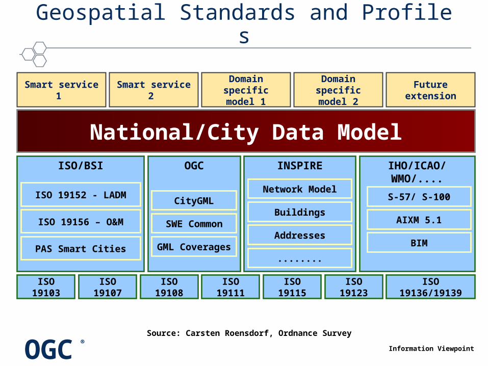
Geospatial Standards and Profile s
ISO/BSI
ISO 19103 ISO 19107 ISO 19108 ISO 19111 ISO 19115 ISO 19123 ISO 19136/19139
ISO 19152 - LADM
ISO 19156 – O&M
PAS Smart Cities
OGC IHO/ICAO/WMO/....INSPIRE
National/City Data Model
Smart service 1 Smart service 2 Domain specific
model 1Domain specific
model 2
S-57/ S-100
AIXM 5.1
Network Model
Buildings
Addresses
........
CityGML
SWE Common
BIM
Future extension
GML Coverages
Information Viewpoint
Source: Carsten Roensdorf, Ordnance Survey

OGC®
Seamless spatial data modeling across SDOs
Copyright © 2014 Open Geospatial ConsortiumInformation Viewpoint

OGC®
Interoperability Services for Smart Cities
• OGC Web Services – Maps - WMS, Features - WFS, Coverages -
WCS, Metadata - CSW
• Sensor Web Enablement – Discover, Task, Access and Process Sensor
Observations – SOS, SPS
• Crowdsourcing – Geo-enabled Social Media – SensorThings for Internet of Things
• Processing – WPS, WCPS, TJS, OpenMI
• Visualization and Augmented Reality – ARML2, 3D Portrayal
• Open Data and Mobile: – Open GeoSMS, Context, GeoPackage, 3D
Portrayal
© 2014 Open Geospatial Consortium
OGC Sensor Web Enablement
Services Viewpoint
OGC Web Services
Web MapServer
Web CoverageServer
Web FeatureServer

OGC®
OGC Services Architecture for interoperable access and processing of geospatial information for decision support
Visualization / Decision Tools and Applications
Internet and Cellular Networks
Other Data
Processing Services
OpenMI
WPSTJS WCPS
Geospatially Enabled Metadata
Discovery Services
CSW
OpenSearch Geo ebRI
M
WMS
WMTS
WFS
Simple Features Access
Access Services
GeospatialFeature
Data
Geospatial
Browse/Maps
Geospatial Coverage
Data
WCS
Other ServicesWorkflow, Alerts
Sensors
Puck
SOS
SPS
O&M
SensorML
Sensor Web Enablement
Discover Task Access
Copyright © 2014 Open Geospatial Consortium
Services Viewpoint

OGC®
Example applications of Smart City Example applications of Smart City Spatial Information Architecture (1 of 2)Spatial Information Architecture (1 of 2)
Indicator Standards
Maintain a City Model • “Rapid model-building for venue owners” using CityGML and IndoorGML
Recreation: Recreation space
• Calculate using WFS, WPS on City model • OGC Moving Features movement of pedestrians
Energy: Renewable energy sources
• Solar Atlas of Berlin is based on CityGML model• BIM, geospatial, smart meters for urban energy -
European SUNSHINE project
Environment: Noise pollution
• 3D visualization of noise using the INSPIRE Building OGC.
Copyright © 2014 Open Geospatial Consortium

OGC®
Example applications of Smart City Example applications of Smart City Spatial Information Architecture (1 of 3)Spatial Information Architecture (1 of 3)
Indicator Standards
Common Operating Picture
• COP for emergency response using Oil Spill Recommended Practice – OGC Web Services and GML Application Schemas
Urban Economics • Geospatial cyberinfrastructure for urban economic analysis and simulation: WMS, WFS, WPS at ASU
Big data Analytics • "New Science of Cities,” Batty • WPS cloud computing for big data geo-analytics
Crowdsourcing and VGI
• SensorThings on crowdsourcing “stovepipes” • WFS and SOS wrapping of Twitter, Flickr and from
mobile devices directly as in OGC testbeds
Open Data • Open source : OS Geo, LocationTech, Apache, etc• Open data: Open Street Map, Location Tech,
GEOSS
Copyright © 2014 Open Geospatial Consortium

OGC®
InformationViewpoint
ComputationalViewpoint
EngineeringTechnology
Viewpoints
Optimized Design/Development
EnterpriseViewpoint
Community Objectives• Indicators for city services
and quality of life• Smart City Applications• Enterprise Components
Abstract/Best Practices
RM-ODP Viewpoints
Information Models•GML•CityGML •IndoorGML•LandXML •BIM
OGC Smart Cities OGC Smart Cities Spatial Information FrameworkSpatial Information Framework
Indicator
Maintain a City Model
Recreation: Recreation space
Energy: Renewable energy
Environment: Noise pollution
Indicator
Common Operating Picture
Urban Economics
Big data Analytics
Crowdsourcing and VGI
Open Data
Services•OGC Web Services•Sensor Web (SWE)•Mobile and IoT•Crowdsourcing •Open Data

OGC®
OGC Smart Cities OGC Smart Cities Spatial Information FrameworkSpatial Information Framework
1. A Spatial Information Framework for Smart Cities?
2. Smart City Information Enterprise2.1 What’s so smart about Smart Cities?
2.2 Indicators for city services and quality of life
2.3 Smart City Applications
2.4 Smart City Enterprise framework
3. Spatial Information and Smart Cities3.1 Spatial information is pervasive and primary
3.2 CityGML and IndoorGML
3.3 LandML, InfraGML and InfraML
3.4 Building Information Models
4. Interoperability Services for Smart Cities4.1 Geospatial Services Architecture
4.2 Sensor Web Enablement and SensorThings
4.3 Data Access Services
4.4 Processing Services
4.5 Catalogue Services
4.6 Workflow
4.7 Context Document and GeoPackage
4.8 Visualization and Augmented Reality
5. Development of Spatial Information Framework for Smart Cities5.1 Spatial Information Architecture for Smart Cities
5.2 OGC Smart City Interoperability Initiatives
5.3 Deploying the Spatial Information Framework for Smart Cities
Annex A. Open Standards Coordination for Smart Cities
Copyright © 2014 Open Geospatial Consortium

OGC®
Next StepsNext Steps
Next Steps in developing Spatial Information Framework
•Develop a Spatial Information Architecture for Smart Cities– Build on the white paper and beyond
•Coordinate with other Standards Developing Organizations– OGC providing spatial and location standards for Smart Cities
•Catalog OGC member implementations •Conduct testing to confirm the architecture and technology
•Deploy the architecture as a policy in your Smart City.
Copyright © 2014 Open Geospatial Consortium

OGC®
Copyright © 2014 Open Geospatial Consortium
Template for Document Approval MotionTemplate for Document Approval Motion
• The Urban Planning DWG recommends that the OGC Technical Committee approve release of [OGC Document 14-115] “OGC Smart Cities Spatial Information Framework” as an OGC White Paper– Pending and final edits and review by OGC staff– After a two week comment period and responses.– Motion: <Name of person making the motion>– Second: <name of the person seconding the motion>– If there is a hand vote, the results of the vote. Otherwise, the phrase
<There was no objection to unanimous consent> should be used• This White Paper provides a draft spatial information framework for
Smart Cities. The document is structured using an RM-ODP viewpoints plus an annex surveying Smart City activities in other SDOs.