Embed Size (px)
Citation preview
World Meteorological OrganizationCOMMISSION FOR BASIC SYSTEMSSixteenth SessionGuangzhou, China, 23 to 29 November 2016
CBS-16/Doc. 3.2(1)Submitted by:
Secretary-General31.X.2016DRAFT 1
AGENDA ITEM 3: DECISIONS RELATED TO TECHNICAL REGULATIONS, ASSOCIATED GUIDES AND GUIDANCE MATERIAL
AGENDA ITEM 3.2: RECOMMENDATIONS FOR THE MANUAL ON THE GLOBAL OBSERVING SYSTEM AND FOR THE GUIDE TO THE GLOBAL OBSERVING SYSTEM
SUMMARY
DECISIONS/ACTIONS REQUIRED:
Adopt draft Recommendation 3.2(1)/1 — Revised Manual on the GOS and Guide to the GOS.
CONTENT OF DOCUMENT:
The Table of Contents is available only electronically as a Document Map*.
* On a PC, in MS Word 2010 go to “View” and tick the “Navigation Pane” checkbox in the “Show” section. In MS Word 2007 or 2003, go to “View” > “Document Map”. On a Mac, go to “View” > “Navigation Pane” and select “Document Map” in the drop-down list on the left.

CBS-16/Doc. 3.2(1), DRAFT 1, p. 2
DRAFT RECOMMENDATION
Draft Recommendation 3.2(1)/1 (CBS-16)
REVISED MANUAL ON THE GOS AND GUIDE TO THE GOS
THE COMMISSION FOR BASIC SYSTEMS,
Noting the recent finalization within ICT-IOS of draft new regulatory material for the Manual on the Global Observing System (WMO-No. 544), Volume I – Global Aspects,
Noting further the finalization within ICT-IOS of updated draft guidance material for the Guide to the Global Observing System (WMO-No. 488),
Having considered the proposed amendments, which respond to the WIGOS call for increased global standardization of observing technologies and techniques, and address, in particular:
(1) WIGOS station identifiers,
(2) Automatic Weather Station (AWS) systems,
(3) Aircraft meteorological stations,
(4) Radar Wind Profiler (RWP) stations,
(5) Weather radar stations,
(6) Voluntary Observing Ships’ (VOS) scheme,
Recommends to the Executive Council:
(1) To amend the Manual on the Global Observing System (WMO–No. 544), Volume 1, Global Aspects, as detailed in Annex 1;
(2) To amend the Guide to the Global Observing System (WMO–No. 488), as detailed in Annex 2.
__________
Annexes: 2
Annex 1 to draft Recommendation 3.2(1)/1 (CBS-16)

CBS-16/Doc. 3.2(1), DRAFT 1, p. 3
AMENDMENTS TO THE MANUAL ON THE GLOBAL OBSERVING SYSTEM, VOLUME 1, GLOBAL ASPECTS
SECTION: Cover redConditions: PDF only
Manual on the Global Observing SystemVolume I – Global AspectsAnnex V to the WMO Technical RegulationsSECTION: TitlePage
Manual on the Global Observing SystemVolume I – Global AspectsAnnex V to the WMO Technical RegulationsSECTION: ISBN-longSECTION: Revision_tablePUBLICATION REVISION TRACK RECORD
TABLE: Revision table
Date Part/chapter/section Purpose of amendment Proposed by Approved by

CBS-16/Doc. 3.2(1), DRAFT 1, p. 4
SECTION: Table_of_contentsSECTION: Pr-Preliminary_pagesINTRODUCTION
Purpose and scope
1. The Manual is designed:
(a) To facilitate cooperation in observations between Members;
(b) To specify obligations of Members in the implementation of the World Weather Watch (WWW) Global Observing System (GOS);
(c) To ensure adequate uniformity and standardization in the practices and procedures employed in achieving (a) and (b) above.
2. The first edition of the Manual on the Global Observing System was issued in 1980 in accordance with the decisions of the Seventh World Meteorological Congress. Since then it has undergone a number of revisions and amendments. The Manual on the WMO Integrated Global Observing System (WMO-No. 1160) will eventually replace the present Manual entirely, and the transfer process begi a ns with the is 2015 edition – some of its provisions have been removed and are now incorporated into the Manual on the WMO Integrated Global Observing System. For now these two Manuals are companion documents and must be read together. In particular, the provisions of the Manual on the WMO Integrated Global Observing System apply to all component observing systems, including the GOS.
3. This Manual is composed of Volumes I and II, which contain the regulations for the global and regional aspects of the System, respectively. The regulations stem from recommendations of the Commission for Basic Systems and resolutions of regional associations, as well as from decisions taken by Congress and the Executive Council.
4. Volume I of the Manual – Global Aspects – has regulatory status and is referred to as Annex V to the Technical Regulations (WMO-No. 49).
5. Volume II of the Manual – Regional Aspects – does not have regulatory status.
6. In essence, the Manual specifies what is to be observed where and when in order to meet the relevant observational requirements of Members. The Guide to the Global Observing System (WMO-No. 488) provides detailed guidance on how to establish, operate and manage networks of stations to make these observations. While some regulatory material concerning instruments and methods of observation is contained in a special short section of the Manual, a full description of how and with what observations are made is contained in the Guide to

CBS-16/Doc. 3.2(1), DRAFT 1, p. 5
Meteorological Instruments and Methods of Observation (WMO-No. 8). The International Cloud Atlas (WMO-No. 407) describes the classification of clouds. The subsequent step of how observations are to be reported and encoded is specified in the Manual on Codes (WMO-No. 306). Further guidance on observations for special applications is given in WMO publications such as the Guide to Meteorological Observing and Information Distribution Systems for Aviation Weather Services (WMO-No. 731), Guide to Marine Meteorological Services (WMO-No. 471), Guide to Climatological Practices (WMO-No. 100), Guide to Agricultural Meteorological Practices (WMO-No. 134) and various publications of the Global Atmosphere Watch Programme.
SECTION: Pr-Preliminary_pagesGENERAL PROVISIONS
1. The Technical Regulations (WMO-No. 49) of the World Meteorological Organization are presented in four volumes:
Volume I – General meteorological standards and recommended practices Volume II – Meteorological service for international air navigation Volume III – Hydrology Volume IV – Quality management
Purpose of the Technical Regulations
2. The Technical Regulations are determined by the World Meteorological Congress in accordance with Article 8 (d) of the Convention.
3. These Regulations are designed:
(a) To facilitate cooperation in meteorology and hydrology among Members;
(b) To meet, in the most effective manner, specific needs in the various fields of application of meteorology and operational hydrology in the international sphere;
(c) To ensure adequate uniformity and standardization in the practices and procedures employed in achieving (a) and (b) above.
Types of Regulations
4. The Technical Regulations comprise standard practices and procedures and recommended practices and procedures.
5. The definitions of these two types of Regulations are as follows:
The standard practices and procedures:
(a) Shall be the practices and procedures that Members are required to follow or implement;
(b) Shall have the status of requirements in a technical resolution in respect of which Article 9 (b) of the Convention is applicable;
(c) Shall invariably be distinguished by the use of the term shall in the English text, and by suitable equivalent terms in the Arabic, Chinese, French, Russian and Spanish texts.
The recommended practices and procedures:
CBS-16/Doc. 3.2(1), DRAFT 1, p. 6
(a) Shall be the practices and procedures with which Members are urged to comply;
(b) Shall have the status of recommendations to Members, to which Article 9 (b) of the Convention shall not be applied;
(c) Shall be distinguished by the use of the term should in the English text (except where otherwise provided by decision of Congress) and by suitable equivalent terms in the Arabic, Chinese, French, Russian and Spanish texts.
6. In accordance with the above definitions, Members shall do their utmost to implement the standard practices and procedures. In accordance with Article 9 (b) of the Convention and in conformity with Regulation 128 of the General Regulations, Members shall formally notify the Secretary-General, in writing, of their intention to apply the standard practices and procedures of the Technical Regulations, except those for which they have lodged a specific deviation. Members shall also inform the Secretary-General, at least three months in advance, of any change in the degree of their implementation of a standard practice or procedure as previously notified and the effective date of the change.
7. Members are urged to comply with recommended practices and procedures, but it is not necessary to notify the Secretary-General of non-observance except with regard to practices and procedures contained in Volume II.
8. In order to clarify the status of the various Regulations, the standard practices and procedures are distinguished from the recommended practices and procedures by a difference in typographical practice, as indicated in the editorial note.
Status of annexes and appendices
9. The following annexes to the Technical Regulations (Volumes I to IV), also called Manuals, are published separately and contain regulatory material having the status of standard and/or recommended practices and procedures:
I International Cloud Atlas (WMO-No. 407), Volume I – Manual on the Observation of Clouds and Other Meteors, Part I; Part II: paragraphs II.1.1, II.1.4, II.1.5 and II.2.3; subparagraphs 1, 2, 3 and 4 of each paragraph from II.3.1 to II.3.10; paragraphs II.8.2 and II.8.4; Part III: paragraph III.1 and the definitions (in italics) of paragraph III.2;
II Manual on Codes (WMO-No. 306), Volume I;III Manual on the Global Telecommunication System (WMO-No. 386);IV Manual on the Global Data-processing and Forecasting System (WMO-No. 485), Volume I;V Manual on the Global Observing System (WMO-No. 544), Volume I;VI Manual on Marine Meteorological Services (WMO-No. 558), Volume I;VII Manual on the WMO Information System (WMO-No. 1060);VIII Manual on the WMO Integrated Global Observing System (WMO-No. 1160).
These annexes (Manuals) are established by decision of Congress and are intended to facilitate the application of Technical Regulations to specific fields. Annexes may contain both standard and recommended practices and procedures.
10. Texts called appendices, appearing in the Technical Regulations or in an annex to the Technical Regulations, have the same status as the Regulations to which they refer.
Status of notes and attachments
11. Certain notes (preceded by the indication “Note”) are included in the Technical Regulations for explanatory purposes; they may, for instance, refer to relevant WMO Guides and publications. These notes do not have the status of Technical Regulations.
CBS-16/Doc. 3.2(1), DRAFT 1, p. 7
12. The Technical Regulations may also include attachments, which usually contain detailed guidelines related to standard and recommended practices and procedures. Attachments, however, do not have regulatory status.
Updating of the Technical Regulations and their annexes (Manuals)
13. The Technical Regulations are updated, as necessary, in the light of developments in meteorology and hydrology and related techniques, and in the application of meteorology and operational hydrology. Certain principles previously agreed upon by Congress and applied in the selection of material for inclusion in the Technical Regulations are reproduced below. These principles provide guidance for constituent bodies, in particular technical commissions, when dealing with matters pertaining to the Technical Regulations:
(a) Technical commissions should not recommend that a Regulation be a standard practice unless it is supported by a strong majority;
(b) Technical Regulations should contain appropriate instructions to Members regarding implementation of the provision in question;
(c) No major changes should be made to the Technical Regulations without consulting the appropriate technical commissions;
(d) Any amendments to the Technical Regulations submitted by Members or by constituent bodies should be communicated to all Members at least three months before they are submitted to Congress.
14. Amendments to the Technical Regulations – as a rule – are approved by Congress.
15. If a recommendation for an amendment is made by a session of the appropriate technical commission and if the new regulation needs to be implemented before the next session of Congress, the Executive Council may, on behalf of the Organization, approve the amendment in accordance with Article 14 (c) of the Convention. Amendments to annexes to the Technical Regulations proposed by the appropriate technical commissions are normally approved by the Executive Council.
16. If a recommendation for an amendment is made by the appropriate technical commission and the implementation of the new regulation is urgent, the President of the Organization may, on behalf of the Executive Council, take action as provided by Regulation 9 (5) of the General Regulations.
Note: Detailed procedures for amending the Manual on the GOS and other Manuals that are the responsibility of CBS are provided in Annex 1 of Resolution 12 (EC-68), to be incorporated into the WMO Technical Regulations (WMO-No. 49) Volume 1 as Appendix F, in accordance with Resolution 21 (Cg-17). These procedures include simple (fast-track) procedures which may be used for amendments to designated technical specifications in the Manual on the GOS . However there are no such designations in this 2017 update. A fast-track procedure can be applied for additions to certain codes and associated code tables contained in Annex II ( Manual on Codes (WMO-No. 306)). Application of the fast-track procedure is described in detail in Annex II.
17. After each session of Congress (every four years), a new edition of the Technical Regulations, including the amendments approved by Congress, is issued. With regard to the amendments between sessions of Congress, Volumes I, III and IV of the Technical Regulations are updated, as necessary, upon approval of changes thereto by the Executive Council. The Technical Regulations updated as a result of an approved amendment by the Executive Council are considered a new update of the current edition. The material in Volume II is prepared by the World Meteorological Organization and the International Civil Aviation Organization working in close cooperation, in accordance with the Working Arrangements agreed by these Organizations. In order to ensure consistency between Volume II and Annex 3 to the Convention on International Civil Aviation – Meteorological Service for International Air

CBS-16/Doc. 3.2(1), DRAFT 1, p. 8
Navigation, the issuance of amendments to Volume II is synchronized with the respective amendments to Annex 3 by the International Civil Aviation Organization.
Note: Editions are identified by the year of the respective session of Congress whereas updates are identified by the year of approval by the Executive Council, for example “Updated in 2012”.
WMO Guides
18. In addition to the Technical Regulations, appropriate Guides are published by the Organization. They describe practices, procedures and specifications which Members are invited to follow or implement in establishing and conducting their arrangements for compliance with the Technical Regulations, and in otherwise developing meteorological and hydrological services in their respective countries. The Guides are updated, as necessary, in the light of scientific and technological developments in hydrometeorology, climatology and their applications. The technical commissions are responsible for the selection of material to be included in the Guides. These Guides and their subsequent amendments shall be considered by the Executive Council.
SECTION: ChapterChapter title in running head: PART I. GENERAL PRINCIPLES REGARDING TH…
PART I. GENERAL PRINCIPLES REGARDING THE ORGANIZATION AND IMPLEMENTATION OF THE GLOBAL OBSERVING SYSTEM
1. PURPOSE OF THE GLOBAL OBSERVING SYSTEM
1.1 The purpose of the Global Observing System shall be to provide, from all parts of the globe and from outer space, high-quality standardized observations of the state of the atmosphere, land and ocean surface for the preparation of weather analyses, forecasts and warnings and for other applications in support of WMO Programmes and related environmental programmes of other organizations.
1.2 The GOS should provide supplementary observations required internationally for special purposes, provided this does not obstruct the achievement of the primary purposes of the World Weather Watch.
2. ORGANIZATION AND DESIGN OF THE GLOBAL OBSERVING SYSTEM
2.1 The GOS shall be organized as part of the WWW, in conjunction with the Global Data-processing and Forecasting System and the Global Telecommunication System (GTS).
2.2 The GOS shall be constituted as a coordinated system of methods, techniques and facilities for making observations on a worldwide scale and as one of the main components of the WWW, taking into account to the extent feasible the requirements of other international programmes.
2.3 The GOS shall consist of facilities and arrangements for making observations at stations on land and at sea, from aircraft, from environmental observation satellites and other platforms.
2.4 For convenience in the planning and coordinating of the system, taking into account various criteria for observational data requirements, the GOS shall be considered as composed of three levels: global, regional and national.

CBS-16/Doc. 3.2(1), DRAFT 1, p. 9
2.5 The GOS shall be designed as a flexible and developing system capable of continuous improvement, on the basis of the latest achievements of technological and scientific progress and in accordance with changing requirements for observational data.
2.6 The planning and coordination of the GOS shall be realized through recommendations of the Commission for Basic Systems and approved by the Executive Council, in consultation and coordination with Members, regional associations and other technical commissions concerned.
2.7 The GOS shall consist of two subsystems: the surface-based subsystem and the space-based subsystem.
2.8 The GOS surface-based subsystem shall be composed of surface synoptic land and sea stations, upper-air synoptic stations, climatological stations, agricultural meteorological stations, aircraft meteorological stations, aeronautical meteorological stations, research and special-purpose vessel stations and special stations as detailed in Part III, paragraph 1 (a) to (h) of this Manual.
2.9 The main elements of the GOS surface-based subsystem shall consist of networks of surface synoptic stations on land and at sea, and upper-air stations, and aircraft meteorological stations, radar wind profiler stations and weather radar stations, as detailed in Part III, paragraph 1 (a) to (c e ) of this Manual.
2.10 Other elements of the GOS surface-based subsystem shall consist of aeronautical meteorological stations, climatological stations, agricultural meteorological stations, research and special-purpose vessel stations and special stations as listed in Part III, paragraph 1 (f d ) to (l h ) of this Manual.
2.11 The GOS space-based subsystem shall comprise satellites of three types: operational low Earth orbit and operational geostationary satellites and research and development satellites.
3. IMPLEMENTATION OF THE GLOBAL OBSERVING SYSTEM
3.1 Countries themselves are responsible for all activities connected with the implementation of the GOS on their individual territories and should fund them, to the extent possible, using national resources.
3.2 Implementation of the GOS on the territory of developing countries should be based on the principle of the utilization of national resources but, where necessary and so requested, assistance may be provided in part through:
(a) The WMO Voluntary Cooperation Programme;
(b) Other bilateral or multilateral arrangements, including the United Nations Development Programme, which should be used to the maximum extent possible.
3.3 Implementation of the GOS in regions outside the territories of individual countries (for example, outer space, oceans, the Antarctic) should be based on the principle of voluntary participation of countries that desire and are able to contribute by providing facilities and services, either individually or jointly from their national resources, or by having recourse to collective financing. The assistance sources described in 3.2 above may also be used.

CBS-16/Doc. 3.2(1), DRAFT 1, p. 10
3.4 In the implementation of the GOS, maximum use should be made of existing arrangements, facilities and personnel.
Note 1. The setting up and operation of the new and improved facilities and services require a considerable amount of scientific research, development engineering, coordination of procedures, standardization of methods and implementation coordination.
Note 2. The further development of the GOS is an important feature of the WWW plan that provides for:
(a) Continued development of the GOS as a cost-effective composite system comprising operationally reliable surface-based and space-based (satellite) subsystems. It is expected that, within the surface-based subsystem, new systems measuring both large and local scales of atmospheric phenomena will be deployed operationally on a wider scale. Increasing use will be made of the rapidly growing fleet of aircraft with automated observing and reporting systems to observe data at cruising levels and during ascent and descent. Radar wind profilers will play an important role in upper-air networks. International exchange of weather radar observational data will enhance Members' ability to provide services for the good of all. Mobile sea stations will continue to be the main source for surface synoptic observations over the oceans. Through increased use of automatic observing and (satellite) transmission equipment, the quality and quantity of the data will increase. The number of ships equipped with automated upper-air sounding facilities (as part of the Automated Shipboard Aerological Programme) will increase and the deployment of more cost-effective systems will be accelerated. Drifting buoys, deployed outside the main shipping routes, will continue to supply surface atmospheric and oceanographic parameters from the data-void ocean areas. It is also expected that the operational space-based subsystem will include a new generation of polar-orbiters and geostationary satellites with improved and new sensing systems.
(b) Coordination, integration and sustainability of composite surface- and space-based subsystems and development of observing networks that are adaptable to changing requirements. This will include the planning for a new composite upper-air observing system making the most effective use of new and emerging technology, in order to develop a cost-effective, truly global system with the density of in situ observations required for operational purposes as well as to complement and calibrate observations from satellites. The new composite system will utilize a range of technologies and techniques, some of which require long-term development efforts to become operational. New technology should be introduced as and when proven and must be consistent with existing systems and supporting structures.
(c) Development of new strategies to facilitate closer cooperation between Meteorological Services and research programmes so that the available observing systems and programmes can be of use to operational meteorology and the research community.
(d) Exploration of new ways for Members to contribute to the GOS, including joint funding and innovative arrangements to ensure adequate observations in remote and data-sparse areas.
3.5 Existing elements of the GOS, as defined in Part III, shall not be removed before the reliability of a new element has been proven, and relative accuracy and representativeness of the observational data have been examined and found acceptable.
SECTION: ChapterChapter title in running head: PART II. REQUIREMENTS FOR OBSERVATIONAL…
PART II. REQUIREMENTS FOR OBSERVATIONAL DATA
EDITORIAL NOTE: NO CHANGES ARE PROPOSED TO PART II.
THE ENTIRE TEXT OF THIS PART HAS BEEN EXCISED FOR THE SAKE OF BREVITY.
………………………………………………………………..
CBS-16/Doc. 3.2(1), DRAFT 1, p. 11
SECTION: ChapterChapter title in running head: PART III. SURFACE-BASED SUBSYSTEM
PART III. SURFACE-BASED SUBSYSTEM
1. COMPOSITION OF THE SUBSYSTEM
The main elements of the surface-based subsystem shall be:
(a) Surface synoptic stations:
(i) Land stations:
– Manned surface stations;
– Automatic surface stations;1
(ii) Sea stations:
– Fixed sea stations:
– Ocean weather stations;
– Lightship stations;
– Fixed platform stations;
– Anchored platform stations;
– Island and coastal stations;
– Mobile sea stations:
– Voluntary observing ship stations
– Selected ship stations;
– Selected AWS ship stations;
– VOSClim (VOS Climate) ship stations;
– VOSClim (VOS Climate) AWS ship stations;
– Supplementary ship stations;
– Supplementary ship stations;
– Supplementary AWS ship stations;
– Auxiliary ship stations;
– Ice-floe stations;
– Automatic sea stations:1
– Fixed sea stations;1 Data may be asynoptic when collected via satellite.
CBS-16/Doc. 3.2(1), DRAFT 1, p. 12
– Lightship stations;
– Mobile sea stations;
– Drifting buoy stations;
– Moored buoy stations;
(b) Upper-air synoptic stations:
– Rawinsonde stations;
– Radiosonde stations;
– Radiowind stations;
– Pilot-balloon stations;
(c) Aircraft meteorological stations;
(d) Radar wind profiler stations;
(e) Weather radar stations;
other elements of the subsystem shall be:
(f d ) Aeronautical meteorological stations;
(g e )Research and special-purpose vessel stations;
(h f ) Climatological stations;
(i) Global Climate Observing System Surface Network stations;
(j) Global Climate Observing System upper-air stations;
(k g )Agricultural meteorological stations;
(l h ) Special stations, which include:
(i) Weather radar stations;
(ii) Radiation stations;
(iii) Wind profilers Other remote-sensing profiler stations ;
(iii v ) Atmospherics Lightning detection location stations;
(iv) Meteorological reconnaissance aircraft stations;
(vi) Meteorological rocket stations;
(vii) Global Atmosphere Watch stations;
(viii) Planetary boundary-layer stations;
(viix)Tide-gauge stations.
Note 1. Definitions of stations listed above will be found in the appendix to this Manual.

CBS-16/Doc. 3.2(1), DRAFT 1, p. 13
Note 2. Any station may fall under more than one of the above categories.
Note 3. Observations from automatic surface synoptic stations on land or at sea may be asynoptic when collected via satellite.
2. IMPLEMENTATION OF ELEMENTS OF THE SUBSYSTEM
2.1 Networks of observing stations
2.1.1 General
2.1.1.1 Three types of networks of observing stations – global, regional and national, to meet the three levels of requirements for observational data – shall be established.
2.1.1.2 The networks should be interdependent, with selected stations of the national networks within a Region comprising the corresponding regional network, and with selected stations of the regional networks forming the global network. Therefore, a station of the global network should be part of a regional network and a national network.
2.1.1.3 The frequency and spacing of the observations should be adjusted to the physical scales of the meteorological phenomena to be described.
Note: See the Guide to the Global Observing System (WMO-No. 488), Figure II.1.
2.1.2 Global networks
2.1.2.1 A global synoptic network shall be established, based upon the Regional Basic Synoptic Networks (RBSNs).
Note: See 2.1.3 below.
2.1.2.2 The observing programme of the global synoptic network should provide meteorological data which have the necessary accuracy, and spatial and temporal resolution, to describe the state of temporal and spatial changes in the meteorological phenomena and processes occurring on the large and planetary scales.
Note: Guidance as to the determination of requirements for accuracy and time and spatial resolution of the observational data is given in the Guide to the Global Observing System (WMO-No. 488).
2.1.2.3 The global synoptic network should be as homogeneous and as uniform as possible, and observations should be made at the main standard times of observation.
2.1.2.4 Members should implement and sustain the Global Climate Observing System (GCOS) Surface Network (GSN) – the global baseline network of some 1 000 selected surface observing stations established to monitor daily global and large-scale climate variability.
2.1.2.5 Members should implement and sustain the GCOS Upper-air Network (GUAN) – the global baseline network of about 170 selected upper-air stations established with relatively homogenous distribution to meet requirements of GCOS.
2.1.2.6 Members should also establish and sustain the GCOS Reference Upper-air Network (GRUAN) of about 30 to 40 selected upper-air stations, to provide long-term high quality climate records, to constrain and calibrate data from more spatially-comprehensive global observing systems (including satellites and current radiosonde networks), and to fully characterize the properties of the atmospheric column.

CBS-16/Doc. 3.2(1), DRAFT 1, p. 14
2.1.3 Regional networks
2.1.3.1 Regional networks shall be established in relation to the regional requirements.
Note: Regional associations are responsible for the determination and coordination of the composition of these networks within the general framework established by the Commission for Basic Systems.
2.1.3.2 Regional Basic Synoptic Networks of both surface and upper-air stations and Regional Basic Climatological Networks (RBCNs) of climatological stations shall be established to meet the requirements laid down by the regional associations.
Note 1. The regional associations will review their plans regularly, in order to ensure that they meet any new international requirements.
Note 2. Details of known regional requirements are given in Volume II of this Manual.
2.1.3.3 Together, the RBSNs shall form the main part of the global surface-based synoptic network.
2.1.3.4 Members shall implement the RBSNs.
2.1.3.5 The horizontal spacing of observing stations and the frequency of their reporting should be in accordance with the requirements laid down in Part II above and in Volume II of this Manual.
2.1.4 National networks
National networks shall be established by Members to satisfy their own requirements. When implementing these national networks, Members shall take into account the need to participate in, and form part of, the global and regional networks.
Note: A complete list of all surface and upper-air stations in operation which are used for synoptic purposes is given in Weather Reporting (WMO-No. 9), Volume A – Observing Stations.
2.2 Observing stations
2.2.1 General
2.2.1.1 The implementation and operation of each of the above elements should be in accordance with decisions of Congress, the Executive Council, the technical commissions and regional associations concerned.
Note: These decisions are reflected in the Technical Regulations (WMO-No. 49) and its annexes, for example this Manual and the Manual on Codes (WMO-No. 306), and in other relevant WMO publications such as the Guide to the Global Observing System (WMO-No. 488) and the Guide to Meteorological Instruments and Methods of Observation (WMO-No. 8), which set forth the technical and meteorological aspects in detail.
2.2.1.2 In implementing the GOS surface-based subsystem, Members should ensure that the observing system meets the subsystem requirements.
2.2.1.3 In implementing the surface-based subsystem, Members should strive to meet the provisions of the decisions indicated in 2.2.1.1 above as closely as possible, in particular as regards the main elements of the surface-based subsystem.
2.2.1.4 Each station shall be uniquely identified by a WIGOS station identifier.

CBS-16/Doc. 3.2(1), DRAFT 1, p. 15
Note: Further regulations and notes relating to station identifiers are to be found in sections 2.4.1.1 to 2.4.1.4 of the Manual on the WMO Integrated Global Observing System (WMO-No. 1160).
2.2.1.5 4 Each station should be located at a site that permits correct exposure of the instruments and satisfactory non-instrumental observations.
2.2.1.6 5 In general, observing stations shall be spaced at an interval and observations shall be taken frequently enough to provide an accurate description of the atmosphere for those who use the observations for their intended purpose.
2.2.1.7 6 If in certain desert and other sparsely populated areas it is not possible to establish networks with the recommended densities, networks with densities as near as possible to those recommended should be established. Special efforts should be made to establish an adequate network in such areas when they border a populated area or are traversed by a regularly used air route.
2.2.1.8 7 Asynoptic observations should be taken when necessary to complement observations from the synoptic networks and in a manner which increases the overall observational spatial or temporal density.
2.2.1.9 8 Observations should be taken in areas where special phenomena are occurring or are expected to develop. As many meteorological elements of standard observations as possible should be reported. Information should be communicated in real time.
Note: Drifting buoys and aircraft may also report at asynoptic times.
2.2.1.10 9 Members shall ensure that a record of all surface and upper-air observations is made and preserved.
2.2.2 Operation of Automatic Weather Station (AWS) systems
Note 1. This section contains provisions for the operation of AWS systems in support of their contribution to the Global Observing System and to WIGOS. It is structured so as to anticipate the eventual integration of the material into the Manual on the WMO Integrated Global Observing System (WMO-No. 1160).
Note 2. The provisions of this section 2.2.2 are specific to AWS systems. They must be read in conjunction with further provisions throughout Part III as well as the Manual on the WMO Integrated Global Observing System (WMO- No. 1160) with which AWS operated by Members are to comply. Note 3. The provisions in this section are directed to Members that operate AWS and provide data to the WMO Information System (WIS).
Note 4. Guidance on making measurements using AWS can be found in Guide to Meteorological Instruments and Methods of Observation (WMO-No. 8), Part II, Chapter 1.
Note 5. Guidance on network planning and site selection in relation to AWS can be found in the Guide to the Global Observing System (WMO-No. 488), Part III, Section 3.2.1.4.
General Requirements
2.2.2.1 Members shall establish and operate an AWS network to meet national, regional and global requirements for observations.
Note 1. General provisions for equipment and methods of observation for meteorological stations, including AWS stations, are given in section 3.1.
Note 2. Further guidance on the operation of AWS networks in support of the surface-based subsystem of the GOS are provided in Guide to the Global Observing System (WMO-No. 488) Part III, Section 3.1.4.3.
2.2.2.2 Members should ensure that observations from AWS, as a minimum, meet the minimum requirements for all Application Areas that the station is associated with.

CBS-16/Doc. 3.2(1), DRAFT 1, p. 16
Note 1. Further discussion of requirements for observations is located in the Manual on the WMO Integrated Global Observing System (WMO-No. 1160) section 2.2.4 and Appendix 2.3. Requirements for observational data are also described in the Guide to the Global Observing System (WMO-No. 488), Part II.
Note 2. It is recommended that Members designate an AWS network manager to be responsible for ensuring that the network addresses user requirements on an ongoing basis, through a review process that takes into consideration WIGOS requirements.
Note 3. The Guide to the Global Observing System (WMO-No. 488), Part III, Appendix III.2, Basic set of variables to be reported by standard automatic weather stations for multiple users, offers guidance to Members on variables that are recommended to be reported from an AWS so as to meet minimum requirements in several areas.
Note 4. The Guide to the Global Observing System (WMO-No. 488), Appendix III.1, Functional Specifications for Automatic Weather Stations, provides information on measurement performance requirements for a range of variables associated with various WMO Application Areas.
2.2.2.3 Members should ensure that staff are trained to the appropriate level of competency for operation and maintenance of their AWS.
Note: Guidance on the training of instruments specialists is provided within the Guide to Meteorological Instruments and Methods of Observation (WMO-No. 8), Part III, Chapter 5.
2.2.2.4 Members should document the methods and procedures employed in the operation of their AWS.
Note: Such documentation is necessary to meet requirements of some Application Areas for observations traceability and comprises several aspects including metadata management, quality management, maintenance, change management, incident management, inspection and calibration. Further provisions and guidance on documentation practices are available in the Manual on the WMO Integrated Global Observing System (WMO-No. 1160) Section 2.6.6 and the Guide to the Global Observing System (WMO-No. 488), Part III, Section 3.2.1.4.
Observing Practices
2.2.2.5 Observation reports shall have a time stamp indicating the time of measurement with a minimum temporal resolution of 1 minute with respect to UTC.
Quality Control
Note 1. The importance of and requirements for Members to implement quality control procedures are given in the Manual on the WMO Integrated Global Observing System (WMO-No. 1160) section 2.4.3. Further elaboration on best practice in quality control of AWS observational data is described in the Guide to the Global Observing System (WMO- No. 488), Part VI and in the Guide to Meteorological Instruments and Methods of Observation (WMO-No. 8), Part III and Part II, section 1.3.2.8. For AWS observations, it is important that appropriate quality control procedures are applied at all stages of data processing and message generation. Note 2. Quality control of AWS systems incorporates aspects of the system design and operation including the following core elements as a minimum:
• Siting and exposure of systems and sensors; • Calibration and verification of systems and sensors; • System and network maintenance; • Incident management; • Data quality control.
Data & Metadata Reporting
2.2.2.6 Members shall make and report observations from AWS a minimum of eight times per day at the main and intermediate times.
CBS-16/Doc. 3.2(1), DRAFT 1, p. 17
Note: WMO standard Table Driven Code Forms (such as BUFR) are to be used for international exchange of surface observations in accordance with the Manual on Codes – International Codes (WMO-No. 306).
2.2.2.7 Members should make and report observations from AWS at least hourly.
Note 1. Observations generated routinely should be reported at uniform intervals aligned to the UTC hour. Note 2. Observations may be required to be reported more frequently when endeavouring to meet requirements for specific application areas such as high resolution NWP and nowcasting. In such cases, it is recommended that Members report these observations to the WIS.
2.2.2.8 Members that report AWS observations to the WIS shall maintain a copy of all reported AWS observations and associated metadata.
Note 1. Non-destructive storage of observations is important such that data and metadata quality and information content are not altered. Note 2. More information on data processing is provided in the Guide to the Global Observing System (WMO- No. 488) Part V, Reduction of Level I Data, and on data sampling in the Guide to Meteorological Instruments and Methods of Observation (WMO-No. 8) Part III, Chapter 2, Sampling Meteorological Variables.
Note 3. The Manual on the WMO Integrated Global Observing System (WMO-No. 1160) section 2.5 contains provisions for Members to maintain and provide required metadata in relation to all observations including operational AWS. Some specific requirements for the calculation and reporting of some meteorological observations are given in Part III, Section 3.3.
Incident Management
Note: The Manual on the WMO Integrated Global Observing System (WMO-No. 1160) Section 2.4.5 contains provisions for Members in relation to the management of incidents which interrupt the normal operation of their observing systems by reducing availability and/or quality of observational data.
2.2.2.9 Members who exchange AWS observations shall detect and report incidents to international recipients of observational data and advise of their resolution.
Note 1. Some incidents, such as those related to internal factors, may be detected automatically and reported without delay to international recipients of observational data. Other incidents may be detected with delay or through periodic checks and reported accordingly. Automatic incident detection can be performed using either built-in test equipment or external monitoring systems. A centralized system can be used for monitoring the performance and health of AWS systems and networks.Note 2. It is important to take corrective action in response to incidents as soon as possible, including their analysis and recording.
2.2.2.10 Members who exchange AWS observations should include information about incidents in the metadata that they record and make available.
Change Management
Note: The Manual on the WMO Integrated Global Observing System (WMO-No. 1160) Section 2.4.6 contains provisions for Members in relation to change management associated with all observing systems, including AWS.
2.2.2.11 When making changes to AWS, Members should plan carefully to avoid or minimize impact on observational data availability and quality.
Note: An important aspect of such careful planning is to have clear roles and responsibilities for each given change.

CBS-16/Doc. 3.2(1), DRAFT 1, p. 18
2.2.2.12 When making changes to AWS systems and networks, Members should notify stakeholders and observational data users in advance, both national and international, record and document such changes and update relevant metadata records.
Note 1. These notifications include information on the expected impacts and the time period over which the change will take place and, importantly, when the period of change is complete. A future standard mechanism and format for such notifications will be useful.Note 2. The record of changes includes the nature and characteristics of the change, the date and time of implementation and the reason that the change is being made.Note 3. The relevant metadata includes both national and international metadata records pertaining to the AWS system and site.
2.2.2.13 In making changes to observing systems, Members should plan and make provision for requirements for periods of overlapping observations.
Note: For climatological stations in particular there may be a requirement to undertake a period of overlap as detailed in Guide to the Global Observing System (WMO-No. 488), Part III, Section 3.7.4 and this is particularly pertinent when the establishment of an AWS system replaces manual observations.
Maintenance
Note: The Manual on the WMO Integrated Global Observing System (WMO-No. 1160) Section 2.4.7 contains provisions for Members in relation to the maintenance of all observing systems, including AWS systems.
2.2.2.14 Members who operate AWS shall develop, implement and document policy and procedures for routine maintenance of the system.
Note 1. The purpose of the policy and procedures is to ensure the requirements and standards for operational performance and observational data quality are met.
Note 2. The complete AWS system incorporates hardware, software, telecommunications and ancillary systems. Where possible and practical, the maintenance programme is to be based on relevant manufacturer specifications and guidelines.
Note 3. Routine site maintenance is conducted so as to ensure the ongoing representativeness of the site and the measured variables in accordance with the requirements of the Application Areas that the AWS observations support.
Note 4. Further guidance on maintenance of AWS networks is in the Guide to Meteorological Instruments and Methods of Observation (WMO-No. 8) Part II, Chapter 1, Section 1.6.
Note 5. Routine maintenance should be planned so as to minimize any impact on the making and reporting of observations, particularly during critical weather times and situations.
2.2.2.15 Members shall perform corrective maintenance as soon as practically possible after an issue with an AWS system has been detected.
Note: Typically, it is through monitoring and/or incident management that an issue is detected and responsive maintenance is triggered. The assessment of what is practically possible may take into account the severity of the issue.
2.2.2.16 Members who operate AWS should, where appropriate, implement and perform maintenance tasks remotely.
Note: Remote maintenance cannot replace on-site maintenance for many tasks, but the ability to perform some tasks remotely can contribute to preventive maintenance practices helping to achieve higher overall system uptime and quality of operation.
2.2.2.17 Members who operate AWS shall ensure that they have sufficient numbers of competent staff to meet all maintenance requirements and responsibilities.
CBS-16/Doc. 3.2(1), DRAFT 1, p. 19
2.2.2.18 Members who exchange AWS observational data should record and report details of corrective and preventive maintenance completed in accordance with the WIGOS metadata standard.
Note 1. The requirements to retain and make available metadata, and the specification of the WIGOS metadata standard, are provided in the Manual on the WMO Integrated Global Observing System (WMO-No. 1160) section 2.5 and Appendix 2.4 with further elaboration in the Guide to the WMO Integrated Global Observing System (WMO- No. xxxx). Note 2. Any planned or responsive maintenance which has or is expected to reduce the normal AWS data availability and/or quality is to be treated in the same manner as an incident, by following provisions 2.2.2.9 and 2.2.2.10 above.
2.2.2.19 Members should either flag, remove or not report, as appropriate, observational data that is adversely impacted by maintenance activities.
Inspection & Supervision
2.2.2.20 Members shall define and establish functions and responsibilities for inspection and supervision of their AWS.
Note 1. The objective of inspection and supervision is to determine whether the AWS and its sensors are functioning correctly (within performance tolerances) and, if not, to understand the deviations and initiate a response. Note 2. Remote monitoring and diagnostic systems can significantly increase the effectiveness of inspection and supervision activities.Note 3. The general provisions for inspection and supervision provided within the Manual on the WMO Integrated Global Observing System (WMO-No. 1160) Section 3.4.8 apply to all surface-based systems, including AWS systems.
2.2.2.21 Members who report AWS observational data to the WIS shall record and report inspection results in accordance with the WIGOS metadata standard.
2.2.2.22 Members that report AWS observations to the WIS shall inspect their AWS at least once every two years.
Note 1. It is recommended that the frequency of inspections should be adequate to ensure a high probability of detection of issues that might impact on the integrity and quality of observational data.
Note 2. For further guidance on inspection processes and standards see Guide to the Global Observing System (WMO-No. 488) Part III, Section 3.1.3.8.
Calibration Procedures
2.2.2.23 Members shall define and establish functions and responsibilities for the calibration of their AWS and its sensors, giving consideration to the manufacturer guidelines.
Note 1. The objective of calibration is to constrain AWS components and sensors to operate within performance tolerances given by the supplier and to meet defined user requirements.Note 2. Recalibration or replacement of sensors is to be undertaken as soon as possible after detecting that tolerances for field verifications are exceeded.
2.2.2.24 Members should ensure that, when possible, AWS field sensors and travelling standards are traceable to the relevant primary international standard.
2.2.2.25 Members who report AWS observations to the WIS should record and report details of calibrations or field verifications in accordance with the WIGOS metadata standard.
Note 1. Any calibration or verification activity which has or is expected to reduce availability and/or quality of AWS observations is to be treated in the same manner as an incident, by following provisions 2.2.2.9 and 2.2.2.10 above.

CBS-16/Doc. 3.2(1), DRAFT 1, p. 20
Note 2. It is recommended that, for those sensors for which it is possible and appropriate, the periodic comparison of AWS sensors with travelling standards should be performed and recorded in accordance with the Guide to Meteorological Instruments and Methods of Observation (WMO-No. 8), Part III, Chapter 1, Section 1.7.
2.3 Surface synoptic stations
2.3.1 General
2.3.1.1 Surface synoptic stations may be manned or partly or fully automated and shall include land stations and fixed and mobile sea stations which conduct synoptic observations.
2.3.1.2 Each synoptic station shall be located so as to give meteorological data representative of the area in which it is situated.
2.3.1.3 The main standard times for surface synoptic observations shall be 0000, 0600, 1200 and 1800 UTC.
2.3.1.4 The intermediate standard times for surface synoptic observations shall be 0300, 0900, 1500 and 2100 UTC.
2.3.1.5 Atmospheric pressure observations should be made at exactly the standard time while the observation of other meteorological elements should be made within the 10 minutes preceding the standard time.
2.3.1.6 Every effort should be made to obtain surface synoptic observations four times daily at the main standard times, with priority being given to the 0000 and 1200 UTC observations, which are required for global exchanges.
2.3.1.7 Additionally, Members should endeavour to obtain surface synoptic observations at the intermediate standard times and, furthermore, at regular hourly intervals.
2.3.1.8 When it is difficult, for any reason, to provide sufficient staff for 24-hour operations, partially or fully automated stations should complement or replace manned surface stations, including those in the basic synoptic network, to provide observations at least at the main standard times.
2.3.2 Land stations
General
2.3.2.1 Each synoptic station on land shall be uniquely identified by a WIGOS station identifier.
Note: Requirements relating to station identifiers are at 2.2.1.4. Some of the now-expired identification requirements for synoptic stations are reproduced here because they may be adopted by an "issuer of identifiers" as a convention to be followed in defining "local identifiers" for new stations:
2.3.2.1 " A synoptic station on land shall be identified by a station index number assigned by the Member concerned, from within the allocations made to that Member, in compliance with the scheme prescribed in the Manual on Codes (WMO-No. 306). Before issuing a station index number, Members should ensure that the operator of the station or platform has committed to complying with the relevant Technical Regulations.
Note: If a station is outside the geographical territory of any Member, or if the relevant Member is not able to assign a number, the Secretary-General may assist in the process of assigning a number.

CBS-16/Doc. 3.2(1), DRAFT 1, p. 21
2.3.2.2 When a Member establishes a synoptic station on land it shall send the following information to the Secretariat at least two months before the station becomes operational:
(a) Name, and where appropriate, station index number (stating whether the station is automatic or manned and, if both, the type of each);
(b) Geographical coordinates in degrees, minutes and integer seconds of arc and elevation of the station, in metres (up to two decimals) above mean sea level;
(c) Geopotential of the datum level in whole metres to which the pressure is reduced, or the reference isobaric surface the geopotential of which is reported;
(d) Times at which synoptic observations are made and reported;
(e) Topographical situation;
(f) Any other information required for completion of the entries in Weather Reporting (WMO-No. 9), Volume A – Observing Stations.
Note: Information on the accurate specification of the geographical coordinates and elevation of a station is provided in the Guide to Meteorological Instruments and Methods of Observation (WMO-No. 8), Part I, Chapter 1, 1.3.3.2.
2.3.2.3 Members shall send any necessary amendments to the information supplied under 2.3.2.2 (a) – (f) above to the Secretariat as soon as possible.
2.3.2.4 The Secretariat should be notified of any changes of the index numbers of synoptic stations included in the international exchanges at least six months before they take effect.
2.3.2.5 Each Member should publish a description of each of its synoptic stations in accordance with the provisions of the Manual on the WMO Integrated Global Observing System (WMO-No. 1160).
2.3.2.6 All changes in the station index number of a synoptic station shall take effect on 1 January or 1 July.
2.3.2.7 Each Member of WMO shall designate a national focal point to communicate with the Secretariat on matters regarding the contents of Weather Reporting (WMO-No. 9), Volume A – Observing Stations. The national focal point shall be authorized to act in this capacity on behalf of the Permanent Representative concerned."
Location and composition
2.3.2.8 2 Surface land stations, including those in the RBSN, should be spaced at intervals not exceeding the minimum horizontal resolution required by applications areas supported by the network and as described in the Rolling Review of Requirements Process and the Observing Systems Capability Analysis and Review Tool (OSCAR) database.
Note: As a general rule, during the first decade of the twenty-first century, the interval was not supposed to exceed 250 km (or 300 km in sparsely populated areas).
2.3.2.9 3 Surface synoptic observations recorded at a manned synoptic land station shall consist of observations of the following meteorological elements:
(a) Present weather;
(b) Past weather;
(c) Wind direction and speed;
(d) Cloud amount;
CBS-16/Doc. 3.2(1), DRAFT 1, p. 22
(e) Type of cloud;
(f) Height of cloud base;
(g) Visibility;
(h) Air temperature;
(i) Humidity;
(j) Atmospheric pressure;
together with such of the following meteorological elements as are determined by regional association resolutions:
(k) Pressure tendency;
(l) Characteristic of pressure tendency;
(m) Extreme temperature;
(n) Amount of precipitation;
(o) State of ground;
(p) Direction of cloud movement;
(q) Special phenomena.
2.3.2.10 4 A surface synoptic observation at an automatic land station shall consist of observations of the following meteorological elements:
(a) Atmospheric pressure;
(b) Wind direction and speed;
(c) Air temperature;
(d) Humidity;
(e) Precipitation, yes or no (at least in tropical areas);
together with the following additional meteorological elements, which should be included if possible:
(f) Amount of precipitation;
(g) Intensity of precipitation;
(h) Visibility;
(i) Optical extinction profile (height of cloud base);
(j) Special phenomena.
Note 1. The set of automatic weather station metadata required for operational purposes is presented in Attachment III.1.

CBS-16/Doc. 3.2(1), DRAFT 1, p. 23
Note 2. Height of cloud base and cloud extent can be derived directly from the optical extinction profile without further measurement, using one-minute time series.
Frequency and timing of observations
2.3.2.11 5 At synoptic land stations surface synoptic observations should be made and reported eight times per day (at the main and intermediate standard times) in extratropical areas, and four times per day (at the main standard times) in the tropics.
2.3.2.12 6 At a (manned or automatic) land station, surface synoptic observations shall be made and reported at least at the main standard times.
2.3.3 Sea stations
General
2.3.3.1 When more economical means are not available, ocean weather stations and some other fixed sea stations should provide essential and detailed meteorological and oceanographic data from critical locations or ocean areas.
Note 1. These stations, in fulfilling this role, form an integral part of regional and national networks.
Note 2. Fixed sea stations also provide reference-level data and a basis for calibration of soundings by remote sensing from satellites and are thus important in the analysis of phenomena on a large or planetary scale.
Note 3. The WIGOS station identifier of a A fixed sea station other than an ocean weather station or a moored buoy may be identified by a station index number following the convention of 2.3.2.1 if considered to be in the same category as a land station.
2.3.3.2 Members shall recruit, as mobile ship stations, as many ships as possible that traverse data-sparse areas and regularly follow routes through areas of particular interest.
2.3.3.3 Members concerned shall provide the Secretariat, not later than 1 March each year, with a list of their selected and supplementary ship stations in operation at the beginning of the year, or shall provide any necessary amendments to their previous list – giving the name, call sign and route or route designator of each ship.
2.3.3.4 Members shall include in the lists of selected and supplementary ship stations information on the method of obtaining sea-surface temperature; on the types of barometer, psychrometer, barograph, radio equipment and other instruments aboard the ship; and radiowatch hours.
2.3.3.5 Members should consider using fixed or mobile automatic sea stations or drifting buoy stations in the data-sparse areas.
Note: These stations are located on fixed or mobile ships, fixed or anchored platforms, and drifting platforms and ice floes.
Location and composition
2.3.3.6 Each fixed sea station should be located so as to provide data which are representative of the marine area. As a minimum, observations should be taken at the main synoptic times. The observations should include as many meteorological elements of a full synoptic report as possible.

CBS-16/Doc. 3.2(1), DRAFT 1, p. 24
2.3.3.7 Members should establish, either individually or jointly, ocean weather stations or other suitable observing facilities in ocean areas where there are large gaps in the global network.
Note: Information describing the stations should be sent to the Secretariat, as for synoptic land stations (see paragraph 2.3.2.2).
2.3.3.8 In its recruitment programme, each Member should aim for its mobile sea stations to contribute as much as possible to the attainment of an adequate density of observations in all oceanic areas.
Note: An adequate density of surface reports in oceanic areas is one per 250 km.
2.3.3.9 It shall be possible to determine the position of a fully automated mobile sea station.
2.3.3.10 At ocean weather stations, a surface synoptic observation shall consist of observations of the following elements:
(a) Present weather;
(b) Past weather;
(c) Wind direction and speed;
(d) Cloud amount;
(e) Type of cloud;
(f) Height of cloud base;
(g) Visibility;
(h) Air temperature
(i) Humidity;
(j) Atmospheric pressure;
(k) Pressure tendency;
(l) Characteristic of pressure tendency;
(m) Ship’s course and speed;
(n) Sea-surface temperature;
(o) Direction of movement of waves;
(p) Wave period;
(q) Wave height;
(r) Sea ice and/or icing of ship superstructure, when appropriate;
(s) Special phenomena.
CBS-16/Doc. 3.2(1), DRAFT 1, p. 25
2.3.3.11 At a selected ship station, a surface synoptic observation should consist of observations of elements (a) to (r) in 2.3.3.10 above.
2.3.3.12 At a supplementary ship station, a surface synoptic observation should consist of observations of elements (a) to (i) and (r) in 2.3.3.10 above.
2.3.3.13 At an auxiliary ship station, a surface synoptic observation should consist of observations of elements (a) to (d), (g), (h), (j) and (r) in 2.3.3.10 above.
2.3.3.14 At lightships, manned platforms, and coastal and island stations, a surface synoptic observation should consist of observations of elements (a) to (r), with the exception of (m), in 2.3.3.10 above.
2.3.3.15 At a fixed automatic sea station, surface synoptic observations shall consist of observations of the following elements:
(a) Atmospheric pressure;
(b) Wind direction and speed;
(c) Air temperature;
(d) Sea-surface temperature;
In addition to the elements listed above, a surface synoptic observation made at a fixed automatic sea station should include, if possible, the following elements:
(e) Precipitation, yes or no (especially in tropical areas);
(f) Waves.
2.3.3.16 At a drifting automatic sea station (drifting buoy), a surface synoptic observation should consist of as many as possible of elements (a) to (d), and (f), in 2.3.3.15 above.
Note: The position of the drifting buoy shall also have to be determined.
2.3.3.17 Members should endeavour to equip mobile ships to make subsurface observations.
Note: Guidance on steps to be taken while recruiting a selected, supplementary or auxiliary observing ship; on the organization needed to collect ships’ weather reports; and on the use of marine meteorological logs on board ships is contained in the Guide to Marine Meteorological Services (WMO-No. 471).
Frequency and timing of observations
2.3.3.18 At ocean weather stations, surface synoptic observations shall be made and reported at least four times per day at the main standard times (and preferably also at the intermediate standard times, and ideally hourly).
2.3.3.19 At lightship stations, fixed and anchored platform stations, and automatic sea stations, surface synoptic observations shall be made and reported at least four times per day at the main standard times.
2.3.3.20 At mobile sea stations, surface synoptic observations should be made and reported at least four times per day at the main standard times.
2.3.3.21 When operational difficulties on board ship make it impracticable to make a surface synoptic observation at a main standard time, the actual time of observation should be as near as possible to the main standard time.
CBS-16/Doc. 3.2(1), DRAFT 1, p. 26
2.3.3.22 Whenever storm conditions threaten or prevail, surface synoptic observations should be made and reported from mobile sea stations more frequently than at the main standard times.
2.3.3.23 When sudden and dangerous weather developments are encountered at sea stations, surface observations should be made and reported as soon as possible without regard to the standard observation times.
Note: For specific instructions relative to the furnishing by ships of special reports, in accordance with the International Convention for Safety of Life at Sea, see Weather Reporting (WMO-No. 9).
2.3.3.24 Members should arrange for timely transmission of observations.
Note: Details of observing and reporting programmes are given in the Guide to Marine Meteorological Services (WMO-No. 471), Chapter 5. In case of difficulties resulting from fixed radiowatch hours on board single-operator ships, the procedures set out in the Manual on the Global Telecommunication System (WMO-No. 386), Volume I – Global Aspects, Part I, Attachment I-1, should be followed.
2.4 Upper-air synoptic stations
General
2.4.1 Upper-air synoptic stations shall be identified as provided under 2.3.2.1 to 2.3.2.6 above uniquely identified by a WIGOS station identifier .
2.4.2 The standard times of upper-air synoptic observations shall be 0000, 0600, 1200 and 1800 UTC.
2.4.3 As upper-air data from the ocean areas are particularly sparse, Members should give consideration to equipping suitable ships to make soundings and, if possible, to measure upper winds.
2.4.4 In the tropics, priority should be given to upper-wind observations.
2.4.5 Upper-air stations making observations of pressure, temperature, humidity and wind should be spaced at intervals not exceeding the minimum horizontal resolution required by applications areas supported by the network and as described in the Rolling Review of Requirements Process and the OSCAR database.
Note: As a general rule, during the first decade of the twenty-first century, the interval was not supposed to exceed 250 km (or 1 000 km in sparsely populated and ocean areas).
Location and composition
2.4.6 An upper-air synoptic observation shall consist of observations of one or more of the following meteorological elements:
(a) Atmospheric pressure;
(b) Air temperature;
(c) Humidity;
(d) Wind direction and speed.
CBS-16/Doc. 3.2(1), DRAFT 1, p. 27
Frequency and timing of observations
2.4.7 At upper-air synoptic stations, the frequency of synoptic observations should be four per day, and these should be made at the standard times of upper-air synoptic observations.
2.4.8 At upper-air synoptic stations, upper-air observations shall be made and reported at least at 0000 and 1200 UTC.
2.4.9 At ocean weather stations, upper-air synoptic observations should comprise rawinsonde observations at 0000 and 1200 UTC and/or radiowind observations at 0600 and 1800 UTC.
2.4.10 The actual time of regular upper-air synoptic observations should be as close as possible to (H-30) and should not fall outside the time range (H-45) to H.
Note: The actual time of a pilot-balloon observation may deviate from the range indicated above if such deviation is expected to enable wind observations to considerably greater heights.
2.4.11 In areas where it is not possible to meet the frequency requirements mentioned above, every effort should be made to obtain at least the following observations:
(a) Upper-air observations from the RBSNs and other networks of stations on land and at sea, twice daily, at 0000 and 1200 UTC;
(b) In the tropics, at stations where two complete radiosonde/radiowind observations are not made, priority should be given to the implementation of one complete radiosonde/radiowind observation and one radiowind observation daily.
2.5 Aircraft meteorological stations
Note: The structure of section 2.5 now departs from the standard structure which comprised sub-sections "General", "Location and composition" and "Frequency and timing of observations". This is a transitional step towards the eventual migration into the Manual on the WMO Integrated Global Observing System (WMO-No. 1160).
General
Note 1: An Aircraft Meteorological Station is defined in Technical Regulations (WMO-No. 49) Volume I – General Standards and Recommended Practices as a “Meteorological Station situated aboard an aircraft”, where a Meteorological Station is defined as a “Place where meteorological observations are made with the approval of the WMO Member or Members concerned.”
Note 2: Mandatory requirements for provision of observations from aircraft are in Technical Regulations (WMO- No. 49) Volume II – Meteorological service for international air navigation. The following provisions are to be read in conjunction with that material.
2.5.1 Members should arrange for meteorological observations to be made and reported by aircraft of their national registry.
Note 1. This provision applies to aircraft operating both on national and international air routes and whilst in all phases of flight.
Note 2. In general, three categories of aircraft-based observations (ABO) are described within the Guide to Aircraft- Based Observations (WMO-No. xxxx), which Members should consider utilizing:
i. WMO Aircraft-Based Observations;
ii. ICAO Aircraft-Based Observations;
iii. Other Aircraft-Based Observations.

CBS-16/Doc. 3.2(1), DRAFT 1, p. 28
WMO ABO are derived from aircraft-based observing systems operated by WMO Members in collaboration with cooperating airlines, in which requirements for ABO are specified by WMO and its Members so as to meet meteorological needs.
ICAO ABO are observations derived from ICAO regulated Aircraft Observations, which are made available to WMO and its Members under the provisions of ICAO as set out within the Technical Regulations (WMO-No. 49) Volume II – Meteorological service for international air navigation.
Other ABO are those observations that are derived from aircraft-based observing systems operated by other entities. In this case, while Members do not define specifications for the operation of the observing system, they are urged to ensure that the observations are fit for purpose.
Note 3. It is recommended that Members collaborate with their civil aviation authorities regarding compliance with ICAO requirements for the provision of Aircraft Reports in support of International Air Navigation, as defined in the WMO Technical Regulations (WMO-No. 49), Volume II — Meteorological Service for International Air Navigation, Part 1. This includes the forwarding of Aircraft Reports by civil aviation authorities to ICAO World Area Forecast Centres (WAFCs) on the Aviation Telecommunications Network so that they can subsequently be made available to WMO Members on the WIS.
2.5.2 Members should participate in the WMO Aircraft Meteorological DAta Relay (AMDAR) observing system.
Note: Guidance on AMDAR programme development and operation is provided in the Guide to Aircraft-Based Observations (WMO-No. xxxx) Section 2.1, AMDAR Observing System Development and Operation.
Requirements
2.5.3 Members should meet the WMO Integrated Global Observing System (WIGOS) requirements for aircraft-based observations.
Note 1. WIGOS requirements for upper-air observations (including those for aircraft-based observations) are to be found in the Manual on the WMO Integrated Global Observing System (WMO-No. 1160).
Note 2. It is recommended that aircraft-based observations consist of at least the following variables, with desirable and optional variables as indicated:
● (static) air temperature; ● wind speed; ● wind direction; ● pressure altitude; ● latitude; ● longitude; ● time of observation; ● turbulence: mean, peak and event-based Eddy Dissipation Rate (EDR) – desirable; ● geometric altitude – desirable; ● humidity – desirable; ● icing – desirable;
● turbulence: derived equivalent vertical gust (DEVG) – optional.
Note 3. For more details and further requirements on the measurement processes and data processing associated with these and additional optional variables, see [REF WMO AMDAR Onboard Software Functional Requirements Specifications, CIMO IOM Report No. 115, Chapter 3].
Note 4. For more detailed guidance on the provision of aircraft-based observations in support of requirements for upper air observations, see Guide to Aircraft-Based Observations (WMO-No. xxxx) Section 1.5.

CBS-16/Doc. 3.2(1), DRAFT 1, p. 29
2.5.4 In the operation of AMDAR observing systems, Members should consult and adhere to WMO specifications and best practice.
Note: Some relevant specifications and guidance on practices include: ● Guide to Aircraft-Based Observations (WMO-No. xxxx); ● The AMDAR Onboard Software Functional Requirements Specifications, which provides a standard for the
meteorological functionality of AMDAR software applications and air-ground data formats;● The ARINC Data Link Ground System Standard and Interface Specification (DGSS/IS) [REF ARINC 620],
which provides a specification of the Meteorological Report;● Guide to Meteorological Instruments and Methods of Observation (WMO-No. 8) Part II, Chapter 3.
2.5.5 Members that operate AMDAR observing systems, shall include in their AMDAR observations air temperature, wind speed, wind direction, pressure altitude, latitude, longitude and time of observation.
2.5.6 Members that operate AMDAR observing systems , should include measurement of humidity or water vapour turbulence and icing as additional components of AMDAR observations.
Observations Data Management
2.5.7 Members who make available aircraft-based observations to the WIS shall ensure they have the authority to do so from the observational data owner.
2.5.8 Members who make available aircraft-based observations to the WIS should retain a copy of all such observations.
Note: The purpose of this record is to assist observations management functions. In some cases retention of raw or high resolution observational data, from which the reports were derived, may be helpful. Data set management and services are not regulated in this document.
2.5.9 Members shall make available observational metadata relevant to the aircraft-based observations they report to the WIS.
Note 1: More details on Data Management Aspects are available in the Manual on the Global Data-Processing and Forecasting System (WMO-No. 485) Vol. 1, Global Aspects, Part III.
Note 2: More information on data processing and data levels is provided in the Guide to the Global Observing System (WMO-No. 488) Part V, Reduction of Level I Data.
Note 3: More detailed guidance on aircraft-based observational data management can be found in Guide to Aircraft- Based Observations (WMO-No. xxxx) Section 1.9.
Quality Management
2.5.10 Members that receive, process and transmit aircraft-based observations to the WIS shall as a minimum comply with the WMO requirements for quality control of these data.
Note 1. Requirements for quality control are defined within: • The Manual on the WMO Integrated Global Observing System (WMO-No. 1160) Sections 2.6 and 3.6; • The Manual on the Global Data-Processing and Forecasting System (WMO-No. 485) Part II, Annex II.1,
Minimum Standards for Quality Control of Data for Use in the GDPFS.

CBS-16/Doc. 3.2(1), DRAFT 1, p. 30
Note 2. Further information on quality control of aircraft-based observational data, can be found in the Guide to Aircraft-Based Observations (WMO-No. xxxx) Section 1.8 and Annex I, Guidance on Quality Control of Aircraft-Based Observations.
2.5.11 WMO Members who make available aircraft-based observations to the WIS shall develop and implement policy and procedures for quality monitoring and quality assessment of such observations.
Note 1: Further information on quality monitoring of aircraft-based observational data, can be found in the Guide to the Global Observing System (WMO-No. 488) Chapter 3.4, Annex II, Guidance on Quality Monitoring of aircraft-based Observational Data.
Note 2: It is recommended that Members ensure that aircraft-based observing systems operated in collaboration with partner airlines and other operators, comply with all practices and guidance that impact on observational data quality provided in the Guide to Aircraft-Based Observations (WMO-No. xxxx) Section 2.
2.5.12 Members who make available aircraft-based observations to the WIS shall develop procedures for the analysis of and response to available monitoring informat :
Note 1. Responses include taking prompt and appropriate corrective action for systematic observing system defects and issues identified that adversely affect the quality of aircraft-based observations transmitted on the WIS. Such responses can be facilitated by WMO Focal Points on Aircraft-Based Observations.Note 2. A key source of advice on aircraft-based observational data quality is from the WMO Lead Centre on Aircraft- Based Observations or from other WMO Members.Note 3. The WMO Lead Center on Aircraft Data undertakes quality monitoring of aircraft-based observations and makes available monitoring information to WMO Members on the WMO website.Note 4. More detailed guidance on aircraft-based observations and observing systems quality management can be found in the Guide to Aircraft-Based Observations (WMO-No. xxxx) Section 1.7 and Annex II.
2.5.13 Members who operate AMDAR observing systems shall ensure that on- board data quality control processing is applied in accordance with WMO specifications and best practice.
Note: Specifications for on-board data quality control processing are described in the AMDAR Onboard Software Functional Requirements Specification [REF, AOSFRS].
Provision of Aircraft-Based Observations on the WIS
2.5.14 Members that receive and process aircraft-based observational data from any source, including AMDAR, ICAO aircraft observations and other aircraft-based observing systems shall make such data available to the WIS in accordance with WMO regulations.
Note 1. Relevant regulations may be found in: ● Technical Regulations (WMO-No. 49) Volume II – Meteorological service for international air navigation; ● Manual on the Global Telecommunication System (WMO-No. 386); ● Manual on Codes – International Codes (WMO-No. 306).
Note 2. Guidance on the encoding and provision of aircraft-based observation to the WIS can be found in the Guide to Aircraft-Based Observations (WMO-No. xxxx) Section 1.9 and Annex III.
2.5.15 Members who make available aircraft-based observations to the WIS shall ensure that they have the capacity to identify and remove poor quality data from transmission on the WIS until such time as the data quality is restored.

CBS-16/Doc. 3.2(1), DRAFT 1, p. 31
Observational Metadata Requirements and Management
2.5.16 Members that receive, process and make available to the WIS aircraft- based observational data from any source shall ensure that they maintain a database of related metadata.
Note: Relevant metadata includes that relating to the following observational aspects and elements of their observational data:
● Models and types of aircraft; ● When and where possible, onboard sensors and their siting, calibration and operational issues and faults; ● Specific software and algorithms used to process data to generate the reported variables; ● Metadata related to quality control processes, data communication practices, data processing and
delivering centres.
2.5.17 Members that make available aircraft-based observations to the WIS shall maintain and provide the related, internationally required metadata.
Note 1: Specific details of relevant metadata can be found in the Guide to Aircraft-Based Observations (WMO- No. xxxx) Annex IV Guidance on Aircraft-Based Observations Metadata Maintenance and Provision]. Note 2: General provisions for the requirements for provision of observational metadata can be found in the Manual on the WMO Integrated Global Observing System (WMO-No. 1160) Section 2.5.
Note 3: More detailed guidance on aircraft-based observational metadata management can be found in the Guide to the Global Observing System (WMO-No. 488) Chapter 3.4, Section 1.10
Maintenance and Incident and Change Management
Note: General provisions which apply to the management of incidents and changes in Members' aircraft-based observing systems are within the Manual on the WMO Integrated Global Observing System (WMO-No. 1160) Sections 2.4 and 3.4 and within the Manual on the Global Telecommunication System (WMO-No. 386) Part II, Chapter 5.
2.5.18 Members should ensure that changes to the programme or schedule of reporting of aircraft-based observations on the WIS are planned and notified in advance.
Note 1: Recommended practices in relation to reporting and recording of such incidents within aircraft-based observational metadata are provided within the Guide to Aircraft-Based Observations (WMO-No. xxxx) Annex IV.
Note 2: It is recommended that Members establish and document suitable policy and procedures for the management of incidents associated with the operation of aircraft-based observing systems.
Note 3: One aim of such procedures is to ensure that incidents adversely affecting the quality or timeliness of aircraft-based observations are rectified in a timely manner.
Note 4: It is recommended that Members report such incidents to the relevant WMO Lead Centre r on Aircraft Observations and to WMO Focal Points on aircraft-based Observations through the relevant communications channels.
2.5.19 Members who make available aircraft-based observations to the WIS shall, in collaboration with their operating partners, develop policy and procedures for the detection, advisement and timely rectification of issues and errors that adversely affect the quality of observations.
2.5.20 Members who make available aircraft-based observations to the WIS shall develop, implement and document plans, policy and procedures for routine maintenance of their aircraft-based observing systems.
Note 1: Such plans will ensure standards for operational performance are maintained.

CBS-16/Doc. 3.2(1), DRAFT 1, p. 32
Note 2: Plans and procedures for routine maintenance should include provisions for maintenance of all aircraft-based observing system components and sensors, related infrastructure and materials.
Note 3: Maintenance documentation and related metadata should be made available to relevant users and stakeholders.
2.5.21 Members should utilize a centralized system for the monitoring of the status and health of aircraft-based observing systems as an integrated component of their maintenance regime.
Note: An example of such a centralized system is a computer system designed and established to receive, monitor and report on automatically generated information and data pertaining to the aircraft-based observing system operation and performance. The functions of such a system might include: (1) automated analysis of quality monitoring and data quality control reports and the raising of alarms or flags based on criteria; (2) alerting for changes in data availability; and (3) monitoring and event-based alerting related to operational computer and communications systems performance.
2.5.1 Each Member shall arrange for observations to be made by aircraft of its registry operating on international air routes and for the recording and reporting of these observations.
Note: Further information on aircraft observations and reports may be found in the Technical Regulations (WMO- No. 49), Volume II – Meteorological Service for International Air Navigation, Part I, 5.
2.5.2 Members accepting responsibility for collecting aircraft reports for synoptic purposes shall promptly make these available, in agreed code forms, to other Members.
2.5.3 Members should give special consideration to the use of an automated aircraft meteorological observing and reporting system.
2.5.4 Aircraft reports shall, at a minimum, satisfy the requirements of International Air Navigation (for details see the Technical Regulations (WMO- No. 49), Volume II – Meteorological Service for International Air Navigation, Part I, 5).
Location and composition
2.5.5 The following aircraft observations shall be made:
(a) Routine aircraft observations during en-route and climb-out phases of the flight; and
(b) Special and other non-routine aircraft observations during any phase of the flight.
2.5.6 Routine air reports shall contain the following meteorological elements:
(a) Air temperature;
(b) Wind direction and speed;
(c) Turbulence;
CBS-16/Doc. 3.2(1), DRAFT 1, p. 33
(d) Aircraft icing;
(e) Humidity (if available).
In addition, reports of any volcanic activity observed by the flight crew shall be included.
2.5.7 Special aircraft reports shall be made whenever any of the following conditions are observed:
(a) Severe turbulence;
(b) Severe icing;
(c) Severe mountain wave;
(d) Thunderstorms, with or without hail, that are obscured, embedded, widespread or in squall lines;
(e) Heavy duststorms or heavy sandstorms;
(f) Volcanic ash clouds;
(g) Pre-eruption volcanic activity or a volcanic eruption;
In addition, in the case of transonic and super-sonic flights:
(h) Moderate turbulence;
(i) Hail;
(j) Cumulonimbus clouds.
2.5.8 Routine aircraft observations should be made at the designated air traffic services/meteorological (ATS/MET) reporting points.
Note: Lists of designated ATS/MET reporting points are prepared by and available from International Civil Aviation Organization Regional Offices.
Frequency and timing of observations
2.5.9 When automated observing and reporting systems are available, routine observations should be made every 15 minutes during the en-route phase and every 30 seconds during the first 10 minutes of the flight.
2.5.10 When voice communications are used, routine observations shall be made during the en-route phase in relation to those air traffic services reporting points or intervals:
(a) At which the applicable air traffic services procedures require routine position reports; and
(b) Which are those separated by distances corresponding most closely to intervals of one hour of flying time.
2.5.11 Observations shall be made by all aircraft of meteorological conditions encountered during the take-off or approach phases of flight which were not

CBS-16/Doc. 3.2(1), DRAFT 1, p. 34
previously reported to the pilot-in-command and which in his or her opinion are likely to affect the safety of other aircraft operations.
2.5.12 Observations shall also be made by aircraft:
(a) If a meteorological office providing meteorological service for a flight makes a request for specific data; or
(b) By agreement between a Meteorological Authority and an operator.

CBS-16/Doc. 3.2(1), DRAFT 1, p. 35
2.6 Radar wind profiler stations
Note 1: The structure of this section 2.6 departs from the standard structure used to regulate other elements of the surface-based subsystem of the GOS. This is a transitional step towards the eventual migration of this regulatory material to the Manual on the WMO Integrated Global Observing System (WMO-No. 1160).
Note 2: Wind profile observations can be determined by a range of other types of systems, such as Doppler lidars, Doppler sodars, and Doppler weather radars. A general description of surface based profiling techniques and systems is given in the Guide to Meteorological Instruments and Methods of Observation ( WMO-No. 8) Part II, Chapter 5 .2 and on radar wind profilers in particular in section 5.2.2.
2.6.1 General Requirements
2.6.1.1 Members should consider the establishment of radar wind profiler (RWP) stations as an element of their network of upper-air stations.
Note: Each RWP station is to be uniquely identified by a WIGOS station identifier, following the provisions in Attachment 2.1 to Chapter 2 of the Manual on the WMO Integrated Global Observing System (WMO-No. 1160).
2.6.1.2 Members who operate RWPs shall comply with national regulations for the use of radio frequencies.
Note 1: Extensive information about the use of radio frequencies is available in the Handbook on the Use of Radio Spectrum for Meteorology: Weather, Water and Climate Monitoring and Prediction (ITU/WMO, 2008) noting that Resolution 217 of the World Radiocommunication Conference 1997 (WRC-97) is the basis for frequency allocation for RWP. Further information is provided in the Guide to Participation in Radio-frequency Coordination (WMO-No. 1159).
Note 2: Physical constraints on selecting systems are described in the Guide to Meteorological Instruments and Methods of Observation (WMO-No. 8) section 5.2. The vertical range of a radar wind profiler is strongly related to the operating frequency.
2.6.1.3 Members who operate RWP shall make horizontal wind vector observations.
2.6.1.4 Members who operate RWP should make vertical wind component observations.
Note 1: Further information about the observations made by RWP, and accuracy requirements, is provided in the Guide to Meteorological Instruments and Methods of Observation (WMO-No. 8).
Note 2: RWP operations may pose safety hazards to operators and maintenance personnel, so the requirement to ensure proper safety procedures (see Manual on the WMO Integrated Global Observing System (WMO-No. 1160) section 2.4.1.7) is particularly relevant. Typically, safety hazards for RWP include electrical shock hazard, RF radiation hazard, high noise hazard (for systems equipped with RASS), tripping hazard, lifting hazard, electrostatic discharge hazard and may additionally include high voltage and radiation exposure.
2.6.2 Observing Practices
Note: The Guide to Meteorological Instruments and Methods of Observation (WMO-No. 8) Part II, Chapter 5.2.2, provides guidance on RWP observing practices. Relevant considerations include techniques and system characteristics, and site selection to optimally contribute to the upper-air network.
2.6.2.1 Members shall operate their RWP continuously so as to acquire and provide horizontal winds at time intervals not exceeding 30 minutes.
Note: Data acquisition at shorter time intervals, for example every five or ten minutes, may be preferable or required depending on user requirements and applications that the observations are intended to support. Users must then be cautious about a potential degradation of data quality under certain atmospheric conditions.

CBS-16/Doc. 3.2(1), DRAFT 1, p. 36
2.6.2.2 Members who operate RWP should maximize the quality of the acquired observational data.
Note: Range and velocity aliasing errors can be completely avoided if data sampling is properly set up. Also, clutter needs to be filtered and interference contamination needs to be minimised by suitable data processing techniques. Further information is provided in the Guide to Meteorological Instruments and Methods of Observation (WMO-No. 8).
2.6.2.3 Members should retain a copy of all RWP observations they report to the WIS.
Note: Non-destructive storage of observations is important such that data and metadata quality and information content are not altered.
2.6.3 Quality Control
Note 1: The importance of and requirements for Members to implement quality control procedures are given in the Manual on the WMO Integrated Global Observing System (WMO-No. 1160) section 2.4.3. For RWP it is important that appropriate quality control procedures are applied at all stages of signal and data processing.
Note 2: The Guide to Meteorological Instruments and Methods of Observation (WMO-No. 8) Part II, Chapter 5.2.2, provides some guidance on quality control for radar wind profiler observations. To the extent possible the procedures are to operate automatically in real-time and enable the characterization of data quality, and be part of a quality assurance programme which, at a minimum, also includes system and test equipment calibration, hardware and software maintenance, technical instructions and reporting.
2.6.3.1 Members who operate RWP shall implement practices and procedures for frequent routine monitoring of the quality of their RWP observations.
Note: It is recommended that RWP observational data quality monitoring be based on frequent and ongoing comparison with a reliable reference standard. A commonly used method relies on the use of “observation minus background” statistics from Numerical Weather Prediction (NWP) output. Comparison may also be made with co-located upper-air wind measurements from other observing systems if available.
2.6.4 Data and Metadata reporting
2.6.4.1 Members who operate RWP should make RWP observational data available via the WMO Information System.
Note 1: WMO standard RWP BUFR codes are to be used for international exchange.
Note 2: The Manual on the WMO Integrated Global Observing System (WMO-No. 1160) Section 2.4.4 contains provisions for Members to maintain and provide required metadata in relation to all observations including operational RWP. While it is desirable that real-time metadata such as data quality be provided together with the observations to which they apply, the feasibility of reporting codes places a limit on what can be accommodated.
2.6.5 Incident Management
Note: The Manual on the WMO Integrated Global Observing System (WMO-No. 1160) Section 2.4.5 contains provisions for Members in relation to the management of incidents which interrupt the normal operation of their observing systems by reducing availability and/or quality of observational data.
2.6.5.1 Members who exchange RWP observations shall detect and report incidents to international recipients of observational data and advise of their resolution.

CBS-16/Doc. 3.2(1), DRAFT 1, p. 37
Note 1: Some incidents, such as those related to internal factors, may be detected automatically and reported without delay to international recipients of observational data. Other incidents may be detected with delay or through periodic checks and reported accordingly. Automatic incident detection can be performed using either built-in test equipment or external monitoring systems. A centralized system can be used for monitoring the performance and health of RWP systems and networks.
Note 2: It is important to take corrective action in response to incidents as soon as possible, including their analysis and recording.
2.6.5.2 Members who exchange RWP observations should include information about incidents in the metadata that they record and make available
2.6.6 Change Management
Note: The Manual on the WMO Integrated Global Observing System (WMO-No. 1160) Section 2.4.6 contains provisions for Members in relation to change management associated with all observing systems, including radar wind profilers.
2.6.6.1 When making changes to radar wind profiler systems, Members should plan carefully to avoid or minimize impact on observational data availability and quality.
Note: An important aspect of such careful planning is to have clear roles and responsibilities for each given change.
2.6.6.2 When making changes to radar wind profiler systems and networks, Members should notify stakeholders and observational data users in advance, both national and international, record and document such changes and update relevant metadata records.
Note 1: These notifications include information on the expected impacts and the time period over which the change will take place and, importantly, when the period of change is complete. A future standard mechanism and format for such notifications will be useful.
Note 2: The record of changes includes the nature and characteristics of the change, the date and time of implementation and the reason that the change is being made.
Note 3: The relevant metadata includes both national and international metadata records pertaining to the observing system and site.
2.6.7 Maintenance
Note: The Manual on the WMO Integrated Global Observing System (WMO-No. 1160) Section 2.4.7 contains provisions for Members in relation to the maintenance of all observing systems, including radar wind profilers.
2.6.7.1 Members who operate radar wind profilers shall develop, implement and document policy and procedures for routine maintenance of the radar wind profiler system.
Note 1: The purpose of the policy and procedures is to ensure the requirements and standards for operational performance and observational data quality are met.
Note 2: The complete radar wind profiler system incorporates hardware, software, telecommunications and ancillary systems. Where possible and practical, the maintenance programme should be based on relevant manufacturer specifications and guidelines.
2.6.7.2 Members shall perform responsive maintenance as soon as practically possible after an issue with their radar wind profiler system has been detected.

CBS-16/Doc. 3.2(1), DRAFT 1, p. 38
Note: Typically, it is through monitoring and/or incident management that an issue is detected and responsive maintenance is triggered. The assessment of what is practically possible may take into account the severity of the issue.
2.6.7.3 Members who operate radar wind profilers should, where appropriate, implement and perform maintenance tasks remotely.
Note: Remote maintenance cannot replace on-site maintenance for many tasks, but the ability to perform some tasks remotely can contribute to preventive maintenance practices helping to achieve higher overall system uptime and quality of operation.
2.6.7.4 Members who operate radar wind profilers should maintain their sites to minimize the effect on the system by external factors (for example blockage by vegetation).
2.6.7.5 Members who operate radar wind profilers shall ensure that they have sufficient numbers of competent staff to meet all maintenance requirements and responsibilities.
2.6.7.6 Members who exchange radar wind profiler observational data should record and report details of corrective and preventive maintenance completed in accordance with the WIGOS metadata standard.
Note 1: The requirements to retain and make available metadata, and the specification of the WIGOS metadata standard, are provided in the Manual on the WMO Integrated Global Observing System (WMO-No. 1160) section 2.5 and Appendix 2.4 with further elaboration in the Guide to the WMO Integrated Global Observing System (WMO- No. xxxx)
Note 2: Any planned or responsive maintenance which has or is expected to reduce the normal radar wind profiler data availability and/or quality is to be treated in the same manner as an incident, by following provisions 1.5.1 and 1.5.2.
2.6.8 Inspection and Supervision
2.6.8.1 Members shall define and establish roles and responsibilities for inspection and supervision of their RWP.
Note 1: The objective of inspection and supervision is to determine whether the RWP is functioning correctly (within performance tolerances) and, if not, to understand the deviations and initiate a response.
Note 2: Remote monitoring and diagnostic systems can significantly increase the effectiveness of inspection and supervision activities.
Note 3: The general provisions for inspection and supervision provided within the Manual on the WMO Integrated Global Observing System (WMO-No. 1160) Section 3.4.8 apply to all surface-based systems, including RWP systems.
2.6.8.2 Members who exchange RWP observational data shall record and report inspection results in accordance with the WIGOS metadata standard.
2.6.9 Calibration Procedures
2.6.9.1 Members shall define and establish roles and responsibilities for the calibration of their RWPs, giving consideration to the manufacturer guidelines.
Note: The objective of calibration is to constrain RWP to operate within performance tolerances given by the supplier and to meet defined user requirements.
2.6.9.2 Members who exchange RWP observational data shall record and report details of calibrations in accordance with the WIGOS metadata standard.

CBS-16/Doc. 3.2(1), DRAFT 1, p. 39
Note 1: Relevant calibration details, in the case of the spaced antenna method of wind determination, would include the statistical bias correction applied.
Note 2: Any calibration activity which has or is expected to reduce the normal radar wind profiler data availability and/or quality is to be treated in the same manner as an incident, by following provisions 1.5.1 and 1.5.2.
2.7 Weather radar stations
Note 1: The structure of this section 2.7 departs from the standard structure used to regulate other elements of the surface-based system of the GOS. This is a transitional step towards the eventual migration of this regulatory material to the Manual on the WMO Integrated Global Observing System (WMO-No. 1160) .
Note 2: A general description of weather radars is given in the Guide to Meteorological Instruments and Methods of Observation (WMO-No. 8) , Part II, Chapter 9 (see 9.1).
2.7.1 General Requirements
2.7.1.1 Members should establish a network of weather radar stations either nationally or in combination with other Members.
Note: Each weather radar station is to be uniquely identified by a WIGOS station identifier (See provision 2.4.1.1 in the Manual on the WMO Integrated Global Observing System (WMO-No. 1160) ).
2.7.1.2 Members who operate weather radars shall comply with national regulations for the use of radio frequencies
Note: Extensive information about the use of radio frequencies is available in the Handbook on the Use of Radio Spectrum for Meteorology: Weather, Water and Climate Monitoring and Prediction (ITU/WMO, 2008) and also the Guide to Participation in Radio-frequency Coordination (WMO-No.1159).
2.7.1.3 Members that operate weather radars shall operate radars capable of transmitting and receiving horizontally polarised signals.
2.7.1.4 Members that operate weather radars should operate radars capable of transmitting and receiving both horizontally and vertically polarised signals.
Note: Such radars are generally known as dual-polarisation or polarimetric radars.
2.7.1.5 Members shall ensure their weather radars provide observations of the radar reflectivity factor.
Note: Radar reflectivity is related to precipitation intensity, and may also be generated by non-meteorological phenomena.
2.7.1.6 Members should ensure their single-polarisation weather radars provide the following observations:
Radial velocitySpectral width
2.7.1.7 Members should ensure their weather radars with dual-polarisation capability provide the following observations:
Differential reflectivityCross-polar correlationDifferential phaseSpecific Differential Phase
Note 1: Further information about the observations made by weather radars, and accuracy requirements, is provided in the Guide to Meteorological Instruments and Methods of Observation (WMO-No. 8) Part II, Table 9.2.

CBS-16/Doc. 3.2(1), DRAFT 1, p. 40
Note 2: Weather radar operations may pose safety hazards to operators and maintenance personnel as well as the surrounding community, so the requirement to ensure proper safety procedures (see Manual on the WMO Integrated Global Observing System (WMO-No. 1160) section 2.4.1.7) is particularly relevant. Typically, on-site safety hazards for weather radars include high voltage, radiation exposure, working in confined spaces, heavy moving components, climbing and working at heights. Further information is available in the Guide to Meteorological Instruments and Methods of Observation (WMO-No. 8) Part II, 9.8.
2.7.2 Observing Practices
Note: The Guide to Meteorological Instruments and Methods of Observation (WMO-No. 8) Part II, Chapter 9, provides guidance on weather radar observing practices related to site selection (9.8.1), optimizing radar characteristics (9.6.8), understanding error sources (9.9 and Figure 2), and meteorological applications (9.10) and products (9.11).
2.7.2.1 Members who operate weather radars should make available observations at least every 15 minutes.
Note 1. Higher temporal-frequency observations acquisition, for example every five or ten minutes, may be preferable depending on the user requirements and the applications supporting them.
Note 2. It is recognized that Members may have seasonal differences in operation of weather radars. The above recommended reporting frequency applies during those periods when the radar is in operation.
Note 3. Requirements to make available metadata in relation to all observations, including weather radar observations, are in the Manual on the WMO Integrated Global Observing System (WMO-No. 1160) section 2.5.
2.7.2.2 Members should retain a copy of all weather radar observations they report to the WIS.
Note: Non-destructive storage of observations is important such that data and metadata quality and information content are not altered.
2.7.3 Quality Control
Note 1. The importance and requirement for Members to implement quality control procedures are in the Manual on the WMO Integrated Global Observing System (WMO-No. 1160) section 2.4.3. In relation to weather radars the procedures will improve both qualitative and quantitative uses of weather radar observations.
Note 2. The Guide to Meteorological Instruments and Methods of Observation (WMO-No. 8) Part II, Chapter 9, provides some guidance on quality control for weather radar observations. To the extent possible the procedures are to include quality control of both internal and external factors, and enable the characterization of data quality and the inclusion of a record of the quality control methods with the observations they were applied to.
2.7.4 Data and Metadata Reporting
Note: The Manual on the WMO Integrated Global Observing System (WMO-No. 1160) Section 2.4.4 contains provisions for Members to maintain and provide required metadata in relation to all observations including operational weather radar.
2.7.4.1 Members who operate weather radars should make weather radar observational data available for international exchange.
Note: A standard WMO data format is under development that will ensure real-time weather radar observational data and metadata are able to be represented non-destructively.
2.7.4.2 Members who exchange observational data shall provide real-time metadata together with the observational data to which they apply.
Note 1. Key amongst such metadata is information on quality and it should accompany as closely as possible the observational data to which it applies.
Note 2. It is recommended that such metadata include information on calibration, timing, beam pointing, and other system settings.
2.7.4.3 Members who exchange weather radar observational data shall provide the associated non-real-time metadata to the WMO Radar Database.

CBS-16/Doc. 3.2(1), DRAFT 1, p. 41
Note: Members are strongly urged to provide non-real-time metadata to the WMO Radar Database for all of their weather radars, including those from which observational data are not exchanged.
2.7.5 Incident Management
Note: The Manual on the WMO Integrated Global Observing System (WMO-No. 1160) Section 2.4.5 contains provisions for Members in relation to the management of incidents which interrupt the normal operation of their observing systems by reducing availability and/or quality of observational data.
2.7.5.1 Members who exchange weather radar observational data shall detect and report incidents to international recipients of observational data and advise of their resolution.
Note 1: Some incidents, such as those related to internal factors may be detected automatically and reported without delay to international recipients of observational data. Other incidents may be detected with delay or through periodic checks and reported accordingly. Automatic detection is facilitated through the use of built-in test equipment and/or external monitoring systems.
Note 2: As stated in the Manual on the WMO Integrated Global Observing System (WMO-No. 1160), section 2.4.5.2, it is important to take corrective action in response to incidents as soon as possible, including their analysis and recording.
2.7.5.2 Members who exchange weather radar observations should report incident information within the metadata that they report in real-time.
Note: A standard WMO data format is under development that will ensure such incident information allows identification of observational data which have been negatively impacted, and also any additional quality control which has been applied to the observational data as a result of the incident. This will assist incident awareness and management.
2.7.6 Change Management
2.7.6.1 When making changes to weather radars and systems, Members should plan carefully to avoid or minimise impact on observational data availability and quality.
Note: An important aspect of such careful planning is to have clear roles and responsibilities for each given change.
2.7.6.2 When making changes to weather radar systems and networks, Members should notify stakeholders and observational data users in advance, both national and international, record and document such changes and update relevant metadata records.
Note 1: These notifications include information on the expected impacts and the time period over which the change will take place and, importantly, when the period of change is complete. A future standard mechanism and format for such notifications will be useful.
Note 2: The record of changes includes the nature and characteristics of the change, the date and time of implementation and the reason that the change is being made.
Note 3: The relevant metadata includes both national and international metadata records pertaining to the observing system and site.
2.7.7 Maintenance
Note: The Manual on the WMO Integrated Global Observing System (WMO-No. 1160) Section 2.4.7 contains provisions for Members in relation to the maintenance of all observing systems, including weather radars and the Guide to Meteorological Instruments and Methods of Observation (WMO-No. 8) Part II, Chapter 9 (see 9.7.1), provides guidance on weather radar maintenance.
2.7.7.1 Members who operate weather radars shall develop, implement and document policy and procedures for routine maintenance of the weather radar system.
Note: Such policies and procedures will ensure requirements and standards for operational performance and observational data quality are met.

CBS-16/Doc. 3.2(1), DRAFT 1, p. 42
2.7.7.2 In relation to preventive maintenance activities, Members shall give attention to all components that comprise the complete weather radar system, with consideration given to manufacturer guidelines.
2.7.7.3 Members shall perform responsive maintenance as soon as practically possible after an issue has been detected with their weather radar system(s).
Note: Typically, it is through monitoring and/or incident management that an issue is detected and responsive maintenance is triggered. The assessment of what is practically possible may take into account the severity of the issue.
2.7.7.4 Members who operate weather radars should, where appropriate, implement maintenance tasks remotely.
Note: Remote maintenance cannot replace on-site maintenance for many tasks, but the ability to perform some tasks remotely can contribute to preventive maintenance practices helping to achieve higher overall system uptime and quality of operation.
2.7.7.5 Members who operate weather radars should maintain their sites to minimize the effect on the radar system by external factors (for example blockage by vegetation).
2.7.7.6 Members shall ensure that they have sufficient numbers of competent staff to meet all maintenance requirements and responsibilities.
2.7.7.7 Members who exchange weather radar observational data shall record and report details of corrective and preventive maintenance completed in accordance with the WIGOS metadata standard.
Note 1: The requirements to retain and make available metadata, and the specification of the WIGOS metadata standard, are provided in the Manual on the WMO Integrated Global Observing System (WMO-No. 1160) section 2.5 and Appendix 2.4 with further elaboration in the Guide to the WMO Integrated Global Observing System (WMO- No. xxxx)
Note 2: Any planned or responsive maintenance which has or is expected to reduce the normal weather radar observational data availability and/or quality is to be treated in the same manner as an incident, by following provisions 2.7.5.1 and 2.7.5.2.
2.7.8 Inspection and Supervision
2.7.8.1 Members shall define and establish roles and responsibilities for inspection and supervision of their weather radars.
Note 1: The objective of inspection and supervision is to determine whether the weather radar system is functioning correctly (within performance tolerances) and, if not, to understand the deviations and initiate a response.
Note 2: Remote monitoring and diagnostic systems can significantly increase the effectiveness of inspection and supervision activities.
2.7.8.2 Members who exchange weather radar observational data shall record and report inspection results in accordance with the WIGOS metadata standard.
2.7.9 Calibration Procedures
Note: The Guide to Meteorological Instruments and Methods of Observation (WMO-No. 8) Part II, Chapter 9 (see 9.7.2), provides guidance on weather radar calibration.
2.7.9.1 Members shall define and establish roles and responsibilities for the calibration of their weather radar systems, giving consideration to the manufacturer guidelines.
Note: The objective of calibration is to constrain weather radar systems to operate within performance tolerances given by the supplier and to meet defined user requirements. WMO-No. 8, Part II, Chapter 9, Table 9.4 contains indicative accuracy requirements.
2.7.9.2 Members shall ensure that they have sufficient numbers of competent staff to meet all calibration requirements and responsibilities.

CBS-16/Doc. 3.2(1), DRAFT 1, p. 43
2.7.9.3 Members who exchange weather radar observational data shall record and report details of calibrations in accordance with the WIGOS metadata standard.
Note 1: Relevant details include calibration variables and their settings or levels, and the terms of the weather radar equation along with the calibration constant
Note 2: Reporting of calibrations is to be done with the observational data to which they apply, in accordance with provision 2.7.4.2
Note 3: Any calibration activity which has or is expected to reduce the normal weather radar observational data availability and/or quality is to be treated in the same manner as an incident, by following provisions 2.7.5.1 and 2.7.5.2
2.6 8 Aeronautical meteorological stations
General
2.6 8 .1 Members should establish an adequate network of aeronautical meteorological stations to meet the requirements of aviation.
Note: Detailed information on aeronautical meteorological stations, observations and reports is given in the Technical Regulations (WMO-No. 49), Volume II – Meteorological Service for International Air Navigation, Part I, 4.
2.6 8 .2 The data relating to the elevation of an aeronautical meteorological station on land shall be specified in whole metres.
2.6.3 Note: The WIGOS station identifier of A a n aeronautical meteorological station on land may follow the convention of 2.3.2.1. shall be identified by a station index number assigned by the Member concerned in compliance with the scheme prescribed in the Manual on Codes (WMO-No. 306), Volume I (Annex II to the Technical Regulations (WMO-No 49)).
2.6 8 .3 4 If a change of index number of an aeronautical meteorological station on land, the reports of which are included in international exchanges, is necessary, such change should be made effective on 1 January or 1 July.
Location and composition
2.6 8 .4 5 Aeronautical meteorological stations shall be established at aerodromes and other points of significance for international air navigation.
2.6 8 .5 6 Aeronautical observations should consist of the following meteorological elements:
(a) Surface wind direction and speed;
(b) Visibility;
(c) Runway visual range, when applicable;
(d) Present weather;
(e) Cloud amount, type and height of base;
(f) Air temperature;
(g) Dew point temperature;
(h) Atmosphere pressure (QNH and/or QFE);
(i) Supplementary information.
CBS-16/Doc. 3.2(1), DRAFT 1, p. 44
Note: For further information on what is to be reported under “supplementary information”, see the Technical Regulations (WMO-No. 49), Volume II – Meteorological Service for International Air Navigation, Part I, 4.6.8.
Frequency and timing of observations
2.6 8 .6 7 Routine observations shall be made at intervals of one hour or, if so determined by regional air navigation agreement, at intervals of one half-hour. Special observations shall be made in accordance with criteria established by the Meteorological Authority in consultation with the appropriate Air Traffic Services Authority.
2.7 9 Research and special-purpose vessel stations
General
2.7 9 .1 Members operating research and special-purpose vessels should do their utmost to ensure that all such vessels make meteorological observations.
Location and composition
2.7 9 .2 In addition to as many as possible of the meteorological elements of surface and upper-air observations, subsurface temperature observations, down to the thermocline, should also be made and transmitted (in real time), in accordance with the procedures agreed between WMO and the Intergovernmental Oceanographic Commission of the United Nations Educational, Scientific and Cultural Organization.
Frequency and timing of observations
2.7 9 .3 In addition to meeting requirements for research, special-purpose vessels should, when possible, make surface and upper-air observations that meet and supplement basic synoptic requirements.
2.8 10 Climatological stations
General
2.8 10 .1 Each Member shall establish in its territory a network of climatological stations.
2.8 10 .2 The network of climatological stations should give a satisfactory representation of the climate characteristics of all types of terrain in the territory of the Member concerned (for example, plains, mountainous regions, plateaux, coasts and islands).
2.8 10 .3 Each Member shall establish and maintain at least one reference climatological station.
2.8 10 .4 Each Member shall establish and maintain an up-to-date directory of the climatological stations in its territory, giving the standard metadata specified in the Manual on the WMO Integrated Global Observing System (WMO-No. 1160), including at least the following information for each station:
(a) Name and geographical coordinates;
(b) Elevation;
(c) A brief description of the local topography;
CBS-16/Doc. 3.2(1), DRAFT 1, p. 45
(d) Category of station and details of observing programmes;
(e) Exposure of instruments, including height above ground of thermometers, raingauges and anemometers;
(f) A station history (date of beginning of records, changes of site, closure or interruption of records, changes in the name of the station and important changes in the observing programme);
(g) The name of the supervising organization or institution;
(h) The datum level to which atmospheric pressure data of the station refer.
2.8 10 .5 The data relating to the elevation of a climatological station should be specified to the nearest metre.
Note: Information on the accurate specification of the geographical coordinates and elevation of a station is provided in the Guide to Meteorological Instruments and Methods of Observation (WMO-No. 8), Part I, Chapter 1, 1.3.3.2.
Location and composition
2.8 10 .6 Each climatological station should be located and set up so that it will be able to operate continually for at least 10 years, and so that the exposure will remain unchanged over a long period, unless it serves a special purpose that justifies its functioning for a shorter period.
2.8 10 .7 Each reference climatological station should have adequate and unchanging exposure that allows observations to be made in representative conditions. The surroundings of the station should not alter over time to such an extent that they affect the homogeneity of the series of observations.
2.8 10 .8 At a principal climatological station, observations shall be made of all or most of the following meteorological elements, where appropriate:
(a) Weather;
(b) Wind direction and speed;
(c) Cloud amount;
(d) Type of cloud;
(e) Height of cloud base;
(f) Visibility;
(g) Air temperature (including extreme temperatures);
(h) Humidity;
(i) Atmospheric pressure;
(j) Precipitation amount;
(k) Snow cover;
(l) Sunshine duration and/or solar radiation;

CBS-16/Doc. 3.2(1), DRAFT 1, p. 46
(m) Soil temperature.
2.8 10 .9 At a principal climatological station, soil temperature should be measured at some or all of the following depths: 5, 10, 20, 50, 100, 150 and 300 cm.
2.8 10 .10 At an ordinary climatological station, observations shall be made of extreme temperatures and amount of precipitation and, if possible, of some of the other meteorological elements listed in 2.8 10 .8 above.
2.8 10 .11 At an automatic climatological station, records should be made of meteorological elements selected from those in 2.8 10 .8 above.
Frequency and timing of observations
2.8 10 .12 Each Member should arrange for observations at all climatological stations to be made at fixed times, according to either UTC or Local Mean Time, which remain unchanged throughout the year.
2.8 10 .13 When two or more observations are made at a climatological station, they should be made at times that reflect the significant diurnal variations of the climatic meteorological elements.
2.8 10 .14 When changes are made to the times of climatological observations in a network, simultaneous observations should be carried out at a skeleton network of representative stations at the old times of observation and at the new ones, for a period covering the major climatic seasons of the area.
2.9 11 Global Climate Observing System Surface Network stations
In implementing the observing programme at GCOS Surface Network (GSN) stations, Members should adhere to the GCOS Climate Monitoring Principles adopted by Resolution 9 (Cg-XIV). In particular, they should comply with the following best practices:
(a) Long-term continuity should be provided for each GSN station: this requires resources, including well-trained staff, and minimal changes in location. Any significant changes in instrumentation or station location should be managed so as to avoid the introduction of inhomogeneities into the measurement record. This may require that old and new instruments be operated simultaneously for a sufficient period of overlap (at least one, but preferably two years) to enable systematic biases between old and new measurement systems to be derived;
(b) CLIMAT data should be accurate, and provided in a timely manner: CLIMAT reports should be transmitted by the fifth day of the month (and no later than the eighth day of the month);
(c) Rigorous quality control of the measurements and their message encoding should be exercised: CLIMAT reports require quality control not only of the measurements themselves, but also of their message encoding to ensure their accurate transmission to national, regional and world centres. Quality-control checks should be made on site and at a central facility designed to detect equipment faults at the earliest stage possible. The Guide to Meteorological Instruments and Methods of Observation (WMO-No. 8), Part IV, Chapter 3, provides the appropriate recommendations;
(d) The site layout should follow the recommendations in the Guide to the Global Observing System (WMO-No. 488);

CBS-16/Doc. 3.2(1), DRAFT 1, p. 47
(e) The site and instruments should be inspected regularly and maintained according to WMO recommended practices. To obtain homogeneous datasets, maintenance should be carried out as documented in the Guide to Meteorological Instruments and Methods of Observation (WMO-No. 8);
(f) A national plan should be developed to archive daily data from GSN stations for climate and climate research purposes: the archive should include both observations and observational metadata pertaining to each climate station, as specified in the Manual on the WMO Integrated Global Observing System (WMO-No. 1160);
(g) Detailed metadata and historical climate data for each GSN station should be provided: a GSN Data Centre should have an up-to-date digital copy of the historical climate data and all types of metadata for GSN stations. A current copy of the long-term series of data and metadata from GSN stations should be made available.
2.10 12 Global Climate Observing System upper-air stations
2.10 12 .1 Global Climate Observing System Upper-air Network stations
In implementing observing programmes at GCOS Upper-air Network (GUAN) stations, Members should adhere to the GCOS Climate Monitoring Principles adopted by Resolution 9 (Cg-XIV). In particular, they should comply with the following best practices:
(a) Long-term continuity should be ensured at each GUAN station: this requires resources, including well-trained staff, and minimal changes in location. Changes in instrumentation must be managed in such a way that no systematic bias is introduced into the measurement time series. This may be accomplished by ensuring a sufficient period of overlap, with observations being made using both old and new measurement systems (perhaps as much as a year), or by making use of the results of instrument intercomparisons made at designated test sites;
(b) Soundings should preferably be made at least twice per day and should reach as high as possible, noting the GCOS requirements for ascents up to a minimum height of 30 hPa. Since climate data are needed in the stratosphere to monitor changes in the atmospheric circulation and to study the interaction between stratospheric circulation, composition and chemistry, every effort should be made to maintain soundings regularly up to a level as high as 5 hPa where feasible, noting the above GCOS requirements;
(c) Rigorous quality control should be exercised at each GUAN site: periodic calibration, validation and maintenance of the equipment should be carried out to maintain the quality of the observations;
(d) Basic checks should be made before each sounding to ensure accurate data: the accuracy of a radiosonde’s sensors should be checked in a controlled environment immediately before the flight. Checks should also be made during and/or at the end of each sounding to ensure that incomplete soundings or soundings containing errors are corrected before transmission;
(e) Back-up radiosondes should be released in cases of failure: in the event of failure of a sounding instrument or incomplete sounding resulting from difficult weather conditions, a second release should be made to maintain the record from the GUAN station;
(f) Detailed metadata for each GUAN station should be provided: the batch identifier on the radiosondes should be logged for each flight, so that faulty batches can be identified and the data amended or eliminated from the climate records, if necessary. Up-to-date records of metadata in a standard format should be provided to the GUAN Data Centre. Both the corrected and uncorrected upper-air observation should be archived. Climate change
CBS-16/Doc. 3.2(1), DRAFT 1, p. 48
studies require extremely high stability in the systematic errors of the radiosonde measurements;
(g) To achieve suitable global coverage, Members should consider operating stations outside of national boundaries.
2.10 12 .2 Global Climate Observing System Reference Upper-air Network stations
Observing programmes contributing to the GCOS Reference Upper-air Network (GRUAN) must undergo the GRUAN site assessment and certification process. In particular, GRUAN sites shall comply with the following best practices:
(a) To ensure that GRUAN measurements meet their design criteria and serve the needs of the climate-monitoring community, long-term continuity of measurement series should be ensured at each GRUAN site: this requires resources including well-trained staff, long-term funding and support for replacement of aging measurement systems;
(b) Robust change management protocols shall be implemented to ensure the long-term homogeneity of the measurement series at GRUAN sites. Changes to measurement systems shall not be made without advanced notification to the GRUAN Lead Centre;
(c) Sufficient raw and metadata shall be collected at contributing sites to permit the processing of measurements, at a centralized processing facility, into a reference measurement. This requires, at least, that the uncertainty of the measurement (including corrections) has been determined, the entire measurement procedure and set of processing algorithms are properly documented and accessible, and that every effort has been made to tie the observations to an internationally accepted traceable standard. Sufficient metadata must also be collected and archived to allow reprocessing of the data at any future date;
(d) In addition to ensuring long-term homogeneity of measurement series at each site within the network, sites shall also be operated in such a way that homogeneity of measurements across the network will ensure that significant site-specific differences between GRUAN data and co-located measurements do not result from the GRUAN data products;
(e) GRUAN sites shall perform regular traceable pre-launch ground checks for balloon-borne systems and record the results. Other instruments which provide vertical profiles extending from the surface require regular checks to assure correct operation;
(f) GRUAN sites shall provide redundant reference observations of the essential climate variables selected for measurement at the site at intervals sufficient to validate the derivation of the uncertainty in the primary measurement;
(g) To achieve suitable global coverage, Members should consider operating stations outside of national boundaries.
Note: The mandatory practices required of GRUAN sites, as detailed in the GCOS Reference Upper-Air Network (GRUAN) Manual (GCOS-170, WIGOS Technical Report No. 2013-02), reflect GRUAN’s primary goal of providing reference-quality observations of the atmospheric column while accommodating the diverse capabilities of sites within the network. However, certification of measurement programmes at a GRUAN site goes beyond considering the extent to which the site adheres to the mandatory practices outlined in the GRUAN Manual and considers the added value that the site brings to the network. The added value is assessed by experts forming the Working Group on the GCOS Reference Upper-air Network, whose judgement is guided by considerations 8.17 to 8.26 in the GRUAN Manual. The GRUAN Manual is supplemented by a more detailed GCOS Reference Upper-Air Network (GRUAN) Guide (GCOS-171,

CBS-16/Doc. 3.2(1), DRAFT 1, p. 49
WIGOS Technical Report No. 2013-03) which provides guidelines on how the protocols detailed in the GRUAN Manual might be achieved, and by a series of technical documents available from the GRUAN website at http://www.gruan.org.
2.11 13 Agricultural meteorological stations
General
2.11 13 .1 Each Member should establish in its territory a network of agricultural meteorological stations.
2.11 13 .2 The density of the network of each category of agricultural meteorological station should permit the delineation of weather parameters on the scale required for agrometeorological planning and operation, taking into account the agricultural features of the country.
2.11 13 .3 Each Member should maintain an up-to-date directory of the agricultural meteorological stations in its territory, giving the standard metadata specified in the Manual on the WMO Integrated Global Observing System (WMO-No. 1160), including at least the following information for each station:
(a) Name and geographical coordinates;
(b) Elevation;
(c) Brief description of the local topography;
(d) Natural biomass, main agrosystems and crops of the area;
(e) Types of soil, physical constants and profile of soil;
(f) Category of station, details of observing programme and reporting schedule;
(g) Exposure of instruments, including height above ground of thermometers, raingauges and anemometers;
(h) Station history (date of beginning of records, changes of site, closure or interruption of records, changes in the name of the station and important changes in the observing programme);
(i) Name of the supervising organization or institution.
Location and composition
2.11 13 .4 Each agricultural meteorological station should be located at a place that is representative of agricultural and natural conditions in the area concerned, preferably:
(a) At experimental stations or research institutes for agriculture, horticulture, animal husbandry, forestry, hydrobiology and soil sciences;
(b) At agricultural and allied colleges;
(c) In areas of present or future importance for agricultural and animal husbandry;
(d) In forest areas;
(e) In national parks and reserves.

CBS-16/Doc. 3.2(1), DRAFT 1, p. 50
2.11 13 .5 At an agricultural meteorological station, the observing programme should, in addition to the standard climatological observations, include some or all of the following:
(a) Observations of physical environment:
(i) Temperature and humidity of the air at different levels in the layer adjacent to the ground (from ground level up to about 10 metres above the upper limit of prevailing vegetation), including extreme values of these meteorological elements;
(ii) Soil temperature at depths of 5, 10, 20, 50 and 100 cm and at additional depths for special purposes and in forest areas;
(iii) Soil water (volumetric content) at various depths, with at least three replications when the gravimetric method is used;
(iv) Turbulence and mixing of air in the lower layer (including wind measurements at different levels);
(v) Hydrometeors and water-balance components (including hail, dew, fog, evaporation from soil and from open water, transpiration from crops or plants, rainfall interception, runoff and water table);
(vi) Sunshine, global and net radiation as well as the radiation balance over natural vegetation, and crops and soils (over 24 hours);
(vii) Observations of weather conditions causing direct damage to crops, such as frost, hail, drought, floods, gales and extremely hot, dry winds;
(viii) Observations of damage caused by sandstorms and duststorms, atmospheric pollution and acid deposition as well as forest, bush and grassland fires;
(b) Observations of a biological nature:
(i) Phenological observations;
(ii) Observations on growth (as required for the establishment of bioclimatic relationships);
(iii) Observations on qualitative and quantitative yield of plant and animal products;
(iv) Observations of direct weather damage on crops and animals (adverse effects of frost, hail, drought, floods, gales);
(v) Observations of damage caused by diseases and pests;
(vi) Observations of damage caused by sandstorms and duststorms and atmospheric pollution, as well as forest, bush and grassland fires.
Frequency and timing of observations
2.11 13 .6 Observations of a physical nature should be made at the main synoptic times. Observations of a biological nature should be made regularly or as frequently as significant changes occur, and should be accompanied by meteorological observations.

CBS-16/Doc. 3.2(1), DRAFT 1, p. 51
2.12 14 Special stations
2.12 14 .1 General
2.12 14 .1.1 In addition to the stations discussed previously, Members should establish special stations.
Note: In some cases, these special stations are collocated with surface or upper-air stations of the RBSNs.
2.12 14 .1.2 Members should cooperate in the establishment of special stations for particular purposes.
2.12 14 .1.3 Special stations shall include:
(a) Weather radar stations;
(b a )Radiation stations;
(c b )Other remote-sensing Wind profiler stations;
(d c )Atmospherics detection Lightning location stations;
(e d )Meteorological reconnaissance aircraft stations;
(f) Meteorological rocket stations;
(g e )Global Atmosphere Watch stations;
(h f ) Planetary boundary-layer stations;
(i g ) Tide-gauge stations.
2.12.1.4 A special station should be identified by its name, geographical coordinates and elevation.
2.12.2 Weather radar stations
General
2.12.2.1 Members should establish an adequate network of weather radar stations, either nationally or in combination with other Members of the Region or Regions, in order to secure information about areas of precipitation and associated phenomena and about the vertical structure of cloud systems, for operational meteorology, hydrology, climatology and research.
Location and composition
2.12.2.2 Weather radars shall be located in such a manner as to minimize interference from surrounding hills, buildings and electro-magnetic sources, so as to provide good coverage of population centres; geographic features affecting stream and river flows; and major thoroughfares and other facilities of importance.
Frequency and timing of observations
2.12.2.3 As a minimum, observations should be taken and reported at hourly intervals. Observations should be more frequent when heavy convective activity or heavy widespread precipitation is occurring.

CBS-16/Doc. 3.2(1), DRAFT 1, p. 52
2.12 14 .3 2 Radiation stations
General
2.12 14 .3 2 .1 Members should establish at least one principal radiation station in each climatic zone of their territory.
2.12 14 .3 2 .2 Members should maintain a network of radiation stations of sufficient density for the study of radiation climatology.
2.12 14 .3 2 .3 Each Member should maintain an up-to-date directory of the radiation stations in its territory, including ordinary and principal stations, giving the following information for each station:
(a) Name and geographical coordinates in degrees and minutes of arc;
(b) Elevation, in whole metres;
(c) Brief description of local topography;
(d) Category of station and details of the observing programme;
(e) Details of radiometers in use (type and serial number of each instrument, calibration factors, dates of any significant changes);
(f) Exposure of radiometers, including height above ground, details of the horizon of each instrument and nature of the surface of the ground;
(g) Station history (date of beginning of records, changes of site, closure or interruption of records, changes in the name of the station and important changes in the observing programme);
(h) Name of the supervising organization or institution.
Location and composition
2.12 14 .3 2 .4 Each radiation station shall be located, to the extent possible, to benefit from adequate exposure that permits observations to be made in representative conditions.
Note: The exposure and surroundings of the stations should not alter over time to such an extent as to affect the homogeneity of the series of observations.
2.12 14 .3 2 .5 At principal radiation stations, the observing programme should include:
(a) Continuous recording of global solar radiation and sky radiation, using pyranometers of the first or second class;
(b) Regular measurements of direct solar radiation;
(c) Regular measurements of net radiation (radiation balance) over natural and crop soil cover (made over a 24-hour period);
(d) Recording of duration of sunshine.
Note: The terminology of radiation qualities and measuring instruments and the classification of pyranometers is given in the Guide to Meteorological Instruments and Methods of Observation (WMO-No. 8), Part I, Chapter 7.

CBS-16/Doc. 3.2(1), DRAFT 1, p. 53
2.12 14 .3 2 .6 At ordinary radiation stations, the observing programme should include:
(a) Continuous recording of global solar radiation;
(b) Recording of duration of sunshine.
2.12 14 .3 2 .7 Pyrheliometric measurements shall be expressed in accordance with the World Radiometric Reference.
Frequency and timing of observations
2.12 14 .3 2 .8 When automatic recording is not available, measurements of direct solar radiation should be made at least three times a day, provided the sun and the sky in the vicinity are free from cloud, corresponding to three different solar heights, one of them being near the maximum.
2.12 14 .3 2 .9 During clear-sky conditions, measurements of long-wave effective radiation should be made every night, one of them being made soon after the end of the evening civil twilight.
2.12 14 .4 3 W Other remote-sensing ind profiler stations
General
2.12 14 .4 3 .1 Members should consider the establishment of wind other remote- sensing profilers.
Note: In addition to radar wind profilers, addressed in section 2.6, a range of other remote-sensing technologies are being used to collect wind and thermal profiles of the atmosphere. Chapter 5, section 5.2 of the G uide to Meteorological Instruments and Methods of Observation (WMO-No. 8), Part II, provides further information about acoustic sounders (sodars), radio acoustic sounding systems, microwave radiometers, laser radars (lidars) and the Global Navigation Satellite System (GNSS). Doppler weather radars may also be used to derive wind profiles.
Location
2.12 14 .4 3 .2 Wind profiler stations should be located so as to measure wind profiles in the troposphere. The location and spacing of stations should be consistent with the requirements for the observations.
2.12 14 .5 4 Atmospherics detection Lightning location stations
General
2.12 14 .5 4 .1 Members should consider acquiring observations from lightning location systems Members should establish atmospherics detection stations .
Note: A detailed description of M m ethods in use are described is provided in the Guide to Meteorological Instruments and Methods of Observation (WMO-No. 8), Part II, Chapter 6 7 . A surface ‐ based sensor at a single station can detect the occurrence of lightning, but cannot be used to locate it on an individual flash basis. A network of stations is needed for accurate lightning location.
Location and composition
2.12 14 .5 4 .2 Atmospherics (spherics) detection stations should be located so as to measure this phenomenon in areas of frequent convective activity. The spacing and number of ground stations should be determined based on consistent with the technique used, and the desired coverage, detection efficiency and accuracy of location.

CBS-16/Doc. 3.2(1), DRAFT 1, p. 54
Frequency and timing of observations
2.12 14 .5 4 .3 Continuous monitoring by the station should be maintained, with an indication of direction and distance, at about 10-minute intervals .
2.12 14 .6 5 Meteorological reconnaissance aircraft stations
General
2.12 14 .6 5 .1 Members are encouraged to organize and communicate, either individually or jointly, routine and special aircraft weather reconnaissance flights.
Location and composition
2.12 14 .6 5 .2 Aircraft reconnaissance facilities should be located near prevalent storm tracks in data-sparse areas. Reconnaissance flights should be initiated in locations where additional observational information is required for the investigation and prediction of developing or threatening storms.
2.12 14 .6 5 .3 Meteorological reconnaissance flight observations should include:
(a) Altitude and position of aircraft;
(b) Observations made at frequent intervals during a horizontal flight at low level;
(c) Observations made during flights at higher levels, as near as possible to standard isobaric surfaces;
(d) Vertical soundings, either by aircraft or by dropsonde.
2.12 14 .6 5 .4 The meteorological elements to be observed during meteorological reconnaissance flights should include:
(a) Atmospheric pressure at which the aircraft is flying;
(b) Air temperature;
(c) Humidity;
(d) Wind (type of wind, wind direction and speed);
(e) Present and past weather;
(f) Turbulence;
(g) Flight conditions (cloud amount);
(h) Significant weather changes;
(i) Icing and contrails.
Note 1. For detailed guidance regarding observations made during meteorological reconnaissance flights, see the Guide to Meteorological Instruments and Methods of Observation (WMO-No. 8).
Note 2. Type of wind refers to how the wind was determined and whether it was a mean or a spot wind.

CBS-16/Doc. 3.2(1), DRAFT 1, p. 55
Frequency and timing of observations
2.12 14 .6 5 .5 Reconnaissance flights should be scheduled in response to requirements for data from data-sparse areas, or in response to special phenomena.
2.12 14 .6 5 .6 Flight times and frequency should be selected so that reconnaissance information supplements upper-air information.
2.12.7 Meteorological rocket stations
General
2.12.7.1 Members are encouraged to establish meteorological rocket stations.
Note: When establishing and operating these stations, appropriate safety precautions are considered necessary and need to be coordinated with the relevant air traffic control authorities.
Location and composition
2.12.7.2 Members establishing rocket stations should coordinate their locations through WMO so that continuous networks can be maintained. Meteorological elements to be measured include:
(a) Wind direction and speed;
(b) Air temperature;
(c) Solar radiation;
(d) Electrical variables;
(e) Minor chemical constituents.
Frequency and timing of observations
2.12.7.3 The frequency and timing of launches should be coordinated, because of cost, among Members concerned, to allow simultaneous sampling at rocket network stations. Information on launches should be communicated to the Secretariat.
2.12 14 .8 6 Global Atmosphere Watch stations
Note: Technical regulations relating to the observing component of the Global Atmosphere Watch (GAW) are contained in the Technical Regulations (WMO-No. 49), Volume I – General Standards and Recommended Practices, Part I – WMO Integrated Global Observing System, and in the Manual on the WMO Integrated Global Observing System (WMO-No. 1160). Further information on GAW stations is contained in the GAW Station Information System at http://gaw.empa.ch/gawsis/ as well as the appropriate GAW technical publications, and the Guide to the Global Observing System (WMO-No. 488).
2.12 14 .9 7 Planetary boundary-layer stations
General
2.12 14 .9 7 .1 Members should establish an adequate network of stations for making measurements in the planetary boundary layer.
Location and composition
2.12 14 .9 7 .2 Members should, whenever possible, provide a capability to obtain detailed knowledge of the profiles of temperature, humidity, pressure and wind in the lowest 1 .

CBS-16/Doc. 3.2(1), DRAFT 1, p. 56
Note 1. This information is required in the study of diffusion of atmospheric pollution, the transmission of electromagnetic signals, the relation between free-air variables and boundary-layer variables, severe storms, cloud physics, convective dynamics, etc.
Note 2. The required accuracy and height intervals of measurements of several variables depend upon the nature of the problems under study.
Note 3. Some of the vertical and horizontal sounding systems which could be applied to specific problems for limited periods in a variety of locations are described in the Guide to the Global Observing System (WMO-No. 488).
2.12 14 .10 8 Tide-gauge stations
General
2.12 14 .10 8 .1 Members should establish an adequate network of tide-gauge stations along coasts subject to storm surges.
Location and composition
2.12 14 .10 8 .2 Gauges should be placed in a manner that allows determination of the full range of water heights.
Frequency and timing of observations
2.12 14 .10 8 .3 Observations of tide height should be made at the main synoptic times, 0000, 0600, 1200 and 1800 UTC. In coastal storm situations, hourly observations should be made.
3. EQUIPMENT AND METHODS OF OBSERVATION
Note: The Guide to Meteorological Instruments and Methods of Observation (WMO-No. 8) is the authoritative reference for all matters related to methods of observations. It should be consulted for more detailed descriptions.
3.1 General requirements for meteorological stations
3.1.1 All stations shall be equipped with properly calibrated instruments to allow for observations and measurements to be made using sufficiently advanced techniques so that the measurements and observations of the various meteorological elements are accurate enough to meet the needs of synoptic meteorology, aeronautical meteorology, climatology and other meteorological disciplines.
Note: For detailed guidance on instruments and methods of observation, see the Guide to Meteorological Instruments and Methods of Observation (WMO-No. 8) and Weather Reporting (WMO-No. 9), Volume D – Information for Shipping.
3.1.2 To satisfy data requirements, primary data from surface-based instruments and observing systems shall be converted into meteorological variables.
3.1.3 The exposure of instruments for the same type of observation at different stations shall be similar in order that observations may be compatible.
3.1.4 A reference height shall be established at each meteorological station.
3.1.5 In order to ensure maintenance of a high standard of observations and the correct functioning of instruments, stations shall be inspected periodically.
CBS-16/Doc. 3.2(1), DRAFT 1, p. 57
3.1.6 Station inspections should be carried out by experienced personnel and should ensure that:
(a) The siting and exposure of instruments are known, recorded and acceptable;
(b) Instruments have approved characteristics, are in good order and regularly verified against relevant standards;
(c) There is uniformity in the methods of observation and in the procedure for reduction of observations;
(d) The observers are competent to carry out their duties.
3.1.7 All synoptic land stations should be inspected at least once every two years.
3.1.8 Agricultural meteorological and special stations should be inspected at least once every year.
3.1.9 Principal climatological stations should be inspected at least once every year; ordinary climatological and precipitation stations should be inspected at least once every three years. If possible, relevant inspections should occasionally be carried out during the winter season.
3.1.10 Automatic weather stations should be inspected not less than once every six months two years .
3.1.11 At sea stations, barometers should be checked at least twice a year with reference to a standard barometer.
3.2 General requirements for instruments
3.2.1 Meteorological instruments should be reliable and accurate.
Note: It is mandatory for Members to avoid the use of mercury in their instruments or, where mercury is still in use, to obey safety precautions. See the Manual on the WMO Integrated Global Observing System (WMO-No. 1160) section 3.3.2.1.
3.2.2 Instruments in operational use shall be periodically compared directly or indirectly with the relevant national standards.
3.2.3 Where automated instrument systems are employed, reference (or check) values of variables shall also be measured, taking into consideration criteria for the allowed difference between the reference and compared instruments as well as the appropriate minimum time interval between comparisons.
3.2.4 At reference climatological stations, any change in instrumentation should be such as not to decrease the degree of accuracy of any observations as compared with the earlier observations, and any such change should be preceded by an adequate overlap (at least two years) of older and newer instrumentation.
3.2.5 Unless otherwise specified, instruments designated as regional and national standards should be compared by means of travelling standards at least once every five years.
3.2.6 In order to control effectively the standardization of meteorological instruments on a national and international scale, a system of national and regional standards, as adopted by WMO, shall be applied in the GOS.

CBS-16/Doc. 3.2(1), DRAFT 1, p. 58
Note: ( See the Guide to Meteorological Instruments and Methods of Observation (WMO-No. 8), Part I, Chapter 1.)
3.3 Surface observations
3.3.1 General
3.3.1.1 Observations should be made in such a way that:
(a) A representative temporally smoothed value of the variable can be found in the vicinity of the station;
(b) All representative extreme values (or other indicators of dispersion) can be determined, if required;
(c) All synoptic-scale discontinuities (such as fronts) can be identified as soon as possible after an observation is made.
3.3.1.2 To satisfy these requirements, observational methods should be selected so as to achieve:
(a) Suitable temporal and/or spatial samples of each variable;
(b) A justifiable accuracy for the measurement of each variable;
(c) A representative observation height above the ground.
3.3.1.3 To avoid the effect of small-scale fluctuations, the meteorological variable should be sampled continuously or repeatedly over a suitable time in order to obtain both representative mean and extreme values. Alternatively, instruments with a suitable lag or damping effect should be used to eliminate or substantially reduce high-frequency noise.
3.3.1.4 The averaging time should be short compared with the temporal scale of such discontinuities as fronts or squall lines, which usually delineate air masses with different characteristics whilst removing the effects of small-scale disturbance. For example, for synoptic purposes, an average taken over 1 to 10 minutes will suffice for the measurement of atmospheric pressure, air temperature, humidity, wind, sea-surface temperature and visibility.
3.3.1.5 Instrumental readings shall be corrected and reduced as appropriate.
3.3.2 Atmospheric pressure
3.3.2.1 Barometric readings shall be reduced from local acceleration of gravity to standard (normal) gravity. The value of standard (normal) gravity (gn) shall be regarded as a conventional constant.
gn = 9.806 65 m s–2
3.3.2.2 The hectopascal (hPa), equal to 100 pascals (Pa), shall be the unit in which pressures are reported for meteorological purposes.
Note: One hPa is physically equivalent to one millibar (mb) and thus no changes are required to scales or graduations made in mb in order to read them in hPa.
3.3.2.3 Atmospheric pressure shall be determined by a suitable pressure measuring device. The uncertainty of such a device is specified in the Guide to

CBS-16/Doc. 3.2(1), DRAFT 1, p. 59
Meteorological Instruments and Methods of Observation (WMO-No. 8), Part I, Chapter 1, Annex 1.E.
3.3.2.4 In order for mercury barometer readings made at different times and at different places to be comparable, the following corrections should be made:
(a) Correction for index error;
(b) Correction for gravity;
(c) Correction for temperature.
Note: It is mandatory for Members to avoid the use of mercury in their instruments or, where mercury is still in use, to obey safety precautions. See the Manual on the WMO Integrated Global Observing System (WMO-No. 1160) section 3.3.2.1 and the Guide to Meteorological Instruments and Methods of Observation (WMO-No. 8) Part I, Chapter 3, 3.2.7.
3.3.2.5 Whenever it is necessary to compute the theoretical local value of the acceleration due to gravity, each Member shall follow the procedure given in the Guide to Meteorological Instruments and Methods of Observation (WMO-No. 8), Part I, Chapter 3, Annex 3.A.
3.3.2.6 Atmospheric pressure at a station shall be reduced to mean sea level, except at those stations where regional association resolutions prescribe otherwise.
3.3.2.7 The results of comparisons of national and regional reference standard barometers shall be reported to the Secretariat for communication to all Members concerned.
3.3.2.8 Regional comparisons of national standard barometers with a regional standard barometer shall be arranged at least once every 10 years.
3.3.2.9 Reference standards for comparison purposes may be provided by a suitable pressure measuring device that, generally, shall be of the highest metrological quality available at a given location (or in a given organization), and to which measurements made there are traceable.
3.3.2.10 In calibration against a standard barometer whose index errors are known and allowed for, tolerances for a station barometer stated in the Guide to Meteorological Instruments and Methods of Observation (WMO-No. 8), Part I, Chapter 3 should not be exceeded.
3.3.3 Air temperature
3.3.3.1 One of the following three main types of thermometer shall be used:
(a) Liquid-in-glass thermometer;
(b) Resistance thermometer;
(c) Thermocouples.
All temperature shall be reported in degrees Celsius.
3.3.3.2 An instrument height of between 1.25 and 2.0 m above ground is considered satisfactory to obtain representative air temperature measurements.

CBS-16/Doc. 3.2(1), DRAFT 1, p. 60
Note: At a station where considerable snow cover may occur, a greater height is permissible or, alternatively, a moveable support can be used allowing the thermometer housing to be raised or lowered in order to maintain the correct height above the snow surface.
3.3.3.3 Thermometer screens should be constructed to minimize radiation effects and at the same time allow free influx and circulation of air.
3.3.3.4 Thermometers should be checked against a reference standard instrument every two years.
Note: The required uncertainties are given in the Guide to Meteorological Instruments and Methods of Observation (WMO-No. 8), Part I, Chapter 1, Annex 1.E.
3.3.3.5 For psychrometric purposes, thermometers shall be read to at least 0.1 °C.
3.3.4 Humidity
Note: Definitions and specifications of water vapour in the atmosphere are given in the Guide to Meteorological Instruments and Methods of Observation (WMO-No. 8), Part I, Chapter 4, Annex 4.A.
3.3.4.1 In surface observations, at temperatures above 0 °C values of humidity should be derived from the readings of a psychrometer or other instrument of equal or better accuracy.
3.3.4.2 If forced ventilation of psychrometers is used the airflow past the thermometer bulbs should be between 2.5 m s–1 and 10 m s–1.
3.3.4.3 In surface observations the height requirements for humidity measurements shall be the same as for air temperature measurements.
3.3.5 Surface wind
3.3.5.1 The exposure of wind instruments over level, open terrain shall be 10 metres above the ground.
Note: Open terrain is defined as an area where the distance between the anemometer and any obstruction is at least 10 times, but preferably 20 times, the height of the obstruction.
3.3.5.2 At aeronautical stations the wind sensors should be exposed to provide measurements representative of conditions 6 to 10 metres above the runway at the average take-off and touch-down points.
3.3.5.3 Wind speed should be measured to the nearest unit (metres per second, kilometres per hour or knots), and should represent, for synoptic reports, an average over 10 minutes or, if the wind changes significantly in the 10-minute period, an average over the period after the change.
Note: In observations used at an aerodrome for aircraft taking off and landing, the averaging period is two minutes and the speed is reported in metres per second, kilometres per hour or knots (with an indication of the unit used).
3.3.5.4 Wind direction should be measured in degrees and reported to the nearest 10 degrees and should represent a scalar average over10 minutes or, if the wind changes significantly in the 10-minute period, an average over the period after the change.
3.3.5.5 “Calm” should be indicated when the average wind speed is less than 0.5 m s–1. The direction is not measured for synoptic purposes in this case.
3.3.5.6 In the absence of an anemometer, the wind speed may be estimated using the Beaufort scale.

CBS-16/Doc. 3.2(1), DRAFT 1, p. 61
Note: The Beaufort scale is given in the Guide to Meteorological Instruments and Methods of Observation (WMO-No. 8), Part I, Chapter 5.
3.3.5.7 At sea stations, in the absence of an appropriate instrument, the wind speed may be estimated by reference to the Beaufort scale and the wind direction by observing the motion of sea waves.
3.3.6 Clouds
3.3.6.1 For all cloud observations, the tables of classification, definitions and descriptions of general species and varieties of clouds as given in the International Cloud Atlas (WMO-No. 407), Volume I – Manual on the Observation of Clouds and other Meteors (Annex I to the Technical Regulations (WMO-No. 49)), shall be used.
3.3.6.2 Height of cloud base should preferably be determined by measurement.
3.3.7 Weather
Note: See the Guide to Meteorological Instruments and Methods of Observation (WMO-No. 8), Part I, Chapter 14, paragraph 14.2.
3.3.8 Precipitation
3.3.8.1 The amount of precipitation shall be the sum of the amounts of liquid precipitation and the liquid equivalent of solid precipitation.
3.3.8.2 Daily amounts of precipitation should be measured to the nearest 0.2 mm and, if feasible, to the nearest 0.1 mm. Daily measurements of precipitation should be made at fixed times.
3.3.8.3 The design and exposure of a raingauge should be such as to minimize the effects of wind, evaporation and splashing, these being the most frequent sources of error.
Note: In general, objects should not be closer to the gauge than a distance twice their height above the gauge orifice.
3.3.9 Sea-surface temperature
The method used at manned sea stations for measuring sea-surface temperature shall be entered in the relevant meteorological logbook.
3.3.10 Waves
When separate wave systems are clearly distinguishable, each of them should be recorded.
3.3.11 Radiation
The comparison of radiation instruments on a regional or a global level should be performed at least once every five years. The calibration of radiation instruments should be checked and these should be recalibrated, if necessary, at least once a year against existing standards.
Note: For details of calibration of other radiation sensors, refer to the Guide to Meteorological Instruments and Methods of Observation (WMO-No. 8), Part I, Chapter 7.
3.3.12 Soil temperature
3.3.12.1 Measurements should be made to detect diurnal variations of soil temperature at depths of 5, 10, 20 and, in some cases, 50 cm.
CBS-16/Doc. 3.2(1), DRAFT 1, p. 62
3.3.12.2 Soil surface temperature measurements are recommended for special purposes.
3.3.13 Soil moisture
3.3.13.1 Gravimetric estimation of soil moisture should be taken as the average of at least three samples from each depth.
3.3.13.2 Gravimetric water content should be expressed as the grams of soil moisture contained in a gram of dry soil.
3.3.14 Evapotranspiration
Observations of evapotranspiration should be representative of the plant cover and moisture conditions of the general surroundings of the station. Separate statements of evapotranspiration from irrigated areas should be provided.
3.3.15 Evaporation
3.3.15.1 Evaporation should be measured by means of evaporation tanks. The design and exposure of the evaporation tanks should ensure the required comparability of observations.
3.3.15.2 Water temperature and wind run records should be taken at each observation.
3.3.15.3 The amount of evaporation should be read in millimetres.
3.3.16 Sunshine duration
The threshold value for bright sunshine should be 120 W m–2 of direct solar irradiance.
3.4 Upper-air observations
3.4.1 At upper-air synoptic stations, atmospheric pressure, temperature and humidity (PTU) observations shall be made by means of a radiosonde attached to a fast-ascending free balloon.
Note: For detailed guidance on the radiosonde and balloon techniques, see the Guide to Meteorological Instruments and Methods of Observation (WMO-No. 8), Part I, Chapters 12 and 13.
3.4.2 Computations of upper-air observations shall be based on the relevant definitions of physical functions and values of constants given in the Technical Regulations (WMO-No. 49), Volume I – General Meteorological Standards and Recommended Practices, Appendix A.
3.4.3 At an upper-air synoptic station, upper-wind observations should be made by tracking of the fast-ascending free balloon by electronic means (such as radio theodolite, radar or NAVAID).
Note: At stations where the skies are generally clear, upper winds may be determined by optical tracking of a balloon.
3.4.4 Each upper-air station should have an appropriate manual of instructions.
3.4.5 Each upper-air synoptic station shall promptly report any changes of the types of radiosonde and windfinding systems in operational use to the Secretariat for communication to all Members, at least on a quarterly basis.
CBS-16/Doc. 3.2(1), DRAFT 1, p. 63
3.4.6 International comparisons of widely used radiosonde types shall be made at least once every four years.
3.4.7 New radiosonde types should be compared with sondes accepted as having the most stable and accurate performance before adoption for operational use.
3.4.8 At a meteorological reconnaissance aircraft station, electronic means (NAVAID) should be used when a vertical profile of upper winds is to be determined by means of a dropsonde.
SECTION: ChapterChapter title in running head: PART III. SURFACE-BASED SUBSYSTEM
ATTACHMENT III.1. AUTOMATIC WEATHER STATION METADATA REQUIRED FOR OPERATIONAL PURPOSES
Note: The Manual on the WMO Integrated Global Observing System (WMO-No. 1160) specifies the WIGOS Metadata Standard defined in Appendix 2.4 for all WMO Integrated Global Observing System (WIGOS) observations. This attachment provides further details relevant only to automatic weather stations.
A metadata database should provide detailed information to enable users to gain adequate background knowledge about the station and observational data, together with updates due to changes that occur.
Major database elements include the following:
(a) Network information;(b) Station information;(c) Individual instrument information;(d) Data-processing information;(e) Data handling information;(f) Data transmission information.
Station information
There is a great deal of information related to a station’s location, local topography, etc. Basic station metadata include:
(a) Station name and index number(s);(b) Geographical coordinates;(c) Elevation above mean sea level;(d) Types of soil, physical constants and profile of soil;(e) Types of vegetation and condition;(f) Local topography description;(g) Type of automatic weather station, manufacturer, model, serial number;(h) Observing programme of the station: parameters measured, reference time, times at
which observations/measurements are made and reported;(i) The datum level to which atmospheric pressure data of the station refer.
Individual instrument information
(Information related to sensors installed at the station, including recommended, scheduled and performed maintenance and calibration)
Metadata provided should be:

CBS-16/Doc. 3.2(1), DRAFT 1, p. 64
(a) Sensor type, manufacturer, model, serial number;(b) Principle of operation, method of measurement/observation, type of detection system;(c) Performance characteristics;(d) Unit of measurement, measuring range;(e) Resolution, accuracy (uncertainty), time constant, time resolution, output averaging time;(f) Siting and exposure: location, shielding, height above ground (or level of depth);(g) Data acquisition: sampling interval, averaging interval and type;(h) Correction procedures;(i) Calibration data and time of calibration;(j) Preventive and corrective maintenance: recommended/scheduled maintenance and
calibration procedures, including frequency, procedure description;(k) Results of comparison with travelling standard.
Data-processing information
For each individual meteorological element, metadata related to processing procedures include:
(a) Measuring/observing programme: time of observations, reporting frequency, data output;(b) Data-processing method/procedure/algorithm;(c) Formula to calculate the element;(d) Mode of observation/measurement;(e) Processing interval;(f) Reported resolution;(g) Input source (instrument, element, etc.);(h) Constants and parameter values.
Data handling information
Metadata elements of interest include:
(a) Quality control procedures/algorithms;(b) Quality control flags definition;(c) Constants and parameter values;(d) Processing and storage procedures.
Data transmission information
The transmission-related metadata of interest are:
(a) Method of transmission;(b) Data format;(c) Transmission time;(d) Transmission frequency.
SECTION: ChapterChapter title in running head: PART IV. SPACE-BASED SUBSYSTEM
PART IV. SPACE-BASED SUBSYSTEM
Note: Regulations applicable to the space-based subsystem of the GOS are contained in the Manual on the WMO Integrated Global Observing System (WMO-No. 1160).

CBS-16/Doc. 3.2(1), DRAFT 1, p. 65
SECTION: ChapterChapter title in running head: PART V. QUALITY CONTROL
PART V. QUALITY CONTROL
Note: Provisions for quality control of all WIGOS observations, including GOS observations, are contained in the Manual on the WMO Integrated Global Observing System (WMO-No. 1160).
SECTION: ChapterChapter title in running head: APPENDIX. DEFINITIONS
APPENDIX. DEFINITIONS
The following terms, when used in this Manual, have the meanings given below. Composite terms have not been defined in this section when their meanings can easily be deduced from those of the elements constituting them. For example, the meaning of the term “synoptic land station” can be constructed logically from the meaning of the terms “synoptic station” and “land station”. Other definitions can be found in the Manual on Codes (WMO-No. 306), Manual on the Global Data-processing and Forecasting System (WMO-No. 485), Manual on the Global Telecommunication System (WMO-No. 386) and other WMO publications.
Many terms used in this Manual are defined in the Manual on the WMO Integrated Global Observing System (WMO-No. 1160) and are not repeated here.
A. METEOROLOGICAL OBSERVING FACILITIES AND RELATED SERVICES
Aeronautical meteorological station: A station designated to make observations and meteorological reports for use in international air navigation.
Agricultural meteorological station: A station that provides meteorological and biological information for agricultural and/or biological applications. Agricultural meteorological stations are classified as follows:
– Principal agricultural meteorological station: A station that provides detailed simultaneous meteorological and biological information and where research in agricultural meteorology is carried out. The instrumental facilities, the range and frequency of observations in both meteorological and biological fields, and the professional personnel are such that fundamental investigations into agricultural meteorological questions of interest to the countries or Regions concerned can be carried out.
– Ordinary agricultural meteorological station: A station that provides, on a routine basis, simultaneous meteorological and biological information and may be equipped to assist in research into specific problems; in general the programme of biological or phenological observations for research will be related to the local climatic regime of the station.
– Auxiliary agricultural meteorological station: A station that provides meteorological and biological information. The meteorological information may include such items as soil temperature, soil moisture, potential evapotranspiration, detailed information on the very lowest layer of the atmosphere; the biological information may cover phenology, onset and spread of plant diseases, etc.
– Agricultural meteorological station for specific purposes: A station set up temporarily or permanently that provides meteorological data for specific agricultural purposes.

CBS-16/Doc. 3.2(1), DRAFT 1, p. 66
Aircraft Communication Addressing and Reporting System (ACARS): Automated aviation meteorological data collection system from aircraft fitted with appropriate software packages. Similar in function to ASDAR.
Aircraft Meteorological Data Relay (AMDAR): The collective name for the automated aviation meteorological data collection systems called ASDAR and ACARS from aircraft fitted with appropriate software packages.
Aircraft to Satellite Data Relay (ASDAR): Automated aviation meteorological data collection system from aircraft fitted with appropriate software packages. Similar in function to ACARS.
Anchored platform station: An observing station on a platform anchored in deep water.
Atmospherics detection station: A station contributing observations to an atmospheric detection system.
Atmospherics detection system: An instrumental system consisting of a number of stations for the detection and location of atmospherics.
Automated aircraft meteorological system: A series of devices integrated into the instrumentation of an aircraft, which records and/or transmits observations automatically.
Automatic weather station (AWS): Meteorological station at which observations are made and transmitted automatically.
Auxiliary ship station: A mobile ship station, normally without certified meteorological instruments, that transmits reports in code form or in plain language, either as routine or on request, in certain areas or under certain conditions.
Climatological station: A station whose observations are used for climatological purposes. Climatological stations are classified as follows:
– Reference climatological station: A climatological station the data of which are intended for the purpose of determining climatic trends. This requires long periods (not less than 30 years) of homogeneous records, where human-induced environmental changes have been and/or are expected to remain at a minimum. Ideally, the records should be of sufficient length to make possible the identification of secular changes of climate.
– Principal climatological station: A climatological station at which hourly readings are taken, or at which observations are made at least three times daily in addition to hourly tabulation from autographic records.
– Ordinary climatological station: A climatological station at which observations are made at least once daily, including daily readings of extreme temperature and of amount of precipitation.
– Climatological station for specific purposes: A climatological station established for the observation of a specific element or elements.
Coastal station: A station on a coast that may be able to make some observations of conditions at sea.
Drifting automatic sea (drifting buoy) station: A floating automatic station that is free to drift under the influence of wind and current.
Environmental data buoy station: A fixed or drifting buoy which records or transmits environmental and/or marine data.

CBS-16/Doc. 3.2(1), DRAFT 1, p. 67
Environmental observation satellite: An artificial Earth satellite providing data on the Earth system which are of benefit to WMO Programmes.
Note: These data support a variety of disciplines including, but not limited to, meteorology, hydrology, climatology, oceanography, climate and global change related disciplines.
Fixed platform station: An observing station on a platform at a fixed site in shallow water.
Fixed sea station: An ocean weather ship or a station situated on a lightship, a fixed or anchored platform, a small island or in certain coastal areas.
Global Climate Observing System Reference Upper-Air Network (GRUAN) station: An upper-air station included in the network of stations specially selected and certified to provide long-term high-quality climate records.
Global Climate Observing System Surface Network (GSN) station: A land station included in the specially selected network of stations to monitor daily and large-scale climate variability on a global basis.
Global Climate Observing System Upper-Air Network (GUAN) station: An upper-air station included in the specially selected global baseline network of upper-air stations to meet the requirements of the Global Climate Observing System.
Global Data-processing and Forecasting System (GDPFS): The coordinated global system of meteorological centres and arrangements for the processing, storage and retrieval of meteorological information within the framework of the World Weather Watch.
Global Telecommunication System (GTS): The coordinated global system of telecommunication facilities and arrangements for the rapid collection, exchange and distribution of observational and processed information within the framework of the World Weather Watch.
Ice-floe station: An observing station on an ice floe.
Island station: A station on a small island on which conditions are similar to those in the marine environment and from which some observations of conditions at sea can be made.
Land station: An observing station situated on land.
Lightship station: A surface synoptic station situated aboard a lightship.
Meteorological element: Atmospheric variable or phenomenon which characterizes the state of the weather at a specific place at a particular time (see Section B below).
Meteorological reconnaissance aircraft station: A meteorological station on an aircraft equipped and assigned for the specific purpose of making meteorological observations.
Meteorological reconnaissance flight: An aircraft flight for the specific purpose of making meteorological observations.
Meteorological rocket station: A station equipped to make atmospheric soundings using rockets.
Mobile sea station: A station aboard a mobile ship or an ice floe.
National Meteorological Centre (NMC): A centre responsible for carrying out national functions including those under the World Weather Watch.

CBS-16/Doc. 3.2(1), DRAFT 1, p. 68
Ocean weather station: A station aboard a suitably equipped and staffed ship that should remain at a fixed sea position and that makes and reports surface and upper-air observations, and may also make and report subsurface observations.
Ozone sounding station: A station at which observations of atmospheric ozone are made.
Pilot-balloon observation: A determination of upper winds by optical tracking of a free balloon.
Pilot-balloon station: A station at which upper winds are determined by optical tracking of a free balloon.
Planetary boundary layer: The lowest layer in the atmosphere, usually taken to be up to 1 500 m, in which meteorological conditions are affected significantly by the Earth’s surface.
Planetary boundary-layer station: A station equipped to provide detailed meteorological data on the planetary boundary layer.
Precipitation station: A station at which observations of precipitation only are made.
Radar wind profiler observation: A vertical profile of the horizontal wind vector and under some conditions the vertical wind component, determined by transmitting radar signals and analysing the reflected information contained in the backscattered electromagnetic wave using system-specific data processing techniques.
Radar wind profiler station: A surface-based station at which radar wind profiler observations are made.
Radar wind profiler system: A system that makes radar wind profiler observations.
Note: The system includes observational data processing and telecommunications hardware and software, documentation, monitoring, maintenance, and certain facilities and support capabilities such as power supply and air conditioning, together with the human expertise and resources required to operate and manage all of these components.
Radiation station: A station at which observations of radiation are made.
– Principal radiation station: A radiation station the observing programme of which includes at least the continuous recording of global solar radiation and of sky radiation and regular measurements of direct solar radiation.
– Ordinary radiation station: A radiation station whose observing programme includes at least the continuous recording of the global solar radiation.
Note: The terminology of radiation quantities and measuring instruments is given in the Guide to Meteorological Instruments and Methods of Observation (WMO-No. 8).
Radiosonde observation: An observation of meteorological elements in the upper air, usually atmospheric pressure, temperature and humidity, by means of a radiosonde.
Note: The radiosonde may be attached to a balloon, or it may be dropped (dropsonde) from an aircraft or a rocket.
Radiosonde station: A station at which observations of atmospheric pressure, temperature and humidity in the upper air are made by electronic means.
Radiowind observation: A determination of upper winds by tracking of a free balloon by electronic means.

CBS-16/Doc. 3.2(1), DRAFT 1, p. 69
Radiowind station: A station at which upper winds are determined by the tracking of a free balloon by electronic means.
Rawinsonde observation: A combined radiosonde and radiowind observation.
Rawinsonde station: A combined radiosonde and radiowind station.
Reference level data: Data for a specified level, normally 1 000 hPa, which enable absolute heights to be ascribed to satellite temperature-sounding data.
Regional Basic Climatological Network (RBCN): A network composed of climatological stations within a WMO Region with a specified observational programme, which is a minimum regional requirement to permit Members to fulfil their World Weather Watch responsibilities, and also serves as a target list for WWW monitoring of climatological data.
Regional Basic Synoptic Network (RBSN): A network composed of synoptic stations within a WMO Region with a specified observational programme, which is a minimum regional requirement to permit Members to fulfil their World Weather Watch responsibilities and in the application of meteorology.
Regional Meteorological Centre (RMC): A centre of the Global Data-Processing and Forecasting System which has the primary purpose of issuing meteorological analyses and prognoses on a regional scale.
Regional Specialized Meteorological Centre (RSMC): A centre of the Global Data-processing and Forecasting System that has the primary purpose of issuing meteorological analyses and prognoses on a regional scale for a specified geographical area or of providing products and related information in a designated field of activity specialization.
Research and special-purpose vessel station: A vessel making voyages for research or other purposes, which is recruited to make meteorological observations during the voyages.
Sea station: An observing station situated at sea.
Selected ship station: A mobile ship station that is equipped with sufficient certified meteorological instruments for making observations and that transmits the required observations in the appropriate code form for ships.
Special report: A report made at a non-standard time of observation when specified conditions or changes of conditions occur.
Special station: A station for a special purpose as specified in Part III, paragraph 1, of this Manual.
Standard time of observation: A time specified in this Manual for making meteorological observations.
Note: The term Coordinated Universal Time (UTC) is used in this Manual.
Supplementary ship station: A mobile ship station that is equipped with a limited number of certified meteorological instruments for making observations and that transmits the required observations in an abbreviated code form for ships.
Surface observation: A meteorological observation, other than an upper-air observation, made from the Earth’s surface.
Surface station: A surface location from which surface observations are made.

CBS-16/Doc. 3.2(1), DRAFT 1, p. 70
Synoptic observation: A surface or upper-air observation made at a standard time.
Synoptic station: A station at which synoptic observations are made.
Tide-gauge station: A station at which tidal measurements are made.
Upper-air observation: A meteorological observation made in the free atmosphere either directly or indirectly.
Upper-air report: A report of an upper-air observation.
Upper-air station: A surface location from which upper-air observations are made.
Upper-wind observation: An observation at a given height or the result of a complete sounding of wind direction and speed in the atmosphere.
Weather radar observation: Evaluation of atmospheric characteristics obtained by transmitting electromagnetic waves (radar signals) and analysing the reflected information from the targets in the sample volume.
Note: Such evaluation is typically repeated over a sequence of samples, as determined by the scan strategy, and reported as a spatially continuous data set.
Weather radar station: a surface-based station at which weather radar observations are made.
Weather radar system: a system that makes weather radar observations.
Note: The system includes observational data processing and telecommunications hardware and software, documentation, monitoring, maintenance, and certain facilities and support capabilities such as power supply and climate control, together with the human expertise and resources required to operate and manage all of these components.
Weather radar station: A station making observations by weather radar.
World Meteorological Centre (WMC): A centre of the Global Data-Processing and Forecasting System which has the primary purpose of issuing meteorological analyses and prognoses on a global scale.
World Weather Watch (WWW): The worldwide, coordinated, developing system of meteorological facilities and services provided by Members for the purpose of ensuring that all Members obtain the meteorological and other environmental information they require both for operational work and for research. The essential elements of the World Weather Watch are the:
– Global Observing System (GOS);
– Global Data-processing and Forecasting System (GDPFS);
– Global Telecommunication System (GTS).
B. METEOROLOGICAL ELEMENTS AND OTHER OBSERVED VARIABLES
Aerosol: Substances, divided into solid particles or liquid droplets, held in suspension in the atmosphere.
Air temperature: The temperature indicated by a thermometer exposed to the air in a place sheltered from direct solar radiation.
CBS-16/Doc. 3.2(1), DRAFT 1, p. 71
Aircraft icing: Formation of ice, rime or hoar frost on an aircraft.
Atmospheric pressure: Pressure (force per unit area) exerted by the atmosphere on any surface by virtue of its weight; it is equivalent to the weight of a vertical column of air extending above a surface of unit area to the outer limit of the atmosphere.
– Pressure tendency: Character and amount of a station pressure change over three hours (over 24 hours in tropical regions).
– Characteristic of pressure tendency: Shape of the curve recorded by a barograph during the three-hour period preceding an observation.
Cloud: A hydrometeor consisting of minute particles of liquid water or ice, or of both, suspended in free air and usually not touching the ground.
– Cloud amount: The fraction of the sky covered by the clouds of a certain genus, species, variety or layer; or by a combination of clouds.
– Height of cloud base: Height above the surface of the Earth of the base of the lower cloud layer, when its amount exceeds a specific value.
– Direction and speed of cloud movement: Direction from which the cloud is coming and the horizontal component of its speed.
– Cloud type (classification): Type or variety of cloud as described and classified in the International Cloud Atlas.
Contrail: Cloud which forms in a wake of an aircraft when the air at flight level is sufficiently cold and moist.
Dew point: Temperature to which a volume of air must be cooled at constant pressure and constant moisture in order to reach saturation.
Humidity: Water vapour content of the air.
Precipitation: Hydrometeor consisting of a fall of an ensemble of particles. The forms of precipitation are: rain, drizzle, snow, snow grains, snow pellets, diamond dust, hail and ice pellets.
Precipitation chemistry: Nature and amount of the impurities dissolved or suspended in the precipitation.
Sea ice: Any form of ice found at sea which has originated from the freezing of sea water.
Sea-surface temperature: Temperature of the surface layer of the sea.
Soil moisture: Moisture contained in that portion of the soil which lies above the water table, including the water vapour contained in the soil pores.
Soil temperature: Temperature observed at different depths in the soil.
Solar radiation: Radiation emitted by the sun, sometimes called short-wave radiation, with wavelengths between 290 nm and about 4 000 nm.
State of ground: The characteristics of the surface of the ground, especially resulting from the effect of rain, snow and temperatures near freezing point.

CBS-16/Doc. 3.2(1), DRAFT 1, p. 72
Sunshine duration: The sum of the time, during a given period, for which the direct solar irradiance exceeds 120 W m–2.
Turbidity: Reduced transparency of the atmosphere to radiation (especially visible) caused by absorption and scattering by solid or liquid particles other than clouds.
Turbulence: Random and continuously changing air motions which are superposed on the mean motion of the air.
Upper wind: The wind speed and direction at various levels in the atmosphere, above the domain of surface weather.
Visibility: Greatest distance at which a black object of suitable dimensions can be seen and recognized against the horizon sky during daylight or could be seen and recognized during the night if the general illumination were raised to the normal daylight level.
Wave height: The vertical distance between the trough and crest of the wave.
Wave period: Time between the passage of two successive wave crests past a fixed point.
Waves, direction of movement of: Direction from which the waves arrive at a given point.
Weather: State of the atmosphere at a particular time, as defined by the various meteorological elements.
– Present weather: Weather existing at a station at a time of observation.
– Past weather: Predominant characteristic of the weather which existed at an observing station during a given period of time.
Wind direction: Direction from which the wind blows.
Wind speed: Ratio of the distance covered by the air to the time taken to cover it.
Note: A more detailed list of geophysical parameters used to state observational data requirements and their associated definitions is contained in the Guide to the Global Observing System (WMO-No. 488).
SECTION: BC-Back_cover
__________

CBS-16/Doc. 3.2(1), DRAFT 1, p. 73
Annex 2 to draft Recommendation 3.2(1)/1 (CBS-16)
AMENDMENTS TO THE GUIDE TO THE GLOBAL OBSERVING SYSTEM
Guide to the Global Observing System
WMO-No. 488
PUBLICATION REVISION TRACK RECORD
Date Part/chapter/sectionPurpose of amendment
Proposed by: (body
and session)Approval Resolution

CBS-16/Doc. 3.2(1), DRAFT 1, p. 74

CBS-16/Doc. 3.2(1), DRAFT 1, p. 75
CONTENTSPage
INTRODUCTION.......................................................................................................................................... xi
PART I – PURPOSE, SCOPE, REQUIREMENTS AND ORGANIZATION OF THE GLOBAL OBSERVING SYSTEM......................................................................................................... I–1
1.1 Purpose and scope of the Global Observing System........................................................................ I–1
1.2 Global Observing System requirements............................................................................................ I–1
1.3 Organization and implementation of the Global Observing System.................................................. I–2
PART II – OBSERVATIONAL DATA REQUIREMENTS ............................................................................. II–1
2.1 General.............................................................................................................................................. II–1
2.2 Assessment and formulation of observational data requirements..................................................... II–22.2.1 Data sensitivity tests or observing system experiments.......................................................... II–22.2.2 Observing system simulation experiments.............................................................................. II–22.2.3 Theoretical studies and simulations........................................................................................ II–32.2.4 Laboratory assessments......................................................................................................... II–32.2.5 System design and analysis activities..................................................................................... II–32.2.6 Field site assessments............................................................................................................ II–32.2.7 End-user application areas..................................................................................................... II–3
2.3 Evaluation of requirements against system capabilities.................................................................... II–32.3.1 The Rolling Requirements Review process............................................................................ II–32.3.2 User requirements and observing system capabilities database............................................ II–4
2.3.2.1 User requirements.................................................................................................. II–42.3.2.2 Observing system capabilities................................................................................ II–5
2.3.3 The Critical Review................................................................................................................. II–52.3.4 Statements of Guidance......................................................................................................... II–6
2.4 Network design and national requirements....................................................................................... II–6
2.5 Evolution of the Global Observing System........................................................................................ II–6
References................................................................................................................................................... II–7
Appendix II.1 – Extract from user requirements and observing system capabilities database – example of global numerical weather prediction requirements for some variables..................................................... II.1–1
Appendix II.2 – Outcome of the Rolling Requirements Review process: examples..................................... II.2–1
PART III – THE SURFACE-BASED SUBSYSTEM...................................................................................... III–1
3.1 General.............................................................................................................................................. III–13.1.1 Design of observational networks........................................................................................... III–13.1.2 Planning of networks and stations.......................................................................................... III–23.1.3 Management of manned station networks.............................................................................. III–3
3.1.3.1 General................................................................................................................... III–33.1.3.2 Organization of the station network management unit............................................ III–43.1.3.3 Administrative arrangements.................................................................................. III–43.1.3.4 Station network management unit staff................................................................... III–43.1.3.5 Station network management unit operational tasks ............................................. III–43.1.3.6 Logistics and supplies............................................................................................. III–53.1.3.7 Establishment of a new station............................................................................... III–53.1.3.8 Regular inspections................................................................................................ III–63.1.3.9 Other station network management unit activities ................................................. III–6
CBS-16/Doc. 3.2(1), DRAFT 1, p. 76
3.1.3.10 Procurement of instruments and equipment........................................................... III–63.1.3.11 Instrument checks and maintenance...................................................................... III–73.1.3.12 Coordination............................................................................................................ III–73.1.3.13 Planning and budgeting.......................................................................................... III–73.1.3.14 Network performance monitoring............................................................................ III–7
3.1.4 Management of automatic surface land station networks....................................................... III–73.1.4.1 General................................................................................................................... III–73.1.4.2 Administrative arrangements.................................................................................. III–83.1.4.3 Operational tasks of the automatic station network supervising unit...................... III–8
3.2 Surface synoptic stations................................................................................................................... III–93.2.1 Organizational aspects........................................................................................................... III–9
3.2.1.1 General................................................................................................................... III–93.2.1.2 Land stations........................................................................................................... III–93.2.1.3 Sea stations............................................................................................................ III–133.2.1.4 Automatic stations................................................................................................... III–19
3.2.2 Observations/measurements.................................................................................................. III–333.2.2.1 General................................................................................................................... III–333.2.2.2 Observations at land stations ................................................................................. III–343.2.2.3 Observations at sea stations................................................................................... III–38
3.3 Upper-air stations.............................................................................................................................. III–433.3.1 Organizational aspects........................................................................................................... III–43
3.3.1.1 Site selection........................................................................................................... III–433.3.1.2 Planning of facilities................................................................................................ III–433.3.1.3 Organization of the upper-air unit........................................................................... III–453.3.1.4 Archiving data and maintenance of records............................................................ III–473.3.1.5 Communications..................................................................................................... III–473.3.1.6 Personnel................................................................................................................ III–473.3.1.7 Training................................................................................................................... III–483.3.1.8 Quality standards.................................................................................................... III–49
3.3.2 Observations/measurements.................................................................................................. III–493.3.2.1 General................................................................................................................... III–493.3.2.2 Pilot-balloon observations....................................................................................... III–493.3.2.3 Radiosonde observations....................................................................................... III–503.3.2.4 Radiowind observations.......................................................................................... III–503.3.2.5 Rawinsonde observations....................................................................................... III–503.3.2.6 Combined radiosonde and radiowind observations................................................ III–503.3.2.7 Aerological soundings using automated shipboard or
land-based upper-air systems................................................................................. III–513.3.2.8 Upper-air systems................................................................................................... III–513.3.2.9 Observational requirements.................................................................................... III–55
3.3.3 Special management considerations...................................................................................... III–553.3.3.1 General................................................................................................................... III–553.3.3.2 Procurement of instruments and equipment........................................................... III–563.3.3.3 Maintenance........................................................................................................... III–563.3.3.4 Budgetary requirements.......................................................................................... III–57
3.4 Aircraft meteorological stations.......................................................................................................... III–573.4.1 General ................................................................................................................................... III–57 3.4.2 Instrumentation and data processing ...................................................................................... III–58 3.4.3 Site selection ........................................................................................................................... III–58 3.4.4 Observing and reporting procedures ....................................................................................... III–58 3.4.5 Communications ..................................................................................................................... III–58 3.4.6 Personnel and training ............................................................................................................ III–58 3.4.7 Quality standards .................................................................................................................... III–58
3.5 Aeronautical meteorological stations................................................................................................. III–593.5.1 General................................................................................................................................... III–59

CBS-16/Doc. 3.2(1), DRAFT 1, p. 77
3.5.2 Instrumentation....................................................................................................................... III–593.5.3 Location of meteorological stations and instruments.............................................................. III–593.5.4 Observing and reporting programme...................................................................................... III–603.5.5 Communications..................................................................................................................... III–603.5.6 Personnel and training............................................................................................................ III–613.5.7 Quality standards.................................................................................................................... III–61
3.6 Research and special-purpose vessel stations................................................................................. III–61
3.7 Climatological stations....................................................................................................................... III–613.7.1 Organization............................................................................................................................ III–613.7.2 Climatological station networks............................................................................................... III–623.7.3 Station classification............................................................................................................... III–62
3.7.3.1 Reference climatological stations........................................................................... III–623.7.3.2 Principal climatological stations.............................................................................. III–623.7.3.3 Ordinary climatological stations.............................................................................. III–623.7.3.4 Special-purpose stations......................................................................................... III–62
3.7.4 Operation of stations............................................................................................................... III–633.7.5 Quality standards.................................................................................................................... III–633.7.6 Archiving................................................................................................................................. III–63
3.8 Agricultural meteorological stations................................................................................................... III–633.8.1 Organization............................................................................................................................ III–633.8.2 Station classification............................................................................................................... III–633.8.3 Operation of stations............................................................................................................... III–64
3.9 Special stations................................................................................................................................. III–643.9.1 General tasks and purposes of special stations...................................................................... III–643.9.2 Types of special stations......................................................................................................... III–64
3.9.2.1 Weather radar stations............................................................................................ III–643.9.2.2 Radiation stations................................................................................................... III–663.9.2.3 Atmospherics detection stations............................................................................. III–673.9.2.4 Meteorological reconnaissance aircraft stations..................................................... III–693.9.2.5 Meteorological rocket stations................................................................................ III–703.9.2.6 Global Atmosphere Watch (GAW) stations............................................................. III–713.9.2.7 Planetary boundary-layer stations.......................................................................... III–773.9.2.8 Tide-gauge stations................................................................................................ III–77
References................................................................................................................................................... III–80
Appendix III.1 – Functional specifications for automatic weather stations ................................................... III.1–1
Appendix III.2 – Basic set of variables to be reported by standard automatic weather stations for multiple users ......................................................................................................................................... III.2–1
Appendix III.3 – Automatic weather station metadata.................................................................................. III.3–1
Appendix III.4 – The Voluntary Observing Ships’ Scheme (VOS) ................................................................ III.4-1
PART IV – THE SPACE-BASED SUBSYSTEM .......................................................................................... IV–1
4.1 General.............................................................................................................................................. IV–14.1.1 History of the space-based subsystem................................................................................... IV–14.1.2 Relation to the surface-based subsystem............................................................................... IV–14.1.3 Coordination............................................................................................................................ IV–2
4.2 The baseline space segment............................................................................................................. IV–34.2.1 Sun-synchronous polar-orbiting satellites............................................................................... IV–3
4.2.1.1 Principle.................................................................................................................. IV–34.2.1.2 Implementation....................................................................................................... IV–34.2.1.3 Observing missions................................................................................................. IV–4
CBS-16/Doc. 3.2(1), DRAFT 1, p. 78
4.2.1.4 Data dissemination missions.................................................................................. IV–44.2.1.5 Other communications missions............................................................................. IV–74.2.1.6 Space monitoring missions..................................................................................... IV–7
4.2.2 Geostationary satellites........................................................................................................... IV–74.2.2.1 Observing missions................................................................................................. IV–74.2.2.2 Data dissemination missions.................................................................................. IV–84.2.2.3 Data collection and search and rescue missions.................................................... IV–84.2.2.4 Space environment monitoring missions................................................................ IV–9
4.2.3 Research and development (R&D) satellites.......................................................................... IV–94.2.3.1 Primary purpose of R&D satellite missions............................................................. IV–94.2.3.2 Relevance of R&D satellite missions to the Global Observing System................... IV–104.2.3.3 Transition to operational status............................................................................... IV–10
4.3 Data circulation and user services..................................................................................................... IV–114.3.1 General ground segment features.......................................................................................... IV–114.3.2 Integrated Global Data Dissemination Service....................................................................... IV–114.3.3 User services.......................................................................................................................... IV–134.3.4 Satellite meteorology user training.......................................................................................... IV–13
4.4 Derived products................................................................................................................................ IV–144.4.1 Calibration issues.................................................................................................................... IV–144.4.2 Product categories.................................................................................................................. IV–14
4.5 Trends in space-based subsystems.................................................................................................. IV–16
References................................................................................................................................................... IV–16
PART V – REDUCTION OF LEVEL I DATA................................................................................................ V–1
5.1 General ............................................................................................................................................. V–1
5.2 Reduction process............................................................................................................................. V–1
5.3 Averaging of measured quantities..................................................................................................... V–1
Reference..................................................................................................................................................... V–2
PART VI – DATA QUALITY CONTROL....................................................................................................... VI–1
6.1 General.............................................................................................................................................. VI–16.1.1 Levels of application of quality control procedures................................................................. VI–16.1.2 Observational errors............................................................................................................... VI–3
6.2 Procedural aspects of quality control................................................................................................. VI–36.2.1 Responsibility and standards.................................................................................................. VI–36.2.2 Scope of quality control........................................................................................................... VI–46.2.3 Implementation....................................................................................................................... VI–4
6.2.3.1 Manual methods..................................................................................................... VI–46.2.3.2 Automated methods................................................................................................ VI–5
6.3 Other quality control procedures........................................................................................................ VI–56.3.1 Availability of statistics on variables........................................................................................ VI–56.3.2 Use of accepted abbreviations................................................................................................ VI–56.3.3 Pictorial representations and diagrams................................................................................... VI–66.3.4 Simplified mathematical checks.............................................................................................. VI–6
References................................................................................................................................................... VI–6
Appendix VI.1 – Data quality control............................................................................................................ VI.1–1
Appendix VI.2 – Guidelines for quality control procedures applying to data from automatic weather stations..................................................................................................................................................................... VI.2–1

CBS-16/Doc. 3.2(1), DRAFT 1, p. 79
PART VII – MONITORING THE OPERATION OF THE GLOBAL OBSERVING SYSTEM ........................ VII-1
7.1 General.............................................................................................................................................. VII-1
7.2 Implementation of the monitoring procedures................................................................................... VII-17.2.1 Quantity monitoring of the operation of the World Weather Watch......................................... VII-1
7.2.1.1 Annual Global Monitoring........................................................................................ VII-17.2.1.2 Special main telecommunication network monitoring ............................................ VII-1
7.2.2 Data quality monitoring........................................................................................................... VII-37.2.2.1 Monitoring centres.................................................................................................. VII-37.2.2.2 Procedures and formats for exchange of monitoring results................................... VII-3
References................................................................................................................................................... VII–4
PART VIII – QUALITY MANAGEMENT ...................................................................................................... VIII–1
8.1 General.............................................................................................................................................. VIII–1
8.2 Quality management framework........................................................................................................ VIII–1
8.3 WMO technical standards as reference documentation.................................................................... VIII–1
8.4 Quality management system............................................................................................................. VIII–1
References................................................................................................................................................... VIII–2
ANNEX – ACRONYMS................................................................................................................................Ann.–1

CBS-16/Doc. 3.2(1), DRAFT 1, p. 80
INTRODUCTION
EDITORIAL NOTE: NO CHANGES ARE PROPOSED TO THIS SECTION.THE TEXT HAS BEEN OMITTED FOR THE SAKE OF BREVITY.
…………………………………………………………….

CBS-16/Doc. 3.2(1), DRAFT 1, p. 81
PART I
PURPOSE, SCOPE, REQUIREMENTS AND ORGANIZATION OF THE GLOBAL OBSERVING SYSTEM
EDITORIAL NOTE: NO CHANGES ARE PROPOSED TO THIS SECTION.THE TEXT HAS BEEN OMITTED FOR THE SAKE OF BREVITY.
…………………………………………………………….

CBS-16/Doc. 3.2(1), DRAFT 1, p. 82
PART II
OBSERVATIONAL DATA REQUIREMENTS
EDITORIAL NOTE: NO CHANGES ARE PROPOSED TO THIS SECTION.THE TEXT HAS BEEN OMITTED FOR THE SAKE OF BREVITY.
…………………………………………………………….

CBS-16/Doc. 3.2(1), DRAFT 1, p. 83
PART III
THE SURFACE-BASED SUBSYSTEM
EDITORIAL NOTE: NO CHANGES ARE PROPOSED TO SUB-SECTIONS 3.1 to 3.2.1.2.5 INCLUSIVE.THE TEXT HAS BEEN OMITTED FOR THE SAKE OF BREVITY.
…………………………………………………………….
3.2.1.2.6 Station identification
All stations which contribute to WMO observing systems are to be uniquely identified by a WIGOS station identifier. Further information about WIGOS station identifiers is in the Manual on WIGOS (WMO-No. 1160) section 2.4.1 and Attachment 2.1, as well as the Guide to WIGOS (WMO-No. xxxx). As indicated in the Manual on the Global Observing System (WMO -No. 544) section 2.3.2, some of the now-expired identification requirements for synoptic stations are reproduced here because they may be adopted by an "issuer of identifiers" as a convention to be followed in defining "local identifiers" for new stations:
A surface station included in the regional basic synoptic network shall be identified by a station index number assigned by the relevant Member in compliance with the scheme set out in the Manual on Codes (WMO-No. 306), Volume I.1, Part A. The list of station index numbers, observing programmes and other relevant information is published by the WMO Secretariat in Weather Reporting (WMO-No. 9), Volume A – Observing stations.
Each Member operating synoptic stations is required to provided the WMO Secretariat with the necessary information for this purpose in compliance with the regulations laid down in the Manual on the Global Observing System (WMO -No. 544), Volume I, Part III, 2.3.2.
Each Member should keep an up-to-date list, or directory, of the synoptic stations on its territory, providing the following information for each station:(a) Name, and where appropriate, station index number;(b)Geographical coordinates in degrees, minutes and integer seconds of arc;4(c) Elevation of the station in metres (up to two decimals) above mean sea level;4(d)Geopotential of the datum level in whole metres to which the pressure is reduced, or the
reference isobaric surface the geopotential of which is reported;(e) Category of the station and observing programme;(f) Times at which synoptic observations are made and reported;(g)Brief description of surrounding topography;(h) Instrument exposure, in particular height above ground of thermometers, rain-gauges and
anemometers;(i) Station history: date regular observations were initiated, transfers, interruptions in
observations, name changes and any substantial changes made to the observing programme;
(j) Name of supervising organization or institution;(k) Any other information required for completion of the entries in Weather Reporting (WMO-No.
9), Volume A – Observing stations.
EDITORIAL NOTE: NO CHANGES ARE PROPOSED TO SUB-SECTIONS 3.2.1.2.7 to 3.2.1.3.2.3 INCLUSIVE.THE TEXT HAS BEEN OMITTED FOR THE SAKE OF BREVITY.

CBS-16/Doc. 3.2(1), DRAFT 1, p. 84
…………………………………………………………….
3.2.1.3.3 Mobile sea stations
3.2.1.3.3.1 Voluntary Observing Ship stations Selected, supplementary and auxiliary ships
The international scheme by which ships are recruited for making and transmitting meteorological information is called the WMO Voluntary Observing Ships’ Scheme (VOS). Mobile sea stations of the VOS are composed of selected ship stations, selected AWS ship stations, VOSClim (VOS Climate) ship stations, VOSClim AWS ship stations, supplementary ship stations, supplementary AWS ship stations, auxiliary ship stations, and auxiliary AWS ship stations and ice-floe stations (the latter is discussed in 3.2.1.3.4). Mobile VOS ships are one of the main sources of surface observations over the oceans. The Manual on the Global Observing System (WMO-No. 544), Volume I, specifies that Members shall recruit as many mobile ships that traverse data-sparse areas and/or regularly follow routes through areas of particular interest as possible. The international scheme by which ships are recruited for making and transmitting meteorological information is called the WMO Voluntary Observing Ships Scheme. Relevant standards and recommended practices and procedures are contained in the Guide to Marine Meteorological Services (WMO-No. 471).
In accordance with the Technical Regulations (WMO-No. 49), each Member shall arrange for the recruitment of ships which are on the national register of that Member as mobile ship stations. By fulfilling this obligation, each Member contributes to the common objective of obtaining sufficient coverage of meteorological observations over the sea. Uniform coverage is desirable, albeit difficult to achieve, owing to large differences in the density of shipping traffic over the oceans that is comparatively greater in the northern hemisphere. Consequently, greater attention should be given to the recruitment of voluntary observing ships which operate in the tropics or in the southern hemi- sphere. To meet international meteorological requirements for data density over the oceans, successive plans under the World Weather Watch have shown the need for maintaining or increasing the number of voluntary observing ships.
Relevant standards and recommended practices and procedures are contained in Appendix III.4The ships engaged in the WMO Voluntary Observing Ships Scheme are classified as follows:(a) Selected ship stations; (b)Supplementary ship stations; (c) Auxiliary ship stations.
For details, please refer to International Meteorological Vocabulary (WMO-No. 182), the Manual on the Global Observing System (WMO-No. 544), Part III, 2.3.3.12– 2.3.3.14) and Technical Report No. 4, The Voluntary Observing Ships Scheme—A Framework Document (WMO/TD-No. 1009).
CBS-16/Doc. 3.2(1), DRAFT 1, p. 85
A selected ship station is a mobile ship station which is equipped with sufficient certified meteorological instruments for making surface observations and which transmits weather reports in the full SHIP code form.
A supplementary ship station is a mobile ship station with a limited number of certified meteorological instruments for making surface observations. It transmits weather reports in an abbreviated SHIP code form. (See 2.3.3.13 of the Manual on the Global Observing System (WMO-No. 544), Volume I, Part III.)
An auxiliary ship station is a mobile ship station, normally without certified meteorological instruments, which may transmit reports in a reduced code form in plain language as a routine or on request, in certain areas or under certain conditions. (See 2.3.3.14 of the Manual on the Global Observing System (WMO-No. 544), Volume I, Part III.)
Meteorological Services in many countries are generally required to provide more detailed information on the weather and sea conditions in coastal areas. Some Services have successfully recruited ships of local companies to make and transmit observations during their voyage from harbour to harbour along the coast. Such ships may be recruited as supplementary or auxiliary ships. Their observations have been found to be of great value everywhere.
3.2.1.3.3.2 Criteria for recruitment of voluntary observing ships
Several criteria can be used to decide whether a particular ship should be recruited as a selected, supplementary or auxiliary ship to meet national and international needs. The following points should be explored: whether all the necessary instruments can be installed, whether the ship’s officers will have time to record and transmit the observations and whether the necessary regular contact can be established for the receipt of meteorological log-books. Generally, shipowners and masters are very cooperative in these matters; it is, however, advisable that these questions be thoroughly discussed at the recruiting stage. At the same time, the meteorological authorities must decide whether the standard duties of navigation and radio officers would leave them sufficient time to conduct and transmit the observations.
Countries may also recruit ships of foreign registry with a view to obtaining a sufficient number of observations from the oceans. This is sometimes done by arrangement between the Meteorological Services of two countries in cases where the home port of certain ships is situated in other than the recruiting country. Selected or supplementary ships thus recruited should, however, visit the ports of the recruiting country often enough to permit regular contact. In order to avoid the entry of duplicate data into the international archiving system, meteorological log-books from ships registered in a foreign country should be produced and stored through appropriate arrangements with the Meteorological Service of the country of registry. When a ship of foreign registry is recruited, the Member in whose country the ship is registered should be notified, unless a port in the country of the Member that recruits the ship is considered to be its home port.
No prior arrangements are required with the Meteorological Service of the country of registry for the recruitment of an auxiliary ship.

CBS-16/Doc. 3.2(1), DRAFT 1, p. 86
The recruitment of voluntary observing ships is the responsibility of each Member participating in the scheme, and for this purpose Members should establish a suitable organizational unit. Shipping agencies should be contacted to enlist their cooperation. Appropriate measures should also be taken for the provision of instruments, instruction material and other necessary documents to ships, for the collection and examination of ships log-books for visits to ships and for the various financial questions involved. A special officer within this national unit should be made responsible for ship recruitment.
3.2.1.3.3.3 Information relating to ships participating in the WMO Voluntary Observing Ships Scheme
(a) International list of selected, supplementary and auxiliary ships This list is an important source of marine data that is used for various purposes all over the world. In analysing these data, Meteorological Services should be aware of the type of instrumentation on board a given ship, or of a particular observing method when several methods are generally in use. For this purposeWMO issues the annual International List of Selected, Supplementary and Auxiliary Ships (WMO-No. 47) on the basis of information supplied by Members in accordance with 2.3.3.3 and 2.3.3.4 of the Manual on the Global Observing System (WMO-No. 544), Volume I, Part III. This publication contains particulars for each ship such as:Recruiting country;
(a) Metadata format version; (b) Date of report preparation; (c) Name of ship; (d) Country of registration; (e) Call sign or WMO number; (f) International Maritime Organization number; (g) Vessel type; (h) Vessel digital image; (i) Ship characteristics (length, moulded breadth, freeboard, draught, cargo
height, distance of bridge from bow);(j) Area or routes which the ship normally plies; (k) Type of barometer; (l) Type of thermometer; (m) Thermometer exposure; (n) Type and exposure of hygrometer or psychrometer; (o) Method of obtaining sea-surface temperature; (p) Various other meteorological instruments used aboard the ship; (q) Height, in metres, of the instruments above (or below, e.g. for sea-surface
temperature) the maximum Summer load line;(r) Height, in metres, of the anemometer above the maximum Summer load
line and above the deck on which it is installed.
The International List of Selected, Supplementary and Auxiliary ships (WMO-No. 47) should be updated regularly, owing to the frequent changes in the international merchant shipping fleet and in the recruitment of auxiliary ships, in particular. As a rule, Members are required to provide on a quarterly basis, namely by 15 January, 15 April, 15 July and 15 October each year, to the WMO Secretariat a complete list of their selected, supplementary and auxiliary ships that were in operation at the

CBS-16/Doc. 3.2(1), DRAFT 1, p. 87
end of the quarter in question. This information can also be given in the form of amendments to the list for the preceding year.
(b)Logistics Some advice on how to handle the recruitment and operation of mobile ship observations through a national unit is given above. In addition, in larger ports, a port meteorological officer should be appointed to liaise directly with the ships’ officers. This is often necessary in order to provide the latter with manuals and other documents, inspect the instruments on board, collect the log-books, or the data from the electronic log-books and to take any necessary corrective action. Port meteorological officers play a very important role and the efficiency of the Voluntary Observing Ships Scheme is heavily dependent on them. Their duties are set out in detail in the Guide to Marine Meteorological Services (WMO-No. 471).
(c) Meteorological log-books The recording of observations in a meteorological log-book or electronic log-book is obligatory for selected and supplementary ships and recommended for auxiliary ships. The layout of log-books is a national responsibility. An example of a log- book is given in Figure III.3. Log-books should contain clear instructions for entering observations. It is useful, for example, to indicate by shading those columns which are meant for entries to be transmitted as part of the weather report. To facilitate the supply of meteorological log-books to ships which do not regularly call on their home ports, port meteorological officers in various ports keep a stock of log-books of different National Meteorological Services. In addition, they may keep stocks of observing and coding instructions in different languages.
(d)Communications Weather reports from mobile ship stations should be transmitted to a coastal radio station as soon as possible after the time of observation; hence the meteorological report, as soon as it is made on board ship, should be handed to the ship’s radio officer without delay so that it can be cleared to shore as rapidly as possible. Regulations for the transmission of weather reports from mobile ship stations to designated coastal radio stations are given in the Manual on the Global Telecommunication System (WMO-No. 386), Volume I, Part I, Attachment I–1. The relevant procedures are reproduced below for ready reference. Weather reports from mobile ship stations should be transmitted without special request from the ship to the nearest coastal radio station situated in the zone in which the ship is navigating. If it is difficult to contact promptly the nearest radio station in the zone in which the ship is navigating owing to radio propagation conditions or other circumstances, the weather messages should be cleared by following the procedures in the order given below:
(a) Transmission to any other coastal radio station in the zone in which the ship is navigating;
(b) Transmission to any coastal radio station in an adjacent zone within the same Region;
(c) Transmission to any coastal radio station in any other zone within the same Region;
(d) Transmission to a coastal radio station in an adjacent zone in a neighbouring Region or, failing that, to any other station in a neighbouring Region;
(e) Transmission to another ship or an ocean weather station with the

CBS-16/Doc. 3.2(1), DRAFT 1, p. 88
function of or willing to act as a relay station.
Maritime mobile radio systems used for ship-to-shore communications as above can cause problems, for various reasons of a technical nature, in the collection of ships’ weather reports for subsequent distribution over the Global Telecommunication System. The use of new communication techniques, especially through satellites, offers a promising solution to these problems. Special mention may be made of the system known as INMARSAT, designed for full communication capability for public ship- to-shore communication. The use of this system has, however, important technical and financial implications for National Meteorological Services, and WMO has been studying them. Other satellite data telecommunication systems are now also being used in a cost-effective way.
(e) Personnel and training An essential step in recruiting voluntary observers for ships’ observations is to obtain the permission of the owner and the master of the ship. When this has been done and the observer(s) identified, the port meteorological officer provides instructions in the following areas:
(a) General care of instruments; (b) Exposure and reading of hygrometer and psychrometer; (c) Obtaining sea-water temperatures; (d) Cloud observations; (e) Use of WMO codes; (f) Coding and transmission of observations.
Once a ship has been recruited, the port meteorological officer should endeavour to visit it at least every three months to check instrument accuracy and renew supplies of forms and documents, for example, codes and regulations. The officer should take the opportunity to foster an interest in meteorology in the crew members concerned and explain to them the mutual value of accurate weather information to seafarers and meteorologists.
3.2.1.3.3.2 3.2.1.3.4 Ice-floe stations
(a) GeneralAn ice-floe station is generally a part of a scientific base on a large ice floe drifting in the polar regions. Such stations make an important contribution to the network in data-sparse polar regions. Members, individually or jointly, should arrange for meteorological observations from large ice floes whenever possible, either as part of the programme of a scientific base or as an automatic station. In the case of a joint undertaking, one National Meteorological Service should have the responsibility for the station’s scientific and technical standards.
(b) IdentificationIdentification of ice-floe stations shall be the same as for ships.
(c) CommunicationsIce-floe stations should have two-way radio connections or automatic transmission via satellite. In the polar regions, only polar-orbiting satellites can be used. The ARGOS system operated with some of the US satellites offers this possibility, and the use of the Doppler effect in the receiver signals makes it possible to locate the

CBS-16/Doc. 3.2(1), DRAFT 1, p. 89
station fairly accurately. Using polar-orbiting satellites as a means of communication may give a synoptic reporting times.
(d)Personnel and trainingA sufficient number of the staff on the ice-floe base must have adequate training for taking all the required observations in accordance with WMO regulations. At least one trained technician should be available to operate and maintain the instruments and be responsible for the supply of expendables and back-up equipment. The staff must also include personnel to operate the communications system.
EDITORIAL NOTE: NO CHANGES ARE PROPOSED TO SUB-SECTIONS 3.2.1.4 to 3.3.3.4 INCLUSIVE.THE TEXT HAS BEEN OMITTED FOR THE SAKE OF BREVITY.
3.4 AIRCRAFT METEOROLOGICAL STATIONS
An Aircraft Meteorological Station is defined in the Technical Regulations ( WMO-No. 49) Volume I – General Meteorological Standards and Recommended Practices[REF WMO Technical Regulations, Volume I] as a “Meteorological Station situated aboard an aircraft”, where a Meteorological Station is a “Place where meteorological observations are made with the approval of the WMO Member or Members concerned”. Meteorological observations from an Aircraft Meteorological Station (aircraft-based observations) are to be made for both aviation and meteorological purposes by aircraft operating on national and international air routes. The making of such observations is regulated by both WMO and the International Civil Aviation Organization (ICAO) within the Technical Regulations (WMO-No. 49) [Ref. WMO-No. 49, Technical Regulations, Volumes I1 and II2]. More specifically, detailed provisions for the making of such observations and requirements for their provision on the WMO Information System (WIS) can be found in the Manual on the Global Observing System (WMO-No. 544), Volume I [Ref. Manual on the GOS, Part III Section 2.5, Aircraft Meteorological Stations].
Further guidance on aircraft based observations can be found in the [Ref. Guide to Aircraft- Based Observations (WMO-No. xxxx)]. Members should utilize this guide as a source of information on best practice in relation to the implementation and operation of Aircraft Meteorological Stations and the provision of ABO on the WIS within three categories:
1. WMO Aircraft-Based Observations; 2. ICAO Aircraft-Based Observations; 3. Other Aircraft-Based Observations.
WMO Aircraft-Based Observations are derived from aircraft-based observing systems operated by WMO Members in collaboration with their national or other partner airlines, in which requirements for aircraft-based observations are specified by WMO and its Members so as to meet meteorological needs.
ICAO Aircraft-Based Observations are observations derived from ICAO regulated Aircraft Observations, which are made available to WMO and its Members under the provisions of ICAO as set out within the Technical Regulations (WMO-No. 49) Volume II – Meteorological service for international air navigation[WMO Technical Regulations, Volume 2].Other Aircraft-Based Observations are those observations derived from aircraft-based observing systems operated by other entities. In this case, while Members do not define specifications for the operation of the observing system, they are urged to ensure that the observations are fit for purpose.

CBS-16/Doc. 3.2(1), DRAFT 1, p. 90
As at 2016, the WMO Aircraft Meteorological Data Relay (AMDAR) observing system is the chief source of aircraft-based observations on the WIS. A detailed description of the AMDAR system and recommendations on its implementation and operation by Members are contained within the [Ref. Guide to Aircraft-Based Observations (WMO-No. xxxx). 3.4.1 General
An aircraft meteorological station is an aircraft in flight from which meteorological data are obtained by utilizing instruments and equipment installed for navigational purposes. The measured data can be supplemented by the observation of visual, weather phenomena and by subjective or objective assessments of turbulence and icing. When compiled into reports, they constitute a vital part of the global database. The reports are of particular value over areas where other upper-air data are scanty or lacking. They can provide information on atmospheric phenomena such as wind, temperature and turbulence along horizontal and vertical profiles on a much smaller scale than do other routine observing systems. Thus, they also constitute a valuable source of information for the issuing of reports on significant weather phenomena and for special investigations and research. The collection and evaluation of post-flight reports is also an invaluable data source. Subject to timely receipt, processing and dissemination, they can be of use for forecasting purposes.Over recent years it has become evident that valuable meteorological data can be obtained from large areas of the world by collecting data from aircraft fitted with appropriate software packages. To date the predominant sources of automated aviation data have been from aircraft-to-satellite data relay (ASDAR), and more recently, from aircraft equipped with aircraft communication addressing and reporting systems (ACARS).
Aircraft communication addressing and reporting systems (ACARS) transmit data between aircraft and ground stations via radio and satellite communication systems. Such systems offer the potential for a vast increase in the provision of aircraft observations of wind, temperature and humidity.
The various systems—ASDAR, ACARS—are collectively named AMDAR, which stands for aircraft meteorological data relay. They are making an increasingly important contribution to the observational database of the World Weather Watch of the World Meteorological Organization. It is envisaged that AMDAR data will inevitably supersede manual air reports (AIREP).
AMDAR systems operate on aircraft which are equipped with sophisticated navigation and other sensing systems. There are sensors for measuring air speed, air temperature and air pressure. Other data relating to aircraft position, acceleration and orientation are available from the aircraft navigation system. The aircraft also carry airborne computers for the flight management and navigation systems, by which navigation and meteorological data are computed continuously and made available to the aircrew at the flight deck.
In AMDAR systems, the data are further processed and fed automatically to the aircraft communication system for transmission to the ground, or alternatively, a dedicated processing package can be used on the aircraft to access raw data from the aircraft systems and independently derive the meteorological variables. In addition, these facilities are used to compile and transmit meteorological reports in real time. The messages contain wind speed and direction, air temperature, altitude, a measure of turbulence and the aircraft position.
CBS-16/Doc. 3.2(1), DRAFT 1, p. 91
The source data for meteorological observations require significant correction and complex processing to yield meteorological measurements representative of the free airstream in the vicinity of the aircraft. Although the data processing involved is complex, errors in reported wind and temperatures are comparable with those of radiosonde systems. AMDAR observations can thus provide high-quality single-level data in cruise and detailed profile data up to cruise levels.AMDAR observations where made can meet the resolution and accuracy requirements for global numerical weather prediction. Observations are restricted from commercial aircraft to specific air routes at cruise level and profile data are only available on climb or descent in the terminal areas. AMDAR observations are not made at standard times, and significant gaps in observations arise owing to the normal flight scheduling.
AMDAR profiles can be very useful for local airfield forecasting and are available during flight operations. This can be especially important during severe storm events.
For further details concerning AMDAR, please refer to the Aircraft Meteorological Data Relay (AMDAR) Reference Manual (WMO-No. 958).
3.4.2 Instrumentation and data processing
The type of sensors used and their siting on board the aircraft are determined by the manufacturers and depend on the type of aircraft. For details concerning instruments, measurement and data processing on board aircraft, reference should be made to Chapter 3, Part II, of the Guide to Meteorological Instruments and Methods of Observation (WMO-No. 8).
3.4.3 Site selection
The selection of observing sites is prescribed by the reporting procedures promulgated by the International Civil Aviation Organization and national aviation authorities. See [C.3.1.] 5, Volume II, Technical Regulations (WMO-No. 49). These generally lead to an accumulation of data at reporting points fixed at intervals of 10° longitude or latitude along major air routes, with most altitudes being between the upper standard pressure levels, 300 hPa and 150 hPa.
Observations related to specified weather phenomena should be made wherever these phenomena are encountered.
Data obtained automatically during ascent or descent are related to the predetermined pressure increments and refer to the vicinity of the aerodrome of departure or arrival. However, owing to the geographical separation of sectors used for approach and take-off and to the differences in descent and climb rates, systematic differences are to be expected.
3.4.4 Observing and reporting procedures

CBS-16/Doc. 3.2(1), DRAFT 1, p. 92
The observational data requirements to support international air navigation are contained in Volume II of the Technical Regulations (WMO-No. 49). Details on the frequency and time of observations are given in 2.5.5 and 2.5.11, Volume I, Part III of the Manual on the Global Observing System (WMO-No. 544).
3.4.5 Communications
ASDAR data are transmitted from the host aircraft via the International Data Collection System on board the Meteorological Geosynchronous Satellite System (METEOSAT, GOES-E, GOES-W, GMS).
Ground stations are located in the USA, Japan and Europe where the received data are encoded into WMO AMDAR code and injected into the Global Telecommunication System.
The standards for aircraft VHF data-links have been established for ACARS and adopted by SITA (AIRCOM), ARINC, Air Canada (ACARS) and Japan (AVICOM). These five compatible systems provide coverage over most of the land areas of the globe through a network of remote ground stations.
Airlines operating international routes have contacts with appropriate service providers; for instance transatlantic operations require contracts with SITA, ARINC and ACARS. ACARS/AIRCOM is used mainly for automation of key airline applications such as maintenance, engine monitoring, flight operations and logistics support. Meteorological data are readily attached to down-linked messages and can be controlled by ground command or on-board programming. The data formats for down-linking meteorological reports through ACARS/AIRCOM are not standardized globally.
3.4.6 Personnel and training
Making meteorological measurements and observations on board the aircraft is a part of pilots’ training in which National Meteorological Services should cooperate as far as possible.
3.4.7 Quality standards
For safety reasons, operators generally apply very high quality standards for measurements and reports. The quality of air reports has been found to be comparable with radiosonde data. For a single level, the reports are much more accurate than satellite wind and temperature data.Systematic errors noticed during the evaluation of observations received at meteorological offices need to be identified; the malfunctioning unit should be located if possible, and the operator notified.
Procedures should be developed by the National Meteorological Services together with national airlines for continuously monitoring adherence to established reporting procedures, the quality of the reports and the adequacy of dissemination methods.

CBS-16/Doc. 3.2(1), DRAFT 1, p. 93
EDITORIAL NOTE: NO CHANGES ARE PROPOSED TO SUB-SECTIONS 3.5 to 3.9.2.8.8 INCLUSIVE.THE TEXT HAS BEEN OMITTED FOR THE SAKE OF BREVITY.
………………………………………
EDITORIAL NOTE: NO CHANGES ARE PROPOSED TO APPENDICES III.1 to III.3 INCLUSIVE.THE TEXT AND TABLES HAVE BEEN OMITTED FOR THE SAKE OF BREVITY.
…………………………………………
EDITORIAL NOTE: THE CONTENT OF THE FOLLOWING APPENDIX WAS PREVIOUSLY CHAPTER 6 OF THE GUIDE TO MARINE METEOROLOGICAL PRACTICES, WHICH HAS BEEN MODIFIED EDITORIALLY TO FIT THE GUIDE TO THE GOS.
APPENDIX III.4
THE WMO VOLUNTARY OBSERVING SHIPS’ SCHEME
1 Introduction
Note: This Appendix was originally structured as Chapter 6 of the WMO Guide to Marine Meteorological Services (WMO-No. 471).
The international scheme under which ships plying the various oceans and seas of the world are recruited for taking and transmitting meteorological observations is known as the WMO Voluntary Observing Ships’ Scheme. The forerunner of the scheme dates back to 1853, the year in which delegates of 10 maritime countries came together at a conference in Brussels, on the initiative of Lieutenant Matthew F. Maury, then director of the US Navy Hydrographic Office, to discuss the establishment of a uniform system for the collection of meteorological and oceanographic data from the oceans and their use for the benefit of shipping. In the twentieth century, the system was recognized in the International Convention for the Safety of Life at Sea (SOLAS)as amended , which specifies in Regulation 5 of Chapter V — Safety of navigation — that ‘the Contracting Governments undertake to encourage the collection of meteorological data by ships at sea and to arrange for their examination, dissemination and exchange in the manner most suitable for the purpose of aiding navigation’.
Voluntary observing ships make a highly important contribution to the Global Observing System of the World Weather Watch. They also contribute substantially to the IOC-WMO-ICSU-UNEP Global Climate Observing System (GCOS), and the IOC-WMO-ICSU-UNEP Global Ocean Observing System (GOOS). Relevant standard and recommended practices and procedures are contained in Volume I, Part III, Section 2.3.3 of the Manual on the Global Observing System (WMO-No. 544). Although new technological means, such as satellites and automated buoys, are used to gather data from the oceans, voluntary observing ships continue to be the main source of oceanic meteorological information.
From the beginning of such activity shipping has assisted in the scientific exploration of the oceans, as well as in the development of suitable measuring techniques for use by shipborne observers. Nowadays, the cooperation of voluntary observing ships is sought in each of the large-scale scientific experiments conducted by special research vessels in order to furnish the additional data needed for complete analyses of environmental conditions. In addition, the participation of these ships is regularly requested in technical studies and investigations concerning observing methods, such as the measurement of sea-surface temperature, precipitation and wind.
2 Classification of voluntary observing ships

CBS-16/Doc. 3.2(1), DRAFT 1, p. 94
2.1 Types of surface synoptic sea stations
Meteorological observing stations include surface synoptic sea stations of different types. Since this Appendix of the Guide emphasizes the mutual collaboration between marine users and meteorologists regarding the making of marine meteorological observations from voluntary observing ships, only the activities of Meteorological Services with regard to voluntary observing ship stations are described in the following paragraphs. There are eight types of mobile ship stations engaged in the WMO Voluntary Observing Ship Scheme, namely:
( a ) Selected ship stations; (b) Selected AWS ship stations; (c) VOSClim (VOS Climate) ship stations; (d) VOSClim (VOS Climate) AWS ship stations; ( e ) Supplementary ship stations; (f) Supplementary AWS ship stations; (g) Auxiliary ship stations; and. (h) Auxiliary AWS ship stations.
The types of observation normally made by each of these types of ship stations is shown in Table 1 below.
2.2 Selected ship station
A mobile ship station equipped with sufficient certified meteorological instruments for making observations, transmits regular weather reports and enters the observations in a meteorological logbook. A Selected ship should have at least a barometer, a thermometer to measure SST, a psychrometer (for air temperature and humidity), a barograph and possibly an anemometer. Selected ships constitute the large majority of voluntary observing ships.
2.3 Selected AWS ship station
A mobile ship station equipped with an Automatic Weather Station (AWS) system comprising certified meteorological instruments to measure at least at least air pressure, pressure change, temperature and humidity. Optional sensors would include wind speed and direction and sea temperature measurement. The AWS may or may not have the facility for manual input of the visual elements, and transmit reports at least three hourly or more frequently. The AWS should have the facility to log the data.
2.4 VOSClim (VOS Climate) ship station
A mobile ship station equipped with sufficient certified meteorological instruments for making observations, transmits regular and timely weather reports, enters the observations in an International Maritime Meteorological Tape (IMMT) compliant electronic logbook and has a proven record of providing high quality observations. A VOSClim ship should have at least a barometer, a thermometer to measure SST, a psychrometer (for air temperature and humidity), a barograph and possibly an anemometer. The full range of metadata must be maintained in WMO-No. 47, the full suite of digital images, sketches and drawings must be available, and the delayed-mode IMMT data must be submitted to the Global Collecting Centres (GCCs) according to the procedures described in Chapter 3 of of WMO-No. 471, Guide to Marine Meteorological Services . It is highly desirable for a VOSClim ship to be inspected at less than six monthly intervals.
2.5 VOSClim (VOS Climate) AWS ship station
A mobile ship station equipped with an AWS system comprising certified meteorological instruments to measure at least air pressure, pressure change, temperature and humidity. Optional sensors would include wind speed and direction and sea temperature measurement. The AWS may have a facility for manual input of the visual elements, and transmit reports at least three hourly or more frequently. The AWS must have the facility to log the data including

CBS-16/Doc. 3.2(1), DRAFT 1, p. 95
the additional IMMT delayed-mode VOSClim groups. The full range of metadata must be maintained in WMO-No. 47, the full suite of digital images, sketches and drawings must be available, and the delayed-mode IMMT data must be submitted to the GCCs according to the procedures described in Chapter 3 of of WMO-No. 471, Guide to Marine Meteorological Services . It is highly desirable for a VOSClim ship to be inspected at less than six monthly intervals.
2.6 Supplementary ship station
A mobile ship station equipped with a limited number of certified meteorological instruments for making observations. It transmits regular weather reports and enters the observations in a meteorological logbook.
2.7 Supplementary AWS ship station
A mobile ship station equipped with an AWS system comprising a limited number of certified meteorological instruments and reporting regularly.
2.8 Auxiliary ship station
A mobile ship station normally without certified meteorological instruments, which transmits in a reduced code form or in plain language, either on a routine basis or on request, in certain data sparse areas and under certain conditions.
2.9 Auxiliary AWS ship station
A mobile ship station equipped with an AWS system comprising non-certified meteorological instruments and reporting regularly.
2.10 International list of selected, VOSClim, supplementary and auxiliary ships
Selected, Selected AWS, VOSClim, VOSClim AWS, Supplementary, Supplementary AWS, Auxiliary and Auxiliary AWS ship stations constitute an important source of marine data. In analysing these data, Meteorological Services should be aware of the type of instrumentation onboard a given ship, or the particular method of observation when several methods are generally in use. To this end WMO com piled the International List of Selected, VOSClim, Supplemen tary and Auxiliary Ships (WMO-No. 47) which is kept up to date through information supplied by Members, and for each ship. For this purpose WMO issues the annual International List of Selected, Supplementary and Auxiliary Ships (WMO-No. 47) on the basis of information supplied by Members in accordance with 2.3.3.3 and 2.3.3.4 of the Manual on the Global Observing System (WMO-No. 544), Volume I, Part III. The information contained covers such particulars as:
(a) Recruiting country; (b) Metadata format version; (c) Date of report preparation; (d) Name of ship; (e) Call sign; (f) Vessel type; (g) Vessel dimensions; (h) Area or routes the ship normally plies; (i) Type of barometer; (j) Type of thermometer; (k) Exposure of thermometer; (l) Type of hygrometer or psychrometer; (m) Exposure of hygrometer or psychrometer; (n) Method of obtaining sea surface temperature; (o) Type of barograph; (p) Various other meteorological instruments used aboard the ship;

CBS-16/Doc. 3.2(1), DRAFT 1, p. 96
(q) Types of radio equipment, including INMARSAT; (r) Height of barometer, in metres, measured from maximum load line; (s) Height of anemometer, in metres, measured from maximum load line; and, (t ) Depth of sea temperature measurement. (u) Ships routes (v) Satellite transmission system (w) Make and model of AWS system (x) Name and version of electronic logbook software
The International List of Selected, VOSClim, Supplementary and Auxiliary Ships needs to be regularly updated (see the Manual on the Global Observing System , Volume I, Part III, paragraph2.3.3.3) because of frequent changes in the international merchant fleet and changes in the recruitment of observing ships. Members are asked to provide to the WMO Secretariat at least every quarter, but preferably every month, updates of their list of Selected, VOSClim, Supplementary and Auxiliary ships, as an email attachment in approved format. This is the most efficient means of keeping the master list updated, as no retyping is required. The Secretariat makes available the master list through its web page (http://www.wmo.int/pages/prog/www/ois/pub47/pub47-home.htm).
Furthermore, a new overarching standard for collecting and making available metadata is being implemented for all WMO observing systems. More information is in the Manual on the WMO Integrated Global Observing System (WMO-No. 1160) and the Guide to the WMO Integrated Global Observing System (WMO-No. xxxx).
3 Recruitment of voluntary observing ships
3.1 Requirement to recruit ships
The recruitment of voluntary observing ships is the responsibility of each Member participating in the scheme.
Each Member shall recruit as mobile ship stations as many ships as possible that traverse data-sparse areas and regularly follow routes through areas of particular interest. In fulfilling this obligation, each Member contributes to the common objective of obtaining sufficient coverage of meteorological observations over the sea. While a uniform coverage of the oceans is desirable, this is difficult to achieve in view of the large differences in the density of shipping traffic. This traffic is comparatively dense in the northern hemisphere, but this is not the case in the tropics or in the southern hemisphere. Consequently, greater attention should be given to the recruitment of voluntary observing ships in these areas. Monthly maps showing the density of observations received from ships are available from JCOMMOPS (http://wo.jcommops.org/cgi-bin/WebObjects/JCOMMOPS.woa/wa/map?type=GTSM_VOS).
Meteorological Services in many countries are required to provide more detailed information of the weather and sea conditions in coastal areas. Some services recruit ships of local shipping companies to make and transmit observations during their voyage from harbour to harbour along the coast. Their observations have been widely recognized as being of great value.
3.2 Criteria for recruitment
Several criteria can be used in deciding whether a parti cular ship should be recruited as a Selected, Selected AWS, VOSClim, VOSClim AWS, Supplementary, Supplementary AWS, Auxiliary or Auxiliary AWS ship, to satisfy national and international needs. Questions which should be examined are whether all the necessary instruments can be installed with adequate exposure, whether the ship's officers will have the time available for recording and transmitting the observations and whether the necessary regular contact can be established for training the observers and for the receipt of electronic or hardcopy logbook data. Ship owners and masters are generally very cooperative in these matters; however, it is advisable that these questions

CBS-16/Doc. 3.2(1), DRAFT 1, p. 97
be thoroughly discussed at the recruiting stage. In all cases observations should never be undertaken if they will impair the safe navigation of the recruited ship.
Contrary to the early days of the VOS Scheme ships are now registered in a variety of different countries. Ships registered in ports outside those of the recruiting country are therefore commonly recruited, although it is advisable to contact the Meteorological Service of the flag state beforehand and to check that the ships hasn’t already been recruited by reference to WMO-No. 47. Care should be taken to ensure that duplicate recruitment is avoided. Selected or supplementary ships thus recruited should, however, visit the ports of the recruiting country often enough to permit regular contact.
Members should establish a suitable organizational structure for the maintenance of their marine networks and for the recruitment of voluntary observing ships. It will often be necessary to contact shipping companies, managers and shipping agencies to enlist their cooperation by arranging visits to ships and the provision of instruments. Port Meteorological Officers play a large role in the recruitment of ships. Appropriate measures should also be taken for the provision of instruments, instruction material and other necessary documents to ships, for the collection and examination of ships log-books for visits to ships and for the various financial questions involved. A special officer within this national unit should be made responsible for ship recruitment.
Complaints about meteorological observations from a particular observing ship should be directed to the Member with which the ship is registered. If the ship was recruited by another Member, the Member receiving the complaint should forward it to the Member concerned.
No prior arrangements are required with the Meteorological Service of the country of registry for the recruitment of an auxiliary ship or auxiliary AWS ship.
3.3 Personnel and training
An essential step in recruiting voluntary observers for ships’ observations is to obtain the permission of the owner and the master of the ship. When this has been done and the observer(s) identified, the port meteorological officer provides instructions in the following areas:
(a) General care of instruments; (b) Exposure and reading of hygrometer and psychrometer; (c) Obtaining sea-water temperatures; (d) Use of WMO codes; (e) Coding and transmission of observations.
Once a ship has been recruited, the port meteorological officer should endeavour to visit it at least every three months to check instrument accuracy and renew supplies of forms and documents, for example, codes and regulations. The officer should take the opportunity to foster an interest in meteorology in the crew members concerned and explain to them the mutual value of accurate weather information to seafarers and meteorologists.
4 Meteorological observations from ships
4.1 Danger messages
The International Convention for the Safety of Life at Sea (SOLAS), 1974, in its Regulation 31, Chapter V, concerning the safety of navigation, specifies that ship masters are obliged to issue a danger message when a ship meets with objects or conditions which are of direct danger to navigation. As far as meteorological phenomena are concerned, danger messages should contain infor mation on dangerous ice, tropical storms, encounters sub-freezing air temperatures associated with gale force winds causing severe ice accretion on superstructures, or winds of force 10 or above on the Beaufort scale for which no storm warning has been received.

CBS-16/Doc. 3.2(1), DRAFT 1, p. 98
Details concerning the contents of danger messages and their transmission are described in Regulation 32 of Chapter V of the International Convention for the Safety of Life at Sea . The information given in these messages directly serves the safety of navigation. Those containing meteorological information are of vital importance to Meteorological Services for the preparation of weather and sea bulletins.
4.2 Surface observations
4.2.1 CONTENT OF SURFACE OBSERVATIONS FROM SHIPS
The elements observed by the various types of voluntary observing ship are shown in Table 1.
CBS-16/Doc. 3.2(1), DRAFT 1, p. 99
Table 1Observations made by mobile ships stations
Selected Selected AWS
VOSClim VOSClim AWS
Supplementary
Supplementary AWS
Auxiliary
Auxiliary AWS
Present and past weather x x x x
Wind direction and speed x x x x
Cloud amount x x x xCloud type and height of base x x x
Visibility x x x xTemperature x x x x x xHumidity (dew point) x x x x
Atmospheric pressure x x x x x x x
Pressure tendency x x x x
Ship’s course and speed x x x x
Sea temperature x x
Period and height of wind waves
x x
Direction, period and height of swell
x x
Sea-ice and/or icing(if appropriate)
x x x x
Special phenomena(if appropriate)
x x
Max height of deck cargo above the SLL
- - x x - - - -
Height difference from the SLL to the water line
- - x x - - - -
Course of ship over ground - - x x - - - -
Ship’s ground speed - - x x - - - -
Ship’s heading - - x x - - - -
x = mandatory
4.2.2 PROGRAMME FOR SURFACE OBSERVATIONS ON BOARD SHIPS
The basic programme for making surface observations on board ships consists of the following procedures:

CBS-16/Doc. 3.2(1), DRAFT 1, p. 100
( a ) Synoptic observations should be made at the main standard times: 0000, 0600, 1200 and 1800 UTC. When additional observations are required, they should be made at one or more of the intermediate standard times: 0300, 0900, 1500 and 2100 UTC;
( b ) While taking observations, atmospheric pressure should be read at the exact standard time, the observation of other elements being made within the ten minutes preceding the standard time;
( c ) When operational difficulties on board ship make it impracticable to make the synoptic observation at a main standard time, the actual time of observation should be as near as possible to the main standard times. In special cases, the observations may even be taken one full hour earlier than the main standard time, i.e. at 2300, 0500, 1100 and 1700 UTC. In these cases the actual time of observation should be indicated; however, these departures should be regarded only as exceptions;
( d ) When sudden or dangerous weather developments are encountered, observations should be made for immediate transmission without regard to the standard times of observation (see paragraph 4.1 above for obligations under the International Convention for the Safety of Life at Sea );
( e ) In accordance with SOLAS Chapter V regulation 32, when a master has reported a tropical cyclone or other dangerous storm, it is desirable but not obligatory, that further observations be made and transmitted hourly, if practicable, but in any case at intervals of not more than 3 hours, so long as the ship remains under the influence of the storm Meteorological Services may also request more frequent observations for storm warnings, particularly for tropical cyclones, and special observations may also be requested for search and rescue operations or other safety reasons;
( f ) When required for scientific studies supplementary observations should be made at intermediate standard times, subject to non-interference with navigation duties;
( g ) Ships’ officers should be encouraged to continue taking and reporting observations while the ships are in coastal waters, provided it does not interfere with their duties for the safety of navigation;
4.2.3 OBSERVATION OF SEA AND SWELL
The distinction between two separate wave trains and particularly the distinction between sea and swell can be difficult for an inexperienced observer. Sea waves are systems of waves observed at a different place than within the wind field producing the waves. Swell waves are systems of waves observed at a point remote from the wind field which produced the waves, or observed when the wind field which generated the waves no longer exists.
The distinction between sea and swell can be made on the basis of one of the following criteria:
Wave direction — if the mean direction of all waves of more or less similar characteristics differs 30° or more from the mean direction of waves of different appearance, then the two sets of waves should be considered to belong to separate wave systems.
Appearance and period — when typical swell waves characterized by their regular appearance and long-crestedness arrive approximately, i.e. within 20°, from the direction of the wind, they should be considered as a separate wave system if their period is at least four seconds greater than the period of the larger waves of the existing sea.
More guidance on the observation of waves and swell, as well as the observation of sea ice, can be found in the Guide to Meteorological Instruments and Methods of Observation (WMO- No. 8) Part II, Chapter 4, Marine observations.
4.3 Upper-air observations
In the past very few mobile ship stations were equipped for making upper-air synoptic observations. An automated means of making upper-air soundings from a merchant ship has

CBS-16/Doc. 3.2(1), DRAFT 1, p. 101
now been developed under the Automated Shipboard Aerological Programme (ASAP). The balloon is filled with helium and released by a ship’s officer. After launch, the observations are automatically received, encoded, and transmitted to the NMS.. However, the number of ships making upper-air observations is still small and mostly concentrated in the North Atlantic.
An upper-air synoptic observation consists of one or more of the following elements:
( a ) Atmospheric pressure; ( b ) Air temperature; ( c ) Humidity; and, ( d ) Wind speed and direction.
The standard times of upper-air synoptic observations are 0000, 0600, 1200 and 1800 UTC, although most ASAP ships report only two times per day. The actual launch time of regular upper-air synoptic observations is about 60 minutes before these standard times to provide sufficient reserves for re-launches as well as delayed satellite transmissions.. The actual time of a balloon observation may deviate from this time range if wind observations at considerably greater heights can be achieved.
In the basic programme of upper-air soundings from mobile ships the general objective is to obtain reports from positions which are not more than 1000 km apart and the observations are typically required at 0000 and 1200 UTC. These observations are to be coordinated within the framework of an international programme to ensure that data are obtained from those parts of the oceans where upper-air data are most needed. Members establishing a programme of upper-air observation on board voluntary observing ships are required to complete the ASAP section of the national SOT Annual Report.
4.4 Sub-surface observations
Selected ships may also be equipped to make bathythermograph observations during ocean crossings. The use of an expendable bathythermograph (XBT) does not oblige the ship to reduce speed or make course alterations. All arrangements for this type of observation are made within the framework of the JCOMM Ship Observations Team (SOT) and its Ship of Opportunity Programme (SOOP).
Procedures for the collection and exchange of BATHY and TESAC (temperature, salinity and current) observations are specified in the Guide to Operational Procedures for the Collection and Exchange of JCOMM Oceanographic Data (IOC/WMO Manuals and Guides No. 3) and the WMO Manual on the Global Telecommunications System , Volume 1, Part 1, Attachment I-1 (WMO-No. 386). The preferred times for BATHY and TESAC observations are 0000, 0600, 1200 and 1800 UTC. However observations taken at any time are useful and should be transmitted.
4.5 Special observations
In relation to international programmes of scientific or economic significance, observations of a special nature are needed from ships at sea and WMO is requested to assist through its Voluntary Observing Ships’ Scheme. One such example is the request for observations on locust swarms in the seas around Africa, Arabia, Pakistan and India. This programme, which is of great importance to the agricultural economy in the countries concerned, is described in Annex A of this Chapter.
Another example is the report of freak waves. A freak wave is defined as a wave of very considerable height preceded by a deep trough. It is the unusual steepness of the wave which makes it dangerous to shipping. Favourable conditions for the development of freak waves seem to be strong current flows in the opposite direction to a heavy sea and especially when this occurs near the edge of the continental shelf. The reports may contribute to a mapping of these particularly dangerous areas and to a better understanding of the phenomenon. Guidelines covering the content and form of the report and the forwarding arrangements are

CBS-16/Doc. 3.2(1), DRAFT 1, p. 102
described in Annex B of this Chapter (see also Chapter 3, paragraph 3.3.1 of WMO-No. 471, Guide to Marine Meteorological Services ).
Sea-surface currents are also subject to special observation. These data are derived from measurement of ships’ set and drift and form the basis for consideration of the ocean surface current circulation. They are of value to research and climatic studies and are collated by the International Surface Current Data Centre (ISCDC) in the United Kingdom which sends a copy of the stored data to the World Data Centres for Oceanography. In order to improve this database, all vessels are encouraged to obtain and supply such data on a voluntary basis. Details of the form of the report and the forwarding arrangements are given in Annex C of this Chapter (see also Chapter 3, paragraph 3.3.2 of WMO-No. 471, Guide to Marine Meteorological Services ).
4.6 Coding of observations
Ships’ observations are coded in the international meteorological codes published in the Manual on Codes , Volume I (WMO-No. 306). The various code forms are given code names which are sometimes included in the heading of the ship's report. In all cases, however, a 4-letter identification group is used (see code 2582 in the Manual on Codes). The identification groups normally used by ships are shown in Table 2.
Table 2Identification groups of codes reported by SHIPS
Code name Identification Content of the code group(s)
SHIP BBXX Surface report from a sea station
PILOT SHIP QQAA, QQBB, Upper-wind report from a sea station; Parts A, B, C, D respectively QQCC, QQDD
TEMP SHIP UUAA, UUBB, Upper-level pressure, temperature, humidity and wind report from UUCC, UUDD a sea station; Parts A, B, C, D respectively
BATHY JJVV Bathythermal observation
TESAC KKYY Observation of temperature, salinity and current from a sea station
TRACKOB NNXX Report of a marine surface observation along a ship’s track
BUFR BUFR Binary Universal Form for the Representation of meteorological data (specific sequences and/or templates should be used for specific ship reports)
CREX CREX Character form for the Representation and EXchange of data (specific sequences and/or templates should be used for specific ship reports)
4.7 Electronic Meteorological logbooks
The manual coding of shipboard observations has been greatly aided by the use of electronic logbook software and by the increased availability of satellite communications on merchant ships. Observations are taken manually in the traditional way and then entered into a

CBS-16/Doc. 3.2(1), DRAFT 1, p. 103
dedicated software program loaded onto a personal computer. This may be in the form of a laptop provided by a National Meteorological Service (NMS), or by installing the software on a ship’s computer ( with the permission of the shipowner). The computer program then:
( a ) Provides screen prompts to assist with data entry; ( b ) Calculates the true wind, MSL pressure and dew point; ( c ) Checks the validity of some data, e.g. month in range 1–12, observations near
climatological extremes;( d ) Allows the real-time observation in SHIP code to be downloaded to a floppy disk or USB
device so that it can then be transferred to the ships Inmarsat system for transmission to the Meteorological Service; because most ocean going ships are required to carry INMARSAT-C equipment, the floppy disk can usually be placed in the INMARSAT terminal and the observation can be transmitted without rekeying. However some ships Inmarsat equipment may not have this facility, in which case the data will need to be transcribed;
( e ) Automatically formats and stores the observation in IMMT format (referred to in Chapter 3, paragraph 3.2.7 of WMO-No. 471, Guide to Marine Meteorological Services ), which can be subsequently downloaded to floppy disk or USB. These data are usually collected by a Port Meteorological Officer at the time of inspection, or emailed directly from the ship to the NMS when email is available.
5 On-board meteorological instrumentation
5.1 General
Full guidance on the basic meteorological instruments suitable for use onboard ships making observations under the Voluntary Observing Ships Scheme, together with advice on methods of observations, is provided in the Guide to Meteorological Instruments and Methods of Observation (WMO-No. 8), Part II, Chapter 4, Marine observations.
Experience shows that certain features of these meteorological instruments onboard ships require constant attention. The following comments emphasize where special care should be paid and are fully complementary to the general guidance in the above-mentioned Guide .
5.2 Instruments measuring atmospheric pressure
Note: It is mandatory for Members to avoid the use of mercury in their instruments or, where mercury is still in use, to obey safety precautions. See the Manual on the WMO Integrated Global Observing System (WMO-No. 1160) section 3.3.2.1 and the Guide to Meteorological Instruments and Methods of Observation (WMO-No. 8) Part I, Chapter 3, 3.2.7.
Aneroid barometers, precision aneroid barometers and digital barometers are commonly used on VOS to measure atmospheric pressure. These instruments are subject to drift and require regular checking by a PMO using a Transfer Standard Barometer, preferably at intervals not exceeding three months. A permanent record of all such checks should be maintained by the PMO, with a copy attached to the barometer showing the date of the check, and the ambient temperature and pressure.
Some aneroid (dial type) barometers are set to indicate Mean Sea Level pressure when they are installed on the ship. Other aneroid barometers, precision aneroid barometers and digital barometers require correction to Mean Sea Level. The barometer height can vary significantly with the loading of the ship, so the barometer correction table for height needs to provide a range of height reduction constants. The draught of very large tankers can vary by as much as 10 metres between a sea-going ballast condition and a fully-loaded condition. If the barometer elevation is great, air temperature may also have to be taken into consideration when preparing reduction tables. At all times the limit of accuracy of the applied reduction should be kept within 0.2 hPa.

CBS-16/Doc. 3.2(1), DRAFT 1, p. 104
The correction of the barometer to Mean Sea Level may be made manually by use of correction tables, or in the case of ships using electronic logbook software, computed by the software.
Barographs used on board ships should be supplied with an efficient built-in damping device and the instrument should be mounted on shock-absorbing material in a position where it is least likely to be affected by concussion, vibration or movement of the ship. The best results are generally obtained from a position as close as possible to the centre of flotation. The barograph should be installed with the pen arm oriented athwart-ship to minimize the risk of its swinging off the chart.
5.3 Instruments measuring wind speed and direction
In order that wind reports from ships equipped with instruments are comparable with estimated winds and wind reports from land stations, anemometer readings should be averaged over 10 minutes. It is difficult to estimate 10-minute means by watching the dial of an anemometer. An overestimation of more than 10 per cent is not uncommon. It is therefore preferable that the instrument read-out used for reporting wind velocities be automatically averaged over 10 minutes. If such read-outs are not available, careful instructions should be given in order to avoid overestimation.
Due to the flow distortion caused by superstructure, masts and spars, the site of the anemometer sensor has to be carefully selected, preferably as far forward and as high as possible, ideally on the foremast if this is possible. Wind speed also needs to be corrected for effective height (For further information see Wind Measurements Reduction to a Standard Level ; R.J. Shearman and A.A. Zelenko (MMROA Report No. 22, WMO/TD-No. 311).
Any anemometer mounted on a ship measures the movement of air relative to the ship and it is essential that the true wind be computed from the relative wind and the ship’s velocity. A simple vector diagram may be used, although in practice this can be a frequent source of error. Special slide rules and hand computers are available and programs can be installed on small digital computers.
5.4 Instruments measuring temperature and humidity
Temperature and humidity observations should be made by means of a psychrometer with good ventilation and exposed in the fresh airstream on the windward side of the bridge. Many countries use a louvred screen and secure on each side of the vessel, so that the observation can be made on the windward side. The muslin and wick fitted to a wet-bulb thermometer in a louvred screen should be changed at least once a week, and more often in stormy weather, and the water bottle filled.
Automated or distant-reading thermometers and hygrometers should be sited in a well-ventilated and exposed screen with good radiation protection and placed as far as possible from any artificial source of heat. It is advisable to compare the readings with standard psychrometer observations at the windward side of the bridge at regular intervals, particularly when new types of equipment are introduced.
5.5 Instruments measuring sea temperature
It is important that the temperature of the uppermost thin film of water (measured by infra-red radiometers) should be distinguished from the temperature of the underlying mixed layer. It is the representative temperature of the mixed layer which should be reported by voluntary observing ships.
The ‘bucket’ instrument method is the simplest and probably the most effective method of sampling this mixed layer, but unfortunately the method can only really be used on board vessels with low freeboards and moving slowly. Other methods are:

CBS-16/Doc. 3.2(1), DRAFT 1, p. 105
( a ) Intake and tank thermometers, preferably with distant reading display and used only when the ship is moving;
( b ) Hull-attached thermometers located forward of all discharges; ( c ) Trailing thermometers; ( d ) Infra-red radiometers.
These instruments are described in Part II, Chapter 4 of the Guide to Meteorological Instrument and Methods of Observation (WMO-No. 8).
6 Transmission of ship’s observations to the shore
6.1 General guidance
Weather reports from mobile ship stations should be transmitted to a coastal radio station as soon as possible after the time of observation; hence the meteorological report, as soon as it is made on board ship, should be handed to the ship’s radio officer without delay so that it can be cleared to shore as rapidly as possible. Regulations for the transmission of weather reports from mobile ship stations to designated coastal radio stations are given in the Manual on the Global Telecommunication System (WMO-No. 386), Volume I, Part I, Attachment I–1. The relevant procedures are reproduced below for ready reference. Weather reports from mobile ship stations should be transmitted without special request from the ship to the nearest coastal radio station situated in the zone in which the ship is navigating. If it is difficult to contact promptly the nearest radio station in the zone in which the ship is navigating owing to radio propagation conditions or other circumstances, the weather messages should be cleared by following the procedures in the order given below:
(a) Transmission to any other coastal radio station in the zone in which the ship is navigating; (b) Transmission to any coastal radio station in an adjacent zone within the same Region; (c) Transmission to any coastal radio station in any other zone within the same Region; (d) Transmission to a coastal radio station in an adjacent zone in a neighbouring Region or,
failing that, to any other station in a neighbouring Region;(e) Transmission to another ship or an ocean weather station with the function of or willing to
act as a relay station.
Maritime mobile radio systems used for ship-to-shore communications as above can cause problems, for various reasons of a technical nature, in the collection of ships’ weather reports for subsequent distribution over the Global Telecommunication System. The use of new communication techniques, especially through satellites, offers a promising solution to these problems. Special mention may be made of the system known as INMARSAT, designed for full communication capability for public ship-to-shore communication. The use of this system has, however, important technical and financial implications for National Meteorological Services, and WMO has been studying them. Other satellite data telecommunication systems are now also being used in a cost-effective way.
6.2 INMARSAT
Ship reports can be readily transmitted to an Inmarsat Land Earth Station (LES) which has been authorized to accept these reports. Such reports should always be sent via Special Access Code 41 to ensure that they are automatically routed to the Meteorological Service and that no cost is incurred to the ship The NMS of the country operating the LES pays the cost. There are a number of such LESs in each satellite footprint and they are listed, together with the area from which they will accept reports in WMO-No. 9, Volume D, Part B, Coastal Radio Stations Accepting Ships’ Weather Reports. To place a limit on the costs incurred by an NMS, a LES may be authorized to accept reports only from ships within a designated area of ocean. These limits should be drawn to the attention of the relevant ship’s officers when recruiting a ship under the Voluntary Observing Ships Scheme.
An increasing number of ships are now willing to use their Inmarsat systems to send their weather reports by email direct to the Meteorological Services. In such cases however the cost

CBS-16/Doc. 3.2(1), DRAFT 1, p. 106
of the transmission will be incurred by the shipowner, so it must be ensured that they are willing to accept such costs. In addition the Meteorological Service will need to establish a secure system for the receipt and routing of the reports through their message switching systems.
6.3 Service Argos
Service Argos is a system for receipt of data from automatic weather stations by orbiting satellites, and has been used for many years to collect data from drifting buoys and profiling floats. The data are sent from the satellite to ground stations for processing and distribution on the GTS.
6.4 Other satellite data telecommunication providers
There are now private satellite data telecommunication service providers that offer the possibility to collect ship observations via specific satellite systems (e.g. Iridium). The data can be transmitted in free format to shore, and the Member recruiting the ship should be responsible for converting the raw data to geo-physical units, and applying the necessary quality control procedures before the dissemination of the data over the GTS.
7 Distribution of ships’ weather reports over the GTS
Ship weather reports received at an NMC from INMARSAT Land Earth Stations (LES) and coastal radio stations should be assembled into meteorological bulletins and transmitted over the GTS with minimum delay. Some Centres transmit a bulletin of available ship weather reports every 15 minutes. Because ship weather reports are a vital input to a variety of forecast models runs it is important the data from different parts of the world is received with minimum delay.
8 Meteorological logbooks for ships
8.1 Layout
The recording of observations in permanent form is obligatory for selected, VOSClim and supplementary ships and recommended for auxiliary ships. Although most ships now use electronic logbooks for compiling their observations, a small number of ships still record their observations in a hardcopy meteorological logbook. The layout of logbooks is a national responsibility. Generally, the order of parameters recorded in the logbook follows the order of elements in the WMO SHIP code format. Thus the logbook can be used both for recording the synoptic weather report which is to be transmitted and to include additional information required for climatological purposes. For the latter use, the entries are subsequently transferred on to IMMT format (see Chapter 3, paragraph 3.2.7 and Annex 3.C of WMO-No. 471, Guide to Marine Meteorological Services ).
Logbooks should contain clear instructions for entering observations. Code books or code cards should also be provided, along with logbooks, for ready reference and to help correct wrong entries as necessary. It is useful to mark in the logbook those columns which are earmarked for entries to be transmitted as part of the weather report. In some national logbooks, these columns are lightly shaded or coloured and in others they are inserted in a special frame. Space is often also provided in logbooks to enter the various readings used to compute a meteorological element such as air pressure reduced to sea-level, or actual wind derived from a measured apparent wind and the ship’s movement. This will enable a check of the computations carried out on board ship for subsequent quality control of the data during processing for climatological purposes.
To facilitate the supply of meteorological log-books to ships which do not regularly call on their home ports, port meteorological officers in various ports keep a stock of log-books of different National Meteorological Services. In addition, they may keep stocks of observing and coding instructions in different languages.
CBS-16/Doc. 3.2(1), DRAFT 1, p. 107
Ships should be requested to return a completed logbook to the Meteorological Service or PMO which has recruited the ship. The period covered by a logbook should ideally not be more than three months, so that the delay in entering the observations in the climatological system is not too great.
Logbooks should be returned with information regarding the ship, the instruments used and other details of a general nature, and space should accordingly be provided for these entries. The name of the master, the observers and the radio officer ( if carried) should also be included, particularly if an Award system exists in the country where the ship has been recruited.
8.2 Supply and return
The observations made by VOS using electronic logbook software, are archived by the programme and need to be downloaded by PMOs at regular intervals. Some VOS still use hard copy logbooks, so PMOs need to issue these ships with the required stationery and collect the completed logbooks. The completed paper logbooks and the electronic data are generally considered to be the property of the NMS which has recruited the ship.
The NMS should archive the paper and electronic logbook data and submit it to the Global Collecting Centres (GCCs) under the Marine Climatological Summaries Scheme (MCSS).
In order to avoid the entry of duplicate data into the international archiving system, meteorological log-books from ships registered in a foreign country should be produced and stored through appropriate arrangements with the Meteorological Service of the country of registry.
8.3 Scrutiny of entries
However clear the instructions relating to entering observations in a logbook, there is always the possibility of errors occurring in entries to a logbook. Completed logbooks must therefore be scrutinized upon receipt and obvious errors corrected. It is of great importance that recurrent types of errors be brought to the attention of the observers concerned so that any misinterpretation of the instructions or erroneous practices in reading instruments or making entries can be corrected. When the logbooks are received by the Port Meteorological Officer, a first check should be made as soon as possible to permit a personal conversation with the appropriate ship’s officers. Such conversations or written responses commenting on logbooks which have been received constitute an important element of the continuous training of shipborne observers. Without this feedback ship officers would soon become uncertain as to the quality of their work or the implementation of certain observing or coding procedures and, with the inevitable waning of interest, the quality of their observations may deteriorate.
Ships’ officers often include questions on coding matters or on any special phenomena observed by them in the ‘remarks’ column of the logbook. Response to these questions is important, as this falls within the same spirit of maintaining interest in meteorological work. Some countries have instituted special periodicals for meteorological observers on board their ships in which these questions are discussed and explained (see paragraph 11 below).
9 Port Meteorological Officers (PMOs)
In recruiting voluntary observing ships and assisting them in their meteorological work, direct contact with ships’ officers is often needed to provide them with instructive material and other documents, to inspect meteorological instruments on board ships, to collect completed hardcopy logbooks and to download log files from electronic logbooks, and to provide feedback on the quality of their observations. For this purpose, Port Meteorological Officers (PMOs), ideally with seagoing experience, should be appointed at the main ports routinely visited by observing ships. PMOs play a very important role and the efficiency of the Voluntary Observing Ships Scheme is heavily dependent on them.
CBS-16/Doc. 3.2(1), DRAFT 1, p. 108
PMOs are representatives of the Meteorological Service of the country as far as the local contact with maritime authorities is concerned. The role of PMOs is a very important one and the efficiency of the voluntary system of ships’ observations often depends on the initiative displayed by these officers. They are in a good position to discuss with ships’ officers any problems they have encountered and offer suggestions, bring to their attention any changes in procedures that may have taken place and give them the latest information which they may wish for. Opportunity should also be taken to explain various meteorological and/or oceanographic programmes whenever observations are specially needed from ships. Meteorological instruments on board ships should be checked and other advice or assistance in meteorological matters should be given by PMOs upon request by the master of any ship.
PMOs should also report to the meteorological authorities in their country if the meteorological work carried out on board the ship has not been entirely satisfactory. Members should immediately respond to these reports; when they concern the work carried out under the authority of another Member, the latter should be informed. If action has to be taken following complaints this can best be done through the PMOs who can play a very important role by a tactful approach to the masters and, if constructive criticism is expressed in positive terms, goodwill can be maintained all round.
The scope of the work of PMOs depends largely on the importance of the marine traffic in the particular area served. Before deciding to establish a PMO in a given port, a study must be made of the various services which should be provided. As marine activities develop, a review should be made from time to time to see whether new services should be provided. Guidelines for organizing PMO activities are given in Annex D of this Chapter, and are also available on the VOS website (http://www.bom.gov.au/jcomm/vos/). A list of PMOs with their addresses and telephone numbers is available on the JCOMM website (http://www.jcomm.info/pmos).
10 Incentive programme for voluntary observing ships
In recognition of the valuable work done by ships’ officers in taking and transmitting meteorological observations and as an incentive to maintaining a high standard of observation many maritime countries have established a national award or certificate system. These systems vary greatly from country to country; in some countries the ships receive the awards, while in other countries awards are made to the individual masters or officers. Sometimes recognition for the meteorological work done on board ships is given in the form of books, charts and other documents presented to the ship.
Members are encouraged to continue the practice of issuing national awards or certificates to Selected, VOSClim, Supplementary and Auxiliary ships recruited by them, or to the ships’ personnel, as a sign of their participation in the WMO Voluntary Observing Ships’ Scheme.
In addition to national award schemes, the JCOMM Ship Observations Team has produced a “Certificate of Appreciation” that can be issued by Meteorological services to participating observing ships
11 Marine meteorological publications produced by National Services for seafarers and marine observers
A number of National Meteorological Services in maritime countries publish magazines directed to the masters and officers of ships participating in the WMO Voluntary Observing Ships’ Scheme. Although content and format differ widely, all these periodicals have two goals in common: first to stress the importance of ships’ participation in the marine observing programme and second to offer timely marine meteorological information of interest. A list of these periodicals is given in Annex E of this Chapter.
Among the material included in these periodicals are:

CBS-16/Doc. 3.2(1), DRAFT 1, p. 109
( a ) Incidents where ships’ observations proved particularly useful; ( b ) Commendations on active participation in the WMO Voluntary Observing Ship Scheme; ( c ) Hints on observing practices; ( d ) Changes in broadcast schedules of weather and sea bulletins or radiofacsimile broadcasts; ( e ) Articles on important weather features of particular ocean areas.
Members are encouraged to produce such periodicals and supply them to voluntary marine observers.
____________

CBS-16/Doc. 3.2(1), DRAFT 1, p. 110
ANNEX A
LOCUST REPORTS FROM SHIPS
(Reference: paragraph 4.5)
Members concerned should instruct reporting ships, regardless of their nationality, operating in the seas around Africa, Arabia, Pakistan and India, to send by radio, and in plain language, reports on any locusts seen to the Food and Agriculture Organization of the United Nations (FAO) in Rome Telex 610181 FOODAGRI. Costs are paid by the FAO.
Each locust report should contain the following elements:
( a ) Date and time (specifying UTC or zone time) when locusts first seen; ( b ) Latitude and longitude, if possible to nearest minute, where locusts first seen; ( c ) Time and position at which locusts last seen; ( d ) Whether isolated locusts (seen in flight singly), locust group (s) (flying locusts seen
intermittently in numbers), swarm (flying locusts seen continuously in numbers, over a period of at least a minute), dense swarm (obscuring part of horizon or other background), locusts appearing on board or floating dead locusts (isolated, groups or swarms);
( e ) Colour of locusts (yellow, pink, grey); ( f ) Wind direction and speed.
Details of such reports should be entered in the ship’s meteorological logbook or recorded in the ships electronic logbook, even when it has not been possible to send a radio report.
____________
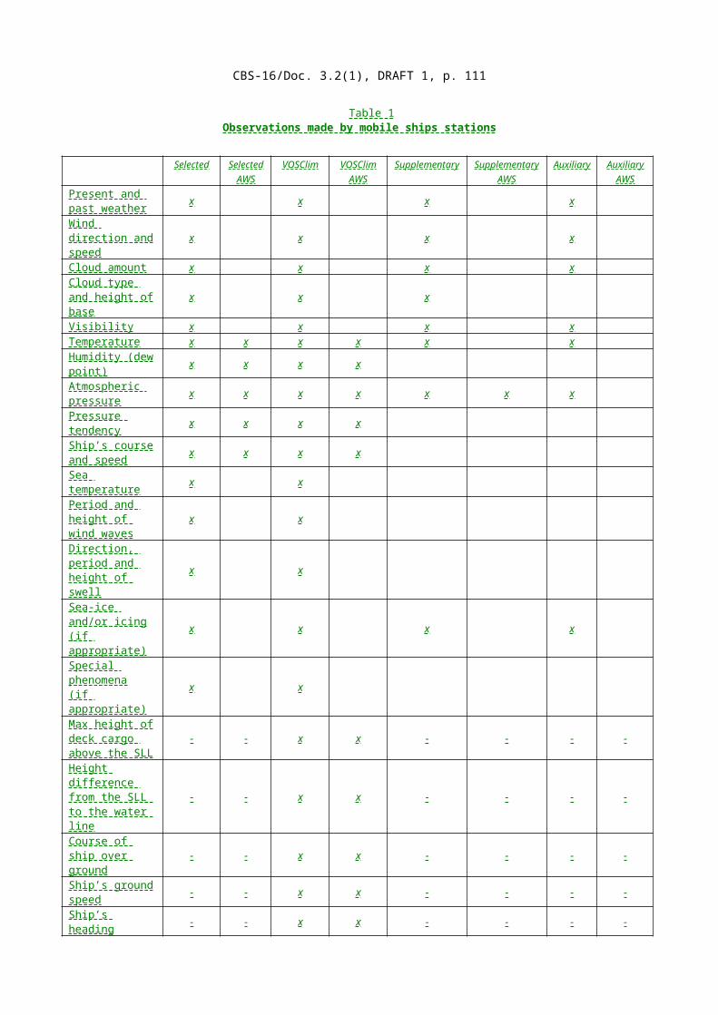
CBS-16/Doc. 3.2(1), DRAFT 1, p. 111
ANNEX B
GUIDELINES FOR REPORTING OF INFORMATION ON FREAK WAVESAND FOR RECORDING IN METEOROLOGICAL LOGBOOKS, AND AN
EXAMPLE OF A SPECIAL LOG SHEET
(Reference paragraph 4.5)
(i) Guidelines
It is recommended that the following information be recorded in meteorological logbooks:
(1) Information on freak waves Date: Time: Ship’s position ................................................... .................................................... ....................................... Full description of freak wave (including height and horizontal distance between crest and trough, if possible)Weather condition: .........................................................................................................................................State of sea: ...................................................................................................................................................Any other factors that may have influenced the state of sea: .......................................................................Any damage sustained by ship: .....................................................................................................................(2) Information to be attached to freak wave reports by National Meteorological Centres: Ship’s name: ...................................................................................................................................................Gross registered tonnage: ...............................................................................................................................Ship’s radio call-sign: ....................................................................................................................................
FREAK WEATHER REPORT
A freak wave may be defined as a wave of very considerable height, ahead of which there is a deep trough. Thus it is the unusual steepness of the wave which is its outstanding feature and which makes it dangerous to shipping.
ss/mv ......................................................................................................................................................Call sign .................................................................................................................................................Gross tons ..............................................................................................................................................Date .................................................................................. Time .................................................GMT Ship’s position.........................................................................................................................................
DESCRIPTION OF FREAK WAVE
Height ........................................................................................m Direction if known ...............................Horizontal distance between crest and trough ............................................................................................mDepth of water .................................................................................m (either by sounding or from chart)Remarks .........................................................................................................................................................
WEATHER CONDITIONS
Wind direction ..................................................................... Wind speed ............................................knotsAny other weather factor applicable ......................................................................................................................................................................................................................................................................................
STATE OF SEA
Sea waves: Height ....................................................................m Period ...............................................secSwell waves: Direction ....................................... Period ............................ sec Height .........................mAny other factor that may have influenced stat of sea (tide, currents, etc.) ..........................................................................................................................................................................................................................
DAMAGE TO SHIP (if any) .........................................................................................................................
Signature of Observer ....................................................................................................................................
Signature of Master ........................................................................................................................................
____________
CBS-16/Doc. 3.2(1), DRAFT 1, p. 112
ANNEX C
GUIDELINES FOR THE OBSERVATION AND RECORDING OF SEA CURRENT DATA ON BOARD SHIP, AND AN EXAMPLE OF A SPECIAL LOG SHEET
(Reference paragraph 4.5)
(i) Guidelines
1. Introduction
The knowledge which we now possess regarding surface currents in the world seas is, for the most part, based on information from current observations taken on board ships.
The systematic collection of surface current information had already begun in the middle of the nineteenth century. The famous Lieutenant Matthew F. Maury of the US Navy was one of the first who saw the importance of gathering wind and current data from ship logbooks. In 1845, he published the first of a series of ‘Wind and current charts’.
For constructing current charts, as many observations as possible are required, covering many years. As the variability of local currents can be examined only on the basis of a large number of observations, and as the number needed has not been reached for any place at sea, there is still a great need of current observations, especially from areas less frequented by ships outside the major shipping lanes. More observations are also needed to establish, year to year, variations in currents, as some of these are of great significance for marine science, e.g., the El Niño . The only way of obtaining enough observations is by the cooperation of voluntary observers.
By making and reporting observations of currents experienced, the seaman not only gains practical knowledge himself, but benefits shipping generally by adding to our statistical knowledge, so that up-to-date information can be published.
2. Methods of ocean-current observations and some definitions
The method of making current observations is to calculate the difference between the dead reckoning (DR) position of the ship after making due allowance for leeway and the position by a reliable astronomical, land, radio, radar, electronic or satellite fix. The result is the set and drift over the ocean floor experienced by the ship during the interval since the previous reliable fix was obtained, and applies to a mean depth of about half the ship’s draught.
The sea of current is the direction in which it acts; that is the direction toward which it flows. So, the current set is from the DR position to the fix.
The d rift of a current is the distance measured in nautical miles from the DR position to the fix.
The leeway is the angular difference between the ship’s course and the ship’s direction of movement through the water (i.e., the direction shown by the wake). Leeway occurs when a ship is subjected by the wind to a pressure from a beam. The angle is rarely more than a few degrees, but there is a considerable loss of accuracy in the observation of the current if a realistic allowance is not made for leeway.
The “FROM” position is the true position at the beginning of the stretch over which the current is calculated.

CBS-16/Doc. 3.2(1), DRAFT 1, p. 113
The “TO” position is the true position at the end of the stretch over which the current is calculated.
The dead reckoning (DR) position is the position of the ship determined by applying to the last well-determined position (the “FROM” position), the run that has since been made, using only the true courses steered (corrected for leeway, if necessary) and the distance run, as determined by log or engine revolutions, without considering current . It is important that the true course is corrected for the influence of the wind, so that the difference between the DR position and the true fix is caused only by the current.
3. The calculation
The calculation is done in two steps and is based on the following data:
First step — Calculation of the DR position:Data: ( a ) Position FROM;
( b ) Course(s) steered, corrected for possible wind influence without considering current;
( c ) The distance, calculated from speed and time, run along each of the course lines without considering current.
Second step — Calculation of the current:Data: ( a ) DR position; ( b ) Position TO.
It is possible to do both calculations by computer. In this case, it is necessary that all three data for the first step and also the position TO are entered in the logbook by the observer.
The advantages of doing the calculation by computer are that the extra work involved for the observers on board is avoided and that errors in the calculation are practically eliminated. A disadvantage, however, is that errors in the basic data cannot be discovered and this inevitably leads to incorrectable faulty results. On the other hand, the observer is in a position to check the basic data for possible mistakes; also, he can check if the data are reliable enough for current calculation.
Calculation by computer therefore means an increased responsibility of the observer for entering the basic data correctly and for their reliability. For this reason, it is advisable to always enter the data carefully, and then, to check them.
However, in many cases, the officer will wish to calculate the current for his own interest and use, and this is to be encouraged. When the current is calculated on board, it should be entered in the logbook, along with the data from which it was calculated.
4. The observation
The following notes are intended to give practical guidance on the ways in which the most useful observations of currents can be made. The usefulness of an observed current depends largely on its representativeness and its accuracy. Nevertheless, an observation which might normally be rejected as being unlikely to have the desired accuracy might still be of value if it came from an area of sparse shipping, i.e., one about whose currents little was known. The observation of currents is particularly desirable in such areas.
The representativeness and accuracy of current observations are discussed below in more detail:
( a ) Representativeness of observed currents

CBS-16/Doc. 3.2(1), DRAFT 1, p. 114
Ideally, each observation would represent a single current. In practice though, an observation is made over a distance over which there is likely to be some variation in current. An observation is not required if it is likely to incorporate currents from two different systems. In particular, it is desirable to interrupt an observation when passing a cape, a strait or a current rip, as they are likely to form boundaries between different current systems. Also, observations should not be made with the distance between FROM and TO positions, in excess of about 500 nautical miles or with the time interval between these positions in excess of about 24 hours. Observations should not be made where there are tidal influences, e.g., on coastal passages;
( b ) Accuracy of fixes
The accuracy of current observations depends largely on the accuracy of the two fixes. In general, fixes accurate to within two nautical miles are required. Observations based on noon (sun) positions, derived by running fix, usually have less than the desired accuracy; the accuracy of such fixes depends on a due appreciation of the currents experienced — the very element we are trying to determine. On the other hand, the fixes derived from observing two or more planets or stars at twilight, are likely to be very suitable for calculating currents. When suitable equipment is available, fixes by such accurate methods as satellite navigation or OMEGA give especially useful current observations;
( c ) Course
The true course, corrected for compass error, must be used. An error in the DR position, due to an incorrect course, has a direct influence on the current calculation. Therefore, the course must be corrected for leeway, whenever necessary. Estimating the correction for wind is not simple and can only be made by experience. However, at a meteorological service receiving current observations, it is hardly possible to make such corrections, because they are so very dependent on the type of ship and on its draught. If estimation of the leeway is impossible, for example, because of stormy weather, no current observation should be made. When, for some reason, the ship is stopped, it is also better to make no current observation if the wind is more than Beaufort force 3;
( d ) Speed
It is of great importance that the speed of the ship through the water is known as accurately as possible. An electronic type of log is especially useful. With other, more common, types of log, the speed cannot be determined so precisely and a compromise between log distance and distance by engine revolutions, making due allowance for slip, possibly gives the best results. The slip depends on several factors (such as draught, loading conditions, sea and swell and the time elapsed since the ship was in dry dock), but some of their effects are often hard to determine;
( e ) Changes in course and speed between the FROM and TO positions
Between the FROM and TO positions, it is possible for the course to have been changed one or more times; also, it can happen that different corrections for leeway must be applied over a distance sailed with a constant course. In such circumstances, the distance is divided into parts, each with a constant course and speed through the water. If the current is not calculated on board, but later by computer for each part, each distance must be determined from speed and time noted in the logbook. More than three parts are not acceptable;
( f ) Period between FROM and TO positions
The main considerations are that the period should be long enough for the current to have a measurable effect, yet short enough to make it unlikely that any large variation in current would have occurred over the distance covered. Thus, the desirable period depends on the

CBS-16/Doc. 3.2(1), DRAFT 1, p. 115
accuracy of available navigational data. Exceptionally, with very accurate data, e.g., satellite fixes and speed through the water measured by electronic log, the current might justifiably be measured over a period as short as one or two hours. Also, when coasting, a period of a few hours between two shore fixes may be taken. Usually, however, a longer period is desirable and a period of about 12 hours between stellar fixes, determined at dusk and at dawn, for instance, would be very suitable. A period of about 24 hours is necessary when the only positions determined have been by running fix, e.g., noon (sun) positions, but such observations are barely acceptable. Observations from still longer periods are not acceptable. Since observations of current should be independent, period of observation should not overlap.
____________

CBS-16/Doc. 3.2(1), DRAFT 1, p. 116
ANNEX D
GUIDELINES FOR ORGANIZING PORT METEOROLOGICALOFFICER (PMO) ACTIVITIES
(Reference paragraph 9)
1. Introduction
The functions of a Port Meteorological Officer (PMO) cover seven broad areas:
( a ) Recruitment of ships to take part in the Voluntary Observing Ships’ Scheme; ( b ) Regular liaison with recruited ships to ensure the highest standard of observations; ( c ) Collection of completed ships’ meteorological logbooks and data from Electronic logbooks; ( d ) Act as an interface between the meteorological service and the marine community; ( e ) In large ports act as a focus for the provision of meteorological services in the port; (f) Assist with arranging deployment of drifting buoys and profiling floats; (g) Inspection of ships fitted with upper-air radiosonde equipment, an AWS system, or XBT
equipment.
1.1 Personnel requirements
Each maritime Member of WMO should endeavour to appoint PMOs with maritime experience at its main ports. Their maritime experience enables them to communicate effectively with the ship’s master and other officers. They should also have experience in, and knowledge of, meteorology, theoretical as well as practical. Knowledge of the English language would be an advantage, as most ships' officers whose mother tongue is not English are able to express themselves in this language. The necessary training of PMOs is described in the Manual on Marine Meteorological Services, Part IV, Section 3.
1.2 Location of the office of a Port Meteorological Officer
The office of the PMO should preferably be situated in the centre of the harbour area. This allows the maximum of ships to be visited and facilitates visits by observers from voluntary ships to the PMO’s office and gives them access to meteorological information. The PMO will need appropriate transport for instruments and supplies to ships as required.
2. Duties of a Port Meteorological Officer
2.1 Recruitment of observing ships
2.1.1 MERCHANT SHIPPING
Recruiting of observing ships should be in the hands of the PMOs, but subject to overall guidance from the relevant section of the NMS. A worldwide distribution of observing ships is the objective to attain and every effort should be made to recruit ships which operate in data-sparse areas, e.g. the oceans of the southern hemisphere.
PMOs often prioritize the recruitment of ships which are registered in their own country, but ships of other registry are commonly considered for recruitment if they are regular callers and if the PMO considers that they would make a useful addition to the voluntary observing fleet.
Points to be considered when recruiting ships are:

CBS-16/Doc. 3.2(1), DRAFT 1, p. 117
( a ) Willingness of masters and officers to carry out the voluntary weather observing and to submit reports throughout the voyage;
( b ) Suitability of the ship to carry and care for the instruments.
Permission to recruit a ship should, whenever possible, be obtained from the ship owners or managers, usually through the marine superintendent of the company and from the master. It is recommended that only a verbal undertaking by a ship’s master to carry out the work of an observing ship should be obtained. This service is voluntary, and it is therefore not desirable to create the impression that a formal binding contract will be imposed.
When a ship agrees to participate (or volunteer) in the scheme, the PMO equips the ship with the necessary instruments and stationery. This needs to be done quickly as many ships do not spend much time in port. A list of the instruments issued to the ship should be recorded along with the metadata required for WMO-No. 47 by the PMO.
If calibrated NMS instruments are available the ship should be recruited as a Selected or a VOSClim ship. If available, E-logbook software should be installed and training given on how to prepare observations.
Suggested lists of instruments and stationery for the various types of observing ships are as follows:
Selected and VOSClim ships
One suitably certificated precision or digital barometer; One barograph (unless the digital barometer includes a tendency display); One whirling pyschrometer OR two screens and two sheathed thermometers (1 air, 1 wet
bulb) for each screen. plus two spares OR a suitable digital electronic device to measure temperature and humidity;
Two sea thermometers and suitable sea buckets (if that bucket method is to be used for measuring sea-surface temperature);Electronic logbook software (or hardcopy meteorological logbooks);Barograph charts;Plotting charts;Code and decode information (usually in the form of a code card);State of sea card or booklet;Cloud types for observers booklet;Reduction to mean sea level card ( for ships where the pressure height correction isn’t automatically applied by the electronic logbook software);Dew-point tables ( for ships that aren’t equipped with electronic logbook software).
Supplementary ships:
One suitably certificated precision or digital barometer; One whirling pyschrometer OR two screens and two sheathed thermometers (1 air, 1 wet
bulb) for each screen. plus two spares OR a suitable digital electronic device to measure temperature and humidity;Electronic logbook software (or hardcopy meteorological logbooks);Code and decode information (usually in the form of a code card);State of sea card or booklet;Cloud types for observers booklet;Reduction to mean sea level card (for ships where the pressure height correction isn’t automatically applied by the electronic logbook software.
Auxiliary ships:
CBS-16/Doc. 3.2(1), DRAFT 1, p. 118
Aneroid barometer correction card; Code and decode information (usually in the form of a code card);Electronic logbook software (or hardcopy meteorological logbooks);State of sea card or booklet;Cloud types for observers booklet.
Ships’ officers should be asked to keep the Meteo rological Service’s instruments in good and clean condition. The position for the barometer in a ship’s chart room should be chosen with care in consultation with the master. It should be as safe as possible from accidental damage, in a good light and clear of artificial heating. Advice should be given as to the best exposure for the thermometer screen if issued under differing conditions. The screen should be kept white. Special attention should be drawn to the care required in ensuring accurate sea temperature observations.
PMOs should ensure that observing officers understand the importance of reading wet and dry bulb temperatures in any one observation to the same degree of precision. All temperatures are required to be read to the nearest tenth of a degree. When this is not possible and the temperatures are read to the nearest whole degree, the tenth figure is reported as a solidus and not by a zero.
Subject to financial constraints, ships under construction may be supplied with distant reading equipment. PMOs should inform their headquarters of any ships being built in their area which would be suitable, and their respective owners and marine superintendents could then be approached by headquarters with a view to installing the necessary cabling and equipment during the construction. When the necessary agreements and financial approvals with the shipowners or managers have been obtained, the PMO should be informed. He should then arrange to visit the ship with a technician if necessary to discuss the siting and installation of the instruments.
It is of the greatest importance that the PMO’s initial guidance and instruction to newly-recruited ships officers should be as thorough and complete as possible. This will immediately ensure a uniformity in observing technique.
2.1.2 FISHING VESSELS AND SMALL CRAFT
To help extend the collection of marine meteorological data small craft fitted with good communication equipment may be supplied with instruments or they may be recruited as non-instrumental observing ships and requested to report surface weather conditions, whenever possible. They become auxiliary ships under the Voluntary Observing Ships’ Scheme.
Large fishing vessels and yachts can supply most valuable meteorological information from important areas from which there are normally very few ships’ weather reports.
In ports from which fishing vessels and large yachts sail, the PMOs should do all that is possible to encourage and interest the owners and captains in marine meteorology. The captains should be assured of the usefulness to forecasting centres of their voluntary weather reports.
2.2 Visits to ships
Visits and inspections are primarily intended to be occasions for giving encouragement and guidance to marine observers and for thanking them for their work, but they are also the occasion of checking on the continued accuracy of the instruments. Observing ships should, if possible, be visited at intervals of no more than three months and a report made on their

CBS-16/Doc. 3.2(1), DRAFT 1, p. 119
instruments. A point to remember when visiting ships is that all the facilities being made available to the visitor are at the discretion and invitation of the ship’s staff.
At each inspection any defective National Meteorological Service instruments should be replaced and a receipt should, if possible, be obtained from the master or his senior officer for all instruments issued.
The barometer is probably the most important instrument for weather observing. The reading should be checked by comparison with a PMO’s Transfer Standard Barometer, such as a Vaisala digital barometer.
The barometer should be withdrawn from a ship if the difference from the Transfer Standard barometer exceeds 0.3 hPa.
It is recommended that a record card is kept for each barometer issued to a ship. On the card is recorded the difference between the barometer and the Transfer Standard barometer. The difference, however small, should always be entered on a form, so that an accurate record can be kept of the behaviour of each barometer. Plus or minus signs should be used to indicate high or low differences: the plus sign when the ship’s barometer is reading higher than the Transfer Standard and the minus sign when the barometer is lower than the standard.
Distant reading equipment, if fitted aboard ships, should be checked at each inspection.
Hand anemometers, if issued to ships, should be returned to the NMS once a year for recalibration and a replacement issued.
In making out reports on instruments, care should be taken to distinguish between Meteorological Service instruments and the ship’s own instruments. Where the ship’s own instruments are used for observing, the PMO should record this on the visit form. This is necessary to avoid confusion between the property of the NMS and that of the owners or officers.
A standard inspection form should be used for each visit. Space should be available on this form for recording, for example:
( a ) Any replacement of instruments; ( b ) Any instruments which are the property of the ship’s owners or officers; ( c ) Any instruments supplied by other authorities e.g. XBTs, plankton recorders, which affect
the appropriate entry to the International List of Selected, VOSClim, Supplementary and Auxiliary Ships (WMO-No. 47);
(d) Any metadata required by WMO-No. 47 (unless this data is collected using the ships electronic logbook).
The inspection report should be forwarded to the relevant section of the NMS as soon as possible after the inspection.
On visiting an observing ship, the PMO should ascertain that the necessary hardcopy logbooks (if applicable) and stationery are on board and are up-to-date. The ship’s officers should be encouraged to understand the international meteorological codes and be familiar with the procedures to be carried out in transmitting weather messages to the meteorological centres ashore.
Courtesy visits should, if possible, be made to voluntary observing ships of other nations when they are in local ports and advice and assistance given as necessary.
2.2.1 WITHDRAWAL OF INSTRUMENTS

CBS-16/Doc. 3.2(1), DRAFT 1, p. 120
It should be the duty of the PMO to recover instruments from ships which cease to observe. When ships cease observing for any reason, the fact should be recorded. PMOs should watch the shipping papers and journals to ascertain, among others, ship sales and change of registry and if these take place abroad they should consider requesting the assistance of the PMO in the relevant country and port.
On receipt of this information, the ship’s name will be removed from the national fleet list in the relevant NMS.
When withdrawing instruments care should be taken that instruments which are not the property of the NMS are not included.
2.3 Collection of ships’ hardcopy meteorological logbooks
When completed, ships normally return their hardcopy meteorological logbooks to the NMS, but some may prefer to hand it to a PMO. The latter should see the meteorological logbook of all visiting ships and, if it is full or nearly full, they should forward it to the relevant section of their NMS as soon as possible after collection.
It is important to return completed logbooks from observing ships. When visiting observing ships, a PMO should therefore ascertain that the logbooks have been returned. If the book in current use has been started more than six months previously it should be withdrawn and the officers asked to start a new one. PMOs should take the opportunity, whenever possible, to give any advice as to the method of writing up the logbooks.
PMOs should make a special point of visiting observing ships’ crews who appear to have difficulties in completing their logbooks and ascertaining the cause.
2.4 General liaison with ships
A PMOs first duty is the care and supervision of the work of voluntary marine observers and they should give encouragement to the applications by the merchant marine generally of marine meteorology to safe and efficient navigation, comfort of passengers and the care of cargo.
A PMO is the channel use to communicate advice, instruction and correction to marine observers and also the gratitude of the meteorological departments responsible for coordinating the work. Thus a complimentary call by these officers upon the master and officers of a ship should be regarded as more valuable than a letter or e-mail, but a complimentary card should be left if it was not possible to see the master.
PMOs should make themselves familiar with the current international meteorological codes for ships in order to be able to explain it to the masters and officers of the voluntary observing fleet.
Advice and encouragement to voluntary observing officers should be given at every opportunity during visits and, for example, through the medium of any national marine meteorological publications aimed at the voluntary observing ships.
Every encouragement should be given to marine observers and others interested in marine meteorology, to contribute papers or remarks on pertinent subjects, for publication in meteorological journals. Special attention should be directed to the pages, where provided, in the meteorological logbooks for ‘additional remarks’. Masters and officers should be encouraged to write descriptions of their experiences not only as regards weather, but of all subjects of scientific interest. It is important that PMOs should maintain contact with their
CBS-16/Doc. 3.2(1), DRAFT 1, p. 121
national navigation schools and colleges and give them any advice and assistance they may require.
PMOs of a Meteorological Service should remember that it is their duty to secure by the voluntary service of ships’ officers the best possible information on meteorological conditions at sea, but it is also desirable to avoid imposing a workload which may interfere with or adversely affect the main duties of a ships’ officer to become, if excessive, detrimental to his or her main duties.
PMOs should make themselves thoroughly familiar with the scheme of communication for observing ships’ routine weather reporting. They should give every encouragement and all necessary advice and instruction to observing ships.
Attention should be drawn to the Special Access Code 41 procedures for ships fitted with INMARSAT. Addressed telexes to Meteorological Services without the code 41+ procedures are chargeable to the ship.
PMOs should explain the use of radio weather bulletins, gale, storm and tropical cyclone warnings issued specially for shipping, and which radio weather bulletins, including facsimile broadcasts are the most suitable for masters and officers. They should be familiar with Meteorological Maritime Safety Information (MSI) broadcasts such as SafetyNet and Navtex forecasts and warnings. Information on this the other meteorological services available to mariners should also be given to navigation schools .
PMOs should try to keep in touch with the manag ement and marine superintendent of shipping companies with offices in their area and make regular visits to them.
2.5 Provision of port meteorological services
Shipping, fishing and other marine interests should be informed on how weather forecasts can readily be obtained in the port. They should also be kept informed of all meteorological services available to mariners.
Weather information useful to shipping, fishing or small craft should, if possible, be available at the Port Meteorological Office and details made available of marine forecast products that are available over the Internet. In large ports with a network of automatic weather stations the latest observations may be displayed electronically at the PMO’s office (see Chapter 5 for more information on services in ports).
As the first point of contact by ships’ officers on meteorological matters, the PMO may be asked for more specific technical information, e.g. on cargo ventilation. If the PMO is unable to answer the query himself, he should transmit it to the appropriate section of the Meteorological Service and ensure that a prompt reply is made.
____________
CBS-16/Doc. 3.2(1), DRAFT 1, p. 122
ANNEX E
MARINE METEOROLOGICAL PUBLICATIONS PRODUCED BY NATIONAL SERVICES AND INTERNATIONAL ORGANIZATIONS OF INTEREST TO SEAFARERS AND MARINE
OBSERVERS
(Reference: paragraph 11)
Title of Publication Editions Country Language per year of origin
Boletín Climático Marino 3 Cuba Sp.
Météo le magazine 4 France F Guide de l’Observateur Météorologisteen Mer 1 France F
Der Wetterlotse 6 Germany German
Newsletter V.O.S. from Hong Kong, China 2 Hong Kong, China E
Ship and Maritime Meteorology 3 Japan Japanese (Fune to Kaijou Kishou)
Meteorological Information bulletin Maritime 4 Netherlands Dutch and English
Monthly Weather Summary 12 Qatar E
IMO News 4 United Kingdom E
Mariners Weather Log 4 United States E Storm Data 12 United States E
WMO Bulletin 4 Switzerland E, F, R, Sp.
____________

CBS-16/Doc. 3.2(1), DRAFT 1, p. 123
PART IVTHE SPACE-BASED SUBSYSTEM
EDITORIAL NOTE: NO CHANGES ARE PROPOSED TO THT REMAINDER OF THE GUIDE.PARTS IV TO VIII AND THE ANNEX OF ACRONYMS HAVE BEEN OMITTED FOR THE SAKE OF BREVITY.
…………………………………………………………….
__________

CBS-16/Doc. 3.2(1), DRAFT 1, p. 124
BACKGROUND INFORMATION SUPPORTING RECOMMENDATIONNOT TO BE INCLUDED IN THE SESSION REPORT
References:
1. Manual on the Global Observing System, Volume I – Global Aspects, WMO, 2015 (WMO-No. 544) (http://library.wmo.int/pmb_ged/wmo_544-v1-2015_en.pdf)
2. Guide to the Global Observing System, WMO, 2013 (WMO-No.488) (http://library.wmo.int/pmb_ged/wmo_488-2013_en.pdf)
3. WIGOS Framework Implementation Plan, version 2.9, 2014 (Annex V to §4.4.6 of EC-66, at http://library.wmo.int/pmb_ged/wmo_1136_en.pdf).
4. Final Report of CBS ICT-IOS-9 (2016) (http://www.wmo.int/pages/prog/www/OSY/Reports/ICT-IOS-9_Final_Report-REV2.pdf )
5. Final report of second Meeting of the JCOMM ad hoc Team Reviewing WMO Manual 558 and Guide 471 (June 2015)(http://www.wmo.int/pages/prog/amp/mmop/meeting_reports.html )
Discussion
1. Following the approval by Congress (Resolution 24 (Cg-17)) of a new edition of the Manual on the GOS in 2015 that harmonized its content with that of the Manual on WIGOS, ICT-IOS expert teams, in addressing the development of new WIGOS regulatory and guidance material, commenced preparation of new material on the GOS for inclusion in the Manual on the GOS and Guide to the GOS. This major effort was carried out by the Expert Teams on Aircraft Based Observations and on Surface-Based Observations, under the leadership of their respective chairs, Mr Frank Grooters and Mr Stuart Goldstraw.
2. Also, the second meeting of the JCOMM ad hoc Team Reviewing WMO Manual 558 and Guide 471 (June 2015) requested CBS to include in the next update to the Guide to the GOS, Chapter 6 of the Guide to Marine Meteorological Services on the Voluntary Observing Ships Scheme. JCOMM requested this move from the JCOMM Guide to the Guide to the GOS to reflect the mutual collaboration under WIGOS between marine users and meteorologists regarding the making of marine meteorological observations from voluntary observing ships.
3. Together, the most significant changes proposed to the Manual on and Guide to the GOS concern:
The composition of the surface-based subsystem of the GOS; Aircraft meteorological stations; Automatic weather station (AWS) systems; Radar wind profilers stations; Weather radar stations; and The Voluntary Observing Ships (VOS) scheme.
4. The above contributions were provided to the Inter-Programme Expert Team’s Sub-Group on Regulatory Material, which, under the excellent leadership of Mr Russel Stringer, edited and harmonized the various contributions, and made minor compensatory changes to the remainder of the Manual and Guide to take them into account.
5. The draft revised versions of the Manual and Guide were subsequently endorsed by ICT-IOS-9 by correspondence for submission to CBS-16.
![meetings.wmo.intmeetings.wmo.int/CBS-16/Spanish/1. Versiones para deb… · Web view[Todas las enmiendas del presente documento han sido realizadas por la Secretaría] PUNTO . 3](https://img.dokumen.tips/doc/110x75/5a9d557d7f8b9abd058bfcc1/-versiones-para-debweb-viewtodas-las-enmiendas-del-presente-documento-han-sido.jpg)


![meetings.wmo.intmeetings.wmo.int/CBS-16/Spanish/1. Versiones para... · Web view[Todas las enmiendas del presente documento han sido realizadas por la Secretaría] PUNTO . 3. DEL](https://img.dokumen.tips/doc/110x75/5a70b0b47f8b9a98538c3d5c/meetingswmointmeetingswmointcbs-16spanish1-versiones-paradoc.jpg)