Embed Size (px)
Citation preview
--/rnr,200) mR ho,g42-
DEPARTMENT OF THE INTERIOR TO ACCOMPANY MAP MR-82 UNITED STATES GEOLOGICAL SURVEY
MAPS SHOWING SELECTED GEOLOGY AND PHOSPHATE RESOURCES OF THE FOSSIL CANYON QUADRANGLE, BEAR LAKE
AND CARIBOU COUNTIES, IDAHO
By Pamela Dunlap Derkeyl, Pamela Palmer', and Susan T. Miller2' I Idaho Bureau of Mines and Geology 2 Bureau of Land Management
INTRODUCTION PURPOSE OF INVESTIGATION
This report summarizes information on the thickness, grade, lateral continuity, phosphate resources, and ownership of phosphate-bearing units in the Meade Peak Phosphatic Shale Member of the Phosphoria Formation in the Fossil Canyon quadrangle. This report is one of a series of quadrangle reports prepared by the Idaho Bureau of Mines and Geology under U.S. Geological Survey cost-sharing contract #14-08-0001-17925 to calculate phosphate resources in southeastern Idaho (fig. 1).
ACKNOWLEDGMENTS
The project was supervised by Bill Bonnichsen of the Idaho Bureau of Mines and Geology and Peter Oberlindacher of the Bureau of Land Management Alumet provided their drill-hole data on the understanding that this confidential information would be used only in a regional analysis of phosphate resources. We wish to thank the College of Mines and Earth Resources and the College of Forestry, University of Idaho, for the use of their cartographic facilities.
METHODS OF INVESTIGATION
The Fossil Canyon quadrangle phosphate resource maps are based on published and unpublished data from industry, State, and Federal sources.
The interpretation of the structure of the Meade Peak Phosphatic Shale Member in the subsurface is based on U.S. Geological Survey and phosphate company geologic maps, drill - hole and trench logs, and cross sections, supplemented by discussions with Bureau of Land Management geologists. Phosphate rock thickness and P,05 assay values are used from only those drill holes and trenches whose locations can be accurately plotted for elevation and land coordinates. Structure contours and overburden isopachs on the stratigraphic top of the Meade Peak are extended 600 feet along strike from the last known exposure of the Phosphoria Formation and are extrapolated to a depth of 1,500 feet. Phosphate resources of the Meade Peak are calculated for three categories of overburden thickness: 0 to 300 feet, 300 to 600 feet, and 600 to 1,500 feet (fig. 2).
Identified phosphate resources (U.S. Bureau of Mines and U.S. Geological Survey, 1980) are computed for the upper and lower phosphate units of the Meade Peak (fig. 3). Resource tonnages were determined according to the method used by Montgomery and Cheney (1967, p. 41) and Oberlindacher and Hovland (1979, p. 7). For the Fossil Canyon quadrangle, fifteen resource blocks (not shown on the map sheets) were constructed based on structural similarities. The volume (V) of phosphate resource in each block is calculated by multiplying the true
1:01,0GICAL , Dr NV I:
OCT 5
LiE,RARY
°CU; DIV IS1
area of the stratigraphic top of the Meade Peak by the cumulative average thickness (t) of the upper and lower phosphate units. The true area is the planimetered map surface area (A) of each block multiplied by the secant of the average dip (d) of the Meade Peak (fig. 4):
(1) V = At (sec d)
Resource tonnages (R) are calculated by multiplying the volume (V) of phosphate resource by the average density (p ) of the phosphate rock:
(2) R = Vp
An average density of 0.0787 short tons per cubic foot, derived from Oberlindacher and Hovland's (1979) average density value of 2.52 metric tons per cubic meter, is applied to convert the volume of phosphate resource (calculated in cubic feet) to short tons of phosphate resource (sheets 2 and 3).
Thickness, phosphate content, and stratigraphic position are the three factors that determine whether a sampling interval is included within the phosphate units to calculate resource tonnages. A "sampling interval" is a rock sample of known thickness and phosphate content, as derived from a drill hole or trench log. The Meade Peak is subdivided into five informally named units for this report based on Hale's (1967) subdivisions of a typical section in the upper Dry Valley area, Caribou County, Idaho (fig. 3). These units are, from bottom to top: the lower waste, the lower phosphate, the middle waste, the upper phosphate, and the upper waste. The only units considered in the resource calculations in this report were the lower and upper phosphate units (fig. 3). Isolated minor phosphorite beds in the waste units are excluded from consideration.
The following guidelines used in this report to define phosphate units are based on Montgomery and Cheney (1967), Oberlindacher and Hovland (1979), and generally accepted phosphate mining practices in southeastern Idaho:
(1) The upper and lower boundaries of the phosphate units are defined by the uppermost and lowermost sampling intervals that are 1 foot or more thick and contain at least 16 percent P,O,, except where adjoining sampling intervals less than 1 foot thick with 16 or more percent P,O, are added together to meet the 1-foot thickness requirement. Within a phosphate unit, all sampling intervals with 16 or more percent 13,0, are included in the resource calculation regardless of thickness.
(2) Within the phosphate units, sampling intervals and sequences of contiguous sampling intervals containing less than 16 percent P,O, and measuring at least
1

Idaho wY0
o o •
<9, 43°
Wayan ID 34
Ble4G k foot River
Res
JP CARIBOU q-
CO. 0
US 30
Bancroft O C nda
C, 0 C")
(ZT
l)
Soda Spr ngs
--a
JP
Grace
ID 34
✓P
▪ r
LAKE
•6, •
BEAR CO.
0 (#
Georgetwn 42° 30'
-11 US 30
112° 111°
IDAHOLI 0 10 "des
FIGURE 1.—Index map showing location of southeast Idaho phosphate area and Fossil Canyon quadrangle (shaded).
2 feet thick are excluded from the resource calculation.
(3) Within the phosphate units, isolated sampling intervals less than 2 feet thick with less than 16 percent P,O, are included in the resource calculation. The boundary of the Diamond Gulch open-pit
phosphate mine was identified from false-color aerial photographs taken in 1979 by the U.S. Geological Survey.
The locations of titles to surface and phosphate rights were obtained for Federal lands from the U.S. Bureau of Land Management's leasable mineral and master title plats and for State lands from the Idaho Department of Lands'
land plats. These sources also were used to locate Federal phosphate leases, Preference Right Lease Applications (PRLA s), Known Phosphate Leasing Areas (KPLAs ), and State phosphate leases. Titles to surface and phosphate rights on private land are from both the Federal and State plats. Private phosphate leases, leases on land with private title to both surface and phosphate rights, are not shown.
LOCATION AND TOPOGRAPHY
The Fossil Canyon quadrangle is about 6 miles southeast of Soda Springs, and 2 miles northwest of Georgetown, Idaho (fig. 1). The quadrangle boundary includes parts of Tps. 9, 10, and 11 S., Rs. 42 and 43 E., Boise Principle Meridian. U.S. Route 30 is the major
2

Identified Phosphate Resources
OVERBURDEN
300'-600' 0'-300' i 600'-1500'
FIGURE 2.— Diagrammatic cross section showing identified phosphate resources for the Meade Peak Phosphatic Shale Member of the Phosphoria Formation.
access highway to the area from Soda Springs and Georgetown. Many other paved and gravel-surfaced roads provide access to the more remote regions. The main line of the Union Pacific railroad also goes through the area, paralleling U.S. Route 30.
Major topographic features in the quadrangle include the Aspen Range, the Bear River Valley, and Nounan Valley, all of which trend northwest. Bear River and its tributaries drain the area. Elevations range from 5,815 feet on the lower end of Bear River to 8,330 feet along the crest of the Aspen Range.
FEDERAL LAND STATUS
Six combinations of titles to surface and phosphate rights occur in the Fossil Canyon quadrangle as shown on sheet 3: (1) Federal phosphate on Federal surface, (2) Federal phosphate on State surface, (3) Federal phosphate on private surface, (4) State phosphate on State surface, (5) State phosphate on private surface, (6) private phosphate on private surface. The Federal government holds phosphate title to 63 percent and surface title to 35 percent of the land in the quadrangle. As of August 1980, 2 percent of the Federal phosphate title was leased, but none was under preference right lease application.
GEOLOGY OF THE MEADE PEAK PHOSPHATIC
SHALE MEMBER OF THE PHOSPHORIA FORMATION
STRATIGRAPHY
In Idaho, the Phosphoria Formation of Permian age disconformably overlies the Park City Formation of Permian age and the Wells Formation of Pennsylvanian and Permian age and is unconformably overlain by the
Dinwoody Formation of Triassic age (McKelvey and others, 1959; Peterson, 1980). The Phosphoria grades northward into the Shedhom Sandstone in south-central Montana and northwestern Wyoming, and southward and eastward into the Park City Formation in northeastern Utah and west-central Wyoming (McKelvey and others, 1959). The Park City Formation, a carbonate sequence, in turn grades eastward into the Goose Egg Formation, a red-bed evaporite sequence (McKelvey and others, 1959).
The Phosphoria Formation is subdivided into six members, four of which are recognized at the type locality at Phosphoria Gulch, Bear Lake County, Idaho (McKelvey and others, 1959). The four members are, from bottom to top: the Meade Peak Phosphatic Shale Member, the Rex Chert Member, the cherty shale member, and the Retort Phosphatic Shale Member. The other two members are the lower chert member, which is laterally continuous with the Meade Peak, and the Tosi Chert Member, which is laterally continuous with the upper part of the Retort and with the cherty shale member (McKelvey and others, 1959, p. 21). As discussed in the "Methods of Investigation" section, the Meade Peak has been subdivided into five informally named units based on lithology and P,O, content (fig. 3). The two phosphate units defined by Hale (1967; fig. 3, this report) consist of interbedded phosphorite, mudstone, and limestone. The waste units consist of interbedded shale, mudstone, siltstone, and thin phosphorite beds. The base of the Meade Peak is characterized by a thin phosphorite bed containing abundant fish scales, bones, and small nodules (McKelvey and others, 1959, p. 23), known as the fish-scale marker bed (Hale, 1967). The top of the Meade Peak is not as well defined. In southeastern Idaho, the uppermost bed is either a thin, nodular phosphorite, commonly containing a gastropod resembling Omphalotrochus, or a thin, soft mudstone locally overlying the nodular phosphorite (McKelvey and others, 1959, p. 23).
The Meade Peak Phosphatic Shale Member averages 145 feet in thickness, determined from selected drill- hole and trench data in the Fossil Canyon and adjacent Johnson Creek quadrangles. Within the Fossil Canyon quadrangle, the Meade Peak crops out over a discontinuous strike length of about 5.5 miles. Based on available drill- hole and trench data, the phosphate rock within the Meade Peak in the quadrangle averages 43 feet in thickness with a weighted average of 25.1 percent P,Os. A detailed stratigraphic section of the Meade Peak in the Fossil Canyon quadrangle has been published by the U.S. Geological Survey for trench 1265 at Swan Lake Gulch (McKelvey and others, 1953).
STRUCTURE
The major regional structures in the Fossil Canyon quadrangle include three major normal fault blocks--the uplifted Aspen Range block to the northeast, the Bear River Valley graben, and an uplifted block to the southwest. The west front of the Aspen Range is marked by a zone of unnamed north- to northwest-trending normal faults, most of which are downthrown on the west. The Bannock overthrust of Mansfield (1927) has been reinterpreted as two separate faults: the Paris thrust to the west and an unnamed westward-dipping normal fault to the east (Armstrong and Cressman, 1963). The Phosphoria Formation crops out on the highly faulted west front of the Aspen Range.
North of Swan Lake Gulch, the Meade Peak
3
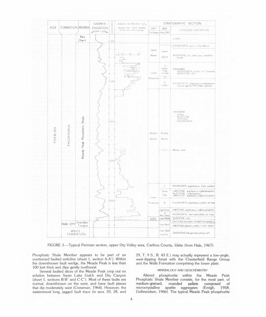
I GAMMA ASSAYS IN PERCENT P5 0, STRATIGRAPHIC SECTION
AGE FORMATION 1MEMBER RADIATION 4: Dorhed tiri“ - h Sample,uUNIT BED Sold „,es L IT HOLOGIC DESCRIPTION
, Th,s Report Hale,1967-
Rex CHERT
Cheri
--- PHOSPHORITE, ool tic, iossiliferous
20u3C Nave MUDSTONE, silty, dark -gray. weathers
brown
Upper Interbedded High PHOSPHORITE, pisolitic !'diameter
peer Grade MUDSTONE, silty
Phospharc-
D PHOSPHORITE, orgillaceous,carbonaceous L ower (Loss on Ignition 111%) finely pelletal
Interbedded
SHALE MUDS TONE SILTSTONE PHOSPHORITE
Middle Middle
Waste Waste
E — - Marker bed
PE
RM
IAN
PH
OS
PH
OR
IA
Me
ade
Peak
Ph
osp
ha
tic
Sha
le
r T C 1 ,HospHoR,TE,org,„oce.s. finely pelletal)
False LIMESTONE, orgilloceous, slightly phosphatic MUDSTONE, carbonaceous
Cap LIMESTONE, orgillaceous, slightly phosphottcl Lower 1 -
Phosphate' B PHOSPHORITE, argilloceous. pellets
Cop Rock LIMESTONE, orgillaceous, sightly phosphatic
PHOSPHORITE, main bed pellets 25 - I 0 rat
MUDSTONE, soft
FISH-SCALE,broclosnc phosphonte 335%'Grandeur PARK CITY' Foot -WallTongue L LIMESTONE dolornitic,cherty Locally absent
Foot -Wall WELLS
SANDSTONE, fine-gra,ned, yellow, softFORMATION Locally
FIGURE 3.—Typical Permian section, upper Dry Valley area, Caribou County, Idaho (from Hale, 1967).
Phosphatic Shale Member appears to be part of an 29, T. 9 S., R. 43 E.) may actually represent a low-angle, overturned faulted anticline (sheet 1, section A-A'). Within west-dipping thrust with the Chesterfield Range Group the downthrown fault wedge, the Meade Peak is less than and the Wells Formation comprising the lower plate. 100 feet thick and dips gently northwest.
MINERALOGY AND GEOCHEMISTRYSeveral faulted slices of the Meade Peak crop out en echelon between Swan Lake Gulch and Dry Canyon Altered phosphorite within the Meade Peak (sheet 1, sections B-B' and C-C'). Most of these faults are Phosphatic Shale Member consists, for the most part, of normal, downthrown on the west, and have fault planes medium-grained, rounded pellets composed of that dip moderately west (Cressman, 1964). However, the microcrystalline apatite aggregates (Emigh, 1958; easternmost long, jagged fault trace (in secs. 20, 28, and Gulbrandsen, 1966). The typical Meade Peak phosphorite
4
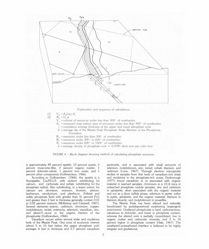
Ppm
section line
1500' overburden
Explanation and sequence of calculations:
(1) V, = kt(sec d) (2) R, =V„ p
V„ = volume of resources under less than 300' of overburden A,, = measured map surface area of resources under less than 300' of overburden
t = cumulative average thickness of the upper and lower phosphate units d = average dip of the Meade Peak Phosphatic Shale Member of the Phosphoria
Formation R, = resources under less than 300' of overburden Rh = resources under 300' to 600' of overburden R, =resources under 600' to 1500' of overburden P = average density of phosphate rock = 0.0787 short tons per cubic foot
FIGURE 4.—Block diagram showing method of calculating phosphate resources.
is approximately 80 percent apatite, 10 percent quartz, 5 pentoxide, and is associated with small amounts of percent muscovite-illite, 2 percent organic matter, 1 selenium, molybdenum, zinc, nickel, cobalt, titanium, and percent dolomite-calcite, 1 percent iron oxide, and 1 cadmium (Love, 1967). Through electron microprobe percent other components (Gulbrandsen, 1966). studies of samples from thin beds of vanadium-rich shale
According to Gulbrandsen (1966), the apatite is a and mudstone in the phosphate-rich zones, Desborough fluorapatite, Cas(PO4),F, with sodium substituting for (1977) found vanadium in or associated with organic calcium, and carbonate and sulfate substituting for the material in leached samples; chromium in a 10-A mica in phosphate radical. Also substituting, to a lesser extent, for unleached phosphate nodule samples; zinc and cadmium calcium are strontium, uranium, thorium, yttrium, in sphalerite; silver associated with the organic material lanthanum, neodymium, and ytterbium. Pelletal and and not as a silver sulfide phase; selenium in pyrite; sulfur oolitic phosphate beds with greater than 31 percent P70, in pyrite, sphalerite, and the organic material; titanium in and greater than 3 feet in thickness generally contain 0.01 titanium dioxide; and molybdenum in powellite. tip 0.02 percent uranium (McKelvey and Carswell, 1967). The Meade Peak has been altered and naturally Several elements--arsenic, cadmium, chromium, copper, beneficiated by postdepositional weathering (supergene molybdenum, nickel, antimony, selenium, vanadium, zinc, enrichment). Unaltered phosphorite is hard, carbonaceous, and silver(?)--occur in the organic fraction of the calcareous to dolomitic, and lower in phosphate content, phosphorite (Gulbrandsen, 1966). whereas the altered rock is partially consolidated, low in
Vanadium occurs within several shale and mudstone organic matter and carbonate minerals, and 3 to 10 beds of the Meade Peak. One zone of economic interest percent higher in phosphate content (Hale, 1967). The (about 5 to 10 feet below the upper phosphate unit) weathered-unweathered interface is believed to be highly averages 4 feet in thickness and 0.7 percent vanadium irregular and gradational.
5
IDENTIFIED RESOURCES
A total of 46.4 million short tons of identified phosphate resources with a weighted average of 25.1 percent P20, is within the Meade Peak Phosphatic Shale Member in the Fossil Canyon quadrangle: 31.3 million short tons of resources with less than 300 feet of overburden, 10.8 million short tons of resources with 300 to 600 feet of overburden, and 4.39 million short tons of resources with 600 to 1,500 feet of overburden.' Thickness and P,O, data from one trench in the Fossil Canyon quadrangle and one drill hole from the southern part of Trail Creek syncline in the adjacent Johnson Creek quadrangle were used to calculate these resources. Resources are based on data from the nearest drill holes or trenches situated along the same structural feature.
REFERENCES
Armstrong, F. C. and Cressman, E. R., 1963, The Bannock thrust zone, southeastern Idaho: U.S. Geological Survey Professional Paper 374-J, p. J1-J22.
Cressman, E. R., 1964, Geology of the Georgetown Canyon-Snowdrift Mountain area, southeastern Idaho: U.S. Geological Survey Bulletin 1153, 105 p.
Desborough, G. A., 1977, Preliminary report on certain metals of potential economic interest in thin vanadium-rich zones in the Meade Peak Member of the Phosphoria Formation in western Wyoming and eastern Idaho: U.S. Geological Survey Open-File Report 77-341, 27 p.
Emigh, G. D., 1958, Petrography, mineralogy, and origin of phosphate pellets in the Phosphoria Formation: Idaho Bureau of Mines and Geology Pamphlet 114.
Gulbrandsen, R. A., 1966, Chemical composition of phosphorites of the Phosphoria Formation: Geochimica et Cosmochimica Acta, v. 30, p. 769778.
Hale, L. A., 1967, Phosphate exploration using gamma-radiation logs, Dry Valley, Idaho, in Anatomy of the western phosphate field, a guide to the geologic occurrence, exploration methods, mining engineering, and recovery technology: Intermountain Association of Geologists, 15th Annual Field Conference, p. 147159.
Love, J. D., 1967, Vanadium and associated elements in the Phosphoria Formation in the Afton area, western Wyoming, in Anatomy of the western phosphate field, a guide to the geologic occurrence, exploration methods, mining engineering, and recovery technology: Intermountain Association of Geologists, 15th Annual Field Conference, p. 115-118.
Mansfield, G. R., 1927, Geography, geology, and mineral resources of part of southeastern Idaho with a description of Carboniferous and Triassic fossils by G. H. Girty: U.S. Geological Survey Professional Paper 152, 453 p.
McKelvey, V. E., and Carswell, L. D., 1967, Uranium in the Phosphoria Formation, in Anatomy of the western phosphate field, a guide to the geologic occurrence, exploration methods, mining engineering, and recovery technology: Intermountain Association of Geologists, 15th Annual Field Conference, p. 119123.
McKelvey, V. E., Davidson, D. F., O'Malley, F. W., and Smith, L. E., 1953, Stratigraphic sections of the Phosphoria Formation in Idaho 1947-1948, pt. 1: U.S. Geological Survey Circular 208, 49 p.
McKelvey, V. E., Williams, J. S., Sheldon, R. P., Cressman, E. R., Cheney, T. M., and Swanson, R. W., 1959, The Phosphoria, Park City, and Shedhorn Formations in the western phosphate field: U.S. Geological Survey Professional Paper 313-A, p. 1-47.
Montgomery, K. M., and Cheney, T. M., 1967, Geology of the Stewart Flat quadrangle, Caribou County, Idaho: U.S. Geological Survey Bulletin 1217, 63 p.
Oberlindacher, Peter, and Hovland, R. D., 1979, Geology and phosphate resources of the Hawley Creek area, Lemhi County, Idaho: U.S. Geological Survey Open-File Report 79-1283.
Peterson, J. A., 1980, Depositional history and petroleum geology of the Permian Phosphoria, Park City, and Shedhom Formations, Wyoming and southeastern Idaho: U.S. Geological Survey Open-File Report 80667, 42 p.
U.S. Bureau of Mines and U.S. Geological Survey, 1980, Principles of a resource/reserve classification for minerals: U.S. Geological Survey Circular 831, 5 p.
'Resources calculated to three significant figures for phosphate rock containing
16 or more percent P20,
6