Embed Size (px)
Citation preview

l ~V~ "L ~ 18"801 Mineral Land Assessment I Open File Report/1989
I Mineral Investigation of a Part of the Gibraltar I Mountain Wilderness Study Area (AZ-050-012), | La Paz County, Arizona
I I
li I"° ,
study area ~~ ! i ' '
!
I ~ BUREAU OF MINES
I , UNITED STATES DEPARTMENT OF THE INTERIOR
I
m '
i /
11 ?:
ili!~:i/ ,
!II;-
I I
MINERAL INVESTIGATION OF A PART OF THE GIBRALTAR MOUNTAIN WILDERNESS STUDY AREA (AZ-050-Ol2), LA PAZ COUNTY, ARIZONA
I
I :I
I I I
I I I
by
David C. Scott
MLA 18-89 1989
Intermountain Field Operations Center, Denver, Colorado
UNITED STATES DEPARTMENT OF THE INTERIOR Manuel Lujan, Or., Secretary
T S Ary, Director
AU G ~ }- 1.989 ' '~d , . c .~ &
Mh',E, AL ~i-SOOi{CE-;
PREFACE
The Federal Land Policy and Management Act of 1976 (Public Law 94-579)
requires the U.S. Geological Survey and the U.S. Bureau of Mines to conduct
mineral surveys on certain areas to determine the mineral values, i f any, that
may be present. Results must be made available to the public and be submitted
to the President and the Congress. This report presents the results of a
mineral survey of a part of the Gibraltar Mountain Wilderness Study Area
(AZ-050-OI2), La Paz County, Arizona.
I I I I
This open-file report summarizes the results of a Bureau of Mines wilderness study. The report is preliminary and has not been edited or reviewed for conformity with the Bureau of Mines editorial standards. Th is study was conducted by personnel from the Resource Evaluation Branch, Intermountain Field Operations Center, Building 20, Denver Federal Center, Denver, CO B0225.

I I I I I I I I I I I I I I I I I
CONTENTS
Summary . . . . . . . . . . . . . . . . . . . . . . . . . . . . . . . . . . . . . . . . . . . . . . . . . . . . . . . . . . . . . . . . . . . . . l
Int roduct ion " 2
Geographic set t ing . . . . . . . . . . . . . . . . . . . . . . . . . . . . . . . . . . . . . . . . . . . . . . . . . . . . 3
Previous invest igat ions . . . . . . . . . . . . . . . . . . . . . . . . . . . . . . . . . . . . . . . . . . . . . . . 3
Methods of invest iga t ion . . . . . . . . . . . . . . . . . . . . . . . . . . . . . . . . . . . . . . . . . . . . . . 5
Geologic se t t ing . . . . . . . . . . . . . . . . . . . . . . . . . . . . . . . . . . . . . . . . . . . . . . . . . . . . . . . . . . . 5
Mining d i s t r i c t s and h is to ry . . . . . . . . . . . . . . . . . . . . . . . . . . . . . . . . . . . . . . . . . . . . . . . 7
Appraisal of s i tes examined . . . . . . . . . . . . . . . . . . . . . . . . . . . . . . . . . . . . . . . . . . . . . . . . B
Mammon Mine area . . . . . . . . . . . . . . . . . . . . . . . . . . . . . . . . . . . . . . . . . . . . . . . . . . . . . . 9
Gray Eagle Mine area . . . . . . . . . . . . . . . . . . . . . . . . . . . . . . . . . . . . . . . . . . . . . . . . . . . g
Giers Mountain area . . . . . . . . . . . . . . . . . . . . . . . . . . . . . . . . . . . . . . . . . . . . . . . . . . . lO
Miscellaneous prospects . . . . . . . . . . . . . . . . . . . . . . . . . . . . . . . . . . . . . . . . . . . . . . . I I
Sand and gravel . . . . . . . . . . . . . . . . . . . . . . . . . . . . . . . . . . . . . . . . . . . . . . . . . . . . . . . I I
Conclusions . . . . . . . . . . . . . . . . . . . . . . . . . . . . . . . . . . . . . . . . . . . . . . . . . . . . . . . . . . . . . . . . I I
Recommendations for fur ther study . . . . . . . . . . . . . . . . . . . . . . . . . . . . . . . . . . . . . . . . . . 12
References . . . . . . . . . . . . . . . . . . . . . . . . . . . . . . . . . . . . . . . . . . . . . . . . . . . . . . . . . . . . . . . . . 13
Appendix . . . . . . . . . . . . . . . . . . . . . . . . . . . . . . . . . . . . . . . . . . . . . . . . . . . . . . . . . . . . . . . . . . . l?
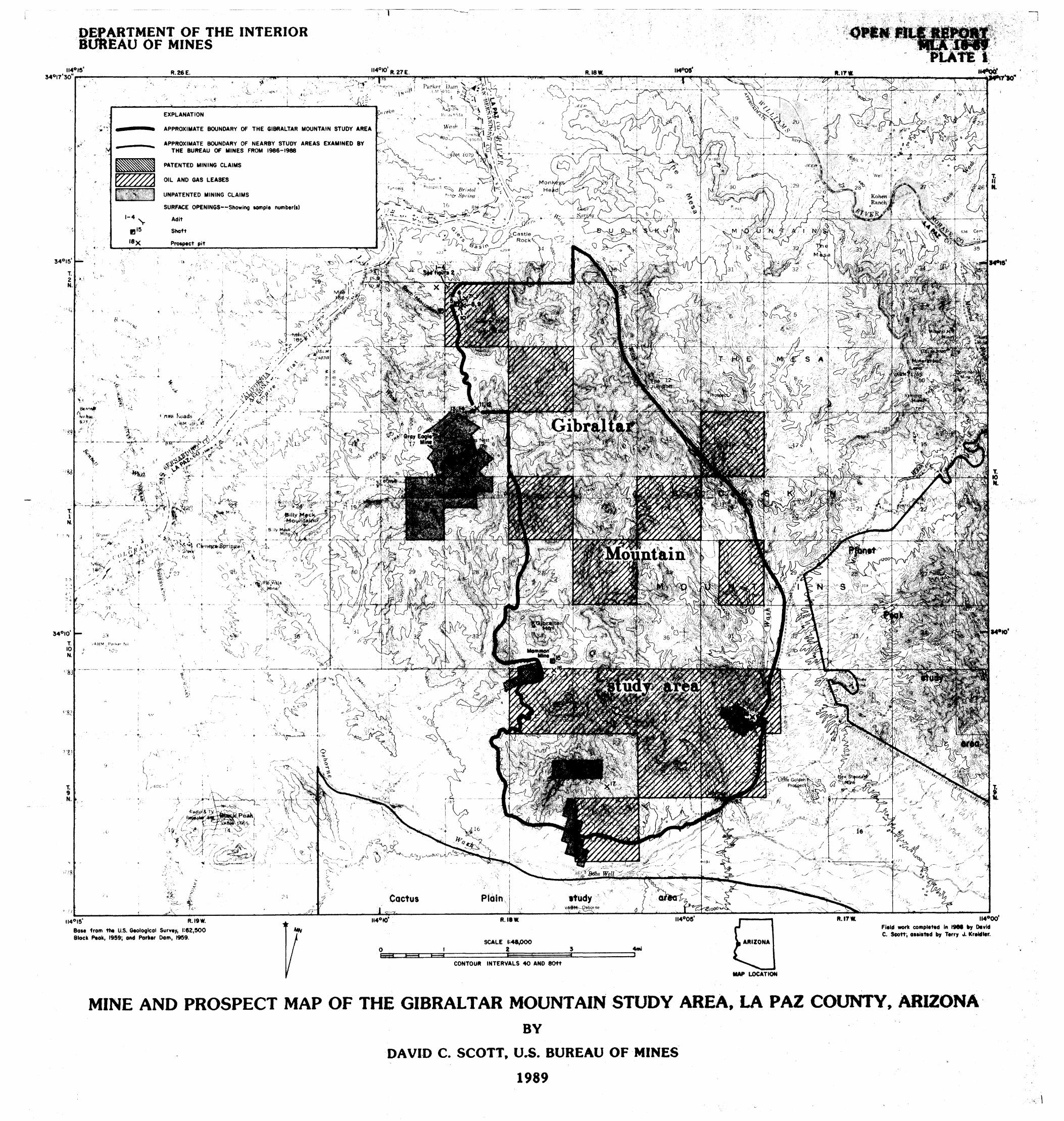
Plate 1.
ILLUSTRATIONS
Mine and prospect map of the Gibra l tar Mountain Wilderness at Study Area, La Paz County, Arizona . . . . . . . . . . . . . . . . . . . . . . . . . . . . back
Figure l .
.
Index and metal l ic mining d i s t r i c t map of the Gibra l tar Mountain study area . . . . . . . . . . . . . . . . . . . . . . . . . . . . . . . . . . . . . . . . . . . 4
Adi t along northwest boundary of the study area, showing sample l o c a l i t i e s and ana ly t ica l resul ts and descr ipt ions . . . . . 14
i i

!i I I I I I I I I I I I |
i
ii i ,
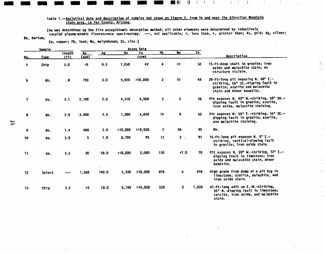
Table l .
TABLES Pa~e
Analytical data and description of samples not shown on figure 2, from in and near the Gibraltar Mountain
study area . . . . . . . . . . . . . . . . . . . . . . . . . . . . . . . . . . . . . . . . . . . . . . . . . . . . 15
UNIT OF MEASURE ABBREVIATIONS USED IN THIS REPORT
° degree
f t foot
in. inch
mi mile
ppb part per b i l l ion
ppm part per million
% percent
Ib pound
st short ton
OZ troy ounce
oz/st troy ounce per short ton
i i i

I I I I I I I I I I I I I I I I I
MINERAL INVESIIGATION OF A PART OF THE GIBRALTAR MOUNTAIN WILDERNESS STUDY AREA (AZ-050-OI2), LA PAZ COUNTY, ARIZONA
by
David C. Scott, Bureau of Nines
SUMMARY
In March 1988, the Bureau of Nines conducted a mineral invest igat ion of
18,807 acres of the 25,260-acre Gibral tar Mountain Wilderness Study Area, La
Paz County, Arizona. The 18,BO7-acre area was pre l im inar i l y ident i f ied as
suitable for wilderness and is administered by the Bureau of Land Management.
The mineral investigat ion was authorized by the Federal Land Policy and
Management Act of 1976 (Public Law 94-579). Bureau personnel investigated
mines, prospects, and mineralized areas to evaluate mineral reserves and
ident i f ied resources. Eighteen rock-chip samples were taken in and near the
study area.
The study area is characterized by basalt that covers upper- and
lower-plate rocks of the Buckskin-Rawhide detachment fau l t . A northeast-
trending synform in the detachment fau l t extends from the Mammon Mine area, at
the southwestern study area boundary, to the Planet metal l ic mining d i s t r i c t ,
outside the northeastern area boundary. Upper-plate rocks of the detachment
fau l t are exposed along the western study area boundary in the Cienega
metal l ic mining d i s t r i c t , and along the eastern study area boundary in the
Planet metal l ic mining d i s t r i c t . Lower-plate rocks of the detachment fau l t
are exposed at the Mammon Nine, outside the southwestern study area boundary.
The d i s t r i c t s had copper, gold, and s i l ve r production.
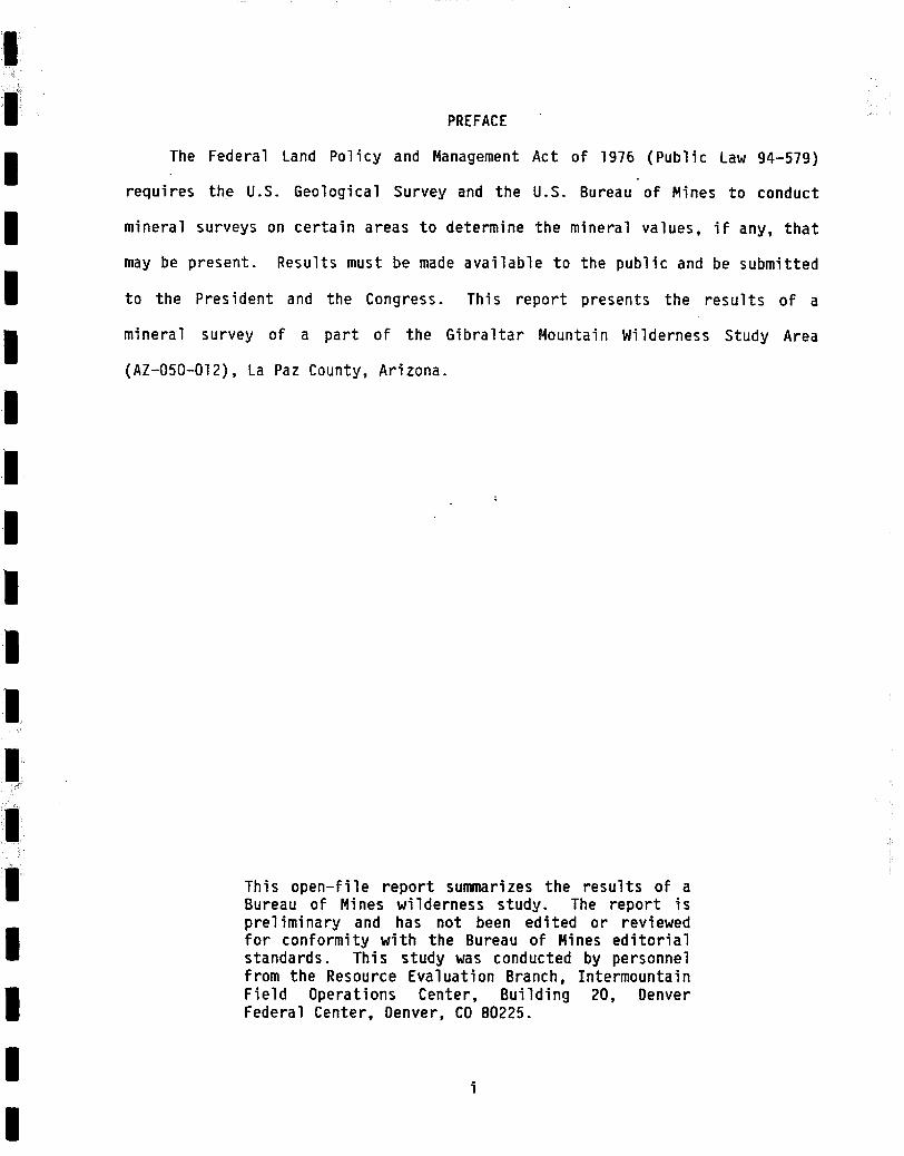
No mineral resources were ident i f ied in the study area, but the
detachment fau l t and related high-angle faul ts and fractures in the metal l ic
mining distr icts adjacent to the study area contain occurrences of copper,
gold, and silver. Geologic conditions are similar in the study area. Copper,
gold, and silver occurrences, similar to those found• in the Planet, Cienega,
and Mammon metallic mining distr icts, could be present beneath the basalt flow
I I I
covering the study area.
Sand and gravel is found throughout the study area; however, similar
material may be obtained outside the study area, nearer to a market place.
The U.S. Geological Survey assessed the study area as having few
attributes of an oil and gas producing area and gave the area a low to zero
I I I
potential for hydrocarbon accumulation.
INTRODUCTION
In March 1988, the Bureau of Mines, in a cooperative program with the
U.S. Geological Survey (USGS), conducted a mineral investigation of a part of
the Gibraltar Mountain Wilderness Study Area, La Paz County, Arizona, on lands
I I I
administered by the Bureau of Land Management (BLM), Yuma District Office.
The wilderness study area comprises 25,260 acres; the Bureau studied the
18,B07 acres deemed preliminarily suitable for inclusion in the National
Wilderness Preservation System. "Study area" (SA) as used in this report
refers only to the smaller area. The Bureau surveys and studies mines,
I I l
prospects, and mineralized areas to appraise reserves and identified
subeconomic resources. The USGS assesses the potential for undiscovered
mineral resources based on regional geological, geochemical, and geophysical
surveys. This report presents the results of the Bureau study, which was
completed prior to the USGS investigations. The USGS wi l l publish the results
l l I
of their studies. A joint USGS-Bureau report, to be published by the USGS,
wi l l integrate and summarize the results of al l surveys.

I I I I I I I I I I I I I I I I I I
Geographic sett ing
The study area is in the Basin and Range physiographic province and
encompasses the western part of the Buckskin Mountains, west-central Arizona.
Parker, Arizona, the nearest munic ipal i ty, is about 10 mi west ( f tg . 1).
Access to the study area is from State Highway 95, north of Parker, and State
Highway 72, south of Parker. Gravel roads and four-wheel-drive t r a i l s
encircle the study area and provide access to the perimeter.
Topography in the study area is characterized by an extensive basalt
plateau that is accentuated by broad, sandy washes. The eastern and southern
boundaries fol low Osborne Wash, which separates the study area from the
extensive, sandy, Cactus Plain Wilderness Study Area.
Elevations in the study area range from 1,908 f t on an unnamed peak jus t
east of Giers Mountain in the northern part of the area, to about 650 f t at
the northwest corner of the area. Climate in the region is semiarid, with
mild winters and hot summers.
Previous investigations
One of the ear l iest geologic investigations in the region described ore
deposits in northern Yuma County (Bancroft, 1911). The report describes the
geology and mineral ization in the Cienega and Mammon metal l ic mineral
d i s t r i c t s , adjacent to the western study area boundary. Subsequent
publications have dealt pr imar i ly with these d i s t r i c t s , but contain sparse
data about the study area. Within the last 10 years, many reports have been
wri t ten about detachment faul ts and related mineral ization in southwestern
Arizona. A l i s t of references related to detachment faul ts in southwestern
Arizona can be found in a report by Lehman and others (1987).
3

I I I I I I I I I I I
T. 3 N.
1:. 2 N.
3 4 O l 5 '
T. 1 N,
T. 9 N,
T,' 8 N.
54000 '
1". 7 N.
114°15 ' R. 26E.
/ \ /
,-- \
\ COLOR~DO
RIVER
R. IBW.
~. Lake Hovasu
R. 179/, 114°00 ' R. 16 W.
p. lanet~F: district
ZP ' s'l'udy area b, C ~ o)';L':'.:l:-:~:::::::::~:::i:~:.~
R. 15W.
~ \ R 19 W. I Mammon :..F:;MOUNTAIN~'~!~:~:':':!:,~. ,,, ::ii::::::i'#eo k ::::::iii::] !~:'i~X ~ . . , ~ . . . ' : ~ . ~ , ~ , ~ ~::::::::::: ".~ di=,i:~ ~ ::::::::::::::::::::::::::::::::::::::::
---------- e;i:~: STU Dy.: j i i ~ ~
::::" A" "~::: , ~ i : : : ; : : a,', i t v o , , ~ ~. ~...'..:.ARE ~!~,t" ........... ,¢"::::~!iii!:~:i:~:i*:.:'~
,district" ~ ~, ,....~.. w o s h ~
- - / - . - - ..... :: ..................... ~moin iii4 ~ Cactu~ ~
~ii ii::~iiiii::i:..d~ :~:~:~:~::::: l~,,a ::::::::::::4::::::: i i i ! i i i i i i i i i i i i i i i~ ......................
M T " N s
~'~
113045
1:. II N.
34015 '
T. i0 N,
"1:. 9 N.
T. 8 N.
34000 '
T. 7 N.
114Ol5 ' RII9 W. R. 18W. R. 17 W. 114000 ' R. 16 W. R. 15W.
0 5 I0 15 20mi I 1 I I t 't I I i - N -
E X P L A N A T I O N
STATE HIGHWAY MAP LOCATION
IMPROVED ROAD
,, '---",..,._, UNIMPROVED ROAD
TRANSMISSION LINE
"" . . . . . . " METALLIC MINING DISTRICT
INDIAN RESERVATION BOUNDARY
/9oa~ SPOT ELEVATION--Showing "feet above sea level X
113045 '
Figure 1 . - - I n d e x and m e t a l l i c mining d i s t r i c t map o f the G i b r a l t a r Mountain s tudy area, La Paz County, A r i zona .
4

I I
Recent Bureau of Mines wilderness reports in the region include: Cactus
Plain (Kreidler, Ig86); East Cactus Plain (Kreidler, Ig87); Planet Peak
(Kreidler, 1989); and Swansea (Ryan, 1989) (pl. l ) .
Methods of investigation
I I I
A review of pertinent l i terature on geology, mineralization, and mining
act iv i ty was completed prior to a f ield examination. Mining claims were
researched and those recorded with the BLM as of March, 1989 are shown on
plate I . Oil and gas lease records were examined and leases on f i l e with the
BLM as of May lgBB are also shown on plate I .
I I I
Two Bureau geologists spent six days conducting a f ield investigation of
the study area. Accessible mine workings were surveyed by the compass-and-
tape method and 18 rock-chip samples Were taken. All samples were analyzed by
inductively coupled plasma-atomic fluorescence spectroscopy (total digestion)
for a suite of 24 elements and by f i re assay/atomic absorption spectroscopy
I I I
for gold. (See appendix for elements and detection l imits.) All analyses
were performed by Chemex Labs. Inc., Sparks, NV. Further inquiries about
sample analysis can be directed to the Bureau of Mines, Resource Evaluation
Branch, Intermountain Field Operations Center, Building 20, Denver Federal
Center, Denver, CO.
I I I
GEOLOGIC SETIING
About 85% of the Gibraltar Mountain study area is covered by basalt, but
a brief description of the geology and mineralization of adjacent mining
distr icts is necessary to explain how similar occurrences could be present
beneath the basalt. The basalt unit is middle to late Miocene-age, f la t - ly ing
I I I
to gently dipping, and consists of phenocrysts of fine-grained olivine,
clinopyroxene, and plagioclase. The unit varies in thickness and has an
m_
average thickness of about lO0 f t . Small isolated outcrops of Proterozic-age
granitic rock are exposed in the extreme northern part and comprise about 5%
of the study area. The remaining 10% of the area is covered with alluvium.
(See Spencer, 1987.)
I I I
The Tertiary-age Buckskin-Rawhide detachment fault, a large-displacement,
low-angle, normal fault that separates upper- and lower-plate rocks in a
metamorphic core complex, underlies the study area. (See Lehman and others,
1987, p. 3-4.) The fault is exposed at the Mammon Mine where lower-plate
mylonitic gneiss is exposed. A northeast-trending synform in the detachment
!
I I I I I I I i I
fault extends from the Mammon Mine northeasterly to the Planet metallic mining
d is t r ic t .
Copper, gold, and silver deposits are located along and adjacent to
Tertiary detachment faults, similar to the Buckskin-Rawhide detachment fault ,
in western Arizona. Spencer and Welty (1986, p. 195) describe mineralization
associated with detachment faults in the following paragraph.
"Mineralization is characterized by early copper and iron sulfides, followed by massive specular hematite, in turn followed by f racture- f i l l ing chrysocolla and malachite. Mineralization occurred during faulting and was associated with unusually high geothermal gradients that were at least part ia l ly due to detachment-fault movement that brought hot, lower-plate rocks up from great depth and juxtaposed them with cool, near-surface, upper-plate rocks. Mixing of ascending, reduced, metal-bearing aqueous solutions with higher level, oxidized fluids is proposed as an important process leading to oxide mineralization. Movement of the redox interface down normal-fault ramps at the same rate as displacement of hanging-wall rocks resulted in continous mineralization at some upper-plate sites over significant periods of geologic time; this produced the largest orebodies. Aqueous solutions that precipitated iron oxides near the detachment fault carried manganese oxides to higher levels where vein and stratabound sedimentary manganese oxides were deposited."
The significance of the mineralization associated with detachment faults
is important to the evaluation of minerals in the study area. The Buckskin-
6

I Rawhide detachment fault, which underlies the study area, may have acted as a
conduit for similar mineralization beneath the basalt covering the study area.
Ryder (1983) evaluated the petroleum potential of wilderness lands in
Arizona based on the known or interpreted distribution of reservoir rocks and
I I I
hydrocarbon source beds, geologic history, and stratigraphic and structural
features favorable for oil and gas accumulations in each wilderness. Based on
these data, Ryder gave the study area a low to zero potential for hydrocarbon
accumulation. Many oil and gas leases have been applied for and received
within the study area, however, no exploratory holes have been dri l led.
I I I
MINING DISTRICTS AND HISTORY
The study area is entirely within the Cienega mining d is t r ic t , where
copper, gold, and silver deposits were discovered as early as 1860 (Keith,
Ig?8, p. 129). The mining d is t r ic t includes the Cienega, Mammon, Planet, and
Pride metallic mineral distr icts as defined by Keith and others (1983, map)
I I I I
(fig. I).
The Cienega metallic mining district is adjacent to the northwestern
boundary of the study area (fig. l). From IB70 to 1969, production from the
district totalled 19,000 tons of ore that contained 1,714,000 Ib of copper,
1,600 oz of silver, and 12,000 oz of gold. Mineral deposits occur as
replacement of silicates, carbonates, and oxides, with quartz-hematite in
northwest-trending shear zones in the upper plate of the Buckskin-Rahwide
I I I
detachment fault (Spencer and Welty, 1986, p. 196).
The Mammon metallic mining district is along and inside the southwestern
boundary of the study area (fig. l). Production from 1909 to 1955 totalled
B00 tons of ore that contained 87,000 Ib of copper, I00 oz of silver, and less
than lO0 oz of gold. Mineral deposits consist of chrysocolla, malachite,
I I I I I I I I I I I I I I I I I
hematite, and calc i te in northwest-trending, steeply dipping shear zones in
lower-plate mylonit ic gneiss of the Buckskin-Rawhide detachment fau l t (Spencer
and Welty, 1986, p. 196).
The Planet metal l ic mining d i s r i c t is about 7 mi northeast of the study
area ( f i g . 1). Production from the d i s t r i c t tota l led 1,OlO,O00 tons of ore
that contained 19,520,000 lb of copper, 600 oz of s i l ver , and 400 oz of gold.
Copper carbonates, s i l i ca tes , and sulf ides with quartz and calc i te occur in
disseminations, veinlets, and replacement bodies of hematite in the upper
plate of the Buckskin-Rawhide detachment fau l t and in northwest-trending shear
zones related to the detachment fau l t (Spencer and Welty, 1986, p. 196).
The Pride metal l ic mining d i s t r i c t is about 8 mi east of the northeastern
part of the study area ( f i g . 1). Production from the d i s t r i c t to ta l led 40
tons of ore that contained 20 lb of copper, less than 100 oz of s i l ve r , and
less than 100 oz of gold. Malachite, chrysocolla, hematite, and quartz occur
in both lower and upper plates of the detachment fau l t , in northwest-trending,
high-angle shear zones (Spencer and Welty, 1986, p. 196).
As of March 1989, 18 claims were on f i l e with the BLM, but no evidence of
any current mining a c t i v i t y was found in the study area (p l . 1). Cyprus
Mining Co. is presently evaluating the Mammon Mine area, just outside the
southwestern study area boundary, as a possible copper leaching s i te (3im
3ones, owner, Mammon Mine, Parker, AZ, oral commun., 3an. 1989).
APPRAISAL OF SITES EXAMINED
NO mineral resources were identified in the study area. Copper, gold,
and si lver occurrences are associated with upper- and lower-plate rocks of the
Buckskin-Rawhide detachment fault, which underlies the study area. Rock-chlp
samples were taken from the lower-plate rocks exposed at the Mammon Mine

I
I I I I I I I I I I I I I I I I I
adjacent to the southwestern part of the study area. Rock-chip samples were
also taken from upper-plate rocks exposed along the northwestern part of the
study area. Sampled loca l i t i es are discussed by geographic location.
Mammon Mine area
The Mammon Mine is on three patented mining claims jus t outside the
southwestern boundary of the study area (p l . 1). Several small adits and
prospects were found at the mine; however, the main working is an adi t about
500 f t in length. The adit was driven on a N. 40 ° W.-str ik ing, 40 ° S.W.-
dipping shear zone in an isolated outcrop of lower-plate mylonit ic gneiss of
the Buckskin-Rawhide detachment fau l t . The zone contains intensely sheared
rocks that are heavily stained with iron oxide and secondary copper minerals;
ca lc i te and hematite are also present. The shear zone cannot be traced into
the study area, and no mineralized rock was found in the basalt overlying the
mylonit ic gneiss. The mylonit ic gneiss does not crop out anywhere in the
study area.
Two samples were collected in the study area east of the Mammon Mine (p l .
1, sample nos. 15-16). Sample 15, a select sample from the dump of a
48-ft-deep shaft in basalt, contained 1- to 4 - in . - th i ck veinlets of hematite.
Gold was detected (5 ppb), and elevated concentrations of copper and zinc were
present: 8,280 ppm (0.83%) copper and 1,805 ppm (0.18%) zinc (table 1). The
copper and zinc are probably associated with the hematite vein lets; no
structure was visible in the shaft. Sample 16, collected from a pit dug in
reddish basalt, contained no significant concentrations of any elements.
Gray Eagle Mine area
A 41-ft-long adit, a shaft, and a prospect pit were found outside of the
study area, but within I/4 mi of the western boundary, near the Gray Eagle
I I I I I I I I I I I I !
I i I I I I
Mine (p l . 1, sample nos. 11-14). The workings are in the upper plate of the
Buckskin-Rawhide detachment f au l t , in Paleozoic and Mesozoic limestones and
shales. East to northeast-trending high-angle faul ts and fractures tn the
limestone and shale contain azur i te , ca lc i te , chrysocol la, malachite, and
hematite. These structures trend toward the study area, but could not be
traced past the fau l t exposed in the workings.
Four samples were col lected from the workings (table 1, sample nos.
11-14). Gold concentrations range from less than 5 ppb to 1,560 ppb (0.045
oz /s t ) . The high concentration was in a select sample from the dump of a
p i t . Copper concentrations range from 1,790 ppm (0.18%) to over 10,000 ppm
(greater than 1%). Al1 samples contain elevated lead, s i l ve r , and zinc
concentrations: lead, from 150 to 875 ppm (0.08%); s i l ve r , 2 to 140 ppm (4.0
oz /s t ) ; zinc, 70 to 1,020 ppm (0.10%). These mineralized fau l ts trend toward
the study area, and may be present beneath the basalt .
Giers Mountain area
A c luster of workings was found in the extreme northwestern part of the
study area on the northwest f lank of Giers Mountain (p l . 1, sample nos.
1-10). Four prospect p i ts and one shallow shaft are jus t inside the boundary;
one ad i t , one shaft , and one prospect p i t are jus t outside.
The workings are on northwest- to nor theast -s t r ik ing fau l ts in grani te in
the upper plate of the Buckskin-Rawhide detachment fau l t . The fau l ts pinch
and swell from 2 to 4 f t in thickness, but exposures are less than 100 f t
long. Azur i te, malachite, and l imoni te are common in the gouge of the fau l t s .
Samples 1 to 10 col lected from the fau l ts contained gold concentrations
ranging from less than 5 ppb to 6,400 ppb (0.18 oz /s t ) . Copper concentrations
range from 42 ppm to greater than 10,000 ppm (greater than 1%). Lead, s i l ve r ,
10

and zinc contents are generally insignif icant (table l ; f ig. 2, nos. I - I0 ) .
Similar mineralized faults containing these elements may be present beneath
the basalt elsewhere in the study area. No resources were calculated because
of the short strike lengths of the faults and sporadic element concentrations.
I I I
Miscellaneous prospects
Two other pits are within the southern part of the study area. One p i t ,
in sec. I I , T. 9 N., R. 18 W., is in basalt; no structure was noted and no
significant metallic concentrations were found in a sample from the p i t (pl.
l ; table l , sample no. l?).
I I I
The other pi t , in sec. 6, T. 9 N., R. l? W., is in basalt; no structure
was found. No unusual concentrations of any element were noted in the sample
from the pi t (pl. l ; table l , sample no. 18).
Sand and gravel
Sand and gravel deposits of Quaternary age are present in drainages In
I I I
the study area; however, there is presently no demand for material near the
study area. Greater volumes of similar sand and gravel are present outside
the study area and are more readily accessible for development. Therefore,
any increase in local demand for sand and gravel would not neccessarily place
a demand on the deposits in the study area.
I I I
CONCLUSIONS
No mineral resources were identif ied in the study area. About 85% of the
study area is covered by basalt and is void of near-surface mineralized rock.
Along the western study area boundary, high-angle faults and fractures in the
upper and lower plates of the Buckskin-Rawhide detachment fault contain
I I I
copper, gold, and s i l v e r occurrences. Based on the prox imi ty of these
deposits to the study area and the existence of the Buckskin-Rawhide
I I

I I I I I I I I I
I
iim
detachment fault under the basalt in the study area, similar copper, gold, and
silver occurrences could also be present in the subsurface of the study area.
The USGS assessed the study area as having zero to low potential for oi l
and gas accumulation. Sand and gravel is present in drainages in the study
area; however, similar materials are outside the study area, nearer to market
places.
RECOMMENDATIONS FOR FURTHER STUDY
Detailed geological, geophysical, or geochemical studies, followed by
subsurface testing of delineated target areas should be done inside the
western boundary of the study area to see i f copper, gold, and silver
mineralization, similar to that outside the area, is present at depth.
12
REFERENCES
Bancroft, H., 1911, Reconnaissance of the ore deposits in northern Yuma County, Arizona: U.S. Geological Survey Bulletin 451, 130 p.
Keith, S. B., 1978,.Index of mining properties in Yuma County, Arizona: Arizona Bureau of Geology and Mineral Technology Bulletin 192, 185 p.
Keith, S. B., Gest, D. E., DeWitt, Ed, Woode Toll, Netta, and Everson, B. A., 1983, Metallic mineral distr icts and production in Arizona: Arizona Bureau of Geology and Mineral Technology, Bulletin 194 54 p.
Kreidler, T. J., 1986, Mineral investigation of a part of the Cactus Plain Wilderness Study Area (AZ-O50-OI4A/B), La Paz County, Arizona: U.S. Bureau of Mines Open-File Report MLA 64-86, I I p .
1987, Mineral investigation of the East Cactus Plain Wilderness Study Area (AZ-050-OI7), La Paz County, Arizona: U.S. Bureau of Mines Open-File Report MLA 81-87, lO p.
1989, Mineral investigation of the Planet Peak Wilderness Study Area, (AZ-050-OI3) La Paz County, Arizona: U.S. Bureau of Mines Open-File Report MLA 9-89, 34 p.
Lehman, N. E., Spencer, 5. E., and Welty, 5. W., 1987, Middle Tertiary mineralization related to metamorphic core complexes and detachment faults in Arizona and California: Society of Mining Engineers Preprint 87-21, 9 p.
Ryan, G. S., 1989, Mineral investigation of a part of the Swansea Wilderness Study Area (AZ-OSO-OISA), La Paz and Mohave Counties, Arizona: U.S. Bureau of Mines Open-File Report MLA 12-89, 19 p.
Ryder, R. T., 1983, Petroleum potent ial of wilderness lands in Arizona, i n M i l l e r , 8. W. ed., Petroleum potent ial of wilderness lands in the western United States: U.S. Geological Survey Circular 902 A-P, p. lC-22C.
Spencer, 5. E., 1987, Compilation geologic map of the Buckskin and Rawhide Mountains, west central Arizona, Arizona Bureau of Geology and Mineral Technology, scale 1:100,000.
Spencer, J. E., and Welty, 5. W., 1986, Possible controls of base- and precious-metal mineral izat ion associated with Tert iary detachment fau l ts in the lower Colorado River trough, Arizona and Cal i forn ia: Geology, v. 14, p. 195-198.
13

2
i,,# t d.
, ; : ;%, l / t '..,4
• ~# %,
- - - ' T - ' - " 36
# I I e i i i i !
EXPLANATION
,/~L Ctd"
w , .
. ~ r w
s%% I
" " 0 "'-'L I
. I ~ t , , ~ I ~,~t~- ~, ~ - l ~ : '~ .
SAMPLE LOCALITY--Showing iomple number "..~'/;:~!
FAULT--Showing lrtrike and dip; dashed where approximate -. t
INCLINED WORKINGS--Showing degree of inclination; chevrons pointing dawn
STOPED ABOVE
TRENCH
GRANITE
m N m
A 20~t
I I
I I I I I
FIGURE 2
Sample Length
1 Chip 2.0
Assa d ~ A ~ ~ Ba Cu
B60 1.5 3%0 >10,000
~p] W
2 <1.0 45
Oescr~ptlon
Azurtte, malachite, and hematite in N. 75" N.-strtktng, 36" SW-dtpptng fau l t ; granite (sample length is also faul t thickness).
do. 3.4 170 1.5 1,730 207 14 <1.0 65 Do.
do. 4.0 6,400 2.0 3,720 >10,000 2 <1.0 79 Do.
do. 2.3 191 1.0 1,100 8,860 2 9.0 47 Do.
[Au was determined by the f i re assay/atomic absorption method; a l l other elements were determined by inductively coupled plasma-atomic fluorescence spectroscopy. <, less than, >, greater than; Au, gold; Ag, s i lver ; Ba, barium; Cu, copper; Pb, lead; Ha, molybdenum; In, z inc.]
Figure 2.--Adit along northwest boundary of the study area, showing sample localities and analytical results and descriptions.
14
l l l l l / I l l ~ 1 I I I I I I III ] t I i i I I , I ~ I
CTI
Ba, barium;
Table 1.--Analytical data and description of samples not shown on f igure 2 t from tn and near the Gibraltar Mountain study areat La Paz County. Artzona.
[Au was determined by the f i r e assay/atomic absorption method; a l l other elements were detemtned by Inductively coupled plasma-atomic fluorescence spectroscopy. - - - , not applicable; <, less than, >, greater than; Au, gold; Ag, s i lver ;
Cu, copper; Pb, lead; Ho, molybdenum; Zn, z inc.]
Sample Length
No. Type ( f t )
5 Chtp 5.0
Au (ppb)
<S
Ag
0.5
Assay Data Ba Cu Pb Ho Zn
(ppm)
1,050 42 4 <l 32
Description
1S-ft-deep shaft in granite; iron oxide and malachite stain; no structure v is ib le .
6 do. .8 750 3.0 5,020 >10,000 51 69 20-ft- long p t t exposing N. 40" E.- s t r i k ing , 66" SE.-dlpptng faul t tn granite; azurtte and malachite stain and minor hematite.
7 do. 3.1 2,100 2.0 4,310 6,060 2 55 Ptt exposes N. 40 e H.-str tk ing, 60 e SW.- dipping fau l t in granite; azurtte, iron oxide, malachite staining.
do. 2.0 2 , 4 0 0 2.5 1,080 4,850 12 52 Ptt exposes N. 59* E.-strtktng, 56* SE.- dtpptng fau l t tn granite; azurtte, and malachite staining.
9 do. 1.4 960 2.0
10 do. 3.0 5 1.0
>10,000 >10,000
8,700 95
2
12
38
3 ..
95
gl
Do.
1S-ft- long p t t exposes N. 5" E.- s t r i k ing , vert ical-dipping faul t tn granite; iron oxide stain.
11 do. 3.6 30 5B.0 >10,000 2,080 150 <1.0 70 Pit exposes N. 20" H.-str ik ing, 72" E.- dipping fau l t in limestone; iron oxide and malachite stain, minor hematite.
12 Select 1,560 140.0 2,330 >10,000 876 910 Htgh grade from dump of a pt t dug in limestone; azur i te, malachite, and iron oxide stain.
13 Chtp 3.4 <5 10.0 5,190 >10,000 520 1,020 41-f t - long adtt on E.-IC.-strtktng, 55" N.-dtpptng fau l t tn limestone; ca lc i te , 1ton oxide, and malachite stain.

m m n | m m | n i | | i D | H H | ~ m mid
NO.
14
15
10
17
18
Table 1 . - -Ana ly t ica l data and descr ipt ion of samples not shown on f tgure 2, from ~n and near the G ib ra l ta r Hountatn study area, La Paz County, Artzona--Cont4nued
Pb Ho Zn Sample Assay Data
Length Au._u___ . Aq Ba Cu TyPe ( f t ) (ppb) (ppm)
Select - - - <5 2.0 520 1,790 150 <1 138
do. - - - 5 3.5 230 8,280 4 5 1,805
<5 .5 510 26 2 2 127
<5 .5 310 54 2 4 111
<5 .5 1,670 17 16 6 152
Chtp
Select
do.
3.4
Description
Sample from dump of adt t . same as sample no. 13; contatns selected chtps of hematite.
Sample from dump of 48- f t deep shaft 4n black basal t ; 1 to 4 tn. vetn le ts of hematite.
Pt t tn red basal t ; mtnor ca lc t te ; no s t ructure.
Pt t tn black basa l t ; no structure or v t s tb l e m~nerals.
Pt t ~n basalt ; m~nor manganese oxide; no st ructure.
i -a O~

I I I
APPENDiX--Analytical l imits, Chemex Laboratories, Sparks, Nevada, (gold and silver were determined by f i re assay/atomic absorption spectroscopy, al l other by inductively coupled plasma-atomic fluorescence spectroscopy).All concentrations reported in ppm, unless otherwise noted.
Detection Upper Element l imi t l imi t
Au 5.0 ppb 10,000
Ag 0.5 500
A1 0.1% 25%
Ba 10.0 10,000
Be 0.5 I0,000
Bi 2.0 lO,O00
Ca 0.1% 25%
Cd 0.5 I0,000
Co 1.0 ~ lO,O00
Cr 1 .0 lO,O00
Cu 1.0 lO,O00
Fe 0.1% 25%
K O. I% 20%
Mg 0.1% 25%
Mn l.O lO,O00
Mo l.O lO,O00
Na 0.1% I0%
Ni l.O lO,O00
P lO.O lO,O00
Pb 2.0 lO,O00
Sr l.O lO,O00
Ti 0.1% I0%
V 1.0 lO,O00
W lO.O lO,O00
Zn 2.0 lO,O00
17


![Indigenous Enhanced Mineralization Pyrene, Benzo[a]pyrene ...Indigenous soil microorganism mineralization experiments. All of the mineralization experiments were performed by using](https://img.dokumen.tips/doc/110x75/5e7c41b0b7c4ef64181e5e16/indigenous-enhanced-mineralization-pyrene-benzoapyrene-indigenous-soil-microorganism.jpg)