Embed Size (px)
Citation preview

®
Global Advisory Council (GAC)Global Advisory Council (GAC)NMO overview, Jan 2011NMO overview, Jan 2011
Summary of the Survey Results Compiled by OGC
Presented and Complemented by Luiz Paulo S.Fortes
Director of NMO, Brazil
President of PC-IDEA
© 2010 Open Geospatial Consortium© 2010 Open Geospatial Consortium
OGC®
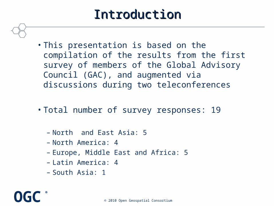
IntroductionIntroduction
• This presentation is based on the compilation of the results from the first survey of members of the Global Advisory Council (GAC), and augmented via discussions during two teleconferences
• Total number of survey responses: 19
– North and East Asia: 5– North America: 4– Europe, Middle East and Africa: 5– Latin America: 4– South Asia: 1
© 2010 Open Geospatial Consortium
OGC®
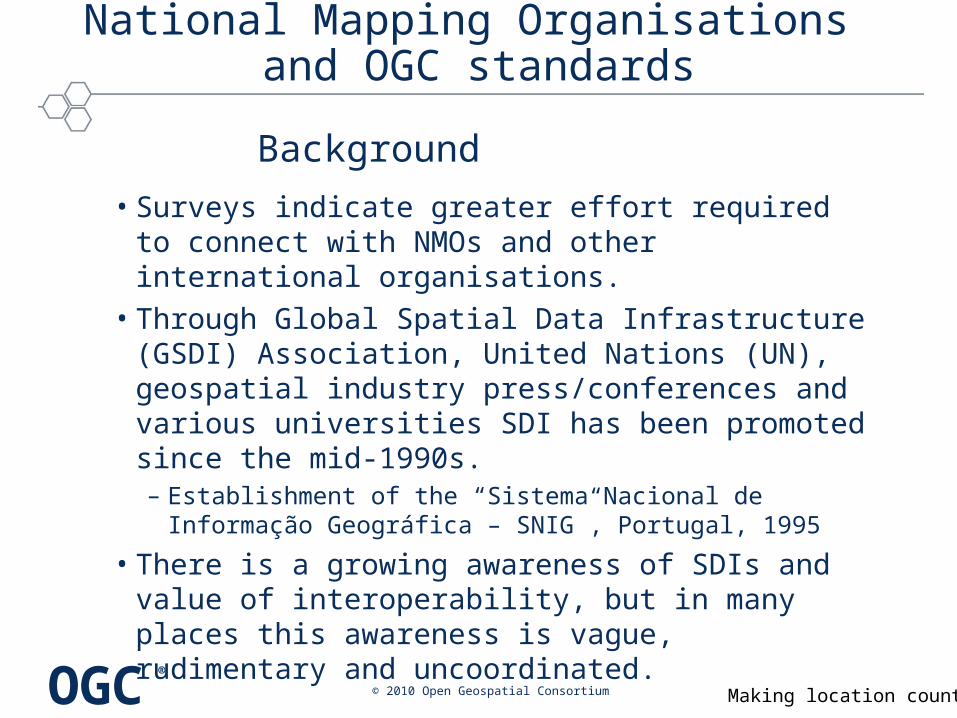
National Mapping Organisations and OGC standards
• Surveys indicate greater effort required to connect with NMOs and other international organisations.
• Through Global Spatial Data Infrastructure (GSDI) Association, United Nations (UN), geospatial industry press/conferences and various universities SDI has been promoted since the mid-1990s. – Establishment of the “Sistema Nacional de Informação
Geográfica – SNIG”, Portugal, 1995
• There is a growing awareness of SDIs and value of interoperability, but in many places this awareness is vague, rudimentary and uncoordinated.
Making location count. © 2010 Open Geospatial Consortium
Background

OGC®
National Mapping Organisations and OGC standards
• Surveys highlighted main barriers to adoption of SDI good practice, that is, framework for interoperable sharing and dissemination of geospatial information: – lack of political will or motivational drivers– poor technical qualifications of advisers to politicians– lack of awareness/understanding of need for standards– vendor lock-in– corruption practices.
Making location count. © 2010 Open Geospatial Consortium
Issues
OGC®
National Mapping Organisations and OGC standards
• Adoption of standards needs to be led and/or driven by the government – a “top down” process.
• This brings about compliance.• A challenge is posed by some critical agencies who
have yet to understand the value of the OGC (consensus, interoperability, networking, policies, capacity building, dissemination of best practices).
Making location count. © 2010 Open Geospatial Consortium
Requirements

OGC®
National Mapping Organisations and OGC standards
• “OGC compliance” should be included in tenders/RFPs issued by government agencies at all levels.“OGC compliant” must be understood by the community to ensure the process works.
• This approach can attract suppliers (including integrators and resellers) to obtain compliance.
• It may also open new opportunities with software development companies.
• Endorsements from global players such as Google, Microsoft and Oracle, as well as geospatial companies like ESRI and Intergraph very important.
Making location count. © 2010 Open Geospatial Consortium
Considerations

OGC®
National Mapping Organisations and OGC standards
• There are various issues of technical interoperability, semantic interoperability and institutional interoperability.
• Implementation in government is usually project based, so approaches using standards-based architectures varies from project to project.
• Specific requirements for geospatial interoperability should be highlighted to IT departments.
• Ultimately it is a business value decision.
Making location count. © 2010 Open Geospatial Consortium
Considerations
OGC®
National Mapping Organisations and OGC standards
• SDI is mainly applied to certain types of information, e.g. a platform for remote sensing information. It is important to: – Refine and improve relevant standards.– Improve ease of use.– Build on work done on space imaging infrastructure.– Design and demonstrate high interoperability frameworks.– Promote demonstration projects.– Explain the business value.
Making location count. © 2010 Open Geospatial Consortium
Considerations
OGC®
National Mapping Organisations and OGC standards
• Use the institutional frameworks and networks that already exist around the NMOs (nationally and multinationally) to promote standards.
• Build on emerging relationships with EuroGeographics and Regional Centre for Mapping of Resources for Development (RCMRD) in Africa.
• Assess international projects and cooperation e.g. PC-IDEA, GeoSur, IDECAN, PREDECAN in Latin America and PCGIAP in Asia Pacific.
• Develop relationships to support various, different national SDIs where standards play a major role.
Making location count. © 2010 Open Geospatial Consortium
Opportunity
OGC®
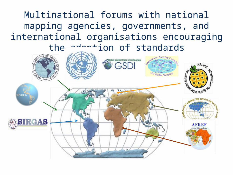
Multinational forums with national mapping agencies, governments, and international
organisations encouraging the adoption of standards
OGC®
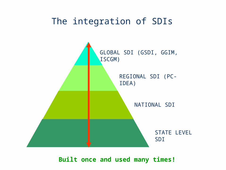
GLOBAL SDI (GSDI, GGIM, ISCGM)
REGIONAL SDI (PC-IDEA)
NATIONAL SDI
STATE LEVEL SDI
The integration of SDIs
Built once and used many times!
OGC®
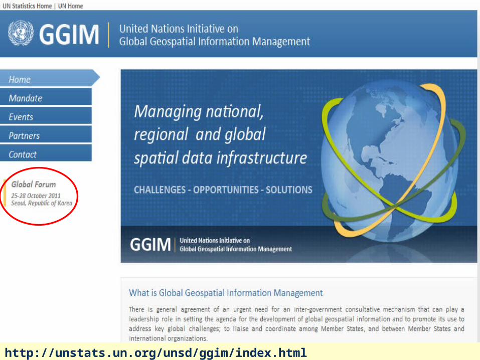
http://unstats.un.org/unsd/ggim/index.html
OGC®
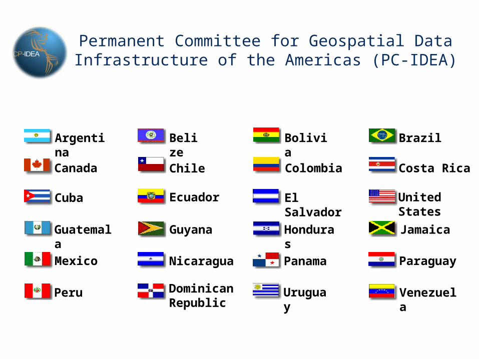
Argentina Belize Bolivia Brazil
ChileCanada Colombia Costa Rica
Cuba Ecuador El Salvador United States
Guatemala Guyana Honduras Jamaica
Mexico Nicaragua Panama Paraguay
Peru Dominican Republic
Uruguay Venezuela
Permanent Committee for Geospatial Data Infrastructure of the Americas (PC-IDEA)

OGC®
PC-IDEA – Work Plan 2010-2013
Next PC-IDEA meeting: August 15-18, 2011, in Rio de Janeiro, along with the Latin American Geospatial Forum
• Institutional capacity building, education and training
• Standards and technical specifications
• Best practices and guidelines for the development of SDI
• Inventory of innovations in national mapping organizations
• Gather knowledge on topics relevant to SDI for the region
• Assess the status of SDI development in the Americas
• Implementation of technological means for discussion related to access to geospatial data and the role of governments in the management and dissemination of these data
• Organization of an event on the management of natural disasters and SDI
OGC®
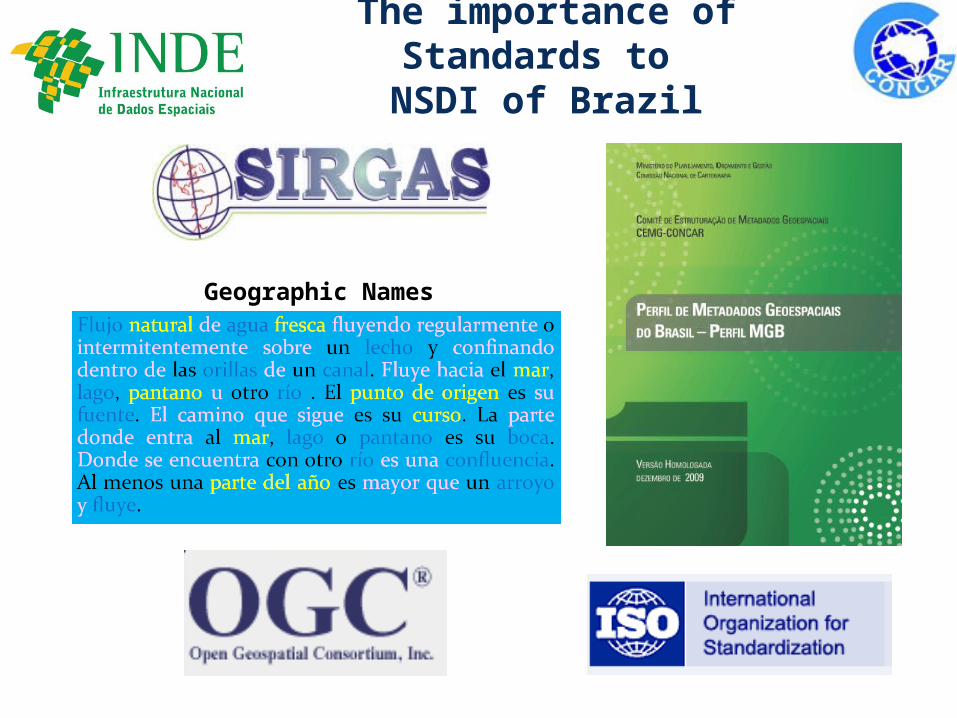
The importance of Standards to NSDI of Brazil
Geographic Names
OGC®
National Mapping Organisations and OGC standards
• National and regional SDI activities vary dramatically around the world in scope and status.
• It is viewed that countries leading the way will create a “pull” for developing regions to participate.
• The situation is expected to improve in near future with the launching/boosting of many multinational initiatives.
• In the era of globalisation and with the speed of innovation on Internet communication technologies, OGC best practices are invaluable for NMOs.
Making location count. © 2010 Open Geospatial Consortium
Summary

®
Thank youThank you
![siqgur pRswid ] jwpu sRI muKvwk pwiqSwhI 10] - Jaap Sahib [Gurmukhi].pdf · nmo srb kwly ] nmo srb idAwly ] nmo srb rUpy ] nmo srb BUpy ]19] nmo srb Kwpy ] nmo srb Qwpy ]](https://img.dokumen.tips/doc/110x75/5f56cad0ac1b37535378eb67/siqgur-prswid-jwpu-sri-mukvwk-pwiqswhi-10-jaap-sahib-gurmukhipdf-nmo-srb.jpg)