Embed Size (px)
Citation preview

I
I
~ ~ ~
6&i 1
a JPL PUBLICATION 86-18 - /.N -2P-d
Science Oppofiunities From the Topex/Poseidon Mission R. Stewart
Jet Propulsion Laboratory
M. Lefebvre Centre Spatial de Toulouse
L.-L. FU
( N A S A - C R -1 797 52) S C I E N C E CPFOFiTUN I T X E S PROE IHE POPEX/POSEICCP M1:ESXCN (Jet Fropulsion Lac.) 6 E p CSCL 08C
July 15, 1986
runsn National Aeronautics and Space Administration
Jet Propulsion Laboratory California Institute of Technology Pasadena, California
N87-10671
Unclas I
G3/48 ri4225
https://ntrs.nasa.gov/search.jsp?R=19870001238 2018-07-03T20:39:49+00:00Z

-
JPL PUBLICATION 86-18
Science Opportunities From the TopexlPoseidon Mission R. Stewart
Jet Propulsion Laboratory
M. Lefebvre Centre Spatial de Toulouse
L.-L. FU
July 15, 1986
NASA National Aeronautics and Space Administration
Jet Propulsion Laboratory California Institute of Technology Pasadena, California

The research described in this publication was carried out in part by the Jet Propulsion Laboratory, California Institute of Technology, under a contract with the National Aero- nautics and Space Administration.
Reference herein to any specific commercial product, process, or service by trade name, trademark, manufacturer, or otherwise, does not constitute or imply its endorsement by the United States Government or the Jet Propulsion Laboratory, California Institute of Technology.

National Aeronautics and Space Administration
Washington, D.C. 20546
EE 4ttn of
Dear Colleague:
The first oceanographic instrument in space was a microwave sensor that flew aboard NASA's Skylab in 1972. Since that time, ocean-related sensors have flown aboard several U.S. satellites, including Nimbus-7 and Seasat--the first dedicated oceanographic satellite--launched in 1978. The NASA Seasat altimeter clearly demonstrated that spaceborne microwave altimeters were capable of obtaining global measurements of ocean topography with sufficient precision and accuracy to be useful for oceanographic studies.
Looking to the future, both NASA and the French Centre National d'Etudes Spatiales (CNES), in cooperation with other national partners, have been planning the coordinated TOPEWPOSEIDON dedicated altimeter satellite mission for observing the oceans. In concert with the TOPEX/POSEIDON mission, NASA also has plans for a series of spaceflight activities designed to further our understanding of ocean circulation, air-sea interactions, and
(NSCAT) to fly aboard the U.S. Navy Remote Ocean Sensing System (N-ROSS) satellite, the NASA/CNES TOPEX/POSEIDON altimeter mission, and a color scanner for a platform of opportunity--will also contribute to the Global Change, the International Geosphere/Biosphere,
I I
! I
I
I
I the biological processes taking place in the upper ocean. This series--the NASA Scatterometer
I I and World Climate Research Programs.
I would like to take this opportunity to inform you that the TOPEX/POSEJDON mission has been proposed by NASA for a new start in FY 87. The TOPEX/POSEIDON measurements of surface topography of the global oceans have the potential to enhance our Understanding of the oceanic circulation, as well as the ocean's role in climate variability. In addition, these measurements will provide information that will allow studies of tides, sea state, and marine geophysics.
This Science Opportunities Document describes the capabilities of the TOPEX/POSEIDON instruments and outlines various types of experiments that could be performed utilizing TOPEX/POSEIDON data. I hope that this document will aid you and your colleagues in preparing to exploit the potential offered by the jointly sponsored NASAKNES TOPEX/POSEIDON mission, and I invite you to share in the scientific planning and execution of this exciting project.
I I
i
Sincerely,
, S. G. Tilford, Director , I
I
Earth Science and Applications Division Office of Space Science and Applicatio~s
I

Abstract
The U.S. National Aeronautics and Space Administration (NASA) and the French Centre National d’Etudes Spatiales (CNES) propose to conduct a Topex/Poseidon mission for studying the global ocean circulation from space. The mission will use the techniques of satellite altimetry to make precise and accurate measurements of sea level for several years. The measurements will then be used by Principal Investigators (selected by NASA and CNES) and by the wider oceanographic community working closely with large inter- national programs for observing the Earth, on studies leading to an improved under- standing of global ocean dynamics and the interaction of the ocean with other processes influencing life on Earth.
The major elements of the mission include a satellite carrying an altimetric system for measuring the height of the satellite above the sea surface; a precision orbit determination system for referring the altimetric measurements to geodetic coordinates; a data analysis and distribution system for processing the satellite data, verifying their accuracy, and making them available to the scientific community; and a Principal Investigator program for scientific studies based on the satellite observations.
This document describes first of all the satellite, its sensors, its orbit, the data analysis system, and plans for verification and distribution of the data. It then discusses the expected accuracy of the satellite’s measurements and their usefulness to oceanographic, geophysical, and other scientific studies. Finally, it outlines the relationship of the Topex/Poseidon mission to other large programs, including the World Climate Research Program, the U.S. Navy’s Remote Ocean Sensing System satellite program, and the Euro- pean Space Agency’s ERS-1 satellite program.
V

Acknowledgment
A substantial portion of Section IV on the ocean topography experiment was adapted from the report Satellite Altimetric Measurements of the Ocean: Report of the TOPEX Science Working Group, a group chaired by Professor Carl Wunsch.
vi

.
Contents
1 . Introduction .................................................. 1
II . Topex/Poseidon Mission ...................................... 5
A . Requirements and Capabilities .............................. 5 1 . Satellite ................................................ 6 2 . Instruments ............................................. 6 3 . Accuracy of Sea-Level Measurements .......................... 7 4 . Sampling Strategy ........................................ 7 5 . Tidal Aliases ............................................ 7 6 . Coverage and Duration ..................................... 7 7 . Orbit Maintenance ........................................ 8 8 . Phases of the Mission ...................................... 8 9 . Data Reduction and Distribution ............................... 9
10 . Retrievability ............................................ 10
B . Sensors .................................................. 10 1 . NASA Dual-Frequency Altimeter ............................... 10 2 . CNES Solid-state Altimeter .................................. 11 3 . Topex Microwave Radiometer ................................ 11 4 . Laser Retroreflector Array ................................... 12 5 . Tranet Beacon ........................................... 12 6 . Doris Receiver ........................................... 13 7 . Global-Positioning-System Demonstration Receiver . . . . . . . . . . . . . . . . . 14
C . Orbit ..................................................... 14
D . Data Management and Verification .......................... 16 1 . Satellite Data ............................................ 16 2 . Historical Data ........................................... 19 3 . Verification of Measurements ................................. 19
111 . Measurement Accuracy ....................................... 23
A . Orbit Errors . . . . . . . . . . . . . . . . . . . . . . . . . . . . . . . . . . . . . . . . . . . . . . . 23
B . Altimeter Errors ........................................... 25
C . Errors Due to the Environment .............................. 27 1 . The Ionosphere . . . . . . . . . . . . . . . . . . . . . . . . . . . . . . . . . . . . . . . . . . 27 2 . TheTroposphere ......................................... 27 3 . Oceanwaves ............................................ 27 4 . Rain .................................................. 28
D . Geoid Uncertainty ......................................... 28
E . Tides .................................................... 30
F . The Inverted Barometer .................................... 30
IV . Topex/Poseidon: The Ocean Topography Experiment . . . . . . . . . . . 31
A . Ocean Circulation Experiments ............................. 31 1 . Geostrophic Currents and Topography .......................... 32 2 . Deviations from Geostrophy .................................. 33 3 . Oceanic Variability . ....................................... 35 4 . Measuring the Variable Ocean Circulation ........................ 36 5 . Measuring the Permanent Ocean Circulation ...................... 38 6 . TheOceanat Depth ....................................... 40
vii

B . Geophysical Experiments .................................. 41 1 . Oceanic Bathymetry . . . . . . . . . . . . . . . . . . . . . . . . . . . . . . . . . . . . . . . 41 2 . Rigidity of the Lithosphere . . . . . . . . . . . . . . . . . . . . . . . . . . . . . . . . . . . 42 3 . Mantle Convection . . . . . . . . . . . . . . . . . . . . . . . . . . . . . . . . . . . . . . . . 42 4 . Geodesy . . . . . . . . . . . . . . . . . . . . . . . . . . . . . . . . . . . . . . . . . . . . . . . 42
C . Auxiliary Experiments . . . . . . . . . . . . . . . . . . . . . . . . . . . . . . . . . . . . . . 42 1 . Calculation of Geocentric Oceanic Tides ......................... 43 2 . Forecasting of Ocean Waves and Storm Surges . . . . . . . . . . . . . . . . . . . 44 3 . Interaction of Waves and Currents ............................. 44 4 . 44 5 . Fisheries . . . . . . . . . . . . . . . . . . . . . . . . . . . . . . . . . . . . . . . . . . . . . . . 45 6 . Earth's Ionosphere . . . . . . . . . . . . . . . . . . . . . . . . . . . . . . . . . . . . . . . . 45
V . Topex/Poseidon and Other Programs 47
A . World Ocean Circulation Experiment 47
B . Tropical Ocean and Global Atmosphere ...................... 48
C . Navy Remote Ocean Sensing System ....................... 49
D . ESA Remote Sensing Satellite-1 . . . . . . . . . . . . . . . . . . . . . . . . . . . . 49
Ocean Currents and the Earth's Angular Momentum Budget . . . . . . . . . . .
.......................... ........................
Glossary . . . . . . . . . . . . . . . . . . . . . . . . . . . . . . . . . . . . . . . . . . . . . . . . . . . . . . . . . . 51
References . . . . . . . . . . . . . . . . . . . . . . . . . . . . . . . . . . . . . . . . . . . . . . . . . . . . . . . . . 53
Figures
1 . A satellite altimeter measures the height of the satellite above the sea surface . . . . . . . . . . . . . . . . . . . . . . . . . . . . . . . . . . . . . . . . . . . . . . . . . 2
2 . The ground track traced out by a satellite at an altitude of 1333.8 km and with an orbital inclination of 63.1 deg during a 1 0-day period of an exactly repeating 1 0-day cycle . . . . . . . . . . . . . . . . . 8
3 . The ground track traced out by a satellite over the Northwestern Atlantic at an altitude of 1333.8 km and with an orbital inclination of 63.1 deg during a 10-day period of an exactly repeating 10-day cycle . . . . . . . . . . . . . . . . . . . . . . . . . . . . . . . . . . . . . . . . . . . 9
4 . The proposed coverage by Tranet receivers. assuming a satellite altitude of 1334 km and a usable tracking elevation of 20 deg for the ground stations . . . . . . . . . . . . . . . . . . . . . . . . . . . . . . . . . . . . . . . . . . . . . . 12
5 . The proposed coverage by Doris beacons. assuming a satellite altitude of 1334 km and a usable tracking elevation of 20 deg for the beacons . . . . . . . . . . . . . . . . . . . . . . . . . . . . . . . . . . . . . . . . 13
6 . The angle between intersections of subsatellite tracks as a function of orbital inclination with the number of orbits per day as a parameter . . . . . . . . . . . . . . . . . . . . . . . . . . . . . . . . . . . . . . . . . . . . . . . . . 14
7 . The precession rate of the orbital plane as a function of inclination. with the altitude of the satellite as a parameter . . . . . . . . . . . 15
viii

Figures (contd)
8. The frequency into which the major tidal constituents are aliased as a function of the precession rate of the orbital plane, together with rough estimates of the tidal amplitudes . . . . . . . . . . . . . . . . 15
9. The functional design of the information processing system . . . . . . . . . . 17
10. Elements of the Topex/Poseidon program ......................... 18
1 1. Elements of the Topex/Poseidon precision orbit determination work .............................................. 21
12. Evolution of Seasat orbit determination accuracy . . . . . . . . . . . . . . . . . . . 25
13. Schematic of the received altimeter waveform where N is receiver noise, S is the received signal, Ah is the width of the tracker gates used to find the track point, and P,,, is the power received by the gate ...................................... 26
14. Geoid undulation comparisons by degree .......................... 28
15. Geoid undulation accuracy, by wavelength, for a geopotential research mission having a tracking error of 21 pm/s, flying at a height of 160 km, and operating for 6 months ...................... 29
16. Mean and variable kinetic energy of surface geostrophic currents . . . . . 32
17. The slope of the sea level relative to the geoid is directly proportional to surface geostrophic current when the current is in geostrophic balance ......................................... 33
18. Sea-surface topography computed under the assumption that the 1000-decibar pressure level coincides with a gravitational equipotential surface ............................................ 34
19. Typical frequency spectra of the north-south component of velocity in the central North Atlantic measured by moored current meters . . . . . 35
20. Frequency spectrum of variability of temperature in the main thermocline near Bermuda ....................................... 36
21. Sketch of the frequency-wave-number spectrum of the general circulation at mid-latitudes, with arbitrary contour units . . . . . . . . . . . . . . . 36
22. Sea surface height variability from the repeat tracks of Seasat altimeter data . . . . . . . . . . . . . . . . . . . . . . . . . . . . . . . . . . . . . . . . . . . . . . . . . . . 37
23. Low-frequency (periods longer than 20 days) sea level changes measured by the Seasat altimeter over the southern Ocean between 40-deg and 65-deg south from 12 July to 11 October 1978 . . . . . . . . . . 37
24. World ocean topography from altimetry and hydrography . . . . . . . . . . . . 39
ix

Figures (contd)
25. Height of the geoid measured by an altimeter on Geos-3 and the corresponding bottom topography along the subsatellite track . . . . . . . . 41
26. Global distribution of pelagic tide gage stations compiled by the International Association for the Physical Sciences of the Ocean . . . . . 44
27. Timetable for major oceanographic elements of the World Climate Research Program . . . . . . . . . . . . . . . . . . . . . . . . . . . . . . . . . . . . . . . . . . . . . . 48
28. Oceanographic elements of the World Ocean Circulation
Tables
Experiment, 1985 . . . . . . . . . . . . . . . . . . . . . . . . . . . . . . . . . . . . . . . . . . . . . . . 48
1. Topex/Poseidon instruments . . . . . . . . . . . . . . . . . . . . . . . . . . . . . . . . . . . . . 6 2. Error budget for Topex/Poseidon measurements of sea level . . . . . . . . 7 3. Topex/Poseidon geophysical measurements ....................... 10
1 1 1 1 13
4. Topex altimeter heritage . . . . . . . . . . . . . . . . . . . . . . . . . . . . . . . . . . . . . . . . . 11 5. Topex/Poseidon altimeters . . . . . . . . . . . . . . . . . . . . . . . . . . . . . . . . . . . . . . . 6. Topex/Poseidon microwave radiometer . . . . . . . . . . . . . . . . . . . . . . . . . . . . 7. Topex/Poseidon tracking systems . . . . . . . . . . . . . . . . . . . . . . . . . . . . . . . . .
X

I I
I
I
I
I
! I I
I
I
I
I
I I
I 1
i I
I
I
i
Section I Introduction
The movement of water in the ocean influences human life in a variety of ways. On the Earth,contrasts in climate between the poles and equator are greatly ameliorated by the presence of the ocean because of its large heat capacity and its contri- bution to the movement of heat from the equator to the poles. Much of the weather we experience is spawned over the ocean through complex air-sea transfer processes. The important global fishing grounds are limited to small geo- graphical areas dominated by special oceanic flows, and the movement of chemical tracers and pollutants in the sea is and will be important. For example, the rate at which the burning of fossil fuel causes the temperature of the air to rise is determined to a large extent by the rate at which the ocean will be able to absorb the CO, and by the rate at which the ocean warms due to increased atmospheric heating (National Research Council, 1979a, 1983a).
Yet much about the ocean is poorly understood, largely because the ocean is so difficult to observe. It is a global fluid, and like the atmosphere it appears to have both climate and weather. But unlike meteorologists, oceanographers have no global observation system, only fragmentary and ephemeral regional observation systems based primarily on measurements from ships.
Given the global nature of the sampling problem, only satellite systems have the potential for providing the data necessary to understand the oceans as a whole. Two types of satellite measurements are used to observe the sea surface: passive and active. The passive measurements are commonly used to measure the oceanic color, temperature, and ice cover and atmospheric water vapor; and they can be used to com- pute the fluxes of latent heat at the sea surface. Active mea- surements are used to measure the roughness and topography of the sea surface, which provide information about wave
height, wind speed and direction, surface geostrophic currents, and tides.
Active measurements are made by a variety of special radars. Two types are particularly useful: scatterometers and altimeters. Scatterometers illuminate the sea surface at nonvertical angles and then measure the intensity of the returned signal. The intensity is directly related to the rough- ness of the sea surface, and the measurements of intensity are used to calculate surface wind velocity. Altimeters illuminate the sea surface at the nadir using a short pulse of electromag- netic radiation and then measure the intensity, arrival time, and structure of the reflected pulse. The intensity and struc- ture of the pulse are used to observe wind speed and wave height, respectively. The arrival time of the pulse gives the height of the spacecraft above the sea surface. If the space- craft also carries systems to measure its height relative to the center of the Earth using techniques of precision orbit deter- mination, then the difference of the two heights gives the height of the sea surface in coordinates relative to the center of the Earth (Greenwood, et al., 1969; Stewart, 1985, Ch. 14). This height is called sea level.
Sea level is determined mostly by gravity (Fig. 1). If the ocean were at rest, sea level would be a surface of constant gravitational potential, the geoid. Surface geostrophic currents, tides, and other dynamical processes in the ocean cause sea level to deviate from the geoid. These deviations are the oceanic topography. Although altimetric satellites measure sea level, variations in sea level as a function of time observed by an altimeter must be due to temporal variability of the topography. Hence, altimeters also measure topography. The following discussions tend to use sea level and topography interchangeably, but the correct meaning will be clear from the context.

HEIGHT O F GEOID 1 FROM GEOPHYSICS
GEOCENTRIC HEIGHT FROM EPHEMER,S OF SATELLITE 1
GEOCENTRIC HEIGHTOFSEA LEVEL
Fig. 1. A satellite altimeter measures the height of the satellite above the sea surface. When this is subtracted from the height of the satellite's orbit, the difference is sea level. Variations in sea level are due to gravity and Ocean currents.
The usefulness of satellite altimetry for measuring sea level and the ocean topography has been demonstrated by a series of altimeters of increasing accuracy and precision flown on Skylab, Geos-3, Seasat, and Geosat (Mather, et al., 1980; Cheney and Marsh, 1981a; Menard, 1983; Fu, 1983b). Data from Seasat have been especially useful and have allowed oceanographers t o map the surface topography of the ocean and the oceanic geoid in unprecedented detail.
Altimeter measurements of sea level, and hence topography, are particularly useful for several reasons. First the altimeter observations, together with theories of ocean dynamics, show that the topography of the ocean is directly related to surface geostrophic currents, which can be directly related to pro- cesses occurring at depth in the ocean. Surface geostrophic currents result from a balance between pressure gradients and the Coriolis force due to the current, and they are equiv- alent to the circulation around highs and lows in the atmo- sphere (see Section 1V.A. 1). Unlike other oceanographic variables measured from space (such as sea-surface temperature or color), sea level is a dynamical rather than a thermody- iiaiiiicai, or passive, variabie and is thus directiy reiated to the governing equations for the ocean as a whole. Second, unlike many other satellite measurements, radar altimetry is not limited t o cloud-free periods. And finally, the Geos-3, Seasat and Geosat results have demonstrated that satellite altimeters can measure topography globally with the accuracies required for studies of ocean dynamics and circulation.
2
The usefulness of satellite altimeters has led to proposals to place new altimeters in orbit. The National Aeronautics and Space Administration (NASA) has developed over the past six years an Ocean Topography Experiment, Topex, to mea- sure oceanic topography using an advanced altimeter on a compact satellite with an accurately known orbit. At the same time, the French Centre National d'Etudes Spatiales (CNES) has been studying the possibility of measuring the ocean topography using a system that includes a solid-state altimeter, a dedicated tracking system, and a radiometer to be flown on one of the Spot series of satellites. The similarity of the two projects, the interest in joint French-American cooperation in space as well as in oceanography, and the favorable results of a joint study of the technical issues involved in a joint mission led t o a decision by both space agencies to combine the two projects into the Topex/Poseidon mission.
The combined Topex/Poseidon mission is designed to make substantial contributions to our understanding of global ocean dynamics by making precise and accurate observations of the oceanic topography for three to five years using radar altimeters o n a well-tracked satellite.
When combined with accurate geoid models, with global measurements of the thermodynamic (solar insolation and evaporation) forcing and wind stress at the sea surface, and with direct observations or models of the deeper circulation, the Topex/Poseidon observations of sea level will lead to a full three-dimensional view of the oceanic general circulation. The additional information necessary to complement the Topex/ Poseidon data will be available from a variety of sources: Accurate geoids will be obtained from planned NASA and foreign space missions dedicated to the measurement of the Earth's gravity field; satellite scatterometers will be used to measure surface winds; new methods for analyzing data from meteorological satellites are providing calculations of the incoming solar radiation and latent heat flux at the sea surface; trajectories of drifting buoys deployed at the surface and at intermediate levels measure currents at these depths in the ocean; and measurements of the distribution of transient tracers define the movement of the water in the deepest layers. Finally, new supercomputers are making possible the develop- ment and use of improved models of the circulation of the ocean and atmosphere, including models that couple the two systems and future models that could eventually incorporate the full set of global measurements that will be available from spaceboiiie iiisiiiiiiieiii:.
The importance of the global problems and the develop- ment of new techniques to observe and analyze the oceans and atmosphere as a whole have led to proposals for several large programs t o study the planet Earth. These include the International Geosphere-Biosphere Program, the Global
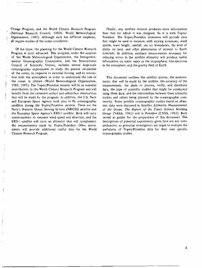
Change Program, and the World Climate Research Program (National Research Council, 1983b; World Meteorological Organization, 1985). Although each has different emphasis, all require studies of the ocean circulation. I
1 Of the three, the planning for the World Climate Research Program is most advanced. This program, under the auspices
1 of the World Meteorological Organization, the Intergovern- I mental Oceanographic Commission, and the International
Council of Scientific Unions, includes several large-scale oceanographic experiments to study the general circulation of the ocean, its response to external forcing, and its interac- tion with the atmosphere in order to understand the role of the ocean in climate (World Meteorological Organization, 1983, 1985). The Topex/Poseidon mission will be an essential contribution to the World Climate Research Program and will benefit from the extensive surface and subsurface observations that will be made by the program. In addition, the U.S. Navy and European Space Agency both plan to fly oceanographic satellites during the Topex/Poseidon mission. These are the Navy’s Remote Ocean Sensing System (NROSS) satellite and the European Space Agency’s ERS-1 satellite. Both will carry scatterometers to measure wind speed and direction, and the ERS-1 satellite will carry an altimeter that will complement the measurements made by Topex/Poseidon. Other instru- ments will provide additional, useful data for the World
I
i I
l 1
1 I
I
’ Climate Research Program.
Finally, any satellite mission produces more information than that for which it was designed. So it is with Topex/ Poseidon. The TopexiPoseidon altimeters will provide data that might be used to measure, with varying accuracies, wind speeds, wave height, rainfall, sea ice boundaries, the level of plains on land, and other phenomena of interest to Earth scientists. In addition, auxiliary measurements necessary for reducing errors in the satellite altimetry will produce useful information on water vapor in the troposphere, free electrons in the ionosphere, and the gravity field of Earth.
This document outlines the satellite system, the measure- ments that will be made by the satellite, the accuracy of the measurements, the plans to process, verify, and distribute data, the type of scientific studies that might be conducted using these data, and the relationships between these scientific studies and others being planned by the oceanographic com- munity. Some possible oceanographic studies based on altim- eter data were discussed in Satellite Altimetric Measurements of the Ocean: The Report of the Topex Science Working Group (NASA, 1981) and in Poseidon (CNES, 1983). Both served as guides for the preparation of this document. The descriptions of potential experiments given here are not com- prehensive, so potential investigators are urged to evaluate the usefulness of Topex/Poseidon data for their own specific oceanographic studies.
3

Section II Topex/Poseidon Mission
Knowing that accurate measurements of sea level contain information about surface currents, tides, and waves and knowing that sea level can be measured by satellites, the Topex and Poseidon projects have worked together to design a specific altimetric satellite mission that will increase sub- stantially our understanding of global ocean dynamics by making precise and accurate observations of sea level for several years. These observations will then be used by Princi- pal Investigators (selected by NASA and CNES) and by the wider oceanographic community working closely with large international programs for observing the Earth on studies leading to an improved understanding of global ocean dynamics and the interaction of the ocean with other global processes influencing life on Earth.
The specific goals of the Topex/Poseidon mission are to do
(1) Measure sea level in a way that allows the study of ocean dynamics, including the calculation of the mean and variable surface geostrophic currents and the tides of the world’s oceans,
(2) Process, verify, and distribute the data in a timely manner, together with other geophysical data, to science investigators.
(3) Lay the foundation for a continuing program to provide long-term observations of the oceanic circu- lation and its variability.
the following:
The TopexlPoseidon mission that has been designed to meet these goals includes an altimetric system to measure the height of the satellite above the sea surface; a precision- orbit determination system to refer satellite measurements to geodetic coordinates; a data analysis and distribution system
to process the satellite data, verify their accuracy, and make them available to the scientific community; and a Principal Investigator program to use the observations of oceanic topography to increase substantially our understanding of global ocean dynamics useful for a wide range of environ- mental studies. This section describes the satellite, its sensors, its orbit, the data analysis system, and plans for the verifica- tion and distribution of data. Subsequent sections consider the accuracy of the satellite’s measurements and their useful- ness to oceanographic, geophysical, and other scientific studies.
Although the details of the mission described here are current as of the printing of this document, minor changes may be made in the final design and fabrication of the satel- lite, its sensors, and the system to process and verify the satel- lite data. Some of these changes could significantly influence work proposed by the Principal Investigators, e.g., by changing the repeat period of the satellite’s orbit. The Principal Investi- gators selected by NASA and CNES will be expected to con- tribute to the work of a Science Working Team, the purpose of which is to provide, among other tasks, general scientific advice on the Topex/Poseidon mission, and help in writing a Science Plan that will coordinate the work of the Principal Investigators.
A. Requirements and Capabilities The Topex/Poseidon mission was derived from require-
ments for a satellite altimetric system established by the Topex Science Working Group (NASA, 1981) and by the Poseidon report to CNES (1983). These requirements were further refined and reviewed during the conceptual design (Phase A) and definition studies (Phase B) conducted by the Jet Propulsion Laboratory and the Toulouse Space Center.
5

As a result of that work, the mission is planned to have the following characteristics.
1. Satellite
The satellite and its major subsystems will be purchased by NASA from U.S. industry. The satellite will be a modification of an existing design from one of three contractors who completed Phase B studies. The three companies are the Fairchild Space Company, RCA Astro-Electronics Company, and Rockwell International Satellite Systems Division.
To make possible an accurate calculation of the satellite's orbit, the forces acting on the satellite must be well known. Hence, the satellite must be compact, must have surfaces of known and predictable reflectivity, thermal emissivity and orientation, must have a well-known center of gravity through- out the mission, and must have a minimum amount of outgas- sing to reduce nongravitational forces acting on the satellite.
The satellite will be designed for launch by the Ariane, and for retrieval (if necessary) by the shuttle (see Section II.A.6 and lo).
2. Instruments
The Topex/Poseidon satellite will carry both NASA and CNES instruments (Table 1 and Section 1I.B). The NASA instruments include (1) an advanced dual-frequency radar altimeter to measure the height of the satellite above the sea surface and to correct this measurement for the effect of free electrons in the ionosphere; ( 2 ) a three-frequency microwave radiometer to make observations necessary to correct the altimeter measurements for the effect of tropospheric water vapor; (3) a Tranet beacon to provide the primary tracking of the satellite; (4) a laser retroreflector assembly to allow ground-based lasers to verify the altimeter measurements of height and to provide supplemental precision tracking of the satellite; and (5) a Global Positioning Satellite receiver to provide data useful for testing new methods for accurately tracking the satellite's position. The CNES instruments include a single-frequency solid-state altimeter and a radiometric tracking system using a one-way Doppler system called Doris that receives signals transmitted by beacons on the ground.
The altimeter measurements of height, when combined with an accurate ephemeris (a table of positions of the satel-
Table 1. Topex/Poseidon instruments
System Instrument Purpose Frequency Bandwidth
Topex Altimeter
Radiometer
Tranet Beacon
Global Positioning Satellite Receiver*
Laser Retroreflector
Doris
Measures height of satellite above the sea, wind speed, wave height, and ionospheric correction
Measures water vapor along the path viewed by the altimeter, which is used to correct the altimeter for pulse delay due to water vapor
Provides Doppler signal for Tranet ground stations for precision orbit determination
Provides a new tracking data type (range differences) for precision orbit determination
Used with ground-based lasers to calibrate and verify altimeter measurements of height
Measures height of satellite above the sea, wind speed, and wave height
Receives signals from ground stations for satellite tracking, gravity field measurements, and ionospheric
5.3 GHz 320 MHz 13.6 GHz 320 MHz
18.0 GHz 220 MHz 21 .O GHz 220 MHz 37.0 GHz 220 MHz
400.0MHz -
150.0MHz -
1227.6MHz -
1575.4MHz -
13.65 GHz 330 MHz
401.25 MHz 150 KHz 2036.25 MHz 50 KHz
correction for altimeter
*Experimental Instruments
6

lite in its orbit), provide the measurement of sea level (Fig. 1). The redundant altimeter and tracking systems have two important advafitages. Redundancy ixreases the reliability of the mission, and the comparison of different measurements of the same variable made by different instruments leads to a much improved understanding of the errors in the measurements.
1 1
, 3. Accuracy of Sea-Level Measurements
Each measurement of sea level will have a precision of k2.0 cm and an accuracy of k14 cm (1 standard deviation) for typical oceanic conditions, with small geographically corre- lated errors. In this context, precision is the ability to deter- mine changes in sea level over distances of 20 km, and accu- racy is the uncertainty of each measurement of sea level when expressed in geocentric coordinates. Detecting changes in sea level over distances greater than 20 km depends on the wave- length of the errors that contribute to the inaccuracy of the measurements. One measure of the distance over which errors become important is the decorrelation distance of each source of error. Thus, for example, a process that produces an error with a decorrelation distance of 1000 km will contribute little to measurements of changes in sea level over distances of much less than 1000 km. The primary sources of error in Topex/ Poseidon measurements of sea level and a rough estimate of their decorrelation distance are summarized in Table 2 . The various entries in the table are discussed further in the follow- ing sections of this document.
'
I
1 I
1
I I
l
I 4. Sampling Strategy
Sea level will be measured along a fixed grid of subsatellite tracks such that it will be possible to investigate and minimize the spatial and temporal aliases of surface geostrophic currents and to minimize the influence of the geoid on measurements of the time-varying topography. Present plans call for the satellite to measure sea level at least every 20 km along a fixed grid of subsatellite tracks that repeat within k1 km every ten days, although the repetition period may be changed to any value between three and twenty days.
I
I
f i
,
5. Tidal Aliases
be aliased into semiannual, annual, or zero frequencies (which influences the calculation of the permanent circulation) or frequencies close to these.
I
I
Sea level will be measured such that tidal signals will not
I
6. Coverage and Duration
with the potential to extend this period for an additional two years. The grid of subsatellite tracks will extend in latitude at least as far south as the southern limit of the Drake Passage,
I i
Sea level will be measured for a minimum of three years,
Table 2. Error budget for Topex/Poseidon measurements of sea level
Error Source Decorrelation
Distance, km
Standard Deviation of Uncertainty,
cm
Altimeter
Instrument noise Bias drift
Media
EM bias Skewness Troposphere, dry Troposphere, wet Ionosphere
Orbit
Atmospheric drag Solar radiation Earth radiation GM Gravity Earth and ocean tides Station and satellite clock Troposphere Station location Higher order ionosphere
RSS Absolute Error
2.0 2.0
2 .o 1 .o 0.1 1.2 1.3 (2.0*)
1 .o 1 .o
<1.0 2.0
10.0 1 .o 1 .o 1 .o 5 .O 5.0 (1 .O t )
13.3
20 (Many days)
20-1000 20-1 000 1,000
50 20
>10,000 10,000 10,000 10,000 1 0,000 10,000 10,000 10,000 10,000 10,000
Note: Major assumptions are listed below:
1. Dual-frequency altimeter 2. Dual-frequency radiometer 3. Upgraded Tranet tracking
system, 40 stations 4. Altimeter data averaged
over 3 s 5 . H,,3 = 2 m, wave skew-
ness = 0.1 6 . Tabular corrections based
on limited waveform- tracker comparisons
7. 1300-km altitude 8. No anomalous data, no
rain 9. Improved gravity model
(by a factor of two over existing models)
10. r3-mbar surface pressure from weather charts
11, 100-ps spacecraft clock
*For the one-frequency Poseidon altimeter; inferred from models
tFrom Doris tracking data using data from Doris.
which is 62 deg, and the subsatellite tracks that comprise the grid will cross at sufficiently large angles that the two orthog- onal components of surface slope can be determined with comparable accuracy.
The NASA altimeter will provide the primary observations of sea level, and the CNES altimeter will demonstrate the use- fulness of a new class of altimeters that could fly on future spacecraft. The two altimeters will share a common antenna
7

and cannot operate simultaneously. The NASA altimeter will operate 95% of the time on a schedule to be negotiated by NASA and CNES with the agreement of the Topex/Poseidon Principal Investigators. The CNES altimeter will operate for the remaining 5% of the time. Present plans call for the CNES
the altimeter will be incorporated into the geophysical data records after evaluation of the data (see Section II.A.9).
, altimeter to operate for one full day out of twenty. Data from
During the primary altimeter operating periods, at least 90% of all global oceanic data that could be acquired by the spacecraft over a three-year period will be acquired, with no systematic gaps in coverage. The intent is to collect data continuously, but small amounts of data will be lost during adjustments of the satellite's orbit, during tests of the altim- eter's performance, and during various other such events.
Although the schedule for the mission is not yet fully established, present plans call for the collection of data to begin in mid 1991 after the launch of the Topex/Poseidon satellite from Kourou, French Guiana, by an Ariane 4 launch vehicle. The spacecraft will operate in a nearly circular obser- vational orbit. For purposes of planning the mission, the orbit is assumed to be at an altitude of 1335 km and an inclination of 63.1 deg (see Section 1I.C). This orbit lays down
60
40
20 U
w- n 3 t I-
0
4 -20
-60
a dense grid of subsatellite tracks between 63.1 deg north and south latitudes (Figs. 2 and 3). The constraints leading to the selection of this orbit are discussed in Section 1I.C.
7. Orbit Maintenance
The orbit of the satellite will slowly decay due to air drag, and it will have long-period variability due to the inhomogen- eous'gravity'field!oflEarth, solar radiation pressure, and smaller forces. Periodic maneuvers will be required to keep the satel- lite in the observational orbit. The frequency of maneuvers will depend primarily on the solar flux as it affects the Earth's atmosphere, and it is expected to be one maneuver (or series of maneuvers) every 40 to 200 days. During the maneuvers, altimeter data will not be useful for periods of typically 2 to 6 hours.
8. Phases of the Mission
The first thirty days after the satellite is launched into the observational orbit will be used for assessing the performance of the satellite, its subsystems, and payload. During this period only a very limited amount of data will be available from the instruments. This will be the engineering assessment phase of the mission.
-180 -150 -120 -90 -60 -30 0 30 60 90 120 150 180
LONGITUDE, deg
Fig. 2. The ground track traced out by a satellite at an altitude of 1333.8 km and with an orbital inclination of 63.1 deg during a l W a y period of an exactly repeating 10-day cycle
8

60
50
2 40 W‘ n 3 !z 2 30 -I
20
10
0
LONGITUDE, deg
Fig. 3. The ground track traced out by a satellite over the north- western Atlantic at an altitude of 1333.8 km and with an orbital inclination of 63.1 deg during a 1 W a y period of an exactly repeating 10-day cycle
The verification and calibration of scientific data from the satellite will begin during the engineering assessment and will continue for up t o six months after launch (cf. Section II.D.3). During this period uncalibrated and unverified data will be collected and made available to the Principal Investigators and to those contributing to the verification of the data. This will be the verification phase of the mission.
The observational phase of the mission will begin approxi- mately six months after launch and will continue until the end of the mission. Verification will continue at a low level through this period to ensure the quality of the data. Verified and calibrated data will be produced and distributed during this phase, including data collected during the first six months of the mission.
9. Data Reduction and Distribution
A system to process and distribute data to the Principal Investigators will be tested, documented, and in operation a t the time of launch. At least 90% of the data acquired by the spacecraft will be processed and made available for scientific investigations, with no systematic gaps. Again, the intent is to process all data, but some data will be lost due to transmission errors, tape recorder problems, or errors in data handling. Overall, 81% of the oceanic data that could be acquired by the spacecraft will be acquired, processed, and delivered to the scientific community.
NASA and CNES will each process data from their respec- tive instruments and will then exchange processed data. These data will be placed in national archives for further
distribution to the scientific community. Plans for the data distribution system are not yet complete, but Principal Investi- gators se!ected by NASA should expect to receive data from the NASA Ocean Data System, and investigators selected by CNES should expect to receive data from the French AVISO (Analysis, Validation, Interpretation of Satellite Oceano- graphic Data) system. Both systems will provide access to data via on-line data management systems. The Principal Investi- gators will further process the Topex/Poseidon data and will conduct oceanographic or geophysical investigations based on these data.
In exchange for access to Topex/Poseidon data, NASA Principal Investigators are required to publish their findings in the open scientific literature and to make available to national archives the results of their investigations together with annotated and documented copies of their analyzed data. In particular, Principal Investigators will contribute to a Project Data Management Plan that documents plans for data analysis, dissemination of results, and making analyzed data and supporting documentation available to the scientific community through national data archives. The plan will be approved by the Topex and Poseidon Project Managers with the concurrence of the Topex and Poseidon Project Scientists and the Director of the U.S. National Space Science Data Center. Principal Investigators must agree to the terms of the plan prior t o receiving Topex/Poseidon data.
During the verification phase of the mission, uncalibrated and unverified interim geophysical data will be available to ik verification team (see Section II.D.3) and Principal Investi- gators within five days after the receipt of satellite data by the project. Both groups are expected to work together on an assessment of the accuracy of the geophysical data.
During the observational phase, verified and calibrated geophysical data will be available t o Principal Investigators within six months of the receipt of data by the project. The primary cause of the delay is the time required for verifying the geophysical data and computing an accurate ephemeris. The delay is expected t o shrink as the backlog of data acquired during the verification period is processed and as the calcula- tion of the accurate ephemeris is streamlined.
To help plan oceanographic experiments, small amounts of interim geophysical data will also be available within five days of data acquisition, during the observational phase of the mission. These data wiii iack oniy an accurate ephemeris. In addition, altimeter observations of wave height and wind speed will be processed and transmitted to the U.S. Navy’s Fleet Numerical Oceanographic Center (FNOC) within four hours of the satellite’s observations.
9

Geophysical data records will have a format similar to the Seasat altimeter records; and they will consist primarily of satellite measurements of sea level, including all corrections applied to the data, plus the precise ephemeris of the satellite, the altimeter measurements of wave height, wind speed, and ionospheric electron content, and the microwave radiometer observations of brightness temperature at three radio frequen- cies plus the derived value of tropospheric water vapor (Table 3). The records will also include the best available values for the height of the tides and geoid. All measurements will be appended with the latitude, longitude, and time of the observation and will be located along the grid of subsatellite tracks. The measurements will not be interpolated to a uniform grid of points in latitude and longitude. All data used to cal- culate the final data will be archived.
10. Retdevability
The spacecraft will be retrievable by the U.S. Space Trans- portation System (the shuttle) in the event of a major mal- function that would render the satellite unable to accomplish its scientific mission. The satellite will carry enough propel- lant to return from the observational orbit at an altitude of 1334 km to the shuttle altitude of 315 km 2nd will carry fixtures to enable the satellite to be captured and stowed on the shuttle.
B. Sensors The primary Topex/Poseidon instruments are derived, in
the main, from similar instruments or systems that have flown on previous space missions. The Topex altimeter is based on the design of the Seasat and Geosat altimeters; the microwave radiometer will use subsystems from the scanning multi- 1
channel microwave radiometer flown on Seasat and Nimbus-7; and the Tranet beacon and laser retroreflector are based on designs used on Seasat and other satellites. The Global Posi- tioning System demonstration receiver will be a space-qualified instrument partially derived from existing Global Positioning System receivers. The Doris receiver, which will be flown on Spot-2 in 1988, will be based on experience gained from the Argos system now operating on the NOAA polar-orbiting meterological satellites. Only the CNES altimeter is an entirely new design. To reduce risk in the development of these instru- ments, prototype models of the Topex and Poseidon altim- eters and the Doris receiver and beacons have been built.
I
I
, 1 I
This conservative approach for providing Topex/Poseidon instruments has two advantages: (1) It increases the reliability of the instruments; and (2) it allows geophysical algorithms derived for earlier missions to be used with only minor modifi- cations, respectively increasing the accuracy of the observa- tions and decreasing the time and expense necessary to process and verify data from the instruments.
I ~
I
I
Table 3. Topex/poseMon geophysical measurements 1. NASA Dual-Frequency Attimeter
Instrument Footprint, Accuracy km X km (Precision)
Topex Altimeter
Altimeter and Tracking Systems
Poseidon Altimeter
Microwave Radiometer
Laser Retroreflector
Satellite height Wave height Electron content Radar reflectivity Wind speed
Sea level
Satellite height Wave height Wind speed
Water vapor Path length
Laser range
3 x 20* 3 x 20* 3 x 20* 3 x 20* 3 x 20*
3 x 20*
3 x 20* 3 x 20* 3 x 20*
35 x 35 35 x 35
( t 2 cm)t 0.5 m or *lo% t 3 x 1 0 ' ~ e/m2 t0.25 dB + 2 m/s**
t14 cm*
(+4 cm) 0.5 m or +lo% t 2 m/s
t 2 kg/m2 t1 .2 cm
k 5 cm
*Depends on sea state. tFor 2-m significant wave height. *See Table 2 for assumptions.
**Based on specified accuracy for radar reflectivity and assuming the Chelton and McCabe (1985) relationship for wind speed.
The NASA altimeter will provide the primary measure- ment of the height of the satellite above the sea surface, being designed to measure the height with a precision of k2.0 cm when the observations are averaged over 3 s. The altimeter is based on earlier instruments flown on Skylab, Geos-3, Seasat, and Geosat (Table 4) but includes a second frequency to measure errors due to free electrons in the ionosphere. Two independent altimeters operating at Ku (13.6 GHz) and C (5.3 GHz) bands will each measure the height of the sensor above the ocean surface {Table 5). Because the pulse delay due to free electrons is inversely proportional to the square of the radar frequency, the difference in the heights measured by the two channels will yield propagation delay due to the iono- sphere. Noise in the measurements at each frequency will be reduced by averaging data over approximately 50-ms intervals to yield smoothed observations of height along the subsatellite track. Successive 50-ms observations will be further averaged on the ground to give one observation of height every 3 s. The signal received by the altimeter will also be processed to determine wave height and wind speed. In particular, the averaged power as a function of time of the reflected pulse, which is the received waveform, will be proc- essed to calculate significant wave height, and the signal strength will be used to calculate wind speed. The measure-
10

Table 4. Heritage of Topex altimeter
I Satel!ite, Yr
p---:-:- Wave Height Frequency, I aus L r u a l u r i , crrr Accuracy GHz (Averaging Time, s) (Range)
Skylab, 1973 13.9 Geos-3, 1975 13.9 Seasat, 1978 13.5 Geosat, 1985 13.5
100 (0.3) 1-2 m 50 (0.2) +25% (4-10 m) 10 (1.0) 5 (1.0)
0.5 m or + 10% (1-20 m) 0.5 m or t10% (1-20 m)
Table 5. Topex/Poseidon altimeters
Altimeters Parameter
Topex Poseidon
Frequency, GHz 5.3 13.6 13.65
Radiated Power, W 20 20 2
Pulse Repetition 1,000 4,000 1,700 Frequency
Pulse Compression 33,000 33,000 33,000 Ratio
Instrument Precision, cm 2 4 (3-s average)
ment of wind speed is of secondary importance, not being directly related to the primary mission goals. Hence, wind speed will be calculated using the best available algorithms, but little effort will be made to verify the accuracy of the measure- ment. Finally, height measured by each frequency, rate of change of height, significant wave height, receiver auto- matic gain control and waveform samples will be stored, then telemetered to the ground.
2. CNES Solid-state Altimeter
The CNES solid-state altimeter will be flown to gain experi- ence with a new class of low-power, lightweight altimeters that could be operated on satellites of opportunity, thus providing for the long-term observation of the sea level, a goal of the World Ocean Circulation Experiment (see Section V.A). The signal received by the altimeter will be processed to give the same geophysical information as the NASA altim- eter, but the two altimeters differ in design. The CNES altim- eter will use separate circuits to lock on to the pulse received frurn the sea surface and to rrack rhe ieaciing edge of rhe received pulse. The correction for ionospheric delay will be provided by the dual-frequency observations made by the Doris tracking system, used with models of the total electron content in the ionosphere. The correction for tropospheric
water vapor will be made using data from the microwave radiometer. The altimeter is designed to measure the height of the satellite above the sea with a precision of +4 cm by using a solid-state single-frequency altimeter operating at the K, band (13.65 GHz) (Table 5 ) . Current plans are to evaluate the accuracy of the altimeter measurements and then to incorporate the altimeter data into the geophysical data records.
3. Topex Microwave Radiometer
The Topex microwave radiometer will measure water vapor at the nadir (Table 6 ) to correct, with an accuracy of k1.2 cm, the error in the altimeter measurements of height caused by pulse delay due to the water vapor. The radiometer will use refurbished electronics from the Nimbus-7 scanning multi- channel microwave radiometer (SMMR) but differs somewhat from this instrument in its operation. Rather than scan, it will continuously observe the brightness temperature at nadir at three radio frequencies (18.0, 21 .O and 37.0 GHz) averaged over a period of 1 s. The longer observation time will yield more sensitive observations of brightness temperature than those from Nimbus-7, thus increasing the accuracy of the water vapor observations. The observed brightness tempera- tures will be periodically compared to an internal reference temperature and to cold space, and the difference tempera- ture will be demodulated by a synchronous detector to correct for drift in the radiometer observations. After filtering, the brightness temperatures will be digitized and passed to the spacecraft data handling system.
Table 6. Topex/Poseidon microwave radiometer
Field of View, km Frequency, (Half Power Beamwidth, NEAT,
GHz K * de& ~~~
18.0 21.0 37.0
4 2 (1.81) 35 (1.49) 22 (0.92)
0.1 1 0.1 1 0.15
*Noise equivalent error in temperature, averaged over 1 s
11

After transmission to the ground, the data will be further processed to determine the vertical columnar water vapor content necessary to correct the altimeter measurement of height for the influence of the wet troposphere.
4. Laser Retroreflector Array
The laser retroreflector will reflect signals from ground- based lasers allowing laser tracking stations to determine the range to the satellite with an accuracy of +2-5 cm. These observations will be used to calibrate the altimeter measure- ment of height and to provide supplemental tracking of the satellite useful for calculating an accurate ephemeris. The altimeter will be calibrated by tracking the height of the satel- lite as it passes directly above laser calibration stations, planned to be located at Bermuda and Dakar, at the same time the
the vicinity of the tracking station. The extrapolation of the difference between the laser and the altimeter measurements, when corrected for the height of the laser above sea level, yields an independent assessment of the accuracy of the altimeter measurement. In addition, if a worldwide system of laser tracking stations continues to be operating at the time of the Topex/Poseidon mission, data from these stations could be used to calculate an accurate ephemeris in the event of a failure of the primary tracking systems. The laser retrore-
I altimeter measures the height of the satellite above the sea in
flector assembly consists of corner cubes mounted in a conical ring around the perimeter of the altimeter antenna in a con- figuration similar to that on Seasat. The number of cubes will be sufficient to allow the array to be tracked with an adequate signal-to-noise ratio by existing laser tracking stations whenever the satellite is more than 20 deg above the horizon.
5. Tranet Beacon
The primary tracking system consists of an improved Tranet beacon that will be tracked by Tranet receiving stations widely spaced over the surface of the Earth and operated by the U.S. Defense Mapping Agency (Fig. 4). The beacon will transmit at frequencies of 400 and 150 MHz so that the influence of ionospheric delay can be reduced and will use an ultra-stable quartz oscillator with a stability of +5 X measured over a period of 1000 s to allow very accurate mea- surements of the Doppler shift produced by the satellite’s velocity. The measurement of Doppler shift, made by radio receivers on the ground, yields observations of the time of closest approach and the distance from the tracking station to the satellite at this time. These data will then be used by orbit determination programs to calculate the satellite’s ephemeris with a single-pass accuracy of +13 cm (Table 7). By combining measurements of sea level made during all passes in a 10-20 day period, sea level can be computed with even better accu-
LONGITUDE, deg
Fig. 4. The proposed coverage by Tranet receivers assuming a satellite altitude of 1334 km and a usable tracking elevation of 20 deg for the ground stations
12

Table 7. Topex/Poseidon tracking systems
System Frequency, MHz Ground Stations Empheris
Accuracy, cm
Tranet I1 150 400
Doris* 401 2036
GPS* 1227 1575
40
40-50
13
10
3-8 10-15
Laser Light 28 15-20t
*Experimental systems not yet tested or flown in space. ?Assuming a global network of tracking stations is operating during the mission.
racy (see Section IV.A.4.b). The beacon will be similar to eris. Second, the difference in the signals at the two frequen- that on Seasat but more stable in frequency. cies will provide an accurate correction for the influence of the ionosphere on both the Doppler signal and the signal used by the CNES altimeter. Finally, the Doppler signal will be used 6. Doris Receiver
The Doris system uses a two-channel receiver on the satel- with orbit-determination programs to improve our knowledge lite to observe the Doppler signals from a network of 40 to of Earth’s gravity field along the satellite’s trajectory, leading 50 dual-frequency radio beacons distributed around the to improved accuracy in the calculation of the satellite’s Earth (Fig. 5). The signal will be used for several purposes. ephemeris. The system is similar to Tranet, but will operate at First, the Doppler signal as a function of time will be used by higher radio frequencies so that the influence of the iono- orbit-determination programs to calculate the satellite ephem- sphere will be less important, and it will use ultra-stable quartz
90
60
30
-30
-60
-90
LONGITUDE, deg
Fig. 5. The proposed coverage by Doris beacons, assuming a satellite altitude of 1334 km and a usable tracking elevation of 20 deg for the beacons
13

oscillators with a stability of 5 X 10-13 over a period of 1000 s and lo-" per day.
t I I , 60 70
The ground stations will be fully automated, allowing deployment in remote areas, especially in oceanic areas. More- over, it is anticipated that a substantial number of these sta- tions will be collocated with laser and Very Long Baseline Interferometry (VLBI) stations (to be linked to a precise and conventional reference system) and with tide gages and/or sea level measurements. The deployment of the network will be made by the Institut Geographique National of France. The first tests of the system are scheduled to begin around 1988 when Doris equipment will be carried by the Spot-2 satellite, the launch of which will depend, however, on the lifetime of
,
spot-1.
, I I 100 110 120
-- 10 INCLINATION, deg
7. Global-Positioning-System Demonstration Receiver A global-positioning-system receiver and processor will
be carried as an experiment to provide a new type of tracking data for precision orbit determination: the difference in range between the satellite and receivers on the ground. The system will receive simultaneously the signals from four Global Posi- tioning System (GPS) Navstar satellites using receivers on the spacecraft and at three or more positions on the ground. Present plans call for NASA to operate three stations and for the Defense Mapping Agency to operate three or more pending the outcome of negotiations with NASA. Other stations may be operated by other groups interested in precision orbit deter- mination. Initial calculations by the Topex/Poseidon Orbit Determination Task Group (see Section 1II.A) indicate that by observing the difference between the signals from each GPS satellite as received at the satellite and at the ground, it may be possible to determine the satellite's position with an accuracy of +6 cm without the need for accurate clocks on the satellites or on the ground. If the receivers on the ground are well spaced on the surface of the Earth, the system will be able to track the Topex/Poseidon satellite nearly continuously. The experiment will investigate the usefulness of this scheme for orbit determination and the accuracy of the resulting ephemeris.
C. Orbit The orbit chosen for the Topex/Poseidon mission is a com-
promise among a number of conflicting requirements. The orbit must provide broad coverage of the oceans as frequently as possible without aliasing the tides to unacceptable frequen- cies, and it must be high enough to minimize atmospheric drag. Because the orbit is a compromise, it is worth consider- ing the arguments influencing the selection.
First, the subsatellite track of the orbit must recur exactly at fixed intervals of time. If the subsatellite track repeats within +1 km, then the influence of spatial variability of the geoid will be small (Fu, 1983b), less than +1 cm on average. Thus an exactly recurring subsatellite track will enable the altimeter to measure the variability of surface geostrophic currents even when the geoid is unknown. But many orbits are available for which the subsatellite tracks recur exactly, and this requirement does not strongly constrain the orbit; sampling strategy does.
The sampling strategy for observations of the surface by the altimeter is determined by four important and interrelated properties of an orbit: the latitudinal extent of the grid traced out by the subsatellite point, the density of the grid, the time interval between repetitions of this grid, and the angle between the tracks at their intersections.
In order to sample as much of the ocean's surface as possi- ble, the orbit should have an inclination as close as possible to 90 deg. This polar orbit, however, has ground tracks that are nearly parallel (Fig. 6), and this conflicts with a requirement that the subsatellite tracks cross at large angles so that the altimeter can measure both components of the surface geo- strophic current with comparable accuracy.
A reasonable compromise between good crossing angles and good coverage is an orbit with an inclination near either 65 deg or 105 deg. These orbits have ground tracks that inter- sect at angles near 40 deg at the equator and that cover most of the open water in both hemispheres. (These orbits exclude
EQUATORIAL CROSSING ANGLE, deg
50 T /
// t
1 5 0
Fig. 6. The angle between intersections of subsatellite tracks as a function of orbital inclination with the number of orbits per day as a parameter
14

the Norwegian Sea and parts of the southern ocean, but these ::$TUDES, ALIASED FREQUENCY,
cm TOPEXI cycl=/vr
l l ! l
compromises seem both necessary and reasonable.)
GEOSATI
15 10 5 0 POSEIDON
I The selection of orbital inclination is also strongly influ- enced by a desire to avoid orbits that are nearly synchronous with the sun so that the ocean surface is not sampled in phase with any of the major tidal constituents. To sample synchronously would alias the tidal constituents into long periods typical of the oceanic circulation and would make difficult the separation of the tides from the circulation. The rate a t which the orbital plane of a circular orbit precesses is a function of inclination and geocentric radius (Fig. 7). Retrograde orbits (those with inclinations greater than 90 deg) with altitudes above 800 km are all nearly synchronous with one or another dominant tidal constituent (Figs. 7 and 8) and should be avoided. For this reason, it is preferable to choose a prograde orbit with an inclination less than 65 deg. Orbits at altitudes less than 1500 km at this inclination precess at a rate greater than 2 deg per day relative to the sun and are not close to being synchronous with any tidal constituent.
To minimize problems caused by atmospheric drag, the altitude of the satellite should be above 1300 km. Thus a nominal orbit should have an inclination near 65 deg and an altitude between 1300 and 1500 km. Within these bounds, it is then possible to find an orbit that recurs in exactly J days (Cutting, et al., 1978). All that is required is that the nodal
P 1 4
T2 4
52 5 1 4
R2 - K 2 K1-
INCLINATION, deg
TOPEXl POSEIDON
Fig. 7. The precession rate of the orbital plane as a function of inclination, with the altitude of the satellii as a parameter. To avoid aliasing the diurnal (K l , S1 and P1) and semidiurnal (n, S2, R2, and K2) tides into long periods, orbii which are nearly sun- synchronous should be avoidad. The indicated precession rates are those whichaliasthedesignatedtidalconstituenttozerofrequency.
-3 -2 -1 0 1 2 3 4
h, deglday
Fig. 8. The frequency into which the major tidal constituents are aliased as a function of the precession rate of the orbital plane, together with rough estimates of the tldal amplitudes (typkal of the North Pacific). Note that, for sun-synchronous orbii, S1 and S2 are aliased to zero frequency, and that 72, P1, K1, and R2 are all aliased into the same frequency of one cycle per year. The T O P C X / ~ orbit is designed to avoid such undesirable aliases.
period be a suitable rational number; and provided that the repeat time is longer than a few days,many orbits are available.
The density of the grid traced out by the subsatellite track is set by the recurrence interval. The longer the interval, the tighter the grid. Assuming that the satellite’s mean motion N in revolutions per day is N = K + (I/J), where K, I , and J are integers, the period between repetitions of the orbit i s J days; and the number of revolutions between repetitions is K J + I . The spacing between ascending (or descending) subsatellite tracks at the equator is 40,075/(KJ + I ) km. This distance decreases approximately as the cosine of the latitude (scaled by the inclination).
A reasonable compromise between grid density and fre- quency of observation (set by the recurrence interval) is an orbit with mean motion of 127/10 revolutions per day, which has a 10-day repeat period (also see Section IV.A.4). This interval provides a Nyquist frequency of 1 cycle per 20 days, which ought to be adequate for more than 90% of the global ocean, and a subsatellite track separation of 316 km at the equator (Figs. 2 and 3). But as a practical matter, the period of repetition is easily changed after launch, as long as the satellite is required to overfly no more than one verification site. The satellite will carry sufficient propellant to allow the repetition interval to be changed after launch, at least once, to any value between 3 and 20 days.
For planning the mission, the satellite is assumed to operate in an orbit with an inclination of 63.13 deg at an altitude of
15

1333.8 km (Farless, 1985). This orbit repeats the subsatellite track every 10 days, and it minimizes tidal aliases and air drag. The orbit has crossing angles between ascending and descend- ing orbits of about 45 deg at 30-deg latitude; and it allows the satellite to observe most of the ocean except for small regions at high latitudes near Antarctica and in the Norwegian Sea. This should not be a problem because Topex/Poseidon is planned to fly at the :ame time as the European Space Agency’s ERS-1 satellite, which will carry an altimeter in near-polar orbits. Data from this instrument can be used to extrapolate Topex/Poseidon data to higher latitudes. The more accurate Topex/Poseidon altimeter can be used to calibrate the ERS-1 altimeter, thus permitting coverage to be extended into the polar regions (see Section V.D).
D. Data Management and Verification Three types of data will be useful for the Topex/Poseidon
science investigations: (1) satellite data in the form of Inter- mediate Geophysical Data Records and Geophysical Data Records; ( 2 ) field data collected in support of the calibration and verification of the satellite data; and (3) historical data already archived at various locations plus contemporary oceanographic data collected by large-scale oceanographic experiments being planned to coincide with the Topex/ Poseidon mission.
1. Satellite Data
Data from the NASA instruments will be processed by the Information Processing System (Fig. 9), which consists of two major facilities: the Topex Data and Information Facility (TDIF) operated by the Topex project and the NASA Ocean Data System (NODS) operated by the Jet Propulsion Labora- tory. Data from CNES instruments will be processed by a satellite data processing facility operated by CNES, and will be distributed by the French data system AVISO. After process- ing their data to the level of Geophysical Data Records, each country will exchange data and make available to the scientific community the complete Topex/Poseidon data set (Fig. IO).
The Topex Data and Information Facility will accept the composite telemetry data from the spacecraft, the satellite ephemeris produced by the Goddard Space Flight Center, and supplementary information and will produce geophysical values such as the height of satellite above the sea: significant wave height, and atmospheric water vapor content. The facility will also maintain a record of the data distributed and will archive telemetry data, sensor data records, and geophys- ical data records.
In addition to processing data, the Information Processing System will also supervise the work necessary to verify the
geophysical algorithms and the precise satellite ephemeris; it will collect the in situ data needed to support the verification and calibration of the Topex/Poseidon data; and it will dis- tribute the satellite data to the National Oceanic and Atmo- spheric Administration’s National Environmental Satellite, Data, and Information Service (NOAA NESDIS).
NODS is an archive for satellite observations of the oceans. Located at the Jet Propulsion Laboratory, it is designed to meet the needs of the oceanographic community for speedy, selective, and tailored access to satellite observations of the ocean. The system will provide regional and special formatting of Topex/Poseidon data, such as converting data from the grid defined by the subsatellite track to a grid defined by latitude and longitude; it will be a source for other satellite data, such as winds from the NASA scatterometer on NROSS that may be needed by the NASA Principal Investigators; and it will be an archive for all these data sets.
The French AVISO data system is similar to NODS, being a facility to process, distribute, and archive satellite oceano- graphic data. AVISO is organized under the Groupe de Recherches et d’Etudes en Oceanographie Spatiale (GREOS), a consortium of eight French governmental research organiza- tions. AVISO is an approved project and will start in 1986. The facility will provide special processing of Topex/Poseidon data and will be a source of other appropriate satellite and ship data.
In support of the Topex/Poseidon mission, NODS will (1) distribute Geophysical Data Records and Interim Geo- physical Data Records to NASA Principal Investigators, to the Topex/Poseidon verification team, and to the AVISO data system for distribution to the CNES Principal Investigators; ( 2 ) archive the Geophysical Data Records and Interim Geo- physical Data Records; (3) contribute to the verification of Topex measurements by making available data necessary to verify the satellite measurements and computer programs to compare the Topex/Poseidon data with in situ or other data necessary for the verification work; and (4) provide computer time to develop programs needed by the Topex Project.
Five levels of data will be produced by the project:
Telemetry data from the satellite transmitted to the Mission Operations System via the Tracking and Data Relay Satellite System. This is essectiz!!y ~2:’: data.
Sensor Data Records consisting of a time-ordered, pre-edited record of partially processed data from the instruments in engineering units.
Interim Geophysical Data Records consisting of all instrument data processed to final form in geophysical units, such as height of the satellite and water vapor
16

I
1
17

t
1
5 0
a I-
5 H
5
0
> Le
0
k
z U W
-1 W
I-
01 Y
L C CZ
I c Y
a
1
18

density, except those which depend on the precision ephemeris. The Interim Geophysical Data Records will be available within 5 days after the receipt of telemetry and other data at the Information Processing System, and the records will be useful for planning the
nated with the satellite observations. In general, the
verification period during the first six months after launch of the satellite. After this period they will be replaced by the Geophysical Data Records, although a small amount of interim data will be available to plan
I
I collection of oceanographic data that must be coordi-
I interim records will only be available during the
I oceanographic experiments throughout the mission.
(4) Geophysical Data Records (GDRs) consisting of satel- lite data processed to final form including precise ephemerides calculated by the Precision Orbit Deter- mination group (see Section IJ.A.9 for a listing of data that will be included in the GDR). The records will be available 6 months after receipt of initial satellite data. The delay is expected to shrink as the backlog of data acquired during the six-month verification period is
meris is streamlined. The accuracy of the data record should improve as the project gains experience in processing the satellite data, but the project does not plan to reprocess data. New or revised processing algorithms may be implemented, but only after ap- proval by the Principal Investigators. If the later data records prove to be significantly better than the earlier
such as the NASA Ocean Data System or the French AVISO, at the request of the scientific community.
I
I I I I processed and as the calculation of the accurate ephe-
I
I
I
I
I records, data could be reprocessed by external archives,
I
I
I (5) Quick-look data consisting of satellite measurements of
wave height and wind speed. Those will be made avail- able to the Fleet Numerical Oceanographic Center within 4 hours of the receipt of data at the project.
,
All data in the form of telemetry, Sensor Data Records, and Geophysical Data Records will be archived by the projects for the duration of the projects. Copies of the Geophysical Data Records will be sent as they become available to the NASA Ocean Data System, to the National Environmental Satellite, Data, and Information Service of the National Oceanic and Atmospheric Administration, and to AVISO for archiving and distribution to Principal Investigators and the wider scientific
~
I community. Principal Investigators selected by the NASA
and CNES Announcement of Opportunity will be required to l
I help write a data management plan that will specify the types of data that should be kept by national archives after the completion of the Topex/Poseidon mission.
I
t
The Topex/Poseidon data will be distributed to NASA Principal Investigators through the NASA Ocean Data System. The system will also archive and distribute other satellite data useful for the science investigators. The facility now has Geos-3, Seasat, and some Nimbus-7 and NOAA’s AVHRR data, and in the future it will have wind data from the NASA scatterometer that will be flown on NROSS, and measure- ments of winds, sea ice, and water vapor measured by a multichannel microwave radiometer (SSM/I) operated by the Defense Meteorological Satellite Program.
Topex/Poseidon data required by CNES Principal Investi- gators will be distributed by the French AVISO data system. Pending agreement with the European Space Agency, AVISO may also be a source of ERS-1 data useful for Topex/Poseidon scientific studies.
2. Historical Data
Historical data useful for the Ocean Topography Experi- ment includes (1) data from Seasat and Geos-3 altimeters, (2) historical compilations of data from expendable bathy- thermographs that give the mean and seasonal variation of the thermal structure of the upper ocean, (3) measurements of density and trace elements of the deep water in the oceans, (4) measurements of the vertical structure of horizontal velocity in the ocean, ( 5 ) regional and global geoids, and (6) sea level measurements from tide gages. These data sets will be available through national archives and must be assembled as needed by the Principal Investigators working individually, or through large programs such as the World Ocean Circulation Experiment discussed in Section V. The Seasat, Geos-3, and geoid data are already available through the NASA Ocean Data System, and similar sets of data will be available through AVISO.
3. Verification of Measurements
The quality of the Topex/Poseidon data depends on the quality of the data from the satellite instruments and on the accuracy of the subsequent processing of the data. The testing necessary to ensure the accuracy of the processed satellite data will begin before launch and will continue throughout the life of the mission. Each step in the processing from raw data to geophysical information will be tested to ensure the accuracy and quality of the final data.
Pre-launch work will verify that algorithm specifications have been completed and are available one and one-half years prior to launch, that algorithms have been completed one year before launch, that the geophysical algorithms are correct and have been accurately encoded, and that ground-based data collection instruments and communication lines are operating properly. Before launch, algorithm verification
19

tests will be conducted to confirm that all algorithms, both sensor and geophysical, have inherent precision and accuracy compatible with pre-launch specifications. Finally, the pre- launch readiness will be verified by an end-to-end test of the ground data system including measurement and processing functions. This will also include testing all interfaces with the Goddard Space Flight Center (GSFC) and Tracking and Data Relay System Satellite (TDRSS) facilities.
After launch, the first 30 days after the sensors are turned on will be used to determine that the spacecraft, sensors, communications links, and ground equipment are functioning according to engineering specifications.
After the 30-day engineering assessment, the collection of data for geophysical evaluation will begin. The verification of the geophysical measurements of satellite height, wave height, water vapor, and other variables will be done primarily for the next five months, although the work will continue for the duration of the mission but at a lower level.
Geophysical variables will be verified to the extent possible by comparison with in situ data. At the present time, instru- mentation at Bermuda and Dakar (pending approval by Senegal) is expected to be the primary source of these data. Thus the Topex/Poseidon spacecraft will be placed in an orbit that passes directly over a laser on Bermuda and one near Dakar every 10 days, so that the orbital height mea- sured by the laser can be directly compared with the height measured by the altimeters on the spacecraft. The eleva- tion of each laser will be accurately surveyed to the height
of tide gages in the oceanic area profiled by the altimeter. In addition, winds, waves, and water vapor will be measured at the calibration sites to determine the accuracy of the other measurements made by Topex/Poseidon instruments. The altimeter observations of the total electron content of the ionosphere will be compared with the electron con- tent measured by incoherent-scatter radars at Jicamara, Peru, and Arecibo, Puerto Rico.
Verification after the initial 6-month period will consist primarily of monitoring data within the Information Process- ing System. If the monitoring reveals unexplained deviations in the expected values of the data, then a reverification will be considered.
'
1
i The Topex/Poseidon precision ephemeris computed from
the Tranet data will be verified for the project by the Goddard Space Flight Center and by the University of Texas (Fig. 1 l), and the ephemeris computed from Doris data will be verified by the Division Mecanique Spatiale of the Toulouse Space Center. The work will begin before launch with an extensive comparison of the Goddard and Texas systems. After launch, the accuracy of the ephemerides will be verified through analysis of tracking data residuals, by analysis of the difference in heights measured by the altimeter when it passes over oceanic areas with little natural variability, by comparison with heights measured by the laser at calibration sites and perhaps elsewhere, and by comparison with tide gage signals at selected sites. Finally, the ephemerides produced by the Goddard system, the University of Texas, and the Toulouse Space Center will be compared as a further means of establish- ing their accuracy.
I
'
1
I
20

21

Section 111 Measurement Accuracy
Altimetric measurements of sea level have many sources of error which are a complex function of position and scale. Thus it is important to examine in detail the extent to which altimeters can provide observations useful for oceanography.
First, the geocentric height of the spacecraft itself must be known; this requires both a tracking system or systems and mathematical models of spacecraft dynamics. These latter require the gravitational field of the Earth, which is imper- fectly known but essentially constant in time, as well as ade- quate models of the forces due to the drag of the atmosphere and radiation from the sun and the Earth, all of which vary in time and space, depending upon the temperature (and hence density) of the upper atmosphere and the orientation of the satellite, among other variables.
Second, the calculation of oceanic topography from satel- lite measurements of sea level requires information about the shape of the equipotential surface, the geoid. This surface varies by roughly 100 m relative to a smooth reference surface, the reference ellipsoid. In contrast, the oceanic topography due to ocean dynamics varies only by roughly 1 m relative to the geoid. Thus, there is a great premium placed upon accur- ately determining the geoid if the permanent geostrophic velocities are to be found. On the other hand, if only time- dependent changes in the geostrophic velocity are required, an accurate geoid is not fundamentally necessary.
Third, the altimeter itself is subject to various errors: The precision of the Topex altimeter is approximately 2.0 cm, but a number of corrections must be applied to the apparent altimetric height to calculate true height with an accuracy comparable to the precision. These include corrections for
thk amount of water vapor in the atmosphere and the number of free electrons in the ionosphere, both of which change the speed of electromagnetic radiation and hence the apparent height measured by the altimeter. Furthermore, the sea surface is complex, rough, and moving; and this too influences the height measurement.
Finally, relating the surface geostrophic velocity to velo- cities at depth involves the density field of the ocean below the surface. This cannot be obtained from space but requires subsurface observation and modeling that will be provided by other oceanographic experiments.
A. Orbit Errors Uncertainty in the ephemeris of the Topex/Poseidon satel-
lite is the largest source of error in the altimeter measurement of sea level. The ephemeris is the tabulated values of the position of the satellite as a function of time calculated from observations made by satellite tracking systems. If the satellite altimeter is to map the permanent topography of the sea with an accuracy sufficient for studies of permanent geostrophic currents, the vertical component of the ephemeris must be known with an accuracy of better than 213 cm (see Section IV.A.5). To provide this accuracy, the Topex/Poseidon mission includes a precision orbit determination program consisting of radio frequency and laser tracking systems, a software system to calculate an accurate ephemeris using the tracking data, and continuing research to understand and reduce errors in the calculation of the ephemeris. (Note that lasers wiil be used primarily for verifying the altimeter’s measurement of height and the accuracy of the satellite’s ephemeris. They would be used for tracking only if the primary tracking data were unavailable.)
23

In theory, the ephemeris can be calculated from Newton’s equations of motion by knowing the forces acting on the satellite, together with occasional measurements of the initial and later positions of the satellite. In practice the forces are not known with sufficient accuracy to permit accurate calcula- tions of the ephemeris between infrequent observations of the satellite’s position. As a result, nearly continuous measure- ments of the satellite’s velocity or position made by a tracking system are necessary to constrain the integration of the equations of motion. Thus, an accurate ephemeris requires accurate estimates of the forces acting on the satellite, numeri- cal integrations of the equations of motion, and nearly con- tinuous and accurate measurements of the satellite’s velocity or position. The accuracy and frequency of the measurements of velocity or position depend on the measurement system. The primary tracking systems will be the Tranet and Doris Doppler tracking systems. These will be supplemented by observations from the experimental GPS receiver. All except the laser can provide nearly continuous observations of the position or velocity of the Topex/Poseidon spacecraft.
The accuracy of the radio frequency systems is influenced by variations in the velocity of the propagation of the radio signals caused by tropospheric water vapor and free electrons in the ionosphere. The latter are especially important for radio frequencies less than 1 GHz; hence, all the systems use two frequencies to reduce the effect. The distribution of stations is also important. Ideally, tracking stations should be uniformly distributed to keep the satellite in view at all times. Although a considerable effort has been made to deploy stations in remote areas, there are still some gaps in tracking coverage. Both pulse delay and station distribution have been accounted for, along with other sources of error, in the estimates of ephemeris accuracy included in Table 7.
Data from the Tranet stations will be collected by the U.S. Defense Mapping Agency and then forwarded to the Goddard Space Flight Center (GSFC) and to the University of Texas at Austin. At GSFC the data will be combined with laser data and incorporated into numerical programs to produce accurate satellite ephemerides that will be forwarded to the Topex project for inclusion in the Topex data stream. Data from the GPS receivers and from the Doris beacons will be analyzed and distributed by the Telecommunication Science and Engi- neering Division of the Jet Propulsion Laboratory and by the Toulouse Space Center, respectively. At the Toulouse Space Center, Doris data will be combined with laser data and incor- porated into numerical programs to produce accurate satellite ephemerides that will be included in the Topex/Poseidon data stream. The ephemerides will also be compared with ephemerides produced by GSFC in order to help assess the accuracy of the Topex/Poseidon orbit calculations.
24
The accuracy of the integrations of the equations of motion depends critically on knowledge of the forces acting on the satellite. In relative order of importance, these are as follows:
The spatially varying components of the Earth’s gravity field. The long-wavelength components of the gravity field have been well measured by tracking low Earth-orbiting satellites, but the shorter wavelengths are less well known, coming in part from regional surveys of gravity at the Earth’s surface and in part from tracking satellites in many different low orbits. To ensure that gravity at the height of the Topex/ Poseidon orbit is known well enough that Tranet data can be used to compute orbits with an accuracy of better than 13 cm, the Topex project has funded further analysis of existing data from well-tracked satellites. The goal of this work is to reduce errors in the knowledge of gravity along the Topex/Poseidon trajectory to one half the present errors by the time of launch of the satellite. There are also parallel efforts in France to improve the knowledge of the gravity field using previously recorded data together with new data expected from the Doris system on Spot-2 through cooperative work by GRGS at Toulouse and the Deutsches Geodatisches Forschungsinstitut at Munich.
Solar and terrestrial radiation. If gravity is sufficiently well known, the coefficient of radiation pressure can be recovered with sufficient accuracy from tracking data that the amplitudes of the radial error in the satellite ephemeris due to this effect will be acceptably small. The error is directly proportional to the satel- lite’s area-to-mass ratio, so the satellite has been designed to be as heavy and compact as possible with accurately known surface areas.
Atmospheric drag. The influence of this force has been minimized by selecting an orbit that is well above regions where the atmosphere is dense enough to cause a problem and will be minimized by flying a compact, dense satellite.
The perturbing effect of oceanic tides. These effects will be recomputed using existing tracking data and will be known with sufficient accuracy.
The gravitational attraction of the moon and sun. These too are known with sufficient accuracy.
Outgassing from the satellite. The mass of the satellite varies because of outgassing (which itself can push the satellite) and because of mass expelled during maneu- vers. The change in mass not only enters directly into the dynamical computations of the orbit but also changes the position of the satellite’s center of mass, the point of reference for the orbit computations.

The expected accuracy of the Topex/Poseidon ephemeris based on Tranet data has been estimated by the Precision Orbit Determination Task Group. They assumed the satellite would be tracked by the present improved Tranet network of 40 stations using accurate frequency standards and that the satellite would orbit at a height of 1300 km at an inclination of 63 deg. The results of the study, summarized in Tables 2 and 7, indicate that uncertainties in the knowledge of gravity produce the largest errors, but that errors in tracking-station locations and the unmeasured influence of the ionosphere on the radio tracking are also important.
z 6 -
0 0
Similarly, the expected accuracy of the Topex/Poseidon ephemeris based on Doris data has been estimated by the French Doris Orbitography and Geopotential Evaluation (DOGE) Group. The ephemeris accuracy indicated in Table 7 is a result of the very dense coverage (50 stations with very few gaps) and the high accuracy of the Doris tracking data (0.3 mmls).
8 I I I I I , 1 PRE-SEASAT GRAVITY FIELD 2 TAILORED GRAVITY FIELD (SEASAT. LASER,
S-BAND TRACKiNG DATA) 3 TAILORED GRAVITY FIELD INCLUDING GEOS-3
ALTIMETER DATA 4 TAILORED GRAVITY FIELD INCLUDING SEASAT
ALTIMETER DATA 5 VARIABLE AREA MODELS FOR SPACECRAFT 6 TRANET AS TRACKING DATA 7 ALTIMETER AS TRACKING DATA 8 PROJECTED ULTIMATE ACCURACY OF SEASAT
ORBIT DETERMINATION
3
TIME AFTER LAUNBH, yr
Fig. 12. Evolution of Seasat orbit determination accuracy
to produce the ephemeris used in the Seasat Geophysical Data Records.
The errors in the gravity field will introduce some geograph- ical correlation into the radial ephemeris errors. A study is now underway to estimate the magnitude and correlation distances associated with anticipated errors in the gravity field. However, the amplitudes of the correlations are expected to be less than 5 cm, while the correlation distance will be many thousands of kilometers.
Finally, measurements made in a satellite coordinate system must be referred to a geodetic coordinate system. The two systems are related through measurements of the length of day and polar motion. By the time of the flight of the satel- lite, the two systems will be integrated with an accuracy suffi- cient for studies of ocean dyanmics. The work necessary to produce a unified, accurate geodetic coordinate system is already being undertaken by the international geodetic com- munity, including two major field programs, the Monitor Earth Rotation and Intercompare Techniques (MERIT) and the program to establish and maintain a Conventional Terres- trial Reference System (COTES) sponsored by the Interna- tional Union of Geodesy and Geophysics and the International Astronomical Union.
A good estimate of the potential accuracy of the Topex/ Poseidon ephemeris can be gained from the Seasat experience (Fig. 12). Based on pre-launch knowledge of the gravity field and other forces, the error in the first calculations of the radial component of the Seasat orbit determined by lasers was about 5 m. After tailoring the gravity field using Seasat laser and NASA radio tracking data, the error was reduced to approximately 1.8 m. With the inclusion of some Geos-3 altimeter data into the gravity model, the error in the ephem- eris was reduced to 1.5 m. This gravity field, PGS-S3, was used
Recent developments have led to new Seasat ephemerides with an accuracy of around 60 to 70 cm in the radial compo- nent, and further improvements are expected. The more accurate ephemerides are based on an improved gravity model and on the development of variable area models for the computation of more accurate drag and radiation forces acting on the Seasat spacecraft. In addition, the Defense Mapping Agency has released some Seasat Tranet tracking data to supplement the laser and NASA tracking data.
B. Altimeter Errors An altimeter operates by sending out a short pulse of
radiation and measuring the time required for the pulse to return from the sea surface. This measurement gives the height of the instrument above the sea surface, provided that the velocity of the propagation of the pulse is known. The accuracy of the measurement depends then (1) on a knowl- edge of the velocity of a radar pulse and (2) on the ability of the instrument to determine the precise arrival time of the reflection. The former depends on the media through which the pulse propagates, and it is discussed in the next section; here we consider the latter problem.
The length of the transmitted pulse is determined by the bandwidth of the transmitted signal. This is 320 MHz for the Topex 13.6-GHz altimeter, and the pulse length, in a simpli- fied anaiysis, is roughiy 3. i25 ns or 0.9 in. To measure iange with 2-cm accuracy, the instrument must accurately calculate the midpoint of the leading edge of the received pulse (Fig. 13). The inaccuracies in this calculation result from several processes.
25

RECEIVED ALTIMETER WAVEFORM
TRACK POINT- K w
I > SIGNAL(S) + NOISE
TIME
Fig. 13. Schematic of the received altimeter waveform where N is receiver noise, S is the received signal, Ah is the width of the tracker gates used to find the track point, and P,,, is the power received by the gate
(1) The shape of the pulse is uncertain due to receiver noise and to random variability in the shape of pulses reflected from the sea surface. This produces instru- ment noise, which is reduced by averaging together many pulses to obtain a smooth mean pulse.
(2) The amplitude of the received pulse varies as the reflectivity of the surface varies. An automatic gain control (AGC) circuit attempts to compensate for this, but rapid changes in amplitude mislead the circuit that tracks the position of the leading edge of the pulse. This produces tracker error. The CNES altimeter will use separate tracking and acquisition circuits, thus reducing tracker error.
(3) Rapidly changing satellite height also produces tracker errors. These are reduced by using an orbit with small eccentricity.
(4) If the subsatellite point is near the edge of the area illuminated by the altimeter, the reflected pulse is distorted. This is a pointing error that is avoided by accurate control of the satellite’s attitude or by a posteriori determination of attitude.
( 5 ) Large steep aceaii waves biieicii the puke and distort its shape. Thus the leading edge of the stretched pulse is more difficult to determine, leading to greater instrument noise; and the distorted shape of the pulse produced by wave skewness leads to tracker error. In addition, waves increase the size of the area on the sea surface illuminated by the radar, decreasing the
time required to obtain independent pulses from the sea surface (Walsh, 1982). This increases altimeter noise if the time between pulses is not sufficiently short. The pulse repetition rate for the Topex altim- eter is approximately 4.5 kHz (1.0 kHz for Seasat), while the optimum rate is 1.19 kHz for 2-m waves, rising to 4 kHz for 20-m waves. Thus the altimeter noise will be small for all but the largest waves at the expense of slight oversampling at lower wave heights. The pulse repetition rate for the CNES altimeter is 1.7 kHz.
Extrapolating the errors and noise observed in the Seasat and Geosat altimeter data to the Topex design leads to an ex- pected error of 2 cm for 2-m significant ocean wave heights when the altimeter measurements of height are averaged for 3 s. Simulations of tracking errors by Hayne and Hancock (1982) and preliminary testing with a laboratory model of the proposed Topex radar altimeter lead to much the same result. Once tabular corrections are applied to the altimeter measurements, the on-board tracker is expected to perform with adequate accuracy, eliminating the need for more elab- orate processing of altimeter data on the ground.
The altimeter is designed to track uniform time rates of change in altitude but has some difficulty with acceleration. For the Topex/Poseidon altimeter, an altitude error of 0.07 cm can be expected for a typical acceleration of 0.6 cm/sZ.
The bias in the altimeter measurement of height can be divided into a constant and a long-term drift with variation over many days. The constant bias will be determined to within centimeters by direct measurement using lasers at two calibration sites. This post-calibration bias error is fixed for all time, so it will have no influence on the Topex/Poseidon mission and therefore is not included in the error budget. On the other hand, the long-term drift must be accounted for. Drift can be measured with an on-board calibration system to within 2.0 cm, and independent techniques are being investi- gated to monitor drift with an accuracy of 1-2 cm over the lifetime of the mission. One such technique compares the mean height of the satellite orbit with the global mean value of the altimeter measurement of height. Initial studies using Seasat data indicate that the difference could be monitored with an accuracy of ?2 cm. If this accuracy were possible, the vaiue of the difference as a function of time could also provide important new information about interannual changes in heat storage in the ocean.
The uncertainty in relating time measured by the altim- eter’s clock and time measufed on the ground introduces a timing error proportional to hat , where At is the timing error
26

and h is the rate of change in height of the instrument. To limit this error, a specification of 100 ps has been placed on the altimeter timing accuracy, and the maximum value for the mean orbital eccentricity has been specified as 0.001 in order to bound h at 20 m/s. These specifications result in a negli- gible 0.2-cm altitude error due to timing errors.
I
l
l C. Errors Due to the Environment I The atmosphere and ionosphere slow the velocity of radio
pulses at a rate proportional to the total mass of the atmo- sphere, the mass of water vapor in the atmosphere, and the
! number of free electrons in the ionosphere. In addition, radio ~ pulses do not reflect from the mean sea level but from a level l that depends on wave height. While not large, the errors due to 1 these processes cannot be ignored and must be removed I (Stewart, 1985).
I 1. The Ionosphere I
I At the frequencies used by the Topex/Poseidon altimeters,
amount proportional to the number of free electrons along the
retardation of velocity causes the altimeter to slightly over-
13.60 GHz. The amount varies from day to night (very few
the propagation velocity of a radio pulse is slowed by an
path, the ionospheric total electron content (TEC), and in- versely proportional to the square of the radio frequency. The
estimate the range to the sea surface by typically 0.2-20 cm at
free electrons at night), from summer to winter (fewer during the summer), and as a function of the solar cycle (fewer during solar minimum).
I
I
I
I
The magnitude of the ionospheric range error will be measured by using an altimeter that operates at 5.3 GHz and 13.6 GHz. Combining the observations of range at the two frequencies gives both the electron content and the true range. After correction for ionospheric influences, the dual- frequency altimeter will have a total error of k2.4 cm due to instrument and ionospheric influences.
I
1 The Poseidon altimeter uses a single frequency (13.65 GHz).
To correct for the pulse delay in the ionosphere, the Poseidon project will use a model of the ionosphere electron content based on extensive measurements of the total electron content made by the Doris tracking stations. More than 250 measure- ments a day with a global coverage will either constrain physi- cal parameters of existing models or allow the development of empirical new models. First results using observations of a Tranet satellite during a geodetic experiment (MEDOC) are encouraging. The Doris data from Spot-2 will validate the algorithms. The expected final accuracy in correcting for ionospheric errors is 2 cm.
I
I
,
I i
t
2. The Troposphere
The propagation velocity of a radio pulse is also slowed by an amount proportional to the mass of the atmosphere and the quantity of water vapor along the path length. The former is nearly constant, but water vapor is quite variable and unpredictable.
The mass of the atmosphere varies by only about k3% from a mean value, a variation corresponding to a height error of k7 cm. If we assume that the surface pressure is known to k3 mbar, the uncertainty in path length will be k0.7 cm. Surface pressure with this accuracy will be obtained from the Navy Fleet Numerical Oceanography Center and will be incor- porated into the altimeter Geophysical Data Record. Measure- ments of surface pressure are also collected on a global and daily basis by the European Center for Medium Range Weather Forecasting in Reading, U.K., and they too will be available.
Water vapor in the troposphere produces a height error of 6-30 cm. To correct for this error, water vapor within the altimeter beam will be measured directly by the Topex micro- wave radiometer using observations at either 18 and 21 GHz or 21 and 37 GHz. The analyses of the data from the Seasat Scanning Multichannel Microwave Radiometer (SMMR) indicate that pairs of brightness temperatures measured by this instrument give columnar water vapor with an accuracy of 4 kg/m2, yielding a correction accurate to 2.3 cm (Tapley, et al., 1984). The more accurate Topex microwave radiometer is expected to measure water vapor with an accuracy of 2 kg/m2 or better, which corresponds to an uncertainty of k1.2 cm in path length.
3. Ocean Waves
Troughs of waves tend to reflect altimeter pulses better than do crests. Thus the centroid of the mean reflecting sur- face is shifted away from mean sea level towards the troughs of the waves. The shift, termed the electromagnetic bias, causes the altimeter to overestimate the height of the satellite above the sea surface.
The nature of the electromagnetic bias has been inves- tigated using airborne radars and lasers capable of determining the strength of the vertically reflected signal as a function of the displacement of the reflecting area from mean sea level, for various sea states.
Observations using 10 GHz, 36 GHz, and laser radiation (Choy et al., 1984; Walsh, et al., 1984; Hoge, et al., 1984) indicate that the electromagnetic bias decreases with fre- quency, being -3.2 k0.3% of significant wave height at 10 GHz, -1 .O +0.3% at 36 GHz, and 1.4 kO.8% at light wavelengths.
27

The scatter in the observations at 36 GHz is a function of wind speed and the skewness and kurtosis of the probability dis- tribution of sea surface elevation due to the waves on the sea surface. Based on these observations and studies of Seasat and Geos-3 altimeter data, the electromagnetic bias will be determined with an accuracy of 1% significant wave height using only the measurements of wave height made by the altimeter. No attempt will be made to account for the influ- ence of the skewness of the sea surface elevation because this influence is relatively small.
More work is required to improve further the accuracy of the correction. Studies are now being made in laboratories (water tanks) in order to better understand the dynamics and distribution on longer waves of the short capillary waves causing the electromagnetic bias and their influence on radar scatter at different radio frequencies, incidence angle, and sea state conditions (swell, foam, etc.). The extrapolation of these results will be made at sea using altimeters and laser pro- filometers carried on aircraft along with other instruments to profile the surface wave field and to measure other surface variables.
4. Rain
Rain attenuates the altimeter pulse, and heavy rain greatly reduces the echo from the sea surface. Light rain tends to pro- duce rapid changes in the strength of the echo as the altimeter crosses rain cells. Both effects degrade the performance of the altimeter, and altimeters usually fail to operate accurately if the rain rate exceeds 5mm/hr. Data contaminated by rain will be tagged and ignored. Fortunately, rain is rare and ignoring data from rainy areas is acceptable.
Lambeck and Coleman (1983) described and compared many of the sets of geoid coefficients that have been deter- mined in the past 24 years. Lerch, et al. (1985), also made a comparison of the most recent geoid models. Currently the most accurate set based only on the analysis of satellite data is the GEML2 field (Lerch, et al., 1982), which is complete to degree 20, that corresponds to a half-wavelength of 1000 km. Based on the estimated accuracy of the coefficients of this expansion, the global root mean square accuracy (commission error only) of the GEML2 solution to degree 20 is k1.6 m, or k18 cm if only coefficients to degree 6 are considered. The geoid undulation accuracy, by degree, for the GEML2 coeffi- cients is shown in Fig. 14. The accuracy estimates, for the very low degrees, may be pessimistic (Wagner, 1983). The sub- stantial improvement in geoid undulation determination at long wavelengths in the past few years has been due to the inclusion of laser ranges to the Lageos satellite in the solu- tions. This improved gravity field has been successfully used by Engelis (1983, 1984) to detect the large-scale ocean circula- tion using Seasat altimeter data. Tai and Wunsch (1983) used the GEM9 model to determine dynamic topography in the Pacific region, and Tai (1983) has described general procedures for the circulation analysis.
I
,
I
1 ~
1 ' I
I
A set of coefficients (GRIM3-L1) complete to degree and order 36 in the spherical harmonic expansion of the gravi- tational field that combines satellite (including Lageos) and terrestrial gravity data has recently become available (Reigber, et al., 1985). The undulation differences between this solution and GEML2 are shown in Fig. 14. Up to degree and order 6 , the cumulative difference is k40 cm, while up to degree and order 20 it is k2.36 m. In oceanic regions, the maximum dif- ference between the two solutions is 1.3 m (to degree 6) and 5 m (to degree 20).
The errors that have been considered so far have been in the I
spectral domain. If we wish to calculate the height of the 1
D. Geoid Uncertainty The geoid must be directly subtracted from the sea level -
90 - 80 -
(GEML2 - GRIMJ-Ll)
measured by the altimeter to yield the oceanic topography
variable currents can be computed without an accurate geoid because the satellite orbits will repeat with a very high degree of accuracy.
caused by permanent surface geostrophic currents. The time- 1
Early calculations of the geoid were based on terrestrial gravity data. Later analyses used observations of the pertur- bations of satellite orbits to obtain the coefficients of a spheri- cal harmonic expansion of the Earth's gravitational potential. These coefficients were then combined with terrestrial gravity data to obtain very high degree (180) spherical harmonic expansions (Rapp, 1981) or very detailed estimates of geoid undulation in local areas (Torge, et al., 1983).
2 3 4 5 6 7 8 9 10 11 12 13 14 15 1 6 1 7 18 1 9 2 0
SPHERICAL HARMONICS, deg
Fig. 14. Geoid undulation comparisons by degree
28

geoid at a point (i.e., one with all frequency components considered) or an average undulation in a geographic region, the effect of the nonestimated coefficients needs to be con- sidered. Nonestimated coefficients are those of higher degree and order than those used to calculate a smoothed geoid. An approximate estimate for the effect of neglected terms above degree N is 64/N m so that the omission error is about 53 m for the degree-20 solutions and 40 cm (perhaps an optimistic estimate) for recent high-degree (180) solutions that incor- porate terrestrial gravity data (Rapp, 1981). The accuracy of a mean geoid undulation can be substantially better than a point value depending on the size of the area in which the mean is taken and the weighting operator or filter that is used to define the average.
To obtain short wavelength geoid undulations, it is neces- sary to incorporate terrestrial gravity data with information about longer wavelength coefficients of the gravitational potential. Such geoids have already proved valuable for deter- mining the dynamic topography of the ocean (Ganeko, 1983; Cheney and Marsh, 1981b). Torge, et al. (1983), have com- bined the GEM9 coefficients of the gravitational potential with 1-deg X 1-deg and 6-min X 10-min mean gravity anoma- lies to compute a geoid for much of Europe, including sur- rounding oceans and seas. The accuracy of a point undulation in this calculation is estimated to be 586 cm. This accuracy estimate should not be construed as typical for all oceano- graphic areas as sufficient gravity data do not exist for the accurate estimation of the gravity anomaly averaged over small areas that are needed for these computations.
Substantially improved geoid determinations will result from the gravity-field improvement studies now being under- taken by the GSFC and the University of Texas. In the future, further substantial improvements in knowledge of the geoid can be expected from the proposed Geopotential Research Mission (GRM) designed to measure Earth’s gravity field from space (Taylor, et al., 1983). A nominal mission would include two satellites approximately 300 km apart in a polar orbit 160 km above the earth. Using satellite-to-satellite tracking (SST) techniques, significant improvement in gravity anomalies and geoid undulations can be expected (Jekeli and Rapp, 1980; Douglas, et al., 1980; and Breakwell, 1979). Assuming that the distance between the two satellites could be tracked with an accuracy of k l pm/s, Jekeli and Rapp have estimated the following accuracies for geoid computations over specified blocks or areas: k16 cm for 30-min X 30-min areas; 23.7 CPI
for 1 -deg X 1 -deg areas; and k1.5 cm for 2-deg X 2-deg areas.
These estimates of accuracy from GRM may also be con- sidered as a function of wavelength or spherical harmonic degree. For example, at degree 100, which has a half wave- length of 200 km, the undulation accuracy is 50.10 cm. If
the error from all the coefficients up to degree 200 is con- sidered, the accuracy of the band-limited geoid undulation would be k0.46 cm, as shown in Fig. 15.
To obtain geoid undulations with still shorter wavelengths, it will be necessary to supplement the GRM data with detailed ship gravity measurements and/or accurate bathymetric data. The latter data can be used to estimate the perturbations in the gravitational potential at the ocean surface caused by the bathymetry.
Another project to improve knowledge of the gravity field called Gradio has begun under the auspices of CNES and ONERA (Office National d’Etudes et Recherches en Aero- spatiales). The project will measure the gravity gradient using gradiometers on a satellite. The gradiometers will measure the differential accelerations using an array of ultra-precise capaci- tive sensors. The project has been submitted to the European Space Agency (ESA) for a possible flight in 1995 on a dedi-
E
Y
Y i7i
> K 3 0
0
(1
101
1 00
1 0 1
1 0 2
1 0 3 50 100 150 200 250 300
SPHERICAL HARMONICS, deg
I 1 1 1 I I I t I I I I I I 400 2OC 750 100 EO E7
HALF WAVELENGTH, km
Fig. 15. Geoid undulation accuracy, by wavelength, for a gee potential research mission having a tracking error of 21 pmh, flying at a height of 160 km, and operating for 6 months
29

cated platform at an altitude of 200 km. The accuracy of the gravity observations is expected to be similar to that of GRM.
The above discussion indicates that current gravity models are just now becoming sufficiently accurate so that long- wavelength patterns of ocean circulation can be detected. In the next few years, the errors in our knowledge of Earth’s gravity will be reduced to one-half the current error by repro- cessing previously collected satellite tracking data, being done as part of the Topex/Poseidon gravity field improvement program. To reduce the error by one-tenth to one-hundredth of the present value, a level needed for various studies, the data from GRM or Gradio missions are required. Detailed gravity information today provides undulation accuracies at the +90-cm level, much of this error being long wavelength in nature so that undulation differences over short distances (100 km) can be computed to an accuracy of + lo cm if suffi- cient gravity data are available (Engelis, et al., 1984).
E. Tides Not only do the tides introduce errors into the determina-
tion of geostrophic velocity, but they are of considerable interest in their own right. Existing numerical tide models (Schwiderski, 1980) suggest that, at best, a priori corrections good to 10 cm can be made to the altimeter measurements of the global ocean topography, but there are undoubtedly important regions where the errors are larger than this value. The Topex/Poseidon altimetric mission will improve these values by directly observing the tides by taking advantage of their unique but aliased frequencies. In addition to altimeter data, measurements made by existing and future tide gage networks will considerably reduce the tidal errors. The deploy- ment of new tide gages will be undertaken during WOCE, especially in areas where large uncertainties exist, and new
methods are being developed to compute tides using altimeter data along with tide gage data (see Le Provost and Fornerino, 1985).
F. The Inverted Barometer As atmospheric pressure increases and decreases, the sea
surface tends to respond hydrostatically. That is, a 1 -mbar increase in atmospheric pressure depresses the sea surface by 1.01 cm. This does not apply over times shorter than roughly 2 days (the ocean does not have time to respond) nor over very long periods (about 1 year, where other meteorological effects dominate). Because surface pressure over the sea is not available from space, it must be inferred from wind measure- ments and analysis of surface observations. Meteorologists estimate that present surface analyses of atmospheric pressure over the sea are generally accurate to +3 mbars although the error may be much greater in regions such as the South Pacific where there are few ships or in extreme winter storms. This accuracy is expected to improve considerably in the next 5 to 10 years as both meteorological data and our understanding of the atmosphere improve as a result of the Global Weather Experiment and as surface winds become available from 1
satellite-borne scatterometers such as the NASA scatterometer (NSCAT) instrument now being planned for flight on the Navy’s NROSS satellite (see section V.C). In any case, the error varies little over distances of hundreds of kilometers and will not overly influence measurements of the short- wavelength oceanic topography. For longer wavelength fea- tures, surface pressure with an accuracy of around +3 mbar will be obtained from the Fleet Numerical Oceanographic Center and from the European Center for Medium Range Weather Forecasting at Reading, U.K.; and the pressure information will be incorporated into the Topex/Poseidon data records.
I
I 1
1
I
,
I
I
30

Section IV Topex/Poseidon: The Ocean Topography Experiment
The major goal of Topex/Poseidon is to improve substan- tially our understanding of the ocean’s circulation and its fluc- tuations. Considered as a purely scientific endeavor, this goal is of great importance by itself, for it will provide the first com- prehensive, global insight into ocean dynamics. Beyond this lies a wide range of other important benefits. In part, these benefits stem directly from an improved understanding of the ocean circulation; in part they are a by-product of data col- lected for the experiment.
Improvements in the understanding of ocean circulation contribute directly toward the goals of the World Climate Research Program, especially to such experiments as the World Ocean Circulation Experiment (WOCE) and the Tropical Oceans and Global Atmosphere (TOGA) Experiment (see Section V). Topex/Poseidon will be an important element of these global experiments. By combining Topex/Poseidon measurements with internal measurements of the ocean being planned as part of these experiments and by incorporating these measurements into new computer models of the ocean circulation, it will be possible for the first time to understand the major elements of the global circulation of the oceans and their interaction with the atmosphere.
This section and the next present an outline of (1) the general concept for an ocean topography experiment to mea- sure the surface geostrophic currents and their variability from the mesoscale to global scales over periods from months to years; ( 2 ) the auxiliary experiments that might app:eciab!y benefit from the satellite data, and (3) the relationship of Topex/Poseidon to the cther elements of the World Climate Research Program. Of course, the scope and elements of an Ocean Topography Experiment remain to be defined in a Science Plan. This will be written by the Principal Investigators
chosen through the NASA and CNES coordinated Announce- ments of Opportunity.
A. Ocean-Circulation Experiments A determination of the general circulation of the oceans
has been a goal from the very beginning of oceanography, attracting the attention of Benjamin Franklin in the 18th century and Alexander Dallas Bache and Matthew Fontaine Maury of the U.S. Coast Survey and of the Navy, respectively, in the 19th century. The general circulation is, loosely speak- ing, the large-scale, time-averaged movement of water. The ocean is a global fluid with large variability both regionally and temporally, and it contains different dynamic and kine- matic regimes, much as the atmosphere does. Superimposed on the time-averaged flows are a variety of time-dependent pro- cesses, and these render the determination of the average extremely difficult. These time-dependent processes also con- tribute dynamically to the large-scale mean distribution of properties.
From the past decade of work, it is known that over great areas of the ocean, the mesoscale variability or eddies can have energy levels one or more orders of magnitude greater than that of the mean flow (Fig. 16). Through eddy Reynolds’ stresses, the field of variability is capable of generating the time-averaged movement of various fields, including passive tracers such as tritium, dynamically active tracers such as heat and salt, and dynamical quantities such as momentum and energy. Because these different properties of the water can be transmitted and mixed differently, the general circula- tion of the ocean cannot be defined uniquely. The definition of the circulation depends on the property that is studied.
31

m J I I I I I I
120 180 120 60 0 60
LONGITUDE. deg
Fig. 16. Mean and variable kinetic energy of surface geostrophic currents: (a) per unit mass ol the mean surface flow based on 5-deg square averages; (b) eddy kinetic energy of the surface per unit mass based on 5-deg square averages. Note that the variable flow tends to have considerably greater energy than the mean (after Wyrtki, et al., 1976).
An important component of the circulation in the surface layers of the ocean, the surface geostrophic current, is directly
to the geoid (cf. Fig. 1). Sea level relative to the center of the Earth can be measured by a radar altimeter from space. If the geoid relative to the center of the Earth is known, then the surface geostrophic currents can be readily computed from the difference between sea level and the geoid. The Ocean Topog- raphy Experiment, using altimeter data from the Topex/ Poseidon satellite, is designed to investigate the dynamics nf surface currents, their variability, their relationship to wind and thermal forcing, and their role in climate.
I related to the ocean topography, the level of the sea relative
1. Geostrophic Currents and Topography
Generally speaking, water movements having spatial scales greater than about 30 km and time scales longer than about a
day are in geostrophic balance to a very good first approxima- tion. According to this approximation, the Coriolis force resulting from water movement balances the pressure gradient due to a slope in the oceanic topography (Fig. 17). Thus water movement tends to be around highs and lows of the pressure field. The pressure field in the ocean manifests itself as a slope of the constant-density surfaces (isopycnals) in the sea relative to level (geopotential) surfaces.
Most large-scale motion in the sea is what oceanographers term “quasi-geostrophic,” meaning simply that the motion is not perfectly geostrophic. Perfect geostrophic balance does not permit any time evolution of the field and does not allow any forces to act, implying that there are no sources or sinks of energy and momentum. But both in theory and practice, the deviations from geostrophy required to produce the neces-
32

CTRONG CURRENT ( lm/sOR 2 knots) 1 I
GEOID !--lo0 km-=
TYPICAL SLOPE lm/100 km
Fig. 17. The slope of the sea level relative to the geoid is directly proportional to surface geostrophic current when the current is in geostrophic balance. A slope of 1 m in 100 km at mid-latitude is due to a current of roughly 1 m/s.
sary fluxes of energy and momentum are very small and not normally observable by direct measurement.
Given the assumption of geostrophic balance, oceanog- raphers proceed to determine ocean currents as follows. The statement that the ocean is nearly in both geostrophic balance and hydrostatic equilibrium is expressed mathematically (in local Cartesian coordinates) by
fu = - p a y 1 aP
a P 0 = - + g p a Z
where f = 2S2 sin (e) is the Coriolis parameter, 0 is latitude, S2 is the rotation rate of the Earth, x is the east-west coordi- nate, y is the north-south coordinate, g is the local gravity, p is pressure, p is density, z is the vertical coordinate, v is the y component velocity, and u is the x component velocity. Let us focus on u. We can combine Eqs. (1 -3) to give
u(x, 2 ) = qz - - dz t vo(x) (4) f P ax 0
where vo is an unknown constant of integration dependent upon the arbitrary depth zo (reference level) from which the integral i s begun. By using temperature and salinity measure- ments from ships and an equation of state, oceanographers compute the first term of Eq. (4), often called the relative velocity or thermal wind. The constant of integration (refer- ence velocity) is normally unknown, although a measurement of v at any depth z for a given x fixes vo.
For example, if the surface velocity v,(x) were known, the reference level zo could be chosen to be the surface zo= 0, and we would thus have
But the surface velocity may be written as
where is sea level relative to the geoid. Thus, a measurement of the slope of the sea surface can determine the surface geo- strophic velocity, from which the geostrophic velocity at depths can be determined if the velocity relative to the surface or the internal density field is also known.
In the past, the ocean topography was usually computed under the ad hoc assumption that a deep surface of constant pressure coincides with an equipotential gravity surface. Fig- ure 18, after Wyrtki (1975, 1979) who used the 1000 decibar surface as a reference level, is typical of the kind of ocean topography built up over the past 100 years by shipborne oceanography. As noted above, the errors in such a map due to the deviations of the reference level from an equipotential surface can be greatly reduced by the observations from Topex/Poseidon.
2. Deviations From Geostrophy
The ocean differs from geostrophic balance in a number of ways, and it is useful to have some understanding of how this occurs. The most obvious demonstration of deviations from pure geostrophy in the open sea is the evolution of the velo- city field with time, implying that there are missing time- dependent terms in momentum Eqs. (1) and (2) . But it is still true that at any particular time the balance is dominated by the Coriolis and pressure forces, with the missing accelera- tion terms being a small residual.
There is other evidence that nongeostrophic balances exist for some restricted circumstances. In regions like the high- speed core of the Gulf Stream, the downstream balance tends to be measurably nongeostrophic. For example, it is possible to observe the Bernoulli head (the Gulf Stream flows down- hill) along the coast of the United States (e.g., Sturges, 1974). This is a manifestation of missing nonlinear terms in the momentum equations. Theory (Charney, 1955) also requires them. But it remains true that the cross-stream balance, involv- ing the Coriolis force from the dominant downstream flow remains geostrophic to high order.
33

80° 80' , I
Fig. 18. Sea-surface topography computed under the assumption that the 1000-decibar pressure level coincides with a gravitational equipotential surface. The large dots denote the position of existing tide gages in the Pacific network (after Wyrtki, 1979).
1
Another region where geostrophy is not expected to apply waves), storm surges, and tides. Storm surges are a shallow at first order is in the immediate vicinity of the equator, where water phenomenon. Tsunamis are short-lived and also of the Coriolis force vanishes. But geostrophy does apply to a significant amplitude only in shallow water. Tides are impor- surprisingly low latitude ( 2 or 3 deg), although the observa- tant and are discussed in Section Iv.C.1. tional accuracy required to make use of it increases consider- 1 ably. Right on the-equator where the Coriolis force vanishes, the pressure force is balanced by nonlinear (or time-dependent) terms in the equations of motion. The pressure force can, of course, be used in the equations of motion to infer the velocity field as is done withgeostrophy, although the relation- ship is more compiex. Hence the equatorial region has a some- what different dynamical balance governing the strongly time- dependent flows and must be treated as a special region.
In regions where the ocean is directly forced, geostrophy also does not apply. The ocean circulation is driven at the sea surface by two forces, the wind stress and the buoyancy result- ing from radiation and the exchange of heat with the overlying atmosphere. With the exception of a few small, localized (but extremely important) regions of deep thermal convection, the coupling of the atmosphere and the ocean occurs in a thin sur- face layer approximately 100 m thick. This boundary layer is nongeostrophic, but the pressure gradients within it are directly related to the geostrophic flow beneath. Because the oceanic circulation and its variability will only be understood completely when the forces acting at the surface are under-
On short time scales there are other important flows which produce changes in sea level but which are not in geostrophic balance. Among these are tsunamis (which are long gravity
34

stood as well, the Topex/Poseidon satellite is designed to fly a t the same time as the NROSS and ERS-1 satellites, both of which carry scatteromeiers to measure the wind field at the sea surface.
3. Oceanic Variability
The turbulent nature of ocean currents, their global extent, their regional and temporal variability, and the interrelation- ship among all scales of motion greatly complicate studies of the circulation. The temporal variability of the ocean has been measured at a variety of locations in the ocean, particularly in the North Atlantic. Figure 19 displays the frequency spectra from 1 -yr-long current-meter measurements in the mid-North Atlantic. They are reasonably typical of open-ocean spectra in being quite “red”; that is, the energy density increases with decreasing frequency. The redness has two important conse- quences:
3927 m c --- “I ? 5 2 1 0 1 100
FREQUENCY, cpd
Fig. 19. Typical frequency spectra of the north-south component Of Velocity in the central Notth Atlantic (2725’N, 41”08’W) measured by moored current meters (after Wunsch, 1981a)
(1) A 1-yr record is insufficient to determine a weak mean, i.e., time-averaged flow. The 1 -yr average velocity of the record at 128 m is 18 cm/s and is not statistically significant. Thus the duration of a mission to deter- mine the time-averaged ocean circulation at a point is several years at least.
(2) The nearly -2 slope of the spectrum at high frequencies implies that altimeter measurements of current will have important aliases only near the Nyquist frequency of the measurements (see Wunsch, 1972).
The spectrum of longer-term variability in the western North Atlantic (Fig. 20) shows a flattening, or plateau, occurring at around 100 days, a feature that corresponds to the mesoscale eddy field studied by the MODE Group (1978), and others. Deeper in the ocean, the spectrum tends to increase much less steeply toward lower frequencies.
The vertical structure of the motion tends to be dominated by the lowest modes, that is, by the barotropic mode (having velocity independent of depth with no signature in the density field) and the first baroclinic mode (having one reversal in direction with depth in the horizontal velocity) with a strong density signature appearing as a gross movement up or down of the main thermocline.
The spatial variability of the ocean is less well known. Most of the data (e.g., Bernstein and White, 1974; Wunsch and Gaposchkin, 1980) suggest a nearly white velocity spectrum at scales larger than the Rossby radius of deformation (for its definition see Pedlosky, 1979, p. 9.), with possibly an excess at wavelengths around 200 km, corresponding to the meso- scale eddy field (also see Menard, 1983 and Fu, 1983b). It may be true that at sufficiently small wave numbers the motions become more steady and dominated by the time- mean circulation which has a definite tendency to be zonal, Le., is parallel to lines of constant latitude (Wines, 1977).
By combining the general observations on temporal and spatial variability, we can sketch (Fig. 21) the outline of the frequency-wave-number spectrum of the general circulation of the ocean, a sketch that will be useful for the following discus- sion of strategies for sampling the ocean. The peak near 100 days and 100 km is due to mesoscale eddies, and the ridge at one year is the annual variability that can be found at many wavelengths. Little variability is expected at scales smaller than the Rossby radius of deformation or at high frequencies, but considerable variability is expected at long periods. Aii these sweeping generalities must be modified in detail in the presence of bottom topography, proximity to strong mean flows, and oceanic boundaries. In the vicinity of the Gulf Stream (and by inference the Kuroshio and other western boundary currents),
35

. 4
0
PANULIRUS
BOTTOM CABLE
o CABLE
f-3.5
4
1 I 1 1 I I 10-5 10.4 10-3 10.2 10 .1 100 101
I 1 I I I I I I I I 1 FREOUENCY, cph
10,000 3,000 1,000 48 2112 2 1.87 17,000 hours minutes
Fig. 20. Frequency spectrum of variability of temperature in the main thermocline near Bermuda. Note that the variance is d w almost entirely to fluctuations with periods greater than 4Odays and that the spectrum tends to be flat at these periods (after Wunsch, 1972).
the eddy band becomes considerably more intense and tends to shift toward somewhat shorter periods (about 50 days; Schmitz. 1978). When strong currents are channeled, e.g., the Florida Current (Duing and M~QPE, ! 977) CT the Antarctic Circumpolar Current through the Drake Passage (Nowlin, et al., 1981), the spectra have strong motions at periods of 3-20 days. On the equator (Wunsch and Gill, 1976) velocity and hence sea level also tend to have considerable energy at periods between 2 and 30 days. These special regions are, in terms of geographical area, a small fraction of the world ocean, but they are kinematically and dynamically important.
10’
> 8 6 a
102 0 W P
1 03
WAVELENGTH, km RossBy RADIUS
Fig. 21. Sketch of the frequency-wavenumber spectrum of the general circulation at mid-latitudes, with arbitrary contour units (after NASA, 1981)
4. Measuring the Variable Ocean Circulation
Altimeter measurements of variable geostrophic currents do not depend critically on an accurate geoid. Thus these currents are more easily measured than the mean currents, which depend on a partition of sea level into a component due to the geoid and a component due to a mean current. If the ground track of the altimeter exactly repeats, then any difference in repeated altimetric measurements must be ascribed to changes in oceanic currents, apart from those due to tides, atmospheric pressure loading, and residual errors of measurement. Some knowledge of the gravity field is still required for the determination of the variability of currents over large distances, but only because this determination depends upon an accurate ephemeris, which requires accu- rate knowledge of gravity.
The utility of satellite altimetry in detecting temporal variabilities of ocean currents has been demonstrated by many investigators (see Fu, 1983a for a review). Displayed in Fig. 22 is a map of the global mesoscale variability derived from one month’s Seasat repeat-track altimeter data (from Cheney, et al., 1983). Note its similarity to Fig. 16, which is obtained
(1985) have also demonstrated good agreement between kinetic energy of the currents in the southern ocean calculated from Seasat altimeter data and that measured by drifting buoys deployed during the First Global CARP Atmospheric Experiment (FGGE). In addition to its contributions to the study of mesoscale variability, altimetry is also useful for observing the variability of larger scale motion. Fu and Chelton
asifig s ~ e f i t y jre;;~’ of hip-diifi data. Caiiiaiilt a11d iv i t~~ard
I
I
I I
I
I
I I
I
I
I
I
I
I I
36

I
I
,
I I
I I
I I
I
I
I I
I I
1
I
I
I
I
I 1 t
I
i
0 30 60 90 120 150 180 210 240 280 300 330 360
0 0-4 cm 4.6cm - > 6 c m
Fig. 22. Sea surface height variability from the repeat tracks of Seasat altimeter data. Contour interval is 1 cm (after Cheney, et ai., 1983)
(1985) have detected global-scale variations in surface velocity of the Antarctic Circumpolar Current (Fig. 23) using Seasat altimeter data.
The short life of Seasat, its inadequate sampling scheme, and its limited accuracy compromised the scientific utility of Seasat data. To make quantitative use of satellite altimetry to improve substantially our knowledge of the variability of the global ocean, a better sampling scheme and better measure- ment accuracy are required.
a. Sampling considerations. We need to consider the sampling requirement both in space and in time. We first con- sider sampling in time. As noted above (Fig. 19), the slope of the frequency spectrum of mid-ocean temporal variability at periods shorter than the mesoscale is sufficiently steep that important aliases caused by sparse sampling will occur only near the Nyquist frequency of the measurement. Thus, to measure the mid-ocean temporal variability, a sampling inter- val as long as 25 days could be tolerated.
The temporal variability in regions of strong boundary currents, also as noted above, is somewhat different from that in the mid-ocean. It tends to have shortened periods and often considerably intensified energy levels. Hence the sampling strategy required for these important regions is different from that for the mid-ocean.
It is not possible for a single spacecraft to cover completely the fuii spectrum of variability everywhere in the world ocean. For instance, to sample adequately regions with 3-day variabil- ity would require ground tracks that repeat every 1 .5 days or sooner; t h s would greatly reduce the available geographical coverage by a single spacecraft. That is, the temporal sampling
interval must be traded against the density of subsatellite tracks. A reasonable compromise is a basic IO-day sampling strategy. Samples made at this interval have a Nyquist fre- quency of 1 cycle per 20 days, which should be adequate for more than 90% of the global ocean, and a track separation of 316 km at the equator (see Fig. 2). Nevertheless, the Topex/ Poseidon mission has been planned so that the repeat period can be any value between 3 and 20 days, and it can be changed
I 1 I I
240” 1
Fig. 23. Low-frequency (periods longer than 20 days) sea level changes measured by the Seasat altimeter over the southern ocean between 4O-deg and 65-deg south from 12 July to 11 October 1978 (October minus July). The directions of the corresponding change in surface geostrophic velocity are indicated by the arrows. The dots designate the locations of the altimeter obsewations.
37

once after launch to another value in this range. Thus the Principal Investigators can consider the usefulness of two different sampling rates at different phases of the experiment. For the present, we will assume a fixed orbit repeating every 10 days.
The 10-day coverage implies that the altimeter will be used to map the variability field in spectral terms rather than in physical space. As can be seen from Figs. 2 and 3, only fea- tures larger than the basic size of the “diamond” pattern could be contoured. Scales smaller than this will be well determined in the along-track directions down to a spatial scale of the order of the system resolution (basically the footprint size) of about 10 km.
For purposes of studying the variability, it is often said that a good geoid is unnecessary. This is only true if the ground tracks repeat exactly so that subtraction of successive altimetric measurements removes the unknown geoid. If successive tracks are offset, then different parts of the geoid will have been sampled, introducing a spurious signal into the difference between successive altimetric measurements. To alleviate this problem, the-Topex/Poseidon orbit will repeat within +1 km, which will make the geoid contamination insignificant over most of the oceans (see Fu, 1983b).
Apart from the ice-covered Arctic Sea, oceanic areas at high latitudes include the southern ocean close to the Antarctic Continent and the Norwegian Sea. To fully cover the southern ocean requires an orbit with an inclination greater than about 70 deg. On the other hand, low-inclination orbits are required to provide subsatellite tracks that cross at high angles so that both components of the geostrophic velocity can be adequately measured. The best compromise is an inclination of about 63 deg (see Section 1I.C).
The Topex/Poseidon mission is planned t o coincide with the ERS-1 mission (see Section V.D). The altimeter on this satellite can be used to observe the ocean between 63 deg and 80 deg. At lower latitudes, the additional coverage provided by this satellite, when combined with that of Topex/Poseidon data, would greatly improve our ability to map the global mesoscale variability. Although the ERS-1 altimeter is less accurate than that of Topex/Poseidon, the altimeter data of the latter can be used to improve substantially the ephemerides of the former, and the Topex/Poseidon measurements of total electron content and water vapor may prove useful for correct- ing the ERS-1 altimeter data.
b. Accuracies. The accuracy required of an altimetric system is a complex function of space, time, and region, and it must ultimately be determined by what is asked of the data. A few guideposts are available.
The variability in the immediate vicinity of strong western boundary currents contains meanders and eddies with varia- tions in sea level of nearly one meter over distances of several hundred kilometers. These disturbances have been measured even with the comparatively crude Geos-3 altimeter system (Huang, et al., 1978) and have been observed very clearly by Seasat (Cheney and Marsh, 1981a). To map and track the changes in sea level of western boundary currents with an accuracy of 5% requires a system with a 5-cm precision over distances on the order of 50 to 500 km. This was achieved by Seasat.
Seasonal and interannual fluctuations of the ocean circula- tion produce much smaller variations in sea level than do eddies near boundary currents. One of the few observations available is that the range of seasonal variability of the total transport through the Florida Straits by the Gulf Stream is -8 X lo6 m3/s (Niiler and Richardson, 1973) which corre- sponds to a change in head across the 100 km of the Florida Straits of about 12 cm. In other regions, the variability is considerably less, being on the order of 5 to 10 cm.
How accurately could a 10-cm change be determined? Assume, based on the Topex/Poseidon error budget (Table 2 ) , that for any particular pass the standard deviation of error in the sea-level measurement is about 14 cm. In practice, the passes will be used to form a surface computed by a crossing- arc analysis (e.g., Rapp, 1978; Marsh, et al., 1980) or some other procedures (e.g., Wunsch and Zlotnicki, 1984). The accuracy with which the slope of the surface can be found should be significantly better than the accuracy of the slope computed from any single pass. By extrapolating from the results of Wunsch and Zlotnicki (1984), who studied the accuracy of the altimetric surface based on Seasat error statistics, we can estimate the accuracy of an altimetric surface constructed over a region of 5000 X 5000 km (roughly the size of the mid-latitude North Atlantic) using 10 days of Topex/Poseidon data (with 14-cm accuracy) as 3.5 cm. In a period of 6 months, during which 18 independent surfaces are obtained, the error for a 6-month mean surface is then reduced to 0.9 cm. According to Wunsch and Zlotnicki (1984), if any single arc can be tracked with an accuracy better than the estimated 14-cm orbit error, the accuracy of the surface can be further improved.
5. Measuring the Permanent Ocean Circulation
The ocean fluctuates on all time scales. For present pur- poses and to avoid semantic difficulties, we will refer to the permanent circulation as that given by a 3-yr time average. This circulation is thought to contain all spatial scales from the Rossby radius of deformation (Pedlosky, 1979, p. 9) - about 30 km - t o the dimensions of the largest ocean basin. A determination of the corresponding time-averaged geostrophic
38

I
I I I I
I
I I
I
I
I
I
I
1
, I
I
I
I
velocity field is more difficult than that of the time-variable part because the marine geoid must be known with high accuracy. Measurements from the proposed Geopotential Research Mission and/or the Gradio Mission (see Section 1II.D) should yield a geoid with an accuracy comparable to that of the altimeter data for wavelengths greater than a few hundred kilometers, although not at shorter scales. In addition, the ocean is a turbulent fluid in which the different spatial scales of flow are coupled together, both kinematically and dynam- ically. This means that the determination of one range of scales of flow by direct means can strongly constrain flows on other scales that are not directly observed.
a. Accuracies and resolution. Present uncertainties in the time-averaged general circulation translate into elevation variations of up to 25 cm in some areas of strong flows and are probably in the neighborhood of 10 cm or less over more quiescent regions of the interior oceans (see Wunsch, 1981a; Stommel, et al., 1978). The simple statistical arguments used for the variability also suggest that accuracies of this order can be attained in the altimetric system with comparably short averaging times, on all the spatial scales of relevance. But, for the time averages, particularly over the longer distances, it is the systematic errors (see Tapley and Rosborough, 1985) that will dominate, not the random errors that can be removed by crossing-arc techniques. (For the variability, the systematic errors will tend to cancel by subtraction.) The Topex Precision Orbit Determination Group has concluded that the residual systematic error should be no greater than 5 cm in any particu- lar orbit. This value, which may actually be high, is the sum of the residual gravity field uncertainties plus systematic uncer- tainties in the influence of radiation pressure. The 5-cm level is below the existing level of uncertainty in the ocean topo- graphy (Wunsch, 1981 b).
The major difficulty in designing an altimetric mission for studying the permanent circulation lies in solving the geoid problem. The errors in existing geoid models are characterized by a blue spectrum, i.e., the largest errors occur in the shortest wavelength and the smallest errors occur in the longest wave- length. Thus if we assume very accurate altimetry is obtained from a multi-year average, then the error introduced into sur- face geostrophic velocities, and thus into water transports, by the geoid will clearly be minimal on the very longest spatial scales and will grow with shorter scales. Assume that there is a wave number k, where the error in the surface geostrophic velocity becomes so large that it is not useful. This results in a statement that the surface geostrophic velocity and hence water transport are known in a low wave-number bandpass, 0 < k < k,. Is this useful and how does it depend upon k,?
Using the three months of Seasat data and the GEML2 geoid, Tai and Wunsch (1984) produced a topographic map of
the world ocean (Fig. 24). To the extent of the accuracy of the geoid (see Section III.D), they found that the wave- number cutoff k, = 2nj6700 km-' , corresponding to sphericai harmonics of degree and order 6. Note the qualitative similar- ity between the hydrography-derived topography and the altimetry result.
The geoid discussion (Section 1II.D) suggests that with a special purpose Geopotential Research Mission, kc = 2n/ 200 km globally, with an error in sea level of 1.5 cm, corre- sponding to surface velocity errors of 2 cm/s. The cutoff k, can be increased regionally, at this level of error, by shipborne gravity measurements. If k, is decreased to 2n/500 km, the surface velocity error is considerably less. The question about the desired values for k, and its corresponding velocity errors must be answered in the context of what is known now about the oceanic general circulation. A formalism for doing this has been constructed by Wunsch and Gaposchkin (1980) and by Marshall (1 985).
b. Duration. Many of the direct observations made over the past decade (e.g., the MODE Group, 1978) suggest that
,-u.o
-70- ' E 70 ' 60
50 40 30 20 10 0
-10 -20 -30 -40 -50 -60
I I I / I 0 30 60 90 120 150 180 210 240 270 300 330 360
-70
LONGITUDE, deg
Fig. 24. World ocean topography (in meters) from altimetry and hydrography: (a) obtained from the Seasat altimeter data; (b) topog- raphy relative to the 2000-decibar level obtained from shipboard hydrographic data. Both maps are low-pass f i t ted to retain spheri- cal harmonics up to degree and order 6 (afterlai and Wunsch, 1984).
39

I
long-term averages are required to find the mean flows in the presence of strong variability - typically over two or more years in many locations. A mission lifetime of about three years represents a reasonable compromise between the need to have very long averages for stable statistics of both the mean and variable currents and the increased costs of long missions. A 3-yr mission will permit a 3-yr averaging interval that is longer than most extant in situ observations, good determi- nations of the annual cycle (which are of very great interest both dynamically and climatologically), good first determina- tions of the interannual variability of the seasonal cycle from year to year, and highly stable statistics of the shorter-than- annual variability. Cartwright (private communication, 1980) has shown that the 3-yr lifetime will permit a determination of tides from the altimeter data, a determination that will vastly improve our knowledge of global tides (see Section IV.C.l). This result will be useful for removing the tides as sources of significant error in the determination of the ocean circulation. If the Topex/Poseidon mission lasts for 5 yr, the result would be correspondingly more useful.
6. The Ocean at Depth
An altimeter observes only surface geostrophic velocities. Optimal use of such information requires ways to couple it with other information about the ocean’s interior. Because the direct determination of the ocean’s interior density and velo- city fields from satellites does not seem possible, we envision obtaining such knowledge in at least two distinct ways: (1) from models of ocean dynamics using the surface observations as boundary conditions, or (2) from direct observations made by in situ instruments, especially those deployed as part of the World Climate Research Program (discussed in Section V).
a. Inference from subsurface observations. The preferred strategy for obtaining fields at depth is the direct use of in situ observations such as ships, floats, drifters, and moorings. These platforms are mismatched to the sampling capabilities of satel- lites. Nonetheless, because the large-scale features in the oceanic circulation seem to change only over very long times, ships can be used for studying the time-averaged large-scale circulation. The picture of the circulation now available in fact has really been built up by treating decades of observations as though they were made simultaneously. The global ship and in situ s b s e x i t i ~ i d stiatcgy’ that is expected io be implemented by the international community as part of the World Ocean Circu- lation Experiment (described in Section V.A) will be especially useful for interpreting the Topex/Poseidon observations and for calculating the deeper circulation. Another promising remote-sensing technique (but not a spaceborne one) is the use of acoustics in the form of tomography as described by Munk and Wunsch (1979). A combination of basin-wide
40
acoustic tomography plus altimetry would provide the com- plete three-dimensional time-variable velocity, density, and pressure fields (e.g., Munk and Wunsch, 1982). A realistic strategy involves a combination of in situ measurements with the type of direct dynamical modeling envisioned below.
b. Inference from models. Ocean dynamics as currently understood can be used to model the interior ocean with the surface field as boundary conditions. The governing equations for quasi-geostrophic variability, for example, can be expressed as sums of vertical normal modes. The great bulk of the meso- scale variability manifests itself in density as simple vertical movement of the thermocline, although there are quantitative complexities in any given region. Thus, models can be used to explore the implications for the interior ocean from changes at the surface.
Consider first the variability. Recent mesoscale variability experiments have suggested that the velocity in the interior of the ocean tends to change, at least in the band of periods from weeks to months, essentially as the sum of two “modes” (McWilliams, 1976): (1) the barotropic mode, which leaves the mass field unchanged and which has a velocity profile that is independent of depth; and (2) the first baroclinic mode, which moves the thermocline up and down and which has a hori- zontal velocity profile with one zero crossing at mid-depth (typically at about 1200 m). In regions where these two modes have different characteristic horizontal wave numbers, a best fit to the observed changes in surface velocity (or pressure) can be made, thus determining the changes in density and velocity with depth (these are computed relative to the time averages). Such ideas can be elaborated to account for such variables as bathymetry and mean shears and will have an accuracy directly dependent upon the reliability of assumed models.
For the time-averaged flow, as with the variability, measure- ments of the surface pressure fields must be translated into useful information about the subsurface fields. Wunsch (1984) has shown that the surface pressure field as measured by an altimeter is a useful substitute for the upper ocean thermal boundary condition required by models of time-averaged circulation. Therefore, altimetry and scatterometry (which measures the wind field at the ocean surface) differ from all other possible measurements from space in that, at least in principie, rhey directly measure the boundary conditions for the dynamical equations governing the three-dimensional movement of the fluid. In the atmosphere, the specification of the surface fields alone does not provide adequate informa- tion for computing the fields at higher elevations; but the ocean differs significantly from the atmosphere in having all of its energy sources at the surface (there is no oceanic analog of radiation absorption at high altitudes).

8. Geophysical Experiments The Ocean Topography Experiment, although primarily
designed for studies of ocean dynamics, will also be useful for geophysical studies as noted in reports by the National Research Council (1978, 1979b); the benefits range from an improved knowledge of the geoid, and hence insight into lithospheric dynamics, to a better understanding of processes deeper in the Earth. Because these geophysical applications are important, they warrant a brief discussion here.
The height of the sea surface relative to the center of the Earth is determined by both ocean dynamics and the geoid. The latter dominates, producing changes in height that are roughly 100 times those due to surface currents, and thus altimetric observations of sea level are useful for the study of the interior of the Earth because the geoid is related to the distribution of mass within the Earth.
Studies of the geoid near seamounts on the ocean floor indicate that the lithosphere behaves as a thin elastic plate riding on top of a more fluid substratum. The plate supports the load of the seamount over distances of a few hundred kilometers, but beyond this distance it bends and the weight of the seamount is balanced by buoyancy forces acting on the plate resulting from its sinking. The compensation is observed by noting the ratio of the strength of the anomalies in the gravity field relative to the bathymetry. For some distances (near 200 km) that are determined by the thickness and strength of the plate, the ratio suddenly becomes small, and this is an indication of the strength of the plate. For shorter distances, the geoid undulations are due primarily to bathymetry, and for greater distances they are due primarily to the distribution of mass below the plate.
1. Oceanic Bathymetry
The lithosphere is relatively rigid over distances of a few hundred kilometers, and changes in sea-floor topography pro- duce corresponding changes in the shape of the geoid (Fig. 2 5 ) . Subsea mountains and seamounts are particularly prominent, the latter producing changes in elevation of 1-10 m in the geoid over distances of tens of kilometers, and maps of geoid height with resolution of 10-20 km can be used to map the distribution of subsea features.
Maps of seamounts are important to geophysics and oceanography :
(1) The total volume of seamounts is an indication of igneous activity, and they may account for a signifi- cant portion of the total production of igneous rocks on Earth.
I ,
I I HAWAIIAN RIDGE
2000
E. 3000 I
w 0 4000 t
5000
6000
LINE ISLANDS SEAMOUNTS 1 I
I I I I
- LAT. 23.2"N LONG. 162.27-W
I I I I L NORTHEAS SOUTHWEST
DISTANCE, km
Fig. 25. Height of the geoid measured by an altimeter on Gso63 and the corresponding bottom topography along the subsatellite track. The geoid profile has had a regional geoid subtracted from it to emphasize the influence of the bottom topography (aftm Watts, 1979).
(2) Seamounts disturb the flow of ocean currents, produc- ing shifts in the path of the currents and large-amplitude internal waves. The latter influence the propagation of sound in the ocean and probably contribute to mixing between surface and deeper layers.
(3) The uncompensated weight of undersea mountains near ridge crests produces stresses that tend to push the ridge crests apart (Parsons and Richter, 1980) and this may contribute to spreading at ridge crests.
Despite the importance of these bottom features, they have been poorly mapped in many regions. Seamounts in particular are very small, and are not seen except on those rare occa- sions when a ship happens to pass directly over the mount. While Topex/Poseidon will produce little more information about the bathymetry than is presently available from Seasat, the improved accuracy of the observations will yield somewhat better information about the correlation of sea level and bathymetry, especially for larger wavelength features.
41

2. Rigidity of the Lithosphere observed in the oceanic geoid must be due to deeper structure
less than 1500 km. As a result, the Topex/Poseidon mission relies in a fundamental way on geodetic coordinate systems and information derived by the worldwide geodetic commun- ity. In return, the work necessary to calculate an accurate ephemeris of the Topex/Poseidon satellite will provide infor- mation useful for geodetic studies.
b
The most important information includes an improved gravity field at satellite heights and perhaps the geoid at sea
below the lithosphere, and they may be related to mantle convection and other processes which could drive lithospheric plates.
The rigid lithospheric plates float on the underlying plastic
of the stress that would otherwise exceed the yielding strength asthenosphere. The plastic yielding of the latter relieves much
~
4. Geodesy of the lithosphere, e.g., as a result of the decrease-in centri- fugal force that results from the steadily decreasing rotational rate of the Earth or from the weight of mountains.
The oceanic lithosphere differs markedly from the conti- nental lithosphere. The ocean floor is younger and is primarily basaltic and denser than the lighter and older granitic material on continental crust. The oceanic lithosphere is generally thinner, less than 1 0 km at ocean ridges, increasing in thick- ness in a regular fashion to less than 100 km at continental margins. The continental lithosphere is more varied in thick- ness and has deep “roots” under stable interiors that may exceed 100 km in depth. The lower boundary of the litho- sphere under mountainous regions is not well known.
The admittance function, relating undulations of the geoid to undulations of bathymetry, is a function of the strength, thickness, and density of the lithospheric plate supporting the weight of bottom features such as seamounts; and the admit- tance is used to constrain estimates of lithospheric rigidity (Watts, 1979). The problem is under-determined, and solutions using geoid information alone are not unique. When combined with other information (seismic and geochemical) about the lithosphere, the geoid can give useful information about the strength and thermal properties of the lithosphere and its response to loads (e.g., Cazenave, et al., 1982 and 1983).
3. Mantle Convection
More than two-thirds of the Earth’s mass is contained in the mantle. Although the mantle is a rigid solid, stiffer than steel, its viscosity is low enough to permit convective flow over geologic time scales under the influence of internal radioactive heating and heat added at the base of the mantle from the core. Mantle convection is necessary to explain the magnitude of heat flow from inside the earth-conductive heat flow is much too small.
Minor lateral variations in seismic properties suggest mantle inhomogeneities, which may be the result of portions of sub- d i i~ t cd I i t h ~ ~ p h c r i ~ phti that hai;e f i ~ i “veri iesoi-beit into the mantle. The mantle is also known to be variable with respect to trace elements and radioactive isotopes from analyses of mantle-driven magmas.
Density is controlled primarily by temperature, and the variations in density should produce variations in the height of the geoid (McKenzie, 1977). Certainly the regional features
C. Auxiliary Experiments The Topex/Poseidon mission, while designed primarily for
the Ocean Topography Experiment, will also produce informa- tion useful for other geophysical studies. The Topex/Poseidon altimeters can measure variations in sea level due to tides and storm surges and perhaps could be used t o profile the shape of continental glaciers and map the topography of plains. Over sloping glacier ice and over land the leading edge of the reflected altimeter pulse is very diffused compared with I
reflections from the sea, and the altimeter can neither find nor easily track it. The signal-processing circuitry of the altimeter on Topex/Poseidon, however, will allow the instrument t o track the height of the satellite over smooth, gently sloping
Florida. The reflected altimeter pulse also contains informa- tion about the roughness and composition of Earth’s surface, information that can be used to deduce wind speed, wave height, the existence of ice cover over the oceans, and the type of snow cover on glaciers. Auxiliary observations are used to correct the altimeter signal by measuring water vapor in the atmosphere and free electrons in the ionosphere (Stewart,
I I
suifzcej such ss the Gie~iiLiiid i ie slieeis, arid iiir piairis ul’
42

I
I
1985). Note however, that except for the measurements listed in Table 3, no work will be done by the Topex/Poseidon projects to verify the usefulness or accu:acy of these other measurements.
strain, so improved knowledge of the tides will result in more accurate measurements of these quantities.
For astronomy and space physics (see Lambeck, 1980), the tides are an important factor in determining (1) station loca- tions in three dimensions relative to Earth’s center; ( 2 ) Earth’s
1. Calculation of Geocentric Oceanic Tides
Tides are periodic motions of the ocean and the Earth at frequencies precisely known from the gravitational forcing of the moon and sun. They arise directly from the gravitational forcing and indirectly from atmospheric tides, solar heating, and land-sea breezes, the latter being known as the radiational tides. For the solid Earth, a distinction is made between that portion of the tide which is directly forced by the gravitational attraction of the moon and sun and that which is due to the flexure of the Earth due to the weight of the ocean tide. Satellite altimeters measure the sum of the ocean tide and the Earth tide.
Although the ocean tide is forced by low-order spherical harmonic perturbations in the gravitational field (dominantly the second spherical harmonic), the result is a wave motion containing shorter scales. Thus the ocean tide is not a bulge following the moon and sun, but rather it is a long wave profoundly modified by the rotation of the Earth and the natural resonances of the ocean basins. Added to this is the relatively small radiational tide which, for example, contri- butes a few percent to the total tidal signal along the coasts of North America (Zetler, 1971).
In contrast to the oceans, the solid Earth tide responds nearly elastically and closely follows the gravitational forcing. In addition, the solid Earth responds elastically to the ocean loading with a magnitude of about 10% that of the gravita- tional response. The influence of the ocean loading extends far inland and can be detected over most continental areas. In principle there should also be a lag caused by dissipation in the solid Earth, but it is yet to be measured, partly due to inter- ference from the ocean loading tide.
Tidal signals appear in many geophysical measurements and have many important influences. For oceanography, (1) tidal dissipation could influence the ocean circulation (Hendershott, 1981); and (2) tides couple with Earth’s magnetic field to pro- duce variations in Earth’s electric field.
For geophysics, a precise knowledge of the ocean tides would allow the structure of the ocean tide to be used as a known function to be convolved with Earth structure. Depend- ing on the intermediate dynamics, the resulting geophysical signal can be used to infer properties of the solid Earth. The tidal signal also appears in measurements of gravity, tilt, and
moment of inertia and hence the length of the day; (3) the secular retardation of the rotation of Earth; (4) the polar motion; (5) satellite positions, both periodic and secular; and (6) the deceleration of the lunar longitude. (Whether or not all of the deceleration can be explained by tidal dissipation is of importance to geophysics and to the history of the evolution of the solar system.)
Observations of tides by coastal gages have been made continuously for hundreds of years. The extrapolations of these measurements to the deep sea were initially empirical, e.g., the M2 charts by Harris (1904) and Dietrich (1944). More recently the tides have been estimated by direct numeri- cal computations (see reviews by Hendershott, 1977 and 1981; Cartwright, 1977; and Schwiderski, 1980). The best of these computations make extensive use of measurements both along the coasts and in the interior of the ocean. Unfortunately, most coastal measurements are in awkward locations for use with deep-sea tidal models. Besides being on the “wrong” side of the continental shelves, coastal measurements are usually taken in bays, estuaries, or up rivers where the tidal signal is strongly disturbed by the intervening shallow water. Even island gages are usually in harbors or lagoons, and lags of as much as one hour are possible between such a gage and the surrounding deep-sea tide. To avoid these problems, the astro- nomical ocean tide is now measured directly by bottom pressure gages (Cartwright, et al., 1980); however, the distribu- tion of these measurements in the deep ocean is still sparse (Fig. 26). Using a limited amount of Seasat data, Mazzega (1983, 1985) mapped the M2 tide in the Indian Ocean and globally. These maps, although qualitative, are encouraging. By combining data from coastal and deep ocean tides with altimeter measurements of sea level, and by using these data with hydrodynamic models of tides as suggested by Le Provost and Fornerino (1985), it will be possible to obtain a complete description of the main tidal constituents in the deep ocean.
Topex/Poseidon will provide the observations necessary to calculate for the first time all the dominant deep-sea geocen- tric tides with useful accuracy. The satellite orbit has been chosen to avoid aliasing one tidal frequency into other tidal frequencies, so with time, all tidal constituents should be observable over the grid of subsatellite tracks. The applications of such a set of observations are varied and will depend on the approach chosen by individual Principal Investigators. For example, the tides could be calculated over a grid, then map- ped (e.g., Mazzega, 1985), or they could be used with tidal
43

Fig. 26. Global distribution of pelagic tide gage stations compiled by the International Association for the Physical Sciences of the Ocean. Note that the deep Ocean tides have been measured in only a few places; hence, our knowledge of tides depends essentially on numerical computations constrained by island and coastal mea- surements. Since this figure was compiled, a few additional obser- vations have been obtained in the western Indian Ocean and in the Antarctic (after Camright, et al., 1979).
models to calculate the admittance of the oceans to tidal forcing. From these studies should come a complete picture of geocentric ocean tides with an accuracy and coverage unavail- able from other techniques.
,
2. Forecasting of Ocean Waves and Storm Surges
The main obstacle in improving our ability to forecast ocean waves is the lack of simultaneous global observations of winds and waves to test wave-prediction models. The measure- ments of significant wave height and wind speed offered by Topex/Poseidon, when combined with the wind vectors mea- sured by the NASA Scatterometer on NROSS and by the scatterometer on ERS-1, will provide a data base of unprece- dented quality and coverage for these tests. The determination of the amplitude and propagation of oceanic swell (Mognard, 1984) is equally possible.
Storm surges, the substantial rises in sea level produced by shoreward storm winds over shallow water in coastal areas, cause flooding, erosion, and damage to coastal structures. The severity of damage is related to the height of the storm surge, which in turn is determined by poorly understood but mmp!e.x in te rac t ie~s amxg winds, wa:.es, thc phasc of the tide, bathymetry, and local currents. The simultaneous mea- surements of sea level. wave height, and wind speed by Topex/ Poseidon, when combined with existing bathymetric informa- tion and analyses of storm winds, will have great potential for improving our ability to predict storm surges. Unfortunately, storm surges are rare, and only a few are likely to be observed by the Topex/Poseidon mission.
3. Interaction of Waves and Currents
Ocean waves propagating into regions of opposing currents and into shallow water are shortened and steepened. Typically this is of only minor importance and occurs in coastal areas where incoming waves meet shoals and locally strong tidal currents. But in a few regions, waves of much greater impor- tance are produced. Along the east coast of South Africa, the southward flowing Agulhas Current meets large storm waves coming up from the southern ocean, steepening and focusing them. Both influences combine to produce monster waves capable of severely damaging or sinking large supertankers (Dawson, 1977). One such wave caused $1,200,000 damage to the tanker Wilsfar (132,700 tons) in 1974, while another sank the World Glory (48,823 tons) in 1968 (Mariner’s Weather Log, 1974). Other monster waves have been recorded along the Greenland continental shelf, along the north edge of the Gulf Stream, near Ushant at the approach to the English Channel, and off the northwest coast of India.
The regions where giant waves occur and the general condi- tions producing such waves are known and described in the appropriate “Pilots,” but the exact mechanisms are not under- stood well enough t o predict accurately the occurrence of the waves. In particular, the relative importance of bathymetry and currents in influencing long, steep waves remains to be determined. Further investigations will require detailed obser- vations of waves and currents over scales of 100-1000 wave- lengths (20-200 km) for use with existing theories of wave- current interactions. Especially needed are velocity profiles, maps of bathymetry, and observations of wave heights across the particular current system at the times they encounter long steep waves. Topex/Poseidon offers simultaneous mea- surement of current and wave height for these studies.
4. Ocean Currents and the Earth’s Angular Momentum Budget
Changes in the distribution and circulation of water in the ocean will cause fluctuations in the length of day by chang- ing the net angular momentum of the oceans about the polar axis. Although changes in the angular momentum of the atmosphere drive most of the fluctuations in the length of day over times of a year or less, the residual is now known well enough is investigate the io:? of ilie U C C ~ I I in rhe ierresiriai angular momentum budget. This investigation is obscured by possible systematic errors in the angular momentum budget and by the lack of reliable estimates of the oceanic angular momentum. While estimates of atmospheric momentum are directly available from the atmospheric models used in weather forecasting, similar oceanic estimates are currently not available. Topex/Poseidon offers the opportunity to directly
I
,
I I I
I
1
I I
I
I
I i
44

estimate the oceanic angular momentum from radar altimetry and some in situ observations. These estimates could be used to explore the interchange of angular momentum among the ocean, atmosphere and solid Earth. 1
5. Fisheries
The ocean has been fished for food since prehistoric times and today provides a large fraction of the world‘s food supply. Yet only a few very limited regions of the ocean can sustain important fisheries (The Grand Banks, the coast of Peru, and the Gulf of Alaska, for example), primarily because of the special oceanic flows required for high productivity. These special environments are often fragile, waxing and waning in ways as yet unpredictable (the Peruvian and California anchovy fisheries are prime examples); and the conditions that lead to particularly good fishing at one time and place and not at another are usually determined by oceanographic and meteor- ological conditions on a much broader scale. Topex/Poseidon will monitor these conditions on a global basis and provide potentially useful information for the world’s fisheries.
, I 1 I
1
I 6. Earth’s Ionosphere
I The dual-frequency (13.6 GHz and 5.3 GHz) altimeter aboard Topex/Poseidon will provide a unique set of measure- ments of the ionosphere’s Total Electron Content (TEC). In addition to the altimeter measurements of TEC at nadir, radio metric tracking of the satellite will provide additional TEC data along nearby lines of sight. The data will have a minimum along-track resolution of 20 km while quickly scan-
l
ning a substantial latitude range between 63 deg north and south.
The altimeter measurements of TEC will be of direct use to the Topex/Poseidon mission in calibrating Tranet data, which make only a relative, not an absolute, TEC measure- ment. Scientifically the data are useful for investigating iono- spheric TEC variations on scales ranging from 50 km to global. The shorter scales, between small instability-driven irregulari- ties and solar-driven changes, have been little studied pre- viously. These smaller scales are of interest because they may contain the largest amount of power in the ionospheric irregu- larity spectrum. At the larger scales the fluctuations may relate solar influences to other ionospheric and atmospheric variability. Of course, larger scale variations such as the equa- torial anomaly or hemispherical differences could also be investigated. The homogeneity of the data would be a great asset for such work. The three to five year Topex/Poseidon mission will allow for some investigation of the changes of the ionosphere over a major part of a solar cycle.
The Topex/Poseidon altimeter will measure the ionospheric TEC with an accuracy of k3 X 10l6 electrons/m2. This is 50% of the typical nighttime value and 5% of the daytime peak TEC. Unlike plasma analyzers, the instrument should have no internal drifts, and the data should be strictly noise limited. This will allow long baseline geographical and temporal comparisons.
The 40 to 50 Doris stations will measure the TEC deriva- tives along the station-to-satellite line of sight. There will be on the average 250 passes a day with a global coverage. These data are also useful for studying the Earth’s ionosphere.
45

I I
!
I I
I
i
I
I I
I
I
I
I I
Section V Topex/Poseidon and Other Programs
The Topex/Poseidon mission fits naturally into current national and international discussions of optimum strategies for measuring the oceans over the next decade. With the end of the Global Weather Experiment that investigated the possi- bility of forecasting weather one to two weeks in advance, meteorological interest has begun to shift toward the second objective of the Global Atmospheric Research Program-that of understanding climate and its changes. In contrast to weather, the slow variability of the climate means that the role of the ocean cannot be regarded as secondary. For exam- ple, the question of whether the ocean really carries as much of the meridional heat flux as calculated by some meteorol- ogists (e.g., Oort and Von der Haar, 1976; Hastenrath, 1980; Trenberth, 1979) is of considerable importance in under- standing global climate and its changes. Other climatologi- cally important questions are of immediate interest to national policy. For example, we do not know the implications of the growing amount of atmospheric carbon dioxide produced by the combustion of fossil fuels because we do not know how much carbon dioxide the oceans can take up directly. Nor do we know the rate at which the ocean will warm under a warm- ing atmosphere (see National Research Council, 1979a; De- partment of Energy, 1980).
These and other problems have led to national and inter- national programs to investigate the causes of climate change and the implications for society. The international studies of the causes and predictability of climate are organized within :he World Clifiate Resezrch Progrim under the auspices of the World Meteorological Organization, the International Council of Scientific Unions, and the Intergovernmental Oceano- graphic Commission. Because of the importance of the oceans in the climate system, the program is built around two large- scale nceanographic experiments: the World Ocean Circulation
Experiment (WOCE) and the Tropical Oceans Global Atmo- spheres (TOGA) experiment.
In parallel with the development of a climate research program has been the development of ocean-observing systems for practical purposes. The European Space Agency and the U.S. Navy will both launch oceanographic satellites, ERS-1 and NROSS, respectively. These will provide global observa- tions of winds and waves of particular importance to the Ocean Topography Experiment, plus altimeter observations of sea level from ERS-I that will supplement the Topex/Poseidon observations.
The combination of data from Topex/Poseidon, NROSS, ERS-1, and the World Climate Research Program (WCW) will lead to a revolutionary new understanding of the ocean, its dynamics, and its interaction with the atmosphere. Dis- played in Fig. 27 are currently planned timetables for the various space missions and the W C W experiments.
A. World Ocean Circulation Experiment (WOCE)
The goal of WOCE is to collect data necessary to develop and test ocean models useful for predicting climate change, to determine the representativeness of the specific WOCE data sets for long-term behavior of the ocean, and to find methods for determining long-term changes in the oceanic circulation (Woods, 1985). The World Ocean Circulation Experiment includes several major elements in addition to altimetry (Fig. 28). One element will be a global shipboard program to measure density and chemistry. This has several goals. It would provide a measurement of the temperature and salinity of the ocean in the present epoch for comparison with past and

'84 '85 '86 '87 '88 '89 '90 '91 '92 '93 '94 '95 '96 '97 1
i YEAR
Fig. 27. Timetable for major aceanographic elements of the World Climate Research Program
SATELLITES MEASURE SURFACE CURRENTS, WAVES, WINDS, TEMPERATURE AND COLOR
/ '
SATELLITE-TRACKED DRIFTING BUOY \
I T ? 'ski RECORDING
SHIP TRACKED
CONDUCTIVITY TEMPERATURE AN DEPTH HENCE
RECORDING CURRENT - PROBE TO MEASURE METERS \ I CONDUCTIVITY
SHIP-TRACKED
TEMPERATURE AN DEPTH HENCE
I Fig. 28. Oceanographic elements of the World Ocean Circulation Experiment (after European Space Agency, 1985)
future measurements to deduce major long-term climatological changes. And it would measure the tritium and other tracer distributions for the study of the large-scale property distri- bution of the sea and the time-averaged velocity field at great depths.
48
A second major element consists of a global program to deploy and track surface and subsurface drifters. These will provide direct measurements of both geostrophic and nongeo- strophic surface flows and mid-level flows that will comple- ment the Topex/Poseidon measurements of the surface geo- strophic flow.
The third major element consists of a program to model the general circulation of the ocean using a combination of eddy- resolving and thermodynamic models of circulation. Such models will be used with surface and subsurface data collected by the field programs and surface currents, winds, and heating measured by the satellite programs. These data would be assimilated into the models in ways that are analogous to the way meteorological data are assimilated into models of the atmospheric general circulation.
The various elements of the World Ocean Circulation Ex- periment will have special importance to the Topex/Poseidon investigations. In any given ocean basin the subsurface mea- surements by hydrography and drifters, when combined with the Topex/Poseidon data, will allow the first direct determina- tion in absolute units of the geostrophic, general circulation of the ocean. In addition, because ships can only cover the world's oceans sequentially, Topex/Poseidon would provide a unique measure of the interbasin variability on the annual and interannual time scales necessary for permitting an understand- ing of the representativeness of any survey of an ocean at a particular time.
In addition, many purely regional experiments will be conducted because of the availability of the Topex/Poseidon measurements. These experiments will require little interna- tional coordination, but it is important that the Topex/ Poseidon timetable and capabilities be widely disseminated long in advance of the actual mission because the logistics of oceanographic expeditions require considerable advanced planning.
B. Tropical Ocean and Global Atmosphere (TOGA)
The equatorial regions of the world's oceans are special. They appear to be directly coupled to the atmosphere and to have a much stronger and more obvious influence on climate than do mid-latitude oceans. They are dynamically distinct and contain such features as undercurrents and equatorially trapped waves. Furthermore, the equatorial Pacific gives rise to the dramatic El Niiio phenomenon with consequences for both fisheries and climate.
The increasing information that the El Niiio phenomenon is but one local manifestation of a global interaction of the

ocean and atmosphere provides an example of the importance of establishing the circulation pattern over all of the tropical oceans.
The goal of TOGA is to determine the predictability of the tropical oceans and the global atmospheric system on time scales of months to years and to understand the mechanisms causing variability in the system. TOGA will include several experiments in the tropical regions of the Atlantic, Pacific, and Indian Oceans.
The Topex/Poseidon measurements of sea level and circu- lation in tropical oceans will directly benefit TOGA, and in turn, Topex/Poseidon will profit from the many new TOGA observations of tropical and global phenomena, including observations of the thermodynamic and wind forcing of the tropical oceans and the measurements of sea level at islands in the Pacific and Atlantic. The latter observations will be especially helpful for calibrating, to the required accuracy, the Topex/Poseidon altimeter system.
C. Navy Remote Ocean Sensing System (NROSS)
NROSS is a satellite system designed to provide measure- ments of near-surface wind, wave height, sea-surface tempera- ture, and atmospheric water content over the global oceans (Freilich, 1985). It is primarily a Navy mission with close collaboration with NASA, NOAA, and the Air Force. It will have four microwave instruments: (1) a scatterometer (pro- vided by NASA and called NSCAT; see Freilich, 1985), ( 2 ) a radar altimeter, (3) a multifrequency scanning microwave radiometer called SSM/I, and (4) a low-frequency scanning microwave radiometer that, in conjunction with the SSM/I data, will be used to measure sea-surface temperature with a resolution of 25 km. The spacecraft will operate in a sun- synchronous orbit at an altitude of 830 km and an inclina- tion angle of 98.7 deg. The launch is currently scheduled for September 1990.
The scheduled simultaneous flight of NROSS is important for the Topex/Poseidon mission because the scatterometer on- board will provide the extremely important windfield measure- ments necessary for calculating the forced oceanic response. The wind measurement is vital for maximum use of the aitimeiric data both for the variability and mean mean circulation.
D. ESA Remote Sensing Satellite-1 (ERS-1)
The ERS-1 project of the European Space Agency (ESA) will fly an oceanographic satellite with launch planned for 1989. Its payload consists of a radar altimeter, a radar scatter- ometer, a synthetic aperture radar, a laser retroreflector array (for tracking purpose), a radiometer (water vapor correction for altimeter), and a radiometric tracking system. The satellite will be flown in a sun-synchronous orbit at an altitude of 777 km with a nominal repeat period of 3 days. The repeat period may be changed after the initial 6-month validation period.
Although there has not been a rigorous error estimate for the ERS-1 altimeter, it is believed that its accuracy will be better than that of the Seasat altimeter but worse than that of Topex/Poseidon. A crossing-arc analysis of the two altimetric measurements will allow a calibration of the ERS-1 altimeter to a much improved accuracy. In essence, the cross-arc analysis allows the Topex/Poseidon accuracy to be transferred to the ERS-1 altimeter data. In addition, Topex/Poseidon will pro- vide global measurements of tides which will feed back into the tidal models used to correct the ERS-1 data. The relatively low inclination of the Topex/Poseidon orbit means that the Topex/Poseidon ground tracks will cross the ERS-1 tracks at a high angle, making it possible to tie the ERS-1 tracks together and to combine the two data sets into one.
There are a number of ways in which Topex/Poseidon can take advantage of the ERS-1 satellite. The lower inclination Topex/Poseidon orbit means that the high-latitude oceans, principally the Norwegian Sea and the near-pole regions of the southern ocean, will not be covered. The high-inclination orbit of ERS-1 will cover these regions with near-meridional ground tracks. Except for the tidal aliasing problem which can be solved using Topex/Poseidon data, ERS- 1 will provide coverage of the variability there. The combination of ERS-1 and Topex/Poseidon data will also allow ERS-I to accurately measure the shape of continental ice sheets in Antarctica and Greenland, a primary goal of the Ice and Climate Experiment. In mid-latitudes, ERS-1 will provide primarily a denser surface coverage for determining the mean sea surface and mapping the mesoscale variability.
Finally, the data from the scatterometer onboard ERS-1, when combined with the data from the NASA Scatterometer on NROSS, will certainly provide a better sampled wind field io be used with the Topcx/Poseidon altinetry for wear, circulation studies.
I
49

AGC
AVISO
CNES
DOGE
Doris
ERS-1
FGGE
FNOC
GDR
Geos-3
GRGS
GRM
GSFC
IGDR
JPL
K, -Band
LOD
MEDOC
Glossary
Automatic Gain Control
Analysis, Validation and Interpretation of Satellite Data
Centre National d’Etudes Spatiales
Doris Orbitography and Geopotential Eval- uation
Determination d’0rbite et Radiopositione- ment Integre par Satellite
ESA Remote Sensing Satellite-1
First Global CARP Atmospheric Experiment
Fleet Numerical Oceanographic Center
Geophysical Data Record
Geodynamic Experimental Ocean Satellite-3
Groupe de Recherche en Geodesie Spatiale
Geopotential Research Mission
Goddard Space Flight Center
Interim Geophysical Data Record
Jet Propulsion Laboratory
12.5-18.6 GHz
Length of Day
Motion of the Earth by Doppler Observing Campaign
MERIT/COTES Monitor Earth Rotation and Intercompare
NASA
NOAA
NODS
NROSS
POD
Poseidon
SSM/l
TDIF
TDRSS
TEC
TOGA
Topex
VLBI
wc RP WOCE
the Techniques/Conventional Terrestrial Reference System
National Aeronautics and Space Adminis- tration
National Oceanographic and Atmospheric Administration
NASA Ocean Data System
Navy Remote Ocean Sensing System
Precision Orbit Determination
French project for ocean and ice dynamics
Special Sensor Microwave/Imager
Topex/Poseidon Data lnformation Facility
Tracking and Data Relay Satellite System
Total Electron Content
Tropical Ocean and Global Atmosphere Experiment
U.S. Ocean Topography Experiment
Very Long Baseline Interferometry
World Climate Research Program
World Ocean Circulation Experiment
51

References
Bernstein, R. L., and W. B. White, 1974. Time and length scales of baroclinic eddies in
Breakwell. J., 1979. Satellite determination of short wavelength gravity variations.
the central north Pacific Ocean. J. Phys. Oceanogr. 4. 613-624.
J. Astronaut. Sci. XXVII (4), 329.
Cartwright, D. E., 1977. Ocean tides. Reports on Progress in Physics 40.665-708.
Cartwright, D. E., B. D. Zetler, and B. V. Hamon, 1979. Pelagic Tidal Constants. Paris:
Cartwright, D. E., A. C. Edden, R. Spencer, and J. M. Vassier, 1980. The tides of the
Cazenave, A., B. Lago, and K. Dominh, 1982. Geoid anomalies over the Northeast Pacific Fracture Zones from satellite altimeter data. Geophys. J. R. Astr. SOC. 69. 15-31.
Cazenave, A., B. Lago, and K. Dominh, 1983. Thermal parameters of the oceanic litho-
Charney, J . G., 1955. The Gulf Stream as an inertial boundary layer. Proc. Nat. Acad.
Chelton, D . B. , and P. McCabe, 1985. A review of satellite altimeter measurement of sea surface wind speed: with a proposed new algorithm. J. Geophys. Res. 90 (C3),
Cheney, R. E., and J. G. Marsh, 1981a. Seasat altimeter observations of dynamic ocean currents in the Gulf Stream region. J. Geophys. Res. 86.473-483.
Cheney, R., and J . G. Marsh, 1981b. Oceanographic evaluation of geoid surfaces in the western North Atlantic. In Oceanography from Space, J . F. R. Cower, Ed. New York: Plenum Press, pp. 855-864.
Cheney, R. E., J . G. Marsh, and B. D. Beckley, 1983. Global mesoscale variability from collinear tracks of Seasat altimeter data. J. Geophjjs. Res. 88, 4343-4354.
Choy, L. W., D. L. Hammond, and E. A. Uliana, 1984. Electromagnetic bias of IO-GHz radar altimeter measurements of MSL. Mar. Geod. 8( 1 -4), 297-3 12.
CNES, 1983. Poseidon. Paris: Centre National d’Etudes Spatiales.
Cutting, E., G. H. Born, and J . C. Frautnick, 1978. Orbit analysis for Seasat-A. J. Astro-
IUGG Publications Office, IAPSO Publication Scientifique No. 30.
northeast Atlantic Ocean. Phil. Trans. R. SOC. London, Ser. A298, 87-1 39.
sphere estimated from geoid height data. J. Geophys. Res. 88, 1105-1 118.
Sci. USA 41, 73 1-740.
4707-4720.
naut. Sci. 26(4), 3 15-342.
Daniault, N., and V. Menard, 1985. Eddy kinetic energy distribution in the southern ocean from altimetry and FGGE drifting buoys. J. Geophys. Res. 90(C6), 11,877-1 1,889.
Dawson, James, 1977. Freak ocean waves are episodic. New Scientist 72(1033), 7-9.
Department of Encrgy, 1980. Carbon dioxide cffects, research and assessment progl-am. Paper presented at the Workshop on Environmental and Societal Consequences of a Possible C0,-Induced Climate Change, CONF-7904143, UC-11,470 pp.
Dietrich, G., 1944. Die schwingungssysteme der half und eintagigen tiden in den ozeanen. Veroeffentl. Inst. Meerskunde Univ. Berlin A41, 7-68.
i 53

Douglas, B. C., C. Goad, C. Morrison, and F. Foster, 1980. A determination of the geopotential from satellite-to-satellite tracking data. J. Geophys. Res. 85(B10),
Duing, W. O., and C. N. K. Mooers, 1977. Low-frequency variability in the Florida Current and some relation to atmospheric forcing, 1972-1974. J. Mar. Res. 35,
5471-5480.
129-161.
Engelis, T., 1983 Analysis of Sea Surface Topography Using Seasat Altimeter Data. Columbus: Department of Geodetic Science and Surveying, The Ohio State Univer- sity, Report No. 343.
Engelis, T., 1985. Global circulation from Seasat altimeter data.Mar. Geod. 9,45-69.
Engelis, T., C. Tscherning, and R. Rapp, 1984. Comparisons of geoid undulation differ- ences in central Ohio. EOS Trans. AGU65(16) , 180.
European Space Agency, 1985. Looking Down, Looking Forward. Paris: European Space Agency, Special Publication SP-1073, 53 pp.
Farless, D. L., 1985. The application of periodic orbits to TOPEX mission design. AAS/ AIAA Astrodynamics Conference paper AAS 05-301 ; available from the Topex Project, Jet Propulsion Laboratory, Pasadena, CA, 91 109.
Freilich, M. H., 1985. Science Opportunities Using the NASA Scatterometer on the N-ROSS. Pasadena: Jet Propulsion Laboratory, JPL Publication 84-57, 36 pp.
Fu, L.-L., 1983a. Recent progress in the application of satellite altimetry to observing the mesoscale variability and general circulation of the ocean. Rev. Geopkys. Space Phy~. 21(8), 1656-1666.
Fu., L.-L., 1983b. On the wave number spectrum of oceanic mesoscale variability observed by the Seasat altimeter. J. Geophys. Res. 88,4331-4342.
Fu., L.-L.. and D. B. Chelton. 1985. Observing large-scale temporal variability of ocean currents by satellite altimetry: with application to the Antarctic Circumpolar Cur- rent. J. Geophys. Res. 90,4721-4739.
Ganeko. Y. . 1983. A 10’ X 10’ detailed gravimetric geoid around Japan. Mar. Geod. 7, 291-314.
Greenwood, J . A., A. Natham,G. Newmann, W. J . Pierson, F. C. Jackson,and T. E. Pease, 1969. Radar altimetry from a spacecraft and its potential applications to geodesy. Remote Sensing o f Environment 1,59-70.
Harris, R. W., 1904. Physical hydrography, manual of tides (pt. IVb, cotidal lines of the world; Appendix 5 ) . Report of the U.S. Coast and Geodetic Survey. Washington, D. C.: US. Government Printing Office, 315-400.
::iisteiiiaili, S . , i880. Heat budget of tiopicai cjceiiii aiid ainiusplieie. J’. PhYs. Oceuriugr. 10(2), 159-170.
Hayne, G. S., and D. W. Hancock, 1982. Sea-state-related altitude errors in the Seasat radar altimeter. J. Geophys. Res. 87(C5), 3227-323 1.
Hendershott, M. C., 1977. Numerical models of ocean tides. In The Sea, vol. 6 , E. D. Goldberg, I . M. McCave, J . J . O’Brien, and J . H. Steele, eds. New York: Wiley- Interscience.
54

Hendershott, M., 1981. Long waves and ocean tides. In Evolution of Physical Ocean- ography: Scientific Surveys of Henry Stommel, B. A. Warren and C. Wunsch, eds. Czmbridge: The MIT Piess, 292-341.
Hoge, F. E., W. B. Krabill, and R. N. Swift, 1984. The reflection of airborne UV laser
Huang, N. E., C. D. Leitas, and C. G. Parra, 1978. Large-scale Gulf Stream frontal study
pulses from the ocean. Mar. Geod. 8( 1 -4), 3 13-344.
using GEOS 3 radar altimeter data. J. Geophys. Res. 83,4673-4682.
Jekeli, C. and R. Rapp, 1980. Accuracy of the Determination of Mean Anomalies and Mean Geoid Undulation for a Satellite Gravity Field Mapping Mission. Columbus: Ohio State University, Geodetic Science Report No. 307.
Lambeck, K., 1980. The Earth’s Variable Rotation: Geophysical Causes and Conse- quences. Cambridge: Cambridge University Press.
Lambeck, K., and R. Coleman, 1983. The Earth’s shape and gravity field: a report of
Le Provost, C., and M. Fornerino, 1985. Tidal spectroscopy of the English Channel with a
Lerch, F. J . , S. M. Klosko, and G. B. Patel, 1982. A refined gravity model from Lageos
Lerch, F. J . , S.M. Klosko, C. A. Wagner, and G. B. Patel, 1985. On the accuracy of
progress from 1958 to 1982. Geophys. J. R. Astr. SOC. 74, 25-54.
numerical model. J. Phys. Oceanogr. 15, 1009-1031.
(GEM-L2). Geophys. Res. Lett. 9(1 l) , 1263-1266.
recent Goddard gravity models. J. Geophys. Res. 90(B1 I) , 9312-1334.
Mariner’s Weather Log, 1974. Important notice - freak waves off South Africa. Mariner’s Weather Log 18(5), 297-298.
Marsh. J . G.. T. V. Martin, J. J . McCarthy, and P. S. Chovitz, 1980. Mean sea surface computation using Geos-3 altimeter data. Mar. Geod. 3.359-378.
Marshall, J . C., 1985. Determining the ocean circulation and improving the geoid from satellite altimetry. J. Phys. Oceanogr. 15. 330-349.
Mather, R. S., R. Coleman, and B. Hirsch. 1980. Temporal variations in regional models of the Sargasso Sea from Geos-3 a1timetry.J. Phys. Oceanogr. 10(2), 171-185.
Ocean.Nature302. 514-516. Mazzega, P.. 1983. The M2 oceanic tide recovered from Seasat altimetry in the Indian
Mazzega, P., 1985. M, model of global ocean tide derived from Seasat altimetry. Mar.
McKenzie, D. P., 1977. Surface deformation, gravity anomalies and convection. Geopiz-vs.
Geod. 9. 335-363.
J. R. Astr. Soc. 48, 21 1-238.
McWilliams, J . C., 1976. Maps from the Mid-Ocean Dynamics Experiment: part 1, geo- strophic stream functions. J. Phys. Oceanogr. 6 . 810-827.
Menard. Y . . 1983. Observation of eddy field in the northwest Atlantic and Pacific by Seasat altimeter data. J. Geophys. Res. 88(C3), 1853-1866.
MODE Group, The, 1978. Mid-Ocean Dynamics Experiment. Deep-sea Res. 25. 859-910.
Mognard, N. M. 1984. Swell in the Pacific Ocean observed by Seasat radar altimeter. Mar. Geod. 8 (1 -4), 183-2 10.
55

Munk, W., and C. Wunsch, 1979. Ocean acoustic tomography: a scheme for large-scale
Munk, W., and C. Wunsch, 1982. Observing the ocean in the 1990's. Phil. Trans. R.
monitoring. Deep-sea Res. 26A, 123-161.
SOC. London, Ser. A 307,439-464.
NASA, 198 1. Satellite Altimetric Measurements of the Ocean: Report of the TOPEX Science Working Group. Pasadena: Jet Propulsion Laboratory, Report 400-1 11, 78 PP.
National Research Council, 1978. Geodesy: Trends and Prospects. Washington, D. C.: National Academy of Sciences, 86 pp.
Washington, D. C. National Academy of Sciences, 22 pp. National Research Council, 1979a. Carbon Dioxide and Climate: A Scientific Assessment.
National Research Council, 197913. Application of a Dedicated Gravitational Satellite Mission. Washington, D. C.: National Academy of Sciences, Panel on Gravity and Sea Level, Committee on Geodesy, 53 pp.
National Research Council, 1983a. Changing Climate: Report of the Carbon Dioxide Assessment Committee Board on Atmospheric Science and Climate. Washington, D. C.: National Academy Press, 496 pp.
National Research Council, 1983b. Toward an International Geosphere-Biosphere Pro- gram: A Study of Global Change. Washington, D. C . : National Research Council, Commission on Physical Sciences, Mathematics and Resources, 8 1 pp.
J. Mar. Res. 31, 144-1 67. Niiler, P. P., and W. S. Richardson, 1973. Seasonal variability of the Florida Current.
Nowlin, W. D., and R. D. Pillsbury, and J . Bottero, 1981. Observations of kinetic energy levels in the Antarctic Circumpolar Current in the Drake Passage. Deep-sea Res. 28, 1-17.
Oort, A. H., and T. H. Von der Haar, 1976. On the observed annual cycle in the ocean- atmosphere heat balance over the Northern Hemisphere. J. Phys. Oceanogr. 6 , 78 1-800.
Parsons, B., and F. M. Richter, 1980. A relationship between the driving force and geoid anomaly associated with mid-ocean ridges. Earth Planet. Sci. Lett. 51 (2), 445-450.
Pedlosky, J . , 1979. Geophysical Fluid Dynamics. New York: Springer-Verlag, 624 pp.
Rapp, R. H., 1978. Mean Gravity Anomalies and Sea Surface Heights from Geos-3 Altim- eter Data. Columbus: Ohio State University, Geodetic Sciences Report 268.
Rapp, R. H., 1981. The Earth's Gravity Field Using Seasat Altimeter Data, Terrestrial Gi-iviiy SO~O, iiid Gi:ici &ju. Cuiuilibus: Tlit Ohio State C'fiivei-siij., Depaiiiiieiii u f
Geodetic Science and Surveying, Report No. 322.
Reigber. C.. G. Balmino, H. Muller, W. Bosch, and B. Moynot, 1985. GRIM gravity model improvement using Lageos (GRIM3-LI). J. Geophvs. Res. 90(B1 l ) ,
Rhines, P. B., 1977. The dynamics of unsteady currents. In The Sea, vol. 5, E. D. Gold-
9285-9299.
berg, I. M., McCane, J . J. O'Brien, and J. H. Steele, eds. New York: Wiley, 189-318.
56

Schmitz, W. J., 1978. Observations of the vertical distribution of low-frequency kinetic
Schwiderski, E. W., 1980. On charting global ocean tides. Rev. Geophys. Space Phys. 18( I ) , 243-268.
Stewart, R. H., 1985. Methods of Satellite Oceanography. Berkeley: University of Cali-
Stommel, H., P. Niiler, and D. Anati, 1978. Dynamic topography and recirculation of
Sturges, W., 1974. Sea level slope along continental boundaries. J. Geophys. Res. 79.
energy in the western North Atlantic. J. Mar. Res. 36, 295-310.
fornia Press, 360 pp.
the North Atlantic. J. Mar. Res. 36. 449-469.
825-830.
Tai, C. K., 1983. On determining the large-scale ocean circulation from satellite altimetry. J. Geophys. Res. 88,9553-9565.
topography of the Pacific Ocean. Nature 301.408-410.
J. Phys. Oceanogr. 14, 457-463.
effect on satellite altimetry mission. J. Geophys. Res. 90. 1181 7-1 1831.
Tai, C. K.. and C. Wunsch, 1983. Absolute measurement by satellite altimetry of dynamic
Tai, C. K., and C. Wunsch, 1984. An estimate of global absolute dynamic topography.
Tapley, B. D.. and G. W. Rosborough, 1985. Geographically correlated orbit error and its
Tapley, B. D., J . B. Lunberg, and G. H. Born. 1984. The Seasat altimeter wet tropo- spheric range correction revisited. Mar. Geod. 8( 1-4). 22 1-248.
Taylor. P. T.. T. Keating, W. D. Kahn, R. A. Langel, D. E. Smith. and C. C. SchnetLlel. 1983. GRM: observing the terrestrial gravity and magnetic fields in the 1990s. EOS Trans. AGU 64 (43). 609-6 1 1 .
Torge, W., G. Weber, H.-G. Wenzel, 1983. High resolution gravimetric geoid heights and gravimetric vertical deflections of Europe including marine areas. Papel pie- sented at the IAG General Assembly. Hamburg.
Trenberth. K. E.. 1979. Mean annual poleward energy transports by the oceans in the Southern Hemisphere. Dyn. Atnzos. Oceans 4. 57-64.
Wagner, C., 1983. The accuracy of the low-degree geopotential: implications for ocean dynamics. J. Geophys. Res. 88(B6). 5083-5090.
Walsh, E. J . . 1982. Pulse-to-pulse correlation in satellite radar altimeters. Radio Sci. 17. 786-800.
Walsh. E. J.. D. W. Hancock. D. E. Hines. and J . E. Kenney. 1984. Electromagnetic bias of 36-GHz radar altimeter measurements of MSL. Mar. Geod. 8(1-4). 265-296.
Watts, A. B.. 1979. On geoid heights derived from Geos-3 altimeter data along the Hawaiian-Emperor Seamount Chain. J. Geophys. Res. M(B8). 381 7-3826.
Woods, S. D., 1985. The World Ocean Circulation Experiment. Nature 314 (601 1). qni q i ~ . d " A - - , J
World Meteorological Organization. 1983. Large-Scale Oceanographic Expeririients in the World Climate Research Progranme, Report of the JSC/CCCO Study Confer- ence it? Tokyo, 10-21 May 1983. Geneva: World Meteorological Organization/ International Council of Scientific Unions. WCRP Publications Series Number 1.
57

World Meteorological Organization, 1983. First Implementation Plan for the World Climate Research Programme. Geneva:. World Meteorological Organization, Tech- nical Document No. 80.
Wunsch, C.. 1972. The spectrum from two years to two minutes of temperature in the
Wunsch, C., 1981a. Low frequency variability of the sea. In Evolution of Physical Ocean- ography: Scientific Surveys in Honor of Henry Stommel, B. A. Warren and C. Wunsch, eds. Cambridge: MIT Press, 342-374.
main thermocline at Bermuda. Deep-sea Res. 19, 577-593.
Wunsch, C.. 1981b. An interim relative sea surface for the North Atlantic Ocean. Mar. Geod. 5 , 103-1 19.
Wunsch. C.. 1984. On interferences concerning the large scale ocean circulation from remote and integrating measurements. In Global Observations and Understanding of the General Circulation of the Oceans. New York: National Academy Press.
Wunsch. C., and E. M . Gaposhkin, 1980. On using satellite altimetry to determine the general circulation of the ocean with application to geoid improvements. Rev. Geophys. Space Phys. 18.725-745.
Wunsch, C.. and A. E . Gill. 1976. Observations of the equatorially trapped waves in Pacific sea-level variation. Deep-sea Res. 23. 371 -390.
Wunsch, C., and V. Zlotnicki, 1984. The accuracy of altimetric surfaces. Geophys. J. R . Astr. Soc. 78. 795-808.
Wyrtki. K.. 1975. Fluctuations of the dynamic topography in the Pacific Ocean. J. Phys. Oceanogr. 5.450-459.
Wyrtki, K. , 1979. Sea level variation: monitoriiig the bieath of the Pacific. EOS Trans. AGU 60.25-27.
Wyrtki. K., L. Magaaid. and J . Hager, 1976. Eddy eneigy in the oceans. J. Geophys. Res. 81.2641-2646.
Zetler, B. D.. 1971. Radiational ocean tides along the coasts of the United States. J. Ph~ls. Oceanogr. 1. 34-38.
58

-~ ~
TECHNICAL REPORT STANDARD TITLE PAGE
7. Authorb)
9. Performing Organization Name and Address
R. Stewart, L.-L. Fu, and M. Lefebvre
12. Government Accession No. 3. Recipient's Catalog No. I 1. Report No. JPL Pub. 86-18
8. Performing Organization Report No,
IO. Work Unit No. JPL Pub. 86-18
I I
4. Title and Subtitle I 5. Report Date
- 9. Sacur;iy c k s i f . {of ihis report) ' 20. Security Class i f . (of this page) ' 21. No. of Pages
Unclassified 1 x + 5 8 I Unclassified
Science Opportunities From the Topex/Poseidon Mission
22. Price
Julv 15. 1986 6. Performing Organization Code
J E T PROPULSION LABORATORY California Institute of Technology 4800 Oak Grove Drive Pasadena, California 91109
11. Contract or Grmt No. NAS7-9 18
13. yp of Report and Period Covered I 12. Sponsoring b n c y Name and Address 1 J P L Publication
14. Sponsoring Agency Code NATIONAL AERONAUTICS AND SPACE ADMINISTRATION Washington, D.C. 20546 RE 4 BP-161-01-01-40-00
I ~
15. Supplementary Notes
28 figures, 7 tables, glossary, and references
16- Abstract 'rench Centre National d' Etudes Spatiales (CNES) propose to conduct a Topex/Poseidon [ission for studying the global ocean circulation from space. echniques of satellite altimetry to make precise and accurate measurements of sea level or several years. selected by NASA and CNES) and by the wider oceanographic community working closely lith large international programs for observing the Earth, on studies leading to an mproved understanding of global ocean dynamics and the interaction of the ocean with ther processes influencing life on Earth.
or measuring etermination system for referring the altimetric measurements to geodetic coordinates; data analysis and distribution system for processing the satellite data, verifying heir accuracy, and making them available to the scientific community; and a Principal nvestigator program for scientific studies based on the satellite observations.
This document describes the satellite, its sensors, its orbit, the data analysis ystem, and plans for verifying and distributing the data. xpected accuracy of the satellite's measurements and their usefulness to oceanographic, eophysical, and other scientific studies. Finally, it outlines the relationship of he Topex/Poseidon mission to other large programs, including the World Climate Research rogram, the U.S. Navy's Remote Ocean Sensing System satellite program and the European pace Agency's ERS-1 satellite program.
The U . S . National Aeronautics and Space Administration (NASA) and the
The mission will use the
The measurements will then be used by Principal Investigators
The major elements of the mission include a satellite carrying an altimetric system the height of the satellite above the sea surface; a precision orbit
It then discusses the
7. Key Words (Selected by Author(s)) I 18. Distribution Statement
Topex!?eseidon Project Physical Oceanography Geodesy Spacecraft Instrumentation
Unclassified -- Unlimited
I I
JPL 0184 R9183