Embed Size (px)
Citation preview

MANAGEMENT OF DROUGHT IN GUJARAT:
( CASE STUDY OF BANASKANTHA DISTRICT)
CHAPTER-I
INTRODUCTION
Abstract of the Chapter:
Drought caused due to deficiency of rainfall is a complex natural hazard. Unlike other
environmental disasters, it starts slowly, has a long duration and covers a vast area. In India, it
upsets the country’s food security by seriously affecting our agricultural economy, which is heavily
dependent on monsoon. The Government of India has declared seventy six districts of the country
as drought prone. Drought causes economic, social and environmental loss quite frequently.
Management of drought needs proper storage and usage of rain and ground water in drought
prone areas.
Introduction
C H A P TE R -I
INTRODUCTION
Water is among the most fundamental requirements that nature provides to sustain life for plants,
animals and humans.27 The total quantity of fresh water on earth could satisfy all the needs of life over
the earth if it were evenly distributed and accessible. But the fact is water is not evenly distributed or
accessible to large section of global population. Unbalanced water distribution causes flood and
drought in a region. Proper storage and usage of water for livelihood are the managemental aspect of
this study, which is very much relevant in a drought prone state of Gujarat.
A. DROUGHT AS A NATURAL HAZARD
A.1. Meaning Of Drought:
Drought or a distressed situation caused by lack of rainfall, is a deadly natural environmental hazard.
It is directly related to one of the basic requirements of any form of life ( i.e. water, air and food ) that
is, water and is indirectly related to food because crops and other plants and animals exclusively
depend on water. Droughts resulting from accumulative effect of water scarcity cause extensivee and
enormous damage to agriculture and natural vegetation and therefore cause famine and starvation to
human and animal population of the region concerned.
The meaning and definition of drought is a difficult proposition because there are many variations in
the interpretation of drought from one region to another and also from one person to another. Drought
clearly involves a shortage of water (water supply minus water need), but can really be defined only in
terms of a particular need. The most common view of drought is a deficiency of rainfall, but the link
between rainfall and water, which becomes available to meet a demand is complex. Therefore
definition of drought relates not only to water needs but also to the complex set of factors involved to
supply that need through the hydrological cycle. Thus, not the amount of total annual rainfall that
matters for drought or flood conditions, (which are the two extremes of hydrological cycle) rather it is
the regularity and irregularity of rainfall that matters more. For example, a more persistent and reliable
amount of 200 MM. of annual rainfall may not be the cause of concern of agriculturists in a dry region
because their agricultural activities would be adopted to this meager amount of rainfall, but receipt of
‘ Numbers in the text indicate the relevant references in the bibliography
2
Introduction
only 200 MM. of annual rainfall for a few years in continuation or even in a single year in those areas
that receive normal annual rainfall of 800 MM. to 500 MM. can cause crop failure and consequently
disastrous drought conditions may prevail. Thus, it can be said, that drought is related to the failure of
the usual rains at a particular time and place, since most activities using water will be geared to that
which is normally available (J.B.Hobbs, 1980).
It is thus obvious that, rainfall is the main parameter for the determination of droughts, but rainfall
values, however, have limitations as drought indicators. So many definitions and indices incorporate
other parameters such as evaporation, run-off humidity, air temperature, solar radiation, wind, soil,
moisture, stream flow and plant conditions (J.B.Hobbs 1980).
Most of the definitions of drought are based on the parameters of precipitation, which are as
follows:-
a) C.G.Bates -- Annual precipitation is 75% or less of normal precipitation and monthly precipitation
is 60% or less of normal monthly precipitation.
b) J.C.Hovt89 - Annual and monthly rainfall is less than 85% of normal rainfall.
c) D.A.Ramdas89 - Drought is an occasion when the actual rainfall fell short of the normal by more
than twice the mean deviation.
d) Tannehill89 -- Drought belongs to the class of phenomenon which is popularly known as ‘spells of
weather’.
e) Hoy!89 - In humid and semi-arid climate, droughts do not occur until the annual precipitation is as
low as eighty-five percent of the mean.
f) Linslev89 - Drought is a sustained period of time without significant rainfall.
g) Thomas - A drought is a meteorological phenomenon and occurs when precipitation is less than
the average and when deficiency is great enough and longs enough to hurt people.
h) Henry (1906), Gibbs and Mahar (1967), Cocheme and Frequin (1967)89 etc. have also
considered rainfall as the best indicator of drought.
i) Among the definitions used in the USA89 - A year having less than 85 percent of the normal
precipitation ; a period of at least 21 days when the precipitation is less than 30 percent of the
normal.
j) In European Russia89 -- Drought is a period of 10 days with a total rainfall not exceeding 0.2’.
3

Introduction
k) British Rainfall Organization -
i. Absolute Drought. When there are at least 15 consecutive days with less
than 0.01 inch of rainfall per day.
ii. Partial Drought When there are at least 29 days having mean rainfall of
0.01 inch or less.
iit. Dry Spell: When 15 consecutive days receive less than 0.04 inch of rainfall per day.
All the aforesaid definitions are based on rainfall. It is true that rainfall is the crucial variable to identify
drought in a region, but on the basis of rainfall the intensity of drought cannot be measured, because
the other variables like temperature, wind velocity, sunshine, evapo-transpiration, soil texture, stage of
crop growth and antecedent rainfall also contribute a lot to produce the situation of drought. Therefore
many of the definitions are based on the factors other than rainfall, are as follows:
a) Landsberq89 -- Drought is a biological phenomenon rather than a climatic phenomenon, and it
shall be defined separately for each plant species and soil environment.
b) Shastrv89 -- Drought begins when plant can no longer recoup water from the soil as quickly as it
is lost by transpiration.
But the same condition can prevail due to the human induced factor for which the water table of
an area is depleted, so the plant also cannot receive enough water for their sustenance.
c) Thornthwaite and Mather - As per their water balance approach, drought is a situation in which
the amount of water needed for maximum evapo-transpiration exceeds the amount obtainable by
precipitation and from soil.
d) American Meteorological Society,89 -- Drought is a period of abnormally dry weather sufficiently
prolonged for lack of water to cause hydrologic imbalance (i.e. crop damage, water supply
shortage etc.) in the affected area.
e) Russel89 -- Drought in Australia is a period of months or years during which little rain falls and
country gets burnt up, grass and water disappear, crop become worthless and sheep and cattle
die.
f) Maunder89 - Drought is a period of moisture deficiency, as the amount of water needed for evapo-
transpiration exceeds the amount available in the soil.
g) C.H.M.Van Baval89 -- Drought exist on those days when available soil moisture is equal to or less
than the needed for satisfactory growth of the dominant crops.
h) James and Galleqher89 - Drought is an economic situation recognizable in crop failure.
4
Introduction
The area which has evenly distributed rainfall throughout the year and where irrigation is not
practiced, a dry period of a several weeks may constitute a serious agricultural drought. On the other
hand, country like India and many of the other tropical and sub-tropical countries, which receive most
of the rainfall during the rainy season (June - September) and their agricultural practices are
associated with distinct seasonal water regime, failure of monsoon adversely affects “kharif crops”
and causes drought conditions. According to India Meteorological Department (I.M.D.), the drought in
India is a situation occurring in any area when the mean rainfall of a year is less than 75% of the mean
annual rainfall. I.M.D. classified drought in two broad categories:-
i. Severe Drought: When the deficiency of rainfall exceeds 50% of the normal rainfall.
ii. Moderate Drought: When the deficiency of rainfall is between 25% and 50% of the normal rainfall.
As per the Irrigation Commission(1962).126 Drought is the result of an imbalance between the soil
moisture and evapo-transpiration needs of an area over a fairly long period, so as to cause damage to
the standing crop and reduction in crop yield. The rainfall plays the key role and the crucial variables
are its distribution, its variability and its capacity to meet the evapo-transpiration needs. The Irrigation
Commission has identified the drought affected areas as those areas with a rainfall less than 19 c.m.
and even 75% of this rainfall is not received in 20% or more of the years and where irrigation is less
than 30% of the cropped areas.
Meaning of drought also depends upon the uses and expectations of the people, which are as
follows:
From the point of view of an agriculturist, drought is a ‘demand’ situation when inadequate availability
of moisture for the growing crops severely affects the total agricultural yield. From a meteorologist’s
point of view, it is a situation of scant and erratic rainfall resulting in unavailability of minimum required
moistures for the crops. Again for a hydrologist, it is a situation of receded ground water level below
15 meter of depth, rendering it unavailable for the use of common people.99
A.2. Drought And Other Hazards Related To The Shortage Of W ater:
Drought is mainly confused with aridity, water shortages or desertification.99 But there is quite a
difference in the meaning of drought and other various categories of dryness (Figure No. 1.1.) :-
5
Introduction
a. Aridity: It is a permanent natural condition and a stable climatic feature of a given region. The main
features of aridity a re :
i. Overall low moisture
ii. High solar energy
iii. Extreme variations in daily temperature
iv. Highly variable precipitation in time and space
v. Low annual mean rainfall
vi. Low carrying capacity of land
b. Drought: It refers to a temporary feature of climate or to regular or unpredictable climatic changes.
The main characteristics of drought a re :
i. Low rainfall as compared to normal mean rainfall
ii. Uncertain frequency, duration and severity of rainfall
iii. Unpredictable occurrence of rainfall
iv. Overall diminished water resources
v. Diminished average carrying capacity of ecosystem
c. Water shortages : Water shortages occur because of man induced work, reflecting the
problem with temporary water deficiencies in small area, especially in dry season. The main
characteristics of water shortages a re :
i. Ground water overdraft
ii. Reduced capacities in reservoir
iii. Increased run-off
iv. Decreased recharge
v. Altered carrying capacity
d. Desertification : It is a part of process of alteration of the ecological regime often associated with
aridity or drought but also can be brought by man-made activities which change the surrounding
environment to a significant degree. The main features of desertification a re :
i. Loss of soil nutrients
ii. Damaged soil surface and sub-surface, resulting overuse of land resources
iii. Increased flash flooding and runoff
6
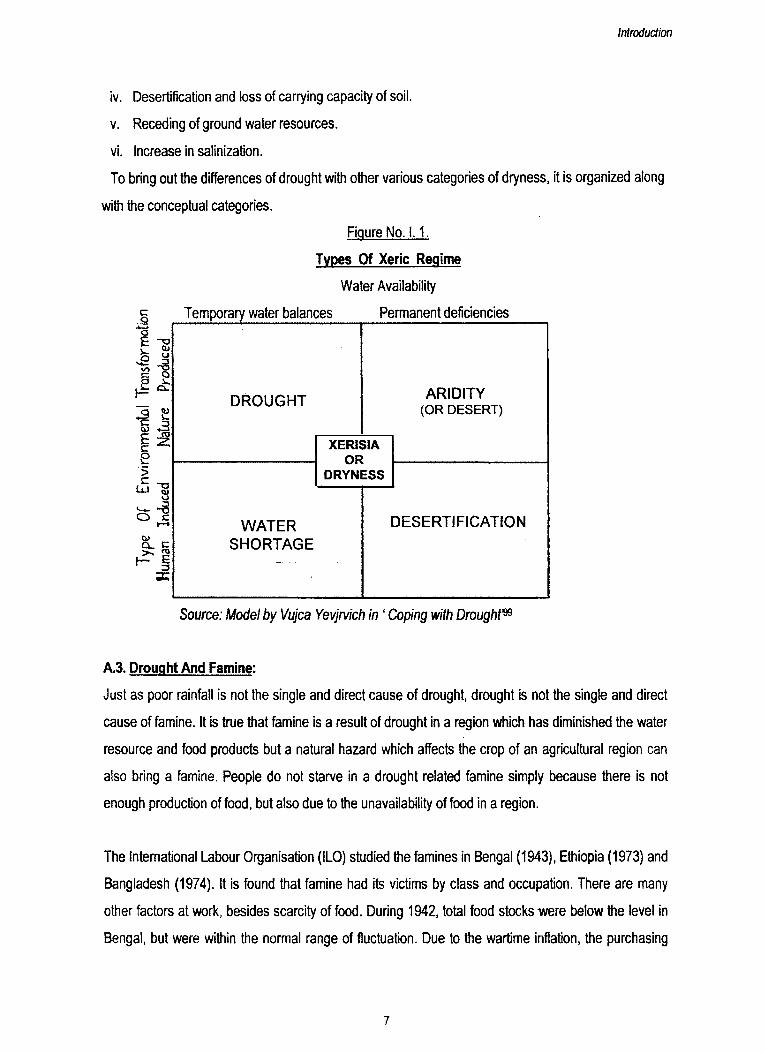
Introduction
iv. Desertification and loss of carrying capacity of soil.
v. Receding of ground water resources.
vi. Increase in salinization.
To bring out the differences of drought with other various categories of dryness, it is organized along
with the conceptual categories.
Figure No. 1.1.
Types Of Xeric Regime
Water Availability
C01 *os -§
£ _§ S Qp V., v- cx
"I£cS>cLa
3
-a<u•j-3E
8. eE
3=
Temporary water balances Permanent deficiencies
D R O U G H T A R ID IT Y (OR DESERT)
XERISIAOR
DRYNESS
W A T E RS H O R T A G E
D E S E R T IF IC A T IO N
Source: Model by Vujca Yevjrvich in ‘ Coping with Drought199
A 3. Drought And Famine:
Just as poor rainfall is not the single and direct cause of drought, drought is not the single and direct
cause of famine. It is true that famine is a result of drought in a region which has diminished the water
resource and food products but a natural hazard which affects the crop of an agricultural region can
also bring a famine. People do not starve in a drought related famine simply because there is not
enough production of food, but also due to the unavailability of food in a region.
The International Labour Organisation (ILO) studied the famines in Bengal (1943), Ethiopia (1973) and
Bangladesh (1974). It is found that famine had its victims by class and occupation. There are many
other factors at work, besides scarcity of food. During 1942, total food stocks were below the level in
Bengal, but were within the normal range of fluctuation. Due to the wartime inflation, the purchasing
7
Introduction
power of the people was decreased. So, they couldnot buy enough food for them. In Ethiopia, the lack
of food was a highly localised phenomenon. Richer farmers had dismissed labourers and household
staff because of low yields, so there were no wages to buy food. Dr. John Rivers of International
Disaster Institute explained that throughout the famine, Ethiopia was a net exporter of food. In
Bangladesh, there was actually more food available during 1974 per person, than in famine years. But
flood had disrupted local industries and thus people lost their employment opportunities and naturally
people could not buy their food.
In each case, people's options to purchase food were diminished. Those who suffered most were the
landless labourers and the pastoralists, who had to sell their cattle, to survive, at a time when there
was no market for cattle.
B. TYPES OF DROUGHT
Types of drought are classified in various ways, taking different parameters related to physical and
climatic characteristic of an area. The principal characteristic is rainfall as drought is directly related to
water scarcity.
Here types of drought are classified in three different groups:
1. Drought due to scarce rainfall.
2. Drought depending on the universal hydrological cycle.
3. Drought on the basis of spatio-temporal pattern of rainfall.
B.1. Drought Due To Scarce Rainfall:
Scientists have tried to define a distressed situation caused by lack of water into three categories of
drought depending on the meteorological, hydrological and agricultural aspects.74 In general terms
they a re :
a. Meteorological Drought: Meteorological drought is a situation when the actual rainfalls do not
arrive in time or less than the climatologically expected rainfall over a wide area.
b. Hydrological Drought: Hydrological Drought is associated with marked depletion of surface water
and consequent drying up of lakes, rivers and reservoirs except deep geological aquifers. A
hydrological drought follows, if a meteorological drought is sufficiently prolonged.
8
Introduction
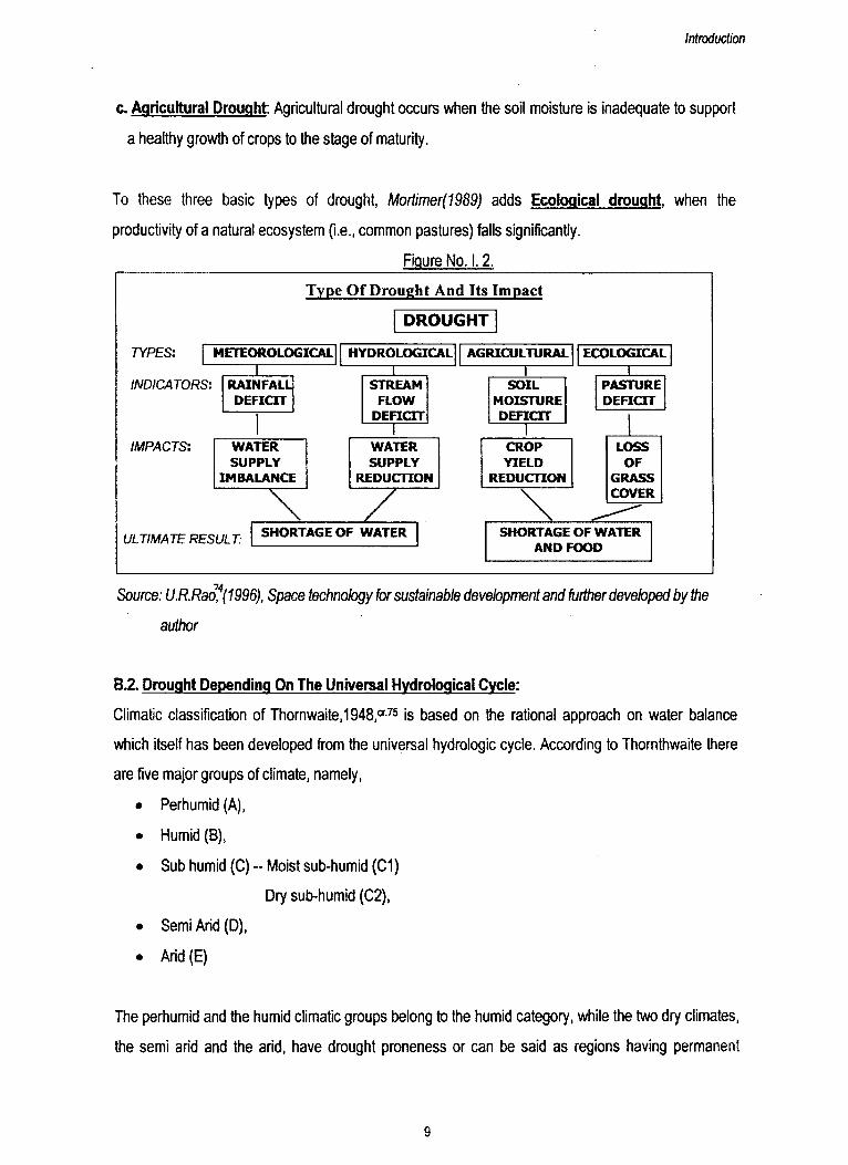
c. Agricultural Drought: Agricultural drought occurs when the soil moisture is inadequate to support
a healthy growth of crops to the stage of maturity.
To these three basic types of drought, Mortimer(1989) adds Ecological drought, when the
productivity of a natural ecosystem (i.e., common pastures) falls significantly.
Figure No. 1.2.
Type Of Drought And Its Impact
Source: U R R ao fl1996), Space technology for sustainable devebpment and further developed by the
author
B.2. Drought Depending On The Universal Hydrological Cycle:
Climatic classification of Thornwaite,1948,Cf75 is based on the rational approach on water balance
which itself has been developed from the universal hydrologic cycle. According to Thornthwaite there
are five major groups of climate, namely,
• Perhumid (A),
• Humid (B),
• Sub humid (C) - Moist sub-humid (C1)
Dry sub-humid (C2),
• Semi Arid (D),
• Arid (E)
The perhumid and the humid climatic groups belong to the humid category, while the two dry climates,
the semi arid and the arid, have drought proneness or can be said as regions having permanent
9
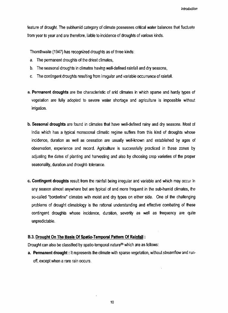
Introduction
feature of drought. The subhumid category of climate possesses critical water balances that fluctuate
from year to year and are therefore, liable to incidence of droughts of various kinds.
Thornthwaite (1947) has recognized droughts as of three kinds:
a. The permanent droughts of the driest climates,
b. The seasonal droughts in climates having well-defined rainfall and dry seasons,
c. The contingent droughts resulting from irregular and variable occurrence of rainfall.
a. Permanent droughts are the characteristic of arid climates in which sparse and hardy types of
vegetation are fully adopted to severe water shortage and agriculture is impossible without
irrigation.
b. Seasonal droughts are found in climates that have well-defined rainy and dry seasons. Most of
India which has a typical monsoonal climatic regime suffers from this kind of droughts whose
incidence, duration as well as cessation are usually well-known and established by ages of
observation, experience and record. Agriculture is successfully practiced in these zones by
adjusting the dates of planting and harvesting and also by choosing crop varieties of the proper
seasonality, duration and drought- tolerance.
c. Contingent droughts result from the rainfall being irregular and variable and which may occur in
any season almost anywhere but are typical of and more frequent in the sub-humid climates, the
so-called “borderline” climates with moist and dry types on either side. One of the challenging
problems of drought climatology is the rational understanding and effective combating of these
contingent droughts whose incidence, duration, severity as well as frequency are quite
unpredictable.
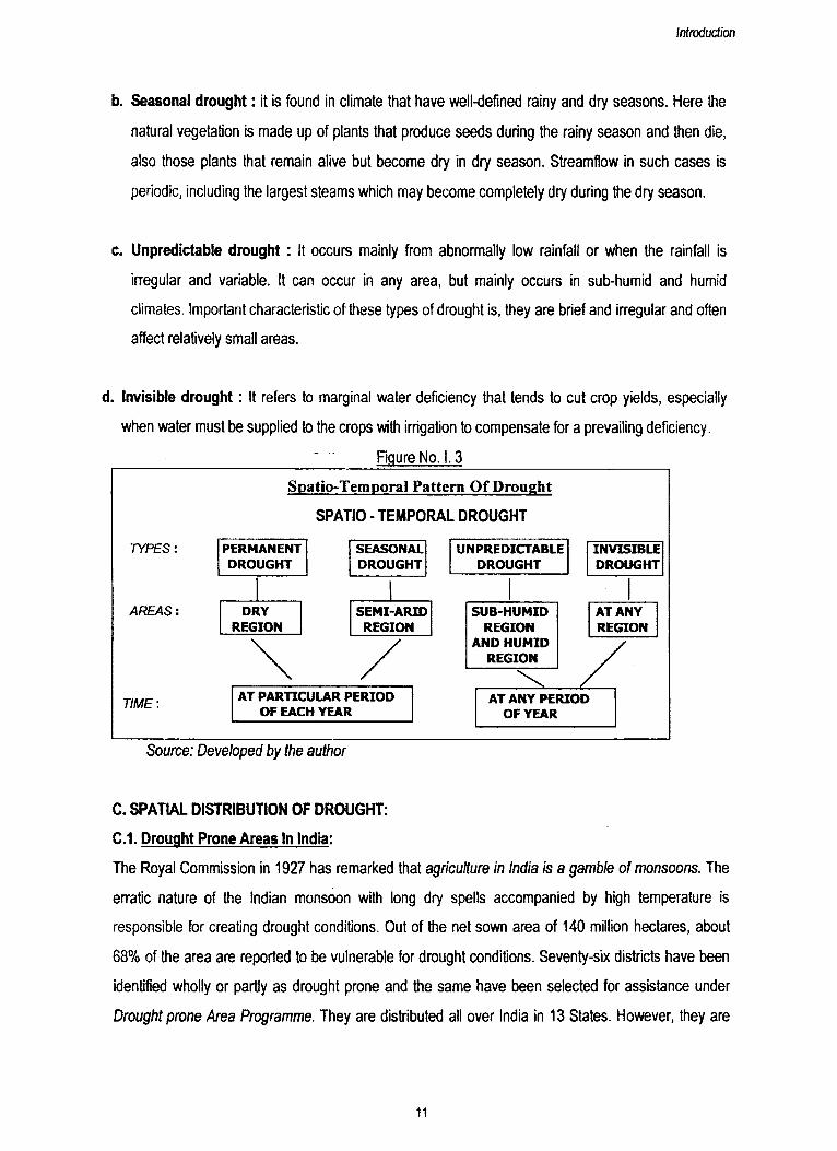
B.3. Drought On The Basis Of Spatio-Temporal Pattern Of Rainfall:
Drought can also be classified by spatio-temporal nature" which are as follows:
a. Permanent drought: It represents the climate with sparse vegetation, without streamflow and run
off, except when a rare rain occurs.
10
Introduction
b. Seasonal drought: it is found in climate that have well-defined rainy and dry seasons. Here the
natural vegetation is made up of plants that produce seeds during the rainy season and then die,
also those plants that remain alive but become dry in dry season. Streamfiow in such cases is
periodic, including the largest steams which may become completely dry during the dry season.
c. Unpredictable drought : It occurs mainly from abnormally low rainfall or when the rainfall is
irregular and variable. It can occur in any area, but mainly occurs in sub-humid and humid
climates. Important characteristic of these types of drought is, they are brief and irregular and often
affect relatively small areas.
d. Invisible drought: It refers to marginal water deficiency that tends to cut crop yields, especially
when water must be supplied to the crops with irrigation to compensate for a prevailing deficiency.
Figure No. 1.3
Source: Developed by the author
C. SPATIAL DISTRIBUTION OF DROUGHT:
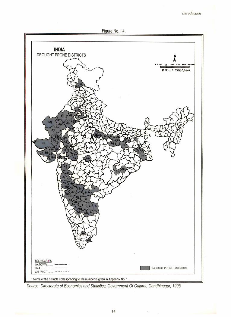
C.1. Drought Prone Areas In India:
The Royal Commission in 1927 has remarked that agriculture in India is a gamble o f monsoons. The
erratic nature of the Indian monsoon with long dry spells accompanied by high temperature is
responsible for creating drought conditions. Out of the net sown area of 140 million hectares, about
68% of the area are reported to be vulnerable for drought conditions. Seventy-six districts have been
identified wholly or partly as drought prone and the same have been selected for assistance under
Drought prone Area Programme. They are distributed all over India in 13 States. However, they are
11
Introduction
concentrated mainly in the western and central zones covering Gujarat, Rajasthan, Haryana,
Maharashtra, Karnataka and Andhra Pradesh (Figure No. I.4.). About 50% of the drought prone area
are classified as severe where frequency of drought is regular. The drought prone condition is related
to erratic and inadequate rainfall. Thus, the total area affected by inadequate rainfall in our country is
about 32.4% of the total geographical area (1,070,000 sq.km.). Co-efficient of variation of rainfall,
derived from historic data indicate occurrence of drought once in three to four years in major parts of
the country. The average density of population in the drought prone area, as per the census of 1971,
is 112 persons per sq.km, as compared with the country’s average density of 178 persons per sq.km.
The general range of population in drought prone districts is from 1.2 million to 2 million. In India, there
are certain well-defined tracts of drought and can be divided into three zones51:
a. Desert and semi-desert regions
b. Chronic drought prone region
c. Scattered pockets of drought.
a. Desert and semi desert regions cover an area of about 600,000 sq.km, and form a rectangular tract
that stretches from Ahmedabad to Kanpur (to form eastern and southeastern border), from Kanpur to
Jullander (to form northeastern and northern boundary) and from Jullander to Rann of Kachchh along
the western International border. The region is characterized by low rainfall ranging between 350 MM.
and 750 MM. per annum but the extreme western deserted areas receive even less than 350 MM. of
annual rainfall. This zone includes whole of Rajasthan and Gujarat, western and south - western parte
of Punjab, most of Haryana, southwestern parte of Uttar Pradesh and a narrow strip along the western
and northwestern border of Madhya Pradesh. There is practically no impact of drought in Punjab and
Harayana because sufficient irrigation facilities are available. The areas having no irrigational facilities
are the worst drought affected and famine areas of the country.
b. The second chronic drought prone zone forms a rectangular tract which spreads over the rain
shadow areas of the western ghats. In fact, this zone is situated to the east of Western Ghats and
extends over a width of 300 k.m. It includes south western Andhra Pradesh, eastern Karnataka (east
of Western Ghats). This region covers 370,000 sq.km, of an area and is characterized by highly
erratic mean annual rainfall of less than 750 MM.
12
Introduction
c. Beside the aforesaid two broad zones of severe droughts there are some scattered pockets of
droughts in the country, such as Tirunelveli district located to the south of Vaigai river, Coimbatore
area, Palamau area of Bihar, Purulia district of West Bengal, Kalahandi region of Orissa etc., The
scattered pockets of drought prone area covers about 1,00,000 sq. k.m. of area.
The total area thus affected by inadequate rainfall is a little over one million sq.km. Of the total gross
cultivated areas of the country, about 56 million hectares are subject to inadequate and highly variable
rainfall.
13
Introduction
14
Introduction
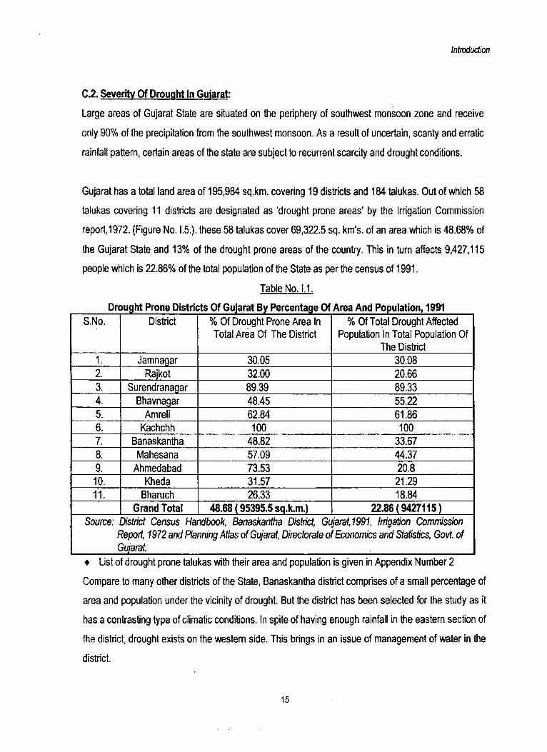
C2 . Severity Of Drought In Gujarat:
Large areas of Gujarat State are situated on the periphery of southwest monsoon zone and receive
only 90% of the precipitation from the southwest monsoon. As a result of uncertain, scanty and erratic
rainfall pattern, certain areas of the state are subject to recurrent scarcity and drought conditions.
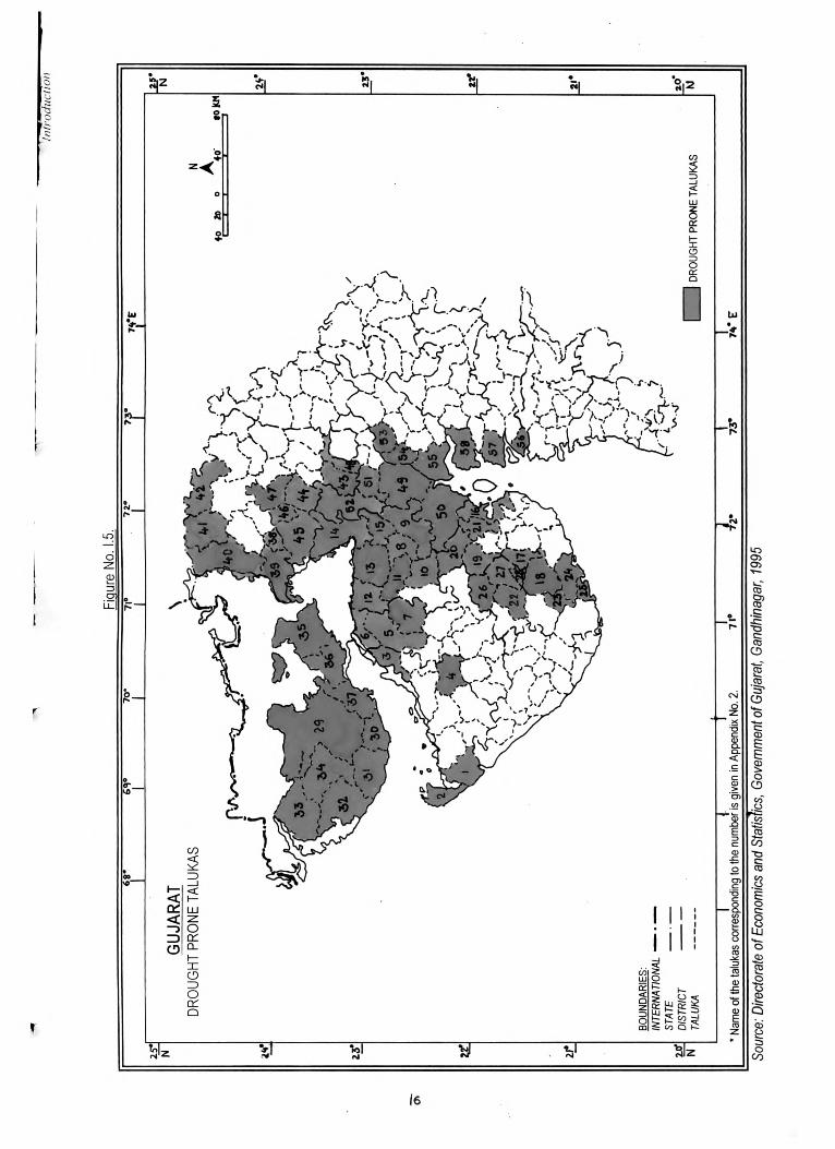
Gujarat has a total land area of 195,984 sq.km, covering 19 districts and 184 talukas. Out of which 58
talukas covering 11 districts are designated as 'drought prone areas’ by the Irrigation Commission
report,1972. (Figure No. I.5.). these 58 talukas cover 69,322.5 sq. km's, of an area which is 48.68% of
the Gujarat State and 13% of the drought prone areas of the country. This in turn affects 9,427,115
people which is 22.86% of the total population of the State as per the census of 1991.
Table No. 1.1.
Drought Prone Districts Of Gujarat By Percentage Of Area And Population, 19191S.No. District % Of Drought Prone Area In
Total Area Of The District% Of Total Drought Affected
Population In Total Population Of The District
1. Jamnagar 30.05 30.082. Rajkot 32.00 20.663. Surendranagar 89.39 89.334. Bhavnagar 48.45 55.225. Amreli 62.84 61.866. Kachchh 100 1007. Banaskantha 48.82 33.678. Mahesana 57.09 44.379. Ahmedabad 73.53 20.810. Kheda 31.57 21.2911. Bharuch 26.33 18.84
Grand Total 48.68 ( 95395.5 sq.km) 22.86 ( 9427115)Source:
fC
District Census Handbook, Banaskantha District, Gujarat,1991, Irrigation Commissbn Report, 1972 and Planning Atlas of Gujarat, Directorate of Economics and Statistics, Govt, of Gujarat
♦ List of drought prone talukas with their area and population is given in Appendix Number 2
Compare to many other districts of the State, Banaskantha district comprises of a small percentage of
area and population under the vicinity of drought. But the district has been selected for the study as it
has a contrasting type of climatic conditions. In spite of having enough rainfall in the eastern section of
the district, drought exists on the western side. This brings in an issue of management of water in the
district.
15
Intro
duct
ion
16
Sou
rce:
Dire
ctor
ate
of E
cono
mic
s an
d S
tatis
tics,
Gov
ernm
ent o
f Guj
arat
, G
andh
inag
ar,
1995
Introdudioi
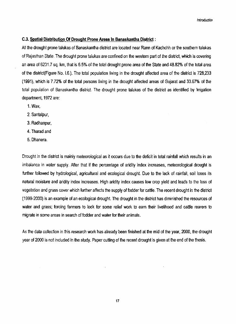
C.3. Spatial Distribution Of Drought Prone Areas In Banaskantha District:
All the drought prone talukas of Banaskantha district are located near Rann of Kachchh or the southern talukas
of Rajasthan State. The drought prone talukas are confined on the western part of the district, which is covering
an area of 6201.7 sq. km, that is 6.5% of the total drought prone area of the State and 48.82% of the total area
of the district Figure No. I.6.). The total population living in the drought affected area of the district is 728,233
(1991), which is 7.72% of the total persons living in the drought affected areas of Gujarat and 33.67% of the
total population of Banaskantha district. The drought prone talukas of the district as identified by Irrigation
department, 1972 are:
1. Wav,
2. Santalpur,
3. Radhanpur,
4. Tharad and
5. Dhanera.
Drought in the district is mainly meteorological as it occurs due to the deficit in total rainfall which results in an
imbalance in water supply. After that if the percentage of aridity index increases, meteorological drought is
further followed by hydrological, agricultural and ecological drought. Due to the lack of rainfall, soil loses its
natural moisture and aridity index increases. High aridity index causes low crop yield and leads to the loss of
vegetation and grass cover which further affects the supply of fodder for cattle. The recent drought in the district
(1999-2000) is an example of an ecological drought. The drought in the district has diminished the resources of
water and grass; forcing farmers to look for some relief work to earn their livelihood and cattle rearers to
migrate in some areas in search of fodder and water for their animals.
As the data collection in this research work has already been finished at the mid of the year, 2000, the drought
year of 2000 is not included in the study. Paper cutting of the recent drought is given at the end of the thesis.
17
18
Sour
ce:
Dis
tric
t Cen
sus H
andb
ook,
Ban
aska
ntha
Dist
rict,
Guj
arat
, 19
91
D. HISTORICAL BACKGROUND OF DROUGHT IN GUJARAT:
History of drought is divided into two periods. In the first period, that is, before 20Th century, there is
no authenticity of data as the information is gathered from different sources. In second period, the data
is collected from different government reports.
D.1. Drought Before Twentieth Century:
Drought is not new to the people of Gujarat State. Kautilya in his Arthashastra has referred the
incidence of occurrences of drought resulting into famine and the measures taken to mitigate it in
ancient India. But the earliest authentic records regarding scarcity and famine that are available for
Gujarat, Saurashtra and Kachchh relate to the 17th and 18th century. The failure of rain in 1630-31
resulted famine in Gujarat.7 “Life”, says Abdul Hamid Lahori in Badshahnama, was offered for a loaf,
dog flesh was sold instead of goat's flesh and pounded bones of the animals were mixed with flour for
sale. In this dreadful calamity, more than a third of population of Gujarat was destroyed and cities and
districts were left bare of inhabitants. In 1650 rain failed in Gujarat, again in 1659-60 Gujarat with
Sindh and western coast were affected due to unfavourable seasons and want of rain. Gujarat area
including Saurashtra and Kachchh, is reported to have been visited by great famines during 1681-82,
1696,1718-19,1731-32,1747 and 1791-92.
During the 19th century, the first famine came during 1812-13 in Kachchh and North Gujarat. In 1813,
there were destructive floods throughout Saurashtra. Monsoon failed in 1877 in Gujarat with Bihar,
United Provinces (U.P.), North Western Provinces, Punjab, North Eastern Rajputana, Central
Provinces, West Konkan and Hyderabad Meteorological Divisions of the country. During this famine
the production of crop was hardly one fourth of the average production and prices were double of the
normal rate. There is a great scarcity of fodder in many tracts and not a grass was seen for miles. A
large number of cattle died and many were driven to Himalayas or sold to butchers in North Western
Provinces.8 Monsoon was highly deficient in 1899 over large parts of the western, central and
southern India. The total rainfall in 1899 was 7.3” against a normal annual rainfall of 30.02". Sir John
Eliot, tiie government meteorologist, estimated afterwards that the drought of 1899 was the greatest in
its extent and intensity, which India had not experienced during the last two centuries. In this way, the
19th century was marked by general conditions of scarcity in one or the other parts of the State,
mainly due to scanty or unseasonable rainfall.
19

D.2. Recent Period ( From Twentieth Century):
Description of some of the earlier famines of the twentieth century makes a pathetic reading. Drought
in 1918 was the most severe experience, faced not only by Gujarat but also by the country during the
last hundred years. Mortality rate due to starvation alone was staggering and a large number of
villages were left desolate.132 This was obvious with the fact that the country had shown a decreasing
trend of population in a decade of 1911-1921. Severity of drought had also increased as the entire
agricultural economy was dependent heavily on rainfall and no organized relief measures were
provided to people. There were 13 moderate and 15 severe types of scarcity experienced in different
parts of the country during 1900 to 1987.
According to the approximate probability of deficient rainfall worked out by India Meteorological
Department for different meteorological sub-divisions, the probability of recurrence of a period of a
highly deficient rainfall is once in three years for Gujarat.
Some of the areas in the State are still subject to nature's fury and are not free form vagaries of the
monsoon. The incidence of scarcity conditions in the state from 1960-61 to 1987-88 can be seen in
table 1.2. Severe drought is noticed for three consecutive years from 1985 to 1988 in the State.
Table No. 1.2.
Number 01 Villages Affected By Drought From 1960-61 To 1987-88 In GujaratYEAR POPULATION
AFFECTEDVILLAGES AFFECTED % OF VILLAGES AFFECTED TO
TOTAL NO. OF INHABITED VILLAGES
1960-61 2303454 2516 13.541961-62 322860 49 0.261962-63 1911860 1592 8.571963-64 1287761 1486 8.001964-65 325734 366 1.971965-66 4080641 5352 28.801966-67 4692404 5662 30.471967-68 90977 102 0.551968-69 8759670 10323 55.551969-70 447619 5114 27.521970-71 NA 678 3.711971-72 21158 483 2.641972-73 15915403 12592 68.901973-74 2862705 2586 14.151974-75 16300000 12716 69.58
*1975-76 — — —
20
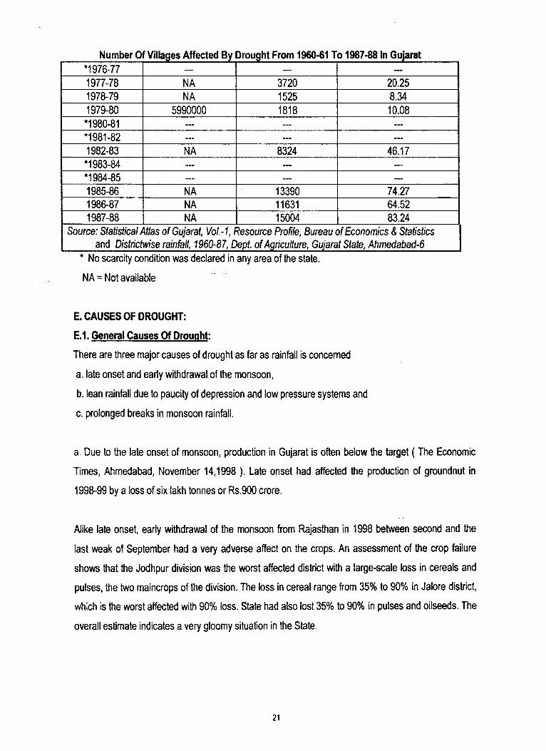
Number 0 Villages Affected By Drought From 1960-61 To 1987-88 In Gujarat*1976-77 — — —
1977-78 NA 3720 20.251978-79 NA 1525 8.341979-80 5990000 1818 10.08
*1980-81 — — —
*1981-82 — — —
1982-83 NA 8324 46.17*1983-84 — — —
*1984-85 — — —
1985-86 NA 13390 74.271986-87 NA 11631 64.521987-88 NA 15004 83.24
Source: Statistical Atlas o f Gujarat, Vol-1, Resource Profile, Bureau of Economics & Statistics and Districtwise rainfall, 1960-87, Dept, o f Agriculture, Gujarat State, Ahmedabad-6
* No scarcity condition was declared in any area of the state.
NA = Not available
E. CAUSES OF DROUGHT:
E.1. General Causes Of Drought:
There are three major causes of drought as far as rainfall is concerned
a. late onset and early withdrawal of the monsoon,
b. lean rainfall due to paucity of depression and low pressure systems and
c. prolonged breaks in monsoon rainfall.
a. Due to the late onset of monsoon, production in Gujarat is often below the target ( The Economic
Times, Ahmedabad, November 14,1998 ). Late onset had affected the production of groundnut in
1998-99 by a loss of six lakh tonnes or Rs.900 crore.
Alike late onset, early withdrawal of the monsoon from Rajasthan in 1998 between second and the
last weak of September had a very adverse affect on the crops. An assessment of the crop failure
shows that the Jodhpur division was the worst affected district with a large-scale loss in cereals and
pulses, the two maincrops of the division. The loss in cereal range from 35% to 90% in Jalore district,
which is the worst affected with 90% loss. State had also lost 35% to 90% in pulses and oilseeds. The
overall estimate indicates a very gloomy situation in the State.
21
Introduction
Till date, the physical mechanisms that lead to the late onset and early withdrawal of the monsoon
from a region is not fully understand. Micheal Palmerino, senior agricultural meteorologist at Weather
Services Crop in Massachusetts, has predicted the onset of India’s monsoon be late in the year of
2000. His prediction is based on the movement of jet stream over central Asia. Improvements in
prediction on such meteorological situation lean heavily on the monitoring facilities of climate With
more information on cloud structure and wind direction etc, one may be able to anticipate conditions
that are likely to lead to a late or an early onset. Research is going on in this subject.
b. The second aspect is concerned with a global view of weather. The Monsoon Experiment (MONEX)
of 1979 suggests that there are meteorological telecommunications that link up the passage of
depressions and low-pressure system with events occurring in other parts of the world. The southern
oscillation, is an example of a meteorological link on a global scale.
Many worldwide meteorological organisations believe that El Nino is linked with unusually warm
surface-current in the south Pacific ocean off the south American coast, which occurs once in a few
years around December. This phenomenon is associated with drought in Africa, India, Australia region
and floods in south American coastal countries.53 It is true that, all the four serious droughts that have
occurred in India over the last 120 years have been El Nino years, still we cannot make a conclusion
that El Nino is the only factor to bring drought in India. As the physical factors for El Nino are not
known, only statistical relationship between drought an El Nino can be drawn. According to many well-
known scholars from meteorological department, El Nino is just one of the parameters taken into
account while preparing a long range forecast for the country. Other than El Nino factor, some of the
senior scientists of Space Applications Centre, Ahmedabad24, believe that volcano eruption also
affects the rainfall pattern of the Indian continent.
c. The last aspect, namely, prolonged break in rainfall is again intimately linked with the dynamics of
the monsoon. Past rainfall data suggest that prolonged breaks in monsoon rainfall have a tendency to
occur towards the second half of the season, that is, in August and September. Thus in 1974 and in
1979 most parts of north west India suffered a break in monsoon rains for a period ranging from six to
eight weeks. The evidences suggest that these breaks are sometimes linked with a quasi-stationary
anticyclone circulation that establishes itself over northwest India. This anticyclone circulation inhabits
22
Introduction
the upward motion of air and there is less chance of rainfall as a consequence. The meteorological
process leading to this type of circulation, is not yet well understood.74
D.2. Causes Of Drought In Banaskantha District:
Rainfall is not the only cause of drought in the district, there are also some other factors which share
the causes of drought and differ from region to region. Banaskantha district lies on the east of Rann of
Kachchh in the northern part of Gujarat state. District has many causes for drought, those are as
follows:
a. The southwest monsoon carrying moisture does not enter the region easily. It passes from
Maharastra and south Gujarat, leaving the other parts of the State quite dry.
b. There is no perennial river in Gujarat except a few in south Gujarat. Out of total 185 rivers in the
State, 168 rivers are in drought prone areas and all of them are non-perennial and account for less
than 20% utilization of surface water.
c. Banaskantha district of Gujarat is located to the north of 23 1/2° N (Tropic of cancer). In these
parts of latitude, the tropical wind coming from the equator, subsides, so the warm tropical wind comes
downward. Hence, whatever moisture the region has, is evaporated due to subsidence, and
convection does not occur for the formation of cloud.
d. Gujarat is in the tropical zone and the Tropic of cancer passes over the State. Thus, the Sun shines
directly over the region during summer season. During the whole year, Gujarat and Rajasthan receive
5.8 kilowatt per hours per sq.m, per day of solar radiation, which is higher than any other states of the
country. Hence, the rate of evaporation is higher in this region compared to the other zones. If this
region, with the similar quantity of moisture, has been located under the temperate zone, then
whatever moisture content the region has would have been enough for cultivation. The mean daily
pan-evaporation in Banaskantha district ranges between 4-5mm/day in the month of May. During the
year, the evaporation increases from January and reaches its maximum value in May.
e. Gujarat receives much of its rainfall from the southwest monsoon. The monsoon season begins
with the southern district of Gujarat. Sometimes Gujarat gets cyclic rainfall also. Cyclic depressions
23
Introduction
cut across the country from east to west or from Bombay area and give rainfall here. The normal
annual rainfall of Valid is 1839.1 mm with 60 rainy days which is the highest among all the districts in
the State. But the amount of rainfall decreases towards the north as the monsoon current loses
moisture while moving from south to north. That is why, the normal annual rainfall of the Banaskantha
district is 577.9 mm with 24.9 rainy days, which is very erratic, scanty and unpredictable.
f. Large fluctuations of annual rainfall on both temporal and spatial scales are observed in the district.
The eastern part of the district receives as much as 750mm of rain as it is located in the vicinity of
Aravallis and Abu hills, whereas the western part receives less than 450mm of annual rainfall which
includes Tharad, Wav, Santalpur and Radhanpur talukas.
g. No rivers or rivulets pass through Deodar, Tharad and Wav talukas of the district. Water
accumulated by monsoon rain in ponds or reservoirs is available upto the month of February. The
water table is also high in these talukas, especially in Wav, but water is unpotable as it is saline. There
are no other prospects of natural water in these talukas. So, the government tankers provide the water
to the villages of Wav taluka during summer to meet the demand for domestic use.
h. Banaskantha district receives mean annual rainfall of 577.9 mm with 24.9 rainy days during June to
September. The length of all the rivers in the district is short and flow along the steep slope of the
Aravallis. Therefore water in river runs away to the Rann of Kachchh, generating floods or water
logging in rainy season and drought in summer in the western part of the district. The Rann has .very
low slope and the water table is high. So a single, heavy rainfall can create floods in the Rann area.
i. Western part of the district is lying next to the Rann of Kachchh, which was once an inlet of the
Arabian Sea, but it has been uplifted and silted up by the enormous volume of mud poured into it by
the small rivers discharging into it from the east and north east. This tract is a saline marshy plain,
hardly above sea level. The western part of the Banaskantha district ( Wav and Santalpur) is located
next to it, which is also low-lying area and not much above the sea level.
j. Ninety five percent of the annual rainfall in the North Gujarat is received only through monsoon
during June to September months. Hence failure in monsoon creates water crisis in the region.
24
Introduction
F. FACTORS CONTRIBUTING TO THE DEVELOPMENT OF DROUGHT PRONE TALUKAS
It is a general views that most of the drought prone areas are also the backward areas, as drought
restricts the socio-economic development of an area. But it is found that in Gujarat, only sixteen
drought prone talukas are also the backward talukas of the district, which is approximately 28.57% of
the total drought prone talukas of the State. Improvement of irrigation facilities and development of
secondary and tertiary sectors are the major reasons of socio-economic development for the forty
three drought prone talukas of the State, which are as follows:
=> Development of secondary occupation; like various industries in Ahmedabad, Rajkot and
Bharuch talukas and development of ports in Kachchh, Jamnagar, Bhavnagar and Bharuch has
helped the drought prone talukas of the respective district to develop by providing a source of
earning other than agriculture.
=> Well-developed mode of transportation has given mobility to the people, which helped them to
migrate easily to some other area during the critical period of drought or dry season of the year
and hence, providing them the opportunity to earn.
=> City provides occupation in secondary and tertiary sectors. Therefore cities like Ahmedabad,
Rajkot, Bharuch and Jamnagar have provided numerous employment opportunity not only to
city people but also to the villagers settled near these cities.
=> All the major rivers of Gujarat are tapped for the irrigation purpose. Therefore, talukas near
these rivers have enough water to irrigate their fields even during summers. Thus, increase in
total production has helped them to increase their total income.
=> In Jamnagar and Kachchh, agriculture with scarce rainfall and saline soil is not enough to
sustain people. But salt industries in these districts have acted as a substitute to agriculture by
providing people a source of income unaffected by scarce rainfall.
=> Agriculture in drought prone talukas provides irregular amount of income. Therefore in some
places, people have diverted themselves to some other occupations, which are not affected by
25
Introduction
drought or scarce rainfall. For example, Patola sarees of Patan and tourist places area have
helped many drought prone areas to develop themselves.
The drought prone talukas of Banaskantha district have sandy soil, they also lack in mineral resources
and industries. These talukas are far from any urban area and do not have proper transportation for
socio-economic development. Efforts are needed to develop the drought prone talukas by developing
the non-agricultural activities, as it is practiced in other drought prone but developed talukas of the
State. With this hope that drought prone areas can be developed through integrated development
system of various aspects, Banaskantha district is chosen for the study.
G. IMPACT OF DROUGHT
Drought is somewhat different from the other major natural disasters. Floods, earthquakes and
cyclones start in a comparatively sudden manners, having a relatively short duration and are
restricted to local influence. Drought in contrast starts slowly, having long duration, being of the
creeping and pervasive nature, covers vast areas. Floods, cyclones and earthquakes are disasters
associated with extreme events, drought is the extreme hydrologic result of the non-occurrence or
less than normal mean rainfall of an area. Basically drought is a slow evolution that seldom causes
dramatic losses of human life (except in famine) but it effect is long lasting in economic sector for the
region and its people.
G-1. Impact Of Drought On Environment:
Rural India is still based on the traditional methods of living style from house to field. Drought shows
its first mark on environment which consequently affect people. The general environmental impacts
are as follows:
Due to scarce rainfall and over exploitation of ground water aquifers, it gets depleted and due to
capillary action, agricultural fields gradually become saline. Scarce rainfall and vegetation are not able
to hold the topsoil, therefore the wind erosion becomes active in this region. Thus, the topsoil of
agricultural field is swept away with wind and saline soil from Rann of Kachchh or desert is deposited
in the field. Consequently, there is a problem of salinization and desertification in areas near Rann. It
is estimated that between 50,000 to 70,000 sq.km, of land are going out of production every year in
the world because of desertification. Exposed fields during drought, without having agriculture, make
soil loose and dry and it is prone to erosion and desertification.
26
Introduction
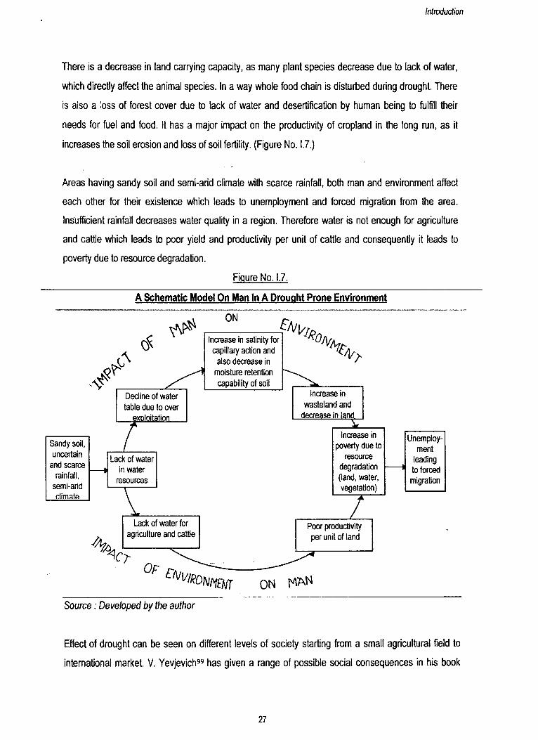
There is a decrease in land carrying capacity, as many plant species decrease due to lack of water,
which directly affect the animal species. In a way whole food chain is disturbed during drought. There
is also a loss of forest cover due to lack of water and desertification by human being to fulfill their
needs for fuel and food. It has a major impact on the productivity of cropland in the long run, as it
increases the soil erosion and loss of soil fertility. (Figure No. 1.7.)
Areas having sandy soil and semi-arid climate with scarce rainfall, both man and environment affect
each other for their existence which leads to unemployment and forced migration from the area.
Insufficient rainfall decreases water quality in a region. Therefore water is not enough for agriculture
and cattle which leads to poor yield and productivity per unit of cattle and consequently it leads to
poverty due to resource degradation.
Figure No. 1.7.
A Schematic Model On Man In A Drought Prone Environment
\
ON
LDecline of water table due to over
exploitation
Sandy soil, uncertain
and scarce rainfall,
semi-arid climate
z
Increase in salinity for capillary action and
also decrease in moisture retention capability of soil
Lack of water in water
resources
o f
€lVv̂ON!tHT
f#0Sir
increase in wasteland and
decrease in land
Increase in poverty due to
resource degradation (land, water, vegetation)z
Lack of water for Poor productivityagriculture and cattle per unit of land
ON KANSource: Developed by the author
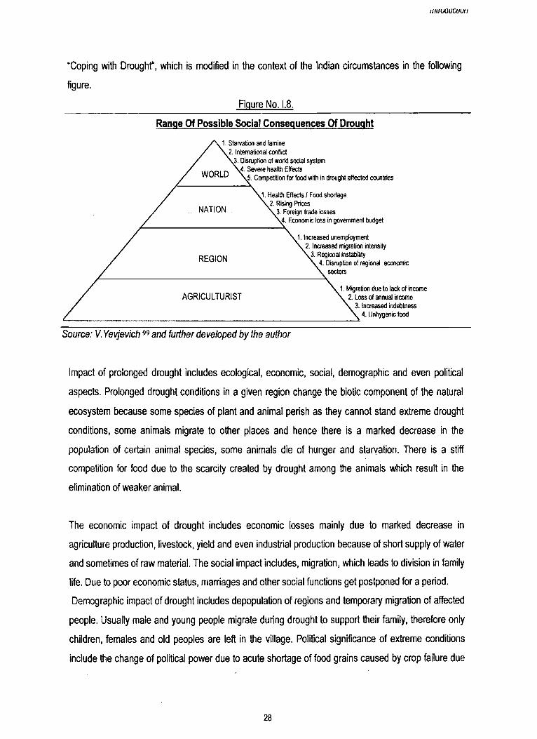
Effect of drought can be seen on different levels of society starting from a small agricultural field to
international market. V. Yevjevich" has given a range of possible social consequences in his book
27
IIIIHX1UCUUII
“Coping with Droughf, which is modified in the context of the Indian circumstances in the following
figure.
Figure No. 1,8.
Range Of Possible Social Consequences Of Drought
1. Starvation and famine2. International conflict
.3. Disruption of world social system ,4. Severe health Effects
p. Competition for food with in drought affected countries
J. Health Effects / Food shortage 2. Rising Prices
3. Foreign trade losses ' ,4. Economic loss in government budget
1. Increased unemployment 2. Increased migration intensity
3. Regional instability4. Disruption of regional economic
sectors
1. Migration due to lack of income 2. Loss of annual income
3. Increased indebtness 4. Unhygenic food
Source: V. Yevjevich99 and further developed by the author
Impact of prolonged drought includes ecological, economic, social, demographic and even political
aspects. Prolonged drought conditions in a given region change the biotic component of the natural
ecosystem because some species of plant and animal perish as they cannot stand extreme drought
conditions, some animals migrate to other places and hence there is a marked decrease in the
population of certain animal species, some animals die of hunger and starvation. There is a stiff
competition for food due to the scarcity created by drought among the animals which result in the
elimination of weaker animal.
The economic impact of drought includes economic losses mainly due to marked decrease in
agriculture production, livestock, yield and even industrial production because of short supply of water
and sometimes of raw material. The social impact includes, migration, which leads to division in family
life. Due to poor economic status, marriages and other social functions get postponed for a period.
Demographic impact of drought includes depopulation of regions and temporary migration of affected
people. Usually male and young people migrate during drought to support their family, therefore only
children, females and old peoples are left in the village. Political significance of extreme conditions
include the change of political power due to acute shortage of food grains caused by crop failure due
28
Introduction
to droughts and increase in the dominance of the countries having surplus food supply on drought
affected poor countries that have surplus food supply on drought affected poor areas.
G.2. Impact Of Drought In Terms Of Domestic Needs:
During drought the water table falls in all ground water sources, even the available water of several
wells turns brackish or saline, so there is an acute shortage of water needed for human being for
different purposes. For example, during the drought period of 1985-87,10402 villages in Gujarat and
700 villages in Rajasthan were reported to have been affected by acute scarcity of drinking water.
Water was being supplied to these villages by tankers and bullock cart. In many drought areas, the
woman folk of the house had to walk for four to five kilometers every day to bring water for drinking
purpose. As the ground water level continued to drop, many dug-wells were deepened and many new
tube-wells were made and repaired by the government.
People did not have bath or could not wash their clothes in dry season for months when the
temperature was more than 40 degree centigrade in Banaskantha district. There was also a change in
consumption behavior during drought conditions, as there was also a scarcity of food, which is
governed by low production and high price. During the drought years of 1985-87, the Central
Government along with the State Government of Gujarat had contributed Rs.86 crores to tackle the
drinking water supply in the State.
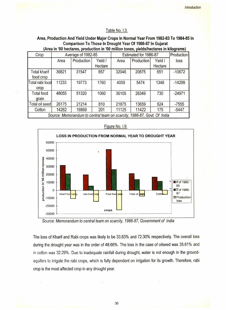
G.3. Impact Of Drought On Cultivation:
Life in India is primarily based on agriculture which is dependent for its very existence on the
southwest monsoon. The monsoon is said to be the pivot upon which the whole economic life of
farmers’ swings. Hence, late onset or inadequate rain pull down the shutters of agriculture and
industry. Statistics reveal, that there is a clear cut downfall of area, production and yield of crops in all
three agricultural seasons of the year 1985-’87 (one of the severe drought year of the state) in
Gujarat, when mean annual rainfall of the state was 383.39 mm, which is 444.61 mm less than the
normal annual rainfall of the State (828 mm).
29
Introduction
BSTof 1982- 85
B 7o f 1986- 87
□ Production loss
LOSS IN PRODUCTION FROM NORMAL YEAR TO DROUGHT YEAR
Table No. I.3.
Area, Production And Yield Under Major Crops In Normal Year From 1982-83 To 1984-85 In Comparison To Those In Drought Year Of 1986-87 In Gujarat
(Area in ‘00 hectares, production in ‘00 million tones, yields/hectares in kilograms)
Figure No. 1.9.
Source: Memorandum to central team on scarcity, 1986-87, Government of India
The loss of Kharif and Rabi crops was likely to be 33.83% and 72.30% respectively. The overall loss
during the drought year was in the order of 48.66%. The loss in the case of oilseed was 35.61% and
in cotton was 32.29%. Due to inadequate rainfall during drought, water is not enough in the ground-
aquifers to irrigate the rabi crops, which is fully dependent on irrigation for its growth. Therefore, rabi
crop is the most affected crop in any drought year.
Crop Average of 1982-85 Estimated for 1966-87 ProductionlossArea Production Yield /
HectareArea Production Yield /
HectareTotal kharif food crop
36821 31547 857 32046 20875 651 -10672
Total rabi fooc crop
11233 19773 1760 4059 5474 1348 -14299
Total food grain
48055 51320 1060 36105 26349 730 -24971
Total oil seed 26175 21214 810 21875 13659 624 -7555Cotton 14262 16869 201 11125 11422 175 -5447
Source: Memorandum to central team on scarcity, 1986-87, Govt. Of India
prod
uctio
n In
'00
mill
ion
tonn
es.L
_k
ro
co
.uo
o
o
o
o
o
o
o
o
o8
o 8
8 8
8
OOCM
CO o o
30
huh ju u u iu h
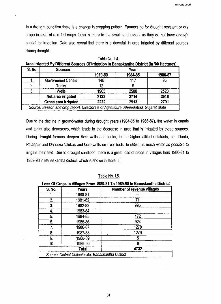
In a drought condition there is a change in cropping pattern. Farmers go for drought resistant or dry
crops instead of rain fed crops. Loss is more to the small landholders as they do not have enough
capital for irrigation. Data also reveal that there is a downfall in area irrigated by different sources
during drought.
Table No. 1.4.Area Irriigated By Different Sources Of Irrigation In Banaskantha District (In ‘00 Hectares)S. No. Sources Year
1979-80 1984-85 1986-871. Government Canals 146 117 952. Tanks 12 9 —
3. Wells 1965 2588 2523Net area irrigated 2123 2714 2618
Gross area irrigated 2222 2913 2791Source: Season and crop report, Directorate o f Agriculture, Ahmedabad, Gujarat State
Due to the decline in ground-water during drought years (1984-85 to 1986-87), the water in canals
and tanks also decreases, which leads to the decrease in area that is irrigated by these sources.
During drought farmers deepen their wells and tanks, in the higher altitude districts, i.e., Danta,
Palanpur and Dhanera talukas and bore wells on river beds, to utilize as much water as possible to
irrigate their field. Due to drought condition, there is a great loss of crops in villages from 1980-81 to
1989-90 in Banaskantha district, which is shown in table 1.5 .
Table No. I.5.
Loss Of Crops In Villages From 1980-81 To 1989-90 In Banaskantha DistrictS. No. Years Number of revenue villages
1. 1980-81 —
2. 1981-82 713. 1982-83 9954. 1983-84 - -
5. 1984-85 1726. 1985-86 9247. 1986-87 12788. 1987-88 . 12799. 1988-89 510. 1989-90 8
Total 4732Source: District Collectorate, Banaskantha District
31
Introduction
During dry weather, there is an increase in multiplying of weeds, insect activities and predators, which
decrease the total production of crops. Hence, the uncertainty of rainfall is the biggest challenge to the
Indian agriculture, as the success and the failure of agricultural economy of a region are intimately
connected with the occurrences of the monsoon.
G.4. Impact Of Drought On Employment Pattern:
“ 16.4 lakh labourers were provided employment on relief works during the peak period of 1986-87 in
Gujarat'.121 This simple statement on a memorandum given by the Central team on the scarcity of
1986-87 in Gujarat by State government shows that how much the employment pattern was affected
on the villages of the State, where more than 56% of the total main workers are cultivators or
agricultural labourers.
Continuous drought from 1985 to 1987 forced even large farmers having more than 50 acres of land,
to work in relief camps organised by the government. Nearly 153.49 lakh population in the State was
affected during this period, out of which 1,422,661 persons were agricultural labourers, 476595
persons were small farmers and 511422 persons were from the group of marginal farmers. During the
drought year of 1985, State government had fixed Rs.11/- per day per head as scarcity wages to
labourers working in relief camps. Not only the farmers of the village were affected, all other families of
cobbler, blacksmith and carpenter had to move out from their usual work as they did not have any
customer to serve in the village. Cattle rearers had to migrated to other green belts of the State or the
neighbouring states. Many of them even sold their cattle in unprofitable prices to butchers. Farmers
have either migrated or worked in relief camps. Migration took place mainly towards the greener belt,
where they worked as agricultural labourer or to the cities where they worked as a labourer in different
shops and markets.
G.5. Impact Of Drought On Forest Coven
Forest plays a vital role in the economy by supplying timber, fuel, fodder and variety of other products
for households and industry. It also helps to preserve ecological and environmental balance. It
improves the percolation of rainwater, reduces salinity, maintains soil fertility and acts against floods
and soil erosion. The total area under forest was 19392 sq. kms. in 1992-93 on Gujarat, that is 9.89%
of the total area of the state.
32
Introduction
During droughts, the area under forest is affected, as it is deforested for fuel and fodder use and in
turn it affects adversely the soil and agro-climatic situation. As per the information given by villagers,
the forest area had decreased after the continuous drought of 1984-87. Due to the unavailability of
enough information from forest department at a macro level, it is not possible to prove the fact but as
we go for micro level study, we canfind that drought had an effect on forest area.
G.6. Impact Of Drought On Cattle Or Dairy Products:
The total livestock population of Gujarat is 17343 thousand which is 3.9% of the country’s livestock
population, according to 1991 census. In Gujarat, there are 10285 milk co.-operative societies which
have 36 chilling plants, 1123175 societies and 1844212 members. But drought on every alternate
year affects the dairy development, as the number of cattle perish due to lack of fodder and grass.
Due to the low rainfall the wild grasses that normally grow on the common pastures during the
monsoon season, fail to grow. So, shepherds graze their cattle on agricultural plots which have failed
crops due to insufficient rainfall. But competition over rights to individual plots leads to several
conflicts. Due to the low fodder stock, the price of fodder increases. In 1984-85 to 1986-87 drought,
grass, which in normal years cost RS. 6 per 100 bundles was sold for RS. 40/- per 100 bundles. Many
shepherds were forced to migrate with their cattle to a green belt or to sell their cattle at much lower
prices as they were not able to keep them. Many cattle died due to lack of fodder and water. So there
was a decrease in the number of cattle wealth. Most of the people abandoned their cattle on the road
as they are not getting a customer to sell them even at a half rate. During the drought year of 1986-87,
over 8 crore kgs of grass was moved from Valsad district to Kachchh, Saurashtra and North Gujarat
districts and distributed through 525 grass depots or fodder banks. To save the cattle population,
government and many NGO’s had opened cattle camps in various scarcity-affected areas. More than
3 lakh heads of cattle were admitted in various cattle camps, ( panjrapoles’ and "gaushalas). As per
the estimation made by the Scarcity Department o f Gujarat, total 90.97 lakh cattle in State and 9.60
lakh cattle in Banaskantha district were affected during the drought period of 1985-1987. (Table No. -
I.6.)
33
Introduction
Table No.1.6.
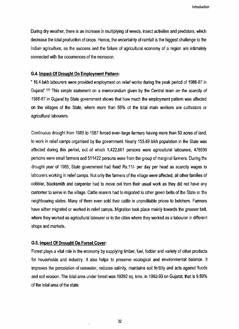
Number Of Cattle Population Affected During The Drought Year Of 1986-87 In ________________ __________ Gujarat____________________________
Name of the district Cattle population affected (in lakhs)1. Amreli 0.572. Junagadh 0.863. Bhavnagar 5.554. Rajkot 4.165. Jamnagar 4.946. Surendranagar 6.957. Kachchh 2.808. Banaskantha 9.609. Mehsana 9.3710. Sabarkantha 9.7911. Ahmedabad 5.1912. Kheda 4.8613. Panchmahals 10.4414. Vadodara 11.2515. Bharuch 2.9216. Surat 1.72Total 90.97
Source: Memorandum to the Central team on scarcity, Govt. Of Gujarat, 1986-87.
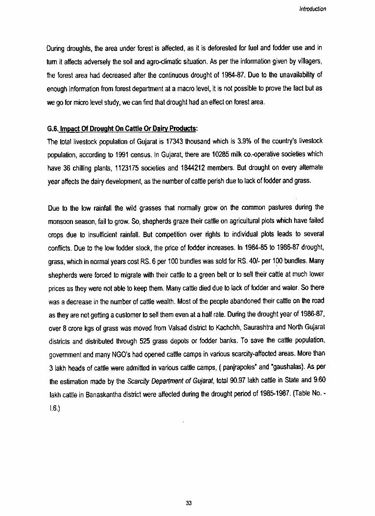
Figure No. 1.10.
CATTLE POPULATION AFFECTED DURING THE DROUGHT YEAR OF 1986-87 IN GUJARAT
Bhaaich Bhavnagar
Amreli
Vadodara
Junagadh
Panchmahals
ih
Rajkot
Jamnagar
Surendranagar
Kuchchh
Banaskantha
Surat
Mehsana
Kheda
Ahmedabuu
Sabarkantha
Source: Memorandum to the Central team on scarcity, Govt. O f Gujarat, 1986-87
34
Introduction
G.7. Impact Of Drought On Industry:
Gujarat is the third largest industrial region (Ahmedabad-Vadodara-Bharuch-Surat belt) of the country.
This region has developed the cotton textile industry, followed by rayon, petrochemical, match,
petroleum refining, pharmaceutical, potteries and glassware, leather goods and a wide variety of
engineering units. One of the initial reasons for the development of this region is the cheap availability
of raw cotton from its hinterland. Latest data available is of 1994, show that there are 16325 factories
working in the State which employ approximately 810,000 workers.
Industries of the State are dependent on agriculture and forest for their raw material, hence, during
droughts the production of industries are mainly affected. During drought, maximum decrease can be
seen on sugar production as inadequate rainfall restrict the proper growth of the crop, that is why it is
also sold as fodder in these periods.
Due to lack of adequate supply of raw material and water, production of industries is affected which
leads to heavy loss for companies. So to minimize the loss, companies cut the number of labour and
consequently it increases the unemployment in a region which forces the people to migrate in some
other region for search of livelihood.
After a three consecutive years of drought from 1984-85 to 1986-87, many factories were closed down
due to lack of raw material in 1987 and 1988. There is also a decreasing trend in number of labour in
of 1985,1987 and 1988 (Table No. I.7.)
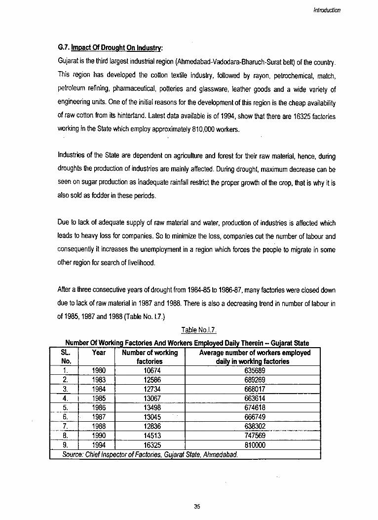
Table No.l.7.
Number Of Work ng Factories And Workers Employed Daily Therein -- Gujarat StateSL.No.
Year Number of working factories
Average number of workers employed daily in working factories
1. 1980 10674 6356892. 1983 12586 6892693. 1984 12734 6680174. 1985 13067 6636145. 1986 13498 6746186. 1987 13045 6667497. 1988 12836 6383028. 1990 14513 7475699. 1994 16325 810000Source: Chief Inspector of Factories, Gujarat State, Ahmedabad.
35
Introduction
G.8. Movement Of Cattle And People Over Space:
Drought causes depopulation of regions and temporary migration of affected people and animals.
There are three main reasons for migration: (1). during drought, the local tenancy and labour markets
do not absorb adequately the pool of available labour, (2). many small farmers and marginal farmers
cannot afford the irrigation costs to cultivate crops in the dry season and, (3). lack of fodder and water
causes migration of cattle rearers to green belts with their cattle.
There is a frequent migration of people from drought affected areas of Maharashtra, Gujarat and
Rajasthan in India. Due to prolonged severe droughts for three consecutive years (1984 to 1987) in
Gujarat and Rajasthan, a large number of people temporarily shifted to South Gujarat, Madhya
Pradesh, Uttar Pradesh and Bihar, together with their cattle or sold them at much lower prices due to
lack of fodder. During the continuous drought of 1984-87, in Lodhrani and Rachhena village of
Banaskantha district, all the shepherd households, migrated with most of their animals to green belt
area in South Gujarat. Statistics reveal that every 3rd year about 3 million people of drought prone
area migrate along with their livestock to some other place in our country. This type of migration is
rather a forced movement which causes disturbance to family life in these areas.
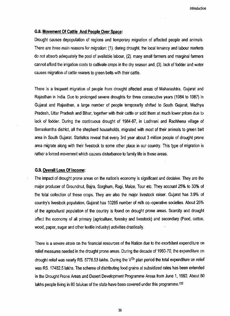
G.9. Overall Loss Of Income:
The impact of drought prone areas on the nation’s economy is significant and decisive. They are the
major producer of Groundnut, Bajra, Sorghum, Ragi, Maize, Tour etc. They account 25% to 33% of
the total collection of these crops. They are also the major livestock raiser. Gujarat has 3.9% of
country’s livestock population. Gujarat has 10285 number of milk co.-operative societies. About 25%
of the agricultural population of the country is found on drought prone areas. Scarcity and drought
affect the economy of all primary (agriculture, forestry and livestock) and secondary (Food, cotton,
wood, paper, sugar and other textile industry) activities drastically.
There is a severe strain on the financial resources of the Nation due to the exorbitant expenditure on
relief measures needed in the drought prone areas. During the decade of 1960-70, the expenditure on
drought relief was nearly RS. 5776.53 lakhs. During the VTh plan period the total expenditure on relief
was RS. 17482.5 lakhs. The scheme of distributing food grains at subsidized rates has been extended
in the Drought Prone Areas and Desert Development Programme Areas from June 1,1992. About 80
lakhs people living in 80 talukas of the state have been covered under this programme.132
36
Introduction
EXPENDITURE INCURRED ON SCARCITY WORK IN GUJARAT FROM 1960-1961 TO 1975-76
9000
60-61 62-63 64-65 66-67 68-69 70-71 72-73 74-75YEARS
Table No. 1.8.
Expenditure Incurred On Scarcity Work In Gujarat From 1960-61 To 1975-76
Figure No. 1.11.
Source; Statistical Atlas of Gujarat, Bureau of Economics and Statistics, Gandhinagar
Year Expenditure incurred on scarcity work (RS. In lakhs)1960-61 50.431961 -62 2.211962-63 72.281963-64 108.641964-65 43.151965-66 85.661966-67 692.081967-68 731.501968-69 631.941969-70 3358.641970 -71 1035.671971-72 62.781972-73 3190.771973-74 5051.791974-75 8141.501975-76 **5768.00
** No scarcity condition was declared in any area of the State.The outlay is a spill over the previous year
Source: Statistical Atlas of Gujarat, Bureau o f Economics and Statistics, Gandhinagar
RS.
IN L
AK
HS
37
Introduction
Drought not only paralyze the economy of the region but also creates a social problem, which needs
proper attention at the time of its occurrence. The intensity of the drought in Gujarat during the
continuous drought year of 1985-88 could be measured from the following facts121:
• 73% of the total villages in Gujarat were declared to be scarcity affected.
• Over 63.73% of the villages faced acute problems of drinking water supply problems.
• 16.4 lakh labourers were provided employment on relief works, during peak period.
• 3 lakh head of cattle were admitted to emergency cattle camps, (gaushalas and panjrapols).
• Over 80,000 tons of grass was moved from South Gujarat to the scarcity affected areas.
• State Government implemented Rs.86 crores of cash programme to mitigate the problem of
drinking water supply.
• Gujarat government had estimated a financial requirement of Rs.42986.63/- for scarcity relief
expenditure during the drought year of 1987-88.
The Government of India had approved total ceiling of Rs.147.44 crores for the financial year of 1986-
87 and 1987-88 to meet with the expenditure on drought relief operation.
H. NEED TO DEVELOP DROUGHT PRONE AREAS:
The drought prone tracts are most vulnerable to ecological degradation leading to indefinite income
which consequently results in migration and other social deprivation. The chronic drought affected
areas of the country include 67 districts which is 19% of the total geographical area ( 60,00,000
sq.km.). Therefore, such a large area cannot be neglected in the overall development process of the
country.
Economically the drought prone areas have a fairly large impact on the nation’s total food economy.
DPAP ( Drought Prone Area Programme) districts of India have major contribution in total production
of ground nut, bajra and sorghum, as these cops accounts for about 1/4 to 1/3 of the country’s total
production. These districts also account for about 12% of the total rice production of India. Thus the
development of drought prone regions will not only stabilize the agricultural economy but also stop a
cost-push inflation, which is caused due to shortage of agricultural production in the whole economy.
Drought not only paralyses the rural economy but also affects the urban centres of the region. Due to
out-migration of selective young male adults, rural areas are left with children, old and female
population. This results in unbalanced working population in the rural areas, which is not able to take
38
Introduction
care of all the agricultural activities. Migration of rural population to urban centres increases the
pressure on the economic, social and physical resources of the centre. Hence, it is essential to
develop both rural and urban areas as an integrated development programme for a region as a whole.
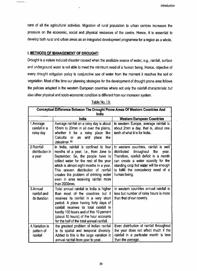
I. METHODS OF MANAGEMENT OF DROUGHT:
Drought is a nature induced disaster caused when the available source of water, e.g., rainfall, surface
and underground water is not able to meet the minimum need of a human being. Hence, objective of
every drought mitigation policy is conjunctive use of water from the moment it reaches the soil or
vegetation. Most of the time our planning strategies for the development of drought prone area follows
the policies adapted in the western European countries where not only the rainfall characteristic but
also other physical and socio-economic condition is different from our monsoon system.
Table No. 1.9.
Conceptual Difference Between The Drought Prone Areas Of Western Countries AndIndia
India Western European Countries1 .Average
rainfall in a rainy day
Average rainfall on a rainy day is about 15mm to 20mm in all over the plains, whether it be a rainy place like Calcutta or an arid place like Jaisalmer.66
In western Europe, average rainfall is about 2mm a day, that is, about one tenth of what it is for India.
2.Rainfall distribution in a year
In India, rainfall is confined to four months of a year, i.e., from June to September. So, the people have to collect water for the rest of the year which is almost eight months in a year. This uneven distribution of rainfall creates the problem of drinking water even in area receiving rainfall more than 2000mm.
In western countries, rainfall is well distributed throughout the year. Therefore, rainfall deficit in a month can create a water scarcity for the standing crop but water will be enough to fulfill the compulsory need of a human being.
3.Annual rainfall and its duration
Total annual rainfall in India is higher than most of- the countries but it receives its rainfall in a very short period. A place having forty days of rainfall receives its total rainfall in hardly 100 hours and of this 10 percent (about 10 hours) of the hour accounts for the half of the total annual rainfall.
In western countries annual rainfall is less but number of rainy hours is more than that of our country.
4.Variation in pattern of rainfall
the greatest problem of Indian rainfall is its spatial and temporal diversity. Added to this is the large variation in annual rainfall from year to year.
Even distribution of rainfall throughout the year does not affect much if the rainfall in a particular month is less than the average.
39
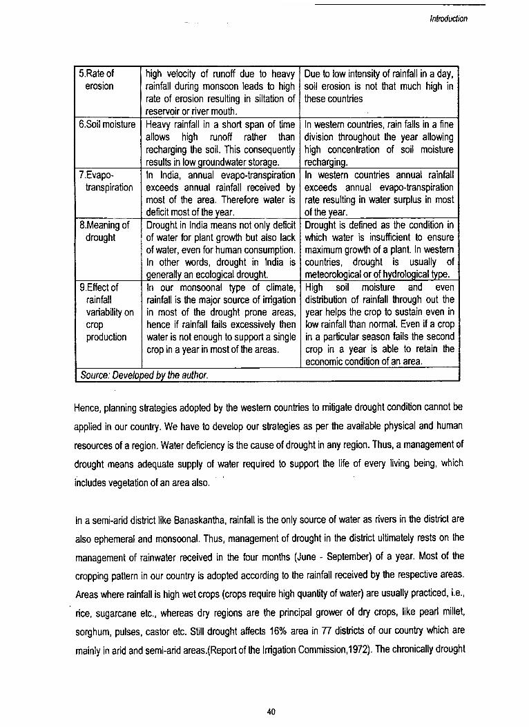
Introduction
S.Rate of erosion
high velocity of runoff due to heavy rainfall during monsoon leads to high rate of erosion resulting in siltation of reservoir or river mouth.
Due to low intensity of rainfall in a day, soil erosion is not that much high in these countries
6.Soil moisture Heavy rainfall in a short span of time allows high runoff rather than recharging the soil. This consequently results in low groundwater storage.
In western countries, rain falls in a fine division throughout the year allowing high concentration of soil moisture recharging.
7.Evapo-transpiration
In India, annual evapo-transpiration exceeds annual rainfall received by most of the area. Therefore water is deficit most of the year.
In western countries annual rainfall exceeds annual evapo-transpiration rate resulting in water surplus in most of the year.
8.Meaning of drought
Drought in India means not only deficit of water for plant growth but also lack of water, even for human consumption. In other words, drought in India is generally an ecological drought.
Drought is defined as the condition in which water is insufficient to ensure maximum growth of a plant. In western countries, drought is usually of meteorological or of hydrological type.
9.Effect of rainfall variability on cropproduction
In our monsoonal type of climate, rainfall is the major source of irrigation in most of the drought prone areas, hence if rainfall fails excessively then water is not enough to support a single crop in a year in most of the areas.
High soil moisture and even distribution of rainfall through out the year helps the crop to sustain even in low rainfall than normal. Even if a crop in a particular season fails the second crop in a year is able to retain the economic condition of an area.
Source: Developed by the author.
Hence, planning strategies adopted by the western countries to mitigate drought condition cannot be
applied in our country. We have to develop our strategies as per the available physical and human
resources of a region. Water deficiency is the cause of drought in any region. Thus, a management of
drought means adequate supply of water required to support the life of every living being, which
includes vegetation of an area also.
In a semi-arid district like Banaskantha, rainfall is the only source of water as rivers in the district are
also ephemeral and monsoonal. Thus, management of drought in the district ultimately rests on the
management of rainwater received in the four months (June - September) of a year. Most of the
cropping pattern in our country is adopted according to the rainfall received by the respective areas.
Areas where rainfall is high wet crops (crops require high quantity of water) are usually practiced, i.e.,
rice, sugarcane etc., whereas dry regions are the principal grower of dry crops, like pearl millet,
sorghum, pulses, castor etc. Still drought affects 16% area in 77 districts of our country which are
mainly in arid and semi-arid areas.(Reportof the Irrigation Commission, 1972). The chronically drought
40

Introduction
affected areas coincide with extremely arid areas like western part of Rajasthan and Kachchh, Rainfall
in these areas is not sufficient for a single crop in a year but these areas have adopted their living
style with this minimal availability of water. Effect of drought is maximum in semi-arid areas of the
country. Due to high deviation of rainfall in these areas, probability of drought is more than 0.3%.
Drought is mainly ecological type in these areas where water is not sufficient even to meet the thirst of
the people and cattle. In this type of situation, an organised method is required to fight with condition
of drought. Mitigation of drought does not mean relief work during drought period to be done but there
should be long term projects before the arrival of drought, to minimize its effect. Strategy to handle the
drought condition requires following steps:
• Identification of drought prone areas in the country.
• Proper research work to study the pattern of rainfall for forecasting its onset sufficient early, so
that necessary steps can be taken earlier.
• Study the other physical and human resources of the area to determine other problems and its
effect on the process of development.
• To develop an integrated development strategy where efforts should be more in the direction of
creating permanent assets which would help to solve the agrarian problems of these chronic scarcity
affected areas for a long period.
• Exercises in identification and development of drought prone areas are meaning less without
proper follow-up action. Thus, evaluation of development work is needed for rectification of side
effects of any development project.
All development works ultimately rest on the financial infrastructure of the region and on the policies of
those in power. Other than this success of development project lies on the acceptance of the local
people of an area. The people’s participation is essential for the development of an area.
J. MAJOR OBJECTIVES OF THE STUDY:
The major objectives of this study are to understand the effect of drought on various parameters of
environment, both physical and human. The study seeks to know the other factors working with
drought, to make it one of the backward regions of the State. The study aims to come up with such
methods that will help to develop this drought prone backward district as one of the progressive
districts of the State. To achieve these goals, the following points are kept as the major objectives of
the study:
41
Introduction
1. To study the spatial and temporal (1969-1998) pattern of rainfall in Banaskantha district of Gujarat.
2. To demarcate the drought prone areas and drought years, as per the definition of Irrigation
Department, in Banaskantha district.
3. To study the aridity index of the district over space.
4. To know the spatial pattern of land capability in the district.
5. To calculate the integrated developmental potential model of the district.
6. To study the spatio-temporal impact of drought on social and economic aspects at meso (taluka)
and micro (village) level.
7. To evaluate the various planning strategies carried out in this area by Government Organisations,
NGO’s and people to combat with drought and backwardness prevailing in the region.
8. To suggest planning strategies for drought prone areas through integrated measures.
K. LITERATURE REVIEW:
Drought, its causes and effects, differs a lot from one to other region. Therefore process of
management also changes accordingly. This is why, researchers from different regions have
described the “drought, its effect and management" as per the area selected for the study or work.
Literature review has been divided into three parts:
1. Conceptual aspects of drought,
2. Regional studies on drought and
3. Planning and development of drought prone areas.
K.1. Conceptual Aspects Of Drought:
Pattern and causes of drought varies from place to place, depending upon the normal climatic
conditions, available water resources, land-use, agricultural-practices and other economic activities of
the region. Therefore, the approach to delimit the drought prone areas and its causes, to calculate the
intensity of drought and type of drought prevailing in area are presented in various ways by different
scholar.
Many worldwide Meteorological Organisations143 believe that El-Nino brings lean rainfall in India,
Africa and Australia. El-Nino is a Spanish word, meaning warm current of the (Christ) child. Peruvian
fisherman have coined this word to describe an unusually warm surface current off the coast of Peru
in South-America, which occurs once in a few years, around December. It is abnormally warm (maybe
42

Introduction
7°c) compared to the normal situation of most years. El-Nino is a local symptom of a global scale
perturbation in the circulation of the atmosphere and also in the Pacific ocean. But very few scientists
see some connection between El-Nino and the monsoons in India. D.R.Sikka,143 former director of the
Indian Institute of Tropical Meteorology, Pune said that whenever the El-Nino phenomenon has
occurred, 60% of the time India had a bad monsoon. J.Srinivasan143, chairperson, Centre for
Atmospheric Studies, Indian Institute of Science, Bangalore, says that whenever there was unusual
warming or cooling of the east Pacific, global circulation patterns have changed and hence, rainfall in
India is affected. Richard Grove143, Prof, of environmental history at the Australian National university,
feels that El-Nino will have a direct effect on the monsoons in India. He told that “when you get a
strong El-Nino, the Indian monsoon fails, you can demonstrate that historically. The biggest famines in
Indian history were linked with the El-Nino effects."
Some of the scholars of India thinks that El-Nino is affecting the Indian monsoon but it is not the only
factor of drought in India. According to Vasant Gowrikar.143 Ex-Director General of IMD and is the
creator of the Monsoon Prediction model with 16 parameters in India, El-Nino is just one of the
parameters taken into account while preparing a long range forecast. According to K.S.Sivasami,143
Professor at the Centre for the Study of Regional Development, JNU, “Indian Monsoon prediction is
currently based on an empirical 16-parameter model which the IMD has been using successfully since
1988 to predict monsoons. If we analyse monsoon rainfall data since 1951 onwards, it is clearly seen
that there is no direct relation between El-Nino and the Indian monsoon. There are many years in the
past when El-Nino has occurred, but India has witnessed good monsoon.”
Other than El-Nino factors, Dr. P.S.Desai, N.K.Vyas and H.J.Andharia24 of Space Applications Centre,
Ahmedabad, believe that volcano eruption also affects the rainfall pattern of the Indian continent.
Volcanoes inject aerosols into the atmosphere which reach the stratospheric heights and attenuate
the solar insolation. This causes lowering of surface temperatures and modification of temperature
gradients. The change in the heat transport, brought about in this way is likely to affect the global
weather and possibly the Indian monsoon also. Usually the low latitude volcanic eruption are
associated with drought years of monsoon because the low latitude aerosol takes only a few weeks to
spread around the globe, even if they occur upto July of a given year. But the high latitude eruptions
are generally associated with above average monsoon but not with excess rainfall, as the high latitude
43
Introduction
aerosol takes a few months time to spread around the globe, so they do not affect the rainfall of the
same year, they may affect the monsoon of the following year,
N.B.K.Reddy and V.R.Singh in “Delimitation of drought prone areas of India - A geographical
approach"75 has identified and delimited drought prone areas in India by considering three
parameters, i.e., climatic characteristic, soil factors and agronomical and socio-economic condition.
C.D.Despande in “Drought prone areas and the human response"75 and A.K.Tewari in “Perception of
drought hazard among the people of drought prone area in arid lands of India : A case study” 75 stated
that response of human regarding the disaster should be studied as it affects the adoption and
adjustment to arid areas. His concepts are of great help for understanding the perception of different
groups in a village community.
K.R.Chowdhury in “ Concepts, approaches and methodology for delimitation of sub-area in drought
prone areas”75 has stated that drought prone area should be divided into sub-areas, as drought prone
areas have variations in productive factors and are vast enough for making concentrated efforts for
development.
In his paper “The problem of droughts: What can the geographer do” by B.Arunachalam75 has
discussed drought as per the people living in the area and then suggested that geographer should
synthesize the results of researcher working in different disciplines on a spatial frame.
In a paper of “Drought prone areas of India - Problems and perspectives” R.K.Narayan,75 has given a
list of drought prone talukas in India, based on the concept of Irrigation Commission. He has also
discussed various methods and technologies can be used for the integrated development plan for
drought prone areas.
In her paper named “Famines Relief Administration in Madras Presidency 1800 to 1900", Ms. Usha
Murthy75 has discussed the geographical features of the Madras presidency from 1800 to 1900 with
special reference to climatic influences and their relationship with famine. She has also attempted to
study the important famines in the selected area between 1800 and 1900 and the relief measures
undertaken by British Government to famines during the said period.
44

tmroaucuon
In their paper “Droughts and famines in Rayalseema : A study of spatial-temporal pattern",
B.Venugopal and Ms.R.Geetha75 has studied the general climatic features of Rayalseema and then
divided the area according to the frequency of drought in Rayalseema. They made a conclusion that
the western and north-western parts of Rayalseema are more prone to drought then the rest of the
area.
In “Desrtification and drought prone areas", N.B.K.Reddy and M.Uttara Prabhu75 has discussed the
global perspective about desertification and different mitigation method. They have also discussed the
drought prone areas of India and DPAP programme working at macro level.
All the above conceptual views about drought, its causes and delimitation of drought prone areas are
in macro level or in district level. It seems that within drought prone district, the intensity and causes of
drought vary. In this research work, drought is considered as a temporary weather phenomenon
caused due to insufficient rainfall or when the water is not enough to fulfill the demand of people.
Mean annual rainfall, number of rainy days in a year, intensity of drought and percentage of area
having irrigation facility are considered as principal parameters for the delimitation of drought prone
area in Banaskantha district, the study area of this thesis.
K.2. Regional Studies On Drought:
Different scholars have used different methodology to delimit the drought prone areas and its affect on
a particular region. V.P.Subrahmanyam and Ms. B.Hema Malini75 in their paper “Drought prone areas
of Andhra Pradesh” has identified the drought prone areas of Andhra Pradesh with the help of
isopleath map of annual and seasonal rainfall variability’s in A.P. they also worked out the aridity
indices of A.P. by Thornthwaite’s procedure.
In “Annual potential water deficit in Andhra Pradesh” by Nreependra K. Singh75 has made an isopleath
map of annual potential water deficit according to Penman potential evapo-transpiration method of
A.P.
In a paper named “Evaluating water resources in the light of climatic fluctuation in Israel”,
H.L.Striem122 concluded that the climatic fluctuation in Israel occur in an irregular pattern, the minimal
45
Introduction
cycle of which is at least 20 years. The long-term average for the range between decadal maxima and
minima is less than half the range of the known extremes. A band at i 215 mm distance from the
curve joining decennial means will envelop 90% of all cases of the annual rainfall series, and its ups
and downs show the validity of the abstraction of wet and dry sub-periods. Hence the frequency
distribution of annual rainfall within the sub-period leading upto the present is a much better guide to
an extrapolation for the oncoming, say, five years, than the long-term distribution.
In their paper named “Telangana - Rainfall variability an aspect of droughf, M.J.Subhramanyam and
K.Surender Reddy75 have investigated the variation of southwest monsoon (kharif season) and
relation of rainfall with crop yields in order to assess the impact of drought. With the help of number of
drought years in 30 years and co-efficient of variability of rainfall, they tried to demarcate the area of
severe drought prone areas in Telangana.
Moris Deutsch, Pieter Van Dongen, Robert Anderson and Peter Gilruth122 have identified
hydrogeological features of Kenya with the help of Landsat Multispectral Scanner (MSS) data in their
paper “ A methodology for application of thematically enhanced landsat MSS film data in direct
support of hydrological investigations in Kenya”. As hydrogeologic significant feature areas deemed
favourable for the ground water development in the country.
On the basis of mean rainfall, number of rainy days and percentage of irrigated land, Irrigation
Commission has demarcated the drought prone area of the district during of 1972. After that nobody
has revised the drought prone areas of the district, as the percentage of irrigated land has changed a
lot after that year. This study has tried to demarcate the drought prone areas of the district by taking
the recent parameters.
K.3. Planning And Development Of Drought Prone Areas:
On the basis of spatial and temporal pattern of drought and its effect on different aspects of man and
environment, different planning strategies are suggested to develop the drought prone areas
accordingly. As the problems of drought prone areas differ from area to area, thus, various
researchers, as per the need of an area has suggested various planning strategies.
46
irurvamiori
WMO has given emphasis on understanding of seasonal climatic anomalies for the seasonal
predictions of drought. This in turn will lead to greater capability to prepare and respond to drought
and its management. WMO has also given emphasis in water resource management and
assessments to cope with natural hazards of floods and drought.122
To meet the increasing demand of water, research, no longer precede the commercial exploitation of
water resources in Israel. Therefore, in a paper named “Research and development as an integrated
element in water resources management in Israel" by Miriam Waldman and Yehuda Shevah122 have
said that the research and development activities have to be fully integrated in water resource
management programmes on an on-going basis in a country.
In “Development Strategy for Drought Prone Areas", L.S.Bhatt75 has suggested that a single
programme for all drought prone areas of the country is not advisable. Therefore development
programme should formulated of (a) national strategies for development of drought prone areas, (b)
regional strategy for development, appropriate to different types of areas (c) a long term spatial
development framework and (d) short term development plans.
“Some socio-economic and demographic implications in planning for drought prone areas of
Maharashtra” by B.Arunachalam75 is based on two complimentary tasks: (a) to assemble existing
knowledge and to present it in a coherent form so that a meaningful understanding of the basic ills that
lie at the root of the regional problem is aided, and (b) to elaborate a plan of action.
B.Hymavathi75 in her paper named “Some aspects of the development of drought prone areas" has
suggested that in a drought prone area, where irrigation by canals is not feasible, irrigation should be
provided by ground water. Rotation of drought resistant crop should be developed to decrease the
evapo-transpiration rate and avoid the crop failure. She has also suggested the diversification of
activities to reduce the regional economic disparities.
In their paper “ Interdisciplinary Approach to the Integrated Development of Drought prone Areas"
B.L.Bhandi and D.Vasudeva Rao75have suggested interdisciplinary approach by (a) irrigation, (b) soil
conservation, (c) forest and pasture, (d) horticulture, (e) animal husbandry, (f) fisheries, (g) sericulture,
(h) industries and (I) PWD, to mitigate the severity of drought on a permanent basis, to develop
47
immauaion
agriculture and also to generate employment opportunities in the region for all classes of people,
particularly for small and marginal farmers and agricultural labourers.
In “Some aspects of Strategy and Planning for Agricultural Development in Drought Prone Areas"
K.R.Chowdhary75 has discussed about the objectives of planning for drought prone areas, present
level of agricultural production and problems of analysis. He had also given the methods to increase
the agricultural production and also to increase the economic reliability of drought prone areas.
In “ Sustaining Environment in Water Resources Projects”, S.Chandra33 said that water resource
development should be designed to build the environment rather than destroying it. This can be
achieved by attaining a judicious mix of development and environment by creating consciousness
amongst the builders and populace and by enforcing the environment standards strictly.
G.N.Reddy,75 in his paper “a Strategy for the Diffusion of Agricultural innovations in DPAP Areas” has
suggested that to provoke small and marginal farmers for the adoption of new technology, extension
workers have to work through community for the community.
John W.Hernadez122 in “Criteria for potential sites for irrigation with saline waters in New Mexico” has
identified and discussed criteria for the location of favourable sites for irrigation of crops with slightly
and moderately saline waters in the arid southwestern state of New Mexico. These criteria falls into
three categories: (a) crop production criteria; (b) economic and firm efficiency factors; and (c) public
welfare, conservation and environmental concerns.
G.Lakshmaiah Naidu75 has said in his paper “ Interdisciplinary Approach for Integrated Development
of Drought Prone Areas” that to transform the drought scene from drought prone areas,
interdisciplinary integrated development of drought prone areas should be encouraged in National
planning. Interdisciplinary development programme includes not only the development of agriculture
and cattle output but to enrich the total quality of life and its availability at minimum levels to all
sections of the population, socio-economic systems, infrastructure, technology, level of education,
health facility should be developed.
48
Introduction
Planning strategy vary according to the need of an area. Banaskantha district is declared as the
“drought prone district" of the State by Irrigation Commission but the eastern part of the district have
enough rainfall and irrigation facility to grow three crops in a year, whereas, the western part of the
district can grow only one crop in a year. This uneven distribution of water can be mitigated by proper
distribution of water, development of available water resources and proper change and development
of agronomic practices. Uneven distribution of water resources is not the only cause of drought, poor
physical and human resources also increase the severity of drought in western talukas. Therefore, an
integrated planning strategy is needed to minimise not only the severity of drought but also for the
overall development of the region.
49


![CHAPTER III - shodhganga.inflibnet.ac.inshodhganga.inflibnet.ac.in/bitstream/10603/17464/8/08_chapter 3.pdf · that returns a value.[ 137] A time-dependem media object is presented](https://img.dokumen.tips/doc/110x75/606bc77b005f95280d2e40bc/chapter-iii-3pdf-that-returns-a-value-137-a-time-dependem-media-object-is.jpg)


