Embed Size (px)
Citation preview
114 5. Volcanic hazards
5Volcanic hazards
In this chapter you will learn:• aboutthemostdevastatingvolcaniceruptionsofhistorictimes• aboutthewidevarietyofwaysinwhicheruptionscancausedeath
anddestruction(includingbytriggeringatsunami).
In previous chapters I dealt with the different types of volcano that occur and the ways in which they can erupt. The scene is now set to examine the hazards posed to human life and well-being by volcanic eruptions. In this chapter I will show how erupting volcanoes can adversely affect their surroundings. The next chapter will consider the wider and longer-term influence of volcanic eruptions on global climate.
InsightThe term ‘hazard’ can be applied to describe any dangerous or damaging phenomenon associated with a volcano (or an earthquake or a tsunami). There is another definition of hazard that includes the likelihood of such a phenomenon, but this will not become relevant until Chapter 8.
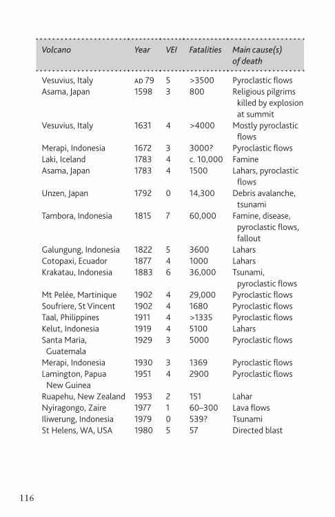
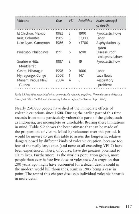
Table 5.1 lists some notable eruptions that have killed people during the past 2,000 years, and indicates the principal causes of death in each case. This list is not comprehensive, though it includes all the eruptions of the past 500 years known to
Ch05_Volcanoes3730407.indd 114 8/5/2010 3:00:08 PM
1155. Volcanic hazards
have killed more than 5,000 people. Two important points are demonstrated by this. The first is that the most deadly eruptions are generally pyroclastic: lava flows are rarely a main cause of death. The second is that it is not always the biggest eruptions that cause the most deaths. Even quite small eruptions can be major killers – for example the 1985 eruption of Ruiz, which resulted in the second largest number of volcanic fatalities of the twentieth century. Sometimes volcanoes kill people even when they are not erupting: Iliwerung 1979 (a landslide, not associated with an eruption, that caused a tsunami when it entered the sea) and Lake Nyos 1986 (escaping gas) being examples of death by two different non-eruptive mechanisms.
Some of the causes of death listed in Table 5.1 may need further elaboration. Famine, for example, is a result of crop failure and/or the loss of livestock because of fallout, pyroclastic flows or gas poisoning. It is often accompanied by the spread of disease as a result of insanitary conditions brought about by pollution of the water supply. In the modern world it is to be hoped that international food aid to a stricken area would prevent starvation and disease in the aftermath of eruptions, although most of the deaths resulting from the 1991 eruption of Pinatubo in the Philippines were caused by disease. Furthermore, the hemispheric, or even global, climate effects of an explosive eruption of VEI 8, or of a magnitude 8 effusive eruption, could lead to regional or global famine with little hope of alleviation, as I will discuss in the next chapter. A tsunami is a special series of waves that can be triggered by an earthquake, by a submarine explosive eruption, or by other sudden displacement of water such as when a landslide or debris avalanche enters the sea. A tsunami travels swiftly and innocuously through deep water, but the waves slow down and become higher and steeper when they move into shallow water so that waves from a tsunami can break across the shore to a height of several tens of metres. I describe some examples of tsunamis caused by volcanoes later in this chapter, but non-volcanogenic tsunamis are deferred until Chapter 11.
Ch05_Volcanoes3730407.indd 115 8/5/2010 3:00:08 PM

114 5. Volcanic hazards
5Volcanic hazards
In this chapter you will learn:• aboutthemostdevastatingvolcaniceruptionsofhistorictimes• aboutthewidevarietyofwaysinwhicheruptionscancausedeath
anddestruction(includingbytriggeringatsunami).
In previous chapters I dealt with the different types of volcano that occur and the ways in which they can erupt. The scene is now set to examine the hazards posed to human life and well-being by volcanic eruptions. In this chapter I will show how erupting volcanoes can adversely affect their surroundings. The next chapter will consider the wider and longer-term influence of volcanic eruptions on global climate.
InsightThe term ‘hazard’ can be applied to describe any dangerous or damaging phenomenon associated with a volcano (or an earthquake or a tsunami). There is another definition of hazard that includes the likelihood of such a phenomenon, but this will not become relevant until Chapter 8.
Table 5.1 lists some notable eruptions that have killed people during the past 2,000 years, and indicates the principal causes of death in each case. This list is not comprehensive, though it includes all the eruptions of the past 500 years known to
Ch05_Volcanoes3730407.indd 114 8/5/2010 3:00:08 PM
1155. Volcanic hazards
have killed more than 5,000 people. Two important points are demonstrated by this. The first is that the most deadly eruptions are generally pyroclastic: lava flows are rarely a main cause of death. The second is that it is not always the biggest eruptions that cause the most deaths. Even quite small eruptions can be major killers – for example the 1985 eruption of Ruiz, which resulted in the second largest number of volcanic fatalities of the twentieth century. Sometimes volcanoes kill people even when they are not erupting: Iliwerung 1979 (a landslide, not associated with an eruption, that caused a tsunami when it entered the sea) and Lake Nyos 1986 (escaping gas) being examples of death by two different non-eruptive mechanisms.
Some of the causes of death listed in Table 5.1 may need further elaboration. Famine, for example, is a result of crop failure and/or the loss of livestock because of fallout, pyroclastic flows or gas poisoning. It is often accompanied by the spread of disease as a result of insanitary conditions brought about by pollution of the water supply. In the modern world it is to be hoped that international food aid to a stricken area would prevent starvation and disease in the aftermath of eruptions, although most of the deaths resulting from the 1991 eruption of Pinatubo in the Philippines were caused by disease. Furthermore, the hemispheric, or even global, climate effects of an explosive eruption of VEI 8, or of a magnitude 8 effusive eruption, could lead to regional or global famine with little hope of alleviation, as I will discuss in the next chapter. A tsunami is a special series of waves that can be triggered by an earthquake, by a submarine explosive eruption, or by other sudden displacement of water such as when a landslide or debris avalanche enters the sea. A tsunami travels swiftly and innocuously through deep water, but the waves slow down and become higher and steeper when they move into shallow water so that waves from a tsunami can break across the shore to a height of several tens of metres. I describe some examples of tsunamis caused by volcanoes later in this chapter, but non-volcanogenic tsunamis are deferred until Chapter 11.
Ch05_Volcanoes3730407.indd 115 8/5/2010 3:00:08 PM
116 5. Volcanic hazards
Volcano Year VEI Fatalities Main cause(s) of death
Vesuvius, Italy ad 79 5 >3500 Pyroclastic flowsAsama, Japan 1598 3 800 Religious pilgrims
killed by explosion at summit
Vesuvius, Italy 1631 4 >4000 Mostly pyroclastic flows
Merapi, Indonesia 1672 3 3000? Pyroclastic flowsLaki, Iceland 1783 4 c. 10,000 FamineAsama, Japan 1783 4 1500 Lahars, pyroclastic
flowsUnzen, Japan 1792 0 14,300 Debris avalanche,
tsunamiTambora, Indonesia 1815 7 60,000 Famine, disease,
pyroclastic flows, fallout
Galungung, Indonesia 1822 5 3600 LaharsCotopaxi, Ecuador 1877 4 1000 LaharsKrakatau, Indonesia 1883 6 36,000 Tsunami,
pyroclastic flowsMt Pelée, Martinique 1902 4 29,000 Pyroclastic flowsSoufriere, St Vincent 1902 4 1680 Pyroclastic flowsTaal, Philippines 1911 4 >1335 Pyroclastic flowsKelut, Indonesia 1919 4 5100 LaharsSanta Maria, 1929 3 5000 Pyroclastic flows GuatemalaMerapi, Indonesia 1930 3 1369 Pyroclastic flowsLamington, Papua 1951 4 2900 Pyroclastic flows New GuineaRuapehu, New Zealand 1953 2 151 LaharNyiragongo, Zaire 1977 1 60–300 Lava flowsIliwerung, Indonesia 1979 0 539? TsunamiSt Helens, WA, USA 1980 5 57 Directed blast
Ch05_Volcanoes3730407.indd 116 8/5/2010 3:00:09 PM
1175. Volcanic hazards
Volcano Year VEI Fatalities Main cause(s) of death
El Chichón, Mexico 1982 5 1900 Pyroclastic flowsRuiz, Colombia 1985 3 23,000 LaharLake Nyos, Cameroon 1986 0 >1700 Asphyxiation by
gasesPinatubo, Philippines 1991 6 1200 Disease, roof
collapses, laharsSoufriere Hills, 1997 3 19 Pyroclastic flow MontserratCasita, Nicaragua 1998 0 1600 LaharNyiragongo, Congo 2002 1 147 Lava flowsManam, Papua New
Guinea2004 4 5 Respiratory
problems
Table 5.1 Fatalities associated with some notable volcanic eruptions. The main cause of death is
listed first. VEI is the Volcanic Explosivity Index as defined in Chapter 3 (pp. 57–8).
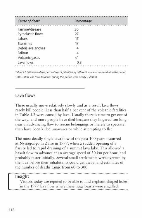
Nearly 250,000 people have died of the immediate effects of volcanic eruptions since 1600. During the earlier part of this time records from some particularly vulnerable parts of the globe, such as Indonesia, are incomplete or unreliable. Bearing these limitations in mind, Table 5.2 shows the best estimate that can be made of the proportions of victims killed by volcanoes over this period. It would be unwise to use this table to assess the long-term, relative dangers posed by different kinds of volcanic eruption, because too few of the really large ones (and none at all exceeding VEI 7) have been experienced. These, of course, have the greatest potential to claim lives. Furthermore, as the world’s population grows, more people than ever before live close to volcanoes. An eruption that 200 years ago might have accounted for a dozen deaths could in the modern world kill thousands, Ruiz in 1985 being a case in point. The rest of this chapter discusses individual volcanic hazards in more detail.
Ch05_Volcanoes3730407.indd 117 8/5/2010 3:00:09 PM
116 5. Volcanic hazards
Volcano Year VEI Fatalities Main cause(s) of death
Vesuvius, Italy ad 79 5 >3500 Pyroclastic flowsAsama, Japan 1598 3 800 Religious pilgrims
killed by explosion at summit
Vesuvius, Italy 1631 4 >4000 Mostly pyroclastic flows
Merapi, Indonesia 1672 3 3000? Pyroclastic flowsLaki, Iceland 1783 4 c. 10,000 FamineAsama, Japan 1783 4 1500 Lahars, pyroclastic
flowsUnzen, Japan 1792 0 14,300 Debris avalanche,
tsunamiTambora, Indonesia 1815 7 60,000 Famine, disease,
pyroclastic flows, fallout
Galungung, Indonesia 1822 5 3600 LaharsCotopaxi, Ecuador 1877 4 1000 LaharsKrakatau, Indonesia 1883 6 36,000 Tsunami,
pyroclastic flowsMt Pelée, Martinique 1902 4 29,000 Pyroclastic flowsSoufriere, St Vincent 1902 4 1680 Pyroclastic flowsTaal, Philippines 1911 4 >1335 Pyroclastic flowsKelut, Indonesia 1919 4 5100 LaharsSanta Maria, 1929 3 5000 Pyroclastic flows GuatemalaMerapi, Indonesia 1930 3 1369 Pyroclastic flowsLamington, Papua 1951 4 2900 Pyroclastic flows New GuineaRuapehu, New Zealand 1953 2 151 LaharNyiragongo, Zaire 1977 1 60–300 Lava flowsIliwerung, Indonesia 1979 0 539? TsunamiSt Helens, WA, USA 1980 5 57 Directed blast
Ch05_Volcanoes3730407.indd 116 8/5/2010 3:00:09 PM
1175. Volcanic hazards
Volcano Year VEI Fatalities Main cause(s) of death
El Chichón, Mexico 1982 5 1900 Pyroclastic flowsRuiz, Colombia 1985 3 23,000 LaharLake Nyos, Cameroon 1986 0 >1700 Asphyxiation by
gasesPinatubo, Philippines 1991 6 1200 Disease, roof
collapses, laharsSoufriere Hills, 1997 3 19 Pyroclastic flow MontserratCasita, Nicaragua 1998 0 1600 LaharNyiragongo, Congo 2002 1 147 Lava flowsManam, Papua New
Guinea2004 4 5 Respiratory
problems
Table 5.1 Fatalities associated with some notable volcanic eruptions. The main cause of death is
listed first. VEI is the Volcanic Explosivity Index as defined in Chapter 3 (pp. 57–8).
Nearly 250,000 people have died of the immediate effects of volcanic eruptions since 1600. During the earlier part of this time records from some particularly vulnerable parts of the globe, such as Indonesia, are incomplete or unreliable. Bearing these limitations in mind, Table 5.2 shows the best estimate that can be made of the proportions of victims killed by volcanoes over this period. It would be unwise to use this table to assess the long-term, relative dangers posed by different kinds of volcanic eruption, because too few of the really large ones (and none at all exceeding VEI 7) have been experienced. These, of course, have the greatest potential to claim lives. Furthermore, as the world’s population grows, more people than ever before live close to volcanoes. An eruption that 200 years ago might have accounted for a dozen deaths could in the modern world kill thousands, Ruiz in 1985 being a case in point. The rest of this chapter discusses individual volcanic hazards in more detail.
Ch05_Volcanoes3730407.indd 117 8/5/2010 3:00:09 PM
118 5. Volcanic hazards
Cause of death Percentage
Famine/disease 30Pyroclastic flows 27Lahars 17Tsunamis 17Debris avalanches 4Fallout 4Volcanic gases <1Lava flows 0.3
Table 5.2 Estimates of the percentage of fatalities by different volcanic causes during the period
1600–2000. The total fatalities during this period were nearly 250,000.
Lava flows
These usually move relatively slowly and as a result lava flows rarely kill people. Less than half a per cent of the volcanic fatalities in Table 5.2 were caused by lava. Usually there is time to get out of the way, and more people have died because they lingered too long near an advancing flow to rescue belongings or merely to spectate than have been killed unawares or while attempting to flee.
The most deadly single lava flow of the past 100 years occurred at Nyiragongo in Zaire in 1977, when a sudden opening of a fissure led to rapid draining of a summit lava lake. This allowed a basalt flow to advance at an average speed of 30 km per hour, and probably faster initially. Several small settlements were overrun by the lava before their inhabitants could get away, and estimates of the number of deaths range from 60 to 300.
InsightVisitors today are reputed to be able to find elephant-shaped holes in the 1977 lava flow where these huge beasts were engulfed.
Ch05_Volcanoes3730407.indd 118 8/5/2010 3:00:09 PM
1195. Volcanic hazards
A more extensive eruption of Nyiragongo in January 2002 probably took fewer lives, but caused a humanitarian crisis when up to 250,000 refugees fled the area.
Possibly as many as 700 out of the more than 4,000 deaths during the 1631 eruption of Vesuvius were caused by lava flows. These were nothing like as fast at Nyiragongo, but within two hours of the start of the eruption the flows reached the sea, 6 km away, cutting off the retreat of many who might otherwise have escaped.
Onlookers who thought they were far enough from an advancing lava flow to be safe have often been killed by explosions when lava encounters water or snow. Heat from advancing lava can generate pressurized steam very quickly, in a miniature version of the phreatomagmatic eruptions described in Chapter 3. Death results either from being hit by explosive fragments, or from the scalding effects of the steam itself. Several bystanders were killed on Mount Etna in 1832 when the front of a previously innocuous lava flow began to move over ice, and 11 years later more than 50 were killed there when lava flowed into a water cistern.
Volcanologists studying active lava flows have to beware of such hazards, and also of smaller, but still potentially deadly, methane-fuelled explosions that can occur when overrun vegetation combusts inside a lava flow. In addition, an unfortunate scientist died during the 1947 eruption of Hekla in Iceland, when a large block rolled off the front of an a’a flow that he had been filming.
Irrespective of the ease with which it is usually possible for people to walk away from danger when a lava flow advances, there is very little that can be done to save immovable property (Figure 5.1). What a lava flow does not set fire to, it is likely to knock down or bury.
LAVAFLOWDIVERSION
Except on very gentle slopes, attempts to divert lava by building rock or earthen ramparts generally meet with only temporary success. More cunning are plans to control the spread of lava by
Ch05_Volcanoes3730407.indd 119 8/5/2010 3:00:09 PM

120 5. Volcanic hazards
Figure 5.1 The destruction and burial of a store in Kalapana, Hawaii, by a pahoehoe lava flow in
June 1990.
From lower left to top right the dates of the photographs are 23 April (before the lava flow
arrived), 6 June and 13 June.
spraying water on to its edge in order to cool it into an artificial levée. The prime example of this took place on the Icelandic island of Heimaey in 1973 when seawater was sprayed on to the front of an a’a flow threatening to overwhelm the island’s main town. This diverted the flow past the town and into the sea, fortuitously narrowing the entrance to the natural harbour so that it became better protected from storms, as well as saving the town.
Mount Etna’s most voluminous lava flow since 1669 came within 1 km of the town of Zafferana in 1992. This eruption began high on the volcano’s south-east flank on 14 December 1991, and the flow front had advanced 5 km before the end of the year. By this time it was fed mostly by lava flowing in tubes, so there was
Ch05_Volcanoes3730407.indd 120 8/5/2010 3:00:10 PM
1215. Volcanic hazards
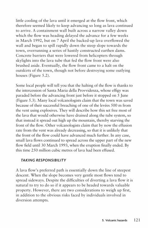
little cooling of the lava until it emerged at the flow front, which therefore seemed likely to keep advancing so long as lava continued to arrive. A containment wall built across a narrow valley down which the flow was heading delayed the advance for a few weeks in March 1992, but on 7 April the backed-up lava overflowed the wall and began to spill rapidly down the steep slope towards the town, overrunning a series of hastily constructed earthen dams. Concrete barriers that were lowered from helicopters through skylights into the lava tube that fed the flow front were also brushed aside. Eventually, the flow front came to a halt on the outskirts of the town, though not before destroying some outlying houses (Figure 5.2).
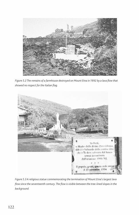
Some local people will tell you that the halting of the flow is thanks to the intercession of Santa Maria della Provvidenza, whose effigy was paraded before the advancing front just before it stopped on 5 June (Figure 5.3). Many local volcanologists claim that the town was saved because of their successful breaching of one of the levées 500 m from the vent using explosives. They will describe how this set free most of the lava that would otherwise have drained along the tube system, so that instead it spread out high up the mountain, thereby starving the front of the flow. Other volcanologists claim that by now the effusion rate from the vent was already decreasing, so that it is unlikely that the front of the flow could have advanced much further. In any case, small lava flows continued to spread across the upper part of the new flow field until 30 March 1993, when the eruption finally ended. By this time 250 million cubic metres of lava had been effused.
TAKINGRESPONSIBILITY
A lava flow’s preferred path is essentially down the line of steepest descent. When the slope becomes very gentle most flows tend to spread sideways. Despite the difficulties of diverting a lava flow it is natural to try to do so if it appears to be headed towards valuable property. However, there are two considerations to weigh up first, in addition to the obvious risks faced by individuals involved in diversion attempts.
Ch05_Volcanoes3730407.indd 121 8/5/2010 3:00:11 PM
120 5. Volcanic hazards
Figure 5.1 The destruction and burial of a store in Kalapana, Hawaii, by a pahoehoe lava flow in
June 1990.
From lower left to top right the dates of the photographs are 23 April (before the lava flow
arrived), 6 June and 13 June.
spraying water on to its edge in order to cool it into an artificial levée. The prime example of this took place on the Icelandic island of Heimaey in 1973 when seawater was sprayed on to the front of an a’a flow threatening to overwhelm the island’s main town. This diverted the flow past the town and into the sea, fortuitously narrowing the entrance to the natural harbour so that it became better protected from storms, as well as saving the town.
Mount Etna’s most voluminous lava flow since 1669 came within 1 km of the town of Zafferana in 1992. This eruption began high on the volcano’s south-east flank on 14 December 1991, and the flow front had advanced 5 km before the end of the year. By this time it was fed mostly by lava flowing in tubes, so there was
Ch05_Volcanoes3730407.indd 120 8/5/2010 3:00:10 PM
1215. Volcanic hazards
little cooling of the lava until it emerged at the flow front, which therefore seemed likely to keep advancing so long as lava continued to arrive. A containment wall built across a narrow valley down which the flow was heading delayed the advance for a few weeks in March 1992, but on 7 April the backed-up lava overflowed the wall and began to spill rapidly down the steep slope towards the town, overrunning a series of hastily constructed earthen dams. Concrete barriers that were lowered from helicopters through skylights into the lava tube that fed the flow front were also brushed aside. Eventually, the flow front came to a halt on the outskirts of the town, though not before destroying some outlying houses (Figure 5.2).
Some local people will tell you that the halting of the flow is thanks to the intercession of Santa Maria della Provvidenza, whose effigy was paraded before the advancing front just before it stopped on 5 June (Figure 5.3). Many local volcanologists claim that the town was saved because of their successful breaching of one of the levées 500 m from the vent using explosives. They will describe how this set free most of the lava that would otherwise have drained along the tube system, so that instead it spread out high up the mountain, thereby starving the front of the flow. Other volcanologists claim that by now the effusion rate from the vent was already decreasing, so that it is unlikely that the front of the flow could have advanced much further. In any case, small lava flows continued to spread across the upper part of the new flow field until 30 March 1993, when the eruption finally ended. By this time 250 million cubic metres of lava had been effused.
TAKINGRESPONSIBILITY
A lava flow’s preferred path is essentially down the line of steepest descent. When the slope becomes very gentle most flows tend to spread sideways. Despite the difficulties of diverting a lava flow it is natural to try to do so if it appears to be headed towards valuable property. However, there are two considerations to weigh up first, in addition to the obvious risks faced by individuals involved in diversion attempts.
Ch05_Volcanoes3730407.indd 121 8/5/2010 3:00:11 PM
122 5. Volcanic hazards
Figure 5.2 The remains of a farmhouse destroyed on Mount Etna in 1992 by a lava flow that
showed no respect for the Italian flag.
Figure 5.3 A religious statue commemorating the termination of Mount Etna’s largest lava
flow since the seventeenth century. The flow is visible between the tree-lined slopes in the
background.
Ch05_Volcanoes3730407.indd 122 8/5/2010 3:00:13 PM
1235. Volcanic hazards
The first revolves around a tricky legal question. Suppose you succeed in diverting a lava flow away from someone’s property, but this flow then destroys other people’s homes or fields. Irrespective of where the flow would really have headed had you not intervened, the discommoded neighbours could hold your actions to blame for the ruin of their property. The only people to win in the end would be the lawyers! A precedent was perhaps set in Sicily in 1669 when a lava flow from Mount Etna was advancing towards the major port of Catania. A working party was sent out from the town to try to breach a levée using picks and shovels, and thereby encourage the flow to spread in a new direction, but the workmen were driven off by the inhabitants of a village whose homes would have been in the new path of the flow. The lava flow continued unhindered, and entered Catania some weeks later.
The other reason for non-intervention is to respect the legitimate, if unscientific, views held by local people in some places that a volcano should not be interfered with. For example in Hawaii, particularly among the indigenous people, there is a widely shared opinion that Pele, the volcano goddess, resents interference in her activities. After all, without them Hawaii would not even exist.
InsightI am told that the best ways to protect your assets are to appease Pele with offerings and ceremonies, and to be kind to unfamiliar women (both young and beautiful and old and frail) and white dogs, in which guises Pele is believed to appear.
If you can’t divert lava flows, then the best way to prevent loss of your home or business is to not site them in the likely path of future flows. A simple but fairly reliable way to do this is to avoid building on any recent lava flows, because these mark the likely paths of future flows too. There is a story that unscrupulous land agents have profited by selling building plots upslope from Hilo (the capital of the Big Island of Hawaii) at inflated prices because they appear as ‘double-A standard’ on maps, whereas in fact this signifies a’a flows from nineteenth and twentieth century eruptions! This may
Ch05_Volcanoes3730407.indd 123 8/5/2010 3:00:13 PM
124 5. Volcanic hazards
be untrue, but on the other side of the island it is undeniable that Keahole airport (one of only two on the island) is built partly on a lava flow erupted from the north-east rift of Hualalai in 1801, the most recent eruption of Hawaii’s ‘forgotten volcano’. Many recent lavas erupted by Hualalai are classified as ‘alkali basalts’. These are more fluid than other basalt, and a new eruption could overwhelm the airport and the circum-island highway within hours, especially if the vent occurred low down on Hualalai’s rift system.
Pyroclastic flows
Pyroclastic flows can be far more lethal than lava flows, mostly because, as noted in Chapter 3, they travel very fast. They have caused over a quarter of the volcano-related deaths since 1600, and were the main killer in the most devastating eruption of the twentieth century. That was the 1902 eruption of Mount Pelée on the Caribbean island of Martinique. St Pierre, the main town of this hitherto prosperous French colony, was annihilated within the space of a few minutes on the morning of 8 May, together with its population of 28,000.
MOUNTPELÉE1902
St Pierre lay on the coast, 6 km from the 1,400 m high composite cone volcano Mount Pelée. Towards the end of April, explosions at the summit began to scatter light ashfall on to the town. This began as a curiosity, and graduated into an inconvenience. It was not initially a great source of anxiety, because in 1851 something similar had happened after which the volcanic activity subsided with no ill effects.
However, in 1902 things just kept getting worse. On 5 May part of the crater rim, probably weakened by fumarolic activity, gave way. A mass of hot water that had been ponded in the crater lake rushed downhill into the nearest valley, which was that of the Rivière Blanche. The escaped water and its load of rock debris turned
Ch05_Volcanoes3730407.indd 124 8/5/2010 3:00:13 PM
1255. Volcanic hazards
into a rapidly travelling lahar that devastated the valley, killing 23 workmen when it overran a rum distillery. By now there was serious talk of evacuating St Pierre. Some people left for another town 25 km away, but at least as many others from the nearby countryside sought shelter in St Pierre, where they were to lose their lives in its ruin on 8 May.
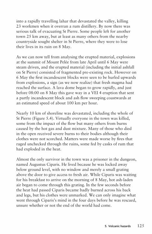
As we can now tell from analysing the erupted material, explosions at the summit of Mount Pelée from late April until 6 May were steam driven, and the erupted material (including the initial ashfall on St Pierre) consisted of fragmented pre-existing rock. However on 6 May the first incandescent blocks were seen to be hurled upwards from explosions, a sign (as we now realize) that fresh magma had reached the surface. A lava dome began to grow rapidly, and just before 08:00 on 8 May this gave way in a VEI 4 eruption that sent a partly incandescent block and ash flow sweeping coastwards at an estimated speed of about 100 km per hour.
Nearly 10 km of shoreline was devastated, including the whole of St Pierre (Figure 5.4). Virtually everyone in the town was killed, some from the impact of the flow but many others from burns caused by the hot gas and dust mixture. Many of those who died in the open received severe burns to their bodies although their clothes were not scorched. Matters were made worse by fires that raged unchecked through the ruins, some fed by casks of rum that had exploded in the heat.
Almost the only survivor in the town was a prisoner in the dungeon, named Augustus Ciparis. He lived because he was locked away below ground level, with no window and merely a small grating above the door to give access to fresh air. While Ciparis was waiting for his breakfast to arrive on the morning of 8 May, hot ash-laden air began to come through this grating. In the few seconds before the heat had passed Ciparis became badly burned across his back and legs, but his clothes were unmarked. We can only imagine what went through Ciparis’s mind in the four days before he was rescued, unsure whether or not the end of the world had come.
Ch05_Volcanoes3730407.indd 125 8/5/2010 3:00:13 PM
124 5. Volcanic hazards
be untrue, but on the other side of the island it is undeniable that Keahole airport (one of only two on the island) is built partly on a lava flow erupted from the north-east rift of Hualalai in 1801, the most recent eruption of Hawaii’s ‘forgotten volcano’. Many recent lavas erupted by Hualalai are classified as ‘alkali basalts’. These are more fluid than other basalt, and a new eruption could overwhelm the airport and the circum-island highway within hours, especially if the vent occurred low down on Hualalai’s rift system.
Pyroclastic flows
Pyroclastic flows can be far more lethal than lava flows, mostly because, as noted in Chapter 3, they travel very fast. They have caused over a quarter of the volcano-related deaths since 1600, and were the main killer in the most devastating eruption of the twentieth century. That was the 1902 eruption of Mount Pelée on the Caribbean island of Martinique. St Pierre, the main town of this hitherto prosperous French colony, was annihilated within the space of a few minutes on the morning of 8 May, together with its population of 28,000.
MOUNTPELÉE1902
St Pierre lay on the coast, 6 km from the 1,400 m high composite cone volcano Mount Pelée. Towards the end of April, explosions at the summit began to scatter light ashfall on to the town. This began as a curiosity, and graduated into an inconvenience. It was not initially a great source of anxiety, because in 1851 something similar had happened after which the volcanic activity subsided with no ill effects.
However, in 1902 things just kept getting worse. On 5 May part of the crater rim, probably weakened by fumarolic activity, gave way. A mass of hot water that had been ponded in the crater lake rushed downhill into the nearest valley, which was that of the Rivière Blanche. The escaped water and its load of rock debris turned
Ch05_Volcanoes3730407.indd 124 8/5/2010 3:00:13 PM
1255. Volcanic hazards
into a rapidly travelling lahar that devastated the valley, killing 23 workmen when it overran a rum distillery. By now there was serious talk of evacuating St Pierre. Some people left for another town 25 km away, but at least as many others from the nearby countryside sought shelter in St Pierre, where they were to lose their lives in its ruin on 8 May.
As we can now tell from analysing the erupted material, explosions at the summit of Mount Pelée from late April until 6 May were steam driven, and the erupted material (including the initial ashfall on St Pierre) consisted of fragmented pre-existing rock. However on 6 May the first incandescent blocks were seen to be hurled upwards from explosions, a sign (as we now realize) that fresh magma had reached the surface. A lava dome began to grow rapidly, and just before 08:00 on 8 May this gave way in a VEI 4 eruption that sent a partly incandescent block and ash flow sweeping coastwards at an estimated speed of about 100 km per hour.
Nearly 10 km of shoreline was devastated, including the whole of St Pierre (Figure 5.4). Virtually everyone in the town was killed, some from the impact of the flow but many others from burns caused by the hot gas and dust mixture. Many of those who died in the open received severe burns to their bodies although their clothes were not scorched. Matters were made worse by fires that raged unchecked through the ruins, some fed by casks of rum that had exploded in the heat.
Almost the only survivor in the town was a prisoner in the dungeon, named Augustus Ciparis. He lived because he was locked away below ground level, with no window and merely a small grating above the door to give access to fresh air. While Ciparis was waiting for his breakfast to arrive on the morning of 8 May, hot ash-laden air began to come through this grating. In the few seconds before the heat had passed Ciparis became badly burned across his back and legs, but his clothes were unmarked. We can only imagine what went through Ciparis’s mind in the four days before he was rescued, unsure whether or not the end of the world had come.
Ch05_Volcanoes3730407.indd 125 8/5/2010 3:00:13 PM
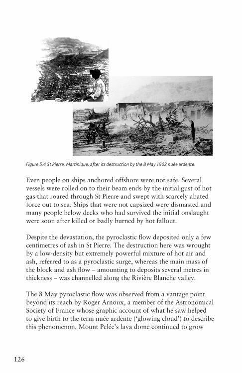
126 5. Volcanic hazards
Figure 5.4 St Pierre, Martinique, after its destruction by the 8 May 1902 nuée ardente.
Even people on ships anchored offshore were not safe. Several vessels were rolled on to their beam ends by the initial gust of hot gas that roared through St Pierre and swept with scarcely abated force out to sea. Ships that were not capsized were dismasted and many people below decks who had survived the initial onslaught were soon after killed or badly burned by hot fallout.
Despite the devastation, the pyroclastic flow deposited only a few centimetres of ash in St Pierre. The destruction here was wrought by a low-density but extremely powerful mixture of hot air and ash, referred to as a pyroclastic surge, whereas the main mass of the block and ash flow – amounting to deposits several metres in thickness – was channelled along the Rivière Blanche valley.
The 8 May pyroclastic flow was observed from a vantage point beyond its reach by Roger Arnoux, a member of the Astronomical Society of France whose graphic account of what he saw helped to give birth to the term nuée ardente (‘glowing cloud’) to describe this phenomenon. Mount Pelée’s lava dome continued to grow
Ch05_Volcanoes3730407.indd 126 8/5/2010 3:00:15 PM
1275. Volcanic hazards
and suffer episodic collapses over the next year or more. A second powerful nuée ardente swept through St Pierre on 20 May, knocking down some of the buildings that had been left standing by its predecessor. Probably the only reason why no one was killed by this is that they were all dead already. However, on 30 August a dome collapse in a new direction sent a nuée ardente inland, taking 2,000 lives in the village of Morne Rouge in a tragic if smaller-scale repeat of the destruction of St Pierre. Activity continued into 1903, but Mount Pelée entered a quiescent phase until 1929–32 when another, and better documented, series of nuée ardentes erupted (Figure 5.5). Since then, Mount Pelée has been quiet, except for some minor seismic events in 1985. The town of St Pierre has long since been rebuilt, and it is to be hoped that modern monitoring techniques (as discussed in Chapter 7) will give enough warning of any large future eruption for the town to be evacuated.
Figure 5.5 A nuée ardente at Mount Pelée in 1930, similar to, or possibly bigger than, the one
that destroyed St Pierre in 1902. A cloud of ash particles rises high above the flow itself.
OTHERDOMECOLLAPSEFLOWS
Since 1902, there have been several other lethal eruptions involving pyroclastic flows, the worst of which are listed in Table 5.1. Many were hot block and ash flows with their sources at lava domes.
Ch05_Volcanoes3730407.indd 127 8/5/2010 3:00:15 PM
128 5. Volcanic hazards
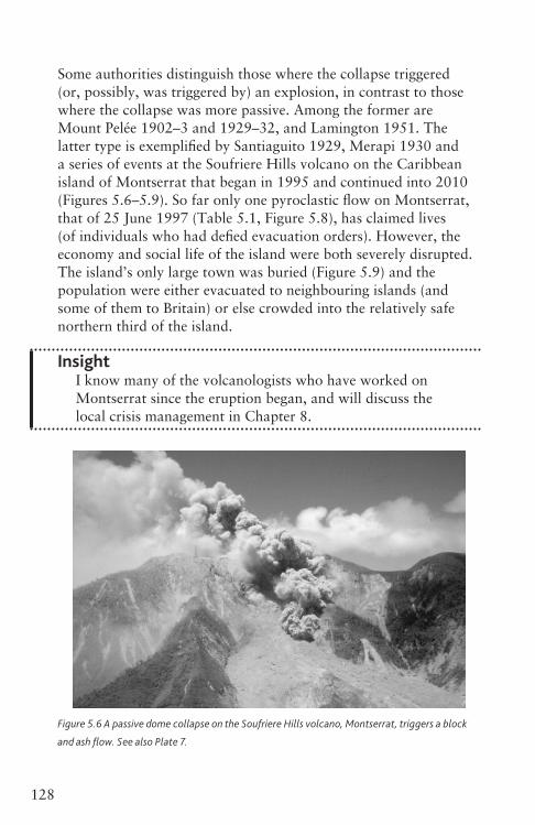
Some authorities distinguish those where the collapse triggered (or, possibly, was triggered by) an explosion, in contrast to those where the collapse was more passive. Among the former are Mount Pelée 1902–3 and 1929–32, and Lamington 1951. The latter type is exemplified by Santiaguito 1929, Merapi 1930 and a series of events at the Soufriere Hills volcano on the Caribbean island of Montserrat that began in 1995 and continued into 2010 (Figures 5.6–5.9). So far only one pyroclastic flow on Montserrat, that of 25 June 1997 (Table 5.1, Figure 5.8), has claimed lives (of individuals who had defied evacuation orders). However, the economy and social life of the island were both severely disrupted. The island’s only large town was buried (Figure 5.9) and the population were either evacuated to neighbouring islands (and some of them to Britain) or else crowded into the relatively safe northern third of the island.
InsightI know many of the volcanologists who have worked on Montserrat since the eruption began, and will discuss the local crisis management in Chapter 8.
Figure 5.6 A passive dome collapse on the Soufriere Hills volcano, Montserrat, triggers a block
and ash flow. See also Plate 7.
Ch05_Volcanoes3730407.indd 128 8/5/2010 3:00:16 PM
1295. Volcanic hazards
Figure 5.7 Damage to a house on Montserrat caused by flows of the kind seen in Figure 5.6.
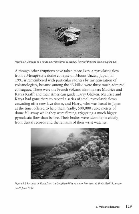
Although other eruptions have taken more lives, a pyroclastic flow from a Merapi-style dome collapse on Mount Unzen, Japan, in 1991 is remembered with particular sadness by my generation of volcanologists, because among the 43 killed were three much admired colleagues. These were the French volcano film-makers Maurice and Katya Krafft and their American guide Harry Glicken. Maurice and Katya had gone there to record a series of small pyroclastic flows cascading off a new lava dome, and Harry, who was based in Japan at the time, offered to help them. Sadly, 500,000 cubic metres of dome fell away while they were filming, triggering a much bigger pyroclastic flow than before. Their bodies were identifiable chiefly from dental records and the remains of their wrist watches.
Figure 5.8 Pyroclastic flows from the Soufriere Hills volcano, Montserrat, that killed 19 people
on 25 June 1997.
Ch05_Volcanoes3730407.indd 129 8/5/2010 3:00:17 PM
128 5. Volcanic hazards
Some authorities distinguish those where the collapse triggered (or, possibly, was triggered by) an explosion, in contrast to those where the collapse was more passive. Among the former are Mount Pelée 1902–3 and 1929–32, and Lamington 1951. The latter type is exemplified by Santiaguito 1929, Merapi 1930 and a series of events at the Soufriere Hills volcano on the Caribbean island of Montserrat that began in 1995 and continued into 2010 (Figures 5.6–5.9). So far only one pyroclastic flow on Montserrat, that of 25 June 1997 (Table 5.1, Figure 5.8), has claimed lives (of individuals who had defied evacuation orders). However, the economy and social life of the island were both severely disrupted. The island’s only large town was buried (Figure 5.9) and the population were either evacuated to neighbouring islands (and some of them to Britain) or else crowded into the relatively safe northern third of the island.
InsightI know many of the volcanologists who have worked on Montserrat since the eruption began, and will discuss the local crisis management in Chapter 8.
Figure 5.6 A passive dome collapse on the Soufriere Hills volcano, Montserrat, triggers a block
and ash flow. See also Plate 7.
Ch05_Volcanoes3730407.indd 128 8/5/2010 3:00:16 PM
1295. Volcanic hazards
Figure 5.7 Damage to a house on Montserrat caused by flows of the kind seen in Figure 5.6.
Although other eruptions have taken more lives, a pyroclastic flow from a Merapi-style dome collapse on Mount Unzen, Japan, in 1991 is remembered with particular sadness by my generation of volcanologists, because among the 43 killed were three much admired colleagues. These were the French volcano film-makers Maurice and Katya Krafft and their American guide Harry Glicken. Maurice and Katya had gone there to record a series of small pyroclastic flows cascading off a new lava dome, and Harry, who was based in Japan at the time, offered to help them. Sadly, 500,000 cubic metres of dome fell away while they were filming, triggering a much bigger pyroclastic flow than before. Their bodies were identifiable chiefly from dental records and the remains of their wrist watches.
Figure 5.8 Pyroclastic flows from the Soufriere Hills volcano, Montserrat, that killed 19 people
on 25 June 1997.
Ch05_Volcanoes3730407.indd 129 8/5/2010 3:00:17 PM
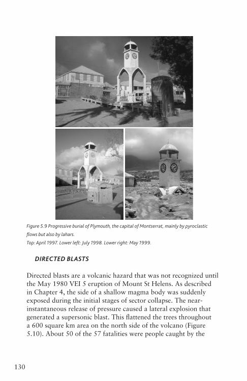
130 5. Volcanic hazards
Figure 5.9 Progressive burial of Plymouth, the capital of Montserrat, mainly by pyroclastic
flows but also by lahars.
Top: April 1997. Lower left: July 1998. Lower right: May 1999.
DIRECTEDBLASTS
Directed blasts are a volcanic hazard that was not recognized until the May 1980 VEI 5 eruption of Mount St Helens. As described in Chapter 4, the side of a shallow magma body was suddenly exposed during the initial stages of sector collapse. The near-instantaneous release of pressure caused a lateral explosion that generated a supersonic blast. This flattened the trees throughout a 600 square km area on the north side of the volcano (Figure 5.10). About 50 of the 57 fatalities were people caught by the
Ch05_Volcanoes3730407.indd 130 8/5/2010 3:00:18 PM
1315. Volcanic hazards
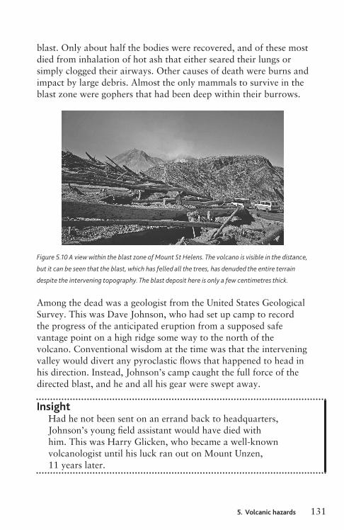
blast. Only about half the bodies were recovered, and of these most died from inhalation of hot ash that either seared their lungs or simply clogged their airways. Other causes of death were burns and impact by large debris. Almost the only mammals to survive in the blast zone were gophers that had been deep within their burrows.
Figure 5.10 A view within the blast zone of Mount St Helens. The volcano is visible in the distance,
but it can be seen that the blast, which has felled all the trees, has denuded the entire terrain
despite the intervening topography. The blast deposit here is only a few centimetres thick.
Among the dead was a geologist from the United States Geological Survey. This was Dave Johnson, who had set up camp to record the progress of the anticipated eruption from a supposed safe vantage point on a high ridge some way to the north of the volcano. Conventional wisdom at the time was that the intervening valley would divert any pyroclastic flows that happened to head in his direction. Instead, Johnson’s camp caught the full force of the directed blast, and he and all his gear were swept away.
InsightHad he not been sent on an errand back to headquarters, Johnson’s young field assistant would have died with him. This was Harry Glicken, who became a well-known volcanologist until his luck ran out on Mount Unzen, 11 years later.
Ch05_Volcanoes3730407.indd 131 8/5/2010 3:00:18 PM
130 5. Volcanic hazards
Figure 5.9 Progressive burial of Plymouth, the capital of Montserrat, mainly by pyroclastic
flows but also by lahars.
Top: April 1997. Lower left: July 1998. Lower right: May 1999.
DIRECTEDBLASTS
Directed blasts are a volcanic hazard that was not recognized until the May 1980 VEI 5 eruption of Mount St Helens. As described in Chapter 4, the side of a shallow magma body was suddenly exposed during the initial stages of sector collapse. The near-instantaneous release of pressure caused a lateral explosion that generated a supersonic blast. This flattened the trees throughout a 600 square km area on the north side of the volcano (Figure 5.10). About 50 of the 57 fatalities were people caught by the
Ch05_Volcanoes3730407.indd 130 8/5/2010 3:00:18 PM
1315. Volcanic hazards
blast. Only about half the bodies were recovered, and of these most died from inhalation of hot ash that either seared their lungs or simply clogged their airways. Other causes of death were burns and impact by large debris. Almost the only mammals to survive in the blast zone were gophers that had been deep within their burrows.
Figure 5.10 A view within the blast zone of Mount St Helens. The volcano is visible in the distance,
but it can be seen that the blast, which has felled all the trees, has denuded the entire terrain
despite the intervening topography. The blast deposit here is only a few centimetres thick.
Among the dead was a geologist from the United States Geological Survey. This was Dave Johnson, who had set up camp to record the progress of the anticipated eruption from a supposed safe vantage point on a high ridge some way to the north of the volcano. Conventional wisdom at the time was that the intervening valley would divert any pyroclastic flows that happened to head in his direction. Instead, Johnson’s camp caught the full force of the directed blast, and he and all his gear were swept away.
InsightHad he not been sent on an errand back to headquarters, Johnson’s young field assistant would have died with him. This was Harry Glicken, who became a well-known volcanologist until his luck ran out on Mount Unzen, 11 years later.
Ch05_Volcanoes3730407.indd 131 8/5/2010 3:00:18 PM
132 5. Volcanic hazards
COLUMNCOLLAPSEFLOWS
Many other lethal pyroclastic flows of the twentieth century, such as El Chichòn 1982 (VEI 5) and Pinatubo 1991 (VEI 6), resulted from partial collapse of plinian eruption columns. This appears also to have been the cause of the pyroclastic flows that accounted for most of the victims of the ad 79 eruption of Vesuvius. That eruption, with an estimated VEI of 6 and an intensity of 11.2, is famous for destroying the Roman cities of Pompeii and Herculaneum. Apparently the inhabitants of the region had noticed minor earthquakes during the preceding 16 years, but these were not recognized as a warning sign so the eruption caught people by surprise. It is the first eruption for which we have contemporary written evidence, and many other details of events within the zone of destruction have been revealed by careful study of the deposits.
The account we have of the eruption was written by Pliny the Younger, who witnessed events from Misenum, 30 km away at the far end of the Bay of Naples. Pliny tells us that shortly after midday on 24 August a strange cloud appeared above Vesuvius. It rose very rapidly (modern estimates suggest to 32 km) and then began to spread out. It is clear that this was what we now know as a plinian eruption column. Young Pliny’s uncle, Pliny the Elder, was a famous naturalist as well as an admiral in the Roman navy and he set off by galley to investigate. About 2 metres of hot fallout fell on the settlements around the volcano’s foot during the next 24 hours. The weight of this material caused roofs to collapse, accounting for some of the fatalities, but most of the several thousand victims (including many that had fled to the shore) were killed by pyroclastic surges that swept down from the collapsing fringes of the eruption column on at least six occasions. The first of these, about 12 hours into the eruption, probably killed most of the people in Herculaneum, and one hour later a larger surge knocked down many of the buildings there that were still standing. The fourth surge, at about 07:30 on 25 August, was the first to sweep through Pompeii. The city was already buried by over two metres of fallout, but 2,000 people, about a tenth of the population, were still there and met the
Ch05_Volcanoes3730407.indd 132 8/5/2010 3:00:19 PM
1335. Volcanic hazards
same fate as befell the inhabitants of St Pierre over 1,800 years later. During the next day, further surges, other pyroclastic flows and fallout buried the remains, so that the ruins of Pompeii and Herculaneum became preserved to provide later scholars with a wealth of information on the Roman way of life as well as on the volcanic way of death.
The Elder Pliny spent the night of 24–5 August ashore in the town of Stabiae, 8 km south of Pompeii, where his galley was trapped by a strong onshore wind and rough seas. Despite earthquakes and falling ash and pumice he slept through the early part of the night, but later became unwell. Given the amount of fine ash in the air, this is hardly surprising in a corpulent 70 year old. He died at about 08:00 on 25 August, caught in the fringes of the sixth and largest pyroclastic surge. Most of his companions survived and were later able to tell his nephew what had happened.
Young Pliny had a scarcely less traumatic time himself. Even though his home in Misenum was on the upwind side of the volcano, the enormous umbrella cloud at the top of the eruption column spread overhead during the afternoon of 24 August and it became very dark. Panic spread among the townsfolk, unsettled by the preternatural darkness, earthquakes sufficiently strong to collapse buildings and a rain of fine ash. Pliny and his mother fled from their home and spent a harrowing night in the nearby fields until a ghostly dawn revealed a landscape mantled in grey ash like a dirty snowfall.
I will describe the specific hazards posed by fallout shortly, but first a few words about surviving pyroclastic flows.
SURVIVINGPYROCLASTICFLOWS
Similarities between the state of the bodies recovered from the Mount St Helens 1980 blast zone and the 1902 records from Martinique suggest to some volcanologists that the phenomenon that devastated St Pierre was a directed blast too. This is rather a fine point, and it is not necessary to trace the arguments here. If it is hot, fast and kills you then it does not matter much whether the experts call it a directed blast, a pyroclastic flow or a pyroclastic surge.
Ch05_Volcanoes3730407.indd 133 8/5/2010 3:00:19 PM
134 5. Volcanic hazards
Generally speaking, the best hope of surviving if caught in a pyroclastic flow, of any variety, is to shelter behind a strong low wall that will shield you from the blast and the projectiles it carries. Better still hide down a hole like the Mount St Helens gophers! Show no exposed skin and swathe your head in as much cloth as you can. The intense heat may last only a few seconds and during this time it is vital not to inhale or you may suffer irreparable lung damage.
Even better, of course, is to be nowhere near when it happens, because if the heat lasts longer than this you will surely be cooked. So, if you are ever subject to an evacuation order my advice is to comply with it.
PROTECTIONAGAINSTPYROCLASTICFLOWS
Unlike lava flows, pyroclastic flows travel so fast that there is no time to take action to divert one after it has started. Furthermore, the ability of pyroclastic flows to climb obstacles makes the engineering of effective barriers very problematic. It is pointless trying to take the force out a pyroclastic flow near its source. The only feasible way to protect property in the expected path of a pyroclastic flow would be to build a series of barriers designed to channel the energy of a flow upwards and so encourage it to form a buoyant plume. If successful, this would turn the serious hazard posed by a pyroclastic flow into the less serious hazard of a low-altitude, fallout-generating ash cloud. Such barriers would need to be substantial feats of engineering: walls maybe 30 m high, or ‘ski-jump’ affairs shaped so as to make the flow airborne. These would be very expensive and controversial, and are only ever likely to be built along specific high-risk flow pathways leading to substantial settlements.
Fallout
One of the biggest eruptions of the past 100 years occurred on 15 June 1991 in the Philippines at Mount Pinatubo, a volcano that
Ch05_Volcanoes3730407.indd 134 8/5/2010 3:00:19 PM
1355. Volcanic hazards
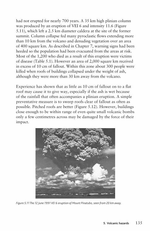
had not erupted for nearly 700 years. A 35 km high plinian column was produced by an eruption of VEI 6 and intensity 11.6 (Figure 5.11), which left a 2.5 km diameter caldera at the site of the former summit. Column collapse fed many pyroclastic flows extending more than 10 km from the volcano and denuding vegetation over an area of 400 square km. As described in Chapter 7, warning signs had been heeded so the population had been evacuated from the areas at risk. Most of the 1,200 who died as a result of this eruption were victims of disease (Table 5.1). However an area of 2,000 square km received in excess of 10 cm of fallout. Within this zone about 300 people were killed when roofs of buildings collapsed under the weight of ash, although they were more than 30 km away from the volcano.
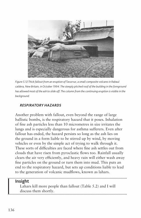
Experience has shown that as little as 10 cm of fallout on to a flat roof may cause it to give way, especially if the ash is wet because of the rainfall that often accompanies a plinian eruption. A simple preventative measure is to sweep roofs clear of fallout as often as possible. Pitched roofs are better (Figure 5.12). However, buildings close enough to be within range of even quite small volcanic bombs only a few centimetres across may be damaged by the force of their impact.
Figure 5.11 The 12 June 1991 VEI 6 eruption of Mount Pinatubo, seen from 20 km away.
Ch05_Volcanoes3730407.indd 135 8/5/2010 3:00:19 PM
134 5. Volcanic hazards
Generally speaking, the best hope of surviving if caught in a pyroclastic flow, of any variety, is to shelter behind a strong low wall that will shield you from the blast and the projectiles it carries. Better still hide down a hole like the Mount St Helens gophers! Show no exposed skin and swathe your head in as much cloth as you can. The intense heat may last only a few seconds and during this time it is vital not to inhale or you may suffer irreparable lung damage.
Even better, of course, is to be nowhere near when it happens, because if the heat lasts longer than this you will surely be cooked. So, if you are ever subject to an evacuation order my advice is to comply with it.
PROTECTIONAGAINSTPYROCLASTICFLOWS
Unlike lava flows, pyroclastic flows travel so fast that there is no time to take action to divert one after it has started. Furthermore, the ability of pyroclastic flows to climb obstacles makes the engineering of effective barriers very problematic. It is pointless trying to take the force out a pyroclastic flow near its source. The only feasible way to protect property in the expected path of a pyroclastic flow would be to build a series of barriers designed to channel the energy of a flow upwards and so encourage it to form a buoyant plume. If successful, this would turn the serious hazard posed by a pyroclastic flow into the less serious hazard of a low-altitude, fallout-generating ash cloud. Such barriers would need to be substantial feats of engineering: walls maybe 30 m high, or ‘ski-jump’ affairs shaped so as to make the flow airborne. These would be very expensive and controversial, and are only ever likely to be built along specific high-risk flow pathways leading to substantial settlements.
Fallout
One of the biggest eruptions of the past 100 years occurred on 15 June 1991 in the Philippines at Mount Pinatubo, a volcano that
Ch05_Volcanoes3730407.indd 134 8/5/2010 3:00:19 PM
1355. Volcanic hazards
had not erupted for nearly 700 years. A 35 km high plinian column was produced by an eruption of VEI 6 and intensity 11.6 (Figure 5.11), which left a 2.5 km diameter caldera at the site of the former summit. Column collapse fed many pyroclastic flows extending more than 10 km from the volcano and denuding vegetation over an area of 400 square km. As described in Chapter 7, warning signs had been heeded so the population had been evacuated from the areas at risk. Most of the 1,200 who died as a result of this eruption were victims of disease (Table 5.1). However an area of 2,000 square km received in excess of 10 cm of fallout. Within this zone about 300 people were killed when roofs of buildings collapsed under the weight of ash, although they were more than 30 km away from the volcano.
Experience has shown that as little as 10 cm of fallout on to a flat roof may cause it to give way, especially if the ash is wet because of the rainfall that often accompanies a plinian eruption. A simple preventative measure is to sweep roofs clear of fallout as often as possible. Pitched roofs are better (Figure 5.12). However, buildings close enough to be within range of even quite small volcanic bombs only a few centimetres across may be damaged by the force of their impact.
Figure 5.11 The 12 June 1991 VEI 6 eruption of Mount Pinatubo, seen from 20 km away.
Ch05_Volcanoes3730407.indd 135 8/5/2010 3:00:19 PM
136 5. Volcanic hazards
Figure 5.12 Thick fallout from an eruption of Tavurvur, a small composite volcano in Rabaul
caldera, New Britain, in October 1994. The steeply pitched roof of the building in the foreground
has allowed most of the ash to slide off. The column from the continuing eruption is visible in the
background.
RESPIRATORYHAZARDS
Another problem with fallout, even beyond the range of large ballistic bombs, is the respiratory hazard that it poses. Inhalation of fine ash particles less than 10 micrometres in size irritates the lungs and is especially dangerous for asthma sufferers. Even after fallout has ended, the hazard persists so long as the ash lies on the ground in a form liable to be stirred up by wind, by moving vehicles or even by the simple act of trying to walk through it. These sorts of difficulties are faced where fine ash settles out from clouds that have risen from pyroclastic flows too. Rainfall usually clears the air very efficiently, and heavy rain will either wash away fine particles on the ground or turn them into mud. This puts an end to the respiratory hazard, but sets up conditions liable to lead to the generation of volcanic mudflows, known as lahars.
InsightLahars kill more people than fallout (Table 5.2) and I will discuss them shortly.
Ch05_Volcanoes3730407.indd 136 8/5/2010 3:00:20 PM
1375. Volcanic hazards
OTHERDAMAGECAUSEDBYFALLOUT
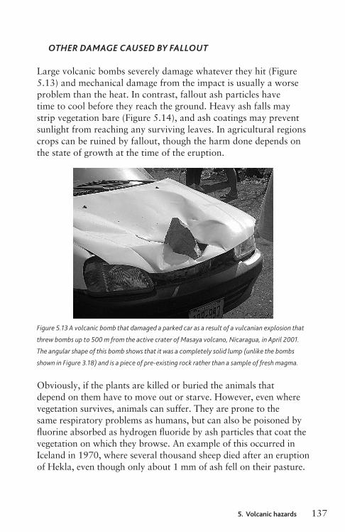
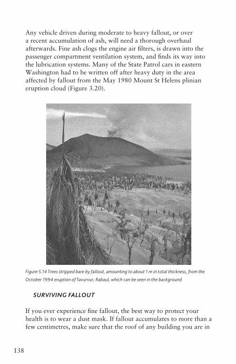
Large volcanic bombs severely damage whatever they hit (Figure 5.13) and mechanical damage from the impact is usually a worse problem than the heat. In contrast, fallout ash particles have time to cool before they reach the ground. Heavy ash falls may strip vegetation bare (Figure 5.14), and ash coatings may prevent sunlight from reaching any surviving leaves. In agricultural regions crops can be ruined by fallout, though the harm done depends on the state of growth at the time of the eruption.
Figure 5.13 A volcanic bomb that damaged a parked car as a result of a vulcanian explosion that
threw bombs up to 500 m from the active crater of Masaya volcano, Nicaragua, in April 2001.
The angular shape of this bomb shows that it was a completely solid lump (unlike the bombs
shown in Figure 3.18) and is a piece of pre-existing rock rather than a sample of fresh magma.
Obviously, if the plants are killed or buried the animals that depend on them have to move out or starve. However, even where vegetation survives, animals can suffer. They are prone to the same respiratory problems as humans, but can also be poisoned by fluorine absorbed as hydrogen fluoride by ash particles that coat the vegetation on which they browse. An example of this occurred in Iceland in 1970, where several thousand sheep died after an eruption of Hekla, even though only about 1 mm of ash fell on their pasture.
Ch05_Volcanoes3730407.indd 137 8/5/2010 3:00:21 PM
136 5. Volcanic hazards
Figure 5.12 Thick fallout from an eruption of Tavurvur, a small composite volcano in Rabaul
caldera, New Britain, in October 1994. The steeply pitched roof of the building in the foreground
has allowed most of the ash to slide off. The column from the continuing eruption is visible in the
background.
RESPIRATORYHAZARDS
Another problem with fallout, even beyond the range of large ballistic bombs, is the respiratory hazard that it poses. Inhalation of fine ash particles less than 10 micrometres in size irritates the lungs and is especially dangerous for asthma sufferers. Even after fallout has ended, the hazard persists so long as the ash lies on the ground in a form liable to be stirred up by wind, by moving vehicles or even by the simple act of trying to walk through it. These sorts of difficulties are faced where fine ash settles out from clouds that have risen from pyroclastic flows too. Rainfall usually clears the air very efficiently, and heavy rain will either wash away fine particles on the ground or turn them into mud. This puts an end to the respiratory hazard, but sets up conditions liable to lead to the generation of volcanic mudflows, known as lahars.
InsightLahars kill more people than fallout (Table 5.2) and I will discuss them shortly.
Ch05_Volcanoes3730407.indd 136 8/5/2010 3:00:20 PM
1375. Volcanic hazards
OTHERDAMAGECAUSEDBYFALLOUT
Large volcanic bombs severely damage whatever they hit (Figure 5.13) and mechanical damage from the impact is usually a worse problem than the heat. In contrast, fallout ash particles have time to cool before they reach the ground. Heavy ash falls may strip vegetation bare (Figure 5.14), and ash coatings may prevent sunlight from reaching any surviving leaves. In agricultural regions crops can be ruined by fallout, though the harm done depends on the state of growth at the time of the eruption.
Figure 5.13 A volcanic bomb that damaged a parked car as a result of a vulcanian explosion that
threw bombs up to 500 m from the active crater of Masaya volcano, Nicaragua, in April 2001.
The angular shape of this bomb shows that it was a completely solid lump (unlike the bombs
shown in Figure 3.18) and is a piece of pre-existing rock rather than a sample of fresh magma.
Obviously, if the plants are killed or buried the animals that depend on them have to move out or starve. However, even where vegetation survives, animals can suffer. They are prone to the same respiratory problems as humans, but can also be poisoned by fluorine absorbed as hydrogen fluoride by ash particles that coat the vegetation on which they browse. An example of this occurred in Iceland in 1970, where several thousand sheep died after an eruption of Hekla, even though only about 1 mm of ash fell on their pasture.
Ch05_Volcanoes3730407.indd 137 8/5/2010 3:00:21 PM
138 5. Volcanic hazards
Any vehicle driven during moderate to heavy fallout, or over a recent accumulation of ash, will need a thorough overhaul afterwards. Fine ash clogs the engine air filters, is drawn into the passenger compartment ventilation system, and finds its way into the lubrication systems. Many of the State Patrol cars in eastern Washington had to be written off after heavy duty in the area affected by fallout from the May 1980 Mount St Helens plinian eruption cloud (Figure 3.20).
Figure 5.14 Trees stripped bare by fallout, amounting to about 1 m in total thickness, from the
October 1994 eruption of Tavurvur, Rabaul, which can be seen in the background.
SURVIVINGFALLOUT
If you ever experience fine fallout, the best way to protect your health is to wear a dust mask. If fallout accumulates to more than a few centimetres, make sure that the roof of any building you are in
Ch05_Volcanoes3730407.indd 138 8/5/2010 3:00:22 PM
1395. Volcanic hazards
is swept clear. If driving through volcanic ash, whether from fallout or a pyroclastic flow, you should check that the cooling surfaces of your vehicle’s radiator are not clogged by ash. Douse your windscreen with water to remove ash, but do not use the wipers because this will scratch the glass. If ash is falling it can be very dark even in the middle of the day. Drive slowly. If, as is likely, people around you are agitated, you are more likely to be injured in a road accident than as a direct result of the eruption.
Should you be unfortunate enough to be caught in the open within range of volcanic bombs, do not turn and run. Instead you should look towards the source of danger. Watch the bombs as they fall and dodge aside only if you are sure that one is going to land on you. Contrary to what you may have seen portrayed in movie special effects, volcanic bombs do not explode on impact.
Eruption clouds and air traffic
You may think that you live so far away from any volcanoes that there is no way they can affect you. In the next chapter I will show that really big eruptions can have global consequences. However, irrespective of where you live, if your job or your holiday involve air travel you can be vulnerable in a quite unexpected way. Explosive eruptions as small as VEI 3 can pluck from the sky a plane full of people who had no idea they were anywhere near a volcano.
An eruption cloud of the kind shown in Figure 3.21 poses a severe hazard to any aircraft that strays into it. To the pilot, such a cloud may look like an ordinary meteorological cloud, but the ash particles that it contains make it a very bad place to fly indeed. Ash sucked into a jet engine leads to a deterioration of performance within seconds, and can cause total failure. The main reason is that ash melts when it comes into contact with the hot sections of the engine, forming a glass that can choke fuel nozzles and coat turbine blades. Simple abrasion of engine parts is a problem too, which also affects the forward-facing surfaces of the aircraft, including the cockpit windows.
Ch05_Volcanoes3730407.indd 139 8/5/2010 3:00:22 PM

140 5. Volcanic hazards
In June 1982 a British Airways jumbo jet flying at 11,000 m towards Australia with 240 people onboard flew by night into the eruption cloud from a VEI 4 eruption of Galungung volcano on Java, which was 150 km from the flight path. A sulfurous smell quickly became evident and all four engines sputtered and died, despite the pilots’ attempts to keep them running. In the next two minutes the plane dropped to less than 2,000 m above the sea (a very rude awakening for the passengers, most of whom had been asleep), and then the engines came back to life. The relieved pilot put on full power in order to regain altitude as quickly as possible. This took the plane back up into the eruption cloud whereupon the engines failed again. After a second terrifying dive the engines restarted and a successful emergency landing was made at Jakarta airport, on three engines and flying blind because the abraded windshield was by now opaque.
The story was repeated, less excusably, a few weeks later when a Singapore Airlines jumbo jet flew into the same eruption cloud, this time managing to land with only two restarted engines. Seven years later a KLM jumbo jet flew by daylight into an ash cloud from a VEI 3 eruption of Redoubt volcano, Alaska. The plane lost all four engines and was within a couple of minutes of crashing into the Alaskan mountains when the engines came back to life, enabling the aircraft to reach Anchorage airport.
Although there had been similar incidents before, the Galungung and Redoubt encounters involved the largest aircraft and brought the eruption cloud hazard to the attention of international airlines and of the authorities responsible for air traffic safety. More than 100 commercial aircraft accidentally encountered volcanic ash during the last two decades of the twentieth century. Fortunately no lives were lost, probably because emergency procedure manuals had been revised to instruct pilots to throttle back at the first sign of engine failure, then to turn round and lose altitude until clear of the cloud. The rush of cold air through the engines during a controlled dive usually chills the glass in the engines so that it shatters and allows them to be restarted. It is now understood that the former recommendation to increase power as soon as the engines begin to fail will raise the engine temperature and make the problem of glass from melted ash even worse.
Ch05_Volcanoes3730407.indd 140 8/5/2010 3:00:22 PM
1415. Volcanic hazards
When an aircraft has been able to make a safe emergency landing after an ash cloud encounter the damage sustained can cost millions of dollars to repair. There is also the problem of hundreds of passengers deposited at an unexpected destination. When these financial burdens are added to the likely litigation costs in the event of a fatal incident caused by flying a plane into a hazard that could have been avoided, it becomes apparent why there is now a global system of Volcanic Ash Advisory Centres (VAACs) whose principal function is to warn air traffic of the expected locations and heights of eruption clouds (see Chapter 7).
The system was tested to breaking point in 2010 when a VEI 4 eruption of the subglacial Icelandic volcano Eyjafjallajökull on 14 April injected ash to a height of about 11 km into high-altitude winds blowing towards Europe. On the following day, most of the airspace over northern and western Europe was closed and remained so for up to six days. The movement of the ash cloud was successfully tracked and predicted. Some ash fallout was noted in the Shetland Islands and in parts of northern Britain, but the airborne ash was fairly diffuse. Airlines alone were losing about 200 million dollars a day and travellers were stranded around the globe, placing the authorities under tremendous pressure to relax the ‘no fly’ restrictions. The existing guideline was that it was unsafe to fly in the presence of any airborne ash, so airlines rushed to perform test flights, and engine manufacturers did some belated experiments, resulting in an agreement to set 2 milligrams (soon raised to 4 milligrams) of ash per cubic metre of air as a ‘safe’ tolerance limit. This allowed commercial flights to resume, and meant that disruption was much less when ash emissions temporarily re-intensified in May.
InsightRisk assessments ought not to be done in a hurry. I am amazed that an aircraft tolerance limit for airborne ash had not been determined in advance. If it had been, then the flight ban in this instance would have been briefer and affecting a smaller area. I am also surprised by how high the threshold was set: 4 milligrams per cubic metre is about forty thousand 30 micrometre-sized ash particles per cubic metre, and I would not feel comfortable flying through that dense an ash cloud.
Ch05_Volcanoes3730407.indd 141 8/5/2010 3:00:22 PM
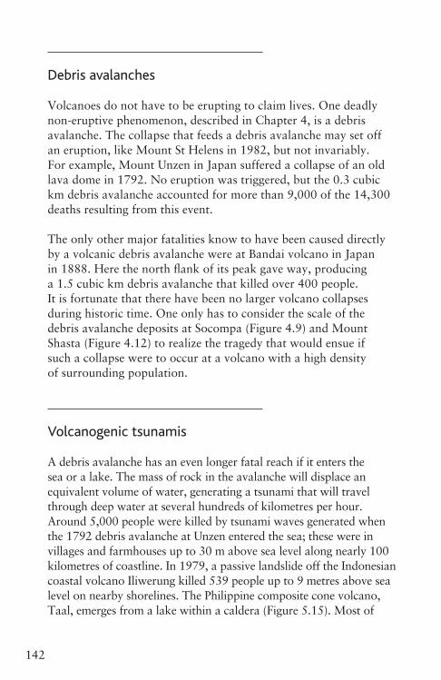
142 5. Volcanic hazards
Debris avalanches
Volcanoes do not have to be erupting to claim lives. One deadly non-eruptive phenomenon, described in Chapter 4, is a debris avalanche. The collapse that feeds a debris avalanche may set off an eruption, like Mount St Helens in 1982, but not invariably. For example, Mount Unzen in Japan suffered a collapse of an old lava dome in 1792. No eruption was triggered, but the 0.3 cubic km debris avalanche accounted for more than 9,000 of the 14,300 deaths resulting from this event.
The only other major fatalities know to have been caused directly by a volcanic debris avalanche were at Bandai volcano in Japan in 1888. Here the north flank of its peak gave way, producing a 1.5 cubic km debris avalanche that killed over 400 people. It is fortunate that there have been no larger volcano collapses during historic time. One only has to consider the scale of the debris avalanche deposits at Socompa (Figure 4.9) and Mount Shasta (Figure 4.12) to realize the tragedy that would ensue if such a collapse were to occur at a volcano with a high density of surrounding population.
Volcanogenic tsunamis
A debris avalanche has an even longer fatal reach if it enters the sea or a lake. The mass of rock in the avalanche will displace an equivalent volume of water, generating a tsunami that will travel through deep water at several hundreds of kilometres per hour. Around 5,000 people were killed by tsunami waves generated when the 1792 debris avalanche at Unzen entered the sea; these were in villages and farmhouses up to 30 m above sea level along nearly 100 kilometres of coastline. In 1979, a passive landslide off the Indonesian coastal volcano Iliwerung killed 539 people up to 9 metres above sea level on nearby shorelines. The Philippine composite cone volcano, Taal, emerges from a lake within a caldera (Figure 5.15). Most of
Ch05_Volcanoes3730407.indd 142 8/5/2010 3:00:22 PM
1435. Volcanic hazards
the fatalities of the terrible VEI 4 eruption of 1911 (Table 5.1) were caused by pyroclastic flows, but a comparable eruption in 1965 took some 200 lives when tsunami waves, generated by either subaqueous explosions or pyroclastic flows hitting the lake, capsized boats loaded with residents fleeing the volcanic island. However, the most famous volcanogenic tsunamis are surely those caused by Krakatau in 1883.
Figure 5.15 A 40 km wide space shuttle radar image showing Taal Volcano rising within Taal lake
(black). Explosive eruptions here sometimes cause tsunamis in the lake. (NASA/JPL)
KRAKATAU
Tsunamis resulting directly from eruptions can be caused by underwater explosions, submarine caldera collapse, and by pyroclastic flows entering the sea. A combination of the latter two was probably responsible for the tsunamis produced by the deadliest eruption of historic times, that of the Indonesian island volcano of Krakatau in 1883. Prior to this cataclysmic eruption, Krakatau was an island consisting of an elongated composite cone volcano, rising to 800 m in the Sunda Strait between Sumatra and Java. Explosive activity beginning in May 1883 produced sufficient ash to strip the island of its luxuriant vegetation, and then during 26–7 August a
Ch05_Volcanoes3730407.indd 143 8/5/2010 3:00:24 PM
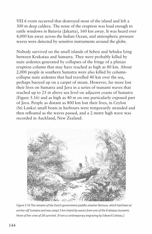
144 5. Volcanic hazards
VEI 6 event occurred that destroyed most of the island and left a 300 m deep caldera. The noise of the eruption was loud enough to rattle windows in Batavia (Jakarta), 160 km away. It was heard over 4,000 km away across the Indian Ocean, and atmospheric pressure waves were detected by sensitive instruments around the globe.
Nobody survived on the small islands of Sebesi and Sebuku lying between Krakatau and Sumatra. They were probably killed by nuée ardentes generated by collapses of the fringe of a plinian eruption column that may have reached as high as 80 km. About 2,000 people in southern Sumatra were also killed by column- collapse nuée ardentes that had travelled 40 km over the sea, perhaps buoyed up on a carpet of steam. However, far more lost their lives on Sumatra and Java in a series of tsunami waves that reached up to 25 m above sea level on adjacent coasts of Sumatra (Figure 5.16) and as high as 40 m on one particularly exposed part of Java. People as distant as 800 km lost their lives, in Ceylon (Sri Lanka) small boats in harbours were temporarily stranded and then refloated as the waves passed, and a 2 metre high wave was recorded in Auckland, New Zealand.
Figure 5.16 The remains of the Dutch government paddle steamer Berouw, which had been at
anchor off Sumatra and was swept 3 km inland by waves from one of the Krakatau tsunamis.
None of her crew of 28 survived. (From a contemporary engraving by Edward Cotteau.)
Ch05_Volcanoes3730407.indd 144 8/5/2010 3:00:26 PM
1455. Volcanic hazards
A larger series of tsunamis appears to have been generated by the caldera-forming eruption of Santorini, an island in the Aegean Sea, in about 1620 bc. This event, estimated to be VEI 6, generated tsunamis that ravaged shorelines round the eastern Mediterranean to heights of up to 50 m and probably contributed to the downfall of the Minoan culture that had been centred on Crete.
InsightThis may be the origin of the myth of Atlantis, the civilization that drowned beneath the waves.
VOLCANOGENICMEGA-TSUNAMIS
Worse could happen today, in terms of fatalities if not in terms of the actual fall of civilization, because of the density of coastal populations. Particularly large tsunamis, popularly dubbed ‘mega-tsunamis’, can cause destruction on coastlines thousands of kilometres away. For example, collapses of volcanoes in the Canary Islands (such as the one in Figure 4.13) could generate tsunamis capable of devastating the eastern seaboard of the USA for up to 20 km inland. Evidence that this is possible comes from the island volcano Hierro, where a large part collapsed into the sea about 120,000 years ago. Strange landforms and enormous perched boulders on the Bahama islands appear to record the passage of a tsunami at least 20 m high.
There is probably not enough left of Hierro to worry about now, but a much more significant threat may be posed by the volcano Cumbre Viejo on the nearby island of La Palma. Here, it is suggested that a quite small summit eruption might heat groundwater and generate enough steam pressure to fracture the rock and trigger a major collapse of the west flank of the volcano that appears to have already slipped downwards by 4 m during an eruption in 1949. The scale of tsunami waves generated by a collapse depends on the speed of collapse and the extent to which the collapsing flank of the volcano breaks apart before it hits the ocean. Blocks of 1 km in size would cause bigger waves than a continuous stream of smaller lumps. In the ‘worse case’ scenario for a collapse of Cumbre Viejo, the initial wave would be over
Ch05_Volcanoes3730407.indd 145 8/5/2010 3:00:26 PM
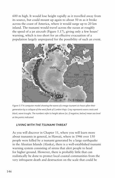
146 5. Volcanic hazards
600 m high. It would lose height rapidly as it travelled away from its source, but could mount up again to about 50 m as it broke across the coast of America, where it would surge up to 20 km inland. The tsunami would travel across the ocean at roughly the speed of a jet aircraft (Figure 5.17), giving only a few hours’ warning, which is too short for an effective evacuation of a population largely unprepared for the possibility of such an event.
Figure 5.17 A computer model showing the waves of a mega-tsunami six hours after their
generation by a collapse of the west flank of Cumbre Viejo. Grey represents wave crests and
black, wave troughs. The numbers refer to height above (or, if negative, below) mean sea level
at the points indicated.
LIVINGWITHTHETSUNAMITHREAT
As you will discover in Chapter 11, where you will learn more about tsunamis in general, in Hawaii, where in 1946 over 150 people were killed by a tsunami generated by a large earthquake in the Aleutian Islands (Alaska), there is a well-established tsunami warning system consisting of sirens that alert people to head for higher ground. However, there is probably little that can realistically be done to protect local coastal communities from the very infrequent death and destruction on the scale that could be
Ch05_Volcanoes3730407.indd 146 8/5/2010 3:00:27 PM
1475. Volcanic hazards
caused by major collapses of volcanic islands of the sort revealed by bathymetric surveys around such islands as Hawaii and the Marquesas in the Pacific, the Canaries (Figure 4.13) and Tristan da Cunha in the Atlantic, and Réunion in the Indian Ocean. At present, opinion is divided over whether such collapses tend to be rapid events genuinely capable of generating mega-tsunamis, or a relatively harmless gradual process.
Lahars
A lahar, or volcanic mudflow, travels at several tens of kilometres per hour and need contain only about 10 per cent by weight of water to remain mobile. An initially dilute lahar is capable of multiplying its volume several-fold if it incorporates extra material picked up by erosion, particularly when channelled along a narrow valley. Bridges and roads tend to be destroyed in this part of a lahar, but the greatest loss of life usually occurs where a lahar is able to spread out beyond the confines of a valley.
As described in Chapter 4, a lahar can be triggered when heavy rain falls on unconsolidated ash. Lahars of this nature accounted for 143 of the victims of the 1991 eruption of Pinatubo, where lahars were still eroding or burying farmland ten years after the eruption. This eruption left a 2.5 km wide caldera. By 2001 this was filled to a depth of 180 m by a rain-fed crater lake, nearly overflowing the lowest point on the caldera rim. To prevent a potentially catastrophic overflow if the rim were to give way, and subsequent mixing with loose 1991 fallout down-slope to produce devastating lahars, the authorities wisely cut a channel through the caldera wall to lower the lake level in a controlled fashion.
The source of a lahar does not have to be particularly fresh volcanic material. A tragic example of this occurred in Nicaragua on 30 October 1998 when torrential rainfall delivered by Hurricane Mitch caused fumarolically altered rock on the side of the dormant Casita volcano to give way. What began as a debris
Ch05_Volcanoes3730407.indd 147 8/5/2010 3:00:28 PM
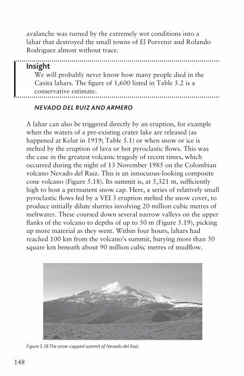
148 5. Volcanic hazards
avalanche was turned by the extremely wet conditions into a lahar that destroyed the small towns of El Porvenir and Rolando Rodriguez almost without trace.
InsightWe will probably never know how many people died in the Casita lahars. The figure of 1,600 listed in Table 5.2 is a conservative estimate.
NEVADODELRUIZANDARMERO
A lahar can also be triggered directly by an eruption, for example when the waters of a pre-existing crater lake are released (as happened at Kelut in 1919; Table 5.1) or when snow or ice is melted by the eruption of lava or hot pyroclastic flows. This was the case in the greatest volcanic tragedy of recent times, which occurred during the night of 13 November 1985 on the Colombian volcano Nevado del Ruiz. This is an innocuous-looking composite cone volcano (Figure 5.18). Its summit is, at 5,321 m, sufficiently high to host a permanent snow cap. Here, a series of relatively small pyroclastic flows fed by a VEI 3 eruption melted the snow cover, to produce initially dilute slurries involving 20 million cubic metres of meltwater. These coursed down several narrow valleys on the upper flanks of the volcano to depths of up to 50 m (Figure 5.19), picking up more material as they went. Within four hours, lahars had reached 100 km from the volcano’s summit, burying more than 50 square km beneath about 90 million cubic metres of mudflow.
Figure 5.18 The snow-capped summit of Nevado del Ruiz.
Ch05_Volcanoes3730407.indd 148 8/5/2010 3:00:28 PM
1495. Volcanic hazards
Figure 5.19 One of the valleys on the flanks of Nevado del Ruiz down which travelled the devastating
lahars of 13 November 1985. Note the lack of trees where the lahar has destroyed them.
Three-quarters of the population of Armero, a town of 28,700 inhabitants about 50 km from the summit, perished around midnight when several pulses of lahar disgorged from the mountains and spread out to bury the town below several metres of mud and coarser debris (Figures 5.20 and 5.21, overleaf). Readers old enough to remember the worldwide news coverage of the disaster will probably recall the harrowing scenes of victims trapped alive in the deposit, notably a young girl whose head was barely above water and who succumbed to the cold and shock after several days of desperate attempts to free her. The annihilation of Armero is all the more tragic because the town had been rebuilt on the site of previous towns destroyed by similar lahars in 1595 and again in 1845. Despite the concerns of local volcanologists, who correctly read the warning signs when the volcano came back to life, the local authorities took no action to safeguard the population. I will consider eruption warnings and crisis management in Chapter 8.
OTHERLAHARS
The greatest volcanic loss of life in New Zealand was also caused by a lahar, when a small (VEI 2) eruption of Ruapehu volcano on 24 December 1953 breached the ice impounding a crater lake, whose level dropped by 10 metres in a few minutes. The released
Ch05_Volcanoes3730407.indd 149 8/5/2010 3:00:29 PM
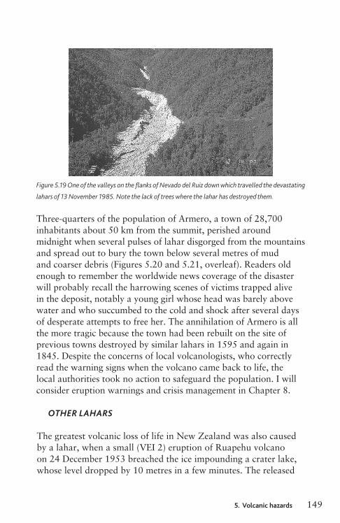

150 5. Volcanic hazards
Figure 5.20 Aerial view of the former site of Armero, which was buried by the 13 November 1985
lahar. The narrow valley that disgorged the lahar can be seen in the background.
Figure 5.21 Some of the surviving buildings in Armero.
Ch05_Volcanoes3730407.indd 150 8/5/2010 3:00:30 PM
1515. Volcanic hazards
waters triggered a 2 million cubic metre lahar that travelled at an average speed of 20 km per hour. This carried away one of the piers of the Tangiwai railway bridge just a few minutes before the Auckland to Wellington express arrived. Five carriages plunged into the river, killing 151 people. Successful engineering allowed road and rail bridges to survive a similar lahar in 2007.
Lahars are a major hazard around all volcanoes capped by snow or ice, notably in the Cascades range of the north-west USA. For example, lahars generated in the 18 May 1980 eruption of Mount St Helens outdistanced the blast and the debris avalanche, destroying bridges, roads and houses along the valleys down which they travelled. A huge volume of sediment was dumped into the Columbia River, and the need to dredge a new navigation channel was one of the costlier consequences of the eruption. Particularly extensive lahar aprons are now recognized around Mount St Helens’ northern neighbour Mount Rainier, which in prehistoric times shed lahars that travelled all the way to Puget Sound onto the sites where the cities of Seattle and Tacoma now stand. The most recent, but by no means largest, of these giant lahar deposits is the Osceola Mudflow, generated 5,700 years ago and covering an area of 500 square km. This buried, apparently with little or no warning, a Native American settlement that was unearthed in 1972 revealing an important collection of tools and also charcoal that was used to date the event.
LAHARPROTECTION
Like pyroclastic flows, lahars travel so fast that it is too late to try to protect property once a lahar is in motion. However, in some circumstances it is possible to take action to reduce the damage caused by future lahars. When the probable source is a crater lake, the lake can be drained. A notable example of this is at Kelut, where a system of tunnels completed in 1926 (seven years after the disaster of 1919) had been improved and maintained since the 1960s to maintain the lake volume at about a twentieth of its
Ch05_Volcanoes3730407.indd 151 8/5/2010 3:00:30 PM
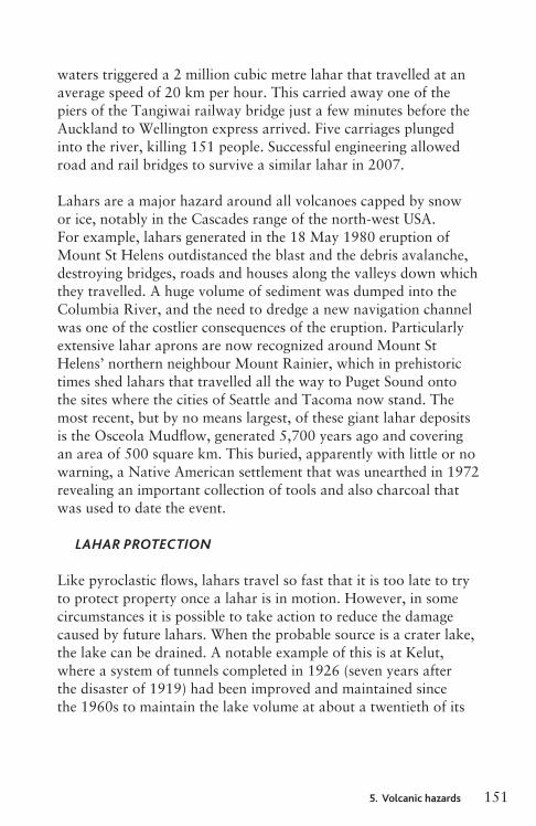
152 5. Volcanic hazards
pre-1919 volume. The tunnels became at least temporarily redundant in 2008 when a lava dome that had begin to grow the previous year almost entirely overwhelmed the site of Kelut’s former lake.
Lahars supplied by ashfall on steep slopes can be diverted by pre-dug channels and held back by dams and retention basins intended to reduce the energy of the flow, trap the larger material and reduce the volume. Such systems require regular dredging to maintain their effectiveness, and in any case can be overwhelmed by sufficiently large lahars. They are impractical on broad expanses of gentle slopes (such as the lower flanks of Mount Pinatubo), where channels can easily migrate to circumvent any obstructions.
Jökulhlaups
When a fully subglacial volcano erupts the consequences are rather different to when hot material is erupted on top of snow or ice. Several cubic kilometres of meltwater can be generated. This is trapped at first, but once sufficient meltwater has accumulated the previously grounded ice sheet can float, allowing the water to escape catastrophically. This phenomenon is described by the Icelandic term jökulhlaup, which is usually translated as ‘glacier burst’. The waters of a jökulhlaup may pick up enough sediment to behave like a lahar, but commonly the flow is more dilute and contains mostly huge blocks of ice, boulders and finer volcanic debris. The sand plains between Iceland’s largest glacier, Vatnajökull, and the southern coast consist entirely of deposits laid down by jökulhlaups. This area is rightly regarded as uninhabitable, but the only road around the island has to cross it.
The Icelandic subglacial volcano Grimsvötn fuels a jökulhlaup from beneath Vatnajökull every four to six years on average. The largest of the last century happened in 1937 and had a volume of 7 cubic km, but passed off without fatal consequences thanks to the sparse population. In fact the only human deaths attributed to an Icelandic
Ch05_Volcanoes3730407.indd 152 8/5/2010 3:00:31 PM
1535. Volcanic hazards
jökulhlaup happened in 1727 when three people were swept off a roof by a jökulhlaup caused by an eruption of the Öraefajökull volcano. The same event killed 600 sheep and 150 horses.
Volcanologists were able to study the initiation of a jökulhlaup using modern techniques when a subglacial eruption began from a new fissure extending northwards from Grimsvötn on 30 September 1996. The ice cap here was between 400 and 600 m thick, but within a few days a hole had been melted up to the surface through which a steam plume rose to a height of several kilometres. Meltwater could be detected flowing southwards along the fissure into the Grimsvötn caldera, which filled to unprecedented depths, jacking up the overlying ice, until, on 5 November, about 3.5 cubic km of pent-up water escaped. The peak discharge rate was 45,000 cubic metres per second, making this (for a few hours) the second largest river on Earth. The flood deposits covered an area of 750 square km, bridges were destroyed, and in places the coastline was extended seawards by 800 metres. The next jökulhlaup from Grimsvötn, in November 2004, released only half a cubic km of meltwater.
There had been several months of seismic activity prior to the 2010 eruption of Iceland’s Eyjafjallajökull, which began as a fire-fountaining basaltic fissure eruption near the edge of the ice cap on 20 March. By the time activity migrated to the subglacial caldera on 14 April (whereupon ingress of meltwater caused the eruption to become much more explosive) the Icelanders were well prepared for the inevitable jökulhlaups. People and animals had been evacuated, and breaches had been made in causeways carrying roads, which allowed floodwaters to escape without causing worse damage.
Gases and air pollution
SULFURDIOXIDE
As described in Chapter 3, volcanoes can emit copious quantities of noxious gases, even during intervals of non-eruptive activity.
Ch05_Volcanoes3730407.indd 153 8/5/2010 3:00:31 PM
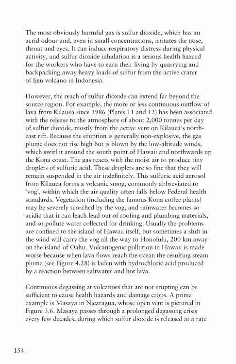
154 5. Volcanic hazards
The most obviously harmful gas is sulfur dioxide, which has an acrid odour and, even in small concentrations, irritates the nose, throat and eyes. It can induce respiratory distress during physical activity, and sulfur dioxide inhalation is a serious health hazard for the workers who have to earn their living by quarrying and backpacking away heavy loads of sulfur from the active crater of Ijen volcano in Indonesia.
However, the reach of sulfur dioxide can extend far beyond the source region. For example, the more or less continuous outflow of lava from Kilauea since 1986 (Plates 11 and 12) has been associated with the release to the atmosphere of about 2,000 tonnes per day of sulfur dioxide, mostly from the active vent on Kilauea’s north-east rift. Because the eruption is generally non-explosive, the gas plume does not rise high but is blown by the low-altitude winds, which swirl it around the south point of Hawaii and northwards up the Kona coast. The gas reacts with the moist air to produce tiny droplets of sulfuric acid. These droplets are so fine that they will remain suspended in the air indefinitely. This sulfuric acid aerosol from Kilauea forms a volcanic smog, commonly abbreviated to ‘vog’, within which the air quality often falls below Federal health standards. Vegetation (including the famous Kona coffee plants) may be severely scorched by the vog, and rainwater becomes so acidic that it can leach lead out of roofing and plumbing materials, and so pollute water collected for drinking. Usually the problems are confined to the island of Hawaii itself, but sometimes a shift in the wind will carry the vog all the way to Honolulu, 200 km away on the island of Oahu. Volcanogenic pollution in Hawaii is made worse because when lava flows reach the ocean the resulting steam plume (see Figure 4.28) is laden with hydrochloric acid produced by a reaction between saltwater and hot lava.
Continuous degassing at volcanoes that are not erupting can be sufficient to cause health hazards and damage crops. A prime example is Masaya in Nicaragua, whose open vent is pictured in Figure 3.6. Masaya passes through a prolonged degassing crisis every few decades, during which sulfur dioxide is released at a rate
Ch05_Volcanoes3730407.indd 154 8/5/2010 3:00:31 PM
1555. Volcanic hazards
of 1,000 or more tonnes per day. The gas plume is blown westwards by the prevailing winds (Figure 5.22) and exacerbates respiratory ailments among the inhabitants of the town of El Crucero on high ground 20 km downwind. To either side of the plume’s habitual track it is possible to grow coffee, but the path of the plume is marked by a belt of poor-quality rangeland (Figure 5.23). Some of the plume’s impact is because of its direct effect on the vegetation, and some is because of acid rain that has fallen through the plume.
Figure 5.22 The sulfur dioxide-rich plume from Masaya volcano, Nicaragua, seen in an oblique
southward-looking view from space. The plume is visible because of condensed droplets of water,
within which much of the sulfur dioxide dissolves to produce sulfuric acid.
HYDROGENFLUORIDEANDHYDROGENSULFIDE
Nasty though volcanic sulfur dioxide is, it has never been proven to be the direct cause of death in humans. Nor has hydrogen fluoride, another common volcanic gas, although as noted previously this can be absorbed on to ash particles and thus cause fluorine poisoning of livestock. The cocktail of sulfur dioxide with a trace of hydrogen fluoride erupted during the biggest historic basaltic fissure eruption, which began on 8 June 1783 from the 27 km long Laki fissure in Iceland, proved deadly in an indirect way. Here, over an eight-month period, 14 cubic km of basalt was erupted, initially by means of fire fountains reaching up to 1,400 m into the air. About 80 million tonnes of sulfur dioxide was emitted, and this destroyed the summer crop. What grass survived was
Ch05_Volcanoes3730407.indd 155 8/5/2010 3:00:32 PM
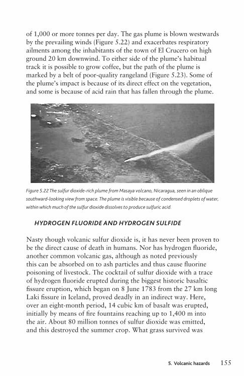
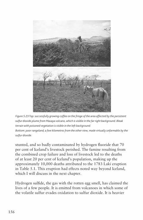
156 5. Volcanic hazards
Figure 5.23 Top: successfully growing coffee on the fringe of the area affected by the persistent
sulfur dioxide plume from Masaya volcano, which is visible in the far right background. Bleak
terrain with poisoned vegetation is visible in the left background.
Bottom: poor rangeland, a few kilometres from the other view, made virtually unfarmable by the
sulfur dioxide.
stunted, and so badly contaminated by hydrogen fluoride that 70 per cent of Iceland’s livestock perished. The famine resulting from the combined crop failure and loss of livestock led to the deaths of at least 20 per cent of Iceland’s population, making up the approximately 10,000 deaths attributed to the 1783 Laki eruption in Table 5.1. This eruption had effects noted way beyond Iceland, which I will discuss in the next chapter.
Hydrogen sulfide, the gas with the rotten egg smell, has claimed the lives of a few people. It is emitted from volcanoes in which some of the volatile sulfur evades oxidation to sulfur dioxide. It is heavier
Ch05_Volcanoes3730407.indd 156 8/5/2010 3:00:33 PM
1575. Volcanic hazards
than air and tends to collect in depressions, where it is a severe menace because at a concentration of only 1,000 parts per million a single breath can bring on a coma. Six skiers on the flanks of Kusatsu–Shirana volcano in Japan died in this way in 1991, and in 1997 four hikers were similarly poisoned when they blundered into a gas-filled crater on Adatara volcano, also in Japan. Neither of these volcanoes was erupting at the time.
CARBONDIOXIDE
The volcanic gas responsible for most of the deaths attributed to gas in Table 5.2 is actually the stuff that you and I breathe out all the time – carbon dioxide. Like hydrogen sulfide it is heavier than air, and if passive degassing allows it to remain unmixed it can reach deadly concentrations. Normal air contains about 0.04 per cent of carbon dioxide, and what you exhale contains about a hundred times as much. However, if the concentration of carbon dioxide in what you are forced to breathe reaches 7.5 per cent this will cause a headache and drowsiness, and if the concentration exceeds 11 per cent you will become unconscious in less than a minute.
The first recognized fatal incident involving volcanic carbon dioxide occurred as recently as 1979 on the Dieng volcanic complex in Java, Indonesia. Here, 149 people fleeing a phreatic eruption died when an invisible cloud of carbon dioxide flowed across their path. The gas was probably released from a subterranean trap by minor earthquakes associated with the eruption.
Far worse befell the West African country of Cameroon a few years later. The Oku volcanic field, 100 km south of the Nigerian border, consists of a series of vents, generally interpreted as maars, which are now occupied by crater lakes. Each of these vents is almost certainly a monogenetic feature, so magma is unlikely to be erupted ever again, but the conduits that supplied some of the vents are still acting as pathways for gases, particularly carbon dioxide, escaping
Ch05_Volcanoes3730407.indd 157 8/5/2010 3:00:33 PM

158 5. Volcanic hazards
from the Earth’s interior. This had tragic consequences on the night of 15 August 1984 when a cloud of carbon dioxide burst out of Lake Monoun. It flowed downhill and asphyxiated 39 people. The event was almost unremarked in the outside world, but a similar disaster at Lake Nyos on 21 August 1986 was on too large a scale to ignore. Here at least 1,700 people and innumerable domestic and wild animals died, many of them in their sleep.
Initially these events were a mystery. However, discolouration of the lake waters and traces of violent wave action above the usual shorelines gave the clue that the lakes were responsible. Now it is understood that the carbon dioxide gradually seeping up through the lake bed dissolves in the warm water at the bottom of the lake, which can hold a large volume of carbon dioxide in solution. This makes the bottom water dense, and prevents it mixing with the surface water, so that the amount of carbon dioxide trapped in the lower part of the lake keeps increasing. However, eventually the carbon dioxide starts to come out of solution and forms bubbles, as in a carbonated drink. This is the trigger for the catastrophe. The bubble-rich water, now of low density, rushes up to the surface, drawing the rest of the bottom-water in its wake. The whole lake overturns, and the carbon dioxide escapes in a mighty gush. Probably 250,000 tonnes of carbon dioxide escaped from Lake Nyos in the 1986 calamity. Efforts are now under way to defuse the Lake Nyos ‘time bomb’, avoiding a repeat of the catastrophe by artificially stimulating continual degassing of the lake water, and thereby preventing a dangerous build-up of carbon dioxide.
Degassing of volcanic carbon dioxide poses a hazard in other settings too. For example, since 1990 trees have been dying over an area of nearly 1 square km on the flanks of Mammoth Mountain, a dacite dome complex on the south-western rim of the 760,000-year-old Long Valley caldera in California. This is because carbon dioxide from a fresh batch of magma at depth is escaping diffusely. It reaches concentrations of up to 90 per cent in the soil, killing the roots. The soil carbon dioxide concentration is highest
Ch05_Volcanoes3730407.indd 158 8/5/2010 3:00:33 PM
1595. Volcanic hazards
during winter when snow prevents its escape. At this time of year people are at risk too, and there have been several cases of near asphyxia from concentrations of carbon dioxide trapped in snow-covered cabins.
So much for the small-scale and relatively local hazards posed by volcanoes and volcanic eruptions. The next chapter looks at the ways in which eruptions, and in particular the gases they emit, can affect the global climate.
Ch05_Volcanoes3730407.indd 159 8/5/2010 3:00:33 PM
160
THINGSTOREMEMBER
C Lava flows have rarely been successfully diverted. Property in the path of a lava flow is at risk, but people and animals can usually get out of the way.
C Pyroclastic flows are fast moving, and generally more lethal than lava flows.
C Fallout can cause roofs to collapse, and is also a respiratory hazard.
C Ash-bearing eruption clouds are a serious hazard to any aircraft that fly into them.
C Debris avalanches initiated when a lava dome or the flank of a volcano collapses non-eruptively can travel tens of kilometres and devastate wide areas. In the Mount St Helens 1980 sector collapse, the debris avalanche was overtaken by a directed blast that claimed most of the fatalities.
C Volcanoes can trigger a tsunami when a debris avalanche or pyroclastic flow reaches the sea (or a lake), or by means of an underwater explosion or caldera collapse.
C Lahars (volcanic mudflows) can occur during or after an eruption. Sometimes, pre-prepared engineering works are adequate to divert or contain them.
C A catastrophic flood called a jökulhlaup can occur when a volcano erupts below an ice cap.
C Gases released by erupting and non-erupting volcanoes can cause various health hazards. Gas heavier than air, such as carbon dioxide, can cause death by asphyxiation.
Ch05_Volcanoes3730407.indd 160 8/5/2010 3:00:33 PM
Ch06_Volcanoes3730407.indd 161 8/5/2010 3:02:01 PM


![[Nanotechnology--possibilities and hazards]](https://img.dokumen.tips/doc/110x75/634d2bd5024fe175900ac942/nanotechnology-possibilities-and-hazards.jpg)
