Embed Size (px)
Citation preview

47
Coastal Management, 30:47–65, 2002Copyright ã 2002 Taylor & Francis0892-0753 /02 $12.00 + .00
Valuing Estuarine Resource ServicesUsing Economic and Ecological Models:
The Peconic Estuary System Study
ROBERT J. JOHNSTONTHOMAS A. GRIGALUNASJAMES J. OPALUCHMARISA MAZZOTTAJERRY DIAMANTEDESDepartment of Environmental and Natural Resource EconomicsUniversity of Rhode IslandKingston, Rhode Island, USA
This article summarizes four integrated economic studies undertaken to contributeto resource preservation and restoration decisions for the Peconic Estuary Systemof Suffolk County, NY. Completed as part of the National Estuary Program, thestudies apply distinct resource valuation methods to a wide range of resource issues.The principal goals of this article are to highlight different methodologies that maybe used to assess nonmarket economic values in a coastal management context, andcharacterize differences in the results that one may expect from each approach. Wealso emphasize potential relationships among values estimated by different nonmarketmethodologies, and comment on the implications of these relationships for the inter-pretation and use of economic value estimates.
Keywords estuarine resources, nonmarket valuation, Peconic, resource values
Introduction
Coastal managers increasingly request quantitative methods for prioritizing managementactions that explicitly account for economic and social factors (Chua 1993; Christie &White 1997; Ruddle, 1988). One common method of linking economic and ecologicaloutcomes involves assessments of the economic consequences of ecological managementoutcomes—often using either market or nonmarket valuation techniques (Freeman, 1993).Several methods may be used to assess the value of coastal resource goods and services,depending upon the resources in question and the specific issues of concern. However, onelimitation of valuation methods used in isolation is that they may quantify values for onlya subset of the many relevant resource goods and services, providing only a partial view
Received November 15, 2000; accepted July 9, 2001.This research was funded by the Peconic Estuary Program and the Rhode Island Agricultural
Experiment Station (AES #3881). Opinions belong solely to the authors and do not imply en-dorsement by the funding agencies or the U.S. Government.
Address all correspondence to Robert J. Johnston, Department of Environmental and NaturalResource Economics, University of Rhode Island, Kingston, RI 02881, USA. e-mail: [email protected].

48 R. J. Johnston et al.
of management benefits. A second limitation of isolated valuation methods is that theymay not allow comparisons of values generated by different resources, or received bydifferent stakeholder groups. Without such input, managers may lack information neces-sary to compare policies that address different types of coastal resources.
Total economic value is generally composed of a number of different types of mar-ket and nonmarket value, associated with different aspects of natural resource goods andservices. No single method can capture the economic value of the many, disparate ser-vices provided by the natural assets of any coastal region. However, given a lack offamiliarity with nonmarket valuation approaches, there is a risk that policy audiencesmay assume that a single methodology provides the “true value” of the resource inquestion—ignoring the fact that different methodologies may estimate different aspectsof value. As most research studies apply a single market or nonmarket valuation meth-odology, the critical differences among benefit estimates provided by different method-ologies can be obscured, leaving policy makers with an incomplete understanding of theappropriate use of economics with coastal management (Johnston et al., 2001). As it israrely practical or cost-effective to apply more than one or two valuation methodologiesto any particular policy question, the choices among competing approaches can haveimportant implications for estimated benefits and costs. In this context, it is critical thatmanagers have a sufficient understanding of the economic methods brought to bearon coastal policy issues, and implications for specific type of resources addressed andvalues measured.
This article summarizes a comprehensive environmental economics research pro-gram conducted as part of the multidisciplinary Peconic Estuary Program. The purposeof this presentation is to promote recognition of the disparate economic benefits associ-ated with different aspects of estuary management, and the methods that may be appro-priately used to measure these benefits. The article is organized as follows. First, webriefly describe the study area and motivation for the reported research. We then presentthe four nonmarket valuation studies that comprise the Peconic Estuary research pro-gram, each designed and implemented in coordination with physical scientists and coastalmanagers. In each case, we summarize the rationale for the study, outline the methodol-ogy and data employed, and present key results.
Throughout the article, we emphasize issues that arise in comparing results of dif-ferent methodologies, and implications of such findings for management. The principalgoals of this presentation are to highlight different approaches that may be used toassess nonmarket economic values in a coastal management context, and characterizedifferences in the results that one may expect from each approach. We also emphasizepotential relationships among values estimated by different nonmarket methodologies,and comment on the implications of these relationships for interpretation and potentialsummation of estimated economic values.
The Peconic Estuary System
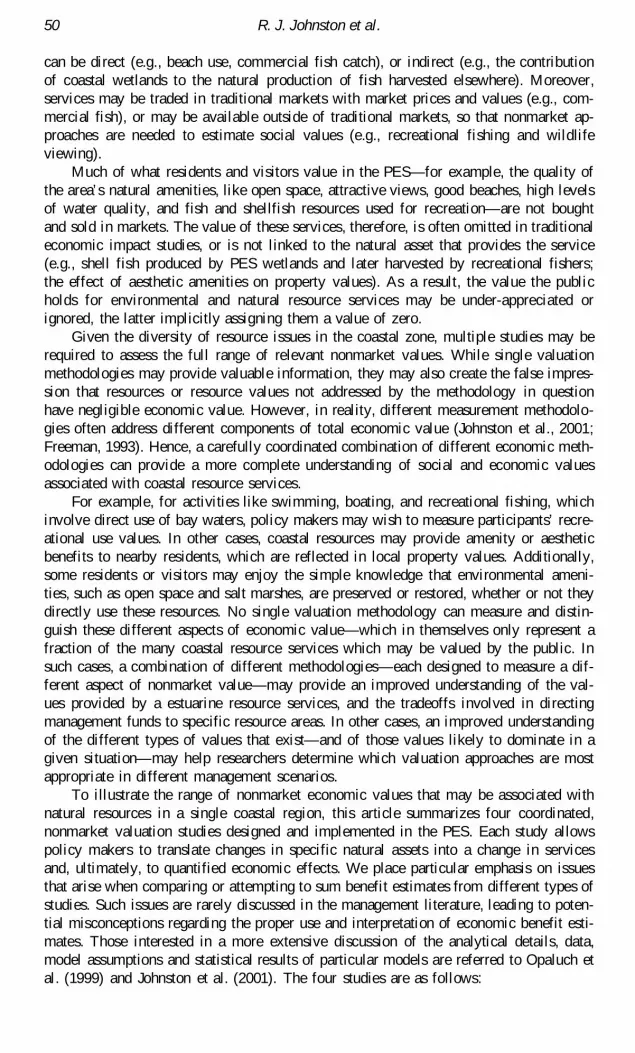
Located within Suffolk County at the East End of Long Island, the Peconic EstuarySystem (PES) is comprised of the Peconic-Flanders Bays system, Gardiners Bay andpart of Block Island Sound, and the adjoining watershed lands. The PES includes fivecommunities: East Hampton, Southampton, Riverhead, Southold, and Shelter Island, aswell as a small part of Brookhaven (Figure 1). In total, the PES comprises about 38percent of the land area and 8 percent of the year-round population of Suffolk County(Suffolk County Dept. of Health Services (SCDHS), 1992; Long Island Business News1994).
The PES contains a wide range of valued coastal resources, including fisheries,

The Peconic Estuary System Study 49
beaches, parks, open space, and wildlife habitat. However, current development andresource uses place many of these resources at risk (SCDHS, 1992). For example, local-ized water quality problems exist due to runoff, failing septic systems, and inadequatesewage treatment. Development has caused the loss of substantial areas of open spaceand large areas of ecologically productive salt marsh. Pollution has closed thousands ofacres of commercial and recreational shellfish beds, and eelgrass beds have been sub-stantially diminished due to outbreaks of brown tide. In part due to the loss of eelgrassand salt marsh nursery areas, as well as the loss of open harvest areas, fin and shellfishlandings have declined substantially during recent years.
While the quality of—and threats to—PES coastal amenities are widely recognized,little systematic information exists about economic value of the natural asset services ofthis region, as realized by different resident and visitor groups. Without information onrecreational and other nonmarket resource values, decision makers lack sufficient infor-mation to appropriately compare the economic benefits and costs of prospective actionsto preserve or restore PES natural assets. Thus, while baseline ecological and otherstudies have identified degradation in a wide range of coastal resources, the impact ofthe potential lost resource services on society has not been quantified, nor have thebenefits of potential policy remedies been assessed.
Estuarine Resource Service Values
Coastal resources may be viewed as natural assets that provide a stream of valuableservices over time (Freeman, 1993; Kopp & Smith, 1993). Estuarine resource services
Figure 1. Depiction of the Peconic Estuary System.
50 R. J. Johnston et al.
can be direct (e.g., beach use, commercial fish catch), or indirect (e.g., the contributionof coastal wetlands to the natural production of fish harvested elsewhere). Moreover,services may be traded in traditional markets with market prices and values (e.g., com-mercial fish), or may be available outside of traditional markets, so that nonmarket ap-proaches are needed to estimate social values (e.g., recreational fishing and wildlifeviewing).
Much of what residents and visitors value in the PES—for example, the quality ofthe area’s natural amenities, like open space, attractive views, good beaches, high levelsof water quality, and fish and shellfish resources used for recreation—are not boughtand sold in markets. The value of these services, therefore, is often omitted in traditionaleconomic impact studies, or is not linked to the natural asset that provides the service(e.g., shell fish produced by PES wetlands and later harvested by recreational fishers;the effect of aesthetic amenities on property values). As a result, the value the publicholds for environmental and natural resource services may be under-appreciated orignored, the latter implicitly assigning them a value of zero.
Given the diversity of resource issues in the coastal zone, multiple studies may berequired to assess the full range of relevant nonmarket values. While single valuationmethodologies may provide valuable information, they may also create the false impres-sion that resources or resource values not addressed by the methodology in questionhave negligible economic value. However, in reality, different measurement methodolo-gies often address different components of total economic value (Johnston et al., 2001;Freeman, 1993). Hence, a carefully coordinated combination of different economic meth-odologies can provide a more complete understanding of social and economic valuesassociated with coastal resource services.
For example, for activities like swimming, boating, and recreational fishing, whichinvolve direct use of bay waters, policy makers may wish to measure participants’ recre-ational use values. In other cases, coastal resources may provide amenity or aestheticbenefits to nearby residents, which are reflected in local property values. Additionally,some residents or visitors may enjoy the simple knowledge that environmental ameni-ties, such as open space and salt marshes, are preserved or restored, whether or not theydirectly use these resources. No single valuation methodology can measure and distin-guish these different aspects of economic value—which in themselves only represent afraction of the many coastal resource services which may be valued by the public. Insuch cases, a combination of different methodologies—each designed to measure a dif-ferent aspect of nonmarket value—may provide an improved understanding of the val-ues provided by a estuarine resource services, and the tradeoffs involved in directingmanagement funds to specific resource areas. In other cases, an improved understandingof the different types of values that exist—and of those values likely to dominate in agiven situation—may help researchers determine which valuation approaches are mostappropriate in different management scenarios.
To illustrate the range of nonmarket economic values that may be associated withnatural resources in a single coastal region, this article summarizes four coordinated,nonmarket valuation studies designed and implemented in the PES. Each study allowspolicy makers to translate changes in specific natural assets into a change in servicesand, ultimately, to quantified economic effects. We place particular emphasis on issuesthat arise when comparing or attempting to sum benefit estimates from different types ofstudies. Such issues are rarely discussed in the management literature, leading to poten-tial misconceptions regarding the proper use and interpretation of economic benefit esti-mates. Those interested in a more extensive discussion of the analytical details, data,model assumptions and statistical results of particular models are referred to Opaluch etal. (1999) and Johnston et al. (2001). The four studies are as follows:

The Peconic Estuary System Study 51
1. A Property Value study examines the contribution of environmental amenities to themarket price of property. Using the Town of Southold as a case study, this study wasdesigned to measure the implicit values of policy-relevant scenic amenities to nearbyresidents.
2. A Travel Cost study estimates the economic value that users have for four key PESoutdoor recreation activities: swimming, boating, fishing, and bird and wildlife viewing.This study also examines the impact of (1) water quality on the number of trips by, andthe value of swimming to, participants and (2) catch rates on recreational fishing.
3. A Wetlands Productivity Value study provides estimates of the economic value of eel-grass, inter-tidal salt marsh, and sand/mud bottoms, based on the value of the fish, shell-fish and bird species that these ecosystems help produce. The focus is on the nursery andhabitat services of wetland ecosystems in the production of commercial fisheries.
4. A Resource Value study uses contingent choice methodology to estimate the relative pref-erences that residents and second homeowners have for preserving and restoring key PESnatural and environmental resources, including open space, farmland, unpolluted shellfishgrounds, eelgrass beds, and inter-tidal salt marsh. This study also provides an estimate ofthe public’s willingness to pay, or economic value for these resources.
It is important to recognize that the resource values estimated by each of the fourapproaches are, in many cases, realized by different resident or non-resident groups. Forexample, the property value study assesses values realized by local residents, while thetravel cost analysis estimates values received by both local residents and tourists. Thewetland productivity study, in contrast, measures economic values realized both on-site(e.g., wildlife viewing and hunting values) and off-site (commercial fish harvest) by arange of resident and non-resident user groups. Hence, decisions among various valua-tion approaches are often made in coordination with decisions regarding which groupshave standing in a particular benefit-cost analysis (Boardman et al., 2001).
The Property Value (Hedonic) Study
The Town of Southold on the North fork of the PES (cf. Figure 1) was used as a casestudy for a property value (hedonic) analysis of scenic amenity resource services.1 Southoldhas a long and varied coastline, both on the Peconic Estuary and on Long Island Sound,and is characterized by a variety of development types. About a quarter (26%) of thetown is currently in agricultural use, compared to 30% in residential use, 12% in pre-served open space, and 18% classified as vacant. Less than 3% is classified as commer-cial or industrial (Suffolk County Department of Planning 1997a). Although the townretains large areas of farmland and open space, its population density (0.67 persons peracre) is highest among the five PES towns. As in all PES communities, Southold isfacing the prospect of rapid residential and commercial growth (Suffolk County Depart-ment of Planning, 1997b). Within this environment of rapid change, many policy choicesinvolve land use—the protection of open space, undeveloped land, and other land-basedenvironmental amenities.
Although the Suffolk County Planning Department maintains a detailed GeographicInformation System (GIS) database covering the Town of Southold, raw land-use dataalone cannot indicate the impact of land use policy changes on local residents. However,these data can often provide a significant component of the raw data necessary to imple-ment a hedonic property value study (Freeman, 1993). Using the hedonic approach,researchers can estimate the impact of land use or environmental attributes on the ob-served value (selling price) of local property. These results reveal home buyers’ actualwillingness to pay to obtain increased levels of desired land use or environmental at-tributes associated with particular properties—or the implicit value of these attributes tolocal residents.
Hedonic property value analysis is a standard means of estimating residents’ use

52 R. J. Johnston et al.
value for certain types of environmental changes (e.g., Braden and Kolstadt, 1991; Free-man, 1993). The technique is based on the premise that environmental amenities providevalued services, making nearby properties with a high level of valued environmentalamenities more attractive, and therefore more valuable, than similar properties with alower level of such amenities.2
The statistical model simultaneously compares a large number of properties withdifferent prices and attributes, including site, neighborhood, and environmental charac-teristics. Attributes may include, for example, the size of the house, size of the lot,number of bedrooms, bathrooms, fireplaces, presence of a garage, the year the housewas built, the attributes of the neighborhood, and many other characteristics that onewould expect to influence the price of residential property. The method then estimatesthe change in property value related to changes in each particular attribute, holdingall other attributes constant. When applied to an environmental amenity, the modelestimates the value of the services that the amenity provides to members of the sur-rounding community, as measured by the incremental willingness to pay to buy a prop-erty that provides the environmental amenity (e.g., an ocean view), as compared to anotherwise identical property that does not provide (or provides less of) the amenity inquestion.
For this study, the property value model was applied using sales data for all realestate parcels sold in the Town of Southold during 1996. The model combines datagathered from Town of Southold property record cards for all properties sold during1996 with land use and other data gathered from the computerized geographic informa-tion system (GIS) maintained by the Suffolk County Planning Department. Altogether,the data include full information on 374 parcels of land.
Model results provide insight into the economic gains and losses associated withnumerous potential policies, including open space preservation, re-zoning, and highwayconstruction in the coastal zone.3 A full description of the methodology and results isprovided by Johnston et al. (2001). Principal findings of the first-stage hedonic analysisinclude:
1. A parcel of land located adjacent to preserved open space has, on average, 12.8% higherper-acre value than a similar parcel located elsewhere.
2. A parcel of land located adjacent to farmland has, on average, a 13.3% lower per-acrevalue than a similar parcel located elsewhere.
3. A parcel of land located next to a major area highway has, on average, a 16.2% lowerper-acre value than a similar parcel located elsewhere.
4. A parcel of land located within a district zoned R-80 (two-acre zoning) or R-120 (three-acre zoning) has, on average, 16.7% higher per-acre value than a similar parcel locatedelsewhere.
Model results indicate that environmental policies in the PES can significantly im-pact the local quality of life, as reflected in residents’ willingness to pay to live inspecific areas characterized by specific resource services. Combined with GIS technol-ogy, these results also provide a framework through which the marginal property valueimpacts of specific land use changes—incorporated in an overall estuary managementplan—may be forecast. For example, hedonic results here suggest that zoning variancesallowing more dense development in existing R-80 or R-120 zones would have a nega-tive influence on the per-acre property values of nearby homeowners, representing anegative influence on local quality of life.
As with all nonmarket valuation methodologies, the hedonic methodology measuresa specific aspect of value associated with natural resources. In this case, the hedonicmodel measures capitalized economic values associated with the direct and indirect useof nearby resources by coastal residents. Hedonic results therefore allow estimation of

The Peconic Estuary System Study 53
use values related to resources that affect the choice of housing properties—that is,resources whose value changes depending on where a resident chooses to live or pur-chase property. Hedonic models cannot assess non-use or existence values, and cannotestimate values of resources to non-residents or those who do not purchase property in agiven area.
The Travel Cost Model
Outdoor recreation is a major activity in the PES, providing a significant source ofeconomic value to users. Unlike the results of hedonic models, which estimate the usevalue of resource changes to those who purchase or rent property, travel cost modelsassess recreational use values associated with natural resources, as realized by both localresidents and visitors. Note that there may be some overlap between values estimated bytravel cost and hedonic approaches, as a portion of the recreational use value of certaincoastal resources may be reflected in residents willingness to pay to live in close prox-imity to those resources. Given this potential overlap, hedonic and travel cost estimatesof value may not be simply “added-up,” even though they address largely distinct ele-ments of value. Similar concerns prevent the summation or direct comparison of valuesfrom a wide range of nonmarket valuation methodologies (Johnston et al., 2001).
Given the substantial level of outdoor recreation in the PES, the economic valueassociated with recreational resource use is likely substantial, and human impacts (e.g.,pollution) on the natural resources that support such recreation may produce significanteconomic gains or losses. To address the potential benefits to recreational users fromproposed coastal management actions, researchers implemented a recreational use sur-vey during the week of August 22–29, 1995, during which 1,354 surveys were com-pleted.4 The survey collected activity-specific data on fishing, shellfishing, boating, andswimming in the PES and surrounding waters. Information was also collected on beachuse, bird watching, wildlife viewing, and hunting in the five PES towns. Based on theresults of this survey, a Travel Cost Model (TCM) was used to estimate the values ofswimming, fishing, boating, and wildlife viewing to both residents and visitors. TCMresults were also employed to assess the impact of (1) the impact of water quality changeson the number of trips and the value of swimming in the PES, and (2) the effect of thecatch rate on the value of recreational fishing.5
The TCM estimates the number of recreational trips an average person takes to aspecific site, as a function of the cost of travelling to that site, the comparative costs oftravelling to substitute sites, and the quality of the recreational experience at the sites.The basis of the model as a means to assess coastal resource values is the assumptionthat the recreational experience is enhanced by high quality coastal resources (e.g., cleanwater, abundant recreational fisheries), hence the demand for—and value of—recreationaltrips depends on resource quality. Although there is no observable market price thatwould allow one to estimate the value of a recreational activity in a traditional marketmodel, an implicit price can be estimated by adding the cost of traveling to a recre-ational site (including the opportunity cost of an individual’s time) with additional costsof access to the site (e.g., parking fees). Observed recreation choices reveal tradeoffsbetween the cost of participation, as measured by travel cost, and participation rates,where this relationship is influenced by the quality of natural resource services at recre-ational sites (Freeman, 1993).
Travel cost models require data on participation rates, cost of travel to sites, and sitequality. Participation rate data were collected by the recreational survey. Informationregarding travel costs to the target and substitute sites, including the opportunity cost oftravel time, was collected from survey data and augmented, as necessary, with distance

54 R. J. Johnston et al.
information gathered from road maps. Water quality data were obtained from field mea-surements of water quality parameters from the Suffolk County water sampling pro-gram. Water quality measures included dissolved nitrogen, coliform counts, water clarity(Secchi disk measurements) and brown tide cell counts. These objective data were supple-mented with data from the recreation survey, which asked respondents to provide theirsubjective evaluation of water quality (excellent, good, fair or poor). The statistical link-ing of swimmers’ subjective perceptions of quality with objective measures of waterquality allowed researchers to more accurately model visitors’ behavior.6
Based on the estimated demand function for recreational visits to a particular site orset of sites (i.e., the travel cost demand curve), the TCM methodology may be used toestimate the consumer surplus or economic use value obtained per person, per trip. Inthe PES, consumer surplus estimates ranged from $8.59 for swimming to $49.83 fornon-residential bird watching and wildlife viewing (Table 1). Fishing and boating valuesper trip were $40.25 and $19.23, respectively. These estimates of consumer surplus arethe average value individuals receive per trip over and above the cost of their recre-ational trip. That is, they represent unpaid for benefits that individuals receive, on aver-age, from a recreational trip (Freeman, 1993). The relative sizes of these values areconsistent with those found elsewhere (e.g. Walsh et al., 1988; Freeman, 1995).
Total annual benefits (access values) for each of the four recreational activities studiedare also given in Table 1. The total benefits are estimated by multiplying average con-sumer surplus for an activity by the estimated total number of trips to engage in thatactivity during the year (1995).7 Viewing of birds and wildlife is the most highly valuedof the activities studied ($27.3 million). Of the water-based activities, recreational fish-ing is the most highly valued ($23.7 million).
To illustrate potential policy implications of travel cost model results, consider ahypothetical set of policies that improves all water quality measures by 10 percent in allfive PES bays. That is, the policy reduces field measurements of nitrogen, total Coli,and brown tide cell counts by 10 percent and increases Secchi depth by 10 percentthroughout the PES. Model results indicate that only swimming is affected by all of thefive water quality estimates available, within the range of data available for these vari-ables. Hence, the hypothetical water quality policy illustrated here is restricted to theeffects on swimming in the PES.
Based on the TCM, a hypothetical, uniform 10% improvement for all quality mea-sures for all bays would increase the number of annual swimming trips in the PES as awhole by about 151 thousand, and would provide annual benefits of $1.3 million.8 Thisrepresents an increase of about 11% in both use and overall benefits. If maintained for25 years, this improvement has a present value of $15.1 million, at a discount rate of
Table 1Total annual value of key recreational activities in the PES (1995 dollars)
Birdwatching
Recreational & wildlifeSwimming Boatinga fishing viewing
Total trips/year 1,409,970 937,387 588,493 547,317Consumer surplus per trip $8.59 $19.23 $40.25 $49.83Total annual consumer surplus $12,113,216 $18,025,952 $23,685,985 $27,272,806
aExcludes boating trips taken primarily for fishing.

The Peconic Estuary System Study 55
7 percent.9 This number represents the change in asset value of the PES for swimmingdue to the quality improvement, all else remaining the same. Thus, a policy or set ofpolicies that create and maintain such an improvement in water quality would be a goodinvestment of scarce resources if the present value of these costs was less than $15.1million.
Aside from providing recreational benefit estimates, the TCM may also be used toassess the impact of specific water quality indicators on recreational values, and distin-guish among such effects in the various bays of the PES. For example, most of theincremental benefit to swimmers ($752 thousand of the $1.3 million annual benefit) isdue to increased water clarity (Secchi depth). The lowest benefit is due to the 10 percentimprovement in E. Coli counts ($81 thousand per year). This result is particularly no-table given that the water quality measure most directly associated with swimmer safety(E. Coli) has a lower influence on value than measures of water clarity. Among the fivePES bays, the 10 percent uniform water quality improvement has the highest incremen-tal benefit for those who swim in Shelter Island Sound (an annual increase in swimmingbenefits of $312 thousand) (Table 2).
This simple example illustrates policy information that may be provided through thecombination of ecological field measurements (e.g., water quality measurements) andeconomic recreation demand models. It also illustrates the human impacts—in behav-ioral and economic terms—of changes in key water quality or ecological indicators. Asis the case with the hedonic property value model, the travel cost approach is limited tomeasurement of use values, in this case use values associated with the recreational useof natural resource services. Although a significant portion of the economic value asso-ciated with certain resource services is related to recreational use, in many cases theTCM will only provide a partial view of total value. For example, many resources
Table 2Travel cost model results: Benefits to swimmers of 10% improvements
in each water quality indicator at each PES water bodya
Total Brown Secchi WaterKjeldahl Total tide cell disk body
PES water bodyb nitrogen coliform counts depth total
Flanders Bay $65,278 $71,310 $14,424 $125,753 $276,7667,598 8,300 1,679 14,637 32,215
Great Peconic Bay $24,801 $3,522 $48,095 $126,362 $202,7792,887 410 5,598 14,708 $23,603
Little Peconic Bay $20,584 $1,140 $70,207 $139,929 $231,8602,396 133 8,172 16,288 26,988
Shelter Island Sound $22,598 $4,553 $109,790 $175,093 $312,0332,630 530 12,779 20,381 36,320
Gardiners Bay $14,138 $129 $76,863 $185,286 $276,4161,646 15 8,947 21,567 32,174
PES total $147,399 $80,653 $319,378 $752,423 $1,299,85417,156 9,387 37,175 87,581 151,299
aAll dollar measures are in 1995 dollars; numbers in italics indicate number of trips.bFor locations of water bodies, see Figure 1.

56 R. J. Johnston et al.
provide non-use or existence values or have additional economic use values not associ-ated with recreational use. In these cases, other valuation methodologies may be re-quired to supplement travel cost results, if an estimate of total resource value is desired.
The Wetland Productivity Analysis
Eelgrass, salt marsh, and intertidal mud flats provide a variety of services to the publicassociated with the ecological productivity of these habitats. For example, improvementsto the ecological integrity of these habitats may ultimately lead to measurable increasesin the production of fin fish, shell fish, birds and other wildlife. These species may be,in turn, commercially harvested or used for viewing or hunting. In some cases, theseproductivity values may overlap use values estimated using hedonic models and recre-ational values estimated using travel cost approaches. In other instances, productivityvalues may represent a unique class of values not captured by alternative valuation meth-odologies. However, it is critical to realize that one may not, in general, add productiv-ity value estimates to use values estimated using other methodologies (e.g., hedonic ortravel cost methods). To do so would risk double-counting some aspects of value, ormeasuring the same benefits twice.
For policy purposes, the most useful information is often the value of a small changein wetlands, or the marginal value. Marginal value changes may result from a widerange of productivity services of wetlands, and may be valued in the market place (e.g.,commercially harvested fish or shellfish), or in nonmarket activities (e.g., bird speciesused for hunting or viewing). Moreover, wetland services may occur on- or off-site. Forexample, some wetland services, such as scallop harvests, may occur on-site, while oth-ers are realized offsite, for example, when fin fish spawned in a salt marsh are harvestedmiles away. Hence, the applicability of various components of productivity value de-pends critically on the choice of groups to be given standing in a particular policy orbenefit-cost analysis.
Research in the PES was carried out in collaboration with ecologists (French &Schuttenberg, 1998) and considered two types of wetland productivity gains: (1) theincrease in food produced by the habitat which is utilized by higher trophic levels (suchas commercially harvested fish and shellfish) in the PES, and (2) the increase in theproduction of higher trophic levels (e.g., birds) brought about by the increased availabil-ity of habitat. These biological gains from restoring or protecting increments of eachwetland type (eelgrass, saltmarsh, and intertidal mud flats) are in turn assigned an eco-nomic value based on the (1) commercial value of the fin fish and shell fish, (2) theviewing value of birds, and (3) the hunting value of waterfowl ultimately “produced” bywetlands. Although coastal wetlands may provide additional services such as erosioncontrol, our research focused solely on the nursery and habitat services described above.
The approach illustrated here estimates wetland productivity using data specific tothe PES. The virtue of this approach is that it captures the underlying biological struc-ture and productivity of PES wetlands, applying biological models and economic valuesspecific to the region.10 The method—in effect a simulation based on a model of bio-logical functions—side steps some of the data and other problems faced in statisticalanalyses of wetland economic value, such as those by Lynne et al. (1981), Bell (1989),and Costanza and Farber (1986). However, the method does not allow for statisticaltests of significance and relies heavily upon professional judgement to derive estimates.The choice of approach, statistical versus simulation model, is often made based onpractical considerations such as the availability of specific types of data.11
Two assumptions are critical to the food web and habitat productivity analysis. The

The Peconic Estuary System Study 57
first is that food and habitat are biologically limiting factors for the species considered;that is, fish, shellfish and birds depend upon the availability of wetlands, so that smallchanges in wetlands will cause changes in the populations of these species. The secondcritical assumption concerns effort and its cost. Fishing, viewing or hunting require theuse of labor, capital and other inputs; the net gain from these activities is the benefit(e.g., value of fish landings) minus the costs of the effort required. However, very smallchanges in the abundance of fish, shellfish or birds due to a small change in wetlandareas will lead to only a very slight increase in harvests per unit of effort. Accordingly,to simplify the model, marginal changes in the availability of each wetland category dueto preservation or restoration actions are presumed to be small enough so that fishing,hunting, or viewing effort (and hence cost) remains the same. More detailed coverage ofthe methodology, data, and assumptions used in these types of models is given in Frenchand Schuttenberg (1998).
Food Web Estimates
To estimate the economic value of food-web effects, several pieces of information arerequired. First, it is necessary to quantify the amount of food produced by a habitat.Primary (plant) and bottom (amphipods, worms, etc., in and on the sediments) produc-tion rates were estimated for PES wetland categories, using results from the ecologicalliterature (French & Shuttenberg, 1998). The fraction of the additional production passedup through the food web is estimated. This additional production is translated into even-tual commercial fin fish and shell fish production and landings using average relation-ships estimated across numerous estuaries by Nixon (1982). Finally, the estimated fishand shell fish landings are valued using species-specific fishery values for PES landings.Details of all calculations are given in French and Schuttenberg (1998).
Habitat Estimates
Habitat values are estimated for species (bay scallops, blue crab, softshell clams, andbirds) with human use values. Habitat values are based on (1) the expected yield of fishor shellfish dependent upon the habitat, and (2) the abundance of wildlife (birds) thatutilize the habitat. Fish and shellfish values are commercial values based on marketsales. Wildlife values are related to nonmarket hunting (waterfowl) and viewing (wadingbirds).
Different aspects of a wetland habitat are critical for different species. For example,bay scallops depend upon eelgrass as nursery habitat for juveniles. The grass provides arefuge from predators for juvenile scallops. It is assumed that eelgrass is a limitingfactor for scallops, so that the entire PES scallop fishery depends upon eelgrass beds.Blue crab use salt marsh and eelgrass habitats preferentially. Again, it is assumed thatthe entire blue crab fishery depends upon the salt marsh and eelgrass beds of the estu-ary. Soft shell clams prefer intertidal mud flats and sand flats. Soft shell clams areassumed to all have been produced in intertidal mudflats and shoals in the PES. Abun-dance of birds depends upon habitat type.
An average abundance per unit area of habitat is assumed, based on the results forthe coastal area including the PES, as given in the Natural Resource Damage Assess-ment Model (Version 2.4, April, 1996) developed by the authors for the US Depart-ment of the Interior (Applied Science Associates et al., 1996). Birds that are specificallybenefited by salt marsh, eelgrass or mud flats were included in the present analysis.These species are waders (herons, egrets, and ibis), shorebirds, brant and black ducks.

58 R. J. Johnston et al.
Waders use all three of the habitat types, while shorebirds use marsh and mud flats.Brants specifically feed on eelgrass. Black ducks are known to require structuredhabitat, including both marsh and eelgrass. The value of fish and shellfish is based oncommercial harvest values. The marginal value of bird species usage of the habitat isbased on the benefits human receive from viewing or hunting (waterfowl) birds. Thevalues per animal per year are proportional to the number of viewing trips and therareness of the species in the local area.
Productivity Value Results
Productivity value estimates include both values due to food web productivity and val-ues related to habitat. Results are provided for the (1) Marginal value of existing wet-lands, and (2) the marginal value for restored wetlands (Table 3). Two values are calcu-lated: An annual value and an asset value. The annual value is the sum of the food webvalues and the habitat values for a year. Asset values were calculated by discounting theannual value over a 25 period using a discount rate of 7 percent, the same time frameand discount rate used elsewhere in this report.12
Based on productivity model results (Table 3), the marginal asset values of PESwetlands appear to be substantial, especially in light of the fact that other services wet-lands may provide, such as protection from erosion and storms, aesthetics, and existencevalue, are not considered. Productivity results also indicate substantial variance in eco-logical productivity values provided by different coastal ecosystem types. For example,study results indicate that eelgrass productivity values ($1,065 per acre/year) exceedthose for salt marshes ($338 per acre/year) by nearly a factor of 3, and exceed those forintertidal mud flats ($67 per acre/year) by greater than a factor of fifteen. Restoredwetlands have a lower value than existing wetlands since it may take years for an exist-ing wetland to become fully functional.
As is the case with any valuation methodology, the policy questions under consider-ation can influence the relevance of particular value estimates. For example, the valuefor existing wetlands would be most applicable to policy issues dealing with preserva-tion decisions. Results regarding created habitats are most relevant assessing wetlandrestoration policies.
Table 3Marginal vaules of PES wetlands (1995 dollars)
Existing habitats Created habitatsEstimated
Annual Asset Years to Asset number ofvalue value become fully value acres in PES
per acrea per acreb functionala per acreb (millions)
Wetland typeEelgrass $1,065 $12,412 10 $9,996 6.04Saltmarsh $ 338 $ 4,291 15 $3,454 13.51Inter-tidal mud flat $ 67 $ 786 3 $ 626 14.05
aFrench and Schuttenberg (1998) estimate habitat values using a discount rate of 3% and time horizon of25 years. Our use of 7% and 25 years reduces the estimated wetland values by over one half.
bUsing a discount rate of 7% and a time horizon of 25 years. Assumes linear recovery to full (99%)restoration over the period estimated by French and Schuttenberg (1998). French and Schuttenberg used asigmoid function to approximate the time path of recovery.

The Peconic Estuary System Study 59
The Resource Value (Contingent Choice) Survey
As presented above, the hedonic property value study captures the value of amenities ordis-amenities to nearby property owners, the recreation study estimates use value forkey outdoor recreational activities, and the wetlands productivity study yields estimatesof the value of wetland ecosystems in the production of fish, shell fish, and birds. How-ever, none of these studies reflects the value the public holds for the general characteror ambience of the PES—the “sense of place” it provides, defined in large part by thequality and characteristics of the local environment. The PES Resource Value surveyuses original contingent choice survey results to estimate relative preferences that resi-dents and second homeowners have for preserving and restoring key PES natural andenvironmental resources. The primary goal of the survey was to learn about the public’spreferences, priorities, and values for the environmental and natural resources of thePeconic Estuary that might be affected by preservation and restoration actions. Otherimportant goals were to create a survey that (1) would minimize some of the problemsoften associated with valuation surveys; (2) would be easily understandable to membersof the public; and (3) could be answered in a reasonable amount of time.
The contingent choice survey format asks respondents to choose between bundlesof public commodities, which differ across their physical, environmental, aesthetic, and/or money dimensions (Swallow et al., 1994). For example, respondents might comparetwo environmental policy proposals, each with a different impact on coastal resourcesand a different money cost. By analyzing choices of respondents (i.e., preferences) for avariety of potential policies, it is possible to estimate respondents’ relative values forenvironmental commodities (or policy results), and their willingness to trade-off ele-ments of policy packages (Cameron, 1988; Hanemann, 1984; Johnston et al., 1999; Swallowet al., 1994). In order to assess money-denominated welfare effects, or willingness-to-pay, the considered commodities or policies must include a money (cost or revenue)component. However, if one is solely interested in estimating rates of in-kind tradeoff orsubstitution, then money elements need not be present.
The resource survey was developed over a six-month period, from February to Au-gust 1995, in an extensive process that included individual interviews, focus groups, andpretests of preliminary versions of the survey. To ensure coordination of the survey withexisting scientific and technical studies, and with potential policy actions, survey devel-opment was preceded by meetings with various groups of science and policy experts.These included members of the PES Management Committee; the Chairman of the PESCitizens’ Advisory Group; a representative of the Nature Conservancy; a biologist fromthe NY State Department of Environmental Conservation; a marina owner who washead of the local Marine Trades Association; a commercial fisherman who representedthe Long Island Inshore Trawlermen’s Association; and representatives of various otherstakeholder, business, and environmental groups.
Based on concerns expressed by participants in focus groups, and natural resourcesidentified as important by the Technical Advisory Committee, five natural resourceswere selected to be addressed by the survey: (1) farmland, (2) undeveloped land, (3)wetlands, (4) shell fishing areas, and (5) eelgrass. The objective of the survey was todetermine respondents’ values for improvements in natural resources above a specifiedbaseline level. This was defined as the level that would exist in the year 2020, if noaction were taken to preserve or restore the resource. We determined the baseline inconsultation with the Technical Advisory Committee, based on historical declines andthe judgment of experts, for each resource. In the contingent choice questions, eachresource was included at three different levels: The projected level for 2020 (the “nonew action,” or baseline, scenario), and two levels associated with hypothetical pro-grams that would preserve or restore the resource. Respondents were asked to choose

60 R. J. Johnston et al.
which of these three policy options was preferred, given the program cost and associ-ated changes in PES resources.
Based on responses to contingent choice questions, the statistical model calculates therelative weights, or values, for an additional acre of each natural resource, and for anadditional dollar of cost to each resident or second homeowner household. Theseweights are measured by the estimated coefficients. From these coefficients, relative valuesfor the different resources, and dollar values for protecting an additional acre of eachresource, can be calculated as described by Hanemann (1984) and Opaluch et al. (1999).
The results for two different models are reported in Table 4.13 Model results indi-cate that the order of priorities for protection or restoration of resources is as follows:farmland, eelgrass, wetlands, shellfish, and undeveloped land. The presentation oftwo sets of statistical results allows researchers to assess the role of symbolic values insurvey results. Symbolic values are often an issue for both contingent valuation andcontingent choice methods, and are characterized by survey responses that express theimportance of improving or protecting the environment in general, instead of values forspecific levels of natural resources. For example, a survey might ask respondents tostate how much they would be willing to pay to protect particular species of birds fromoil spills. A person answering the survey may not care about these birds, but may state apositive willingness to pay because they think that oil spills should be prevented. Thus,their response may not reveal the value of the affected birds, per se. Model 1 (a stan-dard, conditional logit model) does not account for the possibility of symbolic effects,
Table 4Resource survey estimation results: Annual values per household and per acre
(1995 dollars)
Value/acre/hh/ 95% confidence Avg. value
Coefficient year intervala acre/yearb
Model 1:c
Farmland 0.000511 $0.136 $0.122 $0.150 $9,979Undeveloped land 0.000107 $0.028 $0.025 $0.032 $2,080Wetlands 0.000336 $0.089 $0.079 $0.100 $6,560Shellfish areas 0.000233 $0.062 $0.053 $0.071 $4,555Eelgrass 0.000419 $0.111 $0.098 $0.125 $8,186Cost –0.003765
Model 2:d
Program B –0.1586Farmland 0.000300 $0.087 $0.073 $0.101 $6,398Undeveloped land 0.000056 $0.016 $0.013 $0.019 $1,203Wetlands 0.000228 $0.066 $0.056 $0.077 $4,863Shellfish areas 0.000128 $0.037 $0.031 $0.044 $2,724Eelgrass 0.000281 $0.082 $0.069 $0.094 $6,003Cost –0.003441
aThe 95% confidence interval indicates the range within which the “true” value is likely to fall, with a95% probability.
bCalculated based on 73,423 households .cConditional Logit model.dNested Logit model. The program specific constant term represents a difference in intercept between
Program A and Program B. It indicates that respondents were less likely to choose Program B, ceterisparibus. In this instance, holding all else ocnstant, 55% of respondents would choose Program A versus45% choosing Program B.

The Peconic Estuary System Study 61
while Model 2 (a nested logit model) provides a correction for such values. It does thisby separating the probability of taking action vs. no action from the probability of se-lecting either Program A or Program B.
Estimated dollar values for PES resources range from around $2.1 thousand peracre per year for undeveloped land, to around $10 thousand for farmland for Model 1;and around $1.2 thousand to $6.4 thousand for Model 2. The values from Model 2 maybe interpreted as the portion of respondents’ willingness to pay to take action which canbe attributed to the described changes in natural resource levels. This is smaller than theestimated values in Model 1, which includes a “symbolic” effect supporting taking ofaction in general to protect the environment, rather than the value of the specific re-sources being provided. As illustrated by Table 4, the estimated dollar values for Model2 are approximately half to two-thirds as large as those estimated from Model 1.
Although the estimated dollar values differ, both models result in the same order-ing of priorities and relative values for the natural resources. These results indicate thatpriorities and relative values are robust with respect to different model specifications,and are independent of symbolic effects, but that the estimated dollar values vary some-what, although they are similar in magnitude. Therefore, it may be concluded that themodel is relatively robust to different specifications, and that the proportion of value thatis symbolic is not great. In the corrected model, estimated annual values per acre, perhousehold, per year range from $0.016 per acre for undeveloped land to $0.087 per acrefor farmland. Multiplied by the number of households in the PES, total values per acre peryear range from $1,203 per acre for undeveloped land to $6,398 per acre farmland.Discounted over 25 years at a 7% discount rate, the result is a total discounted value of$14,024 per acre for undeveloped land and $74,562 per acre for farmland (Table 4).
Implications and Discussion
Table 5 summarizes relationships among major classes of nonmarket value measured inthe Peconic Estuary system, and methodologies appropriate for their measurement.
Table 5Methodologies for nonmarket valuation
Type of nonmarket value/method of measurementa
Nonrecreationalquality of life Consumptiveand aesthetic values (natural Nonuse or
Group realizing Recreational values (related to goods produced existencevalue use values resource services) by coastal habitats) values
Permanent residents TCM; Hedonic; Hedonic; CVM PVM; CVM CVMPVM; CVM TCM
Seasonal residents TCM; Hedonic; Hedonic; CVM PVM; CVM CVMPVM; CVM TCM
Short-term tourists TCM; PVM CVM PVM; CVM CVMCVM TCM
aMethods in italic type are principal methodologies used to measure the value in question. Methodslisted in plain type may measure some aspects of the value in question, but will likely capture only a smallportion of the total value. TCM = Travel Cost Model; Hedonic = Hedonic Property Value Model; PVM =Productivity Value Model; CVM = Contingent Valuation or Contingent Choice Model.
62 R. J. Johnston et al.
Of particular note are the areas of overlap among values estimated using different meth-odologies, and differences among resident and non-resident groups who may realizeparticular nonmarket values. Although the scope of this presentation prevents a full dis-cussion of the details of each nonmarket methodology, it does provide an indication ofthe types of resource services which may be estimated, and the basic mechanics of eachapproach. It also highlights the fundamental assumptions of each method, and the gen-eral magnitudes of economic impact which may be expected. Finally, it makes the novelcontribution of illustrating the results of a range of studies conducted for the same coastalregion—allowing comparison of the various nonmarket values which are associated withthe same resource services, in the same coastal area.
Within each nonmarket study (i.e., hedonic, travel cost, wetland productivity, con-tingent choice) the estimated values associated with specific coastal resources are notparticularly surprising, given similar results in the resource economics literature (e.g.,Parsons, 1992; Mitchell & Carson, 1989; Correll et al., 1978; Chicoine, 1981; Smith etal., 1986; Lynne et al., 1981; Kahn & Kemp, 1985; Walsh et al., 1988). However,unlike prior studies, the presented combination of results allows new insights regardingthe different types of nonmarket values that may be generated by different classes ofcoastal resources, and allows explicit recognition of areas of potential overlap amongvalues estimated using different methodologies.
Results illustrated for the PES also illustrate cases in which valuation methodolo-gies used in isolation may lead to misleading or incomplete policy conclusions. Forexample, the positive value of farmland in contingent valuation studies is well-estab-lished in the literature (e.g., Beasley et al., 1986; Kline & Wichelns, 1998). However,the combination of contingent valuation and hedonic results for the same region (aspresented above) suggests that assessment of coastal farmland values may be more com-plex than is generally assumed. In this case, hedonic property value results indicate anegative value of farmland—despite the positive value illustrated by the contingent choiceresults (Johnston et al., 2001). This seemingly contradictory pair of results providespolicy insight unavailable though either study in isolation. In this case, it suggests thatlandowners in close proximity to farmland may indeed have negative use values for thisland use, related to such negative amenities as farm odors, noises, and other nuisancesassociated with agricultural landscapes (American Farmland Trust, 1997). However, theaverage coastal community resident has a positive total value for farmland, includinguse values related to viewing agricultural landscapes and non-use (existence) values forfarmland, as reflected in contingent choice results (Beasley et al., 1986). Where a he-donic study in isolation might highlight a negative aspect of farmland value, and acontingent choice study in isolation might highlight an average positive value, a combi-nation of the two studies will illustrate a more realistic scenario characterized by hetero-geneous values for farmland among different resident groups. These findings are dis-cussed in greater detail by Johnston et al. (2001).
Although coastal farmland provides a clear example of the benefits of multiple ap-proaches to economic analysis in a single coastal region, a multi-methodology approachmay provide policy insights regarding a wide range of coastal resources. For example,comparisons of travel cost model results to those from a contingent valuation studymight help policy makers assess approximate differences in social values that wouldresult from improvements in water quality (for recreational purposes) from those thatwould result from, for example, preservation of farmland. One may also use multiplestudies to assess equity considerations—the distribution of policy benefits across usergroups. For example, hedonic studies may indicate benefits of specific resource changesto local property owners, where travel cost studies indicate benefits received by recreationists—including permanent residents, summer residents, and tourists. Where contingent choice

The Peconic Estuary System Study 63
results estimate the values of the average survey respondent (including both residentsand visitors), the wetland productivity study (as applied) estimates benefits to those whosupply and consume associated fish and shellfish products. Comparisons of results fromdifferent methodologies not only help identify the magnitude of total benefits, but alsohelp identify groups who benefit from policy actions.
Although multiple studies can provide information of broader relevance and scopethan any single study in isolation, researchers must use caution when combining theresults of different nonmarket valuation methodologies. For example, a proportion of thevalue stated for eelgrass and shellfish areas in the contingent choice survey likely over-laps with the wetland productivity values calculated using ecological-economic simula-tion models. Similarly, recreational use values may be measured using travel cost meth-odologies, yet may also influence the value of local homes (e.g., residents may wish tolive in close proximity to valued recreational resources), thereby influencing hedonicproperty value estimates. In these and many other cases, summing of value estimatesfrom different methodologies may double-count the same values.
In conclusion, nonmarket valuation methodologies can measure a wide range ofpotential values that do not appear in more typical market-based economic impact analysis.Moreover, different methodologies will provide estimates of different types of resourcevalues. Improved knowledge of the existence, assumptions and outputs of different meth-odologies can help managers assess whether nonmarket valuation methods will providerelevant information, and which specific approaches are appropriate to given policyscenarios. Although multi-dimensional combinations of studies (such as the suite of studiesconducted for the Peconic Estuary) will provide the most broad scope of economicinformation, funding considerations often prevent such large scale research. In such cases,managers must choose a research agenda that is most appropriate given the set of re-sources and resource services under consideration.
Notes
1. Originally we intended to carry out a property value study for all five PES towns, butsufficient data could only be obtained for Southold.
2. A well-documented example of the relationship among environmental amenities and propertyvalues is open space. Many studies show that open space increases the price of nearby property,reflecting home buyers’ values for the services and character offered by this resource (e.g., Bockstael1996; Garrod & Willis, 1992; Johnston et al., 2001; Parsons, 1992).
3. The hedonic price model employs a transcendental or trans-log functional form. The char-acteristics of this functional form are provided by Chicoine (1981). Other functional forms were alsoconsidered, but did not perform as well as the transcendental form (Johnston et al., 2001).
4. The recreation survey was administered to a convenience sample of residents, secondhomeowners, and day trippers using an intercept survey approach. Considerable efforts were madeto select public (e.g., post offices, centrally located streets, beaches and parks) and private (e.g.,malls) locations throughout the study in order to capture a representative cross section of poten-tial respondents. The week selected, August 22–29, was not atypical of the high summer seasonin the PES with respect to weather or special events.
5. Swimming and recreational fishing are major estuary activities for which the number oftrips and their economic value depend upon environmental and resource quality (e.g., McConnell& Strand, 1996; Bell & Leeworthy, 1990). For these reasons, swimming and recreational fishingwere the focus of our efforts to estimate the recreational benefits of management actions thatwould improve estuary water quality.
6. Initial travel cost demand functions were estimated as a function of, among other variables,the subjective water quality ranks provided by respondents (excellent, good, fair, poor). An orderedlogit model (Maddala, 1983, pp. 46–49) was then used to forecast these subjective water qualityratings as a function of an objective brown tide index, a nitrogen-bacteria index, and Secchi disk

64 R. J. Johnston et al.
depth readings. This ordered logit water quality model allows one to forecast the effect of an objec-tive water quality change (e.g., change in Secchi depth) on average subjective water quality ratings,and hence on the expected number of trips, per person, to any particular site.
7. The total participation (i.e., number of trips) for each activity was estimated by extrapo-lating the number of trips respondents identified in the Recreational Use Survey to the populationof residents, second home owners, and overnight visitors. The population of residents and secondhome owners was estimated based on 1990 census data. The population of overnight visitors wasextrapolated based on the proportion of overnight visitors in the survey sample. For additionaldetails, see Opaluch et al. (1999).
8. Note that this number does not account for the potential cost of programs that wouldincrease water quality; only benefits are estimated here.
9. It is recognized that increases in population would increase benefits, as would decreasesin the discount rate used and increases in leisure time (and likely in income).
10. A similar approach by Pornpinatapong (1997) employed the results in the Natural Re-source Damage Assessment Model (Applied Science Associates et al., 1996) to estimate the assetvalue of coastal wetland services in the Northeast.
11. A reviewer correctly notes that these two approaches are not mutually exclusive. Givensufficient funding and data one could conduct both methods at any given site.
12. Use of lower discount rate and longer time horizon would lead to a larger value. Thechoice of the “correct” discount rate for benefit-cost analysis of public projects frequently raisesnettlesome issues (Boardman et al., 2001). This is particularly true when the value being dis-counted (e.g., consumer surplus) is not available for investment elsewhere in the economy. Insuch cases, discount rates based on a social time preference argument are often considered mostappropriate. In this application a 7% discount rate is used, approximating long-term, federal bor-rowing rates. However, we recognize that this choice may over- or understate the true socialdiscount rate, and hence discounted non-market values.
13. Model 1 is the standard conditional logit model, and Model 2 is the nested logit model.
References
American Farmland Trust. 1997. Saving American farmland: What works. Washington, DC: American FarmlandTrust.
Applied Science Associates, Inc. and A. T. Kearney, Inc. 1996. The CERCLA Type A Natural ResourceDamage Assessment Model for Coastal and Marine Environments. Technical Document Submitted toU.S. Department of the Interior, Washington D.C.
Beasley, S., W. G. Workman, and N. A. Williams. 1986. Amenity values of urban fringe farmland: Acontingent valuation approach. Growth and Change 17(4):70–78.
Bell, F. W. 1989. Application of Wetland Valuation Theory to Commercial and Recreational Fisheries inFlorida. Sea Grant Program. Tallahassee: Florida State University (June).
Bell, F. W., and V. R. Leeworthy, 1990. Recreational demand by tourists for Saltwater Beach Days. Jour-nal of Environmental Economics and Management 18(3):189–206.
Boardman, A. E., D. H. Greenberg, A. R. Vining, and D. L. Weimer. 2001. Cost-benefit analysis: Conceptsand practice. Upper Saddle River, NJ: Prentice Hall.
Bockstael, N. E. 1996. Modeling economics and ecology: The importance of a spatial perspective. Ameri-can Journal of Agricultural Economics 78(5):1168–1180.
Braden, J. B., and C. D. Koldstat, 1991. Measuring the demand for outdoor recreation. New York: NorthHolland.
Cameron, T. A. 1988. A bew paradigm for valuing non-market goods using referendum data: Maximumlikelihood estimation by censored logistic regression. Journal of Environmental Economics and Man-agement 15(3):355–379.
Chicoine, D. L., 1981. Farmland values at the urban fringe: An analysis of sales prices. Land Economics57(3):353–362.
Christie, P., and A. T. White. 1997. Trends in development of coastal area management in tropical coun-tries: From central to community orientation. Coastal Management 25:155–181.
Chua, T. E. 1993. Essential elements of integrated coastal zone management. Ocean and Coastal Manage-ment 21:81–108.
Correll, M. R., J. H. Lillydahl, and L. D. Singell. 1978. The effects of greenbelts on property values: Somefindings on the political economy of open Space. Land Economics 54(2):207–217.

The Peconic Estuary System Study 65
Costanza, R., and S. Farber. 1986. The Eeconomic value of coastal Louisiana wetlands. Baton Rouge:Lousiana State University.
Freeman, M. A. 1993. The measurement of environmental and natural resource values. Washington, DC:Resources for the Future.
Freeman, M. A. 1995. The benefits of water quality improvements for marine recreation: A review of theempirical evidence. Marine Resource Economics 19(4):385–406.
French, D., and H. Shuttenberg. 1998. Estimated Food Web and Habitat Values for Habitats in the PeconicEstuary System. Submitted to Economic Analysis Inc., Peacedale, RI (January 23).
Garrod, G., and K. Willis. 1992. The environmental economic impact of a woodland: A two-stage hedonicprice model of the amenity value of forestry in Britain. Applied Economics 24:715–728.
Hanemann, W. M. 1984. Welfare evaluations in contingent valuation experiments with discrete responses.American Journal of Agricultural Economics 66(3):332–341.
Johnston, R. J., J. J. Opaluch, T. A. Grigalunas, and M. J. Mazzotta. 2001. Estimating amenity benefits ofcoastal farmland: Exploring differences between hedonic and contingent choice results. Growth andChange (forthcoming) .
Johnston, R. J., S. K Swallow, and T. F. Weaver. 1999. Estimating willingness to pay and resource trade-offs with different payment mechanisms: An evaluation of a funding guarantee for watershed manage-ment. Journal of Environmental Economics and Management 38(1):97–120.
Kahn, J., and W. M. Kemp. 1985. Economic losses associated with the degradation of an ecosystem: Thecase of submerged aquatic vegetation in Chesapeake Bay. Journal of Environmental Economics andManagement 12 (3):246–263.
Kline, J., and D. Wichelns. 1998. Measuring heterogeneous preferences for preserving farmland and openspace. Ecological Economics 26(2):211–224.
Kopp, R., and V. K. Smith. 1993. Valuing natural assets: The economics of natural resource damageassessment. Washington, DC: Resource for the Future.
Long Island Business News. 1994. Long Island Almanac 1994. Ronkonkoma, NY: Long Island BusinessNews.
Lynne, G., P. Conroy, and F. Prohaska. 1981. Economic valuation of marsh areas for marine productionprocesses. Journal of Environmental Economics and Management 8(2):175–186.
Maddala, G. S. 1983. Limited dependent and qualitative variables in econometrics. Cambridge, UK: Cam-bridge University Press.
McConnell, K., and Ivar Strand. 1996. Marine recreational sportfishing. College Park: University of Mary-land.
Mitchell, R. C., and R. T. Carson. 1989. Using surveys to value public goods: The ontingent valuationmethod. Washington, DC: Resources for the Future.
Nixon, S. W. 1982. Nutrient Dynamics, Primary production and Fisheries Yields of Lagoons. Narragansett :Graduate School of Oceanography, University of Rhode Island.
Opaluch, J. J., T. A. Grigalunas, M. Mazzotta, R. J. Johnston, and J. Diamantedes. 1999. Recreational andResource Economic Values for the Peconic Estuary, prepared for the Peconic Estuary Program. PeaceDale, RI: Economic Analysis Inc.
Parsons, G. R. 1992. The effect of coastal land use restrictions onhousing prices: A repeat sale analysis.Journal of Environmental Economics and Management 22(1):25–37.
Pornpinatapong, K. 1997. Valuing Coastal Wetlands: Insights from the Type A Natural Resource DamageAssessment model. Unpublished M.S. Major Paper. Kingston: Department of Environmental and NaturalResource Economics, University of Rhode Island.
Ruddle, K. I. 1988. Social principles underlying traditional inshore fishery management systems in thePacific Basin. Marine Resource Economics 5:351–363.
Smith, V. K., W. H. Desvousges, and A. Fisher. 1986. A comparison of direct and indirect methods forestimating environmental benefits. American Journal of Agricultural Economics 68(2):280–290.
Suffolk County Department of Health Services. 1992. Brown Tide Comprehensive Assessment and Manage-ment Plan, Vol. II. Riverside, NY: Suffolk County Department of Health Services. (Nov.).
Suffolk County Department of Planning. 1997a. Peconic Estuary Program Existing Land Use Inventory:Draft. Hauppauge, NY.
Suffolk County Department of Planning. 1997b. Peconic Estuary Program Population Analysis: Draft.Hauppauge, NY.
Swallow, S. K., T. Weaver, J. J. Opaluch, and T. S. Michelman. 1994. Heterogeneous preferences andaggregation in environmental policy analysis: A landfill siting case. American Journal of AgriculturalEconomics 76(3):431–443.
Walsh, Richard G., Donn M. Johnson, and John R. McKean. 1988. Review of Outdoor Recreation Eco-nomic Demand Studies with Nonmarket Benefit Estimates, 1968–1988. Fort Collins, CO: Water Re-sources Center, Colorado State University.