Embed Size (px)
Citation preview

Use of Bayesian Networks as a Decision Support System tool in the Peru – Sierra Watershed Management
By
Ada Liz Arancibia Samaniego
A thesis submitted to the programme of Water and Environmental Resources Management at the UNESO-IHE Institute for Water Education, Delft, The Netherlands, in partial fulfilment of the requirements for the degree of Master Science in Water Resources Management.
- FINAL DRAFT -
SUPERVISORS:Prof. Dr. Ir. Hubert H.G. Savenije
Dr. Patrick Moriarty
EXAMINATION COMMITTEEProf. Dr. Ir. Hubert H.G. Savenije
Dr. Patrick MoriartyDr. H. Klein
September 2003

The findings, interpretations and conclusions expressed in this study do neither necessarily reflect the views of the UNESCO – IHE Institute for Water Education, nor of the individual members of the MSc committee, nor of their respective employers.

Use of Bayesian Networks as a DSS tool in the Peru-Sierra Watershed Management
Ada ArancibiaIHE-Delft / September 2003
i
ACKNOLEDGEMENT
Working in this thesis has been a great pleasure for me and was an interesting experience. This would not have been possible without the collaboration, support and contribution of many persons and institutions. I would like to thank all of them.
First of all I thank to my supervisor Dr. Patrick Moriarty, who brought me into the field of Bayesian Networks, for his valuable guidance, supervisions, ideas and patience.
Thanks to all IHE lecturers of the department of Water and Environmental Resources Management for providing me with valuable and useful knowledge, especially to Prof. Savenije, Drs. Ing.Jaspers, Drs. Ing. Heun, Mr. Schotanus, Dr. Rockstrom, and many others.
I would like to thank to UNESCO-IHE for giving me the opportunity to study the MSc course and, supporting me during this last stage. Thanks to all UNESCO-IHE staff, especially to my librarian friends.
My gratitude also goes to the National University of Engineering, CESEL S.A and the Dutch government, for making it possible for me stay in Delft and carry out my study.
I would also like to thank the following people for facilitating the access and providing me with data without which this study would not have been possible: Dr. Charles Batchelor for his expert opinion, Steve P. Maber (World Bank – Peru), Juan Carlos Velarde, Carlos Saez, Victor Rodriguez and especially to Alcides Soza (PRONAMACHCS).
My dear IHE friends, especially to my WERM and Latin friends, to make me feel like at home and to feed my soul and body. Thanks Tatiana (muito obrigada), Paty Sam, Edna, Rosita, Nacho, Bruce, Mary, Faidess, Bushra, Daniel (compañero de “infortunio”), Niño Sam, Yadira, Yenory, Carolina and all the others.Ah! thanks also to K.S. to encourage me, reminding me whenever he could, how I spent many hours in front of the computer during the summer.
My Peruvian friends, for support me from so far away, thanks Cecilia, Rochy, Holguer, Chio, Nancy and Martin.
Finally I would like to express my eternal gratitude to my beloved parents Adrian y Esperanza, for supporting me all through my life, you are my inspiration. To my big family, brothers and sister, especially to my “rugrats”, you are always waiting for me. Thanks Good.
“Manan unu kaqtinqamanaya kawsay kanmanchu”
(Quechua language).
If there were no waterthere would be no life

Use of Bayesian Networks as a DSS tool in the Peru-Sierra Watershed Management
Ada ArancibiaIHE-Delft / September 2003
ii

Use of Bayesian Networks as a DSS tool in the Peru-Sierra Watershed Management
Ada ArancibiaIHE-Delft / September 2003
iii
ABSTRACT
Watershed management, due to its focus on grassroots stakeholder participation and strong focus on integrated natural resources management, has to deal with a vast range of variables: physical, biological, social, etc., making analysis planning difficult. To face this difficulty, managers have started to use decision support system tools in integrated natural resources management. Bayesian Networks is one of those tools used with promising results.
In Peru, watershed management is a new practice currently restricted to the mountain areas called the Sierra, managers here have faced similar difficulties in terms of the process analysis. In this research the performance of Bayesian Networks as decisions support tool in the Peru Sierra Watershed Management through application to a case study of a small watershed was tested.
The main objective of this research was to build a Bayesian Network with all the key factors of decision in Peru-Sierra Watershed Management, and to assess its potential usefulness as a decision support system tool in the decision making process.
The results indicate that Bayesian Networks is a very useful tool for understanding of the watershed system generally, in this case about watershed management in Peru. In addition of this, it has identified weakness in the data collection system, based more on activity indicators than impact indicators.
Keywords: Watershed management; Decision support system; Bayesian Networks; Peru

Use of Bayesian Networks as a DSS tool in the Peru-Sierra Watershed Management
Ada ArancibiaIHE-Delft / September 2003
iv

Use of Bayesian Networks as a DSS tool in the Peru-Sierra Watershed Management
Ada ArancibiaIHE-Delft / September 2003
v
List of Tables
Table 3. 1. Scope of Peru – Sierra Natural Resources Management and Poverty Alleviation Project.. 19Table 3. 2. Successfully Cases Selected ................................................................................................ 20Table 3. 3. Economic Results Indicators ............................................................................................... 21Table 3. 4. Location Ayas Community.................................................................................................. 22Table 3. 5 Soil Erosion Levels............................................................................................................... 23Table 3. 6. Meteorological Information................................................................................................. 24Table 3. 7. Precipitation......................................................................................................................... 25Table 3. 8. Metheorological Station of Ayas 1999/2000 – 2000/2001.................................................. 25Table 3. 9. Classification according Zone Life through ........................................................................ 26Table 3. 10. Ayas Watershed, Computation of Water Availability ....................................................... 26Table 3. 11. Actual Land Use from Soil Study report ........................................................................... 27Table 3. 12. Table of Land Uses defined for this study......................................................................... 28Table 3. 13. Plan of Land Use Areas ..................................................................................................... 29Table 3. 14. Water Crop Requirements and Crop Pattern ..................................................................... 29Table 3. 15 Livestock Water Consumption ........................................................................................... 30Table 3. 16 Total Demand ..................................................................................................................... 30Table 3. 17. Family Composition Ayas Community............................................................................. 31Table 3. 18 Supportability of Alpacas ................................................................................................... 34Table 3. 19 Supportability of Vicunas................................................................................................... 34Table 3. 20 Supportability for Camels in Ayas ..................................................................................... 34Table 3. 21 Agriculture Production Land and Crops............................................................................. 35Table 3. 22 Agriculture Production Income .......................................................................................... 35Table 4. 1. Categories of variables in Bayesian Networks .................................................................... 42Table 4. 2 CPT filled by Batchelor Table 4. 3 CPT – Available Water ........................................... 49Table 4. 4 CPT – Irrigated grass area .................................................................................................... 50Table 4. 5 Actual Situation represented in the BN ................................................................................ 52Table 4. 6 Nodes showing Actual Situation .......................................................................................... 53Table 4. 7 Definition of Scenarios......................................................................................................... 54Table 4. 8 Summary of the Sensitivity Analysis ................................................................................... 54Table 5. 1 Scenarios for Analysis in the Stage 1 ................................................................................... 59Table 5. 2 Scenarios for Analysis in the Stage 2 ................................................................................... 60Table 5. 3 Cost Investment for Soil Conservation Structure ................................................................. 61Table 5. 4 Investments to expand Furrow Infiltration area.................................................................... 61Table 5. 5 Scenarios for Analysis when only Income is Maximum...................................................... 63Table 5. 6 Scenarios for analysis in the Stage 3 .................................................................................... 65

Use of Bayesian Networks as a DSS tool in the Peru-Sierra Watershed Management
Ada ArancibiaIHE-Delft / September 2003
vi
List of Figures
Figure 3. 1 Ayas community Production in percentages .......................................................................36Figure 3. 2 Watershed System Scheme..................................................................................................37Figure 4. 1. General Network Structure.................................................................................................42Figure 4. 2 Preliminary Causality Network – Ayas Watershed. ............................................................44Figure 4. 3 Final Bayesian Network Modelled Ayas Watershed System..............................................45Figure 4. 4. Software used .....................................................................................................................50Figure 4. 5 Node format in Netica .........................................................................................................51Figure 5. 1 Productivity activities..........................................................................................................58Figure 5. 2. Income, Sustainability, Autonomy and Management Capacity .........................................59Figure 5. 3 Changes in the Income for High States of non-monetary Outcomes ..................................60Figure 5. 4. Non-monetary outcomes change in the four scenarios through stages 1 and 2..................62Figure 5. 5 Non – monetary outcomes when Income is Maximum.......................................................64Figure 5. 6 Rainfall in stage 1 and when Income is maxim...................................................................64Figure 5. 7 Variations in Yield Improve, Total_S_C, Labor Contribution and Auto financing Capacity
for the three different stages. .........................................................................................................65Figure 5. 8 Doble Bayesian Network 67
Acronym List
CPT: Conditional probability tableDSS: Decision support system tools.INRENA: National Institute of Natural ResourcesIWRM: Integrated water resources management. MINAG: Ministry of AgriculturePRONAMACHCS: National program of watershed management and soil conservation.WRM: Water resources management.

Use of Bayesian Networks as a DSS tool in the Peru-Sierra Watershed Management
Ada ArancibiaIHE-Delft / September 2003
vii
Table of Contents
ACKNOLEDGEMENT...........................................................................................................................................I
ABSTRACT...........................................................................................................................................................III
LIST OF TABLES ................................................................................................................................................. V
LIST OF FIGURES ..............................................................................................................................................VI
ACRONYM LIST .................................................................................................................................................VI
1 INTRODUCTION.......................................................................................................................................... 1
1.1 BACKGROUND ................................................................................................................................................. 11.2 OBJECTIVE....................................................................................................................................................... 11.3 STRUCTURE OF THE THESIS ............................................................................................................................. 1
2 LITERATURE REVIEW.............................................................................................................................. 3
2.1 INTRODUCTION................................................................................................................................................ 32.2 CONCEPTS ABOUT WATERSHED, WATER RESOURCES MANAGEMENT, INTEGRATED WATER RESOURCES MANAGEMENT (IWRM), AND NATURAL RESOURCES MANAGEMENT.................................................................... 42.2.1 Basic Concepts ........................................................................................................................................ 42.2.2 Concepts related to watershed management and participatory approach............................................. 62.2.3 Water Resources Management and Watershed Management in Peru ................................................... 8
2.3 DECISION SUPPORT SYSTEMS: BAYESIAN NETWORKS.................................................................................. 122.3.1 Key Concepts of Decision Support Systems.......................................................................................... 122.3.2 Key Concepts and applications of Bayesian Networks......................................................................... 14
2.4 CONCLUSIONS ............................................................................................................................................... 18
3 DESCRIPTION OF THE STUDIED AREA............................................................................................. 19
3.1 ABOUT PERU – SIERRA NATURAL RESOURCES MANAGEMENT AND POVERTY ALLEVIATION PROJECT....... 193.2 SUCCESSFUL CASES IN THE PROJECT ............................................................................................................ 203.3 CASE STUDY: AYAS COMMUNITY................................................................................................................. 213.3.1 Physical Description ............................................................................................................................. 223.3.2 Social and Economic Description......................................................................................................... 313.3.3 Valued Features and Activities ............................................................................................................. 363.3.4 Watershed management ........................................................................................................................ 363.3.5 Analysis of Available Data.................................................................................................................... 39
4 BUILDING THE BAYESIAN NETWORK.............................................................................................. 41
4.1 METHODOLOGY............................................................................................................................................. 414.1.1 Developing the model............................................................................................................................ 414.1.2 Testing ................................................................................................................................................... 434.1.3 Refining ................................................................................................................................................. 43
4.2 DEVELOPING THE BAYESIAN NETWORK FOR AYAS WATERSHED................................................................. 434.2.1 Developing the model............................................................................................................................ 434.2.2 Filing Conditional Probability Tables CPTs........................................................................................ 48
4.3 DESCRIPTION OF THE BAYESIAN NETWORK.................................................................................................. 504.3.1 Software Used ....................................................................................................................................... 504.3.2 Restrictions of the Bayesian Network ................................................................................................... 51
4.4 NETWORK VALIDATION ................................................................................................................................ 524.5 SENSITIVITY ANALYSIS ................................................................................................................................. 534.6 UNCERTAINTIES ............................................................................................................................................ 55

Use of Bayesian Networks as a DSS tool in the Peru-Sierra Watershed Management
Ada ArancibiaIHE-Delft / September 2003
viii
5 WATERSHED MANAGEMENT ANALYSIS USING THE BN............................................................57
5.1 ACTUAL SITUATION OF AYAS WATERSHED MANAGEMENT..........................................................................585.2 RESPONSES OF THE WATERSHED SYSTEM TO INCOME, SUSTAINABILITY, AUTONOMY AND CAPACITY MANAGEMENT.....................................................................................................................................................595.2.1 Autonomy, Management Capacity and Sustainability Maximum .........................................................605.2.2 What happen if only the Income is Maximum? .....................................................................................635.2.3 What happened if all the outcomes are in their highest positive state?................................................65
5.3 RESULTS FROM THE ANALYSIS ......................................................................................................................665.3.1 Actual Situation .....................................................................................................................................665.3.2 Responses of the Watershed System to changes in Income, Sustainability, Autonomy, and Management Capacity....................................................................................................................................675.3.3 The constraints ......................................................................................................................................67
5.4 SUGGESTIONS TO IMPLEMENT IN THE ACTUAL STRATEGIES ..........................................................................685.5 CONCLUSIONS AND RECOMMENDATIONS......................................................................................................68
6 EVALUATION OF THE USE OF BN IN WATERSHED MANAGEMENT .......................................70
7 CONCLUSIONS AND RECOMMENDATIONS .....................................................................................71
7.1 WATERSHED MANAGEMENT .........................................................................................................................717.2 BAYESIAN NETWORK USEFULNESS ...............................................................................................................727.3 LIMITATIONS TO THE STUDY..........................................................................................................................72
REFERENCES ......................................................................................................................................................73
ANNEXES..............................................................................................................................................................77

Use of Bayesian Networks as a DSS tool in the Peru-Sierra Watershed Management
Ada ArancibiaIHE-Delft / September 2003
1
1 INTRODUCTION
1.1 Background
Watershed management in developing countries is a relatively new concept, focused on landmanagement, erosion control, sedimentation, and flood control (Sheng, 1999). In Peru, a developing country located in South America, watershed management is a new practice primarily practiced in the mountainous region called the Sierra, it is focused mainly on erosion control and poverty alleviation, under the hypothesis that good Natural Resource Management is a pre–requisite for increases in land productivity and, consequently, poverty alleviation.
Watershed management, due to its focus on resources management, has to deal with many different types of data, from physical, biological, social, etc., and stakeholder involvement at local level, making the analysis process difficult.
To face the difficulties in process analysis and uncertainties involved in integrated natural resources management, land management and agriculture management, many specialists have begun to use Decision Support Systems DSS. There are promising indications that Bayesian Networks can be a tool to help build DSS capable of operating in very data poor environments.
Taking these considerations into account, the study will investigate the possibility of use Bayesian Networks as DSS tools in Peru Sierra watershed management
1.2 Objective
The main objective of this research is a) To build a Bayesian Network with all the key factors of decision in the Peru-Sierra Watershed
Management, and hence to develop a detailed understanding of the present state of watershed management in this country. And
b) To find out how useful is the decision support tools like a Bayesian Networks can be in the decision making process of Watershed Management in the Peru – Sierra?
To achieve the objective proposed, a study area in Peru was chosen to analyze by using the Bayesian Network. After carrying out a description of the watershed and identifying the principal activities and strategies of management, the Bayesian Network was built, to analyze the watershed management, and evaluate if the objectives are achieved.
1.3 Structure of the thesis
The Thesis consists of seven chapters:
Chapter 1. Starts of the thesis by giving a general introduction, and stating the objectives of the study.
Chapter 2. Contains the literature review about general concepts of water resources management, integrated water resources management and watershed management generally, and Water resources management and watershed management in Peru, and finally basic concepts about decision support system tools.

Use of Bayesian Networks as a DSS tool in the Peru-Sierra Watershed Management
Ada ArancibiaIHE-Delft / September 2003
2
Chapter 3. Gives a general description of a big Project in watershed management in Peru-Sierra, and the mean characteristics of the study area like: the physical, social, and economic issues. It gives the objectives and strategies of the actual watershed management in Ayas (the case study), and the analysis of the available data.
Chapter 4. Gives a detailed description of the methodology to build the Bayesian Networks, scenarios and constraints in its use.
Chapter 5. Discuss the actual watershed management of the studied area using the model, focused in the evaluation of the fulfilment of the objectives of the watershed management.
Chapter 6. Gives the evaluation of the use of BN in watershed management
Chapter 7. Gives conclusions based on the study results and make recommendations for the use of BN, about watershed management, and for future research.

Use of Bayesian Networks as a DSS tool in the Peru-Sierra Watershed Management
Ada ArancibiaIHE-Delft / September 2003
3
2 LITERATURE REVIEW
2.1 Introduction
Water resources management has been rapidly evolving based on experiences from around the world. While initially planners and managers used to take care only of big complex hydraulic systems, for the last 10 years a more multidisciplinary approach has been taken, and since 1990’s, awareness of water scarcity and sustainability have changed thinking in water resources management. Concepts of integrated water resources management, participatory approaches, women’s participation, water as an economic good, and equity, emerged and are now being practicing around the world. All of these relatively new concepts are still being redefined, questioned, and evaluated in day to day practice.
These “new” concepts of water resources management have been applied at local level in some developing countries to support the development of rural areas, in order to alleviate poverty. Some of those experiences show promising results, and now in many developing countries governments are implementing projects of water resources management and natural resources management at local level with the same aim: poverty alleviation, with a focus on trying to upscale the success. Peru is one of the developing countries that has been implementing this kind of Project at local level in more than 100 watersheds, where poverty is a common characteristic.
Monitoring and planning of those kind projects require a framework to facilitate the process, beside helping in decision-making process, and evaluating the management at local level. This is not only for the benefit of the process, but also more importantly to evaluate and learn about the new experiences, getting a better background for the upscale.
The present literature review has the purpose of conceptualising a better framework for the local level management. For that purpose, firstly a review of the basic concepts of water resources management, integrated water resources management (IWRM), and natural resources management is presented, highlighting the differences between activities in watersheds and basins. This is done to identify the main activities involved at those different scales. Also, the state of the art in water resources management and watershed management in Peru is presented in order to establish the key activities involved in the local level watershed management projects reported in this study. These include: alleviating poverty, identifying what are the priorities in the management at local level, showing how concepts of natural resources management are tackled, and identifying a framework for decision making under participatory approach.
Secondly in order to find a suitable framework for local level watershed management with a participatory approach, and knowing that decision support systems can be helpful, a review of the general concepts of decision support systems is presented. This is done with the aim of conceptualising a framework in decision-making and water resources management. A review of the concepts about Bayesian Networks and their application in water resources management is presented as Bayesian Networks provide a promising basis for a Decision Support Systems (DSS) that could cope with the wide range of uncertainty found in watershed management.
Finally the conclusions about those topics are presented. Indicating which kind of DSS tool looks like the most suitable for watershed management.

Use of Bayesian Networks as a DSS tool in the Peru-Sierra Watershed Management
Ada ArancibiaIHE-Delft / September 2003
4
2.2 Concepts about watershed, water resources management, integrated water resources management (IWRM), and natural resources management.
Specialists involved in water resources management are familiar with terms like water resources management; integrated water resources management; and watershed management. Terms that are found in the titles of many conferences, workshops, publications, etc. However they remain new and often poorly defined concepts, and for a better understanding and in order to define the main difference among them, a review of these and other relevant concepts are presented.
2.2.1 Basic Concepts
Lets us first define what is a watershed.
The Natural Resource Institute, NRI (2002) states that watershed is the area of land that catches rainfall or snow and drains through a river system into a marsh, lake or the sea. This is the fundamental geographical planning unit for water and land resources, most used by planners and managers.
However scale is not mentioned in the definition, and many different terms related to watershed according to the size of the area, interest exists in distinguishing the small watersheds of the large by means of a different denomination for each one as Moriarty (2002b) states: - When the area is around 103 to 104 (km)2, then we refer to a river basin, catchment, or watershed.- When the area is around 102 (km)2, then we refer to a catchment, watershed, or sub-catchment.- When the area is around 101 (km)2, then we refer to watershed, micro-catchment, or micro-
watershed, because of the small size the area is express usually in hectares.
There are many and good reasons to differentiate the large watershed of the small, many specialists agree in that, but not agreement with respect to the denominations exists.In order to avoiding confusions, in this document the respective definitions will be established to distinguish the watershed by their size, as follows:
BasinIs the area of land around 103 to 104 (km)2 that catches rainfall or snow and drains through a river system into a marsh, lake or the sea.
CatchmentIs the area of land around 102 (km)2 that catches rainfall or snow and drains through a river system into a marsh, lake or river.
WatershedIs the area of land around 10 (km)2 or 10,000 hectares that catches rainfall or snow and usually drains through a stream system into a river or small lake.
The management of water resources in general will not be the same at a basin level or at watershed level. This is because in the first one it is more common to find big hydraulic structures like reservoirs or hydroelectric systems, that are rare in watersheds. Equally quite different apart from the institutional and legal frameworks are found at the different scales. It is expected that the activities involved in water resources management be different according to the scale.
But what does water resources management mean, and which are the involved activities?

Use of Bayesian Networks as a DSS tool in the Peru-Sierra Watershed Management
Ada ArancibiaIHE-Delft / September 2003
5
Following the main concepts related with water resources management as well the activities involved are presented.
Water Resources Management (WRM)
Water Resources Management (WRM) is defined as the whole set of technical, institutional, managerial, legal and operational activities required to plan, operate and manage water resources for sustainable use (Savenije, 2001).
Integrated Water Resources Management (IWRM)
Integrated water resources management (IWRM) is defined as the management of water resources described taking account of all natural aspects of the water resources, all sectoral interests and stakeholders, the spatial variation of resources and demands, relevant policy frameworks (national objectives and constraints) at all institutional levels (Savenije, 2001).
A more general definition is the one states by The Global Water Partnership GWP (2000): "IWRM is a process which promotes the co-ordinated development and management of water, land and related resources, in order to maximise the resultant economic and social welfare in an equitable manner without compromising the sustainability of vital ecosystems."
For the purpose of this document when IWRM is mentioned, reference is made at the concept stated by Savenije (2001) assuming that all the natural aspects of water are related with land, and vital ecosystems.
The main difference between the concepts of WRM and IWRM, is the consideration of related resources with water, with a more broad coverage at all institutional levels and interests in the last one.
Integrated Natural Resources Management (INRM)
Integrated Natural Resources Management INRM, could be defined as the responsible and broad-based management of land, water, forest, and biological resources base including genes-needed to sustain agricultural productivity and avert degradation of potential productivity (INRM, 2002).
Nowadays increasing numbers of national plans and policies are considering the concepts of WRM, IWRM and INRM. From the experiences of their application it is important to highlight:
- IWRM usually works at basin level, focused in efficient allocation of water, and engineering led because of the hydraulic infrastructure hosted (Moriarty, 2002b).
- INRM is also being promoted with community groups and, in some cases, even with individual farmers through community-based natural resource management of common-property, open-access, and privately owned resources in watersheds, typically only in the range of 50,000 to 500,000 hectares. Social boundaries prevail, and many so called “watershed development” projects are being undertaken at this scale in developing countries (Lovell et al, 2002).
Then the concept of Watershed Management emerges.

Use of Bayesian Networks as a DSS tool in the Peru-Sierra Watershed Management
Ada ArancibiaIHE-Delft / September 2003
6
Watershed Management
Watershed Management can be defined as the INRM applied at watershed level. In the fact that Watershed Management works focused more on the natural resources and participation, considering improvement of the environmental protection (Rockström, 2002) and maximising the local potential of green and blue water at watershed level (Moriarty, 2002b).
Then the main differences between the concepts of IWRM and Watershed Management are the scale and the focus of activities, although both frequently claim to work at multiple scales and involve stakeholders, in practice integrated water resources management tends to involve low-level stakeholders in a purely consultative role, and watershed management tends to focus on the lowest level and often bypasses higher ones (Moriarty, 2002b).
2.2.2 Concepts related to watershed management and participatory approach
Let’s focus now on the concepts related to watershed management.
First watershed management is focussed at the watershed level and primarily on INRM, as it mentioned before.Secondly, one important approach of the watershed management is to look for a full participation. But what is involved in participation at watershed level?
Watershed management with participation implies the full involvement of local populations in the identification of priority problems and potential solutions with teams of scientists, planners, and development specialists (Rhoades, 1998).
In the whole world watershed management with a participatory approach has been applied only since 1992, and as results evidences of success or failure at this point is almost entirely anecdotal (Rhoades, 1998).
One of the cases that shows success is the Indo – German watershed development program, in which watershed rehabilitation in semi-arid India not only reverses environmental degradation: largely through improved re-charge of groundwater, it permits a quantum shift in sustainable agricultural productivity in the lower slopes of the watersheds (Farrington et al, 1997).
Advantages of a Participatory Approach
From the experiences in the Indo – German case, which works in small watersheds of approximately 1000 hectares, the improvements as a result of the involvement of local people in watershed programs at community level can be remarkable, and include:
- Economic benefits: increases in land value, enterprise development and demand for labor. Substantial increases in crop and livestock yields (on average cereal yields doubled, with no additional use of external inputs);
- Social benefits: greater self-confidence and a sense of cohesion in communities, fewer conflicts over resources, reduced out-migration, and a new rapport between local people and external professionals; and
- Environmental benefits: recharge of aquifers, reduced soil erosion increased number of trees, reduced salinity, reduced use of fertilizers and pesticides, and the return of birds and other wildlife (Pretty et al, 1995).

Use of Bayesian Networks as a DSS tool in the Peru-Sierra Watershed Management
Ada ArancibiaIHE-Delft / September 2003
7
Risks of Participatory Approach
Rhoades (1998) makes thorough analysis of participatory approaches, categorising the Conceptual and Operational risk, from that analysis the relevant facts are:
Conceptual- Scale Problem. Physical scales are confused with human organisational scales and vice versa.- Participatory Fetish. Rhoades express it in this terms: “Rather than treating local people with
respect and as colleagues, participatory methods sometimes treat them more like school children by playing titillating games, drawing exercises, and other fly-by- night remedies”.
- Participation is not synonymous with social analysis. Serious social and economic questions about watershed dynamic require as much care in research design as in the biological science.
- There are not enough available publications that evaluate success and failures of lessons.
Operational- Great expectations. When a project is based in participatory approach, it means that the
stakeholders will talk about all the problems, not only about the main objective of the Project, this talk then gets confused with what can be realistically accomplished in the project’s time frame and budget.
- Participatory Commons. “When projects budgets are democratically open and competitively available, each stakeholder groups entrenches in terms of its own short-run goals, instead of opting for what is best for the whole group”.
- Duplicating Management Structures. There is tendency to create artificial, externally conceived committees/groups through which the watershed project managers and workers can operate. It is better to use existing in vitro user-based institutions rather than setting up new organisations orcommittee that are likely to be more successful, but this option is rarely selected.
- Stakeholder Complexity and Competition. As the number of stakeholders increase, the likelihood of conflict increases.
Even given the benefits gained with the participation, it is important to realize that the activities undertaken in order to get the participation of the communities carry a financial cost (Cain, 2001), or as Morrison (2002) argues, while stakeholder involvement or participation can be considered a necessity for effective water management, it can also be considered a luxury because:
- It is time consuming (time is money).- Unpredictable nature of the process- The need for leadership/political will- Iterative changes are incomplete or maybe too slow- There is lack of analytical proof that stakeholder groups work
Uncertainties in Watershed Management
Not matter the local-scale of work, uncertainty exist in almost all the scenarios planners have to deal in the process of watershed management. As Savenije (2001) states for Water Resources Management, similarly happen in watershed management.
- Natural Scenarios: occurrences of droughts, floods disaster, uncertainty in forecast.- Financial and Economic: variation in prices of agricultural products, livestock products and
agricultural inputs, variations in the exchange ratios, or inflation.- Socio-Economic: population growth, level of consumption, unemployment rates, willingness to
pay, mentality.

Use of Bayesian Networks as a DSS tool in the Peru-Sierra Watershed Management
Ada ArancibiaIHE-Delft / September 2003
8
- Political Scenarios: changes in government, changes in Institutions, changes in political system, outbreak of wars, policy changes.
All these are source of uncertainty; ones could be more relevant than others in a specific watershed, an other related to the Nature are always uncertain, even the watershed has a good system of forecast, or good monitoring and collecting data system.
Summarizing:
- IWRM takes place at basin level, focused more in the operation of big Hydraulic Infrastructures, with limited participation at low levels, focused more in water allocation.
- Watershed management takes place in small areas with a focus on integrated natural resource management and participatory approaches. While the benefits of participation are clear, it also carries risks, which must to be taken into account.
- Watershed management is being implemented in many developing countries, with few evidences of the results as the Indo – German case, Peru is another developing country where a big Project that includes more than 125 watersheds has been carried out by the Government since 1997.
2.2.3 Water Resources Management and Watershed Management in Peru
General Information
Peru is a developing country located in South America, 23 million people live in 1.3 million (km)2. Because of the Cordillera range of the Andes, the country is divided into three major geographical regions: the Coast, the Highland, and the Jungle.
The Coast covers 10% of the total area of the country. It is an arid strip of variable width. The annual average rainfall is below 150 mm in the central and southern belt; in the extreme north the averages reaches 400 mm annually. The low rainfall of the coast region permits agriculture only under irrigation.
The Highland, called the Sierra, covers 30% of the country’s total area. Rains in the Highland region have an annual mean of 300 mm in the southern zone, and 900 mm in the Northern zone. In this region, agriculture is principally dry land farming under complementary irrigation. The area is characterised by a combination of valley bottoms (generally intensively cropped, minor soil management problems) and steep lands (extensive, severely eroded and poorly managed rainfed cropping areas).
The Jungle region runs from 2000 m above sea level it covers 60% of the total area of the country. The rainfall distribution in this region is better than in the other two, with an annual average of 2 400 mm.
With the exception of the Jungle area, Peru has scarce water resources under conditions of extreme aridity.
The Institution in charge of the Administration of water is the Ministry of Agriculture. Since 1969, the legal framework of Water resources management in Peru is based on the “General Water Law” (Ley General de Aguas). This law was announced under Military Government, and has a strong role for the State which retains most of the control. New legislation announced in the past years aims to rule some omissions in the original Law, but the Law and new legislation actually make the law system contradictory (Jouravlev, 2001).

Use of Bayesian Networks as a DSS tool in the Peru-Sierra Watershed Management
Ada ArancibiaIHE-Delft / September 2003
9
Watershed Management in Peru
The Ministry of Agriculture of Peru, through PRONAMACHCS (national program of watershed management and soil conservation) has been working in watersheds located in the Sierra region since 1981. At the beginning, PRONAMACHCS carried out principally activities of soil conservation, only later undertaking tasks related to watershed management, oriented to livestock and agriculture. Added to its objectives, agriculture production and natural resources management oriented to integral rural development, is working according the concepts of watershed management.
The work of PRONAMACHCS is restricted to the Sierra region because:a) The area suffers from intensive erosion due to natural processes, bad agriculture and livestock
practices.b) Has high indexes of poverty; according to MINAG (2002) 72% of people from the Sierra are
in a state of poverty. Most of these people belong to the indigenous ethnic groups whose main activity is agriculture. The indigenous people have the biggest indices of poverty and the indices of poor educational attainment and unemployment are also high.
c) The indigenous people called campesinos live in close attachment to their natural resources, they live principally from subsistence-oriented production, with the erosion problems, they get less land to cultivate, consequently less income, and becomes poorest than before.
d) From their previous experiences in natural resources management in the last 20 years, it has been proved that good natural resource management is a pre–requisite for land productivity increases and consequently poverty alleviation (World Bank, 1997).
Watershed Management Activities in the Sierra of Peru
Typical activities involved in watershed management aimed at good natural resource management in the Sierra as identified by World Bank (1997) are:
- Soil conservation infrastructure works: bench terraces, slow formation terraces, infiltration furrows. The objective of this activity is improving the quality of the soil to make it suitable for agriculture, preventing erosion and decreasing runoff.
- Small scale irrigation works: construction and maintenance of small reservoirs, diversion structures, lining or channel construction, improvement of weirs. The objective of this activity is expanding and improving crop production efficiency.
- Agricultural Inputs: provision of seeds, fertilisers, construction of seed and input storage rooms. The objective of this activity is expanding and improving crop production efficiency.
- Reforestation and agro-forestry activities: seedling production, tree nurseries, improved forest management. The objective of this activity is reducing erosion problems and protecting farms field, and also promoting the timber production.
- Strengthening rural communities: technical training, community organisation, increasing management capacity and enhancing women’s participation. The objective of this activity is providing basic skills to communities in order to make them more autonomous so that in future they can manage the watershed by themselves. This will have impact in most of the other activities listed earlier.
It is expected that by implementing this activities in poor areas of the sierra, poverty has to be alleviated.
Use of Bayesian Networks as a DSS tool in the Peru-Sierra Watershed Management
Ada ArancibiaIHE-Delft / September 2003
10
The Ministry of Agriculture has been carrying out a Project called: Peru-Sierra Natural Resources Management and Poverty Alleviation in order to reduce poverty in the Sierra region since 1997. The Project was implemented by PRONAMACHCS, and is being implemented in the seven poorest administrative departments of the sierra. The geographical unit for the planning and implementation is the watershed, all the project covers 125 watersheds with an average area of 10,000 ha per unit. The project’s overall strategy consists of participatory community natural resource management and land use planning, focused in the activities mentioned before. The desired end state is one of the community is autonomous enough to manage the watershed themselves.
Uncertainties in Watershed Management in Peru - Sierra
As we mentioned before, the uncertainties are involve in any watershed, with more relevance in some scenarios than others, in the case of watershed in Peru, the uncertainties related to each scenario are:
- Natural Scenarios: occurrences of droughts, floods disaster, in the Sierra of Peru the dramatic changes in weather produce a frozen phenomenon, that damage the crops, variations in the raining season affect the rainfed agriculture production.
- Financial and Economic: variation in prices of agricultural products, livestock products and agricultural inputs, variations in the exchange ratios, or inflation, this is a big one in developing countries like Peru.
- Socio-Economic: population growth, migration is one of the more important in rural areas in Peru, level of consumption, mentality mainly when deals with indigenous population as campesinos in the Sierra of Peru.
- Political Scenarios: changes in government, changes in Institutions, changes in policies. In the last 3 years a change in the government affect the PRONAMACHCS activities, because it was uncertainty about the fusion of this Institution with other.
It is important to consider the fact that watersheds in the Sierra of Peru, because of the level of poverty and inaccessibility, either have incomplete information or do not have the information required for a comprehensive physical description. These facts add more uncertainty to the process of planning and decision making becomes very difficult because of the big uncertainty in the variables, and difficulty in establishing the relationship between the objectives and the related activities.This turn results many times in overlaying activities difficult to understand. Because of this, it becomes more difficult to explain to the community and promote their participation.
Watershed Management and Participation in Peru
Some facts that can facilitate the participatory approach to watershed management and community organisation in Peru, include:
- Community Organisations in the sierra evolve around land ownership and cultural traditions.- Women are responsible for sixty percent of agricultural activities.- The Departments with higher number of indigenous population are also the ones with higher rates
of participation because of their cultural tradition of free labour contributions (minka) (World Bank, 1996).
Minka, is a quechua language, that means working system based in previous agreement, used in the Incas time (Rostworoski, 1999).

Use of Bayesian Networks as a DSS tool in the Peru-Sierra Watershed Management
Ada ArancibiaIHE-Delft / September 2003
11
To get a better understanding about the meaning of free labour contributions, let us review some historical facts. These activities: free labour contributions, has their roots in the administration of the Incas culture, for instance Cuzco the ancient capital had subdivisions, the subdivisions of this large city were communities that functioned as irrigation districts, organized the recruitment of group labour, and fulfilled their obligations to ritual maintenance of the state calendar. Today through out the Andes, large-scale communal work is always broken down into sections and assigned to local communal groups wherever communities control their communal lives. These local communities are ayllus. This term includes a sense of kinship, of sharing common ancestors, and of originating from the same local water sources. The ayllu is a spiritual community that shares rituals and tradition. It is an economic unit that cultivates its own crops, raises its own herds and is fundamentally self-sufficient for its basic needs. It shares work obligations and redistributes a surplus among its constituent families according to an ideology of reciprocity (ayni). It also is a legal unit that owns its lands and waters (Sherbondy, 1998).
In communities with this history and custom, participation through unpaid labour is not a problem in fact it facilitate the approach of community participation.
Summary
- Watershed management in Peru is circumscribed at the sierra Region, focused in poverty alleviation, based in the hypothesis that good natural resources management not only mitigates the problems of soil erosion but also, most importantly, it will help alleviate poverty in a sustainable way through good natural resources management.
- The uncertainties founded in watershed management in Peru are related to the multidisciplinary aspects involved in the management, being the Political and Social-Economic Scenarios as relevant as the natural.
- The implementation of a Decision Support System tool that facilitates the watershed management process under uncertainty conditions and participatory approach will be necessary.

Use of Bayesian Networks as a DSS tool in the Peru-Sierra Watershed Management
Ada ArancibiaIHE-Delft / September 2003
12
2.3 Decision Support Systems: Bayesian Networks
2.3.1 Key Concepts of Decision Support Systems
What is a DSS?
Power (2002) defines Decision Support Systems (DSS) as “a specific class of computerized information system that support decision-making activities. DSS are interactive computer-based systems intended to help decision maker use data, documents, knowledge and/or models to identify and solve problems and make decisions.”
But as Johnson (1986) states DSS are not only for the use of decision makers, DSS also aid operators in making implementation and operational decisions, and understanding probable system performance.
DSS are helpful as tools for decision-making and operation, and can additionally serve as vehicles for communication, training, forecasting and experimentation (Welp, 2000).
Categories of DSSs
Specialists make different categorizations of DSS, some of them are very complicated and others simple. In order to have a general idea about it, the following broad categorization according to Bhargava and Power stated by Bakker-Dhaliwal et al (2001) is presented:
1. Communications-driven DSS emphasizes communications, collaboration, and shared decision-making support. Examples are simple bulletin boards, threaded e-mails, audio conferencing, document sharing, electronic mail, …etc.
2. Data-driven DSS emphasizes access to and manipulation of time-series data from an internal or external database source. Users can access relevant data by simple query and retrieval tools for further synthesis and analysis: an example is weather-related databases.
3. Document-driven DSS integrates a variety of storage and processing technologies to provide users document retrieval and analysis: this may sometimes be found in libraries.
4. Knowledge-driven DSS is an expert or rule based system where facts, rules, information, and procedures are organized into schemes that allow for more informed and effective decision-making. This is also sometimes referred to as the “expert” type of DSS.
5. Model-driven DSS emphasizes access to and manipulation of a model, for example, statistical, financial, optimization, simulation, and deterministic, stochastic, or logic modelling. Model driven DSS generally requires input data from the end-user to aid in analyzing a situation.
From those different categories, knowledge-driven DSS looks like one of the most useful for decision – making, then we can expect it will be useful also in water resources management. With the attention focused in the definition of the Knowledge-driven DSS, the definitions says that it is an expert or rule based system. What is an expert or ruled based system?
Jensen (1996) defines those terms as:
Rule Based systems.The vision of this technology was that experts could be replaced by computer systems. The Rule Base systems consist of a knowledge base, and an inference system. The knowledge base is a set of production rules: if – then questions. The inference system combines rules and observations to come up with conclusions regarding the state of the world and likely actions. One of the major problems of this kind of system is how to treat uncertainty

Use of Bayesian Networks as a DSS tool in the Peru-Sierra Watershed Management
Ada ArancibiaIHE-Delft / September 2003
13
Expert Systems or Normative Expert systems.They are an alternative to rule based expert systems. Instead of modelling the expert, model the domain. Use classical probability calculus and decision theory. Instead of replacing the expert support him.
It is important mention that different DSSs can be used in the same watershed, each one with different role, and for different objective, in the different stages of the management process.
Use of DSS in Water Resources
The use of DSSs in water resources dates back to 1970s, at that time models-driven DSSs focusing on basin wide resources management were the most used
Most of them are generalized DSS software of hydrology models like IRAS, RiverWare, TERRA, NELUP DSS, DESRT, and AQUATOOL. (Ito et al, 2001)
The advantages of those models- They are flexible for application to different river basins.- Models like those, created for simulation and optimization can help provide operational
guidelinesDisadvantages:
- They are often not sufficient to accurately represent the site-specific features of river basins and the changing multiple objectives of the practical management scenarios because of the complex characteristics of catchments.
- Besides they have a weak performance in dealing with uncertainty conditions such as inflow to reservoirs (Ito et al, 2001).
At present, Knowledge-based DSSs are more common in the field of water resources management. Those kinds of DSSs as Arumugam and Mohan (1997) state, can aid in operational decisions, allowing the incorporation of heuristic, subjective, and judgmental knowledge into the solution process.
The advantage Knowledge-based DSSs is that they can help structure decision processes and support analysis of the consequences of possible decision choices by making data easily accessible and allowing “what – if “ analyses (Cain, 2001).
How about Multi-criteria analysis?
Multi-Criteria Analysis is a decision-making tool developed for complex multi-criteria problems that include qualitative and/or quantitative aspects of the problem in the decision-making process (Mendoza, 1999). It refers to a set of techniques, which aim to obtain a ranking of alternative strategies, while the effects of these strategies can not be translated to a single measuring rod (for example monetary units), but are expressed in units which reflect as good as possible the nature of the criteria concerned (Heun, 2000). It is one of the tools more known and used in water resources management.
MCA is more suited to decisions where it is not important to understand the underlying workings of the system in detail (Cain, 2001). It will be difficult for the stakeholder to understand it, because parts of the multi-criteria evaluation methods may be technically too complex.

Use of Bayesian Networks as a DSS tool in the Peru-Sierra Watershed Management
Ada ArancibiaIHE-Delft / September 2003
14
DSS in Watershed Management
Watershed managers view watersheds in a fully integrated social, economic, hydrologic, and ecological context, dealing with many uncertainties, and considering the implications of the participatory approach.
Hence, a decision support system (DSS) with a mathematical framework that allows the manager to test alternatives with respect to all these considerations, and allows interdisciplinary data capture and analysis is required.
Belief and decision networks can provide this framework, allowing simple, integrated methodology for the modelling of complex systems (Batchelor and Cain, 1999), and can deal with uncertainties.
Besides the graphical interface of Bayesian Networks, makes easy for the stakeholders understand the system and participate in the decision – making process.
In the other hand Simulation models are not by themselves suitable DSSs, but can be used to feed information (Westervelt, 2000).
2.3.2 Key Concepts and applications of Bayesian Networks
Key Concepts of Bayesian Networks
Bayesian Decision theory has its roots in the work of an 18th century cleric Rev. Bayes, however, its modern form traces to the work of Jhon Von Neumann, a mathematician and computer pioneer, in the 1940’s; and J. Savage in the 1950’s. In Savage’s formulation, a decision problem has three elements: (1) Beliefs about the world; (2) a set of action alternatives; and (3) preferences over the possible outcomes of alternative actions. Bayesian decision theory excels in situation characterized by uncertainty and risk, situations where the available information is imprecise, incomplete, and even inconsistent, and in which outcomes can be uncertain and the decision maker’s attitude towards them can vary widely (D’Ambrosio, 2003).
In recent years, a set of probabilistic, Bayesian-type approaches applicable or potentially applicable were used for decision analysis under high uncertainty. These techniques are known as belief networks, causal network, Bayesian Nets, qualitative Markov networks, influence diagrams, or constraint networks. They have spread quickly to many application areas, including fault diagnosis, reliability theory, medicine, and pattern recognition (Varis, 1998).
Here focus will made in one of the techniques, the Bayesian Networks or Belief Networks.
Bayesian Networks are defined as a graphical tool for building decision support systems to help make decisions under uncertain conditions, and to show uncertainty in a way that can be clearly understood (Cain, 2001).
Bayesian networks are composed of three elements:
- A set of nodes (management system variables), representing states of nature. The variables can either be discrete or continuous.
- A set of links (causal relationship between the nodes), and

Use of Bayesian Networks as a DSS tool in the Peru-Sierra Watershed Management
Ada ArancibiaIHE-Delft / September 2003
15
Bayesian Belief Networks
Bayesian Belief Networks are a powerful modelling tool that are based on the underlying premises of Bayes’ rule a central axiom of probability theory.
BBNs allow a larger number of causal relationships between variables (called ‘nodes’) to be linked together in a network, into which observations (referred to as ‘findings’) may be entered. The effects of these observations on other elements of the graph are then modelled. Each node has a number of distinct ‘states’, with a probability associated with each one. States may be words, phrases, or numerical ranges.
Each node in a BBN is underlain by a “conditional probability table” which gives the probabilities associated with each of its possible states for all combinations of states of the nodes feeding into it (‘parent’ nodes). The diagram shows a causal diagram and conditional probability table for a node (C) with two parents (A, B).
CA B True FalseTrue False 0.8 0.2False True 0.2 0.8True True 0.5 0.5False False 0.5 0.5
In this example each of the nodes may have two states – true or false, and the table gives the probability for C to be in each of those states for all permutations and combinations of the states of its parent nodes. The sum of probabilities for each combination of states will always be one. The conditional probability table therefore states that, ‘if A is true, and B false, there is an 80% probability that C is true’.
In its baseline state, a BBN reflects the spread of probabilities for all nodes, as soon as findings start to be entered into it the uncertainty associated with the entire network will start to diminish, and the range of possible states becomes constrained.(Moriarty, 2000).
A B
C
- A set of probabilities. One for each node, specifying the belief that a node will be in a particular state given the states of those nodes that affect directly. These are called conditional probability tables and can be used to express how the relationships between the nodes operate (Cain, 2001).
The probabilities representing the linkages, reflected in the Conditional Probability Tables, can be developed empirically or through expert judgement (Rieman et al, 2001), based on previous information. There are different source of information.
Sources of Information for Bayesian Networks
The information that feeds BN through the Conditional Probability Tables, could come from diverse sources, as Cain (2001) states:- Empirical Data. Data collected by direct measurement.- Participatory Input. Data collected through stakeholder elicitation.- Models. Output from process-based models calibrated using data collected by direct measures.- Expert Opinion. Academic ‘expert’ opinion based on theoretical calculation or best judgement.
The expert is not only the person with academic background, but could also be one of the stakeholders who’s understanding of the system structure with people

Use of Bayesian Networks as a DSS tool in the Peru-Sierra Watershed Management
Ada ArancibiaIHE-Delft / September 2003
16
Advantages of Bayesian Networks
As already it has been mentioned, the use of Bayesian Networks has diverse advantages that can be described as Batchelor and Cain (1999) mentioned as follow:
- Because of its graphical nature, promote formal discussion about the system structure among stakeholder from a wide variety of backgrounds and so encourages interdisciplinary discussion and participation.
- The relationships between variables from different context can be done in uncertain terms. It will help to understand in the system, the relationship between physical and socio-economic dynamics.
- The approach enables expert knowledge to be incorporated into the model on the same basis as more objectively derived data. Such features allow the creation of a model, which may contain mathematical relationships as well as subjective elements corresponding to the experience of the people who are, in many cases, an integral part of the system being modelled.
- Will facilitate the formal identification of the system variables and interactions.- A distinct advantage of this approach is that Bayesian Networks do not have to incorporate the
complete mechanistic detail of more process-based models (Rieman et al, 2001).- It is relatively simple to adapt Bayesian Networks to new situations.
One fact about the use of Bayesian Network that is relevant mentioned is: “…Bns do not make decisions. They simply show the impact of any particular action on all factors linked to it, with all the attendant uncertainties; it is left to the planner or manager to make the final choice. But with the network the whole process of decision-making is made to be much more inclusive and transparent” (Bromley 2002).
Limitations of Bayesian networks
Despite these benefits the, BBNs have important limitations
- Uncertainty is explicit in the use of conditional probabilities. This uncertainty reflects the limitations of understanding and information but also means that important trends and differences can be obscured. Because much of the information represented in the networks is subjective, the outputs should be viewed only as relative trends among alternatives rather than absolute numbers or true probabilities (Rieman et al, 2001).
- Time consuming, because it requires stakeholder consultation and data collection and collation.- Activities to collect subjective data involve an extra cost.(Cain, 2001).
As Rieman et al (2001) state, “all models are wrong, but some are useful, Box (1979).” Used appropriately the BBNs, it can provide insight into the potential effects and differences of management in a watershed.

Use of Bayesian Networks as a DSS tool in the Peru-Sierra Watershed Management
Ada ArancibiaIHE-Delft / September 2003
17
Case 2Application of belief networks to water management studies (application in Zimbabwe and Mauritius) by Batchelor, Ch. and Cain, J. (1999.)
From those experience they arrived to the following conclusions:- Belief networks provide a powerful tool for simulating the interactions between physical, social
and economic variables.- Belief networks provide a mathematical framework that facilitates interdisciplinary data capture
and analysis.- A better understanding of the constraints on improved water management is obtained from this
improved dialogue between researchers and stakeholder.
They suggest that the relationships between the nodes could be expanded to make better use of recorded data and stakeholder knowledge, but it is encouraging that the networks produce beliefs that are consistent with field observation. This will be a sort of calibration of the model.
Application of Bayesian Networks in Watershed and Natural Resources Management
Only few cases of application of Bayesian Networks in watershed management were found following, the most relevant aspects of each one are presented.
In these two cases, the expectations in the use of the Bayesian Network were covered. In both cases the Bayesian Network provide the framework for a better understanding of the system, allowing the interaction of physical and non-physical variables.
Case 1“Evaluation of potential effects of federal land management alternatives on trends of salmonids and their habitats in the interior Columbia River basin” by Rieman et al (2001)
They developed a Bayesian Network that represented current understanding and available information with the key processes linking aquatic ecosystems and land management activities, according what they believe.
The lessons outstanding from the use of the Bayesian Network are:
- They believe their analysis provides a useful step for broad scale land management planning.- Complex physical and biological interactions and management alternatives can be
compartmentalized into simpler, more comprehensible components. By formalizing their understanding and assumptions, they provided a framework for exploring differences in the management alternatives that is quantifiable, spatially explicit, and flexible. Those assumptions can be challenged and revised, and they can be directly evaluated to determine whether results are robust.

Use of Bayesian Networks as a DSS tool in the Peru-Sierra Watershed Management
Ada ArancibiaIHE-Delft / September 2003
18
2.4 Conclusions
After this broad literature review the following conclusions can be drawn:
- Integrated water resources management IWRM, is the management of water resources taking account all natural aspects (land and vital ecosystems), all sectoral interests and stakeholders, the spatial variations of resources and demand, relevant policy frameworks at all institutional levels; works at basin level, focused in efficient allocation of water, and engineer lead. It involves low-level stakeholders in a consultative role.
- Integrated Natural Resources Management INRM, is the broad-based management of the land, water, forest and biological resources base to sustain agricultural productive and improving agricultural productivity and improved agricultural productivity; involves participation at lowest level often bypassing higher levels.
- Watershed Management is the Integrated Natural Resources Management at watershed level, aiming to arrive at better understanding of the system (natural, physical, political, social, etc) as a unity, focused in participatory approach.
- There is a lack of analytical proof about success or failure cases in watershed management under participatory approach, then Participatory Approach has to be applied, taking account the benefits, risks, and financial costs implied.
- The process of Watershed Management has to deal with many uncertainties, as many different disciplines are involved.
- Watershed Management in Peru, as is defined in this document, it is a new practice circumscribed at the Sierra region.
- Watershed Management in Sierra of Peru is focused in poverty alleviation, under the hypothesis that a good Natural Resource Management is a pre–requisite for land productivity increases and consequently poverty alleviation.
- Even it is carrying out a big Project in more than 125 watersheds in the Sierra region of Peru; there is not documented previous experience about watershed management under participatory approach.
- Uncertainty in watershed management in Peru is not related only to the natural conditions in the Sierra, the Political and socio-economic unstable conditions give high uncertainty.
- Decision Support System Tools, are only tools to help in decision-making, they are not going to take decision by themselves, only facilitate the process.
- Watershed management, due to it works at low level, and strongly focused in integrated natural resources management, it deals with different type of data, from physical, biological, social, etc., needs of DSS to facilitate the process.
- Bayesian Network or Beliefs Network are suitable as decision support system tool in watershed management under participatory approach, because it can work under uncertainty conditions, provide the mathematical framework needed for the interdisciplinary data capture and analysis, and its graphical presentation facilitate participation.

Use of Bayesian Networks as a DSS tool in the Peru-Sierra Watershed Management
Ada ArancibiaIHE-Delft / September 2003
19
3 Description of the Studied Area
3.1 About Peru – Sierra Natural Resources Management and Poverty Alleviation Project
The Peruvian government is carrying out the Project called: Peru-Sierra Natural Resources Management and Poverty Alleviation. The Project is being implemented since 1997 by PRONAMACHCS (national program of watershed management and soil conservation) under the authority of the Ministry of Agriculture. Initially it was going to finish in June 2003, but has been extended and will finalize in March 2004. The project is financed by a loan from the World Bank as well as the government of Peru (World Bank, 2003).
The general project objective is to help alleviate the poverty of the rural Sierra people by promoting a productive and sustainable use of their natural resources in a participatory manner. Specific project objectives are to assist about 75,000 poor families in watersheds of the Sierra to: (i) manage their natural resources through sustainable soil conservation and reforestation; (ii) increase rural productivity through irrigation and improved agricultural practices; and (iii) strengthen their rural organizations so that they can become autonomous and sustainable entities.
The project has four components: (1) participative identification and formulation of rural investments in micro-catchments; (2) rural investments; (3) strengthening of rural community institutions; and (4) logistical support and training to the implementing agency: PRONAMACHCS.
The geographical unit for the planning and implementation is the watershed, and the project covers a total of more than 125 watersheds with an average area of 10,000 ha per unit. The project’s overall strategy consists of participative community natural resource management and land use planning.
The watersheds selected under the project are situated in the very poor higher Sierra areas where possibilities for productive development without outside assistance are rather scarce. Project activities target these poor communities who have sufficient natural resources to increase their income level through enhanced natural resources management. The watersheds selected for the Project area shown in the following table.
Table 3. 1. Scope of Peru – Sierra Natural Resources Management and Poverty Alleviation Project.
Source: PRONAMACHCS (2002) and INEI (2001).
PRONAMACHCS is an Institution that has being working in Peru – Sierra watersheds, since 1981 with the aim of soil erosion control and a further orientation to agriculture and rural development. Recently PRONAMACHCS added to its objectives, agriculture production and natural resources management oriented to integral rural development
Department Poverty (%)1 Nº of Watersheds Nº Campesino Communities
Nº Benefited Families
Amazonas 74.5 21 107 2785Ancash 61.1 23 161 4246Apurímac 78.0 19 127 4344Ayacucho 72.5 7 47 1010Cajamarca 77.4 19 121 4597Cusco 75.3 4 41 1532Huancavelica 88.0 26 141 3181Huánuco 78.9 43 216 6341Junín 57.5 15 114 4115
177 1075 321511: Percentage from total department populationTOTAL

Use of Bayesian Networks as a DSS tool in the Peru-Sierra Watershed Management
Ada ArancibiaIHE-Delft / September 2003
20
3.2 Successful Cases in the Project
An evaluation of successful cases under the scope of the Project was done in July 2002. The evaluation was done in order to:
- Evaluate the economic and financial feasibility; and the organisational - environmental sustainability of the Project in 10 Campesinos Communities.
- Analyse the influential factors in the results of the Project and;- Formulate recommendations in case of extension of the project.
Doing a survey in the different agencies of PRONAMACHCS it was made the selection. The survey was asking to propose 10 names of Campesinos Communities that, according the following criteria could be considered as successful cases:
- There is a positive general perception of the beneficiaries, about the results of the Project intervention.
- The Campesino Community has executed the works planned without misfortunes and the results of the intervention are visible and subject to evaluation.
- A diversity of works (soil conservation, irrigation, forestry, etc) exists financed by the project, with an average of three years of use.
- The works and practices have really contributed to the increment of productive base of the Community.
According to those criteria, and complementing them with surveys to the campesinos, the ten communities were chosen.
Table 3. 2. Successfully Cases Selected
Source: PRONAMACHCS (2002).
Most of these watersheds belong to the special sub project Intensive Management of Altoandina Micro- watersheds: MIMA. MIMA has the purpose of developing sustainable proposals for integrated management and participation in pilot watersheds. Those pilot watersheds will be replicated in other watersheds in PRONAMACHCS, within the scope of Peru-Sierra Natural Resources Management and Poverty Alleviation Project.
According to the Assessment of successful cases under the Scope of Peru-Sierra Natural Resources Management and Poverty Alleviation, the project got good economic results, and also reported an increase in the income of the families. The Table 3.3 shows a summary of the economic results, increase in production value, benefits, and Net Income per capita.
Campesino Community Watershed District Province Department Families
Andamarca Mayobamba Carmen Salcedo Lucanas Ayacucho 100Ayas Muylo Tarma Tarma Junín 24Ccoricancha Ccorimarca Chinchero Urubamba Cusco 120Cohechan Jucusbamba Conila Luya Amazonas 65El Aliso Namora Namora Cajamarca Cajamarca 60Hatun Suclla Chanchas Pucará Huancayo Junín 130Molino Pampa Ventilla Molinopampa Chachapoyas Amazonas 113Posoccoy Chumbao Talavera Andahuaylas Apurimac 80San Rafael de Millpo Cochatambo Chinchao Huánuco Huánuco 50Yaureccan Ahuatario Locroja Churcampa Huancavelica 167

Use of Bayesian Networks as a DSS tool in the Peru-Sierra Watershed Management
Ada ArancibiaIHE-Delft / September 2003
21
Table 3. 3. Economic Results Indicators
Source: PRONAMACHCS (2002)
The Benefit is considered as total net income, including the value of auto consumption. The Net Income is calculated of the division of Benefit with the total population of each community. Only for Ayas the population is known = 122 persons, for the others, is considered 4 persons per family.
Even though a relative success was obtained, the report also gives some recommendations showing the weakness in the project. The most relevant are:
- It is necessary to focalise the investments in small geographical areas, the scope of more than 125 watersheds disperse the efforts, this have incidence in the effectiveness and efficiency of the activities.
- It is necessary to have previous assessment reports about: natural resources, organisation of the community, availability of human resources, trade markets, among other aspects.
- Reinforcement of monitory and evaluation systems with community participation.
3.3 Case Study: Ayas Community
From the ten successful cases, one watershed was chosen for the purposes of this study. There was not a special criterion for the selection, only the logistic facilities.
The Campesino organisation chosen is the Ayas Community.
Ayas Community is located in Muylo Watershed, covering an area of 3189 hectares. The information related to this area is limited as most of the reports referred to the Muylo Watershed. Anyway it was possible to get some relevant information from the following documents:
- Soil Study of Muylo Watershed, MIMA – PRONAMACHCS. Tarma, March 2000- Water Resources Inventory of Muylo – Mullucro watershed. Tarma, December 1999.- Muylo – Mullucro watershed: agro economic and social diagnosis. Tarma, Nov. 1999.
This information was also complemented through the field information, and consultations with the main headquarters of PRONAMACHCS in Tarma.
Project Contribution Without Project
With Project
Without Project
With Project
Without Project
With Project
Andamarca 128 11 38 90 27 66 68 165Ayas 101 5 15 35 13 31 107 254Ccoricancha 99 64 46 142 44 116 92 242Cohechan 57 6 93 199 69 128 265 492El Aliso 55 12 17 28 18 25 75 104Hatun Suclla 90 18 74 93 57 65 110 125Molino Pampa 70 17 56 132 33 98 73 217Posoccoy 47 11 46 62 51 63 159 197Señor de Millpo 153 5 72 134 60 101 300 505Yaureccan 65 19 22 109 17 71 25 106TOTAL 865 168 479 1024 389 764 127.4 240.7 Average
CommunityINVESTMENTS PRODUCTION VALUE BENEFITS
RESULT INDICATORS (Thousand U.S.$. / year) INCOMEU.S. $/capita/year

Use of Bayesian Networks as a DSS tool in the Peru-Sierra Watershed Management
Ada ArancibiaIHE-Delft / September 2003
22
3.3.1 Physical Description
Location and Boundaries
Table 3. 4. Location Ayas Community
Political Location:Department: JunínProvince: TarmaBasin: Perene riverCatchment: Tarma riverWatershed: Muylo – Ayas Lands
Geographical Location
Max level: 4250 meters above sea levelMin level: 3650 meters above sea levelLatitude S: 11º25’39” to 11º32’00”Longitude W: 75º43’00” to 75º47’00”
Boundaries
The three communities Sanyacancha, Ayas, and Duraznoic Communties are a part of the Muylo watershed area (about 5,700 hectares). The total area of Muylo watershed is approximately 17,693 ha.The land belongs to Ayas Community has an extension of 3,189 hectares (~18% of Muylo watershed area). It is necessary to emphasize that the borders of Ayas community have not been well defined yet.
Physical Features and Landforms
General Geology
The landscape is covered by lands formed by sedimentary and colluvial deposits. In this area grass prevails. In the study area Ayas watershed, there is evidence of a variety of rock formations, sedimentary, metamorphic and extrusive igneous. The ages ranges from Precambric to recent quaternary.
The lithostartigraphic units in this watershed are:- Chambará Formation (Tr-ch).
It has two defined parts. The lower part has diverse lithological characteristics and variable wide. The higher part belongs to a carbonate platform.The lower part has at the base layers of clay and gypsum, followed by coarse sandstone. The higher part has layers of dolomitic limestone and dolomites, from 0.20 m to 3m. Beds of calcareous-clay separate the layers. The carbonates colours range from light grey to black.
- Aramachay formation (Ji-a). It has defined two parts. The lower part has black calcareous shale, good laminated, with insertions of cherts. The higher part is more resistant, it doesn’t have carbonates, and it has phosphatic shales, siliceous limolithies and cherts.
- Condorsinga Formation (Ji-c). It has uniform limestone’s bank ranges from 0.20m to 3 m. In the middle and upper part of the formation there is dolomites.
Landforms and General Phisiography
Muylo watershed is a fluvial watershed, with seasonal flow in the main streams. It has low drainage density, with slow to moderate velocity response to a precipitation.
The surface is conformed by glacial deposits, the highest point rises 4 333 meters above sea level, and the lowest point is located 3 400 meters above sea level. The landscape is full of hills, hillsides and creeks.

Use of Bayesian Networks as a DSS tool in the Peru-Sierra Watershed Management
Ada ArancibiaIHE-Delft / September 2003
23
The top has wavy lithic bleedings, with slopes ranging from 4% to 20%.The hillsides are in sloping ground, with lithic bleedings, with slopes ranging from 16% to 60%. The beds creek are full of alluvial and colluvial deposits. The side slopes ranging from 0% to 15%, and the longitudinal slope is high, ranging from 13% to 18%.
Erosion Problems
Soil losses in Muylo watershed are meanly due to natural phenomena like rain, and the physical characteristics of the soil. But human activity is accelerating the soil losses with bad agriculture activities such as furrows in the direction of the hillsides, overgrazing, and soil extraction for other activities.
Nevertheless, some people have already started working on soil conservation activities such as:
- Furrow infiltration and forestation.- Slow formation terraces.- Good agriculture practices such as furrows in contours, and crop rotation.
The following table shows the different levels of erosion in Ayas watershed, the values were obtained from the Soil Erosion plan showed in Annex I. The plan was elaborated on base of the Soil Study.
Table 3. 5 Soil Erosion Levels
Soil Erosion Level Description Area (hectares)
Non to Slight Hydraulic erosion: laminarSlope ranged between 0% to 5%Located in the thalweg of the creek
31
Slight to Moderate Hydraulic erosion: laminar and furrowsHillsides slope ranged between 6% to 30%Triggering factors: climate, hydrology, soils cover.
1399
Hard to Highest Hydraulic erosion: laminar, furrows and ditchesHillsides slopes more than 20%.Triggering factors: climate, hydrology, and soils cover.
1759
TOTAL 3189Source: PRONAMACHCS – Tarma (2002).
Climate
There are scarce records about all the climatic parameters. The watershed has only one meteorological gauge station: Ayas. The Table 3.6 shows a compilation of Meteorological Information available from different sources.
In the watershed there are three defined seasons:
Dry Season: Months of May, June, July and August.Intermediate Season: Months of September, October, November and April.Wet or Raining Season: Months of December, January, February and March.

Use of Bayesian Networks as a DSS tool in the Peru-Sierra Watershed Management
Ada ArancibiaIHE-Delft / September 2003
24
Table 3. 6. Meteorological Information
ParameterTarma1(1965– 1995)
SENAMHI1(1963-1980)
Ayas2(1999/2000-2000/2001)
Precipitation (mm)P total annual average 401 383.5 471.10P max 75 (Mar) 69.3 (Mar) 84.9 (Jan)P min 2.6 (Jun) 2.4 (Jun) 3.6 (Jun)Temperature (ºC)T media annual 12.3 -- 7.99T max media annual 13.4 (Nov) -- 11.5 (Dec)T min media annual 10.8 (Jul) -- 5.20 (Aug)T max 14.4 (Nov) 20.20 (Nov) 21.7 (Dec)T min 10.1 (Jul) 3.10 (Jul) -4.1 (Aug)RH (%)RH media annual 72 -- 78.10RH max 76 (Jan) -- 87.6 (Feb)RH min 61 (Aug) -- 67.2 (Nov)
Sources: 1 Obando (1999), and 2 PRONAMACHCS – Tarma (2001).
Water Sources
The main sources of water of Ayas community come from the rain, the water that runs in the stream of Ayas creek, and the water that sprouts in some springs
Ayas Creek main characteristics:- Total length: 8.55 km.- With 3 springs- Location:
Initial Point End PointLongitude 75º45’35” W Longitude 75º45’0.08” WLatitude 11º31’40” S Latitude 75º45’45.5” SLevel 4230 meters Level 3630 meters
There are no records about the discharges in this stream.
The springsQuinulapuquio spring:It is located in the stream of Ayas creek. The water from this spring is stored in a small reservoir of 1000 m3 capacity, for its subsequent use in grass irrigation downstream.There are no records about discharges, only some referential observations, however one measurement report a discharge of 10.24 l/s, in September of 1999 (Obando, 1999).
Shuyupuqio spring:It is located at 1 km downstream of Quinualpuquio spring. The water from this spring is used to supply drinking water to Ayas community. There are no references about water quality; neither records about this source in the reports of reference. The only information given by PRONAMACHCS staff is the type of use.

Use of Bayesian Networks as a DSS tool in the Peru-Sierra Watershed Management
Ada ArancibiaIHE-Delft / September 2003
25
Precipitation
The monthly average precipitation, and for different probabilities, was defined in base of isohyets methodology, table 3.7 shows the values.
Table 3. 7. Precipitation
Source: Obando (1999)
Table 3.8 shows the records of the new meteorological station at Ayas. There is only available information from one year. Comparing the two tables, the minimum Precipitation occurs in June in both cases, and the highest values in the months of December to March.
Table 3. 8. Metheorological Station of Ayas 1999/2000 – 2000/2001
Source: PRONAMACHCS - Tarma (2001)
Month T T min T max T media Evap Precipitation Instant P DewºC ºC ºC ºC mm/month mm/month Point
Set 6.2 -1.2 17.2 8.0 108.2 36.8 0.02 74.8 1.3Oct 9.1 0.8 18.2 9.5 129.5 27.8 0.05 72.1 3.7Nov 10.1 -0.9 20.5 9.8 150.1 39.7 0.19 67.2 3.2Dec 7 0.6 21.7 11.2 115.3 74.5 0.07 76.8 2.7Jan 6.7 1.7 14 7.9 95.8 84.9 0.02 86.7 4.4Feb 6.7 0.9 19.3 10.1 60.6 67.6 0.02 87.6 4.5Mar 6.6 1.3 16.5 8.9 62.5 60.4 0.01 87.2 4.5April 6.2 -0.7 14.9 7.1 92.9 37.2 0.02 83.8 3.4May 6.2 -2.1 15.9 6.9 94.9 17.7 0.01 78.8 2.4Jun 5.4 -3.6 15.2 5.8 88.8 3.6 0 75 0.8Jul 5 -3.6 14.30 5.4 94 10.6 0 75.1 0.3Aug 5.1 -4.1 14.6 5.3 104.1 10.3 0 72.1 -0.5
TOTAL 1196.7 471.1 0.41 937.2 30.7Maximum 10.1 1.7 21.7 11.15 150.1 84.9 0.19 87.6 4.5Minimum 5 -4.1 14 5.25 60.6 3.6 0 67.2 -0.5
Average 6.7 -0.9 16.9 8.0 99.7 39.3 0.0 78.1 2.6
Relative Humidity
Average 25% 50% 75%
January 100.6 119 103.9 89.5February 96.9 116.3 92.9 75.1March 90.5 110.3 85 69.2April 47.4 55.7 48.5 31May 27.5 38.6 23.4 12June 10.4 21.8 5.8 0July 8.7 12.5 7.7 2.1August 27 35.1 23.7 13.8Setember 38.7 50 38.7 27October 69.6 82.7 66.8 45.9November 50.3 65 49.2 41.7December 87.4 100.8 87.3 68.8
Total (mm) 655 807.8 632.9 476.1
PrecipitationMonth

Use of Bayesian Networks as a DSS tool in the Peru-Sierra Watershed Management
Ada ArancibiaIHE-Delft / September 2003
26
Water Availability
There are no discharge records, but the discharges were estimated by PRONAMACHCS using the Methodology of Dr. L.R. Holdrige (zones life), defined by:
pPKE ×=Where:
E: Medium annual surface runoff, mmK: Runoff coefficient, a dimensional.Pp: Medium annual precipitation, mm.
INRENA (National Institute of Natural Resources) defines the following values of precipitation and runoff coefficient for the life zones in Muylo watershed:
Table 3. 9. Classification according Zone Life through
ZONE LIFE Pannual averagemm
Runoff Coefficient Observation
Estepa Montano Tropical(e-MT) 375 0.25 Duraznoic area
Bósque húmedo – Montano Tropical (bh-MT) 750 0.30 Ayas area
Páramo muy humedo – Subalpino Tropical (pmh-SaT) 750 0.50 Ayas areaSource: Obando (1999)
Applying this methodology and considering the same runoff coefficients, the annual average runoff was calculated.
Table 3. 10. Ayas Watershed, Computation of Water Availability
The annual average runoff has been calculated as 376.8 l/s in the area of Ayas.
In the Sierra of Peru, the common practice of irrigation is the complementary irrigation; it is because in the wet season the rain water supply water to the farms, but in dry season water collected in wet season is used. In the Ayas watershed, for dry season they have the water from Quinualpuquio spring, with a discharge around 10 l/s.
Volume Dischargekm2 mm mm MMC l/s
LIFE ZONE SYMBOL Area Runoff Coefficient
P average ann
Runoff averag ann
SURFACE RUNOFF
375.00 93.75 0.001 estepa-Montano Tropical e-MT 0.00
2 bosque húmedo - Montano Tropical bh-MT 0.89
páramo muy húmedo - Subalpino Tropical pmh-SaT 31.00
0.00
0.33 750.00 247.50 0.22 7.00
0.25
369.80
TOTAL 31.89 11.85 376.80
0.50 750.00 375.00 11.633

Use of Bayesian Networks as a DSS tool in the Peru-Sierra Watershed Management
Ada ArancibiaIHE-Delft / September 2003
27
Water Quality
Chemical analysis of the water for agriculture was made. From the tests the result reported that the water of the creeks are classified as C2S1 according irrigation aptitude. (That’s mean: moderate salinity, good for most of the crops, and without sodium).But there is not more information about other aspects like BOD for instance. Anyway there is not pollution sources identified upstream of the watershed.
Land Use
The main use of the land is for agriculture and pasture. According to the Soil Studies of Muylo watershed the actual land use does not match the potential land use, proposing an appropriate land use.
To define the areas that correspond to each use was difficult, because of data inconsistence and scope scale. The soil studies report land use for Muylo watershed, then was necessary to assume the boundaries of Ayas community. Based on the plans of the report, the different areas for Ayas were demarked and calculated which are used in this study. Then based on the report of Soil Studies, interviews with peoples, and consultation with PRONAMACHCS office, the areas were defined as is shown subsequently.
Actual Land Use
Based on the Soil Studies of Muylo micro-watershed (2000), the actual land use of Ayas Community is arranged as showed in the Table 3.11, and in the Plan 4 in the Annex I. If we compare this Table with the one showed in FARMOD sheets (Annex I) there are remarkable differences.
Not all the areas defined for the actual land use are being used in its all extension, for instance agriculture only uses 36 hectares out of 148.
Table 3. 11. Actual Land Use from Soil Study report
Source: PRONAMACHCS – Tarma (2000). The areas in italics were calculated on base of the plan 4 for Ayas community.
Partial TotalAgriculturePotato, barley, olluco (andean tuber crop) 31Potato, barley, peas, olluco 1.9Potato, barley, peas, olluco 75.6Potato, barley 39.5 148PasturesNative grass 610.9Native grass (some furrow infiltration) 646.6Native grass (slow formation terracies) 413.6 1671.10ForestationEucalyptus and quinual 3.7 3.7ProtectionNule or scarce vegetation 1366.2 1366.20
TOTAL: 3189.00
From Soil Study Report
Land Use Areas in hectares

Use of Bayesian Networks as a DSS tool in the Peru-Sierra Watershed Management
Ada ArancibiaIHE-Delft / September 2003
28
The definitions of Land use are as follow:
Agriculture. This activity is developed in soils with different slopes: from smooth to steep. In some places there are terraces. The main crops are: potato, peas, barley, olluco (an Andean tuber crop).
Pastures. This activity is developed in steep slopes, scarce vegetation, and some areas have rocky outcrops.
Forestation. This activity is developed in flat lands and also in steep areas. In general these are used like barriers in the crop field.
Protection. This region has different slopes, ranging from flat to steeply. The slightly flat areas are located on the top of the mountains. These areas have rocky outcrops. The access to this area is very difficult.
Suitable Land Use
From the report of soils study, it was suggested to rearrange the land use and to use according to the soil characteristics and potentialities. A new “use” has been defined: Protection with native species. Then according to that, information form PRONAMACHCS staff, the effective land use, the actual land use and new arrangement as Suitable land use is showed in the table 3.12
Table 3. 12. Table of Land Uses defined for this study
S.E.C.S,: Soil erosion control structures.
In the land use defined like protection, the classification is defined as follow:- Very eroded: With high density of outcrop rock, and scarce vegetation. X- With Native Species: Land that can be protected by forestation with native species. Only
includes some bushes and small trees. X’In the annex I, the plan 5 shows this information.
Planned Land Use
For the purposes of this study based on the available information, the areas for actual (effective) use and for a future use are defined according to the following table. The column “Spring” is referring to the reception area that influence the discharge in Quinualpuquio spring.
Land Use "Effective" "Actual" Suitable
Agriculture 36 148 156Pastures- Furrow Infiltration (S.E.C.S.) 83 83 160- Others (S.E.C.S.) * 14 1568 14- Milk Production 20 20 30Forestry 4 4 132Protection-Very eroded (X) 1343 1366 1343-With Native species (X') 1354 0 1354TOTAL 2854 3189 3189

Use of Bayesian Networks as a DSS tool in the Peru-Sierra Watershed Management
Ada ArancibiaIHE-Delft / September 2003
29
Spring Area
Out Spring Area Total Spring
AreaOut Spring
Area Total
PasturesLow Grass (Milk Production) 0 20 20 0 30 30Furrow Infiltration 83 0 83 114 46 160Others (terracies, etc) 0 14 14 0 14 14
Forestry 0 4 4 0 132 132Agriculture 0 36 36 0 156 156Protection
Very eroded (Protection) X 419 924 1343 419 924 1343Native Species Forestry X' 467 887 1354 467 887 1354
TOTAL 2854 TOTAL 3189
Present Area (Ha) Future Area (Ha)LAND USE
Table 3. 13. Plan of Land Use Areas
The protection areas were fixed at the same values, because there is not information about erosion process, and treatment of area X’ through forestation with native species.The future values of agriculture land, refers the possibility of big increase in this land use, but it does not increase the activity vastly (more than 4 times the actual value). For the agriculture land use, further discussion is presented in the Social and Economic Description.
Water Demand
The main use of the water is for agriculture proposes. Then other uses are prioritised as following:
1. Agriculture2. Domestic3. Livestock
Agriculture:It is considered for the use for crop growing and also for grass seeded.
For the Crops:According to the area of effective use for agriculture defined by PRONAMACHCS, and the crop pattern, the water requirement was estimated as around 347 mm/year, or approximately 125,000 m3/year for the 36 hectares.
Table 3. 14. Water Crop Requirements and Crop Pattern
Table elaborated using CROPWAT. Source: PRONAMACHCS – Tarma (2002)
CWR(mm/season)
Potato flooding 14 159Peas flooding 7 52Beans flooding 3 26Oat Rainfed 3 27Barley Rainfed 9 83
Total 36 347
Crop Irrigation by
Seeded Area (ha)
IS wsJan Feb Mar Apr May Jun Jul Aug Set Oct Nov Dec
PotatoPeasBeansOatsBarley
Harvesting seasonSeeding season
DRY SEASON ISWEAT SEASON

Use of Bayesian Networks as a DSS tool in the Peru-Sierra Watershed Management
Ada ArancibiaIHE-Delft / September 2003
30
For the grass seeded:
Considering:For Rye Grass CWR: 500 mm (Hannaway, 1999)Irrigated area: 20 hectares Irrigation efficiency 70% (Rogers, 1997)
The water requirement is around 143,000 m3/year
Then Agriculture Total water demand is: 268,000 m3/year
Domestic:
Water supply average in Peru is: 287 l/capita/day (MINAG, 1995).Ayas Community Population: 122 people
The average will be about 287 x 122 x 365 / 1000 = 12,780 m3/year
Livestock:
The following table shows the computation for estimation of water demand of livestock. Only the big groups are considered. The consumption for cows and sheeps, are according to Cadwallader and Stauffer (1997). About vicunas and alpacas, there is not reference about water consumption, but an estimation based on the values required for cows and sheep, of 0.05 m3/day/unit was considered.
Table 3. 15 Livestock Water Consumption
Total DemandTable 3. 16 Total Demand
Use Demand m3/yearAgriculture 268 000Domestic 12 780Livestock 15 285TOTAL 296 000
The Total demand is approximately = 296 000 m3/year = 9 l/sThe total water availability calculated in table 3.10, is around = 376 l/s
In general, for the actual conditions, there will not be problem of deficit if there is a good watershed management. Even if there is an extension on the agriculture land (4 times the actual one), it is expected not have shortage.
m3/day/unit m3/year/unit m3/yearVicunas 100 0.050 18.25 1825Alpacas 120 0.050 18.25 2190Cows 137 0.094 34.31 4700Sheeps 1200 0.015 5.475 6570
TOTAL 15285
UnitsConsumption
Livestock

Use of Bayesian Networks as a DSS tool in the Peru-Sierra Watershed Management
Ada ArancibiaIHE-Delft / September 2003
31
3.3.2 Social and Economic Description
Social System
Ayas is a campesinos community created from the SAIS (Agriculture Society of Social Interest) Ramón Castilla. Ayas made up of 27 families. Of these at present there are only 18 active families, 3 left the community, 4 families are retired, and 2 families have license and are living in the city.The total population of Ayas Community consists of 122 people, as it is shown in the Table 3.17
Table 3. 17. Family Composition Ayas Community
Source: Rojas (1999)
Campesinos communities (comunidades campesinas) are recognised in the Political Constitution of the Peruvian Government as legal persons. They are autonomous in their organization, in the communal work and in the use and the free disposition of their lands, as well as in the economic and administrative issues, inside the framework that law establishes. The property of their lands is imprescriptibly, but not in the case of abandonment. The State respects the cultural identity of the Native and Campesinos Communities. The legal framework of communities in Peru are based on the Political Constitution of Peru, The General Law of Campesinos Communities – Law 24656, the Law of Communal ownership – Law 24657.
Community Organization and Community Structure
Community organizations in the Sierra evolve around land ownership and cultural traditions. Top authority lays with the General Assembly where the main decisions are taken; a board of managers integrate a “Junta Directiva” including a President, a Vice-President, a Treasurer, Deputy and a Supervisor; this organisation also incorporates municipal authorities related to the political structure of the country such as the “Teniente Gobernador”and the “Agente Municipal”. All members are elected democratically in a general assembly attended not only by all “comuneros” but their families, including young people and children. Traditional organizations have proven to respond to requirements of different public and private programs. The community creates special committees of elected members in charge of each particular program; such as: conservation, irrigation, water and electricity committees.
Infrastructure Facilities
Characteristics of a Typical House:Walls made by blocks of mud with stones with thatched roof and compacted soil floor, water supply installation, but no sewage system.
Health Services:The community does not have health facilities; they have to go to Duraznoic 4 km away from Ayas, where there is a health centre.
Family head 27Spouse 17Sons 42Daugthers 32Grand parents 0Grand children 3Others 1TOTAL 122

Use of Bayesian Networks as a DSS tool in the Peru-Sierra Watershed Management
Ada ArancibiaIHE-Delft / September 2003
32
Education:One school, that gives primary education. The school is in charge of one teacher, who attends twenty students.
Transportation:There is not daily public transportation service to Ayas.
Drinking water supply:The water for domestic use is supplied from Shuyupuqio spring; it is not clear how the water is distributed. There is no information about drinking water supply in the reports from PRONAMACHCS.
Energy:Ayas community has electricity. There is no more information about tariffs, or number of users in the reports from PRONAMACHCS.
CommunicationBy radio, there are no phone line installations.
Institutions and NGOs participating in Ayas watershed- CONACS (National Council of South American Camels): Providing technical advise in South
American camels- UNCP (National University of the Centre of Peru). Researches in agriculture and livestock,
genetic improvement of cows.- PRONAA (National Program of Food Support): Giving social assistance, providing food.- Tarma Provincial Municipality: With social assistance, through the program “glass of milk”.
Economic System
Activity Production
• Milk Production
It is one the most developed activities with high technology. The community use sprinkler irrigation system to irrigate grasslands and improve the production of grass.
ResourcesGrass land area: 20 hectares with sprinkler system irrigation, able to extend up to 30 hectares.Grass yield: the yield of green dry mater is still in research; at present the yield is around 21,500 kilograms per hectare. The grass cultivated is a combination of english rye grass, red clover, white clover, dactylis glomerate and festuca arundinacea. The water to irrigate comes from the Quinualpuqio water storage. Cattle: there are 20 cows, and 117 no productive cattle. There is no more information about this.
ProductionThe Milk production is improved, from a yield of 3.5 to 3.8 l/cow/day, at present the milk production is of 8.0 l/cow/day (PRONAMACHCS-Tarma, 2000).The total production is around 20 x 8 = 160 l/day = 58,400 l/yearMarket PriceMilk Price in Peru = 0.24 U.S.$/l (CEPES, 2003).

Use of Bayesian Networks as a DSS tool in the Peru-Sierra Watershed Management
Ada ArancibiaIHE-Delft / September 2003
33
CommercialisationThe commercialisation of the production is through daily products as cheese, butter and yogurt.
The approach value production because of this activity is around:
Income milk = Milk production x Milk Price= 58,400 l/year x 0.24 U.S. $/l = 14 000 U.S. $/year
• Fibre Production
The most important, is the vicuna fibre production, but its commercialisation is restricted by the CITES.
Vicunas (vicugna vicugna) are wild camelids that live in the high regions of the Andes, between 3 000 to 4 600 meters above sea level. The countries that hosted these animals are: Ecuador, Peru, Chile, and Argentina. Peru is the country with the largest population (102000 in 1998). The commercial interest put vicuna to the verge of extinction due to illegal hunting, declining the population in Peru drastically between 1960 to 1970, leading the listing of this species in the appendix I of CITES and the imposition of restrictions on international trade in vicuna fibre and products.
Current vicunas are listed in the appendix II of CITES. Appendix II lists species that are not necessarily now threatened with extinction but that may become so unless trade is closely controlled
But since 1992, since terrorism activities stop, the government apply the policy to take care of this animals, the only owners in Peru of vicunas are the Campesinos Communities, only them through the National Vicuna Society can trade vicuna fibre.
Vicunas are managed in the wild, only captured to shorn, and then released. Andean communities capture the vicunas communally by surrounding them and leading them to move towards a funnel shaped mesh. This process, called chaku, draws on methods practises by the Incas. Once in the funnel, vicunas are taken one by one, shorn and released.
ResourcesPastures areas: Vicunas and alpacas are fed with native pastures growing in the high lands. In Ayas these areas are made up by:
- Cultivated native grass area on the furrow infiltration, at present around 3 hectares, able to expand to 10 hectares, or maximum 20 hectares in the next 5 years. Because the ability of increase this kind of land use in Ayas community is estimated around 7 hectares per year, based on PORNAMACHCS activity indicators.
- No cultivated native grass area on the furrow infiltration, at present around 80 hectares, able to expand to 160 hectares. This land use can be extended more because they use machinery to do it.
- Areas with other similar infrastructure for soil erosion control, like terraces, around 14 hectares.
- Protection areas, around 2697 hectares.
Supportability: It means the quantity of south camelids (vicunas and alpacas) can be fed per hectare of land. It varies according to the land management and soil quality.
Following are some general values that are adopted for Ayas community.

Use of Bayesian Networks as a DSS tool in the Peru-Sierra Watershed Management
Ada ArancibiaIHE-Delft / September 2003
34
Table 3. 18 Supportability of Alpacas
Type of Land Supportability (alpacas/hectare)Native pastures 0.5With seeded grass 3
Source: PRODASA, 2002.
Table 3. 19 Supportability of Vicunas
Type of Land Supportability (vicunas/hectare)Native pastures 0.2 to 0.6
Source: Lichtenstein, 2002.
Table 3. 20 Supportability for Camels in Ayas
Type of Land Supportability (camels/hectare)Cultivated grass 3Native grass managed 1.5Native pastures X’ 0.2Native pastures in eroded area X 0.05
Number of animals: 100 vicunas and 200 alpacas.
Production:Vicunas produce 220 grams of fibre each two years, then110 g/year (Toscano, 2002)Alpacas 3,632 grams of fibre each year, then 3.63 k/year. (Davis, 2000)The annual production is around:
Vicuna fibre: 100 x 0.11 = 11 k/yearAlpaca fibre: 200 x 3.63 = 726 k/year
Market Price: Vicunas fibre 308 U.S. $/k Alpacas fibre 3.5 U.S.$/k
CommercialisationVicuna fibre commercialisation is through the National Society of vicunas, they collect the fibre from all the country and sell it to an enterprise chosen via International Competence.
This is one of the activities more profitable, according to many studies, and the community have to take advantage of this, combining this activity with soil erosion management. This species do not produce soil erosion, their foot are provided by special tripe and will not produce soil losses.
The approach value production because of this activity is around:
Income fibre = Fibre production x Fibre Price = 11 k/year x 308 U.S. $/k + 726 k/year x 3.5 U.S. $/k = 5 900 U.S. $/year
• Agriculture Production
The information about the agriculture production is contradictory; there is not certainty about the area to be used effectively for this activity. From the information provided by PRONAMACHCS, the area under agriculture was estimated around 36 hectares, as is showed in Table 3.21

Use of Bayesian Networks as a DSS tool in the Peru-Sierra Watershed Management
Ada ArancibiaIHE-Delft / September 2003
35
Resources
Land: This activity is made combining family production and communal production. The actual area used by agriculture is shown in the table 3.21. To extend the area depends very much of the labour effort that the campesinos are willing to do. According to the report of ten successful cases, in the last 5 years they increase the land use for agriculture to 30% (from 27 to 36 hectares). Water: Partially by rain, and partial irrigated. About the water for irrigation there is no information available.Agriculture Inputs: seeds, fertilizers and pesticides. The seeds and fertilizers are provided by PRONAMACHCS. The mechanism of provision is providing seeds to the campesinos to incentive its participation in the Project Peru-Sierra Natural resources management.
ProductionThe yields improved with respect to the previous one. The values shown in table 3.22 are the one provided by PRONAMACHCS in 2003.
Market PriceThe prices were provided also by PRONAMACHCS in 2003, the values are shown in the table 3.22.
CommercialisationThere is not much information about how is the mechanism of commercialisation.
Table 3. 21 Agriculture Production Land and Crops
Table 3. 22 Agriculture Production Income
Yield1: Are the actual yields by the implementation of the project. If we compare this ranges with the ones referred by FAO, are quite low. This means that can be improve much better.
The approach value production because of this activity is around 27 000 U.S. $/year
Ha/fam TotalPotato flooding 0.5 12 2.0 14Peas flooding 0.25 6 0.5 7Beans flooding 0.12 2.88 0.5 3Oat Rainfed 0 0 3.0 3Barley Rainfed 0.25 6 3.0 9
1.12 TOTAL 36
TotalFamily CommunityCrop Irrigation by
Yield1 Crop Area Production To sell Prices Incomekg/ha ha kg % S/. / kg s/.
Potato 12000 14 168000 60 0.8 80640Peas 1500 7 9750 80 1.2 9360Beans 2000 3 6820 80 0.8 4365Oat 1200 3 3600 0 0.6 0Barley 1600 9 14400 20 0.6 1728
Agriculture Productivity Total (S/.) 96093Total (US$) 27145
Total (S/. /ha) 2676Total (US$/ha) 756
Crop

Use of Bayesian Networks as a DSS tool in the Peru-Sierra Watershed Management
Ada ArancibiaIHE-Delft / September 2003
36
Summary of Activity Production
The total production value due to productive activities is around 46,000 US$/year. The total production value according the table 3.3 is around 35,000 US$/year. The difference reveals the lack of information, and uncertainty.
From the figure 3.1, it can be identified that agriculture is the main productive activity that generate more than 58% of the Total Production. From livestock, the most productive is milk production.
Figure 3. 1 Ayas community Production in percentages
3.3.3 Valued Features and Activities
Among the features and activities that promote the management of the watershed the following can be considered:
- Communities have the policy of free labour in support of the community. This is a good advantage, because in this way they can maintain the infrastructure, and with the results obtained at the moment they are enthusiastic in what they can do in the future.
- Localisation of Ayas watershed in high lands, reduce conflicts problems, and pollution as well as though is not a main problem.
- Localisation near Lima the capital city facilitates the access to markets.
3.3.4 Watershed management
Watershed management of Ayas is leaded by PRONAMACHCS under the scope of the Peru-Sierra Natural Resources management and poverty alleviation project. Objectives, strategies, investments and policies of watershed management, are all under the scope of this project.
A brief description of the watershed system and the strategy implemented are cited below:
Watershed system
In the high part of the watershed furrow infiltration have been built to reduce the runoff and to control the erosion. The sown grass in some of these areas serves to feed alpacas and vicunas. The grass cultivation is complemented with the fencing of the same in the phase of growth to avoid that grass in growth are eaten for the alpacas and vicunas. Furrow infiltration reduces runoff and increases the infiltration, campesinos report an increment of the discharge of the spring Quinualpuquio in dry season, and are presumed that it is due to the effect of the furrow infiltration. Other structures for soil erosion control are terraces also, which have the same effect of runoff reduction and increment of infiltration, but do not relate the discharges in Quinualpuquio.
Ayas Community - Production
57%
13%
30%
42%
Agriculture Product ion South Camelids M ilk Product ion

Use of Bayesian Networks as a DSS tool in the Peru-Sierra Watershed Management
Ada ArancibiaIHE-Delft / September 2003
37
The water from Quinualpuquio spring is diverted by a channel into a reservoir for its storage and subsequent use in grass irrigation in the lower part of the watershed. The grass is to feed the cattle, especially to the cows that produce milk. This grass is irrigated using sprinklers manipulated by the campesinos. This activity is combined with the fencing to avoid that grass in growth be eaten by the cows. These activities of soil erosion control, water storage and land management have permitted to initiate a new nonexistent productive activity in the watershed, milk production and daily products commercialisation. Besides from the above-mentioned benefits, soil erosion control activities in the uphill reducing soil losses allow the rehabilitation of downhill land for its use in agriculture.The agriculture land is located mostly in the low part of the watershed, and is basically rainfed.
There is no more information about the other land use and water use in the watershed, because the activities are concentrated and related on Soil Erosion Control.
Figure 3. 2 Watershed System Scheme
Strategy
As it is shown in the watershed system, the actual activities of the watershed management are focussed on build and maintenance of soil erosion structures, and its use for agriculture and livestock, combined with good practices of land use and reforestation. All the activities are part of the strategy implemented by PRONAMACHCS under the scope of Peru-Sierra natural resources management and poverty alleviation project, in order to achieve the main objective: Poverty alleviation.
The project’s overall strategy consists of a participative community natural resources management and land use planning.
The technical strategy aims at: (i) adjusting land use to soil characteristics, (ii) increasing production on fertile lands and, where not possible, convert marginal erosion-prone soils into stable agricultural soils through terracing; (iii) opening the soil infrastructure to maximize water infiltration through
FibreProduction
MilkProduction
AgricultureProduction

Use of Bayesian Networks as a DSS tool in the Peru-Sierra Watershed Management
Ada ArancibiaIHE-Delft / September 2003
38
introduction of adequate soil preparation and cultivation techniques; (iv) increasing soil cover through agricultural and (agro) forestry practices which at the same time increase income; and (v) optimising water use for productive and other purposes through construction of small irrigation schemes.
The operational strategy consists of a rural extension system, organized by PRONAMACHCS, which would help the communities prepare and implement the rural investments, and finance the rural investment costs with the proceeds of the project. The communities would contribute in unpaid labour. The project will train the rural communities to foster self-management.
In order to fulfil the strategies mentioned before, in Ayas the following activities were carried out:
Soil Conservation Infrastructure Works (construction of terraces, water infiltration furrows)With the purpose to control runoff and erosion, and to foster infiltration in rainy season, the following activities were executed:
- Furrow Infiltration, made with machinery by PRONAMACHCS, in a total area of 83 hectares. With native grass cultivation on 3 hectares of this area.
- Terraces in an extension of 0.3 hectares- Slow Formation terraces in an extension of 2.3 hectares- Fencing of areas with grass cultivated, to protect the growing grass.
Small-scale irrigation works and Improvement of agriculture practices (Agricultural Inputs provision)With the purpose to expand grass production, the following activities were carried:
- Reservoir of earth, capacity storage 1000 m3
- Installation of Sprinkler Irrigation system for 20 hectares, with possibility to extend tills 30 hectares.
- Cultivation of grass to improve milk production.- Provision of seeds and fertilisers from PRONAMACHCS.
Reforestation and agro forestryWith the purpose to reduce soil erosion, protect farm fields and promote timber production, the following activities were carried:
- Establishment of plantations with native species.- Plants production in a nursery
Rural community StrengtheningThe strengthening of the community will be promoted by participation, technical and managerial capacity. The activities implemented by PRONAMACHCS in this aspect are presented as follow:
- Courses for campesinos producers: 19 in 5 years - Courses for campesinos promoters: 2 in 5 years- Incentive systems for participation via provision of seeds and fertilisers.
It is important to highlight here that the Project is considered be sustainable if there is community participation. Through labour contribution, the frequency is from1 day per week to the maximum of 3 days per week.
There is not more information about this activities, that the mentioned already.

Use of Bayesian Networks as a DSS tool in the Peru-Sierra Watershed Management
Ada ArancibiaIHE-Delft / September 2003
39
3.3.5 Analysis of Available Data
All the data collected from PRONAMACHCS was made in relative short time. Some extra information was acquired through mail with the collaboration of Mr. Soza, Coordinator of the offices in Tarma.
The data is dispersed and there are many contradictions about the areas of land use, or even there is not information about that.
Following is a summary of the data and the problems related to each one.
- Insufficient detail: Because of the big scope of the project (more than 125 watersheds) many reports are made by regions, including two or more watersheds, for instance reports about hydraulic resources in Muylo and Mullucro.
- Progresses reports are focussed in showing the results in terms of activity indicators. There are not reports referring impact indicators.
- The boundaries of Ayas Community are not defined. There is not a base plan showing the area that belongs to the Ayas community.
- The areas of soil conservation structures are not defined. Only the areas for furrow infiltration.- The land use of the area above the spring Quinualpuquio is not defined.
For the purposes of this study it was necessary to make some assumptions, and estimate values based in the information available, reports, and interviews on the field and via e-mail. All these estimations and assumptions are presented in this chapter, with the references and assumptions taken into consideration.

Use of Bayesian Networks as a DSS tool in the Peru-Sierra Watershed Management
Ada ArancibiaIHE-Delft / September 2003
40

Use of Bayesian Networks as a DSS tool in the Peru-Sierra Watershed Management
Ada ArancibiaIHE-Delft / September 2003
41
4 Building the Bayesian Network
As it was mentioned before, Bayesian Networks is a tool that can be used to build a Decision Support System for watershed management. According Cain (2001) there are two ways of do it:- Providing a mathematical optimal decision on basis of the information provided by the BN- Or promoting and improving the understanding of the environmental system, leaving the decision
makers to reach their own conclusions.
The present study is based on the second approach, for that reason the Bayesian Network will represent the system with their key activities. The Bayesian Network built represents the watershed system according the author beliefs and understanding, the building process was based on the following described methodology.
4.1 Methodology
The methodology followed is based on the general guidelines given by Cain (2001) and Moriarty (2002a), and the author experiences acquired in the process.Basically the methodology is a cyclical process of developing, testing and refining. First it is necessary to develop the model, then test how this work. If it is representing the system as was understood, if it does not, is necessary refine and make some corrections or adjustments, and repeat the process until being satisfied with the results.
4.1.1 Developing the model
The model have to represent the watershed system, then during this process always think in to model the system with the key activities and objectives to achieve, in order to get a good representation of the system.
Defining the objectives
The objectives are things that will be affected through the watershed management; things to improve or to prevent of becoming worst.
Each watershed has different problems to face, for instance floods, water shortages or soil erosion. Depending on the problems faced, the objectives presented will be different.
The identification of objectives will help to identify the activities related to it.
Identifying key activities
Answering the next questions will help identify the key activities:- What are the activities in the watershed, and how this activities influence the identified
objectives?- How these activities are linked to the objective as among them?
In the Bayesian Network the activities are represented through different variables (nodes), and the arrangement of them with the objectives, can be done following the general Network structure suggested by Cain (2001) for the application to natural resources management.The structure of the general Network presented in the figure 4.1 is only a guideline, where the arrows show how the categories are likely to be linked. This diagram is only a guideline for the Network to build, do not be constrained by this, and don not forgets that Bayesian Networks are not flow diagrams.

Use of Bayesian Networks as a DSS tool in the Peru-Sierra Watershed Management
Ada ArancibiaIHE-Delft / September 2003
42
Figure 4. 1. General Network Structure
The following table shows the definitions and related examples to the categories variables of the general network structure
Table 4. 1. Categories of variables in Bayesian Networks
Category Description ExamplesObjectives Things to affect through the watershed
management. To prevent or improve.Agricultural productivity, income.
Interventions Things to implement in order to achieve the objectives.
Train farmers, subsidise agricultural inputs
Intermediate Factors Factors which link objectives and interventions. YieldControlling Factors Factors that control the environmental system at
the work scale, in some way.Population, rainfall, etc
Implementation Factors
Factors which directly affect whether the intervention can be successfully implemented both immediately and in the future
Land availability
Additional impacts Factors which are changed as a result of interventions that do not affect anything else in the environmental system
Source: Cain (2001)
Building a causality network with the activities identified, arranged as the figure 4.1 suggest, will help in the next step.
Defining Nodes and Nodes states
The variables identified, will be represented as nodes in the Bayesian Network. The nodes can represent any physical, social, economic or institutional factor, as Cain (2001) states:“They can present tangible things like water, or intangible concepts such as a consensus among stakeholders. They can represent quantities, a property or movement of those things. They can also represent actions”.
But the node it is not only a representation of a variable, represents also states of nature. To select the states for each variable, it is helpful think how to describe the actual state of the variable, how do you expect will change the variable state under the management plan, if will be any intermediate state?Anyway after testing the model the node states can be arranged better.
Implementing factors
Interventions
Intermediate factors
Objectives Additional Impacts
Controlling factors

Use of Bayesian Networks as a DSS tool in the Peru-Sierra Watershed Management
Ada ArancibiaIHE-Delft / September 2003
43
Defining relationships between nodes
The model will not be complete without a definition of causal relationship between them.
The relationships will be defined filling in conditional probability tables, through the different sources for instance expert opinion, empirical data, or mathematical model that can be a simple equation. It is necessary to put much attention to the source of information, and carry a file with the assumptions made, the conditions and criteria assumed at the moment of filling the CPT’s, this will help in the testing and refining process when is necessary change something or, when further explanation is required from people not involved in the building process.
4.1.2 Testing
After the model is finish, then a testing process is required, in order to verify if it is representing the beliefs and understanding about the watershed.
Testing of the model will be done through systematic changes in the nodes:- First change the different state of each node, and observe what are the changes in the objective
node.- Change the states of the objective nodes, and observe what happens in the other nodes, especially
in the controlling nodes.Put attention to the links, verify if the link connections are adequate or logic, try to find if there are missing links.Put attention to the node states, are well represented, identify unnecessary states.
After the testing process, if any change is necessary go to the next step, refine the model.
4.1.3 Refining
After testing the model, all the identified changes to do will be part of the refining process.Always try to represent what is happening in the physical world, in the field, according your beliefs and understanding about the watershed system.
4.2 Developing the Bayesian Network for Ayas Watershed
The Bayesian Network was developed in order to represent current understanding and available information for what the author believes are the key processes, linking activities of watershed management developed by PRONAMACHCS with the Community and the Objective of Poverty alleviation.The development of the network was carried out following the steps of the methodology explained before. A description of the process is presented below.
4.2.1 Developing the model
Defining the objectives The objective defined by the Project is: poverty alleviation, trough a productive and sustainable use of the natural resources. Another objective of the project is the strengthening of the community with participation of the community, looking for autonomy.

Use of Bayesian Networks as a DSS tool in the Peru-Sierra Watershed Management
Ada ArancibiaIHE-Delft / September 2003
44
To represent those objectives the following variables were chosen:In the first trial model:
- Poverty Alleviation.- Natural Sustainability.
Identifying key activities
What are the activities in the watershed, and how this activities influence the identified objectives?The activities identified are as it was mentioned in the chapter 3:- Soil Conservation Measures: Infrastructure (work conservation and infrastructure) and non-
Infrastructure (management). - Agricultural Inputs: seeds and fertilizers- Productive activities: Livestock (Milk production and Special fibre production) and Agriculture:
auto consumption and commercialisation- Community Strengthening Component: Participation of the community, assistance to the trainings.All those activities can be qualified as Interventions and Intermediate factors.
The other variables qualified as controlling factors are:- Precipitation or rainfall.- Soil quality: permeability.- Markets: variation in prices.
With the objectives and activities identified the causality network showed in the next figure was elaborated. The causality network shown in the figure 4.2 is the first one trial, after the process of testing and refining the final Network change as it shown in the figure 4.3
Figure 4. 2 Preliminary Causality Network – Ayas Watershed.

Use of Bayesian Networks as a DSS tool in the Peru-Sierra Watershed Management
Ada ArancibiaIHE-Delft / September 2003 45
Figure 4. 3 Final Bayesian Network Modelled Ayas Watershed System

Use of Bayesian Networks as a DSS tool in the Peru-Sierra Watershed Management
Ada ArancibiaIHE-Delft / September 2003
46

Use of Bayesian Networks as a DSS tool in the Peru-Sierra Watershed Management
Ada ArancibiaIHE-Delft / September 2003
47
Defining Nodes and Nodes States
Following from the final model of Bayesian Network (figure 4.3), the definitions of the objectives and some controlling factors nodes and their respective states are presented. For the other nodes refer to the Annex II.
In the final model:Objective Nodes
- Sustainability, in sense of the Project Sustainability. Related with the level of income that will give to the community auto-financing capacity, and labour contribution as it is defined by the Project. This variable has two states: high and low. The parent nodes are: Income and Labour Contribution.
- Income, was chosen as indicator of poverty alleviation, because is the only measure of that referred in the Report of assessment of successful cases. The states are ranged according the actual income, the target poverty income, and the maximum income if a good development of economic activities is reached. The parent node is Total Benefits.
- Autonomy, of the community in sense of managerial, technical and financing capacity.Autonomy to manage the watershed without guidance of an external Institution or Organisation. This variable has two states: high and low. The parent nodes are Autofinancing Capacity and Management Capacity.
- Management Capacity, capability of the community to manage by themselves the watershed in sense of technical and administrative capacity. The states are Strong or weak. The parent nodes are Participation and Technical Capacity.
Controlling Factors- Rainfall, annual rainfall that can fall, the ranges are arranged according the values shown in
the tables 3.7 and 3.9 referred at the average (600 mm/year) and maximum values (more than 800 mm/year).
- Labour contribution, defined as the unpaid labour in activities related with the watershed management. As was mentioned in the chapter three, the minimum labour contribution is of one day per week, and the maximum of 3 days per week. Then the states were defined in three ranges: Low with 1 day/week, medium with 2 days/week and high with 3 days per week.
- Autofinancing Capacity, defined as being able to access credits and loans. At the beginning the idea was link this node with the node Income, but it was not possible because it will create a loop in the Network, that can not be stand it by the model.
- PRONAMACHCS, it is a kind of switch to show the influence of the Institution oh the watershed system. Sates are Intervention and No. Are linked with the main activities they realise in the watershed: training courses, land management, and Agricultural Input provision.
- Beneficiaries, defines as people that get direct or indirect benefits through the project.- Attendance, defined as attendance to the training courses.- Fibre/vicuna price, representing the range of likely prices for which fibre can be sold.
Controlling factors related to land useThe nodes represent the land use defined in the chapter 3 according the table 3. 13. These nodes are:Available Area1, Grass area to irrigate, Cultivated Area and Protection Area (X’), and Camelids in Area(X).
Intervention factors: Training Courses, Agr. Inputs Provisions, and Irrigation efficiency.
Implementation factors: Available Area2, and Area with other Similar Structures
The other nodes are considered Intermediate factors, there are no Additional impacts considered in the Bayesian Network.

Use of Bayesian Networks as a DSS tool in the Peru-Sierra Watershed Management
Ada ArancibiaIHE-Delft / September 2003
48
Defining Relationships between nodes
The relationships between the nodes are defined filling the conditional probability table CPT. In order to fill the CPT, all the source of information was used, including expert opinion, empirical data,reference data from researchers, and the author beliefs. In the annex II, there is a summary of the CPT used for the model, and the calculations made for some cases. In the next section more details about filling CPT is presented.
4.2.2 Filing Conditional Probability Tables CPTs
To fill a CPT is necessary information about the variables involved, the sources of information to fill were defined in chapter 2 as follows:- Empirical Data. Data collected by direct measurement.- Participatory Input. Data collected through stakeholder elicitation.- Models. Output from process-based models calibrated using data collected by direct measures,
could be also a simple one expressed by an equation.- Expert Opinion. Academic ‘expert’ opinion based on theoretical calculation or best judgement.
Not only academic expert opinion, also from any stakeholder with experience and knowledge.
Following the description of the filling of some CPTs using different kind of sources.
From expert opinion
CPT for the node Available Water
Available Water, it refers to the amount of water expected at Quinualpuquio spring related to the furrow infiltration treatment upstream under different conditions of rainfall.Parents Node: Rainfall and % Treated Area1.The node Rainfall was explained already. About the node %Treated Area1, it reflects the percentage of area treated with furrow infiltration in the area of reception that infiltrate into the spring. The percentage is related to the total area able to be treated with furrow infiltration.
In the process of filling the CPT, it was found that there was not enough information to do it, because there are no records of discharges in the spring, neither about soil characteristics, or infiltration rates in limestones (because the karst formation). After a failed literature search about general rates of infiltration in karst formation, it was decided to look for an alternative way of filling the CPT, through consultation for expert opinion.
Then a consultation to Dr. Batchelor, an expert with experience in watershed management with knowledge about Bayesian Network was made via e-mail.
In this case of expert opinion, it is necessary give to the expert some information, and brief explanation about the meaning of the CPT and variables involved, and prepare a table to be filled. In the annex II the letter sent to Dr. Batchelor and the reply is presented. The CPT filled by Batchelor is shown in the Table 4.2
The two first columns of left are the parent nodes, the other ones are different states of the child node: the percentage of change in the spring discharge. In bold, the numbers filled by Batchelor.The first row of the last column means, 90% of probability of increase in the discharge of the spring in dry season, if the area treated is in the range 0 to 25%, and there is an annual rainfall in the range of 0 to 600 mm.

Use of Bayesian Networks as a DSS tool in the Peru-Sierra Watershed Management
Ada ArancibiaIHE-Delft / September 2003
49
Treated RainfallArea (%) (mm/year) 50000 300000 10000000-25 0-600 100 0 00-25 600-750 0 90 100-25 750-900 0 0 10025-50 0-600 100 0 025-50 600-750 0 95 525-50 750-900 0 0 10050-75 0-600 100 0 050-75 600-750 0 90 1050-75 750-900 0 0 10075-100 0-600 100 0 075-100 600-750 0 75 2575-100 750-900 0 0 100
Available Water m3/year
Table 4. 2 CPT filled by Batchelor Table 4. 3 CPT – Available Water
After the consultation was made, the author realised that it will better express the Available water in terms of volume, and a calculation in base of the CPT filled by Batchelor was made.The CPT used in the final model is the one presented in the Table 4.3. All the process of calculation is presented in the Annex II.
From Models
The models can be very complicated or a simple one expressed only by one formula. In this case study the models used are simple formulas. Following one of the CPTs filled using formulas.
CPT for node Irrigated grass area
Irrigated grass area, it refers to the area with irrigated grass downhill, that will be effective producing grass depending of the water and land availability.
Parents Node: Available water, Grass area to Irrigate and Irrigation efficiency.The node Available water was explained already.Grass area to Irrigate, it reflects the area available to use for grass irrigated, with two states Current and Future.Irrigation efficiency, it reflects the efficiency of irrigation changes according the technology used, in this case if the sprinkler system is not managed properly the efficiency goes down. This node expresses also one of the activities implemented by PRONAMACHCS.
To fill the CPT the next expression was used:
efficiencyIrrigationCWRareaAvailableareagrassIrrigated
grass
110
××
=
Where:Irrigated grass area: express in hectaresAvailable water: express in m3
CWRgrass: 500 mm (Hannaway, 1999).Irrigation efficiency: express in percentages.
According the minimum and maximum values from the variables, the states for the node Irrigated grass area was fixed. The resulting CPT is shown in the table 4.4.
Batchelor CPT (original)Rainfall Increase Qspring in dry season (%)mm/year 0 - 10 10 - 30 30 - 60 60 - 100
0 - 25 0-600 90 10 0 00 - 25 600-750 85 15 0 00 - 25 750-900 80 15 5 025 - 50 0-600 70 15 15 025 - 50 600-750 65 30 5 025 - 50 750-900 60 30 10 550 - 75 0-600 50 25 5 050 - 75 600-750 45 45 10 550 - 75 750-900 40 40 15 1075 - 100 0-600 30 35 15 575 - 100 600-750 25 50 20 1075 - 100 750-900 20 45 25 15
Catchement area treated

Use of Bayesian Networks as a DSS tool in the Peru-Sierra Watershed Management
Ada ArancibiaIHE-Delft / September 2003
50
Available water
Grass area to Irrigate Efficiency Irrigated
grass area50000 Current 0.6 6 to 1450000 Current 0.7 6 to 1450000 Future 0.6 6 to 1450000 Future 0.7 6 to 14300000 Current 0.6 14 to 22300000 Current 0.7 14 to 22300000 Future 0.6 14 to 22300000 Future 0.7 14 to 221000000 Current 0.6 22 to 301000000 Current 0.7 22 to 301000000 Future 0.6 22 to 301000000 Future 0.7 22 to 30
Table 4. 4 CPT – Irrigated grass area
4.3 Description of the Bayesian Network
The Bayesian Network built is covering the following aspects:- It represent the main activities in the watershed,- It represent the information supplied by PRONAMACHCS,- The links between activities not only represent the beliefs of the author, is based also in the
experience reported by the World Bank, and what they expect from the project, information given for the people working in PRONAMACHCS.
General CharacteristicsNumber of nodes 50Number of Links 66 Total of Conditional Probabilities 803
The Bayesian Network represents the Ayas watershed system described in the chapter 3. The definitions of the nodes, with their respective conditional probability tables are shown in the Annex II.
4.3.1 Software Used
The software used for elaborate, test and use the Bayesian Network is The Netica application from Norsys, version 1.12. Netica Application is a comprehensive tool for working with Bayesian belief networks and decision networks. The figure 4.4 shows how the interface looks like. The links between nodes are showed with arrows, and each node is representing with a box.With the states, and findings for each one.
Figure 4. 4. Software used

Use of Bayesian Networks as a DSS tool in the Peru-Sierra Watershed Management
Ada ArancibiaIHE-Delft / September 2003
51
Figure 4. 5 Node format in Netica
4.3.2 Restrictions of the Bayesian Network
Due to lack of data, and complexity in reflecting some ideas, there are some aspects that were not represented by the Bayesian Network, restricting the use of the model
- SustainabilityThe model considers the sustainability according the Project conceptualisation in terms of economic results and participation. It will be possible to consider other scales of sustainability, at least in environmental terms, through the monitoring indicators of available land use, and number of animals in production. The negative variation of those indicators will be understood as reduction of available land use, and depletion of the natural resources land and animals.
- PovertyThe model considers the Income as indicator of Poverty alleviation, as it is considering in the report of evaluation of successful cases. But income level is not only one of the ways to measure poverty; there are another aspects as availability to get education, health, risk and vulnerability (World Bank, 2002).At the beginning calories consumption was thinking as indicator of poverty, but there was not enough data to consider it as indicator.
- MarketsThe model do not consider changes in prices because changes in markets of behaviour of the customers. Expressing the prices in US dollars covers changes in prizes due to inflation. The only variation in price considered is the one for vicuna fibre production, because of the mechanism of commercialisation now is restricted because its condition of endangered specie.
- Soil erosion problemsSoil erosion will reduce the available land to use of the different productive activities, but it was not possible to link the soil erosion control with the available land to use, because there is not a mechanism to link those variables.
Node States:At left side, name of the state with the number expressing the belief (probability) of that state as percentage. At the right expressed in bar graphs Mean value ±
standard deviation
Node Name

Use of Bayesian Networks as a DSS tool in the Peru-Sierra Watershed Management
Ada ArancibiaIHE-Delft / September 2003
52
Title Name State Finding ValueIntervention 100%No 010 to 40 040 to 70 070 to 100 1000 00 to 12 012 to 24 10024 to 36 0
26 736 8546 456 4
Restricted 100Non-restricted 0Actual 90Future 10Future 10Actual 900 63 9210 1.820 0.2Current 95.5Future 4.55
Training_Courses
Treated Area (X1) ha Protection_AreaX1
PRONAMACHCS PRONAMACHCS
Beneficiaries (%) Beneficiaries
Fiber vicuña Price ($/k) Price_F_V
Treated_Area1 Treated_Area
Treated_Area2 Furrow_Area2
Area under_grass Grass Furrows
Grass area to Irrigate Irrig_G_AreaT
14
NODES REPRESENTING ACTIVITIES AND CONTROLLING FACTORS
18 ± 3.5
0
85 ± 8.7
Cultivated_Area Cultivated_Area (ha)
Other Similar Infr Other Similar Infr
Training Courses
20.5 ± 2.1
13500 0
86.1 ± 9.3
5 ± 14
3 ± 1.4
308
36 ± 5.2
14 100
4.4 Network Validation
There are not data available to make a validation of the network trough comparison of generated output and field data. The validation referred in this section is more like a test of the model. The model will be tested observing if the watershed system is representing the watershed according the values obtained in field by some nodes.
To “validate” the Network, the value of nodes related to land use, and other known parameters were fixed in order to represent the actual situation of Ayas watershed, and the nodes representing the main outputs objectives were compared to actual project data.
Description of Actual Situation:- PRONAMACHCS main role: provide agricultural inputs, tools, technical training.- Suitable actual land use.- Activities of land management and soil conservation upstream.- Total Production around U.S.$ 35 000 / year- Income around U.S.$ 250 / capita / year (from table 3.13)
The node PRONAMACHCS is a kind of switch, to show the influence of PRONAMACHCS in the watershed management.
The following Table summarize the nodes and states used to represent the actual situation to “validate” the Network. This “validation”, it is based more in the financial aspect, because of availability of data.
Table 4. 5 Actual Situation represented in the BN
There are some nodes that were fixed with 100% of findings, because there is more certainty about the information of then than the others. For instance the node PRONAMACHCS, it is 100% of certainty about its participation.
According FARMOD sheets (Annex I), there were 19 courses since 1999, and then the finding is for sure 100% in training course range 12 to 24.

Use of Bayesian Networks as a DSS tool in the Peru-Sierra Watershed Management
Ada ArancibiaIHE-Delft / September 2003
53
Table 4. 6 Nodes showing Actual Situation
The value obtained for Income is 10 dollars less, 4% of difference, but with a standard deviation of 130 dollars (around 50%). The values of Irrigation efficiency are in the range established. The average of Irrigated grass area is almost 5 hectares less than 20 hectares, 25% of difference.
Although the values are not quite accurate, it is considered representing the system in the physical (land and rainfall) and economical aspect.
The Node PRONAMACHCS, works as switch, representing the influence of PRONAMACHCS in technical capacity, when the findings for Irrigation efficiency go down because no Intervention of PRONAMACHCS. Then it can be considered that the managerial aspects in the watershed are quite represented.
The Bayesian Network built it is not the only and unique model to represent the watershed system; it will depend of the people involved in the building process. This Network is subjected to changes and improvements, through additional nodes, changes in the states ranges, or changing the conditional probability tables, based on the same framework.
4.5 Sensitivity Analysis
Before to make an analysis about the watershed management, the characteristics of the Bayesian Network was examined via sensitivity analysis.
Sensitivity analysis was used to identify network components (nodes) that have the greatest influence on the outcomes of interest; namely:
- Income per capita- Sustainability- Autonomy- Management Capacity
Finding Value Finding Value10 to 16 33.3 33.316 to 22 63.6 63.622 to 30 3.03 3.030 to 100 14.2 20100 to 200 24.2 26200 to 300 29.2 27.7300 to 400 21.7 19.1400 to 500 8.53 5.81500 to 600 1.68 1.1600 to 700 0.37 0.22
Low 65.5 68.7High 34.5 31.3Low 51.5 61.7High 48.5 38.3Strenght 52.5 27.1Weak 47.5 72.90.60 10% 60%0.70 90% 40%
220 ± 130
0.64 ± 0.049
Autonomy Autonomy
Management Capacity Manag_Capacity
Income ($/capita/year) Income_P
Sustainability Sustainability
Iirrigated grass area Irrig_G_Area
NODES REPRESENTING OUTPUTS AND OBJECTIVES
Title Name State
15.6 ± 4.8
With PRONAMACHCS Without PRONAMACHCS
15.6 ± 4.8
240 ± 130
Irrigation Efficiency Efficiency 0.69 ± 0.049

Use of Bayesian Networks as a DSS tool in the Peru-Sierra Watershed Management
Ada ArancibiaIHE-Delft / September 2003
54
Yield_Improve Yield_Improve Labor_Contribution Labor_ContributionIrrig_G_Area Irrig_G_Area Yield_Improve BeneficiariesRainfall Rainfall Beneficiaries Total_S_CCultivated_Area Labor_Contribution Total_S_C Yield_ImproveYield_Improve Yield_Improve Yield_Improve Labor_ContributionIrrig_G_Area Irrig_G_Area Labor_Contribution BeneficiariesRainfall Labor_Contribution Beneficiaries Total_S_CCultivated_Area Rainfall Total_S_C Yield_ImproveRainfall Rainfall Labor_Contribution Labor_ContributionIrrig_G_Area Irrig_G_Area Yield_Improve BeneficiariesYield_Improve Yield_Improve Beneficiaries Total_S_CCultivated_Area Labor_Contribution Total_S_C Yield_ImproveRainfall Rainfall Yield_Improve Labor_ContributionIrrig_G_Area Irrig_G_Area Labor_Contribution BeneficiariesYield_Improve Yield_Improve Beneficiaries Total_S_CCultivated_Area Labor_Contribution Total_S_C Yield_Improve
2
3
4
Manag CapacityScenary Income Sustainability Autonomy
1
Sensitivity analysis was conducted by systematically varying the state of some nodes of the network to determine effects on the outcomes of interest.
The selected nodes were:- Attendance (%) = Attendance1: Attendance of the courses implemented by PRONAMACHCS- Beneficiaries (%) = Beneficiaries: Percentage of the people benefited by the Project- Cultivated Area = Cultivated_Area: Area used by agriculture- Irrigated grass area = Irrig_G_Area: Grassland for cows - Labour Contribution = Labor_Contribution: days/week, campesinos work in activities related to
watershed management.- PRONAMACHCS = PRONAMACHCS: switch - Rainfall = Rainfall: annual average rainfall in mm- Total Treated Area 1 = Total_FI_Area: Total Area with furrow infiltration- Total South Camelids = Total_S_C: Total number of camelids that can support the land- Yield Improvement = Yield_Improve: Expectation of changes in the yield
The analysis was made in the scenarios defined in the table 4.7
Table 4. 7 Definition of Scenarios
Variables Sc1 Sc2 Sc3 Sc4Appropriate Land Use Actual Actual Future FuturePRONAMACHCS Intervention Non-
InterventionIntervention Non-
intervention
- Appropriate Land use: According the actual appropriate land use, it was fixed according the table of effective actual land use, chapter 2, table 3.13.
- PRONAMACHCS: The main activities are link to Agricultural Inputs, and Technical Training.
Netica provides a useful tool for sensitivity analysis, providing the values of the variables and the respective parameters of measure like quadratic score.
Table 4. 8 Summary of the Sensitivity Analysis

Use of Bayesian Networks as a DSS tool in the Peru-Sierra Watershed Management
Ada ArancibiaIHE-Delft / September 2003
55
From Sensitivity Analysis it is possible to identify which nodes have more influence in the variations of the interested outcomes. The table 4.8 shows a summary of the first 4 nodes with more influence in each case, in the annex III, a more detailed table is shown, and also graphically results.
Analysis for each Outcome is presented below:
IncomeIn the first two scenarios the amount of land used for the different activities remains constant, for that situation Income is affected more for the Yield Improvement than for rainfall or even Irrigated grass area. In the 3rd and 4th scenarios, because an increase in the amount of land used, Income is more dependant by rainfall than the other outcomes.
SustainabilitySustainability is directly related with Income and Labour contribution, effectively in the 1st and 2nd
scenarios is affected by the same variable that Income, it means by Yield Improvement, but instead of be influenced by Cultivated area, is influenced by Labour contribution.In the 3rd and 4th scenarios, Sustainability is more dependent by rainfall than Irrigated grass area, Yield Improvement or Labour contribution, in that order.
AutonomyAutonomy is directly related with Labour contribution and Yield Improvement; in the 1st and 3rdscenarios Labour Contribution has more influence than Yield Improvement, because of PRONAMACHCS intervention. In the 2nd and 4th scenarios Yield Improvement has more influence than Labour Contribution, because without PRONAMACHCS, it will be necessary to increase the productivity to become autonomous.
Management CapacityIn the four scenarios the variables chosen have the same influence, in the same order. The variations of land do not affect this variable, neither the intervention of PRONAMACHCS. In the tables of Annex III, it can be observed attendance gets some influence in the 1st and 3rd scenarios.
4.6 Uncertainties
As has already been mentioned, uncertainties are implies in all the activities of watershed management like rainfall. The degree of uncertainty depends on the confidence in the data and the information obtained.
Principle sources of uncertainty include:
- The boundaries of Ayas watershed are not fixed. A boundary was assuming using the plans of the soil study report. The determination of the area that infiltrates water to the spring: Quinualpuquio was based in this assumption as well the amount of area for the different land uses.
- The quantity of vicunas is variable, because they are wild, not captive, species. When campesinos make the shearing sometime do not capture all the vicunas, or not the same number, then the fibre production captures this uncertainty.
- There are not records of discharges in the spring, only reference data. Based on this data infiltration rates were assumed.
- The expansion in the land use, for instance to extend area under grass or Cultivated area, have a high uncertainty, because there is not information neither reports about the growing rate, or capacity to face an increment in the areas.
- The rate infiltration or only the infiltration process in karstic has high uncertainty, because is not a well-known phenomenon.

Use of Bayesian Networks as a DSS tool in the Peru-Sierra Watershed Management
Ada ArancibiaIHE-Delft / September 2003
56

Use of Bayesian Networks as a DSS tool in the Peru-Sierra Watershed Management
Ada ArancibiaIHE-Delft / September 2003
57
5 Watershed Management Analysis using the BN
Having built the Bayesian Network and knowing the Ayas watershed system; it is possible to do an analysis of the watershed management using the Bayesian Network built with two purposes:
- Get a better understanding about Ayas watershed management, to define the actual situation of the watershed management, and how the strategies in the watershed management can be redefined in order to achieve the objectives or maintain the results reached.
- Use the Bayesian Network for the analysis, and evaluate its usefulness in Watershed Management and how it can be used as decision support system tool.
Analysis focuses on the behaviour of the variables: Income, sustainability, Autonomy and Management Capacity. These variables are the indicators chosen to evaluate the achievement of the project objectives:
- Poverty alleviation through sustainable management of natural resources through soil conservation measures like the furrow infiltration areas. With the variable: sustainability.
- Increase rural production and productivity through improved agricultural practices. With the variables: Sustainability and management capacity.
- Strengthening the Managerial Capacity of Community Organisations so that they can become autonomous. With the variables: Autonomy and Management Capacity.
The analysis will also study how the physical and non-physical variables respond in the system.
The analysis was done changing the different states of specific nodes, in order to define the scenario of analysis. After the scenario was established, an evaluation of changes in the findings nodes of interest was done. The Bayesian Network used for the analysis is the one shown in the figure 4.3.
In annex IV, a compilation of the Bayesian Network used, with the different states established, is shown. The structure and information filled in the Bayesian Network do not change, and the links, and the conditional Probabilities remain the same: only change the states.
The scenarios of analysis are defined in base on two facts:
- How will be the responses of the watershed system if PRONAMACHCS is not implementing any project in the watershed? And
- How will be the responses of the watershed system if the actual land use increases?
It was not possible to analyse the effectiveness of the watershed management comparing the actual situation with a previous one before the Project Implementation, because there is no data available to make the analysis using the Bayesian Network. The data available about the previous and actual situation is very general, but can give us some level of understanding about the effectiveness of the strategies implemented, the description of the Actual Situation is presented before the Watershed Management Analysis.

Use of Bayesian Networks as a DSS tool in the Peru-Sierra Watershed Management
Ada ArancibiaIHE-Delft / September 2003
58
Ayas Community Watershed Analysis Production
52%
15%
33%
48%
A griculture P roduction South Camelids M ilk P roduction
5.1 Actual Situation of Ayas Watershed Management
According PRONAMACHCS – Tarma (2002) and PRONAMACHCS (2002), the actual watershed management under the scope of Poverty alleviation Project improve related to the previous situation.
According those reports some of the problems identified in the previous situation are:- Deficient management and exploitation of water resources and soil.- Scarcity of soil suitable for crop.- Intensive erosion processes.- Low production and productivity.- Extreme changes in the prices of the products.- Intensive cropping in the soils with mono-cropping.- High use of chemical fertilizer and pesticides.- Many Institutions working without coordination.- Low educational and technical level of the producers.- Paternalist and conformist behaviour of the people.
With the Implementation of the project they report some achievements like:- Annual per capita income with project: U.S. $ 250, without project: U.S.$ 110, table 3.3 - Significant increase in yield grass (PRONAMACHCS – Tarma, 2002).- Increase in the crop yields and in milk Productivity (PRONAMACHCS – Tarma, 2002).
These results indicate a level of success in the achievement of poverty reduction, and increase of productivity. The increase in the productivity is because they implement a new productive activity through milk production. The increase in yield production is another factor that influences the increase in productivity. But about the other productivity activity: vicuna fibre and alpaca fibre it is not mentioned anything.
From the Bayesian Network shown in figure 4.3, the figure 5.1 similar to the figure 3.1 was elaborate. From the comparison of those figures it can be identified there are no big differences in the percentages of each activity. The total production value obtained from the model is around 32,000 US. $/year, close to 35,000 U.S.$/year from table 3.3
About the activities, agriculture the first one, depends on rainfall, cultivated area, and agriculture productivity; it relies on agriculture inputs and water availability.
Figure 5. 1 Productivity activities
The second one is milk production. This activity depends of the irrigated grass area, irrigation system and water availability.
The third one is the commercialisation of vicuna fibre and alpaca fibre. This activity is more dependent of the capacity food supply or supportability of the land and markets.All these activities require of Technical Capacity and some of them are so heavily dependent on PRONAMACHCS like provision of Agriculture Inputs. That is why the Autonomy is Low. There is not enough participation and with the low Income, it is considered not to be sufficiently sustainable.

Use of Bayesian Networks as a DSS tool in the Peru-Sierra Watershed Management
Ada ArancibiaIHE-Delft / September 2003
59
5.2 Responses of the Watershed System to Income, Sustainability, Autonomy and Capacity Management
In this first stage, the responses of the variables Income, Sustainability, Autonomy and Capacity Management are analysed in four scenarios established, as it is shown in the Table 5.1
Table 5. 1 Scenarios for Analysis in the Stage 1
Variables Sc1 Sc2 Sc3 Sc4Appropriate Land Use Actual Actual Future FuturePRONAMACHCS Intervention Non- Intervention Intervention Non- intervention
After running the Bayesian Network in the four scenarios defined, the results of the variables are shown graphically in the figure 5.2 The Bayesian Network with the respective states defined for the four scenarios is shown in the Annex IV.
In the figure 5.2, the horizontal line is a sort of POVERTY LINE, for rural sierra areas in Peru, poor is defined when the consumption is less than 300 U.S. $/capita/year (Francke, no date).It can be observed that only when the available land for furrow infiltration and irrigated grass is used, even with or without PRONAMACHCS intervention, the Income increase in more than 80 U.S.$/capita/year, and could pass over the poverty line.
Figure 5. 2. Income, Sustainability, Autonomy and Management Capacity
Actually the Income/capita/year is around 250 U.S. $, this is quiet well represented in scenario 1 with a value of 240 ± 130 U.S. $. But if at this moment PRONAMACHCS leaves the watershed, there will be a decrease in Income, due to decrease in nodes linked directly with PRONAMACHCS like Ag. Inputs Provision (related with Yield_Improve).
Sustainability and Autonomy do not have a dramatic change like Management Capacity when PRONAMACHCS is not anymore working in the watershed. Management Capacity depends of Participation and Technical Capacity; the last one is a main activity of PRONAMACHCS.
From the four scenarios, the increase of the areas for furrow infiltration and grassland will increase the Income, but the other outcomes remain with low values.
How we can get higher values of Sustainability, Autonomy and Management Capacity?Using the Bayesian Network, we can select the high states for Sustainability, Autonomy and Management Capacity and analyse how the other nodes change their findings.
Income, Sustainability, Autonomy, and Manag CapacityBehaviour - Stage 1
04080
120160200240280320360400440480
0 1 2 3 4 5
Scenarios
Inco
me U.S. $ / capita
0%
10%
20%
30%
40%
50%
60%
70%
80%
% Proba
bility of "Goo
d" state
SustainabilityAutonomyMan. Cap
Income

Use of Bayesian Networks as a DSS tool in the Peru-Sierra Watershed Management
Ada ArancibiaIHE-Delft / September 2003
60
But from the 47 nodes, which ones are going to be analysed?First, Income the other outcome of interest is analysed. Then, from the sensitivity analysis in chapter 4, the nodes with more influence in the outcomes of interest identified will be the ones to analyse. The description of the analysis is presented below.
5.2.1 Autonomy, Management Capacity and Sustainability Maximum
In this second stage the system response for conditions defined in the Table 5.2, is analysed.
The Bayesian Network with the high states fixed for Sustainability, Autonomy and Management Capacity in those different conditions are shown in the Annex IV.
Table 5. 2 Scenarios for Analysis in the Stage 2
Variables Sc1 Sc2 Sc3 Sc4Appropriate Land Use Actual Actual Future FuturePRONAMACHCS Intervention Non- Intervention Intervention Non- interventionAutonomy Enough Enough Enough EnoughManagement Capacity Strong Strong Strong StrongSustainability High High High High
How response the Income?
The figure 5.3 shows the behaviour of the Income in the four scenarios for the previous and current stage.
When the non – monetary outcomes are in their highest state, there is an increase in the Income related to the previous one in stage 1, in more than 50 U.S. $ in scenarios 1 and 2, and more than 60 U.S.$ in scenarios 2 and 3.
Similar to the previous analysis –Stage 1 – the fact of increasing the land area for furrows infiltration and irrigated grass will increase the Income in 100 U.S. $/capita/year, with presence of PRONAMACHCS, and in almost 80 U.S. $/capita/year, without the presence of PRONAMACHCS. The presence of PRONAMACHCS also has influence in Income increase, but lower than the land increase.From this figure the importance of the other non-monetary outcomes related to the increasing in the Income is clearer. To increase the Income is not only a matter of land increase is also related to the other non-monetary outcomes.
Figure 5. 3 Changes in the Income for High States of non-monetary Outcomes
Income, When Sustainability, Autonomy, and Manag Capacity are Maximum
0
50
100
150
200
250
300
350
400
450
500
550
0 1 2 3 4 5
Scenarios
Inco
me U.S. $ / capita
0%
20%
40%
60%
80%
100%
SustainabilityAutonomyM an. Cap
Income Stage 1
Income Stage 2

Use of Bayesian Networks as a DSS tool in the Peru-Sierra Watershed Management
Ada ArancibiaIHE-Delft / September 2003
61
Let us concentrate now on an increase in the areas for furrow infiltration, in order to get higher Incomes. The actual land used for furrow infiltration is 83 hectares, and the available land for this activity is 160 hectares, there is a difference of 77 hectares that will require investments to be implemented.
The investments for soil conservation activities as it is shown in FARMOD sheets (Annex I), cover expenditures in tools, labour and PRONAMACHCS technical assistance. Considering only the investments to cover tools and technical assistance, a rough estimation of the required investment is presented in table 5.3
Table 5. 3 Cost Investment for Soil Conservation Structure
Type of Structure ToolsU.S. $/ha
Technical Assistance U.S. $/year
Furrow Infiltration 85 840Slow formation Terrace 95 840Absorption terrace 325 840Source: FARMOD
To increase the areas of furrow infiltration at the maximum, and assuming the work will be done in one year, the Investments required are shown in the Table 5.4
Table 5. 4 Investments to expand Furrow Infiltration area
Tools (U.S. $) Technical Assistance (U.S.$)
TOTAL(U.S. $)
TOTAL(U.S.$/capita)
77 x 84 = 6545 840 7385 7385 / 122 = 6077 x 84 = 6545 0 6545 6545 / 122 = 54
From the analysis of figure 5.3, the changes of Income due to land increase are in the order of 80 US $/capita, whether in the stage 1 or 2. This increase would be possible if there is an investment in furrow infiltration of around 60 U.S.$/capita. Looks like, the investments will be recovered, but this are referential numbers, do not forget that there is a range of more than 100 U.S.$ of uncertainty.
How response the non – monetary outcomes?
From the tables of Sensitivity Analysis - Annex III it can be identified 3 common variables that have some influence in Sustainability, Autonomy and Management Capacity.
The variables are:- Yield_Improvement- Labour Contribution and- Total_S_C
One variable that was also considered is Auto financing Capacity, because its heavily influence on Yield improvement.
The following figure shows how these 4 variables change their findings in the four scenarios, for the previous stage – Stage 1 – and for this stage – Stage 2 –.

Use of Bayesian Networks as a DSS tool in the Peru-Sierra Watershed Management
Ada ArancibiaIHE-Delft / September 2003
62
Figure 5. 4. Non-monetary outcomes change in the four scenarios through stages 1 and 2.
Yield ImprovementThe probabilities of improving the yield increase respect to the stage 1 in more than 14%, whatever PRONAMACHCS intervention. The probabilities of improve yield are low when PRONAMACHCS is not anymore in the watershed, because there will not be more provision of agriculture inputs by PRONAMACHCS, neither technical capacity.For the stage 2, when Sustainability, Autonomy and Management Capacity are high, the probabilities of Improve the yield ranges from 25% to 50% (figure 5.4), and the probabilities of get the same yield ranges from 29% to 32% (Bayesian Networks Annex III), even PRONAMACHCS is not in the watershed the probabilities of diminish the yield is less than 50%, respect to the present situation.
Total South CamelidsIn the two stages, there is increase in the total number, when there is more land available, but when PRONAMACHCS it is not more in the watershed, the increase is not so high, because there is lack in the land management, and in land supportability.The variation in the total number between stages 1 and 2, in whatever or the 4 scenarios is around 20 and 30, more or less 10% of the total.
Labour ContributionThe maximum value we can get in Labour Contribution is 3 days/week. In the watershed the value is quiet low 1.5 days/week in the first stage and a range between 1.7 to 1.9 days/week in the second stage. For the stage 2 the values vary in function PRONAMACHCS intervention. More labour contribution will be required if PRONAMACHCS is not more in the watershed.
Total_S_C through the stages 1 and 2
240
210
260
230
260
230
290
260
0
50
100
150
200
250
300
350
1 2 3 4Scenarios
Cam
elids
Stage 1 Stage 2
Labour Contribution through the stages 1 and 2
1.5 1.5 1.5 1.5
1.771.92
1.75
1.91
00.20.40.60.8
11.21.41.61.8
2
1 2 3 4Scenarios
days
/wee
k
Stage 1 Stage 2
Auto financing Capacity through the stages 1 and 2
50% 50% 50% 50%
71.0% 72.4% 70.8% 71.8%
0%
10%
20%
30%
40%
50%
60%
70%
80%
1 2 3 4Scenarios
Prob
ability of H
igh state (%
)
Stage 1 Stage 2
Yield Improvement through stages 1 and 2
31.4
10.4
31.4
10.4
45.9
25.9
49.5
26.6
05
1015
202530
3540
4550
1 2 3 4Scenarios
Yield Im
prov
e (%
)
Stage 1 Stage 2

Use of Bayesian Networks as a DSS tool in the Peru-Sierra Watershed Management
Ada ArancibiaIHE-Delft / September 2003
63
Auto financing CapacityAuto financing capacity is constant in the different four scenarios, but when the non-monetary outcomes are in their high state, it is necessary a high financing capacity to provide the agricultural inputs, and increase the Autonomy.
From the analysis, the variables that show more changes because of Sustainability, Autonomy and Management Capacity are Yield Improvement and Autofinancing Capacity.
Then, in order to improve, Sustainability, Autonomy and Management Capacity, so much effort has to focus in the increase of Yield Improvement and Autofinancing Capacity.
Then what are the activities and variables that affect those nodes?Yield Improvement- Rainfall is a control variable, is not possible to manage, only improve water harvesting practices.- The Technical Capacity, without PRONAMACHCS it will be difficult to get high Technical
Capacity. Then it is necessary that PRONAMACHCS train effectively the community, and implement a mechanism of periodical technical training to the Community.
The Auto financing capacity influences Yield Improvement through provision of agriculture inputs. A high Auto financing capacity will depends of Income, but this link is not show in the Bayesian Network because will generate a loop that the system can no stand. High Auto financing capacity will permit provision of agriculture inputs to the watershed; give Autonomy to the community and support technical training in absence of PRONAMACHCS.At present conditions the watershed system is heavily dependent of PRONAMACHCS, all the conditions referred above are not given, then the system is not enough sustainable neither Autonomous.
We only analyse the non-monetary outcomes in their maximum states. But how about the Income, how much we can increase the Income in this watershed system?Following the analysis of the watershed when the Income is at the maximum state.
5.2.2 What happen if only the Income is Maximum?
Fixing the maximum stage of the Income, an analysis of the watershed system responses in the different four scenarios (table 5.5.) is presented below. The Bayesian Network with the high state fixed for Income in those different conditions are shown in the Annex IV.
Table 5. 5 Scenarios for Analysis when only Income is Maximum
Variables Sc1 Sc2 Sc3 Sc4Appropriate Land Use Actual Actual Future FuturePRONAMACHCS Intervention Non-
InterventionIntervention Non-
interventionIncome 650 +- 29 650 +- 29 650 +- 29 650 +- 29
The maximum ranges of income established in the node Income ($/capita/year) are based on the productivity activities of the system. The maximum ranges in Income are related with the maximum range of Total Benefits, and the last one with Total Production, and in the same way the previous nodes linked to this.

Use of Bayesian Networks as a DSS tool in the Peru-Sierra Watershed Management
Ada ArancibiaIHE-Delft / September 2003
64
From the results of the Bayesian Network, the figure 5.5 shows a summary of the behaviour of the non-monetary outcomes in the four scenarios.
Sustainability will reach high values, more than 80% in the four scenarios; it is expected because the direct link between Income and sustainability.Management Capacity always reaches low values when PRONAMACHCS is not in the scenario. Autonomy even high capacity do not reach values bigger than 40%, this is a restriction in the model because it was not possible to linked with Income.
Figure 5. 5 Non – monetary outcomes when Income is Maximum
How about the other variables in the system?
RainfallWe can observe in the Bayesian Network with the respective states for the different four scenarios (annex IV), the node that changes their findings more drastically compared with the other nodes is rainfall.
The figure 5.6 shows the rainfall behaviour in the stage 1, and when the Income is maxim. The average values of rainfall related with the maximum Income are in the range from 730 to 750 mm/year. If we compare these values with the values of rainfall in the stage 1 (light lines), the average is around 600 mm/year. High rainfall will produce high Income.
Depending only from the rainfall, to get a maximum Income, the system only have to wait for a good wet season, that according the table 3.13 has a probability of occurrence around 30%.
Figure 5. 6 Rainfall in stage 1 and when Income is maxim
Then, to improve the income a good strategy combining a good land use and increase in the area of furrow infiltration have to be implemented, or maybe wait for a good wet season! Again improve the water harvesting activities with the soil erosion control structures will provide enough water for the agriculture and grassland production.
Maximum Income
600
610
620
630
640
650
660
670
680
690
700
0 1 2 3 4 5
Scenarios
Inco
me U.S. $ / capita
0%
20%
40%
60%
80%
100%
% Proba
bility "G
ood" state
SustainabilityAutonomyM an. Cap
Income
Rainfall for Maximum Income and Rainfall in Stage 1
350
400
450
500
550
600
650
700
750
800
850
900
0 1 2 3 4 5
Scenarios
Rainfall m
m/year
Rainfall Stage 1
Rainfall Inco me M
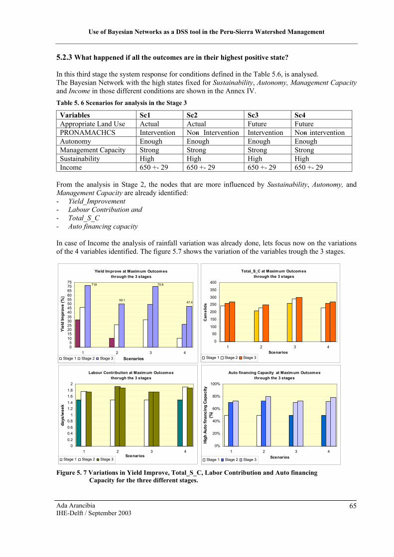
Use of Bayesian Networks as a DSS tool in the Peru-Sierra Watershed Management
Ada ArancibiaIHE-Delft / September 2003
65
5.2.3 What happened if all the outcomes are in their highest positive state?
In this third stage the system response for conditions defined in the Table 5.6, is analysed.The Bayesian Network with the high states fixed for Sustainability, Autonomy, Management Capacityand Income in those different conditions are shown in the Annex IV.Table 5. 6 Scenarios for analysis in the Stage 3
Variables Sc1 Sc2 Sc3 Sc4Appropriate Land Use Actual Actual Future FuturePRONAMACHCS Intervention Non- Intervention Intervention Non- interventionAutonomy Enough Enough Enough EnoughManagement Capacity Strong Strong Strong StrongSustainability High High High HighIncome 650 +- 29 650 +- 29 650 +- 29 650 +- 29
From the analysis in Stage 2, the nodes that are more influenced by Sustainability, Autonomy, and Management Capacity are already identified:- Yield_Improvement- Labour Contribution and- Total_S_C- Auto financing capacity
In case of Income the analysis of rainfall variation was already done, lets focus now on the variations of the 4 variables identified. The figure 5.7 shows the variation of the variables trough the 3 stages.
Figure 5. 7 Variations in Yield Improve, Total_S_C, Labor Contribution and Auto financing Capacity for the three different stages.
Total_S_C at Maximum Outcomesthrough the 3 stages
0
50
100
150
200
250
300
350
400
1 2 3 4Scenarios
Cam
elids
Stage 1 Stage 2 Stage 3
Labour Contribution at Maximum Outcomesthorugh the 3 stages
00.20.40.60.8
11.21.41.61.8
2
1 2 3 4Scenarios
days/wee
k
Stage 1 Stage 2 Stage 3
Auto financing Capacity at Maximum Outcomesthrough the 3 stages
0%
20%
40%
60%
80%
100%
1 2 3 4Scenarios
High
Auto fin
ancing
Cap
acity
(%)
Stage 1 Stage 2 Stage 3
Yield Improve at Maximum Outcomesthrough the 3 stages
50.147.4
70.671.9
05
1015202530354045505560657075
1 2 3 4Scenarios
Yield Im
prov
e (%
)
Stage 1 Stage 2 Stage 3

Use of Bayesian Networks as a DSS tool in the Peru-Sierra Watershed Management
Ada ArancibiaIHE-Delft / September 2003
66
From the figure 5.7 it can be observed that:
- All the variables with exception of Labour Contribution have the same ascending pattern through the three stages. Why is this happening?Analysing the links that part from Labour Contribution. Labour Contribution link to sustainability, participation, and Total Capacity.Sustainability is more depending of Income than of Labour Contribution. Then when Income is high, it is not necessary high levels of Labour Contribution to get high levels of sustainability. Then comparing the values of stage 3 with the values of stage 2, where Income was not at its maximum value, in order to get high sustainability the Labour Contribution fill the gap of the Income. If you have enough money you will hire somebody else to do the work.
- It is required highest values of Yield Improve in order to reach highest Incomes, because agriculture represents the 52% of the Total Production.
- Auto financing is always required to be high, because this lead into a high autonomy, agriculture input provision, and consequently improve the yield and increase agriculture production.
5.3 Results from the Analysis
After the analysis, the results are summarize as follow:
5.3.1 Actual Situation
Agriculture is the main productive activity in the watershed, followed by milk production and south camelids fibre production.
A permanent technical capacity is required to sustain the actual system, because the three productive activities mentioned are based on a certain level of improved technical capacity since:- Milk production is based on grass irrigated by a sprinkler system, and land management with
seeding grass and fencing to protect the growing grass.- The fibre vicunas and alpacas production is based on native grass seeded in furrow infiltration
areas with fencing to protect the growing native grass.- Agriculture production, based on utilisation of selected seeds, fertilizers and sometimes pesticides.
The fibre production of vicuna would deserve more attention from the Community, because since this activity is based on a protected wild animal: vicuna, there is a legal framework for its commercialisation favourable to the campesinos. According law Campesinos Communities are the only ones allowed to commercialise vicuna fibre. The community have to take advantage of this fact, and develop more this productive activity. At present looks like PRONAMACHCS does not deserve the attention expected to this activity, there are few references about the fibre production in the reports and studies.
The main activities of PRONAMACHCS are Technical Capacity, provision of Agricultural Inputs and facilitation of soil erosion control structures. The fencing and manipulation of the sprinkler system it is now in charge of the community, looks like they could manage that by themselves without problems.
At present the watershed system:
- Do not have enough Autonomy; it is still depending of PRONAMACHCS, the management capacity is still low.
- The level of Income is still under the poverty line.- It is not enough sustainability due to low participation and low Income.

Use of Bayesian Networks as a DSS tool in the Peru-Sierra Watershed Management
Ada ArancibiaIHE-Delft / September 2003
67
5.3.2 Responses of the Watershed System to changes in Income, Sustainability, Autonomy, and Management Capacity
Income
Increasing the land used for furrow infiltration and irrigated grass will produce direct increments in the Income level, the maximum levels of Income will be reached if there is enough rainfed water. Income is very dependent of rainfall, more than the area of land used for the productive activities. Then improvement of the water harvesting activities with the soil erosion control structures is a key activity in the watershed management in order to increase the Income level.
Sustainability, Autonomy and Management Capacity
Labour contribution is an important variable to get high Sustainability when the Income levels are low, but it is less important when the Income levels are high.Autonomy will be reached if the Community raise high Auto financing capacity. The Auto financing capacity will permit provision of agriculture inputs to the watershed and support technical training in absence of PRONAMACHCS.Management Capacity is heavily related with PRONAMACHCS, and to manage the system is required certain level of technical capacity, and then it is necessary permanent training.
To summarize, a good combination of structural and non-structural measures will improve the watershed management in order to achieve the objectives.
5.3.3 The constraints
The results of the analysis have some limitations due to the constraints in the model that are described below
- There is very much uncertainty about the non–monetary management variables, like Management Capacity or Total capacity, the links are based only in the author believes. The weight given to the non-monetary variables respect the Income is quiet low.
- There is not a direct link between the Auto financing capacity and Income, because will generate a loop that the system can no stand. To solve this weakness in the model, the implementation of a complete second Network as it shown in the figure 5.8 was thinking, but the idea was left because it was more complex.
- The model give a better understanding about the variables involved, what are the tendencies and the relationship among them. The values showed have to be taken like estimations that give an idea about the range of the value.
Figure 5. 8 Double Bayesian Network

Use of Bayesian Networks as a DSS tool in the Peru-Sierra Watershed Management
Ada ArancibiaIHE-Delft / September 2003
68
5.4 Suggestions to Implement in the actual strategies
Based on the analysis of Ayas watershed system using the Bayesian Network, some recommendations are suggested with the aim of improve the actual situation in order to achieve the Project objectives.
- The lands have to be used according its potentialities, based on an elaborated plan of land management and use considering the limitations of labour availability. To achieve this, it is necessary a revaluation of land use, starting with the establishment of the boundaries of Ayas Community, soil studies, census of population willingness to work.
- In the strategies related to Soil conservation StructuresImplement a plan for maintenance of the actual soil conservation structures; promote the fencing activities and cultivation of native grass in the areas of furrow infiltration.
- In the strategies related to Agriculture Improvement PracticesCombine the Soil Structure maintenance with water harvesting practices as it is made with furrow infiltration.Maintenance and Operation of the sprinkler system have to be supported by special mechanism, in order to support any fail in the system, as well put more attention in the irrigation efficiency.About the provision of Agriculture Inputs, look for another alternative mechanism of provision, an autonomous one, and replace this activity with other ways to incentive free Labour Contribution.
- In the strategies related to Reforestation and agro forestry.Promote reforestation of uphill areas with native species to control soil erosion and improve land supportability in favour of vicuna fibre production.
- In the strategies related to Strengthening of Community OrganisationsMake an evaluation of the actual technical capacity of campesinos to maintain or improve the actual strategies of PRONAMACHCS in training capacity.Realize a Study about the labour contribution in order to implement a program of Incentives and promotions. Looking for a mechanism based more in promotions or legal incentives, than incentives through food provision or agriculture inputs, avoiding programs that create dependency.
- Give more attendance to fibre production activities, taking advantages of the rights in commercialisation, complementing it with soil erosion activities.
- Put attention about the drinking water provision to the community, why it is not in the scope of the watershed management, establish a mechanism of coordination with the institution that provides the service.
5.5 Conclusions and Recommendations
Conclusions
- PRONAMACHCS intervention has high influence in the improvement of managerial variables.
- After the analysis of Ayas community case, the main factor that can have a very strong impact, independent of the land managed, is the precipitation, then water – harvesting activities have to be implemented in combination with the soil erosion control activities.

Use of Bayesian Networks as a DSS tool in the Peru-Sierra Watershed Management
Ada ArancibiaIHE-Delft / September 2003
69
- Bayesian Networks is a very suitable tool to analyze and understand the activities involved in watershed management with many uncertainties, with a poor system of monitoring and data collection.
- Bayesian Networks effectively provide a framework for data collection and analyses, in Ayas Community case, the characteristics of land use, have to be defined better, as well the indicators of participation and effectiveness in the Management Strengthening activity like number of training courses, and attendance to this courses.
Recommendations
- Implement a systematic monitoring system, including not only indicators of activity, also indicators of impact. Promote it use in evaluation of the watershed system, and effectiveness of the project, and PRONAMACHCS activities.
- From the Watershed analysis using the Bayesian Network, the need of activity indicators for the management variables was identified, then is necessary consider indicators like: attendance to training Courses, willingness to participate in training and in the watershed management activities.
- An evaluation of the actual technical capacity of campesinos it is required in order to evaluate the effectiveness of PRONAMACHCS activities in Technical assistance, in order to improve or maintain the strategies of this activity.
- Verify and evaluate efficiency in the use of sprinkler system, through capacity of maintenance and operation.
- Implement a more independent strategy for the provision of agriculture inputs.

Use of Bayesian Networks as a DSS tool in the Peru-Sierra Watershed Management
Ada ArancibiaIHE-Delft / September 2003
70
6 Evaluation of the Use of BN in Watershed Management
How we can measure or evaluate the usefulness of a tool?
Well after using the tool, we can say if we like it or not. Particularly I enjoyed using the Bayesian Network, more than building it. Other way is through comparison with another one used for the same purposes. In this case there was not used another tool to make the evaluation through comparison. Then the evaluation is based only in the appreciations about the use of the tool.
But, to make the evaluation we have to establish parameters not so subjective. Based in the advantages and disadvantages presented in the chapter two, the following “parameters” were established to make the evaluation.
- VersatilityOnce the Bayesian Network is build, it is possible change it according new conditions or new activities involved in the system, through adding or removing links and nodes and changing the condition probability tables.In the analysis process the changes in the state of the variables are easy to do, and facilitate identifying the system response.
- Friendly InterfaceThe graphical presentation facilitates the identification of changes in the variables in different scenarios.The use of Bayesian Networks makes easy to get a better understanding of the system, than reading many reports, or big tables with very small numbers.The graphical presentation provides a better understanding about the relationships between non –physical and physical variables for instance land management and active productivity.
- Time consumingBuild the Bayesian Network only by one specialist that does not have a broad idea about what is going on the watershed, is a time consuming activity.Filling the conditional probability table is a time consuming process, depending of the source ofdata, for instance consultation to specialist, and elaboration of survey are the most time consuming. If the watershed analysed does not have a monitoring system, it will take more time to find information in different reports.
For the analysis is very easy to make changes and identify variables more affected, anyway it is necessary make graphical summaries like the ones presented.
- CostsThe software used for Bayesian Network is not expensive, in fact Netica Application cost 248 U.S.$The Costs of use are implied in the information needed to fill the CPT, and time spent.
In general Bayesian Network looks like useful tools for analysis of watershed management, even they have or no a monitoring system like the case studied.
To use Bayesian Network, as Decision Support system tools in Watershed Management will require a supporting monitoring system with indicators of activity and impact, otherwise will consume so much time, and instead to facilitate the process will obstruct it.

Use of Bayesian Networks as a DSS tool in the Peru-Sierra Watershed Management
Ada ArancibiaIHE-Delft / September 2003
71
7 Conclusions and Recommendations
7.1 Watershed Management
Conclusions
- Watershed Management in Peru is focused on the Sierra region, with a strong intervention of the Government through Programs and Projects such as the National program of watershed management and soil conservation (PRONAMACHCS). The participatory approach is understood as the participation of the communities through a labour contribution to watershed management activities, rather than a role of controlling or participating in the decision making process.
- PRONAMACHCS intervention in watershed management is focused on technical assistance and management capacity to control soil erosion and to improve the productive activities. Some of these interventions have created a strong dependency on part of the watersheds underPRONAMACHCS making them unsustainable, due to the high level of political uncertainty in Peru, where this type of program can disappear from one day to another.
- Despite this Ayas community is considered as one that was successful in the Peru – Sierra natural resources management and poverty alleviation project, has not reached the project objectives, that is to say, has low autonomy, is under the poverty line, and it is not enough sustainable.
- Broadly focussed programs or projects in watershed management, tend to focuses their efforts on the achievement of the physical goals through the list of disbursement or investment (translated as activity indicators), missing the objectives of an efficient watershed management; moreover there broadly focussed programs or projects, tend to disperse efforts and diminish the efficiency and effectiveness of the developed activities.
- Even though there is high uncertainty about the total area of land use in Ayas watershed, it has been shown through the Bayesian Network that income is more related with the availability of physical resources. Management activities (training, fencing, cultivation, etc.) are more related with sustainable land use.
- I have not found documented studies about the relationships between physical and non-physical variables in watershed management.
- In my opinion the most effective way of achieving sustainable watershed management is through achieving autonomy in watershed management.
Recommendations
- Promote the watershed analysis using tools like Bayesian Networks in order to document the relationships that can be established between physical and non-physical variables in watershed management.
- The World Bank should promote more the execution of small scale Projects in watershed management with special attention in the fulfilment of the objectives through periodical evaluation of the watershed management, with the implementation of monitoring systems based not only on activity indicators but also on impact assessment.

Use of Bayesian Networks as a DSS tool in the Peru-Sierra Watershed Management
Ada ArancibiaIHE-Delft / September 2003
72
- PRONAMACHCS have to redefine its paternalistic role. It should promote participation, changes the policies of incentives and improve its monitoring system.
- PRONAMACHCS have to implement in Ayas watershed management a strategy for a suitable land use and a program to expand the areas used under the constraint of labour availability
- The community of Ayas have to put more attention to vicuna fibre production, taking advantages of the existent legal framework and market privileges.
7.2 Bayesian Network Usefulness
Conclusions
- Indeed, Bayesian Networks approach provides an effective mathematical framework for facilitating the integrated analysis of physical and non-physical variables in a watershed, giving a better understanding of the watershed system, as the interaction between the variablesinvolved.
- Participation of stakeholders involved in the watershed management in the Bayesian Network building process will facilitate the process reducing the time consumed by this activity, and improving the quality of the model developed.
- The implementation of decision support system tools like Bayesian Network in Peru sierra watershed management will not be possible until a monitoring system is available. The analysis of a watershed using Bayesian Networks will provide a framework to establish which are the indicators needed to implement an efficient and effective monitoring system.
Recommendations
- Bayesian Networks are easier to understand if it uses a minimum number of nodes. In the building process and conception of the Network try to limit the number of nodes.
- The implementation of Decision Support system tools in the Peru – Sierra watershed management will only be possible if the monitoring of activities is systematized, using not only activity indictors, also impact indicators.
7.3 Limitations to the study
It was not possible to evaluate PRONAMACHCS intervention effectiveness in terms of technical and management capacity, because of data availability and lack of indicators of those activities like assistance to training courses.
The definitions of nodes to represent the objectives of the Project are constrained to the data availability.
The Bayesian Networks is used only to make the analysis, there was not modeled to be used a DSS.

Use of Bayesian Networks as a DSS tool in the Peru-Sierra Watershed Management
Ada ArancibiaIHE-Delft / September 2003
73
References
Arumugam, N. and Mohan, S. 1997. Integrated Decision Support System for tank irrigation system operation, Journal Water Resources Planning and Management, ASCE, 123 (5): 266-273.
Batchelor, C. and Cain, J. 1999. Application of belief networks to water management studies, Journal Agricultural Water Management, 40 (1999): 51-57.
Bakker-Dhaliwal, R., Bell, M., and Morin S. 2001. Decision support systems (DSS): information technology in a changing world. 2001. IRRI, Los baños, Laguna, Philippines.
Bromley, J., Jackson, N., Giacomello, A., Acreman, M. and Bradford, R. 2002. Participatory development of Bayesian Networks as an aid to integrated water resources planning. Wallingford.
Cadwallader and Stauffer. (1997). Livestock Water Requirements [4 pp]. Infosource Number:1085. [Online].http://cf.uwex.edu/ics/infosource/fullrecord.cfm?Idnumbre=84 [2003, Feb. 2].
Cain, J. 2001. Planning improvements in natural resources management Guidelines for using Bayesian networks to support the planning and management of development programmes in the water sector and beyond, Centre for ecology & Hydrology Crowmarsh Giffor, Wallingford
CEPES, 2003. Boletin electronico, CEPES Rural Number 10 [Online]http://www.cepes.org.pe/cendoc/cultivos/leche/vidalactea.htm [2003, Mar. 6].
Global Water Partnership 2003. NO DATE. Why & How IWRM [6pp]. ToolBox Integrated Water Resources Management [Online].http://www.gwp.ihe.nl/wwwroot/GwpORG/handler.cfm?event=infoWhyToolbox [2003, Mar.4].
D’Ambrosio B. NO DATE. Bayesian Methods for Collaborative Decision-Making [28 pp]. Publications Robust Decisions [Online].http://www.robustdecisions.com/BayesianMethodDecisions.pdf [2003, Jan. 24].
Farrington J. and Lobo C. 1997. Scaling up participatory watershed development in India: Lessons from the Indo – German watershed development programme [53 pp]. ODI - Natural Resources Perspectives [Online].http://ww.odi.org.uk/nrp/17.htm [2002, Aug. 23].
Hannaway, D., Fransen, S., Cropper, J., Teel, M., Chaney, M., Griggs, T., Halse, R., Hart, J., Cheeke, P., Hansen, D., Klinger, R. and Lane, W. (1999). Ryegrass Perenne. Oregon State University. USA
Heun J. C. 2000. Water Resources Planning – a framework for analysis. Lecture notes WERM017/00, IHE Delft, the Netherlands
Ito, K., Xu, Z., Jinno, K., Kojiri, T., and Kawamura, A. 2001. Decision Support System for surface water planning in River Basin. Journal Water Resources Planning and Management, ASCE, 127 (4): 272-276.

Use of Bayesian Networks as a DSS tool in the Peru-Sierra Watershed Management
Ada ArancibiaIHE-Delft / September 2003
74
INRM. 2002. Integrated Natural Resources Management [2pp]. Integrated Natural Resources Management [Online].http://www.inrm.cgiar.org/documents/content2.htm [2003, Mar. 4].
Jensen, V. 1996. An Introduction to Bayesian Networks, University College of London Press, London.
Johnson, L. 1986. Water Resource Management Decision Support Systems, Journal Water Resources Planning and Management ASCE, 112(3): 308-325.
Jouravlev A. 2001. Avances en la estructura administrativa para una gestión integrada [14 pp]. Administracion del agua en America Latina y el Caribe en el umbral del Siglo XXI [Online]. http://www.ciedperu.org/agualtiplano/manejo/perumanejo.htm. [2002, Feb. 26].
Lichtenstein, G., Oribe, F., Grieg-Gran, M., and Mazzucchelli, S. (2002). Manejo Comunitario de Vicuñas en Perú. Estudio de caso del manejo comunitario de vida Silvestre. International Institute for Environment and Development, London
Lovell, C., A. Mandondo, and P. Moriarty. 2002. The question of scale in integrated natural resource management. Conservation Ecology 5(2): 25 [Online]. http://www.consecol.org/vol5/iss2/art25[2002, Nov. 24].
Mendoza, G.A. and Macoun, P. with Prabhu, R., Sukadri, D., Purnomo, H. and Hartanto, H. 1999. Guidelines for Applying Multi-Criteria Analysis to the Assessment of Criteria and Indicators, Center for International Forestry Research (CIFOR), Jakarta, Indonesia.
MINAG, 1995. Assessment of water resources and their use by different productive sectors in Peru. MINAG – INRENA, Lima, Peru.
MINAG (Ministry of Agriculture – Peru), 2002. National Report of Food security in Peru. MINAG. Lima, Peru.
Moriarty P. 2002a. An introduction to Bayesian Networks - A tool to support the planning and management of development programmes in the water sector and beyond. Lecture in MSc WERM, IHE Delft, the Netherlands.
Moriarty P. 2002b. Issues from Catchment/Watershed management in India and South Africa. Lecture in MSc WERM, IHE Delft, the Netherlands.
Moriarty P. 2000. Integrated catchment management and sustainable water resource development in semi-arid Zimbabwe. PhD Thesis, University of Reading.
Morrison, K. 2002. Stakeholder involvement in water management: necessity or luxury? In Balancing Competing Water Uses – Present Status and New Prospects. 2002 Stockholm Water Symposium. Water Science & Technology Vol. 47, Number 06 2003.: pp 43 –51.
NRI. 2002. Watershed Management [13 pp]. Natural Resources Institute – Our work in Focus –Environmental Management [Online].http://www.nri.org/work/watershed.htm [2002, Aug. 26].
Obando, 1999. W. Inventario de Recursos Hidricos Microcuenca Muylo – Mullucro, PRONAMACHCS, Tarma, Junin, Peru.

Use of Bayesian Networks as a DSS tool in the Peru-Sierra Watershed Management
Ada ArancibiaIHE-Delft / September 2003
75
Power, D.J. 2002. What is a DSS? [2 pp]. Decision Support Systems Web Tour. [Online]. http://dssresources.com/tour/dss tour.html [2003, Jan. 22].
PRODASA, 2002. Proyecto de Desarrollo Agropecuario Sostenido en el altiplano/Comercializacion, PRODASA, Online [19/12/2002].http://wwidrc.ca/library/document/103453/chap24_s.html
PRONAMACHCS, 2002. Evaluación de casos exitosos en el ámbito del Proyecto de Manejo de Recursos Naturales para el Alivio de la Pobreza en la Sierra BIRF –4130PE, MINAG, Lima, Peru.
PRONAMACHCS - Tarma, 2001. Evaluación Climática de las Microcuencas Muylo – Mullucro Provincia de Tarma, Proyecto MIMA, MINAG, Tarma.
PRONAMACHCS - Tarma, 2000. Estudios de Suelos de la Microcuenca Muylo, Proyecto MIMA, MINAG, Tarma.
Pretty. J., Guijt I., Shah P, and Hinchckiffe F. 1995. Joint watershed management: new evidence from the New Horizons project, Indigenous Knowledge development monitor 3(1): 10 – 12.
Rieman,B., Peterson, J. T., Clayton, J., Howell, P., Thurow, R., Thompson, W., and Lee, D. 2001. Evaluation of potential effects of federal land management alternatives on trends of salmonids and their habitats in the interior Columbia River basin. Journal Forest Ecology and Management, 153 (2001): 43-62.
Rhoades, R. E. (1998). Participatory Watershed research and Management: Where the shadow falls. Gatekeeper Series No 81, IIED, London.
Rockström J. F. 2002. Soil and Water Management. Lecture notes EE469/02/01, IHE Delft, the Netherlands.
Rogers, D., Lamm, F., Alam, M., Trooien, T., Clark, G., Barnes, P., and Mankin, K., 1997. Efficiencies and water losses of irrigation systems. In the irrigation management series. Boletin May 1997. Kansas State University. USA
Rojas T. And Rojas Y. 1999. Microcuencas: Muylo – Mullucro. Diagnostico Social y Agroeconomico, final Report. Tarma, Junin
Rostworoski M. 1999. Historia del Tahuantinsuyu, IEP Editions, Lima.
Savenije H.H.G. 2001. Water Resources Management Concept and Tools. Lecture notes WERM011/01/1, IHE Delft, the Netherlands
Sheng, T. 1999. Important and controversial watershed management issues in developing countries. In Stott D., Mohtar R., and Steinhardt G. (Eds). 2001. Sustaining the Global Farm. Purdue University and the USDA-ARS National Soil Erosion Research Laboratory.: pp 49-52.
Sherbondy, J. 1997, Andean Irrigation in History. In Boelens R. and Dávila G. (Eds). 1998. Searching for Equity Conceptions of justice and equity in peasant irrigation. Van Gorcum & Comp B. V.: pp 210-2214.

Use of Bayesian Networks as a DSS tool in the Peru-Sierra Watershed Management
Ada ArancibiaIHE-Delft / September 2003
76
Toscano, E. 2002. Nuevos horizontes para la comercialización de la vicuña [21pp]. Diario El Peruano[Online].http://www.editoraperu.com.pe/edc/02/04/09/inf.htm [2002, May. 12]
Varis, O. 1998. A belief Network Approach to optimisation and parameter estimation: application to resource and environmental management. Journal Artificial Intelligence 101 (1998): 135-163.
Welp, M. 2000. The use of Decision Support Systems in participatory River Basin Management [3 pp]. European Geophysical Society. [Online].http://www.copernicus.org/EGS/egsga/nice00/programme/abstracts/aac7057.pdf [2003, Jan. 27].
Westervelt, J. 2000. Simulation Modeling for Watershed Management. Springer-Verlang, New York.
World Bank 1996, Staff appraisal reports Peru Sierra – Natural Resources Management and Poverty Alleviation Project, Report No. 15719-PE.
World Bank. 1997, Peru – Sierra Natural Resources Project, Report No. PIC 2488.
World Bank, 2002. Measuring Poverty [6 pp] New direction in poverty measurement [Online].http://www.worldbank.org/poverty/mission/up2.htm [2002, Nov. 27].
World Bank, 2003. Sierra Natural Resources Management and Poverty Alleviation Project [Online].http://www4.worldbank.org/sprojects/Project.asp?pid=P042442 [2003, Jun. 27]

Use of Bayesian Networks as a DSS tool in the Peru-Sierra Watershed Management
Ada ArancibiaIHE-Delft / September 2003
77
ANNEXES
Annex I: Watershed Characteristics
Annex II: Bayesian Networks Nodes, and CPTS
Annex III: Sensitivity Analysis
Annex IV: Bayesian Networks Graphs


