Embed Size (px)
Citation preview

3
Tropical Deforestation in the Ecuadorian Chocó: Logging Practices and Socio-spatial Relationships
Santiago LópezDepartment of GeographyThe George Washington UniversityWashington, DC 20052Email: [email protected]
Rodrigo Sierra Teresa Lozano Long Institute of Latin
American Studies (LLILAS)University of Texas at AustinAustin, TX 78712andFundación Ecuatoriana de Estudios
Ecológicos (EcoCiencia), Quito-Ecuador.Email: [email protected]
Milton TiradoHerbario Nacional del EcuadorQuito, EcuadorEmail: [email protected]
The Geographical Bulletin, 51: 3-22©2010 by Gamma Theta Upsilon
AbSTRACT
This article examines the implications of forest management on biodiversity at a local level and the relationships between defores-tation and its geographic and demographic contexts at a regional level in the Ecuadorian Chocó region . We evaluated the implications of logging practices on biodiversity through the comparison of two 5-ha vegetation quadrats in two areas with and without for-est management . Results of the local evalu-ation showed that the managed forest had higher tree density, larger basal area, and more commercial tree species per hectare than the unmanaged area . Yet, forest gaps were notably large in both research sites . We analyzed the relationships between deforesta-tion and its spatial and demographic contexts at the regional level using Landsat satellite data from years 1993 and 2001, geographic information systems, and regression analysis . Results of the regional evaluation suggest that population density, costs of traveling, and distance to rivers are significantly related to forest loss in the region .
Key Words: Ecuador, Chocó, tropical deforestation, remote sensing, forest man-agement .
INTRODUCTION
Recent research indicates that commercial and subsistence logging are implicated in en-vironmental degradation ranging from local to global scale, and nowhere are these prob-lems more severe than in the tropics (Walker 2004, Barraclough and Ghimire 2000) . In Latin America, land conversion to pasture and crop areas has been identified as one of the main sources of deforestation over the past three decades (Walker 2004) . However, the contribution of logging to forest loss increased significantly in the past 20 years (Carr 2004, Ferraz 2002) . Most evidence of this comes from research in frontier lands in the tropical lowlands (Walker 2004, Carr and
4
Santiago López, Rodrigo Sierra and Milton Tirado
Bilsborrow 2001, Walker et al . 2000, Wood 1983) . However, representative studies are needed for a whole range of regions, under a broad diversity of land use and manage-ment strategies . This study analyzes the im-plications of two types of forest management practices on forest diversity at a local level and the relationships between deforestation and its physical and socio-demographic con-texts at a regional level in the Ecuadorian Chocó region .
The Ecuadorian Chocó region, an area of approximately 7,000 km2 located on the northern edge of the Esmeraldas province in northwestern Ecuador, gathered the at-tention of several national and international conservation organizations when Norman Myers identified it as a biodiversity hot spot . Myers (1990, 1988) introduced the term biodiversity hotspot to distinguish places with particularly large numbers of endemic species at risk of extinction due to the expan-sion and intensification of human activities . The Ecuadorian Chocó region obtained this denomination since approximately 13 to 20 percent of its vascular plants, 25 percent of its mammals, 60 percent of its amphibians, and 10 percent of its birds are endemic (CEPF 2001), and their habitat experienced more than 85 percent habitat loss over the previ-ous 30 years, mainly due to agriculture and logging (Sierra and Stallings 1998, CEPF 2001) .
Logging activities have increased in the Ecuadorian Chocó in the past 20 years due to increased local and national demands for timber (Sierra et al . 2003) . Approximately 70 percent of the Ecuadorian domestic tim-ber comes directly from this region (Sierra 2001) . Due to the potential impacts of these activities on biodiversity, the United States Agency for International Development (USAID) provided financial support through the Cooperative for Assistance and Relief Ev-erywhere (CARE) in 1992 for the creation of the Sustainable Use of Biological Resources (SUBIR) project . The objective of this project was to implement an ambitious conserva-tion program in this region, specifically to
preserve the remaining forests located in the area surrounding the Cotacachi-Cayapas Ecological Reserve located in the provinces of Imbabura and Esmeraldas (CEPF 2001) . The main objective of SUBIR was to pro-mote economic activities that could improve household income and reduce pressure on forest resources, such as technical ecosystem monitoring, ecotourism, handicraft produc-tion using locally available materials, and sus-tainable forestry, as opposed to high intensity conventional logging .
We define sustainable forestry as a type of forest management that ensures that forests continue to produce timber over the long term, while maintaining the full complement of environmental services, such as carbon se-questration or soil erosion prevention, and the provision of non-timber products, such as game and food resources (Rice et al . 2001) . Techniques such as manual or semi-mecha-nized selective logging and improved timber transportation systems are usually used (Uhl and Guimaraes-Vieira 1989) . Even though some damage could be inflicted to the nearby vegetation during the extraction of selected species (i .e . collateral damage), ecosystem services and functions are maintained over the long term . Sustainable forestry involves the implementation of forest management plans (FMP) . A FMP is a set of written plans for current and future management practices that are implemented to meet official gov-ernment forestry policy (Poore and Sayer 1991) . FMP and timber licenses are currently required by the Ecuadorian Environmental Ministry for extracting timber from ecologi-cally sensitive areas .
Notwithstanding these requirements, some communities and private corporations still apply conventional logging techniques for timber extraction . Conventional logging refers to existing timber harvesting practices (e .g . using bulldozers to pull out trees at different stages of growth), which typically pay little attention to maintaining long-term timber supply or guaranteeing the availability of a complete range of ecosystem services for future generations (Lindemalm and Rogers
5
Tropical Deforestation in the Ecuadorian Chocó: Logging Practices and Socio-spatial Relationships
2001) . Techniques such as mechanized selec-tive logging that employ heavy machinery, such as bulldozers to fell trees and drag logs are used . In conventional logging, collateral damage can be so high that ecosystem services and functions are hampered . Collateral dam-age may lead to a range of ecosystem effects including changes in light regimes and forest microclimate, soil erosion and compaction, disruption of nutrient cycling, and possibly changes in tree species composition (Mc-Nabb 1997, Ter Steege et al . 1995, Jonkers 1987) . Such changes could potentially affect the growth of tree species and the diversity of forest fauna (Johns et al . 1996, Pinard et al . 1996, Hill et al . 1995) .
Several empirical studies have confirmed that although sustainable timber manage-ment sometimes provides reasonable rates of return, conventional timber harvesting is generally more profitable, at least in the short term (Rice et al . 1997, Pinard et al . 1996, Ter Steege et al . 1995, Silva 1989, Uhl and Guimaraes-Vieira 1989) . Without additional incentives, one cannot expect local com-munities, private owners, or companies to adopt sustainable practices . One could even anticipate that, in the short term, forest loss will occur at rates similar to those presently observed since profits from conventional logging are usually equivalent to or higher than those from sustainable forestry (Rice et al . 1997) .
Governmental agencies such as the Min-istry of the Environment and organizations such as CARE-Ecuador have directed their efforts towards making sustainable forest management (SFM) a more viable option to manage the land . These efforts include a variety of strategies, such as the provision of communal land titles to ensure legal occupa-tion of the territory and green certification intended to increase sustainable harvesting’s profitability . However, these plans have also increased the profitability of some agricul-tural and farm products (e .g . cacao, shrimp, and African palm) and, in some instances, non-managed logging, and therefore have failed to highlight the benefits of SFM to
local communities and small scale loggers . The slow rise in international timber prices, political uncertainty, and tenure insecurity simply reinforce the tendency at national and regional scales . Unfortunately, there has been limited empirical work linking forest management practices to land cover patterns as a way to evaluate the implications of SFM on biodiversity . This study tries to make these linkages and uses a spatial perspective to as-sess the effects of managed and non-managed logging on the biodiversity of the region .
ThE CAUSES Of DEfORESTATION IN ThE ECUADORIAN ChOCó
Notwithstanding SUBIR efforts, deforested areas in the Ecuadorian Chocó have grown over the past two decades (Rival 2004, Sierra et al . 2003, Sierra 2001, Rudel 2000, Sierra and Stallings 1998) . In 1970, more than 80 percent of the region was covered by lowland forests, but over the past two decades, an increased demand for timber products and farming land for subsistence and commercial production (e .g . shrimp ponds and African palm) has been linked to the loss of more than 85 percent of the original forest cover (Sierra 2001, Rudel 2000) . As in other parts of the tropics, the causes of deforestation in the Chocó region can be grouped into three main categories: 1) infrastructure extension, 2) logging, and 3) agricultural expansion . Several authors have suggested that greater infrastructure development and better access to markets and forest areas accelerate for-est loss (Mertens et al . 2002, Mertens and Lambin 2000, Nelson and Hellerstein 1997, Chomitz and Gray 1996, Ludeke et al . 1990, Southgate et al . 1991) . Deforestation is more likely to occur in areas that are closer to ur-ban areas and markets in physical distance and traveling time, since transportation costs are reduced (Southworth and Tucker 2001, Rudel 2000, Crews-Meyer 1999, Ludeke et al. 1990) . Small forest patches are generally more accessible than large compact patches, and forests in coastal and riverine areas are generally deforested earlier than those in
6
mountainous regions, except in the case of forests in protected reserves (Nelson et al . 2001, Pfaff 1999, Rosero-Bixby and Palloni 1998) . Some authors have suggested that either labor or capital-intensive logging is involved in rapid forest loss (Barbier and Burgess 1996, Deacon 1995, Capistrano 1994) . Higher prices for timber are likely to promote deforestation by making logging in private or public lands more profitable (Sierra 2001, Wunder 1996) . Higher tim-ber values also increase the net benefits of clearing land and encourage deforestation (Burgess 1993, Gullison and Losos 1993) . However, if correctly managed, the extrac-tion of wood from forest plantations can reduce the pressure on natural forests and contribute to biodiversity conservation (Barros and Uhl 1995) .
Infrastructure development, logging, and agricultural expansion may not be the only causes of forest loss in the Chocó re-gion . In the context of tropical lowlands, demographic factors may result in wide-spread deforestation and resource depletion (Brondizio et al . 2002, Carr 2002, Angelsen 1999, Pichón 1997) . An increased demand for food and forest products could poten-tially increase forest fragmentation and the loss of forest-dependent species through agricultural expansion (Godoy 2001) . As population grows, so does the demand for land for agricultural purposes (McCracken et al . 2002, Perz 2002, Pichón 1997) . When the demand for food increases, forest lands that are closer to transportation networks, villages, or markets are more likely to be converted into agriculture than areas farther away . Rudel (2000) identified five main factors that could potentially be linked to deforestation in the Ecuadorian Chocó: 1) the accessibility and proximity of forests to urban markets, 2) the existence of valuable hardwood species like chanul (Humirias-trum procerum), sande (Brosimum utile), and guayacán (Minquartia quianensis), 3) the construction of new road networks along the border with Colombia and within the region where approximately 25,000 immi-
grants from the highlands and other parts of the Ecuadorian and Colombian coast live, 4) the establishment of new shrimp and African palm (Elaeis guineensis) farms, and 5) population growth, specifically of local indigenous groups, such as the Cha-chis and Awá, and Afro-Ecuadorians and mestizo (or mixed) populations . Studies that focus on the identification of the re-lationships between deforestation and its socio-demographic and physical contexts may help in developing appropriate forest polices and applying strategies designed to protect forest resources (Angelsen and Kaimowitz 1999, Kaimowitz and Angelsen 1998, Rudel 1993) .
This analysis attempts to answer two related research questions . First, what are the implications of current SFM practices on biodiversity at the local level in the Ecuadorian Chocó? Second, what are the relationships between the spatial and socio-demographic contexts and deforestation at a regional level? A presupposition of this analysis is that forest management practices are reflected in land cover characteristics both at local and regional levels and these, in turn, can be used to analyze the outcomes of conservation programs .
STUDy AREA
The region includes the combined hydro-graphic basins of the Cayapas and Santiago rivers and extends over approximately 6,200 km2 (Alcina Franch 1979) . About 64 percent of this extent lies on the coastal plains and was the subject of this study (Fig . 1) . The topog-raphy of the inland area is comprised of low-lying, undulating terrain near the juncture of two rivers (Cayapas and Santiago) at the town of Borbón (i .e . the main local market in the region for timber products) . Areas of more irregular relief lie further upstream, where bedded and folded Miocene sandstones are clearly visible in the high banks of the middle and upper Cayapas and its tributaries . Old growth forests in the region are dominated by trees with dense canopies over 30 m high and
Santiago López, Rodrigo Sierra and Milton Tirado

7
include species such as sande, chanul, carrá (Huberodendron patinoi), and chalviande (Virola sp .), tángare (Carapa guianensis), and pialde macho (Guarea kunthiana) (Davis et al . 1997) . Undergrowth vegetation is rela-tively sparse and dominated by tree seedlings, shrubs, and bushes . The road network is poor, but there is a recently built first-order highway that connects the highlands with the ports of San Lorenzo, Borbón, and other coastal towns . The human settlement pattern of the Chocó region is riverine, and most trans-portation, where the best-conserved forests exist, occurs along rivers . In 2001, the region contained approximately 62,000 people, of whom 8 percent were indigenous inhabitants from the Chachis and Awá groups, 60 percent Afro-Ecuadorians, and 32 percent mestizos (INEC 2001) . In the region, 127 communi-ties received land titles from the Ministry of Agriculture between 1990 and 2001, which recognized communal land tenure .
LOCAL ASSESSmENT Of fOREST mANAGEmENT
In order to determine the implications of the two forms of forest management in the region (i .e . sustainable vs . conventional) on biodiversity, we established two quadrats of 500 m x 100 m (5 ha) in three formally recog-nized communities controlled by mestizo and Afro-Ecuadorian populations . The boundaries of these communities were delimited by sur-veyors with the support of SUBIR . We chose a size of 5 ha to be able to accurately map the location of trees, logs, and canopy openings . The axis of each quadrat was georeferenced us-ing GPS . We selected the inventory sites with the aid of satellite images and the assistance of local researchers who have worked extensively in the area (Fig . 2) . With their assistance, we selected areas that had similar soils, slope, elevation, climatic, and biological character-istics . The first site (Quadrat A) was located
Figure 1: Location of the study area: The Cayapas and Santiago rivers watershed in north-western Ecuador .
Tropical Deforestation in the Ecuadorian Chocó: Logging Practices and Socio-spatial Relationships

8
in the Rio Santiago Cayapas Afro-Ecuadorian community at 0°49’12’’ N and 78°53’59’’ W . This community did not have a SFM plan and was not working with SUBIR at the time of the vegetation inventory . We placed Quadrat A perpendicular to a newly opened road, which was going to be used by bulldozers to extract timber . The logging activity in the area nearby the inventory site was intensive, and constant tree removal took place during the survey period . Selective mechanized logging was the general technique used in this site to extract timber . This practice consisted of either cutting selected tree species of any diameter with chainsaws or pulling them out directly from the ground with bulldozers . After trees are felled, large logs are dragged by bulldozers to the closest river or road .
At the time of the survey, seven communi-ties in the Ecuadorian Chocó had SFM plans with SUBIR support, which encompassed an area of approximately 4,000 hectares . Quadrat B was established on the border
of two of these communities, Chispero and Zapallo Grande . The Ministry of the Envi-ronment approved the forest management plan of these two communities in November 1998 (personal communication with log-gers 2002) . The inventory site was located at 0°46’55’’ N and 78°54’10’’ W . In Quadrat B, in contrast to the other area, local loggers used an improved selective semi-mechanized method to extract timber . This method consisted of cutting selected species with a diameter of at least 30 cm at breast height with a chainsaw or axe instead of pulling them out directly with bulldozers . Then, logs were trimmed and transported by hand-powered aerial cables to the closest river to minimize disruption of the understory and collateral damage .
To measure the effects of logging practices on forests, we analyzed three key indicators: basal area, the size of canopy gaps, and den-sity of commercial tree species per quadrat . We estimated basal area using the following
Figure 2: Location of Quadrats A and B in the Afro-Ecuadorian communities of Chispero, Zapallo Grande, and Rio Santiago Cayapas in the Ecuadorian Chocó region .
Santiago López, Rodrigo Sierra and Milton Tirado
9
approximation (Uhl and Gimaraes-Vieira 1989):
0 .7854 * D2 (D = Diameter at Breast Height)
We measured canopy openings in the field and with the aid of high-resolution georeferenced digital aerial photography taken by the research team in 2001 . We measured density of commercial tree species by dividing the number of trees of the most valuable species by the quadrat’s area . The inventory of tree species consisted of three specific tasks: (1) mapping trees with DBH greater than or equal to 10 cm; (2) map-ping canopy gaps; and (3) tabulating DBH values, species names, and canopy heights . Two botanists and two field assistants from the communities where the quadrats were established contributed with their expertise in identifying tree species . We temporarily marked all trees in the sampling plots, visu-ally estimated canopy heights, and hand-drew detailed maps of the locations of trees and canopy gaps in each quadrat . Mapping was accomplished by walking from the ini-tial baseline to the opposite side .
REGIONAL ASSESSmENT Of DEfORESTATION
Landsat Thematic Mapper (TM) satel-lite images (path 10, row 59) were selected to estimate forest loss between 1993 and 2001 . The year 1993 was chosen because SUBIR had just started with the regional conservation program and data were avail-able for the study area . Small differences, if any, in humidity and solar radiation exist between the wet and dry seasons in this region . Therefore, the only criterion taken into account for image selection was cloud coverage, which had to be less than 20 percent . The images were georeferenced to UTM zone 17 North, PSAD 56, using a second degree polynomial rectification algo-rithm with 54 ground control points (GCP) extracted from a digitized topographic map at the scale of 1:50,000 . We then resampled
the pixels to 30 m using a nearest-neighbor interpolation method to preserve radiomet-ric integrity . The root mean square (RMS) error used in the rectification process of the 2001 image was less than 1 pixel (30 m) . We co-registered the other images to the first scene using an image-to-image transforma-tion method with a RMS error of less than 0 .5 pixels (15 m) . A normalized difference vegetation index (NDVI) was calculated for each satellite scene and stacked with bands one, two, five, and seven . We substituted the NDVI layer for bands three and four of the Landsat images to avoid redundancy during classification . The satellite images were segmented into homogenous regions and classified using an unsupervised classifi-cation algorithm . Forty classes resulted after 95 percent of pixels remained unchanged between two consecutive iterations . We vi-sually reclassified the 40 classes into three categories by looking at the pixels on the computer screen and comparing them with the non-classified pixels . These categories were: 1) forest, 2) non-forest, and 3) wa-ter . The category “forest” included both presumably old growth forests, which are relatively unaffected by human activities, and secondary forests, which are wood-lands disturbed in some way by humans . The “non-forest” category refers to areas that have suffered complete removal of for-est cover for any reason (e .g . agriculture, logging, or road construction) . Although some trees may remain, the spectral dis-tinctiveness of these areas is unmistakable . The “water” class comprises every type of water body including rivers, temporary lakes, and swamps . We created a mosaic with the classified datasets and filled gaps with no information due to cloud coverage (less than 3 percent of the study area) with classified images of years 2000 and 1997 . We filtered both 1993 and 2001 classifica-tions using a majority or modal algorithm to eliminate noise and increase the accuracy of land-cover mapping (Jensen 1996, Kenk et al . 1988) . We compared these images to detect change .
Tropical Deforestation in the Ecuadorian Chocó: Logging Practices and Socio-spatial Relationships

10
ACCURACy ASSESSmENT Of LAND USE AND LAND COvER
CLASSIfICATIONS
We validated the 2001 satellite imagery classification with data collected by the research team at the end of 2001 using a state-of-the-art technique based on high-res-olution georeferenced videography and aerial photography . Georeferenced videography refers to positional information from a GPS receiver linked to individual video frames of the surveyed region in digital format (Cooper et al . 1995) . This method can be described as a low-budget, do-it-yourself remote sensing technique that could be used to distinguish among a variety of environmental ground conditions and to assist the interpretation and validation of coarser resolution satellite imagery and classifications . We randomly selected fifty-eight points from georeferenced video frames to generate an error matrix to evaluate the accuracy of the classified satel-
lite image . The overall accuracy of the 2001 classification was 79 percent . Thomlinson et al . (1999) suggested a target of 80 percent or more as an overall accuracy goal . However, there is no consensus yet on this standard, nor is there a single universally acceptable measure of accuracy . It may be preferable to derive more than one measure of accuracy and provide the error matrix as a fuller descrip-tion of classification accuracy (Arbia et al . 1998, Muller et al . 1998, Stehman 1997) . In this study, we report four different measures of accuracy (Table 1): 1) the user’s accuracy, which is a map-based measurement of accu-racy and is calculated by dividing the number of correctly classified pixels of a land use or land cover category by the total number of pixels of the same class, 2) the producer’s accuracy, which is a reference-based accuracy estimate and calculated by dividing the num-ber of correctly classified pixels of a particular class by the total number of ground reference pixels of the same category 3) the overall ac-
Table 1: Accuracy measurements derived from the error matrix: User’s, Producer’s, Overall accuracies and the Kappa coefficient . Reference data extracted from the interpretation of geo-referenced video collected in 2001 . Classified data obtained from a 2001 Landsat image .
FOREST (Reference
data)NON FOREST (Reference data)
WATER (Reference
data)Total # of
cellsUser’s
Accuracy (%)
FOREST (classified data) 23 1 1 25 92.0
NON FOREST (classified data) 7 15 1 23 65.2
WATER (classified data) 2 0 8 10 80.0
Total number of cells 32 16 10 58
Producer’s Accuracy (%) 71.9 93.8 80.0
Overall Accuracy (%) 79.3
Kappa Coefficient (%) 67.0
Santiago López, Rodrigo Sierra and Milton Tirado

11
curacy, which provides a general estimate of the accuracy of the classification and is calculated by dividing the number of pixels correctly classified by the total number of pixels, and 4) the Cohen’s kappa coefficient of agreement, which measures the improve-ment of the classified map over a random class assignment .
SPATIAL AND STATISTICAL mODELING
Commonly, spatial and statistical models of land use cover change that pursue the integration of physical attributes and socio-demographic characteristics are derived from the combination of remote sensing, GIS, socio-economic information obtained from surveyed data, and multivariate mathematical models (Mertens and Lambin 2000, Veris-simo et al . 1998, Chomiz and Gray 1996) . We used a similar combination of methods to analyze the associations between changes in land cover and a series of spatially explicit explanatory variables . We analyzed these relationships through maps derived from remotely sensed data, socio-demographic surveys collected by SUBIR in 2001 at the community level, and statistical modeling . From a total dataset of 127 Afro-Ecuadorian and mestizo communities legally recognized by the Ministry of Agriculture and mapped by SUBIR, we randomly chose 54 for analysis to minimize the effects of spatial autocor-relation . Changes in land cover were sum-marized at the community level, and their spatial occurrence was correlated with social and spatial attributes .
We expected deforestation at a regional scale to be associated with higher population densities and proximity to transportation, villages, and market locations . Specifically, the costs of transportation from deforested areas to the closest market along any trans-portation artery, such as a road or a river, are expected to influence the prevalence of logging activity . Travel costs can be seen as a relative measurement of the costs of mov-ing . Lower travel times, such as found in
areas closer to roads or rivers, should result in lower costs and should provide greater incentives for forest clearing . Nevertheless, if old-growth forests are scarce, people may decide to pay higher costs in order to har-vest enough timber to generate some profit . Proximity to villages can be interpreted as the person’s effort to move from residential locations to logging areas, independent of the effort the same person spends on transporta-tion of timber products to the closest market . Forest clearing for both subsistence and com-mercial agricultural production is more likely to occur in areas closer to villages than farther away from them to reduce the effort invested in reaching production areas . Since rivers are the main transportation arteries in the region, it is expected that most logging activities also follow a riverine pattern . Thus, proximity to rivers can be interpreted as the interaction between transportation routes and the areas where people work, independent from the interaction between logging sites and the areas where people live .
We examined the role of the spatial and social variables in deforestation through an OLS regression equation that explains vari-ations in land cover as a function of popula-tion density, distance to access features and towns, and costs of transportation (Fig . 3) . The general model is specified as:
D = a + b1*P + b2* R + b3*T + b4*S
where D=deforested area within a commu-nity between 1993 and 2001, P=population density of the community, R=average dis-tance for that community from non-forest areas to rivers, T=average distance for that community from non-forest areas to main towns, S=average transportation costs for that community to the main local market, and bn are the regression coefficients .
We obtained population and spatial in-formation for model implementation from SUBIR’s database . These included carto-graphic data for communities, roads, and riv-ers . We converted the classified data derived from satellite images to vector format . Then,
Tropical Deforestation in the Ecuadorian Chocó: Logging Practices and Socio-spatial Relationships

12
we calculated Euclidean distances from the center of each contiguous deforested patch to the closest town and river and estimated an average distance for each community . Cost-weighted distance analysis was used to calculate transportation costs . The first step in calculating these costs consisted of establishing an average speed along roads and rivers . Then, we calculated the cost of cross-ing a 30 m cell (the resolution of the raster) using the following equation:
where C= cell crossing cost (in $), P=raster resolution (in m), and S=average traveling speed (in km/h) . We used the centroid of the town of Borbón as the destination feature for
the calculation of cost-distance weighted val-ues that represent transportation costs along a road or river from any point on the raster map to the closest market . This approach is consistent with multiple studies showing that transportation constraints are among the most significant and consistent factors related to forest loss (Pfaff 1999, Sader and Joyce 1998) .
RESULTS
Results obtained from the vegetation sur-veys showed that Quadrat A, with no FMP, contained 98 species and 1639 trees, while Quadrat B, with SFM, had 117 and 1929 respectively . Thus, Quadrat B (managed for-est) encompassed 19 species and 290 trees
Figure 3: Maps of spatial and demographic factors associated with deforestation in the Ecuadorian Chocó: A) Population density, B) Distance to rivers, C) Distance to towns, and D) Transportation costs .
Santiago López, Rodrigo Sierra and Milton Tirado
13
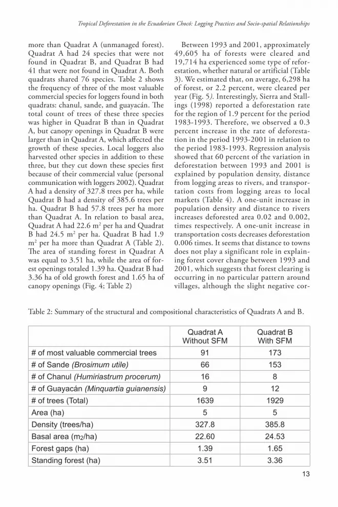
more than Quadrat A (unmanaged forest) .Quadrat A had 24 species that were not found in Quadrat B, and Quadrat B had 41 that were not found in Quadrat A . Both quadrats shared 76 species . Table 2 shows the frequency of three of the most valuable commercial species for loggers found in both quadrats: chanul, sande, and guayacán . The total count of trees of these three species was higher in Quadrat B than in Quadrat A, but canopy openings in Quadrat B were larger than in Quadrat A, which affected the growth of these species . Local loggers also harvested other species in addition to these three, but they cut down these species first because of their commercial value (personal communication with loggers 2002) . Quadrat A had a density of 327 .8 trees per ha, while Quadrat B had a density of 385 .6 trees per ha . Quadrat B had 57 .8 trees per ha more than Quadrat A . In relation to basal area, Quadrat A had 22 .6 m2 per ha and Quadrat B had 24 .5 m2 per ha . Quadrat B had 1 .9 m2 per ha more than Quadrat A (Table 2) . The area of standing forest in Quadrat A was equal to 3 .51 ha, while the area of for-est openings totaled 1 .39 ha . Quadrat B had 3 .36 ha of old growth forest and 1 .65 ha of canopy openings (Fig . 4; Table 2)
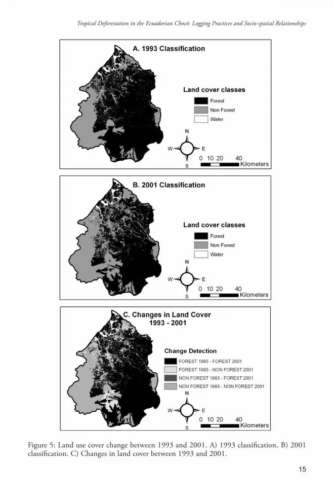
Between 1993 and 2001, approximately 49,605 ha of forests were cleared and 19,714 ha experienced some type of refor-estation, whether natural or artificial (Table 3) . We estimated that, on average, 6,298 ha of forest, or 2 .2 percent, were cleared per year (Fig . 5). Interestingly, Sierra and Stall-ings (1998) reported a deforestation rate for the region of 1 .9 percent for the period 1983-1993 . Therefore, we observed a 0 .3 percent increase in the rate of deforesta-tion in the period 1993-2001 in relation to the period 1983-1993 . Regression analysis showed that 60 percent of the variation in deforestation between 1993 and 2001 is explained by population density, distance from logging areas to rivers, and transpor-tation costs from logging areas to local markets (Table 4) . A one-unit increase in population density and distance to rivers increases deforested area 0 .02 and 0 .002, times respectively . A one-unit increase in transportation costs decreases deforestation 0 .006 times . It seems that distance to towns does not play a significant role in explain-ing forest cover change between 1993 and 2001, which suggests that forest clearing is occurring in no particular pattern around villages, although the slight negative cor-
Table 2: Summary of the structural and compositional characteristics of Quadrats A and B .
Quadrat AWithout SFM
Quadrat BWith SFM
# of most valuable commercial trees 91 173# of Sande (Brosimum utile) 66 153# of Chanul (Humiriastrum procerum) 16 8# of Guayacán (Minquartia guianensis) 9 12# of trees (Total) 1639 1929Area (ha) 5 5Density (trees/ha) 327.8 385.8Basal area (m2/ha) 22.60 24.53Forest gaps (ha) 1.39 1.65Standing forest (ha) 3.51 3.36
Tropical Deforestation in the Ecuadorian Chocó: Logging Practices and Socio-spatial Relationships

14
Figure 4: Canopy coverage and forest gaps in Quadrats A and B derived from aerial photos and field mapping .
Santiago López, Rodrigo Sierra and Milton Tirado
15
Figure 5: Land use cover change between 1993 and 2001 . A) 1993 classification . B) 2001 classification . C) Changes in land cover between 1993 and 2001 .
Tropical Deforestation in the Ecuadorian Chocó: Logging Practices and Socio-spatial Relationships

16
Table 3: Land cover change between 1993 and 2001 in an area of approximately 4,000 km2 in Northwest Ecuador . Post-classification area comparison between land cover classes in hectares derived from Landsat TM satellite images .
Forest in 2001 (ha)
Non-Forest in 2001 (ha) Total %
Forest in 1993 (ha) 236960.12 49605.00 286565.12 74.4%Non-Forest in 1993 (ha) 19714.60 78725.62 98440.22 25.6%
Total 256674.72 128330.62 385005.34 100%% 66.7% 33.3% 100%
Table 4: Results of the regression analysis .
Independent Variables b T P-valuePopulation density (P) 0.0192600 7.42 0.000Distance to towns (T) 0.125000 -3.23 0.863Distance to rivers (R) 0.0024220 3.93 0.000
Transportation Costs (S) -0.0055770 -3.53 0.001(constant) 0.1190000 7.57 0.000
Deforested Area between 1993 and 2001 = Dependent Variablen = 54; Adjusted R square = 0.6
relation suggests that forest clearing may be occurring in remote areas where good forest stands exist . We used a sample of 11 communities to validate the results of the statistical model . The validation proce-dure determined that the model predicted approximately 20 percent more defores-tation in these communities . Although a 20 percent error may appear too high at first, the variables chosen for analysis only account for the spatial and demographic variables associated with deforestation . Other variables such as types of soils, prices of timber and agricultural products, market demand, and access to technology would likely improve the model’s predictive capa-bility . Nevertheless, the model highlights the importance of considering the spatial and social contexts wherein deforestation occurs to advance the understanding of forest loss in the region .
DISCUSSION AND CONCLUSIONS
Some studies have pointed out the poten-tial failure of sustainable forestry on private lands, including those controlled by local communities, if technologies are not cor-rectly transferred or commercial interests prevail over conservation objectives (Pearce et al . 2003, Rametsteiner and Simula 2002, Pinard et al . 1996, Silva 1989, Uhl and Guimaraes-Vieira 1989) . In this study, we showed that SFM has had some positive ef-fects on forest diversity, but logging practices and techniques, even under SFM plans, re-quire improvement . The results suggest that the FMP implemented in 2001 has enhanced tree growth (basal area) and biodiversity rich-ness (number of species and trees) . However, even though timber extraction was selective in both the managed and unmanaged areas, both conventional and sustainable logging
Santiago López, Rodrigo Sierra and Milton Tirado
17
caused relatively high collateral damage . Sev-eral factors could explain these findings . We observed a uniform opening in the canopy along Quadrat B’s axis, caused by local log-gers setting up a new transportation system to carry felled logs to the closest river . This technique consists of a hand-powered system of cables, pulleys, and platforms that aims to prevent pulling timber along trails to reduce collateral damage . However, even though local loggers were using the system at the time of the survey, they were not confident with its technical specifications regarding, for example, the maximum weight that the aerial cable system could handle, how to efficiently transport logs, and the space required to ma-nipulate the cables . This lack of confidence and expertise with the system translated into an inadvertent destruction of the flora near logging operations . Tree felling caused significant openings in the canopy which af-fected the understory vegetation and soils . Given the size and condition of the leaves of the seedlings that we observed, this seems to have compromised the growth of the three most valuable timber species: chanul, sande, and guayacán .
Another factor that could explain differ-ences in size of canopy openings in quadrats A and B is the time when logging operations started in each area and the techniques used to harvest timber . Commercial logging started in the communities of Chispero and Zapallo Grande (Quadrat B) about the same time as in the community of Rio Santiago Cayapas (Quadrat A) . Bulldozers were used in areas nearby Quadrat A, but not where the survey took place . Here only chainsaws were used to cut trees in the inventory site, and felled logs were pulled out by mules and horses . We found no evidence of agricultural land use near the quadrat . In contrast, even though bulldozers were not used in Quadrat B, there was evidence that a section of this area was used for agriculture despite the fact that the FMP called for it to be used exclusively for timber harvesting . A couple of conclusions can be drawn from these observations: 1) even though conventional logging was more inten-
sive in areas adjacent to Quadrat A, canopy gaps were not significantly large where the in-ventory took place since chainsaws were used to selectively harvest timber, and logs were usually pulled out by horses and mules, and 2) even though sustainable timber harvesting could be profitable for local communities in the long term, this alternative is less attrac-tive than commercial agricultural activities since it does not relieve short term financial or nourishment needs. At the time of the vegetation surveys, markets, governmental agencies, and non-governmental organiza-tions still had not offered landowners and local communities attractive incentives to sustainably extract forest products, favoring the transformation of forests to intensive agriculture and resource extraction . In this sense, it should be noted that having a for-estry plan is not sufficient to guarantee its adequate implementation and reach desired conservation goals . Nevertheless, as in many conservation projects, the success of SUBIR efforts may require confidence in the long term and the people’s capability to adapt to new technologies or practices .
The understanding of the processes that lead to forest loss at a local scale may help to explain deforestation at coarser scales . Nevertheless, the dynamics of the underly-ing processes at such levels may be different than those observed at local levels . For this reason, other research approaches such as those based on remote sensing, GIS, and sta-tistical analyses may provide further insights on forest loss from a regional perspective . This combination of methods is a powerful strategy for searching linkages between land cover characteristics and the social and spatial configuration of forest areas . In the case of the social context, the Ecuadorian Chocó has experienced rapid population growth since 1990 (≈1 .9 percent per year) (SISSE 2001) . Mortality rates have decreased in the area due to health programs promoted by the Ecua-dorian government and the Pan American Health Organization / World Health Or-ganization (PAHO 2002) . In 2001 around 62,000 people lived in the area, compared to
Tropical Deforestation in the Ecuadorian Chocó: Logging Practices and Socio-spatial Relationships

18
50,000 in 1991 (INEC 1991, 2001; SIISE, 2001) . It could be expected then that defor-estation rates have increased in the region, since people usually demand more land for agriculture, fuel wood, and construction to meet their basic needs as their numbers grow . The results of the regression analysis presented in Table 4 assert this expecta-tion and show that larger deforested areas are more likely to exist where population density is high . This finding is supported by evidence from several regression models that show positive correlation between population density and deforestation for specific time spans (McCracken et al . 2002, Rock 1996, Palo 1994) .
We found a positive relationship between distance to rivers and deforestation . We observed how deforested areas also follow a riverine pattern that is consistent with settle-ment characteristics, but larger and recent deforestation patches were generally not close to rivers . If areas close to rivers were accessed first by loggers and cleared before 1993, it is reasonable to think that logging activities are presently occurring in areas farther away from riverbanks, where good forest stands are still available . We observed that, in some instances, logs were pulled by mules and horses (and in parts of Quadrat A by bulldoz-ers) up to 9 km to the closest navigable river and then transported to Borbón, the closest market . Interestingly, this distance triples or quadruples the average distance reported in other studies that have shown a rapid decline in forest clearing beyond 2 or 3 km from an access road (Nelson and Hellerstein 1997, Chomitz and Gray 1996, Sader and Joyce 1988) . Finally, deforestation may have ac-celerated in recent years as transportation costs have decreased due to the opening of a first-order highway connecting the highlands with San Lorenzo and the local market of Borbón . This suggests that larger deforested areas were found where lower transportation costs from logging areas to the main market of Borbón existed . This finding supports our initial hypothesis that lower transporta-tion costs are usually associated with larger
cleared areas and suggests that transportation infrastructure improvements have been effec-tive tools in the area for stimulating timber harvesting .
If these preliminary conclusions hold up, the policy implications for the forests in the Ecuadorian Chocó are wide-ranging and rela-tively urgent . This study advocates that fur-ther empirical research at more disaggregated levels of analysis would be helpful to advance the understanding of tropical deforestation, as would field studies that more directly focus on timber harvesting technologies as well as on farmers, loggers’ behavior, and market forces within an environment of changing socioeconomic conditions .
REfERENCES
Alcina Franch, J . 1979 . La Arqueología de Esmeraldas (Ecuador), Introducción gen-eral. Memorias de la Misión Arqueológica Española en el Ecuador, Volumen 1. Madrid: Ministerio de Relaciones Exteriores .
Angelsen, A . 1999 . Deforestation: Population or Market Driven? Different Approaches in Modeling of Agricultural Expansion . Jour-nal of Development Economics, 55:67-84 .
Angelsen, A . and Kaimowitz, D . 1999 . Rethinking the Causes of Deforestation: Lessons from Economic Models . The World Bank Research Observer, 14(1):73-98 .
Arbia, G ., Griffith, D . and Haining, R . 1998 . Error Propagation Modeling in Raster GIS, Overlay Operation . International Journal of Geographical Information Science, 12(2):145-167 .
Barbier, E .J . and Burgess, J .C . 1996 . Eco-nomic Analysis of Deforestation in Mexico . Environment and Development Economics, 1:203-239 .
Barraclough, S .L . and Ghimire, K .B . 2000 . Agricultural Expansion and Tropical Defores-tation: Poverty, International Trade and Land Use . Sterling: Earthscan Publications .
Barros, A . and Uhl, C . 1995 . Logging along the Amazon River and estuary: Patterns, problems, potential . Forest Ecology and Management, 77:87-105 .
Santiago López, Rodrigo Sierra and Milton Tirado

19
Brondizio, E ., McCracken, S ., Moran, E ., Siqueira, A ., Nelson, D . and Rodriguez-Pedraza, C . 2002 . The Colonist Foot-print . In: Wood, C . and Porro, R . (eds .) Deforestation and Land Use in the Amazon, Gainsville: University Press of Florida, pp . 133-161 .
Burgess, J .C . 1993 . Timber Production, Timber Trade and Tropical Deforestation . Ambio, 22:136-143 .
Capistrano, A .D . 1994 . Tropical Forest De-pletion and the Changing Macroeconomy . In: Brown, K . and Pearce, D . (eds .) The Causes of Tropical Deforestation, the Eco-nomic and Statistical Analysis of Factors Giving Rise to the Loss of Tropical Forests . London: University of London Press, pp . 68-85 .
Carr, D .L . 2002 . The Role of Population Change in Land Use and Land Cover Change in Rural Latin America: Un-covering Local Processes Concealed by Macro-Level Data . In: Himiyama, M .H . and Ichinose, T . (eds .) Land use Changes in Comparative Perspective . UK: Science Publishers, pp . 133-148 .
_____ . 2004 . Tropical Deforestation. In: Janelle, D .G ., Warf, B . and Hansen, K . (eds .) WorldMinds: Geographical Perspec-tives on 100 Problems, The Netherlands: Kluwer Academic Publishers, pp . 293-298 .
Carr, D .L . and Bilsborrow, R .E . 2001 . Population and Land Use/Cover Change: A Regional Comparison between Central America and South America . Journal of Geography Education, 43:7-16 .
CEPF 2001 . Ecosystem Profile: Chocó-Manabí Conservation Corridor of the Chocó-Darien-Western Ecuador Biodiver-sity Hotspot . 39 pp . Available at: http://www .cepf .net/where_we_work/regions/south_america/tumbes_choco_magdale-na/ecosystem_profile/Pages/synopsis_of_threats .aspx . [Accessed on: 1/14/2010]
Chomitz, K .M . and Gray, D .A . 1996 . Roads, Land Use and Deforestation: A Spatial Model Applied to Belize . The World Bank Economic Review, 10(3):487-512 .
Cooper, R ., McCarthy, T . and Raper, J . 1995 . Airborne Videography and GPS . Earth Observation, 4:53-55 .
Crews-Meyer, K .A . 1999 . Modeling Land Cover Change Associated with Road Cor-ridors in Northeast Thailand: Integrating Normalized Difference Vegetation Indices and Accessibility Surfaces . In: Schoolmas-ter, F .A . (ed .) Proceedings, Applied Geogra-phy Conference, Vol. 22 . pp . 407-446 .
Davis, S .D ., Heywood, V . H ., Herrera-MacBryde, O ., Villa-Lobos, J . and Hamilton, A .C . 1997 . Centers of Plant Diversity, A Guide and Strategy for Their Conservation, Volume 3. Cambridge: IUCN Publications Unit .
Deacon, R . 1995 . Assessing the Relationship Between Government Policy and Defores-tation . Journal of Environmental Economics and Management, 28:1-18 .
Ferraz, C . 2002 . Explaining Agricultural Ex-pansion and Deforestation: Evidence from the Brazilian Amazon – 1980/98 . IPEA, Working Paper No . 828 .
Godoy, R . 2001 . Indians, Markets, and Rain-forests: Theory, Methods, Analysis . New York: Columbia University Press .
Gullison, R .E . and Losos, E .C . 1993 . The Role of Foreign Debt in Deforestation in Latin America . Conservation Biology, 7:140-147 .
Hill, J .K ., Hamer, K .C ., Kace, L .A . and Banham, W . M . 1995 . Effects of Selective Logging on Tropical Forest Butterflies in Buru, Indonesia . Journal of Applied Ecology, 32(4):754-760 .
INEC (2001) . Instituto Nacional de Estadís-ticas y Censos de Ecuador - INEC . [http://www .inec .gov .ec] .
INEC (1991) . Instituto Nacional de Estadís-ticas y Censos de Ecuador - INEC . [http://www .inec .gov .ec] .
Jensen, J . 1996 . Introductory Digital Image Processing, A Remote Sensing Perspective . Englewood Cliffs, NJ: Prentice Hall .
Johns, J .S ., Barreto, P . and Uhl, C . 1996 . Logging Damage During Planned and Unplanned Logging Operations in the Eastern Amazon . Forest Ecological Manage-ment, 89(1):59-77 .
Tropical Deforestation in the Ecuadorian Chocó: Logging Practices and Socio-spatial Relationships

20
Jonkers, W .B . 1987 . Vegetation Structure, Logging Damage and Silviculture in a Tropical Rain Forest in Suriname, Ecology and Management of Tropical Rain Forests in Suriname . The Netherlands: Wageningen Agricultural University Press .
Kaimowitz, D . and Angelsen, A . 1998 . Economic Models of Tropical Deforestation: A Review . Bogor, Indonesia: Center for International Forestry Research .
Kenk, E ., Sondheim, M . and Yee, B . 1988 . Methods for Improving Accuracy of The-matic Mapper Ground Cover Classifica-tions . Canadian Methods of Remote Sensing, 14(1):17-31 .
Lindemalm, F . and Rogers, H .M . 2001 . Im-pacts of Conventional Logging and Por-table Sawmill Logging Operations on Tree Diversity in East New Britain, Papua New Guinea . Australian Forestry, 64(1):26-31 .
Ludeke, K ., Maggio, R . and Reid, L .M 1990 . An Analysis of Anthropogenic Deforesta-tion Using Logistic Regression and GIS . Journal of Environmental Management, 31:247-259 .
McCracken, S . D ., Siqueira, A .D ., Moran, E . and Brondizio, E .S . 2002 . Land Use Pat-terns on an Agricultural Frontier in Brazil . In: Wood, C . and Porro, R . (eds .) Deforesta-tion and Land Use in the Amazon, Gainsville: University Press of Florida, pp . 162-192 .
McNabb, K . L . 1997 . Selection Harvests in Amazonian Rainforests, Long-Term Im-pacts on Soil Properties . Forest Ecology and Management, 93:153-160 .
Mertens, B . and Lambin, E . 2000 . Land Cover Change Trajectories in Southern Cameroon . Annals of the Association of the American Geographers, 90(3):467-494 .
Mertens, B ., Poccard-Chapuis, R ., Piketty, M .G ., Lacques, A .E . and Venturieri, A . 2002 . Crossing Spatial Analyses and Live-stock Economics to Understand Deforesta-tion Processes in the Brazilian Amazon: The Case of Sao Felix do Xingu in South Para . Agricultural Economics, 27(3):269–294 .
Muller, S ., Walker, D, Nelson, F ., Auerach, N ., Bockheim, J ., Guyer, S . and Sherba, D . 1998 . Accuracy Assessment of a Land-
cover Map of the Kuparuk River Basin, Alaska, Considerations for Remote Re-gions . Photogrammetric Engineering and Remote Sensing, 64(6):619-628 .
Myers, N . 1988 . Threatened Biotas, ‘Hot Spots’ in Tropical Forests . The Environ-mentalist, 8(3):187-208 .
_____ . 1990 . The Biodiversity Challenge, Expanded Hot Spot Analysis . The Envi-ronmentalist, 10(4):243-256 .
Nelson, G .C ., Harris, V . and Stone, S .W . 2001 . Deforestation, Land Use, and Proper-ty Rights: Empirical Evidence from Darién, Panama . Land Economics, 77:187-205 .
Nelson, R . and Hellerstein, D . 1997 . Do Roads Cause Deforestation? Using Satellite Images in Econometric Analysis of Land Use . American Journal of Agricultural Eco-nomics, 79(1):80-88 .
PAHO [Pan American Health Organziation] . 2002 . Health in the Americas . Volume II . Scientific and Technical Publication No . 587 . Washington, D .C .
Palo, M . 1994 . Population and Deforesta-tion . In: Brown, K . and Pearce, D . (eds .) The causes of Tropical Deforestation: The Economic and Statistical Analysis of Factors Giving Rise to the Loss of the Tropical Forest. London: University College London Press . pp . 42-56 .
Pearce, D ., Putz, F . and Vanclay, J . 2003 . Sustainable Forestry in the Tropics: Pana-cea or Folly? Forest Ecology and Manage-ment, 172(2-3):229-247 .
Perz, S .G . 2002 . Population Growth and Net Migration in the Brazilian Legal Amazon, 1970-1996 . In: Wood, C . and Porro, R . (eds .) Deforestation and land use in the Amazon. Gainesville: University of Florida Press . pp . 107-129 .
Pfaff, A . 1999 . What Drives Deforestation in the Brazilian Amazon? Evidence from Satellite and Socioeconomic Data . Journal of Environmental Economics and Manage-ment, 37:26-43 .
Pichón, F . 1997 . Settler Households and Land-use Patterns in the Amazon Frontier: Farm-level Evidence from Ecuador . World Development, 25(1):67-91 .
Santiago López, Rodrigo Sierra and Milton Tirado

21
Pinard, M ., Howlett, B . and Davidson, D . 1996 . Site Conditions Limit Pioneer Tree Recruit-ment After Logging of Dipterocarp Forests in Sabah, Malaysia . Biotropica, 28(1):2-12 .
Poore, D . and Sayer, J . 1991 . The Manage-ment of Tropical Moist Forest Lands: Eco-logical Guidelines. Gland, Switzerland: International Union for Conservation of Nature .
Rametsteiner, E . and M . Simula . 2002 . Forest Certification - An Instrument to Promote Sustainable Forest Management? Journal of Environmental Management, 67(1):173-184 .
Rice, R ., Gullison, R . and Reid, J . 1997 . Can Sustainable Management Save Tropical For-ests? Scientific American, 276(4):34-39 .
Rice, R ., Sugal, C ., Ratay, S . and da Fonseca, G . 2001 . Sustainable Forest Management: A Review of Conventional Wisdom, Volume 3 . Washington DC: Center for Applied Biodiversity Science .
Rival, L . 2004 . Parternships for Sustainable For-est Management: Lessons from the Ecuadorian Chocó . Working Paper 118 . QEH Working Paper Series . University of Oxford .
Rock, M . 1996 . The Stork, the Plow, Rural Social Structure, and Tropical Deforesta-tion in Poor Countries? Ecological Econom-ics, 18(2):113-31 .
Rosero-Bixby, L . and Palloni, A . 1998 . Población y Deforestación en Costa Rica . In: Rosero-Bixby, L and Palloni, A . (eds .) Conservación del bosque en Costa Rica. San José: Académica Nacional de Ciencias y Programa Centroamericano de Población . pp . 131-150 .
Rudel, T . 2000 . Organization for Sustainable Development, Conservation Organizations and the Struggle to Protect Tropical Rain Forests in Esmeraldas, Ecuador . Ambio, 29(2):78-82 .
_____ . 1993 . Tropical Deforestation, Small Farmers and Land Clearing in the Ecua-dorian Amazon. New York: Columbia University Press .
Sader, S . and Joyce, A . 1988 . Deforestation Rates and Trends in Costa Rica . Biotro-pica, 20(1):11-19 .
Sierra , R . 2001 . The role of domestic timber markets in tropical deforestation and forest degradation in Ecuador: Implications for Conservation Planning and Policy . Ecologi-cal Economics, 36:327–40 .
Sierra, R . and Stallings, J . 1998 . The Dynam-ics and Human Organization of Tropical Deforestation in Northwest Ecuador, 1983-1995 . Human Ecology, 26(1):135-161 .
Sierra, R ., Tirado, M . and Palacios, W . 2003 . Forest-Cover Change from Labor- and Capital-intensive Commercial Logging in the Southern Chocó Rainforests . Profes-sional Geographer, 55(4):477-490 .
Silva, J . N . 1989 . The Behavior of the Tropi-cal Rain Forest of the Brazilian Amazon after logging . Ph D dissertation . London: University of Oxford .
Southgate, D ., R . Sierra, R . and L . Brown . 1991 . The Causes of Tropical Deforesta-tion in Ecuador: a Statistical Analysis . World Development, 19(9):1145-1151 .
Southworth, J . and Tucker, C . 2001 . The Influence of Accessibility, Local Institu-tions, and Socioeconomic Factors on Forest Cover Change in the Mountains of Western Honduras . Mountain Research and Development, 21:276-283 .
SIISE . 2001 . Sistema Integrado de Indicadores Sociales del Ecuador . Quito: Ministerio del Frente Social .
Stehman, S . 1997 . Selecting and Interpret-ing Measures of Thematic Classification Accuracy . Remote Sensing of Environment, 62(1):77-89 .
Ter Steege, P ., Boot, R .H ., Brouwer, L ., Hammond, D ., Van Der Hout, P ., Jetten, V .G ., Khan,Z ., Polak, A .M ., Raaimakers, D . and Zagt, R . 1995 . Basic and Applied Research for Sound Rain Forest Manage-ment in Guyana . Ecological Applications, 5(4):904-910 .
Thomlinson, J ., Bostad, P . and Cohen, W . 1999 . Coordinating Methodologies for Scaling Land Cover Classifications from Site-specific to Global, Steps Toward Validation Global Map Products . Remote Sensing of Environment, 70(1):16-28 .
Tropical Deforestation in the Ecuadorian Chocó: Logging Practices and Socio-spatial Relationships

22
Uhl, C . and Guimaraes-Vieira, I . 1989 . Eco-Eco-logical Impact of Selective Logging in the Brazilian Amazon, a Case Study from the Paragominas Region of the State of Para . Biotropica, 21(2):98-106 .
Verissimo, A ., Souza, C ., Stone, S . and Uhl, C . 1998 . Zoning of Timber Extraction in the Brazilian Amazon . Conservation Biol-ogy, 12(1):128-136 .
Walker, R . 2004 . Theorizing Land Cover and Land Use Change: The Case of Tropical Deforestation . International Regional Sci-ence Review, 27:247-270 .
Walker, R ., Moran, E . and Anselin, L . 2000 . Deforestation and Cattle Ranching in the Brazilian Amazon: External Capital and Household Processes . World Development, 28(4):683-699 .
Wood, C . 1983 . Peasant and Capitalist Production in the Brazilian Amazon: A Conceptual Framework for the Study of Frontier Expansion . In: Moran, E . (ed .) The Dilemma of Amazonian Development. Boulder: Westview . pp . 259-277 .
Wunder, S . 1996 . Deforestation and the Uses of Wood in the Ecuadorian Andes . Mountain Research and Development, 16:367-381 .
Santiago López, Rodrigo Sierra and Milton Tirado


