Embed Size (px)
Citation preview
TSAC Task 15-03 (Electronic Charting Systems)
Page 1 of 16 April 12, 2017
TOWINGSAFETYADVISORYCOMMITTEE
TASK15‐03
Recommendations on Electronic Charting Systems Carriage on Towing Vessels (Short Title: ECS or Electronic Charting Systems)
FinalReportandRecommendations

TSAC Task 15-03 (Electronic Charting Systems)
Page 2 of 16 April 12, 2017
March 31, 2017 To: Towing Safety Advisory Committee From: Matt Lagarde, Chair Wes Southworth, Co-Chair RE: TSAC Task 15-03 Recommendations Regarding Carriage and Use of Electronic
Charting Systems for Primary Navigation. At the October 22, 2015 Regular Meeting with the Members of the Towing Safety Advisory Committee, a subcommittee was created to provide recommendations regarding the use of electronic navigation charts on towing vessels for primary navigation in anticipation of the publication of a NVIC allowing the use of these charts. Matt Lagarde was nominated for Chairman and Wes Southworth was nominated as Co-Chair of this Subcommittee. Both nominations were approved by TSAC members without dissent. Subcommittee participants include TSAC members, industry participants, trade associations and Government Agencies. A complete list of individuals that participated in subcommittee meetings is attached as Enclosure (3) to this report. At the spring 2016 Meeting of the Towing Safety Advisory Committee in New Orleans, the Task Statement was amended to reschedule the final report date from the spring 2016 meeting to the fall 2016 meeting of the TSAC committee. The Task Statement was also amended to include recommendations and comments on NVIC 01-16 which was published by the USCG on Feb 5, 2016, prior to a final report from TSAC. Respectfully Submitted, Matthew L. Lagarde TSAC Task 15-03 Subcommittee Chair Enclosure: (1) Recommendations on ECS Operational Requirements
(2) TSAC Task Statement 15-03 (3) TSAC Representatives & Subcommittee Participants (4) NVIC 01-16

TSAC Task 15-03 (Electronic Charting Systems)
Page 3 of 16 April 12, 2017
Executive Summary Background The U.S. Coast Guard (USCG) was directed by the Coast Guard Maritime Transportation Act of 2004 to implement regulations that required carriage of electronic charts on domestic vessels1, including towing vessels, on the navigable waters of the United States by January of 2007. The USCG did not meet this milestone because of the lack of a published standard for Electronic Charting Systems (ECS). In the absence of regulation and guidance on ECS between 2004 and 2015, platform-independent software-based ECS have been developed and have proliferated throughout the towing industry, to the point of saturation. The Radio Technical Commission for Maritime Services (RTCM) published an update to performance standards for ECS in July of 2015 with Special Committee 109 publication 10900.6. This publication is based largely on standards published by the RTCM for Electronic Chart Display and Information Systems (ECDIS), which is itself, based on and refers to several International Electronic Committee (IEC) and International Hydrographic Organization (IHO) documents. The RTCM 10900.6 report states that the intent of the published standard is to support ECS as a backup or alternative to ECDIS systems. Use of ECDIS systems is mandated aboard many seagoing vessels by SOLAS. The USCG has relied on the technical expertise of the RTCM to publish a standard, as they have in the past with RADAR and AIS equipment. The RTCM divides ECS into four classes:
Class A—Intended to serve as backup or alternative to ECDIS; Class B—Intended to serve as primary navigation for vessels operating offshore that are
not required by SOLAS to use ECDIS; Class C—Intended to plot and monitor the position of ships that do not generally operate
offshore; and Class D—Intended to plot the position of ships that do not operate offshore.
The platform-independent software-based ECS widely utilized by the towing industry today were not considered in the standard set forth in the RTCM 10900.6 paper, due largely to the hardware requirements and hardware testing requirements of IEC 60945 that are cited by reference in the RTCM report. In fact, the Subcommittee has determined that there are no ECS in production that meet the RTCM standard. The Towing Safety Advisory Committee (TSAC) was tasked (Task 15-03) by the Coast Guard in October 2015 with making recommendations on ECS carriage on towing vessels and to provide input on the following questions:
1Current chart carriage requirements for towing vessels are addressed in: 33 C.F.R. 164.72 (Towing Vessels); 46 C.F.R. 26.03 (Uninspected Towing Vessels); and 46 140.705 (Inspected Towing Vessels under Subchapter M not subject to 33 C.F.R. 164.72). Chart retention and production in the event of a marine casualty investigation is addressed in 46 C.F.R. 4.05. Exemptions from the chart carriage requirements of 33 C.F.R. 164.72 are provided for in 33 C.F.R. 164.70 (Limited Geographic Area, Assistance Towing, OCMI discretion).
TSAC Task 15-03 (Electronic Charting Systems)
Page 4 of 16 April 12, 2017
Which class of ECS should be allowed in each of the different maritime zones? What information should (or must) be interfaced into the ECS? What should the backup arrangement be for each Class? What should the training requirement be for each Class? What should the waiver parameters be for domestic towing vessels?
In February 2016, the Coast Guard issued NVIC 01-16, which allows vessel operators the option of using ECS that meet the RTCM standard in lieu of paper charts. Conclusions The Subcommittee believes that a massive shift from the systems currently in use throughout the industry to a completely different ECS and/or an ECDIS system would create an economic hardship on the industry, as well as a safety concern due to the massive amount of retraining that would need to occur across the industry. Moreover, the Subcommittee believes that platform-independent software-based ECS have proven to be effective, reliable, user-friendly and safe. The Subcommittee was not provided with any casualty data that indicated that the systems widely in use throughout the industry have contributed to any marine casualties. In fact, there is ample evidence to demonstrate that these systems enhance safety. They automatically update and establish backups for charts and other required nautical publications, reducing the risk of human error. They also have the ability to display Automated Identification System (AIS) data, electronic Marine Safety Information (eMSI) data, Closest Point of Approach (CPA), speed, vector and other relevant information to the vessel operator, which results in greater efficiency and accuracy than a mariner trying to calculate and retrieve this data from various paper charts. The Subcommittee notes that there are no concerns with IHO S-57(ENC) and S-61 (RNC) electronic charts produced by the National Oceanic and Atmospheric Administration (NOAA) and the U.S. Army Corps of Engineers (USACE). In fact, the shift of NOAA and the USACE away from the production of paper charts, and the current trend toward updating the electronic ENCs and RNCs on a frequent basis instead of producing new editions, increases the urgency with which an accepted or approved electronic alternative to the carriage of paper charts is needed. The Subcommittee believes that the RTCM 10900.6 standard cannot be effectively applied widely across the towing industry in a reasonable timeframe, and that delaying acceptance or approval of the platform-independent software-based ECS that are currently widely used will delay the safety benefits of using these systems for primary navigation. Therefore, the Subcommittee has concluded that the USCG should not consider the RTCM 10900.6 standard as it is currently written to be the only acceptable way to use ECS to meet chart carriage requirements for domestic towing vessels. The Subcommittee believes that the USCG should accept the platform-independent software-based systems that, over the past 12 years, have been developed, tested, and proven to be effective, safe and reliable, and that fulfill the need to provide useful and up-to-date navigation information to mariners.
TSAC Task 15-03 (Electronic Charting Systems)
Page 5 of 16 April 12, 2017
TSAC Recommendations
The USCG should approach implementation of ECS on domestic towing vessels in two stages:
First, equivalency, in which the USCG accepts as meeting the chart carriage requirements the display of an electronic chart of appropriate scale, for the area of operation, produced by NOAA, the USACE or other appropriate authority and currently corrected/updated, that meets the requirements in 33 C.F.R. 146, 46 C.F.R. 26 and 46 C.F.R. 140.705; and
Second, integration, in which the USCG requires the utilization of an ECS that integrates the display of electronic charts with data from other relevant navigation equipment into a comprehensive navigation display based on the IHO guidelines provided for ECS.
The Subcommittee has included an appendix which lists its recommendations of operational requirements that both equivalent and integrated ECS must, should, and may meet, for the USCG’s consideration.
The platform-independent software-based ECS in use today should be considered acceptable by the USCG for the purposes of equivalency, as long as that equipment can faithfully display the USACE or NOAA charts. The USCG should work with manufacturers to establish an acceptable standard for the “independent platform” and set a later date for compliance with this standard that allows time for both industry and manufacturers to adjust. The independent platform standard for software-based systems should be based on risk and applicability, not on the existing international standards intended for trans-ocean international voyages.
The Subcommittee recommends that the Coast Guard accept the following ECS carriage
and backup arrangement requirements for towing vessels, based on the routes on which the vessel will be operating and whether the vessel does not plot courses or may plot courses. The routes referred to in this document are as defined in 46 C.F.R. 136.110:
o Rivers and Canals2 and Limited Coastwise Waters3—Vessels operating on
rivers and canals should only be required to carry a single platform-independent software-based ECS or ECS meeting the RTCM 10900.6 Class C requirements. In these areas of operation, failure of the system would not result in the vessel being lost, but would require that the vessel stop until repairs or corrections could be made. The Subcommittee believes vessels operating on long voyages should carry a backup system. This requirement may also be inclusive of Inland Waters shoreward of the baseline using user selected equipment suitable for the route.
o Lakes, Bays and Sounds, the Great Lakes, Coastwise and Oceans (Non-SOLAS)—Non-SOLAS vessels operating on these routes should be required to
2 Including Western Rivers as defined in 46 C.F.R. 136.110. 3 As designated by the cognizant OCMI.
TSAC Task 15-03 (Electronic Charting Systems)
Page 6 of 16 April 12, 2017
carry a platform-independent software-based ECS or ECS meeting the RTCM 10900.6 Class C requirements for primary navigation. Because loss of a primary ECS may result in the vessel operator becoming disoriented or unsure of actual position in relation to underwater hazards, these vessels should be required to have a secondary means of meeting the chart carriage requirements. This requirement would be inclusive of waters seaward of the baseline and include equipment with better suitability for marine environments such as equipment which meets IEC 60945 guidelines. This secondary requirement may be met by:
Having a fully functioning secondary ECS. This backup ECS may be
installed on a computer that has some secondary function, such as email or as a company traffic management system, but should be of sufficient capability to properly run the ECS software in order for the operator to maintain situational awareness; or
A software-based system meeting the functionality of the RTCM Class D standard installed on a suitable GPS-enabled tablet or laptop computer of sufficient scale to serve as a navigational chart; or
Paper Charts meeting the carriage requirements of 33 C.F.R. 164.72
o Limited Local Area/Limited Geographic Area4—Vessels operating in Limited Local Areas as designated by the local OCMI, and in consideration of the area of operation, traffic density, and complexity of navigation in the area, should be able to either: Carry any accepted or approved ECS; or Carry a paper chart or excerpt of a paper chart which is currently corrected
for the area of operation; or Be exempted under provisions in 33 C.F.R. 164.70
In addition to vessels operating in limited local or geographic areas, as designated by the
local OCMI, the USCG should give ECS waiver consideration to vessels engaged in assistance towing as defined by 46 C.F.R. 136.110, because they are not engaged in conventional towing and because assistance towing vessel operators are generally very familiar with the area in which they are operating.
For platform-independent software-based ECS, the Subcommittee recommends a system-specific training program that takes into account the software manufacturer’s operator manuals, the operation of the independent platform on which the system is run, procedures for system anomalies and malfunctions, and proficiency. This training program may be administered by a company or by a third party. Certification or records of proficiency training should be made available to the USCG upon request. The Subcommittee also recommends this same regime of training for an ECS which meets the RTCM 10900.6 Class D requirements if used as a backup ECS. Systems which meet the RTCM 10900.6 requirements for Class A, B or C should follow the Merchant Marine Personnel Advisory Committee (MERPRPAC) Task #92 report recommendations.
4 As designated by the cognizant OCMI.
TSAC Task 15-03 (Electronic Charting Systems)
Page 7 of 16 April 12, 2017
The subcommittee recommends that the Cyber Security issues associated with operation of connected electronic systems onboard towing vessels is a larger issue than may be tackled within the scope of this Tasking. Operators should follow the established best practices for protecting their electronic equipment for nefarious attack. The subcommittee recommends that the USCG seek recommendations from overall protection against Cyber Security attack for all shipboard systems through a separate Tasking.
Summary of Subcommittee Work and Additional Supporting Analysis
The Subcommittee met in some capacity three times as a group, and some members of the Subcommittee attended the RTCM Conference in Clearwater, FL in May of 2016 and the eNav Underway Conference in Houston, TX in October of 2016. Meetings were held on the following dates: December 3, 2015 New Orleans, Louisiana January 19, 2016 New Orleans, Louisiana April 13, 2016 New Orleans, Louisiana May 20, 2016 Clearwater, Florida (RTCM Conference) June 9, 2016 Teleconference (w/ RTCM SC 109) Oct. 18-19, 2016 Houston, Texas (eNav Underway) Attendance is reflected in Enclosure (4) The Subcommittee initially embraced the four classes of ECS systems outlined in the RTCM 109 standard based on the descriptions in RTCM Paper 256-2008-SC109-PR, which established the general intended use of each system, but not the details of their functionality. The publication provided on the RTCM website at the time of the first two meetings was not the most up-to-date version of the RTCM 109 standard. The Subcommittee reached out to the RTCM and committee members were provided with an up-to-date (10900.6) version and the RTCM website was updated. Upon further review and consultation with RTCM members, it became apparent that there were no systems as described in the RTCM 109 standard that were in production and that could be used in lieu of paper charts, and the platform-independent software-based ECS widely in use throughout the industry were not considered in the RTCM 109 standard. The Subcommittee determined that the requirements set forth in NVIC 01-16 that allowed an ECS to meet chart carriage requirements cannot be reasonably met on coastal waters unless a vessel utilized an ECDIS and appropriate backup. The requirements cannot be met on the Inland Waters and Western Rivers due to the lack of available charts for ECDIS for these areas of operation. Subcommittee members also raised concerns regarding equipment requirements outlined in the RTCM 10900.6 standard that seemed to surpass those in USCG regulations establishing minimum carriage requirements. It is the opinion of the Subcommittee that this standard adds
TSAC Task 15-03 (Electronic Charting Systems)
Page 8 of 16 April 12, 2017
equipment carriage requirements, not part of the ECS itself, which are outside of the scope of current USCG regulation and policy. The Subcommittee engaged RTCM Special Committee 109 to assess whether or not the RTCM felt that the standard could be met with equipment presently used to run the software-based ECS widely used in the towing industry, or with minor alterations to that equipment. The committee did not believe current platforms in use within the domestic towing fleet would align with the Class C system standards as written, nor would any reasonable modification to that equipment result in that equipment complying with the current written standard. Discussions with the RTCM 109 committee, which the Subcommittee notes includes several manufacturers and is not a FACA committee, led to the realization that manufacturers will not design, build, test and certify a system unless there is a market need. The Class A system as identified in the 10900.6 standard is essentially the same as an ECDIS with AIS integration. If the need can be met by purchasing and ECDIS, the added cost to develop a new piece of equipment where a commercially available equivalent already exists is not justified. The Class C ECS as defined in the 10900.6 paper does not exist. The Class D system as identified in the 10900.6 paper does not include integration of various navigational aids and does not in general meet the requirements of the USCG or RTCM for chart carriage requirements to meet primary navigation needs; however, the Subcommittee believes that a Class D system of appropriate scale should be considered as a suitable primary chart system (not necessarily an ECS) or backup system in some instances. The IHO S-66 paper that defines ECS in the international community states that an ECS may be a complex system integrated into the ships other navigation equipment, or may be a simple handheld GPS-enabled device. The Subcommittee also assessed the current state of, and challenges presented by, paper charts. The USACE and NOAA ceased production of paper charts in 2014, although print-on-demand charts from authorized chart dealers are still available. Uninspected towing vessels operating exclusively on the navigable waters of the United States have the option of utilizing a currently corrected chart or the most recent edition under 33 C.F.R. 164.72. However, it is the understanding of the Subcommittee that there will no longer be new editions produced by the applicable government organizations, only updates. At the same time, Local Notices to Mariners have grown considerably in length, and with the authorization to carry other nautical publications in electronic format (CG-543 Policy Letter 10-05), it has become increasingly difficult to maintain corrections to the paper charts for large areas of operation. Other electronic versions of nautical publications are permitted to be stored and updated electronically. This is the most efficient and accurate way of making corrections. The Subcommittee urges the Coast Guard to recognize the difficulty and potential for error in having mariners try to maintain paper charts with current corrections given the length of routes, number of changes, available space in the pilothouses of some domestic inland towing vessels, and the time it takes to make the corrections when there is equipment capable of checking for and making available updates to the electronic charts on a weekly basis. As an example, according to 33 C.F.R. 164.70, a currently corrected edition of a USACE river map which is hand annotated must have been issued within the last five years. The last Lower Mississippi River Flood Control and Navigation Map was produced in 2007. At nine years old, it is not acceptable for currently corrected by hand annotation under the regulations, necessitating the industry to maintain this nearly 10-year-old edition as a “most
TSAC Task 15-03 (Electronic Charting Systems)
Page 9 of 16 April 12, 2017
recent edition” rather than a “currently corrected copy”. The USACE regularly updates its S-57 (ENC) files for that route. As previously stated, it is the opinion of the Task 15-03 Subcommittee that the USCG should not consider the 10900.6 standard, which as written does not consider acceptability of systems currently on the market, to be the only way to satisfy the need to display ENCs aboard domestic towing vessels. The platform-independent software-based ECS currently available on the market have proven to be effective and reliable. Delaying acceptance of proven systems for displaying ENCs and relevant marine safety information does not improve the safety of navigation. Maritime Zones5 The subcommittee was asked to recommend which Class of ECS as defined by the RTCM 109 standard should be allowed in each of the maritime zones. The original thinking of the Subcommittee, assuming that the definitions in the RTCM 109 description of the Classes were accurate, was: that Class A systems would serve as a backup for ECDIS systems and/or a substitute for ECDIS on domestic, non-SOLAS vessels operating in coastal waters; that Class B systems would serve as a primary ECS in Near Coastal Waters and as a backup to Class A systems; that Class C systems would serve as primary navigation in Inland and Western Rivers and as a backup to Class B systems in Near Coastal Waters; and that Class D systems would serve as a backup to Class C systems. Upon diligent review of the RTCM 10900.6 standards, the Subcommittee concluded that there are no commercially available systems that meet the standards. The Subcommittee also determined that manufacturers are unlikely to develop systems in the near future to meet those requirements. Therefore, the Subcommittee revised its conclusion on application of these standards, reflected in the recommendations above and restated briefly below:
Rivers and Canals including the Western Rivers6 and Limited Coastwise7--IncludingWatersShorewardoftheBaseline
Platform-Independent Software-Based System or Class C system Lakes, Bays and Sounds, Coastwise, Great Lakes and Oceans (non-SOLAS)--IncludingWatersSeawardoftheBaseline
Platform-Independent Software-Based System or Class C system for primary navigation; and
Either a second ECS as described above, or a Class D system, or suitable paper charts as a backup arrangement.
5 It is the opinion of the Subcommittee that the USCG needs to examine the variations in defining routes/ zones as they appear in various regulations. There is considerable confusion where definitions overlap in terminology including near coastal, coastal vs. limited coastwise and coastwise; inland vs. lakes, bays, sounds, canals; western rivers vs. rivers; and limited geographic vs. limited local area. 6 Including Western Rivers as defined in 46 C.F.R. 136.110. 7 As determined by the cognizant OCMI.
TSAC Task 15-03 (Electronic Charting Systems)
Page 10 of 16 April 12, 2017
Limited Local Area/Limited Geographic8 - As Defined in 46 C.F.R. 136.110 Carry an ECS, or Carry a Paper Chart/Excerpt of Paper Chart currently corrected, or Obtain an exemption from the local OCMI per 33 C.F.R. 164.70.
Backup Arrangements The Task 15-03 Subcommittee believes that the backup arrangements for the primary ECS should be risk-based and take into account the route transited, traffic density, length of the voyage, and experience of the crew. On vessels that operate solely on rivers and canals, where the bank is generally within sight, the channel is obvious and/or well-marked, and risk of the operator getting disoriented is low, the Subcommittee does not believe immediate backup arrangements are required. Vessels operating in coastal waters, and possibly lakes, bays and sounds, with underwater hazards not readily apparent to the watch officer have a more critical need for restoring a position fix, course, speed and heading after an equipment failure. The IMO recommends as a backup either a fully redundant system, or paper charts which would otherwise satisfy the chart carriage requirements, including being of proper scale and currently corrected. The Subcommittee agrees that paper charts should be permissible as a backup. In order for paper charts to meet this requirement at sea, the course would need to be continuously plotted on the chart so that a fix could be taken. The Subcommittee believes that in Inland and Near Coastal Waters, a RADAR range and/or bearing fix from identified landmarks, or data from the AIS or GPS (or equivalent electronic position fixing device), could re-establish position on a paper chart. Utilization of an ECS as a backup has the benefit of integration with other navigational equipment and associated data. The software-based system manufacturers have provided companies with the ability to run their systems on multiple computers per vessel for this reason. The Subcommittee believes that a vessel with two computers onboard should meet the requirements for a suitable backup arrangement if software-based systems are approved by the USCG for domestic vessels. The Subcommittee also recommends that a Class D system be considered as a suitable backup arrangement. Although such systems do not have full functionality, they should serve to meet chart carriage requirements for the purpose of navigation. A consideration for backup ECS should be the amount of space available in the pilothouse of the towing vessel. On a vessel with a small pilothouse, which carries a second computer as backup, but where an additional monitor may obscure the pilothouse windows, the Subcommittee believes the operator should have the option to view the backup ECS on the same monitor as the primary ECS, on a monitor that is shared by another piece of equipment (repurposing). The operator should have an additional monitor that may be plugged in if the monitor is the source of failure, or have a portable device (laptop, tablet PC) that is readily available to deploy in order to restore a functioning ECS.
8AsdeterminedbythecognizantOCMI
TSAC Task 15-03 (Electronic Charting Systems)
Page 11 of 16 April 12, 2017
In short, the Subcommittee supports many options for backup arrangements, and recommends that provisions for a backup arrangement be addressed in the vessel’s Towing Safety Management System (TSMS) or operations manual. Training The discussions by the TSAC Task 15-03 Subcommittee align with the recommendations outlined in MERPAC’s 2016 report on Task #92 “Electronic Navigation Systems” for RTCM 109 Class A, B and C systems as defined in the paper. There is no need to duplicate the work in this document. The Subcommittee will accept MERPAC’s work as meeting the expectation for the task with the exception of the recommendations included in this document for platform independent software based solutions and Class D RTCM 109 systems, which were excluded from the MERPAC discussions. Carriage Waivers When considering which towing vessels should be waived from having to carry an ECS, the Subcommittee believes that the USCG should follow the guidelines established for Limited Local Area Licenses. These areas are limited in scope as determined by the COTP based on a vessel's regular area of operation and frequency of transit. An example of a vessel that should qualify for a waiver is a towing vessel operating in a fleeting area that may make short transits up- or downriver to a local dock or terminal to deliver or retrieve a barge. These vessels are required to carry an AIS and other associated gear that establishes the vessel’s position, speed and course to other vessels in the area, but familiarity and local navigational knowledge greatly reduces the risk of the vessel having issues with the route itself. In these cases, the Subcommittee believes the vessel should, at the very least, maintain a currently corrected excerpt of a paper navigation chart for the area being transited. Chart carriage requirements of 33 C.F.R. 164.72 for vessels operating in a Limited Geographical Area are exempted in 33 C.F.R. 164.01(b)(1) and for a Limited Local Area by 164.01(b)(04) and from 46 C.F.R. 26 (once they become inspected), but chart carriage requirements for inspected towing vessels not subject to 33 C.F.R. 164.72 are defined in 46 C.F.R. 140.705. Waiver consideration for ECS should also be given to Assistance Towing Vessels (regardless of route) because they are not engaged in conventional towing, and the vessel operators are generally very familiar with the area in which they are operating. These vessels have been excepted from Subchapter M for similar reasons, and carriage of an ECS should be considered, not necessarily required, at a later date. These vessels are exempted from the chart carriage requirements of 33164.72 by 33 164.01(b)(2) but not chart carriage requirements of 46 C.F.R. 26.03-4 for uninspected vessels.
TSAC Task 15-03 (Electronic Charting Systems)
Page 12 of 16 April 12, 2017
Voyage Data Recording (Limited) There was much discussion among the Subcommittee regarding the desire of the USCG to require certain Voyage Data Recording (VDR) capabilities within the RTCM Class A and B systems (addressed in the 109 paper), as well as the Class C systems and, by reference, the software-based systems. The argument has been made that this needs to be included as a function of an approved ECS to meet an interpretation of 46 C.F.R. 4.05-15 requirements to turn over marine charts in the event of a marine casualty. The Subcommittee members do not interpret this regulation to require the carriage of any additional equipment other than what is already required by regulation, including VDR capability. While the software-based ECS widely in use throughout the industry do have the ability to store some voyage data, the Subcommittee is not convinced that towing vessels have an obligation under current regulations to record the vessel’s track through position fixes and maintain that information in an electronic format, or on the vessel’s nautical charts. Physically marking the vessel’s position fixes and course tracks on a paper chart on every voyage would result in the degradation of the chart over time, and marks and erasures on the chart would result in items on the chart being obscured. In particular, vessels operating on the Western Rivers do not plot, and plotting is not a component of the USCG exam for that route. It is the opinion of the Subcommittee that the consideration of VDR (Limited) should be a “should” for the purposes of ECS capabilities and not a “must”. If the USCG is interested in TSAC’s recommendations on a prospective requirement for towing vessels to be equipped with a VDR, or an ECS with VDR capability, the USCG should present TSAC with a separate task statement. The merits of establishing a VDR (or VDR capability) as a new carriage requirement for domestic towing vessels deserves its own discussion. Items in particular that needs to be considered are the amount and type of data that needs to be recorded, as well as retention guidelines and storage capacity. Cyber Security The Subcommittee believes that cybersecurity should be a primary concern for users of ECS. Towing Safety Management Systems (TSMS) or operations manuals should include provisions for implementing measures to guard shipboard electronic systems, including ECS, from cyber-attack and data corruption. A USCG request for comprehensive recommendations on cybersecurity should also be presented to TSAC in a separate task statement due to the complex variety of systems that could be affected. International Support The Subcommittee notes that the October 2016 eNav Underway Conference in Houston, Texas resulted in a recommendation for the international community to continue efforts to develop a software solution to ECS that may operate on an independent platform that considers and is compatible with international guidelines.
TSAC Task 15-03 (Electronic Charting Systems)
Page 13 of 16 April 12, 2017
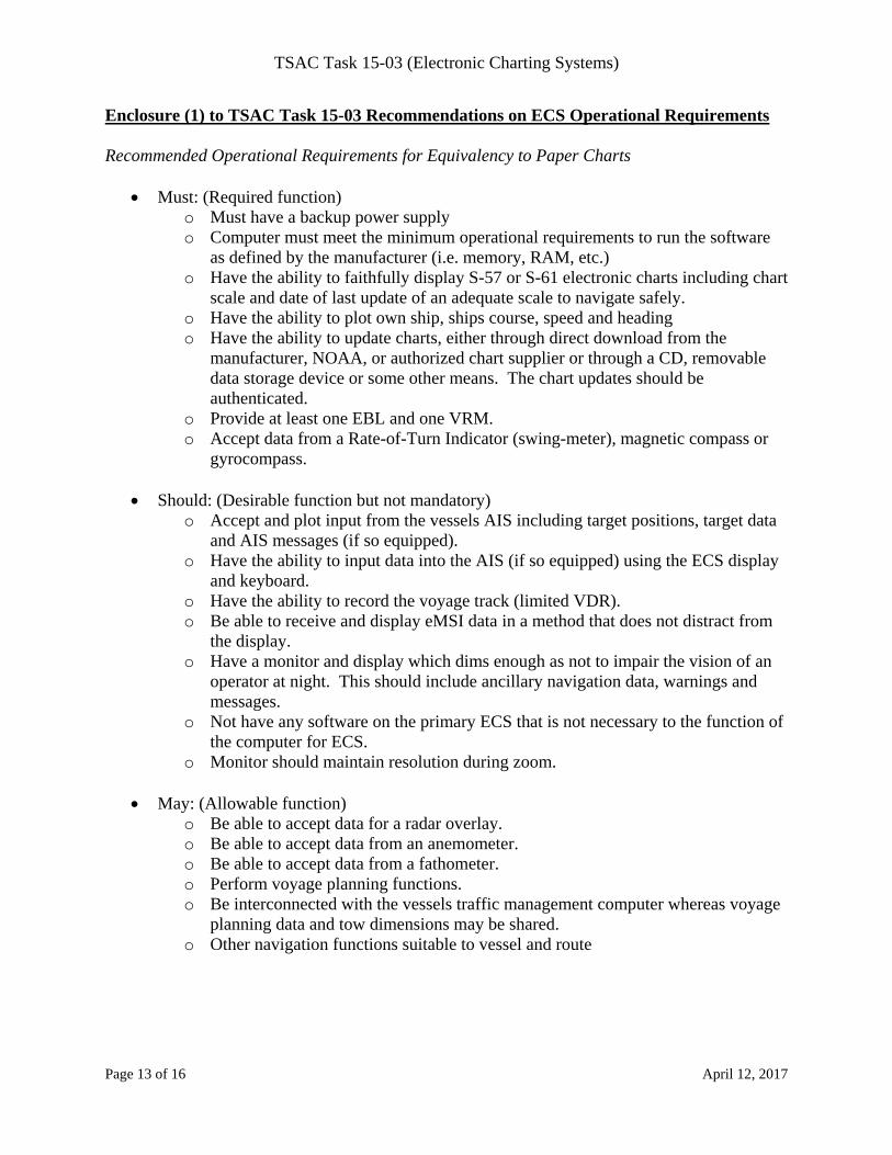
Enclosure (1) to TSAC Task 15-03 Recommendations on ECS Operational Requirements Recommended Operational Requirements for Equivalency to Paper Charts
Must: (Required function) o Must have a backup power supply o Computer must meet the minimum operational requirements to run the software
as defined by the manufacturer (i.e. memory, RAM, etc.) o Have the ability to faithfully display S-57 or S-61 electronic charts including chart
scale and date of last update of an adequate scale to navigate safely. o Have the ability to plot own ship, ships course, speed and heading o Have the ability to update charts, either through direct download from the
manufacturer, NOAA, or authorized chart supplier or through a CD, removable data storage device or some other means. The chart updates should be authenticated.
o Provide at least one EBL and one VRM. o Accept data from a Rate-of-Turn Indicator (swing-meter), magnetic compass or
gyrocompass.
Should: (Desirable function but not mandatory) o Accept and plot input from the vessels AIS including target positions, target data
and AIS messages (if so equipped). o Have the ability to input data into the AIS (if so equipped) using the ECS display
and keyboard. o Have the ability to record the voyage track (limited VDR). o Be able to receive and display eMSI data in a method that does not distract from
the display. o Have a monitor and display which dims enough as not to impair the vision of an
operator at night. This should include ancillary navigation data, warnings and messages.
o Not have any software on the primary ECS that is not necessary to the function of the computer for ECS.
o Monitor should maintain resolution during zoom.
May: (Allowable function) o Be able to accept data for a radar overlay. o Be able to accept data from an anemometer. o Be able to accept data from a fathometer. o Perform voyage planning functions. o Be interconnected with the vessels traffic management computer whereas voyage
planning data and tow dimensions may be shared. o Other navigation functions suitable to vessel and route
TSAC Task 15-03 (Electronic Charting Systems)
Page 14 of 16 April 12, 2017
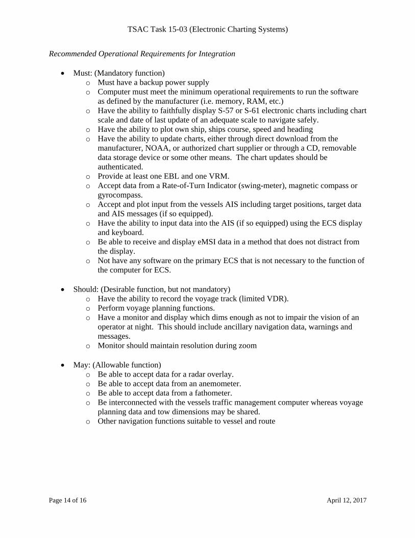
Recommended Operational Requirements for Integration
Must: (Mandatory function) o Must have a backup power supply o Computer must meet the minimum operational requirements to run the software
as defined by the manufacturer (i.e. memory, RAM, etc.) o Have the ability to faithfully display S-57 or S-61 electronic charts including chart
scale and date of last update of an adequate scale to navigate safely. o Have the ability to plot own ship, ships course, speed and heading o Have the ability to update charts, either through direct download from the
manufacturer, NOAA, or authorized chart supplier or through a CD, removable data storage device or some other means. The chart updates should be authenticated.
o Provide at least one EBL and one VRM. o Accept data from a Rate-of-Turn Indicator (swing-meter), magnetic compass or
gyrocompass. o Accept and plot input from the vessels AIS including target positions, target data
and AIS messages (if so equipped). o Have the ability to input data into the AIS (if so equipped) using the ECS display
and keyboard. o Be able to receive and display eMSI data in a method that does not distract from
the display. o Not have any software on the primary ECS that is not necessary to the function of
the computer for ECS.
Should: (Desirable function, but not mandatory) o Have the ability to record the voyage track (limited VDR). o Perform voyage planning functions. o Have a monitor and display which dims enough as not to impair the vision of an
operator at night. This should include ancillary navigation data, warnings and messages.
o Monitor should maintain resolution during zoom
May: (Allowable function) o Be able to accept data for a radar overlay. o Be able to accept data from an anemometer. o Be able to accept data from a fathometer. o Be interconnected with the vessels traffic management computer whereas voyage
planning data and tow dimensions may be shared. o Other navigation functions suitable to vessel and route
TSAC Task 15-03 (Electronic Charting Systems)
Page 15 of 16 April 12, 2017
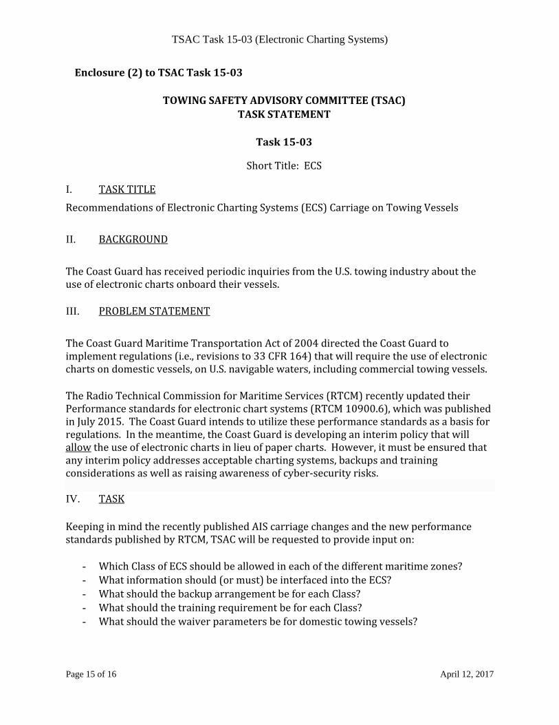
Enclosure(2)toTSACTask15‐03
TOWINGSAFETYADVISORYCOMMITTEE(TSAC)TASKSTATEMENT
Task15‐03
ShortTitle:ECS
I. TASKTITLE
RecommendationsofElectronicChartingSystems(ECS)CarriageonTowingVessels
II. BACKGROUND
TheCoastGuardhasreceivedperiodicinquiriesfromtheU.S.towingindustryabouttheuseofelectronicchartsonboardtheirvessels.
III. PROBLEMSTATEMENT
TheCoastGuardMaritimeTransportationActof2004directedtheCoastGuardtoimplementregulations(i.e.,revisionsto33CFR164)thatwillrequiretheuseofelectronicchartsondomesticvessels,onU.S.navigablewaters,includingcommercialtowingvessels.
TheRadioTechnicalCommissionforMaritimeServices(RTCM)recentlyupdatedtheirPerformancestandardsforelectronicchartsystems(RTCM10900.6),whichwaspublishedinJuly2015.TheCoastGuardintendstoutilizetheseperformancestandardsasabasisforregulations.Inthemeantime,theCoastGuardisdevelopinganinterimpolicythatwillallowtheuseofelectronicchartsinlieuofpapercharts.However,itmustbeensuredthatanyinterimpolicyaddressesacceptablechartingsystems,backupsandtrainingconsiderationsaswellasraisingawarenessofcyber‐securityrisks.IV. TASKKeepinginmindtherecentlypublishedAIScarriagechangesandthenewperformancestandardspublishedbyRTCM,TSACwillberequestedtoprovideinputon:
- WhichClassofECSshouldbeallowedineachofthedifferentmaritimezones?- Whatinformationshould(ormust)beinterfacedintotheECS?- WhatshouldthebackuparrangementbeforeachClass?- WhatshouldthetrainingrequirementbeforeachClass?- Whatshouldthewaiverparametersbefordomestictowingvessels?
TSAC Task 15-03 (Electronic Charting Systems)
Page 16 of 16 April 12, 2017
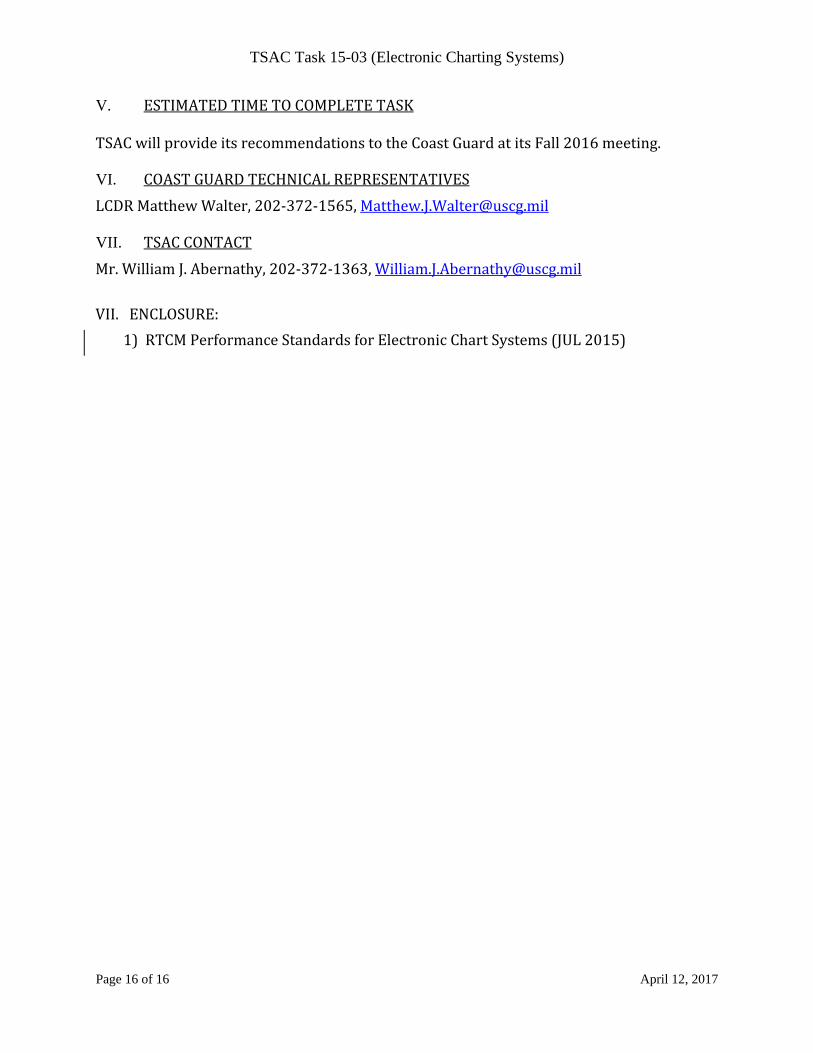
V. ESTIMATEDTIMETOCOMPLETETASK
TSACwillprovideitsrecommendationstotheCoastGuardatitsFall2016meeting.
VI. COASTGUARDTECHNICALREPRESENTATIVES
LCDRMatthewWalter,202‐372‐1565,[email protected]
VII. TSACCONTACT
Mr.WilliamJ.Abernathy,202‐372‐1363,[email protected]
VII.ENCLOSURE:
1)RTCMPerformanceStandardsforElectronicChartSystems(JUL2015)
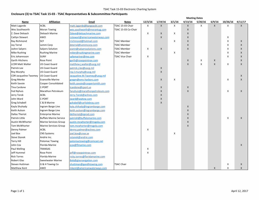
TSAC Task 15‐03 Electronic Charting System
Name Affiliation Email Notes 12/3/16 1/19/16 3/1/16 4/13/16 5/20/16 6/9/16 10/26/16 4/11/17Matt Lagarde ACBL [email protected] TSAC 15‐03 Chair X X X X X X X XWes Southworth Moran Towing [email protected] TSAC 15‐03 Co‐Chair XZ. Dave Deloach Deloach Marine [email protected] X X X XCaitlyn Stewart AWO [email protected] X X XRay Richmond SCF [email protected] TSAC Member X X X XJoy Terral Lemm Corp [email protected] TSAC Member X X XJoAnn Salyers Salyers Solution [email protected] TSAC Member X X X X XMike Rushing Rushing Marine [email protected] TSAC Member X X XEric Johannsson SUNY [email protected] TSAC Vice Chair X X XGarth Hitchens Rose Point [email protected] X X X XLCDR Matt Walter US Coast Guard [email protected] X X X X XPatrick Lee US Coast Guard [email protected] XRoy Murphy US Coast Guard [email protected] XCDR Jacqueline Twomey US Coast Guard [email protected] XGreg Menke Evansville Marine gregm@ems‐harbors.com X X X XKeith Savoie Cooper Consolidated [email protected] Cardone C‐PORT [email protected] X XFed Nyhuis Marathon Petroleum [email protected] X X X XJerry Torok ACBL [email protected] XJohn Ward C‐PORT [email protected] XGreg Schabell C & B Marine [email protected] XKayla Shuhady Ingram Barge Line [email protected] XKeith Aulson Ingram Barge Line [email protected] XDallas Theriot Enterprise Marine [email protected] XPatrick Little Buffalo Marine Service [email protected] X X XAustin McWhorter Marine Services Group [email protected] XTom McWhorter Marine Services Group [email protected] XDenny Palmer ACBL [email protected] XJoel Box CNS Systems [email protected] XSteve Stanek Andrie Inc. [email protected] Hill Potomac Towing [email protected] Cox Florida Marine [email protected] XPaul Welling TRANSAS XJeff Hummel Rose Point [email protected] XRick Torres Florida Marine [email protected] Glas Sweetwater Marine [email protected] Huttman G & H Towing Co [email protected] TSAC Chair X XMatthew Kent AWO [email protected] X X X
Meeting DatesEnclosure (3) to TSAC Task 15‐03 ‐ TSAC Representatives & Subcommittee Participants
Page 1 of 1 April 12, 2017
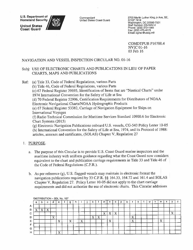
Enclosure (1) to NVIC 01-16
Use of official electronic charts, electronic charting systems and electronic publications This guidance applies to vessels subject to U.S. chart (or map) and publication carriage requirements codified in Titles 33 or 46 of the Code of Federal Regulations (C.F.R.) and provides an equivalent voluntary means to comply with those requirements. If vessels choose to voluntarily comply with this guidance, then they are subject to the requirements herein. Vessels may continue to comply with carriage requirements using official paper charts, maps, and publications as required by Titles 33 and 46 of the C.F.R. This guidance provides an equivalency only for domestic paper chart requirements and does not provide an equivalency for chart requirements contained in the International Convention for the Safety of Life at Sea, 1974 (SOLAS). A. Electronic Chart Carriage. Vessels may use electronic charts provided they are
official charts issued by or on the authority of a Government, authorized hydrographic office, or other relevant government institution (“official electronic charts”). Additional information regarding electronic charts may be found in International Hydrographic Organization (IHO) publication, S-66 – Facts About Electronic Charts and Carriage Requirements, Edition 1.0.0 — January 2010. Under the conditions set forth herein, the Coast Guard considers official electronic charts to be equivalent to the charts prescribed in Titles 33 and 46 of the C.F.R.
B. Electronic Charting System (ECS) Carriage. When displaying official electronic charts, the Coast Guard considers:
1. SOLAS compliant vessels to meet the chart carriage requirements on all waters. 2. A Radio Technical Commission for Maritime Services (RTCM)1 class ‘A’ ECS
to meet the chart carriage requirements for vessels not on international voyages. 3. An RTCM class ‘B’ or ‘C’ ECS to meet the chart carriage requirements for
vessels operating not more than 12 nautical miles from the territorial sea baseline
2. 4. An RTCM class ‘D’ is not equivalent to paper marine charts under this Circular,
and therefore does not meet the chart carriage requirements prescribed in Titles 33 and 46 of the C.F.R.
C. Redundant Arrangement. For vessels using official electronic charts as the primary
means of navigation, an independent redundant arrangement is required in order to meet the equivalency, and must be: 1. An equivalent system to the requirement in paragraph B, connected to a back-up
power supply separate and independent from the primary system, or 2. A full folio of official paper charts in accordance with 33 C.F.R. part 164 for the
intended voyage.3
1 ECS classes shall meet the most current RTCM 10900 series ECS standard. 2 As defined by 33 C.F.R. § 2.20 and, for the purpose of this policy, including the shoreline of the Great Lakes.
Enclosure (1) to NVIC 01-16
If official electronic charts are being used as the primary and back-up means of navigation, the equipment identified in Section E (Integration) of this enclosure must be integrated with the redundant arrangement as outlined.
D. Training. The following training is considered to meet the equivalency for U.S.
flagged vessels electing to use official electronic charts in accordance with this Circular.
1. RTCM ECS class ‘A’: The Coast Guard considers an RTCM class ‘A’ to
function closely to an Electronic Chart Display and Information System (ECDIS). Therefore, for the purposes of this policy, all mariners in charge of a navigational watch and using a class ‘A’ ECS must possess a successful completion certificate from a Coast Guard approved ECDIS course and have the appropriate endorsement on their Merchant Mariner Credential (MMC). The Coast Guard considers this training to meet the requirement of 46 C.F.R. § 15.405.
2. RTCM ECS class ‘B’ and ‘C’: Title 46 C.F.R. § 15.405 requires that each credentialed crewmember must be familiar with installed navigation equipment prior to assuming their duties. This requirement applies to RTCM class ‘B’ or ‘C’ ECS equipment used pursuant to this Circular. To achieve the required familiarity, companies must follow manufacturer’s standards, user’s manuals, and company policies to document watch stander competency.
Mariners serving on U.S. flagged vessels, currently holding the ECDIS endorsement on their MMC, are compliant with this Circular and do not require additional training in order to navigate using official electronic charts displayed on an RTCM standard ECS authorized by this Circular. Mariners will not meet the equivalency requirement using official electronic charts as the primary means of navigation without meeting the above training requirements.
E. Integration. ECSs are most functional for navigational safety when fully interfaced with installed navigation equipment.
1. The following equipment, if installed, must be integrated with the ECS in order
to meet the equivalency: a. External electronic position-fixing device providing position information, b. Automatic Identification System (AIS),
3 If paper charts are being used as the back-up, they must be readily available and the voyage plan should be indicated on them. Section 164.33(c) of Title 33 of the C.F.R. defines “currently corrected” as it applies to charts, U.S. Coast Pilot, and Coast Guard Light List. The IHO defines “official charts” as those “charts issued by or on the authority of a Government, authorized hydrographic office or other relevant government institution.” IHO publication, S-66 – Facts About Electronic Charts and Carriage Requirements, Edition 1.0.0—January 2010, p. 10. Section 164.33 of Title 33 of the C.F.R. includes the National Ocean Service of National Oceanic and Atmospheric Administration (NOAA) and U.S. Army Corps of Engineers as United States sources for charts.
Enclosure (1) to NVIC 01-16
c. Gyro-compass or other means to determine and display the vessel’s heading by vessel borne non-magnetic means and transmit heading information4, and
d. Marine radar.
2. The Coast Guard further recommends the following equipment, if installed, also be integrated with the ECS: a. Magnetic compass; and b. Voyage data recorder or simplified voyage data recorder.
F. Electronic Publications Carriage. Vessels may maintain the navigation publications
required by 33 C.F.R. §§ 161.4, 164.33, and 164.72 and SOLAS Chapter V Regulation 27 in electronic format provided that they are derived from the original source, currently corrected/up-to-date and readily accessible on the vessel’s bridge by the crew. Those publications are: U.S. Coast Pilot, Sailing Directions, Coast Guard Light List, List of Lights, tide-current and river-current tables, Notice to Mariners, Local Notice to Mariners, Notices to Navigation, and Vessel Traffic Rules. If electronic publications are used, vessels must retain a redundant copy in the event the primary electronic format becomes inaccessible. The redundant copy may be a second computer, CD, or portable mass storage device readily displayable to the navigation watch, or a paper copy.
4 Recommendations on Performance Standards for Marine Transmitting Heading Devices (THD) (resolution MSC.116(73)).


