Embed Size (px)
Citation preview
1
0123456789
COMMUNITY DEVELOPMENT CITY OF
STAFF REPORT VENTURA 805-677-3921 • [email protected] • www.cityofventur-a.ca.gov
AGENDA ITEM 11A
Date: September 9, 2019
Council Action Date: September 23, 2019
TO: Honorable Mayor and City Council
FROM: Alex D. McIntyre, City Manager Peter Gilli, Community Development Director
SUBJECT: Kellogg Apartment Project - Zone Change from Limited Industrial (M-1) to Multiple-Family (R-3-1) for a 0.77-acre property located at 58 Kellogg Street; Miller Family Trust, applicant (PROJ - 11817)
SUMMARY
The applicant proposes a 30-unit apartment project on an industrial property across the street from Kellogg Park. The Design Review Committee and Planning Commission approved their portions of the entitlement on August 21, 2019. The item before City Council is to make the zoning district for the property comply with the General Plan Land Use Designation.
RECOMMENDATIONS
a. Conduct a Public Hearing on the proposed Mitigated Negative Declaration and Zone Change.
b. Adopt a Resolution approving a Mitigated Negative Declaration and Mitigated Monitoring Program, Case No. EIR-10-17-42279.
c. Introduce and waive the first reading of an Ordinance approving a Zone Change from Limited Industrial (M-1) to Multiple-Family (R-3-1) for the developed property located at 58 Kellogg Street (APN 071-0-032-030), Case No. Z-3-18-44462.
d. Set the second reading and adoption at the City Council meeting of October 7, 2019.
DISCUSSION/ANALYSIS
On August 21, 2019, the Design Review Committee unanimously approved the construction of a 30-unit Multi-Family apartment project and the Planning Commission unanimously approved a Planned Development Permit and Mitigated Negative Declaration with Mitigation Monitoring Program for the same 30-unit apartment project.
2
0123456789
Public Hearing - Kellogg Apartment Project - Zone Change (PROJ - 11817) September 23, 2019 Page 2 of 3
In addition, the Planning Commission unanimously approved Resolution No. CD-2019-14 to recommend City Council approve the Mitigated Negative Declaration (Attachment A) and the requested Zone Change from Limited Industrial (M-1) to Multiple-Family (R-3-1) (Attachment B).
The staff report and plan materials can be located on the City's website -https://www.cityofventura.ca.gov/DocumentCenterNiew/17818/2019-08-21 ltem-5
The property has a General Plan Land Use Designation of "Neighborhood High" and is in the Limited Industrial (M-1) zoning district (Attachment C). The "Neighborhood High" designation allows high-density residential development on the subject site. The Limited Industrial (M-1) zoning district is inconsistent with the "Neighborhood High" land use designation. It was common practice that non-residential properties identified for future residential development would be left in the non-residential zoning district until the residential project was proposed.
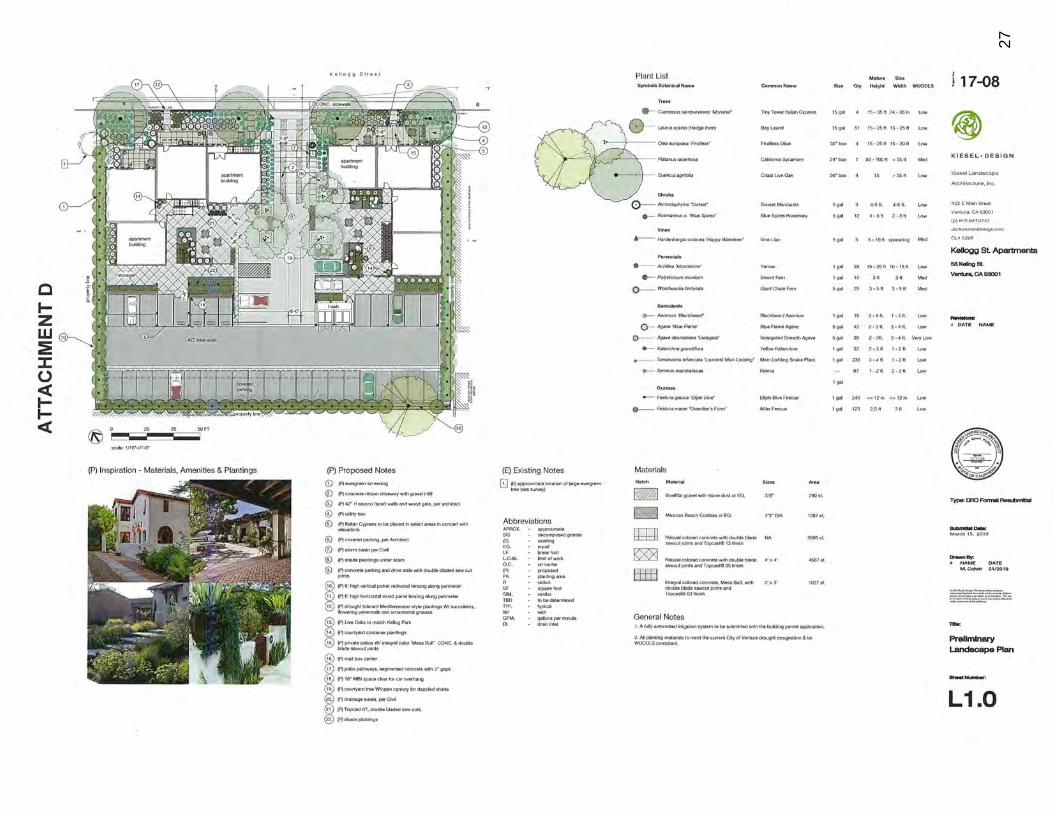
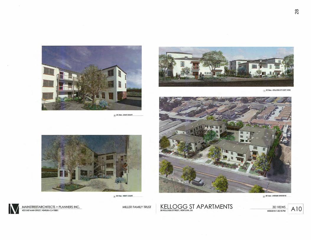
The "Housing Accountability Act" (HAA) is a State law that allows an applicant of a housing project to construct a housing project that complies with the General Plan, even if the current zoning district does not allow housing. As noted earlier, in the past the City would require a Zone Change with a housing project in · order to make the zoning consistent with the General Plan. Now, due to the HAA, the City cannot require the Zone Change and the project can be built regardles.s of City Council's action on the Zone Change. The landscape plan (colored site plan) and architectural renderings are provided for informational purposes in Attachment D.
Even though they were not required to apply for the Zone Change, the applicant sought a formal Zone Change from the existing M-1 zone to the R-3-1 Multi-Family zone to bring the property into compliance with the existing land use designation to assist with future processing. Staff appreciates this because it allows the City to maintain an accurate Zoning Map without the City having to independently initiate a Zone Change in the future .
In addition to approving the Planned Development Permit, the Planning Commission unanimously recommended City Council approve the Zone Change as it would bring the property's zoning into compliance with its underlying General Plan land use designation.
California Environmental Quality Act
As part of their respective actions on August 21, 2019, the Design Review Committee and Planning Commission adopted a Mitigated Negative Declaration (MND) under the provisions of the California Environmental Quality Act (CEQA). The MND identified mitigation measures for Cultural Resources, Hazards and Hazardous Materials, and Tribal Cultural Resources, all of which are common impacts to development in the Westside, which will be mitigated to less than significant levels. These mitigation
3
0123456789
Public Hearing - Kellogg Apartment Project - Zone Change (PROJ - 11817) September 23, 2019 Page 3 of 3
measures were incorporated into the Design Review Committee and Planning Commission approvals as conditions of approval.
During the public comment period for the MND, staff received three correspondence from the Ventura County Air Pollution Control District, Ventura County Public Works Transportation Department, and the Ventura County Watershed Protection during public review period. The comments from these three entities resulted in minor edits to the MND to address their concerns as noted in a strike-through/underlined response included in Attachment E and as incorporated into the MND.
Public Engagement
The Kellogg Apartment Project has been reviewed at a noticed public hearing two times:
• Design Review Committee (May 2, 2018) • Joint Planning Commission and Design Review Committee (August 21, 2019)
The applicant team met with the Westside Community Council on October 4, 2017 prior to submitting their formal application to the City.
Prepared by: Maruja Clensay, Senior Planner
ATTACHMENTS
A City Council Mitigated Negative Declaration Resolution B City Couricil Zone Change Ordinance C Site Location and Context D Landscape Plan and Renderings E Mitigated Negative Declaration with redline changes, response to comments and
Mitigation Monitoring Report Program

THIS PAGE INTENTIONALLY LEFT BLANK
4
0123456789
5
0123456789
ATTACHMENT A
RESOLUTION NO. 2019-
AN RESOLUTION OF THE CITY COUNCIL OF THE e1TY OF SAN BUENAVENTURA, CALIFORNIA
ADOPTING A MITIGATED NEGATIVE DECLARATION AND A MITIGATION MONITORING AND REPORTING
PROGRAM FOR THE KELLOGG APARTMENT PROJECT LOCATED AT 58 KELLOGG STREET
PROJECT-11817 CASE NO. EIR-10-17-42279
WHEREAS, an application has been filed by Miller Famil1 Trust for a Change of Zone (Z-3-18-44462) from Limited Industrial (M-1) to Multiple Family (R-3-1) on a 0.77 acre property located at 58 Kellogg Street, and more particularly described as those portions of Portion of Lot 46 of the Rancho Santa Paula Y Saticoy, in the City of San Buenaventura, County of Ventura, State of California, as Lots 17, 18, 19 and 20 of the Watson Tract, in the City of Ventura, County of Ventura, State of California, as per map recorded in Book 12, Page(s) 78 of Maps, in the Office of the County Recorder of said County, and currently identified as Assessor's Parcel Number 071-0-032-030; and,
WHEREAS, pursuant to the California Public Resources Code section 21067 and the State CEQA Guidelines (Cal. Code Regs., tit. 14 § 15000 et seq.) section 15051, the City is the lead agency for the proposed Project; and,
WHEREAS, an Initial Study was prepared for the project pursuant to State CEQA Guidelines section 15063; and,
WHEREAS, on the basis of the Initial Study, which concluded that the Project would have potentially significant impacts but that those impacts could be reduced to less than significant levels with implementation of the proposed mitigation measures, the City determined that a Mitigated Negative Declaration ("MND") should be prepared for the Project pursuant to Public Resources Code sections 21664.5 and 21080(c), and the State CEQA Guidelines section 15070 et seq.; and,
WHEREAS, on April 23, 2019, staff distributed for public review copies of a proposed MND prepared for the Project pursuant to the California Environmental Quality Act (Public Resources CodeSection 21000 et seq.)("CEQA"); and,
F:\RESOLUTIONS\COMMUNITY DEVELOPMENT\2019\A 19-00514 Kellogg Apartments\Attachment A - Kellogg MND Resolution.docx
1
6
0123456789
WHEREAS, the MND found Potentially Significant Impacts associated with the project in regard to Cultural Resources, Hazards and Hazardous Materials, and Tribal Cultural Resources; and,
WHEREAS, the 20-day public comment period for the MND spanned from April 23, 2019 to May 13, 2019 pursuant to Public Resources Code section 21091 (b); and,
WHEREAS, the City received three comment letters from the Ventura County Air Pollution Control District, Ventura County Public Works Transportation Department, and the Ventura County Watershed dated May 14, 2019, during the public review period and attached as Appendix I to the MND; and,
WHEREAS, City has prepared a written response to the comment letters received and incorporated said comments and responses into the MND; and,
WHEREAS, the City has endeavored to take all steps and impose all conditions necessary to ensure that impacts to the environment would not be significant; and,
WHEREAS, notice was duly given that the Planning Commission of the City of San Buenaventura would hold the public hearing on July 17, 2019; and
WHEREAS, on July 17, 2019 the Planning Commission of the City of San Buenaventura continued the public hearing to August 21, 2019; and,
WHEREAS, on August 21, 2019, the Planning Commission of the City of San Buenaventura held a duly notice public hearing and at the time considered all testimony, written and oral; and,
WHEREAS, the Planning Commission of the City of San Buenaventura reviewed and considered MND EIR-10-17-42279 and the information contained in said MND and recommended that the City Council adopt the MND; and,
WHEREAS, on September 23, 2019, the City Council of the City of San Buenaventura held a duly noticed public hearing and at the time considered all testimony, written and oral; and,
WHEREAS, the City Council of the City of San Buenaventura reviewed and considered MND EIR-10-17-42279 and the information contained in said MND; and,
F:\RESOLUTIONS\COMMUNITY DEVELOPMENT\2019\A 19-00514 Kellogg Apartments\Attachment A - Kellogg MND Resolution.docx
2
7
0123456789
WHEREAS, in accordance with Section 1507 4(b) of the State CEQA Guidelines (California Code of Regulations Sections 1500 et seq.) the decision-making body of the lead agency must consider the MND and comments received before approving the Project; and,
WHEREAS, a Mitigation, Monitoring and Reporting Program ("MMRP") has been prepared for the project to implement mitigation measures required by the Project and is attached as Exhibit A to this Resolution and is incorporated by this reference as though fully set forth herein.
NOW, THEREFORE, the City Council of the City of San Buenaventura does here by resolve, find, determine and order as follows:
SECTION 1. The above recitations are true and correct and are incorporated herein by this reference.
SECTION 2. As the decision-making body for the Project, the City Council has reviewed and considered the information contained in the Initial Study/MND and administrative record for the Project, including all oral and written comments received during the comment period. The City Council finds that the Initial Study/MND contains a complete and accurate reporting of the environmental impacts associated with the Project. The City Council further finds that the Initial Study/MND and the administrative record have been completed in compliance with CEQA.
SECTION 3. Based on the Initial Study/MND and the administrative record including all written and oral evidence presented to the City Council, the City Council finds that all environmental impacts of the Project are either insignificant or can be mitigated to a level of insignificance pursuant to the mitigation measures contained in the MND and the MMRP. The City Council further finds that there is no substantial evidence in the administrative record supporting a fair argument that the Project may result in significant environmental impacts. No new significant environmental effects have been identified in the Initial Study/MND and any changes to the Initial Study/MND in response to comments or otherwise do not constitute substantial revisions requiring recirculation under State CEQA Guidelines section 15073.5.
SECTION 4. In accordance with Municipal Code Section 2R.450.430 and City Council Resolution No. 2002-57 (the City's local CEQA Implementation Guidelines), the City Council hereby further finds that the Final Mitigated Negative Declaration for Case No. El R-10-17-42279 is accurate, objective, complete, and in compliance with the Guidelines for Implementation of the California. Environmental Quality Act (CEQA Guidelines) and Procedures of the State of California and the City of San Buenaventura, and represents the
F:\RESOLUTIONS\COMMUNITY DEVELOPMENT\2019\A19-00514 Kellogg Apartments\Attachment A - Kellogg MND Resolution.docx
3
8
0123456789
independent judgment of the City Council. The City Council has reviewed all documentation comprising the Final Mitigated Negative Declaration and, consistent with the Community Development Department's recommendation, can (i) find the Final Mitigated Negative Declaration is adequate and complete and (ii) certify said Final Mitigated Negative Declaration as being in compliance with CEQA Guidelines Section 1507 4.
SECTION 5. The City Council hereby approves and adopts the Initial Study/MN D (EI R-10-17-42279) pursuant to Public Resources Code section 21080, subdivision (c)(2).
SECTION 6. Pursuant to Public Resources Code section 21081.6, the City Council approves and adopts the MMRP.
SECTION 7. The Mitigation Measure(s), including the MMRP, adopted for No. PROJ-11817 and MND EIR-10-17-42279 shall be fully complied with and the Mitigation Measures shall be included as conditions of any required permits.
SECTION 8. The documents and materials that constitute the record of proceedings on which these findings have been based are located at 501 Poli Street, Room 117, Ventura CA 93002. The custodian for these records is the Planning Manager.
PASSED AND ADOPTED this 23rd day of September, 2019.
ATTEST
Antoinette M. Mann, MMC, CRM City Clerk
Matt Lavere Mayor
F:\RESOLUTIONS\COMMUNITY DEVELOPMENT\2019\A 19-00514 Kellogg Apartments\Attachment A - Kellogg MND Resolution.docx
4
9
0123456789
APPROVED AS TO FORM Gregory G. Diaz, City Attorney
~ 1h<DU1 AndrewHegnd Senior Assistant City Attorney
EXHIBIT LIST:
Exhibit "A" - Mitigation , Monitoring and Reporting Program
F: \RESOLUTIONS\COMMUNITY DEVELOPMENT\2019\A 19-00514 Kellogg Apartments\Attachment A - Kellogg MND Resolution .docx
5

THIS PAGE INTENTIONALLY LEFT BLANK
10
0123456789
11
0123456789
KELLOGG APARTMENTS MITIGATION MONITORING REPORTING PROGRAM PROJ-11817/ EIR-10-17-42279
Implementation Monitoring Standard for Compliance Verification Mitigation Measure/Condition of Approval Responsibility
Timing Division
Funding Success Initial Date Comments
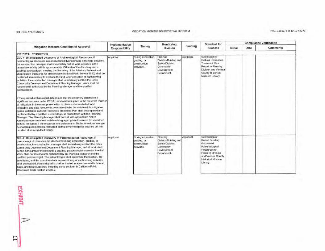
CULTURAL RESOURCES CUL-1: Unanticipated Discovery of Archaeological Resources. If Applicant. During excavation, Planning Applicant. Submission of
archaeological resources are encountered during ground-disturbing activities, grading, or Division/Building and Cultural Resources
the construction manager shall immediately halt all work activities in the construction Safety Division: Treatment Plan
immediate vicinity (within approximately 100 feet) of the discovery and a activities. Community' Report to Planning
qualified archaeologist meeting the Secretary of the Interior's Professional Development Division and V!')ntura
Qualification Standards for archaeology (National Park Service 1983) shall be Department. County Historical
contacted immediately to evaluate the find . After cessation of earthmoving Museum Library.
activities, the construction manager shall immediately contact the City's Community Development Department Planning Manager. Work shall not resume until authorized by the Planning Manager and the q~alified archaeologist.
If the qualified archaeologist determines that the discovery constitutes a significant resource under CEQA, preservation in place is the preferred manner of mitigation. In the event preservation in place is demonstrated to be infeasible, and data recovery is determined to be the only feasible mitigation option, a detailed Cultural Resources Treatment Plan shall be prepared and implemented by a qualified archaeologist in consultation with the Planning Manager. The Planning Manager shall consult with appropriate Native American representatives in determining appropriate treatment for unearthed cultural resources if the resources are prehistoric or Native American in origin . Archaeological materials recovered during any investigation shall be put into curation at an accredited facility.
CUL-2: Unanticipated Discovery of Paleontological Resources. If Applicant. During excavation, Planning Applicant. Submission of
paleontological resources are discovered during excavation, grading, or grading, or Division/Building and Report detailing
construction, the construction manager shall immediately contact the City's construction Safety Division: discovered
Community Development Department Planning Manager, and all work shall activities. Community Paleontological
cease in the area of the find until a qualified paleontologist evaluates the find . Development Resources to
Work shall not resume until authorized by the Planning Manager and the Department. Planning Division
qualified paleontologist. The paleontologist shall determine the location, the and Ventura County
time frame, and the extent to which any monitoring of earthmoving activities Historical Museum
shall be required. Found deposits shall be treated in accordance with federal , Library.
State, and local guidelines, including those set forth in California Public Resources Code Section 21083.2. .
~ i .-1
):::7
12
0123456789
KELLOGG APARTMENTS MITIGATION MONITORING REPORTING PROGRAM PROJ-11817 / EIR-10-17-42279
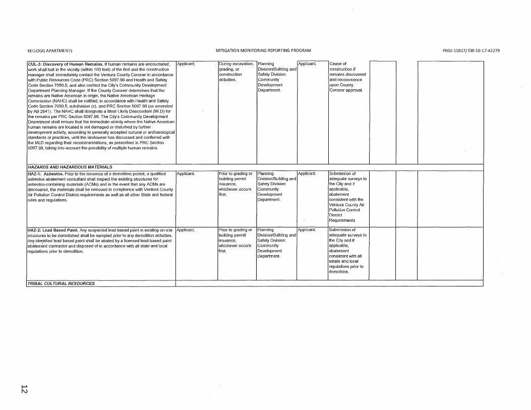
CUL-3: Discovery of Human Remains. If human remains are encountered, Applicant. During excavation, Planning Applicant. Cease of work shall halt in the vicinity (within 100 feet) of the find and the construction grading, or Division/Building and construction if manager shall immediately contact the Ventura County Coroner in accordance construction Safety Division: remains discovered with Public Resources Code (PRC) Section 5097.98 and Health and Safety activities. Community and recommence Code Section 7050.5, and also contact the City's Community Development Development upon County Department Planning Manager. If the County Coroner determines that the Department. Coroner approval. remains are Native American in origin, the Native American Heritage Commission (NAHC) shall be notified, in accordance with Health and Safety Code Section 7050.5, subdivision (c), and PRC Section 5097.98 (as amended by AB 2641). The NAHC shall designate a Most Likely Descendant (MLD) for the remains per PRC Section 5097.98. The City's Community Development Department shall ensure that the immediate vicinity where the Native American human remains are located is not damaged or disturbed by further development activity, according to generally accepted cultural or archaeological standards or practices, until the landowner has discussed and conferred with the MLD regarding their recommendations, as prescribed in PRC Section 5097.98, taking into account the possibility of multiple human remains.
HAZARDS AND HAZARDOUS MATERIALS
HAZ-1: Asbestos. Prior to the issuance of a demolition permit, a qualified Applicant. Prior to grading or Planning Applicant. Submission of asbestos abatement consultant shall inspect the existing structures for building permit Division/Building and adequate surveys to asbestos-containing materials (ACMs) and in the event that any ACMs are issuance, Safety Division: the City and if discovered, the materials shall be removed in compliance with Ventura County whichever occurs Community applicable, Air Pollution Control District requirements as well as all other State and federal first. Development abatement rules and regulations. Department. consistent with the
Ventura County Air Pollution Control District Requirements
HAZ-2: Lead Based Paint. Any suspected lead based paint in existing on-site Applicant. Prior to grading or Planning Applicant. Submission of structures to be demolished shall be sampled prior to any demolition activities. building permit Division/Building and adequate surveys to Any ide~tified lead based paint shall be abated by a licensed lead-based paint issuance, Safety Division: the City and if abatement contractor and disposed of in accordance with all state and local whichever occurs Community applicable, regulations prior to demolition. first. Development abatement
Department. consistent with all satate and local regulations prior to demolition.
TRIBAL CULTURAL RESOURCES
13
0123456789
KELLOGG APARTMENTS MITIGATION MONITORING REPORTING PROGRAM PROJ-11817/ EIR-10-17-42279
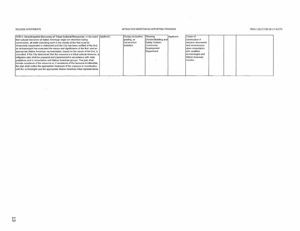
TCR-1: Unanticipated Discovery of Tribal Cultural Resources. In the event Applicant. During excavation, Planning Applicant. Cease of that cultural resources of Native American origin are identified during grading, or Division/Building and construction if construction, all earth-disturbing work in the vicinity of the find must be construction Safety Division: remains discovered temporarily suspended or redirected until the City has been notified of the find, activities. Community and recommence an archaeologist has evaluated the nature and significance of the find, and an Development upon consultation appropriate Native American representative, based on the nature of the find, is Department. with qualified consulted. If the City determines that the resource is a tribal cultural resource, a archaeologist and mitigation plan shall be prepared and implemented in accordance with state Native American guidelines and in consultation with Native American groups. The plan shall monitor. include avoidance of the resource or, if avoidance of the resource is infeasible, the plan shall outline the appropriate treatment of the resource in coordination with the archeologist and the appropriate Native American tribal representative.

THIS PAGE INTENTIONALLY LEFT BLANK
14
0123456789
15
0123456789
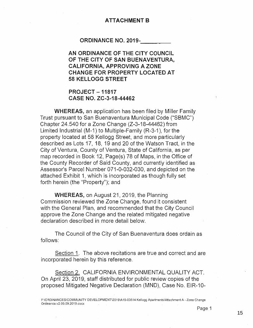
ATTACHMENT 8
ORDINANCE NO. 2019-----
AN ORDINANCE OF THE CITY COUNCIL OF THE CITY OF SAN BUENAVENTURA, CALIFORNIA, APPROVING A ZONE CHANGE FOR PROPERTY LOCATED AT 58 KELLOGG STREET
PROJECT-11817 CASE NO. ZC-3-18-44462
WHEREAS, an application has been filed by Miller Family Trust pursuant to San Buenaventura Municipal Code ("SSMC'') Chapter 24.540 for a Zone Change (Z-3-18-44462) from Limited Industrial (M-1) to Multiple-Family (R-3-1 ), for the property located at 58 Kellogg Street, and more particularly described as Lots 17, 18, 19 and 20 of the Watson Tract, in the City of Ventura, County of Ventura, State of California, as per map recorded in Book 12, Page(s) 78 of Maps, in the Office of the County Recorder of Said County, and currently identified as Assessor's Parcel Number 071-0-032-030, and depicted on the attached Exhibit 1, which is incorporated as though fully set forth herein (the "Property"); and
WHEREAS, on August 21, 2019, the Planning Commission reviewed the Zone Change, found it consistent with the General Plan, and recommended that the City Council approve the Zone Change and the related mitigated negative declaration described in more detail below.
The Council of the City of San Buenaventura does ordain as follows:
Section 1. The above recitations are true and correct and are incorporated herein by this reference.
Section 2. CALIFORNIA ENVIRONMENTAL QUALITY ACT. On April 23, 2019, staff distributed for public review copies of the proposed Mitigated Negative Declaration (MND), Case No. EIR-10-
F:\ORDINANCES\COMMUNITY DEVELOPMENT\2019\A 19-00514 Kellogg Apartments\Attachment A - Zone Change Ordinance.v2.09.09.2019.docx
Page 1
16
0123456789
17-42279, under the provisions of the California Environmental Quality Act (CEQA). The MND identified potentially significant impacts relating to the issue areas of Cultural Resources, Hazards and Hazardous Materials, and Tribal Cultural Resources, but proposed appropriate mitigation measures to minimize the impacts of the Zone Change to those issue areas.
The public comment period for the MND spanned from April 23, 2019 to May 13, 2019. Staff received three comment letters from the County of Ventura Public Works Watershed Protection Division, the County of Ventura Public Works Agency Transportation Division, and the County of Ventura Air Pollution Control District during the public review period commenting on the MND. Staff responded to these comments, addressing the expressed concerns.
Having reviewed the proposed MND, including all pertinent information in the record, including all information presented at the public hearing and as set forth in the staff report, the City Council finds all potentially significant environmental impacts that may directly or indirectly result from the project would be reduced to a less than significant level by the mitigation measures specified in the MND. The City Council finds further the MND is complete, in compliance with CEQA, and represents the independent judgment of the City of San Buenaventura. Through the adoption of the Resolution for Case No. EIR-10-17-42279, the City Council approves the MND.
Section 3. ZONE CHANGE (ZC-3-18-44462). The San Buenaventura Municipal Code authorizes the City Council to grant a zone change making certain findings:
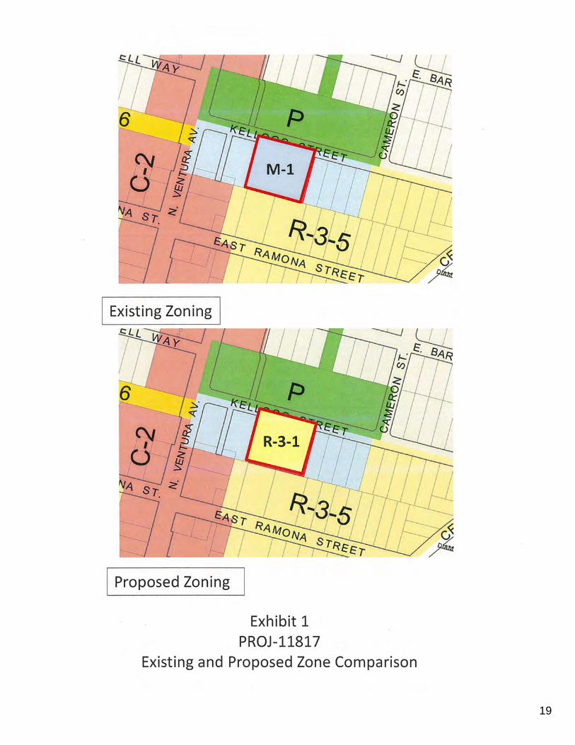
3.1 Consistency with the General Plan. The existing zoning of the Property is Limited Industrial (M-1 ), which is inconsistent with the General Plan's Neighborhood High designation. The Neighborhood High designation accommodates a broader mix of residential, commercial, office, and entertainment building types, primarily attached, from 21 to 54 dwelling units per acre.
F:\ORDINANCES\COMMUNITY DEVELOPMENT\2019\A19-00514 Kellogg Apartments\Attachment A - Zone Change Ordinance.v2.09.09.2019.docx
Page 2
17
0123456789
The Zone Change from M-1 to Multi-Family Residential (R-3-1, 800-foot minimum lot area for each dwelling unit) will make the Property consistent with the Neighborhood High designation since the proposed R-3 zoning allows a residential density of 18 to 54 dwelling units per acre. Since the proposed apartment project will have 30 units, the project will be consistent with the Neighborhood High designation and satisfy the policies and goals of the General Plan.
In addition, the Zone Change will allow multiple-family residential uses to be permitted by right within an area of the city that contains existing residential development with a Neighborhood High designation.
The project is located within an existing urban area that is currently served by all public services, and the Zone Change will not have significant individual or cumulative adverse effects to those services.
For these reasons, the City Council finds that the Zone Change will bring the property into conformance with the underlining General Plan land use designation and place residential use in an area designated for residential development. The Zone Change will require all future development on the Property to adhere to the development standards of the R-3-1 zone, including setbacks, height, lot coverage, and parking requirements. Therefore, the project is consistent with the polices and provisions of the General Plan.
3.2 Public Necessity, Convenience, General Welfare, and Good Zoning Practice. The public necessity, convenience, general welfare, and good zoning practice allow the Property to be reclassified. The Zone Change will have a positive effect on land available for housing within the City, as it will create an opportunity for new apartments thereby increasing housing opportunities.
3.3 Orderly Development. The Zone Change will allow for the continued provision of orderly development for the City and development standards that promote the public health, safety, and general welfare through infill development. The Zone Change will encourage the applicant to improve the property with its highest and
F:\ORDINANCES\COMMUNITY DEVELOPMENT\2019\A19-00514 Kellogg Apartments\Attachment A- Zone Change Ordinance.v2.09.09.2019.docx
Page 3
18
0123456789
best land use and will provide additional residential units, contributing to the City's housing stock.
Based on the findings above, the City Council HEREBY APPROVES the Zone Change.
Section 4. Severability.
If any section, subsection, sentence, clause, or phrase of this ordinance is for any reason held to be invalid or unconstitutional by a decision of any court of competent jurisdiction, such decision will not affect the validity of the remaining portions of this ordinance. The City Council declares that it would have passed this ordinance and each and every section, subsection, sentence, clause, or phrase not declared invalid or unconstitutional without regard to whether any portion of the ordinance would be subsequently declared invalid or unconstitutional .
PASSED and ADOPTED this 23rd day of September 2019.
ATTEST:
ANTOINETTE M. MANN, MMC, CRM CITY CLERK
APPROVED AS TO FORM
MATT LAVERE Mayor
By: ___ -4--1-------___ q ~_____;_Wi_/1 __
Andrew Hegluna Date Senior Assistant City Attorney
EXHIBIT LIST:
1. Zone Change Map F:\ORDINANCES\COMMUNITY DEVELOPMENT\2019\A 19-00514 Kellogg Apartments\Attachment A - Zone Change Ordinance .v2 .09.09.2019.docx
Page 4
19
0123456789
I Proposed Zoning
Exhibit 1 PROJ-11817
Existing and Proposed Zone Comparison

THIS PAGE INTENTIONALLY LEFT BLANK
20
0123456789
21
0123456789
ATTACHMENT C
22
0123456789
23
0123456789
24
0123456789
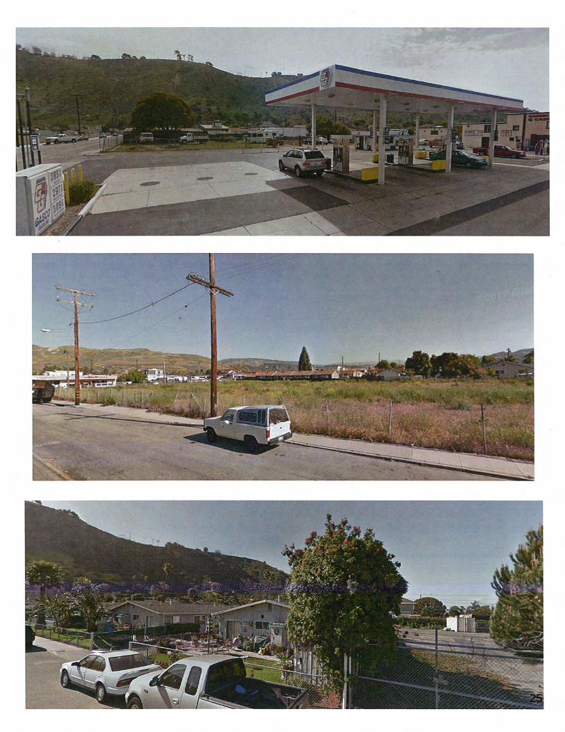
25
0123456789

THIS PAGE INTENTIONALLY LEFT BLANK
26
0123456789
27
0123
4567
89
C 1-z w ~ ~ ::c (..)
~ I<( 0 20
~ 35
®
(P) Inspiration - Materials, Amenities & Plantings
I< o ll o g g Stre e t
(P) Proposed Notes
G) (P)evergroonscreening
® (P) concrete nbbon drivewny with grnvel infill
@) (P) 42" H stucco faced walls and wood gate, per architoct
@ (P)utilitybox
® (P) ltallon Cypress to be ploctld ln seloct aroas ln concert with olovations
@ (P)coveredparking,perArchitect
© ® ®
(P) slom, basin per Civil
(P)shndeplnntingsunderstnir,
(P) concrete parking and drivo aislo with doubJe bfadod saw cut Joints
@(P)6' highvorticnl picket redwoodfencingalongperirnetor
@ (P) 6' high horizontal wood panel fencing along perimeter
@ (P) drought tolen:int Mediterrenean style plantings W/ succulents, floweringperenn1alsandornamontal gmsses
@ (P) Live Oaks to match Kelk>g Paric
@(P)courtyardcontainerplantings
@ (P) privato patios W/ intogral color 'Mes:1 Buff' CONC. & doublo blndesawcutjoints
@<PJma;l boxccntc,
@ (P) patio pathways, segmentod concrete with 3" gaps
@(P)18" MINspnceclear forcnroverhang
@ (P)courtyard treeW/open cnnopyfor dappledshade
@(P)drainagoswa1e,pOl'Civll
@ (P) Topcast 07, doublebladedsawcuts
@(P)shadeplantings
(E) Existing Notes
~ (E) approx.imnle location of large overgreen tree(see survey}
Abbreviations AP ROX. approximato OG docomposed granite (E} existing EQ. equal LF linear foot L.0.W. limit of work O.C. oncentor (P) proposed PA plantingaroa R radius SF square foot SIM. similar TBO to be determined TYP. typicnl W/ with GPM. gnllonsperminuto DI drnln lnlet
Plant List Symbols Botanical Na.mo
Trees
._ Cupressus sempervlrens 'Monshol' TlnyToworltalianCypross
Baylourol
Oleaeuropaon 'Fn.iltless ' Fruitless Olive
CalilorniaSycalllOf'o
Coast Live Oak
Sunset Mnnzonita
8- Rosmarinuso. 'BluoSpiros' Bluo Spires Rosemary
Vinos
/Jr-- Hatdenbergia violacea 'Happy Wanderer' Vine Lilac
Poronnials
9 -- Achillea 'MoonshiM'
9-- Polystichum munitum
0-- Woodwardia flmbriata
Succulents
SWO/'dFem
Giant Chain Fern
G-- Aeonium 'Blackbeard' Blackbeard Aeonium
0-- Agave 'Blue Flamo ' Bluo Flamo Agave
0--- Agave desmetiona 'Variegata' Vnriegated Smooth Agave
...._ KalanchOfJ grondilloro Yellow Kalanchoe
..__ SnnsevlorlD trifasclata 'Laurenti/ Moln Llcbl/ng' Mein Ueb/Jng Snako Plant
- Senecio mandrol/scae Kloinia
.,.__ Fostuca glauca 'Elijah Bluo' Elijah Bluo Fo5cuo
8-- Fostuca mairei 'Greonleo's Form' Atlas Fescuo
Materials
f~:&;:tj
CJ ~
~
EfilJ
Buollflatgravel withstonedust orEQ.
Natumf colored concrete with double blndo sawcut jointsandTopcnst(!l13finish
Natural colorodconcretow1th doubleblado sawcutjointsandTopcast® 05 finish
lntegral colorodconcroto,MesaBuff,with doublebladesawcutjolntsand Topcast®03flnlsh
General Notes 1. A fu lly nutomated irrigation system to be submitted with !he building permit npplicaiton.
2. All planting materials to n1eet the current City of Ventura drought designat ion & be WUCOLS compliant.
Slzci
15gat
15gal
36" box
24"box
36" box
5gal
Sgal
5gal
1gal
1 gal
Sgal
tgnl
5gnl
Sgal
1gal
1 gnl
1 gnl
1gal
1 gal
Qty
4
61
4
1
4
25
Slzci
Height Width WUCOLS
15-35ft24 - 36in Low
15 - 25f115- 25 ft
15-25ft 15-20ft Low
80 - 100ft > 35ft Med
> 35ft Low
4-S rt. 4-S ft. Low
4-Sft 2 - 3ft
5-10ft spreading Med
t 5-25ft 10-15 ft Low
Med
3 - Sft 3-5 11 Med
2 - 3ft. 3-4ft. Verylow
2-3ft 1 -211
2.5ft Low
j
I 17-08
$ K IE SEL • DES I GN
l<1esel Lands cape
Arc hitecture, In c.
"'i22EMainS1reet
Vantura,CA93001
(p)S05.947.0730
J~ck G:ktescldcs,gn.com
CL# 520 6
Kellogg St Apartments
68Kallog6t.
v-.a,a...93001
-• DATE NAME
Type: CAO Formal Reautxnlltal
-0..: March 15, 2019
0.-,lly. * NAME DATE
M . CoMn 01/2019
:='5s· ... '-'"·=='·•:",:::
,_
Preliminary Landscape Plan
--L1.0
28
0123
4567
89
(D 30 View - KELLOGG ST EAST VIEW
@ 30 View - EAST COURT
© ~ O_Vlow • W~_l.(;Ql)R @ 3DYlow- AVENUE BIRDSEYE
I~ MAINSTREETARCHITECTS + PLANNERS INC. 422 EAST MAIN STREET. VENTURA CA 93001
MILLER FAMILY TRUST KELLOGG ST APARTMENTS 58 KELLOGG STREET, VENTURA, CA
30 VIEWS AlO 6/26/20191:43:15 PM
29
0123456789
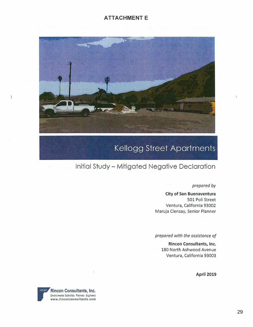
ATTACHMENT E
Kellogg Street Apartments
Initial Study - Mitigated Negative Declaration
rRincon Consultants, Inc. Environmental Scientists Planners Engineers www. ri nco n consultants .com
prepared by
City of San Buenaventura 501 Poli Street
Ventura, California 93002 Maruja Clensay, Senior Planner
prepared with the assistance of
Rincon Consultants, Inc. 180 North Ashwood Avenue
Ventura, California 93003
April 2019
30
0123456789
,' - , -:,-;_ _-_:_' ... < -· ·/ ... , · ~~;;i;;;t:;·,T Ai~:·~~ent:~ --"· > :·-.- •. ··--- • • •' ._: . .. · .. - . -~·:.,.· ~:-: .. ··<<r ~- ,:.·. >. • ;~·/;,;_::::- . ~;, .:~
Initial Study - Mitigated Negative Declaration
r Rincon Consultants, Inc. Environmental Scientists Planners Engineers www.rinconconsultants.com
prepared by
City of San Buenaventura
501 Poli Street Ventura, California
· Maruja Clensay, Senior Planner
prepared with the assistance of
Rincon Consultants, Inc.
180 North Ashwood Avenue Ventura, California 93003
April 2019
31
0123456789
This report prepared on 50% recycled paper with 50% post-consumer content.
32
0123456789
Table of Contents
Table of Contents
Initial Study ............................................................................................................................................ 3 1. Project Title ........................................................................................................................ 3 2. Lead Agency Name and Address ..... '. ... ; .............................................................................. 3 3. · Contact Person and Phone Number ................................................................................... 3 4. Project Location .................................................................................................................. 3 5. Project Sponsor's Name and Address .............................................................................. 11 6. General Plan Designation ................................................................................................. 11 7. Zoning ............................................................................................................................... 11 8. Description of Project ....................................................................................................... 11 9. Surrounding Land Uses and Setting ................................................................................. 16 10. Other Public Agencies Whose Approval is Required ........................................................ 16
Environmental Factors Potentially Affected ........................................................................................ 17
Determination ..................................................................................... ; ................................................ 17
Environmental Checklist ...................................................................................................................... 19 1 Aesthetics ......................................................................................................................... 19 2 Agriculture and Forestry Resources ................................................................................. 23 3 Air Quality ......................................................................................................................... 25 4 Biological Resources ......................................................................................................... 36 5 Cultural Resources ............................................................................................................ 40 6 Geology and Soils ............................................................................................................. 44 7 Greenhouse Gas Emissions ...................... · ........................................................................ 48 8 Hazards and Hazardous Materials .................................................................................... 56 . 9 Hydrology and Water Quality ...................................................................................... · ..... 62 10 Land Use and Planning ..................................................................................................... 68 11 Mineral Resources ............................................................................................................ 70 12 Noise ................................................................................................................................. 72 13 Population and Ho.using .................................................................................................... 80 14 Public Services .................................................................................................................. 82 15 Recreation ........................................................................................................................ 88 16 Transportation/Traffic ...................................................................................................... 90 17 Tribal Cultural Resources .................................................................................................. 94 18 Utilities and Service Systems ............................................................................................ 98 19 Mandatory Findings of Significance ............................................................................... 104
References ......................................................................................................................................... 108 Bibliography ............................................................................................................................... 108 List of Preparers ......................................................................................................................... 112
Initial Study- Mitigated Negative Declaration
33
0123456789
City of Ventura Kellogg Street Apartments
Tables
Table 1 Proposed Area Summary .................................................... : ............................................. 15
Table 2 Project Construction Emissions ........................................................................................ 31
Table 3 Project Operational Emissions ......................................................................................... 32
Table 4 Estimated Construction Emissions of Greenhouse Gases ................................................ 52
Table 5 Combined Annual Emissions of Greenhouse Gases ......................................................... 53
Table 8 Project Trip Generation ........................................................... '. ........................................ 77
Table 9 Constr.uction Equipment Noise Levels ................................ : ................... ,. ........................ 78
Table 10 Project Trip Generation .................................................................................................... 91
Figures
Figure 1 Regional Location ............................................................................................................... 4
Figure 2 Project Location .................................................................................................................. 5
Figure 3 Photo Locations .................................................................................................................. 6
Figure 4 Site Photos - Photos 1 and 2 .............................................................................................. 7
Figure 5 Site Photos - Photos 3 and 4 .............................................................................................. 8
Figure 6 Photos of Surrounding Uses - Photos 5 and 6 ................................................................... 9
Figure 7 Photos of Surrounding Uses - Photos 7 and 8 ................................................................. 10
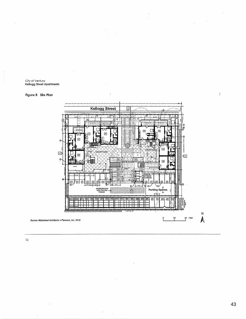
Figure 8 Site Plan ............................................................................................................................ 12
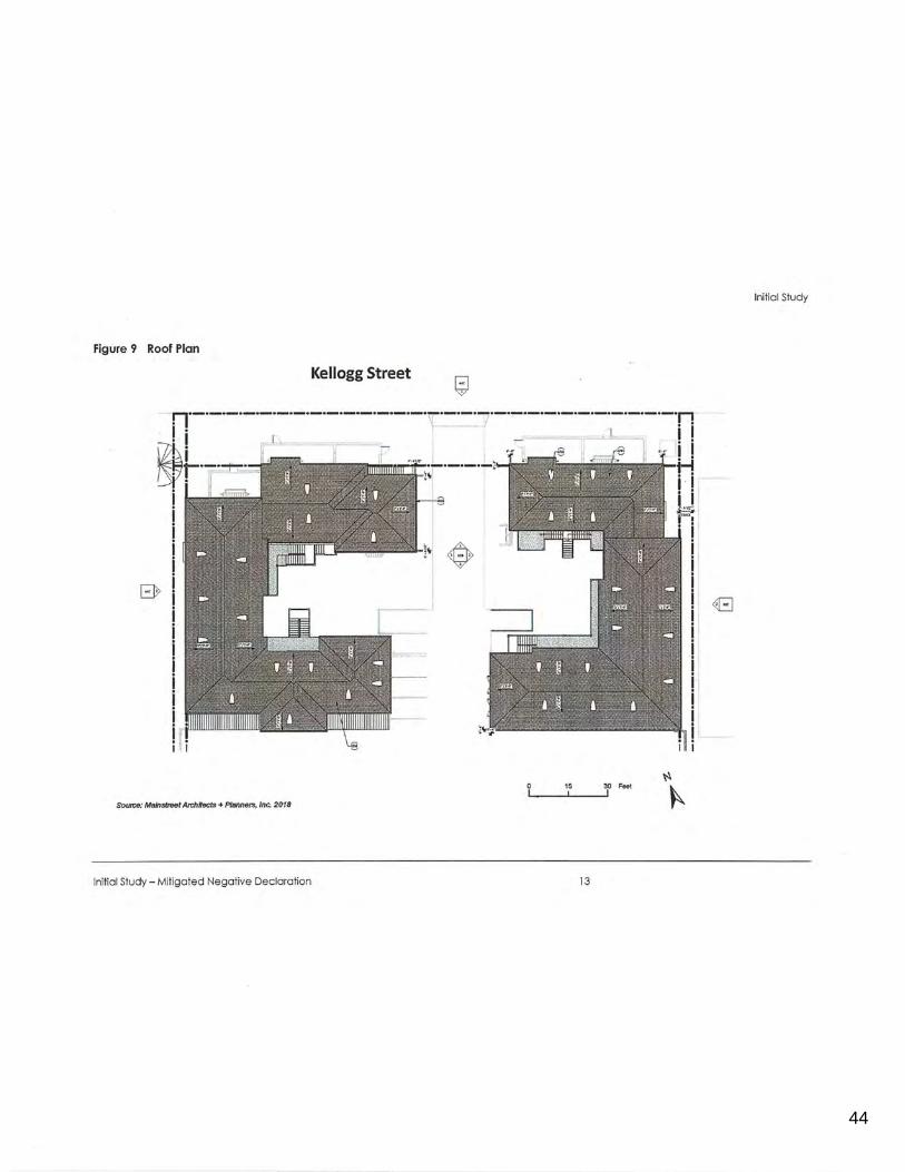
Figure 9 Roof Plan .......................................................................................................................... 13
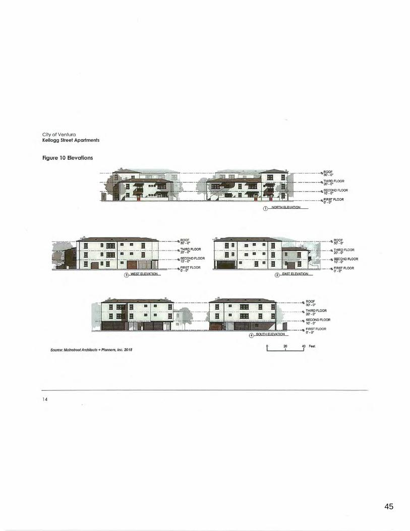
Figure 10 Elevations ......................................................................................................................... 14
Appendices Appendix A CalEEMod Modeling Worksheets
Appendix B Cultural Records Search Results
Appendix C Geotechnical Report
Appendix D Phase I Environmental Site Assessment
Appendix E Preliminary Drainage Study
Appendix F AB 52 Tribal Consultation Correspondence
Appendix G . Pending Projects in Project Site Vicinity
ii
34
0123456789
Initial Study
1 . Project Title
Kellogg Street Apartments
2. Lead Agency Name and Address
City of San Buenaventura Community Development Department 501 Poli Street Ventura, California 93002
3. Contact Person and Phone Number
Maruja Clensay, Senior Planner 805-658-4749
4. Project Location
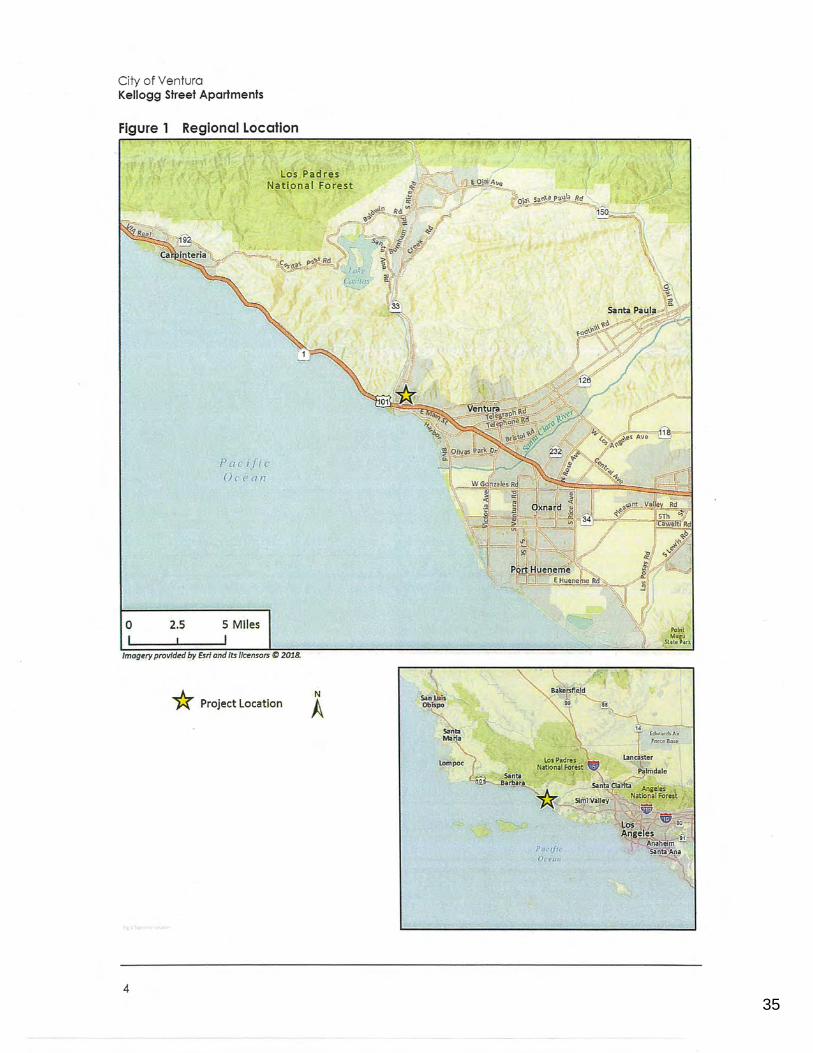
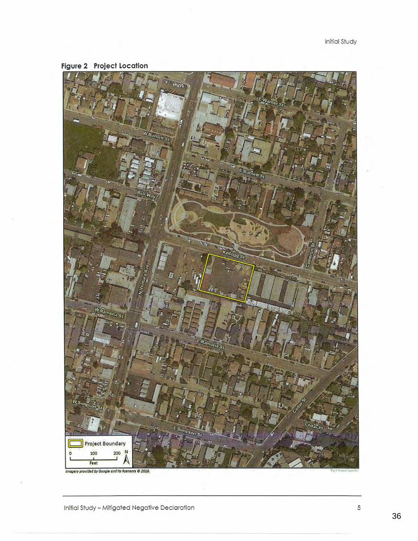
Initial Study
The project site encompasses about 0.77 acres located at 58 Kellogg Street in the City of San Buenaventura in Ventura County, California. The site is bounded by Kellogg Street on the north; 1-story multi-family housing on the east; 1-2-story single-and multi-family housing on the south; and a vacant lot on the west. Kellogg Park is located to the north of the project site across Kellogg Street. The project site's Assessor Parcel Number (APN) is 071-0-032-030.
Figure 1 shows the location of the project site in the region and Figure 2 shows the project site in its neighborhood context. The site is on the south side of Kellogg Street, between Ventura Avenue and Cameron Street in West Ventura. The site has historically been and continues to be occupied by commercial uses. Currently, most of the site is an open area paved with asphalt, used for construction equipment/vehicle storage and staging. The rest of the site is occupied by a prefabricated metal warehouse building used for an office and storage (approximately 960 square feet}, an open air shed used for tool storage (approximately 3,200 square feet}, and three shipping containers used for secured equipment/tool storage (approximately 300 square feet each). All of these buildings/structures are one story. The project site is separated from surrounding properties, and Kellogg Street, by chain link fencing on all sides, with concertina wire along the top on all sides. Access is currently available via gates in the chain link fencing along Kellogg Street.
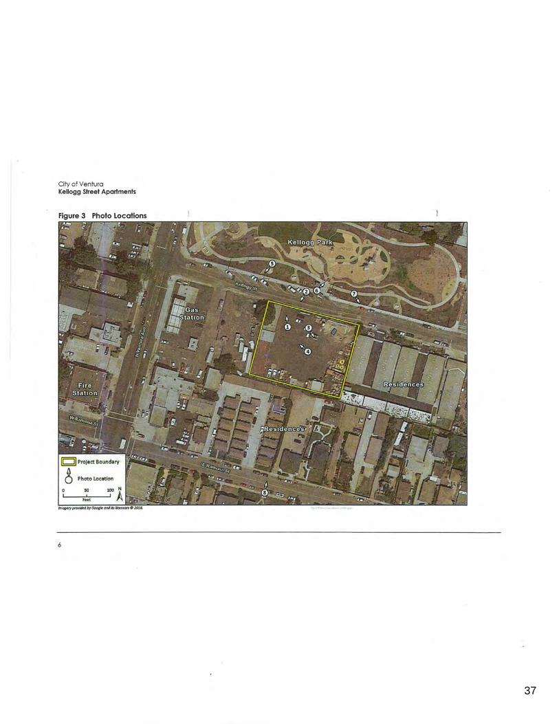
Photographs of existing conditions on the project site are shown in Figure 4 and Figure 5. Photos of surrounding uses in the project vicinity are shown in Figure 6 and Figure 7. A map of the locations and directions of the photos are shown in Figure 3.
Initial Study - Mitigated Negative Declaration 3
35
0123456789
City of Ventura Kellogg Street Apartments
Figure 1 Regional Location
Los Padres National Forest
0 2.5
Pac if1 c 0 ean
5 Miles
I Imagery provided by Esri and its licensors (t) 2018.
* Project Location
4
N
A
Poc1fic Ocer111
Point
St~J~,t.
36
0123456789
Initial Study
Initial Study - Mitigated Negative Decloration 5
37
0123456789
City of Ventura Kellogg Street Apartments
6
38
0123456789
Initial Study
Figure 4 Site Photos - Photos 1 and 2
Photo 1: View of the exfsting metal warehouse on-site and the City Park across Kellogg Street. Phot~ taken from the project site, looking north.
Photo 2: View' of the project site as seen from across Kellogg Street. Photo taken from the public street parking, looking south.
Initial Study - Mitigated Negative Declaration 7
39
0123456789
City of Ventura Kellogg Street Apartments
Figure 5 Site Photos - Photos 3 and 4
Photo 3: View of the tJillsides to the east and residential uses to the south of the site. Photo taken from the project site, looking southeast.
Photo 4: View of the metat warehouse and open air shed on-site. Photo taken from the center of the site, with hillsides across Ventura River to the northwest in the background.
8
40
0123456789
Initial Study
Figure 6 Photos of Surrounding Uses - Photos 5 and 6
Photo 5: Gas station, vacant lot, meat market, and church located west of the project site.
Photo 6: View of Kellogg Park looking northeast. Photo taken from northern sidewalk along Kellogg Street.
Initial Study - Mitigated Negative Declaration 9
41
0123456789
City of Ventura Kellogg Street Apartments
Figure 7 Photos of Surrounding Uses - Photos 7 and 8
I I .
Photo 7: Single story multi-family housing to the east of the project site, viewed from Kellogg Park.
Photo 8: Single and multi-family residences to the south of the project site, looking north from East Ramona Street.
10
42
0123456789
Initial Study
5. Project Sponsor's Name- and Address
Miller Family Trust 850 Lawrence Drive, Suite 100 Thousand Oaks, California 91320
6. General Plan Designation
Neighborhood High
7. Zoning
Limited Industrial (M-1)
8. Description of Project
The Kellogg Street Apartments (proposed project) would involve demolishing and removing the buildings, other structures, and pavement currently located on the project site (described in the Project Location section above); clearing the site; and constructing two apartment buildings containing 30 units totaling 21,826 square feet with 40 grade-level parking spaces. The 30 apartments would include six studio units, 22 one-bedroom units, and two two-bedroom units. Parking is proposed at the rear of the project site, with 30 spaces under carports and the remaining ten spaces uncovered. Access to the project site would be from Kellogg Street. Figure 8 illustrates a site plan and the layout of the site. Figure 9 illustrates the roof plan, and elevations of the proposed buildings in each cardinal direction are shown in Figure 10. The plans are subject to refinement as final Planning entitlements are given and plan check occurs, but the wholesale changes are not anticipated.
The project would be consistent with the project site's current General Plan land use designation of Neighborhood High, but would require a zone change from M-1 Limited Industrial to Multifamily (R-3-1). The project as proposed is consistent with R-3-1 zoning requirements.
Building Characteristics
The two apartment buildings proposed for the project site would be arranged in two horseshoe shapes, with the open end of each horseshoe facing an interior courtyard and a 20-foot wide central drive aisle leading to parking at the rear of the property. Apartment units facing Kellogg Street would be two stories and would include private patios facing the street with walkways to the sidewalk. The remainder of the units behind or set back from Kellogg Street would be three stories.
The buildings would be classified as modern Mediterranean classic style, and include modern and industrial roofing and trim materials including metal gutters, metal mesh infill panels, metal roof awnings, and dark bronze window frames, gutters, and structural columns. The roofing material would be 11Georgetown Grey" shingles. The buildings would be surfaced with a warm ivory ("Oatmeal") stucco steel trowel, with dark burgundy "BBQ" painted door trim and stained wood trim and members.
Initial Study - Mitigated Negative Declaration 11
43
0123456789
City of Ventura Kellogg Street Apartments
Figure 8 Site Plan
N 20 40 Feet
Source: Malnstreet Architects+ Planners, Inc. 2018 A
12
44
0123456789
Initial Study
Figure 9 Roof Plan
Kellogg Street
15 30 Feet
Source: Mainstreet Arch/tacts+ Planners, Inc. 2018
Initial Study - Mitigated Negative Declaration 13
45
0123456789
City of Ventura Kellogg Street Apartments
Figure 10 Elevafions
--------~~ - - · - - -----~!~FLOOR
---- - -----~c_:g.No FLOOR
~ -=-i!l!a---=-"""'!!:!d,..l.l:~....,,.=w=....l:~:::~=====~~;Jl;;:J;;;;;;~d~J::,;_ ______ __ ~~w FLOOR
------~?~ ---- --Ill ~I~~ FLOOR
----- - f~~NDFLOOR
==========~~===o!.a:=:!!!!!!!!!!!!.:::::::::::!~b.=:=--- ~'~W FLOOR
Source: Malnstreet Architects + Planners, Inc. 2018
14
CD NQBIH Fl E\(AT(QN
~r- - ---lli w~~FLOOR
=:_ -- --lll fa:~DFLOOR
====~-- --lli ~'~W FLOOR
·--- ---~ ~~&· - --- ---- --111 ~l'.W, FLOOR
------- -l!I ~DFLOOR
====---- · -l!I ~~f FLOOR
20 40 Feet
46
0123456789
Initial Study
Landscaping
Proposed landscaping includes a variety of very low, low, and medium use water plants consisting of trees, shrubs, perennials, succulents, and grasses. Prominent species include Mein Liebling Snake Plant, Bay Laurel Trees (hedge form), Woodland Strawberry, and Elijah Blue Fescue. All planting materials are proposed to meet the current City of San Buenaventura drought designation and would be WUCOLS (Water Use Classification of Landscape Species) compliant. Other site improvements include patio pathways, evergreen screening, a centrally located courtyard planter with trees (Fruitless Olive), shade structures, bench seats, and central courtyard drainage swales. As shown in Figure 8, an underground infiltration trench is proposed underneath the parking lot in the rear portion of the site. Table 1 shows the total landscaped area, as well as permeable, impermeable, and structure area.
Table 1 Proposed Area Summary
Structures Area
Impermeable Paved Area
Permeable Paved Area
Landscaped Area
Total Gross Area
Construction
7,844 sf I 0.18 ac
18,950 sf/ 0.42 ac
265 sf/ 0.01 ac
6,705 sf/ 0.15 ac
33,764 sf/ 0.77 ac
23
56
1
20
100
Construction of the project is expected to occur in 2019-2020, and assumed to last 8 months based on construction modeling using California Emissions Estimator Model (v. 2016.3.2). In order to level the site for construction, approximately 190 cubic yards (5,130 cubic feet) of cut would be removed from the site, with 320 cubic yards (8,640 cubic feet) of fill. The net result would be 130 cubic yards {3,510 cubic feet) of fill.
Parking, Circulation, and Site Access
Vehicular access to the project site would be from Kellogg Street. A 20-foot wide private drive aisle would run from Kellogg Street, between the two apartment buildings, through the central courtyard, and to the parking area at the rear of the property. This central drive aisle would also contain a trash and recycling enclosure which is located outside of the vehicular path of travel (see Figure 8).
Walkways would flank either side of the drive aisle. Each walkway would be approximately five feet wide. These walkways would connect to new sidewalk along the Kellogg Street frontage of the project site that would be constructed as part of the project, connecting to the existing sidewalks along the south side of Kellogg Street.
Five bicycle parking spaces are required and proposed adjacent to the automobile parking spaces on the east side, of the project site. The site plan also identifies a secure storage area on the ground floor for beach/sports equipment.
Initial Study - Mitigated Negative Declaration 15
47
0123456789
City of Ventura Kellogg Street Apartments
Utilities
Water and sewage would be provided to the project site by Ventura Water. Electricity would be provided by Southern California Edison and gas would be provided by Southern California Gas Company.
9. Surrounding Land Uses and Setting
The project site is located in an area characterized by a mix of residential, commercial, and light industrial uses and a large public park (Kellogg Park). Generalized surrounding land uses are shown in Figure 6 and Figure 7. Most commercial and light industrial uses are located along Ventura Avenue, about 200 feet west of the project site. A few commerci~I and light industrial properties in the area, such as the project site, front onto the east-west trending streets intersecting with Ventura Avenue, not the Avenue itself. Kellogg Park is located to the north of the project site across Kellogg Street, and is shown in Figure 6 - Photo 6. Other surrounding uses include one-story multifamily and single-family housing to the east; one- and two-story single- and multi-family housing on the south; a vacant lot immediately to the west; and commercial and other uses along Ventura Avenue to the west, including a gas station, a meat market, an auto repair shop, a church, a beauty salon, and San Buenaventura Fire 5tation One at the corner of Ventura Avenue and Ramona Street.
10. Other Public Agencies Whose Approval is Required
The City of San Buenaventura is the lead agency for this project, and no approvals are required from any other agency. The project would require a zone change from M-1 Limited Industrial to Multifamily (R-3-5).
16
48
0123456789
Environmental Factors Potentially Affected
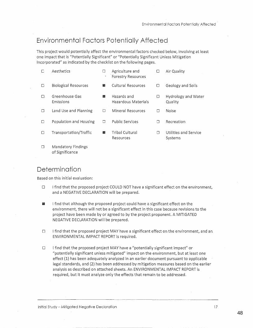
Environmental Factors Potentially Affected
This project would potentially affect the environmental factors checked below, involving at least one impact that is {{Potentially Significant" or (/Potentially Significant Unless Mitigation Incorporated" as indicated by the checklist on the following pages.
D Aesthetics D Agriculture and D Air Quality Forestry Resources
D Biological Resources II Cultural Resources D Geology and Soils
Di Greenhouse Gas Ill Hazards and D Hydrology and Water Emissions Hazardous Materials Quality
D Land Use and Planning D Mineral Resources D Noise
D Population and Housing D Public Services D Recreation
D Transportation/Traffic II Tribal Cultural D Utilities and Service Resources Systems
D Mandatory Findings of Significance
Determination Based on this initial evaluation:
D I find that the proposed project COULD NOT have a significant effect on the environment, and a NEGATIVE DECLARATION will be prepared.
II I find that although the proposed project could have a significant effect on the environment, there will not be a significant effect in this case because revisions to the project have been made by or agreed to by the project proponent. A MITIGATED NEGATIVE DECLARATION will be prepared.
D I find that the proposed project MAY have a significant effect on the environment, and an ENVIRONMENTAL IMPACT REPORT is required.
D I find that the proposed project MAY have a "potentially significant impact" or "potentially significant unless mitigated" impact on the environment, but at least one effect (1) has been adequately analyzed in an earlier document pursuant to applicable legal standards, and (2) has been addressed by mitigation measures based on the earlier analysis as described on attached sheets. An ENVIRONMENTAL IMPACT REPORT is required, but it must analyze only the effects that remain to be addressed.
Initial Study - Mitigated Negative Declaration 17
49
0123456789
City of Ventura Kellogg Street Apartments
D I find that although the proposed project could have a significant effect on the environment, because all potential significant effects (a) have been analyzed adequately in an earlier EIR or NEGATIVE DECLARATION pursuant to applicable standards, and (b) have been avoided or mitigated pursuant to that earlier EIR or NEGATIVE DECLARATION, including revisions or mitigation measures that are imposed upon the proposed project, nothing further is required.
Signature Date
Maruja Clensay, Senior Planner
Printed Name Title
18
50
0123456789
Environmental Checklist Aesthetics
Environmental Checklist
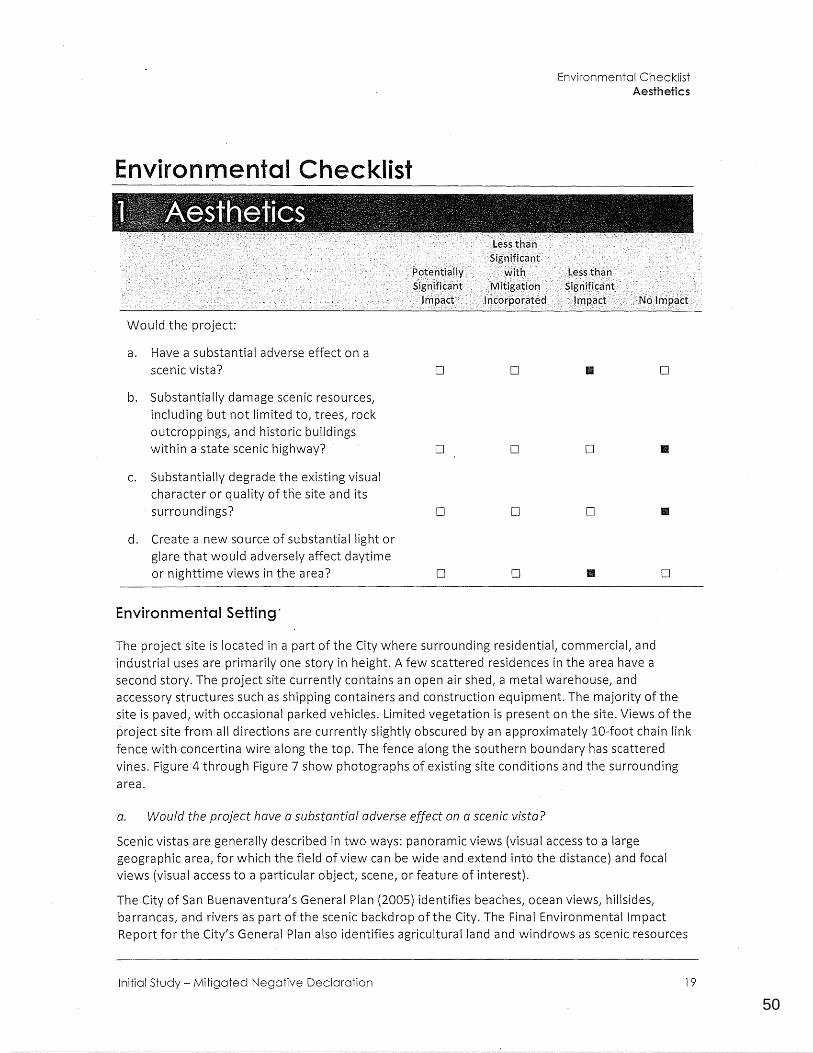
Would the project:
a. Have a substantial adverse effect on a scenic vista?
b. Substantially damage scenic resources, including but not limited to, trees, rock outcroppings, and historic buildings within a state scenic highway?
c. Substantially degrade the existing visual character or quality of the site and its surroundings?
d. Create a new source of substantial light or glare that would adversely affect daytime or nighttime views in the area?
Environmental Setting·
D
D
D
D
D II D
D D II
D D
D II D
The project site is located in a part of the City where surrounding residential, commercial, and industrial uses are primarily one story in height. A few scattered residences in the area have a second story. The project site currently contains an open air shed, a metal warehouse, and accessory structures such as shipping containers and construction equipment. The majority of the site is paved, with occasional parked vehicles. Limited vegetation is present on the site. Views of the project site from all djrections are currently slightly obscured by an approximately 10-foot chain link fence with concertina wire along the top. The fence along the southern boundary has scattered vines. Figure 4 through Figure 7 show photographs of existing site conditions and the surrounding area.
a. Would the project have a substantial adverse effect on a scenic vista?
Scenic vistas are generally described in two ways: panoramic views (visual access to a large geographic area, for which the field of view can be wide and extend into the distance) and focal views (visual access to a particular object, scene, or feature of interest).
The City of San Buenaventura's General Plan (2005) identifies beaches, ocean views, hillsides, barrancas, and rivers as part ohhe scenic backdrop of the City. The Final Environmental Impact Report for the City's General Plan also identifies agricultural land and windrows as scenic resources
Initial Study - Mitigated Negative Declaration 19
51
0123456789
City of Ventura Kellogg Street Apartments
(City of San Buenaventura 2005b). The project is not located near coastal or water features. Hillsides to the east are visible from the project site and adjacent properties. At street level, they are visible €!Ven when looking over the existing urban development. The height of the proposed buildings would be generally consistent with surrounding uses. Therefore, the project would not block views of panoramic scenic vistas.
While the project site does not contain scenic vistas, construction of the proposed project would block part of the view of adjacent hillsides from areas north of the project site (such as Kellogg Street, Kellogg Park, and Ventura Avenue) compared to existing conditions. However, the increased obstruction would be incremental, and any obstructed view would not be focal. Therefore, because there are no panoramic or focal views surrounding the site and the project would not block any scenic vistas from public view locations, impa.cts to scenic vistas would be less than significant.
The 2005 General Plan EIR identified a significant and unavoidable impact to scenic vistas, finding that future development accommodated under the General Plan would potentially alter and/or block views from various public view corridors in areas where development would convert highly visible agricultural lands along US 101 and SR 126. It found that policies included in the General Plan would reduce impacts on view corridors associated with intensification and reuse of land within already-developed parts of the City to a less than significant level. Because the project site is not in an area of highly visible agricultural lands along US 101 and SR 126, and because it would involve intensification and reuse of land within an already-developed parts of the City, the proposed project would not contribute to this significant and unavoidable impact.
LESS THAN SIGNIFICANT IMPACT
b. Would the project substantially damage scenic resources1 inc!uding1 but not limited to, trees1
rock outcroppings1 and historic buildings within a state scenic highway?
The project site is located in an area surrounded by single- and multi-family residences. The project site does not contain any scenic resources such as natural habitats or rock outcroppings, nor is it in proximity to any such resources. There are no trees on-site. The project site is not on or near any · site listed in the National Register of Historic Places, California State Historical Landmarks, or California Historical Resources or Points of Interest, and does not contain any local landmarks designated by the City of San Buenaventura (Ventura County 2018; California State Parks 2017a; City of San Buenaventura 2005a). The project site is not visible from or in proximity to a state scenic highway (California Department ofTransportation 2011). In addition, Policy 4D of the City's General Plan identifies certain streets/roadways as City scenic routes, and neither Kellogg Street nor any other street in the vicinity are listed (City of San Buenaventura 2005a). Therefore, no impact related to scenic resources within a state scenic highway would occur.
NO IMPACT
c. Would the project substantially degrade the existing visual character or quality of the site and its surroundings?
The project site currently contains an open air shed, metal warehouse, and accessory structures such as shipping containers and construction equipment. The majority of the site is paved, with vehicles parked in the center of the site as shown in Figure 4-Photo2 and Figure 5-Photo 3. There is no existing on-site vegetation. The City of San Buenaventura's Design Review Committee (DRC) formally reviewed the project on May 2, 2018. The project was favorably received, and the DRC's adopted meeting minutes are included in Appendix H. The proposed project involves the demolition
20
52
0123456789
Environmental Checklist Aesthetics
of these on-site structures, and the construction of two buildings containing a total of 30 residential units (a mix of studios and one~ and two-bedrooms) in a single and multi-family neighborhood. As shown in the elevations in Figure 10, the project would be built up to three stories (approximately 34 feet, including roofing), which is larger and taller than existing residences surrounding the site. Although the proposed height would be a maximum of three stories, the height along the project frontage would be two stories to reduce massing and scale. The two proposed residential buildings would be placed centrally on the site and would use neutral colors in order to blend with the existing neighborhood. The buildings would have asphalt shingles on the rooftops and warm ivory ((/Oatmeal") stucco steel trowel with wood trim on the outside walls. The buildings would be of more modern construction than the existing residences east of the site; however, the placement of new apartments on the project site would be more visually compatible with the surrounding residential uses than the industrial uses currently on the site.
Project landscaping would include trees, shrubs, succulents, grasses, and vines along the fences lining the project site boundary. Frontage along Kellogg Street would be landscaped, thereby enhancing the site's aesthetic appearance compared to existing conditions, which lack such landscaping. In addition, the project would include construction of new sidewalk along the Kellogg Street frontage of the project site to connect to the existing sidewalk along Kellogg Street east and west of the site. Overall, the proposed residential buildings and landscaping would be similar in visual character and quality to the surrounding area, and the project would improve the visual character and quality of the project site compared to the site's current use as an industrial storage site. The project would not substantially degrade the visual character or quality of the project site or area and there would be no impact.
The 2005 General Plan EIR identified a significant and unavoidable impact to the visual character of the community, finding that future development accommodated under the General Plan would change the visual character of the community by accommodating the conversion of some agricultural lands to urban uses. It also found that growth within the Ventura Avenue corridor in which the project site is located would create a more urban appearance in this area, but would. be expected to generally enhance the character of this area by adding appropriately scaled infill development that emphasizes mixed use, neighborhood character, and walkability. Because the proposed project would be infill development along the Ventura Avenue corridor and not convert agricultural lands to urban uses; and because, as described in the impact analysis above, it would not degrade the visual character or quality of the site or its surroundings; the proposed project would not contribute to the G~neral Plan's significant and unavoidable impact related to the visual character of the community.
NO IMPACT
d. Would the project create a new source of substantial light or glare which would adversely affect day or nighttime views in the area?
The project site is in an area with moderate levels of existing lighting. Primary sources of light adjacent to the project site include lighting associated with the existing residences surrounding the site, street lights along North Ventura Avenue, security lighting lining the path/sidewalk in Kellogg Park, and headlights from vehicles on nearby streets. The primary source of glare adjacent to the project site is the sun's reflection from metallic and glass surfaces on vehicles parked on Kellogg Street, and headlights from vehicles on nearby streets.
Exterior windows on the proposed apartments and additional vehicles parked on the street would incrementally increase the reflected sunlight during certain times of the day but the increase would
Initial Study- Mitigated Negative Declaration 21
53
0123456789
City of Ventura Kellogg Street Apartments
not be easily perceivable. The project would incorporate exterior lighting in the form of security lighting in the driveway and building-mounted lighting. These light sources would not have a significant impact on local light levels or views of the night sky because they would not substantially change existing nighttime lighting conditions and would be similar to the lighting levels of the surrounding residences. The project would also be subject to the following standard City lighting condition:
All lighting is to be designed to confine the light within the site boundaries. Sign lighting is to be shielded from neighboring properties and directed at a specific task or target. Exposed bulbs are prohibited, unless the Community Development Director determines exposed bulbs are integral to the architectural design of signage. The lumens of fixtures shall not exceed the minimum requirements of the California Energy Code. The lumens may be adjusted at the direction of the Community Development Director if the brightness is unreasonably bright for the safety of the public.
Therefore, impacts related to light and glare would be less than significant.
LESS THAN SIGNIFICANT IMPACT
22
54
0123456789
Would the project:
a. Convert Prime Farmland, Unique Farmland, Farmland of Statewide Importance (Farmland), as shown on maps prepared pursuant to the Farmland Mapping and Monitoring Program of the California Resources Agency, to non-agricultural use?
b. Conflict with existing zoning for agricultural use or a Williamson Act contract?
c. Conflict with existing zoning for, or cause rezoning of, forest land (as defined in Public Resources Code Section 12220(g)); timberland (as defined by Public Resources Code Section 4526}; or timberland zoned Timberland Production (as defined by Government Code Section 51104(g))?
d. Result in the loss of forest land or conversion of forest land to non-forest use?
e. Involve other changes in the existing environment which, due, to their location or nature, could result in conversion of Farmland to non-agricultural use or conversion of forest land to non-forest use?
Environmental Setting
D
D
D
D
D
Environmental Checklist Agriculture and Forestry Resources
D D II
D D II
D D II
D D II
D D II
The project site is not identified for Agriculture or Open Space uses. The project site is designated as Limited lndustrial/M-1 on the City's General Plan Map, allowing for City infill developments in an already urbanized setting. The General Plan "Infill First" strategy means avoiding suburban sprawl by directing new development to vacant land in the City and Sphere of Influence. The project site is currently paved, with existing structures on the site. The property to the north is designated as Parks/Open Space. The properties to the east and south are currently developed with single- and multi-family residences.
Initial Study - Mitigated Negative Declaration 23
55
0123456789
City of Ventura Kellogg Street Apartments
a. Would the project convert Prime Farmland, Unique Farmland, Farmland of Statewide Importance {Farmland}, as shown on the maps prepared pursuant to the Farmland Mapping and Monitoring Program of the California Resources Agency, to non-agricultural use?
b. Would the project conflict with existing zoning for agricultural use, or a Williamson Act contract?
e. Would the project involve other changes in the existing environment which, due to their location or nature, could result in conversion of Farmland to non-agricultural use?
The California Department of Conservation's {CDOC) Important Farmland Finder shows that the project site is in an area classified as Urban and Built-Up land and not within an area of prime or unique farmland {CDOC 2016). In addition, the project site and surrounding properties are not zon~d for agricultural use, and the project site is not under any Williamson Act contract (CDOC 2015a). Grazing land is located approximately 750 feet east of the project site; however, the project would involve infill development in an existing residential and commercial area and would not adversely impact ongoing agricultural operations. Accordingly, the project would not conflict with agricultural zoning or a Williamson Act contract and would not result in the loss or conversion of agricultural land to non-agricultural use. Therefore, no impact to farmland would occur.
NO IMPACT
c. Would the project conflict with existing zoning for, or cause rezoning of, forest land (as defined in Public Resources Code Section 12220{g}}, timberland (as defined by Public Resources Code Section 4526}, or timberland zoned Timberland Production (as defined by Government Code Section 51104{g))?
d. Would the project result in the loss of forest land or conversion of forest land to non-forest use?
. The project site is entirely paved, and currently zoned Limited-Industrial. The surrounding area is comprised of residential and commercial uses, and is not zoned for forest land or timberland. Accordingly, the project would not conflict with forest land or timberland zoning, and the project would not result in the loss of forest land or conversion of forest land to non-forest use. Therefore, no impact would occur.
NO IMPACT
24
56
0123456789
3 Air Quality
Would the project:
a. Conflict with or obstruct implementation of the applicable air quality plan?
b. Violate any air quality standard ·or contribute substantially to an existing or projected air quality violation?
c. Result in a cumulatively considerable net increase of any criteria pollutant for which the project region is nonattainment under an applicable federal or state ambient air quality standard (including releasing emissions which exceed quantitative thresholds for ozone precursors)?
d. Expose sensitive receptors to substantial pollutant concentrations?
e. Create objectionable odors affecting a substantial number of people?
Air Quality Standards and Attainment
D
D
D
D
D
D
D
D
D
D
Environmental Checklist Air Quality
• D
• D
• D
• D
D •
The project site lies within the South Central Coast Air Basin (the Basin}, which is under the jurisdiction of the Ventura County Air Pollution Control District (VCAPCD),aM the Santa Barbara County Air Pollution Control District (SBCAPCD), and the San Luis Obispo Air Pollution Control District (SLOCAPCD). The project site falls within the portion of the Basin overseen by the VCAPCD. As the local air quality management agency, the VCAPCD is required to monitor air pollutant levels to ensure that State and federal air quality standards are met and, if they are not met, to develop strategies to meet the standards. Depending on whether or not the standards are met or exceeded, the Basin Ventura County is classified as being in "attainment" or "nonattainment."
The Basin Ventura County is designated a nonattainment area for the federal and State 8-hour ozone standards and the State one-hour ozone and PM10 (particulate matter with a diameter of less than 10 microns} standards (VCAP_CD 2017, California Air Resources Board [ARB] 2015a).TRe Ventura County Sa5-ffi is in attainment of all other federal and State standards. Because #le Ventura County ~ currently exceeds these State and federal ambient air quality standards, it is required to implement strategies to reduce pollutant levels to recognized acceptable standards. This nonattainment status is a result of several factors, the primary ones being the naturally adverse meteorological conditions that limit the dispersion and diffusion of pollutants, the limited capacity
Initial Study - Mitigated Negative Declaration 25
57
0123456789
City of Ventura Kellogg Street Apartments
of the local airshed to eliminate air pollutants, and the number, type, and density of emission sources in the ~ Ventura County.
San Joaquin Valley Fever (formally known as Coccidioidomycosis) is an infectious disease caused by the fungus Coccidioides immitis. San Joaquin Valley Fever (Valley,Fever) is a disease of concern in the Basin. Infection is caused by inhalation of Coccidioides immitis spores that have become airborne when dry, dusty soil or dirt is disturbed by natural processes such as wind or earthquakes, or by human induced ground-disturbing activities such as construction, farming, or other activities (VCAPCD 2003}. From 2011 to 2015, the number of cases of Valley Fever reported in California averaged 3,611 with an average of 50 cases reported in Ventura County (California Department of Public Health 2016).
Air Quality Management
Under State law, the VCAPCD is required to prepare a plan for air quality improvement for pollutants for which the VCAPCDVentura County is in non-compliance. The VCAPCD's 2016 Air Quality Management Plan (AQMP) is an update of the previous 2007 AQMP .' The 2016 AQMP, adopted on February 14, 2017, incorporates new scientific data and notable regulatory actions that have occurred since adoption of the 2007 AQMP, including the approval of the new federal 8-hour ozone standard of 0.070 ppm that was finalized in 2015. This Plan builds upon the approaches taken in the 2007 AQMP and includes attainment and reasonable further progress demonstrations of the new federal 8-hour ozone standard (VCAPCD 2017).
Air Pollutant Emission Thresholds
The 2016 AQMP provides a strategy for the attainment of State and federal air quality standards. The VCAPCD has adopted guidelines for quantifying and determining the significance of air quality emissions (VCAPCD 2003} that only apply to discretionary projects subject to CEOA review.
The VCAPCD considers operational air quality impacts to be significant if a project would generate more than 25 pounds per day of ozone precursors reactive organic compounds (ROC} or nitrogen oxides (NOx}. The operational thresholds for ROC and NOx are not intended to be applied to construction emissions, since such emissions are temporary. For all other criteria pollutants, the VCAPCD considers a significant adverse air quality impact to occur when a project measurably worsens an existing exceedance of a State or federal ambient air quality standard. A project would have a significant cumulative adverse air quality impact if project emissions exceed two pounds per day of ROC or NOx and if t~e project is inconsistent with the population forecasts contained in the AQMP.
The VCAPCD has not established quantitative thresholds for particulate matter for either operation or construction. However, the VCAPCD indicates that a project may have a significant impact if it generates fugitive dust emissions in such quantities as to cause injury, detriment, nuisance, or annoyance to any considerable number of persons or to the public, or which may endanger the comfort, repose, health, or safety of any such person or the public. This threshold is particularly applicable to the generation of fugitive dust during construction grading operations.
The VCAPCD implements rules and regulations for emission that may be generated by various uses and activities. The rules and regulations detail pollution-reduction measures that must be implemented during construction and operation of projects. The VCAPCD Air Quality Assessment Guidelines also has recommended measures to reduce dust and precursor emissions from construction equipment powered by diesel, if the construction emissions are above the operational
26
58
0123456789
Environmental Checklist Air Quality
emission threshold of 25 lbs per day ROG or NOx. Rules and regulations relevant to the project include the following:
Rule 50 (Opacity): This rule sets opacity standards on the discharge from sources of air contamfnants. This rule wou ld apply during construction of the proposed· project, specifically grading activities.
Rule 51 (Nuisance): This rule prohibits any pe·rson from discharging air contaminants or any other material from a source that would cause injury, detriment, nuisance, or annoyance to any c_onsiderable number of persons or the public or which endangers the comfort, health, safety, or repose to any considerable number of persons or the public. The rule would apply to pollutants that generate dust or odors and constructi'on activities are also included. during construction activities.
f The proposed project would consist of residential uses; therefore, compliance with this rule would not be a concern following buildout of the project.
Rule 55 (Fugitive Dust): Th is rule requires fugitive dust generators to implement control measures to limit the amount of dust from vehicle track-out, earth moving, bulk rr:iaterial handling, and truck hauling activities.
Rule 55.1 (Paved Roads and Public Unpaved Roads): Th is rule requires fugitive dust generators to begin the removal of visible roadway dust accumulation within 72 hours of any written notification from the VCAPCD. The use of blowers is expressly prohibited under any circumstances. This ru le also requires controls to limit the amount of dust from any construction activity or any earthmoving activity on a public unpaved road.
Rule 55.2 (Street Sweeping Equipment): This rule requires the use of PM10 efficient street sweepers for routine street sweeping and for removing vehicle track-out pursuant to Rule 55.
Rule 74.4 (Cutback Asphalt): This rule sets limits on the type of application and VOC content of cutback and emulsified asphalt. The proposed project is required to comply with the type of application and voe content standards set forth in this rule for cutback and emulsified asphalt.
a. Would the project conflict with or obstruct implementation of the applicable air quality plan?
Based on the VCAPCD's Ventura County Air Quality Assessment Guidelines (VCAPCD 2003), a significant air quality impact may occur if the project cause the existing population to exceed the growth forecast contained in the AQMP or if the project would be inconsistent with the emission reduction strategies contained in the AQMP. The 2016 AQMP was .developed using the Southern California Association of Governments' (SCAG) population forecasts contained in the 2016-2040 Regional Transportation Plan/Sustainable Communities Strategy (2016 RTP/SCS). Ventura currently ryas a population of 111,269 residents with an average household size of 2.62 persons (California Department of Finance [CDOF] 2018). SCAG forecasts that the population of Ventura will grow to 125,300 residents by 2040, an increase of 14,031 (12.6 percent) relative to the 2018 populati_on (SCAG 2016).
Based on the City's current average household size of 2.62 persons, the proposed 30 residences would house an estimated 79 residents. Assuming conse·rvatively that all residents would move from outside the City of San Buenaventura, the project'wou ld bring the total Ventura population from its cu rrent level of 111,269 residents to 111.,348 residents. This 79-resident increase would account for 0.7 percent of the City's SCAG-projected growth of 14,031-residents by 2040. Thus, the level of population growth associated with the project falls within SCAG's population forecasts for the City. Th~ City currently contains approximately 44,031 housing units, and SCAG forecasts that
Initial Study - Mitigated Negative peclaration 27
59
0123456789
City of Ventura Kellogg Street Apartments
the housing stock of Ventura will reach 48,400 housing units by 2040 (CDOF 2018, SCAG 2016), an increase of 4,369 units. The 30-unit project would increase the City's existing housing stock to 44,061 units, which is well within SCAG's forecasts for the City. Therefore, the project would not conflict with the growth forecasts contained in the 2016 AQMP, and impacts would be less than significant.
The 2005 General Plan EIR identified a significant and unavoidable impact related to the potential for anticipated growth under the General to exceed 2004 AQMP population forecasts. It found that this was largely because 2004 AQMP population forecasts were outdated, and the 2005 General Plan was not expected to hinder attainment of state or federal air quality standards, but that potential exceedance of these population projections used for regional air quality planning still represented a potential inconsistency with the AQMP, and therefore a significant and unavoidable impact. As discussed above, the proposed project would be consistent with current 2016 AQMP population forecasts and the SCAG population forecasts upon which they are based. The proposed project would therefore not make a substantial contribution to the General Plan's significant and unavoidable impact related to its potential to conflict with or obstruct implementation of the AQMP.
LESS THAN SIGNIFICANT IMPACT
b. Would the project violate any air quality standard or contribute substantially to an existing or projected air quality violation?
c. Would the project result in a cumulatively considerable net increase of any criteria pollutant for which the project region is non-attainment under an applicable federal or state ambient air quality standard {including releasing emissions that exceed quantitative thresholds for ozone precursors)?
Based on the VCAPCD's Ventura County Air Quality Assessment Guidelines (2003), a project may have a significant impact if:
• It would generate more than 25 pounds per day of ozone precursors reactive organic compounds (ROC) or nitrogen oxides (NOx).
• It measurably worsens an existing exceedance of a state or federal ambient air quality standard.-
• Fugitive dust emissions are generated in such quantities as to cause injury, detriment, nuisance, or annoyance to any considerable number of persons or to the public, or which may endanger the comfort, repose, health, or safety of any such person or the public.
The monitoring station located closest to the project is the El Rio-Rio Mesa School #2 Station, which is located approximately 9.1 miles southeast of the project site. The data collected at this station indicate exceedances of federal and State 8-hour ozone standards in 2017, federal PM2.s 24-hour averages in 2017, and state and federal PM10 24-hour averages in 2017. No other federal or S~ate standards were exceeded at this monitoring station in 2017 (ARB n.d.).
Construction Emissions
Construction activities associated with development of the proposed project would generate diesel emissions and dust. Construction emissions modeled include emissions generated by construction equipment used on-site and emissions generated by vehicle trips associated with construction, such as worker and vendor trips. It is assumed that all of the construction equipment used would be diesel-powered. The construction emissions associated with development of the project were
28
60
0123456789
Environmental Checklist Air Quality
calculated using the California Emissions Estimator Model (CalEEMod) version 2016.3.2. CalEEMod was developed for use throughout the state in estimating construction and operationa I emissions from land use development. Emissions were based on parameters such as the duration of construction activity, area of disturbance, and anticipated equipment use during construction.
The construction schedule and equipment were based on CalEEMod defaults, other than for architectural coating, which was extended to reflect a more accurate construction schedule. The architectural coating phase was adjusted to last approximately half of the building consvuction phase because it was assumed that individual components of the buildings would be painted as they are completed. Based on applicant-provided information, 4,200 sf of existing buildings (open-air shed, warehouse, and accessory structures} would be demolished. Based on the default CalEEMod assumption that haul trucks have an estimated 16-cubic-yard capacity, and the fact that the project would require a net total of 130 cubic yards of fill, the project would result in 8 total haul round trips.
It was assumed the project would comply with all applicable regulatory standards, which were included in the modelling of construction emissions as "mitigation" when possible. The project would adhere to VCAPCD Rule 55 (Fugitive Dust), Rule 62.7 (Asbestos - Demolition and Renovation}, and Rule 74.2 (Architectural Coatings). The City of San Buenaventura also requires standard construction measures included in the most recent version of the VCAPCD's Ventura County Air
Quality Assessment Guidelines pursuant to Mitigation Measure AQ-3 of the 2005 General Plan Final Environmental Impact Report. Required measures include the following:
1. In order to reduce impacts associated with NOx emissions (a precursor to ozone), the following measures shall be implemented:
0 Equipment idling time should be minimized.
0 Equipment engines should be maintained in good condition and in proper tune, as per manufacturer's specifications.
0 During the smog season (May through October), the construction period should be lengthened so as to minimize the number of vehicles and equipment operating at the same time.
0 Alternatively fueled construction equipment, such as compressed natural gas, liquefied natural gas, or electric, should be used if feasible.
2. During clearing, grading, earth moving, or excavation operation, excessive fugitive dust emissions shall be controlled by regular watering, paving construction roads, or other dustpreventive measures using the following procedures:
0 All material excavated or graded shall be sufficiently watered to prevent excessive amounts of dust. Watering shall occur at least twice daily with complete coverage, preferably in the late morning and after work is done for the day, so that water penetrates sufficiently to minimize fugitive dust during grading activities. Reclaimed water should be used if available.
0 All graded and excavated material, exposed soil areas, and active portions of the construction site, including unpaved roadways on-site, should be treated to prevent fugitive dust. Measures may include watering, application of environmentally-safe soil stabilization materials, and/or roll-compaction as appropriate.
0 Graded and/or excavated inactive areas of the construction site should be monitored at least weekly for dust stabilization. If a portion of the site is inactive for over four days, soil on-site should be stabilized.
Initial Study - Mitigated Negative Declaration 29
61
0123456789
City of Ventura Kellogg Street Apartments
D
0
D
0
D
Signs should be posted limiting on-site traffic to 15 miles per hour.
All clearing, grading, earth moving, or excavation activities shall cease during periods of high winds (i.e., greater than 20 miles per hour averaged over one hour) so as to prevent excessive amounts of dust.
All material transported off-site shall be either sufficiently watered or securely covered to prevent excessive amounts of dust pursuant to California Vehicle Code §23114.
Respiratory protection shall be used by all employees in accordance with California Division of Occupational Safety and Health regulations.
Measures to reduce the fungus that causes Valley Fever should include the following:
Facemasks should be worn on employees involved in grading or excavation operations during dry periods to reduce inhalation of dust.
Employment should be restricted to persons with positive coccidioidin skin tests.
Crews should be hired from local populations where possible, since it is more likely that they have previously been exposed to the fungus and are therefore immune.
Cabs of grading and construction equipment should be air-conditioned.
Crews should work upwind from excavation sites.
Construction roads should be paved.
Weed growth should be controlled by mowing instead of discing.
The access way into the project site should be paved or treated with environmentallysafe dust control agents during rough grading and construction.
0 The area disturbed by clearing, grading, earth moving, or excavation operations shall be minimized so as to prevent excessive amounts of dust.
3. The project applicant shall ensure compliance with the following State laws and APCD requirements:
~ Construction equipment shall not have visible emissions greater than 20% opacity, as required by APCD Rule 50, Opacity.
0 All portable diesel-powered equipment over 50 BHP shall be registered with the State's Portable Equipment Registration Program (PERP) or an APCD Portable Permit.
0 Off-Road Heavy-Duty trucks shalt comply with the California State Regulation for In-Use OffRoad Diesel Vehicles (Title 13, CCR §2449), the purpose of which is to reduce NOx and diesel particulate matter exhaust emissions.
0 All commercial on-road and off-road diesel vehicles are subject to the idling time limits of Title 13, CCR §2485, §2449(d)(3L respectively. Construction equipment shall not idle for more than five consecutive minutes. The idling limit does· not apply to: (1) idling when queing; (2) idling to verify that the vehicle is in safe operating condition; (3) idling for testing, servicing, repairing or diagnostic purposes; (4) idling necessary to accomplish work for which the vehicle was designed (such as operating a crane}; (5) idling required to bring the machine system to operating temperature, and (6) idling necessary to ensure safe operation of the vehicle. It is the Permittee's responsibility to have a written idling policy that is made available to operators of the vehicles and equipment and informs them that idling is limited to 5 consecutive minutes or less, except as exempted in subsection a. above.
4. After clearing, grading, earth moving, or excavation operations, and during construction activities, fugitive dust emissions shall be controlled using the following procedures:
30
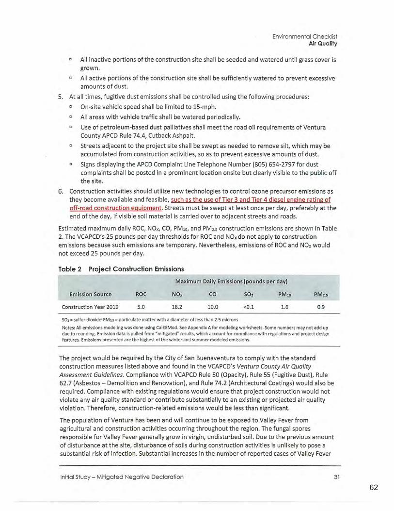
62
0123456789
Environmental Checklist Air Quality
c All inactive portions of the construction site shall be seeded and watered until grass cover is grown.
0 All active portions of the construction site shall be sufficiently watered to prevent excessive amounts of dust. ·
5. At all times, fugitive dust emissions shall be contra.lied using the following procedures:
c On-site vehicle speed shall be limited to 15-mph.
c All areas with vehicle traffic shall be watered periodically.
c Use of petroleum-based dust palliatives shall meet the road oil requirements of Ventura County APCD Rule 74.4, Cutback Ashpalt.
c Streets adjacent to the project site shall be swept as needed to remove silt, which may be accumulated from construction activities, so as to prevent excessive amounts of dust.
c Signs displaying the APCD Complaint Line Telephone Number (805} 654-2797 for dust complaints shall be posted in a prominent location onsite but clearly visible to the public off the site.
6. Construction activities should utilize new technologies to control ozone precursor emissions as they become available and feasible, such as the use ofTier 3 and Tier 4 diesel engine rating of off-road construction equipment. Streets must be swept at least once per day, preferably at the end of the day, if visible soil material is ca.rried over to adjacent streets and roads.
Estimated maximum daily ROC, NOx, CO, PM10, and PM2.s construction emissions are shown in Table 2. The VCAPCD's 25 pounds per day thresholds for ROC and NOx do not apply to construction emissions because such emissions are temporary. Nevertheless, emissions of ROC and NOx would not exceed 25 pounds per day.
Table 2 Project Construction Emissions
Construction Year 2019
ROC
5.0 18.2 10.0
S02 = sulfur dioxide; PM2.s = particulate matter with a diameter of less than 2.5 microns
RM10 PM2.s
<0.1 1.6 0.9
Notes: All emissions modeling was done using CalEEMod. See Appendix A for modeling worksheets. Some numbers may not add up due to rounding. Emission data is pulled fror:n "mitigated" results, which account for compliance with regulations and project design features. Emissions presented are the highest of the winter and summer modeled emissions.
The project would be required by the City of San Buenaventura to comply with the standard construction measures listed above and found in the VCAPCD's Ventura County Air Quality Assessment Guidelines. Compliance with VCAPCD Rule 50 (Opacity}, Rule 55 (Fugitive Dust), Rule 62.7 (Asbestos - Demolition and Renovation}, and Rule 74.2 (Architectural Coatings} would also be required. Compliance with existing regulations would ensure that project construction would not violate any air quality standard or contribute substantially to an existing or projected air quality violation. Therefore, construction-related emissions would be less than significant.
The population of Ventura has been and will continue to be exposed to Valley Fever from agricultural and construction activities occurring throughout the region. The fungal spores responsible for Valley Fever generally grow in virgin, undisturbed soil. Due to the previous amount of disturbance at the site, disturbance of soils during construction activities is unlikely to pose a substantial risk of infection. Substantial increases in the number of reported cases of Valley Fever
Initial Study- Mitigated Negative Declaration 31
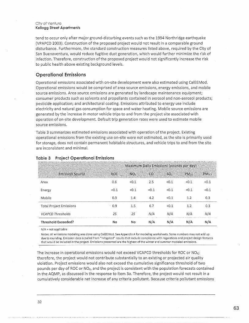
63
0123456789
City of Ventura Kellogg Street Apartments
tend to occur only after major ground-disturbing events such as the 1994 Northridge earthquake (VPAPCD 2003). Construction of the proposed project would not result in a comparable ground disturbance. Furthermore, the standard construction measures listed above, required by the City of San Buenaventura, would reduce fugitive dust generation, which would further minimize the risk of infection. Therefore, construction of the proposed project would not significantly increase the risk to public health above existing background levels.
Operational Emissions
Operational emissions associated with on-site development were also estimated using CalEEMod. Operational emissions would be comprised of area source emissions, energy emissions, and mobile source emiss.ions. Area source emissions are generated by landscape maintenance equipment; consumer products such as solvents and propellants contained in aerosol and non-aerosol products; pesticide application; and architectural coating. Emissions attributed to energy use include electricity and natural gas consumption for space and water heating. Mobile source emissions are generated by the increase in motor vehicle trips to and from the project site associated with operation of on-site development. Default trip generation rates were used to estimate mobile source emissions.
Table 3 summarizes estimated emissions associated with operation of the project. Existing operational emissions from the existing use on-site were not estimated, as the site is primarily used for storage, does not contain permanent habitable structures, and vehicle trips to and from the site are inconsistent and minimal.
Table 3 Project Operational Emissions
Area 0.6 <0.1 2.5 <0.1 <0.1 <0.1
Energy <0.1 <0.1 <0.1 <0.1 <0.1 <0.1
Mobile 0.3 1.4 4.2 <0.1 1.2 0.3
Total Project Emissions · 0.9 1.5 6.7 <0.1 1.2 0.3
VCAPCD Thresholds 25 25 N/A N/A N/A N/A
Threshold Exceeded? No No N/A N/A N/A N/A
N/ A= not applicable
Notes: All emissions modeling was done using CalEEMod. See Appendix A for modeling worksheets. Some numbers may not add up due to rounding. Emission data is pulled from "mitigated" results that include compliance with regulations and project design features that would be included in the project. Emissions presented are the highest of the winter and summer modeled emissions.
The increase in operational emissions would not exceed VCAPCD thresholds for ROC or NOx; therefore, the project would not contribute substantially to an existing or projected air quality violation. Project emissions would also not exceed the cumulative significance threshold of two pounds per day of ROC or NOx, and the project is consistent with the population forecasts contained in the AQMP, as discussed in the response to item 3a. Therefore, the project would not result in a cumulatively considerable net increase of any criteria pollutant. Because criteria pollutant emissions
32
64
0123456789
Environmental Checklist Air Quality
and regional thresholds are cumulative in nature, the project would not result in a cumulatively considerable net increase of any criteria pollutant.
LESS THAN SIGNIFICANT IMPACT
d. Would the project expose sensitive receptors to substantial pollutant concentrations?
Sensitive receptors are members of the population that are particularly sensitive to the effects of air · pollutants, such as children, the elderly, and people with illnesses. The sensitive receptors closest to the project site are residences located immediately adjacent to the project site's eastern and southern boundaries. There is also a public park immediately to the north of the project site, but these are transitory populations. The project would also introduce sensitive receptors to the project site because it would involve the development of residential units.
A carbon monoxide {CO) hotspot is a localized concentration of CO that exceeds the federal onehour standard of 35.0 parts per million (ppm) or the federal and State 8-hour standard of 9.0 ppm (ARB 2016a). According to the VCAPCD Ventura County Air Quality Assessment Guidelines (2003), a CO hotspot screening analysis should be performed for any project with indirect emissions greater than the ozone project significance threshold of 25 pounds per day that may significantly impact roadway intersections that are currently operating at Levels of Service (LOS) E or F. As shown in Table 2 and Table 3, project construction would generate maximum daily CO emissions of approximately 10.0 pounds per day, and project operation would generate maximum daily CO emissions of approximately 6.7 pounds per day. The proposed project would not generate emissions exceeding the ozone significance threshold; therefore, a CO hotspot screening analysis is not warranted.
Furthermore, the Basin Ventura County is in conformance with federal and State CO standards, and most air quality monitoring stations no longer report CO levels. No stations in the vicinity of the project site have monitored CO since 2004. In 2004, the El Rio-Rio Mesa School #2 Station detected an 8-hour maximum CO concentration of 1.52 ppm, which is below the federal and State standard of 9 ppm (ARB n.d.). Based on the low background level of CO in the general project vicinity, everimproving vehicle emissions standards for new cars in accordance with federal and State regulations, and the project's low level of operational CO emissions, the project would not result in the creation of new CO hotspots or contribute substantially to existing CO hotspots. Therefore, localized air quality effects related to CO hotspots would not occur. As discussed under items {b) and (c) above, compliance with Rule 55 and Rule 74.2 would ensure that construction emissions would not be generated in such quantities as to expose sensitive receptors to substantial pollutant concentrations. Impacts to sensitive receptors would be less than significant.
LESS THAN SIGNIFICANT IMPACT
e. Would the project create objectionable odors affecting a substantial number of people?
Based on the VCAPCD Ventura County Air Quality Assessment Guidelines (2003), land uses and industrial operations known to emit objectionable odors include wastewater treatment facilities, food processing facilities, coffee roasters, fiberglass operations, refineries, feed lots/dairies, and composting facilities. Although the site is currently zoned Limited-Industrial, the proposed project involves changing the project site's zoning to Residential and construction of a multi-family residential development, which is not a use includecl on this list. The proposed multi-family residential uses would generate odors that would be similar to those generated by surrounding residential uses. Therefore, no impact related to objectionable odors would occur.
Initial Study - Mitigated Negative Declaration 33
65
0123456789
City of Ventura Kellogg Street Apartments
NO IMPACT
34

66
0123456789
This page intentionally left blank.
Initial Study - Mitigated Negative Declaration
Environmental Checklist Air Quality
35
67
0123456789
City of Ventura Kellogg Street Apartments
Would the_ project:
a. Have a substantial adverse effect, either directly or through habitat modifications, on any species identified as a candidate, sensitive, or special status species in local or regional plans, policies, or regulations, or by the California Department of Fish and Wildlife or U.S. Fish and Wildlife Service? D D D II
b. Have a substantial adverse effect on any riparian habitat or other sensitive natural community identified in local or regional plans, policies, or regulations, or by the California Department of Fish and Wildlife or U.S. Fish and Wildlife Service? D D D II
C. Have a substantial adverse effect on federally protected wetlands as defined by Section 404 of the Clean Water Act (including, but_ not limited to, marsh, vernal pool, coastal, etc.) through direct removal, filling, hydrological interruption, or other means? D D D II
d. Interfere substantially with the movement of any native resident or migratory fish or wildlife species or with established native resident or migratory wildlife corridors, or impede the use of native wildlife nursery sites? II D D II
e. Conflict with any local policies or ordinances protecting biological resources, such as a tree preservation policy or ordinance? D D D II
f. Conflict with the provisions of an adopted Habitat Conservation Plan, Natural Community Conservation Plan, or other approved local, regional, or state habitat conservation plan? D D D 111·
36
68
0123456789
Environmental Checklist Biological Resources
Environmental Setting
The project site is located in a residential and commercial neighborhood in an urbanized area. As seen in the site photos in Figure 4 and Figure 5, the project site has been extensively disturbed by previous on-site activities, as the site is entirely paved, with accessory structures located near the eastern and southern boundary, and has been a storage site for construction and other industrial equipment. The site does not contain any vegetation or trees, and is currently chain-link fenced on all sides.
A field visit was conducted on September 7th, 2018 to verify on-site conditions. In addition, a desktop level review was conducted in September 2018 reviewing online resources such as the: United States Fish and Wildlife (USFW) National Wetlands Inventory (USFW 2018a); USFW Environmental Conservation Online System (ECOS) - Threatened and Endangered Species Active Critical Habitat Report (USFW 2018b); CDFW Biogeographic Information and Observation System's (BIOS) California Essential Habitat Connectivity Viewer (CDFW 2018).
a. Would the project have a substantial adverse effect1 either directly or through habitat modifications, on any species identified as candidate, sensitive, or special status in local or regional plans, policies, or regulations, or by the California Department of Fish and Wildlife or the U.S. Fish and Wildlife Service?
b. Would the project have a substantial adverse effect on any riparian habitat or other sensitive natural community identified in local or regional plans, policies, or regulations, or by the California Department of Fish and Wildlife or U.S. Fish and Wildlife Service?
The project site is located in a part of the City lacking native biological habitat and has been previously disturbed in conjunction with on-site development. The surrounding properties have been developed with residential and commercial land uses. Based on a site visit conducted on September 7th, 2018 and desktop level review discussed in the background setting above, no wetland, riparian, or other sensitive natural communities or federal- or state-listed endangered, threatened, rare, or otherwise sensitive flora or fauna are located on or adjacent to the project site {USFW 2018a; USFW 2018b; CDFW 2018). Consequently, no impact would occur.
NO IMPACT
c. Would the project have a substantial adverse effect on federally protected wetlands as defined by Section 404 of the Clean Water Act (including, but not limited to, marsh, vernal poot coasta( etc.) through 'direct removal, filling, hydrological interruption, or other means?
The project site does not contain any federally protected wetlands, wetland resources, or other waters of the United States as defined by Section 404 of the Clean Water Act (USFW 2018a). The nearest jurisdictional feature is a Freshwater Forested/Shrub Wetland approximately a half mile east of the project site that is separated from the project site by residential development and adjacent hillsides {United States Fish and Wildlife Service 2018). Project construction, including demolition, site preparation, and grading activities, would be confined to the project site and would not impact off-site features. Therefore, the project would not affect federally protected wetlands through direct removal, filling, hydrological interruption, or other means, and no impact would occur.
NO IMPACT
Initial Study · Mitigated Negative Declaration 37
69
0123456789
City of Ventura Kellogg Street Apartments
d. Would the project interfere substantially with the movement of any native resident or migratory fish or wildlife species or with established native resident or migratory wildlife corridors, or impede the use of native wildlife nursery sites?
The project site is currently separated from surrounding uses by an approximately ten-foot-tall chain link fence that runs along all sides of the project site property line, with concertina wire along the top. The project site and its surroundings are urbanized and lack water features. No migratory wildlife species or signs of such species were observed during the site visit on September 7th, 2018 and desktop review (USFW 2018a; USFW 2018b; CDFW 2018). Trees typically serve as habitat for migratory birds; however, no trees are present on the site or along the project site's frontage. A large evergreen tree exists on the adjacent parcel to the west of the site, the canopy of which extends onto the project site. Although the canopy extends onto the project site, the site plan for the proposed project does not propose building construction in this area. Per the landscape plans, other landscaping, including evergreen screening trees lining the western site boundary, an oak tree, and various shrubs and perennials are proposed in this area. Per the landscape plans, the trunk of the proposed oak tree would be located approximately 20 feet from the trunk of the off-site evergreen, and the trunk of the nearest proposed evergreen screening tree would be located approximately 7 feet from the trunk of the off-site evergreen. Because of the intervening distance and separation provided by the fence along the property line1 installation of this landscaping sh_ould not adversely affect the off-site evergreen. Since there are no trees on the site, no migratory species have been identified, and trees on adjacent properties would not be adversely affected by the project, the project would not interfere with wildlife movement or migratory corridors or impede the use of native wildlife nurse·ry sites, and there would be no impact.
NO IMPACT
e. Would the project conflict with any local policies or ordinances protecting biological resources, such as a tree preservation policy or ordinance?
. Chapter 20.150 - Street Trees of the City of San Buenaventura Municipal Code is the only local ordinance that provides tree protection and removal guidelines and only applies to street trees. The project site does not have any street trees located on its northern boundary along Kellogg Street, which is its only street frontage.
City policy guidance relating to trees includes the following guidelines from the Landscaping section of the City's Design Guidelines (City of San Buenaventura, 1997):
3. All areas not occupied by buildings, parking and access and other features should be landscaped
4. Landscaping should employ drought-tolerant varieties of plants
5. Native and other mature trees should be preserved and incorporated into the design of a project, to the extent practical
The proposed project would be consistent with Guideiine 3 because, as described on page 15 of this IS-MND and shown on the Preliminary Landscape Plan dated February 27 2018 and already reviewed by the City's Design Review Committee (DRC), all areas of the project site not occupied by buildings, parking and access and other features would be landscaped.
The project would be consistent with Guideline 4 because, as described on page 15 of this IS-MND, Proposed landscaping includes·a variety of very low1 low, and medium use water plants consisting of trees1 shrubs, perennials, succulents, and grasses. All planting materials are proposed to meet the
38
70
0123456789
Environmental Checklist Biological Resources
current City of San Buenaventura drought designation and would be WUCOLS (Water Use Classification of Landscape Species) compliant.
The project would be consistent with Guideline 5 because there are no current on-site trees that would be removed as part of the proposed project and, as explained in impact discussion 4d, trees on adjacent properties would not be adversely affected by the project.
Chapter 1, Our Natural Community, of the City's General Plan (City of San Buenaventura 2005a) includes Policy lC, which is to improve protection for native plants and animals. Actions 1.23 and 1.24 under Policy lC are the following:
Action 1.23. Require, where appropriate, the preservation of healthy tree windrows associated with current and former agricultural uses, and incorporate trees into the design of new developments
Action 1.24. Require new development to maintain all indigenous tree species or provide adequately sized replacement native trees on a 3:1 basis
The project would be consistent with Action 1.23 because there are no windrow trees on or around the project site to be preserved and, as described on page 15 of this IS-M ND, proposed landscaping for the site includes trees. The project would be consistent with Action 1.24 because there are no indigenous trees on or around the project site that would be impacted by the project.
As described above, the proposed project would be consistent with local policies or ordinances protecting trees. There are no other local policies or ordinances protecting specific biological resources with which the project would conflict. Therefore, no impact would occur.
NO IMPACT
f. Would the project conflict with the provisions of an adopted Habitat Conservation Plan, Natural Community Conservation Plan, or other approved local, regional, or state habitat conservation plan?
The project site is not located in an area subject to an adopted Habitat Conservation Plan, Natural Community Conservation Plan, or other approved conservation plans (CDFW 2017). Therefore, no impact would occur.
NO IMPACT
Initial Study - Mitigated Negative Declaration 39
71
0123456789
City of Ventura Kellogg Street Apartments
Would the project:
a. Cause a substantial adverse change in the significance of a historical resource as defined in §15064.5?
b. Cause a substantial adverse change in the significance of an archaeological resource as defined in §15064.5?
c. Directly or indirectly destroy a unique paleontological resource or site or unique geological feature?
d. Disturb any human remains, including those interred outside of formal cemeteries?
Environmental Setting
D
D
D
D
D D
II D D
II D D
II D D
The project site currently contains an open-air shed, metal warehouse, and accessory structures (shipping containers and construction equipment). The project site is not within a designated historical district or adjacent to any known historical landmarks or those structures who have the potential to be considered historically significant. On September 12, 2018, Rincon Consultants performed a cultural records search of the project site and vicinity (within a 0.5-mile radius) at the California Historical Resources Information System Information Center at California State University, Fullerton (Appendix B). Based on the results of the cultural resources records search, no known cultural resources were identified on or adjacent to the project site.
a. Would the project cause a_ substantial adverse change in the sigmficance of a historical resource as defined in §15064.5?
The City of San Buenaventura Historical Preservation Committee (HPC) has reviewed the existing onsite structures and determined that none of them are local historical resources. The project was subject to a 5 day posting to the HPC on April 26, 2017 and was not requested to be reviewed at a formal HPC hearing. Also, the project site is not listed in the National Register of Historical Places or the CRHR and does not appear to meet the criteria that would make it eligible for listing in either register. Consequently, no portion of the project site is considered a historical resource for the purposes of CEQA and no impact to historical resources would occur..
NO IMPACT
b. Would the project cause a substantial adverse change in the significance of an archaeological resource as defined in §15064.5?
40
72
0123456789
Environmental Checklist Cultural Resources
Historically, this part of Ventura was under agricultura I cultivation before development with urban uses. The has therefore been subject to repeated earth disturbance, including disturbance for agriculture (which may have included deep ripping for agricultural crops) and excavation and grading necessary to provide level .surfaces for building foundations, paving over the entire site, and construction of on-site structures. Such past grading and earth disturbance would have disturbed or destroyed any potential prehistoric, older historic, or paleontological remains that may have resided within at least six feet of the surface. As such, the potential to encounter archaeological resources within the project site or its immediate vicinity is very low. Nevertheless, although no substantial excavation is required for the project, there is the potential for archaeological resources to be discovered during project site grading. Should resources be discovered, compliance with the following mitigation measure would reduce impacts to a less than significant level. For a discussion of potential tribal cultural resources, see Section 17, Tribal Cultural Resources, of this report.
MITIGATION MEASURE
With implementation of Mitigation Measure CUL-1, impacts pertaining to the potential discovery of archaeological resources would be less than significant, as all work would be temporarily halted, and all federal, state, and local guidelines would be adhered to.
CUL-1 Unanticipated Discovery of Archaeological Resources. If archaeological resources are encountered during ground-disturbing activities, the construction manager shall immediately halt all work activities in the immediate vicinity (within approximately 100 feet) of the discovery and a qualified archaeologist meeting the Secretary of the Interior's Professional Qualification Standards for archaeology (National Park Service 1983) shall be contacted immediately to evaluate the find. After cessation of earthmoving activities, the construction manager shall immediately contact the City's Community Development Department Planning Manager. Work shall not resume until authorized by the Planning Manager and the qualified archaeologist.
If the qualified arch?eologist determines that the discovery constitutes a significant resource under CEQA, preservation in place is the preferred manner of mitigation. In the event preservation in place is demonstrated to be infeasible, and data recovery is determined to be the· only feasible mitigation option, a detailed Cultural Resources Treatment Plan shall be prepared and implemented by a qualified archaeologist in consultation with the Planning Manager. The Planning Manager shall consult with appropriate Native American representatives in determining appropriate treatment for unearthed cultural resources if the resources are prehistoric or Native American in origin. Archaeological materials recovered during any investigation shall be put into curation at an accredited facility.
LESS THAN SIGNIFICANT WITH MITIGATION INCORPORATED
c. Would the project directly or indirectly destroy a unique paleontological resource or site or unique geological feature?
There are no subsurface geological features on the project site and such resources are not known to be present. The site has previously undergone extensive disturbance with on-site development, and paving throughout the site. Sin_ce excavation is required, should unanticipated paleontological resources be discovered during project constr_uction, compliance with the following mitigation measure would reduce impacts to a less than significant level.
Initial Study - Mitigated Negative Declaration 41
73
0123456789
City of Ventura Kellogg Street Apartments
MITIGATION MEASURE
With implementation of Mitigation Measure CUL-2, impacts pertaining to the potential discovery of paleontological resources would be less than significant, as all work would be temporarily halted, and adherence ofto all federal, state, and local guidelines would be followed.
CUL-2 Unanticipated Discovery of Paleontological Resources. If paleontological resources are discovered during excavation, grading, or construction, the construction manager shall immediately contact the City's Community Development Department Planning Manager, and all work shall cease in the area of the find until a qualified paleontologist evaluates the find. Work shall° not resume until authorized by the Planning Manager and the qualified paleontologist. The paleontologist shall determine the location, the time frame, and the extent to which any monitoring of earthmoving activities shall be required. Found deposits sha II be treated in accordance with federal, State, and local guidelines, including those set forth in California Public Resources Code Section 21083.2.
LESS THAN SIGNIFICANT WITH MITIGATION INCORPORATED
d. Would the project disturb_any human remains, including those interred outside of formal cemeteries?
The site has been heavily disturbed from previous building construction and paving. During the grading phase, the project would result in ground disturbing activity. If human remains are found, the State of California Health and Safety Code Section 7050.5 states that no further disturbance shall occur until the county coroner has made a determination of origin and disposition pursuant to Public Resources Code Section 5097 .98. In the event of an unanticipated discovery of human remains, the county coroner must be nqtified immediately. If the human remains are determined to be prehistoric, the coroner will. notify the Native American Heritage Commission (NAHC), which will determine and notify a most likely descendant (MLD). The MLD shall complete the inspection of the site and make recommendations to the landowner within 48 hours of being granted access. To ensure adherence to these existing regulations regarding the treatment of human remains, and to provide more specificity regarding their implementation, the following mitigation measure is required. Compliance with this mitigation measure would reduce this impact to a less than significant level.
MITIGATION MEASURE
CUL-3
42
Discovery of Human Remains. If human remains are encountered, work shall halt in the vicinity (within 100 feet) of the find and the construction manager shall immediately contact the Ventura County Coroner in accordance with Public Resources Code (PRC) Section 5097.98 and Health and Safety Code Section 7050.5, and also contact the City's Community Development Department Planning Manager. If the County Coroner determines that the remains are Native American in origin, the Native American Heritage Commission (NAHC) shall be notified, in accordance with Health and Safety Code Section 7050.5, subdivision (c), and PRC Section 5097.98 (as amended by AB 2641). The NAHC shall designate a Most Likely Descendant (MLD) for the remains per PRC Section 5097.98. The City's Comm.unity Development Department shall ensure that the immediate vicinity where the Native American human remains are located is not damaged or disturbed by further development activity, according to generally accepted cultural or archaeological standards or practices, until the landowner has discussed and conferred with the MLD
74
0123456789
Environmental Checklist Cultural Resources
regarding their recommendations, as prescribed in PRC Section 5097 .98, taking into account the possibility of multiple human remains.
LESS THAN SIGNIFICANT WITH MITIGATION INCORPORATED
Initial Study - Mitigated Negative Declaration 43
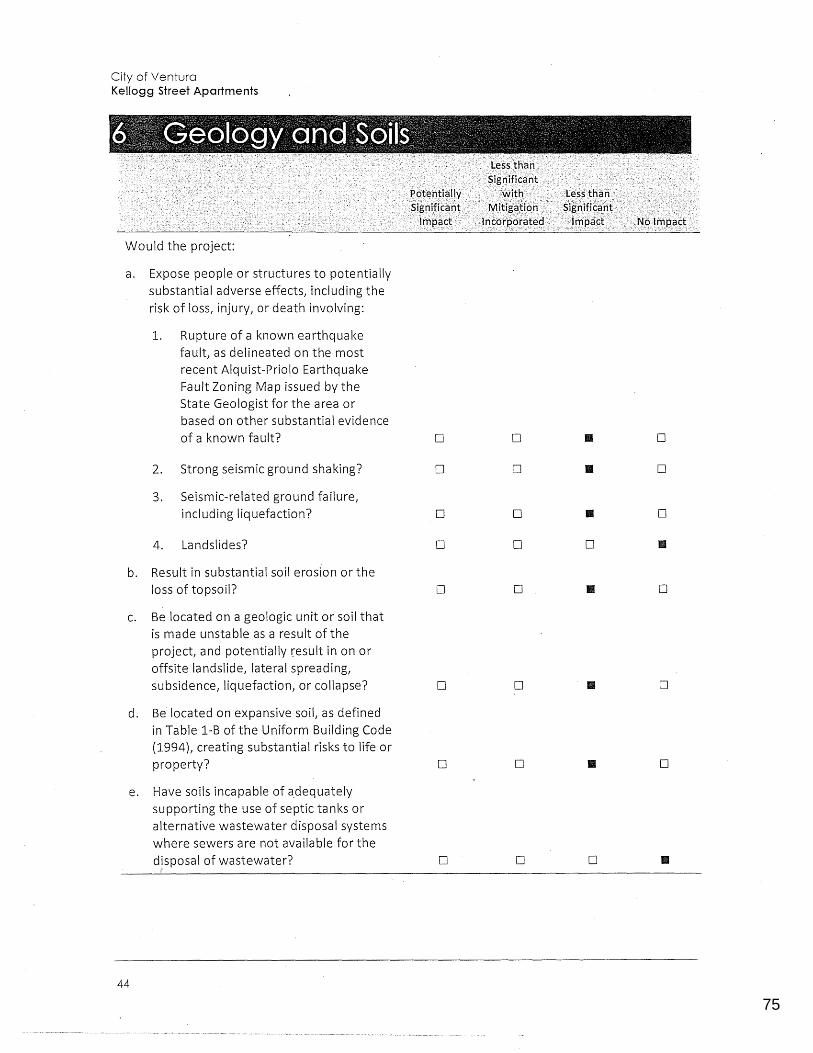
75
0123456789
City of Ventura Kellogg Street Apartments
Would the project:
a. Expose people or structures to potentially substantial adverse effects, including the risk of loss, injury, or death involving:
1. Rupture of a known earthquake fault, as delineated on the most recent Alquist-Priol.o Earthquake Fault Zoning Map issued by the State Geologist for the area or based on other substantial evidence of a known fault? D D II D
2. Strong seismic ground shaking? D D II D
3. Seismic-related ground failure, including liquefaction? D D II D
4. Lands Ii des? D D 0 II
b. Result in substantial soil erosion or the loss of topsoil? D D II D
c. Be located on a geologic unit or soil that is made unstable as a result of the project, and potentially result in on or offsite landslide, lateral spreading, subsidence, liquefaction, or collapse? D D II D
d. Be located on expansive soil, as defined in Table 1-B of the Uniform Building Code (1994L creating substantial risks to life or property? 0 D II D
e. Have soils incapable of a_dequately supporting the use of septic tanks or alternative wastewater disposal systems where sewers are not available for the disposal of wastewater? D D D II
44
76
0123456789
Environmental Checklist Geology and Soils
Environmental Setting
The City of San Buenaventura fs situated between the Pacific Ocean, the Ventura foothills, and the Ventura and Santa Clara rivers. The City is located at the western edge of the Oxnard Plain, an alluvial plain that covers over 200 square miles in the southern portion of Ventura County. Much of the City is on the relatively flat coastal plain, but steeply sloped hills abut the northern portion of the city. Similar to much of Southern California, Ventura is located within a seismically active region and is crossed by several potentially active fault systems. The entire planning area of Ventura is subject to severe ground shaking from a number of faults in the region.
Earth Systems Southern California (Earth Systems) prepared a site-specific geotechnical engineering report for the project site in 2007. Earth Systems prepared an update to the report in July 2017 (Appendix C). The report evaluates on-site geotechnical conditions and offers preliminary geotechnical recommendations for design and construction of the project. The following analysis is based in part on the Earth Systems geotechnical report. While there is no evidence that geotechnical conditions on and around the project site have changed since issuance of this report, the City will require the applicant to update this report, before issuance of building permits to ensure that the findings ofthe July 2017 repornemain valid.
a.1. Expose people or structures to potential substantial adverse effects, including the risk of loss, injury, or death involving rupture of a known earthquake fault, as delineated on the most recent Alquist-Priolo Earthquake Fault Zoning Map issued by the State Geologist for the area or based on other substantial evidence of a known fault?
Similar to all of southern California, the project site is subject to strong ground shaking associated with active and/or potentially active faults in the region. The closest fault is the Ventura Fault, located approximately 0.2 mile to the east/southeast, which is mapped in an Alquist-Priolo Earthquake Fault Zone. However, the project site itself is not within an Earthquake Fault Zone, and no active faults have been mapped across the project site (CGS 2003). Furthermore, the proposed buildings would be built to current seismic safety standards, as specified in the 2016 California Building Code (CBC). Since the project would be constructed to current specifications in the CBC, and would not increase exposure to fault rupture, impacts would be less than significant.
LESS THAN SIGNIFICANT IMPACT
a.2. Expose people or structures to potential substantial adverse effects, including the risk of loss, injury, or death involving strong seismic ground shaking?
The entire southern California region is susceptible to strong ground shaking from severe earthquakes. The project is located approximately 0.2 mile from the Ventura Fault, 3.0 miles from the Oak Ridge Offshore Fault, 3.4 miles from the Red Mountain Fault, and 6.0 miles from the Oak Ridge Onshore fault. The geotechnical report determined that the potential for strong ground shaking at the project site is high. Consequently, development of the project could expose people and structures to strong seismic ground shaking. However, the project would be designed and constructed in accordance with state and local building codes to reduce the potential for exposure of people or structures to seisrriic risks to the maximum extent possible. The project would be required to comply with the seismic safety requirements in the International Building Code (IBC), the 2016 California Building Code (CBC), and the San Buenaventura Municipal Code (SBMC). Compliance with such requirements would reduce seismic ground shaking impacts to the maximum extent practicable with current engineering practices. Furthermore, the project would not increase
Initial Study - Mitigated Negative Declaration 45
77
0123456789
City of Ventura Kellogg Street Apartments
ground shaking hazards at adjacent properties. Therefore, impacts related to strong seismic ground shaking would be less than significant.
LESS THAN SIGNIFICANT IMPACT
a.3. Expose people or structures to potential substantial adverse effects, including the risk of loss, injury, or death involving seismic-related ground failure, including liquefaction?
c. Would the project be located on a geologic unit or soil that is made unstable as a result of the project; and potentially result in on or offsite landslide, lateral spreading, subsidence, liquefaction, or collapse?
The 2007 geotechnical report determined that the site is capped with about four feet of uncertified artificial fill that consists of clayey silty fine sand to sandy clayey silt with pieces of rusted metal. Below the uncertified fill is alluvium consisting of clayey sandy silts and silty fine sands to a depth of about 10 to 12 feet. Below that depth are sandy gravels and cobbles, gravelly clays, and fine to coarse sands with gravel to the maximum depth explored which was approximately 40 feet (Earth Systems 2017). Groundwater was encountered at a depth of approximately 29 feet below the surface during drilling, and measured at 27.5 feet below ground after drilling. The historical groundwater table is about 25 feet. The project site is located in a liquefaction hazard zone; however, the geotechnical report determined that site-specific lateral spreading and settlement hazards are low (Earth Systems 2017; CGS 2003).
Due to the presence of potentially liquefiable soils, the geotechnical study concludes that on-site settlement could result in a potential seismic hazard and recommends procedures during gr?ding (Earth Systems 2017). Per the City Municipal Code (Section 12.220 Grading Regulations), recommendations made by a geotechnical engineer to address site-specific geologic hazards shall be included in project plans prior to issuance of permits. Additionally, the project would be required to comply with current engineering practices as reflected in the !BC and the CBC. The CBC and IBC regulate the design and construction of excavations, foundations, building frames, retaining walls, and other building elements to mitigate the effects of adverse soil conditions. Since the project would be required to comply with City and state building codes and adhere to the recommendations made by the site-specific geotechnical report, the project would not increase potential exposure to liquefaction or ground failure and impacts would be less than significant.
LESS THAN SIGNIFICANT IMPACT
a.4. Expose people or structures to potential substantial adverse effects, including the risk of loss, injury, or death involving landslides?
The project site is flat, and no significant slopes·are located on or near the site. The hillsides to the east are located approximately a quarter mile away, and the site is not mapped within a zone of required investigation for seismically-induced landsliding {CGS 2003). Therefore, the project would not expose people or structures to potential effects resulting from landslides and no i.mpact would occur.
NO IMPACT
b. Would the project result in substantial soil erosion or the loss of topsoil?
A significant impact would occur if construction activities or proposed uses would result in substantial soil erosion or loss of topsoil. Construction of the project would result in ground surface disturbance during site clearance and grading, which could create the potential for soil erosion. The
46
78
0123456789
Environmental Checklist Geology and Soils
City of San Buenaventura Municipal Code Section 8.600.410A requires the project to comply with any conditions and requirements established by the National Pollutant Discharge Elimination System (NPDES) permit or other permits that are reasonably related to the reduction or elimination of pollutants in stormwater from the construction site, and any condition and/or requirements established by the City to protect specific watersheds or drainage basin. Compliance with standard conditions and best management practices (BMPs) already required through the City's building review process would minimize any potential for substantial soil erosion. Impacts related to erosion would be less than significant.
LESS THAN SIGNIFICANT IMPACT
d. Would the project be located on expansive son as defined in Table 1-8 of the Uniform Building Code (1994), creating substantial risks to life or property?
Expansive soils have relatively high clay mineral content, and expand with the addition of water and shrink when dried, which can cause damage to overlying structures. The geotechnical report concludes that on-site soils have a shrink-swell potential of "very low" (Earth Systems 2017). Therefore, the project would not be located on expansive soil and impacts would be less than significant.
LESS THAN SIGNIFICANT IMPACT
e. Would the project have soils incapable of adequately supporting the use of septic tanks or alternative wastewater disposal systems where sewers are not available for the disposal of wastewater?
The project would connect to the City's sewer system. Therefore, no impact related to the use of septic tanks or alternative wastewater disposal systems would occur.
NO IMPACT
Initial Study - Mitigated Negative Declaration 47
79
0123456789
City of Ventura Kellogg Street Apartments
Would the project:
a. Generate greenhouse gas emissions, either directly or indirectly, that may have a significant impact on the environment?
b. Conflict with any applicable plan, policy, or regulation adopted for the purposes of reducing the emissions of greenhouse gases?
Climate Change and Greenhouse Gases
D D 1111 D
D D 1111 D
Climate change is the observed increase in the average temperature of Earth's atmosphere and oceans along with other substantial changes in climate (such as wind patterns, precipitation, and storms) over an extended period of time. The baseline against which these changes are measured originates in historical records identifying temperature changes that have occurred in the past, such as during past ice ages. The global climate is continuously changing, as evidenced by repeated episodes of substantial warming and cooling documented in the geologic record. The rate of change has typically been incremental, with warming or cooling trends occurring over the course of thousands of years. The past 10,000 years have been marked by a period of incremental warming, as glaciers have steadily retreated across the globe. However, scientists have observed acceleration in the rate of warming during the past 150 years. Per the United Nations Intergovernmental Panel on Climate Change {IPCC), the ~nderstanding of anthropogenic (human-induced) warming and cooling influences on climate has led to a high confidence (95 percent or greater chance) that the global average net effect of human activities has been the dominant cause of warming since the mid-20th century {IPCC 2014).
Gases that absorb and re-emit infrared radiation in the atmosphere are called greenhouse gases (GHGs). The gases that are widely seen as the principal contributors to human-induced climate change include carbon dioxide (CO2), methane (CH4), nitrous oxides {N20), fluorinated gases such as hydrofluorocarbons {HFCs) and perfluorocarbons (PFCs), and sulfur hexafluoride {SF5). Water vapor is excluded from the list of GHGs because it is short-lived in the atmosphere and its atmospheric concentrations are largely determined by natural processes, such as oceanic evaporation.
GHGs are emitted by both natural processes and human activities. Of these gases, CO2 and CH4 are emitted in the greatest quantities from human activities. Emissions of CO2 are largely by-products of fossil fuel combustion, and CH4 results from off-gassing associated with agricultural practices and landfills.
Human-made GHGs, many of which have greater heat-absorption potential than CO2, include fluorinated gases and SF6 {Calif,ornia Environmental Protection Agency [CalEPA] 2006). Different
48
80
0123456789
Environmental Checklist Greenhouse Gas Emissions
types of GHGs have varying global warming potentials (GWPst which are the potential of a gas or aerosol to trap heat in the atmosphere over a specified timescale (generally 100 years). Because GHGs absorb different amounts of heat, a common reference gas (CO2) is used to relate the amount of heat absorbed to the amount of the GHG emissions, referred to as carbon dioxide equivalent (C02e), and is the amount of a GHG emitted multiplied by its GWP. CO2 has a 100-year GWP of one. By contrast, CH4 has a GWP of 25, meaning its global warming effect is 25 times greater than that of CO2 on a molecule per molecule basis (IPCC 2007).
The accumulation of GHGs in the atmosphere regulates Earth's temperature. Without the natural heat-trapping effect of GHGs, ~arth's surface would be about 34 degrees Celsius (0
() cooler (CalEPA 2006). However, emissions from human activities, particularly the consumption of fossil fuels for electricity production and transportation, have elevated the concentration of GHGs in the atmosphere beyond the level of naturally-occurring concentrations.
Scientific modeling predicts that continued GHG emissions at or above current rates would induce more extreme climate changes during the 21st century than were observed during the 2oth century. Some of the potential impacts in California of global warming may include loss of snow pack, sea level rise, more extreme heat days per year, more high ozone days, more large forest fires, and more drought years (CalEPA 2010). While these potential impacts identify the possible effects of climate change at a global and potentially statewide level, in general, scientific modeling tools are currently unable to predict what impacts would occur locally.
Greenhouse Gas Emissions Inventory
Worldwide anthropogenic emissions of GHGs were approximately 46,000 million metric tons (MMT) of C02e (CO2 equivalent) in 2010. CO2 emissions from fossil fuel combustion and industrial processes contributed about 65 percent of total emissions in 2010 (IPCC 2014).
Total U.S. GHG emissions were 6,511 MMT of C02e in 2016 (U.S. EPA 2018). In 2016, the industrial and transportation end-use sectors accounted for 22 percent and 28.5 percent of GHG emissions, respectively. Electric power accounted for 28.4 percent of GHG emissions. Meanwhile, the residential and commercial end-use sectors accounted for 11 percent of GHG emissions (U.S. EPA 2018).
Based on the ARB California Greenhouse Gas Inventory for 2000-2015, California produced 440.4 MMT of C02e in 2015 (ARB 2016b}. The largest single source of GHG in California is transportation, contributing 39 percent of the state's total GHG emissions. Industrial sources are the second largest source of the state's GHG emissions, contributing 23 percent of the state's GHG emissions (ARB 2016b). California emissions are due in part to its large size and large population compared to other states. However, the mild climate reduces California's per capita fuel use and GHG emissions as compared to other states. The ARB has projected statewide unregulated GHG emissions for the year 2020 will be 509.4 MMT of C02e (ARB 2016b}. These projections represent the emissions that would be expected to occur in the absence of any GHG reduction actions.
Regulatory Setting
California Regulations
The State of California considers GHG emissions and the impacts of climate change to be a serious threat to the public health, environment, economic well-being, and natural resources of California, and has taken an aggressive stance to mitigate its impact on climate change through the adoption of
Initial Study - Mitigated Negative Declaration 49
81
0123456789
City of Ventura Kellogg Street Apartments
policies and legislation. ARB is responsible for the coordination and oversight of state and local air pollution control programs in the state. California has numerous regulations aimed at reducing the state's GHG emissions; some of the major initiatives are summarized below.
ASSEMBLY BILL 32
California's major initiative for reducing GHG emissions is outlined in Assembly Bill (AB) 32, the "California Global Warming Solutions Act of 2006," signed into law in 2006. AB 32 codifies the statewide goal of reducing GHG emissions to 1990 levels by 2020 (essentially a 15 percent reduction below 2005 emission levels; the same requirement as under S-3-05), and requires ARB to prepare a Scoping Plan that outlines the main strategies for reducing GHGs to meet the 2020 deadline. In addition, AB 32 requires ARB to adopt regulations to require reporting and verification of California 1 s largest industrial emitters.
The ARB approved the initial AB 32 Scoping Plan on December 11, 2008 and a 2020 statewide GHG emission limit of 427 MMT of C02e was established. The Scoping Plan also included measures to address GHG emission reduction strategies related to energy efficiency, water use, and recycling and solid waste, among others. Many of the GHG reduction measures included in the Scoping Plan (e.g., Low Carbon Fuel Standard, Advanced Clean Car standards, and Cap-and-Trade) have been adopted since approval of the Scoping Plan.
SENATE BILL 375
Senate Bill (SB) 375, signed in August 2008, enhances California 1 s ability to reach AB 32 goals by directing ARB to develop regional GHG emission reduction targets to be achieved from passenger vehicles for 2020 and 2035. In addition, SB 375 directs each of California's 18 major metropolitan planning organizations to prepare a "sustainable communities strategy11 (SCS) that contains a growth strategy to meet these emission targets for inclusion in the Regional Transportation Plan (RTP). On September 23, 2010, ARB adopted final regional targets for reducing GHG emissions from 2005 levels by 2020 and 2035.
SENATE BILL 32
On September 8, 2016, the governor signed SB 32 into law, extending AB 32 by requiring California to further reduce GHGs to 40 percent below 1990 levels by 2030 (the other provisions of AB 32 remain unchanged). On December 14, 2017, ARB adopted the 2017 Scoping Plan, which provides a framework for achieving the 2030 target. The 2017 Scoping Plan relies on the continuation and expansion of existing policies and regulations, such as the Cap-and-Trade Program, as well as implementation of recently adopted policies, such as SB 350 and SB 1383. The 2017 Scoping Plan also puts an increased emphasis on innovation, adoption of existing technology, and strategic investment to support its strategies. As with the 2013 Scoping Plan Update, the 2017 Scoping Plan does not provide project-level thresholds for land use development. Instead, it recommends that local governments adopt policies and locally-appropriate quantitative thresholds consistent with a statewide per capita goal of 6 metric tons (MT) of C02e by 2030 and 2 MT of C02e by 2050. As stated in the 2017 Scoping Plan, these goals may be appropriate for plan-level analyses·(city, county, subregional, or regional level), but not for specific individual projects because they include all emissions sectors in California.
50
82
0123456789
Regional Regulations
SCAG RTP /SCS
Environmental Checklist Greenhouse Gas Emissions
As discussed above, SB 375 requires metropolitan planning organizations to prepare an RTP/SCS that will achieve regional emission reductions through sustainable transportation and growth strategies. On September 23, 2010, ARB adopted final regional targets for reducing GHG emissions levels by 2020 and 2035. SCAG.was assigned targets of an eight percent reduction in GHGs from transportation sources by 2020 and a 13 percent reduction in GHGs from transportation sources by 2035. Most recently, SCAG adopted the 2016-2040 RTP/SCS on April 7, 2016, which includes strategies and objectives to encourage transit-oriented and infill development and the use of alternative transportation to minimize vehicle use.
Significance Thresholds
The vast majority of individual projects do not generate sufficient GHG emissions to directly influence climate change. However, physical changes caused by a project can contribute incrementally to cumulative effects that are significant, even if individual changes resulting from a project are limited. The issue of climate change typically involves an analysis of whether a project's contribution towards an impact would be cumulatively considerable. "Cumulatively considerable" means that the incremental effects of an individual project are significant when viewed in connection with the effects of past projects, other current projects, and probable future projects (CEQA Guidelines, Section 15064[h][1]).
The adopted CEQA Guidelines provide regulatory guidance on the analysis and mitigation of GHG emissions in CEQA documents, while giving lead agencies the discretion to set quantitative or qualitative thresholds for the assessment and mitigation of GHGs and climate change impacts. According to the CEQA Guidelines, projects can tier off of a qualified GHG reduction plan, which allows for project-level evaluation of GHG emissions through comparison of the project's consistency with the GHG reduction policies included in a qualified GHG reduction plan. This approach is considered by the Association of Environmental Professionals (AEP) in its white paper, Beyond Newhall and 2020, to be the most defensible approach presently available under CEQA to determine the significance of a project's GHG emissions (AEP 2016). Ventura County includes a climate change chapter in its 2040 General Plan (Chapter 12) (County of Ventura 2017). The chapter includes findings and discussion of countywide emissions, as well as potential localized effects of climate change in the County. Nonetheless, neither the City nor the County have formally adopted a CAP or other GHG reduction plan that addresses community-wide emissions to date. Thus, this approach is not currently feasible for this analysis.
To evaluate whether a project may generate a quantity of GHG emissions that may have a significant impact on the environment, a number of operational bright-line significance thresholds have been developed by state and regional agencies. Significance thresholds are numeric mass emissions thresholds which identify the level at which additional analysis of project GHG emissions is necessary. Projects that attain the significance target, with or without mitigation, would result in less than significant GHG emissions. Some significance thresholds have been developed to reflect a 90 percent capture rate tied to the 2050 reduction target established in the Governor's Executive Order S-3-05, which sets a GHG reduction target of 90 percent below current levels by 2050; such as the South Coast Air Quality Management District's (SCAQMD) recommended bright-line threshold of 3,000 MT C02e per year for development projects (SCAQMD 2010).
Initial Study - Mitigated Negative Declaration 51
83
0123456789
City of Ventura Kellogg Street Apartments
VCAPCD has not established quantitative significance thresholds for evaluating GHG emissions in CEQA analyses. Instead, VCAPCD recommends using the California Air Pollution Control Officers Association CEQA and Climate Change: Addressing Climate Change through California Environmental Quality Act white paper and other resources when developing GHG evaluations (VCAPCD 2006). The CEQA and Climate Change paper provides a common platform of information and tools to support local governments and was prepared as a resource, not as a guidance document. How.ever, CEQA Guidelines section 15064.4 expressly provides that a "lead agency shall have discretion to determine, in the context of a particular project," whether to "[u]se a model or methodology to quantify greenhouse gas emissions resulting from a project, and which model or methodology to use." A lead a,gency also has discretion under the CEQA Guidelines to "[r]ely on a qualitative analysis or [quantitative] performance based standards."
In light of the lack of a specific GHG threshold from VCAPCD, it is appropriate to refer to guidance from other similar agencies when discussing GHG emissions. Thus, for the purposes of this analysis, the bright-line threshold developed by the similar SCAQMD (3,000 MT C02e per year for development projects) is considered to determine the significance of GHG emissions.
Although construction activity is addressed in this analysis, the California Air Pollution Control Officers Association (CAPCOA) does not discuss whether any threshold approaches adequately address impacts from temporary construction activity. As stated in the CEQA and Climate Change white paper, "more study is ne.eded to make this assessment or to develop separate thresholds for construction activity" (CAPCOA 2008). Nevertheless1 air districts such as the SCAQMD (2008) have recommended that GHG emissions from construction be amortized over 30 years and added to operational GHG emissions to determine the overall impact of a proposed project.
a. Would the project generate GHG emissions, either directly or indirectly, that may have a
significant impact on the environment?
Project construction is assumed to occur over a period of approximately eight months, based on CalEEMod default assumptions. Based on CalEEMod modeling results, construction activities for the project would generate an estimated 92 MT of C02e in 2019-2020 (Table 4). Amortized over a 30-year period (the assumed life of the project per SCAQMD guidance), construction of the project would generate about 3 MT of C02e per year.
Table 4 Estimated Construction Emissions of Greenhouse Gases
2019-2020 Total
Amortized over 30 years
Notes: See Appendix A for CalEEMod results. Numbers may not add up due to rounding.
92
3
Table 5 summarizes the project's operational GHG emissions, and its combined construction and operational emissions. Once construction activities are complete, the only indirect source of GHG emissions associated with the project will be from resident vehicles travelling to and from the future residences (mobile sources). Indirect emissions are included with direct emissions for analysis of GHG impacts. Direct GHG emis.sion sources include Area (painting, landscaping), Energy (natural-gas usage), Waste, and Water. A breakdown of emissions by source type is available in the CalEEMod modeling worksheets in Appendix A of this report.
52
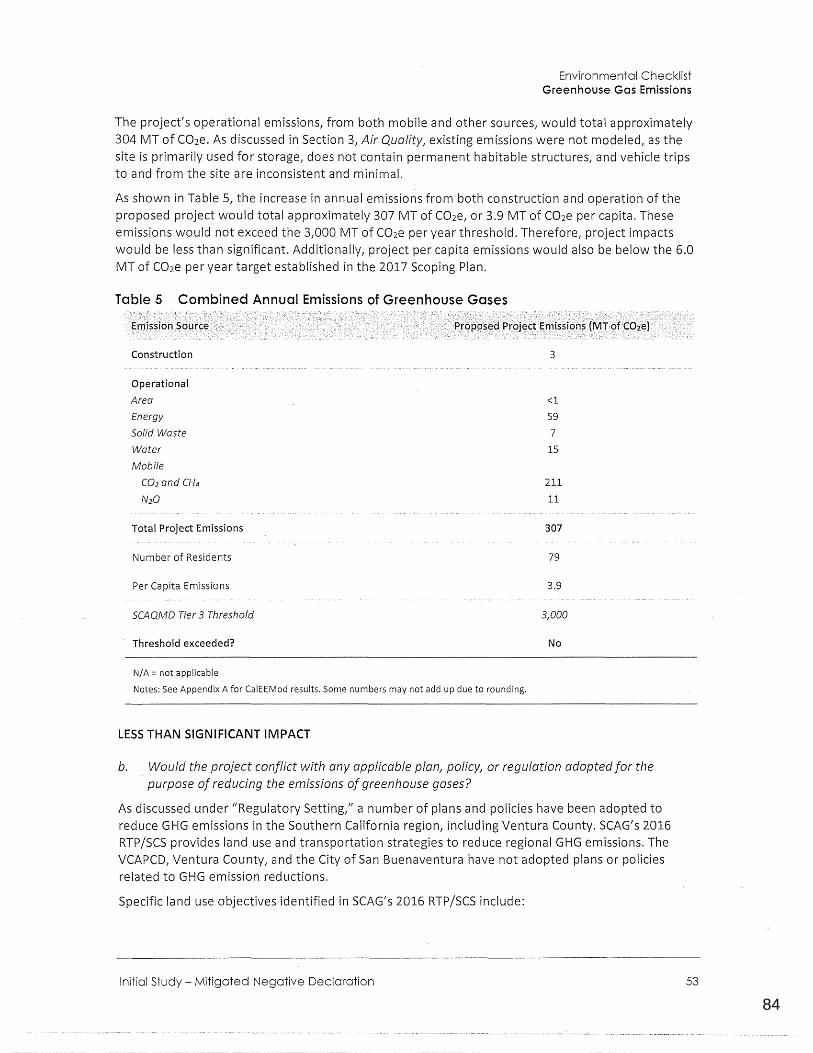
84
0123456789
Environmental Checklist Greenhouse Gas Emissions
The project's operational emissions, from both mobile and other sources, would total approximately 304 MT of C02e. As discussed in Section 3, Air Quality, existing emissions were not modeled, as the site is primarily used for storage, does not contain permanent habitable structures, and vehicle trips to and from the site are inconsistent and minimal.
As shown in Table 5, the increase in annual emissions from both construction and operation of the proposed project would total approximately 307 MT of C02e, or 3.9 MT of C02e per capita. These emissions would not exceed the 3,000 MT of C02e per year threshold. Therefore, project impacts would be less than significant. Additionally, project per capita emissions would also be below the 6.0 MT of C02e per year target established in the 2017 Scoping Plan.
Table 5 Combined Annual Emissions of Greenhouse Gases
Construction 3
Operational
Area <l
Energy 59
Solid Waste 7
Water 15
Mobile
CO2 and CH4 211
N20 11
Total Project Emissions 307
Number of Residents 79
Per Capita Emissions 3.9
SCAQMD Tier 3 Threshold 3,000
Threshold exceeded? No
N/A = not applicable
Notes: See Appendix A for CalEEMod results. Some numbers may not add up due to rounding.
LESS THAN SIGNIFICANT IMPACT
b. Would the project conflict with any applicable plan, policy, or regulation adopted for the purpose of reducing the emissions of greenhouse gases?
As discussed under "Regulatory Setting," a number of plans and policies have been adopted to reduce GHG emissions in the Southern California region, including Ventura County. SCAG's 2016 RTP/SCS provides land use and transportation strategies to reduce regional GHG emissions. The VCAPCD, Ventura County, and the City of San Buenaventura have not adopted plans or policies related to GHG emission reductions.
Specific land use objectives identified in SCAG's 2016 RTP/SCS include:
Initial Study - Mitigated Negative Declaration 53
85
0123456789
City of Ventura Kellogg Street Apartments
•
•
•
•
•
•
•
54
Reflect the changing population and demands - The SCAG region, home to about 18.8 million people in 2015, currently contains 5.9 million households and 8 million jobs. By 2040, the Plan projects that these figures _will increase by 3.4 million people, with nearly 1.5 million more households and 1.8 million more jobs (SCAG 2016). High Quality Transit Areas (HQTAs) will account for three percent of regional total land, but will accommodate 46 percent and 55 percent of future household and employment growth, respectively, between 2012 and 2040. The 2016 RTP/SCS land use pattern contains sufficient residential capacity to accommodate the region's future growth, including the eight-year regional housing need. The land use pattern accommodates about 530,000 additional households in the SCAG region by 2020 and 1.5 million more households by 2040. The land use pattern also encourages improvement in the jobshousing balance by accommodating 1.1 million more jobs by 2020 and about 2.4 million more jobs by 2040.
Focus new growth around transit - The 2016 RTP/SCS land use pattern reinforces the trend of focusing growth in the region's HQTAs. Concentrating housing and transit also concentrates roadway repair investments, leverages transit and active transportation investments, reduces regional life cycle infrastructure costs, improves accessibility, avoids greenfield development, and has the potential to improve public health and housing affordability. HQTAs provide households with alternative modes of transport that can reduce VMT and GHG emissions.
Plan for growth around !iv.able corridors - The Livable Corridors strategy seeks to revitalize commercial strips through integrated transportation and land use planning that results in increased economic activity and improved mobility options. From a land use perspective, Livable Corridors strategies include a special emphasis on fostering collaboration between neighboring jurisdictions to encourage better planning for various land uses, corridor branding, roadway improvements and focusing retail into attractive nodes along a corridor.
Provide more options for short trips - Thirty-eight percent of all trips in the SCAG region are less than three miles. The 2016 RTP/SCS provides strategies to promote the use of active transport for short trips, including implementation of sidewalks and local bikeways. Neighborhood Mobility Areas are meant to reduce short trips in a suburban setting.
Preserve our existing system - Southern California's transportation system is becoming increasingly compromised by decades of underinvestment in maintaining and preserving our infrastructure. These investments have not kept pace with the demands placed on the system, and the quality of many roads, highways, bridges, transit, and bicycle and pedestrian facilities are continuing to deteriorate. Unfortunately, the longer they deteriorate, the more expensive they will be to fix in the future. Even worse, deficient conditions compromise the safety of users throughout the network. For all of these reasons, system preservation and achieving a state of good repair are top priorities of the 2016 RTP/SCS.
Transit - Looking toward 2040, the 2016 RTP/SCS maintains a significant investment in public transportation across all transit modes and also calls for new household and employment growth to be targeted in areas that are well-served by public transportation to maximize the improvements called for in the Plan.
Active Transportation - The 2016 RTP/SCS includes $12.9 billion for active transportation improvements, including $8.1 billion in capital projects a~d $4.8 billion as part of the operations and maintenance expenditures on regionally significant local streets and roads. The Active Transportation portion of the 2016 Plan updates the Active Transportation portion of the 2012 Plan, which has goals for improving safety, increasing active transportation usage and friendliness, and encouraging local active transportation plans. It proposes strategies to further
86
0123456789
Environmental Checklist Greenhouse Gas Emissions
develop the regional bikeway network, assuming that all local active transportation plans will be implemented, and dedicates resources to maintain and repair thousands of miles of dilapidated sidewalks. To accommodate the growth in walking, biking and other forms of active transportation regionally, the 2016 Active Transportation Plan also considers new strategies and approaches beyond those proposed in 2012.
The proposed project would provide residential infill development along Kellogg Street, which provides access between two collector streets, North Ventura Avenue and Cedar Street. Both Cedar Street and North Ventura Avenue provide access to downtown Ventura, and North Ventura Avenue also provides access to commercial uses along North Ventura Avenue itself. The project site is located across the street from Kellogg Park, and is located adjacent to a transportation corridor and
. within walking distance of the following Gold Coast Transit bus stops: the Ventura Avenue/Ramona stop (0.11 miles) and the Ventura Avenue/Warner stop (0.17 miles), which are served by Gold Coast Routes 6, 16, and 18f. The project also proposes five (5) bicycle spaces located in the.rear of the site, as well as additional outdoor storage for additional bikes and other sports equipment. In these ways, the project fulfills several land use objectives of SCAG's RTP/SCS, including reflecting changing population and demands, encouraging new household growth in areas served by existing public transportation, and focusing growth around existing transportation corridors.
Furthermore, State policies to reduce GHG emissions associated with energy use, including the Renewable Portfolio Standard and Title 24 of the California Building Code, would reduce anticipated emissions associated with the proposed project. Overall, the project (upon approval of the proposed Zone Change) would be consistent with applicable land use and zoning designations, make the project site and use compatible with the surrounding area, and would not conflict with any State regulations intended to reduce GHG emissions statewide. As discussed in the response to item 7a, annual GHG emissions for the proposed project would be less than the threshold of 3,000 MT of C02e per year established by the SCAQMD. Additionally, as discussed in detail in Section 10, Land
Use and Planning, the proposed project would also be consistent with other policies of the Ventura General Plan, including a range of policies aimed indirectly at reducing GHG emissions through reductions in vehicle miles traveled, energy use, and water consumption. Consequently, the project would not conflict with plans and policies aimed at reducing GHG emissions and such impacts would
be less than significant.
LESS THAN SIGNIFICANT IMPACT
Initial Study - Mitigated Negative Declaration 55
87
0123456789
City of Ventura Kellogg Street Apartments
Would the project:
a. Create a significant hazard to the public or the environment through the routine transport, use, or disposal of hazardous materials? D D • D
b. Create a significant hazard to the public or the environment through reasonably foreseeable upset and ac;:cident conditions involving the release of hazardous materials into the environment? D D • D
c. Emit hazardous emissions or handle hazardous or acutely hazardous materials, substances, or waste within 0.25 mile of an existing or proposed school? D D II D
d. Be located on a site that is included on a list of hazardous material sites compiled pursuant to Government Code Section 65962.5 and, as a result, would it create a significant hazard to the public or the environment? D D D
e. For a project located in an airport land use plan or, where such a plan has not been adopted, within two miles of a public airport or public use airport, would the project result in a safety hazard for people residing or working in the project area? D D D Ill
f. For a project within the yicinity of a private airstrip, would the project result in a safety hazard for people residing or working in the project area? D D D •
56
88
0123456789
Environmental Checklist Hazards and Hazardous Materials
Less thari $ighificant . w1ih Potentially ·
Significant· · Impact
·. Mitigation ln~orpprated
Signifi~ant . · l~jJac:t No.lnJp_act :
g. Impair implementation of or physically interfere with an ~dopted emergency response plan or emergency evacuation plan?
h. Expose people or structures to a ~ignificant risk of loss, injury, or death involving wildland fires, including where wildlands are adjacent to urbanized areas or where residences are intermixed with wildlands?
Environmental Setting
D
D
D D II
D II D
The project site currently contains an open-air shed, metal warehouse, and accessory structures (shipping containers and construction equipment). A Phase I Environmental Site Assessment (ESA) was completed on the project site in January 2018, by Padre Associates, Inc. (Appendix D). The ESA included a review of geologic and hydrogeologic literature, historical research of available historical maps, site reconnaissance, interviews with persons with knowledge of the site, public agency records review, and environmental database search.
The Ventura County Sheriff Office of Emergency Services (OES) is responsible for countywide disaster planning, mitigation, response, and recovery activities. Disaster planning, training and exercises, public education, emergency alert and warning, and disaster assistance coordination are all included within OES activities. Ready Ventura County is the governmental entity that provides disaster information for the City of Ventura (Ventura County 2019). The 2015 Ventura County MultiHazard Mitigation Plan (MHMP), prepared for Ventura County, gives guidance for emergencies including hazards and threats such as a major earthquake, hazardous material incident, wildland fire, flooding, landslide, civil unrest, transportation, and terrorism threat, among other local hazards. The MHMP additionally outlines planning, hazards and vulnerability analysis, capability assessment, mitigation strategies, and plan maintenance ensuring future implementation of the plan (Ventura County 2015).
a. Would the project create q significant hazard to the public or the environment through the routine transpor( use, or disposal of hazardous materials?
b. Would the project create a significant hazard to the public or the environment through reasonably foreseeable upset and accident conditions involving the release of hazardous materials into the environment?
Grading and construction activities could use a limited amount of hazardous and flammable substances/oils during heavy equipment operation for site preparation and building construction. However, the transport, use, and storage of hazardous materials during construction of the project would be conducted in accordance with all applicable State and federal laws, such as the Hazardous Materials Transportation Act, Resource Conservation and Recovery Act, the Californip Hazardous
Initial Study- Mitigated Negative Declaration 57
89
0123456789
City of Ventura Kellogg Street Apartments
Material Management Act, and the California Code of Regulations, Title 22. As a residential use, no routine disposal of hazardous materials is proposed. Therefore, the project would not create a significant hazard to the public or the environment through a foreseeable upset or accident of hazardous materials; or the routine transport, use, or disposal of hazardous materials, and impacts would be less than significant.
LESS THAN SIGNIFICANT IMPACT
c. Would the project emit hazardous emissions or handle hazardous or acutely hazardous materials, substances, or waste within 0.25 mile of an existing or proposed school?
The nearest schools are both approximately a half mile from the project site. E.P Foster Elementary School is located to the north along North Ventura Avenue at 20 Pleasant Place, and Sheridan Way Elementary School is located to the west near Highway 33 at 573 Sheridan Way. Neither of these schools is within 0.25 mile of the project site. Additionally, the project would involve construction of 30 new housing units, and operational activities associated with these residential uses would not involve use or storage of hazardous materials (see discussion in items a and b). Though potentially hazardous materials such as fuels, lubricants, solvents, and oils could be used during demolition, construction and operation of the proposed project, the transport, use, and storage of any and all hazardous materials would be conducted in accordance with all applicable State and federal lows, such as the Hazardous Materials Transportation Act, Resource Conservation and Recovery Act, the California Hazardous Material Management Act, and the California Code of Regulations, Title 22. There are no existing or proposed schools within 0.25 mile of the project site and the proposed residential project would not involve the use of large quantities of hazardous materials; therefore, impacts associated with hazardous emissions and hazardous materials near a school would be less than significant.
LESS THAN SIGNIFICANT IMPACT
d. Would the project be located on a site included on a list of hazardous material sites compiled pursuant to Government Code Section 65962.5 and, as a result, would it create a significant hazard to the public or the environment?
The following databases and listings compiled pursuant to Government Code Section 65962.5 were checked by Rincon Consultants on September 7, 2018 for known hazardous materials contamination
at the site:
• United States Environmental Protection Agency (U.S. EPA)
0 Superfund Enterprise Management System (SEMS)/Envirofacts database search
• State Water Resources Control Board {SWRCB)
0 GeoTracker search for leaking underground storage tanks (LUST) and other cleanup sites
• Department of Toxic Substances Control (DTSC)
0 Envirostor database for hazardous waste facilities or known contamination sites
~ Cortese list of Hazardo.us Waste and Substances Sites
The project site is not listed in any of the above environmental databases. The closest listing in the databases is in the Geotracker database, which listed a Permitted Underground Storage Tank at 774 N. Ventura Avenue, approximately 150 to the east at the corner gas station. This UST is permitted by the Ventura County Environmental Health Division and the City of San Buenaventura Fire
Department.
58
90
0123456789
Environmental Checklist Hazards and Hazardous Materials
As identified in the Phase I database review, the project site is listed on the HAZNET List and the Ventura County BWT List. The BWT list indicates ·by site address whether the Environmental Health Division has Business Plan (B), Waste Producer (W), and/or Underground Tank (T) information. The listings are associated with the temporary storage and off-site disposal/recycling of waste oil and mixed oil, and the storage of small quantities of hazardous materials by businesses historically located at the project site. Although the site is listed on the HAZNET and County BWT list, no violations have been recorded at the site (Padre 2018). Furthermore, through site reconnaissance, Padre determined that no evidence of current storage of regulated quantities of hazardous materials or significant past spills, active disposal, or leaks have occurred on the site (Padre 2018).
According to the Phase I ESA, because the on-site warehouse building was constructed prior to 1978 {approximately in 1949), the presence of asbestos-containing material (ACM) and lead-based paint {LBP) is considered moderate. Since the building is proposed to be demolished and removed, which may result in the release of potential ACM and LBP to the public or environment, the following mitigation measures are required, requiring the testing for ACM and LBP and abatement if found prior to development of the project. Therefore, impacts would be potentially significant unless the following mitigation is incorporated.
MITIGATION MEASURES
The following mitigation measures are required prior to site development in order to reduce the potentially significant impact of releasing potential ACM and LBP into the environment. With implementation of mitigation measures HAZ-1 and HAZ-2, adequate surveys would be conducted and, if necessary, proper abatement would occur, reducing potential impacts to a less than significant level.
HAZ-1 Asbestos. Prior to the issuance of a demolition permit, a qualified asbestos abatement consultant shall inspect the existing structures for asbestos-containing materials (ACMs) and in the event that any ACMs are discovered, the materials shall be removed in compliance with Ventura County Air Pollution Control District requirements as well as all other State and fed~ral rules and regulations.
HAZ-2 Lead Based Paint. Any suspected lead based paint in existing on-site structures to be demolished shall be sampled prior to any demolition activities. Any identified lead based paint shall be abated by a licensed lead-based paint abatement contractor and disposed of in accordance with all state and local regulations prior to demolition.
LESS THAN SIGNIFICANT WITH MITIGATION INCORPORATED
e. For a project located within an airport land use plan or, where such a plan has not been adopted, within two miles of a public airport or public use airport would the project result in a safety hazard for people residing or working in the project area?
f. For a project near a private airstrip, would it result in a safety hazard for people residing or working in the project area?.
The project site is not located in an airport land use plan area, or within two miles of a public or private airport. The closest airports are the Oxnard Airport, approximately seven miles south/southeast of the project site; the Camarillo Airport, approximately 12 miles southeast of the project site; the Santa Paula Airport, approximately 14 miles northeast of the project site; and the Ventura County Naval Base, approximately 15 miles southeast of the project site. Since the project site is not subject to hazards from these airports due to distance, there would be no impact.
Initial Study - Mitigated Negative Declaratioh 59
91
0123456789
City of Ventura Kellogg Street Apartments
NO IMPACT
g. Would the project impair implementation of or physically interfere with an adopted emergency response plan or emergency evacuation plan?
Pursuant to the City's Municipal Code, construction activities that may temporarily restrict vehicular traffic would be required to implement measures to facilitate the passage of people and vehicles through or around any required road closures. Any road closures would have to be approved by the City's Public Works Department and would have to conform to all applicable standards.
Access to the project site would be primarily from North Ventura Avenue and Cedar Street. During each phase of development, on-site access would be required to comply with standards established by the City'siPublic Works Department. The size and location of fire suppression facilities (e.g., hydrants) and fire access routes would be required to conform to City of San Buenaventura Fire Department standards. Additionally, the project would be required to conform to applicable California Fire Code standards. The submittal of plans in conformance with California Fire Code sta'ndards would be a condition of project approval and compliance would be confirmed as part of the Building and Safety plan check process. As with any development, access to and through the residential area of the project would be required to comply with required street widths as determined in the 2016 California Building Code, Master Plan of Streets, and the California Fire Code. Therefore, implementation of the proposed project would not impair implementation of or physically interfere with an adopted emergency response plan or emergency evacuation plan, and no impact would occur.
NO IMPACT
h. Would the project expose people or structures to a significant risk of loss, injury, or death involving wild/and fires, including where wild/ands are adjacent to urbanized areas or where residences are intermixed with wild/ands?
Although the project site is in a residential area, the project site is located in an area that has been designated as a High Hazard Severity Zone, and directly borders the Very High Fire Hazard Severity Zone (California Department of Forestry and Fire Protection (CalFire 2007, CalFire 2010). The Thomas Fire occurred in the hillsides east of the project site in December 2018. The Thomas Fire is second largest California wildfire to date and burned an area of 281,893 acres,in Ventura and Santa Barbara Counties. In response to this, the City of San Buenaventura Building and Safety Department has developed several documents/checklists for new developments in High Fire Hazard Areas, which detail requirements, strategies and actions in response to extreme wildfires such as adhering to 2018 CBC Chapter 7 A and CRC Section R337 requirements (building materials, systems, and assemblies in exterior design) and demonstrating compliance with vegetation management strategies (removing flammable vegetation, tree limbs, etc.). Since the project would be required to adhere to both State and City qesign requirements required in the High Hazard Severity Zone area, as well as other guidelines listed in the 2016 CBC and CFC, the project would not expose people or structures to substantial wildland fire risk, and impacts would be less than significant.
LESS THAN SIGNIFICANT IMPACT
60
92
0123456789
Environmental Checklist Hazards and Hazardous Materials
This page intentionally left blank.
Initial Study - Mitigated Negative Declaration 61
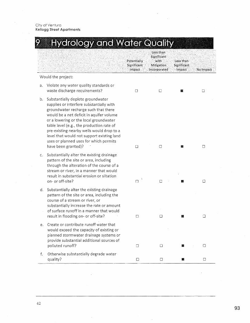
93
0123456789
City of Ventura Kellogg Street Apartments
Would the project:
a. Violate any water quality standards or waste discharge requirements? D D • D
b. Substantially deplete groundwater supplies or interfere substantially with groundwater recharge such that there would be a net deficit in aquifer volume or a lowering or the local groundwater table level (e.g., the production rate of pre-existing nearby wells would drop to a level that would not support existing land uses or planned uses for which permits have been granted)? D D D
C. Substantially alter the existing drainage pattern of the site or area, including through the alteration of the course of a stream or river, in a manner that would result in substantial erosion or siltation on- or off-site? D D • D
d. Substantially alter the existing drainage pattern of the site or area, including the course of a stream or river, or substantially increase the rate or amount of surface runoff in a manner that would result in flooding on- or off-site? D D D
e. Create or contribute runoff water that would exceed the capactty of existing or planned stormwater drainage systems or provide substantial additional sources of polluted runoff? D D • D
f. Otherwise substantially degrade water quality? D D • D
62
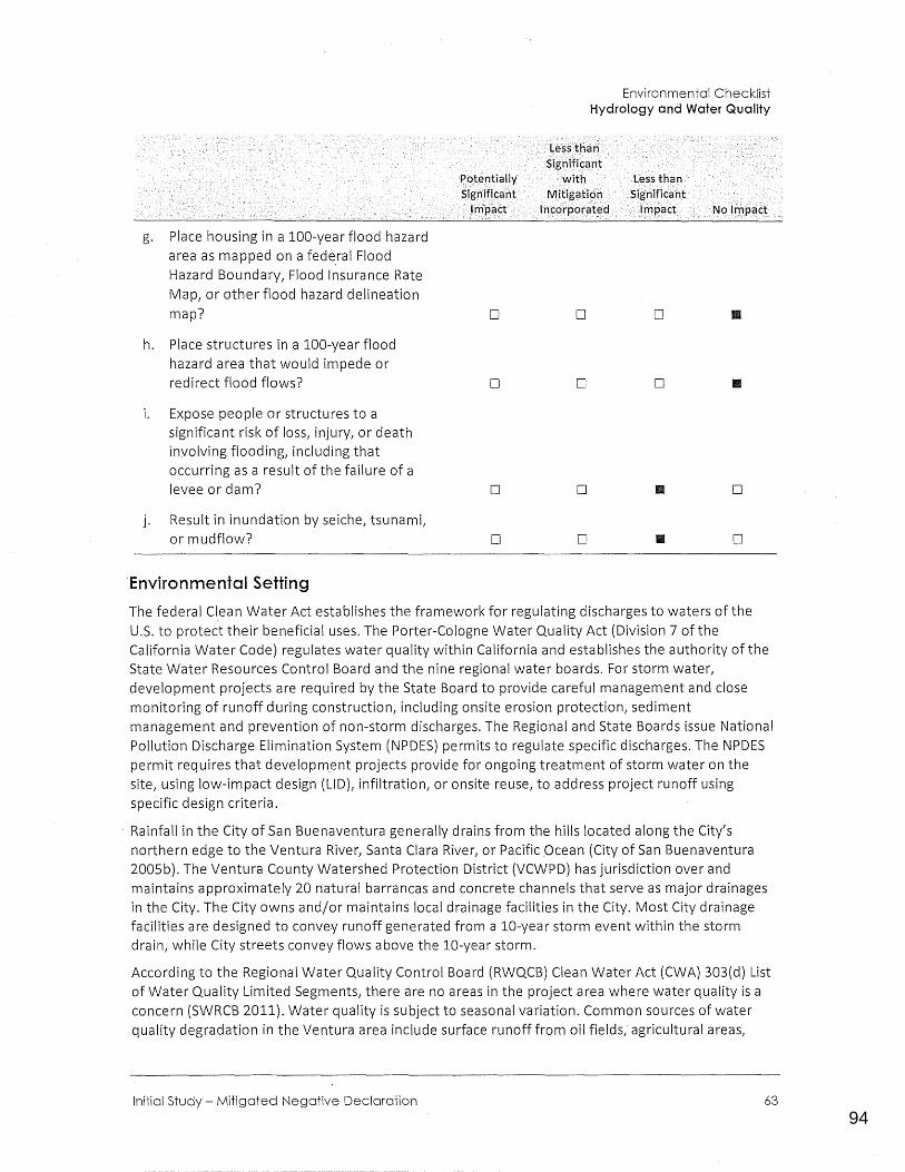
94
0123456789
g. Place housing in a 100-year flood hazard area as mapped on a federnl Flood Hazard Boundary, Flood Insurance Rate Map, or other flood hazard delineation map?
h. Place structures in a 100-year flood hazard area that would impede or redirect flood flows?
i. Expose people or structures to a significant risk of loss, injury, or death involving flooding, including that occurring as a result of the failure of a levee or dam?
j. Result in inundation by seiche, tsunamt or mudflow?
Environmental Setting
r>,ot.e,ntial ly ~jgnificaht \J~pact
D
D
D
D
Environmental Checklist Hydrology and Water Quality
.·1Jsstha11·· Sigf1ificant ·
with IV!Jtigaticfo
' ln\:grpCJrated
D
D
D
D
No ln,:ipact
D
D
II D
II D
The federal Clean Water Act establishes the framework for regulating discharges to waters of the U.S. to protect their beneficial uses. The Porter-Cologne Water Quality Act {Division 7 of the California Water Code) regulates water quality within California and establishes the authority of the State Water Resources Control Board and the nine regional water boards. For storm water, development projects are required by the State Board to provide careful management and close monitoring of runoff during construction, including onsite erosion protection, sediment management and prevention of non-storm discharges. The Regional and State Boards issue National Pollution Discharge Elimination System {NPDES) permits to regulate specific discharges. The NPDES permit requires that developm_ent projects provide for ongoing treatment of storm water on the site, using low-impact design {LIDL infiltration, or onsite reuse, to address project runoff using specific design criteria.
· Rainfall in the City of San Buenaventura generally drains from the hills located along the City's northern edge to the Ventura River, Santa Clara River, or Pacific Ocean (City of San Buenaventura 2005b). The Ventura County Watershed Protection District (VCWPD) has jurisdiction over and maintains approximately 20 natural barrancas and concrete channels that serve as major drainages in the City. The City owns and/or maintains local drainage facilities in the City. Most City drainage facilities are designed to convey runoff generated from a 10-year storm event within the storm drain, while City streets convey flows above the 10-year storm.
According to the Regional Water Quality Control Board (RWQCB) Clean Water Act (CWA) 303{d) List of Water Quality Limited Segments, there are no areas in the project area where water quality is a concern (SWRCB 2011). Water quality is subject to seasonal variation. Common sources of water quality degradation in the Ventura area include surface runoff from oil fields,· agricultural areas,
Initial Study - Mitigated Negative Declaration 63
95
0123456789
City of Ventura Kellogg Street Apartments
urban land uses, and natural sedimentation. Best Manage_ment Practices (BMPs} are typically employed during construction to maintain water quality and must be consistent with anticipated pollutant loads and water quality objectives.
a. Would the project violate any water quality standards or waste discharge requirements?
f. Would the project otherwise substantially degrade water quality?
Project-related grading and construction, including on-site operation of heavy equipment during grading and construction, would require temporary disturbance of surface and subsurface soils which could potentially result in erosion and sedimentation on the project site. The entire site is currently paved, but the introduction of vegetative and cover and removal of asphalt would slightly
'alter the existing on-site drainage pattern. The project site is flat, so the potentia I for soil erosion is low, but peak stormwater runoff could result in short-term sheet erosion in areas of exposed soils.
During construction, the projeG:t applicant would be required to obtain coverage under a Construction General Permit (CGP) to comply with Clean Water Act's National Pollutant Discharge Elimination System (NPDES) requirements. In California, the State Water Resources Control Board (SWRCB) administers the NPDES permitting program and is responsible for developing NPDES permitting requirements. Compliance with the NPDES permit, and City Municipal Code (Section 12.220 - Grading Requirements), would require the development and implementation of either a Storm Water Pollution Prevention Plan (SWPPP) or a Storm Water Pollution Control Plan (SWPCP). Either of these plans would include Best Management Practices (BMPs). The purpose of these plans are to identify all potential sources of pollution which may be expected to affect the quality of storm water discharge from a project site, and provide BMPs to help reduce potential impacts. The BMPs would include measures that would be implemented to prevent discharge of eroded soils from the construction site and sedimentation of surface waters off-site. The BMPs would also include measures to quickly contain and clean up any minor spills or leaks of fluids from construction equipment. Given the relatively flat topography of the site, the distance from surface waters (nearest is the Ventura River located over a half mile to the west), and implementation of a required stormwater control plan, construction of the project would not violate any water quality standards or waste discharge requireme~ts. Compliance with the CGP during construction would reduce water quality and waste discharge impacts from runoff during temporary construction activities.
During operation, the project would be subject to the requirements of a Ventura County Municipal Separate Storm Sewer Systems (MS4) permit. Site-specific BMPs would be designed by the contractor in compliance with applicable regulations and conditions of the MS4 permit. The MS4 permit establishes limits for the concentration of contaminants entering the storm drain system and
· requires BMPs such as landscaping for infiltration. Additionally, the applicant would be required to design storm drains that conform to the standards approved by the City Engineer. Conformance with the NPDES permitting system and MS4 permit requirements would reduce water quality and waste discharge impacts from runoff during long-term operational activities, and impacts would be less than significant.
LESS THAN SIGNIFICANT IMPACT
b. Would the project substantially deplete groundwater supplies or interfere substantially with groundwater recharge such that there would be a net deficit in aquifer volume or a lowering or the local groundwater table level (e.g., the production rate of pre-existing nearby wells would drop to a level that would not support existing land uses or planned uses for which permits have been granted)?
64
96
0123456789
Environmental Checklist Hydrology and Water Quality
According to soil sampling in the Geotechnical Report, groundwater on the project site was encountered at an initial depth of 27 feet (Earth Systems 2018; Appendix C). The historically high groundwater level at the site is approximately 25 feet below ground surface (Earth Systems 2018). Because project construction would not involve substantial excavation to depths where groundwater occurs, and does not propose the construction of wells to access groundwater, the project would not directly interfere with the groundwater table. Furthermore, the project would introduce additional pervious surfaces to the site through landscaping, which would increase the amount of on-site impermeable surfaces, since the site is currently entirely paved and impervious. The addition of permeable surfaces, and the proposed underground infiltration trench, would aid in groundwater recharge. Impacts related to the depletion of groundwater supplies and groundwater recharge would be less than significant.
LESS THAN SIGNIFICANT IMPACT
c. Would the project substantially alter the existing drainage pattern of the site or area, including through the alteration of the course of a stream or river, in a manner that would result in substantial erosion or siltation on- or off-site?
d. Would the project substantially alter the existing drainage pattern of the site or area, including the course of a stream or river, or substantially increase the rate or amount of surface runoff in a manner that would result in flooding on- or off-site?
e. Would the project create or contribute runoff water that would exceed the capacity of existing or planned stormwater drainage systems or provide substantial additional sources of polluted runoff?
The proposed project would n<?t alter the course of any stream or river, but would change existing drainage flows on the project site. The existing on-site drainage pattern is currently uncontrolled. The proposed project would cover approximately 79 percent (0.6 acres) of the project site with impervious surfaces (see Table 1L which would be a reduction in impermeable surfaces compared to existing conditions. These alterations would change on-site drainage patterns and decrease the volume of stormwater runoff from the site, through implementation of on-site landscaping, permeable surfaces, and an on-site underground infiltration trench. The features would help reduce off-site flows and minimize potential erosion.
Stormwater runoff is often contaminated with sediment pesticides, pathogens, trash, debris, petroleum hydrocarbons and heavy metals, especially when the source of urban runoff is paved roadways and the runoff is generated by the first storm of the winter season. The project would decrease the amount of pollutants draining into the stormwater system because the amount of runoff would decrease. Required compliance with Ventura County's MS4 permit and recommended BMPs from the Ventura County Technical Guidance Manual (see impact discussion 9a,f) will improve water quality runoft from the project site and impacts will be less than significant.
During operation, the project would be subject to the requirements of the NPDES MS4 Permit issued to the County of Ventura. The NP DES program requires stormwater permits for point source discharges, and the County's MS4 Permit establishes limits for the concentrations of contaminants
· entering the storm drain system. Under the MS4 Permit, any project applicant who discharges stormwater runoff from a site is required to treat runoff on-site through BMPs such as infiltration, bioretention, vegetated swales and mechanical filtration. The project would meet MS4 requirements by incorporating landscaping adjacent to new sidewalks along the project frontage and an on-site underground infiltration trench.
Initial Study - Mitigated Negative Declaration 65
97
0123456789
City of Ventura Kellogg Street Apartments
With incorporation of standard MS4 permit requirements during construction and operation, the project site would not discharge polluted stormwater in excess of City and County requirements. Impacts to water quality and the project site's drainage pattern would be less than significant.
LESS THAN SIGNIFICANT IMPACT
g. Would the project place housing in a 100-year flood hazard area as mapped on a federal Flood Hazard Boundary, Flood Insurance Rate Map, or other flood hazard delineation map?
h. Would the project place structures in a 100-year flood hazard area that would impede or redirect flood flows?
The FEMA Flood Map Service \enter provides the site-specific Flood Hazard Map relevant to the project site (Map No. 06111C0745E, Effective Date January 20, 2010; FEMA 2010}. This map shows that the site is not located in the 100-year flood hazard area and is located in "Areas determined to be outside the 0.2 percent annual chance floodplain - Zone X". Therefore, the project would not place housing or structures in an identified flood hazard area, and there would be no impact.
NO IMPACT
i. Would the project expose people or structures to a significant risk of loss1 injury1 or death involving flooding, including that occurring as a result of the failure of a levee or dam?
As illustrated in the Ventura County Dam Failure Inundation Area Map, the project site is located in Casitas and Matilija Dam Inundation Areas (Ventura County 2015}. Although the site is located in an inundation area, these dams meet applicable safety requirements and, with the exception of Casitas Dam (which is regulated by the Bureau of ReclamationL are inspected by the Division of Dam Safety, California Department of Water Resources, twice per year to ensure they meet all safety require·ments and that necessary maintenance is performed. The Bureau of Reclamation has stated that Casitas Dam is in satisfactory condition for normal operations and a safety evaluation is ongoing. Matilija Dam is in the .process of being decommissioned (City of San Buenaventura 2005b).
In the event of a dam failure or other flood event, the City and County would follow an emergency response and evacuation plan set forth in the Multi-Hazard Mitigation Plan managed by the Ventura County Sheriff's Office of Emergency Services, in cooperation with the Ventura County Watershed Protection District, and various cities and special districts within Ventura County. The County bilingual alert system includes mobile emergency vehicle sirens and loudspeakers, and door-to-door notification. The City flood emergency warning systems also includes public alerts by television service providers. Since the Casitas Dam is currently meeting applicable safety requirements, the Matilija Dam is currently under a decommission process, and future residents at the project site would be properly notified in the event of dam failure, flooding impacts related to the·failure of a levee or dam would be less than significant.
LESS THAN SIGNIFICANT IMP.ACT
j. Would the project result in inundation by seiche1 tsunamt or mudflow?
Seiches are seismically induced waves that occur in large bodies of water other than the ocean, such as lakes and reservoirs. The closest such body of water is Lake Casitas, which is over six miles to the northwest of the site. Therefore, the project site is not at risk from inundation by seiche, and no impact would occur.
66

98
0123456789
Environmental Checklist Hydrology and Water Quality
A tsunami is a tidal wave produced by off-shore seismic activity. The project site is over one mile inland from the Pacific Ocean and is not located in a tsunami inundation area (CDOC 2015b}. As such, there would be no impact.
The project site is not located in an earthquake-induced landslide zone (CGS 2003). Landslides and mud flows are most likely to occur on or near a slope or hillside area, rather than in generally level areas such as the project site. However, due to the recent Thomas Fire, which occurred in December 2017, the risk of post-fire mud flows from a storm have elevated in the City of San Buenaventura. The USGS released a Preliminary Hazard Assessment for the burn region of the Thomas Fire in order to assign a likelihood of a debris flow in response to the design rainstorm with a peak 15-minute rainfall intensity of 24 millimeters per hour. According to the Assessment, the project site is located 0.25 miles away from the hillsides to the east, which have a 0-20 percent probability of debris flow from a post-fire storm (USGS 2018}. The project site is separated from the nearest undeveloped hillside to the east by more tha_n 600 feet and twelve parcels, all developed with residential structures. In the event of a mudflow, the flow would be impeded by these structures and/or channeled and dispersed into Kellogg Street before it could reach the project site itself. Therefore, there would not be a substantial-risk of mud flows inundating the project site.
For all the reasons discussed above, this impact would be less than significant.
LESS THAN SIGNIFICANT IMPACT
Initial Study - Mitigated Negative Declaration 67
99
0123456789
City of Ventura Kellogg Street Apartments
Would the project:
a. Physically divide an established community?
b. Conflict with any applicable land use plan, policy, or regulation of an agency with jurisdiction over the project (including but not limited to the general plan, specific plan, local coastal program, or zoning ordinance) adopted for the purpose of avoiding or mitigating an environmental effect?
c. Conflict with an applicable habitat conservation plan or natural community conservation plan?
Environmental Setting
D
D
D
D D Ill
D D Ill
D D
The project site is in the western portion of the City of San Buenaventura, in an area with a mix of residential, commercial, and industrial uses as well as Kellogg Park. The site is used for construction equipment storage, and does not contain any habitable structures or residences. The site is completely fenced off from the surrounding area. The project site has a land use designation of Neighborhood High and is zoned Limited Industrial (M-1).
a. Would the project physically divide an established community?
The project would add 30 housing units and would remove the existing accessory structures (open air shed, metal warehouse, and shipping containers). The project would include a sidewalk/walkway along the project frontage to provide for a pedestrian friendly environment, as there is currently no curbed sidewalk. The project would not physically divide an established community and no impact would occur.
NO IMPACT
b. Would the project conflic~ with any applicable land use plan, policy, or regulation of an agency with jurisdiction over the project (including but not limited to the general plan, specific plan, local coastal program, or zoning ordinance) adopted for the purpose of avoiding or mitigating an environmental effect?
Presently, the site is incompatible with its General Plan land use designation and the surrounding area, which is comprised of primarily residential uses. The project includes a Zone Change from (M-1) to R-3-1 in order to construct the proposed uses. This zone change would allow for residential
68
100
0123456789
Environmental Checklist Land Use and Planning
development on the project site, which would be more similar and compatible to residential uses on properties to the east and south than the site's current industrial use. Development of the proposed project would also result in removal of the existing industrial equipment and structures from the site.
The project applicant would be required to adhere to applicable development standards in the R-3 zone. As such, the project would adhere to required and specified height limits, building lot coverage, density/number of units, setbacks, and parking. Since the project would not conflict with an applicable land use plan or other plan adopted for mitigating environmental effects, and since the project/rezone would reduce the existing conflict of having a use on the project site that is incompatible with the surrounding area, there would be no impact.
NO IMPACT
c. Would the project conflict with an applicable habitat conservation plan or natural c·ommunity conservation plan?
As discussed in Section 4, Biological Resources, the project site is not in a habitat conservation plan or natural community conservation plan (CDFW 2017). Therefore, the project would not conflict with any habitat conservation plan or natural community conservation plan and no impact would occur.
NO IMPACT
Initial Study - Mitigated Negative Declaration 69
101
0123456789
City of Ventura Kellogg Street Apartments
Would the project:
a. Result in the loss of availability of a known mineral resource that would be of value to the region and the residents of the state?
b. Result in the loss of availability of a locally important mineral resource recovery site delineated on a local general plan, specific plan, or other land use plan?
Environmental Setting
0
0
0 0 II
0 0 II
Mineral resources are usually mineral derivatives but can include geothermal and natural gas deposits. Because mineral resources can take millions of years to replenish naturally after extraction, they are considered "nonrenewable" resources. The two principal mineral resources within the City of San Buenaventura Planning Area are aggregate and petroleum resources. The City of San Buenaventura's Planning Area is located within the Western Ventura productionconsumption region (PCRt as designated by the California Geological Survey (CGS). Currently there are no active aggregate mining· activities. Oil production (petroleum) has played an integral role in the development of the west Ventura area. The only remaining petroleum fields in the City Planning Area are in the foothills and the northern portion of the Ventura Avenue corridor. There are no active mineral mining or petroleum fields on the project site.
Surface mines are regulated by the state of California in accordance with the Surface Mining and Reclamation Act (SMARA), PRC Sec. 2710 et seq., and through the County's land use permitting processes. Pursuant to SMARA, the California State Mining and Geology Board oversees the Mineral Resource Zone {MRZ) classifica_tion system. According to the 2005 City of Ventura General Plan EIR, the project site is located in the "M RZ-3a area" which is an area with higher potential for mineral
deposits/aggregate resources.
The California Code of Regulations (CCR) Sec. 3675 defines land uses that are compatible and incompatible with mining areas. Examples of compatible land uses include very low-density
. residential, recreational, agricultural, and grazing uses.
a. Would the project result in the loss of availability of a known mineral resource that would be of value to the region and the residents of the state?
b. Would the project result in the Joss of availability of a locally important mineral resource recovery site delineated on a local general plan, specific plan, or other land use plan?
70
102
0123456789
Environmental Checklist Mineral Resources
The project site is entirely paved, with on-site accessory structures, and is not currently being used for the extraction of mineral resources. The project site is located in an area judged to have potential mineral deposits according to Figure 1.4.1 of the County of Ventura's General Plan Resources Appendix and 4.9-2 of the City of Ventura's General Plan EIR (2011; 2005b). While the project site is located within the MRZ-3a area, the project site is entirely paved and developed and the area around it is primarily residential, where aggregate mining activities are not currently allowed. Moreover, the project would not involve the use of or mining of mineral resources. The project would not create an impact related to the loss of availability of a known mineral resource that would be of value to the region and the residents of the state; or loss of availability of a locally important mineral resource recovery site delineated on a local general plan, specific plan, or other land use plan; and would therefore have no impact related to mineral resources.
NO IMPACT
Initial Study - Mitigated Negative Declaration 71
103
0123456789
City of Ventura Kellogg Street Apartments
Would the project result in:
a. Exposure of persons to or generation of noise levels in excess of standards established in the local general plan or noise ordinance, or applicable standards of other agencies? D D II D
b. Exposure of persons to or generation of excessive ground borne vibration or groundborne noise levels? D D II D
C. A substantial permanent increase in ambient noise levels above those existing prior to implementation of the project? D D • D
d. A substantial temporary or periodic increase in ambient noise levels in the project vicinity above levels existing without the project? D D II D
e. For a project located in an airport land use plan or, where such a plan has not been adopted, within two miles of a public airport or public use airport, would the project expose people residing or working in the project area to excessive noise levels? D D D II
f. For a project near a private airstrip, would it expose people residing or working in the project area to excessive noise? D D D II
Noise Background
Noise level (or volume) is generally measured in decibels (dB) using the A-weighted sound pressure level (dBA). The A-weighting scale is an adjustment to the actual sound pressure levels to be consistent with that of human hearing response, which is most sensitive to frequencies around 4,000 Hertz (about the highest note on a piano) and less sensitive to low frequencies (below 100 Hertz).
Sound pressure level ·is measured on a logarithmic scale, with the O dBA level based on the lowest detectable sound pressure level that people can perceive (an audible sound that is not zero sound
72
104
0123456789
Environmental Checklist Noise
pressure level). Based on the logarithmic scale, a doubling of sound energy is equivalent to an increase of 3 dBA, and a sound that is 10 dBA less than the ambient sound level has no effect on ambient noise. Because of the nature of the human ear, a sound must be about 10 dBA greater than the ambient noise level to be judged as twice as loud. In general, a 3 dBA change in the ambient noise level is noticeable, while 1-2 dBA changes generally are not perceived. Quiet suburban areas typically have noise levels in the range of 40-50 dBA, while a-reas adjacent to arterial streets are typically in the 50-60+ dBA range. Normal conversational levels are usually in the 60-65 dBA range and ambient noise levels greater than 65 dBA can interrupt conversations.
Noise from point sources, such as from individual pieces of machinery, typically attenuates (or drops off) at a rate of 6 dBA per doubling of distance from the noise source. Noise levels from lightly traveled roads typically attenuate at a rate of about 4.5 dBA per doubling of distance. Noise levels from heavily traveled roads typically attenuate at about 3 dBA per doubling of distance. Noise levels may also be reduced by intervening structures. Generally, a single row of buildings between the receptor and the noise source reduces noise levels by about 5 dBA, while a solid wall or berm reduces noise levels by 5 to 10 dBA (Federal Transit Administration [FTA] 2006). The manner in which buildings in California are constructed generally provides a reduction of exterior-to-interior noise levels of approximately 20 to 25 dBA with closed windows (FTA 2006).
In addition to the instantaneous measurement of sound levels, the duration of sound is important since sounds that occur over a 'long period of time are more likely to be an annoyance or cause direct physical damage or environmental stress. One of the most frequently used noise metrics that considers both duration and sound power level is the equivalent noise level (Leq). The Leq is defined as the single steady A-weighted level that is equivalent to the same amount of energy as that contained in the actual fluctuating levels over a period of time (essentially, the average noise level). Typically, Leq is summed over a one-hour period. Lmax is the highest RMS (root mean squared) sound pressure level within the measurement period, and Lmin is the lowest RMS sound pressure level within the measurement period.
The time period in which noise' occurs is also important since nighttime noise tends to disturb people more than daytime noise. Community noise is usually measured using the Day-Night Average Level (LdnL which is the 24-hour average noise level with a 10-dBA penalty for noise occurring during nighttime {10 PM to 7 AM) hours, or Community Noise Equivalent Level {CNEL), which is the 24-hour average noise level with a 5 dBA penalty for noise occurring from 7 PM to 10 PM and a 10 dBA penalty for noise occurring from 10 PM-to 7 AM. The Ldn and CNEL typically do not differ by more than 1 dBA. In practice, CNEL and Ldn are often used interchangeably.
The relationship between peak hourly Leq values and associated Ldn values depends on the distribution of traffic over the entire day. There is no precise way to convert a peak hourly Leq to Ldn. However, in urban areas near heavy traffic, the peak hourly Leq is typically 2-4 dBA lower than the daily Ldn. In less heavily developed areas, such as suburban areas, the peak hourly Leq is often roughly equal to the daily Ldn. The project site is located in a less heavily developed area. Therefore, the peak hourly Leq at the project site would be roughly equal to the daily Ldn value.
Vibration refers to groundborne noise and perceptible motion. Vibration is a unique form of noise because its energy is carried through buildings, structures, and the ground, whereas noise is simply carried through the air. Thus, vibration is generally felt rather than heard. Some vibration effects can be caused by noise (e.g., the rattling of windows from passing trucks). This phenomenon is caused by the coupling of the acoustic energy at frequencies that are close to the resonant frequency of the material being vibrated. Typically, ground borne vibration generated by humanmade activities attenuates rapidly as distance from the source of the vibration increases. The
Initial Study - Mitigated Negative Declaration 73
105
0123456789
City of Ventura Kellogg Street Apartments
ground motion caused by vibration is measured as particle velocity in inches per second and is referenced as vibration decibels (VdB) in the U.S.
The background vibration velocity level in residential areas is usually around 50 VdB. The vibration velocity level threshold of perception for humans is approximately 65 VdB. A vibration velocity of 75 VdB is the approximate dividing line between barely perceptible and distinctly perceptible levels for many people. The range of interest is from approximately 50 VdB, which is the typical background vibration velocity level, to 100 VdB, which is the general threshold where minor damage can occur in fragile buildings. The general human response to different levels of groundborne vibration velocity levels is described in Table 6. Most perceptible indoor vibration is caused by sources in buildings such as operation of mechanical equipment, movement of people, or the slamming of doors. Typical outdoor sources of perceptible groundborne v'.ibration are construction equipment, steel wheeled trains, and traffic on rough roads.
Project Area Noise Conditions
The primary off-site noise sources in the project area are from motor vehicles. Motor vehicle noise is a concern because it is characterized by a high number of individual events that often create sustained noise levels. Ambient noise levels would be expected to be highest during the morning and afternoon rush hours unless congestion slows speeds substantially.
To determine ambient noise levels in the project area, the City of San Buenaventura General Plan was reviewed. Based on the 2005 General Plan Noise Contour Mapping, the project site borders the 60-65 dBA contour generated by North Ventura Avenue, but the project site is in an area with mapped ambient noise levels of approximately 60 dBA or lower (City of San Buenaventura 2005a,
2005b).
Sensitive Receptors
Noise exposure goals for various types of land uses reflect the varying noise sensitivities associated with those uses. Some land uses are considered more sensitive to ambient noise and ground-borne vibration levels than others. People in residences, motels and hotels, schools, libraries, churches, hospitals, nursing homes, auditoriums, long-term care and mental care facilities, natural areas, parks, and outdoor recreation areas are generally more sensitive to noise than are people at commercial and industrial establishments.
The noise-sensitive receptors nearest to the project site are single- and multi-family residences to the east and south. The proposed apartments on the project site would also be considered noisesensitive receptors.
a. Would the project result in exposure of persons to or generation of noise levels in excess of standards established in the local general plan or noise ordinance, or applicable standards of other agencies?
The 2005 General Plan indicates that noise levels up to 65 dBA CNEL are normally acceptable for multi-family residential areas. Noise levels up to 70 dBA CNEL are considered conditionally· acceptable, levels up to 75 dBA CNEL are considered normally unacceptable, and levels above 75 dBA CNEL are considered clearly unacceptable.
Action 7.32 in the General Plan requires acoustical analyses for new residential developments within the mapped 60 dBA CNEL contour, or in any area designated for commercial or industrial use, and require mitigation necessary to ensure that:
74
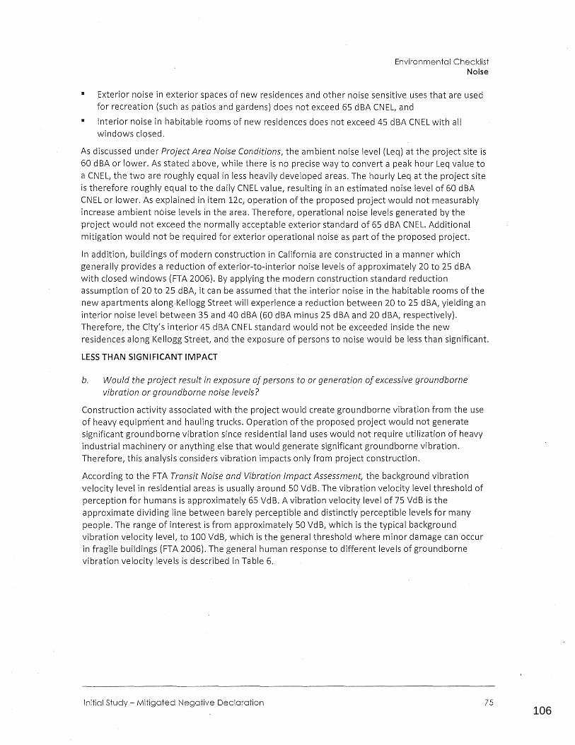
106
0123456789
Environmental Checklist Noise
•
•
Exterior noise in exterior spaces of new residences and other noise sensitive uses that are used for recreation (such as patios and gardens) does not exceed 65 dBA CNEL, and
Interior noise in habitable rooms of new residences does not exceed 45 dBA CNEL with all windows closed.
As discussed under Project Area Noise Conditions, the ambient noise level (Leq) at the project site is 60 dBA or lower. As stated above, while there is no precise way to convert a peak hour Leq value to a CNEL, the two are roughly equal in less heavily developed areas. The hourly Leq at the project site is therefore roughly equal to the daily CNEL value, resulting in an estimated noise level of 60 dBA CNEL or lower. As explained in item 12c, operation of the proposed project would not measurably increase ambient noise levels in the area. Therefore, operational noise levels generated by the project would not exceed the normally acceptable exterior standard of 65 dBA CNEL. Additional mitigation would not be required for exterior operational noise as part of the proposed project.
In addition, buildings of modern construction in California are constructed in a manner which generally provides a reduction of exterior-to-interior noise levels of approximately 20 to 25 dBA with closed windows (FTA 2006). By applying the modern construction standard reduction assumption of 20 to 25 dBA, it can be assumed that the interior noise in the habitable rooms of the new apartments along Kellogg Street will experience a reduction between 20 to 25 dBA, yielding an interior noise level between 35 and 40 dBA (60 dBA minus 25 dBA and 20 dBA, respectively). Therefore, the City's interior 45 dBA CNEL standard would not be exceeded inside the new residences along Kellogg Street1 and the exposure of persons to noise would be less than significant.
LESS THAN SIGNIFICANT IMPACT
b. Would the project result in exposure of persons to or generation of excessive groundborne vibration or groundborne noise levels?
Construction activity associated with the project would create groundborne vibration from the use of heavy equipment and hauling trucks. Operation of the proposed project would not generate significant groundborne vibration since residential land uses would not require utilization of heavy industrial machinery or anything else that would generate significant groundborne vibration. Therefore 1 this analysis considers vibration impacts only from project construction.
According to the FTA Transit Noise and Vibration Impact Assessmen( the background vibration velocity level in residential areas is usually around 50 VdB. The vibration velocity level threshold of perception for humans is approximately 65 VdB. A vibration velocity level of 75 VdB is the approximate dividing line between barely perceptible and distinctly perceptible levels for many people. The range of interest is from approximately 50 VdB, which is the typical background vibration velocity level, to 100 VdB, which is the general threshold where minor damage can occur in fragile buildings (FTA 2006). The general human response to different levels of groundborne vibration velocity levels is described in Table 6.
Initial Study - Mitigated Negative Declaration 75
107
0123456789
City of Ventura Kellogg S!reet Apartments
65 VdB
75 VdB
85 VdB
Source: FTA 2006.
Approximate threshold of perception for many people.
Approximate dividing line between barely perceptible and distinctly perceptible. Many people find that transportation-related vibration at this level is unacceptable.
Vibration acceptable only if there are an infrequent number of events per day.
To determine groundborne vibration impacts, vibration was modeled at the nearest s.ensitive receptors, consisting or residences directly adjacent to the project site's eastern and southern
· boundaries. Although modeled vibration typically assumes that on-site construction activities would occur near the center of a site (where building construction would occurL because the nearest residences are immediately adjacent to the project site, which is relatively small, it is assumed that on-site construction activities would occur approximately 25 feet from these receptors. Vibration is therefore modeled at 25 feet. Vibration levels were calculated at these sensitive receptors using the VdB of the highest impact pieces of equipment that would be used during project construction, which would include dozers (excavators) and loading trucks. Table 7 lists groundborne vibration levels from a large dozer and loading truck at 25 feet from the source.
Large Dozer
Loading Truck
· Source: FTA 2006.
87
86
As shown in Table 7, operation of construction equipment could generate peak vibration up to 87 VdB at the nearest sensitive receptors. Although vibration levels would exceed 75 VdB (the approximate dividing line between barely perceptible and distinctly perceptible), construction activities would be temporary,.lasting only the length of construction, and would not exceed levels at which nearby building damage could occur (100 VdB). Construction-related activities associated with the project would be required to comply with Section 10.650.lSO(d)(l) of the City's Municipal Code, which prohibits noise generating construction between the hours of 8:00 PM and 7:00 AM. As a result, construction activity would be limited to daytime hours and would not disrupt occupants of nearby residences during typical hours of sleep. Therefore, vibration impacts caused by project construction would be less than significant.
LESS THAN SIGNIFICANT IMPACT
c. Would the project result in a substantial permanent increase in ambient noise levels above levels existing without the project?
The proposed project would introduce 30 new apartments on mostly undeveloped land. Residential use of the project site would not introduce new noise sources relative to the existing residential community in the area. Furthermore, the site is currently zoned Limited Industrial, and used for construction equipment storage. The current uses on-site are incompatible with the surrounding
76
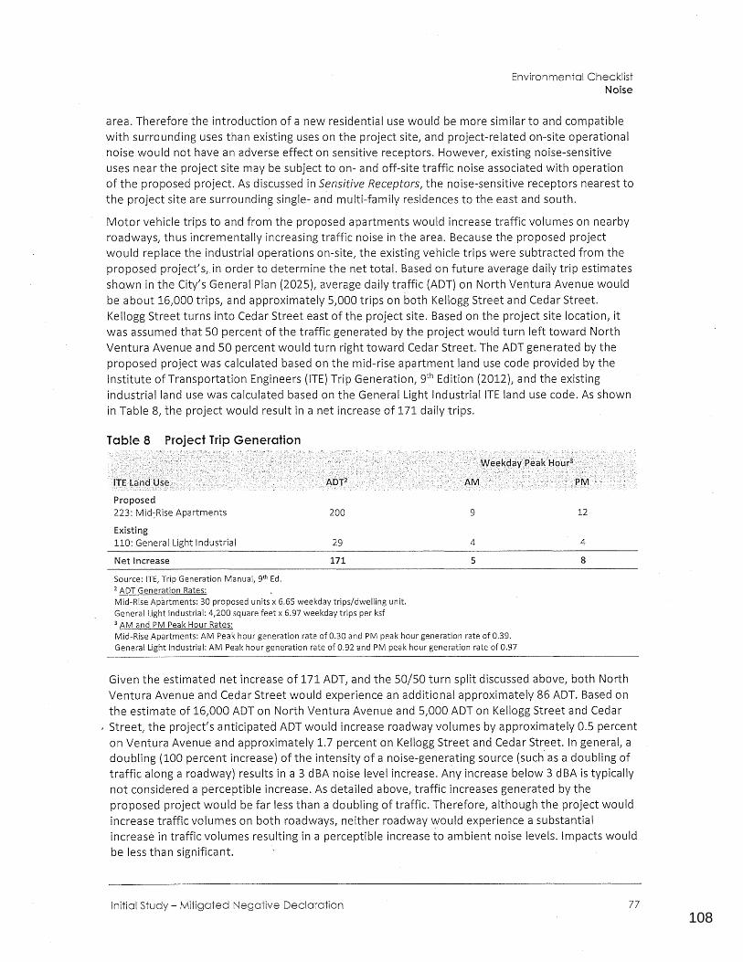
108
0123456789
Environmental Checklist Noise
area. Therefore the introduction of a new residential use would be more similar to and compatible with surrounding uses than existing uses on the project site, and project-related on-site operational noise would not have an adverse effect on sensitive receptors. However, existing noise-sensitive uses near the project site may be subject to on- and off-site traffic noise associated with operation of the proposed project. As discussed in Sensitive Receptors, the noise-sensitive receptors nearest to the project site are surrounding single- and multi-family residences to the east and south.
Motor vehicle trips to and from the proposed apartments would increase traffic volumes on nearby roadways, thus incrementally increasing traffic noise in the area. Because the proposed project would replace the industrial operations on-site, the existing vehicle trips were subtracted from the proposed project's, in order to determine the net total. Based on future average daily trip estimates shown in the City's General Plan (2025), average daily traffic (ADT) on North Ventura Avenue would be about 16,000 trips, and approximately 5,000 trips on both Kellogg Street and Cedar Street. Kellogg Street turns into Cedar Street east of the project site. Based on the project site location, it was assumed that 50 percent of the traffic generated by the project would turn left toward North Ventura Avenue and 50 percent would turn right toward Cedar Street. The ADT generated by the proposed project was calculated based on the mid-rise apartment land use code provided by the Institute ofTransportation Engineers {ITE) Trip Generation, 9th Edition (2012), and the existing industrial land use was calculated based on the General Light Industrial ITE land use code. As shown in Table 8, the project would result in a net increase of 171 daily trips.
Table 8 Project Trip Generation
Proposed 223: Mid:Rise Apartments
Existing 110: General Light Industrial
Net Increase
Source: ITE, Trip Generation Manual, 9th Ed. 2 ADT Generation Rates:
200
29
171
Mid-Rise Apartments: 30 proposed units x 6.65 weekday trips/dwelling unit. General Light Industrial: 4,200 square feet x 6.97 weekday trips per ksf 3 AM and PM Peak Hour Rates:
9
4
5
Mid-Rise Apartments: AM Peak hour generation rate of 0.30 and PM peak hour generation rate of 0.39. General Light Industrial: AM Peak hour generation rate of 0.92 and PM peak hour generation rate of 0.97
12
4
8
Given the estimated net increase of 171 ADT, and the 50/50 turn split discussed above, both North Ventura Avenue and Cedar Street would experience an additional approximately 86 ADT. Based on the estimate of 16,000 ADT on North Ventura Avenue and 5,000 ADT on Kellogg Street and Cedar
, Street, the project's anticipated ADT would increase roadway volumes by approximately 0.5 percent on Ventura Avenue and approximately 1.7 percent on Kellogg Street and Cedar Str.eet. In general, a doubling (100 percent increase) of the intensity of a noise-generating source (such as a doubling of traffic along a roadway) results in a 3 dBA noise level increase. Any increase below 3 dBA is typically not considered a perceptible increase. As detailed above, traffic increases generated by the proposed project would be far less than a doubling of traffic. Therefore, although the project would increase traffic volumes on both roadways, neither roadway would experience a substantial increase in traffic volumes resulting in a perceptible increase to ambient noise levels. Impacts would be less than significant.
Initial Study - Mitigated Negative Declaration 77
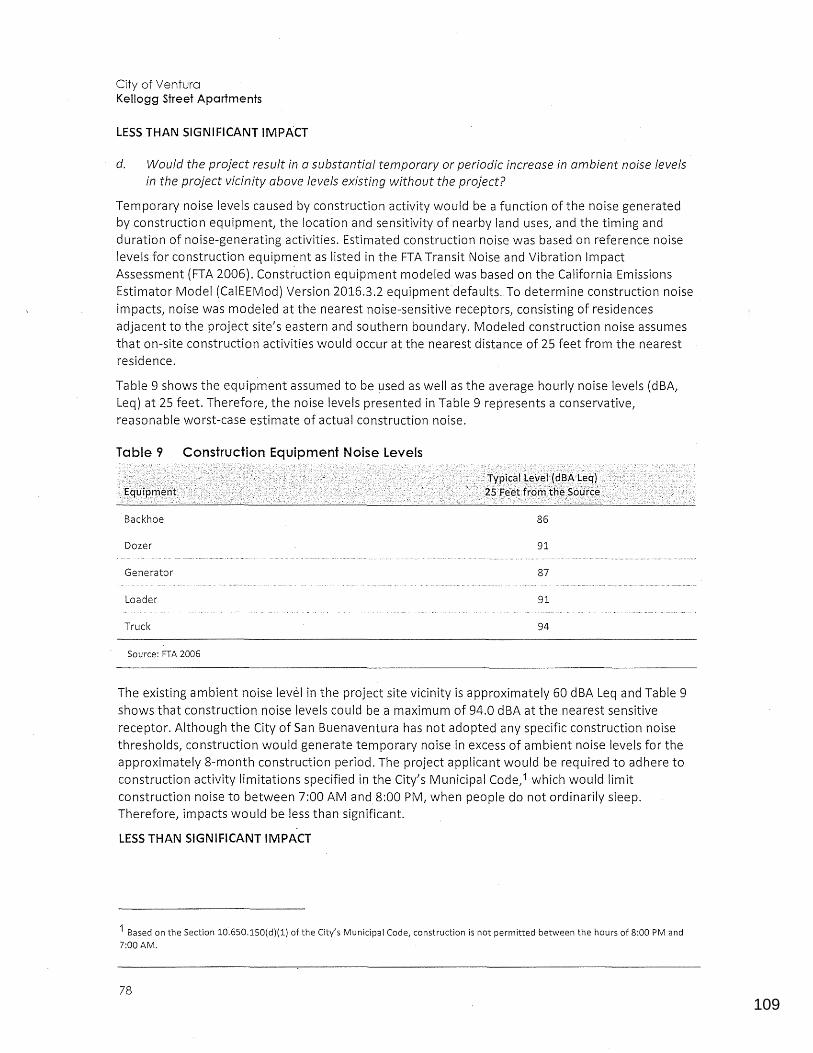
109
0123456789
City of Ventura Kellogg Street Apartments
LESS THAN SIGNIFICANT IMPACT
d. Would the project result in a substantial temporary or periodic increase in ambient noise levels in the project vicinity above levels existing without the project?
Temporary noise levels caused by construction activity would be a function of the noise generated by construction equipment, the location and sensitivity of nearby land uses, and the timing and duration of noise-generating activities. Estimated construction noise was based on reference noise levels for construction equipment as listed in the FTA Transit Noise and Vibration Impact Assessment (FTA 2006). Construction equipment modeled was based on the California Emissions Estimator Model (CalEEMod) Version 2016.3.2 equipment defaults. To determine construction noise impacts, noise was modeled at the nearest noise-sensitive receptors1 consisting of residences adjacent to the project site1 s eastern and southern boundary. Modeled construction noise assumes that on-site construction activities would occur at the nearest distance of 25 feetfrom the nearest residence.
Table 9 shows the equipment assumed to be used as well as the average hourly noise levels (dBA1
Leq) at 25 feet. Therefore 1 the noise levels presented in Table 9 represents a conservative 1
reasonable worst-case estimate of actual construction noise.
Table 9 Construction Equipment Noise Levels
Backhoe 86
Dozer 91
Generator 87
Loader 91
Truck 94
Source: FTA 2006
The existing ambient noise level in the project site vicinity is approximately 60 dBA Leq and Table 9 shows that construction noise levels could be a maximum of 94.0 dBA at the nearest sensitive receptor. Although the City of San Buenaventura has not adopted any specific construction noise thresholds1 construction would generate temporary noise in excess of ambient noise levels for the approximately 8-month construction period. The project applicant would be required to adhere to construction activity limitations specified in the City's Municipal Code,i which would limit construction noise to between 7:00 AM and 8:00 PM, when people do not ordinarily sleep. Therefore, impacts would be less than significant.
LESS THAN SIGNIFICANT IMPACT
1 Based on the Section 10.650.lSO(d)(l) of the City's Municipal Code, construction is not permitted between the hours of 8:00 PM and 7:00 AM.
78
110
0123456789
Environmental Checklist Noise
e. For a project located in an airport land use plan or, where such a plan has not been adopted, within two miles of a public airport or public use airport would the project expose people residing or working in the project area to excessive noise levels?
f. For a project within the vicinity of a private airstrip, would the project expose people residing or working in the project area to excessive noise?.
As discussed in Section 8, Hazards and Hazardous Materials, the project site is not located within an airport land use plan, or within two miles of a public or private airport. The closest airports are Oxnard Airport, approximately 7 miles south/southeast of the project site; Camarillo Airport, approximately 12 miles southeast of the project site; Santa Paula Airport, approximately 14 miles northeast of the project site; and the Ventura County Naval Base, approximately 15 miles S?utheast of the project site. Because the project would not expose future residents or workers to excessive aviation related noise levels, there would be no impact.
NO IMPACT
Initial Study - Mitigated Negative Declaration 79
111
0123456789
City of Ventura Kellogg Street Apartments
Would the project:
a. Induce substantial population growth in an area, either directly (e.g., by proposing new homes and businesses) or indirectly (e.g., through extension of roads or other infra structure)?
b. Displace substantial amounts of existing housing, necessitating the construction of replacement housing elsewhere?
c. Displace substantial numbers of people, necessitating the construction of replacement housing elsewhere?
Environmental Setting
D
D
D
D II D
D D II
D D II
The project site is currently utilized for limited industrial purposes and the surrounding area is characterized by residential uses. The project site and surrounding properties have previously undergone disturbance resulting from development of adopted urban land uses. The project site is currently developed with accessory structures and contains construction equipment.
The California Department of Finance (CDOF) estimates that the January 2018 population of the City of San Buenaventura was 111,269 (CDOF 2018). In its 2016 RTP/SCS, the Southern California Council of Governments (SCAG) estimates that the City's population will increase to 125,300 by 2040, an increase of 14,031 {SCAG 2016).
a. Would the project induce substantial population growth in an area, either directly (for example, by proposing new homes and businesses) or indirectly (for example, through extension of roads or other infrastructure)?
The proposed project involves construction of apartments containing a total of 30 units (six studios, 22 one-bedrooms, and two two-bedrooms). CDOF estimates that the average household size in the City is 2.62. Based on the average household size of 2.62, the increase of 30 housing units would generate a population increas~ of approximately 79 residents, which is 0.5 percent of SCAG's projection for the City of a 14,031 population increase by 2040 (SCAG 2016). The growth expected from the project is within regional forecasts, and would induce population growth that has already been accounted for. Therefore, impacts related to population growth would be less than significant.
The 2005 General Plan EIR identified a significant and unavoidable impact related to the potential for anticipated growth under the General to exceed SCAG'S Regional Comprehensive Plan and Guide and Ventura County 2004 AQMP population forecasts. It found that this was largely because these forecasts were outdated, but that exceedance of regional population forecasts were a significant
80
112
0123456789
Environmental Checklist Population and Housing
and unavoidable impact. As discussed above, the proposed project would be consistent with SCAG's 2016 RTP /SCS forecasts, and the projected potential population growth associated with the project would equal less than one percent of SCAG's projected population growth for the City through 2040. As such, although the project would incrementally contribute to the significant and unavoidable impact identified under the 2005 General Plan EIR, this contribution would not be cumulatively considerable.
LESS THAN SIGNIFICANT IMPACT
b. Would the project displace substantial numbers of existing housing/ necessitating the construction of replacement housing elsewhere?
c. Would the project displac(! substantial numbers,of people, necessitating the construction of replacement housing elsewhere?
The project site does not contain any residential uses and is currently zoned Limited Industrial. The project would add 30 housing units to the City. Therefore, the proposed project would not displace housing units or people or necessitate the construction of replacement housing and there would be no impact.
NO IMPACT
Initial Study - Mitigated Negative Declaration 81
113
0123456789
City of Ventura Kellogg Street Apartments
a. Would the project result_ in substantial adverse physical impacts associated with the provision of new or physically altered governmental facilities, or the need for new or physically altered governmental facilities, the construction of which could cause significant environmental impacts, in order to maintain acceptable service ratios, response times or other performance objectives for any of the public services:
1 Fire protection?
2 Police protection?
3 Schools?
4 Parks?
5 Other public facilities?
Environmental Setting
Fire Services
0
0
0
0
0
0
0
0
0
0
II
II
II
II
II
0
0
0
0
0
The City of San Buenaventura ~ire Department (VFD) responds to fire, medical, and disaster calls from six stations in the city and has a reciprocal agreement with the Ventura County Fire Protection District (VCFPD) to ensure that the City of San Buenaventura receives the swiftest service possible. The VFD has a goal to respond to emergency calls within four minutes, 90 percent of the time (City of San Buenaventura 2005a). The VFD is comprised of three Divisions - Operations, Administration, and Prevention. The Operations Division is responsible for activities and emergency responses of the Departmenf s firefighting force. Station #5, the most centrally located (near the intersection of US 101 and SR 126), has a truck company and engine company. In addition, there is one battalion chief on duty at a time (assigned as ~he shift manager). The shift manager's quarters are adjacent to Station #2 near the intersection of Seaward Avenue and Main Street. While staff at any of the fire stations can respond to a call for service, the primary station responding to the project site would be Fire Station #1, which is located 500 feet to the southwest.
Police Services
The Ventura Police Department (VPD) provides police protection services within the City. The Project site is located in Beat 1, Reporting District 23 for the VPD. The VPD employs approximately
82
114
0123456789
Environmental Checklist Public Services
215 employees, with 137 officers and 78 professional staff. There were over 100,000 calls to VPD in 2018. This includes 911 calls, non-911 calls, walk-ins, and field-initiated calls by officers. The VPD's Strategic Plan: A Crime Fighting Blueprint for Our Community 2019-2021 provides goals and strategies for crime control, team development, active partnerships, safe neighborhood maintenance, and efficiency and accountability.
Schools
The Ventura Unified School Di~trict (VUSD) provides public school education to the entire City, including the project site and its vicinity. The VUSD has approximately 19 elementary schools, 7 middle schools, 5 high schools, and a variety of additional programs. The public schools nearest to the project site are E.P. Foster Elementary School and Sheridan Way Elementary School.
Parks
The City currently operates 34 parks and recreation facilities and oversees nearly 825 acres of park lands. The recreational area nearest to the project site is Kellogg Park, a City-owned and operated park located directly across KeUogg Street from the project site.
a.1. Would the project result in substantial adverse physical impacts associated with the provision of new or physically altered fire protection facilities, or the need for new or physically altered governmental facilities, the construction of which could cause significant environmental impacts, in order to maintain acceptable service ratios, response times or other performance objectives?
During construction, framing operations and the installation of electrical, plumbing, communications, and ventilation systems would occur. Although rare, the potential for fire to occur at the construction site is possible. Required compliance with applicable building and fire codes, verified through the City's inspection process, would ensure that the electrical, plumbing and mechanical systems for the development would be properly installed during framing operations1
thus reducing the potential for fire during the operational phase of the project. In addition, the project applicant would be required to comply with 2016 California Fire Code (CFC) and City standards related to water availability and accessibility to firefighting equipment. The SBMC requires that all building construction be designed in accordance with the City's currently adopted California Building Code, California Residential Code, California Green Building Code, California Electric Code, California Plumbing and Mechanical Codes, California Fire Code, and all other appropriate sections of the City Municipal Code. The structure must be maintained in accordance with the CFC, California Health and Safety Code, and CA Title 19. The project must meet all applicable requirements of State and local codes related to building safety, fire protection and hazardous materials in effect at time of permit application. Further, the water system for fire protection must meet the minimum requirements of the California Fire Code Appendix Band shall provide a minimum of 1,500 gallons per minute with a minimum residual main pressure of 20 psi. Fire flow test data and water system plans must be provided at the time of building plan check. The plans must include all equipment, components and layout of the system. The project site is in a residential area and would connect to fire water lines at the site. Without demonstrating that fire flow meets minimum state and City requirements, the project will not move forward. As such, fire flow would be available to the site during construction. Adherence to CFC and City requirements during construction would reduce the potential for fire hazards.
Initial Study - Mitigated Negative Declaration 83
115
0123456789
City of Ventura Kellogg Street Apartments
According to the City of San Buenaventura Fire Department (Foster McLean, City of San Buenaventura Fire Prevention Supervisor, Personal Communication, 2019), VFD currently does not meet its citywide response time goals, and operation of this project would have a continuing impact on its ability to maintain acceptable response times. Furthermore, the VFD expects that the proposed residential units, once occupied, may incrementally increase the frequency of emergency calls compared to the light industrial uses currently on the project site. For a residential project, the majority of calls are likely to be emergency medical and rescue. As discussed in Section 13, Population and Housing, the proposed project would increase the City's population by approximately 79 people, which would incrementally increase demand for service. However, the VFD does not expect that the proposed project would create the need for new or expanded fire protection facilities.
Additionally, the project would be required to conform to the CBC and California Fire Code (CFC), which require integration of fire safety features such as fire sprinklers, fire hydrants, and water service infrastructure capable of delivering the required fire flows rates. The project would also be required to pay the City's Fire Facility and Equipment Mitigation Fee, which is contained in Chapter 4.220 of the City's Municipal Code. This fee was approved by the City for those areas where new development should contribute a fair share cost, proportionate to the impact of the project, to City fire services (City of San Buenaventura, 2016a).
For all the rec;1sons discussed above, the project would not result in substantial adverse physical impacts associated with the provision of new or physically altered fire protection facilities, or the need for new or physically altered governmental facilities, the construction of which could cause significant environmental impacts, in order to maintain acceptable service ratios, response times or other performance objectives. This impact would therefore be less than significant.
LESS THAN SIGNIFICANT IMPACT
a.2. Would the project re·sult in substantial adverse physical impacts associated with the provision of new or physically altered police protection facilities, or the need for new or physically altered police protection facilities, the construction of which could cause significant environmental impacts, in order to maintain acceptable service ratios, response times or other performance objectives?
The project site is serviced by the City of San Buenaventura Police Department (VPD). Rincon Consultants contacted the City of San Buenaventura Police Department on October gth, 2018 in regards to the project's potential to increase demand for police services, but we have not received an answer to this question to date.
The VPD currently has 215 employees, of which 137 are sworn officers. This is a staffing ratio of approximately 1.2 officers per 1,000 residents (VPD 2018a}. As discussed in Section 13, Population and Housing, the project would increase the City1s population by approximately 79 people. This minor increase in population would not alter the existing staffing ratio, which would be 1.2 officers per 1,000 residents with or without the project, and the project site is within the VPD1 s current service area. Therefore, the project would not create the need for new or expanded police protection facilities and the project1s impacts to police protection would be less than significant.
LESS THAN SIGNIFICANT IMPACT
a.3. Would the project result in substantial adverse physical impacts associated with the provision of new or physically altered schools, or the need for new or physically altered schools, the
84
116
0123456789
Environmental Checklist Public Services
construction of which could cause significant environmental impacts, in order to maintain acceptable service ratios, response times or other performance objectives?
As discussed in Section 13, Population and Housing, the project would increase the population of the City of San Buenaventura by approximately 79 residents from 30 new units. VUSD forecasts student generation for all new residential development at the following rates (City of San Buenaventura 2015):
• 0.22 elementary school student per residential unit 11 0.09 middle school student per residential unit
• 0.11 high school student per residential unit
Using the above gene-ration rates, the proposed 30-unit project would generate approximately seven new elementary school students, three new middle school students, and three new high school students.
The Education Code section 17620 Fees Justification Required for Level 1 Fees Report for VUSD states that there has been, and will continue to be, a need for new school facilities in the City of San Buenaventura. Enrollment is projected to grow and exceed available school space. However, the report also states that necessary accounts have been established and funds are appropriated for the purpose of new school facilities by the Districfs Governing Board (Schoolhouse Services 2017). To offset a project's potential impact on schools, Government Code 65995 (b) establishes the base amount of allowable developer fees a school district can collect from development projects located within its boundaries. The fees obtained by VUSD are used to maintain the desired school capacity and the maintenance and/or development of new school facilities. The project applicant would be required to pay the state-mandated school impact fees that would contribute to the funds available for development of new school facilities. Pursuant to Section 65995 (3){h) of the California Government Code (Senate Bill 50, chap.tered August 27, 1998), the payment of statutory fees " ... is deemed to be full and complete mitigation of the impacts of any legislative or adjudicative act, or both, involving, but not limited to, the planning, use, or development of real property, or any change in governmental organization or reorganization." Therefore, with required payment of mitigation fees, the project's impacts to schools would be less than significant.
LESS THAN SIGNIFICANT IMPACT
a.4. Would the project result in substantial adverse physical impacts associated with the provision of new or physically altered parks, or the need for new or physically altered parks, the construction of which could cause significant environmental impacts, in order to maintain acceptable service ratios or other performance objectives?
The City's 2018 population is estimated at 111,269 residents (CDOF 2018). Based on this population and the 825 acres of parkland inside the·City limits, there are approximately 7.1 acres of parkland for every 1,000 residents. The addition of 79 residents would increase the estimated population to 111,348, but would not substantially affect the citywide ratio of parks per 1,000 residents. In addition, Kellogg Park is directly across the street from the project site. Therefore, the project would not create the need for new or expanded parks and impacts would be less than significant.
LESS THAN SIGNIFICANT IMPACT
a.5. Would the project result in substantial adverse physical impacts associated with the provision of other new or physically_ altered public facilities, or the need for new or physically altered
Initial Study - Mitigated Negative Declaration 85
117
0123456789
City of Ventura Kellogg Street Apartments
public facilities/ the construction of which could cause significant environmental impacts/ in order to maintain acceptable service ratios/ response times or other performance objectives for other public facilities?
Development of the proposed project would result in incremental impacts to the City's public services and facilities such as storm drain usage, solid-waste disposal, water usage, and wastewater disposal. Refer to the impact analysis in Section 9, Hydrology and Water Quality, and Section 18, Utilities and Service Systems, for discussion of the proposed project's impacts to utility services and facilities. Other commonly used public facilities include libraries and medical facilities. As discussed in Section 13, Population and Housing, the proposed project would increase the City's population by approximately 79 residents. However, the project site is located in an area of Ventura that is currently served by existing public libraries, medical facilities, and other services. These facilities would continue to accommodate the needs of the City. Because the project would not substantially increase the City's population, increased demand on existing libraries and medical facilities would be negligible, and impacts would be less than significant.
LESS THAN SIGNIFICANT IMPACT
86

118
0123456789
This page intentionally left blank.
Initial Study - Mitigated Negative Declaration
Environmental Checklist Public Services
87
119
0123456789
City of Ventura Kellogg Street Apartments
a. Would the project increase the use of existing neighborhood and regional parks or other recreational facilities such that substantial physical deterioration of the facility would occur or be accelerated?
b. Does the project include· recreational facilities or require the construction or expansion of recreational facilities which might have an adverse physical effect on the environment?
Environmental Setting
D
D
D II D
D II D
The City currently owns and operates a total of 34 public parks, open space areas, and recreation sites, occupying approximately 825 acres of land. These areas are all part of the City's recreation and parks system. The closest public park, Kellogg Park, is a City owned and maintained park located directly across Kellogg Street from the project site.
a. Would the project increase the use of existing neighborhood and regional parks or other recreational facilities such that substantial physical deterioration of the facility would occur or be accelerated?
b. Does the project include recreational facilities or require the construction or expansion of recreational facilities which might have an adverse physical effect on the environment?
The project does not include recreational facilities and there are no existing recreational uses on the project site. The City's current estimated population is 111,269, resulting in approximately 7.1 acres per 1,000 residents. As discussed in Section 13, Population and Housing, the proposed project would result in an increase of approximately 79 residents, which would not substantially alter the ratio of parks per 1,000 residents. In addition, the project site is directly across the street from Kellogg Park. The project would also be conditioned to pay Parks fees as part of the entitlement's conditions of approval. As such, the project would not create the need for new or expanded parks or cause an acceleration in the deterioration of existing parks, and impacts would be less than significant.
LESS THAN SIGNIFICANT IMPACT
88
120
0123456789
This page intentionally left blank.
Initial Study - Mitigated Negative Declaration
Environmental Checklist Recreation
89
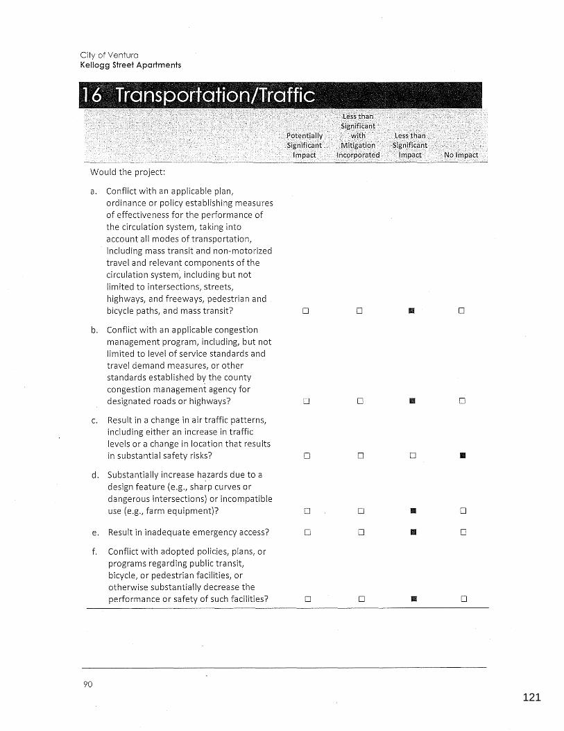
121
0123456789
City of Ventura Kellogg Street Apartments
Would the project:
a. Conflict with an applicable plan, ordinance or policy establishing measures of effectiveness for the performance of the circulation system, taking into account all modes of transportation, including mass transit and non-motorized travel and relevant components of the circulation system, including but not limited to intersections, streets, highways, and freeways, pedestrian and . bicycle paths, and mass transit? D D II D
b. Conflict with an applicable congestion management program, including, but not limited to level of service standards and travel demand measures, or other standards established by the county congestion management agency for designated roads or highways? D D II D
C. Result in a change in air traffic patterns, including either an increase in traffic levels or a change in location that results in substantial safety risks? D D D II
d. Substantially increase h~zards due to a design feature (e.g., sharp curves or dangerous intersections) or incompatible use (e.g., farm equipment)? D D II D
e. Result in inadequate emergency access? D D II D
f. Conflict with adopted policies, plans, or programs regarding public transit, bicycle, or pedestrian facilities, or otherwise substantially decrease the performance or safety of such facilities? D D II D
90
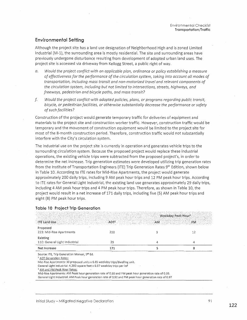
122
0123456789
Environmental Checklist Transportation/Traffic
Environmental Setting
Although the project site has a land use designation of Neighborhood High and is zoned Limited Industrial (M-1), the surrounding area is mostly residential. The site and surrounding areas have previously undergone disturbance resulting from development of adopted urban land uses. The project site is accessed via driveway from Kellogg Street, a public right of way.
a. Would the project conflict with an applicable plan, ordinance or policy establishing a measure of effectiveness for the performance of the circulation system, taking into account all modes of transportation, including mass transit and non-motorized travel and relevant components of the circulation system, including but not limited to intersections, streets, highways, and freeways, pedestrian and bicycle paths, and mass transit?
f. Would the project conflict with adopted policies, plans, or programs regarding public transit, bicycle, or pedestrian facilities, or otherwise substantially decrease the performance or safety of such facilities?
Construction of the project would generate temporary traffic for deliveries of equipment and materials to the project site and construction worker traffic. However, construction traffic would be temporary and the movement of construction equipment would be limited to the project site for most of the 8-month construction period. Therefore, construction traffic would not substantially interfere with the City's circulation system.
The industrial use on the project site is currently in operation and generates vehicle trips to the surrounding circulation system. Because the proposed project would replace these industrial operations, the existing vehicle trips were subtracted from the proposed project's, in order to determine the net increase. Trip generation estimates were developed utilizing trip generation rates from the Institute of Transportation Engineers (ITE) Trip Generation Rates gth Edition, shown below in Table 10. According to ITE rates for Mid-Rise Apartments, the project would generate approximately 200 daily trips, including 9 AM peak hour trips and 12 PM peak hour trips. According to ITE rates for General Light Industrial, the existing land use generates approximately 29 daily trips, including 4 AM peak hour trips and 4 PM peak hour trips. Therefore, as shown in Table 10, the project would result in a net increase of 171 daily trips, including five (5) AM peak hour trips and eight (8) PM peak hour trips.
Table 10 Project Trip Generation
Proposed 223: Mid-Rise Apartments
Existing 110: General Light Industrial
Net Increase
Source: ITE, Trip Generation Manual, 9th Ed. 2 ADT Generation Rates:
200
29
171
Mid-Rise Apartments: 30 proposed units x 6.65 weekday trips/dwelling unit. General Light Industrial: 4,200 square feet x 6.97 weekday trips per ksf 3 AM and PM Peak Hour Rates:
9
4
5
Mid-Rise Apartments: AM Peak hour generation rate of 0.30 and PM peak hour generation rate of 0.39. General Light Industrial: AM Peak hour generation rate of 0.92 and PM peak hour generation rate of0.97
Initial Study - Mitigated Negative Declaration
12
4
8
91
123
0123456789
City of Ventura Kellogg Street Apartments
The City's threshold for warranting a traffic analysis is 100 peak hour trips. The project's maximum net peak hour traffic generation of eight trips would not exceed this threshold. Furthermore, based on Future 2025 traffic counts shown in the City of San Buenaventura General Plan, average daily trips (ADT) are projected to be 16,000 ADT on Ventura Avenue, and 5,000 ADT on both Cedar Street and Kellogg Street (Kellogg Street turns into Cedar Street). Assuming the same 50/50 directional split from the project site as discussed in Section 12, Noise, the project would increase ADT along Ventura Avenue by approximately 0.5 percent and would increase traffic on Cedar Street by about 1.7 percent. These traffic volume increases would not substantially affect the local circulation system.
The project would be subject to all applicable policies of the City's General Plan. As discussed in Section 7, Greenhouse Gas Emissions, the project site is located across the street from Kellogg Park, adjacent to a transportation corridor, and within walking distance of the following Gold Coast Transit bus stops: the Ventura Avenue/Ramona stop {0.11 miles) and the Ventura Avenue/Warner stop (0.17 miles), which are served by Gold Coast Routes 6, 16, and 18f. The project also proposes five (5) bicycle spaces as well a? additional sports equipment storage. In these ways, the project fulfills several land use objectives of SCAG's RTP/SCS, encouraging new household growth in areas served by existing public transportation, and focusing growth around existing transportation corridors. The project would include construction of new sidewalk along the Kellogg Street frontage of the project site to connect to the existing sidewalk along Kellogg Street east and west of the site, which would aid in ped·estrian safety and access.
The project would not adversely affect the operation of the local circulation system, would support the City's circulation system goals, and would not decrease the performance or safety of public transit, bicycle, or pedestrian facilities. Therefore, it would not conflict with any plan, policy, or ordinance relating to any aspect of the circulation system, and impacts would be less than significant.
LESS THAN SIGNIFICANT IMPACT
b. Would the project conflict with an applicable congestion management program1 including1 but not limited to level of service standards and travel demand measures1 or other standards established by the county.congestion management agency for designated roads or highways?
The Ventura County Congestion Management Program (CMP) requires an analysis of congestionrelated impacts of all significant projects proposed for development in the County. A project is considered significant if:
•
•
The proposed land use is not included in the Ventura County Traffic Model because the project was not anticipated in the jurisdiction's general plan and the project will generate 200 or more peak hour trips in either peak hour; or
The proposed land use is i~cluded in the Ventura County Traffic Model as provided by the local agency, but because of an increase in project size or density the project will generate an additional 100 or more peak hour trips.
As shown in Table 10, the project would generate a net increase of approximately five (5) AM peak hour trips and eight (8) PM peak hour trips. Because the project would not generate traffic exceeding CMP thresholds or otherwise conflict with the CMP, impacts would be fess than significant.
LESS THAN SIGNIFICANT IMPACT
92
124
0123456789
Environmental Checklist Transportation/Traffic
c. Would the project result in a change in air traffic patterns, including either an increase in traffic levels or a change in location that results in substantial safety risks?
The nearest airport is Oxnard Airport, which is located over seven miles southeast of the project site. As discussed in Section 8, Hazards and Hazardous Materials, no Airport Land Use Plans or designated approach or runway clear zones overlay the project site. Therefore, the project would not result in aviation related safety risks or result in a change in air traffic patterns, and there would be no impact.
NO IMPACT
d. Would the project substantially increase hazards due to a design feature (e.g., sharp curves or dangerous intersections) or incompatible use (e.g., farm equipment)?
e. Would the project result in inadequate emergency access?
The project does not include design features such as sharp curves or dangerous intersections that would be considered hazardous, as proposed project improvements include curb and gutter, walkway/sidewalk along project frontage, and a central driveway for ingress/egress. These additions would improve existing conditions. The project's proposed residential use and zoning is mo're compatible with surrounding residential uses than the site's current zoning of Limited Industrial and use as an industrial storage site. The project's central driveway would be constructed per Ventura Public Works Engineering Design Standards Section 4-1.C. Because the on-site circulation system would comply with applicable requirements of the City's emergency response personnel and the City's Public Works Department, the project would provide adequate access for emergency response vehicles and impacts would be less than significant.
LESS THAN SIGNIFICANT IMPACT
Initial Study - Mitigated Negative Declaration 93
125
0123456789
City of Ventura Kellogg Street Apartments
Would the project ca use a substantial adverse change in the significance of a tribal cultural resource, defined in Public Resources Code section 21074 as either a site, feature, place, or
. cultural landscape that is geographically defined in terms of the size and scope of the landscape, sacred place, or object with cultural value to a California Native American tribe, and that is:
a. Listed or eligible for listing in the California Register of Historical Resources, or in a local register of historical resources as defined in Public Resources Code section 5020. l(k), or
b. A resource determined by the lead agency, in its discretion and supported by substantial evidence, to be significant pursuant to criteria set forth in subdivision (c) of Public Resources Code Section 5024.1. In applyi.ng the criteria set forth in subdivision (c) of Public Resources Code Section 5024.1, the lead agency shall consider the significant of the resource to a California Native American tribe.
Regulatory Setting
D
D
II D D
II D D
As of July 1, 2015, California Assembly Bill 52 of 2014 (AB 52} was enacted and expands CEQA by defining a new resource category, "tribal cultural resources." AB 52 establishes that "A project with an effect that may cause a substantial adverse change in the significance of a tribal cultural resource is a project that may have a significant effect on the environment" {PRC Section 21084.2). It further states that the lead agency shall establish measures to avoid impacts that would alter the significant characteristics of a tribal cultural resource, when feasible (PRC Section 21084.3).
PRC Section 21074 (a)(l}(A) and {B) defines tribal cultural resources as "sites, features, places, cultural landscapes, sacred places, and objects with cultural value to a California Native American tribe" and is:
1. Listed or eligible for listing in the California Register of Historical Resources, or in a local register of historical resources as defined in Public Resources Code section 5020.l(k), or
2. A resource determined by the lead agency, in its discretion and supported by substantial evidence, to be significant pursuant to criteria set forth in subdivision (c) of Public Resources Code Section 5024.1. In applying these criteria, the lead agency shall consider the significance of the resource to a California Native American tribe.
94
126
0123456789
Environmental Checklist Tribal Cultural Resources
AB 52 also establishes a formal consultation process for California tribes regarding those resources. The consultation process must be completed before a CEQA document can be certified. Under AB 52, lead agencies are required to /(begin consultation with a California Native American tribe that is traditionally and culturally affiliated with the geographic area of the proposed project." Native American tribes to be included,in the process are those that have requested notice of projects proposed within the jurisdiction of the lead agency.
Environmental Setting
Although the site has a land use designation of Neighborhood High and is zoned Limited Industrial (M-1), the surrounding area is generally characterized as residential and has previously undergone disturbance resulting from development of adopted urban land uses. The property contains accessory structures and construction equipment, and is entirely paved. As such, and as discussed in Section 5, Cultural Resources, the project site has been significantly disturbed by urban development.
a. Would the project cause a substantial adverse change in the significance of a tribal cultural resource as defined in Public Resources Code 21074 that is listed or eligible for listing in the California Register of Historical Resources/ or in a local register of historical resources as defined in Public Resources Code section 5020.l{k)?
b. Would the project cause a substantial adverse change in the significance of a tribal cultural resource as defined in Public Resources Code 21074 that is a resource determined by the lead agency/ in its discretion and supported by substantial evidence/ to be significant pursuant to criteria set forth in subdivision (c) of Public Resources Code Section 2024.1?
The NAHC was contacted on September 6, 2018 to obtain a list of tribes with traditional lands or cultural places located in the vicinity of the project site. The NAHC responded on September 24th, 2018 with a list of tribal contacts to whom letters requesting AB 52 consultation should be sent. The City then sent AB 52 consultation request letters to these tribal contacts on November 21, 2018, but no responses to these letters were received by the City. Copies of this correspondence are included in App~ndix F of this Addendum.
The City of San Buenaventura's 2005 General Plan outlines appropriate policies and actions in relation to Native American resources to ensure that potential impacts to these resources during excavation work are less than significant {City of San Buenaventura 2005a).
In addition, as discussed in Section 5, Cultural Resources, the project site is in an urbanized area and has .been previously disturbed in conjunction with construction of structures on, and paving of, the site. Although it is not anticipated that intact tribal cultural resources are present on or beneath the project site, there is the potential for the recovery of buried cultural materials during project construction activities. Upon compliance with Mitigation Measures CUL-1 through CUL-3 in Section 5, Cultural Resources, in addition to Mitigation Measure TCR-1 below, potential impacts would be reduced to a less than significant level by providing a process for evaluating and, as necessary, avoiding impacts to any identified resources. Impacts would be less than significant with mitigation incorporated.
Initial Study- Mitigated Negative Declaration · 95
127
0123456789
City of Ventura Kellogg Street Apartments
MITIGATION MEASURE
The following mitigation measure is required to reduce potential impacts pertaining to the unanticipated discovery of tribal cultural resources. With implementation of Mitigation Measure TCR-1, impacts would be less than significant.
TCR-1 Unanticipated Discovery of Tribal Cultural Resources. In the event that cultural resources of Native American origin are identified during construction, all earthdisturbing work in the vicinity of the find must be temporarily suspended or redirected until the City has been notified of the find, an archaeologist has evaluated the nature and significance of the find, and an appropriate Native American representative, based on the nature of the find, is consulted. If the City determines that the reso_urce is a tribal cultural resource, a mitigation plan shall be prepared and implemented in accordance with state guidelines and in consultation with Native American groups. The plan shall include avoidance of the resource or, if avoidance of the resource is infeasible, the plan shall outline the appropriate. treatment of the resource in coordination with the archeologist and the appropriate Native American tribal representative.
LESS THAN SIGNIFICANT WITH MITIGATION INCORPORATED
96

128
0123456789
This page intentionally left blank.
Initial Study - Mitigated Negative Declaration
Environmental Checklist Tribal Cultural Resources
97
129
0123456789
City of Ventura Kellogg Street Apartments
Would the project:
a. Exceed wastewater treatment requirements of the applicable Regional Water Quality Control Board? D D II D
b. Require or result in the construction of new water or wastewater treatment facilities or expansion of existing facilities, the construction of which could cause significant environmental effects? D D II D
C. Require or result in the construction of new stormwater drainage facilities or expansion of existing facilities, the construction of which could cause significant environmental effects? D D II D
d. Have sufficient water supplies available to serve the project from existing entitlements and resources, or are new or expanded entitlements needed? D D II D
e. Result in a determination by the wastewater treatment provider which serves or may serve the project that it has adequate capacity to serve the project's projected demand in addition to the provider's existing commitments? D D D
f. Be served by a landfill with sufficient permitted capacity to accommodate the project's solid waste disposal needs? D Ill II D
g. Comply with federal, state, and local statutes and regulations related to solid waste? D D II D
Environmental Setting
Wastewater
As stated in the City's 2015 UWMP (City of San Buenaventura, 2016b), the Ventura Water Reclamation Facility (VWRF) is permitted at 14 million gallons per day (MGD) and discharges up to 9
98
130
0123456789
Environmental Checklist Utilities and Service Systems
MGD. The VWRF currently discharges less than 9 MGD during drought conditions. The City's existing National Pollutant Discharge Elimination System (NPDES) permit issued by the Regional Water Quality Control Board (RWQCB) for the VWRF indicates that once the average daily dryJ-weather flow equals or exceeds 75 percent of the Plant's design capacity then a report must be submitted outlining the steps needed to provide for additional capacity for waste treatment. Flows are monitored closely due to the permit requirement to consider expansion when at 75 percent capacity.
The VWRF provides wastewater collection and treatment services for approximately 98 percent of the City residences as well as McGrath State Beach Park and the North Coast Communities (County Service Area No. 29). In February 2016 the City took over sewer service for the formerly unincorporated Montalvo community serviced by Montalvo Community Services District. The VWRF produces recycled water that is treated to tertiary Title 22 standards through tertiary filtration and disinfection. Currently approximately seven percent of the treated effluent is reused as recycled water; the rest is discharged to the Santa Clara River Estuary.
The City's wastewater collection system consists of approximately 290 miles of gravity sewers ranging in size from 4 to 42 inches, approximately 10 miles of force mains, 11 wastewater lift station, and the VWRF, a tertiary treatment plant. In addition, the City has taken over 7.5 miles of sewer mains formerly owned by the Montalvo Community Services District. The collection system conveys flows generally from e·ast to west and north to south, culminating at the VWRF for treatment.
Water Supply
As stated in the City's 2015 Urban Water Management Plan (2015 UWMPL the City's water system is a geographically complex system of 16 pressure zones, 10 active wells, 21 booster stations, approximately 380 miles of pipelines ranging from 4-inches to 36-incehs in diameter, and a total storage capacity of approxima~ely 52 million gallons (MG) in 32 tanks and reservoirs. The City operates three purification facilities, including one membrane filtration treatment plant for surface water sources on the west side of the City and two iron/manganese removal treatment plants for groundwater sources on the east side. The City also maintains and operates the VWRF. Five distinct sources provide surface and groundwater to the City supply system.
• Casitas Municipal Water District
• Ventura River surface water intake, subsurface water and wells (Foster Park)
• Mound Groundwater Basin
• Oxnard Plain Groundwater Basin (Fox Canyon Aquifer)
• Santa Paula Groundwater Basin
The City also holds a State Water Project entitlement of 10,000 acre-feet per year (AFY).
The UWMP is required by the California State Water Code. The UWMP is a long-term planning tool that provides water purveyors and their customers a broad perspective on water supply issues over a 20 to 25 year period. The UWMP is a management tool, providing the framework for action, but does not function as a detailed project development plan.
In addition to the UWMP, in 2013 the City Council directed the Ventura Water Department and the Community Development Department to work together to develop a short tern balance of water supply and estimated demands. The result of this collaboration is the annual Comprehensive Water
Initial Study - Mitigated Negative Declaration 99
131
0123456789
City of Ventura Kellogg Street Apartments
Resource Report (CWRR) completed each year by Ventura Water. The CWRR focuses on a short timeframe and on near-term demand changes as well as long-term projection of demand and supply. The CWRR estimates demands from approved projects whereas the UWMP estimates demands from population projections.
The water supply from Lake Casitas has historically ranged from 4,960 to 8,000 AFY, with 4,200 to 6,700 AFY of water historically supplied from the Ventura River. In 2015, total water production for the City was estimated at 14,981 AFY (City of San Buenaventura 2016b). The recent CWRR (2018) updated the normal (non-drought year) available water supply for the City to 21,381 AFY. However, under existing drought conditions in 2018, the current water supply is estimated at 15,321 acre-feet. If drought conditions persist through 2020, the water supplies are estimated to range from a low of 13,030 to a high of 15,851 acre-feet per year. The 2018 CWRR also includes estimated total future water demands based on existing water demands (16,515 AFY baseline demand, 10-year average} plus estimated demands for approved development projects. The total future water demand (17,899 AFY) estimate does not account for any other recently initiated or pending projects.
The 2018 CWRR indicates that "the spread between the current water demand and the current water supply is very tight. If the continued drought condition persists, the supply could be less than the demand.I} The City's customers will need to continue to conserve and/or pay penalties for overuse of the City's water supply sources while the City secures new water supplies. This presents significant challenges for the City moving forward in its ability to allocate water supply to development projects that will generate additional water demands.
Solid Waste
Assembly Bill 969 requires all jurisdictions in California to increase their landfill diversion to 50 percent by the year 2000. In addition, AB 341 sets a new statewide goal of achieving 75 percent landfill diversion by 2020. The City has achieved a landfill diversion rate of 74 percent (City of San Buenaventura n.d.}. AB 341 also requires businesses generating more than four cubic yards of solid waste to-recycle, and requires owners of multi-family housing with five or more units to provide recycling for their tenants. New development projects in the City are required to implement sitespecific source reduction, recycling, and re-use programs to comply with AB 939 and AB 341.
The City of San Buenaventura requires all new residential, commercial, and mixed-use construction projects to divert a minimum of 65 percent of construction and demolition waste from landfill disposal. Applicants must submit a Waste Management Plan to the City's Environmental Sustainability division for approval prior to the issuance of a building permit, and submit a Final Report at the time of Final Inspection of the project. The City recommends achieving compliance · with this mandate by using the City's franchise hauler, E.J. Harrison & Sons, which diverts at least 65 percent of the construction and demolition waste and provides finai-reporting forms (City of San Buenaventura, n.d.).
Project-generated solid waste would be handled by the City's franchise hauler, E.J Harrison & Sons. Solid waste from the City of San Buenaventura is taken to the Gold Coast Recycling and Transfer Station located at 5375 Colt Street in the southeastern portion of the City, and trash is sent to 'the Toland Road Landfill located north of Highway 126 near Santa Paula. The Toland Road Landfill currently receives approximately 1~484 tons of solid waste per day and has a permitted daily throughput of 1,500 tons (California Department of Resources Recycling and Recovery [CalRecycle] 2018a, 2018b). As of January 1, 2016, the Toland Road Landfill had a remaining capacity of 10,571,820 cubic yards and an .estimated closure date of May 31, 2027 (CalRecycle 2018a).
100.
132
0123456789
Environmental Checklist Utilities and Service Systems
a. Would the project exceed wastewater treatment requirements of the applicable Regional Water Quality Control Board?
b. Would the project require or result in the construction of new water or wastewater treatment facilities or expansion of existing facilities, the construction of which could cause significant environmental effects?
e. Would the project result i(J a determination by the wastewater treatment provider which serves or may serve the project that it has adequate capacity to serve the project's projected demand in addition to the provider's existing commitments?
The Ventura Water Reclamation Facility (VWRF) is currently permitted to treat 14 million gallons per day (MGD) and discharge an annual average of up to 9 MGD. The VWRF is currently treating less than 9 MGD. The City's NPDES permit, issued by the Regional Water Quality Control Board for the VWRF, indicates that once the average daily dry-weather flow equals or exceeds 75 percent of the Plant's design capacity then a report must be submitted outfining the steps needed to provide for additional capacity for water tr:eatment. Plant flows are closely monitored due to the permit requirements to consider expansion when at 75 percent capacity.
Water demand for the proposed project would be approximately 7,500 gallons per day. Assuming that wastewater generation is 80 percent of water demand, the project would produce an estimated 6,000 gallons {0.006 MGD) of wastewater per day. Adding the Project's estimated wastewater flow of 6,000 gallons {.006 mgd) would not exceed the existing VWRF capacity, therefore the project would not exceed the existing VWRF capacity.
As indicated in the City's 2005 ~eneral Plan and General Plan EIR, project proponents are required to conduct sewer collection system analysis to determine if downstream facilities are adequate to handle the proposed development.
A report titled Sewer System Assessment - Kellogg Street Apartments, was completed for Ventura Water by the City's Land Development Department on April 18, 2019. The Report indicates that the wastewater from the Project will connect to the City's sewer collection system at one location on Kellogg St. The report recommends that the existing 10-inch sewer main in Ventura Avenue from Santa Clara Street to Thompson Boulevard be upgraded to accommodate the increased flow. The report also mentions the likely.requirement of replacing one manhole and reconfiguring two others.
LESS THAN SIGNIFICANT IMPACT
b. Would the project require or result in the construction of new water or wastewater treatment facilities or expansion of existing facilities, the construction of which could cause significant environmental effects?
d. Would the project have sufficient water supplies available to serve the project from existing entitlements and resourc~s, or are new or expanded entitlements needed?
As indicated in the City's 2005 General Plan and General Plan EIR, project proponents are required to conduct evaluations of the existing water distribution system, pump station and storage requirements for the proposed development in order to determine if there are any system deficiencies or needed improvements for the proposed development. A report titled Water System Assessment for the Kellogg Street Apartments was completed for Ventura Water by the City's Land Development Department on April 4, 2019. The Water Report included the analysis of 30 residential multifamily dwelling units.
Initial Study - Mitigated Negative Declaration 101
133
0123456789
City of Ventura Kellogg Street Apartments
The hydraulic evaluation examined the impacts of the Project specifically on the City's domestic water distribution system, however the on-site system (anything including or downstream of a meter and /or backflow prevention device) was specifically excluded from the evaluation and should be conducted by the developer during design. The Project is projected to require an annual water supply of 7,500 gpd or 8.4 AFY to meet the projected water demand requirements.
The hydraulic model results for the City's existing domestic water distribution system as a result of the addition of the proposed Project are minor and are identified in Attachment 3 of the Water Report. No improvements tot.he City's existing water distribution system are identified due to the addition of the Project. Overall, the result indicates that the City's existing domestic water system and the Project's currently pmposed water system have available capacity to support the increased water demands and fire flow.
The proposed project would be required to comply with the City's Water Rights Dedication and Water Resource Net Zero Policy (Ordinance No. 2016-0
004), which is designed to ensure that new
development does not adversely affect the water supply or water supply reliability of the City's existing customers and/or approved new development. The Ordinance requires developers to offset new or increased water demand through one or more compliance options, including dedication of water rights, payment of a water resource net zero fee, and/or extraordinary conservation measures (e.g., graywater/reuse systems, water efficient plumbing fixtures and appliances beyond what is required in the current building code and ordinances, or recycled water delivery systems for outdoor irrigation/non-potable use).
The project would also be required to comply with the State Model Water Efficient Landscape Ordinance (MWELO), which was adopted by the City of San Buenaventura (California Code of Regulations Title 23, Division 2, Chapter 2.7). The MWELO requires new development projects with landscape areas of 500 square 'feet or more to design a landscaping plan with an estimated total water use that would not exceed the site's calculated Maximum Applied Water Allowance, which is based on the site's reference evapotranspiration, adjustment factor, and the size of the landscaped area. The MWELO also requires the use of high efficiency irrigation emission devices, automatic irrigation controllers that use either evapotranspiration or soil moisture sensor data for irrigation scheduling, and sensors that suspend or alter irrigation operation during unfavorable weather conditions. Compliance with the MWELO would reduce outdoor water usage by approximately 20 percent (Department of Water Resources 2015).
Although the project would-generate demand for existing water resources, compliance with the City's Water Rights Dedication and Water Resource Net Zero Policy, State Model Water Efficient Landscape Ordinance, and other applicable City ordinances and policies for water conservation and reduction, would reduce impacts to water supply and infrastructure to a less than significant level.
LESS THAN SIGNIFICANT IMPACT
c. Would the project require or result in the construction of new storm water drainage facilities or expansion of existing facilities/ the construction of which could cause significant environmental effects?
As discussed in the Preliminary Drainage Study, construction of the proposed project would result in reduced peak stormwater runoff compared to existing conditions (from 3.5 cubic feet per second
102
134
0123456789
Environmental Checklist Utilities and Service Systems
(cfs) to 3.3 cfs during peak conditions). The proposed project would include new stormwater drainage lines that would extend under the project site to connect to the existing storm drain lines along Kellogg Street. As discussed in Section 9, Hydrology and Water Quality, the applicant would be required to design storm drains that conform to the standards approved by the City Engineer. In addition, the project would meet MS4 requirements by incorporating landscaping adjacent to sidewalks and around the project site, as well as installing an underground infiltration trench. Since the project would result in reduced stormwater runoff volumes and would increase permeable surfaces on-site, the project would not adversely affect the local storm drain system. Accordingly, potential impacts to stormwater drainage facilities would be less than significant.
LESS THAN SIGNIFICANT IMPACT
f. Would the project be served by a landfill with sufficient permitted capacity to accommodate the project's solid waste d_isposal needs?
g. Would the project comply with federal, state, and local statutes and regulations related to solid waste?
Operation of the project would generate approximately 0.76 tons of solid waste per day based on the 2005 General Plan waste generation rate of 0.0096 tons/day per person, assuming the project would accommodate 79 people. However, the City diverts approximately 74 percent of its solid waste through source reduction programs such as recycling; therefore, the amount sent to the landfills would be approximately 0.19 tons per day. When added to the 1,484 tons per day of solid waste the Toland Road Landfill'is already receiving, the resulting amount of less than 1,485 tons per day would not exceed this landfiWs permitted daily capacity of 1,500 tons per day.
The project would comply with federal, state, and local statutes and regulations related to solid waste, such as AB 939, AB 341, and the County Integrated Waste Management Summary Plan, and the City1 s recycling program. Since there is adequate landfill capacity in the region to accommodate project-generated waste, and the project would comply with all applicable requirements pertaining to solid waste disposal, impacts would be less than significant.
The 2005 General Plan EIR identified a significant and unavoidable impact for solid waste generation. The 2005 General Plan EIR found that projected growth would increase solid waste sent to landfills by an estimated 84 tons per day by 2025, which was within the currently available daily capacity at Toland Road Landfill. However, the 2005 General Plan EIR concluded that because area landfills are projected to close in the 2022-2027 timeframe, regional waste generation increases could exceed the daily capacity of area landfills. The proposed project's increase in solid waste would remain well within the currently available capacity of area landfills, as discussed in the preceding paragraph. As such, although the project would incrementally contribute to the significant and unavoidable impact identified under the 2005 General Plan EIR, this contribution would not be cumulatively considerable.
LESS THAN SIGNIFICANT IMPACT
Initial Study- Mitigated Negative Declaration 103
135
0123456789
City of Ventura Kellogg Street Apartments
Does the project:
a. Have the potential to substantially reduce the habitat of a fish or wildlife species, cause a fish or wildlife population to drop below self-sustaining levels, eliminate a plant or animal community, reduce the number or restrict the range of a rare or endangered plant or animal or eliminate important examples of the major periods of California history or prehistory?
b. Have impacts that are individually limited, but cumulatively considerable? ("Cumulatively considerable" means that the incremental effects of a project are considerable when viewed in connection with the effects of past projects, the effects of other current projects, and the effects of probable future projects)?
c. Have environmental effects which will cause substantial adverse effects on human beings, either directly or indirectly?
Environmental Setting
D
D
D
1111 D D
D • D
• D D
The project site is located in a residential and commercial neighborhood in an urbanized area. As seen in the site photos in Figure 4 and Figure 5, the project site has been extensively disturbed by previous on-site activities, as the site is entirely paved, with accessory structures located near the eastern and southern boundary, and has been a storage site for construction and other industrial equipment. The site does not contain any vegetation or trees, and is currently chain-link fenced on all sides.
a. Does the project have the·potential to substantially reduce the habitat of a fish or wildlife species, cause a fish or wildlife population to drop below self-sustaining levels, eliminate a plant or animal community, reduce the number or restrict the range of a rare or endangered plant or animal or eliminate important examples of the major periods of California history or prehistory?
104
136
0123456789
Environmental Checklist Mandatory Findings of Significance
As described in Section 4, Biological Resources, there are no identified species on-site, and impacts to biological resources are less than significant. As noted under Section 5, Cultural Resources, no historical or archeological resources were identified on the site. Nevertheless, implementation of Mitigation Measures CUL-1 through CUL-3 and TCR-1 would reduce impacts to unanticipated · cultural resources to a less than significant level by providing a process for evaluating and, as necessary, avoiding impacts to any identified resources during construction. Impacts would be less than significant with the mitiga_tion incorporated for cultural resources.
LESS THAN SIGNIFICANT WITH MITIGATION INCORPORATED
b. Does the project have impacts that are individually limited, but cumulatively considerable? {11Cumulatively considerable" means that the incremental effects of a project are considerable when viewed in connection with the effects of past projects, the effects of other current projects, and the effects of probable future projects)?
As described in the discussion of environmental checklist Sections 1 through 18, the project would have no impact, a less than significant impact, or a less than significant impact with mitigation incorporated, with respect to all environmental issues. These include short-term, long-term, and where appropriate, cumulative impacts. Cumulative impacts of the following resource areas have been addressed in the individual resource sections above: Air Quality, Greenhouse Gases, Noise, and Transportation/Traffic, and Utilities & Service Systems (solid wastes) (See CEQA Guidelines Section 15064[h][3]0). CalEEMod was utilized to assess the air quality and greenhouse gas impacts resulting from the proposed project, leading to a conclusion that the impacts associated with air quality and GHG emissions would be less than significant. In addition, noise, traffic, and solid waste analyses conducted as part of this Initial Study also conclude that cumulative impacts would be less than significant. Certain resource areas (e.g., agricultural and mineral) were determined to have no impact in comparison to existing conditions. Therefore, the project would not contribute to cumulative impacts related to these issues. Other issues (e.g., geology and hazards and hazardous materials) are by their nature project-specific and impacts at one location do not add to impacts at other locations or create additive impacts.
There are two approved but yet to be constructed projects and one conceptual proposal in the immediate project site vicinity, according to the City of San Buenaventura's on line map of Pending Projects throughout the City ( City of San Buenaventura 2018c). For a map and descriptions of these projects see Appendix G of this IS-M ND.
Per this map and discussions with City of San Buenaventura Community Development staff, the closest pending project (PROJ-04691) is directly south of the project site, fronting on Ramona Street, and would involve construction of seven apartment units. Two of these apartments (in a duplex configuratron} have already been constructed, while an additional five units .have not. The remaining five units are already entitled, and it is possible that their construction may overlap with that of the proposed project, which is planned for construction in 2019-2020.
The second nearby project (PROJ-7123) is at the meat market located two parcels southwest of the project site, fronting onto Ventura Avenue between Ramona Street and Kellogg Street. This pending project would involve demolition of an approximately 1,075 square foot garage and construction of a 2,039 square foot first story addition, a 180 square foot second story addition, and a new 210 square foot carport space all located on the rear and side of the commercial building currently on the site. This project received all planning approvals in April 2018, and it is possible that construction of this project may overlap that of the proposed project.
Initial Study - Mitigated Negative Declaration 105
137
0123456789
City of Ventura Kellogg Street Apartments
The third nearby project {PROJ-11237) is a conceptual proposal for the gas station located on the corner of Ventura Avenue and Kellogg Street, adjacent to the second nearby project discussed above. It would involve demolition of the existing 256 square foot cashier kiosk structure and construction of a new 1,235 square foot food mart structure. Because this project is in the conceptual phase, has not yet received any entitlements, and has no proposed schedule for construction, it is very unlikely that its construction would overlap with that of the proposed project, which is planned for construction in 2019-2020.
As discussed in the discussion of environmental checklist Sections 1 through 18, the proposed project was found to have no impact or less than significant impacts after mitigation in all environmental impact areas. The mitigation measures required for the project are for site-specific hazards and cultural resource impacts and the proposed project would therefore not contribute to cumulative impacts in the region in terms of these impacts.
Construction impacts of the proposed project, the five entitled apartment units on the property , directly to the south of the project site on Ramona Street, and the building additions and carport at the meat market to the west of the project site, may overlap. Construction impacts would occur primarily in the areas of air quality, noise, and traffic due to the potential for construction equipment and other construction activities to generate dust and other air quality emissions, noise, and construction traffic. The impacts of the proposed project in these areas have been determined to be less than significant without the need for mitigation. Potential cumulative impacts of the proposed project and the neighboring projects on Ramona Street and Ventura Avenue in these impact areas are described below.
As discussed in the Section 3, Air Quality of this Initial Study, the VCAPCD has not established quantitative thresholds for particulate matter for either operation or construction. However, the VCAPCD implements rules and regulations for emissions that may be generated by various uses and activities. These rules and regulations detail pollution-reduction measures that must be implemented during construct~on and operation of projects. All three projects would be subject to these rules and regulations, which would ensure that their impacts from construction-related emissions of particulate matter (dust) would be less than significant, both individually and cumulatively. The VCAPCD considers operational air quality impacts to be significant if a project would generate more than 25 pounds per day of ozone precursors, reactive organic compounds (ROC), or nitrogen oxides {NOx). The operational thresholds for ROC and NOx apply on a project-byproject basis, however, and are not intended to be applied to construction emissions, since such emissions are temporary. All three projects would be subject to the City of San Buenaventura's standard construction measures included in the most recent version of the VCAPCD's Ventura County Air Quality Assessmen(Guidelines pursuant to Mitigation Measure AQ-3 of the 2005 General Plan Final Environmental Impact Report. Due to the previous amount of disturbance at these sites, disturbance of soils duri-ng construction activities is unlikely to pose a substantial risk of infection from the fungal spores responsible for Valley Fever, which generally grow in virgin, undisturbed soil. The air quality impacts of both projects would therefore not combine to create a significant impact.
As discussed in Section 12, Noise of this Initial Study, although the City of San Buenaventura has not adopted any specific construction noise thresholds, construction of the proposed project would generate temporary noise in e0cess of ambient noise levels for the approximately 8-month construction period. The project applicant would be required to adhere to construction activity limitations specified in the City's Municipal Code, which would limit construction noise to between 7:00 AM and 8:00 PM, when people do not ordinarily sleep. Therefore, impacts would be less than significant. The neighboring projects on Ramona Street and Ventura Avenue would be subject to the
106
138
0123456789
Environmental Checklist Mandatory Findings of Significance
same limitation on construction hours from the City's Municipal Code, and since all three projects would be constructed during hours people do not ordinarily sleep, their cumulative construction noise impacts would therefore also be less than significant. Because groundborne vibration geherated by human-made activities attenuates rapidly as distance from the source of the vibration increases, and because the modeled vibration levels for the proposed project are well below applicable thresholds of significance, cumulative vibration impacts of both projects together would be less than significant.
As discussed in Section 16, Transportation/Traffic of this Initial Study, construction of the proposed project would generate temporary traffic for deliveries of equipment and materials to the project site and construction worker traffic. However, construction traffic would be temporary and the movement of construction equipment would be limited to the project site for most of the 8-month construction period. While the neighboring projects on Ramona Street and Ventura Avenue would also generate construction traffic, this traffic would also be temporary and the movement of construction equipment would be limited to that project site for most of its construction period. Additionally, any on-street traffic generated by the projects on Ramon Street and Ventura Avenue would most directly impact those streets, not Kellogg Street, so the construction traffic from these three projects would not combine to create a cumulatively significant traffic impact on any of these streets. Therefore, cumulative construction traffic from these three projects would not substantially interfere with the City's circula~ion system or have any other significant impact related to transportation or traffic.
LESS THAN SIGNIFICANT IMPACT
c. Does the project have environmental effects which will cause substantial adverse effects on human beings/ either directly or indirectly?
In general, and as analyzed in this Initial Study1 impacts to human beings are associated with air quality contaminants, adverse geologic conditions, exposure to hazards and hazardous materials, and excessive noise. As detailed in analyses in Section 3, Air Quality, Section 6, Geology and Soils, Section 8, Hazards and Hazardous Materials, Section 9, Hydrology and Water Quality/ and Section 12, Noise, the proposed project would not result, either directly or indirectly, in adverse hazards that cannot be mitigated to a less than significant level. As discussed in Section 8, Hazards and Hazardous Materials, Mitigation Measures HAZ-1 and HAZ-2 require lead and asbestos surveys prior to demolition activities, which would verify the potentia I presence of these hazardous materials and outline potential abatement procedures. With implementation of Mitigation Measures HAZ-1 and HAZ-2, any potential impacts from the release of lead or asbestos would be mitigated, and impacts would be less than significant. ~ompliance with applicable rules and regulations and recommended mitigation measures would reduce potential impacts on human beings to a less than significant level._
LESS THAN SIGNIFICANT WITH MITIGATION INCORPORATED
Initial Study - Mitigated Negative Declaration 107
139
0123456789
City of Ventura Kellogg Street Apartments
References
Bibliography California Air Resources Board (ARB). 2005. Air Quality and Land Use Handbook: A Community
Health Perspective. April 2005.
__ . 2015a. Area Designations for State Ambient Air Quality Standards - PM10. Last modified: December 2015. https://www.arb.ca.gov/desig/adm/2015/state_pm10.pdf (accessed September 2018).
__ . 2016a. Ambient Air Qual!ty Standards. http://www.arb.ca.gov/research/aaqs/aaqs2.pdf
__ . 2016b. California Greenhouse Gas Emission Inventory. http://www.arb.ca.gov/cc/inventory/data/data.htm (accessed September 2018).
__ . n.d. Top 4 Summary: Select Pollutant, Years, & Area. https://www.arb.ca.gov/adam/topfour/topfour1.php (accessed September 2018).
California Department of Conservation (CDOC}. 2015. Ventura County Williamson Act FY 2015/2016.
ftp://ftp.consrv.ca.gov/pub/dlrp/wa/Ventura_15_16_WA.pdf
__ . 2015. CGS Information Warehouse: Tsunami. https://maps.conservation.ca.gov/cgs/informationwarehouse/index.html?map=tsunami (accessed September 2018)
__ . 2016. California Important Farmland Finder. Last modified: 2016. https://maps.conservation.ca.gov/DLRP/C!FF/ (accessed September 2018).
California Department of Finance (CDOF). 2018. E-5 Population and Housing Estimates for Cities, Counties, and the State, 2011- 2018 with 2010 Census Benchmark. Last modified: May 2018. http://www.dof.ca.gov/Forecasting/Demographics/Estimates/E-5/ (accessed September 2018).
California Department of Forestry and Flre Protection (CALFIRE). 2010. Draft Fire Hazard Severity Zones in LRA. September 26, 2007. http://frap.fire.ca.gov/webdata/maps/ventura/fhsz106_1_map.56.pdf
California Department of Fish arid Wildlife. 2017. "California Regional Conservation Plans." Last modified: October 2017. https://nrm .dfg.ca .gov /FileHandler.ashx?Document! D=68626&in line (accessed September 2018).
__ .2018. ({California Habitat Connectivity Viewer. 11 Last modified: 2018. https://www.wildlife.ca.gov/Data/BlOS (accessed September 2018).
California Geological Survey. 2003. Earthquake Zones of Required Investigation -Ventura Quadrangle. Scale 1:24000. http://gmw.conservation.ca.gov/SHP/EZRIM/Maps/VENTURA_EZRlM.pdf (accessed September 2019). ·
108
140
0123456789
References
California Department of Public Health. 2016. Yearly Summaries of Selected General Communicable Diseases in California, 2011-2015. April 26, 2016. https://www.cdph.ca.gov/Programs/CID/DCDC/CDPH%20Document%20Library/YearlySum mRptsofSelectedGenCommDisinCA2011-2015.pdf#page=38 (accessed September 2018}.
California Department of Resources Recycling and Recovery (CalRecycle). 2018a. "Facility/Site Summary Details: Toland Road Landfill (56-AA-0005)." http://www.calrecycle.ca.gov/SWFacilities/Directory/56-AA-0005/Detail/ (accessed Septen:iber 2018).
__ . 2018b. "Facility/Site lnsp_ection Listings: Toland Road Landfill (56-AA-0005)." LEA Periodic Inspection Report. November 28, 2017. http://www.calrecycle.ca.gov/SWFacilities/Directory/56-AA-0005/lnspection/ (accessed June 2018).
California Department ofTransportation. 2011. California Scenic Highway Mapping System. Last · modified: September 7, 2011. http://www.dot.ca.gov/hq/LandArch/16_livabi1ity/scenic_highways/ (accessed September 2018).
California Department of Wate·r Resources. 2015. "Model Water Efficient Landscape Ordinance: 2015 Revision." Last modified: July 31, 2015. https://www.water.ca.gov/LegacyFiles/wateruseefficiency/landscapeordinance/docs/MWE L0%202015%20Revision%20Fact%20Sheet.pdf (accessed September 2018).
California Environmental Protection Agency (CalEPA). 2006. Climate Action Team Report to Governor Schwarzenegger and the Legislature.
___ . 2010. Climate Action Team Biennial Report. Final Report. April. http://www.energy.ca :gov /2010publ ications/CAT-1000-2010-005/CAT-1000-2010-005. PDF.
California State Parks. 2018. "California Historical Resources." http://ohp.parks.ca.gov/Listed Resources/?view=county (accessed September 2018).
California Regional Water Quality Control Board - Los Angeles Region. 2013. Order R4-2013-0174. NP DES No. CA0053651. Water Discharge Requirements for the City of Ventura, Ventura Water Reclamation Facility Discharge to the Santa Clara River Estuary via Discharge Outfall No. 001. https://www.cityofventura.ca.gov/DocumentCenter/View/5614/Ventura-WaterReclamation-Facilit:y-NPDES (accessed September 2018).
Earth Systems Southern California. Update of Geotechnical Engineering Report for 58 East Kellogg Street Ventura/ California. August 2017.
Federal Transit Administration (FTA). 2006. Transit Noise and Vibration Impact Assessment. May https://www.transit.dot.gov/sites/fta.dot.gov/files/docs/FTA_Noise_and_Vibration_Manual .pdf
Federal Emergency Management Agency. 2010. FEMA Flood Map Service Center. Flood Map D6111C0745E - Effective January 20, 2010. Web.
Initial Study - Mitigated Negative Declaration 109
141
0123456789
City of Ventura Kellogg Street Apartments
Intergovernmental Panel on Climate Change (IPCC). 2007. Summary for Policymakers. In: Climate Change 2007: The Physica I Science Basis. Contribution of Working Group I to the Fourth Assessment Report of the Intergovernmental Panel on Climate Change [Solomon, S., D. Qin, M. Manning, Z. Chen, M. Marquis, K.B. Averyt, M.Tignor and H.L. Miller (eds.)]. Cambridge University Press, Cambridge, United Kingdom and New York, NY, USA.
__ . 2014. Summary for Policymakers. In: Climate Change 2014, Mitigation of Climate Change. Contribution of Working Group Ill to the Fifth Assessment Report of the Intergovernmental Panel on Climate Change [Edenhofer, 0., R. Pichs-Madruga, Y. Sokona, E. Farahani, S. Kadner, K. Seyboth, A. Adler, I. Baum, S. Brunner, P. Eickemeier, B. Kriemann, J. Savolainen, S. Schlomer, C. von Stechow, T. Zwickel and J.C. Minx (eds.)]. Cambridge University Press, Cambridge, United Kingdom and New York, NY, USA.
State Water Resources Control Board. 2010. 2010 Integrated Report (Clean Water Act Section 303(d) List/ 305(b} Report) - Statewide. https://www.waterboards.ca.gov/water issues/programs/tmdl/integrated2010.shtml
Schoolhouse Services. 2017. Education Code Section 17620 Fees Justification Required for Level 1 Fees, prepared for Ventura Unified School District.
http://www.venturausd.org/Porta1s/4/Schoolhouse%20Services%20Fees%20Justification%2 0Rpt%20-%20rev. %20JAN%202018. pdf.
South Coast Air Quality Management District (SCAQMD). 2008a. Interim CEQA GHG Significance Threshold for Stationary Sources, Rules and Plans. December 5, 2008. http://www.aqmd.gov/docs/default-source/ceqa/handbook/greenhouse-gases-(ghg)-ceqasignificance-thresho1ds/ghgboardsynopsis.pdf?sfvrsn=2
__ . 2008b. Draft Guidance Document- Interim CEQA Greenhouse Gas (GHG} Significance
Threshold. October 2008. http://www.aqmd.gov/docs/default-sou reef ceqa/ha nd boo k/gree nhouse-gases-(ghg)-ceqa-sign ifica nce-th resholds/ ghgattachmente. pdf
__ . 2010. "Greenhouse Gas CEQA Significance Threshold Stakeholder Working Group Meeting #15." September 28, 2010. http://www.aqmd.gov/docs/defaultsource/ceqa/handbook/greenhouse-gases-(ghg)-ceqa-significance-thresholds/year-2008-2009/ghg-meeting-15/ghg-meeting-15-main-presentation.pdf
Southern California Association of Governments (SCAG}. 2016. 2016-2040 Regional Transportation Plan/Sustainable Communities Strategy (2016 RTP/SCS Plan). http://scagrtpscs.net/Pages/Fl NAL2016 RTPSCS.aspx.
United States Environmental Protection Agency (U.S. EPA}. 2018. "Inventory of U.S. Greenhouse Gas Emissions and Sinks." Last modified: April 16, 2018. https://www.epa.gov/~hgemissions/inventory-us-greenhouse-gas-emissions-and-sinks (accessed September 2018).
U'nited States Fish and Wildlife Service. 2018a. National Wetlands Inventory Wetlands Mapper. Last modified: June 25, 2018. https://www.fws.gov/wetlands/data/mapper.html (accessed September 2018).
110
142
0123456789
References
__ . 2018b. Environmental Conservation Online System (ECOS) - Threatened and Endangered Species Active Critical Habitat Report. Last modified: July 9, 2018. https://fws.maps.arcgis.com/home/webmap/viewer.html?webmap=9d8de5e265ad4fe0989 3cf75b8dbfb77 (accessed September 2018).
United States Geological Survey (USGS). 2018. Preliminary Hazard Assessment Map. https://landslides.usgs.gov /haza rds/postfire_debrisflow / detail.php ?objectid=l 78. Accessed September 2018.
San Buenaventura, City of. 1997. Design Guidelines. August 1997.
__ . 2005a. 2005 Ventura General Plan. August 8, 2005.
__ . 2005b. Final Environmental Impact Report for the City of Ventura 2005 General Plan. SCH #2004101014.August2005.
__ .2015. Final Initial Study - Mitigated Negative Declaration Mar-Y-Cel Project. July 2015.
__ .2016a. City of Ventura Administrative Report, Fiscal Year 2016 Report on Local Agency Developer Improvement Fees (AB 1600}. January 2016.
__ .2016b. 2015 Urban Water Management Plan for City of Ventura. June 2016. https://www.cityofventura.ca.gov/DocumentCenter/View/5623/2015-Urban-WaterM a nagem e nt-Pla h-M a in-Text.
__ . 2018a. "About the VPD.'' https://www.cityofventura.ca.gov/950/About-The-VPD (accessed September 2018}.
__ . 2018b. Capital Improvement Plan 2018-2024.
__ . 2018c. City Map - Public Version - Pending Projects Configuration. https://m a p .cityofventu ra. net/flex/ cityma p/i ndex. htm l?co nfig=config_pe nd ing.xm I (accessed September 2018)
__ . n.d. ({Residential Service~." https://www.cityofventura.ca.gov/264/Residential-Services (accessed September 2018).
__ . n.d. "Construction & Demolition." https://www.cityofventura.ca.gov/198/ConstructionDemolition (accessed June 2018).
Ventura County Air Pollution Control District (VCAPCD). 2003. Ventura County Air Quality Assessment Guidelines. October 2003. http://www.vcapcd.org/pubs/Planning/VCAQGuidelines.pdf.
__ . 2011. Greenhouse Gas Thresholds of Significance Options for Land Use Development Projects in Ventura County. November 8, 2011. http://www.vcapcd.org/pubs/Planning/GHGThresholdReportRevised.pdf.
__ . 2017. 2016 Ventura County Air Quality Management Plan. February 14, 2017. http://www.vcapcd.org/pubs/Pla nning/ AQM P /2016/Final/Final-2016-Ventura-CountyAQMP .pdf.
Ventura, County of. 2011. Ventura County General Plan Resources Appendix. June 28, 2011. https:// docs.vcrma .org/images/ pdf /planning/plans/Genera I-Pian-Resources-Append ix. pdf.
Initial Study - Mitigated Negative Declaration 111
143
0123456789
City of Ventura Kellogg Street Apartments
___ . 2015 .. Ventura County Dam Failure Inundation Areas. http://www.ventu raco untym h mp.com/map/flood_ dam in u ndation/#9/34.4 7 51/-119 .0068/ roa dma p/O//. Accessed September 2018.
__ . 2015. Ventura County Multi-Hazard Mitigation Plan. September 2015; https://s29710.pcdn.co/wp-content/uploads/2018/05/ventura-hmp_mainbody_september-2015.pdf (accessed February 2019)
__ . 2018. Ventura County R~source Management Agency - Cultural Heritage Board. Ventura County Landmark Map. https://www.vcrma.org/cultural-heritage-board (accessed September 2018).
__ . 2019. Ready Ventura County. https://www.readyventuracounty.org/about-us// (accessed February 2019)Ventura Water. 2018. 2016 Comprehensive Water Resources Report. May 24, 2018. https://www.cityofventura.ca.gov/DocumentCenter/View/12794/2018-Comprehensive-Water-Resources-Report
Ventura Water. n.d. "Net Zero." https://www.cityofventura.ca.gov/905/Net-Zero (accessed September 2018).
List of Preparers . Rincon Consultants, Inc. prepared this IS-MND under contract to the City of San Buenaventura.
Persons involved in data gathering analysis, project management, and quality control are listed below.
RINCON CONSULTANTS, INC. .
Joe Power, AICP, Principal Greg Martin, Senior Planner/Project Manager Nik Kilpelainen, Associate Environmental Planner Jonathon Schuhrke, GIS Analyst
112
144
0123456789
References
, This page intentionally left blank.
Initial Study- Mitigated Negative Declaration 113
145
0123456789
Appendix A CalEEMod Modeling Worksheets
PLEASE NOTE THAT ALL APPENDICES ARE LOCATED ONLINE ON THE CITY OF VENTURA
WEBSITE - COMMUNITY DEVELOPMENT - ENVIRONMENTAL DOCUMENTS.
Initial Study- Mitigated Negative Declaration
146
0123456789
City of Ventura Kellogg Street Apartments
Appendix B Cultural Resource Records Search
2

147
0123456789
Appendix C Geotechnical Study
Initial Study - Mitigated Negative Declaration 3
148
0123456789
City of Ventura Kellogg Street Apartments
Appendix D Phase I Environmental Site Assessment
4

149
0123456789
Appendix E Preliminary Drainage Study
Initial Study - Mitigated Negative Declaration 5

150
0123456789
City of Ventura Kellogg Street Apartments
Appendix F AB 52 Tribal Consultation Correspondence
6

151
0123456789
Appendix G Pending Projects in Project Site Vicinity
Initial Study - Mitigated Negative Declaration 7
152
0123456789
City of Ventura Kellogg Street Apartments
Appendix H City of San Buenaventura's DRC Adopted Motion, May 2, 2018.
8
153
0123456789
Appendix I Public Review Comment Letters and Responses
Initial Study - Mitigated Negative Declaration 9
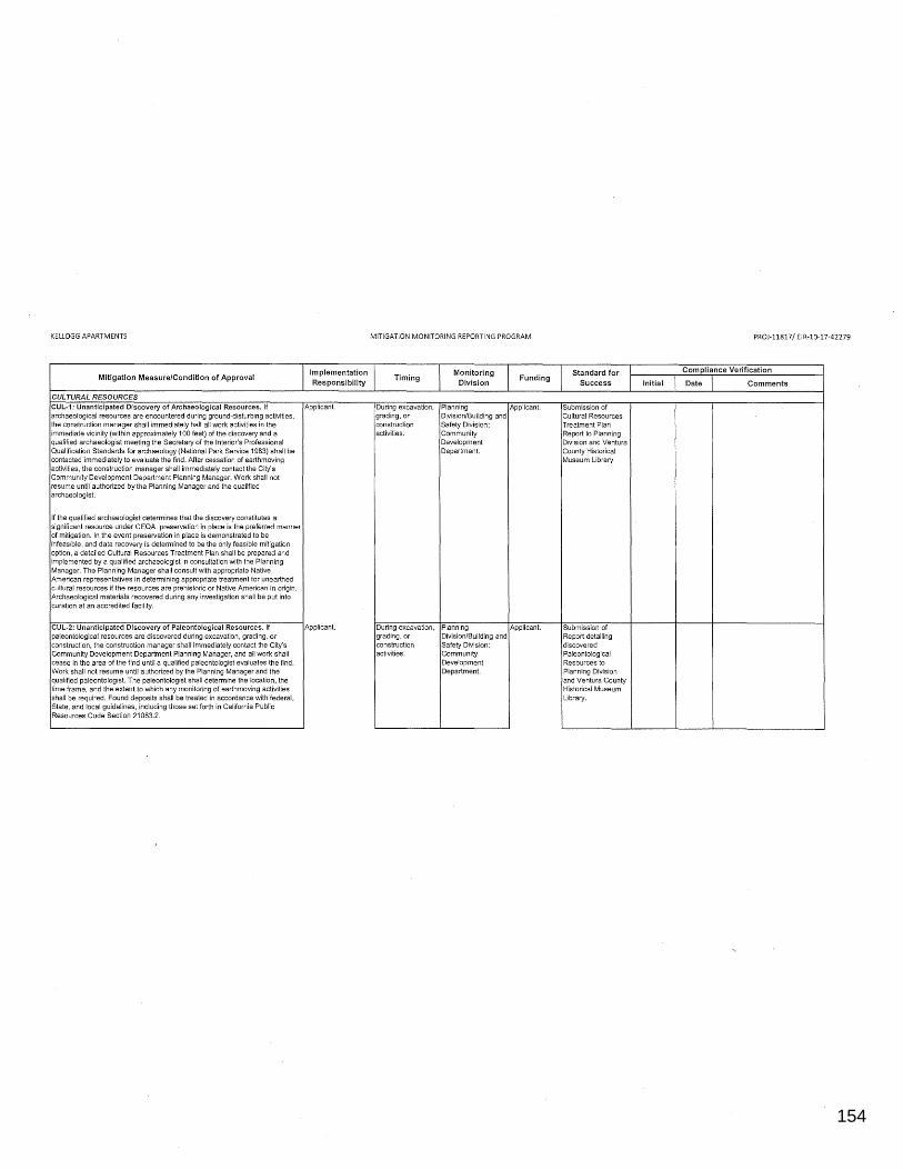
154
0123456789
KELLOGG APARTMENTS
Mitigation Measure/Condition of Approval
CULTURAL RESOURCES CUL-1; Unanticipated Discovery of Archaeological Resources. If archaeological resources are encountered during ground-disturbing activities, the construction manager shall immediately halt all work activities in the immediate vicinity (within approximately 100 feet) of the discovery and a qualified archaeologist meeting the Secretary of the Interior's Professional Qualification Standards for archaeology (National Park Service 1983) shall be contacted immediately to evaluate the find. After cessation of earthmoving activities, the construction manager shall immediately contact the City's Community Development Department Planning Manager. Work shall not resume until authorized by the Planning Manager and the qualified archaeologist.
If the qualified archaeologist determines that the discovery constitutes a significant resource under CEQA, preservation in place is the preferred manner of mitigation. In the event preservation in place is demonstrated to be infeasible, and data recovery is determined to be the only feasible mitigation option, a detailed Cultural Resources Treatment Plan shall be prepared and implemented by a qualified archaeologist in consultation with the Planning Manager. The Planning Manager shall consult with appropriate Native American representatives in determining appropriate treatment for unearthed cultural resources if the resources are prehistoric or Native American in origin. Archaeological materials recovered during any investigation shall be put into curation at an accredited facility.
CUL-2: Unanticipated Discovery of Paleontological Resources. If paleontological resources are discovered during excavation, grading, or construction, the construction manager shall immediately contact the City's Community Development Department Planning Manager, and all work shall cease in the area of the find until a qualified paleontologist evaluates the find. Work shall not resume until authorized by the Planning Manager and the qualified paleontologist. The paleontologist shall determine the location, the time frame, and the extent to which any monitoring of earthmoving activities shall be required. Found deposits shall be treated in accordance with federal, State, and local guidelines, including those set forth in California Public Resources Code Section 21083.2.
Implementation Responsibility
Applicant.
Applicant.
MITIGATION MONITORING REPORTING PROGRAM
Timing
During excavation, grading, or construction activities.
During excavation, grading, or construction activities.
Monitoring Division
Funding
Planning Applicant. Division/Building and Safety Division: Community Development Department.
Planning Applicant. Division/Building and Safety Division: Community Development Department.
Standard for Success
Submission of Cultural Resources Treatment Plan Report to Planning Division and Ventura County Historical Museum Library.
Submission of Report detailing discovered Paleontological Resources to Planning Division and Ventura County Historical Museum Library.
Initial
PROJ-11817/ EIR-10-17-42279
Compliance Verification
Date Comments
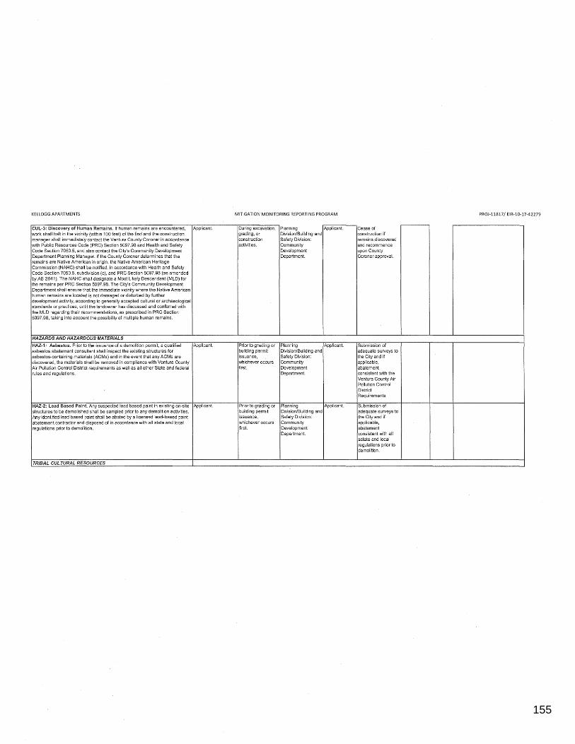
155
0123456789
KELLOGG APARTMENTS
CUL-3: Discovery of Human Remains. If human remains are encountered, Applicant. work shall halt in the vicinity (within 100 feet) of the find and the construction manager shall immediately contact the Ventura County Coroner in accordance with Public Resources Code (PRC) Section 5097.98 and Health and Safety Code Section 7050.5, and also contact the City's Community Development Department Planning Manager. If the County Coroner determines that the remains are Native American in origin, the Native American Heritage Commission (NAHC) shall be notified, in accordance with Health and Safety Code Section 7050.5, subdivision (c), and PRC Section 5097.98 (as amended by AB 2641 ). The NAHC shall designate a Most Likely Descendant (MLD) for the remains per PRC Section 5097.98. The City's Community Development Department shall ensure that the immediate vicinity where the Native American human remains are located is not damaged or disturbed by further development activity, according to generally accepted cultural or archaeological standards or practices, until the landowner has discussed and conferred with the MLD regarding their recommendations, as prescribed in PRC Section 5097.98, taking into account the possibility of multiple human remains.
HAZARDS AND HAZARDOUS MATERIALS
HAZ-1: Asbestos. Prior to the issuance of a demolition permit, a qualified Applicant. asbestos abatement consultant shall inspect the existing structures for asbestos-containing materials (ACMs) and in the event that any ACMs are discovered, the materials shall be removed in compliance with Ventura County Air Pollution Control District requirements as well as all other State and federal rules and regulations.
HAZ-2: Lead Based Paint. Any suspected lead based paint in existing on-site Applicant. structures to be demolished shall be sampled prior to any demolition activities. Any identified lead based paint shall be abated by a licensed lead-based paint abatement contractor and disposed of in accordance with all state and local regulations prior to demolition.
TRIBAL CULTURAL RESOURCES
MITIGATION MONITORING REPORTING PROGRAM
During excavation, grading, or construction activities.
Prior to grading or building permit issuance, whichever occurs first.
Prior to grading or building permit issuance, whichever occurs first.
Planning Applicant. Division/Building and Safety Division: Community Development Department.
Planning Applicant. Division/Building and Safety Division: Community Development Department.
Planning Applicant. Division/Building and Safety Division: Community Development Department.
Cease of construction if remains discovered and recommence upon County Coroner approval.
Submission of adequate surveys to the City and if applicable, abatement consistent with the Ventura County Air Pollution Control District Requirements
Submission of adequate surveys to the City and if applicable, abatement consistent with all satate and local regulations prior to demolition.
PROJ-11817/ EIR-10-17-42279
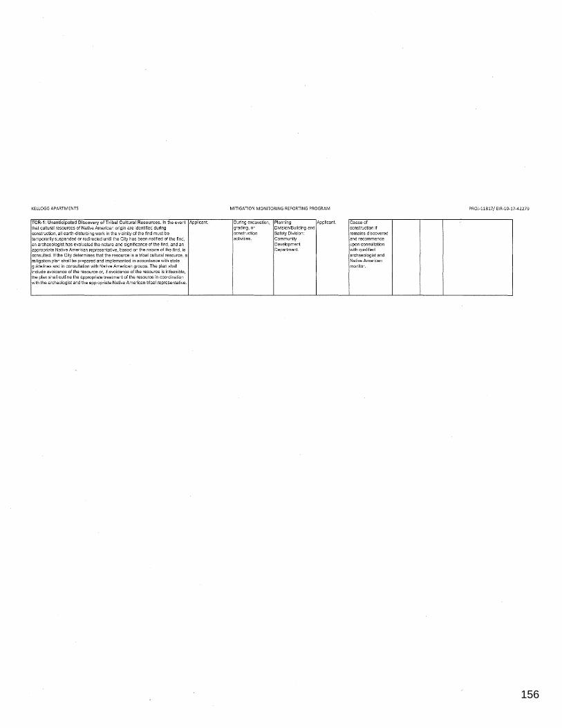
156
0123456789
KELLOGG APARTMENTS
TCR-1: Unanticipated Discovery of Tribal Cultural Resources. In the event Applicant. that cultural resources of Native American origin are identified during construction, all earth-disturbing work in the vicinity of the find must be temporarily suspended or redirected until the City has been notified of the find, an archaeologist has evaluated the nature and significance of the find, and an appropriate Native American representative, based on the nature of the find, is consulted. If the City determines that the resource is a tribal cultural resource, a mitigation plan shall be prepared and implemented in accordance with state guidelines and in consultation with Native American groups. The plan shall include avoidance of the resource or, if avoidance of the resource is infeasible, the plan shall outline the appropriate treatment of the resource in coordination with the archeologist and the appropriate Native American tribal representative.
MITIGATION MONITORING REPORTING PROGRAM
During excavation, grading, or construction activities.
Planning Applicant. Division/Building and Safety Division: Community Development Department.
Cease of construction if remains discovered and recommence upon consultation with qualified archaeologist and Native American monitor.
PROJ-11817/ EIR-10-17-42279


