Embed Size (px)
Citation preview
Landscape and Urban Planning 75 (2006) 198–226
The role of the spatial dimension within the frameworkof sustainable landscapes and natural capital
Thomas Blaschke
Z GIS, Centre for Geoinformatics, University of Salzburg, Hellbrunner Str. 34, 5020 Salzburg, Austria
Available online 23 June 2005
Abstract
A new paradigm of Natural Capital and Sustainable Landscapes has been suggested. It implies the integration of economic,environmental and social-cultural qualities in a physical setting while focusing on functions in terms of goods and services forpeople. Due to its anthropocentric perspective it pays less attention to landscape structure and spatial arrangement compared tothe widely applied patch-matrix concept. The matrix of land use elements provides the key to understanding land use systemsand land use changes and it can play an important role in understanding land use pattern and their dynamics. But one ofthe remaining constraints for a direct application of landscape ecological concepts in practice is the lack of agreed ways tocombine environmental, socio-economic and societal/cultural views. This paper examines both paradigms, asking: does thespatial arrangement of land use types add specific qualities beyond statistical measures of their existence and quantity? Forinstance, can a landscape be sustainable, as long as 20% of the land use is extensive, 10% is protection area, etc., no matter wherethe respective patches are, which typical size and shape they have, how connected patches are and how often incompatible landuse types are adjacent? This paper elucidates spatial concepts for sustainable landscapes with an emphasis on the role of GIS.©
K
1
1
feSfFf
c spa-
s caneal-ntalivid-the
apesics
tyandrst.
0
2005 Elsevier B.V. All rights reserved.
eywords: Sustainable landscape; Landscape planning; Landscape metrics; GIS; Landscape scenario; Leitbild
. Introduction
.1. Spatial constructs to decomposing complexity
Landscape ecology as a discipline has, in part,ocussed on the description of structure and pattern,specially through the use of Geographic Informationystems (GIS). These pattern descriptions are the basis
or the exploration of ecological mosaics (Turner, 1990;orman, 1995; Wiens, 1995; Turner et al., 2001) and the
oundation of a spatially explicit consideration of space
E-mail address: [email protected].
based on relatively homogeneous patches as basitial entities (Wiens, 1995; Gustafson, 1998). It is gen-erally believed that an area dissected into patchebe analysed and modelled more efficiently than ding with a complex system as a whole. Environmemanagement has predominantly focused on indual ecosystems but is increasingly confronted withproblem of managing and planning entire landscwhich often consist of complex, interacting mosaof different habitat patches and ecosystems (Potschinand Haines-Young, 2001). Generally, a complex entiis composed of different elements that interactcombine in a way that may not be obvious at fi
169-2046/$20.00 © 2005 Elsevier B.V. All rights reserved.doi:10.1016/j.landurbplan.2005.02.013

T. Blaschke / Landscape and Urban Planning 75 (2006) 198–226 199
Planners and environmentalists break down complexproblems into compartments (sectoral approach) orthemes (object-oriented or theme-oriented) accountingfor the fact that landscapes are spatially and function-ally heterogeneous, more so than ecosystems. Recently,models have been applied to the observed patterns andprocesses and research gradually moves from descrip-tion to statistical interference (Turner et al., 2001;Bissonette, 2003). Planners offer guidelines for futuredevelopments, informing the decision making process(Botequilha Leitao and Ahern, 2002).
Nature is complex. To partition complexity is defin-ing a typical human behaviour (Simon, 1962; Koestler,1967). For example, structural complexity may refer tothe compositional diversity and configurational intri-cacy of a system; functional complexity emphasizesthe heterogeneity and non-linearity in system dynam-ics; and self-organizing complexity hinges on theemergent properties of systems co-evolving with theirenvironment primarily through local interactions andfeedbacks at different spatiotemporal scales (Wu andMarceau, 2002). We can observe a shift of systems
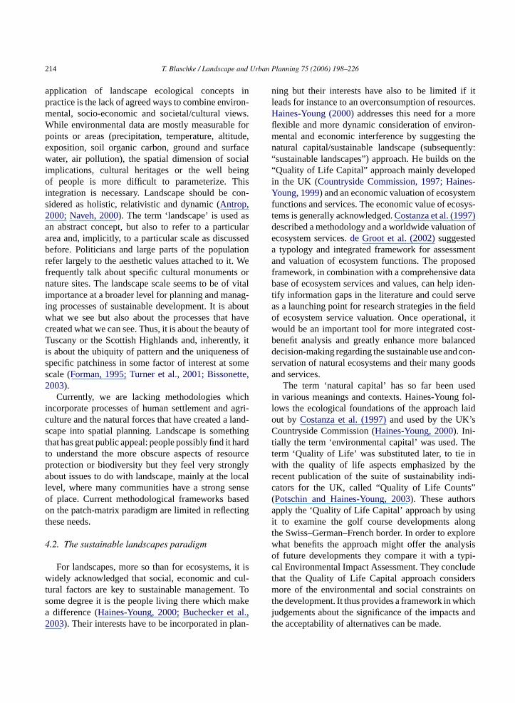
thinking in complex ecology (Peterson and Parker,1998): research increasingly deals with emergent prop-erties of non-linear adaptive landscape system, spatio-temporal complexity and chaos, scale (scale invarianceand covariance), hierarchy, cross-scale dynamics, andnon-linear physics based holistic landscape ecology.New methods such as coupled map lattice, non-linearthermodynamics-based Markovian model, multiscaleentropy analysis, self-assembling of networks, anddetecting noise-induced structures in spatiotemporaldata have been introduced (Brown et al., 2002). Theidea that the concept of complexity is inseparable fromperception depends on the scale of observation understudy. There is no scale for observing all phenomenaas illustrated inFig. 1.
In order to understand complex systems, it is oftenconvenient to consider a simpler system that exhibitsthe type of behaviour of interest (Simon, 1962). Insustainable landscape management we are mainly con-cerned with the notion of long term stability/resilienceand the fact that the domain of attraction of a stableequilibrium may depend upon slowly varying biophys-
F erent le gmentationl vels is r a certaina
ig. 1. Dissecting a remotely sensed image (a) into three diffevels and increasing numbers of segments. None of these lepplication and a given scale.
vels. The images (b) to (d) represent increasingly detailed se‘right’ or ‘wrong’ but might be appropriate or inappropriate fo
200 T. Blaschke / Landscape and Urban Planning 75 (2006) 198–226
ical parameters and fast changing human-induced dis-turbance (Botequilha Leitao and Ahern, 2002; Antrop,2003). This task is extremely difficult and we haveto look for easier approximations of these processes.Ludwig et al. (1997)demonstrated the complexityof the task to clarify the concepts of sustainabilityand resilience even for the subset of natural systems.Brown et al. (2002)describe recent progress and futureprospects for understanding the mechanisms of com-plex systems as power laws which express empiricalscaling relationships that are emergent quantitative fea-tures of biodiversity. One of the major issues of thispaper is the ability to take into account the multiplicityof (spatial) scales of study so that each phenomenonstudied at its specific level can be integrated throughhierarchically organised spatial concepts.
1.2. The landscape concept and spatial questions
Landscape refers to a common perceivable part ofEarth’s surface (Zonneveld, 1995). Land use is themost dynamic aspect. Crop rotation and changing landuse year after year is a ‘normal’ change and is notconsidered as a disturbance that breaks continuity.Changing land use in this manner seldom changes thewhole landscape and may even be a specific charac-ter of it. Landscape change does happen when grad-ually the land cover transforms to a new dominanttype and also causes structural change (Antrop, 2003).Another landscape will be formed when the new formso ento wsa arer usea phya ofla tc n then por-t oreat velyia taoa at-i t oft eds
and identify themselves with their everyday landscape(Buchecker et al., 2003). Social problems can be adirect consequence (and cause) of environmental prob-lems (Saunders and Briggs, 2002). Concepts, therefore,for sustainable landscapes should not only focus onsustaining the physical landscape resources, but theyshould also ensure quality of life of the people livingin the landscape.
For particular situations, examples exist to modelconsequences in the form of scenarios and impact mapsfor a particular scale. The impacts of economic forcesand environmental policies are difficult to forecast spa-tially due to the highly variable ecologies across regions(Webster, 1997) but ample studies demonstrate thepossibility to combine both a local and regional per-spective using a spatial framework (Dramstad et al.,1996; Hermann and Osinski, 1999; Botequilha Leitaoand Ahern, 2002). A good example is land abandon-ment in Europe which is due to severe changes inagricultural economics. This process is ongoing in largeparts of Europe but it is expected to be escalating overthe next years. The spatial patterns of these expectedsevere land use changes, affecting millions of hectaresof land, are important. The combination of GIS andspatial modelling tools will support research questionslike: “where will land abandonment happen if no pol-icy actions are set” or “which areas will be more or lessaffected if subsidies are increased or decreased”? Theidentification of risk zones may help planners at local,regional and national levels, to focus their activities onp eenl le ofm othe ntiala ichi h asr tion,e eta-t untt
1
enta-t melym alitya fort , and
f land use demand larger fields, special treatmf the soil, terrain levelling, removal of hedgerond new enlarged roads. Change and continuityelated to speed and magnitude of the overall landnd land organization. The use of aerial photografter the Second World War stimulated the study
andscape in a broader multidisciplinary field (Formannd Godron, 1986; Zonneveld, 1995). Theories abouhanges were developed and the human impact oatural environment is considered as the most im
ant factor of change nowadays, acting more and mt a global scale (Goudie, 2000). It is widely agreed
hat people living in the landscape must be actintegrated in the landscape planning process (Formannd Collinge, 1997; Volker, 1997; Botequilha Leind Ahern, 2002). If the residents do not have s
sfying opportunities to influence the developmenheir landscape they might no longer fulfil their ne
roblem areas and to differentiate strategies betwow-potential and high-potential areas. The examp
odelling land abandonment certainly includes bcological and economic aspects. Risk and potere typically envisaged through additive models wh
ndicate areas of superimposition of factors sucecent and historic land use, areas of legal restricnvironmental parameters on topography, soil, veg
ion, or land use. Usually, they do not take into accohe quality of life of the residents.
.3. Objectives of this paper
This paper puts an emphasis on spatial represions in the context of sustainable landscapes, naaps and representations incorporating tempornd dynamic modelling which are important tools
he analysis of landscape ecological processes
T. Blaschke / Landscape and Urban Planning 75 (2006) 198–226 201
for the visualization of alternative land-use scenarios.Many social and economic data are only available forcertain administrative levels. The availability of spatialdata in digital form is a prerequisite in landscape analy-sis, to monitor landscape change and to evaluate land-scape functions. GIS offer powerful tools for spatialanalysis (Openshaw and Clark, 1996; Longley et al.,2001) but are not exclusive to model complex systemsspatially. GIS is both a toolbox and methodology atthe same time (Pickles, 1997). It needs methodologiesto integrate qualitative and quantitative informationacross spatial and temporal scales. The sophisticationand usefulness of GIS is not necessarily proportional tocomplexity but it is hypothesized that they are in prin-ciple codifying and empowering human understandingof nature.
Haines-Young (2000)suggested a new paradigm forlandscape ecology based on the concept of natural cap-ital: sustainable landscapes. It reflects the increasedhuman influence on landscapes and the increasingdemand to reveal the human population as part of thelandscape. Haines-Young claims that current landscapemodels are mainly science-based and that these mod-els cannot define in any complete sense an optimal orsustainable landscape. He argues that in order to dealwith landscape sustainability we must recognise thatin any situation there is a whole set of landscapes thatare more or less sustainable, in terms of the outputs ofgoods and services that are important to people. In thispaper, I critically discuss this concept, the underlyingi nd It iallye n,1
s inl der-s achesa nalc entp cales kesa f thes hesb gh-o apep , inp pitala
2. The ‘landscape concept’ and some ecologicalconcepts with relevance to ‘SustainableLandscapes’
2.1. Landscape change: decoupling‘sustainability’ and ‘development’
Humanity has influenced and dramatically changedat least 90% of Earth’s landscape (Naveh, 2000;Sanderson et al., 2002). The influence of human beingson the planet has become so pervasive that it is hardto find adults in any country who have not seen theenvironment around them reduced in natural valuesduring their lifetimes. This includes woodlots con-verted to agriculture, agricultural lands converted tosuburban development, suburban development con-verted to urban areas (Sanderson et al., 2002). Thecumulative effect of these many local changes is theglobal phenomenon of human influence on nature, anew epoch some call the “anthropocene” (Steffen andTyson, 2001). The patches created (see below) mayalready depend more on human actions than on nat-ural ecological conditions. In cultural landscapes theecological and socio-economic realms are intricatelylinked. We need concepts to predict and to managefuture land use but we are just beginning to param-eterize issues related to the new economy, changinglifestyles and different priorities in land consumption.
The concept of ‘Sustainable Development’ is rela-tively well known and often serves as a guideline ins s-mi ther,I and( age-m and‘ hatw t wes lop-m ity,b ore,f dif-f nt cani form sticc n asi ity’
deas of ecosystem functions and their valuation aake up the challenge to juxtapose it to the spatxplicit patch-matrix concept (Forman and Godro986).
This paper discusses several leading issueandscape science. Namely the importance of untanding concepts, research and applied apprond methods with respect to their informatioharacteristics and the potentials for developmrovided by the recently emerged arena of multi-segmentation/object-relationship modelling. It macase for this, demonstrating the significance o
patial, and the limitations of statistical approacased mainly around a patch-matrix model. Throuut I aim to link these issues to ones of landscolicy planning and sustainable managementarticular the assessment approach of natural capplied to sustainable landscape planning.
patial planning (Volker, 1997; Webster, 1997; Grosann, 2000; Botequilha Leitao and Ahern, 2002). It
s not comprehensively discussed in this paper. Raconcentrate on spatial aspects of sustainability
spatial) indicators for sustainable landscape manent. First, I suggest decoupling sustainability
development’. Decision makers have to decide we must adapt to, what we must try to control, whahould alter, and what we should leave as is. Deveent is often implicit in the concept of sustainabil
ut the goal is no longer progress in the sense of murther and higher, but a new and qualitativelyerent set of aims (Grossmann, 2000). Depending ohe initial situation, development towards this goalnvolve quantitative increase (as will be the case
ost of the world’s less developed nations), or drautbacks in material flows and resource consumption most industrialized countries. When ‘sustainabil
202 T. Blaschke / Landscape and Urban Planning 75 (2006) 198–226
and ‘development’ are intrinsically coupled togetherthis implies that there is ‘change’. These changes leavefootprints on Earth’s surface and we will be able todetect and measure the resulting change within theenvironment. The whole human centred concept of sus-tainability is centred on the well being of humans,namely to enhance and maintain the well-being offuture generations, individuals and communities. Land,and the uses to which it is put, are influenced by almostevery area of policy and by every sector of the econ-omy. Conversely, changes in the land have widespreadimpacts elsewhere, for example, on water quality, onamenity and on nature.
2.2. Spatial matters: natural resource accountingand indicators
Neither increasing nor decreasing resource con-sumption will automatically lead to a ‘sustainablelandscape’. For instance, decreasing land use inten-sity through land abandonment processes will not hap-pen spatially randomly, it might increase or decreaseexisting disparities in resource consumption. In highlyhuman-influenced landscapes this process must beplanned and its methods must be explicit and repli-cable (Forman and Collinge, 1997). This is particu-larly relevant in the era of GIS-based spatial analysis,through which methods and procedures can be sub-jected to rigorous tests of accuracy and replication. AGIS-based planning process is regarded to be explicita goalsa ,a ertp lter-n 997;B ess,2
The concept of sustainable landscapes does notfocus on the analysis of a status quo. It is about whatlandscapes of the future will look like and how will theyfunction, based on our understanding of current envi-ronmental and human conditions. This paper highlightsthe ‘spatiality’ of the underlying questions of sustain-able land use without neglecting the role of partici-patory approaches: what spatial patterns and processeswill be evident, assuming expected global, regional andlocal conditions? Only a spatial framework offers foun-dation for providing answers to these questions: “Thespatial solution is a pattern of ecosystems or land usesthat will conserve the bulk of, and the most importantattributes of, biodiversity and natural processes in anyregion, landscape or major portion thereof” (Formanand Collinge, 1997, p. 129). Consequently, evaluat-ing sustainability cannot be performed ‘a-spatially’. Bythis, I mean it cannot be performed on administrativeunits based on statistical reports and national statis-tics. What is needed is a regionalisation of statisticsthrough an integration of various types of information(measurements, sample data, areal data).
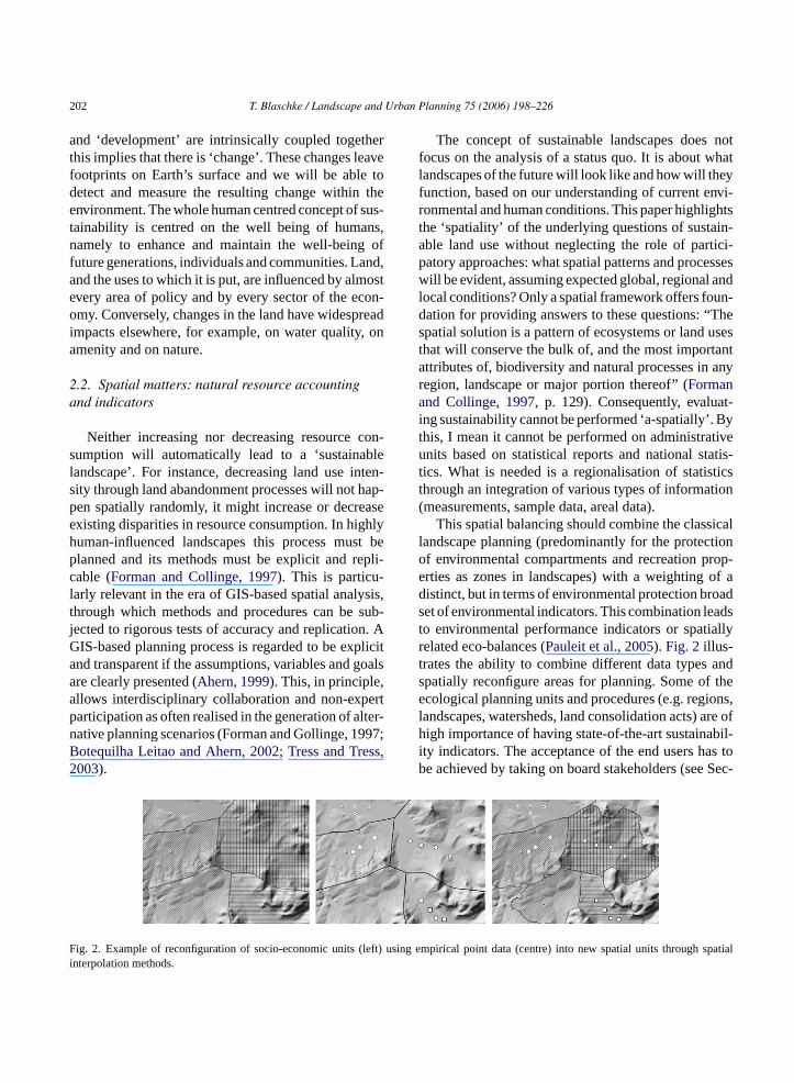
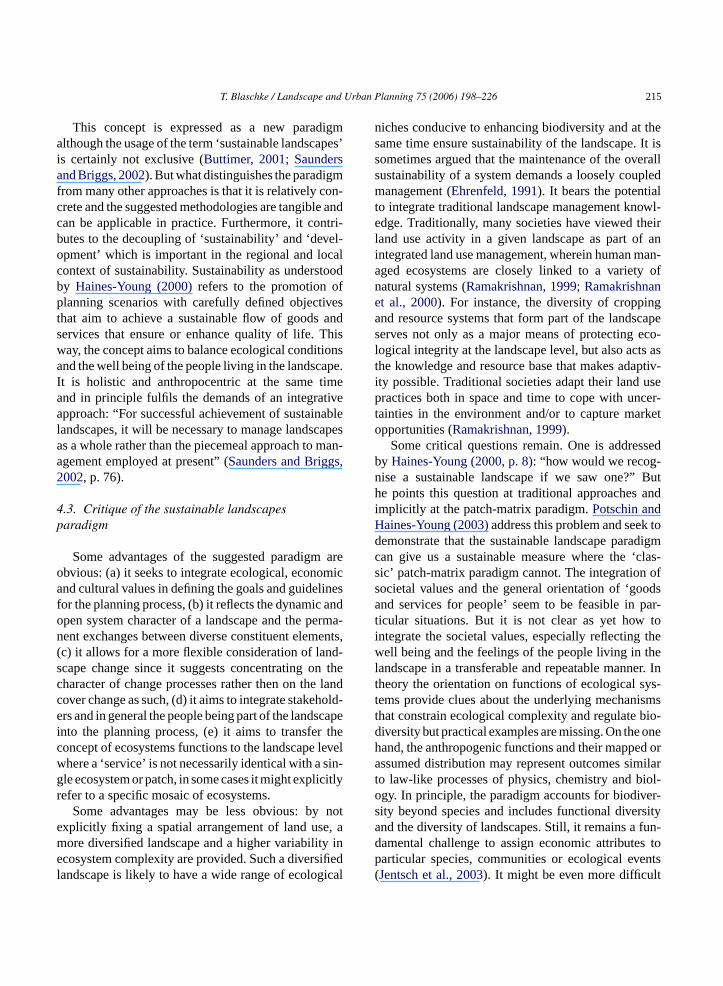
This spatial balancing should combine the classicallandscape planning (predominantly for the protectionof environmental compartments and recreation prop-erties as zones in landscapes) with a weighting of adistinct, but in terms of environmental protection broadset of environmental indicators. This combination leadsto environmental performance indicators or spatiallyrelated eco-balances (Pauleit et al., 2005). Fig. 2 illus-t ands thee ions,l are ofh bil-i as tob Sec-
F eft) us h spatiali
nd transparent if the assumptions, variables andre clearly presented (Ahern, 1999). This, in principlellows interdisciplinary collaboration and non-exparticipation as often realised in the generation of aative planning scenarios (Forman and Gollinge, 1otequilha Leitao and Ahern, 2002; Tress and Tr003).
ig. 2. Example of reconfiguration of socio-economic units (lnterpolation methods.
rates the ability to combine different data typespatially reconfigure areas for planning. Some ofcological planning units and procedures (e.g. reg
andscapes, watersheds, land consolidation acts)igh importance of having state-of-the-art sustaina
ty indicators. The acceptance of the end users he achieved by taking on board stakeholders (see
ing empirical point data (centre) into new spatial units throug
T. Blaschke / Landscape and Urban Planning 75 (2006) 198–226 203
tion 5). The need to report regularly on the state ofthe environment at the local, national and internationallevels has become a preoccupation for a number oforganizations (Haines-Young, 1999). But we lack spa-tial approaches to differentiate sustainability in practicein order to maximise natural economic effectivenessand efficiency and maintain a necessary balance amongresource accessibility, requirements, and capacity tomeet requirements.
There is an increasing need for indicators whichcapture the links between the economic, socialand environmental dimensions.Haines-Young (1999)highlighted the merits of the ‘indicator approach’ com-pared to one based on natural resource accounting. Heargued that, for ‘State of the Environment’ reporting tobe effective, it must embody a model that describes theprocesses of land use/land cover change. The indicatorapproach, as currently employed by several Europeancountries, is a relatively loose framework for achievingsuch a systematic view mainly based on land cover.Technically, the challenge lies in the integration of‘hard’ (measured, mapped, interpolated) and soft data(e.g. well-being of people living in a landscape), of spa-tially explicit measurable data and vague but importantconcerns of people living in landscapes. Methodologi-cally, different scientific areas and sub-models are to beincorporated, so that it is possible to predict and evalu-ate the environmental outcomes of alternative coursesof action for policy. GIS provide the analytical tools andmethodologies for spatial integration of the differents ani-z ribet f thec hipsw apeaG 00;T
2r
ntialt ning( andA la-t foref 3
A common proposition leading to the patch-matrix(-corridor) paradigm (Forman and Godron, 1986; For-man, 1995; Wiens, 1995), is that landscapes are con-sidered to be mosaics of smaller entities, mostly calledpatches, which are relatively homogenous in a sensethat the ‘within-patch-heterogeneity’ of some phe-nomena under consideration are less than the differ-ences to its surroundings. The patch-mosaic paradigmevolved rapidly in North America (Krummel et al.,1987; O’Neill et al., 1988) and dominates landscaperesearch (Bastian, 2002; Wu and Hobbs, 2002). Euro-pean schools of landscape ecology developed differentapproaches, e.g. the large scale analysis methodologyin the German Democratic Republic with its conceptionof natural landscape units, called geochores. The geo-chores as geographically defined units were regarded asassociations or mosaics of basic topic elements. Tope ortopic refers to a particular locality. One important fea-ture of these geochores is their heterogeneous structure.The properties of choric spatial units result from theassociation of combinations of topic elements, as wellas their arrangement in space. Finally, on a higher levelof aggregation, geochores have new properties beyondthe mere sum of the parts and are regarded as func-tional regions. Both approaches, the ‘North American’and the ‘Central European’, focus on spatial hetero-geneity and regard it as a measurable expression ofthe overall spatial complexity or variety of an area.Both approaches rely on mappable basic spatial unitsat a given scale. “Nanochores have a simple pattern ofa eousf eent
tern:b ught vari-e it isr tialv tiono tch-m land-s xacta levelb neityi ousa scaper hed:t nti-
cientific areas and sub-models. The spatial orgation of the composing elements is a key to desche functions and processes within a landscape. Iomposition changes their connecting relationsill change too, since the functioning of a landscnd its structure are intimately related (Forman andodron, 1986; Dramstad et al., 1996; Antrop, 20urner et al., 2001; Nagendra et al., 2004).
.3. Spatial heterogeneity and establishingelatively homogeneous spatial units
Ecosystem structure and function are esseo understanding in sustainable landscape planForman, 1995; Ahern, 1999; Botequilha Leitaohern, 2002). The understanding of the dynamic re
ionship of landscape pattern to process is thereundamental (Turner et al., 2001; Bissonette, 200).
rrangement of the topes with a nearly homogenorm of spatial relations and interlinkages betwhem” (Haase, 1989, p. 31).
Patchiness refers to a particular spatial patounded elements in a background matrix. Altho
he specific arrangement of patches may take aty of forms, the basic structure is the same, andelatively well-defined. In contrast, any form of spaariation, from an unbounded gradient to a collecf various patch types (and including a simple paatrix system) is heterogeneous. For sustainable
capes it is concluded that we do not know the emount of heterogeneity necessary at a landscapeut we assume that a certain degree of heteroge
s needed. The delineation of relatively homogenereas is a prerequisite for most approaches in landesearch. Two main approaches can be distinguiso optimize homogeneity or to concentrate on disco

204 T. Blaschke / Landscape and Urban Planning 75 (2006) 198–226
nuities assuming that the areas between discontinuitiesare relatively homogeneous. Since the 1970s, dozensof techniques have been proposed for edge detectionin remote sensing and GIS data sets (Pitas, 1993). Sig-nificant progress has been achieved in image analysiswith a focus on edge enhancement (visually empha-sizing the boundaries in a picture) and edge detection.In remote sensing, heterogeneity is often reduced to‘texture’. Texture can be characterized e.g. through astructural approach, an image is assumed to be com-posed of primitive elements (pixels) that can be charac-terized in groups by their shape and size as well as theirpattern of repetition. However, because image process-ing encounters problems similar to those met in fieldecology (i.e., misclassification or unclear repetitive pat-terns) statistical approaches are often preferred includ-ing autocorrelation functions, autoregressive models,spatial intensity co-occurrence probabilities, and struc-tural element filtering in field data, for reducing noiseand for the ability to detect small edges (Fortin etal., 2000). Alternative approaches to overcome theproblem of scale-dependency include fractal geometry(Krummel et al., 1987; Milne, 1988) or lacunarity anal-ysis (Plotnick et al., 1993; MacIntyre and Wiens, 2000).
2.4. Landscape, scale and hierarchy
Scale is a key issue in sustainable planning (Ahern,1999). Conventionally, the hierarchy of scales (Allenand Starr, 1982) refers to organizational levels: cell,o ome,a osys-t nes as s ana ing( glyp -s 002a s andm rob-l ales( 2I apep s andp withw ringi ;A l-
ing and downscaling techniques (Hay et al., 2001; Wu,2004). For example, contrast properties of heteroge-neous habitat template in general compared to hetero-geneity of a template defined at a particular scale arescale-independent, but heterogeneity of a specific tem-plate is scale-dependent and changes with altered scale(Kolasa and Rolo, 1991). Generally, extrapolation ofexperimental results from fine to broad spatial scalescan be fraught with problems (Murphy, 1989). Whilefine-scale experiments may yield some useful informa-tion of relevance to broad-scale processes, its validity inbroad-scale contexts must always be carefully assessed(Hobbs, 1999).
For several understandable reasons, landscape ecol-ogists and planners highlight ‘the landscape scale’which refers to a particular geographic extent (Laversand Haines-Young, 1993). It is said to be appropriate forsustainable planning (Ahern, 1999) because it is suffi-ciently large enough to contain a heterogeneous matrixof landscape elements that provide a context for mosaicstability (Forman, 1995). Ecologists discuss more crit-ically the term landscape scale, especially if it is usedsynonymously with the term ‘landscape level’ (Allen,1998; King, 1999). King (1999)and other ecologistsreject the hypothesis that there is a ‘landscape scale’and that a particular scale is inherent to the concept ofa landscape. But landscape planning needs a particularscale which corresponds to a ‘window of perception’(Hay et al., 2001). Lavers and Haines-Young (1993,p. 65)provide a relative flexible definition: “The ‘land-s thep ele-m
areg withd nes.K ct-i gu-lM andc reso-l nlyr atials i eta ota thes earchq y
rganism, population, ecosystem, landscape, bind biosphere. Due to the interdependencies of ec
ems, a planning approach is needed that examiite in its broader context. The landscape providepproximately useful context for sustainable plannForman, 1995). Scale and scaling became increasinopular in ecology in recent years (Allen, 1998; Peteron and Parker, 1998; Marceau, 1999; Hay et al., 2)s research has shifted from local to broader scaleany environmental and resource management p
ems can only be dealt with effectively at broad scAhern, 1999; Botequilha Leitao and Ahern, 200).n order to develop fuller understanding of landscrocess we must understand broad-scale patternrocesses and relate them to those at fine scaleshich we are most familiar. In both cases, transfer
nformation between scales is essential (Wiens, 1995llen, 1998; Wu, 1999) but difficult. It requires upsca
cape scale’ is simply that at which one considersattern and interaction between the various mosaicents of patch, edge and corridor”.Holling (1992) demonstrated that landscapes
enerally structured according to scaling regionsistinct dimensions connected by transition zorummel et al. (1987)developed a method for dete
ng distinct scales of pattern for mosaics of irrear patches using fractal analysis (Mandelbrot, 1983).
ost appropriate methods to detect discontinuitiesharacterize boundaries depend of the spatialution and the measurement type of the data. Oecently, methods were developed to detect spcales (Lindeberg, 1994; Fortin et al., 2000; Grossl., 2001; Hay et al., 2002) but these methods are nble to explain hierarchical relationships betweencales. Certain scales are related to specific resuestions and vice versa (Table 1). Hierarchy theor
T. Blaschke / Landscape and Urban Planning 75 (2006) 198–226 205
Table 1Different levels of investigation, related research questions and example methods with an emphasis on the landscape level
Scale Research question Methods and indicators
Landscape level Landscape diversity Indices of landscape patternsHistoric reference conditionsRemote sensing and GIS
Habitat availability and distribution Indices of landscape patternsHistoric reference conditionsRemote sensing and GIS
Changes in landscape elements Indices of landscape patternsHistoric reference conditionsRemote sensing and GIS
Community or ecosystem level Management actions or natural disturbanceaffects on species diversity
Species diversity indices
Function of species in community or ecosystem Functional group and guild analysisLevel of protection in areas with high species richness e.g. Gap analysis
Species/population level Species-population trends Abundance indicesPopulation estimates
Anthropogenic or natural disturbance Abundance indicesPopulation estimates
Probability of species or population persistence Population viability analysis
Genetic level . . . . . .
. . . . . .
(Koestler, 1967; Allen and Starr, 1982; O’Neill et al.,1986) is a way of ordering observational scales in away that draws attention to the mechanisms and con-straints that operate at a given level and how thesechange among levels. The theory does not maintain thatevery ecological system must necessarily be hierarchi-cal. Rather, it points out that stable complex systemsoften take on such a structure (O’Neill et al., 1986).Hierarchies, however, are artificial constructs that weimpose on nature: we categorize phenomena into levelsthat are logically related (Burnett and Blaschke, 2002).These categories cannot reflect the true complexity ofinteractions within natural systems. Hierarchical levelsmay be seemingly clearly defined when we are dealingwith units such as cells, organisms or populations, butthey are not intuitively apparent when we are dealingwith spatial variation.
2.5. Landscape composition and ecosystemfunctions
The complexity of landscapes is largely determinedby the number of ecosystem types, their characteris-tics (e.g. in terms of structure and functioning), theirsize and shape, and their connectivity (Forman, 1995).
A large amount of evidence suggests that complexityat the landscape scale may have large consequenceson regional to global scale processes. For instance,the presence and arrangement of keystone ecosystemtypes such as wetlands or riparian areas often deter-mine total carbon and nitrogen balance of a region.Arising research questions include: (i) what effect doeslandscape complexity have on ecosystem functioningat large scales? (ii) how do these relationships betweencomplexity and functioning vary with ecosystem pro-cesses of interest? and (iii) how will global changeaffect landscape complexity, and in turn ecosystemfunctioning?
Ecosystem functions are divided into four cat-egories according toDe Groot (1992): regulation,habitat, production and information functions.Markset al. (1992)developed a conceptual framework andpractical guidelines for the assessment of the fulfilmentof specific functions by a particular landscape. Afunction of a given landscape unit is understood as theperformances and tasks the landscape ecosystem isfulfilling. Their concept is based upon experiences ingeoecological mapping. Complex ecosystem processescan be divided into the transfer of matter and energyacross landscapes and between the land surface and
206 T. Blaschke / Landscape and Urban Planning 75 (2006) 198–226
the atmosphere. Examples of such processes includebiogeochemical cycles, surface hydrology and water,and energy exchange. They deal with the interaction oflandscape patterns and regional disturbance regimes.For example, landscape patterns influence the spread offire and the probability of logging, which in turn governlarge-scale ecosystem functioning. Although matterand energy exchange, movement of organisms, anddisturbance are treated largely independently, there areinteractions between them (e.g., migration across land-scapes of new functional types which affect nutrientcycling and probability of fire). Changes in the struc-ture of the landscape can have ecological effects suchas modifying nutrient transport and transformation(Hobbs, 1993; Mander et al., 2000) and affectingspecies persistence and biodiversity (Dale et al., 1994;Opdam et al., 2003; Jentsch et al., 2003). Whileecosystem processes are more and more understood,we have little knowledge about the material and energyflows between ecosystems and how the arrangementof ecosystems in space control the ecological patternsand processes that result.
3. Spatial analysis and the spatial dimension ofsustainable landscapes
3.1. GIS
In the late 1980s and throughout the 1990s researchf nese omeo n intM rnere ics( t-i cI 8;L vel-o hicI ;L yt enab rig-i ndp sed,m that
incorporate spatial variation by allowing individualcells in a spatial grid to undergo dynamics that arespatially linked in various ways. Cellular automata areone version of such models, and some individual-basedmodels incorporate a spatial dimension as well (e.g.Takeyama and Couclelis, 1997). Much of the recentgrowth in spatial theory has involved elaborationand extension of patch-based population models (e.g.metapopulation theoryHanski and Simberloff, 1997).The development of certain new, specialized statisticalmetrics has been motivated by the emerging field oflandscape ecology, which focuses on spatial processesoperating over various spatial extents (Forman andGodron, 1986; Krummel et al., 1987; Turner, 1990).
Patch-based population theory has developed inseveral ways and a variety of patch arrangementsand interactions have been incorporated into models(Turner et al., 2001) but also spatially explicit indi-vidual based models are readily available today (e.g.Topping and Jepsen, 2002). They are by no meansrestricted to ecological parameters: innovations insimulation have been supported by conceptual devel-opments in articulating dynamics and complexity andtechnical developments in GIS and object-oriented pro-gramming, coupled with increases in the availabilityof high-resolution data sets. These models emphasizespatial, disaggregated, flexible, dynamic, and morerealistic approaches for example to modelling urbansystems (Batty and Torrens, 2001). With theoreticalroots in artificial life, non-equilibrium physics andc ulti-a imu-la tiono tated wth)w telya on,p eset icitt icaleFa
s ane buta tives( 00;
rameworks and applications in various disciplivolved which emphasize spatial relationships. Sf this growth has led to increased sophisticatio
he description of spatial patterns (McGarigal andarks, 1994; Forman, 1995; Gustafson, 1998; Tut al., 2001), aided by more powerful spatial statistLiebhold and Gurevitch, 2002), techniques for detecng patch boundaries (Fortin et al., 2000), Geographinformation Systems (Burrough and McDonnell, 199ongley et al., 2001) and remote sensing. These depments led to the foundation of Geograp
nformation Science (‘GIScience’,Goodchild, 1992ongley et al., 2001). The power of a GIS is its abilit
o synthesize information about spatial phenomy integrating geo-referenced data to show the o
nal data and derived information in new ways aerspectives. As computational power has increaodellers have developed simulation models
omputational economics, cellular automata and mgent systems are being rapidly developed for s
ating cities (Torrens and O’Sullivan, 2001). Cellularutomata are generally well suited to the simulaf urban infrastructure (land-use transition, real esevelopment and redevelopment and urban grohile multi-agent systems are more appropriapplied to population modelling (residential locatiedestrian movement and traffic simulation). Th
ools all enhance our ability to test spatially explheory and are powerful tools to analyse ecologvents in a spatially explicit framework (Grimm, 1999).or a critical review of spatial statistics seeOpenshawnd Clark (1996)or Liebhold and Gurevitch (2002).
GIS have emerged over the last 20 years affective tool not only for analysing spatial datalso for evaluating resource management alternaHermann and Osinski, 1999; Kangas et al., 20

T. Blaschke / Landscape and Urban Planning 75 (2006) 198–226 207
Appleton et al., 2002; Seppelt and Voinov, 2002). Oneof its strengths is that it allows us continually to recon-figure the data in ways that are most appropriate forour changing needs and points of view. Spatial statis-tics tend to perform the same sort of task, but in amore abstract way, allowing us to make generalizationsabout what we see in the data, to extract hypothesesfrom them, or, finally, to use them to test hypothe-ses. This is a positive view on the potential of GIS.In reality, in many cases data are simply stored andprocessed in a GIS centred around the patterns of landcover and land use, and of social, economic, and demo-graphic characteristics. But these conditions constantlychange, both because the spatial structures representedare themselves inherently unstable, and because theyare typically exposed to external phenomena that alsoforce change. Today, environmental data collectionprogrammes are designed for periodic data collectionand updating, typically in a manner that provides a reg-ularly updated picture of current conditions. Plannersand decision makers need to know not only the cur-rent state of affairs but also require some idea of futureconditions. Ideally they would like to be able to see thepossible consequences of the plans and policies theymay have under consideration. This is often realised ina finite set of scenarios or through one of the many dif-ferent predictive computational modelling techniquesavailable (Seppelt and Voinov, 2002). The latter mainlyuse regular tessellations like regular grids or latticesand support the search for ‘optimal’ spatial decisions( 00;S
urcesf ellitei ausev ithv iquec nd-s ternsa , likea ringo irroroa ti hert erys fromh nal
information extraction from raw data exist (Blaschkeand Strobl, 2001). Forest inventory and agricultureroutinely use information from satellites and thesetechnologies are built into scenario development. But,for example, surveys of past processes remain largelyoutside the investigative capacity of recent spatialtechnologies.
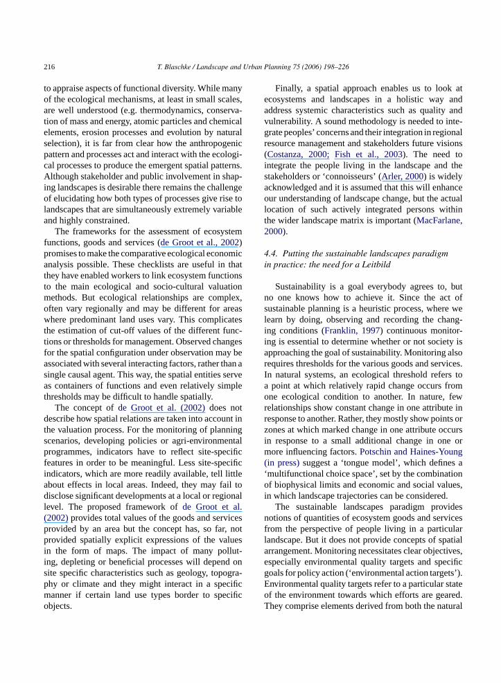
3.2. Landscape analysis and spatial indicators
Data on land use, land use intensity and land usediversity are important indicators for sustainable landmanagement. Many spatial indicators are only suited todescribe specific aspects of spatial patterns. The com-mon indicators are often called ‘landscape metrics’(Gustafson, 1998; Blaschke, 2000; Botequilha Leitaoand Ahern, 2002). A better way would be to distin-guish between metrics (neutral values) and indicators(some meaning attached to it through definition andpossible range). An initial and seemingly straightfor-ward question is whether the patterns of two maps aresimilar (seeFig. 3). The palette of geostatistical tools toanswer this is powerful today but, like classic statistics,is not automatically protected against pseudo correla-tions. Approaches include autocorrelation analysis orthe use a polygon-by-polygon comparison, in whichvarious characteristics of the polygons can be com-pared, starting with the extent to which polygons on onemap coincide with those on the other, but also includ-ing other measures of polygon similarity such as sizea ics isa ilityh reaso gri-c ve tod s, ifw icts,w l useo ong-t ken( rnere aoa
dexo dja-c cribec 7;G of
Martinnez-Falero et al., 1998; Makowski et al., 20eppelt and Voinov, 2002).Remotely sensed images are essential data so
or landscape analysis. Aerial photography and satmagery are useful in characterizing landscape becariation in the image is usually highly correlated wariation in the landscape. No other survey technan operationally provide a regularized survey of lacape with which to assess landscape level patnd change. However, remotely sensed imagesll observations of reality, are an imperfect captuf patterns, which are themselves an imperfect mf ecosystem and human-induced processes (Burnettnd Blaschke, 2003). Until recently, most effort wen
nto the exploitation of pixel characteristics rathan into the exploration of pattern and only for vpecific purposes (e.g. automated road extractionigh-resolution imagery) applications of operatio
nd compactness. An example for landscape metrdjacency. If we analyse in the context of sustainabow much neighbouring conflicts (e.g. between af high nature conservation value and intensive aultural use) a certain area is opposed to, we haefine thresholds of potential impact. In other worde are able to set thresholds for these spatial confle have the tools at hand for determining a rationaf existing resources that anticipates the possible l
erm effects on the environment of the decisions taHermann and Osinski, 1999; Blaschke, 2000; Tut al., 2001, Appleton et al., 2002; Botequilha Leitnd Ahern, 2002; Verburg et al., 2004).
Interspersion/Juxtaposition Index, Contagion Inr Cohesion Index and other indices compare aency frequencies between classes and desonnectivity (Schumaker, 1996; Wu et al., 199ustafson, 1998). A variety of examples exist, many
208 T. Blaschke / Landscape and Urban Planning 75 (2006) 198–226
Fig. 3. Selected landscape indices describing two different subsets of a habitat map. The map is aggregated in a binary classification withblack colour indicating suitable habitat. Both subsets comprise about 70% non-suitable area (white) and 30% black areas. Only few indices aresensitive to changes in pattern.
them exhibit a very simple method of counting edgesand patches. The amount of edge between each landuse is usually determined by summing the number ofinterfaces between adjacent cells of different land uses,then multiplying by the length of a cell or by usingpolygon data to represent the land uses and measuringadjacency directly. The amount of edge between all cat-egories can be statistically analysed and may provideinsights regarding the degree of convolution of edgesand consequently about the potential for species disper-sion from a patch since in general a straight boundarytends to have more species movement along it, whereasa convoluted boundary is more likely to have move-ment across it (Forman, 1995; Dramstad et al., 1996.).The complexity of patch perimeters is measured usingfractal dimensions (Mandelbrot, 1983), which can beused to compare the geometry of landscape mosaics(Milne, 1988). Some problems with landscape metricsare illustrated inFig. 3. The two graphics exhibit atotally different appearance even if both classes (forthe sake of simplicity aggregated to black and whiteclasses ‘suitable habitat’ and ‘not-suitable habitat’)cover about 30% suitable habitat (black) in both imagesbut only few metrics react to these differences (Wu
et al., 1997; Hargis et al., 1998; Tischendorf, 2001; Wu,2004). Another often underestimated problem is the‘study area bias’ (Blaschke and Petch, 1999): depend-ing on the delineation of the study area boundariessignificant differences may occur (Saura and Martinez-Milan, 2001).
What have been described so far are mainly descrip-tive, structural indicators which measure the physi-cal composition or configuration of the patch mosaicwithout explicit reference to an ecological process.Resulting figures are of limited use in the context ofsustainable development, but landscape indices havebeen applied to compare heterogeneity between dif-ferent landscapes (O’Neill et al., 1988; Turner, 1990;Hulshoff, 1995; Pan et al., 1999), to predict responsevariables of ecological processes (Wiens et al., 1993;Schumaker, 1996; Mander et al., 2000) and specificaspects of the survival of populations in heterogeneouslandscapes (Dale et al., 1994; Wiens et al., 1997; Withet al., 1997; Fahrig, 1998).
Many studies revealed significant statistical rela-tionships between landscape indices and dependentvariables, suggesting the general potential of landscapeindices to predict ecological processes (Tischendorf,
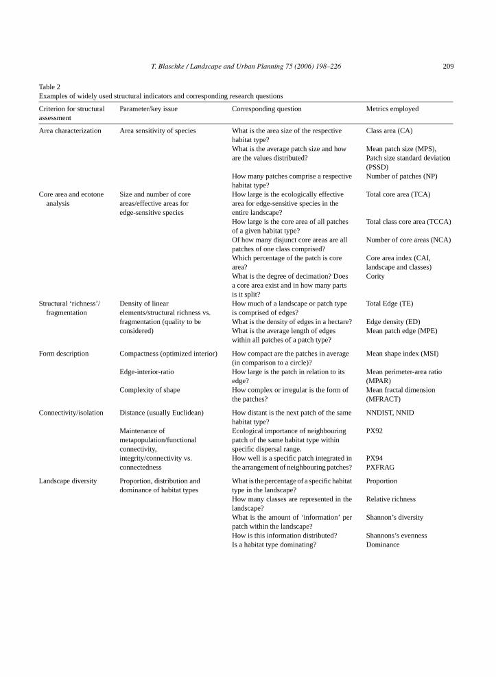
T. Blaschke / Landscape and Urban Planning 75 (2006) 198–226 209
Table 2Examples of widely used structural indicators and corresponding research questions
Criterion for structuralassessment
Parameter/key issue Corresponding question Metrics employed
Area characterization Area sensitivity of species What is the area size of the respectivehabitat type?
Class area (CA)
What is the average patch size and howare the values distributed?
Mean patch size (MPS),Patch size standard deviation(PSSD)
How many patches comprise a respectivehabitat type?
Number of patches (NP)
Core area and ecotoneanalysis
Size and number of coreareas/effective areas foredge-sensitive species
How large is the ecologically effectivearea for edge-sensitive species in theentire landscape?
Total core area (TCA)
How large is the core area of all patchesof a given habitat type?
Total class core area (TCCA)
Of how many disjunct core areas are allpatches of one class comprised?
Number of core areas (NCA)
Which percentage of the patch is corearea?
Core area index (CAI,landscape and classes)
What is the degree of decimation? Doesa core area exist and in how many partsis it split?
Cority
Structural ‘richness’/fragmentation
Density of linearelements/structural richness vs.fragmentation (quality to beconsidered)
How much of a landscape or patch typeis comprised of edges?
Total Edge (TE)
What is the density of edges in a hectare? Edge density (ED)What is the average length of edgeswithin all patches of a patch type?
Mean patch edge (MPE)
Form description Compactness (optimized interior) How compact are the patches in average(in comparison to a circle)?
Mean shape index (MSI)
Edge-interior-ratio How large is the patch in relation to itsedge?
Mean perimeter-area ratio(MPAR)
Complexity of shape How complex or irregular is the form ofthe patches?
Mean fractal dimension(MFRACT)
Connectivity/isolation Distance (usually Euclidean) How distant is the next patch of the samehabitat type?
NNDIST, NNID
Maintenance ofmetapopulation/functionalconnectivity,integrity/connectivity vs.connectedness
Ecological importance of neighbouringpatch of the same habitat type withinspecific dispersal range.
PX92
How well is a specific patch integrated inthe arrangement of neighbouring patches?
PX94PXFRAG
Landscape diversity Proportion, distribution anddominance of habitat types
What is the percentage of a specific habitattype in the landscape?
Proportion
How many classes are represented in thelandscape?
Relative richness
What is the amount of ‘information’ perpatch within the landscape?
Shannon’s diversity
How is this information distributed? Shannons’s evennessIs a habitat type dominating? Dominance
210 T. Blaschke / Landscape and Urban Planning 75 (2006) 198–226
Table 2 (Continued )
Criterion for structuralassessment
Parameter/key issue Corresponding question Metrics employed
Subdivision Fragmentation/dissection/isolationof remnants
What is the remaining degree ofcoherence, i.e. how likely are tworandomly chosen locations not part of thesame un-dissected patch?
DIVISION
How many patches remain at a givendegree of division?
SPLIT
What is the average size of those? MESH
Index nomenclature according toMcGarigal and Marks (1994)andJaeger (2000).
2001). However, relationships between landscapeindices and response variables of ecological processesmay be non-linear (With and Crist, 1995; Wiens et al.,1997; Hargis et al., 1998; Blaschke and Petch, 1999),including thresholds at which ecological processes maychange dramatically (Wu, 2004). For instance, the sur-vival probability of a population may severely decreaseafter a certain proportion of habitat is removed fromthe landscape (Fahrig, 1998). The measures whichHargis et al. (1998)examined were relatively insensi-tive to variations in the spatial arrangement of patcheson a landscape. Mean nearest neighbor distance andmean proximity index both quantify distances betweenpatches in a cluster, but neither are designed to place thecluster in the context of the landscape window. Edgedensity, contagion, and perimeter-area fractal dimen-sion are all metrics of landscape pattern caused by sizeand shape of patches and their proportional represen-tation on a landscape, but none can differentiate thespatial relationship among patches (for an overviewof structural metrics seeTable 2). Recently, indiceswere introduced which are more sensitive to the spa-tial arrangement (Jaeger, 2000; Fjellstad, 2001; Ludwiget al., 2002; Verburg et al., 2004). For the discussionof sustainable landscapes it is concluded that land-scape metrics provide mainly descriptive spatial valuesfor a limited set of spatially dissected realities butare less suited for continuous processes through spaceand time.
3
onv rel-a fori nt of
interface between upland vegetative community andthe aquatic environment to facilitate the exchangeof energy and nutrients between these two systems.Beyond the investigation of species presence, abun-dance or dispersal, the usefulness of landscape metricsfor the understanding of interactions between land-scape balance and land use at various levels of scale isincreasingly investigated, namely addressing processesof soil erosion, ground water recharge, surface runoff ofmaterial into river and lakes, using remotely sensed dataand complex GIS-based models (Thierfelder, 1998;Wrbka, 1998; Zhang et al., 1998).
Many examples demonstrate that spatial configura-tions can in principle have functional significance inspatial systems. The functional relevance of the com-puted value is left for interpretation during a subsequentstep. What are needed are functional landscape met-rics (Vos et al., 2001; Turner et al., 2001; Opdam etal., 2003) which explicitly measure landscape patternin a manner that is functionally relevant to the organ-ism or process under consideration (Vos et al., 2001;Bissonette, 2003). This requires additional parameter-ization prior to their calculation, such that the samemetric can return multiple values depending on the userspecifications. For instance, mean nearest neighbourdistance is based on the distances between neighbour-ing patches of the same class. The mosaic is in essencetreated as a binary landscape (focal class versus every-thing else) and a single value for this metric is returned(McGarigal and Marks, 1994; Wiens, 1995). This is as f anyp pre-t idert ento onalm can
.3. The need for functional indicators
Applications of structural indices often focusegetation or habitat structure since vegetation istively easy to map. The measuring of edge can
nstance be used to create the greatest amou
tructural metric because the functional meaning oarticular computed value is left to subsequent inter
ation. Conversely, connectivity metrics that conshe permeability of various patch types to movemf the organism or process of interest are functietrics. There are an infinite number of values that
T. Blaschke / Landscape and Urban Planning 75 (2006) 198–226 211
be returned from the same landscape, depending on thepermeability coefficients assigned to each patch type.The computed metric may be functionally relevant onlyfor a particular parameterization. In most empiricalstudies conducted, most species attributes are linkedto landscape pattern using single-year distribution orturnover patterns (Reich and Grimm, 1996; Harrisonand Taylor, 1997). These produce regression modelsthat usually are hard to extrapolate to other landscapeareas and to the long-term chance of persistence (TerBraak et al., 1998; Vos et al., 2001). At a landscapelevel, Mander et al. (2000)presented some examplesof ecological consequences due to the ongoing changesin land use and land cover in Estonian agricultural land-scapes during the 1990s.MacIntyre and Wiens (2000)demonstrate a use of the lacunarity index (Plotnick etal., 1993) to quantify landscape function and describe adisparity between landscape pattern and landscape use.Zebisch et al. (2004)have proved response functions ofbiodiversity attributes built on spatial heterogeneity tobe particularly useful to explaining the impact of land-use shifts on biodiversity.Ludwig et al. (2002)create aleakiness index to differentiate the landscape functionto retain vital system resources such as rainwater andsoil.
3.4. A multiscale object-based GIS framework
The patch-matrix paradigm is widespread but it hasits limitations to model complex landscapes especiallyt land-s ets atd nge-m ficultt andd )p ure( chico erly,s erar-c lexs ordera -g micsv laya ingd cals
(1967) concepts of flux rates in hierarchy, suggeststhat ecological systems are nearly completely decom-posable systems because of their loose vertical andhorizontal coupling in structure and function. Theterm “loose” suggests decomposable, and the word“coupling” implies resistance to decomposition.Following these ideas we accept scale non-linearitiesas discussed before.Koestler (1967) introduceda methodology which translates hierarchy theoryto landscape ecological analysis: holons (from theGreek wordholos) are then used synonymous withpatches: the ecological unit at a particular scale ofconsideration. It is at the same time a (sub)whole andconsist of sub-wholes of a lower order.
Building on Koestler’s ideas, the concept of sus-tainability will not be satisfactorily supported by a‘thematic layering’ of information. But how to definemeaningful levels and how to dissect reality spatially atthese levels?Burnett and Blaschke (2003)build in theirapproach on Koestler’s ideas of multi-levelled hierar-chies. Like societies they treat landscapes as multi-levelled hierarchies of semi-autonomous sub-wholesbranching into sub-wholes of a lower order. The term‘holon’ (Koestler, 1967) refers to these intermediaryentities which, relative to their sub-ordinates in thehierarchy, function as self-contained wholes, relativeto their sub-ordinates as dependent parts.
The multiscale segmentation/object relationshipmodelling methodology suggested by Burnett andBlaschke segments information (usually remotes ion).G ssifi-c acet ons.A thingm ignedt urs e ofa llited t ins new( ws beent leadt ngrT uses
hrough time and across scales. The discussedcape metrics focus on one scale or a few data sifferent scales and at given sets of spatial arraents. The relationships between scales are dif
o model, although some examples for upscalingownscaling were mentioned. AsKoestler (1967oints out, when we turn from the universe in miniate.g. the cell) to the universe at large, we find hierarrder. He concludes that whenever we find ordtable systems in nature, we find that they are hihically structured. Without structuring of compystems into sub-assemblies, there could be nond stability.Wu and Loucks (1995)suggest the interation between hierarchy theory and patch dynaia the hierarchical patch dynamics paradigm andtheoretical framework for a theory-driven break
own of ecological complexity through a hierarchicaling strategy.Wu (1999), drawing on Koestler
ensing images plus any georeferenced informatenerally, an advantage of segmentation to cla
ation of pixels is that the resulting division of spends to involve fewer and more compact subregilternatively, classification-based approaches wieostatistical frameworks exist (Atkinson, 2001). Theultiscale segmentation based approach is des
o utilize information in the scales inherent in opatial (image) data sets in addition to a ranguxiliary data sets, including for airborne and sateata, but also to the scales of information inhereningle images. Technically, segmentation is notHaralick and Shapiro, 1985). Recently, many neegmentation algorithms and applications haveested in GIScience applications, but few of themo qualitatively convincing results while still beiobust and operational (Blaschke and Strobl, 2001).he multiscale segmentation based methodology
212 T. Blaschke / Landscape and Urban Planning 75 (2006) 198–226
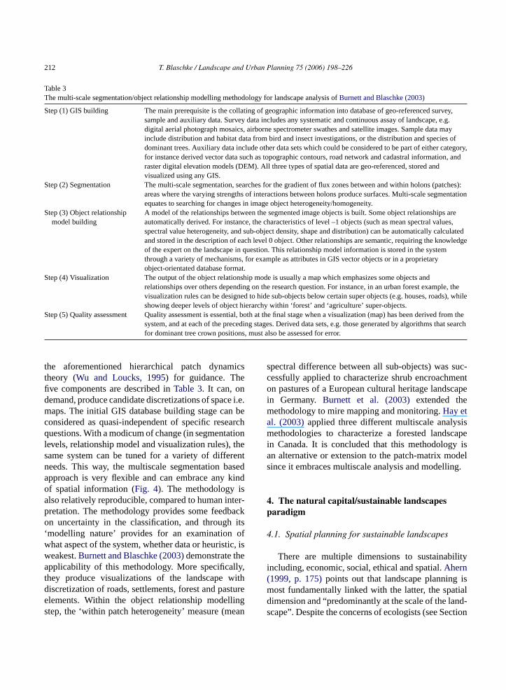
Table 3The multi-scale segmentation/object relationship modelling methodology for landscape analysis ofBurnett and Blaschke (2003)
Step (1) GIS building The main prerequisite is the collating of geographic information into database of geo-referenced survey,sample and auxiliary data. Survey data includes any systematic and continuous assay of landscape, e.g.digital aerial photograph mosaics, airborne spectrometer swathes and satellite images. Sample data mayinclude distribution and habitat data from bird and insect investigations, or the distribution and species ofdominant trees. Auxiliary data include other data sets which could be considered to be part of either category,for instance derived vector data such as topographic contours, road network and cadastral information, andraster digital elevation models (DEM). All three types of spatial data are geo-referenced, stored andvisualized using any GIS.
Step (2) Segmentation The multi-scale segmentation, searches for the gradient of flux zones between and within holons (patches):areas where the varying strengths of interactions between holons produce surfaces. Multi-scale segmentationequates to searching for changes in image object heterogeneity/homogeneity.
Step (3) Object relationshipmodel building
A model of the relationships between the segmented image objects is built. Some object relationships areautomatically derived. For instance, the characteristics of level –1 objects (such as mean spectral values,spectral value heterogeneity, and sub-object density, shape and distribution) can be automatically calculatedand stored in the description of each level 0 object. Other relationships are semantic, requiring the knowledgeof the expert on the landscape in question. This relationship model information is stored in the systemthrough a variety of mechanisms, for example as attributes in GIS vector objects or in a proprietaryobject-orientated database format.
Step (4) Visualization The output of the object relationship mode is usually a map which emphasizes some objects andrelationships over others depending on the research question. For instance, in an urban forest example, thevisualization rules can be designed to hide sub-objects below certain super objects (e.g. houses, roads), whileshowing deeper levels of object hierarchy within ‘forest’ and ‘agriculture’ super-objects.
Step (5) Quality assessment Quality assessment is essential, both at the final stage when a visualization (map) has been derived from thesystem, and at each of the preceding stages. Derived data sets, e.g. those generated by algorithms that searchfor dominant tree crown positions, must also be assessed for error.
the aforementioned hierarchical patch dynamicstheory (Wu and Loucks, 1995) for guidance. Thefive components are described inTable 3. It can, ondemand, produce candidate discretizations of space i.e.maps. The initial GIS database building stage can beconsidered as quasi-independent of specific researchquestions. With a modicum of change (in segmentationlevels, relationship model and visualization rules), thesame system can be tuned for a variety of differentneeds. This way, the multiscale segmentation basedapproach is very flexible and can embrace any kindof spatial information (Fig. 4). The methodology isalso relatively reproducible, compared to human inter-pretation. The methodology provides some feedbackon uncertainty in the classification, and through its‘modelling nature’ provides for an examination ofwhat aspect of the system, whether data or heuristic, isweakest.Burnett and Blaschke (2003)demonstrate theapplicability of this methodology. More specifically,they produce visualizations of the landscape withdiscretization of roads, settlements, forest and pastureelements. Within the object relationship modellingstep, the ‘within patch heterogeneity’ measure (mean
spectral difference between all sub-objects) was suc-cessfully applied to characterize shrub encroachmenton pastures of a European cultural heritage landscapein Germany. Burnett et al. (2003)extended themethodology to mire mapping and monitoring.Hay etal. (2003)applied three different multiscale analysismethodologies to characterize a forested landscapein Canada. It is concluded that this methodology isan alternative or extension to the patch-matrix modelsince it embraces multiscale analysis and modelling.
4. The natural capital/sustainable landscapesparadigm
4.1. Spatial planning for sustainable landscapes
There are multiple dimensions to sustainabilityincluding, economic, social, ethical and spatial.Ahern(1999, p. 175)points out that landscape planning ismost fundamentally linked with the latter, the spatialdimension and “predominantly at the scale of the land-scape”. Despite the concerns of ecologists (see Section

T. Blaschke / Landscape and Urban Planning 75 (2006) 198–226 213
Fig. 4. Integrating socio-economic data within the multiscale segmentation methodology.
2.4) it will not only pragmatically but also legally be theera of landscape planners. Although defined function-ally and more precisely the ecosystem is by definitionvulnerable to irrevocable disturbance and is therefore,as Ahern (1999, p. 176)concludes, not an appropri-ate scale for landscape planning. The ecosystem isa useful spatial unit but it is spatially too limited tounderstand the “horizontal” or chorological patternsand processes (Zonneveld, 1995). Landscapes, moreso than ecosystems, are spatially heterogeneous and arespatial arrangements of a number of different ecosys-tem types that may be linked through various energyand material flows (Potschin and Haines-Young, 2001).Although not measurable directly, these spatial param-eters are to be included in land use planning throughmodelling and interpolation methods.
Natural resources and economic activities are inter-linked to highly complex levels. The environmentalcharacteristics of an area affect the amount of materials,effort and money required to yield a particular productor economic award. This suggests that there should bespatial patterns to the sustainability of the landscape to
support different land uses at different times, and thatthese patterns should coincide to a large extent withspatial patterns in environmental characteristics. Indi-vidual plans for certain natural resources and regionsare often prepared (e.g. river basin management plans,biodiversity management plans). However, landscapesare increasingly regarded as ‘multi-functional’ (Brandtand Vejre, 2003). In order to encompass some naturalboundaries the scale of a plan may be such that localpeople find it difficult to relate to. This increases theneed for a more anthropogenic perspective as discussedbelow and a multiscale perspective (Hay et al., 2002,2003; Wu, 2004).
Landscape ecology has achieved significantprogress in defining spatial elements and a frameworkbased on them (Forman, 1995; Zonneveld, 1995;Turner et al., 2001). Although alternatives exist (e.g.gradients,Muller, 1998) it seems to be widely acceptedthat spatial planning needs tangible elements, bothfrom a legal and a pragmatic point of view (Hermannand Osinski, 1999; Botequilha Leitao and Ahern,2002). One of the remaining constraints for a direct
214 T. Blaschke / Landscape and Urban Planning 75 (2006) 198–226
application of landscape ecological concepts inpractice is the lack of agreed ways to combine environ-mental, socio-economic and societal/cultural views.While environmental data are mostly measurable forpoints or areas (precipitation, temperature, altitude,exposition, soil organic carbon, ground and surfacewater, air pollution), the spatial dimension of socialimplications, cultural heritages or the well beingof people is more difficult to parameterize. Thisintegration is necessary. Landscape should be con-sidered as holistic, relativistic and dynamic (Antrop,2000; Naveh, 2000). The term ‘landscape’ is used asan abstract concept, but also to refer to a particulararea and, implicitly, to a particular scale as discussedbefore. Politicians and large parts of the populationrefer largely to the aesthetic values attached to it. Wefrequently talk about specific cultural monuments ornature sites. The landscape scale seems to be of vitalimportance at a broader level for planning and manag-ing processes of sustainable development. It is aboutwhat we see but also about the processes that havecreated what we can see. Thus, it is about the beauty ofTuscany or the Scottish Highlands and, inherently, itis about the ubiquity of pattern and the uniqueness ofspecific patchiness in some factor of interest at somescale (Forman, 1995; Turner et al., 2001; Bissonette,2003).
Currently, we are lacking methodologies whichincorporate processes of human settlement and agri-culture and the natural forces that have created a land-s thingt hardt ourcep glya ocall enseo sedo ingt
4
, it isw cul-t t. Tos akea al.,2 lan-
ning but their interests have also to be limited if itleads for instance to an overconsumption of resources.Haines-Young (2000)addresses this need for a moreflexible and more dynamic consideration of environ-mental and economic interference by suggesting thenatural capital/sustainable landscape (subsequently:“sustainable landscapes”) approach. He builds on the“Quality of Life Capital” approach mainly developedin the UK (Countryside Commission, 1997; Haines-Young, 1999) and an economic valuation of ecosystemfunctions and services. The economic value of ecosys-tems is generally acknowledged.Costanza et al. (1997)described a methodology and a worldwide valuation ofecosystem services.de Groot et al. (2002)suggesteda typology and integrated framework for assessmentand valuation of ecosystem functions. The proposedframework, in combination with a comprehensive database of ecosystem services and values, can help iden-tify information gaps in the literature and could serveas a launching point for research strategies in the fieldof ecosystem service valuation. Once operational, itwould be an important tool for more integrated cost-benefit analysis and greatly enhance more balanceddecision-making regarding the sustainable use and con-servation of natural ecosystems and their many goodsand services.
The term ‘natural capital’ has so far been usedin various meanings and contexts. Haines-Young fol-lows the ecological foundations of the approach laidout by Costanza et al. (1997)and used by the UK’sCt het inw ther di-c s”( sa ngi ongt lorew lysiso pi-c ludet ersm ont ichj andt
cape into spatial planning. Landscape is somehat has great public appeal: people possibly find ito understand the more obscure aspects of resrotection or biodiversity but they feel very stronbout issues to do with landscape, mainly at the l
evel, where many communities have a strong sf place. Current methodological frameworks ban the patch-matrix paradigm are limited in reflect
hese needs.
.2. The sustainable landscapes paradigm
For landscapes, more so than for ecosystemsidely acknowledged that social, economic and
ural factors are key to sustainable managemenome degree it is the people living there which mdifference (Haines-Young, 2000; Buchecker et
003). Their interests have to be incorporated in p
ountryside Commission (Haines-Young, 2000). Ini-ially the term ‘environmental capital’ was used. Term ‘Quality of Life’ was substituted later, to tieith the quality of life aspects emphasized by
ecent publication of the suite of sustainability inators for the UK, called “Quality of Life CountPotschin and Haines-Young, 2003). These authorpply the ‘Quality of Life Capital’ approach by usi
t to examine the golf course developments alhe Swiss–German–French border. In order to exphat benefits the approach might offer the anaf future developments they compare it with a tyal Environmental Impact Assessment. They conchat the Quality of Life Capital approach considore of the environmental and social constraints
he development. It thus provides a framework in whudgements about the significance of the impactshe acceptability of alternatives can be made.
T. Blaschke / Landscape and Urban Planning 75 (2006) 198–226 215
This concept is expressed as a new paradigmalthough the usage of the term ‘sustainable landscapes’is certainly not exclusive (Buttimer, 2001; Saundersand Briggs, 2002). But what distinguishes the paradigmfrom many other approaches is that it is relatively con-crete and the suggested methodologies are tangible andcan be applicable in practice. Furthermore, it contri-butes to the decoupling of ‘sustainability’ and ‘devel-opment’ which is important in the regional and localcontext of sustainability. Sustainability as understoodby Haines-Young (2000)refers to the promotion ofplanning scenarios with carefully defined objectivesthat aim to achieve a sustainable flow of goods andservices that ensure or enhance quality of life. Thisway, the concept aims to balance ecological conditionsand the well being of the people living in the landscape.It is holistic and anthropocentric at the same timeand in principle fulfils the demands of an integrativeapproach: “For successful achievement of sustainablelandscapes, it will be necessary to manage landscapesas a whole rather than the piecemeal approach to man-agement employed at present” (Saunders and Briggs,2002, p. 76).
4.3. Critique of the sustainable landscapesparadigm
Some advantages of the suggested paradigm areobvious: (a) it seeks to integrate ecological, economicand cultural values in defining the goals and guidelinesf ando erma-n ents,( d-s n thec landc hold-e capei thec levelw sin-g icitlyr
note , am y ine ifiedl ical
niches conducive to enhancing biodiversity and at thesame time ensure sustainability of the landscape. It issometimes argued that the maintenance of the overallsustainability of a system demands a loosely coupledmanagement (Ehrenfeld, 1991). It bears the potentialto integrate traditional landscape management knowl-edge. Traditionally, many societies have viewed theirland use activity in a given landscape as part of anintegrated land use management, wherein human man-aged ecosystems are closely linked to a variety ofnatural systems (Ramakrishnan, 1999; Ramakrishnanet al., 2000). For instance, the diversity of croppingand resource systems that form part of the landscapeserves not only as a major means of protecting eco-logical integrity at the landscape level, but also acts asthe knowledge and resource base that makes adaptiv-ity possible. Traditional societies adapt their land usepractices both in space and time to cope with uncer-tainties in the environment and/or to capture marketopportunities (Ramakrishnan, 1999).
Some critical questions remain. One is addressedby Haines-Young (2000, p. 8): “how would we recog-nise a sustainable landscape if we saw one?” Buthe points this question at traditional approaches andimplicitly at the patch-matrix paradigm.Potschin andHaines-Young (2003)address this problem and seek todemonstrate that the sustainable landscape paradigmcan give us a sustainable measure where the ‘clas-sic’ patch-matrix paradigm cannot. The integration ofsocietal values and the general orientation of ‘goodsa par-t toi thew thel er. Int ys-t ismst bio-d oneh d ora milart iol-o er-s rsitya fun-d s top ents( lt
or the planning process, (b) it reflects the dynamicpen system character of a landscape and the pent exchanges between diverse constituent elemc) it allows for a more flexible consideration of lancape change since it suggests concentrating oharacter of change processes rather then on theover change as such, (d) it aims to integrate stakers and in general the people being part of the lands
nto the planning process, (e) it aims to transferoncept of ecosystems functions to the landscapehere a ‘service’ is not necessarily identical with ale ecosystem or patch, in some cases it might explefer to a specific mosaic of ecosystems.
Some advantages may be less obvious: byxplicitly fixing a spatial arrangement of land useore diversified landscape and a higher variabilitcosystem complexity are provided. Such a divers
andscape is likely to have a wide range of ecolog
nd services for people’ seem to be feasible inicular situations. But it is not clear as yet howntegrate the societal values, especially reflectingell being and the feelings of the people living in
andscape in a transferable and repeatable mannheory the orientation on functions of ecological sems provide clues about the underlying mechanhat constrain ecological complexity and regulateiversity but practical examples are missing. On theand, the anthropogenic functions and their mappessumed distribution may represent outcomes si
o law-like processes of physics, chemistry and bgy. In principle, the paradigm accounts for biodivity beyond species and includes functional divend the diversity of landscapes. Still, it remains aamental challenge to assign economic attributearticular species, communities or ecological evJentsch et al., 2003). It might be even more difficu
216 T. Blaschke / Landscape and Urban Planning 75 (2006) 198–226
to appraise aspects of functional diversity. While manyof the ecological mechanisms, at least in small scales,are well understood (e.g. thermodynamics, conserva-tion of mass and energy, atomic particles and chemicalelements, erosion processes and evolution by naturalselection), it is far from clear how the anthropogenicpattern and processes act and interact with the ecologi-cal processes to produce the emergent spatial patterns.Although stakeholder and public involvement in shap-ing landscapes is desirable there remains the challengeof elucidating how both types of processes give rise tolandscapes that are simultaneously extremely variableand highly constrained.
The frameworks for the assessment of ecosystemfunctions, goods and services (de Groot et al., 2002)promises to make the comparative ecological economicanalysis possible. These checklists are useful in thatthey have enabled workers to link ecosystem functionsto the main ecological and socio-cultural valuationmethods. But ecological relationships are complex,often vary regionally and may be different for areaswhere predominant land uses vary. This complicatesthe estimation of cut-off values of the different func-tions or thresholds for management. Observed changesfor the spatial configuration under observation may beassociated with several interacting factors, rather than asingle causal agent. This way, the spatial entities serveas containers of functions and even relatively simplethresholds may be difficult to handle spatially.
The concept ofde Groot et al. (2002)does notd nt int ings ntalp cificf cifici ttlea il tod onall l.( icesp , notp uesi ut-i ons gra-p ificm cifico
Finally, a spatial approach enables us to look atecosystems and landscapes in a holistic way andaddress systemic characteristics such as quality andvulnerability. A sound methodology is needed to inte-grate peoples’ concerns and their integration in regionalresource management and stakeholders future visions(Costanza, 2000; Fish et al., 2003). The need tointegrate the people living in the landscape and thestakeholders or ‘connoisseurs’ (Arler, 2000) is widelyacknowledged and it is assumed that this will enhanceour understanding of landscape change, but the actuallocation of such actively integrated persons withinthe wider landscape matrix is important (MacFarlane,2000).
4.4. Putting the sustainable landscapes paradigmin practice: the need for a Leitbild
Sustainability is a goal everybody agrees to, butno one knows how to achieve it. Since the act ofsustainable planning is a heuristic process, where welearn by doing, observing and recording the chang-ing conditions (Franklin, 1997) continuous monitor-ing is essential to determine whether or not society isapproaching the goal of sustainability. Monitoring alsorequires thresholds for the various goods and services.In natural systems, an ecological threshold refers toa point at which relatively rapid change occurs fromone ecological condition to another. In nature, fewrelationships show constant change in one attribute inr ts orz cursi e orm g( s a‘ iono es,i .
idesn icesf larl atiala ives,e cificg s’).E tateo red.T tural
escribe how spatial relations are taken into accouhe valuation process. For the monitoring of planncenarios, developing policies or agri-environmerogrammes, indicators have to reflect site-spe
eatures in order to be meaningful. Less site-spendicators, which are more readily available, tell libout effects in local areas. Indeed, they may faisclose significant developments at a local or regi
evel. The proposed framework ofde Groot et a2002)provides total values of the goods and servrovided by an area but the concept has, so farrovided spatially explicit expressions of the val
n the form of maps. The impact of many pollng, depleting or beneficial processes will dependite specific characteristics such as geology, topohy or climate and they might interact in a specanner if certain land use types border to spebjects.
esponse to another. Rather, they mostly show poinones at which marked change in one attribute ocn response to a small additional change in on
ore influencing factors.Potschin and Haines-Younin press)suggest a ‘tongue model’, which definemultifunctional choice space’, set by the combinatf biophysical limits and economic and social valu
n which landscape trajectories can be consideredThe sustainable landscapes paradigm prov
otions of quantities of ecosystem goods and servrom the perspective of people living in a particuandscape. But it does not provide concepts of sprrangement. Monitoring necessitates clear objectspecially environmental quality targets and speoals for policy action (‘environmental action targetnvironmental quality targets refer to a particular sf the environment towards which efforts are geahey comprise elements derived from both the na
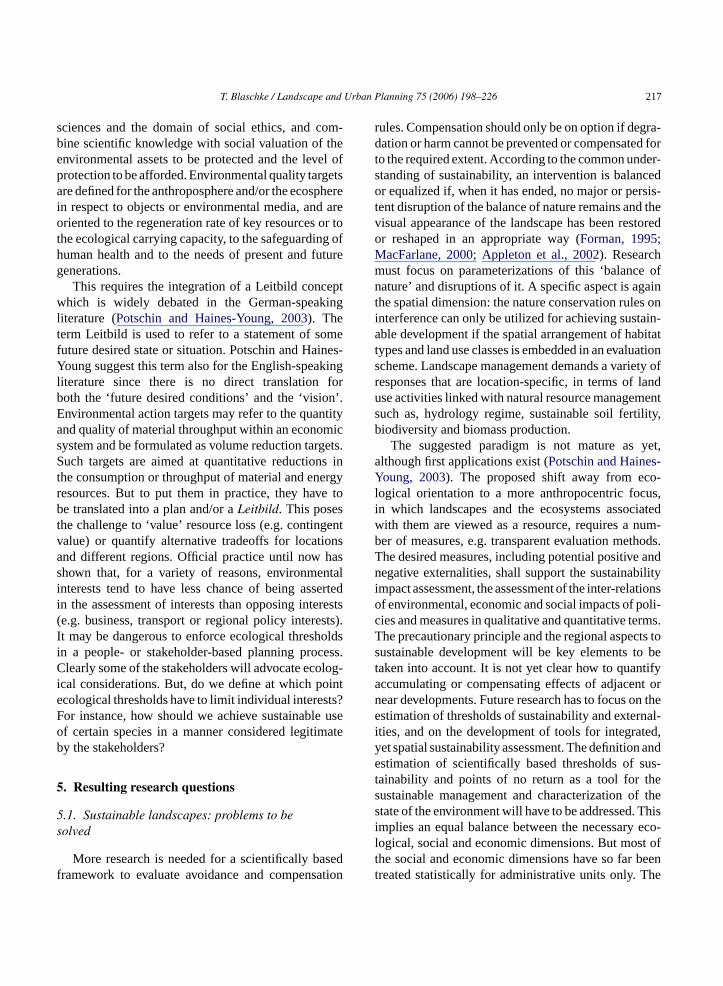
T. Blaschke / Landscape and Urban Planning 75 (2006) 198–226 217
sciences and the domain of social ethics, and com-bine scientific knowledge with social valuation of theenvironmental assets to be protected and the level ofprotection to be afforded. Environmental quality targetsare defined for the anthroposphere and/or the ecospherein respect to objects or environmental media, and areoriented to the regeneration rate of key resources or tothe ecological carrying capacity, to the safeguarding ofhuman health and to the needs of present and futuregenerations.
This requires the integration of a Leitbild conceptwhich is widely debated in the German-speakingliterature (Potschin and Haines-Young, 2003). Theterm Leitbild is used to refer to a statement of somefuture desired state or situation. Potschin and Haines-Young suggest this term also for the English-speakingliterature since there is no direct translation forboth the ‘future desired conditions’ and the ‘vision’.Environmental action targets may refer to the quantityand quality of material throughput within an economicsystem and be formulated as volume reduction targets.Such targets are aimed at quantitative reductions inthe consumption or throughput of material and energyresources. But to put them in practice, they have tobe translated into a plan and/or aLeitbild. This posesthe challenge to ‘value’ resource loss (e.g. contingentvalue) or quantify alternative tradeoffs for locationsand different regions. Official practice until now hasshown that, for a variety of reasons, environmentalinterests tend to have less chance of being assertedi rests( sts).I oldsi ess.C log-i ointe ts?F useo ateb
5
5s
sedf tion
rules. Compensation should only be on option if degra-dation or harm cannot be prevented or compensated forto the required extent. According to the common under-standing of sustainability, an intervention is balancedor equalized if, when it has ended, no major or persis-tent disruption of the balance of nature remains and thevisual appearance of the landscape has been restoredor reshaped in an appropriate way (Forman, 1995;MacFarlane, 2000; Appleton et al., 2002). Researchmust focus on parameterizations of this ‘balance ofnature’ and disruptions of it. A specific aspect is againthe spatial dimension: the nature conservation rules oninterference can only be utilized for achieving sustain-able development if the spatial arrangement of habitattypes and land use classes is embedded in an evaluationscheme. Landscape management demands a variety ofresponses that are location-specific, in terms of landuse activities linked with natural resource managementsuch as, hydrology regime, sustainable soil fertility,biodiversity and biomass production.
The suggested paradigm is not mature as yet,although first applications exist (Potschin and Haines-Young, 2003). The proposed shift away from eco-logical orientation to a more anthropocentric focus,in which landscapes and the ecosystems associatedwith them are viewed as a resource, requires a num-ber of measures, e.g. transparent evaluation methods.The desired measures, including potential positive andnegative externalities, shall support the sustainabilityimpact assessment, the assessment of the inter-relationso oli-c rms.T ts tos bet tifya t orn n thee nal-i ted,y ande us-t thes f thes Thisi eco-l t oft beent he
n the assessment of interests than opposing intee.g. business, transport or regional policy interet may be dangerous to enforce ecological threshn a people- or stakeholder-based planning proclearly some of the stakeholders will advocate eco
cal considerations. But, do we define at which pcological thresholds have to limit individual interesor instance, how should we achieve sustainablef certain species in a manner considered legitimy the stakeholders?
. Resulting research questions
.1. Sustainable landscapes: problems to beolved
More research is needed for a scientifically baramework to evaluate avoidance and compensa
f environmental, economic and social impacts of pies and measures in qualitative and quantitative tehe precautionary principle and the regional aspecustainable development will be key elements toaken into account. It is not yet clear how to quanccumulating or compensating effects of adjacenear developments. Future research has to focus ostimation of thresholds of sustainability and exter
ties, and on the development of tools for integraet spatial sustainability assessment. The definitionstimation of scientifically based thresholds of s
ainability and points of no return as a tool forustainable management and characterization otate of the environment will have to be addressed.mplies an equal balance between the necessaryogical, social and economic dimensions. But moshe social and economic dimensions have so farreated statistically for administrative units only. T
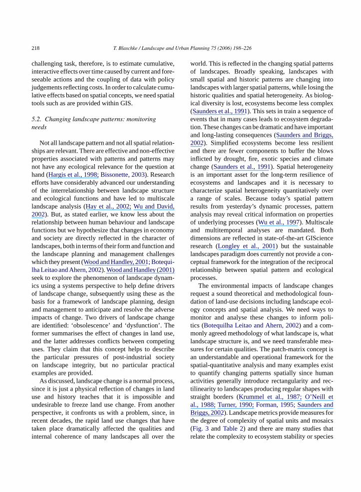
218 T. Blaschke / Landscape and Urban Planning 75 (2006) 198–226
challenging task, therefore, is to estimate cumulative,interactive effects over time caused by current and fore-seeable actions and the coupling of data with policyjudgements reflecting costs. In order to calculate cumu-lative effects based on spatial concepts, we need spatialtools such as are provided within GIS.
5.2. Changing landscape patterns: monitoringneeds
Not all landscape pattern and not all spatial relation-ships are relevant. There are effective and non-effectiveproperties associated with patterns and patterns maynot have any ecological relevance for the question athand (Hargis et al., 1998; Bissonette, 2003). Researchefforts have considerably advanced our understandingof the interrelationship between landscape structureand ecological functions and have led to multiscalelandscape analysis (Hay et al., 2002; Wu and David,2002). But, as stated earlier, we know less about therelationship between human behaviour and landscapefunctions but we hypothesize that changes in economyand society are directly reflected in the character oflandscapes, both in terms of their form and function andthe landscape planning and management challengeswhich they present (Wood and Handley, 2001; Botequi-lha Leitao and Ahern, 2002).Wood and Handley (2001)seek to explore the phenomenon of landscape dynam-ics using a systems perspective to help define driversof landscape change, subsequently using these as theb signa versei ngea hef use,a etingu ribet ietyo icale
cess,s andu andu otherp , inr havet andi the
world. This is reflected in the changing spatial patternsof landscapes. Broadly speaking, landscapes withsmall spatial and historic patterns are changing intolandscapes with larger spatial patterns, while losing thehistoric qualities and spatial heterogeneity. As biolog-ical diversity is lost, ecosystems become less complex(Saunders et al., 1991). This sets in train a sequence ofevents that in many cases leads to ecosystem degrada-tion. These changes can be dramatic and have importantand long-lasting consequences (Saunders and Briggs,2002). Simplified ecosystems become less resilientand there are fewer components to buffer the blowsinflicted by drought, fire, exotic species and climatechange (Saunders et al., 1991). Spatial heterogeneityis an important asset for the long-term resilience ofecosystems and landscapes and it is necessary tocharacterize spatial heterogeneity quantitatively overa range of scales. Because today’s spatial patternresults from yesterday’s dynamic processes, patternanalysis may reveal critical information on propertiesof underlying processes (Wu et al., 1997). Multiscaleand multitemporal analyses are mandated. Bothdimensions are reflected in state-of-the-art GIScienceresearch (Longley et al., 2001) but the sustainablelandscapes paradigm does currently not provide a con-ceptual framework for the integration of the reciprocalrelationship between spatial pattern and ecologicalprocesses.
The environmental impacts of landscape changesrequest a sound theoretical and methodological foun-d col-o ys tom oli-t -m hatl mea-s pt isa r thes existt ana rec-t withs ta andB fort aics( hatr cies
asis for a framework of landscape planning, dend management to anticipate and resolve the ad
mpacts of change. Two drivers of landscape chare identified: ‘obsolescence’ and ‘dysfunction’. T
ormer summarises the effect of changes in landnd the latter addresses conflicts between compses. They claim that this concept helps to desc
he particular pressures of post-industrial socn landscape integrity, but no particular practxamples are provided.
As discussed, landscape change is a normal proince it is just a physical reflection of changes in lse and history teaches that it is impossiblendesirable to freeze land use change. From anerspective, it confronts us with a problem, sinceecent decades, the rapid land use changes thataken place dramatically affected the qualitiesnternal coherence of many landscapes all over
ation of land-use decisions including landscape egy concepts and spatial analysis. We need waonitor and analyse these changes to inform p
ics (Botequilha Leitao and Ahern, 2002) and a comonly agreed methodology of what landscape is, w
andscape structure is, and we need transferableures for certain qualities. The patch-matrix concen understandable and operational framework fopatial-quantitative analysis and many exampleso quantify changing patterns spatially since humctivities generally introduce rectangularity and
ilinearity to landscapes producing regular shapestraight borders (Krummel et al., 1987; O’Neill el., 1988; Turner, 1990; Forman, 1995; Saundersriggs, 2002). Landscape metrics provide measures
he degree of complexity of spatial units and mosFig. 3 andTable 2) and there are many studies telate the complexity to ecosystem stability or spe

T. Blaschke / Landscape and Urban Planning 75 (2006) 198–226 219
survival (e.g.Dramstad et al., 1996; Goudie, 2000;Moser et al., 2002).
5.3. Which patterns are needed?
As discussed earlier, the world is patchy (Wiens,1995; Dale, 1999; Bissonette, 2003). When we seekspatial pattern and evidence of spatial non-randomness,we find it is the rule rather than the exception. Land-scape ecologists study spatial pattern to infer theexistence of underlying processes, such as move-ment or responses to environmental heterogeneity(Kolasa and Pickett, 1991). Spatial structure indicatesintraspecific and interspecific interactions such ascompetition, predation, and reproduction but can alsobe shaped by abiotic processes. We have many terms todescribe various aspects of non-randomness in spatialdata. The terms ‘aggregated’, ‘patchy’, ‘contagious’,‘clustered’ and ‘clumped’ all refer to positive, or‘attractive’, associations between individuals or eventsin point-referenced data. The terms ‘autocorrelated’,‘structured’ and ‘spatial dependence’ indicate the
tendency of nearby samples to have attribute valuesmore similar than those farther apart (Liebhold andGurevitch, 2002; Perry et al., 2002). Observed hetero-geneity may also be driven by resource availability.Clearly, care is required in inferring causation, sincemany different processes may generate the same spa-tial pattern. Spatial pattern has implications for appliedproblems such as the management of biodiversity(Jentsch et al., 2003). Some effects are illustrated inFig. 5. As we are starting to understand some of thesecomplex relationships between spatial structure andecological parameters, we currently have very limitedknowledge about integration of these relationshipsin planning scenarios. How much spatial diversity isneeded? How much connectedness is needed? Howlittle spatial diversity can we accept?
5.4. Spatial entities versus services for people
Recent research emphasizes that both the way weare dissecting our reality and the scale of investi-gation influence the results significantly (Wu et al.,
al refer
Fig. 5. The relevance of spati ence for environmental indicators.
220 T. Blaschke / Landscape and Urban Planning 75 (2006) 198–226
1997; Hay et al., 2002, 2003; Wu, 2004). The method-ological framework ofBurnett and Blaschke (2003)tries to overcome the problems of ‘discreteness’ ofanalysis units and mono-scaled analysis by explic-itly incorporating information from below the targetlevel as a mechanistic level. It is still based on dis-crete spatial entities representing a continuous surface.In an attempt to represent complexity and a multi-scale view better, an object-based hierarchical struc-ture was introduced to improve the integration of bothraster and vector structures, and support facilities tohandle fuzziness and uncertainty at the boundaries ofhomogeneous regions. Alternatives include fuzzy spa-tial objects (Cheng, 1999) or geographic fields (Covaand Goodchild, 2002). All these approaches addresslandscapes in terms of the physical patterns that we(or remote sensing) perceive. In landscapes, these pat-terns are usually determined by vegetation and topog-raphy. This perception may be convenient, but it maynot reflect the spatial patterns of factors that influenceother organisms. The sustainable landscapes paradigmmight view some aspects of landscape mosaics betterin terms of various costs and benefits. How to dealwith distance and topological relationships of vari-ous existing and planned configurations and how toembrace concepts such as spatial gradients (Muller,1998) and ecotones (Hansen and di Castri, 1992; Fortinet al., 2000) have to be laid out explicitly. The sus-tainable landscapes paradigm is flexible concerning thetemporal dimension of sustainability compared to thep tratet ce thep hipsb ociald pro-m
5o
s oft toryp nceo tedk sys-t nowr s ofi d the
environment. The latter depends on the nature of theinteraction and the particular species, ecosystems, orprocesses in question and is inherently multiscale innature. The sustainable landscapes paradigm is by def-inition (‘goods and services for people’) linked withone level of scale: the human scale. This is reasonablesince a sustainable landscape is defined as one in whichthe output of goods and services is maintained, and thecapacity of those systems to deliver benefits for futuregenerations is not undermined (Haines-Young, 2000).But how would we know? Certainly, the predictionsare based on existing data and models associated withcertain scales. While the patch-matrix paradigm hasrecently been developed further and applied to multi-scale analysis (Turner et al., 2001; Hay et al., 2003) thesustainable landscapes paradigm must develop multi-scale methodologies in order to be applicable.
A challenge for both the sustainable landscapesparadigm and the patch-matrix paradigm is the inte-gration of aesthetic values. Landscape planning is con-cerned with balancing ecological and anthropogenicvalues such as aesthetics or the visual landscape.But how do we balance the sometimes incompatiblegoals in the context of sustainable landscapes?Parsons(1995) demonstrated this conflict using the exampleof wood patches and hedges in an open landscape.Densely vegetated wood patches support the diver-sity of wildlife habitats, while evidence from literatureon the aesthetic quality of natural environments hasrepeatedly established that people tend to prefer moreo pingso , tooo unc-t
5
balc icalc at an ch isc sys-tG ofe ainsu ses,t endo at in
atch-matrix concept but no applications demonshis as yet. Sustainable landscapes clearly referenast, present and the future in terms of the relationsetween the ecosystem and the economic and simensions of life today and the desire not to comise future needs.
.5. How to reflect the human dimension withoutverriding ecological functions?
Beyond the general intention to reflect the needhe people and the mandate to seek for participalanning in order to ensure the long-term acceptaf the planning directives, there is only fragmennowledge about how human influence affects ecoem functions and processes. We do not even kelatively simple relations like the consequencenteractions between human population density an
pen grassy areas punctuated by occasional grouf trees and shrubs. But, in landscape planningften form and aesthetics take prevalence over f
ional aspects (Hobbs, 1999).
.6. How to include topology and hierarchy?
Many ecological processes of interest in glohange studies, such as productivity, biogeochemycling, and water and energy exchange, operateumber of scales. While most process level researonducted at the patch scale, the valuation of ecoems (Costanza et al., 1997) and the methodology ofderoot et al. (2002)respectively extend the analysiscosystem processes to the global scale. But it remnclear how to incorporate hierarchy. In some ca
he ecosystem function or the ‘service’ might depn the association of different ecosystems or habit
T. Blaschke / Landscape and Urban Planning 75 (2006) 198–226 221
space. For any use or activity, the area being plannedis embedded within a larger ecological system, andwill affect other parts of the systems non-linearly sincefunctional relationships exist to and from that largersystem (Forman, 1995). Some argue even that contextis usually more important than content (Dramstad etal., 1996). The critical question is when can ecosystemprocesses simply be aggregated as an area-weightedsum of patches, and when does distribution and patch-iness, adjacency and remoteness, fragmentation andconnectedness, rather than just abundance of landscapeelements affect these processes? Further, when mustmaterial and energy exchange among landscape unitsbe considered to develop adequate estimations at largescales?
6. GIS integration
The premise of landscape ecology, that spatialcontext makes a difference in ecological patterns andprocesses does not hold for any case, but there aremany studies and empirically validated facts under-pinning the importance of the spatial (Wiens, 1995;Wrbka, 1998; Fjellstad, 2001; Turner et al., 2001;Bissonette, 2003). GIS is not a solution to environ-mental problems but a powerful analysis, integrationand visualization tool for sustainable environmentalmanagement. Although the choice of scale may bestrongly influenced by existing data, the selection isi atai andf oft S isa allyr cesi theG atingd rep-r zedw hers wnG intya ver,a vedi
ettert re of
the interaction between ongoing or periodic humanactions such as agricultural practices, permanent orlong lasting land use changes and the environment.Together with territorially differentiated informationon driving forces and the state of the environment,a spatially explicit landscape approach can form thebasis for describing in a relatively simple way thebalance between agricultural activity and the ecosys-tem of which it is part. Mapping and, more generally,providing basic information for planning does not auto-matically lead to any betterment or sustainability, butthere is potential for an integrated and scientific plan-ning through a meaningful use of relatively maturecomputer-based tools and methods dealing with spatialinformation. Analysis at large spatial scales can neverreplace the need to understand structure and functionat the ecosystem level of organization.
First attempts have been made to develop a theoret-ical base and associated spatial techniques to identifyresource management regions integrating the citizens’views by means of GIS (Brunckhorst et al., this vol-ume). It was laid out in this paper that day-to-dayplanning and decision making depend on the abilityto associate different sorts of land-related informa-tion with its physical location. Today, GIS alleviatesmany of the underlying problems and provides muchmore than record management and maintaining spatialinformation. Geographic databases interfaced to pre-dictive models provides a resource for professionalsand decision makers with the capability to undertakem es.T ughm one lter-n
smenta sses.S oodsa s andt ent.I andw elya allye ppro-p d.
oundf rhapsi the
mportant for establishing a common system for dntegration, for addressing data-quality issues,or specifying detection limits. An understandinghe precision and accuracy of the data within a GIlso important. Even though a GIS can mechaniceformat and transform data from different sournto a common system, it is the responsibility ofIS user to determine the consequences of integrata that have been collected at different scales,esented by different topological structures, digitiith varying degrees of precision, or containing otources of errors. Unfortunately, elegantly draIS maps usually do not convey the uncertassociated with boundaries or contour lines. Howedvanced cartographic techniques provide impro
nterpretability of the spatial analysis results.A spatial concept enables us to understand b
he specific characteristics of sites and the natu
ore ‘what if’ analysis and comparison of alternativhus, they can support envisioning the future, althoost effort in ’futures modelling’ has so far focused
xtrapolating past trends rather than envisioning aative futures (Costanza, 2000).
Natural science research focuses on an assesnd understanding of ecological patterns and proceocial science usually calculates values of the gnd services by assessing the costs and benefit
he social acceptability of changing the environmntegrated approaches shall take into account howhy societal conditions that positively or negativffect the environment are made. We are technicquipped to serve for these integrated needs and ariate methodologies are currently being develope
The sustainable landscapes paradigm is new gror landscape ecology and landscape planning. Pet is currently immature in some respects. Despite
222 T. Blaschke / Landscape and Urban Planning 75 (2006) 198–226
discussed remaining problems, this paper emphasizesthe potential of the paradigm. It advocates a ‘spatiali-sation’ of the framework suggested byHaines-Young(2000). The spatial dimension of sustainable land-scapes engages processes and relationships betweendifferent land use types, ecosystems and landscapesat different scales, and over time and requests a con-ceptual framework for sustainable landscape planningbased on landscape ecological concepts and spatialconcepts. Although the author believes that the devel-opment of a combined methodological framework isof central importance to a meaningful use of GIS forlandscape analysis and landscape planning, the devel-opment is slow.
Acknowledgements
Special thanks are given to Dr. Charles Burnettfor the critical discussion of the first version of themanuscript. Four anonymous reviewers and Dr. DenisSaunders as co-editor of the journal provided helpfuldetailed comments and constructive critique on earlierversions of this manuscript.
References
Ahern, J., 1999. Spatial concepts, planning strategies, and futurescenarios: a framework method for integrating landscape ecol-
r, R.tions.
A milyEco-–54.
A ical
A cape
A nder,n-WIT
A uralon ofn. 26,
A Ecol.
A puta-
Bastian, O., 2002. Landscape ecology—towards a unified discipline?Landsc. Ecol. 16, 757–766.
Batty, M., Torrens, P. 2001. Modeling complexity: the limits to pre-diction. Cybergeo [online] URL:http://193.55.107.45/Ectqg12/Batty/articlemb.htm.
Bissonette, J., 2003. Linking landscape patterns to biological real-ity. In: Bissonette, J., Storch, I. (Eds.), Landscape Ecology AndResource Management. Linking Theory with Practice. IslandPress, Washington, pp. 15–34.
Blaschke, T., 2000. Landscape Metrics: Konzepte und Anwendungeneines jungen Ansatzes der Landschaftsokologie im Naturschutz.Archiv fur Naturschutz und Landschaftsforschung 39, 267–299.
Blaschke, T., Petch, J., 1999. Landscape structure and scale: compar-ative studies on some landscape indices in Germany and the UK.In: Maudsley, M., Marshall, J. (Eds.), Heterogeneity in Land-scape Ecology: Pattern and Scale. International Association ofLandscape Ecology UK, Bristol, pp. 75–84.
Blaschke, T., Strobl, J., 2001. What’s wrong with pixels? Somerecent developments interfacing remote sensing and GIS. GISZeitschrift fur Geoinformationssysteme 6, 12–17.
Botequilha Leitao, A.B., Ahern, J., 2002. Applying landscapeecological concepts and metrics to sustainable land planning.Landsc. Urban Plan 59, 65–93.
Brandt, J., Vejre, H. (Eds.), 2003. Multifunctional Landscapes. Mon-itoring, Diversity and Management. WIT press, Southampton.
Brown, J., Gupta, V., Li, B.-L., Milne, B., Restropo, C., West, G.,2002. The fractal nature of nature: power laws, ecological com-plexity and biodiversity. Phil. Trans. Roy. Soc. London B 357,619–626.
Brunckhorst, D., Coop, P., Reeve, I., this volume, “Eco-civic” opti-misation: a nested framework for planning and managing land-scapes. Landscape Urban Plan.
Buchecker, M., Hunziker, M., Kienast, F., 2003. Participatory land-scape development: overcoming social barriers to public involve-ment. Landsc. Urban Plan 64, 29–46.
B 003.res-al
B near-d.),
B bjectysis.
B for-
B ays.
C atial
C tures(1),
C , M.,, J.,e of
ogy and landscape planning. In: Klopatek, J., Gardne(Eds.), Landscape Ecological Analysis. Issues and applicaSpringer, New York, pp. 175–201.
llen, T., 1998. The landscape “level” is dead: persuading the fato take it off the respirator. In: Peterson, D., Parker, V. (Eds.),logical Scale. Columbia University Press, New York, pp. 35
llen, T., Starr, T.B., 1982. Hierarchy: Perspectives for EcologComplexity. University of Chicago Press, Chicago.
ntrop, M., 2000. Background concepts for integrated landsanalysis. Agr. Ecosyst. Environ. 77, 17–28.
ntrop, M., 2003. Continuity and change in landscapes. In: MaU., Antrop, M. (Eds.), Multifunctional Landscapes, vol. III: Cotinuity and Change. Advances in Ecological Sciences 16.press, Southampton, Boston.
ppleton, K., Lovett, A., Sunnenberg, Dockerty, T., 2002. Rlandscape visualisation from GIS databases: a comparisapproaches, options and problems. Comput. Environ. Urba141–162.
rler, F., 2000. Aspects of landscape or nature quality. Landsc.15, 291–302.
tkinson, P., 2001. Geographical information science: geocomtion and nonstationarity. Prog. Phys. Geogr. 25, 111–125.
urnett, C., Aaviksoo, K., Lang, S., Langanke, T., Blaschke, T., 2An object-based methodology for mapping mires using higholution imagery. In: Jarvet, A., Lode, E., (Eds.), EcohydrologicProcesses in Northern Wetlands, Tallinn, pp. 239–244.
urnett, C., Blaschke, T., 2002. Objects/not-objects anddecomposability: ecosystems and GI. In: NCGIA., (EGIScience 2002. Boulder, pp. 225–229.
urnett, C., Blaschke, T., 2003. A multi-scale segmentation/orelationship modelling methodology for landscape analEcol. Model. 168 (3), 233–249.
urrough, P., McDonnell, R., 1998. Principles of Geographical Inmation Systems. Oxford Univ. Press, Oxford.
uttimer, A. (Ed.), 2001. Sustainable Landscapes and LifewScale and appropriateness. Cork Univ. Press, Cork.
heng, T., 1999. A process-oriented data model for fuzzy spobjects. ITC publication Series no. 68, Enschede.
ostanza, R., 2000. Visions of alternative (unpredictable) fuand their use in policy analysis. Conserv. Ecol. 4http://www.consecol.org/vol4/iss1.
ostanza, R., d’Arge, R., de Groot, R.S., Farber, S., GrassoHannon, B., Limburg, K., Naeem, S., O’Neill, R.V., ParueloRaskin, R.G., Sutton, P., van den Belt, M., 1997. The valu
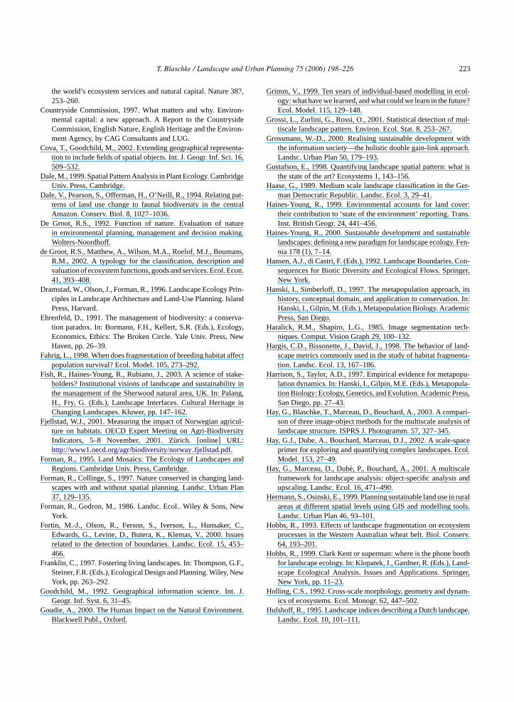
T. Blaschke / Landscape and Urban Planning 75 (2006) 198–226 223
the world’s ecosystem services and natural capital. Nature 387,253–260.
Countryside Commission, 1997. What matters and why. Environ-mental capital: a new approach. A Report to the CountrysideCommission, English Nature, English Heritage and the Environ-ment Agency, by CAG Consultants and LUG.
Cova, T., Goodchild, M., 2002. Extending geographical representa-tion to include fields of spatial objects. Int. J. Geogr. Inf. Sci. 16,509–532.
Dale, M., 1999. Spatial Pattern Analysis in Plant Ecology. CambridgeUniv. Press, Cambridge.
Dale, V., Pearson, S., Offerman, H., O’Neill, R., 1994. Relating pat-terns of land use change to faunal biodiversity in the centralAmazon. Conserv. Biol. 8, 1027–1036.
De Groot, R.S., 1992. Function of nature. Evaluation of naturein environmental planning, management and decision making.Wolters-Noordhoff.
de Groot, R.S., Matthew, A., Wilson, M.A., Roelof, M.J., Boumans,R.M., 2002. A typology for the classification, description andvaluation of ecosystem functions, goods and services. Ecol. Econ.41, 393–408.
Dramstad, W., Olson, J., Forman, R., 1996. Landscape Ecology Prin-ciples in Landscape Architecture and Land-Use Planning. IslandPress, Harvard.
Ehrenfeld, D., 1991. The management of biodiversity: a conserva-tion paradox. In: Bormann, F.H., Kellert, S.R. (Eds.), Ecology,Economics, Ethics: The Broken Circle. Yale Univ. Press, NewHaven, pp. 26–39.
Fahrig, L., 1998. When does fragmentation of breeding habitat affectpopulation survival? Ecol. Model. 105, 273–292.
Fish, R., Haines-Young, R., Rubiano, J., 2003. A science of stake-holders? Institutional visions of landscape and sustainability inthe management of the Sherwood natural area, UK. In: Palang,H., Fry, G. (Eds.), Landscape Interfaces. Cultural Heritage inChanging Landscapes. Kluwer, pp. 147–162.
F icul-sity
F s and
F land-Plan
F ew
F , C.,ues
453–
F G.F.,New
G t. J.
G ent.
Grimm, V., 1999. Ten years of individual-based modelling in ecol-ogy: what have we learned, and what could we learn in the future?Ecol. Model. 115, 129–148.
Grossi, L., Zurlini, G., Rossi, O., 2001. Statistical detection of mul-tiscale landscape pattern. Environ. Ecol. Stat. 8, 253–267.
Grossmann, W.-D., 2000. Realising sustainable development withthe information society—the holistic double gain-link approach.Landsc. Urban Plan 50, 179–193.
Gustafson, E., 1998. Quantifying landscape spatial pattern: what isthe state of the art? Ecosystems 1, 143–156.
Haase, G., 1989. Medium scale landscape classification in the Ger-man Democratic Republic. Landsc. Ecol. 3, 29–41.
Haines-Young, R., 1999. Environmental accounts for land cover:their contribution to ‘state of the environment’ reporting. Trans.Inst. British Geogr. 24, 441–456.
Haines-Young, R., 2000. Sustainable development and sustainablelandscapes: defining a new paradigm for landscape ecology. Fen-nia 178 (1), 7–14.
Hansen, A.J., di Castri, F. (Eds.), 1992. Landscape Boundaries. Con-sequences for Biotic Diversity and Ecological Flows. Springer,New York.
Hanski, I., Simberloff, D., 1997. The metapopulation approach, itshistory, conceptual domain, and application to conservation. In:Hanski, I., Gilpin, M. (Eds.), Metapopulation Biology. AcademicPress, San Diego.
Haralick, R.M., Shapiro, L.G., 1985. Image segmentation tech-niques. Comput. Vision Graph 29, 100–132.
Hargis, C.D., Bissonette, J., David, J., 1998. The behavior of land-scape metrics commonly used in the study of habitat fragmenta-tion. Landsc. Ecol. 13, 167–186.
Harrison, S., Taylor, A.D., 1997. Empirical evidence for metapopu-lation dynamics. In: Hanski, I., Gilpin, M.E. (Eds.), Metapopula-tion Biology: Ecology, Genetics, and Evolution. Academic Press,San Diego, pp. 27–43.
Hay, G., Blaschke, T., Marceau, D., Bouchard, A., 2003. A compari-sis of
H pacecol.
H leand
H ruralools.
H ystemserv.
H boothand-nger,
H nam-
H cape.
jellstad, W.J., 2001. Measuring the impact of Norwegian agrture on habitats. OECD Expert Meeting on Agri-BiodiverIndicators, 5–8 November, 2001. Zurich. [online] URL:http://www1.oecd.org/agr/biodiversity/norwayfjellstad.pdf.
orman, R., 1995. Land Mosaics: The Ecology of LandscapeRegions. Cambridge Univ. Press, Cambridge.
orman, R., Collinge, S., 1997. Nature conserved in changingscapes with and without spatial planning. Landsc. Urban37, 129–135.
orman, R., Godron, M., 1986. Landsc. Ecol.. Wiley & Sons, NYork.
ortin, M.-J., Olson, R., Ferson, S., Iverson, L., HunsakerEdwards, G., Levine, D., Butera, K., Klemas, V., 2000. Issrelated to the detection of boundaries. Landsc. Ecol. 15,466.
ranklin, C., 1997. Fostering living landscapes. In: Thompson,Steiner, F.R. (Eds.), Ecological Design and Planning. Wiley,York, pp. 263–292.
oodchild, M., 1992. Geographical information science. InGeogr. Inf. Syst. 6, 31–45.
oudie, A., 2000. The Human Impact on the Natural EnvironmBlackwell Publ., Oxford.
son of three image-object methods for the multiscale analylandscape structure. ISPRS J. Photogramm. 57, 327–345.
ay, G.J., Dube, A., Bouchard, Marceau, D.J., 2002. A scale-sprimer for exploring and quantifying complex landscapes. EModel. 153, 27–49.
ay, G., Marceau, D., Dube, P., Bouchard, A., 2001. A multiscaframework for landscape analysis: object-specific analysisupscaling. Landsc. Ecol. 16, 471–490.
ermann, S., Osinski, E., 1999. Planning sustainable land use inareas at different spatial levels using GIS and modelling tLandsc. Urban Plan 46, 93–101.
obbs, R., 1993. Effects of landscape fragmentation on ecosprocesses in the Western Australian wheat belt. Biol. Con64, 193–201.
obbs, R., 1999. Clark Kent or superman: where is the phonefor landscape ecology. In: Klopatek, J., Gardner, R. (Eds.), Lscape Ecological Analysis. Issues and Applications. SpriNew York, pp. 11–23.
olling, C.S., 1992. Cross-scale morphology, geometry and dyics of ecosystems. Ecol. Monogr. 62, 447–502.
ulshoff, R., 1995. Landscape indices describing a Dutch landsLandsc. Ecol. 10, 101–111.

224 T. Blaschke / Landscape and Urban Planning 75 (2006) 198–226
Jaeger, J., 2000. Landscape division, splitting index, and effectivemesh size: new measures of landscape fragmentation. Landsc.Ecol. 15, 115–130.
Jentsch, A., Wittmwer, J., Jax, K., Ring, I., Henle, K., 2003. Biodi-versity. Emerging issues for linking natural and social sciences.GAIA 12, 121–128.
Kangas, J., Store, R., Leskinen, P., Mehtatalo, L., 2000. Improvingthe quality of landscape ecological forest planning by utilis-ing advanced decision-support tools. Forest Ecol. Manage. 132,157–171.
King, A., 1999. Hierarchy theory and the landscape. . . level? Or:words do matter. In: Wiens, J., Moss, M. (Eds.), Issues in Land-scape Ecology. International Association of Landscape Ecology,Guelph, pp. 6–9.
Koestler, A., 1967. The Ghost in the Machine. Random House, NewYork.
Kolasa, J., Pickett, S.T. (Eds.), 1991. Ecological Heterogeneity.Springer Verlag, New York.
Kolasa, J., Rolo, D., 1991. Introduction: the heterogeneity of hetero-geneity: a glossary. In: Kolasa, J., Pickett, S.T. (Eds.), EcologicalHeterogeneity. Springer Verlag, New York, pp. 1–23.
Krummel, J.R., Gardner, R.H., Sugihara, G., O’Neill, R.V., Coleman,P.R., 1987. Landscape patterns in a disturbed environment. Oikos48, 321–324.
Lavers, C.P., Haines-Young, R., 1993. Equilibrium landscapes andtheir aftermath: spatial heterogeneity and the role of new tech-nology. In: Haines-Young, R., Green, D., Cousins, S. (Eds.),Landscape Ecology and GIS. Taylor and Francis, London, pp.57–74.
Liebhold, A., Gurevitch, J., 2002. Integrating the statistical analysisof spatial data in ecology. Ecography 25, 553–557.
Lindeberg, T., 1994. Scale-Space Theory in Computer Vision.Kluwer Academic Publishers, Dordrecht.
Longley, P., Goodchild, M., Maguire, D., Rhind, D., 2001. Geo-graphic Information Systems and science. Wiley, Chichester.
L bil-RL:
L 02.mote
M mentthe
. 25,
M rity13–
M ernsers
M H.,earplo-
M ree-
Mander,U., Kull, A., Kuusemets, V., 2000. Nutrient flows and landuse change in a rural catchment: a modelling approach. Landsc.Ecol. 15, 187–199.
Marceau, D., 1999. The scale issue in the social and natural sciences.Can. J. Remote Sens. 25, 347–356.
Marks, R., Muller, M.J., Leser, H., Klink, H.J. (Eds.), 1992.Anleitung zur Bewertung des Leistungsvermogens des Land-schafthaushaltes. Forschungen zur Deutschen Landeskunde, vol.229. Trier.
Martinnez-Falero, E., Trueba, I., Cazorla, A., Alier, J.L., 1998. Opti-mization of spatial allocation of agricultural activities. J. Agr.Eng. Res. 69, 1–13.
Milne, B.T., 1988. Measuring the fractal dimension of landscapes.Appl. Math. Comp. 27, 67–79.
Moser, D., Zechmeister, H., Plutzar, C., Sauberer, N., Wrbka, T.,Grabherr, G., 2002. Landscape patch shape complexity as aneffective measure for plant species richness in rural landscapes.Landsc. Ecol. 17, 657–669.
Murphy, D., 1989. Conservation and confusion: wrong species,wrong scale, wrong conclusions. Conserv. Biol. 3, 82–84.
Muller, F., 1998. Gradients in ecological systems. Ecol. Model. 108,3–21.
Nagendra, H., Munroe, D., Southworth, J., 2004. From pattern to pro-cess: landscape fragmentation and the analysis of land use/landcover change. Agr. Ecosyst. Environ. 101, 111–115.
Naveh, Z., 2000. What is holistic landscape ecology? A conceptualintroduction. Landsc. Urban Plan 50, 7–26.
O’Neill, R.V., DeAngelis, D.L., Waide, J.B., Allen, T.F., 1986.A Hierarchical Concept of Ecosystems. Princeton Univ. Press,Princeton.
O’Neill, R.V., Krummel, J.R., Gardner, R.H., Sugihara, G., Jackson,B.L., DeAngelis, D.L., Milne, B.T., Turner, M.G., Zygmunt, B.,Christensen, S.W., Dale, V.H., Graham, R., 1988. Indices of land-scape pattern. Landsc. Ecol. 1, 153–162.
Opdam, P., Verboom, J., Pouwels, R., 2003. Landscape cohesion: aniver-
O func-lten,IS.
P oralHaut-scape
P bility.
P entaldy in
P ko-linesrn in
P mbia
udwig, D., B. Walker, Holling, C.S., 1997. Sustainability, staity, and resilience. Conservation Ecology [online] 1 (1), Uhttp://www.consecol.org/vol1/iss1/art7.
udwig, J., Eager, R., Bastin, G., Chewings, V., Liedloff, A., 20A leakiness index for assessing landscape funtion using resensing. Landsc. Ecol. 17, 157–171.
acFarlane, R., 2000. Achieving whole-landscape manageacross multiple land management units: a case study fromLake District environmentally sensitive area. Landsc. Res229–254.
acIntyre, N., Wiens, J., 2000. A novel use of the lacunaindex to discern landscape function. Landsc. Ecol. 15, 3321.
cGarigal, K., Marks, B., 1994. FRAGSTATS—Spatial pattanalysis program for quantifying landscape structure, UManual, Version 2.0.
akowski, D., Hendrix, E.M., van Ittersum, M.K., Rossing, W.A.2000. A framework to study nearly optimum solutions of linprogramming models developed for agricultural land use exration. Ecol. Model. 131, 65–77.
andelbrot, B.B., 1983. The Fractal Geometry of Nature. W.H. Fman and Co., San Francisco.
index fort he conservation potential of landscapes for biodsity. Landsc. Ecol. 18, 113–126.
penshaw, S., Clark, G., 1996. Developing spatial analysistions relevant to GIS environments. In: Fischer, M., SchoH., Unwin, D. (Eds.), Spatial Analytical Perspectives on GTaylor and Francis, London, pp. 21–37.
an, D.Y., Domon, G., de Blois, S., Bouchard, A., 1999. Temp(1958–1993) and spatial patterns of land use changes inSaint-Laurent (Quebec, Canada) and their relation to landphysical attributes. Landsc. Ecol. 14, 35–52.
arsons, R., 1995. Conflict between ecological sustainaand environmental aesthetics: conundrum, canard or curiosityLandsc. Urban Plan 32, 227–244.
auleit, S., Ennos, R., Golding, Y., 2005. Modeling the environmimpacts of urban land use and land cover change. A stuMerseyside, UK. Landsc. Urban Plan 71, 295–310.
erry, J., Liebhold, A., Rosenberg, M., Dungan, J., Miriti, M., Jamulska, A., Citron-Pousty, S., 2002. Illustrations and guidefor selecting statistical methods for quantifying spatial patteecological data. Ecography 25, 578–600.
eterson, D.L., Parker, V.T. (Eds.), 1998. Ecological Scale. ColoUniv. Press, New York.
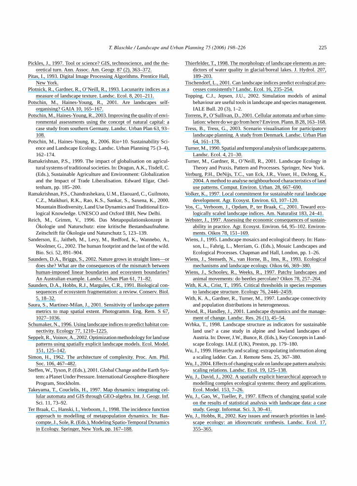
T. Blaschke / Landscape and Urban Planning 75 (2006) 198–226 225
Pickles, J., 1997. Tool or science? GIS, technoscience, and the the-oretical turn. Ann. Assoc. Am. Geogr. 87 (2), 363–372.
Pitas, I., 1993. Digital Image Processing Algorithms. Prentice Hall,New York.
Plotnick, R., Gardner, R., O’Neill, R., 1993. Lacunarity indices as ameasure of landscape texture. Landsc. Ecol. 8, 201–211.
Potschin, M., Haines-Young, R., 2001. Are landscapes self-organising? GAIA 10, 165–167.
Potschin, M., Haines-Young, R., 2003. Improving the quality of envi-ronmental assessments using the concept of natural capital: acase study from southern Germany. Landsc. Urban Plan 63, 93–108.
Potschin, M., Haines-Young, R., 2006. Rio+10. Sustainability Sci-ence and Landscape Ecology. Landsc. Urban Planning 75 (3–4),162–174.
Ramakrishnan, P.S., 1999. The impact of globalisation on agricul-tural systems of traditional societies. In: Dragun, A.K., Tisdell, C.(Eds.), Sustainable Agriculture and Environment: Globalizationand the Impact of Trade Liberalisation. Edward Elgar, Chel-tenham, pp. 185–200.
Ramakrishnan, P.S., Chandrashekara, U.M., Elaouard, C., Guilmoto,C.Z., Maikhuri, R.K., Rao, K.S., Sankar, S., Saxena, K., 2000.Mountain Biodiversity, Land Use Dynamics and Traditional Eco-logical Knowledge. UNESCO and Oxford IBH, New Delhi.
Reich, M., Grimm, V., 1996. Das Metapopulationskonzept inOkologie und Naturschutz: eine kritische Bestandsaufnahme.Zeitschrift fur Okologie und Naturschutz 5, 123–139.
Sanderson, E., Jaitheh, M., Levy, M., Redford, K., Wannebo, A.,Woolmer, G., 2002. The human footprint and the last of the wild.Bio. Sci. 52, 891–904.
Saunders, D.A., Briggs, S., 2002. Nature grows in straight lines—ordoes she? What are the consequences of the mismatch betweenhuman-imposed linear boundaries and ecosystem boundaries?An Australian example. Landsc. Urban Plan 61, 71–82.
Saunders, D.A., Hobbs, R.J., Margules, C.R., 1991. Biological con-. Biol.
S ttern67,
S t con-
S useodel.
S hil.
S Sys-phere
T cel-r. Inf.
T ctionas-
mics
Thierfelder, T., 1998. The morphology of landscape elements as pre-dictors of water quality in glacial/boreal lakes. J. Hydrol. 207,189–203.
Tischendorf, L., 2001. Can landscape indices predict ecological pro-cesses consistently? Landsc. Ecol. 16, 235–254.
Topping, C.J., Jepsen, J.U., 2002. Simulation models of animalbehaviour are useful tools in landscape and species management.IALE Bull. 20 (3), 1–2.
Torrens, P., O’Sullivan, D., 2001. Cellular automata and urban simu-lation: where do we go from here? Environ. Plann. B 28, 163–168.
Tress, B., Tress, G., 2003. Scenario visualisation for participatorylandscape planning. A study from Denmark. Landsc. Urban Plan64, 161–178.
Turner, M., 1990. Spatial and temporal analysis of landscape patterns.Landsc. Ecol. 4, 21–30.
Turner, M., Gardner, R., O’Neill, R., 2001. Landscape Ecology inTheory and Praxis, Pattern and Processes. Springer, New York.
Verburg, P.H., DeNijs, T.C., van Eck, J.R., Visser, H., DeJong, K.,2004. A method to analyse neighbourhood characteristics of landuse patterns. Comput. Environ. Urban. 28, 667–690.
Volker, K., 1997. Local commitment for sustainable rural landscapedevelopment. Agr. Ecosyst. Environ. 63, 107–120.
Vos, C., Verboom, J., Opdam, P., ter Braak, C., 2001. Toward eco-logically scaled landscape indices. Am. Naturalist 183, 24–41.
Webster, J., 1997. Assessing the economic consequences of sustain-ability in practice. Agr. Ecosyst. Environ. 64, 95–102. Environ-ments. Oikos 78, 151–169.
Wiens, J., 1995. Landscape mosaics and ecological theory. In: Hans-son, L., Fahrig, L., Merriam, G. (Eds.), Mosaic Landscapes andEcological Processes. Chapman and Hall, London, pp. 1–26.
Wiens, J., Stenseth, N., van Horne, B., Ims, R., 1993. Ecologicalmechanisms and landscape ecology. Oikos 66, 369–380.
Wiens, J., Schooley, R., Weeks, R., 1997. Patchy landscapes andanimal movements: do beetles percolate? Oikos 78, 257–264.
With, K.A., Crist, T., 1995. Critical thresholds in species responses
W ivity
W nage-
W inablees ofnd-
W long
W alysis:
W h toions.
W scalecase
W land-l. 17,
sequences of ecosystem fragmentation: a review. Conserv5, 18–32.
aura, S., Martinez-Milan, J., 2001. Sensitivity of landscape pametrics to map spatial extent. Photogramm. Eng. Rem. S1027–1036.
chumaker, N., 1996. Using landscape indices to predict habitanectivity. Ecology 77, 1210–1225.
eppelt, R., Voinov, A., 2002. Optimization methodology for landpatterns using spatially explicit landscape models. Ecol. M151, 125–142.
imon, H., 1962. The architecture of complexity. Proc. Am. PSoc. 106, 467–482.
teffen, W., Tyson, P. (Eds.), 2001. Global Change and the Earthtem: a Planet Under Pressure. International Geosphere-BiosProgram, Stockholm.
akeyama, T., Couclelis, H., 1997. Map dynamics: integratinglular automata and GIS through GEO-algebra. Int. J. GeogSci. 11, 73–92.
er Braak, C., Hanski, I., Verboom, J., 1998. The incidence funapproach to modelling of metapopulation dynamics. In: Bcompte, J., Sole, R. (Eds.), Modeling Spatio-Temporal Dynain Ecology. Springer, New York, pp. 167–188.
to landscape structure. Ecology 76, 2446–2459.ith, K. A., Gardner, R., Turner, M., 1997. Landscape connect
and population distributions in heterogeneous.ood, R., Handley, J., 2001. Landscape dynamics and the ma
ment of change. Landsc. Res. 26 (1), 45–54.rbka, T., 1998. Landscape structure as indicators for susta
land use? a case study in alpine and lowland landscapAustria. In: Dover, J.W., Bunce, R. (Eds.), Key Concepts in Lascape Ecology. IALE (UK), Preston, pp. 179–180.
u, J., 1999. Hierarchy and scaling: extrapolating information aa scaling ladder. Can. J. Remote Sens. 25, 367–380.
u, J., 2004. Effects of changing scale on landscape pattern anscaling relations. Landsc. Ecol. 19, 125–138.
u, J., David, J., 2002. A spatially explicit hierarchical approacmodelling complex ecological systems: theory and applicatEcol. Model. 153, 7–26.
u, J., Gao, W., Tueller, P., 1997. Effects of changing spatialon the results of statistical analysis with landscape data: astudy. Geogr. Informat. Sci. 3, 30–41.
u, J., Hobbs, R., 2002. Key issues and research priorities inscape ecology: an idiosyncratic synthesis. Landsc. Eco355–365.

226 T. Blaschke / Landscape and Urban Planning 75 (2006) 198–226
Wu, J., Loucks, O.L., 1995. From the balance-of-nature to hierar-chical patch dynamics: a theoretical framework shift in ecology.Quart. Rev. Biol. 70, 439–466.
Wu, J., Marceau, D., 2002. Modeling complex ecological systems:an introduction. Ecol. Model. 153, 1–6.
Zebisch, M., Wechsung, F., Kenneweg, H., 2004. Landscaperesponse functions for biodiversity-assessing the impact of land-use changes at the county level. Landsc. Urban Plan 67, 157–172.
Zhang, M., Geng, S., Ustin, S.L., 1998. Quantifying the agri-cultural landscape and assessing spatio-temporal pattern ofprecipitation and groundwater use. Landsc. Ecol. 13, 37–53.
Zonneveld, I., 1995. Land Ecology. SBP Academic Publishing, Ams-terdam.
Thomas Blaschke holds a MSc in Geography and AppliedGeoinformatics and a PhD in Geography from the University ofSalzburg, Austria. He worked as GIS coordinator at the BavarianAcademy of Nature Conservation and Landscape Management,Laufen, Germany, as a senior research fellow in Manchester, UK,and as a professor for Geography and GIS at the University ofTubingen, Germany. Currently, he is associate director of ZGIS,the Centre for Geoinformatics, University of Salzburg, Austria.His research interests include methodological issues of the use ofGIS, remote sensing and image processing in landscape and urbanstudies. He is involved in European-wide landscape ecologicalresearch projects, CIS and remote sensing projects and has editedseveral books on GIS and Remote Sensing related topics. Oneprimary research question is on scales over which the relations andprocesses that we are seeking to model operate.


