Embed Size (px)
Citation preview
Vol:128; Issue 2(No:1) May 2014: 82-91 ISSN 0028-1344
82
1. INTRODUCTION
Archeological investigations show that landslides have been the main causes of settlement destructions
and survivors’ abandoning of their living sites. Studies on the effect of this phenomenon on ancient
settlements abandonment (prehistoric periods) have been limited to sedimentary examinations in the field
of archeology. The purpose of these studies was to comprehend sedimentation background and layers
sequence in order to reconstruct the environmental and climatic conditions of human settlements. Mc
Burney (1970) proposed worthwhile reports on the ancient climatee of central Zagros through
sedimentary data and ancient plants studies as well as excavating Humian rock shelter. Geo archeological
studies reported from 1975 to 1979 on Ghara Su River located at east of Ravansar and the west of
Kermanshah and Brux based on natural layers sequence has found out that torrential processes caused
burial of many ancient mounds under layers of muddy sediments with 10 meters thickness around the
shores of the main river 10000 years ago (Taheri, 2007). Berberian et al (2012) studied on Kashan Fault
activity and stated that an ancient earthquake happened in 3800 B.C. and the climate change that occurred
after that caused the springs to get dry and the settlements to destruct in Tappeh Sialk in Kashan. But the
notion is that the features, characteristics, reasons and dangers of an ancient landslide and its effect on
human’s life have not been studied yet.
During two seasons of Tappeh Mehr Ali rescue excavation, because of being in the vicinity of
Molasadra Dam on the north of Fars, unknown and discomposed cultural layers were shown. With
surveying the geomorphologic situation of the layers, analyzing soil-mechanism related issues, and also
examining the external and environmental conditions of this territory, it can be claimed that an earthquake
happened on this mound. All the archeological data was obtained from trench investigations that were
done before mound drowning; further investigations were impossible after mound drowning. The
extension of this phenomenon could be estimated if we possibly had at least enough opportunities.
The role of Natural events on Human settlements: an ancient case of Tappeh Mehr Ali
Landslide
Mahmood Heydarian*1
, Alireza Sardari2, Majid Sarikhani
3, Yasser Mardani
4, Mohsen Mardani
5
ABSTRACT
Natural events and disasters always have a devastating impact on human settlements and impose economic
and social effects on human societies with destroying buildings and infrastructures. One of these
destructive phenomena that dominate human life is landslide phenomenon damaging human communities,
meadows and forests, communication lines, and monuments extensively in many parts of the globe,
especially in mountainous countries such as Iran. Some information is currently available about the
morphological cause and the effects of some apparent cases of this phenomenon. However, the destructive
effects of this phenomenon on ancient settlements have not adequately been mentioned. This study
examined the infrequent phenomenon of an ancient landslide by combining data from two seasons of
rescue archaeological excavations of Tappeh Mehr Ali, located in Fars province, and related
interdisciplinary studies. The results of the archaeological excavations, geological evidence and
morphology of the site indicate that the southern slopes of the mound that slants (about 35 degrees) to
Balangan River, represent an ancient landslide event. This event caused the abandonment of this Mound for
some time during settlement periods.
Keywords: Landslides, Tappeh Mehr Ali, Balangan River, The ancient layer, Trench, Geo-archeology
Heydarian et al., (2014) NAUTILUS ISSN:0028-1344
83
2. TAPPEH MEHR ALI AND ITS IMPORTANCE IN ARCHEOLOGICAL STUDIES OF
NORTHERN FARS
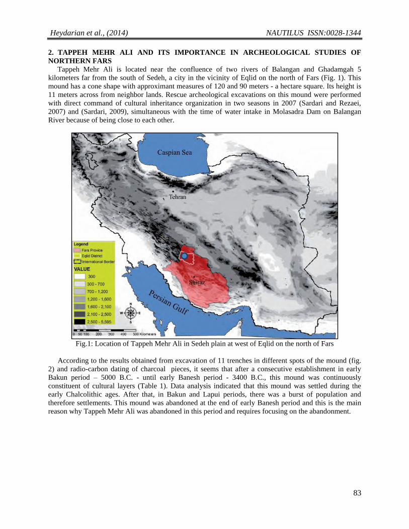
Tappeh Mehr Ali is located near the confluence of two rivers of Balangan and Ghadamgah 5
kilometers far from the south of Sedeh, a city in the vicinity of Eqlid on the north of Fars (Fig. 1). This
mound has a cone shape with approximant measures of 120 and 90 meters - a hectare square. Its height is
11 meters across from neighbor lands. Rescue archeological excavations on this mound were performed
with direct command of cultural inheritance organization in two seasons in 2007 (Sardari and Rezaei,
2007) and (Sardari, 2009), simultaneous with the time of water intake in Molasadra Dam on Balangan
River because of being close to each other.
Fig.1: Location of Tappeh Mehr Ali in Sedeh plain at west of Eqlid on the north of Fars
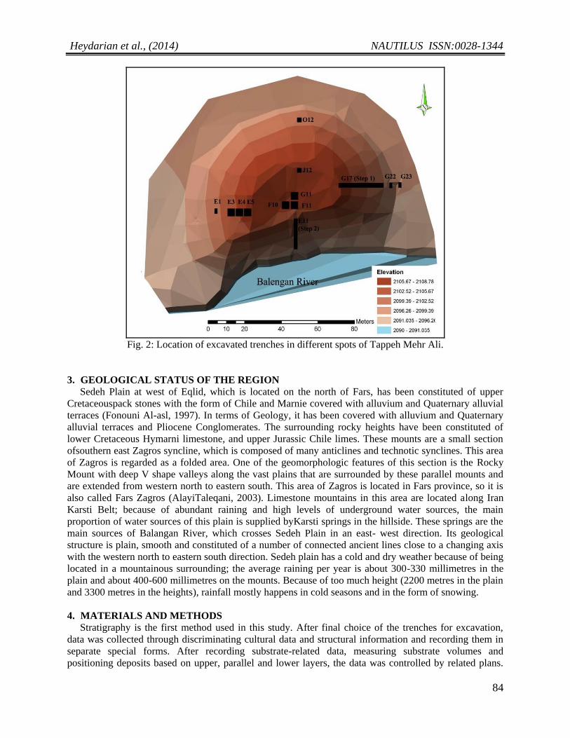
According to the results obtained from excavation of 11 trenches in different spots of the mound (fig.
2) and radio-carbon dating of charcoal pieces, it seems that after a consecutive establishment in early
Bakun period – 5000 B.C. - until early Banesh period - 3400 B.C., this mound was continuously
constituent of cultural layers (Table 1). Data analysis indicated that this mound was settled during the
early Chalcolithic ages. After that, in Bakun and Lapui periods, there was a burst of population and
therefore settlements. This mound was abandoned at the end of early Banesh period and this is the main
reason why Tappeh Mehr Ali was abandoned in this period and requires focusing on the abandonment.
Heydarian et al., (2014) NAUTILUS ISSN:0028-1344
84
Fig. 2: Location of excavated trenches in different spots of Tappeh Mehr Ali.
3. GEOLOGICAL STATUS OF THE REGION
Sedeh Plain at west of Eqlid, which is located on the north of Fars, has been constituted of upper
Cretaceouspack stones with the form of Chile and Marnie covered with alluvium and Quaternary alluvial
terraces (Fonouni Al-asl, 1997). In terms of Geology, it has been covered with alluvium and Quaternary
alluvial terraces and Pliocene Conglomerates. The surrounding rocky heights have been constituted of
lower Cretaceous Hymarni limestone, and upper Jurassic Chile limes. These mounts are a small section
ofsouthern east Zagros syncline, which is composed of many anticlines and technotic synclines. This area
of Zagros is regarded as a folded area. One of the geomorphologic features of this section is the Rocky
Mount with deep V shape valleys along the vast plains that are surrounded by these parallel mounts and
are extended from western north to eastern south. This area of Zagros is located in Fars province, so it is
also called Fars Zagros (AlayiTaleqani, 2003). Limestone mountains in this area are located along Iran
Karsti Belt; because of abundant raining and high levels of underground water sources, the main
proportion of water sources of this plain is supplied byKarsti springs in the hillside. These springs are the
main sources of Balangan River, which crosses Sedeh Plain in an east- west direction. Its geological
structure is plain, smooth and constituted of a number of connected ancient lines close to a changing axis
with the western north to eastern south direction. Sedeh plain has a cold and dry weather because of being
located in a mountainous surrounding; the average raining per year is about 300-330 millimetres in the
plain and about 400-600 millimetres on the mounts. Because of too much height (2200 metres in the plain
and 3300 metres in the heights), rainfall mostly happens in cold seasons and in the form of snowing.
4. MATERIALS AND METHODS
Stratigraphy is the first method used in this study. After final choice of the trenches for excavation,
data was collected through discriminating cultural data and structural information and recording them in
separate special forms. After recording substrate-related data, measuring substrate volumes and
positioning deposits based on upper, parallel and lower layers, the data was controlled by related plans.
Heydarian et al., (2014) NAUTILUS ISSN:0028-1344
85
After stratification of the, it was the time for descriptive classification of them. In total description of each
stratigraphy excavated sounding, at first, data obtained from stratigraphy was presented precisely and
finally, after data description, classified description of the substrates in a less specific framework and with
a more general consideration was presented. After analysing the raw information obtained from the forms,
designs and plans and finally, after stratifying, some chronological information was gained about the
process of layers formation and substrates sequential proportion as well as the stratigraphic framework.
After a close examination of previous stratigraphies and chronologies, a total categorical chronology was
proposed as the best complementary for the previous chronologies, which constituted of charcoal
radiocarbon dating.
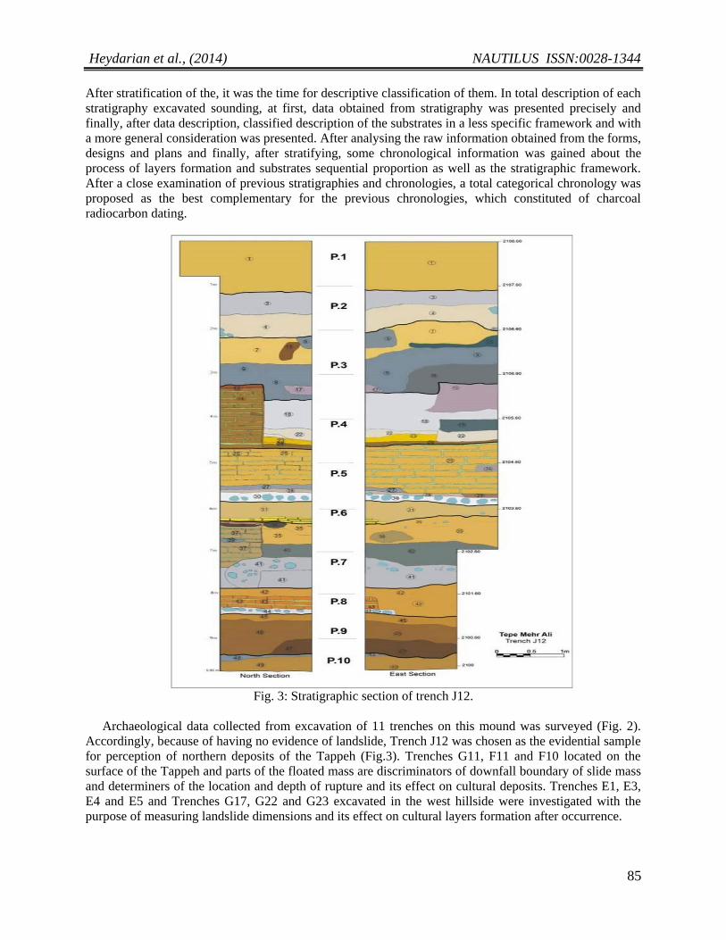
Fig. 3: Stratigraphic section of trench J12.
Archaeological data collected from excavation of 11 trenches on this mound was surveyed (Fig. 2).
Accordingly, because of having no evidence of landslide, Trench J12 was chosen as the evidential sample
for perception of northern deposits of the Tappeh (Fig.3). Trenches G11, F11 and F10 located on the
surface of the Tappeh and parts of the floated mass are discriminators of downfall boundary of slide mass
and determiners of the location and depth of rupture and its effect on cultural deposits. Trenches E1, E3,
E4 and E5 and Trenches G17, G22 and G23 excavated in the west hillside were investigated with the
purpose of measuring landslide dimensions and its effect on cultural layers formation after occurrence.
Heydarian et al., (2014) NAUTILUS ISSN:0028-1344
86
5. RESULTS
5.1. Landslide Introduction, Features and Occurrence Causes
Conforth (2005) defines landslide as any event occurs as a result of tottery hillside and causes
relocation of a mass of materials along with the hillside. This event as a natural occurrence is geologically
constituent of shakes and processes causing a mass of soil and stone to slide into lower because of the
gravity (Berberian, 1994). Ahmad and McCaplin (1999) used the terminology of landslide for all mass
movements along with the hillsides such as falls, topples and debris flows. Further, landslide as a
downside gravity movement of constituent materials of hillsides such as stones, soil or artificial gravel
soil which can be in the form of falling, sliding, flowing or a mixture of them (Varens, 1958). In 1978,
Kasen, by considering a collection of theories and ideas in 28 articles, defined landslide event as a mass
movement with a main element of gravity, which has a rapid movement of ruptured mass (Shariat Jafari,
1996). Sometimes, the movements are so rapid and have a speed of about 10 kilometres per hour and they
are so slow and are not intelligible without evidential and time passage (Varnes, 1958). Based on rupture
shape, landslides are categorised into two types of rotational and transitive slides (Bromhead, 2010). In
the first type, as the name denotes, materials move downward on a U shape surface, but in the second
type, the transferred mass along a rupture surface disc moves downward the hillside. The main features of
a landslide are illustrated in Picture 4.
Zezere(1999) proposes that the most prominent cause of landslide occurrence is as follows: geological
structure, land applied geology, pre-occurred landslides and human activities. Wu et al (2001) referred to
soil heavy texture as the most important cause of landslide. Kumak and Gerald (2001) have identified
land slop, geology and surface structure as effective factors on landslide occurrence. Lidia believes that
raining and water are the main causes of landslides among which an intense continuous raining affects
geological structure, permeability and hillside slope (Lydia and Bengochea, 2002). Talebi et al (2007)
also propose that slope geometry and temporal changes of the amounts of underground water sources and
depth of underground waters are the main causes of landslides in damp areas. Totally, this event can
occur as a result of various geological, geomorphologic, hydrological, biological and humanistic factors
though at the starting point of this event, usually, an external stimulus or a trigger is the most determinant
factor. Intensive raining, snow melting, changes in underground water sources, earthquake and rapid soil
drifting are the main triggers of landslides (Sidle and Ochiai, 2006). Hillside slope and morphology also
play important roles in landslide occurrences. Emergence of this factor, an exigent one, strengthens the
effective roles of other factors in mass movements. In a similarly shaped landside with symmetric
material features, an increase of landside slope has the most coefficients in mass movements (Dai and
Lee, 2002). All in all, various factors such as geological features (Lithology weathering, structural factors
and seismicity), hydrology and hydrological circumstances, topography, morphology and weather affect
stability of the slope and can cause landslides (Shoaei and Qhayoumian, 1998; Angeli et al., 2004). These
factors can be classified into three classes of geological, morphological and humanistic factors (USGS:
Fact sheet, 2004):
1. Geological factors are weathered fragile materials, ruptured cleaved and creviced materials,
discontinuous directing at the opposite side of layering, schistosity, fault, contact surfaces,
permeability differences and materials toughness.
2. Morphological factors among which uplifting as a result of volcanic techno tic activities, iceberg
melting pressure elimination, river erosion, underground erosion (break up and boiling), sediment
uploading on the landsides, vegetation elimination (fire and drought), snow melting, weathering
as a result of glaciating and melting, weathering as a result of expansion and contraction are the
most prominent ones.
3. Humanistic factors such as excavation on the hillside, uploading on the hillside, underground
water sources lowering, woodcutting, irrigation, mining, artificial quake fluctuation, and water
are affective. It must be noted that humanistic factors play no role in the process of under
investigation landslide.
Heydarian et al., (2014) NAUTILUS ISSN:0028-1344
87
6. EVIDENCE OF LANDSLIDE OCCURRENCE ON TAPPEH MEHR ALI
6.1. Environmental Evidence
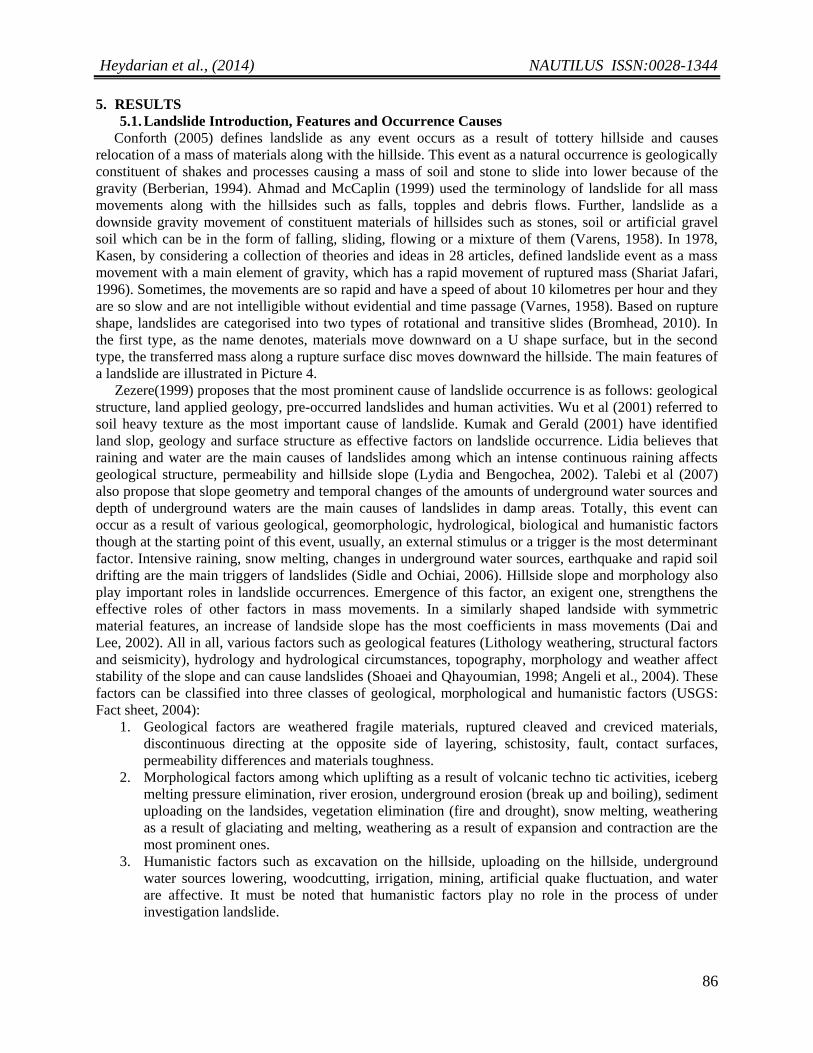
Mound morphology shows that an ancient landside happened on the southern hillside. On this
landside, the shape of the mound changes suddenly and reaches Balangan River with a steep slope (about
35 degree). The evidence indicates that the direction of Balangan River changes toward the mound, which
is the main cause of hillside. Erosion caused by destructive floods has caused the southern hillside to
rupture as a result of gravity. Other factors affecting the occurrence of this landslide are the high level of
underground waters and flow of underground waters through the mound (Fig.4, right). The evidence of
underground waters was totally apparent in the cuts and partitions of Balangan River in water lowering
season. Existence of such bulky volumes of underground sources is because of alluvial fans on which the
plain and also the city of Sedeh are located. The loads of snow melting waters on the mound,permeation
of snow melting waters and the abundance of clay mineral in between the various ancient layers (Fig. 4,
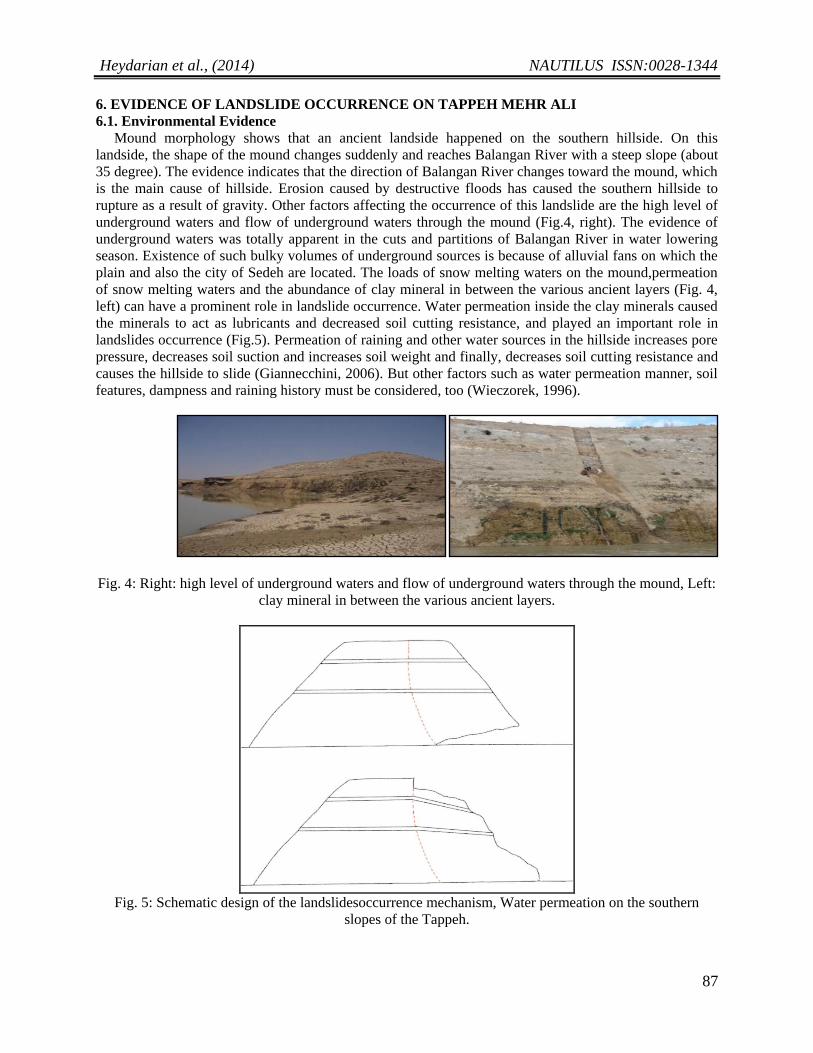
left) can have a prominent role in landslide occurrence. Water permeation inside the clay minerals caused
the minerals to act as lubricants and decreased soil cutting resistance, and played an important role in
landslides occurrence (Fig.5). Permeation of raining and other water sources in the hillside increases pore
pressure, decreases soil suction and increases soil weight and finally, decreases soil cutting resistance and
causes the hillside to slide (Giannecchini, 2006). But other factors such as water permeation manner, soil
features, dampness and raining history must be considered, too (Wieczorek, 1996).
Fig. 4: Right: high level of underground waters and flow of underground waters through the mound, Left:
clay mineral in between the various ancient layers.
Fig. 5: Schematic design of the landslidesoccurrence mechanism, Water permeation on the southern
slopes of the Tappeh.
Heydarian et al., (2014) NAUTILUS ISSN:0028-1344
88
6.2. Archaeological Evidence
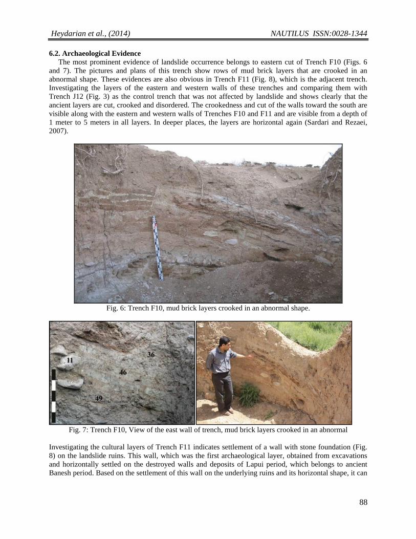
The most prominent evidence of landslide occurrence belongs to eastern cut of Trench F10 (Figs. 6
and 7). The pictures and plans of this trench show rows of mud brick layers that are crooked in an
abnormal shape. These evidences are also obvious in Trench F11 (Fig. 8), which is the adjacent trench.
Investigating the layers of the eastern and western walls of these trenches and comparing them with
Trench J12 (Fig. 3) as the control trench that was not affected by landslide and shows clearly that the
ancient layers are cut, crooked and disordered. The crookedness and cut of the walls toward the south are
visible along with the eastern and western walls of Trenches F10 and F11 and are visible from a depth of
1 meter to 5 meters in all layers. In deeper places, the layers are horizontal again (Sardari and Rezaei,
2007).
Fig. 6: Trench F10, mud brick layers crooked in an abnormal shape.
Fig. 7: Trench F10, View of the east wall of trench, mud brick layers crooked in an abnormal
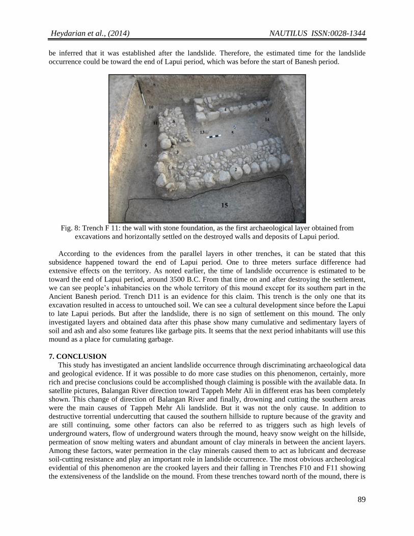
Investigating the cultural layers of Trench F11 indicates settlement of a wall with stone foundation (Fig.
8) on the landslide ruins. This wall, which was the first archaeological layer, obtained from excavations
and horizontally settled on the destroyed walls and deposits of Lapui period, which belongs to ancient
Banesh period. Based on the settlement of this wall on the underlying ruins and its horizontal shape, it can
Heydarian et al., (2014) NAUTILUS ISSN:0028-1344
89
be inferred that it was established after the landslide. Therefore, the estimated time for the landslide
occurrence could be toward the end of Lapui period, which was before the start of Banesh period.
Fig. 8: Trench F 11: the wall with stone foundation, as the first archaeological layer obtained from
excavations and horizontally settled on the destroyed walls and deposits of Lapui period.
According to the evidences from the parallel layers in other trenches, it can be stated that this
subsidence happened toward the end of Lapui period. One to three meters surface difference had
extensive effects on the territory. As noted earlier, the time of landslide occurrence is estimated to be
toward the end of Lapui period, around 3500 B.C. From that time on and after destroying the settlement,
we can see people’s inhabitancies on the whole territory of this mound except for its southern part in the
Ancient Banesh period. Trench D11 is an evidence for this claim. This trench is the only one that its
excavation resulted in access to untouched soil. We can see a cultural development since before the Lapui
to late Lapui periods. But after the landslide, there is no sign of settlement on this mound. The only
investigated layers and obtained data after this phase show many cumulative and sedimentary layers of
soil and ash and also some features like garbage pits. It seems that the next period inhabitants will use this
mound as a place for cumulating garbage.
7. CONCLUSION
This study has investigated an ancient landslide occurrence through discriminating archaeological data
and geological evidence. If it was possible to do more case studies on this phenomenon, certainly, more
rich and precise conclusions could be accomplished though claiming is possible with the available data. In
satellite pictures, Balangan River direction toward Tappeh Mehr Ali in different eras has been completely
shown. This change of direction of Balangan River and finally, drowning and cutting the southern areas
were the main causes of Tappeh Mehr Ali landslide. But it was not the only cause. In addition to
destructive torrential undercutting that caused the southern hillside to rupture because of the gravity and
are still continuing, some other factors can also be referred to as triggers such as high levels of
underground waters, flow of underground waters through the mound, heavy snow weight on the hillside,
permeation of snow melting waters and abundant amount of clay minerals in between the ancient layers.
Among these factors, water permeation in the clay minerals caused them to act as lubricant and decrease
soil-cutting resistance and play an important role in landslide occurrence. The most obvious archeological
evidential of this phenomenon are the crooked layers and their falling in Trenches F10 and F11 showing
the extensiveness of the landslide on the mound. From these trenches toward north of the mound, there is
Heydarian et al., (2014) NAUTILUS ISSN:0028-1344
90
no sign of landslide. Investigation of the cultural layers obtained from Trench F11 shows the settlement of
a stone wall on the landslide ruins. This wall, which is found from excavating the first archeological layer,
belongs to Ancient Banesh period and is settled horizontally on the ruins and destroyed, walls of Ancient
Lapui period. According to horizontal settlement of this wall on the ruins, it can be deducted that its
structure belongs to a time after landslide. Therefore, the landslide might have occurred toward the end of
Lapui and the beginning of Banesh period. More precisely, if we consider the above settlement as the last
occupational phase on the Tappeh Mehr Ali, based on the absolutely radiocarbon dates of Charcoal
samples, the estimated time of landslide occurrence can be during around 3500 B.C. In the Picture 8, the
form of stone wall settlement on the ruins is shown in the western cut of Trench F11. The length of the
wall in northern and southern sides indicates that it is horizontal.
REFERENCES
1.Ahmad, R., and McCaplin, J. P., 1999, Landslide susceptibility maps for the Kingston Metropolitan Area
Jamaica. http//www.oas.org/en/cdmp.
2.AlayiTaleqani, M., 2003, Geomorphology of Iran, Ghoomes Publishing company Ltd, Second edition,
Tehran, Iran.
3.Angeli, M. G., Gasparetto, P., and Bromhead, E., 2004, Strength-regain mechanisms in intermittently
moving landslides. Rio de Janeiro, Vol. 1. Taylor and Francis, London, pp. 689-698.
4.Berberian, M., 1994, Master "blind" thrust faults hidden under the Zagros folds: Active basement
tectonics and surface morph tectonics. Tectonophysics.
5.Berberian.M.,Malekshahmirzadi, S., Nokandeh., J, Djamali, M., 2012, Archeoseismicity and
environmental crises at the sialk mounds, Central Iranian plateau, since the early Neolithic; journal of
archeological science; Elsevier.
6.Bromhed, E. N., 2010, Landslide slip surfaces: their origins, behavior and geometry. London: Kingston
University.
7.Conforth, D. H., 2005, Landslides in practice, John Wiley & Sons, Inc.
8.Dai, F. C., and Lee, C. F., 2002, Landslide characteristics and slope in stability modeling using GIS
lantau Island Hong Kong. Geomorphology, H2:213-228. (In Eng.)
9.Fonouni Al-asl, B., 1997, Structural study Tang-e Boraq for Assessment of engineering properties of
MullaSadra Dam in north of Fars, Master of Science thesis, ShahidBeheshti University, Tehran, Iran.
10.Giannecchini, R., 2006, Relationship between Rainfall and shallow landslides in the southern Apuan Alps
(Italy), J Nat Hazards Earth SystSci 6, 357-364.
11.Kumac, M., and Gerald, F., 2006, A Landslide suscepility model using the Analytical hierarchy process
method and multivariate statisticsimPerialpine Slovenia Geomorphology, Vol 74, pp. 17-28.
12.Lydia, E. E., and Bengochea, D., 2002, Landslide Hazard and Risk Zonation Mapping in the Rio Grande
Basim, Central Andes of Mendoza Argentina Research and Development. Vol. 22, pp. 177-185.
13.McBurney, C. B. M., 1970, Paleolithic Excavation in Zagros Area, Iran, Vol. 8, pp. 185-186.
14.Sardari, A. R., 2009, Report of the Second Season Rescue excavations of the Tappeh Mehr Ali, Eghlid
Fars, Archive Center for Archaeological Research Documents, Cultural Heritage, Handcrafts and Tourism
Organization.
15.Sardari, A. R., 2011, Study of Socio-economic Complexities of Northern Fars Cultures (Eghlid) during
Chalcolithic period based on the Archaeological excavation at Tappeh Mehr Ali, PhD Thesis,
TarbiatModares University, Tehran, Iran.
16.Sardari, A. R., and Rezaei, A., 2007, Report of the Rescue Archaeological Investigations on the Tappeh
Mehr Ali, Eghlid Fars, in Archaeological Reports(7): the 9th Annual Symposium on Iranian Archaeology,
Iranian Center for Archaeological Research, Tehran, vol. 2: 155–72 (in Persian).
17.ShariatJafari, M., 1996, Landslide (Basics and principles of Stability of natural slopes), Sazeh Publishing
company Ltd, Tehran, Iran.
18.Shoaei, Z., and Qhayoumian, J., 1998, Seimareh landslide, the largest complex slides in the world, proc.
Eighth International Congress.
Heydarian et al., (2014) NAUTILUS ISSN:0028-1344
91
19.Sidle, R. C., and Ochiai, H., 2006, Landslides Processes, Predictio, and land use, Water Resource
Monograph: 18, AGU books, ISSN: 0170-9600.
20.Taheri, K., 2007, Reviews the history of Geoarcheology in Iran, 26th Symposium of Geosciences,
Tehran, Ministry of Industries and Mines, Geological and Mineral Exploration of Iran. For more
information: http://www.civilica.com/Paper-GSI26-GSI26_363.htm
21.Talebi, A., Uijlenhoet, R., Troch, P. A., 2007, soil Moisture storage and hill slope Stability, J Nat Hazards
EarthsystSci 7,523-534.
22.U. S. Geological Survey, Landslide Type and Processes, fact sheet 2004 -3072, July 2004. 23.Varnes, D. J., 1958, Landslide Types and Process. In Special Report29: Landslide and Engineering
practice (E.B. Eckel, Ed.) HRB, National Research Council, Washington, D. C., pp. 20-47.
24.Wieczarek, G. F., 1996, landslide Triggering Mechanisms, In: Landslides: Investigation and Mitigation,
Washington DC: Transportation Research Board, National Research Council, Special Report, 76-90.
25.Wu, S., L. Shi, R. Wang and R. Xu., 2001, Zonation of the landslid the foreserviorvegion engineering
Geology, vol. 74, pp: 17-28.
26.Zezere, J. L., 1999, landslide in the north of Lisbon region (Portugal): conditioning and triggering factors,
Phys. chem. earths (A), vole 24: 925.
1-Assistant Prof., Dept. of Archaeology, Shahrekord University, IRAN
2-Assistant Prof.,Iranian Archaeological Research Center, IRAN
3-Assistant Prof., Dept. of Archaeology, Shahrekord University, IRAN
4-MSc Student, Dept. of Archaeology, Shahrekord University, IRAN
5-Geotechnical Specialist, Soil and Mechanic Laboratory Company, Road and Urban
Development Ministry, IRAN
*Corresponding Author’s Address: [email protected], Mob: 00989187552993, Post Cod: 115
Journal’s USL; http://www.nautilusjournal.net


