Embed Size (px)
Citation preview

The Downs Conservation Area
Conservation Area Appraisal October 2014


The Downs Conservation Area, Altrincham: Conservation Area Appraisal October 2014
Contents
The Downs Conservation Area Altrincham Conservation Area Appraisal October 2014 Contents
1. Introduction .......................................................................................................................... 1
1.1. Designation and Extensions of The Downs Conservation Area .............................................. 1
1.2. Definition of a Conservation Area ........................................................................................... 1
1.3. Value of Conservation Area Appraisals ................................................................................... 2
1.4. Scope of the Appraisal............................................................................................................. 3
2. Planning Policy Context ......................................................................................................... 5
2.1. Planning Policy Context ........................................................................................................... 5
2.2. Conservation Area Policy Guidance ........................................................................................ 6
2.3. Control Measures Brought about by Designation .................................................................. 7
3. The Summary of Special Interest ........................................................................................... 9
4. Assessment of Special Interest ............................................................................................ 11
4.1. Introduction ........................................................................................................................... 11
4.2. Location and Setting .............................................................................................................. 11
4.3. Historic Development of Altrincham and The Downs........................................................... 17
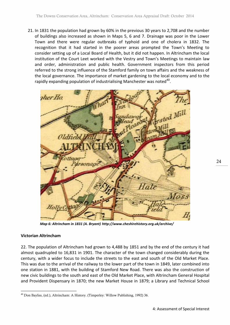
4.4. Architectural Quality and Built Form .................................................................................... 44
5. Audit of Heritage Assets ...................................................................................................... 69
5.1. Introduction ........................................................................................................................... 69
5.2. Listed Buildings ...................................................................................................................... 69
5.3. Monuments ........................................................................................................................... 95
5.4. Positive Contributors ............................................................................................................. 96
6. Assessment of Condition ............................................................ Error! Bookmark not defined. 6.1. General Condition .................................................................... Error! Bookmark not defined. 6.2. Intrusion and Negative Factors ................................................ Error! Bookmark not defined. 6.3. Problems, Pressures and Capacity for Change ......................... Error! Bookmark not defined.
7. Identifying the Boundary ............................................................ Error! Bookmark not defined.
8. A Plan for Further Action ............................................................ Error! Bookmark not defined.
9. Sources ...................................................................................... Error! Bookmark not defined.
Appendix 1: Listed Buildings ...................................................................................................... 87
Appendix 2: Contacts .............................................................................................................. 127

The Downs Conservation Area, Altrincham: Conservation Area Appraisal Draft: October 2014
1: Introduction
1
1. Introduction
1.1. Designation and Extensions of The Downs Conservation Area
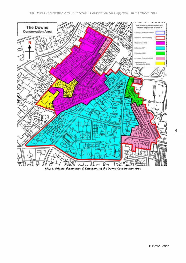
1. The Downs Conservation Area was designated on 8th February, 1973, comprising The Downs and the area to its north including Wellington Place, New Street, Lyme Grove and the majority of Norman’s Place. The Conservation Area was extended on 4th July, 1974, to include the area to the south including St John’s Road, Albert Square, Delamer Road, part of Ashley Road and the north side of Cavendish Road. It was further extended in 1988 to include the northeast side of Ashley Road and the north of Oxford Road. Map 1 indicates the original designation with subsequent extensions.
1.2. Definition of a Conservation Area
1. A conservation area is an area “of special architectural or historic interest the character or appearance of which it is desirable to preserve or enhance”.1 Designation takes place primarily by local planning authorities under Section 69 of the Planning (Listed Buildings and Conservation Areas) Act 1990. Local planning authorities also have a duty from time to time to review the extent of designation and to designate further areas if appropriate.2
2. Section 71 of the Act imposes a duty on the local planning authority to formulate and publish proposals for the preservation and enhancement of conservation areas. Proposals should be publicised and incorporate public comment.
3. Conservation area designation recognises the unique quality of an area as a whole. It is not
just the contribution of individual buildings and monuments, but also that of features such as topography, layout of roads, pathways, street furniture, open spaces and hard and soft landscaping which assist in defining the character and appearance of an area. Conservation Areas identify the familiar and cherished local scene that creates a sense of place, community, distinctiveness and environment.
4. The extent to which a building positively shapes the character of a conservation area depends not just on their street elevations, but also on their integrity as historic structures and the impact they have in three dimensions, perhaps in an interesting roofscape, or skyline. Back elevations can be important, as can side views from alleys and yards3.
1 Section 69 (1) (a) Planning (Listed Buildings and Conservation Areas) Act 1990 2 Section 69 (2) Planning (Listed Buildings and Conservation Areas) Act 1990 3 English Heritage, Understanding Place: Conservation Area Designation, Appraisal and Management. (London: English
Heritage, 2011) para 2.2.21

The Downs Conservation Area, Altrincham: Conservation Area Appraisal Draft: October 2014
1: Introduction
2
1.3. Value of Conservation Area Appraisals
1. The National Planning Policy Framework stresses the need for local planning authorities to set out a positive strategy for the conservation and enjoyment of the historic environment. Local planning authorities are required to define and record the special characteristics of heritage assets within their area. This appraisal fulfills the statutory duty placed on the local planning authority “to formulate and publish proposals for the preservation and enhancement of any parts of their area which are conservation areas.”4
2. Conservation areas may be affected by direct physical change or by changes in their setting. A clear definition of those elements which contribute to the special architectural or historic interest of a place will enable the development of a robust policy framework for the future management of that area, against which applications can be considered.5
3. The purpose of the Appraisal is, in accordance with the methodology recommended by English Heritage,6 to define and record the special architectural and historic interest of the Downs Conservation Area. This Appraisal has been used to prepare a draft Management Plan which sets out suggested actions to maintain and enhance the special character of the area. These documents will support the active management of the Conservation Area through the development control process, including support for appeals.
4. The undertaking of an appraisal will lead to a better understanding of the development of
the conservation area, in terms of its local distinctiveness, setting and condition, which together contribute to the place it is today. This will enable the basis for positive management of the Downs Conservation Area.
5. An adopted conservation area appraisal is a material consideration to appeal decisions and
also relevant to decisions made by the Secretary of State when considering urgent works to preserve an unlisted building in a conservation area. An appraisal can inform those considering investment in the area, help guide the form and content of new development7 and result in an educational and informative document for the local community.8
6. The Town and Country Planning Act (General Permitted Development) Order 1995 as
amended (GPDO) sets out permitted development rights for certain minor forms of development - i.e. development that may be legitimately undertaken without the need for planning permission. An appraisal can assess whether or not permitted development rights are having an adverse impact on the special interest of a conservation area and whether or not the use of an Article 4 direction is appropriate.
4 Section 71(1) Planning (Listed Buildings and Conservation Areas) Act 1990. 5 English Heritage, Guidance on Conservation Area Appraisals. (London: English Heritage, 2006) para 2.8. 6 English Heritage, Guidance on Conservation Area Appraisals. (London: English Heritage, 2005). 7 English Heritage, Understanding Place: Conservation Area Designation, Appraisal and Management. (London: English
Heritage, 2011) para 1.7 8 English Heritage, Understanding Place: Conservation Area Designation, Appraisal and Management. (London: English
Heritage, 2011) para 1.9

The Downs Conservation Area, Altrincham: Conservation Area Appraisal Draft: October 2014
1: Introduction
3
7. This Appraisal will provide a character assessment of the present Conservation Area and those areas under consideration for extension. The document will seek to identify those factors resulting in adverse harm to the special interest of the Conservation Area, identify whether cumulative change can be addressed through Article 4 directions and assess if statutory action is required to safeguard buildings at risk.
8. A review of existing boundaries has also been undertaken to determine if areas should be included or removed from the designation; this discussion is found in Section 7 and the proposed extensions are also shown in Map 21. Consequentially the document will provide background evidence for accessing the acceptability of development proposals.
9. Further guidance and proposals will be detailed in a corresponding The Downs Management
Plan which should be considered in conjunction with this Appraisal.
1.4. Scope of the Appraisal
1. This document is not intended to be comprehensive in its scope and content. Omission of any specific building, structure, site, landscape, space, feature or aspect located in or adjoining to The Downs Conservation Area should not be taken to imply that it does not hold significance and positively contribute to the character and appearance of the designated heritage asset.
2. As an area evolves evidence may emerge which provides a greater understanding of a heritage asset(s) and the contribution made to the special interest of the Downs Conservation Area. Such information should be considered in conjunction with the appraisal during the course of decision making by the local planning authority.
3. The positive characteristics as defined by this document should be the starting point for further discussion with the local planning authority where alterations are being considered to or will affect a heritage asset(s). Each site will be judged on its own merits and there are bound to be variations in the quality of individual developments. It will not be acceptable merely to emulate the least successful or highest density of these or to use such sites as an excuse for making matters worse. Instead regard should be paid to those elements which make the Downs Conservation Area significant. Ultimately special attention shall be paid to the desirability of preserving and enhancing the character or appearance of the Conservation Area9.
4. This draft conservation area appraisal has been produced by the Council following the
submission of an initial draft by Kathryn Sather Associates
9 Section 7(1) Planning (Listed Buildings and Conservation Areas) Act 1990.
The Downs Conservation Area, Altrincham: Conservation Area Appraisal Draft: October 2014
1: Introduction
4
Map 1: Original designation & Extensions of the Downs Conservation Area
The Downs Conservation Area, Altrincham: Conservation Area Appraisal Draft: October 2014
2: Planning Policy Context
5
2. Planning Policy Context
2.1. Planning Policy Context
1. The Planning (Listed Buildings and Conservation Areas) Act 1990 and the National Planning Policy Framework (NPPF) provide the legislative and national policy framework for conservation area appraisals and management plans.
2. The NPPF (paragraph 126) states;10
“Local planning authorities should set out in their Local Plan a positive strategy for the conservation and enjoyment of the historic environment, including heritage assets most at risk through neglect, decay or other threats. In doing so, they should recognize that heritage assets are an irreplaceable resource and conserve them in a manner appropriate to their significance. In developing this strategy, local planning authorities should take into account;
the desirability of sustaining and enhancing the significance of heritage assets and putting them to viable uses consistent with their conservation;
the wider social, cultural, economic and environmental benefits that conservation of the historic environment can bring;
the desirability of new development making a positive contribution to local character and distinctiveness;
and opportunities to draw on the contribution made by the historic environment to the character of a place”.
3. NPPF (Annex 2) defines a heritage asset as, “A building, monument, site, place, area or landscape identified as having a degree of significance meriting consideration in planning decisions, because of its heritage intereSt Heritage asset includes designated heritage assets and non-designated heritage assets identified by the local planning authority (including local listing)”. The guidance also states that a designated heritage asset is one that is classed as “A World Heritage Site, Scheduled Monument, Listed Building, Protected Wreck Site, Registered Park or Garden, Registered Battlefield or Conservation Area designated as such under the relevant legislation.11” A non-designated heritage asset is a building, monument, site, place, area or landscape identified as having a degree of significance that is not protected under legislative framework.
4. This document must be considered alongside the Council’s policies concerning development
and the use of land as set out in the Trafford Core Strategy formally adopted on 25th January
10 Department of Communities and Local Government, National Planning Policy Framework. (Department of Communities and Local Government, 2012) para.126. 11 Department of Communities and Local Government, National Planning Policy Framework. (Department of
Communities and Local Government, 2012) Annex 2.

The Downs Conservation Area, Altrincham: Conservation Area Appraisal Draft: October 2014
2: Planning Policy Context
6
2012. Of particular relevance is Policy R1 - Historic Environment relating to designated and non-designated heritage assets; Policy R5 - Open Space Sport and Recreation, Policy R6 – Culture and Tourism, Policy L7 – Design and Policy W2-Town Centres and Retail.
5. A number of policies and proposals of the Revised Unitary Development Plan adopted in
2006 are currently “saved”, such as ENV21 Conservation Areas and ENV22 Conservation Area Designation, until they are replaced by the Land Allocations Development Plan Document. Relevant supplementary planning documents for the Old Market Place Conservation Area include advertisements and shop fronts.
2.2. Conservation Area Policy Guidance
1. This appraisal was undertaken consulting guidance provided by English Heritage in the subsequent documents;
Measuring and Assessing Change in Conservation Areas 2005
Guidance on Conservation Area Appraisals 2006
Guidance on the Management of Conservation Areas 2006
Understanding Place: An Introduction 2010
Understanding Place: Historic Area Assessments in a Planning and Development Context 2010
Understanding Place: Historic Area Assessments: Principles and Practice 2010; Understanding Place: Conservation Area Designation, Appraisal and Management 2011
Understanding Place: Character and Context in Local Planning 2011
Streets for All
Conservation Principles Policies and Guidance
2. The English Heritage document Conservation Principles, published in 2008, provides policies and guidance for identifying significance. Four heritage values are assigned through which a site or place can be interpreted; evidential, historical, communal and aesthetic.
3. Further guidance has been issued by English Heritage in the suite of documents
Understanding Place with a view to setting out approaches to undertake assessments of historic areas allowing a greater understanding of the character of a place and its capacity for change. In particular Understanding Place - Historic Area Assessments: Principles and Practice stresses the importance in ‘identifying and understanding particular qualities, and what these add to our lives, is central to our engagement with our history and culture’. As referenced in Understanding Place - Historic Area Assessments: Principles and Practice, Power of Place published by English Heritage, ‘stressed the positive impact of local and ‘ordinary’ heritage – what might be termed the buildings and spaces in between ‘monuments’ – on the quality of people’s lives and its central role in constructing local identity’.
4. In addition, consultation of the Historic Environment Record for Altrincham maintained by
the Greater Manchester Archaeological Advisory Service (GMAAS) has been undertaken and also an assessment of the Trafford Urban Historic Landscape Characterisation Project 2008.

The Downs Conservation Area, Altrincham: Conservation Area Appraisal Draft: October 2014
2: Planning Policy Context
7
5. The proposals set out by this appraisal shall undergo a period of public consultation and will
be submitted for consideration at a public meeting in the area to which they relate.12 The local planning authority shall have regard to any views concerning the proposals expressed by persons attending the meeting13 or during the period of consultation.
2.3. Control Measures Brought about by Designation
1. In determining applications for development in conservation areas, local planning authorities must pay special attention “to the desirability of preserving or enhancing the character or appearance of that area.”14 This requirement, as set out in legislation, is also reflected in national and local policy.
2. In order to protect and enhance conservation areas any changes that take place must do so
in a way that encourages positive conservation and management. Statutory control measures are designed to prevent development that may have a negative or cumulative effect on the character and appearance of an area and include the following;
• Planning Permission is usually required to totally or substantially demolish buildings or structures including walls, gate piers, gates, chimneys, fence or railings within a conservation area. • The extent of ‘permitted’ development is reduced for commercial and residential properties restricting such things as cladding, extensions to the side of the original dwelling or the installation of satellite dishes. Further control measures such as Article 4 directions may be placed upon an area. These may be served to further restrict permitted development rights for example elements or alterations such as windows, doors, chimneys, boundary walls and gate posts and restrict certain types of extensions. • Trees with a stem diameter of 75mm or greater, measured at 1.5 metres from soil level, enjoy a measure of protection if they stand in a designated conservation area. The Council requires six weeks written notice of any proposed felling or pruning of such trees, other than the removal of dead wood and the felling of dead and/or dangerous trees, which do not require notification. In the case of the removal of undesirable trees to allow superior trees to flourish, known as ‘selective thinning’, the requirement is relaxed to allow the removal of trees of stem diameter up to 100mm to be removed without giving the Council prior notice. • Should the notified tree work be unacceptable to the Council, the latter will make a Tree Preservation Order during the six week notification period, thus ensuring continuity of protection. Local Authorities cannot insist upon a replacement for a tree lawfully felled within a conservation area, unless the tree is also protected by a Tree Preservation Order.
12 Section 71 (2) Planning (Listed Buildings and Conservation Areas) Act 1990. 13 Section 71 (3) Planning (Listed Buildings and Conservation Areas) Act 1990 14 Section 72 (1) Planning (Listed Buildings and Conservation Areas) Act 1990

The Downs Conservation Area, Altrincham: Conservation Area Appraisal Draft: October 2014
2: Planning Policy Context
8
Certain categories of advertisement which have deemed consent under the Advertisement Regulations are restricted in areas of special control.

The Downs Conservation Area, Altrincham: Conservation Area Appraisal Draft: October 2014
4: Assessment of Special Interest
9
3. The Summary of Special Interest
1. The special character of the Downs Conservation Area derives from the following elements:
Altrincham has a long history as part of a communication and transport network, going back nearly two thousand years. The development of the Downs area for housing and business, was greatly influenced by the advent of the railway in 1849, with the terminus station being located just outside the Conservation Area at the foot of The Downs.
The Downs Conservation Area is situated between what was the original settlement of the market town of Altrincham and the hamlet of Bowdon to the south of it. It has grown up around the first sections of two routes between the settlements. The first is Norman’s Place and The Narrows, leading from Altrincham’s ‘Higher Town’ into Bowdon Road and then to Altrincham’s original Church at Bowdon, via The Firs, which was known as ‘Burying Lane’. The second is up The Downs from the ‘Lower Town’, leading up to Higher Downs, then onto The Firs and the Church.
The Downs Conservation Area has five distinct character zones. Character Zone A which being late Georgian and early Victorian terraced housing on different plot sizes, with small town gardens or larger gardens built for a mixture of social classes; Character Zone B is the core area, closer to the town centre has a compact urban grain, with on-street Victorian buildings now in commercial use and some purpose built residential of the same period; Character Zone C predominately developed in the second half of the 19th century, with large semi-detached and detached villas in mature gardens; Character Zone D is a distinctive group of large cream ‘white’ brick Italianate villas also set in mature gardens and Character Zone E is the unified residential cul-de-sac of Lyme Grove.
There are extensive views out of the area from The Downs, due to its location on the northern slope of the Bowdon ridge, and the flatness of the surrounding area. These views have been diminished to a degree by the construction of tall buildings on Railway Street, just outside the Conservation Area. There are also attractive enclosed views within the designation.
The development of the area in the second half of the 19th century was planned to a certain degree by the 7th Earl of Stamford, but controlled by strict covenants at the sale of the plots, resulting in significant control over quality and density. Small entrepreneurial builders developed the individual plots with a few houses, so that the effect combines individuality with harmony. Traditional craftsmanship is embodied in original building materials (primarily brick and natural blue slate); with architectural and decorative features ensuring a balance of variety and harmony.
The Downs Conservation Area, Altrincham: Conservation Area Appraisal Draft: October 2014
4: Assessment of Special Interest
10
The area has a large number of listed buildings, comprising two substantial detached residences, four groups of early 19th century terraced housing, two churches and a boundary stone, in addition to buildings of local architectural and/or historic interest
Despite the lack of public open spaces, the size, maturity and quality of the many gardens, trees, hedges and shrubs. Particularly in the southern part of the Conservation Area, the range of trees reflects the Victorian interest in unusual species. Frontage planting is obviously important in the street scene but trees further back within a site may also be very significant as background landscaping. Many of the trees contribute to the quality of the distant views.
Historic boundary treatments notably the sandstone walls, gateposts and hedging are significant and valuable contributors to the historic streetscene.
The area has a long association with education, both private and public. Since the late 18th century there have been a series of Sunday schools, church schools and private schools. The buildings, one still operating as a school, contribute to the character of the Conservation Area.

The Downs Conservation Area, Altrincham: Conservation Area Appraisal Draft: October 2014
4: Assessment of Special Interest
11
4. Assessment of Special Interest
4.1. Introduction
1. The main section of the appraisal comprises a detailed analysis of the special interest of the Downs Conservation Area with regard to its location and setting, historic development and archaeology, architectural quality and built form, open space, parks, gardens and trees.
4.2. Location and Setting Location and Setting of The Downs Conservation Area
1. The Downs Conservation Area is designated in Altrincham, to the south of the town centre, straddling the historic boundary of the Townships of Altrincham, Bowdon and Dunham Massey, within the original Parish of Bowdon (but now mainly within St John’s Parish and St Margaret’s Parish, Altrincham and only in part St Mary’s Parish of Bowdon). Historically, the area known as The Downs was residential and included much of what is now Railway Street, extending up to the open fields at the top of the ridge, also known as The Downs.
2. Altrincham is located approximately 8 miles (12.9 km) southwest of Manchester city centre, 3 miles (4.8 km) south-southwest of Sale and 10 miles (16 km) east of Warrington. Altrincham is the principal focus for high quality comparison retail supported by a range of service, leisure, tourism, office and other town centre-type uses including residential. Its market has run continuously since 1290. The town provides supplies and services for the surrounding settlements of Hale, Hale Barns, Bowdon, Oldfield Brow, Dunham Massey, Broadheath and Timperley. It also serves as a commuter settlement to nearby Manchester connected by an integrated public transport system including the Metrolink tram service.
3. The Downs Conservation Area is one of five Conservation Areas either wholly or partly sited within the Altrincham town centre boundary (see map 2). The Conservation Area borders the Bowdon and Devisdale Conservation Areas to its south and west, the Old Market Place Conservation Area to the north and New Stamford Road Conservation Area to the northeast.
4. Altrincham is located in the south of the borough of Trafford, one of the ten local authorities forming the Greater Manchester region. In Roman times its centre (The Old Market Place) if it did exist then, lay just to the southeast of the part of Watling Street which connected Chester to Manchester. This route has largely remained the main road (the modern A556/56) but at some point it deviated from the straight line to go through Altrincham15
before re-joining it further north in Broadheath. In the 18th century the road was upgraded to a turnpike and Altrincham was also on the route of the Bridgewater Canal, linking the Earl of Bridgewater’s mines to Manchester and to Manchester to Runcorn with access to the sea.
5. In the 19th century the Bridgewater Canal was supplemented by the Manchester Ship Canal, passing to the north of Altrincham, and the town was linked by rail to Manchester in 1849,
15 Don Bayliss (ed.), Altrincham: A History. (Timperley: Willow Publishing, 1992), 9

The Downs Conservation Area, Altrincham: Conservation Area Appraisal Draft: October 2014
4: Assessment of Special Interest
12
allowing Altrincham and its suburbs to become a desirable residential area for commuters to Manchester. In the 20th century, this was complemented by the introduction of the Altrincham Metro, a reintroduction of tram transport.
6. Altrincham is situated on a ridge surrounded by the Cheshire Plain to the south and the lowland of the Mersey valley to the north. The ridge rises to a height of 67 metres above sea level and runs from Dunham Park to the south west of Altrincham through to Bowdon, Hale and beyond in the southeast. The Old Market Place is situated on the northward facing, shallow slope of the ridge; the somewhat steeper, southward facing side of the ridge in Bowdon overlooks the Bollin valley. In the town centre, the ridge also falls away to the east towards Hale Moss. The Downs is located on the shallow north-
eastern slope, just south of the town centre.18
7. The Conservation Area is bisected by the north to south routes from Altrincham to the Parish Church of St Mary’s on Bowdon Downs on the top of the ridge. The Narrows formed part of the Saxon route and still provides a direct pedestrian route today; The Downs and Higher Downs supplemented this route up the hill. Woodville and St John’s Road (onto Hale Road), is an ancient west to eastern route. Other roads such as New Street, Oxford Road and Delamer Road, however, were laid out in the 19th century.
8. The geology of the area consists of the Permian and Triassic sandstones and mudstones of the north Cheshire Basin. Surface exposures of these rocks are mainly limited to river valleys due to great thickness of the overlying Quaternary deposits.16 The ridge upon which Altrincham is sited in part reflects the solid rock structure which under lies it but is obscured by the significant Quaternary deposits. These deposits are largely responsible for the minor landforms and soils of the area (glacially deposited sands with occasional clay lenses17), thus the farming potential.18
9. The Helsby Sandstone Formation (formerly the Lower Keuper Sandstone) appears on the surface at Timperley where it was quarried prior to 1900. It is this stone which was probably used for stone plinths for timber-framed and brick houses in the locality, as well as in the striking boundary walls within the Victorian and Edwardian ‘villa suburbs’ of Altrincham.19 The Building Stone Atlas of Greater Manchester describes this rock type as harder than the others in the Permian-Triassic succession, due to the localised presence of a silica cement matrix, hence it is a more durable building material. It is often red or pink from the coating of iron oxide over the sand grains and often contains many ‘millet seed’ grains, with a spherical shape, indicative of an aeolian origin within a desert environment. It contains white or purplish quartz pebbles up to 20mm across; and pebbles of red silt and red clay, which when weathered out leave ovoid cavities.20
16 English Heritage, Strategic Stone Study – A Building Stone Atlas of Greater Manchester, Introduction. (London: English
Heritage, 2011) 17 Michael Nevell, Archaeology North West Vol 5 (Issue 15 for 2000). 18 Don Bayliss et al., Altrincham in 1841 – A Cheshire Market Town in Victorian Times. (Altrincham: Historical Society,
1994) 5. 19
English Heritage, Strategic Stone Study – A Building Stone Atlas of Greater Manchester. (London: English Heritage,
2011) 12. 20 English Heritage, Strategic Stone Study – A Building Stone Atlas of Greater Manchester. (London: English Heritage,
2011) 12.
The Downs Conservation Area, Altrincham: Conservation Area Appraisal Draft: October 2014
4: Assessment of Special Interest
13
10. Towards the end of the nineteenth century and early twentieth century large amounts of
building stone was imported particularly for use in public and municipal buildings. The red Runcorn Sandstone (Triassic, Sherwood Sandstone group) was used profusely, shipped in great volumes via the Bridgewater and Manchester Ship Canals. The red sandstone is evident at the Church of St Mary the Virgin, Bowdon and also at the Old Bank, Old Market Place. More commonly sandstone was used in small amounts for architectural detailing and buff varieties can be found in the Conservation Area often used for cills and coping stones to boundary walls21.
11. Another commonplace rock type to be imported and one used in the Conservation Area was the metamorphic blue-grey Welsh Slate (Ordovician), which is still ubiquitous as a roof cladding in the vast swathes of terraced housing which formed the iconic industrial townscapes of Manchester’s satellite towns. Green Westmoreland Slate (Ordovician), and Cornish Delabole Slate (Devonian), have also been utilised occasionally for roofing22.
21 English Heritage, Strategic Stone Study – A Building Stone Atlas of Greater Manchester. (London: English Heritage, 2011)
13 22 English Heritage, Strategic Stone Study – A Building Stone Atlas of Greater Manchester. (London: English Heritage, 2011)
12

The Downs Conservation Area, Altrincham: Conservation Area Appraisal Draft: October 2014
4: Assessment of Special Interest
14
Map 2: The Downs Conservation Area in relation to nearby conservation areas

The Downs Conservation Area, Altrincham: Conservation Area Appraisal Draft: October 2014
4: Assessment of Special Interest
15
General Description, Character and Plan Form
1. The focus of The Downs Conservation Area is the historic route of The Downs; it encompasses the largely residential areas either side (dating chiefly from the 19th century) and the commercial area at the eastern end of The Downs, resulting in a considerably varied street scene. This is further enhanced by the variety of gardens and walls, as well as the topography, with The Downs reflecting its natural gradient.
2. The Conservation Area is accessed from the northeast via the road junction at Railway
Street. Historically this was the location of Bowdon Railway Terminus and later in 1907, the terminus of the tram reinforcing the commuter habit. It is also accessed from the town centre to the north via Norman’s Place and New Street and from the south from Bowdon, via Higher Downs and Delamer Road. From Hale it is accessed from Ashley Road and Oxford Road (shown in Map 3).
3. The Downs is broadly triangular in shape, with a rectangle containing Lyme Grove and
Norman’s Place to the northwest. The character of the area derives primarily from its origin as a Victorian residential suburban area, comprising a variety of dwellings including early terraced housing, spacious Victorian semi-detached houses and a small commercial area, closer to the town centre. The plots are smaller lower down the hill in the north, reflecting the area originally being developed to provide housing for workers in New Street and the now demolished Chapel and Albert Streets. They were, built on to the street or with very small town gardens and small narrow plots to the rear. Elsewhere further up the hill towards Bowdon, the predominant impression is of spaciousness, tree lined streets and large houses in large grounds, containing mature trees and shrubs. The majority of properties are of Victorian date but there are smaller numbers of Georgian, Edwardian and later 20th century buildings.
4. There are no open public spaces apart from New Street Green, tended informally by local residents. Albert Square is an enclosed public space but the planting is all in the gardens, the square itself is tarmac. Towards the top of The Downs, where the road forks off to Delamer Road, there is also a sense of space, particularly with the view back downhill and out towards the distant hills in the northeast, now partially obscured by the building on the corner of Railway Street and Lloyd Street.
5. The area to the southeast of New Street containing a 1960s social housing development has open land around it and mature trees, but this lies on the edge of the Conservation Area.
6. There are a few public buildings. Most are in keeping with the character of the neighbourhood, namely the converted Chapel on Oxford Road (now a theatre), St John’s Church and associated converted buildings, Trinity Presbyterian Church (now vacant) on Delamer Road and Bowdon Preparatory School (formerly Culcheth) on the corner of Cavendish Road and Ashley Road.
7. Due to the variety of character within the Conservation Area, it has been divided into five character zones for the purpose of analysis.

The Downs Conservation Area, Altrincham: Conservation Area Appraisal Draft: October 2014
4: Assessment of Special Interest
16
8. Hard surfacing details vary considerably. The streetscape consists of tarmac road surfaces
with pavements of flagstones and tarmac. In Lyme Grove, Wellington Place, Osborne Place and Upper Downs (off Higher Downs), stone kerb-stones and stone setts have been retained. Generally the original surfaces were loose gravel with sandstone edges forming paths and driveways. The street furniture varies throughout the area – street lighting is Victorian style street lanterns in Lyme Grove and The Narrows; original cast iron lampposts with electric swan necks (at the top of The Downs and on Higher Downs) with concrete lampposts in Albert Square and modern lighting columns in other places.
9. There is generally a wealth of planting within the sites themselves. This is important for the
background landscape of the streetscene, for screening between sites and for its contribution to the distant skyline views of the area. There is in most parts of the areas a high proportion of soft landscaping to hard surfacing and building footprint and this is an important characteristic.
10. Typical trees and shrubs include oak, birch, pine, beech, holly, yew, box, laurel, privet and
rhododendron.
11. The larger plots typically have dense informal mixtures of trees and shrubs on their boundaries including a high proportion of evergreens. Hedges of native species are also commonly found on frontages. The frontage planting is often given prominence by being on a raised area behind a boundary wall for 5 metres or more into the site.
12. Front boundaries throughout the area consist mainly of walls of large dressed sandstone
blocks, varying in height from 0.6m to 2,0m. Usually there are simply designed stone gate piers. There are brick front boundary walls on some of the smaller properties.

The Downs Conservation Area, Altrincham: Conservation Area Appraisal Draft: October 2014
4: Assessment of Special Interest
17
Map 3: Existing Conservation Area Boundary
4.3. Historic Development of Altrincham and The Downs
Roman and Anglo-Saxon Period
1. The Roman Road known as Watling Street is thought to have run almost the length of England, from the southeast to Wroxeter (Viroconium) in Shropshire, with one section going west to Holyhead and another going north to Chester and on to Hadrian’s Wall. It is this latter section (from Chester to Manchester) which is believed to broadly follow the line of the A556-A56, traversing the area to the west of what was to become Altrincham town centre23. Its straight route can be traced from Dunham Road, across the archaeological excavations undertaken on the North Cestrian School playing fields on Oldfield Road and in line with Davenport Road, before re-joining the A56. No Roman remains have been found in
23
Don Bayliss. (ed.) Altrincham : A History, (Timperley: Willow Publishing, 1992) 9

The Downs Conservation Area, Altrincham: Conservation Area Appraisal Draft: October 2014
4: Assessment of Special Interest
18
the Conservation Area. However, a characteristic of land use from the Roman period was the laying out of roads, tracks and field boundaries at right angles and parallel to the Roman road, creating a grid system of square lands for farming and development which is probably reflected in subsequent Anglo-Saxon field boundaries24.
2. After the Romans left in AD 410 the native Britons (probably Celts) may have provided a
sparse population and the area may have been largely uninhabited and uncultivated. Evidence for Anglo-Saxon settlement in the area is derived from place names, in the absence of documentary or archaeological evidence. ‘Ham’ is derived from the Anglo-Saxon word for homestead or village and ‘inga’ refers to an Anglo-Saxon group, possibly led by an Anglo-Saxon chief, Aldhere, probably creating ‘Aldheringeham’.25 It is also possible that settlement here may have been preceded by settlement on the summit of the ridge, as the ‘dun’ found in Dunham and Bowdon, is an early Saxon word for curved hill, and also because the curved form of the churchyard was often associated with the earliest which were circular or oval in shape.
3. Although Altrincham is not mentioned in the Domesday Book, the area would have lain
within the Bucklow Hundred, the contemporary administrative division. This suggests that the population was minimal at this time. The vill of Dunham which is mentioned in Domesday as ‘Doneha’ is likely to have had a population no greater than eight families; Bowdon, including the church (‘Bogedone’), Hale (‘Hale’) and Ashley (‘Ascelie’) are also mentioned, all held by Alfward (also spelt ‘Alweard’), a Saxon lord. Thus one can extrapolate that in the Anglo-Saxon period Altrincham had a population of not more than 30-4026 and that it lay within the manor of Dunham.
Medieval Altrincham
4. The Normans did not reach Cheshire until 1070, in the context of the “Harrying of the North”, a violent campaign to take control of the land and the rebellious Anglo-Saxon landowners. William the Conqueror created his loyal follower Hugh d’Avranches Earl of Chester in this year and he in turn gave a large estate in the Altrincham area to Hamo de Masci, creating him a Baron. The name Dunham Massey, which was the administrative centre of the estate, is clearly derived from his name.27
5. In the subsequent two centuries the town grew in terms of both population and trade. This was encouraged by the introduction of a money economy and the trade resulting from being located in part of the hinterland for the Welsh campaigns of the late 13th century. In 1290 the town was granted a Borough Charter. It is possible that this was a measure initiated by de Masci’s descendent, another Hamo, to generate funds from the associated taxes, rents and other monopolies but it constituted a step-change in trade conditions and prosperity. The Royal Charter, granted to Hamo by King Edward I on 10th July 1290, allowed for a weekly market on Tuesdays and a three-day annual fair on the Feast of the Assumption
24 Don Bayliss. (ed.) Altrincham : A History, (Timperley: Willow Publishing, 1992) 9. 25
J. Dodgson. The Place Names of Cheshire, part 2. (Cambridge: English Place Name Society, 1970). 26
Don Bayliss. (ed.) Altrincham : A History, (Timperley: Willow Publishing, 1992) 10. 27
Don Bayliss. (ed.) Altrincham : A History, (Timperley: Willow Publishing, 1992) 12.

The Downs Conservation Area, Altrincham: Conservation Area Appraisal Draft: October 2014
4: Assessment of Special Interest
19
on August 15th. There was no market building, but the market place was probably marked by a market cross.
6. A second Charter was created at the same time by Hamo, which is referred to as the Borough Charter, provided for a ‘plan of the borough’, its legal aspects, its administration, the social composition of its population and their way of life. The Charter allowed for the institution of the Court Leet with associated officials, the forerunner of local government, and a self-regulating town community of tradesmen, called burgesses (regulated through a Guild) who had a steady residence on plots of land within the town known as burgages, for which they paid rent. Altrincham appears to have been the only new settlement type established during the medieval period in the area, contrasting with the dispersed settlement pattern of northern Cheshire28.
7. The medieval town plan was characterised by the rectangular plots, laid out perpendicular to the road. Representing the earliest form of land ownership, these were two perches wide and five long (approx. 48 x 120 feet), together with a strip of farmland, a Cheshire acre in size, for which an annual rent of twelve pence was payable. Dwellings, often two or three storeys in height, were erected at the street end and probably comprised a farmstead, workshop or shop on the ground floor with living accommodation above. The farmland would have been in the form of rectangular strips without boundaries within a larger field, such as Town Field. Such burgesses were also part-time farmers and craftspeople and it is notable that the Charter did not confirm the market29, meaning the Hamo could retain all the income from this source. The market’s location in Altrincham rather than Dunham suggests that the transport connections for Altrincham were superior; the detour from the route east of the Roman Road may already have been introduced.
8. Data from a rent roll of 1348/9 lists 120 burgages (similar size to Macclesfield and larger than Congleton (80) and Knutsford (30). If each contained a few inhabitants, the population could have been 500-600; however this was the period of the Black Death and the some Burgesses held several each – the roll contained only 45 names. New towns were generally laid out in a grid form with a market place at the centre, and along the major thoroughfare. In the case of Altrincham, the burgages probably extended either side of what is now Church Street, and south of the Market Place. The curved roads (Church Street, High Bank and Albert Place) north and west of the market place probably pre-dated the new town; the parallel roads laid out approximately on the present line of Market Street and George Street were intersected by cross-members approximating to Regent Road, Shaws Road and High Street. The Market Place was also the intersection of the east-west road from the baron’s castle at Dunham to Stockport Castle and the north-south road from Manchester to Chester30.
9. In 1319 Edward II changed the terms of the original charter so that the annual fair was held for the three days around the Feast of St. James, 24-26th July. A second annual fair held from 10-12th November dates from about this time. The 1348/9 document refers to the office of Mayor, chosen from the Burgesses by election.
28 Michael Nevell, Altrincham North West Vol. 5 (Issue 15 for 2000), 19 29 Don Bayliss (ed.), Altrincham: A History. (Timperley: Willow Publishing, 1992) 16 30 Don Bayliss (ed.), Altrincham: A History. (Timperley: Willow Publishing, 1992) 18.

The Downs Conservation Area, Altrincham: Conservation Area Appraisal Draft: October 2014
4: Assessment of Special Interest
20
10. During the 14th century outbreaks of the bubonic plague resulted in a declining population.
In 1348-49 the most severe of these, the Black Death, affected the area and the population is thought to have been reduced from its peak of about 650 people in 1300, down to two thirds or less31. It is likely that some of the burgage plots were abandoned or combined with others at this time.
11. There remains a lack of archaeological investigation into Altrincham as a medieval town32. In
the early 1980s a number of excavations were undertaken which produced very little evidence other than medieval pottery, a late medieval corn drying kiln and a post medieval well in Victoria Street. Nevertheless, watching briefs in the 1990s demonstrated the archaeological potential of the medieval borough with post medieval pits along the southern side of Dunham Road and the potential for buried remains behind buildings to the east of Church Street. Such investigations were the result of rescue archaeology rather than detailed studies into the medieval core of the town, therefore more substantial below ground remains may exist33.
12. At some point a distinction within the layout of the town was made between ‘Higher Town’ (the civic centre area around the Market Place) where the wealthier and professional people lived or had their businesses and the ‘Lower Town’ where the artisans and poorer people lived and worked the area around what is today known as George Street, Shaws Road and Victoria Street. It is believed that at least part of Railway Street existed in the medieval period, as the southern extent of Lower Town, but the area of Stamford New Road was fields, with Hale Moss lower still and further east.
Tudor to Georgian Altrincham
13. By the 1500s the population had probably still not recovered to its pre-Black Death size and prosperity. Leland referred to it as a “pore thing with a mayre”, suggesting that the houses were in poor repair but it had retained the local government forms.34 A visitor in 1621 described it as having ‘a fine little market’. The period of peace under the Tudors following the War of the Roses is likely to have led to greater prosperity interrupted again by the Civil war in the middle of the 17th century. This did not affect Altrincham, with the exception of Prince Rupert of the Rhine moving his army from Shrewsbury to York, stopping somewhere around the Downs.
14. The title of Lord of the Manor had passed to the Booth family from the 15th century. They had been heavily involved in the Civil War, leaving the estate in a poor and impoverished condition. After the Glorious Revolution of 1688, William Booth was made Earl of Warrington in recognition of his support for William of Orange. His son eschewed politics and focussed on rebuilding the estate and its management. The rebuilding of Dunham Hall and ancillary buildings took place was completed by 1720 and the wall to the park by 1740;
31 Don Bayliss (ed.), Altrincham: A History. (Timperley: Willow Publishing, 1992) 27 32 Michael Nevell, Archaeology North West Vol 5 (Issue 15 for 2000) 18. 33 Don Bayliss (ed.), Altrincham: A History. (Timperley: Willow Publishing, 1992) 18. 34
Don Bayliss. (ed.), Altrincham: A History. (Timperley: Willow Publishing, 1992) 33.

The Downs Conservation Area, Altrincham: Conservation Area Appraisal Draft: October 2014
4: Assessment of Special Interest
21
this would have generated grade and labour for the area but also required good management of the estate to cover the costs.
15. Leycester’s 1673 book about Cheshire refers to the erection of a number of small cottages in town with the permission of the estate and calling Altrincham ‘a nest of beggars’, which may have been the estate seeking to maximise its income from the high number of men seeking work. Nevertheless he had been on the opposing side of the Civil War to the Booths so his account may not be entirely impartial. Shortly after this the male Booth line died out and the estate passed by marriage to the Grey family, Earls of Stamford, who were to become important patrons and landowners of Altrincham.
16. Dairy farming was expanding at this period, recognised in the construction of a buttermarket in the marketplace, with a courthouse on the upper floor, built by Lord Delamer in 1684. This represents both a renewed focus on the civic core of Altrincham as well as a supplement to the growth of flax and the production of linen and woollen cloth in addition to other agricultural products. The growing importance of the dairy industry is reflected in the establishment of a third fair for cattle sales granted in 1734.
17. A further important 18th century development was the construction of the Bridgewater canal in 1765 from Worsley and Manchester through Broadheath and onto Runcorn by 1776. It was shown in Burdett’s 1777 Map of Cheshire (Map 4). This allowed for commuting from Altrincham to Manchester by packet boat, by then the centre of the flourishing cotton industry. On occasion people used the canal packets for day trips to visit Dunham Park. It also improved transport to Manchester for the dairy and agricultural goods from the market gardens and farms in the Altrincham area, increasing prosperity. Night soil was brought from Manchester to fertilise the market gardens. The ease of access and reduction in price of coal due to the Canal, helped local industry. The importing of building materials from further afield such as slate, led to greater variety in building styles. The focus for the canal transport and associated buildings was Broadheath (including the Old Packet House pub). This innovation also proved a spur to the development of the roads. The main one to Chester had already been turnpiked in 1752, with the northern section to Manchester completed by 1765. A stage-coach and mail coach service between Manchester, Knutsford and Chester was introduced35.
35 Don Bayliss et al., Altrincham in 1841 – A Cheshire Market Town in Victorian Times. (Altrincham: Altrincham History Society, 1994) 52.

The Downs Conservation Area, Altrincham: Conservation Area Appraisal Draft: October 2014
4: Assessment of Special Interest
22
Map 4: Altrincham in 1772-4 (Peter Burdett) http://www.cheshirehistory.org.uk/archive/
18. Town directories give a picture of the activities practiced in Altrincham at this time (recognising that these record only the more affluent and commercially oriented occupants). The 1782 directory lists thirty-six people and suggests the existence of established shops and businesses, in addition to the market. By far the largest proportion (13) was engaged in trade, but Altrincham also had a cabinet maker, a clockmaker, two attorneys, a barber and an apothecary suggesting prosperity, along with three innkeepers, the Unicorn Inn and the White Hart Inn mentioned by name. The textile trade is reflected with the presence of three ‘twisters’36. A 1789 directory refers to Altrincham as ‘the seat of a considerable manufactory in the worsted branch’ and a town characterised by ‘plain dealing’37. There was also a fulling mill on Grosvenor Road. Most of the mills relied on water power from The Fleam, which drained from Hale Moss across the north of Altrincham and ending up powering the corn mill at Dunham Massey. It was a time of rapid population growth in the town, from 1,029 in 1772 to 1,692 in 180138.
19. In the mid to late18th century, the introduction of the Bridgewater Canal sparked a phase of re-building and new building. Many medieval properties in the town centre were replaced by brick buildings or else their existing timber frame structures were given a new shell and a Georgian appearance. The first church to be built within Altrincham (which was part of the parish of St. Mary’s Bowdon) was the Wesleyan Chapel at Chapel Walk (Regent Road) in 1788. John Wesley had visited Altrincham in 1738 and preached in the open
36 Broster’s Chester Guide 1782, Altrincham Section, collated by Trafford Local Studies Centre. 37 W. Cowdroy, Directory and Guide for the City and County of Chester, with a concise history: Altrincham section, 1789,
collated by Trafford Local Studies Centre. 38 Don Bayliss et al., Altrincham in 1841 – A Cheshire Market Town in Victorian Times. (Altrincham: Altrincham History Society, 1994) 52.

The Downs Conservation Area, Altrincham: Conservation Area Appraisal Draft: October 2014
4: Assessment of Special Interest
23
air on Oldfield Brow, preaching at the new chapel on 5th April 1790. In 1799, marking the growing prosperity and population of Altrincham, the chapel of St George to the northwest of the Old Market Place was consecrated as a chapel of ease to Bowdon Parish Church. The first incumbent, Oswald Leicester, was the son of a local grocer. In 1783 he had started the first Sunday School in the County, first in Ashley Road, then at his home ‘The Poplars’ on Norman Place and finally in a cottage near the St George’s Church. The Wesleyans started another Sunday school in a house adjacent to what is now New Street. These complement the school founded by Thomas Walton in 1759 in Oldfield House.
20. The plan showing the property of the Earl of Stamford of 1790 (amended after 1799) in John Rylands Library, provides an overview of the state of Altrincham in the middle of the Georgian period and allows some of the buildings still existing today to be identified. The census of 1801 established the pattern of Altrincham society and housing. There were 340 houses with a population of 1,692. The upper and middle classes in larger houses were still clustered in Higher Town, the area around the Old Market Place, Church Street and Market Street. The poorer families and those of modest means lived in Lower Town in denser housing around George Street, Goose Green and the bottom of the Downs39. In addition to employment in the textile industry, there would have been handloom weaving in some of these houses. There was no regulation on the construction of these buildings.
Map 5: Altrincham in 1819 (Christopher Greenwood) http://www.cheshirehistory.org.uk/archive/
39 Don Bayliss (ed.), Altrincham: A History. (Timperley: Willow Publishing, 1992) 93.
The Downs Conservation Area, Altrincham: Conservation Area Appraisal Draft: October 2014
4: Assessment of Special Interest
24
21. In 1831 the population had grown by 60% in the previous 30 years to 2,708 and the number of buildings also increased as shown in Maps 5, 6 and 7. Drainage was poor in the Lower Town and there were regular outbreaks of typhoid and one of cholera in 1832. The recognition that it had started in the poorer areas prompted the Town’s Meeting to consider setting up of a Local Board of Health, but it did not happen. In Altrincham the local institution of the Court Leet worked with the Vestry and Town’s Meetings to maintain law and order, administration and public health. Government inspectors from this period referred to the strong influence of the Stamford family on town affairs and the weakness of the local governance. The importance of market gardening to the local economy and to the rapidly expanding population of industrialising Manchester was noted40.
Map 6: Altrincham in 1831 (A. Bryant) http://www.cheshirehistory.org.uk/archive/
Victorian Altrincham 22. The population of Altrincham had grown to 4,488 by 1851 and by the end of the century it had almost quadrupled to 16,831 in 1901. The character of the town changed considerably during the century, with a wider focus to include the streets to the east and south of the Old Market Place. This was due to the arrival of the railway to the lower part of the town in 1849, later combined into one station in 1881, with the building of Stamford New Road. There was also the construction of new civic buildings to the south and east of the Old Market Place, with Altrincham General Hospital and Provident Dispensary in 1870; the new Market House in 1879; a Library and Technical School
40 Don Bayliss, (ed.), Altrincham: A History. (Timperley: Willow Publishing, 1992) 36.

The Downs Conservation Area, Altrincham: Conservation Area Appraisal Draft: October 2014
4: Assessment of Special Interest
25
on George Street and a new Town Hall in 1901 on Market Street. The houses on George Street were gradually converted into retail and business use, albeit with residential use still above. Landmark bank buildings were built during this period and into the beginning of the 20th century on the Old Market Place, Stamford New Road and Railway Street. 23. Due to the Turnpike roads, the proximity of the Bridgewater Canal and the healthier raised location, Altrincham had already established itself as an early commuter town for the wealthy and professional classes. This characteristic was significantly reinforced and expanded to the hamlet of Bowdon further up the hill to the south, after an 1845 Act of Parliament. This meant that in 1849, the Manchester South Junction and Altrincham Railway opened the branch line from Manchester to Altrincham Station at the foot of what is now Stamford Street, extended to the Bowdon Terminus at the foot of the Downs in September of that year41. 24. A turntable was added in 1858. The Cheshire Midland Railway from Altrincham to Knutsford was opened in 1862, extended by other companies to Chester in 1872. This resulted in the additional development of Hale as a commuter town. 25. Under the Public Health Act of 1848, which in turn was prompted by a major widespread cholera epidemic in 1847-8, when a sufficient number of ratepayers (broadly 10%) petitioned, there would be a public inquiry into the sewerage, drainage, water supply, burial grounds, as well as the state of the streets. A preliminary report on the town centre by Isaac Turton led Altrincham to make such a request. His report censured the housing in the New Street and Chapel Street area, as being of poor quality, high density and with such overcrowding as to be unhealthy. Sir Robert Rawlinson attended and made a subsequent report to the General Board of Health in 1851, noting the inadequacy of the drinking water, sewerage and drains and paving, as well as the polluted state of the rivers and the absence of public parks. As a consequence, Altrincham’s Board of Health was empowered in 1851 to deal with highways and to improve the water supply and sewerage. Progress, however was slow. The Board of Health provided the municipal government, until it was superseded by the formation of the Altrincham Urban District Council in 189542. 26. An extensive description of the socio-economic structure and status of the area is provided in Bayliss’ survey, Altrincham in 1841 (1994) and also A Town in Crisis – Altrincham in the Mid-nineteenth Century (2006), based upon extensive analysis of census, tithe map and apportionment data, along with the 1852 Board of Health Plans and associated data . The Board of Health Plans in Trafford Local Studies, based upon a survey in 1852, detail the land use, structures, materials and road surfaces of the town, on a street by street basis. 27. The layout of the area continued to be greatly influenced by the Earl of Stamford. The 6th Earl had died in 1845 and his grandson George Harry the 7th Earl, who came of age in 1848, started selling off agricultural land for housing and new streets in 1851, as residential land values increased primarily due to the arrival of the railway in Altrincham in 1849. The deed covenants specified the quality and type of materials and rental value. The further away from the town centre and the higher up the hill to Bowdon, along with the proximity to the Dunham Massey seat, the better the quality and bigger the size of the houses. He also specified that industrial development should take place north of the Bridgewater Canal, which remained the case until the very end of the century.
42 Don Bayliss (ed), Altrincham: A History. (Timperley: Willow Publishing, 1992) 43.

The Downs Conservation Area, Altrincham: Conservation Area Appraisal Draft: October 2014
4: Assessment of Special Interest
26
28. There was also construction in the 1880s and 1890s of terraced housing off Hale Road and off the newly created Stamford Park on Hale Moss for lower middle and working classes, many of whom worked in the growing industrial expansion of Broadheath. Towards the end of the century more working class housing was developed on the Linotype estate43. 29. Brand new roads were laid out in the area and built upon, including New Street by 1851, Lyme Grove by 1865, Oxford Road by 1876 and Delamere Road up to Bowdon by 1865. A new section of Dunham Road was created to approach the Old Market Place from the south, avoiding the tight corner at High Street and Market Street. In 1880 Altrincham Station and Bowdon Terminus were closed and replaced by a new station in 1881 (still in use). Altrincham Station was demolished and Bowdon Station was converted into carriage sheds. This also resulted in the creation of Stamford New Road, extending in a straight line north from Railway Street at the bottom The Downs44. 20th Century Altrincham 30. The population in the 20th century rose from 16,831 in 1901 to 39,789 in 1951 to 41,122 in 1961, which is the approximate population today. The residential, business and industrial growth in the 19th century had been as a result of the development of the railways and the availability of the canal, along with gas and electricity supplies, combined with the availability of labour. Growth in the 20th century was spurred on by the improved transport facilities with the introduction in turn of trams, motorised road transport, and later the reintroduction of the tram in 1992. Broadheath industrial estate developed in the late 19th century, continued to thrive until the 1960s when around 10,000 people were employed by over 30 firms45. 31. In 1907 an electric tram service from Manchester was extended to Altrincham, with the Terminus at the bottom of the Downs on Railway Street. This was operated by Manchester Corporation and the service also included post trams. The trams were replaced by buses and an improved electrified railway in 1931, with the tram lines being removed or covered shortly afterwards along nearly all the route46.
32. Altrincham town centre developments shifted the focus further away from the Old Market Place around the twin hubs of the new railway station and the 1879 Market House during the first half of the 20th century, with the provision on George Street of public facilities such as the extension of the library in 1928 and the adjacent art gallery in 1934, as well as the Stamford Public Hall and assembly complex in 1936, extended in 1940. Other leisure facilities from this period included the public baths on Stamford New Road (1901), the Altrincham Theatre opposite the station which showed films from 1913 to 1966, and the nearby Altrincham Hippodrome which opened before the First World War and finally closed in 1986. Both of these seated around 1,000 people. There were two further cinemas in Altrincham in this period as well as the Garrick Playhouse to the north of the town, which opened in 193247. 33. Little changed until the 1960s, when the redevelopment of the town centre began with the demolition of part of George and Grafton Streets and the construction of the Grafton Centre,
43 Don Bayliss (ed), Altrincham: A History. (Timperley: Willow Publishing, 1992) 93 44 Don Bayliss (ed), Altrincham: A History. (Timperley: Willow Publishing, 1992) 89. 45 48 Don Bayliss (ed.), Altrincham: A History. (Timperley: Willow Publishing, 1992) 120. 46 Don Bayliss, Altrincham: A History. (Timperley: Willow Publishing, 1992) 84 47 Don Bayliss (ed.), Altrincham: A History. (Timperley: Willow Publishing, 1992) 79.
The Downs Conservation Area, Altrincham: Conservation Area Appraisal Draft: October 2014
4: Assessment of Special Interest
27
combining retail and commercial uses, and incorporating a high-rise office block. Following a report by the County Planning Officer, submitted in 1968, a policy for the redevelopment of the town centre was implemented. This involved the replacement of the public baths by the new leisure centre east of the railway line. It also resulted in the demolition of part of the area west of the station and its replacement by a new Library and a pedestrianised shopping area and raised car park at the north end of George Street, with Rackhams department store as the lead tenant, developed by Petros Development Company. The Stamford Hall and library complex was demolished as part of this development. The area north of the station now contains several office blocks. The dense 19th century housing, churches and schools of Chapel Street, Albert Street and lower New Street, were demolished and blocks of social housing and a car park took their place. The crowded housing of Newtown to the south of Lloyd Street was also demolished.
34. In 1974 the metropolitan borough of Trafford was formed, being part of Greater Manchester, merging a number of municipal boroughs including Altrincham which forms the southern limit. In the 1980s derelict areas, such as the site of the old Bowdon Terminus remained undeveloped as car parking, with a large supermarket being built opposite, on the site of Newtown. Goose Green and Kings Court became small enclaves for fashionable eateries and bars.
35. In the 21st century, further significant new development has taken place. This includes the redevelopment of the site of the Bowdon Terminus and the Denmark Street area site into a combination of a cinema, fitness complex restaurants, apartment housing, a large supermarket and car parking. Part of the redeveloped northern section of George Street has been demolished and redeveloped further with even larger units. A new public square and Lower Market canopy at Central Way has been created in 2014 and the Market House has become a food and drink destination with seating. On the east of Railway Street, the new Altrincham hospital will be relocated in 2015. Historic Development of The Downs 36. There have been no finds from the Roman or pre-Norman period within the Conservation Area. Nevertheless an historic route traverses through part of The Downs Conservation Area is part of a path connecting the settlement of Altrincham to that of Bowdon to the south (with its church and graveyard). Situated between Market Street and Norman’s Place in the town centre and The Firs in Bowdon, now known as The Narrows, this path is believed to date from Saxon times. Crossing this route, Woodville Road and St John’s Road leading to Hale Road are also thought to be ancient in origin. 37. The northern part of The Downs Conservation Area was thought to lie in the Town Field, one of the manorial fields divided into strips associated with particular burgage plots following the establishment of the town following its Charter in 1290. The entire area was probably agricultural at this time.48 38. The Plan showing the property of the Earl of Stamford of 1790 (with amendments after 1799), provides an overview of the state of Altrincham in the middle of the Georgian period and allows some of the buildings still existing today to be identified. Some of the road and paths within the
48 Don Bayliss(ed.), Altrincham: A History. (Timperley: Willow Publishing, 1992) 28.

The Downs Conservation Area, Altrincham: Conservation Area Appraisal Draft: October 2014
4: Assessment of Special Interest
28
Downs Conservation Area can be identified, including Norman’s Place and the footpath of The Narrows. What was then the large fork leading at the west edge of Pinfold Brow (Lloyd Street) into Ashley Road and up The Downs and higher up, to the offset cross roads at Higher Downs, Woodville Road and an ancient path which later became St John’s Road, can also clearly be seen. Lyme Grove, New Street, Wellington Place, Delamer Road, Cavendish Road, Albert Square and Oxford Road are simply fields. 39. The first church to be built within Altrincham (which was part of the parish of St Mary’s Bowdon) was the Wesleyan Chapel at Chapel Walk (Regent Road) in 1788, where John Wesley preached in 1790. A Wesleyan school was built at the lower end of New Street. In 1783 Oswald Leicester, son of a local grocer (and later first incumbent of St George’s) started the first Sunday School in the County, first in Ashley Road, then at his home ‘The Poplars’ on Norman Place, within the Downs Conservation Area. These schools established a trend for religious and educational establishments in the Conservation Area, which continues to this day. 40. The census of 1801 established the pattern of Altrincham society and housing. The poorer
families lived in Lower Town in denser housing, which included the bottom of The Downs.55 During the beginning of the 19th century, a period of greater prosperity, a few larger villa-type houses began to be built along The Downs and Norman’s Place. Further dense housing for the working classes proliferated in Chapel Street and Albert Street (now demolished but was parallel to New Street) and later New Street itself and Wellington Place. There were no regulations on the construction of the buildings.
Photograph 1: The Downs 1890 (Altrincham Area Image Archive)
41. The 1835 Tithe map (and Apportionments of 1839) showed that the section of the Conservation Area between The Narrows and The Downs was given over to market gardens (see Map 7). There are three substantial houses on Norman’s Place, but Lyme Grove and Wellington Place are still just fields. New Street runs parallel to Chapel Street, but while the south side is developed, there are only a few buildings on the north side, including the Wesleyan school. By this time the upper part of The Downs on the northern side had been developed. Outside the Conservation Area in the 1839 Dunham Massey Tithe Map, there are two detached houses to the west of Higher Downs. The land to the southeast of The Downs, was either arable or to the south of St John’s Road, market gardens. There are scattered farm buildings. Part of this included a large area of land between The Downs

The Downs Conservation Area, Altrincham: Conservation Area Appraisal Draft: October 2014
4: Assessment of Special Interest
29
and Ashley Road down to the plot today containing St John’s Church and its former school, being Thorley Moor and is shown as being owned by the Mayor of Altrincham.
42.Following the opening of the railway line to Altrincham in 1849 and its extension to the terminus in Bowdon, at the foot of The Downs, in September of that year, land and property values in the area rose and further new villas and terraces were built upon The Downs area and well into Bowdon. The immediate impact of the anticipated railway development on the area closest to it, can be seen on date marks on The Downs: e.g. Albert Terrace was completed in 1847 and Stanley Place in 1849. All the houses on Higher Downs were built on four plots of land sold to speculative builders by the 7th Earl of Stamford in 1851.
43. An extensive description of the socio-economic structure and status of the area is provided in Bayliss et al’s survey, Altrincham in 1841, based on extensive analysis of census and Tithe map and apportionment data. The area around Chapel Street and New Street housed labourers, agricultural workers, artisans, weavers and traders, whereas The Downs was home to ministers, gentlewomen and textile manufacturers. Bayliss suggests that the alignment of Norman’s Place, New Street and Chapel Street were related to the layout of the former strip fields, which had been sold off to builders. There was an Aikenite Chapel built in the mid-1830s at the bottom of the Downs, now incorporated into numbers 12 and 14, which became a Congregational Church then their Sunday School, before serving as a starter Chapel for other Church groups.
44. The Board of Health Plans, based on a survey completed in 1852, details the land use, structures, materials and road surfaces of the town, on a street by street basis (see Map 8). The contrast in the density of housing, lack of water supply and sanitary facilities in the houses closest to the town can be compared to those of better quality and size, higher up the hill on The Downs. The Plans only cover the Township of Altrincham; the southern section of the Conservation Area, including Higher Downs (1851) and Albert Square (late 1840s), lay in the township of Dunham Massey at this time so are not depicted. 45. By 1876 (the surveying of the first edition of the OS Plans, see Map 9), the town end of newly created Oxford Road and the southeast side of The Downs had been developed. Sometime after 1876, the town houses on the northwest of the lower part of The Downs were extended outwards to incorporate their shallow front gardens, signifying the transition from residential to commercial use, as the town centre expanded. St Margaret’s Primary School was also in the Albert Street/Chapel Street area, which was within the newly formed Parish of the St Margaret’s Church (completed by 1855). St John’s Church was built in 1865-6, with its adjacent school and vicarage, on the north side of St John’s Road. Trinity Presbyterian Church was built on the newly laid out Delamer Road by 1872 to serve the Scottish population. 46. The imposing houses on Delamer Road and either side are predominately of ‘white brick’, dating from land sold between 1855 until 1875. However the land to the south of Trinity Church and Albert Square remained open. This section of – Cavendish Road had not yet been built; this development took place between 1876 and 1897 as did the development of the southern section of Oxford Road (called then after the British School half-way down), see Map 10. The Hale Primitive Methodist Chapel was built in 1878 in Oxford Road, its simple design in keeping with the aims of its members to return to the roots of their tradition. This replaced one in Dale Street which had been built to replace the first chapel in the Newtown area. It too had a Sunday School which met in the

The Downs Conservation Area, Altrincham: Conservation Area Appraisal Draft: October 2014
4: Assessment of Special Interest
30
basement until the adjacent building was added in 1921. The Baptist Church on Hale Road, at the end of Oxford Road was completed in 1879, the Altrincham congregation having moved from the Chapel on The Downs. 47. In 1891 Culcheth School was founded and opened in Culcheth Hall, the stone villa on the corner of Ashley Road and Cavendish Road. This recently merged with Bowdon Preparatory School, continuing the tradition of educating girls.
Photograph 2: The Downs, early 1900s 1902 (Trafford Lifetimes,
TL0387)
48. An early 1900s postcard of The Downs shows a graded street with setts on either side and wide pavements with flagstones. There are iron streetlamps and looking uphill the houses cannot be seen for the mature trees. Meanwhile, the condition of the housing in the Chapel Street and Albert Street, which had been denounced already in the last century, continued to decline until it was cleared in the 1960s. 49. In 1907 an electric tram service from Manchester was extended to Altrincham, with the Terminus at the bottom of the Downs on Railway Street. The trams were replaced by buses and an electrified train service in 1931. The Telephone Exchange was built on Woodville Road in 1908 and is sited within the Conservation Area boundary.

The Downs Conservation Area, Altrincham: Conservation Area Appraisal Draft: October 2014
4: Assessment of Special Interest
31
Photograph 3: The Downs in the 1910s (Trafford Lifetimes, TL3705)
50. Since 1965 the triangular island site at the top of The Downs has been redeveloped with denser town housing, following the demolition of a large detached Victorian house. On the west side of Ashley Road large scale and inappropriate buildings have emerged -, a modern office block and a more recent apartment block, and the former YWCA at Alexandra House, south of St John’s Road (see Map 14). The school of St John’s has been converted to housing and a doctors’ surgery, and the vicarage has been demolished and townhouses built in its place. There has been development around Albert Square and some infill housing there, some from earlier in the 20th century and one house later. There have been piecemeal changes on other sites, including to the rear of many terraced properties, the original telephone exchange at the corner of The Downs and Woodville Road has been supplemented with low rise buildings between 1937-1965. The area has been affected by widespread car ownership.

The Downs Conservation Area, Altrincham: Conservation Area Appraisal Draft: October 2014
4: Assessment of Special Interest
32
Sequence of Maps Showing Development of The Downs Map 7: 1835 Altrincham Tithe Map of 1835 includes approximate location of current Conservation Area boundary

The Downs Conservation Area, Altrincham: Conservation Area Appraisal Draft: October 2014
4: Assessment of Special Interest
33
Map 8: Bowdon Tithe Map of 1838 indicating approximate location of Cavendish Road and Albert Square & Dunham Massey Tithe Map of 1839 indicating location of Delamer Road, Woodville Road & Higher Downs

The Downs Conservation Area, Altrincham: Conservation Area Appraisal Draft: October 2014
4: Assessment of Special Interest
34
Map 8: 1852 Altrincham Board of Health Plans include approximate location of current Conservation Area boundary

The Downs Conservation Area, Altrincham: Conservation Area Appraisal Draft: October 2014
4: Assessment of Special Interest
35
Map 9: 1876 OS Plans includes approximate location of current Conservation Area boundary

The Downs Conservation Area, Altrincham: Conservation Area Appraisal Draft: October 2014
4: Assessment of Special Interest
36
Map 10: 1897 OS Map includes approximate location of current Conservation Area boundary

The Downs Conservation Area, Altrincham: Conservation Area Appraisal Draft: October 2014
4: Assessment of Special Interest
37
Map 11: 1907-8 OS Map includes approximate location of current Conservation Area boundary

The Downs Conservation Area, Altrincham: Conservation Area Appraisal Draft: October 2014
4: Assessment of Special Interest
38
Map 12: 1937 OS Map includes approximate location of current Conservation Area boundary

The Downs Conservation Area, Altrincham: Conservation Area Appraisal Draft: October 2014
4: Assessment of Special Interest
39
Map 13: 1965 OS Map includes approximate location of current Conservation Area boundary
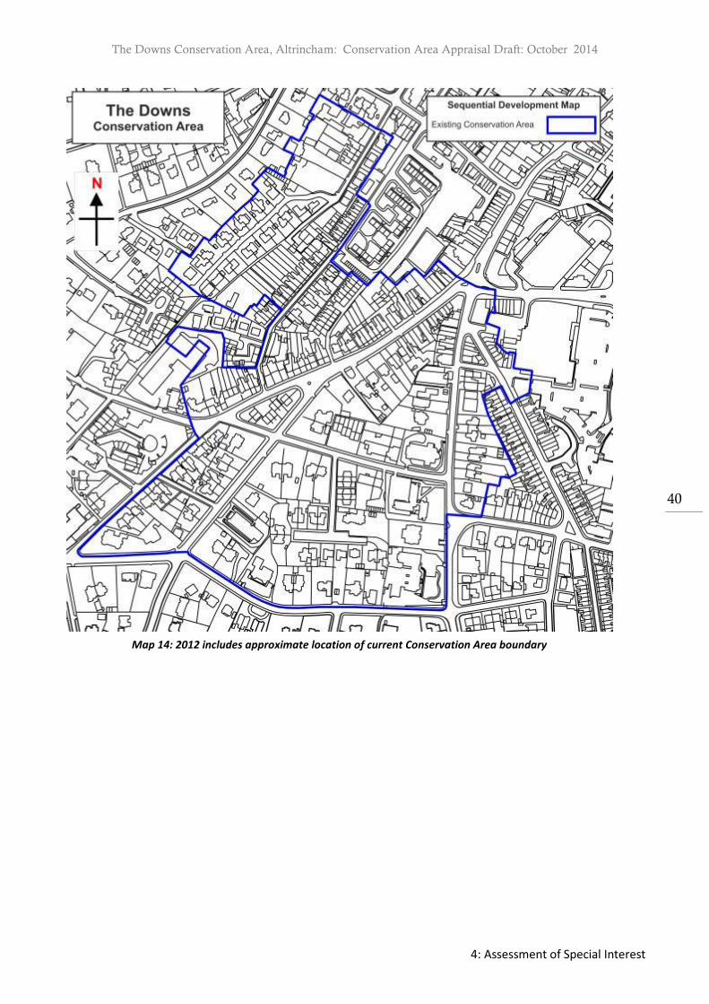
The Downs Conservation Area, Altrincham: Conservation Area Appraisal Draft: October 2014
4: Assessment of Special Interest
40
Map 14: 2012 includes approximate location of current Conservation Area boundary

The Downs Conservation Area, Altrincham: Conservation Area Appraisal Draft: October 2014
4: Assessment of Special Interest
41
Archaeology Previous Archaeological Work
1. Previous archaeological work within or close to The Downs Conservation Area included;
In 1981 six test pits on High Bank to the northeast of the Unitarian Chapel. These
revealed medieval plough soils and post medieval pottery.
In 1982 a test pit was dropped to the east of the Unitarian Chapel, this only revealed
contexts of modern disturbance.
In 1983 two sites were excavated to the east side of the Old Market Place, on Victoria
Street. A medieval well, dryings kiln and shards of pottery were recovered.
A watching brief took place in 1989 during the landscaping works to the Old Market
Place. This revealed 19th and 20th century disturbance, although the trenches were
shallow, they were only cut to 0.5m deep.
Two post medieval refuse pits were recovered to the rear of 2a Market Street in a 1995
during building works. They are thought to date to the 18th or 19th century.
An archaeological watching brief was undertaken in 1997 during works to 12 Dunham
Road. The results indicated that this area was stepped into the hillside of High Bank
during the Medieval Period. Later works to the area in the 19th century are thought to
have destroyed the majority of medieval archaeological deposits. During excavation a
post medieval pit was recovered as was an area of stone setts and a layer of pebbles
were recovered49.
In 2000 a photographic survey of the buildings ion Arnold’s Yard Old Market Place was
undertaken by GMAU.
An archaeological desk based assessment was undertaken for the Altair site in 200750.
Sites of Archaeological Interest/ Visible Archaeological Remains
2. A single flint arrowhead from the Neolithic period was found in the area to the east of the railway and north of Lloyd Street, now occupied by Tesco. Roman coins were found in the vicinity of the core settlement of Bowdon.
49 Michael Nevell, 12 Dunham Road Altrincham An Archaeological Watching Brief within the Medieval Borough
(Manchester: GMAU, 1997) 50 Dr Peter Arrowsmith, Altair, Altrincham, Trafford An Archaeological Desk-Based Assessment (Manchester: GMAU,
2007)

The Downs Conservation Area, Altrincham: Conservation Area Appraisal Draft: October 2014
4: Assessment of Special Interest
42
3. The Historic Environment Record (HER) identifies one site of a scheduled ancient monument, namely that of the mid-1830 chapel towards the foot of The Downs at numbers 12 to 14. It appears on the 1835 Tithe Map as the Aikenites Chapel (built for the charismatic Robert Aitken); on the 1852 Board of Health Plan in the associated Book of Reference as the ‘British Schools’ (of Bowdon Downs Congregational Church) and on the 1876 OS Plan as a Baptist Chapel. Although the HER states that the building has been destroyed, the building is still present, with the top elevation still seen externally and internally, the steps, mezzanine floor and roof trusses intact, reportedly with the remains of an immersion pool in the basement.
4. A detailed list of archaeological sites registered in the Sites & Monuments Record is included in the audit of heritage assets for each character zone.
Potential for Underground Remains
5. Altrincham has been settled continuously since the Anglo Saxon period. There is archaeological potential for the presence of features within the Conservation Area, for example to the rear of properties or the delineation of boundaries and building lines. This area should therefore be treated as having some archaeological potential.

The Downs Conservation Area, Altrincham: Conservation Area Appraisal Draft: October 2014
4: Assessment of Special Interest
43
4.4 Ages of Buildings
2. The ages of buildings within the Conservation Area have been identified through both a basic visual inspection and map regression (see Map 16). Buildings have been dated to the earliest known part of the building evident from the aforementioned research, although many may have later extensions, or in some cases later facades or conceal earlier origins. The buildings have been allocated into general date ranges based upon available maps which provide sufficient detail to allow assessment. Maps assessed include the Cheshire tithe map (dated 1835) 1852 Board of Health Plan, Ordnance Survey plans surveyed in 1876 (published in 1878) and subsequent Ordnance Survey maps. Whilst this analysis attempts to provide an approximate date to buildings and properties, it is not in lieu of a comprehensive building survey and documentary research which should be undertaken using appropriate expertise.

The Downs Conservation Area, Altrincham: Conservation Area Appraisal Draft: October 2014
4: Assessment of Special Interest
44
Map 16: Ages of Buildings

The Downs Conservation Area, Altrincham: Conservation Area Appraisal Draft: October 2014
4: Assessment of Special Interest
45
4.5 Architectural Quality and Built Form Identification of Character Zones
1. Within the Conservation Area five different character zones can be identified; Character Zone A: The Downs Core Area: The first character zone is the earlier core, comprising broadly the northwest section of The Downs, the area to the west including New Street, Wellington Place, Osborne Place, Norman’s Place and to the south, Higher Downs, an upper extension of The Downs. This zone is characterised by a combination of predominantly pre-1835 through to 1851, two and three-storey terraced and semi-detached houses for both middle and working classes. Properties are constructed in red brick laid in
both English and Flemish bond with slate roofs, small town gardens to the front and yards or mostly modest gardens to the rear, as well as a few detached and semi-detached houses. This corresponds to the area largely developed by 1852. Character Zone B: The Downs Commercial Area; is now more commercial in character and comprises both sides of the lower part of The Downs, and those parts of Ashley Road closest to the town centre and all of Oxford Road. Some of the area was developed in the late 18th and early 19th century, however most of the buildings date from later in the 19th century or have, and some more recent additions. Here the majority of the structures are Victorian, mainly three-storey buildings converted to commercial usage in the later 19th century or else purpose-built. The prevalent building material is with blue slate used for roofs. Yards to the rear are smaller or non-existent or built up or have been converted to parking. Some buildings have elaborate polychrome brick designs, dormers and decorative ridges and retain elements of the early shop fronts. Character Zone C: The Downs Southeast Area; the third character zone lies to the southeast to the Conservation Area, between Ashley Road and Cavendish Road and includes Albert Square. It is a residential area and with the exception of Albert Square dating from the late
1840s, the majority of other houses dating from the mid to late 19th century. Houses on Cavendish Road, Ashley Road and Hale Road date from 1880-90’s. The houses are much larger and more imposing, mainly semi-detached, but with a few detached properties. They all have slate roofs and distinctive entrances. They are sometimes set back on slightly higher ground so are generally visible from the street in landscaped gardens to front and rear, with a wide variety of mature trees. Characteristic boundary treatments are low stone walls, with openings defined by stone gateposts. In some places there are also higher brick walls. Character Zone D: White brick Italianate Villas The fourth character zone is focused on Italianate ‘white brick’ villas sited either side of
Delamer Road and on the east side of The Downs, built between 1855 and 1877. Those located on St John’s Road dating from the mid 1850s, along with those on the newly created Delamer Road, the southeast side of The Downs and western end of Cavendish Road dating from 1865-1877. From the perspective of building size and age they are not substantially different from many others within the character Area C however the architectural style and choice of materials results in a distinctive group of villas.

The Downs Conservation Area, Altrincham: Conservation Area Appraisal Draft: October 2014
4: Assessment of Special Interest
46
Character Zone E: Lyme Grove The fifth character zone is the attractive suburban cul-de-sac of Lyme Grove, which contains
many fine two/three-storey semi-detached houses with gardens and boundary walls from
about 1867, built for the middle classes. Despite the close proximity to the earlier core, the
area was laid out in the second half of the 19th century and differs greatly in urban grain to
the adjacent New Street and Wellington Place. Properties are more substantial constructed
in red brick laid in both English and Flemish bond with slate roofs. Front gardens are larger
and the wealth of trees, mature landscaping and boundary walls is a vital feature.
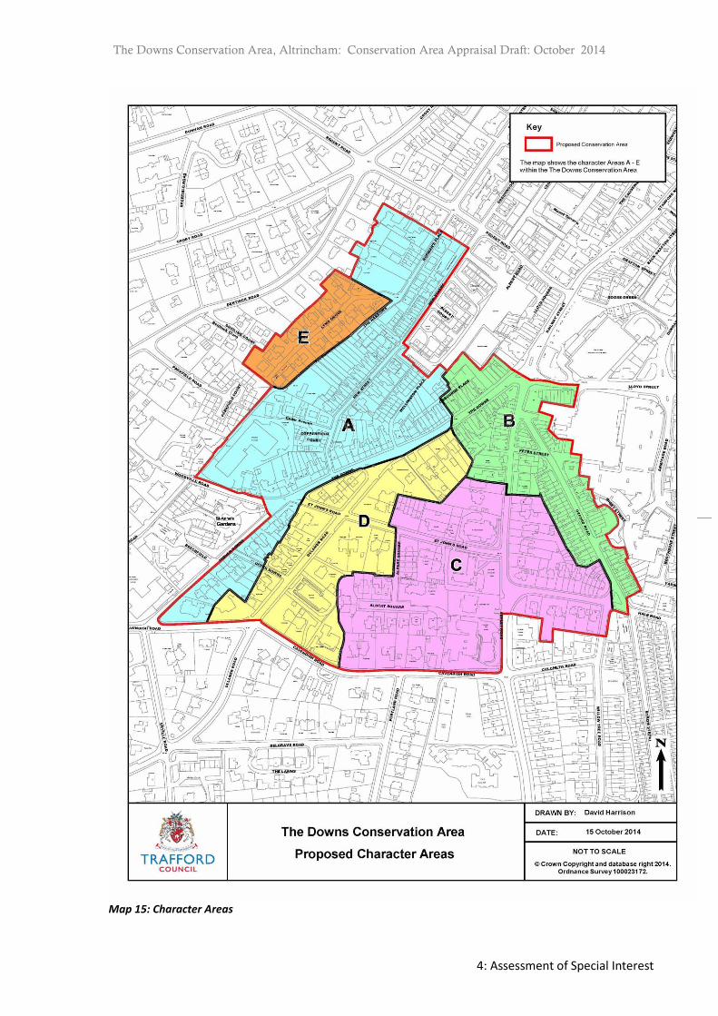
The Downs Conservation Area, Altrincham: Conservation Area Appraisal Draft: October 2014
4: Assessment of Special Interest
47
Map 15: Character Areas

The Downs Conservation Area, Altrincham: Conservation Area Appraisal Draft: October 2014
4: Assessment of Special Interest
48
Character Zone A: The Downs Core Area
2. The boundaries of this character zone are: to the northwest, the rear of the plots of Normans Place; to the northeast, up to the social housing estate; to the south including the northern residential section of The Downs including Wellington Place, Osborne Place, New Street and further up to Higher Downs) and to the southwest, to top of Higher Downs and up to the site of the Telephone Exchange on Woodville Road. The area excludes Lyme Grove which is placed in a separate character zone.
Qualities of the Buildings
3. There are six listed buildings within this character zone of the Conservation Area (although some listings refer to more than one dwelling). These are the 32-34 The Downs, Victoria Terrace (36-44 The Downs), Downs Place (56-62 The Downs), 2-8 Norman’s Place and Richmond House and The Elms on Norman Place.
4. The properties within this character area are almost exclusively residential in use and
character, and built of red brick, sometimes with red and pale brick Flemish bond, dating from the late Georgian and early Victorian period. Most are terraced or semi-detached; a few are detached. Many buildings have retained original features such as sash windows, timber panelled doors surmounted with decorative fanlights in some instances, dentillated brick detailing and stone date-stones naming the building units. Some house having pillared porches or pilasters around the doors. Painted timber sash windows predominate, with full pane windows appearing on the larger houses built in 1851, when the technology was introduced. There is one shop on New Street whose shop front retains original features.
5. Most have small town gardens to the front with low stone walls, sometimes surmounted by modern railings (towards the town centre) and/or hedges. Some only have small yards and out buildings to the rear, while those further up the hill towards Bowdon have larger front and rear gardens, with the houses also increasing in footprint and height, the more salubrious the location.
6. While the front façade attracts the most attention, has the better quality brick and contributes to the character of the Conservation Area, the rear elevation also contributes to telling the story and advancement of the area. The building plots in the lower part of the area are generally characterised by their narrow form, which is derived from the receding field strip ownership patterns. Only in a few cases (2-8 Normans Place, 56-76 New Street) was there anything but a small back yard. The outrigger building form of the rear was dictated by the plot form and depth, the need to allow for some natural light, and to fulfil service uses including access to an outside privy.
7. There has been a long tradition of historic alterations to the rear of properties, relating to changing uses. In the 19th century sometimes additional buildings were fitted in either for subletting or for workshops, where there was space (as at the rear of some of the New Street properties); alternatively some extensions to the rear will date from this period. In the 20th century, with the advent of the car, there have been efforts to provide off-street parking and garages. In addition the series of spaces for coal storage, the privy, washrooms

The Downs Conservation Area, Altrincham: Conservation Area Appraisal Draft: October 2014
4: Assessment of Special Interest
49
etc. have become redundant and owners have sought to adapt these to new uses, as well as the location for extensions to provide additional accommodation. Thus single story outriggers have been extended in some cases, sometimes with detrimental effects on the rooflines, occasionally using inappropriate materials. The retention of such historic structures is significant to understand the historic use of a building and the evolution of the area.
Building Materials
8. The predominant building material is red and Cheshire brick, laid in a variety of bonds, with Welsh slate roofs. Cream “white brick” is also seen both as a building material and used decoratively, as is stone and faience. A few houses have been rendered but they are the exception. The terrace of three houses on Osborne Place, dating from the mid-1840s, is faced with a large white brick resembling stone, seen in a few other locations in Bowdon and Altrincham. The houses on the southeast of Norman’s Place, which date from slightly later period, contain a greater range of building and decorative materials (see Photograph 5).
Photograph 4: Stone Datestone on Albert Terrace and Flemish bond brickwork, The Downs
Photograph 5: Stained Glass Panel on Norman’s Place
9. In addition to the variety of traditional bricks used, they are often laid in different bonds to
create a decorative effect (see Photograph 6). Dominant Architectural Styles
10. Much of the area was developed piecemeal by different builders, so that there is considerable variety in the detailing. The gradient of a number of the streets also means that terraces tend to be fairly small, rarely larger than five units. Norman’s Place is characterised by two larger plots with large detached two-storey Georgian with six over six sash window, pedimented doorways with decorative fanlights and extensive grounds and a terrace of four houses (see Photograph 8). The Poplars was a large single house, demolished and developed as sheltered housing but still retaining the original brick boundary walls and a mature beech tree.

The Downs Conservation Area, Altrincham: Conservation Area Appraisal Draft: October 2014
4: Assessment of Special Interest
50
11. The southeast of Norman’s Place, largely comprises three storey pairs of semi-detached houses and terraces of three residences, with bow windows, sometimes with stained glass panels, pitched dormers, decorative brickwork both in colour and dentillated bands, and stone for lintels, cills and keystones. These houses have small gardens to the front and rear, inside brick boundary walls.
12. New Street and Wellington Place are characterised by two-storey (New Street) terraces built
on to the street or with very walled small town gardens; the three-storey Wellington Street terraces have larger spaces in front of the houses but most of these have been turned into hard standing for parking. The three terraced houses on Osborne Place which is perpendicular to The Downs, has small gardens to the front and yards to the rear. All these terraces have sash windows and panelled doors with fanlights (covered by Article 4 direction, see Photograph 9). The rear treatment varies according to plot size; some have outriggers. The south side of New Street has semi-detached houses from the same period.
13. The Downs has the greatest variety of buildings, a number of two-storey two-up-two down terraces of great charm with town gardens to the front (Downs Place, Russell Place, Victoria Terrace), with sash windows and panelled doors with fanlights. Above Wellington Place the houses are generally three storey, on slightly larger plot sizes, including more land to the rear.
14. Higher Downs consists of four groups of grander raised terraced or semi-detached four-storey houses (with one detached house), built by four different builders on plots of land sold by the 7th Earl of Stamford in 1851. Each house is consistent in style and material within its plot. Some still have decorative bargeboards (8-9, 13-15) or corbels under box gutters (11-12). There are town gardens to the front and yards or else gardens to the rear, some limited by the shape of the irregular plots. There are only a few driveway openings which apart from 11, are modest in size in comparison to the plot and in keeping, thus retaining the overall original character to a certain extent. The one commercial building is on the corner of The Downs and Woodville Road, the tall three-storey telephone exchange dating from 1908, a handsome belle-epoque style structure in red brick and terracotta, with a shaped gable, balcony and decorative windows, some of which have unfortunately been replaced with upvc. Adjacent to this building are the mid-20th century single storey telephone exchange buildings.
Photograph 8: Richmond House on Norman’s Place Photograph 9: Worker’s Housing on New Street and
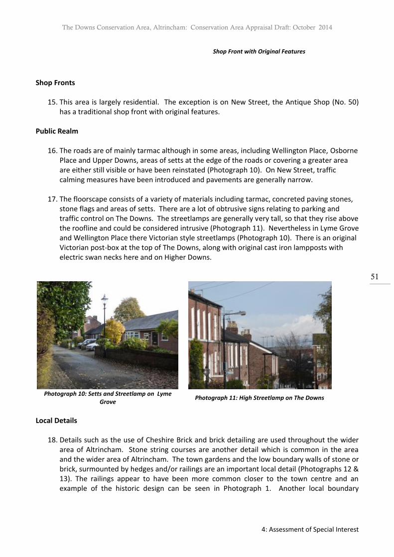
The Downs Conservation Area, Altrincham: Conservation Area Appraisal Draft: October 2014
4: Assessment of Special Interest
51
Shop Front with Original Features
Shop Fronts
15. This area is largely residential. The exception is on New Street, the Antique Shop (No. 50) has a traditional shop front with original features.
Public Realm
16. The roads are of mainly tarmac although in some areas, including Wellington Place, Osborne Place and Upper Downs, areas of setts at the edge of the roads or covering a greater area are either still visible or have been reinstated (Photograph 10). On New Street, traffic calming measures have been introduced and pavements are generally narrow.
17. The floorscape consists of a variety of materials including tarmac, concreted paving stones, stone flags and areas of setts. There are a lot of obtrusive signs relating to parking and traffic control on The Downs. The streetlamps are generally very tall, so that they rise above the roofline and could be considered intrusive (Photograph 11). Nevertheless in Lyme Grove and Wellington Place there Victorian style streetlamps (Photograph 10). There is an original Victorian post-box at the top of The Downs, along with original cast iron lampposts with electric swan necks here and on Higher Downs.
Photograph 10: Setts and Streetlamp on Lyme
Grove Photograph 11: High Streetlamp on The Downs
Local Details
18. Details such as the use of Cheshire Brick and brick detailing are used throughout the wider area of Altrincham. Stone string courses are another detail which is common in the area and the wider area of Altrincham. The town gardens and the low boundary walls of stone or brick, surmounted by hedges and/or railings are an important local detail (Photographs 12 & 13). The railings appear to have been more common closer to the town centre and an example of the historic design can be seen in Photograph 1. Another local boundary

The Downs Conservation Area, Altrincham: Conservation Area Appraisal Draft: October 2014
4: Assessment of Special Interest
52
treatment is the use of upstanding natural stone slabs on boundaries, as present on The Narrows (Photograph 14).
Uses/Former Uses
19. The predominant former and present use is residential. The telephone exchange building is now used as commercial premises by a firm of architects, with the adjacent structure being used by a number of different businesses. Along with the Antique shop on New Street, there is one shop on New Street and a fitness studio in a back yard building opposite. The modern telephone exchange is tucked away.
Open Space, Parks and Gardens and Trees
20. This character area is partly defined by two important historic routes: The Narrows (Photograph 14), part of the old path leading from Altrincham through Norman’s Place up to Bowdon Road (outside the Conservation Area) and The Firs to Bowdon Church and Graveyard. The Narrows and indeed the parallel Lyme Grove (which connects to The Narrows) have an enclosed, almost private feel to the space, as does Wellington Place.
21. In contrast, The Downs has an open feel. In particular, the area at the junction of The Downs and Delamer Road appears spacious. This area is softened by the island with a single tree (Photograph 17). This area is significant as visually it balanced the terminus of the tram at the bottom of The Downs. Although there is no other planting here in a public space, much of the area is softened by the trees and planting in gardens which has a positive effect on the streetscape, being visible over the characteristic low boundary walls of stone and brick.
Photograph 12: Town Garden with Boundary Wall
and Railing Photograph 13: Stone Wall with Evidence of Railings
22. Only New Street and Wellington Place have a more urban grain. On New Street a small area
known as New Street Green, south of Lloyds Court has now been turned into open garden by a local resident (Photograph 15). Not only does this area make a positive contribution to the boundary of the existing Conservation Area, it is also a retention of the earlier grain as much of it is on the site of the former alley connecting New Street to Wellington Place, still used as a pedestrian pathway through to the cobbled ginnel at the rear of Wellington Place. For this reason it is proposed for inclusion within the Conservation Area.

The Downs Conservation Area, Altrincham: Conservation Area Appraisal Draft: October 2014
4: Assessment of Special Interest
53
Photograph 14: The Narrows ( with Upstanding Stone
Slabs) Photograph 15: New Street Green Garden Area on
New Street (Boundary Extension)
Key Views and Vistas
23. The views within the Conservation Area are varied in character. Due to the width of the street and the gradient of The Downs, there are important views both downhill and out of the Conservation Area, through Character Zone B (Photograph 16) and into the Conservation Character Zone B/Railway Street. The former has been curtailed through the erection of a six storey building on the opposite corner. In addition, the view through The Narrows is more enclosed and poorly maintained and overgrown in places, which is detrimental to the character of the area. In contrast, views within Normans Place are more enclosed and private, as is Wellington Place.
Photograph 16: View from the Top of The Downs Photograph 17: Open Space at Top of The Downs
Development Opportunities
24. Due to the compact grain of the character zone, there are no opportunities for new development. Just outside the Conservation Area, in a proposed boundary extension, the site of the former St John’s Ambulance has been redeveloped with terraced housing, matching its mid-19th century neighbours. Adjacent to this is the 1960s New Street Chapel and the 1960s St Margaret’s Parish Hall, now both used as office space.

The Downs Conservation Area, Altrincham: Conservation Area Appraisal Draft: October 2014
4: Assessment of Special Interest
54
Character Zone B: The Downs Commercial Area
25. The boundaries of this character area are The Downs northwest down from 30/31 to but not including no. 2; Ashley Road up to 32 (west) and Fairbank House (east) and all of Oxford Road. Proposed boundary extensions within this character zone include the south side of Lloyd Street (2-16) and the southern end of Oxford Road, both sides, to include the junction with Hale Road.
Qualities of the Buildings
26. There are no listed buildings within this character zone. There is a scheduled monument, the Aikenite Chapel dating from ca. 1830, cited as destroyed in the Sites and Monuments Record. Nevertheless this non-Conformist chapel is located to the rear of 12-14 The Downs, with its gable visible above the shop façades and its internal features still visible as well.
27. The properties within this character zone are a combination of two- and three-storey Victorian buildings from 1835-1897; No 6 The Downs may be pre-1835. Some were built as residential properties, such as those on the northwest of The Downs which were extended outwards after 1876 over their front gardens and were converted in the late 19th century to commercial or retail purposes, as were 19-45 Oxford Road. They are now mostly commercial properties such as shops, estate agents, restaurants and office buildings; the exception being the Club Theatre, occupying a 19th century Methodist chapel/20th century Sunday school building and the chapel mentioned above. There is some modern development on Ashley Road.
28. Many buildings have retained original features, such as window, roofs and decorative brickwork and retain a high quality and level of historic character. Nevertheless many have undergone alteration and extension to the rear, which has often been detrimental to the historic character and in addition historic boundary walls have removed to accommodate cars in front gardens on the western side of Oxford Road, which also has an adverse impact on the appearance of individual properties and the wider street scene.
Building Materials
29. The dominant building materials in this area are brick, both Cheshire brick and red brick, and Bowdon “white brick”, with polychrome decorative detailing in blue and white brick, terracotta and stone. Roofs are clad with Welsh blue slate, some houses, such as 27-31 The Downs, exhibiting detailing in green Westmoreland slate. The modern buildings on 30 and 32 Ashley Road use brown brick, metal window frames and pillars, whereas the more recent Wetherspoons/The Unicorn on 1 Ashley Road is of red brick, sandstone and glass. The ground floor of 1-5 The Downs is faced in Portland stone but this has been recently painted; other ground floor fascia have been tiled such as 21 The Downs and 2-4 Lloyd Street. Number 16 The Downs has been rendered at a later date. Dominant Architectural Styles

The Downs Conservation Area, Altrincham: Conservation Area Appraisal Draft: October 2014
4: Assessment of Special Interest
55
30. The buildings on The Downs generally front directly on to the street which has wide pavements. Most are two and three-storey buildings, built in groups of two to four units, although neither the number of bays nor their width is uniform. To the rear there are often courts or yards, with outriggers and other service accommodation. The form is dictated by the plot size and shape which is generally irregular. The ground floor is generally given over to retail, with shop windows, many of which incorporate original features, such as cast-iron pillars and decorative timber fascia boards. Above this level, the facades often display decorative elements, including brick detailing, bands of stone or brick, ornate bargeboards, decorative ridge tiles and chimney stacks; here the usage is mainly commercial with some residential.
31. The buildings on the northwest side of The Downs appear in the 1852 Board of Health Plans
with small gardens in front of them. They are two-storey although some (28-30) have dormer windows in the attic floor), built as semi-detached houses, apart from 16 and 18. 12-14 is an exception, as the site of an early 19th century Non-Conformist Chapel. The string band and the segmental arch above a window are just visible above and behind the front extension of the later shop front. All have now been extended and converted to retail on the ground floor, with the addition of shop windows and signage. 28-30 is a handsome building with decorative bargeboards on the dormers, bay windows at first floor level with sash windows either side and elements of original shop frontage.
Photograph 18: Downs Court, 27-31 The Downs Photograph 19: Ashley House on Ashley Road
32. The buildings on the southeast side first appear on the 1876 OS Plans. They are built in
terraces, in groups of three to four, straight on to the street, as are those to their rear on the west side of Ashley Road and those on the south side of Lloyd Street (recommended as a boundary extension). The site of 1-5 The Downs was developed between 1876 and 1897.
33. Downs Court (27-31 extending into residential at 33) is a three-storey, 6-bay building with large retail premises either side of a central arch to the rear yard, where the ancillary buildings (added by 1897) have been converted into offices. With its retained setts through the arch and sensitive conversion of the rear accommodation, the fine decorative brickwork in yellow brick on the façade and the retained cast-iron pillars within a newly designed shop front, it shows how the heritage can be enhanced for 21st century usage (Photograph 18).

The Downs Conservation Area, Altrincham: Conservation Area Appraisal Draft: October 2014
4: Assessment of Special Interest
56
34. There are some 20th century buildings in the character zone, located on Ashley Road. One occupies the site of a former large semi-detached pair of 19th century villas. A rectangular office building with parking below has a narrow street frontage. Architecturally the building has strong vertical and horizontal elements which balance the impact of its height and massing (Photograph 19). Adjacent is a modern apartment building in dark brown brick. The early 21st century bar and office block on the corner of Lloyd Street (1-7 Ashley Road) is a three and a half-storey building utilising the local sandstone (Photograph 20). Nevertheless, its height is in keeping with the area and the design quality good. It contrasts with the building opposite (outside of but within the curtilage of the Conservation Area) which is five to six storeys high and with little visual interest in the L-shaped façade, creating an impermeable barrier to views out of the area (Photograph 21).
Photograph 20: 1-7 Ashley Road (Unicorn) Photograph 21: New Building at Foot of The Downs
35. The buildings within the character area on Ashley Road and Oxford Road are mainly three
storey buildings, built on to the street frontage, with decorative brick detailing. Those south of Peter Street are converted two-storey houses but Fairbank House (post 1967, commercial offices), although modern, echoes the character of a large residential building, similar to 36 opposite. On Oxford Road, 1-15 form an attractive row of 2-storey shops with attractive brickwork and generally good quality shop fronts in keeping with the character; together with the two adjacent units on Peter Street. The Club Theatre on Oxford Road has an imposing entrance with steps leading to an arched entrance, with pairs of arched windows either side; the pedestrian zone, which can incur car parking, leading to supermarket car park is well maintained and planted with small trees surrounded by setts.
36. The proposed boundary extension on Lloyd Street comprises a series of three late 19th century buildings of red brick: the three-storey number 2-4 which retains sash windows and a dentillated cornice; York Buildings (6-12) with decorative brickwork; and the two-storey number 14-16 which has decorative ridge tiles and pitched dormer windows, although the windows are replacements. Oxford Road (19-45) was built as two-storey red brick terraced housing and 19-21 is still in residential use but the rest have lost their gardens and been converted to retail use, with some retention of earlier shop windows. The area of the proposed boundary extension includes the residential section of Oxford Road, comprising two-storey Victorian terraced housing with attics and cellars (14-60, west side and 47-69, east side, latter built 1877). At the southern end of Oxford Road, houses display two storey
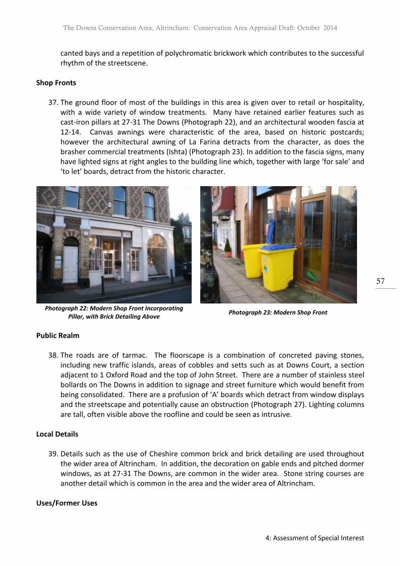
The Downs Conservation Area, Altrincham: Conservation Area Appraisal Draft: October 2014
4: Assessment of Special Interest
57
canted bays and a repetition of polychromatic brickwork which contributes to the successful rhythm of the streetscene.
Shop Fronts
37. The ground floor of most of the buildings in this area is given over to retail or hospitality, with a wide variety of window treatments. Many have retained earlier features such as cast-iron pillars at 27-31 The Downs (Photograph 22), and an architectural wooden fascia at 12-14. Canvas awnings were characteristic of the area, based on historic postcards; however the architectural awning of La Farina detracts from the character, as does the brasher commercial treatments (Ishta) (Photograph 23). In addition to the fascia signs, many have lighted signs at right angles to the building line which, together with large ‘for sale’ and ‘to let’ boards, detract from the historic character.
Photograph 22: Modern Shop Front Incorporating
Pillar, with Brick Detailing Above Photograph 23: Modern Shop Front
Public Realm
38. The roads are of tarmac. The floorscape is a combination of concreted paving stones, including new traffic islands, areas of cobbles and setts such as at Downs Court, a section adjacent to 1 Oxford Road and the top of John Street. There are a number of stainless steel bollards on The Downs in addition to signage and street furniture which would benefit from being consolidated. There are a profusion of ‘A’ boards which detract from window displays and the streetscape and potentially cause an obstruction (Photograph 27). Lighting columns are tall, often visible above the roofline and could be seen as intrusive.
Local Details
39. Details such as the use of Cheshire common brick and brick detailing are used throughout the wider area of Altrincham. In addition, the decoration on gable ends and pitched dormer windows, as at 27-31 The Downs, are common in the wider area. Stone string courses are another detail which is common in the area and the wider area of Altrincham.
Uses/Former Uses

The Downs Conservation Area, Altrincham: Conservation Area Appraisal Draft: October 2014
4: Assessment of Special Interest
58
40. The buildings on the northwest side of The Downs in this character zone were originally residential, based on the 1852 Board of Health Plans. These houses were subsequently extended over their front gardens and converted to retail/commercial on the ground floor with accommodation above. The accommodation above is now a mixture of commercial and residential. By 1897, the rest of this character zone had been developed and the gardens of the north side have been lost. Oxford Road was developed as housing but is now largely used for retail purposes.
Open Space, Parks and Gardens and Trees
41. Although the buildings front directly on to the street the combination of the width of The Downs and the open space of the junction with Railway Street, Lloyd Street, Oxford Road and Ashley Road create a feeling of spaciousness. This is both commercial and urban in character, with modern pavements, bollards and traffic lights and islands (Photographs 24 & 27). With the relatively recent addition of traffic lights at the junction, there is nearly always waiting traffic. There are no areas of green space or trees apart from the few on Peter Street, Oxford Road and the small island at the junction of Hale Road and Oxford Road. Some of the yards to the rear of the buildings have been converted to car parking, such as at 20 The Downs, or to a combination of private yards such as at Downs Court and to the rear of 17-19 The Downs.
Key Views and Vistas
42. Due to the width of the street and the gradient of The Downs, there are views both downhill and out of the Conservation Area and into the Conservation from Railway Street. The former has been curtailed through the erection of a six storey building on the opposite corner. The latter is enhanced by the inclusion of the landmark building 1-5 The Downs and view up to the greenery and gardens further into the Conservation Area, beyond this character area.
Photograph 24: Open Space on The Downs Photograph 25: The Downs and Ashley Road 1950
(Altrincham Area Image Archive)

The Downs Conservation Area, Altrincham: Conservation Area Appraisal Draft: October 2014
4: Assessment of Special Interest
59
Photograph 26:The Downs Looking Downhill in 1910
(Altrincham Area Image Archive) Photograph 27: View 2012, with Excessive Street Clutter
Development Opportunities
43. Due to the compact grain of the subsection there are no opportunities for new development, with the possible exception parking at the rear of 2-14 The Downs. The only plausible development opportunities for the area are the re-use of existing properties. At present there are one or two vacant commercial properties on The Downs at ground floor level and vacancies in the upper floors, as well as on Ashley Road. Some of these upper floors are being turned back into residential use.
Character Zone C: The Downs Southeast Area
44. The boundaries of this character zone are: the north side of Cavendish Road, Albert Square, the eastern section of St Johns Road and to the east Ashley Road up to Hale Road. It is proposed to extend the boundary of the existing Conservation Area to include the section of Hale Road between Oxford Road and Ashley Road and area of open space on the corner of Hale Road and Ashley Road.
Qualities of the Buildings
45. There is one listed building within this character zone of the Conservation Area, Church of St John on St John’s Road.
46. The buildings within this character zone are mainly residential in use and character, although there are some public buildings, a school and some commercial and medical premises. The majority of buildings date from the second half of the 19th century. Many are semi-detached or detached. Many buildings have retained original features such as windows, doors, roofs and gardens with boundary walls.
Building Materials
47. There is extensive use of Cheshire brick and red brick. Public buildings and some detached villas are of constructed of rusticated stone. A small number of houses are rendered. The majority of roofs are clad with traditional blue slate, some 20th century buildings have

The Downs Conservation Area, Altrincham: Conservation Area Appraisal Draft: October 2014
4: Assessment of Special Interest
60
utilised different materials such as brown brick, timber cladding and clay tile roofs, with limited success. Windows and doors are generally constructed from painted timber, often with glazed panels. Boundary walls are generally but not exclusively of stone.
Dominant Architectural Styles
48. Two factors greatly influenced both the grain and the style of development in this area. Firstly much of the land was sold off from 1851 by the 7th Earl of Stamford plots for one or more houses to small developers/builders. However, the houses built on Albert Square in the late 1840s or around Cavendish Road and Ashley Road later in the century are more varied in style and materials. Secondly covenants in the deeds specified the density of the development, minimum rental value and some of the materials, contributing to the decisions on scale and embellishment, as well as common boundary treatments.
49. Houses along the east side of Ashley Road were developed in the 1860s (Photograph 29), as
were houses on Hale Road (in the proposed boundary extension but not those on the southwest). These areas are characterised by three-storey semi-detached villas of Cheshire brick with cellars and attics, set within gardens; the houses have bow windows, sash windows and are relatively plain in decorative style.
Photograph 28: 12 Higher Downs Photograph 29: 49-41 (Rose Cottage) Ashley Road
50. Cavendish Road and the north side of Ashley Road had much larger plots with either much larger pairs of three storey semi-detached villas with cellars and attics or detached villas in large gardens, set back from the street.
51. Albert Square was laid out in the late 1840s as an elegant rectangular space with one
detached and five pairs of two-storey semi-detached villas of great charm set in gardens. Subsequently there have been two early 20th century infill houses of good quality and one dating to 1937-65. In addition, late 20th century terraced housing has been added on the approach road to Albert Square and on the south side of St John’s Road, as well as on the site of St John’s Vicarage, with some loss of character.
52. This character zone also contains one church with associated buildings: St John’s dating
from 1865-6 by Medlock Taylor in early English style, of snecked stone and ashlar, with a

The Downs Conservation Area, Altrincham: Conservation Area Appraisal Draft: October 2014
4: Assessment of Special Interest
61
polygonal apse and geometric tracery, listed grade 2. Its steeple provides a landmark from a number of directions and is integral to local views (Photograph 32). The adjacent school has been converted into housing and a medical centre.
Photograph 32: St John’s Church and School, St John’s Road
(Altrincham Area Image Archive)
53. A further substantial building of stone is the detached villa known as Culcheth Hall (dating
from 1852-1876) on the corner of Ashley and Cavendish Road. This was converted into a girls’ school in 1891 (Photograph 34). An extension was added after 1967, containing a gymnasium/hall. Another mid-20th century addition to this character zone located on Ashley Road is the 1968-9 YWCA, named Alexandra House; while Pevsner rates the design by Elsworth, Sykes and Partners as “good if not welcoming”, the scale, massing and use of dark brown brick are out of character with the character of the area and it intrudes into views of St John’s (Photograph 35). It is noted that the building is set back within the site, allowing views along Ashley Road to St John’s Church, grade 2 listed. The traditional stone wall, gate piers and mature planting also complements the site.
Photograph 34: Bowdon Preparatory School, Ashley Rd Photograph 35: YWCA, Ashley Road
The Downs Conservation Area, Altrincham: Conservation Area Appraisal Draft: October 2014
4: Assessment of Special Interest
62
Public Realm
54. Roads and pavements are tarmac, with stone kerbs. Historically the edges of the roads were lined with setts which are still extant, but covered by tarmac. There is considerable variety of hard standing within garden boundaries – some is laid with setts and/or stone flags or gravel/pebbles. Nevertheless some of this private space is of poor quality and detracts from the streetscene, for example the coloured concrete flagstones in front of some of the modern houses on 1-11 Albert Square.
55. There are a variety of street signs, including old signs located at the junction with Oxford
Road. Lighting columns are a mixture of simple black modern lampposts and concrete posts. The modern lamp posts could be considered to be intrusive for example in Albert Square.
Local Details
56. In addition to the widespread use of Cheshire and red stock and distinctive varieties of cream “white brick”, there are characteristic decorative details including dentillated timber eaves and bargeboards. With regard to the gardens, the planting is characteristic of the late Victorian period interests in arboretums and tree collections and they contain a wide variety of mature trees of different species, many exotic. Similarly, the planting of boundary hedging above and behind the stone walls was also varied with regard to species.
Uses/Former Uses
57. The area was developed for residential purposes, supplemented by associated public buildings, namely churches and schools. Today most of the houses are still used for residential purposes, although some have been converted into flats, offices or medical practices. This also applies to the former school on St John’s Road which is split between a mews conversion and a medical centre. A large house on Cavendish Road, Southbank, (including Delamere Lodge and The Coach House which are in Character Zone D), have been converted into a care home but are currently vacant. Within the properties, some of the outhouses have been converted to garages.
Open Space, Parks and Gardens and Trees
58. There are few public spaces; the garden area at the southwest corner of Hale Road and the open area around St Johns Church (although this lies within the boundaries of the plot). Nevertheless the area has a spacious, suburban feel. This is due to both the wide streets and the large plot sizes, but also to the gradients within the plots, so that the houses are often on higher ground than the street level, and the impact of mature trees planted on the boundaries of gardens. Albert Square has no public planting. Where trees have been planted in tree pits on the streets, they are still young.
59. Boundary treatments, including openings and gateposts: Traditionally the properties all had
low stone walls, although the size, finish and colour of the stone blocks varies, as does the height/number of courses. Few of the walls have evidence of railings (which historically

The Downs Conservation Area, Altrincham: Conservation Area Appraisal Draft: October 2014
4: Assessment of Special Interest
63
seem to have been more common closer to the town centre and have long been removed); 16 Albert Square still has its original wrought iron railings. Most openings are framed by substantial gateposts of stone, which are generally set flush with the line of wall sited to the back of the pavement. The houses are generally set on higher ground and highly visible from the street; sometimes the walls are surmounted by hedges of holly, privet, laurel or yew or screening is provided by shrubs planted inside the garden. A number of the gateposts have been painted.
Key Views and Vistas
60. St John’s Church with its spire is an important visual focus within this character zone; it is visible from Hale Road, from the junction with Ashley Road, in both directions along Ashley Road as well as from The Downs and Albert Square (this latter view is adversely affected by the YWCA building).
Development Opportunities
61. There are few opportunities for development and enhancement within the character zone. Alexandra House, the former YWCA building (Photograph 35) is currently vacant as is Southbank on Cavendish Road.
62. Additionally the size of many of the plots, and indeed of the houses, means there is pressure
to adapt and alter historic buildings for 21st century usage. It is important to ensure that the spacious character is retained. The development of garden land and the consequential increase in density will adversely affect the grain of the character and appearance of the character zone. This has been the case with the redevelopment of the triangular site at the top of The Downs, the redevelopment of the site of St John’s Vicarage and St John’s Court. Where there is development, it should respect the historic patterns of development of the area.
Character Zone D: White brick Italianate Villas Qualities of the Buildings
63. The boundaries of this character zone are: the east side of the Downs following the rear
properties boundaries along the east side of Higher Downs to meet Cavendish Road at Southbank. The boundary then follows the north side of Cavendish Road, excluding Albert Square to return to The Downs. The Character Zones includes the western section of St Johns Road and west and east sides of Delamer Road.
64. There are two listed buildings within this character zone of the Conservation Area. These are the Boundary Stone, grade 2 listed at the foot of Higher Downs, and Trinity United Reformed Church, grade 2 listed on Delamer Road.
65. The buildings within this character zone are mainly residential in use and character. The majority of properties were erected during a short period between 1850’s to 1877. Similar to those located in Character Zone C, the majority are substantial semi-detached or

The Downs Conservation Area, Altrincham: Conservation Area Appraisal Draft: October 2014
4: Assessment of Special Interest
64
detached. Many buildings have retained original features such as windows, doors, roofs and gardens with boundary walls.
Building Materials
66. There is extensive use of the characteristic cream ‘white brick’ laid in Flemish and English garden wall bonds. The majority of roofs are clad with traditional blue slate with painted barge boards. Windows and doors are generally constructed from painted timber, often with glazed panels. Boundary walls are generally constructed of sandstone a number with stone copings and in conjunction with stone gate piers.
Dominant Architectural Styles & Local Details
67. It is the Italianate style and use of distinctive white brick, built at a similar time, which justifies a separate character zone. In terms of building size and type, this group of villas are not substantially different from many others within Character Zone C.
68. There is uniformity in design, materials and decoration within the groupings on each road in the character zone. Predominantly constructed of brick, they display dentillated timber, large over hanging eaves, prominent chimneys, canted bays, stone cills and dressings, string courses, round arched or cambered headed windows and use in some cases of stained glass panels. Entrances are more imposing (Photographs 30 & 31).
Photograph 30: Holly Bank, St John’s Road Photograph 31: Delamer Road
Photograph 33: Trinity Church, Delamer Road (Altrincham Area Image Archive)

The Downs Conservation Area, Altrincham: Conservation Area Appraisal Draft: October 2014
4: Assessment of Special Interest
65
Public Realm
69. Similar to Character Zone C roads and pavements are tarmac, with stone kerbs. Historically the edges of the roads were lined with setts which are still extant, but covered by tarmac. There is considerable variety of hard standing within garden boundaries – some is laid with setts and/or stone flags or gravel/pebbles. The predominant impression is of spaciousness, tree lined streets and large houses in large grounds with mature planting and traditional stone front boundary walls and gateposts throughout.
Uses/Former Uses
70. The area was developed for residential purposes and this use continues today. On Delamer Road, Trinity United Reformed Church, grade 2 listed, was built in 1872 in Geometric style for the Presbyterian community but is currently vacant. (Photograph 33).
Open Space, Parks and Gardens and Trees
71. The general impression of the area is one of spaciousness. More defined open space can be found at the junction of Delamer Road and The Downs (although technically in Character Zone A) and also within the curtilage of Trinity Church.
72. Trees and other mature planting are a significant feature throughout the chracter zone, equal in importance to the buildings in the streetscene. Delamer Road has been planted as an avenue, with the trees now mature.
Key Views and Vistas
73. A key view into the Conservation Area along Delamer Road from the junction of Delamer Road with Cavendish Road is distinctive, due to the contribution made by mature trees, as well as the incline.
Development Opportunities
74. Trinity Church, grade 2 listed on Delamer Road (following the merging of the Bowdon and Hale United Reform communities) is currently vacant. The building and site should be monitored to ensure that the area and condition of buildings do not deteriorate.
Character Zone E: Lyme Grove
75. This is a small character zone primarily focused on Lyme Grove and does not include the Narrows or Normans Place.
Qualities of the Buildings
76. There are no listed buildings in this character zone. Lyme Grove is an attractive cul-de-sac
which contains many fine two/three-storey semi-detached houses erected around 1867, built for the middle classes. There is a distinctive landscape character derived from mature

The Downs Conservation Area, Altrincham: Conservation Area Appraisal Draft: October 2014
4: Assessment of Special Interest
66
trees and planting, the consistent style of the front boundary walls with stone copings and general lack of interruption of the walls and front garden planting by vehicular access and hard standing.
77. Despite the close proximity to the earlier core, the area was laid out in the second half of
the 19th century and differs greatly in urban grain to the adjacent New Street and Wellington Place. Properties are more substantial constructed in red brick laid in both English and Flemish bond with slate roofs.
Building Materials
78. Properties are constructed from red brick laid in a Flemish bond with pitched roofs clad with blue slate. Elevations are enlivened with painted stone dressings and white brick is utilised for decorative quoins and dressings. Unlike elsewhere in the Conservation Area, the low boundary walls are predominately constructed from brick with shaped stone coping.
Dominant Architectural Styles & Local Details
79. Houses were designed in a revival style, incorporating classical architectural features such as key stones, quoins, stone string courses, round arched heads to recessed porches and symmetrical, balanced proportions to the principal elevations. Other embellishments include gauged brickwork, hoodmoulds to first floor windows, canted bays, prominent chimneys, large over hanging eaves and cambered brick heads to windows. Generally houses retain painted timber sliding sash windows and timber panelled doors. Houses are slightly elevated above the road with semi basements adding to their prominence and accessed generally via a flight of stone steps.
Public Realm & Open Space, Parks and Gardens and Trees
80. Lyme Grove is a narrow road which curves slightly with properties set back behind front gardens and low boundary walls. There is no defined open space in the character zone other than the spaciousness afforded by front gardens and space to the sides of houses.
81. The road surfaces consists of tarmac with an apron of stone setts forming a drainage channel either side which contributes greatly to the streetscene. The wealth of trees and mature landscaping is a vital feature of the area and completes greatly the relatively unaltered historic buildings.
Uses/Former Uses
82. Lyme Grove was laid out as a residential street and this use is continued. Key Views and Vistas
83. The key view is looking south west and north east along Lyme Grove. Development Opportunities
84. There are no development opportunities in the character zone.

The Downs Conservation Area, Altrincham: Conservation Area Appraisal Draft: October 2014
4: Assessment of Special Interest
67
Landmarks and Positive Contributors
85. Within The Downs Conservation Area there are a number of buildings which, within their spatial context, serve as landmarks. These include:
The former bank building on the corner of The Downs and Ashley Road (1-5 The Downs), now L’Amour;
Church of St John, particularly viewed from Hale Road, but also from Albert Square, Ashley Road and The Downs;
Trinity United Reformed Church on Delamer Road.
Bowdon Preparatory School, on the prominent corner site of Ashley Road and Cavendish Road on the southeast boundary of the Conservation Area.

The Downs Conservation Area, Altrincham: Conservation Area Appraisal Draft: October 2014
6: Assessment of Condition
68
Map 20: Townscape Map (does not show location of listed boundary stone)

The Downs Conservation Area, Altrincham: Conservation Area Appraisal Draft: October 2014
6: Assessment of Condition
69
5. Audit of Heritage Assets
5.1 Introduction
1. A basic audit has been undertaken of heritage assets within the Conservation Area. These include Listed Buildings, Archaeological Sites and Monuments and Positive Contributors. These assets have been logged in tables and described. The standing properties have in most cases been assessed from the street scene to determine their current condition. Please note that the heritage asset description is principally to aid identification and is not intended to provide a comprehensive or exclusive record of all the features of significance. The amount of information varies greatly and absence of any feature external or internal does not, therefore, indicate that it is not of interest. Any evidence relating to a heritage asset, which may present itself since the time of survey will also be taken into account during the course of a planning or listed building consent application.
2. This assessment has been undertaken using the criteria of the English Heritage at Risk Register condition assessment.
3. The list of heritage assets can be found at the end of this document in Appendix 1.
5.2 Listed Buildings
1. A listed building is a building that has been placed on the Statutory List of Buildings of Special Architectural or Historic Interest. a brief description of every listed building located within the The Downs Conservation Area can be found at the end of this document in Appendix 1. For a full copy of each listed building description please see the National Heritage List for England which can be accessed via English Heritage’s website.
2. Please note that the list description provided by English Heritage is also principally to aid identification and is not intended to provide a comprehensive or exclusive record of all the features of importance. The amount of information varies greatly and absence of any feature external or internal does not, therefore, indicate that it is not of interest or that it can be removed or altered without consent.
3. It is a criminal offence to carry out any works either to the exterior or the interior which would affect the character of a building once it is listed unless the requisite consent has been sought. Where there is doubt please contact the Council’s Conservation Officer.

The Downs Conservation Area, Altrincham: Conservation Area Appraisal Draft: October 2014
6: Assessment of Condition
70
6. Assessment of Condition
6.1 General Condition
1. The Downs Conservation Area like most of the low density residential areas in the southern part of the Borough is under considerable pressure for redevelopment. Economic and social trends have led particularly to conversions of larger houses to flats redevelopment of larger properties with new flats or houses, and to infilling of gardens. A significant problem has been the intensification involved which if not controlled could result in undue dominance of buildings, loss of trees and other landscaping and overly prominent areas of hard standing, which would erode and diminish the character of the area. Architectural treatment can be a problem too, and some buildings, even at low densities, have looked out of character with their surroundings.
2. In general the condition of buildings and sites located within The Downs Conservation Area is good. Most change has taken place at the rear of the both residential and commercial properties; such alterations vary greatly from one property to another both in terms of the structural changes and the design of elements such as windows (Photograph 36). A number of properties are in a deteriorating condition particularly in Character Zone B (see Photograph 37).
Photograph 36: Rear of Osborne Terrace, 17-23 Hale
Road Photograph 37: Rear of 19-23 Ashley Road
3. In Character Zone B there are some empty commercial properties, including ones which
have changed hands several times in recent years, e.g. 6 The Downs. There is a prominence of ‘for sale’ and ‘to let’ boards which highlights the economic condition of the area as well as detracting from the character. Often there is a duplication of boards on a single building where there is a ground floor retail unit and an upstairs residential unit vacant, as for example at 19 The Downs.
4. While the retention and reinvigoration of the school (in the old Culcheth Hall villa) is positive
for the area, both in terms of maintaining continuity of use for such a substantial building and in terms of contributing to demand for housing, it does impact on traffic (see 6.3 below). In contrast Alexandra House (former YWCA) has been vacant for several years. In

The Downs Conservation Area, Altrincham: Conservation Area Appraisal Draft: October 2014
6: Assessment of Condition
71
the meanwhile the boarded up windows and deteriorating grounds diminish the character (Photograph 35).
5. Where the passage of time necessitates re-roofing or similar repairs, or there is a conversion
or extension to adapt the building to 21st century use, there is a risk that the architectural detail will be lost or only partly reinstated. This is the case with some houses on The Downs, Delamer Road and St John’s Road. The replacement of traditional materials and architectural detailing results in diminishing the significance of a heritage asset and its contribution to the Conservation Area contrasting with those buildings which have retained historic detail.
6. The need to accommodate cars and create off-street parking has been met in a wide variety of ways, not all of them enhancing the character and appearance of the Conservation Area, but rather the reverse. The area is residential and pre-dates the arrival of the car, hence traditionally no garages. Some of the more substantial dwellings have outhouses which lend themselves to conversion, which is the preferred solution. Nevertheless terraced housing presents little opportunity for parking. So, where the size of the garden and its gradient permits parking, this has often entailed the loss of garden area, sometimes compounded with the use of inappropriate hard standing materials and the excessive widening of entrances or loss of gateposts, as on Lyme Grove and examples on The Downs.
7. With the larger houses sometimes having been converted to apartments or offices, the demand for parking is greater, sometimes leading to loss of their valuable gardens (Photograph 38). Where there potentially an opportunity for erecting a garage, low quality structures with PVC fascia and designs and bold colours are visually intrusive and result in a loss of character. However, there are examples of both minimally intrusive garages, set well back within the site, utilising traditional materials and style with sensitive hard-standing and soft landscaping provision (Photograph 39).
Photograph 38: Loss of Garden Photograph 39: Well Landscaped
Hard Standing
8. The low stone boundary walls, with hedges and shrubs planted above and behind are a
characteristic of the Conservation Area. Although this issue will be discussed below (6.2.2),
The Downs Conservation Area, Altrincham: Conservation Area Appraisal Draft: October 2014
6: Assessment of Condition
72
the erosion of this element through piecemeal and wholesale removal (Oxford Road), excessive widening of gate openings (Lyme Grove), the removal of gateposts or their painting and the erection of fencing all affect the general condition of the area.
9. Although there are few trees in the public realm, the gardens in the Conservation Area, in
particular in Character Zone C, contain a significant variety of mature trees, which contribute greatly to the character and appearance of the area; where these are lost and not replaced, the character is greatly diminished as well as a loss of habitat and wildlife.
6.2 Intrusion and Negative Factors Individual Properties
1. There are some examples in the Conservation Area where the significance of a property has been diminished through either the addition of unsympathetic elements such as satellite dishes or plastic rainwater goods or the loss of architectural detail including original doors and windows. These additions and alterations can have a cumulative effect on the character and appearance of the Conservation Area. Inappropriate alterations also include the conversion of basements into garages and the introduction of light wells. Such extensions can alter the scale and composition of a property.
2. Within Character Zone B, a number of of shop frontages have incorporated historic features, such as 50 New Street and 31 The Downs. Nevertheless there are examples of less successful replacement shop fronts which result in a detrimental impact on the street scene and fail to respect the architectural composition of upper storeys. Inappropriate window treatments and shop fronts are a problem with some buildings on The Downs, such as a replacement bay window at first floor level which is out of character with its adjacent pair (Photograph 41), or a permanent awning over 19 The Downs (Photograph 40). Number 41 The Downs provides an example of loss of historic architectural detail, as the ridge tiles and pinnacle of the turret are now missing.
3. The treatment of the rear of the properties, especially in the Character Zone B, is harmful to their significance. Here there are examples of incongruous ventilation systems poorly sited. There are also signs of the decay of historic fabric to the rear of properties on Oxford Road (see Photograph 37) and The Downs.
4. In other cases traditional stone dressings have been painted, such as the Portland Stone ground floor façade of 1-5 The Downs (Photograph 24) and numerous stone gateposts (Photographs 31 & 43).

The Downs Conservation Area, Altrincham: Conservation Area Appraisal Draft: October 2014
6: Assessment of Condition
73
Photograph 40: Intrusive Permanent Awning Photograph 41: Inappropriate
First Floor Window
5. The issue of garages has been referred to above under ‘General Condition’. While, for the purposes of the Conservation Area Appraisal, an evaluation as ‘Intrusive’ refers to the main building, and therefore has not highlighted garages as ‘intrusive or negative’ elements, some of the garages within the Conservation Area would otherwise have this classification. The issue is not that garages are ‘per se’ intrusive but that when insufficient consideration is given to the siting, design and materials, the result is intrusive and detracts from the positive contribution of the house and garden.
Photograph 42: Intrusive Garage/Hard Standing on Lyme Grove(Wide Opening not Visible)
Photograph 43: Lyme Grove Garage with Traditional form and Materials but Wide Opening and Painted
Gateposts
6. Fences are not a traditional means of enclosure within the Conservation Area. Often they
have been erected without planning permission. There are examples , due to height, siting and/or materials, which are visually intrusive, such as a concrete fence on The Narrows or the fencing around the triangular site at the bottom of Higher Downs (Photographs 44 and 45). In some cases fences have been sited behind planting in an attempt to screen such structures; however this has limited success as often they can still be glimpsed through hedging.
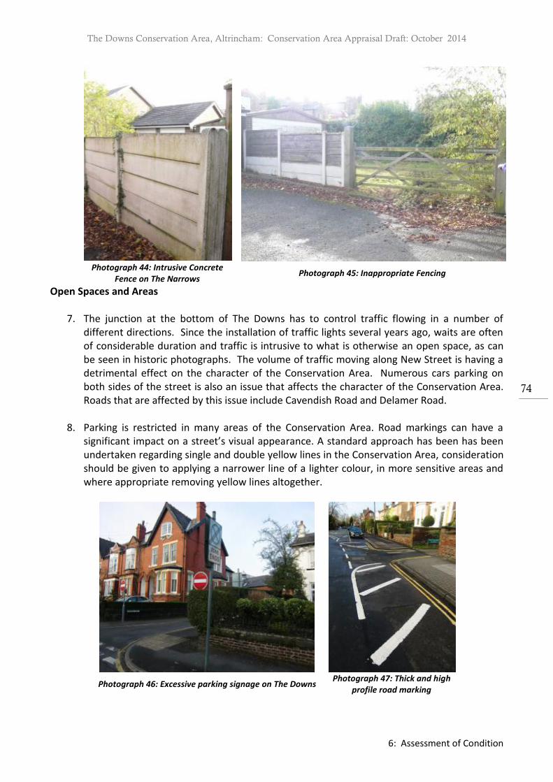
The Downs Conservation Area, Altrincham: Conservation Area Appraisal Draft: October 2014
6: Assessment of Condition
74
Photograph 44: Intrusive Concrete
Fence on The Narrows Photograph 45: Inappropriate Fencing
Open Spaces and Areas
7. The junction at the bottom of The Downs has to control traffic flowing in a number of different directions. Since the installation of traffic lights several years ago, waits are often of considerable duration and traffic is intrusive to what is otherwise an open space, as can be seen in historic photographs. The volume of traffic moving along New Street is having a detrimental effect on the character of the Conservation Area. Numerous cars parking on both sides of the street is also an issue that affects the character of the Conservation Area. Roads that are affected by this issue include Cavendish Road and Delamer Road.
8. Parking is restricted in many areas of the Conservation Area. Road markings can have a
significant impact on a street’s visual appearance. A standard approach has been has been undertaken regarding single and double yellow lines in the Conservation Area, consideration should be given to applying a narrower line of a lighter colour, in more sensitive areas and where appropriate removing yellow lines altogether.
Photograph 46: Excessive parking signage on The Downs Photograph 47: Thick and high
profile road marking

The Downs Conservation Area, Altrincham: Conservation Area Appraisal Draft: October 2014
6: Assessment of Condition
75
9. Particularly on The Downs and New Street there is a large amount of road marking detracts from the historic character (Photograph 47). In addition, previous safety repairs to roads and pathways, such as tarmac patching, have negatively affected the character and appearance of the Conservation Area. When planned scheme(s) is carried out consideration should be given to the use of materials compatible with the Conservation Area.
10. There is a variety of street furniture located throughout the Conservation Area. These vary in quality and style and consideration should be given to a street clutter audit, when resources permit, to contemplate the removal and consolidation of these structures where possible.
Photograph 48: Poor Repair, Wide Yellow
Lines and Bollards, as well as Tall Streetlamps
Photograph 49: Street Clutter
11. The bollards, parking meters and parking signage create a high level of street clutter. The
stainless steel bollards are not in keeping with the historic character and are visually intrusive – a number are dented by traffic (Photograph 48). In addition, especially outside 16 The Downs, there are many A-frame advertising boards. Some repairs to pavements have been carried out, such as on The Downs, detract from the quality of the open spaces (Photograph 27).
12. The height of the streetlamps on The Downs detracts from the rooflines of the historic
buildings (Photograph 48). Furthermore where original street furniture (post-boxes, streetlamps, signs) remain, every effort should be made to retain and restore these, rather than replace them. The modern concrete lamp posts in Albert Square are particularly intrusive.
13. In the residential areas, the condition of the open spaces is affected by poor quality boundary treatments. The Conservation Area is generally characterised by the low stone walls with planting above (Photographs 12 & 13). Historically wrought iron railings were at properties close to the town centre, such as those on The Downs. However where original railings have been removed, replacements have been taller, constructed from inadequate material and/ or more ornate, thus diminishing the character and appearance of the

The Downs Conservation Area, Altrincham: Conservation Area Appraisal Draft: October 2014
6: Assessment of Condition
76
relatively modest houses. It is not considered the reinstatement of railings in these locations would contribute to the significance of the heritage assets or the street scene.
Photograph 50: Partial Loss of Screening Planting of
Fence Photograph 51: Boundaries on Hale Road
14. In some cases there is existing and potential damage to boundary walls from planting too
close to the boundary. Typically the boundary walls also serve as retaining walls with earth behind and the house on higher ground. Where planting has occurred too close to the boundary (or so long ago that the root growth has been extensive) walls are being or will be pushed outward. Separately, the traditional boundary treatments of low stone walls with hedges of holly, privet and other shrubs are sometimes being replaced by fencing. .
15. In addition while the presence of gateposts indicates that gates were always a characteristic
of the area, the height of the gateposts suggests that they were never a solid visual barrier to the house. In general gardens and boundaries are well maintained and the variety of materials and presentation adds to the individuality which is characteristic of this area. Gateposts are generally flush with boundary wall; deviation from this and painting of original stone posts, as well as significant widening of the opening, detracts from the rhythm and formal relationship with the street (Photograph 31).
16. The Narrows is an historic path which is much used today but in sections is deteriorating and
overgrown, adversely impacting on the character of the area and encouraging littering. Intrusion
17. Within the boundary of the Conservation Area there has been some inappropriate infill and redevelopment. Some buildings dating from the 1960s and 1970s pre date the designation and could be considered to be intrusive due to the choice of materials and poor quality, unsympathetic design. This includes the townhouses on The Downs (80 a-c), using dark brown brick and white timber cladding with no traditional boundary treatment. Albert Court, Chapel Court and Lloyd Court, just outside the Conservation Area, on New Street, also diminish the setting of Character Zone A.

The Downs Conservation Area, Altrincham: Conservation Area Appraisal Draft: October 2014
6: Assessment of Condition
77
18. Similarly the tall new building at the on the corner of Stamford New Road and Lloyd Street, at the bottom of The Downs in the detracts from the views and the character zone one B; in contrast the early 21st century development on 1-7 Ashley Road is more successful, with its massing more subtle and use of red sandstone and articulation. Within Character Zone C there are some examples of development which has been unsympathetic and interrupting street boundaries.
6.3 Problems, Pressures and Capacity for Change
1. The Conservation Area faces a number of different pressures and problems, which vary between its different character zones. The commercial section faces the problem of businesses remaining economically viable in the current climate. Although there are not a significant number of vacant properties within The Downs, businesses face the same pressures as those elsewhere in the town and are further from the main footfall areas with more limited parking.
2. With regard to residential areas, demand for housing is high, due to the quality and attractiveness particularly of historic properties and proximity to services and schools. Nevertheless there is pressure to introduce adaptations for 21st century living. There is evidence that buildings have evolved over time as well as changed use and there is no reason for this not to continue as long as it is not detrimental to overall character and appearance.
3. Traffic and parking is problematic throughout the Conservation Area for which sensitive and
creative solutions are needed. Further guidance is required regarding appropriate hard landscaping materials, garage solutions, and giving consideration to narrowing of pavements in some areas to create parking. There are no loading/parking spaces, on the west side of Ashley Road. As a consequence traffic is often held up by delivery vans pulling in.
4. New Street retains a dense urban grain with terraced housing and narrow roads. . Since the
installation of traffic lights at the bottom of Regent Road and The Downs, it has become a route to avoid the town centre. The issue is less the volume of traffic than the speed, which traffic calming measures have failed to abate and result in introducing visually intrusive elements.
5. Although many of the roads in character zone C are wide and allow for on-street parking
(with the exception of Ashley Road), Cavendish Road is frequently parked on both sides, as is Delamer Road. Congestion is frequent on these roads when only a single lane of traffic, including buses, can pass. The presence of educational establishments in the area has exacerbated this issue and often attract pupils from well beyond the immediate vicinity. Similarly St John’s Road has parking on one side (necessary for the medical centre and the church) but this does not allow for cars to pass. There is currently a proposal to introduce yellow lines on Cavendish Road and some other roads in the vicinity – it is important any such lines should be as unobtrusive as possible.

The Downs Conservation Area, Altrincham: Conservation Area Appraisal Draft: October 2014
6: Assessment of Condition
78
6. The proliferation of recycling bins has created a problem for many businesses in the Conservation Area due the lack of back yards to store bins.

The Downs Conservation Area, Altrincham: Conservation Area Appraisal Draft: October 2014
7: Identifying the Boundary
79
7 Identifying the Boundary
1. The NPPF and best practice guidance produced English Heritage states that the boundaries of existing Conservation Areas should be kept under review. Parts which are no longer special should be excluded. Where drawn too tightly, the Conservation Area should be extended to include more recent phases or plots associated with buildings of historic interest.
2. It is now recognised that Conservation Area boundaries need to be seen within a wider
context of urban development. Designated areas should provide protection to buildings that were perhaps not previously considered to be of architectural merit and to the spaces between buildings, such as streets and neutral areas. It is also the case that further information can come to light about the historic importance of buildings and spaces.
3. Taking this into account, it is proposed that the Conservation Area boundary be revised. The
following areas have been proposed for inclusion into the Conservation Area. Each extension has been labelled with a letter so that it may be easily identified on the corresponding boundary extensions map.
A To include the plot at the top of The Downs/bottom of Woodville Road, including The Narrows, which is now occupied by the 1908 Telephone Exchange and associated later buildings and also houses on Cedar Avenue, which are currently part of The Devisdale Conservation Area. This plot was originally a single house and garden, whose northern boundary was The Narrows and the southern boundary, is Woodville Road, the rear of plots on The Downs and New Street. The 1908 building makes a positive contribution to the area and The Narrows is integral to the Conservation Area, hence the importance of including this section.
B To include Cedar Court, now part of the Devisdale Conservation Area, which also lies on the south side of the Narrows and was historically part of the development of New Street; 76-80 New Street are pre-1898 and two houses on Cedar Court are pre-1910 and the post-war development of Copperfield Court on the site of the old umbrella factory.
C To include all of the L-shaped building of 16 The Downs (currently the rear section is not included). The adjacent bowling green is more appropriate for inclusion in the New Stamford Road Conservation Area.
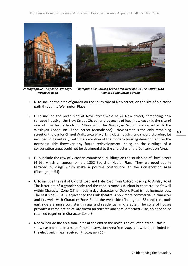
The Downs Conservation Area, Altrincham: Conservation Area Appraisal Draft: October 2014
7: Identifying the Boundary
80
Photograph 52: Telephone Exchange,
Woodville Road Photograph 53: Bowling Green Area, Rear of 2-14 The Downs, with
Rear of 16 The Downs Beyond
D To include the area of garden on the south side of New Street, on the site of a historic path through to Wellington Place.
E To include the north side of New Street west of 24 New Street, comprising new terraced housing, the New Street Chapel and adjacent offices (now vacant), the site of one of the first schools in Altrincham, the Wesleyan School associated with the Wesleyan Chapel on Chapel Street (demolished). New Street is the only remaining street of the earlier Chapel Walks area of working class housing and should therefore be included in its entirety, with the exception of the modern housing development on the northeast side (however any future redevelopment, being on the curtilage of a conservation area, could not be detrimental to the character of the Conservation Area.
F To include the row of Victorian commercial buildings on the south side of Lloyd Street (4-16), which all appear on the 1852 Board of Health Plan. They are good quality terraced buildings which make a positive contribution to the Conservation Area (Photograph 54).
G To include the rest of Oxford Road and Hale Road from Oxford Road up to Ashley Road The latter are of a grander scale and the road is more suburban in character so fit well within Character Zone C.The modern day character of Oxford Road is not homogenous. The east side (19-45), adjacent to the Club theatre is now more commercial in character and fits well with Character Zone B and the west side (Photograph 56) and the south east side are more consistent in age and residential in character. The style of houses provides a combination of late Victorian terraces and semi-detached villas, so need to be retained together in Character Zone B.
Not to include the area small area at the end of the north side of Peter Street – this is shown as included in a map of the Conservation Area from 2007 but was not included in the electronic maps received (Photograph 55).
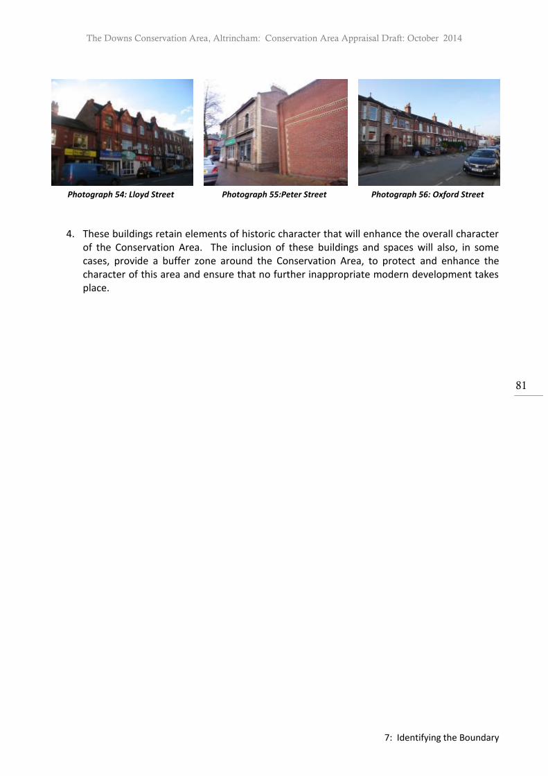
The Downs Conservation Area, Altrincham: Conservation Area Appraisal Draft: October 2014
7: Identifying the Boundary
81
Photograph 54: Lloyd Street Photograph 55:Peter Street Photograph 56: Oxford Street
4. These buildings retain elements of historic character that will enhance the overall character
of the Conservation Area. The inclusion of these buildings and spaces will also, in some cases, provide a buffer zone around the Conservation Area, to protect and enhance the character of this area and ensure that no further inappropriate modern development takes place.

The Downs Conservation Area, Altrincham: Conservation Area Appraisal Draft: October 2014
7: Identifying the Boundary
82
Map 21: Proposed Boundary Extensions
The Downs Conservation Area, Altrincham: Conservation Area Appraisal Draft: October 2014
8: A Plan for Further Action
83
8 A Plan for Further Action
1. Below is a summary of the issues and pressures within the Conservation Area which will be addressed in the corresponding draft Management Plan.
2. The future of vacant sites such as Alexandra House, Trinity Church and South Bank.
3. Provide further guidance regarding the extension and alteration of historic properties to
ensure the retention and protection of architectural and historic character. The removal of permitted development rights will also be considered.
4. Preventing further loss of architectural detail and traditional materials, including painting of
stonework, rendering of brickwork, erection of garages, and replacement of historic roof coverings, fenestration and rainwater goods. Provide further guidance regarding the installation of light wells and associated balustrades, altering of roofs, chimneys, door and window details.
5. Inappropriate shop fronts have a negative effect on the street scene and often fail to respect the significance of individual heritage assets. There are some examples of replacement shop fronts within the Conservation Area consisting of homogenous frontages with poorly designed signage, illumination and security. A revision of current guidance should be considered.
6. Balancing the need to create off-street parking with the need to maintain the rhythm of the
streets, by preventing wholesale loss of boundary walls and gateposts, creation of excessive openings, inappropriate or excessive hard landscaping and construction of intrusive garages. The removal of permitted developments will be considered to ensure historic boundary walls, gates and gateposts are retained.
7. The retention and reinstatement where possible of traditional boundary treatments and
road and pavement surfaces. To also seek to retain the quality and extent of the tree cover, mature planting and the landscaping and the general character of spaciousness.
8. Working towards appropriate solutions to the problems of parking and traffic within the
Conservation Area includes investigating the use of appropriate, minimal and unobtrusive signage and road markings, the creation of access only parking areas, where possible, and the review of traffic controls in key historic locations.
9. The consolidation of street furniture and the retention and restoration of original items
including cast iron signs and lampposts where possible.
10. Seeking creative solutions for bin storage and waste disposal, especially in areas of terraced housing and commercial premises.

The Downs Conservation Area, Altrincham: Conservation Area Appraisal Draft: October 2014
5: Audit of Heritage Assets
84
10. Sources Cartographic Sources 1772-4 Peter Burdett’s Map of Cheshire (published 1777), scale 1” to 1 mile, Cheshire Archives and Local Studies. 1819 Christopher Greenwood’s Map of Cheshire (survey date unknown), scale 1” to 1 mile, Cheshire Archives and Local Studies. 1831 A. Bryant’s Map of Cheshire (survey date unknown), scale 1 ¼ “ to 1 mile, Cheshire Archives and Local Studies. 1835 Altrincham Tithe Map, scale 3 chains to 1”, with associated Apportionment (1863), Cheshire Archives and Local Studies. 1838 Altrincham Tithe Map, scale 3 chains to 1”, with associated Apportionment (1841), Cheshire Archives and Local Studies. 1839 Altrincham Tithe Map, scale 3 chains to 1”, with associated Apportionment (1841), Cheshire Archives and Local Studies 1852 Detailed Plans of the Township of Altrincham Surveyed for the Local Board of Health, Sheets 1,2,3,4. With associated Altrincham Survey Book of References. (1852), Trafford Local Studies and Altrincham Area Image Archive. 1876 OS Map, Sheets XX111.6.11, XV111.6.12, XV111.6.7, XV111.6.6 (published 1878), scale 6” to 1 mile, Trafford Local Studies and Altrincham Area Image Archive1872 OS Map, XVIII.NW (published 1872), scale 6” to 1 mile, Cheshire Archives and Local Studies. 1897 OS Map, XVIII.NW (published 1898), scale 6” to 1 mile, Cheshire Archives and Local Studies. 1907-8 OS Map, XVIII.NW (published 1910), scale 6” to 1 mile, Cheshire Archives and Local Studies. 1937 OS Map, XVIII.NW (published 1937), scale 6” to 1 mile, Cheshire Archives and Local Studies. 1965 OS Map, XVIII.NW (published 1967), scale 6” to 1 mile, Cheshire Archives and Local Studies. Photographic Sources Altrincham Area Image Archive Trafford Local Studies – Trafford Lifetimes (The Downs 1902, TL0387; The Downs 1919, TL3705; The Downs 1950. Written Sources Altrincham History Society. Altrincham Tour. Altrincham Forward. Altrincham Town Centre Action Plan. Altrincham: Altrincham Forward, 2012. Bamford, F. The Making of Altrincham 1850 to 1991 From Market to Megastore? Altrincham:
Frank Bamford, 1991. Bayliss, D. (ed.) Altrincham: A History. Timperley: Willow Publishing, 1992. Bayliss, D. The Buildings of Central Altrincham in the Year 2000, a Report for Altrincham History
Society to Mark the Millennium. Altrincham: Altrincham History Society, 2000. Bayliss, D. Altrincham in 1799, A Stamford Estate Map: Occasional Paper 4. Altrincham:
Altrincham History Society, 1999. Bayliss, D. A Town in Crisis, Altrincham in the Mid-Nineteenth Century. Hale: Don Bayliss, 2006. Bayliss, H. Altrincham A Pictorial History. West Sussex: Phillimore & Co Ltd., 1996.

The Downs Conservation Area, Altrincham: Conservation Area Appraisal Draft: October 2014
5: Audit of Heritage Assets
85
Birchall, S. Dissent in Altrincham. Religion, Politics and a Touch of Scandal 1870 – 1905. Milton Keynes: Author House, 2010.
Booker, J. Temples of Mammon: The Architecture of Banking, 1990. Broster’s Chester Guide Altrincham Section, collated by Trafford Local Studies Centre, 1782. Cowdroy, W. Directory and Guide for the City and County of Chester, with a Concise History:
Altrincham Section, collated by Trafford Local Studies Centre, 1789. Department for Communities and Local Government. National Planning Policy Framework.
London: Department for Communities and Local Government, 2012. English Heritage. Good Practice Guide for Local Heritage Listing. London: English Heritage, 2012. English Heritage. Guidance on Conservation Area Appraisals. London: English Heritage, 2006. English Heritage. Guidance on the Management of Conservation Areas. London: English Heritage,
2006. English Heritage. Strategic Stone Study – A Building Stone Atlas of Greater Manchester, Introduction.
London: English Heritage, 2011. English Heritage. Understanding Place: Conservation Area Designation, Appraisal and Management.
London: English Heritage, 2011. Faulkner, P. FLASHBACK A Pictorial View from the turn of the Century. Trafford: Manchester
Engraving Services Ltd., 1988. Fitzpatrick, G. Altrincham Past & Present. Timperley: Willow Publishing, 1990. English Heritage. Guidance on Conservation Area Appraisals, English Heritage, 2005 GMAU & GMAC. Trafford SMR Update Final Report. Manchester: GMAU & GMAC,1995. GMAU . Arnold’s Yard Old Market Place Altrincham, an Archaeological Photographic Survey of the Buildings. Manchester: GMAU, 2003.
Hartwell, C. and et al. Buildings of England: Cheshire. London & New Haven: Yale University Press, 2011.
Hoskins, W G. The Making of the English Landscape. Sevenoaks: Hodder & Stoughton, 1992. Kelly’s Directory of Cheshire 1864. London: Kelly’s Directories Ltd, 1864. Kelly’s Directory of Cheshire with coloured map 1910. London: Kelly’s Directories Ltd, 1910. Kelly’s Directory of Cheshire 1923. London: Kelly’s Directories Ltd, 1923. Kelly’s Directory. Morris & Co Commercial Directory and Gazeteer of Cheshire 1864. London: Kelly’s
Directories Ltd, 1864. List of Street Directories and Directory Extracts. Trafford Local Studies, July 1999. Local History Pack 2: Altrincham. Trafford Local Studies. McNeal Dodgson, J. The Place Names of Cheshire, Part 2. Cambridge: English Place Name
Society, 1970. Michael Nevell, Archaeology North West Vol 5 (Issue 15 for 2000). Nevell, Michael. The Archaeology of Trafford, A Study of the Origins of Community in North West England Before 1900. Trafford: Trafford Metropolitan Borough Council with The
University of Manchester Archaeological Unit and The Greater Manchester Archaeological Unit, 1997.
Nevell, M. 12 Dunham Road Altrincham, an Archaeological Watching Brief within the Medieval Borough. Manchester: GMAU, 1997. Nickson, C. Bygone Altrincham, Traditions and History. Didsbury: E.J. Morten, 1935 reprinted
1971 and 1979. Pigot and Co. Commercial Directory for the County of Cheshire 1834. Manchester: Pigot & Co, 1834.

The Downs Conservation Area, Altrincham: Conservation Area Appraisal Draft: October 2014
5: Audit of Heritage Assets
86
Pigot and Co. Pigot’s Directory of Altrincham 1832. Manchester: Pigot & Co, 1832. Pigot and Co. National Commercial Directory; for 1828-9. Manchester: Pigot & Co, 1828-9. Planning (Listed Buildings and Conservation Areas) Act, 1990. Slater’s Royal National Commercial Directory of Manchester & Liverpool, and the Principal Manufacturing Towns in Lancashire, &c. Manchester: Isaac Slater, 1858. Winchester A. England’s Landscape: The North WeSt London: Collins, 2006. Copyright Cheshire Record Office Records in the Cheshire Record Office are reproduced with the permission of Cheshire Archives and Local Studies and the owner/depositor to whom copyright is reserved. Altrincham Area Image Archive Historic photographs in Altrincham Area Image are reproduced with the permission of the Altrincham Area Image Archive and the owner/depositor to whom copyright is reserved. Trafford Local Studies – Trafford Lifetimes Historic photographs in Trafford Lifetimes are reproduced with the permission of the Trafford Local Studies, Trafford Lifetimes and the owner/depositor to whom copyright is reserved.

The Downs Conservation Area, Altrincham: Conservation Area Appraisal Draft: October 2014
5: Audit of Heritage Assets
87
Appendix 1: Listed Buildings Entries taken from the List of Buildings of Special Architectural or Historic Interest.
Character Zone A:
Address: 32-34 The Downs, Grade II
Built: 1840, Condition: Good
Reference TD/01
Site Name 32-34, The Downs
Grade II
Address 32-34, The Downs, Altrincham
Postcode WA14 2QQ Location SJ 7657 8752
SMR Reference 3744.1.0 Listed Building No. 1356477
Listing Description
2 Houses. c.1840. Brick with slate roof. Double-depth, 2 storeys, 1 room wide (plus hall) on ground floor. The 2 houses are symmetrical and have a large wing at the rear. Stone plinth and modillion eaves cornice. 4 bays, the centre 2 being slightly advanced. Each doorway has a 4-panel door, semi-elliptical fanlight, dentilled cornice and a stone step approach. The windows, 6 in total, have cambered brick arches, stone sills and 12-pane sashes. A dormer window has been added to No. 34.
Address: Victoria Terrace (36-44 The Downs), Grade II

The Downs Conservation Area, Altrincham: Conservation Area Appraisal Draft: October 2014
5: Audit of Heritage Assets
88
Built: 1840, Condition: Fair
Reference TD/02
Site Name Victoria Terrace, 36-44 The Downs
Grade II
Address 36-44, The Downs, Altrincham
Postcode WA14 2QQ Location SJ 7655 8751
SMR Reference 3745.1.0 Listed Building No. 1067950
Listing Description
Terrace of 5 houses. c.1840. Flemish bond brick with slate roof. Double-depth, one room wide with 2 storeys and various 2 and 1-storey wings and C20 extensions at the rear. Each house has a 4-panel door to the right (except No 38 which has a C20 6-panel) with pilasters and fanlight with decorative glazing bars, a window to the left and 2 windows on the upper floor. All windows are 16-pane sashes with wedge lintels and stone sills. The eaves and roofs are stepped as they rise up the hill and No. 42 has a later dormer window. Ridge stacks between each house.
Address: Downs Place (56-62 The Downs), Grade II
Built: 1839 on date-stone, Condition: Good

The Downs Conservation Area, Altrincham: Conservation Area Appraisal Draft: October 2014
5: Audit of Heritage Assets
89
Reference TD/03
Site Name 56, 58, 60 and 62, Downs Place
Grade II
Address 56, 58, 60 and 62, The Downs, Altrincham
Postcode WA14v 2QJ Location SJ 7648 8747
SMR Reference 3746.1.0 Listed Building No. 1067951
Listing Description
Terrace of 4 houses. 1839 on datestone. Flemish bond brick with slate roof. Each house has 2 storeys and a central- staircase plan except for No. 58 which is only one room in width. Each house has a 4, 6, or 8-panel door with fanlight above. Nos 62 and 58 have moulded surrounds, in No. 60 the fanlight is blocked and Nos. 56 and 58 retain cast iron fanlight bars. Each house has 4 windows (except for No 58 which has 2 the lower being a C20 bay window the upper a 20-pane sash) which have cambered brick arches, stone sills and 16- pane sashes. Dormer windows have been added to Nos. 58 and 60.
Address: The Elms, Norman’s Place, Grade II
Built: Mid C18, Condition: Good

The Downs Conservation Area, Altrincham: Conservation Area Appraisal Draft: October 2014
5: Audit of Heritage Assets
90
Reference TD/08
Site Name The Elms
Grade II
Address The Elms, Norman's Place, Altrincham
Postcode Location SJ 7647 8773
SMR Reference 7363.1.0 Listed Building No. 1119591
Listing Description
House. Mid C18. Brick with graduated slate roof. The original 2-storey house projects at the front right and rear left with a hipped roof. Additional bays were added in the late C18 and in C19 on the right hand side and a flat roofed C20 extension to the rear as well as a C20 porch. Stone plinth, moulded timber eaves cornice and brick parapet. 6 bays in all, each having a sash window on each floor with cambered brick arches and stone sills (except for bay 2 which has the C20 porch with stone surround). Bay 6 (C19) has a 6-panel door with decorated fanlight. Interior has 3 Adam style fire places and one exposed chamfered timber beam.
Address: Richmond House (Carradale), Norman’s Place Grade II
Built: 1820 and earlier, Condition: Good

The Downs Conservation Area, Altrincham: Conservation Area Appraisal Draft: October 2014
5: Audit of Heritage Assets
91
Reference TD/05
Site Name Richmond House (Shown on map as Carradale)
Grade II
Address Richmond House, Normans Place, Altrincham
Postcode WA14 2AB Location SJ 7644 8769
SMR Reference 3759.1.0 Listed Building No. 1356479
Listing Description
House. c.1820 and earlier. Brick with slate roof. 2-storey, double-depth, central-staircase plan with single-storey addition to left and 2-storey to the right. 3 bays with stone plinth, moulded eaves cornice and brick eaves parapet. Pedimented Regency door surround with ornate fanlight and 6- octagonalpanel door. The 2 ground floor and 3 first floor windows are good C20 replacement sashes which have cambered brick arches and stone sills. 3 ridge chimney stacks. The additions to the left are not of special interest although those to the right would appear to be of an early date. The interior incorporates timber beams which are said to be of an early C18 dated predecessor building.
Address: 2, 4, 6 & 8 Norman’s Place, Grade II
Built: 1810, Condition: Good

The Downs Conservation Area, Altrincham: Conservation Area Appraisal Draft: October 2014
5: Audit of Heritage Assets
92
Reference TD/07
Site Name 2, 4, 6 and 8, Norman's Place
Grade II
Address 2, 4, 6 and 8, Norman's Place, Altrincham
Postcode Location SJ 7654 8773
SMR Reference 7364.1.0 Listed Building No. 1067959
Listing Description
4 houses. c.1810. Brick with slate roof. Each house has 2 bays, 2 storeys, and a double-depth plan with small wing to rear. Each house has a 6-panel door with decorative fanlight, Tuscan 3/4 columns and open pediment on the right, a sash window to the left (except for No. 2 which has a single-storey canted bay window) and 2 sash windows on the upper floor each having stone sills, cambered brick arches and original glazing bars. Modillion eaves cornice and a ridge stack between each house.
Address: Boundary
Stone, Grade II Built:
Circa 1840, Condition: Fair

The Downs Conservation Area, Altrincham: Conservation Area Appraisal Draft: October 2014
5: Audit of Heritage Assets
93
Reference TD/04
Site Name Boundary stone
Grade II
Address The Downs, Altrincham
Postcode Location SJ 7648 8744
SMR Reference 3747.1.0 Listed Building No. 1253113
Listing Description
Circa 1840. Inscribed stone indicating the ancient Anglo-Saxon Borough of Altrincham. A large carved stone set flush in a coursed rubble street boundary wall, the base of the stone now below pavement level. A simple moulding to the sides and top and to two slightly pointed arched panels on the lower half of the stone. In the spandrel in the centre an emblem (arrowhead) in relief below TOWNSHIPS incised in a curve. In the left hand arched panel ALTRINCHAM and in the right hand panel DUNHAM MASSEY incised. The Altrincham Court Leet, chartered in 1920, use the boundary stone as the start of the annual procession to beat the boundaries of the Borough.
Character Zone B:
1. There are no listed buildings in this character area.
Character Zone C:
Address: St John’s Church, Grade II
Built: 1865-6, Condition: Good

The Downs Conservation Area, Altrincham: Conservation Area Appraisal Draft: October 2014
5: Audit of Heritage Assets
94
Reference TD/06
Site Name Church of St John the Evangelist
Grade II
Address St John’s Church, St John’s Road, Altrincham
Postcode WA14 2NA Location SJ 7664 8737
SMR Reference 3764.1.0 Listed Building No. 1067961
Listing Description
Church. 1865-6. J. Medland Taylor. Snecked stone, ashlar dressings and green and blue decorative slate roofs. Nave, clerestory, aisles, south-west tower, west porch with gallery above, transepts, polygonal chancel with vestry and organ chamber to either side. Stone bands (some coloured), overhanging eaves and steeply pitched roofs with coped gables. 3-bay clerestory and aisles have polygonal weathered buttresses, cusped circular clerestory lights and 2 2-light aisle windows in each bay with geometrical tracery. 3-stage tower has set-back weathered buttresses, small lancet openings to the first 2 stages, 2-light openings to the belfry. The broach spire has decorated bands and gabled lucarnes. 4-light transept windows and 3 2-light chancel windows. The vestry has a door and the organ chamber a window which are diagonally set. Interior: nave arcade has short columns with variously carved capitals and tall chamfered arches. Chancel arch has elaborate columnar corbels. Scissorbraced roof trusses. Good stained glass (some by Abbott and Co.), carved stone pulpit, and font on short columns with flying buttresses supporting the bowl.
Address: Trinity Church and Schoolroom, Grade II
Built: 1872, Condition: Good but currently vacant

The Downs Conservation Area, Altrincham: Conservation Area Appraisal Draft: October 2014
5: Audit of Heritage Assets
95
Reference TD/09
Site Name Trinity United Reformed Church
Grade II
Address Trinity United Reformed Church, Delamer Road, Altrincham
Postcode Location SJ 7640 8730
SMR Reference 7368.1.0 Listed Building No. 1067924
Listing Description
Church with schoolroom at rear. 1872. Rock-faced stone, ashlar dressings and slate roof: extension to schoolroom in header bond brick. Nave with clerestory, aisles, transepts, west porch, south-west tower and small 3-sided chancel. Schoolroom and ancillary rooms to east Projecting plinth, bracketed eaves, steep roofs with coped gables. 3-bay aisles and clerestory have weathered buttresses, 2-light openings with Geometrical tracery to aisles and a type of plate tracery to clerestory. Transepts have rose window and 3 lancets. 5-light west window above vestibule with enriched parapet, window of 5 lancets, porch to left and tower to right. 2-stage tower with weathered angle buttresses, 2- light belfry openings and broach spire with gabled corner canopies and lucarnes above on enriched band with grotesque beasts. The schoolroom is treated similarly. Interior: all faced in polychromatic brick. Double-chamfered brick arched nave arcade with slender cast iron columns with foliated stone capitals and bases, those carrying the transept arches being coupled. Arch-braced roof, contemporary organ and good stained glass especially to chancel.
4.4. Monuments
Character Zone A: Monuments
1. There are no archaeological sites or scheduled monuments in the character zone .
Character Zone B: Monuments
Address: Site of the Aikenites Chapel
Built: Date, Condition: Recorded as demolished but evidence suggests still standing
Description: Chapel building, AD 19th century, Tithe map 1835 shows a small square building with
rear outrigger, adjacent to the road. OS 1876 shows building remains and is labelled as ‘Baptist
Chapel’, seating 100 . It is thought that the building was demolished, nevertheless it is still visible to

The Downs Conservation Area, Altrincham: Conservation Area Appraisal Draft: October 2014
5: Audit of Heritage Assets
96
the rear of 12-14 The Downs and internally there are features. A simple brick gable wall with stone
string course.
Character Zone C: Monuments
2. There are no archaeological sites or scheduled monuments in the character zone.
4.5. Positive Contributors
1. The term positive contributor identifies a non-designated heritage asset which makes a positive contribution to the Conservation Area. These buildings, structures and sites are classed as heritage assets as they are identified by the local authority as having a degree of significance, meriting consideration in planning decisions, because of their heritage interest.51 A single building, group or landmark can be classed as a positive contributor.
1. These assets have been assessed with reference to English Heritage criteria set out in their document Understanding Place: Conservation Area Designation, Appraisal and Management, paragraph 2.2.21.52 The guidance uses the following questions to assess if an element should be considered for positive contribution;
Is it the work of a particular architect or designer of regional or local note?
Does it have landmark quality?
Does it reflect a substantial number of other elements in the conservation area in age, style, materials, form or other characteristics?
Does it relate to adjacent designated heritage assets in age, materials or in any other historically significant way?
Does it contribute positively to the setting of adjacent designated heritage assets?
Does it contribute to the quality of recognisable spaces including exteriors or open spaces with a complex of public buildings?
Is it associated with a designed landscape e.g. a significant wall, terracing or a garden building?
Does it individually, or as part of a group, illustrate the development of the settlement in which it stands?
Does it have significant historic association with features such as the historic road layout, burgage plots, a town park or a landscape feature?
Does it have historic associations with local people or past events?
Does it reflect the traditional functional character or former uses in the area?
Does its use contribute to the character or appearance of the area?
Character Zone A: Positive Contributors
51 Department of Communities and Local Government, National Planning Policy Framework. (Department of
Communities and Local Government,2012). 52 English Heritage, Understanding Place: Conservation Area Designation, Appraisal and Management. (London: English
Heritage, 2011) para 2.2.21

The Downs Conservation Area, Altrincham: Conservation Area Appraisal Draft: October 2014
5: Audit of Heritage Assets
97
Address: 13-25 Norman’s Place
Built: Date, Condition: Good
Description: These buildings reflect a substantial number of other elements in the Conservation
Area in age, style, materials and form. The buildings reflect the traditional functional character and
former uses in the area. As a group they illustrate the development of the settlement in which they
stand.
Address: 1-19 Lyme Grove
Built: Date, Condition: Good
Description: These buildings reflect a substantial number of other elements in the Conservation
Area in age, style, materials and form. The buildings reflect the traditional functional character and
former uses in the area. As a group they illustrate the development of the settlement in which they
stand.
Address: 2-16 Lyme Grove
Built: Date, Condition: Good

The Downs Conservation Area, Altrincham: Conservation Area Appraisal Draft: October 2014
5: Audit of Heritage Assets
98
Description: These buildings reflect a substantial number of other elements in the Conservation
Area in age, style, materials and form. The buildings reflect the traditional functional character and
former uses in the area. As a group they illustrate the development of the settlement in which they
stand.
Address: 24-84 New Street including Stanley Place (24-32), Russell Place (36-48) and
Stamford Terrace (56-66)
Built: Date, Condition: Good
Description: These buildings reflect a substantial number of other elements in the Conservation
Area in age, style, materials and form. The buildings reflect the traditional functional character and
former uses in the area. As a group they illustrate the development of the settlement in which they
stand.
Address: 77-89 New Street
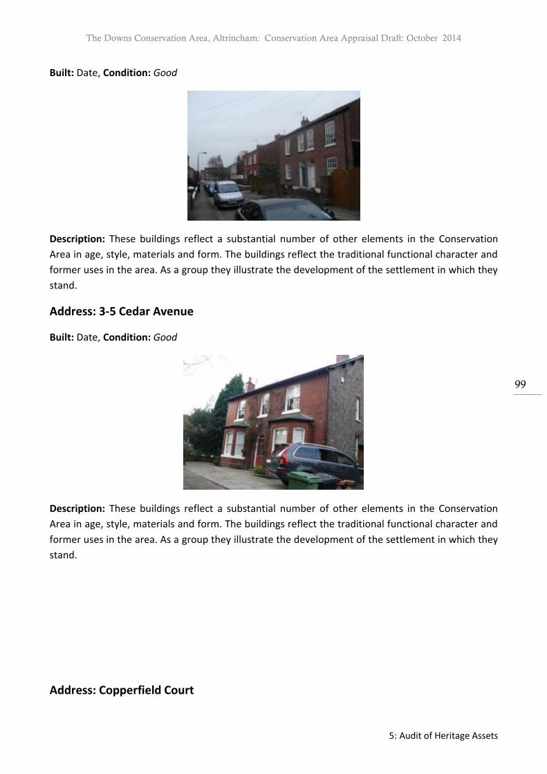
The Downs Conservation Area, Altrincham: Conservation Area Appraisal Draft: October 2014
5: Audit of Heritage Assets
99
Built: Date, Condition: Good
Description: These buildings reflect a substantial number of other elements in the Conservation
Area in age, style, materials and form. The buildings reflect the traditional functional character and
former uses in the area. As a group they illustrate the development of the settlement in which they
stand.
Address: 3-5 Cedar Avenue
Built: Date, Condition: Good
Description: These buildings reflect a substantial number of other elements in the Conservation
Area in age, style, materials and form. The buildings reflect the traditional functional character and
former uses in the area. As a group they illustrate the development of the settlement in which they
stand.
Address: Copperfield Court
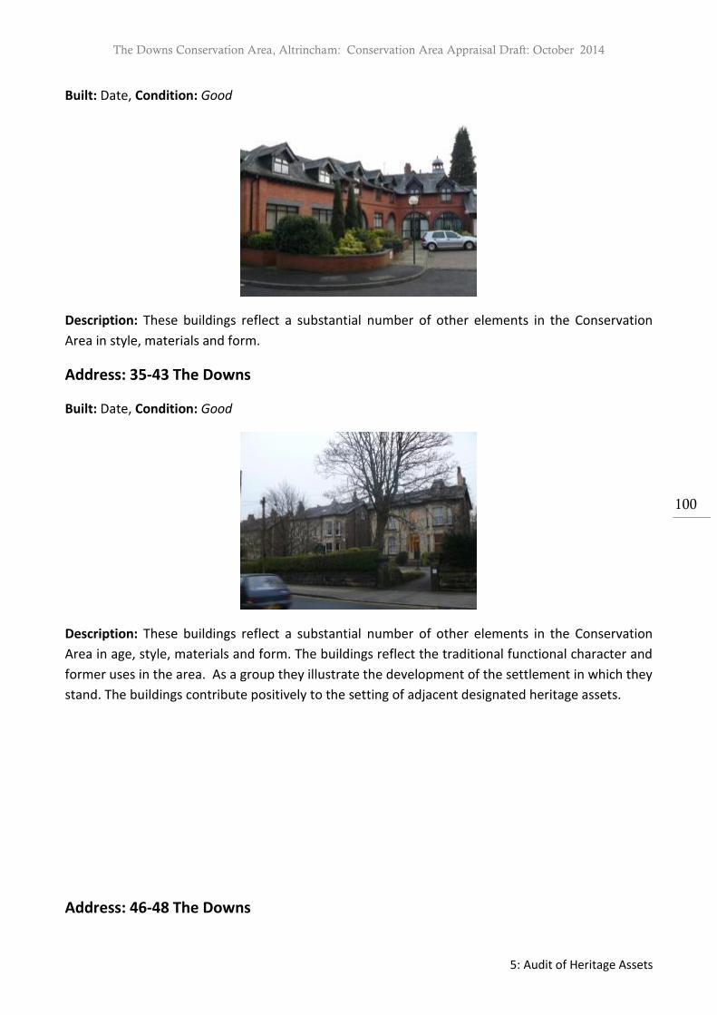
The Downs Conservation Area, Altrincham: Conservation Area Appraisal Draft: October 2014
5: Audit of Heritage Assets
100
Built: Date, Condition: Good
Description: These buildings reflect a substantial number of other elements in the Conservation
Area in style, materials and form.
Address: 35-43 The Downs
Built: Date, Condition: Good
Description: These buildings reflect a substantial number of other elements in the Conservation
Area in age, style, materials and form. The buildings reflect the traditional functional character and
former uses in the area. As a group they illustrate the development of the settlement in which they
stand. The buildings contribute positively to the setting of adjacent designated heritage assets.
Address: 46-48 The Downs

The Downs Conservation Area, Altrincham: Conservation Area Appraisal Draft: October 2014
5: Audit of Heritage Assets
101
Built: Date, Condition: Good
Description: These buildings reflect a substantial number of other elements in the Conservation
Area in age, style, materials and form. The buildings reflect the traditional functional character and
former uses in the area. As a group they illustrate the development of the settlement in which
they stand. The buildings contribute positively to the setting of adjacent designated heritage assets.
Address: 50-54 The Downs
Built: Date, Condition: Good
Description: These buildings reflect a substantial number of other elements in the Conservation
Area in age, style, materials and form. The buildings reflect the traditional functional character and
former uses in the area. As a group they illustrate the development of the settlement in which
they stand. The buildings contribute positively to the setting of adjacent designated heritage assets.
Address: 64-70 The Downs

The Downs Conservation Area, Altrincham: Conservation Area Appraisal Draft: October 2014
5: Audit of Heritage Assets
102
Built: Date, Condition: Good
Description: These buildings reflect a substantial number of other elements in the Conservation
Area in age, style, materials and form. The buildings reflect the traditional functional character and
former uses in the area. As a group they illustrate the development of the settlement in which they
stand.
Address: 72-78 The Downs
Built: Date, Condition: Good
Description: These buildings reflect a substantial number of other elements in the Conservation
Area in age, style, materials and form. The buildings reflect the traditional functional character and
former uses in the area. As a group they illustrate the development of the settlement in which they
stand.
Address: 82-86 The Downs

The Downs Conservation Area, Altrincham: Conservation Area Appraisal Draft: October 2014
5: Audit of Heritage Assets
103
Built: Date, Condition: Good
Description: These buildings reflect a substantial number of other elements in the Conservation
Area in age, style, materials and form. The buildings reflect the traditional functional character and
former uses in the area. As a group they illustrate the development of the settlement in which they
stand.
Address: Old Telephone Exchange, Woodville Road
Built: 1908, Condition: Good
Description: This building reflects a substantial number of other elements in the Conservation Area
in age, style, materials and form. It illustrates the development of the settlement in which it stands.
It reflects the traditional former uses in the area.
Address: 1-12 Wellington Place

The Downs Conservation Area, Altrincham: Conservation Area Appraisal Draft: October 2014
5: Audit of Heritage Assets
104
Built: Date, Condition: Good
Description: These buildings reflect a substantial number of other elements in the Conservation
Area in age, style, materials and form. The buildings reflect the traditional functional character and
former uses in the area. As a group they illustrate the development of the settlement in which they
stand.
Address: Osbourne Place
Built: Date, Condition: Good
Description: These buildings reflect a substantial number of other elements in the Conservation
Area in age, style, materials and form. The buildings reflect the traditional functional character and
former uses in the area. As a group they illustrate the development of the settlement in which they
stand.

The Downs Conservation Area, Altrincham: Conservation Area Appraisal Draft: October 2014
5: Audit of Heritage Assets
105
Character Zone B: Positive Contributors
Address: 1-5 The Downs
Built: Date, Condition: Fair, ground floor façade of Portland stone recently painted
Description: This building reflects a substantial number of other elements in the Conservation Area
in age, style, materials and form. The building reflects the traditional functional character and
former uses in the area. It illustrates the development of the settlement in which it stands. The
building has a landmark quality.
Address: 7-11 The Downs
Built: Date, Condition: Good
Description: These buildings reflect a substantial number of other elements in the Conservation
Area in age, style, materials and form. The buildings reflect the traditional functional character and
former uses in the area. As a group they illustrate the development of the settlement in which they
stand.

The Downs Conservation Area, Altrincham: Conservation Area Appraisal Draft: October 2014
5: Audit of Heritage Assets
106
Address: 13-19 The Downs
Built: Date, Condition: Good, shop front of 19 in poor condition
Description: These buildings reflect a substantial number of other elements in the Conservation
Area in age, style, materials and form. As a group they illustrate the development of the settlement
in which they stand.
Address: 21-25 The Downs
Built: Date, Condition: Good, awning and alterations mar ground floor
Description: These buildings reflect a substantial number of other elements in the Conservation
Area in age, style, materials and form. As a group they illustrate the development of the settlement
in which they stand.
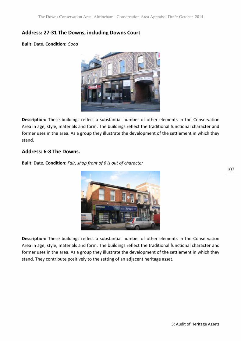
The Downs Conservation Area, Altrincham: Conservation Area Appraisal Draft: October 2014
5: Audit of Heritage Assets
107
Address: 27-31 The Downs, including Downs Court
Built: Date, Condition: Good
Description: These buildings reflect a substantial number of other elements in the Conservation
Area in age, style, materials and form. The buildings reflect the traditional functional character and
former uses in the area. As a group they illustrate the development of the settlement in which they
stand.
Address: 6-8 The Downs.
Built: Date, Condition: Fair, shop front of 6 is out of character
Description: These buildings reflect a substantial number of other elements in the Conservation
Area in age, style, materials and form. The buildings reflect the traditional functional character and
former uses in the area. As a group they illustrate the development of the settlement in which they
stand. They contribute positively to the setting of an adjacent heritage asset.

The Downs Conservation Area, Altrincham: Conservation Area Appraisal Draft: October 2014
5: Audit of Heritage Assets
108
Address: 16-18 The Downs.
Built: Date, Condition: Fair, second floor façade shows original form but ground floor and rear are
greatly changed.
Description: This building reflects a substantial number of other elements in the Conservation Area
in age, style, materials and form. The building reflects the traditional functional character and
former uses in the area. It illustrates the development of the settlement in which it stands. It
contributes positively to the setting of an adjacent heritage asset.
Address: 20-22 The Downs
Built: Date, Condition: Good, 22 has a replacement first floor window
Description: These buildings reflect a substantial number of other elements in the Conservation
Area in age, style, materials and form. The buildings reflect the traditional functional character and
former uses in the area. As a group they illustrate the development of the settlement in which they
stand.

The Downs Conservation Area, Altrincham: Conservation Area Appraisal Draft: October 2014
5: Audit of Heritage Assets
109
Address: 24-26 The Downs
Built: Date, Condition: Good
Description: These buildings reflect a substantial number of other elements in the Conservation
Area in age, style, materials and form. The buildings reflect the traditional functional character and
former uses in the area. As a group they illustrate the development of the settlement in which they
stand.
Address: 28-30 The Downs
Built: Date, Condition: Good, the shop fronts are in character and good quality
Description: These buildings reflect a substantial number of other elements in the Conservation
Area in age, style, materials and form. The buildings reflect the traditional functional character and
former uses in the area. As a group they illustrate the development of the settlement in which they
stand.

The Downs Conservation Area, Altrincham: Conservation Area Appraisal Draft: October 2014
5: Audit of Heritage Assets
110
Address: 10-28 Ashley Road
Built: Date, Condition: Fair
Description: These buildings reflect a substantial number of other elements in the Conservation
Area in age, style, materials and form. The buildings reflect the traditional functional character and
former uses in the area. As a group they illustrate the development of the settlement in which they
stand.
Address: 9-17 Ashley Road
Built: Date, Condition: Good
Description: These buildings reflect a substantial number of other elements in the Conservation
Area in age, style, materials and form. As a group they illustrate the development of the settlement
in which they stand.

The Downs Conservation Area, Altrincham: Conservation Area Appraisal Draft: October 2014
5: Audit of Heritage Assets
111
Address: 19-23 Ashley Road
Built: Date, Condition: Fair, significant alteration to rear
Description: These buildings reflect a substantial number of other elements in the Conservation
Area in age, style, materials and form. The buildings reflect the traditional functional character and
former uses in the area. As a group they illustrate the development of the settlement in which they
stand.
Address: 1-15 Oxford Road
Built: Date, Condition: Good
Description: These buildings reflect a substantial number of other elements in the Conservation
Area in age, style, materials and form. The buildings reflect the traditional functional character and
former uses in the area. As a group they illustrate the development of the settlement in which they
stand.
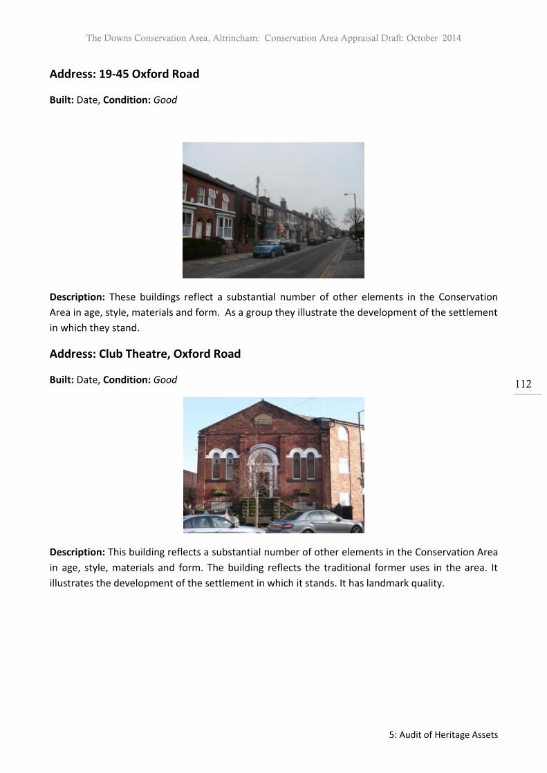
The Downs Conservation Area, Altrincham: Conservation Area Appraisal Draft: October 2014
5: Audit of Heritage Assets
112
Address: 19-45 Oxford Road
Built: Date, Condition: Good
Description: These buildings reflect a substantial number of other elements in the Conservation
Area in age, style, materials and form. As a group they illustrate the development of the settlement
in which they stand.
Address: Club Theatre, Oxford Road
Built: Date, Condition: Good
Description: This building reflects a substantial number of other elements in the Conservation Area
in age, style, materials and form. The building reflects the traditional former uses in the area. It
illustrates the development of the settlement in which it stands. It has landmark quality.

The Downs Conservation Area, Altrincham: Conservation Area Appraisal Draft: October 2014
5: Audit of Heritage Assets
113
Address: 2-10 Oxford Road
Built: Date, Condition: 2-6 Good, 8-10 Fair
Description: These buildings reflect a substantial number of other elements in the Conservation
Area in age, style, materials and form. As a group they illustrate the development of the settlement
in which they stand.
Address: 12 Oxford Road
Built: Date, Condition: Good
Description: This building reflects a substantial number of other elements in the Conservation Area
in age, style, materials and form. It illustrates the development of the settlement in which it stands.

The Downs Conservation Area, Altrincham: Conservation Area Appraisal Draft: October 2014
5: Audit of Heritage Assets
114
Address: 1-3 Peters Street
Built: Date, Condition: Good
Description: These buildings reflect a substantial number of other elements in the Conservation
Area in age, style, materials and form. The buildings reflect the traditional functional character and
former uses in the area. As a group they illustrate the development of the settlement in which they
stand.
Address: 2-4, 6-12 and 14-16 Lloyd Street
Built: Date, Condition: Fair, alteration to windows and rear
Description: These buildings reflect a substantial number of other elements in the Conservation
Area in age, style, materials and form. The buildings reflect the traditional functional character and
former uses in the area. As a group they illustrate the development of the settlement in which they
stand.

The Downs Conservation Area, Altrincham: Conservation Area Appraisal Draft: October 2014
5: Audit of Heritage Assets
115
Character Zone C: Positive Contributors
Address: 47-69 Oxford Road
Built: Date, Condition: Good
Description: These buildings reflect a substantial number of other elements in the Conservation
Area in age, style, materials and form. The buildings reflect the traditional functional character and
former uses in the area. As a group they illustrate the development of the settlement in which they
stand.
Address: 14–58 Oxford Road
Built: Date, Condition: Good, loss of front gardens and boundary walls
Description: These buildings reflect a substantial number of other elements in the Conservation
Area in age, style, materials and form. The buildings reflect the traditional functional character and
former uses in the area. As a group they illustrate the development of the settlement in which they
stand.

The Downs Conservation Area, Altrincham: Conservation Area Appraisal Draft: October 2014
5: Audit of Heritage Assets
116
Address: 51 Ashley Road (Rose Cottage) & 39-55 Ashley Road
Built: Date, Condition: Good
Description: These buildings reflect a substantial number of other elements in the Conservation
Area in age, style, materials and form. The buildings reflect the traditional functional character and
former uses in the area. As a group they illustrate the development of the settlement in which they
stand.
Address: 34 and 36 Ashley Road
Built: Date, Condition: Good
Description: These buildings reflect a substantial number of other elements in the Conservation
Area in age, style, materials and form. As a group they illustrate the development of the settlement
in which they stand.

The Downs Conservation Area, Altrincham: Conservation Area Appraisal Draft: October 2014
5: Audit of Heritage Assets
117
Address: 1-23 Hale Road
Built: Date, Condition: Good
Description: These buildings reflect a substantial number of other elements in the Conservation
Area in age, style, materials and form. The buildings reflect the traditional functional character and
former uses in the area. As a group they illustrate the development of the settlement in which they
stand.
Address: 2-12 Hale Road
Built: Date, Condition: Good
Description: These buildings reflect a substantial number of other elements in the Conservation
Area in age, style, materials and form. The buildings reflect the traditional functional character and
former uses in the area. As a group they illustrate the development of the settlement in which they
stand.

The Downs Conservation Area, Altrincham: Conservation Area Appraisal Draft: October 2014
5: Audit of Heritage Assets
118
Address: Windlehurst, St John’s Road & Grosvenor House, The Downs
Built: Date, Condition: Good
Description: These buildings reflect a substantial number of other elements in the Conservation
Area in age, style, materials and form. The buildings reflect the traditional functional character and
former uses in the area. As a group they illustrate the development of the settlement in which they
stand.
Address: Former St John’s School building, now housing St John’s Mews and
Medical Centre
Built: Date, Condition: Good
Description: These buildings reflect a substantial number of other elements in the Conservation
Area in age, style, materials and form. As a group they illustrate the development of the settlement
in which they stand.

The Downs Conservation Area, Altrincham: Conservation Area Appraisal Draft: October 2014
5: Audit of Heritage Assets
119
Address: Holly Bank, St John’s Road & Thornhill, Delamer Road
Built: Date, Condition: Good
Description: These buildings reflect a substantial number of other elements in the Conservation
Area in age, style, materials and form. The buildings reflect the traditional functional character and
former uses in the area. As a group they illustrate the development of the settlement in which they
stand.
Address: North Bank & Turn Lee, St John’s Road
Built: Date, Condition: Good
Description: These buildings reflect a substantial number of other elements in the Conservation
Area in age, style, materials and form. The buildings reflect the traditional functional character and
former uses in the area. As a group they illustrate the development of the settlement in which they
stand.

The Downs Conservation Area, Altrincham: Conservation Area Appraisal Draft: October 2014
5: Audit of Heritage Assets
120
Address: Bowdon Preparatory School
Built: Date, Condition: Good
Description: This building reflects a substantial number of other elements in the Conservation Area
in age, style, materials and form. The building reflects traditional former uses in the area. It
illustrates the development of the settlement in which it stands. This building has a landmark
quality.
Address: Greenbank House and The Old Coach House
Built: Date, Condition: Good
Description: These buildings reflect a substantial number of other elements in the Conservation
Area in age, style, materials and form. The buildings reflect the traditional functional character and
former uses in the area. As a group they illustrate the development of the settlement in which they
stand.

The Downs Conservation Area, Altrincham: Conservation Area Appraisal Draft: October 2014
5: Audit of Heritage Assets
121
Address: 22-24 Albert Square
Built: Date, Condition: Good
Description: These buildings reflect a substantial number of other elements in the Conservation
Area in age, style, materials and form. The buildings reflect the traditional functional character and
former uses in the area. As a group they illustrate the development of the settlement in which they
stand.
Address: 28-29 Albert Square
Built: Date, Condition: Good
Description: These buildings reflect a substantial number of other elements in the Conservation
Area in age, style, materials and form. The buildings reflect the traditional functional character and
former uses in the area. As a group they illustrate the development of the settlement in which they
stand.

The Downs Conservation Area, Altrincham: Conservation Area Appraisal Draft: October 2014
5: Audit of Heritage Assets
122
Address: 21-23 Albert Square
Built: Date, Condition: Good
Description: These buildings reflect a substantial number of other elements in the Conservation
Area in age, style, materials and form. As a group they illustrate the development of the settlement
in which they stand.
Address: 25-27 Albert Square
Built: Date, Condition: Good
Description: These buildings reflect a substantial number of other elements in the Conservation
Area in age, style, materials and form. As a group they illustrate the development of the settlement
in which they stand.

The Downs Conservation Area, Altrincham: Conservation Area Appraisal Draft: October 2014
5: Audit of Heritage Assets
123
Address: Beauthorn House and Delamer Road
Built: Date, Condition: Good
Description: This building reflects a substantial number of other elements in the Conservation Area
in age, style, materials and form. The building reflects the traditional functional character and
former uses in the area. It illustrates the development of the settlement in which it stands.
Address: Levenshurst, Fern Bank, Knowsley Bank, Kelston, Delamer House, Dunham
Grange, Laurel House and Engelfield, South Downs, Delamer Road
Built: Date, Condition: Good
Description: These buildings reflect a substantial number of other elements in the Conservation
Area in age, style, materials and form. The buildings reflect the traditional functional character and
former uses in the area. As a group they illustrate the development of the settlement in which they
stand.

The Downs Conservation Area, Altrincham: Conservation Area Appraisal Draft: October 2014
5: Audit of Heritage Assets
124
Address: Rostherne,Wendover, Rosedene, Cranwells, Farley Lodge, Stancliffe,
Hazelfield and Southbank, Cavendish Road.
Built: Date, Condition: Good, except for part of garden of Wendover and 35 Cavendish Road
(derelict garages and overgrown garden)
Description: These buildings reflect a substantial number of other elements in the Conservation
Area in age, style, materials and form. The buildings reflect the traditional functional character and
former uses in the area. As a group they illustrate the development of the settlement in which they
stand.
Address: 1-15 Higher Downs
Built: Date, Condition: Good
Description: These buildings reflect a substantial number of other elements in the Conservation
Area in age, style, materials and form. The buildings reflect the traditional functional character and
former uses in the area. As a group they illustrate the development of the settlement in which they
stand. Several have an historic association with significant local people (12, 13 & 15).
Address: 12-18 Lloyd Street
Built: Date, Condition:

The Downs Conservation Area, Altrincham: Conservation Area Appraisal Draft: October 2014
5: Audit of Heritage Assets
125
Photo & description required
Address: 75 New Street
Built: Date, Condition:
Photo & description required
Address: 16-22 New Street
Built: Date, Condition:
Photo & description required
Address: Chapel House, New Street
Built: Date, Condition:
Photo & description required

The Downs Conservation Area, Altrincham: Conservation Area Appraisal Draft: October 2014
Appendix 2: Contacts
126

The Downs Conservation Area, Altrincham: Conservation Area Appraisal Draft: October 2014
Appendix 2: Contacts
127
Appendix 2: Contacts Trafford Council Contacts General development control enquiries concerning The Downs Conservation Area should be referred to South Team, Development Control. Telephone: 0161 912 3149 General enquiries concerning The Downs Conservation Area and listed buildings should be referred to the Local Planning Authority’s Conservation Officer. Telephone: 0161 912 3222 Enquiries relating to trees within the Conservation Area should be addressed to the Local Planning Authority’s Arboricultural Officer. Telephone: 0161 912 3199 Enquiries relating to accessing Historic Environment Records, archaeological planning advice, and charges, where appropriate, should be addressed to the Greater Manchester Archaeological Advisory Service, University of Salford, Centre for Applied Archaeology, Joule House, Salford M5 4WT [email protected] National Organisations English Heritage North West Office Canada House Chepstow Street Manchester M1 5FW Telephone: 0161 242 1400 www.english-heritage.org.uk Email: [email protected] Victorian Society The Victorian Society 1 Priory Gardens Bedford Park London W4 1TT Telephone: 020 8994 1019 www.victorian-society.org.uk Email: [email protected] Georgian Group 6 Fitzroy Square, London W1T 5DX Telephone: 087 1750 2936 www.georgiangroup.org.uk Email: [email protected] Twentieth Century Society 70 Cowcross Street London EC1M 6EJ Telephone: 020 7250 3857 www.c20society.org.uk Email: [email protected] Institute of Historic Building Conservation Jubilee House, High Street, Tisbury, Wiltshire SP3 6HA Telephone: 01747 873133 www.ihbc.org.uk Email: [email protected]


