Embed Size (px)
Citation preview

The Architecture of the Periphery Alona Martínez Pérez March, 2016
Thesis submitted for the fulfilment of the degree of Doctor of Philosophy in Architecture School of Architecture The University of Sheffield

This thesis is dedicated to my mother Rosa Maria Perez Ruiz
to my son Alberto and Louis Ember Gyoh
Dedico esta tesis a mi madre Rosa María Pérez Ruiz
a mi hijo Alberto y a Louis Ember Gyoh

Acknowledgments
This thesis has benefited from the input of various individuals and organisations whom I would like to take the opportunity to thank here. First, I would like to thank my supervisor Dr Stephen Walker, for his never-ending patience and positive approach, for his critical revisions and corrections, and belief in this work and for his excellent supervision. This long journey that I started could not have been concluded without his supervision, his knowledge of the context and culture of Madrid and architectural theory, and his suggestions and the careful management of this process. This thesis is a testament to his continuous support and teaching, which I feel privileged to have been a part of. I would also like to thank the University of Sheffield for the scholarship that I was awarded that made it financially possible for me to do this work, and also to all the staff, especially Doina Petrescu, Tatjana Schneider, and Cristina Cerulli. Special thanks go to my two examiners Russell Knight and Lorens Holm whose helpful advice, comments and support have helped this thesis tremendously. I am grateful to all my students and colleagues that I have worked with over the years, and those from Belfast that walked through Madrid with me, asking questions and to all the anonymous people that I met in the peripheries of Madrid who assisted me during this work. Richard Roger’s work who has been essential for me in understanding cities, and his generosity and that of his team in allowing me to interview him for Domus, and Simon Smithson meeting us in Madrid. In Belfast special thanks go to Professors Alastair Adair, Stanley McGreal and Jim Berry who will always be a reference for me and Professor Graeme Hutton in Dundee. Dean Ali Parsa who has been a continuous mentor towards my work and a source of inspiration, and has always been there for me as a friend no matter what. Their work understanding urban processes and real estate and urbanism, has been invaluable to me. From Plymouth University I thank everyone but in particular Professors Malcolm Miles, Alex Aurigi and Steve Goodhew for their continuous support, comments and mentoring and especially my friends Katharine Willis, Simon Bradbury, Kasia and Krzysztof Nawaratek, Satish Basavapatna Kumaraswamy, and Giovanna Guidicini. Special mention goes to all my students in Belfast, Dundee and Plymouth Universities and at all the places where I have taught in Italy, Spain and Ireland. This work is dedicated to all of you because through this journey you have taught me and inspired me so much that this has shaped not just this work, but also my architectural life. I would also like to thank my mother for her financial and intellectual support over the years that I have studied architecture in this country, and for introducing me to the work of the Italian architect Aldo Rossi when I was young and for her belief in my work. She introduced me to the love of architecture, travelling Italy and Spain with me and encouraging me to ask questions and seek answers always, to think freely, and to be myself. It was thanks to her that I was offered the opportunity to be in Morocco where most of the writing for this work took place. My Italian father Alberto Avalle, who showed me the importance of dreaming, and allowing your dreams to become true, never being afraid of always constantly trying and his architect wife Simona Marinelli and also Pietro and Lucia. My grandmother Adela whose kindness and sharp intelligence has always been in my life, my grandfather Manuel who loved architecture and people, and my incredible and amazing sister Adela who I hope understand that this history is also part of their history. Pedro who read and helped with numerous drafts in café Paris and without whom this work would not be here today, and to my friends in the city of Tetouan in Morocco, where I lived for nine months writing this work and all the architects and technicians I worked with in Edinburgh. Particular thanks to my Irish friends Ciaran Mackel and Brian

Murphy who read and constructively criticised this work and believed in it. The beginning of this journey would have not been possible without the support of Massimo Clemente, Ilir Nase, Kristofer Eklund, Louis Ember Gyoh, Cameron McEwan, Sophie Harbour, Jose Luis Ramirez Luengo, Rob Burns, Dorian Wiszniewski, Liam Ross, and of course the always amazing and unique Adam Jason Oakley. Lorens Holm and Paul Guzzardo, two people that since 2009 have been so important to me, and their work on architecture and cities who gave me the amazing chance to be part of their world and work in the Geddes Institute in Dundee (I can never thank you enough, with just words). My two closest friends in practice and life over the years and fantastic women: Lita Khazaka and Ariadna Perich Capdeferro whose work as architects make me aspire to always be critical and challenge conceptions. Particular thanks go also to Alba Fuertes and Rory Jones whose support was invaluable. My drawing maestro Manuel Balsa Bermejo (a Russian child from the Spanish Civil War and the greatest teacher for generations of artists and architects) from the Museo de Reproducciones in Bilbao who taught me to draw when I was ten years old, and to observe, listen and carefully look at the detail before drawing it and whose love of Turner and art opened my eyes to the world and the career that I chose as a profession and the curiosity of learning and travel. The generosity of Rafael Moneo and his kindness has been my privilege, since meeting him in his office in Madrid, to discuss my research. Stefano Boeri from Milano also helped this research through an interview about his work and as a pioneer in Europe about the peripheral condition. There are three people that have been essential in framing my thinking about this subject which are not here with us anymore Aldo Rossi, Manuel de Solà-Morales, and Gabriele Basilico whose writings and images and the poetic qualities of their work has been an inspiration for me. Mosè Ricci, Massimo Angrilli, Claudia Trillo, Gabriella Esposito, Riccardo Marini, my Italian friends who made me love their work and their country. Mosè Ricci’s support and advice about this work, and his own writings and built work is critical to anyone understanding the contemporary city and has been both influential and inspirational for me. Ultimately I would like to thank my son Alberto who is too young to read this work, but I hope that one day he can understand that life is a journey that allows us to dream, to write and to cherish. I hope you can forgive me one day for all the hours that I did not spend with you, while writing this work.

Abstract
Aldo Rossi’s L’archittetura della citta (The Architecture of the City) has proven to be one of the most influential architecture manifestoes of the 20th century. Written against the backdrop of the CIAM and Functionalism it offered a theory of the elements that constitute the architecture of the city. Rafael Moneo writes: “As a critic no one can question the insightful value of Rossi’s oeuvre. From the knowledge of the ancient city it has been possible to make a critique of modern urbanism that has shown its terrible gaps and, therefore, the role that the ancient city has played as an antidote to that has been of prime importance. This has been his most important contribution to the development of current urban thinking.”1
The last chapter of Rossi’s book emphasizes the importance of investigating the peripheries of the European city, and offers a starting point for this thesis.2 Moreover, according to Rossi there is a clear relationship between architectural theory and the project,3 and this thesis explores this assertion in the context of the city of Madrid. No other European city has undergone a similar scale of development in recent years regarding peripheral and infrastructural development.4 Picking up from Rossi’s final chapter, this thesis asks whether it is possible to establish a theory of the architecture of the periphery of the European city.
To arrive at such a theory, Rossi’s methodology, developed for his reading of the traditional city, needs to be supplemented and developed. Here, this work will be started by drawing on the contribution of Rossi’s contemporaries Robert Venturi and Denise Scott-Brown (Learning from Las Vegas5). The gaps left in the theory also requires new approaches for the methodology and its application, and fieldwork techniques are used here that embrace other forms of exploring these territories, including walking and visual tools such as photography, in order to map, and to analyse and understand, these environments. This PhD uses fieldwork to look at different areas developed to the North and South of Madrid, in combination with architectural theory, in order to describe, analyse and understand the architecture of the periphery, and to define the gaps between architectural theory and project.
In addition to this understanding of the architecture of the periphery, the thesis also makes a methodological contribution, developing practical and analytical tools and building a theory that offers new ways of analysing other European peripheries.
1 R. Moneo, “La idea de arquitectura en Rossi y el cementerio de Modena”, in, E. Bonfanti, and A. Ferlenga, Aldo Rossi (Barcelona: Ediciones del Serbal, 1992), 57. [Author’s translation]. 2 A. Rossi, et al., The Architecture of the City (Cambridge, Mass: MIT Press, 1988), 160. 3 V. Sainz Gutiérrez, Aldo Rossi : la ciudad, la arquitectura, el pensamiento (Buenos Aires: Nobuko. 2011), 55. 4 R. Prat, “Madrid: The Rise of the Residential Periphery” in M. Ballesteros, Verb crisis (Barcelona; New York: Actar, 2008), 39. 5 R. Venturi, D. Scott Brown, and S. Izenour, Learning from Las Vegas: the forgotten symbolism of architectural form (Cambridge Mass.: The MIT Press, 1996), 73.
Preface
1
PREFACE
In April 2010 I took a group of Irish students to Madrid, and after walking all day through the peripheries of the city, I went to the Circle of Fine Arts in the city centre to have a coffee, and I thought about these areas where people live.
I immediately went to La Casa del Libro in Gran Via, and bought some architecture books, including one called La Arquitectura de la no-ciudad1 (The Architecture of the non-city). The idea of these ‘non-city’ areas proliferating throughout Europe was clear to me. I have lived in many cities, Sheffield, Edinburgh, Bilbao, Milano, Belfast, Wakefield, and in all of them you can see that the real city, where according to the Italian architect Stefano Boeri most Europeans live, is in those areas2 where the shopping mall has become your corner shop, and the multi-storey cinema the small art house place where we see films. We don’t walk, we drive instead, we don’t mix with other real people in real space,3 and we do not live in the city centre anymore, we live in the peripheries.
The country where I am from, Spain, was then facing the toughest crisis in several generations. Madrid is one of the biggest conurbations in Europe, but what is interesting is that in the last few years it has seen unprecedented growth, and it has become a place for urban and architectural experimentation. But what I see on the ground —as Madrid architect Juan Herreros has suggested— is a mediocre city, even though when we were building it we had everything in our favour. He writes: “As we watch in amazement at what emerging economies do with their territories-those cities with a population of two million that are built out of nothing in China- we become aware that we have been doing much the same thing: we have built a mediocre city around Madrid, and not exactly out of nothing. In fact we had everything in our favour”.4 The city I saw on the ground was a complex one. I asked myself how the European landscape was changing, and how I saw in the periphery of Madrid a city built out of nothing. And it was not just Madrid: other European cities had similar landscapes.
The work of the Italian photographer Gabriele Basilico inspired me to look at this changing landscape and to ask myself a series of questions about what the theory is that defines these peripheries. But this journey was not going to be straightforward or concluded in a linear path: I had to read texts in three languages (Italian, Spanish, and English) to understand these processes from the original sources, and most importantly to walk, to see, and to explore these areas, to immerse myself in them. Only in that way could I critically approach them. And I had to use different techniques and methods so that I could see a multi-faceted approach to the subject.
1 F. de Azúa, ed., La arquitectura de la no-ciudad (Pamplona: Universidad Pública de Navarra, 2004). 2 Please refer to S. Boeri, L’anticittà, 1st. edition (Roma: Laterza, 2011), 29-30. 3 ibid. 13-15. 4 J. Herreros, “Madrid in times of crisis, from the periphery to the centre through the inner suburbs” in A. J. Cantis, and A. Jaque, Piensa Madrid = Think Madrid: [José María Ezquiaga, Juan Herreros, Fabio Casiroli ...]. In [Madrid]: (Caja Madrid: La Casa Encendida, 2009), 286.

Preface
2
Learning from Las Vegas and The Architecture of the City are the two most influential architecture manifestoes of the 1960’s. On one hand Rossi’s manifesto was underwritten by the presupposition that cities follow the rules he identified. But the changes that have occurred to the city in the last thirty or forty years are quite different to the traditional city that Rossi describes in his text. On the other hand Venturi and Scott-Brown’s text offers the first theoretical investigation of the fragmented city, the automobile city, and it offers new tools to explore these new types of city.
Rossi’s book had a massive influence for generations of Spanish architects as Rafael Moneo writes: “In 1966 he published L’archittetura della città, elaborated with material taken from previous articles […] So influential was it that by the close of the sixties, concepts like “place”, “type”, “monument”, and “urban form” had become household terms”.5 This argument is reinforced by Adrian Forty when he writes: “Continuita, the theme developed in the second half of the 1950’s by Ernesto Rogers, the editor of Casabella, was in part a critique of orthodox modernism, and partly a solution to specifically Italian difficulties […] The three related concepts that came out of the debates about continuita, ‘History’ […] ‘Context’ […] and ‘Type’, all became key terms in the architectural discourse of the 1970s and 1980s”.6
A lot of critical work about Aldo Rossi has been carried out by architects since the 1960’s, however the focus of this thesis is on critiques that have been raised in the contemporary Spanish and Italian contexts (particularly in Spain the writings of Rafael Moneo, Manuel e Ignasi de Solà-Morales Rubió, and in Italy Stefano Boeri and Francesco Careri amongst others) and also of the recent work on peripheries in Madrid (particularly Abalos & Herreros and other scholars) without really arriving at a specific theory of the architecture of the periphery and the elements that constitute it.
Pierluigi Nicolin writes about the complexity of studying the periphery and arriving at a theory about it: “For those who wish to identify its characteristics and propose possible lines of transformation, the contemporary metropolis represents an increasingly arduous challenge. Almost insurmountable obstacles face those who try to apply the well-known methods of urbanism or architecture”.7 In this new context the traditional methods of understanding the city, as a structure that develops over time like Rossi's did in The Architecture of the City, are not enough. All these points remain major challenges.
The traditional tools used to read the city no longer really work today if we want to arrive at an understanding of the architecture of the periphery. Juan Herreros and Juan Maria Ezquiaga write in the context of Madrid: “The harsh reality of this crisis has revealed this contradiction to the known dramatic consequences, but it also provides an opportunity to reformulate the urban tools from a much-needed solid ground. It provides a possible answer to the fast transformations of the city from the perspective of an urban culture in constant redefinition, calling into question criteria that once seemed untouchable, questions from a culture that demands modes of participation unimaginable not long ago while also needing an environmental sensibility no longer anti-systemic and, actually, quite the contrary”.8 This thesis studies this territory using Rossi’s tools and categories: when they fail I supplement them with my own tools and approaches that compliment them, to support analysis in understanding these peripheral areas and
5 J. R. Moneo Harvard University, Theoretical anxiety and design strategies in the work of eight contemporary architects (Cambridge, Mass: MIT Press, 2004), 104. 6 A. Forty, Words and buildings: a vocabulary of modern architecture : with 216 illustrations (London: Thames & Hudson, 2004), 308. 7 P. L. Nicolin, “Periphery, Metropolis Erranza” In: ISSUU - UR9-10 Proyectar la periferia by Laboratori d’Urbanisme de Barcelona.p.10 (1992); available from: http://issuu.com/lub.upc.edu/docs/ur9_10_digital?e=5542525/2588854. [Accessed 4 July 2014]. 8 J. María Ezquiaga and J. Herreros, “A Strategic Vision for the Center of Dense Cities: Madrid as a Case Study,” In: Mas Contest; available from http://www.mascontext.com/issues/11-speed-fall-11/a-strategic-vision-for-the-center-of-dense-cities-madrid-as-a-case-study/. [Accessed 20 July 2015].

Preface
3
to arrive at a new cartography for understanding the architecture of the periphery in Madrid.
The understanding of the European periphery, particularly in Madrid (that has seen unprecedented urban growth in recent years) is a critical question today as Stefano Boeri writes: “Today 60% of the European urban population lives outside the limits of the city that was built and consolidated by the end of the second-half of the last century”.9
This thesis presented here is divided into seven chapters that address these various facets as follows:
Chapter 1 (Setting the Context- Aldo Rossi’s “The Architecture of the City”) starts by looking at the work of Rossi in order to set up the bigger questions confronted by this study. I establish a closer critical reading of the four categories from Rossi’s work (typology, memory, theory of permanences, and speculative development). These can appear in all cities, and according to his work they conform to what is a conventional cartography of the city (the theory). Close reading of these categories sets out not only their potential relevance and applicability to the architecture of the periphery, but also establishes the gaps in Rossi’s theory, and thus the issues to be investigated. Secondly, this chapter surveys the current state of critical thinking on Rossi’s work. This progresses from a general analysis into a more specific context relevant to the Italian and the Spanish discourses. Taken together, this exploration of the current contributions and gaps establishes a critique of his work and demonstrates that a new immersive approach is required. The thesis enacts this immersive approach, within which I develop my own tools to fill the gaps highlighted in the traditional approach. On the other hand, Learning from Las Vegas by Robert Venturi and Denisse Scott-Brown, the other critical theoretical architectural manifesto of the 1960’s, provides tools and motivations with which to undertake more detailed fieldwork in Madrid (using the Strip/Corridor as a typology of capitalist development) and an established method from which an understanding of the current periphery can be approached. The last part of this chapter sets out where Venturi and Scott-Brown’s work can successfully be applied to the periphery.
Chapter 2 (The Periphery- A Historical Overview) consists of a general history of the concept of periphery and introduces the reader to the different definitions of periphery in architectural and related theories. It begins by setting out some of the difficulties encountered when attempting to define the periphery, before continuing with the three main sections of the chapter. The first of these provides a general taxonomy and describes the characteristics of the periphery, based on general historical discourses; the second examines architectural discourse and typologies in more detail, developing a particular focus on the European context and thirdly it focuses in more detail on this difficulty of defining the peripheral condition.
Chapter 3 (Peripheral Development in Madrid) focuses on the case study of Madrid, to introduce the reader to the different aspects of the development of the periphery in the city. It begins by setting out the context of the city plans with today’s current periphery, before working through five main sections. The first of these provides a critical overview of the periphery in all the city plans that make reference to it;10 the second examines the influence of these plans in today’s periphery; the third develops a particular focus on the role of the infrastructure in the city’s growth; the fourth part
9 S. Boeri, L’anticittà, (Laterza, Roma, 2011), 29-30. [Author’s translation] 10 Please note that only the plans during this period that make direct reference to the periphery have been included in these thesis. Other plans that did not refer to it or where not relevant have not been mentioned. If you would like further information about any of the other city plans please refer to: M. Neuman, The imaginative institution: planning and governance in Madrid (Farnham, Surrey ; Burlington, VT: Ashgate Pub. Co, 2010); Madrid (Spain : Region), 2006. Los planes de ordenación urbana de Madrid 3. ed., corr. y aumentada., Madrid: Dirección General de Urbanismo y Planificación Regional, Consejería de Medio Ambiente y Ordenación del Territorio, Comunidad de Madrid.

Preface
4
focuses on the current Madrid periphery model based on economic development, and then finally the fifth section looks at the different types of periphery today.
Chapter 4 (Methodology) focuses on the research methods used in the thesis and a rationale for the methodological approach adopted. The first part introduces the methodology, and then it draws attention to my main activities and tactics: narrative, walking, photographing, and collaging, all of which lead to and support my new cartography. The reason for using walks as a way to analyse the areas identified for the study was determined during the literature review. The routes of the walks were facilitated by using tools such as Google Earth prior to the fieldwork and also by using the gaps identified in Rossi’s work and established in Chapter 1 and the need for a combined methodology today that combined not just the use of photography, but also narratives in order to understand the peripheral condition in Madrid. This need for developing other tools to understand this condition draws back from many influences as covered in Chapters 1 and 2, but mainly Stefano Boeri in his work with Mutations and Multiciplicity,11 the photographer Gabriele Basilico in understanding the peripheral condition in Europe, and also Venturi & Scott-Brown in Learning from Las Vegas has been key for my approach.
I do acknowledge however a difference between the approaches of the Situationists (for example) who set out with no plan and a desire to get lost, and my own approach, where I had a specific intention and planned strategy organised in advance. The interdisciplinary methodological approach, bringing techniques in from other disciplines and collaging them with my own architectural and urban expertise follows from the understanding of the peripheral condition as a complex entity that requires a multi-faceted approach, as explained in Chapter 2.
Chapter 5 (Research Findings) describes and explains my findings from the immersive study, what I learnt and what I decided to disregard. The first part of this chapter is a summary of the key findings from all the areas studied during the fieldwork both in the North and the South of Madrid, to give the reader an overall idea of the study undertaken, before focusing on a more detailed study of Leganes, which is the only area studied where the new periphery has been built next to an existing settlement rather than from scratch. I illustrate my discussion with a typical walk as a ‘worked example’, introducing the idea of a new cartography based on the direct observations of an immersed observer that goes beyond conventional plans and planning, and which I argued and demonstrated in Chapter 1 is necessary for capturing the important features of these placeless places.
Chapter 6 (Theoretical Discussion) starts with a summary of the fieldwork studies undertaken in all the peripheral case study areas in Madrid under the three scales (Photographer, Architect, and Citizen). This is followed by a focused discussion of my findings in light of the theory of the periphery discussed in Chapter 1. The subsequent section explains the consequences of my findings in Leganes in light of the work of Rossi, Venturi and Scott-Brown, and for the Spaniards and how my findings extend and limit their work. This is then expanded upon by revising the current state of theory of the periphery, and fully developing the concept of a new cartography that fills the current gap between theory and project. This is done by extending and applying Rossi’s categories to the periphery and developing a series of typologies that describe the new cartography of the “worked example” in greater detail than the theory alone defines, revealing that in the relationship between the Old Leganes and the New Leganes the tertiary corridor and the Old Town are both changing and influencing each other.
A clear typology that emerges in this “worked example” is the Strip/Corridor. A section discusses the typologies of Corridor/Strip- Venturi and Scott-Brown. Illustrated drawings
11 S. Boeri, Uncertain state of Europe (Milan; London: Skira Editore ; Thames & Hudson, 2002) and S. Boeri, “Notes for a research program” in R. Koolhaas, et al., Mutations (Bordeaux; Barcelona: Arc en rêve centre d’architecture; ACTAR, 200), 266.

Preface
5
showing the areas introduced in Chapter 5 are developed in more detail, explaining the influences of the car, signs, and the automobile developed through Learning from Las Vegas. The last part of this chapter follows a theoretical discussion of this new cartography.
Chapter 7 (Conclusions, Contribution to Knowledge and Further Research) summarises the analysis and sets out the major contributions.
Major contributions of the thesis are threefold: Firstly La Tendenza establishes a tension between theory and project (Theory: Rossi+Venturi and Scott- Brown and Project: Madrid). To test this relationship between theory and project I take the following categories developed in Chapter 1 from Rossi’s work (typology, memory and permanence, and capitalist speculative development) and apply them to the periphery in Leganes to develop and test a theory of architecture of the periphery in Madrid. Secondly an approach to making knowledge in my work is to develop a new cartography that fills the gaps between theory and project and creates new scales and new positions that permit the peripheral city to be read, analysed and understood with greater clarity than previously. Thirdly, and linked to the previous contribution, the thesis promotes the development of my own (immersive) tools to fill the gaps within existing approaches. Taken together, these contributions could be developed to help us read the current European peripheries beyond the Madrilenian context studied here in detail.

CONTENTS
PREFACE………………………………………………………………………………………………….1
CHAPTER ONE: SETTING THE CONTEXT- ALDO ROSSI’S “THE ARCHITECTURE OF THE CITY”……………………………………………………………......……………………………..7
1.1 Aldo Rossi’s The Architecture of the City…………………………………………….7 1.1.1 Typology……………………………………………………………………………………………………….10 1.1.2 Memory…………………………………………………………………………………………………………11 1.1.3 Theory of permanences……………………………………………………………………………….13 1.1.4 Capitalist speculative development……………………………………………………………..14
1.2 Speed of change and Aldo Rossi’s Theory of Permanences applied to the periphery……………………………………………………………………………………………….15
1.2.1 Theory of permanences and memory………………………………………………………….16
1.2.2 Typology……………………………………………………………………………………………………….17
1.2.3 Capitalist speculative development…………………………………………………………….18
DEFINING THE GAPS IN ALDO ROSSI’S WORK AND RAISING THE RESEARCH QUESTIONS……………………………………………………………………………………………19
1.3 Critique and challenges to Aldo Rossi’s book…………………………………..……19
1.3.1 Critique of functionalism and capitalist speculative development……………..19
1.3.2 Critique of typology………………………………………………………………………………………20
1.4 Summary of Spanish thinking on the urban periphery……………………………22
1.4.1 The influence of Aldo Rossi and La Tendenza in the Spanish context……….22
1.4.2 The relationship between theory and project in the Spanish context……….25
1.4.3 Summary of Spanish thinking on theoretical discourses on the urban periphery…………………………………………………………………………………………………………………26
1.4.4 The influence of the work of Aldo Rossi, and of Robert Venturi and Denise Scott Brown in Spanish theoretical discourses………………………………………………………27
1.5 Robert Venturi and Denise Scott Brown’s Learning from Las Vegas…………34
CHAPTER TWO: THE PERIPHERY- A HISTORICAL OVERVIEW……………………….41
2.1 Context…………………………………………………………………………………………….41
2.2 General taxonomy and characteristics of the periphery …………………………42
2.2.1 Historical discourses…………………………………………………………………………………….42
2.2.2 The North American periphery…………………………………………………………………….50

2.3 The difficulty of defining the periphery………………………………………………..54
CHAPTER THREE: PERIPHERAL DEVELOPMENT IN MADRID………………………….69
3.1 Madrid’s plans: treatment of the periphery/Critique….………………………….69
3.1.1 Plan Castro 1859………………………………………………………………………………………….74
3.1.2 Plan Nuñez Granes 1910 & La ciudad lineal Arturo Soria 1911…………………76
3.1.3 International Urban Competition for Madrid 1929………………………………………82
3.1.4 The Bidagor Plan 1939-1963……………………………………………………………………….84
3.1.5 The Evolution of the Structural region and Plan of Territorial Strategy 1983-1996 and the 1985 General Plan……………………………………………………………………………84
3.1.6 The Plan General 1997…………………………………………………………………………………87
3.2 The influence of the previous plans in today’s periphery………………………..88
3.3 The role of infrastructure in the growth of the periphery……………………….98
3.4 The Madrid periphery model: the role of the economic dominant model…101
3.5 Types of periphery in Madrid…………………………………………………………….103
CHAPTER FOUR: METHODOLOGY……………………………………………………………..112
4.1 Introduction to methodology…………………………………………………………….112
4.2 Walking the Northern periphery: Telefonica City, San Chinarro and Las Tablas………………………………………………………………………………………………….115
4.2.1 Methodology: A written catalogue of my own experience of the periphery, describing and defining emerging or existing typologies from the ground in the context of architectural theory…………………………………………………………………………….115
4.2.2 Methodology: There are more than just words… a visual catalogue of wandering………………………………………………………………………………………………………………120
4.2.3 Walking as a methodology to study the periphery……………………………………123
4.3 Methodology: Photography as a tool to study the periphery of Madrid and a proposed cartography for the periphery…………………………………………………..128
4.3.1 Methodology: Photography as a tool proposing three different visual scales for the periphery……………………………………………………………………………………………………132
4.3.2 Photographs: Fragments to produce peripheral categories and narratives………………………………………………………………………………………………………………139
CHAPTER FIVE: RESEARCH FINDINGS……………………………………………………..144
5.1 Typical walk-Worked Example- Leganes…………………………………………….146

5.1.1 Extending Rossi’s typological approach to the periphery of Leganes………150
5.1.2 Introducing a new cartography – Typologies……………………………………………156
5.1.3 Typology Strip/Corridor- Applying Venturi and Scott-Brown’s Learning from las Vegas Studio Notes to Leganes………………………………………………………………………167
CHAPTER SIX: THEORETICAL DISCUSSION………………………………………………178
6.1 Summary of findings (three scales: Photographer, Architect, Citizen) in the North and South of Madrid……………………………………………………………………..178
6.2 Consequences of my findings in Leganes for Rossi………………………………190
6.3 Consequences of my findings in Leganes for Venturi and Scott-Brown…..196
6.4 Consequences of my findings for the Spaniards…………………………………..197
6.5 Revising the current state of the theory of the periphery……………………..199
6.6 A new cartography for the periphery of Leganes…………………………………200
6.6.1 Typologies of the periphery—Extending Rossi’s typological approach to Leganes…………………………………………………………………………………………………………………201
6.6.2 Typologies of Corridor/Strip- Venturi and Scott-Brown……………………………212
6.7 Theoretical discussion of the new cartography……………………………………218
CHAPTER SEVEN: CONCLUSIONS, CONTRIBUTION TO KNOWLEDGE & FURTHER RESEARCH……………………………………………………………………………………………224
7.1 Can we establish a theory of the architecture of the periphery in the case of Madrid?..........................................................................................................224
7.2 Contribution to knowledge………………………………………………………………..229
7.2.1 Knowledge………………………………………………………………………………………………….229
7.2.2 Theory…………………………………………………………………………………………………………231
7.2.3 Method………………………………………………………………………………………………………..232
7.3 Limits of the research………………………………………………………………………233
7.4 Further research……………………………………………………………………………..234
7.4.1 Strip/corridor………………………………………………………………………………………………234
7.4.2 Other areas of Madrid…………………………………………………………………………………234
7.4.3 Other cities across Europe…………………………………………………………………………234
BIBLIOGRAPHY…………………………….………………………………………………………236
APPENDIX 1-Original translated texts in Spanish and Italian……………………..245 APPENDIX 2- Original document prepared for the Fieldwork in Madrid December 2013 that is a testament of the fieldwork at that moment

in time……………………………………………………………………………..………………….262 APPENDIX 3- Lab Notes: Detailed Fieldwork Madrid- Set of Instructions for reading these lab-notes (Steps 1-6) & lab-notes Detailed Fieldwork Madrid………………………………………………………………………………………………...307

1

Chapter One: Setting the context- Aldo Rossi’s “The Architecture of the City”
7
CHAPTER ONE: SETTING THE CONTEXT- ALDO ROSSI’S “THE ARCHITECTURE OF THE CITY”
1.1 Aldo Rossi’s The Architecture of the City
The book by Aldo Rossi The Architecture of the City (L’architettura della citta) was written in 1966 as a treatise on the European city and its constituent elements, and has become one of the most important architectural manifestoes of the second half of the 20th century. This thesis starts with a question that was posed at the end of Rossi’s book: Is there a theory of architecture of the European periphery?1
While the hypothesis set up by Rossi frames the central research question of my thesis, in order to develop the possibilities of such a theory, a case study area has been chosen: the Spanish capital, Madrid. No other European city has experienced similar levels of growth in recent years, particularly in the residential sector. Certainly this has been the most ambitious building programme in recent Spanish urban history, and it was developed in record time between 1997 and 2008 (less than fifteen years). It stopped when the construction boom came to an end due to the economic crisis. This growth occurred on the flat plain of the meseta, miles and miles of construction across the flat plateaus of the peripheries of the city. The scale was vast: “residential sprawl (74,000 units) […] spread over 22.5 million square metres […] 225,000 new residents”.2
Rossi’s book was written not only as a treatise on urbanism, but also in response to the transformations of the European cities after the war, as Associate Professor of Architecture Mary Louise Lobsinger from the University of Toronto, Canada writes: “Rossi wrote the book as a treatise for a science of urbanism in an attempt to establish the principles and terms for analysing existing urban conditions. His thesis responded to a polemical debate within Italian architecture of the early 1960s over the future form of the city brought about, in part by unprecedented transformations of the European city”.3 It is important to contextualize the fact that Rossi wrote his book to try to describe the traditional cartography of the European City at the time, and its architecture in the context of how Italian and European cities were growing. By doing this he was looking for the principles that could be used to analyse the existing cities that were growing after the war. In a similar way, this thesis attempts to establish a theory of architecture for the periphery, in the case of Madrid. I will draw upon four categories of his work in The Architecture of the City that are part of this traditional cartography. These are: typology, memory, theory of permanences, and capitalist speculative development. Permanence and memory are in Rossi’s text categories of a city developed over a period of time, while typologies allow us to classify, and speculative development is particularly relevant in the context of Madrid.
Rossi’s responses to developing a theory emphasize the importance of peripheral growth that occurred in Italian cities in the 1960’s and that were part of the Italian debate in
1 Rossi asks himself this critical question about peripheral areas in reference to the American megalopolis that was emerging in the 1960’s: “But if this is the most sensational case of increased urban scale, no less important instances of expansion exist in the large European cities. These expansions constitute phenomena in themselves and must be studied as such; the various studies of the megalopolis have brought to light interesting material which will undoubtedly be useful for further studies of the city. In these terms, the hypothesis of the city-region may truly become a working hypothesis, and it will become increasingly valuable the more it serves to illuminate situations that preceding hypothesis have been unable to explain completely” A. Rossi, A. et al., The Architecture of the City (Cambridge, Mass: by MIT Press, 1998), 160. 2 R. Prat, “Madrid The rise of the Residential Periphery,” in M. Ballesteros, Verb Crisis, (Barcelona; New York: Actar, 2008), 39. 3 M. L. Lobsinger, “The New Urban Scale in Italy: On Aldo Rossi’s L’architettura della città,” Journal of Architectural Education, 1966: Forty Years After 59:3 (February 2006): 28.

Chapter One: Setting the context- Aldo Rossi’s “The Architecture of the City”
8
architecture at the time. Lobsinger writes: “The swollen peripheries of cities such as Milan, Turin and Rome comprised an uncontrolled mix of developer and state-sponsored housing quarters and commercial and industrial building. Subject to rampant land speculation and building practices largely unregulated by law, the accelerated rate of change profoundly affected the configurations of Italian urban centers”.4 The concept of speculative growth and its role in the development of the city that Rossi identifies (and that is central to his arguments and the debate in the 1960’s) is an essential component of this thesis. I connect Rossi’s analysis of speculative development to what we see in the current European peripheries, and particularly in Madrid, where these areas have grown in record time.
The separation between theory and project of the group La Tendenza (which Rossi belonged to) is also an important part of my work. I connect theory (the theoretical ideas and debates starting from his work in the 1960’s) to the project (here, the case study of Madrid) in order to evaluate how the situation on the ground actually works. Using this speculative connection, I will also explore what typologies exist in the Madrid peripheries, to see if we can arrive at a theory of the architecture of the periphery.
Alfred Pacquement writes about this relationship between theory and project: “La Tendenza proposed a typological reading of architecture, seeking out formal constants throughout the history of architecture as well as those of cities and urban morphologies. This typo-morphology opened up a vast field of research, laying the foundations of a new theory on the teaching of architecture as well as an entirely new approach to the architectural project, one relying on a re-appropriation of drawing and image”.5 This relationship was important for the whole debate in 1960’s and is also critical in understanding the context of the role of an autonomous architecture. Typological and urban analysis were used as a method, not always with the desired outcomes which were based on a structuralist approach to architecture that had its problems and that I will discuss later in this chapter in a critique of Rossi’s work.
This connection to the work of Rossi and the periphery theorised in the context of the 1960’s is essential in order to understand the future city that we see emerging in front of our eyes today, and that was part of the 1960’s Italian discourse. Mary Louise Lobsinger writes about this in her article City, Periphery, Territory: “For Rossi the periphery presented a new urban reality that contained the seeds of the future city. […] In Rossi’s writings of this period, the periphery is often described in conflicted terms; despite the physical degradation and loss of traditional city form, this new frontier holds potential and may be evidence of a transitional phase in social relations […] Of course, the periphery could be a regressive force, for the making of consumers, new markets and facilitating the passive absorption of subjects into advanced capitalism”.6 It is in this new frontier that this thesis sites itself.
4 ibid. 30. 5 A. Pacquement, “Foreword,” in F. Migayrou, Musée national d’art moderne (France) (Eds.), (La Tendenza: Italian architectures, 1965-1985. Centre Pompidou, Paris, 2012), 8. 6 M. L. Lobsinger, “City, Periphery, Territory: Italy c. 1962,” in An anthology celebrating the 45th anniversary of the publication of Aldo Rossi’s L’architettura della città (Padua: Marsilio Edizione, 2013), 76-77.

Chapter One: Setting the context- Aldo Rossi’s “The Architecture of the City”
9
This chapter starts by looking at the work of Rossi in order to set up the bigger questions confronted by this study. I establish a closer critical reading of the four categories from Rossi’s work (typology, memory, theory of permanences, and speculative development). These can appear in all cities, and according to his work they conform to what is a conventional cartography of the city (the theory). Close reading of these categories sets out not only their potential relevance and applicability to the architecture of the periphery, but also establishes the gaps in Rossi’s theory, and thus the issues to be investigated. Operating under these four categories, Rossi provides a conventional cartography with which to begin exploring the gaps between theory and project, while also identifying how this cartography fails in explaining the current periphery. Also this allows me to see if these are qualities that the peripheries have in the case study of Madrid.
Secondly, this chapter will survey the current state of critical thinking on Rossi’s work. This will progress from a general analysis, into a more specific context relevant to the Italian and the Spanish discourses. Not only is the aforementioned case study based in Spain, but the on-going influence of Rossi’s work follows a clear and unique trajectory in that country. Rossi’s book was translated into Spanish in 1971,7 influencing a whole group of Spanish architects and discourses at the time. Taken together, this exploration of the current contributions and gaps will establish a critique of his work and demonstrate that a new immersive approach is required. The thesis enacts this immersive approach, within which I develop my own tools to fill the gaps. These tools will be introduced and explained in Chapters 3 and 4, in response to a gap left by the concept of typology. The complexities of the contemporary city are not defined just by type but by other forces.
In order to contextualise and support this work, it is necessary to explain how these ideas change as they move from an Italian to a Spanish context, linking Rossi and Venturi into these settings and the terms used within them, and how urban theories accommodate both Venturi and Scott-Brown and Rossi. This is done to establish the gaps left in Rossi’s work and to raise the central questions that this PhD explores.
The discussion of these gaps will establish that the approaches currently used by architects are not adequate, and will also establish that there is no theory of the periphery in Aldo Rossi’s work and therefore new tools and new immersive approaches are required in order to understand it. This thesis argues that Rossi’s text provides a critique, not a theory of the periphery. Therefore this thesis takes up the challenge posed by Rossi at the end of his book to provide an urban theory that accounts for the peripheries of Madrid.
On the other hand, Learning from Las Vegas by Robert Venturi and Denisse Scott- Brown, the other critical theoretical architectural manifesto of the 1960’s, provides tools and motivations with which to undertake the more detailed fieldwork in Madrid (using the Strip/Corridor as a typology of capitalist development) and an established method from which an understanding of the current periphery can be approached. In the context of Madrid, the car takes an important role in this new peripheral city-region: following a Strip/Corridor typology and the automobile city described in this book relates
7 Publishing History of The Architecture of the City in A. Rossi, et al., The Architecture of the City (Cambridge, Mass: MIT Press, 1988), 1971.

Chapter One: Setting the context- Aldo Rossi’s “The Architecture of the City”
10
closely to the peripheral areas explored in Madrid. The last part of this chapter will show how and where Venturi and Scott-Brown’s work can be applied to the periphery.
This chapter discusses and establishes the gaps that the thesis aims to fill, and also brings a significant body of work from Spanish and Italian thinkers to an English-speaking audience for the first time. By translating and contextualising this critical theoretical material from debates taking place in the Mediterranean (especially in Italy and Spain), this PhD can also claim to make a contribution to urban theory in the Anglo-Saxon world.
1.1.1 Typology
Aldo Rossi introduces the concept of type in his book as a question rather than an answer: “It therefore seems clear that typological questions are important. They have entered into the history of architecture, and arise naturally when urban problems are confronted”.8 For him the idea of type is important in understanding the architecture of the city and locating what elements and types conform to it. It is essential to study the types of the past in order to understand the urban problems we confront today: “The concept of type became the basis of architecture, a fact attested to both by practice and by treatises”.9
The idea of typology appears in Rossi’s work as something necessary in order to classify: “We must begin with a question that opens the way to the problem of classification – that of the typology of buildings and their relationship to the city”.10
According to Rossi himself, typology is important not just for the development of descriptive classifications: “The process of reduction is a necessary, logical operation, and it is impossible to talk about the problems of form without this presupposition. In this sense all architectural theories are also theories of typology and in an actual design it is difficult to distinguish the two moments”.11
For Rossi it is important to be able to have an element that is permanent and fixed: "Typology is an element that plays its own role in constituting form; it is a constant”.12 Type is seen here as something that remains, that idea of permanence constituted in the architectural objects.
However, in today’s periphery there is limited use for the concept of typology as Aldo Rossi defines it. As Manuel de Sola-Morales writes: “Typologist thought, and the objectual view of the architectural building- its complementary paradoxical- have given up any attempt of understanding the mixtures of infrastructures and voids, service centres and small dwellings, great mobility around small places of extreme privacy, as a figurative terrain for more contemporary urban forms”.13
One of the main presuppositions and crucial aspects of this thesis is to identify what the typologies of the peripheries of Madrid are. The category as defined by Rossi is here used to understand, and to classify, what types of spaces can be observed in this periphery, and how that creates a new cartography with different typologies of the architecture of the periphery (corridors, strips, edges, buildings etc.).
8 A. Rossi, et al., The Architecture of the City (Cambridge, Mass: MIT Press, 1988), 40 (Please note that all further references will be to this edition unless otherwise stated). 9 ibid. 40. 10 ibid. 35. 11 ibid. 41. 12 ibid. 41. 13 M. Sola-Morales, “Periphery as a project” in ISSUU - UR9-10 Proyectar la periferia by Laboratori d’Urbanisme de Barcelona. p. 4 (1992); available from http://issuu.com/lub.upc.edu/docs/ur9_10_digital?e=5542525/2588854 [Accessed July 4, 2014].

Chapter One: Setting the context- Aldo Rossi’s “The Architecture of the City”
11
Again Rossi explores types as a question rather than an answer viewing different types of foundations, Doric orders, and different types of corrales in Seville and street types in Spain and Milano14 showing the commonalities of those and establishing them as types in understanding the study both of architecture and the city. As Manuel de Sola-Morales argues above, these are difficult to define.
The understanding of this self-governing force and the autonomous processes under which the city develops is a difficult issue. The architect Albert Pope writes further on this: “Traditional formal analyses have been regarded as instrumental inasmuch as they have distilled design strategies down to an established typological base […] Typology derives from the dominance of form. It is not simply meaningful to establish a typology of form in a city of space. The value of the analysis thus derives, not from explicit intervention strategies but from the identification and elaboration of the unseen potential of Megalopolis”.15 This limitation of typology also offers the possibility of analysing the peripheries to identify the potential of these spaces (rather than forms) and to classify the typologies of the peripheries of Madrid, overcoming the limitations of Rossi’s category by using new tools and immersive approaches such as walking and photography in order to understand these peripheral environments.
1.1.2 Memory
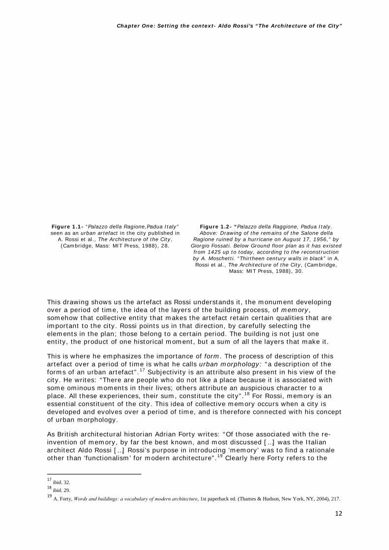
The second category of Rossi’s book I am working with is the idea of memory. Rossi sees the city as something built by men over a period of time.16 He also emphasizes the importance of urban artefacts, of history and of form. In order to describe what he means by artefact he refers, as an example, to Palazzo della Ragione in Padua, Italy. In this case the importance of the artefact and its relationship with the city is clear: the building’s function can change but the form remains.
In the drawings and images he uses to refer to the Palazzo, he shows the palace as it was at the time the book was published (see Figure 1.1) but also the plan of the Palazzo over time (see Figure 1.2). The plan shows the walls in a different tone to show us the passage of time.
14 A. Rossi et al., The Architecture of the City (Cambridge, Mass: MIT Press, 1988), 37-39. 15 A. Pope, “The primacy of space”, in F. Bulman, L. Young, and J. Thumb (Firm), Everything must move : documenting a decade-and-a-half of propositions about the suburban city in general, and Houston in particular : this city--shapeless, polluted, traffic-clogged, water-logged, limitless--is a workshop for testing ideas about operating in impossible situations (Houston: Rice University School of Architecture, 2009), 21.
16 A. Rossi et al., The Architecture of the City (Cambridge, Mass: MIT Press, 1988), 29.
Chapter One: Setting the context- Aldo Rossi’s “The Architecture of the City”
12
Figure 1.1- “Palazzo della Ragione,Padua Italy” seen as an urban artefact in the city published in
A. Rossi et al., The Architecture of the City, (Cambridge, Mass: MIT Press, 1988), 28.
Figure 1.2- “Palazzo della Raggione, Padua Italy. Above: Drawing of the remains of the Salone della
Ragione ruined by a hurricane on August 17, 1956,” by Giorgio Fossati. Below Ground floor plan as it has existed from 1425 up to today, according to the reconstruction by A. Moschetti. “Thirtheen century walls in black” in A. Rossi et al., The Architecture of the City, (Cambridge,
Mass: MIT Press, 1988), 30.
This drawing shows us the artefact as Rossi understands it, the monument developing over a period of time, the idea of the layers of the building process, of memory, somehow that collective entity that makes the artefact retain certain qualities that are important to the city. Rossi points us in that direction, by carefully selecting the elements in the plan; those belong to a certain period. The building is not just one entity, the product of one historical moment, but a sum of all the layers that make it.
This is where he emphasizes the importance of form. The process of description of this artefact over a period of time is what he calls urban morphology: “a description of the forms of an urban artefact”.17 Subjectivity is an attribute also present in his view of the city. He writes: “There are people who do not like a place because it is associated with some ominous moments in their lives; others attribute an auspicious character to a place. All these experiences, their sum, constitute the city”.18 For Rossi, memory is an essential constituent of the city. This idea of collective memory occurs when a city is developed and evolves over a period of time, and is therefore connected with his concept of urban morphology.
As British architectural historian Adrian Forty writes: “Of those associated with the re-invention of memory, by far the best known, and most discussed […] was the Italian architect Aldo Rossi […] Rossi’s purpose in introducing ‘memory’ was to find a rationale other than ‘functionalism’ for modern architecture”.19 Clearly here Forty refers to the
17 ibid. 32. 18 ibid. 29. 19 A. Forty, Words and buildings: a vocabulary of modern architecture, 1st paperback ed. (Thames & Hudson, New York, NY, 2004), 217.

Chapter One: Setting the context- Aldo Rossi’s “The Architecture of the City”
13
introduction of memory in Rossi’s work as a critique of the Functionalist city, emphasizing the importance of history in the formation of the city. Therefore the idea of a city developed over time is often associated with this collective memory.
In the context of the periphery, of Madrid and elsewhere, it is clear that the scale of the periphery is vast, and the speed of its construction so quick (fifteen years, in the case of Madrid). Therefore, this category becomes an essential one to explore on the ground to critically assess whether this new emerging city holds ‘memory’ or not. Rossi attributes urban artefacts and monuments as changing in function, but with form remaining part of the city’s history and memory (like the Palazzo in Padua), I will explore whether there are any traces of memory and permanence in these peripheries. I will also look to see whether there are artefacts and monuments in these peripheries, while looking at the new typologies that emerge from this study. As Lobsinger writes: “Perhaps it is time to reassess and update typology and morphology in order to pursue a more discrete understanding of landscape-architecture-urban interactions and the dynamic underpinning their formations”.20
The next two categories that I will introduce are the theory of permanences, often associated with memory, and capitalist speculative development which is important in the context of Madrid, being the driving force behind the creation of the new peripheries that have emerged there in the last fifteen years.
1.1.3 Theory of permanences
Rossi connects the theory of permanences with monuments, and therefore with memory.21 Using the same example as before, the Palazzo della Raggione in Padua, Rossi writes in relation to permanence: “I remarked on its permanent character before, but now by permanence I mean not only that one can still experience the form of the past has assumed different functions and has continued to function, conditioning the urban area in which stands and continuing to constitute an urban focus”.22
Putting this in the context of Madrid’s fast-built peripheries, I ask myself if there are any traces of permanence in these peripheral places. This is an important question as many of these areas were built from scratch, so the place to look for any sign of this permanence would perhaps be where the old periphery and the new periphery meet. Furthermore, a critical question here is: if there is no past for these urban artefacts and monuments, will there be no focus for them in those urban peripheral areas? (I mean here as elements that condition peripheral spaces in Madrid). I ask: What kind of landscapes would I find in these new typologies and cartographies in Madrid, and will permanence be a quality evident in any of these spaces?
If the spaces that are normally connected with memory and permanence do not appear in these peripheries, then where can the collective memory be located for the inhabitants of this new city? As Adrian Forty writes: “It was Poete who gave Rossi the idea of ‘permanencies’, that the very essence of a city’s complexity lay in the persistence through time of certain indelible features. The other idea, that the inhabitants of a city
20 M. L. Lobsinger, “The New Urban Scale in Italy: On Aldo Rossi’s L’architettura della città,” Journal of Architectural Education, 1966: Forty Years After 59:3 (February 2006): 37. 21 A. Rossi, et al., The Architecture of the City (Cambridge, Mass: MIT Press, 1988), .57-59. 22 ibid. 59.

Chapter One: Setting the context- Aldo Rossi’s “The Architecture of the City”
14
shared collective memory manifested in the buildings of a city”.23 If these new peripheries are built so quickly that is not possible to find the essence of the city’s complexity, through the persistence of certain features, then how can the collective memory manifested in the buildings of these peripheries collect the essence of a city in people’s minds? These critical questions emerge from considerations about the category of persistence and permanence. Not only as Forty refers to them, but also at establishing a critical position in relation to these peripheries. The new cartography and typologies will show if there are any traces of these categories.
1.1.4 Capitalist speculative development
The idea of speculative development in Rossi’s work is also connected to the importance of the city centre, and to the concept of study areas and their importance in studying a city. This section will describe those concepts and how they are interrelated, and then will show how they can be applied to the periphery of Madrid and how Rossi can be put to work to clarify our thinking and fill the gaps between his theories and the project (Madrid).
This study area can be used as a tool or a method in order to delimit an urban area and describe it in relation to the city, but also as an abstraction of that part of the city with the elements that define it. As Rossi explains “the study area can also be defined by historical elements which may coincide with a particular urban artefact. Just to consider this area in itself means to recognize that there are both specific and disparate qualities within parts of the more general urban whole”.24 In this thesis, this concept helps with the fieldwork in terms of defining the different areas and identifying their characteristics, in order to examine what typologies we find in the periphery, and to arrive at a new cartography of the periphery.
The connection between speculation and growth is an interesting one; Rossi sees the cities from Ancient Rome to those visible today as places where growth occurs as a result of speculation. In this, the residential element is an essential part, an urban artefact in this whole process. The landscape that he describes in America is that of a single-type of house reproduced across the landscape, whereas in Europe these residential areas are sub-centres to the main city centre.
In the context of Madrid, as touched on earlier regarding urban morphology and permanence, growth happened incredibly quickly, and speculation at a far greater scale than ever before in Spain. An important question in this thesis concerns the types of residential typologies and facilities we find in these peripheries: Do they serve the interests of the citizens, or are they more oriented towards urban and capitalist speculative development?
For Rossi, in order to have a successful approach to these residential areas: “It is logical and important to understand that the success of residential complexes is also related to the existence of public services and collective facilities”.25 This means that residential areas or sub-centres cannot operate properly without connection and facilities for the people that live in them. That is why for him it is of paramount importance to study the concept of dwelling as a way to understand the city: “the study of the individual dwelling offers one of the best means of studying the city and vice versa”.26 Taking this concept from Rossi, what types of collective facilities and public services do we see in these peripheral areas? If these facilities are an essential part of a successful residential area,
23 Forty, op.cit. p.217 24 Rossi, op.cit. p. 63. 25 Rossi, op.cit. p.71. 26 Rossi, op.cit. p. 72.

Chapter One: Setting the context- Aldo Rossi’s “The Architecture of the City”
15
we will ascertain whether this is the case, again by extending Rossi’s ideas into the periphery and connecting this tension between theory and project.
Vittorio Gregotti,27 another architect of La Tendenza, is critical about the type of development and housing we see in the peripheries: “The new developments are built and established according to the principles arising from the forms of internationalism […] in an ambiguous identification of progress with consumption on the standards and behaviours spread by the mass media as a term of reassurance and evidence of the state of progress of a social body […] in the periphery we often find homogeneous housing areas without an internal hierarchy”.28 This thesis will examine whether, as Gregotti critically asserts, these peripheries are places of consumption, whether the buildings we see in these places are a result of speculative development, and whether the models and typologies to be found there are a reflection of this, or whether they have collective facilities to make them successful residential areas as Rossi describes. Both categories—study area and capitalist speculative development—therefore are essential in establishing the questions and exploring the theory on the ground.
1.2 Speed of change and Aldo Rossi’s Theory of Permanences applied to the periphery
This section will show where and how Rossi’s analysis can be put to work to clarify our thinking on the periphery. First I will introduce and show how some of the categories explained earlier in terms of theory can be put to work in the context of the case study in Madrid. This will be further explored and developed in Chapters 5 and 6.
After examining Madrid, one is confronted with the scale and high speed of the construction of some of these peripheries. To put it in context: “From the 7,011 units proposed in the six PAUs in 1985 this increased to more than 70,000 units in 1994. It also proposes more residential developments between the rings of the M-40 and M-50- the only non-urbanised or used for open space left in the municipality. The total residential capacity estimated would be around 200,000 units only looking at the vacant land. In parallel the infrastructure is strengthened with two new ring motorways: the M-45 and the M-50 which have partially been executed”.29 This means that over a period of fifteen years the city increased its overall residential capacity by 200,000 residential units. PAU in Spanish Plan de Accion Urbana is translated in English as Urban Action Plans and they were the names used commonly in the city plans for the expansion of the peripheral areas in Madrid.
This type of city is almost like an on-going construction site, in constant flux. Alongside this, an infrastructure and scale unprecedented in Spain made the car an essential element of this network (and with this move, the book Learning from Las Vegas offers an essential tool to explore these types of environments further).
The categories that I am working with will show in the fieldwork where and how a conventional cartography fails, and how a new cartography is developed that fills the gaps between theory and project, and often working with this tension that was so important for La Tendenza. Furthermore, the project is a testing ground for the theory, and Madrid’s speed of change and peripheral growth is the perfect laboratory for this.
27 Gregotti is not just interested in the historical city (like Rossi) but in extending this to the form of the territory. For further reference please refer to his essay: The form of the territory which was published in the 1960’s and is available in English at: http://www.oasejournal.nl/en/Issues/80/TheFormOfTheTerritory#007 [accessed 16 July 2014] 28 V. Gregotti, “On Atopy” in ISSUU - UR9-10 Proyectar la periferia by Laboratori d’Urbanisme de Barcelona. p. 79 (1992); available from http://issuu.com/lub.upc.edu/docs/ur9_10_digital?e=5542525/2588854 [accessed 4 July 2014]. 29 R. Lopez de Lucio, “Desarrollo urbano y planeamiento urbanistico de la ciudad de Madrid en el s. XX” in VV.AA., 2004. Guía del urbanismo de Madrid, s. XX, Madrid: Área de Gobierno de Urbanismo, Vivienda e Infraestructuras, Ayuntamiento de Madrid., p.106 (2004) [Author’s translation].

Chapter One: Setting the context- Aldo Rossi’s “The Architecture of the City”
16
1.2.1 Theory of permanences and memory
Normally cities grow over time, but in this case we can see a rapid speed of change in comparison to a traditional rate of urban growth in a city. If we look at Aldo Rossi’s passage about Monuments and the Theory of Permanences,30 he writes:
“What I mean to suggest, however, is that from the point of view of urban structure, urban history seems more useful than any form of research in the city […] the theory of permanences as posited by both Poete and Lavedan. One must remember that the difference between past and future, from the point of view of theory of knowledge, in large measure reflects that the past is partly being experienced now, and this maybe the meaning to give permanences: they are a past that we are still experiencing”.31
In the case of the Northern and Southern peripheries of Madrid, the question that is posed if we refer to this passage by Rossi is how can we understand urban history as a useful tool for research in the city, if that urban structure has only been built in the past fifteen years? The history of these developments does not allow us to consider that over the lengthy period of time assumed by Rossi: the relationship between the past and present is so small in terms of the city’s history in these peripheries. Therefore, the concept of permanence is not really applicable. This is reinforced by Rossi as he discusses the concepts of monuments and persistences. He writes:
“These persistences are revealed through monuments, the physical signs of the past, as well as through the persistence’s of the city’s basic layouts and plans. This last point is Poete’s most important discovery. Cities tend to remain on their axes of development, maintaining the position of their original layout and growing accordingly to their direction and meaning of older artifacts, which often appear remote from present-day ones. Sometimes these artifacts persist virtually unchanged, endowed with a continuous vitality; other times they exhaust themselves, and then only the permanence of their form, their physical sign, their locus remains”.32
This means that monuments develop over a period of time (years, sometimes centuries). In this same passage Rossi refers to the Palace of the Alahambra in Spain, once a building with a major function in the city that subsequently developed different functions, but the artefact remains. One question that this raises is: If there is no opportunity for this persistence of monuments to occur in the peripheries, what are the reasons for this? Do the monuments that exist there reveal any signs of the past, or is the past there too immediate for that? And on the other hand, is there persistence in the city’s basic layouts and plans, or has the city has been built too quickly?
For example, in one of the fieldwork areas in the PAU of San Chinarro, we can see the inverted block (called the Mirador) designed by MVDRV almost as a monument or a landmark in that generic residential landscape (see Figure 1.3). As Ramon Prat writes: “the Mirador by MDVRV is a counterpart to anonymous structures flanking its facades; a building that challenges the conventional closed, donut-block apartment complexes”.33
30 A. Rossi, et al., The Architecture of the City (Cambridge, Mass: MIT Press, 1988), 57-61. 31 ibid. 57-59. 32 ibid. 59. 33 R. Prat, “Madrid The Rise of the Residential Periphery”, in M. Ballesteros, Verb crisis (Barcelona; New York: Actar, 2008), 41.

Chapter One: Setting the context- Aldo Rossi’s “The Architecture of the City”
17
Figure 1.3 –Building El Mirador by MVDRV and Blanca Lleo almost a monument in the generic landscape of the
PAU San Chinarro
But here the monument does not grow over a period of time, or with enough history to retain any locus, any memory of place. As Rossi writes about the monuments: “by permanence I mean not only that one can experience the form of the past in this monument but that the physical form of the past has assumed different functions and has continued to function, conditioning the urban area in which it stands and continuing to constitute an important urban focus”.34 A question this raises in the periphery is whether this characteristic of permanence and persistence that the monument gives to the city both symbolically and physically exists or not?
The other interesting aspect here is that Rossi mentions the idea of defining the city and its architecture. According to him: “The city will be seen as architecture of different parts and components, these being principally the dwelling and primary elements […] Since dwellings cover the major portion of the urban surface and rarely have a character of permanence, their evolution should be studied together with the area upon which they are found; thus I will speak of dwelling area”.35 So in this case, if the monuments qua urban artefacts do not really conform to Rossi’s idea of permanence and persistence, and if the dwellings that cover major parts of the urban surface and rarely have the character of permanence, if in these peripheries we do not have the opportunity of seeing an evolution of these dwelling areas and monuments because these areas have been built too fast, then we do not have the qualities of what according to Rossi constitute the elements that make the architecture of the city.
1.2.2 Typology
Rossi discussed the concept of study area as follows: “Such a minimum urban context constitutes the study area […] For example, in order to define the characteristics of a certain plot of land and its influence on a housing type, it is useful to examine the contiguous lots, those elements which demarcate a particular context, to see if their form is entire anomalous or whether they arise from more general conditions in the city. […] This aspect of urban artefacts is extremely important; the recognition of their specificity allows us to understand their structure better”.36
In this case in the PAUs (Urban Action Plan) the generic architecture of the plots and the residential blocks, and the absence of permanence in the so called monuments does not allow the city that has been built over ten or fifteen years to have those specific elements that we can normally see in a study area. Furthermore, we cannot see the characteristics of a certain plot in the housing type, as all the plots have been built 34 Rossi, op.cit. p. 59. 35 Rossi, op.cit. p. 61. 36 Rossi, op.cit. p. 61.

Chapter One: Setting the context- Aldo Rossi’s “The Architecture of the City”
18
according to the Urban Action Plans which outline six programmes of urban growth in the periphery (new barrios) and their construction was based on zoning of different uses (residential, industrial, open space etc.),37 creating very similar generic blocks, so they appear to lack any recognisable specificity and we cannot really understand the area’s structure in a traditional sense. These PAUs were part of the revision of the 1997 Madrid Plan as part of growth into peripheral areas. The points raised here will be explored in much more detail in the fieldwork study and in Chapters 5 and 6.
1.2.3 Capitalist Speculative development
Rossi defines the residential district as: “a moment, a piece of the city’s form. […] We should also bear in mind that an analysis of the residential district as a social artefact based on the division of social or economic classes as well as on economic functions corresponds in an essential way to the process of formation of the modern metropolis”.38 Here in the context of these residential peripheries we cannot see a moment of the city’s form, as they have been built too quickly to even differentiate social classes, or different economic functions.
Because of this the residential district in the periphery cannot be seen as a social artefact in this new context, lacking the function normally associated with what Rossi defines as the process of formation in the modern metropolis. Jacob van Rijs writes about the consequent lack of community and social network in these new residential areas in the periphery of Madrid: “A house is embedded in an area, a social network of facilities, which form part of a certain lifestyle that can be obtained through the purchase of that particular house. Instead of simply adding more of the same ‘blocked’ new towns, inward growth and redevelopment could lead to more sustainable neighbourhoods in the case of Madrid”.39 What van Rijs describes in the new towns is not a house embedded in a community but a single use residential zoning where the traditional shop is now the shopping mall, the traditional park is now a vast green area, and people use their cars to go from place to place rather than walking, as the infrastructure and the planning of these new areas promotes, even demands, the use of the car. This aspect will be explored further in the fieldwork and on the ground.
Alejandro Zaera-Polo writes about this type of residential district peripheral model: “The problem of Madrid is not to be found on the viability of the overall model, but rather in the way in which the urban planning is being executed. Recent planning regulations that ban construction of residences with more than three floors plus attic, is proof that administrations may not really understand the nature of a city like Madrid”.40 This means that following the city’s natural evolution the planning of Madrid has been based in a suburban model that repeats a similar typology, creating a residential landscape that is not a natural evolution in the development of the city over time, but as a result of the planning based in zoning and separation of uses that we see in the PAUs. What we can see here is a quick model of city built not based around community: “Both Madrid and Dubai suggest that as the public domain is progressively privatised, the mechanisms of producing cities can no longer be based on a sort of idealistic, community-based, institutionally-ruled urban governance”.41
What we see here is not a model based on the traditional elements that Rossi discusses: the European city that Madrid is—at least in its traditional centre— contrasts with its recent development that seems to have more in common with the type of market-led
37 PAU in Spanish Plan de Accion Urbana is translated in English as Urban Action Plans and Barrio is the Spanish word for neighbourhood; R. Prat, “Madrid The Rise of the Residential Periphery”, in M. Ballesteros, Verb crisis (Barcelona; New York: Actar, 2008), 39. 38 Rossi, op.cit. p 65. 39 J. van Rijs, MVDRV “Madrid Boom Boom Madrid: The Disappearance of Social Housing”, in M. Ballesteros, Verb crisis (Barcelona; New York: Actar, 2008), 143. 40 A. Zaera-Polo, “Development, Control, and Mediation”, in M. Ballesteros, Verb crisis (Barcelona; New York: Actar, 2008), 139. 41 ibid. 139.

Chapter One: Setting the context- Aldo Rossi’s “The Architecture of the City”
19
forces for development that predominate in cities like Dubai. After all, a whole new city has been built in the last fifteen years, and in order to understand its environment we need new ways for reading it rather than using the traditional tools for understanding the city. It is these new tools, this new understanding that this thesis sets out to provide.
DEFINING THE GAPS IN ALDO ROSSI’S WORK AND RAISING THE RESEARCH QUESTIONS
1.3 Critique and challenges to Aldo Rossi’s book
This section will cover what the current contributions that critique and challenge Aldo Rossi’s work are, defining the gaps and raising the questions that this thesis aims to answer. This is again carried out with reference to the four categories of his work that have been introduced above.
1.3.1 Critique of functionalism and capitalist speculative development
Under functionalist theory according to Rossi “The permanence of buildings and forms would have no significance, and the very idea of the transmission of a culture, of which the city is an element, would be questionable. […] For if urban artefacts present nothing but a problem of organization, and then they have neither continuity nor individuality. Monuments and architecture have no reason to exist; they do not “say” anything to us”.42 This passage reflects clearly the importance of Aldo Rossi’s hypothesis for the central arguments of this thesis. For him architecture is an essential part of the city, and his theory tries to deal with the complexities of it. His critique of the simplification brought about by naïve functionalism is the catalyst for the development of a theory about the architecture of the city. In this hypothesis permanence, buildings, and forms have importance; they are not just a simple classification of functions.
The context of this critique of functionalism was not just present in the work of Aldo Rossi but at that same time was also at the heart of the modern movement, as Sainz Gutiérrez explains: “This ‘tempered functionalism’ of the masters will become, nevertheless, contested in the subsequent meetings of the CIAM, […] where the youngest architects, led by the Smithson and Aldo Van Eyck, openly claimed a revision of the simplicity of the Charter 43 about the need for an in-depth investigation of the structural principles of the human habitat”.44 In this context the early thinking that Aldo Rossi set out in his book is also the response of a critical approach towards what was occurring in architecture at that time. Pier Vittorio Aureli adds precision: “Rossi’s hypothesis of autonomous architecture involved more than the rejection of the naiveté of functionalism, nor was it just a call for a rational language: a theory of form liberated from the sequence of formal styles in the service of the dominant bourgeois institutions”.45 Rossi’s reading of the city was political, and his critique of returning to a rational language was a reaction against the capitalist interests that he observed increasingly dominating the construction of the city. In today’s context, the peripheries that have grown around the boundaries of most European cities are also a response to economic forces and interests. The idea of capitalist interests still remains today, but with greater intensity as urban growth in Spain, particularly in Madrid, has happened at the fastest rate in the country’s recent planning history.
42 Rossi, op.cit. p. 47 43 This refers to the Charter of Athens written by Le Corbusier in 1933. For further information please refer to: E. Mumford. The CIAM Discourse on Urbanism, 1928-1960. (MIT Press, 2000). 44 V. Sainz Gutiérrez, Aldo Rossi : la ciudad, la arquitectura, el pensamiento (Buenos Aires: Nobuko, 2011), 27. [Author’s translation]. 45 P. V. Aureli, “Rossi: The concept of Locus as a Political Category of the City,” in P. V. Aureli, P.V., The project of autonomy: politics and architecture within and against capitalism (New York; London: Princeton Architectural, 2012), 55.

Chapter One: Setting the context- Aldo Rossi’s “The Architecture of the City”
20
In this context Rossi’s theories remain relevant as they offer a critique of the capitalist forms and interests that govern the city today: “Instead of simply advancing in tandem with the further modernisation of architecture and the city, the need for renewal became visible as a demand for a theoretical re-foundation of architecture in relation to the city”.46 This is arguably still a critical question: the disconnection identified by Rossi between city growth and an appropriate theory of architecture applicable to the city appears as wide as ever. The complexity of these new peripheral cities might not really make it possible to arrive at a definitive theory; this will be a matter of exploration as this study develops. However where Aldo Rossi’s work was a demand for a re-foundation of architecture in relation to the city, this new city that we see around Madrid —and indeed around cities all over Europe and beyond— requires a critical foundation of theory, as the city responds to capitalist and economic interests.
1.3.2 Critique of typology
The idea of type or typology as a term that Rossi used has also been criticised by other scholars. Albert Pope writes about the use of typology and its limits in the modern periphery: “The logic is sometimes thought to be transcendent, always indexing first causes or the origins of urban form (Rossi) […] Whether typology is justified by first causes, customary uses or mimesis is not the point. Each of these formal approaches attempts to discern the continuity of self-governing forces existing beneath the apparent order of things”.47 The idea that the peripheral city can somehow be analysed only with a formal approach looking at built form is one of the clear gaps in Rossi’s theories. It is also fair to say that the city he described is not the city we live in today. If we look at the reminiscences left by Rossi’s theories we can grasp the unseen potential that Albert Pope points out concerning the autonomy ruling the periphery, and the challenges of looking at the possibilities of a taxonomy that operates beyond a catalogue of mere types of built form, and that proves valuable analysis by offering us a tool for the identification and elaboration of the potential of the periphery. This thesis proposes to re-visit the old question of typology or taxonomy in order to classify and look at the alternative urban theory for the architecture of the periphery. “Analysis has value in itself, it is useful in order to understand and look for themes that assist us in understanding a certain reality, and to interpret the processes of formation, change and permanence in the areas we are working on”.48 Historically developed mechanisms to describe and understand the city, such as Rossi’s, are insufficient in this context. We need new tools and approaches to explore the question and to see if there are typologies of the periphery and if so what they are like in the context of Madrid. The tools for analysis developed by creating a taxonomy of the periphery is seen here as a tool for the elaboration of the architectural project. By understanding these theoretical and visual processes we can interpret them. The apparent need for new tools will be addressed using Learning from Las Vegas, which provides tools and motivations to undertake more detailed fieldwork and also the development of new tools and approaches to arrive at a new cartography of the periphery that fills the gap between theory and project.
One might ask here: what is the relationship between Rossi’s and Venturi & Scott-Browns’ work from the 1960’s in the context of today’s peripheries, apart from being two
46 ibid. 53-54. 47A. Pope, “The primacy of space”, in F., Bulman, L., Young, J. & Thumb (Firm), Everything must move : documenting a decade-and-a-half of propositions about the suburban city in general, and Houston in particular : this city--shapeless, polluted, traffic-clogged, water-logged, limitless--is a workshop for testing ideas about operating in impossible situations (Houston: Rice University School of Architecture, 2009), 21. 48 A. del Pozo y Barajas, A. La condición postmoderna: Ideas de ciudad (Sevilla: Universidad de Sevilla, 2009), 61. [Author’s translation].

Chapter One: Setting the context- Aldo Rossi’s “The Architecture of the City”
21
of the main urban manifestos of their time? I will not answer this question here, but I would let an interview with Aldo Rossi, carried out by Francesco Moschini in 1987 when designing the project in the periphery of Milan (Area Pirelli Bicocca), provide an answer and a clear connection with my study. In this interview Francesco Moschini asks Rossi:
“In 1966 you wrote The Architecture of the City, in which, in a systematic way you take into consideration the problems of the modern city’s development. Looking back in all the years that have passed since then and with a much bigger knowledge of the American urban reality, do you still think that it is correct to read the city by parts? And how do you consider after the experience of the project Pirelli-Bicocca, the urban periphery and its relationship with the city?” 49
To which Aldo Rossi replies:
“I was one of the few, in Italy and in the world, around the 60’s, to look at and examine the city, therefore both the city and the periphery. Another very important book is the one R. Venturi wrote in the same period. I think that he and myself have been coherent in the architectural translation of everything that has been theorised, I am not so worried here about the coherence, because cities change, but in that vision of the city in parts, that is a city that has centres that are privileged historically and culturally, but also by geographical facts, for example, that are articulated around a series of differentiated places that compose the city, and I think today the modern city […] It is impossible to do a project for the Pirelli-Bicocca without understanding the reality of the city, the connection between one type of city and another, not the centre or the periphery, because we can’t consider the area of Pirelli-Bicocca as the centre or as the periphery, as this is not important, is a part of the polycentric Milano built by parts”.50
This interview was carried out more than twenty years after Rossi wrote The Architecture of the City and offers a clear insight into the architect’s ideas connecting his work to Venturi, and also understanding both the city centre and the periphery as a city by parts, as part of a polycentric entity.
Another Italian architect who in recent years has studied the European periphery arrived at a similar conclusion to that of Rossi: when interviewed in the summer of 1987, Boeri stated that what distinguishes the European city from others is: “the absence of the megalopolis and a strong diffused condition of urbanity are the main characteristics of the European territory. Europe continues to be the place where there are no cities of twenty million inhabitants, whilst this occurs in almost all other continents, excluding Oceania”.51 Boeri goes on, describing Europe as: “A polycentric city that extends across a large part of the continent, having control areas and peripheries, of “natural corridors”, of “waterfronts”, of “terrain vague”.52 He mentions here both the diffuse condition and also the idea of city by parts, and also connects his thinking to the concept of terrain vague, a term that was originally used by the Spanish architect Ignasi de Solà-Morales.53
49 M. F. Francesco, Moschini intervista Aldo Rossi (1987) available from http://www.aamgalleria.it/GALLERY/0/0/1177426413.pdf [Accessed February 9, 2014]. [Author’s translation]. 50 ibid. 51 S. Boeri, Uncertain state of Europe, (Milan; London: Skira Editore, 2002), 25. 52 ibid. 25. 53 I. Solà-Morales, “Terrain vague” in Cynthia C. Davidson, Anyone Corporation (Anyplace, New York, N.Y.: Cambridge Mass: Anyone Corp. ; MIT Press, 1995), 119.

Chapter One: Setting the context- Aldo Rossi’s “The Architecture of the City”
22
Boeri goes on to argue very strongly that other ways and methods are necessary to account for the periphery, as the categories from the 1960’s are not sufficient in the new peripheral context: “Yet the diffuse city and scattered dynamics are not simply a new “part” of the European city. They represent the visible and emergent form of a new urban condition that transforms the nature and the very concept of city, exerting its effects on the classical city as well […] a condition impossible to decipher with the vocabulary constructed in the 1960s to analyse the old European city. The now-useless vocabulary continues to make the distinction between “center” and “periphery”, between “public space” and “private space”, between “emergent areas” and “parts of the city”. In the new European territories these categories simply do not work, and merely slip over the surface of things”.54 To arrive at an understanding of the peripheral condition a series of methods are required that combine multiple approaches to understand the complexities of the territory.
Therefore we can establish in this critique of the current contributions that there are clear gaps: Firstly, that there is no existing theory of the periphery, and secondly, that approaches currently used to study the periphery are not robust. Using Rossi’s The Architecture of the City and Venturi and Scott-Brown’s Learning from Las Vegas (specifically the work along the Strip/Corridor typology and the Studio Notes) for understanding Madrid, these will be applied to the periphery and put to work to clarify our thinking on the periphery to fill these gaps.
1.4 Summary of Spanish thinking on the urban periphery
This section summarises the Spanish thinking on the urban periphery, explaining how some of the architectural discourses from La Tendenza and Rossi have influenced Spanish architecture and discourse, including explaining the critical relationship between theory and practice central in relation to the Spanish context and to this thesis. This generation of architects, influenced so much by the Italian School, are the actors that have shaped the critical discourses, architecture and planning in Spain since the 1960’s, and who also frame the ideas towards the city and interventions in the city and planning in Spanish cities.
This section brings key extracts from this body of work from the Mediterranean to an English-speaking audience for the first time by translating key texts from Spanish literature to contextualise this thesis. While Rossi’s book The Architecture of the City has been translated and become influential in the English speaking world, a lot of the other work by La Tendenza and Rossi about the city, so influential in Italy and Spain, has never been translated to English. This is an additional contribution of this thesis.
1.4.1 The influence of Aldo Rossi and La Tendenza in the Spanish Context
The influence of the work of Aldo Rossi and La Tendenza in Spain is essential in order to understand the context of this PhD, not only because Rossi’s work became fundamental in the Spanish context in the last thirty years, but also because the application of urban analysis and the tension between theory and project was fundamental in Spanish architectural thinking and practice and also in Urbanism since the 1970’s. As Alfonso del Pozo y Barajas writes:
“This theoretical work, supported by the practice of architecture of Aldo Rossi, greatly explained by him, starts with the International influence of the author, but this was also happening at the same time as the introduction of his work
54 S. Boeri, “Notes for a research program” in R. Koolhaas, et al., Mutations (Bordeaux; Barcelona: Arc en rêve centre d’architecture ; ACTAR, 2000), 366.

Chapter One: Setting the context- Aldo Rossi’s “The Architecture of the City”
23
in some of the most relevant groups of the architectural debate in Spain. Urban Analysis entered our country through the interpretation of Rossi’s work”.55
Using Rossi to frame the thinking then until today was promoted for a whole generation of architects that were influenced by his work and by the work of the Italians during that time, as Pozo y Barajas continues:
“In the 1970’s, Spain was really in a time of transition. In these convulsive years, of rapid regeneration of the social, cultural and political context, Aldo Rossi’s theories were accepted by some young restless architects […] as the basic argument for the ideological redefinition of the role of the architect, and also as adequate strategies for the knowledge and interventions in the city from the perspective of a new era in Architecture”.56
These interventions and tools have continued to influence Spanish architectural thinking, focusing on the discourses emanating from the Schools of Madrid and Barcelona and a series of key figures from that time (see Figure 3) has produced a body of critical work from scholars about the work of Aldo Rossi.
Aldo Rossi wrote the prologue for Ludovico Quaroni’s (one of the most important architects of the Post war period in Italy) book La Torre di Babele (The Tower of Babel) where he emphasized the importance of the city constructed as architecture, being architecture.
The idea of quartiere (translated into English from Italian as district or neighbourhood) was essential to the idea of projecting in the city.57 Rossi refers to this concept of quartiere in his book The Architecture of the City58 to define the residential districts, clearly influenced by Quaroni and his concept of the quartiere as an essential part of projecting in the city. Quaroni was not just one of the main influences for Rossi, but was also one of the mentors of Manuel Solà-Morales i Rubió who worked for him in Rome for a year before returning to teach in Barcelona in the 1970s. Aldo Rossi worked on the magazine Casabella-Continuita at a time when the publication played a leading role in Italian culture. He was editor (1961-1964, nos. 249-294)59 and here below you can see the family tree of the editorial group at the time in number 253 (see Figure 1.4), which included Quaroni, but also other figures of La Tendenza such as Vittorio Gregotti, and Giorgio Grassi under the directorship of Ernesto N. Rogers. Ignasi Solà-Morales (Manuel’s brother) was an architect and philosopher who played a key role in defining the relationship between photography and the concept of terrain vague that defines the contemporary peripheral metropolis.
55 A. del Pozo y Barajas, La condición postmoderna : Ideas de ciudad (Sevilla: Universidad de Sevilla, 2009), 57. [Author’s translation]. 56 ibid.57. 57 V. Sainz Gutiérrez, Aldo Rossi : la ciudad, la arquitectura, el pensamiento (Buenos Aires: Nobuko, 2011), 41-49. Note: Please refer to this publication for further information and a synthesis of Quaroni’s influence in the work of Aldo Rossi and La Tendenza 58 Rossi, op.cit. p. 65. 59 Biographical Note in: A. Rossi, et al., The Architecture of the City (Cambridge, Mass: MIT, 1988), 202.

Chapter One: Setting the context- Aldo Rossi’s “The Architecture of the City”
24
Figure 1.4 –Editorial team of Casabella-Continuita July 1961 Number 253 where Aldo Rossi was the editor, Vittorio Gregotti the chief editor, Ernesto N. Rogers the director, and Ludovico Quaroni part of the editorial
committee with Giorgio Grassi as part of the centre of studies. Many key members of La Tendenza group were part of the journal. Image taken from: A. Rossi ed. Casabella-Continuita, rivista internationale di architecture e
di urbanistica, No. 253 (1961): 1. Ignasi was also part of the team that published the Spanish Edition of the book The Architecture of the City in Barcelona in 1971 so he has a clear influence in divulging the Italian discourse in Spain.60 The influence of the Post-war Italian architects in Spain was an essential part of the theory and culture of architecture which developed in the 1970s: key architects such as Rafael Moneo, who in 1963 spent two years at the Spanish Academy in Rome (see Figure 1.5).
60 Publishing History of The Architecture of the City in: A. Rossi, et al., The Architecture of the City (Cambridge, Mass: MIT Press, 1998), 197.

Chapter One: Setting the context- Aldo Rossi’s “The Architecture of the City”
25
Figure 1.5- Diagram showing the relationship and connections between different architects and theorists in
relation to this study. Rafael Moneo was a close collaborator in architectural projects and a colleague of Manuel Solà-Morales i Rubió, and also taught with him in Barcelona for ten years from 1972. They worked together
and they built the project as a team of L’Illa Diagonal (1993) in Barcelona. (Author’s own) 1.4.2 The relationship between theory and project in the Spanish context
This section explains the relationship between theory and project, so important to the broader analysis that runs throughout the thesis, particularly in relation to Spanish thinking, in order to bring the main theoretical ideas (from Rossi to Spain) and frame them towards the project/case study (Madrid’s periphery).
There is also a dilemma, which this thesis aims to explore, regarding the duality and dialectic between architectural theory and project and how this might be resolved in terms of the architecture of the periphery. Victoriano Sainz Gutiérrez writes about the importance of this relationship:
“For him [Rossi], like all the other architects of La Tendenza, it is not possible to separate the theory from the project: theory and project are part of two moments in the same dialectic process. The theory of architecture can only be built through the architectonic “praxis”,61 this means, the project; more specifically, the project is constructed like a moment of the theory, because the principles of the discipline are in the same moment that we build architecture: this is the final core of their position”.62
61 The term Praxis in Latin refers to established practice, in the translation of this text from Spanish to English it refers to architectural practice, or to architectural project. 62 V. Sainz Gutiérrez, Aldo Rossi : la ciudad, la arquitectura, el pensamiento (Buenos Aires: Nobuko, 2011), 55. [Author’s translation].

Chapter One: Setting the context- Aldo Rossi’s “The Architecture of the City”
26
But was Aldo Rossi able to build the projects he theorised about? Was he able to create the city that he wrote about? Sainz Gutiérrez thinks that there was a problem with the theory: “[…] only to the extent that the urban investigation is linked to an interpretative system, able to give sense to evolution of the analysed phenomenon, is the only way we avoid that they are just converted in a catalogue of data organised in a technical way, but that is culturally silent”.63 This means that the theoretical aspects require a system that is able to interpret them in order to have any sense, but somehow the importance of the theoretical analysis might just be the understanding of a phenomenon. It is in this context when the work of Rossi becomes relevant in providing tools of urban analysis to understand the current peripheral phenomena rather than in the project itself.
The difficulty in being precise and specific with some of these theoretical terms is explained by Rafael Moneo: “The concepts presented are vague, imprecise, diffuse. But it was enormously attractive to my generation”.64
There is a lack of relationship between the urban analysis and the architectural project: “We can see that some of the techniques that belong to this discipline are the remains of what was removed from the spirit that they were originally created for, having been recycled - and also perversely neutralised - in the circuits of urban production”.65 The techniques developed by Rossi which influenced a whole generation of architects in Spain and beyond, were influential as they offered a critique, showing architecture as having an autonomous discourse, however often they were applied in the architectural projects without really conforming to the spirit that changed the critical thinking of architecture in the 1960’s. Ignasi de Sola-Morales is also critical about Rossi’s architectural work and he writes: “the disillusion that many suffered after seeing the site and construction materials of Rossi’s buildings has its origins in the theory that considers these things as an object and a function […] however what he proposes is to pay attention to the process that his drawings show us, a process where the construction of a building is just another episode of an idea, that is understood as an architectural autonomous discourse, and therefore indifferent to the construction or the use of the building”.66 This interesting tension between the image and the project that Sola-Morales refers to in Rossi’s work here, is also present in Madrid. As Michael Neuman discussed the images of urban plans of the city are important and influence the planning approach adopted to construct the city of the future.67 It is interesting to highlight this approach as a design tool, applying a historical understanding of the image to project the future of the city, is an aspect which I will explain in more detail in Chapter 3. 1.4.3 Summary of Spanish thinking on theoretical discourses on the urban periphery
Urban Analysis became a main tool and approach used to understand the city in the Spanish context. Manuel de Solà-Morales Rubió developed a course about the peripheries at the University in Barcelona, and wrote most of the literature in Spain about forms of urban growth. He refers to the importance of opening up the urban analysis further than the Italian group of La Tendenza (of which Aldo Rossi was a
63 ibid. 72. 64 J. R. Moneo, & Harvard University, Theoretical anxiety and design strategies in the work of eight contemporary architects, (Cambridge, Mass: MIT Press, 2004), 104. 65 A. del Pozo y Barajas, La condición postmoderna : Ideas de ciudad (Sevilla: Universidad de Sevilla, 2009), 61. [Author’s translation]. 66 I. Solà-Morales Rubió, “Anyone De la autonomía a lo intempestivo” in I. Solà-Morales Rubió, Los artículos de Any, (Barcelona: Fundación Caja de Arquitectos, 2009), 21. [Author’s translation]. 67 M. Neuman, The imaginative institution: planning and governance in Madrid. (Ashgate Pub. Co, Farnham, Surrey; Burlington, VT, 2010), 10.

Chapter One: Setting the context- Aldo Rossi’s “The Architecture of the City”
27
member): “Already in the years 1968-1970, we have translated for the first time in the Laboratori Gregotti, Aymonimo, Rossi and a long list of other scholarly articles that were unreachable (Moneo presented theoretically the discussion of the idea of type in the year 1974 in Oppositions). But the programme the forms of urban growth suppose precisely the will to open up the urban analysis to a wider field other than just strict observation of morphological types”.68
The influences of La Tendenza and the Venice group (Aymonimo, Rossi, etc) are clear, but he expands further on the challenges left by them and the limits of their theories. Rafael Moneo introduced the concept of typology to an American audience in Oppositions. He also wrote another article in the same journal about Aldo Rossi. It is worth noting that Peter Eisenman was one of the editors of this journal, and also went on to write the Preface and the Introduction to the American edition of The Architecture of the City by Aldo Rossi which is the first English version of the book.69
Manuel de Solà-Morales thinks that these categories are not sufficient by themselves for analysing the city: “Morphology-typology are an axis of dualities to which the different parts of the city can refer, according to the architectonic and constructive characteristics of a building, with a conceptual argument that is not so well known. But within the works of Rossi and Aymonimo, or those of Panerai and Castex, these two categories seemed enough to analyse the architecture of these cities, it seems to me, still today, that a more structural explanation of the urban form, in its parts and as a whole, in the projects and in the history, in its brilliant moments and in the commonplace areas, in their results but also in their processes- has to recognise the importance of the infrastructural forms (the railway paths, the service networks, the riverbanks, the communication nodes, the great access points) as independent forms-in the project, in its execution, and in its performance”.70 This confirms the need to read the city with a more structural approach (typologies, and Rossi’s conventional cartography and categories) so therefore bringing Rossi’s ideas back into the periphery of Madrid as I am doing in this chapter, but recognising other categories such as infrastructure (strips/corridors) that are visible in the projects of the periphery of Madrid, I will discuss this issue in full in Chapter 5.
1.4.4 The influence of the work of Aldo Rossi, and of Robert Venturi and Denise Scott Brown in the Spanish theoretical discourses
This part of the study focuses on two aspects: one is interested almost exclusively in the concept of architectural theory in relation to peripheries, and in particular to Madrid.
The works of Abalos & Herreros who was part of the Madrid School in the 1980’s and was influenced by work from the earlier generations follows on from these discourses and focuses more on the context of Madrid and the terms used to define the current discourse on peripheries.
The other is an analysis of these theories combined with exploring approaches to analysing and understanding the periphery, and also with the concept of developing a typology for Madrid’s periphery from that. I will introduce here the three key definitions in this context of theory which are: areas of impunity, descampados, and terrain vague.
The first two definitions are by the Madrid architects Abalos & Herreros and the last one is by the Catalan architect Ignasi de Solà-Morales and is a commonly used term to define 68 M. Solà-Morales i Rubió, Las formas de crecimiento urbano (Barcelona: UPC, 1997), 13. [Author’s translation]. 69 The Institute of Architecture and Urban Studies (1967-1984) created the journal Oppositions in 1973 to foster the emergence of a critical voice independent of academic and professional institutions. Oppositions stimulated the formulation of competing critical projects, disseminated the works of Anglo-American formalism and the Italian La Tendenza, and introduced to the American context the phenomenological, structuralist and Marxist criticisms of contemporary European scholarship. Anon, Oppositions | Canadian Centre for Architecture (CCA). Available at: http://www.cca.qc.ca/en/collection/799-oppositions [Accessed 14 February 2013]. 70 M. Solà-Morales i Rubió, Las formas de crecimiento urbano (Barcelona: UPC, 1997), 15. [Author’s translation].

Chapter One: Setting the context- Aldo Rossi’s “The Architecture of the City”
28
the periphery in Spain. I will then explore in Chapter 6 if these definitions appear in the case study areas in Madrid.
The work of Abalos & Herreros focused on those peripheral areas of Madrid that are referred to as areas of impunity. Discussion here will focus on their theoretical approach but also about how they approach this in their projects in the periphery of Madrid and the context of their work in relation to architectural theory. In this section I will explore their theoretical terms and explain how they are applied in one specific project looking at this relationship which was important for La Tendenza between theory and project.
Abalos & Herreros take a critical view on the issue of location in relation to the project. For them in recent decades there have been four main approaches to this topic (see Figure 1.6): “Many forms of anchorage to the location have been developed in recent decades, from those involving the phenomenological root (Anchoring is the title of an important text by Steven Holl), via the Bergsonian influence in Moneo’s work and the structuralist effect of the genius loci in Aldo Rossi’s, to attitudes that come from the Frankfurt School (Frampton and his Contextualism)”.71 However they discuss in theoretical terms a significant shift in architectural theory in relation to location: “In recent years we have witnessed an important shift (see Figure 1.6): “every location has started to be regarded as a landscape, and has ceased to be a neutral background in which more or less decidedly sculptural, artificial architectural objects stand out”.72 This critical approach is reflected in their own work where the landscape can be a subject to be transformed and embodies their theoretical concepts exemplified in the recycling plant project in the outskirts of Madrid in Valdedominguez.
Here the project is part of the landscape (see Figure 1.7) not only being artificial in a natural landscape but also in the way the building responds to the landscape in programmatic terms (but also returning to the landscape once its life span of twenty-five years is over and the building is dismantled). This offers a new approach in architectural theory that then they apply to the project specifically shifting the other four theoretical discourses and (see Figure 1.6) creating a new position for these kinds of peripheral landscapes.
71Abalos & Herreros, “A New Naturalism (7 Micromanifestos)” in F. Beigel, Ábalos & Herreros (Barcelona: Editorial Gustavo Gili, 2002), 29. 72 ibid.

Chapter One: Setting the context- Aldo Rossi’s “The Architecture of the City”
29
Figure 1.6- Main architectural theories about location and the shift that has occurred in architecture theory that requires a new location in these areas of impunity that act as focal points for the architect
(Adapted from A&H). Author’s own
The critics Florien Beigel and Philip Christou write about this area as Hinterland, and Abalos & Herreros’ Valdedominguez recycling plant in particular: “The garbage processing plant is in the Hinterland. […] Abalos & Herreros have designed and built the recycling plant itself […] the garbage factory building is a tertiary architectural topography. It is covered with the same arid vegetation as one can find in the surrounding deposition plateaus”.73 (see Figure 1.7). In this case we can see the building becoming a hybrid in the landscape that is both natural and artificial. The building is a part of the topography of the hinterland.
This recycling plant project applies in practice the two theoretical concepts they refer to in their work which are; the idea of descampados74 and also the definition of areas of impunity.75 These two terms refer to the areas in the periphery; out of the city boundaries in the open country. They also question whether they contain a model or a typology for this term:
“One is tempted to ask whether they might contain a metaphoric model, a quasi-model, or whether it is possible to think of their compliment, de-edification, given that the term ‘descampados’ embodies a fascinating concept: land that has lost its attributes as the city approaches, sterilised
73 F. Beigel & P. Christou, “Teasing Modernity” in F. Beigel, Ábalos & Herreros (Barcelona: Editorial Gustavo Gili, 2002), 16. 74 The term descampados is translated from Spanish as open country or “de-countrified” please refer to Abalos & Herreros, A New Naturalism (7 Micromanifestos) in F. Beigel, Ábalos & Herreros (Barcelona: Editorial Gustavo Gili, 2002), 28. 75 ibid. 18.

Chapter One: Setting the context- Aldo Rossi’s “The Architecture of the City”
30
before being occupied, but also given a transcendental role in its new context. We ask ourselves whether architecture could be constructed this way […]”.76
Here the term descampados refers to a landscape that we see in the peripheral areas of Madrid where the land is rural but also urban; land that has lost the attributes of being part of the existing city of Madrid, but also where the new peripheral city emerges. With the project of Valdedominguez the recycling plant embodies this approach as the artificial nature they created mixes with the agricultural land, giving this location a new status.
However, the difficulty with the concept is how then it is taken from the project to the context of the city, but what the terms offer is a clear definition of the type of landscape that we find in these peripheral areas of Madrid, a term that embodies land that is both rural and urban, but also natural and artificial at the same time. Here is where the city (artificial and urban) meets the landscape (rural and natural).
For them: “Areas of impunity are precisely those zones in which this ambiguous status is produced in an exceptional way, a status whose designation as public or natural space is imprecise. These formerly negative zones are endowed with a new urban status by the gaze of new social subjects and their practices”.77 These concepts therefore have a new urban status.
If we look at the two definitions of the terms, descampados is an area where natural and artificial meet and this is common to the definition of areas of impunity. But areas of impunity take the concept further: the land is ambiguous therefore has no boundaries and is imprecise, and often also has a negative connotation.
Figure 1.7- Valdedominguez Recycling Plant, a project by Abalos & Herreros where we can see natural and artificial nature together in the Hinterland. In the image on the left you can see the artificial nature created by
the building and in the image on the right how the building becomes part of the descampados landscape, a theoretical term that Abalos & Herreros use to define this type of place in their theoretical work. Images taken
from: Abalos & Herreros, A New Naturalism (7 Micromanifestos) in F. Beigel, Ábalos & Herreros (Barcelona: Editorial Gustavo Gili, 2002), 16.
One of the issues I will explore in the fieldwork is whether the concepts of descampados and areas of impunity are areas that are present in the case study, and a critical question to explore through the fieldwork and the subsequent analysis is if the role of these areas is a transcendental one or not within the peripheral system, and to see what typologies I find on the ground to create a new cartography. A further critical question
76 ibid. 28. 77 ibid. 28.

Chapter One: Setting the context- Aldo Rossi’s “The Architecture of the City”
31
here is; what are the consequences of my findings in terms of the work of Rossi, Venturi and Ábalos & Herreros and how will my findings extend or limit their work? These findings will be discussed in light of the theory of the periphery in Chapter 6.
Ábalos & Herreros also proposed a working programme for these areas of impunity (see Figure 1.7): “The dissolution of the natural-artificial opposition that we observe at every scale implies a working program which is nothing other than re-describing via architecture, the position of contemporary man vis-à-vis the world”.78 This emphasizes the importance of new typologies or ways of defining these areas, and also working tools and the critical importance for contemporary man in architecture to re-describe new ways of looking at this critically and to see if this opposition between natural and artificial exists in the case study areas and if so to what extent.
The architect Ignasi de Solà-Morales defines these peripheral spaces using the French word terrain vague which is the third term I refer to in this section. He explains clearly why he chooses this term in French, and the different meanings and connotations that it has for him. He writes: “It is impossible to capture in a single English word or phrase the meaning of terrain vague. The French term terrain connotes a more urban quality than the English land thus terrain is an extension of the precisely limited ground fit for construction, for the city. […] The French word also refers to greater and perhaps less precisely defined territories, connected with the physical idea of a portion of land in its potentially exploitable state but already possessing some definition to which we are external […] Vague descends from vacuus, giving us “vacant” and “vacuum” in English, which is to say “empty, unoccupied”, yet also “free, available, unengaged”.79
There are certainly qualities in that definition that are similar to those of areas of impunity in the sense that the land is vacant and contains an urban quality, but it is also open to being exploited as it is free and available.
However, as Abalos & Herreros see the areas of impunity with a certain negative connotation, this is not the case for the concept of terrain vague: “Once again the paradox of the message we receive from these indefinite and uncertain spaces is not purely negative. While the analogous terms that we noted are generally preceded by negative particles (in-determinate, im-precise, un-certain), this absence of limit precisely contains the expectation of mobility, vagrant roving, free time, liberty”.80 Here the term terrain vague is seen has having positive qualities as it is a free and mobile territory.
For Abalos & Herreros it is necessary to find a new poetic way to see this new type of condition in architectural practice: “If we were modernist architects, we would think of this city in moral terms, and would produce reformist policies. However we think it is much more necessary and, if you wish, more closely linked to architectural practice, to find a poetic substratum in this magma, to understand this as something that calls for a new kind of gaze and via this, to attain a critical dimension”.81
This idea is interesting in two ways: firstly, they seek different ways in which to look at place and location in these areas of impunity or descampados, where the natural and artificial meet, but they also propose a new gaze that finds a poetic dimension to this magma. To me this is a critical question, in the sense that peripheries, defined by them with negative connotations and a lack of regulations, might contain this element that they lack by definition, which are the poetics of space which means that when an
78 ibid. 28. 79 I. Solà-Morales, “Terrain vague” in Cynthia C. Davidson, Anyone Corporation (Anyplace, New York, N.Y.: Cambridge Mass: Anyone Corp; MIT Press, 1995), 119. 80 ibid. 81Abalos & Herreros, A New Naturalism (7 Micromanifestos) in F. Beigel, Ábalos & Herreros (Barcelona: Editorial Gustavo Gili, 2002), 29.

Chapter One: Setting the context- Aldo Rossi’s “The Architecture of the City”
32
architect intervenes in these spaces the descampados take a new urban status which is not neutral but gives the project a new transcendental role like the recycling plant in Valdedominguez.
Can the periphery have this new dimension that Abalos & Herreros refer to after the shift they imply has occurred in recent decades of architectural thinking in relation to place and location? This dimension could also be associated with the concept that another Madrilenian architect Rafael Moneo refers to, which is the idea of continuity but also with the categories of permanence and memory expressed in Rossi’s work: looking at this concept, Moneo states: “I am inclined to believe that architecture also introduces the concept of continuity, a notion that acknowledges the past and anticipates the future. An understanding of continuity, a concept that has nothing to do with simplistic conservatism, is critical for urban interventions, and the awareness of this debt to the existing fabric is the first step towards building a public space because the city endures and changes sometimes”.82
This connection between finding the poetic dimension in these areas of impunity as they are defined by Abalos & Herreros also connects with that idea of location that they mention when they defined four theoretical approaches to this theme, one of which they defined as Bergsonian Moneo (see Figure 1.6). This means that when an architect intervenes in a new project or landscape he or she looks at the way this place was before, and the project adds something to this location.
Moneo’s writings when he refers to the city as an “open game” in relation to continuity:
“According to this view the city is an “open game”, a game of solitaire in which we find ourselves dealing new cards that transform but do not destroy the patterns of rules that the others laid down before. Our work as architects modifies the field of action-the city and its buildings- and prepares the ground for those who will come after us. As I see it, accepting the specificity of a work of architecture—what makes it different from a painting or a piece of sculpture—is crucial for the architect, I believe there is a logic to architecture that involves a particular way of learning and proceeding, a logic that incorporates the notion of continuity”.83
This “open game” is about the new cards and tools. It also refers to the understanding of the rules of the past in this sense which means how this place was and how it affects the context and location of the project that the architect will build. But Moneo refers here also to the use of tools and methods in this context that look at the city’s past but the project itself also intervenes in the future of the city. This is also similar to the approach used by Abalos & Herreros where the project intervenes in the landscape and the location, but gives it a new urban status.
The connections between these architectural tools that either use different names such as open game like Moneo does, or in terms of a location in the landscape that Abalos & Herreros refer to still do not resolve one particular question in relation to the periphery which is, whether or not the notion of continuity can appear in the periphery as a concept.
A further question is whether the periphery can have the poetic dimension that not only gives it certain continuity but that is also connected to memory and permanence. This can be explored using the tools offered by Aldo Rossi, to explore on the ground what typologies occur in the periphery, or if new typologies occur that can be 82 J. R. Moneo, M. Moran, and L. Martínez de Guereñu, Rafael Moneo: remarks on 21 works (London: Thames & Hudson, 2010), 169. 83 ibid.

Chapter One: Setting the context- Aldo Rossi’s “The Architecture of the City”
33
identified and introduced or replace those of Rossi’s traditional city being explored in this new context.
Abalos & Herreros establish in their writings their connection to Aldo Rossi, as explained earlier and the idea of genius loci,84 but other influences in their work clearly show a connection with Robert Venturi.
In an interview, Hans Ulrich Obrist asks Abalos & Herreros about the influence of Venturi and Rossi in their work, and they answer:
“A lot of things we’ve done come from our student years, years in which Venturi and Rossi were leaders in the field. […] The influence of your student years is always there. In a sense, the first things we did were strongly technical, as a kind of statement against that cultural period. Still those projects were very much based on parts of the work of Aldo Rossi and Giorgio Grassi, for example. The rigorist part, not the historical one, was what we took from them. Then we started working in a more relaxed way in disciplinary terms, and some aspects of Venturi’s work began to seem interesting to us, just by sliding into other contexts”.85
The relevance of this to the development of this thesis is the strong theoretical influence of both thinkers in their work. In this chapter I have used typology as a category based on Rossi’s work in The Architecture of the City and the work of La Tendenza, and now Abalos & Herreros’ work offers us new tools and types to develop the work on the Madrid periphery. While these two periods may seem disconnected, they are actually not as the earlier work influenced the later and helped to develop the thinking processes since the 1970’s. However, it is relevant in this study to refer to the critique of Rossi’s work, and Abalos & Herreros are a useful point of reference as they are also critical of this. However, Abalos & Herreros also refer to Venturi’s work as an influence, whilst remaining critical. In an essay called A Fragile Skin Abalos & Herreros discuss both the influence and critique of Rossi’s and Venturi’s work in their practice:
“We go, then, straight into the first topic we wish to tackle: the signified, a dreadful work that has not ceased tormenting critics and architects throughout the century, but which especially since the sixties, as a result of the attempt to apply the advances of structural linguistics to architecture, has colonized disciplinary debate. We refer in particular to Rossi and Venturi, or better, to the form in which the years of our formation of the issue of the signified came to be central to all pedagogy and to the moment of historicist postmodernism in general. Those linguistics analogies derived from a caricature which became widespread: that in which the signified was something which was stuck to the facades vulgar buildings in the form of a historicist quotation or knowing wink. An elementary transposition of the interesting structural theories of Rossi, and the more pragmatic ones of Venturi, which degenerated into a complete abandonment of the discipline and its specific technical knowledge as a source of production of a signified: in reality, or that was our perception of the moment, a complete abandonment of the disciplinary, packaged as a simulated return to the disciplinary”.86
84 For Aldo Rossi’s definition of the locus please refer to: A. Rossi, et al., The Architecture of the City (Cambridge, Mass.: MIT Press, 1988), 103. 85 H. Ulrich Obrist, “Part i. Hans Ulrich Obrist interviews Abalos & Herreros” in F. Beigel, Ábalos & Herreros (Barcelona: Editorial Gustavo Gili, 2002), 128. 86 I. Abalos, and J. Herreros, A fragile skin In Areas de impunidad = Areas of impunity (Barcelona: Actar, 1997), 12.

Chapter One: Setting the context- Aldo Rossi’s “The Architecture of the City”
34
Here they emphasize the importance of Rossi and Venturi’s work from the 1960’s taking a critical approach on how they were later applied to the project. For Abalos & Herreros their work is clearly important in shaping their architectural thinking, but then when it is applied to the project it becomes a caricature of the original intention behind the theory and this is where the theory fails and does not work.
The shift in thinking that Abalos & Herreros propose here is a way of understanding these new peripheral landscapes. This quote shows the connections between the thinkers in the 1960’s and how influential they were for the current thinkers on the Spanish and Madrilenian periphery, but also looking at new ways and terms to see these environments.
This also applies to Ignasi de Solà-Morales who was also influenced by Rossi and the Italians publishing Rossi’s book in Spain but he challenged his structuralist approach by developing new terms and definitions like terrain vague. Even though all of them were very influenced by Rossi, they have challenged and extended what the Italians said.
The three theoretical terms that I have explained here in the theoretical discourse in Spain have influenced how I have approached the fieldwork. Currently some of these ideas that Juan Herreros developed in his work with Abalos & Herreros are being applied in a project called Proyecto Madrid Centro (Madrid Centre Project) together with Juan Maria Ezquiaga.
The fact that some of these ideas are being applied by the planning authority shows their importance today. This is a response to the past planning systems that were applied in the peripheries based on zoning (PAU’s) and infrastructure that did not work: “The case of Spain is especially revealing. There, the housing boom experienced during the last decade fomented the illusion that the market could support the urbanism. The systems disassociated from the real needs of the citizens, unable to assume the complexity and speed of the process of growth and obsolescence, have ended up being mere infrastructure and urban guidelines cut out from the reforming vocation that defined the beginnings of urbanism. They have become rituals, most of the time incomprehensible for the citizens, creating a schism between a community in transformation and the greater instruments of planning”.87
In relation to my work this quote defines the critical importance of using the manifestoes of the 1960’s but combining them with new tools and approaches to understand what is happening with the project in Madrid and to see how these three definitions appear or not in the project which I will explore in Chapter 6.
1.5 Robert Venturi and Denise Scott Brown’s Learning from Las Vegas
This section will show where and how the work of Venturi and Scott-Brown can be applied to clarify our thinking on the periphery. First it will introduce the reader to the typology of the Corridor/Strip and the how the Studio Notes from the book Learning from Las Vegas can be put to work in the context of the case study in Madrid. This will be further explored and developed in more detail in Chapters 5 and 6.
87 J. María Ezquiaga, and J. Herreros, “A Strategic Vision for the Center of Dense Cities: Madrid as a Case Study” in Mas Contest; available from http://www.mascontext.com/issues/11-speed-fall-11/a-strategic-vision-for-the-center-of-dense-cities-madrid-as-a-case-study/ [Accessed 20 July 2015].
Chapter One: Setting the context- Aldo Rossi’s “The Architecture of the City”
35
Rossi and Learning from Las Vegas play different roles in my thesis. Rossi sets up the bigger questions, while Learning from Las Vegas provides some of the tools and motivations to undertake the more detailed fieldwork/analysis and is important for my own observations following the adoption of an immersive approach.
The Studio Notes88 give some early characteristics of how we might read these types of environments. These notes refer to the way they tried to understand the new environment of Las Vegas, including the Strip. They write: “We are evolving new tools: analytical tools for understanding new space and form, and graphic tools for representing them. Don’t bug us for lack of social concern: we are trying to train ourselves to offer socially relevant skills”.89
In some way the fieldwork in this thesis tries to follow a similar approach in order to understand these areas in ways that do not just look at their characteristics, but also attempt to graphically represent these spaces.
While discussing the Strip they looked at Symbol in space before form in space: Las Vegas as a communication system, and discuss the messages on the Strip as follows: “On the strip three message systems exist: the heraldic-the sign dominates (Fig. 1); the physiognomic, the messages given by the faces of the buildings- the continuous balconies and regularly spaced picture windows of the Dunes saying HOTEL (Fig. 3) and the suburban bungalows converted to chapels by addition of a steeple (Fig. 4) and the locational- service stations are found on corner lots. […] All three message systems are closely interrelated on the Strip. Sometimes they are combined as when the façade of a casino becomes one big sign (Fig. 5)”.90 (see Figure 1.8 for the different types of Strip from the original illustrations in the book).
They write “Although its buildings suggest a number of historical styles, its urban spaces owe nothing to historical space. Las Vegas space is neither contained and enclosed like medieval space nor classically balanced and proportioned”.91
This kind of space does not conform to historical rules like Rossi’s city, it does not follow specific periods, nor can their artefacts be classified in that sense. Similar to the Madrid periphery this new kind of space requires new tools in order to understand it.
88 R. Venturi, D. Scott Brown, and S. Izenour, Learning from Las Vegas: the forgotten symbolism of architectural form, (Cambridge Mass: The MIT Press, 1996), 73-83. 89 ibid. 73. 90 ibid. 73. 91 ibid. 75.

Chapter One: Setting the context- Aldo Rossi’s “The Architecture of the City”
36
Figure 1.8 –from left to right, (top and bottom) Different types of Strips according to Learning from Las Vegas Studio Notes
(Fig. 1) Heraldic; (Fig. 3) Physiognomic; (Fig. 4) Locational; (Fig. 5) Combined;. All images and types taken from: R. Venturi, D. Scott Brown, and S. Izenour, Learning from Las Vegas: the forgotten
symbolism of architectural form (Cambridge Mass: The MIT Press, 1996), 4 & 10.
Both Venturi and Scott-Brown emphasize the importance of using new tools for the understanding of this space that cannot be understood just by using the tools that were available in the period when these buildings were constructed. They see this space as something different: “It is something else again. But what? Not chaos, but a new spatial order relating the automobile and highway communication in architecture which abandons pure form in favour of mixed media. Las Vegas space is so different from the docile spaces for which analytical and conceptual tools were evolved that we need new concepts and theories to handle it”.92
Somehow here the automobile and highway communication rule in a new kind of space, where the motorway and the car create a new spatial order (see Figure 1.9 for different types of Strip found in the Madrid periphery). In the fieldwork undertaken for the Madrid periphery we will see similarities with this approach. For example, we can see an automobile and highway designed type of space, where signs and buildings are positioned around this new order.
92 ibid. 75.

Chapter One: Setting the context- Aldo Rossi’s “The Architecture of the City”
37
Figure 1.9–from left to right, (top and bottom)
Different types of Strips according to Learning from Las Vegas Studio Notes (Fig. 1) Heraldic In this case the sign dominates McDonalds at the end of PAU Las Tablas; (Fig. 2) Physiognomic; In this case the message is given by the faces of the building, is clear is a shopping centre from the motorway at the end of Las Tablas in between the motorway that divides las Tablas and PAU San Chinarro (please note that El
Corte Ingles is a big Spanish shopping brand) (Fig. 3) Locational service station found at the corner of the motorway at the end of PAU Las Tablas; (Fig. 4) Combined the façade of the office becomes one big sign off the
motorway next to Telefonica City HQ. All images and types taken from: R. Venturi, D. Scott Brown, and S. Izenour, Learning from Las Vegas: the forgotten symbolism of architectural form (Cambridge Mass: The MIT Press, 1996), 4
& 10.
This new type of form requires a new approach. The Studio Notes explain the approach taken for these new types of environments: “Compare a form that “just grew” with designed equivalent and “group forms” from other cultures. Another way of understanding of the city as is, to evolve new theories and concepts of form more suited to twentieth-century realities and therefore more useful as conceptual tools in design and planning”.93
The Madrid periphery that emerged from the 1997 plan is the result of economic market orders. They write: “Some Strip establishments such as casinos and wedding chapels are generators, and others such as motels and gasoline stations, benefit from the market generated”.94 This new market led approach to the periphery generated a series of generic residential blocks, shopping malls, vast green spaces, with cars and highways as space generators. Some of these malls and petrol stations benefit from the market generated. The buildings face or are off the highway. We can even see this motorway in the space that separates the two PAU’s of Las Tablas and San Chinarro with shopping malls, petrol station and offices coming off it (Figure 1.10 shows the civic highway separating two of Madrid’s neighbourhoods, Las Tablas and San Chinarro).
93 ibid. 75. 94 ibid. 77.

Chapter One: Setting the context- Aldo Rossi’s “The Architecture of the City”
38
Figure 1.10– Motorway separating the two residential PAUs of Las Tablas and San Chinarro
The use of images and photographs as a technique to understand these types of environments is also mentioned in the Studio Notes when they discuss Image of Las Vegas Inclusion and Allusion in Architecture. They write: “An image employed by the designer should be something very evocative, something that does not limit by being too defined and too concrete, yet helps the designer think of the city in physical terms. Laughing or crying faces of people sitting at gambling machines are not enough. What is an urban designer’s image, or set of images, for the Strip and the big low spaces of the casinos? What technique-movie, graphic, or other should depict them”.95
Developing from their techniques, the approach selected (and discussed in detail in Chapters 3 and 4) involved photographing these peripheries to support the analysis of the city’s physical terms in order to depict the spaces through a set of images in order to understand them. They emphasize why this is necessary in this new context when they write: “If the eighteenth century architect discovered his design gestalt by means of the Grand Tour and a sketch pad, we as twentieth century architects will have to find our own “sketch pad” for Las Vegas. We feel that we should construct our visual image of Las Vegas by means of a collage made from Las Vegas artefacts of many types and sizes, from YESCO signs to the Caesars Palace daily calendar. To construct this collage, you should collect images, verbal slogans, and objects. Bear in mind that, however diverse the pieces, they might be juxtaposed in a meaningful way, for example, as are Rome and Las Vegas in this study. Document the American Piazza versus the Roman, and Nolli’s Rome versus the Strip”.96 This is particularly relevant as a tool for the peripheries. In order to understand these artefacts, Rossi’s elements or urban artefacts are not enough in order to understand these environments. However if we use images in the 21st century as almost a sketch pad to give us a collage of the pieces that are being recorded and we depict the different meanings we can understand these environments.
Using juxtaposition is also a useful way to confront these elements in a similar way as Robert Venturi and Denise Scott-Brown mention. We can contrast the artefacts found in the architecture of the periphery recorded as a collage of images and artefacts with those of Aldo Rossi in The Architecture of the City. When contrasting the characteristics of Rossi’s urban elements or artefacts that constitute the architecture of the city with the elements (or lack of elements) that we can find in the periphery, this offers us interesting insights into some of the issues we confront in these peripheries in terms of what these areas do not have while comparing them with the elements that constitute the architecture of the city (as understood by Rossi).
In some interesting way we can see by this juxtaposition the interesting patterns that emerge that might allow us to theorise about the architecture of the periphery in a 95 ibid. 82-83. 96 ibid. 82-83.

Chapter One: Setting the context- Aldo Rossi’s “The Architecture of the City”
39
similar way to Aldo Rossi. This process is described by Venturi and Scott Brown as “Twin Phenomena”: “Aldo Van Eyck has defined what others might call polar opposites- inside and outside, public and private, unique and general- as “twin phenomena”, because these pairs are inextricably intertwined at every level in the city”.97
Other kinds of forces shape the city, and in Chapter 3 I will explore these in more detail: from the treatment of periphery in the plans of Madrid, to the role of the infrastructure and the predominant economic model used to develop these peripheries (including types of Madrid periphery). The next chapter provides a general history of the concept of periphery (including different terms and discourses about in in architectural theory), and then focuses on the current discourse on the periphery in architectural theory.
97 ibid. 77.

2

Chapter Two: The Periphery- A Historical Overview
41
CHAPTER TWO: THE PERIPHERY- A HISTORICAL OVERVIEW
2.1 Context
This chapter consists of a general history of the concept of periphery and aims to introduce the reader to the different definitions of periphery in architectural and other theories. It begins by setting out some of the difficulties encountered when attempting to define the periphery, before continuing with the three main sections of the chapter. The first of these provides a general taxonomy and describes the characteristics of the periphery, based on historical general discourses; the second examines architectural discourse and typologies in more detail, developing a particular focus on the European context and thirdly it focuses in more detail on this difficulty of defining the peripheral condition.
The architects Jonathan Woodroff, Dominic Papa and Ian Mac Burnie write: “Today, it seems an almost impossible task to define a contemporary peripheral condition; and yet it is that very quality, its extreme elusiveness, that ensures its attractiveness for debate […] In Western Europe with the exception of Britain, the notion of periphery has historically been associated with the ‘marginal’”.1
This quote summarises recent discourse on peripheries, where the difficulty of the theme through its elusiveness has made the discourse marginal. So it is through these marginal figures that the exploration of the theme can be carried out in order to understand its language. As Lars Lerup writes: “The abecedarium is a table of alphabet letters that for centuries has allowed students to commit the fundamental structure of language to memory. Likewise reading the city requires a metropolitan alphabet, a collection of base elements fundamental to the character of the middle landscape”.2
Like an abecedarium constituting a table of letters that allow a structure, this potted history comprises a series of definitions that look at the language of a collection of elements that explore the complexity of these peripheral areas. As Lerup writes: “Despite its very long history, metaphors still dominate theories of the city—from deceased bodies to dysfunctional machines. Larger than life—in fact more complex than our own bodies, or any organic system—the actual city is a jerry built patchwork of civilisation and nature”.3 As Lerup suggests here the periphery is a patchwork and a collage of different components.
These marginal discourses on periphery have led me to explore it using a non-linear approach to the subject. The architect Albert Pope emphasizes the importance of raising the current discourse on peripheries, but also the complexity of grasping the theme: “It is necessary to separate this new parasitic city from its identification with the host, from its conceptual moorings as mere urban supplement and, after nearly fifty years of construction, attempt to raise into discourse. […] Its characteristic dissipation and dispersion establish a complexity that is difficult to grasp as anything other than statistical construct”.4 He mentions the difficulty of grasping these types of territories in his discourse to emphasize the way peripheries have developed. This approach is explored in the first part of this chapter, on the one hand using historical approaches (the industrial city, urban growth), and the more current discourses in these emerging territories (particularly in the North American case). This thesis is not about planning: the marginal discourse and the complexities of defining the periphery lead to the use and drawing in of selected contributions from other subjects and authors. 1 J. Woodroffe, D. Papa, D and I. Mac Burnie “An Introduction” in M. Toy (ed) The periphery (London: Architectural design, 1994), 6. 2 L. Lerup, One million acres & no zoning (London: Architectural Ass., 2011), 131. 3 ibid. 187. 4 A. Pope, “The primacy of space” in F. Bulman, L. Young, and J. Thumb (Firm), Everything must move: documenting a decade-and-a-half of propositions about the suburban city in general, and Houston in particular : this city--shapeless, polluted, traffic-clogged, water-logged, limitless--is a workshop for testing ideas about operating in impossible situations (Houston: Rice University School of Architecture, 2009), 18.

Chapter Two: The Periphery- A Historical Overview
42
Definitions are not metaphors: in some ways the marginal discourses of the peripheries can work in different ways, as Luke Bulman and Jessica Young write about the study of the city of Houston carried out in the Rice School of Architecture in the US: “This book is organised into clusters that are roughly analogous to the typological geography of the contemporary city, in general, and Houston, in particular. This organising principle produces surprising juxtapositions, and some possible contradictions, yet presents with clarity many of the issues raised by the interactions of architecture and the metropolis”.5
Although the aforementioned definitions refer to the American metropolis, the second part of this chapter describes a non-linear history focused on the European context and is organised in such a way that some of these definitions might overlap or juxtapose. But its purpose is to offer some clarity on the many issues raised by those interactions between architecture and the city. As I mentioned earlier, I use collage as a technique to draw selected contribution from others, but also to define the non-linear approach of the peripheral discourse.
Regarding the subject of peripheries in architecture, there is still no clear or specific theory about it, as Rem Koolhaas writes in his essay Junkspace: “We inhabit sumptuous Potemkin suburbs of weasel terminologies. Aberrant linguistic ecologies sustain virtual subjects in their claim to legitimacy, help them survive…Language is no longer used to explore, define, express, or to confront but to fudge, blur, obfuscate, apologize, and comfort…”.6 He refers here critically to the terminologies that have been used in recent years that do not really use language to define or express concepts.
The importance of the collage in architectural theory suggests that “in the discussion about the relativity of the parts to the whole, the compositional technique of the collage is useful as it puts emphasis on relationships of separate but dissimilar events and rather less on the ending”.7 As Pope discusses, the periphery could be understood as a collage and a patchwork of different elements. This method of working relates to the approach used in this thesis and informs the methodology, where I use collage as a technique in various modes. I use different elements and tools, putting them together as a collage and emphasizing their relationships (historical and non-historical approaches, non-linear history, mixed methodology). Peripheral development can be understood as a process of collaging and therefore my method was designed to respond to this. In this chapter the different elements and definitions used for periphery are gathered together in the text, like a collage. In this way it shows the elements that conform to the history of the periphery, but also establishes the different approaches used in the context of the peripheral discourse. I also use collage in the methodology proposal (see Chapter 4) based on three scales (photographer, architect and citizen) and the way in which I combine the findings of the fieldwork in Madrid.
2.2 General taxonomy and characteristic of the periphery
2.2.1 Historical discourses
The periphery cannot be understood only as a condition, one of the main characteristics that define the requirements for the periphery to occur is urban growth. Manuel Solà-Morales i Rubió explains these processes as having two main characteristics: “Between the causes for urban growth […] demographic migrations—regional imbalances—and industrialization. These are the classical phenomena that the social sciences have determined as the modern process of urbanisation. In this explanation there is a clear
5 B. Luke and J. Young, “About this book” in F. Bulman, L. Young, and J. Thumb (Firm), Everything must move : documenting a decade-and-a-half of propositions about the suburban city in general, and Houston in particular : this city--shapeless, polluted, traffic-clogged, water-logged, limitless--is a workshop for testing ideas about operating in impossible situations (Houston: Rice University School of Architecture),11. 6 R. Koolhaas, Junkspace in «October», Vol. 100, Obsolescence, Spring (2002):186. 7 F. Beigel and P. Christou, “Teasing Modernity” in F. Beigel, Ábalos & Herreros (Barcelona: Editorial Gustavo Gili, 2002), 6.

Chapter Two: The Periphery- A Historical Overview
43
inertia of the economic determinism that influenced all the theories of urbanisation between the years 1960 to 1980”.8
However while urban growth is traditionally associated with the periphery, it is important not just to look at it as an economically deterministic process, or just as a process of urbanisation. Marcel Smets has discussed the origins of the periphery historically: “This type of planning continued up to the sixties and seventies. All activities that could not fit in the densely built up areas were automatically transferred to the agricultural land around it, where any form of settlement could be implanted according to its proper logic efficiency”.9 This historical approach of transferring the areas outside the city with a certain economic efficiency followed in the sixties and seventies, it is what Manuel Solà-Morales defines as clear inertia influenced by economic determinism that influenced the theories of peripheries during the 60’s until the 80’s. There is a clear relationship between this peripheral development and urban growth. But today the discourses about this peripheral city are much more complex and as mentioned earlier require a non-linear approach to decipher the periphery.
Two particular examples of this type of approach in architectural theory in recent years show the different non-linear discourses to describe the periphery and the difficulties entailed. Firstly, Rafael Moneo in his essay ‘Six discontinuous notes about the city’ covers the concept of “non-city” in a series of six themes.10 These explain this development historically but he also collects as a collage a series of examples from different periods to show the evolution of what he refers to as the non-city (see Figures 2.1 & 2.3). He refers to this as discontinuous notes, emphasizing this non-linear approach. Where he might follow different notes and discourses from different chronological periods to describe the condition of the non-city, they are non-continuous historically, and he draws examples of the peripheral condition under these notes about the city.
8 M. Solà-Morales i Rubió, Las formas de crecimiento urbano (Barcelona: UPC, 1997), 14. [Author’s translation]. 9 M. Smets, Periphery: An unstructured development towards a new centrality in UR9-10 Proyectar la periferia (1992): 59; available from http://issuu.com/lub.upc.edu/docs/ur9_10_digital?mode=embed&layout=http%3A%2F%2Fskin.issuu.com%2Fv%2Flight%2Flayout.xml&showFlipBtn=true [Accessed 16 February 2013]. 10 R. Moneo, “Seis apuntes discomtinuos sobre la ciudad” in F. Azúa, La arquitectura de la no-ciudad (Pamplona: Universidad Pública de Navarra, 2004), 101-18. [Author’s translation]. 11 ibid. 101-4. [Author’s translation]. 12 ibid. 105-6. [Author’s translation]. 13 ibid.
Concept Characteristics and examples 1-Walled City “Enclosures and compounds: the first image of the city is like a walled
enclosure, protected, enclosed. This image offers a closed city that distinguishes between the outside and the inside, between the urbe et orbi”.11
2-Garden City
The garden city follows from the boundaries of the enclosed city with limits
“Peripheries: between the garden city and chaos”12 Here Moneo looks at two ideas for the proliferation of these garden cities:
1. “The importance of the human being in history, since free examination occurred in society and the discovery of nature where the human can be happy”.13

Chapter Two: The Periphery- A Historical Overview
44
14 ibid. 15 ibid. 107-8. [Author’s translation]. 16 ibid. 17 ibid. 18 ibid. 109-11. [Author’s translation]. 19 ibid. 112-14. [Author’s translation].
2. “The Renaissance as a starting point, then the English poets of
the XVII century. The enlightenment on the other hand”.14
He also mentions the “automovile” and “movement” as values that the citizens of today value.
I.e.: "Garden cities (England), New Towns”.
3-Partial Plans
“From Le Corbusier to the partial plans” 15
Moneo states that “the garden city was going to be a non-architectural city, and that Le Corbusier was aware of this. Loos for example, built houses in the periphery of Vienna, which was something Le Corbusier was not happy with”. 16
I.e.: “Plan Voisin, Paris”. He also acknowledges that cities have been created following these influences without a critique. His question for the next note is “is it possible to plan the city?”17
4-Planned Cities
“The planned city: from the baroque city to the “beautiful city””.18
· Here Moneo mentions as an influence from his student days the book of Maurice Beresford titled ‘New Towns of the middle ages’. He argues that the New Towns as a concept have always existed.
I.e.: “Daniel Burnham’s Plan of Chicago (1892)”.
· He then states that being a planner is not an easy task in the post Burnham era, but someone who tried to do that arriving not just to a theory of the city, but also to an architectural theory was the Italian architect Aldo Rossi who is the subject of his next note.
5-Aldo Rossi: L'architettura della città 1960’s
“The figure of Aldo Rossi: structure and ideology in front of the image”.19 Moneo here covers fundamental questions in the work of Aldo Rossi from trying to look at the processes and taxonomies that create the architecture of the city, looking at Rossi as a Marxist thinker of the 1960’s and the elements that Rossi called fatti urbani (urban facts/structures) which are the streets, the neighbourhoods and the monuments. He explains how Rossi drew projects and drawings of this architecture

Chapter Two: The Periphery- A Historical Overview
45
Figure 2.1- Summary table summarising main concepts historically and characteristics of the non-city, Rafael Moneo (Main Ideas highlighted in bold by the author). Author’s own.
20 ibid. 115-18. [Author’s translation]. 21 ibid. 22 ibid. 23 ibid.
“that promised an architecture that he was not able to build”. He states that if “Rossi’s fantasy was to create a theory of the city that was forgotten, what is left of an alternative urban theory?” and that is the point where he starts with his final note trying to answer that question.
6-Urbanism post 1960’s
He looks at an urbanism of planning and urban plans after the optimist theory of the 1960’s.
Mentioning the work of structural geographers (Hagget and Chorley) he thinks that a change of scale occurred thinking: “[…] cities from the roads, the train lines, the airports, the electrical grid […] where the infrastructure takes precedence is driven by the failure of the planned city”.20
He explains the concept of specific urban interventions or urban acupunctures.
Moneo also explains: “that residential architecture is essential to the city on one hand, but that now has been left as a secondary item”.21 He defines two new forms of residential architecture of the periphery:
“The dispersion of mobility in the city, promotes the predisposition to a trivialised garden city and the concentrated forms of residential areas, the two most frequent forms of residential development”. 22 He mentions the typology of the building called “container”. 23

Chapter Two: The Periphery- A Historical Overview
46
Other authors do not follow any chronology at all, but the non-linear approach and discourse draws a collage of different ideas about the periphery. The second example is the writer Josep Ramoneda who discusses different types of peripheries associated with colours, each one of which has different characteristics (see Figures 2.2 & 2.3):
Typology Colour Characteristics Red Periphery
“There are peripheries bordering on the ancient cities, pathetic bedroom areas for the accumulated workforce. […] Red periphery, with a worn out spirit striving between integration and the ghetto”.24
Black Periphery
“There are peripheries of the “esventrate” cities. Nobody has a more expressive word for them than the Italians, meaning chaos, a land that even the authorities do not dare to approach. Black Periphery, the space of the impossible”.25
White periphery
“There are residential peripheries, those that have been occupied by the stable social sectors, with profiles ranging from the luxurious to the fashion of low houses. White peripheries the dominion of the conventional”.26
Yellow periphery
“[…] there is a periphery used as a place to accumulate industry, the area to which certain services have recently been removed. Yellow periphery, open space to technological efficiency”.27
Green periphery
“[…] the open periphery, areas that were free, or have been freed, from the relics of the first industrialization. Green periphery, open to experimentation”.28
Figure 2.2- Summary table showing periphery as colours (Main Ideas highlighted in bold by the author). Author’s own
24 J. Ramoneda, “The Periphery”, in UR9-10 Proyectar la periferia. (1992): 1; available from http://issuu.com/lub.upc.edu/docs/ur9_10_digital?mode=embed&layout=http%3A%2F%2Fskin.issuu.com%2Fv%2Flight%2Flayout.xml&showFlipBtn=true [Accessed 16 February 2013]. 25 ibid. 1. 26 ibid. 1. 27 ibid. 1. 28 ibid. 1.

Chapter Two: The Periphery- A Historical Overview
47
Figure 2.3- Visual Summary tables showing two examples of different approaches to peripheries top: the periphery as a historical discontinuous approach
(Rafael Moneo) bottom: the periphery as a colour-coded approach like a collage of different ideas Josep Ramoneda (Author’s own) All images top taken from: R. Moneo, “Seis apuntes discomtinuos sobre la ciudad” in F. Azúa, La arquitectura de la no-ciudad (Pamplona: Universidad Pública de Navarra, 2004), 101-18. All images bottom taken from the internet: available from 1-https://thexipiron.files.wordpress.com/2011/06/ciudad-dormitorio1.jpg [Accessed 16 July 2014].2-
http://www.businessweek.com/articles/2013-07-18/detroit-files-for-bankruptcy [Accessed 16 July 2014]3-http://www.realtor.com/advice/charting-the-future-of-the-american-suburb/ [Accessed 16 July 2014] 4-http://propertywheel.co.za/2014/02/small-light-industrial-units-demand-cape-towns-northern-suburbs/
[Accessed 16 July 2014]5-http://www.inquirebotany.org/es/news/waste-lands-exhibition-296.html[Accessed 16 July 2014].

Chapter Two: The Periphery- A Historical Overview
48
These two ways of looking at the periphery show two of the approaches that are used in architecture to define it.
It also shows how visual representations can help to understand its characteristics (the semiological and phenomenological approaches that I will develop in my methodology in Chapter 4).
These two examples from Rafael Moneo and Josep Ramoneda introduce the reader to two different approaches of looking at the periphery and it shows the importance of looking at it in different ways (visual-narratives) but these important issues will be developed in much more detail in the methodology.
The Spanish architect Manuel Solà-Morales i Rubió (who also had a degree in Economics) establishes a relationship between the contemporary city and areas of urban growth. Urban growth has been one of the main reasons why cities have expanded, particularly during the 19th and 20th Centuries (for example in Madrid we see the Castro Extension or in Barcelona the Cerda Plan or the Garden City and the New Towns Programme in the UK as ways of dealing with growth).
In one of his major studies published in Spain in 1997 called Las Formas de crecimiento urbano (Different forms of urban growth) he mentions the different types of approaches/movements that led to these forms of growth (see Figure 2.4).
“Anticipated characteristic relations of urban growth in the contemporary city:
1. Quantitative control of residential use (typology and land use) 2. The tendency of the concentration of economic management, followed by the
fragmentation of urban growth: the city of “zoning” 3. The breakdown of the relation morphology-typology-infrastructure (services)”29
“Descriptive typologies or urban growth”30
“The historic urban typologies The study of the city’s growth by parts or packages and the requirement of relationship along with types of management”31
Characteristics Functionalism
“The limits of the functionalist approach:
- Division of the city and its growth by functions. The application of standards as a means for analysis and as a criterion for proposals.
- Schematic breakdown of uses and activities and lack of consideration of the characteristics of form and management.
- The classification of cities by prevailing activities: commercial/ administrative/army/universities/tourist/industrial etc. Lack of precision of the prevailing function in many cases, and use of generalities to explain the forms of internal city growth”.32
Characteristics Morphology-Typology
“The limits of the morphology-typology approach:
- The (topographic) determinism of the first analyses of
29 M. Solà-Morales i Rubió, Las formas de crecimiento urbano (Barcelona: UPC, 1997), 76. [Author’s translation]. 30 ibid. 77. 31 ibid. 77. 32 ibid. 77.

Chapter Two: The Periphery- A Historical Overview
49
human geography: the city within a slope/ as a bridge/ coastal city/ mountain city/ pass-by city/ port city/ etc. The value is only descriptive.
- The morphology of the plan and the rule of its permanence (M. Poete, geographers from Grenoble, A. Smiles): the analysis of the city on a grid/ radial/ linear/ concentric/polycentric/ etc. Applicable to a whole city, but also to different parts of the city. Exclusive consideration to morphology.
- The analysis of networks (from theories of geographers, P. Hagget) axis/mesh/nodes/ hierarchies/surfaces. Elemental categories of multiple combinations of each urban area. Applicable to the relation form-image of the city (K. Lynch). Lack of consideration to city management”.33
Characteristics Historicism
“The limits of the historicist approach:
- The classical cultural period of urban history (Mumford, Geddes, Chueca): the Ancient City. Roman/ Medieval/ Renaissance/ Industrial/ etc. The duty of generalisations in this approach.
- The historical building typologies of the Venice group (Aymonimo, Rossi, Canella etc.): the gothic house/capitalist house/ socialist house. It is an important contribution, but still with an excessive simplicity. There is a lack of an equivalent consideration of the morphology and urbanization processes (infrastructure and services)”.34
Figure 2.4- Summary table showing descriptive typologies of urban growth according to Manuel Solà-Morales i Rubió (Main Ideas highlighted in bold by the author). Author’s own.
These approaches that range from functionalist, to morphological and historicist are interesting in defining the way cities have been planned to deal with growth in the 20th century. For example infrastructure under these categories will be part of morphology and typology, where Aldo Rossi’s approach would be historicist and zoning would be a functionalist approach.
While this is useful for categorising different approaches towards urban growth, I will not use it for my methodology as the modern metropolis is much more complex and for this a mixed methodology is required (see Chapter 4).
However, these categories are a clear attempt to define different ways of dealing with city growth, but what is interesting is his study of the limits of each approach. In the functionalist approach where the city is divided by functions he mentions the “lack of consideration of form and management”35, which Aldo Rossi was also critical of in his book The Architecture of the City, where he criticises naïve functionalism and emphasizes the importance of form.
If we look at the morphological and historicist approaches, Solà-Morales refers to the morphological limitations when discussing geography, the morphology of the plan and
33 ibid. 77. 34 ibid. 77. 35 ibid. 77.

Chapter Two: The Periphery- A Historical Overview
50
the analysis of networks, describing their limits as “the value being too descriptive”36, and the plan only looking at the morphology.
Ultimately he describes the historicist approach as being limited because it is too simple and generic and “the lack of an equivalent consideration of the morphology and urbanisation processes”.37 This point is interesting as I started with Rossi (who is a historicist under these categories) and according to Sola-Morales it is necessary to also see the morphology (the plan) and the urbanisation processes too (infrastructures and services).
I started this chapter by saying that historically the periphery has used marginal discourses and that it requires more than one point of view to be defined to tackle its current complexities, today’s periphery should be considered more like a collage, a non-linear approach that can combine the complexities of the modern city.
2.2.2 The North American Periphery
The phenomenon of suburbia and the sprawl that is so typical of North American cities is not really a part of this thesis, but what is worth mentioning however, is what we mean by the American city, and defining the relationship between this type of conurbation and the European periphery. Manuel de Solà-Morales explains how the American periphery can be understood: “The American vision is not too far removed from a certain Dutch empiricism of the present time, in which the scenes of the periphery tend to be explained on the basis of structuralism, considering accessibility and the new functional conditions of urbanity as the reason for settlement patterns”.38
It is interesting to see how different the situations are in the two continents (North America and Europe) and how the American approaches have influenced Europe and vice versa in order to understand the broader context of periphery, and also before focusing solely on Europe.
As the architect Lars Lerup writes while defining American sprawl (see Figure 2.5 left image): “In sprawl, units, swatches, zones, and domains come to the fore […] the observer can read through the trees for the hundreds of thousands of houses, the meandering streets, the cul-de-sacs, the arteries and the continuous freeways […] The orientation of the house is totally dependent on the platting, with no regards for the compass, the landscape, or prevailing ecology. Inefficient and wasteful, sprawl’s true power and success lie in its economic and social effectiveness”.39
This definition of American sprawl produces a clear image of the American landscape, hundreds of houses, scattered around the outside of the city in cul-de-sacs which are socially and economically effective, and dependant on the car. We do not see the same kind of landscape in European conurbations. While sprawl has certain negative connotations there are other differences too.
For example, it is worth mentioning that “in North America it is the centre, a territory comprised of ‘downtown’ and adjacent neighbourhoods, which historically has been associated with the marginal […] the city as the space of the devil incarnate, the 36 ibid. 77. 37 ibid. 77. 38 M. Sola-Morales, “Periphery as a project” in UR9-10 Proyectar la periferia. (1992): 4; available from http://issuu.com/lub.upc.edu/docs/ur9_10_digital?mode=embed&layout=http%3A%2F%2Fskin.issuu.com%2Fv%2Flight%2Flayout.xml&showFlipBtn=true [Accessed 16 February 2013]. 39 L. Lerup, After the city (Cambridge: MIT Press, 2000), 53-4.

Chapter Two: The Periphery- A Historical Overview
51
periphery, principally the ‘suburbs’ as ‘Paradise regained’”.40 This is totally the opposite of the European city, as highlighted in the case study focusing on Madrid where the centre is not associated with the marginal at all, in fact the periphery historically has normally been referred to as extrarradio41 which in Spanish means outside of the radius. This is the area which has been developed outside the city limits, as you can see in Chapter 3 in one of the plans of the city after the 19th century extension (Plan Nuñez Granes 1910). This area at the edge of the town was uncontrolled and poor, without rules or legislation. The European periphery is not the place were ‘Paradise is regained’ but actually the centre is normally where the middle and upper classes live and is often considered one of the wealthier areas.
But sprawl and suburbia, often associated with the American landscape, are two different things as Lerup writes in reference to suburbia (see Figure 2.5 right image): “But beyond the rhetoric of sprawl is a much more challenging question: What is suburbia? It cannot just be a freeway and a set of sprawling subdivisions […] we usually only see suburbia from above, at a deceptive distance that allows us to reject it as sprawl […] to tell its history we must […] follow those automobiles leaving the cloverleaves beyond the commercial strip, and disappearing into the stillness of the subdivision […] This is where we will find the ‘new bourgeoisie’ living in utter abundance, at least for the moment We will also discover a vast assembly of topoi-places—switching on and off as if controlled by a large circuit board[…] the suburban city, more than any other urban condition, is already the graphic representation if our most urgent dilemma: a provocative confrontation with nature”.42 Here as I mentioned earlier he associates American suburbia with wealth.
Suburbia is a place for the newly wealthy; inhabitants that own a car, and want to have a big house, its repetitive qualities making it almost look like a switchboard. This image of suburbia as ordered and repetitive is at odds with the wild, uncontrolled natural landscape (that loses this condition as suburbia expands). However, this confrontation between the natural landscape and the urbanised territory in the European periphery is one of the questions that we confront and is explored further in Chapter 5: do we see this landscape of the natural and the urban in conflict in Madrid’s peripheries?
This concept of periphery in North America has been associated with the suburbs. Jonathan Woodroff, Dominic Papa & Ian Mac Burnie write: “The periphery in North America has long be commodified as ‘suburbia’, last frontier of the individual, a richly encoded Holiday Inn environment, rhetorical locus of the American dream, auto-dependent revered […] the iconic North American periphery has seen a shift from the dependent suburb of the 1950s to the technopolis of the 1990s”.43 Here the idea of individualism is connected somehow with freedom and the American dream, somehow the suburb with all its problems is a reflection of the inhabitants and it portrays and reflects their cultural qualities.
40 J. Woodroffe, D. Papa, D and I. Mac Burnie “An Introduction” in M. Toy (ed) The periphery (London: Architectural design, 1994), 7. 41 For further reference on the term please refer to: M. Neuman, The imaginative institution: planning and governance in Madrid (Farnham, Surrey ; Burlington, VT: Ashgate Pub. Co, 2010), 99. 42 L. Lerup, One million acres & no zoning (London: Architectural Ass, 2011), 42-3. 43 J. Woodroffe, D. Papa, and I. Mac Burnie, “An Introduction” in M. Toy (ed), The periphery (London: Architectural design, 1994), 7.

Chapter Two: The Periphery- A Historical Overview
52
Figure 2.5- Left: Lars Lerup’s sketch of Subdivision of the American sprawl Right: Lars Lerup’s sketch of Suburban Houston with Downtown on the Horizon. Images taken from: L. Lerup, One million acres & no zoning
(London: Architectural Ass, 2011), 48 (left), 186 (right).
Some of these American influences are clearly visible in the Europe landscape for example in the UK the Garden City Movement and the work of Ebenezer Howard and also Raymond Unwin.44 Manuel de Solà-Morales explains the Anglo-Saxon system according to Raymond Unwin: “His urbanism is defined as being in between the themes and their discussion of the suburban extension of the neighbourhood, promoting from there a global understanding of the city (including the metropolis and the regional territory). […] It is a thematic approach of the city from the residential perspective, so deep that allows it to become a whole urbanism compendium. […] His obsession for low density (Nothing Gained by Overcrowding, 1912) gives him the right for his rules to work”.45 The Italian architect Stefano Boeri also explains how this Anglo-Saxon model has expanded in recent years in Southern Europe: “[…] the typology of detached family house with the Anglo-Saxon suburban model, is like a failed attempt of the decline of the model of the “garden-city””.46 Any of these processes of Garden City are ways of absorbing extensions to the existing city, and in the UK this also applies to the New Towns as the architect Alex Wall writes: “The Garden City ideas of Ebenezer Howard, the creation of a system of new towns in England (New Towns Act 1946) and more recently in France (Schema Directeur), are part of a tradition of absorbing an expanding population in satellite towns that are still dependent on the central city for jobs and cultural institutions”.47 This idea of absorption is also associated with growth and building out of the city centre new towns and places to accommodate people. What is interesting is what Boeri states which is that there is a particular type of detached house now appearing in the Southern European landscape, influenced not just by the Anglo-Saxon model but by the concept of ‘doing it yourself’ so typical of the Anglo-Saxon way of life and that typical individual approach emerging. We clearly see the different situations and the identification of similar issues emerging on both sides of the two continents even though we are dealing with different concepts and contexts.
This idea of individualism and the romantic landscape is also emphasized by the American architect Peter Rowe who explains the relationship between suburbia in the
44 For further information on their work please refer to: E. Howard, Garden cities of tomorrow (Gloucester, Gloucestershire: Dodo Press, 2010) and M. Miller, Raymond Unwin: garden cities and town planning (Leicester, England; New York: Leicester University Press, 1992). 45 M. Solà-Morales i Rubió, "Unwin para un urbanismo particular” in Las formas de crecimiento urbano (Barcelona: UPC, 1997), 188. [Author’s translation]. 46 S. Boeri, L’anticittà (Roma: Laterza, 2011), 20-21. [Author’s translation]. 47 A. Wall, “The Dispersed City” in M. Toy (ed) The periphery (London: Architectural design, 1994), 8.

Chapter Two: The Periphery- A Historical Overview
53
US, the single family house and pastoralism, and the proliferation of this type of suburban landscape in America: “Whenever possible regardless of style, the single family house tends to be embraced by a landscape that is both pastoral and romantic in appearance. Surprisingly, perhaps given such an otherwise individualistic emphasis, there is often a strong commitment to a larger, common landscape into which specific houses are placed”.48
Peter Rowe explains the notion of American suburbia: “Shortly after World War II, between 1950 and 1955 to be more precise, America became a nation of suburban dwellers. Having become an urban nation for the first time a scant thirty years earlier in 1920, the American metropolitan landscape was now being transformed back once again towards its earlier rural origins. Today, the suburban and ex-urban proportion of metropolitan development stands above sixty-five per cent. Moreover, over fifty per cent of the nation’s entire population reside in such metropolitan areas, which population excess of one million persons (US Bureau of the Census, 1960, 1980 and 1990) […] Pastoralism the middle ground, as it were, between the wilderness and the industrial city was a way of making the contemporary circumstances seem alright of justifying resource exploitation”.49
Stefano Boeri writes: “Today 60% of the European urban population live outside the limits of the city that was built and consolidated by the end of the second-half of the last century”.50 If we refer to the earlier quote by Peter Rowe and we compare this statistic with what Stefano Boeri mentions about the European periphery this means that the current landscape of the American periphery is taking a similar pattern to the European periphery with more than 50% of the urban population living in these areas.
This is why it is interesting to look at the different situations emerging in the two continents. If Europe is becoming more peripheral today, it is important to understand the architecture of the periphery
This phenomenon of the European city becoming peripheral has been explained by Hilde Heynen: “The spatial developments which occurred in Europe during the last twenty years, have progressively affected the traditional hierarchy between city and countryside. Evolutions in transportation and communication facilities brought along complex transformations and displacements. Most obvious with this process is the gradual crumbling away of the radio-concentric structure which up until very recently was typical of European urbanity”.51
However, one interesting aspect is that the concept of sprawl has also in recent years become apparent in the European landscape as the architect Lieven De Boeck writes: “Sprawl is not restricted to the Flemish diamond or elsewhere in Belgium. The sprawl appears primarily where higher densities have arisen since the Middle Ages because of significant economic activity […] The European Belt is also sometimes called the “Blue Banana” […] In spatial terms, the Blue Banana is characterised by a varied collection of separate fragments that are interconnected by a dense network of infrastructure”.52 This form of European sprawl is different from the American one as these are areas outside
48 P. Rowe, “Poetics of an American Landscape” in UR9-10 Proyectar la periferia. (1992): 18; available from http://issuu.com/lub.upc.edu/docs/ur9_10_digital?mode=embed&layout=http%3A%2F%2Fskin.issuu.com%2Fv%2Flight%2Flayout.xml&showFlipBtn=true [Accessed 16 February 2013]. 49 ibid 14. 50 S. Boeri, L’anticittà (Roma: Laterza, 2011), 29-30. [Author’s translation]. 51 H. Heinen, “The peripherial condition. Some thoughts about a problematic phenomenon, illustrated by a case study in Winterslag” in UR9-10 Proyectar la periferia (1992): 55; available from http://issuu.com/lub.upc.edu/docs/ur9_10_digital?mode=embed&layout=http%3A%2F%2Fskin.issuu.com%2Fv%2Flight%2Flayout.xml&showFlipBtn=true [Accessed 16 February 2013]. 52 L. De Boeck, “After-Sprawl” in Xaveer de Geyter (ed) After-sprawl: research for the contemporary city Rotterdam: NAi Publishers/Rotterdam & deSingel International Arts Centre, Antwerp, 2002), 23.

Chapter Two: The Periphery- A Historical Overview
54
high density conurbations where separate fragments of urban development occur and are connected by infrastructure.
These changes in infrastructure are allowing the development of the concept of ‘Blue Banana’ (a corridor of urbanisation in Western Europe stretching from North West England to Northern Italy) to emerge in the European city. A city that is becoming more peripheral with a series of fragments connected by infrastructure that is so typical of the concept of Megalopolis that Jean Gottman explored in the 1960’s, where he observed the American conurbations where transport was connecting and linking different American cities together. This is now also happening in Europe and it increases the complexities of the peripheral areas. David Grahame Shane states: “The big difference between the American megalopolis and the European ‘city landscape’ variants was that in most northern European nations, national zoning codes protected agricultural land and forests as scarce resources. These regulations prevented the unplanned sprawl of cities”.53 This is important because it explains the idea of controlled growth and legislation to stop the sprawl of the cities in the European context. In order to develop a general taxonomy and to establish the characteristics of the periphery I have developed a series of definitions from a range of authors introduced in the literature review in Chapter 1. The idea behind the definitions is to develop the characteristics of what we know as periphery, and also to explore the different range of names that have been used by a range of authors to define it. Indeed, this was Aldo Rossi’s approach in The Architecture of the City, where he used a range of theorists from architecture and other fields to develop his own work.54
Now I will explore some of the definitions and concepts that currently relate to periphery and refer to the various authors that have given different names and definitions to these concepts. This discussion is broadened by using different fields for the non-linear approach of defining the peripheral discourse.
2.3 The difficulty of defining the periphery
Massimo Cacciari explains the importance of researching the periphery from a theoretical and critical perspective in Europe: “To narrow down this contradiction to be able to live in it and understanding it, not only for enduring and suffering it, constitutes a technical problem that we have to face. If we are from places, how can we not want places? But to be clear, the desired places cannot be either that of the polis, or of the industrial city: they have to be the places where the Universal movement of people can be represented and be part of”.55 Here he emphasizes the difficulties we confront in understanding the periphery in relation to Europe and the importance of defining the places where we live in order to understand them.
In order to do that and to address the understanding of what he defines as the “technical problem we have to face”, this part of the chapter looks at the different architectural discourses and typologies in more detail, focusing specifically on the European context.
The marginal discourse also requires a non-linear approach and more than one definition to address its complexities. By using collage as a tool that emphasizes the relationships between the different definitions I examine some of the broader definitions from architects and thinkers from the 1960’s and 70’s (Roland Barthes, Lewis Mumford, the work of the British group Archigram and the Italian Archizoom that have been influential in architectural discourses) and also sociologists and geographers (Edward Soja, Saskia Sassen, and Richard Sennett) that looked at the impact of economics and globalisation.
53 D. G. Shane, Urban design since 1945: a global perspective (Chichester, West Sussex: Wiley, 2011), 148. 54 Please refer to the way Aldo Rossi uses various methods in the study of the city and his own work such as comparative methods, permanences and its relationship with linguistics, political, social and economical and geography in: A. Rossi, et. al., The Architecture of the City (Cambridge, Mass: MIT Press, 1988), 22-23. 55 M. Cacciari, La ciudad (Barcelona: Gustavo Gili, 2010), 36. [Author’s translation].

Chapter Two: The Periphery- A Historical Overview
55
Then I focus more on the European context using work from a series of architects and thinkers who have looked at the concept of periphery in Europe ranging from anthropologists (who specifically focused on the subject like Auge, and Manuel Delgado), to other architects in the European context in general (Sieverts, Koolhaas, Greggoti, Heynen,Neutlings etc), narrowing it down to the Southern European context (with particular emphasis on the work of Boeri, Moneo, Ignasi and Manuel Solà-Morales,56 and Jose Maria Ezquiaga).
In the 1960’s and 1970’s there were a series of authors that looked at different concepts relating to peripheries: For example the American historian Lewis Mumford defined the concept of “Megalopolis”57 in 1961: “Los Angeles has now become an undifferentiated mass of houses, walled off, into sectors by many-laned expressways, with ramps, and viaducts that create special bottlenecks of their own”.58 Here we see a city where even today the housing has become almost a homogeneous building mass, connected by infrastructure (see Figure 2.6). The infrastructure in this case has a relevant role in connecting all these areas where the homogeneity of the built form seems to be in a space where it never ends.
Figure 2.6 - Image of Los Angeles “megalopolis” today with homogeneous buildings connected by
infrastructure. Image taken from http://lauramoeller.blogspot.co.uk/2011/03/week-7-los-angeles-in-1960s-70s.html [accessed 16 July 2014]
The French philosopher Roland Barthes defined this in 1970 as “Center-City, Empty Center’ ‘No address’”.59 “[…] a center of our cities is always full: a marked site, it is here that the values of civilisation are condensed: spirituality (churches), power (offices), money (banks), merchandise (department stores), language (agoras: cafes
56 Manuel de Solà-Morales has carried one of the most important studies of the periphery and forms of urban growth in the Barcelona School of Architecture in Spain. Please refer to the following publications: 1- M. Solà-Morales, UR9-10 Proyectar la periferia. (1992); available from: http://issuu.com/lub.upc.edu/docs/ur9_10_digital?mode=embed&layout=http%3A%2F%2Fskin.issuu.com%2Fv%2Flight%2Flayout.xml&showFlipBtn=true [Accessed 16 February 2013]. 2- M. Solà-Morales i Rubió, Las formas de crecimiento urbano (Barcelona: UPC, 2007).3- M. Solà-Morales i Rubió, A matter of things (Rotterdam: NAi Publishers, 2008). 57 L. Munford, The City in History, Its Origins, Its Transformation and Its Prospect (1st ed) (USA: Harbinger Book, 1961), 525.
58 ibid. 510.
59 R. Barthes, “‘Center-City, Empty Center’ and ‘No address’” in M. Miles, I. Borden and T. Hall, (eds) The city cultures reader (London; New York: Routledge, 2000), 195.

Chapter Two: The Periphery- A Historical Overview
56
and promenades: to go downtown or to the center-city is to encounter the social “truth”, to participate in the proud plenitude of “reality” […]”.60
Here he writes about the importance of the city centre as a place that condenses a series of values, where citizens can explore the social truth. Today, however, many of these centres are abandoned, and new peripheral centres have emerged (see Figure 2.7).
In some extreme cases like Detroit in the US, we see a complete abandonment of the city centre, as Mose Ricci writes: “In short, what is new is being abandoned. It is an abandonment of an idea of growth and the city, even before being an idea about its physical spaces. It responds to a strategy of survival, to the economic crisis and to the awareness of the environmental emergency”.61
These two cases show on one hand these extremes of peripheral condition, for example a city like LA with its continuous mass and where the infrastructure is an essential element of connecting all the parts, and on the other hand Detroit, where the empty centre has no value anymore and the city is abandoned. As I mentioned earlier in Europe now we see these “Blue Bananas” of small cities all connected through the infrastructure of high-speed railway, but also an increase of city-regions like in Madrid where the infrastructure is an essential part of this peripheral growth. These new peripheral areas in some cases grow out of the centre, leaving the centre empty after night with people going back to the suburbs (Belfast) or almost like a museum piece for the tourists (Venice).
Figure 2.7- Image of Detroit’s empty centre with abandoned buildings.
Image taken from http://content.time.com/time/photogallery/0,29307,1882089_1850973,00.html [accessed 16 July 2014]
60 ibid.
61 M. Ricci, “Reducing reusing and recycling the city (and the landscape) the Pompei syndrome” in M. Ricci, New paradigms (Trento: LISt, 2010), 22.

Chapter Two: The Periphery- A Historical Overview
57
Speaking on behalf of Archigram,62 the British architect Peter Cook defined this, in 1972, as “Instant city”: “The instant city is both collective and coercive, by definition there is no perfect set of components. […] This involves the theoretical territory between the ‘hardware’ (or the design of buildings and places) and the ‘software’ (or the effect of information and programation of the environment)”.63 He makes here in the 70’s a connection between the city and software. Today we can see this much more clearly, as information technology has taken a critical role in the city not just in terms of communication and human relations, but also changing the way we work using information technology.
Archigram’s ideas were utopic but somehow they allowed people to embrace technology, and the city was seen as a living organism (see Figure 2.8). There was another group that formed a critique of Archigram in the 1960’s in Italy called Archizoom.64 As Pier Vitorio Aureli writes, it was made up of architects and designers whose practice in the 1970s and 1980s would especially be in the field of industrial design; the Archizoom group began by aspiring to be a critical and sarcastic “parody” of the British collective Archigram.”
Figure 2.8- Archigram Living City 1964.
Image taken from: http://designmuseum.org/design/archigram [accessed 16 July 2014]
However, even though both groups were experimental and utopic, their influence is still important in today’s context, as the architect Alex Wall writes: “What seems contemporary about the ideas of the Florentine groups Archizoom and Superstudio and the British group Archigram is the idea of empowering the individual to construct environments that stimulate the participation of every individual. Their significance is that their images anticipates and suggest any conditions current today”.65 Today we see more people working from home and this change in working and life patterns is also changing the way we live in the city. The walking city offers that choice of walking to the
62 For further information on the work of Archigram please refer to: D. Crompton, (ed) A guide to Archigram 1961-74 Second, revised edition (New York: Princeton Architectural Press, 2012). 63 P. Cook, et al., “Instant city” (1972) in M. Miles, I. Borden, and T. Hall, (eds) The city cultures reader (London; New York: Routledge, 2000), 125. 64 For further information on the work of Archizoom please refer to: A. Branzi, No-stop city (Archizoom association, Orléans: HYX, 2006). 65 A. Wall, “The Dispersed City” in M. Toy (ed) The periphery (London: Architectural design, 1994), 9.
Chapter Two: The Periphery- A Historical Overview
58
place that you want. Where life patterns have changed to allow a person to have more than fifteen jobs in a life time rather than one, the walking city represents a precursor to our current living patterns (also including the changes that technology brings to our work patterns). In this case the home can be the office and vice versa. As I mentioned earlier the idea of individualism is connected to the American suburb as Peter G Rowe66 mentioned, but also to the prevalence as Boeri67 said of the architecture of Do It Yourself resulting in detached houses appearing for example in Italy.
In the 1990’s the sociologist Saskia Sassen defined the concept of “Global City”: “Developments cannot be understood in isolation from fundamental changes in larger organization of advanced economies”.1-[…] Growth […]locational concentration of major growth sectors with either sharp earnings dispersion or disproportionate concentration of either low or high paying jobs2-[…] Services[…] proliferation of small, low-cost service operations made possible by the massive concentration of people in such cities, in addition to a large daily inflow of non-residents and tourists.3-[…] Big Cities-Intensity […] informal economy would tend to be larger in big cities like New York or Los Angeles than average-size cities”.68 Here she connects the idea of economic growth as having a fundamental role in the concentration of people and services.
This concept of Global Cities also means that these places have opportunities for work and labour and attract people to work and live in these conurbations. In the case study in Madrid we see this clear connection of a city that is a capital of a European country, but also in recent years it has grown not only in terms of construction but also in its ability to attract people to live in it in search of work and opportunities. As we will see in Chapter 3, twentieth-century Madrid can be considered a city based on an image, where the importance of being a global city and attracting investment has been an inherent part of the recent plans, but this image has also promoted the construction and urban growth that has led to the creation of the peripheries that were constructed during the 1990’s.69
As Sassen writes: “The Global City is a function of a cross border network of strategic sites. In my reading the are no fixed number of global cities, because it depends on countries de-regulating their economies, privatizing public-sectors (to have something to offer to international investors) […] What we have seen since the early 1990s is a growing number of countries opting or being pressured into the new rules of the game and hence a rapid expansion of cities that are either global cities or have global city functions […] The global city network is the operational scaffolding of that other fuzzy notion, the global economy”.70
In Chapter 3 we will examine how some of the economic forces and of Madrid’s role as a global city have had a clear impact on the planning of the peripheries in the case study. However today we can also see the negative effects of being involved in a global economy as Spain and other European countries entered into a financial crisis after unprecedented growth.
The geographer and urban planner Edward W. Soja refers to the term “Exopolis”: “The prefix exo- (outside) is a direct reference to the growth of “outer” cities, and also suggests the increasing importance of exogenous forces shaping the city. […] I also use
66 P. Rowe, “Poetics of an American Landscape” in UR9-10 Proyectar la periferia (1992): 18; available from http://issuu.com/lub.upc.edu/docs/ur9_10_digital?mode=embed&layout=http%3A%2F%2Fskin.issuu.com%2Fv%2Flight%2Flayout.xml&showFlipBtn=true [Accessed 16 February 2013]. 67 S. Boeri, L’anticittà (Roma: Laterza, 2011), 29-30. 68 S. Sassen, “The new inequalities within cities” in M. Miles, I. Borden, and T. Hall, The city cultures reader (London; New York: Routledge, 1994). 69 For further information on the importance of image and global city in Madrid please refer to: M. Neuman, The imaginative institution: planning and governance in Madrid (Farnham, Surrey; Burlington, VT: Ashgate Pub. Co, 2010), 10, 57. 70 S. Sassen, The global city: New York, London, Tokyo, 2nd ed (Princeton, N.J: Princeton University Press, 2001), 348.

Chapter Two: The Periphery- A Historical Overview
59
the term Exopolis to signify […] the many oppositional processes and dualized arguments that have shaped the general discourse on urban form. The new geography of post metropolitan urbanism is thus seen as a product of both a decentering and a recentering, deterritorialization and reterritorialization, continuing sprawl and intensified urban nucleation […] I turn next to the exemplary geography of Los Angeles to illustrate some of the more concrete expressions of the exopolitan restructuring of urban form”.71 I think that it is interesting that, like Sassen, he refers to the growth of the city and also to that oppositional processes that take place in it. He refers to Los Angeles as an example of this type of city (like Mumford’s megalopolis).
Both Soja and Mumford refer to the American metropolis, and while this thesis focuses primarily on the European city, the economic aspects of the American context and the parallels with growth (as well as aspects of Sassen’s Global City) are interesting as a point of reference.
The economic importance and also the connection with urban growth of these cities referred to by Soja and Munford is also relevant in the European context, and as we will see with the case of Madrid in Chapter 3, economic forces and the image of a Global City are significant in the peripheral development of the city.
The Spanish architect Manuel Solà-Morales i Rubió defines this as “metropolitan territory”: “Paying attention to urban things is what enables us to make the urban ‘quantity’ translated into variety the main characteristic of the metropolitan territory. Masses of houses and buildings, office districts, endless zones of one-family homes, open extensions without planning, the hubbub of maritime littorals, industrial states, commercial centres, holiday resorts, big car parks and are sums of things—urban things in which we can recognise the energy of urbanity today”.72
Here we see a concept which is more focused on a territory, where we can see different elements emerging. Solà-Morales defines them as a sum of things associated with the energy of urbanity. This concept is interesting as it shows a certain speed in the concept of urbanity which is often associated with growth, and what we see in this territory is a series of elements not connected together but as a sum of things conforming to an entity that he defines as metropolitan territory. In Chapter 3, using the case study I will cover some of the typologies in Madrid’s periphery that are not just part of the city but of the metropolitan territory. But critically while this is an interesting idea and it shows the images of these peripheries, it does not say what actually connects them, which is the infrastructure.
The Italian architect Stefano Boeri has a similar definition to metropolitan territory in the sense that the city expands over its borders into the agricultural land, but he defines this as "Anti-City": “[…] the Anti-city is building huge cities without borders across the world, places which are extending into those areas which were once used for agriculture or simply left to nature, and these new cities are made up of a number of mono-cultural islands which are uninterested in the workings of the geographical and anthropological organisation of which they are part”.73
It is this confrontation that we see with nature in this periphery that Lerup also referred to in the American landscape, and that we will see later in this chapter in relation to Madrid that Abalos & Herreros also refer to with the idea of areas of impunity or descampados. This concept refers to land that is neither urban nor agricultural but a place where we see this opposition between urban and nature. According to them, this is
71 E. W. Soja, Postmetropolis: critical studies of cities and regions (Malden, MA: Blackwell Pub, 2000), 250-51. 72 M. Solà-Morales i Rubió, A matter of things (Rotterdam: NAi Publishers, 2008), 28. 73 S. Boeri, The Anti-city | Abitare En; available from http://www.abitare.it/en/direttore/the-anti-city/ [Accessed April 19, 2013].

Chapter Two: The Periphery- A Historical Overview
60
a characteristic of the periphery, and it will be interesting to explore whether these qualities appear in the case study areas of Madrid.
Boeri writes: “If we travel inside a portion of this new city, we can see through the windscreen a series of heterogeneous objects: the residential palaces, the car cleaning garages, industrial sheds, neighbourhoods of terraced houses, the junctions, the commercial centres, the old town, the call centres, lonely structures that are juxtaposed and amalgamated in the same areas of the territory”.74 Here he describes an interesting concept in the European city which he associates with the concept of a place without borders, and a series of heterogeneous objects amalgamated in this territory.
Rafael Moneo defines this as “Non-city”: “Trivialised garden city and the consolidation of concentration of residential areas, the two most frequent forms of residential development […] “container” as a type of building that can have any use”.75 Here he mentions a type of development which is normally low-rise and he mentions the building that has any use, which he defines as container.
The Spanish architect Jose Maria Ezquiaga defines this territory as “periphery”: “This method of colonising territories results in the multiplication of spaces with no construction control: empty spaces among the fragments of disconnected residential areas, or among urban enclaves, abandoned production areas, etc. While we are discussing the whether the city block represents a naïve way of formalising fragments of the well-ordered city in the immediate peripheries, a new consumer product naturally emerges, a new type of spatial organisation which questions the conventional reference points of urbanity: the so called, commercial, industrial business or theme parks”.76 In this definition we see areas with certain characteristics which are lack of control, empty spaces and different fragments (see Figure 2.9).
Figure 2.9- Metropolitan archipelago in the periphery according to Jose Maria Ezquiaga is a fragmented city of empty spaces and lack of control. In the left image you can see this periphery. In the two images on the right you can see the contrast between the high density centre and the periphery. Image taken from; J. E. Ezquiaga, “From Fragmentation to fractality: the Paradoxes of Diversity” in A. J. Cantis, and A. Jaque, Piensa Madrid = Think Madrid : [José María Ezquiaga,
Juan Herreros, Fabio Casiroli ...]. In [Madrid]: (Caja Madrid : La Casa Encendida, 2009), 276. (Image modified by Author)
74 S. Boeri, L’anticittà (Roma: Laterza, 2011), 82. [Author’s translation]. 75 R. Moneo, “Seis apuntes discontinuos sobre la ciudad” in F. Azúa, La arquitectura de la no-ciudad (Pamplona: Universidad Pública de Navarra, 2004), 101-18. [Author’s translation]. 76 J. E. Ezquiaga, “From Fragmentation to fractality: the Paradoxes of Diversity” in A. J. Cantis, and A. Jaque, Piensa Madrid = Think Madrid : [José María Ezquiaga, Juan Herreros, Fabio Casiroli ...]. In [Madrid]: (Caja Madrid : La Casa Encendida, 2009), 274.

Chapter Two: The Periphery- A Historical Overview
61
I mentioned earlier the importance of collage as a technique of collecting all these fragments to define the characteristics of the periphery, and it is interesting to see that according to Ezquiaga we see in the periphery a series of empty spaces connecting these fragments. Will we see these empty spaces in Madrid? Critically this lack of control associated with the peripheries has meant that there has been unprecedented growth, and new territories have been colonised: to what extent has this lack of control and growth occurred in Madrid? These are questions that will be explored in the case study in Chapters 5 and 6.
The Italian philosopher and architect Massimo Cacciari defines this as “city-territory”77 “How will these cities look? If we look at the current situation, it will be very easy to guess: vast areas architecturally indifferent, full of functional representations, financial and directed with structures around the residential peripheral areas that become “ghettoes” in relation to other areas, commercial areas for the masses, and “remains” of manufactured production. The group of these spaces, connected by occasional “events”, is independent of any urban and administrative logic. For the great “masses” it will be the “house” or the mini and standardised apartment”.78 Here he attributes these areas as having a total lack of urban and administrative logic and also we are in a city that is also part of a concept of a city-territory and has expanded over its own limits.
The Spanish anthropologist Manuel Delgado Ruiz defines this as “Dispersed city” (see Figure 2.10): “The non-city has a bad reputation. From the 60s, the notion of non-city has been used to label a kind of chaos that had proliferated in periurban areas and that was perceived like a destruction of the urban as a way of life in favour of a dispersed city, based in expanded settlements that turned their backs into anything that looks like a space that is social or socializes”.79 This kind of city has a negative connotation for him, and the settlements have no social space. The American sociologist Richard Sennett writes about the kind of spaces that we see in this type of dispersed-city: “What we make in the urban realm are therefore bland, neutralizing spaces, spaces which remove the threat of social contact: street walls faced in sheets of plate glass, highways that cut off poor neighbourhoods from the rest of the city, dormitory housing developments”.80
Figure 2.10- Dispersed-city with no social life. Image taken from: M. Delgado Ruiz, “La no-ciudad como ciudad absoluta” in F. Azúa, La arquitectura de la no-ciudad (Pamplona: Universidad Pública de Navarra,
2004), 124. [Author’s translation].
77 M. Cacciari, La ciudad (Barcelona: Gustavo Gili, 2010), 33. [Author's Translation].
78 ibid. 34.
79 M. Delgado Ruiz, “La no-ciudad como ciudad absoluta” in F. Azúa, La arquitectura de la no-ciudad (Pamplona: Universidad Pública de Navarra, 2004), 123. [Author’s translation]. 80 R. Sennett, “Quotations taken from the Conscience of the eye” in Projectar la periferia Talleres y Seminarios 1991 1992 1993 1994 (Laboratori d’Urbanisme de Barcelona, 1991), 30.

Chapter Two: The Periphery- A Historical Overview
62
This lack of social space in these peripheries is critical as it means there is no space for people to interact with each other. The environment in this dispersed city means the destruction of the urban way of life. This is promoted by a control of the urban environment in making these spaces anti-social as they are not build for promoting social interaction but instead to promote isolation. It will be interesting to see whether this idea of control of space and its relationship with a lack of social space is apparent in the case study areas of Madrid or not.
The French anthropologist Marc Augé defines these areas as “non-places” (see Figure 2.11): “ […] ‘non place’ designates two complementary but distinct realities: spaces formed in relation to certain ends (transport, transit, commerce, leisure) and the relations that individuals have with these spaces […] The link between individuals and their surroundings in the space of non-place is established through the mediation of words, or even texts […] But the real non-places of supermodernity—the ones we inhabit when we are driving down the motorway, wandering in a supermarket or sitting in an airport lounge waiting for the next flight to London or Marseille—have the peculiarity that they are defined partly by the words and texts they offer us: their ‘instructions for use’, which may be prescriptive (‘Take right-hand lane’), prohibitive (‘No smoking’) or informative (‘You are now entering the Beaujolais region’)”.81
Figure 2.11-Left: Airport lounge Right: Supermarket. Different types of Non-places according to Marc Augé. Images taken from left: Copyright Scott Campbell http://www.flickr.com/photos/scott_campbell/393391432/ [accessed 17 of July 2014] right: http://www.telegraph.co.uk/news/uknews/scotland/8254697/Supermarket-
tax-to-be-voted-down-by-MSPs.html [accessed 17 of July 2014]
Here he establishes a relationship between the individual and the space, and according to him this relationship is mediated through words. We know for example that these spaces are inhabited through words and signs as when travelling on a motorway. He explains that: “The notions of itinerary, intersection, centre and monument are useful not only for the description of traditional anthropological places. They can also be applied to contemporary French space, urban space in particular. Paradoxically, they even enable us to characterize it as a specific space although, by definition, they are criteria of comparison”.82 In the methodology (Chapter 4) we use itinerary as a way to investigate these spaces, as a way to study them, but also as a comparative way to explore the different areas of study but are the words and the texts that Augé refers to part of the peripheral areas in the case study, and if so to what extent are they important elements in this peripheral system?
81 M. Augé, Non-places: introduction to an anthropology of supermodernity (London ; New York: Verso, 1995), 94-96.
82.Augé, op.cit. p. 64.

Chapter Two: The Periphery- A Historical Overview
63
The German architect Thomas Sieverts calls this type of city “Zwischendstat”83 stating: “City peripheries are often used only as functional space. They contain DIY warehouses, suburbs, dormitories and leisure centres”.84 In defining this term his discourse explains some of its characteristics: 1-“[…] the worldwide distribution of labour in the economy85 2-[…] the dissolution of the cultural binding forces of the city”.86 3-[…] the fact that the natural world has now been almost completely penetrated by artefacts and the contrast between city and nature has therefore dissolved”.87
Here he mentions functionality as one of the main characteristics of these areas. Like Saskia Sassen he refers to the distribution of labour and economy in these spaces and the penetration of the dissolution between nature and the city but it does not specify where this occurs in the Zwischendstat. If this dissolution between nature and the city is such an essential characteristic I would like to see in the case study not just an outline of this characteristic but also to see and identify where this aspect of the definition occurs or not.
The Spanish architect and philosopher Ignasi de Solà-Morales defines these territories as “terrain vague”: “These strange places exist outside the city’s effective circuits and productive structures […] industrial areas, railway stations, ports, unsafe residential neighbourhoods, and contaminated places where the city is no longer”.88
The architect Willem Jan Neutlings writes about the concept in the Netherlands of “Patchwork Metropolis” (see Figure 2.12): “In a complex area like the Randstad, an expanding conurbation of cities between Amsterdam, The Hague and Rotterdam […] A 20 minute drive takes the Randstad dweller past sculptural oil refineries, colourful bulb-fields, intimate garden cities, intimate garden cities […] old Dutch windmills, university campuses, tourist beaches, protected dune landscapes, glass roofs of greenhouses […] this part of the Randstad could be described more appropriately as an extensive patchwork carpet reaching from the North Sea to the Nieuwe Mass river. Each patch has a specific programme and a specific physical structure. In these heterogeneous fields the contradiction between city and landscape is abolished”.89
This is an interesting concept as the two elements—city and landscape—are together in this patchwork where each ingredient has both their own programme and structure but critically the patchwork metropolis is interesting because in this Dutch landscape we do not see the contradiction between city and landscape that others like Sieverts for example mentions in the European landscape.
83 Note: “The term Zwischendstat signifies that today’s city is in an in between state, a state between place and world, space and time, city and country”. T. Sieverts, Cities without cities: an interpretation of the Zwischenstadt, English language ed (London ; New York: Spon Press, 2003), x. (Foreword to the English edition). 84 ibid. 44.
85 ibid. xii. (Foreword).
86 ibid. xii. (Foreword).
87 ibid. xiii. (Foreword).
88 I. Solà-Morales, “Terrain vague” (1994) in C. C. Davidson, Anyone Corporation (Anyplace, New York, N.Y. : Cambridge Mass: Anyone Corp. ; MIT Press, 1995), 120. 89 W. Jan Neutelings, “Explorations into Wonderland riding the Periphery of the Low Countries” in M. Toy (ed) The periphery (London: Architectural design, 1994), 60.

Chapter Two: The Periphery- A Historical Overview
64
Figure 2.12-Left: Patchwork element Right: Patchwork landscape Randstad Netherlands. Images taken from: W. Jan Neutelings, “Explorations into Wonderland riding the Periphery of the Low Countries” in M. Toy (ed) The periphery (London: Architectural design, 1994),
60.
In 1992 the Spanish architect de Manuel Solà-Morales i Rubió wrote a special issue of the journal UR on the theme of peripheries in architecture, and he invited a group of architects and academics to contribute. These are some of the definitions of periphery from this publication:
1. The Italian architect Vittorio Greggoti refers to “atopical typology”: “This atopical typology is made up of hypermarkets, lorry ports, great service stations on the motorways, airports and their systems of car parks, where different junctions are interconnected and industrial premises and showrooms along the roads leaving the city. We also find the residual spaces, the container parks, the areas for selling used cars or breaker’s yards, the spaces left between the great motorway junctions, the standard undeveloped green areas, the dumping grounds, the lands abandoned by agriculture”.90
2. The architect Hilde Heynen describes “the periphery”: “In the periphery today suburban dwellings are combined with exhibition centres, gas stations with baby palaces, disused industrial areas with breweries, brain parks with homecenters, road restaurants with agro-industrial complexes”.91
3. The architect Marcel Smets describes “the periphery”: “The same shopping-centers, fast food joints, service stations, cinema complexes, industrial halls, glass-houses for plant breeding, tire-renewals, dancings, etc. become the standard equipment of peripheral expansion, independent of any particular town”.92
4. The Danish architect Carsten Juel Christiansen defined “the periphery” as: “The periphery is the boundary between the meaningless and the meaningful, or
90 V. Greggotti, “On Atopy” in UR9-10 Proyectar la periferia (1992): 80; available from http://issuu.com/lub.upc.edu/docs/ur9_10_digital?mode=embed&layout=http%3A%2F%2Fskin.issuu.com%2Fv%2Flight%2Flayout.xml&showFlipBtn=true [Accessed 16 February 2013]. 91 H. Heinen, “The peripherial condition. Some thoughts about a problematic phenomenon, illustrated by a case study in Winterslag” in UR9-10 Proyectar la periferia (1992): 55; available from http://issuu.com/lub.upc.edu/docs/ur9_10_digital?mode=embed&layout=http%3A%2F%2Fskin.issuu.com%2Fv%2Flight%2Flayout.xml&showFlipBtn=true [Accessed 16 February 2013]. 92 M. Smets, “Periphery: An unstructured development towards a new centrality” in UR9-10 Proyectar la periferia (1992): 60; available from http://issuu.com/lub.upc.edu/docs/ur9_10_digital?mode=embed&layout=http%3A%2F%2Fskin.issuu.com%2Fv%2Flight%2Flayout.xml&showFlipBtn=true [Accessed 16 February 2013].

Chapter Two: The Periphery- A Historical Overview
65
between the limited and unlimited significance. A borderland that is neither dense nor stable, but somehow a membrane through which the meaningful and the meaningless are also exchanged and reversed”.93
All of these definitions refer to spaces such as service stations, fast food restaurants, industrial spaces, suburban dwellings, undeveloped green areas, and spaces left over between motorway junctions but do not specifically say what the elements are that connect all these spaces, are they infrastructure, empty areas, that are part of a system? In Chapter 5 we look at these kinds of areas in the case study and explore which elements connect all these objects if there are any. Although these four definitions describe the spaces of the periphery, they are not specific about which elements tie all of these objects together at all.
The Dutch architect Rem Koolhaas developed the concept of “Generic City”: “The Generic City is the city liberated from the captivity of the centre, from the straitjacket of identity. The Generic City breaks with this destructive cycle of dependency: it is nothing but a reflection of present need and present ability”.94 In defining the Generic City his discourse explains some of its characteristics: 1-“The Generic City is fractal, and an endless repetition of the same simple structural model;”95 2-“The Generic is always founded by people on the move, poised to move on”.96 3- “The great originality of the Generic City is simply to abandon what doesn’t work—what has outlived its use—to break up the blacktop of idealism with the jackhammers of the realm and to accept whatever grows in its place”.97 Koolhaas sees the generic city as a positive element and also as a reflection of the present need and ability. This city has one model that repeats itself and if something does not work, something else will grow in its place. It is a city that constantly moves and evolves. As the Spanish architect Alfonso del Pozo y Barajas writes: “The concept of Generic City—the city without identity—is built in the first instance as a contraposition to the Historic City that has its own identity […] we should accept this essay as a thematic index—not very well articulated—rather than as a real urban treaty”.98 I think that the concept of Generic City is interesting in terms of expressing the condition of the modern metropolis; however it does not offer specific tools or elements to work with but mainly provides a list of characteristics that define this type of city.
There is another interesting definition “megacities”: “a megacity is not defined by the size of its population or the size of its spatial territories. Instead the definition is associated with the agglomeration of functions and networks […] is a concept that is imposed on a particular urban agglomeration which consist of a number of networked metropolitan cores”.99 To summarise and conclude this brief history Figure 2.13 provides a visual summary of all of the definitions of periphery in a non-linear interpretation covering a period from the 1960’s until today, where we can conclude critically that all the definitions open further questions which will be explored in the case study. The next chapter will introduce the city of Madrid and locate the case studies as part of that city's historical development.
93 C. Juel Christiansen, “The desert, the center and the periphery” in Projectar la periferia Talleres y Seminarios 1991 1992 1993 1994 (Laboratori d’Urbanisme de Barcelona, 1991), 24. 94 R. Koolhaas, Small, medium, large, extra-large : Office for Metropolitan Architecture, (2nd ed) (New York, N.Y.: Monacelli Press, 1998), 1249-1250. 95 ibid. 1251.
96 ibid. 1252.
97 ibid. 1252.
98 A. del Pozo y Barajas, La condición postmoderna: ideas de ciudad (Sevilla: Universidad de Sevilla, Secretariado de Publicaciones, 2009), 126. [Author’s translation]. 99 P. Hall, S. Sassen, and E. Soja, “Defining Megacities” in S. Buijs, et al., Megacities: exploring a sustainable future (Rotterdam: 010 Publishers, 2010).

Chapter Two: The Periphery- A Historical Overview
66
Figure 2.13- Historical overview diagram of all the definitions of periphery covered in this chapter (Author’s own).All the images taken for this photomontage are referenced in this chapter individually.

Chapter Two: The Periphery- A Historical Overview
67
This chapter started with a broad general taxonomy of the periphery based on historical discourses (which are often marginal and non-linear) and continued by looking more specifically at the North American periphery and how I use collage as a tool to connect all these different elements. Then I focused on the existing discourses in more detail, looking at various definitions of periphery and the difficulties encountered in defining it. This part focused more on providing a non-linear potted history, like a collage of fragments arriving at a summary table, before connecting it to the case study and the discourses on Madrid’s periphery which mainly focuses on the work of Abalos & Herreros.
In all of these parts, collage was used both as a technique to explore this history from a broad sense (general discourse), then—due to the difficulty of defining the term—it followed into a more focused and specific non-linear history with an emphasis on Europe and a collage of different definitions. The discussion will now narrow down further to Madrid, where collage will be picked up again as a tool to look at areas of Hinterland and impunity in Madrid’s periphery.
The next chapter will focus on setting out certain aspects of the Urban Planning history of Madrid, looking at the periphery as this has been mentioned and addressed in the city plans for over 150 years, as well as considering the role of infrastructure and the economically dominant model in the periphery, and different types of periphery in Madrid.

3

Chapter Three: Peripheral development in Madrid
69
CHAPTER THREE: PERIPHERAL DEVELOPMENT IN MADRID
“We have lived the past few decades regarding the peripheries of the city with a certain fascination. The idea that the centre was something complete, needing only a few finishing touches, protection and integrated intervention, led to several generation of architects, from the 80s on, to view the peripheries as a deregulated zone in which they could rehearse a new scale, typology and programmes, and activate new types of public spaces.”
Juan Herreros1
3.1 Madrid’s plans: treatment of the periphery/ Critique
This chapter focuses on the case study of Madrid to introduce the reader to the different aspects of the development of the periphery in the city. It begins by setting out the context of the city plans with today’s current periphery, before working through five main sections. The first of these provides a critical overview of the periphery in all the city plans that make reference to it;2 the second examines the influence of these plans in today’s periphery; the third develops a particular focus on the role of the infrastructure in the city’s growth; the fourth part focuses on the current Madrid periphery model based on economic development, and then finally the fifth section looks at different types of periphery today.
The process of looking at Madrid as a case study is an interesting one: no other European city has seen so much construction into its periphery in recent years (see Figures 3.2 & 3.3): “Madrid, the second largest city of Europe in population and the third largest built-up urban area in the European Community, is undergoing a vertiginous process of change, in which global realities are being evolved and transformed, creating new necessities which require debate, decision and action. […] A new scene of urban changes is adding a new dimension to the city, from the large-scale infrastructural projects such as the M-30, the Metro-sur transport network, or the regulation of the riverbank Manzanares, through the future operations such as the Prolongation of La Castellana, the Campamento Project, or the work of the Prado-Recoletos axis”.3
One of the main problems of the residential periphery of Madrid according to Juan Herreros is its mediocrity. He says: “[…] we have built a mediocre city around Madrid, and not exactly out of nothing. In fact we had everything in our favour. And that residential estate could have been an extraordinary opportunity to make the city, to make it work, to promote an infrastructural concept of large scale architecture and territory that goes beyond satisfying a few services, the roots of which seem to be the only logistical support system for growth”.4 I think that it is a very important reflection about the periphery in general, and in the particular context of Madrid. The infrastructure only serves a few services in this case, when it could have been a fundamental element in making the city: in this regard, it is clearly a missed opportunity. While there was a heavy investment in infrastructure in Madrid’s city and region, a lot of the residential Urban Action Plans (PAUs) are still not connected to it as
1 J. Herreros, “Madrid in times of crisis, from the periphery to the centre through the inner suburbs” in A. J. Cantis, and A. Jaque, Piensa Madrid = Think Madrid: [José María Ezquiaga, Juan Herreros, Fabio Casiroli ...]. In [Madrid]: (Caja Madrid: La Casa Encendida, 2009), 285. 2 Please note that only the plans during this period that make direct reference to the periphery have been included in these thesis. Other plans that did not refer to it or where not relevant have not been mentioned. If you would like further information about any of the other city plans please refer to: M. Neuman, The imaginative institution: planning and governance in Madrid (Farnham, Surrey; Burlington, VT: Ashgate Pub. Co, 2010). & Madrid (Spain : Region), 2006. Los planes de ordenación urbana de Madrid 3. ed., corr. y aumentada., Madrid: Dirección General de Urbanismo y Planificación Regional, Consejería de Medio Ambiente y Ordenación del Territorio, Comunidad de Madrid. 3 A. Cantis, “Introduction Piensa Madrid” in A. J. Cantis, and A. Jaque, Piensa Madrid = Think Madrid: [José María Ezquiaga, Juan Herreros, Fabio Casiroli ...]. In [Madrid]: (Caja Madrid: La Casa Encendida, 2009), 243. 4 J. Herreros, “Madrid in times of crisis, from the periphery to the centre through the inner suburbs” in A. J. Cantis, and A. Jaque, Piensa Madrid = Think Madrid: [José María Ezquiaga, Juan Herreros, Fabio Casiroli ...]. In [Madrid]: (Caja Madrid: La Casa Encendida, 2009), 286.

Chapter Three: Peripheral development in Madrid
70
they are not fully occupied by residents, and also most people use their car as a form of transport in Madrid, rather than public transport. Juan Herreros advocates the idea of resurgence of community5 pointing out that in some of the residential peripheries there is a problem about this with respect to the architecture: “Sanchinarro and other enclaves—communities are still monotonous or too homogeneous”.6
The city plans of Madrid in the first part of this chapter offer two insights into this study: on one hand the analyses of the city's development from a historical perspective over a period of time, and on the other the development of the periphery within the plans (see Figures 3.1 & 3.2). The period that I have examined is from the first extension of the city in the 19th century until today. The reason for that is that the areas of growth determine also the periphery as an entity outside the old city’s limits. Some of these plans were materialised but other were not:7 however they still provide insights that are pertinent to the context of this work.
As Michael Neuman writes summarising these plans and the processes behind them: “Every 20 years or so since 1920 Madrid has undergone a city planning cycle in which a plan was prepared, adopted by law, and implemented by a new institution. This preparation-adoption-institutionalization sequence, the planning institutions structures, and technical-political processes have persisted—without some exceptions—despite frequent upheavals in society”.8 In order to understand this context is important to point out that: “since 1860 there have been four major regime types in Spain, with at least two separate instances of each. They are monarchy, republican democracy, dictatorship, and constitutional monarchy”.9
I will examine the plans directly from the Royal Decree or the plan text itself, and critically look at the causes and the treatment of the periphery in these documents. All the other plans that occurred during these periods but that do not offer any specific insight to the periphery relevant for this investigation have not been taken into account.
5 J. Herreros, “Round Table” in A. J. Cantis, and A. Jaque, Piensa Madrid = Think Madrid: [José María Ezquiaga, Juan Herreros, Fabio Casiroli ...]. In [Madrid]: (Caja Madrid: La Casa Encendida, 2009), 332. 6 ibid. 334. 7 Please note that some of the plans during the periods of 1900-1939 were never implemented. For further information please refer to: M. Neuman, The imaginative institution: planning and governance in Madrid (Farnham, Surrey; Burlington, VT: Ashgate Pub. Co., 2010), 98-99. 8 M. Neuman, The imaginative institution: planning and governance in Madrid (Farnham, Surrey; Burlington, VT: Ashgate Pub. Co., 2010), 2. 9 ibid. 8.

Chapter Three: Peripheral development in Madrid
71
Figure 3.1- Diagram showing the different political systems in Spain (in blue) together with the Madrid Plans
for each decade (from the second half of the 19th century till today). Author’s own. All information for this diagram is taken from the following sources 1- M. Neuman, The imaginative institution: planning and governance in Madrid (Farnham, Surrey ;
Burlington, VT: Ashgate Pub. Co., 2010), 98. 2- Madrid (Spain : Region) Los planes de ordenación urbana de Madrid 3. ed., corr. y aumentada (Madrid: Dirección General de Urbanismo y Planificación Regional, Consejería de Medio Ambiente y Ordenación del Territorio, Comunidad de Madrid, 2006).

Chapter Three: Peripheral development in Madrid
72
Figure 3.2- Diagram showing the historical developments of Madrid (from 1859 until 1985). The diagram shows that the growth during the 1980’s covered the city-region. All the diagrams
are at the same scale, so growth can be read from left to right. All the plans for this diagram were taken from the accompanying CD that comes with the following publication: Madrid (Spain : Region), Los planes de ordenación urbana de Madrid 3. ed., corr. y aumentada (Madrid: Dirección General de Urbanismo y Planificación Regional, Consejería de Medio Ambiente y
Ordenación del Territorio, Comunidad de Madrid, 2006), 19.

Chapter Three: Peripheral development in Madrid
73
Figure 3.3- Diagram of Madrid showing comparative analyses of the peripheries’ urban land growth since 1956 till 2005. The diagrams indicate both the urban land (in
Hectares) and also the urban growth during each period (in Hectares). The growth is so large that it covers not just the city, but the city-region. From 1956 until 2005 the urban land has triplicated, registering the biggest urban growth during the period of 1980-2005. Image Available at:
http://www.madrid.org/cartografia/planea/planeamiento/estudios/ocupacion_suelo/Evolucion_1956_2005_Ocupacion_Suelo_CM.pdf [Accessed 16 December 2015]. Author’s translation

Chapter Three: Peripheral development in Madrid
74
3.1.1 Plan Castro 1859
The first plan that I will examine here is the Plan Castro from the year 1859 (see Figure 3.4) for the extension of the city, which is called the Ensanche of Madrid.10 If we look at the text of the Descriptive memory of the draft project of the Madrid extension passed by Royal Decree on the 8 of April 1857 in the note written by the Minister of Public Works to the Queen, he says: “My lady: The population growth that the capital of the Kingdom has experienced in the last few years, and the great improvements that should soon be proposed for it, transforming it, can be said, above all, by the new requirements created by the advancements of the century, reclaim my lady the extension of the Capital, a subject that has been in the hands of the public opinion and the municipality for a long time, without obtaining up to this date an immediate result. Madrid is one of the towns, in proportion to its neighbourhood, with less space allocated, in its interior areas to boulevards, squares and other leisure activities so necessary for movement and traffic, and also from the point of view of ornaments and public health”.11
In this case it is clear that the growth of population requires the improvements of the city’s roads, architecture and public health but there is also a need for wider streets and public squares. It also points out that where all these issues have been debated and discussed by the public and the municipal government, legislation has become a requirement in order to take the plan of the extension forward and build the Ensanche. If we analyse the text further, the Minister discusses the different parts of the city at that time, and also the treatment of the periphery.
In relation to the city he writes: “Madrid is currently divided in three great sections, in reference to its urbanisation, the Interior part, the Ensanche, and the periphery”12 and the characteristics of these peripheries “[…] the constructions that are built up in this third section, the periphery, comprised of the actual paseo13 de Circunvalacion and the boundary line of the municipal area, situated there where it is convenient for each owner, with the most absolute anarchy, producing always considerable damages, and for the Council it will also do that, as long as it does not have an urban plan for this section, that is approved legally”.14
The periphery here is an area built outside the limits of the city, and beyond the planned built up areas. It is characterised here as a deregulated area (without legislation or urban plans), where construction is undertaken with total anarchy by the owners or people that inhabit these areas. Moreover, it is viewed negativity, as it produces damage for the council (which is unable to control it, unless it has an urban plan or a Royal decree for it).
The Castro plan had a wall (see Figure 3.4) around its perimeter to limit the growth within the plan itself: “Castro established a zoning-based plan, established on the tendencies of urban growth that he observed occurring outside the wall’s limits”.15
10 Please note that the Word Ensanche in Spanish means to widen and it refers to the process of the extensions of the Spanish Cities normally in the second half of the 19th century as an extension to the old city. Other cities in Spain had similar Ensanches, like Cerda’s in Barcelona, Bilbao, etc. Normally the built form that these Ensanches have is based on a block called in Spanish manzana, and with radial routes crossing the grid. 11 Plan Castro, In: Madrid (Spain : Region), Los planes de ordenación urbana de Madrid 3. ed., corr. y aumentada. (Madrid: Dirección General de Urbanismo y Planificación Regional, Consejería de Medio Ambiente y Ordenación del Territorio, Comunidad de Madrid, 2006), 14.. [Author’s translation]. 12 ibid. 24. 13 Paseo in Spanish means promenade 14 Plan Castro, In: Madrid (Spain : Region) Los planes de ordenación urbana de Madrid 3. ed., corr. y aumentada.(Madrid: Dirección General de Urbanismo y Planificación Regional, Consejería de Medio Ambiente y Ordenación del Territorio, Comunidad de Madrid, 2006), 24. [Author’s translation]. 15 In the Anteproyecto of the Castro Plan which is the text that comes together with the original plan there was a wall around the perimeter of the plan and it says in relation to this: “The new line around the circuit has a length around the perimeter of 19, 085 metres. The closure will take place through a trench at the bottom of the wall in the North and the East and in the South and the West through the River

Chapter Three: Peripheral development in Madrid
75
Figure 3.4- Plan Castro 1859. In red we can see the extension of the city around the old centre of Madrid. Plan Castro, iIn: Madrid (Spain Region) Los planes de ordenación urbana de Madrid 3. ed., corr. y aumentada
(Madrid: Dirección General de Urbanismo y Planificación Regional, Consejería de Medio Ambiente y Ordenación del Territorio, Comunidad de Madrid, 2006), 15.
According to Michael Neuman this plan “initiated the modern era in Madrid”16 and “The “Plan Castro” of 1860 and its historic image of the future expansion of Madrid guided the growth to the end of that century and beyond”.17 This connects the idea of the plans’ influence on the city and the way they have governed its growth. The plan “reacted to [the] recent rapid growth due to the economic, technological, and cultural boom of the Manzanares that will become a natural obstacle […] the purpose of the wall is to limit the population and to stop fraudulent activities such as the introduction of illegal goods” Information available at: http://www.madrid.es/UnidadWeb/Contenidos/Publicaciones/TemaUrbanismo/PlanCastro/plancastrocorr.pdf [Accessed 16 December 2015]:5-7. [Author’s translation]. 16 Neuman, op.cit. p. 10. 17 ibid. 11.

Chapter Three: Peripheral development in Madrid
76
1850s and the immigration it induced from the countryside. It also sought to give relief to the lack of open space, high densities, and unsanitary conditions in the existing city”.18
3.1.2 Plan Nuñez Granes 1910 & La ciudad lineal Arturo Soria 1911
Sixty one years later in 1910 a new plan was again dealing with these issues of the periphery. This plan, called the Plan Nuñez Granes Project for the urbanisation of the periphery (see Figure 3.5), was never executed, but it points out that “[…] the periphery, where today 50,120 people live in terrible conditions, instead of the 37,339 that lived there in 1905”.19
There was an intention and the difficulty of creating an urban plan for the periphery, but also some of the issues that become apparent such as the growth of population and the lack of control in these proliferating areas, that have issues of public health and housing within. The plan clearly dealt with the emerging peripheries: “Its proposal dealt with the extrarradio, the periphery outside the limits of the ensanche. The plan responded to the proliferation of housing construction in the extrarradio. […]The term extrarradio itself is vague, connoting “something out there” without specifying what is out there and where it is. Its literal translation is the outer edge of town, the quintessential non-place”.20
Figure 3.5- Plan Nuñez Granes 1910. The plan shows the unregulated periphery (in green) outside the limits of the city’s 19th century extension (Ensanche) and expanding into the regional territory. Plan Nuñez Granes Project for the urbanisation of the periphery In: Madrid (Spain : Region) Los planes de ordenación urbana de
Madrid 3. ed., corr. y aumentada (Madrid: Dirección General de Urbanismo y Planificación Regional, Consejería de Medio Ambiente y Ordenación del Territorio, Comunidad de Madrid, 2006), 25.
18 ibid. 95. 19 Plan Nuñez Granes Project for the urbanisation of the periphery In: Madrid (Spain : Region), Los planes de ordenación urbana de Madrid 3. ed., corr. y aumentada. (Madrid: Dirección General de Urbanismo y Planificación Regional, Consejería de Medio Ambiente y Ordenación del Territorio, Comunidad de Madrid, 2006), 24. [Author’s translation]. 20 Neuman, op.cit. p. 99.

Chapter Three: Peripheral development in Madrid
77
Another project that was only partially constructed, but which gives an interesting insight into the periphery and the growth of the city at that time, is the Ciudad Lineal (Linear City) by Arturo Soria. But, “What is the Linear City? […] the first neighbourhood of the Linear City would be composed by a 40 metre wide street, and 5.200 metres in length from the Road of Aragon until Pinar de Chamartin, and an electric tram that runs throughout it and connects it with Madrid, arriving from one side to Las Ventas, and from the other to Cuatro Caminos […] the inhabitants of the Linear City, and also the thousands of neighbours from Madrid that wish to spend a day in the country breathing fresh air in a leisure environment, comfortable and nice”.21 Here we can see some concepts that exemplify what the periphery becomes in the current thinking of the city today.
On one hand it gives people the chance to have a house out of the city centre, but it also offers the residents from the centre the opportunity to enjoy a day in the country. However what is more important in the context of the development traced in this thesis is the fact that it mentions the infrastructure as an essential part of the project (the tram). Here it connects not just all the parts of this new linear city, the centre and vice versa, it also looks at the issue of housing as an important element of the plan. What we see in Madrid today can only work through the infrastructure connecting all these elements that we can see in the periphery of the city. This is an essential element of the scheme as without this connectivity, all these areas would not work; they need to be connected both with the Linear City but also with the centre of Madrid. The infrastructure also allows the periphery to work and expand even further into the regional territory.
In the original publicity brochure of the scheme (see Figure 3.6) Arturo Soria writes: “The need for fresh air in the hot summer nights, the fun in the open air, the establishment of many industries next to an important consumer centre like Madrid, and the affordable life of “The Linear City” for the middle and working classes, there are abundant sources of income that would make this project one of the most lucrative ones, and a lot of people will take their money and their savings into this as it offers more security to them than the State”.22
This clearly states the beginning of the periphery in the plans of the city. There are two interesting aspects about this text firstly that the periphery starts having industrial uses, but secondly it also offers cheap housing for the working and middle classes, and an opportunity for them to invest and for the contractors of the scheme to maximise their capital (see Figures 3.8, 3.9 that show the Linear City in Madrid today and 3.10 and in a plan from 1940 that show it as a corridor in relation to the Castro Plan).
This is a forerunner to what we have seen in modern Spain, as most people wanted to own a house, and the house in the periphery was an investment to maximise profit not just for the owner but also for the construction company (either public or private) to maximise their profit speculatively. It is clear today that the periphery has grown due to a similar situation, creating a construction boom and providing both housing for the masses coupled with the need for economic profit and speculation.
21 La ciudad lineal In: Madrid (Spain : Region) Los planes de ordenación urbana de Madrid 3. ed., corr. y aumentada. (Madrid: Dirección General de Urbanismo y Planificación Regional, Consejería de Medio Ambiente y Ordenación del Territorio, Comunidad de Madrid, 2006), 26. [Author’s translation]. Please note that this text is a summary of the original text “Datos acerca de la Ciudad Lineal”. Compañia Madrileña de Urbanizacion. 1911” translated in English as “Details about the Linear City. Madrid Urbanisation Company. 1911” 22 ibid 30.

Chapter Three: Peripheral development in Madrid
78
Figure 3.6- Publicity brochure for Ciudad Lineal 1911 written by Arturo Soria
where we can see the plan of the linear city connected by the tram infrastructure. La ciudad lineal In: Madrid (Spain : Region) Los planes de ordenación urbana de Madrid 3. ed., corr. y aumentada (Madrid: Dirección General de Urbanismo y Planificación Regional, Consejería de
Medio Ambiente y Ordenación del Territorio, Comunidad de Madrid, 2006), 30.
The “Linear City” that Arturo Soria proposed “was a private real estate venture that urbanized the then eastern outskirts. A boulevard five kilometres long with 20-meter-wide single family residential lots along its length, it also had commercial
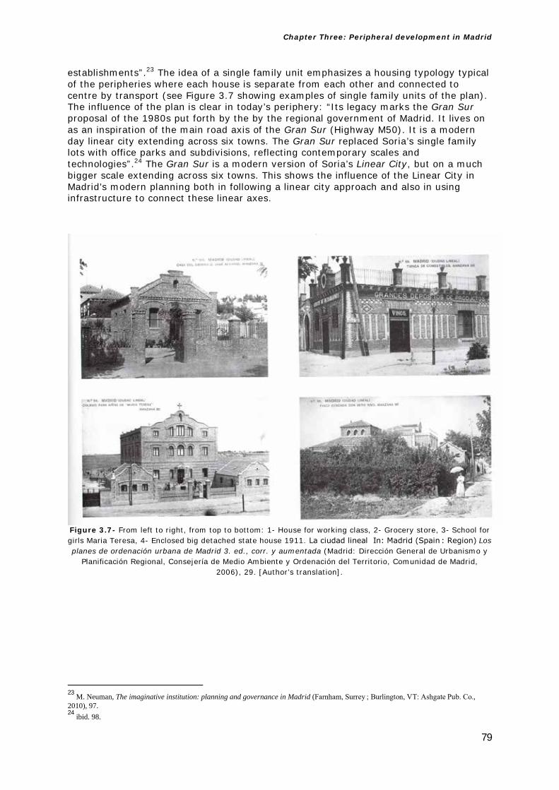
Chapter Three: Peripheral development in Madrid
79
establishments”.23 The idea of a single family unit emphasizes a housing typology typical of the peripheries where each house is separate from each other and connected to centre by transport (see Figure 3.7 showing examples of single family units of the plan). The influence of the plan is clear in today’s periphery: “Its legacy marks the Gran Sur proposal of the 1980s put forth by the by the regional government of Madrid. It lives on as an inspiration of the main road axis of the Gran Sur (Highway M50). It is a modern day linear city extending across six towns. The Gran Sur replaced Soria’s single family lots with office parks and subdivisions, reflecting contemporary scales and technologies”.24 The Gran Sur is a modern version of Soria’s Linear City, but on a much bigger scale extending across six towns. This shows the influence of the Linear City in Madrid’s modern planning both in following a linear city approach and also in using infrastructure to connect these linear axes.
Figure 3.7- From left to right, from top to bottom: 1- House for working class, 2- Grocery store, 3- School for girls Maria Teresa, 4- Enclosed big detached state house 1911. La ciudad lineal In: Madrid (Spain : Region) Los planes de ordenación urbana de Madrid 3. ed., corr. y aumentada (Madrid: Dirección General de Urbanismo y
Planificación Regional, Consejería de Medio Ambiente y Ordenación del Territorio, Comunidad de Madrid, 2006), 29. [Author’s translation].
23 M. Neuman, The imaginative institution: planning and governance in Madrid (Farnham, Surrey ; Burlington, VT: Ashgate Pub. Co., 2010), 97. 24 ibid. 98.

Chapter Three: Peripheral development in Madrid
80
Figure 3.8- Left: Image of Madrid today showing the Ciudad Lineal in relation to the city centre. Author’s own
Right: Districts of Madrid’s Ciudad Lineal today next to Paseo de la Castellana. Left Image copyright Google Earth. Right Image Available at:http://www.idealista.com/static/es/img/maps/0-EU-ES-28-07-001-079-15.jpg
[Accessed 22 July 2014].
Figure 3.9- Arturo Soria’s Ciudad Lineal Project on the top of Madrid’s plan today (the project was never fully implemented). Image Available at: http://urbancidades.files.wordpress.com/2008/10/arturo-soria-googlemap-
con-superposicion-y-marco.jpg [Accessed 22 July 2014].

Chapter Three: Peripheral development in Madrid
81
Figure 3.10-Plan of Madrid dated in 1940 by Vicente de Castro showing the corridor plan of Ciudad Lineal by
Arturo Soria (in white, in the top right-hand corner) in relation to the Castro Plan (in pink and blue). All information for this diagram is taken from the following sources:
1-http://cartotecadigital.icc.cat/cdm/singleitem/collection/espanya/id/2352/rec/30 [Accessed 16 December 2015].
2-Image Available at: http://granvia.memoriademadrid.es/fondos/OTROS/Imp_14102_mh_2006_19_39.pdf [Accessed 16 December 2015].

Chapter Three: Peripheral development in Madrid
82
3.1.3 International Urban Competition for Madrid 1929
“In 1928 the Seccion de Urbanismo (City Planning Section) was formed in the city hall. In 1929 there was an International Urban Competition for Madrid. Trying to gain additional support for the 1926 Plan General de Extension proposal and for plan international competition for a new planning in general, the technicians got the city to sponsor an international competition for a new plan in 1929”.25
In the report from the competition a member of the jury, Don Bonatz, writes in relation to the periphery “When we study the periphery we find that the North part of the city is ideal for housing from the Hippodrome to Fuencarral. […] the south of Madrid, the largest area, alongside the rail track, is the most appropriate area for industrial use. The towns surrounding it, Puente de Vallecas, Vallecas, Entrevias, Villaverde, Carabanchel Alto y Bajo, are the natural points for worker’s houses. The factories should be built in the low points of the terrain, alongside the rail track and the houses in the high points”.26 (See Figure 3.11 showing a diagram of the relationships from the 1929 competition report).
Figure 3.11- Diagram showing the different relationships between the North and the South of Madrid from the 1929 International competition document. The areas in the North are located for housing while the large areas in the South are for industrial use, and workers housing. The South is working class and poorer than the North.
25 Neuman, op.cit. p. 100. 26 Concurso Urbanístico Internacional 1929 In: Madrid (Spain : Region), Los planes de ordenación urbana de Madrid 3. ed., corr. y aumentada (Madrid: Dirección General de Urbanismo y Planificación Regional, Consejería de Medio Ambiente y Ordenación del Territorio, Comunidad de Madrid, 2006), 26. [Author’s translation]. Please note that this text is an extract of the original text “Informe de Don Bonatz, miembro del jurado en representacion de los concursantes extranjeros” translated in English as “Report by Don Bonatz, member of the jury in representation of the foreign participants”.

Chapter Three: Peripheral development in Madrid
83
It is clear that regarding the three areas mentioned in the earlier plans (centre, Ensanche and periphery, which were uncontrolled and not legislated) there was now a shift dividing the city into different geographical parts (North and South). This text shows the intentions of the planning of the periphery to the North of the city for housing and the south for industries and workers housing that support this type of tertiary use. We can see the acquisition of some of the existing settlements in the south into the overall fabric of the city (Vallecas, Carabanchel etc). This is interesting as some of the PAUs (Urban Action Plans) developed in the 1980s and 1990s were located in these areas in the North and South of the city that are referred in this document from 1929 (see Figure 3.12 showing these areas in the 1985 Plan).
Figure 3.12- General Plan 1985, showing basic zoning of the territory for its development.
The Urban Action Plan Areas (PAUS), areas for residential development are shown in the plan in orange growing into the periphery all around the city. Plan General 1985 In: Madrid (Spain : Region) Los planes de ordenación urbana de Madrid 3. ed., corr. y aumentada (Madrid: Dirección General de Urbanismo y Planificación Regional, Consejería de Medio
Ambiente y Ordenación del Territorio, Comunidad de Madrid, 2006), 57.

Chapter Three: Peripheral development in Madrid
84
It is worth pointing out in the Spanish context that most of the plans between the periods of 1900-1939 were not implemented, as Neuman notes: “During this period there were repeated attempts at adapting a plan and creating a new institution to implement it. All the attempts were failures. The plans lacked clarity regarding how to manage new growth in the periphery. They offered no persuasive images of a viable future for the city […] As Castro’s expansion was built out and peripheral growth increased its impact on the city, four plans were put forth in the first third of the twentieth century. A common feature of these plans was the relative freedom their authors had, engineers and architects all. This freedom came at a political price—their plans were not realized. None were adopted for lack of political support […] in both these regards they contrasted sharply with the plan for expansion of 1860, which was implemented”.27 It is interesting to see that Castro’s extension plan was implemented to deal with urban growth in the 19th Century, and the other plans of the first half of the 20th century were not implemented due to a lack of political support, but also due to the lack of stability in the country (including changes in the political system and the Spanish Civil War (1936-39). However there are clear insights that these plans offer for the future city’s development in terms of concepts and ideas which influenced the periphery of the city.
3.1.4 The Bidagor Plan 1939-1963
The period that ranges from 1939 until 1963 (from the end of the Spanish Civil War until the culmination of Franco’s dictatorial regime) also created a new plan: “Called the Plan General de Ordenacion Urbana, it is better known as the Bidagor Plan after its author. It is the exception to the tendency of plans reacting to economic growth. It reacted to a diseconomy, the destruction of Madrid from Spain’s civil war”.28 In the context of the periphery this plan is important: “Projects realized as a result of the plan, such as the completion of the Paseo de la Castellana, the construction of highway accesses in a radial hub and spoke pattern into the core of the city, and erecting monumental structures in the center went against the plan’s goal of decongestion via decentralization into satellite new towns”.29
3.1.5 The Evolution of the Structural region and Plan of Territorial Strategy 1983-1996 and the 1985 General Plan
I mentioned earlier the importance of infrastructure in the development of the city plans. If we look at the illustration below (see Figure 3.13) showing the Evolution of the Structural Region inside the framework of the Reticular Order of the Territory we can see the clear evolution and importance in the growth of the city and the peripheries associated with the development of infrastructure inside of the context of the basis for the Plan of Territorial Strategy 1996. Not only this but we can see that in the first illustration (1980) we can identify the airport Barajas and the orbital motorway M30, and two corridors/Strips named Corredor Henares, and Corredor Sagra. Ten years later we can see the expansion of the periphery connecting with the railway infrastructure and the high speed train to the cities of Seville (AVE Sevilla) and Toledo and Guadalajara and connected with the motorway M30. This means that two small Spanish cities Toledo and Guadalajara, now closer to the centre by the high speed train, become part of that region and expansion of the city. Ten years later in 2000 we can see the extension of the tube to Barajas airport (Metro Barajas) and the extension of the Motorway M45. Ten years later again in 2010 we can see that the high speed train has been extended to Barcelona (AVE Barcelona) and also the motorways have expanded incorporating the M-70. But the infrastructure in these drawings/diagrams is not being developed in isolation but integrated. This means that all these infrastructure and transport improvements over a period of thirty years were co-ordinated as a transport strategy for the whole region. 27 Neuman, op.cit. p. 98-99. 28 ibid. 103. 29 ibid. 105.

Chapter Three: Peripheral development in Madrid
85
This shows the importance of this infrastructure in supporting these peripheral areas, but also in the emergence of these corridors/strips. As Spanish architect Andres Jaque points out also: “High speed train lines and the building of new mobility vectors for road traffic have widened the area of territorial interdependence to a radius of 90 km, putting Madrid within daily commuting reach of cities up to 200 km distant”.30 This shows that infrastructure plays a key role in the periphery’s extension, almost reaching city-region scale in this case.
Figure 3.13- Evolution of the Structural Region showing the development of infrastructure From left to right, from top to bottom: 1-1980’s, 2- 1990’s, 3- 2000’s. P. C. Ortiz “Bases del plan de estrategia territorial 1996” in Madrid (Spain :
Region) Los planes de ordenación urbana de Madrid 3. ed., corr. y aumentada (Madrid: Dirección General de Urbanismo y Planificación Regional, Consejería de Medio Ambiente y Ordenación del Territorio, Comunidad de Madrid,
2006), 68.
30 A. Jaque, “Presentation the state if the question and three priorities in a Madrid which is politically Eco-systematic” in A. J. Cantis, and A. Jaque, Piensa Madrid = Think Madrid: [José María Ezquiaga, Juan Herreros, Fabio Casiroli ...]. In [Madrid]: (Caja Madrid: La Casa Encendida, 2009), 245.
Chapter Three: Peripheral development in Madrid
86
As I pointed out earlier the “Linear City” of Arturo Soria portrayed an image of the city which clearly incorporated, indeed was predicated upon, economic development and dealt with the growth of the city. These thoughts and images that he referred to are not that different from the ones Michael Neuman describes: “[…] from 1983 to 1995 […] It is a case in which the regional planning department created two new images. One was of the region, which it called Madrid Region Metropolitana. The other aggregated seven municipalities in the southern part of the metropolis outside of Madrid city, which it called Gran Sur (Great South). These new images were used to shape and implement an electoral campaign strategy in the first instance and an economic and territorial development strategy in the second”.31 By images in the plans it means that: “The plan typically offered as its centrepiece (and often as its literal centrefold) an image of the future physique of the city in the form of a land use map and/or a pictorial rendering of the city’s spatial layout-a city design. This graphic image served the dual purpose of representing the city and being the focal point of the planning institution”.32 The image of the plan projects firstly the future layout of the city, but secondly it also represents the image of the institution that promotes the plan.
The development of economic growth is clearly embedded with the strategies of the plans of the city throughout these different periods clearly connecting the construction of major infrastructure plans and housing growth areas that are implemented into the plans with a clear strategy both on an economic and political level, in order to increase housing provisions. Those aspects connect the economic development embedded in the plans’ ethos with the concept of the growth of the periphery supported by economic growth and the increased agenda of developing the infrastructure that supported these plans. This emphasis on the economic “shows planning as a tool of dominant economic interest to assure the highest and best (most profitable) use of land and to support and maintain property values (Boyer 1983)”.33 This plan is important because it was the precursor to some of the economic models that we see in Madrid today: “From the socialist government they promoted the decree Boyer (30 April 1985), after the 1985 city plan was approved, and the decree contradicts some of the Plan’s main ideas […] the Boyer decree offered very generous tax incentives, for the middle class families that save money to acquire a second home, with increasing in that way the capacity of the construction sector to build more […] it also allowed (again contradicting the decisions of the recently approved Plan General), to substitute housing for offices and economic activities in the urban centre, something that was specifically forbidden in the plan specifically in order to stop the economic processes that were destroying the complexity of the city centre activities, and the nature of the centre as a residential use”.34 There is a strong relationship between the Decree and what we see in Madrid today, as Fernando Roch writes: “This Decree promoted the expansion of the middle class suburb, the destruction of the territory, the overdevelopment of the infrastructure, the functional segregation that accentuated the opposition centre-periphery […] giving a great impulse to today’s dispersed models and acts as a catalyst of the real estate boom of the late eighties”.35
Also the Linear City by Arturo Soria envisaged the role of infrastructure in the project of the plan, by incorporating the railway line between the centre and the Linear City. This early influence of the role of the infrastructure in the growth of the city was also happening in other European cities such as London at the end of the 19th Century, where in 1870 we can see a clear connection between railway infrastructure and suburbanisation: “It has long been recognised that transport services played an 31 Neuman, op.cit. p.57. 32 ibid. 45. 33 ibid. 94. 34 F. Roch, “Agentes Sociales y tendencia urbanísticas: hegemonía inmobiliaria y perdida de urbanindad” in J. Borja, Z. Muxí, and J. Cenicacelaya, (eds) Urbanismo en el siglo XXI: una visión crítica: Bilbao, Madrid, Valencia, Barcelona (Barcelona: Escola Tècnica Superior d’Arquitectura de Barcelona : Edicions UPC, 2004), 88. [Author’s translation]. 35 ibid.

Chapter Three: Peripheral development in Madrid
87
important part among the general influences on suburban growth […] a much more complicated statement about the relationship between transport and development emerges from the close analysis of railway promotions and train services in outer west London, and here it is possible to see the inter-dependence of the two, with the promotion of new lines in advanced of suburban housing both by speculative land owners and the railway company”.36 It is interesting to see this case in other European cities, than later occurred in Madrid, developing a clear connection between the infrastructure and the growth of the city (see Figure 3.13). Furthermore this relationship also occurred in some of the earlier plans and proposals for the city like the Linear City, where infrastructure is a vital part of the plan connecting the new Linear City together, and with the centre of Madrid.
It is clear that what we saw in the earlier plans of the city, and some of the insights that they offer in terms of the development of the city, have actually occurred in recent years, which clearly show that these intentions were historically part of the development of Madrid.
In Chapter 1, I started this thesis with the work of Aldo Rossi and the Italian School. There is clear Italian influence on Spanish architectural culture in general, but this is even more legible in the plans of Madrid. The Spanish architect Alfonso Vegara writes in 1991: “The Plan general of Madrid 1985 and all the generations of plans from the 80’s have a clear influence of the Italian School […] the search of a new foundation of architecture and urbanism, that now is considered as one discipline, puts value and makes relevant the idea of “context”. The recovery of urban memory and the value given to the “history of the city” as an element of analysis and understanding, represents another important contribution in contrast with previous positions, and as we know they have inspired a lot of interventions in many Spanish cities recently”.37 These ideas and influences in the plans of Rossi’s The Architecture of the City, where he refers to the idea of context and memory in the history of the city, are interestingly connected with the plans of the city of Madrid. I will go on to examine the extent to which Rossi’s theories were relevant in making the plans of the city in the 1980’s happen, and also in the project which is the case study areas that I will analyse in this thesis.
3.1.6 The Plan General 1997
The Plan General 1997 (General City Plan of 1997) was conceived as a plan for the future of the city of Madrid. As a general framework it looks at the problems, the opportunities, fundamental characteristics for future projects and also a general strategy for the city. It also offers a general framework for future areas of the city. The plan establishes a dispersal of the centrality from the city centre into the periphery: “The Plan has understood the dispersal of this character of centrality towards the urban periphery, creating new centralities in the opportunity areas that are vacant, as the only possible solution in trying to find a new equilibrium for the city”.38
The central area of the city is seen as having “a fundamental role in the railway structure of the Northern Fringe and for this it is allocated the proposed extension of the Paseo de la Castellana between the M30 and the M40, this extension is seen as a structural element that supports a greater centrality for the area, but also as a transversal axis North-South of the East-West area. […] The extension of la Castellana as a new capital axis in the North and the integration into the city of the current rail yard areas of
36 F.M.L Thompson, “The case against the historical inevitability of suburbs” (1982) in D. C. Goodman (ed). The European cities and technology reader: industrial to post-industrial city (London; New York: Routledge, in association with the Open University, 1999), 35-36. 37 A. Vegara, “Sobre la crisis de los planes de los 80 y el nuevo enfoque urbanístico de Madrid Metropoli” in Madrid Metropoli. (Ayuntamiento de Madrid, 1991), 241. [Author’s translation]. 38 L. Rodriguez-Avial Llardent, “El plan general, un Proyecto de futuro para la ciudad” in Madrid (Spain : Region), Los planes de ordenación urbana de Madrid 3. ed., corr. y aumentada., (Madrid: Dirección General de Urbanismo y Planificación Regional, Consejería de Medio Ambiente y Ordenación del Territorio, Comunidad de Madrid, 2006), 80. [Author’s translation].

Chapter Three: Peripheral development in Madrid
88
Chamartin and Fuencarral”.39 The old centre has lost its centrality, as Juan Herreros explains: “[…] the centre has lost residents, has expelled the large corporations who now concentrate their work force in the “corporate cities” of the outskirts, has become elderly and gentrified, and has handed entire neighbourhoods to immigrants and nightlife”. However, that centre, with its complex social map and lack of children, with its real and imaginary inconveniences […] offers new opportunities, especially if we extend its borders beyond the historical centre”.40 The areas of urban growth are seen in the planning system as having “The role of new centralities that in some way will be absorbed by the four PAUs of the Municipal programme of planning”.41 There is a clear emphasis in the 1997 plan with infrastructure: “the recovery in the year 1988 of the M40 as the fourth orbital ring […] to the South the non-urbanised areas understood in the Southern part of the M40 and the Aerodromo de Cuatro Vientos. Finally this vacant land is extended towards the East, supported by the M40, between the motorway and the Old Town of Carabanchel Alto”.42 In the context of this pilot study it is necessary to refer to the recent plans of the city of Madrid. This influence on the infrastructure is also clear in the changes that were adopted in this 1997 plan with respect of the previous 1985 plan. As Alfonso Vegara writes: “The Plan General of 1985 proposed as an objective to promote public transport with a ratio of (80/20) (Private/Public). This objective represents today a complete failure. There has not been much investment in public transport during the years of the Plan […] the revision of the Plan General proposes the following Infrastructure Operations: 1- Great operations in the Railway Infrastructure. 2- Transport Interchanges. 3- Improvement and extension Madrid’s tube system”.43 So it is clear that the development of the infrastructure was inherent in the plan, but so too was the increase of residential units, as Vegara points out: “Another fundamental problem for the citizens of Madrid is the cost of housing. The increase in property prices, the inefficient politics of Social Housing and the high cost of mortgages has meant that more parts of the population cannot have access to a dignified house in Madrid”.44 These two elements—infrastructure expansion and provision of housing—were inherent in the revisions of the 1997 plan, and the place for this were the PAUs in the periphery of the city, and the expansion of the infrastructure in the city-region, which led to the construction book after the plan.
3.2 The influence of the previous plans in today’s periphery
The Northern periphery of Madrid has the headquarters of private companies such as Telefonica City (Spanish Telecom) and different peripheral areas, but mainly two urban action plans (called PAUs): Las Tablas and San Chinarro. In the southern periphery there are the PAUs of Carabanchel and Vallecas.
Madrid was growing fast and these city expansions happened quickly and on a big scale. As Ramon Prat writes “The periferia of Madrid is defined as the area between the city’s M-30 and M-40 ring highways and is the site of a breathtakingly ambitious, government sponsored urban expansion project. In the past ten years entire communities have been created in what was, until very recently, the city’s literal frontier: thousands of hectares on uninhabited scrubland".45 This means constructing in a short period of time, and
39 ibid. 83. 40 J. Herreros, “Madrid in times of crisis, from the periphery to the centre through the inner suburbs” in A. J. Cantis, and A. Jaque, Piensa Madrid = Think Madrid: [José María Ezquiaga, Juan Herreros, Fabio Casiroli ...]. In [Madrid]: (Caja Madrid: La Casa Encendida, 2009), 285. 41 Rodriguez-Avial Llardent, op.cit.p. 83. [Author’s translation]. 42 ibid. 76. 43 A. Vegara, “Sobre la crisis de los planes de los 80 y el nuevo enfoque urbanístico de Madrid Metropoli” in Madrid Metropoli. (Ayuntamiento de Madrid, 1991), 241. [Author’s translation]. 44 ibid. 45 R. Prat, “Madrid The Rise of the Residential Periphery” in M. Ballesteros, Verb crisis (Barcelona; New York: Actar, 2008), 39.

Chapter Three: Peripheral development in Madrid
89
within an unprecedented scale of expansion to the existing city. Prat continues: “[…] this residential sprawl that has reached 74,000 units (and counting), is spread over 22.5 million square meters (and counting), and is home to 225,000 new residents (and counting)”.46
It is interesting if we compare these extensions to the existing city with the biggest expansion plan that the city had before—namely the Ensanche by Castro in 1859. Ramon Lopez de Lucio writes “The Ensanche expands the limits of the city by 2,025 Hectares, which would allow an increase in population of 150,000 inhabitants over the century with a generous standard of 40 square metres/per inhabitant in comparison with the 26.7 square metres/per inhabitant in the old city. The geometric characteristics of the proposal are well known; a series of blocks in a grid, approximately, 100 by 100 metres each around the Old Town, in the North, East and South East, articulated by streets of 15, 20 and 30 metres, with a big provision of green areas, agricultural land and services that will not be implemented as there were not mechanisms of requalification of the land and the compulsory purchase of railway land and free areas”.47
If we compare these two numbers, the expansion that Prat discusses is 2,250 Hectares for 225,000 people, in contrast with the Ensanche which is 2,025 Hectares for 150,000 people. So in this scale we are building the surface of the original 19th century expansion of the Ensache but to have nearly double of the population and built in a period of ten to fifteen years.
If we see an image of the city of Madrid in the middle of the 20th century (see Figure 3.14 top image) we can see the different parts of the city: the centre (Interior), the 19th century expansion (Ensanche), the river Manzanares, and the Periphery (Extrarradio in Spanish) and a clear demarcation of the limits of the municipal district (Limite del Termino Municipal). In comparison to that steady growth over time, what we see in this new peripheral expansion is of a different scale, happening at a much greater speed than previous phases of expansion. If we compare this to today’s Madrid we can see how much the city has grown over its limits, during the 1990’s construction boom (see Figure 3.14 bottom image).
46 ibid 40. 47 R. Lopez de Lucio, “Desarrollo urbano y planeamiento urbanistico de la ciudad de Madrid en el s. XX” in VV.AA., 2004. Guía del urbanismo de Madrid, s. XX, Madrid: Área de Gobierno de Urbanismo (Vivienda e Infraestructuras, Ayuntamiento de Madrid, 2004). 36. [Author’s translation].

Chapter Three: Peripheral development in Madrid
90
Figure 3.14 – Top Image: The city and its parts in 1950 the old centre (Interior), the 19th century expansion (Ensanche), the periphery (extrarradio) and the municipal boundary (limite de termino municipal) Bottom image: Satellite image of Madrid in 1995 showing the elements from the 1950
diagram superimposed on it, red (Ensanche), white (Interior) and blue (River Manzanares). Here you can see the urban explosion of the city in recent years and the 1950’s periphery (extrarradio) in
relation to the rest of the city. Author’s own. Top Image taken from: R. Lopez de Lucio, “Desarrollo urbano y planeamiento urbanistico de la ciudad de Madrid en el s. XX” in VV.AA., 2004 (Guía del
urbanismo de Madrid, s. XX, Madrid: Área de Gobierno de Urbanismo, Vivienda e Infraestructuras,
Ayuntamiento de Madrid, 2004), 35. Bottom Image: ibid. 90 Bottom Image: Copyright Google Earth.

Chapter Three: Peripheral development in Madrid
91
The scale and speed of development is much greater. Basically over a decade and a half the city expanded more than in the whole of the previous century. The periphery was the place where this expansion took place; mainly with residential use but also to accommodate other uses (see Figures 3.15-3.20). As explained by Ramon Prat: “Officially there are “two generations” of government-sponsored development underway. The initial phase, which started in 1997, which is nearly complete; its plan outlined in six “Programas de Actuacion Urbanistica” development plans, or “PAU”, and acronym that has become synonymous with the new barrios enumerated in the official plan: Monte Carmelo, Las Tablas, San Chinarro, Carabanchel, Arroyo del Fresno, and Vallecas. Currently in the making is a new plan to further develop sections of the southeast and northeast periphery (Desarrollo del Sureste y del Noreste). Combined, these new development plans propose the construction of an additional 121,000 units of housing and two industrial zones spread over 53 million square meters. Twice the size of its predecessor, this second phase of Madrid’s formidable expansion plan seems imminent. (Even geography aids and abets: set on an endlessly flat plateau or meseta, there are no natural obstacles to the city’s growth) Yet as the details of this plan are formalized, it is perhaps important to take a moment and assess the character of this development”.48
Figure 3.15 –Plan of PAU Carabanchel: dark orange (residential use), light orange (commercial), yellow
(sport), green (green area). R. Lopez de Lucio, “Desarrollo urbano y planeamiento urbanistico de la ciudad de Madrid en el s. XX” in VV.AA., 2004 (Guía del urbanismo de Madrid, s. XX, Madrid: Área de Gobierno de
Urbanismo, Vivienda e Infraestructuras, Ayuntamiento de Madrid, 2004), 108.
48 Prat, op.cit. p. 39.

Chapter Three: Peripheral development in Madrid
92
Figure 3.16 –Aerial picture of PAU Carabanchel March 2003. R. Lopez de Lucio, “Desarrollo urbano y
planeamiento urbanistico de la ciudad de Madrid en el s. XX” in VV.AA., 2004 (Guía del urbanismo de Madrid, s. XX, Madrid: Área de Gobierno de Urbanismo, Vivienda e Infraestructuras, Ayuntamiento de Madrid, 2004),
111.
Figure 3.17 –Plan of the four PAUs of the Northern Fringe, from left to right: Arroyo del Fresno, Monte Carmelo, Las Tablas and San Chinarro: dark orange (residential use), light orange (commercial), yellow
(sport), green spaces (green area). R. Lopez de Lucio, “Desarrollo urbano y planeamiento urbanistico de la ciudad de Madrid en el s. XX” in Guía del urbanismo de Madrid, s. XX, Madrid: Área de Gobierno de Urbanismo,
Vivienda e Infraestructuras, Ayuntamiento de Madrid. VV.AA., 2004), 109.

Chapter Three: Peripheral development in Madrid
93
Figure 3.18 –Aerial picture of PAU Las Tablas November 2003. In the background you can see the PAU San
Chinarro. R. Lopez de Lucio, “Desarrollo urbano y planeamiento urbanistico de la ciudad de Madrid en el s. XX” in VV.AA. 2004 (Guía del urbanismo de Madrid, s. XX, Madrid: Área de Gobierno de Urbanismo, Vivienda e
Infraestructuras, Ayuntamiento de Madrid, 2004), 110.
Figure 3.19 –Aerial picture of PAU Las Tablas December 2013. If you compare figure 3.18 with figure 3.19 you can see that the PAU has almost been completed in less than a decade. Image copyright: Google Earth
What is interesting is that the economy promoted a certain way of development that allowed such a speed of construction to occur. As Jacob van Rijs writes in reference to
Chapter Three: Peripheral development in Madrid
94
the period from 1997-2008: “The last decade may be considered a “golden decade” in Spain, the economy was growing and rising like never before. Housing prices were rising even faster, especially in Madrid, again pushing up the production of more and more houses: Boom Boom Madrid. But there has been little reflection on the quality and conditions of this production. Why only terracotta blocks? Is the resultant urban monotony created during this unprecedented period of economic growth not a huge missed opportunity?”49
This increase in land that is built on for residential use is also clearly emphasized in the 1997 plan of the city where these extensions or PAUS originated: “The General Urban Plan of Madrid, approved in 1997, has a main modification in comparison to the previous 1985 plan in which the current municipal team always objected to that politically the previous plan had a (relative) lack of classifying the land use as new urbanised land use”.50 What this means is that the ethos of the 1997 Plan was to change the political intentions of the previous plan and free up more land for building. What was previously agricultural land or other classification becomes with this plan new buildable land, which clearly promotes these expansions.
The comparison between the two plans is not just in the change of land use to free up land to build on, but also in the bigger scale and speed in which it is promoted in relation to the previous 1985 plan: “It culminates the previous operations coming from the 1985 plan and changes dramatically the Programmes of Urban Action (PAU) from that plan, multiplying by ten the residential land use. From the 7,011 units proposed in the six PAUs in 1985 it will increase to more than 70,000 units in 1994. It also proposes more residential developments between the rings of the M-40 and M-50- the only non-urbanised or used for open space left in the municipality. The total residential capacity estimated would be around 200,000 units only looking at the vacant land. In parallel the infrastructure is strengthened with two new ring motorways: the M-45 and the M-50 which have partially been executed. The great operation of the South East is still being defined in the broader scale; but the three PAU’s of the North (Montecarmelo, Las Tablas and San Chinarro, and the one of Vallecas and Carabanchel are in different stages of construction. It is questionable that their character of “islands” in between big motorways, its limited density and the common use of blocks and enclosed typologies, will be able to have the urban interest that ten years before the “new ensanches” generated. On the other hand the private execution of the construction is producing an increase on the final price of the housing unit”.51
What we can see here in the 1997 Plan is an increase in construction of ten times the scale of housing units to that of its predecessor. Not only that, but these houses are built by private developers, and the quality of the product is not as good as the new ensanches built in the 1980s. So we have greater numbers, more square footage, at the expense of quality, but connected by a clear infrastructure that supports this growth.
Alfonso Vegara wrote in 1991 about the challenges of urbanism in the Madrid of the 90’s: “Great transformations have occurred in Madrid since the approval of the 1985 plan. The changes in the economy, the increase of all kinds of inter-relationships and particularly the demand for transport in the urban and metropolitan context, and the new International importance of our city, and the appearance of new requirements, including the increase in residential land value and the increasing problem of social housing in Madrid are all factors that require new approaches to assuming the challenges
49 J. Van Rijs, “Madrid Boom Boom Madrid The Disappearance of Social Housing” in M. Ballesteros, Verb crisis (Barcelona; New York: Actar, 2008), 142. 50 R. Lopez de Lucio, “Desarrollo urbano y planeamiento urbanistico de la ciudad de Madrid en el s. XX” in VV.AA., 2004. (Guía del urbanismo de Madrid, s. XX, Madrid: Área de Gobierno de Urbanismo, Vivienda e Infraestructuras, Ayuntamiento de Madrid, 2004), 106. [Author’s translation]. 51 ibid. 108.

Chapter Three: Peripheral development in Madrid
95
facing urbanism in the 1990’s”.52 These challenges that he mentioned are actually what happened in the city in the last twenty years, where we have seen the biggest residential construction boom in Spanish urban history, a great increase in infrastructure which has meant the growth of the city into the region. This relates to what Neuman mentioned about the concept of the image of Madrid being an International city open to investors, but also the role of the economy and the interrelationship between all these different elements in what we see in the city today.
It is not just the scale of construction that is big, but also the provision of open green areas that is completely out of scale, and based on zoning. As Ramon Prat writes about these green spaces in the PAUs: “While the existing 70,000 units of housing are modest in size (from 20m2 to 90m2, for a family of five) and tightly packed into hundreds of seven to nine storey apartment blocks, this very real residential density is offset by an oversized network of wide boulevards and leisure plots, whose paved personae (more parking lot than park) intensify the feeling of being in an asphalt suburbia, where plush lawns have been swapped for acres of hard-top”.53
For example if we take one of the areas in the periphery North of Madrid—the PAU of San Chinarro—these large-scale extensions of green space become clear, as Ramon Lopez de Lucio writes: “San Chinarro, one of the greatest pieces of residential land use that resulted from the General Plan of Madrid of 1997, has a total surface of 407 Hectares and has 13568 units, with a total density of 33.8 units/Ha. The lucrative land use (residential, tertiary and private services) is nearly 26% of the total land, only increasing to 37% if we take into account the public services. The total open public space (roads and green areas) is nearly 60% of the total plot of land. Each housing unit has 94 square metres of public green space, nearly double than the average green space per housing unit (50 square metres)”.54 This shows the scale of public green spaces in relation to housing density. The space is not just vast, but we also see a more suburban type of environment and an increased scale of zoned space without specific purpose or quality. These are just green areas in an environment’s quality which is mainly more a parking lot than a park as Ramon Prat refers to.
The plan is also based on different zones not a mix of uses and activities (see Figure 3.20). By comparing two images of the increase of green space (green areas bigger than 2 Hectares) in the city over a period of twenty years (one from 1979 and the other one from 1999) we can see that increase in relation to the whole city (see Figure 3.21).
52 A. Vegara, “Sobre la crisis de los planes de los 80 y el nuevo enfoque urbanístico de Madrid Metropoli”in Madrid Metropoli. (Ayuntamiento de Madrid, 1991), 241. [Author’s translation]. 53 Prat, op.cit. p. 43. 54 R. López de Lucio, Construir ciudad en la periferia: criterios de diseño para áreas residenciales sostenibles (Madrid: Mairea Libros, 2007), 39. [Author’s translation].

Chapter Three: Peripheral development in Madrid
96
Figure 3.20 –PAU Las Chinarro taken from the current plan. Key adapted by author. We can see the mainly
residential use and green space use of the plan. The plan is based on zoning. Image taken from http://www.madrid.org/cartografia/planea/planeamiento/html/visor.htm [accessed 19 of March 2014]

Chapter Three: Peripheral development in Madrid
97
Figure 3.21 – Green areas bigger than 2 Hectares in Madrid, 1979. R. Lopez de Lucio, “Desarrollo urbano y planeamiento urbanistico de la ciudad de Madrid en el s. XX” in VV.AA., 2004. (Guía del urbanismo de Madrid, s. XX, Madrid: Área de Gobierno de Urbanismo, Vivienda e Infraestructuras, Ayuntamiento de Madrid, 2004),
96.
Not only is this planning based on zoning clear in the housing and green areas, but also in the commercial use of the PAU. The big shopping mall ‘El Corte Ingles’ covers most of the commercial facilities of the PAU. It faces the motorway and clearly the multiple level access favours cars instead of pedestrians. Ramon Lopez de Lucio writes about this: “The great shopping centres implemented in the new residential areas act like a “black hole” that absorbs high proportions of potential urban activity in the area, making not viable the small local shops […] The great commercial centre of Sanchinarro absorbs a great percentage of the urban and commercial life of the neighbourhood, showing also a bad relationship with the area: ramps and different levels of access for the car park. While the building’s main façade faces the A1 emphasizing in that way the symbolic value of the motorway instead of the value of the street and the boulevards (which on the other hand are very big in scale) of Sanchinarro”.55
55 R. Lopez de Lucio,“Desarrollo urbano y planeamiento urbanistico de la ciudad de Madrid en el s. XX” in VV.AA., (Guía del urbanismo de Madrid, s. XX, Madrid: Área de Gobierno de Urbanismo, Vivienda e Infraestructuras, Ayuntamiento de Madrid, 2004), 26. [Author’s translation].

Chapter Three: Peripheral development in Madrid
98
Figure 3.22– Green areas bigger than 2 Hectares in Madrid, 1999. R. Lopez de Lucio, “Desarrollo urbano y
planeamiento urbanistico de la ciudad de Madrid en el s. XX” in VV.AA., 2004 (Guía del urbanismo de Madrid, s. XX, Madrid: Área de Gobierno de Urbanismo, Vivienda e Infraestructuras, Ayuntamiento de Madrid, 2004),
96.
3.3 The role of the infrastructure in the growth of the periphery
There is a clear connection between the rapid development of the periphery of Madrid and the investment in infrastructure. As Alejandro Zaera-Polo writes: “The level of architectural ambition does not always match the scale of growth; perhaps this might be true for the planning of the infrastructure as well. […] Madrid has built a huge infrastructure network that can sustain large amounts of urban ground and provide it competitively at a global scale”.56 By comparing two images of the road infrastructure in the city over a period of twenty years (one from 1979 and the other one from 1999) we can see that increase in infrastructural investment (see Figures 3.23 & 3.24).
This increase in infrastructure was embedded in the 1985 plan: “It is difficult to understand Madrid outside of the Regional Plan for the Community of Madrid drafted over twenty years ago in 1985. The plan proposed an infrastructural grid that would enable the city’s expansion to swell far beyond existing limits, swallowing all of the many smaller, neighbouring populations such as Tres Cantos, Colmenar Viejo, Pozuelo, Mostoles, and Getafe.
56 A. Zaera-Polo, “Development, Control, and Mediation” in M. Ballesteros, Verb crisis (Barcelona; New York: Actar, 2008), 137-38.

Chapter Three: Peripheral development in Madrid
99
Figure 3.23 –Road network Madrid 1979. R. Lopez de Lucio, “Desarrollo urbano y planeamiento urbanistico de
la ciudad de Madrid en el s. XX” in VV.AA., 2004. (Guía del urbanismo de Madrid, s. XX, Madrid: Área de Gobierno de Urbanismo, Vivienda e Infraestructuras, Ayuntamiento de Madrid, 2004), 94.
The geographic conditions of the Madrid plateau (flat, unbounded) made an ideal scenario for laying down infrastructure and generating suburban sprawl”.57 The political agenda of the plan of 1985 in relation to that investment on infrastructure was clear as Alejandro Zaera-Polo writes: “Theirs was a political decision, made without an image of the city and, I believe without precise macroeconomic forecasts. Globalization has intensified at such speed since then, the structure so enthusiastically taken by the market, that it has exceeded even the wildest dreams. […] Both Madrid and Dubai suggest that as the public domain is progressively privatized, the mechanisms of producing cities can no longer be based on a sort of idealistic, community-based, institutionally-ruled urban governance; such strategy is simply too introverted in current economies. Nonetheless, the construction of the city cannot be left entirely in the hands of transnational capital”.58 This clearly shows that the 1985 plan had a political intention of investing in infrastructure that supported the suburban growth of the city. While the 1985 plan was modest in comparison to the 1997 plan in relation to housing, it was clearly the development of that infrastructure over a period of twenty years that allowed
57 ibid. 139. 58 ibid.

Chapter Three: Peripheral development in Madrid
100
the 1997 to increase the provision of housing at a scale unknown before in the city’s expansion. In ten to fifteen years the city increased its housing provision by a factor of ten in comparison to its previous plan (comparing the 1997 to the 1985 plan) and this was supported by the investment in infrastructure set out in the 1985 plan. The result is a low density model that has been built at the fastest possible pace.
Figure 3.24 –Road network Madrid 1999. R. Lopez de Lucio, “Desarrollo urbano y planeamiento urbanistico de
la ciudad de Madrid en el s. XX” in VV.AA., 2004(Guía del urbanismo de Madrid, s. XX, Madrid: Área de Gobierno de Urbanismo, Vivienda e Infraestructuras, Ayuntamiento de Madrid, 2004), 95.
The current city of Madrid is the result of all these historical plans that have framed the future of what the city’s periphery is today: “The other Madrid, metro Madrid, the third largest city region in Europe. New Universities, private research centers, and high technology industry in the periphery. Changing from a mono-centric region to a polycentric one. […] Jammed highways, noise, and pollution. Shanty towns on the outskirts. Deteriorated and depopulating inner city neighbourhoods. All the usual accoutrements of a late industrial metropolis, displaying symptoms of a dual city and designs of being a global one”.59
59 Neuman, op.cit. p. xii.

Chapter Three: Peripheral development in Madrid
101
3.4 The Madrid periphery model: the role of the economic dominant model
As we can see in this chapter after looking at the selected Plans of Madrid, the combination of infrastructure and growth have created a periphery that has grown thanks to this investment in transport and motorway expansion that facilitated the growth, and also by the fact that the land is flat and easily allows these extensions into the countryside. But also real estate speculation and the construction industries have permitted this growth that was apparent in the plans of the city during the 19th, 20th and beginning of the 21st centuries.
The sociologist and architect Maria Ezquiaga explains how normal urban processes cannot explain the growth of Madrid (see Figure 3.25): “These principles can no longer be the geometrical “analogies” that they were in the traditional urban thought (from the decentralised garden city to the “poly-nuclear” mesh), but must instead be strategies adapted to an ever-changing game board, upon which not only are “what” and “how much” important (in other words the type and intensity of land usage) but also, syntax and time. This means defining how, and within what frame, the territory will be developed”.60 In these stages we see that the territory becomes more of a fractal organisation and dispersed territory in Madrid (see Figure 3.25). While the plans initially offered a future image of the territory and the political image that the institutions wanted for the city, the current metropolitan territory is much more complex and discontinuous in dealing with its growth than, for example, the first plan of expansion of the city (the Castro plan 1859).
In this way that Ezquiaga refers to, it is necessary to look at these ‘new ways’ that define the periphery: this is not possible just by looking at just geometrical analogies. The invitation he makes is to develop strategies for the ever changing game-board that the periphery is. In that way, the next part of this chapter sets out to define these visual characteristics that Juan Herreros refers to as the elements in the periphery of Madrid, and then continues with the different types of peripheries.
These types of periphery, once identified, will define the basis for choosing the case study areas both in the North and the South of the city.
As Ezquiaga remarks, it is necessary to have new tools to understand these areas: that is why I develop a combined methodology as a tool that is combined in a series of strategies (walking, photographing the territory, narratives, collage) set out in Chapter 4. These strategies are then implemented during fieldwork, discussed in Chapter 5, in order to understand this ever-changing territory to define how, and within that frame of work, the territory will develop by analysing and comparing the findings in Chapter 6.
60 Ezquiaga, op.cit. p. 271.

Chapter Three: Peripheral development in Madrid
102
Figure 3.25- Summary table summarising the main stages and characteristics of the modern transformation of the metropolis of Madrid (Main Ideas highlighted in bold by the author). Author’s own.
The architect Juan Herreros describes this image (see Figure 3.26) of the current situation in Madrid as follows: “[…] we can see that the peripheral construction has […] degenerated into a chaotic amalgamation of large, unconnected units, with a scarcity of resources, gobbling up all the available land space. Partial plans, industrial estates, all sorts of complexes…, these have acted like segregated islands, incapable of keeping the spaces between them green, as they spread out like an oil spill”.67
61 ibid. 62 ibid. 63 ibid. 64 ibid. 65 ibid. 66 ibid. 67 J. Herreros, “Madrid in times of crisis, from the periphery to the centre through the inner suburbs” in A. J. Cantis and A. Jaque, Piensa Madrid = Think Madrid: [José María Ezquiaga, Juan Herreros, Fabio Casiroli ...]. In [Madrid]: (Caja Madrid: La Casa Encendida, 2009), 285.
Stages Characteristics
1- “The formation of the metropolitan area , which meant exceeding the limits of the traditional, continuous and compact city”.61 1960’s-1970’s
“[…]took place in the 1960s and 70s[…]The concentric radiating urban structure is supported by a central nucleus made up of the metro and the M30, and by ring-roads and railways of the metropolitan outskirts”.62
2- “The “poly-nuclear” city region, which again meant extending the scale of interaction and overcoming the simple, interdependent relationships of the metropolitan nuclei”.63 1980’s-1990’s
“[…] The central part of the city brings together the institutions of commercial activity, services and the tertiary sector, surrounding them with peripheral residential suburbs, distributed into socially segregated areas according to a very simple guideline: higher incomes are found to the North and West and lower incomes to the South and East”.64
3- “The post-metropolitan territory, which marks the start of fractal organisation of a territory made up of large axes of supra-regional development”.65 1990’s-2000’s
“[…] These are formed by commuter towns which undergo rapid, yet discontinuous growth, and are supported by the primitive network of ring-roads and rural nuclei. The new cities are born with hardly any basic infrastructure and are completely dependent on Central Madrid for employment and essential services”.66

Chapter Three: Peripheral development in Madrid
103
Figure 3.26- Sketch of the Madrid’s periphery showing main elements. Author’s own
The current periphery is in crisis and we need new models to look into it. Jose Maria Ezquiaga writes about this: “I see the crisis as an opportunity to change direction, a model which appeared to be indestructible is exhausted, and now is the chance to reinitiate a new model”.68 These new models that he refers to are developed not just in new methods to look at the periphery to understand it.
The current economic crisis in Spain offers new opportunities to have a chance to have new models for the periphery. After the construction boom in recent years, and the models of periphery that these plans promoted the period of crisis might have an opportunity to look at alternative models for the future.
3.5 Types of periphery in Madrid
This final part of the chapter identifies the types of periphery developed in Madrid in recent years. In the type of periphery identified as corridor/strip we see two typologies (standard corridor & tertiary corridor, see Figures 3.27 & 3.28). These three types of periphery are: 1- Business Districts, 2- Corridors/Strips, and 3- Residential Peripheries (PAUs), which can be broadly defined as follows:
1- Business districts: “A model which […] has led to an exodus of corporate headquarters- Telefonica, Banco Santander, Central Hispano- even the large state institutions,- let us not forget the Campus de la Justicia- from the old meeting centres and integrated institutional representations such as Alcala Street, or Paseo de la Castellana – to areas where land is cheaper and neighbourhoods yet to be designed”.69
68 Ezquiaga, op.cit. p. 332. 69 A. Jaque, “Presentation the state if the question and three priorities in a Madrid which is politically Eco-systematic” in A. J. Cantis, and A. Jaque, Piensa Madrid = Think Madrid: [José María Ezquiaga, Juan Herreros, Fabio Casiroli ...]. In [Madrid]: (Caja Madrid: La Casa Encendida, 2009), 245.

Chapter Three: Peripheral development in Madrid
104
2- Corridors/Strips: “[…] backing urban references of traditional centrality, and the low density suburbanisation, first of the higher and mid-income properties, and later in segments of directional activities with a higher added value (financial entities, R+D, directional tertiary sector activity), specialised services (private universities, hospitals…), leisure and commerce (large commercial centres, theme parks…)”.70 (see Figure 3.27).
Figure 3.27- Sketch of the Madrid’s periphery’s corridor. Author’s own
These corridors/strips have different types (as we can see in Figure 3.28) and are normally connected by the infrastructure.
During the fieldwork in the case study areas I will look at the role of the infrastructure as an element of connecting these areas.
70 Ezquiaga, op.cit. p. 272.

Chapter Three: Peripheral development in Madrid
105
Typology Characteristics
Standard Corridor 1- “[…]Singled-out from surroundings”.71
2- “[…]”self-contained” nature”.72
3- “[…]lack in important public spaces”.73
4- No architectonic expression.
5- No construction control.
6- “[…]Empty spaces among fragments of disconnected residential areas”.74
“Tertiary suburban corridors specialising in services and consumerism”.75
1- “Axis-connects to the airport”.76
2- “Road to A Coruña”.77
3- “Archipielago of business+commercial parks- Road to Burgos”.78
4- “Development of a range of industrial activities to the South- supported by the Campuses of Carlos III+ King Juan Carlos Universities”.79
5- “Logistic+ technological orientation- South East- Madrid arch and Henares corridor+ University of Alcala de Henares”.80
6- “Scientific corridor to the North, near Tres Cantos and the Autonomic University”.81
Figure 3.28- Summary table summarising different types of corridors/strips in Madrid and their characteristics (Main Ideas highlighted in bold by the author). Author’s own.
71 ibid. 274. 72 ibid. 274. 73 ibid. 274. 74 ibid. 274. 75 ibid. 274. 76 ibid. 274. [Text adapted by author for table]. 77 ibid. 274. 78 ibid. 274. 79 ibid. 274. 80 ibid. 274
81 ibid. 274.

Chapter Three: Peripheral development in Madrid
106
3- Residential Periphery: “[…] in what was on just grassland, a new urban barracks stands ready to house thousands of residents moving from the expensive centre. This huge, government-sponsored effort to expand the city’s housing stock is for the city’s considerable middle class, […] as the cranes and bulldozers rumble along, it is still to be seen if this 21st century housing development can benefit from lessons of the 20th”.82
Typology Characteristics
Residential Periphery · “[…] defined as the area between the city’s M30 and M40 ring highways and is the site of a breathtakingly ambitious, government urban expansion project”.83
· “Entire communities have been created in what it was, […].the city’s literal frontier: thousands of hectares of uninhabited scrubland”.84
· “A feast for the hungry architect, the periphery is dotted with a dozen examples of interesting architectural experimentation”.85.
· “Residential spawn (74,000 units) […] spread over 22.5 million square metres […] 225,000 new residents”.86
Figure 3.29- Summary table summarising the different residential peripheries in Madrid and their characteristics (Main Ideas highlighted in bold by the author). Author’s own
Ramon Prat explains the phases of residential periphery in Madrid (see Figures 3.29-3.31): “Officially, there are two “generations” of government-sponsored development […] The initial phase, which started in 1997, is nearly complete; its plan outlined in six “Programas de Actuacion Urbanistica” development plans, or “PAU”, an acronym that became synonymous with the new barrios enumerated in the official plan: Monte Carmelo, Las Tablas, Sanchinarro, Carabanchel, Arroyo del Fresno, and Vallecas. Currently in the making is a new plan to further develop sections of the southeast and northeast periphery (desarrollo del Sureste y del Noreste)”.87
He further explains that: “The PAU communities are advertised as extensions of the already sprawling city; they are not considered to be separate and different communities […] Commerce is typically concentrated into one large shopping mall; green areas, though generous, are mostly peripheral, most residents commute into
82 Prat, op.cit. p. 39. 83 ibid. 84 ibid. 85 ibid. 86 ibid. 87 ibid. 40.

Chapter Three: Peripheral development in Madrid
107
the city-proper for work”.88 Ramon Prat is also critical of this residential periphery “[…] it can feel like a ghost town […] Apart from the occasional passing car, the streets are deserted.” He also discussed the poor quality of its architecture: “it’s as if everything has been plucked from a huge residential housing superstore, off-the-shelve brick apartment buildings and industrial strength park spaces across millions of square meters of meseta”.89
Figure 3.30- Plan showing the two generation of PAUs (Urban Action Plans) and their characteristics.
R. Prat, “Madrid The Rise of the Residential Periphery”, in M. Ballesteros, Verb crisis (Barcelona; New York: Actar, 2008), 38.
88 ibid. 40. 89 ibid. 43.

Chapter Three: Peripheral development in Madrid
108
Figure 3.31- Plan showing the PAUs (Urban Action Plan) in pink and identifying the main types and phases. R. Prat, “Madrid The Rise of the Residential Periphery” in M. Ballesteros, Verb crisis, (Barcelona; New York:
Actar, 2008), 42.

Chapter Three: Peripheral development in Madrid
109
The Italian group La Tendenza (of which Aldo Rossi was a member) as mentioned in Chapter 1 emphasized the importance of architectural theory and project. My position in this case is that this chapter explained the epistemological position of the theory behind the plans and established two important characteristics in relation to them: the role of an economically dominant model, and the role of infrastructure in developing these peripheral areas showing the importance of the concept of image in the old plans and what we see in today’s periphery. In Chapters 5 and 6, this thesis will go on to explore in the case study whether these characteristics emerging from the study of the plans occur on the ground, and if so to which extent.
In order to be able to select the study areas,90 I have looked ontologically at different categories or types of periphery present in architectural theory in recent years in Madrid. This has helped me in framing the types of peripheries and narrowing down and establishing the areas that I will look at both in the North and South of Madrid. This will allow me to test if these theoretical ideas are actually happening on the ground, and to see the relationship between theory and project.
In order to look at the other two typologies like residential peripheries I have chosen in the North two of the first generation PAUs (see Figure 3.31): Las Tablas and San Chinarro. Las Tablas is next to Telefonica City and San Chinarro after Las Tablas. The motorway divides the two PAUs as explained in the characteristics of the residential periphery (see Figure 3.29). The motorway here is a standard corridor/strip typology (see Figures 3.27 & 3.28) allowing me to explore all the three different typologies identified. By being next to each other, I can also look at the relationships between all the typologies and see if the characteristics mentioned in the theory occur on the ground.
For the South of the city I have identified two areas on one hand the PAU of Carabanchel and then a tertiary corridor typology (see Figures 3.27 & 3.28) where the University Carlos III is in the existing town of Leganes.
I have chosen specifically first generation PAUs because they have been almost completed and I can find much more information on the ground. By choosing different study areas in both North and South then I will compare them and analyse my findings in Chapters 5 and 6.
The role of the project here in the case study is to see if what the theory establishes, both the characteristics from the plans, and also the typologies are actually happening on the ground, and if not identify the differences or any new characteristics that emerge in the study areas chosen. Another aspect of the project is to test the methodologies proposed and to see what methodological contribution this thesis could make in the study of the peripheries.
Juan Herreros summarises three strategies that the periphery developed:
1st- “[…] is a reflection on the infrastructures and the organisational role of the city”.91
2nd- “[…] Refers to building up a programmatic diversity based on the hybridisation of uses, especially those who bring production and residence together”.92
3rd- “[…] is what we would call the naturalisation of the city”.93 90 The term study area is taken directly from: A. Rossi, et al., The Architecture of the City (Cambridge, Mass: MIT Press, 1988) . Please refer to Chapter 1. 91 J. Herreros, “Madrid in times of crisis, from the periphery to the centre through the inner suburbs” in A. J. Cantis and A. Jaque, Piensa Madrid = Think Madrid: [José María Ezquiaga, Juan Herreros, Fabio Casiroli ...]. In [Madrid]: (Caja Madrid: La Casa Encendida, 2009), 285. 92 ibid.

Chapter Three: Peripheral development in Madrid
110
According to Herreros these are: “[…] three ingredients that the historical centre and inner suburbs-needs and for which instruments have been developed in the work going on of peripheries”.94 He also thinks that “the only major tool that is left to architecture and urbanism to make of the contemporary city a place which is truly necessary and interesting is densifying the city and stopping sprawling. I would go so far to make this a proposal”.95 Another aspect of the role of the project in this thesis is to see if these three strategies that Herreros refers to are actually evident in the chosen study areas or not.
The next chapter will focus on the different methodologies proposed for the fieldwork by first introducing the methodology, and explaining the methods of walking and photographing the peripheries. It will also introduce the narratives that will result from the walks as a way to develop both visual and narrative typologies of these areas.
93 ibid 285. 94 ibid 285. 95 J. Herreros, “Round Table” in A. J. Cantis, and A. Jaque, Piensa Madrid = Think Madrid: [José María Ezquiaga, Juan Herreros, Fabio Casiroli ...]. In [Madrid]: (Caja Madrid: La Casa Encendida, 2009), 330.

4

Chapter Four: Methodology
112
CHAPTER FOUR: METHODOLOGY
4.1 Introduction to methodology
On a cold winter’s day in December 2013, I walked through the Madrid peripheries, with my Leica camera. I took over one thousand two hundred pictures, and a series of videos of both the Northern and Southern periphery of the city, to test and to analyse the focus of my study. These areas were chosen after a careful literature review and the research described in Chapter 3. The areas chosen were in the North and the South of Madrid and this included the following: 1-Telefonica City (Corporate HQ), PAU Las Tablas and PAU San Chinarro in the North 2- PAU Carabanchel and the tertiary corridor of Leganes with its new railway infrastructure and a new University Campus.
Before planning my fieldwork, I looked at the different types of periphery in Madrid and decided on a range of different areas that comprised of these characteristics, both in the North and the South of the city. I also decided to plan specific routes before travelling to carry out the fieldwork. They provide different examples of peripheral conditions across the city that will allow me to develop a new cartography that fills the gap between the theory and the project as set out in Chapter 1. The only area that had an existing town next to the new periphery was Leganes, which will be the focus of a much more detailed analysis in Chapters 5 and 6, which introduces firstly a “worked example” and develops a new detailed cartography that fills the gap between theory and project, where the old town meets the new tertiary corridor.
The decision to use the walks as a way in which to analyse the areas identified for the study was determined during the literature review. The decision to use the walks during the fieldwork was facilitated by using tools such as Google Earth prior to the fieldwork and also by the gaps, established in Chapter 1, that exposed the gaps in Aldo Rossi’s work and the need for a methodology that combined not just the use of photography, but also narratives and a combined methodology in order to understand the peripheral condition in Madrid.
As the periphery in Madrid extends across a vast area comprising the city-region, the mapping using Google Earth, was a useful tool in order to prepare the fieldwork. I have included in Appendix 2 the document that I prepared before carrying out the fieldwork in Madrid, which is just a snapshot of the documentation at that stage of this research. This document in Appendix 2 shows why the decision was made to do the walks I planned across all the areas identified in the literature review and also shows how these routes were chosen.
I identified the three scales of study both before undertaking the fieldwork and as I developed and established the methodology, but also these scales became more apparent not only when I was there but also when I returned and analysed the data. As a researcher looking at the subject (in this case a female and alone) the moment I immersed myself in this peripheral condition, taking photographs and meandering through the landscape the nature of the study became subjective and the perspective undertaken was within that landscape. By choosing a picture, or a walk as a researcher you frame a particular image in time and a moment during that study.
In this chapter I discuss the methodological approach, including a discussion on photography, narratives and walking. This includes a discussion on the approach used by city photographers that I am interested in such as Gabriele Basilico. This is intended to add clarity to my photographic approach as Basilico has worked closely with architects such as Stefano Boeri in order to explore and understand the peripheral condition in Europe.
This thesis started with the ending of Aldo Rossi’s book The Architecture of the City where he discusses the elements that define the traditional historic European city: I set

Chapter Four: Methodology
113
out to see if those elements occur in the European periphery, specifically in the city of Madrid that in recent years has seen one of the biggest construction sites in Europe leading to the growth of peripheries in both the North and South of the city. The last chapter of his book mentions that the next study that was required was that of the periphery, or the concept of the city regions. Where Rossi’s thesis concluded, mine starts. I propose to see if we can develop an understanding of what I call The architecture of the periphery by developing a new cartography.
Boeri is another Italian architect who in recent years has studied the European periphery and arrives at a similar conclusion to that of Aldo Rossi when in the second part of his career he worked on the project of La Bicocca in Milano, in what as he defined as a city by parts.1 Boeri states that what distinguishes the European city from others is: “the absence of the megalopolis and a string diffused condition of urbanity are the main characteristics of the European territory. Europe continues to be the place where there are no cities of twenty million inhabitants, whilst this occurs in almost all other continents, excluding Oceania”.2 Boeri goes on, describing Europe as: “A polycentric city that extends across a large part of the continent, having control areas and peripheries, of “natural corridors”, of “waterfronts”, of “terrain vague”.3 He mentions here both the diffuse condition and also the idea of city by parts, and also connects his thinking to the concept of terrain vague that was originally used by the Spanish architect Ignasi de Solà-Morales.
These dualities between image and structural types in Rossi’s work is also supported by Ignasi de Sola-Morales when he writes: “Rossi’s architecture shows itself as a never ending game between structural typologies and images that are in constant interaction. That is, he presents the idea in his work almost like a game of figures, which constitute the fundamental objective of his architecture”.4
These two approaches of looking at the city have also been established by other scholars in architectural theory as a valid methodology for research. Neil Leach states that “The metropolis therefore lends itself to serve in textual terms as an object of research. It constitutes a series of spatial images—hieroglyphics— which may be deciphered in order to provide access to deeper underlying questions about society”.5 The two approaches used to explore the city in this thesis are:
1. Semiological Approach: “Reading” the city (Psychoanalytic modes, signs, signifiers, signified). The use of typology as is understood by Rossi is then used as an approach for my typological study in Madrid.
2. Phenomenological approach: “Experiencing” the city.6 This is important because the semiotic approach has limitations: “The problem with ‘reading’ the environment as a codified system of meaning is that approach effectively.
1 F. Moschini, Francesco Moschini intervista Aldo Rossi (1966); available from http://www.aamgalleria.it/GALLERY/0/0/1177426413.pdf [Accessed February 9, 2014] [Author’s translation]. (Original text in Italian). 2 S. Boeri, Uncertain state of Europe (Milan; London: Skira Editore ; Thames & Hudson, 2002), 25. 3 ibid. 4 I. Solà-Morales Rubió, “Anyone De la autonomía a lo intempestivo”, in I. Solà-Morales Rubió, Los artículos de Any (Barcelona: Fundación Caja de Arquitectos, 2009), 20. [Author’s translation]. 5 N. Leach, The hieroglyphics of space : reading and experiencing the modern metropolis (London: Routledge, 2002), 2. 6 ibid. Note: The two terms used here in order to define cities (the semiological and phenomenological) are taken directly from this book by Neil Leach. However, there are other phenomenological approaches to the city particularly in the work of Kevin Lynch (Image of the City) and Gordon Cullen (Townscapes). Even though I acknowledge their work in my research context, Lynch’s work is primarily concerned with legibility, identity and navigation, as is Cullen’s to some extent, and the latter in particular is explicitly based in city-centres but neither of them are used here as their focus is not part of the remit of this thesis. For further reference see: K. Lynch, The Image of the City (Nachdr. Publication of the Joint Center for Urban Studies. Cambridge, Mass.: MIT Press, 2005): G. Cullen, The Concise Townscape (Oxford ; Boston: Butterworth-Heinemann, 1995).

Chapter Four: Methodology
114
privileges the visual landmarks little allowance for the full ontological potential of human experience”.7
Furthermore this methodological approach offers “interdependent models of understanding the metropolis”.8 Both approaches are important as a method to read and experience the city.
This phenomenological approach using fieldwork and other techniques is important in order to understand this polycentric city and city by parts that both Boeri and Rossi refer to. Once the fieldwork study has been developed, there will be an archive of photographs that will be analysed and compared against the more firm literature-based approaches of Rossi and Venturi and Scott-Brown. However, these concepts taken from the work of Venturi and Scott-Brown and their work in the 1960’s are useful in the case study context, but require other additional tools to meet their short falls in this new context. One example of this is that they observed the Strip and the city by the car, where in this study I propose to do this by walking.
Other ways and methods are necessary to look at the periphery, as the categories from the 1960’s are not sufficient in the new peripheral context, as Boeri writes: “Yet the diffuse city and scattered dynamics are not simply a new “part” of the European city. They represent the visible and emergent form of a new urban condition that transforms the nature and the very concept of city, exerting its effects on the classical city as well […] a condition impossible to decipher with the vocabulary constructed in the 1960s to analyse the old European city. The now-useless vocabulary continues to make the distinction between “center” and “periphery”, between “public space” and “private space”, between “emergent areas” and “parts of the city”. In the new European territories these categories simply do not work, and merely slip over the surface of things”.9 To arrive at an understanding of the peripheral condition a series of methods are required that combine multiple approaches to understand the complexities of the territory.
In this chapter the different methodologies proposed and adopted are used to provide an image (both visual and narrative) of the periphery before arriving at a new cartography. From using photography and walking as a way in which to understand this territory, I also explore different narratives that resulted from my walks and fieldwork investigation, selecting fragments and elements of my findings in the case study areas and combining both the narratives and the images. These samples are a reflection of this territory put together as a collage by myself to try to decipher its complexities because as Boeri writes: “Our status as city or town dwellers is increasingly defined by a “collage” of places we assemble in our erratic, daily experiences of the territory, rather than the geographic location of our home. We inhabit the city, tuning into a limited number of these landscape sequences, as in the case of the symmetrical route to the shopping centre, or the ‘lurching’ and ‘spasmodic’ sequence a continuous succession of stop-go movements) we go through when taking a train or plane.”10
I propose to look at the case study during the fieldwork under three scales (the photographer, the citizen, and the architect) to give me an overview and a visual and written catalogue that I can then compare with the literature to see if I can arrive at a theory of the periphery in Madrid, as set out in my hypothesis and research question. As the Italian architect and photographer Gabriele Basilico writes: “For me photography is a way of assimilating images and expressing points of view about the world outside,
7 ibid. 3. 8 ibíd. 3. 9 S. Boeri, “Notes for a research program” in R. Koolhaas, et al., Mutations (Bordeaux; Barcelona: Arc en rêve centre d’architecture; ACTAR, 200), 266. 10 S. Boeri, Uncertain state of Europe (Milan; London: Skira Editore; Thames & Hudson, 2002), 438-439.

Chapter Four: Methodology
115
through the experience of seeing. But it is also, in a rather more subtle way, a way of weaving relationships together, bringing out an exchange, of impressions about different places of reality, recomposing fragments of life experiences configured in the infinite formal variants of the physical world […] just as pollen facilitates exchange and continuity through being spread in the world of nature, so the new images of the world take the shape, of the movement and circularity of the act of looking”.11 In this case, the photographs taken in the periphery of Madrid are a way of interweaving these relationships, expressing points of view on the outside world but also connecting different perspectives, ideas and narratives in order to create a series of visual and written typologies that by the act of looking at these places show the different fragments that compose this periphery that I study.
The fieldwork for the case study is taken on the ground, to test the theory of architecture against the project in order to see if I can identify emerging patterns, and to test these tools that I use in this context. Once I analyse the work on the ground I can see if the theoretical approaches (discussed in Chapter 5) to Madrid’s periphery are really present on the ground, in order to test whether there are any gaps between the theory and the project.
4.2 Walking the Northern periphery: Telefonica City, San Chinarro and Las Tablas
The study of the northern periphery of Madrid comprises three areas specific to this study: the district of Telefonica city and the two PAUs (Urban Action Plans) located in the north of Madrid: San Chinarro and Las Tablas. Telefonica City was defined as a type of business district12 and Las Tablas and San Chinarro as residential peripheries13 resulting in the ambitious plans for housing developed in recent years called PAUs which envisaged areas of growth in the immediate peripheries of the city.
4.2.1 Methodology: A written catalogue of my own experience of the periphery, describing and defining emerging or existing typologies from the ground in the context of architectural theory
Once on site I discovered two things: one was that the route that I actually followed was different to the one I originally planned (refer to Figure 4.1) and secondly, other typologies of periphery actually emerged as I walked through these areas. These new typologies that emerged as I walked through the Northern periphery were the corridors/strips whose characteristics are “[…] backing urban references of traditional centrality, and the low density suburbanisation, first of the higher and mid-income properties, and later in segments of directional activities with a higher added value (financial entities, R+D, directional tertiary sector activity), specialised services (private universities, hospitals…), leisure and commerce (large commercial centres, theme parks…”.14
For example, on my way to the PAU of San Chinarro (refer to Figure 4.1 stage 19 of my walk for reference) I found by chance the headquarters of the BBVA Bank (Banco Bilbao Vizcaya Argentaria) re-located to this new emerging periphery from the Paseo de la Castellana in central Madrid where it had been for many years. These new headquarters were not in the form of a skyscraper as they traditionally appear in the centre, but in a long low density built form. Next to it there was a garage and a McDonald’s, like you might find next to any American highway. The motorway heading north from Madrid to
11 G. Basilico, “Letter to Josep Vicent Monzo” in G. Basilico, Berlin (London: Thames & Hudson, 2002), 7-9. 12 Please refer to Chapter 5 of this thesis for this type of periphery and its characteristics. 13ibid. 14 J. M. Ezquiaga, “Fragmentation to fractality: the paradoxes of diversity”, Iin A. J. Cantis, and A. Jaque, A Piensa Madrid = Think Madrid: [José María Ezquiaga, Juan Herreros, Fabio Casiroli ...]. In [Madrid]: (Caja Madrid: La Casa Encendida, 2009), 272. Please refer to Chapter 5 of this thesis for this type of periphery and its characteristics.
Chapter Four: Methodology
116
Burgos ran in between, and split the two areas of Las Tablas and San Chinarro. As you cross the pedestrian bridge above the motorway you could see next to the motorway another petrol station and a big commercial centre called “El Corte Ingles Centro Commercial San Chinarro” with a small theme park next to it. You could really see this typology emerging as I walked. But the concept of corridor and strip did not only become apparent as I walked through these in-between areas within those I defined before I prepared my fieldwork: this concept was developed by Robert Venturi and Denise Scott Brown in their book Learning from Las Vegas. Their definition of the strip’s image “[…] is chaos. The order in this landscape is not obvious”.15 They define two orders on the strip: the private and the civic: “This counterpoint reinforces the contrast between two types of order on the Strip: the obvious visual of street elements and the difficult visual order of buildings and signs. The zone of the highway is a shared order. The zone off the highway is an individual order […] the elements of the highway are civic. The buildings and signs are private”.16
Here, if I take Venturi and Scott Brown’s definition, I can think of the motorway that cuts across the motorway to Burgos as a Civic nature in terms of their two definitions of strip, whereas the other elements (either buildings or signs), are private, designed to be seen from a car rather than on foot. If I take this definition that I am using of the typology of corridor/strip in Madrid, in comparison to Venturi and Scott-Browns’, I can see similar activities along the highway: “There is an order along the sides of the highway. Varieties of activities are juxtaposed on the Strip: service stations, minor motels, and multi-million-dollar casinos”.17
Here in this area I can see the motorway in the middle and off the motorway I can see two service stations with signs (in one on the left next to the BBVA headquarters there is even a McDonald's sign to indicate you that you can eat), but the motels and multi-million dollar casinos (typical of Las Vegas landscape) are here substituted by the Shopping Centre (“El Corte Ingles Centro Commercial San Chinarro”) and the bank corporate headquarters (BBVA Bank).
15 R. Venturi, D. Scott Brown, and S. Izenour, Learning from Las Vegas: the forgotten symbolism of architectural form (Cambridge Mass: The MIT Press, 1996), 20. 16 ibid. 17 ibid.

Chapter Four: Methodology
117
Figure 4.1- Stages of walk followed on site during fieldwork (in purple) through Telefonica City followed by PAU Las
Tablas and ending at the BBVA headquarters from stages 1-19 (1 being where the walk started and 19 the last stage of the walk). The red line shows in comparison the original walk the author envisaged while preparing the fieldwork.
Image copyright Google Earth, adapted by author.
Venturi and Scott-Brown see these strips as zones that have to be studied by car, not by walking: “Immediate proximity of related uses, as on Main Street, where you walk from one store to another, is not required along the Strip because interaction is by car and highway. You drive from one casino to another even when they are adjacent because of the distance between them, and an intervening service station is not disagreeable”.18 On one hand I agree with them in that these types of places are designed for use by the cars and driving, hence you have all these signs and symbols for the cars and uses for stopping like the petrol stations or the commercial centre. Even the corporate headquarters such as Telefonica or BBVA are designed to cater for the car.
But the point where I disagree with them is that these places should also be studied and analysed from the perspective of pedestrians too. In fact, the American Art Professor Ann Reynolds explains this process both through the work of artists such as Robert Smithson and also Robert Venturi and Denise Scott Brown: “Since it is a convention for describing deep three-dimensional space, linear perspective often implies a destination that is hypothetical. One never arrives at the vanishing point but presumably and continuously and indefinitely “passes through” space toward it. This is particularly true if the convention is used to describe and photograph spatial experience from a moving car, as Smithson does and often as Blake and as Venturi and Scott Brown do”.19
Taking this assertion from Reynolds, I could argue that describing the periphery or the city through the car is not enough: I am “passing through” in the car not walking through. We are missing elements of the object of study that are necessary to understand it as a phenomenon. It also shows the shift in attitude that has occurred in recent years regarding the importance of walking through these areas these peripheral
18 Venturi Scott Brown, and Izenour, op.cit. p. 20 & 34. 19 A. M. Reynolds, and R. Smithson, Robert Smithson: learning from New Jersey and elsewhere (Cambridge, Mass: MIT Press, 2003), 90.

Chapter Four: Methodology
118
areas, and while walking using photography as a tool or as a viewpoint to record them. However, when one can refer to Venturi’s and Scott-Brown’s work in Learning from Las Vegas to look at the concept of the strip, the idea of the highway and the different meanings of signs and forms, they looked at the city from the car and driving, passing through and it is necessary to compliment this with walking, looking at the ground and understanding subjectively these places. This emphasizes the importance of walking and photographing these areas to try to see what we miss by just “passing through” them.
Another insight that became apparent to me when I walked through these vast residential areas is that they are experimental and a testing ground of ideas for architects: “A feast for the hungry architect, the periphery is dotted with a dozen examples of interesting architectural experimentation”.20 According to Juan Herreros, architects “[…] view the peripheries as a deregulated zone in which they could rehearse a new scale, typology and programmes, and activate new types of public spaces”.21
I also found during my fieldwork a lot of interesting points such as a proliferation of private space versus public realm, and CCTV 24 hour cameras in a lot of the residential blocks, but also in the corporate headquarters of offices and shopping malls. For example, in the area of Telefonica Headquarters the only café I could find was a Starbucks. There was also a clear definition of private space in front of some of the blocks instead of good public realm. This was particularly clear on the ground level, or street level, with many CCTV cameras and also the lack of public space. As American urbanist Michael Sorkin writes in his essay Big Brother Is Charging You: “This transformation is fundamental. Cities-and the organization of space in general- bare key media by which we sort out the boundaries between public and private, and the public side of the equation is increasingly squeezed. The dramatic acceleration of surveillance post 9/11 is one marker of the contraction, and police agencies, public and private are enjoying virtual carte blanche to intrude in the traditional public realm-the streets of the city- and in the private as well. "[…] The problem with the suburbs (and increasingly the city) lies both in the homogeneity of formats and the frequent elusiveness of a genuinely public realm- the fact that a coffee always comes from Starbucks or Dunkin’ Donuts and that the “street” on which stores sit is a parking lot or supermarket aisle […] While strolling over, I’ve counted the security cameras on the single block between here and there. There are fifteen visible to me. Fifteen […] A shopping mall in not the same as a street, and a security camera on every corner is not a pal”.22
I also considered the idea about continuity in the city, and tried to explore during my fieldwork whether this existed in these peripheries or not. Ignasi de Solà-Morales writes about: “Undoubtedly through attention to continuity: not the continuity of the planned efficient and legitimated city, but of the flows, the energies, the rhythms established by the passing of time and the loss of limits. […] Marquand proposes the notion of continuity in contrast to the clarity and distinctness with which the strange world presents itself to us. In the same way, we should treat the residual city with a contradictory complicity that will not shatter the elements that maintain its continuity in time and space”.23
However while words and literature, are good ways to describe and study these peripheries, as a tool they are not sufficient: in addition photography as a tool is essential in analysing these areas. This is emphasized by Stefano Boeri: “Words fluctuate; they make temporary associations and they know how to wait. Ways of seeing
20 R. Prat, “Madrid: The Rise of the Residential Periphery”, in M. Ballesteros, Verb crisis (Barcelona; New York: Actar, 2008), 39. 21 J. Herreros, “Madrid in times of crisis, from the periphery to the centre through the inner suburbs” in A. J. Cantis and A. JaquePiensa Madrid = Think Madrid: [José María Ezquiaga, Juan Herreros, Fabio Casiroli ...]. In [Madrid]: (Caja Madrid: La Casa Encendida, 2009), 285. 22 M. Sorkin, “Big Brother is charging you” in M. Sorkin, All over the map: writing on buildings and cities (London New York: Verso, 2008), 311-13. 23 I. Solà-Morales, “Terrain vague”in C. Davidson, Anyplace (New York, N.Y. : Cambridge Mass: Anyone Corp; MIT Press, 1995), 123.

Chapter Four: Methodology
119
are rigid, rooted in subjectivity and strategic when they change they create radical turmoil. […] It is no coincidence that the words which shift their allegiance from one thing to another because they are too vague or limited., are those that involve processes of reading and measurement or the physical territory: terms such as “parts of the city”, “monument”, “fabric”, “edge”, “central area”, outskirts. This instability is not only limited to words”.24
According to Boeri, plans are not enough in explaining the periphery; ”It is not by placing one of these territorial representations on top of the other that we will ever be able to group the essence of contemporary inhabited space […] we would produce thematic “maps” crammed with useless and highly ordered information but incapable of appreciating the multi-faceted and dynamic nature of urban phenomena”.25
When carrying out the fieldwork I also found a lot of empty areas, voids (see Figure 4.2). These places appeared everywhere in different parts of the Northern periphery, they were like a bit of countryside, in most cases fenced off away from the public, but you could easily penetrate these spaces (please see Figure 5 in order to see them highlighted in dark grey and called areas of impunity/countryside).
Abalos & Herreros (A&H) define these areas as areas of impunity: “One is tempted to ask whether they might contain a metaphoric model, a quasi-model, or whether it is possible to think of their compliment, de-edification, given that the term ‘descampados’ embodies a fascinating concept: land that has lost its attributes as the city approaches, sterilised before being occupied, but also given a transcendental role in its new context”.26 These areas normally have a negative connotation associated with them, according to Abalos & Herreros. 27
However, there is a certain positive aspect to being empty and free and available, so by nature nomadic and changeable, which is similar conceptually to what the Italian architect Francesco Careri describes: “At this point it was also noticed that—once again there beside the historical28 city, in the “periphery”—there were large empty spaces that were not being utilized, that could lend themselves to large-scale operations of territorial surgery. Given their large scale they were called urban voids”.29
24 S. Boeri, Uncertain state of Europe (Milan; London: Skira Editore ; Thames & Hudson, 2002), 428. 25 ibid. 431. 26 The term descampados is translated from Spanish as open country or “de-countrified” please refer to: Abalos & Herreros, “A New Naturalism (7 Micromanifestos)” in F. Beigel, Ábalos & Herreros (Barcelona: Editorial Gustavo Gili, 2002), 28. 27 Please refer to the Chapter 5 for more information about these concepts and their characteristics. 28 F. Careri, Walkscapes: Walking as an aesthetic practice = El andar como practica estetica (Barcelona: Editorial Gustava Gili, GG, 2002), 177. 29 ibid.

Chapter Four: Methodology
120
Figure 4.2- From top to bottom areas of impunity, or empty spaces found in the fieldwork. From top to bottom 1- PAU Las Tablas, this area was open 2-Transition area located at the end of PAU Las Tablas and
before PAU San Chinarro, this area was fenced off, but you could enter in certain parts 3. Area at the end of PAU San Chinarro and next to the building Mirador by MVDRV, this area was totally fenced off. All photographs
taken by the author. 4.2.2 Methodology: There are more than just words… a visual catalogue of wandering
The work of the Italian architect Francesco Careri in his seminal book Walkscapes: Walking as an aesthetic practice emphasizes not only justifies the importance of walking but also doing so in the context of the newly emerging peripheral territories. In the Preface to the book Gilles A. Tiberghien refers to these peripheral spaces as: “a group of territories belonging to the suburbs, a word that, as Smithson explains, "literally means 'city below'" and which he describes as "a circular abyss between town and country, a place where buildings seem to sink away from one's vision buildings fall back into sprawling babels' limbos".30
30 G. A. Tiberghien, “Preface” in F. Careri, Walkscapes: Walking as an aesthetic practice = El andar como practica estetica (Barcelona: Editorial Gustava Gili, GG, 2002), 14. Note here Tiberghien refers to the work of the American artist Robert Smithson. For further information about his work please refer to A. M. Reynolds and R. Smithson, Robert Smithson: learning from New Jersey and elsewhere (Cambridge, Mass: MIT Press, 2003).

Chapter Four: Methodology
121
For the purpose of this study, rather than walking as planned I decided to wander across these areas which were the object of my study. I also decided to photograph them and record videos from three different scales with my camera (1. The view of the photographer, 2. The point of view of the architect, 3. The view of the citizen or the person walking through the street). That was my proposal as the photographer records the landscape, the skyline of the city and that is what I tried to record. However the architect designs the street elevations and the building blocks, and the citizen has to live in these spaces or walk through them but often has no say in the way they are designed. These scales mentioned were also subjectively covering three different city’s scales: 1. The city, the landscape, 2. The neighbourhood and the block, 3. The street and the ground level. Those choices seem subjective but they do follow the logic of scales from the city to ground on one hand, but also zooming in the subject from the perspective of the person looking at the subject (with the camera) on the other. I will endeavour to explain below a rationale for these choices and the methods used in my fieldwork and in the object of this study. However, in this study I had planned the route in advance, and although I did diverge from this plan on occasion, I was never wandering aimlessly. Walking randomly, wandering, allows us not to have pre-conceptions about a space, but to look at it with fresh eyes and become immersed in it. In this case it was not just the action of walking but also doing it with a camera that allowed me to record what I saw in order to classify it if possible. Following Venturi and Scott Brown’s approach in their book Learning from Las Vegas, I followed a two stage approach: first was an Observational Stage of diagramming, mapping and producing photographic images, followed by a series of Observational studies to try to understand the theoretical context after visiting the ground. However rather than “passing through” with the car, I disregarded the car on my visits and decided that I wanted to “walk through” instead and stop, observe, think, select, record and then possibly arrive at a concept or a typology or categories of what I saw and studied. It also allowed me to expand further on Venturi’s and Scott-Brown’s approach that I was also using as reference for parts of this study. Why walking rather than driving? For the reasons mentioned before, but also because “It was by walking that man began to construct the natural landscape of his surroundings. And in our own century we have formulated the categories for interpreting the urban landscapes that surround us by walking through them”.31 If I wanted to develop a series of categories or typologies of these areas, in order to test this and to understand them I needed to walk through them however my walks as mentioned earlier were pre-planned making them slightly different from just wandering. There are other kinds of walking (in particular, the Situationist Derive which is discussed and practiced extensively). However this is not something new, in the 1960’s a group called the Situationists developed a series of studies of the nomadic city: “Lettrist urban drifting was transformed into the construction situations, experimenting with playful creative behaviour and unitary environments. Constant reworked Situationist theory to develop the idea of a nomadic city-New Babylon- bringing the theme of nomadism into the sphere of architecture and laying the groundwork for the radical avant-gardes of the years to follow”.32 This kind of nomadic approach to walking allows us to penetrate the territory, opening up not just the lines or paths, but also discovering the aesthetic values that allow us to understand the city, and the people, its smells and to draw a story and narrate a tale, to create a narrative and to play with the pieces of the city, to play with the parts that make the place like a collage full of pieces that only have an entity when they are together, but have certain characteristics by themselves too. It is almost like Walter Benjamin’s flaneur meandering through the spaces of the city, instead of the Parisian arcades. 31 Tiberghien, op.cit. p.19. 32 Tiberghien, op.cit. p.19.

Chapter Four: Methodology
122
In order to have a framework for these activities, a list of actions is utilised as a tool for describing these processes (refer to table in Figure 4.3). This table offers me a tool to describe the spaces of the contemporary city in a subjective manner, and describe a narrative that can explain what I find in these areas, what characteristics the areas have, and if I can define categories or typologies for them that describe the architecture of the non-city. As Walter Benjamin notes about wandering or getting lost in the city in order to understand it: “Not to find one’s way in a city may well be uninteresting and banal. It requires ignorance—nothing more. But to lose oneself in a city—as one loses oneself in a forest—that calls for quite different schooling. Then, signboards and street names, passers-by, roofs, kiosks, or bars must speak to the wanderer like a cracking twig under his feet in the forest, like the starting call of a bittern in the distance”.33
Figure 4.3- “The list […] contains a series of actions that have only recently become part of the history art. As
a whole they can be a useful aesthetic tool with which to explore and transform the nomadic spaces the contemporary city”. This explains the rationale chosen by the author about nomadic walking to explore the areas of study. Both quotes and images taken from: G. A. Tiberghien, “Preface” in F. Careri, Walkscapes: Walking as an aesthetic practice = El andar como practica estetica (Barcelona: Editorial Gustava Gili, GG,
2002), 19-20.
There is a specific term used by the so-called group Stalker led by the Italian architect Francesco Careri that defines this type of walking, the term is called Transurbance. They refer to it as: “The interpretation of the present city from the point of view of roaming is based on the "transurbances" conducted by Stalker since 1995 in a number of European cities. Losing itself amidst urban amnesias Stalker has encountered those spaces Dada defined as banal and those places the Surrealists defined as the unconscious of the city”.34 According to them, by walking and losing ourselves in the city it is possible to interpret those places that are the unconscious of the city, the spaces considered as banal and are somehow the ones that are overlooked sometimes. The important relationship between Transurbance as a method to explore the peripheries is explained by Careri: “Repressed memory, rejection, absence of control have produced a system of empty spaces (the sea of the archipelago) through which it is possible to drift, as in the labyrinthine sectors of Constant’s New Babylon: a nomadic space ramified as a system of 33 i Careri, op.cit. p. 72. Note: This was originally published in: W. Benjamin, Berliner Kindheit um Neunzehnhundert [1930-1933] (Suhrkamp Verlag, Francfort, 1950). (English version: W. Benjamin, “A Berlin Chronicle”, in One Way Street and Other Writings (NLB, London, 1979). 34 Tiberghien, op.cit. p. 23.

Chapter Four: Methodology
123
urban sheep tracks that seems to have taken form as the result of the entropy of the city, as one of the “forgotten futures” described by Robert Smithson. Inside the wrinkles of the city, spaces in transit have grown, territories in continuous transformation in time”.35 If I take the periphery as this big archipelago, the creation of this system of empty spaces that are the sea that surrounds it (a similar concept to what Juan Herreros refers to as areas of impunity), I have a space in transition, a nomadic space that is continuously transforming itself, and that nomadic space that he describes as a system of urban sheep tracks resulted because the city grew without control. This city and its spaces are rejected, but also are active, and in continuous movement and for that transurbence is an approach that is intrinsically connected with the type of space and the object that we are studying: a nomadic space in continuous transformation creating a series of seas around the archipelago and a series of tracks. However, these tracks are nomadic in the same way as the drifting that is created by walking through them. As Careri further states: “Transurbance is, just like the erratic journey, a sort of pre-architecture of the contemporary landscape […] the landscape seen as an architecture of open space is an invention of the civilization of wandering”.36 Then by walking I create a sort of pre-architecture understood as architecture of open space or voids that are an invention of wandering through the space.
4.2.3 Walking as a methodology to study the periphery As I considered walking as a methodology I asked myself two questions. Firstly, in what way walking can be used as a tool with which to understand the phenomenon I am studying, and secondly if this phenomenon of the periphery should be analysed by walking. But also this posed another critical question, what do I do when I walk? How do I record the things I see? How do I remember what I saw? Memory is an act of remembrance; we remember cities that we visit, places that we see. But the way we really remember them after our journey is through the photographs, and through the notes that we encounter and that we recorded during these processes. So for me before and after my trips to these areas, the relationship between walking and the use of photography in understanding the peripheries plays a critical part in establishing a methodology for walking to study the periphery. John Berger writes about the associations between words, photography and memory: “The aim must be to construct a context for a photograph, to construct it with words, to construct it with other photographs, to construct it by its place in an ongoing text of photographs and images. How? Normally photographs are used in a very un-linear way, they are used to illustrate an argument, or to demonstrate a thought […] Memory is not un-linear at all. Memory works radially, that is to say with an enormous number of associations all leading to the same event”.37 In this way the methodology proposed works in building a context for the photographs taken during the fieldwork with words and narratives that are constructed into a series of narratives and images. Then from these words and images collected from memory a series of nonlinear associations are created from these narratives in a similar way that our memory works.
As Berger writes the apparatus we use for words and appearances in our brain are the same: “We know that is the right hemisphere of the human brain which ‘reads’ and stores our visual experience. This is significant because the areas and centres where this takes place are structurally identical with those in the left hemisphere which process our experience of words. The apparatus with which we deal with verbal language”.38 So the association between words and images is similar, we read and store our visual
35 ibid. 36 ibid. 24. 37J. Berger, “Uses of Photography” (1978) in J. Berger and G. Dyer, Understanding a photograph (London: Penguin Books, 2013), 59.
38 J. Berger, “Appearances” (1982) in J. Berger and G. Dyer, Understanding a photograph (London: Penguin Books, 2013), 84-85.

Chapter Four: Methodology
124
experiences and we process them with words, which is what I am proposing in this methodology to record the visual experience with images and to process them with words and narratives as I will explain further in this chapter.
The geographers Ash Amin and Nigel Thrift also emphasize the importance of walking when they write in reference to Walter Benjamin and the idea of a flaneur walking through the city: “He was armed instead with a transcendental speculative philosophy that allowed him to select, order and interpret his sensory experiences of the city. These were reflexive wanderings underpinned by a particular theorization of urban life, with the demand from theory to reveal the processes at work through the eye of a needle. For some it is precisely the flaneur’s sensitivity linking space, language, and subjectivity that is needed to read cities. Such intellectual wandering should not romanticize, but portray the multiple uses of the street, the unexpected subversions of the stereotype”.39 Walking connects space, and also language therefore I propose in the methodology the use of narratives, but also the subjectivity that according to them is necessary to read cities. If I see that relationship between the action of walking and the creation of the methodology about walking becomes clear: “The term “path” simultaneously indicates the act of crossing (the path as the action of walking), the line that crosses the space (the path as an architectural object) and the tale of the architectural space crossed (the path as a narrative structure)”.40 That is how I approached the walking in the fieldwork in Madrid: first I followed a path as a result of walking, then the line crossed that space in the different areas I explored (in that way the path becomes an architectural object) and then there is a tale as a result of that line and that path crossing the space which becomes the narrative of the history that results as the action of drifting through the space occurs. In this way I could easily explore a 4 stage approach:
1- Path 2- The line 3- The path becomes an architectural object 4- Narrative
In the fieldwork this approach is undertaken by first following a path by walking in a nomadic way and drifting and wandering, and by doing that I draw the line of my itinerary (see Figure 4.4), which crosses through space making the path become an architectural object, and by looking through that path and the things that I have both observed and recorded I can then create a narrative. This narrative will tell me a history of the different areas of study (see Figure 4.3 for a tool of actions that can be used to explain this narrative) and by analysing and evaluating them I might or might not be able to arrive at or establish categories or typologies of these places. As Careri states: “The nomadic city is the path itself, the most stable sign in the void, and the form of this city is the sinuous line drawn by the succession of points in motion. The points of departure and arrival are less important, where the space between is the space of going, the very essence of nomadism, the place in which to celebrate the everyday ritual of eternal wandering”.41 That is why the wandering becomes the path in which to draw the nomadic city, the city of voids, and spaces that are like the sea of that archipelago of constant nomadic spaces that change their nature in the periphery.
39 A. Amin and N. Thrift, Cities: reimagining the urban (Cambridge: Polity, 2002), 11. 40 Careri, op.cit. p. 24-25. 41 Careri, op.cit. p.38.

Chapter Four: Methodology
125
Figure 4. 4- Stages of the walk followed on site during fieldwork (in pink) through Telefonica City followed by PAU Las Tablas, and from the BBVA headquarters to San Chinarro (20-32). The pink line shows the itinerary of
the undertaken path that I followed, and the path then becomes a series of architectural objects that are recorded mainly through photography at different stages telling a narrative that then analysed and evaluated could become a series of categories or typologies of these peripheral areas. Image copyright Google Earth,
adapted by author. In the broader context of walking/researching practices I would say that these kinds of approaches to walking have been explored in other forms of art, such as sculpture or landscape architecture, but I think that they are still relevant in architecture, particularly in the exploration of peripheries. As Careri writes: “Considering architecture too, as a discipline that operates in its own expanded field, we should expect to find sculpture, landscape, and path within it. Their common field of action is the activity of symbolic transformation of the territory. Walking, therefore, is situated in a sphere where it is still simultaneously sculpture, architecture and landscape, between the primitive need of art and inorganic sculpture”.42 If I am operating in a territory of open spaces and voids, of areas of impunity that are constantly transforming themselves as the sea in an archipelago of buildings and spaces, then these paths and walking should be approaches that are taken into the architectural field, not just in art. As Careri states there is a need for expanding these techniques into the field of architecture, and for the subject itself to also expand its own field in order to understand certain phenomenon like the periphery by walking. He writes: “In this space of encounter walking is useful for architecture as a cognitive and design tool, as a means of recognizing a geography in the chaos of the peripheries, and a means through which to invent new ways to intervene in public metropolitan spaces, to investigate them and make them visible”.43 This method allows me to use walking as a tool that can offer a kind of order or geography to understand the peripheries, and a way to investigate them to find new ways, not just for comprehending them, but to make them 42 Careri, op.cit. p.134. 43 ibid. 26.

Chapter Four: Methodology
126
visible to possibly develop new categories that can allow me to develop a new architecture for these non-cities. In this context he emphasizes the importance of walking as a tool: “The aim is to indicate walking as an aesthetic tool capable of describing, and modifying, those metropolitan spaces that often have a nature still demanding comprehension, to be filled with meanings rather than designed and filled with things”.44 And this is really the purpose of the methodology: to find the meanings, to establish the categories, to try to find the typologies of these places that cannot be understood just with objective tools and methodologies. The aim is to try to fill them with meanings, rather as they are filled at present with things. In order to understand these spaces that I have walked through I have created a drawing that explains some of the things that I found in the spaces in the North periphery of Madrid, but I also came across the definition of these nomadic areas, or zones and voids that Francesco Careri describes and which are defined in this drawing (as the architect Juan Herreros talks about) as areas of impunity (see Figure 4.5). Using this kind of method is important as a tool in the periphery. Careri writes: “Therefore we are not looking at a non-city to be transformed into city, but at a parallel city with its own dynamics and structures that have to yet to be fully understood. As we have seen, the city can be described from an aesthetic-geometric, but also an aesthetic-experiential, point of view. To recognize a geography within the supposed chaos of peripheries, therefore, we can attempt to establish a relationship with it by utilising the aesthetic form of the erratic journey”.45 The common methods of analysing these types of spaces are not sufficient in the contemporary context. The nature of these mutant and nomadic city spaces requires a technique that is erratic and also nomadic and not planned. Moreover, as Fred Truniger writes: “Unlike the city of surfaces, the city of the pedestrian cannot be describes in traditional grounds and maps. Wandering cannot be represented in the temporal section topographic maps depict. Of course, the paths and places through which one has travelled may be drawn on a map […] Maps lack the “being in the world” and thereby the decisive element that lends “the act of passing by” its meaning”.46 Therefore the common methods of analysing space are not sufficient and walking becomes an essential element in understanding this landscape: “It is walking that generates this city. Urban space is produced by the subject, by the body that relates itself to other bodies and perceives this relationship”.47 This correlation of the nature of wandering is similar to the characteristics of these spaces, almost being a reflection of each other, as Careri describes: “They are empty spaces like deserts, but like deserts they are not so empty after all; in fact they are city. Empty corridors that penetrate the consolidated city, appearing with the extraneous character of a nomadic city living inside the sedentary city. New Babylon lives inside the amnesias of the contemporary city like an enormous desert system ready to be inhabited by nomadic transurbance”. He even finds a name to define this form of erratic walking: “In Italian andare a Zonzo means “to waste time wandering endlessly”. It’s an idiomatic expression whose origins have been forgotten, but it fits perfectly into the context of the city wandered by the flaneurs”.48
44 ibid. 26. 45 ibid. 184. 46 F. Truniger, Filmic mapping: film and the visual culture of landscape architecture (Berlin: Jovis Verlag, 2013), 128. 47 ibid. 48 Careri, op.cit. p. 185.
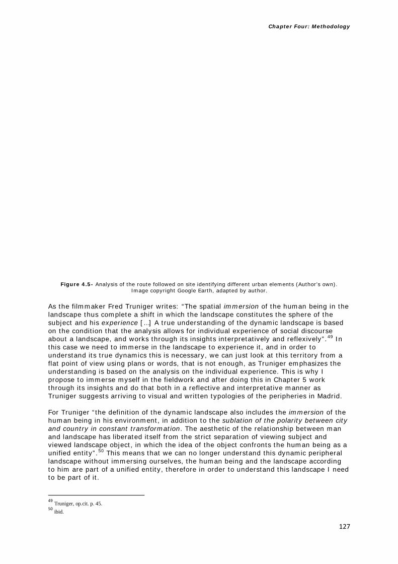
Chapter Four: Methodology
127
Figure 4.5- Analysis of the route followed on site identifying different urban elements (Author’s own).
Image copyright Google Earth, adapted by author. As the filmmaker Fred Truniger writes: “The spatial immersion of the human being in the landscape thus complete a shift in which the landscape constitutes the sphere of the subject and his experience […] A true understanding of the dynamic landscape is based on the condition that the analysis allows for individual experience of social discourse about a landscape, and works through its insights interpretatively and reflexively”.49 In this case we need to immerse in the landscape to experience it, and in order to understand its true dynamics this is necessary, we can just look at this territory from a flat point of view using plans or words, that is not enough, as Truniger emphasizes the understanding is based on the analysis on the individual experience. This is why I propose to immerse myself in the fieldwork and after doing this in Chapter 5 work through its insights and do that both in a reflective and interpretative manner as Truniger suggests arriving to visual and written typologies of the peripheries in Madrid. For Truniger “the definition of the dynamic landscape also includes the immersion of the human being in his environment, in addition to the sublation of the polarity between city and country in constant transformation. The aesthetic of the relationship between man and landscape has liberated itself from the strict separation of viewing subject and viewed landscape object, in which the idea of the object confronts the human being as a unified entity”.50 This means that we can no longer understand this dynamic peripheral landscape without immersing ourselves, the human being and the landscape according to him are part of a unified entity, therefore in order to understand this landscape I need to be part of it.
49 Truniger, op.cit. p. 45. 50 ibid.

Chapter Four: Methodology
128
4.3 Methodology: Photography as a tool to study the periphery of Madrid and a proposed cartography for the periphery There is a passage in a text by Italo Calvino called Cartography, Narrative, Journey that describes clearly the processes and tools used in this fieldwork (see Figure 4.6). First you look at a map of the place that you want to investigate which represents that surface or area of study. You use a tool like Google Earth which allows you to see the places almost as he describes as an extra-terrestrial gaze from your home computer, you look at the place like a voyeur, you can see without being seen, you can observe without touching, or being in that place. As Stefano Boeri writes: “Satellites have undermined a deep conviction in both architecture and town planning: in order to understand the territory better it is necessary to see more of it”.51 You just look at that map to trace your journey. But then when you are there you trace your own itinerary by walking, and you divide it in stages so you can comprehend and understand the path you took, the journey you started. The journey can then become a narrative of the path that you followed, a line drawn on a map. But in order to explain that journey between space and time you need the image. The series of images of that journey can give you the traces, and are the record of what you saw; they become a visual narrative and cartography of the object of study. The importance of the image into the narrative about the object of study, and in order to allow me to analyse the traces of time, in a certain space is important. That is where photography meets the ground, the path, the journey. That is how I can understand the processes that I see. These narratives mentioned by Calvino that I create also have importance in relation to the meaning and the signals I receive to create an inventory or a cartography for the city. Ignasi de Solà-Morales writes: “Because we have already seen or are going to see some of these places, we consume this semiological mechanism of communication, and the memories that we accumulate through direct experience, through narratives, or through the simple accumulation of new signals produce our imagination of the city”.52 When I take a photograph I capture the world and the place I visited or that I studied. It is like owning that object, that instant in time that allows us to see what we saw, because we captured it. By looking at the image I understand in retrospect what I saw. There is a clear relationship in that passage by Italo Calvino between the images, and the journey. I returned from our journey and my travel, and I see the pictures that allow me to create a visual narrative that informs my written passage and vice versa. In her essay In Plato’s Cave the American writer Susan Sontag talks about the importance of using photography and images to collect the world we observe: “This very insatiability of the photographing eye changes the terms of confinement in the cave, our world. In teaching us a new visual code photographs alter and enlarge our notions of what is worth looking at and what we have a right to observe. They are grammar, and even more importantly, an ethics of seeing. Finally, the most grandiose result of photographic enterprise is to give us the sense that we can hold the whole world in our heads- as an anthology of images. To collect photographs is to collect the world. […] To photograph is to appropriate the thing photographed. It means putting oneself into a certain relation to the world that feels like knowledge- and therefore, like power”.53 Our eye when taking a photograph is selecting the very essence of what we want to look at. The photographs are the grammar of the language I want to learn, or find something out about. In this case the photographs of Madrid’s periphery are the selection by the 51 S. Boeri, Uncertain state of Europe (Milan; London: Skira Editore; Thames & Hudson, 2002), 429. 52 Solà-Morales, op.cit. p. 119. 53 S. Sontag, “In Plato’s Cave” (1973) in S. Sontag, On photography (London: Penguin Books, 2008), 3-4.

Chapter Four: Methodology
129
photographer’s eye of the things I want to study and look at on the ground. When I look at the photographs after the fieldwork, I feel that that I can collect the world in my head as Sontag refers to in a series of images. Then these images would allow me to develop a grammar of the object I am studying in this case the Madrid’s Northern and Southern peripheries. Davide Deriu also writes about the importance of using photography in the peripheries and the city: “It is, at present, the preeminent medium in contemporary art for the representation of the landscape. Until around the turn of the ninetieth century, this privilege lay with easel painting as the principal field of representation […] by the early twentieth century photography has supplanted painting […]in the field of architecture and town planning, the current interest in film and time –based media in landscape representation has historical links to the perception of landscapes in motion”.54 In order to understand this landscape we need to use photography as a medium as it is intrinsically connected with these areas of continuous transformation. He even makes a connection between the terrain vagues of Ignasi de Solà-Morales and the use of photography: “Beyond the mid-1990s photographic works that acted as catalysts for this novel architectural approach, terrain vague, has also come to occupy an increasingly important place in more recent photographic practice and discourse”.55As Gabriele Basilico writes about using photography: “And even the end of the day photography cannot in fact change the fate of the city or exert a determinate influence on political and urbanistic options, the important thing is that it has the chance to create a sensibility for the interpretation of the resigned, chaotic, indecipherable world that lies before us”.56 Photography allows me to interpret these territories that seem indecipherable and build a series of images that not only select fragments of these spaces, but are open to interpretation allowing me to describe narratives from the images and from my walks throughout the fieldwork. It is a collection of these images that are part of the overall grammar of these spaces. An interesting aspect of taking photographs is both the analysis and interpretation of that material. Fred Truniger writes that: “The analyses of the filmic translation of the landscape […] consider not only the image of the landscape, but also the invisible qualities of the lived environment, which significantly influences our daily interaction with the landscape”.57 So in order to understand the images we also need the immersion in the landscape and the narratives that result from this experience. So the image by itself is not enough. He describes this as a: “The evidentiary method of clues” is unconditionally bound to the concrete, and thus, to the complex web of social and individual processes”.58 He continues by saying “the classification of a phenomenon (or a group of phenomena) within a category-bound necessarily to work with clues. It must furthermore understand these clues in relation to their context. The interpretative dimension of this epistemology is anchored with the person or persons who evaluate the clues”.59 This means that in order to understand the clues that the images give me this relationship between the image and the clues, is based on the individual processes, and by interpreting these clues I can arrive at categories and a phenomena and a classification and that this interpretation is bound with the person that evaluates these clues. Therefore in Madrid for the methodology I propose to look at the images produced during fieldwork and extract the clues that I develop through the narratives in order to arrive at the categories of the peripheral areas in the case study. By extracting these
54 D. Deriu, K. Kamvasinou, andE. Shinkle (eds) Emerging landscapes: between production and representation (Burlington, VT: Ashgate Publishing, 2014), 6. 55 ibid. 56 Basilico, op.cit. p. 9. 57 Truniger, op.cit. p.46. 58 ibid. 47. 59 ibid. 47.

Chapter Four: Methodology
130
clues from the images and interpreting them through narratives after immersing myself in the landscape I will arrive at a series of categories both visual and written. Truniger writes that in relation to clues: “when it departs from the strictly observatory mode and enables observations to lead to the act of interpretation is also the moment the term “the narrative” comes into view”.60 It is only after observing the image that we can interpret it and arrive at a narrative in this case. Therefore the narrative in the fieldwork in Chapter 5 arrives after the image extracting the clues, and after interpretation is translated into to a series of categories. As explained in this chapter I started to look at the work of Aldo Rossi and Venturi and Scott-Brown as two of the most relevant manifestoes in the 1960’s that were theorising about the city. From Rossi I took the concept of creating a theory of the periphery in a similar way as he did for the traditional city then, and from Venturi and Scott-Brown the idea of the Strip and the way they looked at the environment in Las Vegas in their Studio Notes. However, since then even Rossi himself has subsequently referred to the city by parts which is connected with Boeri’s concept of the polycentric city. Boeri also mentions the importance of new tools and the need of multiple approaches to understand the peripheral condition. Whilst using Venturi and Scott-Brown’s notion of the Strip and the Studio Notes as tools I propose to look at the case study not from behind the windscreen the car but by walking, and using photography and narratives to explore these new areas. From this point of view the work of Francesco Careri on walking in these nomadic spaces is useful as a new tool that is different from viewing these areas from the car (Venturi and Scott-Brown). These nomadic spaces defined by Careri also have other definitions, such as Ignasi de Solà-Morales’ terrain vague and Abalos and Herreros’ areas of impunity. Boeri’s and also to Basilico’s work refers to photography and places as fragments that allow us to establish relationships and to arrive at certain categories through images in their work and methods. The idea of nomadic walking is supported by Careri and his concept of Transurbance but is also emphasized by geographers such Ash Amin and Nigel Thrift. As stated, from this point of view I take these approaches and the essay by Italo Calvino Cartography, Narrative and Journey (see Figure 4.6) to propose a 4 stage approach during my walks (path, line that becomes architectural object and narratives) but I also propose three different scales to look at the case study using photography. Both Sontag, Basilico and Berger mention the importance of photography and Berger particularly its relationship with memory, words and images which is connected to my proposed methodology. Deriu, and Basilico mention the importance of photography in recording these terrain vagues. Basilico like Truniger explains the role of photography for interpretation and comparison in order to arrive at a grammar or a series of categories that define the theory of the architecture of these places. Truniger explains the critical importance of immersing ourselves in the landscape in order to reflect and interpret it and to arrive at narratives and categories and this is not possible to achieve just from the window of a car. This is connected with Berger’s idea of using words to describe the environment that we perceive. The combination of these approaches and the tools that I propose work as a way in which to assemble all these different ideas in order to understand the peripheral condition in Madrid.
60 ibid. 48.

Chapter Four: Methodology
131
Figure 4.6- This image shows the passage by Italo Calvino Cartography, Narrative, Journey. I highlighted in red the words that relate to my chosen methodology combining photography, and walking highlighting the importance of images in developing a cartography for Madrid. The images from top to bottom show:1. The
itinerary I followed, 2. The image of the Madrid periphery and this collection of images will develop a cartography, 3. The image I took of the ground in one of the areas of impunity, or nomadic spaces. Highlighted
in white in the photographs are the words taken from Calvino’s passage that explain the methodology that I followed and the ideas behind it. Image copyright Google Earth, adapted by author, all other images taken by
the author during fieldwork.

Chapter Four: Methodology
132
This shows the importance of narration in the methodology, as Truniger writes: “Narration thus becomes a way of reading clues by integrating facts and precise observations in a plausible overall form; it is a model that thereby enables the primary role of understanding and communicating the historical and social development of a landscape”.61 In order to understand this landscape, I have used narratives as a way of reading the clues that I gathered from the fieldwork images as we will see in Chapter 5. This emphasizes the importance of narratives from a research point of view: “The reader of clues is, in other words, a researcher within a complex science, in which historical developments must be represented independently of social realities. To this end, plausible and contextualising narratives are particularly appropriate”.62 However subjectivity is also an important part of this process as he writes: “The “intellectual effort” comprises taking into account the role and predisposition of the describing author, who himself is deeply interwoven into the culture’s web of meaning. It is unavoidable that subjective, culturally encoded perspectives seep into any description”.63 In order to overcome that subjectivity which is unavoidable in the narrations described in Chapter 5, all these narratives are then compared with the objective literature that emerges from the clues of the narratives, before establishing any categories for the case study areas. Like Susan Sontag, Ignasi de Solà-Morales in his essay Terrain vague explains the importance of using photography as a tool in representing the modern metropolis: “The representation in various media has had at its disposal one particularly privileged instrument since particular instrument since its beginnings: photography. Generated by technological apparatuses dating from the period of expansion of the great cities, images of Paris, Berlin, New York, and of the inhabited continuums of the first, second, and third the world enters our memory and our imagination by way of photography”.64 Here he does not only emphasize the importance of photography in relationship to the city, but also in the context of the early 19th century expansions of both European and American cities when these cities grew out of their limits creating the first historical peripheries. 4.3.1 Methodology: Photography as a tool proposing three different visual scales for the periphery During the fieldwork I proposed to take photographs from three different scales; that of the photographer looking at the city’s landscape, followed by the point of view of the architect who designs buildings, and finally of the citizen’s that live in them or simply walk through these areas. These three different scales are vehicles into which information can be collected to provide me with a better understanding of the modern metropolis. Ignasi de Solà-Morales also reiterates the importance of these different views in which to look at the city: “Landscape photography, aerial photographs, and photographs of buildings and of the people living in big cities constitute a principle vehicle for information that makes us aware of the built and human reality that is the modern metropolis”.65 However there are certain problematic areas worth pointing out, the moment we photograph something we are already selecting what we want to emphasize. One could say that we have somehow a prefigured eye, and that this does not allow the viewer to be totally objective in relation to the object of study.
61 Truniger, op.cit. p. 48. 62 ibid. 50. 63 ibid. 51. 64 Solà-Morales, op.cit. p. 118. 65 Solà-Morales, op.cit. p. 118.

Chapter Four: Methodology
133
This problematic relationship between the importance of photography as a tool in relation to this study but also the fact that we are pre-conditioned before we take a picture to select already what we want to frame is clear but it is still necessary in order to understand the object as Solà-Morales writes: “Not only is the possibility of accumulating direct personal experiences in places in which one has not lived for a long time, but our gaze has been constructed and our imagination shaped by photography. Of course we also have literature, painting, video, and film, but the imprint of the photographic (that “minor art” as Pierre Bourdieu would have it) continues to be primordial for our visual experience of the city. […] As Rosalind Krauss has shown, photography operates in semiological terms not as an icon but also as an index. […] When we look at photographs, we do not see cities-still less with photomontages. We see only images, static framed prints. Yes by the way of the photographic image we receive signals, physical impulses that steer in a particular direction the construction of an imaginary that we establish as that of a specific place or city”.66 It is important to understand that even though I accumulate personal experiences, and also I pre-select what I look at the moment I press the click button on my camera, photography still provides me with a tool that can provide not just an image but also an index and a grammar by which I cannot only frame the object of study, but also in order to look at the image and receive certain signals or directions that lead me in a certain direction in order to construct categories or indexes of the city’s periphery. Solà-Morales writes further on this paradox: “Contemporary photography does not fix on these terrain vagues innocently. Why does this kind of landscape visualize the urban in some primordial way? Why does the discriminating photographer’s eye no longer incline toward the apotheosis of the object, the formal accomplishment of the built volume, or the geometric layout of the great infrastructures the fabric of the metropolis? Why is this landscape sensibility, potentially unlimited to this artificial nature populated by surprises, devoid of strong forms representing power?”. 67 This interesting observation confronts me with the reality of the use of these type of landscapes in representing urbanity, in the pre-selection of the image the photographer according to Solà-Morales does not focus in the immediate object but in the landscape that represents the urban with a certain fascination to the photographer’s eye. As the photographer Josep Vicent Monzo writes: “Whatever the artist seeks, whatever tools he uses, the final result always contain the traces that will remind us of the moment and space from which they were extracted. I do not think there is more than one human language, developed through speech, writing, painting, architecture, photography… New technologies open up new venues, and the threshold of contemporary art has been marked by the use of photography”.68 When using photography I have the traces of that specific moment and time when I used the camera to collect the subject of study in front of me and other tools such as walking and narratives to describe what I see in front of me. The other two scales that I took in this fieldwork were that of the architect and the citizen or the person inhabiting these spaces. Solà-Morales writes about this relationship between the architecture of the terrain vagues and the inhabitant: “The Romantic imagination, which still survives in our contemporary sensibility, feeds on memories and expectations. Strangers in our own land, strangers in our city, we inhabitants of the metropolis feel the spaces not dominated by architecture, as reflections of our own insecurity, of our vague wanderings through limitless spaces that in our position, external to the urban system, to power, to activity, constitute both a physical expression
66 ibid. 118-119. 67 ibid. 120-121. 68 J. V. Monzo, “The city observed” in G. Basilico, et al. Milan, Berlin, Valencia: Institut Valencià d’Art Modern, 12-VII / 30-IX, (Barcelona; Valencià: ACTAR; IVAM, 2001), 15.

Chapter Four: Methodology
134
of our fear and insecurity our expectation of the other, the alternative, the utopian, the future. Odo Marquand has characterized the present as “the epoch of strangeness in front of the world”. […] the post conventional epoch is the fleeting relationship between the subject and her/his world, conditioned by the speed with change takes place”.69 This interesting comparison between the inhabitants and the peripheral spaces shows the condition of the modern man/woman and his/her relationship to the world, we feel like strangers in our own land, in a world that changes too fast, these peripheral spaces are both an expression of the limitless places that we can wander through, but also the manifestation of the current society where space constantly fluctuates, and changes. The relationship between this inhabitant that is lost in their own land and place, is reflected in the way these spaces are defined as vague, and areas that are nomadic and constantly changing. That is why it is important to photograph the place as the inhabitant sees it, with that eye that wonders in the periphery. The reflection of our strangeness in the world, is the reflection of the city that is also constantly changing and moving, as I move through it: the periphery as it is explained by Solà-Morales: “The photographic images of the terrain vague are territorial indications of strangeness itself, and the aesthetic and ethical problems that they pose embrace the problematic of contemporary social life”.70 The inhabitants of these places do not only feel like strangers in their own country. Francesco Careri describes further how the inhabitants of these peripheries have inhabited these spaces: “The inhabitants of this city, the “diffuse settlers”, were people who lived of the most elementary civil and urban laws, inhabiting only the private space of the home and the automobile. Their only idea of public space was the shopping mall, the highway rest stop, the gas station and the railroad station”.71 He even goes into explaining how these diffuse settlers use these spaces and voids: “These were the places where “the diffusion dwellers” went to grow vegetables without a permit, to walk the dog, have a picnic, make love and look for shortcuts leading from one urban structure to another”.72 The point being that what is most alienating about European cities is that traditionally the people described by Careri were those living in the outskirts of the city, and in most European cities traditionally we live in the centre, but that has dramatically changed in recent years, as Stefano Boeri writes: “Today 60% of the European urban population live outside the limits of the city that was built and consolidated by the end of the second-half of the last century”.73 In this kind of context and looking at the spaces inhabited by the people using these spaces I took a series of photographs using the eye of the citizen, and found interesting results in the different areas that I walked through during the fieldwork (see Figure 4.7). Furthermore, the perspective of the architect in relation to these peripheries is different again from that of the inhabitant and the photographer. As Solà-Morales writes: “In this situation the role of the architect is inevitably problematic. Architecture’s destiny has always been colonisation, the imposing of limits, order and form, the introduction into strange space of the elements of identity necessary to make it recognizable, identical, universal […] When architecture and urban design project their desire onto a vacant space, a terrain vague, they seem incapable of doing anything other than introducing violent transformations, changing estrangement into citizenship, and striving at all costs to dissolve the uncontaminated magic of the obsolete in the realism of efficacy”.74 In this context it is difficult for the architect to introduce any form of order into the peripheries, these areas are nomadic, they are constantly changing, and as voids they fluctuate. In
69 Solà-Morales, op.cit. p. 121. 70 ibid. 71 Careri, op.cit. p. 180-181. 72 ibid. 73 S. Boeri, L ’anticitta (Roma: Laterza, 2011), 29-30. [Author’s translation]. 74 Solà-Morales, op.cit. p. 122-123.

Chapter Four: Methodology
135
some ways the idea of control and limits dissolves in these spaces, but it is actually those qualities that make them a more interesting territory to study. Another difference between the perspective of the architect and the photographer is the social function as Gabriele Basilico writes: “it is obvious that there is a crucial difference between the work of a photographer and an architect, which always has a social function. Architecture is above all an object to be used. In this sense, the architect task is full of responsibility, bonds and constrictions. I think that, up to a point, photography allows one to reorder the chaos in front of our eyes, which is a common, repeated feature of the urban landscape. We can talk about this viewpoint, but only in terms of metaphor, of theory”.75 That is why the architect’s perspective looks at the buildings, the places where people have to live, so in some aspect this perspective carries in some form a social function as the architect’s objects are used, where the photographer’s landscape offers just an image of the spaces. However an interesting point that Basilico refers to is that capacity to reorder the chaos that photography has and what he describes as talking about this viewpoint in terms of metaphor and theory: here the photographs are seen as tools that allow me to generate that theory of the peripheral spaces that I am seeking in my hypothesis. As Francesco Careri defines the interventions in these peripheries by architects: “From this position the architects approached the thing the way the doctor approaches a patient: it was necessary to cure the cancer, to restore order […] Design would have to work on these areas and bring new portions of order into the chaos of the periphery: to re-connect and re-compose the fragments, to saturate and sature the voids with new forms of order, often extracted from the quality of the historical city. Even today many architects approach the cancer of the periphery with these intentions of these operative modes”.76 This new city is seen as a cancerous extension, as a non-city clinging to the backdrop of the existing city, however as mentioned before, more than 60% of Europeans now live here, so this is the reality, and new ways of thinking about it ought to be explored. If the measures that the architect tried to use here of order and rules, and also the tools used in the historical city, then through photographing and mapping these areas we might understand them better and begin to see new emerging patterns, or if I find any of the elements of the historical city that Aldo Rossi talks about in The Architecture of the City, or any corridors/strips as Venturi and Scott-Brown define them.
75 Basilico, op.cit. p. 17. 76 Careri, op.cit. p. 177.

Chapter Four: Methodology
136
Figure 4.7- From top to bottom images taken from the perspective of the citizen showing the street and the ground 1-Street of PAU Las Tablas, showing an immigrant Chinese shop in the foreground
2- PAU Las Tablas showing street level unpaved and not urbanised 3- An area at the end of PAU San Chinarro and below the building Mirador by MVDRV showing an area in front of the building which is unpaved, with a protective fence in front of the building and an inactive ground floor level without
any business or commercial activities but with 24 hour security cameras

Chapter Four: Methodology
137
In the context of Madrid is important to refer to the work of the Madrid architects Abalos & Herreros. In their essay about the work of Abalos & Herreros From Close To, 77 Cristina Diaz Moreno and Efren Garcia Grinda discuss the use of the following tools in their work:
1. The Project as job of research (see Figure 4.8): “We’ve heard that Abalos & Herreros endlessly claim that they understand the project as a job of research […] That is, to judiciously apply a series of instruments specific to reality so that a potentially problematic situation which proceed from the need to build architecture is transformed into another situation in which the elements are reordered in such a way that the initial difficulty disappears”.78 In this case in Madrid I understand the project as a reduced reality in the study areas to test specific situations using a range of methodological tools, as I have explained in this chapter. The problematic situation in this case is broadly to see if I can arrive at a theory of the periphery, and by applying the methodological tools proposed to the case study areas, the findings and elements will then be analysed and compared (in the North and the South of Madrid) and are then re-ordered to produce a theory of the periphery, which was my original hypothesis and question.
2. The Project as a set of tools (see Figure 4.8): “For Abalos & Herreros each project is an individual entity, a body of research that is no longer to search for true principles or beliefs but about how to produce the necessary tools”.79 In this case the project is also seen as a set of tools that I have defined and produced as I have been working along to determine the necessary approaches to study the periphery. I started looking at Aldo Rossi’s work in Chapter 1, then looked in Chapter 2 at the marginal discourses and definitions of periphery, and in Chapter 3 at the case study from the plans, to the types of periphery to define the study areas, to this chapter where I developed a series of tools to understand my subject of study. In this case I did not look at true principles but also to produce the necessary tools to understand my project and as I went along I also proposed a series of tools (three perspectives to look in the fieldwork, four stages for path, line, architectural object and narrative) to understand the project, but also the importance of walking through the spaces, determines the way I approach my fieldwork instead of, for example, just using the car like in Learning from Las Vegas.
3. Project Design Methods (see Figure 4.8): “Project design means, then, refining work methods as you go along, methods that render the word “problem” irrelevant and meaningless. The adventure of designing would thus be a deliberate, selective and controlled form of behaviour by means in which certain things emerge, surprising us”.80 Project design means, in this project, to continually refine my working methods as I have gone along, using collage, and different techniques and a mixed range of methods for the project. For example, the preparation that I did before carrying out the fieldwork (the selection of satellite based maps from Google Earth, walks etc.) then was not exactly, as you will see in the next chapter, the routes that I followed as when I walked, because as I was walking other aspects that interested me more emerged and I was compelled to divert from my original route.
77 C. Diaz Moreno and E. Garcia Grinda, “From Close To” in F. Beigel, Ábalos & Herreros (Barcelona: Editorial Gustavo Gili, 2002), 17-25. 78 ibid. 18. 79 ibid. 18. 80 ibid. 18.

Chapter Four: Methodology
138
In order to summarise these concepts as a series of tools for my own project, I have developed a series of diagrammatic project tools (see Figure 4.8) from the theoretical approach by Abalos & Herreros.
Figure 4.8- Tools for the project of the Madrid periphery (adapted from A&H). Author’s own
Another interesting condition of the work of Abalos & Herreros is the condition that they refer to as ecomonumentalism, a concept which they explain as follows (please see Figure 9): “The project is validated insofar as it constructs a complete re-description of the place, as it primarily proposes the invention of a topography. This dual movement from nature to the project and from the project to nature thus resuscitates an ‘ecomonumental’ condition which is beginning to push inexorably beyond any argument of opportunity, in a way that others would not hesitate to call “the spirit of the times” or the “desire of a period”.81 We have seen in Chapter 1 this condition of the peripheries as a place where nature meets the urban, and also what they defined as descampados or areas of impunity (both terms share these qualities). Having taken the elements from their work that were appropriate for this project as a set of tools, as a body of research, and as a way of testing design methods along the way, (see Figure 4.8) I take this a step further after carrying out the fieldwork and testing the methodological tools of the project, by reflecting on whether, and if so how, I can arrive at a new topography as Abalos & Herreros refer to (see Figure 4.9). Moreover, I will see if this eco-monumental condition (that has the conditions of a dual movement between nature to the project and the project to nature) appears during the fieldwork.
81 ibid. 29.

Chapter Four: Methodology
139
Figure 4.9- Invention of a new topography and a re-description of place as a result of this shift in theory
in relation to location, leading into what A&H call Eco monumental condition. Author’s own
4.3.2 Photographs, Fragments to produce peripheral categories and narratives Ignasi de Solà-Morales explains the importance of photographing these peripheral areas: “Empty, abandoned space in which a series of occurrences have taken place seems to subjugate the eye of the photographer. […] photography communicates not only the perceptions that we may accumulate of these kind of spaces but also the affects, experiences that pass from the physical to the psychic, converting the vehicle of the photographic image into the medium through which we form value judgements about these seen or imagined places”.82 It is that shift he describes from the physical to the psychic that uses the medium of photography as a vehicle to conform our judgement of these places. Stefano Boeri writes about alternative ways of looking at the periphery: “More astute in interweaving points of view, the Eclectic Atlases propose a visual plural thinking that has abandoned the utopia of a global vision for an optimised angle of observation. Their more interesting characteristics are that they are sympathetic towards their field of observation; they use an eclectic look to see an eclectic territory”.83 A series of methods are required to explore this territory that is also eclectic. I mentioned in Chapter 2 the importance of using collage as a tool to connect all the different elements that constitute the periphery and understand this new urban condition and answer the question that this thesis investigates.
He writes about the importance of photographing these peripheral areas: “In the last two decades, the exploration of the periphery changes radically entering a new direction; the body of the photographer enters inside the new urban heart—in the “voids” of the
82 Solà-Morales, op.cit. p. 119. 83 S. Boeri, L’anticittà (Roma: Laterza, 2011), 61. [Author’s translation].

Chapter Four: Methodology
140
abandoned industry or in the historic degraded districts—to the research of the areas of deterioration, and suffering”.84 Photography is seen here as a way to enter these “voids”, and these territories that are constantly changing. The Italian photographer and architect Gabriele Basilico emphasizes this close relationship between photography and the city: “It is as though the eye merges with the city itself. Like an animal whose coat takes on the colours of the city”.85 The only way to understand this type of city is through photographing it and immersing myself in it, and by doing that understanding it better.
He refers to a specific project in Milano where he works with other architects to see the city through photography (see Figure 4.10). He writes: “My contribution to the conference ’Tre viste su Milano [Three views of Milan] organized at the Milan Triennale in 1994 by Stefano Boeri, Gianpero Bosoni and Cino Zucchi. Images of Milan were shown in sequence on the first screen, where in the second there were images of other European cities. The aim was to accompany Milan, through a rhythm of visual analogies, in which the notion of a global place, constructed of fragments of different places, would predominate. This project of a hybrid city, obtained by means of a sequential montage, became a model adopted and tried out in subsequent works such as ‘Cityscapes’ in 2000 and ‘Milan-Berlin-Valencia’ in 2001. Here he emphasizes the importance of those fragments in order to give an image of the city as a subject of study.
In Chapter 5, I present photographs of the different fragments of the North and South of Madrid in order to make a montage of the visual catalogue of the city. I am not comparing Madrid with other cities, but I am comparing different areas of the metropolis and its peripheries as a model with which to study it and as a way of analysing the city. It is interesting that Basilico mentions immersing ourselves in the city in order to understand it, as one could say that the fragments show this hybrid city that he refers to, which is still in transformation. And this also ties back into the methodology that I have followed of walking and immersing myself in the case study areas, but combining it with the narratives from my walks. Photography is a way to understand the city, and it has always been since the 19th century until today. These collections of fragments are a way to create the models or the catalogues of these territories.
As the Portuguese architect Eduardo Souto de Moura writes in reference to the photographic work of Gabriele Basilico: “Gabriele Basilico is a man of the tendenza, a friend and admirer of Aldo Rossi. He registers the city fragment by fragment, separating them in time and space, fixing them on paper. His photographs are instruments of a project, going from Colin Rowe’s Collage City to Aldo Rossi’s Cidade Analoga”.86 Here I can see a clear relationship between photography in his work and a connection of the fragments to la tendenza and the work of Aldo Rossi that I refer to in Chapter 1 and the way these fragments are registering the city. In this connection of his work and the city the photographs become part of the project. And in the case of this thesis as I explain in Chapter 5 the photographs of the city are part of the architectural project that I set out to present with this work.
As Souto de Moura writes: “Today peripheries, so much criticized and neglected by politicians, should be our main laboratory. Gabriele Basilico show us that this is where we find tensions, super positions, voids, the persistence of types, the relinquished ephemeral, the half-breads of old and new, large and small, the ruptures of scale. This is where we can register and construct a ‘visual dictionary’ of expansion, enlargements, demolitions, residues of things that used to be or still have not been materialised”.87 In
84 ibid. 85 G. Basilico, “A ‘Perhaps’ City Telephone conversation between Hans Ulrich Obrist, Stefano Boeri and Gabrielle Basilico” in G. Basilico, Berlin (London: Thames & Hudson, 2002), 6. 86 E. Souto de Moura, “Gabriele Basilico-Architect Photographer” in G. Basilico, et al., Milan, Berlin, Valencia: Institut Valencià d’Art Modern, 12-VII / 30-IX, 2001 (Barcelona; Valencià: ACTAR ; IVAM, 2001), 27. 87 ibid. p.29

Chapter Four: Methodology
141
this sense the periphery is my laboratory for investigation, that space where I look at the project in practice to test the different theoretical positions of my work in this thesis. In this chapter I have explained my methodological approach, but in the Chapter 5 I will explore in this laboratory through fieldwork these voids, and spaces Souto de Moura describes to develop a visual dictionary or catalogue of these spaces after registering the images and narratives taken from them.
The photographs here are not the only instruments I used for the project, but as I explained in the previous chapter the work of Abalos & Herreros also uses the project not just as research but also as a set of tools to explore different issues (see Figure 4.8). I am doing this with my methodology where the project is a work of research (trying to understand the theory of the periphery both visually and its characteristics) but also as a set of tools that I propose in order to do this project that (connecting theory and practice together) forming a collage of fragments that describe the study as a whole.
The next chapter will test all these tools proposed in the case study areas in the North and the South of Madrid using photography, walking, images, and narratives, and introduced the “worked example” in Leganes and explore the methodology further.

Chapter Four: Methodology
142
Figure 4.10- From top to bottom & from left to right: Top Beirut 1991, Roma 1989, Porto 1995
The three images by Gabriele Basilico show a comparative photographic approach to the cities as a series of fragments comparing the three different metropolises Bottom: the three images by Basilico from Valencia’s periphery showing different parts of the city left: the motorway next to the peripheral areas. Middle: big scale open spaces in front of existing residential peripheries right: new residential areas in the periphery in front of areas of impunity. A similar approach of photographing different
areas of Madrid has been adopted for this study. All images taken from G. Basilico, “‘Perhaps’ City Telephone conversation between Hans Ulrich Obrist, Stefano Boeri and Gabrielle Basilico” in G. Basilico, Berlin (London:
Thames & Hudson, 2002), 24-25 (top image), 135-139-172 (bottom images: left, middle & right).

5

Chapter Five: Research Findings
144
CHAPTER FIVE: RESEARCH FINDINGS
In the last chapter I introduced the methodology that was developed and implemented for all the fieldwork undertaken in Madrid, which involved a substantial immersive study of five peripheral areas in the city. This chapter however, is focused on a detailed study of one of these areas, Leganes, but first it will introduce the key findings of the overall fieldwork from both the areas in the North of Madrid (Telefonica City, PAU Las Tablas and PAU San Chinarro) and the South (PAU Carabanchel and the Tertiary Corridor in Leganes). The exact locations of these areas are shown in Figure 5.1. Full fieldwork notes, together with the relevant photographs, narratives, and analytical tables for all five areas are included in Appendix 3.
Figure 5.1- Map showing five different areas of study in the North and the South of Madrid: Telefonica City (in yellow), Las Tablas and San Chinarro (in purple), and Carabanchel (in purple) and Tertiary Corridor in Leganes (in orange). Madrid City Centre (in white), and the Ensanche 19th Century Extension (in red). Image copyright
Google Earth, adapted by author.

Chapter Five: Research Findings
145
These areas were identified and established through the literature review carried out in Chapter 3, and involved three Urban Action Plans (PAUs), one corporate city (Telefonica City) and a Tertiary Corridor in Leganes (which incorporates a new University Campus and a train station that connects the town with the city centre in less than twenty minutes). All the areas were built from scratch apart from the periphery in Leganes, which was built next to the existing town of Leganes (a peripheral working class town developed mainly during the 1960’s to accommodate workers who came to Madrid from other parts of Spain).
The areas were selected to show different samples or study areas of periphery in the city, and to allow a discussion and a comparison. It is worth stating that the North of the City is generally wealthier than the South, and that the fieldwork study was carried out during the winter time of December 2013. The study was carried out by walking, photographing and taking notes both during and after the fieldwork for all the aforementioned areas which are included in Appendix 3 as lab notes, together with instructions which explain what approach was undertaken for analysis. The particular areas on which I concentrated were first identified using Google Earth before undertaking the fieldwork. The reality of what I found during the field work was very different from what I originally saw on Google Earth. The findings are connected with my own assemblage of ideas and narratives and the images are resituated as a graphic recording of the peripheral city. The ‘real time’ experience of walking in all these areas is explored further with the subsequent analysis of the images with reference to the theories and ideas I explained in Chapter 4. As Mark Dorrian writes: “the aerial photograph, remade on the basis of these lines, is grafted into the map; and the resultants assemble is resituated, and re-performed, within the context of the narratives which are the prompt for a graphic recording of the city”.1 This quote reinforces the importance of the approach adopted during the fieldwork: the original image of the aerial picture taken before the fieldwork from Google Earth is then both resituated and re-performed in the context of the narratives, notes and photographs which allowed me a graphic recording of the city. In Chapter 6, I will discuss my own categories under the three different scales of the photographer, the architect and the citizen that I developed in my own fieldwork together with my own narratives (which are in the lab notes in Appendix 3).
In this chapter I will describe and explain my findings, what I learnt and what I decided to leave out through this kind of immersive study. The first part of this chapter is a summary of the key findings from all the areas studied during the fieldwork both in the North and the South of Madrid, to give the reader an overall idea of the study undertaken, it will then focus on a more detailed study of Leganes, which is the only one of all the areas from the study where the new periphery has been built next to an existing settlement rather than from scratch.
I will illustrate my discussion with a typical walk as a ‘worked example’. In this example I will introduce the idea of a new cartography based on the direct observations of an immersed observer that goes beyond conventional plans and planning, and which I argued in Chapter 1 is necessary for capturing the important features of these ‘placeless’ places. The area chosen as the ‘worked example’ is Leganes. Of all the areas studied, this one is the crucial case study for someone looking to discern legibility in the periphery because in Leganes, the ‘old’ city centre meets the ‘new’ periphery. As Mary Lou Lobsinger writes in relation to the Aldo Rossi’s ideas concerning the periphery, Rossi “argues that architects should work where the ruptures between the old and the new are most legible”.2
This new cartography not only goes beyond the validity of the current terms reviewed in the literature, but also goes beyond the precision and issues registered by existing 1 M. Dorrian, and A. Hawker, Metis: urban cartographies (Black Dog Pub, London, 2002), 10. 2 M. L. Lobsinger, “The New Urban Scale in Italy: On Aldo Rossi’s L’architettura della città,” Journal of Architectural Education, 1966: Forty Years After 59:3 (February 2006): 34.

Chapter Five: Research Findings
146
cartographic techniques bridging the gaps between theory and project: this will be explored in a number of ways in this chapter. Firstly I will deliberately apply and extend Rossi’s categories to the periphery, showing examples of memory and permanence here. I will also describe what I found in terms of typologies (which is one of the four categories I am using from Rossi) to explain this new cartography. This will establish what the typologies of the periphery appear to be (I will introduce a range of new typologies including buildings, paths, edges, trash, car lanes, parking lots, curbs), as well as the typologies of the Strip/Corridor, and what the traces of the past (referring to Rossi’s memory and permanence) are in these terrains vague.
Secondly, I will analyse the typology of the Strip/Corridor in Leganes in relation to the literature reviewed in Chapter 3, this is a Tertiary Corridor, but I will also connect this to the idea developed in Chapter 3 of the Ciudad Lineal by Arturo Soria, and to the concept of infrastructure and capitalist development. I argued there that this type of corridor developed in Ciudad Lineal promoted a speculative model of development connected to the infrastructure, and that this kind of model is a precursor to what we see today in Madrid’s periphery. I will apply here the ideas of Venturi and Scott-Brown whose ways of understanding these environments are often associated with the car and the accompanying signs used to navigate these areas by vehicle.
5.1 Typical walk-Worked Example- Leganes
The walk through Leganes took place in December 2013. It started in the centre of the Old Leganes, progressing through the University Carlos III campus and ending up in the train station area. For analytical purposes, I have divided my walk into 22 stages in order to focus and explore the walk in more detail, as shown in Figure 5.2. On a larger scale, the walk can also be broken down in three phases, as set out in Figures 5.3-5.5):
Figure 5.2- Stages of the walk followed on site during the fieldwork (in pink) through tertiary corridor (1-22).
The pink line shows the itinerary of the path that I followed, and the path then becomes a series of architectural objects that are recorded mainly through photography at different stages telling a narrative that
then when analysed and evaluated could become a series of categories or typologies of these peripheral areas. Image copyright Google Earth, adapted by author.

Chapter Five: Research Findings
147
1. The first phase of the walk took approximately one hour and it covered stages 1-11 first through old town of Leganes and then through the University Carlos III.
Figure 5.3- This image shows the first phase of the walk that took approximately one hour and covered
stages 1-11 first through old town of Leganes and then through the University Carlos III. Image copyright Google Earth, adapted by author.

Chapter Five: Research Findings
148
2. The second phase of the walk took approximately half an hour and it covered stages 12-15 first through the University Carlos III and also through the station.
Figure 5.4 - This image shows the second phase of the walk that took approximately half an hour and it covered stages 12-15 first through the University Carlos III and through the station. Image copyright Google
Earth, adapted by author.
3. The third phase of the walk took approximately half an hour and it covered stages 16-22 through the station and included the 1970’s residential areas for workers.
Figure 5.5- This image shows the third phase of the walk that took approximately half an hour and it
covered stages 16-22 through the station and the residential areas. Image copyright Google Earth, adapted by author.

Chapter Five: Research Findings
149
I travelled to Leganes on public transport from Madrid city centre, and it took me one tube to Carabanchel (which I visited first) and then two bus rides between old Carabanchel and Carabanchel PAU, and then from there to Leganes Old Town. The total time of these journeys was approximately an hour and twenty minutes, which is significantly longer in comparison to the twenty-minute journey by train between Leganes new train Station and Atocha Station (the central station in Madrid). This shows that the infrastructure investment really reduces the perceived distance between the periphery and the city centre, managing to connect the city-region in almost record time, showing the importance of infrastructure investment and its connection with development, in this case the University.
The selection of this area was informed by the issues raised and discussed in the literature review (see Chapter 3) and defined accordingly as a Corridor: “[…] backing urban references of traditional centrality, and the low density suburbanisation, first of the higher and mid-income properties, and later in segments of directional activities with a higher added value (financial entities, R+D, directional tertiary sector activity), specialised services (private universities, hospitals…), leisure and commerce (large commercial centres, theme parks…)”.3 More specifically, it would be defined as a Tertiary Suburban Corridor specialising both in services and consumerism: “Development of a range of industrial activities to the South- supported by the Campuses of Carlos III+ King Juan Carlos Universities” 4 (see Chapter 3, Figure 3.5).
Following this definition, in the urban analysis below the corridor typology can be identified in Leganes (Figure 5.6). There, one can see the elements of the corridor: a central new station for Leganes (in orange), a 1970’s residential blocks for workers (in light blue), industrial areas (in grey), car parking (in dark brown), and the new University Carlos III campus (light brown).
The car has an important role in the corridor, the car parking areas allow people to park their cars and connect with the train to the city centre, and there is also a big roundabout (in pink) next to the corridor. There is a clear car based interface between the corridor and the surrounding areas, but also the presence of the roundabout emphasizes this area as a car-dominated environment.
The existing town of Leganes is next to this Tertiary Corridor. The town centre has some community spaces and activities such as pedestrian streets, a town square and a police station. The new roundabout provides a connection between corridor (car dominant) and old-town (tighter urban fabric). The train station and tertiary activities are supported by the University Campus and by the transport infrastructure (both rail and car).
3 J. M. Ezquiaga, “Fragmentation to fractality: the paradoxes of diversity” in A. J. Cantis and A. Jaque, Piensa Madrid = Think Madrid: [José María Ezquiaga, Juan Herreros, Fabio Casiroli ...]. In [Madrid]: (Caja Madrid: La Casa Encendida, 2009), 272. 4 ibid. 274.

Chapter Five: Research Findings
150
5.1.1 Extending Rossi’s typological approach to the periphery of Leganes
The main questions for this PhD developed in Chapter 1 were the following:
1. What are the typologies of the peripheries? 2. What is the new cartography of the periphery that bridges the gap between
theory and project?
This new cartography will be explored by extending Rossi’s typological approach to the peripheries investigating the four categories that I discussed in Chapter 1 (typology, memory and permanence, and capitalist speculative development).
In Chapter 1, I discussed how memory is a quality that Rossi connects with the idea of urban morphology, closely connected with the fact that a city develops over time. Urban morphology holds the idea of collective memory. Developing questions from Chapter 1 in relation to memory, I will discuss here:
· Does the periphery hold memory, and if so how? · What are the artefacts and monuments of these peripheries while looking at the
typologies that emerge from this study?
I will explore and discuss these questions by looking at a series of examples from the walks I took in Leganes, particularly concerning those areas where the old city meets the new city, and deliberately applying Rossi’s categories of both memory and permanence. In order to understand these places I had to be immersed in them, walk through them and photograph them. This is an essential difference from Rossi’s traditional approach which in my opinion does not work and needs to be supplemented by new approaches if we are to better understand these places. Without an immersive approach we cannot ascertain in detail whether the reality is more nuanced than the theory establishes.
Figure 5.6- Analysis of the route followed on site identifying different urban elements (Author’s own).
Image copyright Google Earth, adapted by author

Chapter Five: Research Findings
151
Figure 5.7- First example of Old Leganes meeting New Leganes corridor
In the first example of where the old city meets the new one is shown in Figure 5.7 (Stage 4 of the walk) we can see a pedestrian street in the old part of the city and next to it the new University Campus. However there is no physical connection or permeability between the old building (which is a police station) the new University building, and the urban furniture in the in-between spaces which show various elements aimed at preventing cars entering the old street.
Permanence and memory can be identified in the fact that next to the corridor typology we can see the urban morphology and the collective facilities such as the police station forming part of this space between the old and new city, making this periphery more human than the other peripheries studied (see the lab notes in the Appendix 3). There, in some of the PAUs like San Chinarro and Las Tablas, as well as Carabanchel, the scale of both open spaces and buildings was much bigger, and the urban morphology of the last decades could not be seen in the urban fabric. Moreover, they lacked the collective facilities and smaller urban scale of the local shops at ground level, of the residential buildings in existing town of Leganes.
Memory as a category for Rossi is shown when a city evolves over a period of time: meaning that, memory is registered by urban morphology, and this exists in the example of Leganes more than it does in the other peripheral areas studied. In Leganes the new tertiary corridor does not appear suddenly built in the middle of the countryside, like in the other areas of Madrid. However what becomes apparent too in this new corridor is the presence and dominance of the car, influencing the urban elements and devices (bollards, benches, planting) that prevent it from accessing the public urban spaces of the existing town.

Chapter Five: Research Findings
152
Figure 5.8- Second example of Old Leganes meeting New Leganes corridor
In the second example of where the old city meets the new one in Figure 5.8 (Stage 5 & 6 of the walk) we can see a new roundabout and a small park. The new road infrastructure is giving preference to the circulation of the cars, while pedestrians are overlooked. What is interesting here is that as one becomes immersed more in the corridor and the connection between the old and the new, the control of the car over space becomes more apparent. Rather than having a square at the end of the street, what we have is a roundabout with a monument and a sculpture to the architect Sabatini at the centre of it.5
The concept of the monument and the square as places for people to meet and to represent collective places is here substituted and subordinated by a ‘monument’ to the car. In the old town of Leganes we have a public square, while here in the extension of the periphery with the corridor we have a roundabout.
However, in the area in between the old and new we can find a small square and also the existing housing which still has the small facility of a green space for existing residents and newcomers. I can confirm again in this example that there are more collective facilities here than in the other peripheral areas studied.
The other aspect which is interesting here is the idea that as a result of the priorities of the planners of this infrastructure corridor the two spaces are not being physically connected: the housing and the University. All around the University perimeter the access for pedestrians and cars is restricted. Here the message is clear: the car is the king, and this starts creating a new urban order in the connection between the old and the new city but also space is privatised around the University Campus giving restricted access to both cars and people.
5 Francesco Sabatini (1722 – 1797) was an Italian architect that worked as the Royal architect in the period when Carlos III was the King, being responsible for the mayor works of the transformations of Madrid during the second half of the 18th century. (Author’s translation) Source: http://www.arteespana.com/franciscosabatini.htm [Accessed November 26, 2015] The monument to Sabatini is in Leganes because before the University Carlos III was built around 1994 there was an old barracks designed by Sabatini on the site which was demolished before the construction of the Campus Source: http://elpais.com/diario/1994/11/03/madrid/783865465_850215.html [Accessed November 26, 2015]

Chapter Five: Research Findings
153
Figure 5.9- Third example of Old Leganes meeting New Leganes corridor
In the third example of where the old city meets the new one in Figure 5.9 (Stage 7 & 8 of the walk) we can see a long brick wall next to the railway line, making the interface between the station and the city non-permeable.
Here we see that the new station becomes a new central part of the town, co-existing together with the old centre, both centres complementing one another. The idea of speculative development through infrastructure becomes clearer in this connection, where the heavy investment gives a new order to this existing periphery. The railway connects the periphery with the centre of Madrid in less than twenty minutes, shortening the journey between city and region. It also allows the existing city to become a regional entity and expand through infrastructural investment.
If I compare this to the other peripheral areas studied, the investment in an infrastructure corridor improves the connection to the periphery allowing students and workers to commute between the city centre and the periphery. This new station allows access to the peripheries much more quickly than the other areas, and this makes people less reliant on their cars. All the other peripheries covered in this study are mainly reliant on the car as the main form of transport, apart from Telefonica City in the North that has a dedicated station built to connect the new HQ to the city centre.
In the fourth example of where the old city meets the new one in Figure 5.10 below (Stage 20 of the walk) we can see a massive car park next to the station for people to leave their cars before they take their train. This shows the characteristic of the commuter nature of the town. As one immerses oneself more into the corridor, it can be seen that the increase in the car’s presence is to the detriment of pedestrians. The infrastructure element becomes more apparent in the typology of the tertiary corridor that I established in the literature review in Chapter 3.
In the fifth example of where the old city meets the new one in Figure 5.11 below (Stages 21 & 22 of the walk) we can see the existing industrial uses behind the railway station, clearly showing the nature explained in the theory of the tertiary corridor. This also confirms the concept of the urban morphology of the place being developed over time incorporating the existing residential and industrial uses of the town into the new fabric of the tertiary corridor.

Chapter Five: Research Findings
154
Figure 5.10- Fourth example of Old Leganes meeting New Leganes corridor
Figure 5.11- Fifth example of Old Leganes meeting New Leganes corridor

Chapter Five: Research Findings
155
To summarise these five examples where the old city meets the new, there are certain lessons to be learnt. In the case of Leganes the presence of an existing urban morphology within the areas connecting the old and new city is visible. Next to the corridor we can see existing facilities such as housing, parks, a police station and also industrial uses which were one of the characteristics of this type of corridor in theory, showing presence of permanence of the area’s past history and characteristics. These facilities integrate with the new corridor typology established at the beginning of the study as a tertiary corridor and the infrastructure has been well integrated with the existing town. This integration allows the periphery to have both collective facilities, and an urban morphology that brings the memory of the past to the existing corridor.
Another lesson learnt from these examples is as one goes further into the corridor the presence of the car becomes much more apparent, with devices to stop cars entering the space such as bollards and street furniture. The nature of the space changes, from catering more for pedestrians in the existing town of Leganes to a more car-oriented environment (wider roads, and roundabouts) in the newer development.
The importance of the car is also emphasized more clearly at the end of the corridor where the existence of car parking spaces for commuters shows its relevance.
Also the importance of the infrastructure and the use of this in the speculative development of the peripheral corridor are clear. The periphery connection with Madrid's city centre shows the importance of the peripheral city-region scale increasing and journeys being shortened as a result of this infrastructure investment to support the University Campus. The University is part of the tertiary corridor identified in the literature review in Chapter 3, but as land is cheaper in the periphery this led to both Universities and corporations moving out of Madrid’s city centre.
Another interesting lesson is that the power of the car is clear in this new corridor. Where in the existing town at the beginning of the walk we see pedestrian streets and small-squares with shops, as we penetrate deeper into the corridor we can see that the square is substituted in favour of a new roundabout which represents a monument to the use of the car as described. This change of urban order shows the importance of the car in this new typology. The monument that results from this new corridor typology is a monument to the car, not to the people.
Another lesson from these examples is the presence of physical barriers between the old and the new, for example the perimeter wall stopping access between the University and the town, and the long brick wall next to the station.
What these examples show is that even though we see a new typology in Leganes which we can be critical of, a positive element of this “worked example” is that we see traces both of permanence and memory, including urban morphology and also the support of these collective facilities (a police station, a park, and some small shops) to the new corridor. This is in contrast to the other peripheral areas studied (see lab notes in the Appendix 3) which have been built much more quickly and where the periphery is much greater in scale and is much more disconnected from the rest of the city of Madrid, both in physical terms, and with respect to the concept of memory and permanence for the new people coming to live in the PAUs.
The lessons I learnt through this kind of immersive study are that this combined approach is necessary to explain the nature of these places. This is where the categories used by Aldo Rossi do not work, without adopting the combined approach that I have developed. The reality on the ground is much more nuanced and detailed than Rossi’s theory can explain, so there is a clear gap between the theory and the project. What Rossi offers, however, when his work is applied to the periphery is a clear understanding of which elements of the traditional city (such as memory, permanence and speculative development), the periphery has and which it lacks.
This immersive approach gives a much clearer understanding of the periphery, and the worked example of looking at where the old city meets the new city in particular clearly helps in exploring Rossi’s categories and how they work, or more particularly how far they work, in the peripheries. As the close reading of Leganes demonstrates, Rossi’s

Chapter Five: Research Findings
156
categories and the immersive approach reveal how the periphery can be more appealing and appropriate for people when connected to existing settlements, which is critical in order to make it work more successfully.
Developing this idea, I will next introduce the basis of a new cartography. Using these five examples, which illustrate how I am deliberately applying Rossi’s ideas in the development of a new range of sub-categories while also extending Rossi’s typological approach to the periphery, and illustrating my discussion with what I found in the worked example of Leganes towards the development of a new cartography.
5.1.2 Introducing a new cartography - Typologies
The new cartography developed through these immersive approaches has a series of typologies and new sub-categories that I will illustrate and describe: buildings, paths, edges, security, trash, scrub, curbs, and parking lots. These typologies provide ways of classifying different common characteristics I found during these walks in the “worked example” of Leganes. This cartography allows me to understand these hitherto quite general terms in much greater detail than the author's I refer to in Chapter 1 have been able to do. This cartography goes beyond the scope of the current terms like areas of impunity explaining the reality on the ground in these areas.
As I explained in Chapter 1, typology, as Rossi understood it, has limits in understanding the modern metropolis. Therefore it is necessary to introduce new tools through immersive approaches to understand these places and see what the typologies of the peripheries are. The spaces that we find are what allow the development of a new cartography. As Albert Pope has stated (as discussed in Chapter 1) by developing these new typologies it is possible not only to identify but also to elaborate the unseen potential of the metropolis.
Clearly looking for the traces of permanence and memory also shows the importance of the car in these new corridors (in Leganes and elsewhere), emphasizing the concept of the Corridor/Strip as a typology by itself. I will return to this issue later, making use of the work of Venturi and Scott-Brown, particularly with reference to the presence of signs, automobile and parking lots. Before that, I will focus on questions that emerged from Chapter 1 regarding capitalist speculative development:
· What are the types of residential typologies and collective facilities in these peripheries?
· Do these peripheries serve the interest of the citizens or are they more oriented towards urban and speculative development?
The first typology that I will examine and discuss here is buildings. Traditionally in Spain the residential blocks and commercial units are mixed-use with the units at ground level and flats above (see Figure 5.12 below). In the first phase of the walk (Stage 1) I found low rise buildings of two storeys, integrated in the fabric of the Old Town, in pedestrian streets. As I walked through Stage 4 of my walk into the corridor I found the University Campus Carlos III with a bigger scale of building type constructed in similar architectural style, but instead of being integrated in the urban fabric, it was isolated and enclosed, without any access around its perimeter. The spaces surrounding the buildings were more oriented towards cars (as seen in stage 6 and discussed above: the roundabout).
In stages 6 and 7 of the walk I found the typical private blocks created for workers during the 1980’s (four storeys high) where the presence of signs and cars is more apparent when these residential blocks are next to the tertiary corridor. In the side streets (Stage 14) the residential blocks have more businesses located at ground level, and the street is more typical of the old town of Leganes than to the nature of the new corridor. At the end of the walk (Stage 19) there is the new station in front of the 1970’s private residential buildings. The new building has become a central building in the town.

Chapter Five: Research Findings
157
Figure 5.12- Different building typologies in Leganes

Chapter Five: Research Findings
158
What is clear in this typology is that the new tertiary corridor is well integrated with the existing town of Leganes. This integration becomes less apparent as one goes further out from the corridor where the buildings are more isolated (for example, the University Campus) and the use of the car is more prominent.
The prominence of the car has an effect on the city fabric, causing it to be more enclosed and isolated. However in addressing the questions above, it is clear that in the residential typologies, we can see many more collective facilities and greater integration between the new corridor and the existing town, making the periphery a more human centred place for those who live in it. If we compare the collective facilities available in the Old Town of Leganes, with the new PAUs of Las Tablas, San Chinarro or Carabanchel (see lab notes in the Appendix 3), there is a much better integration between the old and new buildings and the periphery that emerges from this tertiary corridor than in the PAUs that were created from scratch. For Aldo Rossi the success of residential elements depends on the dependency of this with the primary elements such as schools, commercial buildings and hospitals to make the city work.6
The speculative nature of this type of development is much clearer in the University building which is an enclosed and controlled environment without any real integration into the existing town at all. The station, on the other hand, is much more open and integrated to the existing urban fabric. So from these points of view the University does not really integrate with the citizens of this community, but the infrastructure investment of the corridor benefits both users: residents and students.
Figure 5.13- Different path typologies in Leganes
6 A. Rossi, The Architecture of the City (Cambridge, Mass: MIT Press, 1988), 86.

Chapter Five: Research Findings
159
The second typology that I will examine and discuss here is paths (see Figure 5.13 above). In the first stage of the walk (Stage 1) the path was pedestrian in the old town, and narrow, giving a more human scale but with bollards to stop car access. Progressing further into the corridor the path widens (Stage 7) and gets bigger in scale. This is clearly connected to the presence of the car, the paths reflecting the nature of the importance of the traffic by having bigger measures to prevent its access (evident by the bigger plant pots).
Progressing further still in the walk, in the middle of the tertiary corridor the path becomes narrower (Stage 10). The path there is full of signs and the road is bigger than at the beginning of the walk where the corridor was more integrated with the existing town. By the end (Stage 19) the path becomes a wide space without any clear demarcations. Some street furniture is located in the middle of the space, but without it really being either a path or a square.
If we compare the typology of the path with the five examples of permanence and memory examined in the earlier section of this chapter the same pattern can be seen: the path widens and becomes less integrated with the existing town. This is clearly connected to the presence of the car in the tertiary corridor giving a new urban status to the cars in the physical manifestation not only of the nature of the paths, but also in the urban environment.
The third typology that I will examine is the edges (see Figure 5.14 below) that define the areas between one side and another at each boundary of the tertiary corridor. In this case at the beginning of the walk (Stage 4) the edge is formed by a metal fence with some vegetation really separating the street from the University Campus. Progressing further (Stage 7) the edge is just a metal fence in front of the roundabout. The edges show a demarcation between private and public domain here: between the street and the campus. As I walked further I could see an edge between the town and the motorway (Stage 9) the underpass gives access to traffic to the motorway. This means architecture of communication over space: one looks at the sign indicating to the drivers how to access the motorway.
The edge of the two urban areas (old and new) is clearly demarcated for the highway at the edge of the corridor. The edge becomes the highway here rather than a street, or different areas of the town. The urban fabric is clearly broken by this urban edge between the tertiary corridor and the city.
As I walked further in the corridor (Stage 12) the edge became a brick wall separating the street from the train station. At the end of the walk in the car park next to the station (Stages 21 and 22) the edges are on one hand a metal fence, but also a mixed edge composed of a brick wall together with a metal fence with bollards in the front.
Summarising the edges really shows the importance of the car throughout the urban corridor, emphasized in the highway connection with the underpass and the metal fence with bollard devices in front in the metal edge, and then the speculative nature of this type of urban tertiary corridor with edges that separate the street from the Campus and the station composed from different types of edges from metal fences (with vegetation to soften them) and brick walls. The pedestrians are secondary in these streets and the edges, both in their height and lack of permeability for pedestrians, clearly show a privatised environment. An environment that reflects both the importance of the infrastructure and the nature of the spatial devices created by this type of this speculative development.

Chapter Five: Research Findings
160
Figure 5.14- Different edge typologies in Leganes

Chapter Five: Research Findings
161
The fourth typology that I will examine is the security devices (see Figure 5.15 below) that are present on both sides of the tertiary corridor and that I also found in the walk. At the beginning of the walk (Stages 4 and 7) the security devices clearly stop people from entering the university precinct. Similarly as I walked further into the tertiary corridor there are other security devices (Stage 12) such as a brick wall to stop people entering the station, and at the end of the walk (Stage 22) a security gate to stop access to the street in front of the car park. The street becomes private. Clearly, like in the typology of the edges, we witness a separation in this tertiary corridor between private and public.
Also another lesson learnt from this typology is that the security devices only appear at the edges and on each side of the corridor, and they are never present in the areas between the old and new city, showing clearly that the new periphery is an environment that is a much more security controlled place than the old city.
Figure 5.15- Different security typologies in Leganes

Chapter Five: Research Findings
162
The fifth typology is trash (see Figure 5.16 below), which is visible throughout the walk (Stages 5, 10 and 19). In general there are bins located on the street in an orderly fashion, both around residential buildings and on the University Campus. In other peripheries in the PAUs (please see lab notes) one can see trash in different areas throughout these spaces, particularly in abandoned spaces. Clearly in Leganes the connection with the existing town works much better in this aspect than in the other case study areas as there are devices provided such as bins to throw the rubbish away in an ordered manner. In the other areas in the PAUs people can throw the rubbish anywhere in the landscape as they remain unobserved, unlike in the existing urban fabric of Leganes where other people might look at them.
The sixth typology that I looked at is scrub (see Figure 5.17 below). At the beginning of the walk (Stage 3) I could see manicured scrub, foliage organised inside planting pots. As well as looking pleasant these devices also act as barriers for the cars. As I went further along the corridor the scrub is organised as part of the fence wall (Stage 4) acting as a barrier between the street and the enclosed University Campus. As I walked further still into the small park in front of the roundabout (Stage 7) the scrub is much more untidy and less cared for. By Stage 17, the scrub is much more manicured, and — like at the beginning of the walk—is inside a planting pot which acts to protect the pedestrians from the cars.
Clearly here the main purpose of this typology is protection and space control (rather than providing shade or visual interest): either to stop people from accessing the university campus, or cars from entering the street. The typology in this case, similarly to the other typologies discussed in this section, shows the importance of the car in the corridor, more than in the old town of Leganes.
Figure 5.16- Different trash typologies in Leganes

Chapter Five: Research Findings
163
The next typology that I will examine is the parking lots (see Figure 5.18 below). I walked first through the old town of Leganes: in these areas pedestrians have priority. Approaching the tertiary corridor (Stage 4) I could see a car park in front of the University Campus. As I kept on walking (Stage 7) I found an underground car park below the small park next to the University, and in front of the new roundabout. As I walked further into the corridor (Stage 19) I found small parking lots for residents in front of the new train station. The biggest parking lot was at the end of the walk (Stage 22) next to the railway, indicating a clear characteristic of the town as a commuter place, where people leave their cars and commute into Madrid’s city centre on the train.
The existence of these parking lots next to the tertiary corridor shows the importance of the car in this new urban periphery. Even though the town is well connected by train with the centre of Madrid people still use their cars, emphasizing the importance and the reliance on the car to connect the periphery with other parts of Madrid.
Figure 5.17- Different scrub typologies in Leganes

Chapter Five: Research Findings
164
Figure 5.18- Different parking lot typologies in Leganes
The last typology that I will examine is curbs (see Figure 5.19 below). I walked first through the old town of Leganes (Stage 1) and you find in these spaces that pedestrians predominantly have priority, however you still find curbs within the home zone area and a line of bollards preventing cars from entering the pedestrian space.
As I kept on walking (Stage 5) the devices increased in size to protect pedestrians from cars. Here the curb has a metal fence to act as a barrier. As I walked further into the corridor (Stage 7) the curb becomes wider, having a planting device to stop cars from the roundabout entering the park. Further down (Stages 17 & 19) the curb is typical apart from the bollard in front of the traffic light positioned there to stop the cars entering the street. At the end of the walk (Stage 22) the curb is full of bollards to protect the street from the cars from the parking lot.
Lessons learnt here, as with the other typologies, are that the environment is determined substantially by measures to control the cars, and this is much more prominent as one progresses further into the corridor and particularly at the end of the walk. However, the spaces between the corridor and the old town, are well connected and integrated with the existing old town, you can see the curbs in the old part of the town oriented more towards the pedestrian, and in the corridor towards the cars.

Chapter Five: Research Findings
165
Figure 5.19- Different curb typologies in Leganes

Chapter Five: Research Findings
166
After describing and explaining my findings and sub-categories of different typologies I found in the “worked example” of Leganes I will summarise the principal findings from this kind of immersive study.
Certainly the definitions used by Aldo Rossi in relation to typology are important in classifying the different elements I found in this periphery: “The process of reduction is necessary, logical operation […] in this sense all architectural theories, are also theories of typology and in actual design it is difficult to distinguish the two moments”.7 By typology, for Rossi and others, one is reducing complexity in order to classify.
This process of reduction identifies and classifies a reality that can be witnessed on the ground, where the object I see is a subjective one made by myself as an observer. What I leave out are the views of others, but the idea of typology as Rossi defines it concerns architectural theory, however, what I actually found on the ground is a different reality that explains the architecture of the periphery much more clearly than just the theory itself. I introduced this tension between theory and project at the beginning of this thesis and highlighted the importance of La Tendenza, and what the immersive approach revealed clearer is a much more detailed understanding of the rules that govern these peripheries. What I found interesting here is to see where the new peripheral city, the tertiary corridor that I established in Chapter 3, meets the old city of Leganes, it also has the tension between the traditional and the new city that Rossi described in the 1960’s.
From this tension between the traditional city rules and my immersive experience in the new city, I can understand these new spaces much more clearly, what defines this new city and how it affects the old Leganes. Lessons learnt in relation to the typology of buildings in this “worked example” is that while the new University Campus is not clearly integrated with the rest of the town, the station becomes a new central element. So the infrastructure clearly has a new role improving the existing connection between the periphery and the city centre and giving a new directional emphasis to the existing settlement.
On the other hand the tertiary corridor clearly benefits from the collective facilities and from the concept of urban morphology and memory being part of this new periphery (as can be seen in the mixture of buildings from different periods and uses). An interesting lesson here is that the periphery becomes more humane than in the other areas that I have studied (outlines are included in the lab notes in the Appendix 3).
However a lesson that is clear throughout is that the more you immerse yourself in the corridor the new urban status of the car and its importance in this environment, becomes clearer.
A clear lesson in this worked example is how the other peripheries studied could have been integrated into existing settlements better improving conditions for the citizens as witnessed in Leganes. For example in Carabanchel the PAU could have been integrated to the existing old town of Carabanchel, but this is not the case and the PAU just arrived from nowhere. This is evident in the wealthier North where the PAU’s residential blocks are more occupied by residents and there are more commercial businesses on the ground floors. The PAU of Las Tablas is also better integrated with Telefonica City than in the Southern PAU of Carabanchel and the scale is much larger with miles and miles of residential blocks in the landscape.
Rossi’s categories really help in understanding these tensions between the old city and the new, but they also led me to develop a list of sub-categories that allowed me to understand these places even better, introducing a new cartography to explain the project from the ground. In the other typologies such as paths and edges I have observed that the influence of the car which is clearly defining the environment: the making of paths has incorporated the use of devices such as bollards and fences to protect pedestrians from the danger posed by cars; edges not only clearly introduce the
7 ibid. 41.

Chapter Five: Research Findings
167
importance of the car but also of the linear importance of the road and the access to the highway. They also mark a clear separation and demarcation between public and private entities across the corridor.
Clearly here I have seen an environment that reflects both: the importance of the infrastructure and the nature of the spatial devices created by this type of speculative development and the use of the car. We can see a much more privatised environment in the corridor in terms of devices and edges than in the old Leganes. This environment is softened in this case by the integration of the corridor within the old city.
The typology of security reveals a clear lesson concerning the separation between private and public, showing security devices at each side of the corridor but not in the existing city, revealing this new city to be a much more controlled environment. Both of these qualities reflect the result of speculative development driving the creation of these types of corridors. The city created here is private and controlled, the result of speculative infrastructural investment.
In the typology of trash clearly the integration between the old town and the periphery offers a much more organised way of dealing with it (through bins being located in specific areas) in comparison to other areas studied.
Clearly the main purpose of the typology scrub is protection and space control: either to stop people from accessing the university campus (again manifesting clearly public from private), or cars from entering the street. This is a clear lesson emerging from the study, that there is a creation of devices (planting pots, manicured areas with vegetation) created by the shape of the environment controlled by the car rather than the people.
On each side of the curb a clear lesson is that we see the importance of the car through a creation of devices in the curbs (such as bollards and metal fences) to stop the car entering the street. Again this is also about controlled environments.
The importance of the car really shapes the environment in all typologies becoming much more apparent as you immerse yourself in the walk and at each side of the corridor than in the old city creating new typologies such as parking lots or devices that allow the car to control the space in detriment to the people using that space.
These categories help explain clearly what I found on the ground, demonstrating that Rossi’s theories are not sufficient to understand the current periphery, but that they are useful in providing tools and categories that can be applied and extended, and thus support our understanding of what I found there. A clear lesson is that the capitalist speculative model (a category I took from Rossi) while this is based in traditional cartography8 it cannot be understood on the ground only using traditional cartographic techniques and projections such as mapping only (i.e. plans, and Google Earth images); new tools are required to understand the detailed nature of these places, and therefore arrive at a new cartography which bridges the gaps left in the theory which will be more fully developed and explored in Chapter 6. In the next section I will return to the issues introduced in Chapter 1 and to the work of Venturi & Scott-Brown in order to develop tools and analysis of the Strip/Corridor typology present in the peripheral condition around Madrid.
5.1.3 Typology Strip/Corridor- Applying Venturi and Scott-Brown’s Learning from Las Vegas Studio Notes to Leganes
The previous sections of this “worked example” in Leganes show the importance of the car and the infrastructure in shaping this new environment. This together with the literature review that established this typology as a tertiary corridor based on infrastructure. I argued in Chapter 3 that this type of corridor developed in the Ciudad Lineal by Arturo Soria in 1911, and promoted as a speculative model of development connected to the infrastructure. Moreover, I argued that this kind of model is a precursor 8 By this I mean the planning based approach of the PAU’s and other peripheral areas in Madrid based on speculative development and zoning based capitalist models explained in Chapter 3.

Chapter Five: Research Findings
168
to what we see today in Madrid’s periphery. Following the adoption of an immersive approach, I needed to develop new analytical tools and Venturi and Scott-Brown provided some of these, and the motivation, to undertake a more detailed fieldwork/analysis. In this section, I will set out how their work informed my approach exploring the typology in the Leganes Strip/Corridor in greater detail on the ground, and in subsequent analysis of these environments, which are often associated with the car and signs alongside the Strip/Corridor. There are arguably two elements that influence this environment, creating a new spatial order which is demonstrated in the previous section.
As I walked through the Strip (Stage 4) I could see the impact the automobile had in this corridor and on the city, where the environment is designed towards this new spatial order which Venturi and Scott-Brown referred to (see Figure 5.20). This can be seen in all the various devices operating at different scales discussed in the previous section, but as you walk further into the corridor (Stages 7 & 10) this impact of the car and the highway becomes intensified. Therefore, below I analyse more specifically the impact that the automobile has had in creating this new spatial order in the city.
As Venturi and Scott-Brown write in their Studio Notes: “We are evolving new tools: analytical tools for understanding new space and form, and graphic tools for representing them”.9 In order to understand this Strip it is also important to see how the environment has been shaped through the symbols that this new space develops such as signs emphasizing the importance of communication of architecture of symbols in space alongside the Strip.
9 R. Venturi, D. Scott Brown, and S. Izenour, Learning from Las Vegas: the forgotten symbolism of architectural form (Cambridge Mass: The MIT Press, 1996), 73.

Chapter Five: Research Findings
169
Figure 5.20- The automobile in the Strip/Corridor of Leganes

Chapter Five: Research Findings
170
The impact that the car has on signs appears throughout the Strip/Corridor in Leganes. This has been analysed throughout the walk (see Figure 5.21 below). I could not see any signs in the old town of Leganes but as I went into the corridor signs for cars started appearing everywhere. At the beginning (Stage 5) the signs indicate not just the University Campus, but also the nearby towns and the access to the motorway. As you walk further this is emphasized not just in the presence of signs but also in the presence of a roundabout (Stage 6) where the sign mentions that this monument to the architect Sabatini. The sign tells you about this new order; the monument is not designed to be in the middle of a pedestrian square but in the middle of the roundabout and is also designed to be seen from a car. As you walk further (Stages 7-8) you see more signs appearing in the street and the park similar to those seen earlier.
However further down the corridor the signs alerts you of the maximum height of a lorry before going through the underpass connecting the road with the motorway (Stage 8), emphasizing the presence of large vehicles in an urban space that we might associate with people. Walking further, the sign alerts you to the nearby hospital (again to be seen from the car) and it separates pedestrians from cars further impacting on the urban environment (Stage 9).
Later in the walk I saw signs again on the street (Stage 17) and a change of colour in the signs (Stage 19), yellow indicating where the town hall and the underground car park are located. The change in colour alerts the driver to the hierarchy of communication in the space: the yellow sign is more important than the white one.
What is interesting is that analysis of the impact of the automobile and signs reveal a lesson here: namely that the communication over the space and the new space created in the Strip is defined by an architecture of signs and communication rather than people. The signs do not appear at all in the old town of Leganes. In Chapter 1 I refer to three types of communication on the strip (Heraldic, Physiognomic, Locational and Combined) from Venturi and Scott-Brown.
I have analysed this through a study of the signs throughout the strip (see Figure 5.21) locating the signs, and noting where all the signs are heraldic. This means that the sign dominates the space, they are not on the faces of the buildings (physiognomic) nor are they in the service stations (locational), nor when the façade or casino becomes the sign (combined). It is here, that the situation is different to Las Vegas, because here there is just one type of sign, but it appears alongside the whole Strip as the analysis below demonstrates (see Figure 5.22). The city has just been taken over by the car, not like in Las Vegas which is wholly dependent on the car. The communication for the cars here is important. As Venturi and Scott-Brown write: “Although its buildings suggest a number of historical styles, its urban spaces owe nothing to historical space”.10 This new space created has nothing to do with the existing space in the town. The Strip is chaos but it is the signs and the highway and the systems created that make it work in Leganes.
Alongside the Leganes Strip, history does not influence the urban space; the rules are rules of communication, highway communication for cars and this typology of corridor. The importance of using photography is essential in order to understand these environments: “An image employed by the designer should be something very evocative […] helps the designer think of the city in physical terms”.11
The photographs helped me understanding the environment of the Strip and this typology. But as with Rossi, this had to be combined throughout as an immersive approach that combined, walking, photographs and analysis.
10 ibid. 75. 11 ibid. 82-83.

Chapter Five: Research Findings
171
Figure 5.21- The signs in the Strip/Corridor of Leganes

Chapter Five: Research Findings
172
Figure 5.22- The types and location of signs in the Strip/Corridor of Leganes12
12 Image of the corridor copyright Google Earth, adapted by author

Chapter Five: Research Findings
173
Considering the impact of the automobile in the areas in between the Strip and the existing town (see Figure 5.23 below), we can see the car’s presence already registering on the urban space with the introduction of bollards (Stage 4). As I walked further the cars started invading the street (Stage 11), and ultimately at the end of the walk the automobile ruled the urban space, legible with a series of fences to protect pedestrians from the cars (Stage 17).
A lesson learnt here is that the car does not just rule the Strip’s environment but in the areas where it meets the old city the car also penetrates this old traditional city.
Figure 5.23- Influence of the automobile in the areas between the strip and the old town of Leganes

Chapter Five: Research Findings
174
While the Strip offers a new spatial order related to the automobile and highway communication it also looks at another way of understanding the city to evolve new thinking and concepts of forms more suited to 21st century realities than the traditional city cartography that Aldo Rossi referred to in the 1960’s. One of the main lessons from the approach adopted by Venturi and Scott-Brown is the use of images and photography as techniques to understand these types of environments.
Using juxtaposition as a way to explore the corridor as a typology like Venturi and Scott-Brown, I will now compare the corridor of Linear City (Ciudad Lineal) by Arturo Soria a project from 1911 with the Tertiary Corridor/Strip in Leganes. In Chapter 3 I analysed the project stating that the use of the tram was essential in making the Linear City work. I have also established the importance of infrastructure for making the periphery expand to the regional territory. Examining the original brochure of the Linear City I analysed how on one hand the periphery started by having industrial uses, but how also it was an opportunity for the working and middle classes to invest in housing and for developers to maximise capital and profit speculatively. Indeed, Neuman confirmed that the Linear City “was a private state venture that urbanised the then eastern outskirts”.13 I also established that this was a forerunner of what we see in today’s peripheries, both in terms of infrastructure investment but also in terms of speculative development.
In the images below by contrasting the two corridors we can see the similarities that I argued this project had in what I see today in Leganes (see Figure 5.24 below). The corridor is part of a state infrastructural plan that allows the city and the region to be connected. In both corridors the role of speculative development and consumerism is important. In Leganes, it establishes the new University as a new directional centre for the periphery connected with the infrastructure development.
But also in Leganes, in the same way as in the Linear City, there are also houses for workers and the possibility of them investing in their properties to make a profit. The land in Leganes was cheaper for the University to build on than in the centre of Madrid, however it relies heavily on infrastructural investment to make it work.
But most importantly, going back to Rossi as well as to Venturi & Scott-Brown, the concept of typology is here revealed in Leganes as a modern version of a 1911 corridor. The multi-faceted immersive approach developed in response to their work is what creates this new cartography that bridges the gap between the theory and the project. As Kester Rattenbury writes: “there is a close and direct relationship between Rem Koolhaas, the most influential of contemporary architects, and Robert Venturi and Denisse Scott Brown. Koolhaas’ own later books, the Project on the city series, with studies on shopping, on Las Vegas, on Lagos, on the Pearl River Delta are all clearly based on the LLV model”.14 This model of Learning from Las Vegas has been adopted by Rem Koolhaas (the main architect that is opposite to Aldo Rossi) as a catalyst of understanding the contemporary metropolis.
To summarise here the lessons learnt are that the typology of the Strip/Corridor in Leganes in much more complex and detailed than Venturi and Scott-Brown theory originally explained. This “worked example” the typology of corridor is full of signs and is architecture of communication alongside the Strip. It is not history that dominates this new urban typology. The Strip is full of signs and the car is dominating the environment
13 M. Neuman, The imaginative institution: planning and governance in Madrid (Farnham, Surrey; Burlington, VT: Ashgate Pub. Co., 2010), 97. 14 K. Rattenbury, and S. Hardingham, Robert Venturi and Denise Scott Brown: Learning from Las Vegas (Supercrit. Routledge, Abingdon [England]; New York, 2007), 21.

Chapter Five: Research Findings
175
to the point that in the areas between the corridor and the existing town we can see evidence of this.
The other lesson is that the tertiary corridor is based on infrastructure as the theory stated, but the reality is much more detailed and in order to understand this typology of corridor I had to use not just an immersive approach but also Learning from Las Vegas as a way to apply it to the periphery to see the environment that I looked at here.
The category of speculative development and the concept of typology (categories that I chose from Rossi’s work) have been useful here in seeing that both are present in this “worked example”. This is clearly demonstrated through the comparison between the historic corridor of the Linear City as a project, and being today in Leganes in a different way (but as discussed here with common characteristics). The corridor is established here as an urban type.
However, in this case Leganes is different from the other areas studied (see lab notes in the Appendix 3). It is the only case study area where the new corridor is built adjacent to an existing settlement, and where the old city meets the new city. It is this relationship that has allowed me to explore this tension between the old city (Rossi) and the new periphery. This allowed me to understand in greater detail and discuss this new cartography. The lessons learnt in this chapter and the comparison with the other case study areas will be discussed in Chapter 6 which fully explores the consequences of my findings.

Chapter Five: Research Findings
176
Figure 5.24- Comparing Linear City Corridor & Leganes Corridor

6

Chapter Six: Theoretical Discussion
178
CHAPTER SIX: THEORETICAL DISCUSSION
6.1 Summary of findings (three scales: Photographer, Architect, Citizen) in the North and South of Madrid
This section starts with a summary of the fieldwork studies undertaken in all the peripheral case study areas in Madrid under the three scales (Photographer, Architect, and Citizen). A sentence by Ignasi de Solà-Morales summarizes the importance of these different scales with which to look at the city: “Landscape photography, aerial photographs, and photographs of buildings and of the people living in big cities constitute a principal vehicle for information that makes us aware of the built and human reality that is the modern metropolis”.1 There is a visual summary of the characteristics in the diagrams in this chapter, but the detailed tables categorising the characteristics that emerged from my fieldwork are located in Appendix 3 (pages 346-361 and 392-406) together with “Lab Notes: Manual for Instructions” at the beginning of the Appendix (pages 308-313) that explain in detail the categorised findings from this detailed fieldwork study. As described in Chapter 4, the methodology for this fieldwork involved walks, and the subsequent analysis which sampled hundreds of images of these peripheral areas in the North and the South of the city, selecting them, together with walks and narratives, in order to demonstrate how the theory has been applied (or not) in the project. All the references for each of the terms in this summary are also available for reference in the tables in Appendix 3 (pages 392-406).
These three different scales also offer varied tools and insights into the city that we study. The photographer proposes a landscape view, the view of a skyline and a horizon of the growing metropolis. The architect designs the buildings that inhabit the space of the city; the perspective in this case of the camera zooms into the blocks and the spaces in between them. The citizen’s scale looks at the ground, at the materiality of the city we live in and walk through, the city that we do not photograph or design but that we live in as inhabitants. It is this kind of data that allows us to understand the complexities of the contemporary landscape that we are confronted with in these peripheries. In reference to the concept of “psychogeography” developed by Guy Debord, Fred Truniger writes: “Although it was established as a play-based-form the derive had a concrete aim for the urban researcher: the creation of a kind of cartography to record atmospheric entities, (individual) primary axes of movement, and the fundamental structure of the city as a functional space. The subjective data from many samples is taken as basis for a general image, which summarizes the city as a dynamic construction of daily use”.2 The narrative and visual characteristics taken under these three scales offer a basis from which to set out a general image that can summarize the city as a dynamic construction. This layer of experience synthesised from these three scales allows the inherent deficiencies or spatial bias of each of these constituent systems to be expanded or supplemented. As Fred Truniger continues: “The psychogeography thus comes to terms with the deficiencies inherent to geographical cartography perfected in the nineteenth century: these show a city’s topography and massing down to the detail but nonetheless completely ignore its spatial qualities. The psychogeography does not relinquish the depiction provided by classical geography, but rather expands it by means of qualitative information on everyday human space which deposits like sediment in one’s experience”.3 The areas explored during fieldwork in the North were the following:
1 I. Solà-Morales, “Terrain vague” in C. Davidson Anyplace (New York, N.Y. : Cambridge Mass: Anyone Corp.; MIT Press, 1995), 118. 2 F. Truniger, Filmic mapping: film and the visual culture of landscape architecture (Berlin: Jovis Verlag, 2013), 124. 3 ibid. 124-25.

Chapter Six: Theoretical Discussion
179
Telefonica City (Headquarters of the new telephone company re-located from the centre to the periphery), next to it the PAU of Las Tablas is located and following from this and separated by the motorway the PAU of San Chinarro. In the South the areas explored were the PAU of Carabanchel, and the tertiary corridor of the existing town of Leganes (which incorporates a new train station and University campus). The following paragraphs summarise the key findings for each of these fieldwork areas. These summaries draw on extensive work that is contained in the “Lab Notes: Manual for Instructions” located in Appendix 3, which organise the results of a series of walks undertaken throughout these peripheral areas and a detailed study of the photographs under the three scales (Photographer, Architect, Citizen), along with the resultant narratives developed following Italo Calvino’s text Cartography, Narrative, Journey.4
Each walk was broken down into stages, and photographs and notes were taken to identify the characteristics emerging from these walks under these three scales. Emerging patterns and characteristics of these narratives were developed into tables that then connected this subjective practice of walking in the periphery (the project) with the relevant literature (the theory). The summaries below set out the principal observations from the North and the South, along with a visual summary. This is then followed by an overview of these findings.
In the Northern peripheries (Telefonica City, Las Tablas and San Chinarro) these are the characteristics from the three different scales:
Photographer’s Scale (Northern Periphery) refers to Figure 6.1 below:
4 I. Calvino, “Il viandante nella mappa” in Collezione di sabbia, (Palomar/Mondadori, Milan, 1984).
Figure 6.1 – The visual typology summarising the emerging characteristics resulting from fieldwork-
photographer for Madrid’s Northern periphery
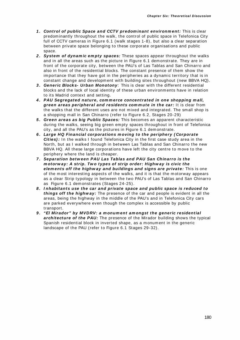
Chapter Six: Theoretical Discussion
180
1. Control of public Space and CCTV predominant environment: This is clear predominantly throughout the walk, the control of public space in Telefonica City full of CCTV cameras in Figure 6.1 (walk stages 1-8), but also a clear separation between private space belonging to these corporate organisations and public space.
2. System of dynamic empty spaces: These spaces appear throughout the walks and in all the areas such as the picture in Figure 6.1 demonstrate. They are in front of the corporate city, between the PAU’s of Las Tablas and San Chinarro and also in front of the residential blocks. The constant presence of them show the importance that they have got in the peripheries as a dynamic territory that is in constant change and development with building sites throughout (new BBVA HQ).
3. Generic Blocks- Urban Monotony: This is clear with the different residential blocks and the lack of local identity of these urban environments have in relation to its Madrid context and setting.
4. PAU Segregated nature, commerce concentrated in one shopping mall, green areas peripheral and residents commute in the car: It is clear from the walks that the different uses are not mixed and integrated. The small shop is a shopping mall in San Chinarro (refer to Figure 6.2, Stages 20-29)
5. Green areas as big Public Spaces: This becomes an apparent characteristic during the walks, seeing big green empty spaces throughout in front of Telefonica city, and all the PAU’s as the pictures in Figure 6.1 demonstrate.
6. Large HQ Financial corporations moving to the periphery (Corporate Cities): In the walks I found Telefonica City in the first case study area in the North, but as I walked through in between Las Tablas and San Chinarro the new BBVA HQ. All these large corporations have left the city centre to move to the periphery where the land is cheaper.
7. Separation between PAU Las Tablas and PAU San Chinarro is the motorway: A strip. Two types of strip order: Highway is civic the elements off the highway and buildings and signs are private: This is one of the most interesting aspects of the walks, and it is that the motorway appears as a clear Strip typology in between the two PAU’s of Las Tablas and San Chinarro as Figure 6.1 demonstrates (Stages 24-25).
8. Inhabitants use the car and private space and public space is reduced to things off the highway: The presence of the car and people is evident in all the areas, being the highway in the middle of the PAU’s and in Telefonica City cars are parked everywhere even though the complex is accessible by public transport.
9. “El Mirador” by MVDRV: a monument amongst the generic residential architecture of the PAU: The presence of the Mirador building shows the typical Spanish residential block in inverted shape, as a monument in the generic landscape of the PAU (refer to Figure 6.1 Stages 29-32).

Chapter Six: Theoretical Discussion
181
Architect’s Scale (Northern Periphery) refers to Figure 6.2 below:
Figure 6.2 – The visual typology summarising the emerging characteristics resulting from fieldwork-
architect for Madrid’s Northern periphery
1. Control of public Space and CCTV predominant environment: This is clear in Telefonica City which is full of bollards (Telefonica 1-8).
2. System of dynamic empty spaces: The same spaces that appear in the photographer’s scale appear also here. They appear in front of the area of Telefonica City and in the PAU Last Tablas (Telefonica-Las Tablas 8-16) and also in PAU San Chinarro (Corte Ingles Mall- to San Chinarro PAU 24-29).
3. Signs on the Strip/Highway: The space is designed for cars and not for people. The sign becomes architecture along the motorway as Venturi & Scott-Brown would refer to in Learning from Las Vegas. In this scale becomes much clearer from the Nissan sign office near Telefonica, to El Corte Ingles to be seen from the highway, to the McDonalds to have your burger. All these signs demonstrate the importance of the language of the sign in the Strip and the predominance of the car.
4. De-countrified landscape (Abalos & Herreros term): As I walked through these areas it becomes very clear that the term Abalos & Herreros (A&H) refer to appears everywhere. This wild landscape from the countryside, that now has been built on by the new PAU’s and Corporate Headquarters is now in front of a new kind of manicured and artificial landscape (Telefonica-Las Tablas 8-16).
5. Generic Blocks- Urban Monotony: This is clear with the different residential blocks and the lack of local identity of these urban environments in relation to its Madrid context and setting.
6. Architectural experimentation and periphery seen as a deregulated zone for architects to try new things: This becomes much clearer in this scale as you can see the different typologies of architecture from the MVRDV block, to the different types of blocks.

Chapter Six: Theoretical Discussion
182
7. The shopping centre becomes the local shop and the sign is also the architecture of the motorway: El Corte Ingles Shopping mall, off the motorway in San Chinarro, is not only out of scale in a neighbourhood context but it serves a different public and is designed to be seen and accessed from the motorway (Corte Ingles Mall- to San Chinarro PAU 24-29).
8. Zoning in the planning of the PAUs: As you walk through the Telefonica City, it is clear that all the uses are separated, large residential blocks, offices in Head Quarters (Telefonica, BBVA) and shopping in the mall. A new order of space appears in this peripheral city.
Citizen’s Scale (Northern Periphery) refers to Figure 6.3 below:
Figure 6.3 – The visual typology summarising the emerging characteristics resulting from fieldwork-citizen for
Madrid’s Northern periphery

Chapter Six: Theoretical Discussion
183
1. Control of public Space and CCTV predominant environment: This is demonstrated in this scale with the use of devices such as bollards, to signs forbidding entrance to the space “Prohibido el paso” (End of Las Tablas PAU-BBVA Headquarters 16-23). This is a clear control of space and people, with silent devices such as CCTV cameras, but as I focus on the ground it is clear that the space is telling you as a citizen that you cannot enter.
2. De- Countrified Landscape (Abalos & Herreros): The contrast between the natural and artificial landscape becomes clearer at this scale (Corte Ingles Mall-to San Chinarro PAU 24-29). When you look on the ground of these peripheries you can clearly see this characteristic with manicured shrubs and trees, in front of messy, natural, almost rural landscape.
3. Green Areas & Public Space: The green areas are not designed for citizens; they are big vast spaces throughout often rural empty land.
4. System of dynamic empty spaces: These spaces appear throughout the walks and it is clear it is important in the dynamic space that the periphery is.
5. Impression of Incompletion - the place looks like an on-going building site: This characteristic appears together with the system of empty spaces. As the scale focuses more on the ground you can see this sense of incompletion (rests of garbage and water) and metal fencing. This is also apparent on the ground units below the flats boarded up with bricks (Telefonica- Las Tablas 8-16).
6. Hybridisation of uses - The Chinese local food store versus the supermarket: The Simply store substitutes the local shop. The predominance of these shops all over Spain somehow emphasizes its appearance in the periphery where the land is cheap and there are no local facilities for shopping for citizens. This scale allows seeing and demonstrating this level of detail of this peripheral environment.
In the Southern peripheries (Carabanchel and Leganes) these are the characteristics from the three different scales:
Photographer’s Scale (Southern Periphery) in Carabanchel refers to Figure 6.4 below:
Figure 6.4 – The visual typology summarising the emerging characteristics resulting from fieldwork-
photographer for Madrid’s Southern periphery (Carabanchel)

Chapter Six: Theoretical Discussion
184
Carabanchel
1. Control of public Space and CCTV predominant environment: CCTV cameras and controlled access to the flats (Carabanchel 9-13), and also metal fences to stop cars entering the street, demonstrate the control of space (Carabanchel 1-8).
2. System of dynamic empty spaces: These spaces appear through the walk, in different size pockets: one big green space at the side of the road (Carabanchel 14-17) and also in different parts of the social housing blocks in between the architectural experimental projects (Carabanchel 18-31).
3. PAU segregated, commerce concentrated in one shopping mall, green areas peripheral and residents commute in the car: The shopping mall is the only commercial big space in the PAU, next to the McDonalds. The whole shopping complex is designed to be accessed by the car (Carabanchel 14-17).
4. Generic Blocks- Urban Monotony: The residential blocks are very monotonous and the architecture is very generic (Carabanchel 1-8).
5. Architectural experimentation and periphery seen as a deregulated zone for architects to try new things: The buildings from the PAU shows the possibility for architects to experiment new agendas and materials (i.e.: Bamboo Housing Foreign Office Architects in Carabanchel 18-31).
6. Two types of strip order: Highway is civic the elements off the highway and buildings and signs are private: The walks demonstrate that the Strip is present in the new PAU. There is a highway to the side of the PAU, but also in the middle of it with car signs, and off it a shopping mall, a McDonalds and a patrol station for cars (Carabanchel 14-17).
Photographer’s Scale (Southern Periphery) in Leganes refers to Figure 6.5 below:
Figure 6.5 – The visual typology summarising the emerging characteristics resulting from fieldwork-
photographer for Madrid’s Southern periphery (Leganes)
Leganes
1. Role of infrastructure in the expansion of the periphery: The walk demonstrates the importance of the new infrastructure in the existing town of Leganes, with the new railway station and railway line (Leganes 12-15) connecting the town with the centre in less than twenty minutes. Also the walk

Chapter Six: Theoretical Discussion
185
clearly demonstrates this aspect as there is a massive car park for commuters, just outside the new train station (Leganes 16-25).
2. Control of public Space and CCTV predominant environment: This is clear in this part of Madrid. As you walk you see the University campus controlled by CCTV, and not accessible to the public (Leganes 1-11). Also as you walk there are a series of devices to stop cars entering the street such as metal fencing (Leganes 12-15) and bollards (Leganes).
Architect’s Scale (Southern Periphery) in Carabanchel refers to Figure 6.6 below:
Figure 6.6 – The visual typology summarising the emerging characteristics resulting from fieldwork- architect
for Madrid’s Southern periphery (Carabanchel)
Carabanchel
1. Architectural experimentation and periphery seen as a deregulated zone for architects to try new things: The buildings from the PAU show the possibility for architects to experiment new agendas and materials from white render (Carabanchel 14-17) to bamboo (Carabanchel 18-31).
2. Control of public Space and CCTV predominant environment and no street activity: CCTV cameras and controlled access to the flats (Carabanchel 1-8).
3. Signs on the Strip Designed for the drivers and the cars: There are signs for cars for the shopping mall, and McDonalds and a patrol station (Carabanchel 14-17) and the environment is designed for cars.

Chapter Six: Theoretical Discussion
186
Architect’s Scale (Southern Periphery) in Leganes refers to Figure 6.7 below:
Figure 6.7 – The visual typology summarising the emerging characteristics resulting from fieldwork- architect for
Madrid’s Southern periphery (Leganes)
Leganes
1. Control of public Space: This is clear in this part of Madrid. There are metal fences to stop car access (Leganes 16-25).
2. Signs on the Strip: In this scale you can see clearly in more detail the signs as you zoom in the existing area. The walk demonstrates the importance of car signs in this new environment (i.e. signs to show motorway access through an underpass Leganes 1-11).
3. Existing commuter town: The walk clearly demonstrates this aspect as there are cars parked everywhere throughout the streets (Leganes 12-15) and in front of the station.
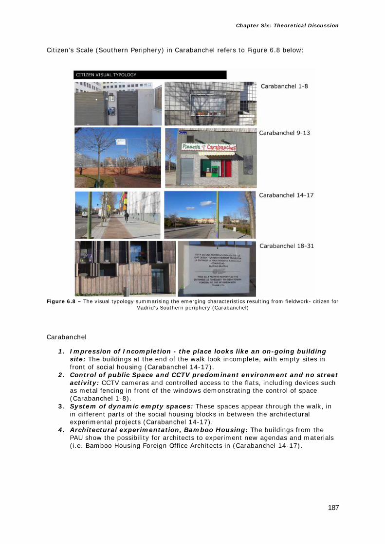
Chapter Six: Theoretical Discussion
187
Citizen’s Scale (Southern Periphery) in Carabanchel refers to Figure 6.8 below:
Carabanchel
1. Impression of Incompletion - the place looks like an on-going building site: The buildings at the end of the walk look incomplete, with empty sites in front of social housing (Carabanchel 14-17).
2. Control of public Space and CCTV predominant environment and no street activity: CCTV cameras and controlled access to the flats, including devices such as metal fencing in front of the windows demonstrating the control of space (Carabanchel 1-8).
3. System of dynamic empty spaces: These spaces appear through the walk, in in different parts of the social housing blocks in between the architectural experimental projects (Carabanchel 14-17).
4. Architectural experimentation, Bamboo Housing: The buildings from the PAU show the possibility for architects to experiment new agendas and materials (i.e. Bamboo Housing Foreign Office Architects in (Carabanchel 14-17).
Figure 6.8 – The visual typology summarising the emerging characteristics resulting from fieldwork- citizen for
Madrid’s Southern periphery (Carabanchel)

Chapter Six: Theoretical Discussion
188
Citizen’s Scale (Southern Periphery) in Leganes refers to Figure 6.9 below:
Figure 6.9 – The visual typology summarising the emerging characteristics resulting from fieldwork- citizen for
Madrid’s Southern periphery (Leganes)
Leganes
1. Role of the infrastructure in the expansion of the periphery: The walk demonstrates the importance of the new infrastructure in the existing town of Leganes, with the new railway station and railway line (Leganes 16-25) connecting the town with the centre in less than twenty minutes.
2. Control of public Space and CCTV predominant environment: As you zoom into the scale of the citizen the control of the space is demonstrated with a long wall to stop access to the station (Leganes 12-15) and a metal fence door to stop street access at the back of the flats (Leganes 16-25)
3. Tertiary Suburban Corridor: This is clear as you walk through this part of the periphery where you see the new University (Leganes 1-11) and the new station (Leganes 16-25).
4. Signs on the Strip: This aspect of the Strip is demonstrated only when you zoom into the citizen’s scale and you see the prominence of the car signs, demonstrating this Strip’s messages of communication for drivers (Leganes 1-11 &12-15), changing the nature of the space dramatically.

Chapter Six: Theoretical Discussion
189
One of the main aspects that appeared in the study was a system of empty spaces throughout all the areas studied (apart from Leganes) which I introduced in Chapter 1 with three definitions: descampados (translated into English as de-countrified landscape), areas of impunity, and terrain vague. The first two terms were developed by the architects Abalos & Herreros, and the third one by Ignasi de Solà-Morales. I will discuss in more detail the consequences of my findings later in section 6.4 of this chapter. Other aspects that appear through the study include the control of public space, strip development and signage, and the importance of the car. The control of public space, and the CCTV environment created in all these areas, together contributes to the detriment of public space and the public realm.
The idea of strip development and signs (announced as an emerging urban phenomenon in Learning from Las Vegas) appear in the creation of different Strips both in between the PAUs in the North (between Las Tablas and San Chinarro) and in Carabanchel. These examples reveal elements coming off the main highway, such as shopping malls, McDonalds, and petrol stations, showing this to be a new peripheral typology that is evident in the Strip as a realised project, but importantly one that was not anticipated or projected in the theory.
The importance of the car, of commuting and the privatisation of space show how signs become a dominant medium of communication over space (replacing or downplaying the role of architecture). Here again, I am only able to demonstrate this because of the methodological attention at the citizen’s scale, showing the importance of signs in this new landscape. The impact of signs also appears in the tertiary corridor in Leganes, showing the changing environment and demonstrating the nature of change, but more importantly perhaps, highlighting (in the project) the key role of large scale infrastructure in making these peripheries work.
Other aspects that emerge as headlines from this summary of the three scales are the appearance in the areas of big green areas, and of generic and monotonous architecture (repetitive residential blocks). These represent the economic values of this city, and also the use of zoning and segregation of uses in these areas, confirmed by the appearance of HQs that had relocated from the centre and thereby created Corporate Cities in the Northern periphery. While I visited Telefonica City I also found the new BBVA Bank HQ as I walked.
The appearance of architecture experimentation is clear throughout all the PAUs but is more prominent in the Southern periphery (the more working class part of the city). This highlights that this experimentation is in relation to people’s income and social class. Alejandro Zaera-Polo from Foreign Office Architects that built the Bamboo Housing writes: “The housing in Carabanchel was an interesting project, with a client that was prepared to take risks and a contractor open to experimentation […] While the experiment may fail, I think it is worthwhile investigating these technologies, ones that are much cheaper and much more sustainable than those readily available on the market”.5
By this experimentation I mean that the Southern PAUs such as Carabanchel have a greater variety of social housing, and this has allowed a greater range of social experimentation in the architecture (different colours, materials such as Bamboo for example). In the Northern PAUs this was not so evident in the blocks, apart from the MVDRV El Mirador Block at the end of the PAU of San Chinarro. The study also shows that in the PAU of Carabanchel there are hardly any commercial services or shops (Fast Food Stores) whereas in the wealthier North there is better service provision (El Corte Ingles Shopping Mall, and more corporate cities with Starbucks outlets, for example the BBVA HQ that were found during the fieldwork). It is in this relationship between theory and project explored during fieldwork and that La Tendenza is so concerned about that 5 A. Zaera Polo, “Phone interview with Alejandro Zaera-Polo” in M. Ballesteros, Verb crisis (Barcelona; New York: Actar, 2008), 219.

Chapter Six: Theoretical Discussion
190
the next section covers, discussing the application of Rossi’s categories (theory) into Leganes in the fieldwork (the project) and finding the consequences of my results in terms of Rossi’s work.
6.2 Consequences of my findings in Leganes for Rossi
In Chapter 1 I discussed particular categories of Rossi’s work in The Architecture of the City: these were Typology, Memory, Theory of Permanences and Capitalist Speculative Development.
The limits of Typology established in Chapter 1 allowed me to introduce new tools and to follow an immersive approach. The spaces I found in the periphery demand the creation of a new cartography that bridges the gaps between theory and project. This relationship is important for the Italian group La Tendenza. In Chapter 1 I also asked what the typologies of this periphery were in the “worked example” of Leganes. The concept of memory is important in Rossi’s work to the development of the city over time, the concept of urban morphology, and is also related to the urban artefacts and monuments. Often this concept is associated with his theory of permanences (monuments) and the idea of collective memory. A question I asked in Chapter 1 is if there are any traces of memory in these peripheral areas, and if so what the monuments might be in these places. In the tension between the old city of Leganes and the new Leganes’ tertiary corridor I explored these relationships.
The idea of speculative development is present in Rossi’s work with the connection between speculation and growth and the concept of study area (in the context of Madrid this urban growth happened very quickly). Rossi establishes these areas as a way of understanding the city as a whole, often describing their success as having residential complexes together with public services and collective facilities. A question this posed for Madrid was to see if these peripheral areas studied had such facilities, and whether they served the capitalist interests of speculation or the interests of citizens. The “worked example” extended and applied Rossi’s categories to the periphery of Leganes in Chapter 5 and now I will discuss the extent to which this application extends or limits his work.
Rossi’s critique of Functionalism and speculative capitalist development was political, and his reaction —to provide a rational language— was a reaction against the capitalist interests and forces that he observed increasingly dominating the construction of the city. He arrived at a theory of the city and its architecture to critique Functionalism. Madrid’s periphery has grown mainly due to market and speculative forces. The new city we see in Madrid requires a critical foundation of theory, but one of the main gaps in Rossi’s work is the idea that the city can only be analysed with historically developed mechanisms which are not sufficient in this context. As explained in Chapter 1, there is no existing theory of the periphery. Moreover, the approaches currently used to study the periphery are not robust. Therefore new tools are required to fill these gaps in knowledge, tools that use and refer to but extend Rossi’s work and apply it to the periphery, to clarify our thinking on the periphery and fill these gaps in our understanding.
In order to do this I applied Rossi’s categories of permanence and memory to a series of examples in the “worked example” of Leganes, where the Old Town met the New Town’s corridor. The limitations of Rossi’s work are that these categories of permanence and memory need to be supplemented with an immersive approach (i.e. walking, photographing and observing) in order to properly understand the periphery. It is in this tension between the old city and the new where the importance, and continued promise, of Rossi’s work can really be seen.
The examples explored in Chapter 5 show how this periphery is more humane than the others explored in the North and the South. The Old Leganes shares collective facilities such as the police station, or the old pedestrian streets and shops. Also

Chapter Six: Theoretical Discussion
191
buildings of different periods and times show an urban morphology present between the Old Leganes and the new corridor throughout the walk in Leganes (incorporating the existing town with the University, and the industrial uses, next to the new train Station).
That detailed immersive approach also revealed the detail of a reality that is being changed by the presence and dominance of the car, penetrating from the corridor into the Old Leganes in all the examples. This is critical in the detailed immersive approach where we see a series of devices (bollards, barriers) whose role is to stop pedestrian access, along with the broader restriction of pedestrian access around the University perimeter. The control of the space indicates two things: the space in the University becomes private and is not public anymore; and the car is changing the environment to make its presence more prominent and dominant. This effect brings about a change in the use of public space and the concept of the monument, and ultimately the street. The car imposes a new urban order.
The street in these examples is given over to the cars, and in turn incorporates multiple devices to protect the pedestrians from the cars. Ultimately the end of the street, instead of having a square, now has a roundabout with a statue in the centre. With this monument here, the statue and the space is taken away from the people and given to the cars.
The examples in Chapter 5 also show the role of the infrastructure and infrastructural development in the importance as a centre for the new town, connecting it to Madrid in less than twenty minutes. As Jose Maria Ezquiaga critically writes: “Firstly the transformation of “geometrical mobility” with the opening of the large, orbital metropolitan roadways (M-40, M-45 and beginnings of the M-50), an improvement in the capabilities of the radial roadways, the modernisation of the railway system and above all, the construction of the Metro-Sur. Once again, the infrastructure exceeds the mere function of strengthening the needs of a settlement, and become true vectors in a new scale of the colonisation of the territory”.6 This shows that connection between infrastructure and the importance of speculative development that we see in Madrid today. The land is cheaper in the periphery than in the centre, to build new corporate headquarters and Universities but the tendency in order to expand in these territories was to invest heavily on infrastructure for territory expansion to connect the centre of Madrid with these new peripheral areas. The Spanish economist Jose Manuel Naredo writes about this model: “The general tendency of real-estate led construction business, instead of other aims and approaches to urban projects implemented in the Madrilenian conurbation, created a territorial model that emerged by changing land-use policy and requalifying rural land into urban, a territorial model where the urban and constructional approaches followed the usual market rules”.7
What Rossi’s categories show us here is a much clearer understanding of the periphery than could be provided just by the theory itself. But the limitations of these categories are that they do not work by themselves, it is necessary to extend them and combine them with other immersive tools and approaches such, as photography, walking and narratives in order to analyse these places in any depth. By applying them to the context where the old meets the new we can see clearly what the periphery lacks in terms of memory and permanence, but also how it is possible to humanise these places by seeing some of these aspects in Leganes such as collective facilities that are now present in the new corridor.
6 J. M. Ezquiaga, “Fragmentation to fractality: the paradoxes of diversity” in A. J. Cantis and A. Jaque, Piensa Madrid = Think Madrid: [José María Ezquiaga, Juan Herreros, Fabio Casiroli ...]. In [Madrid]: (Caja Madrid: La Casa Encendida, 2009), 273. 7 J. M. Naredo, “Naturaleza de la Conurbacion madrileña y sus tendencias actuales Segunda parte. Anatomia y fisiologia de la conurbacion madrileña: gigantismo e ineficiencia crecientes” in J. Borja, Z. Muxí, and J. Cenicacelaya, (eds) Urbanismo en el siglo XXI: una visión crítica: Bilbao, Madrid, Valencia, Barcelona, (Arquitext. Escola Tècnica Superior d’Arquitectura de Barcelona : Edicions UPC, Barcelona, 2004), 101. [Author’s translation].
Chapter Six: Theoretical Discussion
192
This approach used in Leganes indicates how the Old Town helps the New Town’s tertiary corridor by having collective facilities. In the other areas such as the PAUs people are more isolated, and they do not have similar facilities as those analysed in the Leganes “worked example”. The other peripheral areas analysed in this thesis have been built from scratch, and while I do not suggest that a model like Leganes, of building them next to an existing town, is something that could be transferred to all new developments, what these findings in Leganes show in terms of Rossi’s work is that more assertive town planning is required in the new PAUs.
The application of Rossi’s categories is absolutely essential, in order to identify what all the other areas lack, and what needs to be considered for the future planning of peripheral city extensions by the government rather than just leaving these projects to speculative development and private interests. A recent article in the Spanish press (El Mundo Newspaper) emphasized the lack of collective facilities in one of the other PAUs in Vallecas in the South of Madrid: “After a while from what on the plan seemed an idyllic place in which to have a family, now you find a city that is half built. Your house value has fallen by fifty per cent, the green areas are abandoned agricultural land often with frequently provoked fires, and your children probably have to study in another neighbourhood due to the lack of public facilities […] This neighbourhood that is a no-neighbourhood does not have a police station. The closest police stations are in the UVA de Vallecas (the old town of Vallecas) and in Entrevias. The same occurs with the health centres. The PAU has only got one in one of its corners”.8 Rossi’s category of speculative development is also critical here after seeing the application of the other categories, in showing what these places lack in the other PAU’s and as a critique to this new city, emphasizing the role of his manifesto as a critique to the Functionalist city in these new PAUs. But fundamentally, applying Rossi in combination with an immersive approach shows its relevance today in offering an understanding of a phenomenon such as the presence of the car, and how it penetrates the Old Town, changing its nature and the control of space (and public space in particular), with monuments now given to the cars rather than to people. Here we can see an environment that is changing, shifting towards private and traffic-controlled space (in the University and throughout the examples) giving a clear new typology full of signs, roundabouts and access to highways: the Strip.
It is relevant for me to expand these aspects of Rossi’s work to show how important his work remains today in order that we might understand these environments in the project, not just as a theory itself. Other critical voices in the debate that follow on from Rossi and La Tendenza after the 1960’s are critical of Rossi’s approach. Stefano Boeri argues that the categories from the 1960’s are not sufficient to understand the periphery today: “In the new European territories these categories simply do not work, and merely slip the surface of things”.9 Other contemporaries such as the Spanish architect Rafael Moneo also became critical of this relationship between theory and project and Rossi: “The focus on typology grew out of a critical view of the modern city. The perspective led architects to look at the principles of the building of the discipline for building traditional cities, historical cities […] Aldo Rossi and the new-rationalist from La Tendenza applied the notion of type to explain the city and its growth”.10 While type is useful to critique the contemporary city, and go back to a theory of the city based in traditional principles, it is not sufficient to understand the city today in Madrid (the project) only by itself.
This critique is also shared by the architect and economist Manuel de Solà-Morales who studied with Ludovico Quaroni and wrote extensively about urban growth in Spain “Morphology-typology are axes of dualities to which the different parts of the city can 8 PAU de Vallecas, el barrio abandonado por todos | Madrid | EL MUNDO [WWW Document], URL http://www.elmundo.es/madrid/2015/09/20/55fdcbe8ca47418d128b4589.html [accessed 14 of October 2015] 9 S. Boeri, “Notes for a research program” in R. Koolhaas, et al., Mutations (Bordeaux; Barcelona: Arc en rêve centre d’architecture; ACTAR, 2000), 366. 10 J. R. Moneo, Rafael Moneo: remarks on 21 works, (Monacelli Press, New York, 2010), 15.

Chapter Six: Theoretical Discussion
193
refer to […] But if in the works of Rossi and Aymonimo, or on those of Panerai and Castex, these two categories seemed enough to analyse the architecture of the cities, it seems to me, still today, that a more structural explanation of the urban form—in its parts and as a whole, in the projects and in the history, in its brilliant moments and in the commonplace areas, in their results but also in their processes— has to recognise the importance of the infrastructural forms (the railway paths, the service networks, the riverbanks, the communication nodes, the great accesses) as independent forms—in the project, in its execution, and in its performance”.11 Critically, to understand the project and to supplement the theories from Rossi, and his categories and analyse the city today it is important not just to use other tools to complement its limits, but also to recognise the importance of the infrastructure (Strips, Railway and Cars), and the less architectural notions such as paths and access, as independent forms of the project to fill the gap between theory and project.
From such understanding, we are able to critically assess what is happening in these places, how our cities are changing with the addition, the imposition of new urban conditions, moving increasingly towards speculative developed spaces: spaces that focus on the private owned space controlled by private interests rather than the public, and resulting from speculative development.
This approach of extending Rossi’s categories to the periphery demonstrates that if the gaps in his work are filled with other tools a much greater, more detailed understanding of the periphery can be attained. His manifesto from the 1960’s proves to be critical to analyse and understand the shift of the traditional city into this new city that I see in Madrid. The theory becomes critical in order to understand the project, but by contrasting the old and the new city, and by demonstrating how the combination of his work, its limits and the potential filling of its gaps with new tools, I can arrive at a much clearer understanding of the project on the ground and explain how this new environment works in detail.
This offers an extension of his work that can bring a new dimension to the critical thinking of today’s peripheries and be applied in other peripheries and European cities. However, what I ultimately found in Leganes only is a city that is more humane because it is built on to an existing city, but also arriving at a new reality, a new automobile city where new typologies are emerging such as the Strip. This new city is the result of speculative development and of that I am critical, in the strict sense that it shows the enduring importance of Rossi’s critique of Functionalism being political. His work shows a dimension of application where we can find answers about how we can humanise these places, understand them better, and offer a new application in the project of his theoretical manifesto.
An extension of Rossi’s work is that this cartography goes beyond the current terms, explaining clearly the reality on the ground in these peripheral areas. The typologies I found on the ground were more modest, low-brow architecture of the peripheral city, and somehow less noble than the ones architects spend time discussing when referring to the traditional city (squares, monuments, artefacts). While idealising the city is a noble academic pursuit what I see here is the new architecture of communication and the car, and as Venturi and Scott-Brown note in Learning from Las Vegas, connected to the highway and signs, and influenced more by Pop Art than urban history. As architectural journalist Kester Rattenbury writes: “With Learning from Las Vegas, Venturi, Scott-Brown and Izenour were overturning the elite, where suggesting that things that deemed cheap, common, popular, crass were equally as likely to be worth of study as things purporting to be expensive, rare, refined, knowing”.12
11 M. Solà-Morales i Rubió, Las formas de crecimiento urbano (UPC, Barcelona, 1997), 15. [Author’s translation]. 12 Rattenbury, K., Hardingham, S., 2007. Robert Venturi and Denise Scott Brown: Learning from Las Vegas, Supercrit. Routledge, Abingdon [England]; New York. p.19

Chapter Six: Theoretical Discussion
194
These new typologies developed after the application of Rossi’s categories of permanence and memory to the examples in Leganes. The Strip emerges as a typology showing the importance of the car in this space, emphasizing the importance of architecture of signs, automobile and parking lots: I will explore this in more detail in the next section, focusing on the consequences of my findings in Leganes for the work of Venturi and Scott-Brown.
Before that, the remainder of this section will stay with Rossi and his concerns with speculative development. In Chapter 1 I asked a series of questions regarding speculative development (one of Rossi’s categories), regarding the following points on one hand to see what types of residential typologies and collective facilities are found in these peripheries. And also to see if these peripheries serve the interest of citizens or if on the other hand they are oriented towards urban and speculative development. I will discuss my findings of the typologies in the next section showing how this speculative development appears and relates to these places.
In terms of buildings, what I found was that the new tertiary corridor, by virtue of being adjacent to the existing Leganes, was able to share the collective facilities in the old town, so in this sense this existing condition humanizes the periphery when compared to the other areas studied in the North and the South (all the PAUs and Telefonica City). The speculative nature of development of the PAUs leads to residential development, however in Leganes there are some residential uses but these are not simply Rossi’s residential category, they also include other buildings (University, collective facilities such as police station). For Rossi the emphasis was mainly on the fact that these residential areas had public provisions and collective facilities. In comparison to Leganes, the other PAUs studied have commercial units on the ground which are boarded up (there is not yet enough density of occupation to make these units work financially). Also the services for residents are basic businesses (a Chinese store, a fast food shop etc.) indicating gaps in public provision and collective facilities in comparison to Leganes.
However the University Campus Carlos III was totally isolated from the existing Leganes settlement, and protected throughout its perimeter indicating the privatisation of this space and emphasizing the speculative nature of this type of development. It was not integrated for the new citizens or the existing community, but instead created an environment resulting from speculative development.
Speculative development in Leganes that produce these kinds of environments are as the Spanish architect Jose Maria Ezquiaga describes: “ […] the attraction of more highly qualified economic activities (commerce, service and logistics) due to both the saturation and extraordinary land prices in the city of Madrid, and to the significant improvement to the quality and accessibility of these towns”.13 The land prices tend to promote the kind of speculative nature of the places that I found here, creating a specialised service such as the University connected to the infrastructure of the new station in Leganes. But also I found this in the North in the creation of new business HQs such as Telefonica City and the bank BBVA, which are leaving the city centre and relocating to the periphery.
The other typologies that I developed such as paths and edges show the influence of the car in these new urban environments. The paths are being narrowed to allow for the passage of cars, and making these routes for vehicles more spacious, and we see the emergence of bollards at the beginning of the walk, with increased measures to separate and thus protect the pedestrians from the increase in cars. The streets are taken up by the cars in this case. The edges that define the areas at each side of the tertiary corridor really demonstrate this influence: at one edge in particular, it becomes a highway rather than a street, and a series of metal fences and brick walls control the urban space and prevent pedestrian access (i.e. the University perimeter, between the street and the 13 Ezquiaga, op.cit. p. 272.

Chapter Six: Theoretical Discussion
195
station, and with a highway access to the main motorway). The pedestrians here are secondary and the car starts penetrating the urban fabric of the existing Old Town, showing also a clear demarcation between private and public space. This demarcation appears in barriers between the path and the roads with devices such as bollards and fences, and also at the University perimeter where access is private.
In the next typologies such as security and trash, it becomes very clear that the security devices only appear at each side of the corridor, but never in the areas between the old city and the new. This detail is important as it demonstrates that the new city is a much more security-controlled place than the old city. Considering trash highlights a series of bins, very carefully located at different points of the walk. This detail also indicates that in comparison to all the other case study areas, in this typology the city is more human, we do not see any systems of empty spaces with rubbish as in all the other PAUs or Telefonica city, demonstrating that the integration between the tertiary corridor in Leganes and the old city could successfully be applied to other European peripheries. Rather than leaving the new periphery such as the PAUs to a speculative residential market without any collective services, currently producing a collection of empty spaces that look incomplete and which accumulate rubbish, the example of Leganes suggests that these places could be integrated better in the PAUs. Lessons that could be learnt concern the introduction of better public realm design in the public spaces in front of the PAUs, instead of leaving a large, open, empty space in front of the buildings. The PAUs’ zoning approach leads to this kind of lack of consideration in design terms where other approaches could be considered.
The other typologies such as scrub, parking lots and curbs again show the importance of the car in shaping the old city and giving a new order to the speculative nature of the tertiary corridor. The scrub is mainly a manicured landscape device next to the curbs, which along with bollards and metal fences is placed to protect the street from the cars. Next to the University the metal fence emphasizes the division of control between private and public space. The parking lots were present throughout the whole walk, but very clearly this provision increased closer to the railway station, showing the importance of the town as a commuter town.
In exploring these typologies in the periphery, Rossi’s work is extended through my findings, giving a greater understanding of these places and new contexts. The limits of his work are supplemented by an “immersive approach” that addresses the gaps left in his work and allows us to explore these places in greater detail. The most important question here concerns the category of speculative development: the issues discussed above show that speculation has shaped these peripheral environments fundamentally, and while the tertiary corridor really benefits from the existing town and its collective facilities, the role of the new infrastructure has clearly shaped this new Leganes with the train station and the University. Across the different typologies these findings really show the role of the car in shaping these environments, creating a new relationship between the citizens and the city, one that frequently removes pedestrians or exercises a high degree of control over them, and provides a much more controlled space that is both private and inaccessible.
A periphery that is the result of speculation—similar perhaps to the Functionalist critique of the city that Rossi did not want to see in the 1960’s— is what we see today emerging after these close readings of Madrid, and which appear to be replicated around cities across Spain, Europe and beyond. A city that is the result of speculative development is not serving the interest of citizens, but is the result of speculation both in terms of infrastructural investment and produces an architecture of residential PAUs, corporate HQs and shopping malls which have allowed this new city to be put in the hands of controlled, private spaces serving cars not people.
However to make the periphery more humane or to humanize it, what these findings show is that in Leganes this has been achieved to some extent because Old Leganes

Chapter Six: Theoretical Discussion
196
provides both collective facilities and an existing settlement to the New Leganes: this could be a useful lesson for anyone designing new peripheries. Certainly this “worked example” shows the on-going relevance of applying Rossi’s thinking and critique to the periphery in today’s context, and the importance and relevance of his work both on a practical but also on a theoretical level. But fundamentally, this thesis extends the application of his work and shows the importance of his architectural manifesto from the 1960’s having a continuing role in the understanding of the project while also revealing the gaps in the theory: the reality is much more complex, and to understand it Rossi’s work by itself is now no longer enough.
6.3 Consequences of my findings in Leganes for Venturi and Scott-Brown
My findings set out in Chapter 5 demonstrate the need to develop new analytical tools to understand this kind of environment after analysing in the “worked example”, in particular the importance of the car in shaping this new environment. Venturi and Scott-Brown’s work helped with some of these, and provided motivations to undertake more detailed fieldwork/analysis. Venturi and Scott-Brown emphasize in their Studio Notes the importance of developing new tools to understand these kinds of environments, and see how the space has been shaped through the symbols (such as signs) that this new space develops. Furthermore I argued in Chapter 3 that this type of Corridor had already been developed in Madrid, in the Ciudad Lineal by Arturo Soria in 1911, which emphasized and promoted speculative development and the role of infrastructure. I argued in my hypothesis that this project was a precursor of what we see in Madrid today, and the fieldwork findings demonstrate that this is the case. A typology that emerged from these investigations was the Strip/Corridor in Leganes, and the importance of the car and the infrastructure in it. The tertiary corridor established in the literature, in the theory, was in reality an infrastructural corridor full of signs and cars, and these elements were changing the existing urban fabric of Leganes.
By analysing the automobile in the “worked example” of the Strip/Corridor of Leganes the appearance of signs throughout this Strip is clear. I could not find the same car signs in the Old town of Leganes, but on the other hand the findings demonstrate the importance of the car in this new space: wider roads, roundabouts, devices to protect the street and pedestrians from the car (bollards, metal railings, and fences) but also access to the highway directly through the underpass, and the appearance of signs throughout. A conclusion here is that alongside the Strip, history does not influence urban space in exactly the way that Rossi argues in his manifesto: the rules here are the rules of a new and different mode of communication. Highway communication for cars emerges in this typology of corridor that was resultant in my findings. The new signs that emerge in the corridor are aimed at the car drivers not at pedestrians, directing the driver towards the closest car park, or the highway access, or the hospital. A new order is being created here for cars and their drivers, instead of pedestrians.
For Venturi and Scott-Brown “the image of the commercial strip is chaos. The order in this landscape is not obvious. The continuous highway itself and its systems for turning are absolutely consistent”.14 Using their work to analyse this urban environment the order of the Strip is clearly provided by the signs, so in Chapter 5, in order to understand this, I used their work to look firstly at the signs on the Strip, and secondly at the types and the locations of signs on the Strip. I then analysed the influence of the automobile in the areas between the strip and the Old Town of Leganes, to see how this is affecting the old city. The findings show that the car does not just rule the Strip’s environment, but the signs reveal a lesson, the communication over space and the new architecture in the Strip is defined by an architecture of signs and communication over space, an architecture related to cars and highways, rather than spaces directed towards people and pedestrians. 14 R. Venturi, D. Scott Brown, and S. Izenour, Learning from Las Vegas: the forgotten symbolism of architectural form (Cambridge Mass: The MIT Press, 1996), 20.

Chapter Six: Theoretical Discussion
197
The analysis of the signs themselves reveals that they were all Heraldic, by which Venturi and Scott-Brown mean that the signs dominate the space; the city has been taken over by the car, but not like the situation in Las Vegas where the whole city is wholly dependent on the car. Fundamentally this newly created space has nothing to do with the existing town of Leganes. What the findings demonstrate is that the strip is chaos, as Venturi and Scott-Brown noted, but in this case in Leganes, what gives it order is not just the signs but also the highway and the systems created to make it consistent for cars, not for people. Moreover, the analysis of the influence of the car and the corridor shows that the car is slowly penetrating into the fabric of the Old city, slowly changing its character by responding to a new order of cars and Strip (bollards, metal barriers, and roundabout and highway access).
Using juxtaposition as a tool I analysed the historic strip corridor by Arturo Soria in Ciudad Lineal and compared this to the current corridor of Leganes. The corridor in both cases is a private state enterprise which uses infrastructure to expand the periphery and connect it to the centre of Madrid. In both projects the role of speculative development and consumerism is important: in the new corridor this is initiated by the University and the new station, while in the old corridor in Ciudad Lineal by the tram and the housing investment by the people buying their houses in (what was then) the country. But most importantly, going both back to Rossi and Venturi and Scott-Brown, the concept of typology is here revealed as modern version of the 1911 corridor: what using the tools developed in this study from the work of Venturi and Scott-Brown confirms is that the project of Leganes demonstrates my hypothesis (see Chapter 3) concerning the theory about the image of Ciudad Lineal influencing what happens in Madrid today. As Professor Michael Neuman writes about Madrid planning and its relationship with images: “Madrid’s planners invented new images for the city and the metro region. […] Planners also created social images that posited new identities for the growing metropolis: “Great Madrid”, “Madrid Metropolitan Region”, and the “Great South”. […]Now planning is a process of government acting on other governments and organized interests through image-based plan making and strategy forming”.15
One of the main lessons of this study is that the use of images and photography as techniques with which to understand these new places is essential. The city that Rossi discussed in his manifesto does offer a certain, qualified application to the periphery, as explained in the previous section, which in turn allows a clearer understanding of these new places and allows us to develop a new cartography that fills the gap. This new cartography is in part guided by the offer of Venturi and Scott-Brown’s work, developing new tools to understand these new spaces in Madrid. The work of the two manifestoes is clearly demonstrated in this thesis, not just in terms of the on-going relevance of theory, but also as essential part of the project. This can only be explored by bringing together the old and new Leganes, for example, and confronting this with the two kinds of cities that they described in the 1960’s. In The Architecture of the City Rossi discussed the importance of history and the elements that conform the traditional city as a way to critique the Functionalist City, while Venturi and Scott-Brown were developing new tools and ways to understand the new automobile city that was emerging at that time.
6.4 Consequences of my findings for the Spaniards
In Chapter 1 in the context of theory, I introduced three key definitions for this research, which were: descampados (translated into English as de-countrified landscape), areas of impunity, and terrain vague. The first two terms are borrowed from the Madrid architects Abalos & Herreros. The definition of the term descampados is an area where natural and artificial meet, and this is common to the definition of areas of impunity. But the latter takes the concept further: the land is ambiguous; it therefore has no boundaries and is imprecise, and often also has negative connotations. The third term, terrain vague, is 15 M. Neuman, The imaginative institution: planning and governance in Madrid (Farnham, Surrey; Burlington, VT: Ashgate Pub. Co., 2010), 2.

Chapter Six: Theoretical Discussion
198
from the Catalan architect Ignasi de Solà-Morales and is commonly used to define the periphery in Spain. I explored in my fieldwork whether, and if so how, these definitions appeared in the case study areas in Madrid. I adopted these terms because they offer perhaps the closest definitions of the peripheral areas in Spain (terrain vague in particular is one of the most commonly used definitions for these areas in the Spanish context). Moreover, as explained in Chapter 1, Abalos & Herreros and Solà-Morales belong to the next generation of Spanish architects and were heavily influenced by Rossi and his disciples: Ignasi de Solà-Morales in particular was significant in publishing the works of Rossi and other Tendenza architects that were critical in the dissemination of their work to a Spanish audience and influential in the Spanish discourse.
The summary of the three scales set out earlier in this chapter indicates the appearance of a system of empty spaces, but the detailed reality is much more nuanced, requiring the introduction of a clearer terminology through which the different phenomena could be categorised. These spaces in the fieldwork locations appear as a system of dynamic empty spaces in all the areas apart from Leganes, and the case study (the project) demonstrates that these areas appear throughout. However, the visual typology shows this concept of rural land with urban land (as the concept descampados defines it) is not in fact a mixed landscape, but that the rural landscape is located in front of the descampados, a very clearly manicured artificial landscape and generic blocks in the project. Moreover, these systems of empty spaces I found during the walks are clearly defined: the fact that they appear everywhere shows their importance in the peripheral landscape and thus the importance of a methodology that is able to bridge the gap between the theory and the project. These areas all had physical demarcation on the land (either they were fenced off, or they were big public spaces in front of the PAUs in Las Tablas and San Chinarro or Telefonica City). There were only two areas of the whole fieldwork where this was not the case: 1- The left over land between the PAU of Las Tablas and San Chinarro in the North, 2- Left over land in the PAU of Carabanchel in the South.
My findings here clearly extend the Spaniards’ work (Abalos & Herreros and Ignasi de Solà-Morales) in different ways. On one hand, in the context of Madrid the fact that the theory explains these areas such as the descampados helped me identify them during the fieldwork, where I confronted this relationship between natural and artificial conditions in all the areas apart from Leganes but very clearly in the PAUs, emphasizing the fact that they are built from scratch and quickly on previously rural land. So the category of speculative development is confirmed clearly in these spaces, where one confronts these empty areas —which are often rural, or undeveloped— in front of big residential blocks. Considering areas of impunity, this reveals that there is a clear difference between the theory and the project. The theory states that the areas are imprecise and ambiguous, and have negative connotations, but in many cases the land on the project (i.e.in front of Telefonica City, or at the beginning of the PAU in Carabanchel) was clearly delimited and fenced off. I found these spaces in all the areas apart from Leganes, where there is an existing Old town next to the corridor, and they are not typically found in the centre of Madrid, indicating this is land that is open to development and ready to be built on, land taken from the rural landscape and being turned into an urbanised environment in what has been the biggest construction site in recent Spanish history.
The term terrain vague is often associated with photography according to Ignasi de Solà-Morales: he writes of: “Those empty, abandoned spaces in which a series of occurrences have taken place seem to subjugate the eye of the urban photographer. Such urban spaces, which I should like to denote by the French expression terrain vague, seem to assume the status of fascinating focuses of attention, the most solvent signs used to refer to the city, in order to indicate with images what cities are, and what our

Chapter Six: Theoretical Discussion
199
experience of them is”.16 What I took from this term (apart from the definition) and extended in relation to my work was the use of photography: I recorded the images of the city to indicate what the city is and to make a record of my experience of it as I walked through it. What my work here has clearly demonstrated is that the theory, while it helped to define the concepts and the particular elements I was looking for in the Madrid periphery (descampados, areas of impunity and terrain vague), it was not sufficient to describe the project in these places. Where I extended the concept of terrain vague and used an immersive approach to understand these places, by doing this I actually established the limits of these terms in all the case study areas, and established that they are not sufficient to explain these places. As this study demonstrates, they are more detailed, nuanced and slightly different on the ground, manifesting the differences I have discussed between the theory and the project.
My work contributes to and further challenges the Spanish debate in a number of ways. It reinforces the importance of Rossi’s seminal work The Architecture of the City into a new application in the periphery of Madrid, extending his work into this new context and showing and emphasizing its importance today. The limits of the Structuralist approach followed by Rossi and La Tendenza was criticised by Manuel de Solà-Morales when he wrote: “The historicist approach of the urban typologies of the Venice group (Aymonimo, Rossi and Canella etc): the gothic house/capitalist house/ socialist house. It is an important contribution, however, it still holds a very simplistic view. There is no consideration given to the morphology and the urbanisation process (infrastructure and services)”.17 This structuralist view was not sufficient to understand the city, therefore Venturi and Scott- Brown provided in the 1960’s new ways to understand these environments that took into account the cars, and the highway all infrastructural systems emerging in their study of Las Vegas. My work in this thesis extends and further applied Venturi and Scott-Brown in this context. This thesis shows the theoretical connection between the two main theoretical manifestoes and theorists of the 1960’s (Rossi and Venturi and Scott- Brown) and demonstrates a new application and extension of their work and highlighting the areas of relevance today in the context of the Madrid periphery.
As discussed and demonstrated in my work the definition of the theory in the work of Abalos & Herreros is different in the project element of the work where I found different issues to those discussed in terms of their definitions. The same applies to the definition of terrain vague by Ignasi de Solà-Morales. This thesis thus extends a new application of the work of the Spaniards, demonstrating a different relationship between theory and project (an important relationship in the work of La Tendenza). As explained in Chapter 1 the work of Rossi in Spain has profoundly influenced the Spanish debate from the 1960’s until today, and also theoretical work of the key actors in it. My work develops theirs, adding precision and showing that while the theory is important, the project on the ground is different: this I can understand to a much greater level of detail.
6.5 Revising the current state of the theory of the periphery
This chapter has presented a summary of my key findings from the fieldwork undertaken in all the areas studied in the North and the South of Madrid (at three scales: Photographer, Architect, Citizen), and discussed the consequences of my findings in the “worked example” in Leganes for Rossi and Venturi and Scott-Brown. I explained and discussed how my findings extended their work and also highlighted its limitations. The typology of peripheries that I developed is where I introduced the idea of a new cartography by exploring the areas where the Old Leganes met the New Leganes, illustrating my discussion with an example of a fieldwork walk.
16 I. Solà-Morales, “Terrain vague” in C. Davidson Anyplace (New York, N.Y. : Cambridge Mass: Anyone Corp ; MIT Press, 1995), 121. 17 M. Solà-Morales i Rubió, Las formas de crecimiento urbano (Barcelona: UPC, 1997), 77. [Author’s translation].

Chapter Six: Theoretical Discussion
200
In this section, I propose to revise the current state of theory on the periphery to reflect my findings. In the final sections I will analyse further the “worked example” introduced in Chapter 5 and discussed here, and develop in more detail the concept of this new cartography that fills the gaps between theory and project that was important for La Tendenza and also the theoretical framework of this thesis. I will show that this cartography goes considerably beyond the debate in the current literature, not because it disputes the validity of current terms like descampados, areas of impunity and terrain vague, but because it shows that the reality is more detailed and nuanced than previously thought. I am able to understand these hitherto quite general terms in much greater detail than any of these authors have been able to, to date, due to the detailed field work I have carried out and I am able to show how they might be put into practice through this new cartography. I demonstrated in my discussion of the findings in this chapter that the application of Rossi’s categories into the periphery resulted in a series of typologies that I developed to explain the project in much clearer detail than the theory. Following on from those findings in the “worked example” and the typology of the Strip which appears in Leganes, I also established the importance of extending the tools left for us by Venturi and Scott-Brown to develop a clearer understanding of this new cartography.
6.6 A new cartography for the periphery of Leganes
Now in this section I will develop in detail the new cartography introduced in Chapter 5, extending Rossi’s categories and the typologies that emerged (buildings, paths, edges, security, trash, scrub, parking lots, and curbs) in the areas where the Old Town meets the New. I will fully describe the cartography and the circumstances for its use, by applying it to the investigation of these peripheries, while also explaining what a conventional cartography is and how its application fails in these places. Then I will undertake a similar detailed exploration of the typology of Strip/Corridor that I established in the “worked example”, and show the impact of the automobile and the signs alongside the Strip using Venturi and Scott-Brown’s approach. By fully developing this new detailed cartography I will then discuss it and establish how it operates in the gap between theory and project, an important relationship for La Tendenza and for the framework of this thesis, is explaining the importance of the work of Rossi, Venturi and Scott-Brown and the Spaniards and demonstrating that this new cartography develops their work much further. Finally, I will suggest that this new cartography provides us with new applications in the periphery that can be applied to other European cities.
As Professor Mary Louise Lobsinger writes: “The publication of Aldo Rossi’s L’archittetura della citta in 1966 marked the conclusion of several years of research and writing on architecture and urbanism in an attempt to establish the principles and terms for analysing existing urban conditions. His thesis responded to a polemical debate within Italian architecture of the early 1960's over the future form of the city brought about, in part, by unprecedented transformations in the post war city”.18 A conventional cartography applied to the traditional elements that together form the city was an attempt by Rossi to order and understand the principles and terms of urban conditions. This was carried out in response to the critical changes that were happening on the outskirts of cities such as Milan or Rome. As Lobsinger argues, the periphery was a concern in Rossi’s work before writing The Architecture of the City and observing the changes taking place in the Italian cities: “In la citta e la periferia19 (The City and the Periphery), Rossi again drew attention to the degraded conditions of the periphery. […]
18 Lobsinger, M. L.“The New Urban Scale in Italy: On Aldo Rossi’s L’architettura della città,” Journal of Architectural Education, 1966: Forty Years After 59:3 (February 2006): 28. 19 A. Rossi, “La citta e la periferia”, Casabella continuita 253 (July 1961): 23.

Chapter Six: Theoretical Discussion
201
Photographs accompanying the text depict the desolate landscape of the Milanese periphery comprising substandard housing lining roads lacking any signs of social life”.20
His book is an attempt to emphasize the elements of the traditional city as a critique of the Functionalist city, framed by an understanding of a traditional cartography of the European city. This critique was as a result of his concerns about the growing peripheries in his country. However as I explained in Chapter 1, a critique of his work today reveals the fact that the contemporary city that we see in Madrid today cannot be explored through using Rossi’s categories alone. By applying Rossi’s categories to the periphery in Leganes we can appreciate how the conventional cartography fails in these places. Therefore by using Rossi in this context I can find the elements that the periphery lacks and that are important for the cohesion of the whole city.
Chapter 5 explained the importance of looking at the areas where the Old Town meets the New Town in Leganes. The Old Town somehow represents the theory of the city that Rossi describes in his book and also the tools that Venturi and Scott-Brown used, while the new city represents the project the new city that is emerging on the ground in Leganes. It is in this tension between Old Town and New Town, between theory and project, where the new cartography emerges in the gap between theory and project, it is in that space where I can explore in detail the nuances between old and new and what kind of typologies emerge in these spaces. These differences between the theory and the project and the critique of Rossi’s work led me to select other authors and theoretical definitions (such as Venturi and Scott-Brown and the Spaniards) and to develop my own immersive tools (walking, photographing, developing narratives) in the development of this new cartography.
As I have explained above, the case of Leganes is unusual, as there is an existing Old town, with what I have discussed as a parasitical tertiary corridor that has penetrated and changed the fabric of the existing town. We can see in the Leganes “worked example” that the Old Town softens the periphery. In all the other cases the PAUs are built by developers and for profit, and they lack the basic services that Leganes possesses. This evidence-based study can be used to develop a critical understanding of other Mediterranean or North European cities that are undergoing similar peripheral processes and conditions.
6.6.1 Typologies of the periphery—Extending Rossi’s typological approach to Leganes
This section will discuss the typologies of the periphery: buildings, paths, edges, security, trash, scrub, paths, parking lots, and curbs in the old city meeting the new city of Leganes, illustrated with tables showing the areas from Chapter 5 (Section 5.1.1) in more detail under these categories, and identifying the traces of Rossi’s memory and permanence (2 categories). This will add an extra layer of analysis by understanding and analysing the typologies in much greater detail here, and what lessons emerge in each case by undertaking the typological study introduced in Chapter 5 a level further and focusing it on the connection where old meets new. This more in detail typological analysis will also compare if any of these typologies, appeared also in the other case study areas studied in Madrid.
In order to do that I have highlighted the parts and stages of the walk in Leganes where the New Town meets the Old Town, the areas where the tertiary corridor meets the existing town (see Figure 6.10). This plan highlights in red dots where these areas are in my walk (see Figure 6.10) and will be a general plan to develop the typological study. In these zones where the old meets the new, where the theory of the Old Town meets the emerging peripheral city, I can understand these typologies introduced in the “worked
20 M. L. Lobsinger, “The New Urban Scale in Italy: On Aldo Rossi’s L’architettura della città,” Journal of Architectural Education, 1966: Forty Years After 59:3 (February 2006): 34.
Chapter Six: Theoretical Discussion
202
example”. Here, the tertiary corridor penetrates the old part of Leganes, changing its fabric, and here the Old Town provides services and existing infrastructure to the new peripheral corridor.
The first typology that emerges in the new cartography is buildings (see Figure 6.11). In the first stage of the walk (Stage 4) the first signs of the car’s influence from the tertiary corridor are clear, with bollards but also in the relationship between the old building (in this case the police station) and the new one, the University, which are totally disconnected. The University is a private controlled space, whereas the police station is not. In terms of scale the University building is bigger in scale than the surrounding 2-3 storey buildings. As I progress further in the walk (Stage 5-6) the presence of the car becomes even more prominent, and in the space between the old and the new city, I can see a roundabout instead of a town square, and the highway is much bigger in scale than in the Old Town of Leganes. The presence of small commercial shops on the ground floors offers small scale shopping facilities to this new tertiary corridor (away from the big Shopping Mall that I found in the areas in the PAUs in the North and also in the South in Carabanchel). This is reinforced later in the walk (Stage 7) where in the street interface, the presence of bollards, cars and signs show the new set of relationships between the buildings and the street. The side streets are invaded by the cars, and even the square now has an underground car park. This critically changes the importance of the car over pedestrians. In the last stage of the walk (Stage 19) the new train station is in this area where the Old Town meets the New, positioned in front of the old housing. Here the environment is more pedestrian friendly than before the station was built. But what is an important lesson here is the new infrastructural centrality created by the new station building. Two clear lessons emerge here: Firstly the tertiary corridor penetrates the existing fabric of the Old Town, changing its character and the new buildings focus on the private, secondly the infrastructure changes the place creating a new focus in the existing town towards the new station, but also that the existing collective facilities and buildings in the Old Town (i.e. the police station, and the shops at ground level) soften this new periphery making it more habitable, and less harsh than in the other areas studied (where the highway, the shopping malls and a lack of collective facilities prevail).

Chapter Six: Theoretical Discussion
203
Figure 6.10 – Plan showing areas where the old city meets the new city (in red) and stages of the walk. This will be a general plan to develop the typological study

Chapter Six: Theoretical Discussion
204
Figure 6.11 – Different building typologies in Leganes (in detail),
indicated in red where the old city meets the new city
The second typology that emerges in the new cartography is paths (see Figure 6.12). In the first part of the walk where the Old Town meets the New Town (Stage 4), I noticed the presence of two devices: bollards (stopping cars), and shrubs (to stop the public accessing the University Campus). As I continued walking (Stage 7) these devices changed, but the same function of stopping the cars being carried out by planting pots. This indicates that the new park was designed thinking about the cars, where on the left hand side the residential buildings do not have any devices. Each side of the corridor gives out a different message: the Old Town softens the path on the left of the corridor, while the new park on the right gives away the space to the cars.
The next stage of the walk (Stage 10) shows the old street’s character being completely changed by the tertiary corridor, with two clear messages: the appearance of signs for the drivers, and the increase of traffic and bollards for the cars. This is clearly as a result of the new road infrastructure. In the last stage of my walk (Stage 19) next to the train station there is a huge area given over for car parking, again favouring cars instead of people.
Two clear lessons are taken from this typology: on one hand the change of the existing paths, being increasingly taken over by the cars to the detriment of people, and the creation of a series of devices for that purpose (i.e. bollards, planting pots, metal fences); and secondly the impact of the infrastructure in terms of both the cars mainly, but also the train in the existing town (with the appearance of car signs, increased road sizes, and ultimately car parking spaces next to the station). It is important from these observations to point out that the intensity of the changes to the Old Town by these means is much greater as you penetrate further into the spaces between the Old and the New, where these issues become increasingly more relevant.

Chapter Six: Theoretical Discussion
205
It is also worth mentioning in this typology that the area of the left hand side of the tertiary corridor softens the impact of the car without devices to stop it from entering the path. So where the Old Town meets the tertiary corridor, even though the car penetrates the existing fabric of the Old Town, this is softened by the presence of an existing settlement where the street is more pedestrian.
Figure 6.12 – Different path typologies in Leganes (in detail),
indicated in red where the old city meets the new city
The third typology that emerges in the new cartography are the edges (see Figure 6.13). In the first part of the walk where the Old Town meets the New Town (Stage 4), I noticed that on the edge was a planting pot being used as a device to stop cars. As I kept on walking (Stages 6-7) the edge became more noticeable with a big metal fence in front of the University and bollards on the other side. Later in my walk (Stages 9-10) this car presence becomes even clearer and stronger: here the edge is a highway access. It is not anymore the street that separates the edge of the area between the old and new but the highway access, allowing straight access to it. The last part of my walk (Stage 20) shows again a fence demarcating the private from the public. Lessons learnt here are that the edge indicates two things both devices for control (cars not entering

Chapter Six: Theoretical Discussion
206
space, and pedestrians not having access to either the University or the Station), and security (the space that used to belong to the public is now privatised).
A clear lesson is the change of the car in the interface between the Old City and the New Town, showing the car penetrating all the areas of my walk from the corridor into the existing city, but fundamentally a clear change in the urban environment here and clearly indicating a new order: the city is given over to the cars.
Figure 6.13 – Different edge typologies in Leganes (in detail),
indicated in red where the old city meets the new city The fourth typology that emerges in the new cartography is security (see Figure 6.14). In the first part of the walk where the Old Town meets the New Town (Stage 4), I noticed that that security was provided by a fence with planting but. As I kept on walking the security devices became harder in physical terms being just a metal fence without planting (Stage 7). In the last stages of my walk (Stage 11-22), the security wall is impenetrable.
Lessons learnt here concern the increase in security: not just stopping pedestrian access from the street into the new space created by the corridor, but also about private control of the space taken away from the public domain. The detail of the study shows that at Stage 4 of the walk the security devices are softer and more permeable (i.e.: planting, and metal fence with holes in front of the University), but at the end of the corridor they are much harder, allowing neither visual nor physical permeability (i.e. a brick wall next to the train station) but also the street becomes totally privatised (Stage 22 next to the existing housing).

Chapter Six: Theoretical Discussion
207
Figure 6.14 – Different security typologies in Leganes (in detail),
indicated in red where the old city meets the new city
The fifth typology that emerges in the new cartography is trash (see Figure 6.15). In the first part of the walk where the Old Town meets the New Town (Stage 5), I could see street bins in the middle of the street, next to the cars. As I kept on walking (Stages 10-19) this quality increases, the traditional street is now full of cars and trash devices. The main difference between the trash here and the other areas studied is that here the Old city softens this typology, by collecting the trash in this “worked example” in designated street zones, instead of having it everywhere in the big open space. Here the Old Town changes the character of the periphery, humanising it while still giving up the street to the cars instead of the people.

Chapter Six: Theoretical Discussion
208
Figure 6.15 – Different trash typologies in Leganes (in detail), indicated in red where the old city meets the new city
The sixth typology that emerges in the new cartography is scrub (see Figure 6.16). In the first and last parts of the walk (Stages 3-17) I found manicured scrub in planting pots. In the middle of the walk (Stage 7) the scrub is wilder and less manicured and located next to the car park. A clear lesson here is that this type of manicured scrub is a typology that is designed to be seen from the driver’s perspective, a nice landscaped space instead of concrete. This typology of manicured scrub also appeared in other areas studied during fieldwork. The main difference is that in the “worked example” here these areas do not appear in front of the rural or de-countrified landscape, but instead in the area between the New Town and the Old Town, on one hand emphasizing the change of the Old Town brought by the cars and the infrastructure, but also much more integrated in this case to the existing Old Town than in the other peripheral areas, showing how the Old Town humanizes the New Town here.

Chapter Six: Theoretical Discussion
209
Figure 6.16 – Different scrub typologies in Leganes (in detail),
indicated in red where the old city meets the new city

Chapter Six: Theoretical Discussion
210
The seventh typology that emerges in the new cartography is parking lots (see Figure 6.17). In the first parts of the walk (Stages 4-7) there were on-street car parking spaces and an underground car park, and by the end of my walk (Stage 22) I found a massive car park for commuters.
The car and the infrastructure are changing the Old Town, giving the car a new order (increasing the amount of public space taken away from the people, in favour of the cars), but also changing the nature of the Old Town itself, which becomes a commuter town rather than an Old Town in the suburbs of Madrid, making it much more dependent on the centre of Madrid.
The last typology that emerges from applying Rossi to the periphery of Leganes is curbs (see Figure 6.18). At the beginning of my walk (Stages 1) there is no curb in the area in the centre that has become a ‘home zone’ area that gives pedestrians priority. As I kept on walking (Stages 5-7) there is a change in the devices that appear at the curb: they become bigger (i.e.: metal fence, planting device).
The observations of this typology demonstrate how at the beginning of the walk, the environment is more oriented towards pedestrians in the Old Town, without clear demarcation between people and cars, and as I walked more the presence of the cars becomes much more important and relevant.
Applying Rossi’s categories to the periphery develops a series of typologies that describe the new cartography of the “worked example” in greater detail than the theory defines, revealing in that relationship between the Old Leganes and the New Leganes how the tertiary corridor and the Old Town are changing and also influence each other. A clear typology that emerges in this “worked example” is the Strip/Corridor. The next section of this chapter will discuss this in more detail, again where the Old Town meets the New Town, and finally this will be followed by a theoretical discussion of this new cartography.

Chapter Six: Theoretical Discussion
211
Figure 6.17 – Different parking lot typologies in Leganes (in detail),
indicated in red where the old city meets the new city

Chapter Six: Theoretical Discussion
212
Figure 6.18 – Different curb typologies in Leganes (in detail),
indicated in red where the old city meets the new city
6.6.2 Typologies of Strip/Corridor - Venturi and Scott-Brown
This section will discuss the typology of Strip/Corridor in the areas where the Old Town meets the New Town of Leganes. Illustrated drawings showing the areas introduced in Chapter 5 will be developed in more detail, explaining the influences of the car, signs, and the automobile developed through Learning from Las Vegas. This Strip developed from the “worked example” introduced in the last Chapter, exploring Rossi’s speculative development category (through Infrastructure following from Linear City). The first drawing (see Figure 6.19) shows the impact of the automobile in the corridor in Leganes.
As discussed in the previous section, the impact of the automobile clearly has changed the nature of the Old Town, allowing the car not just to penetrate into the existing settlement, but also changing it. The car creates a new spatial order; the communication here is that of the highway, a new architectural order described so well by Venturi and Scott-Brown in their book Learning from Las Vegas. Their seminal text offered me a tool with which to understand this new spatial order and was explored further in this “worked example”. At the beginning of my walk (Stage 4) in the interface
Chapter Six: Theoretical Discussion
213
area I found the automobile impacting on the existing pedestrian high street, in terms of devices that appear throughout to stop the cars entering the street. As I kept on walking (Stage 7), the impact of the car becomes stronger in the interface area. On the left hand side of the corridor of the street a metal fence protects pedestrians from the cars (Stage 10), and the road widens to allow more cars to circulate throughout. In the middle of my walk (Stage 10) in the interface area a clear separation between people and cars can be seen, with a metal fence on the left hand side of the street, and on the right there is a direct access route to the highway.
This is an image more typical of a highway than of a small road that goes through an existing settlement, showing the impact of the car directly in this interface area. The New Town dictates the order of the Old Town, creating a functionalist city that segregates cars and people, rather than integrating them. It was with a critique of Functionalism that for Aldo Rossi was so important in his criticism of the state of European cities in the 1960’s. Here his category of capitalist speculative development can be witnessed in the town of Leganes, with its heavy investment in infrastructure (rail and cars), and the creation of a tertiary corridor, creating the typology of the Strip, an environment that requires Venturi and Scott-Brown’s approach to understanding and indeed learning from the case of Las Vegas. In this place Rossi’s categories are not sufficient, but it is in this place where the old meets the new where I can be as critical as Rossi was of the kind of functionalist city, and automobile-led environment, that is emerging in this case. This new typology of Strip/Corridor, and the way I have described it and analysed it in this new cartography, can be used for other parts of Madrid, and indeed other European peripheries. This will allow a researcher to see, to map and to describe the new cartography of the periphery, and to develop a much clearer and detailed understanding of the phenomenon that is happening right now, on the ground.
As I continued with my walk (Stage 11) the small side streets’ character had changed: now the street is like a linear car park, full of cars instead of being inhabited by people. As I went further into the interface area the existing street has metal fences at both sides to protect pedestrians from the cars. Clearly the whole Strip typology reveals a series of lessons; a new clear typology emerges from infrastructural development taking place in the current periphery as a result of capitalist speculative development, changing the existing Old Town, making it a space that acts as a highway between the tertiary corridor and the existing town. The areas of small side streets are increasingly penetrated by cars, while these streets themselves have devices all the way at each side to protect pedestrians from cars. The more you penetrate the Strip the more obvious this becomes, in the middle of the walk there is a clear segregation between pedestrians and cars. The number of signs increase, and the interface areas show that the new order is the order of the automobile, and the architecture of highway communication emerges, one of a kind that is designed to be seen as you drive not as you walk. This kind of new environment is one that encourages cars, and not people to populate the space and is the kind of city Rossi criticised in the 1960’s, and Venturi and Scott-Brown made the subject of their study in Las Vegas.

Chapter Six: Theoretical Discussion
214
Figure 6.19 – The impact of the automobile in the corridor of Leganes (in detail). In red areas where the old city meets the new city.
Aerial Image: Copyright Google Earth

Chapter Six: Theoretical Discussion
215
This section will discuss the typology of Strip/Corridor in the areas where the Old City meets the New City of Leganes in relation to the position of the signs within the Strip (see Figure 6.20). Indicated in yellow is the existing Strip/Corridor, and all the signs as established in Chapter 5 following Venturi and Scott-Brown are Heraldic. In order to explore and describe in more detail this new cartography and how the signs operate alongside the Strip in Leganes I have used the text in black (Figure 6.20) to explain the different signs and hierarchies I found, the red text defines how they have impacted in the existing Old Town of Leganes.
In the first stage of my walk next to the University (mostly on the right hand side of the signs in Figure 16) all the signs have different colours to alert the cars and the drivers to a particular set of instructions. The signs in blue are more important indicating the highway, whereas the ones in white indicate existing neighbourhoods, and in pink the University’s auditorium.
The communication of the highway access is the most important sign. The impact of the highway in the Old Town is clear, the Strip is the road used to access it, and the automobile also creates a new order of communication of architecture of the highway instead of people. The detailed study of the signs and their hierarchies establishes and demonstrates the nature of the new order, the new environment and the clear Strip typology.
As I continued alongside the centre of the Strip, where a square and a monument could be placed for people, instead there was a roundabout with a statue in the middle. The analysis of the signs indicated the name of the roundabout (see Figure 6.20, the fourth image from the left). The new signs and the new roundabout emphasize the changing nature that the car is bringing to the existing Leganes, changing the nature and the character of the spaces. The monument here is dedicated to the automobile, the statue in the middle of it is designed to be seen from the car by the drivers, not as in a traditional public square where people would sit down and enjoy the space and socialise with other people.
After the roundabout the four signs have different colours (see Figure 6.20, the first image from the left). The most important in yellow, indicates the new train station, the ones in white indicate the location of the closest car park at the town hall, and in a nearby neighbourhood and the one in pink is a monument, a nearby church. The signs’ hierarchy indicates that the new centre is the car park, not the traditional town hall.
The most important sign in yellow that indicates the new station shows the new importance of the infrastructure alongside the corridor, the impact of this on the existing settlement is very clear: the most important place in the town is the train station that connects it with Madrid’s city centre. The sign in yellow shows the drivers where the closest monument is located. Here the monuments, so important for Rossi’s historic and traditional city, are delegated to a sign to be seen from a car. All the hierarchy of the signs indicate the importance of the cars, and the nature of the Strip as a highway full of signs to communicate to drivers rather than to pedestrians. Also the nature of the existing settlement is changing, the town hall is now a car park, and the monuments and new centre have now changed to be mainly accessed by cars.
In Figure 6.20 (the second image from the left) the signs for the underpass accessing the highway indicate the minimum height for a lorry and the signs to the left state where the closest hospital is, and that access for pedestrians is forbidden.
In this detailed analysis some observations are revealed: there is a complete segregation between pedestrians and cars, and the road and interface area between the Strip and the existing areas is now a place for cars that leads to highway access. This is more typical of an automobile city, a city that is segregating pedestrians from cars. The nature

Chapter Six: Theoretical Discussion
216
of the space has completely changed the Old Town making it a highway, a clear Strip typology.
The last four sets of signs (see Figure 6.20, the first image from the left) indicate the new train station and the car park (in yellow) and the hospital (in white). This hierarchy of signs indicate the new infrastructural order created by the corridor, emphasizing the new train station as the new directional centre of the New Leganes, and the car park as the new public space next to the town hall.
The Linear City with its tram infrastructure connecting it to Madrid here is a modern metaphor of that plan, where the new infrastructure is not just the new centre that connects the Old City with Madrid city centre, but also changes the importance of spaces. Instead of the Town Hall being the centre of the community, we have a car park.
This detailed study explains clearly the new cartography of signs alongside the Strip. Here Venturi and Scott-Brown’s work is applied into a new context offering tools and new ways to interpret and understand these places in greater detail than the theory itself, and bridging the gaps between theory and project. In the next section a theoretical discussion of this new cartography will demonstrate, in detail that this work goes beyond the current literature.

Chapter Six: Theoretical Discussion
217
Figure 6.20 – Signs along the strip/ Corridor explaining in detail different signs and hierarchies (text in black), and how they have impacted the
environment in Old Leganes (text in red). Aerial Image: Copyright Google Earth

Chapter Six: Theoretical Discussion
218
6.7 Theoretical discussion of the new cartography
In order to bridge this gap between theory and project that was so important to Rossi and La Tendenza, the category of typology has allowed me to introduce a new cartography developed through an immersive approach which I illustrated in the “worked example”. The typologies provided me with ways of classifying different common characteristics that I found during my walks, after taking photographs of these places (buildings, paths, edges, security, trash, scrub, and parking lots). As Manuel de Solà-Morales explains, there are other categories that are part of the project in today’s city. The modest urban elements that I have established here at play in the “worked example” show the different roles of the car in the city and experiencing the project on the ground. These typologies are supplementing Rossi’s types from the 1960’s. This cartography allowed me to understand these places much more clearly than any of the authors like Rossi, or the broad group of Spanish architects and theorists introduced in Chapter 1, were able to do.
The definition of cartography is often associated with traditional practices of maps, projections and definitions of territory. The architect Mario Vrbančić writes in his essay “A Dream of the Perfect Map – Calvino’s Invisible Cities”: “The cartographer’s dream is that of a perfect map: a map that perfectly represents a territory, a dream of Divine knowledge; a map that has haunted the ideology of representation throughout history; a map so detailed that it coincides with real space”.21 In today’s contemporary city, this task of the perfect map representing the territory is no longer possible. As explained in Chapter 1 in the critique of Rossi’s work, one of the main gaps is that today’s city is very different from that one in the 1960’s as it is much more complex and is constantly developing. Madrid’s periphery is an on-going project, quickly developed and constantly changing: using only traditional cartographies such as mapping will not work in this context.
Therefore developing and introducing the concept of a new cartography that I proposed in order to understand these places is essential. To reiterate, in Chapter 1 I established the gaps left in Rossi’s work: first that there is no theory of the periphery, and secondly that the approaches currently used to study the periphery are not robust. Critically, one of the aspects raised was that there were already critiques established by what I referred to collectively as the Italians and the Spaniards: those two groups both stated that the development of other tools was necessary in order to understand these places. These new tools are needed to answer the questions left hanging at the end of The Architecture of the City and was also the point at which this thesis started: the idea of arriving at a theory of architecture of the European periphery in the case of Madrid. To arrive at a working definition of this new cartography, the traditional cartographic tools as established in Chapters 1 and 3 are not sufficient, and need to be supplemented with other ones such as an immersive approach to the subject on the ground if we are to understand these places in more detail.
I established these new tools and approaches prior to carrying out the fieldwork. Amongst these new tools are the use of narratives, photography and walking, as well as those outlined by Venturi and Scott-Brown in Learning from Las Vegas which also offers working tools for this purpose. Organised according to three scales (the photographer, the architect and the citizen) the fieldwork also included the use of typology (a concept taken from Rossi) to categorise other elements of the peripheral environment. As I mentioned in Chapter 4 in the passage by Italo Calvino Cartography, Narrative, Journey: “The need to comprehend in one image both the dimension of time and that of space lies in the origin of cartography. Time as story of the past […] and time in the future: as the presence of obstacles that are encountered on the journey, and here the weather (tempo 21 M. Vrbančić, A Dream of the Perfect Map – Calvino’s Invisible Cities; available from http://www.sic-journal.org/ArticleView.aspx?aid=126 [Accessed 21 December 2015].

Chapter Six: Theoretical Discussion
219
atmosferico) is joined with chronological time (tempo cronologico)”.22 In the present work, as Calvino suggests, this new cartography does exceed a map document, using other immersive tools (photography, narratives, fieldwork) in order to communicate how the areas studied in the peripheries of Madrid work on the ground.
The main justification for the immersive methodological approach undertaken in this thesis is as a consequence of the critique to Rossi’s work which highlighted its remaining gaps. In the pre-fieldwork context there was nevertheless a connection with the theory and traditional cartographic tools: plans of the city, Google Earth. The literature of today’s periphery in Madrid undertaken in Chapter 3 defined the areas of study adopted before undertaking the fieldwork, together with the use of Google Earth. The areas of Madrid chosen for the study in the North and the South comprised 3 PAUs (Las Tablas and San Chinarro in the North and Carabanchel in the South) one corporate city HQ (Telefonica City, next to Las Tablas PAU) and one tertiary corridor (in Leganes). In order to look at and identify them I used Google Earth, and traditional maps to plan my fieldwork. Not only this but also Chapters 1 and 3 (the theory based chapters) provide a series of theoretical definitions and approaches taken from Rossi (categories), Venturi and Scott-Brown (tools) and the Spaniards (terrain vague, de-countrified landscape, and areas of impunity).
The project, which in this case is Madrid itself, was then explored on the ground through a series of walks and analysis that took place both during and after the fieldwork, using photography as a tool to record these areas. But the theory also helped to analyse these places, and then of course the observations and the development of a new cartography following the fieldwork analysis. It is in this duality between theory and project that I am working: in Chapter 3 the critical overview of the periphery in the city plans of Madrid since the 19th century extension (Castro Plan) until today, together with the influence of the plans as a projection in today’s periphery together with the influence of the infrastructure and economic development model that have been adopted today.
However that distinction that Calvino made occurred during the journey and the need to comprehend the images that I undertook during the fieldwork were then analysed and explored in much clearer detail. This involved other methods of working such as analysis and also the difference between the theory (pre-fieldwork) and the project (after fieldwork) became clearer. After the fieldwork, select insights from authors such as Rossi, and Venturi and Scott-Brown were used in order to analyse what I found during the fieldwork. This helped establish methods of analysis /categorisation and understanding based on the fieldwork and the various tools adopted. The detailed study of the fieldwork (included in Appendix 3) which included photographs, tables and analysis, became the starting point for developing a clearer understanding of these places, and the introduction and development of the new cartography that fills the gap between both theory and project.
This new cartography has a series of new typologies that I established during the fieldwork to explain these areas better. The new typologies emerged during the fieldwork and they are part of this cartography. Rossi’s work during the 1960’s in The architecture of the city was twofold: on one hand he returned to the traditional European city and explained its constituent elements, and on the other from this position he set out a critique of functionalism. This critical position was in response to the new city that was emerging during the 1960’s in the outskirts of Milano, and Rome and his return to the traditional city offered a critical alternative to this situation. On the other hand the other manifesto from the 1960’s —Learning from Las Vegas written by Venturi and Scott-Brown— accepted this new city as it was, and instead of taking Rossi’s critical position they developed new tools in order to understand it.
22 I. Calvino “Il viandante nella mappa”in Collezione di sabbia, (Palomar/Mondadori, Milan, 1984).

Chapter Six: Theoretical Discussion
220
The Spaniards such as Abalos & Herreros, and Ignasi de Solà-Morales also accept this position of the city as it is. This also includes the adopted approach of the work of Stefano Boeri, and also contemporary architects such as Rem Koolhaas23 where they consider the contemporary metropolis as too complex to define. All of them arguably follow on from Venturi & Scott-Brown’s position. Both Koolhaas and Boeri were the authors of work published in the 2001 book Mutations24 where they brought together a number of theoretical and critical points and different views of the contemporary urban condition. (Notably in respect of my fieldwork methodology, in this book Boeri and the research group Multiplicity used photography as a way of exploring the contemporary metropolis in Europe). As explained in Chapter 1, Stefano Boeri is one of the main critical voices concerning Rossi’s work, and fundamentally explores the current condition of the European city and his position is that traditional ways of reading the city are not enough today in order to understand it.25 This position fundamentally means that in order to investigate the peripheral condition and its dynamics it is not possible to do it by the old definitions with the vocabulary used in the 1960’s. This reinforces the relevance of my cartography and the methodological approach that I have taken (using and immersive approach that involves tools such as walking, photographing etc). As the Spanish architect Alfonso del Pozo y Barajas writes about Rossi and Koolhaas in relation to understanding the city today: “I have chosen Aldo Rossi and Rem Koolhaas, who significantly occupy the initial and final stages of the end of the postmodern context that we are in today, because even though they are contrary to each other, both of them, in my opinion, are the only ones that have tackled and faced the daring task and main problem that architecture has today, and that is the understanding of the urban processes”.26 The new cartography does not arrive at a theory but explains and deciphers these places better. It also points out the importance of how —and to what extent—this 1960’s material remains relevant today in order to understand the periphery. It also brings the importance of the critical theoretical work from the 1960’s together with an immersive approach, offering to take the work of Rossi and Venturi and Scott-Brown much further, opening up new ways of understanding these places while also demonstrating that the project is critically different from the theory and filling the gaps established in Chapter 1. This new cartography that I have developed can be a critical tool for analysing these peripheries and establishing a better understanding of them, it gives a greater level of grain than existing approaches in the understanding of these places. It offers a clearer production of knowledge of the existing peripheral condition that could be useful for planners and policy makers not just in the understanding of this complex phenomenon but also in assisting them in the planning of new more successful peripheral areas.
In the previous sections I have explained in detail the different typologies of the new cartography of the periphery that I introduced in Chapter 5, extending Rossi’s typological approach to the periphery. In order to map the conditions of the traces of the past I have highlighted my discussion of this new cartography in the areas where permanence and memory exist (which are two of the categories from Rossi that I introduced in Chapter 1). The consequences of my findings for Rossi here are clear. I am able to explain how the traditional city cartography that Rossi described in The Architecture of the City helps in this area where the Old Town meets the New Town, where this New Town fails. For Rossi the purpose of writing his treatise at that time was to respond to
24 Arc en Rêve Centre d’Architecture (ed.), Mutations: [... on the occasion of Mutations, a cultural event on the contemporary city]. (Actar, Barcelona, 2001). 25 S. Boeri, Uncertain state of Europe (Milan; London: Skira Editore ; Thames & Hudson, 2002), 25. 26 A. del Pozo y Barajas, La condición postmoderna: ideas de ciudad (Universidad de Sevilla, Secretariado de Publicaciones, Sevilla, 2009), 17. [Author’s translation].

Chapter Six: Theoretical Discussion
221
the Functionalist city that was emerging in the 1960’s by explaining the elements that form the traditional city. In my research I found a New Town that is penetrating the Old Town and changing it: with this new cartography I was able to describe this quality and explain its characteristics and dynamics. This new peripheral city is a city where the car changes the existing settlement, penetrating the streets and developing a series of devices that both change its nature and control the public spaces. This new cartography shows a town that is more oriented towards cars rather than people, and whose public space is being privatized. By applying Rossi into the periphery in that section where permanence and memory meet, the new cartography demonstrates what this new town lacks: the new town square at the end of the new road is now a roundabout rather than a public square, and the statue located in the middle of it is designed to be seen from the cars. However a clear lesson that is coming from developing this new cartography is that the existing Old Town provides the new corridor with collective facilities that humanize this periphery in much greater ways than the other areas studied in Madrid. According to Rossi, for residential areas to be successful they require collective facilities. The idea of urban morphology clearly exists here where the Old Town and the New Town can be seen working together, and with shopping below the residential existing units, rather than the shopping malls found in the PAUs in the North and the South. The limits to Rossi’s work are (in part) that these categories are not sufficient to understand the modern metropolis such as those emerging in and around Leganes. Instead the categories established by Rossi help in understanding what this new peripheral town lacks, and allow us to be critical about the kinds of cities that are emerging in these peripheries. In the case where the Old meets the New, they also indicate how an existing settlement helps the new periphery to work better. The extension to Rossi’s work here offers a new application on the project to today’s periphery, making it work with an immersive approach in modern Leganes to arrive at a new cartography that explains these places more clearly than has been previously understood. The benefits of extending these categories into Leganes show what the contemporary city that is emerging next to the existing one does not have. By analysing what it lacks in relation to the city described by Rossi, one can be critical of its shortcomings. Also, as Rossi’s work in The Architecture of the City is one of the main architectural manifestoes from the 1960’s, acting as a critique against functionalism, this new work developed from the periphery allows us to extend Rossi’s work in a new way, not just restricted to the periphery but also offering critical insights into the city of Madrid that is emerging as a whole. One of the main typologies that results from the development of the new cartography is the Strip/Corridor. In order to explore this typology developed through infrastructure, my findings reveal a new category emerging from Rossi that I introduced in Chapter 1 which is speculative development. Here applying Rossi’s work to the periphery is not enough, I needed to use the other critical manifesto from the 1960’s written by Venturi and Scott-Brown: Learning from Las Vegas. I did this by using their work in order to understand the relationship between the Strip/Corridor and how this is influencing the areas where the Old Town is meeting the New Town in Leganes, in relation to the impact of the automobile, and the study of the signs along the Strip/Corridor, also showing how the plan of the Linear City influenced the current peripheral city. This application of the work of Venturi and Scott-Brown extends their work to the Leganes case, giving it a new application across the European periphery. The typology of the Strip and the detailed study of the signs using Venturi and Scott-Brown and extending them in this new context, shows what was originally a street now becoming a highway, occupied by cars, and full of signs to guide the driver (the signage hierarchy of colours indicate the importance of the new elements of this Strip). Here there is a new architecture of communication and signs, and a clear segregation of cars

Chapter Six: Theoretical Discussion
222
and people. The limit of Venturi and Scott-Brown’s work here is that applying their tools by themselves does not offer a clear understanding of the Madrid Strip. It is only when they are used in combination with Rossi’s extended categories and applied to the periphery that they help to develop a new series of typologies. Using Venturi and Scott-Brown as tools with which to understand the typology of Strip/Corridor together with an immersive approach that combines walking, photographing and narratives makes the development of the new cartography work and fills the gaps left in Rossi’s work. As I explained earlier in this chapter my work extends the work of the Spaniards, and explores what the limits are of the three definitions introduced earlier. The new cartography helps to explain the differences between the theory and project. Using it, the reality I found on the ground was clearly different from the theory, and as a consequence the Spaniards’ theoretical definitions helped to identify what to look for in the fieldwork (in areas of impunity and descampados), and to emphasise the importance of using photography as part of the mapping of these places (terrain vague). The new cartography reveals that the project on the ground is different from the Spaniards’ theory and adds to the new discourse and understanding of the subject in the Spanish context.
I have explained in detail in this chapter this new cartography, and how it extends and limits the work of Rossi, Venturi and Scott-Brown and the Spaniards; how a conventional cartography (related to the Traditional City that Rossi explained in his book) clearly fails in the emerging peripheries; and how developing a new cartography can fill gaps left in his work and offer new applications of his work today. A clear difference between the work of Rossi and Venturi and Scott-Brown is that Rossi returned both to the Traditional City and a traditional cartography to explain critically the typologies of this city, while in Learning from Las Vegas Venturi and Scott-Brown offer new tools to understand the new Strip in Las Vegas and ways to understand the modern metropolis that was emerging. In this chapter I have set out a new cartography in detail, showing how the project is on the ground and illustrating it in the parts where the Old Town meets the New Town, returning to their work and giving it a new application today is a contribution of my thesis. This new cartography fills the gaps left in the literature (theory) introduced in Chapter 1, using an immersive and multi-faceted approach (as indicated by the Spaniards) to decipher, and then develop a clearer understanding of the peripheral condition. The new cartography that I have developed describes the peripheral city in more detail than previous authors have done, and challenges existing practices by showing and demonstrating how the work of the two critical manifestoes of the 1960’s can be given a new application in order to develop a fuller understanding of these places. Contemporary theorists like Rem Koolhaas have emphasized the difficulty of understanding the contemporary metropolis, accepting that this so-called ‘generic city’ is the condition of the modern city while questioning the practice of urbanism of traditional cartographies such as Rossi, situating himself as following on from Venturi’s work. This thesis has shown that there are ways to decipher these hitherto little-understood areas in much clearer ways than other authors have done, and to arrive at a clearer understanding of these places. My work adds new knowledge of these places by developing a new cartography that adds to existing cartographic practices. These models can assist other researchers and can be applied to other parts of Madrid or other European peripheries, or indeed to other European cities taken as a whole, providing a better understanding of the peripheries, or a critical overview, or a way to consider improving their design.

7

Chapter Seven: Conclusions, Contribution to Knowledge and Further Research
224
CHAPTER SEVEN: CONCLUSIONS, CONTRIBUTION TO KNOWLEDGE AND FURTHER RESEARCH
7.1 Can we establish a theory of the architecture of the periphery in the case of Madrid?
This thesis started with a look at the two of the main critical manifestoes from the 1960’s Learning from Las Vegas and The Architecture of the City by Robert Venturi and Denise Scott-Brown and Aldo Rossi respectively. Both look at the city emerging in the 1960’s: one trying to develop new tools to read an architecture of signs and highways in Las Vegas, the other trying to arrive at a treatise of urbanism for the traditional European city while also acting as a critique of the functionalist city framed as a counterpart to the emerging peripheries growing on the outskirts of Italian cities at the time.
Over forty years later the European city today is a much more complex entity, constantly growing and changing. The ending of Rossi’s book left an open question regarding what could be the conclusions concerning the new rules and explanations of these urban expansions. He writes: “These expansions constitute phenomena in themselves and must be studied as such; the various hypothesis of the megalopolis have brought to light interesting material which will undoubtedly be useful for further studies of the city”.1 The end of his work is the beginning of mine. The questions that he left unresolved have been nagging in my mind. Trying to find the rules as a researcher of these places, of these areas outside the cities where the majority, as much as 60% of our European population, now live.2
No one can doubt the importance of Rossi’s seminal text in architectural theory, in architectural discourses, and in practice. In fact he belonged to a critically influential group of architects during the 1960’s called La Tendenza that showed the important relationship between what they called theory and project. The duality and tension between these two terms is a critical aspect of all the work that I have carried out in this thesis. The group influenced much of the critical architectural thinking in Italy and also in Spain since the 1960’s, and shaped this relationship between theory and project. A lot of this critical work has not been translated into English before and this PhD brings it to a British context for the first time.
However, the main critical question of this thesis started with the ambition of arriving at a theory of the architecture of the periphery, which is the title of this work. A play with words, it contextualizes Rossi’s seminal work today and returns to the questions that concerned him during the 1960’s but that were left unresolved in his critical manifesto.
A lot of critical work has been developed since Rossi published The Architecture of the City by his contemporaries (which in this work I refer to as The Italians and the Spaniards) without really arriving at a theory of the architecture of the periphery, or its constituent elements. In the very different context of the modern city today, with all its resultant complexities, the traditional methods of understanding the city developed by Rossi are now no longer enough. All these points remained major challenges for researchers, but also for those who design and plan cities (planners/architects/urban designers), and for the people who live in these peripheral areas (the citizens).
This thesis has focused on the project in Madrid’s periphery, a city that has seen unprecedented growth in recent years (particularly in the last fifteen years) and has certainly seen the biggest urban growth in Spanish urban history to date. This project remains a critical question today.
1 A. Rossi, The Architecture of the City (Cambridge, Mass: MIT Press, 1998), 160. 2 S. Boeri, L’anticittà, (Laterza, Roma, 2011), 29-30.

Chapter Seven: Conclusions, Contribution to Knowledge and Further Research
225
This thesis began with Rossi’s categories to arrive at an understanding of this emerging territory, and where they fail I have supplemented them with my own tools, to support analysis and to arrive at a new cartography for understanding the architecture of the periphery.
In Chapter 6 firstly I discussed my findings in relation to all the areas studied during the fieldwork in both the North and the South of Madrid (which are included in Appendix 3). One of the main aspects is that throughout all the areas in the study (apart from Leganes), there was a visible system of empty spaces. The study also indicated the control of public space, the CCTV environments created in all these areas. Together, these contribute to the detriment of public space and public realm. I think this is really showing that the periphery is an area that is constantly changing, therefore the spaces are not clearly all built-up and you see these empty spaces in between the buildings, as what was agricultural land is now becoming built land, but more critically that the spaces that are appearing in these areas are controlled by the private sector with security measures such as CCTV, and this has a detrimental influence on the public realm in these areas. Also this is an indicator of the clear speculative nature of these new kinds of spaces that emerge in the peripheries. My findings suggest that the design of new peripheral areas should not just be left in the hands of private developers and corporations, if we want to see a city that is oriented towards people, and also that has better designed public spaces.
Another interesting point that emerged from the study concerned the creation of different Strips both in between the PAUs in the North (between Las Tablas and San Chinarro), and also in Carabanchel showing this to be a new peripheral typology, that is evident in the Strip as a realised project emerging on the ground during and after fieldwork. Another insight that emerges from this study is the importance of the car, of commuting and the privatisation of space, shown through the use of signs as a dominant medium of communication over space (replacing or downplaying the role of architecture). I think this is an important finding, the Strip as a typology emerging in Madrid. This clearly shows again a new typology of space, more associated with the use of the car and the associated signs, a city that is developing a new order not just of architectural spaces, but also that is clearly indicating the changing nature of Madrid’s new peripheral areas. These kinds of areas were emerging when Rossi wrote his book, and critically he confronted this in a critical manner and it shows the importance and also the relevance of his work in today’s context. This kind of space was also explored by Venturi and Scott-Brown in their manifesto Learning from Las Vegas. But in this instance the Strip that emerges is different, it is occurring in the European periphery in Madrid. In the study that I have undertaken, what I see here is a different city from the European city that Rossi returned in his book, to explain how the traditional city worked but this was from a critical point of view, and I think that we have to be critical of a city that is more oriented towards private forms of space (both with CCTV control, and to the detriment of public realm), but also private forms of transport such as the car, and a new typology that emerges associated with this and the use of signs: the Strip.
If we want to develop a city that is more oriented towards people, we need to design these areas with them in mind and not for private profit and the spaces that emerge need to successfully reflect that. Critically a city like this is not a city that we want for future generations, because it is a city that relies on the private sector in order to provide public spaces, and facilities.
Other findings from the study reveal more interesting aspects concerning the following areas: 1- the emergence of big green areas and monotonous architecture (repetitive residential blocks); and 2- The appearance of architectural experimentation throughout the PAUs but this being more prominent in the Southern periphery (the more working class part of the city). This shows what kind of residential blocks and public spaces are being created in these new cities, but furthermore a real concern about the fact that the architectural experimentation as the

Chapter Seven: Conclusions, Contribution to Knowledge and Further Research
226
study shows, is more prominent in working class areas. This should never be the case, this means that if you are poorer you live in a place where more design experimentation has taken place and this should have nothing to do with people’s income or social background. But ultimately the new city where people live should be better designed to accommodate both an environment that is welcoming in terms of both public space, collective facilities and also a variety of residential blocks, all elements necessary for a successful city according to Rossi. Fundamentally these findings bring back the importance of Rossi’s work to today’s peripheries in Madrid. The city he started being critical about in his writings in Casabella,3 show the kind of peripheral landscapes that were anonymous without collective facilities for people, and it was those early concerns that made him write his critical manifesto The Architecture of the City. All these findings emerging from the fieldwork (the project) show the importance of both the immersive methodological approach adopted, but also the tools proposed for the thesis. It was only in this way that I was able to understand these places in greater detail than what was established during the literature review (the theory), highlighting not only the differences between theory and the project but also indicating that the theory by itself is not enough to decipher the complexities at play within these places.
After looking at the summary of my findings in these areas, I considered the consequences of my findings in the “worked example” in Leganes for both Rossi, and Venturi and Scott-Brown. Applying Rossi’s categories (Typology, Memory, Theory of Permanences, and Capitalist Speculative Development) to Leganes a series of findings are clear. Firstly a series of collective facilities (i.e. a police station and local shops) are shared between the Old Town and the New Town. There are also buildings from different periods, showing a clear urban morphology. But the findings show clearly that the car imposes a new urban order, penetrating the tertiary corridor into the Old Leganes in all the examples studied. Furthermore the findings indicate a connection between infrastructure and the importance of speculative development.
These findings show us the importance of Rossi today by applying his work to the periphery where the old meets the new; we can see what the periphery lacks in terms of memory and permanence. Applying Rossi’s categories also shows us these places in much more detail, rather just relying on the account provided by the theory by itself. The application of his categories is absolutely essential, in order to identify what all the areas lack, and what needs to be considered for future planning of peripheral city extensions by the government, rather than just leaving these areas to be executed by private developers, and ruled by speculative development. His manifesto proves here to be critical in order to analyse and understand the shift from the traditional city, to this new city that is emerging in Madrid, while the theory is critical in order to understand the project.
By contrasting the old and the new in Leganes, and combining Rossi’s work with new tools to fill its gaps, I have arrived at a much clearer understanding of how this periphery operates, and in greater details than other authors. Another important aspect of the enduring importance of Rossi’s work is that this city is clearly the result of speculative development, and in the same way I am critical about this new city, Rossi’s critique of Functionalism was also political. This PhD extends his work showing how by doing this, we can find answers that help to humanise these places, understanding them better, and being critical of them, but also offering a new application in the project of his theoretical manifesto from the 1960’s. His manifesto has a continuing role today by revealing in the project the gaps in the theory: the reality is much more complex requiring other tools and approaches to be combined with Rossi’s original work. Under the typologies explored in Chapter 5, interesting insights were revealed. Under buildings the Old Town in Leganes helped the new town with its collective facilities, something that was lacking in all the other areas studied in Madrid. Under the typologies
3 A. Rossi, “La citta e la periferia”, Casabella continuita 253 (July 1961): 23

Chapter Seven: Conclusions, Contribution to Knowledge and Further Research
227
of paths and edges the influence of the car really was evident both with the car penetrating the existing Old Town, and a clear separation between public and private space. The typologies of security and trash indicate that the new city is a much more security-controlled space than the old city. Other typologies such as scrub, parking lots and curbs again show the importance of the car in shaping the environment of the old city.
A new typology emerged in my findings in Leganes: the Strip. This typology was full of signs, roundabouts and access to the highway. Across the different typologies explored in the “worked example” in Leganes the findings clearly show the role of the car in shaping these environments, creating a new relationship between citizens and the city, one that removes pedestrians, and provides a much more controlled space that is both private and not accessible to people.
The findings for Venturi and Scott-Brown demonstrated the need to develop new analytical tools, after analysing the “worked example”. Both of my hypotheses that I argued in Chapter 3 concerning the type of the Strip that appeared as a new typology, had already been developed in Madrid in the Ciudad Lineal by Arturo Soria in 1911 promoted both speculative development and the role of infrastructure. The hypothesis that this project was a precursor of what we see today in Madrid was confirmed in my findings. The appearance of signs throughout the Strip is clear. A conclusion from this is that alongside the Strip history does not influence urban space in the way Rossi argued in his manifesto. The rules here are different; we see highway communication over space for drivers. I used juxtaposition to analyse the historic corridor by Arturo Soria, and compared it with the corridor in Leganes. A clear conclusion of my findings in the “worked example” is the emergence of a new kind of city dominated by the car, and speculative development, a city that is clearly oriented towards the control of space, and the production of private space instead of public, and that is slowly penetrating the existing one and changing its character.
One of the main lessons of the study overall is that the use of both images and photography as techniques is essential if we are to begin to analyse and understand these new places and allow us to develop a new cartography that fills the gaps between theory and project. The significance of the two manifestoes is clearly demonstrated in this thesis, not only as an essential part of the on-going relevance of the 1960’s theory, but also as an essential tool in understanding the project. My work shows a connection between the two main theoretical manifestoes from the 1960’s, demonstrating both a new application and an extension of their work to Madrid’s periphery and informing its relevance today.
In chapter 1 I introduced three definitions from the theory of the Spaniards (descampados, areas of impunity and terrain vague). However the summary of the three scales (photographer, architect and citizen) developed in the detailed fieldwork indicated the appearance of a system of empty spaces. As explained in Chapter 6, the project demonstrates that they were different on the ground, emphasizing the importance of the methodology being able to bridge the gap between theory and project. One main characteristic of these systems of empty spaces is the confrontation between natural and artificial, but also the nature of the speculative development, of land that has changed from agricultural to urban very quickly. While the theory stated that the land was imprecise and ambiguous, the project demonstrated that these empty spaces were clearly delimited and fenced off in most areas, contradicting the theory (apart from in Leganes).
My work develops that of Rossi, Venturi, Scott-Brown and the Spaniards, by adding precision and showing that while theory is important, the project on the ground is different: this can be seen and understood in much greater levels of detail.

Chapter Seven: Conclusions, Contribution to Knowledge and Further Research
228
While describing and developing the new cartography in greater detail in Chapter 6, developing the typologies of the periphery and extending Rossi’s typological approach to Leganes, a series of lessons emerged in my findings. In relation to buildings, the car becomes more important, and clearly starts penetrating the Old Town, changing its character and the new buildings focus on the private. The infrastructure changes the place, creating a focus in the town towards the train station, but also the collective facilities from the Old Town benefit the tertiary corridor. In relation to paths it shows that the side streets (off the tertiary corridor) have changed their character, and there are two clear messages here: 1- appearance of signs for the drivers, 2- increase in traffic and bollards to stop cars entering the street. The typology of edges show clearly the following: the edge is both a device for control (cars not entering the space, and pedestrians not accessing the University and the Station), and security (public space is now becoming privatised). The typology of security shows a series of devices that becomes harder in physical terms as one penetrates the tertiary corridor further, finally becoming an impenetrable brick wall, removing all kind of permeability between the street and the station. A clear lesson from the typology of trash is that in the area between the Old Town and the New Town, the landscape of the street has changed, the street normally given pedestrian priority is now inundated with cars, and with devices to collect rubbish. A lesson in the typology of scrub is that a clear manicured scrub device is designed to be seen from the driver’s perspective but also provides a control device to stop cars entering the street. The typologies of parking lots and curbs clearly indicate the impact of the car in the Old Town, changing its nature: more space is dedicated to cars and they are changing the nature and the fabric of the Old Town. This application of Rossi’s categories to the periphery develops a series of typologies that describe this new cartography of the “worked example” in greater detail than the theory, revealing not only the influence of this tertiary corridor in the Old Town of Leganes but also how both of these entities are influencing each other. The influence of the car and the change of the spaces are clear in the new cartography, not only is the Old Town changing and becoming a more controlled and privatised space, but also it is a space that is being changed by the nature of the automobile and the appearance of the Strip typology. However the presence of the Old Town offers a series of positive qualities to this New Town that makes the latter work more successfully than the other peripheries studied in Madrid.
The typologies of the Corridor/Strip where the Old Town meets the New Town in Leganes were explored using Venturi and Scott-Brown together with Rossi’s category of speculative development as the Strips developed as a result of both infrastructural investment in rail transport to connect and expand the peripheries (as explained in Chapter 3). The impact of the automobile has clearly changed the Old Town of Leganes, the Old Town dictates the order of the New, creating a functionalist city that segregates cars and people. Rossi criticised this in his book in the 1960’s and ironically the findings of my work show that this kind of city is emerging in the peripheries of Madrid. In the case of Leganes it is better integrated than in the other areas, but still this is the kind of future city we confront. The Strip typology emerges from infrastructural development, encouraging cars, signs and highways. This kind of city criticised by Rossi and studied in Las Vegas by Venturi and Scott-Brown is clearly the peripheral city emerging in Madrid. The findings show that in Leganes this is happening in a slightly more integrated way than in the other areas studied, but the new cartography reveals clearly that this is the case and provides a clearer understanding of this phenomena that is happening in front of our eyes. The scrutiny of the signs in Chapter 6 shows a new hierarchy of signs indicating the importance of the cars, but also the nature of the Strip as a highway full of signs to communicate with the drivers rather than the pedestrians. This includes changes to the existing settlement, the town hall now has an underground carpark, and the monuments (the square typical in Spanish Old towns is here in the form of a new roundabout) in the new centre have changed to accommodate cars. These observations reveal a complete segregation between pedestrians and cars. The Linear City by Arturo Soria is a historical forerunner of the current situation in Leganes, and this

Chapter Seven: Conclusions, Contribution to Knowledge and Further Research
229
is demonstrated through a detailed study of the signs alongside the Strip that emerged as a typology in this new cartography.
The new cartography developed in this PhD provides a clear understanding of these peripheries. The building of Madrid is an on-going project, the periphery is constantly changing, but this study shows a clear methodology and methods that allow a much clearer understanding of these peripheries. The theoretical analysis in Chapter 1 and Chapter 3 show that other tools were necessary both methodologically and in terms of the analysis in order to fill the gaps left in Rossi’s work but also in order to fully develop the new cartography proposed in my work. The new cartography does not arrive at a theory, but explains and deciphers these places more precisely than other authors have done. The new cartography shows a town more oriented towards cars than people, and whose public space has been privatised. However the existing Old Town of Leganes provides this new corridor with collective facilities and humanizes the periphery in a much better way, than the other areas studied in Madrid. The idea of urban morphology existed here. Rossi’s work helped us understand what these new areas lack, and also to be critical of the kind of cities emerging in the peripheries of Madrid. Venturi and Scott-Brown’s work can help to show us how, in Leganes, the street is becoming an access route to the highway, how the square and the monument is now a roundabout, and the Strip is a place full of signs to guide drivers rather than giving priority to pedestrians and the street.
If this is the city that awaits us in the rest of Europe, my work shows the enduring importance of the 1960’s thinkers whose theories are essential today in the project, both in criticising what these places lack (Rossi) and in order to develop tools and ways of understanding them better (Venturi and Scott-Brown). But ultimately the approach that I have adopted in order to develop this new cartography shows a way of understanding these places better, and clearly being able to develop a much better understanding than current authors have done. Leganes in this case can provide an example of how to integrate the new peripheries better with an existing settlement, compared to any of the other areas which were just built from scratch. Therefore it can be a clear way of developing an understanding and tools in terms of developing a much clearer cartography of the periphery that while it does not arrive at a theory of the architecture of the periphery develops a much clearer way of bridging the gaps between theory and project.
7.2 Contribution to knowledge
This section will explain the contributions of this thesis in three parts: 1- Knowledge; 2- Theory; and 3-Method.
As explained in Chapter 1 and to help contextualise this work La Tendenza established a tension between theory and project (Theory: Rossi plus Venturi and Scott- Brown, and Project: Madrid). This relationship has been key throughout the whole thesis and the exploration of both theory and project in this PhD and is worth mentioning prior to explaining the contributions to knowledge.
7.2.1 Knowledge
A major contribution of this work is an approach to making knowledge and developing a new cartography that fills the gaps between theory and project. This new cartography that can be a critical tool for analysing these peripheries and establishing a better understanding of them. It gives a greater level of grain than existing approaches, offering a clearer production of knowledge of the existing peripheral condition that could be useful for planners and policy makers not just in the understanding of this complex phenomenon, but also in assisting them in the planning of new peripheral areas.

Chapter Seven: Conclusions, Contribution to Knowledge and Further Research
230
Another aspect is the connection between the historical study of the planning of the periphery in Madrid and today: the thesis confirms that this speculative nature is exemplified in the peripheries studied and that emerged after the 1990’s, and the particular role of the infrastructure in this growth. As discussed in Chapter 3, the concepts of images, infrastructure and economic development led by profit was inherent in the General Plans of the city (both in the 1985 and the 1997 Plans) as Professor Neuman argues.4 We can see this in the influences of changing land use for residential development, and the construction of these new areas in the hands of the private sector. In my original hypothesis I also proposed this important relationship in all the previous plans, but particularly in relation to the plan of Ciudad Lineal by Arturo Soria. My research confirms that what actually happened on the ground was what I discussed in Chapter 3: the plans of the city and its construction were led by speculative interest, aiming for economic profit, which resulted in the biggest urban construction site in Spain’s history. In the case of Leganes in the “worked example,” the study in Chapter 3 of the original plans for the corridor of Ciudad Lineal by Arturo Soria is confirmed on the ground, where we can see a corridor emerging connected to infrastructure. Many aspects referred to in the study of the plans of Madrid were encountered on the ground during the fieldwork analysis, confirming that the study of the periphery in the historical plans proves to be a useful tool in understanding the current state of Madrid’s periphery.
The legal framework of the Plans and the changes in land classification increased the speed of construction, and this is confirmed by the case study and was theoretically framed in the planning analysis and the questions raised in Chapter 3. As I explained in my findings in Chapter 6, in the 1997 plan together with the role of infrastructure we can see that this promoted speculation by leaving construction in the hands of the private sector. I can conclude that the type of environments that I found (car led, un-completed projects on the ground, generic architecture, and a lack of public realm) are closely associated with this fact. The whole development in the hands of the private sector is led by the market and profit, which was then severely hit by the economic crisis that shook the global north in 2008 and beyond.
The study also confirms an image of the city (both visual and narrative) that shows a clear gap between the theory and the project, emphasizing the importance of a new tool as a methodological approach but also offering a new understanding of the object of the study. This shows that a multi-faceted approach that combines a series of tools is necessary in this kind of city.
My own work in this thesis has an impact on traditional cartographies (plans, maps, orthographic drawings etc.) and approaches that are the stock in trade of architects and planners (as well as historians) in understanding the city today. In that sense my findings demonstrate that these approaches are not enough to understand the periphery in Madrid, and they can be supplemented and challenged. Plans are not enough to comprehend the peripheral subject, and further research could test further the implementation of the new cartography that I have developed by applying it around other European cities.
In order to undertake this PhD and to contextualise it I had to read and translate a lot of material from Italy and Spain. As a result of this one of the major contributions of this PhD is to bring for the first time to the English audiences, critical texts translated from Spanish and Italian in relation to Aldo Rossi’s work, and a critical body of work about peripheries from the Italian and the Spanish context and of La Tendenza to the UK context.
4 M. Neuman, The imaginative institution: planning and governance in Madrid (Farnham, Surrey; Burlington, VT: Ashgate Pub Co, 2010), 10.
Chapter Seven: Conclusions, Contribution to Knowledge and Further Research
231
7.2.2 Theory
This evidence-based study can be used to develop a critical understanding of other Mediterranean or North European cities that are undergoing a similar peripheral processes and conditions. This application of the work of Venturi and Scott-Brown extends their work to the Leganes case, giving it a new application to the European periphery.
The application of Rossi’s categories show us here a much clearer understanding of the periphery than the theory can provide by itself. But the limits of these categories are that they do not work by themselves, it is necessary to extend them and combine them with other immersive tools and approaches such as photography, walking and narratives in order to analyse these places in detail. By applying them to the context where the old meets the new we can see clearly what the periphery lacks in terms of memory and permanence, but also how it is possible to humanise these places and give a new application of Rossi’s work into today’s peripheries, giving not only a new application but also extending both Rossi’s and Venturi and Scott-Brown’s work.
There is urgency about this study as in Europe we are no longer living in the traditional city, in an idealised place, but in a new form of conurbation: “Today 60% of the European urban population live outside the limits of the city that was built and consolidated by the end of the second-half of the last century”.5 It is important to explore and understand the place where we live. Most European cities still have Urban Plans that talk about a city plan, and a city centre, but the peripheries are where most Europeans live. This is somehow the real city, but it does not appear in either the plans or in architectural thinking.
This urgency is also manifested from a need to have a critical capacity in understanding peripheries in architectural theory, as Manuel de Solà-Morales states: “The critical capacity, and now I am talking about intellectual reflection, is pretty low. We know cities through cultural clichés, through books, slides, through travel, as architectural tourists. We criticise or support certain models of the city or of urbanism, basing our views on critical classifications that are sometimes simply graphic and very limited […] This limitation produces a weakness in our common capacity to read the cities or, more specifically, to read the contemporary parts of our cities. This paucity of discernment seems to me to be one of the generic cultural limitations that architectural culture, and even culture in general has at the moment”.6 This quote exemplifies the importance in developing a critical approach to understanding the city and towards developing tools that allow us to critically understand the current state of the peripheral city today.
Using other methods such as Robert Venturi and Denise Scott-Brown’s Learning from Las Vegas Studio Notes, what this study demonstrates is that not only do their tools allow us to understand these environments, but that we see a new typology of the Strip/Corridor that emerges full of signs, high speeds, and an architecture of big spaces, where the buildings are secondary. Architecture of consumption and control: a city designed for cars and to be seen from cars.
As Rafael Moneo writes about Learning from Las Vegas: "As we know, the end of the sixties witnessed a tendency to turn architectural theory into a specific case of a general theory of language, giving rise to a confrontation between those who gave priority to syntax and those who were simply interested in semantics. It is clear in the book that Venturi, Scott-Brown, and Izenour are inclined to uphold the communicative rather than the structural, aspects of architecture. Las Vegas is the paradigm of an architecture whose raison d’etre is communication, and the book begins with a eulogy thereof. […]
5 S. Boeri, L’anticittà (Roma: Laterza, 2011), 29-30. [Author’s translation]. 6 M. Solà-Morales i Rubió, A matter of things (Rotterdam: NAi Publishers, 2008), 157.

Chapter Seven: Conclusions, Contribution to Knowledge and Further Research
232
Modern architects had shunned the complexity that comes from assuming the many obligations of architecture, and the result was an abstract quest for spatial values”.7 For me, using Venturi and Scott-Brown in my work is a useful tool to understand the emerging corridors that appeared both during and after the fieldwork. Their work becomes invaluable in understanding the architecture that is emerging in the peripheries of Madrid, and this has been demonstrated in the “worked example” in Leganes, understanding clearly the elements of the corridor that emerged as a typology in the new cartography.
This study concludes with an architecture that emerges in the case study areas of huge complexity, consisting broadly of a series of corridors and areas connected to the transport infrastructure (both rail and motorways). In this context, as Moneo mentions with reference to Las Vegas, it is not possible to arrive at a structural approach to the city (also in vogue in the 1960’s) but more to an architecture of communication and signs rather than one based on spatial values.
I see that I can demonstrate the clear gaps between the architectural theory and the project in this thesis, but also that rather than arriving at a definitive theory of the periphery in architecture (like Rossi did for the centre) I can put forward a cartography that defines both the visual characteristics, and also provides a greater understanding of these spaces in the European periphery (and particularly in the context of Madrid), which is a contribution to theory in itself.
7.2.3 Method
Now I will explain the methodological contributions of this thesis. The first is the development of my own tools (immersive), to fill the gaps between theory and project. Another contribution is the development of tools to read the current European peripheries. But these categories are limited and do not work by themselves, it is necessary to extend them and combine them with other immersive tools and approaches such as photography, walking and narratives in order to successfully analyse these places in depth. By applying them to the context of Madrid’s periphery this thesis proposed a new methodological approach in order to understand and analyse the European peripheries.
Another contribution this thesis makes is the development of practical and analytical tools and the building of theory that offer new ways of analysing other European peripheries. The methodology proposed shows that I can arrive both at a visual and narrative cartography that defines these areas of study, and that this can be analysed through the images, narratives and the three perspectives proposed. As Fred Truniger writes: “The ability to pass judgement upon for example, the “generic city” (Koolhaas 1995) is equally influenced by the constant transformation of the physical city, and by that which the subject projects onto it. A person in the best possible mood can find something positive even in the most inhospitable environment. The evaluation of the landscape arises from a complex interpolation between the real topography, the aesthetic sensitivity of the perceiving subject, and his physic disposition. In other words, we no longer stand before the landscape as an image, but rather within it”.8 With reference to my methodology, this quote by Truniger shows that the approach works, I immersed myself in the landscape, I walked through it, I photographed it, I created narratives both visual and written and I developed a cartography that bridges the gaps between the theory and the project. As a result I arrived at a new method as a tool that contributes to a theory of the architecture of the periphery, but also at a cartography that shows that both visual elements and theoretical characteristics (that are both
7 J. R. Moneo, & Harvard University, Theoretical anxiety and design strategies in the work of eight contemporary architects, (Cambridge, Mass: MIT Press, 2004), 76-77. 8 F. Truniger, Filmic mapping: film and the visual culture of landscape architecture (Berlin: Jovis Verlag, 2013), 42-43.

Chapter Seven: Conclusions, Contribution to Knowledge and Further Research
233
subjective and objective) are essential in developing and understanding these new spaces, to arrive at a critique and to a better understanding of these new peripheries.
This method also provides us with a critical approach with which to determine the gaps between the theory and the project, between what we set out to find and what we actually find, and confirms new typologies that emerge that further the theoretical approach on the subject.
7.3 Limits of the research
Further studies could be carried out at different times of the year, but the study in this case was focused within its scope, in one particular period of the year when the fieldwork took place (December 2013). Omitted in this immersive approach is an examination of how these spaces change in different seasons and conditions, and also how the people living in and using these environments operate and work under these categories. The work could thus be extended by the addition of further fieldwork, undertaken at different times of year, with different routes round similar areas, at different times of day, and so on.
Moreover, the existing fieldwork data gathering could be supplemented with interviews and contact with residents: although this was not on Rossi or Venturi & Scott-Brown’s agenda it could be useful to explore the citizen’s perspective on their neighbourhoods to incorporate their views in this kind of urban processes, as after all they are the people who live in these peripheries. Kevin Lynch’s work (The Image of the City)9, was based on research that grew out of extensive interviews and contact with citizens. Lynch was interested in the image of the city, but the way things ‘mean’ was very different from the things Venturi & Scott-Brown were analysing in Learning from Las Vegas which is one of the main theoretical manifestoes used in this thesis. However Lynch was also interested in way-finding, navigation, spatial use etc., and the complementary role of this approach to my own work could be explored and developed in future projects.
This approach could also be extended to expand the study further and involve officials and developers, to understand more about the planning process (and theory).
This study has identified the importance of what I referred to as areas of impunity or de-countrified landscape as part of this peripheral system. In the theoretical chapter I established and explored these areas under three definitions, and as I explained in the discussion in the Chapter 6, the findings on the ground were different from the theory and these areas certainly appeared in all the areas studied apart from Leganes. Therefore there were clear limitations between what the theory stated and the project, as the project was different. While there was a constant relationship between natural and artificial, these areas, which appear everywhere in the system, were not exactly like the theoretical definition. Also the proposal by Abalos & Herreros for these areas could be tested further to see to what extent it is valid on the ground in all the areas that I have studied in this thesis.
Following these concerns, outstanding issues can be identified regarding how these spaces operate: this could be developed further with a study identifying the spaces and how they work in the city.
7.4 Further research
Further research could be undertaken on a number of areas following this thesis: Strip/Corridor; other areas of Madrid and other cities across Europe.
9 Lynch, Kevin. The Image of the City. Nachdr. Publication of the Joint Center for Urban Studies. Cambridge, Mass.: MIT PRESS, 2005.

Chapter Seven: Conclusions, Contribution to Knowledge and Further Research
234
7.4.1 Strip/Corridor
This new typology of Strip/Corridor, and the way I have described it and analysed it in this new cartography, could be applied to other parts of Madrid, and indeed other European peripheries. This would allow a researcher to see, to map and then to describe the new cartography of the periphery, and to develop a more extensive and detailed understanding of the phenomenon that is happening right now, on the ground.
Another study that could be undertaken after this thesis is to see which points the concept of Strip and the Studio Notes from Venturi and Scott-Brown’s Learning from Las Vegas could be used as analytical tools to study other European peripheries. This development could also ask to what extent they are still relevant in today’s context in other cities.
It would be interesting to explore what measures or approaches the city plans in Madrid could adopt to develop a different approach to peripheries, incorporating new strategies that are not profit-led and that produce different results than those that have just left a city in the hands of private developers and this method can be used in research by design/practice by local government and agencies before developing their urban plans.
7.4.2 Other areas of Madrid
The Strips/Corridors examined in this study are much more complex and have a wider range of activities than those studied in Learning from Las Vegas. Further studies on how these corridors operate and the relationships between them could be undertaken. This could identify what types of corridor there are in Madrid, and what their role is in the system of the city-region. Further comparative studies would allow greater architectural theoretical accounts to be given of how these corridors have developed and how they operate.
7.4.3 Other cities across Europe
A comparative study of the corridors in other European cities of similar sizes (Milano, Dublin etc.) could be carried out to see to what extent these corridor typologies appear. Two aspects — analytical attempts to understand the existing peripheries, or proposing ideas to design these new areas — could be pursued, but a comparative study with other cities could also be developed to understand this typology further.
This evidence-based study could also be used to develop a critical understanding of other Mediterranean or Northern European cities that are undergoing similar peripheral processes and conditions. For example, a further study that could be undertaken after this thesis would be to see how the elements that define the city for Aldo Rossi apply to other European cities. Another study that could be carried out is to question the extent to which the readings of the capitalist city carried out by Aldo Rossi and others in La Tendenza are still useful in today’s context.
The duality found in the study between nature and built form in the de-countrified landscape could allow for further studies of the conditions identified here to be further explored both visually and with narratives to establish a catalogue of this ever-changing environment.
To conclude this work it is important to state that the approach that I adopted of studying the periphery through the planning of Madrid to see on one hand how it developed and also to see what elements of these plans influenced what is happening today on the ground so that it could be adopted as a tool for other European cities, and also as a comparative study between cities.
A major part of my work in this thesis is that the methodology developed for the case studies including the 4 stage approach combining walking and narratives, and the 3

Chapter Seven: Conclusions, Contribution to Knowledge and Further Research
235
perspectives adopted to arrive at the cartography (both visual, and narrative). These could be used as a transferable template or tools that could be applied to other European peripheries to assist the successful development of other European peripheries.
It is indeed here at the end of my journey that this work is complete. The journey that started with the questions left by the Italian architect Aldo Rossi at the end of his book The Architecture of the City that provided the title of this thesis The Architecture of the Periphery. It is a body of work and knowledge in critically understanding these places, which concerned Rossi in the 1960’s and myself over fifty years later, a journey that both started and ends in Madrid.

Appendix 1 Original translated texts in Spanish and Italian

Appendix 1
246
APPENDIX 1
This appendix contains the original texts translated from Italian and Spanish of the following books and articles in Chapter 1:
Boeri, S., 2011. L’anticittà 1. ed., Roma: Laterza.
Lopez de Lucio, R. Desarrollo urbano y planeamiento urbanistico de la ciudad de Madrid en el s. XX In: VV.AA., 2004. Guía del urbanismo de Madrid, s. XX, Madrid: Área de Gobierno de Urbanismo, Vivienda e Infraestructuras, Ayuntamiento de Madrid.
Moschini, F, Francesco Moschini intervista Aldo Rossi Available at: http://www.aamgalleria.it/GALLERY/0/0/1177426413.pdf [Accessed February 9, 2014]
Pozo y Barajas, A. del, 2009. La condición postmoderna: ideas de ciudad, Sevilla: Universidad de Sevilla, Secretariado de Publicaciones.
Sainz Gutiérrez, V., 2011. Aldo Rossi: la ciudad, la arquitectura, el pensamiento.
Solà-Morales i Rubió, M. de, 1997. Las formas de crecimiento urbano, Barcelona: UPC.
Solà-Morales Rubió, I., 2009. Los artículos de Any, Barcelona: Fundación Caja de Arquitectos.
The original quotes from the books have been underlined in pencil in each page.

Appendix 1
247

Appendix 1
248

Appendix 1
249

Appendix 1
250

Appendix 1
251

Appendix 1
252

Appendix 1
253

Appendix 1
254

Appendix 1
255

Appendix 1
256

Appendix 1
257

Appendix 1
258

Appendix 1
259

Appendix 1
260

Appendix 1
261

Appendix 2 Original document prepared for the Fieldwork in Madrid-December 2013

Fieldwork…. Madrid Alona Martinez Perez Supervisor: Dr Stephen Walker
Introduction In April 2010 I took a group of Irish students to Madrid, and after walking all day through the peripheries of the city, I went to the Circle of Fine Arts to have a coffee, and I thought about these areas where people live. I immediately went to La Casa del Libro in Gran Via, and bought some architecture books, including one called La Arquitectura de la no-ciudad (The Architecture of the non-city). The idea of these areas proliferating throughout Europe was clear to me. I have lived in many cities, Sheffield, Edinburgh, Bilbao, Milano, Belfast, Wakefield, and in all of them you can see that the real city, where according to Stefano Boeri (an Italian architect) live is in those areas where the shopping mall has become your corner shop, and the multi-storey cinema the small art house place where we see films. We don’t walk, we drive, we don’t mix, we live in the peripheries. As the country where I am from Spain, was facing the toughest crisis in a few generations, and after publishing and studying urban things for a long time, I decided to apply for a scholarship to carry out this study. Madrid is one of the biggest conurbations in Europe, but what is interesting is that in the last few years it has seen unprecedented growth, and it has become a place for urban and architectural experimentation. But what we see on the ground as Madrid architect Juan Herreros define is a mediocre city, even though when we were building it we had everything in our favour… Alona Martinez Perez

Study Area according to Aldo Rossi The architecture of the city
• A portion of the urban area that can be defined or described by comparison to other larger elements of the overall urban area, for example, the street system
• Is an abstraction with respect to the space of the city, and as such, it serves to define specific elements more clearly
• Can also be defined by historical elements which may coincide with a particular urban artefact
• Just to consider this area in itself means to recognize that there are both specific and disparate qualities within parts of the more general urban whole
• the study area always involves a notion of the unity both of the urban whole as it has emerged through a process of diverse growth and differentiation, and of those individual areas or parts of the city that have acquired their own characteristics
For this fieldwork we have chosen different study areas in the city of Madrid both North and South. These areas have been determined following a literature review of the city’s different periphery types

“As a critic no one can question the insightful value of Rossi’s oeuvre. From the knowledge of the ancient city it has been possible to make a critique of modern urbanism that has shown its terrible gaps and, therefore, the role that the ancient city has played as an antidote to that has been of prime importance. This has been his most important contribution to the development of the actual urban thinking.” Rafael Moneo Rafael Moneo, “La idea de arquitectura en Rossi y el cementerio de Modena”, in, Bonfanti, E. & Ferlenga, A., 1992. Aldo Rossi, Barcelona: Ediciones del Serbal. p.57 Author’s translationm

This question is what I am interested in exploring in this thesis. Aldo Rossi study of the city concludes in the importance of exploring these areas. I want to take the point where Rossi concludes his book as a starting point to this work and explore the questions he left inconclusive in his study. Research questions are: To what extent traditional tools of urban analysis (and design) apply to the new European city as this has grown since Rossi’s time? What new concepts/tools do we need? For creating if we can The architecture of the non-city

CITY 1. Gigantic man-made object 2. Work of engineering and architecture 3. Large and complex 4. Growing over time 5. Composed of urban artifacts 6. When we study a city, we find the urban
whole tends to be divided according to three principal functions: housing, fixed activities and circulation
URBAN ARTIFACTS They have their own history They have their own form The building’s function can change but the form remains It structures the city They constitute memory and permanence

MONUMENT 1. Persistence or permanence 2. Capacity to constitute the city, its history
and art, its being and memory 3. Conditioning the urban area in which
stands 4. Physical form of the past can assume a
different function
RESIDENTIAL DISTRICT 1. A piece of the city’s form 2. Social artifact based on the division of
social or economic classes or functions 3. Essential way to the process of formation
of the modern metropolis
DWELLING 1. An urban artifact in such a way that is in
itself primary in the composition of the city 2. The success of residential complexes is
also related to the existence of public services and collective facilities
3. As in any other form of mass housing, one of the most important forces of urban growth could be felt: speculation
4. The study of the individual dwelling offers one of the best means of studying the city and vice versa
FIXED ACTIVITIES “Fixed activities” include stores, public and commercial buildings, universities, hospitals and schools Fixed activities are included within primary elements; The relationship of the house to the residential area is like that of fixed activities to primary elements

In the conclusion to his book The Architecture of the City Aldo Rossi leaves the question of where his study should continue and the gaps remaining of it. His inconclusive end is the beginning of my work investigating and taking his thesis further into the new phenomenon of the periphery in the European city…we work with what Rossi left that hypothesis and we see his thoughts in the periphery…to see if there is an Architecture of the non-city “Gottman used the term megalopolis, already coined and described by Munford. But if this is the most sensational case of increased urban scale, no less important instances of expansion exist in the large European cities. These expansion constitute phenomena in themselves and must be studied as such; the various hypotheses of the megalopolis have brought to light interesting material which will undoubtedly be useful for further studies in the city. In these terms, the hypothesis of the city-region might truly become a working hypothesis, and it will become increasingly valuable the more it serves to illuminate situations that preceding hypotheses have been unable to explain completely” Rossi, A. et al., 1988. The architecture of the city, Cambridge, Mass.: published for the Graham Foundation for Advanced Studies in the Fine Arts and the Institute for Architecture and Urban Studies by MIT. p. 160

DAY 1 MORNING

Periphery type: Business district
• Telefonica Headquartes
• Address: Ronda de la Comunicación, S/N, Distrito
Telefónica, 28050 Madrid, Spain
• Constructed between 2004-08 in the area of expansion
between Madrid and Alcobendas
• Surface: 140.000 square metres
• Metro: Ronda de la comunicación, line 10
• 500 million euros
• 14,000 workers
• The complex has a shopping mall, a private clinic, a
bank, hairdressing opticians etc.
Periphery Type: Residential PAU Las Tablas
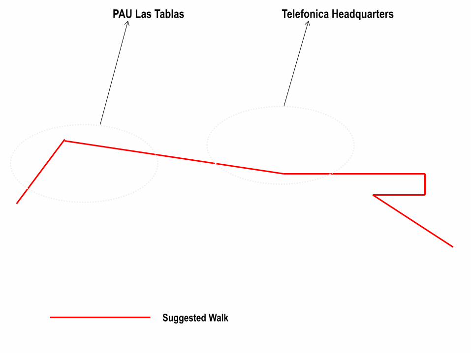
Suggested Walk
PAU Las Tablas Telefonica Headquarters


PAU Las Tablas Paseo San Millan de la Cogolla

Paseo de los Parques

DAY 1 AFTERNOON/EVENING

PAU San Chinarro
Mirador Building MDVRV
Telefonica Headquarters

Suggested Walk
1 2
3
4
5

1- Calle Antonio del Cabezon

2-Camino Sanchinarro

3-Calle Maria de Portugal

4-Calle Maria Tudor

4-Calle Princesa de Eboli 13

DAY 2 MORNING

Periphery Type: Residential PAU Carabanchel
Social Housing Thom Mayne
Social Housing Foreign Office Architects
• Inside the motorway
• More integrated with the city of Madrid and with
Old Carabanchel
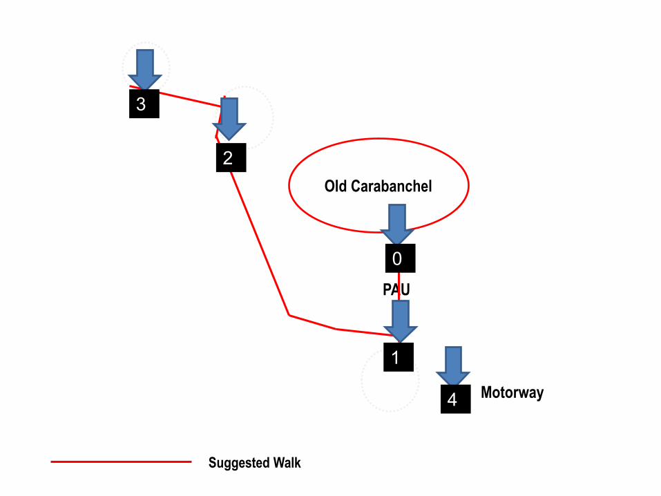
Old Carabanchel
PAU
Motorway
1
2
3
0
4
Suggested Walk

1-Calle Morales

1-Calle Morales

2- 12 Calle Clarinetes

2- 12 Calle Clarinetes

1-Calle Campanas/ Avenida Aviacion

1-Calle Campanas/ Avenida Aviacion

4- Avenida Carabanchel Alto

Periphery Type: Tertiary Suburban Corridors
Scientific Corridor North near Tres Cantos
Industrial Activities South Carlos, King Juan Carlos III Universities
From the centre of Madrid: the quickest way is to take the metro line 1 to Atocha Renfe station and them take the commuter train line (Cercanias) train C5 to Humanes and get off at Leganés Central. Upon leaving the train station from the main exit, turn left and walk straight on for 5 minutes until you reach the University

DAY 2 AFTERNOON/ EVENING


1-Avenida de la Universidad

2- Calle Santa Rosa

Tertiary corridor- strip

Appendix 3 Lab Notes: Detailed Fieldwork Madrid- Set of Instructions for reading these lab-notes (Steps 1-6) & lab-notes Detailed Fieldwork Madrid

Appendix 3
308
LAB NOTES: DETAILED FIELDWORK MADRID- SET OF INSTRUCTIONS FOR READING THESE LAB-NOTES (STEPS 1-6)

Appendix 3
309

Appendix 3
310

Appendix 3
311

Appendix 3
312
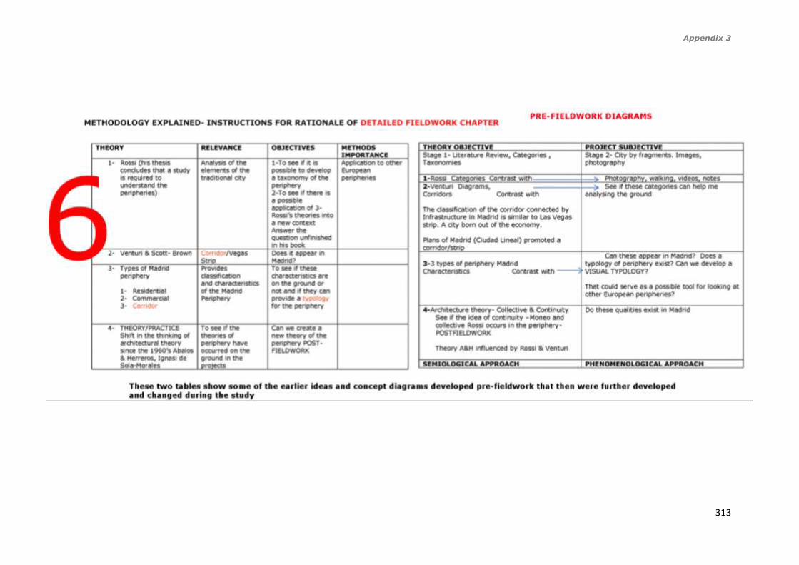
Appendix 3
313

Appendix 3
314
LAB-NOTES: DETAILED FIELDWORK MADRID
Madrid North: Telefonica HQ and PAU’s Las Tablas and San Chinarro
Figure 1- Stages of walked followed on site during fieldwork (in black) through Telefonica City followed by PAU Las Tablas, and from the BBVA headquarters to San Chinarro (20-32). The black line show the itinerary of the undertaken path that I followed, and the path then becomes a series of architectural objects that are recorded
mainly through photography at different stages telling a narrative that then analysed and evaluated could become a series of categories or typologies of these peripheral areas.1
1 Image copyright Google Earth, adapted by author

Appendix 3
315
Figure 2- Analysis of the route followed on site identifying different urban elements (Author’s own)2
2 Image copyright Google Earth, adapted by author

Appendix 3
316
Figure 3- This image shows the passage by Italo Calvino Cartography, Narrative, Journey. I highlighted in red
the words that relate to my chosen methodology combining photography, and walking highlighting the importance of images in developing a cartography for Madrid. The images from top to bottom show:1. the itinerary I
followed, 2. The image of the Madrid periphery and this collection of images will develop a cartography, 3. The image I took of the ground in one of the areas of impunity, or nomadic spaces. Highlighted in white in the
photographs are the words taken from Calvino’s passage that explain the methodology that I followed and the ideas behind it.3
3 Image copyright Google Earth, adapted by author, all other images taken by the author during fieldwork.
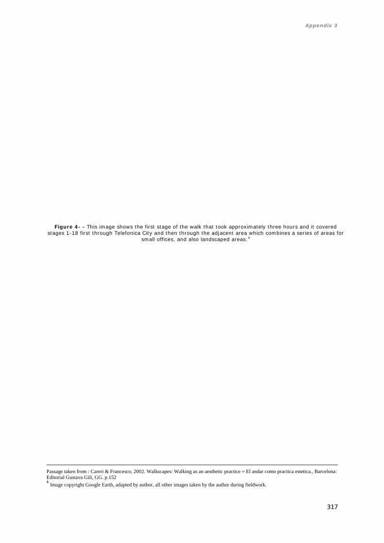
Appendix 3
317
Figure 4- - This image shows the first stage of the walk that took approximately three hours and it covered stages 1-18 first through Telefonica City and then through the adjacent area which combines a series of areas for
small offices, and also landscaped areas.4
Passage taken from : Careri & Francesco, 2002. Walkscapes: Walking as an aesthetic practice = El andar como practica estetica., Barcelona: Editorial Gustava Gili, GG. p.152 4 Image copyright Google Earth, adapted by author, all other images taken by the author during fieldwork.
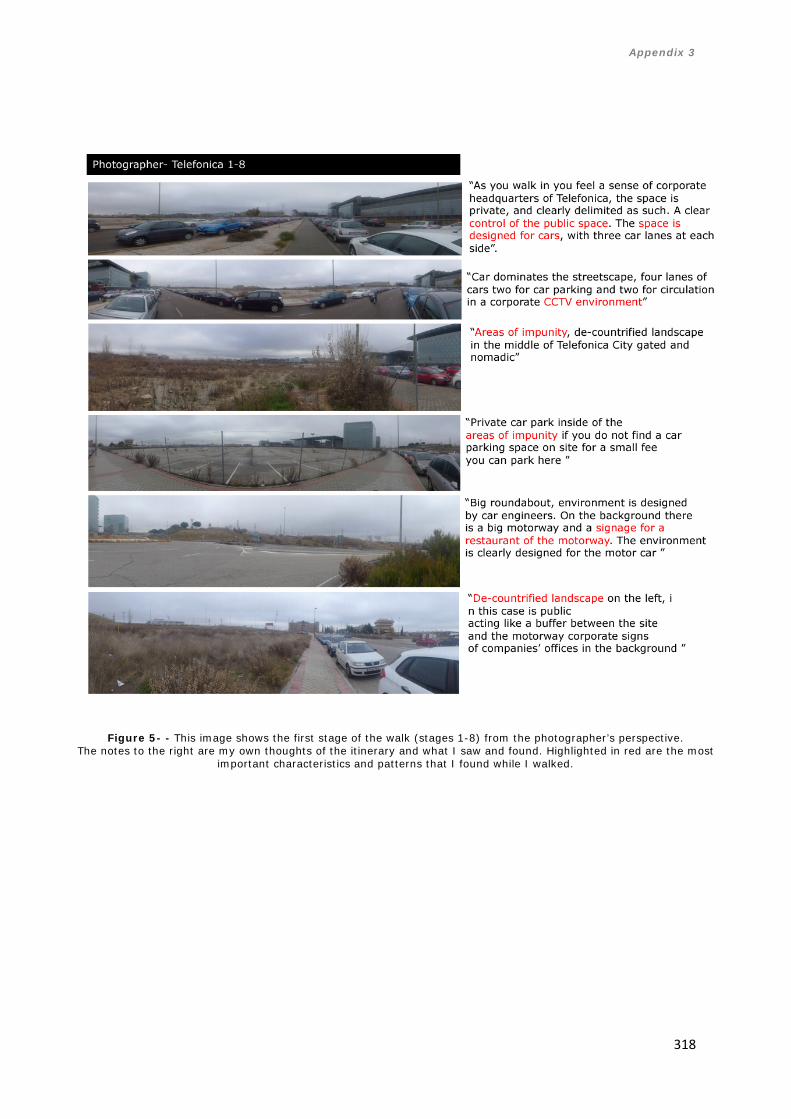
Appendix 3
318
Figure 5- - This image shows the first stage of the walk (stages 1-8) from the photographer’s perspective. The notes to the right are my own thoughts of the itinerary and what I saw and found. Highlighted in red are the most
important characteristics and patterns that I found while I walked.

Appendix 3
319
Figure 6 - This image shows the first stage of the walk (stages 1-8) from the architect’s perspective. The notes to the right are my own thoughts of the itinerary and what I saw and found. Highlighted in red are
the most important characteristics and patterns that I found while I walked.

Appendix 3
320
Figure 7 - This image shows the first stage of the walk (stages 1-8) from the architect’s perspective.
The notes to the right are my own thoughts of the itinerary and what I saw and found. Highlighted in red are the most important characteristics and patterns that I found while I walked.

Appendix 3
321
Figure 8- This image shows the first stage of the walk (stages 1-8) from the citizen’s perspective. The notes to the right are my own thoughts of the itinerary and what I saw and found. Highlighted in red are
the most important characteristics and patterns that I found while I walked.

Appendix 3
322
Figure 9- This image shows the first stage of the walk (stages 1-8) from the citizen’s perspective.
The notes to the right are my own thoughts of the itinerary and what I saw and found.

Appendix 3
323
5 Image copyright Google Earth, adapted by author, all other images taken by the author during fieldwork.
Figure 10 - This image shows the second stage of the walk that took approximately two and a half hours and it
covered stages 8-16 first through the PAU Last Tablas and ending at the end of the PAU in a de-countrified area in between the PAU and BBVA HQ5

Appendix 3
324
Figure 11 - This image shows the second stage of the walk (stages 8-16) from the photographer’s perspective.
The notes to the right are my own thoughts of the itinerary and what I saw and found. Highlighted in red are the most important characteristics and patterns that I found while I walked.

Appendix 3
325
Figure 12 - This image shows the second stage of the walk (stages 8-16) from the architect’s perspective. The notes to the right are my own thoughts of the itinerary and what I saw and found. Highlighted in red are the
most important characteristics and patterns that I found while I walked.

Appendix 3
326
Figure 13 - This image shows the second stage of the walk (stages 8-16) from the citizen’s perspective.
The notes to the right are my own thoughts of the itinerary and what I saw and found. Highlighted in red are the most important characteristics and patterns that I found while I walked.

Appendix 3
327
Figure 14 - This image shows the second stage of the walk (stages 8-16) from the citizen’s perspective. The notes to the right are my own thoughts of the itinerary and what I saw and found. Highlighted in red are the
most important characteristics and patterns that I found while I walked.

Appendix 3
328
Figure 15 - This image shows the second stage of the walk (stages 8-16) from the citizen’s perspective.
The notes to the right are my own thoughts of the itinerary and what I saw and found. Highlighted in red are the most important characteristics and patterns that I found while I walked.

Appendix 3
329
Figure 16 - This image shows the third stage of the walk that took approximately one hour it covered stages
16-23 first at the end of the PAU Las Tablas, through a de-countrified area and then through the bank BBVA HQ and then crossing through a pedestrian bridge the big motorway
and arriving at the beginning of the PAU San Chinarro.6
6 Image copyright Google Earth, adapted by author, all other images taken by the author during fieldwork.

Appendix 3
330
Figure 17 - This image shows the third stage of the walk (stages 16-23) from the photographer’s perspective.
The notes to the right are my own thoughts of the itinerary and what I saw and found. Highlighted in red are the most important characteristics and patterns that I found while I walked.

Appendix 3
331
Figure 18 - This image shows the third stage of the walk (stages 16-23) from the architect’s perspective.
The notes to the right are my own thoughts of the itinerary and what I saw and found. Highlighted in red are the most important characteristics and patterns that I found while I walked.

Appendix 3
332
Figure 19 - This image shows the third stage of the walk (stages 16-23) from the citizen’s perspective.
The notes to the right are my own thoughts of the itinerary and what I saw and found. Highlighted in red are the most important characteristics and patterns that I found while I walked.

Appendix 3
333
Figure 20 - This image shows the third stage of the walk (stages 16-23) from the citizen’s perspective.
The notes to the right are my own thoughts of the itinerary and what I saw and found. Highlighted in red are the most important characteristics and patterns that I found while I walked.

Appendix 3
334
Figure 21 - This image shows the fourth stage of the walk that took approximately three hours it covered
stages 24-29 starting at the cross of the pedestrian bridge above the motorway to the beginning of the PAU of San Chinarro and half way through it..7
7 Image copyright Google Earth, adapted by author, all other images taken by the author during fieldwork.

Appendix 3
335
Figure 22 - This image shows the fourth stage of the walk (stages 24-29) from the photographer’s perspective. The notes to the right are my own thoughts of the itinerary and what I saw and found. Highlighted in red are the most
important characteristics and patterns that I found while I walked.
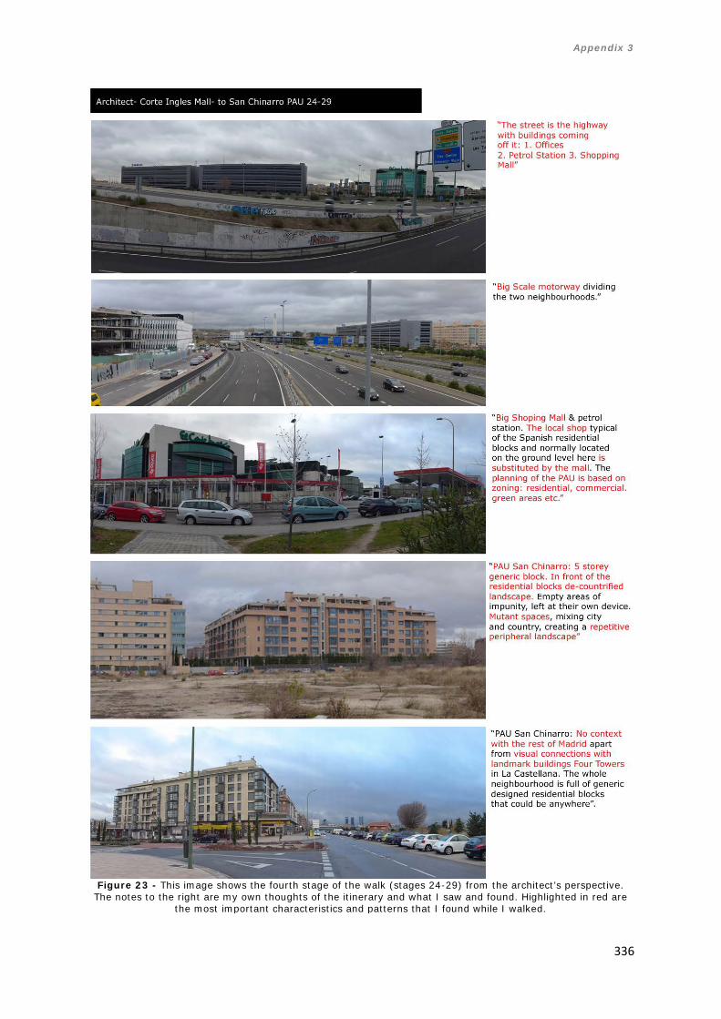
Appendix 3
336
Figure 23 - This image shows the fourth stage of the walk (stages 24-29) from the architect’s perspective.
The notes to the right are my own thoughts of the itinerary and what I saw and found. Highlighted in red are the most important characteristics and patterns that I found while I walked.

Appendix 3
337
Figure 24 - This image shows the fourth stage of the walk (stages 24-29) from the citizen’s perspective. The notes to the right are my own thoughts of the itinerary and what I saw and found. Highlighted in red are the
most important characteristics and patterns that I found while I walked.
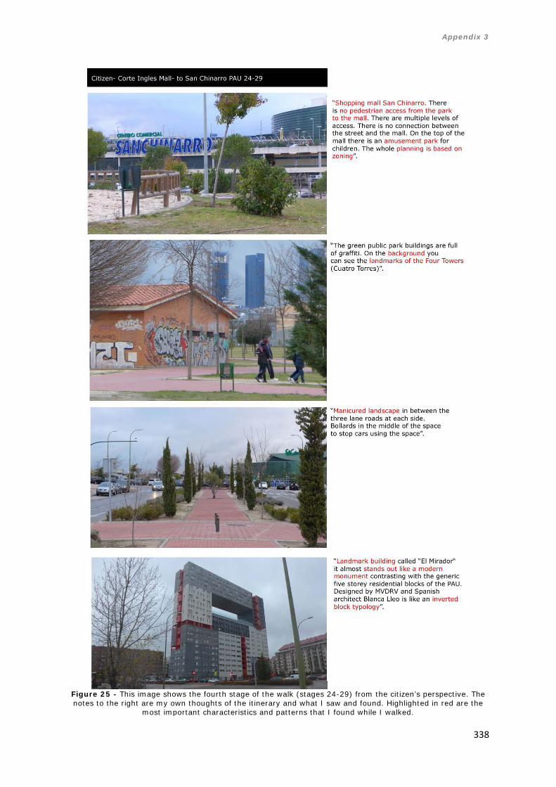
Appendix 3
338
Figure 25 - This image shows the fourth stage of the walk (stages 24-29) from the citizen’s perspective. The notes to the right are my own thoughts of the itinerary and what I saw and found. Highlighted in red are the
most important characteristics and patterns that I found while I walked.

Appendix 3
339
Figure 26 - This image shows the fifth stage of the walk that took approximately one hour it covered stages 29-32 starting in the middle of the PAU San Chinarro and concluding at the end of the PAU, with the MDVRV
landmark building8
8 Image copyright Google Earth, adapted by author, all other images taken by the author during fieldwork.

Appendix 3
340
Figure 27 - This image shows the fifth stage of the walk (stages 29-32) from the photographer’s perspective. The notes to
the right are my own thoughts of the itinerary and what I saw and found. Highlighted in red are the most important characteristics and patterns that I found while I walked.

Appendix 3
341
Figure 28 - This image shows the fifth stage of the walk (stages 29-32) from the architect’s perspective. The notes to the right are my own thoughts of the itinerary and what I saw and found. Highlighted in red are the most important characteristics and
patterns that I found while I walked.

Appendix 3
342
Figure 29 - This image shows the fifth stage of the walk (stages 29-32) from the citizen’s perspective. The notes to the right are my own thoughts of the itinerary and what I saw and found. Highlighted in red are the most important characteristics and
patterns that I found while I walked.

Appendix 3
343
Figure 30 - This image shows visual typology developed as a result of the walk and its different stages from the photographer’s perspective.

Appendix 3
344
Figure 31 - This image shows visual typology developed as a result of the walk and its different
stages from the architect’s perspective.

Appendix 3
345
Figure 32 - This image shows visual typology developed as a result of the walk and its different
stages from the citizen’s perspective.

Appendix 3
346
Categories (from fieldwork)
Stages 1-8 Tracing/ Image/ Itinerary (Calvino)
Stages 8-16 Tracing/ Image/ Itinerary (Calvino)
Stages16-23 Tracing/ Image/ Itinerary (Calvino)
Stages 24-29 Tracing/ Image/ Itinerary (Calvino)
Stages 29-32 Tracing/ Image/ Itinerary (Calvino)
Cartography (Calvino)-Emerging Patterns from the Cartography Resulting from the narrative of the journey
Photographer Narrative Idea Extracted from image by author
• Control of public space
• Space is designed for cars
• CCTV environment • Areas of impunity • Signage for a
restaurant in the motorway
• De-countrified landscape
• Generic blocks of 4-5 storeys flats
• Four lane traffic road at each side
• Big scale • De-countrified
landscape • Everything has been
built too quickly • No context • Space designed for cars
• Area of impunity
• Mix between the city and the country
• Mutant space • We can see
the landmark of the Four Towers
• Landscape is mutant and nomadic
• New corporate HQ of the bank BBVA
• A petrol station off the road and also a Mc Donalds
• The design of the street is around the car
• Big motorway • Off the
motorway: 1. Car showrooms
• 2 A petrol station & shopping mall
• Civic Highway divides the two peripheral areas of Las Tablas and San Chinarro
• Big green area • Manicured
landscape • 6 lane traffic
road in residential area of San Chinarro
• Big scale roads and car priority
• Manicured landscape
• Landmark • 6 lane
traffic road in residential area of San Chinarro
• “El Mirador” building. Monument in the generic landscape
• De-countrified landscape
• Signage for car drivers
• The public square becomes a roundabout
• Control of public space • Space is designed for cars • CCTV environment • De-countrified landscape • Generic blocks of 4-5 storeys
flats • Everything has been built too
quickly • Mix between the city and the
country • We can see the landmark of the
Four Towers • Landscape is mutant and
nomadic • New corporate HQ of the bank
BBVA • A petrol station off the road
and also a Mc Donalds • Civic Highway divides the two
peripheral areas of Las Tablas and San Chinarro
• Off the motorway: 1. Car showrooms 2 A petrol station & shopping mall
• Big green area • Manicured landscape • 6 lane traffic road in residential
area of San Chinarro • “El Mirador” building.
Monument in the generic landscape
• Signage for car drivers • The public square becomes a
roundabout

Appendix 3
347
Architect Narrative Idea Extracted from image by author
• Manicured landscape • Bollards • CCTV cameras,
private street & car oriented design
• Motorways, the car is the king
• Signage for a restaurant off the motorway
• De-countrified landscape
• Iconography of signs • Signs for cars, the
building is not the form but the sign
• Signs for cars, Burger King, Shopping mall
• Building signs, corporate HQ
• Golf course: manicured form of landscape for leisure use
• Generic blocks • The same façade is
repeated with minimum change
• Areas of impunity • Lack of distinctiveness.
All the blocks are the same.
• Monotonous elevations, no commercial ground activity.
• Architectural experimentation
• Monotonous residential blocks in front of de-countrified landscape
• Office block with mirror style façade in front of manicured landscape
• Environment designed for cars
• Signs designed to be seen from a car: Mc Donalds and a petrol station.
• Four lane road designed for cars not for pedestrians
• No relationship between the buildings and the ground level.
• Generic petrol station, Mc Donalds restaurant and a de-countrified area. Signs everywhere for the cars indicating a P for Car Parking, a M for Mc Donalds
• The street is the highway with buildings coming off it: 1 Offices 2. Petrol station 3 Shopping Mall.
• Big scale motorway
• The local shop is substituted by the mall.
• Planning of the PAU is based on zoning: residential, commercial, green areas etc.
• PAU San Chinarro: 5 storey generic block. In front of the residential blocks de-countrified landscape.
• Mutant spaces
• Repetitive peripheral landscape
• No context with the rest of Madrid
• Generic 6 storey residential block
• Manicured landscape
• De-countrified landscape
• All the blocks are very similar typology and repetitive and monotonous
• The PAU is mainly single use residential, zoning is clear. No offices, or mix uses integrated together
• The whole environment is designed for cars.
• Block “El Mirador” is like a modern monument
• Manicured landscape • CCTV cameras, private street &
car oriented design (bollards) • De-countrified landscape • Iconography of signs • Signs for cars, the building are
not the form but the sign: 1 Signs for cars, Burger King, Shopping mall 2. Building signs, corporate HQ.
• Golf course: manicured form of landscape for leisure use
• Monotonous residential blocks in front of de-countrified landscape
• Architectural experimentation • Office block with mirror style
façade in front of manicured landscape
• Environment designed for cars: four lane road
• Signs designed to be seen from a car: Mc Donalds and a petrol station.
• The street is the highway with buildings coming off it: 1 Offices 2. Petrol station 3 Shopping Mall.
• Planning of the PAU is based on zoning: residential, commercial, green areas etc.
• PAU San Chinarro: 5 storey generic block. In front of the residential blocks de-countrified landscape.
• Mutant spaces • No context with the rest of
Madrid • Block “El Mirador” is like a
modern monument Citizen Narrative Idea Extracted from image by
• Environment designed for cars
• Manicured landscape • Control of public
space • Signage for cars
• Big green island of public space in the middle
• Space is used for people to pass by, not to stop and play
• Signage for cars in the street indicating: 1 the motorway 2 Sanchinarro
• Ground outside mall that is off the motorway is used as a space for
• De-countrified landscape
• Street elevation has no
• Environment designed for cars • Control of public space • Areas of impunity • Starbucks, private street, CCTV
controlled environment • Traffic engineered designed

Appendix 3
348
Figure 33 - This table shows the author’s subjective notes from the fieldwork’s itinerary at each stage from the 3 perspectives (photographer, architect& citizen)
author • Areas of impunity • Nomadic spaces • Control of public
space • Space designed for
cars • Manicured landscape
adding a few trees • Starbucks, private
street, CCTV controlled environment
• De-countrified public landscape
• Narrow public path in between the cars
• Traffic engineered designed environment
• Three lanes of landscape. No benches to sit down, no shelter.
• The street is not a street. No shops or human activity on the ground level
• The whole environment is designed around and for cars.
• The street becomes a six way lane for cars and the space on the ground in the middle, a manicured set of shrubs.
• Area of impunity • Brick wall on the ground
closing what it would have been traditional in Spain, a commercial unit like a café, or a shop.
• Portakabin style temporary structure in the middle of the green space.
• De-countrified space next to the church that is the only civic building in the PAU
• Control of public space. Protective gates. CCTV cameras.
• Small Chinese store. The Chinese store becomes the local shop.
3 The shopping Mall.
• Manicured landscape area
• Signage indicating “it is forbidden to enter Private Property”. Space is private and controlled
• Eight lane traffic road
• Manicured landscape: Carefully designed to be seen from a car driver’s perspective
• Car parking wash area off the motorway
• Signage indicating Mc Donald’s menu
• Carefully designed square concrete bollards
• Manicured landscape
cleaning cars • The whole
space is designed around and for cars
• De-countrified space in front of residential blocks
• Transition of external spaces: 1 De-countrified space with a fence 2. Pavement 3 manicured shrubs
• Wilderness (de-countrified landscape) versus order (manicured shrubs)
• Big green area between residential blocks
• Amusement Park
• Planning based on zoning
• Manicured landscape
commercial activity
• Signage for cars indicating the closest Mc Donalds
environment • Big green island of public space
in the middle • Three lanes of landscape. No
benches to sit down, no shelter.
• The street is not a street. No shops or human activity on the ground level
• The street is not a street. No shops or human activity on the ground level
• Portakabin style temporary structure in the middle of the green space.
• Small Chinese store. The Chinese store becomes the local shop.
• Signage indicating “it is forbidden to enter Private Property”. Space is private and controlled
• Eight lane traffic road • Manicured landscape:
carefully designed to be seen from a car driver’s perspective
• The design focus of the street furniture is around the cars not the pedestrians: carefully designed square concrete bollards
• Transition of external spaces: 1 De-countrified space with a fence 2. Pavement 3 manicured shrubs
• Wilderness (de-countrified landscape) versus order (manicured shrubs)
• Planning based on zoning • Landmark building stands out
like a modern monument. Inverted block typology

Appendix 3
349
9 Sorkin, M., 2008, Big Brother Is charging you In: Sorkin, M., 2011. All over the map: writing on buildings and cities, London New York: Verso. pp. 311-13
Categories (from fieldwork) To be read in sequence from left to right
Cartography (Calvino)-Subjective-Practice Emerging Patterns from the Cartography Resulting from the narrative of the journey
Concept Objective Theory This column shows the concept as defined in the literature in relation to the emerging patterns that were found in the fieldwork from the previous column
Theorist This column shows the concept and theorist/s and highlighted in red are the main concepts’ characteristics taken from the literature analysis from the previous column
Photographer Narrative Idea Extracted from image by author
• Control of public space • CCTV environment • Space is designed for cars • De-countrified landscape • Generic blocks of 4-5 storeys flats • Everything has been built too
quickly • Mix between the city and the
country • We can see the landmark of the
Four Towers • Landscape is mutant and nomadic • New corporate HQ of the bank
BBVA • A petrol station off the road and
also a Mc Donalds • Civic Highway divides the two
peripheral areas of Las Tablas and San Chinarro
• Off the motorway: 1. Car showrooms 2 A petrol station & shopping mall
• Big green area • Manicured landscape • 6 lane traffic road in residential
area of San Chinarro • “El Mirador” building. Monument in
the generic landscape • Signage for car drivers • The public square becomes a
roundabout
Control of public space & CCTV environment “This transformation is fundamental. Cities-and the organization space in general- bare key media by which we sort out the boundaries between public and private, and the public side of the equation is increasingly squeezed. The dramatic acceleration of surveillance post 9/11 is one marker of the contraction, and police agencies, public and private are enjoying virtual carte blanche to intrude in the traditional public realm-the streets of the city- and in the private as well” 9 De-countrified landscape (Descampados)- Areas of Impunity & Mix between the city and the country 1- “One is tempted to ask whether
they might contain a metaphoric model, a quasi-model, or whether it is possible to think of their compliment, de-edification, given that the term ‘descampados’ embodies a fascinating concept: land that has lost its attributes as the city approaches, sterilised
Control of public space & CCTV environment- Michael Sorkin • . The dramatic acceleration of
surveillance post 9/11 is one marker of the contraction
De-countrified landscape- Abalos & Herreros • Land that has lost its attributes as the
city approaches • Sterilised before being occupied • dissolution of the natural-artificial
Opposition that we observe at every scale

Appendix 3
350
10 The term descampados is translated from Spanish as open country or “de-countrified” please refer to Abalos & Herreros, A New Naturalism (7 Micromanifestos) In: Beigel, F., 2002. Ábalos&Herreros, Barcelona: Editorial Gustavo Gili. p.28 11 Ibid. p 28 12 Careri Francesco, 2002. Walkscapes: Walking as an aesthetic practice = El andar como practica estetica., Barcelona: Editorial Gustava Gili, GG. p. 14. Here Tiberghien refers to the work of the American artist Robert Smithson. For further information about his work please refer to Reynolds, A.M. & Smithson, R., 2003. Robert Smithson: learning from New Jersey and elsewhere, Cambridge, Mass.: MIT Press p.23
before being occupied, but also given a transcendental role in its new context”10 “The dissolution of the natural-artificial opposition that we observe at every scale implies a working program which is nothing other than re-describing the position of contemporary man vis-à-vis the world. “Areas of impunity” are precisely those zones in which this ambiguous status is produced in an exceptional way, a status whose designation as public is imprecise. These formerly negative zones are endowed with a new urban status by the gaze of new social subjects and their practices”11
2- “Repressed memory, rejection,
absence of control have produced a system of empty spaces (the sea of the archipelago) through which it is possible to drift, as in the labyrinthine sectors of Constant’s New Babylon: a nomadic space ramified as a system of urban sheep tracks that seems to have taken form as the result of the entropy of the city, as one of the “forgotten futures” described by Robert Smithson. Inside the wrinkles of the city, spaces in transit have grown, territories in continuous transformation in time”12
3- “It is impossible to capture in a
Areas of Impunity- Abalos & Herreros • Zones in which this ambiguous status
is produced in an exceptional way • Designation as public is imprecise • Negative zones are endowed with a
new urban status System of empty spaces- Francesco Careri • Absence of control • System of empty spaces (the sea of
the archipelago) • A nomadic space ramified as a system
of urban sheep tracks • Spaces in transit have grown,
territories in continuous transformation in time
Terrain Vague-Ignasi de Solà-Morales

Appendix 3
351
13 Solà-Morales, I.,1994, Terrain vague In: Cynthia C. Davidson Anyone Corporation, 1995. Anyplace, New York, N.Y. : Cambridge Mass: Anyone Corp. ; MIT Press. p.119 14 Ibid. p.119
single English word or phrase the meaning of terrain vague. The French term terrain connotes a more urban quality than the English land thus terrain is an extension of the precisely limited ground fit for construction, for the city. […] The French word also refers also refers to greater and perhaps less precisely defined territories, connected with the physical idea of portion of land in its potentially exploitable state but already possessing some definition to which we are external […] Vague descends from vacuus, giving us “vacant” and “vacuum” in English, which is to say “empty, unoccupied”, yet also “free, available, unengaged”13
Landscape is mutant and nomadic 1- “Once again the paradox of the
message we receive from these indefinite and uncertain spaces is not purely negative. While the analogous terms that we noted are generally preceded by negative particles (in-determinate, im-precise, un-certain), this absence of limit precisely contains the expectation of mobility, vagrant roving, free time, liberty”14
2- “[…] they form an enormous portion of undeveloped territory that is utilized and experienced in an infinite numbers of ways, and in some cases tends out to be absolutely impenetrable. The voids are fundamental part of the urban
• Extension of the precisely limited ground Fit for construction, for the city
• portion of land in its potentially exploitable state
• “Empty, unoccupied”, yet also “free, available, unengaged
Imprecise, expectation of mobility, vagrant territory-Ignasi de Solà-Morales • In-determinate, im-precise, un-
certain) • This absence of limit precisely
contains the expectation of mobility, vagrant roving, free time, liberty
Voids- Nomadic territory- Francesco Careri • Enormous portion of undeveloped
territory • The voids are fundamental part of the
urban system, • Spaces that inhabit the city in a

Appendix 3
352
15 Careri Francesco, 2002. Walkscapes: Walking as an aesthetic practice = El andar como practica estetica., Barcelona: Editorial Gustava Gili, GG. p. 181 16 Ibid. p.183
17 Prat, R, 2008, Madrid The Rise of the Residential Periphery, In: Ballesteros, M., 2008. Verb crisis, Barcelona; New York: Actar p. 40
system, spaces that inhabit the city in a nomadic way, moving on every time the powers that be try to impose a new order” 15
3- “At the margins, on the other hand,
we find a certain dynamism and we can observe the becoming of a vital organism that transforms itself, leaving entire parts of the territory in a state of abandon around and inside itself, in a situation that is difficult to control”16
Generic blocks of 4-5 storeys flats. Everything has been built too quickly. Big green area. 6 lane traffic road in residential area of San Chinarro “The PAU communities are advertised as extensions of the already sprawling city; they are not considered to be separate and different communities. However the built reality of these places speaks otherwise. Unlike the city center, which possesses the full gamut of business, commercial and cultural institutions inter- mixed within the residential fabric, the PAUs are far more segregated. Commerce is typically concentrated into one large shopping mall; green areas, through generous are mostly peripheral; most residents commute into the city-proper for work”17 “Unlike the more heterogeneous Madrid
nomadic way • Moving on every time the powers that
be try to impose a new order Dynamic territory- Francesco Careri • At the margins […] we find a certain
dynamism • Vital organism that transforms itself • Entire parts of the territory in a state
of abandon around and inside itself, in a situation that is difficult to control
PAU segregated , Commerce concentrated in one shopping mall, green areas peripheral, and residents commute in the car - Ramon Prat • Commerce is typically concentrated
into one large shopping mall • Green areas, through generous are
mostly peripheral • Most residents commute into the city-
proper for work Generic- Homogeneous lookalike housing blocks- - Ramon Prat • Highly homogeneous

Appendix 3
353
18 Ibid p.42 19 Ibid p.43 20 Van Rijs, J. MVDRV, 2008, Madrid BoomBoomMadrid The Disappearance of Social Housing, In: Ballesteros, M., 2008. Verb crisis, Barcelona; New York: Actar pp. 142-43
city center, its periphery is highly homogeneous, a gigantic game-board populated by an army of look-alike housing blocks that are unctuated by the occasional shopping center”18 “Moreover, except for the dozen or so examples of innovative structures, the large majority of properties are indistinguishable: it’s as if everything has been plucked from a huge residential superstore; off- the-shelve brick apartment buildings and industrial strength park spaces deployed across millions of square meters of meseta”19 “Why only terracotta blocks? Is the resultant urban monotony created during this unprecedented period of economic growth not a huge missed opportunity? […] this design freedom has produced in Spain (and especially in Madrid ), a mostly homogeneous (and large) production of identical blocks filled with three and four bedroom apartments”20 Green areas. The public square becomes a roundabout : “While the existing 70,000 units of housing are modest in size (from 20m2 to 90m2 , for a family of five) and tightly packed into hundreds of seven to nine story apartment blocks, this very real residential density is offset by an oversized network of wide boulevards and leisure plots, whose paved personae
• An army of look-alike housing blocks • Punctuated by the occasional
shopping center Generic- properties are indistinguishable- Ramon Prat • It’s as if everything has been plucked
from a huge residential superstore; off- the-shelve brick apartment buildings
• Industrial strength park spaces deployed across millions of square meters
Urban Monotony & Identical Blocks -Jacob van Rijs MVDRV • Resultant urban monotony created
during this unprecedented period of economic growth
• This design freedom has produced in Spain (and especially in Madrid ), a mostly homogeneous (and large) production of identical blocks
Green areas & Public Space - Ramon Prat • Oversized network of wide boulevards
and leisure plots • More parking lot than park • Asphalt suburbia • Plush lawns have been swapped for
acres of hard-top

Appendix 3
354
21 Prat, R, 2008, Madrid The Rise of the Residential Periphery, In: Ballesteros, M., 2008. Verb crisis, Barcelona; New York: Actar p.43 22 Jaque, A.,. 2009 Presentation the state if the question and three priorities in a Madrid which is politically Eco-systematic In: Cantis, A.J. & Jaque, A., 2009. Piensa Madrid = Think Madrid: [José María Ezquiaga, Juan Herreros, Fabio Casiroli ...]. In [Madrid]: Caja Madrid: La Casa Encendida. p.245 23 Herreros, J,. 2009, Madrid in times of crisis, from the periphery to the centre through the inner suburbs In: Cantis, A.J. & Jaque, A., 2009. Piensa Madrid = Think Madrid: [José María Ezquiaga, Juan Herreros, Fabio Casiroli ...]. In [Madrid]: Caja Madrid: La Casa Encendida. p.285
(more parking lot than park) intensify the feeling of being in an asphalt suburbia, where plush lawns have been swapped for acres of hard-top”21 New corporate HQ of the bank BBVA “A model which […] has led to an exodus of corporate headquarters- Telefonica, Banco Santander, Central Hispano- even the large state institutions,- let us not forget the Campus de la Justicia- from the old meeting centres and integrated institutional representations such as Alcala street, or Paseo de la Castellana – to areas where land is cheaper and neighbourhoods yet to be designed”22 “[…] the centre has lost residents, has expelled large corporations who now concentrate their workforce in the “corporate cities” of the outskirsts”23 A petrol station off the road and also a Mc Donalds. Civic Highway divides the two peripheral areas of Las Tablas and San Chinarro. Off the motorway: 1. Car showrooms 2 A petrol station & shopping mall 1. “[…] is chaos. The order in this
landscape is not obvious […] The continuous highway itself and its systems for turning are absolutely consistent […] This counterpoint reinforces the contrast between two
Large HQ Financial corporations moving to the periphery - Andres Jaque • A model which […] has led to an
exodus of corporate headquarters- Telefonica, Banco Santander, Central Hispano- even the large state institutions […] to areas where land is cheaper and neighbourhoods yet to be designed
Corporate cities-Juan Herreros • large corporations who now
concentrate their workforce in the “corporate cities” of the outskirts
Separation between PAU Las Tablas and PAU San Chinarro is the motorway: A strip Two types of strip order: Highway is civic the elements off the highway and buildings and signs are private- Robert Venturi and Denise Scott Brown • Two types of order on the Strip: the
obvious visual order of street elements and the difficult visual order of buildings and signs.
• The zone of the highway is a shared

Appendix 3
355
24 Venturi, R., Scott Brown, D. & Izenour, S., 1996. Learning from Las Vegas: the forgotten symbolism of architectural form, Cambridge Mass.: The MIT Press. p. 20 25 Ezquiaga, J.M.,. 2009 Fragmentation to fractality: the paradoxes of diversity In: Cantis, A.J. & Jaque, A., 2009. Piensa Madrid = Think Madrid: [José María Ezquiaga, Juan Herreros, Fabio Casiroli ...]. In [Madrid]: Caja Madrid: La Casa Encendida. p.272. 26 Careri & Francesco, 2002. Walkscapes: Walking as an aesthetic practice = El andar como practica estetica., Barcelona: Editorial Gustava Gili, GG. pp .180-181
types of order on the Strip: the obvious visual order of street elements and the difficult visual order of buildings and signs. The zone of the highway is a shared order. The zone off the highway is an individual order. […] The elements of the highway are civic. The buildings and signs are private”24
2. “[…] backing urban references of
traditional centrality, and the low density suburbanisation, first of the higher and mid-income properties, and later in segments of directional activities with a higher added value (financial entities, R+D, directional tertiary sector activity), specialised services (private universities, hospitals…), leisure and commerce (large commercial centres, theme parks) […]”25
3. “The inhabitants of this city, the
“diffuse settlers”, were people who lived of the most elementary civil and urban laws, inhabiting only the private space of the home and the automobile. Their only idea of public space was the shopping mall, the highway rest stop, the gas station and the railroad station”26
“El Mirador” building. Monument in the generic landscape. We can see the landmark of the Four Towers
order. The zone off the highway is an individual order
• The elements of the highway are civic. The buildings and signs are private.
Image of the peripheral strip/corridor in Madrid- Jose Maria Ezquiaga • Low density suburbanisation • Segments of directional activities with
a higher added value (financial entities, R+D, directional tertiary sector activity)
• Specialised services (private universities, hospitals…)
• Leisure and commerce (large commercial centres, theme parks)
Inhabitants use the car and private space and public space is reduced to things off the highway- Jose Maria Ezquiaga • Inhabiting only the private space of
the home and the automobile • Their only idea of public space was
the shopping mall, the highway rest stop, the gas station and the railroad station
El Mirador” by MVDRV a monument amongst the generic residential architecture of the PAU- Ramon Prat
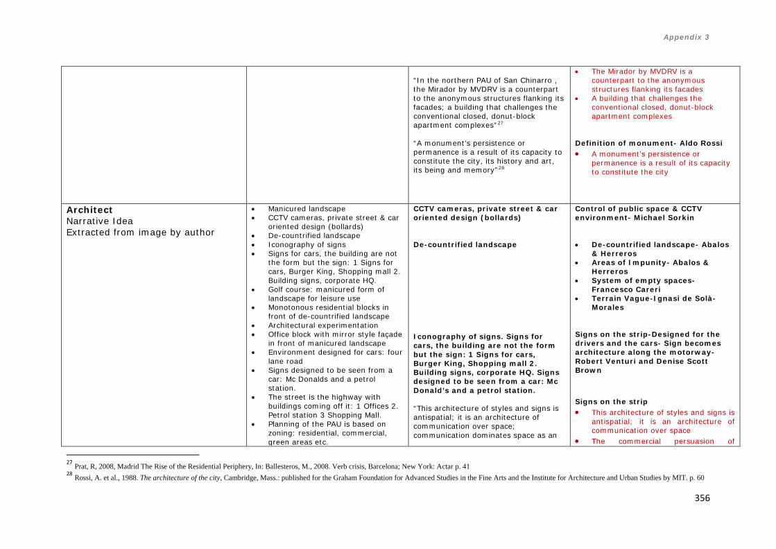
Appendix 3
356
27 Prat, R, 2008, Madrid The Rise of the Residential Periphery, In: Ballesteros, M., 2008. Verb crisis, Barcelona; New York: Actar p. 41 28 Rossi, A. et al., 1988. The architecture of the city, Cambridge, Mass.: published for the Graham Foundation for Advanced Studies in the Fine Arts and the Institute for Architecture and Urban Studies by MIT. p. 60
“In the northern PAU of San Chinarro , the Mirador by MVDRV is a counterpart to the anonymous structures flanking its facades; a building that challenges the conventional closed, donut-block apartment complexes”27 “A monument’s persistence or permanence is a result of its capacity to constitute the city, its history and art, its being and memory”28
• The Mirador by MVDRV is a counterpart to the anonymous structures flanking its facades
• A building that challenges the conventional closed, donut-block apartment complexes
Definition of monument- Aldo Rossi • A monument’s persistence or
permanence is a result of its capacity to constitute the city
Architect Narrative Idea Extracted from image by author
• Manicured landscape • CCTV cameras, private street & car
oriented design (bollards) • De-countrified landscape • Iconography of signs • Signs for cars, the building are not
the form but the sign: 1 Signs for cars, Burger King, Shopping mall 2. Building signs, corporate HQ.
• Golf course: manicured form of landscape for leisure use
• Monotonous residential blocks in front of de-countrified landscape
• Architectural experimentation • Office block with mirror style façade
in front of manicured landscape • Environment designed for cars: four
lane road • Signs designed to be seen from a
car: Mc Donalds and a petrol station.
• The street is the highway with buildings coming off it: 1 Offices 2. Petrol station 3 Shopping Mall.
• Planning of the PAU is based on zoning: residential, commercial, green areas etc.
CCTV cameras, private street & car oriented design (bollards) De-countrified landscape Iconography of signs. Signs for cars, the building are not the form but the sign: 1 Signs for cars, Burger King, Shopping mall 2. Building signs, corporate HQ. Signs designed to be seen from a car: Mc Donald’s and a petrol station. “This architecture of styles and signs is antispatial; it is an architecture of communication over space; communication dominates space as an
Control of public space & CCTV environment- Michael Sorkin • De-countrified landscape- Abalos
& Herreros • Areas of Impunity- Abalos &
Herreros • System of empty spaces-
Francesco Careri • Terrain Vague-Ignasi de Solà-
Morales Signs on the strip-Designed for the drivers and the cars- Sign becomes architecture along the motorway-Robert Venturi and Denise Scott Brown Signs on the strip • This architecture of styles and signs is
antispatial; it is an architecture of communication over space
• The commercial persuasion of

Appendix 3
357
29 Venturi, R., Scott Brown, D. & Izenour, S., 1996. Learning from Las Vegas: the forgotten symbolism of architectural form, Cambridge Mass.: The MIT Press. p. 8 30 Ibid. p 9 31 Ibid. p 13 32 Abalos & Herreros, A New Naturalism (7 Micromanifestos) In: Beigel, F., 2002. Ábalos&Herreros, Barcelona: Editorial Gustavo Gili. p.28
• PAU San Chinarro: 5 storey generic block. In front of the residential blocks de-countrified landscape.
• Mutant spaces • No context with the rest of Madrid • Block “El Mirador” is like a modern
monument
element in the architecture and in the landscape […] The commercial persuasion of roadside eclecticism provokes bold impact in the vast and complex setting of a new landscape of big spaces, high speeds and complex programs”29 “But the driver has no time to ponder paradoxical subtleties within a dangerous, sinuous maze. He or she relies on the signs for guidance –enormous signs in vast spaces at high speeds”30 “[…] architecture in this landscape becomes symbol in space rather than form in space. Architecture defines very little: The big sign and the little building is the rule of Route 66[…]The sign is more important than the architecture […]The sign at the front is a vulgar extravaganza, the building at the back, a modest necessity”31 Manicured landscape. Golf course: manicured form of landscape for leisure use. “The dissolution of the natural-artificial opposition that we observe at every scale implies a working program which is nothing other than re-describing the position of contemporary man vis-à-vis the world”32.
roadside eclecticism provokes bold impact in the vast and complex setting of a new landscape of big spaces, high speeds and complex programs
Designed for the drivers and the cars • The driver has no time to ponder
paradoxical subtleties within a dangerous, sinuous maze.
• He or she relies on the signs for guidance
• Enormous signs in vast spaces at high speeds
Sign becomes architecture along the motorway • Architecture in this landscape
becomes symbol in space rather than form in space
• The big sign and the little building is the rule of Route 66
• The sign at the front is a vulgar extravaganza, the building at the back, a modest necessity
Dissolution of natural and artificial in the periphery, we observe the natural wild landscape against a new form of carefully planned and manicured landscape (the golf course)- Abalos & Herreros • The dissolution of the natural-artificial
opposition that we observe at every scale
• Implies a working program which is nothing other than re-describing the position of contemporary man vis-à-vis the world

Appendix 3
358
33 Prat, R, 2008, Madrid The Rise of the Residential Periphery, In: Ballesteros, M., 2008. Verb crisis, Barcelona; New York: Actar p. 39 34 Herreros, J,. 2009, Madrid in times of crisis, from the periphery to the centre through the inner suburbs In: Cantis, A.J. & Jaque, A., 2009. Piensa Madrid = Think Madrid: [José María Ezquiaga, Juan Herreros, Fabio Casiroli ...]. In [Madrid]: Caja Madrid: La Casa Encendida. p.285 35 Garcia-German, J, 2008, Madrid, In: Ballesteros, M., 2008. Verb crisis, Barcelona; New York: Actar p. 148
Monotonous residential blocks in front of de-countrified landscape. Office block with mirror style façade in front of manicured landscape. PAU San Chinarro: 5 storey generic block. In front of the residential blocks de-countrified landscape. No context with the rest of Madrid Architectural experimentation “A feast for the hungry architect, the periphery is dotted with a dozen examples of interesting architectural experimentation”33 “[…] view the peripheries as a deregulated zone in which they could rehearse a new scale, typology and programmes, and activate new types of public spaces”34 Planning of the PAU is based on zoning: residential, commercial, green areas etc. “Here the overlaying of functions has been eliminated, buildings are icebergs floating in isolation, and contact is reduced to the absolute bare minimum”35
• Generic- Homogeneous lookalike
housing blocks- - Ramon Prat • Generic- properties are
indistinguishable- Ramon Prat • Urban Monotony & Identical
Blocks -Jacob van Rijs MVDRV Architectural experimentation in Madrid- Ramon Prat • A feast for the hungry architect • The periphery is dotted with a dozen
examples of interesting architectural experimentation
Periphery as a deregulated zone for architects to try new things- Juan Herreros • Peripheries as a deregulated zone • They could rehearse a new scale,
typology and programmes • Activate new types of public spaces Zoning in planning the PAU’s- Jacobo Garcia-German • Overlaying of functions has been
eliminated • Buildings are icebergs floating in
isolation • Contact is reduced to the absolute
bare minimum
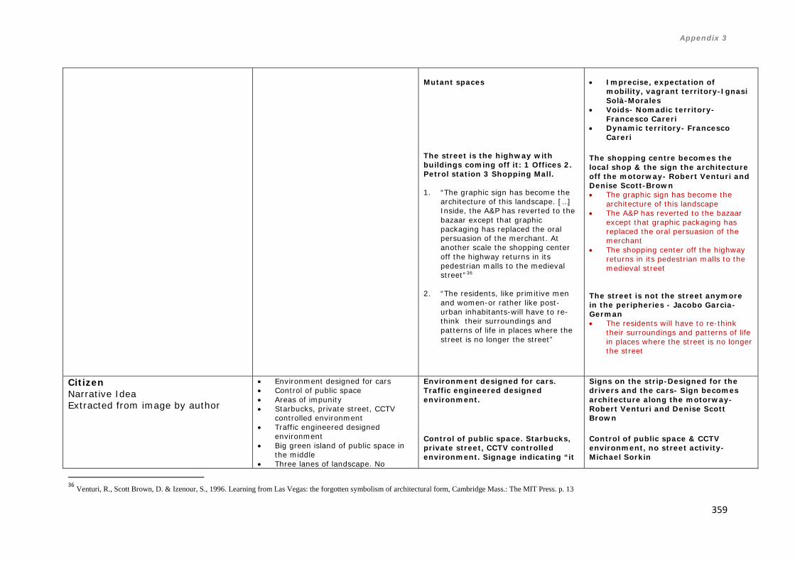
Appendix 3
359
36 Venturi, R., Scott Brown, D. & Izenour, S., 1996. Learning from Las Vegas: the forgotten symbolism of architectural form, Cambridge Mass.: The MIT Press. p. 13
Mutant spaces The street is the highway with buildings coming off it: 1 Offices 2. Petrol station 3 Shopping Mall. 1. “The graphic sign has become the
architecture of this landscape. […] Inside, the A&P has reverted to the bazaar except that graphic packaging has replaced the oral persuasion of the merchant. At another scale the shopping center off the highway returns in its pedestrian malls to the medieval street”36
2. “The residents, like primitive men
and women-or rather like post- urban inhabitants-will have to re-think their surroundings and patterns of life in places where the street is no longer the street”
• Imprecise, expectation of
mobility, vagrant territory-Ignasi Solà-Morales
• Voids- Nomadic territory- Francesco Careri
• Dynamic territory- Francesco Careri
The shopping centre becomes the local shop & the sign the architecture off the motorway- Robert Venturi and Denise Scott-Brown • The graphic sign has become the
architecture of this landscape • The A&P has reverted to the bazaar
except that graphic packaging has replaced the oral persuasion of the merchant
• The shopping center off the highway returns in its pedestrian malls to the medieval street
The street is not the street anymore in the peripheries - Jacobo Garcia-German • The residents will have to re-think
their surroundings and patterns of life in places where the street is no longer the street
Citizen Narrative Idea Extracted from image by author
• Environment designed for cars • Control of public space • Areas of impunity • Starbucks, private street, CCTV
controlled environment • Traffic engineered designed
environment • Big green island of public space in
the middle • Three lanes of landscape. No
Environment designed for cars. Traffic engineered designed environment. Control of public space. Starbucks, private street, CCTV controlled environment. Signage indicating “it
Signs on the strip-Designed for the drivers and the cars- Sign becomes architecture along the motorway-Robert Venturi and Denise Scott Brown Control of public space & CCTV environment, no street activity- Michael Sorkin

Appendix 3
360
37 Sorkin, M., 2008, Big Brother Is charging you In: Sorkin, M., 2011. All over the map: writing on buildings and cities, London New York: Verso. pp. 311-13 38 Prat, R, 2008, Madrid The Rise of the Residential Periphery, In: Ballesteros, M., 2008. Verb crisis, Barcelona; New York: Actar p. 43
benches to sit down, no shelter. • The street is not a street. No shops
or human activity on the ground level
• Portakabin style temporary structure in the middle of the green space.
• Small Chinese store. The Chinese store becomes the local shop.
• Signage indicating “it is forbidden to enter Private Property”. Space is private and controlled
• Eight lane traffic road • Manicured landscape:
carefully designed to be seen from a car driver’s perspective
• The design focus of the street furniture is around the cars not the pedestrians: carefully designed square concrete bollards
• Transition of external spaces: 1 De-countrified space with a fence 2. Pavement 3 manicured shrubs
• Wilderness (de-countrified landscape) versus order (manicured shrubs)
• Planning based on zoning • Landmark building stands out like a
modern monument. Inverted block typology
is forbidden to enter Private Property”. Space is private and controlled. The street is not a street. No shops or human activity on the ground level “[…] The problem with the suburbs (and increasingly the city) lies both in the homogeneity of formats and the frequent elusiveness of a genuinely public realm- the fact that a coffee always comes from Starbucks or Dunkin’ Donuts and that the “street” on which stores sit is a parking lot or supermarket aisle […] While strolling over, I’ve counted the security cameras on the single block between here and there. There are fifteen visible to me. Fifteen[…] A shopping mall in not the same as a street, and a security camera on every corner is not a pal”37 Big green island of public space in the middle. Three lanes of landscape. No benches to sit down, no shelter. Portakabin style temporary structure in the middle of the green space. “Rapid and single- minded determination, which ensures the timely and efficient delivery of housing on a massive scale, may perpetuate the repetition of insufficient planning decisions that contribute to the impression of incompletion, a condition which seems to persist long after these developments are officially concluded”38 Small Chinese store. The Chinese
• The problem with the suburbs (and increasingly the city) lies both in the homogeneity of formats and the frequent elusiveness of a genuinely public realm-
• The fact that a coffee always comes from Starbucks or Dunkin’ Donuts and that the “street” on which stores sit is a parking lot or supermarket aisle
• A shopping mall in not the same as a street, and a security camera on every corner is not a pal
Green areas & Public Space - Ramon Prat Impression of incompletion- the place looks like an on-going building site- Ramon Prat • Delivery of housing on a massive
scale, may perpetuate the repetition of insufficient planning decisions that contribute to the impression of incompletion
Hybridisation of uses- The Chinese local food store versus the

Appendix 3
361
Figure 34 - This table shows from left to right three different categories 1- Cartography (Patterns resulting from the narratives from the journey), 2- Concept (Objective Theory/Emerging patterns), 3- Theorists (Highlighted in red main concepts and characteristics)
39 Herreros, J., 2009 Round Table In: Cantis, A.J. & Jaque, A., 2009. Piensa Madrid = Think Madrid: [José María Ezquiaga, Juan Herreros, Fabio Casiroli ...]. In [Madrid]: Caja Madrid: La Casa Encendida. p.334
store becomes the local shop. “I mean, hybridisation is being produced- no neighbourhood can fight off the appearance of a Chinese store in every corner. I mean diversity is being created through a phenomenon that includes economic components and people who are looking for an opportunity is overshadowed by consumers, or the search of clientele, and wherever there are customers a supermarket is bound to appear. The Chinese supermarket is what will, in certain ways, increase the diversity we are talking about. In Madrid, curiously enough, there are small supermarkets and food shops appearing, which is amazing because it seemed although that generation had completely died out, had lost its battle against the shopping centres”39. Manicured landscape: carefully designed to be seen from a car driver’s perspective. Transition of external spaces: 1 De-countrified space with a fence 2. Pavement 3 manicured shrubs. Wilderness (de-countrified landscape) versus order (manicured shrubs) The design focus of the street furniture is around the cars not the pedestrians: carefully designed square concrete bollards
supermarket- Juan Herreros • Hybridisation is being produced- no
neighbourhood can fight off the appearance of a Chinese store in every corner
• In Madrid, curiously enough, there are small supermarkets and food shops appearing, which is amazing because it seemed although that generation had completely died out, had lost its battle against the shopping centres
De-countrified landscape- Abalos & Herreros Areas of Impunity- Abalos & Herreros Signs on the strip-Designed for the drivers and the cars- Sign becomes architecture along the motorway-Robert Venturi and Denise Scott Brown
•

Appendix 3
362
Madrid South: PAU Carabanchel and Leganes Tertiary Corridor
Figure 39- Stages of walked followed on site during fieldwork (in black) through PAU Carabanchel (1-31). The black line show the itinerary of the undertaken path that I followed, and the path then becomes a series of architectural objects that are recorded mainly through photography at different stages telling a narrative that then analysed and
evaluated could become a series of categories or typologies of these peripheral areas40
40 Image copyright Google Earth, adapted by author

Appendix 3
363
Figure 40- Analysis of the route followed on site identifying different urban elements (Author’s own)41
41 Image copyright Google Earth, adapted by author
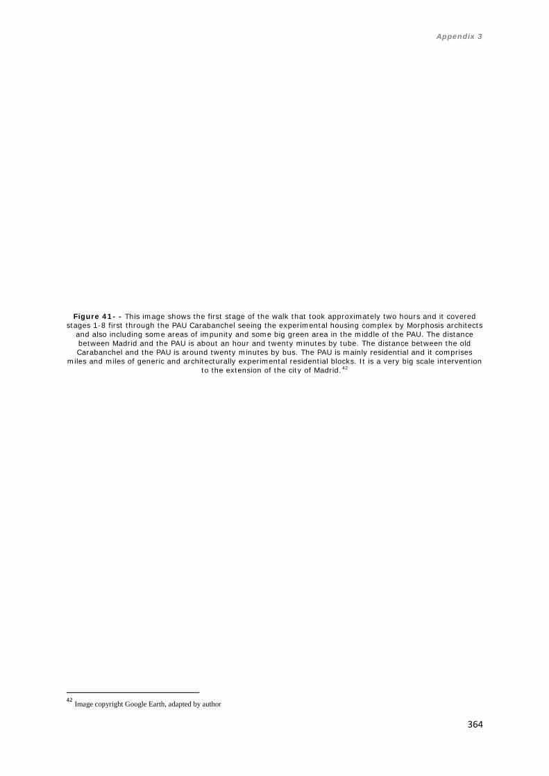
Appendix 3
364
Figure 41- - This image shows the first stage of the walk that took approximately two hours and it covered
stages 1-8 first through the PAU Carabanchel seeing the experimental housing complex by Morphosis architects and also including some areas of impunity and some big green area in the middle of the PAU. The distance between Madrid and the PAU is about an hour and twenty minutes by tube. The distance between the old Carabanchel and the PAU is around twenty minutes by bus. The PAU is mainly residential and it comprises
miles and miles of generic and architecturally experimental residential blocks. It is a very big scale intervention to the extension of the city of Madrid.42
42 Image copyright Google Earth, adapted by author

Appendix 3
365
Figure 42- This image shows the first stage of the walk (stages 1-8) from the photographer’s perspective. The notes to the right are my own thoughts of the itinerary and what I saw and found. Highlighted in red are the
most important characteristics and patterns that I found while I walked.

Appendix 3
366
Figure 43- This image shows the first stage of the walk (stages 1-8) from the photographer’s perspective.
The notes to the right are my own thoughts of the itinerary and what I saw and found. Highlighted in red are the most important characteristics and patterns that I found while I walked.

Appendix 3
367
Figure 44- This image shows the first stage of the walk (stages 1-8) from the architect’s perspective.
The notes to the right are my own thoughts of the itinerary and what I saw and found. Highlighted in red are the most important characteristics and patterns that I found while I walked.

Appendix 3
368
Figure 45- This image shows the first stage of the walk (stages 1-8) from the architect’s perspective.
The notes to the right are my own thoughts of the itinerary and what I saw and found. Highlighted in red are the most important characteristics and patterns that I found while I walked.

Appendix 3
369
Figure 46- This image shows the first stage of the walk (stages 1-8) from the citizen’s perspective.
The notes to the right are my own thoughts of the itinerary and what I saw and found.

Appendix 3
370
Figure 47- This image shows the second stage of the walk that took approximately one and it covered stages
9-13 through the PAU Carabanchel seeing the experimental housing and large 6 storey generic residential blocks43
43 Image copyright Google Earth, adapted by author

Appendix 3
371
Figure 48- This image shows the second stage of the walk (stages 9-13) from the photographer’s perspective. The notes to the right are my own thoughts of the itinerary and what I saw and found. Highlighted in red are
the most important characteristics and patterns that I found while I walked.
Figure 49- This image shows the second stage of the walk (stages 9-13) from the architect’s perspective. The notes to the right are my own thoughts of the itinerary and what I saw and found. Highlighted in red are
the most important characteristics and patterns that I found while I walked.

Appendix 3
372
Figure 50- This image shows the second stage of the walk (stages 9-13) from the citizen’s perspective.
The notes to the right are my own thoughts of the itinerary and what I saw and found.

Appendix 3
373
Figure 51 - This image shows the third stage of the walk that took approximately one hour and it covered
stages 14-17 first through the PAU Carabanchel seeing a mix between and also including some areas of impunity and some big green area in between the housing.44
44 Image copyright Google Earth, adapted by author

Appendix 3
374
Figure 52- This image shows the third stage of the walk (stages 14-17) from the photographer’s perspective. The notes to the right are my own thoughts of the itinerary and what I saw and found. Highlighted in red are
the most important characteristics and patterns that I found while I walked.
Figure 53- This image shows the third stage of the walk (stages14-17) from the architect’s perspective.
The notes to the right are my own thoughts of the itinerary and what I saw and found. Highlighted in red are the most important characteristics and patterns that I found while I walked.

Appendix 3
375
Figure 54- This image shows the third stage of the walk (stages14-17) from the citizen’s perspective.
The notes to the right are my own thoughts of the itinerary and what I saw and found.

Appendix 3
376
Figure 55 - This image shows the fourth stage of the walk that took approximately one hour and it covered
stages 18-31 first through the PAU Carabanchel seeing a mix between and also including a shopping mall and a Mc Donalds and petrol station and also the bamboo housing by
Foreign office architects45
45 Image copyright Google Earth, adapted by author

Appendix 3
377
Figure 56- This image shows the fourth stage of the walk (stages 18-31) from the photographer’s perspective. The notes to the right are my own thoughts of the itinerary and what I saw and found. Highlighted in red are
the most important characteristics and patterns that I found while I walked.
Figure 57- This image shows the fourth stage of the walk (stages 18-31) from the architect’s perspective.
The notes to the right are my own thoughts of the itinerary and what I saw and found. Highlighted in red are the most important characteristics and patterns that I found while I walked.

Appendix 3
378
Figure 58- This image shows the fourth stage of the walk (stages 18-31) from the citizen’s perspective.
The notes to the right are my own thoughts of the itinerary and what I saw and found.

Appendix 3
379
Figure 60- Analysis of the route followed on site identifying different urban elements (Author’s own)47 46 Image copyright Google Earth, adapted by author 47 Image copyright Google Earth, adapted by author
Figure 59- Stages of walked followed on site during fieldwork (in black) through tertiary corridor (1-22). The
black line show the itinerary of the undertaken path that I followed, and the path then becomes a series of architectural objects that are recorded mainly through photography at different stages telling a narrative that
then analysed and evaluated could become a series of categories or typologies of these peripheral areas46

Appendix 3
380
Figure 61- This image shows the first stage of the walk that took approximately one hour and it covered
stages 1-11 first through old town of Leganes and then through the University Carlos III48
48 Image copyright Google Earth, adapted by author

Appendix 3
381
Figure 62- This image shows the first stage of the walk (stages 1-11) from the photographer’s perspective. The notes to the right are my own thoughts of the itinerary and what I saw and found. Highlighted in red are
the most important characteristics and patterns that I found while I walked.

Appendix 3
382
Figure 63- This image shows the first stage of the walk (stages 1-11) from the architect’s perspective.
The notes to the right are my own thoughts of the itinerary and what I saw and found. Highlighted in red are the most important characteristics and patterns that I found while I walked.
Figure 64- This image shows the first stage of the walk (stages 1-11) from the citizen’s perspective.
The notes to the right are my own thoughts of the itinerary and what I saw and found.

Appendix 3
383
Figure 65 - This image shows the second stage of the walk that took approximately half an hour and it
covered stages 12-15 first through the University Carlos III and through the station49
49 Image copyright Google Earth, adapted by author

Appendix 3
384
Figure 66- This image shows the second stage of the walk (stages 12-15) from the photographer’s
perspective. The notes to the right are my own thoughts of the itinerary and what I saw and found. Highlighted in red are the most important characteristics and patterns that I found while I walked.
Figure 67- This image shows the second stage of the walk (stages 12-15) from the architect’s perspective. The notes to the right are my own thoughts of the itinerary and what I saw and found. Highlighted in red are
the most important characteristics and patterns that I found while I walked.

Appendix 3
385
Figure 68- This image shows the second stage of the walk (stages 12-15) from the citizen’s perspective.
The notes to the right are my own thoughts of the itinerary and what I saw and found.

Appendix 3
386
Figure 69- This image shows the third stage of the walk that took approximately half an hour and it covered
stages 16-22 through the station and the residential areas50
50 Image copyright Google Earth, adapted by author

Appendix 3
387
Figure 70- This image shows the third stage of the walk (stages 16-22) from the photographer’s perspective. The notes to the right are my own thoughts of the itinerary and what I saw and found. Highlighted in red are
the most important characteristics and patterns that I found while I walked.
Figure 71- This image shows the third stage of the walk (stages 16-22) from the architect’s perspective. The notes to the right are my own thoughts of the itinerary and what I saw and found. Highlighted in red are
the most important characteristics and patterns that I found while I walked.

Appendix 3
388
Figure 72- This image shows the first stage of the walk (stages 16-22) from the citizen’s perspective.
The notes to the right are my own thoughts of the itinerary and what I saw and found.

Appendix 3
389
Figure 73- This image shows visual typology developed as a result of the walk and its different
stages from the photographer’s perspective.

Appendix 3
390
Figure 74- This image shows visual typology developed as a result of the walk and its different
stages from the architect’s perspective.

Appendix 3
391
Figure 75- This image shows visual typology developed as a result of the walk and its different
stages from the architect’s perspective.

Appendix 3
392
Categories Carabanchel (from fieldwork)
Stages 1-8 Tracing/ Image/ Itinerary (Calvino)
Stages 9-13 Tracing/ Image/ Itinerary (Calvino)
Stages14-17 Tracing/ Image/ Itinerary (Calvino)
Stages 18-31 Tracing/ Image/ Itinerary (Calvino)
Cartography (Calvino)-Emerging Patterns from the Cartography Resulting from the narrative of the journey
Photographer Narrative Idea Extracted from image by author
• Three lanes of cars, car oriented environment
• Generic 6 storey blocks • Architectural
experimentation • Manicured landscape
to be seen from the car • Boulevard in the middle of
the three lane car roads at each side. The boulevard has not seating areas, is just a place to pass by
• The place looks like a building site. Sense of incompletion
• Big scale of the PAU • Miles and miles of generic
blocks • Health centre, almost
fenced off with metal fence from the street
• De-countrified landscape. City and country missed together
• Motorway
• Architectural experimentation
• Space is private • Control • Manicured
landscape • Segregation
between cars and pedestrians
• Car designed environment
• Miles and miles of 6 storey residential blocks
• Manicured landscape
• Area of impunity
• Mc Donalds • Space is
dominated by cars
• Mc Donalds and patrol station off the road
• Shopping mall is the local store
• Big vast green areas
• Big scale • Big building
site. The place has not been completed
• De-countrified landscape
• Three lanes of cars, car oriented environment
• Architectural experimentation • Manicured landscape
to be seen from the car • Boulevard in the middle of
the three lane car roads at each side. The boulevard has not seating areas, is just a place to pass by
• The place looks like a building site. Sense of incompletion
• Big scale of the PAU • Miles and miles of generic
blocks • Health centre, almost fenced
off with metal fence from the street
• De-countrified landscape. City and country missed together
• Motorway • Space is private • Control • Manicured landscape • Segregation between cars
and pedestrians • Car designed environment • Miles and miles of 6 storey
residential blocks • Manicured landscape • Area of impunity • Mc Donalds • Space is dominated by cars • Mc Donalds and patrol station
off the road • Shopping mall is the local

Appendix 3
393
store • Big vast green areas • Big building site. The place
has not been completed De-countrified landscape
Architect Narrative Idea Extracted from image by author
• Manicured landscape • Architectural
experimentation • Generic 6 storey residential
blocks • Space is dominated and
designed for cars • Metal fencing everywhere.
The space is private • No commercial activity at
ground level • No public interface
between the residential block and the street. Public space is private
• Space is designed at a vast scale and for cars not pedestrians
• 3 lanes of cars, vast wide pavements
• Segregation between cars and people
• Architectural experimental block typology, Morphosis
• De-countrified landscape • Signage for cars • Big scale
• 6 storey residential blocks. Planning is based on zoning
• Architectural experimentation
• Manicured landscape to be seen from the cars
• Anti-social behaviour graffiti
• Manicured landscape
• Areas of impunity. City meets the country
• Architectural experimentation
• School building using similar coding as residential block
• Big sign for Mc Donalds
• Petrol Station
• Bamboo block Foreign Office architects. Architectural experiment
• De-countrified landscape
• Building site that is uncompleted
• Experimental architecture
• Architectural experimentation • Space is dominated and
designed for cars • Metal fencing everywhere.
The space is private • No commercial activity at
ground level • No public interface between
the residential block and the street. Public space is private
• Space is designed at a vast scale and for cars not pedestrians
• 3 lanes of cars, vast wide pavements
• Segregation between cars and people
• Architectural experimental block typology, Morphosis
• De-countrified landscape • Signage for cars • 6 storey residential blocks.
Planning is based on zoning • Architectural experimentation • Manicured landscape to be
seen from the cars • Anti-social behaviour graffiti • Manicured landscape • Areas of impunity. City meets
the country • School building using similar
coding as residential block • Big sign for Mc Donalds • Petrol Station
Citizen Narrative Idea Extracted from
• No commercial • Big pavement • Access is forbidden. The
area looks like a building
• No ground commercial activity
• Control. Private
• Protective metal fencing. Control of space
• Bamboo housing Foreign Office Architects
• No commercial • Big pavement • Access is forbidden. The area
looks like a building site,

Appendix 3
394
image by author
site, sense of incompletion • Protective fencing in front
of residential block • Small bank on ground level • The Chinese store becomes
the local shop • British pub on the PAU • Metal fencing to access
residential blocks • De-countrified landscape • Areas of impunity • Mix between city and
country • Lorry to clean up industrial
areas in the middle of the PAU
• Two layers of metal protective fencing for the window and the block access
access only • Blank wall at
the ground • The Chinese
store becomes the local shop
• Graffiti saying: “We sell cocaine”
• Manicured landscape
• Fast food pizzeria store
• Manicured landscape to be seen from the car
• Control. Protective fencing
• No interface between the building and the street
• Graffiti. Big signs
• Mc Donald and petrol station of the road
• Christmas decoration outside the house in order to personalise the space
• Forbidden to enter the block
• Blocks of flats without ground commercial activity
• Landscape designed around the car
• Incomplete building site
• De-countrified landscape
• Areas of impunity
• Manicured landscape next to the de-countrified landscape. Human intervention vs. nature
sense of incompletion • Protective fencing in front of
residential block • Small bank on ground level • The Chinese store becomes
the local shop • British pub on the PAU • Metal fencing to access
residential blocks • De-countrified landscape • Areas of impunity • Mix between city and country • Lorry to clean up industrial
areas in the middle of the PAU
• Two layers of metal protective fencing for the window and the block access
• No ground commercial activity
• Control. Private access only • Blank wall at the ground • The Chinese store becomes
the local shop • Graffiti saying: “We sell
cocaine” • Fast food pizzeria store • Protective metal fencing.
Control of space • Manicured landscape to be
seen from the car • Control. Protective fencing • No interface between the
building and the street • Graffiti. Big signs • Mc Donald and petrol station
of the road • Bamboo housing Foreign
Office Architects • Christmas decoration outside
the house in order to personalise the space
• Forbidden to enter the block • Blocks of flats without ground
commercial activity

Appendix 3
395
• Landscape designed around the car
• Incomplete building site • Manicured landscape next to
the de-countrified landscape. Human intervention vs. nature
Figure 76- This table shows the author’s subjective notes from the fieldwork’s itinerary at each stage from the 3 perspectives (photographer, architect& citizen) for Carabanchel

Appendix 3
396
Categories Leganes (from fieldwork)
Stages 1-11 Tracing/ Image/ Itinerary (Calvino)
Stages 12-15 Tracing/ Image/ Itinerary (Calvino)
Stages16-22 Tracing/ Image/ Itinerary (Calvino)
Cartography (Calvino)-Emerging Patterns from the Cartography Resulting from the narrative of the journey
Photographer Narrative Idea Extracted from image by author
• New big University Carlos III Campus built on the periphery
• Big roundabout. The whole environment is designed for cars
• University campus is fenced off not allowing public access
• Big car parking areas • 1980’s housing in the
periphery
• Long brick was • Railway line • Manicured landscape
• Existing 1970’s working class housing
• Big car park area next to the train station
• Big tertiary corridor, knowledge sector University, Infrastructure railway line
• New big University Carlos III Campus built on the periphery
• Big roundabout. The whole environment is designed for cars
• University campus is fenced off not allowing public access
• Big car parking areas • 1980’s housing in the periphery • Long brick wall • Railway line • Manicured landscape • Existing 1970’s working class
housing • Big car park area next to the train
station • Big tertiary corridor, knowledge
sector University, Infrastructure railway line
Architect Narrative Idea Extracted from image by author
• Old town of Leganes with pedestrian street
• University campus fences off from the main street
• Big metal fence stopping pedestrians accessing the University Campus.
• Controlled environment • Big roundabout • Residential 1980’s blocks • Signage for cars • Big car underpass in the
middle of the street. No pavement available for pedestrians. The whole environment is designed around cars
• Big long brick wall in front of the railway line
• Residential street
• Bus stop in front of railway station
• 1970’s working class housing in the periphery
• Local Leganes train station
• Old town of Leganes with pedestrian street
• University campus fences off from the main street
• Big metal fence stopping pedestrians accessing the University Campus.
• Controlled environment • Big roundabout • Residential 1980’s blocks • Signage for cars • Big car underpass in the middle of
the street. No pavement available for pedestrians. The whole environment is designed around cars
• Big long brick wall in front of the railway line
• Residential street

Appendix 3
397
• Bus stop in front of railway station • 1970’s working class housing in
the periphery • Local Leganes train station
Citizen Narrative Idea Extracted from image by author
• Signage for cars • Manicured landscape to be
seen from cars • Roundabout with public art • Signage indicating
maximum heights for lorries on the street
• Access to garage in the middle facing the street
• Manicured landscape • Bins on the street as the
only street furniture • Sigange saying “it is
forbidden to put any adverts on the wall”
• Control • Signage for cars in the
middle of the street • Car signal. Environment
designed for cars • Train corridor connecting
the periphery to the city centre
• Fence separating the street from the station
• Industrial
• Signage for cars • Manicured landscape to be seen
from cars • Roundabout with public art • Signage indicating maximum
heights for lorries on the street • Access to garage in the middle
facing the street • Manicured landscape • Bins on the street as the only
street furniture • Signage saying “it is forbidden to
put any adverts on the wall” • Control • Signage for cars in the middle of
the street • Car signal. Environment designed
for cars • Train corridor connecting the
periphery to the city centre • Fence separating the street from
the station • Industrial
Figure 86- This table shows the author’s subjective notes from the fieldwork’s itinerary at each stage from the 3 perspectives (photographer, architect& citizen) for Leganes

Appendix 3
398
Categories (from fieldwork) To be read in sequence from left to right Carabanchel
Cartography (Calvino)-Subjective-Practice Emerging Patterns from the Cartography Resulting from the narrative of the journey
Concept Objective Theory This column shows the concept as defined in the literature in relation to the emerging patterns that were found in the fieldwork from the previous column
Theorist This column shows the concept and theorist/s and highlighted in red are the main concepts’ characteristics taken from the literature analysis from the previous column
Photographer Narrative Idea Extracted from image by author
• Three lanes of cars, car oriented environment
• Architectural experimentation • Manicured landscape
to be seen from the car • Boulevard in the middle of the three
lane car roads at each side. The boulevard has not seating areas, is just a place to pass by
• The place looks like a building site. Sense of incompletion
• Big scale of the PAU • Miles and miles of generic blocks • Health centre, almost fenced off
with metal fence from the street • De-countrified landscape. City and
country missed together • Motorway • Space is private • Control • Manicured landscape • Segregation between cars and
pedestrians • Car designed environment • Miles and miles of 6 storey
residential blocks • Manicured landscape • Area of impunity • Mc Donalds • Space is dominated by cars • Mc Donalds and patrol station off
Three lanes of cars, car oriented environment. Manicured landscape to be seen from the car. Boulevard in the middle of the three lane car roads at each side. The boulevard has not seating areas, is just a place to pass by. Miles and miles of generic blocks. Segregation between cars and pedestrians. Big scale of the PAU. Big vast green areas “The PAU communities are advertised as extensions of the already sprawling city; they are not considered to be separate and different communities. However the built reality of these places speaks otherwise. Unlike the city center, which possesses the full gamut of business, commercial and cultural institutions inter- mixed within the residential fabric, the PAUs are far more segregated. Commerce is typically concentrated into one large shopping mall; green areas, through generous are mostly peripheral; most residents commute into the city-proper for work”51 “Unlike the more heterogeneous Madrid city center, its periphery is highly homogeneous, a gigantic game-board populated by an army of look-alike
PAU segregated , Commerce concentrated in one shopping mall, green areas peripheral, and residents commute in the car - Ramon Prat • Commerce is typically concentrated
into one large shopping mall • Green areas, through generous are
mostly peripheral • Most residents commute into the
city-proper for work Generic- Homogeneous lookalike housing blocks- - Ramon Prat • Highly homogeneous • An army of look-alike housing
51 Prat, R, 2008, Madrid The Rise of the Residential Periphery, In: Ballesteros, M., 2008. Verb crisis, Barcelona; New York: Actar p. 40

Appendix 3
399
the road • Shopping mall is the local store • Big vast green areas • Big building site. The place has not
been completed De-countrified landscape
housing blocks that are unctuated by the occasional shopping center”52 “Moreover, except for the dozen or so examples of innovative structures, the large majority of properties are indistinguishable: it’s as if everything has been plucked from a huge residential superstore; off- the-shelve brick apartment buildings and industrial strength park spaces deployed across millions of square meters of meseta”53 “Why only terracotta blocks? Is the resultant urban monotony created during this unprecedented period of economic growth not a huge missed opportunity? […] this design freedom has produced in Spain (and especially in Madrid ), a mostly homogeneous (and large) production of identical blocks filled with three and four bedroom apartments”54 Green areas. “While the existing 70,000 units of housing are modest in size (from 20m2 to 90m2 , for a family of five) and tightly packed into hundreds of seven to nine story apartment blocks, this very real residential density is offset by an oversized network of wide boulevards and leisure plots, whose paved personae (more parking lot than park) intensify the feeling of being in an asphalt
blocks • Punctuated by the occasional
shopping center Generic- properties are indistinguishable- Ramon Prat • It’s as if everything has been
plucked from a huge residential superstore; off- the-shelve brick apartment buildings
• Industrial strength park spaces deployed across millions of square meters
Urban Monotony & Identical Blocks -Jacob van Rijs MVDRV • Resultant urban monotony created
during this unprecedented period of economic growth
• This design freedom has produced in Spain (and especially in Madrid ), a mostly homogeneous (and large) production of identical blocks
Green areas & Public Space - Ramon Prat • Oversized network of wide
boulevards and leisure plots • More parking lot than park • Asphalt suburbia • Plush lawns have been swapped for
acres of hard-top
52 Ibid p.42 53 Ibid p.43 54 Van Rijs, J. MVDRV, 2008, Madrid BoomBoomMadrid The Disappearance of Social Housing, In: Ballesteros, M., 2008. Verb crisis, Barcelona; New York: Actar pp. 142-43

Appendix 3
400
suburbia, where plush lawns have been swapped for acres of hard-top”55 Architectural experimentation “A feast for the hungry architect, the periphery is dotted with a dozen examples of interesting architectural experimentation”56 “[…] view the peripheries as a deregulated zone in which they could rehearse a new scale, typology and programmes, and activate new types of public spaces”57 The place looks like a building site. Sense of incompletion “Rapid and single- minded determination, which ensures the timely and efficient delivery of housing on a massive scale, may perpetuate the repetition of insufficient planning decisions that contribute to the impression of incompletion, a condition which seems to persist long after these developments are officially concluded”58 Health centre, almost fenced off with metal fence from the street. Space is private. Control. “This transformation is fundamental. Cities-and the organization space in
Architectural experimentation in Madrid- Ramon Prat • A feast for the hungry architect • The periphery is dotted with a dozen
examples of interesting architectural experimentation
Periphery as a deregulated zone for architects to try new things- Juan Herreros • Peripheries as a deregulated zone • They could rehearse a new scale,
typology and programmes • Activate new types of public spaces Impression of incompletion- the place looks like an on-going building site- Ramon Prat • Delivery of housing on a massive
scale, may perpetuate the repetition of insufficient planning decisions that contribute to the impression of incompletion
Control of public space & CCTV environment- Michael Sorkin • . The dramatic acceleration of
surveillance post 9/11 is one marker of the contraction
55 Prat, R, 2008, Madrid The Rise of the Residential Periphery, In: Ballesteros, M., 2008. Verb crisis, Barcelona; New York: Actar p.43 56Ibid.p. 39 57 Herreros, J,. 2009, Madrid in times of crisis, from the periphery to the centre through the inner suburbs In: Cantis, A.J. & Jaque, A., 2009. Piensa Madrid = Think Madrid: [José María Ezquiaga, Juan Herreros, Fabio Casiroli ...]. In [Madrid]: Caja Madrid: La Casa Encendida. p.285 58 Prat, R, 2008, Madrid The Rise of the Residential Periphery, In: Ballesteros, M., 2008. Verb crisis, Barcelona; New York: Actar p. 43

Appendix 3
401
general- bare key media by which we sort out the boundaries between public and private, and the public side of the equation is increasingly squeezed. The dramatic acceleration of surveillance post 9/11 is one marker of the contraction, and police agencies, public and private are enjoying virtual carte blanche to intrude in the traditional public realm-the streets of the city- and in the private as well” 59 De-countrified landscape (Descampados)- Areas of Impunity & Mix between the city and the country
1. “One is tempted to ask whether they might contain a metaphoric model, a quasi-model, or whether it is possible to think of their compliment, de-edification, given that the term ‘descampados’ embodies a fascinating concept: land that has lost its attributes as the city approaches, sterilised before being occupied, but also given a transcendental role in its new context”60
2. “The dissolution of the natural-
artificial opposition that we observe at every scale implies a working program which is nothing other than re-describing the position of contemporary man vis-à-vis the world. “Areas of impunity” are precisely those zones in which
De-countrified landscape- Abalos & Herreros • Land that has lost its attributes as
the city approaches • Sterilised before being occupied • dissolution of the natural-artificial
Opposition that we observe at every scale
Areas of Impunity- Abalos & Herreros • Zones in which this ambiguous
status is produced in an exceptional way
• Designation as public is imprecise • Negative zones are endowed with a
new urban status
59 Sorkin, M., 2008, Big Brother Is charging you In: Sorkin, M., 2011. All over the map: writing on buildings and cities, London New York: Verso. pp. 311-13 60 The term descampados is translated from Spanish as open country or “de-countrified” please refer to Abalos & Herreros, A New Naturalism (7 Micromanifestos) In: Beigel, F., 2002. Ábalos&Herreros, Barcelona: Editorial Gustavo Gili. p.28

Appendix 3
402
this ambiguous status is produced in an exceptional way, a status whose designation as public is imprecise. These formerly negative zones are endowed with a new urban status by the gaze of new social subjects and their practices”61
Motorway. Mc Donalds and patrol station off the road. Shopping mall is the local store “[…] is chaos. The order in this landscape is not obvious […] The continuous highway itself and its systems for turning are absolutely consistent […] This counterpoint reinforces the contrast between two types of order on the Strip: the obvious visual order of street elements and the difficult visual order of buildings and signs. The zone of the highway is a shared order. The zone off the highway is an individual order. […] The elements of the highway are civic. The buildings and signs are private”62
Two types of strip order: Highway is civic the elements off the highway and buildings and signs are private- Robert Venturi and Denise Scott Brown • Two types of order on the Strip: the
obvious visual order of street elements and the difficult visual order of buildings and signs.
• The zone of the highway is a shared order. The zone off the highway is an individual order
• The elements of the highway are civic. The buildings and signs are private.
Architect Narrative Idea Extracted from image by author
• Architectural experimentation • Space is dominated and designed
for cars • Metal fencing everywhere. The
space is private • No commercial activity at ground
level • No public interface between the
Architectural experimentation. Architectural experimental block typology, Morphosis. School building using similar coding as residential block “A feast for the hungry architect, the periphery is dotted with a dozen
Architectural experimentation in Madrid- Ramon Prat • A feast for the hungry architect • The periphery is dotted with a dozen
examples of interesting architectural experimentation
61 Ibid. p 28 62 Venturi, R., Scott Brown, D. & Izenour, S., 1996. Learning from Las Vegas: the forgotten symbolism of architectural form, Cambridge Mass.: The MIT Press. p. 20

Appendix 3
403
residential block and the street. Public space is private
• Space is designed at a vast scale and for cars not pedestrians
• 3 lanes of cars, vast wide pavements
• Segregation between cars and people
• Architectural experimental block typology, Morphosis
• De-countrified landscape • Signage for cars • 6 storey residential blocks. Planning
is based on zoning • Architectural experimentation • Manicured landscape to be seen
from the cars • Anti-social behaviour graffiti • Manicured landscape • Areas of impunity. City meets the
country • School building using similar coding
as residential block • Big sign for Mc Donalds Petrol Station
examples of interesting architectural experimentation”63 “[…] view the peripheries as a deregulated zone in which they could rehearse a new scale, typology and programmes, and activate new types of public spaces”64 Space is dominated and designed for cars. Space is designed at a vast scale and for cars not pedestrians. Manicured landscape to be seen from the cars. 6 storey residential blocks. Planning is based on zoning. No commercial activity at ground level “Here the overlaying of functions has been eliminated, buildings are icebergs floating in isolation, and contact is reduced to the absolute bare minimum”65 De-countrified landscape. Areas of impunity. City meets the country Signage for cars. Big sign for Mc Donalds. Petrol Station. “This architecture of styles and signs is antispatial; it is an architecture of
Periphery as a deregulated zone for architects to try new things- Juan Herreros • Peripheries as a deregulated zone • They could rehearse a new scale,
typology and programmes • Activate new types of public spaces Zoning in planning the PAU’s- Jacobo Garcia-German • Overlaying of functions has been
eliminated • Buildings are icebergs floating in
isolation • Contact is reduced to the absolute
bare minimum De-countrified landscape- Abalos & Herreros. Areas of Impunity- Abalos & Herreros Sign and strip- Robert Venturi & Denisse Scott-Brown Signs on the strip • This architecture of styles and signs
is antispatial; it is an architecture of communication over space
63 Prat, R, 2008, Madrid The Rise of the Residential Periphery, In: Ballesteros, M., 2008. Verb crisis, Barcelona; New York: Actar p. 39 64 Herreros, J,. 2009, Madrid in times of crisis, from the periphery to the centre through the inner suburbs In: Cantis, A.J. & Jaque, A., 2009. Piensa Madrid = Think Madrid: [José María Ezquiaga, Juan Herreros, Fabio Casiroli ...]. In [Madrid]: Caja Madrid: La Casa Encendida. p.285 65 Garcia-German, J, 2008, Madrid, In: Ballesteros, M., 2008. Verb crisis, Barcelona; New York: Actar p. 148

Appendix 3
404
communication over space; communication dominates space as an element in the architecture and in the landscape […] The commercial persuasion of roadside eclecticism provokes bold impact in the vast and complex setting of a new landscape of big spaces, high speeds and complex programs”66 “But the driver has no time to ponder paradoxical subtleties within a dangerous, sinuous maze. He or she relies on the signs for guidance –enormous signs in vast spaces at high speeds”67 No public interface between the residential block and the street. Public space is private “[…] The problem with the suburbs (and increasingly the city) lies both in the homogeneity of formats and the frequent elusiveness of a genuinely public realm- the fact that a coffee always comes from Starbucks or Dunkin’ Donuts and that the “street” on which stores sit is a parking lot or supermarket aisle […] While strolling over, I’ve counted the security cameras on the single block between here and there. There are fifteen visible to me. Fifteen[…] A shopping mall in not the same as a street, and a security camera on every corner is not a pal”68
• The commercial persuasion of roadside eclecticism provokes bold impact in the vast and complex setting of a new landscape of big spaces, high speeds and complex programs
Designed for the drivers and the cars • The driver has no time to ponder
paradoxical subtleties within a dangerous, sinuous maze.
• He or she relies on the signs for guidance
• Enormous signs in vast spaces at high speeds
Control of public space & CCTV environment, no street activity- Michael Sorkin • The problem with the suburbs (and
increasingly the city) lies both in the homogeneity of formats and the frequent elusiveness of a genuinely public realm-
• The fact that a coffee always comes from Starbucks or Dunkin’ Donuts and that the “street” on which stores sit is a parking lot or supermarket aisle
• A shopping mall in not the same as a street, and a security camera on every corner is not a pal
66 Venturi, R., Scott Brown, D. & Izenour, S., 1996. Learning from Las Vegas: the forgotten symbolism of architectural form, Cambridge Mass.: The MIT Press. p. 8 67 Ibid. p 9 68 Sorkin, M., 2008, Big Brother Is charging you In: Sorkin, M., 2011. All over the map: writing on buildings and cities, London New York: Verso. pp. 311-13

Appendix 3
405
Citizen Narrative Idea Extracted from image by author
• Big pavement • Access is forbidden. The area looks
like a building site, sense of incompletion
• Protective fencing in front of residential block
• Small bank on ground level • The Chinese store becomes the local
shop • British pub on the PAU • Metal fencing to access residential
blocks • De-countrified landscape • Areas of impunity • Mix between city and country • Lorry to clean up industrial areas in
the middle of the PAU • Two layers of metal protective
fencing for the window and the block access
• No ground commercial activity • Control. Private access only • Blank wall at the ground • The Chinese store becomes the local
shop • Graffiti saying: “We sell cocaine” • Fast food pizzeria store • Protective metal fencing. Control of
space • Manicured landscape to be seen
from the car • Control. Protective fencing • No interface between the building
and the street • Graffiti. Big signs • Mc Donald and petrol station of the
road • Bamboo housing Foreign Office
Architects
Access is forbidden. The area looks like a building site, sense of incompletion Protective fencing in front of residential block. Metal fencing to access residential blocks. Control. Private access only. Forbidden to enter the block The Chinese store becomes the local shop “I mean, hybridisation is being produced- no neighbourhood can fight off the appearance of a Chinese store in every corner. I mean diversity is being created through a phenomenon that includes economic components and people who are looking for an opportunity is overshadowed by consumers, or the search of clientele, and wherever there are customers a supermarket is bound to appear. The Chinese supermarket is what will, in certain ways, increase the diversity we are talking about. In Madrid, curiously enough, there are small supermarkets and food shops appearing, which is amazing because it seemed although that generation had completely died out, had lost its battle against the shopping centres”69. De-countrified landscape. Areas of impunity. Mix between city and country. Fast food pizzeria store. Mc Donald
Impression of incompletion- the place looks like an on-going building site- Ramon Prat Control of public space & CCTV environment, no street activity- Michael Sorkin Hybridisation of uses- The Chinese local food store versus the supermarket- Juan Herreros • Hybridisation is being produced- no
neighbourhood can fight off the appearance of a Chinese store in every corner
• In Madrid, curiously enough, there are small supermarkets and food shops appearing, which is amazing because it seemed although that generation had completely died out, had lost its battle against the shopping centres
De-countrified landscape- Abalos & Herreros. Areas of Impunity- Abalos & Herreros Sign and strip- Robert Venturi &
69 Herreros, J., 2009 Round Table In: Cantis, A.J. & Jaque, A., 2009. Piensa Madrid = Think Madrid: [José María Ezquiaga, Juan Herreros, Fabio Casiroli ...]. In [Madrid]: Caja Madrid: La Casa Encendida. p.334

Appendix 3
406
• Christmas decoration outside the house in order to personalise the space
• Forbidden to enter the block • Blocks of flats without ground
commercial activity • Landscape designed around the car • Incomplete building site • Manicured landscape next to the de-
countrified landscape. Human intervention vs. nature
and petrol station of the road. Graffiti. Big signs. Bamboo housing Foreign Office Architects. Christmas decoration outside the house in order to personalise the space. “In the Carabanchel block, the shutters keep changing and disturbing the overall pattern without ever revealing the scale and position of the units. Such a phenomenon calls to my mind the image of a swarm, which I think is a far more appropriate representation of the contemporary metropolis”70 “The housing in Carabanchel was an interesting project, with a client that was prepared to take risks and a contractor open to experimentation”71
Denisse Scott-Brown Bamboo Housing- Alejandro Zaera-Polo • The housing in Carabanchel was an
interesting project, with a client that was prepared to take risks and a contractor open to experimentation
Figure 87- This table shows from left to right three different categories 1- Cartography (Patterns resulting from the narratives from the journey) 2- Concept (Objective Theory/Emerging patterns), 3- Theorists (Highlighted in red main concepts and characteristics)
70 Foreign Office Architects, 2008, Building the periphery, In: Ballesteros, M., 2008. Verb crisis, Barcelona; New York: Actar p. 216 71 Ibid p. 219


