Embed Size (px)
Citation preview
411
ABSTRACT
As one of the most isolated archipelagos in the world, Hawaii possesses some of the highest levels of marine endemic species in the world. This chain of islands stretches for more than 2,500 km from the island of Hawaii in the southeast to Kure Atoll (the world’s highest latitude atoll) in the northwest. The archipelago consists of two regions: the main Hawaiian Islands (MHI) made up of populated, high volcanic islands; and the Northwestern Hawaiian Islands (NWHI) consisting of mostly uninhabited atolls and banks. Hawaii’s coral reefs, which have recently been valued at US$10 billion, are under pressure from 1.2 million residents (more than70% live on Oahu) and nearly 7 million tourists each year. A number of urban areas and popular tourist destinations have suffered from land-based sources of pollution, overfishing, recreational overuse, and alien species. Despite these anthropogenic stressors, many of Hawaii’s coral reefs, particularly the remote ones, are still in fair to good condition. The reefs of the NWHI represent almost undamaged coral reef ecosystems with abundant and large apex predators, due mostly to their isolation. The reefs also have an extremely high proportion of endemic species across many taxa, and virtually no impacts from alien species. The principal stresses to the reef ecosystems of the NWHI are coral bleaching and marine debris. In a major multi-agency effort to protect this region more efficiently, more than 470 metric tons of marine debris, primarily derelict fishing gear, have been removed from the reefs and beaches of the NWHI since 1996. The NWHI are an important nesting, and breeding site for many endangered and threatened species. In recent years, increased U.S. Federal funding and expanded partnerships among federal and state agencies, academia, and non-governmental organisations have greatly enhanced monitoring, mapping, and research efforts leading to a better understanding of the spatial and temporal dynamics of Hawaiian reefs. These partnerships have helped to guide management decisions.
15. STATUS OF CORAL REEFS IN THE HAWAIIAN ARCHIPELAGO
ALAN FRIEDLANDER, GRETA AEBY, RUSSELL BRAINARD, ERIC BROWN, ATHLINE CLARK, STEVE COLES, EDWARD DEMARTINI, STEVE DOLLAR, SCOTT GODWIN, CINDY HUNTER, PAUL JOKIEL, JEAN KENYON, RANDY KOSAKI, JIM MARAGOS, PETER VROOM, BILL WALSH, IVOR WILLIAMS
AND WENDY WILTSE

412
Status of Coral Reefs of the World: 2004
MAIN HAWAIIAN ISLANDS
100 years ago: The first Polynesian inhabitants collected reef resources for food and built fish traps and ponds on reef flats. They strictly enforced traditional management practices, and the reefs were healthy with good fish populations.
In 1994: There were clear signs of damage to coral reefs from pollution, development and dredging. Reef fish stocks had declined from over-fishing and there was inadequate enforcement of regulations to protect fish stocks. A need for Marine Protected Areas (MPAs) was recognised and many were established around the Hawaiian Islands.
In 2004: The reefs remain in relatively good condition, with some declines in coral cover and target fish stocks. The Hawaiian Government is improving management of reef resources to reduce over-fishing and pollution from the land. More MPAs have been added and monitoring is showing improvements in coral and fish populations. Coral bleaching and disease, and alien species now pose the most significant threats to the reefs.
Predictions for 2014: Reefs will continue to degrade as human pressures increase, but the rate of decline will be reduced if there is effective protection and management through adequate political and financial support.
NORTHWESTERN HAWAIIAN ISLANDS
100 years ago: Coral reefs on the Northwestern Hawaiian Islands were in pristine condition with only limited harvesting of seals, turtles and fish.
#
###
#
#
###################
#####
#
##
##
####
#
#
#########
#############
##
#####
#
#
#
#
########
#####
#
#
##
##############
##
150°E
150°E
160°E
160°E
170°E
170°E
180°
180°
170°W
170°W
160°W
160°W
10°N 10°N
20°N 20°N
30°N 30°N
0° 0°
:0 220 440 880
Kilometers
Johnston Is
Midway Is
Kaua'i
OahuMolokai
Pearl & HermesKure Atoll
Maro Reef
French Frigate ShoulsNecker IsNihoa Is
Hawaii
Mau'i
N O R T H W E S TH A W A I I A N I S L A N D S
M A I NH A W A I I A N I S L A N D S
Palmyra
Line Islands
Howland IsJarvis IsBaker Is
Kingman Atoll
K I R I B A T IN A U R U
M A R S H A L L I S L A N D S
Wake Is
P A L A U
G U A M
N O R T H E R NM A R I A N AI S L A N D S
FEDERATED STATES of MICRONESIA
RotaSaipan
LEGEND
# Monitoring SiteCoral Reefs
Map
cou
rtes
y of
The
Wor
ldFi
sh C
ente
r

413
In 1994: These remote reefs were still healthy except for some reef fishing and harvesting of lobsters. Monk seal and turtle populations were receiving strong management attention. There was minimal effective monitoring of the protected areas.
In 2004: Management, research and monitoring have increased dramatically since the designation of the reefs and islands as a Reserve in 2000. The lobster fishery is closed, reef fishing strictly controlled, and all activities require permission from management authorities. Coral bleaching was first observed in 2002 and 2004 and poses the greatest threat to the reefs.
Predictions for 2014: The coral reefs will remain healthy with strong collaboration between management agencies, but monitoring and surveillance will be necessary over these vast and remote reefs. Predictions of serious climate change and threats of increased coral bleaching remain the major potential cause for reef damage
INTRODUCTION
The Hawaiian Archipelago stretches from 19oN to 28oN latitude and includes the geologically younger and actively volcanic, main Hawaiian Islands (MHI) with fringing, patch and barrier reefs, and the older atolls and bank reef systems of the Northwestern Hawaiian Islands (NWHI).
MHIThe MHI consists of 8 high volcanic islands that range in age, from Hawaii which has active lava flows on the east side of the island to the 7 million years old Kauai. Coral reefs were important to the ancient Hawaiians for subsistence food, culture, and survival. Today these reefs provide commercial, recreational and subsistence fishing opportunities, create world famous surfing and diving locations, and are vital to the State’s approximately $800 million per year marine tourism industry. In 2002, the economic value of Hawaii’s coral reefs was estimated at US$10 billion with direct economic benefits of $360 million per year. Despite their economic significance, reefs near urbanized areas are coming under ever increasing population pressures from human and land-based pressures.
NWHIThe NWHI stretch for more than 2,000 km from Nihoa and Necker Islands (7 and 10 million years old respectively) to Midway and Kure Atolls (28 million years old) and represent the older portion of an emergent volcanic archipelago. The majority of the islets and shoals are uninhabited, although Midway, Kure, Laysan Island, and French Frigate Shoals have each been occupied for extended periods by various government agencies or commercial enterprises over portions of the last century. The NWHI provide important habitat for a number of threatened and endangered species. The Hawaiian monk seal is one of the most endangered marine mammals in the US (only about 1,400 individuals remain); it depends almost entirely on the islands of the NWHI for breeding and the surrounding reefs provide food. However, in recent years there has been an increase in the number of births of the monk seal in the MHI. More than 90% of all sub-adult and adult green sea turtles in Hawaii are hatched in the NWHI. One of the largest and most important assemblages of seabirds in the world occur as large colonies in the NWHI.
Status of Coral Reefs in the Hawaiian Archipelago

414
Status of Coral Reefs of the World: 2004
STATUS OF CORAL REEFS
MHIThe Hawaii Coral Reef Assessment and Monitoring Program (CRAMP) has monitored benthic marine communities around the MHI since 1999. In 2004, coral cover at 60 sites around the state averaged 20.8% (range 0.5% to 86.0%), with 6 coral species accounting for 20.3% of the total cover (Porites lobata, 6.1%; Porites compressa, 4.5%; Montipora capitata, 3.9%; M. patula, 2.7%; Pocillopora meandrina, 2.4%; and M. flabellata, 0.7%). Coral cover, coral species richness, and coral diversity all showed a significant relationship with the physical factors of habitat complexity, sediment composition, mean wave direction and height, rainfall, and geological age of the islands. Sites exposed to the larger west and northwest swells on the older islands, such as Kauai and Oahu generally had lower coral cover, species richness and diversity.
Coral cover at most CRAMP stations changed less than 10% between 2000 and 2003; 16 of 60 stations showed a significant decline in coral cover with the greatest reduction being 19% on Molokai. In contrast, 13 stations increased in coral cover with the greatest increase on Maui of 14%. The downward trend was most evident in the central portion of the archipelago on the islands of Oahu, Molokai and Maui. Most Hawaiians live on Oahu (72%) and Maui (10%); Molokai has a lower population, but there is extreme erosion and sediment flow onto the reefs along the south shore due to inadequate watershed management. Oahu and Maui also have damaged watersheds and there are large population centres adjacent to major reef areas. The islands of Kauai and Hawaii, which have relatively low human populations, showed an increase in coral reef cover. Kahoolawe is a former military target island, and the condition of sediment-
-10.00
-8.00
-6.00
-4.00
-2.00
0.00
2.00
4.00
Kauai Oahu Molokai Kahoolawe Maui Hawaii
Cha
nge
in C
oral
Cov
er %
The average change in live coral cover between 1999 and 2002 at CRAMP sites among islands shows that the reefs off the large populated islands have decreased in coral cover, whereas those on the less populated islands have remained relatively stable in those 3 years.

415
Status of Coral Reefs in the Hawaiian Archipelago
STATUS AND CONSERVATION OF THE HAWAIIAN MONK SEAL AND STATUS AND CONSERVATION OF THE HAWAIIAN MONK SEAL AND GREEN TURTLEGREEN TURTLE
The Hawaiian monk seal The Hawaiian monk seal (Monachus schauinslandi)(Monachus schauinslandi) is the only endangered pinniped in U.S. is the only endangered pinniped in U.S. waters. Counts declined by about 5% per year from 1985 to 1993; remained relatively waters. Counts declined by about 5% per year from 1985 to 1993; remained relatively stable to 2000; and then declined again with record low beach counts recorded in 2001, stable to 2000; and then declined again with record low beach counts recorded in 2001, 2002, and 2003. While Monk seals occur throughout the Hawaiian Archipelago, most are 2002, and 2003. While Monk seals occur throughout the Hawaiian Archipelago, most are found in the NWHI with smaller numbers coming ashore in the MHI, where they rest, found in the NWHI with smaller numbers coming ashore in the MHI, where they rest,
molt, and nurse on isolated beaches. Beach counts estimate that the current population is molt, and nurse on isolated beaches. Beach counts estimate that the current population is 1,300 seals, which is a decrease of 60% from the 1950s. Population trends were variable at 1,300 seals, which is a decrease of 60% from the 1950s. Population trends were variable at the 6 main reproductive sites in the NWHI but overall numbers of births and survival of the 6 main reproductive sites in the NWHI but overall numbers of births and survival of juveniles have decreased at most sites. The largest declines were at French Frigate Shoals juveniles have decreased at most sites. The largest declines were at French Frigate Shoals where adult counts have dropped by 60% since 1989. Most of the remaining individuals where adult counts have dropped by 60% since 1989. Most of the remaining individuals are older animals due to high juvenile mortality over the past decade. Future abundance are older animals due to high juvenile mortality over the past decade. Future abundance trends will depend upon whether the predicted losses at French Frigate Shoals are trends will depend upon whether the predicted losses at French Frigate Shoals are balanced by gains at other locations. The main reasons for the losses were hunting during balanced by gains at other locations. The main reasons for the losses were hunting during the1880s, disturbance by military activities, entanglement of seals in marine debris, direct the1880s, disturbance by military activities, entanglement of seals in marine debris, direct losses from fi shing prior to the 1991 Protected Species Zone in the NWHI, predation losses from fi shing prior to the 1991 Protected Species Zone in the NWHI, predation by sharks, aggression by adult male monk seals, and reduction of habitat and prey due to by sharks, aggression by adult male monk seals, and reduction of habitat and prey due to environmental change. environmental change.
Adu
lt S
eals
on
beac
h
19500
200
400
600
800
1000
Year1960 1970 1980 1990 2000
The historical trend in beach counts of adult Hawaiian monk seals of the six main reproductive subpopulations shows a dramatic decline in populations of this endangered species.

416
Status of Coral Reefs of the World: 2004
damaged reefs have remained stable following the removal of all grazing animals, cessation of bombing, and a massive program of revegetation.
Benthic cover has been monitored at a number of other sites around the MHI since the 1970s and 1980s. The long-term trends at these sites show that the majority of the stations (13 of 18) have declined since the fi rst survey. Explanations for the declines greater than 10% include reef slumping (Kaneohe Bay, Oahu) and sedimentation (Honolua Bay, Maui). Other, less dramatic declines may be a result of natural variability or sampling frequency.
The Hawaiian green turtle The Hawaiian green turtle (Chelonia mydas)(Chelonia mydas) is a spatially distinct population with many is a spatially distinct population with many feeding grounds within the Hawaiian Archipelago. The principal rookery is on French feeding grounds within the Hawaiian Archipelago. The principal rookery is on French Frigate Shoals, where more than 90% of all nesting occurs. Monitoring of the population Frigate Shoals, where more than 90% of all nesting occurs. Monitoring of the population since 1973 has shown nesting females generally return to the same islands. Turtles have since 1973 has shown nesting females generally return to the same islands. Turtles have been protected under the US Endangered Species Act since 1978 and there has been a been protected under the US Endangered Species Act since 1978 and there has been a dramatic increase in abundance over 30 years. There are substantial fl uctuations in the dramatic increase in abundance over 30 years. There are substantial fl uctuations in the number of turtles nesting each year, which refl ect regional variations in ocean-climate. number of turtles nesting each year, which refl ect regional variations in ocean-climate. Despite the recovery patterns after 25 years of protection, green sea turtles face a new Despite the recovery patterns after 25 years of protection, green sea turtles face a new threat from disease, particularly fi bropapilloma tumours. Turtle tumours were rare prior threat from disease, particularly fi bropapilloma tumours. Turtle tumours were rare prior to 1985, but are now common on turtles on Maui, Kauai, and Oahu. Up to 60% of the to 1985, but are now common on turtles on Maui, Kauai, and Oahu. Up to 60% of the turtles in Kaneohe Bay, Oahu have tumours.turtles in Kaneohe Bay, Oahu have tumours.
0
100
200
300
400
500
600
73 75 77 79 81 83 85 87 89 91Year
93 95 97 99 01 02
Fem
ale
Turtl
es N
estin
g
The number of female green turtles nesting at East Island (French Frigate Shoals, Northwestern Hawaiian Islands) from 1973 to 2002 has shown a steady increase, but with large variations that often correspond with changes in the ocean climate e.g. El Niño – La Niña events.
417
Status of Coral Reefs in the Hawaiian Archipelago
Coral populations in the Hawaiian Archipelago continue to be spared from epidemic diseases, unlike many other coral reefs around the world. Baseline surveys for coral disease showed that the average prevalence of disease (number of diseased colonies/total number of colonies) was 0.95% (range 0-4.4%) at 18 sites around Oahu. There are 557 species of reef and shore fishes in Hawaii, of which 24.3% are endemic species. Surveys of fishes at CRAMP sites provided the first broad spatial examination of reef fishes in the MHI. Surgeonfishes and parrotfishes were the dominant families (38% and 16% by weight, respectively) and herbivores were more than 65% of the total reef fish biomass, followed by invertebrate feeders (12%), planktivores (7%), and detritivores (7%). Predators were rare and accounted for only 4.7 % of reef fish biomass. Endemic species accounted for 28% of numerical abundance observed over all locations. The direction of wave exposure, amount of habitat complexity, and the level of protection from fishing were all important determinants of reef fish assemblage structure and standing stock.
NWHIBetween 2000 and 2003, investigations at 536 assessment sites recorded 57 stony coral species including 11 first records and 29 species range extensions. Rapid Ecological Assessment surveys showed: coral endemism is high with 17 endemic species (30%) accounting for 37-53% of the relative abundance of stony corals; 3 genera (Montipora, Porites, Pocillopora) account for 88% of the endemic species and most of the endemic abundance; and 7 Acropora species are now known from the central NWHI despite their near absence from the MHI. Coral cover was highest on Maro Reef (64%) and lowest on Necker Island (4%). Coral abundance and diversity were highest on the large open atolls of the central NWHI (French Frigate, Maro Reef, Lisianski/Neva Shoal) and declined gradually through the remaining atolls to the northwest (Pearl and Hermes, Midway and Kure). Stony corals were also less abundant and diverse off the exposed basalt islands to the southeast (Nihoa and Necker Islands, and La Perouse and Gardner Pinnacles), where soft corals (Sinularia, Palythoa) were more abundant. Exposure to severe wave action appears to limit coral development off these small islands and the surrounding deep platforms. There were fewer coral species and lower abundance on the northwestern end of the chain; most likely due to temperature extremes and the natural accumulation of lagoon sediments.
There are 366 known species of algae from the NWHI, and new endemic species have been described recently. The NWHI contain many Indo-Pacific algal species not found in the MHI, e.g. the common green calcareous alga Halimeda velasquezii. Algal-dominated reefs are normal for many healthy ecosystems of the NWHI with wide fore-reef and back-reef regions characterised by 15% macro-algal cover, while live coral cover was less than 8%. Oceanographic studies and monitoring suggest that water motion may be a major factor in defining algal assemblage structure.
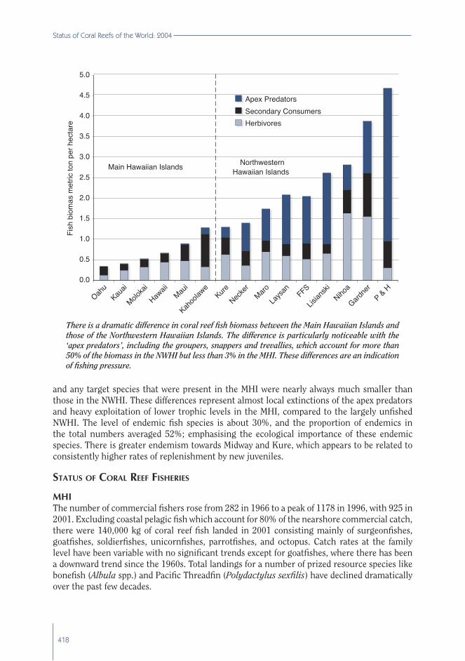
Observations of NWHI reef fishes between two series of partially overlapping monitoring and assessment surveys in 1992-2000 and 2000-2004 showed that the average fish standing stock in the NWHI was more than 260% greater than in similar habitats of the MHI. The most striking difference was the abundance and size of large apex predators (primarily sharks and jacks) in the NWHI compared to the MHI. More than 54% of the total fish biomass on fore-reef habitats in the NWHI consisted of apex predators, compared to less than 3% in the MHI. Most of the dominant species by weight in the NWHI were either rare or absent in the MHI
418
Status of Coral Reefs of the World: 2004
and any target species that were present in the MHI were nearly always much smaller than those in the NWHI. These differences represent almost local extinctions of the apex predators and heavy exploitation of lower trophic levels in the MHI, compared to the largely unfished NWHI. The level of endemic fish species is about 30%, and the proportion of endemics in the total numbers averaged 52%; emphasising the ecological importance of these endemic species. There is greater endemism towards Midway and Kure, which appears to be related to consistently higher rates of replenishment by new juveniles.
STATUS OF CORAL REEF FISHERIES
MHIThe number of commercial fishers rose from 282 in 1966 to a peak of 1178 in 1996, with 925 in 2001. Excluding coastal pelagic fish which account for 80% of the nearshore commercial catch, there were 140,000 kg of coral reef fish landed in 2001 consisting mainly of surgeonfishes, goatfishes, soldierfishes, unicornfishes, parrotfishes, and octopus. Catch rates at the family level have been variable with no significant trends except for goatfishes, where there has been a downward trend since the 1960s. Total landings for a number of prized resource species like bonefish (Albula spp.) and Pacific Threadfin (Polydactylus sexfilis) have declined dramatically over the past few decades.
0.0
0.5
1.0
1.5
2.0
2.5
3.0
3.5
4.0
4.5
5.0
Oahu
Kauai
Moloka
i
Hawaii
Maui
Kahoo
lawe
Kure
Necke
rMaro
Laysa
nFFS
Lisian
skiNiho
a
Gardne
rP & H
Fish
bio
mas
met
ric to
n pe
r hec
tare
Apex PredatorsSecondary ConsumersHerbivores
Main Hawaiian Islands Northwestern Hawaiian Islands
There is a dramatic difference in coral reef fish biomass between the Main Hawaiian Islands and those of the Northwestern Hawaiian Islands. The difference is particularly noticeable with the ‘apex predators’, including the groupers, snappers and trevallies, which account for more than 50% of the biomass in the NWHI but less than 3% in the MHI. These differences are an indication of fishing pressure.

419
Status of Coral Reefs in the Hawaiian Archipelago
The nearshore recreational and subsistence catch is probably equal to or greater than the commercial fi sheries catch, with these non-commercial fi shers taking more species using a wider range of fi shing gear. Intensive fi shing on highly prized and vulnerable species has led to substantial declines in catch and size, raising concerns about the long-term sustainability of fi sh stocks. Pacifi c Threadfi n, one of the premier recreational fi sh in Hawaii, has declined signifi cantly in size since the 1960s, while the proportion of juveniles has increased from 6 to 40% of the catch. A recreational creel survey in Kauai in the 1990s found that 30% of the catch of bluefi n trevally (Caranx melampygus) was below legal size and less than 3% had reached size at fi rst sexual reproduction. Fishers frequently cite inadequate enforcement of fi shing and marine resource laws as one of their major concerns. The lack of marine-focused enforcement and minimal fi nes for those few cases that have been prosecuted contribute to poor compliance with fi sheries management regulations.
Most of the marine ornamental fi sh and invertebrates coming from U.S. waters are collected in Hawaii, which is known for valuable high quality and rare endemic species. This coastal fi shery is the second most valuable after the scad fi shery, with a reported value of $1.06 million in FY
ALIEN SPECIES INVADE HAWAIIALIEN SPECIES INVADE HAWAIIDue to the extreme isolation and consequent high numbers of endemic species, the Due to the extreme isolation and consequent high numbers of endemic species, the invasion by alien species poses a signifi cant threat to the native diversity in Hawaii. The invasion by alien species poses a signifi cant threat to the native diversity in Hawaii. The estimated number of non-indigenous marine species (NIMS) includes 287 invertebrates, estimated number of non-indigenous marine species (NIMS) includes 287 invertebrates, 20 algae, 20 fi sh, and 12 fl owering plant species. Alien marine algae have proliferated on 20 algae, 20 fi sh, and 12 fl owering plant species. Alien marine algae have proliferated on many nearshore Hawaiian reefs and out compete or smother coral reef species. many nearshore Hawaiian reefs and out compete or smother coral reef species.
Gracilaria salicornia, Hypnea musciformis, Gracilaria salicornia, Hypnea musciformis, andand Kappaphycus/Eucheuma Kappaphycus/Eucheuma spp. were introduced spp. were introduced to Hawaii for aquaculture in the 1960s and 1970s, andto Hawaii for aquaculture in the 1960s and 1970s, and Acanthophora spicifera Acanthophora spicifera arrived on a arrived on a ship hull in the 1950s. These ‘superweeds’ are now spreading rapidly and overgrowing and ship hull in the 1950s. These ‘superweeds’ are now spreading rapidly and overgrowing and smothering corals on a number of Hawaiian reefs. While the majority of NIMS in Hawaii smothering corals on a number of Hawaiian reefs. While the majority of NIMS in Hawaii are invertebrates, many species are cryptic and/or have remained in highly disturbed are invertebrates, many species are cryptic and/or have remained in highly disturbed harbour and other fouling environments. It is thus very diffi cult to determine the effects harbour and other fouling environments. It is thus very diffi cult to determine the effects and interactions that the invaders may be having on native marine fl ora and fauna. The and interactions that the invaders may be having on native marine fl ora and fauna. The snowfl ake coral snowfl ake coral (Carijoa riisei)(Carijoa riisei) was fi rst reported in Pearl Harbor in 1972. As it reproduces was fi rst reported in Pearl Harbor in 1972. As it reproduces and grows rapidly, it is now found in high densities from the intertidal zone down to 100 and grows rapidly, it is now found in high densities from the intertidal zone down to 100 m depth, especially where reduced light and moderate currents provide ideal growth m depth, especially where reduced light and moderate currents provide ideal growth conditions. It is overgrowing black coral beds between 75 and 100 m off Maui. The conditions. It is overgrowing black coral beds between 75 and 100 m off Maui. The recently introduced orange keyhole spongerecently introduced orange keyhole sponge Mycale armata Mycale armata was observed at 5 of 41 sites, was observed at 5 of 41 sites, and in parts of Kaneohe Bay. It has become abundant and overgrows the dominant corals and in parts of Kaneohe Bay. It has become abundant and overgrows the dominant corals Porites compressaPorites compressa and and Montipora capitata.Montipora capitata. Between 1951 and 1961, 11 bottom fi sh species Between 1951 and 1961, 11 bottom fi sh species (6 groupers, 4 snappers, and 1 emperor) were intentionally introduced into Hawaii. Of (6 groupers, 4 snappers, and 1 emperor) were intentionally introduced into Hawaii. Of these, the blacktail snapper these, the blacktail snapper (Lutjanus fulvus),(Lutjanus fulvus), the bluestripe snapper the bluestripe snapper (Lutjanus kasmira)(Lutjanus kasmira) and and the peacock grouper the peacock grouper (Cephalopholis argus)(Cephalopholis argus) have established viable breeding populations have established viable breeding populations and have spread throughout the state. The latter two species are particularly controversial and have spread throughout the state. The latter two species are particularly controversial because they have adapted well. They are now being blamed for declines in native fi sheries because they have adapted well. They are now being blamed for declines in native fi sheries species, although recent studies do not confi rm this belief.species, although recent studies do not confi rm this belief.

420
Status of Coral Reefs of the World: 2004
2002. However, the true dollar value is thought to be $3 - 5 million per year, due to potential under-reporting and non-reporting. While the overall economic value of the aquarium fishery has been relatively stable over the last few decades, there have been local variations with the value of the Oahu aquarium fish catch declining by 76%, while the Hawaii catch increased by 282%. These trends are probably the result of overfishing, generalised damage to the habitat on Oahu, specific habitat destruction from two major hurricanes, and an expansion of the fishery on Hawaii. Surgeonfishes, butterflyfishes, and wrasses are the most commonly fished species, while feather duster worms, hermit crabs, and shrimp predominate among the invertebrates. The top 10 species constitute 73.3% of the catch with the Yellow tang (Zebrasoma flavescens) accounting for 37% of the total.
In 2002, the State began to gather recreational and subsistence fishery information through the Hawaii Marine Recreational Fisheries Survey (HMRFS), which is part of the nationwide Marine Recreational Fisheries Statistical Survey (MRFSS). This is being integrated into a national dataset, which will be available to all fisheries management personnel, and the public, via the MRFSS website. HMRFS surveyors perform intercept surveys at key fishing areas, in harbours, at boat ramps, and along the shoreline. The survey is designed to assess a number of parameters of recreational fishing, including the area fished, gear types, target species, and length/weight/species of fish caught.
NWHIFishing in the NWHI is mostly limited to two commercial fisheries: a bottomfish fishery; and a recently closed lobster trap fishery. The bottom-fish fishery targets snappers and groupers
0
5
10
15
20
25
30
35
40
45
1949 1953 1957 1961 1965Year
1969 1973 1977 1981 1985 1989 1993 1997 2001
Bone
fish
land
ed (t
ons)
0
2
4
6
8
10
12
Thre
adfin
land
ed (t
ons)
Bonefish Pacific Threadfin
The commercial landings of two important fish species, bonefish and Pacific threadfin, have clearly declined in the 50 years of record keeping in Hawaii.

421
Status of Coral Reefs in the Hawaiian Archipelago
on the deep-slopes (generally deeper than 100m). Only two species, the green jobfish (Aprion virescens) and the endemic Hawaiian grouper (Epinephelus quernus) occur in shallow reef habitats and contribute substantively to NWHI bottomfish landings, with far more jobfish being taken. Existing time series data suggest no obvious pattern of temporal change for jobfish, although there is a declining trend in catch per unit effort for Hawaiian grouper in the northern fishing zone. The lobster fishery targeted the endemic Hawaiian spiny lobster (Panulirus marginatus), as well as the non-endemic slipper lobster Scyllarides squammosus from 1998 to 2000, when it was closed because of growing uncertainty about the status of the stock. A recreational catch-and-release fishery commenced in 1996 at Midway, after the Midway Naval Air Station was closed and the atoll became a USFWS National Wildlife Refuge. Giant trevally (Caranx ignobilis) and bluefin trevally, the main targets of the catch-and-release fishery, declined in abundance at Midway between 1996 and 2000, when sampling was discontinued. There are no other significant resource extraction activities in the NWHI.
ANTHROPOGENIC THREATS TO CORAL REEF BIODIVERSITY
MHIThe coastlines of Hawaii continue to be developed for a variety of land uses. Agricultural lands (primarily sugarcane and pineapple) are being converted for residential and resort use on all islands. Many of Hawaii’s low-lying coastal areas were wetlands and flood plains before being cleared for agriculture and development. These areas acted as excellent filters, removing sediments and nutrients from streams before the water entered the ocean. More sediments are carried directly to the ocean because the coastal areas were cleared, flood plains filled, and streams channelled. Construction projects of more than 1 acre require State of Hawaii Department of Health authorisation and Counties (grading permits) to ensure the use of best management practices to control erosion. Recent major earthworks at development projects on Hawaii and Kauai have resulted in significant sediment discharges into the ocean. Lawsuits and enforcement actions delayed the work and cost the developer millions of dollars in remediation, penalties, legal fees, etc. One outcome of damage from these developments is that there is public pressure to preserve open space, coastal lands and beaches on all islands. The State and Counties, local land trusts and conservation organisations, have purchased, or are negotiating the purchase of major coastal land parcels for preservation.
Offshore water quality in Hawaii is generally good although there are few long-term data sets for waters near coral reefs. Contaminants in stormwater drains, streams and groundwater supplies from urban and agricultural lands enter the sea, but pollutant concentrations are rapidly diluted by the oceanic waters. The relocation of sewage outfalls into deep offshore areas has eliminated the direct effects of sewage on reefs, resulting in some recovery to previously stressed reefs. The total magnitude of these anthropogenic nutrient inputs into groundwater is unknown, however on West Maui, 61% of the total nitrogen entering the ocean from groundwaters came from pineapple and sugarcane agriculture, and 29.8% was from sewerage systems. Nuisance algal blooms are known along this coastline and these nutrient inputs are probably the cause of these blooms, although there are other natural or anthropogenic inputs.
The State of Hawaii estimates that more than 6.7 million visitors will arrive in 2004 and spend more than $11.4 billion; these are increases from 2003. Nearly 52% of all visitors participate

422
Status of Coral Reefs of the World: 2004
in diving or snorkeling activities, which outrank all other recreational activities of U.S and Japanese visitors to Hawaii, other than just visiting a beach. Hawaii’s Marine Protected Areas (MPAs) and other calm water locations are the prime areas to dive and snorkel and are marketed as ‘must see destinations’ by the tourist industry. The potential damage to these natural resources are numerous at these high use sites. For example, extensive damage occurs in shallow, calm water sites when tourists trample on the more fragile corals, with considerable evidence of broken and dead coral in high coral cover areas. Education is a critical management tool in minimising such damage. A recent study has shown that tourists who are given a brief orientation and provided with floatation devices to use while snorkeling are much less likely to damage the corals than independent visitors entering the water from the shoreline without interpretive information or training.
Each year tons of marine debris wash onto Hawaii’s shorelines, posing a threat to endangered Hawaiian monk seals, sea turtles and sea birds from entanglement or ingestion. The debris (especially derelict fishing gear from around the Pacific rim) is unsightly and also significantly damages the benthic substrate, especially coral and algae communities, as it washes over the reefs. In 2002, nearly 2,000 volunteers across the state collected more than14 tons of marine debris along 94 miles of shoreline in a one-day event. Of all the debris, cigarettes and plastic plates, utensils, caps and lids were the most common accounting for more than half the debris collected. Fishing line and net debris are the most common form of debris that becomes entangled on the reefs and can be removed only by divers.
NWHIMost of the marine debris is derelict fishing gear from distant fisheries around the Pacific rim, the debris poses one of the most significant anthropogenic threats to the reefs of the NWHI. To address this threat, a large-scale multi-agency effort funded by the NOAA Coral Reef Conservation Program has removed more than 480 metric tons of derelict fishing gear and other debris since 1996. Based on an estimate that 1000 tons of debris have accumulated in the NWHI over the past few decades, and accumulation rates are continuing at 25-40 tons per year, the removal program will have to continue, while attempts are made to reduce debris from the sources.
CURRENT AND POTENTIAL CLIMATE CHANGE IMPACTS
MHI The trend over the past few decades is for temperatures to increase in Hawaiian waters; the first multi-location coral bleaching events were documented during the summer of 1996 around the MHI. Although bleaching events may have occurred in the past, there is no quantitative or qualitative record of previous events, and there has been no documented case of extensive bleaching across the chain. The bleaching events were triggered by a combination of: prolonged exposure to sea surface temperatures greater than 1°C above normal maxima of summer; high solar energy; and low winds which resulted in restricted water circulation in areas where eddies retained the warm water. Most bleaching occurred on the lee sides of the larger Hawaiian Islands, probably due to higher solar irradiance because of clear skies and reduced trade winds.
NWHICoral bleaching was observed in the NWHI for the first time during late summer 2002. Bleaching was most severe on the 3 northern atolls (Pearl and Hermes, Midway, and Kure), with less at Lisianski and farther south in the NWHI. Bleaching in the north was most severe

423
Status of Coral Reefs in the Hawaiian Archipelago
on back-reefs, moderate in the lagoons, and low on the cooler and deeper fore-reef slopes. The predominant corals, Montipora and Pocillopora, experienced the most extensive bleaching with minor bleaching in Porites. Sea surface temperature data from satellites and in situ buoys showed that elevated temperatures were the most likely cause of the bleaching due to prolonged periods of light winds. No significant bleaching was seen in July 2003, but mortality from the 2002 bleaching was noted. Recent reports also indicate that mild bleaching occurred during September 2004 at several sites in the NWHI, including Pearl and Hermes Atoll and Maro Reef, however, the magnitude and extent of the bleaching is unknown.
CURRENT MPAS, MONITORING AND CONSERVATION MANAGEMENT CAPACITY
MHIHawaii has a wide variety of MPAs that vary in size and level of protection. These include Marine Life Conservation Districts (MLCD), Fisheries Management Areas (FMA), Fisheries Replenishment Areas (FRA), a Marine Laboratory Refuge (MLR), Natural Area Reserve (NAR), Kahoolawe Island Reserve (KIR), and National and State Wildlife Refuges. The Hawaii Department of Land and Natural Resources, Division of Aquatic Resources (DLNR/DAR) administers the state’s MLCD, FMA, FRA, programs, which are designed to conserve and replenish marine resources state-wide. Hanauma Bay, Oahu was created in 1967 as the first MLCD; 10 more MLCDs have been established since then. The State is currently evaluating its existing system of MPAs and exploring options for the creation of a network of marine managed areas, to ensure coral reef sustainability, and rehabilitation and enhancement of fisheries.
The Hawaii DLNR/DAR has undertaken a number of measures to improve the management of fisheries resources including: increasing minimum size limits for certain resource species; initiating marine recreational fisheries surveys, evaluating and expanding Marine Protected Areas (MPAs); and changing commercial reporting forms. Other management measures have included the use of stock enhancement based on aquaculture for a few highly prized species, and artificial reefs to improve the catch of some coastal fisheries species at a few select locations. A tag and release program initiated by DAR has involved more than 850 volunteer anglers and has increased public awareness about fish biology and conservation.
Hawaii created a Local Action Strategy (LAS) to focus on management, research and monitoring needs of coral reef fisheries. This document outlines the Coral Reef Fishery Management LAS for the MHI, and is a collaborative effort between federal, state, and NGO partners. The LAS will be updated regularly, as new information is obtained and new priorities identified. The goal of this local action strategy is to work towards the development of an integrated fishery management plan over the next 3 years in order to promote sustainable harvest using an ecosystem-based approach.
A network of 9 Fisheries Replenishment Areas (FRAs) was established in West Hawaii in 2000 to conserve fish targeted by the aquarium trade. With the designation of these additional sites, more than 35% of 150 miles of coastline was excluded from harvesting aquarium species. The West Hawaii Aquarium Fish Project (WHAP) is a collaborative effort between DAR and researchers at several Universities. It was established in 1998 to evaluate the effectiveness of the marine reserve network in West Hawaii, which was created to ensure the sustainability of the aquarium fishery. The initial objectives of the program were to:

424
Status of Coral Reefs of the World: 2004
1. Estimate impacts of aquarium fish collecting in West Hawaii;2. Evaluate effectiveness of protected areas in increasing stocks;3. Document recruitment patterns of aquarium fishes; and4. Characterise benthic habitat and determine fish-habitat associations.
WHAP has monitored 26 sites bimonthly for fish and key invertebrates in West Hawaii and 4 in East Hawai’i since 1998, and found an increase of 26% in the abundance of target fishes after 3 years of closure, with the dominant species (yellow tang) increasing by 86%. The abundance of aquarium fishes did not decline in open areas, which coupled with a consistent catch per unit effort, suggests that there has been no diversion of harvesting effort outside the FRAs.
The goal of long-term coral reef monitoring is to combine existing programs with new components to form a comprehensive long-term regional coral reef ecosystem monitoring program within the State. CRAMP, WHAP, and other long-term monitoring data will be included in this new program. The ultimate objective of the project is to develop the capacity for effective monitoring of coral reefs and associated communities using the most appropriate, comprehensive, powerful and scientifically valid methods. These programs must be compatible with other monitoring programs in the State of Hawaii and elsewhere.
Local communities are becoming more accountable for the health and long-term sustainability of their marine resources by revitalizing traditions and increasing their knowledge about resources. The State has encouraged community-based management programs such as reef monitoring and assessments and community watch programs resulting in more reporting of violations. More partnerships are planned in the future.
In 1998, the Hawaii Coral Reef Initiative Research Program (HCRI-RP) was established to support scientific research and monitoring to enhance the state’s capacity to manage its coral reef resources. DAR and the University of Hawaii jointly administer this program with funding from NOAA. The program also supports public awareness efforts, briefings for legislators and decision-makers, internships, and fellowships.
The NOAA National Ocean Service and its partners are developing comprehensive digital benthic habitat maps of shallow (< 30 m) coral reefs. These maps are used to evaluate existing MPAs and guide the design of monitoring programs. NOAA Fisheries, the University of Hawaii, and other partners are developing comprehensive moderate depth (20- 300 m) habitat mapping products for the MHI using multibeam acoustic imagery.
Federal and state agencies have created a Local Action Strategy for Hawaii to address Pollution Threats to Coral Reefs. This program builds on existing land management efforts and coral reef monitoring to determine how land management affects coral reef health. Three watersheds on the islands of Maui, Molokai and Kauai were selected as pilot sites for this Local Action Strategy because significant community participation is already occurring at these focal sites. In addition to the Local Action Strategy, many upland watersheds in the forest reserves are being managed by partnerships between landowners and the federal, state and county agencies. Pollution control projects on land include cesspool upgrades and erosion control. Coral reef monitoring programs are being designed to assess the effects of pollution, e.g. the EPA has banned large-capacity cesspools serving 20 or more people per day as both a health and pollution control measure. Volunteer coral reef monitoring activities include REEF and Reef Check, with a focus on reef conservation education with residents and visitors participating in the surveys.
425
Status of Coral Reefs in the Hawaiian Archipelago
NWHIThe Northwestern Hawaiian Islands Coral Reef Ecosystem Reserve was created by Executive Order 13178 in December 2000 and amended by Executive Order 13196 in January of 2001 to include the marine waters and submerged lands extending 1200 nautical miles long and 100 nautical miles wide from Nihoa Island to Kure Atoll. With this designation, the Reserve became the second largest marine protected area in the world. These Executive Orders contain conservation measures that restrict some activities throughout the Reserve, and establish Reserve Preservation Areas around certain islands, atolls and banks where all exploitation is prohibited. NOAA is working with its partner agencies that have jurisdiction in the NWHI (State of Hawaii and the US Fish and Wildlife Service) to designate the area as a national marine sanctuary.
NOAA Fisheries and partner agencies and various research institutes have been involved in marine research in the NWHI over the past few decades. With support from recent Executive Orders, the Pacific Islands Fisheries Science Center, the NWHI Coral Reef Ecosystem Reserve, and partner agencies have started a comprehensive program to map, assess, monitor, and conduct research for a better understanding of the coral reefs of the NWHI. Collaborators include other federal and state agencies, and numerous academic and NGO and international partners. The Northwestern Hawaiian Islands Reef Assessment and Monitoring Program (NOWRAMP) is a multi-agency, multi-year effort that began in 2000 to assess, evaluate, map, and monitor the shallow water reef habitats in the NWHI. This monitoring program is supported by the NOAA Coral Reef Conservation Program (CRCP) and led by the Coral Reef Ecosystem Division of the Pacific Islands Fisheries Science Center.
Since 2001, NOAA CRCP has established a comprehensive Coral Reef Ecosystem Integrated Observing System (CREIOS) in the NWHI to observe, monitor, and understand key oceanographic processes influencing these reefs. Their observations have already improved our understanding of the processes responsible for significant reef events, such as the 2002 coral bleaching. The NOAA National Oceanic Service and Fisheries Service have led a collaboration to develop two draft NWHI atlases: Shallow Water Benthic Habitat Maps; and Bathymetric Atlas of the NWHI based on acoustic mapping
GOVERNMENT POLICIES, LAWS, AND LEGISLATION
MHIThe State of Hawaii, Department of Land and Natural Resources has proposed several policy and regulatory changes. These included: assessment of the current system of marine managed areas; a proposal to consider a network of managed areas; a proposed ban on gill nets in some areas statewide; additional bag limits for some regulated species; addition of more species into the minimum size regulations; the development of a ‘community watch’ program to assist in reporting marine resource violations; and the creation of new civil penalties for violations.
NWHIEight of the 10 NWHI (except Kure and Midway Atolls) have been protected by the Hawaiian Islands National Wildlife Refuge (HINWR), established by President Theodore Roosevelt in 1909. The Refuge includes all emergent lands, while administrative boundaries were established for the reef areas to 20 fathoms off Necker Island and to 10 fathoms off the remaining 7 islands. The
426
Status of Coral Reefs of the World: 2004
State of Hawaii manages the Kure Atoll Wildlife Refuge and all waters around each of the islands and atolls from 0-3 miles, except for Midway Atoll. The State has recently proposed regulations that would create the Northwestern Hawaiian Islands Marine Refuge and designate most of these waters as non-extractive. With the exception of Midway Atoll, the NOAA Northwestern Hawaiian Islands Coral Reef Ecosystem Reserve (NWHICRER) established in 2000 by President Clinton (Executive Order 13178 and amended with Executive Order 13196 in January 2001) extends protection and federal jurisdiction beyond the offshore boundaries of State and HINWR waters to a maximum distance of 50 nm. The Reserve is planning to designate the region as a national marine sanctuary and is developing an Environmental Impact Statement and a Management Plan with input from partner agencies and the public. Midway Atoll is outside both State of Hawaii and NWHICRER jurisdiction and since 1996 has been under USFWS administration as the Midway Atoll National Wildlife Refuge, affording protection to all reefs and islands at the atoll.
GAPS IN CURRENT MONITORING AND CONSERVATION CAPACITY
MHIMonitoring gaps include:
❚❘ An integrated multi-agency program that incorporates an ecosystem approach for all marine components;
❚❘ The capacity within the State to effectively monitor coral reefs and associated communities under their jurisdiction utilizing appropriate, comprehensive, powerful and scientifically valid methods;
❚❘ Financial support for ongoing programs such as CRAMP and WHAP;❚❘ Education and outreach campaigns to reduce the spread of invasive species;❚❘ Continued funding to assess and monitor the spread of invasive species; ❚❘ Additional monitoring of human use patterns in the marine environment which is
critical to understand anthropogenic threats;❚❘ Other mechanisms to characterise the habitat in high use sites, map and assess
the patterns of use and develop a systematic approach to defining and determining appropriate levels of use to achieve a balance between minimising the human-induced stress while maintaining healthy ecosystems; and
❚❘ A systematic oceanographic and water quality monitoring program to assess oceanographic influences and sediment and nutrient loading on coral reefs.
Conservation capacity gaps include:
❚❘ Additional enforcement capacity in the marine sector;❚❘ The small number and area of existing MPAs; there are several islands with no
MPAs; ❚❘ Effective land management, to avoid the disconnect between land-based activities
and resulting damage to coral reefs. The Local Action Strategy on pollution and the watershed partnerships needs support to address this issue comprehensively; and
❚❘ Funding to understand and combat the spread of alien species.
427
Status of Coral Reefs in the Hawaiian Archipelago
NWHIRegular monitoring programs of coral bleaching and disease are needed to improve understanding of their impacts and role in shaping community structure. Regular monitoring in this remote area is logistically challenging and expensive, and it is difficult to access the area and respond rapidly when a major anthropogenic or natural catastrophic event occurs. In addition, patrolling and enforcing regulations over more than 1600 km of the island chain to ensure compliance by fishing, research and ecotourism users presents a challenge for all jurisdictional authorities. Thus, there is a need to implement an automated Vessel Monitoring System and require all vessels to carry transmitters and notify authorities of their location in relation to protected areas. This program will require funding for vessels, and for the management agencies to monitor vessel movements. Management and monitoring remain fragmented among agencies with differing missions, but efforts are underway to develop a more coordinated approach. The reliance on some agencies to inform others about fisheries management has had limited success and Federal court action has been required previously to obtain NMFS compliance to fisheries management and endangered species laws. The establishment of the NWHI Coral Reef Ecosystem Reserve and the process to designate the region as a national marine sanctuary, provides an opportunity to develop more collaborative and coordinated management for the region. The additional funding and assets provided by NOAA have already increased access and profile in the region, but continued funding and support are needed.
CONCLUSIONS
Coral ecosystems in the Hawaiian Archipelago are in fair to excellent condition, but are threatened by continued population growth, urbanisation and development. Ocean outfalls and urban and recreational coastal developments (hotels, golf courses, etc.) are focal points for coral reef degradation. New technologies for extraction, offshore aquaculture, and bioprospecting are cause for concern about the ability of management agencies to keep ahead of real or potential damage to coral reef resources. There is clear evidence of over-exploitation of most target food fishes and invertebrates. Key marine aquarium species were also heavily exploited in the MHI until recently. Potential under-reporting of exploitation levels and insufficient enforcement is compounding problems for resource managers. Introduced alien species now threaten the structure and function of Hawaiian reefs and some may out-compete endemic species. Some alien species have already caused complete phase shifts on some reefs.
However, significant progress has been made in mapping, monitoring, researching, and managing Hawaii’s reefs. Habitat maps of the MHI and NWHI provide a baseline for understanding the most critical areas for biodiversity and fisheries productivity. Research studies are improving our understanding of land-water interactions and the effect of natural and human-induced stresses on coral reefs. Monitoring programs are now documenting management effectiveness in catalysing improvements in ecosystem health and function. Improved socio-economic valuations of Hawaiian reef resources are fundamental to assist management determine compensation levels for detrimental land (e.g. sediment runoff) and ocean activities (e.g. ship groundings). Much of the data needed for decision making has only been available in recent years. Problems still remain with marine debris and grounded vessels, but the community is more aware and cooperative in removing debris, especially from the MHI. There has been tremendous success in the recent removal of a large portion (480 metric tons) of marine debris from the NWHI.

428
Status of Coral Reefs of the World: 2004
There is now evidence that MPAs can effectively promote recovery of heavily exploited fish stocks in Hawaii, without causing significant declines in areas outside the MPAs. Fish Replenishment Areas have successfully reduced conflicts between collectors and other resource users, promoted a sustainable fishery, and enhanced aquarium fish populations. The success of the Fish Replenishment Areas in West Hawaii is likely to increase as aquarium fishes grow and mature within these protected areas and further replenish nearby reefs.
A new outreach campaign called ‘Hawaii’s Living Reef Program’ launched in 2004 is raising public awareness of the importance of healthy coral reefs. The partnerships between management agencies, academia, NGOs and user communities continue to develop. However these partnerships need ongoing financial and political support to continue progress within the complex pattern of different coral reef and human communities in the Hawaiian Archipelago.
Main Hawaiian Islands100 years ago: The affects of humans on the environment began with the settlement of the Hawaiian Islands by the Polynesians. They relied heavily upon nearshore resources for food and altered shorelines and reef-flats to develop fishponds and traps. Traditional fishery management practices were in use by early Hawaiians, with strict enforcement of rules. The reefs were almost certainly healthy with adequate fish populations.
In 1994: There were clear signs of damage to coral reefs from land-based sources of pollution, increased sedimentation, shoreline modification and dredging near urban areas. Over-fishing had resulted in significant declines in nearshore fish stocks over the previous 30 years. The inadequate enforcement of marine resource regulations hampered efforts to maintain fish stocks. The Hawaiian Government and people had already recognised the need for MPAs and had established numerous protected areas around the islands.
In 2004: The Hawaiian Government has undertaken a number of measures to improve the management of the State’s coral reef resources. Monitoring has increased and there are more MPAs that vary in size and level of protection. Over-fishing is still a major problem that is severely damaging the health of the ecosystem. Alien species now pose a significant threat to the native species. Coral bleaching and disease are starting to become an issue and plans are in place to include them in future monitoring efforts. Regardless, the reefs remain stable and in relatively good condition, although declines in coral cover are occurring. These reefs are healthier and better managed than those in other regions of the world.
Predictions for 2014: The reefs will continue to decline due to ever increasing human populations and their associated pressures. The rate of decline will depend directly on the degree of protection given to the coral reef resources. Increased support (political and financial) will be needed for existing and future efforts to effectively sustain Hawaii’s coral reef resources.
Northwestern Hawaiian Islands100 years ago: The Northwestern Hawaiian Islands were a pristine ecosystem with little influence from humans, except for limited harvesting of turtles and fish.
In 1994: The NWHI were still in a healthy state, predominantly due to the remoteness of the islands that prevented easy human access. Fishing efforts were primarily limited to bottom reef fishes and lobsters, with limited entry and seasonal closure conditions applied. Research efforts were aimed at maintaining bottom fish and lobster stocks.

429
Status of Coral Reefs in the Hawaiian Archipelago
In 2004: The designation of the NWHI as a Reserve in 2000 promoted an increase in support and involvement of various management agencies in the conservation of the NWHI coral reefs. There was an increase in research to understand the reefs, and in management to protect the reef resources. The lobster fishery was closed and bottom fishing was capped. All future activities in the NWHI will require permits and will only be allowed if they are consistent with the goals of long-term conservation of the ecosystem. A significant coral bleaching event was observed in the northern end of the NWHI for the first time in 2002 and another milder event occurred in 2004. This emphasised the need for future research and monitoring efforts in the NWHI.
Predictions for 2014: The ecosystem will be in a healthy state with management agencies working in cooperation to fully understand and protect the environment. However, predictions of global climate change and the recent observations of coral bleaching suggest that there may be a need to further understand and minimize any potential ecosystem impacts of future bleaching events. Due to its vast size and remote location, significant resources will be needed to fully investigate, properly manage and protect the unique ecosystems of the NWHI.
AUTHOR CONTACTS
Alan Friedlander, NOAA National Ocean Service and the Oceanic Institute, [email protected]; Greta Aeby, Hawaii Department of Land and Natural Resources, [email protected]; Rusty Brainard, NOAA Fisheries Pacific Islands Fisheries Science Center, [email protected]; Eric Brown, Hawaii Department of Land and Natural Resources, [email protected]; Athline Clark, Hawaii Department of Land and Natural Resources, [email protected]; Steve Coles, Bishop Museum, [email protected]; Edward DeMartini, NOAA Fisheries Pacific Islands Fisheries Science Center, [email protected]; Steve Dollar, University of Hawaii, [email protected]; Scott Godwin, Bishop Museum, [email protected]; Cindy Hunter, University of Hawaii, [email protected]; Paul Jokiel, Hawaii Institute of Marine Biology, [email protected]; Jean Kenyon, NOAA Fisheries, [email protected]; Randy Kosaki, NOAA NWHI Coral Reef Ecosystem Reserve, [email protected]; Jim Maragos, US Fish and Wildlife Service, [email protected]; Peter Vroom, NOAA Fisheries Pacific Islands Fisheries Science Center, [email protected]; Bill Walsh, Hawaii DLNR, [email protected]; Ivor Williams, Hawaii Coral Reef Initiative Research Program, [email protected]; Wendy Wiltse, Environmental Protection Agency, [email protected].
SUPPORTING DOCUMENTATION
Balaz G, Chaloupka M. (2004). Thirty-year recovery trend in the once depleted Hawaiian green sea turtle stock. Bio. Con. 117:491-498.
Coyne MS, Battista TA, Anderson M, Waddell J, Smith W, Jokiel P, Kendall MS, Monaco ME. (2003). NOAA Technical Memorandum NOS NCCOS CCMA 152 (On-line). Benthic Habitats of the Main Hawaiian Islands URL: http://biogeo.nos.noaa.gov/projects/mapping/pacific/.
Friedlander AM, DeMartini EE (2002) Contrasts in density, size, and biomass of reef fishes between the northwestern and the main Hawaiian islands: the effects of fishing down apex predators. Mar Ecol Prog Ser 230:253-264
Friedlander AM, Brown EK, Jokiel PL. Smith WR, Rodgers KS. (2003). Effects of habitat, wave exposure, and marine protected area status on coral reef fish assemblages in the Hawaiian archipelago. Coral Reefs 22:291-305.

430
Status of Coral Reefs of the World: 2004
Jokiel PL, E. K. Brown EK, Friedlander A, Rodgers SK, Smith WR. (2004). Hawaii Coral Reef Assessment and Monitoring Program: Spatial patterns and temporal dynamics in reef coral communities. Pacific Science 58 (2): 159-174
National Oceanic and Atmospheric Administration. (2003). Atlas of the Shallow-Water Benthic Habitats of the Northwestern Hawaiian Islands (Draft). Silver Spring, Md. 160pp.
Miller JE, Hoeke RK, Appelgate TB, Johnson PJ, Smith JR, Bevacqua S. (2003). Bathymetric Atlas of the Northwestern Hawaiian Islands, Draft – February 2004., National Oceanic and Atmospheric Administration, 65 pp.