Embed Size (px)
Citation preview

State Taxes and Aids By Municipality and County
For Calendar Year 2014
WISCONSIN DEPARTMENT OF REVENUE
Division of Research and Policy November 2015

ii
INTRODUCTION The State of Wisconsin has traditionally shared a large part of its revenue with counties, municipalities, school districts, and other local governments. A provision of the State Constitution (currently Article X, Section 2) directed that the interest earned on the "School Fund", which included the sales proceeds from land granted to the state for school purposes plus certain fines and forfeitures, be used exclusively for the support and maintenance of common schools and the purchase of suitable libraries. In response, the Legislature passed a law (Chapter 20, Laws of 1849) which provided that the interest earnings be distributed to those governmental units operating schools based on the number of pupils in attendance. In its first decades, both the state and its local governments relied on property taxes for most of their revenue needs. However, as the portion of the state's economy from urban and non-agricultural activity grew, problems concerning the fairness and adequacy of the property tax also grew. In response, in November 1908, state voters approved an amendment to the State Constitution which permitted the state to impose a state income tax using graduated tax rates. The law implementing the state income tax was enacted in 1911. In addition to imposing an income tax, the law did two other things: (1) exempted intangibles (primarily money, stocks, and bonds) and personal possessions (primarily jewelry and household furniture) from property taxes, and (2) directed that 70% of income tax collections be returned to the municipality where collected and 20% be returned to the county where collected, to compensate for the loss in property taxes. This sharing of the income tax with local governments set a precedent which was followed in subsequent years as other state taxes and fees were enacted. For example, in 1931, the Legislature enacted a law which
imposed a state license fee on motor vehicles, exempted licensed vehicles from property taxes, and directed that 20% of the fees be returned to the municipality where the vehicle was normally kept. Although state law no longer specifies how much of the various state taxes and fees are to be shared with local governments, the practice of using state taxes and fees to fund payments to local governments continues. While property tax relief is often cited as a primary reason for such payments, the various state aid payments are intended to meet several goals, such as: (1) Cost sharing – many of the state's human service programs are administered by county governments, as are circuit courts and related legal services. Highways, mass transit, and other transportation services are provided by counties and municipalities. The state aids for these services are often set at some percentage of costs, or some flat rate per unit (such as highway miles). In addition, there are grant programs under which the state makes discretionary payments to local governments to help pay for certain capital improvements. (2) Direct tax relief – some state aid is in the form of credits that appear directly on property tax bills. The two biggest examples are the school levies credit and the lottery and gaming credit. (3) Equalization: state aid is intended to permit local governments to provide for similar levels of service (as measured by per pupil or per capita expenditures) at tax rates as nearly equal as possible. The largest such program is the school equalization program. At one time, most of the state shared revenue payment was also distributed on an equalization formula basis (and, despite payments being frozen and/or reduced for several years, arguably are still so distributed). In relation to total state aids, the percentage breakdown is roughly as follows: 25% cost sharing, 10% direct tax relief, and 65% equalization.

iii
For purposes of this analysis, state revenues include most general fund taxes and segregated fund revenues such as transportation fund licenses and taxes, conservation fund licenses and user fees, and net lottery proceeds. The data generally reflect collections for the 2013/14 and 2014/15 fiscal years as reported in the "Annual Fiscal Report: Budgetary Basis" prepared by the Department of Administration (DOA) – State Controller's Office. Revenue data are generally available only on a state total basis. The methods used to allocate state revenues to municipalities attempt to measure the taxes paid by residents and businesses located in that municipality. Since there is no definitive way to allocate revenues, the allocations in this report should be viewed as approximations of the actual taxes paid. Data on state aids are based on information in the "State Payments Register" maintained by the Department of Revenue (DOR). The register includes data on most state aid payments to local governmental units (counties, municipalities, school districts, technical college districts, metropolitan sewerage districts, town sanitary districts, and lake districts). Federal aids are excluded when identifiable as federal funds. Aids to individuals and non-government organizations are also excluded since they are not paid to local governmental units. This report provides estimates of state revenues and state aid payments by county and municipality for 2014. The report shows that 55.39% of state revenues were returned to local governments in 2014. After allocating county, school district, technical college district, and special district aids to the underlying municipalities, the percentage of state revenues returned as state aid payments was 67.36% for towns, 47.26% for villages, and 52.21% for cities. The chart in Table 1 shows the 5-year trend for State Aid as a percent of State Revenue for towns, villages, cities, and all municipalities combined. Table 2 illustrates the 5-year trend for State Aid in Mills.
Table 1
Table 2
30.00%
40.00%
50.00%
60.00%
70.00%
80.00%
90.00%
100.00%
2010 2011 2012 2013 2014
State Aid as % of State Revenue
Towns Villages Cities All Municipalities
15.0000
16.0000
17.0000
18.0000
19.0000
20.0000
21.0000
22.0000
2010 2011 2012 2013 2014
State Aid in Mills on Full Value
Towns Villages Cities All Municipalities

iv
The estimated ratio of state aid to state revenue for each municipality reflects a combination of both unique factors and overall tax capacity. For municipalities (excluding certain low population and/or low value pieces of multi-county villages and cities), the highest percentages were for the Town of Dewhurst in Clark County (364.34%), the Town of Popple River in Forest County (349.25%), and the Town of Foster in Clark County (348.28%). The lowest percentages were for the City of Mequon in Ozaukee County (11.12%), and Village of Chenequa in Waukesha County (12.83%), and the Village of Elm Grove in Waukesha County (14.66%). For counties, the highest percentages were for Menominee (233.92%), Iron (108.26%), and Rusk (106.18%). The lowest percentages were for Ozaukee (24.32%), Waukesha (24.69%), and Washington (37.74%).
The report was prepared by Craig Steinfeldt, Division of Research and Policy. Questions about this report may be directed to him at (608) 266-5705 or by e-mail at: [email protected]
GENERAL INFORMATION Some villages and cities are located in two or more counties. These localities are indicated by an asterisk (*) in the tables. The allocation of state aid to each piece depends on the method used to calculate the aid payments. Information for the total municipality is available at the end of the report (following the appendix with county data).
2014 DOA Final Population This is the population as of January 1, 2014 as estimated by the Wisconsin Department of Administration, Division of Intergovernmental Relations.
2014 Full Value per Capita This is the equalized value of all taxable property (including value increments in tax incremental financing districts) as of January 1, 2014 as determined by DOR's Bureau of Equalization, Division of State and Local Finance, divided by the 2014 DOA final population.
2014 WAGI per Tax Return Wisconsin adjusted gross income (WAGI) equals income after business expenses and before the standard deduction, as reported on individual income tax returns for tax year 2014. WAGI per tax return equals the total WAGI divided by the number of tax returns in that municipality. For municipalities in two or more counties, the figure represents data for the specific "county piece".
STATE REVENUE COLLECTOINS
Individual Income Taxes This is an estimate of the amount of individual income taxes paid by residents in the municipality. The estimate is based on an analysis of tax returns for tax year 2014 on which a valid municipality of residence was reported. Taxpayers commonly report their "post office" village or city as their municipality of residence. As a result, the "tax population" (total count of filers plus dependents) and the income tax payments for many municipalities, notably villages and cities with post offices that serve large rural areas, tend to be considerably overstated. The following procedure was used to adjust for this misreporting:
The procedure is based on two assumptions: (1) the county of residence is reported correctly, and (2) the average income per tax return is a reasonable estimate of income levels in the municipality.

v
Step 1: The "local/county income ratio" was calculated as follows: Municipal income per tax return County income per tax return Step 2: An "income-weighted population" was calculated by multiplying the municipality's estimated population by its "local/county income ratio". Step 3: The total WAGI for the county was allocated to each municipality in the county based on the percentage of the county "income-weighted population" located in the municipality. This is the estimated WAGI for the municipality. Step 4: The income tax paid by residents in the municipality was estimated by multiplying its estimated WAGI by the average income tax rate for the county. Table 3 demonstrates how this procedure affects the income taxes allocated to individual municipalities.
Table 3
Item City of Hayward (Sawyer County)
Village of Marathon (Marathon County)
2014 DOA Final Population
2,347
1,530
Number of tax returns for 2013
2,535
193
State income tax as reported
$ 2,845,709
$ 448,021
State income tax as adjusted
$ 1,294,986
$ 1,855,135
As the example shows, this procedure reallocates income taxes so that taxes for municipalities with too many tax returns relative to population (like Hayward) are reduced while taxes for municipalities
with too few tax returns relative to population (like Marathon) are increased. Corporate Franchise and Income Taxes This is the amount of corporate franchise and income tax collected in 2014 allocated to each municipality as follows: 1) 25% on the basis of the 2014 DOA final population, 2) 40% on the basis of the 2014 equalized value of commercial real
and personal property, and; 3) 35% on the basis of the 2014 equalized value of manufacturing real
and personal property.
Sales and Use Taxes This is the amount of net sales and use taxes collected in 2014 allocated to each municipality as follows: 1) 35% on the basis of the 2014 DOA final population, 2) 35% of the basis of the 2014 attributed WAGI, 3) 30% on the basis of the 2014 equalized value of commercial and
manufacturing real and personal property. WARNING: This is an estimate of the sales and use taxes paid by residents and businesses in the municipality, regardless of where the business transaction on which the tax was imposed took place. The data are NOT an estimate of the sales and use taxes collected at business enterprises located in the municipality.
Excise Taxes This is the amount of excise tax collections in 2014 on cigarettes, tobacco products, beer, liquor, and wine allocated to each municipality on the basis of the 2014 DOA final population.
Utility Taxes This is the amount of utility tax collections in 2014, as reported by the DOR's Manufacturing and Utility Bureau from private and municipal

vi
light, heat, and power companies; telecommunications companies; pipelines; rural electric cooperatives; municipal electric association projects; and conservation and regulation companies. These revenues are allocated to each municipality as follows: 1) 50% on the basis of the 2014 DOA final population, and 2) 50% on the basis of the 2014 equalized value of commercial and
manufacturing real and personal property.
Net Lottery Proceeds This is the amount of net operating income (gross sales less prizes, program expenses, and administrative expenses) in 2014 based on data from accounting staff at the Department of Revenue. This amount is allocated to each municipality on the basis of the 2014 DOA final population.
Transportation Fund Revenues This represents collections in 2014 from motor vehicle registration fees, driver license fees, motor carrier fees, motor fuel taxes, railroad and airline property taxes, and other transportation-related revenues. These revenues are allocated to municipalities on the basis of the 2014 DOA final population.
Conservation Fund Revenues Collections in 2014 from fishing and hunting licenses; state park, forest admission, and recreational fees; and registration fees for all terrain vehicles, snowmobiles, and boats were allocated to municipalities on the basis of the 2014 DOA final population. The state forestation property tax and the closure fee for land in the Managed Forest Land program were allocated to the municipality in which the tax or fee was levied for collection in 2014, as reported to DOR on municipal Statement of Taxes.
Other Revenues Collections in 2014 from gift and inheritance taxes, petroleum inspection fees, recycling fees, and insurance premium taxes, and fire
dues (the tax on fire insurance premiums) were allocated to each municipality as follows: 1) 50% on the basis of the 2014 DOA final population, and 2) 50% on the basis of the 2014 equalized value. The state's share of the real estate transfer fee is based on data for 2014 as reported by DOR's State and Local Finance Division. The revenue was first allocated to the county from which the fee was collected, and then allocated to each municipality based on 2014 equalized value. The state share of occupation taxes (collected through the property tax system) due for payment in 2014 was allocated to the municipality where the tax was levied, as reported to DOR on municipal Statements of Taxes.
Total State Revenues This is the sum of the preceding nine columns.
PROPERTY TAXES
Gross Property Tax Levy This is the total 2013/14 general property tax levy before tax credits.
STATE AIDS
Shared Revenue This is the amount paid in 2014 from the utility payment, the county and municipal aid payment, and the expenditure restraint payment. The portion of the county and municipal aid payment funded by the Department of Health Services (DHS), referred to as prepaid medical transportation reimbursements, is not included here, but is included under miscellaneous aids. For municipalities in two or more counties, payments were allocated to each "county piece" as property taxes were allocated, based on the 2013 equalized value excluding value

vii
increments in TIF districts. The payment is shown after reductions due to levy limit penalties imposed on municipalities that exceeded their levy limit.
School Levies Credit This is the school levies credit paid in 2014 to reduce 2013/14 property taxes. For municipalities located in two or more counties, the amount is the actual payment for that piece. If a municipality's credit was paid to the county during the property tax settlement process, the credit was allocated to the municipality that "earned" the credit.
First Dollar and Lottery Credit This is the total of the first dollar credit and the lottery credit paid in 2014 to reduce 2013/14 property taxes. The first dollar credit equaled the school levies on the first $6,400 in full value on real estate parcels with one or more improvements. The lottery credit equaled the school levies on the first $10,900 in full value of primary residences, including mobile homes on which the monthly parking fee is paid in-lieu of property taxes. For municipalities in two or more counties, the credits are the actual payment for that piece. If a municipality's credits were paid to the county during the property tax settlement process, the credits were allocated to the municipality that "earned" the credits. Natural Resources Aids This is the amount paid by the Department of Natural Resources (DNR) to each municipality in 2014. A partial list of the aids includes: per acre, severance taxes, yield taxes, withdrawal fees, and penalties related to lands in the Forest Crop, Managed Forest, and County Forest programs; aids in-lieu of taxes on DNR-owned land; boating projects; brownfield grants; fire suppression; lake management; non-point source pollution programs; recycling programs; river protection; Stewardship 2000 projects; urban forests; and wildlife abatement and control. If a municipality is required to share the payment with other governments (such as aids in-lieu of taxes), the aid was allocated to the municipality that received the initial payment. Payments to special districts were allocated to municipalities based on the 2013 equalized
value excluding value increments in TIF districts. For municipalities in two or more counties, payments were allocated to each "county piece" based on 2013 equalized value excluding value increments in TIF districts.
Transportation Aids This is the amount paid to each municipality in 2014. A partial list of these aids includes: general highway aid, bicycle and pedestrian paths, connecting highways, flood damage, harbor assistance, lift bridges, mass transit, and special grants for local road improvements. For municipalities in two or more counties, payments were allocated to each "county piece" based on the 2013 equalized value excluding value increments in TIF districts.
Miscellaneous Aids This is the sum of amounts paid to each municipality in 2014 from the following departments and programs (a partial list): 1) Administration: housing-related grants, justice-related grants,
planning grants, public benefits grants, transmission line impact and annual fees, and payments for services to state-owned facilities.
2) Commerce and Safety and Professional Services: brownfield grants, fire insurance dues, housing assistance grants, and petroleum storage environmental program grants.
3) Election Board: election aids, 4) Health Services and Children and Family Services: ambulance
funding assistance, aids for general health and family service programs, and "prepaid medical transportation reimbursements".
5) Justice: law enforcement training and victim assistance grants. 6) Military Affairs: emergency government planning, disaster
recovery, and hazardous materials handling and equipment grants. 7) Public Instruction: public library construction grants. 8) Tourism: payments in-lieu of taxes for land in the Kickapoo Valley
Reserve.

viii
9) Revenue: exempt computer aids and "terminal" payments for oil pipeline terminals, railroad docks, and railroad repair facilities.
10) Workforce Development: administrative services Payments to special districts and to municipalities in two or more counties were allocated based on the 2013 equalized value excluding value increments in TIF districts.
Property Tax Offset: School Aids This amount reflects aid payments in calendar year 2014 to cooperative education service agencies (CESA), technical college districts, and elementary and secondary school districts. Among the aid payments included in the analysis are: 1) CESA: general aid for CESA operations and the other education
programs carried out by CESAs. 2) Technical colleges: general equalization aid, plus all other state
aids such as college parallel programs, faculty development, health care education, minority student retention), and exempt computer aid.
3) Elementary and Secondary schools: General aid, consisting of equalization aid, inter-district and intra-district integration aids, and special adjustment aid, constitutes most of this aid. All other state aids, such as children with disabilities, children-at-risk programs, nutrition-related programs, professional development, pupil transportation, school libraries, and exempt computer aids, are also included.
The school aids paid to each CESA district, technical college district, and elementary and secondary school district were allocated to underlying municipalities based on 2013 equalized value excluding value increments in TIF districts. For municipalities in two or more counties, aids were separately calculated for each piece.
Property Tax Offset: County Aids
This amount reflects the municipality's share of state aids paid to counties in 2014. County aids were allocated to municipalities based on 2013 equalized value excluding value increments in TIF districts. For municipalities in two or more counties, aids were calculated separately for each piece. A detailed list of county aids is provided in the appendix.
Total State Aids This is the sum of the preceding eight columns.
State Aids as a % of State Revenues This is the total state aids divided by the total state revenues.
Gross Property Tax Rate (mills) This is the 2013/14 gross property tax levy (the tax for all purposes, including TIF incremental tax levies) divided by the 2013 equalized value including value increments in tax increment districts.
State Aids (in mills on Full Value) This is the total of all state aid payments paid in 2014 divided by the 2013 equalized value excluding tax increments. It represents the property tax relief effect of state aids in relation to the property tax base for 2013/14 property taxes.
APPENDIX: State Payments to Counties
General Government Aids This is the amount paid to each county in 2014 from the Department of Justice for programs such as law enforcement services and training, victim assistance, and related aids.
Education Aids This is the amount paid to counties in 2014 for the following programs: 1) County-operated children with disabilities educational programs.

ix
2) Payments to regional library commissions (allocated to counties based on their 2013 equalized value excluding value increments in TIF districts).
Health and Human Services Aids This is the amount paid to each county in 2014 from the Department of Health Services, the Department of Children and Family Services, and the Department of Workforce Development related to administering income maintenance and other payment programs to individuals, ambulance funding assistance grants, and prepaid medical transportation reimbursements. Aids to multi-county agencies were allocated on the basis of 2013 equalized value excluding value increments in TIF districts.
Natural Resources Aids This is the amount paid to each county in 2014 for programs such as all-terrain vehicle and snowmobile trails and enforcement; county conservation aids; county forest roads; lakes management grants; non-point source pollution grants; recycling programs; river protection; Stewardship 2000 grants; urban forestry aids; and wildlife abatement, control, and damage claims. Aids to multi-county and quasi-governmental entities were allocated on the basis of the 2013 equalized value excluding value increments in TIF districts.
Transportation Aids This is the amount paid to each county in 2014 for general transportation aids plus aids for county forest roads, demand management programs, elderly and disabled transit, flood damages, harbor assistance, and mass transit programs.
Shared Revenue This is the amount paid in 2014 from the utility payment and the county and municipal aid payment. The portion of the county and municipal aid payment funded by the Department of Health Services
(DHS), referred to as prepaid medical transportation reimbursements, is not included here, but is included under health and human services aids. The payment is shown before certain deductions (such as the deduction from Milwaukee County's payment regarding the state administration of child welfare programs in that county). The payment is shown after reductions due to levy limit penalties imposed on counties that exceeded their levy limit.
Other Aids This is the amount paid to each county in 2014 from the following departments and programs: 1) Administration: district attorney salaries, grants to non-profit
organizations, recording equipment), Land Information Board grants; electric transmission line impact fees, Public Benefits Fund grants; and transportation planning grants.
2) Agriculture, Trade, and Consumer Protection: Clean Sweep program grants, drainage board assistance, resource management programs, and soil and water conservation programs.
3) Elections Board: grants the purchase of equipment to assist voters unable to use conventional ballots.
4) Commerce and Safety and Professional Services: housing assistance, petroleum storage environmental programs, and private sewerage system grants.
5) Corrections: aids for operating county jails. 6) Military Affairs: disaster recovery, response, and planning
programs; grants for emergency management equipment. 7) Revenue: exempt computer aid payments. 8) Veterans Affairs: grants for veterans services.
Total County Aids This is the sum of the preceding 7 columns.

General Information and Estimated State Revenue Collections -- By Taxation District -- For Calendar Year 2014 *** Revenue is allocated to where the taxpayer lives, which may differ from where the tax was collected. *** Page 1
Code Municipality
2014 DOA Final
Population
2014 Full Value
Per Capita
2014 WAGI per
Tax Return
Individual Income
Taxes
Corporate
Franchise &
Income Taxes Sales & Use Taxes Excise Taxes Utility Taxes
Lottery Net
Operating Income
Transportation Fund
Revenues
Conservation Fund
Revenues
Other
Revenues
Total State
Revenues
Adams County:
1002 Adams 1,350 87,985 30,753 658,978 103,138 676,320 164,560 53,899 37,924 401,226 62,837 76,264 2,235,145
1004 Big Flats 1,031 80,127 26,386 431,796 52,850 457,323 125,675 36,354 28,963 306,418 55,018 55,080 1,549,476
1006 Colburn 228 187,060 39,650 143,493 11,320 114,566 27,792 7,893 6,405 67,763 23,770 21,699 424,700
1008 Dell Prairie 1,623 93,026 42,339 1,090,704 117,238 938,647 197,838 69,278 45,593 482,363 60,908 94,881 3,097,449
1010 Easton 1,134 73,103 34,717 624,896 55,598 540,652 138,230 38,973 31,856 337,030 42,226 57,473 1,866,933
1012 Jackson 1,004 159,379 43,250 689,231 55,293 535,368 122,384 36,481 28,204 298,393 54,958 84,703 1,905,017
1014 Leola 306 118,201 48,684 236,461 18,618 177,772 37,300 11,964 8,596 90,945 20,099 20,896 622,651
1016 Lincoln 291 134,004 41,949 193,759 13,871 147,645 35,472 9,842 8,175 86,487 26,111 21,667 543,029
1018 Monroe 408 209,397 38,531 249,526 23,045 211,510 49,734 15,239 11,461 121,259 30,210 42,389 754,373
1020 New Chester 2,154 40,174 33,441 1,143,327 126,933 1,028,925 262,565 75,981 60,510 640,178 59,140 81,476 3,479,036
1022 New Haven 660 78,014 34,074 356,958 35,450 322,263 80,451 23,920 18,541 196,155 31,724 34,715 1,100,177
1024 Preston 1,401 93,153 43,804 974,096 140,706 785,912 170,776 55,410 39,356 416,383 61,556 81,972 2,726,167
1026 Quincy 1,170 147,407 37,535 697,068 80,699 646,514 142,618 49,550 32,867 347,729 56,245 93,239 2,146,528
1028 Richfield 156 175,924 31,860 78,890 31,712 105,964 19,016 9,689 4,382 46,364 19,460 14,169 329,646
1030 Rome 2,758 216,179 45,989 2,013,252 218,267 1,637,095 336,190 116,893 77,477 819,690 162,504 293,841 5,675,209
1032 Springville 1,323 85,550 33,357 700,479 71,445 642,617 161,269 48,102 37,165 393,202 59,626 73,481 2,187,385
1034 Strongs Prairie 1,163 171,756 31,425 580,104 78,441 602,856 141,765 48,543 32,671 345,649 66,238 103,737 2,000,004
Total Towns 18,160 119,831 37,480 10,863,018 1,234,624 9,571,948 2,213,635 708,010 510,146 5,397,233 892,630 1,251,683 32,642,927
1126 Friendship 682 40,554 25,441 275,403 92,793 394,384 83,133 36,232 19,159 202,693 17,651 25,898 1,147,346
Total Villages 682 40,554 25,441 275,403 92,793 394,384 83,133 36,232 19,159 202,693 17,651 25,898 1,147,346
1201 Adams 1,942 41,058 31,326 965,625 384,628 1,302,372 236,723 119,111 54,554 577,171 50,159 74,127 3,764,470
1291 Wisconsin Dells (*) 60 1,527,533 21,415 20,395 347,763 1,100,572 7,314 140,069 1,686 17,832 16,909 37,111 1,689,652
Total Cities 2,002 85,608 29,841 986,020 732,391 2,402,943 244,037 259,181 56,240 595,003 67,068 111,239 5,454,122
Total County 20,844 113,950 34,275 12,124,441 2,059,808 12,369,275 2,540,805 1,003,422 585,545 6,194,930 977,349 1,388,820 39,244,395
Ashland County:
2002 Agenda 419 96,093 39,343 282,762 21,011 217,918 51,075 14,588 11,770 124,529 37,349 23,221 784,222
2004 Ashland 585 64,487 35,015 351,354 33,265 294,896 71,309 20,877 16,434 173,865 19,753 26,018 1,007,770
2006 Chippewa 374 126,620 44,842 287,670 20,982 212,293 45,589 13,912 10,506 111,154 38,533 24,681 765,321
2008 Gingles 784 71,055 40,617 546,212 58,837 444,226 95,567 31,300 22,024 233,008 26,481 36,651 1,494,305
2010 Gordon 288 208,649 27,438 135,547 21,792 154,662 35,106 12,968 8,090 85,595 18,170 27,188 499,118
2012 Jacobs 713 53,467 27,983 342,226 57,951 361,011 86,912 29,036 20,029 211,907 34,390 28,989 1,172,451
2014 La Pointe 267 1,059,111 39,960 183,012 79,734 346,721 32,547 35,849 7,501 79,354 55,297 103,848 923,863
2016 Marengo 395 77,837 38,483 260,739 18,348 199,092 48,149 13,168 11,096 117,396 14,450 19,394 701,832
2018 Morse 494 105,673 43,995 372,795 26,501 274,397 60,217 17,888 13,877 146,819 28,806 29,017 970,317
2020 Peeksville 142 132,745 39,230 95,553 7,664 75,463 17,309 5,161 3,989 42,203 19,575 9,672 276,590
2022 Sanborn 1,326 16,897 23,925 544,176 58,707 557,686 161,634 43,048 37,250 394,093 28,136 37,118 1,861,849
2024 Shanagolden 125 167,711 33,183 71,148 8,347 67,443 15,237 5,184 3,512 37,151 16,300 10,028 234,349
2026 White River 938 51,981 41,183 662,617 61,672 522,310 114,339 35,912 26,350 278,778 30,825 37,654 1,770,457
Total Towns 6,850 110,361 35,898 4,135,811 474,811 3,728,118 834,990 278,892 192,428 2,035,851 368,064 413,480 12,462,445
2106 Butternut 368 28,864 28,397 179,247 26,917 196,585 44,858 16,199 10,338 109,371 8,508 11,826 603,850
Total Villages 368 28,864 28,397 179,247 26,917 196,585 44,858 16,199 10,338 109,371 8,508 11,826 603,850
2201 Ashland (*) 8,135 47,335 36,359 5,073,546 1,176,761 5,651,113 991,626 481,804 228,527 2,417,758 216,062 313,671 16,550,868
2251 Mellen 718 32,105 32,473 399,931 152,654 448,351 87,521 37,941 20,170 213,393 16,869 23,880 1,400,710
Total Cities 8,853 46,100 36,028 5,473,477 1,329,415 6,099,464 1,079,147 519,745 248,697 2,631,151 232,931 337,552 17,951,578
Total County 16,071 73,095 35,800 9,788,535 1,831,143 10,024,167 1,958,995 814,836 451,463 4,776,373 609,503 762,858 31,017,873
Barron County:
3002 Almena 849 165,238 56,460 897,545 51,476 552,307 103,490 33,121 23,850 252,327 41,838 73,314 2,029,268
3004 Arland 822 60,073 48,114 740,545 211,106 567,353 100,199 41,004 23,091 244,302 28,102 37,389 1,993,091
3006 Barron 871 52,315 40,262 656,638 56,939 498,402 106,172 35,002 24,468 258,865 23,589 36,992 1,697,067
3008 Bear Lake 660 114,691 55,405 684,705 33,789 405,915 80,451 23,223 18,541 196,155 28,438 44,029 1,515,247
3010 Cedar Lake 971 267,257 48,167 875,744 82,077 660,580 118,361 47,167 27,277 288,586 56,917 122,345 2,279,054

General Information and Estimated State Revenue Collections -- By Taxation District -- For Calendar Year 2014 *** Aid is allocated to the municipality whose taxes are affected by the receipt of the aid. *** Page 2
Code Municipality
Gross Property
Tax Levy Shared Revenue
School Levies
Credit
First Dollar and
Lottery Credit
Natural Resources
Aids
Transportation
Aids
Miscellaneous
Aids
Property Tax
Offset: School Aids
Property Tax
Offset: County
Aids Total State Aid
State Aid As a % of
State Revenues
Gross Property
Tax Rate (mills)
State Aid (in
mills on full
value)
Adams County:
1002 Adams 2,410,421 31,133 202,296 117,341 61,074 122,722 26 608,895 323,997 1,467,485 65.66% 21.2382 12.9300
1004 Big Flats 1,905,148 12,076 145,244 123,516 406,694 190,615 2,547 460,952 245,275 1,586,918 102.42% 22.1738 18.4700
1006 Colburn 971,465 5,905 65,668 32,560 206,833 85,527 1,609 234,269 124,802 757,171 178.28% 22.2213 17.3196
1008 Dell Prairie 2,852,308 16,081 203,555 104,501 170,676 106,252 5,078 211,643 430,862 1,248,649 40.31% 18.8983 8.2731
1010 Easton 1,802,307 15,634 141,102 99,951 46,176 150,413 2,572 448,552 238,677 1,143,075 61.23% 21.5567 13.6719
1012 Jackson 3,278,986 9,955 251,643 115,297 4,586 131,699 4,961 555,003 457,807 1,530,950 80.36% 20.4466 9.5465
1014 Leola 800,100 8,889 52,363 27,938 38,682 97,869 1,186 433,922 106,146 766,994 123.18% 21.5182 20.6279
1016 Lincoln 843,650 13,895 65,615 35,179 7,924 95,364 1,062 204,184 108,647 531,870 97.94% 22.1670 13.9749
1018 Monroe 2,123,233 7,342 147,409 61,887 192,329 93,952 2,807 489,732 260,589 1,256,048 166.50% 23.2598 13.7599
1020 New Chester 1,738,630 83,490 135,136 101,048 10,631 119,843 2,928 414,316 221,166 1,088,557 31.29% 21.3790 13.3854
1022 New Haven 1,038,898 14,032 69,712 41,203 4,387 74,603 1,619 72,589 147,058 425,204 38.65% 20.1673 8.2542
1024 Preston 2,925,714 9,188 216,889 145,318 604,949 135,714 4,503 703,137 374,143 2,193,842 80.47% 22.3233 16.7391
1026 Quincy 3,899,562 40,366 308,710 178,532 125,649 156,658 5,165 896,848 477,218 2,189,146 101.99% 23.3273 13.0955
1028 Richfield 636,193 6,915 43,944 21,373 12,925 79,252 708 143,760 77,763 386,640 117.29% 23.3550 14.1938
1030 Rome 14,434,284 39,051 1,087,922 445,449 465,789 320,387 21,344 3,043,677 1,653,979 7,077,598 124.71% 24.9132 12.2158
1032 Springville 2,295,942 11,786 174,289 119,275 87,905 134,774 3,728 401,283 312,960 1,245,998 56.96% 20.9429 11.3656
1034 Strongs Prairie 3,845,202 18,531 309,286 153,087 3,043 192,012 6,163 981,955 522,504 2,186,579 109.33% 21.0085 11.9465
Total Towns 47,802,040 344,269 3,620,781 1,923,453 2,450,250 2,287,655 68,005 10,304,717 6,083,593 27,082,724 82.97% 22.3907 12.6857
1126 Friendship 766,605 168,691 43,561 38,124 4 29,813 1,728 146,178 77,782 505,881 44.09% 25.3568 16.7329
Total Villages 766,605 168,691 43,561 38,124 4 29,813 1,728 146,178 77,782 505,881 44.09% 25.3568 16.7329
1201 Adams 2,065,285 606,854 100,817 101,389 6,179 117,851 24,746 338,951 180,358 1,477,144 39.24% 25.1997 18.0235
1291 Wisconsin Dells (*) 2,594,825 14,571 26,385 16,968 6,119 20,440 2,422 24,051 48,963 159,919 9.46% 27.8250 1.7148
Total Cities 4,660,110 621,425 127,202 118,357 12,298 138,291 27,168 363,002 229,321 1,637,063 30.02% 26.5970 9.3433
Total County 53,228,755 1,134,385 3,791,544 2,079,934 2,462,553 2,455,759 96,901 10,813,897 6,390,696 29,225,668 74.47% 22.7439 12.4877
Ashland County:
2002 Agenda 883,627 28,971 68,062 47,372 24,244 158,163 1,027 375,616 158,868 862,322 109.96% 21.8518 21.3250
2004 Ashland 767,183 66,860 65,094 43,469 4,493 170,902 3,346 680,288 148,118 1,182,569 117.35% 20.3491 31.3670
2006 Chippewa 1,004,215 14,350 82,540 43,818 61,523 202,364 1,207 457,735 193,600 1,057,137 138.13% 20.3786 21.4526
2008 Gingles 1,069,080 52,754 71,473 43,088 16,101 65,733 2,142 1,388,930 212,191 1,852,413 123.96% 19.7942 34.2978
2010 Gordon 959,361 5,272 80,643 31,966 67,129 198,321 1,694 304,223 231,597 920,844 184.49% 16.2744 15.6210
2012 Jacobs 666,123 143,200 51,541 45,190 12,266 138,854 1,150 191,346 145,667 729,213 62.20% 17.9659 19.6675
2014 La Pointe 6,449,129 22,508 450,819 62,446 26,995 124,975 16,308 435,821 1,113,962 2,253,833 243.96% 22.7450 7.9489
2016 Marengo 535,875 32,825 42,021 25,960 40,484 130,148 12,817 724,982 117,873 1,127,110 160.60% 17.8609 37.5669
2018 Morse 1,034,158 22,859 92,538 45,808 83,569 181,972 13,366 927,810 202,011 1,569,932 161.80% 20.1126 30.5324
2020 Peeksville 376,320 15,096 26,407 12,726 4,005 102,214 396 97,827 74,473 333,144 120.45% 19.8524 17.5747
2022 Sanborn 356,927 96,856 28,651 9,203 4,423 102,865 359 561,230 85,741 889,328 47.77% 16.3549 40.7502
2024 Shanagolden 349,995 4,455 28,093 14,309 56,073 139,299 557 111,587 84,948 439,320 187.46% 16.1868 20.3180
2026 White River 974,295 53,738 63,829 48,105 6,054 144,462 23,234 1,218,069 186,088 1,743,578 98.48% 20.5697 36.8111
Total Towns 15,426,287 559,741 1,151,711 473,457 407,356 1,860,271 77,603 7,475,464 2,955,137 14,960,741 120.05% 20.5087 19.8898
2106 Butternut 266,489 138,742 17,603 27,327 924 31,390 777 100,379 42,456 359,597 59.55% 24.6603 33.2763
Total Villages 266,489 138,742 17,603 27,327 924 31,390 777 100,379 42,456 359,597 59.55% 24.6603 33.2763
2201 Ashland (*) 10,384,736 3,865,889 547,922 371,768 156,585 719,050 90,246 9,963,053 1,522,084 17,236,597 104.14% 25.6074 42.5033
2251 Mellen 590,626 414,310 37,140 48,089 2,231 44,483 15,689 378,394 82,387 1,022,723 73.01% 25.6351 44.3896
Total Cities 10,975,362 4,280,199 585,062 419,857 158,815 763,533 105,935 10,341,447 1,604,472 18,259,320 101.71% 25.6089 42.6047
Total County 26,668,137 4,978,682 1,754,376 920,641 567,095 2,655,194 184,315 17,917,290 4,602,064 33,579,657 108.26% 22.3808 28.1812
Barron County:
3002 Almena 2,628,148 10,686 230,707 90,527 2,665 133,159 5,305 314,776 323,625 1,111,451 54.77% 19.6935 8.3284
3004 Arland 982,544 63,037 78,865 51,263 4,601 105,935 1,671 1,378,034 112,021 1,795,427 90.08% 21.2700 38.8672
3006 Barron 1,029,390 64,487 96,284 57,020 799 106,633 1,994 1,351,037 107,478 1,785,733 105.22% 23.2260 40.2913
3008 Bear Lake 1,392,843 8,825 119,680 51,207 2,013 88,766 2,210 670,146 176,980 1,119,826 73.90% 19.0851 15.3441
3010 Cedar Lake 3,863,117 10,876 321,256 97,994 1,709 134,832 6,633 1,321,046 559,870 2,454,215 107.69% 16.7327 10.6302

General Information and Estimated State Revenue Collections -- By Taxation District -- For Calendar Year 2014 *** Revenue is allocated to where the taxpayer lives, which may differ from where the tax was collected. *** Page 3
Code Municipality
2014 DOA Final
Population
2014 Full Value
Per Capita
2014 WAGI per
Tax Return
Individual Income
Taxes
Corporate
Franchise &
Income Taxes Sales & Use Taxes Excise Taxes Utility Taxes
Lottery Net
Operating Income
Transportation Fund
Revenues
Conservation Fund
Revenues
Other
Revenues
Total State
Revenues
3012 Chetek 1,656 147,376 45,639 1,415,168 120,076 1,029,208 201,860 70,849 46,520 492,171 70,973 131,507 3,578,331
3014 Clinton 882 85,532 37,500 619,312 475,572 709,286 107,513 63,377 24,777 262,134 30,401 48,844 2,341,217
3016 Crystal Lake 761 91,879 42,027 598,852 56,996 419,511 92,763 27,606 21,378 226,173 32,193 44,020 1,519,491
3018 Cumberland 870 87,765 36,174 589,289 46,847 435,278 106,050 29,402 24,440 258,568 30,942 48,935 1,569,749
3020 Dallas 568 65,709 44,587 474,203 31,993 325,456 69,237 21,180 15,956 168,812 19,597 27,080 1,153,514
3022 Dovre 857 116,607 46,001 738,163 991,553 1,015,224 104,465 98,359 24,075 254,704 35,987 57,809 3,320,340
3024 Doyle 461 100,372 51,976 448,657 38,593 289,263 56,194 18,052 12,950 137,011 18,928 28,188 1,047,838
3026 Lakeland 986 133,460 53,876 994,679 109,927 659,274 120,189 42,519 27,698 293,044 45,443 72,968 2,365,742
3028 Maple Grove 983 47,762 41,676 767,095 44,485 512,721 119,824 32,156 27,614 292,152 27,994 40,009 1,864,050
3030 Maple Plain 816 208,174 48,026 733,797 44,778 479,018 99,467 29,953 22,923 242,519 51,296 84,080 1,787,831
3032 Oak Grove 954 68,279 45,195 807,327 61,862 547,791 116,289 35,320 26,800 283,533 28,518 46,435 1,953,877
3034 Prairie Farm 579 57,875 67,090 727,355 26,435 382,850 70,578 19,117 16,265 172,081 23,002 25,841 1,463,524
3036 Prairie Lake 1,540 98,203 47,510 1,369,967 98,310 932,913 187,720 60,786 43,261 457,695 55,259 92,867 3,298,778
3038 Rice Lake 3,083 69,105 48,213 2,783,202 213,036 1,932,136 375,806 128,462 86,607 916,281 91,233 151,053 6,677,817
3040 Sioux Creek 648 67,990 53,887 653,838 32,677 391,850 78,989 22,625 18,203 192,589 23,069 31,468 1,445,308
3042 Stanfold 722 71,234 44,028 595,219 41,323 403,085 88,009 25,841 20,282 214,582 25,055 35,972 1,449,368
3044 Stanley 2,564 70,652 51,215 2,458,809 224,849 1,698,292 312,542 113,231 72,027 762,032 77,010 127,166 5,845,959
3046 Sumner 814 73,505 45,753 697,348 126,163 498,056 99,223 33,755 22,867 241,924 40,350 41,274 1,800,961
3048 Turtle Lake 628 76,889 38,775 455,951 95,912 365,828 76,551 26,715 17,642 186,644 21,046 32,669 1,278,958
3050 Vance Creek 664 57,678 44,111 548,428 29,240 353,296 80,939 21,494 18,653 197,344 27,440 29,584 1,306,417
Total Towns 25,209 97,352 46,655 22,331,837 3,346,014 16,064,896 3,072,881 1,100,314 708,165 7,492,228 954,621 1,511,839 56,582,795
3101 Almena 660 40,312 34,233 423,050 89,334 408,731 80,451 33,265 18,541 196,155 16,290 24,952 1,290,768
3111 Cameron 1,809 43,717 35,283 1,195,108 209,665 1,103,018 220,510 87,645 50,818 537,643 45,527 70,785 3,520,718
3116 Dallas 398 32,794 28,059 209,104 27,227 204,645 48,515 16,396 11,181 118,287 9,395 13,884 658,634
3136 Haugen 283 42,561 36,327 192,498 18,801 152,432 34,496 10,925 7,950 84,109 7,094 10,946 519,251
3151 New Auburn (*) 28 676,750 37,588 19,707 386,282 234,602 3,413 29,217 787 8,322 650 7,984 690,964
3171 Prairie Farm 463 36,912 37,157 322,133 44,772 264,013 56,438 19,484 13,007 137,606 11,062 16,892 885,406
3186 Turtle Lake (*) 948 54,780 28,747 510,282 226,038 747,561 115,558 71,970 26,631 281,750 25,567 41,170 2,046,527
Total Villages 4,589 47,670 33,559 2,871,881 1,002,119 3,115,001 559,381 268,901 128,915 1,363,871 115,584 186,614 9,612,267
3206 Barron 3,404 37,195 40,596 2,587,510 521,708 2,296,630 414,934 180,751 95,624 1,011,684 83,232 124,568 7,316,641
3211 Chetek 2,226 59,931 34,895 1,454,424 368,005 1,507,843 271,341 127,761 62,532 661,577 62,605 101,127 4,617,216
3212 Cumberland 2,169 76,287 40,941 1,662,752 486,356 1,644,960 264,393 137,946 60,931 644,637 65,859 112,325 5,080,159
3276 Rice Lake 8,423 75,158 37,958 5,986,646 2,163,338 8,099,443 1,026,731 772,651 236,617 2,503,353 255,308 432,501 21,476,589
Total Cities 16,222 65,253 38,729 11,691,333 3,539,407 13,548,876 1,977,399 1,219,110 455,704 4,821,251 467,004 770,521 38,490,604
Total County 46,020 81,083 41,123 36,895,051 7,887,540 32,728,774 5,609,661 2,588,325 1,292,784 13,677,350 1,537,209 2,468,973 104,685,666
Bayfield County:
4002 Barksdale 717 103,480 66,165 922,173 36,779 496,060 87,400 24,510 20,142 213,096 25,560 41,001 1,866,721
4004 Barnes 769 399,208 42,709 638,429 76,689 550,121 93,738 42,032 21,603 228,550 81,858 120,988 1,854,008
4006 Bayfield 691 251,143 39,645 532,516 90,615 548,301 84,230 46,269 19,411 205,368 46,094 74,068 1,646,872
4008 Bayview 491 154,660 58,146 554,964 28,605 331,698 59,851 18,688 13,793 145,927 23,180 36,587 1,213,295
4010 Bell 268 347,323 40,873 212,928 24,667 182,383 32,668 13,817 7,529 79,651 21,385 37,456 612,483
4012 Cable 821 201,576 33,737 538,415 101,251 605,039 100,076 52,629 23,063 244,005 46,721 74,222 1,785,421
4014 Clover 220 350,677 44,451 190,094 18,402 147,910 26,817 10,524 6,180 65,385 22,558 30,997 518,867
4016 Delta 276 262,838 63,419 340,245 22,635 215,350 33,643 13,129 7,753 82,028 20,011 30,678 765,472
4018 Drummond 426 447,206 38,186 316,216 45,075 285,374 51,928 22,233 11,967 126,609 42,341 73,948 975,691
4020 Eileen 685 76,127 52,395 697,663 48,664 467,223 83,499 29,577 19,243 203,585 22,446 32,826 1,604,727
4021 Grand View 471 294,973 37,271 341,241 29,664 268,086 57,413 18,817 13,231 139,983 35,852 57,478 961,765
4022 Hughes 385 179,097 43,548 325,909 45,852 260,119 46,930 18,840 10,815 114,424 19,438 31,875 874,202
4024 Iron River 1,149 158,732 36,053 805,242 122,474 762,165 140,059 60,823 32,277 341,488 51,932 87,204 2,403,664
4026 Kelly 470 67,120 39,856 364,135 22,103 251,172 57,291 15,776 13,203 139,686 23,919 21,089 908,374
4028 Keystone 372 72,635 44,525 321,967 19,236 214,310 45,346 13,184 10,450 110,560 12,872 17,387 765,312
4030 Lincoln 286 124,292 37,361 207,707 12,801 146,676 34,862 9,340 8,034 85,000 14,050 18,370 536,841
4032 Mason 317 64,194 40,797 251,394 14,814 170,846 38,641 10,603 8,905 94,214 15,109 13,910 618,436
4034 Namakagon 249 1,009,631 52,410 253,675 60,940 304,797 30,352 28,062 6,995 74,004 47,574 90,649 897,047
4036 Orienta 122 383,348 29,674 70,373 6,004 58,822 14,871 4,202 3,427 36,259 19,226 18,539 231,723
4038 Oulu 525 58,251 40,817 416,551 25,162 284,967 63,995 17,812 14,748 156,032 18,250 21,980 1,019,497

General Information and Estimated State Revenue Collections -- By Taxation District -- For Calendar Year 2014 *** Aid is allocated to the municipality whose taxes are affected by the receipt of the aid. *** Page 4
Code Municipality
Gross Property
Tax Levy Shared Revenue
School Levies
Credit
First Dollar and
Lottery Credit
Natural Resources
Aids
Transportation
Aids
Miscellaneous
Aids
Property Tax
Offset: School Aids
Property Tax
Offset: County
Aids Total State Aid
State Aid As a % of
State Revenues
Gross Property
Tax Rate (mills)
State Aid (in
mills on full
value)
3012 Chetek 4,225,990 20,773 377,474 165,359 507 151,852 8,395 1,250,469 548,566 2,523,396 70.52% 18.6816 11.1551
3014 Clinton 1,513,494 72,252 108,482 67,766 6,364 128,036 2,843 1,958,949 174,314 2,519,006 107.59% 21.0555 35.0440
3016 Crystal Lake 1,524,220 26,243 125,765 67,633 20,944 141,310 2,506 414,126 165,560 964,087 63.45% 22.3259 14.1214
3018 Cumberland 1,568,656 31,372 129,721 68,674 2,573 129,984 2,754 632,462 177,341 1,174,881 74.85% 21.4504 16.0657
3020 Dallas 783,899 35,938 74,347 42,248 397 100,644 1,374 1,115,355 87,209 1,457,512 126.35% 21.7979 40.5290
3022 Dovre 2,358,493 54,724 90,054 53,729 6,370 118,467 4,997 563,005 268,253 1,159,599 34.92% 21.3209 10.4828
3024 Doyle 823,918 28,680 65,096 34,212 7,726 84,087 1,386 423,138 106,009 750,335 71.61% 18.8476 17.1644
3026 Lakeland 2,569,600 14,989 240,349 93,667 4,157 128,904 3,652 1,024,388 321,531 1,831,637 77.42% 19.3802 13.8144
3028 Maple Grove 1,000,058 91,411 94,488 69,128 1,166 142,728 1,878 1,392,220 109,247 1,902,265 102.05% 22.1989 42.2257
3030 Maple Plain 3,344,343 8,071 296,772 81,235 13,595 118,954 4,313 1,245,816 391,309 2,160,066 120.82% 20.7255 13.3864
3032 Oak Grove 1,382,121 50,646 98,879 61,599 983 143,532 2,645 595,411 155,402 1,109,097 56.76% 21.5678 17.3073
3034 Prairie Farm 746,751 62,134 67,746 42,346 1,141 99,965 1,222 1,018,540 78,208 1,371,301 93.70% 23.1548 42.5204
3036 Prairie Lake 2,960,915 22,074 263,554 126,206 3,748 131,974 5,415 1,884,340 372,629 2,809,939 85.18% 19.2692 18.2867
3038 Rice Lake 3,758,149 64,112 321,699 174,865 2,415 130,833 8,875 1,916,614 500,234 3,119,647 46.72% 18.2187 15.1233
3040 Sioux Creek 919,403 74,493 69,696 42,949 32,030 114,212 1,625 325,538 102,236 762,779 52.78% 21.8081 18.0930
3042 Stanfold 989,805 43,257 82,552 47,514 645 107,855 2,027 637,923 118,922 1,040,695 71.80% 20.1838 21.2215
3044 Stanley 3,293,041 69,510 281,405 166,475 107 137,203 7,400 3,927,869 435,703 5,025,671 85.97% 18.3283 27.9717
3046 Sumner 1,100,840 37,608 82,042 48,776 5,016 98,997 1,888 1,345,750 133,900 1,753,976 97.39% 19.9369 31.7657
3048 Turtle Lake 1,124,712 50,279 79,194 51,233 326 119,272 1,696 624,555 113,872 1,040,427 81.35% 23.9519 22.1569
3050 Vance Creek 869,200 90,208 66,868 49,967 10,475 106,019 1,509 1,067,415 90,450 1,482,911 113.51% 23.3039 39.7579
Total Towns 46,753,649 1,106,686 3,862,977 1,903,591 132,471 3,004,154 86,212 28,398,921 5,730,868 44,225,879 78.16% 19.7838 18.7142
3101 Almena 562,943 193,246 40,900 45,619 0 39,413 2,023 583,828 45,710 950,738 73.66% 21.8227 36.8557
3111 Cameron 1,741,989 358,904 121,043 88,005 0 91,006 6,258 1,987,572 181,100 2,833,887 80.49% 22.9562 37.3454
3116 Dallas 268,921 85,641 25,069 28,801 2 9,124 137,169 371,155 29,059 686,021 104.16% 20.7458 52.9227
3136 Haugen 216,530 82,496 17,396 19,343 0 8,652 593 108,744 28,382 265,606 51.15% 18.5008 22.6940
3151 New Auburn (*) 17,891 6,518 1,143 1,709 167 823 97 3,278 2,067 15,802 2.29% 20.9888 18.5385
3171 Prairie Farm 331,229 108,400 33,099 30,146 0 12,398 1,111 495,294 38,011 718,459 81.14% 20.7779 45.0687
3186 Turtle Lake (*) 1,353,471 187,239 83,482 58,249 19 74,240 66,259 87,757 120,850 678,095 33.13% 27.1593 13.6069
Total Villages 4,492,974 1,022,443 322,132 271,874 189 235,657 213,509 3,637,627 445,178 6,148,608 63.97% 23.2828 31.8623
3206 Barron 3,522,944 757,586 255,011 183,430 305 171,629 17,736 3,878,860 303,689 5,568,248 76.10% 27.4296 43.3543
3211 Chetek 3,505,049 370,503 196,780 135,385 28,892 150,292 25,998 686,462 301,143 1,895,456 41.05% 26.5201 14.3415
3212 Cumberland 4,086,617 492,619 244,716 145,486 27,306 177,152 15,233 1,088,301 341,834 2,532,646 49.85% 25.9624 16.0900
3276 Rice Lake 15,069,043 1,870,258 887,405 422,188 11,579 776,414 191,580 5,401,626 1,401,482 10,962,531 51.04% 24.8972 18.1124
Total Cities 26,183,653 3,490,967 1,583,913 886,489 68,081 1,275,487 250,548 11,055,249 2,348,148 20,958,881 54.45% 25.5886 20.4825
Total County 77,430,276 5,620,096 5,769,021 3,061,953 200,741 4,515,297 550,269 43,091,797 8,524,194 71,333,368 68.14% 21.6319 19.9286
Bayfield County:
4002 Barksdale 1,450,851 39,982 120,642 61,942 18,155 157,907 5,880 762,477 137,001 1,303,985 69.85% 19.9153 17.8993
4004 Barnes 3,542,790 11,105 211,240 50,964 92,497 313,507 12,694 161,368 616,290 1,469,662 79.27% 10.8106 4.4846
4006 Bayfield 3,236,132 16,218 269,755 68,171 81,227 188,988 8,697 265,184 324,447 1,222,687 74.24% 18.7574 7.0870
4008 Bayview 1,413,372 6,786 147,984 45,132 27,169 147,576 12,570 793,106 142,834 1,323,156 109.05% 18.6087 17.4209
4010 Bell 1,576,208 7,483 124,599 39,609 29,435 167,772 40,961 81,249 172,153 663,261 108.29% 17.2183 7.2454
4012 Cable 2,183,687 3,243 106,309 39,076 19,561 161,845 27,533 85,776 327,593 770,935 43.18% 12.5356 4.4256
4014 Clover 1,244,009 5,088 101,494 34,043 36,782 165,888 6,626 69,457 147,167 566,545 109.19% 15.8965 7.2396
4016 Delta 825,423 6,080 52,183 15,348 50,743 150,292 1,565 37,076 141,598 454,885 59.43% 10.9625 6.0413
4018 Drummond 2,131,777 11,854 113,946 24,965 89,905 305,377 4,802 95,743 365,657 1,012,249 103.75% 10.9637 5.2060
4020 Eileen 1,001,159 47,651 74,492 42,361 18,150 118,827 2,271 1,384,607 101,253 1,789,613 111.52% 18.5945 33.2385
4021 Grand View 1,569,749 12,087 92,907 22,778 66,874 202,322 3,273 71,538 273,216 744,994 77.46% 10.8047 5.1279
4022 Hughes 1,371,690 5,539 132,713 55,162 12,814 161,019 2,018 625,560 133,844 1,128,668 129.11% 19.2729 15.8583
4024 Iron River 3,870,341 9,817 381,361 135,310 24,259 131,910 12,345 1,561,485 334,093 2,590,581 107.78% 21.7857 14.5821
4026 Kelly 588,040 30,294 38,618 24,372 16,571 96,354 1,087 672,006 62,309 941,611 103.66% 17.7477 28.4189
4028 Keystone 506,243 43,820 36,556 23,383 15,811 139,098 5,961 681,323 49,823 995,776 130.11% 19.1080 37.5852
4030 Lincoln 465,175 19,447 24,154 11,005 55,770 90,946 2,286 18,274 69,793 291,676 54.33% 12.5342 7.8592
4032 Mason 341,667 32,132 13,727 8,358 15,393 124,488 613 10,071 38,464 243,247 39.33% 16.7048 11.8929
4034 Namakagon 2,466,743 7,676 154,968 21,992 33,614 140,230 5,434 117,885 450,222 932,020 103.90% 10.3035 3.8930
4036 Orienta 756,206 4,049 51,244 17,333 4,879 114,805 611 42,260 89,543 324,723 140.13% 15.8818 6.8198
4038 Oulu 550,936 64,564 39,945 34,947 3,255 129,322 970 28,942 57,780 359,726 35.28% 17.9314 11.7080

General Information and Estimated State Revenue Collections -- By Taxation District -- For Calendar Year 2014 *** Revenue is allocated to where the taxpayer lives, which may differ from where the tax was collected. *** Page 5
Code Municipality
2014 DOA Final
Population
2014 Full Value
Per Capita
2014 WAGI per
Tax Return
Individual Income
Taxes
Corporate
Franchise &
Income Taxes Sales & Use Taxes Excise Taxes Utility Taxes
Lottery Net
Operating Income
Transportation Fund
Revenues
Conservation Fund
Revenues
Other
Revenues
Total State
Revenues
4040 Pilsen 215 74,373 43,130 180,255 10,030 118,730 26,207 7,185 6,040 63,899 7,425 10,175 429,946
4042 Port Wing 373 129,383 36,701 266,105 24,871 215,374 45,467 15,454 10,478 110,857 20,936 24,602 734,144
4046 Russell 1,339 25,922 15,188 395,311 64,923 530,035 163,219 45,728 37,615 397,957 32,627 41,401 1,708,816
4048 Tripp 239 85,974 36,407 169,142 10,620 121,008 29,133 7,774 6,714 71,032 10,169 12,250 437,843
4050 Washburn 528 98,455 44,577 457,522 22,953 290,732 64,361 16,967 14,833 156,924 19,631 29,295 1,073,218
Total Towns 12,404 184,341 40,923 9,770,172 985,829 7,827,298 1,511,997 563,978 348,449 3,686,524 701,163 1,048,974 26,444,384
4151 Mason 92 35,375 35,003 62,598 5,503 50,246 11,214 3,559 2,584 27,343 2,216 3,139 168,402
Total Villages 92 35,375 35,003 62,598 5,503 50,246 11,214 3,559 2,584 27,343 2,216 3,139 168,402
4201 Ashland (*) 0 0 53,447 0 0 0 0 0 0 0 0 0 0
4206 Bayfield 480 222,183 49,764 464,326 158,979 709,683 58,510 70,706 13,484 142,658 26,415 46,744 1,691,505
4291 Washburn 2,083 53,705 42,264 1,711,276 169,852 1,317,400 253,910 92,387 58,515 619,077 57,204 84,003 4,363,624
Total Cities 2,563 85,258 46,463 2,175,602 328,831 2,027,083 312,420 163,093 71,999 761,735 83,619 130,746 6,055,128
Total County 15,059 166,567 42,497 12,008,372 1,320,163 9,904,627 1,835,631 730,629 423,032 4,475,602 786,998 1,182,859 32,667,914
Brown County:
5010 Eaton 1,532 88,238 62,498 2,010,302 178,115 1,128,274 186,745 72,055 43,037 455,317 49,573 84,129 4,207,547
5012 Glenmore 1,114 94,249 61,483 1,438,055 430,404 988,437 135,792 74,710 31,294 331,086 37,673 63,662 3,531,112
5014 Green Bay 2,045 102,583 56,671 2,433,271 161,862 1,402,796 249,278 90,964 57,448 607,783 73,753 123,196 5,200,350
5018 Holland 1,528 92,155 66,330 2,127,993 227,529 1,124,454 186,257 67,809 42,924 454,128 52,957 86,132 4,370,184
5022 Humboldt 1,303 80,992 63,624 1,740,607 138,648 929,403 158,830 56,419 36,604 387,257 41,067 68,047 3,556,882
5024 Lawrence 4,634 106,020 92,475 8,997,458 1,151,470 5,208,868 564,867 354,740 130,177 1,377,246 164,754 285,080 18,234,659
5025 Ledgeview 7,337 101,470 112,721 17,364,391 1,161,218 8,208,581 894,352 456,607 206,109 2,180,589 253,020 438,967 31,163,835
5026 Morrison 1,591 72,696 51,557 1,722,263 106,431 978,904 193,937 61,824 44,694 472,852 51,392 78,185 3,710,482
5028 New Denmark 1,556 90,156 57,590 1,881,451 193,078 1,107,905 189,670 73,450 43,711 462,450 52,992 86,556 4,091,263
5030 Pittsfield 2,634 88,123 64,212 3,551,147 322,237 1,899,633 321,075 115,682 73,994 782,837 85,871 144,533 7,297,008
5034 Rockland 1,753 104,508 95,076 3,499,380 97,569 1,426,592 213,684 61,353 49,245 520,999 61,719 106,859 6,037,400
5036 Scott 3,575 91,361 65,669 4,929,205 288,165 2,475,119 435,779 140,265 100,428 1,062,506 117,896 200,466 9,749,829
5040 Wrightstown 2,232 80,543 66,972 3,138,508 160,674 1,564,635 272,072 88,093 62,701 663,360 69,029 116,190 6,135,263
Total Towns 32,834 94,711 73,612 54,834,032 4,617,400 28,443,599 4,002,338 1,713,973 922,366 9,758,412 1,111,694 1,882,002 107,285,816
5102 Allouez 13,795 64,542 62,736 18,170,784 1,171,878 10,336,923 1,681,558 669,360 387,526 4,099,936 396,217 636,130 37,550,311
5104 Ashwaubenon 16,855 130,958 59,426 21,030,211 9,116,015 27,269,282 2,054,560 2,733,403 473,487 5,009,382 664,478 1,193,031 69,543,850
5106 Bellevue 14,760 76,286 58,446 18,112,630 2,633,473 13,935,431 1,799,188 1,127,710 414,635 4,386,738 453,223 745,014 43,608,041
5116 Denmark 2,144 68,273 50,281 2,263,433 565,617 1,794,295 261,345 146,110 60,229 637,206 62,515 101,838 5,892,587
5126 Hobart 7,610 93,078 93,026 14,863,718 1,233,237 7,259,749 927,630 413,698 213,778 2,261,726 251,410 431,582 27,856,528
5136 Howard (*) 18,703 77,355 55,433 21,768,035 3,911,743 16,761,383 2,279,825 1,351,905 525,400 5,558,615 577,103 951,467 53,685,476
5171 Pulaski (*) 3,282 56,656 45,712 3,149,992 751,639 2,604,149 400,063 215,484 92,197 975,425 88,701 141,730 8,419,380
5178 Suamico 11,593 91,029 74,601 18,158,425 1,253,966 9,287,771 1,413,142 546,896 325,668 3,445,492 383,594 648,644 35,463,597
5191 Wrightstown (*) 2,690 68,558 63,781 3,602,292 558,073 2,162,494 327,901 147,463 75,567 799,480 79,551 128,057 7,880,878
Total Villages 91,432 86,958 62,623 121,119,519 21,195,641 91,411,478 11,145,212 7,352,028 2,568,487 27,174,000 2,956,791 4,977,493 289,900,650
5216 De Pere 24,180 75,861 69,785 35,428,991 6,199,673 24,099,246 2,947,450 1,825,587 679,259 7,186,404 734,799 1,216,678 80,318,087
5231 Green Bay 104,710 55,944 47,307 104,003,651 21,424,968 83,125,588 12,763,750 6,767,735 2,941,489 31,120,281 2,872,498 4,496,699 269,516,659
Total Cities 128,890 59,681 51,798 139,432,642 27,624,641 107,224,834 15,711,200 8,593,323 3,620,748 38,306,686 3,607,297 5,713,377 349,834,746
Total County 253,156 74,076 56,417 315,386,194 53,437,682 227,079,910 30,858,750 17,659,323 7,111,601 75,239,098 7,675,782 12,572,872 747,021,212
Buffalo County:
6002 Alma 298 137,092 34,439 156,361 16,338 154,520 36,325 10,933 8,371 88,567 51,084 22,880 545,379
6004 Belvidere 395 133,949 45,696 275,001 24,105 237,122 48,149 15,472 11,096 117,396 24,768 29,833 782,942
6006 Buffalo 698 86,213 47,387 503,939 47,443 436,195 85,084 28,704 19,608 207,449 30,781 39,438 1,398,641
6008 Canton 310 82,823 41,543 196,207 15,428 164,705 37,788 10,315 8,708 92,133 20,653 17,097 563,034
6010 Cross 381 91,001 49,439 286,980 18,797 222,732 46,443 13,141 10,703 113,235 30,650 22,254 764,935
6012 Dover 482 66,168 38,425 282,177 26,804 249,672 58,754 16,283 13,540 143,253 21,476 23,383 835,342
6014 Gilmanton 435 87,811 28,799 190,865 22,206 206,825 53,025 15,302 12,220 129,284 20,838 24,855 675,420
6016 Glencoe 482 69,550 35,123 257,929 33,380 247,740 58,754 17,168 13,540 143,253 28,452 24,033 824,248
6018 Lincoln 167 163,596 40,808 103,830 8,329 89,914 20,357 5,796 4,691 49,633 23,959 14,586 321,094

General Information and Estimated State Revenue Collections -- By Taxation District -- For Calendar Year 2014 *** Aid is allocated to the municipality whose taxes are affected by the receipt of the aid. *** Page 6
Code Municipality
Gross Property
Tax Levy Shared Revenue
School Levies
Credit
First Dollar and
Lottery Credit
Natural Resources
Aids
Transportation
Aids
Miscellaneous
Aids
Property Tax
Offset: School Aids
Property Tax
Offset: County
Aids Total State Aid
State Aid As a % of
State Revenues
Gross Property
Tax Rate (mills)
State Aid (in
mills on full
value)
4040 Pilsen 273,482 27,273 21,725 15,374 11,916 71,152 600 417,612 30,539 596,193 138.67% 16.8408 36.7132
4042 Port Wing 824,268 56,960 60,869 37,521 22,731 111,905 2,917 40,724 86,288 419,915 57.20% 17.9642 9.1517
4046 Russell 633,307 114,194 55,664 16,804 21,809 54,555 2,608 53,905 65,952 385,491 22.56% 18.0583 10.9920
4048 Tripp 363,135 14,678 25,988 17,081 8,160 118,050 4,030 18,021 38,183 244,191 55.77% 17.8850 12.0268
4050 Washburn 902,150 23,932 88,986 41,443 44,536 294,790 1,943 541,823 97,579 1,135,033 105.76% 17.3864 21.8746
Total Towns 34,088,541 621,951 2,542,069 904,472 822,016 3,858,927 170,295 8,637,472 4,353,619 21,910,821 82.86% 14.7247 9.4645
4151 Mason 40,078 39,220 1,571 2,613 120 5,525 170 1,612 6,156 56,987 33.84% 12.2425 17.4074
Total Villages 40,078 39,220 1,571 2,613 120 5,525 170 1,612 6,156 56,987 33.84% 12.2425 17.4074
4201 Ashland (*) 0 0 0 0 0 0 0 0 0 0 0.00% 0.0000 #DIV/0!
4206 Bayfield 2,137,506 35,433 159,720 47,284 99 58,495 12,761 160,781 196,712 671,284 39.69% 20.4346 6.4175
4291 Washburn 2,709,016 644,105 196,910 137,085 16,570 578,960 15,969 1,119,428 201,602 2,910,629 66.70% 23.4443 25.1890
Total Cities 4,846,523 679,538 356,630 184,369 16,669 637,454 28,730 1,280,209 398,314 3,581,913 59.16% 22.0143 16.2701
Total County 38,975,141 1,340,709 2,900,269 1,091,453 838,804 4,501,907 199,195 9,919,293 4,758,090 25,549,721 78.21% 15.3537 10.0650
Brown County:
5010 Eaton 2,424,591 23,655 197,806 80,957 3,167 103,307 5,814 2,075,668 618,558 3,108,933 73.89% 18.8244 24.1376
5012 Glenmore 2,147,822 30,394 163,322 64,244 2,033 127,232 4,224 1,521,082 496,630 2,409,161 68.23% 20.7696 23.2968
5014 Green Bay 3,652,669 26,918 287,028 112,623 4,715 94,926 8,589 2,993,097 1,032,734 4,560,630 87.70% 16.9857 21.2080
5018 Holland 2,719,096 46,934 205,701 87,988 5,831 117,028 12,511 2,038,048 658,164 3,172,205 72.59% 19.8405 23.1467
5022 Humboldt 1,764,087 61,818 142,210 78,230 2,513 90,901 4,416 1,650,132 495,936 2,526,156 71.02% 17.0827 24.4623
5024 Lawrence 9,937,158 26,468 823,985 245,694 2,486 123,546 26,855 4,818,181 2,295,549 8,362,763 45.86% 20.7892 17.4955
5025 Ledgeview 14,604,696 25,694 1,202,616 319,711 17,437 161,442 35,631 9,785,673 3,411,615 14,959,819 48.00% 20.5587 21.0586
5026 Morrison 2,493,064 67,246 197,751 109,725 17,026 126,636 4,730 1,561,732 540,990 2,625,837 70.77% 22.1313 23.3099
5028 New Denmark 2,544,681 28,526 216,604 82,572 5,414 127,147 5,698 2,146,560 661,976 3,274,498 80.04% 18.4609 23.7555
5030 Pittsfield 4,275,990 33,855 342,625 161,801 4,846 130,279 9,675 3,645,112 1,053,558 5,381,751 73.75% 19.4913 24.5317
5034 Rockland 3,532,475 21,346 310,648 104,586 8,342 88,935 7,491 2,466,435 850,567 3,858,350 63.91% 19.9450 21.7849
5036 Scott 5,807,386 34,837 498,225 233,624 14,717 90,777 12,962 5,898,324 1,496,475 8,279,942 84.92% 18.6369 26.5718
5040 Wrightstown 3,379,737 69,554 276,554 127,402 10,739 115,144 14,175 2,595,361 809,852 4,018,780 65.50% 20.0420 23.8315
Total Towns 59,283,453 497,245 4,865,075 1,809,157 99,266 1,497,300 152,771 43,195,407 14,422,604 66,538,825 62.02% 19.7402 22.1561
5102 Allouez 20,454,476 510,973 1,438,212 813,412 330,295 344,026 187,601 16,423,183 4,166,757 24,214,459 64.49% 23.5751 27.9087
5104 Ashwaubenon 44,821,310 323,603 3,251,542 808,052 76,345 903,434 572,443 15,165,716 10,073,379 31,174,514 44.83% 21.1128 14.6846
5106 Bellevue 21,398,370 339,884 1,774,807 686,437 231,142 372,360 60,707 20,333,314 5,287,081 29,085,733 66.70% 19.4369 26.4196
5116 Denmark 2,896,972 250,647 149,743 95,769 9,984 99,103 15,279 1,518,137 468,177 2,606,838 44.24% 20.6402 18.5730
5126 Hobart 14,235,471 63,060 1,015,878 354,978 18,401 233,820 36,488 8,868,879 2,928,168 13,519,672 48.53% 21.1947 20.1289
5136 Howard (*) 27,227,085 552,400 1,997,814 790,663 94,621 648,100 189,986 22,849,970 6,349,266 33,472,819 62.35% 19.3095 23.7390
5171 Pulaski (*) 4,384,582 498,414 272,384 140,855 10,080 162,718 18,165 2,803,946 810,467 4,717,029 56.03% 25.2513 27.1659
5178 Suamico 20,517,432 110,282 1,489,282 612,753 55,229 551,576 55,151 16,560,707 4,606,229 24,041,208 67.79% 20.2437 23.7205
5191 Wrightstown (*) 4,295,900 129,099 264,488 131,174 4,750 106,150 49,942 2,471,626 770,136 3,927,365 49.83% 23.5297 21.5111
Total Villages 160,231,597 2,778,362 11,654,149 4,434,092 830,847 3,421,289 1,185,761 106,995,478 35,459,659 166,759,637 57.52% 20.8546 21.7043
5216 De Pere 42,841,319 1,590,621 3,118,924 1,213,956 111,015 961,532 489,238 19,087,689 7,944,131 34,517,106 42.98% 24.3652 19.6309
5231 Green Bay 148,239,325 18,200,685 9,133,871 4,474,064 462,051 6,226,521 2,541,460 106,711,167 27,073,895 174,823,714 64.87% 25.6182 30.2125
Total Cities 191,080,643 19,791,307 12,252,795 5,688,020 573,066 7,188,053 3,030,698 125,798,856 35,018,025 209,340,819 59.84% 25.3262 27.7465
Total County 410,595,693 23,066,914 28,772,020 11,931,269 1,503,179 12,106,641 4,369,230 275,989,740 84,900,289 442,639,281 59.25% 22.5216 24.2792
Buffalo County:
6002 Alma 740,463 21,727 52,869 24,545 4,161 38,614 1,024 348,951 180,555 672,446 123.30% 19.4054 17.6229
6004 Belvidere 1,002,562 68,095 74,317 32,665 2,024 64,992 75,190 575,717 239,764 1,132,764 144.68% 19.7859 22.3554
6006 Buffalo 1,177,410 36,002 90,547 51,854 909 53,806 73,993 720,675 282,940 1,310,726 93.71% 19.6907 21.9203
6008 Canton 538,900 21,481 36,540 19,972 2,999 62,303 830 467,583 117,635 729,342 129.54% 21.6771 29.3376
6010 Cross 846,378 21,010 52,793 26,451 9,459 90,966 34,781 426,325 161,451 823,238 107.62% 24.8057 24.1275
6012 Dover 821,189 36,607 57,972 46,720 611 88,892 952 406,816 147,863 786,433 94.15% 26.2792 25.1670
6014 Gilmanton 903,458 35,935 70,330 43,720 544 48,183 1,078 480,760 174,739 855,288 126.63% 24.4651 23.1607
6016 Glencoe 817,990 28,014 58,550 32,732 1,420 103,225 1,108 878,893 158,049 1,261,991 153.11% 24.4898 37.7828
6018 Lincoln 548,584 9,739 37,189 17,758 1,262 25,510 539 257,396 129,208 478,600 149.05% 20.0902 17.5272

General Information and Estimated State Revenue Collections -- By Taxation District -- For Calendar Year 2014 *** Revenue is allocated to where the taxpayer lives, which may differ from where the tax was collected. *** Page 7
Code Municipality
2014 DOA Final
Population
2014 Full Value
Per Capita
2014 WAGI per
Tax Return
Individual Income
Taxes
Corporate
Franchise &
Income Taxes Sales & Use Taxes Excise Taxes Utility Taxes
Lottery Net
Operating Income
Transportation Fund
Revenues
Conservation Fund
Revenues
Other
Revenues
Total State
Revenues
6020 Maxville 305 108,764 56,090 260,640 24,724 192,406 37,178 10,886 8,568 90,647 25,261 19,974 670,285
6022 Milton 548 88,366 44,155 368,655 43,714 329,426 66,799 22,124 15,394 162,868 26,228 31,433 1,066,641
6024 Modena 357 80,397 34,085 185,392 18,745 181,830 43,517 12,766 10,029 106,102 35,934 19,344 613,659
6026 Mondovi 467 84,655 38,898 276,763 95,138 290,492 56,925 21,853 13,119 138,794 21,527 26,096 940,707
6028 Montana 283 104,160 30,400 131,073 12,557 131,172 34,496 9,199 7,950 84,109 29,034 18,014 457,603
6030 Naples 696 63,632 45,335 480,734 36,138 388,368 84,840 23,663 19,552 206,854 27,019 33,061 1,300,230
6032 Nelson 590 106,421 43,600 391,923 46,623 342,673 71,919 22,513 16,574 175,351 50,430 38,088 1,156,094
6034 Waumandee 458 104,573 45,828 319,786 153,852 351,305 55,829 27,693 12,866 136,120 29,006 29,229 1,115,686
Total Towns 7,352 92,424 41,686 4,668,254 644,321 4,217,098 896,182 283,809 206,529 2,185,047 497,099 433,601 14,031,940
6111 Cochrane 446 49,399 35,972 244,432 100,018 301,853 54,365 24,932 12,529 132,553 11,887 18,656 901,225
6154 Nelson 372 48,888 38,461 217,985 32,502 238,963 45,346 18,493 10,450 110,560 10,649 15,485 700,433
Total Villages 818 49,166 37,120 462,417 132,520 540,817 99,711 43,425 22,979 243,113 22,536 34,140 1,601,658
6201 Alma 804 69,310 35,620 436,330 86,056 553,128 98,004 46,297 22,586 238,952 26,944 40,011 1,548,309
6206 Buffalo City 1,008 65,590 40,930 628,587 51,707 547,870 122,872 35,558 28,317 299,582 28,928 48,668 1,792,090
6226 Fountain City 839 60,640 43,073 550,582 69,712 549,205 102,271 40,272 23,569 249,355 24,942 38,854 1,648,762
6251 Mondovi 2,773 51,288 35,865 1,515,239 339,069 1,845,521 338,018 151,215 77,899 824,148 73,691 118,080 5,282,881
Total Cities 5,424 58,064 38,464 3,130,739 546,544 3,495,724 661,165 273,342 152,371 1,612,037 154,506 245,613 10,272,041
Total County 13,594 76,112 39,666 8,261,410 1,323,385 8,253,639 1,657,058 600,576 381,879 4,040,198 674,140 713,354 25,905,639
Burnett County:
7002 Anderson 397 78,196 50,015 268,714 18,065 214,446 48,392 13,084 11,152 117,990 14,239 19,539 725,621
7004 Blaine 195 191,821 56,887 150,124 12,192 122,164 23,770 7,755 5,478 57,955 11,934 17,269 408,641
7006 Daniels 646 126,513 42,644 372,812 39,641 352,759 78,745 24,731 18,147 191,994 30,563 42,601 1,151,994
7008 Dewey 511 95,145 32,760 226,548 27,628 247,059 62,289 18,592 14,355 151,871 22,315 28,148 798,805
7010 Grantsburg 1,137 57,610 43,182 664,452 82,100 605,352 138,596 41,158 31,940 337,922 35,279 47,854 1,984,651
7012 Jackson 780 316,312 40,709 429,720 38,739 394,291 95,079 26,738 21,912 231,820 60,176 102,697 1,401,173
7014 La Follette 531 189,169 32,518 233,681 30,926 263,026 64,727 20,207 14,917 157,816 35,547 46,537 867,383
7016 Lincoln 307 111,538 39,438 163,855 23,868 159,438 37,422 11,311 8,624 91,242 14,456 18,653 528,868
7018 Meenon 1,152 114,193 40,275 627,903 73,000 632,250 140,425 46,203 32,362 342,380 42,932 71,055 2,008,510
7020 Oakland 840 279,586 37,656 428,070 101,260 534,216 102,393 44,444 23,597 249,652 59,847 99,915 1,643,394
7022 Roosevelt 199 130,437 41,126 110,756 14,833 116,970 24,257 8,871 5,590 59,144 22,188 13,394 376,003
7024 Rusk 411 208,147 40,219 223,706 26,014 225,362 50,099 16,472 11,546 122,151 28,194 38,721 742,266
7026 Sand Lake 536 171,831 28,733 208,426 26,875 242,150 65,336 18,660 15,057 159,302 25,196 43,757 804,759
7028 Scott 504 456,079 35,171 239,889 50,906 323,354 61,435 27,806 14,158 149,791 57,213 90,749 1,015,300
7030 Siren 944 158,029 35,327 451,314 87,908 579,149 115,070 48,589 26,519 280,561 45,636 72,554 1,707,300
7032 Swiss 791 205,673 36,448 390,168 58,781 446,499 96,420 35,189 22,221 235,089 45,038 73,843 1,403,248
7034 Trade Lake 828 140,377 42,298 473,971 46,695 444,514 100,930 30,898 23,260 246,085 35,746 58,578 1,460,676
7036 Union 342 278,094 35,016 162,066 22,150 180,499 41,689 13,908 9,607 101,644 23,734 40,503 595,799
7038 Webb Lake 313 681,288 36,925 156,412 30,859 201,112 38,153 16,966 8,793 93,025 43,098 80,765 669,183
7040 West Marshland 367 74,719 43,959 218,332 16,079 185,562 44,736 11,847 10,310 109,074 15,305 17,620 628,865
7042 Wood River 951 115,033 49,415 635,974 197,480 618,005 115,923 45,076 26,715 282,641 37,343 58,934 2,018,091
Total Towns 12,682 182,846 39,333 6,836,892 1,025,999 7,088,178 1,545,886 528,504 356,260 3,769,147 705,980 1,083,687 22,940,533
7131 Grantsburg 1,334 45,328 33,304 601,253 209,586 826,768 162,610 71,408 37,474 396,471 33,976 50,472 2,390,017
7181 Siren 794 84,908 27,085 291,038 206,274 695,695 96,786 71,682 22,305 235,980 25,610 40,923 1,686,294
7191 Webster 652 49,908 32,192 284,053 111,868 446,326 79,476 40,769 18,316 193,777 17,267 25,702 1,217,554
Total Villages 2,780 57,707 31,467 1,176,344 527,728 1,968,789 338,872 183,859 78,095 826,228 76,852 117,098 5,293,865
Total County 15,462 160,347 36,906 8,013,236 1,553,727 9,056,966 1,884,758 712,363 434,355 4,595,376 782,832 1,200,785 28,234,397
Calumet County:
8002 Brillion 1,496 67,204 51,130 1,467,831 108,377 937,230 182,357 64,779 42,025 444,618 44,188 71,051 3,362,456
8004 Brothertown 1,322 100,311 54,277 1,376,945 167,667 840,416 161,147 56,226 37,137 392,904 47,188 79,298 3,158,928
8006 Charlestown 780 81,464 50,681 758,588 45,939 433,379 95,079 26,901 21,912 231,820 27,237 41,241 1,682,095
8008 Chilton 1,139 91,254 52,458 1,146,573 143,547 803,250 138,840 59,885 31,997 338,516 36,968 64,429 2,764,005
8010 Harrison 1,286 80,670 81,959 2,022,573 301,111 1,056,956 156,758 63,310 36,126 382,205 84,236 67,610 4,170,885
8012 New Holstein 1,510 76,393 49,553 1,435,869 123,895 875,506 184,063 57,820 42,419 448,779 47,406 76,950 3,292,707

General Information and Estimated State Revenue Collections -- By Taxation District -- For Calendar Year 2014 *** Aid is allocated to the municipality whose taxes are affected by the receipt of the aid. *** Page 8
Code Municipality
Gross Property
Tax Levy Shared Revenue
School Levies
Credit
First Dollar and
Lottery Credit
Natural Resources
Aids
Transportation
Aids
Miscellaneous
Aids
Property Tax
Offset: School Aids
Property Tax
Offset: County
Aids Total State Aid
State Aid As a % of
State Revenues
Gross Property
Tax Rate (mills)
State Aid (in
mills on full
value)
6020 Maxville 645,269 11,083 52,772 23,957 6,294 45,833 889 419,874 151,767 712,470 106.29% 20.1184 22.2136
6022 Milton 925,142 34,546 70,720 40,317 11,835 55,423 75,622 566,067 222,241 1,076,770 100.95% 19.6976 22.9260
6024 Modena 543,792 24,833 42,535 26,360 3,109 72,304 740 502,940 130,922 803,743 130.98% 19.6539 29.0491
6026 Mondovi 771,830 38,558 51,817 32,711 414 55,000 1,340 810,543 185,379 1,175,763 124.99% 19.7011 30.0116
6028 Montana 694,614 13,214 53,057 25,033 6,332 76,847 863 636,536 135,126 947,008 206.95% 24.3239 33.1622
6030 Naples 914,119 31,503 63,467 42,752 4,396 75,154 1,713 859,276 199,447 1,277,707 98.27% 21.6872 30.3133
6032 Nelson 1,273,304 33,227 94,967 43,388 47,282 101,732 1,825 655,979 288,211 1,266,611 109.56% 20.9050 20.7951
6034 Waumandee 980,344 24,303 73,400 36,605 4,420 88,554 1,759 800,831 209,512 1,239,385 111.09% 22.1411 27.9915
Total Towns 14,145,349 489,877 1,033,842 567,541 107,471 1,147,338 274,244 9,815,162 3,114,808 16,550,283 117.95% 21.4887 25.1422
6111 Cochrane 525,521 82,233 35,639 28,795 0 14,359 7,708 272,536 106,999 548,270 60.84% 23.2402 24.2462
6154 Nelson 412,760 111,950 27,809 22,246 1,273 8,421 804 181,657 83,642 437,802 62.50% 23.3509 24.7676
Total Villages 938,281 194,183 63,448 51,041 1,273 22,780 8,512 454,193 190,641 986,071 61.57% 23.2888 24.4750
6201 Alma 1,223,771 457,892 67,036 50,557 4,217 52,907 26,982 437,437 240,632 1,337,660 86.39% 22.6248 24.7304
6206 Buffalo City 1,341,488 63,567 104,056 79,216 0 38,529 5,791 762,447 299,340 1,352,946 75.50% 21.2056 21.3867
6226 Fountain City 1,081,597 206,491 77,261 50,200 4,687 27,415 74,680 603,379 236,889 1,281,002 77.69% 21.6047 25.5878
6251 Mondovi 3,427,691 600,598 177,602 150,740 46 176,906 33,117 2,532,798 576,856 4,248,663 80.42% 24.6027 30.4953
Total Cities 7,074,547 1,328,548 425,955 330,712 8,949 295,758 140,570 4,336,061 1,353,717 8,220,271 80.03% 23.0640 26.7992
Total County 22,158,177 2,012,607 1,523,245 949,294 117,693 1,465,876 423,327 14,605,417 4,659,166 25,756,626 99.42% 22.0415 25.6210
Burnett County:
7002 Anderson 585,164 22,660 54,712 39,524 21,284 141,289 1,008 712,686 45,478 1,038,641 143.14% 18.6219 33.0531
7004 Blaine 500,826 8,312 38,402 15,316 9,449 126,766 1,064 40,265 54,036 293,610 71.85% 13.4141 7.8640
7006 Daniels 1,514,258 16,184 149,674 68,435 1,533 129,137 2,382 735,540 118,445 1,221,330 106.02% 18.5027 14.9234
7008 Dewey 853,856 24,514 85,387 42,195 8,108 113,005 1,421 451,610 69,922 796,163 99.67% 17.6735 16.4793
7010 Grantsburg 1,265,605 45,277 108,316 84,792 36,189 124,899 2,608 1,509,346 96,316 2,007,743 101.16% 19.0176 30.1693
7012 Jackson 3,182,525 7,685 240,875 72,710 4,639 172,684 7,192 267,781 354,965 1,128,531 80.54% 12.9760 4.6013
7014 La Follette 1,777,771 6,522 195,637 56,731 692 90,798 2,598 309,251 142,040 804,268 92.72% 18.1142 8.1949
7016 Lincoln 554,799 17,724 47,502 21,916 7,803 92,703 998 270,841 51,184 510,672 96.56% 15.6875 14.4398
7018 Meenon 1,817,268 16,684 149,543 76,155 1,348 213,244 4,036 187,010 184,921 832,940 41.47% 14.2228 6.5190
7020 Oakland 2,938,631 7,815 239,541 69,696 2,582 132,088 6,658 252,018 334,070 1,044,468 63.56% 12.7309 4.5249
7022 Roosevelt 467,481 9,470 48,888 19,726 10,580 51,512 611 272,899 38,050 451,735 120.14% 17.7814 17.1825
7024 Rusk 1,332,796 5,771 118,814 40,558 2,078 94,757 2,120 109,806 120,253 494,158 66.57% 16.0406 5.9473
7026 Sand Lake 1,289,846 7,071 100,459 35,034 3,158 90,735 2,264 126,308 128,418 493,446 61.32% 14.5367 5.5612
7028 Scott 3,663,538 6,585 354,254 91,477 684 232,971 5,728 299,756 328,347 1,319,802 129.99% 16.1481 5.8174
7030 Siren 3,060,961 14,658 277,959 113,461 13,285 147,763 4,737 491,869 225,917 1,289,649 75.54% 19.6093 8.2618
7032 Swiss 2,390,814 26,675 158,256 54,056 7,878 378,206 4,474 175,741 232,959 1,038,244 73.99% 14.8532 6.4502
7034 Trade Lake 2,148,442 13,930 214,237 86,473 120 111,862 3,560 1,649,687 163,858 2,243,726 153.61% 18.9762 19.8178
7036 Union 1,200,597 4,716 99,095 29,461 135,722 79,197 2,534 105,470 139,809 596,004 100.03% 12.4284 6.1697
7038 Webb Lake 2,568,836 3,493 202,628 49,624 5,443 159,834 5,135 219,922 291,523 937,601 140.11% 12.7531 4.6548
7040 West Marshland 565,879 22,008 52,599 33,746 59,854 190,085 900 658,667 42,031 1,059,891 168.54% 19.4851 36.4956
7042 Wood River 2,064,772 23,274 191,923 80,146 9,010 118,104 4,091 2,509,119 160,114 3,095,782 153.40% 18.6636 27.9830
Total Towns 35,744,666 311,029 3,128,700 1,181,231 341,442 2,991,639 66,119 11,355,592 3,322,655 22,698,406 98.94% 15.5697 9.8870
7131 Grantsburg 1,408,961 424,731 88,760 80,444 419 186,952 13,610 1,149,027 73,323 2,017,265 84.40% 24.1527 34.5803
7181 Siren 1,542,331 171,679 114,338 60,829 21 81,424 4,658 196,189 90,110 719,249 42.65% 23.2056 10.8217
7191 Webster 742,323 190,916 29,221 24,268 1 44,187 110,757 35,332 46,835 481,518 39.55% 22.9081 14.8596
Total Villages 3,693,615 787,326 232,320 165,541 441 312,564 129,026 1,380,547 210,268 3,218,032 60.79% 23.4957 20.4704
Total County 39,438,281 1,098,355 3,361,019 1,346,772 341,883 3,304,203 195,145 12,736,140 3,532,922 25,916,438 91.79% 16.0776 10.5652
Calumet County:
8002 Brillion 2,350,786 87,431 164,036 92,732 11,604 241,802 7,065 1,955,104 255,028 2,814,802 83.71% 23.4208 28.0438
8004 Brothertown 2,714,596 40,517 227,134 97,405 15,350 136,728 5,090 1,797,650 324,517 2,644,391 83.71% 21.2542 20.7045
8006 Charlestown 1,345,876 33,587 110,562 57,237 62,414 76,064 2,655 923,920 160,625 1,427,064 84.84% 21.2897 22.5740
8008 Chilton 1,090,986 24,905 184,462 78,002 5,172 96,006 4,367 1,464,066 244,101 2,101,081 76.02% 11.3560 21.8701
8010 Harrison 7,328,478 33,265 560,966 220,931 12,602 267,894 66,783 5,771,529 907,876 7,841,846 188.01% 20.5099 21.9467
8012 New Holstein 2,075,061 71,089 175,819 87,004 10,087 125,564 5,509 1,113,078 292,773 1,880,923 57.12% 18.0084 16.3236

General Information and Estimated State Revenue Collections -- By Taxation District -- For Calendar Year 2014 *** Revenue is allocated to where the taxpayer lives, which may differ from where the tax was collected. *** Page 9
Code Municipality
2014 DOA Final
Population
2014 Full Value
Per Capita
2014 WAGI per
Tax Return
Individual Income
Taxes
Corporate
Franchise &
Income Taxes Sales & Use Taxes Excise Taxes Utility Taxes
Lottery Net
Operating Income
Transportation Fund
Revenues
Conservation Fund
Revenues
Other
Revenues
Total State
Revenues
8014 Rantoul 795 85,762 60,577 924,149 39,273 479,962 96,907 27,441 22,333 236,278 25,948 43,323 1,895,613
8016 Stockbridge 1,472 108,385 60,019 1,695,353 86,292 925,462 179,431 56,037 41,351 437,485 53,625 92,780 3,567,816
8018 Woodville 972 75,477 55,267 1,030,861 162,249 633,109 118,483 42,692 27,305 288,883 29,717 49,198 2,382,496
Total Towns 10,772 85,482 63,894 11,858,741 1,178,350 6,985,269 1,313,065 455,092 302,605 3,201,487 396,513 585,880 26,277,001
8131 Harrison 9,844 76,078 76,143 14,383,528 1,024,108 7,210,470 1,199,946 407,248 276,535 2,925,681 260,566 500,485 28,188,567
8136 Hilbert 1,150 52,310 54,800 1,209,339 342,227 909,060 140,181 71,370 32,306 341,785 30,667 48,156 3,125,091
8160 Potter 248 51,541 44,351 211,067 19,464 152,754 30,230 11,447 6,967 73,707 6,665 10,313 522,613
8179 Sherwood 2,818 87,099 86,743 4,690,716 175,017 2,152,937 343,504 109,433 79,163 837,522 90,843 154,988 8,634,124
8181 Stockbridge 625 105,209 53,616 643,041 82,647 418,663 76,185 29,576 17,557 185,753 22,172 38,645 1,514,239
Total Villages 14,685 77,157 72,836 21,137,691 1,643,463 10,843,884 1,790,046 629,074 412,528 4,364,448 410,914 752,587 41,984,635
8201 Appleton (*) 11,195 58,538 58,086 12,478,411 1,175,935 8,566,620 1,364,628 635,652 314,487 3,327,204 311,160 495,092 28,669,189
8206 Brillion 3,191 60,163 47,383 2,901,458 862,636 2,577,788 388,971 219,829 89,641 948,380 89,445 143,076 8,221,223
8211 Chilton 3,927 61,069 44,104 3,323,601 1,003,836 3,174,909 478,686 278,853 110,316 1,167,122 111,014 177,419 9,825,757
8231 Kaukauna (*) 0 0 52,070 0 0 0 0 0 0 0 8 18 25
8241 Kiel (*) 317 71,121 38,827 236,186 241,806 331,910 38,641 33,249 8,905 94,214 9,475 15,524 1,009,910
8251 Menasha (*) 2,440 86,701 78,243 3,663,555 207,334 1,948,424 297,427 118,439 68,544 725,179 74,841 133,832 7,237,574
8261 New Holstein 3,188 52,578 44,139 2,700,267 420,321 2,161,644 388,605 172,969 89,557 947,488 85,411 133,819 7,100,082
Total Cities 24,258 61,377 53,883 25,303,478 3,911,868 18,761,295 2,956,958 1,458,991 681,450 7,209,586 681,355 1,098,780 62,063,762
Total County 49,715 71,261 60,078 58,299,911 6,733,681 36,590,448 6,060,069 2,543,157 1,396,583 14,775,521 1,488,781 2,437,247 130,325,398
Chippewa County:
9002 Anson 2,100 91,040 52,542 1,957,199 225,055 1,279,266 255,982 83,111 58,993 624,129 69,581 118,650 4,671,966
9004 Arthur 766 74,308 40,656 552,412 58,262 455,219 93,373 34,613 21,518 227,659 28,318 38,442 1,509,816
9006 Auburn 695 80,192 50,994 628,659 130,533 440,961 84,718 30,442 19,524 206,557 27,067 36,422 1,604,883
9008 Birch Creek 518 195,002 71,527 657,216 41,701 392,626 63,142 24,166 14,551 153,952 29,894 49,591 1,426,839
9010 Bloomer 1,057 71,347 48,116 902,149 72,332 607,621 128,844 40,139 29,693 314,145 32,976 51,865 2,179,764
9012 Cleveland 864 82,053 39,634 607,422 50,053 444,798 105,318 30,792 24,271 256,785 35,938 45,886 1,601,262
9014 Colburn 874 96,288 40,662 630,390 42,838 445,679 106,537 30,032 24,552 259,757 35,483 51,112 1,626,379
9016 Cooks Valley 820 84,704 48,863 710,731 398,839 658,947 99,955 54,813 23,035 243,708 27,782 44,369 2,262,178
9018 Delmar 944 52,737 48,247 807,897 46,164 511,965 115,070 31,831 26,519 280,561 25,333 39,690 1,885,030
9020 Eagle Point 3,101 102,651 63,360 3,485,193 242,304 2,112,481 378,000 130,164 87,113 921,631 113,779 188,795 7,659,460
9022 Edson 1,076 54,779 41,646 794,877 48,523 539,471 131,160 35,121 30,227 319,792 31,516 46,068 1,976,756
9024 Estella 425 93,192 42,597 321,127 23,098 227,850 51,806 15,511 11,939 126,312 15,678 24,358 817,679
9026 Goetz 769 63,091 41,408 564,830 43,364 406,414 93,738 27,893 21,603 228,550 23,537 35,337 1,445,266
9028 Hallie 169 77,469 51,849 155,430 7,984 94,569 20,601 5,687 4,748 50,228 5,296 8,683 353,225
9032 Howard 797 79,878 55,946 790,927 127,310 515,663 97,151 33,694 22,389 236,872 28,445 41,673 1,894,124
9034 Lafayette 5,850 97,743 73,309 7,607,199 393,426 4,250,520 713,093 242,767 164,337 1,738,646 198,681 345,325 15,653,994
9035 Lake Holcombe 1,041 157,057 44,745 826,246 87,360 632,589 126,894 46,134 29,244 309,390 47,599 84,754 2,190,210
9036 Ruby 492 69,920 38,050 332,068 23,017 241,123 59,973 16,467 13,821 146,225 23,276 23,876 879,845
9038 Sampson 906 225,453 40,679 653,745 56,480 495,585 110,438 35,431 25,451 269,267 67,633 97,149 1,811,180
9040 Sigel 1,040 67,374 51,504 950,141 56,434 602,976 126,772 37,921 29,215 309,093 32,313 49,471 2,194,336
9042 Tilden 1,500 78,736 66,411 1,767,022 89,688 992,192 182,844 56,263 42,138 445,807 47,230 77,784 3,700,969
9044 Wheaton 2,737 81,598 60,440 2,934,348 293,593 1,898,967 333,630 124,361 76,887 813,449 88,650 144,887 6,708,771
9046 Woodmohr 951 78,816 56,720 956,819 64,691 596,445 115,923 37,319 26,715 282,641 29,903 49,344 2,159,801
Total Towns 29,492 93,487 56,329 29,594,049 2,623,049 18,843,926 3,594,962 1,204,673 828,483 8,765,155 1,065,908 1,693,530 68,213,735
9106 Boyd 545 44,666 34,185 330,479 41,336 306,125 66,433 24,580 15,310 161,976 13,773 21,254 981,266
9111 Cadott 1,443 49,848 36,548 935,491 187,193 950,519 175,897 80,881 40,537 428,866 37,998 59,096 2,896,478
9128 Lake Hallie 6,763 79,588 50,082 6,008,061 1,052,355 5,774,229 824,384 490,409 189,985 2,009,994 209,851 352,880 16,912,148
9161 New Auburn (*) 520 53,882 39,379 363,226 230,187 404,319 63,386 36,142 14,608 154,546 13,624 22,088 1,302,126
Total Villages 9,271 71,465 42,671 7,637,257 1,511,071 7,435,192 1,130,100 632,011 260,440 2,755,383 275,246 455,317 22,092,017
9206 Bloomer 3,550 61,442 46,215 2,910,162 643,341 2,652,587 432,731 217,570 99,726 1,055,076 100,854 160,919 8,272,966
9211 Chippewa Falls 13,685 59,749 39,057 9,480,948 4,480,417 11,123,341 1,668,149 1,015,864 384,436 4,067,243 382,602 611,588 33,214,587
9213 Cornell 1,472 39,599 32,858 857,956 175,963 864,506 179,431 72,458 41,351 437,485 36,419 54,590 2,741,518

General Information and Estimated State Revenue Collections -- By Taxation District -- For Calendar Year 2014 *** Aid is allocated to the municipality whose taxes are affected by the receipt of the aid. *** Page 10
Code Municipality
Gross Property
Tax Levy Shared Revenue
School Levies
Credit
First Dollar and
Lottery Credit
Natural Resources
Aids
Transportation
Aids
Miscellaneous
Aids
Property Tax
Offset: School Aids
Property Tax
Offset: County
Aids Total State Aid
State Aid As a % of
State Revenues
Gross Property
Tax Rate (mills)
State Aid (in
mills on full
value)
8014 Rantoul 1,519,454 45,620 109,542 48,523 14,868 96,408 3,099 1,106,603 168,956 1,593,618 84.07% 22.8502 23.9656
8016 Stockbridge 3,428,461 24,859 308,984 131,275 13,418 155,063 5,611 749,505 396,302 1,785,017 50.03% 21.9811 11.4444
8018 Woodville 1,459,996 51,206 102,490 57,089 1,097 122,354 3,161 991,017 177,366 1,505,780 63.20% 20.9151 21.5709
Total Towns 23,313,694 412,480 1,943,995 870,198 146,612 1,317,883 103,337 15,872,472 2,927,544 23,594,521 89.79% 20.2341 20.4779
8131 Harrison 9,848,561 32,299 766,907 355,068 20,633 0 21,430 9,331,837 1,241,175 11,769,351 41.75% 20.1612 24.0933
8136 Hilbert 1,524,260 399,770 77,328 66,962 8,502 51,835 3,988 671,836 123,049 1,403,270 44.90% 26.0986 24.0270
8160 Potter 287,450 43,338 20,852 17,567 1,049 2,639 656 178,962 32,778 297,841 56.99% 22.2824 23.0879
8179 Sherwood 5,004,118 14,217 270,360 158,416 151,017 109,851 12,441 3,106,604 567,924 4,390,829 50.85% 21.2394 18.6364
8181 Stockbridge 1,551,159 35,639 127,577 58,112 16,509 17,591 2,337 133,687 163,079 554,531 36.62% 24.1677 8.6398
Total Villages 18,215,547 525,263 1,263,023 656,126 197,710 181,917 40,852 13,422,926 2,128,005 18,415,822 43.86% 21.1911 21.4241
8201 Appleton (*) 15,942,307 1,352,115 842,533 504,346 0 597,339 163,316 8,192,447 1,417,348 13,069,444 45.59% 24.7959 20.3276
8206 Brillion 4,724,217 615,843 291,775 168,434 11,316 203,413 86,348 3,273,419 421,821 5,072,369 61.70% 25.1691 27.0240
8211 Chilton 5,865,503 513,279 381,745 233,165 23,861 213,715 19,791 3,208,906 508,272 5,102,735 51.93% 24.7992 21.5742
8231 Kaukauna (*) 1,117 129 147 59 0 56 5 646 118 1,160 0.00% 24.0181 24.9568
8241 Kiel (*) 460,591 52,327 32,088 17,381 2,178 16,915 2,875 271,824 56,208 451,796 44.74% 20.8208 20.4232
8251 Menasha (*) 5,028,614 650,952 246,222 123,179 33,198 101,902 102,978 2,628,492 407,237 4,294,161 59.33% 27.7046 23.6582
8261 New Holstein 4,353,705 667,360 255,155 180,758 23,028 173,478 15,401 1,354,093 396,156 3,065,430 43.17% 26.5069 18.6634
Total Cities 36,376,054 3,852,004 2,049,666 1,227,323 93,582 1,306,817 390,715 18,929,828 3,207,160 31,057,094 50.04% 25.3477 21.6413
Total County 77,905,295 4,789,747 5,256,684 2,753,646 437,904 2,806,617 534,905 48,225,225 8,262,709 73,067,437 56.07% 22.6018 21.1982
Chippewa County:
9002 Anson 2,833,194 326,100 262,274 137,063 29,535 118,975 7,116 2,471,238 462,833 3,815,134 81.66% 15.6917 21.1302
9004 Arthur 955,401 48,246 75,233 47,869 9,313 88,808 2,060 1,069,621 142,610 1,483,760 98.27% 17.1733 26.6705
9006 Auburn 1,084,825 33,096 83,349 47,860 1,144 66,175 1,872 671,835 143,242 1,048,574 65.34% 19.4136 18.7649
9008 Birch Creek 1,707,629 11,969 142,491 54,901 5,614 89,697 2,967 219,728 254,486 781,854 54.80% 17.2008 7.8755
9010 Bloomer 1,438,929 40,213 131,552 79,922 9,398 95,096 2,865 1,135,716 186,625 1,681,387 77.14% 19.7646 23.0949
9012 Cleveland 1,385,145 54,649 120,113 71,010 9,908 76,000 2,126 1,266,924 180,426 1,781,157 111.23% 19.6796 25.3059
9014 Colburn 1,319,190 28,820 118,740 55,436 2,778 137,102 2,282 1,799,938 214,565 2,359,661 145.09% 15.7604 28.1909
9016 Cooks Valley 1,257,142 39,841 91,037 50,289 4,792 76,572 2,226 1,095,478 168,283 1,528,517 67.57% 19.1498 23.2836
9018 Delmar 770,672 88,531 67,296 49,801 1,904 143,545 2,052 1,106,239 123,994 1,583,362 84.00% 15.9326 32.7339
9020 Eagle Point 5,154,780 92,768 443,325 204,366 1,475 222,236 12,296 4,144,419 800,882 5,921,767 77.31% 16.4991 18.9540
9022 Edson 927,600 69,212 78,021 55,213 3,984 115,779 2,233 1,317,855 151,441 1,793,738 90.74% 15.7013 30.3622
9024 Estella 698,509 17,060 64,342 35,234 841 48,712 1,260 666,201 97,011 930,661 113.82% 18.4574 24.5918
9026 Goetz 762,384 52,159 58,638 40,435 14,962 70,096 1,833 891,949 120,494 1,250,565 86.53% 16.2191 26.6048
9028 Hallie 225,448 9,287 19,424 9,571 16,236 7,422 2,261 173,284 33,919 271,404 76.84% 17.0381 20.5112
9032 Howard 1,106,840 32,268 88,207 45,886 276 89,570 2,438 1,056,940 161,116 1,476,702 77.96% 17.6103 23.4949
9034 Lafayette 9,037,495 151,135 743,122 353,025 132 186,364 20,842 7,204,569 1,377,652 10,036,841 64.12% 16.8162 18.6757
9035 Lake Holcombe 2,835,440 79,601 217,576 98,587 2,942 99,795 4,367 364,736 403,633 1,271,237 58.04% 18.0074 8.0734
9036 Ruby 587,877 22,756 50,729 35,589 4,876 73,523 14,110 136,646 88,534 426,765 48.50% 17.0214 12.3565
9038 Sampson 3,941,774 19,973 371,316 97,248 55,880 160,813 6,257 935,275 565,920 2,212,682 122.17% 17.8548 10.0226
9040 Sigel 1,092,643 46,509 85,327 56,911 720 101,044 2,664 1,286,508 173,795 1,753,479 79.91% 16.1161 25.8631
9042 Tilden 2,007,043 33,230 169,452 91,204 23 89,549 5,193 1,574,840 300,368 2,263,858 61.17% 17.1286 19.3203
9044 Wheaton 3,954,118 358,160 312,065 163,649 3,389 172,027 9,758 3,851,646 559,702 5,430,397 80.94% 18.1097 24.8710
9046 Woodmohr 1,431,242 58,903 121,120 75,070 1,142 101,595 3,221 1,175,605 187,803 1,724,459 79.84% 19.5357 23.5379
Total Towns 46,515,320 1,714,485 3,914,750 1,956,138 181,265 2,430,497 114,300 35,617,192 6,899,335 52,827,961 77.44% 17.2825 19.6280
9106 Boyd 483,588 211,615 32,089 32,342 0 34,769 14,203 532,732 57,784 915,534 93.30% 20.8486 39.4709
9111 Cadott 1,556,674 246,746 87,369 65,973 0 77,913 12,819 1,336,730 180,580 2,008,129 69.33% 22.0977 28.5063
9128 Lake Hallie 10,330,271 234,476 648,472 343,302 592 0 39,436 5,764,193 1,136,580 8,167,051 48.29% 20.0435 15.8462
9161 New Auburn (*) 536,914 135,406 30,006 30,446 3,475 17,102 2,015 72,438 45,395 336,283 25.83% 21.4935 13.4619
Total Villages 12,907,447 828,243 797,937 472,063 4,068 129,783 68,474 7,706,093 1,420,338 11,426,997 51.72% 20.3583 18.0232
9206 Bloomer 4,747,134 728,263 347,522 256,598 198,605 14,876 18,518 3,352,210 535,103 5,451,695 65.90% 21.9018 25.1524
9211 Chippewa Falls 18,973,859 3,336,484 1,042,312 611,346 90,421 797,628 648,002 9,136,420 1,788,389 17,451,003 52.54% 23.7440 21.8383
9213 Cornell 1,391,270 583,835 103,847 101,681 10,459 88,414 6,247 1,136,655 146,494 2,177,630 79.43% 23.9640 37.5087

General Information and Estimated State Revenue Collections -- By Taxation District -- For Calendar Year 2014 *** Revenue is allocated to where the taxpayer lives, which may differ from where the tax was collected. *** Page 11
Code Municipality
2014 DOA Final
Population
2014 Full Value
Per Capita
2014 WAGI per
Tax Return
Individual Income
Taxes
Corporate
Franchise &
Income Taxes Sales & Use Taxes Excise Taxes Utility Taxes
Lottery Net
Operating Income
Transportation Fund
Revenues
Conservation Fund
Revenues
Other
Revenues
Total State
Revenues
9221 Eau Claire (*) 1,975 85,244 46,842 1,641,009 1,030,217 2,057,618 240,745 194,904 55,481 586,979 63,118 107,267 5,977,337
9281 Stanley (*) 3,593 26,315 33,782 2,153,041 497,022 2,083,536 437,973 171,347 100,934 1,067,856 80,465 115,235 6,707,409
Total Cities 24,275 55,900 39,786 17,043,116 6,826,960 18,781,588 2,959,029 1,672,143 681,928 7,214,639 663,459 1,049,599 56,913,818
Total County 63,038 75,774 45,972 54,274,421 10,961,080 45,060,706 7,684,091 3,508,827 1,770,851 18,735,176 2,004,613 3,198,446 147,219,570
Clark County:.
10002 Beaver 892 45,993 46,590 612,918 46,393 465,850 108,731 30,797 25,058 265,106 25,348 35,578 1,615,779
10004 Butler 94 111,311 48,896 67,788 4,764 50,446 11,458 3,293 2,641 27,937 12,018 6,118 186,463
10006 Colby 885 42,306 42,254 551,519 41,975 438,822 107,878 29,792 24,861 263,026 23,857 34,039 1,515,770
10008 Dewhurst 327 274,501 36,385 175,476 30,467 182,015 39,860 14,676 9,186 97,186 28,774 41,871 619,511
10010 Eaton 710 76,513 79,027 827,525 443,490 703,911 86,546 53,827 19,945 211,015 27,606 36,679 2,410,545
10012 Foster 95 245,691 37,502 52,544 11,067 65,574 11,580 5,830 2,669 28,234 7,004 11,108 195,610
10014 Fremont 1,256 44,444 46,112 854,179 73,580 665,420 153,101 44,929 35,283 373,289 34,226 49,345 2,283,352
10016 Grant 926 49,695 37,619 513,771 50,963 462,092 112,876 34,050 26,013 275,211 28,370 38,256 1,541,603
10018 Green Grove 756 48,606 40,501 451,576 43,397 392,739 92,154 28,516 21,237 224,687 21,432 30,915 1,306,654
10020 Hendren 499 67,500 37,172 273,569 29,192 239,105 60,826 17,208 14,018 148,305 23,241 24,043 829,508
10022 Hewett 293 85,866 42,629 184,211 17,451 153,900 35,716 10,905 8,231 87,081 10,653 16,194 524,342
10024 Hixon 815 48,351 34,306 412,361 49,555 409,106 99,345 31,850 22,895 242,222 22,437 33,248 1,323,020
10026 Hoard 828 40,930 39,349 480,520 36,997 392,952 100,930 27,016 23,260 246,085 22,994 31,408 1,362,163
10028 Levis 493 74,259 22,604 164,353 41,163 217,969 60,095 18,843 13,849 146,522 27,334 25,040 715,168
10030 Longwood 862 48,567 38,087 484,209 45,760 412,142 105,074 29,151 24,215 256,190 26,599 35,237 1,418,577
10032 Loyal 828 47,253 39,916 487,443 40,768 406,848 100,930 28,526 23,260 246,085 22,759 33,428 1,390,047
10034 Lynn 868 51,482 38,632 494,560 148,000 476,050 105,806 36,909 24,384 257,973 37,239 36,458 1,617,380
10036 Mayville 955 50,702 54,878 772,945 52,946 545,299 116,411 34,331 26,828 283,830 26,163 39,826 1,898,579
10038 Mead 328 122,122 50,061 242,170 15,484 174,202 39,982 11,033 9,214 97,483 26,097 22,716 638,382
10040 Mentor 586 55,735 38,056 328,903 31,483 284,170 71,431 20,340 16,462 174,162 22,113 25,575 974,640
10042 Pine Valley 1,162 74,263 48,212 826,238 73,579 628,077 141,643 41,743 32,643 345,352 39,992 59,020 2,188,287
10044 Reseburg 785 45,861 35,315 408,864 50,555 378,004 95,688 28,158 22,052 233,306 21,554 31,270 1,269,451
10046 Seif 169 106,693 36,661 91,377 20,330 94,327 20,601 7,591 4,748 50,228 16,057 10,698 315,957
10048 Sherman 899 52,928 46,967 622,732 41,453 461,757 109,585 29,847 25,255 267,187 28,909 38,262 1,624,987
10050 Sherwood 224 91,952 40,679 134,390 11,568 112,523 27,305 7,933 6,293 66,574 19,659 12,906 399,152
10052 Thorp 823 56,009 32,768 397,742 111,271 428,824 100,320 34,915 23,119 244,599 23,881 36,006 1,400,677
10054 Unity 901 45,696 40,286 535,335 43,319 440,524 109,829 30,565 25,311 267,781 26,917 35,833 1,515,415
10056 Warner 672 45,477 42,732 423,520 46,620 342,017 81,915 23,565 18,878 199,721 25,271 26,669 1,188,176
10058 Washburn 291 74,468 35,422 152,025 13,133 133,318 35,472 9,547 8,175 86,487 19,803 14,804 472,763
10060 Weston 695 60,631 39,683 406,760 50,187 375,577 84,718 28,410 19,524 206,557 24,257 31,645 1,227,636
10062 Withee 971 45,570 57,543 824,065 52,794 569,970 118,361 35,392 27,277 288,586 27,222 38,570 1,982,237
10064 Worden 674 62,956 57,309 569,679 74,475 410,692 82,158 26,590 18,934 200,316 22,270 31,294 1,436,408
10066 York 880 42,386 41,182 534,483 73,535 448,968 107,269 31,793 24,721 261,540 22,569 33,874 1,538,752
Total Towns 22,442 59,024 43,217 14,359,752 1,917,714 11,963,193 2,735,594 847,870 630,439 6,669,863 794,628 1,007,935 40,926,987
10111 Curtiss 211 157,265 30,953 96,325 452,198 450,014 25,720 52,800 5,927 62,710 8,576 17,474 1,171,743
10116 Dorchester (*) 869 50,222 39,810 510,228 339,024 670,015 105,928 61,167 24,412 258,271 22,964 36,078 2,028,086
10131 Granton 350 31,424 35,003 180,685 21,266 176,749 42,663 13,672 9,832 104,022 8,115 11,992 568,996
10186 Unity (*) 136 33,518 34,341 68,881 15,737 77,227 16,578 6,461 3,820 40,420 3,229 4,770 237,122
10191 Withee 479 36,405 33,982 240,068 62,914 286,395 58,389 24,705 13,456 142,361 11,682 17,333 857,302
Total Villages 2,045 53,702 35,924 1,096,187 891,139 1,660,399 249,278 158,804 57,447 607,783 54,565 87,647 4,863,249
10201 Abbotsford (*) 1,606 41,529 37,277 882,956 184,971 982,613 195,765 82,618 45,115 477,310 39,781 61,289 2,952,418
10211 Colby (*) 1,332 34,549 40,030 786,394 124,329 716,479 162,366 53,751 37,418 395,876 31,791 47,246 2,355,650
10231 Greenwood 1,014 37,251 36,720 549,140 105,514 565,365 123,602 45,433 28,485 301,365 25,085 37,023 1,781,013
10246 Loyal 1,253 42,184 45,800 846,384 164,878 846,557 152,736 68,489 35,199 372,397 31,194 48,135 2,565,969
10261 Neillsville 2,430 48,599 37,442 1,341,885 455,846 1,670,621 296,208 148,359 68,263 722,207 63,803 99,364 4,866,556
10265 Owen 936 42,942 34,313 473,679 214,231 648,628 114,095 59,510 26,294 278,183 23,998 36,231 1,874,849
10281 Stanley (*) 6 628,200 28,639 2,534 14,695 47,567 732 5,970 169 1,783 701 1,587 75,739
10286 Thorp 1,633 51,757 34,147 822,405 281,806 1,114,598 199,056 101,797 45,874 485,335 42,798 68,764 3,162,433
Total Cities 10,210 44,066 37,589 5,705,378 1,546,270 6,592,428 1,244,560 565,927 286,817 3,034,458 259,150 399,639 19,634,627
Total County 34,697 54,309 40,338 21,161,316 4,355,123 20,216,019 4,229,432 1,572,601 974,703 10,312,104 1,108,343 1,495,222 65,424,863

General Information and Estimated State Revenue Collections -- By Taxation District -- For Calendar Year 2014 *** Aid is allocated to the municipality whose taxes are affected by the receipt of the aid. *** Page 12
Code Municipality
Gross Property
Tax Levy Shared Revenue
School Levies
Credit
First Dollar and
Lottery Credit
Natural Resources
Aids
Transportation
Aids
Miscellaneous
Aids
Property Tax
Offset: School Aids
Property Tax
Offset: County
Aids Total State Aid
State Aid As a % of
State Revenues
Gross Property
Tax Rate (mills)
State Aid (in
mills on full
value)
9221 Eau Claire (*) 3,861,465 286,320 258,197 99,825 9,595 148,673 91,986 1,933,233 414,952 3,242,780 54.25% 23.8529 20.0312
9281 Stanley (*) 1,749,348 959,064 106,600 99,769 0 189,609 763,771 1,825,498 198,007 4,142,319 61.76% 19.0080 45.0096
Total Cities 30,723,075 5,893,965 1,858,478 1,169,218 309,080 1,239,200 1,528,524 17,384,016 3,082,945 32,465,427 57.04% 23.1379 24.4501
Total County 90,145,842 8,436,693 6,571,164 3,597,419 494,412 3,799,480 1,711,298 60,707,300 11,402,618 96,720,385 65.70% 19.3724 20.7853
Clark County:.
10002 Beaver 862,689 78,566 53,074 37,669 696 131,741 1,638 901,278 172,557 1,377,220 85.24% 21.5333 34.3763
10004 Butler 199,173 18,646 13,637 6,694 37,626 45,897 253 210,221 46,216 379,191 203.36% 18.5619 35.3387
10006 Colby 764,654 83,554 48,639 37,886 1,630 99,033 32,439 896,384 158,027 1,357,590 89.56% 20.8412 37.0020
10008 Dewhurst 1,744,033 4,153 136,054 34,152 329,930 84,998 2,408 1,276,640 388,800 2,257,135 364.34% 19.3205 25.0046
10010 Eaton 1,346,132 49,333 95,265 48,235 2,599 91,941 2,444 682,371 231,827 1,204,015 49.95% 25.0099 22.3695
10012 Foster 505,426 11,871 40,428 17,869 13,297 37,767 934 457,731 101,377 681,275 348.28% 21.4737 28.9449
10014 Fremont 1,285,035 63,060 87,941 65,447 881 134,070 2,351 872,090 245,779 1,471,620 64.45% 22.5195 25.7892
10016 Grant 984,494 85,612 76,555 54,865 919 134,070 2,078 736,606 191,642 1,282,346 83.18% 22.1264 28.8206
10018 Green Grove 681,848 40,637 47,230 29,465 2,683 102,696 32,130 755,515 153,297 1,163,652 89.06% 19.1576 32.6948
10020 Hendren 835,891 38,389 63,230 50,003 3,905 99,541 1,100 424,958 145,623 826,750 99.67% 24.7233 24.4530
10022 Hewett 446,609 9,366 34,819 23,907 6,298 52,558 810 340,071 103,828 571,656 109.02% 18.5268 23.7142
10024 Hixon 743,325 50,521 51,645 29,649 2,267 97,128 33,207 759,358 166,399 1,190,173 89.96% 19.2405 30.8069
10026 Hoard 577,059 49,653 44,477 25,358 2,737 119,505 1,132 677,549 144,273 1,064,683 78.16% 17.2276 31.7852
10028 Levis 691,810 42,715 52,936 29,973 4,496 100,007 1,228 503,574 153,748 888,677 124.26% 19.3806 24.8956
10030 Longwood 811,568 37,708 57,389 31,687 718 85,336 38,920 784,769 177,702 1,214,229 85.59% 19.6708 29.4305
10032 Loyal 811,957 80,738 47,196 34,124 2,160 119,356 1,646 871,706 162,252 1,319,180 94.90% 21.5541 35.0188
10034 Lynn 1,013,027 51,373 82,879 46,639 9,291 110,994 1,676 773,286 186,587 1,262,726 78.07% 23.3845 29.1485
10036 Mayville 1,039,483 68,623 64,454 49,140 594 116,477 2,054 1,316,761 199,969 1,818,072 95.76% 22.3895 39.1595
10038 Mead 1,033,958 9,044 79,213 38,455 11,075 93,106 1,134 532,234 171,835 936,096 146.64% 25.9167 23.4638
10040 Mentor 720,970 51,293 50,763 43,266 6,969 83,947 1,083 917,611 139,715 1,294,648 132.83% 22.2261 39.9115
10042 Pine Valley 1,597,331 60,227 116,971 69,971 4,351 121,262 3,213 1,141,622 348,552 1,866,168 85.28% 19.7386 23.0606
10044 Reseburg 716,337 42,129 45,293 26,984 2,572 117,832 1,384 664,068 148,032 1,048,295 82.58% 20.8425 30.5011
10046 Seif 384,426 19,590 27,492 16,624 7,398 45,706 540 252,633 78,939 448,923 142.08% 20.9753 24.4944
10048 Sherman 987,235 57,337 67,408 43,085 697 139,847 2,053 1,125,425 206,491 1,642,343 101.07% 20.5924 34.2571
10050 Sherwood 423,106 15,628 35,567 19,883 5,231 39,725 594 270,669 89,434 476,730 119.44% 20.3768 22.9593
10052 Thorp 897,153 55,812 57,530 38,558 2,824 134,938 1,835 973,593 193,556 1,458,644 104.14% 19.9641 32.4588
10054 Unity 889,915 88,872 57,863 43,637 4,780 155,172 1,638 987,477 179,431 1,518,870 100.23% 21.3618 36.4595
10056 Warner 828,345 52,169 60,692 49,632 2,917 102,675 1,189 394,465 134,829 798,567 67.21% 26.4617 25.5104
10058 Washburn 431,855 29,256 31,277 21,379 4,328 84,257 647 307,558 93,720 572,422 121.08% 19.8469 26.3070
10060 Weston 885,559 45,600 61,173 37,837 27,624 86,776 1,529 613,524 184,083 1,058,146 86.19% 20.7201 24.7583
10062 Withee 839,999 58,653 56,889 35,996 1,436 122,151 1,942 867,047 191,326 1,335,439 67.37% 18.9101 30.0634
10064 Worden 838,299 49,652 53,001 30,369 4,174 114,932 1,470 910,187 180,786 1,344,570 93.61% 19.9721 32.0338
10066 York 811,486 85,011 58,525 49,924 2,003 119,441 1,477 726,085 163,584 1,206,049 78.38% 21.3663 31.7551
Total Towns 27,630,185 1,584,790 1,957,505 1,218,360 511,105 3,324,881 180,174 23,925,068 5,634,217 38,336,101 93.67% 21.1222 29.3064
10111 Curtiss 871,991 63,514 11,045 11,044 631 17,041 3,675 258,199 32,517 397,667 33.94% 31.0398 14.1555
10116 Dorchester (*) 1,102,042 204,049 43,593 43,430 81,402 69,674 204,463 736,239 132,547 1,515,396 74.72% 25.6895 35.3252
10131 Granton 281,803 201,635 21,440 27,687 1,337 41,948 997 199,453 45,639 540,135 94.93% 26.5950 50.9749
10186 Unity (*) 106,708 29,423 5,336 8,815 555 2,794 206 90,384 16,272 153,784 64.85% 23.3922 33.7120
10191 Withee 430,081 211,449 23,328 25,551 2,226 24,018 2,088 312,846 68,526 670,032 78.16% 24.0361 37.4464
Total Villages 2,792,625 710,071 104,741 116,527 86,151 155,475 211,428 1,597,120 295,501 3,277,014 67.38% 26.8413 31.4970
10201 Abbotsford (*) 1,689,851 260,104 96,707 83,766 4,494 71,153 16,793 2,175,066 273,924 2,982,006 101.00% 26.5654 46.8789
10211 Colby (*) 1,306,447 342,037 53,399 60,380 3,446 100,651 13,893 986,814 177,658 1,738,278 73.79% 28.6047 38.0596
10231 Greenwood 1,359,791 480,090 73,247 88,879 2,779 104,632 9,481 459,224 158,026 1,376,359 77.28% 35.8655 36.3025
10246 Loyal 1,477,070 406,093 64,634 70,029 4,587 73,444 5,740 1,107,684 201,202 1,933,414 75.35% 29.2178 38.2448
10261 Neillsville 3,136,537 908,423 150,826 124,680 9,368 152,536 20,165 1,538,177 469,626 3,373,801 69.33% 27.2879 29.3520
10265 Owen 1,176,986 470,675 46,867 43,811 2,743 53,047 3,321 672,624 147,332 1,440,421 76.83% 28.1129 34.4052
10281 Stanley (*) 79,253 43,352 2,327 318 0 8,571 34,524 82,517 15,039 186,648 246.44% 22.6983 53.4562
10286 Thorp 1,804,836 576,182 92,174 78,437 24,517 102,712 7,783 1,330,544 293,615 2,505,964 79.24% 22.9860 31.9154
Total Cities 12,030,770 3,486,956 580,180 550,301 51,933 666,747 111,700 8,352,650 1,736,422 15,536,890 79.13% 27.5575 35.5885
Total County 42,453,581 5,781,818 2,642,426 1,885,188 649,190 4,147,103 503,303 33,874,837 7,666,140 57,150,005 87.35% 22.9637 30.9132

General Information and Estimated State Revenue Collections -- By Taxation District -- For Calendar Year 2014 *** Revenue is allocated to where the taxpayer lives, which may differ from where the tax was collected. *** Page 13
Code Municipality
2014 DOA Final
Population
2014 Full Value
Per Capita
2014 WAGI per
Tax Return
Individual Income
Taxes
Corporate
Franchise &
Income Taxes Sales & Use Taxes Excise Taxes Utility Taxes
Lottery Net
Operating Income
Transportation Fund
Revenues
Conservation Fund
Revenues
Other
Revenues
Total State
Revenues
Columbia County:
11002 Arlington 800 105,183 61,915 1,040,407 110,395 616,108 97,517 39,770 22,473 237,764 29,847 48,420 2,242,701
11004 Caledonia 1,396 164,272 64,938 1,904,151 179,650 1,190,871 170,167 81,267 39,216 414,897 74,331 114,596 4,169,147
11006 Columbus 642 108,486 44,171 595,651 195,573 462,946 78,258 35,928 18,035 190,805 23,201 39,631 1,640,027
11008 Courtland 531 96,074 44,619 497,659 207,375 393,988 64,727 30,970 14,917 157,816 18,583 30,374 1,416,408
11010 Dekorra 2,312 150,134 65,376 3,174,848 221,174 1,807,132 281,824 112,691 64,948 687,137 101,167 177,862 6,628,782
11012 Fort Winnebago 819 87,623 54,447 936,645 42,360 505,958 99,833 29,030 23,007 243,410 29,711 44,322 1,954,277
11014 Fountain Prairie 889 97,139 59,203 1,105,506 80,189 679,222 108,366 45,202 24,974 264,215 29,826 51,198 2,388,697
11016 Hampden 575 103,889 68,207 823,782 35,491 416,752 70,090 22,683 16,153 170,893 20,208 34,531 1,610,582
11018 Leeds 769 99,621 59,310 958,012 47,251 518,998 93,738 30,250 21,603 228,550 27,179 44,983 1,970,565
11020 Lewiston 1,223 95,484 45,745 1,175,128 140,359 759,702 149,079 51,405 34,356 363,481 66,356 69,694 2,809,560
11022 Lodi 3,292 127,268 66,126 4,572,393 184,314 2,287,027 401,282 122,013 92,478 978,397 142,583 225,782 9,006,269
11024 Lowville 1,003 83,713 52,534 1,106,770 47,014 593,886 122,262 33,606 28,176 298,096 33,150 52,848 2,315,808
11026 Marcellon 1,096 79,767 43,712 1,006,292 57,476 614,726 133,599 39,164 30,789 325,736 39,069 56,170 2,303,023
11028 Newport 583 99,416 50,657 620,327 37,128 369,749 71,065 23,456 16,377 173,270 22,654 34,059 1,368,086
11030 Otsego 692 97,576 50,705 737,014 33,841 407,060 84,352 23,736 19,439 205,666 25,151 39,963 1,576,221
11032 Pacific 2,706 83,364 52,019 2,956,663 184,845 1,705,702 329,851 104,922 76,016 804,235 87,372 142,235 6,391,841
11034 Randolph 763 107,768 55,956 896,779 303,545 699,700 93,007 55,523 21,434 226,767 28,757 46,901 2,372,412
11036 Scott 909 63,061 44,733 854,101 40,940 493,959 110,803 29,789 25,535 270,159 27,630 41,045 1,893,960
11038 Springvale 519 133,322 56,256 613,264 43,129 376,605 63,264 24,914 14,580 154,249 24,799 36,742 1,351,547
11040 West Point 1,977 160,120 78,439 3,257,273 121,115 1,540,950 240,989 77,556 55,537 587,573 91,169 159,294 6,131,457
11042 Wyocena 1,675 104,624 51,341 1,806,332 90,755 1,014,220 204,176 60,411 47,054 497,818 61,178 101,039 3,882,982
Total Towns 25,171 112,608 56,739 30,638,998 2,403,919 17,455,260 3,068,249 1,074,288 707,097 7,480,934 1,003,920 1,591,689 65,424,353
11101 Arlington 822 87,992 53,772 928,413 136,139 709,964 100,199 55,461 23,091 244,302 26,763 44,595 2,268,927
11111 Cambria 765 60,315 37,557 603,480 400,970 620,368 93,250 55,204 21,490 227,361 21,342 33,776 2,077,241
11116 Doylestown 291 45,974 38,656 236,280 15,429 153,012 35,472 10,129 8,175 86,487 7,541 11,325 563,850
11126 Fall River 1,720 71,849 49,413 1,785,198 606,172 1,503,652 209,661 123,668 48,318 511,192 51,184 83,180 4,922,224
11127 Friesland 355 56,906 51,165 381,517 42,732 288,927 43,273 22,337 9,973 105,508 9,715 15,232 919,214
11171 Pardeeville 2,109 58,109 40,459 1,792,269 267,857 1,378,991 257,079 105,367 59,245 626,804 58,345 91,418 4,637,374
11172 Poynette 2,527 60,496 46,745 2,481,181 387,442 1,745,800 308,032 127,017 70,988 751,036 70,632 111,738 6,053,866
11176 Randolph (*) 468 57,974 40,533 398,445 59,190 362,393 57,047 30,590 13,147 139,092 12,765 20,263 1,092,932
11177 Rio 1,058 54,661 40,852 907,839 136,580 708,983 128,966 54,771 29,721 314,442 29,484 44,529 2,355,316
11191 Wyocena 758 50,409 42,341 674,127 94,138 467,924 92,397 33,308 21,293 225,281 20,241 30,727 1,659,436
Total Villages 10,873 62,010 44,381 10,188,749 2,146,649 7,940,015 1,325,376 617,852 305,441 3,231,504 308,011 486,784 26,550,381
11211 Columbus (*) 5,021 69,343 51,223 5,402,191 1,266,750 4,329,269 612,041 346,869 141,049 1,492,264 148,729 238,228 13,977,389
11246 Lodi 3,062 77,000 58,107 3,737,200 509,786 2,575,077 373,246 188,290 86,017 910,040 93,276 153,836 8,626,769
11271 Portage 10,238 53,094 41,238 8,868,115 2,406,381 8,310,664 1,247,973 713,215 287,603 3,042,779 278,864 425,043 25,580,638
11291 Wisconsin Dells (*) 2,430 91,336 43,645 2,227,708 506,489 2,525,208 296,208 236,046 68,263 722,207 81,650 134,797 6,798,575
Total Cities 20,751 65,031 47,229 20,235,214 4,689,406 17,740,218 2,529,468 1,484,419 582,932 6,167,290 602,518 951,905 54,983,371
Total County 56,795 85,538 50,100 61,062,961 9,239,974 43,135,492 6,923,093 3,176,559 1,595,470 16,879,729 1,914,450 3,030,377 146,958,104
Crawford County:
12002 Bridgeport 996 102,727 53,461 859,870 259,000 1,046,023 121,409 94,530 27,979 296,016 34,876 59,162 2,798,865
12004 Clayton 947 71,598 35,314 540,057 53,104 482,030 115,436 35,217 26,603 281,453 55,189 45,559 1,634,649
12006 Eastman 745 82,916 40,252 484,263 49,325 391,421 90,813 26,899 20,928 221,417 45,780 38,899 1,369,745
12008 Freeman 699 112,410 37,348 421,585 31,300 337,876 85,205 22,779 19,636 207,746 44,467 43,975 1,214,569
12010 Haney 312 69,507 37,803 190,468 14,122 151,595 38,032 10,176 8,765 92,728 20,987 14,773 541,646
12012 Marietta 478 84,686 33,622 259,534 24,937 228,510 58,266 16,400 13,428 142,064 23,458 25,265 791,862
12014 Prairie du Chien 1,071 56,741 42,930 742,491 111,122 649,806 130,551 47,993 30,086 318,306 39,437 45,753 2,115,544
12016 Scott 456 72,344 37,170 273,715 23,039 225,263 55,585 15,534 12,810 135,525 35,188 22,061 798,720
12018 Seneca 886 96,880 20,528 293,707 50,291 384,161 108,000 32,829 24,889 263,323 46,733 50,749 1,254,683
12020 Utica 672 62,301 34,666 376,193 32,129 320,825 81,915 22,549 18,878 199,721 32,258 30,063 1,114,531
12022 Wauzeka 419 60,881 31,889 215,774 19,758 191,656 51,075 13,735 11,770 124,529 21,184 18,529 668,009
Total Towns 7,681 80,667 37,384 4,657,657 668,127 4,409,165 936,287 338,640 215,772 2,282,828 399,558 394,788 14,302,822

General Information and Estimated State Revenue Collections -- By Taxation District -- For Calendar Year 2014 *** Aid is allocated to the municipality whose taxes are affected by the receipt of the aid. *** Page 14
Code Municipality
Gross Property
Tax Levy Shared Revenue
School Levies
Credit
First Dollar and
Lottery Credit
Natural Resources
Aids
Transportation
Aids
Miscellaneous
Aids
Property Tax
Offset: School Aids
Property Tax
Offset: County
Aids Total State Aid
State Aid As a % of
State Revenues
Gross Property
Tax Rate (mills)
State Aid (in
mills on full
value)
Columbia County:
11002 Arlington 1,929,057 12,908 143,049 54,563 85 96,091 27,446 717,105 191,271 1,242,517 55.40% 22.8835 14.7394
11004 Caledonia 3,964,453 22,863 371,350 107,180 11,451 161,929 7,580 2,830,055 497,162 4,009,571 96.17% 18.0930 18.2989
11006 Columbus 1,475,115 30,421 114,588 42,445 1,316 106,041 3,044 783,712 153,961 1,235,528 75.34% 21.7390 18.2081
11008 Courtland 1,085,744 15,185 82,482 31,452 10,856 77,076 1,984 789,845 118,712 1,127,592 79.61% 20.7519 21.5517
11010 Dekorra 6,476,451 27,442 558,299 197,670 15,577 132,475 25,351 2,992,591 719,212 4,668,616 70.43% 20.4317 14.7284
11012 Fort Winnebago 1,309,192 11,294 119,560 57,784 13,900 76,911 2,590 979,573 156,770 1,418,382 72.58% 18.9481 20.5284
11014 Fountain Prairie 1,731,367 19,328 123,547 53,855 66 108,232 2,935 1,200,373 175,863 1,684,199 70.51% 22.3378 21.7293
11016 Hampden 1,262,290 14,180 98,468 42,022 209 89,676 1,996 669,374 131,037 1,046,961 65.01% 21.8570 18.1285
11018 Leeds 1,715,783 10,960 134,364 53,840 16 116,134 9,087 801,903 174,650 1,300,954 66.02% 22.2905 16.9013
11020 Lewiston 2,173,373 19,072 199,607 83,241 25,490 98,356 4,046 1,638,585 262,546 2,330,944 82.96% 18.7825 20.1443
11022 Lodi 8,748,014 35,793 811,024 262,559 13,926 69,607 14,916 2,726,515 962,145 4,896,484 54.37% 20.6297 11.5470
11024 Lowville 1,693,413 15,682 131,665 72,336 12,848 97,742 3,884 1,013,787 187,118 1,535,062 66.29% 20.5339 18.6138
11026 Marcellon 1,758,048 12,807 153,527 70,057 2,052 94,207 3,333 741,187 196,608 1,273,776 55.31% 20.2887 14.7000
11028 Newport 1,049,126 6,955 81,096 37,506 840 61,880 2,171 82,767 133,923 407,139 29.76% 17.7746 6.8978
11030 Otsego 1,386,369 11,644 100,051 48,744 670 99,838 2,345 962,691 146,731 1,372,713 87.09% 21.4379 21.2268
11032 Pacific 3,547,537 753,364 315,779 195,266 34,175 76,594 11,879 2,813,661 496,271 4,696,988 73.48% 16.2193 21.4746
11034 Randolph 1,549,447 181,978 135,987 49,741 74 83,812 3,401 1,125,156 183,271 1,763,418 74.33% 19.1827 21.8317
11036 Scott 1,163,910 118,093 97,310 53,532 87 75,111 1,941 565,077 132,588 1,043,738 55.11% 19.9178 17.8613
11038 Springvale 1,365,087 8,120 105,354 37,141 52,511 100,261 2,444 853,727 153,097 1,312,655 97.12% 20.2310 19.4540
11040 West Point 6,069,116 20,450 544,192 145,500 46,816 85,950 10,171 2,349,267 701,707 3,904,053 63.67% 19.6243 12.6237
11042 Wyocena 3,412,282 18,514 303,577 130,764 8,689 102,738 6,556 1,617,891 396,715 2,585,442 66.58% 19.5160 14.7870
Total Towns 54,865,172 1,367,053 4,724,874 1,827,196 251,652 2,010,659 149,098 28,254,843 6,271,356 44,856,731 68.56% 19.8500 16.2290
11101 Arlington 1,632,108 37,066 98,407 52,173 0 50,477 8,130 650,564 146,934 1,043,751 46.00% 23.2228 14.8512
11111 Cambria 1,264,795 254,506 76,920 52,084 0 34,122 9,458 529,740 100,748 1,057,578 50.91% 28.4846 23.8178
11116 Doylestown 256,596 49,928 21,894 17,741 19 16,618 561 197,237 30,043 334,041 59.24% 19.3792 25.2282
11126 Fall River 2,668,372 81,519 169,101 74,023 0 88,646 7,882 1,847,738 269,283 2,538,193 51.57% 22.4835 21.3866
11127 Friesland 462,070 41,773 26,360 24,171 0 17,135 236,614 188,857 35,917 570,828 62.10% 23.7086 29.2890
11171 Pardeeville 2,898,928 249,742 202,778 132,749 0 68,839 17,652 1,014,414 271,159 1,957,332 42.21% 24.2571 16.3782
11172 Poynette 4,139,396 314,066 239,609 137,681 666 111,864 22,905 1,481,333 334,568 2,642,692 43.65% 28.0723 17.9220
11176 Randolph (*) 699,971 94,290 37,833 27,384 0 27,905 57,248 423,619 51,667 719,947 65.87% 27.5073 28.2923
11177 Rio 1,521,350 149,977 83,129 65,615 8 83,307 470,265 747,202 113,812 1,713,315 72.74% 25.6750 28.9147
11191 Wyocena 940,629 99,732 65,013 40,296 0 12,159 2,170 328,159 87,719 635,248 38.28% 24.3305 16.4315
Total Villages 16,484,215 1,372,599 1,021,045 623,918 692 511,073 832,886 7,408,863 1,441,849 13,212,926 49.77% 25.1123 20.1288
11211 Columbus (*) 9,295,157 670,679 584,201 302,163 0 312,411 27,092 3,709,373 744,494 6,350,414 45.43% 27.1464 18.5463
11246 Lodi 5,887,230 138,935 419,760 181,706 0 137,419 25,222 1,434,038 506,050 2,843,130 32.96% 26.2834 12.6931
11271 Portage 14,003,741 1,817,034 917,732 424,358 21,526 749,610 454,635 7,685,115 1,229,918 13,299,928 51.99% 25.5811 24.2954
11291 Wisconsin Dells (*) 5,589,527 187,102 281,250 106,359 78,573 262,463 31,100 308,835 499,712 1,755,394 25.82% 25.0994 7.8825
Total Cities 34,775,655 2,813,750 2,202,943 1,014,586 100,099 1,461,903 538,048 13,137,361 2,980,174 24,248,865 44.10% 26.0195 18.1433
Total County 106,125,042 5,553,402 7,948,862 3,465,701 352,444 3,983,635 1,520,032 48,801,067 10,693,380 82,318,522 56.01% 22.3096 17.3050
Crawford County:
12002 Bridgeport 2,247,545 10,759 151,027 68,920 13,106 42,298 12,564 1,890,399 431,912 2,620,984 93.64% 23.1072 26.9466
12004 Clayton 1,910,920 36,849 104,209 75,285 2,320 173,916 16,815 1,290,016 294,809 1,994,218 122.00% 28.7830 30.0377
12006 Eastman 1,657,944 37,089 109,540 61,645 19,987 162,395 14,429 1,340,918 277,655 2,023,658 147.74% 26.5154 32.3643
12008 Freeman 1,878,817 29,368 146,509 72,042 91,902 180,072 22,401 946,280 345,744 1,834,318 151.03% 24.1304 23.5589
12010 Haney 548,206 44,249 34,632 23,329 27,657 87,093 2,222 450,967 97,741 767,890 141.77% 24.9059 34.8865
12012 Marietta 882,181 40,973 60,385 35,685 79,029 126,914 10,297 1,127,281 171,206 1,651,770 208.59% 22.8810 42.8417
12014 Prairie du Chien 1,447,309 53,637 98,930 67,681 12,442 66,323 60,615 1,163,631 271,506 1,794,767 84.84% 23.6710 29.3537
12016 Scott 826,580 37,341 50,888 29,095 4,454 108,644 5,357 919,354 165,299 1,320,432 165.32% 22.2050 35.4717
12018 Seneca 2,101,915 45,583 160,827 78,905 4,030 141,416 15,370 1,154,698 359,250 1,960,077 156.22% 25.9808 24.2276
12020 Utica 1,025,443 67,489 67,523 49,401 1,932 163,729 16,967 745,697 182,207 1,294,945 116.19% 24.9908 31.5588
12022 Wauzeka 707,804 50,977 41,374 36,286 19,018 101,404 10,043 995,782 111,277 1,366,160 204.51% 28.2452 54.5171
Total Towns 15,234,665 454,311 1,025,843 598,274 275,876 1,354,205 187,081 12,025,024 2,708,606 18,629,220 130.25% 24.9759 30.5410

General Information and Estimated State Revenue Collections -- By Taxation District -- For Calendar Year 2014 *** Revenue is allocated to where the taxpayer lives, which may differ from where the tax was collected. *** Page 15
Code Municipality
2014 DOA Final
Population
2014 Full Value
Per Capita
2014 WAGI per
Tax Return
Individual Income
Taxes
Corporate
Franchise &
Income Taxes Sales & Use Taxes Excise Taxes Utility Taxes
Lottery Net
Operating Income
Transportation Fund
Revenues
Conservation Fund
Revenues
Other
Revenues
Total State
Revenues
12106 Bell Center 117 50,341 28,286 53,444 5,032 50,649 14,262 3,739 3,287 34,773 5,769 4,727 175,681
12116 De Soto (*) 107 33,464 40,757 70,425 7,974 63,550 13,043 4,769 3,006 31,801 2,604 3,668 200,839
12121 Eastman 426 37,908 36,781 253,029 23,928 220,103 51,928 15,858 11,967 126,609 10,442 15,289 729,152
12126 Ferryville 179 115,200 33,937 98,099 17,004 108,640 21,820 9,064 5,028 53,200 7,022 11,442 331,320
12131 Gays Mills 505 42,217 30,368 247,653 57,761 284,707 61,558 23,940 14,186 150,088 15,503 18,914 874,309
12146 Lynxville 131 67,131 33,815 71,536 9,158 71,347 15,968 5,597 3,680 38,934 4,172 6,090 226,482
12151 Mount Sterling 210 29,549 33,119 112,316 12,177 99,753 25,598 7,191 5,899 62,413 4,831 6,900 337,079
12181 Soldiers Grove 572 35,637 27,775 256,560 45,048 309,939 69,725 26,464 16,069 170,001 14,064 20,058 927,928
12182 Steuben 128 36,898 30,220 62,466 6,404 59,459 15,603 4,450 3,596 38,042 9,380 4,547 203,947
12191 Wauzeka 698 29,796 37,977 428,073 48,902 371,174 85,084 26,796 19,608 207,449 15,903 22,997 1,225,987
Total Villages 3,073 41,804 32,698 1,653,601 233,388 1,639,320 374,589 127,869 86,326 913,309 89,690 114,631 5,232,724
12271 Prairie du Chien 5,874 58,552 35,763 3,392,389 1,383,863 4,690,235 716,018 434,866 165,011 1,745,779 161,591 254,797 12,944,549
Total Cities 5,874 58,552 35,763 3,392,389 1,383,863 4,690,235 716,018 434,866 165,011 1,745,779 161,591 254,797 12,944,549
Total County 16,628 65,672 35,628 9,703,647 2,285,378 10,738,720 2,026,894 901,375 467,109 4,941,916 650,840 764,216 32,480,095
Dane County:
13002 Albion 1,955 106,646 54,879 2,585,510 166,878 1,421,870 238,307 93,881 54,919 581,035 69,396 125,735 5,337,530
13004 Berry 1,138 154,712 85,420 2,342,584 62,206 900,991 138,718 38,752 31,969 338,219 58,397 94,821 4,006,657
13006 Black Earth 484 143,630 64,618 753,692 26,894 337,124 58,998 17,900 13,596 143,847 28,068 38,207 1,418,326
13008 Blooming Grove 1,815 98,904 51,746 2,263,350 275,820 1,621,762 221,241 130,002 50,987 539,426 62,835 111,174 5,276,596
13010 Blue Mounds 976 128,494 71,659 1,685,452 94,405 844,154 118,971 52,175 27,418 290,072 41,173 71,203 3,225,023
13012 Bristol 3,970 100,828 84,522 8,086,407 248,764 3,258,922 483,928 152,630 111,524 1,179,902 134,925 246,195 13,903,196
13014 Burke 3,329 133,688 72,649 5,828,290 945,294 4,214,693 405,792 346,869 93,517 989,394 132,545 249,703 13,206,098
13016 Christiana 1,238 95,232 64,634 1,928,324 85,968 894,699 150,908 49,927 34,778 367,939 43,639 74,033 3,630,215
13018 Cottage Grove 3,887 98,857 66,955 6,271,821 295,230 2,940,774 473,811 167,078 109,193 1,155,234 132,817 238,018 11,783,976
13020 Cross Plains 1,520 156,347 88,592 3,245,133 88,172 1,252,094 185,282 54,492 42,700 451,751 69,588 127,633 5,516,845
13022 Dane 991 116,406 48,148 1,149,875 48,741 577,908 120,799 34,120 27,839 294,530 40,415 67,560 2,361,787
13024 Deerfield 1,591 108,244 78,225 2,999,233 104,940 1,226,540 193,937 58,264 44,694 472,852 58,884 103,330 5,262,674
13026 Dunkirk 1,942 94,534 63,942 2,992,491 129,973 1,340,913 236,723 71,270 54,554 577,171 66,061 115,597 5,584,754
13028 Dunn 4,943 134,399 83,953 10,000,530 266,782 3,958,777 602,533 179,402 138,858 1,469,082 199,837 372,157 17,187,957
13032 Madison 6,289 64,460 45,278 6,862,169 1,390,983 6,776,137 766,605 628,459 176,669 1,869,119 176,678 299,556 18,946,375
13034 Mazomanie 1,091 107,195 57,961 1,523,906 72,632 725,110 132,988 41,172 30,648 324,250 42,389 70,404 2,963,500
13036 Medina 1,380 94,979 63,362 2,107,174 81,263 942,111 168,216 49,849 38,767 410,142 47,122 82,387 3,927,031
13038 Middleton 6,143 175,787 127,651 18,897,257 546,495 6,982,278 748,808 292,105 172,568 1,825,727 283,834 563,049 30,312,122
13040 Montrose 1,084 114,151 68,931 1,800,682 98,094 821,720 132,135 45,241 30,451 322,170 41,046 72,934 3,364,472
13042 Oregon 3,214 111,358 78,104 6,049,459 175,046 2,469,401 391,774 116,911 90,287 955,215 118,822 212,696 10,579,611
13044 Perry 737 111,933 61,816 1,097,897 33,478 478,165 89,837 24,248 20,704 219,040 28,847 48,941 2,041,156
13046 Pleasant Springs 3,180 133,691 77,544 5,942,556 209,306 2,549,994 387,630 130,660 89,332 945,110 129,501 238,531 10,622,620
13048 Primrose 728 115,843 60,116 1,054,675 35,331 472,503 88,741 24,875 20,451 216,365 29,957 49,469 1,992,367
13050 Roxbury 1,817 111,115 93,431 4,091,103 136,839 1,602,791 221,485 72,342 51,043 540,021 73,380 120,071 6,909,074
13052 Rutland 1,987 120,262 72,999 3,495,494 170,257 1,665,241 242,208 97,441 55,818 590,545 76,438 138,492 6,531,934
13054 Springdale 1,935 148,668 101,517 4,733,864 105,824 1,747,708 235,869 70,886 54,358 575,091 85,466 156,604 7,765,669
13056 Springfield 2,772 139,322 94,085 6,285,080 239,566 2,616,023 337,896 130,956 77,870 823,851 114,419 214,099 10,839,759
13058 Sun Prairie 2,337 105,427 63,201 3,559,408 192,287 1,803,784 284,871 111,418 65,650 694,567 83,353 149,176 6,944,514
13060 Vermont 816 166,172 75,359 1,481,907 47,644 625,216 99,467 31,090 22,923 242,519 48,081 71,689 2,670,537
13062 Verona 1,968 144,562 89,753 4,256,659 157,376 1,726,515 239,892 82,408 55,285 584,898 83,067 156,080 7,342,180
13064 Vienna 1,509 139,936 86,005 3,127,595 252,274 1,602,819 183,941 103,093 42,391 448,482 64,449 116,916 5,941,960
13066 Westport 3,976 180,984 121,118 11,605,163 632,895 4,766,444 484,659 239,686 111,693 1,181,685 198,280 372,599 19,593,104
13068 Windsor 6,686 91,909 78,907 12,713,926 679,978 5,692,933 814,998 310,610 187,822 1,987,109 217,565 391,042 22,995,983
13070 York 650 115,023 52,271 818,790 36,036 406,947 79,232 24,007 18,260 193,183 24,660 43,958 1,645,072
Total Towns 80,078 120,979 76,804 153,637,455 8,133,671 71,265,062 9,761,200 4,074,216 2,249,536 23,799,540 3,105,935 5,604,058 281,630,673
13106 Belleville (*) 1,842 80,235 54,770 2,431,256 398,548 1,642,884 224,533 127,495 51,745 547,451 58,809 99,229 5,581,949
13107 Black Earth 1,352 80,654 68,187 2,221,653 128,304 1,090,705 164,803 65,602 37,980 401,820 41,802 73,056 4,225,725
13108 Blue Mounds 883 69,348 54,271 1,154,839 183,377 664,247 107,634 45,621 24,805 262,432 25,707 43,765 2,512,427
13109 Brooklyn (*) 951 63,346 57,272 1,312,565 56,847 632,991 115,923 36,484 26,715 282,641 27,157 44,879 2,536,203
13111 Cambridge (*) 1,353 91,087 52,217 1,702,555 217,219 1,202,429 164,926 95,611 38,008 402,118 45,361 78,693 3,946,919
13112 Cottage Grove 6,322 95,497 70,713 10,773,243 887,927 5,799,679 770,628 384,869 177,596 1,878,927 213,767 378,723 21,265,360

General Information and Estimated State Revenue Collections -- By Taxation District -- For Calendar Year 2014 *** Aid is allocated to the municipality whose taxes are affected by the receipt of the aid. *** Page 16
Code Municipality
Gross Property
Tax Levy Shared Revenue
School Levies
Credit
First Dollar and
Lottery Credit
Natural Resources
Aids
Transportation
Aids
Miscellaneous
Aids
Property Tax
Offset: School Aids
Property Tax
Offset: County
Aids Total State Aid
State Aid As a % of
State Revenues
Gross Property
Tax Rate (mills)
State Aid (in
mills on full
value)
12106 Bell Center 120,429 36,322 8,818 8,136 10,494 65,480 808 115,154 26,333 271,545 154.57% 20.3080 45.7910
12116 De Soto (*) 91,242 20,708 6,436 7,452 16,065 3,173 2,019 32,578 14,905 103,336 51.45% 25.4432 28.8158
12121 Eastman 413,520 70,829 24,905 26,740 1,235 16,220 721 289,505 68,913 499,068 68.44% 26.6459 32.1583
12126 Ferryville 542,460 43,226 36,861 21,641 328 15,473 6,408 193,152 88,372 405,461 122.38% 26.8968 20.1040
12131 Gays Mills 566,956 221,292 29,856 34,187 8,789 57,162 324,122 398,755 91,185 1,165,348 133.29% 26.0749 53.5955
12146 Lynxville 239,324 36,607 17,926 14,547 628 8,087 378 131,272 40,841 250,287 110.51% 26.0209 27.2128
12151 Mount Sterling 149,579 46,407 11,470 13,376 536 3,324 270 101,328 27,247 203,957 60.51% 24.3778 33.2399
12181 Soldiers Grove 445,999 230,504 32,406 30,819 1,102 21,339 34,379 403,553 92,283 846,384 91.21% 21.4609 40.7270
12182 Steuben 153,735 35,665 8,809 9,977 12,600 18,481 3,508 186,617 20,722 296,379 145.32% 32.9443 63.5122
12191 Wauzeka 600,784 150,277 31,490 47,606 13,733 31,014 1,881 719,342 79,875 1,075,218 87.70% 30.8480 55.2085
Total Villages 3,324,029 891,837 208,980 214,482 65,509 239,753 374,494 2,571,254 550,675 5,116,984 97.79% 26.1314 40.2265
12271 Prairie du Chien 9,670,727 1,329,917 426,125 321,788 254,794 465,022 132,914 4,834,162 1,144,739 8,909,461 68.83% 29.5301 27.2056
Total Cities 9,670,727 1,329,917 426,125 321,788 254,794 465,022 132,914 4,834,162 1,144,739 8,909,461 68.83% 29.5301 27.2056
Total County 28,229,421 2,676,066 1,660,948 1,134,543 596,179 2,058,980 694,488 19,430,441 4,404,020 32,655,665 100.54% 26.5149 30.6723
Dane County:
13002 Albion 3,805,180 37,992 343,179 137,384 4,997 105,321 85,526 2,373,253 550,272 3,637,925 68.16% 18.9532 18.1201
13004 Berry 3,493,743 20,674 307,968 90,149 8,749 120,128 6,318 567,245 485,041 1,606,271 40.09% 19.7423 9.0766
13006 Black Earth 1,429,433 7,260 120,207 38,431 5,681 41,747 2,236 240,817 191,638 648,017 45.69% 20.4440 9.2681
13008 Blooming Grove 3,911,698 56,087 344,822 133,432 127,852 71,912 51,064 2,075,640 485,595 3,346,404 63.42% 22.0788 18.8881
13010 Blue Mounds 2,404,572 9,280 196,116 57,729 4,356 80,658 4,958 1,465,015 364,542 2,182,653 67.68% 18.0790 16.4105
13012 Bristol 7,510,125 31,428 767,691 276,186 8,838 157,547 14,730 4,804,396 1,021,900 7,082,717 50.94% 20.1429 18.9966
13014 Burke 8,459,313 68,121 830,213 242,572 11,760 130,296 18,731 4,906,471 1,169,569 7,377,734 55.87% 19.8241 17.2895
13016 Christiana 2,233,239 395,499 262,735 92,719 4,287 98,779 108,499 1,013,975 329,477 2,305,971 63.52% 18.5778 19.1829
13018 Cottage Grove 8,448,523 55,616 774,966 312,205 8,307 139,489 17,014 3,516,728 1,004,993 5,829,318 49.47% 23.0410 15.8979
13020 Cross Plains 4,359,451 20,481 392,093 100,014 66,992 96,451 8,930 1,478,054 639,075 2,802,091 50.79% 18.6967 12.0175
13022 Dane 2,155,541 12,501 207,732 65,028 7,477 105,236 3,918 810,347 312,313 1,524,553 64.55% 18.9169 13.3794
13024 Deerfield 3,688,507 23,632 355,300 115,499 46,192 100,261 12,000 2,531,106 477,513 3,661,503 69.57% 21.1714 21.0164
13026 Dunkirk 3,606,849 28,323 311,704 142,251 7,499 110,740 8,058 1,640,667 492,827 2,742,068 49.10% 20.0594 15.2500
13028 Dunn 13,145,340 76,226 1,256,831 396,040 90,802 135,488 33,516 9,638,318 1,781,874 13,409,095 78.01% 20.2199 20.6256
13032 Madison 9,054,223 647,555 667,419 182,620 23,537 299,161 276,495 1,368,086 945,521 4,410,394 23.28% 24.3228 11.8478
13034 Mazomanie 2,144,356 14,353 187,913 76,572 66,929 64,780 3,966 459,021 315,736 1,189,270 40.13% 18.6148 10.3238
13036 Medina 2,769,664 29,564 225,469 103,805 3,804 94,778 9,361 3,522,568 348,699 4,338,049 110.47% 21.7701 34.0979
13038 Middleton 19,628,773 146,955 1,745,823 386,506 16,195 228,460 69,752 3,013,362 2,769,024 8,376,078 27.63% 19.4290 8.2908
13040 Montrose 2,450,172 14,071 197,818 76,383 28,718 87,707 5,024 1,496,107 340,101 2,245,929 66.75% 19.7457 18.0998
13042 Oregon 7,142,442 44,418 689,803 239,735 69,112 111,524 13,864 4,264,571 970,161 6,403,189 60.52% 20.1784 18.0899
13044 Perry 1,543,101 10,438 128,330 49,773 2,989 84,278 2,852 900,492 212,838 1,391,990 68.20% 19.8714 17.9255
13046 Pleasant Springs 7,775,731 68,422 756,419 228,940 19,872 164,306 126,262 4,053,256 1,159,172 6,576,648 61.91% 18.3856 15.5504
13048 Primrose 1,701,991 8,318 141,822 50,646 3,217 90,163 2,936 1,183,009 245,682 1,725,794 86.62% 18.9875 19.2531
13050 Roxbury 3,646,272 21,855 315,083 109,107 15,320 104,559 6,734 1,640,556 550,371 2,763,584 40.00% 18.1584 13.7626
13052 Rutland 4,722,779 22,948 428,649 156,544 49,964 97,149 8,799 2,383,794 636,739 3,784,587 57.94% 20.3292 16.2907
13054 Springdale 5,081,506 19,434 494,440 121,910 9,287 130,434 8,998 3,128,534 775,541 4,688,578 60.38% 17.9586 16.5699
13056 Springfield 6,981,647 36,315 646,073 177,052 36,727 129,857 11,685 1,823,238 1,037,344 3,898,291 35.96% 18.4467 10.3000
13058 Sun Prairie 5,152,790 28,071 498,001 175,042 13,671 87,414 9,572 3,605,892 662,626 5,080,289 73.16% 21.3137 21.0138
13060 Vermont 2,644,784 9,628 219,510 59,928 4,481 81,441 4,046 858,026 367,191 1,604,251 60.07% 19.7416 11.9747
13062 Verona 5,938,019 25,778 564,349 139,260 30,777 91,433 64,282 3,134,168 756,679 4,806,726 65.47% 21.5087 17.4109
13064 Vienna 4,310,307 63,118 378,423 101,575 4,975 249,650 18,657 2,208,489 587,867 3,612,754 60.80% 20.0962 16.8439
13066 Westport 14,192,220 67,674 1,311,753 265,199 54,013 100,970 27,354 6,319,952 2,041,512 10,188,428 52.00% 19.0538 13.6785
13068 Windsor 12,705,308 80,184 1,043,942 383,925 17,605 174,693 25,463 6,000,001 1,564,715 9,290,528 40.40% 22.2553 16.2738
13070 York 1,525,340 9,754 129,609 48,847 1,148 99,330 2,288 1,302,970 204,249 1,798,193 109.31% 20.4688 24.1302
Total Towns 189,762,938 2,211,973 17,242,206 5,333,007 876,129 4,066,140 1,073,890 89,728,125 25,798,399 146,329,870 51.96% 20.1023 15.5013
13106 Belleville (*) 3,723,714 145,668 227,611 119,422 48,373 103,357 20,768 1,793,193 403,102 2,861,495 51.26% 24.7195 18.9957
13107 Black Earth 2,220,373 92,019 161,661 88,849 4,405 69,950 5,951 323,060 264,022 1,009,917 23.90% 21.6552 9.8497
13108 Blue Mounds 1,328,598 122,936 67,060 46,809 2,407 52,659 5,192 446,562 111,880 855,506 34.05% 23.0758 14.8589
13109 Brooklyn (*) 1,553,581 106,729 119,109 61,360 18,240 33,516 6,986 708,988 161,393 1,216,322 47.96% 26.3835 20.6561
13111 Cambridge (*) 3,238,752 75,211 287,693 103,201 3,806 82,542 16,166 956,578 338,228 1,863,425 47.21% 26.2454 15.1004
13112 Cottage Grove 14,010,310 39,299 1,118,853 399,553 9,684 250,064 72,746 4,439,768 1,474,509 7,804,476 36.70% 23.8558 13.2889
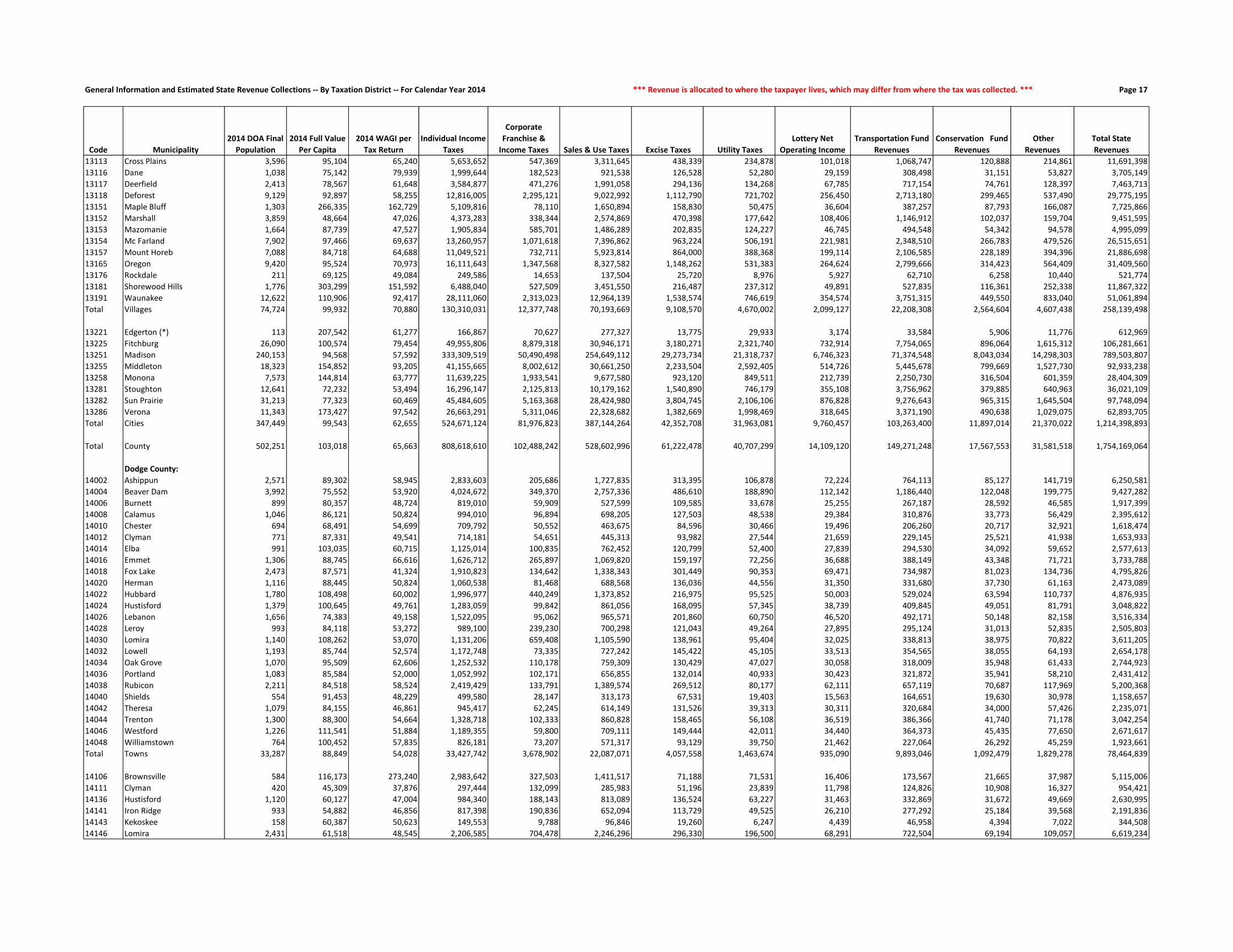
General Information and Estimated State Revenue Collections -- By Taxation District -- For Calendar Year 2014 *** Revenue is allocated to where the taxpayer lives, which may differ from where the tax was collected. *** Page 17
Code Municipality
2014 DOA Final
Population
2014 Full Value
Per Capita
2014 WAGI per
Tax Return
Individual Income
Taxes
Corporate
Franchise &
Income Taxes Sales & Use Taxes Excise Taxes Utility Taxes
Lottery Net
Operating Income
Transportation Fund
Revenues
Conservation Fund
Revenues
Other
Revenues
Total State
Revenues
13113 Cross Plains 3,596 95,104 65,240 5,653,652 547,369 3,311,645 438,339 234,878 101,018 1,068,747 120,888 214,861 11,691,398
13116 Dane 1,038 75,142 79,939 1,999,644 182,523 921,538 126,528 52,280 29,159 308,498 31,151 53,827 3,705,149
13117 Deerfield 2,413 78,567 61,648 3,584,877 471,276 1,991,058 294,136 134,268 67,785 717,154 74,761 128,397 7,463,713
13118 Deforest 9,129 92,897 58,255 12,816,005 2,295,121 9,022,992 1,112,790 721,702 256,450 2,713,180 299,465 537,490 29,775,195
13151 Maple Bluff 1,303 266,335 162,729 5,109,816 78,110 1,650,894 158,830 50,475 36,604 387,257 87,793 166,087 7,725,866
13152 Marshall 3,859 48,664 47,026 4,373,283 338,344 2,574,869 470,398 177,642 108,406 1,146,912 102,037 159,704 9,451,595
13153 Mazomanie 1,664 87,739 47,527 1,905,834 585,701 1,486,289 202,835 124,227 46,745 494,548 54,342 94,578 4,995,099
13154 Mc Farland 7,902 97,466 69,637 13,260,957 1,071,618 7,396,862 963,224 506,191 221,981 2,348,510 266,783 479,526 26,515,651
13157 Mount Horeb 7,088 84,718 64,688 11,049,521 732,711 5,923,814 864,000 388,368 199,114 2,106,585 228,189 394,396 21,886,698
13165 Oregon 9,420 95,524 70,973 16,111,643 1,347,568 8,327,582 1,148,262 531,383 264,624 2,799,666 314,423 564,409 31,409,560
13176 Rockdale 211 69,125 49,084 249,586 14,653 137,504 25,720 8,976 5,927 62,710 6,258 10,440 521,774
13181 Shorewood Hills 1,776 303,299 151,592 6,488,040 527,509 3,451,550 216,487 237,312 49,891 527,835 116,361 252,338 11,867,322
13191 Waunakee 12,622 110,906 92,417 28,111,060 2,313,023 12,964,139 1,538,574 746,619 354,574 3,751,315 449,550 833,040 51,061,894
Total Villages 74,724 99,932 70,880 130,310,031 12,377,748 70,193,669 9,108,570 4,670,002 2,099,127 22,208,308 2,564,604 4,607,438 258,139,498
13221 Edgerton (*) 113 207,542 61,277 166,867 70,627 277,327 13,775 29,933 3,174 33,584 5,906 11,776 612,969
13225 Fitchburg 26,090 100,574 79,454 49,955,806 8,879,318 30,946,171 3,180,271 2,321,740 732,914 7,754,065 896,064 1,615,312 106,281,661
13251 Madison 240,153 94,568 57,592 333,309,519 50,490,498 254,649,112 29,273,734 21,318,737 6,746,323 71,374,548 8,043,034 14,298,303 789,503,807
13255 Middleton 18,323 154,852 93,205 41,155,665 8,002,612 30,661,250 2,233,504 2,592,405 514,726 5,445,678 799,669 1,527,730 92,933,238
13258 Monona 7,573 144,814 63,777 11,639,225 1,933,541 9,677,580 923,120 849,511 212,739 2,250,730 316,504 601,359 28,404,309
13281 Stoughton 12,641 72,232 53,494 16,296,147 2,125,813 10,179,162 1,540,890 746,179 355,108 3,756,962 379,885 640,963 36,021,109
13282 Sun Prairie 31,213 77,323 60,469 45,484,605 5,163,368 28,424,980 3,804,745 2,106,106 876,828 9,276,643 965,315 1,645,504 97,748,094
13286 Verona 11,343 173,427 97,542 26,663,291 5,311,046 22,328,682 1,382,669 1,998,469 318,645 3,371,190 490,638 1,029,075 62,893,705
Total Cities 347,449 99,543 62,655 524,671,124 81,976,823 387,144,264 42,352,708 31,963,081 9,760,457 103,263,400 11,897,014 21,370,022 1,214,398,893
Total County 502,251 103,018 65,663 808,618,610 102,488,242 528,602,996 61,222,478 40,707,299 14,109,120 149,271,248 17,567,553 31,581,518 1,754,169,064
Dodge County:
14002 Ashippun 2,571 89,302 58,945 2,833,603 205,686 1,727,835 313,395 106,878 72,224 764,113 85,127 141,719 6,250,581
14004 Beaver Dam 3,992 75,552 53,920 4,024,672 349,370 2,757,336 486,610 188,890 112,142 1,186,440 122,048 199,775 9,427,282
14006 Burnett 899 80,357 48,724 819,010 59,909 527,599 109,585 33,678 25,255 267,187 28,592 46,585 1,917,399
14008 Calamus 1,046 86,121 50,824 994,010 96,894 698,205 127,503 48,538 29,384 310,876 33,773 56,429 2,395,612
14010 Chester 694 68,491 54,699 709,792 50,552 463,675 84,596 30,466 19,496 206,260 20,717 32,921 1,618,474
14012 Clyman 771 87,331 49,541 714,181 54,651 445,313 93,982 27,544 21,659 229,145 25,521 41,938 1,653,933
14014 Elba 991 103,035 60,715 1,125,014 100,835 762,452 120,799 52,400 27,839 294,530 34,092 59,652 2,577,613
14016 Emmet 1,306 88,745 66,616 1,626,712 265,897 1,069,820 159,197 72,256 36,688 388,149 43,348 71,721 3,733,788
14018 Fox Lake 2,473 87,571 41,324 1,910,823 134,642 1,338,343 301,449 90,353 69,471 734,987 81,023 134,736 4,795,826
14020 Herman 1,116 88,445 50,824 1,060,538 81,468 688,568 136,036 44,556 31,350 331,680 37,730 61,163 2,473,089
14022 Hubbard 1,780 108,498 60,002 1,996,977 440,249 1,373,852 216,975 95,525 50,003 529,024 63,594 110,737 4,876,935
14024 Hustisford 1,379 100,645 49,761 1,283,059 99,842 861,056 168,095 57,345 38,739 409,845 49,051 81,791 3,048,822
14026 Lebanon 1,656 74,383 49,158 1,522,095 95,062 965,571 201,860 60,750 46,520 492,171 50,148 82,158 3,516,334
14028 Leroy 993 84,118 53,272 989,100 239,230 700,298 121,043 49,264 27,895 295,124 31,013 52,835 2,505,803
14030 Lomira 1,140 108,262 53,070 1,131,206 659,408 1,105,590 138,961 95,404 32,025 338,813 38,975 70,822 3,611,205
14032 Lowell 1,193 85,744 52,574 1,172,748 73,335 727,242 145,422 45,105 33,513 354,565 38,055 64,193 2,654,178
14034 Oak Grove 1,070 95,509 62,606 1,252,532 110,178 759,309 130,429 47,027 30,058 318,009 35,948 61,433 2,744,923
14036 Portland 1,083 85,584 52,000 1,052,992 102,171 656,855 132,014 40,933 30,423 321,872 35,941 58,210 2,431,412
14038 Rubicon 2,211 84,518 58,524 2,419,429 133,791 1,389,574 269,512 80,177 62,111 657,119 70,687 117,969 5,200,368
14040 Shields 554 91,453 48,229 499,580 28,147 313,173 67,531 19,403 15,563 164,651 19,630 30,978 1,158,657
14042 Theresa 1,079 84,155 46,861 945,417 62,245 614,149 131,526 39,313 30,311 320,684 34,000 57,426 2,235,071
14044 Trenton 1,300 88,300 54,664 1,328,718 102,333 860,828 158,465 56,108 36,519 386,366 41,740 71,178 3,042,254
14046 Westford 1,226 111,541 51,884 1,189,355 59,800 709,111 149,444 42,011 34,440 364,373 45,435 77,650 2,671,617
14048 Williamstown 764 100,452 57,835 826,181 73,207 571,317 93,129 39,750 21,462 227,064 26,292 45,259 1,923,661
Total Towns 33,287 88,849 54,028 33,427,742 3,678,902 22,087,071 4,057,558 1,463,674 935,090 9,893,046 1,092,479 1,829,278 78,464,839
14106 Brownsville 584 116,173 273,240 2,983,642 327,503 1,411,517 71,188 71,531 16,406 173,567 21,665 37,987 5,115,006
14111 Clyman 420 45,309 37,876 297,444 132,099 285,983 51,196 23,839 11,798 124,826 10,908 16,327 954,421
14136 Hustisford 1,120 60,127 47,004 984,340 188,143 813,089 136,524 63,227 31,463 332,869 31,672 49,669 2,630,995
14141 Iron Ridge 933 54,882 46,856 817,398 190,836 652,094 113,729 49,525 26,210 277,292 25,184 39,568 2,191,836
14143 Kekoskee 158 60,387 50,623 149,553 9,788 96,846 19,260 6,247 4,439 46,958 4,394 7,022 344,508
14146 Lomira 2,431 61,518 48,545 2,206,585 704,478 2,246,296 296,330 196,500 68,291 722,504 69,194 109,057 6,619,234

General Information and Estimated State Revenue Collections -- By Taxation District -- For Calendar Year 2014 *** Aid is allocated to the municipality whose taxes are affected by the receipt of the aid. *** Page 18
Code Municipality
Gross Property
Tax Levy Shared Revenue
School Levies
Credit
First Dollar and
Lottery Credit
Natural Resources
Aids
Transportation
Aids
Miscellaneous
Aids
Property Tax
Offset: School Aids
Property Tax
Offset: County
Aids Total State Aid
State Aid As a % of
State Revenues
Gross Property
Tax Rate (mills)
State Aid (in
mills on full
value)
13113 Cross Plains 7,639,946 103,740 553,805 206,913 7,081 166,794 34,045 954,879 890,329 2,917,586 24.95% 23.1657 8.8466
13116 Dane 1,820,664 67,896 139,304 59,023 2,657 44,647 4,153 470,461 200,547 988,688 26.68% 24.8828 13.5123
13117 Deerfield 4,482,849 189,377 344,589 156,568 13,717 89,618 43,259 2,417,527 450,907 3,705,562 49.65% 24.3748 20.1484
13118 Deforest 18,856,324 314,846 1,354,969 482,345 17,073 376,035 76,065 7,416,985 1,938,829 11,977,148 40.23% 23.7561 15.0894
13151 Maple Bluff 8,846,232 43,957 670,768 102,648 31,455 197,468 15,881 1,502,040 1,038,100 3,602,317 46.63% 23.3563 9.5110
13152 Marshall 5,016,275 458,634 282,915 239,510 15,315 187,550 11,516 4,468,700 442,357 6,106,498 64.61% 26.2835 31.9958
13153 Mazomanie 3,519,600 139,902 228,916 103,890 5,152 79,659 26,265 447,515 365,734 1,397,033 27.97% 24.5706 9.7528
13154 Mc Farland 18,253,579 212,573 1,455,919 496,963 21,754 365,745 59,757 16,022,884 1,927,444 20,563,038 77.55% 24.9484 28.1049
13157 Mount Horeb 13,035,519 210,280 918,548 353,990 18,095 402,231 45,339 6,246,162 1,564,896 9,759,540 44.59% 22.0639 16.5190
13165 Oregon 19,771,438 203,794 1,595,762 608,022 38,671 442,863 62,091 9,937,984 2,262,270 15,151,458 48.24% 23.2349 17.8056
13176 Rockdale 337,154 30,977 33,135 16,528 826 9,034 634 111,903 39,567 242,604 46.50% 23.3551 16.8055
13181 Shorewood Hills 11,157,673 20,889 869,514 125,862 14,945 217,080 60,048 1,914,451 1,323,129 4,545,918 38.31% 22.4598 9.1507
13191 Waunakee 30,518,291 320,438 2,302,184 671,500 28,460 627,512 97,228 13,330,825 3,484,541 20,862,687 40.86% 23.3561 15.9666
Total Villages 169,330,873 2,899,164 12,732,315 4,442,956 302,116 3,798,324 664,090 73,910,466 18,681,786 117,431,216 45.49% 23.6328 16.3894
13221 Edgerton (*) 543,234 19,613 10,368 4,228 391 6,562 739 79,512 18,005 139,418 22.74% 23.8447 6.1196
13225 Fitchburg 62,771,684 926,991 4,450,973 1,159,271 198,788 1,126,564 1,012,828 18,153,487 6,360,731 33,389,632 31.42% 25.0708 13.3357
13251 Madison 569,136,432 12,216,619 38,756,605 11,062,387 911,909 26,761,856 16,612,928 92,673,281 58,632,508 257,628,092 32.63% 26.0436 11.7890
13255 Middleton 62,191,265 417,863 3,975,539 887,268 160,488 977,086 807,290 7,128,504 6,588,377 20,942,413 22.53% 22.5050 7.5784
13258 Monona 26,429,128 180,079 2,048,182 579,768 280,627 865,903 448,559 7,812,650 2,603,914 14,819,683 52.17% 24.9419 13.9857
13281 Stoughton 22,503,879 727,607 1,536,398 696,074 59,151 687,065 138,267 7,734,771 2,367,217 13,946,551 38.72% 25.1686 15.5980
13282 Sun Prairie 63,230,622 1,243,888 4,653,498 1,723,082 56,851 1,864,073 509,455 29,479,528 6,204,176 45,734,551 46.79% 26.6946 19.3081
13286 Verona 40,641,514 308,571 2,461,805 681,744 22,191 877,866 429,040 14,347,018 3,463,784 22,592,020 35.92% 24.1249 13.4107
Total Cities 847,447,758 16,041,231 57,893,369 16,793,821 1,690,396 33,166,974 19,959,106 177,408,751 86,238,711 409,192,359 33.70% 25.5638 12.3436
Total County 1,206,541,568 21,152,367 87,867,891 26,569,784 2,868,640 41,031,438 21,697,087 341,047,342 130,718,896 672,953,445 38.36% 24.2495 13.5253
Dodge County:
14002 Ashippun 4,552,400 38,926 392,110 156,545 11,859 123,104 8,842 950,521 496,955 2,178,862 34.86% 20.6126 9.8656
14004 Beaver Dam 5,152,155 78,243 450,645 207,988 9,427 123,082 12,793 4,796,029 662,320 6,340,528 67.26% 17.5038 21.5411
14006 Burnett 1,512,539 24,640 114,253 64,521 16,984 60,525 2,815 912,387 162,445 1,358,571 70.85% 20.9513 18.8186
14008 Calamus 1,712,372 31,153 127,603 58,862 4,394 84,871 3,446 1,317,020 194,946 1,822,294 76.07% 19.7649 21.0337
14010 Chester 980,915 14,115 82,081 49,498 1,207 36,836 2,895 636,291 108,616 931,538 57.56% 20.3212 19.2983
14012 Clyman 1,480,572 16,098 132,743 59,076 385 39,014 2,658 1,166,693 151,158 1,567,824 94.79% 22.0399 23.3387
14014 Elba 2,040,745 13,027 159,539 76,164 31 97,276 4,768 1,076,873 212,517 1,640,194 63.63% 21.5949 17.3564
14016 Emmet 2,349,148 19,011 189,559 79,748 4,673 82,563 5,089 1,665,115 260,354 2,306,113 61.76% 20.3029 19.9309
14018 Fox Lake 4,517,348 37,023 370,300 116,599 17,589 77,969 20,260 2,935,969 479,012 4,054,720 84.55% 21.2201 19.0470
14020 Herman 2,105,810 113,864 189,084 86,267 5,020 104,220 3,878 558,285 221,213 1,281,833 51.83% 21.4199 13.0386
14022 Hubbard 3,743,859 33,893 300,492 133,452 5,710 94,355 7,147 1,885,661 415,031 2,875,741 58.97% 20.2978 15.5912
14024 Hustisford 2,856,033 19,794 225,944 96,240 39 94,334 5,483 851,249 308,703 1,601,785 52.54% 20.8177 11.6755
14026 Lebanon 2,445,256 64,151 193,418 104,074 17,136 100,875 10,988 1,428,383 256,454 2,175,480 61.87% 21.4548 19.0878
14028 Leroy 1,623,790 115,894 114,594 61,027 2,194 72,416 3,598 1,123,826 173,152 1,666,702 66.51% 21.1014 21.6591
14030 Lomira 2,169,269 63,637 178,447 67,120 7,036 78,075 5,253 1,666,173 242,806 2,308,547 63.93% 20.1032 21.3939
14032 Lowell 2,180,012 26,366 180,218 89,771 11,837 105,067 3,788 1,826,761 217,360 2,461,168 92.73% 22.5679 25.4784
14034 Oak Grove 2,079,748 23,669 179,872 83,582 7,886 69,035 4,082 1,680,495 215,529 2,264,151 82.49% 21.7128 23.6379
14036 Portland 1,996,944 23,034 150,224 79,126 28,987 97,852 3,923 1,414,940 211,160 2,009,246 82.64% 21.2797 21.4108
14038 Rubicon 3,403,331 48,661 328,195 125,572 9,198 109,682 7,138 1,477,695 404,528 2,510,668 48.28% 18.9307 13.9653
14040 Shields 1,038,178 14,580 76,403 35,189 3,750 60,652 1,912 727,764 113,631 1,033,882 89.23% 20.5582 20.4731
14042 Theresa 1,734,661 30,236 125,971 60,982 4,779 98,631 3,518 1,276,682 190,097 1,790,897 80.13% 20.5329 21.1985
14044 Trenton 2,096,534 16,746 176,059 76,497 11,864 154,626 4,297 1,596,552 241,416 2,278,056 74.88% 19.5410 21.2329
14046 Westford 2,509,633 16,565 216,965 94,627 12,702 67,998 5,292 2,346,453 309,041 3,069,644 114.90% 18.2728 22.3503
14048 Williamstown 1,132,395 16,147 101,815 47,573 14,182 50,090 2,821 1,044,230 165,264 1,442,123 74.97% 15.4181 19.6352
Total Towns 57,413,645 899,473 4,756,535 2,110,102 208,870 2,083,147 136,687 36,362,047 6,413,707 52,970,566 67.51% 20.1423 18.5835
14106 Brownsville 1,456,661 22,707 93,387 31,125 1,883 25,958 4,463 1,016,343 147,505 1,343,371 26.26% 22.2210 20.4928
14111 Clyman 621,502 111,322 43,438 29,353 796 34,145 1,017 410,266 44,129 674,466 70.67% 31.6907 34.3913
14136 Hustisford 1,851,394 150,068 112,530 59,577 67,460 72,482 5,213 388,131 151,920 1,007,382 38.29% 27.4217 14.9207
14141 Iron Ridge 1,141,994 170,959 83,917 56,035 6,030 30,920 3,530 569,826 110,645 1,031,863 47.08% 23.2244 20.9847
14143 Kekoskee 164,476 27,274 14,502 11,600 849 3,239 433 131,782 20,448 210,126 60.99% 18.0995 23.1231
14146 Lomira 3,352,478 203,554 194,900 93,455 10,495 170,654 20,913 2,147,193 311,628 3,152,792 47.63% 22.4711 21.1326
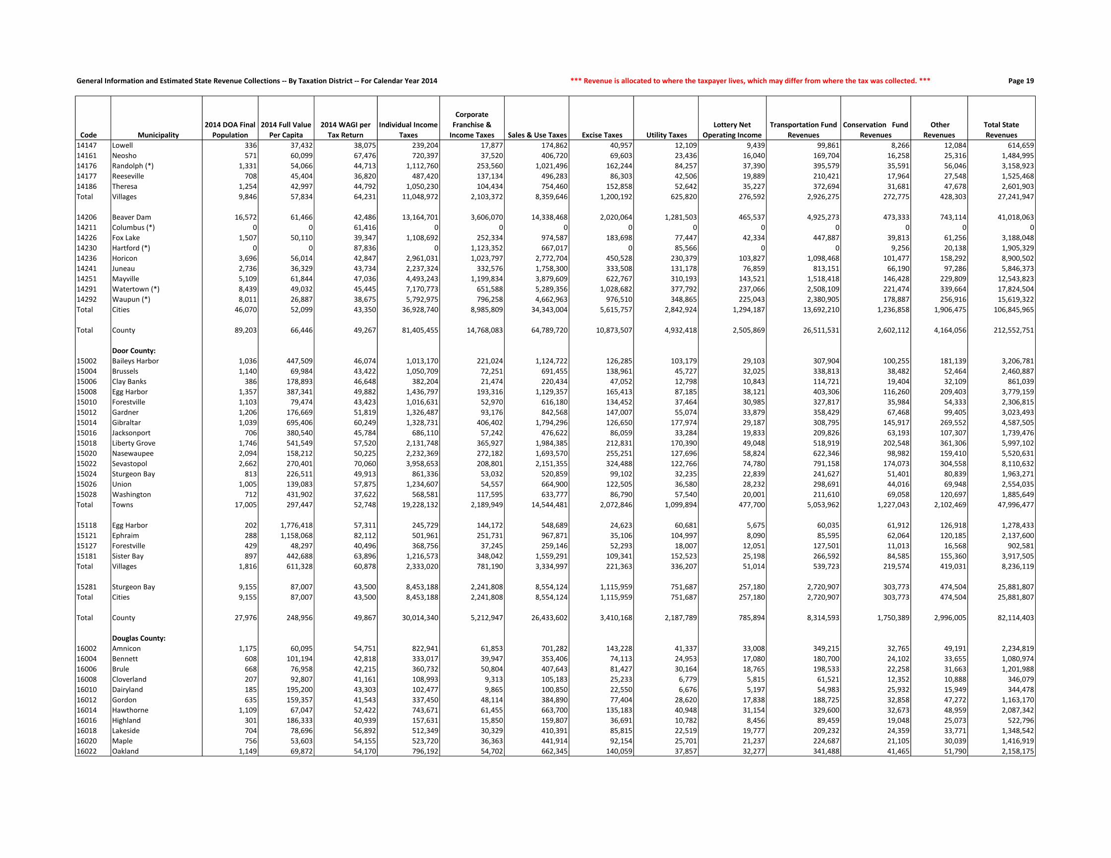
General Information and Estimated State Revenue Collections -- By Taxation District -- For Calendar Year 2014 *** Revenue is allocated to where the taxpayer lives, which may differ from where the tax was collected. *** Page 19
Code Municipality
2014 DOA Final
Population
2014 Full Value
Per Capita
2014 WAGI per
Tax Return
Individual Income
Taxes
Corporate
Franchise &
Income Taxes Sales & Use Taxes Excise Taxes Utility Taxes
Lottery Net
Operating Income
Transportation Fund
Revenues
Conservation Fund
Revenues
Other
Revenues
Total State
Revenues
14147 Lowell 336 37,432 38,075 239,204 17,877 174,862 40,957 12,109 9,439 99,861 8,266 12,084 614,659
14161 Neosho 571 60,099 67,476 720,397 37,520 406,720 69,603 23,436 16,040 169,704 16,258 25,316 1,484,995
14176 Randolph (*) 1,331 54,066 44,713 1,112,760 253,560 1,021,496 162,244 84,257 37,390 395,579 35,591 56,046 3,158,923
14177 Reeseville 708 45,404 36,820 487,420 137,134 496,283 86,303 42,506 19,889 210,421 17,964 27,548 1,525,468
14186 Theresa 1,254 42,997 44,792 1,050,230 104,434 754,460 152,858 52,642 35,227 372,694 31,681 47,678 2,601,903
Total Villages 9,846 57,834 64,231 11,048,972 2,103,372 8,359,646 1,200,192 625,820 276,592 2,926,275 272,775 428,303 27,241,947
14206 Beaver Dam 16,572 61,466 42,486 13,164,701 3,606,070 14,338,468 2,020,064 1,281,503 465,537 4,925,273 473,333 743,114 41,018,063
14211 Columbus (*) 0 0 61,416 0 0 0 0 0 0 0 0 0 0
14226 Fox Lake 1,507 50,110 39,347 1,108,692 252,334 974,587 183,698 77,447 42,334 447,887 39,813 61,256 3,188,048
14230 Hartford (*) 0 0 87,836 0 1,123,352 667,017 0 85,566 0 0 9,256 20,138 1,905,329
14236 Horicon 3,696 56,014 42,847 2,961,031 1,023,797 2,772,704 450,528 230,379 103,827 1,098,468 101,477 158,292 8,900,502
14241 Juneau 2,736 36,329 43,734 2,237,324 332,576 1,758,300 333,508 131,178 76,859 813,151 66,190 97,286 5,846,373
14251 Mayville 5,109 61,844 47,036 4,493,243 1,199,834 3,879,609 622,767 310,193 143,521 1,518,418 146,428 229,809 12,543,823
14291 Watertown (*) 8,439 49,032 45,445 7,170,773 651,588 5,289,356 1,028,682 377,792 237,066 2,508,109 221,474 339,664 17,824,504
14292 Waupun (*) 8,011 26,887 38,675 5,792,975 796,258 4,662,963 976,510 348,865 225,043 2,380,905 178,887 256,916 15,619,322
Total Cities 46,070 52,099 43,350 36,928,740 8,985,809 34,343,004 5,615,757 2,842,924 1,294,187 13,692,210 1,236,858 1,906,475 106,845,965
Total County 89,203 66,446 49,267 81,405,455 14,768,083 64,789,720 10,873,507 4,932,418 2,505,869 26,511,531 2,602,112 4,164,056 212,552,751
Door County:
15002 Baileys Harbor 1,036 447,509 46,074 1,013,170 221,024 1,124,722 126,285 103,179 29,103 307,904 100,255 181,139 3,206,781
15004 Brussels 1,140 69,984 43,422 1,050,709 72,251 691,455 138,961 45,727 32,025 338,813 38,482 52,464 2,460,887
15006 Clay Banks 386 178,893 46,648 382,204 21,474 220,434 47,052 12,798 10,843 114,721 19,404 32,109 861,039
15008 Egg Harbor 1,357 387,341 49,882 1,436,797 193,316 1,129,357 165,413 87,185 38,121 403,306 116,260 209,403 3,779,159
15010 Forestville 1,103 79,474 43,423 1,016,631 52,970 616,180 134,452 37,464 30,985 327,817 35,984 54,333 2,306,815
15012 Gardner 1,206 176,669 51,819 1,326,487 93,176 842,568 147,007 55,074 33,879 358,429 67,468 99,405 3,023,493
15014 Gibraltar 1,039 695,406 60,249 1,328,731 406,402 1,794,296 126,650 177,974 29,187 308,795 145,917 269,552 4,587,505
15016 Jacksonport 706 380,540 45,784 686,110 57,242 476,622 86,059 33,284 19,833 209,826 63,193 107,307 1,739,476
15018 Liberty Grove 1,746 541,549 57,520 2,131,748 365,927 1,984,385 212,831 170,390 49,048 518,919 202,548 361,306 5,997,102
15020 Nasewaupee 2,094 158,212 50,225 2,232,369 272,182 1,693,570 255,251 127,696 58,824 622,346 98,982 159,410 5,520,631
15022 Sevastopol 2,662 270,401 70,060 3,958,653 208,801 2,151,355 324,488 122,766 74,780 791,158 174,073 304,558 8,110,632
15024 Sturgeon Bay 813 226,511 49,913 861,336 53,032 520,859 99,102 32,235 22,839 241,627 51,401 80,839 1,963,271
15026 Union 1,005 139,083 57,875 1,234,607 54,557 664,900 122,505 36,580 28,232 298,691 44,016 69,948 2,554,035
15028 Washington 712 431,902 37,622 568,581 117,595 633,777 86,790 57,540 20,001 211,610 69,058 120,697 1,885,649
Total Towns 17,005 297,447 52,748 19,228,132 2,189,949 14,544,481 2,072,846 1,099,894 477,700 5,053,962 1,227,043 2,102,469 47,996,477
15118 Egg Harbor 202 1,776,418 57,311 245,729 144,172 548,689 24,623 60,681 5,675 60,035 61,912 126,918 1,278,433
15121 Ephraim 288 1,158,068 82,112 501,961 251,731 967,871 35,106 104,997 8,090 85,595 62,064 120,185 2,137,600
15127 Forestville 429 48,297 40,496 368,756 37,245 259,146 52,293 18,007 12,051 127,501 11,013 16,568 902,581
15181 Sister Bay 897 442,688 63,896 1,216,573 348,042 1,559,291 109,341 152,523 25,198 266,592 84,585 155,360 3,917,505
Total Villages 1,816 611,328 60,878 2,333,020 781,190 3,334,997 221,363 336,207 51,014 539,723 219,574 419,031 8,236,119
15281 Sturgeon Bay 9,155 87,007 43,500 8,453,188 2,241,808 8,554,124 1,115,959 751,687 257,180 2,720,907 303,773 474,504 25,881,807
Total Cities 9,155 87,007 43,500 8,453,188 2,241,808 8,554,124 1,115,959 751,687 257,180 2,720,907 303,773 474,504 25,881,807
Total County 27,976 248,956 49,867 30,014,340 5,212,947 26,433,602 3,410,168 2,187,789 785,894 8,314,593 1,750,389 2,996,005 82,114,403
Douglas County:
16002 Amnicon 1,175 60,095 54,751 822,941 61,853 701,282 143,228 41,337 33,008 349,215 32,765 49,191 2,234,819
16004 Bennett 608 101,194 42,818 333,017 39,947 353,406 74,113 24,953 17,080 180,700 24,102 33,655 1,080,974
16006 Brule 668 76,958 42,215 360,732 50,804 407,643 81,427 30,164 18,765 198,533 22,258 31,663 1,201,988
16008 Cloverland 207 92,807 41,161 108,993 9,313 105,183 25,233 6,779 5,815 61,521 12,352 10,888 346,079
16010 Dairyland 185 195,200 43,303 102,477 9,865 100,850 22,550 6,676 5,197 54,983 25,932 15,949 344,478
16012 Gordon 635 159,357 41,543 337,450 48,114 384,890 77,404 28,620 17,838 188,725 32,858 47,272 1,163,170
16014 Hawthorne 1,109 67,047 52,422 743,671 61,455 663,700 135,183 40,948 31,154 329,600 32,673 48,959 2,087,342
16016 Highland 301 186,333 40,939 157,631 15,850 159,807 36,691 10,782 8,456 89,459 19,048 25,073 522,796
16018 Lakeside 704 78,696 56,892 512,349 30,329 410,391 85,815 22,519 19,777 209,232 24,359 33,771 1,348,542
16020 Maple 756 53,603 54,155 523,720 36,363 441,914 92,154 25,701 21,237 224,687 21,105 30,039 1,416,919
16022 Oakland 1,149 69,872 54,170 796,192 54,702 662,345 140,059 37,857 32,277 341,488 41,465 51,790 2,158,175
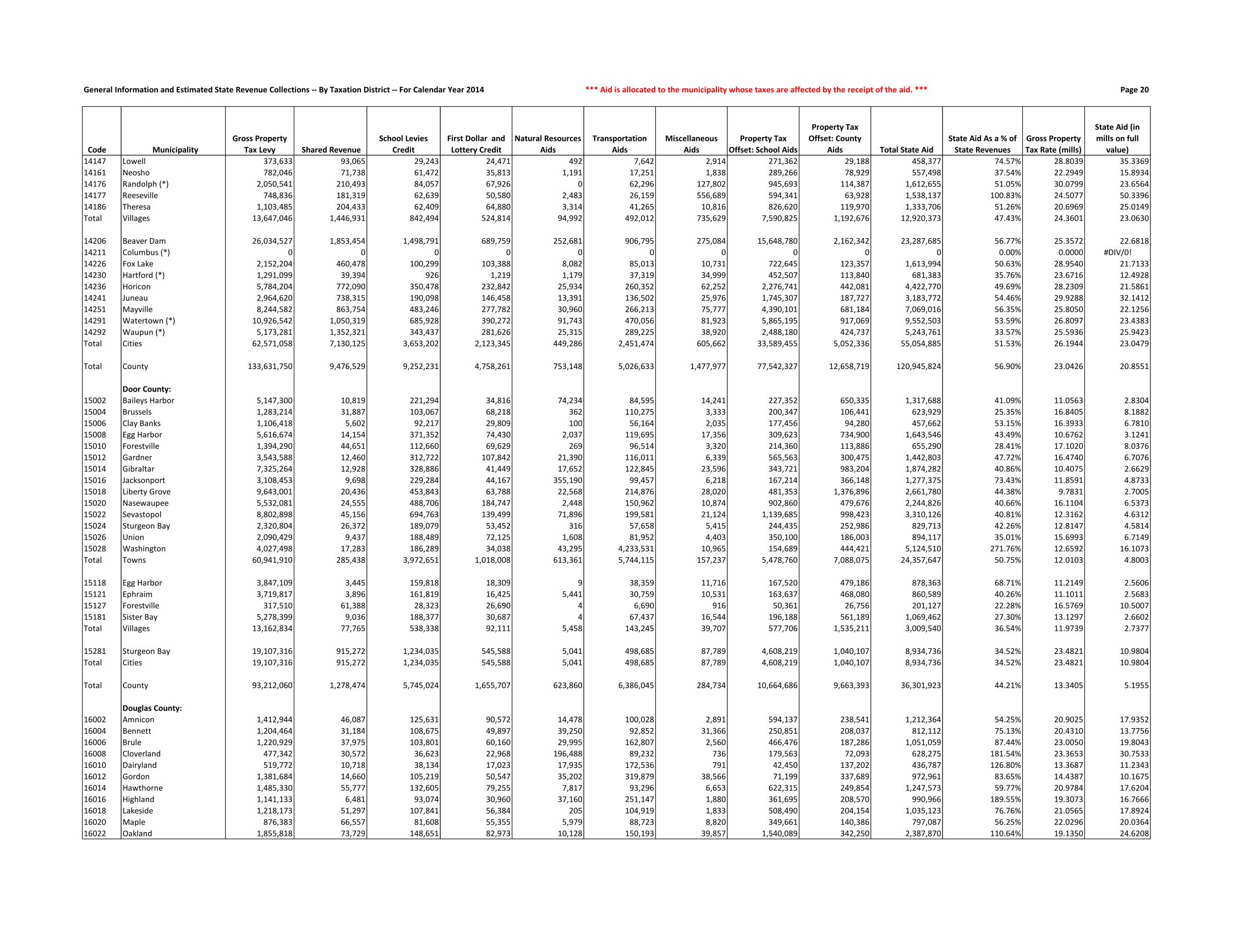
General Information and Estimated State Revenue Collections -- By Taxation District -- For Calendar Year 2014 *** Aid is allocated to the municipality whose taxes are affected by the receipt of the aid. *** Page 20
Code Municipality
Gross Property
Tax Levy Shared Revenue
School Levies
Credit
First Dollar and
Lottery Credit
Natural Resources
Aids
Transportation
Aids
Miscellaneous
Aids
Property Tax
Offset: School Aids
Property Tax
Offset: County
Aids Total State Aid
State Aid As a % of
State Revenues
Gross Property
Tax Rate (mills)
State Aid (in
mills on full
value)
14147 Lowell 373,633 93,065 29,243 24,471 492 7,642 2,914 271,362 29,188 458,377 74.57% 28.8039 35.3369
14161 Neosho 782,046 71,738 61,472 35,813 1,191 17,251 1,838 289,266 78,929 557,498 37.54% 22.2949 15.8934
14176 Randolph (*) 2,050,541 210,493 84,057 67,926 0 62,296 127,802 945,693 114,387 1,612,655 51.05% 30.0799 23.6564
14177 Reeseville 748,836 181,319 62,639 50,580 2,483 26,159 556,689 594,341 63,928 1,538,137 100.83% 24.5077 50.3396
14186 Theresa 1,103,485 204,433 62,409 64,880 3,314 41,265 10,816 826,620 119,970 1,333,706 51.26% 20.6969 25.0149
Total Villages 13,647,046 1,446,931 842,494 524,814 94,992 492,012 735,629 7,590,825 1,192,676 12,920,373 47.43% 24.3601 23.0630
14206 Beaver Dam 26,034,527 1,853,454 1,498,791 689,759 252,681 906,795 275,084 15,648,780 2,162,342 23,287,685 56.77% 25.3572 22.6818
14211 Columbus (*) 0 0 0 0 0 0 0 0 0 0 0.00% 0.0000 #DIV/0!
14226 Fox Lake 2,152,204 460,478 100,299 103,388 8,082 85,013 10,731 722,645 123,357 1,613,994 50.63% 28.9540 21.7133
14230 Hartford (*) 1,291,099 39,394 926 1,219 1,179 37,319 34,999 452,507 113,840 681,383 35.76% 23.6716 12.4928
14236 Horicon 5,784,204 772,090 350,478 232,842 25,934 260,352 62,252 2,276,741 442,081 4,422,770 49.69% 28.2309 21.5861
14241 Juneau 2,964,620 738,315 190,098 146,458 13,391 136,502 25,976 1,745,307 187,727 3,183,772 54.46% 29.9288 32.1412
14251 Mayville 8,244,582 863,754 483,246 277,782 30,960 266,213 75,777 4,390,101 681,184 7,069,016 56.35% 25.8050 22.1256
14291 Watertown (*) 10,926,542 1,050,319 685,928 390,272 91,743 470,056 81,923 5,865,195 917,069 9,552,503 53.59% 26.8097 23.4383
14292 Waupun (*) 5,173,281 1,352,321 343,437 281,626 25,315 289,225 38,920 2,488,180 424,737 5,243,761 33.57% 25.5936 25.9423
Total Cities 62,571,058 7,130,125 3,653,202 2,123,345 449,286 2,451,474 605,662 33,589,455 5,052,336 55,054,885 51.53% 26.1944 23.0479
Total County 133,631,750 9,476,529 9,252,231 4,758,261 753,148 5,026,633 1,477,977 77,542,327 12,658,719 120,945,824 56.90% 23.0426 20.8551
Door County:
15002 Baileys Harbor 5,147,300 10,819 221,294 34,816 74,234 84,595 14,241 227,352 650,335 1,317,688 41.09% 11.0563 2.8304
15004 Brussels 1,283,214 31,887 103,067 68,218 362 110,275 3,333 200,347 106,441 623,929 25.35% 16.8405 8.1882
15006 Clay Banks 1,106,418 5,602 92,217 29,809 100 56,164 2,035 177,456 94,280 457,662 53.15% 16.3933 6.7810
15008 Egg Harbor 5,616,674 14,154 371,352 74,430 2,037 119,695 17,356 309,623 734,900 1,643,546 43.49% 10.6762 3.1241
15010 Forestville 1,394,290 44,651 112,660 69,629 269 96,514 3,320 214,360 113,886 655,290 28.41% 17.1020 8.0376
15012 Gardner 3,543,588 12,460 312,722 107,842 21,390 116,011 6,339 565,563 300,475 1,442,803 47.72% 16.4740 6.7076
15014 Gibraltar 7,325,264 12,928 328,886 41,449 17,652 122,845 23,596 343,721 983,204 1,874,282 40.86% 10.4075 2.6629
15016 Jacksonport 3,108,453 9,698 229,284 44,167 355,190 99,457 6,218 167,214 366,148 1,277,375 73.43% 11.8591 4.8733
15018 Liberty Grove 9,643,001 20,436 453,843 63,788 22,568 214,876 28,020 481,353 1,376,896 2,661,780 44.38% 9.7831 2.7005
15020 Nasewaupee 5,532,081 24,555 488,706 184,747 2,448 150,962 10,874 902,860 479,676 2,244,826 40.66% 16.1104 6.5373
15022 Sevastopol 8,802,898 45,156 694,763 139,499 71,896 199,581 21,124 1,139,685 998,423 3,310,126 40.81% 12.3162 4.6312
15024 Sturgeon Bay 2,320,804 26,372 189,079 53,452 316 57,658 5,415 244,435 252,986 829,713 42.26% 12.8147 4.5814
15026 Union 2,090,429 9,437 188,489 72,125 1,608 81,952 4,403 350,100 186,003 894,117 35.01% 15.6993 6.7149
15028 Washington 4,027,498 17,283 186,289 34,038 43,295 4,233,531 10,965 154,689 444,421 5,124,510 271.76% 12.6592 16.1073
Total Towns 60,941,910 285,438 3,972,651 1,018,008 613,361 5,744,115 157,237 5,478,760 7,088,075 24,357,647 50.75% 12.0103 4.8003
15118 Egg Harbor 3,847,109 3,445 159,818 18,309 9 38,359 11,716 167,520 479,186 878,363 68.71% 11.2149 2.5606
15121 Ephraim 3,719,817 3,896 161,819 16,425 5,441 30,759 10,531 163,637 468,080 860,589 40.26% 11.1011 2.5683
15127 Forestville 317,510 61,388 28,323 26,690 4 6,690 916 50,361 26,756 201,127 22.28% 16.5769 10.5007
15181 Sister Bay 5,278,399 9,036 188,377 30,687 4 67,437 16,544 196,188 561,189 1,069,462 27.30% 13.1297 2.6602
Total Villages 13,162,834 77,765 538,338 92,111 5,458 143,245 39,707 577,706 1,535,211 3,009,540 36.54% 11.9739 2.7377
15281 Sturgeon Bay 19,107,316 915,272 1,234,035 545,588 5,041 498,685 87,789 4,608,219 1,040,107 8,934,736 34.52% 23.4821 10.9804
Total Cities 19,107,316 915,272 1,234,035 545,588 5,041 498,685 87,789 4,608,219 1,040,107 8,934,736 34.52% 23.4821 10.9804
Total County 93,212,060 1,278,474 5,745,024 1,655,707 623,860 6,386,045 284,734 10,664,686 9,663,393 36,301,923 44.21% 13.3405 5.1955
Douglas County:
16002 Amnicon 1,412,944 46,087 125,631 90,572 14,478 100,028 2,891 594,137 238,541 1,212,364 54.25% 20.9025 17.9352
16004 Bennett 1,204,464 31,184 108,675 49,897 39,250 92,852 31,366 250,851 208,037 812,112 75.13% 20.4310 13.7756
16006 Brule 1,220,929 37,975 103,801 60,160 29,995 162,807 2,560 466,476 187,286 1,051,059 87.44% 23.0050 19.8043
16008 Cloverland 477,342 30,572 36,623 22,968 196,488 89,232 736 179,563 72,093 628,275 181.54% 23.3653 30.7533
16010 Dairyland 519,772 10,718 38,134 17,023 17,935 172,536 791 42,450 137,202 436,787 126.80% 13.3687 11.2343
16012 Gordon 1,381,684 14,660 105,219 50,547 35,202 319,879 38,566 71,199 337,689 972,961 83.65% 14.4387 10.1675
16014 Hawthorne 1,485,330 55,777 132,605 79,255 7,817 93,296 6,653 622,315 249,854 1,247,573 59.77% 20.9784 17.6204
16016 Highland 1,141,133 6,481 93,074 30,960 37,160 251,147 1,880 361,695 208,570 990,966 189.55% 19.3073 16.7666
16018 Lakeside 1,218,173 51,297 107,841 56,384 205 104,919 1,833 508,490 204,154 1,035,123 76.76% 21.0565 17.8924
16020 Maple 876,383 66,557 81,608 55,355 5,979 88,723 8,820 349,661 140,386 797,087 56.25% 22.0296 20.0364
16022 Oakland 1,855,818 73,729 148,651 82,973 10,128 150,193 39,857 1,540,089 342,250 2,387,870 110.64% 19.1350 24.6208

General Information and Estimated State Revenue Collections -- By Taxation District -- For Calendar Year 2014 *** Revenue is allocated to where the taxpayer lives, which may differ from where the tax was collected. *** Page 21
Code Municipality
2014 DOA Final
Population
2014 Full Value
Per Capita
2014 WAGI per
Tax Return
Individual Income
Taxes
Corporate
Franchise &
Income Taxes Sales & Use Taxes Excise Taxes Utility Taxes
Lottery Net
Operating Income
Transportation Fund
Revenues
Conservation Fund
Revenues
Other
Revenues
Total State
Revenues
16024 Parkland 1,216 60,196 48,084 747,948 69,105 685,993 148,226 43,018 34,160 361,401 34,736 50,948 2,175,535
16026 Solon Springs 922 133,908 43,269 510,323 56,525 525,415 112,388 36,218 25,901 274,023 40,814 60,936 1,642,543
16028 Summit 1,074 76,700 51,166 702,949 53,087 615,775 130,916 37,083 30,171 319,198 37,664 50,816 1,977,659
16030 Superior 2,202 79,693 45,644 1,285,693 147,864 1,269,358 268,415 84,917 61,858 654,444 67,967 106,350 3,946,867
16032 Wascott 750 357,615 42,772 410,354 67,766 493,453 91,422 38,181 21,069 222,903 71,987 104,637 1,521,772
Total Towns 13,661 100,245 47,804 8,456,440 812,942 7,981,405 1,665,224 515,754 383,763 4,060,110 542,082 751,938 25,169,658
16146 Lake Nebagamon 1,083 151,013 59,663 826,555 71,728 724,948 132,014 44,677 30,423 321,872 46,121 77,657 2,275,997
16165 Oliver 421 51,170 48,614 261,809 25,105 249,264 51,318 16,255 11,827 125,123 11,160 16,392 768,253
16171 Poplar 612 64,330 52,942 414,472 47,129 409,130 74,601 27,886 17,192 181,889 17,512 26,472 1,216,283
16181 Solon Springs 605 74,620 41,125 318,270 69,842 419,790 73,747 34,244 16,996 179,809 17,802 28,212 1,158,713
16182 Superior 668 68,154 48,728 416,385 42,172 403,193 81,427 26,728 18,765 198,533 19,305 29,733 1,236,241
Total Villages 3,389 92,987 52,529 2,237,491 255,976 2,206,326 413,107 149,791 95,203 1,007,226 111,901 178,466 6,655,486
16281 Superior 27,146 60,900 39,632 13,762,265 6,117,007 21,912,958 3,308,993 1,957,945 762,579 8,067,913 755,486 1,207,729 57,852,875
Total Cities 27,146 60,900 39,632 13,762,265 6,117,007 21,912,958 3,308,993 1,957,945 762,579 8,067,913 755,486 1,207,729 57,852,875
Total County 44,196 75,522 42,913 24,456,196 7,185,925 32,100,689 5,387,324 2,623,489 1,241,545 13,135,249 1,409,469 2,138,133 89,678,020
Dunn County:
17002 Colfax 1,241 60,338 45,226 875,230 65,993 655,904 151,273 44,711 34,862 368,831 43,270 55,104 2,295,178
17004 Dunn 1,515 60,959 43,259 1,022,007 84,012 776,190 184,672 53,178 42,559 450,265 49,223 67,618 2,729,725
17006 Eau Galle 760 87,267 45,578 540,166 36,107 389,341 92,641 25,642 21,350 225,875 31,284 41,298 1,403,703
17008 Elk Mound 1,851 60,122 52,248 1,508,113 121,819 1,101,811 225,630 74,932 51,998 550,126 56,598 82,043 3,773,068
17010 Grant 386 87,660 48,286 290,647 16,854 197,938 47,052 12,437 10,843 114,721 17,558 21,031 729,081
17012 Hay River 556 87,956 48,210 417,993 292,396 444,152 67,774 38,341 15,619 165,246 26,263 30,354 1,498,138
17014 Lucas 767 66,250 49,897 596,798 45,310 418,617 93,494 27,237 21,546 227,956 28,100 35,730 1,494,788
17016 Menomonie 3,424 59,216 49,904 2,664,591 200,159 1,938,615 417,373 130,535 96,186 1,017,628 100,025 150,619 6,715,731
17018 New Haven 676 52,446 37,597 396,335 34,195 319,060 82,402 22,467 18,990 200,910 22,738 28,048 1,125,147
17020 Otter Creek 496 74,027 44,504 344,222 23,091 250,267 60,461 16,555 13,934 147,413 33,644 24,529 914,116
17022 Peru 242 66,934 46,952 177,185 12,051 126,716 29,499 8,322 6,798 71,923 8,806 11,335 452,636
17024 Red Cedar 2,134 76,540 72,621 2,416,652 287,309 1,485,283 260,126 88,548 59,948 634,234 66,665 107,513 5,406,278
17026 Rock Creek 1,022 59,967 51,551 821,582 50,580 557,868 124,578 35,313 28,710 303,743 29,260 45,240 1,996,875
17028 Sand Creek 574 60,270 38,527 344,852 29,969 281,501 69,968 20,123 16,125 170,595 28,114 25,473 986,721
17030 Sheridan 462 74,541 49,416 356,013 20,308 239,712 56,316 14,940 12,978 137,308 20,621 22,935 881,132
17032 Sherman 873 71,166 53,693 730,957 40,150 475,526 106,416 28,942 24,524 259,460 30,858 42,252 1,739,083
17034 Spring Brook 1,588 70,314 60,267 1,492,410 78,760 924,901 193,571 54,227 44,610 471,961 49,330 76,358 3,386,127
17036 Stanton 786 63,295 47,138 577,763 40,454 409,376 95,810 26,664 22,080 233,603 32,272 35,758 1,473,780
17038 Tainter 2,381 82,550 59,120 2,195,113 123,273 1,398,797 290,235 84,446 66,886 707,644 81,542 125,238 5,073,173
17040 Tiffany 616 58,742 43,611 418,929 33,714 322,934 75,088 22,437 17,304 183,078 21,928 26,990 1,122,401
17042 Weston 596 66,207 40,373 375,230 27,897 289,973 72,650 19,953 16,743 177,134 28,458 27,755 1,035,793
17044 Wilson 532 64,795 39,633 328,800 23,873 253,832 64,848 17,399 14,945 158,113 28,263 24,497 914,571
Total Towns 23,478 67,867 50,264 18,891,587 1,688,274 13,258,312 2,861,877 867,350 659,538 6,977,767 834,820 1,107,720 47,147,245
17106 Boyceville 1,084 35,564 37,556 634,842 161,890 626,029 132,135 50,729 30,451 322,170 26,036 38,225 2,022,506
17111 Colfax 1,127 40,713 42,358 744,426 138,382 707,635 137,377 56,859 31,659 334,949 28,039 41,882 2,221,209
17116 Downing 264 34,543 37,070 152,613 14,294 130,513 32,180 9,614 7,416 78,462 6,289 9,210 440,589
17121 Elk Mound 878 38,550 45,531 623,391 62,552 514,755 107,025 37,981 24,665 260,946 21,424 31,928 1,684,667
17141 Knapp 460 47,644 37,516 269,115 85,384 300,836 56,072 26,051 12,922 136,714 11,912 18,271 917,276
17176 Ridgeland 271 47,854 36,104 152,575 48,613 191,410 33,034 17,390 7,613 80,542 7,170 10,785 549,132
17191 Wheeler 353 26,678 28,858 158,856 53,054 181,899 43,030 15,497 9,916 104,913 7,951 11,290 586,407
Total Villages 4,437 38,698 39,713 2,735,818 564,169 2,653,077 540,853 214,121 124,642 1,318,696 108,820 161,590 8,421,787
17251 Menomonie 16,002 56,679 40,081 10,001,633 4,549,991 13,845,209 1,950,583 1,315,818 449,525 4,755,866 438,189 688,936 37,995,750
Total Cities 16,002 56,679 40,081 10,001,633 4,549,991 13,845,209 1,950,583 1,315,818 449,525 4,755,866 438,189 688,936 37,995,750
Total County 43,917 60,843 44,733 31,629,038 6,802,434 29,756,598 5,353,313 2,397,290 1,233,705 13,052,329 1,381,830 1,958,246 93,564,782

General Information and Estimated State Revenue Collections -- By Taxation District -- For Calendar Year 2014 *** Aid is allocated to the municipality whose taxes are affected by the receipt of the aid. *** Page 22
Code Municipality
Gross Property
Tax Levy Shared Revenue
School Levies
Credit
First Dollar and
Lottery Credit
Natural Resources
Aids
Transportation
Aids
Miscellaneous
Aids
Property Tax
Offset: School Aids
Property Tax
Offset: County
Aids Total State Aid
State Aid As a % of
State Revenues
Gross Property
Tax Rate (mills)
State Aid (in
mills on full
value)
16024 Parkland 1,337,644 108,160 103,463 79,786 2,891 66,686 108,589 1,184,546 263,239 1,917,358 88.13% 17.9319 25.7033
16026 Solon Springs 2,205,938 18,517 201,501 87,430 26,042 198,871 44,529 508,814 421,973 1,507,678 91.79% 18.4478 12.6084
16028 Summit 1,518,771 44,108 131,188 84,364 20,916 184,391 3,073 1,370,182 304,492 2,142,715 108.35% 17.6016 24.8327
16030 Superior 2,874,910 72,078 247,958 140,108 89,640 154,393 124,686 2,603,434 578,555 4,010,852 101.62% 17.5354 24.4640
16032 Wascott 3,825,203 14,886 295,424 63,414 33,123 426,639 35,394 174,435 933,839 1,977,153 129.92% 14.4550 7.4714
Total Towns 24,556,439 682,787 2,061,396 1,051,196 567,249 2,656,590 452,221 10,828,335 4,828,160 23,127,933 91.89% 17.9482 16.9041
16146 Lake Nebagamon 3,406,784 15,087 280,417 105,745 333 61,308 6,928 1,311,364 526,501 2,307,683 101.39% 22.8340 15.4673
16165 Oliver 421,542 45,728 35,451 24,072 1,423 11,982 8,919 333,247 74,057 534,879 69.62% 20.0869 25.4876
16171 Poplar 826,208 41,273 71,171 44,735 0 61,408 1,761 334,918 134,467 689,733 56.71% 21.6826 18.1010
16181 Solon Springs 933,338 105,903 74,872 47,128 0 30,993 2,098 162,559 134,814 558,366 48.19% 23.0112 13.7664
16182 Superior 943,399 52,326 67,651 37,997 0 13,337 2,128 678,314 150,740 1,002,493 81.09% 22.0853 23.4687
Total Villages 6,531,270 260,316 529,563 259,678 1,755 179,028 21,835 2,820,401 1,020,578 5,093,154 76.53% 22.4007 17.4683
16281 Superior 37,811,005 7,908,783 2,383,683 1,230,776 143,298 3,185,165 2,406,916 24,244,723 5,387,849 46,891,193 81.05% 24.1639 29.9668
Total Cities 37,811,005 7,908,783 2,383,683 1,230,776 143,298 3,185,165 2,406,916 24,244,723 5,387,849 46,891,193 81.05% 24.1639 29.9668
Total County 68,898,714 8,851,887 4,974,641 2,541,650 712,303 6,020,783 2,880,972 37,893,458 11,236,587 75,112,280 83.76% 21.3671 23.2941
Dunn County:
17002 Colfax 1,609,691 17,428 99,013 61,677 2,074 78,731 3,040 1,404,082 276,204 1,942,250 84.62% 21.9787 26.5194
17004 Dunn 2,153,458 85,659 160,119 90,053 41,317 145,750 3,731 1,217,001 344,970 2,088,599 76.51% 23.5421 22.8330
17006 Eau Galle 1,574,934 36,127 136,567 68,536 3,442 95,413 2,454 1,042,264 239,496 1,624,300 115.72% 24.8001 25.5774
17008 Elk Mound 2,346,990 26,560 163,806 88,099 8,475 85,527 4,513 3,273,663 399,176 4,049,819 107.33% 22.1736 38.2614
17010 Grant 756,052 25,131 47,703 23,754 924 81,610 1,169 639,289 127,932 947,512 129.96% 22.2876 27.9316
17012 Hay River 1,251,500 30,781 97,028 46,148 3,350 90,756 1,935 1,174,906 184,509 1,629,414 108.76% 25.5802 33.3046
17014 Lucas 1,228,672 37,986 87,819 50,913 14,130 90,692 1,920 687,260 190,620 1,161,340 77.69% 24.3085 22.9764
17016 Menomonie 4,682,980 156,338 352,959 207,995 6,533 159,805 8,968 2,817,077 796,285 4,505,959 67.10% 22.1791 21.3407
17018 New Haven 966,357 59,086 66,482 52,610 785 97,890 1,344 905,031 136,495 1,319,722 117.29% 26.6999 36.4632
17020 Otter Creek 796,409 24,255 53,645 28,984 18,518 105,697 1,060 688,505 135,499 1,056,164 115.54% 22.1661 29.3958
17022 Peru 383,000 18,526 26,383 15,928 1,929 41,133 595 213,961 61,639 380,094 83.97% 23.4334 23.2556
17024 Red Cedar 3,480,134 52,637 257,549 139,854 12,414 127,803 6,519 2,131,744 585,484 3,314,004 61.30% 22.4166 21.3465
17026 Rock Creek 1,294,809 26,212 97,011 60,851 17,531 92,598 2,683 727,740 220,962 1,245,588 62.38% 22.0992 21.2591
17028 Sand Creek 783,588 45,490 54,397 38,365 6,079 71,533 1,315 327,977 130,441 675,596 68.47% 22.6550 19.5327
17030 Sheridan 922,758 35,814 65,215 37,423 1,300 76,868 1,204 988,930 131,376 1,338,130 151.86% 26.4888 38.4125
17032 Sherman 1,486,009 29,976 114,915 61,191 1,827 81,759 2,412 1,182,323 232,923 1,707,326 98.17% 24.0601 27.6435
17034 Spring Brook 2,380,641 44,599 170,000 96,844 18,564 212,711 10,573 2,802,034 389,302 3,744,627 110.59% 23.0620 36.2753
17036 Stanton 1,272,046 59,138 95,810 54,495 4,342 75,894 2,102 1,157,357 191,331 1,640,470 111.31% 25.0730 32.3349
17038 Tainter 4,428,877 24,944 338,745 165,478 16,627 102,018 7,246 3,031,923 713,458 4,400,438 86.74% 23.4107 23.2604
17040 Tiffany 960,884 54,491 70,694 44,152 3,006 94,815 11,925 882,102 137,275 1,298,461 115.69% 26.3978 35.6719
17042 Weston 1,120,544 30,027 88,111 54,505 965 87,157 1,537 683,753 147,116 1,093,171 105.54% 28.7250 28.0233
17044 Wilson 784,684 33,244 61,099 33,808 3,026 88,872 1,114 859,389 128,486 1,209,039 132.20% 23.0318 35.4873
Total Towns 36,665,017 954,449 2,705,070 1,521,663 187,158 2,185,033 79,359 28,838,314 5,900,977 42,372,023 89.87% 23.4324 27.0797
17106 Boyceville 983,303 462,618 71,731 62,127 13 67,892 8,457 795,112 124,757 1,592,706 78.75% 26.0765 42.2374
17111 Colfax 1,343,904 288,757 59,043 53,218 0 59,414 18,754 803,725 160,526 1,443,436 64.98% 29.6225 31.8164
17116 Downing 189,233 23,090 14,998 15,074 5 9,738 420 219,159 33,312 315,797 71.68% 21.4232 35.7515
17121 Elk Mound 916,551 234,667 51,483 34,779 0 58,182 3,068 1,011,016 121,165 1,514,361 89.89% 27.8864 46.0750
17141 Knapp 550,207 121,311 30,308 28,631 2,920 28,103 1,414 234,798 66,124 513,610 55.99% 25.8697 24.1490
17176 Ridgeland 329,157 66,116 24,858 18,978 0 7,735 1,041 385,327 46,548 550,604 100.27% 24.5149 41.0078
17191 Wheeler 251,689 121,027 19,190 17,191 0 9,201 481 223,804 35,116 426,010 72.65% 27.0302 45.7514
Total Villages 4,564,044 1,317,585 271,609 229,999 2,937 240,266 33,637 3,672,942 587,548 6,356,524 75.48% 27.0409 37.6609
17251 Menomonie 24,161,197 3,300,741 1,415,896 496,243 228 672,747 660,285 11,318,511 3,199,329 21,063,982 55.44% 27.4483 23.9297
Total Cities 24,161,197 3,300,741 1,415,896 496,243 228 672,747 660,285 11,318,511 3,199,329 21,063,982 55.44% 27.4483 23.9297
Total County 65,390,258 5,572,776 4,392,576 2,247,905 190,323 3,098,046 773,281 43,829,767 9,687,855 69,792,528 74.59% 25.0179 26.7022

General Information and Estimated State Revenue Collections -- By Taxation District -- For Calendar Year 2014 *** Revenue is allocated to where the taxpayer lives, which may differ from where the tax was collected. *** Page 23
Code Municipality
2014 DOA Final
Population
2014 Full Value
Per Capita
2014 WAGI per
Tax Return
Individual Income
Taxes
Corporate
Franchise &
Income Taxes Sales & Use Taxes Excise Taxes Utility Taxes
Lottery Net
Operating Income
Transportation Fund
Revenues
Conservation Fund
Revenues
Other
Revenues
Total State
Revenues
Eau Claire County:
18002 Bridge Creek 1,885 82,365 55,536 2,025,402 699,135 1,533,010 229,774 111,818 52,953 560,230 72,337 105,629 5,390,288
18004 Brunswick 1,725 81,887 73,773 2,462,152 146,480 1,320,855 210,271 69,325 48,458 512,678 58,408 96,324 4,924,951
18006 Clear Creek 852 64,480 39,451 650,316 43,652 456,714 103,856 30,034 23,934 253,218 25,589 41,472 1,628,786
18008 Drammen 798 80,788 48,091 742,501 39,045 460,081 97,273 27,349 22,417 237,169 31,394 44,199 1,701,428
18010 Fairchild 348 78,470 46,191 311,004 31,574 242,490 42,420 17,768 9,776 103,427 19,999 18,943 797,401
18012 Lincoln 1,115 78,543 56,401 1,216,705 51,746 685,940 135,914 37,121 31,322 331,383 40,748 60,727 2,591,607
18014 Ludington 1,067 74,449 52,390 1,081,539 51,276 638,283 130,063 36,255 29,974 317,117 46,482 56,315 2,387,304
18016 Otter Creek 500 60,830 37,920 366,829 29,740 265,501 60,948 17,849 14,046 148,602 14,910 23,587 942,012
18018 Pleasant Valley 3,159 103,249 86,358 5,278,087 156,498 2,502,025 385,070 109,215 88,742 938,869 114,318 204,170 9,776,994
18020 Seymour 3,265 81,920 59,761 3,775,110 194,928 2,135,369 397,991 117,122 91,720 970,373 103,041 182,362 7,968,015
18022 Union 2,739 123,087 56,029 2,969,165 1,539,729 3,600,506 333,874 337,638 76,943 814,043 108,773 199,386 9,980,057
18024 Washington 7,223 89,793 79,027 11,043,802 643,523 6,055,386 880,456 330,469 202,907 2,146,708 239,394 426,833 21,969,478
18026 Wilson 494 59,712 40,307 385,243 22,110 257,180 60,217 16,133 13,877 146,819 26,227 23,077 950,884
Total Towns 25,170 89,372 66,113 32,307,855 3,649,436 20,153,339 3,068,127 1,258,095 707,069 7,480,637 901,620 1,483,026 71,009,205
18126 Fairchild 547 22,011 27,569 291,766 31,045 264,167 66,677 20,199 15,366 162,571 11,958 17,066 880,815
18127 Fall Creek 1,304 46,566 41,900 1,057,111 123,273 813,110 158,953 58,322 36,632 387,555 34,046 53,860 2,722,862
Total Villages 1,851 39,309 38,866 1,348,877 154,318 1,077,276 225,630 78,522 51,998 550,125 46,004 70,926 3,603,676
18201 Altoona 7,056 67,439 47,973 6,549,089 1,255,731 5,930,955 860,099 481,391 198,215 2,097,075 199,247 352,052 17,923,854
18202 Augusta 1,541 53,430 34,502 1,028,656 782,897 1,263,370 187,842 115,871 43,289 457,992 41,931 68,003 3,989,851
18221 Eau Claire (*) 64,859 66,193 81,643 102,450,904 12,403,207 69,833,858 7,906,065 4,829,375 1,822,004 19,276,385 1,877,344 3,202,835 223,601,977
Total Cities 73,456 66,045 77,742 110,028,649 14,441,835 77,028,184 8,954,006 5,426,637 2,063,508 21,831,452 2,118,521 3,622,890 245,515,682
Total County 100,477 71,396 75,293 143,685,381 18,245,589 98,258,800 12,247,763 6,763,254 2,822,575 29,862,215 3,066,145 5,176,842 320,128,563
Florence County:
19002 Aurora 1,051 61,420 40,222 799,794 78,855 605,771 128,113 42,871 29,524 312,362 36,416 44,467 2,078,173
19004 Commonwealth 402 108,862 38,095 289,737 24,718 215,092 49,003 14,859 11,293 119,476 25,032 23,271 772,480
19006 Fence 194 177,175 30,443 111,738 11,139 96,950 23,648 7,319 5,450 57,658 31,663 15,582 361,146
19008 Fern 162 288,114 41,408 126,916 11,025 86,819 19,747 5,634 4,551 48,147 25,313 18,913 347,065
19010 Florence 2,000 147,883 44,054 1,666,987 242,297 1,377,882 243,793 105,160 56,184 594,409 118,890 141,402 4,547,003
19012 Homestead 341 124,564 37,183 239,887 15,565 170,283 41,566 11,258 9,579 101,347 23,814 21,498 634,797
19014 Long Lake 159 245,457 25,087 75,468 18,847 102,295 19,381 9,517 4,467 47,256 13,741 16,336 307,308
19016 Tipler 141 181,124 19,863 52,987 10,492 67,554 17,188 5,978 3,961 41,906 12,426 11,508 223,999
Total Towns 4,450 133,072 40,592 3,363,515 412,938 2,722,646 542,439 202,595 125,009 1,322,560 287,293 292,976 9,271,972
Total County 4,450 133,072 40,592 3,363,515 412,938 2,722,646 542,439 202,595 125,009 1,322,560 287,293 292,976 9,271,972
Fond du Lac County:
20002 Alto 1,042 85,474 51,919 1,079,135 413,327 813,113 127,016 61,966 29,272 309,687 33,520 56,504 2,923,541
20004 Ashford 1,753 80,030 59,053 2,064,939 167,117 1,165,552 213,684 69,781 49,245 520,999 55,856 91,476 4,398,649
20006 Auburn 2,357 89,616 62,372 2,932,465 126,552 1,541,584 287,309 85,225 66,212 700,511 78,782 131,476 5,950,116
20008 Byron 1,633 84,982 56,990 1,856,368 278,299 1,149,768 199,056 75,506 45,874 485,335 52,440 88,250 4,230,897
20010 Calumet 1,504 116,734 55,814 1,674,435 112,566 1,014,474 183,332 65,040 42,250 446,996 57,212 99,206 3,695,510
20012 Eden 1,029 95,226 72,225 1,482,465 186,317 834,771 125,431 51,063 28,906 305,823 35,372 59,566 3,109,715
20014 Eldorado 1,462 75,957 48,109 1,402,991 81,822 845,069 178,212 52,787 41,070 434,513 44,868 74,056 3,155,388
20016 Empire 2,811 98,473 85,439 4,790,664 145,382 2,151,612 342,650 97,709 78,966 835,442 97,237 166,148 8,705,809
20018 Fond du Lac 3,409 89,040 55,693 3,787,094 496,541 2,631,757 415,544 190,334 95,765 1,013,170 111,825 189,421 8,931,452
20020 Forest 1,066 86,983 58,769 1,249,639 205,058 792,782 129,942 53,417 29,946 316,820 34,453 58,410 2,870,467
20022 Friendship 2,692 57,723 44,329 2,380,385 202,337 1,662,550 328,145 117,781 75,623 800,074 75,749 117,934 5,760,578
20024 Lamartine 1,757 73,856 54,924 1,924,913 112,266 1,107,314 214,171 67,063 49,357 522,188 52,740 87,613 4,137,626
20026 Marshfield 1,122 86,469 60,247 1,348,372 60,191 710,773 136,768 39,232 31,519 333,463 37,370 61,261 2,758,950
20028 Metomen 738 77,779 49,876 734,217 74,385 493,003 89,959 34,280 20,732 219,337 22,757 37,887 1,726,558
20030 Oakfield 702 80,975 51,005 714,224 63,416 431,164 85,571 27,221 19,720 208,638 22,236 36,881 1,609,071
20032 Osceola 1,863 103,667 53,835 2,000,589 118,430 1,176,110 227,093 72,743 52,335 553,692 68,965 113,747 4,383,705
20034 Ripon 1,412 74,418 54,422 1,532,826 94,842 874,977 172,117 52,463 39,666 419,653 42,709 70,708 3,299,961
20036 Rosendale 694 89,363 53,042 734,275 33,543 408,239 84,596 23,639 19,496 206,260 23,647 38,646 1,572,341
20038 Springvale 713 73,348 53,506 760,977 32,554 415,371 86,912 23,542 20,029 211,907 21,433 35,418 1,608,143

General Information and Estimated State Revenue Collections -- By Taxation District -- For Calendar Year 2014 *** Aid is allocated to the municipality whose taxes are affected by the receipt of the aid. *** Page 24
Code Municipality
Gross Property
Tax Levy Shared Revenue
School Levies
Credit
First Dollar and
Lottery Credit
Natural Resources
Aids
Transportation
Aids
Miscellaneous
Aids
Property Tax
Offset: School Aids
Property Tax
Offset: County
Aids Total State Aid
State Aid As a % of
State Revenues
Gross Property
Tax Rate (mills)
State Aid (in
mills on full
value)
Eau Claire County:
18002 Bridge Creek 2,808,970 72,985 236,993 110,820 20,944 183,406 5,271 2,606,292 558,798 3,795,508 70.41% 19.1989 25.9417
18004 Brunswick 2,509,053 54,757 217,103 104,611 9,847 100,727 5,596 1,793,094 539,276 2,825,010 57.36% 17.7698 20.0075
18006 Clear Creek 1,006,132 35,037 87,300 54,750 1,161 67,871 2,266 952,899 205,976 1,407,260 86.40% 18.6562 26.0941
18008 Drammen 1,097,122 23,822 90,277 53,276 2,773 63,891 2,411 1,263,652 232,673 1,732,776 101.84% 18.0091 28.4433
18010 Fairchild 564,327 32,748 43,070 25,989 17,665 60,102 2,316 504,780 99,954 786,623 98.65% 21.5632 30.0573
18012 Lincoln 1,649,049 49,839 133,729 68,553 15,146 101,552 3,271 1,833,150 310,515 2,515,756 97.07% 20.2831 30.9435
18014 Ludington 1,435,645 38,321 131,515 75,925 13,669 73,354 2,804 1,541,662 284,061 2,161,312 90.53% 19.3028 29.0596
18016 Otter Creek 588,301 20,233 52,807 31,425 144 60,567 1,188 566,476 114,981 847,821 90.00% 19.5415 28.1619
18018 Pleasant Valley 5,592,926 41,511 490,871 203,903 3,110 139,531 13,199 4,196,216 1,212,560 6,300,902 64.45% 17.6165 19.8465
18020 Seymour 4,473,168 73,985 400,350 200,260 1,009 112,561 9,726 3,625,688 947,446 5,371,024 67.41% 18.0320 21.6514
18022 Union 5,707,193 38,277 515,672 153,062 15,627 97,361 26,848 4,202,488 1,282,088 6,331,423 63.44% 17.0016 18.8611
18024 Washington 11,129,954 107,503 991,268 404,566 1,367 206,937 26,932 9,429,578 2,360,920 13,529,070 61.58% 18.0051 21.8862
18026 Wilson 510,423 39,162 50,877 30,583 23,320 74,794 881 607,241 111,880 938,737 98.72% 17.4245 32.0460
Total Towns 39,072,264 628,182 3,441,831 1,517,722 125,781 1,342,654 102,707 33,123,216 8,261,129 48,543,222 68.36% 18.0640 22.4426
18126 Fairchild 246,997 228,525 21,581 34,592 13 24,510 793 238,996 46,937 595,947 67.66% 20.0984 48.4927
18127 Fall Creek 1,462,022 240,449 96,917 75,997 0 75,331 3,970 1,415,186 231,089 2,138,938 78.55% 23.6043 34.5330
Total Villages 1,709,019 468,973 118,498 110,589 13 99,841 4,763 1,654,181 278,026 2,734,885 75.89% 23.0238 36.8442
18201 Altoona 9,360,824 1,174,081 529,428 332,990 0 317,268 584,595 8,775,513 1,396,414 13,110,288 73.14% 22.0948 30.9449
18202 Augusta 1,857,255 524,393 113,463 94,402 2,022 83,153 8,611 1,217,909 261,711 2,305,663 57.79% 22.3242 27.7140
18221 Eau Claire (*) 99,530,433 7,206,985 6,463,311 2,744,849 241,506 3,742,253 2,315,388 48,696,751 15,561,996 86,973,039 38.90% 23.9039 20.8880
Total Cities 110,748,512 8,905,459 7,106,201 3,172,241 243,528 4,142,675 2,908,593 58,690,173 17,220,122 102,388,991 41.70% 23.7116 21.9218
Total County 151,529,795 10,002,614 10,666,530 4,800,552 369,322 5,585,169 3,016,064 93,467,570 25,759,277 153,667,098 48.00% 21.9358 22.2452
Florence County:
19002 Aurora 1,247,536 65,034 84,734 77,023 60,860 75,259 2,480 106,861 237,313 709,563 34.14% 19.7935 11.2580
19004 Commonwealth 776,083 22,939 59,546 40,218 69,211 68,633 1,348 72,765 161,594 496,253 64.24% 18.0832 11.5630
19006 Fence 593,632 4,179 48,259 34,251 69,242 158,628 881 57,312 127,276 500,029 138.46% 17.5615 14.7924
19008 Fern 912,657 5,516 64,928 28,770 47,783 52,332 1,259 79,697 176,990 457,276 131.76% 19.4157 9.7280
19010 Florence 6,009,751 80,623 400,686 193,686 383,202 254,912 13,475 502,394 1,115,702 2,944,681 64.76% 20.2815 9.9376
19012 Homestead 843,884 12,767 61,196 39,406 10,310 76,678 1,348 73,853 164,011 439,569 69.25% 19.3733 10.0913
19014 Long Lake 747,286 8,263 54,303 28,140 17,600 71,787 5,771 67,512 149,929 403,305 131.24% 18.7670 10.1284
19016 Tipler 468,152 3,890 34,644 26,845 11,769 71,131 756 42,965 95,416 287,417 128.31% 18.4739 11.3418
Total Towns 11,598,980 203,211 808,296 468,339 669,978 829,362 27,316 1,003,360 2,228,231 6,238,093 67.28% 19.5998 10.5411
Total County 11,598,980 203,211 808,296 468,339 669,978 829,362 27,316 1,003,360 2,228,231 6,238,093 67.28% 19.5998 10.5411
Fond du Lac County:
20002 Alto 1,899,468 32,781 155,594 69,021 17,821 87,496 3,683 1,180,959 298,759 1,846,114 63.15% 21.9077 21.2923
20004 Ashford 2,874,604 39,168 217,728 118,408 19,390 131,783 6,063 1,171,236 474,362 2,178,138 49.52% 20.8811 15.8220
20006 Auburn 4,190,086 33,193 326,140 158,737 24,972 94,545 9,714 1,631,887 711,369 2,990,557 50.26% 20.2961 14.4858
20008 Byron 2,739,594 92,426 216,316 110,796 3,640 92,238 6,241 1,977,290 463,418 2,962,364 70.02% 20.3704 22.0268
20010 Calumet 3,330,386 144,968 254,152 102,979 5,711 63,764 6,983 1,484,979 589,178 2,652,714 71.78% 19.4775 15.5142
20012 Eden 2,007,284 76,476 147,314 69,611 11,991 82,923 4,013 810,860 332,765 1,535,953 49.39% 20.7853 15.9047
20014 Eldorado 2,245,286 54,358 166,624 87,285 15,041 114,953 4,657 2,188,572 367,901 2,999,392 95.06% 21.0293 28.0923
20016 Empire 5,521,191 92,741 426,458 183,428 3,634 105,405 11,881 3,720,041 939,543 5,483,131 62.98% 20.2489 20.1093
20018 Fond du Lac 6,196,579 319,431 430,822 190,443 6,774 61,142 12,962 4,431,899 1,015,725 6,469,198 72.43% 21.0214 21.9462
20020 Forest 1,757,132 23,497 137,568 75,564 4,066 104,834 3,661 718,707 303,015 1,370,912 47.76% 19.9814 15.5894
20022 Friendship 2,828,758 113,945 248,380 154,947 8,038 48,924 6,099 2,811,797 538,950 3,931,079 68.24% 18.0856 25.1333
20024 Lamartine 2,635,908 41,093 204,064 107,893 25,750 134,176 5,097 2,295,268 425,900 3,239,241 78.29% 21.3259 26.2072
20026 Marshfield 1,824,615 154,236 139,016 73,575 1,644 86,225 3,888 830,276 329,419 1,618,280 58.66% 19.0857 16.9274
20028 Metomen 1,247,596 14,452 96,169 45,760 5,356 100,071 2,357 1,094,983 191,625 1,550,774 89.82% 22.4340 27.8856
20030 Oakfield 1,214,110 69,912 90,018 43,948 55,863 76,021 2,541 925,694 189,978 1,453,974 90.36% 22.0212 26.3718
20032 Osceola 4,015,662 22,076 308,820 145,783 5,912 90,417 7,159 1,629,577 687,049 2,896,794 66.08% 20.1398 14.5283
20034 Ripon 2,444,454 32,503 184,010 105,963 5,201 89,295 5,959 2,016,000 349,747 2,788,678 84.51% 24.0831 27.4745
20036 Rosendale 1,393,202 11,086 110,655 49,987 18,597 89,994 2,735 1,296,475 219,882 1,799,409 114.44% 21.8328 28.1985
20038 Springvale 1,068,653 20,876 81,911 44,535 6,144 79,345 2,025 983,718 173,272 1,391,825 86.55% 21.2517 27.6785

General Information and Estimated State Revenue Collections -- By Taxation District -- For Calendar Year 2014 *** Revenue is allocated to where the taxpayer lives, which may differ from where the tax was collected. *** Page 25
Code Municipality
2014 DOA Final
Population
2014 Full Value
Per Capita
2014 WAGI per
Tax Return
Individual Income
Taxes
Corporate
Franchise &
Income Taxes Sales & Use Taxes Excise Taxes Utility Taxes
Lottery Net
Operating Income
Transportation Fund
Revenues
Conservation Fund
Revenues
Other
Revenues
Total State
Revenues
20040 Taycheedah 4,373 99,605 75,116 6,552,255 370,384 3,283,908 533,052 174,583 122,845 1,299,675 151,162 260,329 12,748,194
20042 Waupun 1,382 77,876 58,504 1,612,778 93,381 918,461 168,460 55,476 38,823 410,737 42,603 70,999 3,411,717
Total Towns 35,514 86,985 59,851 42,616,008 3,468,710 24,422,353 4,329,020 1,490,852 997,651 10,554,920 1,162,936 1,945,938 90,988,388
20106 Brandon 865 46,584 44,396 766,021 77,377 551,186 105,440 39,984 24,299 257,082 22,125 34,278 1,877,792
20111 Campbellsport 2,008 51,426 41,948 1,680,172 184,129 1,297,020 244,767 98,406 56,408 596,787 53,581 83,222 4,294,491
20121 Eden 890 50,847 42,493 754,371 147,791 652,877 108,488 53,293 25,002 264,512 23,612 36,693 2,066,639
20126 Fairwater 370 53,044 64,680 477,370 91,247 299,374 45,102 20,158 10,394 109,966 9,924 15,559 1,079,094
20142 Kewaskum (*) 0 0 46,976 0 0 0 0 0 0 0 0 0 0
20151 Mount Calvary 571 56,014 55,840 636,004 69,944 416,667 69,603 28,726 16,040 169,704 15,634 24,649 1,446,970
20161 North Fond du Lac 5,153 38,102 39,166 4,025,761 476,278 3,196,517 628,131 245,357 144,757 1,531,495 125,886 187,794 10,561,976
20165 Oakfield 1,099 54,538 49,367 1,082,214 155,154 703,107 133,964 47,446 30,873 326,628 29,792 46,832 2,556,011
20176 Rosendale 1,049 55,619 50,785 1,062,644 94,433 674,039 127,869 44,650 29,468 311,768 28,576 45,127 2,418,574
20181 Saint Cloud 468 57,644 48,432 452,129 34,030 299,557 57,047 20,520 13,147 139,092 12,960 20,489 1,048,970
Total Villages 12,473 46,663 44,051 10,936,685 1,330,383 8,090,345 1,520,411 598,540 350,388 3,707,032 322,089 494,644 27,350,517
20226 Fond du Lac 43,151 60,201 48,077 41,382,036 8,668,098 36,083,673 5,259,942 2,988,187 1,212,188 12,824,671 1,214,219 1,930,550 111,563,563
20276 Ripon 7,795 56,272 42,078 6,542,584 1,981,642 6,225,148 950,181 533,996 218,975 2,316,709 212,761 337,246 19,319,242
20292 Waupun (*) 3,491 56,114 49,177 3,424,467 316,839 2,414,234 425,540 174,356 98,068 1,037,541 94,771 150,829 8,136,645
Total Cities 54,437 59,376 47,377 51,349,087 10,966,579 44,723,055 6,635,663 3,696,540 1,529,231 16,178,920 1,521,750 2,418,624 139,019,450
Total County 102,424 67,401 50,589 104,901,780 15,765,672 77,235,754 12,485,094 5,785,932 2,877,270 30,440,872 3,006,775 4,859,206 257,358,355
Forest County:
21002 Alvin 156 234,079 30,300 80,952 12,239 86,458 19,016 7,199 4,382 46,364 14,867 16,211 287,687
21004 Argonne 514 74,771 37,201 327,474 29,122 267,823 62,655 19,235 14,439 152,763 22,079 24,807 920,396
21006 Armstrong Creek 399 104,665 29,661 202,682 27,987 204,385 48,636 16,429 11,209 118,585 17,537 23,424 670,873
21008 Blackwell 309 75,467 27,857 147,418 16,172 142,262 37,666 11,029 8,680 91,836 12,640 14,988 482,691
21010 Caswell 89 127,119 70,893 108,058 10,226 68,722 10,849 4,255 2,500 26,451 5,768 5,923 242,751
21012 Crandon 652 87,943 33,843 377,896 43,984 333,919 79,476 25,072 18,316 193,777 33,761 34,467 1,140,668
21014 Freedom 348 212,337 42,832 255,274 22,513 199,944 42,420 14,142 9,776 103,427 20,056 33,520 701,073
21016 Hiles 315 497,451 35,472 191,363 27,326 190,958 38,397 15,582 8,849 93,619 37,819 61,717 665,629
21018 Laona 1,202 81,117 34,377 707,679 132,243 668,328 146,519 52,569 33,766 357,240 43,112 60,676 2,202,132
21020 Lincoln 969 200,182 37,459 621,646 54,607 505,249 118,117 36,143 27,221 287,991 58,385 89,221 1,798,580
21022 Nashville 1,082 196,834 31,590 585,386 69,693 557,412 131,892 43,604 30,395 321,575 82,914 98,360 1,921,232
21024 Popple River 43 306,416 28,360 20,885 2,448 20,522 5,241 1,614 1,208 12,780 9,261 5,555 79,513
21026 Ross 135 92,278 26,112 60,372 18,702 67,747 16,456 5,689 3,792 40,123 6,292 7,341 226,513
21028 Wabeno 1,168 64,827 30,099 602,076 84,209 585,682 142,374 46,142 32,811 347,135 37,803 52,313 1,930,545
Total Towns 7,381 141,590 33,830 4,289,162 551,471 3,899,409 899,714 298,701 207,344 2,193,666 402,293 528,523 13,270,283
21211 Crandon 1,872 49,057 30,743 985,639 177,816 1,101,334 228,190 94,035 52,588 556,367 51,313 73,530 3,320,812
Total Cities 1,872 49,057 30,743 985,639 177,816 1,101,334 228,190 94,035 52,588 556,367 51,313 73,530 3,320,812
Total County 9,253 122,870 32,964 5,274,801 729,287 5,000,744 1,127,904 392,736 259,932 2,750,033 453,606 602,052 16,591,095
Grant County:
22002 Beetown 788 57,522 35,258 397,951 39,186 374,412 96,054 27,302 22,136 234,197 22,511 34,877 1,248,626
22004 Bloomington 350 85,191 39,109 196,062 27,628 194,710 42,663 14,969 9,832 104,022 16,994 19,215 626,094
22006 Boscobel 376 62,958 32,800 176,645 79,872 256,117 45,833 23,515 10,562 111,749 12,101 17,428 733,822
22008 Cassville 410 71,081 39,538 232,190 24,709 214,743 49,977 15,719 11,518 121,854 13,913 20,284 704,907
22010 Castle Rock 251 70,257 49,998 179,751 11,290 132,704 30,596 8,220 7,051 74,598 9,776 12,339 466,324
22012 Clifton 392 77,263 49,301 276,814 18,065 207,333 47,783 13,010 11,012 116,504 13,576 20,326 724,423
22014 Ellenboro 536 71,298 46,703 358,556 25,109 277,678 65,336 17,872 15,057 159,302 15,980 26,563 961,453
22016 Fennimore 611 54,701 38,581 337,640 51,408 351,309 74,478 27,787 17,164 181,592 17,391 26,380 1,085,149
22018 Glen Haven 415 61,975 34,516 205,167 23,050 203,283 50,587 15,345 11,658 123,340 12,839 19,079 664,347
22020 Harrison 497 79,991 43,681 310,955 24,006 252,512 60,582 16,829 13,962 147,711 16,561 26,292 869,408
22022 Hazel Green 1,138 54,848 45,156 736,044 73,163 639,176 138,718 45,358 31,969 338,219 30,773 49,198 2,082,618
22024 Hickory Grove 467 67,839 49,730 332,646 24,120 256,038 56,925 16,540 13,119 138,794 18,789 22,522 879,493
22026 Jamestown 2,117 81,758 52,268 1,584,896 191,201 1,389,115 258,054 101,086 59,470 629,182 66,850 113,430 4,393,284
22028 Liberty 558 65,254 38,999 311,693 34,099 294,624 68,018 21,875 15,675 165,840 16,583 26,356 954,763

General Information and Estimated State Revenue Collections -- By Taxation District -- For Calendar Year 2014 *** Aid is allocated to the municipality whose taxes are affected by the receipt of the aid. *** Page 26
Code Municipality
Gross Property
Tax Levy Shared Revenue
School Levies
Credit
First Dollar and
Lottery Credit
Natural Resources
Aids
Transportation
Aids
Miscellaneous
Aids
Property Tax
Offset: School Aids
Property Tax
Offset: County
Aids Total State Aid
State Aid As a % of
State Revenues
Gross Property
Tax Rate (mills)
State Aid (in
mills on full
value)
20040 Taycheedah 8,621,918 45,497 633,596 273,691 6,998 139,743 18,145 5,799,099 1,462,789 8,379,559 65.73% 20.3099 19.7390
20042 Waupun 2,219,624 17,702 177,803 97,784 21,412 101,447 4,429 1,398,300 358,073 2,176,948 63.81% 21.3596 20.9489
Total Towns 62,276,112 1,452,415 4,753,156 2,310,139 273,954 1,974,742 130,292 40,397,616 10,422,719 61,715,033 67.83% 20.5886 20.4031
20106 Brandon 1,007,634 202,148 55,378 46,921 3,157 38,850 3,020 701,849 116,474 1,167,797 62.19% 26.2524 30.4252
20111 Campbellsport 2,824,978 300,421 165,330 110,579 8,596 126,353 16,540 835,075 352,077 1,914,971 44.59% 27.6479 18.7417
20121 Eden 866,877 106,853 69,286 45,974 2,439 17,369 2,069 363,571 153,286 760,845 36.82% 19.4868 17.1033
20126 Fairwater 506,217 82,984 30,122 28,292 1,016 3,916 1,014 84,768 55,309 287,422 26.64% 26.4671 15.0276
20142 Kewaskum (*) 0 0 0 0 0 0 0 0 0 0 0.00% 0.0000 #DIV/0!
20151 Mount Calvary 617,587 81,918 45,418 30,974 1,405 8,045 1,728 272,665 108,182 550,333 38.03% 19.6711 17.5289
20161 North Fond du Lac 4,929,375 1,452,971 271,662 225,616 16,410 257,988 57,075 3,093,368 592,920 5,968,010 56.50% 25.4392 30.7993
20165 Oakfield 1,525,023 132,678 79,525 61,753 3,544 26,915 3,305 808,826 166,227 1,282,773 50.19% 25.9917 21.8629
20176 Rosendale 1,242,213 117,688 92,446 57,226 5,994 27,978 3,894 1,179,835 195,797 1,680,857 69.50% 21.8612 29.5808
20181 Saint Cloud 608,373 70,527 39,914 31,047 814 7,282 1,403 230,964 91,637 473,587 45.15% 22.8762 17.8080
Total Villages 14,128,277 2,548,186 849,081 638,381 43,375 514,697 90,047 7,570,920 1,831,909 14,086,596 51.50% 24.7245 24.6516
20226 Fond du Lac 67,082,997 6,016,879 3,921,456 2,051,170 168,277 2,530,045 796,282 36,147,710 8,738,988 60,370,806 54.11% 26.1456 23.5295
20276 Ripon 11,375,083 1,551,111 671,836 418,745 26,853 591,217 101,027 7,440,892 1,290,888 12,092,568 62.59% 26.7832 28.4726
20292 Waupun (*) 4,847,634 1,328,872 338,146 228,207 24,877 284,210 38,245 2,445,036 639,143 5,326,736 65.47% 25.8992 28.4589
Total Cities 83,305,714 8,896,863 4,931,437 2,698,122 220,006 3,405,473 935,554 46,033,638 10,669,018 77,790,110 55.96% 26.2163 24.4806
Total County 159,710,102 12,897,464 10,533,674 5,646,642 537,335 5,894,912 1,155,893 94,002,174 22,923,646 153,591,739 59.68% 23.5775 22.6742
Forest County:
21002 Alvin 539,687 2,437 51,985 34,059 47,819 137,416 1,042 154,606 138,479 567,843 197.38% 15.3541 16.1551
21004 Argonne 609,057 31,936 51,688 43,228 32,086 107,438 1,222 160,138 141,548 569,283 61.85% 16.9519 15.8449
21006 Armstrong Creek 752,544 20,730 79,240 58,809 11,172 95,076 1,267 144,318 155,182 565,795 84.34% 19.1053 14.3642
21008 Blackwell 269,891 33,940 24,778 10,383 29,552 133,539 431 32,640 87,538 352,802 73.09% 12.1466 15.8781
21010 Caswell 269,922 18,904 27,692 24,806 17,570 14,491 359 82,555 42,197 228,574 94.16% 25.2014 21.3410
21012 Crandon 1,018,583 32,726 77,081 50,397 17,939 65,394 2,211 253,374 223,960 723,083 63.39% 17.9180 12.7198
21014 Freedom 1,039,923 4,313 76,158 26,294 12,230 84,278 2,070 97,715 283,954 587,012 83.73% 14.4284 8.1445
21016 Hiles 2,486,711 8,967 187,766 57,429 56,198 213,902 4,188 594,099 606,313 1,728,862 259.73% 16.1582 11.2338
21018 Laona 2,694,813 92,436 246,888 184,007 118,224 138,050 3,642 709,153 362,474 1,854,873 84.23% 29.2898 20.1605
21020 Lincoln 3,200,104 18,382 255,937 83,940 23,057 167,243 4,483 839,153 741,738 2,133,932 118.65% 16.9972 11.3343
21022 Nashville 3,404,898 21,312 280,739 95,891 200,551 146,983 5,031 906,297 801,087 2,457,892 127.93% 16.7451 12.0878
21024 Popple River 295,336 606 33,049 21,908 20,821 58,726 234 94,205 48,151 277,700 349.25% 24.1641 22.7211
21026 Ross 307,560 23,698 30,084 36,399 14,538 34,803 411 90,930 46,478 277,342 122.44% 26.0706 23.5091
21028 Wabeno 1,015,693 97,226 77,589 45,455 103,926 154,160 7,632 93,991 273,132 853,112 44.19% 14.6506 12.3055
Total Towns 17,904,723 407,615 1,500,674 773,007 705,684 1,551,498 34,224 4,253,173 3,952,229 13,178,105 99.31% 17.8480 13.1363
21211 Crandon 2,274,445 448,330 122,169 101,690 937 87,224 6,991 414,830 366,673 1,548,845 46.64% 24.1607 16.4529
Total Cities 2,274,445 448,330 122,169 101,690 937 87,224 6,991 414,830 366,673 1,548,845 46.64% 24.1607 16.4529
Total County 20,179,168 855,946 1,622,843 874,698 706,621 1,638,722 41,215 4,668,003 4,318,902 14,726,949 88.76% 18.3896 13.4209
Grant County:
22002 Beetown 1,002,055 66,205 81,899 54,821 598 124,310 6,908 796,619 144,123 1,275,483 102.15% 21.9345 27.9198
22004 Bloomington 867,210 30,502 56,137 32,547 1,492 93,783 2,559 532,895 92,903 842,818 134.62% 29.4485 28.6202
22006 Boscobel 373,798 47,538 32,071 22,156 13,131 28,296 2,482 583,504 72,888 802,067 109.30% 16.1789 34.7155
22008 Cassville 739,619 64,980 53,003 46,988 5,169 56,101 2,326 250,090 94,009 572,666 81.24% 24.8203 19.2176
22010 Castle Rock 428,552 26,676 31,697 23,713 28,805 64,441 10,858 412,595 53,179 651,964 139.81% 25.4232 38.6769
22012 Clifton 762,758 17,348 49,200 28,702 2,306 97,827 1,263 774,543 93,243 1,064,432 146.94% 25.8072 36.0141
22014 Ellenboro 822,033 45,724 63,027 37,281 887 98,356 1,496 546,572 113,077 906,419 94.28% 22.9342 25.2885
22016 Fennimore 679,804 28,754 48,761 29,467 1,609 77,207 1,679 1,004,410 115,738 1,307,626 120.50% 18.5300 35.6430
22018 Glen Haven 785,336 30,081 51,073 43,574 1,941 107,268 6,502 335,099 81,840 657,378 98.95% 30.2733 25.3408
22020 Harrison 889,432 37,121 71,414 40,241 1,706 99,160 1,399 547,445 119,357 917,843 105.57% 23.5090 24.2600
22022 Hazel Green 1,116,092 70,549 85,785 48,688 2,148 98,186 2,704 1,003,321 189,028 1,500,409 72.04% 18.6270 25.0410
22024 Hickory Grove 627,482 34,901 41,599 21,321 839 102,018 28,100 792,151 96,132 1,117,063 127.01% 20.5921 36.6587
22026 Jamestown 3,111,517 84,567 221,071 110,278 2,807 113,111 7,309 2,788,424 531,269 3,858,836 87.83% 18.4768 22.9145
22028 Liberty 722,652 45,297 49,243 35,415 935 105,892 1,407 896,403 110,188 1,244,781 130.38% 20.6901 35.6390

General Information and Estimated State Revenue Collections -- By Taxation District -- For Calendar Year 2014 *** Revenue is allocated to where the taxpayer lives, which may differ from where the tax was collected. *** Page 27
Code Municipality
2014 DOA Final
Population
2014 Full Value
Per Capita
2014 WAGI per
Tax Return
Individual Income
Taxes
Corporate
Franchise &
Income Taxes Sales & Use Taxes Excise Taxes Utility Taxes
Lottery Net
Operating Income
Transportation Fund
Revenues
Conservation Fund
Revenues
Other
Revenues
Total State
Revenues
22030 Lima 800 55,952 49,547 567,747 42,440 441,428 97,517 28,782 22,473 237,764 22,594 34,925 1,495,670
22032 Little Grant 285 90,868 44,356 181,068 13,454 145,200 34,740 9,587 8,006 84,703 9,919 16,269 502,946
22034 Marion 576 51,926 46,190 381,078 29,203 299,630 70,212 19,539 16,181 171,190 19,730 24,254 1,031,017
22036 Millville 170 60,246 43,268 105,357 7,431 83,898 20,722 5,481 4,776 50,525 7,424 7,702 293,316
22038 Mount Hope 305 67,393 31,558 137,864 35,259 155,274 37,178 12,568 8,568 90,647 11,121 14,657 503,137
22040 Mount Ida 568 52,754 42,542 346,111 31,784 290,652 69,237 19,883 15,956 168,812 15,836 24,098 982,370
22042 Muscoda 773 58,444 37,405 414,150 49,271 374,685 94,226 26,744 21,715 229,739 29,228 34,487 1,274,246
22044 North Lancaster 514 82,356 46,138 339,674 49,425 295,621 62,655 21,075 14,439 152,763 16,744 27,658 980,055
22046 Paris 708 76,984 58,265 590,861 61,105 427,402 86,303 26,513 19,889 210,421 23,318 36,635 1,482,447
22048 Patch Grove 335 62,388 46,111 221,255 16,290 174,870 40,835 11,457 9,411 99,564 11,999 15,454 601,135
22050 Platteville 1,543 76,611 49,023 1,083,459 114,975 923,296 188,085 65,217 43,346 458,587 46,808 79,620 3,003,392
22052 Potosi 849 67,256 26,107 317,479 45,106 367,366 103,490 29,417 23,850 252,327 26,416 40,755 1,206,205
22054 Smelser 791 74,317 55,545 629,316 47,574 474,961 96,420 30,574 22,221 235,089 24,160 40,119 1,600,434
22056 South Lancaster 861 63,319 45,902 566,083 70,843 477,878 104,953 33,202 24,187 255,893 24,479 40,028 1,597,546
22058 Waterloo 570 81,452 42,194 344,486 30,997 292,967 69,481 20,236 16,012 169,407 21,233 30,474 995,292
22060 Watterstown 329 80,205 50,080 235,996 22,518 186,867 40,104 12,416 9,242 97,780 17,276 17,431 639,630
22062 Wingville 354 68,530 45,775 232,103 16,376 181,637 43,151 11,774 9,944 105,210 11,109 17,167 628,471
22064 Woodman 192 75,178 28,378 78,042 9,305 81,848 23,404 6,235 5,394 57,063 9,473 9,802 280,567
22066 Wyalusing 349 83,838 40,659 203,249 21,057 186,118 42,542 13,574 9,804 103,724 15,701 18,979 614,748
Total Towns 19,778 69,280 43,603 12,612,387 1,361,319 10,905,350 2,410,859 769,700 555,599 5,878,110 649,206 964,804 36,107,335
22106 Bagley 378 54,073 28,063 151,937 21,423 175,181 46,077 14,148 10,619 112,343 10,534 16,229 558,492
22107 Bloomington 748 38,579 42,635 456,789 49,469 419,289 91,178 30,828 21,013 222,309 18,193 27,658 1,336,726
22108 Blue River 436 30,019 47,362 295,772 24,690 241,024 53,147 16,310 12,248 129,581 10,316 14,686 797,775
22111 Cassville 944 46,728 37,762 510,591 79,071 532,582 115,070 42,083 26,519 280,561 24,662 37,863 1,649,002
22116 Dickeyville 1,056 49,409 44,483 672,826 66,865 591,711 128,722 42,332 29,665 313,848 27,760 43,445 1,917,173
22136 Hazel Green (*) 1,250 37,536 45,595 816,343 81,002 707,423 152,370 50,181 35,115 371,506 30,437 45,718 2,290,095
22147 Livingston (*) 657 36,032 39,648 373,107 35,864 335,506 80,086 24,041 18,456 195,263 15,917 23,650 1,101,891
22151 Montfort (*) 618 44,190 38,779 343,269 53,984 354,236 75,332 27,891 17,361 183,672 15,859 24,185 1,095,788
22152 Mount Hope 231 28,603 37,093 122,728 12,930 116,226 28,158 8,581 6,489 68,654 5,313 7,655 376,734
22153 Muscoda (*) 1,236 49,678 33,376 590,882 420,166 856,070 150,664 78,690 34,721 367,345 32,531 50,978 2,582,046
22171 Patch Grove 199 40,640 36,140 103,012 14,353 105,499 24,257 8,195 5,590 59,144 4,996 7,516 332,561
22172 Potosi 689 48,017 46,005 454,014 47,157 401,948 83,987 29,033 19,355 204,774 18,319 27,977 1,286,563
22186 Tennyson 363 47,415 40,502 210,585 24,658 201,918 44,248 15,221 10,197 107,885 9,128 14,656 638,496
22191 Woodman 130 29,221 33,269 61,948 6,311 60,088 15,847 4,443 3,652 38,637 2,978 4,339 198,242
Total Villages 8,935 43,287 40,674 5,163,801 937,943 5,098,699 1,089,143 391,978 251,000 2,655,522 226,943 346,555 16,161,584
22206 Boscobel 3,245 34,564 32,700 1,519,863 429,786 1,854,699 395,553 157,506 91,158 964,429 77,239 114,976 5,605,208
22211 Cuba City (*) 1,860 47,751 42,407 1,129,777 220,464 1,140,615 226,727 89,483 52,251 552,800 48,745 75,336 3,536,198
22226 Fennimore 2,507 39,858 39,444 1,416,380 264,042 1,460,734 305,594 115,197 70,426 745,092 61,840 93,931 4,533,236
22246 Lancaster 3,845 55,803 45,178 2,488,095 570,359 2,578,095 468,691 206,889 108,013 1,142,751 103,957 167,640 7,834,489
22271 Platteville 12,433 50,011 39,999 7,123,182 2,183,717 9,546,001 1,515,535 862,463 349,265 3,695,143 318,559 514,381 26,108,247
Total Cities 23,890 47,604 40,174 13,677,297 3,668,368 16,580,145 2,912,100 1,431,537 671,113 7,100,215 610,340 966,264 47,617,379
Total County 52,603 55,020 41,310 31,453,485 5,967,630 32,584,194 6,412,102 2,593,216 1,477,712 15,633,847 1,486,489 2,277,622 99,886,297
Green County:
23002 Adams 529 91,524 58,931 610,927 23,805 316,283 64,483 17,090 14,861 157,221 18,569 30,799 1,254,040
23004 Albany 1,114 88,062 56,925 1,242,720 53,508 668,933 135,792 37,842 31,294 331,086 35,515 63,339 2,600,028
23006 Brooklyn 1,093 95,508 62,372 1,335,978 66,393 697,408 133,232 38,452 30,704 324,845 39,604 65,353 2,731,968
23008 Cadiz 803 79,052 45,271 712,396 73,837 452,453 97,883 29,667 22,558 238,655 26,279 42,804 1,696,531
23010 Clarno 1,154 75,438 49,726 1,124,549 92,151 714,528 140,668 47,475 32,418 342,974 35,246 59,870 2,589,879
23012 Decatur 1,753 78,137 54,923 1,886,790 128,390 1,105,896 213,684 68,706 49,245 520,999 55,511 92,811 4,122,032
23014 Exeter 2,055 86,672 73,389 2,955,494 99,691 1,411,533 250,496 70,154 57,729 610,755 67,522 115,715 5,639,089
23016 Jefferson 1,227 66,600 44,234 1,063,631 102,998 729,216 149,567 51,031 34,469 364,670 36,175 59,382 2,591,139
23018 Jordan 639 98,533 52,437 656,642 266,094 521,221 77,891 41,248 17,951 189,914 23,493 38,969 1,833,423
23020 Monroe 1,235 86,671 62,158 1,504,362 129,912 904,483 150,542 58,564 34,693 367,048 40,111 69,541 3,259,256
23022 Mount Pleasant 592 90,705 54,673 634,283 30,602 344,599 72,162 19,597 16,630 175,945 19,790 34,276 1,347,884
23024 New Glarus 1,355 103,533 77,103 2,047,384 63,765 950,330 165,170 45,437 38,064 402,712 49,330 85,305 3,847,497
23026 Spring Grove 878 90,837 51,736 890,176 53,245 536,825 107,025 34,077 24,665 260,946 29,520 50,881 1,987,360

General Information and Estimated State Revenue Collections -- By Taxation District -- For Calendar Year 2014 *** Aid is allocated to the municipality whose taxes are affected by the receipt of the aid. *** Page 28
Code Municipality
Gross Property
Tax Levy Shared Revenue
School Levies
Credit
First Dollar and
Lottery Credit
Natural Resources
Aids
Transportation
Aids
Miscellaneous
Aids
Property Tax
Offset: School Aids
Property Tax
Offset: County
Aids Total State Aid
State Aid As a % of
State Revenues
Gross Property
Tax Rate (mills)
State Aid (in
mills on full
value)
22030 Lima 1,024,155 47,871 82,141 48,544 2,088 106,654 1,785 575,310 141,998 1,006,392 67.29% 22.7536 22.3590
22032 Little Grant 636,521 26,940 46,401 25,341 773 90,967 896 460,516 78,633 730,467 145.24% 25.5373 29.3065
22034 Marion 525,646 40,124 42,700 25,790 1,539 84,468 4,273 739,254 91,365 1,029,514 99.85% 18.1502 35.5484
22036 Millville 254,013 26,654 21,566 16,524 26,453 36,857 6,046 194,884 33,974 362,957 123.74% 23.5872 33.7035
22038 Mount Hope 494,052 14,892 36,625 25,333 557 67,299 4,913 370,372 62,585 582,577 115.79% 24.9042 29.3666
22040 Mount Ida 533,755 43,563 38,040 30,026 1,107 104,199 1,699 788,036 90,806 1,097,475 111.72% 18.5438 38.1286
22042 Muscoda 875,692 36,742 79,775 55,578 9,065 71,068 9,149 856,205 143,395 1,260,976 98.96% 19.2658 27.7422
22044 North Lancaster 894,921 31,938 70,085 33,196 1,499 91,454 1,659 838,871 130,267 1,198,970 122.34% 21.6730 29.0364
22046 Paris 1,048,922 46,957 97,686 52,267 5,086 91,243 2,108 834,900 159,432 1,289,679 87.00% 20.7557 25.5197
22048 Patch Grove 565,446 33,969 39,808 31,066 6,533 82,648 3,613 380,216 66,283 644,135 107.15% 26.9127 30.6579
22050 Platteville 2,249,199 35,022 193,437 94,563 4,059 89,359 4,779 1,328,619 350,106 2,099,943 69.92% 20.2673 18.9224
22052 Potosi 1,255,540 101,459 108,938 62,106 3,213 137,880 2,196 1,157,140 177,738 1,750,669 145.14% 22.2853 31.0736
22054 Smelser 1,200,944 21,502 101,199 61,507 1,686 108,962 2,373 813,015 180,224 1,290,467 80.63% 21.0223 22.5894
22056 South Lancaster 1,047,257 78,841 96,308 46,913 1,807 92,915 2,444 991,355 164,483 1,475,066 92.33% 20.0863 28.2917
22058 Waterloo 1,150,269 53,783 88,184 55,529 1,391 88,554 1,447 552,907 147,803 989,598 99.43% 24.5519 21.1224
22060 Watterstown 450,506 33,038 40,487 23,815 11,231 48,268 22,227 540,245 77,323 796,633 124.55% 18.3807 32.5026
22062 Wingville 610,489 24,112 37,669 28,790 784 88,237 2,376 627,490 74,555 884,012 140.66% 25.8328 37.4069
22064 Woodman 265,031 20,913 21,061 13,248 3,483 46,701 7,522 343,685 45,188 501,802 178.85% 18.5029 35.0327
22066 Wyalusing 701,156 20,187 58,933 39,812 8,276 62,642 17,147 542,712 94,611 844,320 137.34% 23.3798 28.1536
Total Towns 28,711,856 1,368,748 2,237,024 1,345,139 155,002 2,856,333 175,644 24,199,803 4,217,743 36,555,437 101.24% 21.4758 27.3426
22106 Bagley 443,038 79,924 40,072 53,393 514 15,600 63,279 395,850 69,009 717,640 128.50% 20.2538 32.8075
22107 Bloomington 770,331 201,043 54,637 66,929 878 57,720 8,207 500,390 87,233 977,037 73.09% 27.8590 35.3345
22108 Blue River 406,162 147,780 26,299 32,119 1,206 27,011 2,255 271,664 45,498 553,832 69.42% 28.1631 38.4024
22111 Cassville 1,223,325 735,604 84,073 86,210 4,999 46,808 4,262 377,056 32,355 1,371,367 83.16% 119.2813 133.7162
22116 Dickeyville 1,278,222 148,144 94,494 72,370 1,891 47,264 4,479 810,902 161,752 1,341,297 69.96% 24.9301 26.1603
22136 Hazel Green (*) 935,425 423,156 64,762 54,253 4,180 53,049 2,667 756,404 143,106 1,501,577 65.57% 20.1531 32.3504
22147 Livingston (*) 618,876 160,172 43,804 53,218 2,018 30,417 441,799 621,863 74,780 1,428,070 129.60% 25.8718 59.6997
22151 Montfort (*) 669,352 141,221 45,618 50,521 803 28,484 1,823 727,325 87,461 1,083,256 98.86% 24.1438 39.0736
22152 Mount Hope 135,161 47,262 13,301 18,137 981 2,879 257,844 121,969 21,263 483,637 128.38% 20.0539 71.7573
22153 Muscoda (*) 1,723,162 436,344 100,792 77,574 5,101 95,413 13,971 1,084,152 181,571 1,994,918 77.26% 28.6046 33.1158
22171 Patch Grove 172,999 73,627 15,179 17,296 0 6,085 125,400 149,802 26,115 413,504 124.34% 20.8988 49.9527
22172 Potosi 698,055 204,060 67,133 54,606 1,534 16,847 1,782 696,000 105,390 1,147,352 89.18% 20.8957 34.3451
22186 Tennyson 331,106 64,471 29,352 26,918 708 5,423 680 316,330 47,900 491,782 77.02% 21.8074 32.3899
22191 Woodman 58,580 37,420 5,734 5,642 126 4,276 180 93,951 11,736 159,065 80.24% 15.7473 42.7595
Total Villages 9,463,793 2,900,228 685,251 669,187 24,939 437,276 928,628 6,923,656 1,095,168 13,664,332 84.55% 26.9544 38.9182
22206 Boscobel 2,550,612 987,018 167,003 116,289 15,392 172,547 186,094 2,692,263 336,302 4,672,908 83.37% 23.1816 42.4704
22211 Cuba City (*) 2,324,405 378,156 146,977 126,524 5,057 96,027 14,115 1,329,931 265,284 2,362,069 66.80% 25.9940 26.4152
22226 Fennimore 2,188,248 719,467 131,545 120,663 10,875 144,822 203,968 2,656,270 306,082 4,293,693 94.72% 22.3796 43.9124
22246 Lancaster 4,796,803 1,137,599 358,209 244,396 15,190 209,146 33,810 3,789,840 628,813 6,417,003 81.91% 23.5536 31.5092
22271 Platteville 14,009,417 2,553,594 878,526 406,449 43,988 880,708 348,387 5,909,777 1,557,293 12,578,722 48.18% 25.2477 22.6693
Total Cities 25,869,485 5,775,835 1,682,260 1,014,321 90,501 1,503,250 786,373 16,378,081 3,093,774 30,324,395 63.68% 24.5031 28.7228
Total County 64,045,134 10,044,811 4,604,536 3,028,646 270,442 4,796,859 1,890,646 47,501,539 8,406,685 80,544,164 80.64% 23.3417 29.3549
Green County:
23002 Adams 1,047,392 12,666 82,791 43,496 1,766 88,914 1,743 820,519 114,943 1,166,837 93.05% 22.2220 24.7562
23004 Albany 2,069,954 8,680 176,969 88,724 1,479 97,031 3,505 1,028,028 219,262 1,623,678 62.45% 23.0225 18.0589
23006 Brooklyn 2,602,734 11,387 215,218 85,162 13,724 89,761 4,486 1,417,767 273,157 2,110,663 77.26% 23.2365 18.8434
23008 Cadiz 1,383,884 30,687 106,765 58,194 3,045 116,985 2,686 1,131,481 150,124 1,599,967 94.31% 22.4803 25.9904
23010 Clarno 1,894,749 21,972 157,666 79,371 1,877 153,438 3,610 1,632,941 204,267 2,255,143 87.08% 22.6208 26.9234
23012 Decatur 2,707,373 16,341 199,390 110,803 7,816 87,771 6,000 2,546,483 330,425 3,305,030 80.18% 19.9816 24.3925
23014 Exeter 3,867,941 11,687 291,682 130,734 2,875 115,912 7,607 2,272,002 432,166 3,264,666 57.89% 21.8264 18.4222
23016 Jefferson 1,851,757 27,658 153,954 98,075 4,860 123,125 7,965 1,715,618 196,243 2,327,498 89.83% 23.0114 28.9233
23018 Jordan 1,326,002 14,998 98,846 44,586 2,476 93,529 2,210 1,114,820 143,245 1,514,710 82.62% 22.5746 25.7872
23020 Monroe 2,111,798 21,563 187,355 87,274 4,535 69,141 4,390 2,020,222 252,987 2,647,467 81.23% 20.3567 25.5203
23022 Mount Pleasant 1,253,738 14,885 105,716 53,380 1,677 104,931 2,157 676,630 127,657 1,087,034 80.65% 23.9505 20.7659
23024 New Glarus 3,364,935 9,727 270,255 97,460 7,000 87,792 5,873 2,162,195 334,302 2,974,603 77.31% 24.5467 21.6993
23026 Spring Grove 1,711,371 10,274 121,494 59,837 1,648 108,390 3,503 1,580,817 192,786 2,078,748 104.60% 21.6482 26.2954

General Information and Estimated State Revenue Collections -- By Taxation District -- For Calendar Year 2014 *** Revenue is allocated to where the taxpayer lives, which may differ from where the tax was collected. *** Page 29
Code Municipality
2014 DOA Final
Population
2014 Full Value
Per Capita
2014 WAGI per
Tax Return
Individual Income
Taxes
Corporate
Franchise &
Income Taxes Sales & Use Taxes Excise Taxes Utility Taxes
Lottery Net
Operating Income
Transportation Fund
Revenues
Conservation Fund
Revenues
Other
Revenues
Total State
Revenues
23028 Sylvester 1,009 98,443 71,149 1,406,855 225,171 776,199 122,993 46,609 28,345 299,879 35,124 61,498 3,002,673
23030 Washington 826 92,209 55,250 894,339 62,371 518,674 100,687 31,885 23,204 245,491 28,852 48,314 1,953,818
23032 York 940 95,103 74,091 1,364,845 42,573 639,794 114,583 30,899 26,406 279,372 33,524 56,055 2,588,052
Total Towns 17,202 87,599 60,295 20,331,370 1,514,506 11,288,376 2,096,858 668,732 483,236 5,112,511 574,163 974,916 43,044,668
23101 Albany 1,005 49,331 39,254 773,105 87,522 594,410 122,505 44,748 28,232 298,691 26,688 41,796 2,017,697
23106 Belleville (*) 533 61,796 63,692 665,278 25,855 339,486 64,971 18,207 14,973 158,410 15,259 24,786 1,327,225
23109 Brooklyn (*) 464 52,873 54,656 496,987 28,729 293,282 56,560 18,340 13,035 137,903 12,460 19,945 1,077,241
23110 Browntown 283 40,957 37,789 209,573 38,089 168,236 34,496 12,985 7,950 84,109 7,030 10,835 573,303
23151 Monticello 1,218 56,427 41,039 979,556 125,047 799,872 148,470 62,987 34,216 361,995 33,086 54,062 2,599,289
23161 New Glarus 2,165 71,797 55,266 2,344,800 583,803 1,889,959 263,905 151,600 60,819 643,448 65,063 109,213 6,112,610
Total Villages 5,668 60,481 48,785 5,469,298 889,045 4,085,245 690,907 308,867 159,225 1,684,555 159,585 260,637 13,707,364
23206 Brodhead (*) 3,201 48,117 38,800 2,433,943 646,479 2,164,750 390,189 178,318 89,922 951,352 83,875 131,591 7,070,418
23251 Monroe 10,751 61,321 45,983 9,687,981 2,411,811 8,921,297 1,310,506 759,469 302,015 3,195,245 302,981 497,933 27,389,239
Total Cities 13,952 58,292 44,195 12,121,924 3,058,290 11,086,048 1,700,695 937,787 391,937 4,146,597 386,856 629,524 34,459,657
Total County 36,822 72,320 50,241 37,922,592 5,461,841 26,459,669 4,488,460 1,915,386 1,034,398 10,943,663 1,120,604 1,865,077 91,211,690
Green Lake County:
24002 Berlin 1,138 88,761 56,962 1,301,848 115,157 837,873 138,718 56,240 31,969 338,219 37,372 60,990 2,918,387
24004 Brooklyn 1,847 251,334 59,783 2,217,538 228,490 1,528,881 225,142 109,327 51,886 548,937 112,285 205,395 5,227,881
24006 Green Lake 1,152 354,440 46,582 1,077,710 152,881 734,301 140,425 50,658 32,362 342,380 90,031 170,199 2,790,947
24008 Kingston 1,083 45,744 40,460 879,994 58,291 589,383 132,014 39,297 30,423 321,872 29,336 41,534 2,122,145
24010 Mackford 561 89,707 41,672 469,503 98,258 397,751 68,384 31,742 15,760 166,732 18,109 30,254 1,296,493
24012 Manchester 1,047 55,855 43,120 906,682 67,514 579,254 127,626 37,264 29,412 311,173 28,894 43,904 2,131,723
24014 Marquette 544 137,992 43,100 470,880 33,983 303,167 66,312 19,651 15,282 161,679 23,933 38,646 1,133,533
24016 Princeton 1,434 217,750 40,235 1,158,734 106,220 857,627 174,799 62,165 40,284 426,191 84,255 142,401 3,052,677
24018 Saint Marie 356 99,574 38,110 272,469 21,975 197,976 43,395 14,044 10,001 105,805 12,664 20,444 698,773
24020 Seneca 410 79,255 37,374 307,739 23,353 220,268 49,977 15,392 11,518 121,854 12,760 20,593 783,453
Total Towns 9,572 165,812 47,664 9,063,097 906,122 6,246,483 1,166,792 435,780 268,897 2,844,841 449,640 774,360 22,156,012
24141 Kingston 326 47,974 39,454 258,308 21,081 186,664 39,738 13,244 9,158 96,889 8,642 12,760 646,483
24154 Marquette 153 99,061 31,471 96,700 13,690 92,811 18,650 7,735 4,298 45,472 5,407 8,758 293,521
Total Villages 479 64,292 37,265 355,008 34,771 279,474 58,388 20,979 13,456 142,361 14,048 21,518 940,004
24206 Berlin (*) 5,465 44,185 41,522 4,557,222 783,911 3,765,467 666,162 295,769 153,521 1,624,222 139,197 206,566 12,192,037
24231 Green Lake 961 237,775 47,552 917,743 337,342 1,325,940 117,143 133,124 26,996 285,614 57,720 102,250 3,303,871
24251 Markesan 1,449 47,608 41,408 1,204,997 240,187 1,001,072 176,628 78,881 40,705 430,649 37,718 56,527 3,267,364
24271 Princeton 1,188 42,512 36,933 881,181 115,757 751,770 144,813 59,528 33,373 353,079 29,660 44,200 2,413,361
Total Cities 9,063 65,040 41,901 7,561,143 1,477,197 6,844,248 1,104,746 567,302 254,595 2,693,564 264,295 409,543 21,176,633
Total County 19,114 115,486 44,121 16,979,247 2,418,090 13,370,206 2,329,926 1,024,061 536,948 5,680,766 727,984 1,205,421 44,272,649
Iowa County:
25002 Arena 1,476 101,576 55,115 1,600,190 127,810 941,225 179,919 57,837 41,464 438,674 74,968 90,836 3,552,924
25004 Brigham 1,064 107,190 67,327 1,409,099 62,448 735,842 129,698 40,258 29,890 316,226 48,020 67,798 2,839,278
25006 Clyde 309 134,370 46,232 281,002 18,734 182,117 37,666 12,051 8,680 91,836 19,652 22,947 674,685
25008 Dodgeville 1,739 112,579 59,512 2,035,710 152,701 1,279,262 211,978 84,819 48,852 516,839 79,662 114,444 4,524,268
25010 Eden 367 89,869 57,091 412,139 25,397 247,143 44,736 15,572 10,310 109,074 15,826 20,919 901,117
25012 Highland 759 84,657 45,940 685,869 39,950 415,750 92,519 25,698 21,322 225,578 37,454 41,729 1,585,869
25014 Linden 850 62,246 42,119 704,221 43,528 454,574 103,612 29,563 23,878 252,624 28,087 39,343 1,679,429
25016 Mifflin 591 60,375 43,905 510,403 26,592 312,294 72,041 19,357 16,602 175,648 17,078 26,926 1,176,942
25018 Mineral Point 1,044 75,675 51,646 1,060,589 75,082 664,016 127,259 43,139 29,328 310,281 33,412 53,761 2,396,867
25020 Moscow 593 89,527 61,042 712,023 28,668 369,413 72,285 19,738 16,658 176,242 23,822 33,723 1,452,572
25022 Pulaski 402 91,773 36,007 284,725 17,970 195,310 49,003 13,120 11,293 119,476 25,844 23,211 739,952
25024 Ridgeway 566 109,912 57,191 636,728 30,883 355,645 68,993 20,706 15,900 168,218 32,471 36,663 1,366,206
25026 Waldwick 475 82,570 50,128 468,372 21,416 266,728 57,901 15,575 13,344 141,172 16,190 25,731 1,026,429
25028 Wyoming 302 314,709 65,283 387,813 93,029 441,486 36,813 41,686 8,484 89,756 39,392 43,554 1,182,012
Total Towns 10,537 99,892 54,315 11,188,884 764,208 6,860,805 1,284,423 439,119 296,005 3,131,644 491,876 641,586 25,098,549

General Information and Estimated State Revenue Collections -- By Taxation District -- For Calendar Year 2014 *** Aid is allocated to the municipality whose taxes are affected by the receipt of the aid. *** Page 30
Code Municipality
Gross Property
Tax Levy Shared Revenue
School Levies
Credit
First Dollar and
Lottery Credit
Natural Resources
Aids
Transportation
Aids
Miscellaneous
Aids
Property Tax
Offset: School Aids
Property Tax
Offset: County
Aids Total State Aid
State Aid As a % of
State Revenues
Gross Property
Tax Rate (mills)
State Aid (in
mills on full
value)
23028 Sylvester 2,073,940 9,967 184,554 77,225 1,150 117,070 4,367 1,850,326 238,276 2,482,936 82.69% 21.2261 25.4120
23030 Washington 1,733,267 7,761 143,783 70,014 2,466 91,137 2,995 1,045,227 178,167 1,541,550 78.90% 23.7243 21.1001
23032 York 1,982,221 7,186 165,275 75,192 10,057 87,157 5,431 1,215,903 208,909 1,775,110 68.59% 23.1392 20.7215
Total Towns 32,983,057 237,438 2,661,712 1,259,527 68,450 1,632,086 68,529 24,230,978 3,596,918 33,755,637 78.42% 22.3622 22.8860
23101 Albany 1,443,416 262,090 94,099 71,884 9,733 59,124 9,235 534,519 114,004 1,154,688 57.23% 28.6519 22.9207
23106 Belleville (*) 906,400 32,914 51,983 33,702 10,930 23,354 4,693 405,178 81,041 643,794 48.51% 27.2753 19.3730
23109 Brooklyn (*) 697,324 43,634 49,023 31,738 7,457 13,703 2,856 289,859 58,709 496,978 46.13% 28.9659 20.6438
23110 Browntown 256,286 82,354 21,268 21,069 1,696 14,226 554 220,814 27,622 389,603 67.96% 22.6269 34.3971
23151 Monticello 1,868,906 273,060 132,710 99,895 7,313 69,009 4,221 828,990 152,090 1,567,289 60.30% 28.5654 23.9553
23161 New Glarus 4,493,287 241,899 264,214 139,021 7,952 128,492 16,106 2,135,176 329,851 3,262,711 53.38% 29.3413 21.3056
Total Villages 9,665,619 935,951 613,297 397,308 45,081 307,908 37,664 4,414,536 763,317 7,515,064 54.83% 28.6326 22.2620
23206 Brodhead (*) 4,589,571 784,615 206,639 168,521 12,808 159,344 71,954 2,705,211 347,348 4,456,440 63.03% 29.8393 28.9737
23251 Monroe 18,837,838 1,470,527 1,143,419 659,737 81,400 563,838 192,889 11,806,106 1,476,844 17,394,760 63.51% 29.3439 27.0960
Total Cities 23,427,408 2,255,142 1,350,058 828,258 94,208 723,181 264,843 14,511,318 1,824,192 21,851,199 63.41% 29.4397 27.4590
Total County 66,076,084 3,428,531 4,625,068 2,485,093 207,739 2,663,175 371,036 43,156,832 6,184,427 63,121,900 69.20% 25.3330 24.2004
Green Lake County:
24002 Berlin 1,694,723 14,005 151,261 76,325 69 67,864 9,292 1,776,245 131,610 2,226,672 76.30% 17.0855 22.4484
24004 Brooklyn 7,222,967 26,579 441,654 89,779 8,745 98,949 11,361 653,583 613,791 1,944,441 37.19% 15.6140 4.2033
24006 Green Lake 7,870,315 27,295 731,267 131,010 3,029 123,164 9,709 1,414,758 541,181 2,981,412 106.82% 19.2960 7.3097
24008 Kingston 1,148,810 40,920 94,372 63,833 23,923 37,344 1,861 247,126 63,818 573,196 27.01% 23.8851 11.9174
24010 Mackford 1,121,495 17,493 88,530 43,787 839 71,555 1,938 244,666 62,423 531,230 40.97% 23.8382 11.2917
24012 Manchester 1,249,467 33,563 106,169 67,603 690 78,647 2,323 308,694 72,977 670,665 31.46% 22.7173 12.1938
24014 Marquette 1,658,695 5,903 131,115 54,421 33,794 52,396 2,356 357,306 99,885 737,175 65.03% 22.0336 9.7924
24016 Princeton 6,093,645 22,362 461,145 142,006 5,543 78,964 9,098 467,261 441,074 1,627,453 53.31% 18.3309 4.8957
24018 Saint Marie 645,247 12,977 47,244 28,764 18,345 51,570 1,078 105,626 44,038 309,641 44.31% 19.4411 9.3294
24020 Seneca 617,577 18,728 51,174 30,010 23,135 41,551 1,209 563,118 41,784 770,709 98.37% 19.6108 24.4734
Total Towns 29,322,941 219,826 2,303,930 727,537 118,112 702,002 50,224 6,138,383 2,112,580 12,372,594 55.84% 18.4167 7.7708
24141 Kingston 395,909 65,009 31,017 28,372 853 5,603 717 84,520 21,564 237,655 36.76% 24.3605 14.6230
24154 Marquette 362,479 28,519 32,131 20,491 4,497 17,202 666 81,064 20,682 205,251 69.93% 23.2543 13.1676
Total Villages 758,388 93,527 63,148 48,863 5,349 22,805 1,383 165,584 42,246 442,906 47.12% 23.8190 13.9105
24206 Berlin (*) 6,264,195 1,694,961 346,752 282,009 28,672 415,063 120,987 4,078,795 302,654 7,269,893 59.63% 26.2073 30.4148
24231 Green Lake 4,364,959 24,289 184,602 39,238 22,656 201,496 10,301 96,459 294,423 873,465 26.44% 18.3468 3.6714
24251 Markesan 1,894,473 429,635 124,215 99,911 5,885 61,795 17,183 345,129 88,054 1,171,807 35.86% 27.7975 17.1939
24271 Princeton 1,431,359 437,618 79,153 85,721 9,338 67,557 12,325 76,245 64,262 832,219 34.48% 29.5537 17.1831
Total Cities 13,954,985 2,586,503 734,722 506,879 66,550 745,910 160,797 4,596,628 749,394 10,147,384 47.92% 23.5121 17.0969
Total County 44,036,314 2,899,856 3,101,800 1,283,280 190,012 1,470,718 212,404 10,900,595 2,904,220 22,962,884 51.87% 19.8581 10.3551
Iowa County:
25002 Arena 3,067,737 23,890 246,777 115,586 35,941 164,152 11,281 1,099,107 276,203 1,972,937 55.53% 20.7509 13.3454
25004 Brigham 2,411,811 16,404 176,494 70,382 15,104 122,341 5,593 1,669,792 203,901 2,280,012 80.30% 22.0989 20.8913
25006 Clyde 906,266 10,352 67,394 29,045 30,012 60,440 4,219 345,456 75,470 622,388 92.25% 22.4351 15.4076
25008 Dodgeville 4,428,846 27,212 365,486 141,788 30,987 152,128 10,529 2,239,099 362,296 3,329,525 73.59% 22.8388 17.1698
25010 Eden 757,801 100,252 56,749 32,837 2,689 75,492 1,692 767,888 60,577 1,098,177 121.87% 23.3720 33.8698
25012 Highland 1,752,371 19,080 142,114 79,624 9,518 150,434 15,165 1,591,939 118,968 2,126,842 134.11% 27.5197 33.4005
25014 Linden 1,349,694 19,160 94,056 58,941 585 112,328 2,039 942,325 97,017 1,326,450 78.98% 25.9917 25.5441
25016 Mifflin 867,565 19,391 58,113 43,800 1,728 82,055 1,420 875,766 64,183 1,146,455 97.41% 25.2538 33.3720
25018 Mineral Point 1,728,733 20,620 144,155 71,643 3,823 111,227 4,487 1,335,523 141,356 1,832,835 76.47% 22.8487 24.2246
25020 Moscow 1,359,283 14,982 103,506 49,393 2,195 83,219 2,038 701,669 100,566 1,057,567 72.81% 25.2526 19.6474
25022 Pulaski 744,760 12,507 57,771 31,564 44,239 78,858 5,209 642,848 62,367 935,363 126.41% 22.3104 28.0202
25024 Ridgeway 1,539,553 10,793 110,621 50,280 37,473 103,204 2,984 699,073 113,007 1,127,435 82.52% 25.4529 18.6395
25026 Waldwick 911,497 16,277 74,236 37,351 599 68,125 5,120 639,894 72,467 914,067 89.05% 23.4996 23.5658
25028 Wyoming 2,166,660 6,561 169,146 31,790 56,729 62,642 4,932 866,381 182,002 1,380,184 116.77% 22.2413 14.1680
Total Towns 23,992,576 317,479 1,866,619 844,023 271,622 1,426,646 76,707 14,416,760 1,930,380 21,150,237 84.27% 23.2210 20.4701
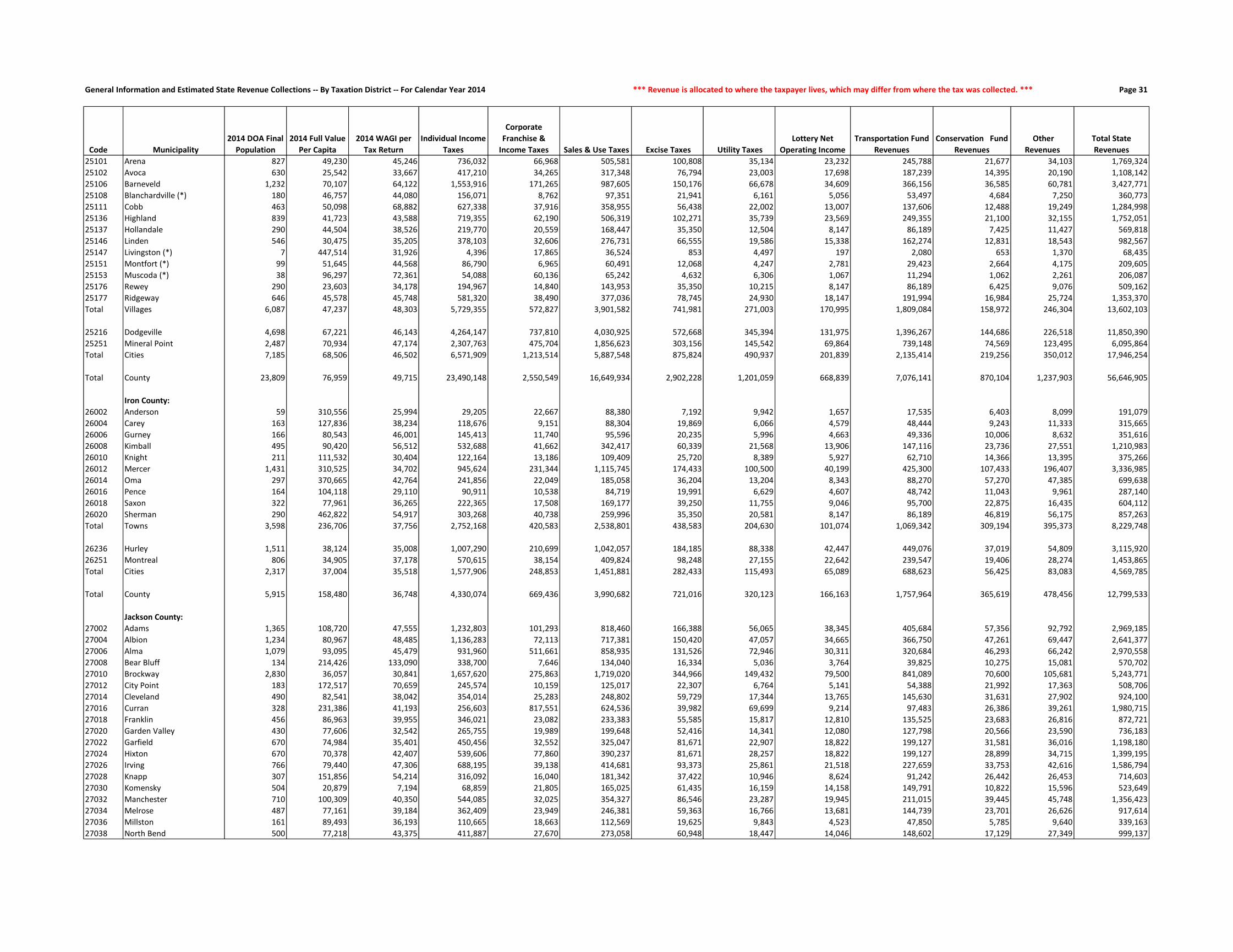
General Information and Estimated State Revenue Collections -- By Taxation District -- For Calendar Year 2014 *** Revenue is allocated to where the taxpayer lives, which may differ from where the tax was collected. *** Page 31
Code Municipality
2014 DOA Final
Population
2014 Full Value
Per Capita
2014 WAGI per
Tax Return
Individual Income
Taxes
Corporate
Franchise &
Income Taxes Sales & Use Taxes Excise Taxes Utility Taxes
Lottery Net
Operating Income
Transportation Fund
Revenues
Conservation Fund
Revenues
Other
Revenues
Total State
Revenues
25101 Arena 827 49,230 45,246 736,032 66,968 505,581 100,808 35,134 23,232 245,788 21,677 34,103 1,769,324
25102 Avoca 630 25,542 33,667 417,210 34,265 317,348 76,794 23,003 17,698 187,239 14,395 20,190 1,108,142
25106 Barneveld 1,232 70,107 64,122 1,553,916 171,265 987,605 150,176 66,678 34,609 366,156 36,585 60,781 3,427,771
25108 Blanchardville (*) 180 46,757 44,080 156,071 8,762 97,351 21,941 6,161 5,056 53,497 4,684 7,250 360,773
25111 Cobb 463 50,098 68,882 627,338 37,916 358,955 56,438 22,002 13,007 137,606 12,488 19,249 1,284,998
25136 Highland 839 41,723 43,588 719,355 62,190 506,319 102,271 35,739 23,569 249,355 21,100 32,155 1,752,051
25137 Hollandale 290 44,504 38,526 219,770 20,559 168,447 35,350 12,504 8,147 86,189 7,425 11,427 569,818
25146 Linden 546 30,475 35,205 378,103 32,606 276,731 66,555 19,586 15,338 162,274 12,831 18,543 982,567
25147 Livingston (*) 7 447,514 31,926 4,396 17,865 36,524 853 4,497 197 2,080 653 1,370 68,435
25151 Montfort (*) 99 51,645 44,568 86,790 6,965 60,491 12,068 4,247 2,781 29,423 2,664 4,175 209,605
25153 Muscoda (*) 38 96,297 72,361 54,088 60,136 65,242 4,632 6,306 1,067 11,294 1,062 2,261 206,087
25176 Rewey 290 23,603 34,178 194,967 14,840 143,953 35,350 10,215 8,147 86,189 6,425 9,076 509,162
25177 Ridgeway 646 45,578 45,748 581,320 38,490 377,036 78,745 24,930 18,147 191,994 16,984 25,724 1,353,370
Total Villages 6,087 47,237 48,303 5,729,355 572,827 3,901,582 741,981 271,003 170,995 1,809,084 158,972 246,304 13,602,103
25216 Dodgeville 4,698 67,221 46,143 4,264,147 737,810 4,030,925 572,668 345,394 131,975 1,396,267 144,686 226,518 11,850,390
25251 Mineral Point 2,487 70,934 47,174 2,307,763 475,704 1,856,623 303,156 145,542 69,864 739,148 74,569 123,495 6,095,864
Total Cities 7,185 68,506 46,502 6,571,909 1,213,514 5,887,548 875,824 490,937 201,839 2,135,414 219,256 350,012 17,946,254
Total County 23,809 76,959 49,715 23,490,148 2,550,549 16,649,934 2,902,228 1,201,059 668,839 7,076,141 870,104 1,237,903 56,646,905
Iron County:
26002 Anderson 59 310,556 25,994 29,205 22,667 88,380 7,192 9,942 1,657 17,535 6,403 8,099 191,079
26004 Carey 163 127,836 38,234 118,676 9,151 88,304 19,869 6,066 4,579 48,444 9,243 11,333 315,665
26006 Gurney 166 80,543 46,001 145,413 11,740 95,596 20,235 5,996 4,663 49,336 10,006 8,632 351,616
26008 Kimball 495 90,420 56,512 532,688 41,662 342,417 60,339 21,568 13,906 147,116 23,736 27,551 1,210,983
26010 Knight 211 111,532 30,404 122,164 13,186 109,409 25,720 8,389 5,927 62,710 14,366 13,395 375,266
26012 Mercer 1,431 310,525 34,702 945,624 231,344 1,115,745 174,433 100,500 40,199 425,300 107,433 196,407 3,336,985
26014 Oma 297 370,665 42,764 241,856 22,049 185,058 36,204 13,204 8,343 88,270 57,270 47,385 699,638
26016 Pence 164 104,118 29,110 90,911 10,538 84,719 19,991 6,629 4,607 48,742 11,043 9,961 287,140
26018 Saxon 322 77,961 36,265 222,365 17,508 169,177 39,250 11,755 9,046 95,700 22,875 16,435 604,112
26020 Sherman 290 462,822 54,917 303,268 40,738 259,996 35,350 20,581 8,147 86,189 46,819 56,175 857,263
Total Towns 3,598 236,706 37,756 2,752,168 420,583 2,538,801 438,583 204,630 101,074 1,069,342 309,194 395,373 8,229,748
26236 Hurley 1,511 38,124 35,008 1,007,290 210,699 1,042,057 184,185 88,338 42,447 449,076 37,019 54,809 3,115,920
26251 Montreal 806 34,905 37,178 570,615 38,154 409,824 98,248 27,155 22,642 239,547 19,406 28,274 1,453,865
Total Cities 2,317 37,004 35,518 1,577,906 248,853 1,451,881 282,433 115,493 65,089 688,623 56,425 83,083 4,569,785
Total County 5,915 158,480 36,748 4,330,074 669,436 3,990,682 721,016 320,123 166,163 1,757,964 365,619 478,456 12,799,533
Jackson County:
27002 Adams 1,365 108,720 47,555 1,232,803 101,293 818,460 166,388 56,065 38,345 405,684 57,356 92,792 2,969,185
27004 Albion 1,234 80,967 48,485 1,136,283 72,113 717,381 150,420 47,057 34,665 366,750 47,261 69,447 2,641,377
27006 Alma 1,079 93,095 45,479 931,960 511,661 858,935 131,526 72,946 30,311 320,684 46,293 66,242 2,970,558
27008 Bear Bluff 134 214,426 133,090 338,700 7,646 134,040 16,334 5,036 3,764 39,825 10,275 15,081 570,702
27010 Brockway 2,830 36,057 30,841 1,657,620 275,863 1,719,020 344,966 149,432 79,500 841,089 70,600 105,681 5,243,771
27012 City Point 183 172,517 70,659 245,574 10,159 125,017 22,307 6,764 5,141 54,388 21,992 17,363 508,706
27014 Cleveland 490 82,541 38,042 354,014 25,283 248,802 59,729 17,344 13,765 145,630 31,631 27,902 924,100
27016 Curran 328 231,386 41,193 256,603 817,551 624,536 39,982 69,699 9,214 97,483 26,386 39,261 1,980,715
27018 Franklin 456 86,963 39,955 346,021 23,082 233,383 55,585 15,817 12,810 135,525 23,683 26,816 872,721
27020 Garden Valley 430 77,606 32,542 265,755 19,989 199,648 52,416 14,341 12,080 127,798 20,566 23,590 736,183
27022 Garfield 670 74,984 35,401 450,456 32,552 325,047 81,671 22,907 18,822 199,127 31,581 36,016 1,198,180
27024 Hixton 670 70,378 42,407 539,606 77,860 390,237 81,671 28,257 18,822 199,127 28,899 34,715 1,399,195
27026 Irving 766 79,440 47,306 688,195 39,138 414,681 93,373 25,861 21,518 227,659 33,753 42,616 1,586,794
27028 Knapp 307 151,856 54,214 316,092 16,040 181,342 37,422 10,946 8,624 91,242 26,442 26,453 714,603
27030 Komensky 504 20,879 7,194 68,859 21,805 165,025 61,435 16,159 14,158 149,791 10,822 15,596 523,649
27032 Manchester 710 100,309 40,350 544,085 32,025 354,327 86,546 23,287 19,945 211,015 39,445 45,748 1,356,423
27034 Melrose 487 77,161 39,184 362,409 23,949 246,381 59,363 16,766 13,681 144,739 23,701 26,626 917,614
27036 Millston 161 89,493 36,193 110,665 18,663 112,569 19,625 9,843 4,523 47,850 5,785 9,640 339,163
27038 North Bend 500 77,218 43,375 411,887 27,670 273,058 60,948 18,447 14,046 148,602 17,129 27,349 999,137

General Information and Estimated State Revenue Collections -- By Taxation District -- For Calendar Year 2014 *** Aid is allocated to the municipality whose taxes are affected by the receipt of the aid. *** Page 32
Code Municipality
Gross Property
Tax Levy Shared Revenue
School Levies
Credit
First Dollar and
Lottery Credit
Natural Resources
Aids
Transportation
Aids
Miscellaneous
Aids
Property Tax
Offset: School Aids
Property Tax
Offset: County
Aids Total State Aid
State Aid As a % of
State Revenues
Gross Property
Tax Rate (mills)
State Aid (in
mills on full
value)
25101 Arena 1,130,595 99,006 67,858 50,830 1,109 40,843 2,357 287,168 69,662 618,834 34.98% 28.4198 15.5556
25102 Avoca 527,708 156,221 23,038 38,705 4,767 35,114 285,026 247,599 24,558 815,028 73.55% 31.2773 48.3068
25106 Barneveld 2,128,006 71,790 129,657 70,946 1,955 62,713 8,536 1,230,455 149,753 1,725,804 50.35% 25.1676 20.4108
25108 Blanchardville (*) 235,240 58,173 16,544 13,565 679 6,502 699 110,906 15,804 222,872 61.78% 27.8094 26.3474
25111 Cobb 633,300 110,054 41,422 40,556 1,812 23,230 2,537 638,666 45,482 903,760 70.33% 26.0145 37.1244
25136 Highland 982,802 182,869 87,425 82,236 2,420 58,543 27,491 889,036 61,363 1,391,381 79.41% 27.9960 39.6347
25137 Hollandale 334,902 69,338 24,889 22,911 951 23,338 1,600 169,271 24,121 336,419 59.04% 25.9400 26.0576
25146 Linden 449,152 170,257 30,471 39,880 1,690 14,377 833 460,153 32,769 750,430 76.37% 25.6077 42.7847
25147 Livingston (*) 84,380 3,722 910 1,483 47 707 10,266 14,450 1,029 32,613 47.66% 27.1859 10.5076
25151 Montfort (*) 134,346 26,341 8,829 7,628 150 5,313 340 135,664 9,661 193,926 92.52% 25.9803 37.5019
25153 Muscoda (*) 67,364 10,129 2,240 2,672 118 2,215 324 25,166 2,496 45,361 22.01% 30.3826 20.4586
25176 Rewey 195,046 63,716 11,929 20,579 919 6,522 356 184,127 13,112 301,263 59.17% 27.7907 42.9248
25177 Ridgeway 933,407 134,510 61,288 50,224 2,674 34,308 4,383 362,460 58,620 708,467 52.35% 29.7491 22.5799
Total Villages 7,836,247 1,156,127 506,500 442,216 19,291 313,724 344,749 4,755,122 508,431 8,046,159 59.15% 27.1665 27.8943
25216 Dodgeville 10,520,719 260,554 588,556 310,831 15,206 272,061 554,010 3,638,669 588,474 6,228,361 52.56% 29.8088 17.6471
25251 Mineral Point 4,891,667 313,722 334,705 179,372 9,145 136,107 20,013 3,089,700 315,274 4,398,038 72.15% 27.9664 25.1442
Total Cities 15,412,386 574,277 923,261 490,203 24,351 408,168 574,022 6,728,369 903,748 10,626,399 59.21% 29.1983 20.1314
Total County 47,241,209 2,047,883 3,296,380 1,776,441 315,264 2,148,538 995,478 25,900,251 3,342,559 39,822,795 70.30% 25.5423 21.5313
Iron County:
26002 Anderson 309,900 11,706 27,113 11,165 24,884 81,759 557 177,769 44,541 379,494 198.61% 17.5388 21.4775
26004 Carey 353,640 15,308 30,291 19,693 9,871 81,526 503 203,186 50,910 411,286 130.29% 17.5106 20.3650
26006 Gurney 237,623 25,578 19,282 12,872 5,332 69,988 384 135,907 34,052 303,396 86.29% 17.5906 22.4596
26008 Kimball 827,550 71,437 64,279 39,379 2,207 95,985 1,308 428,850 107,452 810,896 66.96% 19.4143 19.0236
26010 Knight 389,062 29,674 34,834 25,909 20,447 106,697 506 224,213 56,178 498,457 132.83% 17.4579 22.3667
26012 Mercer 6,520,218 36,825 340,314 121,895 656,883 327,902 11,019 221,263 1,062,780 2,778,881 83.28% 15.4654 6.5912
26014 Oma 2,016,267 5,348 174,231 49,549 32,081 138,742 2,174 1,115,512 279,500 1,797,137 256.87% 18.1848 16.2084
26016 Pence 289,387 44,108 25,994 18,377 10,331 60,485 451 173,856 43,561 377,164 131.35% 16.7464 21.8260
26018 Saxon 499,564 50,916 37,431 28,563 33,633 96,902 108,557 249,708 62,566 668,277 110.62% 20.1276 26.9251
26020 Sherman 2,039,270 8,317 167,627 39,778 222,094 113,243 3,187 701,147 340,598 1,595,990 186.17% 15.0929 11.8122
Total Towns 13,482,480 299,216 921,396 367,181 1,017,763 1,173,228 128,647 3,631,409 2,082,138 9,620,979 116.90% 16.3231 11.6480
26236 Hurley 1,763,769 655,915 84,780 104,268 0 174,641 10,754 540,831 135,509 1,706,698 54.77% 30.7057 29.7121
26251 Montreal 584,447 251,619 42,402 62,070 0 51,596 266,796 288,077 72,180 1,034,740 71.17% 20.4113 36.1374
Total Cities 2,348,217 907,534 127,183 166,338 0 226,237 277,550 828,908 207,689 2,741,439 59.99% 27.2812 31.8496
Total County 15,830,697 1,206,750 1,048,578 533,519 1,017,763 1,399,465 406,197 4,460,318 2,289,827 12,362,417 96.58% 17.3572 13.5545
Jackson County:
27002 Adams 2,971,044 35,961 201,670 103,456 12,485 112,836 5,460 2,193,918 582,043 3,247,828 109.38% 19.7130 21.5494
27004 Albion 1,911,678 21,882 130,976 72,197 2,767 114,170 3,496 1,366,833 372,212 2,084,533 78.92% 19.8346 21.6280
27006 Alma 2,007,403 49,162 130,797 69,884 4,936 145,120 3,460 2,370,866 375,088 3,149,314 106.02% 20.6680 32.4251
27008 Bear Bluff 592,178 2,660 39,781 14,261 3,819 80,764 629 412,529 113,809 668,251 117.09% 20.0944 22.6758
27010 Brockway 2,267,327 104,621 144,637 78,165 133,403 103,458 7,781 1,523,852 404,276 2,500,192 47.68% 21.6588 23.8833
27012 City Point 626,399 8,278 60,536 26,928 12,366 103,818 827 399,269 119,773 731,794 143.85% 20.1971 23.5954
27014 Cleveland 887,406 36,560 67,836 38,599 9,664 106,591 1,156 814,709 152,093 1,227,208 132.80% 22.5327 31.1608
27016 Curran 1,647,967 30,691 73,927 24,175 417 80,340 2,343 962,178 286,736 1,460,807 73.75% 22.1954 19.6747
27018 Franklin 895,278 36,528 64,037 33,922 1,294 71,385 1,099 605,818 149,156 963,239 110.37% 23.1800 24.9397
27020 Garden Valley 727,190 31,831 51,475 31,102 1,525 113,556 1,027 900,017 122,976 1,253,509 170.27% 22.8362 39.3644
27022 Garfield 1,108,641 33,212 85,006 51,877 8,882 68,951 1,689 972,082 193,037 1,414,735 118.07% 22.1793 28.3030
27024 Hixton 957,385 82,553 64,206 40,387 7,151 96,451 1,538 800,362 171,544 1,264,191 90.35% 21.5531 28.4600
27026 Irving 1,400,432 25,041 90,296 49,458 2,759 94,376 2,190 968,074 237,121 1,469,315 92.60% 22.8082 23.9301
27028 Knapp 889,343 8,074 60,880 26,069 20,171 119,653 1,385 660,896 177,844 1,074,972 150.43% 19.3120 23.3429
27030 Komensky 186,618 24,274 13,412 5,664 57,425 92,520 451 147,994 39,263 381,002 72.76% 18.3559 37.4755
27032 Manchester 1,272,133 20,542 89,375 54,703 11,092 128,481 2,247 971,131 257,640 1,535,211 113.18% 19.0686 23.0120
27034 Melrose 861,855 28,362 61,105 32,940 3,917 99,786 1,422 644,425 141,915 1,013,872 110.49% 23.4533 27.5901
27036 Millston 269,544 18,398 19,384 15,055 250,624 102,545 489 201,680 53,505 661,682 195.09% 19.4549 47.7583
27038 North Bend 836,495 40,892 61,984 37,272 17,826 59,742 1,355 663,231 146,135 1,028,435 102.93% 22.1059 27.1782

General Information and Estimated State Revenue Collections -- By Taxation District -- For Calendar Year 2014 *** Revenue is allocated to where the taxpayer lives, which may differ from where the tax was collected. *** Page 33
Code Municipality
2014 DOA Final
Population
2014 Full Value
Per Capita
2014 WAGI per
Tax Return
Individual Income
Taxes
Corporate
Franchise &
Income Taxes Sales & Use Taxes Excise Taxes Utility Taxes
Lottery Net
Operating Income
Transportation Fund
Revenues
Conservation Fund
Revenues
Other
Revenues
Total State
Revenues
27040 Northfield 648 65,077 45,141 555,535 31,650 346,472 78,989 22,222 18,203 192,589 24,159 32,127 1,301,945
27042 Springfield 620 87,864 43,566 512,983 287,583 469,837 75,576 39,635 17,417 184,267 26,053 36,696 1,650,045
Total Towns 14,572 80,588 41,241 11,326,105 2,473,575 8,958,197 1,776,272 688,831 409,354 4,330,864 623,811 817,756 31,404,765
27101 Alma Center 509 31,386 35,921 347,236 28,375 259,637 62,045 18,862 14,299 151,277 12,049 18,005 911,785
27136 Hixton 431 45,500 40,037 327,722 39,795 274,409 52,537 21,832 12,108 128,095 11,110 17,811 885,418
27151 Melrose 500 41,176 37,406 355,207 36,549 285,831 60,948 22,001 14,046 148,602 12,559 19,751 955,494
27152 Merrillan 535 33,622 27,990 284,392 31,725 257,601 65,215 20,586 15,029 159,004 12,847 19,429 865,829
27186 Taylor 481 26,383 36,392 332,446 32,337 260,075 58,632 19,567 13,512 142,955 10,759 16,000 886,283
Total Villages 2,456 35,363 34,838 1,647,003 168,781 1,337,552 299,377 102,847 68,994 729,934 59,325 90,996 4,504,809
27206 Black River Falls 3,602 62,093 48,383 3,309,773 852,718 3,167,580 439,070 275,315 101,186 1,070,531 105,235 174,050 9,495,457
Total Cities 3,602 62,093 48,383 3,309,773 852,718 3,167,580 439,070 275,315 101,186 1,070,531 105,235 174,050 9,495,457
Total County 20,630 71,974 42,460 16,282,881 3,495,074 13,463,329 2,514,719 1,066,993 579,534 6,131,328 788,371 1,082,803 45,405,032
Jefferson County:
28002 Aztalan 1,456 87,675 54,554 1,535,282 327,905 1,010,795 177,481 69,086 40,902 432,730 47,798 79,167 3,721,146
28004 Cold Spring 728 99,503 57,280 806,000 68,621 480,084 88,741 29,976 20,451 216,365 24,952 42,749 1,777,939
28006 Concord 2,085 81,108 55,147 2,222,446 113,071 1,275,100 254,153 75,998 58,571 619,671 65,491 108,333 4,792,834
28008 Farmington 1,384 92,430 53,984 1,444,109 112,334 932,906 168,704 62,615 38,879 411,331 47,826 77,671 3,296,374
28010 Hebron 1,096 85,322 55,612 1,178,096 50,800 645,964 133,599 36,492 30,789 325,736 36,473 58,644 2,496,594
28012 Ixonia 4,618 88,527 58,542 5,225,397 925,785 3,620,170 562,917 260,012 129,728 1,372,490 152,178 252,540 12,501,216
28014 Jefferson 2,185 78,685 45,375 1,916,312 148,701 1,245,222 266,343 82,166 61,381 649,392 68,905 111,583 4,550,005
28016 Koshkonong 3,689 94,122 65,707 4,685,103 245,127 2,494,544 449,675 139,153 103,631 1,096,387 123,982 209,325 9,546,926
28018 Lake Mills 2,083 134,354 63,369 2,551,349 141,106 1,419,841 253,910 83,259 58,515 619,077 84,231 149,004 5,360,293
28020 Milford 1,107 91,607 53,001 1,134,055 77,244 718,374 134,939 47,238 31,098 329,005 37,088 61,791 2,570,832
28022 Oakland 3,088 107,210 64,254 3,835,119 185,606 2,090,887 376,416 119,818 86,747 917,767 109,693 190,080 7,912,133
28024 Palmyra 1,181 146,292 51,468 1,174,855 69,021 714,806 143,959 44,982 33,176 350,998 50,356 89,664 2,671,819
28026 Sullivan 2,211 79,970 54,339 2,322,208 133,622 1,385,580 269,512 86,067 62,111 657,119 71,351 113,955 5,101,526
28028 Sumner 824 133,594 54,812 872,985 41,554 492,722 100,443 28,781 23,148 244,896 39,247 58,713 1,902,489
28030 Waterloo 909 90,254 52,232 917,705 59,729 543,756 110,803 33,336 25,535 270,159 30,437 50,286 2,041,747
28032 Watertown 1,968 90,990 40,496 1,540,407 139,342 1,106,322 239,892 78,438 55,285 584,898 65,177 109,404 3,919,165
Total Towns 30,612 96,423 54,955 33,361,427 2,839,568 20,177,075 3,731,487 1,277,417 859,947 9,098,024 1,055,185 1,762,908 74,163,038
28111 Cambridge (*) 108 47,369 43,154 90,084 5,637 58,648 13,165 3,849 3,034 32,098 2,770 4,272 213,556
28141 Johnson Creek 2,873 102,414 54,785 3,042,263 1,013,982 3,616,796 350,207 343,990 80,708 853,868 100,441 171,780 9,574,036
28146 Lac la Belle (*) 1 792,100 0 3,660 43 1,272 122 32 28 297 131 313 5,899
28171 Palmyra 1,779 64,580 40,952 1,408,160 620,894 1,365,457 216,853 117,237 49,975 528,727 50,959 81,624 4,439,886
28181 Sullivan 670 65,591 43,618 564,858 109,022 530,286 81,671 45,022 18,822 199,127 19,371 30,990 1,599,170
Total Villages 5,431 84,511 48,119 5,109,026 1,749,578 5,572,459 662,018 510,130 152,567 1,614,118 173,671 288,980 15,832,547
28226 Fort Atkinson 12,364 68,818 45,208 10,803,725 2,507,359 9,867,061 1,507,124 828,182 347,327 3,674,636 362,987 586,550 30,484,952
28241 Jefferson 7,922 58,285 43,552 6,668,726 1,427,475 6,008,203 965,661 499,095 222,543 2,354,454 219,511 345,145 18,710,813
28246 Lake Mills 5,758 84,878 54,935 6,113,968 1,051,862 4,881,047 701,878 385,114 161,752 1,711,303 181,991 307,157 15,496,074
28290 Waterloo 3,323 57,245 44,658 2,868,325 725,375 2,378,855 405,061 188,773 93,349 987,610 91,224 143,506 7,882,078
28291 Watertown (*) 15,472 56,143 41,870 12,521,474 3,442,164 11,859,376 1,885,978 1,008,103 434,636 4,598,348 423,458 661,899 36,835,436
28292 Whitewater (*) 3,092 24,101 36,648 2,190,237 689,572 2,013,246 376,903 166,434 86,860 918,956 68,619 95,855 6,606,682
Total Cities 47,931 61,228 44,814 41,166,455 9,843,807 37,007,788 5,842,605 3,075,701 1,346,467 14,245,308 1,347,790 2,140,113 116,016,034
Total County 83,974 75,564 48,156 79,636,908 14,432,953 62,757,322 10,236,110 4,863,248 2,358,981 24,957,449 2,576,646 4,192,001 206,011,618
Juneau County:
29002 Armenia 724 175,983 36,269 422,255 35,797 350,314 88,253 25,002 20,338 215,176 46,269 62,525 1,265,929
29004 Clearfield 726 87,053 42,053 490,940 45,287 399,156 88,497 28,642 20,395 215,770 38,884 39,137 1,366,708
29006 Cutler 329 95,710 66,931 354,094 19,957 218,860 40,104 12,839 9,242 97,780 12,719 18,775 784,370
29008 Finley 97 174,055 56,098 87,501 5,875 59,481 11,824 3,781 2,725 28,829 14,740 8,309 223,065
29010 Fountain 559 59,455 39,787 357,640 26,168 275,274 68,140 18,716 15,703 166,137 26,212 24,505 978,495
29012 Germantown 1,575 210,712 46,435 1,176,036 156,760 975,472 191,986 71,960 44,245 468,097 91,832 155,978 3,332,366
29014 Kildare 700 96,186 40,981 461,290 55,542 419,751 85,328 32,551 19,664 208,043 32,469 40,069 1,354,706

General Information and Estimated State Revenue Collections -- By Taxation District -- For Calendar Year 2014 *** Aid is allocated to the municipality whose taxes are affected by the receipt of the aid. *** Page 34
Code Municipality
Gross Property
Tax Levy Shared Revenue
School Levies
Credit
First Dollar and
Lottery Credit
Natural Resources
Aids
Transportation
Aids
Miscellaneous
Aids
Property Tax
Offset: School Aids
Property Tax
Offset: County
Aids Total State Aid
State Aid As a % of
State Revenues
Gross Property
Tax Rate (mills)
State Aid (in
mills on full
value)
27040 Northfield 852,432 57,662 57,843 41,578 725 102,611 1,374 849,660 155,294 1,266,746 97.30% 21.1985 31.5017
27042 Springfield 1,177,692 40,450 57,960 40,760 3,755 100,325 1,952 641,755 204,796 1,091,753 66.17% 22.2079 20.5874
Total Towns 24,346,441 737,634 1,627,121 888,452 567,004 2,097,477 43,371 19,071,277 4,456,256 29,488,590 93.90% 21.0991 25.5554
27101 Alma Center 418,236 148,977 27,355 32,052 0 37,983 896 487,021 65,141 799,427 87.68% 24.7951 47.3939
27136 Hixton 448,321 62,903 25,987 24,004 2 9,975 2,893 278,659 73,928 478,352 54.03% 22.8422 24.3722
27151 Melrose 495,914 169,646 34,997 33,356 1,619 21,313 1,387 365,216 80,451 707,984 74.10% 23.8054 33.9854
27152 Merrillan 403,427 187,177 30,213 37,056 0 18,382 1,033 542,983 72,626 889,470 102.73% 21.4522 47.2974
27186 Taylor 316,253 165,997 15,242 26,114 0 22,750 765 112,816 36,069 379,751 42.85% 25.8238 31.0087
Total Villages 2,082,153 734,699 133,794 152,582 1,621 110,403 6,975 1,786,695 328,215 3,254,984 72.26% 23.5593 36.8298
27206 Black River Falls 6,129,685 611,902 286,774 165,218 108 465,505 60,468 3,045,999 808,099 5,444,073 57.33% 26.7686 23.7745
Total Cities 6,129,685 611,902 286,774 165,218 108 465,505 60,468 3,045,999 808,099 5,444,073 57.33% 26.7686 23.7745
Total County 32,558,278 2,084,235 2,047,689 1,206,251 568,733 2,673,385 110,813 23,903,971 5,592,570 38,187,647 84.10% 22.1293 25.9554
Jefferson County:
28002 Aztalan 2,543,888 30,147 213,743 93,838 5,403 97,513 4,974 1,533,427 212,600 2,191,645 58.90% 20.2538 17.4493
28004 Cold Spring 1,377,115 10,450 125,703 53,448 4,818 51,803 2,436 490,969 117,290 856,917 48.20% 19.8738 12.3666
28006 Concord 3,097,317 33,926 270,013 123,237 529 107,290 6,295 1,644,709 276,124 2,462,122 51.37% 18.9869 15.0931
28008 Farmington 2,263,840 22,391 215,541 95,362 1,516 115,652 4,888 1,600,767 220,823 2,276,939 69.07% 17.3529 17.4533
28010 Hebron 1,981,430 15,364 169,341 77,357 47,509 78,393 3,582 1,320,799 158,812 1,871,157 74.95% 21.1186 19.9433
28012 Ixonia 7,776,889 66,683 659,319 245,006 9,871 149,926 24,274 1,899,078 682,117 3,736,274 29.89% 19.2983 9.2715
28014 Jefferson 3,482,800 67,817 314,696 147,334 60,001 100,706 6,936 2,464,632 290,984 3,453,105 75.89% 20.2596 20.0869
28016 Koshkonong 6,411,273 45,731 601,129 275,510 10,022 147,322 13,105 4,570,603 565,437 6,228,858 65.24% 19.1925 18.6464
28018 Lake Mills 5,201,787 22,547 451,021 153,757 93,806 80,192 9,019 2,423,686 462,408 3,696,436 68.96% 19.0414 13.5310
28020 Milford 1,888,993 13,743 162,005 91,535 2,925 90,100 3,774 1,012,962 168,438 1,545,482 60.12% 18.9829 15.5308
28022 Oakland 6,959,060 38,604 681,297 265,087 64,077 106,443 13,128 2,741,873 532,040 4,442,548 56.15% 22.1400 14.1338
28024 Palmyra 3,314,751 18,629 318,781 98,404 11,232 80,552 6,392 1,099,964 285,237 1,919,192 71.83% 19.6706 11.3890
28026 Sullivan 3,725,022 46,226 312,655 154,880 10,868 84,680 7,057 1,855,274 305,446 2,777,085 54.44% 20.6427 15.3896
28028 Sumner 2,279,595 9,852 201,780 79,973 16,272 53,560 3,426 1,481,417 194,318 2,040,599 107.26% 19.8571 17.7752
28030 Waterloo 1,638,110 12,915 134,050 61,044 38,636 83,050 2,932 1,068,618 137,953 1,539,198 75.39% 20.0994 18.8857
28032 Watertown 3,030,329 348,525 296,323 123,820 5,705 112,032 6,367 2,397,419 293,181 3,583,371 91.43% 17.4954 20.6884
Total Towns 56,972,198 803,551 5,127,399 2,139,591 383,189 1,539,211 118,585 29,606,196 4,903,207 44,620,928 60.17% 19.6677 15.4039
28111 Cambridge (*) 133,290 2,947 11,782 5,623 362 3,234 634 37,481 8,184 70,247 32.89% 27.5667 14.5283
28141 Johnson Creek 6,578,980 284,111 322,337 140,851 5,641 196,014 38,985 2,048,701 313,964 3,350,604 35.00% 22.9786 11.7028
28146 Lac la Belle (*) 12,879 27 928 203 2,056 115 24 1,618 1,127 6,097 103.36% 19.3402 9.1566
28171 Palmyra 2,974,064 242,359 194,475 102,863 12,874 65,682 15,262 669,268 175,413 1,478,194 33.29% 26.7738 13.3073
28181 Sullivan 1,067,660 48,086 80,850 33,994 2,258 33,323 2,414 619,512 72,597 893,035 55.84% 24.8934 20.8219
Total Villages 10,766,874 577,530 610,371 283,533 23,190 298,369 57,319 3,376,581 571,285 5,798,178 36.62% 24.1529 13.0068
28226 Fort Atkinson 21,459,742 1,129,877 1,464,443 717,952 35,177 619,507 121,036 11,213,905 1,361,471 16,663,368 54.66% 26.0430 20.2222
28241 Jefferson 11,953,613 747,326 829,878 402,584 23,894 422,221 125,489 6,286,777 736,713 9,574,881 51.17% 26.5061 21.2315
28246 Lake Mills 11,672,327 444,203 719,753 310,393 30,801 331,756 42,892 3,922,357 742,228 6,544,384 42.23% 25.3729 14.2259
28290 Waterloo 5,164,214 464,617 310,278 186,624 275,625 236,535 647,867 2,704,756 300,337 5,126,640 65.04% 28.0450 27.8410
28291 Watertown (*) 21,760,199 1,918,854 1,282,816 637,538 167,607 858,757 149,666 10,715,272 1,260,327 16,990,838 46.13% 25.6062 19.9939
28292 Whitewater (*) 1,759,896 305,599 88,277 38,613 3,414 67,729 40,618 289,930 85,386 919,566 13.92% 23.3070 12.1782
Total Cities 73,769,991 5,010,476 4,695,445 2,293,704 536,519 2,536,505 1,127,569 35,132,998 4,486,461 55,819,677 48.11% 25.9345 19.6239
Total County 141,509,063 6,391,557 10,433,215 4,716,828 942,898 4,374,085 1,303,473 68,115,774 9,960,953 106,238,784 51.57% 22.8720 17.1713
Juneau County:
29002 Armenia 2,954,215 17,320 245,791 87,270 37,370 259,477 3,702 868,742 455,426 1,975,098 156.02% 21.9755 14.6922
29004 Clearfield 1,335,445 11,313 106,970 65,263 59,889 95,201 1,978 659,280 205,954 1,205,847 88.23% 21.9671 19.8353
29006 Cutler 709,239 12,717 51,582 27,889 10,266 113,196 755 299,022 104,008 619,435 78.97% 23.1016 20.1765
29008 Finley 394,901 10,150 31,533 12,965 3,961 69,819 540 143,362 61,364 333,693 149.59% 21.8018 18.4227
29010 Fountain 811,439 56,825 56,812 39,801 1,898 121,791 1,258 397,352 113,897 789,633 80.70% 24.1355 23.4869
29012 Germantown 7,448,015 13,194 620,853 206,863 368,597 174,772 10,458 3,796,054 1,129,151 6,319,940 189.65% 22.3462 18.9616
29014 Kildare 1,616,429 8,943 147,678 71,483 7,700 97,446 1,876 1,080,274 222,785 1,638,184 120.93% 24.5802 24.9110

General Information and Estimated State Revenue Collections -- By Taxation District -- For Calendar Year 2014 *** Revenue is allocated to where the taxpayer lives, which may differ from where the tax was collected. *** Page 35
Code Municipality
2014 DOA Final
Population
2014 Full Value
Per Capita
2014 WAGI per
Tax Return
Individual Income
Taxes
Corporate
Franchise &
Income Taxes Sales & Use Taxes Excise Taxes Utility Taxes
Lottery Net
Operating Income
Transportation Fund
Revenues
Conservation Fund
Revenues
Other
Revenues
Total State
Revenues
29016 Kingston 87 41,498 29,332 41,034 13,515 43,127 10,605 3,506 2,444 25,857 2,198 3,244 145,530
29018 Lemonweir 1,756 63,924 41,622 1,175,296 146,055 1,075,761 214,050 83,890 49,329 521,891 58,638 79,841 3,404,752
29020 Lindina 715 68,189 52,107 599,095 38,527 409,923 87,156 25,962 20,086 212,501 25,773 33,622 1,452,646
29022 Lisbon 916 67,321 46,222 680,834 57,011 523,305 111,657 36,324 25,732 272,239 35,174 42,784 1,785,060
29024 Lyndon 1,396 76,711 37,654 845,258 118,124 837,886 170,167 67,861 39,216 414,897 48,689 69,987 2,612,085
29026 Marion 424 114,703 39,640 270,266 22,729 217,486 51,684 15,349 11,911 126,015 24,818 27,135 767,392
29028 Necedah 2,368 74,807 33,974 1,293,663 378,005 1,282,943 288,650 102,700 66,521 703,780 94,414 117,072 4,327,749
29030 Orange 574 63,945 34,792 321,130 26,251 267,043 69,968 18,970 16,125 170,595 24,400 26,103 940,585
29032 Plymouth 600 87,588 45,867 442,538 31,288 318,207 73,138 20,772 16,855 178,323 29,614 32,462 1,143,196
29034 Seven Mile Creek 359 83,239 51,061 294,764 15,685 192,611 43,761 11,571 10,085 106,696 22,248 18,853 716,276
29036 Summit 652 73,453 44,481 466,358 33,065 336,737 79,476 21,964 18,316 193,777 29,873 31,912 1,211,479
29038 Wonewoc 690 61,717 37,430 415,305 37,766 340,575 84,108 24,199 19,383 205,071 23,762 30,817 1,180,986
Total Towns 15,247 94,457 41,472 10,195,296 1,263,407 8,543,913 1,858,552 626,560 428,315 4,531,477 682,725 863,131 28,993,375
29111 Camp Douglas 609 33,203 32,918 322,366 42,373 314,123 74,234 24,776 17,108 180,998 14,750 20,863 1,011,590
29136 Hustler 195 48,921 32,116 100,706 12,084 95,554 23,770 7,384 5,478 57,955 5,133 7,799 315,862
29146 Lyndon Station 498 46,544 34,332 274,934 97,113 321,742 60,704 28,151 13,990 148,008 13,158 19,484 977,284
29161 Necedah 922 44,801 34,658 513,836 194,778 620,607 112,388 55,134 25,901 274,023 23,559 35,487 1,855,713
29186 Union Center 198 52,202 31,900 101,566 52,667 139,692 24,135 12,998 5,562 58,846 5,391 8,156 409,013
29191 Wonewoc 811 27,031 34,426 448,953 56,019 412,436 98,858 31,491 22,782 241,033 18,187 25,956 1,355,716
Total Villages 3,233 39,129 33,901 1,762,362 455,034 1,904,153 394,089 159,934 90,821 960,862 80,178 117,744 5,925,177
29221 Elroy 1,409 34,582 35,859 812,471 257,422 871,839 171,752 73,396 39,581 418,761 33,517 48,977 2,727,715
29251 Mauston 4,475 45,378 31,799 2,288,211 879,203 3,221,889 545,485 302,335 125,711 1,329,990 113,143 173,182 8,979,150
29261 New Lisbon 2,570 27,777 34,608 1,430,225 456,001 1,574,719 313,273 133,853 72,196 763,816 58,498 82,951 4,885,532
29291 Wisconsin Dells (*) 0 0 25,211 0 0 0 0 0 0 0 83 158 241
Total Cities 8,454 38,279 32,981 4,530,907 1,592,626 5,668,447 1,030,510 509,585 237,488 2,512,567 205,240 305,269 16,592,638
Total County 26,934 70,183 36,800 16,488,565 3,311,067 16,116,513 3,283,151 1,296,078 756,624 8,004,905 968,143 1,286,144 51,511,190
Kenosha County:
30002 Brighton 1,446 110,669 77,958 2,177,389 72,865 1,016,607 176,262 50,471 40,621 429,758 54,121 93,806 4,111,899
30006 Paris 1,504 130,721 62,136 1,805,094 320,822 1,313,506 183,332 100,601 42,250 446,996 62,586 109,214 4,384,400
30010 Randall 3,173 147,587 59,357 3,637,904 323,510 2,181,879 386,776 142,300 89,135 943,030 132,939 251,073 8,088,546
30012 Salem 12,058 82,134 55,550 12,937,857 800,300 7,588,288 1,469,824 479,976 338,731 3,583,692 380,783 649,378 28,228,829
30014 Somers 9,512 77,902 66,112 12,146,772 971,666 7,447,511 1,159,477 501,722 267,209 2,827,009 302,971 496,723 26,121,060
30016 Wheatland 3,336 83,862 57,448 3,701,738 215,039 2,137,289 406,646 133,594 93,714 991,474 109,908 181,885 7,971,287
Total Towns 31,029 91,400 59,496 36,406,753 2,704,202 21,685,080 3,782,317 1,408,664 871,660 9,221,958 1,043,307 1,782,079 78,906,021
30104 Bristol 4,954 103,837 60,635 5,802,085 902,112 4,295,410 603,874 332,141 139,167 1,472,351 175,595 308,310 14,031,045
30131 Genoa City (*) 6 43,350 47,147 5,464 258 3,157 732 192 169 1,783 150 233 12,138
30171 Paddock Lake 2,993 73,661 49,813 2,879,740 247,119 1,984,061 364,835 143,036 84,079 889,533 90,784 151,395 6,834,583
30174 Pleasant Prairie 20,155 131,574 73,946 28,787,566 9,050,928 27,103,165 2,456,818 2,414,405 566,190 5,990,156 782,817 1,470,200 78,622,246
30181 Silver Lake 2,400 67,872 52,435 2,430,729 182,853 1,574,648 292,551 108,571 67,420 713,291 71,722 116,035 5,557,820
30186 Twin Lakes 6,041 110,991 47,780 5,575,260 586,698 3,998,122 736,375 295,740 169,702 1,795,412 225,588 392,647 13,775,544
Total Villages 36,549 115,472 63,678 45,480,845 10,969,968 38,958,561 4,455,185 3,294,086 1,026,727 10,862,527 1,346,657 2,438,820 118,833,376
30241 Kenosha 99,680 55,425 44,749 86,158,617 14,157,613 74,589,103 12,150,611 6,179,032 2,800,188 29,625,343 2,708,337 4,340,234 232,709,077
Total Cities 99,680 55,425 44,749 86,158,617 14,157,613 74,589,103 12,150,611 6,179,032 2,800,188 29,625,343 2,708,337 4,340,234 232,709,077
Total County 167,258 75,221 49,521 168,046,215 27,831,783 135,232,745 20,388,113 10,881,782 4,698,575 49,709,827 5,098,301 8,561,133 430,448,474
Kewaunee County:
31002 Ahnapee 936 88,490 46,343 830,250 65,973 541,692 114,095 34,901 26,294 278,183 35,621 49,878 1,976,887
31004 Carlton 1,024 86,899 50,154 982,987 97,923 738,949 124,822 54,290 28,766 304,337 32,101 53,994 2,418,170
31006 Casco 1,179 75,321 53,469 1,206,591 62,798 715,166 143,715 42,441 33,120 350,404 37,527 57,362 2,649,124
31008 Franklin 990 86,725 48,493 918,890 52,061 569,004 120,677 34,956 27,811 294,232 35,369 52,141 2,105,141
31010 Lincoln 943 80,400 47,717 861,250 44,242 524,960 114,948 31,612 26,491 280,264 36,770 47,566 1,968,102
31012 Luxemburg 1,479 81,743 55,565 1,572,962 84,901 933,389 180,284 55,774 41,548 439,565 47,764 75,301 3,431,490
31014 Montpelier 1,310 87,736 51,265 1,285,406 328,918 912,018 159,684 64,186 36,800 389,338 42,577 69,461 3,288,388

General Information and Estimated State Revenue Collections -- By Taxation District -- For Calendar Year 2014 *** Aid is allocated to the municipality whose taxes are affected by the receipt of the aid. *** Page 36
Code Municipality
Gross Property
Tax Levy Shared Revenue
School Levies
Credit
First Dollar and
Lottery Credit
Natural Resources
Aids
Transportation
Aids
Miscellaneous
Aids
Property Tax
Offset: School Aids
Property Tax
Offset: County
Aids Total State Aid
State Aid As a % of
State Revenues
Gross Property
Tax Rate (mills)
State Aid (in
mills on full
value)
29016 Kingston 66,407 1,063 5,258 3,641 22,136 90,248 108 51,806 12,538 186,798 128.36% 17.9434 50.4736
29018 Lemonweir 2,485,556 89,008 237,590 146,822 1,803 118,234 3,975 1,715,634 353,816 2,666,884 78.33% 23.7991 25.5353
29020 Lindina 1,194,319 42,795 100,629 66,650 909 94,842 2,043 806,276 166,979 1,281,122 88.19% 24.2311 25.9922
29022 Lisbon 1,412,649 31,092 117,472 76,593 552 78,879 2,250 832,870 201,338 1,341,047 75.13% 23.7697 22.5649
29024 Lyndon 2,139,081 13,489 164,547 86,761 30,070 81,801 5,024 554,660 351,383 1,287,734 49.30% 20.6235 12.4154
29026 Marion 1,141,599 12,323 110,727 50,762 9,527 23,547 1,581 798,198 164,613 1,171,278 152.63% 23.4944 24.1052
29028 Necedah 3,994,762 150,141 327,455 211,902 12,245 246,927 6,225 1,421,110 628,936 3,004,942 69.43% 21.5179 16.1862
29030 Orange 861,102 42,623 57,889 37,443 4,945 72,401 1,276 476,696 128,375 821,648 87.35% 22.7242 21.6830
29032 Plymouth 1,465,395 53,433 113,740 69,391 1,965 95,540 2,097 1,445,031 184,800 1,965,997 171.97% 26.8638 36.0409
29034 Seven Mile Creek 852,661 20,371 63,220 33,880 8,945 122,109 1,010 477,732 103,540 830,807 115.99% 27.8988 27.1837
29036 Summit 1,408,327 66,222 89,942 62,579 3,477 119,865 1,787 552,141 172,182 1,068,194 88.17% 27.7096 21.0173
29038 Wonewoc 1,148,635 84,947 82,223 60,357 4,568 123,099 1,727 627,974 144,338 1,129,233 95.62% 26.9597 26.5043
Total Towns 33,440,178 737,968 2,731,910 1,418,315 590,823 2,199,192 49,669 17,004,213 4,905,424 29,637,515 102.22% 23.0944 20.4682
29111 Camp Douglas 591,716 178,785 22,218 28,521 6,917 33,511 20,187 237,502 57,478 585,119 57.84% 29.1715 28.8463
29136 Hustler 223,244 49,287 15,321 14,632 564 6,584 468 111,756 32,209 230,821 73.08% 23.4810 24.2781
29146 Lyndon Station 552,064 133,852 49,468 37,370 2,349 13,803 1,393 359,807 74,203 672,245 68.79% 25.2047 30.6917
29161 Necedah 1,347,406 229,962 59,225 51,861 1,834 45,915 6,815 240,648 106,503 742,764 40.03% 33.0495 18.2187
29186 Union Center 302,907 63,850 21,904 19,780 465 11,948 1,081 89,753 36,285 245,066 59.92% 28.2811 22.8807
29191 Wonewoc 652,487 255,568 39,756 63,166 4,566 26,136 66,825 175,315 70,876 702,207 51.80% 31.1881 33.5647
Total Villages 3,669,823 911,303 207,892 215,331 16,695 137,897 96,769 1,214,781 377,554 3,178,222 53.64% 29.5726 25.6111
29221 Elroy 1,612,244 573,440 101,504 113,163 46,952 61,104 476,972 1,152,817 147,333 2,673,286 98.00% 33.8343 56.1011
29251 Mauston 6,348,898 1,093,347 351,493 251,066 91,871 396,187 186,926 2,492,577 514,046 5,377,513 59.89% 33.2777 28.1862
29261 New Lisbon 2,087,356 569,898 100,622 81,410 5,332 89,268 348,760 726,811 209,472 2,131,572 43.63% 29.2422 29.8616
29291 Wisconsin Dells (*) 13,015 414 610 0 174 581 69 683 1,651 4,182 22.96% 25.6284 8.5799
Total Cities 10,061,513 2,237,099 554,228 445,639 144,328 547,140 1,012,728 4,372,889 872,502 10,186,553 61.39% 32.4245 32.8275
Total County 47,171,514 3,886,371 3,494,030 2,079,285 751,846 2,884,229 1,159,166 22,591,883 6,155,481 43,002,290 83.48% 25.0595 22.8447
Kenosha County:
30002 Brighton 3,411,198 17,596 330,244 103,355 4,417 33,914 6,761 1,597,356 580,797 2,674,440 65.04% 20.8396 16.3386
30006 Paris 3,310,027 314,969 314,196 112,443 26 16,449 10,012 1,725,732 733,382 3,227,209 73.61% 16.0143 15.6136
30010 Randall 9,913,812 40,715 891,646 266,667 44,677 90,349 14,006 3,290,136 1,579,384 6,217,580 76.87% 22.2720 13.9682
30012 Salem 23,653,420 121,821 2,112,199 976,902 58,538 297,643 41,568 13,332,186 3,402,622 20,343,481 72.07% 24.6653 21.2137
30014 Somers 18,839,878 133,224 1,467,851 590,836 19,235 270,740 203,888 16,510,808 2,743,700 21,940,282 83.99% 24.3639 28.3734
30016 Wheatland 6,857,273 44,040 638,337 283,428 15,699 78,272 10,029 2,845,857 1,024,508 4,940,173 61.97% 23.7488 17.1093
Total Towns 65,985,607 672,365 5,754,473 2,333,632 142,593 787,367 286,265 39,302,076 10,064,394 59,343,165 75.21% 23.2631 20.9213
30104 Bristol 10,901,074 55,791 954,645 315,528 16,235 130,569 25,856 5,078,311 1,779,272 8,356,207 59.56% 21.7387 16.6638
30131 Genoa City (*) 7,255 114 746 311 9 163 20 1,683 875 3,921 32.30% 29.4186 15.8997
30171 Paddock Lake 5,788,227 95,341 418,946 208,769 17,396 160,328 16,052 2,587,512 768,701 4,273,044 62.52% 26.7174 19.7236
30174 Pleasant Prairie 58,887,945 2,040,378 3,937,166 1,302,195 127,867 786,015 374,940 45,479,271 7,570,621 61,618,454 78.37% 23.8480 24.9537
30181 Silver Lake 4,465,993 68,481 366,661 168,360 18,247 73,725 8,339 2,189,632 593,918 3,487,363 62.75% 26.6807 20.8342
30186 Twin Lakes 17,803,939 65,527 1,483,611 462,289 59,096 238,136 36,963 4,649,208 2,436,131 9,430,961 68.46% 25.9311 13.7360
Total Villages 97,854,433 2,325,632 7,161,775 2,457,452 238,851 1,388,936 462,170 59,985,617 13,149,518 87,169,951 73.35% 24.2116 21.5680
30241 Kenosha 166,679,161 13,813,753 9,773,797 5,017,225 1,253,570 4,820,930 1,003,907 103,435,896 17,393,984 156,513,062 67.26% 31.1081 29.2107
Total Cities 166,679,161 13,813,753 9,773,797 5,017,225 1,253,570 4,820,930 1,003,907 103,435,896 17,393,984 156,513,062 67.26% 31.1081 29.2107
Total County 330,519,201 16,811,750 22,690,044 9,808,309 1,635,013 6,997,233 1,752,343 202,723,589 40,607,895 303,026,177 70.40% 27.0116 24.7647
Kewaunee County:
31002 Ahnapee 1,688,543 42,989 122,270 63,355 5,762 102,251 3,327 930,986 553,706 1,824,646 92.30% 20.4443 22.0922
31004 Carlton 1,441,332 479,194 110,606 70,646 3,368 124,156 3,109 971,813 528,859 2,291,751 94.77% 18.2710 29.0514
31006 Casco 1,677,711 52,788 122,190 68,445 9,257 96,154 3,598 1,098,817 561,900 2,013,148 75.99% 20.0170 24.0191
31008 Franklin 1,747,247 25,999 132,243 64,362 2,477 121,997 3,772 1,165,179 562,447 2,078,477 98.73% 20.8263 24.7744
31010 Lincoln 1,449,333 90,567 100,513 56,379 2,068 107,014 3,055 937,521 498,169 1,795,286 91.22% 19.5043 24.1600
31012 Luxemburg 2,363,908 40,095 163,099 79,543 3,126 136,075 5,401 1,629,842 792,739 2,849,920 83.05% 19.9912 24.1014
31014 Montpelier 2,124,914 36,287 145,194 78,871 1,852 100,748 4,773 1,409,287 711,446 2,488,457 75.67% 20.0235 23.4492

General Information and Estimated State Revenue Collections -- By Taxation District -- For Calendar Year 2014 *** Revenue is allocated to where the taxpayer lives, which may differ from where the tax was collected. *** Page 37
Code Municipality
2014 DOA Final
Population
2014 Full Value
Per Capita
2014 WAGI per
Tax Return
Individual Income
Taxes
Corporate
Franchise &
Income Taxes Sales & Use Taxes Excise Taxes Utility Taxes
Lottery Net
Operating Income
Transportation Fund
Revenues
Conservation Fund
Revenues
Other
Revenues
Total State
Revenues
31016 Pierce 825 94,103 47,019 742,456 49,509 489,911 100,564 31,980 23,176 245,194 28,773 45,593 1,757,155
31018 Red River 1,399 100,619 57,185 1,531,251 86,277 885,857 170,533 51,590 39,300 415,789 52,880 80,524 3,314,001
31020 West Kewaunee 1,327 74,304 47,218 1,199,296 67,362 747,556 161,756 46,068 37,278 394,390 42,965 64,088 2,760,760
Total Towns 11,412 85,447 51,086 11,131,339 939,964 7,058,503 1,391,078 447,797 320,584 3,391,698 392,346 595,908 25,669,217
31111 Casco 585 45,657 42,799 479,220 54,270 362,789 71,309 26,336 16,434 173,865 15,298 22,354 1,221,875
31146 Luxemburg 2,571 64,973 49,626 2,442,060 419,307 2,016,469 313,395 157,909 72,224 764,113 74,635 115,722 6,375,834
Total Villages 3,156 61,392 48,341 2,921,280 473,577 2,379,258 384,704 184,245 88,658 937,977 89,933 138,076 7,597,709
31201 Algoma 3,161 50,698 35,275 2,134,201 511,327 2,064,733 385,314 171,935 88,798 939,463 84,835 126,396 6,507,002
31241 Kewaunee 2,923 52,749 48,348 2,704,931 370,017 2,100,485 356,303 157,439 82,112 868,729 79,512 118,989 6,838,517
Total Cities 6,084 51,683 42,612 4,839,132 881,344 4,165,218 741,617 329,374 170,910 1,808,192 164,347 245,385 13,345,519
Total County 20,652 71,824 47,091 18,891,750 2,294,885 13,602,978 2,517,399 961,417 580,152 6,137,867 646,627 979,370 46,612,445
La Crosse County:
32002 Bangor 614 87,486 44,373 531,370 123,636 428,109 74,845 33,486 17,248 182,484 28,041 34,876 1,454,095
32004 Barre 1,239 77,166 57,817 1,397,132 72,518 792,369 151,029 47,293 34,806 368,236 45,851 65,311 2,974,545
32006 Burns 951 84,365 38,005 704,919 61,755 509,906 115,923 36,252 26,715 282,641 46,914 52,842 1,837,869
32008 Campbell 4,339 75,697 59,307 5,018,875 501,964 3,500,848 528,908 254,438 121,890 1,289,570 133,122 226,197 11,575,812
32010 Farmington 2,075 75,191 43,724 1,769,512 153,793 1,140,769 252,935 74,806 58,290 616,699 81,699 107,756 4,256,261
32012 Greenfield 2,093 72,121 77,057 3,145,551 123,971 1,542,986 255,129 79,273 58,796 622,049 84,344 106,145 6,018,244
32014 Hamilton 2,457 93,501 71,751 3,438,310 174,360 1,822,232 299,499 103,150 69,022 730,231 93,336 145,416 6,875,556
32016 Holland 3,895 83,068 66,267 5,034,035 232,826 2,612,419 474,785 142,315 109,417 1,157,611 128,932 214,425 10,106,766
32018 Medary 1,491 94,449 82,191 2,390,113 109,600 1,211,100 181,747 65,726 41,885 443,132 54,672 88,805 4,586,779
32020 Onalaska 5,704 80,825 63,953 7,114,686 478,545 4,006,058 695,296 240,342 160,235 1,695,254 184,689 308,943 14,884,048
32022 Shelby 4,707 86,646 83,850 7,697,745 292,598 3,686,453 573,765 184,723 132,228 1,398,941 157,167 265,798 14,389,419
32024 Washington 553 84,311 61,407 662,299 26,638 346,100 67,408 18,815 15,535 164,354 31,318 30,716 1,363,184
Total Towns 30,118 82,163 65,834 38,904,548 2,352,204 21,599,350 3,671,269 1,280,620 846,067 8,951,205 1,070,085 1,647,231 80,322,578
32106 Bangor 1,480 50,257 43,803 1,264,399 111,707 906,492 180,406 65,186 41,576 439,863 38,483 62,237 3,110,349
32136 Holmen 9,413 59,874 52,469 9,632,593 1,060,378 6,881,778 1,147,409 503,428 264,428 2,797,586 258,915 431,700 22,978,214
32176 Rockland 614 43,800 44,622 534,360 42,888 349,020 74,845 23,238 17,248 182,484 15,527 24,249 1,263,859
32191 West Salem 4,938 69,542 49,335 4,751,366 811,513 3,949,010 601,923 317,883 138,717 1,467,596 143,402 245,381 12,426,791
Total Villages 16,445 61,311 50,472 16,182,718 2,026,486 12,086,301 2,004,583 909,735 461,969 4,887,528 456,328 763,567 39,779,213
32246 La Crosse 52,018 61,745 44,008 44,647,314 10,988,963 45,435,061 6,340,796 4,025,386 1,461,278 15,459,983 1,465,454 2,424,213 132,248,448
32265 Onalaska 18,159 95,487 66,876 23,685,069 3,666,267 19,623,992 2,213,513 1,611,121 510,118 5,396,936 609,937 1,089,024 58,405,977
Total Cities 70,177 70,476 49,578 68,332,384 14,655,230 65,059,053 8,554,309 5,636,507 1,971,396 20,856,919 2,075,391 3,513,236 190,654,425
Total County 116,740 72,200 52,363 123,419,649 19,033,920 98,744,704 14,230,161 7,826,862 3,279,432 34,695,651 3,601,804 5,924,033 310,756,216
Lafayette County:
33002 Argyle 444 113,316 43,957 302,012 25,584 244,535 54,122 16,786 12,473 131,959 17,898 29,752 835,121
33004 Belmont 786 64,553 43,188 525,289 62,193 445,626 95,810 31,728 22,080 233,603 24,581 37,493 1,478,403
33006 Benton 510 69,338 46,504 367,002 32,089 292,534 62,167 19,963 14,327 151,574 15,317 25,294 980,267
33008 Blanchard 272 96,613 49,981 210,372 13,079 149,708 33,156 9,245 7,641 80,840 10,292 16,428 530,760
33010 Darlington 889 76,882 40,085 551,438 61,866 490,542 108,366 35,883 24,974 264,215 27,747 46,746 1,611,777
33012 Elk Grove 559 65,201 57,747 499,516 27,340 330,296 68,140 19,185 15,703 166,137 16,105 26,808 1,169,230
33014 Fayette 398 79,595 41,789 257,367 23,250 204,523 48,515 13,705 11,181 118,287 14,629 21,355 712,812
33016 Gratiot 551 76,407 44,375 378,355 29,570 293,197 67,165 19,370 15,479 163,760 17,467 28,869 1,013,232
33018 Kendall 469 68,107 37,016 268,642 22,200 227,367 57,169 15,801 13,175 139,389 14,121 23,032 780,895
33020 Lamont 319 59,847 45,929 226,717 13,912 164,815 38,885 10,272 8,961 94,808 9,348 14,622 582,340
33022 Monticello 134 88,452 55,516 115,116 5,789 75,331 16,334 4,293 3,764 39,825 4,671 7,660 272,783
33024 New Diggings 508 56,081 37,326 293,420 25,047 249,990 61,923 17,493 14,271 150,980 15,818 22,528 851,469
33026 Seymour 452 83,485 35,299 246,897 27,931 235,727 55,097 17,844 12,697 134,336 13,897 24,949 769,375
33028 Shullsburg 351 117,462 41,032 222,866 56,154 300,399 42,786 27,650 9,860 104,319 13,285 24,096 801,414
33030 Wayne 492 69,396 48,064 365,930 49,683 278,219 59,973 18,266 13,821 146,225 15,557 24,412 972,086
33032 White Oak Springs 120 84,290 37,804 70,200 5,324 57,526 14,628 3,900 3,371 35,665 3,835 6,662 201,110

General Information and Estimated State Revenue Collections -- By Taxation District -- For Calendar Year 2014 *** Aid is allocated to the municipality whose taxes are affected by the receipt of the aid. *** Page 38
Code Municipality
Gross Property
Tax Levy Shared Revenue
School Levies
Credit
First Dollar and
Lottery Credit
Natural Resources
Aids
Transportation
Aids
Miscellaneous
Aids
Property Tax
Offset: School Aids
Property Tax
Offset: County
Aids Total State Aid
State Aid As a % of
State Revenues
Gross Property
Tax Rate (mills)
State Aid (in
mills on full
value)
31016 Pierce 1,608,363 15,746 116,846 58,219 34,942 60,716 2,700 898,035 514,370 1,701,574 96.84% 20.9627 22.1776
31018 Red River 2,691,800 52,086 187,582 84,843 2,553 125,813 5,870 1,911,586 929,777 3,300,110 99.58% 19.4090 23.7952
31020 West Kewaunee 1,953,076 43,487 146,866 84,462 22,948 89,083 4,046 1,181,387 642,909 2,215,188 80.24% 20.3662 23.0994
Total Towns 18,746,227 879,237 1,347,410 709,122 88,352 1,064,009 39,652 12,134,454 6,296,321 22,558,557 87.88% 19.9603 24.0195
31111 Casco 640,587 76,607 39,109 28,903 3,768 19,918 1,510 382,542 186,064 738,422 60.43% 23.0810 26.6061
31146 Luxemburg 3,824,653 72,067 191,247 113,190 8,996 113,942 23,128 1,975,076 960,658 3,458,304 54.24% 22.9895 20.7874
Total Villages 4,465,240 148,674 230,356 142,094 12,764 133,860 24,638 2,357,618 1,146,722 4,196,727 55.24% 23.0026 21.6193
31201 Algoma 4,513,052 984,239 255,419 189,256 29,363 219,684 23,658 1,819,550 1,082,181 4,603,349 70.74% 27.5651 28.1167
31241 Kewaunee 4,193,824 568,631 256,479 169,880 19,954 198,583 23,714 1,858,889 1,011,604 4,107,734 60.07% 26.5987 26.0527
Total Cities 8,706,876 1,552,869 511,898 359,136 49,318 418,267 47,372 3,678,438 2,093,785 8,711,083 65.27% 27.0910 27.1041
Total County 31,918,344 2,580,780 2,089,664 1,210,352 150,434 1,616,136 111,662 18,170,511 9,536,829 35,466,367 76.09% 21.9417 24.3807
La Crosse County:
32002 Bangor 1,018,411 34,483 86,337 42,752 4,425 50,660 2,084 890,133 152,921 1,263,795 86.91% 20.9449 25.9916
32004 Barre 1,767,193 41,036 147,633 69,622 2,752 34,401 4,156 1,641,431 306,442 2,247,475 75.56% 18.1367 23.0659
32006 Burns 1,547,315 55,570 138,295 70,592 2,121 74,286 2,715 1,378,227 235,013 1,956,819 106.47% 20.7067 26.1868
32008 Campbell 7,408,751 309,324 580,774 317,994 10,720 77,557 13,508 3,355,374 1,015,765 5,681,016 49.08% 22.9391 17.5896
32010 Farmington 2,956,102 64,076 252,705 145,488 7,623 84,405 5,957 2,675,148 468,019 3,703,420 87.01% 19.8646 24.8865
32012 Greenfield 3,255,001 55,144 258,943 127,166 2,915 64,336 6,600 2,168,891 485,246 3,169,240 52.66% 21.0966 20.5408
32014 Hamilton 4,110,320 28,330 327,465 144,156 5,484 101,976 8,917 3,623,385 673,427 4,913,140 71.46% 19.1959 22.9452
32016 Holland 5,956,179 60,954 517,861 264,596 8,727 102,632 86,642 6,629,662 946,510 8,617,583 85.27% 19.7909 28.6341
32018 Medary 2,648,778 26,399 240,572 110,630 10,096 36,603 5,431 1,475,518 428,001 2,333,251 50.87% 19.4637 17.1451
32020 Onalaska 8,697,131 158,089 780,771 383,740 32,932 139,453 21,218 8,843,373 1,394,036 11,753,612 78.97% 19.6212 26.5168
32022 Shelby 8,689,640 135,760 750,536 376,509 10,388 129,254 17,487 3,909,455 1,174,496 6,503,885 45.20% 23.2688 17.4159
32024 Washington 930,246 26,273 72,526 39,654 2,647 55,825 1,671 872,086 135,119 1,205,801 88.45% 21.6524 28.0662
Total Towns 48,985,065 995,439 4,154,418 2,092,898 100,831 951,387 176,386 37,462,682 7,414,995 53,349,037 66.42% 20.7767 22.6277
32106 Bangor 1,649,583 119,375 123,380 90,113 3,123 46,714 3,848 1,281,631 218,161 1,886,344 60.65% 23.7806 27.1937
32136 Holmen 12,060,106 475,426 924,703 491,846 15,259 146,624 41,186 11,464,166 1,636,727 15,195,938 66.13% 22.9891 28.9666
32176 Rockland 574,624 130,472 45,551 39,162 2,575 9,403 1,184 466,805 79,460 774,612 61.29% 21.9348 29.5688
32191 West Salem 6,670,113 392,102 476,848 244,479 6,050 124,174 23,128 5,241,740 978,591 7,487,112 60.25% 20.8541 23.4084
Total Villages 20,954,426 1,117,376 1,570,481 865,599 27,008 326,915 69,345 18,454,342 2,912,939 25,344,005 63.71% 22.2917 26.9614
32246 La Crosse 97,385,147 11,369,962 5,575,614 2,654,152 213,184 3,827,420 3,945,286 29,742,465 9,004,177 66,332,258 50.16% 31.3826 21.3757
32265 Onalaska 38,046,909 666,523 2,402,373 841,940 40,647 843,660 227,673 18,128,451 5,229,785 28,381,053 48.59% 22.8802 17.0674
Total Cities 135,432,056 12,036,485 7,977,987 3,496,092 253,831 4,671,080 4,172,959 47,870,916 14,233,962 94,713,312 49.68% 28.4161 19.8726
Total County 205,371,546 14,149,300 13,702,887 6,454,589 381,671 5,949,381 4,418,691 103,787,940 24,561,896 173,406,354 55.80% 25.4685 21.5045
Lafayette County:
33002 Argyle 1,111,526 14,974 78,109 38,273 3,967 76,847 1,642 812,763 191,659 1,218,234 145.88% 23.4955 25.7511
33004 Belmont 1,101,542 33,335 83,304 44,891 8,044 98,102 2,069 787,433 201,863 1,259,040 85.16% 22.1075 25.2684
33006 Benton 840,992 21,854 70,290 41,571 2,221 67,003 1,402 860,687 138,166 1,203,194 122.74% 24.6596 35.2800
33008 Blanchard 644,637 14,632 50,436 25,022 853 44,817 930 330,706 102,188 569,585 107.32% 25.5569 22.5814
33010 Darlington 1,677,390 20,689 127,384 72,348 757 113,641 2,729 1,350,999 270,100 1,958,648 121.52% 25.1595 29.3782
33012 Elk Grove 851,386 18,061 58,016 30,826 646 83,833 3,810 561,966 142,562 899,720 76.95% 24.1944 25.5680
33014 Fayette 682,455 21,238 52,396 31,977 30,912 49,131 1,904 563,751 118,065 869,373 121.96% 23.4178 29.8318
33016 Gratiot 1,038,110 22,581 64,380 40,443 3,227 130,682 1,576 738,603 167,293 1,168,786 115.35% 25.1396 28.3041
33018 Kendall 799,148 15,500 54,605 25,719 866 101,479 1,133 541,882 125,634 866,818 111.00% 25.7700 27.9521
33020 Lamont 507,596 19,273 35,114 23,972 982 61,097 702 372,513 76,601 590,252 101.36% 26.8460 31.2176
33022 Monticello 317,183 18,633 18,916 11,319 452 49,517 431 257,685 48,537 405,489 148.65% 26.4749 33.8457
33024 New Diggings 685,920 40,516 58,987 46,650 622 67,448 1,043 802,330 116,615 1,134,210 133.21% 23.8295 39.4035
33026 Seymour 856,520 16,394 57,859 24,183 2,039 77,249 1,224 655,680 134,949 969,577 126.02% 25.7135 29.1076
33028 Shullsburg 980,373 17,881 60,483 26,353 1,298 87,432 1,722 891,986 165,064 1,252,220 156.25% 24.0621 30.7343
33030 Wayne 860,888 20,297 48,883 31,109 5,872 90,459 1,281 562,006 134,744 894,651 92.03% 25.8841 26.8992
33032 White Oak Springs 240,722 13,475 15,551 8,798 397 35,460 323 213,384 39,435 326,824 162.51% 24.7301 33.5756

General Information and Estimated State Revenue Collections -- By Taxation District -- For Calendar Year 2014 *** Revenue is allocated to where the taxpayer lives, which may differ from where the tax was collected. *** Page 39
Code Municipality
2014 DOA Final
Population
2014 Full Value
Per Capita
2014 WAGI per
Tax Return
Individual Income
Taxes
Corporate
Franchise &
Income Taxes Sales & Use Taxes Excise Taxes Utility Taxes
Lottery Net
Operating Income
Transportation Fund
Revenues
Conservation Fund
Revenues
Other
Revenues
Total State
Revenues
33034 Willow Springs 760 83,803 47,698 560,947 37,738 413,558 92,641 26,310 21,350 225,875 25,920 42,045 1,446,385
33036 Wiota 852 80,173 38,307 505,045 65,840 448,170 103,856 32,522 23,934 253,218 28,983 45,911 1,507,479
Total Towns 8,866 77,584 43,329 5,967,130 584,589 4,902,064 1,080,733 340,215 249,062 2,635,015 289,469 468,662 16,516,939
33101 Argyle 854 40,824 37,422 494,529 90,022 509,577 104,100 40,814 23,990 253,813 21,182 32,712 1,570,740
33106 Belmont 987 63,346 43,330 661,788 338,098 807,343 120,312 71,537 27,727 293,341 27,798 46,609 2,394,554
33107 Benton 968 38,745 39,365 589,646 56,944 515,053 117,996 37,061 27,193 287,694 23,665 36,283 1,691,535
33108 Blanchardville (*) 644 44,544 36,885 367,574 47,073 363,550 78,501 28,336 18,091 191,400 16,598 25,617 1,136,740
33131 Gratiot 233 31,413 34,235 123,435 17,231 128,206 28,402 10,212 6,545 69,249 5,473 8,057 396,810
33136 Hazel Green (*) 13 78,831 52,482 10,558 692 7,524 1,585 469 365 3,864 408 694 26,157
33181 South Wayne 489 35,834 41,951 317,441 31,623 275,282 59,607 19,867 13,737 145,333 11,899 17,765 892,554
Total Villages 4,188 45,235 39,580 2,564,971 581,683 2,606,535 510,503 208,296 117,648 1,244,692 107,023 167,737 8,109,088
33211 Cuba City (*) 216 64,763 47,899 160,102 9,480 113,863 26,330 6,979 6,068 64,196 6,105 10,321 403,444
33216 Darlington 2,422 40,773 37,946 1,422,157 344,847 1,568,662 295,233 130,796 68,038 719,829 59,752 92,726 4,702,041
33281 Shullsburg 1,222 43,082 35,718 675,418 207,356 774,880 148,957 65,570 34,328 363,184 31,627 47,901 2,349,221
Total Cities 3,860 42,847 37,974 2,257,677 561,683 2,457,405 470,520 203,344 108,434 1,147,209 97,484 150,949 7,454,705
Total County 16,914 61,647 40,598 10,789,778 1,727,955 9,966,004 2,061,756 751,854 475,144 5,026,917 493,977 787,347 32,080,732
Langlade County:
34002 Ackley 527 73,445 38,917 372,834 25,985 273,313 64,239 18,155 14,804 156,627 28,345 25,127 979,430
34004 Ainsworth 467 166,750 29,693 252,078 36,773 262,105 56,925 21,604 13,119 138,794 35,036 37,418 853,852
34006 Antigo 1,402 65,904 47,317 1,205,944 135,083 936,910 170,899 67,118 39,385 416,681 43,078 63,170 3,078,268
34008 Elcho 1,239 199,161 31,058 699,528 109,237 719,666 151,029 59,268 34,806 368,236 85,337 113,237 2,340,344
34010 Evergreen 492 65,558 35,942 321,467 23,529 245,151 59,973 16,672 13,821 146,225 25,236 22,109 874,182
34012 Langlade 477 138,349 33,815 293,216 33,945 266,975 58,145 20,619 13,400 141,767 36,415 33,508 897,991
34014 Neva 901 77,248 45,019 737,363 56,486 513,694 109,829 33,215 25,311 267,781 39,678 44,150 1,827,508
34016 Norwood 903 72,851 44,683 733,482 53,099 508,128 110,072 32,637 25,367 268,376 35,936 42,868 1,809,965
34018 Parrish 89 153,539 39,793 64,381 4,848 48,029 10,849 3,253 2,500 26,451 10,012 6,722 177,046
34020 Peck 352 80,334 35,902 229,734 16,035 172,825 42,907 11,608 9,888 104,616 28,199 17,626 633,438
34022 Polar 990 77,275 50,947 916,889 61,895 584,685 120,677 35,059 27,811 294,232 37,200 48,521 2,126,969
34024 Price 224 87,753 48,300 196,681 12,070 130,683 27,305 8,134 6,293 66,574 15,744 11,795 475,278
34026 Rolling 1,512 64,944 50,678 1,392,951 156,901 959,695 184,307 62,383 42,475 449,373 55,472 67,621 3,371,178
34028 Summit 162 131,121 35,482 104,493 9,034 84,334 19,747 6,004 4,551 48,147 23,832 10,973 311,116
34030 Upham 683 271,616 40,553 503,508 56,938 432,933 83,255 32,859 19,187 202,991 54,099 79,629 1,465,399
34032 Vilas 227 120,679 44,555 183,858 12,800 129,651 27,670 8,470 6,377 67,465 25,844 14,552 476,687
34034 Wolf River 745 157,595 35,064 474,877 47,103 403,371 90,813 29,820 20,928 221,417 59,038 57,320 1,404,688
Total Towns 11,392 112,116 41,619 8,683,285 851,761 6,672,149 1,388,641 466,877 320,023 3,385,753 638,502 696,345 23,103,337
34191 White Lake 363 48,437 27,465 181,239 75,374 207,173 44,248 17,790 10,197 107,885 9,550 14,151 667,608
Total Villages 363 48,437 27,465 181,239 75,374 207,173 44,248 17,790 10,197 107,885 9,550 14,151 667,608
34201 Antigo 8,092 44,798 32,618 4,798,140 1,314,900 5,630,738 986,384 497,779 227,319 2,404,979 207,741 305,214 16,373,193
Total Cities 8,092 44,798 32,618 4,798,140 1,314,900 5,630,738 986,384 497,779 227,319 2,404,979 207,741 305,214 16,373,193
Total County 19,847 83,504 37,280 13,662,664 2,242,035 12,510,061 2,419,273 982,445 557,539 5,898,617 855,793 1,015,710 40,144,137
Lincoln County:
35002 Birch 642 57,794 43,493 521,783 34,135 350,158 78,258 22,591 18,035 190,805 34,559 26,917 1,277,241
35004 Bradley 2,434 171,618 47,187 2,146,216 698,412 1,847,856 296,695 146,307 68,375 723,396 122,961 196,899 6,247,117
35006 Corning 881 77,848 47,524 782,382 47,658 504,727 107,390 31,703 24,749 261,837 89,360 42,986 1,892,793
35008 Harding 379 125,346 49,482 350,440 16,547 209,922 46,199 12,211 10,647 112,641 58,747 24,655 842,009
35010 Harrison 842 188,629 50,841 799,941 43,864 494,570 102,636 29,971 23,653 250,246 52,068 73,018 1,869,966
35012 King 871 176,055 44,078 717,413 60,700 528,321 106,172 37,137 24,468 258,865 47,803 71,783 1,852,662
35014 Merrill 2,993 63,885 47,872 2,677,422 171,721 1,721,990 364,835 107,933 84,079 889,533 103,300 131,728 6,252,541
35016 Pine River 1,879 69,309 52,204 1,833,011 101,434 1,126,662 229,043 68,097 52,784 558,447 77,070 86,188 4,132,736
35018 Rock Falls 622 128,461 48,359 562,079 53,521 363,315 75,819 22,925 17,473 184,861 47,091 41,127 1,368,212
35020 Russell 682 62,764 39,097 498,266 41,967 378,397 83,133 26,853 19,159 202,693 31,625 29,755 1,311,848
35022 Schley 932 66,826 40,259 701,143 48,448 494,739 113,607 33,094 26,182 276,995 40,699 41,958 1,776,865

General Information and Estimated State Revenue Collections -- By Taxation District -- For Calendar Year 2014 *** Aid is allocated to the municipality whose taxes are affected by the receipt of the aid. *** Page 40
Code Municipality
Gross Property
Tax Levy Shared Revenue
School Levies
Credit
First Dollar and
Lottery Credit
Natural Resources
Aids
Transportation
Aids
Miscellaneous
Aids
Property Tax
Offset: School Aids
Property Tax
Offset: County
Aids Total State Aid
State Aid As a % of
State Revenues
Gross Property
Tax Rate (mills)
State Aid (in
mills on full
value)
33034 Willow Springs 1,541,508 21,255 111,780 58,197 1,960 103,818 2,517 1,236,836 251,094 1,787,457 123.58% 24.8716 28.8399
33036 Wiota 1,527,923 26,585 103,723 67,833 19,411 143,173 2,521 1,163,842 264,157 1,791,245 118.82% 23.4333 27.4718
Total Towns 16,265,816 377,174 1,150,216 649,483 84,525 1,481,187 28,960 12,705,052 2,688,724 19,165,321 116.03% 24.5089 28.8778
33101 Argyle 798,360 199,213 61,027 55,924 4,581 31,583 8,099 609,931 137,719 1,108,077 70.54% 23.4854 32.5963
33106 Belmont 1,435,874 210,277 88,393 59,738 3,130 37,514 3,134 888,295 213,589 1,504,070 62.81% 24.4048 25.5639
33107 Benton 1,003,078 280,151 71,777 84,092 3,242 43,269 1,839 1,018,024 124,890 1,627,284 96.20% 27.4804 44.5813
33108 Blanchardville (*) 844,772 201,590 57,850 51,905 2,354 22,532 2,423 384,326 118,757 841,737 74.05% 28.8187 28.7152
33131 Gratiot 218,367 91,446 10,374 15,512 0 12,069 1,081 110,379 26,464 267,325 67.37% 29.2259 35.7783
33136 Hazel Green (*) 23,206 9,537 1,502 964 94 1,196 53 17,047 4,142 34,534 132.02% 22.6999 33.7803
33181 South Wayne 506,119 170,926 26,242 30,325 0 32,938 335,788 306,011 73,368 975,597 109.30% 27.9474 53.8715
Total Villages 4,829,776 1,163,139 317,165 298,459 13,401 181,101 352,416 3,334,013 698,929 6,358,623 78.41% 26.0719 34.3249
33211 Cuba City (*) 374,744 58,460 23,055 18,462 782 14,845 2,182 205,599 52,666 376,051 93.21% 28.8271 28.9277
33216 Darlington 3,100,471 676,424 163,687 158,822 16,863 121,457 26,200 1,725,527 345,059 3,234,039 68.78% 32.8042 34.2174
33281 Shullsburg 1,497,507 516,251 81,721 89,323 2,966 70,069 192,698 1,042,592 192,681 2,188,301 93.15% 26.5491 38.7961
Total Cities 4,972,722 1,251,136 268,463 266,607 20,611 206,370 221,080 2,973,718 590,405 5,798,391 77.78% 30.3364 35.3734
Total County 26,068,314 2,791,449 1,735,844 1,214,549 118,537 1,868,659 602,455 19,012,783 3,978,058 31,322,335 97.64% 25.7379 30.9253
Langlade County:
34002 Ackley 691,790 25,355 53,553 32,913 12,489 71,775 1,245 636,604 115,340 949,275 96.92% 17.7945 24.4177
34004 Ainsworth 1,225,787 13,195 77,313 36,033 24,021 88,702 2,127 67,278 225,925 534,594 62.61% 16.0970 7.0203
34006 Antigo 1,720,863 23,455 127,776 89,834 7,223 84,913 4,161 1,477,243 267,936 2,082,542 67.65% 19.0550 23.0598
34008 Elcho 3,650,637 22,472 238,622 87,824 15,880 255,252 10,635 221,687 744,444 1,596,816 68.23% 14.5489 6.3638
34010 Evergreen 660,221 27,369 61,361 44,375 31,116 57,015 1,061 153,315 95,175 470,787 53.85% 20.5806 14.6755
34012 Langlade 1,173,367 6,791 91,409 46,091 33,025 48,522 2,120 1,035,942 195,506 1,459,406 162.52% 17.8060 22.1467
34014 Neva 1,298,469 25,739 90,050 55,180 9,034 64,505 2,751 967,083 212,505 1,426,848 78.08% 18.1282 19.9205
34016 Norwood 1,202,978 36,787 93,075 57,085 14,004 90,713 2,465 1,090,180 197,732 1,582,041 87.41% 18.0499 23.7374
34018 Parrish 241,885 1,495 20,387 12,097 6,339 21,855 413 32,809 40,102 135,496 76.53% 17.8954 10.0244
34020 Peck 510,894 27,674 39,977 21,928 13,293 70,517 845 447,533 88,977 710,744 112.20% 17.0351 23.6989
34022 Polar 1,446,183 27,506 106,696 59,416 13,431 105,321 2,991 1,296,893 235,225 1,847,479 86.86% 18.2404 23.3018
34024 Price 345,838 14,672 27,851 15,842 14,303 64,259 647 323,243 58,628 519,446 109.29% 17.5008 26.2860
34026 Rolling 1,887,837 43,828 142,042 81,615 117,934 117,078 4,297 1,621,211 294,048 2,422,053 71.85% 19.0475 24.4376
34028 Summit 367,162 6,812 29,776 14,150 6,517 40,921 449 345,723 62,706 507,055 162.98% 17.3717 23.9905
34030 Upham 2,570,862 11,487 176,789 56,118 14,304 114,358 5,092 233,296 535,981 1,147,424 78.30% 14.2306 6.3514
34032 Vilas 490,885 6,848 37,592 16,922 21,302 55,910 648 450,631 81,413 671,266 140.82% 17.8888 24.4621
34034 Wolf River 2,351,826 20,616 217,964 105,009 126,897 159,431 3,930 544,478 348,913 1,527,239 108.72% 19.9978 12.9862
Total Towns 21,837,485 342,101 1,632,234 832,433 481,111 1,511,047 45,879 10,945,150 3,800,556 19,590,510 84.80% 17.0470 15.2930
34191 White Lake 446,397 109,899 27,417 24,300 1,758 16,174 739 75,351 46,777 302,414 45.30% 26.0562 17.6519
Total Villages 446,397 109,899 27,417 24,300 1,758 16,174 739 75,351 46,777 302,414 45.30% 26.0562 17.6519
34201 Antigo 9,455,418 2,938,378 491,882 369,025 60,426 532,134 129,451 5,766,760 1,045,950 11,334,006 69.22% 26.0093 31.1768
Total Cities 9,455,418 2,938,378 491,882 369,025 60,426 532,134 129,451 5,766,760 1,045,950 11,334,006 69.22% 26.0093 31.1768
Total County 31,739,300 3,390,378 2,151,532 1,225,758 543,295 2,059,355 176,068 16,787,261 4,893,282 31,226,929 77.79% 19.1007 18.7923
Lincoln County:
35002 Birch 687,120 32,658 56,261 37,942 14,791 55,883 1,150 787,734 90,160 1,076,579 84.29% 18.4164 28.8548
35004 Bradley 7,142,390 45,413 570,802 202,158 26,814 180,410 13,251 944,077 982,037 2,964,961 47.46% 17.5753 7.2959
35006 Corning 1,331,817 29,739 101,967 60,282 106,268 218,823 1,946 1,397,360 159,359 2,075,744 109.67% 20.1955 31.4764
35008 Harding 869,954 8,145 65,836 32,375 58,497 85,103 1,223 964,021 109,940 1,325,140 157.38% 19.1218 29.1269
35010 Harrison 2,653,315 17,386 224,508 85,926 13,540 136,610 4,044 450,320 365,458 1,297,792 69.40% 17.5444 8.5813
35012 King 2,481,946 9,491 210,913 77,826 62,134 72,317 5,075 347,064 361,019 1,145,838 61.85% 16.6130 7.6697
35014 Merrill 3,712,499 79,896 274,527 192,903 21,530 249,574 8,013 4,031,852 459,803 5,318,098 85.05% 19.5111 27.9493
35016 Pine River 2,555,460 79,585 192,532 121,773 7,809 150,719 4,931 2,623,605 299,203 3,480,157 84.21% 20.6391 28.1073
35018 Rock Falls 1,519,285 11,015 117,767 54,341 85,176 79,345 2,229 1,436,932 195,011 1,981,816 144.85% 18.8264 24.5579
35020 Russell 856,886 46,094 64,838 46,201 19,119 86,733 1,773 918,155 104,709 1,287,622 98.15% 19.7755 29.7161
35022 Schley 1,173,310 25,614 94,488 63,212 3,783 113,831 2,149 1,309,882 149,382 1,762,341 99.18% 18.9802 28.5087

General Information and Estimated State Revenue Collections -- By Taxation District -- For Calendar Year 2014 *** Revenue is allocated to where the taxpayer lives, which may differ from where the tax was collected. *** Page 41
Code Municipality
2014 DOA Final
Population
2014 Full Value
Per Capita
2014 WAGI per
Tax Return
Individual Income
Taxes
Corporate
Franchise &
Income Taxes Sales & Use Taxes Excise Taxes Utility Taxes
Lottery Net
Operating Income
Transportation Fund
Revenues
Conservation Fund
Revenues
Other
Revenues
Total State
Revenues
35024 Scott 1,440 64,283 51,693 1,390,986 105,684 931,774 175,530 61,453 40,452 427,974 45,003 63,573 3,242,430
35026 Skanawan 397 122,752 57,102 423,615 21,834 249,904 48,392 14,592 11,152 117,990 36,805 25,474 949,758
35028 Somo 115 174,971 43,843 94,218 6,717 65,565 14,018 4,384 3,230 34,179 12,278 9,435 244,023
35030 Tomahawk 422 163,819 39,380 310,545 21,767 221,664 51,440 14,934 11,855 125,420 31,147 33,011 821,783
35032 Wilson 314 212,084 35,911 210,713 27,209 193,542 38,276 15,520 8,821 93,322 21,920 29,751 639,075
Total Towns 15,845 106,447 46,889 14,020,174 1,501,618 9,683,106 1,931,443 649,703 445,114 4,709,205 852,436 928,257 34,721,056
35251 Merrill 9,615 37,525 37,408 6,721,109 1,541,707 6,473,016 1,172,032 535,597 270,102 2,857,621 237,093 336,404 20,144,681
35286 Tomahawk 3,356 64,453 41,276 2,588,504 788,131 2,678,517 409,084 231,927 94,276 997,418 97,755 148,357 8,033,969
Total Cities 12,971 44,492 38,468 9,309,613 2,329,838 9,151,533 1,581,116 767,524 364,378 3,855,039 334,848 484,761 28,178,650
Total County 28,816 78,559 42,341 23,329,787 3,831,456 18,834,639 3,512,559 1,417,227 809,492 8,564,244 1,187,284 1,413,019 62,899,706
Manitowoc County:
36002 Cato 1,567 85,327 55,410 1,739,661 197,519 1,062,809 191,011 68,495 44,020 465,719 51,321 81,978 3,902,533
36004 Centerville 642 113,607 61,289 788,360 32,502 411,083 78,258 22,352 18,035 190,805 24,304 40,007 1,605,707
36006 Cooperstown 1,299 76,999 52,343 1,362,304 70,083 768,154 158,343 45,029 36,491 386,069 44,397 64,132 2,935,002
36008 Eaton 832 92,353 62,713 1,045,415 69,383 575,050 101,417 33,583 23,372 247,274 33,273 45,594 2,174,360
36010 Franklin 1,260 81,622 51,570 1,301,907 85,708 802,234 153,589 51,674 35,396 374,478 41,414 64,266 2,910,667
36012 Gibson 1,341 76,432 55,158 1,481,986 79,702 824,368 163,463 47,923 37,671 398,551 45,518 65,937 3,145,119
36014 Kossuth 2,084 75,289 56,637 2,364,855 191,878 1,322,061 254,032 77,616 58,543 619,374 65,697 101,627 5,055,683
36016 Liberty 1,276 108,083 56,751 1,450,886 94,716 837,273 155,540 50,989 35,845 379,233 48,762 77,023 3,130,267
36018 Manitowoc 1,091 79,217 48,560 1,061,472 76,637 642,491 132,988 40,306 30,648 324,250 34,498 54,719 2,398,008
36020 Manitowoc Rapids 2,141 92,181 88,806 3,809,488 166,497 1,858,589 260,980 96,730 60,144 636,315 71,909 117,196 7,077,848
36022 Maple Grove 831 79,254 49,829 829,644 45,564 493,322 101,296 30,484 23,344 246,977 30,123 41,689 1,842,443
36024 Meeme 1,451 75,950 56,495 1,642,435 148,813 920,381 176,871 54,167 40,761 431,244 45,455 71,098 3,531,224
36026 Mishicot 1,293 71,204 50,065 1,297,010 69,313 764,351 157,612 46,806 36,323 384,285 39,172 61,186 2,856,059
36028 Newton 2,288 90,719 68,373 3,134,368 428,347 1,802,767 278,898 111,877 64,274 680,004 79,193 124,060 6,703,788
36030 Rockland 1,003 82,109 59,127 1,188,213 66,607 679,102 122,262 41,136 28,176 298,096 31,455 51,331 2,506,378
36032 Schleswig 1,987 113,059 64,101 2,551,932 206,054 1,396,935 242,208 81,339 55,818 590,545 79,459 123,437 5,327,727
36034 Two Creeks 425 102,249 45,103 384,060 22,111 237,722 51,806 15,097 11,939 126,312 15,233 24,777 889,057
36036 Two Rivers 1,782 70,207 43,798 1,563,765 132,252 1,016,034 217,219 67,365 50,060 529,618 55,189 83,697 3,715,200
Total Towns 24,593 86,151 57,417 28,997,763 2,183,686 16,414,726 2,997,793 982,967 690,860 7,309,150 836,372 1,293,754 61,707,071
36112 Cleveland 1,519 56,936 49,170 1,496,455 108,331 968,772 185,160 65,005 42,671 451,454 41,973 64,216 3,424,036
36126 Francis Creek 666 57,339 51,471 686,827 63,442 471,491 81,183 33,446 18,709 197,938 18,550 28,250 1,599,836
36132 Kellnersville 332 37,060 40,317 268,185 21,090 189,244 40,470 13,336 9,327 98,672 8,064 11,702 660,089
36147 Maribel 347 46,901 40,046 278,415 36,379 228,465 42,298 17,938 9,748 103,130 9,044 13,438 738,855
36151 Mishicot 1,438 55,807 46,013 1,325,722 126,795 970,243 175,286 71,464 40,396 427,380 40,150 60,218 3,237,655
36176 Reedsville 1,201 41,304 44,528 1,071,484 107,505 765,932 146,398 55,213 33,738 356,943 29,756 44,133 2,611,102
36181 Saint Nazianz 779 47,511 39,997 624,280 145,477 509,675 94,957 39,882 21,883 231,522 20,254 30,336 1,718,266
36186 Valders 957 54,125 45,569 873,762 228,919 720,008 116,655 57,383 26,884 284,425 26,100 39,506 2,373,642
36191 Whitelaw 755 52,093 46,792 707,823 51,064 466,156 92,032 31,570 21,209 224,389 20,379 30,625 1,645,247
Total Villages 7,994 51,444 45,811 7,332,953 889,002 5,289,986 974,439 385,237 224,565 2,375,853 214,269 322,423 18,008,727
36241 Kiel (*) 3,456 66,027 47,341 3,278,106 989,292 2,826,412 421,273 232,055 97,085 1,027,139 100,758 157,214 9,129,333
36251 Manitowoc 33,649 56,282 45,397 30,606,342 6,758,132 25,783,536 4,101,684 2,081,570 945,260 10,000,634 924,481 1,414,841 82,616,480
36286 Two Rivers 11,628 43,897 40,611 9,461,446 1,455,520 7,477,426 1,417,409 573,694 326,651 3,455,894 297,013 437,957 24,903,010
Total Cities 48,733 54,018 44,537 43,345,893 9,202,944 36,087,374 5,940,366 2,887,320 1,368,996 14,483,666 1,322,252 2,010,012 116,648,823
Total County 81,320 63,483 47,591 79,676,609 12,275,632 57,792,086 9,912,598 4,255,524 2,284,421 24,168,668 2,372,893 3,626,189 196,364,621
Marathon County:
37002 Bergen 638 105,415 51,644 680,948 29,652 369,174 77,770 21,275 17,923 189,616 28,713 39,160 1,454,232
37004 Berlin 942 73,018 56,830 1,106,357 45,104 575,154 114,826 31,907 26,462 279,967 37,504 46,459 2,263,739
37006 Bern 602 55,064 39,659 493,415 40,853 321,437 73,381 21,590 16,911 178,917 32,061 25,668 1,204,232
37008 Bevent 1,124 75,205 49,366 1,146,750 53,095 639,323 137,012 37,824 31,575 334,058 46,439 56,351 2,482,426
37010 Brighton 611 67,677 41,887 528,916 56,073 350,588 74,478 24,099 17,164 181,592 21,371 28,920 1,283,200
37012 Cassel 910 74,521 54,416 1,023,385 52,682 572,514 110,926 34,503 25,564 270,456 28,086 45,390 2,163,507
37014 Cleveland 1,506 75,975 59,675 1,857,327 84,254 952,519 183,576 52,294 42,306 447,590 46,327 75,933 3,742,126

General Information and Estimated State Revenue Collections -- By Taxation District -- For Calendar Year 2014 *** Aid is allocated to the municipality whose taxes are affected by the receipt of the aid. *** Page 42
Code Municipality
Gross Property
Tax Levy Shared Revenue
School Levies
Credit
First Dollar and
Lottery Credit
Natural Resources
Aids
Transportation
Aids
Miscellaneous
Aids
Property Tax
Offset: School Aids
Property Tax
Offset: County
Aids Total State Aid
State Aid As a % of
State Revenues
Gross Property
Tax Rate (mills)
State Aid (in
mills on full
value)
35024 Scott 1,929,056 44,318 144,588 88,932 2,532 110,634 4,663 1,992,880 227,274 2,615,820 80.67% 20.5108 27.8129
35026 Skanawan 840,446 5,549 66,346 29,455 4,551 50,321 1,459 111,603 116,090 385,372 40.58% 17.4945 8.0218
35028 Somo 376,067 14,081 32,880 16,661 4,464 44,182 449 133,865 45,875 292,457 119.85% 19.8098 15.4055
35030 Tomahawk 1,155,184 7,727 88,423 41,140 31,880 88,723 1,601 154,403 160,612 574,509 69.91% 17.3804 8.6438
35032 Wilson 1,067,001 4,098 82,594 32,165 8,403 58,275 1,798 149,997 156,028 493,357 77.20% 16.5253 7.6409
Total Towns 30,351,737 460,807 2,389,270 1,183,292 471,291 1,781,484 55,754 17,753,748 3,981,959 28,077,605 80.87% 18.4193 17.0392
35251 Merrill 11,617,250 3,284,546 561,646 476,249 73,966 668,792 113,475 7,728,001 881,322 13,787,999 68.44% 31.0182 36.8141
35286 Tomahawk 5,560,429 635,437 258,605 170,069 12,394 220,267 56,029 478,737 497,987 2,329,525 29.00% 25.5249 10.6936
Total Cities 17,177,679 3,919,982 820,252 646,318 86,360 889,060 169,504 8,206,739 1,379,310 16,117,524 57.20% 28.9980 27.2084
Total County 47,529,416 4,380,790 3,209,521 1,829,610 557,651 2,670,543 225,258 25,960,487 5,361,269 44,195,129 70.26% 21.2166 19.7283
Manitowoc County:
36002 Cato 2,900,834 54,907 232,322 127,737 6,648 139,976 5,622 1,443,203 362,559 2,372,974 60.81% 22.6495 18.5280
36004 Centerville 1,464,287 12,422 117,959 45,624 45,645 80,044 2,901 1,280,901 206,012 1,791,508 111.57% 20.1209 24.6173
36006 Cooperstown 1,880,185 49,395 159,551 81,097 12,597 157,133 4,084 1,468,949 270,169 2,202,976 75.06% 19.7006 23.0828
36008 Eaton 1,601,062 26,952 124,234 63,212 6,160 99,139 3,038 857,303 210,365 1,390,403 63.95% 21.5451 18.7103
36010 Franklin 2,066,241 51,735 212,781 126,580 1,119 138,007 3,917 1,292,799 287,607 2,114,547 72.65% 20.3374 20.8129
36012 Gibson 2,116,893 101,101 158,338 100,562 5,072 126,343 3,978 1,239,176 279,079 2,013,650 64.02% 21.4726 20.4254
36014 Kossuth 3,038,610 38,364 240,045 144,460 3,655 137,563 6,881 2,110,543 447,321 3,128,831 61.89% 19.2296 19.8005
36016 Liberty 2,892,697 28,467 235,504 103,087 6,977 154,155 5,130 1,483,458 377,245 2,394,024 76.48% 21.7067 17.9647
36018 Manitowoc 1,544,289 17,906 121,886 61,174 2,407 25,171 3,641 1,275,876 244,400 1,752,461 73.08% 17.8872 20.2984
36020 Manitowoc Rapids 3,667,390 49,935 270,577 137,936 8,146 110,020 8,701 2,682,822 545,189 3,813,327 53.88% 19.0425 19.8003
36022 Maple Grove 1,499,917 66,117 130,090 63,980 2,759 133,413 2,351 941,985 178,840 1,519,535 82.47% 23.7420 24.0525
36024 Meeme 2,159,963 38,129 182,353 94,763 6,440 109,322 4,581 1,349,795 310,988 2,096,372 59.37% 19.6615 19.0826
36026 Mishicot 1,758,470 65,184 133,698 92,340 1,876 111,820 3,859 1,043,173 242,340 1,694,290 59.32% 20.5412 19.7914
36028 Newton 4,037,321 46,296 303,092 141,285 35,599 136,599 9,297 3,010,420 610,881 4,293,469 64.05% 18.7090 19.8960
36030 Rockland 1,894,655 51,880 150,946 81,114 8,056 112,159 31,363 1,134,380 220,986 1,790,883 71.45% 24.2705 22.9412
36032 Schleswig 4,292,083 28,651 341,100 137,813 5,987 119,018 8,450 2,774,546 639,201 4,054,766 76.11% 19.0084 17.9574
36034 Two Creeks 809,710 233,519 31,626 29,421 902 80,356 1,617 545,871 126,146 1,049,457 118.04% 18.1707 23.5508
36036 Two Rivers 2,596,359 60,350 214,430 134,010 10,567 88,258 6,021 2,807,707 371,179 3,692,522 99.39% 19.8014 28.1614
Total Towns 42,220,965 1,021,310 3,360,533 1,766,196 170,612 2,058,496 115,433 28,742,908 5,930,508 43,165,996 69.95% 20.1535 20.6046
36112 Cleveland 2,240,950 237,346 154,139 107,649 30,818 84,890 4,622 1,870,742 228,187 2,718,394 79.39% 26.1240 31.6898
36126 Francis Creek 858,079 70,144 59,150 45,503 1,612 20,535 2,173 456,188 105,977 761,282 47.58% 22.3018 19.7860
36132 Kellnersville 299,497 72,744 26,078 27,202 2,381 5,797 640 150,344 33,447 318,633 48.27% 24.5320 26.0995
36147 Maribel 319,249 46,035 27,586 17,737 2,194 3,982 1,006 255,232 46,397 400,168 54.16% 19.4786 24.4158
36151 Mishicot 2,117,909 116,794 133,769 105,173 23,650 47,152 6,406 1,019,414 236,820 1,689,178 52.17% 25.3165 20.1916
36176 Reedsville 1,454,062 285,052 108,743 89,596 2,435 93,811 3,666 605,866 134,786 1,323,955 50.70% 30.5388 27.8062
36181 Saint Nazianz 941,073 158,698 61,466 48,547 2,854 21,136 3,372 402,832 102,759 801,663 46.66% 25.9250 22.0844
36186 Valders 1,321,932 197,934 87,681 63,272 141,476 60,321 17,019 577,255 147,253 1,292,211 54.44% 25.4133 24.8419
36191 Whitelaw 907,685 91,787 64,091 54,677 3,626 22,945 1,868 433,192 110,504 782,690 47.57% 22.8114 19.6701
Total Villages 10,460,436 1,276,535 722,704 559,355 211,045 360,569 40,772 5,771,064 1,146,129 10,088,174 56.02% 25.3750 24.4719
36241 Kiel (*) 4,899,645 490,043 295,652 194,603 20,399 158,414 27,071 2,545,641 586,466 4,318,288 47.30% 21.6631 19.0927
36251 Manitowoc 44,504,577 5,741,691 2,429,668 1,451,699 364,062 2,371,016 479,309 25,947,734 4,970,401 43,755,581 52.96% 23.8121 23.4114
36286 Two Rivers 14,044,552 3,937,180 824,706 700,480 140,523 619,966 116,221 11,651,645 1,379,819 19,370,538 77.78% 27.3490 37.7204
Total Cities 63,448,774 10,168,914 3,550,026 2,346,782 524,984 3,149,396 622,601 40,145,020 6,936,685 67,444,407 57.82% 24.3221 25.8537
Total County 116,130,175 12,466,760 7,633,263 4,672,333 906,641 5,568,460 778,806 74,658,992 14,013,322 120,698,577 61.47% 22.6999 23.5929
Marathon County:
37002 Bergen 1,271,725 12,692 110,340 49,337 37,649 48,644 2,571 943,464 207,102 1,411,798 97.08% 19.2478 21.3678
37004 Berlin 1,467,294 35,187 126,691 70,739 717 98,546 2,908 1,158,777 222,302 1,715,866 75.80% 20.6893 24.1942
37006 Bern 669,091 58,224 59,781 40,060 4,698 75,662 1,176 614,686 105,428 959,714 79.70% 19.8931 28.5338
37008 Bevent 1,651,835 19,881 128,408 78,116 2,495 121,558 3,005 925,421 275,163 1,554,047 62.60% 18.8169 17.7029
37010 Brighton 822,284 59,258 60,531 33,295 1,383 104,156 1,753 941,554 125,730 1,327,660 103.46% 20.5000 33.0993
37012 Cassel 1,229,551 29,943 110,910 57,831 2,253 101,235 25,699 1,200,038 203,796 1,731,707 80.04% 18.9113 26.6348
37014 Cleveland 2,074,196 29,521 151,828 88,205 1,886 96,429 4,519 2,176,257 339,521 2,888,167 77.18% 19.1494 26.6641

General Information and Estimated State Revenue Collections -- By Taxation District -- For Calendar Year 2014 *** Revenue is allocated to where the taxpayer lives, which may differ from where the tax was collected. *** Page 43
Code Municipality
2014 DOA Final
Population
2014 Full Value
Per Capita
2014 WAGI per
Tax Return
Individual Income
Taxes
Corporate
Franchise &
Income Taxes Sales & Use Taxes Excise Taxes Utility Taxes
Lottery Net
Operating Income
Transportation Fund
Revenues
Conservation Fund
Revenues
Other
Revenues
Total State
Revenues
37016 Day 1,097 67,499 58,254 1,320,685 73,376 696,860 133,720 39,554 30,817 326,033 33,299 51,850 2,706,195
37018 Easton 1,129 66,230 55,120 1,286,103 51,649 670,942 137,621 37,210 31,716 335,544 41,753 52,830 2,645,368
37020 Eau Pleine 765 76,797 55,767 881,681 39,943 466,378 93,250 26,381 21,490 227,361 25,397 38,806 1,820,687
37022 Elderon 620 78,732 51,180 655,782 28,113 355,022 75,576 20,394 17,417 184,267 32,629 31,897 1,401,097
37024 Emmet 934 73,763 52,359 1,010,663 61,590 552,367 113,851 32,214 26,238 277,589 36,403 46,324 2,157,239
37026 Frankfort 660 63,319 48,914 667,188 33,112 379,841 80,451 22,984 18,541 196,155 30,640 30,168 1,459,080
37028 Franzen 582 67,801 51,560 620,166 41,979 346,030 70,944 20,629 16,349 172,973 39,012 27,574 1,355,656
37030 Green Valley 544 101,288 57,380 645,107 25,298 331,575 66,312 18,146 15,282 161,679 19,258 32,555 1,315,211
37032 Guenther 346 87,540 48,740 348,522 47,209 216,901 42,176 14,371 9,720 102,833 25,248 18,935 825,915
37034 Halsey 652 56,696 37,676 507,675 43,548 335,488 79,476 22,652 18,316 193,777 26,129 28,195 1,255,255
37036 Hamburg 915 58,824 50,245 950,136 75,761 540,814 111,535 32,850 25,704 271,942 33,745 40,294 2,082,781
37038 Harrison 373 64,415 41,324 318,552 17,827 196,708 45,467 12,635 10,478 110,857 33,552 17,202 763,278
37040 Hewitt 611 74,931 49,516 625,255 31,557 356,432 74,478 21,639 17,164 181,592 48,367 30,570 1,387,054
37042 Holton 885 54,659 44,055 805,758 43,736 484,175 107,878 30,554 24,861 263,026 24,851 37,600 1,822,440
37044 Hull 744 67,519 47,637 732,467 187,919 503,148 90,690 36,180 20,900 221,120 23,097 35,171 1,850,693
37046 Johnson 981 47,984 42,724 866,180 130,496 571,757 119,580 39,265 27,558 291,558 28,492 39,242 2,114,127
37048 Knowlton 1,923 117,438 121,630 4,833,818 280,441 1,971,299 234,407 81,602 54,021 571,524 77,202 126,638 8,230,953
37052 Maine 2,348 81,751 73,819 3,582,067 344,491 1,872,824 286,212 108,408 65,959 697,836 83,096 123,436 7,164,331
37054 Marathon 1,050 89,081 65,030 1,411,141 91,110 735,123 127,991 41,699 29,496 312,065 43,527 58,064 2,850,215
37056 Mc Millan 1,992 94,858 104,696 4,310,132 248,608 1,839,538 242,817 81,779 55,959 592,031 68,187 114,439 7,553,491
37058 Mosinee 2,187 70,690 58,835 2,659,201 170,076 1,410,379 266,587 80,688 61,437 649,986 72,570 105,968 5,476,891
37060 Norrie 980 67,069 46,492 941,619 48,679 549,728 119,458 33,931 27,530 291,260 38,481 46,163 2,096,850
37062 Plover 683 64,099 46,228 652,529 32,332 377,196 83,255 23,011 19,187 202,991 38,158 31,418 1,460,076
37064 Reid 1,231 68,940 58,364 1,484,829 70,019 766,484 150,054 42,303 34,581 365,859 51,038 58,844 3,024,012
37066 Rib Falls 994 75,170 52,692 1,082,443 120,008 624,184 121,165 38,716 27,923 295,421 36,342 49,820 2,396,024
37068 Rib Mountain 6,884 101,690 81,396 11,580,116 1,021,801 7,263,399 839,133 509,310 193,384 2,045,956 242,254 412,988 24,108,340
37070 Rietbrock 979 48,026 45,722 925,079 54,424 540,546 119,336 33,309 27,502 290,963 27,464 39,177 2,057,800
37072 Ringle 1,740 76,431 63,855 2,296,232 107,797 1,146,744 212,099 61,341 48,880 517,136 67,115 88,028 4,545,371
37074 Spencer 1,602 69,719 59,891 1,982,880 120,968 1,045,851 195,278 59,572 45,003 476,122 48,968 77,043 4,051,685
37076 Stettin 2,553 92,127 81,208 4,284,681 341,024 2,093,476 311,201 112,215 71,718 758,763 92,690 144,074 8,209,842
37078 Texas 1,610 67,975 51,711 1,720,594 136,002 1,011,029 196,253 63,801 45,228 478,499 68,812 76,383 3,796,601
37080 Wausau 2,235 66,361 58,186 2,687,625 126,767 1,443,166 272,438 83,691 62,785 664,252 72,158 104,692 5,517,574
37082 Weston 656 81,367 89,613 1,214,916 34,632 526,201 79,964 23,534 18,428 194,966 21,718 34,393 2,148,750
37084 Wien 841 67,984 47,977 833,872 52,022 484,436 102,515 29,885 23,625 249,949 26,497 39,902 1,842,703
Total Towns 50,659 78,855 64,940 67,562,792 4,696,027 36,486,749 6,175,137 2,159,944 1,423,102 15,056,082 1,918,647 2,608,565 138,087,045
37102 Athens 1,105 44,843 41,088 938,309 113,096 698,175 134,695 52,419 31,041 328,411 28,146 42,910 2,367,202
37104 Birnamwood (*) 18 36,128 32,352 12,035 774 8,357 2,194 575 506 5,350 444 641 30,876
37106 Brokaw 242 105,199 42,329 211,700 82,251 349,457 29,499 36,487 6,798 71,923 8,130 14,834 811,080
37116 Dorchester (*) 5 188,920 38,214 3,949 3,715 13,399 609 1,561 140 1,486 248 462 25,568
37121 Edgar 1,475 42,407 46,181 1,407,750 134,057 938,301 179,797 65,612 41,435 438,377 37,648 55,941 3,298,917
37122 Elderon 178 35,097 45,285 166,589 11,039 105,553 21,697 7,043 5,000 52,902 4,305 6,266 380,394
37126 Fenwood 147 39,473 44,797 136,094 8,917 86,164 17,919 5,737 4,129 43,689 3,568 5,415 311,631
37136 Hatley 598 52,071 44,473 549,626 36,478 350,108 72,894 23,417 16,799 177,728 15,985 24,831 1,267,867
37145 Kronenwetter 7,327 66,825 55,883 8,462,034 737,036 5,157,604 893,134 340,694 205,828 2,177,617 231,401 344,477 18,549,824
37151 Marathon 1,530 76,204 58,670 1,855,135 728,439 1,484,373 186,501 120,466 42,980 454,723 46,731 77,274 4,996,623
37176 Rothschild 5,287 76,434 48,126 5,258,491 1,671,536 4,794,122 644,465 411,656 148,521 1,571,320 164,639 267,478 14,932,228
37181 Spencer 1,936 47,402 38,633 1,545,740 452,502 1,317,320 235,991 107,181 54,386 575,388 50,632 77,024 4,416,164
37182 Stratford 1,591 58,620 45,077 1,482,163 427,724 1,220,296 193,937 98,691 44,694 472,852 44,072 69,941 4,054,370
37186 Unity (*) 201 39,415 33,453 138,965 20,824 108,835 24,501 8,261 5,646 59,738 4,890 7,399 379,059
37192 Weston 15,090 66,334 52,819 16,472,160 3,032,766 13,382,020 1,839,413 1,087,537 423,905 4,484,816 445,418 706,697 41,874,732
Total Villages 36,730 64,977 49,887 38,640,740 7,461,154 30,014,085 4,477,246 2,367,337 1,031,808 10,916,321 1,086,255 1,701,589 97,696,535
37201 Abbotsford (*) 692 73,193 32,650 466,943 569,296 834,171 84,352 87,767 19,439 205,666 21,030 34,175 2,322,838
37211 Colby (*) 500 58,070 34,168 353,073 114,793 447,398 60,948 42,968 14,046 148,602 13,743 21,878 1,217,449
37250 Marshfield (*) 906 122,528 50,603 947,493 436,865 1,508,913 110,438 157,176 25,451 269,267 33,817 61,381 3,550,801
37251 Mosinee 4,020 63,005 49,096 4,078,901 775,833 3,259,948 490,023 260,895 112,929 1,194,762 116,311 183,283 10,586,079

General Information and Estimated State Revenue Collections -- By Taxation District -- For Calendar Year 2014 *** Aid is allocated to the municipality whose taxes are affected by the receipt of the aid. *** Page 44
Code Municipality
Gross Property
Tax Levy Shared Revenue
School Levies
Credit
First Dollar and
Lottery Credit
Natural Resources
Aids
Transportation
Aids
Miscellaneous
Aids
Property Tax
Offset: School Aids
Property Tax
Offset: County
Aids Total State Aid
State Aid As a % of
State Revenues
Gross Property
Tax Rate (mills)
State Aid (in
mills on full
value)
37016 Day 1,454,542 50,250 107,519 63,418 4,327 107,395 3,136 1,213,592 221,493 1,771,132 65.45% 20.5844 25.0647
37018 Easton 1,687,466 51,604 124,386 84,962 12,878 126,639 3,035 1,490,666 241,310 2,135,479 80.73% 21.9196 27.7391
37020 Eau Pleine 1,012,679 27,799 82,883 49,490 1,389 82,186 2,314 1,113,950 175,152 1,535,164 84.32% 18.1229 27.4734
37022 Elderon 911,096 29,560 70,954 38,535 5,455 75,005 42,227 859,369 163,617 1,284,723 91.69% 17.4545 24.6123
37024 Emmet 1,266,851 21,583 110,245 60,367 4,402 106,358 24,270 1,175,561 212,522 1,715,308 79.51% 18.6850 25.2993
37026 Frankfort 804,077 41,954 62,067 40,834 3,019 94,334 32,018 981,582 129,351 1,385,158 94.93% 19.4850 33.5662
37028 Franzen 728,816 18,141 56,969 32,817 2,313 88,376 1,427 676,512 129,122 1,005,676 74.18% 17.6925 24.4135
37030 Green Valley 1,079,619 11,423 84,797 45,590 49,303 52,523 2,496 797,216 163,192 1,206,540 91.74% 20.7369 23.1747
37032 Guenther 708,043 15,132 52,460 26,808 5,387 67,109 3,519 464,368 101,934 736,718 89.20% 21.7726 22.6544
37034 Halsey 791,350 53,673 68,159 44,116 3,622 80,637 1,388 680,247 116,559 1,048,401 83.52% 21.2811 28.1937
37036 Hamburg 1,106,090 44,473 88,130 56,818 1,609 100,833 2,253 1,129,483 173,783 1,597,381 76.69% 19.9506 28.8120
37038 Harrison 434,806 32,541 36,006 24,138 10,654 40,498 720 414,622 79,453 638,631 83.67% 17.1537 25.1948
37040 Hewitt 1,096,351 27,475 86,577 52,087 4,073 99,541 1,791 812,762 152,424 1,236,730 89.16% 22.5460 25.4328
37042 Holton 906,698 87,569 71,539 50,984 2,381 103,415 2,105 1,366,260 152,789 1,837,044 100.80% 18.6012 37.6876
37044 Hull 920,051 80,503 63,858 40,863 2,171 95,032 28,269 1,175,147 153,544 1,639,387 88.58% 18.7825 33.4674
37046 Johnson 953,641 116,234 84,221 59,037 4,853 90,459 1,938 1,087,608 146,622 1,590,972 75.25% 20.3873 34.0124
37048 Knowlton 4,101,268 31,462 355,971 138,058 13,227 113,979 7,220 3,036,007 666,441 4,362,365 53.00% 19.2898 20.5179
37052 Maine 4,245,608 46,049 332,727 172,684 4,449 157,801 9,437 3,228,480 605,464 4,557,092 63.61% 21.9798 23.5924
37054 Marathon 1,673,258 27,309 151,516 69,199 2,845 74,370 3,758 1,031,525 279,467 1,639,989 57.54% 18.7674 18.3943
37056 Mc Millan 3,552,940 49,689 275,519 121,197 11,016 202,334 8,496 2,410,548 571,838 3,650,637 48.33% 19.4754 20.0110
37058 Mosinee 2,969,005 44,151 246,571 142,381 17,347 101,531 48,798 2,133,335 474,709 3,208,823 58.59% 19.6045 21.1880
37060 Norrie 1,198,570 45,139 94,888 61,197 26,537 72,613 2,630 1,149,118 214,058 1,666,180 79.46% 17.5510 24.3984
37062 Plover 897,782 30,877 60,362 38,427 12,151 70,475 1,485 737,030 140,718 1,091,524 74.76% 19.9983 24.3140
37064 Reid 1,662,642 24,644 140,082 82,003 2,044 95,710 51,013 1,441,221 279,932 2,116,649 69.99% 18.6174 23.7011
37066 Rib Falls 1,433,886 32,255 130,844 63,929 8,364 94,355 3,170 1,203,683 238,539 1,775,137 74.09% 18.8420 23.3262
37068 Rib Mountain 15,117,221 69,435 1,225,550 490,575 112,970 205,542 66,874 11,390,650 2,136,183 15,697,777 65.11% 22.1822 23.0341
37070 Rietbrock 976,461 73,397 87,267 64,956 1,920 89,062 1,929 983,218 148,878 1,450,626 70.49% 20.5587 30.5419
37072 Ringle 2,623,336 36,080 232,163 106,899 44,574 118,065 4,924 2,585,325 418,514 3,546,544 78.03% 19.6479 26.5624
37074 Spencer 2,107,028 40,334 167,261 100,478 4,496 96,937 4,848 2,460,574 333,184 3,208,113 79.18% 19.8225 30.1813
37076 Stettin 5,092,023 47,915 401,989 173,593 359 175,942 10,449 3,761,884 744,279 5,316,410 64.76% 21.4450 22.3900
37078 Texas 2,386,995 68,104 196,101 125,086 3,910 122,299 4,688 1,861,146 349,036 2,730,370 71.92% 21.4365 24.5201
37080 Wausau 3,210,459 55,961 267,981 161,271 1,112 119,759 6,817 2,589,094 465,025 3,667,020 66.46% 21.6403 24.7178
37082 Weston 1,005,803 144,568 88,875 41,095 576 65,149 11,104 1,018,474 164,871 1,534,713 71.42% 19.1223 29.1779
37084 Wien 1,024,777 48,262 82,458 51,564 2,768 87,030 41,294 1,422,834 168,514 1,904,725 103.37% 19.0618 35.4297
Total Towns 80,327,210 1,870,251 6,537,386 3,393,041 439,580 4,119,524 483,468 67,843,289 12,391,560 97,078,098 70.30% 20.3193 24.5565
37102 Athens 1,258,422 278,366 83,807 70,252 3,623 97,696 8,112 813,759 139,436 1,495,051 63.16% 26.1719 31.0931
37104 Birnamwood (*) 13,648 2,992 963 726 22 599 395 11,602 2,209 19,508 63.18% 19.3664 27.6830
37106 Brokaw 957,021 54,606 40,468 10,927 317 13,005 27,897 192,940 36,184 376,344 46.40% 43.1726 16.9774
37116 Dorchester (*) 21,760 6,145 1,260 233 2,452 2,098 6,158 22,173 2,905 43,424 169.83% 23.4788 46.8532
37121 Edgar 1,518,650 326,533 103,065 84,558 5,111 65,597 4,504 1,729,968 197,029 2,516,365 76.28% 23.3731 38.7286
37122 Elderon 117,614 37,433 9,217 10,635 0 2,837 653 105,951 20,172 186,898 49.13% 18.2758 29.0417
37126 Fenwood 104,884 58,953 8,878 11,194 284 4,298 258 148,316 16,892 249,073 79.93% 19.4626 46.2188
37136 Hatley 654,378 20,097 46,210 37,520 47,355 16,386 7,602 526,691 85,261 787,122 62.08% 21.3872 25.7257
37145 Kronenwetter 11,001,506 1,605,762 746,607 437,279 34,024 478,580 143,238 7,990,359 1,399,288 12,835,137 69.19% 22.8617 26.6721
37151 Marathon 2,696,339 112,408 175,499 90,426 10,535 135,694 12,682 1,172,968 317,787 2,027,999 40.59% 23.9356 18.0027
37176 Rothschild 10,329,522 1,397,274 703,989 340,206 19,641 300,955 58,475 7,834,333 1,268,225 11,923,098 79.85% 25.5303 29.4689
37181 Spencer 2,321,771 529,287 139,708 117,972 10,729 111,427 25,394 2,038,372 276,014 3,248,903 73.57% 25.1114 35.1389
37182 Stratford 2,025,476 380,804 104,924 82,483 9,278 158,480 24,323 1,452,156 228,330 2,440,778 60.20% 22.4934 27.1054
37186 Unity (*) 154,967 56,195 10,114 12,539 1,059 5,337 394 172,623 22,617 280,877 74.10% 20.8368 37.7665
37192 Weston 24,314,131 1,083,589 1,366,504 754,998 79,979 909,954 159,871 15,664,952 2,535,850 22,555,696 53.86% 24.4002 22.6355
Total Villages 57,490,091 5,950,444 3,541,215 2,061,949 224,409 2,302,941 479,955 39,877,163 6,548,198 60,986,273 62.42% 24.3173 25.7961
37201 Abbotsford (*) 1,235,180 192,013 75,044 28,914 3,317 52,526 12,397 1,579,785 147,162 2,091,159 90.03% 24.5425 41.5505
37211 Colby (*) 725,228 116,661 19,470 23,249 1,175 34,330 4,739 336,581 44,098 580,304 47.67% 26.0800 20.8684
37250 Marshfield (*) 2,648,687 374,943 157,620 29,977 6,042 125,742 57,054 1,266,278 322,594 2,340,250 65.91% 25.7363 22.7393
37251 Mosinee 6,321,964 524,635 434,182 251,218 14,707 263,463 82,683 3,601,700 790,618 5,963,207 56.33% 24.5186 23.1273

General Information and Estimated State Revenue Collections -- By Taxation District -- For Calendar Year 2014 *** Revenue is allocated to where the taxpayer lives, which may differ from where the tax was collected. *** Page 45
Code Municipality
2014 DOA Final
Population
2014 Full Value
Per Capita
2014 WAGI per
Tax Return
Individual Income
Taxes
Corporate
Franchise &
Income Taxes Sales & Use Taxes Excise Taxes Utility Taxes
Lottery Net
Operating Income
Transportation Fund
Revenues
Conservation Fund
Revenues
Other
Revenues
Total State
Revenues
37281 Schofield 2,165 87,232 44,455 1,989,079 1,277,893 2,500,790 263,905 243,010 60,819 643,448 71,484 118,233 7,168,660
37291 Wausau 39,131 67,873 44,138 35,694,564 8,215,418 35,031,684 4,769,920 3,096,369 1,099,259 11,629,909 1,134,823 1,854,998 102,526,944
Total Cities 47,414 69,363 45,186 43,530,052 11,390,098 43,582,905 5,779,586 3,888,185 1,331,943 14,091,653 1,391,209 2,273,947 127,372,771
Total County 134,803 71,735 52,289 149,733,585 23,547,279 110,083,738 16,431,969 8,415,466 3,786,853 40,064,056 4,396,111 6,584,101 363,156,351
Marinette County:
38002 Amberg 730 117,860 29,427 425,014 42,589 362,699 88,984 27,809 20,507 216,959 49,513 45,644 1,279,718
38004 Athelstane 509 230,343 30,144 303,566 58,394 344,386 62,045 30,875 14,299 151,277 53,217 51,444 1,069,503
38006 Beaver 1,158 120,932 52,752 1,208,587 108,433 750,597 141,156 47,948 32,530 344,163 52,356 73,624 2,759,394
38008 Beecher 729 128,183 32,961 475,396 52,968 388,513 88,862 29,368 20,479 216,662 43,315 48,160 1,363,724
38010 Dunbar 848 91,596 29,143 488,945 42,675 398,820 103,368 29,584 23,822 252,029 40,039 45,391 1,424,673
38012 Goodman 617 120,412 30,872 376,862 98,794 361,722 75,210 29,966 17,333 183,375 109,697 39,118 1,292,077
38014 Grover 1,797 66,560 44,342 1,576,501 96,619 1,011,433 219,047 65,167 50,481 534,076 56,403 80,771 3,690,499
38016 Lake 1,162 128,148 48,515 1,115,353 74,075 708,175 141,643 45,738 32,643 345,352 62,235 76,752 2,601,965
38018 Middle Inlet 838 118,641 36,997 613,392 49,484 435,751 102,149 30,032 23,541 249,057 56,273 52,621 1,612,301
38020 Niagara 864 84,223 39,053 667,570 51,512 472,892 105,318 32,768 24,271 256,785 35,705 44,064 1,690,884
38022 Pembine 886 89,993 32,306 566,296 104,217 491,384 108,000 38,556 24,889 263,323 44,500 46,938 1,688,103
38024 Peshtigo 4,084 75,799 55,880 4,515,184 258,051 2,617,236 497,824 156,439 114,727 1,213,783 135,251 196,496 9,704,990
38026 Porterfield 1,992 77,746 47,801 1,883,891 121,533 1,162,186 242,817 72,741 55,959 592,031 71,124 97,171 4,299,453
38028 Pound 1,430 63,519 47,316 1,338,689 98,000 828,439 174,312 51,945 40,171 425,002 44,440 62,785 3,063,783
38030 Silver Cliff 500 241,464 32,737 323,853 31,553 264,765 60,948 20,001 14,046 148,602 57,096 52,440 973,304
38032 Stephenson 3,063 165,703 33,989 2,059,775 219,006 1,706,014 373,368 130,663 86,045 910,337 188,438 241,731 5,915,378
38034 Wagner 693 142,803 43,491 596,303 32,520 372,090 84,474 23,234 19,468 205,963 52,882 49,254 1,436,188
38036 Wausaukee 1,087 150,440 63,761 1,371,262 54,642 713,552 132,501 37,897 30,536 323,061 79,770 80,101 2,823,322
Total Towns 22,987 111,159 44,477 19,906,440 1,595,065 13,390,654 2,802,026 900,730 645,747 6,831,839 1,232,255 1,384,505 48,689,261
38111 Coleman 726 50,012 42,043 603,903 164,849 571,554 88,497 48,381 20,395 215,770 19,676 28,515 1,761,541
38121 Crivitz 962 76,423 32,440 617,433 204,913 938,020 117,264 93,663 27,024 285,911 30,689 46,491 2,361,407
38171 Pound 378 30,791 39,434 294,916 27,963 226,606 46,077 16,765 10,619 112,343 8,927 12,357 756,575
38191 Wausaukee 572 41,763 30,608 346,392 91,711 391,206 69,725 35,051 16,069 170,001 14,483 20,850 1,155,487
Total Villages 2,638 55,101 35,122 1,862,644 489,436 2,127,386 321,563 193,860 74,107 784,025 73,775 108,214 6,035,010
38251 Marinette 10,930 54,481 36,996 8,000,265 3,327,128 9,185,546 1,332,326 840,964 307,043 3,248,445 300,664 446,041 26,988,422
38261 Niagara 1,608 43,813 41,885 1,332,523 193,624 1,196,682 196,009 98,451 45,172 477,905 40,570 59,742 3,640,679
38271 Peshtigo 3,442 46,106 57,098 3,888,348 719,958 2,916,376 419,567 220,105 96,692 1,022,978 89,346 130,587 9,503,957
Total Cities 15,980 51,604 40,551 13,221,136 4,240,710 13,298,605 1,947,902 1,159,520 448,907 4,749,328 430,580 636,370 40,133,057
Total County 41,605 84,730 41,744 34,990,220 6,325,211 28,816,644 5,071,491 2,254,110 1,168,761 12,365,192 1,736,611 2,129,088 94,857,328
Marquette County:
39002 Buffalo 1,233 77,131 45,107 957,893 64,183 673,890 150,298 43,869 34,637 366,453 44,361 59,309 2,394,894
39004 Crystal Lake 486 246,415 38,923 325,805 26,489 254,167 59,242 17,768 13,653 144,441 41,467 51,069 934,101
39006 Douglas 724 86,449 45,887 572,184 36,373 394,449 88,253 25,233 20,338 215,176 24,938 37,096 1,414,040
39008 Harris 789 95,068 41,100 558,511 47,988 436,711 96,176 30,823 22,164 234,494 36,323 42,716 1,505,906
39010 Mecan 690 164,618 36,472 433,425 70,267 454,208 84,108 38,297 19,383 205,071 34,271 53,508 1,392,539
39012 Montello 1,033 130,234 35,616 633,665 82,110 588,869 125,918 46,217 29,019 307,012 43,656 68,152 1,924,618
39014 Moundville 555 78,648 47,819 457,089 40,625 347,540 67,652 24,443 15,591 164,948 19,222 26,980 1,164,089
39016 Neshkoro 554 158,706 36,230 345,693 28,830 277,938 67,531 19,707 15,563 164,651 29,460 41,860 991,233
39018 Newton 543 111,300 36,511 341,457 28,828 274,970 66,190 19,544 15,254 161,382 25,290 32,364 965,278
39020 Oxford 887 117,689 60,976 931,519 411,190 770,795 108,122 59,134 24,917 263,620 39,400 54,775 2,663,472
39022 Packwaukee 1,412 112,345 32,193 782,896 101,162 697,570 172,117 52,532 39,666 419,653 55,988 84,655 2,406,239
39024 Shields 547 100,501 32,378 305,033 25,241 253,731 66,677 18,168 15,366 162,571 26,062 30,614 903,463
39026 Springfield 833 156,460 38,111 546,776 41,105 418,819 101,540 28,734 23,401 247,571 46,714 62,310 1,516,970
39028 Westfield 875 116,657 61,540 927,418 66,929 567,679 106,659 33,296 24,580 260,054 34,915 53,730 2,075,259
Total Towns 11,161 120,328 42,560 8,119,364 1,071,320 6,411,336 1,360,483 457,765 313,532 3,317,099 502,065 699,138 22,252,102
39121 Endeavor 462 38,435 34,314 273,041 63,902 262,657 56,316 20,968 12,978 137,308 11,399 16,206 854,776
39161 Neshkoro 429 52,449 30,080 222,253 33,093 235,504 52,293 19,570 12,051 127,501 12,483 17,072 731,819

General Information and Estimated State Revenue Collections -- By Taxation District -- For Calendar Year 2014 *** Aid is allocated to the municipality whose taxes are affected by the receipt of the aid. *** Page 46
Code Municipality
Gross Property
Tax Levy Shared Revenue
School Levies
Credit
First Dollar and
Lottery Credit
Natural Resources
Aids
Transportation
Aids
Miscellaneous
Aids
Property Tax
Offset: School Aids
Property Tax
Offset: County
Aids Total State Aid
State Aid As a % of
State Revenues
Gross Property
Tax Rate (mills)
State Aid (in
mills on full
value)
37281 Schofield 4,877,323 168,895 293,513 140,477 9,692 170,361 69,151 3,328,837 538,874 4,719,802 65.84% 25.5392 24.7144
37291 Wausau 70,320,439 4,678,988 4,310,903 2,133,478 154,111 3,182,525 1,761,989 39,280,472 7,312,564 62,815,029 61.27% 27.8948 24.9175
Total Cities 86,128,821 6,056,136 5,290,733 2,607,313 189,045 3,828,947 1,988,013 49,393,653 9,155,910 78,509,750 61.64% 27.3357 24.9175
Total County 223,946,122 13,876,830 15,369,334 8,062,302 853,034 10,251,412 2,951,436 157,114,105 28,095,668 236,574,122 65.14% 23.6525 24.9862
Marinette County:
38002 Amberg 1,425,131 47,541 131,447 79,610 57,686 201,569 2,428 122,371 354,857 997,509 77.95% 16.1029 11.2711
38004 Athelstane 1,991,415 13,473 176,250 71,814 35,506 210,345 3,617 171,266 496,646 1,178,917 110.23% 16.0775 9.5179
38006 Beaver 2,279,615 40,761 173,173 79,421 23,222 152,291 4,251 995,816 560,042 2,028,977 73.53% 16.3209 14.5265
38008 Beecher 1,909,140 13,073 165,821 113,641 110,326 122,066 3,166 191,724 383,207 1,103,025 80.88% 19.9759 11.5413
38010 Dunbar 1,456,799 22,667 143,377 84,113 94,015 169,102 2,298 156,694 313,190 985,457 69.17% 18.6507 12.6163
38012 Goodman 1,671,042 31,747 153,160 90,485 39,424 106,909 2,625 292,341 305,841 1,022,532 79.14% 21.9076 13.4055
38014 Grover 1,991,282 69,318 172,140 103,068 10,040 219,088 4,632 2,659,416 494,323 3,732,025 101.13% 16.1520 30.2717
38016 Lake 2,731,872 26,332 205,604 82,987 44,590 131,423 4,536 516,584 620,826 1,632,883 62.76% 17.6439 10.5460
38018 Middle Inlet 1,885,294 10,339 141,446 73,259 17,799 156,001 3,256 170,938 411,648 984,686 61.07% 18.3636 9.5913
38020 Niagara 1,155,212 30,413 115,736 58,450 45,231 133,413 2,755 1,847,761 303,024 2,536,783 150.03% 15.2858 33.5668
38022 Pembine 1,582,342 20,451 154,134 114,902 56,563 168,217 3,068 161,877 323,550 1,002,761 59.40% 19.6093 12.4268
38024 Peshtigo 5,334,981 262,177 474,438 272,069 77,649 181,448 12,420 6,704,933 1,272,608 9,257,742 95.39% 16.8090 29.1685
38026 Porterfield 3,118,571 38,857 257,983 146,356 61,375 150,900 5,806 2,529,249 647,607 3,838,134 89.27% 19.3084 23.7636
38028 Pound 1,539,143 66,479 125,326 85,744 3,401 144,401 3,567 761,131 379,248 1,569,297 51.22% 16.2727 16.5915
38030 Silver Cliff 1,855,091 9,372 166,579 73,350 250,134 170,517 3,435 172,031 497,228 1,342,645 137.95% 14.9594 10.8270
38032 Stephenson 8,195,974 59,499 662,374 330,234 504,737 472,291 17,657 861,059 2,059,641 4,967,493 83.98% 15.9556 9.6705
38034 Wagner 1,754,719 12,448 142,987 55,483 3,797 142,617 2,410 140,011 406,010 905,761 63.07% 17.3290 8.9450
38036 Wausaukee 2,900,393 24,450 258,030 94,934 15,543 209,117 4,802 242,540 703,330 1,552,745 55.00% 16.5349 8.8521
Total Towns 44,778,018 799,398 3,820,005 2,009,920 1,451,037 3,241,714 86,730 18,697,741 10,532,827 40,639,371 83.47% 17.0460 15.4705
38111 Coleman 917,529 178,997 50,312 40,176 1,665 43,198 5,525 278,610 138,823 737,305 41.86% 23.6886 19.0356
38121 Crivitz 1,646,895 183,676 80,332 48,988 1,794 64,685 7,504 106,356 254,403 747,739 31.66% 20.9720 9.5219
38171 Pound 302,823 155,432 17,345 17,824 0 19,195 869 99,823 49,739 360,227 47.61% 24.4116 29.0391
38191 Wausaukee 553,477 141,625 33,289 26,470 2,038 24,557 3,669 33,887 98,267 363,803 31.48% 22.5836 14.8443
Total Villages 3,420,724 659,731 181,277 133,458 5,497 151,636 17,567 518,676 541,232 2,209,075 36.60% 22.1874 14.3285
38251 Marinette 14,994,578 4,661,531 919,614 603,670 1,002,398 596,216 571,003 8,846,508 2,261,820 19,462,760 72.12% 24.6105 31.9442
38261 Niagara 1,749,714 640,958 100,180 88,933 7,350 182,430 6,058 1,589,989 260,750 2,876,648 79.01% 25.7126 42.2733
38271 Peshtigo 3,179,982 1,167,769 189,147 149,423 230,027 193,837 18,575 3,570,730 508,015 6,027,522 63.42% 19.8227 37.5730
Total Cities 19,924,274 6,470,258 1,208,941 842,026 1,239,775 972,483 595,636 14,007,226 3,030,585 28,366,929 70.68% 23.7832 33.8611
Total County 68,123,016 7,929,387 5,210,223 2,985,403 2,696,308 4,365,833 699,933 33,223,644 14,104,644 71,215,376 75.08% 18.8247 19.6792
Marquette County:
39002 Buffalo 1,750,150 12,313 128,397 67,358 18,101 119,518 3,255 302,001 144,556 795,499 33.22% 19.6712 8.9412
39004 Crystal Lake 2,371,800 6,160 161,893 56,734 10,280 74,434 3,444 360,556 190,285 863,786 92.47% 20.2518 7.3755
39006 Douglas 1,265,966 11,588 92,898 49,819 469 69,786 2,393 309,380 101,092 637,425 45.08% 20.3468 10.2448
39008 Harris 1,461,977 13,181 98,848 55,334 2,034 80,065 2,449 218,869 115,509 586,290 38.93% 20.5643 8.2468
39010 Mecan 2,172,008 7,683 150,599 65,481 24,242 89,774 3,756 346,706 179,391 867,632 62.31% 19.6721 7.8582
39012 Montello 2,671,354 16,804 182,583 87,858 4,471 50,885 5,165 463,857 221,529 1,033,150 53.68% 19.5926 7.5775
39014 Moundville 811,166 21,437 64,303 33,527 126 36,031 1,421 553,395 63,420 773,661 66.46% 20.7813 19.8205
39016 Neshkoro 1,859,013 8,632 132,556 56,476 19,485 66,018 2,929 261,632 148,822 696,549 70.27% 20.2958 7.6046
39018 Newton 1,330,962 0 90,353 42,377 18,839 88,194 2,042 193,014 101,864 536,684 55.60% 21.2292 8.5603
39020 Oxford 2,124,050 10,539 146,501 66,412 552 70,941 4,568 314,322 165,885 779,719 29.27% 20.8041 7.6370
39022 Packwaukee 3,107,557 19,677 223,036 112,015 50,019 103,510 6,031 512,961 248,718 1,275,967 53.03% 20.3003 8.3353
39024 Shields 1,091,553 11,324 76,230 40,159 2,039 78,544 1,743 184,076 88,502 482,617 53.42% 20.0393 8.8602
39026 Springfield 2,586,233 7,145 176,070 69,907 7,075 124,091 5,149 395,425 208,687 993,548 65.50% 20.1355 7.7354
39028 Westfield 1,982,771 8,021 137,912 62,058 478 80,044 3,491 307,472 162,270 761,745 36.71% 19.8530 7.6272
Total Towns 26,586,561 154,504 1,862,179 865,515 158,209 1,131,833 47,835 4,723,668 2,140,529 11,084,274 49.81% 20.1805 8.4135
39121 Endeavor 476,285 94,758 24,684 24,638 1,086 11,136 1,194 181,924 20,849 360,270 42.15% 26.4063 19.9741
39161 Neshkoro 577,380 90,906 32,128 25,943 27 14,988 1,839 71,125 37,537 274,494 37.51% 24.9917 11.8814

General Information and Estimated State Revenue Collections -- By Taxation District -- For Calendar Year 2014 *** Revenue is allocated to where the taxpayer lives, which may differ from where the tax was collected. *** Page 47
Code Municipality
2014 DOA Final
Population
2014 Full Value
Per Capita
2014 WAGI per
Tax Return
Individual Income
Taxes
Corporate
Franchise &
Income Taxes Sales & Use Taxes Excise Taxes Utility Taxes
Lottery Net
Operating Income
Transportation Fund
Revenues
Conservation Fund
Revenues
Other
Revenues
Total State
Revenues
39165 Oxford 603 41,879 34,493 358,230 49,523 353,840 73,503 28,712 16,939 179,214 15,076 21,850 1,096,888
39191 Westfield 1,259 43,588 32,849 712,297 149,726 798,850 153,468 68,994 35,368 374,180 31,987 46,346 2,371,216
Total Villages 2,753 43,730 33,068 1,565,822 296,244 1,650,851 335,580 138,244 77,336 818,204 70,945 101,474 5,054,699
39251 Montello 1,485 59,793 36,226 926,532 218,127 989,586 181,016 84,204 41,716 441,349 42,530 62,765 2,987,824
Total Cities 1,485 59,793 36,226 926,532 218,127 989,586 181,016 84,204 41,716 441,349 42,530 62,765 2,987,824
Total County 15,399 100,797 39,489 10,611,718 1,585,691 9,051,773 1,877,079 680,213 432,584 4,576,652 615,540 863,377 30,294,626
Milwaukee County:
40106 Bayside (*) 4,286 131,642 160,056 14,039,163 458,648 5,698,385 522,447 246,762 120,401 1,273,818 169,998 306,751 22,836,373
40107 Brown Deer 12,157 77,522 47,482 11,813,296 2,803,525 11,840,742 1,481,892 1,065,952 341,512 3,613,115 376,757 623,031 33,959,822
40126 Fox Point 6,676 158,757 155,455 21,239,208 649,164 8,511,380 813,779 358,253 187,541 1,984,137 288,467 545,774 34,577,703
40131 Greendale 14,144 92,913 57,984 16,784,219 2,507,547 13,533,038 1,724,099 1,109,086 397,330 4,203,660 467,631 806,607 41,533,217
40136 Hales Corners 7,678 81,940 54,389 8,546,347 1,126,040 6,860,170 935,919 558,260 215,689 2,281,936 246,283 406,227 21,176,870
40176 River Hills 1,584 290,588 425,835 13,804,315 94,439 4,079,159 193,084 61,153 44,497 470,772 105,726 207,903 19,061,049
40181 Shorewood 13,183 108,619 86,215 23,260,424 1,594,968 12,997,727 1,606,958 832,687 370,334 3,918,047 463,786 829,544 45,874,475
40191 West Milwaukee 4,197 87,911 36,118 3,102,277 2,353,889 5,265,738 511,598 551,187 117,901 1,247,367 136,550 231,463 13,517,970
40192 Whitefish Bay 14,105 143,134 144,368 41,673,850 1,073,193 16,232,039 1,719,346 637,504 396,234 4,192,069 579,778 1,070,360 67,574,373
Total Villages 78,010 112,676 97,719 154,263,098 12,661,413 85,018,378 9,509,122 5,420,845 2,191,439 23,184,922 2,834,976 5,027,660 300,111,853
40211 Cudahy 18,224 66,899 39,462 14,717,706 3,535,550 13,594,199 2,221,436 1,163,121 511,944 5,416,254 528,722 861,268 42,550,202
40226 Franklin 35,702 100,546 73,789 53,913,938 7,951,216 36,243,775 4,351,938 2,687,345 1,002,932 10,610,794 1,223,779 2,138,340 120,124,056
40231 Glendale 12,773 160,182 69,761 18,235,660 6,322,355 22,846,790 1,556,980 2,263,472 358,816 3,796,193 578,303 1,051,048 57,009,616
40236 Greenfield 36,687 75,227 47,207 35,443,542 5,714,284 32,419,893 4,472,006 2,798,613 1,030,603 10,903,541 1,127,274 1,848,551 95,758,306
40251 Milwaukee (*) 595,993 43,833 37,315 455,139,021 86,881,100 432,256,795 72,649,272 37,318,017 16,742,499 177,131,791 15,181,749 23,004,949 1,316,305,193
40265 Oak Creek 34,707 85,058 54,884 38,983,745 8,759,683 33,911,126 4,230,651 2,884,104 974,981 10,315,076 1,122,276 1,876,901 103,058,543
40281 Saint Francis 9,465 60,183 42,685 8,268,240 1,565,788 7,082,371 1,153,748 586,388 265,889 2,813,040 267,859 423,449 22,426,772
40282 South Milwaukee 21,142 53,915 42,111 18,220,415 2,812,015 13,986,228 2,577,129 1,082,751 593,916 6,283,497 573,885 896,104 47,025,939
40291 Wauwatosa 46,766 114,413 72,919 69,789,814 13,060,371 56,583,783 5,700,597 4,715,900 1,313,740 13,899,065 1,681,199 3,044,508 169,788,976
40292 West Allis 60,272 61,598 40,096 49,457,296 9,064,815 46,574,455 7,346,927 4,028,203 1,693,147 17,913,109 1,715,941 2,728,497 140,522,389
Total Cities 871,731 56,742 42,546 762,169,376 145,667,177 695,499,414 106,260,684 59,527,913 24,488,467 259,082,360 24,000,987 37,873,615 2,114,569,993
Total County 949,741 61,337 45,984 916,432,474 158,328,590 780,517,792 115,769,806 64,948,758 26,679,906 282,267,282 26,835,964 42,901,276 2,414,681,847
Monroe County:
41002 Adrian 790 76,839 50,690 688,448 34,954 430,309 96,298 25,638 22,192 234,792 30,947 40,853 1,604,431
41004 Angelo 1,305 50,656 44,621 1,001,082 78,294 710,738 159,074 47,355 36,660 387,852 43,483 54,335 2,518,873
41006 Byron 1,354 95,247 40,425 941,011 1,180,614 1,359,847 165,047 132,576 38,036 402,415 48,832 79,611 4,347,988
41008 Clifton 697 46,272 40,827 489,220 30,673 345,204 84,961 22,554 19,580 207,152 24,977 27,844 1,252,164
41010 Glendale 686 51,097 48,817 575,726 31,988 372,420 83,621 22,918 19,271 203,882 20,586 28,679 1,359,090
41012 Grant 501 75,491 39,083 336,622 24,919 252,776 61,070 17,361 14,074 148,899 22,640 25,648 904,009
41014 Greenfield 717 186,027 64,126 790,455 1,632,610 1,393,913 87,400 145,883 20,142 213,096 37,309 67,207 4,388,016
41016 Jefferson 836 43,272 42,342 608,551 39,924 424,012 101,905 27,528 23,485 248,463 23,848 32,432 1,530,147
41018 La Fayette 401 52,024 39,972 275,567 18,514 199,617 48,880 13,323 11,265 119,179 19,242 16,907 722,493
41020 La Grange 2,011 70,905 54,034 1,868,093 209,748 1,230,457 245,133 78,334 56,492 597,678 63,404 99,401 4,448,740
41022 Leon 1,130 75,856 50,796 986,810 54,034 628,484 137,743 38,261 31,744 335,841 45,390 58,007 2,316,315
41024 Lincoln 837 86,290 59,332 853,756 53,153 513,496 102,027 29,971 23,513 248,760 27,701 46,328 1,898,705
41026 Little Falls 1,566 71,791 43,580 1,173,273 77,260 822,877 190,889 54,009 43,992 465,422 77,249 77,939 2,982,911
41028 New Lyme 174 119,001 66,154 197,892 8,609 110,897 21,210 6,011 4,888 51,714 21,628 11,821 434,669
41030 Oakdale 786 100,837 50,822 686,741 534,080 718,830 95,810 62,735 22,080 233,603 33,220 47,905 2,435,003
41032 Portland 830 61,095 39,734 566,969 37,923 410,953 101,174 27,416 23,316 246,680 29,054 37,892 1,481,377
41034 Ridgeville 509 68,666 35,950 314,585 49,928 267,542 62,045 20,024 14,299 151,277 20,207 24,721 924,628
41036 Scott 134 93,504 66,242 152,603 7,400 87,866 16,334 4,938 3,764 39,825 6,898 7,789 327,417
41038 Sheldon 745 38,352 39,858 510,496 36,296 376,366 90,813 25,512 20,928 221,417 23,256 27,491 1,332,576
41040 Sparta 3,167 68,778 45,126 2,456,972 154,838 1,680,218 386,045 108,186 88,967 941,247 101,796 153,948 6,072,216
41042 Tomah 1,429 70,068 44,230 1,086,598 208,307 854,504 174,190 61,988 40,143 424,705 43,890 70,173 2,964,499
41044 Wellington 639 55,082 37,149 408,107 28,410 303,662 77,891 20,521 17,951 189,914 23,877 27,694 1,098,027

General Information and Estimated State Revenue Collections -- By Taxation District -- For Calendar Year 2014 *** Aid is allocated to the municipality whose taxes are affected by the receipt of the aid. *** Page 48
Code Municipality
Gross Property
Tax Levy Shared Revenue
School Levies
Credit
First Dollar and
Lottery Credit
Natural Resources
Aids
Transportation
Aids
Miscellaneous
Aids
Property Tax
Offset: School Aids
Property Tax
Offset: County
Aids Total State Aid
State Aid As a % of
State Revenues
Gross Property
Tax Rate (mills)
State Aid (in
mills on full
value)
39165 Oxford 638,194 135,743 36,250 31,500 1,876 14,311 1,471 76,066 40,144 337,363 30.76% 25.8296 13.6541
39191 Westfield 1,535,170 264,901 67,782 57,020 10 89,025 6,934 144,370 76,192 706,234 29.78% 28.1213 12.9368
Total Villages 3,227,029 586,308 160,844 139,102 3,000 129,460 11,438 473,486 174,722 1,678,360 33.20% 26.7940 13.9354
39251 Montello 2,458,663 176,370 114,472 77,930 10,818 102,245 29,192 313,200 150,583 974,810 32.63% 26.5286 10.5181
Total Cities 2,458,663 176,370 114,472 77,930 10,818 102,245 29,192 313,200 150,583 974,810 32.63% 26.5286 10.5181
Total County 32,272,252 917,182 2,137,496 1,082,547 172,027 1,363,539 88,465 5,510,354 2,465,834 13,737,445 45.35% 21.0853 8.9754
Milwaukee County:
40106 Bayside (*) 16,154,208 158,824 1,121,140 293,924 31,051 349,827 77,257 1,454,289 2,297,053 5,783,365 25.33% 29.5916 10.5941
40107 Brown Deer 30,597,190 351,751 2,122,445 1,003,406 302,895 404,436 991,355 7,730,123 3,721,222 16,627,633 48.96% 33.0009 17.9339
40126 Fox Point 28,861,201 228,404 2,051,879 524,671 70,133 501,057 68,392 2,924,484 4,164,934 10,533,955 30.46% 29.1582 10.6424
40131 Greendale 37,090,207 464,711 2,498,878 946,557 68,394 478,754 198,708 15,144,123 4,963,164 24,763,290 59.62% 29.6407 19.7896
40136 Hales Corners 17,284,113 238,405 1,016,776 347,719 27,398 433,430 106,390 3,764,079 2,663,340 8,597,537 40.60% 27.2328 13.5463
40176 River Hills 12,821,156 62,961 896,904 122,967 16,153 242,108 28,915 976,994 1,912,607 4,259,609 22.35% 28.2069 9.3713
40181 Shorewood 41,289,714 654,633 2,904,650 773,069 68,295 784,815 139,178 7,600,563 5,579,162 18,504,366 40.34% 31.0245 13.9039
40191 West Milwaukee 11,543,075 930,667 508,502 139,418 18,363 396,088 107,233 4,030,873 1,195,380 7,326,522 54.20% 32.2182 20.4493
40192 Whitefish Bay 49,443,191 253,391 3,393,405 894,689 86,090 799,130 432,034 13,352,025 7,975,152 27,185,916 40.23% 25.8013 14.1866
Total Villages 245,084,055 3,343,747 16,514,579 5,046,420 688,771 4,389,646 2,149,463 56,977,552 34,472,013 123,582,193 41.18% 29.1458 14.6966
40211 Cudahy 34,134,894 3,614,498 1,795,347 1,025,027 78,430 973,398 547,695 18,974,944 4,087,092 31,096,432 73.08% 28.9917 26.4110
40226 Franklin 93,498,096 703,728 6,246,199 2,221,937 169,110 1,295,337 1,120,403 28,017,116 13,931,667 53,705,498 44.71% 27.3845 15.7297
40231 Glendale 58,264,622 659,441 3,004,858 898,886 80,946 1,188,439 834,249 3,355,767 6,954,368 16,976,954 29.78% 28.4318 8.2844
40236 Greenfield 78,169,089 1,554,065 5,216,798 2,033,657 156,439 1,722,046 722,961 23,913,493 11,497,182 46,816,641 48.89% 28.5199 17.0810
40251 Milwaukee (*) 815,295,907 226,697,579 49,344,702 23,206,292 3,123,898 25,102,269 21,617,961 601,466,872 105,139,048 1,055,698,621 80.20% 31.2667 40.4862
40265 Oak Creek 73,459,530 6,195,953 4,311,795 1,362,136 127,723 1,719,691 488,687 28,730,515 12,030,147 54,966,646 53.34% 25.1403 18.8114
40281 Saint Francis 17,876,132 2,122,150 1,107,727 503,259 40,104 686,420 133,751 6,433,460 2,405,901 13,432,772 59.90% 31.2644 23.4932
40282 South Milwaukee 34,348,922 3,203,175 2,306,397 1,280,915 99,158 857,474 345,292 24,394,525 4,540,736 37,027,672 78.74% 30.3114 32.6753
40291 Wauwatosa 131,585,281 1,771,140 7,025,207 2,257,593 259,913 1,811,650 2,076,980 34,064,311 19,528,868 68,795,662 40.52% 26.6745 13.9460
40292 West Allis 111,417,638 8,711,600 6,268,531 2,786,105 338,077 2,208,565 1,926,837 51,247,563 15,197,777 88,685,055 63.11% 30.1019 23.9602
Total Cities 1,448,050,111 255,233,328 86,627,561 37,575,808 4,473,799 37,565,289 29,814,816 820,598,568 195,312,786 1,467,201,954 69.39% 29.7227 30.1158
Total County 1,693,134,166 258,577,075 103,142,140 42,622,229 5,162,570 41,954,935 31,964,279 877,576,120 229,784,799 1,590,784,147 65.88% 29.6378 27.8462
Monroe County:
41002 Adrian 1,230,625 30,221 81,133 44,968 220 76,784 2,570 922,612 165,837 1,324,345 82.54% 20.8152 22.4004
41004 Angelo 1,284,856 63,965 97,994 72,331 573 49,877 2,907 1,349,764 181,349 1,818,759 72.21% 19.8735 28.1317
41006 Byron 2,264,585 54,336 129,915 66,425 1,308 98,250 4,979 1,637,618 328,150 2,320,981 53.38% 19.3577 19.8397
41008 Clifton 829,737 59,070 56,644 38,948 1,760 88,131 1,151 642,031 91,780 979,514 78.23% 25.3589 29.9364
41010 Glendale 995,793 45,393 71,105 60,717 1,831 134,526 1,349 935,879 99,687 1,350,487 99.37% 28.0199 38.0004
41012 Grant 844,800 24,128 52,828 29,653 1,325 46,193 1,402 562,673 112,750 830,952 91.92% 21.0172 20.6726
41014 Greenfield 1,885,164 40,908 77,852 37,381 385 53,052 3,662 1,319,062 264,317 1,796,617 40.94% 20.0060 19.0663
41016 Jefferson 980,544 82,986 57,331 45,818 153 85,760 1,404 940,503 98,589 1,312,543 85.78% 27.8982 37.3442
41018 La Fayette 406,649 39,682 31,130 18,190 1,067 22,377 672 418,679 56,252 588,050 81.39% 20.2776 29.3232
41020 La Grange 2,766,002 36,466 179,536 107,755 171 96,705 5,918 1,896,807 380,087 2,703,444 60.77% 20.4130 19.9513
41022 Leon 1,823,490 65,775 126,958 69,125 936 74,243 3,603 1,799,225 238,454 2,378,320 102.68% 21.4504 27.9770
41024 Lincoln 1,354,411 19,945 94,647 52,938 849 74,878 2,541 960,323 192,432 1,398,552 73.66% 19.7429 20.3863
41026 Little Falls 2,226,579 43,910 167,128 99,146 21,948 201,582 4,794 2,153,903 298,932 2,991,343 100.28% 20.8930 28.0692
41028 New Lyme 415,309 12,096 31,158 12,832 15,696 33,681 744 403,887 57,910 568,005 130.68% 20.1165 27.5127
41030 Oakdale 1,641,206 77,929 73,338 40,702 10,101 78,922 3,175 1,118,269 224,316 1,626,752 66.81% 20.5229 20.3422
41032 Portland 1,396,898 61,561 82,152 61,161 13,742 95,540 2,039 1,321,420 140,792 1,778,405 120.05% 27.8307 35.4316
41034 Ridgeville 798,999 37,193 56,244 32,926 690 82,690 1,457 1,040,183 94,445 1,345,829 145.55% 23.7303 39.9712
41036 Scott 237,376 18,534 15,797 7,647 14,516 54,174 288 170,974 34,260 316,190 96.57% 19.4349 25.8877
41038 Sheldon 687,309 52,034 49,357 35,003 3,913 98,927 1,086 1,014,472 79,828 1,334,621 100.15% 24.1508 46.8961
41040 Sparta 4,083,492 109,361 313,026 177,775 2,039 147,830 9,757 4,211,063 567,746 5,538,597 91.21% 20.1750 27.3642
41042 Tomah 2,005,279 37,755 133,038 75,285 341 96,535 4,705 1,390,089 278,549 2,016,298 68.01% 20.1934 20.3043
41044 Wellington 863,360 58,388 61,199 43,729 1,728 94,672 1,366 1,193,843 99,742 1,554,667 141.59% 24.2800 43.7215

General Information and Estimated State Revenue Collections -- By Taxation District -- For Calendar Year 2014 *** Revenue is allocated to where the taxpayer lives, which may differ from where the tax was collected. *** Page 49
Code Municipality
2014 DOA Final
Population
2014 Full Value
Per Capita
2014 WAGI per
Tax Return
Individual Income
Taxes
Corporate
Franchise &
Income Taxes Sales & Use Taxes Excise Taxes Utility Taxes
Lottery Net
Operating Income
Transportation Fund
Revenues
Conservation Fund
Revenues
Other
Revenues
Total State
Revenues
41046 Wells 528 77,514 41,948 380,770 23,859 266,368 64,361 17,335 14,833 156,924 35,549 27,441 987,440
41048 Wilton 1,049 34,446 41,777 753,411 53,146 534,155 127,869 35,188 29,468 311,768 28,768 37,132 1,910,904
Total Towns 22,821 71,040 46,093 18,103,758 4,609,481 14,295,510 2,781,790 1,045,565 641,083 6,782,503 853,748 1,129,198 50,242,637
41111 Cashton 1,107 53,604 42,615 811,027 203,879 866,666 134,939 75,412 31,098 329,005 29,887 47,347 2,529,260
41141 Kendall 469 35,820 34,964 281,912 38,776 263,504 57,169 20,922 13,175 139,389 11,224 16,849 842,921
41151 Melvina 105 21,940 32,698 59,025 5,093 49,265 12,799 3,587 2,950 31,206 2,291 3,211 169,427
41161 Norwalk 635 23,466 60,543 660,941 35,613 400,216 77,404 23,617 17,838 188,725 13,865 19,794 1,438,013
41165 Oakdale 295 69,359 34,950 177,250 55,704 270,836 35,960 26,644 8,287 87,675 8,741 14,406 685,503
41176 Rockland 0 0 48,478 0 51,735 29,877 0 3,833 0 0 0 962
41185 Warrens 360 160,350 38,479 238,146 93,757 369,107 43,883 36,662 10,113 106,994 16,278 30,187 945,125
41191 Wilton 501 47,021 40,201 346,255 48,317 326,280 61,070 26,435 14,074 148,899 13,009 20,159 1,004,498
41192 Wyeville 141 34,824 33,952 82,301 8,233 71,376 17,188 5,374 3,961 41,906 3,376 5,012 238,726
Total Villages 3,613 56,046 43,092 2,656,858 541,107 2,647,126 440,412 222,486 101,496 1,073,800 98,671 157,926 7,853,475
41281 Sparta 9,701 53,055 37,764 6,298,196 2,788,577 7,317,599 1,182,515 655,092 272,518 2,883,181 261,961 412,865 22,072,503
41286 Tomah 9,204 65,122 41,302 6,535,375 2,235,137 8,217,623 1,121,932 764,460 258,557 2,735,470 264,635 434,458 22,567,647
Total Cities 18,905 58,930 39,514 12,833,571 5,023,714 15,535,222 2,304,447 1,419,552 531,075 5,618,651 526,595 847,323 44,640,150
Total County 45,339 64,796 42,098 33,594,187 10,174,302 32,477,858 5,526,649 2,687,603 1,273,654 13,474,954 1,479,014 2,134,446 102,736,262
Oconto County:
42002 Abrams 1,870 83,972 54,722 1,908,391 149,275 1,266,428 227,946 84,835 52,532 555,772 72,984 97,417 4,415,581
42006 Bagley 292 152,725 33,426 182,024 14,618 141,605 35,593 10,156 8,203 86,784 19,315 22,373 520,671
42008 Brazeau 1,292 188,491 41,666 1,003,944 80,364 730,365 157,490 51,215 36,295 383,988 77,483 115,477 2,636,621
42010 Breed 725 101,926 31,086 420,312 37,818 347,595 88,375 25,826 20,366 215,473 33,313 42,412 1,231,490
42012 Chase 3,064 71,064 57,142 3,265,164 379,722 1,986,023 373,490 122,680 86,073 910,635 96,176 145,510 7,365,474
42014 Doty 263 391,596 36,014 176,640 23,001 161,733 32,059 13,084 7,388 78,165 29,566 42,561 564,197
42016 Gillett 1,031 68,509 33,818 650,233 72,388 517,773 125,675 37,875 28,963 306,418 35,791 48,023 1,823,138
42018 How 525 77,154 34,466 337,457 35,066 258,354 63,995 18,381 14,748 156,032 34,359 26,073 944,465
42019 Lakewood 825 274,004 36,360 559,427 120,730 635,042 100,564 57,235 23,176 245,194 60,847 98,903 1,901,117
42020 Lena 721 71,670 42,973 577,822 40,915 400,167 87,887 27,006 20,254 214,284 24,841 34,396 1,427,573
42022 Little River 1,101 68,904 44,578 915,312 52,050 587,073 134,208 36,993 30,929 327,222 45,512 51,438 2,180,737
42024 Little Suamico 4,963 80,364 62,383 5,773,959 284,214 3,259,151 604,971 186,931 139,420 1,475,026 160,067 252,158 12,135,897
42026 Maple Valley 668 79,426 38,755 482,801 48,170 349,711 81,427 24,185 18,765 198,533 31,709 33,716 1,269,017
42028 Morgan 988 77,120 50,591 932,159 49,786 562,172 120,433 33,803 27,755 293,638 35,394 49,055 2,104,195
42029 Mountain 828 186,397 31,945 493,287 86,243 518,751 100,930 44,646 23,260 246,085 44,607 73,387 1,631,197
42030 Oconto 1,344 72,380 41,326 1,035,823 75,587 718,875 163,828 48,334 37,755 399,443 43,836 64,458 2,587,938
42032 Oconto Falls 1,270 68,060 46,559 1,102,744 62,403 698,150 154,808 43,696 35,677 377,450 42,077 58,952 2,575,956
42034 Pensaukee 1,385 81,638 51,519 1,330,705 69,952 799,834 168,826 48,045 38,907 411,628 54,666 70,998 2,993,561
42036 Riverview 729 343,778 36,610 497,729 89,393 431,050 88,862 33,765 20,479 216,662 67,402 105,539 1,550,881
42038 Spruce 841 122,094 45,194 708,830 52,063 475,368 102,515 31,369 23,625 249,949 42,056 55,248 1,741,023
42040 Stiles 1,500 81,739 51,039 1,427,765 104,219 939,337 182,844 61,887 42,138 445,807 56,686 76,947 3,337,629
42042 Townsend 992 284,386 37,395 691,812 72,846 573,698 120,921 43,782 27,867 294,827 69,876 122,597 2,018,226
42044 Underhill 884 91,128 48,140 793,635 50,724 515,924 107,757 33,336 24,833 262,729 45,391 48,308 1,882,637
Total Towns 28,101 111,110 47,351 25,267,974 2,051,547 16,874,180 3,425,404 1,119,065 789,408 8,351,743 1,223,953 1,735,948 60,839,223
42146 Lena 564 51,781 38,008 399,775 192,047 436,181 68,749 38,776 15,844 167,623 15,306 22,905 1,357,207
42171 Pulaski (*) 0 0 36,667 0 9,315 9,459 0 1,213 0 0 134 288 20,409
42181 Suring 543 41,787 28,639 290,016 116,096 382,444 66,190 35,886 15,254 161,382 13,477 20,116 1,100,860
Total Villages 1,107 47,607 33,931 689,791 317,458 828,084 134,939 75,875 31,098 329,005 28,917 43,309 2,478,476
42231 Gillett 1,373 40,300 36,781 941,801 253,325 910,905 167,363 76,147 38,570 408,062 33,833 50,137 2,880,142
42265 Oconto 4,544 40,069 44,126 3,739,338 607,621 3,021,273 553,896 230,789 127,649 1,350,497 112,898 165,555 9,909,515
42266 Oconto Falls 2,889 49,531 40,110 2,161,058 499,692 2,134,393 352,158 181,793 81,157 858,624 75,893 115,008 6,459,775
Total Cities 8,806 43,209 42,252 6,842,196 1,360,638 6,066,570 1,073,417 488,729 247,376 2,617,183 222,623 330,699 19,249,432
Total County 38,014 93,531 45,041 32,799,961 3,729,643 23,768,834 4,633,760 1,683,669 1,067,882 11,297,931 1,475,494 2,109,956 82,567,131

General Information and Estimated State Revenue Collections -- By Taxation District -- For Calendar Year 2014 *** Aid is allocated to the municipality whose taxes are affected by the receipt of the aid. *** Page 50
Code Municipality
Gross Property
Tax Levy Shared Revenue
School Levies
Credit
First Dollar and
Lottery Credit
Natural Resources
Aids
Transportation
Aids
Miscellaneous
Aids
Property Tax
Offset: School Aids
Property Tax
Offset: County
Aids Total State Aid
State Aid As a % of
State Revenues
Gross Property
Tax Rate (mills)
State Aid (in
mills on full
value)
41046 Wells 955,322 33,423 63,250 36,714 11,484 54,386 1,582 909,477 115,093 1,225,409 124.10% 23.2829 29.8654
41048 Wilton 870,762 74,133 63,365 44,532 255 75,767 1,492 1,141,246 102,213 1,503,003 78.65% 23.8963 41.2469
Total Towns 32,848,545 1,179,193 2,166,125 1,311,699 107,029 2,015,482 64,641 29,454,003 4,303,511 40,601,684 80.81% 21.4106 26.4641
41111 Cashton 1,698,758 273,139 68,499 76,787 0 139,084 354,031 1,066,896 111,838 2,090,274 82.64% 29.0979 35.8041
41141 Kendall 518,374 127,057 30,746 43,267 12 26,347 193,478 371,602 39,322 831,832 98.68% 31.8786 51.1554
41151 Melvina 50,482 43,018 3,899 6,656 0 2,991 90 62,391 6,540 125,586 74.12% 21.6513 53.8626
41161 Norwalk 446,359 186,010 24,783 31,977 10 24,662 1,323 510,499 39,369 818,632 56.93% 31.8030 58.3275
41165 Oakdale 485,730 52,634 18,814 14,533 0 8,301 1,417 195,886 39,252 330,836 48.26% 24.1288 16.4344
41176 Rockland 0 0 0 0 0 0 0 0 0 0 0.00% 0.0000 #DIV/0!
41185 Warrens 2,052,043 77,822 22,348 40,233 0 27,310 3,731 225,718 45,230 442,391 46.81% 35.6055 7.6760
41191 Wilton 655,227 184,015 27,788 33,116 9 26,419 5,618 601,966 46,423 925,354 92.12% 28.0299 39.5856
41192 Wyeville 95,476 41,688 6,881 7,481 0 6,076 234 68,574 13,741 144,674 60.60% 19.4900 29.5331
Total Villages 6,002,450 985,383 203,757 254,050 30 261,190 559,920 3,103,533 341,715 5,709,579 72.70% 30.4621 28.9758
41281 Sparta 13,169,635 2,054,621 656,837 421,909 175 460,086 68,078 9,806,911 1,317,620 14,786,236 66.99% 25.7261 28.8840
41286 Tomah 15,236,132 1,729,578 744,437 351,293 958 721,875 92,576 8,126,461 1,628,400 13,395,578 59.36% 26.2452 23.0747
Total Cities 28,405,767 3,784,199 1,401,274 773,202 1,133 1,181,961 160,654 17,933,372 2,946,020 28,181,814 63.13% 26.0019 25.7969
Total County 67,256,762 5,948,775 3,771,156 2,338,952 108,192 3,458,633 785,215 50,490,908 7,591,246 74,493,077 72.51% 23.8186 26.3813
Oconto County:
42002 Abrams 2,979,779 35,757 260,994 139,611 2,219 121,304 5,970 2,359,463 544,531 3,469,850 78.58% 19.4217 22.6160
42006 Bagley 672,474 9,304 51,604 22,421 6,811 76,647 1,276 67,979 149,916 385,958 74.13% 15.9204 9.1373
42008 Brazeau 4,427,921 22,403 352,349 152,893 8,707 251,297 12,151 2,534,091 851,544 4,185,435 158.74% 18.4553 17.4446
42010 Breed 1,158,772 11,075 89,125 56,152 12,974 97,130 2,435 104,077 252,877 625,846 50.82% 16.2636 8.7839
42012 Chase 3,837,552 34,204 303,454 169,876 7,900 145,764 9,243 3,455,142 738,520 4,864,103 66.04% 18.4425 23.3759
42014 Doty 1,729,130 3,160 120,482 44,094 51,795 129,412 3,073 147,225 357,653 856,894 151.88% 17.1590 8.5034
42016 Gillett 1,409,024 48,742 97,428 87,936 260 96,959 2,728 1,073,466 228,716 1,636,234 89.75% 21.8649 25.3907
42018 How 736,366 39,944 49,211 31,977 7,228 92,090 1,375 82,789 150,097 454,710 48.14% 17.4120 10.7520
42019 Lakewood 3,375,373 18,814 233,232 78,659 69,705 235,532 7,082 335,548 781,193 1,759,763 92.56% 15.3352 7.9951
42020 Lena 1,019,381 53,685 88,922 57,429 845 100,960 1,773 784,488 165,304 1,253,405 87.80% 21.8867 26.9114
42022 Little River 1,531,578 44,223 135,361 83,060 13,610 127,095 2,508 1,441,594 268,813 2,116,263 97.04% 20.2217 27.9413
42024 Little Suamico 7,385,829 57,986 587,335 310,163 42,908 193,430 16,319 6,328,034 1,385,736 8,921,909 73.52% 18.9167 22.8510
42026 Maple Valley 934,724 34,479 70,274 50,667 2,144 77,863 1,762 381,657 187,949 806,795 63.58% 17.6511 15.2353
42028 Morgan 1,438,909 47,350 116,712 72,127 1,685 107,586 26,966 1,132,417 256,764 1,761,607 83.72% 19.8896 24.3502
42029 Mountain 2,562,926 20,908 187,584 85,831 31,034 260,802 4,750 223,839 543,861 1,358,609 83.29% 16.7253 8.8661
42030 Oconto 1,901,213 54,372 167,432 98,104 2,495 119,441 3,799 1,921,483 343,639 2,710,766 104.75% 19.6361 27.9973
42032 Oconto Falls 1,795,420 35,879 149,864 94,703 228 105,511 3,800 1,411,541 324,514 2,126,040 82.53% 19.6363 23.2523
42034 Pensaukee 2,270,853 24,176 199,332 104,915 10,957 106,466 4,167 2,329,045 414,782 3,193,840 106.69% 19.4311 27.3288
42036 Riverview 3,841,689 15,524 285,872 102,304 27,858 226,761 12,911 374,003 889,347 1,934,581 124.74% 15.3313 7.7205
42038 Spruce 1,913,179 10,067 167,138 82,373 4,511 91,095 3,204 1,484,370 344,086 2,186,843 125.61% 19.7340 22.5568
42040 Stiles 2,427,623 65,297 214,960 114,033 1,882 122,816 4,932 1,925,882 433,162 2,882,965 86.38% 19.8911 23.6220
42042 Townsend 4,295,368 10,497 308,550 93,620 35,248 224,432 7,984 449,519 1,046,530 2,176,380 107.84% 14.5672 7.3809
42044 Underhill 1,729,207 14,170 126,509 83,503 1,968 80,128 2,507 1,345,907 286,764 1,941,457 103.12% 21.4018 24.0287
Total Towns 55,374,291 712,016 4,363,726 2,216,450 344,970 3,190,520 142,711 31,693,559 10,946,300 53,610,253 88.12% 17.9543 17.3823
42146 Lena 740,245 165,776 56,685 35,858 0 31,486 258,758 508,877 107,228 1,164,667 85.81% 24.5015 38.5496
42171 Pulaski (*) 20,237 2,333 1,182 154 47 762 85 13,126 2,804 20,493 100.41% 25.6170 25.9401
42181 Suring 526,235 174,319 24,653 23,214 136 32,779 2,464 29,850 72,527 359,944 32.70% 24.2881 16.6130
Total Villages 1,286,717 342,429 82,520 59,226 183 65,027 261,307 551,853 182,559 1,545,104 62.34% 24.4304 29.3363
42231 Gillett 1,415,240 484,113 74,828 87,645 8 100,939 4,667 817,444 174,167 1,743,811 60.55% 26.5309 32.6905
42265 Oconto 4,644,605 1,800,860 300,412 252,195 4,386 1,294,193 37,775 3,582,842 621,825 7,894,489 79.67% 25.5192 43.3753
42266 Oconto Falls 3,609,241 512,589 194,619 158,405 8 194,610 14,537 1,777,162 411,492 3,263,422 50.52% 25.7884 23.3175
Total Cities 9,669,085 2,797,562 569,858 498,246 4,403 1,589,741 56,979 6,177,447 1,207,485 12,901,721 67.02% 25.7634 34.3768
Total County 66,330,093 3,852,007 5,016,104 2,773,922 349,556 4,845,288 460,997 38,422,860 12,336,344 68,057,078 82.43% 18.8859 19.3776

General Information and Estimated State Revenue Collections -- By Taxation District -- For Calendar Year 2014 *** Revenue is allocated to where the taxpayer lives, which may differ from where the tax was collected. *** Page 51
Code Municipality
2014 DOA Final
Population
2014 Full Value
Per Capita
2014 WAGI per
Tax Return
Individual Income
Taxes
Corporate
Franchise &
Income Taxes Sales & Use Taxes Excise Taxes Utility Taxes
Lottery Net
Operating Income
Transportation Fund
Revenues
Conservation Fund
Revenues
Other
Revenues
Total State
Revenues
Oneida County:
43002 Cassian 983 249,236 46,042 935,211 64,320 603,691 119,824 40,152 27,614 292,152 92,695 104,744 2,280,403
43004 Crescent 2,048 115,773 58,910 2,492,995 138,093 1,416,494 249,643 85,353 57,532 608,675 87,183 125,649 5,261,618
43006 Enterprise 317 297,013 46,414 304,026 28,306 207,605 38,641 14,523 8,905 94,214 34,695 38,908 769,822
43008 Hazelhurst 1,289 272,160 57,739 1,537,897 127,429 942,442 157,124 61,320 36,210 383,097 89,978 147,358 3,482,854
43010 Lake Tomahawk 1,033 227,172 48,031 1,025,237 65,555 640,085 125,918 41,469 29,019 307,012 61,608 102,352 2,398,254
43012 Little Rice 313 225,572 45,719 295,697 23,947 202,692 38,153 14,199 8,793 93,025 24,851 30,843 732,201
43014 Lynne 144 234,562 33,568 99,883 12,303 87,603 17,553 7,047 4,045 42,797 13,234 14,628 299,094
43016 Minocqua 4,486 328,779 56,732 5,258,825 1,106,259 5,378,656 546,826 485,841 126,020 1,333,259 353,049 598,864 15,187,599
43018 Monico 307 86,105 36,148 229,310 20,052 168,870 37,422 12,168 8,624 91,242 12,227 15,750 595,665
43020 Newbold 2,735 190,034 52,474 2,965,518 172,241 1,757,662 333,386 109,264 76,831 812,854 145,343 236,589 6,609,688
43022 Nokomis 1,417 153,077 46,596 1,364,317 98,412 871,778 172,727 57,523 39,806 421,139 68,917 104,839 3,199,458
43024 Pelican 2,799 108,703 51,135 2,957,501 246,327 1,943,035 341,188 132,978 78,629 831,875 113,523 165,023 6,810,078
43026 Piehl 86 184,038 27,777 49,360 5,961 42,465 10,483 3,298 2,416 25,560 6,568 7,265 153,376
43028 Pine Lake 2,759 104,924 51,732 2,949,279 194,278 1,760,537 336,312 110,062 77,505 819,987 107,168 159,133 6,514,261
43030 Schoepke 392 300,043 39,547 320,335 36,568 260,908 47,783 20,402 11,012 116,504 32,466 48,515 894,493
43032 Stella 646 126,538 44,832 598,441 68,220 473,801 78,745 36,827 18,147 191,994 37,464 41,989 1,545,628
43034 Sugar Camp 1,711 219,206 47,648 1,684,602 117,661 1,057,295 208,565 68,778 48,065 508,517 117,955 164,914 3,976,351
43036 Three Lakes 2,145 439,113 45,038 1,996,223 224,905 1,524,607 261,467 115,733 60,257 637,504 212,811 366,507 5,400,014
43038 Woodboro 830 201,715 47,439 813,601 51,217 507,043 101,174 32,737 23,316 246,680 46,688 75,082 1,897,539
43040 Woodruff 1,997 168,610 36,822 1,519,463 275,883 1,575,170 243,426 139,349 56,099 593,517 93,011 158,258 4,654,176
Total Towns 28,437 215,710 49,816 29,397,719 3,077,937 21,422,439 3,466,360 1,589,024 798,845 8,451,604 1,751,434 2,707,210 72,662,572
43276 Rhinelander 7,645 74,963 34,982 5,526,092 2,684,828 8,030,517 931,896 800,042 214,762 2,272,128 230,966 363,368 21,054,600
Total Cities 7,645 74,963 34,982 5,526,092 2,684,828 8,030,517 931,896 800,042 214,762 2,272,128 230,966 363,368 21,054,600
Total County 36,082 185,889 44,962 34,923,811 5,762,765 29,452,955 4,398,256 2,389,066 1,013,607 10,723,732 1,982,400 3,070,578 93,717,171
Outagamie County:
44002 Black Creek 1,252 72,873 52,297 1,454,828 70,101 779,464 152,614 46,517 35,171 372,100 48,238 62,412 3,021,445
44004 Bovina 1,154 72,681 57,116 1,464,518 51,748 709,302 140,668 37,727 32,418 342,974 45,077 57,443 2,881,875
44006 Buchanan 6,920 82,810 72,572 11,158,478 948,894 6,609,758 843,522 452,059 194,395 2,056,655 219,193 371,110 22,854,064
44008 Center 3,430 84,582 67,779 5,165,534 253,137 2,460,071 418,104 131,126 96,355 1,019,411 113,092 186,257 9,843,088
44010 Cicero 1,104 70,249 54,654 1,340,662 63,786 679,834 134,573 38,198 31,013 328,114 37,838 53,933 2,707,951
44012 Dale 2,768 79,221 71,756 4,413,186 151,993 1,997,214 337,408 99,480 77,758 822,662 89,405 144,666 8,133,773
44014 Deer Creek 648 62,320 46,967 676,239 28,391 359,563 78,989 20,918 18,203 192,589 22,319 29,703 1,426,913
44016 Ellington 2,845 79,512 58,720 3,711,911 139,752 1,812,080 346,794 97,883 79,921 845,547 90,323 149,006 7,273,215
44018 Freedom 5,968 75,987 66,146 8,771,208 646,774 4,543,143 727,476 268,825 167,652 1,773,716 181,683 304,572 17,385,049
44020 Grand Chute 21,767 106,218 63,027 30,482,753 7,443,783 29,451,356 2,653,314 2,681,437 611,474 6,469,250 778,165 1,361,078 81,932,610
44022 Greenville 10,857 102,106 75,549 18,225,058 3,075,168 10,979,795 1,323,427 764,337 304,992 3,226,749 376,843 661,905 38,938,273
44024 Hortonia 1,094 101,591 86,709 2,107,700 469,308 1,116,330 133,355 69,568 30,732 325,142 41,275 66,482 4,359,892
44026 Kaukauna 1,261 96,049 56,808 1,591,656 108,704 886,771 153,711 55,833 35,424 374,775 42,464 73,974 3,323,311
44028 Liberty 868 75,437 58,660 1,131,338 48,410 570,578 105,806 32,174 24,384 257,973 32,635 44,116 2,247,415
44030 Maine 873 77,515 54,292 1,053,118 44,618 539,913 106,416 30,730 24,524 259,460 43,394 45,060 2,147,232
44032 Maple Creek 605 71,260 43,271 581,677 29,692 333,156 73,747 20,802 16,996 179,809 20,364 29,788 1,286,030
44034 Oneida 4,695 40,119 43,245 4,511,306 246,433 2,574,443 572,303 160,109 131,891 1,395,375 117,956 175,572 9,885,388
44036 Osborn 1,191 76,874 59,552 1,575,939 72,011 770,414 145,178 41,785 33,457 353,971 38,430 61,183 3,092,368
44038 Seymour 1,193 78,553 45,472 1,205,355 129,808 768,273 145,422 53,422 33,513 354,565 38,350 62,048 2,790,756
44040 Vandenbroek 1,507 91,656 76,145 2,549,676 114,888 1,228,157 183,698 67,494 42,334 447,887 50,112 85,887 4,770,132
Total Towns 72,000 88,835 64,643 103,172,141 14,137,399 69,169,613 8,776,525 5,170,422 2,022,607 21,398,723 2,427,155 4,026,193 230,300,779
44106 Bear Creek 450 31,652 36,561 365,563 92,259 279,973 54,853 21,758 12,641 133,742 10,388 15,379 986,556
44107 Black Creek 1,320 48,198 44,360 1,301,045 218,329 917,839 160,903 68,854 37,081 392,310 34,682 53,417 3,184,460
44111 Combined Locks 3,447 77,936 66,204 5,070,542 770,287 2,684,123 420,176 162,833 96,832 1,024,464 107,545 178,469 10,515,272
44136 Hortonville 2,703 62,033 57,101 3,429,387 389,975 2,033,482 329,485 136,131 75,932 803,344 77,160 123,603 7,398,497
44137 Howard (*) 0 0 0 0 90 281 0 36 0 0 4 9 420
44141 Kimberly 6,620 68,933 44,042 6,478,164 1,061,295 5,194,078 806,953 422,629 185,968 1,967,494 195,568 320,089 16,632,238
44146 Little Chute 10,539 64,305 50,156 11,744,898 2,719,239 8,847,515 1,284,664 700,982 296,059 3,132,238 301,426 491,033 29,518,055
44155 Nichols 268 32,878 35,075 208,860 39,053 158,930 32,668 12,241 7,529 79,651 6,304 9,284 554,521

General Information and Estimated State Revenue Collections -- By Taxation District -- For Calendar Year 2014 *** Aid is allocated to the municipality whose taxes are affected by the receipt of the aid. *** Page 52
Code Municipality
Gross Property
Tax Levy Shared Revenue
School Levies
Credit
First Dollar and
Lottery Credit
Natural Resources
Aids
Transportation
Aids
Miscellaneous
Aids
Property Tax
Offset: School Aids
Property Tax
Offset: County
Aids Total State Aid
State Aid As a % of
State Revenues
Gross Property
Tax Rate (mills)
State Aid (in
mills on full
value)
Oneida County:
43002 Cassian 3,899,730 19,217 379,174 135,366 68,153 191,186 6,217 561,126 424,374 1,784,814 78.27% 16.3365 7.4768
43004 Crescent 4,188,242 28,566 414,431 172,799 6,249 131,242 7,710 602,702 441,420 1,805,118 34.31% 16.8676 7.2699
43006 Enterprise 1,152,025 5,346 92,827 24,267 12,252 30,231 2,214 84,821 170,678 422,637 54.90% 11.9993 4.4021
43008 Hazelhurst 3,460,711 13,594 288,963 65,598 25,251 106,210 9,586 229,268 593,562 1,332,032 38.25% 10.3651 3.9895
43010 Lake Tomahawk 2,840,500 12,334 182,874 58,146 57,739 154,190 7,431 157,311 407,268 1,037,291 43.25% 12.3990 4.5279
43012 Little Rice 1,007,574 6,646 85,675 35,187 612,158 97,573 2,103 159,065 121,726 1,120,132 152.98% 14.7153 16.3591
43014 Lynne 631,253 9,045 57,659 26,352 86,909 198,356 811 232,227 58,547 669,905 223.98% 19.1679 20.3415
43016 Minocqua 17,015,613 54,346 1,283,952 256,834 221,226 408,793 64,568 1,006,958 2,606,956 5,903,632 38.87% 11.6035 4.0259
43018 Monico 331,786 34,301 23,482 15,993 9,337 46,129 837 16,877 48,730 195,686 32.85% 12.1043 7.1390
43020 Newbold 7,951,050 43,630 729,076 262,530 120,607 238,734 15,369 1,030,507 894,930 3,335,382 50.46% 15.7946 6.6257
43022 Nokomis 3,161,946 15,461 303,308 115,056 133,511 112,392 6,359 500,846 383,276 1,570,209 49.08% 14.6662 7.2832
43024 Pelican 4,964,637 88,589 461,181 233,159 4,711 153,250 9,474 747,829 547,712 2,245,905 32.98% 16.1142 7.2898
43026 Piehl 177,506 17,820 14,129 6,085 6,614 17,012 395 10,450 30,173 102,678 66.95% 10.4587 6.0498
43028 Pine Lake 4,903,081 70,665 446,865 221,035 8,491 141,416 9,417 686,714 502,951 2,087,553 32.05% 17.3308 7.3788
43030 Schoepke 1,461,138 5,984 114,996 32,955 4,302 64,928 2,538 111,359 224,077 561,138 62.73% 11.5923 4.4519
43032 Stella 1,419,184 8,379 129,164 54,768 3,106 82,563 2,717 204,534 152,820 638,050 41.28% 16.5094 7.4225
43034 Sugar Camp 4,238,958 27,386 337,953 97,361 50,149 180,695 9,997 229,419 662,395 1,595,354 40.12% 11.3767 4.2817
43036 Three Lakes 10,842,108 39,465 848,601 168,482 63,980 297,731 21,691 574,151 1,657,732 3,671,832 68.00% 11.6271 3.9377
43038 Woodboro 2,631,870 11,045 258,550 91,681 119,383 101,807 4,369 401,295 293,909 1,282,039 67.56% 15.9193 7.7546
43040 Woodruff 5,487,292 35,227 417,466 125,225 23,798 149,263 26,945 594,983 595,389 1,968,296 42.29% 16.3844 5.8771
Total Towns 81,766,204 547,046 6,870,324 2,198,875 1,637,926 2,903,699 210,749 8,142,442 10,818,623 33,329,683 45.87% 13.4362 5.4769
43276 Rhinelander 14,176,297 1,196,285 853,449 425,081 163,522 672,969 615,214 1,318,857 965,934 6,211,310 29.50% 25.8722 11.3358
Total Cities 14,176,297 1,196,285 853,449 425,081 163,522 672,969 615,214 1,318,857 965,934 6,211,310 29.50% 25.8722 11.3358
Total County 95,942,502 1,743,331 7,723,773 2,623,956 1,801,448 3,576,668 825,963 9,461,299 11,784,557 39,540,993 42.19% 14.4634 5.9608
Outagamie County:
44002 Black Creek 1,767,471 31,729 139,088 81,939 2,615 90,671 9,362 2,323,168 137,894 2,816,465 93.22% 19.1951 30.5874
44004 Bovina 1,751,287 31,684 149,999 91,444 44,637 97,839 3,325 1,652,718 129,390 2,201,036 76.38% 20.2694 25.4748
44006 Buchanan 11,257,837 73,768 891,725 362,331 20 102,794 27,890 10,405,230 830,066 12,693,824 55.54% 20.3108 22.9015
44008 Center 5,382,861 39,493 435,259 207,972 2,074 134,599 12,853 4,250,895 446,671 5,529,815 56.18% 18.0472 18.5399
44010 Cicero 1,475,696 58,880 113,583 63,778 2,110 262,071 3,378 2,088,056 117,365 2,709,221 100.05% 18.8297 34.5693
44012 Dale 4,164,049 48,064 329,248 163,629 887 97,805 9,567 3,023,452 325,513 3,998,165 49.16% 19.1572 18.3940
44014 Deer Creek 829,106 57,239 76,996 48,769 7,093 69,819 49,885 792,112 61,028 1,162,941 81.50% 20.3453 28.5372
44016 Ellington 4,169,110 66,278 322,899 173,190 49,142 381,517 9,327 3,029,049 325,714 4,357,117 59.91% 19.1686 20.0331
44018 Freedom 8,525,540 186,849 622,841 319,438 6 209,882 47,509 6,031,700 650,783 8,069,007 46.41% 19.6187 18.5681
44020 Grand Chute 48,210,371 270,845 3,420,266 873,737 586 794,304 228,465 32,522,199 3,397,626 41,508,028 50.66% 21.2495 18.2954
44022 Greenville 19,672,208 83,974 1,475,805 580,849 2,474 218,728 129,775 12,485,038 1,586,937 16,563,580 42.54% 18.5643 15.6307
44024 Hortonia 2,209,138 10,596 177,184 63,478 3,659 42,509 6,364 1,464,818 164,914 1,933,522 44.35% 20.0609 17.5581
44026 Kaukauna 1,979,788 429,568 171,671 69,107 7 98,425 6,148 1,683,079 173,562 2,631,566 79.19% 17.0824 22.7062
44028 Liberty 1,194,111 17,613 104,648 58,889 21,981 49,411 2,417 1,065,469 97,208 1,417,635 63.08% 18.3961 21.8397
44030 Maine 1,379,194 36,692 122,761 68,315 46,578 64,420 2,785 1,324,597 101,185 1,767,333 82.31% 20.4125 26.1570
44032 Maple Creek 840,241 55,647 68,298 42,074 175 46,341 36,824 730,990 66,194 1,046,543 81.38% 19.0094 23.6767
44034 Oneida 3,396,143 262,564 294,717 165,665 107 168,958 10,989 3,707,514 287,012 4,897,527 49.54% 17.7203 25.5541
44036 Osborn 1,759,655 18,858 130,848 67,284 222 58,831 4,149 2,366,001 138,088 2,784,281 90.04% 19.0835 30.1955
44038 Seymour 1,770,164 59,809 138,570 70,248 705 81,420 4,370 2,529,957 142,203 3,027,282 108.48% 18.6418 31.8807
44040 Vandenbroek 2,360,723 18,907 189,405 86,843 3 60,013 5,862 1,865,550 200,992 2,427,576 50.89% 17.5894 18.0875
Total Towns 124,094,693 1,859,055 9,375,810 3,658,978 185,081 3,130,357 611,245 95,341,593 9,380,344 123,542,463 53.64% 19.8116 19.7234
44106 Bear Creek 263,724 212,877 27,027 23,484 0 10,475 699 262,377 19,996 556,934 56.45% 19.7510 41.7104
44107 Black Creek 1,658,017 351,022 77,805 67,069 644 158,492 5,945 1,332,142 74,877 2,067,996 64.94% 25.9139 32.3217
44111 Combined Locks 6,025,069 417,228 424,019 209,722 38,568 183,020 49,814 4,869,561 398,297 6,590,229 62.67% 22.5549 24.6706
44136 Hortonville 3,915,236 467,832 237,754 138,581 13,695 109,681 11,963 1,885,306 239,646 3,104,458 41.96% 23.4762 18.6147
44137 Howard (*) 465 10 31 0 2 11 3 387 35 479 113.96% 19.9408 20.5502
44141 Kimberly 10,942,149 500,091 734,147 392,180 0 351,325 148,447 8,551,531 639,306 11,317,027 68.04% 24.4050 25.2411
44146 Little Chute 15,279,869 1,598,502 943,522 496,495 0 470,837 81,432 13,430,491 919,136 17,940,413 60.78% 23.3156 27.3754
44155 Nichols 188,776 99,809 13,467 13,140 0 7,476 438 230,390 12,950 377,671 68.11% 21.8309 43.6755
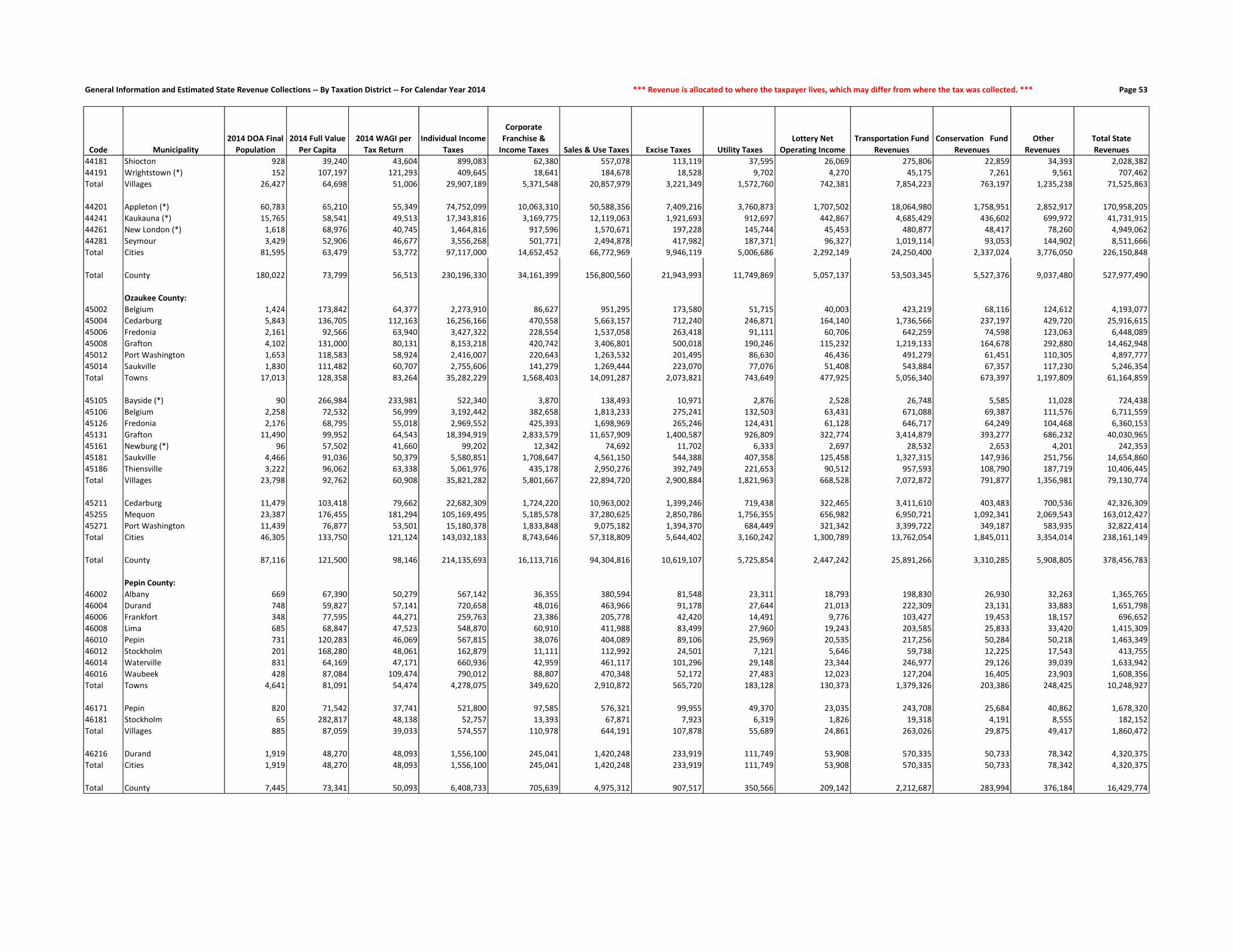
General Information and Estimated State Revenue Collections -- By Taxation District -- For Calendar Year 2014 *** Revenue is allocated to where the taxpayer lives, which may differ from where the tax was collected. *** Page 53
Code Municipality
2014 DOA Final
Population
2014 Full Value
Per Capita
2014 WAGI per
Tax Return
Individual Income
Taxes
Corporate
Franchise &
Income Taxes Sales & Use Taxes Excise Taxes Utility Taxes
Lottery Net
Operating Income
Transportation Fund
Revenues
Conservation Fund
Revenues
Other
Revenues
Total State
Revenues
44181 Shiocton 928 39,240 43,604 899,083 62,380 557,078 113,119 37,595 26,069 275,806 22,859 34,393 2,028,382
44191 Wrightstown (*) 152 107,197 121,293 409,645 18,641 184,678 18,528 9,702 4,270 45,175 7,261 9,561 707,462
Total Villages 26,427 64,698 51,006 29,907,189 5,371,548 20,857,979 3,221,349 1,572,760 742,381 7,854,223 763,197 1,235,238 71,525,863
44201 Appleton (*) 60,783 65,210 55,349 74,752,099 10,063,310 50,588,356 7,409,216 3,760,873 1,707,502 18,064,980 1,758,951 2,852,917 170,958,205
44241 Kaukauna (*) 15,765 58,541 49,513 17,343,816 3,169,775 12,119,063 1,921,693 912,697 442,867 4,685,429 436,602 699,972 41,731,915
44261 New London (*) 1,618 68,976 40,745 1,464,816 917,596 1,570,671 197,228 145,744 45,453 480,877 48,417 78,260 4,949,062
44281 Seymour 3,429 52,906 46,677 3,556,268 501,771 2,494,878 417,982 187,371 96,327 1,019,114 93,053 144,902 8,511,666
Total Cities 81,595 63,479 53,772 97,117,000 14,652,452 66,772,969 9,946,119 5,006,686 2,292,149 24,250,400 2,337,024 3,776,050 226,150,848
Total County 180,022 73,799 56,513 230,196,330 34,161,399 156,800,560 21,943,993 11,749,869 5,057,137 53,503,345 5,527,376 9,037,480 527,977,490
Ozaukee County:
45002 Belgium 1,424 173,842 64,377 2,273,910 86,627 951,295 173,580 51,715 40,003 423,219 68,116 124,612 4,193,077
45004 Cedarburg 5,843 136,705 112,163 16,256,166 470,558 5,663,157 712,240 246,871 164,140 1,736,566 237,197 429,720 25,916,615
45006 Fredonia 2,161 92,566 63,940 3,427,322 228,554 1,537,058 263,418 91,111 60,706 642,259 74,598 123,063 6,448,089
45008 Grafton 4,102 131,000 80,131 8,153,218 420,742 3,406,801 500,018 190,246 115,232 1,219,133 164,678 292,880 14,462,948
45012 Port Washington 1,653 118,583 58,924 2,416,007 220,643 1,263,532 201,495 86,630 46,436 491,279 61,451 110,305 4,897,777
45014 Saukville 1,830 111,482 60,707 2,755,606 141,279 1,269,444 223,070 77,076 51,408 543,884 67,357 117,230 5,246,354
Total Towns 17,013 128,358 83,264 35,282,229 1,568,403 14,091,287 2,073,821 743,649 477,925 5,056,340 673,397 1,197,809 61,164,859
45105 Bayside (*) 90 266,984 233,981 522,340 3,870 138,493 10,971 2,876 2,528 26,748 5,585 11,028 724,438
45106 Belgium 2,258 72,532 56,999 3,192,442 382,658 1,813,233 275,241 132,503 63,431 671,088 69,387 111,576 6,711,559
45126 Fredonia 2,176 68,795 55,018 2,969,552 425,393 1,698,969 265,246 124,431 61,128 646,717 64,249 104,468 6,360,153
45131 Grafton 11,490 99,952 64,543 18,394,919 2,833,579 11,657,909 1,400,587 926,809 322,774 3,414,879 393,277 686,232 40,030,965
45161 Newburg (*) 96 57,502 41,660 99,202 12,342 74,692 11,702 6,333 2,697 28,532 2,653 4,201 242,353
45181 Saukville 4,466 91,036 50,379 5,580,851 1,708,647 4,561,150 544,388 407,358 125,458 1,327,315 147,936 251,756 14,654,860
45186 Thiensville 3,222 96,062 63,338 5,061,976 435,178 2,950,276 392,749 221,653 90,512 957,593 108,790 187,719 10,406,445
Total Villages 23,798 92,762 60,908 35,821,282 5,801,667 22,894,720 2,900,884 1,821,963 668,528 7,072,872 791,877 1,356,981 79,130,774
45211 Cedarburg 11,479 103,418 79,662 22,682,309 1,724,220 10,963,002 1,399,246 719,438 322,465 3,411,610 403,483 700,536 42,326,309
45255 Mequon 23,387 176,455 181,294 105,169,495 5,185,578 37,280,625 2,850,786 1,756,355 656,982 6,950,721 1,092,341 2,069,543 163,012,427
45271 Port Washington 11,439 76,877 53,501 15,180,378 1,833,848 9,075,182 1,394,370 684,449 321,342 3,399,722 349,187 583,935 32,822,414
Total Cities 46,305 133,750 121,124 143,032,183 8,743,646 57,318,809 5,644,402 3,160,242 1,300,789 13,762,054 1,845,011 3,354,014 238,161,149
Total County 87,116 121,500 98,146 214,135,693 16,113,716 94,304,816 10,619,107 5,725,854 2,447,242 25,891,266 3,310,285 5,908,805 378,456,783
Pepin County:
46002 Albany 669 67,390 50,279 567,142 36,355 380,594 81,548 23,311 18,793 198,830 26,930 32,263 1,365,765
46004 Durand 748 59,827 57,141 720,658 48,016 463,966 91,178 27,644 21,013 222,309 23,131 33,883 1,651,798
46006 Frankfort 348 77,595 44,271 259,763 23,386 205,778 42,420 14,491 9,776 103,427 19,453 18,157 696,652
46008 Lima 685 68,847 47,523 548,870 60,910 411,988 83,499 27,960 19,243 203,585 25,833 33,420 1,415,309
46010 Pepin 731 120,283 46,069 567,815 38,076 404,089 89,106 25,969 20,535 217,256 50,284 50,218 1,463,349
46012 Stockholm 201 168,280 48,061 162,879 11,111 112,992 24,501 7,121 5,646 59,738 12,225 17,543 413,755
46014 Waterville 831 64,169 47,171 660,936 42,959 461,117 101,296 29,148 23,344 246,977 29,126 39,039 1,633,942
46016 Waubeek 428 87,084 109,474 790,012 88,807 470,348 52,172 27,483 12,023 127,204 16,405 23,903 1,608,356
Total Towns 4,641 81,091 54,474 4,278,075 349,620 2,910,872 565,720 183,128 130,373 1,379,326 203,386 248,425 10,248,927
46171 Pepin 820 71,542 37,741 521,800 97,585 576,321 99,955 49,370 23,035 243,708 25,684 40,862 1,678,320
46181 Stockholm 65 282,817 48,138 52,757 13,393 67,871 7,923 6,319 1,826 19,318 4,191 8,555 182,152
Total Villages 885 87,059 39,033 574,557 110,978 644,191 107,878 55,689 24,861 263,026 29,875 49,417 1,860,472
46216 Durand 1,919 48,270 48,093 1,556,100 245,041 1,420,248 233,919 111,749 53,908 570,335 50,733 78,342 4,320,375
Total Cities 1,919 48,270 48,093 1,556,100 245,041 1,420,248 233,919 111,749 53,908 570,335 50,733 78,342 4,320,375
Total County 7,445 73,341 50,093 6,408,733 705,639 4,975,312 907,517 350,566 209,142 2,212,687 283,994 376,184 16,429,774

General Information and Estimated State Revenue Collections -- By Taxation District -- For Calendar Year 2014 *** Aid is allocated to the municipality whose taxes are affected by the receipt of the aid. *** Page 54
Code Municipality
Gross Property
Tax Levy Shared Revenue
School Levies
Credit
First Dollar and
Lottery Credit
Natural Resources
Aids
Transportation
Aids
Miscellaneous
Aids
Property Tax
Offset: School Aids
Property Tax
Offset: County
Aids Total State Aid
State Aid As a % of
State Revenues
Gross Property
Tax Rate (mills)
State Aid (in
mills on full
value)
44181 Shiocton 934,306 350,262 62,417 56,576 1,697 82,741 7,442 683,510 53,511 1,298,155 64.00% 26.1473 36.3299
44191 Wrightstown (*) 634,543 17,791 33,446 10,953 655 14,629 6,883 342,149 33,096 459,601 64.96% 23.8357 17.2642
Total Villages 39,842,154 4,015,423 2,553,634 1,408,200 55,260 1,388,685 313,066 31,587,843 2,390,851 43,712,963 61.11% 23.6316 25.9275
44201 Appleton (*) 96,486,175 9,338,623 5,826,628 2,898,115 0 4,125,628 1,121,918 55,380,597 5,769,704 84,461,212 49.40% 24.7372 21.6542
44241 Kaukauna (*) 22,734,714 2,416,988 1,295,456 776,559 0 1,044,506 97,226 12,146,756 1,308,673 19,086,164 45.74% 25.3708 21.2992
44261 New London (*) 2,893,560 661,461 158,495 79,815 112 118,379 13,731 1,648,162 149,433 2,829,587 57.17% 25.5551 24.9901
44281 Seymour 4,693,235 702,145 253,352 162,800 869 176,890 21,635 4,476,600 251,620 6,045,911 71.03% 25.6828 33.0851
Total Cities 126,807,683 13,119,217 7,533,931 3,917,289 981 5,465,403 1,254,510 73,652,116 7,479,429 112,422,875 49.71% 24.9008 22.0761
Total County 290,744,530 18,993,696 19,463,375 8,984,467 241,322 9,984,445 2,178,821 200,581,551 19,250,624 279,678,301 52.97% 22.2925 21.4441
Ozaukee County:
45002 Belgium 4,121,365 19,617 438,108 103,542 13,658 114,413 7,163 2,756,247 243,577 3,696,325 88.15% 16.5227 14.8187
45004 Cedarburg 13,231,915 71,452 1,191,601 369,750 5,188 140,971 30,723 4,295,519 755,060 6,860,264 26.47% 17.1126 8.8723
45006 Fredonia 3,542,048 38,194 345,095 142,323 29,491 247,086 7,829 2,061,120 201,771 3,072,909 47.66% 17.1424 14.8719
45008 Grafton 10,080,565 60,196 939,726 310,788 10,105 92,661 20,938 3,002,744 521,337 4,958,496 34.28% 18.8817 9.2877
45012 Port Washington 3,113,665 21,568 295,524 97,834 5,757 49,707 6,842 1,955,210 181,515 2,613,957 53.37% 16.7508 14.0625
45014 Saukville 3,584,644 23,809 372,502 133,936 7,527 83,727 8,084 2,124,250 190,993 2,944,828 56.13% 18.3275 15.0563
Total Towns 37,674,203 234,836 3,582,557 1,158,173 71,726 728,565 81,579 16,195,089 2,094,253 24,146,779 39.48% 17.5667 11.2591
45105 Bayside (*) 623,333 6,789 48,085 8,442 1,327 14,954 3,291 73,615 22,788 179,293 24.75% 26.7110 7.6830
45106 Belgium 3,184,845 46,017 220,440 120,874 5,380 57,156 7,870 1,612,722 137,500 2,207,958 32.90% 18.8753 13.0857
45126 Fredonia 3,195,402 195,702 269,074 134,524 6,692 100,117 17,077 1,599,600 143,223 2,466,010 38.77% 21.7864 16.8134
45131 Grafton 25,621,191 491,525 1,826,369 734,010 424,148 911,178 121,413 5,451,575 992,089 10,952,306 27.36% 23.3889 9.9980
45161 Newburg (*) 127,563 6,562 9,898 4,446 245 6,166 309 58,219 5,213 91,058 37.57% 23.8963 17.0578
45181 Saukville 8,491,854 441,061 623,491 217,306 2,535 372,982 63,317 4,025,240 383,717 6,129,647 41.83% 21.4106 15.4548
45186 Thiensville 6,351,601 108,134 397,536 178,184 9,524 277,298 26,410 353,141 259,743 1,609,970 15.47% 21.2862 5.3955
Total Villages 47,595,790 1,295,790 3,394,893 1,397,784 449,851 1,739,851 239,687 13,174,112 1,944,274 23,636,242 29.87% 22.2980 11.0733
45211 Cedarburg 24,882,937 355,910 1,838,119 604,895 122,991 547,997 76,789 6,418,098 1,129,576 11,094,375 26.21% 21.5110 9.5910
45255 Mequon 71,857,726 344,666 5,789,327 1,253,001 89,695 1,239,327 259,745 5,298,546 3,844,635 18,118,941 11.12% 18.1943 4.5877
45271 Port Washington 16,778,745 2,680,177 1,335,266 584,001 21,020 687,052 72,557 8,834,051 820,123 15,034,248 45.80% 19.9493 17.8752
Total Cities 113,519,407 3,380,753 8,962,712 2,441,898 233,707 2,474,376 409,092 20,550,695 5,794,334 44,247,565 18.58% 19.0876 7.4400
Total County 198,789,400 4,911,379 15,940,161 4,997,855 755,284 4,942,792 730,359 49,919,896 9,832,861 92,030,585 24.32% 19.4387 8.9993
Pepin County:
46002 Albany 1,011,410 41,466 68,772 40,720 2,095 78,964 1,781 873,348 187,517 1,294,662 94.79% 22.1252 28.3215
46004 Durand 858,829 29,335 72,693 41,452 9,259 20,196 1,798 566,856 177,624 919,212 55.65% 19.8338 21.2283
46006 Frankfort 648,084 24,698 47,885 28,150 3,068 69,607 845 283,051 107,896 565,199 81.13% 24.6392 21.4880
46008 Lima 1,015,299 41,545 76,554 44,003 1,978 58,747 2,041 615,042 192,723 1,032,631 72.96% 21.6103 21.9792
46010 Pepin 2,271,597 18,352 196,669 96,873 18,545 131,826 2,930 274,899 355,255 1,095,350 74.85% 26.2296 12.6477
46012 Stockholm 876,830 8,292 79,645 25,010 4,861 38,085 1,135 108,055 139,640 404,722 97.82% 25.7575 11.8890
46014 Waterville 1,139,263 94,945 88,707 56,163 21,467 77,080 2,106 709,405 221,454 1,271,327 77.81% 21.1028 23.5491
46016 Waubeek 737,084 5,077 60,682 28,775 8,409 19,921 1,580 484,515 151,822 760,782 47.30% 19.9150 20.5553
Total Towns 8,558,397 263,710 691,607 361,144 69,682 494,425 14,216 3,915,171 1,533,931 7,343,886 71.66% 22.8869 19.6390
46171 Pepin 1,766,241 122,766 137,155 86,050 0 23,118 10,017 184,111 237,928 801,145 47.73% 27.5377 12.4907
46181 Stockholm 445,349 15,610 39,829 15,269 56 3,959 595 56,443 72,941 204,702 112.38% 25.0453 11.5119
Total Villages 2,211,589 138,375 176,985 101,319 56 27,077 10,612 240,553 310,869 1,005,846 54.06% 26.9967 12.2783
46216 Durand 2,382,801 465,521 153,785 109,761 0 90,770 23,058 1,210,796 379,402 2,433,092 56.32% 25.1192 25.6494
Total Cities 2,382,801 465,521 153,785 109,761 0 90,770 23,058 1,210,796 379,402 2,433,092 56.32% 25.1192 25.6494
Total County 13,152,787 867,607 1,022,376 572,224 69,738 612,272 47,885 5,366,520 2,224,202 10,782,824 65.63% 23.8827 19.5794

General Information and Estimated State Revenue Collections -- By Taxation District -- For Calendar Year 2014 *** Revenue is allocated to where the taxpayer lives, which may differ from where the tax was collected. *** Page 55
Code Municipality
2014 DOA Final
Population
2014 Full Value
Per Capita
2014 WAGI per
Tax Return
Individual Income
Taxes
Corporate
Franchise &
Income Taxes Sales & Use Taxes Excise Taxes Utility Taxes
Lottery Net
Operating Income
Transportation Fund
Revenues
Conservation Fund
Revenues
Other
Revenues
Total State
Revenues
Pierce County:
47002 Clifton 2,022 120,579 79,716 1,700,292 106,596 1,419,509 246,474 72,478 56,802 600,947 76,603 138,758 4,418,459
47004 Diamond Bluff 462 95,065 64,603 314,844 25,124 293,356 56,316 16,867 12,978 137,308 20,255 27,160 904,209
47006 Ellsworth 1,158 72,801 55,220 674,541 75,716 710,078 141,156 45,707 32,530 344,163 37,238 58,138 2,119,266
47008 El Paso 693 77,452 61,644 450,631 45,516 454,660 84,474 28,435 19,468 205,963 28,418 36,035 1,353,600
47010 Gilman 973 75,982 58,320 598,590 61,635 583,676 118,605 34,893 27,333 289,180 33,455 50,043 1,797,409
47012 Hartland 844 76,588 50,491 449,529 39,976 460,502 102,880 28,445 23,709 250,841 28,813 43,606 1,428,300
47014 Isabelle 284 108,065 71,628 214,585 123,666 280,889 34,619 22,045 7,978 84,406 10,728 18,119 797,036
47016 Maiden Rock 596 98,212 47,649 299,572 27,299 313,127 72,650 19,578 16,743 177,134 30,680 35,761 992,544
47018 Martell 1,186 73,315 66,949 837,584 56,943 742,814 144,569 40,278 33,317 352,485 40,097 59,778 2,307,864
47020 Oak Grove 2,163 106,998 82,156 1,874,549 135,010 1,531,616 263,662 75,977 60,763 642,853 79,198 137,109 4,800,737
47022 River Falls 2,288 92,874 55,994 1,351,436 138,638 1,364,225 278,898 84,251 64,274 680,004 80,634 132,575 4,174,934
47024 Rock Elm 485 67,278 48,820 249,767 24,901 266,766 59,119 17,117 13,624 144,144 25,610 23,317 824,366
47026 Salem 516 81,012 60,562 329,650 72,631 330,369 62,899 20,467 14,495 153,358 21,365 27,539 1,032,773
47028 Spring Lake 565 68,631 53,368 318,075 27,117 313,605 68,872 18,729 15,872 167,921 21,523 27,458 979,171
47030 Trenton 1,838 83,602 57,240 1,109,808 353,832 1,281,909 224,045 90,135 51,633 546,262 61,774 99,931 3,819,329
47032 Trimbelle 1,676 71,880 56,110 992,005 95,136 996,405 204,298 61,222 47,082 498,115 54,163 83,549 3,031,975
47034 Union 593 86,544 45,176 282,594 231,347 456,414 72,285 38,962 16,658 176,242 21,439 32,914 1,328,855
Total Towns 18,342 88,488 60,441 12,048,051 1,641,083 11,799,920 2,235,821 715,586 515,259 5,451,325 671,994 1,031,789 36,110,827
47106 Bay City 499 37,749 40,000 210,552 33,916 279,312 60,826 20,932 14,018 148,305 12,135 18,310 798,305
47121 Ellsworth 3,304 49,701 49,390 1,721,388 464,502 2,291,422 402,745 176,274 92,815 981,964 88,351 136,457 6,355,917
47122 Elmwood 816 42,126 41,381 356,200 119,042 520,970 99,467 41,777 22,923 242,519 20,821 31,318 1,455,036
47151 Maiden Rock 118 168,086 42,979 53,498 177,223 183,136 14,384 19,754 3,315 35,070 5,972 10,259 502,611
47171 Plum City 585 41,396 41,346 255,148 44,605 346,327 71,309 26,478 16,434 173,865 14,774 22,288 971,227
47181 Spring Valley (*) 1,361 44,199 45,915 659,194 115,034 838,924 165,900 62,046 38,233 404,495 35,133 53,323 2,372,283
Total Villages 6,683 48,127 45,683 3,255,979 954,322 4,460,089 814,631 347,262 187,738 1,986,218 177,187 271,954 12,455,380
47271 Prescott 4,257 71,872 66,181 2,971,914 632,801 3,436,877 518,912 245,437 119,587 1,265,199 125,430 212,199 9,528,357
47276 River Falls (*) 11,825 47,059 52,533 6,552,866 1,045,447 8,080,947 1,441,423 592,694 332,185 3,514,443 302,362 476,334 22,338,701
Total Cities 16,082 53,627 57,140 9,524,781 1,678,248 11,517,824 1,960,335 838,131 451,772 4,779,642 427,792 688,533 31,867,058
Total County 41,107 68,288 56,048 24,828,811 4,273,653 27,777,833 5,010,787 1,900,979 1,154,769 12,217,185 1,276,973 1,992,276 80,433,265
Polk County:
48002 Alden 2,802 103,315 56,371 2,095,287 125,305 1,603,599 341,553 91,466 78,713 832,767 105,282 168,826 5,442,799
48004 Apple River 1,155 112,316 47,826 732,757 88,599 654,190 140,790 43,034 32,446 343,271 58,391 73,426 2,166,906
48006 Balsam Lake 1,409 183,530 48,527 907,015 70,548 775,687 171,752 49,007 39,581 418,761 72,388 126,588 2,631,327
48008 Beaver 838 115,090 43,015 478,172 74,842 460,123 102,149 31,896 23,541 249,057 41,561 54,131 1,515,472
48010 Black Brook 1,338 75,258 54,606 969,204 80,195 817,689 163,097 51,825 37,587 397,660 43,730 66,769 2,627,756
48012 Bone Lake 722 134,390 39,200 375,440 32,591 353,378 88,009 23,690 20,282 214,582 33,510 51,778 1,193,260
48014 Clam Falls 609 81,304 33,390 269,744 30,348 289,643 74,234 21,126 17,108 180,998 31,950 31,749 946,900
48016 Clayton 985 67,805 45,843 599,007 47,564 523,855 120,068 33,560 27,670 292,746 33,034 46,446 1,723,950
48018 Clear Lake 905 57,098 43,873 526,699 39,922 460,777 110,316 29,322 25,423 268,970 27,520 39,099 1,528,048
48020 Eureka 1,659 71,498 48,559 1,068,639 79,607 902,789 202,226 56,319 46,604 493,062 59,398 80,487 2,989,131
48022 Farmington 1,842 72,502 56,419 1,378,592 141,237 1,148,539 224,533 72,177 51,745 547,451 57,879 90,047 3,712,199
48024 Garfield 1,691 106,812 51,175 1,147,932 85,576 955,750 206,126 59,184 47,503 502,573 63,667 104,067 3,172,378
48026 Georgetown 986 286,865 35,096 459,043 64,685 525,707 120,189 40,427 27,698 293,044 73,317 126,170 1,730,280
48028 Johnstown 532 194,409 47,517 335,333 26,802 290,733 64,848 18,567 14,945 158,113 49,441 49,931 1,008,713
48030 Laketown 968 86,595 42,645 547,601 47,113 500,794 117,996 33,129 27,193 287,694 37,134 52,354 1,651,009
48032 Lincoln 2,195 103,116 55,052 1,602,961 118,631 1,305,880 267,562 79,845 61,661 652,364 82,567 132,091 4,303,562
48034 Lorain 280 90,575 41,004 152,303 13,428 141,182 34,131 9,400 7,866 83,217 19,949 15,555 477,031
48036 Luck 915 68,531 40,974 497,332 51,217 483,506 111,535 33,577 25,704 271,942 34,375 43,390 1,552,578
48038 Mc Kinley 352 117,583 37,500 175,100 16,450 171,099 42,907 11,774 9,888 104,616 34,968 23,061 589,864
48040 Milltown 1,228 176,009 44,043 717,446 76,935 656,715 149,688 43,695 34,497 364,967 62,459 106,919 2,213,321
48042 Osceola 2,864 83,306 59,188 2,248,666 182,972 1,830,315 349,111 112,949 80,455 851,194 92,723 151,423 5,899,808
48044 Saint Croix Falls 1,163 125,375 48,645 750,475 137,174 873,056 141,765 70,229 32,671 345,649 47,924 79,537 2,478,479
48046 Sterling 777 72,447 38,396 395,758 40,756 394,967 94,714 27,769 21,827 230,928 35,455 37,968 1,280,142
48048 West Sweden 692 80,444 45,393 416,689 39,728 371,071 84,352 24,164 19,439 205,666 25,901 35,856 1,222,865
Total Towns 28,907 107,626 49,226 18,847,194 1,712,225 16,491,047 3,523,651 1,068,132 812,047 8,591,290 1,224,524 1,787,667 54,057,777
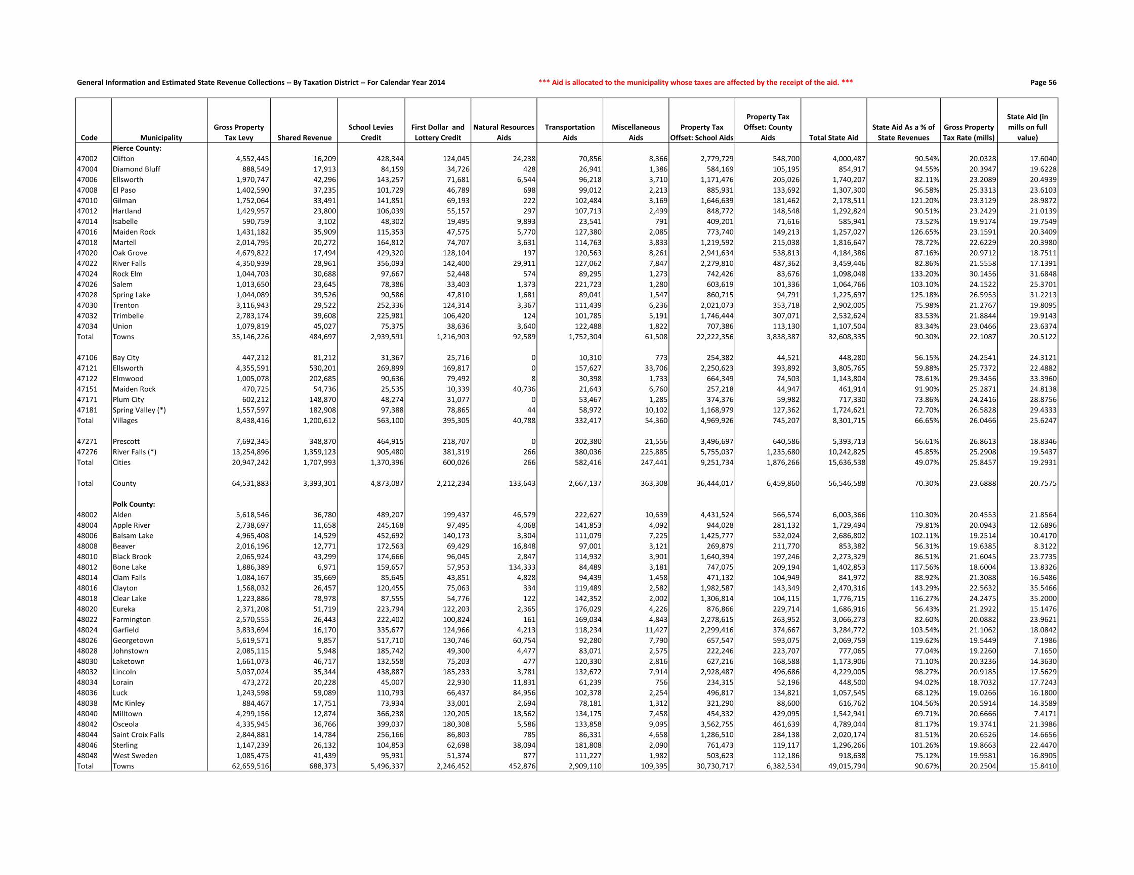
General Information and Estimated State Revenue Collections -- By Taxation District -- For Calendar Year 2014 *** Aid is allocated to the municipality whose taxes are affected by the receipt of the aid. *** Page 56
Code Municipality
Gross Property
Tax Levy Shared Revenue
School Levies
Credit
First Dollar and
Lottery Credit
Natural Resources
Aids
Transportation
Aids
Miscellaneous
Aids
Property Tax
Offset: School Aids
Property Tax
Offset: County
Aids Total State Aid
State Aid As a % of
State Revenues
Gross Property
Tax Rate (mills)
State Aid (in
mills on full
value)
Pierce County:
47002 Clifton 4,552,445 16,209 428,344 124,045 24,238 70,856 8,366 2,779,729 548,700 4,000,487 90.54% 20.0328 17.6040
47004 Diamond Bluff 888,549 17,913 84,159 34,726 428 26,941 1,386 584,169 105,195 854,917 94.55% 20.3947 19.6228
47006 Ellsworth 1,970,747 42,296 143,257 71,681 6,544 96,218 3,710 1,171,476 205,026 1,740,207 82.11% 23.2089 20.4939
47008 El Paso 1,402,590 37,235 101,729 46,789 698 99,012 2,213 885,931 133,692 1,307,300 96.58% 25.3313 23.6103
47010 Gilman 1,752,064 33,491 141,851 69,193 222 102,484 3,169 1,646,639 181,462 2,178,511 121.20% 23.3129 28.9872
47012 Hartland 1,429,957 23,800 106,039 55,157 297 107,713 2,499 848,772 148,548 1,292,824 90.51% 23.2429 21.0139
47014 Isabelle 590,759 3,102 48,302 19,495 9,893 23,541 791 409,201 71,616 585,941 73.52% 19.9174 19.7549
47016 Maiden Rock 1,431,182 35,909 115,353 47,575 5,770 127,380 2,085 773,740 149,213 1,257,027 126.65% 23.1591 20.3409
47018 Martell 2,014,795 20,272 164,812 74,707 3,631 114,763 3,833 1,219,592 215,038 1,816,647 78.72% 22.6229 20.3980
47020 Oak Grove 4,679,822 17,494 429,320 128,104 197 120,563 8,261 2,941,634 538,813 4,184,386 87.16% 20.9712 18.7511
47022 River Falls 4,350,939 28,961 356,093 142,400 29,911 127,062 7,847 2,279,810 487,362 3,459,446 82.86% 21.5558 17.1391
47024 Rock Elm 1,044,703 30,688 97,667 52,448 574 89,295 1,273 742,426 83,676 1,098,048 133.20% 30.1456 31.6848
47026 Salem 1,013,650 23,645 78,386 33,403 1,373 221,723 1,280 603,619 101,336 1,064,766 103.10% 24.1522 25.3701
47028 Spring Lake 1,044,089 39,526 90,586 47,810 1,681 89,041 1,547 860,715 94,791 1,225,697 125.18% 26.5953 31.2213
47030 Trenton 3,116,943 29,522 252,336 124,314 3,367 111,439 6,236 2,021,073 353,718 2,902,005 75.98% 21.2767 19.8095
47032 Trimbelle 2,783,174 39,608 225,981 106,420 124 101,785 5,191 1,746,444 307,071 2,532,624 83.53% 21.8844 19.9143
47034 Union 1,079,819 45,027 75,375 38,636 3,640 122,488 1,822 707,386 113,130 1,107,504 83.34% 23.0466 23.6374
Total Towns 35,146,226 484,697 2,939,591 1,216,903 92,589 1,752,304 61,508 22,222,356 3,838,387 32,608,335 90.30% 22.1087 20.5122
47106 Bay City 447,212 81,212 31,367 25,716 0 10,310 773 254,382 44,521 448,280 56.15% 24.2541 24.3121
47121 Ellsworth 4,355,591 530,201 269,899 169,817 0 157,627 33,706 2,250,623 393,892 3,805,765 59.88% 25.7372 22.4882
47122 Elmwood 1,005,078 202,685 90,636 79,492 8 30,398 1,733 664,349 74,503 1,143,804 78.61% 29.3456 33.3960
47151 Maiden Rock 470,725 54,736 25,535 10,339 40,736 21,643 6,760 257,218 44,947 461,914 91.90% 25.2871 24.8138
47171 Plum City 602,212 148,870 48,274 31,077 0 53,467 1,285 374,376 59,982 717,330 73.86% 24.2416 28.8756
47181 Spring Valley (*) 1,557,597 182,908 97,388 78,865 44 58,972 10,102 1,168,979 127,362 1,724,621 72.70% 26.5828 29.4333
Total Villages 8,438,416 1,200,612 563,100 395,305 40,788 332,417 54,360 4,969,926 745,207 8,301,715 66.65% 26.0466 25.6247
47271 Prescott 7,692,345 348,870 464,915 218,707 0 202,380 21,556 3,496,697 640,586 5,393,713 56.61% 26.8613 18.8346
47276 River Falls (*) 13,254,896 1,359,123 905,480 381,319 266 380,036 225,885 5,755,037 1,235,680 10,242,825 45.85% 25.2908 19.5437
Total Cities 20,947,242 1,707,993 1,370,396 600,026 266 582,416 247,441 9,251,734 1,876,266 15,636,538 49.07% 25.8457 19.2931
Total County 64,531,883 3,393,301 4,873,087 2,212,234 133,643 2,667,137 363,308 36,444,017 6,459,860 56,546,588 70.30% 23.6888 20.7575
Polk County:
48002 Alden 5,618,546 36,780 489,207 199,437 46,579 222,627 10,639 4,431,524 566,574 6,003,366 110.30% 20.4553 21.8564
48004 Apple River 2,738,697 11,658 245,168 97,495 4,068 141,853 4,092 944,028 281,132 1,729,494 79.81% 20.0943 12.6896
48006 Balsam Lake 4,965,408 14,529 452,692 140,173 3,304 111,079 7,225 1,425,777 532,024 2,686,802 102.11% 19.2514 10.4170
48008 Beaver 2,016,196 12,771 172,563 69,429 16,848 97,001 3,121 269,879 211,770 853,382 56.31% 19.6385 8.3122
48010 Black Brook 2,065,924 43,299 174,666 96,045 2,847 114,932 3,901 1,640,394 197,246 2,273,329 86.51% 21.6045 23.7735
48012 Bone Lake 1,886,389 6,971 159,657 57,953 134,333 84,489 3,181 747,075 209,194 1,402,853 117.56% 18.6004 13.8326
48014 Clam Falls 1,084,167 35,669 85,645 43,851 4,828 94,439 1,458 471,132 104,949 841,972 88.92% 21.3088 16.5486
48016 Clayton 1,568,032 26,457 120,455 75,063 334 119,489 2,582 1,982,587 143,349 2,470,316 143.29% 22.5632 35.5466
48018 Clear Lake 1,223,886 78,978 87,555 54,776 122 142,352 2,002 1,306,814 104,115 1,776,715 116.27% 24.2475 35.2000
48020 Eureka 2,371,208 51,719 223,794 122,203 2,365 176,029 4,226 876,866 229,714 1,686,916 56.43% 21.2922 15.1476
48022 Farmington 2,570,555 26,443 222,402 100,824 161 169,034 4,843 2,278,615 263,952 3,066,273 82.60% 20.0882 23.9621
48024 Garfield 3,833,694 16,170 335,677 124,966 4,213 118,234 11,427 2,299,416 374,667 3,284,772 103.54% 21.1062 18.0842
48026 Georgetown 5,619,571 9,857 517,710 130,746 60,754 92,280 7,790 657,547 593,075 2,069,759 119.62% 19.5449 7.1986
48028 Johnstown 2,085,115 5,948 185,742 49,300 4,477 83,071 2,575 222,246 223,707 777,065 77.04% 19.2260 7.1650
48030 Laketown 1,661,073 46,717 132,558 75,203 477 120,330 2,816 627,216 168,588 1,173,906 71.10% 20.3236 14.3630
48032 Lincoln 5,037,024 35,344 438,887 185,233 3,781 132,672 7,914 2,928,487 496,686 4,229,005 98.27% 20.9185 17.5629
48034 Lorain 473,272 20,228 45,007 22,930 11,831 61,239 756 234,315 52,196 448,500 94.02% 18.7032 17.7243
48036 Luck 1,243,598 59,089 110,793 66,437 84,956 102,378 2,254 496,817 134,821 1,057,545 68.12% 19.0266 16.1800
48038 Mc Kinley 884,467 17,751 73,934 33,001 2,694 78,181 1,312 321,290 88,600 616,762 104.56% 20.5914 14.3589
48040 Milltown 4,299,156 12,874 366,238 120,205 18,562 134,175 7,458 454,332 429,095 1,542,941 69.71% 20.6666 7.4171
48042 Osceola 4,335,945 36,766 399,037 180,308 5,586 133,858 9,095 3,562,755 461,639 4,789,044 81.17% 19.3741 21.3986
48044 Saint Croix Falls 2,844,881 14,784 256,166 86,803 785 86,331 4,658 1,286,510 284,138 2,020,174 81.51% 20.6526 14.6656
48046 Sterling 1,147,239 26,132 104,853 62,698 38,094 181,808 2,090 761,473 119,117 1,296,266 101.26% 19.8663 22.4470
48048 West Sweden 1,085,475 41,439 95,931 51,374 877 111,227 1,982 503,623 112,186 918,638 75.12% 19.9581 16.8905
Total Towns 62,659,516 688,373 5,496,337 2,246,452 452,876 2,909,110 109,395 30,730,717 6,382,534 49,015,794 90.67% 20.2504 15.8410
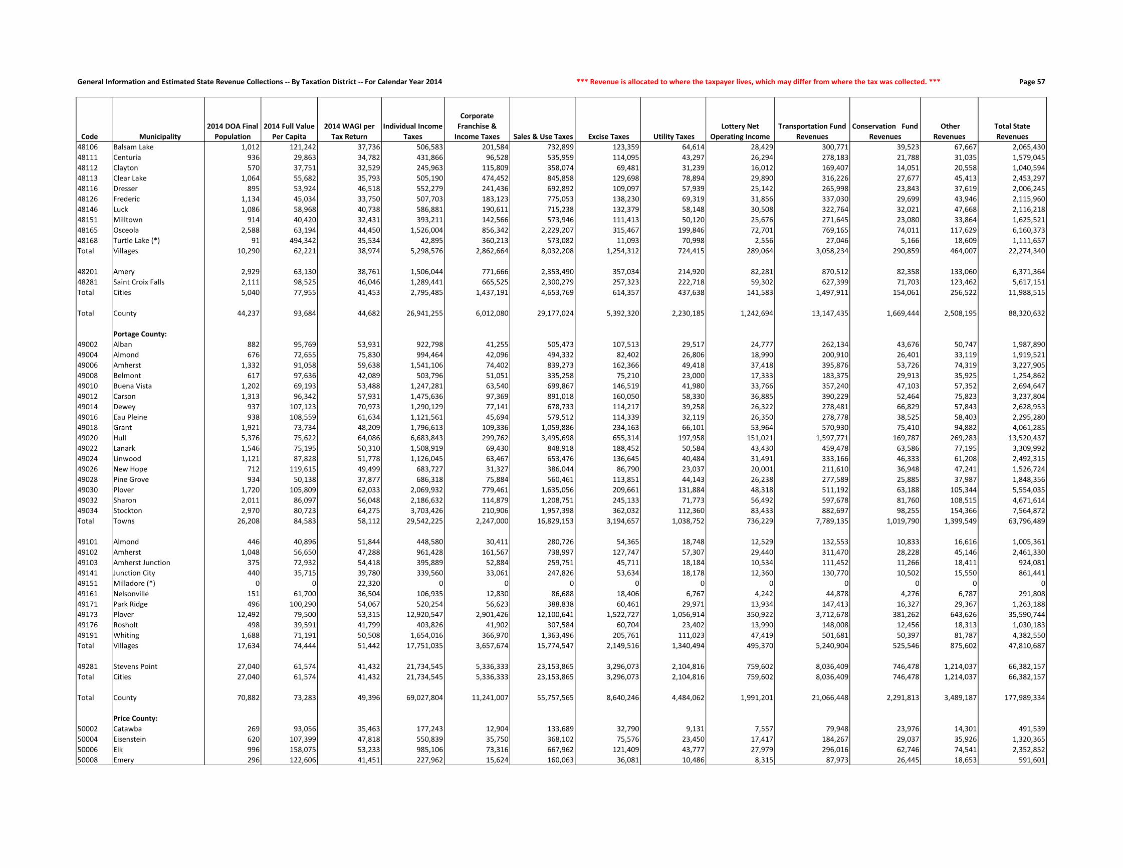
General Information and Estimated State Revenue Collections -- By Taxation District -- For Calendar Year 2014 *** Revenue is allocated to where the taxpayer lives, which may differ from where the tax was collected. *** Page 57
Code Municipality
2014 DOA Final
Population
2014 Full Value
Per Capita
2014 WAGI per
Tax Return
Individual Income
Taxes
Corporate
Franchise &
Income Taxes Sales & Use Taxes Excise Taxes Utility Taxes
Lottery Net
Operating Income
Transportation Fund
Revenues
Conservation Fund
Revenues
Other
Revenues
Total State
Revenues
48106 Balsam Lake 1,012 121,242 37,736 506,583 201,584 732,899 123,359 64,614 28,429 300,771 39,523 67,667 2,065,430
48111 Centuria 936 29,863 34,782 431,866 96,528 535,959 114,095 43,297 26,294 278,183 21,788 31,035 1,579,045
48112 Clayton 570 37,751 32,529 245,963 115,809 358,074 69,481 31,239 16,012 169,407 14,051 20,558 1,040,594
48113 Clear Lake 1,064 55,682 35,793 505,190 474,452 845,858 129,698 78,894 29,890 316,226 27,677 45,413 2,453,297
48116 Dresser 895 53,924 46,518 552,279 241,436 692,892 109,097 57,939 25,142 265,998 23,843 37,619 2,006,245
48126 Frederic 1,134 45,034 33,750 507,703 183,123 775,053 138,230 69,319 31,856 337,030 29,699 43,946 2,115,960
48146 Luck 1,086 58,968 40,738 586,881 190,611 715,238 132,379 58,148 30,508 322,764 32,021 47,668 2,116,218
48151 Milltown 914 40,420 32,431 393,211 142,566 573,946 111,413 50,120 25,676 271,645 23,080 33,864 1,625,521
48165 Osceola 2,588 63,194 44,450 1,526,004 856,342 2,229,207 315,467 199,846 72,701 769,165 74,011 117,629 6,160,373
48168 Turtle Lake (*) 91 494,342 35,534 42,895 360,213 573,082 11,093 70,998 2,556 27,046 5,166 18,609 1,111,657
Total Villages 10,290 62,221 38,974 5,298,576 2,862,664 8,032,208 1,254,312 724,415 289,064 3,058,234 290,859 464,007 22,274,340
48201 Amery 2,929 63,130 38,761 1,506,044 771,666 2,353,490 357,034 214,920 82,281 870,512 82,358 133,060 6,371,364
48281 Saint Croix Falls 2,111 98,525 46,046 1,289,441 665,525 2,300,279 257,323 222,718 59,302 627,399 71,703 123,462 5,617,151
Total Cities 5,040 77,955 41,453 2,795,485 1,437,191 4,653,769 614,357 437,638 141,583 1,497,911 154,061 256,522 11,988,515
Total County 44,237 93,684 44,682 26,941,255 6,012,080 29,177,024 5,392,320 2,230,185 1,242,694 13,147,435 1,669,444 2,508,195 88,320,632
Portage County:
49002 Alban 882 95,769 53,931 922,798 41,255 505,473 107,513 29,517 24,777 262,134 43,676 50,747 1,987,890
49004 Almond 676 72,655 75,830 994,464 42,096 494,332 82,402 26,806 18,990 200,910 26,401 33,119 1,919,521
49006 Amherst 1,332 91,058 59,638 1,541,106 74,402 839,273 162,366 49,418 37,418 395,876 53,726 74,319 3,227,905
49008 Belmont 617 97,636 42,089 503,796 51,051 335,258 75,210 23,000 17,333 183,375 29,913 35,925 1,254,862
49010 Buena Vista 1,202 69,193 53,488 1,247,281 63,540 699,867 146,519 41,980 33,766 357,240 47,103 57,352 2,694,647
49012 Carson 1,313 96,342 57,931 1,475,636 97,369 891,018 160,050 58,330 36,885 390,229 52,464 75,823 3,237,804
49014 Dewey 937 107,123 70,973 1,290,129 77,141 678,733 114,217 39,258 26,322 278,481 66,829 57,843 2,628,953
49016 Eau Pleine 938 108,559 61,634 1,121,561 45,694 579,512 114,339 32,119 26,350 278,778 38,525 58,403 2,295,280
49018 Grant 1,921 73,734 48,209 1,796,613 109,336 1,059,886 234,163 66,101 53,964 570,930 75,410 94,882 4,061,285
49020 Hull 5,376 75,622 64,086 6,683,843 299,762 3,495,698 655,314 197,958 151,021 1,597,771 169,787 269,283 13,520,437
49022 Lanark 1,546 75,195 50,310 1,508,919 69,430 848,918 188,452 50,584 43,430 459,478 63,586 77,195 3,309,992
49024 Linwood 1,121 87,828 51,778 1,126,045 63,467 653,476 136,645 40,484 31,491 333,166 46,333 61,208 2,492,315
49026 New Hope 712 119,615 49,499 683,727 31,327 386,044 86,790 23,037 20,001 211,610 36,948 47,241 1,526,724
49028 Pine Grove 934 50,138 37,877 686,318 75,884 560,461 113,851 44,143 26,238 277,589 25,885 37,987 1,848,356
49030 Plover 1,720 105,809 62,033 2,069,932 779,461 1,635,056 209,661 131,884 48,318 511,192 63,188 105,344 5,554,035
49032 Sharon 2,011 86,097 56,048 2,186,632 114,879 1,208,751 245,133 71,773 56,492 597,678 81,760 108,515 4,671,614
49034 Stockton 2,970 80,723 64,275 3,703,426 210,906 1,957,398 362,032 112,360 83,433 882,697 98,255 154,366 7,564,872
Total Towns 26,208 84,583 58,112 29,542,225 2,247,000 16,829,153 3,194,657 1,038,752 736,229 7,789,135 1,019,790 1,399,549 63,796,489
49101 Almond 446 40,896 51,844 448,580 30,411 280,726 54,365 18,748 12,529 132,553 10,833 16,616 1,005,361
49102 Amherst 1,048 56,650 47,288 961,428 161,567 738,997 127,747 57,307 29,440 311,470 28,228 45,146 2,461,330
49103 Amherst Junction 375 72,932 54,418 395,889 52,884 259,751 45,711 18,184 10,534 111,452 11,266 18,411 924,081
49141 Junction City 440 35,715 39,780 339,560 33,061 247,826 53,634 18,178 12,360 130,770 10,502 15,550 861,441
49151 Milladore (*) 0 0 22,320 0 0 0 0 0 0 0 0 0 0
49161 Nelsonville 151 61,700 36,504 106,935 12,830 86,688 18,406 6,767 4,242 44,878 4,276 6,787 291,808
49171 Park Ridge 496 100,290 54,067 520,254 56,623 388,838 60,461 29,971 13,934 147,413 16,327 29,367 1,263,188
49173 Plover 12,492 79,500 53,315 12,920,547 2,901,426 12,100,641 1,522,727 1,056,914 350,922 3,712,678 381,262 643,626 35,590,744
49176 Rosholt 498 39,591 41,799 403,826 41,902 307,584 60,704 23,402 13,990 148,008 12,456 18,313 1,030,183
49191 Whiting 1,688 71,191 50,508 1,654,016 366,970 1,363,496 205,761 111,023 47,419 501,681 50,397 81,787 4,382,550
Total Villages 17,634 74,444 51,442 17,751,035 3,657,674 15,774,547 2,149,516 1,340,494 495,370 5,240,904 525,546 875,602 47,810,687
49281 Stevens Point 27,040 61,574 41,432 21,734,545 5,336,333 23,153,865 3,296,073 2,104,816 759,602 8,036,409 746,478 1,214,037 66,382,157
Total Cities 27,040 61,574 41,432 21,734,545 5,336,333 23,153,865 3,296,073 2,104,816 759,602 8,036,409 746,478 1,214,037 66,382,157
Total County 70,882 73,283 49,396 69,027,804 11,241,007 55,757,565 8,640,246 4,484,062 1,991,201 21,066,448 2,291,813 3,489,187 177,989,334
Price County:
50002 Catawba 269 93,056 35,463 177,243 12,904 133,689 32,790 9,131 7,557 79,948 23,976 14,301 491,539
50004 Eisenstein 620 107,399 47,818 550,839 35,750 368,102 75,576 23,450 17,417 184,267 29,037 35,926 1,320,365
50006 Elk 996 158,075 53,233 985,106 73,316 667,962 121,409 43,777 27,979 296,016 62,746 74,541 2,352,852
50008 Emery 296 122,606 41,451 227,962 15,624 160,063 36,081 10,486 8,315 87,973 26,445 18,653 591,601

General Information and Estimated State Revenue Collections -- By Taxation District -- For Calendar Year 2014 *** Aid is allocated to the municipality whose taxes are affected by the receipt of the aid. *** Page 58
Code Municipality
Gross Property
Tax Levy Shared Revenue
School Levies
Credit
First Dollar and
Lottery Credit
Natural Resources
Aids
Transportation
Aids
Miscellaneous
Aids
Property Tax
Offset: School Aids
Property Tax
Offset: County
Aids Total State Aid
State Aid As a % of
State Revenues
Gross Property
Tax Rate (mills)
State Aid (in
mills on full
value)
48106 Balsam Lake 2,924,172 23,528 200,628 72,362 11,669 51,935 71,176 263,987 250,260 945,545 45.78% 23.3434 7.5482
48111 Centuria 731,098 289,853 49,731 44,966 10 34,884 7,082 57,154 54,182 537,862 34.06% 25.3471 18.6476
48112 Clayton 613,371 127,329 36,789 27,466 0 34,914 1,785 671,693 43,933 943,910 90.71% 27.6607 42.5668
48113 Clear Lake 1,268,454 334,912 81,379 58,199 0 52,084 12,852 1,192,837 95,034 1,827,297 74.48% 25.4049 36.5975
48116 Dresser 1,247,730 120,788 94,864 49,922 0 57,000 8,026 472,886 93,465 896,951 44.71% 27.5367 19.7952
48126 Frederic 1,278,014 362,491 85,368 56,623 14 60,683 121,260 503,783 112,222 1,302,445 61.55% 23.4907 23.9398
48146 Luck 1,778,854 185,472 99,096 64,564 8 64,675 25,556 519,538 150,096 1,109,004 52.40% 24.3053 15.1528
48151 Milltown 1,129,275 253,320 62,345 57,469 21 52,595 3,631 75,819 71,877 577,077 35.50% 29.1094 14.8753
48165 Osceola 3,870,930 338,261 225,907 110,367 0 200,825 44,291 2,347,830 271,970 3,539,452 57.46% 24.0606 22.0003
48168 Turtle Lake (*) 620,930 47,026 24,643 3,717 5 18,646 16,641 22,040 25,817 158,534 14.26% 29.9048 7.6352
Total Villages 15,462,828 2,082,979 960,751 545,656 11,727 628,242 312,300 6,127,566 1,168,856 11,838,077 53.15% 24.9577 19.1072
48201 Amery 4,990,580 584,862 304,530 174,983 720 203,207 38,225 1,979,895 336,400 3,622,821 56.86% 28.8311 20.9294
48281 Saint Croix Falls 4,690,874 244,246 266,811 115,141 1,862 175,118 27,284 1,531,233 302,644 2,664,339 47.43% 23.6901 13.4556
Total Cities 9,681,454 829,108 571,341 290,124 2,582 378,325 65,509 3,511,128 639,044 6,287,160 52.44% 26.0880 16.9416
Total County 87,803,798 3,600,460 7,028,429 3,082,231 467,185 3,915,677 487,204 40,369,411 8,190,434 67,141,030 76.02% 21.4947 16.4364
Portage County:
49002 Alban 1,717,436 31,185 120,047 73,813 38,081 86,352 2,697 816,147 185,049 1,353,371 68.08% 20.9413 16.5022
49004 Almond 1,071,365 16,951 74,117 45,677 12,732 105,617 1,697 942,071 113,511 1,312,373 68.37% 21.2966 26.0873
49006 Amherst 2,383,565 25,808 201,210 103,618 8,315 119,632 5,114 2,116,692 259,950 2,840,339 87.99% 20.6893 24.6541
49008 Belmont 1,132,136 14,667 92,172 52,798 17,922 87,072 1,888 899,251 133,102 1,298,873 103.51% 19.1921 22.0187
49010 Buena Vista 1,568,440 31,520 135,025 82,263 17,513 147,407 3,095 1,399,515 184,388 2,000,724 74.25% 19.1931 24.4829
49012 Carson 2,376,277 17,936 169,386 86,033 31,884 130,725 4,728 1,439,091 278,627 2,158,409 66.66% 19.2435 17.4791
49014 Dewey 1,891,674 15,919 125,995 58,148 24,468 122,745 3,310 1,052,191 216,313 1,619,088 61.59% 19.7321 16.8887
49016 Eau Pleine 1,775,091 40,757 133,814 61,940 63,839 113,196 3,275 1,093,882 223,729 1,734,433 75.57% 17.9022 17.4922
49018 Grant 2,693,662 36,401 213,882 146,323 18,730 373,237 5,157 2,398,069 316,131 3,507,930 86.37% 19.2259 25.0377
49020 Hull 7,100,811 156,947 492,754 295,598 3,592 171,498 17,488 4,194,181 862,255 6,194,312 45.81% 18.5816 16.2094
49022 Lanark 2,271,736 21,680 187,800 118,452 5,331 72,931 4,316 1,627,657 249,485 2,287,651 69.11% 20.5458 20.6898
49024 Linwood 1,802,770 20,728 124,150 68,774 1,411 86,162 3,479 1,066,695 219,295 1,590,694 63.82% 18.5490 16.3670
49026 New Hope 1,636,029 10,302 133,742 59,489 4,615 76,635 3,019 1,234,644 197,699 1,720,144 112.67% 18.6723 19.6323
49028 Pine Grove 964,489 46,815 67,645 51,748 41,356 134,726 4,109 781,724 102,372 1,230,495 66.57% 21.2583 27.1213
49030 Plover 3,171,624 39,648 237,570 94,703 1,928 149,333 6,872 2,042,633 381,503 2,954,190 53.19% 18.7583 17.4723
49032 Sharon 3,271,783 37,110 228,395 131,779 6,194 146,179 6,367 1,730,534 373,560 2,660,118 56.94% 19.7621 16.0676
49034 Stockton 4,464,776 48,047 321,021 176,759 40,498 184,539 9,793 2,968,690 528,182 4,277,528 56.54% 19.0733 18.2734
Total Towns 41,293,665 612,419 3,058,723 1,707,916 338,409 2,307,985 86,404 27,803,666 4,825,151 40,740,673 63.86% 19.3100 19.0514
49101 Almond 341,927 102,558 26,896 29,453 0 14,996 895 349,052 37,010 560,859 55.79% 20.8462 34.1937
49102 Amherst 1,304,394 132,764 85,712 62,843 4 33,775 7,644 933,224 113,498 1,369,463 55.64% 23.7692 24.9549
49103 Amherst Junction 551,387 21,256 43,942 25,213 1,351 15,110 1,264 491,677 59,798 659,610 71.38% 20.8057 24.8894
49141 Junction City 287,922 146,908 21,623 22,134 1,799 19,931 73,403 165,631 34,051 485,480 56.36% 19.0789 32.1699
49151 Milladore (*) 0 0 0 0 0 0 0 0 0 0 0.00% 0.0000 0.0000
49161 Nelsonville 175,990 24,348 15,726 11,909 829 3,366 415 169,532 20,618 246,744 84.56% 19.2593 27.0023
49171 Park Ridge 877,325 12,677 62,968 35,257 0 9,929 2,127 476,963 98,056 697,977 55.26% 20.1882 16.0612
49173 Plover 20,620,436 639,275 1,176,606 507,523 8,466 692,836 72,833 9,625,317 1,978,807 14,701,663 41.31% 22.4716 16.0215
49176 Rosholt 510,401 83,449 29,600 31,954 0 15,257 2,443 203,343 46,105 412,150 40.01% 24.9790 20.1706
49191 Whiting 2,456,493 16,027 169,291 90,039 0 74,345 6,616 1,274,181 261,951 1,892,449 43.18% 20.9154 16.1129
Total Villages 27,126,275 1,179,262 1,632,364 816,324 12,448 879,544 167,639 13,688,920 2,649,894 21,026,395 43.98% 22.2170 17.2210
49281 Stevens Point 39,010,228 3,845,820 2,009,535 939,463 0 1,573,976 1,668,480 16,343,307 3,359,916 29,740,496 44.80% 25.6147 19.5281
Total Cities 39,010,228 3,845,820 2,009,535 939,463 0 1,573,976 1,668,480 16,343,307 3,359,916 29,740,496 44.80% 25.6147 19.5281
Total County 107,430,168 5,637,501 6,700,622 3,463,702 350,857 4,761,505 1,922,523 57,835,893 10,834,961 91,507,565 51.41% 22.0036 18.7424
Price County:
50002 Catawba 421,959 12,804 34,859 21,534 5,752 56,397 521 135,944 67,443 335,254 68.20% 17.8885 14.2127
50004 Eisenstein 1,046,071 18,636 93,815 52,399 35,535 165,973 5,680 359,527 182,821 914,386 69.25% 16.3598 14.3003
50006 Elk 2,847,039 13,916 220,701 94,268 9,299 104,792 4,805 866,717 444,067 1,758,564 74.74% 18.3311 11.3228
50008 Emery 638,351 15,400 49,297 26,228 46,667 171,795 10,053 201,019 102,993 623,451 105.38% 17.7213 17.3076

General Information and Estimated State Revenue Collections -- By Taxation District -- For Calendar Year 2014 *** Revenue is allocated to where the taxpayer lives, which may differ from where the tax was collected. *** Page 59
Code Municipality
2014 DOA Final
Population
2014 Full Value
Per Capita
2014 WAGI per
Tax Return
Individual Income
Taxes
Corporate
Franchise &
Income Taxes Sales & Use Taxes Excise Taxes Utility Taxes
Lottery Net
Operating Income
Transportation Fund
Revenues
Conservation Fund
Revenues
Other
Revenues
Total State
Revenues
50010 Fifield 904 203,765 35,957 603,941 73,583 520,981 110,194 39,576 25,395 268,673 53,252 81,426 1,777,022
50012 Flambeau 482 155,957 40,005 358,267 39,276 296,138 58,754 22,109 13,540 143,253 41,444 35,733 1,008,515
50014 Georgetown 171 96,127 32,495 103,241 8,059 81,805 20,844 5,747 4,804 50,822 8,997 9,266 293,585
50016 Hackett 169 168,391 42,851 134,552 8,676 92,487 20,601 5,964 4,748 50,228 32,814 13,229 363,300
50018 Harmony 224 102,184 46,972 195,493 9,666 121,833 27,305 7,172 6,293 66,574 14,775 12,590 461,701
50020 Hill 332 115,589 42,922 264,764 17,611 183,584 40,470 11,944 9,327 98,672 25,187 20,144 671,704
50022 Kennan 353 85,423 32,303 211,867 17,394 170,868 43,030 12,166 9,916 104,913 22,149 17,869 610,172
50024 Knox 346 107,076 35,709 229,558 19,226 180,613 42,176 12,796 9,720 102,833 25,048 20,012 641,983
50026 Lake 1,117 134,953 46,794 971,154 80,267 681,182 136,158 45,347 31,379 331,977 69,238 74,986 2,421,689
50028 Ogema 717 91,431 31,628 421,335 49,952 360,391 87,400 26,757 20,142 213,096 53,926 37,730 1,270,728
50030 Prentice 467 114,961 36,920 320,342 34,100 270,768 56,925 20,344 13,119 138,794 66,411 28,238 949,042
50032 Spirit 277 159,938 35,375 182,063 15,364 143,101 33,765 10,117 7,781 82,326 24,812 20,903 520,231
50034 Worcester 1,568 109,799 45,736 1,332,419 118,672 937,541 191,133 62,407 44,048 466,017 75,175 92,113 3,319,525
Total Towns 9,308 129,410 41,723 7,270,145 629,440 5,371,111 1,134,611 369,291 261,480 2,766,379 655,433 607,661 19,065,551
50111 Catawba 104 56,164 33,183 64,120 8,332 60,842 12,677 4,868 2,922 30,909 3,875 4,250 192,796
50141 Kennan 129 44,629 47,211 113,155 13,411 82,648 15,724 5,710 3,624 38,339 3,226 4,775 280,613
50171 Prentice 653 44,908 36,962 448,440 183,810 471,348 79,598 40,324 18,344 194,075 16,691 24,234 1,476,863
Total Villages 886 46,189 38,123 625,715 205,553 614,837 107,999 50,903 24,890 263,323 23,792 33,260 1,950,272
50271 Park Falls 2,514 49,710 34,070 1,591,399 630,222 1,906,096 306,447 171,994 70,623 747,172 64,799 97,325 5,586,077
50272 Phillips 1,447 62,235 33,786 908,326 596,852 1,253,549 176,384 119,349 40,649 430,055 41,846 62,060 3,629,069
Total Cities 3,961 54,286 33,951 2,499,725 1,227,074 3,159,645 482,831 291,342 111,272 1,177,227 106,645 159,385 9,215,146
Total County 14,155 103,179 38,848 10,395,585 2,062,067 9,145,593 1,725,441 711,536 397,642 4,206,929 785,870 800,305 30,230,968
Racine County:
51002 Burlington 6,456 96,109 56,811 7,262,455 393,164 4,069,342 786,962 250,288 181,361 1,918,752 219,937 366,859 15,449,122
51006 Dover 4,031 79,881 57,997 4,629,221 362,487 2,762,386 491,364 181,604 113,238 1,198,031 127,269 205,452 10,071,052
51010 Norway 7,964 98,949 66,387 10,468,971 597,108 5,506,254 970,781 321,792 223,723 2,366,936 273,507 460,712 21,189,784
51012 Raymond 3,917 113,320 63,904 4,956,392 574,060 3,122,849 477,468 217,759 110,036 1,164,150 144,457 246,911 11,014,083
51016 Waterford 6,345 114,075 66,910 8,406,329 372,925 4,241,978 773,431 235,642 178,242 1,885,762 235,052 401,691 16,731,051
51018 Yorkville 3,090 161,360 72,281 4,422,542 1,506,427 4,609,047 376,659 430,264 86,804 918,362 135,998 248,351 12,734,453
Total Towns 31,803 106,807 63,424 40,145,910 3,806,171 24,311,856 3,876,665 1,637,348 893,404 9,451,994 1,136,221 1,929,976 87,189,545
51104 Caledonia 24,880 78,917 69,757 34,365,770 2,684,536 18,922,609 3,032,777 1,171,782 698,923 7,394,448 775,947 1,259,431 70,306,223
51121 Elmwood Park 500 71,512 65,251 646,017 27,994 330,153 60,948 18,577 14,046 148,602 14,971 23,974 1,285,281
51151 Mount Pleasant 26,386 90,232 61,590 32,178,759 5,808,350 24,533,467 3,216,353 1,955,009 741,229 7,842,037 869,065 1,443,412 78,587,681
51161 North Bay 237 146,350 142,229 667,458 10,274 239,181 28,890 7,607 6,658 70,437 9,992 17,764 1,058,261
51176 Rochester 3,700 95,190 61,997 4,542,139 281,325 2,487,391 451,016 150,936 103,939 1,099,657 125,996 209,024 9,451,423
51181 Sturtevant 6,993 71,756 50,057 6,931,318 2,999,181 6,914,315 852,420 623,210 196,446 2,078,351 209,371 335,916 21,140,527
51186 Union Grove 4,899 60,141 48,823 4,736,095 712,064 3,545,772 597,169 273,983 137,622 1,456,005 136,883 214,793 11,810,386
51191 Waterford 5,366 77,976 53,677 5,703,322 779,950 4,238,768 654,095 328,783 150,740 1,594,799 165,396 269,806 13,885,660
51192 Wind Point 1,707 134,887 131,915 4,458,751 160,961 1,762,469 208,077 71,281 47,953 507,328 68,761 120,888 7,406,469
Total Villages 74,668 83,196 63,007 94,229,628 13,464,635 62,974,126 9,101,745 4,601,167 2,097,556 22,191,664 2,376,383 3,895,009 214,931,913
51206 Burlington (*) 10,511 76,744 51,340 10,685,344 2,655,568 9,752,440 1,281,251 845,865 295,273 3,123,916 328,380 523,825 29,491,862
51276 Racine 78,479 40,881 42,486 66,022,235 10,005,544 51,837,916 9,566,291 4,074,169 2,204,614 23,324,311 1,970,654 2,895,393 171,901,126
Total Cities 88,990 45,117 43,454 76,707,579 12,661,112 61,590,355 10,847,542 4,920,034 2,499,887 26,448,227 2,299,034 3,419,218 201,392,988
Total County 195,461 69,701 51,076 211,083,117 29,931,918 148,876,337 23,825,952 11,158,549 5,490,847 58,091,885 5,811,638 9,244,203 503,514,446
Richland County:
52002 Akan 397 74,878 29,335 190,414 19,495 178,476 48,392 13,656 11,152 117,990 25,764 19,855 625,195
52004 Bloom 508 64,187 31,736 263,592 23,689 227,116 61,923 16,566 14,271 150,980 18,455 23,385 799,977
52006 Buena Vista 1,886 52,726 43,195 1,331,975 129,394 1,030,674 229,896 72,333 52,981 560,528 59,299 78,772 3,545,851
52008 Dayton 698 69,055 43,252 493,603 34,822 361,826 85,084 24,229 19,608 207,449 34,466 33,396 1,294,483
52010 Eagle 524 73,781 85,812 735,184 32,236 381,597 63,874 18,653 14,720 155,735 23,377 25,993 1,451,368
52012 Forest 355 86,381 32,173 186,741 73,489 191,624 43,273 15,704 9,973 105,508 26,877 19,275 672,463
52014 Henrietta 488 65,209 36,143 288,375 21,912 228,831 59,486 15,966 13,709 145,036 33,019 22,650 828,984

General Information and Estimated State Revenue Collections -- By Taxation District -- For Calendar Year 2014 *** Aid is allocated to the municipality whose taxes are affected by the receipt of the aid. *** Page 60
Code Municipality
Gross Property
Tax Levy Shared Revenue
School Levies
Credit
First Dollar and
Lottery Credit
Natural Resources
Aids
Transportation
Aids
Miscellaneous
Aids
Property Tax
Offset: School Aids
Property Tax
Offset: County
Aids Total State Aid
State Aid As a % of
State Revenues
Gross Property
Tax Rate (mills)
State Aid (in
mills on full
value)
50010 Fifield 3,171,818 22,847 222,585 83,562 75,968 252,516 13,720 971,832 494,181 2,137,212 120.27% 18.3512 12.3653
50012 Flambeau 1,309,996 14,363 104,195 47,097 23,467 127,570 4,709 390,458 200,053 911,913 90.42% 18.7227 13.0332
50014 Georgetown 283,747 27,594 23,092 13,206 7,532 91,773 23,469 103,295 44,927 334,888 114.07% 18.0580 21.3127
50016 Hackett 574,520 8,972 48,065 19,035 6,327 67,863 503 204,658 83,560 438,982 120.83% 19.6586 15.0208
50018 Harmony 435,654 14,467 35,803 18,428 4,043 46,743 36,504 130,985 67,111 354,084 76.69% 18.5607 15.0854
50020 Hill 728,219 19,533 62,564 32,506 4,047 66,770 1,006 321,160 104,712 612,298 91.16% 19.8843 16.7190
50022 Kennan 548,115 32,451 43,585 26,850 10,469 128,544 773 215,988 83,486 542,146 88.85% 18.7716 18.5672
50024 Knox 701,328 24,834 61,490 35,385 5,124 86,268 773 266,752 101,897 582,522 90.74% 19.6791 16.3454
50026 Lake 2,493,573 96,680 205,336 95,502 13,943 182,337 7,597 842,393 407,503 1,851,292 76.45% 17.4958 12.9894
50028 Ogema 1,378,500 89,782 110,000 71,051 7,461 123,993 1,520 491,784 187,857 1,083,448 85.26% 20.9808 16.4901
50030 Prentice 1,012,743 25,515 91,545 43,560 5,599 125,214 3,757 377,742 144,294 817,225 86.11% 20.0675 16.1933
50032 Spirit 858,662 13,491 74,314 33,580 7,978 64,441 1,060 438,355 120,120 753,341 144.81% 20.4385 17.9316
50034 Worcester 3,033,444 38,139 242,498 127,841 34,394 245,170 10,890 956,686 490,163 2,145,781 64.64% 17.6945 12.5166
Total Towns 21,483,739 489,424 1,723,745 842,032 303,605 2,108,158 127,340 7,275,294 3,327,187 16,196,785 84.95% 18.4619 13.9186
50111 Catawba 96,275 37,612 7,641 10,131 1,254 17,762 217 30,164 15,455 120,235 62.36% 17.8112 22.2439
50141 Kennan 93,747 39,231 7,524 9,912 207 8,650 235 29,530 15,130 110,418 39.35% 17.7161 20.8666
50171 Prentice 670,574 193,609 46,430 39,875 1,310 28,909 8,940 213,211 81,445 613,729 41.56% 23.5411 21.5455
Total Villages 860,595 270,452 61,595 59,917 2,771 55,321 9,391 272,905 112,029 844,382 43.30% 21.9640 21.5502
50271 Park Falls 3,379,938 1,060,781 138,219 122,521 9,381 202,454 26,097 571,436 290,577 2,421,467 43.35% 29.8162 21.3610
50272 Phillips 2,434,945 549,496 102,044 75,379 62,710 112,541 13,725 421,419 215,916 1,553,229 42.80% 26.2688 16.7566
Total Cities 5,814,883 1,610,277 240,263 197,900 72,091 314,995 39,821 992,855 506,494 3,974,696 43.13% 28.2204 19.2897
Total County 28,159,217 2,370,154 2,025,603 1,099,849 378,466 2,478,474 176,553 8,541,053 3,945,710 21,015,862 69.52% 19.9864 14.9163
Racine County:
51002 Burlington 12,358,405 78,460 1,112,287 446,726 43,420 206,105 25,214 5,552,936 1,351,129 8,816,277 57.07% 20.3101 14.4889
51006 Dover 6,342,589 53,878 578,706 230,806 15,043 191,769 53,378 3,144,224 710,159 4,977,963 49.43% 19.8315 15.5647
51010 Norway 14,776,796 89,611 1,479,114 536,884 41,914 127,401 28,797 5,937,124 1,696,869 9,937,714 46.90% 19.3365 13.0042
51012 Raymond 9,134,516 51,748 861,071 295,361 1,802 131,363 28,185 3,619,341 956,418 5,945,289 53.98% 21.2072 13.8029
51016 Waterford 15,246,525 74,967 1,459,719 519,469 50,834 172,674 32,409 6,567,275 1,573,063 10,450,409 62.46% 21.5214 14.7514
51018 Yorkville 9,903,372 39,731 956,990 224,912 5,511 108,400 24,412 4,624,055 1,049,567 7,033,577 55.23% 20.9517 14.8803
Total Towns 67,762,204 388,395 6,447,887 2,254,157 158,524 937,712 192,395 29,444,954 7,337,205 47,161,230 54.09% 20.5070 14.2725
51104 Caledonia 43,620,393 867,431 3,057,456 1,417,915 61,386 873,810 308,286 36,165,228 4,259,279 47,010,790 66.87% 22.6993 24.4636
51121 Elmwood Park 744,598 16,886 58,296 33,972 2,781 9,025 1,553 660,659 77,808 860,980 66.99% 21.2493 24.5706
51151 Mount Pleasant 53,885,645 286,907 3,717,073 1,569,187 327,026 1,194,463 378,564 42,491,627 5,004,356 54,969,204 69.95% 23.2781 23.7462
51161 North Bay 772,234 17,751 52,846 15,410 1,665 19,286 1,321 634,899 74,774 817,951 77.29% 22.9322 24.2898
51176 Rochester 7,196,419 66,874 652,393 256,152 30,068 73,375 12,655 3,204,616 761,569 5,057,703 53.51% 20.9823 14.7465
51181 Sturtevant 12,097,321 942,362 508,837 288,224 18,712 389,612 223,207 5,742,847 676,351 8,790,151 41.58% 24.6872 17.9382
51186 Union Grove 7,386,584 422,673 627,915 285,724 12,671 297,932 30,538 6,438,559 611,531 8,727,543 73.90% 25.8648 30.5603
51191 Waterford 10,468,700 184,468 796,178 364,671 12,309 146,564 88,803 3,549,623 836,825 5,979,442 43.06% 25.9169 14.8031
51192 Wind Point 4,625,908 23,933 367,643 124,910 8,641 90,678 11,026 4,216,489 496,588 5,339,906 72.10% 20.6846 23.8772
Total Villages 140,797,803 2,829,285 9,838,636 4,356,165 475,260 3,094,746 1,055,953 103,104,548 12,799,079 137,553,671 64.00% 23.2670 22.7309
51206 Burlington (*) 20,939,218 653,118 1,130,064 525,408 55,228 564,923 91,511 5,797,529 1,410,643 10,228,424 34.68% 25.6245 12.5171
51276 Racine 103,746,786 27,438,306 5,239,628 3,505,709 458,324 8,141,384 2,262,962 59,195,583 6,971,627 113,213,523 65.86% 31.7662 34.6648
Total Cities 124,686,004 28,091,424 6,369,691 4,031,117 513,552 8,706,307 2,354,473 64,993,112 8,382,269 123,441,947 61.29% 30.5370 30.2323
Total County 333,246,011 31,309,104 22,656,215 10,641,438 1,147,336 12,738,765 3,602,821 197,542,614 28,518,553 308,156,847 61.20% 24.7972 22.9303
Richland County:
52002 Akan 624,817 27,285 40,591 27,014 11,873 122,375 4,237 482,839 181,605 897,818 143.61% 21.0806 30.2913
52004 Bloom 706,526 47,710 49,178 36,179 547 101,552 1,345 598,017 193,985 1,028,513 128.57% 22.3160 32.4861
52006 Buena Vista 1,952,640 64,965 167,383 111,743 35,457 66,664 4,944 1,458,749 599,488 2,509,393 70.77% 19.9571 25.6475
52008 Dayton 912,919 48,771 60,987 37,478 10,695 84,235 3,797 719,524 274,770 1,240,258 95.81% 20.3573 27.6567
52010 Eagle 833,936 34,472 62,659 38,486 16,502 67,575 1,726 695,169 233,094 1,149,683 79.21% 21.9209 30.2206
52012 Forest 700,335 20,030 53,384 29,130 10,219 82,859 2,459 606,543 187,484 992,108 147.53% 22.8875 32.4229
52014 Henrietta 678,431 60,511 48,359 36,072 1,966 95,392 1,119 540,613 200,987 985,020 118.82% 20.6821 30.0285

General Information and Estimated State Revenue Collections -- By Taxation District -- For Calendar Year 2014 *** Revenue is allocated to where the taxpayer lives, which may differ from where the tax was collected. *** Page 61
Code Municipality
2014 DOA Final
Population
2014 Full Value
Per Capita
2014 WAGI per
Tax Return
Individual Income
Taxes
Corporate
Franchise &
Income Taxes Sales & Use Taxes Excise Taxes Utility Taxes
Lottery Net
Operating Income
Transportation Fund
Revenues
Conservation Fund
Revenues
Other
Revenues
Total State
Revenues
52016 Ithaca 627 70,398 45,785 469,362 31,998 332,646 76,429 21,771 17,614 186,347 28,930 30,312 1,195,410
52018 Marshall 573 69,542 50,513 473,234 31,625 316,883 69,847 19,891 16,097 170,298 37,999 27,519 1,163,393
52020 Orion 583 97,605 43,437 414,040 52,235 332,799 71,065 24,095 16,377 173,270 34,121 34,089 1,152,091
52022 Richland 1,359 63,440 40,080 890,565 92,136 742,093 165,657 54,637 38,177 403,901 49,676 62,181 2,499,022
52024 Richwood 525 72,052 44,066 378,252 27,183 273,169 63,995 18,093 14,748 156,032 24,692 25,704 981,870
52026 Rockbridge 721 65,992 43,005 506,955 44,725 370,813 87,887 24,760 20,254 214,284 32,814 33,674 1,336,166
52028 Sylvan 561 57,200 39,913 366,095 32,988 290,984 68,384 20,642 15,760 166,732 26,568 24,366 1,012,519
52030 Westford 525 62,753 34,719 298,018 23,899 243,631 63,995 17,306 14,748 156,032 23,823 23,887 865,340
52032 Willow 586 56,713 38,865 372,368 25,623 280,240 71,431 18,896 16,462 174,162 27,163 25,345 1,011,690
Total Towns 10,916 66,133 42,832 7,658,773 697,449 5,783,403 1,330,618 397,197 306,651 3,244,284 507,044 510,403 20,435,822
52106 Boaz 155 25,298 38,391 97,293 9,208 81,358 18,894 5,971 4,354 46,067 3,457 4,891 271,492
52111 Cazenovia (*) 308 48,612 30,077 151,465 19,196 152,258 37,544 12,224 8,652 91,539 7,876 12,393 493,146
52146 Lone Rock 883 35,533 33,707 486,627 72,432 490,404 107,634 39,999 24,805 262,432 21,244 31,229 1,536,805
52186 Viola (*) 477 32,952 36,220 282,477 27,165 239,839 58,145 17,657 13,400 141,767 11,281 16,412 808,142
52196 Yuba 69 30,688 39,336 44,377 4,667 38,301 8,411 2,885 1,938 20,507 1,631 2,316 125,034
Total Villages 1,892 35,997 33,849 1,062,239 132,668 1,002,160 230,628 78,736 53,149 562,311 45,489 67,241 3,234,620
52276 Richland Center 5,187 50,715 34,389 2,916,436 1,201,266 3,823,550 632,276 353,742 145,712 1,541,600 137,552 212,762 10,964,896
Total Cities 5,187 50,715 34,389 2,916,436 1,201,266 3,823,550 632,276 353,742 145,712 1,541,600 137,552 212,762 10,964,896
Total County 17,995 58,520 38,707 11,637,448 2,031,383 10,609,113 2,193,522 829,675 505,512 5,348,195 690,085 790,405 34,635,338
Rock County:
53002 Avon 600 81,250 41,795 500,623 33,858 333,556 73,138 22,391 16,855 178,323 19,065 31,717 1,209,525
53004 Beloit 7,626 51,791 43,351 6,599,844 885,733 4,725,466 929,580 338,788 214,228 2,266,481 205,726 318,182 16,484,028
53006 Bradford 1,098 85,181 61,134 1,340,071 74,117 761,996 133,842 45,854 30,845 326,331 35,520 59,674 2,808,250
53008 Center 1,058 90,550 58,496 1,235,527 58,869 661,573 128,966 36,777 29,721 314,442 35,503 59,649 2,561,028
53010 Clinton 935 72,208 64,423 1,202,515 55,809 623,722 113,973 33,711 26,266 277,886 28,047 46,230 2,408,158
53012 Fulton 3,263 109,152 54,541 3,552,862 252,878 2,177,292 397,747 139,843 91,663 969,778 119,723 206,913 7,908,700
53014 Harmony 2,575 88,203 68,107 3,501,113 209,239 1,943,663 313,883 115,315 72,336 765,302 83,613 142,889 7,147,353
53016 Janesville 3,439 107,456 58,416 4,010,571 267,969 2,369,806 419,201 147,873 96,608 1,022,086 123,137 215,870 8,673,121
53018 Johnstown 772 98,441 64,942 1,000,877 50,013 544,007 94,104 31,282 21,687 229,442 27,824 45,828 2,045,064
53020 Laprairie 829 81,247 66,135 1,094,528 100,382 679,922 101,052 45,196 23,288 246,383 27,057 43,822 2,361,629
53022 Lima 1,275 77,483 57,992 1,476,112 69,452 811,577 155,417 46,597 35,817 378,936 39,454 65,583 3,078,945
53024 Magnolia 756 81,748 49,957 753,973 71,039 540,820 92,154 39,442 21,237 224,687 24,689 40,106 1,808,147
53026 Milton 2,939 93,570 54,914 3,221,978 175,396 1,860,570 358,253 112,309 82,562 873,484 97,397 169,052 6,951,000
53028 Newark 1,529 71,342 49,185 1,501,345 74,557 874,003 186,379 52,385 42,952 454,426 46,830 75,098 3,307,975
53030 Plymouth 1,175 74,894 44,461 1,042,936 58,116 644,529 143,228 40,585 33,008 349,215 37,157 59,289 2,408,064
53032 Porter 960 100,622 57,185 1,095,960 54,728 614,523 117,020 36,059 26,968 285,316 33,255 57,779 2,321,609
53034 Rock 3,189 52,408 26,490 1,686,470 253,355 1,741,114 388,727 148,418 89,585 947,785 84,943 133,800 5,474,196
53036 Spring Valley 741 86,941 48,695 720,349 51,811 466,534 90,325 31,148 20,816 220,229 26,042 40,765 1,668,019
53038 Turtle 2,375 75,601 68,676 3,256,180 414,380 1,831,372 289,504 110,391 66,718 705,861 71,935 120,475 6,866,816
53040 Union 2,109 75,328 65,058 2,739,158 125,067 1,453,400 257,079 81,088 59,245 626,804 64,898 106,764 5,513,503
Total Towns 39,243 78,893 51,703 41,532,994 3,336,768 25,659,445 4,783,572 1,655,451 1,102,405 11,663,195 1,231,816 2,039,486 93,005,132
53111 Clinton 2,119 55,065 46,365 1,961,378 416,827 1,722,988 258,298 142,344 59,527 629,776 57,237 91,035 5,339,410
53126 Footville 805 41,978 36,742 590,473 75,975 492,298 98,127 38,575 22,614 239,250 20,335 30,600 1,608,247
53165 Orfordville 1,449 46,020 40,964 1,184,990 110,257 879,733 176,628 64,417 40,705 430,649 36,705 57,295 2,981,379
Total Villages 4,373 49,659 42,720 3,736,840 603,059 3,095,019 533,053 245,337 122,846 1,299,675 114,277 178,930 9,929,036
53206 Beloit 36,805 39,986 34,044 25,014,251 7,361,277 25,231,234 4,486,389 2,181,135 1,033,918 10,938,611 897,971 1,371,347 78,516,133
53210 Brodhead (*) 90 52,187 40,540 72,839 12,136 71,458 10,971 6,184 2,528 26,748 2,407 3,769 209,040
53221 Edgerton (*) 5,399 55,701 46,140 4,973,152 602,539 3,694,402 658,118 274,279 151,667 1,604,607 146,139 233,246 12,338,149
53222 Evansville 5,124 62,202 51,185 5,235,861 684,734 3,749,772 624,596 273,819 143,942 1,522,876 146,446 233,962 12,616,008
53241 Janesville 63,525 63,060 47,112 59,746,850 11,525,657 51,424,929 7,743,455 4,205,497 1,784,530 18,879,915 1,790,265 2,921,145 160,022,243
53257 Milton 5,545 59,132 52,841 5,849,414 1,218,336 4,410,652 675,915 335,273 155,769 1,647,999 158,723 246,747 14,698,828
Total Cities 116,488 55,195 43,777 100,892,368 21,404,679 88,582,447 14,199,444 7,276,188 3,272,354 34,620,756 3,141,951 5,010,215 278,400,402
Total County 160,104 60,853 45,163 146,162,202 25,344,506 117,336,911 19,516,069 9,176,976 4,497,605 47,583,626 4,488,044 7,228,631 381,334,569

General Information and Estimated State Revenue Collections -- By Taxation District -- For Calendar Year 2014 *** Aid is allocated to the municipality whose taxes are affected by the receipt of the aid. *** Page 62
Code Municipality
Gross Property
Tax Levy Shared Revenue
School Levies
Credit
First Dollar and
Lottery Credit
Natural Resources
Aids
Transportation
Aids
Miscellaneous
Aids
Property Tax
Offset: School Aids
Property Tax
Offset: County
Aids Total State Aid
State Aid As a % of
State Revenues
Gross Property
Tax Rate (mills)
State Aid (in
mills on full
value)
52016 Ithaca 1,092,450 41,946 89,071 52,499 4,534 75,873 1,679 1,188,068 267,452 1,721,123 143.98% 25.0272 39.4296
52018 Marshall 791,749 41,213 51,083 32,762 2,942 97,296 1,367 636,605 243,105 1,106,373 95.10% 19.9550 27.8846
52020 Orion 1,118,024 26,340 91,059 42,382 39,234 67,582 3,309 1,018,951 349,024 1,637,881 142.17% 19.6270 28.7531
52022 Richland 1,601,061 38,017 115,172 66,272 1,376 82,055 4,415 1,453,300 516,273 2,276,880 91.11% 19.0014 27.0220
52024 Richwood 855,305 52,977 64,619 47,300 35,241 100,007 5,057 732,275 234,552 1,272,028 129.55% 22.3428 33.2287
52026 Rockbridge 930,697 50,796 64,857 43,559 10,477 70,369 1,976 783,796 290,569 1,316,398 98.52% 19.6253 27.7584
52028 Sylvan 640,669 37,259 47,526 30,556 1,716 90,438 1,127 533,922 188,109 930,653 91.91% 20.8680 30.3134
52030 Westford 817,342 42,691 66,492 45,673 1,128 83,346 1,044 497,525 199,471 937,371 108.32% 25.1062 28.7931
52032 Willow 795,103 39,917 69,659 44,322 5,481 92,068 1,189 843,962 199,189 1,295,788 128.08% 24.4577 39.8590
Total Towns 15,052,004 674,901 1,142,078 721,426 189,389 1,379,688 40,790 12,789,859 4,359,156 21,297,287 104.22% 21.1567 29.9349
52106 Boaz 80,096 57,060 5,563 7,291 0 4,530 193 62,356 23,812 160,806 59.23% 20.6093 41.3766
52111 Cazenovia (*) 402,271 78,969 31,376 27,256 1,678 8,814 4,663 210,430 83,649 446,835 90.61% 29.4657 32.7299
52146 Lone Rock 750,404 131,296 54,245 56,369 22 32,220 11,652 222,324 176,872 684,999 44.57% 23.9930 21.9017
52186 Viola (*) 358,349 201,419 25,313 30,323 0 27,666 3,031 306,435 94,945 689,131 85.27% 22.7630 43.7749
52196 Yuba 52,833 9,438 3,619 5,519 0 2,181 141 45,787 13,931 80,615 64.47% 23.2376 35.4570
Total Villages 1,643,953 478,182 120,116 126,757 1,700 75,410 19,681 847,331 393,208 2,062,386 63.76% 24.5987 30.8598
52276 Richland Center 6,338,115 1,325,969 297,719 216,225 19,370 313,417 119,779 3,494,676 1,334,536 7,121,690 64.95% 24.4811 27.5077
Total Cities 6,338,115 1,325,969 297,719 216,225 19,370 313,417 119,779 3,494,676 1,334,536 7,121,690 64.95% 24.4811 27.5077
Total County 23,034,072 2,479,052 1,559,913 1,064,408 210,459 1,768,515 180,250 17,131,866 6,086,900 30,481,363 88.01% 22.2083 29.3887
Rock County:
53002 Avon 1,042,007 16,982 75,089 38,609 46,234 93,212 2,656 816,792 303,419 1,392,993 115.17% 22.6499 30.2792
53004 Beloit 11,095,717 1,271,103 741,620 561,305 174,742 199,144 75,553 12,428,347 2,644,913 18,096,728 109.78% 27.6682 45.1259
53006 Bradford 2,235,995 14,445 158,884 69,025 2,247 131,069 3,503 1,875,420 588,129 2,842,722 101.23% 25.0747 31.8786
53008 Center 2,224,381 12,059 162,747 81,087 6,212 102,124 3,691 1,767,684 626,013 2,761,617 107.83% 23.4349 29.0949
53010 Clinton 1,665,525 11,583 127,391 63,024 786 81,907 2,409 1,433,121 431,421 2,151,642 89.35% 25.4617 32.8932
53012 Fulton 7,473,188 75,588 585,854 256,087 10,960 175,636 64,363 4,418,747 2,330,249 7,917,486 100.11% 21.1515 22.4090
53014 Harmony 4,337,000 33,471 312,703 139,392 8,772 102,399 11,633 2,992,427 1,440,054 5,040,851 70.53% 19.8631 23.0867
53016 Janesville 7,177,812 48,710 579,426 230,082 7,666 104,453 67,357 6,300,626 2,349,212 9,687,534 111.70% 20.1515 27.1974
53018 Johnstown 1,583,172 11,889 115,270 48,379 2,823 82,372 2,807 888,326 496,434 1,648,302 80.60% 21.0331 21.8984
53020 Laprairie 1,709,342 21,428 127,756 56,993 2,398 91,687 3,322 1,534,636 468,715 2,306,934 97.68% 24.0523 32.4611
53022 Lima 1,983,922 22,353 157,361 68,543 13,236 96,662 3,455 758,019 618,729 1,738,358 56.46% 21.1476 18.5300
53024 Magnolia 1,428,126 9,484 109,402 60,792 6,602 89,486 2,537 1,157,820 396,049 1,832,171 101.33% 23.7824 30.5109
53026 Milton 5,294,233 39,405 397,434 191,777 10,476 99,012 32,881 3,408,972 1,691,717 5,871,674 84.47% 20.6401 22.8913
53028 Newark 2,279,982 24,044 184,863 102,515 8,453 107,861 5,253 1,681,947 710,553 2,825,490 85.41% 21.1627 26.2261
53030 Plymouth 1,976,608 21,746 151,241 77,092 5,947 104,516 3,661 1,430,864 604,480 2,399,548 99.65% 21.5663 26.1809
53032 Porter 2,013,120 12,484 158,022 68,123 4,483 115,821 3,825 1,368,046 596,038 2,326,842 100.23% 22.2758 25.7472
53034 Rock 3,471,518 101,514 268,848 167,815 11,888 171,067 61,262 3,331,946 1,057,525 5,171,865 94.48% 21.6504 32.2547
53036 Spring Valley 1,345,350 12,148 100,857 49,459 1,509 123,675 2,524 1,091,015 418,138 1,799,325 107.87% 21.2203 28.3809
53038 Turtle 3,832,211 53,085 325,078 190,164 11,890 98,673 7,506 4,411,141 1,090,056 6,187,594 90.11% 23.1866 37.4378
53040 Union 3,758,055 22,715 302,623 140,179 13,403 113,746 6,819 3,100,826 1,039,272 4,739,583 85.96% 23.8490 30.0779
Total Towns 67,927,265 1,836,236 5,142,470 2,660,441 350,728 2,284,524 367,018 56,196,721 19,901,118 88,739,256 95.41% 22.5115 29.4087
53111 Clinton 3,362,604 336,392 200,186 122,234 7,113 140,873 19,063 2,142,995 645,118 3,613,974 67.68% 30.0453 32.2914
53126 Footville 1,036,004 109,735 51,681 46,612 3,271 33,984 8,038 456,990 193,059 903,370 56.17% 30.2824 26.4055
53165 Orfordville 1,714,961 296,781 104,862 82,922 4,452 75,809 119,717 917,559 387,630 1,989,732 66.74% 27.5789 31.9975
Total Villages 6,113,569 742,907 356,729 251,768 14,836 250,666 146,819 3,517,544 1,225,808 6,507,077 65.54% 29.3480 31.2370
53206 Beloit 45,092,966 16,776,527 2,072,659 1,837,524 138,016 2,648,085 1,198,215 64,987,822 7,681,415 97,340,264 123.97% 32.7441 70.6832
53210 Brodhead (*) 145,527 23,313 6,597 1,002 381 4,735 2,138 80,380 27,912 146,457 70.06% 31.5568 31.7584
53221 Edgerton (*) 7,944,835 801,097 463,757 284,618 15,959 268,018 30,187 3,274,984 1,769,635 6,908,254 55.99% 27.6872 24.0748
53222 Evansville 9,023,606 452,698 587,012 325,768 17,114 276,468 34,664 6,214,906 2,048,331 9,956,961 78.92% 28.3756 31.3106
53241 Janesville 103,137,924 4,934,039 5,871,942 3,235,306 275,395 3,204,344 1,391,522 74,337,717 24,267,800 117,518,064 73.44% 27.1891 30.9799
53257 Milton 9,082,505 657,843 451,698 262,272 33,329 391,793 43,218 4,229,450 2,039,366 8,108,969 55.17% 26.2823 23.4651
Total Cities 174,427,364 23,645,517 9,453,664 5,946,490 480,193 6,793,442 2,699,944 153,125,259 37,834,460 239,978,969 86.20% 28.4750 39.1762
Total County 248,468,198 26,224,660 14,952,863 8,858,700 845,756 9,328,632 3,213,781 212,839,524 58,961,386 335,225,302 87.91% 26.5702 35.8476

General Information and Estimated State Revenue Collections -- By Taxation District -- For Calendar Year 2014 *** Revenue is allocated to where the taxpayer lives, which may differ from where the tax was collected. *** Page 63
Code Municipality
2014 DOA Final
Population
2014 Full Value
Per Capita
2014 WAGI per
Tax Return
Individual Income
Taxes
Corporate
Franchise &
Income Taxes Sales & Use Taxes Excise Taxes Utility Taxes
Lottery Net
Operating Income
Transportation Fund
Revenues
Conservation Fund
Revenues
Other
Revenues
Total State
Revenues
Rusk County:
54002 Atlanta 585 77,608 40,282 359,585 27,899 292,349 71,309 19,792 16,434 173,865 24,044 29,418 1,014,694
54004 Big Bend 370 291,826 45,502 256,903 32,505 240,592 45,102 18,465 10,394 109,966 29,423 47,352 790,701
54006 Big Falls 141 92,826 41,298 88,855 9,520 79,877 17,188 5,889 3,961 41,906 18,305 7,869 273,370
54008 Cedar Rapids 39 95,715 107,686 64,086 2,145 33,072 4,754 1,434 1,096 11,591 2,375 2,217 122,770
54010 Dewey 553 127,601 45,097 380,548 25,764 287,314 67,408 18,466 15,535 164,354 26,106 37,835 1,023,330
54012 Flambeau 1,067 60,624 41,283 672,166 77,208 586,432 130,063 42,263 29,974 317,117 33,641 47,084 1,935,947
54014 Grant 816 61,345 42,491 529,083 49,273 442,272 99,467 30,914 22,923 242,519 27,917 36,221 1,480,589
54016 Grow 423 59,950 33,600 216,881 19,012 194,122 51,562 13,846 11,883 125,718 14,347 18,562 665,934
54018 Hawkins 156 106,776 26,635 63,404 7,817 68,857 19,016 5,429 4,382 46,364 14,798 9,495 239,562
54020 Hubbard 201 102,370 28,592 87,695 10,312 91,370 24,501 7,091 5,646 59,738 29,400 11,913 327,666
54022 Lawrence 307 73,808 34,096 159,726 14,875 144,982 37,422 10,480 8,624 91,242 21,302 15,015 503,668
54024 Marshall 694 39,494 35,590 376,904 32,492 329,132 84,596 23,227 19,496 206,260 17,958 25,306 1,115,370
54026 Murry 277 84,347 39,352 166,334 13,237 137,267 33,765 9,382 7,781 82,326 16,885 14,606 481,583
54028 Richland 233 85,272 31,075 110,487 10,610 104,518 28,402 7,682 6,545 69,249 11,302 12,364 361,160
54030 Rusk 544 212,588 34,239 284,220 54,072 325,746 66,312 27,354 15,282 161,679 37,869 53,986 1,026,520
54032 South Fork 118 99,869 34,983 62,992 5,399 55,238 14,384 3,901 3,315 35,070 11,878 6,886 199,063
54034 Strickland 288 95,374 40,355 177,349 29,745 162,371 35,106 12,097 8,090 85,595 13,077 16,338 539,769
54036 Stubbs 584 95,850 33,592 299,357 57,422 348,198 71,188 29,406 16,406 173,567 22,134 33,231 1,050,910
54038 Thornapple 788 72,742 32,608 392,090 37,180 363,351 96,054 26,500 22,136 234,197 32,106 38,235 1,241,850
54040 True 294 54,560 42,921 192,554 14,328 151,627 35,837 10,069 8,259 87,378 8,777 12,327 521,157
54042 Washington 348 201,269 39,770 211,191 26,678 204,505 42,420 15,809 9,776 103,427 27,654 33,107 674,566
54044 Wilkinson 38 202,966 29,800 17,280 2,875 20,381 4,632 1,711 1,067 11,294 2,771 3,639 65,649
54046 Willard 514 126,582 34,858 273,402 27,166 251,683 62,655 18,452 14,439 152,763 27,761 34,977 863,298
54048 Wilson 108 91,281 42,173 69,502 5,447 55,882 13,165 3,772 3,034 32,098 6,231 5,967 195,097
Total Towns 9,486 99,969 37,756 5,512,592 592,981 4,971,142 1,156,308 363,431 266,478 2,819,282 478,060 553,949 16,714,222
54106 Bruce 775 31,840 34,719 410,595 92,841 434,262 94,470 34,914 21,771 230,333 18,156 26,108 1,363,451
54111 Conrath 95 33,885 49,152 71,252 9,250 63,835 11,580 4,791 2,669 28,234 2,202 3,271 197,084
54131 Glen Flora 90 61,188 30,528 41,926 55,152 79,940 10,971 8,074 2,528 26,748 2,541 3,990 231,870
54136 Hawkins 305 41,250 32,027 149,058 83,773 191,492 37,178 16,890 8,568 90,647 7,551 11,316 596,473
54141 Ingram 80 22,734 30,172 36,832 4,408 37,925 9,751 2,944 2,247 23,776 1,884 2,431 122,198
54181 Sheldon 233 44,679 37,000 131,551 25,463 156,477 28,402 13,493 6,545 69,249 5,731 8,934 445,844
54186 Tony 112 41,448 34,866 59,588 9,909 67,294 13,652 5,617 3,146 33,287 2,717 4,163 199,373
54191 Weyerhaeuser 228 59,689 31,655 110,134 123,738 184,284 27,792 17,956 6,405 67,763 5,600 9,984 553,654
Total Villages 1,918 39,866 34,891 1,010,935 404,534 1,215,509 233,796 104,679 53,879 570,038 46,382 70,197 3,709,949
54246 Ladysmith 3,386 50,589 33,033 1,706,756 734,359 2,501,032 412,741 233,527 95,119 1,006,334 87,504 137,091 6,914,464
Total Cities 3,386 50,589 33,033 1,706,756 734,359 2,501,032 412,741 233,527 95,119 1,006,334 87,504 137,091 6,914,464
Total County 14,790 80,870 35,895 8,230,283 1,731,874 8,687,683 1,802,845 701,637 415,476 4,395,654 611,947 761,237 27,338,635
St. Croix County:
55002 Baldwin 918 72,637 50,632 522,765 54,570 548,339 111,901 35,377 25,788 272,834 27,758 46,530 1,645,861
55004 Cady 829 78,258 57,980 540,600 83,549 550,766 101,052 35,136 23,288 246,383 31,151 43,850 1,655,774
55006 Cylon 682 66,928 51,775 397,143 72,890 423,871 83,133 27,894 19,159 202,693 23,770 33,038 1,283,592
55008 Eau Galle 1,171 75,677 62,174 818,862 55,850 724,709 142,741 39,619 32,896 348,026 38,616 60,752 2,262,072
55010 Emerald 838 56,910 46,139 434,867 41,856 447,573 102,149 27,933 23,541 249,057 23,958 37,296 1,388,231
55012 Erin Prairie 681 81,180 67,390 516,160 30,832 434,232 83,011 22,381 19,130 202,396 23,402 36,804 1,368,348
55014 Forest 630 61,524 42,403 300,454 30,745 329,240 76,794 21,594 17,698 187,239 23,196 29,181 1,016,141
55016 Glenwood 782 62,938 47,930 421,561 36,659 425,788 95,323 26,203 21,968 232,414 24,720 36,656 1,321,291
55018 Hammond 2,141 77,177 64,640 1,556,544 113,527 1,379,563 260,980 76,018 60,144 636,315 64,937 112,339 4,260,367
55020 Hudson 8,547 101,484 87,875 8,447,343 789,006 7,121,538 1,041,846 382,046 240,100 2,540,207 290,295 530,108 21,382,489
55022 Kinnickinnic 1,747 103,214 72,951 1,433,399 77,549 1,158,141 212,953 56,797 49,076 519,216 60,863 109,542 3,677,536
55024 Pleasant Valley 519 74,829 63,894 372,970 24,718 325,592 63,264 17,546 14,580 154,249 15,839 26,753 1,015,511
55026 Richmond 3,375 78,934 69,783 2,648,903 221,187 2,302,255 411,400 124,965 94,810 1,003,065 102,643 179,418 7,088,646
55028 Rush River 502 80,612 64,360 363,384 24,962 319,395 61,192 17,393 14,102 149,197 17,033 27,018 993,674
55030 Saint Joseph 3,863 110,809 82,367 3,578,646 250,286 2,977,054 470,885 155,439 108,518 1,148,101 140,328 253,751 9,083,007
55032 Somerset 4,103 81,778 67,932 3,134,851 231,343 2,769,608 500,140 153,082 115,261 1,219,430 130,913 222,704 8,477,333
55034 Springfield 943 65,030 56,007 594,015 50,327 557,705 114,948 32,346 26,491 280,264 28,733 44,978 1,729,806

General Information and Estimated State Revenue Collections -- By Taxation District -- For Calendar Year 2014 *** Aid is allocated to the municipality whose taxes are affected by the receipt of the aid. *** Page 64
Code Municipality
Gross Property
Tax Levy Shared Revenue
School Levies
Credit
First Dollar and
Lottery Credit
Natural Resources
Aids
Transportation
Aids
Miscellaneous
Aids
Property Tax
Offset: School Aids
Property Tax
Offset: County
Aids Total State Aid
State Aid As a % of
State Revenues
Gross Property
Tax Rate (mills)
State Aid (in
mills on full
value)
Rusk County:
54002 Atlanta 792,045 53,136 63,055 41,491 2,819 109,893 1,348 427,048 190,964 889,755 87.69% 17.4576 19.6113
54004 Big Bend 2,006,561 6,280 173,870 54,147 1,733 91,835 2,552 741,506 459,502 1,531,424 193.68% 18.3803 14.0280
54006 Big Falls 240,889 31,441 23,329 15,851 10,333 48,585 288 197,869 52,116 379,813 138.94% 19.4549 30.6748
54008 Cedar Rapids 67,027 532 6,382 4,959 12,372 39,863 108 57,308 15,094 136,618 111.28% 18.6907 38.0965
54010 Dewey 1,280,829 47,185 127,170 58,256 7,416 79,261 1,744 1,056,681 278,317 1,656,030 161.83% 19.3704 25.0446
54012 Flambeau 1,204,477 44,871 128,757 89,649 381 81,788 17,977 1,796,820 247,113 2,407,356 124.35% 20.5159 41.0045
54014 Grant 982,817 64,259 100,341 69,392 2,045 89,464 41,740 1,528,377 205,039 2,100,657 141.88% 20.1754 43.1226
54016 Grow 476,310 23,917 38,801 32,909 5,817 76,610 809 438,843 100,432 718,137 107.84% 19.9621 30.0971
54018 Hawkins 329,310 19,176 27,541 18,802 3,776 32,563 359 247,712 67,699 417,628 174.33% 20.4744 25.9655
54020 Hubbard 407,825 13,263 34,181 20,279 11,474 52,205 12,370 464,893 79,294 687,958 209.96% 21.6480 36.5180
54022 Lawrence 408,848 24,896 40,112 23,711 6,243 50,004 413 325,474 87,630 558,482 110.88% 19.6379 26.8252
54024 Marshall 528,532 70,477 40,690 42,951 910 84,426 38,911 422,854 112,356 813,577 72.94% 19.7998 30.4781
54026 Murry 415,561 10,387 33,436 19,984 10,564 80,721 24,922 230,719 103,171 513,904 106.71% 16.9536 20.9658
54028 Richland 359,308 24,209 32,902 25,206 2,030 52,544 413 288,841 76,077 502,223 139.06% 19.8792 27.7861
54030 Rusk 2,254,133 6,223 192,079 61,488 1,166 100,514 3,163 636,182 506,123 1,506,938 146.80% 18.7461 12.5322
54032 South Fork 240,866 2,818 19,774 17,100 9,346 15,600 377 185,865 48,955 299,834 150.62% 20.7095 25.7796
54034 Strickland 545,747 27,847 38,263 22,936 4,626 61,778 856 149,052 113,492 418,849 77.60% 20.2401 15.5339
54036 Stubbs 864,482 15,320 84,686 41,826 159 129,758 1,581 436,448 221,249 931,027 88.59% 16.4460 17.7120
54038 Thornapple 958,475 27,217 90,486 58,068 5,718 110,613 19,423 673,695 234,279 1,219,498 98.20% 17.2200 21.9096
54040 True 286,027 48,358 24,035 24,236 389 58,429 503 229,045 60,328 445,323 85.45% 19.9561 31.0702
54042 Washington 1,170,671 8,445 103,803 42,505 1,330 123,230 1,635 427,674 277,817 986,440 146.23% 17.7363 14.9451
54044 Wilkinson 102,664 1,426 7,962 3,975 5,729 12,956 162 14,494 32,602 79,305 120.80% 13.2544 10.2386
54046 Willard 1,256,140 22,387 97,676 47,531 7,253 51,231 2,791 160,155 268,876 657,901 76.21% 19.6640 10.2990
54048 Wilson 137,583 23,532 9,302 5,176 10,005 53,264 270 18,958 42,643 163,148 83.62% 13.5802 16.1037
Total Towns 17,317,128 617,601 1,538,631 842,428 123,633 1,687,137 174,714 11,156,512 3,881,170 20,021,826 119.79% 18.7802 21.7134
54106 Bruce 447,150 199,550 35,245 44,923 0 20,163 1,362 223,405 99,900 624,548 45.81% 18.2025 25.4240
54111 Conrath 57,678 31,717 4,894 7,420 0 3,788 126 45,894 12,088 105,927 53.75% 20.0836 36.8840
54131 Glen Flora 144,139 37,185 5,099 6,163 0 7,579 5,930 39,938 10,519 112,413 48.48% 26.6938 20.8183
54136 Hawkins 256,302 161,918 21,082 29,260 4 19,824 1,203 181,943 47,922 463,156 77.65% 21.4859 38.8267
54141 Ingram 34,446 31,993 2,731 7,121 4 9,167 72 26,961 7,101 85,149 69.68% 20.4174 50.4706
54181 Sheldon 201,541 104,875 14,312 19,546 0 11,543 549 143,674 37,842 332,341 74.54% 22.4169 36.9654
54186 Tony 100,061 37,530 6,929 10,061 0 11,051 181 65,547 17,264 148,563 74.51% 24.3950 36.2198
54191 Weyerhaeuser 179,975 75,461 14,291 17,847 576 8,172 582 45,857 34,916 197,702 35.71% 21.6955 23.8324
Total Villages 1,421,291 680,229 104,583 142,341 584 91,286 10,004 773,219 267,553 2,069,799 55.79% 20.9505 30.5097
54246 Ladysmith 4,297,014 1,274,141 295,796 218,977 0 256,456 30,864 4,305,576 555,854 6,937,664 100.34% 27.6292 44.6082
Total Cities 4,297,014 1,274,141 295,796 218,977 0 256,456 30,864 4,305,576 555,854 6,937,664 100.34% 27.6292 44.6082
Total County 23,035,433 2,571,971 1,939,011 1,203,745 124,217 2,034,879 215,581 16,235,308 4,704,578 29,029,289 106.18% 20.1102 25.3429
St. Croix County:
55002 Baldwin 1,296,977 48,286 109,538 63,047 82 111,608 2,924 1,516,164 76,505 1,928,155 117.15% 19.9477 29.6553
55004 Cady 1,331,404 22,158 121,981 59,042 7,093 97,234 2,689 1,435,366 75,933 1,821,495 110.01% 20.6316 28.2261
55006 Cylon 985,294 20,370 91,863 47,524 18,733 80,086 1,760 877,588 53,793 1,191,718 92.84% 21.5520 26.0673
55008 Eau Galle 1,658,397 15,350 159,299 64,694 614 101,807 3,502 1,994,677 101,494 2,441,436 107.93% 19.2265 28.3046
55010 Emerald 1,124,090 37,265 81,417 50,690 8,239 98,335 4,333 1,126,748 56,438 1,463,464 105.42% 23.4360 30.5115
55012 Erin Prairie 1,055,130 9,429 101,069 44,989 16,779 98,800 2,192 1,101,032 61,798 1,436,089 104.95% 20.0902 27.3439
55014 Forest 879,516 30,817 67,624 40,169 872 97,911 1,514 1,011,529 46,882 1,297,318 127.67% 22.0746 32.5608
55016 Glenwood 1,076,933 44,756 73,906 47,314 682 97,975 1,883 1,193,556 57,169 1,517,241 114.83% 22.1655 31.2280
55018 Hammond 2,798,661 10,704 268,279 121,221 832 151,411 6,589 3,677,258 178,959 4,415,253 103.64% 18.4013 29.0305
55020 Hudson 12,489,572 76,505 1,188,903 417,649 20,316 223,955 33,836 7,480,525 941,969 10,383,657 48.56% 15.6013 12.9707
55022 Kinnickinnic 3,179,306 17,541 296,078 110,931 93,419 92,026 6,525 2,018,172 194,446 2,829,137 76.93% 19.2391 17.1201
55024 Pleasant Valley 760,211 13,006 67,769 27,789 3,757 41,176 1,492 782,686 44,207 981,883 96.69% 20.2346 26.1348
55026 Richmond 4,542,300 25,787 486,402 210,521 5,072 142,030 11,057 4,940,278 287,261 6,108,408 86.17% 18.6059 25.0209
55028 Rush River 712,125 11,937 72,787 33,212 10,174 45,029 1,704 923,849 46,411 1,145,103 115.24% 18.0545 29.0318
55030 Saint Joseph 7,269,090 38,451 667,800 228,680 12,509 144,408 13,753 5,032,961 486,220 6,624,782 72.94% 17.5913 16.0321
55032 Somerset 6,039,885 36,084 619,784 268,107 18,636 212,801 14,227 6,414,446 362,452 7,946,538 93.74% 19.6078 25.7975
55034 Springfield 1,051,991 43,062 97,484 58,360 3,570 108,018 2,282 1,400,407 68,569 1,781,752 103.00% 18.0524 30.5752

General Information and Estimated State Revenue Collections -- By Taxation District -- For Calendar Year 2014 *** Revenue is allocated to where the taxpayer lives, which may differ from where the tax was collected. *** Page 65
Code Municipality
2014 DOA Final
Population
2014 Full Value
Per Capita
2014 WAGI per
Tax Return
Individual Income
Taxes
Corporate
Franchise &
Income Taxes Sales & Use Taxes Excise Taxes Utility Taxes
Lottery Net
Operating Income
Transportation Fund
Revenues
Conservation Fund
Revenues
Other
Revenues
Total State
Revenues
55036 Stanton 892 62,801 58,215 584,040 45,258 534,822 108,731 30,256 25,058 265,106 26,591 41,764 1,661,627
55038 Star Prairie 3,522 74,319 60,916 2,413,030 202,686 2,246,962 429,318 130,659 98,939 1,046,754 109,444 180,844 6,858,636
55040 Troy 4,847 138,190 105,178 5,733,807 296,675 4,246,414 590,831 189,042 136,161 1,440,550 194,244 370,542 13,198,267
55042 Warren 1,605 87,794 71,815 1,296,391 107,755 1,116,231 195,643 60,060 45,087 477,013 51,998 90,912 3,441,090
Total Towns 43,137 92,005 73,021 36,109,735 2,842,230 30,939,798 5,258,235 1,661,787 1,211,795 12,820,510 1,450,432 2,514,778 94,809,299
55106 Baldwin 3,961 58,557 49,193 2,191,569 910,046 3,231,102 482,831 267,310 111,272 1,177,227 108,705 178,850 8,658,912
55116 Deer Park 211 51,827 37,613 89,260 15,462 121,285 25,720 9,300 5,927 62,710 5,677 8,969 344,311
55136 Hammond 1,911 59,457 51,156 1,099,516 382,071 1,534,069 232,943 123,358 53,683 567,958 53,390 86,963 4,133,950
55161 North Hudson 3,762 90,797 68,252 2,887,856 261,110 2,679,648 458,573 157,569 105,681 1,118,083 124,998 217,529 8,011,046
55176 Roberts 1,636 68,108 62,140 1,143,392 454,317 1,493,233 199,422 117,059 45,958 486,227 46,875 80,011 4,066,494
55181 Somerset 2,646 68,617 50,171 1,493,087 698,082 2,303,426 322,537 195,495 74,331 786,403 77,221 129,935 6,080,517
55182 Star Prairie 550 58,493 56,279 348,137 37,322 355,443 67,043 22,639 15,450 163,462 15,542 24,820 1,049,858
55184 Spring Valley (*) 8 117,500 63,760 5,737 344 4,898 975 256 225 2,378 283 547 15,641
55191 Wilson 180 51,281 45,181 91,469 9,683 99,394 21,941 6,529 5,056 53,497 4,890 7,613 300,072
55192 Woodville 1,344 55,180 48,129 727,533 412,932 1,078,021 163,828 89,276 37,755 399,443 36,393 58,902 3,004,082
Total Villages 16,209 68,330 54,092 10,077,555 3,181,369 12,900,520 1,975,813 988,789 455,338 4,817,387 473,975 794,137 35,664,884
55231 Glenwood City 1,219 46,478 45,388 622,289 127,318 813,667 148,591 62,085 34,244 362,292 32,054 49,255 2,251,795
55236 Hudson 13,326 119,132 81,212 12,172,038 3,506,609 16,567,254 1,624,388 1,354,018 374,351 3,960,547 488,805 918,935 40,966,946
55261 New Richmond 8,616 66,793 49,867 4,832,383 1,718,131 7,066,872 1,050,257 582,645 242,039 2,560,714 249,525 416,924 18,719,489
55276 River Falls (*) 3,228 91,645 57,593 2,090,950 1,008,781 3,164,222 393,481 268,423 90,680 959,376 105,677 187,727 8,269,317
Total Cities 26,389 95,325 67,403 19,717,660 6,360,839 27,612,015 3,216,717 2,267,170 741,314 7,842,929 876,061 1,572,841 70,207,546
Total County 85,735 88,551 66,794 65,904,950 12,384,438 71,452,333 10,450,765 4,917,746 2,408,447 25,480,826 2,800,468 4,881,756 200,681,729
Sauk County:
56002 Baraboo 1,680 107,971 49,039 1,710,412 198,523 1,244,988 204,785 90,865 47,194 499,304 65,006 107,471 4,168,547
56004 Bear Creek 604 98,844 48,811 612,071 29,101 347,404 73,625 19,915 16,967 179,512 44,732 36,502 1,359,828
56006 Dellona 1,570 124,699 47,249 1,540,066 163,770 1,176,988 191,377 88,693 44,104 466,611 70,096 110,608 3,852,314
56008 Delton 2,410 116,055 51,896 2,596,592 624,044 2,682,438 293,770 240,343 67,701 716,263 95,671 161,717 7,478,540
56010 Excelsior 1,573 79,409 57,363 1,873,335 83,813 1,000,650 191,742 54,385 44,188 467,503 56,473 83,220 3,855,308
56012 Fairfield 1,067 91,320 49,067 1,086,935 60,864 653,501 130,063 40,086 29,974 317,117 43,377 61,373 2,423,290
56014 Franklin 649 106,603 47,413 638,843 48,862 387,259 79,111 23,850 18,232 192,886 40,629 41,173 1,470,845
56016 Freedom 452 114,035 51,503 483,302 21,497 269,721 55,097 15,268 12,697 134,336 31,874 29,977 1,053,769
56018 Greenfield 937 106,387 56,940 1,107,670 62,681 632,510 114,217 37,360 26,322 278,481 42,150 59,365 2,360,756
56020 Honey Creek 731 97,764 51,106 775,609 35,116 435,661 89,106 24,833 20,535 217,256 35,531 43,872 1,677,520
56022 Ironton 658 74,167 40,872 558,343 31,651 348,291 80,207 21,623 18,484 195,561 25,635 33,475 1,313,270
56024 La Valle 1,320 268,233 52,156 1,429,322 88,414 872,554 160,903 54,849 37,081 392,310 90,229 166,398 3,292,060
56026 Merrimac 958 246,128 69,699 1,386,255 125,637 874,123 116,776 58,487 26,912 284,722 60,098 112,560 3,045,571
56028 Prairie du Sac 1,133 125,081 57,186 1,345,158 306,042 962,738 138,108 70,362 31,828 336,733 46,841 79,989 3,317,798
56030 Reedsburg 1,289 70,081 43,467 1,163,222 66,297 725,571 157,124 45,478 36,210 383,097 42,404 63,536 2,682,938
56032 Spring Green 1,705 90,908 53,728 1,901,840 142,477 1,230,378 207,833 82,154 47,896 506,734 64,936 97,799 4,282,047
56034 Sumpter 1,189 46,417 44,771 1,105,160 64,978 690,449 144,934 43,538 33,401 353,376 40,560 47,706 2,524,103
56036 Troy 798 105,455 45,560 754,809 37,391 444,065 97,273 26,283 22,417 237,169 45,855 50,270 1,715,533
56038 Washington 1,009 54,841 37,474 784,996 55,803 536,311 122,993 35,936 28,345 299,879 30,401 43,777 1,938,441
56040 Westfield 559 82,265 41,917 486,471 26,151 301,848 68,140 18,709 15,703 166,137 21,028 30,192 1,134,380
56042 Winfield 861 92,441 50,954 910,821 42,009 514,418 104,953 29,509 24,187 255,893 35,227 49,898 1,966,915
56044 Woodland 798 95,196 39,365 652,173 36,087 415,477 97,273 26,210 22,417 237,169 34,718 47,099 1,568,623
Total Towns 23,950 110,761 50,188 24,903,407 2,351,208 16,747,343 2,919,410 1,148,737 672,795 7,118,047 1,063,471 1,557,978 58,482,395
56111 Cazenovia (*) 13 52,562 31,333 8,457 559 6,087 1,585 415 365 3,864 346 553 22,230
56141 Ironton 248 29,023 39,671 204,255 12,182 132,567 30,230 8,532 6,967 73,707 5,798 8,279 482,518
56146 Lake Delton 2,921 440,724 39,894 2,419,282 2,898,358 10,113,349 356,059 1,197,083 82,056 868,134 275,723 563,417 18,773,462
56147 La Valle 358 46,147 37,205 276,527 25,983 212,564 43,639 15,678 10,057 106,399 9,231 14,327 714,405
56148 Lime Ridge 159 51,416 28,998 95,723 11,980 88,386 19,381 7,139 4,467 47,256 4,246 6,688 285,266
56149 Loganville 297 44,310 32,138 198,166 22,123 169,587 36,204 13,234 8,343 88,270 7,738 11,674 555,338
56151 Merrimac 424 153,693 46,889 412,752 32,705 281,050 51,684 19,341 11,911 126,015 19,014 34,634 989,105
56161 North Freedom 686 35,026 33,717 480,205 38,046 357,103 83,621 25,340 19,271 203,882 16,539 24,497 1,248,504
56171 Plain 771 88,605 55,240 884,216 156,528 773,528 93,982 64,159 21,659 229,145 25,593 43,537 2,292,346

General Information and Estimated State Revenue Collections -- By Taxation District -- For Calendar Year 2014 *** Aid is allocated to the municipality whose taxes are affected by the receipt of the aid. *** Page 66
Code Municipality
Gross Property
Tax Levy Shared Revenue
School Levies
Credit
First Dollar and
Lottery Credit
Natural Resources
Aids
Transportation
Aids
Miscellaneous
Aids
Property Tax
Offset: School Aids
Property Tax
Offset: County
Aids Total State Aid
State Aid As a % of
State Revenues
Gross Property
Tax Rate (mills)
State Aid (in
mills on full
value)
55036 Stanton 1,179,144 37,074 115,743 59,435 11,819 90,184 2,302 1,125,012 66,311 1,507,880 90.75% 20.9235 26.7569
55038 Star Prairie 4,866,393 35,065 511,330 222,517 9,753 149,120 10,096 5,323,552 303,574 6,565,006 95.72% 18.8623 25.4462
55040 Troy 10,790,051 43,632 1,001,887 267,453 167 189,239 22,098 6,411,217 727,402 8,663,094 65.64% 17.4542 14.0136
55042 Warren 2,520,480 14,795 254,444 94,248 79,517 103,077 18,228 3,216,644 155,156 3,936,107 114.39% 19.1147 29.8504
Total Towns 67,606,950 632,072 6,455,388 2,537,592 322,635 2,476,227 164,986 59,003,668 4,392,947 75,985,516 80.15% 18.1087 20.3529
55106 Baldwin 5,674,714 306,853 398,111 202,775 13 227,932 181,928 5,029,150 253,852 6,600,614 76.23% 25.8765 30.0985
55116 Deer Park 219,575 43,840 20,066 17,613 0 5,980 529 133,700 12,959 234,686 68.16% 19.9378 21.3099
55136 Hammond 2,683,843 233,076 163,453 100,612 0 109,282 6,682 2,225,555 107,350 2,946,009 71.26% 24.0992 26.4533
55161 North Hudson 6,370,298 76,055 473,489 195,611 0 101,509 14,348 3,144,078 395,911 4,401,001 54.94% 18.9327 13.0799
55176 Roberts 2,532,492 290,809 162,139 81,507 5,671 94,270 7,573 2,183,001 105,298 2,930,269 72.06% 24.7737 28.6649
55181 Somerset 4,443,869 249,625 299,208 136,215 4 187,494 14,268 3,172,320 175,073 4,234,209 69.64% 25.7581 24.5429
55182 Star Prairie 763,913 60,600 63,812 43,575 640 18,903 1,700 625,536 36,397 851,163 81.07% 24.6964 27.5170
55184 Spring Valley (*) 18,910 2,824 1,532 390 1 911 156 18,048 958 24,820 158.69% 23.2192 30.4768
55191 Wilson 182,473 63,894 17,435 13,134 978 8,383 415 199,400 10,554 314,194 104.71% 20.3431 35.0280
55192 Woodville 1,763,654 348,778 98,443 69,956 0 70,899 7,696 1,261,240 63,663 1,920,674 63.94% 24.6619 26.8576
Total Villages 24,653,740 1,676,353 1,697,689 861,388 7,308 825,562 235,295 17,992,029 1,162,015 24,457,639 68.58% 23.1463 22.9622
55231 Glenwood City 1,344,619 266,500 84,180 63,788 9,534 76,745 11,408 1,321,151 63,281 1,896,587 84.23% 22.6984 32.0161
55236 Hudson 28,454,963 144,333 2,013,622 614,651 0 588,860 144,297 13,671,569 1,721,564 18,898,895 46.13% 19.4485 12.9171
55261 New Richmond 14,039,130 589,478 1,050,528 468,655 0 558,168 80,121 10,555,604 614,176 13,916,732 74.34% 25.3401 25.1192
55276 River Falls (*) 6,421,937 656,071 434,948 182,183 128 183,450 109,038 2,778,051 290,681 4,634,550 56.05% 22.9840 16.5870
Total Cities 50,260,649 1,656,382 3,583,277 1,329,278 9,663 1,407,222 344,865 28,326,375 2,689,702 39,346,764 56.04% 21.3351 16.7023
Total County 142,521,340 3,964,807 11,736,354 4,728,258 339,606 4,709,011 745,147 105,322,072 8,244,664 139,789,919 69.66% 19.9211 19.5393
Sauk County:
56002 Baraboo 3,331,585 32,250 261,973 105,329 85,580 112,497 8,363 2,157,723 206,748 2,970,463 71.26% 18.1379 16.1719
56004 Bear Creek 1,417,369 7,312 105,146 51,846 4,104 114,315 2,211 643,359 69,840 998,134 73.40% 22.8430 16.0864
56006 Dellona 3,341,828 14,618 270,823 102,012 34,579 105,427 7,664 791,741 220,262 1,547,127 40.16% 17.0774 7.9061
56008 Delton 4,733,337 34,360 383,797 126,513 64,120 116,858 23,351 2,497,543 321,054 3,567,596 47.70% 16.5946 12.5077
56010 Excelsior 2,410,337 22,350 216,152 109,325 8,930 111,270 5,001 1,527,184 140,725 2,140,936 55.53% 19.2790 17.1242
56012 Fairfield 1,787,687 11,804 139,093 62,771 26,937 72,507 3,974 1,188,620 113,891 1,619,597 66.83% 17.6677 16.0065
56014 Franklin 1,534,610 12,066 116,277 49,228 2,180 130,513 2,550 609,454 80,367 1,002,634 68.17% 21.4931 14.0425
56016 Freedom 1,158,606 13,006 79,685 34,786 6,067 88,808 1,651 625,290 58,097 907,391 86.11% 22.4470 17.5799
56018 Greenfield 1,861,303 10,105 141,111 52,566 41,646 72,550 4,082 1,217,367 116,550 1,655,976 70.15% 17.9756 15.9926
56020 Honey Creek 1,539,502 11,837 114,565 48,003 10,652 115,863 2,576 603,236 80,908 987,639 58.87% 21.4175 13.7400
56022 Ironton 1,132,539 32,694 85,207 43,382 410 94,926 1,933 655,422 55,818 969,792 73.85% 22.8379 19.5561
56024 La Valle 7,173,801 16,872 606,918 152,800 23,132 156,849 13,032 4,107,558 396,684 5,473,844 166.27% 20.3555 15.5319
56026 Merrimac 4,109,094 15,296 389,499 86,309 50,118 64,060 6,933 2,009,927 260,458 2,882,600 94.65% 17.7577 12.4573
56028 Prairie du Sac 2,449,381 73,473 211,486 71,723 18,550 84,998 5,470 1,118,371 151,334 1,735,403 52.31% 18.2179 12.9075
56030 Reedsburg 1,718,107 54,019 152,963 80,916 2,055 86,776 3,764 1,116,222 101,546 1,598,260 59.57% 19.0443 17.7159
56032 Spring Green 3,238,228 43,303 267,981 137,317 31,663 130,026 223,430 1,193,883 174,484 2,202,086 51.43% 20.8896 14.2055
56034 Sumpter 1,074,643 14,822 87,439 42,992 54,395 49,538 11,933 457,321 60,560 778,999 30.86% 19.9736 14.4787
56036 Troy 1,766,090 15,638 132,864 53,310 20,114 94,863 2,799 685,727 94,535 1,099,850 64.11% 21.0279 13.0953
56038 Washington 1,371,631 36,907 112,928 67,659 2,569 132,860 2,329 880,854 64,391 1,300,498 67.09% 23.9769 22.7335
56040 Westfield 1,006,936 13,945 72,945 36,495 2,225 107,840 1,645 558,553 50,813 844,461 74.44% 22.3050 18.7060
56042 Winfield 1,477,908 16,072 131,695 61,814 11,264 87,961 2,811 950,004 86,425 1,348,046 68.54% 19.2481 17.5568
56044 Woodland 1,711,456 7,452 143,742 73,190 3,272 157,311 2,644 681,100 84,066 1,152,777 73.49% 22.9151 15.4348
Total Towns 51,345,977 510,199 4,224,289 1,650,285 504,561 2,288,616 340,147 26,276,457 2,989,555 38,784,110 66.32% 19.3320 14.6024
56111 Cazenovia (*) 18,029 3,811 1,348 1,434 81 425 225 10,154 742 18,221 81.96% 27.3667 27.6572
56141 Ironton 183,360 43,604 12,614 14,356 124 7,113 868 96,379 8,768 183,825 38.10% 23.5391 23.5988
56146 Lake Delton 23,113,748 30,248 1,299,773 221,376 32,409 547,433 80,576 1,454,381 1,154,901 4,821,098 25.68% 17.5895 3.6688
56147 La Valle 401,987 97,432 26,321 24,482 1,605 16,946 927 201,955 18,372 388,040 54.32% 24.6277 23.7732
56148 Lime Ridge 177,981 41,113 16,069 15,356 0 1,785 400 125,009 9,129 208,861 73.22% 21.9450 25.7526
56149 Loganville 372,428 54,576 23,627 19,866 966 31,362 161,846 173,363 15,771 481,378 86.68% 26.5798 34.3554
56151 Merrimac 1,367,401 17,746 106,389 32,761 1,886 23,970 1,929 556,247 75,269 816,198 82.52% 20.4482 12.2055
56161 North Freedom 499,016 147,806 30,959 33,009 1,967 14,875 1,273 265,857 25,474 521,220 41.75% 20.3692 21.2756
56171 Plain 1,796,858 41,199 115,005 56,209 29,247 75,687 11,528 500,071 73,084 902,031 39.35% 26.1125 13.1086

General Information and Estimated State Revenue Collections -- By Taxation District -- For Calendar Year 2014 *** Revenue is allocated to where the taxpayer lives, which may differ from where the tax was collected. *** Page 67
Code Municipality
2014 DOA Final
Population
2014 Full Value
Per Capita
2014 WAGI per
Tax Return
Individual Income
Taxes
Corporate
Franchise &
Income Taxes Sales & Use Taxes Excise Taxes Utility Taxes
Lottery Net
Operating Income
Transportation Fund
Revenues
Conservation Fund
Revenues
Other
Revenues
Total State
Revenues
56172 Prairie du Sac 4,023 86,186 55,957 4,673,642 645,058 3,506,575 490,388 264,738 113,013 1,195,654 129,897 223,400 11,242,364
56176 Rock Springs 313 61,383 34,898 226,776 44,755 231,459 38,153 20,084 8,793 93,025 8,966 14,373 686,384
56181 Sauk City 3,433 85,578 45,828 3,266,323 725,258 3,218,756 418,470 280,242 96,439 1,020,303 111,406 189,828 9,327,024
56182 Spring Green 1,631 85,439 55,693 1,885,835 790,960 1,747,794 198,813 149,484 45,818 484,741 54,226 90,098 5,447,769
56191 West Baraboo 1,406 75,405 40,648 1,186,512 308,881 1,428,976 171,386 134,273 39,497 417,870 42,946 72,204 3,802,545
Total Villages 16,683 143,601 46,709 16,218,670 5,713,376 22,267,780 2,033,595 2,199,743 468,656 4,958,262 711,669 1,297,508 55,869,260
56206 Baraboo 11,985 63,423 38,779 9,649,076 2,206,567 9,536,148 1,460,925 821,585 336,680 3,561,996 344,322 559,840 28,477,139
56276 Reedsburg 9,301 55,844 39,588 7,644,471 2,021,017 7,110,933 1,133,756 594,968 261,282 2,764,299 255,666 407,156 22,193,547
56291 Wisconsin Dells (*) 173 566,161 44,743 160,702 388,396 1,221,627 21,088 150,164 4,860 51,416 19,503 41,776 2,059,533
Total Cities 21,459 64,191 39,572 17,454,249 4,615,980 17,868,709 2,615,769 1,566,717 602,822 6,377,711 619,492 1,008,772 52,730,220
Total County 62,092 103,490 44,540 58,576,326 12,680,564 56,883,832 7,568,774 4,915,196 1,744,273 18,454,021 2,394,631 3,864,258 167,081,875
Sawyer County:
57002 Bass Lake 2,397 193,657 34,174 1,409,648 146,165 1,204,950 292,185 89,368 67,336 712,399 132,837 212,372 4,267,259
57004 Couderay 406 70,383 19,638 137,207 20,890 168,488 49,490 14,348 11,405 120,665 20,158 18,795 561,446
57006 Draper 209 211,433 30,774 110,681 15,916 114,360 25,476 9,440 5,871 62,116 15,460 19,792 379,111
57008 Edgewater 527 313,509 42,580 386,156 53,329 360,818 64,239 29,115 14,804 156,627 42,947 68,368 1,176,401
57010 Hayward 3,568 150,547 38,350 2,354,715 535,559 2,350,947 434,926 194,985 100,231 1,060,426 158,273 263,336 7,453,399
57012 Hunter 684 293,706 30,168 355,100 137,872 615,616 83,377 62,120 19,215 203,288 48,433 84,087 1,609,108
57014 Lenroot 1,308 190,265 66,329 1,492,999 99,351 924,845 159,441 56,135 36,744 388,743 67,304 114,365 3,339,928
57016 Meadowbrook 138 144,183 50,660 120,308 6,209 75,850 16,822 4,520 3,877 41,014 6,745 9,884 285,229
57018 Meteor 154 154,613 31,892 84,519 6,909 70,160 18,772 5,036 4,326 45,769 10,500 11,581 257,572
57020 Ojibwa 249 205,792 33,275 142,582 18,704 138,660 30,352 11,157 6,995 74,004 19,968 23,098 465,521
57022 Radisson 398 151,232 30,424 208,375 20,629 187,058 48,515 14,125 11,181 118,287 21,062 29,468 658,700
57024 Round Lake 986 372,204 45,532 772,568 92,086 653,604 120,189 49,854 27,698 293,044 96,900 147,774 2,253,717
57026 Sand Lake 821 459,824 45,112 637,353 79,823 555,077 100,076 43,124 23,063 244,005 76,993 147,732 1,907,247
57028 Spider Lake 356 834,144 48,324 296,049 65,988 347,427 43,395 31,660 10,001 105,805 70,304 109,790 1,080,419
57030 Weirgor 332 121,930 55,704 318,250 22,086 200,936 40,470 12,169 9,327 98,672 15,551 21,243 738,705
57032 Winter 951 217,983 32,559 532,850 80,070 553,124 115,923 46,069 26,715 282,641 66,675 92,197 1,796,264
Total Towns 13,484 232,385 40,194 9,359,360 1,401,586 8,521,920 1,643,648 673,223 378,789 4,007,505 870,112 1,373,884 28,230,027
57111 Couderay 89 35,942 36,523 55,938 5,138 46,175 10,849 3,369 2,500 26,451 2,163 3,068 155,652
57121 Exeland 196 35,792 36,252 122,274 14,991 107,296 23,892 8,172 5,506 58,252 4,698 6,747 351,828
57176 Radisson 243 29,681 27,904 116,685 25,194 130,366 29,621 11,089 6,826 72,221 5,596 7,855 405,453
57190 Winter 317 39,836 30,139 164,414 39,183 214,677 38,641 19,735 8,905 94,214 7,975 11,352 599,095
Total Villages 845 35,567 32,392 459,310 84,506 498,515 103,003 42,364 23,737 251,138 20,432 29,023 1,512,028
57236 Hayward 2,347 97,024 32,063 1,294,986 677,480 2,684,354 286,091 283,681 65,931 697,539 80,789 130,111 6,200,961
Total Cities 2,347 97,024 32,063 1,294,986 677,480 2,684,354 286,091 283,681 65,931 697,539 80,789 130,111 6,200,961
Total County 16,676 203,361 37,155 11,113,656 2,163,572 11,704,788 2,032,742 999,268 468,457 4,956,182 971,333 1,533,018 35,943,016
Shawano County:
58002 Almon 587 91,986 37,458 372,958 31,549 300,398 71,553 21,282 16,490 174,459 36,010 32,333 1,057,032
58004 Angelica 1,813 66,201 52,609 1,617,842 170,474 1,098,963 220,998 70,039 50,930 538,832 56,409 83,122 3,907,609
58006 Aniwa 536 75,735 44,335 403,083 30,427 297,816 65,336 20,081 15,057 159,302 35,693 26,404 1,053,200
58008 Bartelme 809 20,597 23,073 316,620 40,560 346,613 98,614 28,162 22,726 240,438 25,549 23,879 1,143,161
58010 Belle Plaine 1,859 104,257 49,495 1,560,701 122,583 1,133,333 226,605 76,367 52,223 552,503 72,736 110,566 3,907,618
58012 Birnamwood 775 60,010 40,145 527,727 35,542 387,974 94,470 25,653 21,771 230,333 32,225 33,814 1,389,509
58014 Fairbanks 608 82,857 37,384 385,540 33,327 304,361 74,113 21,202 17,080 180,700 35,134 31,502 1,082,959
58016 Germania 326 146,664 41,622 230,154 14,413 163,932 39,738 10,575 9,158 96,889 45,967 24,340 635,166
58018 Grant 984 66,289 41,884 699,072 49,706 515,448 119,946 34,402 27,642 292,449 42,552 45,145 1,826,361
58020 Green Valley 1,091 66,733 48,188 891,747 51,749 595,466 132,988 36,798 30,648 324,250 35,584 50,227 2,149,459
58022 Hartland 903 68,741 43,519 666,570 49,779 480,710 110,072 31,608 25,367 268,376 29,579 42,222 1,704,282
58024 Herman 772 68,585 38,624 505,765 41,073 391,113 94,104 26,903 21,687 229,442 38,776 36,053 1,384,917
58026 Hutchins 597 78,639 41,577 421,021 26,150 299,314 72,772 19,269 16,771 177,431 37,390 30,030 1,100,148
58028 Lessor 1,277 68,872 50,018 1,083,417 59,196 704,400 155,661 42,522 35,873 379,530 43,856 59,769 2,564,224
58030 Maple Grove 960 59,555 51,356 836,267 52,107 545,862 117,020 33,234 26,968 285,316 27,629 41,729 1,966,133

General Information and Estimated State Revenue Collections -- By Taxation District -- For Calendar Year 2014 *** Aid is allocated to the municipality whose taxes are affected by the receipt of the aid. *** Page 68
Code Municipality
Gross Property
Tax Levy Shared Revenue
School Levies
Credit
First Dollar and
Lottery Credit
Natural Resources
Aids
Transportation
Aids
Miscellaneous
Aids
Property Tax
Offset: School Aids
Property Tax
Offset: County
Aids Total State Aid
State Aid As a % of
State Revenues
Gross Property
Tax Rate (mills)
State Aid (in
mills on full
value)
56172 Prairie du Sac 7,916,528 157,505 470,873 212,673 132,839 226,457 65,386 2,522,982 341,400 4,130,117 36.74% 23.4510 12.2346
56176 Rock Springs 458,830 89,639 30,298 23,565 2,972 10,580 3,907 241,804 21,998 424,762 61.88% 23.4776 21.7344
56181 Sauk City 6,812,327 171,160 449,192 180,139 15,190 154,131 75,257 2,339,380 316,556 3,701,004 39.68% 23.3807 12.7023
56182 Spring Green 3,682,257 109,137 251,564 104,263 1,948 78,524 24,179 1,124,999 164,416 1,859,029 34.12% 25.2085 12.7268
56191 West Baraboo 2,579,992 26,264 132,138 51,110 0 101,393 7,763 1,116,127 106,945 1,541,740 40.54% 24.9187 14.8908
Total Villages 49,380,742 1,031,239 2,966,172 990,600 221,233 1,290,682 436,064 10,728,708 2,332,825 19,997,524 35.79% 20.4117 8.2661
56206 Baraboo 19,445,185 1,584,634 1,026,512 502,826 35,209 814,407 293,775 8,415,634 806,366 13,479,363 47.33% 25.8055 17.8883
56276 Reedsburg 14,404,559 880,884 860,915 474,654 24,717 558,945 90,795 6,182,462 562,437 9,635,810 43.42% 27.8421 18.6248
56291 Wisconsin Dells (*) 2,386,219 65,793 100,462 9,140 27,630 92,293 10,936 108,599 87,172 502,025 24.38% 24.7213 5.2010
Total Cities 36,235,962 2,531,312 1,987,890 986,620 87,555 1,465,645 395,506 14,706,695 1,455,975 23,617,198 44.79% 26.4995 17.2714
Total County 136,962,681 4,072,751 9,178,351 3,627,505 813,350 5,044,944 1,171,716 51,711,860 6,778,355 82,398,832 49.32% 21.2587 12.7896
Sawyer County:
57002 Bass Lake 5,699,717 80,199 514,588 106,809 16,559 179,056 26,297 617,594 582,451 2,123,552 49.76% 11.7803 4.3890
57004 Couderay 353,556 21,585 38,473 13,654 8,584 93,106 22,158 28,449 32,900 258,909 46.11% 12.9366 9.4735
57006 Draper 611,555 5,290 65,777 35,048 164,557 179,649 1,191 40,687 51,382 543,581 143.38% 14.3280 12.7354
57008 Edgewater 2,017,952 8,138 152,617 46,674 10,100 97,954 9,325 305,055 196,249 826,111 70.22% 12.3785 5.0675
57010 Hayward 6,549,310 53,357 521,411 142,434 7,458 184,793 42,013 688,124 651,745 2,291,334 30.74% 12.0971 4.2323
57012 Hunter 2,323,292 7,234 192,528 49,309 38,466 83,600 6,071 260,003 245,459 882,670 54.85% 11.3943 4.3289
57014 Lenroot 2,856,099 22,037 250,262 83,137 18,281 184,645 7,063 306,564 289,119 1,161,109 34.76% 11.8921 4.8346
57016 Meadowbrook 275,671 21,250 27,524 11,553 3,563 56,185 431 21,106 23,198 164,812 57.78% 14.3053 8.5525
57018 Meteor 316,262 9,872 25,950 10,709 5,062 56,947 29,301 68,694 27,181 233,717 90.74% 14.0069 10.3511
57020 Ojibwa 764,028 0 74,441 28,399 5,329 67,605 1,476 46,788 59,087 283,124 60.82% 15.5662 5.7683
57022 Radisson 894,707 17,704 90,572 36,368 16,057 137,330 10,546 56,730 71,643 436,949 66.34% 15.0339 7.3421
57024 Round Lake 4,222,698 21,228 349,875 84,144 79,978 197,982 29,890 454,216 428,370 1,645,684 73.02% 11.8668 4.6248
57026 Sand Lake 4,148,945 14,307 385,277 75,713 9,582 138,579 58,638 462,863 424,045 1,569,005 82.27% 11.7785 4.4543
57028 Spider Lake 3,514,993 10,173 313,252 48,336 65,283 206,662 5,681 420,799 358,835 1,429,021 132.27% 11.7922 4.7941
57030 Weirgor 686,801 24,645 58,816 31,096 7,503 70,962 9,008 385,993 49,366 637,390 86.28% 16.7480 15.5431
57032 Winter 3,154,873 22,932 328,137 113,318 123,196 307,452 6,813 206,149 260,340 1,368,336 76.18% 14.5883 6.3273
Total Towns 38,390,457 339,952 3,389,500 916,700 579,558 2,242,505 265,903 4,369,815 3,751,372 15,855,303 56.16% 12.3196 5.0880
57111 Couderay 53,656 40,528 4,827 6,758 19 3,542 116 3,129 3,952 62,871 40.39% 16.3462 19.1534
57121 Exeland 133,630 67,695 10,139 12,161 35 9,886 312 64,377 8,233 172,839 49.13% 19.5383 25.2711
57176 Radisson 117,771 81,174 10,170 14,143 841 10,585 337 6,800 8,587 132,638 32.71% 16.5096 18.5937
57190 Winter 221,625 127,529 18,434 16,651 3,797 13,676 1,140 12,658 15,985 209,869 35.03% 16.6906 15.8053
Total Villages 526,682 316,926 43,570 49,713 4,692 37,690 1,906 86,963 36,757 578,218 38.24% 17.2491 18.9370
57236 Hayward 3,707,526 121,658 209,813 80,750 21,618 151,808 40,356 289,056 272,607 1,187,666 19.15% 16.3723 5.2447
Total Cities 3,707,526 121,658 209,813 80,750 21,618 151,808 40,356 289,056 272,607 1,187,666 19.15% 16.3723 5.2447
Total County 42,624,665 778,535 3,642,883 1,047,163 605,869 2,432,003 308,165 4,745,834 4,060,736 17,621,187 49.03% 12.6363 5.2239
Shawano County:
58002 Almon 1,057,197 27,462 83,294 44,966 35,790 103,161 1,708 1,197,890 296,552 1,790,823 169.42% 19.0865 32.3313
58004 Angelica 2,477,905 58,442 184,266 112,496 7,832 128,756 5,484 1,971,679 658,730 3,127,685 80.04% 20.1395 25.4207
58006 Aniwa 795,979 44,353 62,400 33,327 1,200 82,034 1,269 748,625 244,130 1,217,338 115.58% 17.4563 26.6970
58008 Bartelme 295,580 57,344 28,785 8,984 10,682 41,091 270 373,350 91,676 612,181 53.55% 17.2620 35.7515
58010 Belle Plaine 3,775,800 80,532 315,698 151,163 59,411 139,913 96,079 2,991,148 1,010,971 4,844,914 123.99% 19.9959 25.6578
58012 Birnamwood 866,803 47,871 67,308 39,885 2,165 91,243 1,493 817,862 265,968 1,333,794 95.99% 17.4487 26.8492
58014 Fairbanks 1,094,908 36,468 87,411 58,666 9,130 82,267 37,864 589,674 268,877 1,170,356 108.07% 21.8020 23.3043
58016 Germania 924,402 11,500 82,680 32,805 2,601 67,680 952 678,237 263,264 1,139,720 179.44% 18.7992 23.1781
58018 Grant 1,345,780 42,939 95,106 67,247 8,031 107,628 42,561 774,751 343,813 1,482,076 81.15% 20.9567 23.0792
58020 Green Valley 1,564,550 36,505 109,296 72,771 4,921 107,163 48,833 1,133,341 385,716 1,898,546 88.33% 21.7167 26.3527
58022 Hartland 1,331,395 53,460 93,589 51,596 2,328 113,027 2,523 754,664 336,769 1,407,956 82.61% 21.1664 22.3835
58024 Herman 962,166 57,482 76,101 53,640 3,416 112,090 1,691 847,607 277,734 1,429,762 103.24% 18.5478 27.5617
58026 Hutchins 859,616 62,806 70,009 37,820 11,685 89,863 1,384 870,492 256,181 1,400,240 127.28% 17.9651 29.2635
58028 Lessor 1,760,500 33,081 133,678 76,041 2,438 113,471 3,721 1,258,219 478,690 2,099,339 81.87% 19.6903 23.4801
58030 Maple Grove 1,147,149 65,720 88,778 59,392 3,247 116,520 2,504 1,035,494 311,470 1,683,124 85.61% 19.7185 28.9315

General Information and Estimated State Revenue Collections -- By Taxation District -- For Calendar Year 2014 *** Revenue is allocated to where the taxpayer lives, which may differ from where the tax was collected. *** Page 69
Code Municipality
2014 DOA Final
Population
2014 Full Value
Per Capita
2014 WAGI per
Tax Return
Individual Income
Taxes
Corporate
Franchise &
Income Taxes Sales & Use Taxes Excise Taxes Utility Taxes
Lottery Net
Operating Income
Transportation Fund
Revenues
Conservation Fund
Revenues
Other
Revenues
Total State
Revenues
58032 Morris 455 89,265 43,689 337,181 22,138 238,830 55,463 15,442 12,782 135,228 37,880 24,619 879,564
58034 Navarino 444 89,809 44,002 331,389 23,120 239,453 54,122 15,800 12,473 131,959 25,538 24,110 857,964
58036 Pella 872 85,778 40,155 593,926 51,224 448,979 106,293 30,454 24,496 259,162 38,400 46,092 1,599,027
58038 Red Springs 931 75,986 40,644 641,843 51,018 494,362 113,486 34,147 26,153 276,697 37,904 45,946 1,721,556
58040 Richmond 1,872 81,256 59,140 1,877,865 265,272 1,282,660 228,190 83,440 52,588 556,367 66,997 95,919 4,509,298
58042 Seneca 556 91,803 38,006 358,432 40,896 305,894 67,774 22,702 15,619 165,246 45,205 30,589 1,052,357
58044 Washington 1,907 104,838 44,307 1,433,192 100,813 1,036,094 232,456 68,467 53,571 566,769 73,403 113,817 3,678,582
58046 Waukechon 1,044 76,101 48,929 866,463 57,290 585,986 127,259 36,790 29,328 310,281 37,514 51,566 2,102,477
58048 Wescott 3,202 111,407 44,496 2,416,706 233,537 1,826,273 390,312 125,681 89,950 951,649 120,778 198,639 6,353,525
58050 Wittenberg 827 79,412 58,118 815,255 64,972 554,628 100,808 35,863 23,232 245,788 41,446 41,828 1,923,821
Total Towns 26,007 82,511 46,284 20,190,737 1,718,915 14,578,861 3,170,153 966,885 730,583 7,729,397 1,120,156 1,344,260 51,549,946
58101 Aniwa 256 29,517 32,258 140,074 16,663 124,396 31,205 9,288 7,192 76,084 6,724 8,374 420,000
58106 Birnamwood (*) 796 37,662 37,887 511,543 112,794 499,713 97,030 40,488 22,361 236,575 19,652 28,359 1,568,515
58107 Bonduel 1,485 48,762 42,337 1,066,415 217,062 994,458 181,016 79,267 41,716 441,349 39,121 58,810 3,119,213
58108 Bowler 294 28,632 23,965 119,511 18,845 140,082 35,837 11,877 8,259 87,378 7,162 9,524 438,476
58111 Cecil 560 83,072 49,388 469,129 56,582 402,673 68,262 30,903 15,731 166,435 17,890 29,058 1,256,662
58121 Eland 199 34,769 35,749 120,669 9,537 96,522 24,257 6,751 5,590 59,144 4,852 6,884 334,205
58131 Gresham 584 28,971 28,957 286,843 44,824 301,581 71,188 24,712 16,406 173,567 13,495 18,989 951,605
58151 Mattoon 432 22,747 33,787 247,579 51,139 230,675 52,659 17,913 12,136 128,392 9,516 13,084 763,093
58171 Pulaski (*) 217 37,171 45,301 166,741 9,381 112,454 26,451 6,954 6,096 64,493 5,220 7,693 405,484
58186 Tigerton 732 26,060 30,072 373,376 84,515 388,784 89,228 31,832 20,563 217,554 16,704 23,038 1,245,594
58191 Wittenberg 1,037 44,850 33,864 595,657 218,261 738,988 126,406 66,713 29,131 308,201 27,099 39,615 2,150,071
Total Villages 6,592 41,292 36,619 4,097,535 839,603 4,030,327 803,539 326,699 185,181 1,959,172 167,434 243,427 12,652,917
58252 Marion (*) 26 188,204 31,940 14,086 31,098 67,717 3,169 8,015 730 7,727 1,341 2,328 136,211
58281 Shawano 9,234 54,316 34,996 5,481,312 1,819,376 7,035,580 1,125,589 645,731 259,399 2,744,386 254,164 384,057 19,749,594
Total Cities 9,260 54,692 34,965 5,495,398 1,850,474 7,103,297 1,128,758 653,746 260,129 2,752,114 255,505 386,385 19,885,805
Total County 41,859 69,866 40,747 29,783,670 4,408,992 25,712,485 5,102,450 1,947,329 1,175,893 12,440,682 1,543,095 1,974,072 84,088,668
Sheboygan County:
59002 Greenbush 2,561 52,455 57,001 3,010,541 170,399 1,599,466 312,176 90,614 71,943 761,141 72,119 105,005 6,193,403
59004 Herman 2,183 55,620 59,443 2,676,138 116,141 1,392,055 266,099 77,231 61,324 648,797 60,854 91,990 5,390,629
59006 Holland 2,250 144,963 60,936 2,827,548 119,783 1,455,127 274,266 79,889 63,206 668,710 99,471 167,093 5,755,093
59008 Lima 2,985 73,077 55,730 3,430,753 219,247 1,869,376 363,860 108,893 83,854 887,155 89,895 144,522 7,197,555
59010 Lyndon 1,544 99,686 57,963 1,845,675 118,930 1,022,856 188,208 61,114 43,374 458,884 55,269 89,527 3,883,838
59012 Mitchell 1,307 83,903 62,152 1,675,265 68,744 839,895 159,318 44,619 36,716 388,446 42,618 68,368 3,323,989
59014 Mosel 781 154,415 53,164 856,287 483,880 1,084,057 95,201 106,198 21,940 232,117 33,556 60,654 2,973,891
59016 Plymouth 3,193 99,886 65,929 4,341,392 305,646 2,510,423 389,215 159,490 89,697 948,974 112,497 185,372 9,042,707
59018 Rhine 2,125 155,411 85,331 3,739,542 130,206 1,692,024 259,029 80,370 59,695 631,560 95,856 165,793 6,854,074
59020 Russell 372 84,889 67,386 516,970 18,456 250,888 45,346 12,872 10,450 110,560 15,953 19,591 1,001,086
59022 Scott 1,830 77,739 58,081 2,191,996 107,859 1,161,434 223,070 65,758 51,408 543,884 59,019 91,670 4,496,097
59024 Sheboygan 7,407 92,415 66,589 10,171,800 1,076,366 6,755,963 902,885 486,207 208,076 2,201,394 249,660 410,121 22,462,472
59026 Sheboygan Falls 1,719 112,371 58,295 2,066,634 916,687 1,706,944 209,540 140,531 48,290 510,895 61,775 107,515 5,768,810
59028 Sherman 1,495 87,934 53,757 1,657,400 104,795 959,794 182,235 59,597 41,997 444,321 50,038 80,369 3,580,547
59030 Wilson 3,357 110,040 76,707 5,310,542 579,516 2,875,513 409,205 172,960 94,304 997,715 128,095 207,150 10,775,002
Total Towns 35,109 96,437 64,453 46,318,482 4,536,655 27,175,816 4,279,653 1,746,343 986,274 10,434,552 1,226,676 1,994,741 98,699,193
59101 Adell 515 68,511 47,777 507,436 109,109 426,425 62,776 34,948 14,467 153,060 15,063 24,089 1,347,373
59111 Cascade 702 54,829 42,502 615,320 63,069 414,745 85,571 28,837 19,720 208,638 18,911 29,382 1,484,193
59112 Cedar Grove 2,102 65,387 50,918 2,207,270 297,834 1,459,115 256,225 101,984 59,049 624,724 60,747 95,959 5,162,906
59121 Elkhart Lake 955 285,589 87,473 1,722,798 273,506 1,038,383 116,411 70,362 26,828 283,830 62,299 119,210 3,713,628
59131 Glenbeulah 461 66,541 45,515 432,723 32,113 285,405 56,194 19,650 12,950 137,011 13,290 21,237 1,010,573
59135 Howards Grove 3,216 66,604 58,823 3,901,394 224,975 2,200,016 392,018 134,299 90,343 955,810 94,721 148,222 8,141,798
59141 Kohler 2,117 191,952 130,985 5,718,717 1,631,278 4,303,468 258,054 349,061 59,470 629,182 108,499 192,984 13,250,712
59165 Oostburg 2,921 65,221 48,554 2,924,932 497,033 2,124,456 356,059 158,914 82,056 868,134 84,059 133,173 7,228,816
59176 Random Lake 1,583 85,126 48,160 1,572,244 488,932 1,299,226 192,962 105,527 44,469 470,475 51,925 83,501 4,309,261
59191 Waldo 495 56,736 46,939 479,171 39,925 327,236 60,339 23,278 13,906 147,116 13,601 21,058 1,125,629
Total Villages 15,067 98,795 63,496 20,082,004 3,657,774 13,878,474 1,836,609 1,026,859 423,258 4,477,980 523,115 868,815 46,774,888
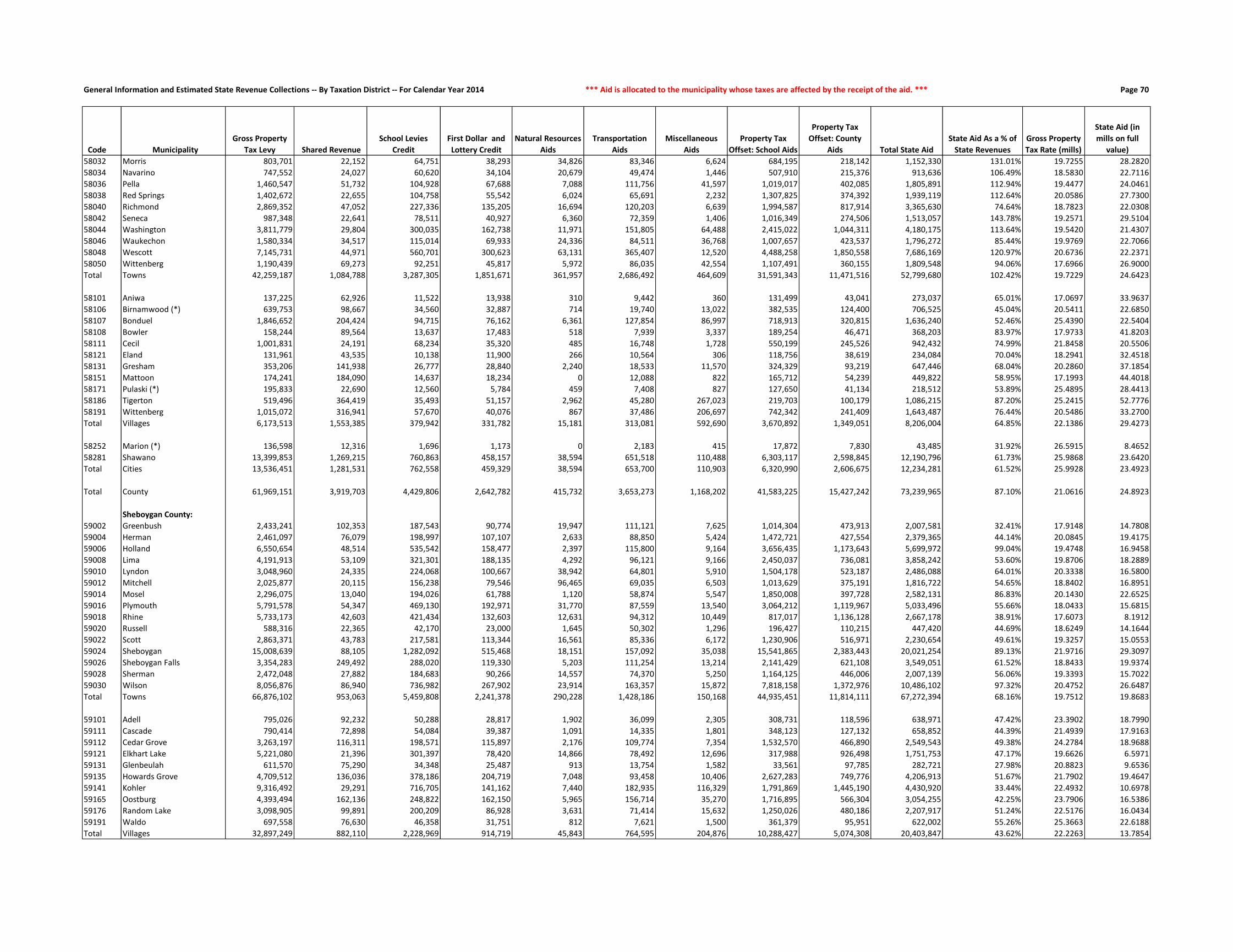
General Information and Estimated State Revenue Collections -- By Taxation District -- For Calendar Year 2014 *** Aid is allocated to the municipality whose taxes are affected by the receipt of the aid. *** Page 70
Code Municipality
Gross Property
Tax Levy Shared Revenue
School Levies
Credit
First Dollar and
Lottery Credit
Natural Resources
Aids
Transportation
Aids
Miscellaneous
Aids
Property Tax
Offset: School Aids
Property Tax
Offset: County
Aids Total State Aid
State Aid As a % of
State Revenues
Gross Property
Tax Rate (mills)
State Aid (in
mills on full
value)
58032 Morris 803,701 22,152 64,751 38,293 34,826 83,346 6,624 684,195 218,142 1,152,330 131.01% 19.7255 28.2820
58034 Navarino 747,552 24,027 60,620 34,104 20,679 49,474 1,446 507,910 215,376 913,636 106.49% 18.5830 22.7116
58036 Pella 1,460,547 51,732 104,928 67,688 7,088 111,756 41,597 1,019,017 402,085 1,805,891 112.94% 19.4477 24.0461
58038 Red Springs 1,402,672 22,655 104,758 55,542 6,024 65,691 2,232 1,307,825 374,392 1,939,119 112.64% 20.0586 27.7300
58040 Richmond 2,869,352 47,052 227,336 135,205 16,694 120,203 6,639 1,994,587 817,914 3,365,630 74.64% 18.7823 22.0308
58042 Seneca 987,348 22,641 78,511 40,927 6,360 72,359 1,406 1,016,349 274,506 1,513,057 143.78% 19.2571 29.5104
58044 Washington 3,811,779 29,804 300,035 162,738 11,971 151,805 64,488 2,415,022 1,044,311 4,180,175 113.64% 19.5420 21.4307
58046 Waukechon 1,580,334 34,517 115,014 69,933 24,336 84,511 36,768 1,007,657 423,537 1,796,272 85.44% 19.9769 22.7066
58048 Wescott 7,145,731 44,971 560,701 300,623 63,131 365,407 12,520 4,488,258 1,850,558 7,686,169 120.97% 20.6736 22.2371
58050 Wittenberg 1,190,439 69,273 92,251 45,817 5,972 86,035 42,554 1,107,491 360,155 1,809,548 94.06% 17.6966 26.9000
Total Towns 42,259,187 1,084,788 3,287,305 1,851,671 361,957 2,686,492 464,609 31,591,343 11,471,516 52,799,680 102.42% 19.7229 24.6423
58101 Aniwa 137,225 62,926 11,522 13,938 310 9,442 360 131,499 43,041 273,037 65.01% 17.0697 33.9637
58106 Birnamwood (*) 639,753 98,667 34,560 32,887 714 19,740 13,022 382,535 124,400 706,525 45.04% 20.5411 22.6850
58107 Bonduel 1,846,652 204,424 94,715 76,162 6,361 127,854 86,997 718,913 320,815 1,636,240 52.46% 25.4390 22.5404
58108 Bowler 158,244 89,564 13,637 17,483 518 7,939 3,337 189,254 46,471 368,203 83.97% 17.9733 41.8203
58111 Cecil 1,001,831 24,191 68,234 35,320 485 16,748 1,728 550,199 245,526 942,432 74.99% 21.8458 20.5506
58121 Eland 131,961 43,535 10,138 11,900 266 10,564 306 118,756 38,619 234,084 70.04% 18.2941 32.4518
58131 Gresham 353,206 141,938 26,777 28,840 2,240 18,533 11,570 324,329 93,219 647,446 68.04% 20.2860 37.1854
58151 Mattoon 174,241 184,090 14,637 18,234 0 12,088 822 165,712 54,239 449,822 58.95% 17.1993 44.4018
58171 Pulaski (*) 195,833 22,690 12,560 5,784 459 7,408 827 127,650 41,134 218,512 53.89% 25.4895 28.4413
58186 Tigerton 519,496 364,419 35,493 51,157 2,962 45,280 267,023 219,703 100,179 1,086,215 87.20% 25.2415 52.7776
58191 Wittenberg 1,015,072 316,941 57,670 40,076 867 37,486 206,697 742,342 241,409 1,643,487 76.44% 20.5486 33.2700
Total Villages 6,173,513 1,553,385 379,942 331,782 15,181 313,081 592,690 3,670,892 1,349,051 8,206,004 64.85% 22.1386 29.4273
58252 Marion (*) 136,598 12,316 1,696 1,173 0 2,183 415 17,872 7,830 43,485 31.92% 26.5915 8.4652
58281 Shawano 13,399,853 1,269,215 760,863 458,157 38,594 651,518 110,488 6,303,117 2,598,845 12,190,796 61.73% 25.9868 23.6420
Total Cities 13,536,451 1,281,531 762,558 459,329 38,594 653,700 110,903 6,320,990 2,606,675 12,234,281 61.52% 25.9928 23.4923
Total County 61,969,151 3,919,703 4,429,806 2,642,782 415,732 3,653,273 1,168,202 41,583,225 15,427,242 73,239,965 87.10% 21.0616 24.8923
Sheboygan County:
59002 Greenbush 2,433,241 102,353 187,543 90,774 19,947 111,121 7,625 1,014,304 473,913 2,007,581 32.41% 17.9148 14.7808
59004 Herman 2,461,097 76,079 198,997 107,107 2,633 88,850 5,424 1,472,721 427,554 2,379,365 44.14% 20.0845 19.4175
59006 Holland 6,550,654 48,514 535,542 158,477 2,397 115,800 9,164 3,656,435 1,173,643 5,699,972 99.04% 19.4748 16.9458
59008 Lima 4,191,913 53,109 321,301 188,135 4,292 96,121 9,166 2,450,037 736,081 3,858,242 53.60% 19.8706 18.2889
59010 Lyndon 3,048,960 24,335 224,068 100,667 38,942 64,801 5,910 1,504,178 523,187 2,486,088 64.01% 20.3338 16.5800
59012 Mitchell 2,025,877 20,115 156,238 79,546 96,465 69,035 6,503 1,013,629 375,191 1,816,722 54.65% 18.8402 16.8951
59014 Mosel 2,296,075 13,040 194,026 61,788 1,120 58,874 5,547 1,850,008 397,728 2,582,131 86.83% 20.1430 22.6525
59016 Plymouth 5,791,578 54,347 469,130 192,971 31,770 87,559 13,540 3,064,212 1,119,967 5,033,496 55.66% 18.0433 15.6815
59018 Rhine 5,733,173 42,603 421,434 132,603 12,631 94,312 10,449 817,017 1,136,128 2,667,178 38.91% 17.6073 8.1912
59020 Russell 588,316 22,365 42,170 23,000 1,645 50,302 1,296 196,427 110,215 447,420 44.69% 18.6249 14.1644
59022 Scott 2,863,371 43,783 217,581 113,344 16,561 85,336 6,172 1,230,906 516,971 2,230,654 49.61% 19.3257 15.0553
59024 Sheboygan 15,008,639 88,105 1,282,092 515,468 18,151 157,092 35,038 15,541,865 2,383,443 20,021,254 89.13% 21.9716 29.3097
59026 Sheboygan Falls 3,354,283 249,492 288,020 119,330 5,203 111,254 13,214 2,141,429 621,108 3,549,051 61.52% 18.8433 19.9374
59028 Sherman 2,472,048 27,882 184,683 90,266 14,557 74,370 5,250 1,164,125 446,006 2,007,139 56.06% 19.3393 15.7022
59030 Wilson 8,056,876 86,940 736,982 267,902 23,914 163,357 15,872 7,818,158 1,372,976 10,486,102 97.32% 20.4752 26.6487
Total Towns 66,876,102 953,063 5,459,808 2,241,378 290,228 1,428,186 150,168 44,935,451 11,814,111 67,272,394 68.16% 19.7512 19.8683
59101 Adell 795,026 92,232 50,288 28,817 1,902 36,099 2,305 308,731 118,596 638,971 47.42% 23.3902 18.7990
59111 Cascade 790,414 72,898 54,084 39,387 1,091 14,335 1,801 348,123 127,132 658,852 44.39% 21.4939 17.9163
59112 Cedar Grove 3,263,197 116,311 198,571 115,897 2,176 109,774 7,354 1,532,570 466,890 2,549,543 49.38% 24.2784 18.9688
59121 Elkhart Lake 5,221,080 21,396 301,397 78,420 14,866 78,492 12,696 317,988 926,498 1,751,753 47.17% 19.6626 6.5971
59131 Glenbeulah 611,570 75,290 34,348 25,487 913 13,754 1,582 33,561 97,785 282,721 27.98% 20.8823 9.6536
59135 Howards Grove 4,709,512 136,036 378,186 204,719 7,048 93,458 10,406 2,627,283 749,776 4,206,913 51.67% 21.7902 19.4647
59141 Kohler 9,316,492 29,291 716,705 141,162 7,440 182,935 116,329 1,791,869 1,445,190 4,430,920 33.44% 22.4932 10.6978
59165 Oostburg 4,393,494 162,136 248,822 162,150 5,965 156,714 35,270 1,716,895 566,304 3,054,255 42.25% 23.7906 16.5386
59176 Random Lake 3,098,905 99,891 200,209 86,928 3,631 71,414 15,632 1,250,026 480,186 2,207,917 51.24% 22.5176 16.0434
59191 Waldo 697,558 76,630 46,358 31,751 812 7,621 1,500 361,379 95,951 622,002 55.26% 25.3663 22.6188
Total Villages 32,897,249 882,110 2,228,969 914,719 45,843 764,595 204,876 10,288,427 5,074,308 20,403,847 43.62% 22.2263 13.7854

General Information and Estimated State Revenue Collections -- By Taxation District -- For Calendar Year 2014 *** Revenue is allocated to where the taxpayer lives, which may differ from where the tax was collected. *** Page 71
Code Municipality
2014 DOA Final
Population
2014 Full Value
Per Capita
2014 WAGI per
Tax Return
Individual Income
Taxes
Corporate
Franchise &
Income Taxes Sales & Use Taxes Excise Taxes Utility Taxes
Lottery Net
Operating Income
Transportation Fund
Revenues
Conservation Fund
Revenues
Other
Revenues
Total State
Revenues
59271 Plymouth 8,428 80,383 51,878 9,017,064 3,569,925 8,357,785 1,027,341 724,968 236,757 2,504,839 262,770 430,193 26,131,642
59281 Sheboygan 48,897 50,619 41,327 41,674,139 8,695,926 36,151,190 5,960,358 2,979,993 1,373,603 14,532,408 1,297,906 1,972,557 114,638,081
59282 Sheboygan Falls 7,861 73,509 50,132 8,127,308 2,429,214 6,557,459 958,226 526,867 220,829 2,336,324 237,049 381,822 21,775,099
Total Cities 65,186 57,227 43,726 58,818,511 14,695,065 51,066,434 7,945,925 4,231,828 1,831,189 19,373,571 1,797,726 2,784,573 162,544,822
Total County 115,362 74,589 50,729 125,218,997 22,889,494 92,120,725 14,062,187 7,005,031 3,240,721 34,286,103 3,547,517 5,648,128 308,018,903
Taylor County:
60002 Aurora 428 63,664 37,859 280,641 20,189 207,229 52,172 14,391 12,023 127,204 18,625 18,685 751,159
60004 Browning 916 59,961 44,116 699,887 42,655 468,600 111,657 30,512 25,732 272,239 30,355 38,844 1,720,481
60006 Chelsea 813 73,008 44,215 622,579 42,778 432,027 99,102 29,100 22,839 241,627 29,274 38,061 1,557,387
60008 Cleveland 264 75,650 44,001 201,188 12,701 136,329 32,180 8,976 7,416 78,462 12,636 12,595 502,482
60010 Deer Creek 766 56,200 43,076 571,473 36,984 391,937 93,373 26,013 21,518 227,659 21,217 31,509 1,421,682
60012 Ford 269 78,550 41,924 195,319 12,838 135,925 32,790 9,105 7,557 79,948 13,196 13,097 499,775
60014 Goodrich 511 69,796 42,215 373,610 26,667 262,612 62,289 17,770 14,355 151,871 34,472 23,368 967,015
60016 Greenwood 641 80,455 38,812 430,878 30,236 313,269 78,135 21,553 18,007 190,508 36,504 31,622 1,150,712
60018 Grover 256 130,896 50,854 225,476 13,127 143,097 31,205 9,029 7,192 76,084 20,469 16,993 542,673
60020 Hammel 712 92,198 57,860 713,492 36,932 423,088 86,790 25,280 20,001 211,610 31,786 37,950 1,586,928
60022 Holway 965 40,535 38,469 642,945 42,909 461,894 117,630 31,402 27,109 286,802 32,375 34,586 1,677,652
60024 Jump River 369 59,208 38,485 245,953 54,838 209,781 44,979 16,258 10,366 109,668 16,364 15,554 723,761
60026 Little Black 1,147 64,205 45,374 901,382 117,505 773,612 139,815 61,292 32,221 340,894 32,727 50,284 2,449,732
60028 Maplehurst 334 74,450 35,314 204,280 18,119 165,037 40,713 12,177 9,383 99,266 13,691 15,799 578,465
60030 Mc Kinley 459 63,518 25,849 205,489 26,804 199,291 55,950 15,862 12,894 136,417 18,292 20,016 691,015
60032 Medford 2,639 61,192 55,152 2,520,789 136,790 1,532,706 321,684 93,521 74,134 784,323 75,070 113,006 5,652,023
60034 Molitor 326 121,335 52,285 295,210 14,997 179,084 39,738 10,809 9,158 96,889 22,591 20,586 689,062
60036 Pershing 177 101,972 32,296 99,006 8,248 80,687 21,576 5,911 4,972 52,605 10,131 10,019 293,155
60038 Rib Lake 859 86,517 47,747 710,354 40,511 456,391 104,709 28,880 24,131 255,299 48,586 44,136 1,712,997
60040 Roosevelt 462 61,872 38,036 304,348 22,142 225,169 56,316 15,674 12,978 137,308 15,047 19,890 808,872
60042 Taft 425 69,157 41,091 302,460 21,649 217,324 51,806 14,931 11,939 126,312 24,014 19,343 789,779
60044 Westboro 695 89,720 45,803 551,334 34,715 368,863 84,718 24,142 19,524 206,557 44,354 36,462 1,370,669
Total Towns 14,433 70,286 45,733 11,298,093 814,334 7,783,952 1,759,327 522,587 405,449 4,289,552 601,777 662,407 28,137,478
60131 Gilman 396 43,326 44,396 304,491 70,539 278,990 48,271 22,925 11,124 117,693 9,986 14,566 878,585
60146 Lublin 118 31,281 25,530 52,176 6,851 54,205 14,384 4,482 3,315 35,070 2,745 3,860 177,088
60176 Rib Lake 898 37,261 28,775 447,541 88,855 488,327 109,463 42,052 25,226 266,890 21,775 31,191 1,521,320
60181 Stetsonville 534 41,338 38,053 351,938 59,173 297,039 65,092 22,829 15,001 158,707 13,336 19,284 1,002,400
Total Villages 1,946 39,252 35,373 1,156,146 225,418 1,118,562 237,210 92,288 54,666 578,360 47,843 68,901 3,579,393
60251 Medford 4,354 66,355 38,370 2,893,417 1,520,575 3,984,205 530,736 385,708 122,312 1,294,028 125,310 194,044 11,050,336
Total Cities 4,354 66,355 38,370 2,893,417 1,520,575 3,984,205 530,736 385,708 122,312 1,294,028 125,310 194,044 11,050,336
Total County 20,733 66,548 42,439 15,347,656 2,560,327 12,886,719 2,527,273 1,000,583 582,427 6,161,940 774,929 925,351 42,767,207
Trempealeau County:
61002 Albion 663 70,482 56,200 698,808 35,620 426,024 80,817 24,032 18,625 197,047 27,904 33,085 1,541,962
61004 Arcadia 1,837 90,481 47,565 1,638,719 245,856 1,207,320 223,924 81,572 51,605 545,965 87,866 106,140 4,188,967
61006 Burnside 509 68,305 28,918 276,057 40,054 244,065 62,045 17,898 14,299 151,277 19,440 24,964 850,099
61008 Caledonia 931 66,156 55,691 972,404 58,102 588,405 113,486 32,830 26,153 276,697 27,282 44,872 2,140,232
61010 Chimney Rock 236 100,129 42,490 188,064 10,725 127,078 28,767 7,755 6,630 70,140 19,418 14,533 473,110
61012 Dodge 390 84,858 40,592 296,901 25,175 221,517 47,539 14,831 10,956 115,910 16,927 21,670 771,426
61014 Ettrick 1,242 79,778 44,172 1,028,914 58,632 688,155 151,395 41,780 34,890 369,128 66,910 66,526 2,506,330
61016 Gale 1,725 81,808 51,432 1,663,919 105,929 1,076,065 210,271 64,354 48,458 512,678 70,831 93,776 3,846,282
61018 Hale 1,048 74,527 41,973 824,966 51,535 573,996 127,747 36,074 29,440 311,470 47,609 53,967 2,056,804
61020 Lincoln 856 49,178 44,312 711,384 38,651 469,476 104,343 28,091 24,047 254,407 24,944 35,533 1,690,877
61022 Pigeon 901 62,126 42,525 718,592 54,209 495,609 109,829 30,924 25,311 267,781 37,588 41,996 1,781,840
61024 Preston 970 72,739 43,352 788,665 116,825 567,917 118,239 37,117 27,249 288,288 46,245 49,267 2,039,812
61026 Sumner 820 67,568 47,135 724,886 69,861 491,477 99,955 30,582 23,035 243,708 30,228 39,978 1,753,710
61028 Trempealeau 1,792 78,287 46,144 1,550,825 149,035 1,084,122 218,438 69,415 50,340 532,590 59,413 94,933 3,809,112
61030 Unity 500 78,085 48,800 457,614 28,517 292,368 60,948 17,104 14,046 148,602 25,086 26,448 1,070,734
Total Towns 14,420 75,430 46,143 12,540,718 1,088,726 8,553,595 1,757,743 534,359 405,084 4,285,689 607,694 747,689 30,521,296

General Information and Estimated State Revenue Collections -- By Taxation District -- For Calendar Year 2014 *** Aid is allocated to the municipality whose taxes are affected by the receipt of the aid. *** Page 72
Code Municipality
Gross Property
Tax Levy Shared Revenue
School Levies
Credit
First Dollar and
Lottery Credit
Natural Resources
Aids
Transportation
Aids
Miscellaneous
Aids
Property Tax
Offset: School Aids
Property Tax
Offset: County
Aids Total State Aid
State Aid As a % of
State Revenues
Gross Property
Tax Rate (mills)
State Aid (in
mills on full
value)
59271 Plymouth 15,652,656 730,429 836,409 418,091 22,175 354,342 222,632 5,431,113 1,983,407 9,998,599 38.26% 24.0046 15.3336
59281 Sheboygan 69,010,922 11,733,758 4,508,793 2,733,773 193,841 3,162,632 508,188 52,457,155 8,170,625 83,468,765 72.81% 28.1931 34.0996
59282 Sheboygan Falls 13,207,301 412,318 899,404 469,441 19,241 310,807 67,989 7,195,447 1,910,478 11,285,123 51.83% 23.5504 20.1229
Total Cities 97,870,879 12,876,504 6,244,605 3,621,305 235,257 3,827,782 798,808 65,083,715 12,064,510 104,752,487 64.45% 26.7358 28.6156
Total County 197,644,230 14,711,678 13,933,383 6,777,403 571,327 6,020,563 1,153,853 120,307,593 28,952,929 192,428,728 62.47% 23.1794 22.5678
Taylor County:
60002 Aurora 623,351 46,947 44,114 31,729 2,493 85,484 28,684 280,615 165,255 685,321 91.24% 23.6163 25.9641
60004 Browning 1,068,667 39,531 63,985 42,197 683 90,586 2,120 970,315 334,781 1,544,199 89.75% 19.9856 28.8787
60006 Chelsea 1,137,952 26,578 74,269 45,628 1,528 113,536 2,103 1,056,535 364,529 1,684,705 108.18% 19.5446 28.9352
60008 Cleveland 473,814 21,690 34,486 26,346 10,551 67,022 683 214,064 126,063 500,904 99.69% 23.5318 24.8773
60010 Deer Creek 889,821 65,070 54,164 33,608 241 115,990 1,692 766,024 264,296 1,301,086 91.52% 21.0789 30.8213
60012 Ford 479,258 24,131 33,863 23,874 4,858 74,921 13,323 218,617 128,744 522,332 104.51% 23.3065 25.4012
60014 Goodrich 715,588 30,669 43,456 27,543 2,626 80,382 1,116 635,965 219,415 1,041,172 107.67% 20.4189 29.7092
60016 Greenwood 1,081,098 33,958 82,913 48,620 8,234 116,795 1,439 601,679 311,386 1,205,025 104.72% 21.7370 24.2288
60018 Grover 788,460 10,884 57,050 28,900 8,616 158,584 1,043 414,221 218,089 897,388 165.36% 22.6350 25.7621
60020 Hammel 1,328,302 14,965 82,115 45,175 1,680 78,096 2,267 1,147,609 395,951 1,767,858 111.40% 21.0034 27.9538
60022 Holway 804,794 64,124 48,213 36,141 675 104,029 1,313 686,663 236,914 1,178,074 70.22% 21.2681 31.1326
60024 Jump River 528,468 35,794 36,285 29,151 1,217 61,753 662 234,022 137,816 536,699 74.15% 24.0078 24.3818
60026 Little Black 1,386,725 54,998 88,041 59,513 44 121,283 2,503 1,213,298 418,616 1,958,296 79.94% 20.7400 29.2885
60028 Maplehurst 507,841 26,877 35,498 18,602 20,005 61,478 2,734 471,850 158,736 795,780 137.57% 20.0302 31.3871
60030 Mc Kinley 681,747 36,365 51,397 34,472 1,732 98,081 1 378,641 179,391 780,079 112.89% 23.7934 27.2252
60032 Medford 3,202,337 66,261 190,768 126,484 2,844 121,812 6,974 2,854,739 984,950 4,354,833 77.05% 20.3558 27.6817
60034 Molitor 830,316 9,284 49,280 24,155 3,665 63,870 1,225 705,829 243,527 1,100,836 159.76% 21.3467 28.3015
60036 Pershing 443,368 23,566 30,998 17,107 35,972 66,701 25,805 187,562 110,456 498,166 169.93% 25.1311 28.2372
60038 Rib Lake 1,601,567 31,856 112,923 59,599 23,804 171,134 2,409 857,596 443,831 1,703,153 99.43% 22.5924 24.0254
60040 Roosevelt 662,898 29,220 47,359 36,554 7,754 117,261 36,383 315,631 178,482 768,643 95.03% 23.2535 26.9628
60042 Taft 617,790 32,871 43,188 21,878 1,388 63,964 966 521,603 182,461 868,320 109.94% 21.1986 29.7951
60044 Westboro 1,428,626 50,651 95,660 54,453 12,230 186,381 1,638 757,600 392,080 1,550,692 113.13% 22.8128 24.7620
Total Towns 21,282,788 776,291 1,400,026 871,731 152,840 2,219,144 137,082 15,490,680 6,195,768 27,243,560 96.82% 21.5064 27.5298
60131 Gilman 540,537 144,652 23,332 31,632 2,635 22,969 2,192 154,985 91,271 473,668 53.91% 32.3077 28.3109
60146 Lublin 88,185 51,080 6,172 12,483 0 7,494 4,548 38,542 22,698 143,017 80.76% 24.3248 39.4497
60176 Rib Lake 867,749 306,456 46,995 44,353 0 56,738 2,075 385,383 199,447 1,041,448 68.46% 26.4472 31.7412
60181 Stetsonville 444,781 116,864 26,811 26,001 0 13,942 1,048 395,445 136,438 716,549 71.48% 20.4102 32.8811
Total Villages 1,941,252 619,052 103,310 114,470 2,635 101,144 9,863 974,355 449,853 2,374,681 66.34% 25.8976 31.6798
60251 Medford 6,980,880 1,084,081 290,088 184,800 3,541 374,295 94,269 4,180,176 1,442,256 7,653,506 69.26% 25.3529 27.7957
Total Cities 6,980,880 1,084,081 290,088 184,800 3,541 374,295 94,269 4,180,176 1,442,256 7,653,506 69.26% 25.3529 27.7957
Total County 30,204,919 2,479,425 1,793,423 1,171,000 159,015 2,694,582 241,214 20,645,212 8,087,876 37,271,747 87.15% 22.5425 27.8166
Trempealeau County:
61002 Albion 1,024,371 65,737 77,128 53,427 3,483 63,235 1,937 959,484 209,146 1,433,577 92.97% 22.5131 31.5064
61004 Arcadia 3,591,477 85,969 270,421 134,364 37,465 265,718 6,023 3,962,346 710,276 5,472,583 130.64% 23.2420 35.4155
61006 Burnside 866,622 57,507 69,533 47,380 547 60,165 1,318 696,740 154,232 1,087,422 127.92% 25.8276 32.4080
61008 Caledonia 1,231,836 30,764 103,226 59,115 5,296 56,270 16,341 990,843 275,494 1,537,348 71.83% 20.5527 25.6501
61010 Chimney Rock 566,724 25,580 42,426 29,240 19,174 165,690 701 475,626 107,523 865,959 183.04% 24.2270 37.0190
61012 Dodge 677,249 46,834 56,330 32,796 34,039 51,926 1,266 806,624 145,378 1,175,192 152.34% 21.4131 37.1569
61014 Ettrick 2,200,762 65,938 162,151 96,085 4,044 184,666 3,346 1,454,085 461,808 2,432,124 97.04% 21.9049 24.2077
61016 Gale 2,930,239 112,355 217,065 114,065 13,082 161,125 63,893 2,264,118 629,507 3,575,210 92.95% 21.3959 26.1054
61018 Hale 1,666,114 68,026 118,563 76,472 5,545 159,558 3,961 1,569,717 345,213 2,347,055 114.11% 22.1843 31.2511
61020 Lincoln 890,821 102,014 65,482 46,451 8,817 75,471 1,624 870,316 187,942 1,358,117 80.32% 21.7869 33.2156
61022 Pigeon 1,099,890 73,757 76,461 52,058 5,850 88,850 2,177 1,169,037 252,943 1,721,134 96.59% 19.9873 31.2766
61024 Preston 1,521,900 92,099 105,107 62,415 29,878 151,895 2,478 925,359 319,251 1,688,482 82.78% 21.9120 24.3104
61026 Sumner 1,210,461 54,391 97,104 59,603 7,891 66,389 2,357 1,109,595 262,261 1,659,592 94.63% 21.2151 29.0868
61028 Trempealeau 3,018,725 57,067 219,726 127,370 14,825 139,367 93,067 2,228,927 611,778 3,492,128 91.68% 22.6808 26.2376
61030 Unity 909,240 41,035 68,751 46,163 5,777 94,585 1,427 817,538 178,967 1,254,243 117.14% 23.3526 32.2135
Total Towns 23,406,430 979,073 1,749,475 1,037,005 195,713 1,784,910 201,915 20,300,356 4,851,720 31,100,166 101.90% 22.1752 29.4643

General Information and Estimated State Revenue Collections -- By Taxation District -- For Calendar Year 2014 *** Revenue is allocated to where the taxpayer lives, which may differ from where the tax was collected. *** Page 73
Code Municipality
2014 DOA Final
Population
2014 Full Value
Per Capita
2014 WAGI per
Tax Return
Individual Income
Taxes
Corporate
Franchise &
Income Taxes Sales & Use Taxes Excise Taxes Utility Taxes
Lottery Net
Operating Income
Transportation Fund
Revenues
Conservation Fund
Revenues
Other
Revenues
Total State
Revenues
61121 Eleva 677 42,697 41,011 520,718 50,497 401,591 82,524 27,727 19,018 201,207 16,852 26,375 1,346,508
61122 Ettrick 521 42,621 44,311 432,974 44,736 331,676 63,508 22,990 14,636 154,844 12,878 20,282 1,098,523
61173 Pigeon Falls 413 41,248 45,130 349,566 32,452 258,880 50,343 17,460 11,602 122,745 10,345 15,854 869,248
61181 Strum 1,124 42,468 41,753 880,164 88,621 682,083 137,012 47,395 31,575 334,058 27,964 43,687 2,272,559
61186 Trempealeau 1,612 64,639 45,413 1,372,936 196,288 1,076,297 196,497 76,265 45,284 479,094 45,731 76,732 3,565,125
Total Villages 4,347 50,628 43,552 3,556,358 412,594 2,750,528 529,884 191,837 122,115 1,291,948 113,768 182,930 9,151,962
61201 Arcadia 2,929 55,084 77,206 4,241,128 1,135,203 3,126,017 357,034 221,014 82,281 870,512 78,718 128,399 10,240,306
61206 Blair 1,378 60,637 40,440 1,045,136 842,550 1,320,758 167,973 121,578 38,711 409,548 38,852 63,421 4,048,528
61231 Galesville 1,507 54,947 42,805 1,209,815 240,632 1,064,782 183,698 81,670 42,334 447,887 41,008 65,981 3,377,807
61241 Independence 1,352 51,025 38,453 975,032 160,744 961,427 164,803 78,338 37,980 401,820 35,753 57,106 2,873,004
61265 Osseo 1,697 64,861 39,951 1,271,521 486,306 1,444,429 206,858 126,968 47,672 504,356 48,802 80,926 4,217,838
61291 Whitehall 1,554 55,237 41,166 1,199,770 375,237 1,193,255 189,427 98,290 43,655 461,856 41,592 68,216 3,671,298
Total Cities 10,417 56,888 51,662 9,942,402 3,240,672 9,110,669 1,269,793 727,859 292,633 3,095,979 284,725 464,049 28,428,781
Total County 29,184 65,117 48,106 26,039,478 4,741,992 20,414,792 3,557,420 1,454,055 819,832 8,673,616 1,006,188 1,394,667 68,102,040
Vernon County:
62002 Bergen 1,368 81,699 60,699 1,370,170 73,522 837,834 166,754 48,862 38,429 406,576 48,819 71,970 3,062,937
62004 Christiana 938 65,840 41,688 645,235 62,241 527,113 114,339 38,451 26,350 278,778 33,309 43,800 1,769,616
62006 Clinton 1,373 35,825 36,370 823,983 85,247 667,495 167,363 47,446 38,570 408,062 36,350 48,744 2,323,259
62008 Coon 742 78,475 46,283 566,678 39,990 397,883 90,447 25,860 20,844 220,526 33,150 38,144 1,433,522
62010 Forest 639 52,434 37,159 391,806 30,558 309,740 77,891 21,653 17,951 189,914 22,050 26,643 1,088,206
62012 Franklin 1,172 65,226 39,184 757,792 63,138 578,545 142,862 39,586 32,924 348,324 36,733 54,459 2,054,361
62014 Genoa 798 67,343 44,162 581,519 42,370 426,207 97,273 28,639 22,417 237,169 35,640 37,710 1,508,944
62016 Greenwood 841 42,971 32,762 454,643 42,949 393,790 102,515 29,005 23,625 249,949 33,137 32,098 1,361,711
62018 Hamburg 973 72,876 56,476 906,754 47,492 562,774 118,605 33,042 27,333 289,180 40,544 47,988 2,073,712
62020 Harmony 775 72,421 48,942 625,881 40,353 422,906 94,470 26,676 21,771 230,333 41,555 38,091 1,542,036
62022 Hillsboro 812 67,224 34,819 466,537 57,748 443,461 98,980 35,085 22,811 241,330 28,808 38,336 1,433,096
62024 Jefferson 1,138 68,411 43,729 821,146 54,600 588,205 138,718 38,633 31,969 338,219 42,843 54,231 2,108,563
62026 Kickapoo 642 70,225 34,875 369,455 31,155 305,543 78,258 21,935 18,035 190,805 30,444 31,028 1,076,659
62028 Liberty 262 113,208 47,167 203,913 12,030 138,074 31,936 8,678 7,360 77,868 18,830 16,863 515,551
62030 Stark 368 77,455 35,160 213,506 18,392 173,465 44,858 12,294 10,338 109,371 26,496 18,778 627,498
62032 Sterling 627 72,040 37,886 391,977 27,617 298,736 76,429 20,298 17,614 186,347 31,050 30,728 1,080,797
62034 Union 714 51,054 39,738 468,182 38,065 364,569 87,034 25,425 20,058 212,204 28,735 29,403 1,273,676
62036 Viroqua 1,744 78,727 42,901 1,234,599 108,670 955,058 212,587 66,976 48,992 518,325 60,684 89,819 3,295,709
62038 Webster 807 70,794 34,104 454,141 50,880 382,174 98,370 27,715 22,670 239,844 35,355 39,174 1,350,322
62040 Wheatland 577 98,516 43,960 418,548 36,791 326,108 70,334 23,081 16,209 171,487 28,501 33,975 1,125,033
62042 Whitestown 513 50,670 38,860 328,952 25,015 254,377 62,533 17,576 14,411 152,466 19,717 21,052 896,099
Total Towns 17,823 67,462 43,014 12,495,416 988,823 9,354,056 2,172,556 636,915 500,681 5,297,075 712,752 843,033 33,001,307
62111 Chaseburg 287 54,375 53,150 251,706 67,324 201,135 34,984 14,844 8,062 85,298 7,811 12,174 683,338
62112 Coon Valley 764 52,226 63,627 802,125 133,177 596,721 93,129 42,429 21,462 227,064 20,235 31,796 1,968,139
62116 De Soto (*) 185 73,751 38,189 116,579 14,109 107,009 22,550 8,375 5,197 54,983 6,183 9,184 344,169
62131 Genoa 252 50,115 35,109 145,993 17,980 138,159 30,718 10,912 7,079 74,896 6,687 10,289 442,713
62146 La Farge 703 50,676 30,085 348,993 96,718 513,663 85,693 49,075 19,749 208,935 18,073 28,851 1,369,750
62165 Ontario 554 26,797 33,059 302,208 37,584 284,173 67,531 22,182 15,563 164,651 12,706 17,802 924,400
62176 Readstown 420 32,960 26,124 181,047 33,539 215,857 51,196 18,671 11,798 124,826 10,100 14,462 661,496
62181 Stoddard 786 56,456 46,042 597,149 59,588 466,194 95,810 33,247 22,080 233,603 21,784 33,952 1,563,405
62186 Viola (*) 224 27,228 29,798 110,139 18,840 108,706 27,305 8,626 6,293 66,574 5,067 7,234 358,784
Total Villages 4,175 47,082 41,515 2,855,938 478,859 2,631,617 508,916 208,361 117,283 1,240,829 108,646 165,745 8,316,194
62236 Hillsboro 1,408 43,616 34,919 811,275 244,358 912,584 171,629 79,176 39,553 418,464 35,664 54,077 2,766,780
62286 Viroqua 4,343 54,315 38,083 2,729,197 649,404 3,141,873 529,395 277,671 122,003 1,290,759 117,571 184,130 9,042,003
62291 Westby 2,228 52,428 40,135 1,475,512 327,768 1,564,084 271,585 133,500 62,589 662,172 59,523 92,893 4,649,626
Total Cities 7,979 51,900 38,145 5,015,985 1,221,530 5,618,541 972,609 490,347 224,145 2,371,395 212,758 331,100 16,458,410
Total County 29,977 60,482 41,018 20,367,339 2,689,212 17,604,214 3,654,081 1,335,623 842,109 8,909,299 1,034,155 1,339,879 57,775,911

General Information and Estimated State Revenue Collections -- By Taxation District -- For Calendar Year 2014 *** Aid is allocated to the municipality whose taxes are affected by the receipt of the aid. *** Page 74
Code Municipality
Gross Property
Tax Levy Shared Revenue
School Levies
Credit
First Dollar and
Lottery Credit
Natural Resources
Aids
Transportation
Aids
Miscellaneous
Aids
Property Tax
Offset: School Aids
Property Tax
Offset: County
Aids Total State Aid
State Aid As a % of
State Revenues
Gross Property
Tax Rate (mills)
State Aid (in
mills on full
value)
61121 Eleva 670,813 164,328 45,516 48,764 1,817 24,984 344,384 575,666 125,483 1,330,942 98.84% 24.5724 48.7533
61122 Ettrick 501,378 125,806 36,847 31,723 3,192 14,141 1,366 338,476 94,110 645,662 58.78% 24.4883 31.5354
61173 Pigeon Falls 390,287 89,607 24,608 20,219 509 6,838 1,283 366,869 78,294 588,226 67.67% 22.9132 34.5339
61181 Strum 1,281,011 284,940 79,150 76,619 10,429 35,955 3,114 953,976 207,946 1,652,129 72.70% 28.3160 36.5193
61186 Trempealeau 2,376,161 231,506 155,389 107,324 8,534 59,266 6,892 1,592,331 442,732 2,603,974 73.04% 24.2373 26.5611
Total Villages 5,219,649 896,188 341,511 284,648 24,481 141,184 357,039 3,827,318 948,564 6,820,933 74.53% 25.0843 32.7797
61201 Arcadia 3,784,777 707,003 229,162 135,437 7,245 350,058 62,068 3,313,828 578,875 5,383,675 52.57% 24.8423 35.3371
61206 Blair 2,015,683 624,399 59,788 72,532 2,525 59,619 4,327 853,141 324,652 2,000,984 49.42% 24.4651 24.2867
61231 Galesville 2,148,637 360,134 125,407 88,334 5,996 61,902 22,316 1,275,573 354,660 2,294,321 67.92% 26.4051 28.1954
61241 Independence 2,041,822 303,675 120,347 101,389 13,373 58,587 5,528 1,218,288 269,683 2,090,870 72.78% 30.5235 31.2567
61265 Osseo 2,922,914 247,948 165,035 103,131 9,924 137,491 18,473 1,804,423 426,489 2,912,914 69.06% 27.2936 27.2003
61291 Whitehall 2,079,783 454,047 99,838 80,734 6,620 73,191 17,721 1,540,710 328,804 2,601,666 70.87% 26.0581 32.5969
Total Cities 14,993,616 2,697,206 799,576 581,557 45,683 740,849 130,432 10,005,963 2,283,163 17,284,429 60.80% 26.3086 30.3282
Total County 43,619,695 4,572,466 2,890,562 1,903,211 265,877 2,666,943 689,386 34,133,637 8,083,447 55,205,528 81.06% 23.7902 30.1091
Vernon County:
62002 Bergen 2,328,410 41,237 191,492 108,387 2,291 94,799 23,621 1,023,138 358,338 1,843,303 60.18% 23.1607 18.3353
62004 Christiana 1,683,359 56,481 99,089 64,189 377 116,012 4,928 1,146,181 222,432 1,709,689 96.61% 26.9752 27.3971
62006 Clinton 1,057,601 154,919 79,180 52,560 771 58,181 3,561 1,056,279 168,599 1,574,049 67.75% 22.3589 33.2772
62008 Coon 1,398,690 56,603 94,871 55,639 2,034 119,526 2,336 1,005,719 205,335 1,542,061 107.57% 24.2797 26.7685
62010 Forest 729,676 55,156 53,000 43,349 3,167 87,030 1,188 773,338 117,626 1,133,853 104.19% 22.1112 34.3589
62012 Franklin 1,695,157 52,538 133,710 71,612 11,648 139,383 4,529 1,131,807 275,774 1,821,002 88.64% 21.9099 23.5364
62014 Genoa 1,078,588 305,623 94,747 56,813 580 122,066 7,229 521,784 185,865 1,294,707 85.80% 20.6844 24.8289
62016 Greenwood 941,622 36,101 56,976 37,353 2,059 79,917 1,466 773,275 136,865 1,124,012 82.54% 24.5226 29.2726
62018 Hamburg 1,670,042 44,323 116,373 64,057 1,743 82,176 2,681 1,158,764 246,395 1,716,512 82.77% 24.1590 24.8313
62020 Harmony 1,336,070 32,154 93,333 49,356 6,836 110,656 2,050 835,166 201,396 1,330,946 86.31% 23.6462 23.5555
62022 Hillsboro 1,179,277 57,502 83,890 52,005 403 88,321 2,155 1,103,440 190,284 1,577,999 110.11% 22.0901 29.5590
62024 Jefferson 1,849,843 38,314 130,518 78,391 796 226,639 5,880 1,130,692 278,566 1,889,795 89.62% 23.6696 24.1808
62026 Kickapoo 1,089,324 29,361 68,320 44,761 2,041 110,994 1,367 932,822 168,967 1,358,635 126.19% 22.9794 28.6606
62028 Liberty 586,109 11,950 47,676 24,801 3,430 39,673 845 498,787 97,411 724,572 140.54% 21.4463 26.5128
62030 Stark 687,069 23,106 60,482 36,196 22,704 80,171 4,156 582,813 100,020 909,648 144.96% 24.4849 32.4168
62032 Sterling 1,046,623 35,827 74,646 44,135 3,905 130,661 9,820 532,713 161,910 993,617 91.93% 23.0410 21.8741
62034 Union 843,281 36,921 57,611 40,300 708 83,452 1,351 730,358 129,578 1,080,280 84.82% 23.1966 29.7158
62036 Viroqua 3,011,729 85,689 216,197 121,080 5,893 162,162 5,772 2,078,380 487,966 3,163,140 95.98% 21.9994 23.1054
62038 Webster 1,301,289 44,835 104,688 59,831 1,776 107,311 1,889 1,045,078 192,913 1,558,320 115.40% 24.0434 28.7925
62040 Wheatland 1,394,385 18,522 104,629 59,850 14,467 86,649 5,497 556,499 204,375 1,050,488 93.37% 24.3186 18.3209
62042 Whitestown 670,652 56,958 53,145 36,957 12,554 105,088 2,026 837,981 97,878 1,202,587 134.20% 24.4228 43.7940
Total Towns 27,578,796 1,274,121 2,014,572 1,201,623 100,185 2,230,865 94,345 19,455,013 4,228,493 30,599,215 92.72% 23.2474 25.7934
62111 Chaseburg 304,874 97,182 26,275 18,111 338 8,978 1,899 271,507 55,253 479,542 70.18% 19.6674 30.9352
62112 Coon Valley 959,634 236,857 64,591 49,034 2 48,950 2,774 619,746 126,122 1,148,076 58.33% 25.3050 30.2741
62116 De Soto (*) 314,258 82,626 26,451 20,695 64,099 12,661 8,057 129,988 47,738 392,315 113.99% 23.0572 28.7843
62131 Genoa 256,098 121,483 22,280 20,620 0 8,328 3,496 122,335 44,928 343,469 77.58% 20.3178 27.2495
62146 La Farge 819,026 244,672 53,864 55,260 0 32,510 23,197 581,955 99,494 1,090,952 79.65% 25.8115 34.3813
62165 Ontario 383,582 168,402 23,177 30,027 1 20,185 5,265 505,451 49,532 802,040 86.76% 24.2723 50.7514
62176 Readstown 332,756 206,317 21,890 28,817 16 25,685 6,721 283,535 51,105 624,085 94.34% 23.2083 43.5273
62181 Stoddard 1,067,138 167,533 78,180 55,022 0 29,610 2,891 434,515 159,576 927,328 59.31% 23.8362 20.7133
62186 Viola (*) 129,949 77,848 9,271 15,081 0 10,693 1,171 118,436 21,347 253,848 70.75% 21.5293 42.0564
Total Villages 4,567,313 1,402,919 325,980 292,666 64,456 197,601 55,472 3,067,468 655,095 6,061,656 72.89% 23.7465 31.5160
62236 Hillsboro 1,704,872 485,150 70,270 81,307 61 71,486 482,005 908,500 160,800 2,259,578 81.67% 28.2218 37.4042
62286 Viroqua 6,259,570 1,053,708 379,558 254,305 3,950 395,868 21,563 2,999,162 766,704 5,874,818 64.97% 27.1077 25.4415
62291 Westby 2,760,233 547,018 167,074 127,285 0 102,872 8,826 1,867,170 379,979 3,200,224 68.83% 24.2561 28.1227
Total Cities 10,724,675 2,085,875 616,903 462,897 4,011 570,226 512,394 5,774,832 1,307,483 11,334,621 68.87% 26.4729 27.9785
Total County 42,870,784 4,762,914 2,957,455 1,957,185 168,651 2,998,692 662,211 28,297,313 6,191,071 47,995,493 83.07% 24.0337 26.9067

General Information and Estimated State Revenue Collections -- By Taxation District -- For Calendar Year 2014 *** Revenue is allocated to where the taxpayer lives, which may differ from where the tax was collected. *** Page 75
Code Municipality
2014 DOA Final
Population
2014 Full Value
Per Capita
2014 WAGI per
Tax Return
Individual Income
Taxes
Corporate
Franchise &
Income Taxes Sales & Use Taxes Excise Taxes Utility Taxes
Lottery Net
Operating Income
Transportation Fund
Revenues
Conservation Fund
Revenues
Other
Revenues
Total State
Revenues
Vilas County:
63002 Arbor Vitae 3,324 161,945 43,506 2,900,516 507,953 2,654,595 405,183 219,702 93,377 987,908 154,532 252,272 8,176,038
63004 Boulder Junction 941 533,779 49,608 936,295 209,689 1,060,957 114,704 97,799 26,434 279,669 103,111 187,556 3,016,213
63006 Cloverland 1,029 226,968 38,536 795,344 50,328 538,463 125,431 35,315 28,906 305,823 61,874 100,304 2,041,788
63008 Conover 1,236 305,902 40,615 1,006,878 113,409 821,187 150,664 62,960 34,721 367,345 95,041 152,865 2,805,070
63010 Lac du Flambeau 3,457 251,259 31,942 2,214,785 228,592 1,821,844 421,395 136,549 97,113 1,027,436 220,828 364,851 6,533,393
63012 Land O Lakes 862 544,034 38,601 667,380 154,004 785,359 105,074 72,427 24,215 256,190 103,115 174,744 2,342,508
63014 Lincoln 2,440 209,917 39,049 1,911,049 325,641 1,873,970 297,427 159,452 68,544 725,179 126,701 224,034 5,711,997
63016 Manitowish Waters 580 925,882 51,663 600,996 151,390 715,600 70,700 67,340 16,293 172,379 95,168 191,089 2,080,955
63018 Phelps 1,231 314,006 34,699 856,724 108,317 750,288 150,054 59,230 34,581 365,859 95,164 155,558 2,575,774
63020 Plum Lake 496 557,037 39,981 397,747 80,112 437,793 60,461 39,377 13,934 147,413 58,617 102,689 1,338,143
63022 Presque Isle 630 951,693 50,061 632,571 58,084 455,118 76,794 32,536 17,698 187,239 115,099 212,960 1,788,098
63024 Saint Germain 2,075 290,616 36,504 1,519,221 249,580 1,524,411 252,935 130,486 58,290 616,699 141,626 246,102 4,739,351
63026 Washington 1,468 340,720 42,359 1,247,205 155,899 1,061,765 178,943 84,041 41,239 436,296 112,419 198,524 3,516,332
63028 Winchester 384 668,521 50,603 389,738 27,149 252,809 46,808 16,528 10,787 114,127 56,080 93,711 1,007,737
Total Towns 20,153 330,537 40,554 16,076,449 2,420,147 14,754,158 2,456,573 1,213,742 566,132 5,989,562 1,539,374 2,657,260 47,673,397
63221 Eagle River 1,370 123,143 33,515 920,923 484,491 1,810,366 166,998 192,196 38,486 407,170 51,974 86,330 4,158,935
Total Cities 1,370 123,143 33,515 920,923 484,491 1,810,366 166,998 192,196 38,486 407,170 51,974 86,330 4,158,935
Total County 21,523 317,336 39,322 16,997,372 2,904,638 16,564,524 2,623,571 1,405,938 604,618 6,396,732 1,591,348 2,743,591 51,832,332
Walworth County:
64002 Bloomfield 1,595 63,446 45,477 1,360,444 161,014 960,061 194,425 67,491 44,806 474,041 45,999 73,576 3,381,858
64004 Darien 1,695 111,601 68,287 2,170,885 567,390 1,884,474 206,614 157,443 47,616 503,762 63,223 109,050 5,710,456
64006 Delavan 5,267 165,532 46,908 4,633,811 418,846 3,363,518 642,027 242,753 147,959 1,565,376 247,344 446,260 11,707,895
64008 East Troy 4,041 176,288 68,098 5,161,176 239,103 2,736,761 492,583 150,595 113,519 1,201,003 191,861 358,817 10,645,420
64010 Geneva 5,012 159,310 60,176 5,656,718 542,939 4,007,103 610,944 291,203 140,796 1,489,589 230,304 412,864 13,382,460
64012 La Fayette 1,967 126,207 68,823 2,538,999 261,419 1,648,274 239,769 112,930 55,256 584,601 77,273 137,412 5,655,933
64014 La Grange 2,453 278,975 71,907 3,308,218 141,657 1,676,595 299,011 87,302 68,909 729,043 170,622 313,051 6,794,408
64016 Linn 2,403 663,347 102,521 4,620,558 253,071 2,363,604 292,917 130,195 67,505 714,182 310,394 655,898 9,408,325
64018 Lyons 3,697 107,408 57,770 4,005,677 463,438 3,033,557 450,650 230,567 103,855 1,098,765 127,308 231,990 9,745,806
64020 Richmond 1,886 124,710 54,143 1,915,200 107,769 1,137,918 229,896 69,521 52,981 560,528 74,221 130,686 4,278,720
64022 Sharon 898 84,863 46,208 778,246 42,296 482,809 109,463 30,168 25,226 266,890 29,389 48,696 1,813,182
64024 Spring Prairie 2,174 110,319 65,926 2,688,070 101,360 1,382,958 265,002 72,623 61,071 646,123 79,520 138,814 5,435,540
64026 Sugar Creek 3,936 89,295 55,315 4,083,416 224,686 2,384,788 479,784 143,373 110,569 1,169,797 130,550 220,032 8,946,996
64028 Troy 2,352 106,629 60,841 2,683,871 118,263 1,462,397 286,700 82,011 66,072 699,025 84,877 146,898 5,630,114
64030 Walworth 1,686 131,328 53,419 1,689,211 607,411 1,332,342 205,517 103,364 47,363 501,087 67,674 121,047 4,675,015
64032 Whitewater 1,481 204,387 47,632 1,323,076 119,816 901,816 180,528 61,922 41,604 440,160 79,026 147,239 3,295,188
Total Towns 42,543 170,988 58,986 48,617,576 4,370,478 30,758,976 5,185,830 2,033,462 1,195,107 12,643,970 2,009,586 3,692,332 110,507,318
64115 Bloomfield 4,680 73,811 43,614 3,828,255 273,912 2,613,628 570,474 177,614 131,469 1,390,917 139,509 234,225 9,360,002
64116 Darien 1,588 62,169 42,468 1,264,836 572,602 1,282,049 193,571 112,149 44,610 471,961 46,189 72,486 4,060,453
64121 East Troy 4,282 77,896 48,730 3,913,557 1,122,434 3,888,150 521,959 340,274 120,289 1,272,630 132,357 220,921 11,532,571
64126 Fontana 1,678 693,145 93,237 2,934,331 268,779 1,894,252 204,542 132,316 47,138 498,709 223,861 476,915 6,680,843
64131 Genoa City (*) 3,052 52,314 44,899 2,570,081 408,221 2,032,881 372,027 155,412 85,736 907,068 80,858 127,941 6,740,226
64153 Mukwonago (*) 117 113,316 73,350 160,958 7,319 84,648 14,262 4,655 3,287 34,773 4,232 7,603 321,736
64181 Sharon 1,593 44,775 36,792 1,099,236 217,722 965,784 194,181 77,293 44,750 473,447 40,974 62,238 3,175,624
64191 Walworth 2,821 66,752 47,071 2,490,481 872,157 2,379,709 343,869 203,894 79,247 838,414 84,023 133,656 7,425,450
64192 Williams Bay 2,577 273,568 213,476 10,317,885 252,507 3,968,620 314,126 137,611 72,392 765,896 164,344 323,609 16,316,991
Total Villages 22,388 137,500 70,280 28,579,621 3,995,653 19,109,720 2,729,011 1,341,218 628,918 6,653,814 916,347 1,659,594 65,613,895
64206 Burlington (*) 0 0 57,183 0 2,329 7,268 0 932 0 0 89 225 10,843
64216 Delavan 8,433 65,074 38,643 6,111,931 2,081,899 7,246,919 1,027,950 672,809 236,898 2,506,325 248,673 394,200 20,527,604
64221 Elkhorn 9,956 66,192 45,477 8,491,790 2,122,304 8,325,885 1,213,598 720,590 279,682 2,958,968 286,725 469,600 24,869,142
64246 Lake Geneva 7,696 151,822 58,433 8,434,373 2,168,658 8,835,010 938,113 799,929 216,194 2,287,286 327,697 612,170 24,619,430
64291 Whitewater (*) 11,821 46,584 40,764 9,037,631 1,815,745 8,662,187 1,440,935 734,872 332,073 3,513,254 306,745 469,930 26,313,372
Total Cities 37,906 77,230 46,586 32,075,725 8,190,935 33,077,268 4,620,596 2,929,132 1,064,847 11,265,833 1,169,930 1,946,125 96,340,391
Total County 102,837 129,138 55,844 109,272,922 16,557,066 82,945,964 12,535,437 6,303,813 2,888,872 30,563,617 4,095,863 7,298,050 272,461,605

General Information and Estimated State Revenue Collections -- By Taxation District -- For Calendar Year 2014 *** Aid is allocated to the municipality whose taxes are affected by the receipt of the aid. *** Page 76
Code Municipality
Gross Property
Tax Levy Shared Revenue
School Levies
Credit
First Dollar and
Lottery Credit
Natural Resources
Aids
Transportation
Aids
Miscellaneous
Aids
Property Tax
Offset: School Aids
Property Tax
Offset: County
Aids Total State Aid
State Aid As a % of
State Revenues
Gross Property
Tax Rate (mills)
State Aid (in
mills on full
value)
Vilas County:
63002 Arbor Vitae 6,680,635 49,527 691,515 224,825 36,379 436,465 16,779 931,874 627,845 3,015,209 36.88% 12.7362 5.7483
63004 Boulder Junction 4,385,289 21,316 340,105 47,966 67,942 191,567 16,967 240,926 584,675 1,511,464 50.11% 8.9775 3.0943
63006 Cloverland 2,592,727 18,856 230,686 73,772 59,287 80,404 6,201 152,026 280,026 901,258 44.14% 11.0823 3.8523
63008 Conover 4,465,118 44,328 382,971 97,971 20,267 190,170 10,277 249,949 460,397 1,456,329 51.92% 11.6084 3.7862
63010 Lac du Flambeau 11,762,495 20,567 1,249,654 198,763 8,483 300,889 44,836 1,417,007 1,045,198 4,285,397 65.59% 13.4702 4.9076
63012 Land O Lakes 5,549,272 20,135 447,711 77,497 36,572 178,336 15,893 304,701 567,858 1,648,704 70.38% 11.6969 3.4752
63014 Lincoln 5,277,639 38,909 493,390 147,933 472 136,271 14,004 310,437 571,813 1,713,230 29.99% 11.0474 3.5862
63016 Manitowish Waters 4,337,262 9,907 348,953 39,340 20,587 117,980 16,321 242,131 587,599 1,382,817 66.45% 8.8350 2.8168
63018 Phelps 5,096,832 29,163 454,593 116,162 35,717 216,357 11,831 133,591 474,834 1,472,248 57.16% 12.8479 3.7112
63020 Plum Lake 2,877,145 12,248 264,749 48,195 58,245 193,600 11,248 171,173 315,295 1,074,752 80.32% 10.9224 4.0800
63022 Presque Isle 5,143,231 12,131 392,777 48,172 67,361 129,645 16,209 272,067 660,247 1,598,608 89.40% 9.3240 2.8981
63024 Saint Germain 6,651,498 18,120 608,985 151,042 110,433 180,855 15,528 380,944 701,684 2,167,591 45.74% 11.3462 3.6975
63026 Washington 5,480,856 15,999 486,726 124,301 27,577 153,927 13,225 319,580 588,655 1,729,990 49.20% 11.1445 3.5177
63028 Winchester 2,617,710 5,860 185,593 30,621 17,600 91,814 10,150 132,310 321,087 795,035 78.89% 9.7582 2.9637
Total Towns 72,917,710 317,066 6,578,406 1,426,561 566,922 2,598,282 219,466 5,258,717 7,787,213 24,752,633 51.92% 11.2079 3.8046
63221 Eagle River 2,937,606 68,551 150,884 57,822 1,224 312,496 18,402 100,865 185,790 896,035 21.54% 18.2962 5.5807
Total Cities 2,937,606 68,551 150,884 57,822 1,224 312,496 18,402 100,865 185,790 896,035 21.54% 18.2962 5.5807
Total County 75,855,316 385,616 6,729,290 1,484,383 568,147 2,910,778 237,869 5,359,583 7,973,002 25,648,668 49.48% 11.3786 3.8474
Walworth County:
64002 Bloomfield 2,381,737 12,983 220,083 104,393 6,171 67,808 10,779 913,093 102,612 1,437,921 42.52% 23.4829 14.1773
64004 Darien 3,157,760 29,931 280,511 83,389 3,232 81,780 7,084 1,230,715 193,849 1,910,491 33.46% 16.4806 9.9710
64006 Delavan 17,277,107 71,788 1,522,376 330,131 227,570 287,748 36,275 5,038,483 907,756 8,422,127 71.94% 19.2556 9.3866
64008 East Troy 13,412,639 45,775 1,215,279 257,217 107,914 159,515 32,688 1,969,767 708,644 4,496,797 42.24% 19.1488 6.4199
64010 Geneva 16,890,972 60,774 1,542,724 420,454 42,466 190,973 38,858 3,426,953 833,603 6,556,804 49.00% 20.4998 7.9577
64012 La Fayette 4,619,176 20,239 428,332 121,494 3,959 92,132 9,117 1,734,501 246,239 2,656,014 46.96% 18.9785 10.9126
64014 La Grange 13,500,310 24,381 1,336,415 202,115 148,638 131,254 20,187 5,965,179 748,257 8,576,424 126.23% 18.2536 11.5961
64016 Linn 25,386,336 25,853 2,200,085 157,036 10,726 174,045 43,935 1,844,258 1,591,877 6,047,815 64.28% 16.1341 3.8437
64018 Lyons 7,019,579 39,957 827,581 262,204 8,626 118,298 19,403 2,340,821 360,143 3,977,033 40.81% 19.7193 11.1722
64020 Richmond 4,532,466 20,476 425,236 136,380 28,401 120,137 7,767 1,377,327 238,137 2,353,862 55.01% 19.2558 10.0002
64022 Sharon 1,648,898 15,987 133,873 55,061 1,196 87,474 2,991 1,185,339 78,586 1,560,508 86.06% 21.2278 20.0898
64024 Spring Prairie 4,682,306 25,111 385,718 139,298 3,048 96,089 7,578 1,756,799 238,212 2,651,853 48.79% 19.8862 11.2627
64026 Sugar Creek 6,479,647 43,802 634,528 258,259 37,653 128,925 13,987 2,979,298 354,601 4,451,053 49.75% 18.4870 12.6992
64028 Troy 4,792,916 29,864 412,865 142,903 96,155 86,437 8,992 790,377 251,800 1,819,393 32.32% 19.2575 7.3101
64030 Walworth 3,634,645 35,194 298,467 58,406 7,155 316,094 8,667 1,196,293 222,035 2,142,312 45.82% 16.5613 9.7615
64032 Whitewater 6,034,703 28,696 563,399 118,864 85,330 97,107 9,889 1,760,255 311,268 2,974,808 90.28% 19.6145 9.6689
Total Towns 135,451,198 530,811 12,427,471 2,847,605 818,241 2,235,816 278,196 35,509,458 7,387,620 62,035,217 56.14% 18.5496 8.4955
64115 Bloomfield 7,495,574 41,582 714,982 349,106 9,872 109,788 12,895 2,892,326 328,143 4,458,693 47.64% 23.1099 13.7468
64116 Darien 3,098,846 270,200 133,605 69,844 6,013 78,407 15,670 538,826 84,870 1,197,436 29.49% 30.0020 11.5932
64121 East Troy 7,776,758 367,261 504,022 200,187 8,894 165,473 22,091 837,031 303,507 2,408,466 20.88% 23.9632 7.4214
64126 Fontana 17,463,463 21,536 1,181,169 122,480 16,892 363,303 42,813 1,004,517 1,112,484 3,865,196 57.85% 15.3100 3.3886
64131 Genoa City (*) 4,500,749 70,463 203,861 183,820 5,681 100,108 12,128 2,265,757 153,661 2,995,478 44.44% 29.6331 19.7223
64153 Mukwonago (*) 296,788 5,834 15,055 4,730 493 9,624 1,311 38,398 12,638 88,083 27.38% 23.7579 7.0511
64181 Sharon 2,195,949 265,231 142,786 89,258 14,652 108,709 266,735 1,611,639 72,867 2,571,875 80.99% 30.4893 35.7088
64191 Walworth 4,209,336 49,222 304,890 105,639 8,541 100,349 24,042 1,828,820 197,271 2,618,774 35.27% 21.5754 13.4228
64192 Williams Bay 11,496,743 32,068 847,862 120,409 8,163 214,559 30,907 494,158 702,472 2,450,599 15.02% 16.5577 3.5294
Total Villages 58,534,208 1,123,398 4,048,231 1,245,474 79,201 1,250,321 428,592 11,511,472 2,967,912 22,654,600 34.53% 19.3908 7.5049
64206 Burlington (*) 13,491 541 898 0 46 468 76 4,798 532 7,358 67.86% 25.6587 13.9934
64216 Delavan 14,742,342 536,430 946,849 339,279 25,856 661,740 145,338 3,474,509 547,266 6,677,266 32.53% 25.9333 11.7460
64221 Elkhorn 15,023,513 434,140 1,002,712 437,070 13,854 664,601 54,622 5,166,683 593,870 8,367,553 33.65% 23.8194 13.2666
64246 Lake Geneva 28,189,230 107,529 2,250,849 495,098 24,030 729,253 77,122 5,234,300 1,050,902 9,969,084 40.49% 25.3385 8.9609
64291 Whitewater (*) 12,809,156 3,025,611 906,452 332,625 33,803 670,555 402,142 2,857,401 505,278 8,733,867 33.19% 23.2745 15.8696
Total Cities 70,777,733 4,104,251 5,107,760 1,604,072 97,589 2,726,616 679,300 16,737,691 2,697,848 33,755,128 35.04% 24.7252 11.7919
Total County 264,763,139 5,758,460 21,583,462 5,697,151 995,031 6,212,752 1,386,088 63,758,621 13,053,381 118,444,945 43.47% 20.0831 8.9844

General Information and Estimated State Revenue Collections -- By Taxation District -- For Calendar Year 2014 *** Revenue is allocated to where the taxpayer lives, which may differ from where the tax was collected. *** Page 77
Code Municipality
2014 DOA Final
Population
2014 Full Value
Per Capita
2014 WAGI per
Tax Return
Individual Income
Taxes
Corporate
Franchise &
Income Taxes Sales & Use Taxes Excise Taxes Utility Taxes
Lottery Net
Operating Income
Transportation Fund
Revenues
Conservation Fund
Revenues
Other
Revenues
Total State
Revenues
Washburn County:
65002 Barronett 437 77,467 33,267 254,151 19,991 208,063 53,269 14,445 12,276 129,878 22,775 21,501 754,159
65004 Bashaw 951 77,873 45,781 761,130 46,495 525,412 115,923 32,631 26,715 282,641 32,477 46,925 1,877,895
65006 Bass Lake 519 119,247 35,391 321,105 25,614 258,805 63,264 17,904 14,580 154,249 31,063 33,110 903,328
65008 Beaver Brook 720 74,782 42,541 535,472 85,033 467,272 87,765 35,210 20,226 213,987 27,895 34,749 1,504,977
65010 Birchwood 482 440,322 46,884 395,060 28,395 284,192 58,754 18,472 13,540 143,253 54,673 84,809 1,077,410
65012 Brooklyn 257 148,397 45,505 204,448 13,578 144,771 31,327 9,224 7,220 76,382 19,129 19,012 482,473
65014 Casey 356 442,251 46,516 289,494 56,637 244,819 43,395 18,212 10,001 105,805 37,172 62,879 837,516
65016 Chicog 229 470,091 29,532 118,226 39,891 190,738 27,914 18,635 6,433 68,060 28,276 42,674 534,195
65018 Crystal 262 152,647 123,488 565,613 11,814 249,929 31,936 8,592 7,360 77,868 18,279 19,771 462,459
65020 Evergreen 1,133 82,224 44,858 888,502 55,170 619,707 138,108 38,787 31,828 336,733 43,899 57,627 2,217,017
65022 Frog Creek 130 113,682 42,757 97,172 6,589 70,460 15,847 4,554 3,652 38,637 7,722 8,041 253,404
65024 Gull Lake 188 190,361 36,729 120,715 9,495 95,762 22,917 6,572 5,281 55,874 15,447 16,664 335,182
65026 Long Lake 630 314,142 58,860 648,270 61,884 488,868 76,794 34,057 17,698 187,239 56,809 83,082 1,621,535
65028 Madge 514 255,732 35,899 322,581 35,804 290,258 62,655 21,908 14,439 152,763 44,038 57,297 1,006,079
65030 Minong 932 375,130 38,196 622,341 65,482 538,604 113,607 39,841 26,182 276,995 83,573 142,764 2,446,872
65032 Sarona 386 172,692 41,723 281,546 48,888 298,576 47,052 25,258 10,843 114,721 24,586 31,831 822,196
65034 Spooner 717 125,276 42,859 537,225 56,682 428,270 87,400 30,154 20,142 213,096 30,229 47,251 1,462,820
65036 Spring Brook 438 76,811 32,263 247,039 32,169 222,737 53,390 16,599 12,304 130,176 18,178 21,450 733,584
65038 Stinnett 242 65,801 34,141 144,437 11,882 118,878 29,499 8,324 6,798 71,923 7,816 10,921 408,447
65040 Stone Lake 512 127,877 43,075 385,559 25,289 276,306 62,411 17,671 14,383 152,169 25,467 34,207 989,127
65042 Trego 941 129,873 37,137 610,919 80,915 560,553 114,704 43,055 26,434 279,669 41,192 63,524 1,832,901
Total Towns 10,976 181,809 42,309 8,351,004 817,697 6,582,979 1,337,931 460,103 308,335 3,262,116 670,694 940,089 22,563,576
65106 Birchwood 440 66,930 32,737 251,814 82,579 305,643 53,634 27,037 12,360 130,770 13,077 20,029 896,943
65151 Minong 522 69,479 38,596 352,216 211,608 382,753 63,630 49,481 14,664 155,141 15,434 24,226 1,269,153
Total Villages 962 68,313 35,770 604,029 294,187 688,396 117,264 76,519 27,024 285,911 28,510 44,255 2,166,096
65281 Spooner 2,651 49,485 32,206 1,492,598 418,518 1,939,528 323,147 176,436 74,471 787,889 70,184 104,519 5,387,290
65282 Shell Lake 1,359 121,577 42,402 1,007,389 185,984 903,374 165,657 69,333 38,177 403,901 53,251 87,804 2,914,869
Total Cities 4,010 73,917 35,800 2,499,987 604,502 2,842,902 488,804 245,768 112,648 1,191,790 123,435 192,324 8,302,159
Total County 15,948 147,834 39,662 11,455,020 1,716,386 10,114,278 1,943,999 782,390 448,007 4,739,817 822,639 1,176,668 33,031,832
Washington County:
66002 Addison 3,469 89,795 62,431 4,336,042 472,390 2,819,262 422,858 181,739 97,450 1,031,002 115,550 191,405 9,667,699
66004 Barton 2,632 102,976 60,095 3,166,745 349,602 2,112,774 320,831 139,104 73,938 782,242 95,269 157,986 7,198,492
66006 Erin 3,767 143,157 89,141 6,722,986 230,412 3,259,582 459,183 147,763 105,822 1,119,569 158,079 281,801 12,485,197
66008 Farmington 4,027 92,858 61,609 4,967,235 229,199 2,741,222 490,876 145,255 113,126 1,196,842 135,010 226,732 10,245,497
66010 Germantown 249 88,973 66,743 332,729 18,115 192,051 30,352 10,922 6,995 74,004 8,194 13,663 687,026
66012 Hartford 3,597 100,480 58,537 4,215,597 241,056 2,452,063 438,460 138,437 101,046 1,069,045 124,375 212,608 8,992,686
66014 Jackson 4,296 104,324 65,875 5,665,897 363,902 3,145,545 523,666 169,676 120,682 1,276,790 151,862 259,998 11,678,018
66016 Kewaskum 1,055 113,491 56,442 1,192,174 84,292 774,076 128,601 49,292 29,637 313,551 39,820 67,408 2,678,851
66018 Polk 3,973 142,291 77,047 6,128,614 571,596 3,786,389 484,294 236,376 111,609 1,180,793 164,594 295,945 12,960,211
66022 Trenton 4,739 94,648 73,354 6,959,851 274,178 3,583,671 577,666 175,341 133,127 1,408,452 158,568 269,940 13,540,794
66024 Wayne 2,190 88,659 65,618 2,877,081 155,736 1,554,359 266,952 80,609 61,521 650,878 72,982 119,920 5,840,038
66026 West Bend 4,775 169,596 79,287 7,579,854 375,361 3,985,957 582,054 203,671 134,138 1,419,151 215,746 403,653 14,899,585
Total Towns 38,769 115,171 69,230 54,144,805 3,365,839 30,406,951 4,725,793 1,678,185 1,089,091 11,522,321 1,440,051 2,501,060 110,874,096
66131 Germantown 19,891 114,793 68,579 27,310,979 7,443,622 22,397,964 2,424,637 1,750,435 558,773 5,911,694 732,828 1,280,439 69,811,372
66141 Jackson 6,830 81,088 56,431 7,716,589 1,899,336 6,386,479 832,551 495,579 191,867 2,029,907 216,023 354,973 20,123,303
66142 Kewaskum (*) 4,015 69,614 50,789 4,082,667 458,331 3,070,570 489,413 220,504 112,789 1,193,276 119,121 191,722 9,938,394
66161 Newburg (*) 1,151 58,012 47,567 1,096,154 85,220 731,261 140,302 46,864 32,334 342,082 31,486 50,049 2,555,752
66166 Richfield 11,424 126,179 0 10,879,641 1,319,697 6,839,821 1,392,542 546,904 320,920 3,395,264 442,402 783,246 25,920,437
66181 Slinger 5,140 85,297 65,709 6,762,024 808,113 4,909,362 626,547 350,634 144,392 1,527,631 168,512 275,099 15,572,314
Total Villages 48,451 104,505 63,096 57,848,054 12,014,319 44,335,456 5,905,992 3,410,919 1,361,075 14,399,854 1,710,373 2,935,528 143,921,571

General Information and Estimated State Revenue Collections -- By Taxation District -- For Calendar Year 2014 *** Aid is allocated to the municipality whose taxes are affected by the receipt of the aid. *** Page 78
Code Municipality
Gross Property
Tax Levy Shared Revenue
School Levies
Credit
First Dollar and
Lottery Credit
Natural Resources
Aids
Transportation
Aids
Miscellaneous
Aids
Property Tax
Offset: School Aids
Property Tax
Offset: County
Aids Total State Aid
State Aid As a % of
State Revenues
Gross Property
Tax Rate (mills)
State Aid (in
mills on full
value)
Washburn County:
65002 Barronett 634,531 29,196 63,532 35,936 2,765 104,770 1,079 393,756 59,785 690,819 91.60% 19.0422 20.7314
65004 Bashaw 1,306,061 28,024 133,388 77,416 1,393 117,853 2,732 624,485 131,671 1,116,963 59.48% 17.7963 15.2197
65006 Bass Lake 1,022,365 12,858 82,145 35,857 4,131 96,556 28,382 78,857 108,640 447,427 49.53% 16.8838 7.3890
65008 Beaver Brook 908,229 27,804 82,942 49,426 30,943 66,686 2,912 228,035 94,169 582,917 38.73% 17.3039 11.1059
65010 Birchwood 3,038,357 10,937 239,405 50,632 11,536 112,794 5,987 381,104 380,617 1,193,012 110.73% 14.3221 5.6236
65012 Brooklyn 654,740 15,147 53,309 30,108 5,696 61,880 1,150 50,907 69,198 287,395 59.57% 16.9757 7.4514
65014 Casey 2,640,530 6,136 236,651 66,679 4,371 112,921 4,764 202,855 275,397 909,773 108.63% 17.2023 5.9269
65016 Chicog 1,799,590 5,991 162,105 48,615 91,235 132,106 2,574 131,952 179,139 753,718 141.09% 18.0235 7.5487
65018 Crystal 749,363 9,241 62,270 24,771 2,052 84,747 1,006 54,453 73,926 312,465 67.57% 18.1866 7.5833
65020 Evergreen 1,645,844 0 140,686 83,471 336 104,664 3,096 122,261 165,982 620,497 27.99% 17.7903 6.7071
65022 Frog Creek 212,060 18,715 15,706 7,004 28,509 84,897 35,476 9,971 27,139 227,417 89.74% 14.0191 15.0343
65024 Gull Lake 596,996 7,098 47,501 20,258 6,031 60,525 903 46,764 63,487 252,568 75.35% 16.8711 7.1376
65026 Long Lake 3,242,277 8,740 312,290 69,409 2,957 78,583 4,483 1,511,366 350,279 2,338,108 144.19% 16.6070 11.9758
65028 Madge 2,292,153 5,188 195,944 53,497 3,882 81,910 3,954 198,077 245,350 787,802 78.30% 16.7615 5.7609
65030 Minong 5,069,201 20,724 334,014 78,949 80,762 239,581 10,634 245,845 669,144 1,679,652 68.64% 13.5918 4.5036
65032 Sarona 1,084,280 7,743 120,377 40,185 5,229 92,834 1,895 518,528 108,081 894,872 108.84% 17.9990 14.8549
65034 Spooner 1,563,096 10,354 129,014 58,022 10,839 48,649 3,138 120,614 163,746 544,375 37.21% 17.1266 5.9646
65036 Spring Brook 563,721 24,808 50,239 39,676 13,311 71,237 1,026 43,333 58,829 302,459 41.23% 17.1921 9.2243
65038 Stinnett 202,542 21,010 17,552 11,676 11,892 45,663 42,040 20,926 29,412 200,171 49.01% 12.3551 12.2104
65040 Stone Lake 1,023,364 7,229 70,346 32,681 15,339 80,742 1,880 83,008 115,862 407,087 41.16% 15.8469 6.3038
65042 Trego 2,046,526 11,606 176,967 82,772 2,396 108,412 3,424 158,101 214,639 758,317 41.37% 17.1066 6.3387
Total Towns 32,295,827 288,549 2,726,381 997,036 335,607 1,988,010 162,537 5,225,200 3,584,493 15,307,812 67.84% 16.1650 7.6620
65106 Birchwood 514,342 119,228 29,184 18,357 7,410 22,951 485,262 53,403 51,202 786,996 87.74% 16.9973 26.0076
65151 Minong 650,486 156,050 28,172 19,682 237 44,103 595,859 19,598 53,343 917,045 72.26% 18.3602 25.8839
Total Villages 1,164,827 275,278 57,356 38,039 7,647 67,053 1,081,121 73,001 104,545 1,704,040 78.67% 17.7324 25.9409
65281 Spooner 3,357,179 513,001 173,398 129,446 2,672 164,002 60,297 157,495 213,816 1,414,126 26.25% 25.5047 10.7432
65282 Shell Lake 3,908,755 48,617 304,575 111,499 46,577 92,554 11,036 1,712,276 259,979 2,587,114 88.76% 23.3995 15.4876
Total Cities 7,265,935 561,619 477,973 240,944 49,249 256,556 71,333 1,869,771 473,795 4,001,240 48.20% 24.3273 13.3967
Total County 40,726,589 1,125,445 3,261,710 1,276,019 392,504 2,311,619 1,314,991 7,167,971 4,162,833 21,013,093 63.61% 17.2406 8.8954
Washington County:
66002 Addison 5,434,914 43,564 461,094 202,694 12,670 136,652 16,057 3,118,301 307,886 4,298,918 44.47% 17.6341 13.9483
66004 Barton 4,587,104 43,540 407,764 159,028 10,676 97,954 11,720 2,168,522 272,246 3,171,450 44.06% 16.8317 11.6372
66006 Erin 8,498,480 44,011 873,398 246,335 54,605 120,034 16,569 3,136,343 518,158 5,009,453 40.12% 16.3844 9.6578
66008 Farmington 5,957,545 38,662 574,742 236,812 13,670 137,859 13,993 2,737,760 363,684 4,117,181 40.19% 16.3642 11.3091
66010 Germantown 386,673 13,838 37,674 14,695 395 9,442 921 117,387 21,782 216,134 31.46% 17.7333 9.9122
66012 Hartford 5,980,129 56,631 614,600 243,458 34,700 103,585 14,115 3,484,154 349,127 4,900,372 54.49% 17.1111 14.0216
66014 Jackson 7,305,934 52,150 660,780 250,701 39,891 140,299 17,525 3,033,306 434,897 4,629,549 39.64% 16.7819 10.6342
66016 Kewaskum 2,092,555 23,990 180,714 69,202 40,256 80,552 4,888 899,379 119,473 1,418,455 52.95% 17.4967 11.8603
66018 Polk 8,436,910 61,880 847,786 243,563 121,094 137,275 18,632 5,173,607 543,620 7,147,457 55.15% 15.5038 13.1343
66022 Trenton 6,939,046 59,087 635,080 270,040 16,428 139,468 16,003 3,426,111 424,342 4,986,559 36.83% 16.3356 11.7391
66024 Wayne 3,059,817 20,508 287,531 132,628 9,043 120,542 7,955 1,415,607 187,815 2,181,628 37.36% 16.2748 11.6038
66026 West Bend 12,092,160 64,696 1,201,271 272,928 92,100 95,096 23,205 6,697,858 757,175 9,204,329 61.78% 15.9536 12.1436
Total Towns 70,771,268 522,557 6,782,433 2,342,085 445,529 1,318,757 161,583 35,408,334 4,300,206 51,281,484 46.25% 16.4406 11.9130
66131 Germantown 44,480,179 810,696 3,568,288 1,133,931 23,970 959,981 234,539 11,477,297 2,129,730 20,338,432 29.13% 20.1985 9.2357
66141 Jackson 12,254,603 325,402 654,661 352,994 11,909 263,790 93,281 3,627,320 447,036 5,776,394 28.70% 22.4213 10.5686
66142 Kewaskum (*) 5,965,513 276,849 395,131 220,013 13,757 187,557 21,827 1,965,672 261,120 3,341,927 33.63% 21.6979 12.1553
66161 Newburg (*) 1,379,902 77,590 95,111 53,105 2,899 72,915 3,659 509,119 63,057 877,454 34.33% 21.8607 13.9008
66166 Richfield 23,334,136 129,177 2,422,923 729,714 16,163 309,759 58,844 6,854,297 1,384,131 11,905,008 45.93% 16.8409 8.5922
66181 Slinger 9,589,486 152,697 497,965 273,987 12,568 166,708 43,919 3,334,316 328,066 4,810,227 30.89% 21.4854 10.7774
Total Villages 97,003,819 1,772,413 7,634,078 2,763,746 81,266 1,960,710 456,069 27,768,022 4,613,140 47,049,443 32.69% 19.7216 9.5655

General Information and Estimated State Revenue Collections -- By Taxation District -- For Calendar Year 2014 *** Revenue is allocated to where the taxpayer lives, which may differ from where the tax was collected. *** Page 79
Code Municipality
2014 DOA Final
Population
2014 Full Value
Per Capita
2014 WAGI per
Tax Return
Individual Income
Taxes
Corporate
Franchise &
Income Taxes Sales & Use Taxes Excise Taxes Utility Taxes
Lottery Net
Operating Income
Transportation Fund
Revenues
Conservation Fund
Revenues
Other
Revenues
Total State
Revenues
66236 Hartford (*) 14,320 74,413 54,093 15,508,589 3,001,294 12,254,912 1,745,553 918,379 402,274 4,255,968 431,060 709,083 39,227,113
66251 Milwaukee (*) 0 0 36,583 0 4,053 12,646 0 1,622 0 0 217 380 18,919
66291 West Bend 31,531 75,760 50,469 31,860,572 5,664,955 28,161,480 3,843,509 2,258,401 885,762 9,371,155 972,649 1,576,939 84,595,422
Total Cities 45,851 75,362 51,529 47,369,161 8,670,302 40,429,039 5,589,062 3,178,402 1,288,036 13,627,123 1,403,927 2,286,402 123,841,454
Total County 133,071 97,571 59,752 159,362,021 24,050,460 115,171,446 16,220,847 8,267,506 3,738,202 39,549,298 4,554,350 7,722,990 378,637,121
Waukesha County:
67002 Brookfield 6,064 161,469 73,334 10,911,066 2,926,028 10,226,263 739,178 967,898 170,348 1,802,248 277,838 502,319 28,523,187
67004 Delafield 8,221 168,933 136,461 27,525,542 422,890 8,734,389 1,002,108 290,473 230,942 2,443,318 379,665 704,062 41,733,389
67006 Eagle 3,507 125,334 73,937 6,362,120 266,882 2,638,808 427,490 138,113 98,518 1,042,296 137,479 242,871 11,354,578
67008 Genesee 7,330 121,261 84,948 15,277,874 737,742 6,089,350 893,499 305,736 205,913 2,178,509 278,781 496,403 26,463,806
67010 Lisbon 10,236 103,033 76,683 19,258,990 1,078,858 8,229,447 1,247,730 451,083 287,547 3,042,185 358,380 623,068 34,577,288
67014 Merton 8,383 171,513 105,374 21,673,903 582,476 7,783,421 1,021,856 334,758 235,493 2,491,465 388,203 726,067 35,237,642
67016 Mukwonago 8,010 103,864 78,169 15,362,743 367,844 5,821,506 976,389 265,331 225,015 2,380,608 282,680 490,074 26,172,191
67022 Oconomowoc 8,602 161,185 80,845 17,063,029 827,642 7,184,989 1,048,551 388,523 241,645 2,556,553 389,177 711,639 30,411,748
67024 Ottawa 3,876 133,002 86,918 8,266,011 226,183 3,061,177 472,470 135,950 108,884 1,151,965 156,705 279,597 13,858,942
67030 Vernon 7,624 105,102 74,379 13,913,601 440,004 5,622,935 929,336 283,305 214,172 2,265,887 273,679 470,006 24,412,924
67032 Waukesha 9,168 99,849 71,371 16,054,571 689,275 7,008,472 1,117,544 391,669 257,545 2,724,771 316,152 547,086 29,107,084
Total Towns 81,021 131,318 84,529 171,669,450 8,565,824 72,400,756 9,876,151 3,952,838 2,276,022 24,079,804 3,238,740 5,793,192 301,852,778
67106 Big Bend 1,292 110,883 56,830 1,801,546 299,728 1,389,212 157,490 119,873 36,295 383,988 47,170 82,457 4,317,759
67107 Butler 1,832 133,261 37,969 1,706,708 1,298,479 2,750,307 223,314 294,310 51,464 544,479 72,786 132,331 7,074,177
67111 Chenequa 587 776,065 1,083,638 15,607,245 42,442 3,699,320 71,553 25,642 16,490 174,459 84,476 184,236 19,905,864
67116 Dousman 2,327 75,082 64,403 3,677,133 184,577 1,686,550 283,652 98,931 65,370 691,595 70,656 117,196 6,875,660
67121 Eagle 1,946 74,457 61,592 2,940,822 329,786 1,450,485 237,210 91,709 54,667 578,360 60,180 97,550 5,840,769
67122 Elm Grove 5,963 176,804 157,816 23,089,735 705,542 8,275,293 726,867 370,304 167,511 1,772,230 273,368 528,326 35,909,176
67136 Hartland 9,141 127,731 90,629 20,326,647 3,349,889 11,909,832 1,114,253 898,546 256,787 2,716,746 356,647 641,280 41,570,627
67146 Lac La Belle (*) 291 369,903 197,600 1,410,861 22,232 429,029 35,472 13,189 8,175 86,487 23,770 46,905 2,076,119
67147 Lannon 1,099 98,675 45,092 1,215,903 452,360 1,130,442 133,964 104,433 30,873 326,628 37,484 65,096 3,497,182
67151 Menomonee Falls 35,798 125,534 70,473 61,899,305 13,899,549 43,323,751 4,363,640 3,598,982 1,005,629 10,639,326 1,366,564 2,481,819 142,578,565
67152 Merton 3,435 109,497 104,877 8,839,134 223,066 3,083,635 418,714 124,810 96,495 1,020,897 123,585 217,436 14,147,773
67153 Mukwonago (*) 7,390 95,517 62,137 11,266,812 1,812,517 7,428,286 900,813 591,745 207,598 2,196,341 247,805 428,952 25,080,869
67158 Nashotah 1,387 128,074 90,828 3,090,997 169,465 1,243,269 169,070 63,814 38,963 412,223 54,280 97,483 5,339,563
67161 North Prairie 2,144 101,444 68,524 3,604,697 378,999 1,822,285 261,345 119,387 60,229 637,206 73,428 129,225 7,086,803
67166 Oconomowoc Lake 589 538,044 409,929 5,924,172 137,544 1,775,070 71,797 55,361 16,546 175,053 64,992 132,165 8,352,701
67171 Pewaukee 8,154 110,270 59,659 11,935,688 2,274,923 9,587,657 993,942 845,580 229,060 2,423,405 300,094 518,519 29,108,867
67172 Summit 4,713 195,504 119,878 13,862,445 539,424 5,506,923 574,496 285,387 132,396 1,400,725 240,016 450,703 22,992,515
67181 Sussex 10,669 112,678 65,322 17,099,772 4,116,943 11,667,570 1,300,510 951,500 299,711 3,170,875 382,445 688,105 39,677,431
67191 Wales 2,544 139,282 88,694 5,536,239 335,106 2,557,199 310,104 156,363 71,465 756,088 103,407 189,518 10,015,489
Total Villages 101,301 130,951 82,541 214,835,861 30,572,571 120,716,117 12,348,206 8,809,865 2,845,724 30,107,111 3,983,152 7,229,302 431,447,909
67206 Brookfield 37,847 167,025 102,517 95,199,096 10,392,010 56,822,628 4,613,405 4,368,594 1,063,189 11,248,298 1,700,886 3,214,144 188,622,251
67216 Delafield 7,093 185,831 106,327 18,504,583 1,889,032 10,669,285 864,609 802,357 199,255 2,108,071 340,661 652,511 36,030,365
67250 Milwaukee (*) 0 0 64,530 0 267,610 154,546 0 19,825 0 0 2,175 4,749 448,905
67251 Muskego 24,304 108,801 71,987 42,927,332 3,535,373 20,782,769 2,962,565 1,310,489 682,742 7,223,258 868,850 1,532,091 81,825,468
67261 New Berlin 40,130 117,209 72,746 71,628,350 10,992,009 44,780,360 4,891,694 3,484,878 1,127,323 11,926,816 1,492,009 2,656,567 152,980,006
67265 Oconomowoc 16,293 114,181 78,154 31,243,283 4,077,833 18,640,918 1,986,055 1,412,123 457,699 4,842,353 599,526 1,060,036 64,319,826
67270 Pewaukee 13,728 195,423 92,550 31,173,561 6,942,410 24,014,224 1,673,391 2,117,073 385,644 4,080,023 683,932 1,312,391 72,382,649
67291 Waukesha 71,044 78,077 66,077 115,180,468 15,157,102 69,160,271 8,659,992 5,203,766 1,995,752 21,114,595 2,196,870 3,658,016 242,326,833
Total Cities 210,439 119,227 77,119 405,856,673 53,253,379 245,025,000 25,651,711 18,719,106 5,911,604 62,543,414 7,884,910 14,090,505 838,936,302
Total County 392,761 124,745 79,436 792,361,984 92,391,774 438,141,872 47,876,068 31,481,810 11,033,350 116,730,329 15,106,802 27,112,999 1,572,236,988
Waupaca County:
68002 Bear Creek 818 73,109 49,379 789,285 44,819 482,002 99,711 29,997 22,979 243,113 36,767 39,954 1,788,628
68004 Caledonia 1,654 90,991 65,659 2,122,099 141,263 1,150,253 201,616 64,868 46,464 491,576 58,850 91,591 4,368,581
68006 Dayton 2,757 130,962 58,687 3,161,646 159,621 1,780,483 336,068 103,649 77,449 819,393 119,636 192,921 6,750,867
68008 Dupont 734 68,340 41,937 601,494 51,498 417,218 89,472 28,672 20,619 218,148 27,709 34,573 1,489,402
68010 Farmington 4,009 109,851 55,048 4,312,334 259,397 2,602,520 488,682 162,374 112,620 1,191,493 159,784 249,617 9,538,821

General Information and Estimated State Revenue Collections -- By Taxation District -- For Calendar Year 2014 *** Aid is allocated to the municipality whose taxes are affected by the receipt of the aid. *** Page 80
Code Municipality
Gross Property
Tax Levy Shared Revenue
School Levies
Credit
First Dollar and
Lottery Credit
Natural Resources
Aids
Transportation
Aids
Miscellaneous
Aids
Property Tax
Offset: School Aids
Property Tax
Offset: County
Aids Total State Aid
State Aid As a % of
State Revenues
Gross Property
Tax Rate (mills)
State Aid (in
mills on full
value)
66236 Hartford (*) 22,171,928 776,745 1,733,079 806,689 23,254 735,815 690,086 9,878,479 996,504 15,640,652 39.87% 21.7989 15.3775
66251 Milwaukee (*) 37,122 11,614 2,572 0 160 1,286 1,108 30,814 1,279 48,833 258.11% 28.9994 38.1477
66291 West Bend 53,222,805 1,715,411 3,149,075 1,439,807 117,254 1,690,964 491,704 18,029,572 2,233,061 28,866,848 34.12% 22.3807 12.1388
Total Cities 75,431,854 2,503,770 4,884,726 2,246,497 140,669 2,428,065 1,182,897 27,938,865 3,230,844 44,556,332 35.98% 22.2089 13.1184
Total County 243,206,941 4,798,740 19,301,237 7,352,327 667,464 5,707,533 1,800,549 91,115,220 12,144,190 142,887,259 37.74% 19.2719 11.3225
Waukesha County:
67002 Brookfield 16,786,424 77,795 1,527,457 309,902 0 222,823 100,632 6,543,028 684,953 9,466,589 33.19% 16.9173 9.5404
67004 Delafield 22,136,656 98,815 2,389,152 508,355 329,179 178,695 68,214 5,894,208 940,596 10,407,214 24.94% 16.2458 7.6377
67006 Eagle 6,992,348 34,931 697,149 219,700 166,382 87,919 25,443 2,998,223 301,140 4,530,887 39.90% 16.0283 10.3860
67008 Genesee 13,521,664 105,327 1,396,208 433,721 22,575 169,847 41,230 5,116,918 594,731 7,880,557 29.78% 15.6943 9.1468
67010 Lisbon 18,071,942 112,615 1,782,322 637,471 56 268,962 57,906 8,693,806 703,544 12,256,682 35.45% 17.7315 12.0258
67014 Merton 21,792,437 107,312 2,308,351 503,215 84,987 259,845 50,511 6,157,369 959,225 10,430,815 29.60% 15.6826 7.5064
67016 Mukwonago 13,259,042 94,240 1,239,683 439,156 154,007 176,209 33,319 6,055,653 560,528 8,752,795 33.44% 16.3285 10.7791
67022 Oconomowoc 23,360,620 102,971 2,270,057 560,506 96,254 260,230 53,969 3,354,763 951,326 7,650,077 25.16% 16.9507 5.5510
67024 Ottawa 8,322,044 45,144 853,387 249,788 29,250 81,250 18,130 2,240,000 349,182 3,866,131 27.90% 16.4517 7.6429
67030 Vernon 12,447,349 106,642 1,228,284 452,311 23,516 157,801 38,393 6,415,493 550,893 8,973,332 36.76% 15.5970 11.2440
67032 Waukesha 13,200,731 106,036 1,430,069 472,426 18,327 140,495 40,501 6,563,507 612,646 9,384,006 32.24% 14.8738 10.5733
Total Towns 169,891,254 991,827 17,122,117 4,786,552 924,534 2,004,077 528,248 60,032,968 7,208,763 93,599,085 31.01% 16.2683 8.9628
67106 Big Bend 2,814,153 64,857 219,600 74,041 2 67,193 13,638 1,044,395 96,672 1,580,398 36.60% 20.0946 11.2849
67107 Butler 5,017,548 83,937 362,265 100,708 7,286 126,141 55,882 1,387,809 147,391 2,271,421 32.11% 21.4370 9.7044
67111 Chenequa 7,667,118 8,986 757,011 33,162 19,657 130,885 13,107 1,291,723 299,696 2,554,227 12.83% 17.6597 5.8832
67116 Dousman 3,319,540 148,276 261,005 102,911 25 50,038 19,634 700,491 116,467 1,398,847 20.34% 19.6747 8.2909
67121 Eagle 2,939,681 31,720 265,565 126,243 0 46,761 11,002 953,646 101,928 1,536,865 26.31% 19.9086 10.4082
67122 Elm Grove 20,354,185 193,679 1,683,713 408,565 2,987 416,736 73,047 1,826,509 659,649 5,264,886 14.66% 20.8404 5.3906
67136 Hartland 21,407,730 239,151 1,959,228 462,987 0 571,636 235,770 4,576,535 779,372 8,824,680 21.23% 18.9547 7.8135
67146 Lac La Belle (*) 2,064,100 4,485 190,117 21,461 336,876 18,805 3,974 265,128 75,323 916,170 44.13% 18.9162 8.3961
67147 Lannon 2,001,301 21,989 178,308 64,998 1,158 35,692 11,941 775,072 71,788 1,160,946 33.20% 19.2438 11.1632
67151 Menomonee Falls 89,381,287 549,884 7,588,686 2,400,855 79,933 1,746,322 1,172,795 18,524,232 2,766,143 34,828,851 24.43% 21.0556 8.2046
67152 Merton 6,240,943 20,268 585,919 164,349 2 77,899 17,072 2,988,594 250,478 4,104,581 29.01% 17.1994 11.3118
67153 Mukwonago (*) 14,109,355 295,871 1,031,324 348,213 35,212 488,032 66,461 4,724,388 437,302 7,426,802 29.61% 20.9252 11.0145
67158 Nashotah 2,819,165 11,746 255,905 72,144 0 47,730 8,336 469,244 118,963 984,069 18.43% 16.3584 5.7101
67161 North Prairie 3,651,674 30,054 338,225 118,329 5,414 44,408 18,773 1,417,091 141,042 2,113,337 29.82% 17.8721 10.3432
67166 Oconomowoc Lake 5,953,140 0 631,969 37,119 2,601 87,893 10,979 778,315 221,121 1,769,996 21.19% 18.5844 5.5255
67171 Pewaukee 18,663,804 197,191 1,659,554 505,588 27,246 329,032 60,450 1,820,741 622,050 5,221,851 17.94% 20.7113 5.7947
67172 Summit 15,212,578 97,069 1,567,776 301,760 22,590 143,231 35,166 2,684,443 629,192 5,481,226 23.84% 16.6898 6.0135
67181 Sussex 21,172,589 124,359 1,875,924 518,071 30,328 466,358 98,904 8,512,671 772,389 12,399,004 31.25% 18.9221 11.0811
67191 Wales 6,206,357 35,800 533,817 158,829 100 67,442 27,037 1,367,651 227,392 2,418,068 24.14% 18.3199 7.1376
Total Villages 250,996,248 2,159,322 21,945,910 6,020,332 571,416 4,962,236 1,953,971 56,108,678 8,534,358 102,256,225 23.70% 19.7739 8.0559
67206 Brookfield 119,870,389 997,534 9,882,851 2,371,706 181,460 1,816,771 778,911 11,709,360 4,092,311 31,830,902 16.88% 19.9866 5.3073
67216 Delafield 23,190,705 96,216 1,994,597 364,257 88,099 499,849 63,129 4,650,630 864,546 8,621,324 23.93% 18.5078 6.8804
67250 Milwaukee (*) 367,241 116,297 30,763 79 1,603 12,878 11,084 50,391 8,848 231,942 51.67% 28.6497 18.0946
67251 Muskego 49,892,304 427,489 4,435,883 1,515,639 156,453 1,018,348 139,015 18,890,402 1,700,968 28,284,199 34.57% 19.6852 11.1596
67261 New Berlin 92,283,157 740,880 7,959,980 2,578,857 0 1,691,606 404,478 11,182,540 3,122,822 27,681,164 18.09% 20.3989 6.1188
67265 Oconomowoc 35,722,536 315,410 2,764,253 877,738 190,576 946,654 157,817 3,929,533 1,116,388 10,298,369 16.01% 19.8461 5.7214
67270 Pewaukee 44,582,548 640,371 4,349,444 920,514 16,048 407,230 186,297 11,483,536 1,773,725 19,777,166 27.32% 17.3505 7.6968
67291 Waukesha 123,564,263 3,353,161 8,280,975 2,863,987 144,717 7,862,932 906,884 38,548,163 3,598,132 65,558,951 27.05% 22.9262 12.1639
Total Cities 489,473,144 6,687,358 39,698,747 11,492,778 778,956 14,256,268 2,647,614 100,444,554 16,277,741 192,284,016 22.92% 20.3261 7.9849
Total County 910,360,646 9,838,507 78,766,774 22,299,662 2,274,905 21,222,582 5,129,833 216,586,201 32,020,862 388,139,326 24.69% 19.2802 8.2203
Waupaca County:
68002 Bear Creek 1,337,830 31,625 113,405 61,724 619 85,085 2,357 1,126,335 119,617 1,540,767 86.14% 22.9655 26.4492
68004 Caledonia 3,108,480 20,616 227,840 113,916 7,204 80,065 5,709 2,451,690 304,786 3,211,826 73.52% 20.9421 21.6384
68006 Dayton 7,492,521 23,120 555,527 227,946 23,423 157,420 10,810 2,769,587 720,950 4,488,784 66.49% 21.3398 12.7847
68008 Dupont 1,024,104 34,746 63,943 44,446 3,416 85,315 34,254 604,743 101,614 972,477 65.29% 20.6947 19.6515
68010 Farmington 9,281,106 57,512 686,422 261,189 15,115 163,813 35,057 3,455,874 893,882 5,568,863 58.38% 21.3200 12.7925

General Information and Estimated State Revenue Collections -- By Taxation District -- For Calendar Year 2014 *** Revenue is allocated to where the taxpayer lives, which may differ from where the tax was collected. *** Page 81
Code Municipality
2014 DOA Final
Population
2014 Full Value
Per Capita
2014 WAGI per
Tax Return
Individual Income
Taxes
Corporate
Franchise &
Income Taxes Sales & Use Taxes Excise Taxes Utility Taxes
Lottery Net
Operating Income
Transportation Fund
Revenues
Conservation Fund
Revenues
Other
Revenues
Total State
Revenues
68012 Fremont 588 136,610 61,122 702,283 83,549 535,022 71,675 41,053 16,518 174,756 27,485 42,358 1,694,699
68014 Harrison 469 122,635 42,662 390,976 23,265 252,071 57,169 16,227 13,175 139,389 49,332 31,392 972,995
68016 Helvetia 630 111,105 46,118 567,731 49,852 381,621 76,794 25,835 17,698 187,239 44,132 39,515 1,390,416
68018 Iola 982 110,622 48,110 923,163 48,353 551,918 119,702 33,432 27,586 291,855 47,273 61,420 2,104,702
68020 Larrabee 1,377 59,848 48,457 1,303,833 71,979 792,686 167,851 48,961 38,682 409,251 42,493 60,589 2,936,325
68022 Lebanon 1,680 69,293 53,839 1,767,413 85,321 1,008,707 204,785 58,920 47,194 499,304 58,783 79,716 3,810,142
68024 Lind 1,591 75,189 43,994 1,367,715 140,983 991,857 193,937 71,148 44,694 472,852 53,845 78,919 3,415,950
68026 Little Wolf 1,424 70,605 49,296 1,371,702 80,942 820,716 173,580 49,944 40,003 423,219 45,285 68,252 3,073,643
68028 Matteson 929 65,572 58,780 1,067,036 73,668 587,384 113,242 33,255 26,097 276,103 45,371 42,819 2,264,974
68030 Mukwa 2,956 71,747 60,877 3,516,381 145,776 1,871,617 360,325 101,931 83,039 878,536 94,258 142,913 7,194,776
68032 Royalton 1,441 85,583 52,937 1,490,605 79,609 861,208 175,653 50,908 40,480 428,272 52,735 76,949 3,256,420
68034 Saint Lawrence 706 89,424 46,046 635,236 32,342 383,299 86,059 23,295 19,833 209,826 42,796 38,691 1,471,378
68036 Scandinavia 1,064 97,243 51,377 1,068,174 50,186 612,941 129,698 35,775 29,890 316,226 46,926 61,349 2,351,164
68038 Union 811 71,713 46,457 736,217 39,303 449,149 98,858 27,668 22,782 241,033 32,701 39,199 1,686,910
68040 Waupaca 1,186 76,544 42,397 982,552 123,397 697,798 144,569 48,991 33,317 352,485 41,675 59,417 2,484,200
68042 Weyauwega 570 98,023 42,782 476,512 75,881 384,172 69,481 29,657 16,012 169,407 24,267 33,028 1,278,417
68044 Wyoming 319 109,668 47,647 297,006 16,649 179,996 38,885 11,051 8,961 94,808 35,247 19,841 702,444
Total Towns 28,695 90,612 51,914 29,651,394 1,877,653 17,794,640 3,497,812 1,097,609 806,092 8,528,283 1,187,348 1,585,024 66,025,854
68106 Big Falls 59 51,449 25,170 29,018 4,474 31,066 7,192 2,661 1,657 17,535 1,611 2,415 97,628
68121 Embarrass 396 35,912 34,863 269,768 28,893 225,315 48,271 17,403 11,124 117,693 9,559 13,962 741,988
68126 Fremont 677 103,807 49,703 657,517 60,903 474,379 82,524 34,358 19,018 201,207 23,398 40,658 1,593,963
68141 Iola 1,287 48,534 34,678 872,098 112,898 770,217 156,881 61,589 36,154 382,502 33,740 51,310 2,477,389
68165 Ogdensburg 179 38,825 38,389 134,275 8,644 91,416 21,820 6,099 5,028 53,200 4,373 6,502 331,356
68181 Scandinavia 363 42,808 40,511 287,349 34,512 212,669 44,248 15,344 10,197 107,885 9,193 13,713 735,112
Total Villages 2,961 58,253 39,170 2,250,025 250,324 1,805,063 360,936 137,454 83,178 880,022 81,873 128,560 5,871,195
68211 Clintonville 4,535 48,241 36,421 3,227,450 1,294,459 3,433,908 552,799 303,994 127,396 1,347,822 119,368 180,316 10,587,512
68251 Manawa 1,332 57,617 37,741 982,308 644,000 1,095,139 162,366 99,194 37,418 395,876 36,988 57,523 3,510,811
68252 Marion (*) 1,232 39,988 34,141 821,898 267,789 765,320 150,176 63,001 34,609 366,156 30,849 45,271 2,545,071
68261 New London (*) 5,690 43,061 40,715 4,526,906 585,151 3,757,145 693,589 294,068 159,842 1,691,094 143,889 215,473 12,067,157
68291 Waupaca 6,076 65,095 42,592 5,056,853 1,857,865 5,751,209 740,642 529,365 170,686 1,805,814 177,033 278,990 16,368,459
68292 Weyauwega 1,914 46,159 35,206 1,316,712 524,725 1,313,406 233,309 112,452 53,768 568,849 49,485 74,646 4,247,353
Total Cities 20,779 51,671 39,607 15,932,128 5,173,989 16,116,127 2,532,881 1,402,075 583,719 6,175,612 557,612 852,220 49,326,363
Total County 52,435 73,353 45,151 47,833,547 7,301,966 35,715,830 6,391,629 2,637,138 1,472,989 15,583,917 1,826,834 2,565,803 121,223,412
Waushara County:
69002 Aurora 1,003 89,828 46,221 809,881 104,352 674,053 122,262 51,108 28,176 298,096 33,059 53,753 2,174,740
69004 Bloomfield 1,067 84,318 47,965 894,064 55,972 594,061 130,063 37,386 29,974 317,117 37,890 55,125 2,151,652
69006 Coloma 752 121,006 35,186 462,244 37,662 368,718 91,666 26,162 21,125 223,498 36,498 48,511 1,316,084
69008 Dakota 1,237 78,088 37,992 821,010 104,139 755,667 150,786 59,919 34,750 367,642 45,951 61,209 2,401,073
69010 Deerfield 750 119,269 40,508 530,751 38,420 383,229 91,422 25,494 21,069 222,903 38,222 47,925 1,399,436
69012 Hancock 537 134,304 41,606 390,314 81,860 321,470 65,459 23,912 15,085 159,599 25,138 37,142 1,119,978
69014 Leon 1,434 121,135 41,238 1,033,084 72,201 748,120 174,799 50,041 40,284 426,191 71,195 92,570 2,708,486
69016 Marion 2,038 155,185 40,779 1,451,876 115,789 1,094,216 248,424 75,700 57,251 605,703 97,725 155,858 3,902,542
69018 Mount Morris 1,107 203,450 44,547 861,489 56,700 599,018 134,939 39,016 31,098 329,005 70,810 103,366 2,225,442
69020 Oasis 395 128,108 51,392 354,629 19,267 224,270 48,149 13,522 11,096 117,396 18,497 26,463 833,290
69022 Plainfield 547 81,605 64,694 618,208 57,114 436,822 66,677 30,209 15,366 162,571 20,835 27,740 1,435,542
69024 Poy Sippi 923 69,790 37,632 606,803 69,931 520,083 112,510 39,310 25,929 274,320 28,621 42,990 1,720,497
69026 Richford 632 97,912 33,222 366,802 35,625 316,013 77,038 23,577 17,754 187,833 29,551 35,659 1,089,852
69028 Rose 648 108,495 43,611 493,695 44,774 359,424 78,989 24,357 18,203 192,589 33,615 38,963 1,284,609
69030 Saxeville 988 140,228 44,223 763,293 47,234 522,453 120,433 33,468 27,755 293,638 51,842 70,384 1,930,500
69032 Springwater 1,278 216,142 38,907 868,643 113,780 805,922 155,784 64,382 35,901 379,827 82,409 125,013 2,631,662
69034 Warren 667 75,238 44,450 517,941 40,041 368,176 81,305 24,480 18,737 198,235 25,433 32,339 1,306,686
69036 Wautoma 1,274 92,011 41,993 934,609 147,732 908,568 155,296 75,126 35,789 378,639 50,672 69,250 2,755,681
Total Towns 17,277 122,616 42,540 12,779,339 1,242,593 10,000,283 2,106,001 717,170 485,342 5,134,802 797,963 1,124,260 34,387,752

General Information and Estimated State Revenue Collections -- By Taxation District -- For Calendar Year 2014 *** Aid is allocated to the municipality whose taxes are affected by the receipt of the aid. *** Page 82
Code Municipality
Gross Property
Tax Levy Shared Revenue
School Levies
Credit
First Dollar and
Lottery Credit
Natural Resources
Aids
Transportation
Aids
Miscellaneous
Aids
Property Tax
Offset: School Aids
Property Tax
Offset: County
Aids Total State Aid
State Aid As a % of
State Revenues
Gross Property
Tax Rate (mills)
State Aid (in
mills on full
value)
68012 Fremont 1,614,313 8,731 103,888 43,078 7,748 44,436 2,697 569,386 162,906 942,869 55.64% 20.3479 11.8846
68014 Harrison 1,189,754 12,059 86,747 47,121 37,020 93,000 1,514 586,448 119,047 982,956 101.02% 20.5214 16.9545
68016 Helvetia 1,472,268 12,987 108,205 62,169 11,499 89,126 2,191 749,848 143,095 1,179,121 84.80% 21.1266 16.9200
68018 Iola 2,207,606 8,496 165,101 81,578 7,942 95,815 3,745 1,100,692 220,121 1,683,490 79.99% 20.5934 15.7043
68020 Larrabee 1,839,690 55,173 151,232 106,133 15,656 108,136 9,350 1,540,710 164,987 2,151,378 73.27% 22.8961 26.7753
68022 Lebanon 2,432,320 39,082 175,418 109,348 1,726 99,753 11,644 1,808,040 231,083 2,476,095 64.99% 21.6132 22.0022
68024 Lind 2,529,327 30,229 169,724 105,500 545 125,559 4,695 906,166 242,938 1,585,357 46.41% 21.3785 13.3998
68026 Little Wolf 2,088,606 49,069 163,464 98,108 1,867 99,541 4,295 1,331,931 201,531 1,949,806 63.44% 21.2805 19.8663
68028 Matteson 1,395,264 38,255 116,148 76,981 15,955 87,432 48,625 1,177,552 123,050 1,683,999 74.35% 23.2803 28.0979
68030 Mukwa 4,208,576 45,440 322,024 200,740 23,548 90,163 8,515 3,391,704 430,482 4,512,615 62.72% 20.0747 21.5249
68032 Royalton 2,379,760 34,083 173,490 101,313 5,040 89,253 4,858 1,127,088 251,929 1,787,054 54.88% 19.3965 14.5656
68034 Saint Lawrence 1,341,660 32,294 102,225 56,264 5,594 110,841 1,965 736,844 128,653 1,174,680 79.84% 21.4136 18.7485
68036 Scandinavia 2,136,241 15,677 163,602 85,355 70,185 93,127 3,652 1,026,488 212,133 1,670,220 71.04% 20.6781 16.1672
68038 Union 1,307,396 29,633 93,867 58,910 2,431 102,293 2,226 804,288 116,396 1,210,045 71.73% 23.0641 21.3467
68040 Waupaca 1,905,668 38,036 137,972 85,640 1,009 92,449 3,406 702,214 182,560 1,243,287 50.05% 21.4343 13.9841
68042 Weyauwega 1,100,127 31,539 66,397 37,649 7,004 40,350 2,246 359,074 106,318 650,577 50.89% 19.7027 11.6515
68044 Wyoming 683,170 11,666 46,379 27,647 9,040 29,909 937 402,985 69,704 598,267 85.17% 20.1251 17.6240
Total Towns 54,075,789 660,065 3,993,020 2,092,755 273,589 2,062,883 204,750 28,729,687 5,247,784 43,264,533 65.53% 21.1254 16.9018
68106 Big Falls 66,913 29,285 3,795 7,391 7 3,006 108 36,752 6,175 86,518 88.62% 22.2494 28.7685
68121 Embarrass 336,861 96,252 26,850 24,854 2 7,672 9,050 279,238 29,179 473,098 63.76% 23.7051 33.2921
68126 Fremont 1,410,957 32,085 88,072 48,551 133 20,296 3,297 456,844 135,266 784,545 49.22% 21.4187 11.9096
68141 Iola 1,844,788 206,360 98,109 76,555 0 87,345 7,810 635,980 127,186 1,239,345 50.03% 29.7835 20.0088
68165 Ogdensburg 151,069 42,916 11,448 14,071 733 15,714 304 91,340 13,820 190,345 57.44% 22.4452 28.2805
68181 Scandinavia 324,245 47,150 24,425 22,631 495 7,304 703 159,826 31,963 294,495 40.06% 20.8305 18.9192
Total Villages 4,134,834 454,048 252,698 194,052 1,369 141,338 21,271 1,659,980 343,590 3,068,346 52.26% 24.7107 18.3371
68211 Clintonville 6,730,555 1,278,911 349,795 290,836 32,910 360,830 83,587 3,587,452 374,877 6,359,198 60.06% 30.6925 28.9991
68251 Manawa 2,205,573 305,008 126,908 76,150 21 64,415 15,268 1,035,360 156,658 1,779,788 50.69% 28.9092 23.3283
68252 Marion (*) 1,410,307 373,367 57,801 69,486 0 66,165 12,582 541,801 91,038 1,212,239 47.63% 27.7843 23.8821
68261 New London (*) 6,563,190 1,471,001 348,632 280,467 248 263,258 30,536 3,665,293 455,657 6,515,093 53.99% 27.0377 26.8395
68291 Waupaca 11,640,789 1,039,044 512,713 287,399 10,122 585,455 77,271 2,662,966 688,791 5,863,761 35.82% 29.3223 14.7704
68292 Weyauwega 2,311,215 536,139 105,387 81,546 6,728 80,853 13,236 570,178 168,823 1,562,890 36.80% 26.2514 17.7517
Total Cities 30,861,627 5,003,471 1,501,234 1,085,883 50,030 1,420,977 232,480 12,063,049 1,935,844 23,292,968 47.22% 28.7320 21.6856
Total County 89,072,250 6,117,584 5,746,953 3,372,691 324,988 3,625,197 458,500 42,452,716 7,527,218 69,625,847 57.44% 23.4326 18.3168
Waushara County:
69002 Aurora 1,665,162 15,283 128,259 72,197 46 58,535 3,271 1,499,617 186,867 1,964,074 90.31% 19.8544 23.4185
69004 Bloomfield 1,652,227 19,627 112,228 67,005 407 94,566 3,299 556,508 190,546 1,044,187 48.53% 19.3198 12.2099
69006 Coloma 1,953,563 12,779 141,016 65,263 30,890 108,666 2,896 310,424 214,260 886,194 67.34% 20.3152 9.2156
69008 Dakota 1,872,507 21,093 132,550 75,604 27,880 84,680 3,643 722,262 215,767 1,283,477 53.45% 19.3363 13.2537
69010 Deerfield 1,700,345 7,757 122,661 55,523 86,005 104,114 2,677 851,934 200,797 1,431,469 102.29% 18.8675 15.8840
69012 Hancock 1,351,906 8,212 103,041 48,315 5,175 86,178 3,072 843,713 161,085 1,258,792 112.39% 18.6993 17.4114
69014 Leon 3,246,633 14,475 230,924 119,448 24,026 131,887 6,094 1,110,174 381,331 2,018,360 74.52% 18.9699 11.7932
69016 Marion 5,938,892 20,644 424,817 173,460 18,507 143,457 11,519 2,252,772 689,218 3,734,394 95.69% 19.1992 12.0725
69018 Mount Morris 4,235,534 10,827 324,275 108,108 26,275 104,813 6,251 1,210,008 510,759 2,301,316 103.41% 18.4768 10.0391
69020 Oasis 974,768 5,713 69,353 36,744 16,466 82,847 1,902 586,285 111,621 910,931 109.32% 19.4576 18.1833
69022 Plainfield 917,434 13,648 62,500 40,367 984 117,049 1,791 531,044 101,389 868,772 60.52% 20.1613 19.0919
69024 Poy Sippi 1,218,610 37,564 103,678 66,420 25,352 60,821 2,333 1,110,534 138,648 1,545,350 89.82% 19.5833 24.8341
69026 Richford 1,192,544 6,867 87,760 39,504 45,982 84,998 2,053 422,594 141,216 830,973 76.25% 18.8160 13.1111
69028 Rose 1,345,866 7,717 107,594 49,341 5,470 77,884 6,299 267,743 156,342 678,391 52.81% 19.1805 9.6680
69030 Saxeville 2,664,236 11,795 196,722 82,134 6,786 79,747 4,352 323,006 307,796 1,012,338 52.44% 19.2861 7.3282
69032 Springwater 5,388,826 14,699 397,688 125,811 20,523 110,677 11,611 514,895 623,609 1,819,513 69.14% 19.2538 6.5010
69034 Warren 982,617 11,284 72,268 46,729 3,825 74,518 1,693 687,272 110,855 1,008,444 77.18% 19.7498 20.2689
69036 Wautoma 2,271,174 16,110 165,441 85,648 7,811 87,813 5,232 854,773 273,045 1,495,872 54.28% 18.5332 12.2066
Total Towns 40,572,843 256,093 2,982,772 1,357,622 352,411 1,693,251 79,988 14,655,557 4,715,153 26,092,848 75.88% 19.1723 12.3299

General Information and Estimated State Revenue Collections -- By Taxation District -- For Calendar Year 2014 *** Revenue is allocated to where the taxpayer lives, which may differ from where the tax was collected. *** Page 83
Code Municipality
2014 DOA Final
Population
2014 Full Value
Per Capita
2014 WAGI per
Tax Return
Individual Income
Taxes
Corporate
Franchise &
Income Taxes Sales & Use Taxes Excise Taxes Utility Taxes
Lottery Net
Operating Income
Transportation Fund
Revenues
Conservation Fund
Revenues
Other
Revenues
Total State
Revenues
69111 Coloma 457 52,325 33,943 270,988 53,879 308,609 55,706 27,111 12,838 135,822 11,979 18,491 895,423
69136 Hancock 411 41,052 35,105 252,052 26,269 219,088 50,099 16,574 11,546 122,151 10,269 15,007 723,056
69146 Lohrville 399 37,437 28,325 197,439 23,537 192,908 48,636 15,303 11,209 118,585 9,948 14,064 631,630
69171 Plainfield 857 39,937 36,448 545,681 60,273 479,778 104,465 36,757 24,075 254,704 21,112 30,958 1,557,803
69176 Redgranite 2,137 20,225 31,057 1,159,442 209,047 1,162,499 260,492 94,771 60,032 635,126 46,187 62,447 3,690,043
69191 Wild Rose 712 44,337 32,222 400,795 84,051 453,288 86,790 39,501 20,001 211,610 17,836 26,817 1,340,688
Total Villages 4,973 33,126 33,101 2,826,398 457,056 2,816,170 606,188 230,017 139,701 1,477,998 117,330 167,785 8,838,642
69206 Berlin (*) 90 134,696 46,354 72,881 147,425 136,159 10,971 14,286 2,528 26,748 3,583 6,237 420,819
69291 Wautoma 2,171 42,744 36,738 1,393,344 400,440 1,644,293 264,637 147,726 60,987 645,231 56,151 80,559 4,693,368
Total Cities 2,261 46,405 37,321 1,466,225 547,865 1,780,453 275,608 162,012 63,515 671,979 59,734 86,796 5,114,187
Total County 24,511 97,430 39,595 17,071,961 2,247,514 14,596,906 2,987,797 1,109,199 688,558 7,284,779 975,026 1,378,841 48,340,581
Winnebago County:
70002 Algoma 6,884 84,063 88,538 12,647,714 393,788 5,485,073 839,133 253,296 193,384 2,045,956 219,972 368,496 22,446,812
70004 Black Wolf 2,428 111,460 75,892 3,823,742 189,419 1,824,870 295,964 96,101 68,207 721,612 89,824 154,807 7,264,548
70006 Clayton 4,016 113,152 83,809 6,984,356 1,010,074 3,883,855 489,535 248,399 112,817 1,193,573 149,509 258,594 14,330,713
70008 Menasha 18,624 77,027 56,412 21,801,634 6,069,734 17,867,917 2,270,195 1,479,865 523,181 5,535,136 572,746 948,002 57,068,410
70010 Neenah 3,435 115,630 75,823 5,404,709 874,204 3,268,604 418,714 224,234 96,495 1,020,897 127,790 224,361 11,660,008
70012 Nekimi 1,421 86,182 57,770 1,703,489 173,426 1,077,657 173,214 74,959 39,918 422,328 47,036 77,189 3,789,216
70014 Nepeuskun 731 78,852 55,880 847,655 36,429 443,840 89,106 25,319 20,535 217,256 22,826 37,708 1,740,673
70016 Omro 2,142 87,997 56,656 2,518,318 122,937 1,331,620 261,102 77,047 60,173 636,612 70,266 117,806 5,195,881
70018 Oshkosh 2,474 126,192 57,622 2,958,206 259,078 1,881,064 301,571 131,375 69,499 735,284 97,754 171,349 6,605,180
70020 Poygan 1,306 114,418 58,451 1,584,070 64,772 810,303 159,197 45,181 36,688 388,149 48,615 84,712 3,221,687
70022 Rushford 1,574 68,411 50,690 1,655,659 82,301 916,247 191,865 55,002 44,216 467,800 46,663 75,056 3,534,809
70024 Utica 1,313 94,775 69,548 1,894,917 245,928 1,023,756 160,050 62,358 36,885 390,229 44,926 75,536 3,934,586
70026 Vinland 1,750 130,577 75,452 2,740,008 557,792 1,764,301 213,318 127,389 49,161 520,108 70,182 124,071 6,166,330
70028 Winchester 1,777 79,200 62,734 2,313,291 102,644 1,180,276 216,610 66,282 49,919 528,132 56,212 91,895 4,605,260
70030 Winneconne 2,385 124,450 70,339 3,481,188 138,015 1,691,339 290,722 90,405 66,999 708,833 92,815 163,634 6,723,950
70032 Wolf River 1,193 143,062 56,486 1,398,365 83,626 789,575 145,422 49,197 33,513 354,565 52,359 90,142 2,996,764
Total Towns 53,453 94,187 66,846 73,757,320 10,404,167 45,240,299 6,515,718 3,106,409 1,501,590 15,886,471 1,809,496 3,063,358 161,284,827
70191 Winneconne 2,397 80,392 55,557 2,763,437 397,665 1,837,229 292,185 132,532 67,336 712,399 74,545 125,024 6,402,353
Total Villages 2,397 80,392 55,557 2,763,437 397,665 1,837,229 292,185 132,532 67,336 712,399 74,545 125,024 6,402,353
70201 Appleton (*) 1,485 52,319 50,996 1,571,474 330,000 1,662,588 181,016 153,972 41,716 441,349 40,195 61,889 4,484,199
70251 Menasha (*) 15,110 52,120 41,047 12,870,331 3,010,843 10,950,363 1,841,851 903,304 424,467 4,490,760 407,350 628,606 35,527,874
70261 Neenah 25,833 74,259 61,323 32,872,875 7,583,226 24,216,844 3,148,944 1,893,810 725,695 7,677,683 780,688 1,288,257 80,188,021
70265 Omro 3,526 48,809 43,289 3,167,407 395,910 2,287,110 429,806 171,018 99,052 1,047,943 92,269 142,330 7,832,845
70266 Oshkosh 66,412 56,448 42,428 58,471,734 13,674,533 53,582,984 8,095,369 4,607,564 1,865,631 19,737,944 1,836,585 2,870,193 164,742,536
Total Cities 112,366 59,667 47,339 108,953,820 24,994,512 92,699,888 13,696,986 7,729,667 3,156,561 33,395,679 3,157,087 4,991,275 292,775,475
Total County 168,216 70,931 52,432 185,474,578 35,796,344 139,777,416 20,504,889 10,968,607 4,725,487 49,994,549 5,041,127 8,179,657 460,462,655
Wood County:
71002 Arpin 949 58,886 50,274 962,859 47,771 553,483 115,679 33,112 26,659 282,047 30,252 40,557 2,092,419
71004 Auburndale 840 63,554 43,706 740,935 123,213 533,177 102,393 38,656 23,597 249,652 24,478 37,270 1,873,372
71006 Cameron 488 117,669 54,790 539,605 130,247 553,145 59,486 49,958 13,709 145,036 18,810 30,889 1,540,885
71008 Cary 427 100,611 53,348 459,726 21,276 255,398 52,049 14,811 11,995 126,906 36,275 24,480 1,002,917
71010 Cranmoor 164 217,379 197,201 652,694 7,118 221,377 19,991 5,267 4,607 48,742 11,502 16,100 987,397
71012 Dexter 357 81,116 46,480 334,885 17,526 199,560 43,517 12,278 10,029 106,102 16,988 18,033 758,918
71014 Grand Rapids 7,691 63,667 62,402 9,685,890 450,600 5,132,619 937,504 287,154 216,054 2,285,800 221,393 341,549 19,558,562
71016 Hansen 685 74,141 48,867 675,555 36,553 386,470 83,499 22,891 19,243 203,585 28,866 32,930 1,489,592
71018 Hiles 167 130,553 53,602 180,656 19,718 110,296 20,357 7,099 4,691 49,633 19,597 11,323 423,370
71020 Lincoln 1,572 81,950 76,241 2,418,801 189,953 1,226,100 191,621 66,429 44,160 467,205 51,001 79,863 4,735,133
71022 Marshfield 774 78,530 77,439 1,209,645 68,528 648,737 94,347 37,848 21,743 230,036 24,121 38,396 2,373,400
71024 Milladore 688 57,989 46,869 650,778 50,084 411,311 83,864 26,907 19,327 204,477 21,305 29,187 1,497,239
71026 Port Edwards 1,421 54,435 42,330 1,213,931 77,638 784,171 173,214 51,630 39,918 422,328 49,949 58,517 2,871,294
71028 Remington 261 113,635 56,056 295,272 172,938 255,001 31,815 21,253 7,332 77,570 21,244 16,152 898,577

General Information and Estimated State Revenue Collections -- By Taxation District -- For Calendar Year 2014 *** Aid is allocated to the municipality whose taxes are affected by the receipt of the aid. *** Page 84
Code Municipality
Gross Property
Tax Levy Shared Revenue
School Levies
Credit
First Dollar and
Lottery Credit
Natural Resources
Aids
Transportation
Aids
Miscellaneous
Aids
Property Tax
Offset: School Aids
Property Tax
Offset: County
Aids Total State Aid
State Aid As a % of
State Revenues
Gross Property
Tax Rate (mills)
State Aid (in
mills on full
value)
69111 Coloma 628,114 95,005 29,056 28,153 10 18,537 1,752 65,419 45,154 283,087 31.61% 28.9933 13.0671
69136 Hancock 403,326 151,585 25,203 26,080 360 18,852 81,514 194,599 37,154 535,346 74.04% 24.1875 32.1047
69146 Lohrville 277,886 31,168 21,117 25,590 15 19,053 738 120,511 35,023 253,214 40.09% 17.6788 16.1092
69171 Plainfield 785,948 156,019 43,833 43,036 2,000 24,244 2,324 388,146 74,106 733,708 47.10% 23.6305 22.0598
69176 Redgranite 1,060,556 227,355 45,143 52,184 740 53,542 27,867 264,603 76,899 748,333 20.28% 23.7620 16.7666
69191 Wild Rose 806,417 193,020 38,868 37,470 5,582 37,449 2,892 48,090 58,243 421,613 31.45% 27.4508 14.3519
Total Villages 3,962,247 854,152 203,220 212,514 8,706 171,677 117,087 1,081,367 326,578 2,975,301 33.66% 24.5604 18.4427
69206 Berlin (*) 306,703 40,812 8,574 5,111 690 9,994 2,913 98,210 12,237 178,542 42.43% 26.5737 15.4695
69291 Wautoma 2,761,254 517,051 95,802 79,587 2,640 107,512 409,543 560,367 162,853 1,935,356 41.24% 27.6165 19.3564
Total Cities 3,067,957 557,863 104,376 84,699 3,331 117,506 412,456 658,578 175,090 2,113,898 41.33% 27.5086 18.9541
Total County 47,603,047 1,668,109 3,290,368 1,654,835 364,447 1,982,434 609,531 16,395,502 5,216,821 31,182,047 64.50% 19.9253 13.0519
Winnebago County:
70002 Algoma 10,938,497 60,863 790,209 386,653 12,562 87,538 25,363 7,287,242 1,044,152 9,694,583 43.19% 19.3915 17.1863
70004 Black Wolf 4,933,543 27,739 366,048 164,965 4,850 59,848 10,728 3,459,553 496,708 4,590,438 63.19% 18.3855 17.1069
70006 Clayton 8,798,653 31,293 621,765 215,454 15,526 155,832 19,999 4,155,779 834,145 6,049,793 42.22% 19.5251 13.4251
70008 Menasha 31,944,016 412,257 2,033,989 863,841 186,598 564,820 258,083 18,078,392 2,580,873 24,978,853 43.77% 22.9108 17.9153
70010 Neenah 6,931,113 284,466 521,100 184,683 42,341 57,879 16,655 3,691,431 717,494 5,516,048 47.31% 17.8815 14.2308
70012 Nekimi 2,374,477 40,906 174,402 88,152 2,857 99,393 5,699 1,626,967 233,161 2,271,538 59.95% 18.8508 18.0336
70014 Nepeuskun 1,234,438 18,191 89,136 53,940 25,014 87,263 2,174 1,046,758 104,900 1,427,376 82.00% 21.7826 25.1872
70016 Omro 3,680,036 21,142 279,702 140,902 34,186 84,468 7,841 3,089,806 343,182 4,001,229 77.01% 19.8493 21.5818
70018 Oshkosh 5,682,230 71,628 443,707 169,062 35,469 59,064 13,714 3,590,226 579,217 4,962,088 75.12% 18.1592 15.8577
70020 Poygan 2,907,223 11,563 228,596 93,472 41,982 73,439 5,450 1,473,582 271,491 2,199,574 68.27% 19.8217 14.9969
70022 Rushford 2,180,791 31,062 166,893 106,352 18,903 99,351 4,567 1,812,043 198,704 2,437,874 68.97% 20.3154 22.7103
70024 Utica 2,691,386 14,408 195,011 90,645 5,522 147,581 5,586 1,992,597 230,195 2,681,546 68.15% 21.6421 21.5629
70026 Vinland 4,180,008 34,533 337,419 116,687 3,152 74,010 25,038 2,140,856 420,862 3,152,558 51.13% 18.3847 13.8657
70028 Winchester 2,666,260 33,535 210,915 117,536 23,831 103,225 5,620 1,156,004 252,703 1,903,370 41.33% 19.5304 13.9422
70030 Winneconne 5,772,304 23,583 473,512 161,759 6,823 95,964 9,920 2,302,087 541,158 3,614,804 53.76% 19.7444 12.3646
70032 Wolf River 3,346,141 14,282 246,675 109,138 19,108 75,492 5,527 1,262,882 321,226 2,054,330 68.55% 19.2820 11.8380
Total Towns 100,261,116 1,131,450 7,179,079 3,063,242 478,725 1,925,167 421,963 58,166,205 9,170,172 81,536,003 50.55% 20.2383 16.4585
70191 Winneconne 4,870,784 198,005 272,523 155,950 46,246 199,727 17,326 1,262,278 312,241 2,464,298 38.49% 26.4231 13.3683
Total Villages 4,870,784 198,005 272,523 155,950 46,246 199,727 17,326 1,262,278 312,241 2,464,298 38.49% 26.4231 13.3683
70201 Appleton (*) 2,071,393 167,325 107,419 11,689 0 73,921 20,100 1,391,281 127,781 1,899,516 42.36% 26.2466 24.0687
70251 Menasha (*) 22,513,749 3,069,037 1,219,438 793,756 156,520 480,436 474,468 16,261,765 1,398,754 23,854,173 67.14% 28.3768 30.0663
70261 Neenah 47,403,195 2,088,915 2,468,100 1,194,903 205,076 1,177,855 695,020 16,173,095 3,143,523 27,146,486 33.85% 25.5831 14.6508
70265 Omro 4,520,824 819,395 250,574 180,693 11,944 210,346 19,099 2,626,842 291,542 4,410,436 56.31% 26.7960 26.1417
70266 Oshkosh 98,368,509 10,656,883 4,802,768 2,532,055 390,499 3,923,145 1,937,219 44,476,374 6,385,736 75,104,680 45.59% 26.1669 19.9785
Total Cities 174,877,670 16,801,555 8,848,299 4,713,096 764,039 5,865,703 3,145,906 80,929,357 11,347,336 132,415,292 45.23% 26.2848 19.9025
Total County 280,009,570 18,131,010 16,299,901 7,932,288 1,289,011 7,990,596 3,585,196 140,357,840 20,829,750 216,415,592 47.00% 23.7466 18.3534
Wood County:
71002 Arpin 1,155,923 84,933 85,616 60,186 3,594 91,984 2,379 1,443,631 204,726 1,977,049 94.49% 21.0894 36.0705
71004 Auburndale 996,197 45,130 88,345 60,629 3,073 104,834 2,284 1,327,999 187,968 1,820,263 97.17% 19.7956 36.1707
71006 Cameron 1,037,811 13,367 82,145 33,826 1,713 52,134 2,364 687,794 208,796 1,082,140 70.23% 18.5654 19.3584
71008 Cary 864,723 19,788 81,329 33,978 6,525 70,644 1,351 587,024 170,318 970,957 96.81% 18.9638 21.2935
71010 Cranmoor 841,175 6,460 71,841 16,481 1,829 14,759 1,079 672,663 149,966 935,078 94.70% 20.9508 23.2897
71012 Dexter 580,549 22,323 54,750 30,268 7,733 62,319 971 384,683 111,611 674,658 88.90% 19.4285 22.5779
71014 Grand Rapids 9,429,202 240,980 720,017 531,252 13,743 197,812 26,229 8,340,548 1,739,760 11,810,341 60.38% 20.2439 25.3560
71016 Hansen 1,068,626 52,662 84,179 49,447 2,129 95,688 1,860 856,764 192,502 1,335,231 89.64% 20.7348 25.9077
71018 Hiles 468,456 10,689 39,197 13,579 5,641 32,009 630 292,806 84,954 479,505 113.26% 20.5965 21.0822
71020 Lincoln 2,513,490 28,279 190,297 97,685 4,053 101,044 6,159 1,627,262 493,994 2,548,773 53.83% 19.0048 19.2716
71022 Marshfield 1,147,768 21,425 87,322 47,180 1,817 52,544 3,280 727,924 220,978 1,162,470 48.98% 19.4005 19.6490
71024 Milladore 832,594 41,710 69,123 47,330 11,221 95,138 2,070 1,009,364 151,250 1,427,205 95.32% 20.5611 35.2452
71026 Port Edwards 1,620,501 45,811 137,987 100,680 8,107 85,484 9,494 588,934 302,935 1,279,432 44.56% 19.9806 15.7752
71028 Remington 586,452 21,922 55,596 23,400 12,685 91,899 1,588 390,235 113,222 710,548 79.07% 19.3468 23.4407

General Information and Estimated State Revenue Collections -- By Taxation District -- For Calendar Year 2014 *** Revenue is allocated to where the taxpayer lives, which may differ from where the tax was collected. *** Page 85
Code Municipality
2014 DOA Final
Population
2014 Full Value
Per Capita
2014 WAGI per
Tax Return
Individual Income
Taxes
Corporate
Franchise &
Income Taxes Sales & Use Taxes Excise Taxes Utility Taxes
Lottery Net
Operating Income
Transportation Fund
Revenues
Conservation Fund
Revenues
Other
Revenues
Total State
Revenues
71030 Richfield 1,621 57,441 57,833 1,891,972 78,525 1,001,386 197,594 55,307 45,537 481,768 51,641 68,457 3,872,188
71032 Rock 860 84,240 55,510 963,441 45,090 531,350 104,831 30,727 24,159 255,596 39,456 44,380 2,039,030
71034 Rudolph 1,025 58,488 53,835 1,113,634 48,625 608,120 124,944 34,575 28,794 304,635 30,462 43,662 2,337,451
71036 Saratoga 5,170 56,585 44,796 4,673,967 309,679 2,982,608 630,204 195,689 145,235 1,536,547 148,051 216,788 10,838,768
71038 Seneca 1,119 61,547 63,792 1,440,620 60,300 746,178 136,402 40,634 31,435 332,572 38,664 48,864 2,875,668
71040 Sherry 808 70,353 45,255 737,962 84,408 559,154 98,492 42,260 22,698 240,141 33,156 37,772 1,856,043
71042 Sigel 1,048 60,299 56,352 1,191,866 96,179 731,608 127,747 47,626 29,440 311,470 33,871 45,306 2,615,113
71044 Wood 789 78,247 47,636 758,529 70,009 543,512 96,176 39,654 22,164 234,494 34,428 39,062 1,838,029
Total Towns 28,924 67,132 55,872 32,793,224 2,205,978 18,974,761 3,525,726 1,161,764 812,526 8,596,342 985,509 1,319,536 70,375,368
71100 Arpin 329 32,653 54,173 359,694 21,349 213,702 40,104 13,396 9,242 97,780 7,811 11,042 774,119
71101 Auburndale 706 45,692 47,484 676,557 66,795 448,797 86,059 30,741 19,833 209,826 18,080 26,914 1,583,602
71106 Biron 835 97,615 45,212 761,903 701,725 997,077 101,783 97,478 23,457 248,166 29,824 46,996 3,008,408
71122 Hewitt 829 61,736 59,568 996,605 47,082 534,662 101,052 30,186 23,288 246,383 23,320 36,255 2,038,833
71151 Milladore (*) 280 34,470 42,143 238,145 17,396 155,438 34,131 10,327 7,866 83,217 6,658 9,575 562,754
71171 Port Edwards 1,790 50,041 43,565 1,573,797 465,728 1,243,239 218,194 96,282 50,284 531,996 50,695 70,961 4,301,177
71178 Rudolph 434 61,504 44,618 390,804 121,107 314,727 52,903 24,735 12,192 128,987 12,128 18,945 1,076,528
71186 Vesper 585 44,108 38,149 450,395 132,601 375,238 71,309 29,661 16,434 173,865 14,666 21,977 1,286,145
Total Villages 5,788 56,567 46,424 5,447,900 1,573,783 4,282,879 705,535 332,807 162,596 1,720,220 163,182 242,665 14,631,566
71251 Marshfield (*) 18,238 70,967 48,477 17,843,131 3,976,871 16,641,587 2,223,143 1,429,199 512,338 5,420,415 542,367 856,495 49,445,546
71261 Nekoosa 2,568 40,578 34,282 1,776,703 632,309 1,711,462 313,030 145,284 72,140 763,221 63,436 93,304 5,570,890
71271 Pittsville 877 56,205 43,655 772,670 150,473 730,258 106,903 62,659 24,637 260,648 23,733 36,658 2,168,639
71291 Wisconsin Rapids 18,559 53,882 35,275 13,212,216 4,627,192 14,776,961 2,262,271 1,346,215 521,355 5,515,818 504,279 760,670 43,526,977
Total Cities 40,242 60,827 40,945 33,604,720 9,386,845 33,860,268 4,905,347 2,983,356 1,130,470 11,960,103 1,133,816 1,747,126 100,712,051
Total County 74,954 184,526 143,241 71,845,844 13,166,606 57,117,909 9,136,608 4,477,927 2,105,592 22,276,665 2,282,507 3,309,327 185,718,985
Menominee County
72001 Menominee 4,236 68,254 16,472 813,759 196,842 1,552,266 516,352 141,242 118,997 1,258,958 125,686 186,731 4,910,833
Total Towns 4,236 68,254 16,472 813,759 196,842 1,552,266 516,352 141,242 118,997 1,258,958 125,686 186,731 4,910,833
Total County 4,236 68,254 16,472 813,759 196,842 1,552,266 516,352 141,242 118,997 1,258,958 125,686 186,731 4,910,833
State Totals:
Towns 1,651,889 108,680 57,366 1,871,227,481 167,397,373 1,158,857,130 201,358,952 75,124,626 46,404,495 490,948,814 67,575,033 102,651,166 4,181,545,069
Villages 899,618 91,003 61,657 1,195,323,415 186,285,327 826,337,073 109,660,000 62,418,267 25,271,857 267,370,501 29,701,413 50,652,284 2,753,020,137
Cities 3,181,474 68,405 50,604 3,375,152,364 632,372,317 2,775,037,798 387,809,544 228,848,351 89,373,241 945,548,331 93,383,304 152,779,357 8,680,304,608
All Units 5,732,981 83,556 53,660 6,441,703,260 986,055,017 4,760,232,000 698,828,496 366,391,244 161,049,593 1,703,867,646 190,659,750 306,082,807 15,614,869,814
5,732,981
County
5,732,981 0

General Information and Estimated State Revenue Collections -- By Taxation District -- For Calendar Year 2014 *** Aid is allocated to the municipality whose taxes are affected by the receipt of the aid. *** Page 86
Code Municipality
Gross Property
Tax Levy Shared Revenue
School Levies
Credit
First Dollar and
Lottery Credit
Natural Resources
Aids
Transportation
Aids
Miscellaneous
Aids
Property Tax
Offset: School Aids
Property Tax
Offset: County
Aids Total State Aid
State Aid As a % of
State Revenues
Gross Property
Tax Rate (mills)
State Aid (in
mills on full
value)
71030 Richfield 1,822,306 75,497 145,301 92,383 3,228 83,770 3,784 1,380,731 347,614 2,132,308 55.07% 19.5809 22.9119
71032 Rock 1,440,654 23,436 106,064 52,420 25,653 91,624 2,676 892,342 270,646 1,464,861 71.84% 19.8822 20.2163
71034 Rudolph 1,223,409 57,996 91,783 74,257 6,027 86,670 2,354 1,037,416 216,395 1,572,898 67.29% 21.1170 27.1495
71036 Saratoga 5,614,970 183,277 459,242 367,406 60,562 1,054,631 11,254 3,549,318 1,070,118 6,755,809 62.33% 19.5985 23.5805
71038 Seneca 1,392,925 29,786 122,446 75,721 6,230 90,486 2,762 1,218,382 260,146 1,805,959 62.80% 19.9995 25.9298
71040 Sherry 1,194,419 55,549 97,152 55,055 3,869 87,919 2,130 1,400,806 209,300 1,911,779 103.00% 21.3156 34.1175
71042 Sigel 1,220,161 80,133 97,539 75,712 15,334 112,328 2,361 1,146,775 239,207 1,769,388 67.66% 19.0525 27.6286
71044 Wood 1,164,115 39,573 109,822 52,883 2,422 75,707 2,365 786,124 228,084 1,296,980 70.56% 19.0638 21.2396
Total Towns 38,216,425 1,200,725 3,077,093 1,991,757 207,187 2,831,429 91,425 30,349,525 7,174,491 46,923,632 66.68% 19.8961 24.4292
71100 Arpin 257,101 84,882 16,492 20,897 1,146 6,542 526 270,206 38,246 438,936 56.70% 23.2985 39.7764
71101 Auburndale 710,710 138,370 56,289 40,559 25,427 37,890 2,112 810,431 114,711 1,225,789 77.41% 22.5931 38.9671
71106 Biron 2,309,865 62,240 117,050 56,625 6,036 46,121 5,624 1,348,432 281,270 1,923,399 63.93% 26.9127 22.4100
71122 Hewitt 885,585 63,087 76,118 49,229 1,273 12,427 2,342 605,977 183,958 994,412 48.77% 17.9812 20.1909
71151 Milladore (*) 192,569 70,972 11,894 15,252 757 5,864 675 103,769 35,315 244,498 43.45% 20.3676 25.8599
71171 Port Edwards 3,090,048 277,537 191,088 133,348 190,649 105,498 7,482 1,667,767 371,818 2,945,188 68.47% 30.0664 28.6569
71178 Rudolph 468,526 66,484 37,678 30,441 1,486 11,749 1,355 453,216 94,537 696,946 64.74% 18.5115 27.5364
71186 Vesper 532,019 135,446 39,512 35,712 1,456 12,836 3,034 432,310 90,176 750,482 58.35% 21.9819 31.0083
Total Villages 8,446,423 899,017 546,122 382,063 228,230 238,927 23,151 5,692,110 1,210,031 9,219,649 63.01% 24.8928 27.1716
71251 Marshfield (*) 31,941,123 4,377,454 1,814,982 906,724 70,546 1,468,040 666,102 14,783,777 4,487,962 28,575,587 57.79% 25.4244 22.7455
71261 Nekoosa 3,334,385 1,014,140 156,784 153,625 9,921 226,134 37,656 470,990 333,722 2,402,973 43.13% 33.1133 23.8636
71271 Pittsville 1,265,840 352,899 44,474 47,761 6,627 110,776 3,021 338,005 98,068 1,001,631 46.19% 27.1747 21.5028
71291 Wisconsin Rapids 28,552,152 4,197,893 1,532,838 1,032,300 75,213 1,434,640 327,007 17,682,041 3,688,307 29,970,240 68.85% 28.6167 30.0380
Total Cities 65,093,500 9,942,387 3,549,079 2,140,410 162,306 3,239,591 1,033,786 33,274,813 8,608,060 61,950,432 61.51% 27.1071 25.7983
Total County 111,756,347 12,042,129 7,172,293 4,514,230 597,723 6,309,946 1,148,362 69,316,448 16,992,582 118,093,713 63.59% 23.9746 25.3341
Menominee County
72001 Menominee 6,559,709 185,172 474,581 130,524 9,075 167,349 8,050 7,331,121 3,181,639 11,487,511 233.92% 22.7099 39.7701
Total Towns 6,559,709 185,172 474,581 130,524 9,075 167,349 8,050 7,331,121 3,181,639 11,487,511 233.92% 22.7099 39.7701
Total County 6,559,709 185,172 474,581 130,524 9,075 167,349 8,050 7,331,121 3,181,639 11,487,511 233.92% 22.7099 39.7701
State Totals:
Towns 3,289,049,370 52,705,686 272,362,494 112,902,345 28,060,714 145,284,544 12,160,977 1,757,951,559 435,146,873 2,816,575,193 67.36% 18.6142 15.9403
Villages 1,792,979,331 74,821,864 127,957,421 52,076,428 5,676,652 43,307,040 18,891,847 791,434,467 186,872,403 1,301,038,121 47.26% 22.7008 16.4723
Cities 5,523,493,355 592,330,917 347,080,086 150,566,201 17,504,301 197,570,637 98,512,851 2,539,672,741 588,863,549 4,532,101,282 52.21% 26.0759 21.3956
All Units 10,605,522,055 719,858,467 747,400,000 315,544,975 51,241,667 386,162,221 129,565,676 5,089,058,767 1,210,882,825 8,649,714,597 55.39% 22.6855 18.5020

APPENDIX: State Aid for Counties in 2014 Page 87
County
General
Government Education
Health & Human
Services Natural Resources Transportation Shared Revenues Other Total
Adams 43,125 67,574 3,913,904 434,320 1,586,684 98,804 246,284 6,390,696
Ashland 298,896 29,570 1,988,516 331,635 615,493 1,012,374 325,581 4,602,064
Barron 91,332 121,928 4,742,861 866,988 1,144,699 1,204,064 352,322 8,524,194
Bayfield 174,901 63,869 2,896,108 639,932 658,882 63,476 260,922 4,758,090
Brown 387,506 3,022,186 70,409,704 294,086 5,552,622 3,428,125 1,806,058 84,900,289
Buffalo 34,788 41,776 2,258,443 242,836 937,293 801,246 342,785 4,659,166
Burnett 188,208 61,621 1,542,759 629,599 832,752 71,600 206,383 3,532,922
Calumet 83,045 686,633 4,813,328 129,615 1,029,518 874,697 645,874 8,262,709
Chippewa 255,401 154,295 5,327,617 524,100 1,508,802 2,529,377 1,103,025 11,402,618
Clark 44,995 69,288 2,743,921 1,559,804 885,705 1,962,769 399,657 7,666,140
Columbia 150,630 142,262 3,988,002 299,799 1,718,598 2,245,891 2,148,198 10,693,380
Crawford 33,007 52,363 2,049,104 55,757 735,961 891,426 586,402 4,404,020
Dane 1,630,643 1,460,456 114,229,550 1,438,451 5,510,449 3,984,375 2,464,972 130,718,896
Dodge 223,999 141,412 5,761,703 214,662 2,974,004 2,842,082 500,856 12,658,719
Door 59,755 211,811 6,643,213 411,933 1,777,753 100,891 458,037 9,663,393
Douglas 167,977 80,380 5,342,051 576,464 1,706,425 2,200,803 1,162,488 11,236,587
Dunn 170,133 89,105 3,980,961 344,274 1,815,503 2,302,831 985,046 9,687,855
Eau Claire 293,413 233,946 18,103,115 715,027 2,809,467 2,459,775 1,144,534 25,759,277
Florence 20,341 18,120 1,061,158 470,072 280,191 160,099 218,250 2,228,231
Fond du Lac 184,801 167,226 16,212,040 219,224 2,777,233 2,751,444 611,678 22,923,646
Forest 90,059 42,675 2,173,274 1,265,698 372,497 132,695 242,005 4,318,902
Grant 63,757 140,690 3,020,036 135,187 2,164,502 2,300,002 582,512 8,406,685
Green 63,743 76,550 4,064,487 80,316 1,105,473 345,629 448,230 6,184,427
Green Lake 105,907 115,660 1,274,051 74,589 834,441 108,382 391,189 2,904,220
Iowa 66,422 94,458 1,424,497 69,787 987,912 305,548 393,936 3,342,559
Iron 48,498 22,930 739,864 539,433 372,235 131,378 435,489 2,289,827
Jackson 120,487 61,441 1,955,843 729,476 1,025,109 985,523 714,690 5,592,570
Jefferson 131,697 147,923 4,925,101 57,286 1,770,296 2,092,091 836,559 9,960,953
Juneau 70,811 77,089 2,341,539 175,581 1,077,094 1,119,307 1,294,059 6,155,481
Kenosha 634,570 398,675 28,844,748 67,590 3,196,489 3,044,470 4,421,352 40,607,895
Kewaunee 39,222 43,556 5,749,657 350,068 1,153,810 1,621,619 578,897 9,536,829
La Crosse 245,286 331,348 15,945,305 103,812 2,274,186 4,029,017 1,632,942 24,561,896
Lafayette 21,411 51,842 1,110,072 80,285 682,110 1,678,526 353,811 3,978,058
Langlade 41,878 64,206 1,575,189 497,858 674,134 723,222 1,316,794 4,893,282
Lincoln 43,060 86,367 2,110,653 699,062 1,131,209 969,088 321,830 5,361,269
Manitowoc 200,301 202,151 6,782,682 231,933 1,609,547 4,170,099 816,608 14,013,322
Marathon 386,984 1,081,159 15,126,872 875,319 3,760,702 5,649,027 1,215,607 28,095,668
Marinette 82,043 107,707 9,866,948 823,325 1,336,002 1,473,341 415,279 14,104,644
Marquette 49,508 80,194 948,976 172,725 810,527 58,681 345,223 2,465,834
Milwaukee 3,568,629 2,736,539 87,335,683 292,358 69,898,247 52,299,834 13,653,510 229,784,799

APPENDIX: State Aid for Counties in 2014 Page 88
County
General
Government Education
Health & Human
Services Natural Resources Transportation Shared Revenues Other Total
Monroe 74,569 114,821 3,111,088 535,899 1,083,460 2,283,259 388,150 7,591,246
Oconto 64,631 106,425 9,266,822 735,256 1,233,316 614,130 315,763 12,336,344
Oneida 146,126 258,053 9,451,596 518,815 1,019,741 126,798 263,427 11,784,557
Outagamie 380,277 499,211 9,771,618 1,051,293 3,406,624 2,917,110 1,224,492 19,250,624
Ozaukee 86,842 392,892 4,591,016 84,534 2,495,462 1,657,278 524,837 9,832,861
Pepin 18,773 18,808 826,283 114,871 512,764 470,563 262,141 2,224,202
Pierce 168,796 92,802 3,042,463 365,580 1,269,440 979,752 541,028 6,459,860
Polk 112,107 137,731 4,677,755 533,659 1,744,407 586,734 398,041 8,190,434
Portage 112,839 144,949 5,212,668 542,500 2,072,868 1,834,073 915,064 10,834,961
Price 21,364 47,868 1,786,684 539,328 738,771 528,350 283,344 3,945,710
Racine 624,172 326,420 20,144,938 832,799 3,113,214 2,539,314 937,696 28,518,553
Richland 40,385 52,450 3,317,611 357,048 699,956 1,175,872 443,577 6,086,900
Rock 349,377 451,943 48,419,490 127,927 2,536,543 5,742,842 1,333,264 58,961,386
Rusk 48,228 38,770 1,707,643 640,570 842,053 1,101,793 325,519 4,704,578
St Croix 438,377 243,045 4,226,547 403,546 2,047,097 520,203 365,849 8,244,664
Sauk 98,813 181,779 3,451,348 99,138 1,443,532 734,674 769,072 6,778,355
Sawyer 97,743 85,151 2,013,904 381,324 1,159,903 130,603 192,108 4,060,736
Shawano 163,836 88,227 11,635,171 350,400 1,485,362 1,291,038 413,208 15,427,242
Sheboygan 208,321 271,854 17,637,990 98,437 6,687,736 3,131,881 916,711 28,952,929
Taylor 65,068 50,289 5,443,959 369,030 775,643 1,059,238 324,650 8,087,876
Trempealeau 60,082 74,613 4,702,096 149,325 1,017,276 1,690,446 389,609 8,083,447
Vernon 39,262 73,693 1,989,348 590,051 1,243,979 1,303,293 951,445 6,191,071
Vilas 121,913 168,150 5,810,202 483,837 1,042,251 124,991 221,659 7,973,002
Walworth 461,589 3,985,038 5,316,326 179,636 2,271,725 275,015 564,052 13,053,381
Washburn 40,349 58,571 1,744,151 946,364 968,693 140,770 263,935 4,162,833
Washington 243,336 305,579 6,366,334 274,358 3,661,313 773,694 519,576 12,144,190
Waukesha 715,565 980,706 21,093,096 1,053,945 5,345,599 1,151,334 1,680,617 32,020,862
Waupaca 65,677 142,361 2,941,037 778,271 1,797,145 1,333,647 469,081 7,527,218
Waushara 116,827 123,721 3,098,659 544,751 909,404 46,396 377,064 5,216,821
Winnebago 477,898 594,616 13,346,720 129,635 2,302,575 2,819,833 1,158,472 20,829,750
Wood 315,435 137,325 10,286,435 309,860 2,233,627 3,031,720 678,181 16,992,581
Menominee 109,025 8,844 1,556,388 91,614 235,399 436,766 743,602 3,181,639
State Total 16,698,774 23,135,688 723,310,919 31,933,863 192,491,436 157,777,037 65,535,109 1,210,882,825
16,698,774 23,135,688 669,954,667 31,933,863 192,491,436 157,777,037 65,535,109 1,127,254,792

General Information and Estimated State Revenue Collections -- By Taxation District -- For Calendar Year 2014 *** Revenue is allocated to where the taxpayer lives, which may differ from where the tax was collected. *** Page 89
Code Municipality
2014 DOA Final
Population
2014 Full Value
Per Capita
2014 WAGI per
Tax Return
Individual Income
Taxes
Corporate
Franchise &
Income Taxes Sales & Use Taxes Excise Taxes Utility Taxes
Lottery Net
Operating Income
Transportation Fund
Revenues
Conservation Fund
Revenues
Other
Revenues
Total State
Revenues
10201 Abbotsford (*) 1,606 41,529 37,277 882,956 184,971 982,613 195,765 82,618 45,115 477,310 39,781 61,289 2,952,418
37201 Abbotsford (*) 692 73,193 32,650 466,943 569,296 834,171 84,352 87,767 19,439 205,666 21,030 34,175 2,322,838
2,298 51,064 36,260 1,349,899 754,267 1,816,783 280,117 170,385 64,554 682,976 60,811 95,464 5,275,256
8201 Appleton (*) 11,195 58,538 58,086 12,478,411 1,175,935 8,566,620 1,364,628 635,652 314,487 3,327,204 311,160 495,092 28,669,189
44201 Appleton (*) 60,783 65,210 55,349 74,752,099 10,063,310 50,588,356 7,409,216 3,760,873 1,707,502 18,064,980 1,758,951 2,852,917 170,958,205
70201 Appleton (*) 1,485 52,319 50,996 1,571,474 330,000 1,662,588 181,016 153,972 41,716 441,349 40,195 61,889 4,484,199
73,463 63,932 55,554 88,801,985 11,569,245 60,817,564 8,954,860 4,550,497 2,063,705 21,833,533 2,110,306 3,409,898 204,111,593
2201 Ashland (*) 8,135 47,335 36,359 5,073,546 1,176,761 5,651,113 991,626 481,804 228,527 2,417,758 216,062 313,671 16,550,868
4201 Ashland (*) 0 0 53,447 0 0 0 0 0 0 0 0 0 0
8,135 47,335 36,742 5,073,546 1,176,761 5,651,113 991,626 481,804 228,527 2,417,758 216,062 313,671 16,550,868
40106 Bayside (*) 4,286 131,642 160,056 14,039,163 458,648 5,698,385 522,447 246,762 120,401 1,273,818 169,998 306,751 22,836,373
45105 Bayside (*) 90 266,984 233,981 522,340 3,870 138,493 10,971 2,876 2,528 26,748 5,585 11,028 724,438
4,376 134,426 161,977 14,561,503 462,518 5,836,877 533,418 249,638 122,929 1,300,567 175,582 317,778 23,560,811
13106 Belleville (*) 1,842 80,235 54,770 2,431,256 398,548 1,642,884 224,533 127,495 51,745 547,451 58,809 99,229 5,581,949
23106 Belleville (*) 533 61,796 63,692 665,278 25,855 339,486 64,971 18,207 14,973 158,410 15,259 24,786 1,327,225
2,375 76,097 57,173 3,096,534 424,403 1,982,369 289,504 145,702 66,718 705,861 74,068 124,015 6,909,174
24206 Berlin (*) 5,465 44,185 41,522 4,557,222 783,911 3,765,467 666,162 295,769 153,521 1,624,222 139,197 206,566 12,192,037
69206 Berlin (*) 90 134,696 46,354 72,881 147,425 136,159 10,971 14,286 2,528 26,748 3,583 6,237 420,819
5,555 45,651 41,813 4,630,102 931,336 3,901,626 677,133 310,055 156,049 1,650,971 142,780 212,803 12,612,856
37104 Birnamwood (*) 18 36,128 32,352 12,035 774 8,357 2,194 575 506 5,350 444 641 30,876
58106 Birnamwood (*) 796 37,662 37,887 511,543 112,794 499,713 97,030 40,488 22,361 236,575 19,652 28,359 1,568,515
814 37,628 37,018 523,578 113,568 508,070 99,224 41,063 22,867 241,924 20,096 29,000 1,599,390
25108 Blanchardville (*) 180 46,757 44,080 156,071 8,762 97,351 21,941 6,161 5,056 53,497 4,684 7,250 360,773
33108 Blanchardville (*) 644 44,544 36,885 367,574 47,073 363,550 78,501 28,336 18,091 191,400 16,598 25,617 1,136,740
824 45,028 38,385 523,645 55,835 460,901 100,442 34,497 23,147 244,897 21,282 32,867 1,497,513
23206 Brodhead (*) 3,201 48,117 38,800 2,433,943 646,479 2,164,750 390,189 178,318 89,922 951,352 83,875 131,591 7,070,418
53210 Brodhead (*) 90 52,187 40,540 72,839 12,136 71,458 10,971 6,184 2,528 26,748 2,407 3,769 209,040
3,291 48,228 38,905 2,506,782 658,615 2,236,208 401,160 184,502 92,450 978,100 86,282 135,360 7,279,458
13109 Brooklyn (*) 951 63,346 57,272 1,312,565 56,847 632,991 115,923 36,484 26,715 282,641 27,157 44,879 2,536,203
23109 Brooklyn (*) 464 52,873 54,656 496,987 28,729 293,282 56,560 18,340 13,035 137,903 12,460 19,945 1,077,241
1,415 59,912 56,555 1,809,552 85,576 926,274 172,483 54,825 39,750 420,544 39,617 64,824 3,613,444
51206 Burlington (*) 10,511 76,744 51,340 10,685,344 2,655,568 9,752,440 1,281,251 845,865 295,273 3,123,916 328,380 523,825 29,491,862
64206 Burlington (*) 0 0 57,183 0 2,329 7,268 0 932 0 0 89 225 10,843
10,511 76,800 51,697 10,685,344 2,657,897 9,759,707 1,281,251 846,797 295,273 3,123,916 328,470 524,050 29,502,705
13111 Cambridge (*) 1,353 91,087 52,217 1,702,555 217,219 1,202,429 164,926 95,611 38,008 402,118 45,361 78,693 3,946,919
28111 Cambridge (*) 108 47,369 43,154 90,084 5,637 58,648 13,165 3,849 3,034 32,098 2,770 4,272 213,556
1,461 87,855 50,868 1,792,639 222,856 1,261,076 178,091 99,459 41,042 434,216 48,131 82,965 4,160,475
52111 Cazenovia (*) 308 48,612 30,077 151,465 19,196 152,258 37,544 12,224 8,652 91,539 7,876 12,393 493,146
56111 Cazenovia (*) 13 52,562 31,333 8,457 559 6,087 1,585 415 365 3,864 346 553 22,230
321 48,772 30,193 159,921 19,755 158,345 39,129 12,640 9,017 95,403 8,222 12,945 515,376
10211 Colby (*) 1,332 34,549 40,030 786,394 124,329 716,479 162,366 53,751 37,418 395,876 31,791 47,246 2,355,650
37211 Colby (*) 500 58,070 34,168 353,073 114,793 447,398 60,948 42,968 14,046 148,602 13,743 21,878 1,217,449
1,832 40,968 38,324 1,139,467 239,122 1,163,877 223,314 96,719 51,464 544,479 45,534 69,124 3,573,099
11211 Columbus (*) 5,021 69,343 51,223 5,402,191 1,266,750 4,329,269 612,041 346,869 141,049 1,492,264 148,729 238,228 13,977,389
14211 Columbus (*) 0 0 61,416 0 0 0 0 0 0 0 0 0 0
5,021 69,343 51,506 5,402,191 1,266,750 4,329,269 612,041 346,869 141,049 1,492,264 148,729 238,228 13,977,389

General Information and Estimated State Revenue Collections -- By Taxation District -- For Calendar Year 2014 *** Aid is allocated to the municipality whose taxes are affected by the receipt of the aid. *** Page 90
Code Municipality
Gross Property
Tax Levy Shared Revenue
School Levies
Credit
First Dollar and
Lottery Credit
Natural Resources
Aids
Transportation
Aids
Miscellaneous
Aids
Property Tax
Offset: School Aids
Property Tax
Offset: County
Aids Total State Aid
State Aid As a % of
State Revenues
Gross Property
Tax Rate (mills)
State Aid (in
mills on full
value)
10201 Abbotsford (*) 1,689,851 260,104 96,707 83,766 4,494 71,153 16,793 2,175,066 273,924 2,982,006 101.00% 26.5654 46.8789
37201 Abbotsford (*) 1,235,180 192,013 75,044 28,914 3,317 52,526 12,397 1,579,785 147,162 2,091,159 90.03% 24.5425 41.5505
2,925,030 452,116 171,751 112,680 7,811 123,678 29,190 3,754,851 421,086 5,073,165 96.17% 25.6719 44.5253
8201 Appleton (*) 15,942,307 1,352,115 842,533 504,346 0 597,339 163,316 8,192,447 1,417,348 13,069,444 45.59% 24.7959 20.3276
44201 Appleton (*) 96,486,175 9,338,623 5,826,628 2,898,115 0 4,125,628 1,121,918 55,380,597 5,769,704 84,461,212 49.40% 24.7372 21.6542
70201 Appleton (*) 2,071,393 167,325 107,419 11,689 0 73,921 20,100 1,391,281 127,781 1,899,516 42.36% 26.2466 24.0687
114,499,875 10,858,062 6,776,579 3,414,150 0 4,796,888 1,305,334 64,964,325 7,314,833 99,430,172 48.71% 24.7711 21.5109
2201 Ashland (*) 10,384,736 3,865,889 547,922 371,768 156,585 719,050 90,246 9,963,053 1,522,084 17,236,597 104.14% 25.6074 42.5033
4201 Ashland (*) 0 0 0 0 0 0 0 0 0 0 0.00% 0.0000 0.0000
10,384,736 3,865,889 547,922 371,768 156,585 719,050 90,246 9,963,053 1,522,084 17,236,597 104.14% 25.6074 42.5033
40106 Bayside (*) 16,154,208 158,824 1,121,140 293,924 31,051 349,827 77,257 1,454,289 2,297,053 5,783,365 25.33% 29.5916 10.5941
45105 Bayside (*) 623,333 6,789 48,085 8,442 1,327 14,954 3,291 73,615 22,788 179,293 24.75% 26.7110 7.6830
16,777,541 165,613 1,169,226 302,366 32,378 364,781 80,548 1,527,905 2,319,841 5,962,658 25.31% 29.4735 10.4748
13106 Belleville (*) 3,723,714 145,668 227,611 119,422 48,373 103,357 20,768 1,793,193 403,102 2,861,495 51.26% 24.7195 18.9957
23106 Belleville (*) 906,400 32,914 51,983 33,702 10,930 23,354 4,693 405,178 81,041 643,794 48.51% 27.2753 19.3730
4,630,114 193,353 271,907 131,936 13,998 106,308 16,492 2,188,203 451,310 3,373,508 48.83% 25.1814 18.3472
24206 Berlin (*) 6,264,195 1,694,961 346,752 282,009 28,672 415,063 120,987 4,078,795 302,654 7,269,893 59.63% 26.2073 30.4148
69206 Berlin (*) 306,703 40,812 8,574 5,111 690 9,994 2,913 98,210 12,237 178,542 42.43% 26.5737 15.4695
6,570,898 1,735,773 355,326 287,120 29,362 425,057 123,900 4,177,006 314,892 7,448,435 59.05% 26.2242 29.7264
37104 Birnamwood (*) 13,648 2,992 963 726 22 599 395 11,602 2,209 19,508 63.18% 19.3664 27.6830
58106 Birnamwood (*) 639,753 98,667 34,560 32,887 714 19,740 13,022 382,535 124,400 706,525 45.04% 20.5411 22.6850
653,401 101,660 35,523 33,614 735 20,339 13,417 394,137 126,609 726,033 45.39% 20.5151 22.7956
25108 Blanchardville (*) 235,240 58,173 16,544 13,565 679 6,502 699 110,906 15,804 222,872 61.78% 27.8094 26.3474
33108 Blanchardville (*) 844,772 201,590 57,850 51,905 2,354 22,532 2,423 384,326 118,757 841,737 74.05% 28.8187 28.7152
1,080,012 259,763 74,394 65,470 3,033 29,035 3,122 495,232 134,561 1,064,610 71.09% 28.5927 28.1849
23206 Brodhead (*) 4,589,571 784,615 206,639 168,521 12,808 159,344 71,954 2,705,211 347,348 4,456,440 63.03% 29.8393 28.9737
53210 Brodhead (*) 145,527 23,313 6,597 1,002 381 4,735 2,138 80,380 27,912 146,457 70.06% 31.5568 31.7584
4,735,098 807,928 213,235 169,523 13,189 164,078 74,092 2,785,591 375,260 4,602,897 63.23% 29.8893 29.0548
13109 Brooklyn (*) 1,553,581 106,729 119,109 61,360 18,240 33,516 6,986 708,988 161,393 1,216,322 47.96% 26.3835 20.6561
23109 Brooklyn (*) 697,324 43,634 49,023 31,738 7,457 13,703 2,856 289,859 58,709 496,978 46.13% 28.9659 20.6438
2,250,905 150,363 168,132 93,098 25,697 47,219 9,842 998,847 220,102 1,713,300 47.41% 27.1329 20.6525
51206 Burlington (*) 20,939,218 653,118 1,130,064 525,408 55,228 564,923 91,511 5,797,529 1,410,643 10,228,424 34.68% 25.6245 12.5171
64206 Burlington (*) 13,491 541 898 0 46 468 76 4,798 532 7,358 67.86% 25.6587 13.9934
20,952,709 653,659 1,130,961 525,408 55,274 565,391 91,587 5,802,328 1,411,175 10,235,782 34.69% 25.6245 12.5181
13111 Cambridge (*) 3,238,752 75,211 287,693 103,201 3,806 82,542 16,166 956,578 338,228 1,863,425 47.21% 26.2454 15.1004
28111 Cambridge (*) 133,290 2,947 11,782 5,623 362 3,234 634 37,481 8,184 70,247 32.89% 27.5667 14.5283
3,372,042 78,158 299,474 108,824 4,169 85,777 16,800 994,059 346,412 1,933,672 46.48% 26.2952 15.0788
52111 Cazenovia (*) 402,271 78,969 31,376 27,256 1,678 8,814 4,663 210,430 83,649 446,835 90.61% 29.4657 32.7299
56111 Cazenovia (*) 18,029 3,811 1,348 1,434 81 425 225 10,154 742 18,221 81.96% 27.3667 27.6572
420,301 82,780 32,724 28,690 1,759 9,239 4,888 220,584 84,390 465,056 90.24% 29.3691 32.4964
10211 Colby (*) 1,306,447 342,037 53,399 60,380 3,446 100,651 13,893 986,814 177,658 1,738,278 73.79% 28.6047 38.0596
37211 Colby (*) 725,228 116,661 19,470 23,249 1,175 34,330 4,739 336,581 44,098 580,304 47.67% 26.0800 20.8684
2,031,675 458,698 72,869 83,630 4,621 134,981 18,631 1,323,396 221,757 2,318,582 64.89% 27.6493 31.5538
11211 Columbus (*) 9,295,157 670,679 584,201 302,163 0 312,411 27,092 3,709,373 744,494 6,350,414 45.43% 27.1464 18.5463
14211 Columbus (*) 0 0 0 0 0 0 0 0 0 0 0.00% 0.0000 0.0000
9,295,157 670,679 584,201 302,163 0 312,411 27,092 3,709,373 744,494 6,350,414 45.43% 27.1464 18.5463

General Information and Estimated State Revenue Collections -- By Taxation District -- For Calendar Year 2014 *** Revenue is allocated to where the taxpayer lives, which may differ from where the tax was collected. *** Page 91
Code Municipality
2014 DOA Final
Population
2014 Full Value
Per Capita
2014 WAGI per
Tax Return
Individual Income
Taxes
Corporate
Franchise &
Income Taxes Sales & Use Taxes Excise Taxes Utility Taxes
Lottery Net
Operating Income
Transportation Fund
Revenues
Conservation Fund
Revenues
Other
Revenues
Total State
Revenues
22211 Cuba City (*) 1,860 47,751 42,407 1,129,777 220,464 1,140,615 226,727 89,483 52,251 552,800 48,745 75,336 3,536,198
33211 Cuba City (*) 216 64,763 47,899 160,102 9,480 113,863 26,330 6,979 6,068 64,196 6,105 10,321 403,444
2,076 49,521 43,005 1,289,879 229,944 1,254,478 253,057 96,462 58,319 616,997 54,849 85,657 3,939,642
12116 De Soto (*) 107 33,464 40,757 70,425 7,974 63,550 13,043 4,769 3,006 31,801 2,604 3,668 200,839
62116 De Soto (*) 185 73,751 38,189 116,579 14,109 107,009 22,550 8,375 5,197 54,983 6,183 9,184 344,169
292 58,988 38,637 187,003 22,083 170,559 35,593 13,144 8,203 86,784 8,788 12,852 545,008
10116 Dorchester (*) 869 50,222 39,810 510,228 339,024 670,015 105,928 61,167 24,412 258,271 22,964 36,078 2,028,086
37116 Dorchester (*) 5 188,920 38,214 3,949 3,715 13,399 609 1,561 140 1,486 248 462 25,568
874 51,015 39,753 514,177 342,739 683,414 106,537 62,727 24,552 259,757 23,212 36,540 2,053,654
9221 Eau Claire (*) 1,975 85,244 46,842 1,641,009 1,030,217 2,057,618 240,745 194,904 55,481 586,979 63,118 107,267 5,977,337
18221 Eau Claire (*) 64,859 66,193 81,643 102,450,904 12,403,207 69,833,858 7,906,065 4,829,375 1,822,004 19,276,385 1,877,344 3,202,835 223,601,977
66,834 66,756 80,986 104,091,912 13,433,424 71,891,476 8,146,810 5,024,278 1,877,485 19,863,364 1,940,462 3,310,102 229,579,314
13221 Edgerton (*) 113 207,542 61,277 166,867 70,627 277,327 13,775 29,933 3,174 33,584 5,906 11,776 612,969
53221 Edgerton (*) 5,399 55,701 46,140 4,973,152 602,539 3,694,402 658,118 274,279 151,667 1,604,607 146,139 233,246 12,338,149
5,512 58,814 47,049 5,140,019 673,166 3,971,729 671,893 304,213 154,841 1,638,191 152,045 245,022 12,951,118
30131 Genoa City (*) 6 43,350 47,147 5,464 258 3,157 732 192 169 1,783 150 233 12,138
64131 Genoa City (*) 3,052 52,314 44,899 2,570,081 408,221 2,032,881 372,027 155,412 85,736 907,068 80,858 127,941 6,740,226
3,058 52,297 45,028 2,575,545 408,479 2,036,038 372,759 155,603 85,905 908,851 81,009 128,174 6,752,364
14230 Hartford (*) 0 0 87,836 0 1,123,352 667,017 0 85,566 0 0 9,256 20,138 1,905,329
66236 Hartford (*) 14,320 74,413 54,093 15,508,589 3,001,294 12,254,912 1,745,553 918,379 402,274 4,255,968 431,060 709,083 39,227,113
14,320 78,221 54,421 15,508,589 4,124,646 12,921,929 1,745,553 1,003,946 402,274 4,255,968 440,316 729,221 41,132,442
22136 Hazel Green (*) 1,250 37,536 45,595 816,343 81,002 707,423 152,370 50,181 35,115 371,506 30,437 45,718 2,290,095
33136 Hazel Green (*) 13 78,831 52,482 10,558 692 7,524 1,585 469 365 3,864 408 694 26,157
1,263 37,961 45,894 826,901 81,694 714,947 153,955 50,650 35,480 375,369 30,845 46,412 2,316,253
5136 Howard (*) 18,703 77,355 55,433 21,768,035 3,911,743 16,761,383 2,279,825 1,351,905 525,400 5,558,615 577,103 951,467 53,685,476
44137 Howard (*) 0 0 0 0 90 281 0 36 0 0 4 9 420
18,703 77,356 55,433 21,768,035 3,911,833 16,761,664 2,279,825 1,351,941 525,400 5,558,615 577,107 951,476 53,685,897
8231 Kaukauna (*) 0 0 52,070 0 0 0 0 0 0 0 8 18 25
44241 Kaukauna (*) 15,765 58,541 49,513 17,343,816 3,169,775 12,119,063 1,921,693 912,697 442,867 4,685,429 436,602 699,972 41,731,915
15,765 58,544 49,524 17,343,816 3,169,775 12,119,063 1,921,693 912,697 442,867 4,685,429 436,610 699,989 41,731,940
20142 Kewaskum (*) 0 0 46,976 0 0 0 0 0 0 0 0 0 0
66142 Kewaskum (*) 4,015 69,614 50,789 4,082,667 458,331 3,070,570 489,413 220,504 112,789 1,193,276 119,121 191,722 9,938,394
4,015 69,614 50,724 4,082,667 458,331 3,070,570 489,413 220,504 112,789 1,193,276 119,121 191,722 9,938,394
8241 Kiel (*) 317 71,121 38,827 236,186 241,806 331,910 38,641 33,249 8,905 94,214 9,475 15,524 1,009,910
36241 Kiel (*) 3,456 66,027 47,341 3,278,106 989,292 2,826,412 421,273 232,055 97,085 1,027,139 100,758 157,214 9,129,333
3,773 66,455 46,636 3,514,292 1,231,098 3,158,322 459,914 265,305 105,990 1,121,353 110,233 172,737 10,139,244
28146 Lac la Belle (*) 1 792,100 0 3,660 43 1,272 122 32 28 297 131 313 5,899
67146 Lac La Belle (*) 291 369,903 197,600 1,410,861 22,232 429,029 35,472 13,189 8,175 86,487 23,770 46,905 2,076,119
292 371,349 197,600 1,414,521 22,275 430,301 35,594 13,221 8,203 86,784 23,901 47,218 2,082,018
22147 Livingston (*) 657 36,032 39,648 373,107 35,864 335,506 80,086 24,041 18,456 195,263 15,917 23,650 1,101,891
25147 Livingston (*) 7 447,514 31,926 4,396 17,865 36,524 853 4,497 197 2,080 653 1,370 68,435
664 40,370 39,070 377,503 53,729 372,030 80,939 28,538 18,653 197,344 16,570 25,020 1,170,326
58252 Marion (*) 26 188,204 31,940 14,086 31,098 67,717 3,169 8,015 730 7,727 1,341 2,328 136,211
68252 Marion (*) 1,232 39,988 34,141 821,898 267,789 765,320 150,176 63,001 34,609 366,156 30,849 45,271 2,545,071
1,258 43,051 33,933 835,984 298,887 833,037 153,345 71,016 35,339 373,883 32,190 47,599 2,681,282

General Information and Estimated State Revenue Collections -- By Taxation District -- For Calendar Year 2014 *** Aid is allocated to the municipality whose taxes are affected by the receipt of the aid. *** Page 92
Code Municipality
Gross Property
Tax Levy Shared Revenue
School Levies
Credit
First Dollar and
Lottery Credit
Natural Resources
Aids
Transportation
Aids
Miscellaneous
Aids
Property Tax
Offset: School Aids
Property Tax
Offset: County
Aids Total State Aid
State Aid As a % of
State Revenues
Gross Property
Tax Rate (mills)
State Aid (in
mills on full
value)
22211 Cuba City (*) 2,324,405 378,156 146,977 126,524 5,057 96,027 14,115 1,329,931 265,284 2,362,069 66.80% 25.9940 26.4152
33211 Cuba City (*) 374,744 58,460 23,055 18,462 782 14,845 2,182 205,599 52,666 376,051 93.21% 28.8271 28.9277
2,699,149 436,617 170,032 144,986 5,839 110,872 16,297 1,535,529 317,950 2,738,120 69.50% 26.3536 26.7341
12116 De Soto (*) 91,242 20,708 6,436 7,452 16,065 3,173 2,019 32,578 14,905 103,336 51.45% 25.4432 28.8158
62116 De Soto (*) 314,258 82,626 26,451 20,695 64,099 12,661 8,057 129,988 47,738 392,315 113.99% 23.0572 28.7843
405,499 103,334 32,887 28,147 80,164 15,835 10,077 162,565 62,643 495,651 90.94% 23.5542 28.7908
10116 Dorchester (*) 1,102,042 204,049 43,593 43,430 81,402 69,674 204,463 736,239 132,547 1,515,396 74.72% 25.6895 35.3252
37116 Dorchester (*) 21,760 6,145 1,260 233 2,452 2,098 6,158 22,173 2,905 43,424 169.83% 23.4788 46.8532
1,123,802 210,194 44,853 43,663 83,854 71,772 210,620 758,412 135,452 1,558,820 75.90% 25.6428 35.5689
9221 Eau Claire (*) 3,861,465 286,320 258,197 99,825 9,595 148,673 91,986 1,933,233 414,952 3,242,780 54.25% 23.8529 20.0312
18221 Eau Claire (*) 99,530,433 7,206,985 6,463,311 2,744,849 241,506 3,742,253 2,315,388 48,696,751 15,561,996 86,973,039 38.90% 23.9039 20.8880
103,391,897 7,493,305 6,721,508 2,844,675 251,101 3,890,926 2,407,374 50,629,984 15,976,948 90,215,819 39.30% 23.9020 20.8559
13221 Edgerton (*) 543,234 19,613 10,368 4,228 391 6,562 739 79,512 18,005 139,418 22.74% 23.8447 6.1196
53221 Edgerton (*) 7,944,835 801,097 463,757 284,618 15,959 268,018 30,187 3,274,984 1,769,635 6,908,254 55.99% 27.6872 24.0748
8,488,069 820,710 474,125 288,845 16,350 274,580 30,926 3,354,496 1,787,640 7,047,672 54.42% 27.4046 22.7541
30131 Genoa City (*) 7,255 114 746 311 9 163 20 1,683 875 3,921 32.30% 29.4186 15.8997
64131 Genoa City (*) 4,500,749 70,463 203,861 183,820 5,681 100,108 12,128 2,265,757 153,661 2,995,478 44.44% 29.6331 19.7223
4,508,004 70,577 204,606 184,131 5,690 100,271 12,147 2,267,440 154,536 2,999,399 44.42% 29.6328 19.7161
14230 Hartford (*) 1,291,099 39,394 926 1,219 1,179 37,319 34,999 452,507 113,840 681,383 35.76% 23.6716 12.4928
66236 Hartford (*) 22,171,928 776,745 1,733,079 806,689 23,254 735,815 690,086 9,878,479 996,504 15,640,652 39.87% 21.7989 15.3775
23,463,027 816,140 1,734,005 807,908 24,434 773,134 725,085 10,330,985 1,110,344 16,322,035 39.68% 21.8942 15.2307
22136 Hazel Green (*) 935,425 423,156 64,762 54,253 4,180 53,049 2,667 756,404 143,106 1,501,577 65.57% 20.1531 32.3504
33136 Hazel Green (*) 23,206 9,537 1,502 964 94 1,196 53 17,047 4,142 34,534 132.02% 22.6999 33.7803
958,631 432,692 66,265 55,217 4,274 54,244 2,720 773,451 147,247 1,536,110 66.32% 20.2080 32.3812
5136 Howard (*) 27,227,085 552,400 1,997,814 790,663 94,621 648,100 189,986 22,849,970 6,349,266 33,472,819 62.35% 19.3095 23.7390
44137 Howard (*) 465 10 31 0 2 11 3 387 35 479 113.96% 19.9408 20.5502
27,227,550 552,410 1,997,844 790,663 94,622 648,111 189,989 22,850,357 6,349,301 33,473,298 62.35% 19.3095 23.7390
8231 Kaukauna (*) 1,117 129 147 59 0 56 5 646 118 1,160 45.74% 25.3708 24.9568
44241 Kaukauna (*) 22,734,714 2,416,988 1,295,456 776,559 0 1,044,506 97,226 12,146,756 1,308,673 19,086,164 45.74% 25.3708 21.2992
22,735,830 2,417,117 1,295,603 776,619 0 1,044,562 97,231 12,147,403 1,308,791 19,087,325 45.74% 25.3708 21.2994
20142 Kewaskum (*) 0 0 0 0 0 0 0 0 0 0 0.00% 0.0000 0.0000
66142 Kewaskum (*) 5,965,513 276,849 395,131 220,013 13,757 187,557 21,827 1,965,672 261,120 3,341,927 33.63% 21.6979 12.1553
5,965,513 276,849 395,131 220,013 13,757 187,557 21,827 1,965,672 261,120 3,341,927 33.63% 21.6979 12.1553
8241 Kiel (*) 460,591 52,327 32,088 17,381 2,178 16,915 2,875 271,824 56,208 451,796 44.74% 20.8208 20.4232
36241 Kiel (*) 4,899,645 490,043 295,652 194,603 20,399 158,414 27,071 2,545,641 586,466 4,318,288 47.30% 21.6631 19.0927
5,360,237 542,370 327,740 211,984 22,577 175,330 29,946 2,817,464 642,673 4,770,084 47.05% 21.5880 19.2112
28146 Lac la Belle (*) 12,879 27 928 203 2,056 115 24 1,618 1,127 6,097 103.36% 19.3402 9.1566
67146 Lac La Belle (*) 2,064,100 4,485 190,117 21,461 336,876 18,805 3,974 265,128 75,323 916,170 44.13% 18.9162 8.3961
2,076,979 4,512 191,045 21,663 338,932 18,920 3,999 266,746 76,451 922,267 44.30% 18.9187 8.4007
22147 Livingston (*) 618,876 160,172 43,804 53,218 2,018 30,417 441,799 621,863 74,780 1,428,070 129.60% 25.8718 59.6997
25147 Livingston (*) 84,380 3,722 910 1,483 47 707 10,266 14,450 1,029 32,613 47.66% 27.1859 10.5076
703,256 163,893 44,714 54,701 2,065 31,124 452,065 636,313 75,809 1,460,683 124.81% 26.0227 54.0499
58252 Marion (*) 136,598 12,316 1,696 1,173 0 2,183 415 17,872 7,830 43,485 31.92% 26.5915 8.4652
68252 Marion (*) 1,410,307 373,367 57,801 69,486 0 66,165 12,582 541,801 91,038 1,212,239 47.63% 27.7843 23.8821
1,546,905 385,683 59,496 70,659 0 68,348 12,997 559,673 98,868 1,255,724 46.83% 27.6746 22.4653

General Information and Estimated State Revenue Collections -- By Taxation District -- For Calendar Year 2014 *** Revenue is allocated to where the taxpayer lives, which may differ from where the tax was collected. *** Page 93
Code Municipality
2014 DOA Final
Population
2014 Full Value
Per Capita
2014 WAGI per
Tax Return
Individual Income
Taxes
Corporate
Franchise &
Income Taxes Sales & Use Taxes Excise Taxes Utility Taxes
Lottery Net
Operating Income
Transportation Fund
Revenues
Conservation Fund
Revenues
Other
Revenues
Total State
Revenues
37250 Marshfield (*) 906 122,528 50,603 947,493 436,865 1,508,913 110,438 157,176 25,451 269,267 33,817 61,381 3,550,801
71251 Marshfield (*) 18,238 70,967 48,477 17,843,131 3,976,871 16,641,587 2,223,143 1,429,199 512,338 5,420,415 542,367 856,495 49,445,546
19,144 73,407 49,042 18,790,624 4,413,736 18,150,500 2,333,581 1,586,374 537,789 5,689,683 576,184 917,875 52,996,347
8251 Menasha (*) 2,440 86,701 78,243 3,663,555 207,334 1,948,424 297,427 118,439 68,544 725,179 74,841 133,832 7,237,574
70251 Menasha (*) 15,110 52,120 41,047 12,870,331 3,010,843 10,950,363 1,841,851 903,304 424,467 4,490,760 407,350 628,606 35,527,874
17,550 56,928 45,869 16,533,885 3,218,177 12,898,787 2,139,278 1,021,743 493,011 5,215,939 482,191 762,439 42,765,449
49151 Milladore (*) 0 0 22,320 0 0 0 0 0 0 0 0 0 0
71151 Milladore (*) 280 34,470 42,143 238,145 17,396 155,438 34,131 10,327 7,866 83,217 6,658 9,575 562,754
280 34,470 41,120 238,145 17,396 155,438 34,131 10,327 7,866 83,217 6,658 9,575 562,754
40251 Milwaukee (*) 595,993 43,833 37,315 455,139,021 86,881,100 432,256,795 72,649,272 37,318,017 16,742,499 177,131,791 15,181,749 23,004,949 1,316,305,193
66251 Milwaukee (*) 0 0 36,583 0 4,053 12,646 0 1,622 0 0 217 380 18,919
67250 Milwaukee (*) 0 0 64,530 0 267,610 154,546 0 19,825 0 0 2,175 4,749 448,905
595,993 43,856 37,336 455,139,021 87,152,763 432,423,987 72,649,272 37,339,465 16,742,499 177,131,791 15,184,142 23,010,078 1,316,773,018
22151 Montfort (*) 618 44,190 38,779 343,269 53,984 354,236 75,332 27,891 17,361 183,672 15,859 24,185 1,095,788
25151 Montfort (*) 99 51,645 44,568 86,790 6,965 60,491 12,068 4,247 2,781 29,423 2,664 4,175 209,605
717 45,219 39,722 430,058 60,949 414,727 87,400 32,138 20,142 213,096 18,523 28,360 1,305,393
64153 Mukwonago (*) 117 113,316 73,350 160,958 7,319 84,648 14,262 4,655 3,287 34,773 4,232 7,603 321,736
67153 Mukwonago (*) 7,390 95,517 62,137 11,266,812 1,812,517 7,428,286 900,813 591,745 207,598 2,196,341 247,805 428,952 25,080,869
7,507 95,794 62,462 11,427,770 1,819,836 7,512,933 915,075 596,400 210,885 2,231,114 252,036 436,555 25,402,605
22153 Muscoda (*) 1,236 49,678 33,376 590,882 420,166 856,070 150,664 78,690 34,721 367,345 32,531 50,978 2,582,046
25153 Muscoda (*) 38 96,297 72,361 54,088 60,136 65,242 4,632 6,306 1,067 11,294 1,062 2,261 206,087
1,274 51,069 35,920 644,969 480,302 921,311 155,296 84,996 35,788 378,639 33,593 53,238 2,788,133
3151 New Auburn (*) 28 676,750 37,588 19,707 386,282 234,602 3,413 29,217 787 8,322 650 7,984 690,964
9161 New Auburn (*) 520 53,882 39,379 363,226 230,187 404,319 63,386 36,142 14,608 154,546 13,624 22,088 1,302,126
548 85,707 39,213 382,933 616,469 638,922 66,799 65,359 15,395 162,868 14,274 30,071 1,993,089
44261 New London (*) 1,618 68,976 40,745 1,464,816 917,596 1,570,671 197,228 145,744 45,453 480,877 48,417 78,260 4,949,062
68261 New London (*) 5,690 43,061 40,715 4,526,906 585,151 3,757,145 693,589 294,068 159,842 1,691,094 143,889 215,473 12,067,157
7,308 48,798 40,721 5,991,722 1,502,747 5,327,816 890,817 439,813 205,295 2,171,970 192,306 293,732 17,016,219
45161 Newburg (*) 96 57,502 41,660 99,202 12,342 74,692 11,702 6,333 2,697 28,532 2,653 4,201 242,353
66161 Newburg (*) 1,151 58,012 47,567 1,096,154 85,220 731,261 140,302 46,864 32,334 342,082 31,486 50,049 2,555,752
1,247 57,972 47,179 1,195,356 97,562 805,952 152,004 53,197 35,031 370,614 34,138 54,250 2,798,105
5171 Pulaski (*) 3,282 56,656 45,712 3,149,992 751,639 2,604,149 400,063 215,484 92,197 975,425 88,701 141,730 8,419,380
42171 Pulaski (*) 0 0 36,667 0 9,315 9,459 0 1,213 0 0 134 288 20,409
58171 Pulaski (*) 217 37,171 45,301 166,741 9,381 112,454 26,451 6,954 6,096 64,493 5,220 7,693 405,484
3,499 55,678 45,279 3,316,733 770,335 2,726,062 426,514 223,651 98,293 1,039,918 94,056 149,711 8,845,273
11176 Randolph (*) 468 57,974 40,533 398,445 59,190 362,393 57,047 30,590 13,147 139,092 12,765 20,263 1,092,932
14176 Randolph (*) 1,331 54,066 44,713 1,112,760 253,560 1,021,496 162,244 84,257 37,390 395,579 35,591 56,046 3,158,923
1,799 55,082 43,807 1,511,205 312,750 1,383,888 219,291 114,847 50,537 534,671 48,356 76,309 4,251,855
47276 River Falls (*) 11,825 47,059 52,533 6,552,866 1,045,447 8,080,947 1,441,423 592,694 332,185 3,514,443 302,362 476,334 22,338,701
55276 River Falls (*) 3,228 91,645 57,593 2,090,950 1,008,781 3,164,222 393,481 268,423 90,680 959,376 105,677 187,727 8,269,317
15,053 56,620 54,053 8,643,816 2,054,228 11,245,169 1,834,904 861,117 422,865 4,473,819 408,039 664,061 30,608,017
47181 Spring Valley (*) 1,361 44,199 45,915 659,194 115,034 838,924 165,900 62,046 38,233 404,495 35,133 53,323 2,372,283
55184 Spring Valley (*) 8 117,500 63,760 5,737 344 4,898 975 256 225 2,378 283 547 15,641
1,369 44,628 46,674 664,931 115,378 843,822 166,875 62,302 38,458 406,873 35,416 53,870 2,387,924

General Information and Estimated State Revenue Collections -- By Taxation District -- For Calendar Year 2014 *** Aid is allocated to the municipality whose taxes are affected by the receipt of the aid. *** Page 94
Code Municipality
Gross Property
Tax Levy Shared Revenue
School Levies
Credit
First Dollar and
Lottery Credit
Natural Resources
Aids
Transportation
Aids
Miscellaneous
Aids
Property Tax
Offset: School Aids
Property Tax
Offset: County
Aids Total State Aid
State Aid As a % of
State Revenues
Gross Property
Tax Rate (mills)
State Aid (in
mills on full
value)
37250 Marshfield (*) 2,648,687 374,943 157,620 29,977 6,042 125,742 57,054 1,266,278 322,594 2,340,250 65.91% 25.7363 22.7393
71251 Marshfield (*) 31,941,123 4,377,454 1,814,982 906,724 70,546 1,468,040 666,102 14,783,777 4,487,962 28,575,587 57.79% 25.4244 22.7455
34,589,810 4,752,397 1,972,602 936,700 76,588 1,593,783 723,155 16,050,055 4,810,557 30,915,837 58.34% 25.4480 22.7450
8251 Menasha (*) 5,028,614 650,952 246,222 123,179 33,198 101,902 102,978 2,628,492 407,237 4,294,161 59.33% 27.7046 23.6582
70251 Menasha (*) 22,513,749 3,069,037 1,219,438 793,756 156,520 480,436 474,468 16,261,765 1,398,754 23,854,173 67.14% 28.3768 30.0663
27,542,362 3,719,988 1,465,660 916,935 189,719 582,338 577,446 18,890,257 1,805,991 28,148,334 65.82% 28.2516 28.8732
49151 Milladore (*) 0 0 0 0 0 0 0 0 0 0 0.00% 0.0000 0.0000
71151 Milladore (*) 192,569 70,972 11,894 15,252 757 5,864 675 103,769 35,315 244,498 43.45% 20.3676 25.8599
192,569 70,972 11,894 15,252 757 5,864 675 103,769 35,315 244,498 43.45% 20.3676 25.8599
40251 Milwaukee (*) 815,295,907 226,697,579 49,344,702 23,206,292 3,123,898 25,102,269 21,617,961 601,466,872 105,139,048 1,055,698,621 80.20% 31.2667 40.4862
66251 Milwaukee (*) 37,122 11,614 2,572 0 160 1,286 1,108 30,814 1,279 48,833 258.11% 28.9994 38.1477
67250 Milwaukee (*) 367,241 116,297 30,763 79 1,603 12,878 11,084 50,391 8,848 231,942 51.67% 28.6497 18.0946
815,700,270 226,825,490 49,378,038 23,206,372 3,125,660 25,116,432 21,630,152 601,548,077 105,149,175 1,055,979,396 80.19% 31.2653 40.4751
22151 Montfort (*) 669,352 141,221 45,618 50,521 803 28,484 1,823 727,325 87,461 1,083,256 98.86% 24.1438 39.0736
25151 Montfort (*) 134,346 26,341 8,829 7,628 150 5,313 340 135,664 9,661 193,926 92.52% 25.9803 37.5019
803,698 167,562 54,447 58,150 953 33,796 2,164 862,988 97,123 1,277,182 97.84% 24.4325 38.8265
64153 Mukwonago (*) 296,788 5,834 15,055 4,730 493 9,624 1,311 38,398 12,638 88,083 27.38% 23.7579 7.0511
67153 Mukwonago (*) 14,109,355 295,871 1,031,324 348,213 35,212 488,032 66,461 4,724,388 437,302 7,426,802 29.61% 20.9252 11.0145
14,406,143 301,706 1,046,378 352,943 35,705 497,656 67,772 4,762,786 449,941 7,514,886 29.58% 20.9767 10.9424
22153 Muscoda (*) 1,723,162 436,344 100,792 77,574 5,101 95,413 13,971 1,084,152 181,571 1,994,918 77.26% 28.6046 33.1158
25153 Muscoda (*) 67,364 10,129 2,240 2,672 118 2,215 324 25,166 2,496 45,361 22.01% 30.3826 20.4586
1,790,526 446,473 103,032 80,246 5,220 97,628 14,295 1,109,318 184,067 2,040,278 73.18% 28.6677 32.6665
3151 New Auburn (*) 17,891 6,518 1,143 1,709 167 823 97 3,278 2,067 15,802 2.29% 20.9888 18.5385
9161 New Auburn (*) 536,914 135,406 30,006 30,446 3,475 17,102 2,015 72,438 45,395 336,283 25.83% 21.4935 13.4619
554,805 141,923 31,149 32,155 3,643 17,925 2,112 75,715 47,462 352,085 17.67% 21.4768 13.6294
44261 New London (*) 2,893,560 661,461 158,495 79,815 112 118,379 13,731 1,648,162 149,433 2,829,587 57.17% 25.5551 24.9901
68261 New London (*) 6,563,190 1,471,001 348,632 280,467 248 263,258 30,536 3,665,293 455,657 6,515,093 53.99% 27.0377 26.8395
9,456,749 2,132,462 507,127 360,282 360 381,637 44,267 5,313,455 605,090 9,344,679 54.92% 26.5661 26.2513
45161 Newburg (*) 127,563 6,562 9,898 4,446 245 6,166 309 58,219 5,213 91,058 37.57% 23.8963 17.0578
66161 Newburg (*) 1,379,902 77,590 95,111 53,105 2,899 72,915 3,659 509,119 63,057 877,454 34.33% 21.8607 13.9008
1,507,465 84,152 105,009 57,550 3,144 79,081 3,968 567,338 68,270 968,512 34.61% 22.0195 14.1470
5171 Pulaski (*) 4,384,582 498,414 272,384 140,855 10,080 162,718 18,165 2,803,946 810,467 4,717,029 56.03% 25.2513 27.1659
42171 Pulaski (*) 20,237 2,333 1,182 154 47 762 85 13,126 2,804 20,493 100.41% 25.6170 25.9401
58171 Pulaski (*) 195,833 22,690 12,560 5,784 459 7,408 827 127,650 41,134 218,512 53.89% 25.4895 28.4413
216,071 25,024 13,741 5,939 506 8,169 912 140,776 43,937 239,005 2.70% 25.5014 28.2081
11176 Randolph (*) 699,971 94,290 37,833 27,384 0 27,905 57,248 423,619 51,667 719,947 65.87% 27.5073 28.2923
14176 Randolph (*) 2,050,541 210,493 84,057 67,926 0 62,296 127,802 945,693 114,387 1,612,655 51.05% 30.0799 23.6564
2,750,512 304,783 121,890 95,310 0 90,202 185,051 1,369,312 166,054 2,332,602 54.86% 29.3806 24.9165
47276 River Falls (*) 13,254,896 1,359,123 905,480 381,319 266 380,036 225,885 5,755,037 1,235,680 10,242,825 45.85% 25.2908 19.5437
55276 River Falls (*) 6,421,937 656,071 434,948 182,183 128 183,450 109,038 2,778,051 290,681 4,634,550 56.05% 22.9840 16.5870
19,676,834 2,015,194 1,340,428 563,502 394 563,485 334,923 8,533,088 1,526,361 14,877,376 48.61% 24.4887 18.5155
47181 Spring Valley (*) 1,557,597 182,908 97,388 78,865 44 58,972 10,102 1,168,979 127,362 1,724,621 72.70% 26.5828 29.4333
55184 Spring Valley (*) 18,910 2,824 1,532 390 1 911 156 18,048 958 24,820 158.69% 23.2192 30.4768
1,576,506 185,732 98,920 79,256 45 59,883 10,258 1,187,028 128,320 1,749,441 73.26% 26.5367 29.4476

General Information and Estimated State Revenue Collections -- By Taxation District -- For Calendar Year 2014 *** Revenue is allocated to where the taxpayer lives, which may differ from where the tax was collected. *** Page 95
Code Municipality
2014 DOA Final
Population
2014 Full Value
Per Capita
2014 WAGI per
Tax Return
Individual Income
Taxes
Corporate
Franchise &
Income Taxes Sales & Use Taxes Excise Taxes Utility Taxes
Lottery Net
Operating Income
Transportation Fund
Revenues
Conservation Fund
Revenues
Other
Revenues
Total State
Revenues
9281 Stanley (*) 3,593 26,315 33,782 2,153,041 497,022 2,083,536 437,973 171,347 100,934 1,067,856 80,465 115,235 6,707,409
10281 Stanley (*) 6 628,200 28,639 2,534 14,695 47,567 732 5,970 169 1,783 701 1,587 75,739
3,599 27,318 33,553 2,155,575 511,717 2,131,103 438,705 177,317 101,103 1,069,639 81,166 116,822 6,783,147
3186 Turtle Lake (*) 948 54,780 28,747 510,282 226,038 747,561 115,558 71,970 26,631 281,750 25,567 41,170 2,046,527
48168 Turtle Lake (*) 91 494,342 35,534 42,895 360,213 573,082 11,093 70,998 2,556 27,046 5,166 18,609 1,111,657
1,039 93,278 30,358 553,177 586,251 1,320,643 126,651 142,968 29,187 308,795 30,733 59,779 3,158,184
10186 Unity (*) 136 33,518 34,341 68,881 15,737 77,227 16,578 6,461 3,820 40,420 3,229 4,770 237,122
37186 Unity (*) 201 39,415 33,453 138,965 20,824 108,835 24,501 8,261 5,646 59,738 4,890 7,399 379,059
337 37,035 33,893 207,846 36,561 186,061 41,079 14,723 9,466 100,158 8,119 12,169 616,182
52186 Viola (*) 477 32,952 36,220 282,477 27,165 239,839 58,145 17,657 13,400 141,767 11,281 16,412 808,142
62186 Viola (*) 224 27,228 29,798 110,139 18,840 108,706 27,305 8,626 6,293 66,574 5,067 7,234 358,784
701 31,123 33,620 392,616 46,005 348,545 85,450 26,283 19,693 208,340 16,348 23,646 1,166,926
14291 Watertown (*) 8,439 49,032 45,445 7,170,773 651,588 5,289,356 1,028,682 377,792 237,066 2,508,109 221,474 339,664 17,824,504
28291 Watertown (*) 15,472 56,143 41,870 12,521,474 3,442,164 11,859,376 1,885,978 1,008,103 434,636 4,598,348 423,458 661,899 36,835,436
23,911 53,633 43,234 19,692,247 4,093,752 17,148,733 2,914,660 1,385,895 671,702 7,106,456 644,932 1,001,563 54,659,940
14292 Waupun (*) 8,011 26,887 38,675 5,792,975 796,258 4,662,963 976,510 348,865 225,043 2,380,905 178,887 256,916 15,619,322
20292 Waupun (*) 3,491 56,114 49,177 3,424,467 316,839 2,414,234 425,540 174,356 98,068 1,037,541 94,771 150,829 8,136,645
11,502 35,758 42,487 9,217,442 1,113,097 7,077,197 1,402,050 523,221 323,111 3,418,446 273,657 407,746 23,755,967
28292 Whitewater (*) 3,092 24,101 36,648 2,190,237 689,572 2,013,246 376,903 166,434 86,860 918,956 68,619 95,855 6,606,682
64291 Whitewater (*) 11,821 46,584 40,764 9,037,631 1,815,745 8,662,187 1,440,935 734,872 332,073 3,513,254 306,745 469,930 26,313,372
14,913 41,923 40,261 11,227,868 2,505,317 10,675,432 1,817,838 901,306 418,933 4,432,210 375,365 565,785 32,920,054
1291 Wisconsin Dells (*) 60 1,527,533 21,415 20,395 347,763 1,100,572 7,314 140,069 1,686 17,832 16,909 37,111 1,689,652
11291 Wisconsin Dells (*) 2,430 91,336 43,645 2,227,708 506,489 2,525,208 296,208 236,046 68,263 722,207 81,650 134,797 6,798,575
29291 Wisconsin Dells (*) 0 0 25,211 0 0 0 0 0 0 0 83 158 241
56291 Wisconsin Dells (*) 173 566,161 44,743 160,702 388,396 1,221,627 21,088 150,164 4,860 51,416 19,503 41,776 2,059,533
2,663 154,704 40,242 2,408,805 1,242,648 4,847,407 324,610 526,279 74,809 791,456 118,145 213,843 10,548,001
5191 Wrightstown (*) 2,690 68,558 63,781 3,602,292 558,073 2,162,494 327,901 147,463 75,567 799,480 79,551 128,057 7,880,878
44191 Wrightstown (*) 152 107,197 121,293 409,645 18,641 184,678 18,528 9,702 4,270 45,175 7,261 9,561 707,462
2,842 70,625 68,249 4,011,937 576,714 2,347,173 346,429 157,165 79,837 844,655 86,812 137,618 8,588,340

General Information and Estimated State Revenue Collections -- By Taxation District -- For Calendar Year 2014 *** Aid is allocated to the municipality whose taxes are affected by the receipt of the aid. *** Page 96
Code Municipality
Gross Property
Tax Levy Shared Revenue
School Levies
Credit
First Dollar and
Lottery Credit
Natural Resources
Aids
Transportation
Aids
Miscellaneous
Aids
Property Tax
Offset: School Aids
Property Tax
Offset: County
Aids Total State Aid
State Aid As a % of
State Revenues
Gross Property
Tax Rate (mills)
State Aid (in
mills on full
value)
9281 Stanley (*) 1,749,348 959,064 106,600 99,769 0 189,609 763,771 1,825,498 198,007 4,142,319 61.76% 19.0080 45.0096
10281 Stanley (*) 79,253 43,352 2,327 318 0 8,571 34,524 82,517 15,039 186,648 246.44% 22.6983 53.4562
1,828,601 1,002,416 108,927 100,087 0 198,180 798,295 1,908,015 213,046 4,328,967 63.82% 19.1429 45.3183
3186 Turtle Lake (*) 1,353,471 187,239 83,482 58,249 19 74,240 66,259 87,757 120,850 678,095 33.13% 27.1593 13.6069
48168 Turtle Lake (*) 620,930 47,026 24,643 3,717 5 18,646 16,641 22,040 25,817 158,534 14.26% 29.9048 7.6352
1,974,402 234,265 108,125 61,966 24 92,886 82,900 109,797 146,667 836,629 26.49% 27.9668 11.8506
10186 Unity (*) 106,708 29,423 5,336 8,815 555 2,794 206 90,384 16,272 153,784 64.85% 23.3922 33.7120
37186 Unity (*) 154,967 56,195 10,114 12,539 1,059 5,337 394 172,623 22,617 280,877 74.10% 20.8368 37.7665
261,676 85,618 15,449 21,353 1,614 8,131 600 263,007 38,889 434,661 70.54% 21.8083 36.2251
52186 Viola (*) 358,349 201,419 25,313 30,323 0 27,666 3,031 306,435 94,945 689,131 85.27% 22.7630 43.7749
62186 Viola (*) 129,949 77,848 9,271 15,081 0 10,693 1,171 118,436 21,347 253,848 70.75% 21.5293 42.0564
488,297 279,268 34,585 45,403 0 38,358 4,202 424,871 116,292 942,979 80.81% 22.4211 43.2986
14291 Watertown (*) 10,926,542 1,050,319 685,928 390,272 91,743 470,056 81,923 5,865,195 917,069 9,552,503 53.59% 26.8097 23.4383
28291 Watertown (*) 21,760,199 1,918,854 1,282,816 637,538 167,607 858,757 149,666 10,715,272 1,260,327 16,990,838 46.13% 25.6062 19.9939
32,686,741 2,969,172 1,968,744 1,027,810 259,350 1,328,814 231,589 16,580,467 2,177,396 26,543,341 48.56% 25.9963 21.1103
14292 Waupun (*) 4,999,678 1,345,214 331,007 252,718 151,122 276,441 38,176 2,642,302 465,737 5,502,716 35.23% 24.7348 27.2234
20292 Waupun (*) 4,839,458 1,333,361 325,560 202,991 149,790 274,005 37,839 2,619,020 623,482 5,566,049 68.41% 25.8555 29.7374
9,839,136 2,678,575 656,567 455,709 300,912 550,446 76,015 5,261,321 1,089,219 11,068,764 46.59% 25.2736 28.4321
28292 Whitewater (*) 1,759,896 305,599 88,277 38,613 3,414 67,729 40,618 289,930 85,386 919,566 13.92% 23.3070 12.1782
64291 Whitewater (*) 12,809,156 3,025,611 906,452 332,625 33,803 670,555 402,142 2,857,401 505,278 8,733,867 33.19% 23.2745 15.8696
14,569,052 3,331,210 994,729 371,238 37,217 738,283 442,760 3,147,331 590,664 9,653,433 29.32% 23.2784 15.4242
1291 Wisconsin Dells (*) 2,594,825 14,571 26,385 16,968 6,119 20,440 2,422 24,051 48,963 159,919 9.46% 27.8250 1.7148
11291 Wisconsin Dells (*) 5,589,527 187,102 281,250 106,359 78,573 262,463 31,100 308,835 499,712 1,755,394 25.82% 25.0994 7.8825
29291 Wisconsin Dells (*) 13,015 414 610 0 174 581 69 683 1,651 4,182 22.96% 25.6284 8.5799
56291 Wisconsin Dells (*) 2,386,219 65,793 100,462 9,140 27,630 92,293 10,936 108,599 87,172 502,025 24.38% 24.7213 5.2010
10,583,586 267,880 408,707 132,466 112,496 375,777 44,527 442,169 637,498 2,421,519 22.96% 25.6284 5.8638
5191 Wrightstown (*) 4,295,900 129,099 264,488 131,174 4,750 106,150 49,942 2,471,626 770,136 3,927,365 49.83% 23.5297 21.5111
44191 Wrightstown (*) 634,543 17,791 33,446 10,953 655 14,629 6,883 342,149 33,096 459,601 64.96% 23.8357 17.2642
4,930,443 146,891 297,934 142,127 5,404 120,779 56,824 2,813,775 803,232 4,386,966 51.08% 23.5686 20.9707


