Embed Size (px)
Citation preview

1
EA-South West LEAPsflB S a x £ I ^>i .
SID AND OTTER1st ANNUAL REVIEW
NOVEMBER 2001
j

CA - CEA^sm
Environment Agency Copyright Waiver
This report is intended to be widely used and may be quoted, copied or reproduced in any way, provided that the extracts are not quoted out of context and that due acknowledgement is given to the Environment Agency.
NOTE: This is not a legally or scientifically binding document.
E n v i r o n m e n t Ag e n c y
NATIONAL LIBRARY & INFORM ATION SERVICE
SOUTH WEST REGION
Manley House. Kestrel Way. Exeter EX2 7LQ
Requests for further copies of this report and any other enquiries concerning this Annual Review should be addressed to:
Team Leader LEAPsEnvironment Agency, Devon AreaExminster HouseMiller WayExminsterDevon EX6 8AS
November 2001
ENVIRONM ENT AGENCY
108479

CONTENTS
S U M M A R Y ..................................................................................................................................................................................................................1
1. IN T R O D U C T IO N .........................................................................................................................................................................................21.1 T he E n v ir o n m e n t A g e n c y .................................................................................................................................................................. 2l .2 L o c a l En v ir o n m e n t a g e n c y P l a n s .............................................................................................................................................. 21.3 T h e LEA P St e e r in g G r o u p .................................................................................................................................................................21.4 W o r k in g W ith O t h e r s ................................................................................................................................................:.........................31.5 E n v ir o n m e n t St r a t e g y ....................................................................................................................................................................... 3
2. T H E L E A P A R E A ................................................................................................ ........................................................................................52.1 C o m pl ia n c e w ith EC D ir e c t iv e s ......................................................................................................................................................52 .2 2000 C o m pl ia n c e w ith R iv e r Q u a lity O b je c t iv e s (R Q O s)................................................................................................6
3. P R O G R E S S T A B L E S .................................................................. ............................................................................................................... 8Is s u e 1: T h e Im pa c t o f E ff l u e n t D is p o s a l ..........................................................................................................................................8Is s u e 2: Im p a c t o f D e v e l o p m e n t .............................................................................................................................................................. 9Is s u e 3 : W a st e M a n a g e m e n t ................................................................................................................................................................... 10Is s u e 4: Im pa c t o f F a r m in g ....................................................................................................................................................................... 11Is s u e 5: So il a n d Rjv e r b a n k E r o s io n ..................................................................................................................................................11Is s u e 6: M a n a g in g o u r W a t e r R e s o u r c e s ........................................................................................................................................13Is s u e 7: En h a n c in g B io d iv e r sit y a n d E a r t h Sc ie n c e ................................................................................................................14Is s u e 8: Re c r e a t io n ...................................................................................................................................................................................... 22Is s u e 9: M a n a g e m e n t o f o u r Fr e sh w a t e r F is h e r ie s ..................................................................................................................23
4. D U T IE S , P O W E R S A N D IN T E R E S T S O F T H E E N V IR O N M E N T A G E N C Y ...........................................................25
G L O S S A R Y ...............................................................................................................................................................................................................29
A B B R E V IA T IO N S ................................................................................................................................................................................................. 30
R E F E R E N C E S 31

SUMM ARY
The Sid & Otter LEAP aims to promote integrated environmental management in the area surrounding the River Sid and the River Otter. It seeks to develop partnerships with a wide range of organisations and individuals who have a role to play in the management of this area of Devon. It is vital that the needs of all aspects of the area, including flora and fauna, are balanced to ensure continued protection of these precious assets.
Since the publication of the Sid & Otter LEAP Action Plan in November 2000 we have made good progress on the actions. We have already completed 5% of the actions published in the plan and work is being undertaken on a further 63%, many through collaborative projects with other organisations. However, this leaves 32% of actions which we have not yet been able to progress. We will be looking at ways in which these can be progressed over the next year.
OFWAT have now agreed the funding and timetable for work to be carried out by South West Water Ltd (SWWL) under Asset Management Programme 3 (AMP3) and this will lead to improvements at two sewage treatments works within the LEAP area. South West Water Ltd have completed construction of the new sewage treatment works for Sidmouth as part of AMP2, and it is now operational. There are four bathing waters in the LEAP area. These were all compliant with the mandatory standards of the EC Bathing Waters Directive in 2000 and 2001.
SID & OTTER LEAP PROGRESS CHART
New Action 0
Completed B 3Started/Routine B B 41
Total ES 3 65
0 10 20 30 40 50 60 70
1
A
1. IN T R O D U C TIO N
This is the First Annual Review of the Sid & Otter LEAP Action Plan. It summarises progress made with actions and should be read in conjuncticpn with the LEAP Action Plan which was produced in November 2000.
1.1 The Environment Aqenc
The Environment Agency has a wide range of duties and powers relating to different aspects of environmental management. These duties, together with those areas where we have an interest but have no powers to act, are described in more detail in Section 4.
1.2 Local Environment Agency Plans
Local Environment Agency Plans (LEAPs) help us to identify and assess, prioritise and solve local environmental issues related to our functions, taking into account the views of our local customers.
Some issues can be resolved through our statutory and routine work programme, whilst others require action over and above our day-to-day business. Funding for the latter is not always certain. Usually, because of the short-term nature of our funding, we can only firmly commit ourselves to action in the current and next financial years. Our priorities, policies and budget may change, and these changes will be reflected at each Annual Review.
In most cases we show the anticipated cost to the Agency for an action. These are estimated costs to give the reader an idea of the relative size and resource implications for each action. Some issues require solutions beyond the scope of our existing budgets or technology - they are nevertheless valid issues and earn their place in this plan, in the hope that a solution may be found in the future.
The Consultation Report - The publication of the LEAP Consultation Report marked the start of a three- month period of formal consultation, which enabled external organisations and the public to work with us in planning the future of the local environment. At the end of the consultation period, we produced a Statement on Public Consultation that gave the results of the process.
The Action Plan - The Action Plan followed on from the Consultation Report, taking into account the results of the consultation. It included numerous actions identifying costs, timescales and partner organisations. Agreed actions are incorporated into our annual business plans.
The Annual Review - We monitor implementation of the Action Plan and report on the year's progress in a published Annual Review. The Annual Review also identifies any additional issues and actions needed to maintain progress in light of any changes within the LEAP area. We invite people to contact us at any tim e to raise new issues or suggest new actions - this ensures the LEAP process is an active one, w hich evolves to m eet the changing needs of the local environment.
We will review progress again in 2002 and details will be published in the Second Annual Review of the Sid & Otter LEAP.
1.3 The LEAP Steering Grou
The LEAP Steering Group act as a communication link between ourselves, our committees and the local community. The members of the group represent a range of commercial, local authority, recreational and environmental interests. They commented upon the Consultation Report and Action Plan prior to public release, and monitor the implementation of the Action Plan, providing us with specific advice on the importance of issues within the LEAP area. They will help to promote and develop initiatives of benefit to the environment within the LEAP area. The Steering Group members are:
Name Representing
Mr D Dixon Blackdown Hills AONBMr P Gotham Royal Society for the Protection of BirdsMr M Hallett National Farmers UnionMr A Knights River Otter AssociationMr R T Marker Riparian OwnerMr B Myers Sid Vale Association
2

Mr S Day Cllr. R Webb Mr M Williams
English Nature Honiton Town Council South West Water Ltd
1.4 Working With Others
We can only deliver long-term environmental improvement by working with others, building partnerships with those who share common objectives, and developing links to the community.
Local Agenda 21 - This is the global action plan endorsed at the United Nations Conference on Development and the Environment in 1992. It is designed to achieve sustainable development within all levels of our society. Within the LEAP area, local authorities are assisting local communities to develop strategies and action plans for sustainable development.
Development Plans - These are produced by Local Authorities to guide the way in which land is developed. We have limited control over the development of land, but we provide advice and guidance to Local Authorities and work with them to develop policies that minimise the impact of development of the environment.
Non-Statutory Plans - We work with a number of other organisations to develop partnerships and collaborative projects. The LEAP is one of a number of separate, but related environmental initiatives that aim to protect and manage the environment. Other non-statutory plans include:
• Devon Biodiversity and Earth Science Action Plan1
• East Devon Heathlands BAP
• Lyme Bay and South Devon Shoreline Management Plan
• East Devon Heritage Coast Management Plan
• Devon's Local Agenda 21 Network Issues Report
1.5 Environment Strate
We are required and guided by Government to use the duties and powers which are outlined in Section 4 in order to help achieve the objective of sustainable development. Sustainable development has been defined as 'development that meets the needs of the present without compromising the ability of future generations to meet their own needs'.
One of the key outcomes of the United Nations 'Earth Summit' was agreement by governments that, to solve global environmental problems, local action is crucial: we must therefore all think globally but act locally.
An Environmental Vision - Our vision for the environment and a sustainable future is a healthy, rich and diverse environment in England and Wales, for present and future generations. It was published in January 2001 and is available on our web site at www.environment-agencv.QQv.uk.
A number of themes have been identified to contribute to this long-term goal:
• a better quality of life
• an enhanced environment for wildlife
• cleaner air for everyone
• improved and protected inland and coastal waters
• restored, protected land with healthier soils
• a 'greener1 business world
• wiser, sustainable use of natural resources
• limiting and adapting to climate change
3

• reducing flood risk
• educating and informing
Long-term objectives have been set for each theme and progress towards these objectives will be measured using a set of key indicators. We will use this vision as a basis for co-operative projects with others, including those we regulate, to help protect the environment and to enhance its quality wherever we can.
We have consulted widely about the content and direction of the vision, and it therefore reflects views from across society, as well as from within the Environment Agency.
4

THE LEAP AREA
The Sid & Otter LEAP covers an area of approximately 283 kmJ of East Devon from the Blackdown Hills in the north to Sidmouth and Budleigh Salterton in the south. The River Otter which rises on the Blackdown Hills runs through the area in a south-westerly direction past Upottery, Monkton, Honiton, Ottery St Mary and Newton Poppleford until it reaches the sea near Budleigh Salterton. It has a number of tributaries including the River Tale, River Love and River Wolf. The River Sid rises on the edgs of Pen Hill Woods above Ottery St Mary and runs in a southerly direction through Sidbury and Sidford, entering the sea at Sidmouth.
LEAP Area 283 km2 approximately
Length of river monitored for classification purposes
Average annual rainfall
Approximate population (1991 census)
Main settlements
Administrative areas
River Otter - 73.5 km River Sid - 14.7 km
1130 mm per annum over the Blackdown Hills 773 mm per annum at Sidmouth
45,986
Budleigh Salterton, Honiton, Ottery St Mary, Sidmouth
East Devon District Council, Mid Devon District Council, Taunton Deane Borough Council
2.1 Compliance with EC Directives
EC Bathing Waters Directive2 - There are four bathing waters in the LEAP area which are designated under the EC Bathing Waters Directive; Ladram Bay, Sidmouth (Town), Sidmouth (Jacobs Ladder) and Budleigh Salterton.
In 2000 and 2001, Ladram Bay was compliant with the mandatory coliform standards of the Directive. The installation of UV disinfection at Otterton STW under AMP3 by December 2001 may improve water quality at this bathing water and enable it to achieve compliance with the more stringent guideline standards of the Directive (see Issue 1).
In 2000 Budleigh Salterton was compliant with the guideline standards of the Directive. In 2001, it was compliant with the mandatory coliform standards of the Directive, but failed to achieve compliance with the more stringent guideline standards.
The other bathing waters in the LEAP area, Sidmouth (Town) and Sidmouth (Jacobs Ladder) were both compliant with the guideline standards of the Directive in 2000 and 2001.
EC Surface Water Abstraction Directive1 - Otterhead Lakes and Squabmoor Reservoir are designated under this Directive. Both sites were compliant with the standards required by the Directive in 2000.
EC Fresh Water Fish Directive4 - There are no stretches of the River Otter designated under this Directive, however there are three stretches where we regulate water quality as if they were formally designated (see Issue 9). All stretches identified for salmonid designation complied with the imperative standards of the Directive for the period 1996 - 2000. We will be raising the issue of the designation of new river stretches under this Directive with DEFRA by the end of 2001.
EC Urban Waste W ater Treatm ent Directive1 - We have undertaken an assessment of the River Otter to determine if the river is 'sensitive' as described in the EC Urban Waste Water Treatment Directive. This essentially decides if the waters are eutrophic. After consideration of the biological and chemical evidence which we have collated over the past few years, it was concluded that the evidence did not show that the River Otter was eutrophic or at risk of becoming eutrophic. We have therefore not submitted the River Otter to DEFRA as a candidate sensitive area (eutrophic) for this round of designations.
EC Dangerous Substances Directive* - We monitor for List I and List II dangerous substances at three locations in the LEAP area: the River Otter downstream of Ottery St Mary (Town) STW, the River Otter at Cottarson Farm which is downstream of the final effluent discharge from Honiton STW, and the River Otter at Dotton Mill. There were no failures of either List I or List II substances at these sites in 2000.
5

EC H abitats D irective7 - This Directive means that we have to review all authorisations and other permissions that have been previously issued, as well as our own activities, to establish whether or not they are adversely affecting Special Protection Areas (SPAs - designated under the EC Birds Directive) or candidate Special Areas of Conservation (cSACs - to be designated under the EC Habitats Directive), collectively known as Natura 2000 sites. If existing authorisations are causing significant damage, w e are required to modify or revoke them. A moderation exercise has resulted in additional features and new sites being proposed for designation. We have embarked on a twelve-year programme (1998-2010) to carry out this review, consisting of a four-stage process. We plan that all sites within the LEAP area will be progressed to Stage II by March 2002. We assess all new applications for their potential impact on Natura 2000 sites.
2.2 2000 Compliance with River Quality Objectives (RQOs)
We monitor water quality by setting RQOs, which apply to 83 km of rivers in the Sid & Otter LEAP area. Map 1 shows where current water quality fails to meet its RQO. RQOs are set using a classification scheme known as the River Ecosystem (RE) Classification which comprises five hierarchical classes (see table below). These classes reflect the chemical quality needed by different types of river ecosystems. Where solutions and resources have been identified to resolve current water quality problems, yet time and finance are required before improvements can be undertaken, we have also set a Long Term RQO.
Class Description (RE Class)
RE1 Water of very qood quality suitable for all fish speciesRE2 Water of qood quality suitable for all fish speciesRE3 Water of fair quality suitable for high class coarse fish populationsRE4 Water of fair quality suitable for coarse fish populationsRES Water of poor quality which is likely to limit coarse fish populations
This assessment of compliance with RQOs is based on three years of data collected between 1998 and 2000.Of the 16 monitored stretches in the LEAP area, five stretches marginally failed to meet their RQOs. There were no significant failures against RQOs in 2000. We have also assessed whether stretches have complied with their long term RQO. Of the six stretches, three stretches significantly failed to achieve the long term RQO and one stretch marginally failed to achieve its long term RQO.
Each of the stretches which have an RQO were surveyed for biological quality in 2000 as part of a five-yearly assessment. 41 .7km of river were found to be of very good quality and 42.2 of good quality. 4.3 km of river was not surveyed. The biological data give a longer term view of water quality and is used to complement the chemical data.
Water quality declined in 2000 compared to 1999 in three stretches of the River Otter (Otterhead Lakes outflow to Hoemore Farm, Rawridge to Clapperlane Bridge and Cottarson Farm to Weston) and in the River Love from source to Otter confluence.
The RQO failures in 2000 are described below:-
The River O tter from Otterhead Lakes to Hoemore Farm marginally failed to achieve its long term RQO of RE1 as a result of elevated BOD. A high result in October 2000 occurred during a very wet period and the cause is suspected to be agricultural runoff. We are not proposing to take any action unless further elevated results are recorded because the biological quality of this stretch was found to be very good.
Tw o stretches of the River O tter from Hoemore Farm to Clapperlane Bridge significantly failed to achieve their long term RQOs of RE1 as a result of elevated BOD results recorded on a number of occasions in 2000. We plan to carry out an investigation in 2002.
The stretch from Rawridge to C lapperlane Bridge marginally failed to comply with its RQO of RE2 dueto elevated BOD associated with rainfall events. The investigation which was programmed for 2001 has been delayed as a result of the foot and mouth disease outbreak. We are planning to carry out the investigation in 2002. Action 4a. In 2000, the biological data of this stretch of the River Otter was found to indicate better water quality than the chemical data.
The River O tter from Cottarson Farm to W eston marginally failed to achieve its RQO of RE2. A high BOD result was recorded during a very wet period. The specific cause of the elevated BOD results are not known as there are a number of factors which can affect the water quality of this stretch; urban runoff from Honiton, flows from the River Wolf and runoff from Honiton Industrial Estate. We are not proposing to take
6

any action unless further elevated results are recorded. The biological survey undertaken during 2000 classed this stretch as good.
The River Otter below Ottery St Mary STW to Tipton St John marginally failed to comply with its RQO of RE2 as a result of elevated BOD. The cause of the failure is unknown, but previous investigations in 1999 identified that the operation of the storm overflow at Ottery St Mary (Fluxton) STW may exacerbate the poor water quality of the stretch. It is unlikely that this is the cause of the 2000 RQO failure as the water quality downstream of the Fluxton storm overflow was within the standards required for RE2, but the water quality at Tipton St john exceeds the standards.
The Metcombe Brook and Fluxton Brook join the River Otter just upstream of our sampling point and it is possible that these tributaries contribute to the poor water quality recorded at Tipton St John. We were planning to investigate the cause of the poor water quality at Tipton St John in 2001, but have been unable to due to the outbreak of foot and mouth disease. We plan to carry out the required investigation in 2002. Action 1b.
The River Otter from Dotton Mill to the normal tidal limit w hich was compliant with its RQO in 2000. This was an improvement as the stretch marginally failed to meet its RQO in 1999. The last elevated BOD result was recorded in May 1998. In 2000, the biological quality of this stretch was found to be very good.
The River Love from source to River Otter confluence significantly failed to achieve its long term RQO of RE1 and marginally failed to achieve its RQO of RE2 as a result of elevated BOD. The elevated BOD results were associated with rainfall. The cause is suspected to be diffuse agricultural runoff. The River Love has its confluence with the River Otter in the stretch from Rawridge to Clapperlane Bridge and the investigation planned for 2002 may identify specific sources on the River Love. The 2000 biological survey found that the biology of the River Love was very good. Action 4a.
The Clssage from source to Otter confluence marginally failed to comply with its RQO of RE1 in 2000 as a result of elevated BOD. The most recent elevated result coincided w ith heavy rainfall. The cause of the failure is unknown, but surface water runoff from Honiton and storm overflow operation is suspected. We do not proposed to undertake any action unless further high results occur. The biological quality of this stretch was found to be very good during the 2000 survey.
The monitoring site for the Knowle Brook was changed and monitoring of the watercourse stopped in 1998. Monitoring has been reinstated but there was insufficient data to be able to classify this stretch for RQO purposes in 2000.
7

3. P R O G R ESS TA B LES
The following pages give updates for the actions from the taw LEAP for the year up to February 2001. The current status of each action is indicated in the left hand column as follows:
X New Action
• Completed/Routine
▼ Started/Ongoing
■ Delayed/No Progress
Key to Tables:
n/a Cost not applicable to the Agency <1 k Cost to Agency under £1000u/k Cost to Agency is unknown p.a. Per Annum
Issue 1: The Impact of Effluent Disposal
We regulate the disposal of effluent to surface and groundwaters by issuing consents to control discharges, including treated sewage from water companies and private properties, industrial and farm wastes. Rivers and coastal waters can naturally render the main constituents of many effluents harmless and with proper controls over effluent disposal the environment will not be harmed.
We aim to maintain and, where appropriate, improve the quality of water and we achieve this by setting water quality targets for rivers based on River Quality Objectives (RQOs) to protect recognised uses, standards laid down in EC Directives and international commitments (see Section 2).
Sew age treatm ent im provem ent plans - The Water Companies' investment programme for the period 2000-2005 is known as Asset Management Plan 3 (AMP3). AMP3 has been developed along guidelines agreed between the Environment Agency, the Department of the Environment, Transport and the Regions (now the Department for Environment, Food and Rural Affairs (DEFRA)), the water services companies and the Office of Water Services (OFWAT).
We have agreed with DETR (DEFRA) which sewage discharges require improvement during AMP3. OFWAT has now completed a review of water prices which allows for this programme of environmental investment and enables the companies to make the environmental improvements by 2005 . Many of these schemes will be delivered before 2005.
South West Water Ltd will be carrying out improvements to the following STWs in the Sid & Otter LEAP area under AMP3 (2000-2005):
Required Reason for Investm ent Due byTreatm ent
Improved Protection of downstream RQO March 2002treatment
Otterton Lyme Bay UV treatment Bathing Waters Directive December2001
Following the installation of UV disinfection by SWWL at Sidmouth STW, we undertook an appraisal of the aesthetic impact of the discharge during the 2001 bathing waters season. This appraisal showed there was no aesthetic impact from the discharge on the receiving water. Therefore, w e consider that the provision of a diffuser on the outfall at Sidmouth is not needed.
In order to meet the requirements of the Urban Waste Water Treatment Directive three intermittent discharges will also be improved under AMP3. These are the storm tanks at Churchinford STW and Ottery St Mary (Fluxton) STW and the Combined Sewer Overflow (CSO) at Ottery St Mary (Fluxton) STW.
There are currently applications with SWWL for first time sewerage for Colesworthy and Monkton, but there has been no progress with these since the publication of the Action Plan.
STW ReceivingW ater
Churchinford River Otter
8

There is concern that the sewage treatment infrastructure for Ottery St Mary may not have the capacity for increased loading following proposed future developments in the town. We will monitor the performance of the two sewage treatment works which serve Ottery St Mary and create an action if a problem is identified.
NPv Action . Lead By / Others
StartDate
EndDate
Cost Progress
la
▼
Complete improvements to Sidmouth STW, Otterton STW and Churchinford STW under AMP3.
SWWL,Agency
01/04/01 31/03/05 n/a Improvements to Sidmouth STW are no longer required under AMP3 (see above). Improvements are to be carried out by SWWL at Churchinford STW by March 2002 and at Otterton by May 2002 . The delay to the improvements at Otterton is due to issues with planning permission.
1b
■
Investigate cause of RQO failure in the River Otter at Tipton St john.
Agency 01/04/01 31/03/02 <1 k No progress has been made w ith the proposed investigation in 2001 due to restrictions on our activities from the foot and mouth outbreak. We are planning to carry out the investigation in 2002 . (See Section 2.2)
1c
▼
Carry out an investigation to assess the biological quality of the River Tale and identify potential areas for improvement.
Agency 30/11/00 31/03/02 u/k 2000 survey indicated that the site remained at GQA band fb' which means the biology fell short of what would be expected from an unpolluted reach. A further survey of the River Tale upstream of Coombe Lake will be undertaken in 2002.
Id
•
Ensure information leaflets on 'Care of septic tanks' are sent to new property owners on the transfer of Consents to Discharge.
Agency 30/11/00 31/03/05 <1k Information leaflets have been sent out as required. This action now forms part of our routine work and will not be reported on in future annual reviews.
Issue 2: Impact of Development
We carried out a pre-feasibility study to look at the problem of flooding from non-main river sources at Ottery St Mary. As a consequence an additional flood defence scheme for the town was proposed and put into the medium-term plan for 2003/04. This has now been brought forward to 2002/2003. Some enhancements to the existing River Otter flood defences have been completed which will ensure that in future water will be allowed to return to the River Otter and not flood the industrial area at the lower end of the town. In the meantime, we are also investigating carrying out improvements to the overflow weir on the leat. Action 2c.
East Devon District Council undertook an investigation into runoff from East Hill to assess whether this has any impact on flooding in the town (see Issue 5). This study looked at all the flooding issues which relate to Ottery St Mary and identified a number of potential options to alleviate the problem. Action 2d.
No. Action Lead By / Others
StartDate
EndDate
Cost Progress
2a Conduct risk assessment at industrial sites at Talewater and Sidmouth and carry out remediation if necessary.
Agency 30/11/00 31/03/04 u/k All industrial sites at Sidmouth have been visited once and a number are to be revisited to confirm that the recommendations have been
9

No. A ction Lead By / Others
StartDate
End^Date
Cost Progress
▼
carried out. The inspections at Talewater have not yet been carried out.
2b
■
Carry out flood defence work at Otterton.
Agency 01/04/05 31/03/06 50k Construction work on this scheme is now due to start in 2005.
2c
▼
Carry out additional flood defence work at Ottery St Mary including enhancements to the existing Flood Alleviation Scheme at the Land of Canaan Car Park.
Agency 01/04/02 31/03/05 u/k An appraisal report has been completed. We are awaiting a decision on funding arrangements between EDDC and ourselves to be finalised prior to progressing further to the desiqn phase.
2d
▼
Assess results following investigation into the runoff from East Hill.
EDDC, DCC, OSMTC, Agency
30/11/00 31/03/01 n/a Following investigations a scheme has now been proposed and is awaiting confirmation of fundinq.
2e
▼
Support assessment of archaeological and historic value of LEAP area.
DCC, DAS, Agency, NT, EH, EDDC,
Others
01/04/00 31/03/05 u/k The historic interest of this catchment is now well documented within the Historical Atlas of South West England which was published in 2000 by Exeter University Press. We will continue to seek opportunities to improve our understanding of the archaeologyl/history of the catchment.
Issue 3: Waste Management
W aste reduction - We are keen to promote the reduction of waste at source and continue to support business waste minimisation groups. Groundwork EBS (formerly known as PAYBACK), a business environment association working in partnership with Devon County Council, local authorities and ourselves initiate schemes for businesses to reduce waste at source, as part of a wider initiative covering the whole country. One project has previously run in East Devon and another is due to be organised for 2001. Action 3a
Knapps Copse closed landfill site - A treatment system for leachate entering the stream has been installed at the former Knapps Copse landfill site, which consists of a limestone filter and reed bed. The biological quality of water downstream has improved since the treatment system was installed. Action 3b.
Disposal of w aste oil - Oil accounts for one quarter of all pollution incidents in the UK each year, primarily due to careless or incorrect disposal. There are concerns about a lack of oil recycling facilities within the LEAP area which can be used by the general public. Provision of civic amenity sites is a responsibility of the District Council. We encourage the provision of disposal facilities where appropriate and work with businesses and oil users to promote safe storage and handling practices. W e also work with oil suppliers to distribute information on good practice to their customers. Action 3c.
No. A ction Lead By / Others
St*1** -D ate
EndDate
Cost Progress
3a
■
Pursue Waste Minimisation Schemes in East Devon with the support of PAYBACK (now known as Groundwork EBS) .
Agency,Groundwork
30/11 /00 31/03/02 <1 k The project due to run in 2001 has not yet been organised.
3b Review monitoring information from Knapps Copse closed landfill site to assess effectiveness of the
Agency 30/11/00 31/03/02 <1 k We have now received the monitoring information for this site. A remediation scheme is currently being
10
No. Action Lead By / Others
StartDate
EndDate
C ost Progress
▼
treatment system. proposed by Devon County Council in consultation with ourselves. This will include improvements to the leachate treatment system.
3c
▼
Encourage the provision of waste oil disposal facilities by the Local Authorities, where appropriate.
Agency, EDDC, MDDC, TDBC
30/11/00 31/03/05 <1 k The provision of civic amenity waste disposal and recycling services to the public are currently being assessed as part of Devon County Council's Best Value Review of their Waste Management services. Oil disposal facilities will be included in this review.
Issue 4: Impact of Farmin
ESA/Countryslde Stewardship schemes - The Blackdown Hills in the north of the LEAP area have been designated an Environmentally Sensitive Area (ESA) under a scheme run by DEFRA in order to maintain and enhance their landscape, wildlife and historic value. Farmers who opt to join the scheme receive a payment in return for less intensive farming.
In conjunction with other conservation bodies we have been in discussion with DEFRA to ensure that, wherever possible, our interests are reflected within scheme guidelines and that incentives are included to protect these interests. This is an on-going process and the scheme was recently subject to a five-year policy review (1999 - 2004). Action 4b.
In addition to the ESA scheme, the Countryside Stewardship scheme ( also operated by DEFRA) makes payments to farmers and land managers to improve the natural beauty and diversity of the countryside. The scheme has identified land within the East Devon AONB as a target area and farmers/landowners may be eligible for funding where management involves the conservation of riverside and wetland sites, old meadows and pastures, coastal grassland, field boundaries and lowland heath. Action 4c.
No. Action Lead By / Others
StartDate
EndDate
Cost Progress
4a
■
Investigate cause of poor water quality in the River Otter from Hoemore Farm to Clapperlane and in the River Love.
Agency 01/04/01 31/03/02 u/k W e have been unable to progress this investigation due to the foot and mouth outbreak. We are planning to carry out this investigation in 2002 .
4b
▼
Continue to influence ESA scheme objectives to ensure our interests are protected.
DEFRA, Blackdown Hills Proj.,
EN, Agency
30/11/00 31/03/05 1k This work is carried out as part of our routine activities which include responding to consultations of ESA prescriptions.
4c
▼
Encourage uptake of Countryside Stewardship scheme by eligible landowners.
DEFRA,Agency
30/11/00 31/03/05 lk This is carried out as part of our routine activities.
Issue 5: Soil and Riverbank Erosion
Soil erosion can be a particular problem when the soil is compacted or the surface capped so that the risk of runoff is increased. Fine, flat seedbeds for arable crops can exacerbate the problem when the soil particles seal the soil surface following rainfall. This is a widespread problem on the sandy loam soils especially those which are low in organic matter. Other soils vulnerable to soil erosion and runoff are those over clayey subsoils in the
11

LEAP area because these are often wet in autumn and spring and therefore vulnerable to compaction if worked when wet, for example during late harvesting of maize. Soil erosion in the LEAP area is an increasing problem, and this problem has been made worse in recent years by heavy rainfall. Excessive runoff from fields can lead to local flooding and the blocking of roadside drains and it leaves mud on the roads which can be a hazard to traffic. Runoff from fields can contribute to elevated BOD levels in watercourses and affect compliance with the RQO. It can also lead to deposition of sediments in nearby streams which results in the siltation of gravels. These gravels are used by salmonids as spawning areas and siltation is known to limit severely egg survival. Action 5a.
We have been carrying out work with a farmer near Yettington who has developed a system to reduce erosion by keeping his outdoor pigs on grass. This system appears to have been successful and we are not aware of any soil erosion problems occurring in this area last winter. The farmer has been discussing his system with other outdoor pig farmers and it is hoped that this will lead to other farmers adopting a similar system.
The River Tale Restoration Project is a partnership project between the Agency and the Tale Valley Trust. The project was established in December 2000. The Westcountry Rivers Trust have been commissioned by the Tale Valley Trust to conduct a restoration project on the River Tale. Farmers are being visited and , holistic land management plans are being produced. These plans will encourage sustainable, river friendly farming practices in the Tale Valley. Grants are available to assist with fencing and coppicing. The project has commenced and was achieving good results but foot and mouth disease has slowed progress. We will report on the project outcomes in the next Annual Review.
Riverbank erosion is also a problem in many parts of the LEAP area, often exacerbated by trampling and over-grazing by livestock, ploughing close to the riverbank, and unstable trees succumbing to strong winds, flood events or alder root disease (Phytophthora) (See Issue 7). There has also been a decline in general riverbank management in recent years. Bankside trees, which in the past would have been coppiced or pollarded, have developed full crowns and become destabilised through heavy winds and flood events. Once they have fallen into the river they can expose riverbanks to erosion. This is particularly noticeable downstream of Newton Poppleford, where a popular public footpath has been interrupted by erosion of the riverbank. An important action in preventing tree loss is to identify vulnerable trees before they fall and take early remedial action. Action 5b.
No. Action Lead By / . Others
StartDate
EndDate
Cost Progress,
5a
T
Develop a partnership project in the Otter Valley to raise awareness about the problems of soil erosion, and to promote good agricultural practice.
Agency,DEFRA,Others
30/11/00 31/03/03 u/k The River Tale restoration project is being run in partnership between ourselves and the Tale Valley Trust. This partnership was established in December 2000.
5b
T
Encourage riparian owners to undertake management of bankside trees and provide suitable conditions for development of more extensive marginal vegetation.
Agency 30/11/00 31/03/05 u/k This is carried out as part of our routine activities, also see action 19d.
5c
T
Where appropriate, promote bankside fencing schemes to limit bank erosion and reduce sediment input to the river.
Agency,Landowners,
Farmers,DEFRA
30/11/00 31/03/05 u/k We have recently produced the fact sheet "Reduce Riverbank Erosion by Fencing" which provides guidance on this issue.
5d
T
Promote formal stock watering points and buffer zones and encourage the planting of appropriate bankside trees.
Farmers, River Otter Association,
Agency
30/11/00 31/03/05 <1 k Some work toward this action may be carried out as part of the River Tale Restoration Project.
12

Issue 6: Managing our Water Resources
We have a duty to secure the proper use of water resources. In March 2001 we published a water resources strategy for the South West Region. This strategy looks 25 years ahead and considers the needs for water, both for the environment and for society, and examines the uncertainties about future water demand and its availability.
The strategy identifies demand management and water resource development options that are able to help ensure adequate supplies of water across all sectors, and shows that we can manage water resources over the next 25 years in a way that will allow an improvement to present levels of environmental protection. A copy of the strategy can be downloaded from the internet at the South West Environmental Observatory website (www.swenvo.org.uk) . Hard copies are also available from our Devon Area office (the address can be found at the front of this annual review). The strategy will contribute to the Catchment Abstraction Management Strategy (CAMS) by providing information on demands and our overall vision for the management of water resources. CAMS, in turn, provides information to future Regional strategies about the availability of resources on a local scale and about pressures on the aquatic environment.
The strategy recommends 30 actions, which will involve the assistance of many other organisations to deliver them. Where actions are to be carried out at a catchment level, they will be included in the LEAP.
No. Action Lead By / Others
StartDate
EndDate
Cost Progress
6a
▼
Revise Regional Water Resources Development Strategy.
Agency 30/11/00 31/03/01 u/k Our water resources strategy ''Water resources for the future - a strategy for the South West Region" was launched in March 2001. It sets down how we can provide enough water for all human uses with an improved water environment for the period up to 2025.
6b Complete Stage II of the Habitats Review on East Devon Pebblebed Heath, (Priority SAC and SPA site), assessing which, if any, licences are having a significant effect on the sitef
3
Agency 30/11/00 31/03/01 3k Stage 2 site inspections of private sources were delayed by the Foot and Mouth outbreak. These have been rescheduled for completion this autumn. Work is in hand to complete the Stage 2 assessments and some Stage 3 assessments by April 2002.
V
: %
The Yettington Intake has now also been subject to a site investigation and a temporary cessation in abstraction is being sought. The impacts of this action are to be monitored. The aim is to resolve matters by April 2002 using the information obtained to help reach agreement on the option to be promoted.
6c
■
Implement CAMS for the LEAP area.
Agency 01/04/02 31/03/03 u/k Water Resources issues will be investigated as part of the Otter, Sid, Axe & Lim .Catchment Abstraction Management Strategy (CAMS) which will commence in April 2002.
13
Issue 7: Enhancing Biodiversity and Earth Science
The Countryside and Rights of Way Act 2000, which came into force on 30 January 2001, provides a statutory basis for biodiversity conservation. Until now this work has been undertaken purely as a matter of policy. However, Government Departments now have a duty to have regard to biodiversity conservation. Procedures associated with the notification, protection and management of SSSIs have been improved, and threatened species have been given stronger legal protection. Management of Areas of Outstanding Natural Beauty has also been improved.
We have produced 'Focus on Biodiversity'8 which summarises our contribution to the national Biodiversity Action Plan (BAP) process. National and County targets for habitats and species have been set and we are progressively adapting them on a catchment scale.
County Wildlife Sites
Within the LEAP area there are a number of sites of national conservation importance which are protected under the Wildlife & Countryside Act 1981, being designated as National Nature Reserves or Sites of Special Scientific Interest (SSSI). The coastline is considered of particular wildlife and geological/geomorphological importance and boasts three SSSIs. Sites of County importance are designated as either County or Local Wildlife sites and may also be designated as Local Nature Reserves (where various degrees of management are undertaken). Whilst these sites are afforded no statutory protection, local authorities generally recognise their importance, which will be reflected in appropriate policies within their Local Plan conferring various degrees of protection. We have supported the development of inventories for these sites within other Districts in Devon and we will, where possible, continue to support the updating of the East Devon inventory through work such as resurveying. A ction 7a.
No. Action Lead By / Others
StartDate
EndDate
Cost Progress
7a
▼
Support the updating of wildlife inventories.
DWT, LPAs, DCC, EN, Agency
30/11/00 31/03/05 u/k We continue to support the updating of these inventories. There are no plans for the immediate updating of the East Devon inventory although this may be undertaken in approximately two years time.
Wet Woodland
Found commonly around springs or meandering watercourses, wet woodland is most abundant within the upper reaches of the River Otter, although the full extent in this area is currently unknown. A decline in extent is believed to have arisen through agricultural improvement, an increase in pasture, and neglect. Although most commercial forestry has little or no wetland interest, it is worth noting that there is some commercial forestry within the LEAP area, mainly concentrated along the East Hill Strips. In order to establish standards for sustainable management and best practice, the Forestry Commission has developed the UK Forestry Standards5. All forestry activities should be undertaken in accordance with these guidelines. Actions 8a, 8b Cx 8c.
Target:
Determine extent of resource by 2001, recreate 5 ha of wet woodland by 2005.
No. Action Lead By / Others
S ta rtD ate
EndDate
Cost Progress
8a Promote and implement actions from the Devon BAP for wet woodland by assisting with assessment of extent of resource, seeking potential new sites and promoting use as buffer zones.
EN, DWT, Agency, DEFRA,
FWAG, NFU, C LA
30/11/00 31/03/05 <1kp.a.
Representatives from several conservation bodies attended the Devon Wet Woodland Seminar in November 2000. This raised an understanding of the habitat and promoted discussion of issues. Proposals are being developed between English Nature and Devon
14

No. Action Lead By / Others
StartDate
EndDate
Cost Progress
• ▼
Wildlife Trust to undertake an audit across Devon of all BAP habitats.
8b
■
Identify areas of river valleys where tree planting can be encouraged without adversely affectinq flood risks.
Blackdown Hills Proj.,
Agency
30/11/00 31/03/01 u/k There has been no progress on this action to-date.
8c
■
Create new areas of wet woodland through planting and appropriate management.
Blackdown Hills Proj.,
Agency
01/04/01 31/03/05 u/k There has been no progress on this action to-date.
Rhos Pasture
The most extensive area of Rhos pasture within the LEAP area occurs at Hense Moor, particularly along the spring-line mires. This site comprises some of the best remaining examples of lowland mixed valley bog in Devon and is considered of national importance being designated a SSSI. The wide range of habitats found within the site include moss dominated springs, wet and dry heath, rush dominated marshy grassland with scrub and wet woodland. Having identified the site as a priority for restoration, we are currently collaborating with the Blackdown Hills Project, English Nature, Devon Wildlife Trust, RSPB and the Luppitt Commons Trustee Committee to restore and maintain the site to a more open nature with a mosaic of grassland, bog, heath and scrub. In addition, sites in other LEAP areas have also been identified as part of this restoration project. Action 9d.
Targets:
9a: Ensure no further loss of resource, restore 20 ha of habitat by 2005, maintain existing marsh fritillary population. Enter 80% of total area resource into protective management schemes by 2005.
9b: Restore breeding population of southern damselfly to Hense Moor.
No. Action Lead By / Others
StartDate
EndDate
Cost Progress
9a
▼
Promote and implement actions from the Devon BAP for Rhos Pasture by encouraging sympathetic management and/or restoration of sites. Also discourage inappropriate creation of lakes/ponds within Rhos pasture.
DWT, EN, Agency,
Blackdown Hills Proj.
30/11/00 31/03/04 <3kp.a.
We have not been involved with specific projects this year, however we continue to prevent the innappropriate creation of ponds and lakes through our role as a statutory planning consultee.
9b
T
Promote and implement actions from the Devon BAP for curlew, southern damselfly and marsh fritillary by promoting sympathetic management and restoration of breeding sites.
DWT, Blackdown Hills Proj., EN, BC, Agency, DEFRA
30/11/00 31/03/04 Ikp.a.
We have not participated in any particular projects this year for these species, however we continue to promote sympathetic habitat management where possible through our regulatory duties and as a statutory consultee in the planning process.
9c
▼
Promote and implement actions from the Devon BAP for barn owl by promoting appropriate management of riparian feeding habitats and providing nest boxes to encourage recolonisation.
Agency, BOT, Hawk
& Owl Trust,
Landowners
30/11/00 31/03/04 Ikp.a.
The Barn Owl Trust launched the East Devon Barn Owl scheme in November 2000. The scheme will identify landowners with barn owls on their land and seek to carry out habitat enhancements to benefit the species.
15

No. Action Lead By / Others
Sta rtD ate
EndDate
Cost Progress;
9d
▼
Support measures from the National Fen, Carr, Marsh, Swamp and Reedbed Habitat Statement, and enter 80% of spring-line mire resource into protective management by 2005.
EN, Blackdown Hills Proj.,
Agency
30/11/00 31/03/04 3kp.a.
We are currently working on a collaborative restoration project at Hense Moor. (See main text above).
Rivers, Streams and Fluvial Processes
The Rivers Sid and Otter are typical of rivers in East Devon and notably different from the spatey fast-flowing rivers in the west of the county. Of particular interest are reaches with extensive meandering along much of the River Otter. Associated with these features are varied in-stream habitats including eroding bank faces and Exposed Riverine Sediments (ERS). It has recently been recognised that these exposed areas of sand and gravel ('shoals'), deposited by the river, are particularly valuable as habitats for invertebrates (especially beetles). However, the existence of these sediments are vulnerable to erosion control works and some flood defence activities. A survey has been undertaken of the invertebrates, particularly beetles, found in exposed riverine sediments on a number of rivers in Devon and Cornwall. Results from this survey show that ERS studied on the River Otter had a high diversity of associated species w ith many specialised species found only within this type of habitat. Their conservation status ranks high in a county context.
Targets:
10c: Increase otter territories within LEAP area to pre-1 970 levels, ensure breeding populations present on both rivers by 2010, ensure road casualties are minimised by appropriate preventative measures.
7 Od: Identify current distribution of water vole by 2001, restore 2 km of suitable habitat by 2005.
1 Oe: Ensure protection of all known bat roosts. Achieve a 30% increase in bat populations within the LEAP area by 2010.
7 Of: Determine current status of white-clawed crayfish within the LEAP area and assess the possibility of reintroducing the species to historic sites.
7 Oh: Prevent the spread of aquatic non-native invasive plant species. Restrict the spread af Japanese knotweed and giant hogweed.
No. Action Lead By / Others
StartDate
EndDate
Cost Progress
10a
■
Establish criteria for the designation of rivers and *-*■ streams as County Wildlife Sites and examine potential for creating demonstration!? sites for best-working practice techniques.
Agency, .DWT,
EDDC, EN
30/11/00 31/03/05 u/k There has been no progress on this action to-date.
10b
▼
Promote and implement actions from the Devon BAP for Rivers, streams and fluvial processes by promoting measures to conserve, enhance or interpret earth science features linked to the water environment.
Agency,EDDC,EDCCS
30/11/00 31/03/05 u/k We will continue to protect these interests through our licensing and advisory activities.
10c Promote and implement actions from the Devon BAP for otter by continuing the post-mortem programme and identify road casualty blackspots and investigate other possible causes for the
Agency, DWT, EN, DCC, LPAs
30/11/00 31/03/05 3k Records from Operation Otter indicates that there is a generally improving distribution of otters within the LEAP area. The contract for post mortems of otter casualties finished at the
16

No. Action Lead By / Others
StartDate
EndDate
Cost Progress •
■
slow colonisation of the LEAP area. Promote habitat creation/restoration
beginning of the year, however we are retaining and freezing all collected corpses for later analysis once a new contract has been commenced.
10d
■
Promote and implement actions from the Devon BAP for water vole by determining the status within the LEAP area and investigating opportunities for habitat restoration and population reestablishment if appropriate.
Agency 30/11/00 31/03/05 2k Survey work across the county by the Devon Wildlife Trust have been postponed due to the foot and mouth crisis. It is intended that this work will be resumed, for completion in 2002.
10e
▼
Promote and implement actions from the Devon BAP for bats by protection and restoration of wetland and riparian habitats, encouraging water quality levels which will help support populations of aquatic insects on which bats feed.
Agency, EN, Devon Bat
Group, DWT, Others
30/11/00 31/03/05 u/k We continue to promote these activities as part of our routine work.
lOf
■
Promote and implement actions from the Devon BAP for freshwater white-clawed crayfish by surveying historical sites to confirm presence and initiate appropriate habitat management, and develop and implement actions to protect and/or reintroduce population.
Agency 30/11/00 31/03/05 2k We have undertaken no survey work within the LEAP area and believe that freshwater crayfish in Devon may now be restricted to a discrete area within the neighbouring River Exe catchment.
lOg
▼
Implement recommendations of exposed riverine sediments invertebrate research and development.
Agency, EN 30/11/00 31/03/05 2kp .a .
A systematic survey of exposed riverine sediment invertebrates, supported and funded by ourselves, English Nature and Watts Blake Bearne, was undertaken across Devon and Cornwall and included a site on the River Otter, downstream of Ottery St Mary. This site yielded a high number of species and has helped to improve our understanding of this habitat to enable a ranking of importance within Devon.
lOh Continue to monitor spread of marginal and aquatic invasive plants, encourage and facilitate control and raise public awareness of the issue. Ensure continued control on Agency owned land, where necessary.
Agency,LPAs,
Riparianowners
30/11/00 31/03/05 <1 k p .a .
In collaboration with Devon County Council, Devon Wildlife Trust and local authorities we have distributed advisory leaflets on Japanese knotweed and have requested records for this species from the public.These records will be collated by the Devon Biodiversity Records Centre and the
17

No. A ction Lead By / Others
StartDate
EndD ate
Cost Progress
T
information will help us to develop a strategy to deal with this highly invasive plant. We have also recently published a code of practice for the management, destruction and disposal of this plant.
We continue to raise the profile of the problems caused by invasive aquatic plants.
lOi
T
Continue to raise public awareness of the spread of Phytopthora (alder root disease), encourage the reporting of diseased trees and provide guidance.
Agency, FC 30/11/00 31/03/05 Ikp.a.
We continue to gather information regarding this disease and will be undertaking an experimental control programme to investigate the effect of coppicing on the vigour of the disease. This will be carried out at a site within the Axe
| LEAP area.
Standing Open Water
There are a number of lakes within the LEAP area, ranging from the Otterhead Lakes in the upper part of the River Otter catchment to the ornamental lake at Bicton and the old mineral workings at West Hill. Ponds are not a common feature of the Devon landscape, but do occur infrequently and provide an important habitat for a wide range of associated flora and fauna. Although we have no comprehensive county-based record for amphibians, we know that the great crested newt does occur within the Sid and Otter LEAP area. A population was discovered near Fenny Bridges during the environmental assessment for the A30 improvements between Honiton and Exeter. We need to improve our information on amphibians within the county as a whole, especially where the rarer species are concerned*
Target:
Establish current status of great crested newt. Develop appropriate actions to maintain and restore populations.
No. Action Lead By / Others
StartDate
EndDate
Cost Progress
11a
T
Promote and implement actions from the South West BAP for standing open water by ensuring favourable management, encouraging creation of new sites and encouraging the development of a county-wide database for amphibians.
DWT, Agency, FWAC,
LPAs, EN
30/11/00 31/03/05 2k We continue to encourage the creation of open water features in appropriate locations through our routine work. The Devon Biodiversity Records Centre is now collating information on species within Devon.
Lowland Heath
Lowland heath is a habitat of international importance and the UK contains approximately 20% of the total area occurring in Europe. There are two significant areas of lowland heath within the LEAP area, these occur on the East Devon Pebblebed Heaths and within the Blackdown Hills. The habitat often occurs within a complex association of other habitats and a correspondingly rich complement of plant and animal species are often present, many of which are rare, including the southern damselfly, Dartford warbler and nightjar, which are all
18

found within the East Devon Pebblebed Heaths. In addition two bird species, which are not rare, but are nevertheless experiencing a national decline, also breed on the East Devon Pebblebed Heaths, the skylark and curlew. The East Devon Pebblebed Heaths have been identified as a priority site in the review of existing authorisations and activities that we licence within sites protected under the Habitat's Directive. Work is currently being undertaken to determine whether any existing abstractions may affect the integrity of the site (see Issue 6).
Targets:
12a: Ensure no further loss of existing resource, restore 130 ha by 2005, assess impact of Agency licensed activities of East Devon Pebblebed Heaths by 2004.
12c: Maintain existing populations of southern damselfly and restore breeding population to Venn Ottery Common.
No. Action Lead By / Others
StartDate
EndDate
Cost Progress
12a
■
Promote and implement actions from the Devon BAP for lowland heath and East Devon Heathlands BAP by supporting the implementation of heathland restoration within the LEAP area.
Agency, EN, RSPB,
EDDC, DWT
30/11/00 31/03/02 u/k There has been no progress on this action to-date.
12b
•
Support and contribute towards implementing heathland restoration initiatives within the LEAP area.
Agency, EN 30/11/00 31/03/01 2k This will be progressed through Action 12a.
12c
■
Promote appropriate management for conservation of southern damselfly, and ensure hydrology of occupied and potential reintroduction sites is protected.
RSPB, DWT, EN, Agency,
Clinton Devon Estates
30/11/00 31/03/04 3k There has been no progress on this action to-date.
12d
▼
Promote appropriate conservation management for curlew and nightjar.
RSPB, DWT, EN, Agency,
Clinton Devon Estates
30/11/00 31/03/04 <2k W e continue to promote this work through our routine activities, although we have not been specifically involved w ith projects this year.
Floodplain Grazing Marsh
Within the LEAP area an important area of grazing marsh occurs along the western margins of the Otter Estuary. These marshes contain species-rich ditches and although there is a flood bank between the marshes and the estuary to prevent extensive tidal flooding, we manage the bank sympathetically for wildlife whilst ensuring it fulfils its flood defence functions. The East Devon Coast & Countryside Service has endeavoured to develop a Water Level Management Plan for the marshes adjacent to the Otter Estuary, but the response from landowners has not been favourable. Barn owls are strongly associated with lowland river valleys and floodplains and we have a particular interest in their conservation.
Target:
Maintain the extent and quality of existing grazing marsh, restore 20 ha of grazing marsh that has become too dry or is intensively managed, by 2005.
No. Action Lead By / Others
StartDate
EndDate
Cost Progress
13a Promote and implement actions from Devon BAP for grazing marsh and barn owl by encouraging sympathetic
Agency, RSPB, DWT, EN, EDCCS, BOT, Hawk
30/11/00 31/03/04 <lk See action 9c.
19

No. A ction ' n Lead By / Others
Start Date -
End : Date
Cost Progress
▼
management and identifying opportunities for enhancement and restoration.
& Owl Trust -
Reedbeds
The most significant area of reedbed within the LEAP area occurs adjacent to the Otter Estuary, on the landward side of the west bank, though the site is not large enough (less than 10 ha) to support many critical species. This site forms part of a Devon Wildlife Trust Reserve and is managed specifically for conservation purposes. In addition to the wildlife value, reedbeds represent a sustainable method of water treatment and we are keen to promote reedbed creation where it can produce wildlife benefits and/or water quality improvements. The opportunity for the creation of additional reedbed adjacent to the estuary is limited due to the concentration of existing habitats of wildlife value, but there may be opportunities for the creation of reedbeds, albeit on a relatively small scale, elsewhere within the LEAP area.
Target:
Ensure no loss of habitat and create up to 1 ha of additional reedbed by 2005.
No. Action Lead By / Others
StartP a te
EndDate
Cost Progress
14a
■
Promote and implement actions from Devon BAP for reedbed by encouraging appropriate management of existing reedbeds and advise on and encourage the use of reedbeds for wildlife and pollutant/effluent treatment. Identify potential sites for restoration.
Agency, LPAs,
SWWL, RSPB, DWT
30/11/00 31/03/04 <1 k There has been no progress on this action to-date.
Estuaries and Association Habitats
Even though the Otter Estuary (a SSSI) is relatively small, it does contain rich invertebrate communities, most numerous of which are the burrowing amphipod Corophium volutator, the ragworm Hediste diversicolor and in the higher estuary the polychaete Manayunkia aesturina. These communities of invertebrates support migrant and wintering wildfowl, with birds often moving between the Otter Estuary and the larger, internationally important Exe Estuary.
The Otter estuary contains an area of saltmarsh with one of the widest range of plant communities within the region. The east bank of the estuary also supports large stands of willow scrub with tall-herb vegetation which are important to breeding birds such as the reed and sedge warbler.
Target:
Ensure no net loss of intertidal area, maintain and seek to increase numbers of waders and wildfowl using Otter Estuary. Establish current extent and quality af saltmarsh by 2001
No. Action Lead By / Others
Sta rtD ate
EndDate
Progress
15a Promote and implement actions from Devon BAP for estuaries by maintaining existing area and conservation value of habitats. Seek opportunities to enhance the value of estuarine and adjacent habitats for
Agency, EN, DWT,
EDCCS
30/11/00 31/03/04 2k There has been no progress on this action to-date.
20

No. Action Lead By / Others
StartDate
EndDate
Cost Progress
■breeding, migrating and overwintering birds.
■
Rocky Foreshore
Ladram Bay is a complex marine environment containing an outstanding range of wildlife which can also be found at Budleigh Salterton and Sidmouth. The intertidal rocks here are colonised by the brown seaweed Asperococcus compressus, which although present around the British Isles is rare. Similarly, the sub-tropical red seaweed Lophosiphonia reptabunda also occurs near Ladram Bay, one of only two sites within the British Isles. At the neighbouring Hern Rock Bay the honeycomb worm (Sabellaria alveolata) forms spectacular reefs which are considered to be some of the best examples within the United Kingdom. These reefs are, however, susceptible to damage from trampling and caution is necessary where visitor pressure is uncontrolled., The lower shore at Ladram supports rich underboulder communities of sea squirts, anemones and crabs and the rock surfaces are dominated by the red alga Mastocarpus stellatus.
Whilst uncontrolled recreational pressure can have an impact upon the rocky foreshore, one of the greatest potential threats comes from oil pollution. Action 16a.
No. Action Lead By / Others
StartDate
EndDate
Cost Progress
16a
■
Promote and implement actions from Devon BAP for rocky foreshore by encouraging ecologically benign clean-up policies within oil spill contingency plans, and continuing to raise awareness of the high value of, and threats to, the marine environment.
EDDC, Agency, DEFRA,
DWT, EN, DSFC
30/11/00 31/03/04 2k There has been no progress on this action to-date.
Coastal Reefs and Rocky Seabed
Lyme Bay contains coastal reefs which support diverse communities of marine life including sponges, anemones, cup corals, ross corals and sea fans. Information gathered during a recent survey undertaken by the Devon Wildlife Trust (DWT) showed that this reef contained a low abundance of species diversity with occasional sightings of scallops (Pecten maximus) and a few hydroids (Nemertesia antennina) attached to rock fragments and empty shells. This suggests that the site has been extensively dredged which may account for the low species diversity.
No. Action Lead By /Others
StartDate
EndDate
Cost Progress
17a
▼
Work with Devon Sea Fisheries Committee to ensure damage to valuable marine habitats and features is minimised.
Agency, DSFC, DWT
30/11/00 31/03/04 2k The Lyme Bay reefs report on the area's off-shore fishery was produced by Devon Wildlife Trust in September 2000. This document will complement their forthcoming study into the effects of scallop dredging on local habitats due to be completed lated in 2001.
21
Regionally Important Geological Sites (RIGS)
th e geology of Devon gives rise to a wealth of exposed features and impressive landscapes. Exposed features occur in a variety of situations including riverbanks and cliffs. The Devon RIGS (Regionally Important Geological/Geomorphological Sites) Group has been established to identify and describe sites of county importance. In line with our conservation duties, we are keen to support this initiative. A similar initiative has also been undertaken in Somerset, where information on RIGS is held at the Somerset Records Centre.
Two RIGS have been identified within the Sid and Otter LEAP area. Where possible we will continue to support the identification of RIGS and the updating of inventories.
No. A ctio n Lead By / Others
StartDate
EndDate
Cost Progress
18a
T
Support identification/ documentation of Earth Science features and sites and promote the understanding of the importance of geomorphology in natural river processes and support identification and documentation of County Geological Sites (RIGS).
Agency, RIGS Group,
EDDC, EDCCS
30/11/00 31/03/05 Ikp.a.
We continue to support the documentation and protection of County Geological Sites. The educational RIGS register is now available on the Devon County Council web site and a CD version will soon be made available.
Issue 8: Recreation
Concern had been raised about a potentially dangerous section of the footpath between Budleigh Salterton and Ottery St Mary. Diversions along dangerous roads have to be taken at Tipton St John and Cadhay Bridge, Ottery St Mary. Work has been recently carried out to alleviate this problem. Action 19b.
Concerns have also been raised about the inappropriate disposal of dog excrement into watercourses around the Honiton area, and the River Gissage in particular, by people exercising their dogs. Despite the provision of dog bins in popular dog walking areas, these are not always used. We will work with members of the LEAP steering group to highlight the problems caused by this activity. Action 19c.
No.A ction Lead By /
OthersStartDate
EndDate
Cost Progress
19a
■
Develop proposals for a new footpath route in Ottery St Mary by 2001 using Agency flood alleviation scheme for part of the route, implement as appropriate.
Agency, Ottery Town
Council, EDDC
30/11/00 31/03/05 u/k There has been no progress on this action to-date.
19b
▼
Support the development of circular and regional footpath and cycle routes and encourage the development of safe alternative routes where dangerous footpath links exist.
DCC, EDDC, Landowners,
Agency
30/11 /00 31/03/05 <1 k We have recently worked with Clinton Devon Estates and East Devon District Council to implement sympathetic repairs to the riverside footpath between Budleigh Salterton and Newton Poppleford. Unfortunately difficulties have arisen and the project will now be implemented in two phases.
19c
■
Work with Honiton Town Council and East Devon District Council to publicise the problem of dog excrement being disposed of in the River Gissage.
Agency, EDDC, HTC
30/11/00 31/03/05 <1 k The situation is being monitored and appears to be worse when the dog bins have not been emptied.
19d Work with others to provide access to, and interpretation
EDCCS,EDDC,
30/11/00 31/03/05 Ik There has been no progress on this action to-date.
22

No.Action Lead By /
OthersStartDate
EndDate
Cost Progress ̂ '
■of, the water environment. DDC,
Agency19e
T
Raise public awareness of the potential disturbance to wildlife from public access.
EDCCS, DCC, DWT, Blackdown Hills Proj. Agency,
BTCV
30/11/00 31/03/05 <1 k This is carried out as part of our routine activities.
19f
■
Encourage discussions between interested parties to investigate the possibilities of allowing canoe access to the River Otter.
BCU, Riparian Owners, Agency, EDDC, Anglers
30/11/00 31/03/05 <1 k There has been no progress on this action to-date.
Issue 9: Management of our Freshwater Fisheries
Barriers to fish migration - With the completion of the fish pass at Otterton during 1999, migrating fish are now able to gain access to several miles of the River Otter. However, there are still a number of other sites where improvements are needed to aid fish passage. One such site is Langford weir where the associated road bridge creates difficulties for migrating brown trout. In conjunction with the River Otter Association we are developing a low-cost solution to the problem at this site. Actions 20a.
No. Action Lead By / Others
StartDate
EndDate
Cost Progress
20a
▼
Improve conditions for fish migration through partnership funding at Langford, Tipton, Maries Farm and Colhayes weirs.
Agency,Others
01/04/01 31/03/05 Ik We are developing a project in collaboration with the River Otter Association to improve fish passage at Langford Weir on the River Otter. This will involve the installation of a low cost fish pass. In addition to the above, an estimate for works at Tipton St john weir is being prepared for action in 2002/03.
20b
T
Identify other obstructions to fish migration and plan for improvements.
Agency, River Otter Association
30/11/00 31/03/03 u/k This is carried out as part of our routine activities.
20c
■
Investigate ova survival in the river catchments at selected sites.
Agency,Fishery
Associations
01/04/01 31/03/02 u/k There has been no progress on this action to-date.
20d
▼
Discourage the stocking of the river catchments with farmed brown trout and promote habitat improvements and recovery of natural fish populations.
Agency,RiparianOwners,Fishery
Associations
30/11/00 31/03/05 <1k This is carried out as part of our routine activities.
20e
T
Establish Agency approach to the issue of fish-eating birds following DEFRA decision regarding government policy in the liqht of R&D findinqs.
Agency,DEFRA
30/11/00 31/03/02 u/k We will continue to follow Government guidance.
20f
T
Seek to dissuade riparian owners from carrying out gravel removal or to limit the extent of the operation.
Agency,RiparianOwners
30/11/00 31/03/02 <1 k This is carried out as part of our routine activities.
23
No. Action Lead By / :L; Others
StartD ate
End ' Date
Cost Progress .
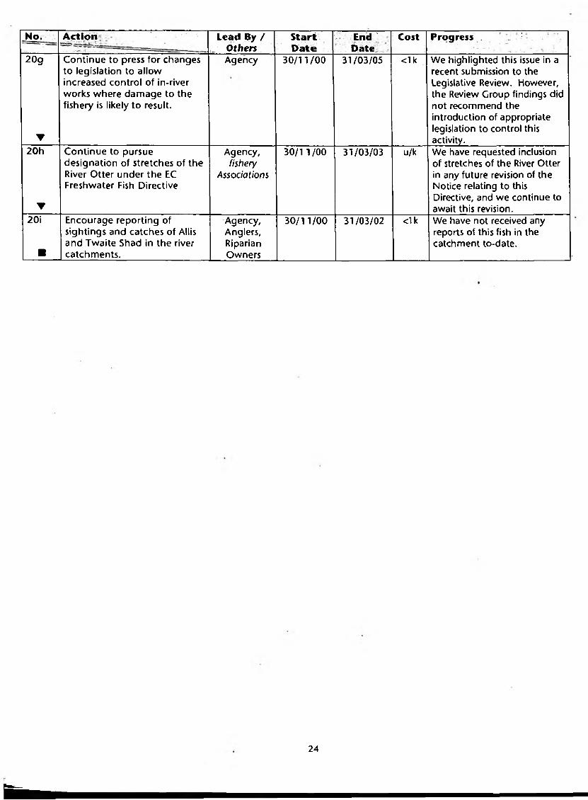
20g
▼
Continue to press for changes to legislation to allow increased control of in-river works where damage to the fishery is likely to result.
Agency 30/11/00 31/03/05 <1 k We highlighted this issue in a recent submission to the Legislative Review. However, the Review Croup findings did not recommend the introduction of appropriate legislation to control this activity.
20h
▼
Continue to pursue designation of stretches of the River Otter under the EC Freshwater Fish Directive
Agency,fishery
Associations
30/1 1/00 31/03/03 u/k We have requested inclusion of stretches of the River Otter in any future revision of the Notice relating to this Directive, and we continue to await this revision.
20i
■
Encourage reporting of sightings and catches of Allis and Twaite Shad in the river catchments.
Agency,Anglers,RiparianOwners
30/11/00 31/03/02 <1k We have not received any reports of this fish in the catchment to-date.
m
24

Duties, Powers and Interests of the Environm ent Agenq
The Environment Agency has a wide range of interests in the areas of water management, waste management and pollution prevention and control. Whilst many of these interests are supported by statutory duties and powers, much of our work is advisory, with the relevant powers resting with other bodies such as local planning authorities. The following table summarises our duties, powers and interests and their relationship to land-use planning.
Agency Duty The Agency has powers to:
The Agency has an interest (but no powers) in :
Partnership
W ater ResourcesThe Agency has a duty to conserve, redistribute, augment and secure the proper use of water resources.
• Grant or vary water abstraction and impoundment licences on application with appropriate conditions imposed to safeguard the needs of the environment whilst allowing reasonable and justified use of available and sustainable water resources - with the aim of achieving an equitable balance between competing demands.• Revoke or vary existing licences to reinstate flows or levels to surface waters or groundwater which have become depleted as a result of abstraction. Compensation may be payable if such powers are used.• Secure the proper use of
water resources through our role in water resources planning, and the assessment of reasonable need for abstractions and the promotion of more efficient use of water resources.• Monitor and enforce abstraction and impoundment licences.• Issue conservation notices to direct appropriate practices with regard to water resources issues associated with exempt dewaterinq activities.
• The more efficient use of water by water companies, developers, industry, agriculture and the public and the introduction of water- efficiency measures and suitable design and layout of the infrastructure.• Protecting the water environment from any adverse impact due to proposed major developments.
• The Agency uses its position as a statutory consultee to the planning authorities to secure conditions and agreements that protect the water environment and that encourage water conservation measures.• The Agency also seeks to influence planning decisions for new development by ensuring that planning authorities allow for any lead- time required for resource development.• The Agency is committed to water-demand management and will work closely with water companies and developers, local authorities and relevant organisations to promote the efficient use of water.• The Agency acknowledges that new resources may be needed in the future and supports a twin-track approach of planning for water resource development alongside the promotion of demand-management measures.
Atr QualityThe Agency has a duty to implement Part 1 of the Environmental Protection Act 1990.
• Regulate the largest technically complex and potentially most polluting prescribed industrial processes such as refineries, chemical works and power stations including enforcement of, and quidance on, BATNEEC and BPEO.• Have regard to the government's National Air Quality Strategy when setting standards for the releases to air from industrial processes.
• The vast number of smaller industrial processes which are controlled by local authorities.• Control over vehicular emissions and transport planning.
• The Agency provides data on IPC processes and advice on planning applications to local authorities. The Agency is willing to offer its technical experience to local authorities on the control of air pollution. The Agency wishes to liaise with local authorities in the production of their Air Quality Management Plans. The Agency will advise and contribute to the government's National Air Quality Strategy.
25

Agency Duty The Agency has powers to:
The Agency has an interest (but no powers) in :
Partnership
Flood DefenceThe Agency has a duty to exercise general supervision over all matters relating to flood defence throughout each LEAP area.
• Control, through Land Drainage consents, of development within 8 m of main river (Water Resources Act 1991, Section 109) or construction of a structure that would affect the flow of an ordinary watercourse (Land Drainage Act, 1991 Section 23).• Produce flood risk maps for all main rivers under S105 of Water Resources Act 1991.• Undertake works to main rivers using permissive powers.• Issue flood warnings relating to main river to the public, local authorities and the police.• Consent mineral working within 16 m of main rivers.
• Granting of planning permission throughout a LEAP area but especially floodplains where development can significantly increase flood risk. This permission is granted by local planning authorities.• Installation of surface water source control measures e.g. flood attenuation structures.• Supervising the maintenance of ordinary watercourses which is a local authority remit, but may impact on main rivers.• Installation of buffer zones which reduce flood risk and have significant environmental benefits.• Urban and rural land use and measures that can reduce flood risk or the need for watercourse maintenance.
• As a statutory consultee on planning applications within main river floodplains the Agency offers advice based on knowledge of flood risk. It also advises on the environmental impacts of proposed floodplain development• The Agency will encourage best practice, including source control measures and common standards, among local authorities and riparian owners to protect and enhance the environment. The Agency works with the civil authorities to prepare flood warning dissemination plans and supports their endeavours to protect communities at risk.
W a te r QualityThe Agency has a duty to monitor, protect, manage and, where possible, enhance the quality of all controlled waters including rivers, groundwaters, lakes, canals, estuaries and coastal waters through the prevention and control of pollution.
• Issue discharge consents to control pollution loads in controlled waters.• Regulate discharges to controlled waters in respect of water quality through the issue and enforcement of discharge consents.• Issue 'works notices' where action is required to reduce the risk of pollution.• Prosecute polluters and recover the costs of clean-up operations.• Serve prohibition notices (with or without conditions) on highway authorities to require treatment and pollution measures for hiqhway runoff.
• The greater use of source control measures to reduce pollution by surface water runoff.• Prevention and education campaigns to reduce pollution incidents.• The provision of highway runoff control measures which is a highway authority remit
• The Agency will liaise with local authorities, developers, the Highways Agency, industry and agriculture to promote pollution prevention and the adoption of source control measures. As a statutory consultee on planning applications, the Agency will advise local planning authorities on the water quality impact of proposed developments.
Waste ManagementThe Agency has a duty to regulate the management of waste, including the treatment, storage, transport and disposal of controlled waste, to prevent pollution of the environment, harm to public health or detriment to local amenities.
• Vary waste management licence conditions.• Suspend and revoke licences.• Investigate and prosecute illegal waste management operations.
• The siting and granting of planning permission for waste management facilities. This is conducted by the waste industry and local planning authorities. The Agency, as a statutory consultee on planning applications, can advise on such matters.• Serve notices to require improvements to waste facilities or for the removal of waste.
• The Agency will work with waste producers, the waste management industry and local authorities to reduce the amount of waste produced, increase re-use and recycling and improve standards of disposal.
26

Agency Duty The Agency has powers to:
The Agency has an interest (but no powers) in :
Partnership
Radioactive SubstancesThe Agency has a duty under the Radioactive Substances Act 1993 to regulate the use of radioactive materials and the disposal of radioactive waste.
• To issue certificates to users of radioactive materials and disposers of radioactive waste, with an overall objective of protecting members of the public.
• The health effects of radiation.
• The Agency will work with users of the radioactive materials to ensure that radioactive wastes are not unnecessarily created, and that they are safely and appropriately disposed of. The Agency will work with DEFRA to ensure that the disposal of radioactive waste creates no unacceptable effects on the food chain.• The Agency will work with the Nuclear Installations Inspectorate to ensure adequate protection of workers and the public at nuclear sites.• The Agency will work with the HSE on worker protection issues at non-nuclear sites.
Contaminated LandThe Agency has a duty to develop an integrated approach to the prevention and control of land contamination, ensuring that remediation is proportionate to risks and cost-effective in terms of the economy and environment.
• Regulate the remediation of contaminated land designated as special sites.• Prevent future land contamination by means of its IPC, Water Quality and other statutory powers.• Report on the state of contaminated land.
• Securing with others, including local authorities, landowners and developers, the safe remediation of contaminated land.
• The Agency supports land remediation and will promote this with developers and local authorities and other stakeholders.
ConservationThe Agency will further conservation, wherever possible, when carrying out water management functions; have regard to conservation when carrying out pollution control functions; and promote the conservation of flora and fauna which are dependent on an aquatic environment.
• The Agency has no direct conservation powers but uses its powers with regard to water management and pollution control to exploit opportunities for furthering and promoting conservation.
• The conservation impacts of new development. These are controlled by local planning authorities.• Protection of specific sites or species, which is a function of English Nature. The Agency does, however, provide advice to local authorities and developers to protect the integrity of such sites or species.• Implementation of the UK Biodiversity Plan for which it is the contact point for 35 species and one habitat.
• The Agency supports action to sustain or improve natural and man-made assets so that they are made available for the benefit of present and future generations. Many development schemes have significant implications for conservation. The Agency will work with developers, local authorities, conservation bodies and landowners to conserve and enhance biodiversity.
LandscapeThe Agency will further landscape conservation and enhancement when carrying out water management functions; have regard to the landscape when carrying out pollution control functions; and promote the conservation and enhancement of the natural beauty of rivers and associated land.
• The Agency must further the conservation and enhancement of natural beauty when exercising its water management powers and have regard to the landscape in exercising its pollution control powers.
• The landscape impact of new development, particularly within river corridors. This is controlled by local planning authorities.
• The Agency produces River Landscape Assessments and Design Guidelines which it uses when working with local authorities and developers to conserve and enhance diverse river landscapes.
27

Agency Duty The Agency has powers to:
The Agency has an interest (but no powers) in :
Partnership
A rchaeologyThe Agency has a duty to consider the impact of all of its regulatory, operational and advising activities upon archaeology and heritage, and implement mitigation and enhancement measures where appropriate.
• The Agency must promote its archaeological objectives through the exercise of its water management and pollution control powers and duties.
• Direct protection or management of sites of archaeological or heritage interest. This is carried out by local planning authorities, County Archaeologists and English Heritage.
• The Agency will liaise with those organisations which have direct control over archaeological and heritage issues to assist in the conservation and enhancement of these interests.
FisheriesThe Agency has a duty to maintain, improve and develop salmon, trout, freshwater and eel fisheries.
• Regulate fisheries by a system of licensing.• Make and enforce fisheries byelaws to prevent illegal fishing.• Promote the free passage of fish and consent fish passes.• Monitor fisheries and enforce measures to prevent fish entrainment in abstractions.• Promote its fisheries duty by means of land drainage consents, water abstraction applications and discharge applications.
• The determination of planning applications which could affect fisheries.
• Many development schemes have significant implications for fisheries. The Agency will work with anglers, riparian owners, developers and local authorities to protect fisheries.
RecreationThe Agency has a duty to promote rivers and water space for recreational use.
• The Agency contributes towards its recreation duty through the exercise of its statutory powers and duties in water management.
• Promotion of water sports. This is carried out by the Sports Council and other sports bodies.
• The Agency will work with the Countryside Commission, the Sports Council, British Waterways and other recreational and amenity organisations to optimise recreational use of the water environment.
28

GLOSSARY
Abstraction - Removal of water from surface or groundwater sources.
Aquatic Plants - A term given to plants that grow entirely covered by water, like water-milfoil, or at the surface, such as yellow water-lily. Some plants have both aquatic and emergent forms.
Asset Management Plan (AMP) - The Asset Management Plan is produced by the Water Companies for the Office of Water Services (OFWAT). It sets out the water industry investment programme for a set number of years.
Biochemical Oxygen Demand (BOD) - A standard test which measures over five days the amount of oxygen taken up by aerobic bacteria to oxidise organic (and inorganic) matter.
Biodiversity - The variability among living organisms from all sources including, inter alia, terrestrial, marine and other aquatic ecosystems and the ecological complexes of which they are part; this includes diversity within species, between species and ecosystems. (Article II of the Biodiversity Convention).
Catchment - The total area from which a single river collects surface runoff.
Coarse fish - This is a lay-man's term for cyprinid fish and other commonly associated species such as pike, perch and eels of angling significance. The term does not normally refer to minor species such as bullhead, stone loach, minnow and stickleback.
Confluence - The point at which two rivers meet.
Consumptive - The use of water which involves a degree of loss from the catchment resource.
Culm - A geological formation in SW England comprising beds of shales and thin layers of impure anthracite, all of Carboniferous age.
Culm grassland - Type of nutrient poor grassland present on culm geological formations.
Diffuse pollution - Pollution without a single point source, e.g. acid rain, pesticides, urban runoff, etc.
Environmental Quality Standard (EQS) - The concentration of a substance found in the environment which should not be exceeded in order to protect the environment or human health. An EQS is set by the EC through EC Directives and also by the Government.
Environmentally Sensitive Area (ESA) - An area designated by DEFRA where grant aid is available to support traditional farming methods.
Eutrophic - Water enriched with nutrients which result in high plant (including algal) growth. Usually used when referring to enrichment from man-made sources such as fertilisers leaching from the soil.
Floodplain - Part of river valley or coastal plain which is inundated during periods of flooding.
Fluvial - Pertaining to, or found in, rivers.
Hydrology - The study of water and its dynamics.
Non-consumptive - The use of water whereby the majority is returned to the catchment resource.
p H -A measurement of the concentration of hydrogen ions which cause acidity. Acid solutions have a pH of less than 7, alkalis of more than 7 and neutral solutions a pH of 7 (e.g. pure water).
Rh6s pasture - See Culm grassland.
Riparian - Relating to or situated on the bank of a river or stream.
Riparian owner- Owner of riverbank and/or land adjacent to a river. Normally owns river bed and rights to mid-line of channel.
River Quality Objective (RQO) - The level of water quality that a river should achieve in order to be suitable for its agreed uses.
Runoff - Rainwater which does not soak into the ground but which runs over the surface in a downhill direction.
Salmonid - Game fish of the salmon family, e.g. salmon, trout and sea trout.
Section 105 Surveys - Section 105 of the Water Resources Act 1991 allows for Standards of Service Assets and Flood Risk Surveys.
29

Sew age - Liquid waste from cities, towns and villages which is normally collected and conveyed in sewers for treatment and/or discharge to the environment.
Sew erage - A system of underground pipes designed to carry sewage to Sewage Treatment Works.
SSSI - Sites of national importance designated under the Wildlife and Countryside Act 1981 by English Nature in England. Sites may be designated to protect wildlife, geology or land forms.
Surface w ater - General term used to describe all the water features such as rivers, streams, springs, ponds and lakes.
Sustainable developm ent - Development that meets the needs of the present without compromising the ability of future generations to meet their own needs.
ABBREVIATIONS
AMP Asset Management PlanAONB Area of Outstanding Natural BeautyBATNEEC Best Available Technique Not Entailing Excessive CostBC Butterfly ConservationBCU British Canoe UnionBOD Biochemical Oxygen DemandBOT Barn Owl TrustBPEO Best Practicable Environmental OptionBTCV British Trust for Conservation VolunteersCLA Country Landowners AssociationDAS Devon Archaeological SocietyDCC Devon County CouncilDETR Department of the Environment, Transport and the Regions (now DEFRA)DEFRA Department for Environment, Food and Rural AffairsDSFC Devon Sea Fisheries CommitteeDWT Devon Wildlife TrustEDDC East Devon District CouncilEDCCS East Devon Coast & Countryside ServiceEH English HeritageEN English NatureERS Exposed Riverine SedimentESA Environmentally Sensitive AreaFC Forestry CommissionFWAC Farming and Wildlife Advisory GroupCQA General Quality AssessmentIPC Integrated Pollution ControlLEAP Local Environment Agency PlanLPAs Local Planning AuthoritiesMDDC Mid Devon District CouncilNFU National Farmers UnionNT National TrustOF WAT Office of Water ServicesOSMTC Ottery St Mary Town CouncilRIGS Regionally Important Geological SiteRQO River Quality ObjectiveRSPB Royal Society for the Protection of BirdsSAC Special Area of ConservationSPA Special Protection AreaSSSI Site of Special Scientific InterestSTWs Sewage Treatment WorksSWWL South West Water LtdTDBC Taunton Deane Borough CouncilUWWTD Urban Waste Water Treatment Directive
30

REFERENCES
1 Nature of Devon: A Biodiversity Action Plan, July 1998.
2 European Council Directive of 8 December 1975 concerning the Quality of Bathing Water (76/160/EEC). Official Journal of the European Communities No. L31 / I .
3 European Council Directive on Surface Water Abstractions (75/440/EEC).
4 European Council Directive on the Quality of Freshwaters needing Protection or Improvement in order to support Fish Life (78/659/EEC). Official Journal of the European Communities No. L22/1.
5 European Council Directive concerning Urban Waste Water Treatment (91/271/EEC). Official Journal of the European Communities No. LI 35.
6 European Council Directive on Pollution Caused by the Discharge of Certain Dangerous Substances into the Aquatic Environment (76/464/EEC). Official Journal of the European Communities No. LI 29.
7 European Council Directive on Species and Habitats (92/43/EEC). Official Journal of the European Communities No. L206, 1992.
a Focus on Biodiversity, The Environment Agency, June 2000.
9 The UK Forestry Standard, The Govern Government's Approach to Sustainable Forestry, Forestry Commission, 1998.
31
SW-11/01-.25-D-BGGO

All enquiries to: Devon Area Ex minster House Miller Way Ex minster EX6 8ASTel: 01392 444000

f I
Map 2 - Key Sites in the Sid & Otter LEAP Area
• AMP3 site
• RIG site
♦ EC Bathing Water Site
— Barrier to fish passage
— Weir allowing fish passage
■ Flood defence scheme proposed
□ Knapps Copse closed landfill site
S S S I
S A C / S P A
East Devon A O N B
Blackdown Hills A O N B / E S A
Heritage Coast
Setttlement
Catchm ent Boundary
Reservoir
Bu Salte
6 Kilometres
Reproduced from the Ordnance Survey map with the permission of the controller of Her Majesty's Stationery Office, under copyright licence No GD03177G@Crown Copyright.

Map 1 - Compliance with River Quality Objectives 2000
Compliant
Marginal Failure
Significant Failure
Unclassified
Unmonitored River Stretch
juabmoor?servoir
Budlei
RE2
-a
RE2
RE2
RE2J
R E 2
RE2 [RE ̂
RE2
fton
RE2*[RE1J
Sidnjiout]
Lyme Bay
--------- Stretch Boundary
TL Tidal Limit
RE1 River Quality Objective
[RE1] Long Term River QualityObjective
Settlement
Catchment Boundary
.
Salt* m 6 Kilometres
Reproduced from the Ordnance Survey map with the permission of the controller of Her Majesty’s Stationery Office, under copyright licence No GD03177G@ Crown Copyright.


