Embed Size (px)
Citation preview
Obunadike Callistus (58407) Page 1
Salt Water Intrusion in Coastal regions of Lagos, Lagos state of Nigeria Obunadike Callistus Ebuka
Department of Hydrogeology, Technische Universität Bergeakademie 09599 Freiberg, Germany
Abstract The Coastal region of Lagos, Nigeria has a long coastline with the Atlantic Ocean. Most of the groundwater aquifer in this region are used for irrigation purposes. However, the region is threatened by the problem of saltwater intrusion, due to high extraction rate of groundwater. It is very vital to mention that the analysis of this study was based on geochemical analysis of samples from the coastal parts of Lagos. The main aim of this study is to find out whether salinization of the selected wells is solely from saltwater intrusion or from other sources. In this regard, hydro-chemical data from previous investigations were analyzed and inferences made by graphical representation of chemical parameters measured. Samples from the coastal had the highest Intrusions e.g. Victoria Island and CMS Keywords: hydrochemical data analysis, saline incursion, aquifer sustainability and management Introduction
The Coastal Plains Sands is the main aquifer in Lagos that is exploited through hand-dug wells and boreholes. It forms a multi-aquifer system consisting of three aquifer horizons separated by silty or clayey layers (Longe et al., 1987). The aquifer thickens from its outcrop area in the north of the city to the coast in the south and the sand percentage in the formation changes from north to south (Longe et al., 1987). Coastal aquifers constitute a vital source of fresh water in these regions, and are increasingly used to meet the water supply needs (Pareek et al., 2006). There is vital need to monitor the feasible risk of saline water intrusion of the coastal aquifers because, once saline intrusion into coastal aquifer has occurred, it is extremely difficult to overcome and improve the management of the water resources based on long term strategy. Less than 2% of seawater intrusion in the fresh water can diminish the water’s potability (Custodio, 1987). Coastal aquifers in Nigeria straddling from Lagos State the west to Cross River State in the east have been reported to be affected by seawater intrusion. Some of these are presented in the works of (Amadi et al 1989, Edet et al., 2011).
Seawater intrusion is an inevitable problem of coastal fresh water aquifer associated with urban area (Hwang et al., 2004). Frequently, boreholes have to be abandoned and other water sources sought, often at high cost. The challenge of saline water contamination in coastal aquifers is driven by a violation of the delicate hydrogeological balance that exists between freshwater and seawater in coastal aquifers (Goldman and Kafri, 2004) due to large-scale groundwater abstraction occasioned by rapid urbanization (Pareek et al., 2006).
Due to the proximity of Lagos to the Atlantic Ocean, the general population is faced with problems of freshwater abstraction from the subsurface. It is becoming harder for hydrogeology Engineers to construct boreholes in areas adjoining the sea without encountering salt water. Saline water intrusions vary in character and thickness. Accordingly, identification, distribution and nature of the intrusion could be used to identify areas where aquifer(s) may be more vulnerable to contamination to mitigate the degradation of the resources.
The large conductivity contrast between salt water- saturated formation and the fresh water-saturated formation had been used for studying the salt-water intrusion in coastal areas (Bates and Robinson, 2000; Hwang et al., 2004). The source of the salinity in groundwater has been attributed to dissolution of chloride minerals (Uma et al., 1990). Sampling procedures and physicochemical analyses previously done on water samples in the study area by (Adewuyi et al., 2010) to generate data will be maintained.
However, inferences of the possible outcome of the laboratory procedures will be done by the combination of graphical representations of chemical parameters and ratios of these parameters generated by (Adewuyi et al.,
Obunadike Callistus (58407) Page 2
2010). Parameters to be used in making such inferences to ascertain the origin of salinization in the selected wells include: Na+/CL-, Ca2+/CL-, K+/CL-, Ca2+/SO4
2-, Ca2+/Na+, Na+/Ca2+, SO42+/Cl- . The percentage hardness (Ca2+) of the
water samples (Freeze and Cherry, 1979) indicated that all the selected wells are made up of 100% very hard water.
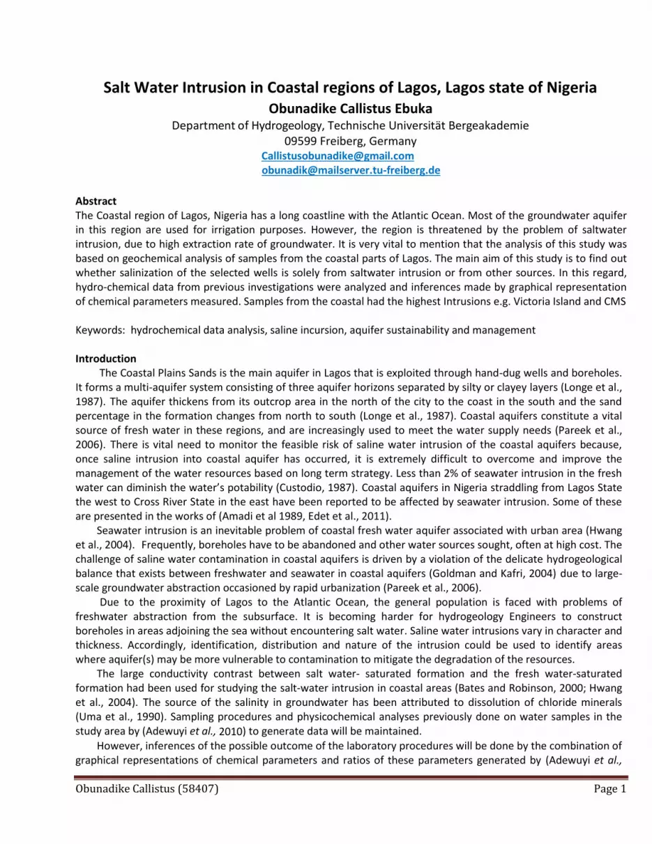
Description of the geology, hydrogeology and geomorphology of the study area Lagos State is bounded between Ogun State to the north and east; and the Atlantic Ocean to the south as shown in Figure 1. Lagos is underlain by the Benin Basin. The rocks of the Benin Basin are mainly sands and shales with some limestone which thicken towards the west and the coast as well as down dips to the coast (Oteri and Atolagbe, 2003). The stratigraphic description of sediments in the basin has been provided by various authors (Elueze et al., 2004; Ako et al., 1980). Five lithostratigraphic formations covering the cretaceous to Tertiary ages have been described. The formations from the oldest to the youngest include: Abeokuta Group (Cretaceous), Ewekoro Formation (Paleocene), Akinbo Formation (Late Paleocene - Early Eocene), Oshosun Formation (Eocene) and llaro Formation (Eocene). The Abeokuta Group present an unconformity with the basement complex. The Abeokuta Formation constitutes a deep aquifer only in the northern parts of Lagos city (Ikeja area) where boreholes to the aquifer are about 750 m deep. The Ilaro and Ewekoro Formations are not key aquifers in Lagos as they are predominantly composed of shale/clay. The only source of hydraulic information on the Ilaro formation was obtained at Lakowe where no fresh water horizon was intercepted. Ewekoro Formation has not been possible to be differentiated as a target aquifer in any boreholes or existing wells in the Lagos metropolis. The formation apparently represents a minor groundwater resource in Lagos. The Coastal Plains Sands is the main aquifer in Lagos that is exploited through hand-dug wells and boreholes. It forms a multi-aquifer system consisting of three aquifer horizons separated by silty or clayey layers (Longe et al., 1987).
Figure 1: Geological map of Nigeria basin (modified after Eruola et al., 2011).
Location of the study area
Obunadike Callistus (58407) Page 3
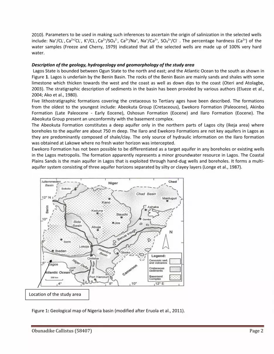
Methodology: The data for my research were obtained from the (Adewuyi et al., 2010). Assessment of groundwater quality and
saline intrusions in coastal aquifer of Lagos metropolis, Nigeria: Journal Water Resources and Protection, 2, 849-
853. Water samples from 8 selected boreholes within the study area were collected and subjected to physico-
chemical analyses (Adewuyi et al., 2010). On-site parameters like pH, temperature, electrical conductivity and Eh
were measured with the appropriate measuring instruments. The electrical conductivity was measured using a
Horiba U90 meter with an accuracy of 0.001 µs⁄cm. The Alkali metals was determined by flame absorption
spectrophometry (Adewuyi et al., 2010). Surfer11.0 was used to plot the geochemical data distributions in different
locations. SWI (Salt-water Index) shows the rate of the saltwater intrusion in different locations within the study
area.
Figure 2a: Map showing sampling points. (Modified from (Adewuyi et al., 2010)).
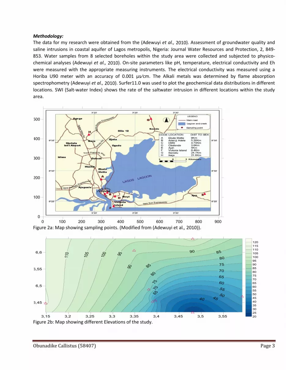
Figure 2b: Map showing different Elevations of the study.
Obunadike Callistus (58407) Page 4
Table 1: Showing sampling points, GPS coordinates and relative positions from the ocean
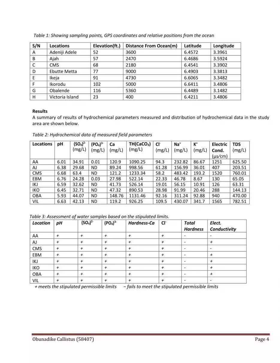
Results A summary of results of hydrochemical parameters measured and distribution of hydrochemical data in the study area are shown below. Table 2: Hydrochemical data of measured field parameters
Table 3: Assessment of water samples based on the stipulated limits.
Location pH (SO4)2- (PO4)3-
Hardness-Ca Cl- Total
Hardness Elect. Conductivity
AA + + + + + - -
AJ + + + + + - +
CMS + + + + + - -
EBM + + + + + - +
IKJ + + + + + - +
IKO + + + + + - +
OBA + + + + + - +
VIL + + + + + - -
+ meets the stipulated permissible limits − fails to meet the stipulated permissible limits
S/N Locations Elevation(ft.) Distance From Ocean(m) Latitude Longitude
A Adeniji Adele 52 3600 6.4572 3.3961
B Ajah 57 2470 6.4686 3.5924
C CMS 68 2180 6.4541 3.3902
D Ebutte Metta 77 9000 6.4903 3.3813
E Ikeja 91 4730 6.6065 3.3482
F Ikorodu 102 5000 6.6411 3.4806
G Obalende 116 5360 6.4489 3.1482
H Victoria Island 23 400 6.4211 3.4806
Locations pH (SO4)2- (mg/L)
(PO4)3-
(mg/L) Ca (mg/L)
TH(CaCO3) (mg/L)
Cl-
(mg/L) Na+ (mg/L)
K+ (mg/L)
Electric Cond. (µs⁄cm)
TDS (mg/L)
AA 6.01 34.91 0.01 120.9 1090.25 94.3 232.82 86.67 1251 625.50 AJ 6.38 29.68 ND 89.24 998.56 61.28 156.99 36.01 407 203.51 CMS 6.68 63.4 ND 121.2 1233.34 58.2 483.42 193.2 1520 760.01 EBM 6.76 24.28 0.03 27.98 522.14 22.33 46.78 8.67 130 65.05 IKJ 6.59 32.62 ND 41.73 526.14 19.01 56.15 10.91 126 63.31 IKO 6.45 32.71 ND 47.32 890.53 28.98 91.99 20.46 288 144.13 OBA 5.93 44.07 ND 148.76 1131.46 92.16 311.24 92.88 940 470.00 VIL 6.63 42.13 ND 119.2 926.25 109.5 430.07 341.7 1565 782.51
Obunadike Callistus (58407) Page 5
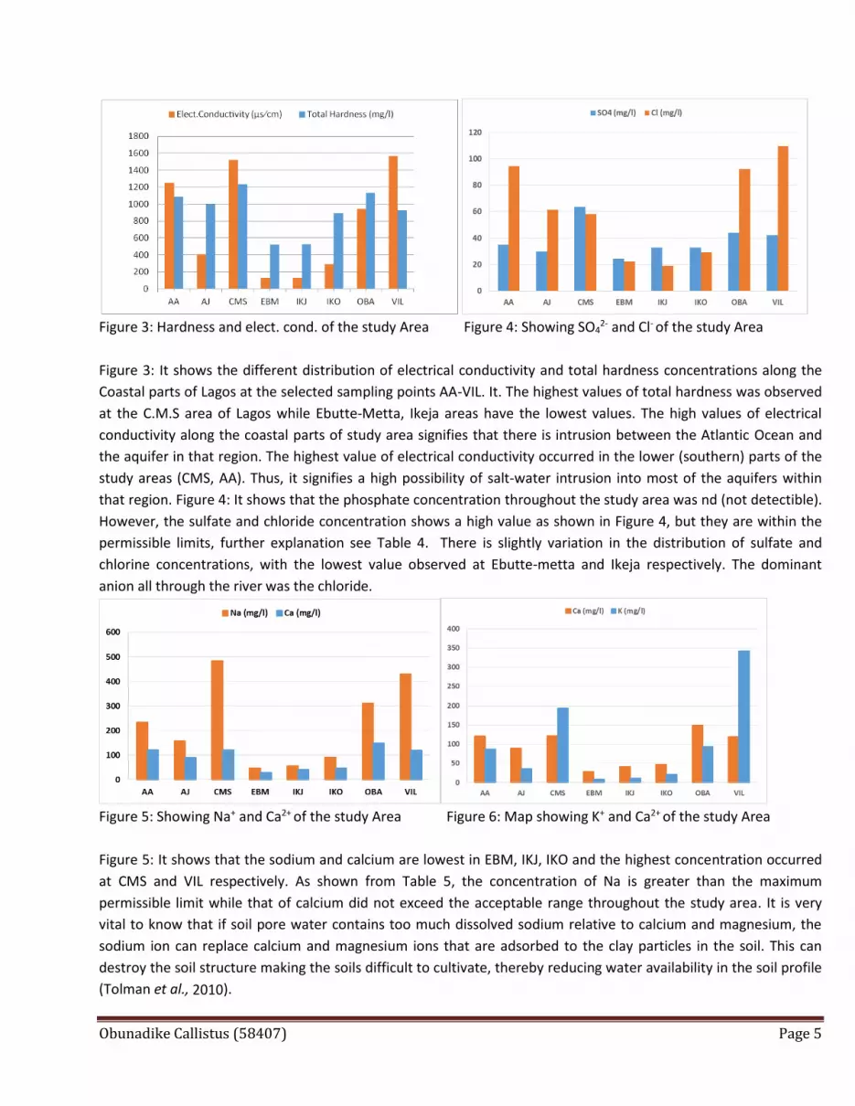
Figure 3: Hardness and elect. cond. of the study Area Figure 4: Showing SO4
2- and Cl- of the study Area
Figure 3: It shows the different distribution of electrical conductivity and total hardness concentrations along the
Coastal parts of Lagos at the selected sampling points AA-VIL. It. The highest values of total hardness was observed
at the C.M.S area of Lagos while Ebutte-Metta, Ikeja areas have the lowest values. The high values of electrical
conductivity along the coastal parts of study area signifies that there is intrusion between the Atlantic Ocean and
the aquifer in that region. The highest value of electrical conductivity occurred in the lower (southern) parts of the
study areas (CMS, AA). Thus, it signifies a high possibility of salt-water intrusion into most of the aquifers within
that region. Figure 4: It shows that the phosphate concentration throughout the study area was nd (not detectible).
However, the sulfate and chloride concentration shows a high value as shown in Figure 4, but they are within the
permissible limits, further explanation see Table 4. There is slightly variation in the distribution of sulfate and
chlorine concentrations, with the lowest value observed at Ebutte-metta and Ikeja respectively. The dominant
anion all through the river was the chloride.
Figure 5: Showing Na+ and Ca2+ of the study Area Figure 6: Map showing K+ and Ca2+ of the study Area
Figure 5: It shows that the sodium and calcium are lowest in EBM, IKJ, IKO and the highest concentration occurred
at CMS and VIL respectively. As shown from Table 5, the concentration of Na is greater than the maximum
permissible limit while that of calcium did not exceed the acceptable range throughout the study area. It is very
vital to know that if soil pore water contains too much dissolved sodium relative to calcium and magnesium, the
sodium ion can replace calcium and magnesium ions that are adsorbed to the clay particles in the soil. This can
destroy the soil structure making the soils difficult to cultivate, thereby reducing water availability in the soil profile
(Tolman et al., 2010).
Obunadike Callistus (58407) Page 6
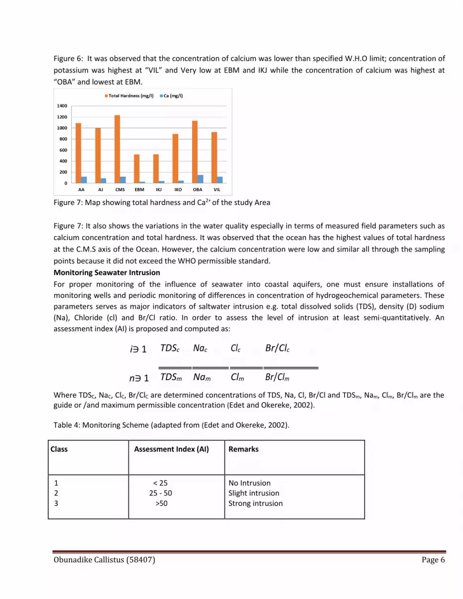
Figure 6: It was observed that the concentration of calcium was lower than specified W.H.O limit; concentration of
potassium was highest at “VIL” and Very low at EBM and IKJ while the concentration of calcium was highest at
“OBA” and lowest at EBM.
Figure 7: Map showing total hardness and Ca2+ of the study Area
Figure 7: It also shows the variations in the water quality especially in terms of measured field parameters such as
calcium concentration and total hardness. It was observed that the ocean has the highest values of total hardness
at the C.M.S axis of the Ocean. However, the calcium concentration were low and similar all through the sampling
points because it did not exceed the WHO permissible standard.
Monitoring Seawater Intrusion For proper monitoring of the influence of seawater into coastal aquifers, one must ensure installations of
monitoring wells and periodic monitoring of differences in concentration of hydrogeochemical parameters. These
parameters serves as major indicators of saltwater intrusion e.g. total dissolved solids (TDS), density (D) sodium
(Na), Chloride (cl) and Br/Cl ratio. In order to assess the level of intrusion at least semi-quantitatively. An
assessment index (AI) is proposed and computed as:
Where TDSC, NaC, ClC, Br/ClC are determined concentrations of TDS, Na, Cl, Br/Cl and TDSm, Nam, Clm, Br/Clm are the guide or /and maximum permissible concentration (Edet and Okereke, 2002). Table 4: Monitoring Scheme (adapted from (Edet and Okereke, 2002).
Class Assessment Index (AI) Remarks
1 < 25 No Intrusion 2 25 - 50 Slight intrusion 3 >50 Strong intrusion
i∋ 1 TDSc Nac Clc
Br/Clc
n∋ 1 TDSm Nam Clm Br/Clm

Obunadike Callistus (58407) Page 7
Table 5: The Assessment Index of SWI level (Salt-Water Intrusion Level)
Locations TDS Na+ Ca2+ SWI level (REMARKS)
Adeniji Adele 41.7 47.51429 60.45 Slight-Strong intrusion
Ajah 13.567 32.03878 44.62 No -Slight Intrusion
CMS 50.667 98.65714 60.6 Strong intrusion
Ebutte Metta 4.3367 9.546939 13.99 No Intrusion
Ikeja 4.2207 11.45918 20.865 No Intrusion
Ikorodu 9.6087 18.77347 23.66 No Intrusion
Obalende 31.333 63.51837 74.38 Slight-Strong Intrusion
Victoria Island 52.167 87.76939 59.6 Strong intrusion
Table 6: Percentage hardness of the water samples (modified from (Freeze & Cherry, 1979)).
Total Hardness (CaCO32- ) (mg/L) Water Classification % Result of this Study
0 – 75 Soft -
75 – 150 Moderately hard -
150 – 300 Hard -
>300 Very hard 100%
Figure 8: Total Hardness of the Wells (> 300 mg/l)
Figure 9: Cl- Conc. of the Study Area
0
200
400
600
800
1000
1200
1400
AA AJ CMS EBM IKJ IKO OBA VIL
Total Hardness (CaCO3) mg/l
Obunadike Callistus (58407) Page 8
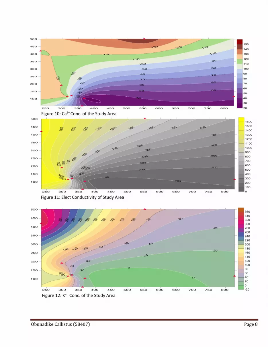
Figure 10: Ca2+ Conc. of the Study Area
Figure 11: Elect Conductivity of Study Area
Figure 12: K+ Conc. of the Study Area
Obunadike Callistus (58407) Page 9
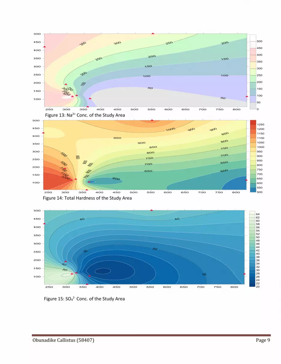
Figure 13: Na2+ Conc. of the Study Area
Figure 14: Total Hardness of the Study Area
Figure 15: SO42- Conc. of the Study Area

Obunadike Callistus (58407) Page 10
Figure16: TDS Conc. of the Study Area
Discussion The occurrence of groundwater with very high concentration of total hardness [figure.8], TDS and salinity has been documented in some parts of Study areas. The maximum concentration levels of TDS, Na, K, Ca, Cl, and SO4
2- concentrations are as follows; 782.51mg/l, 483.42mg/l, 341.7mg/l, 148.76mg/l, 109.5mg/l, 44.07mg/l respectively [Table 2]. These high values are unacceptable for domestic and agricultural purposes. The sequences of ion concentration are as follows Na+ > K+ > Ca2+ for cations and Cl- > SO4
2- > Po43-for the anions.
From [Table 2), it is observed that the pH values of groundwater from the selected boreholes vary from 6.01 to 6.63. Electric conductivity values vary from lowest value in Ikeja (IKJ) 126μS/cm in to 1565μS/cm in Victoria Island (VIL). The higher conductivity (salinity) values were found along the coast areas like Obalande, Adeniji Adele, CMS and Victoria Island whiles lower values were observed in other parts of the sampled areas. The high conductivity values is an indicator of saturation of these waters with respect to the saltwater intrusion, which implies that there might have been a long time contact of these waters with the ocean. Further clarification can be seen in [Table 2] (field concentrations) and [Table 5]/ (SWIlevel) Calculated. Low conductivities and TDS were observed for samples taken from the Ikeja, Ikoyi, Ebutte-Metta, this corresponds to the SWI [Table 5] which indicates that there are no intrusion in these areas. Table 7: Ionic ratios of the wells in the study area
Most of the water in the wells are slightly - moderately contaminated based on the differences in the ionic ratios as illustrated in the “Table 7” above. (Vengosh et al., 1997) found that saline water, associated with seawater intrusion is characterized, relatively to seawater, by low Na/CL and high (>1) Ca/ (HCO3 + SO4) and Ca/SO4 ratios. This classification includes 5 classes: 0.5 for good quality water, 1.3 for slightly contaminated water, 2.8 moderately contaminated water, 6.6 injuriously contaminated water, 15.5 highly contaminated water (Todd, 1959). Seawater solutes are specifically
Loc. Na+/CL- Ca2+/CL- K+/CL- SO42- /CL- Ca2+/SO4
2- Na+/Ca2+
AA 2.47 1.28 0.92 0.37 3.46 1.92
AJ 2.56 1.46 0.59 0.48 3.01 1.76
CMS 8.31 2.08 3.31 1.09 1.91 3.99
EBM 2.09 1.25 0.39 1.09 1.15 1.67
IKJ 2.95 2.20 0.57 1.72 1.28 1.35
IKO 3.17 1.63 0.71 1.13 1.45 1.94
OBA 3.38 1.61 1.01 0.49 3.38 2.09
VIL 3.93 1.09 3.12 0.38 2.83 3.61
Obunadike Callistus (58407) Page 11
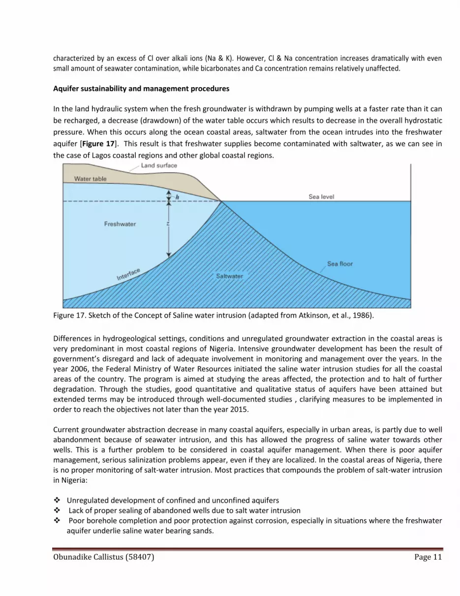
characterized by an excess of Cl over alkali ions (Na & K). However, Cl & Na concentration increases dramatically with even small amount of seawater contamination, while bicarbonates and Ca concentration remains relatively unaffected. Aquifer sustainability and management procedures In the land hydraulic system when the fresh groundwater is withdrawn by pumping wells at a faster rate than it can
be recharged, a decrease (drawdown) of the water table occurs which results to decrease in the overall hydrostatic
pressure. When this occurs along the ocean coastal areas, saltwater from the ocean intrudes into the freshwater
aquifer [Figure 17]. This result is that freshwater supplies become contaminated with saltwater, as we can see in
the case of Lagos coastal regions and other global coastal regions.
Figure 17. Sketch of the Concept of Saline water intrusion (adapted from Atkinson, et al., 1986).
Differences in hydrogeological settings, conditions and unregulated groundwater extraction in the coastal areas is very predominant in most coastal regions of Nigeria. Intensive groundwater development has been the result of government’s disregard and lack of adequate involvement in monitoring and management over the years. In the year 2006, the Federal Ministry of Water Resources initiated the saline water intrusion studies for all the coastal areas of the country. The program is aimed at studying the areas affected, the protection and to halt of further degradation. Through the studies, good quantitative and qualitative status of aquifers have been attained but extended terms may be introduced through well-documented studies , clarifying measures to be implemented in order to reach the objectives not later than the year 2015. Current groundwater abstraction decrease in many coastal aquifers, especially in urban areas, is partly due to well abandonment because of seawater intrusion, and this has allowed the progress of saline water towards other wells. This is a further problem to be considered in coastal aquifer management. When there is poor aquifer management, serious salinization problems appear, even if they are localized. In the coastal areas of Nigeria, there is no proper monitoring of salt-water intrusion. Most practices that compounds the problem of salt-water intrusion in Nigeria: Unregulated development of confined and unconfined aquifers Lack of proper sealing of abandoned wells due to salt water intrusion Poor borehole completion and poor protection against corrosion, especially in situations where the freshwater
aquifer underlie saline water bearing sands.

Obunadike Callistus (58407) Page 12
The following is a list of measures, for both hydraulic and engineering approaches, that can be implemented to control saltwater intrusion in Lagos coastal aquifers. Direct increase of recharge rate of the aquifer (artificial recharge/primarily surficial aquifers); various means to
control runoff of freshwater lost through fractures, karst and rivers. Extracting/injecting combination or Extracting seawater before it reaches the wells. Relocating wells or redesign of well field Re-injecting wastewater near the saltwater interface to aid in maintaining a sufficient head of freshwater. Freshwater recharging into wells paralleling the coast, creating a hydrodynamic barrier. Reducing pumping rate, in order to avoid the discharge rate exceeding the recharge rate. Adequate and regular monitoring systems, with early warning signals and public information The authority and popular will to attain sustainable use A water management institution with adequate tools and resources Education, training and dissemination of knowledge and data As long as the cone of depression from freshwater pumping wells does not fall below sea level, the threat of
seawater intrusion can be averted (Atkinson et al., 1986). Generally, coastal aquifers may become important elements for human water supply and guarantee if they are properly managed. There is no doubt that intensive development of aquifers produces social benefits as well as other issues and costs that need careful study if valuable opportunities are not to be lost, and this is especially true for coastal aquifers of the Nigeria. If any of the measures is to work effectively, the identification of the true source of salinity and understanding of salinization dynamics is key starting points for management decisions, protection and remedial measures. There is a great and urgent need for all stakeholders to commission the necessary studies to adequately delineate, monitor and manage the freshwater resources of the coastal areas to the benefits of its people and industry. The involvement of stakeholders in coastal aquifer management and sustainable development is considered a necessary goal. However, in any case, good public and private understanding and cooperation is needed. The four basic components that are very necessary for proper management of groundwater resources against saltwater intrusion are (a) Delineation: This involves the characterization of the existing conditions so that people can have an adequate understanding of the hydrogeological conditions and a detailed spatial characterization of the saltwater interface. In this report, all data obtained were gotten through direct (hydrogeochemical parameters). (b) Monitoring: It involves a monitor program that can monitor conditions and provide a reasonable accurate assessment of the changes in the saltwater interface. This can be achieved by accurately selecting the location of monitoring wells and providing sufficient screens length to monitor the changes in the saltwater interface. (c) Modeling: It is the use of Numerical modeling to predict long-term behavior of saltwater interface in response to changes in rainfall, water use and other activities or actions, which affect groundwater. The numerical modeling that is often used is FEM (Finite Element Model) and FDM (Finite definite Model).They are both good at solving complicated boundary value problems through discretization. (d) Modification: Based on the results, provide by the above three steps. There must be a modification of the pumping and control runoff or re-injection of wastewater to maintain the freshwater head in order to prevent further encroachment of saltwater.
Obunadike Callistus (58407) Page 13
These four components -delineation, monitoring, modeling, and modification- must be accomplished for an effective, proper management and sustainability of aquifer in coastal parts of Lagos and the entire globe. Conclusion The main aim of this paper was to investigate saltwater intrusion in the Coastal parts of Lagos; it is however quintessential to know that salinization of wells in this region is mainly as a result of saltwater intrusion. The higher electrical conductivities of samples taken along the coastal part coupled with other analyses indicate that salinization of these wells is as result of saltwater intrusion. The dominant factor for salinization of wells in the other parts is due to dissolution of rock salt in the soil zone. Four of the wells generated in this study (wells: AA’, CMS’, OBA’ and VIL’) indicate saline water intrusion with a very high values of electric conductivities ranging from (1251’, 1520’, 940’, 1565) respectively. It was also confirmed from the Surfer Plots and the Salt-Water Index (SW-index), while other locations (Wells: EBM’, IKJ, IKO’) have lower values of electric conductivities which indicate that there is no salt-water intrusion, but (Well AJ’) shows a slight intrusion which signifies that dissolution comes from gypsum of the underlying aquifer materials. The hydrogeology importance of the Coastal Plain Sand aquifer unit in Lagos is under severe threat of continued seawater incursion and intrusion on its southern coastal flank. Results presented in this paper show that the process of salt-water intrusion is active on southern flank of Lagos metropolis. Groundwater problems in the coastal aquifers of the Nigeria range from lowering of groundwater levels and piezometric surfaces to declining yields, saline water intrusion from various sources. However, monitoring of the wells within the coastal parts will help to sustain and reduce saltwater intrusion.
References
Adewuyi, G. O., Oputu, O.U., and Opasina, M.A. (2010). Assessment of groundwater quality and saline
intrusions in coastal aquifer of Lagos metropolis, Nigeria: Journal Water Resources and Protection, 2,
849-853.
Amadi P. A., Ofoegbu C. O., Morrison T (1989). Hydrogeochemical assessment of groundwater quality in parts
of the Niger delta, Nigeria. Environ. Geol., 14(3): 195-202.
Atkinson, S. F., Miller G., Curry D., and Lee S. (1986). Salt Water Intrusion, Environmental and Groundwater
Water Institute, University of Oklahoma, Norman, OK, USA:Lewis Publishers.
Bates CR, Robinson R (2000). Geophysical Surveys for Groundwater Modeling of Coastal Golf Courses EAGE 62nd Conference and Technical Exhibition - Glasgow, Scotland, 29 May - 2 June. pp. 1- 5. Custodio, E., (1987). ‘Groundwater Problems in Coastal Areas’, Studies and Reports in Hydrology, UNESCO, Paris. Edet AE, Okereke CS (2002). Delineation of shallow groundwater aquifers in the coastal plain sands of Calabar area (southern Nigeria) using surface resistivity and hydrogeological data. J. Afr. Earth Sci., 35: 433-443. Edet, A. E., et al (2011), Review of groundwater chemistry and quality of Niger-African journal Science and
Technology Vol. 5 (13), pp 1152-1169.
E. O. Longe, S. Malomo, and M. A. Olorunniwo, “Hydro-geology of Lagos Metropolis,” African Journal of Earth
Sciences, Vol. 6, No. 2, 2007, pp. 163-174.
Elueze, A. A., Nton, M. E., (2004). Organic geochemical appraisal of limestone and shale in part of eastern Dahomey basin, southwestern Nigeria. J. Min. Geol. 40(1):29-40. Eruola, A. O., et al (2011), Analytical Investigation of pollutants in Lagos coastal waters, Nigeria: Advances in Analytical Chemistry Vol. 1(1), pp 8-11. FEPA, “Present Water Quality Status in Nigeria,” Federal Environmental Protection Agency, Lagos, 1998, pp. 35
-41.
Freeze R. A. and Cherry J. A. (1979). Groundwater, Englewood Cliffs, NJ, USA: Prentice Hall.
Obunadike Callistus (58407) Page 14
Goldman, M., Kafri, U., (2004). Hydrogeophysical Applications in Coastal Aquifers. In: Applied Hydrogeophysics. Eds Vereecken, H. Binley, A., Cassiani, G., Revil, A. and Titov, K. Springer NATO Science Series IV: Earth Environ. Sci. 71:233-254. Hwang S, Shin J, Park I, Lee S (2004). Assessment of seawater intrusion using geophysical well logging and electrical soundings in a coastal aquifer, Young kwang-gun, Korea. Explor. Geophys. 35(1):99-104. Jones, B. F., Vengosh, A., Rosenthal, E., and Yechieli, Y., 1999, ‘Geochemical investigation of groundwater quality’, in: proceeding: Seawater Intrusion in Coastal Aquifers. K. Kruger and S. Associates, “Underground Water Re-sources of the Metropolitan Lagos,” Final Report to Lagos
State Ministry of Works, Lagos, 1997, p. 170.
Oteri A. U., Atolagbe F. P., (2003). Saltwater Intrusion into Coastal Aquifers in Nigeria. Paper presented at the Second International Conference on Saltwater Intrusion and Coastal Aquifers - Monitoring, Modeling, and Management. Mérida, Yucatán, México, March 30 - April 2 Pareek, N., Jat, M. K., Jain, S.K., (2006). The utilization of brackish water, protecting the quality of the upper fresh water layer in coastal aquifers. Environmentalist 26:237-246. Todd, D. K., 1959, Ground Water Hydrology, John Wiley and Sons. Inc, 277–294. Tolman, C. F. and Poland, J. F., 1940, ‘Ground Water, salt water infiltration, and ground surface recession in Santa Clara Valley, Santa Clara County, California’, Trans. Amer. Geoph. Union 21, 23–35. World Health Organization, “International Standards for Drinking Water,” 2nd Edition. W.H.O., Geneva, 1971.
Uma K. O., Onuoha K. M., Egboka C. E. (1990) Hydrochemical Facies, Groundwater Flow Pattern and Origin of Saline Waters in parts of the Western Flank of the Cross River Basin, Nigeria. In The Evolution of the Benue Basin (Eds Ofoegbu), pp. 115-134. Vengosh, A., Gill, J., Reyes, A., and Thoresberg, K., 1997, a multi-isotope investiga6tion of the origin of groundwater salinity in Salinas valley, California. American Geophysical Union, San Francisco, California.


