Embed Size (px)
Citation preview
Richmond Bridge
Conservation Management Plan
Department of State Growth
15 December 2017

Richmond Bridge Conservation Management Plan 15 December 2017 i
Document Version
Date Approved
Draft V1 26 May 2017 Justin McCarthy, Director Austral Tasmania Pty Ltd
Draft V2 12 July 2017 Justin McCarthy, Director Austral Tasmania Pty Ltd
Final 15 December 2017 Justin McCarthy, Director Austral Tasmania Pty Ltd
Richmond Bridge Conservation Management Plan 15 December 2017 ii
EXECUTIVE SUMMARY
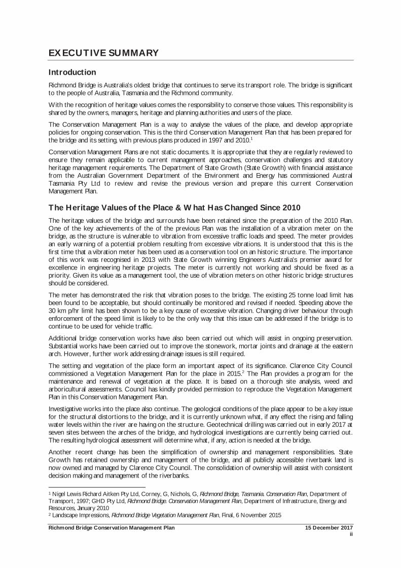
Introduction Richmond Bridge is Australia’s oldest bridge that continues to serve its transport role. The bridge is significant to the people of Australia, Tasmania and the Richmond community.
With the recognition of heritage values comes the responsibility to conserve those values. This responsibility is shared by the owners, managers, heritage and planning authorities and users of the place.
The Conservation Management Plan is a way to analyse the values of the place, and develop appropriate policies for ongoing conservation. This is the third Conservation Management Plan that has been prepared for the bridge and its setting, with previous plans produced in 1997 and 2010.1
Conservation Management Plans are not static documents. It is appropriate that they are regularly reviewed to ensure they remain applicable to current management approaches, conservation challenges and statutory heritage management requirements. The Department of State Growth (State Growth) with financial assistance from the Australian Government Department of the Environment and Energy has commissioned Austral Tasmania Pty Ltd to review and revise the previous version and prepare this current Conservation Management Plan.
The Heritage Values of the Place & What Has Changed Since 2010 The heritage values of the bridge and surrounds have been retained since the preparation of the 2010 Plan. One of the key achievements of the of the previous Plan was the installation of a vibration meter on the bridge, as the structure is vulnerable to vibration from excessive traffic loads and speed. The meter provides an early warning of a potential problem resulting from excessive vibrations. It is understood that this is the first time that a vibration meter has been used as a conservation tool on an historic structure. The importance of this work was recognised in 2013 with State Growth winning Engineers Australia’s premier award for excellence in engineering heritage projects. The meter is currently not working and should be fixed as a priority. Given its value as a management tool, the use of vibration meters on other historic bridge structures should be considered.
The meter has demonstrated the risk that vibration poses to the bridge. The existing 25 tonne load limit has been found to be acceptable, but should continually be monitored and revised if needed. Speeding above the 30 km p/hr limit has been shown to be a key cause of excessive vibration. Changing driver behaviour through enforcement of the speed limit is likely to be the only way that this issue can be addressed if the bridge is to continue to be used for vehicle traffic.
Additional bridge conservation works have also been carried out which will assist in ongoing preservation. Substantial works have been carried out to improve the stonework, mortar joints and drainage at the eastern arch. However, further work addressing drainage issues is still required.
The setting and vegetation of the place form an important aspect of its significance. Clarence City Council commissioned a Vegetation Management Plan for the place in 2015.2 The Plan provides a program for the maintenance and renewal of vegetation at the place. It is based on a thorough site analysis, weed and arboricultural assessments. Council has kindly provided permission to reproduce the Vegetation Management Plan in this Conservation Management Plan.
Investigative works into the place also continue. The geological conditions of the place appear to be a key issue for the structural distortions to the bridge, and it is currently unknown what, if any effect the rising and falling water levels within the river are having on the structure. Geotechnical drilling was carried out in early 2017 at seven sites between the arches of the bridge, and hydrological investigations are currently being carried out. The resulting hydrological assessment will determine what, if any, action is needed at the bridge.
Another recent change has been the simplification of ownership and management responsibilities. State Growth has retained ownership and management of the bridge, and all publicly accessible riverbank land is now owned and managed by Clarence City Council. The consolidation of ownership will assist with consistent decision making and management of the riverbanks.
1 Nigel Lewis Richard Aitken Pty Ltd, Corney, G, Nichols, G, Richmond Bridge, Tasmania. Conservation Plan, Department of Transport, 1997; GHD Pty Ltd, Richmond Bridge. Conservation Management Plan, Department of Infrastructure, Energy and Resources, January 2010 2 Landscape Impressions, Richmond Bridge Vegetation Management Plan, Final, 6 November 2015
Richmond Bridge Conservation Management Plan 15 December 2017 iii
The Content of this Conservation Management Plan A Conservation Management Plan must be a practically focussed document that assists owners and managers with caring for the place. The review of the previous 2010 Plan finds that it is a sound management tool. This is demonstrated by the review of the 103 policies included in the 2010 Plan. The review highlights that many of these policies are implemented as ongoing management or maintenance tasks, whilst some specific items have been completed.
Opportunities to refine, simplify and improve the usability of the Plan have been pursued where possible. The number of policies has been reduced to 91 by simplifying some, or removing those actions or tasks that have been completed.
A number of policies and actions are yet to be addressed. Within available resources, it is appropriate that the highest priority has been given to implementing those tasks which will assist in the essential conservation of the bridge. Nonetheless, this Plan considers that other assessments or tasks should be completed in the future within available resources. Areas where work is required include traffic management, flood management, interpretation and visitor management, Aboriginal heritage and archaeological assessments. It would be highly desirable for some of these tasks to be completed by the time of the next review of this Conservation Management Plan.
The 2010 Plan provided a sound and usable structure which has been adopted for this current Plan. Conservation Policies have been grouped into broad subject areas, each with a policy statement, followed by explanation, implementation, identification of responsibilities and priority. The following summarises the key findings.
General Policies
The general conservation policies provide the overarching framework for managing the heritage significance of the bridge and setting. It begins with recognition of the exceptional significance of the place. From this recognition, the general and detailed policies are developed. The bridge and setting are comprised of multiple elements. These elements range in their levels of significance. Assessing the levels of cultural significance allows for an understanding of the relative values of the elements that form the place and appropriate management practices. Minor changes have been made to this section.
Management System
Considerable changes have occurred with the ownership and therefore management of the place. State Growth owns and manages the bridge, Clarence City Council now owns and manages the public riverbanks.
The 2010 Plan recommended the formation of a management committee to assist with coordination between the different stakeholders and approval bodies and to provide a forum for community involvement. This policy recommendation was not adopted.
Since the simplification of ownership, the need for a separate committee is perhaps less useful at this time. Regular engagement and referral to the existing Richmond Advisory Committee (a committee of Council), may provide a more practical means of community engagement. Implementation of the Tasmanian Planning Scheme State Planning Provisions will also require Council to address its role in heritage management of the place. A review of available mechanisms of the Local Provisions Schedules is recommended.
Use of the Richmond Bridge and Setting
The bridge is currently used for both vehicular and pedestrian use. The continuing use of the bridge since 1825 is part of the cultural significance of the place. This Plan recommends the continuation of this use. However, it is crucial that these uses do not jeopardise the structural integrity of the bridge. Fixing and maintaining the vibration meter is a high priority.
Continued uses of the place and setting for recreational purposes is appropriate, however care is needed to ensure that such uses do not compromise the heritage values. The preparation of Visitor Management and Interpretation Plan is recommended, and would complement Council’s work in the Vegetation Management Plan.
Two new areas are addressed in the policies related to use. Firstly, a recommendation has been made regarding commercial uses of the place to ensure they do not impact on the significance of the place. Secondly, hydrological assessments are currently being carried out and will determine what, if any, action is needed.
Richmond Bridge Conservation Management Plan 15 December 2017 iv
Managing the Fabric of the Richmond Bridge
This vibration meter has proven to be a valuable tool in providing real time data on the structure of the bridge and excessive vibrations which may cause damage. The meter should be repaired and maintained.
Improvements have been made to the fabric of the bridge since 2010. Most notably in the extensive conservation works carried out in the eastern arch to address drainage issues. Whilst substantially improving the appearance and repairing damaged stonework and mortar joints, drainage remains an ongoing issue that needs further investigations. Hydrological assessments resulting from the geotechnical work may also have a bearing on the management of the bridge fabric.
Management of Public Riverbank Land and Infrastructure
The public riverbank land forms a crucial part of the significance of the place. It also provides important tourism and passive recreation areas for relaxation, picnics and appreciating the bridge and surrounds. Conservative policies have been recommended based on the significance, the physical nature of the place, and the limited compatible uses available.
Modifications have been made to these policies. The Vegetation Management Plan recommends the preparation of a landscape masterplan to coordinate things such as seating, rubbish bins, paths and so on. This has been included as a policy in this Conservation Management Plan. New areas requiring attention include rehabilitating the land on the north east abutment of the bridge, and managing the historic boiler located on the south east riverbank which is now publicly accessible.
Vegetation Management
Policies for vegetation management have been taken from the Vegetation Management Plan which has also been included in this Conservation Management Plan as an appendix. Vegetation forms an important part of the place and defining its character. A few historic plantings do exist within the place, however, most of the oldest plantings have declined and what exists today are largely naturalised exotic and native specimens. Much of the character of the place comes from this naturalised vegetation. The Vegetation Management Plans adopts the approach that it is appropriate to let the plantings landscape continue to evolve with a similar character to what currently exists.
River Management
After the bridge, the Coal River is the dominant element of the place. It has important historical and aesthetic values. Enhancing the health of the Coal River brings both environmental and cultural benefits. The 2010 Plan recommended the preparation of a flood management plan, and this policy is repeated in this current Plan. The hydrological investigations currently being carried out may also provide recommendations for the management of water flow at the bridge.
Traffic and Road Management
As discussed above, the vibration mater has shown the existing 25 tonne load limit to be acceptable. This should however be continually monitored. Excessive speed creates unacceptable levels of vibration for the bridge. Enforcement of the speed limit is crucial if the bridge is to continue to be used for vehicle traffic. The 2010 Plan recommended the installation of a permanent speed camera. This has not occurred. This 2017 Plan again encourages State Growth and the Tasmanian Police to look at enforcement of the speed limit. If a permanent speed camera cannot be installed, mobile speed cameras should be used regularly at the crossing to alter driver behaviour.
Interpretation
Interpretation refers to all the ways of presenting the significance of the place. Since 2010, some additional interpretation has been provided through the installation of a plaque acknowledging the national heritage values of the place. New technologies through smart phone applications provides for a myriad of interpretation opportunities. However, it remains crucial that careful consideration be given to introducing any further on-site interpretation structures that could potentially compromise the values and character of the place. A coordinated approach to visitor management is desirable. The preparation of an interpretation plan remains a policy.
Richmond Bridge Conservation Management Plan 15 December 2017 v
Further Assessment Work
This Conservation Management Plan continues to recommend that Aboriginal heritage and historical archaeological assessments be prepared for the place. These policies were included in the 2010 Plan. In the absence of an Aboriginal heritage assessment, the Unanticipated Discovery Plan included as an appendix in this report should be applied. Heritage Tasmania, DPIPWE should advise on the management of historical archaeology in the interim.
Review and Reporting
Only minor wording changes have been made to review and reporting policies. This Conservation Management Plan should be reviewed regularly; be made publicly available; and works carried out by State Growth and Council be documented and disseminated.
Richmond Bridge Conservation Management Plan 15 December 2017 vi
TABLE OF CONTENTS EXECUTIVE SUMMARY .......................................................................................................................II
INTRODUCTION ............................................................................................................................................................................. II
THE HERITAGE VALUES OF THE PLACE & WHAT HAS CHANGED SINCE 2010 .................................................................... II
THE CONTENT OF THIS CONSERVATION MANAGEMENT PLAN ............................................................................................ III
General Policies .............................................................................................................................................................................................. iii
Management System ................................................................................................................................................................................... iii
Use of the Richmond Bridge and Setting .............................................................................................................................................. iii
Managing the Fabric of the Richmond Bridge ..................................................................................................................................... iv
Management of Public Riverbank Land and Infrastructure ............................................................................................................ iv
Vegetation Management ............................................................................................................................................................................ iv
River Management ....................................................................................................................................................................................... iv
Traffic and Road Management ................................................................................................................................................................ iv
Interpretation .................................................................................................................................................................................................. iv
Further Assessment Work ........................................................................................................................................................................... v
Review and Reporting ................................................................................................................................................................................... v
TABLE OF CONTENTS ...................................................................................................................... VI
1.0 INTRODUCTION ............................................................................................................................ 2
1.1 BACKGROUND ....................................................................................................................................................................... 2
1.1.1 Previous Conservation Management Plans and Objectives of this Current 2017 Review ......................................... 2
1.2 UNDERSTANDING THE PLACE .............................................................................................................................................. 3
1.2.1 The Richmond Bridge ....................................................................................................................................................................... 3
1.2.2 The Study Area for the 2017 CMP ............................................................................................................................................. 4
1.3 APPROACH TO PREPARING THIS CONSERVATION MANAGEMENT PLAN ....................................................................... 7
1.4 STRUCTURE OF THIS CONSERVATION MANAGEMENT PLAN ........................................................................................... 7
1.5 LIMITATIONS AND CONSTRAINTS ........................................................................................................................................ 8
1.6 ACKNOWLEDGEMENTS ......................................................................................................................................................... 8
2.0 HISTORICAL SUMMARY ............................................................................................................. 10
2.1 CHRONOLOGY OF THE RICHMOND BRIDGE ................................................................................................................... 10
2.2 ABORIGINAL HISTORY AND INTERACTION WITH EUROPEAN SETTLERS ...................................................................... 12
2.3 EUROPEAN SETTLEMENT ...................................................................................................................................................... 13
2.4 ESTABLISHMENT OF RICHMOND ......................................................................................................................................... 15
2.5 CONSTRUCTION OF THE RICHMOND BRIDGE ................................................................................................................. 17
2.5.1 The Design and Builders of the Bridge .................................................................................................................................... 19
2.6 EARLY REPAIRS TO THE RICHMOND BRIDGE .................................................................................................................... 20
2.7 DEVELOPMENT OF RICHMOND AND THE COAL VALLEY ................................................................................................ 22
2.7.1 Accessing the River ......................................................................................................................................................................... 27
2.7.2 The Development of Agriculture ................................................................................................................................................ 28
2.7.3 Flour Milling ...................................................................................................................................................................................... 29
Richmond Bridge Conservation Management Plan 15 December 2017 vii
2.7.4 Transport ........................................................................................................................................................................................... 31
2.8 LATER WORKS TO THE BRIDGE ......................................................................................................................................... 32
2.8.1 Maintenance Work on the Bridge 1884–2017................................................................................................................... 33
2.9 THE CHANGING CHARACTER OF RICHMOND ................................................................................................................ 36
2.9.1 The Role of Tourism ...................................................................................................................................................................... 37
2.9.2 The Rise of Interest in Heritage ................................................................................................................................................. 40
3.0 SETTING AND LANDSCAPE ANALYSIS .................................................................................. 44
3.1 INTRODUCTION ................................................................................................................................................................... 44
3.2 AN APPROACH TO THE RICHMOND BRIDGE CULTURAL LANDSCAPE ......................................................................... 44
3.3 OVERVIEW OF THE LANDSCAPE ELEMENTS OF THE RICHMOND BRIDGE SETTING ..................................................... 45
3.3.1 The Environment of the Coal River Valley and Richmond ................................................................................................ 45
3.3.2 The Coal River ................................................................................................................................................................................. 45
3.3.3 The River Banks .............................................................................................................................................................................. 46
3.4 CULTURAL INTERPRETATIONS OF THE RICHMOND BRIDGE SETTING AND LANDSCAPE ........................................... 52
3.4.1 Modifying the Environment ......................................................................................................................................................... 53
3.4.2 The Establishment of Richmond as a Crossing Place ......................................................................................................... 53
3.4.3 Historical Perceptions of the Coal River Valley and Richmond ........................................................................................ 53
3.4.4 The Social Value of the Bridge and Setting ............................................................................................................................ 57
3.4.5 Road Approaches ............................................................................................................................................................................ 57
3.5 CHANGES IN VEGETATION ................................................................................................................................................. 58
3.6 IDENTIFICATION OF SIGNIFICANT VIEWS .......................................................................................................................... 63
3.7 SECTION SUMMARY .............................................................................................................................................................. 70
4.0 SIGNIFICANCE ASSESSMENT .................................................................................................... 73
4.1 INTRODUCTION ................................................................................................................................................................... 73
4.2 ASSESSING SIGNIFICANCE .................................................................................................................................................... 73
4.3 ASSESSMENT OF SIGNIFICANCE FOR THE RICHMOND BRIDGE ....................................................................................... 74
4.3.1 Assessment of Historical Significance ....................................................................................................................................... 74
4.3.2 Assessment of Rarity ...................................................................................................................................................................... 77
4.3.3 Assessment of Research Potential ............................................................................................................................................. 79
4.3.4 Assessment of Importance in Demonstrating the Principal Characteristics of a Class of Place ........................... 80
4.3.5 Assessment of Creative or Technical Achievement .............................................................................................................. 82
4.3.6 Assessment of Social Significance .............................................................................................................................................. 84
4.3.7 Assessment of Associative Significance .................................................................................................................................... 86
4.3.8 Assessment of Aesthetic Significance ....................................................................................................................................... 89
4.4 STATEMENT OF HERITAGE SIGNIFICANCE ......................................................................................................................... 90
5.0 MANAGEMENT SYSTEM FOR THE RICHMOND BRIDGE ..................................................... 93
5.1 INTRODUCTION ................................................................................................................................................................... 93
5.2 AUSTRALIAN GOVERNMENT ............................................................................................................................................... 93
5.2.1 The National Heritage List .......................................................................................................................................................... 93
5.2.2 Management Requirements and the National Heritage Management Principles .................................................... 94
Richmond Bridge Conservation Management Plan 15 December 2017 viii
5.2.3 Determining if Approval is Required......................................................................................................................................... 95
5.2.4 Significant Impact Criteria for National Heritage Places ................................................................................................... 95
5.2.5 Approvals Process ........................................................................................................................................................................... 96
5.2.6 Actions that may have a significant impact on the Richmond Bridge and Setting .................................................... 96
5.3 TASMANIAN GOVERNMENT ................................................................................................................................................ 97
5.3.1 Department of State Growth ...................................................................................................................................................... 97
5.3.2 Historic Cultural Heritage Act 1995 ........................................................................................................................................ 97
5.3.3 Aboriginal Heritage Act 1975 .................................................................................................................................................... 99
5.3.4 Water Resources Management - the Coal River ............................................................................................................... 100
5.3.5 Land Use Planning and Approval Act 1993......................................................................................................................... 101
5.4 LOCAL GOVERNMENT - PLANNING REFORMS AND THE CLARENCE INTERIM PLANNING SCHEME 2015 .............. 102
5.4.1 Clarence Interim Planning Scheme 2015 ............................................................................................................................. 102
5.4.2 Open Space Zone ......................................................................................................................................................................... 102
5.4.3 Environmental Management Zone ......................................................................................................................................... 103
5.4.4 Waterways and Coastal Protection Code ............................................................................................................................. 103
5.4.5 Historic Heritage Code ............................................................................................................................................................... 104
5.4.6 Inundation Prone Areas Code ................................................................................................................................................... 105
5.4.7 Non-Statutory Management Resources - Richmond Cultural Resource Management Plan ................................ 106
5.4.8 Richmond By-pass ......................................................................................................................................................................... 107
5.5 SUMMARY OF MANAGEMENT SYSTEM .............................................................................................................................. 107
6.0 CONSERVATION POLICY ......................................................................................................... 110
6.1 INTRODUCTION ................................................................................................................................................................. 110
6.1.1 Terminology .................................................................................................................................................................................... 110
6.1.2 Priorities for Works and Actions .............................................................................................................................................. 111
6.2 REVIEW OF PREVIOUSLY RECOMMENDED POLICIES AND ACTIONS ............................................................................ 112
6.3 GENERAL CONSERVATION POLICIES ............................................................................................................................... 113
6.4 MANAGEMENT SYSTEM OF THE RICHMOND BRIDGE AND SETTING ........................................................................... 119
6.5 USE OF THE RICHMOND BRIDGE AND SETTING ............................................................................................................ 122
6.5.1 Use of the Bridge .......................................................................................................................................................................... 122
6.5.2 Use of the Riverbank Setting of the Bridge .......................................................................................................................... 122
6.5.3 Use of the Coal River................................................................................................................................................................... 122
6.6 MANAGING THE FABRIC OF THE RICHMOND BRIDGE .................................................................................................. 126
6.6.1 The Geology of the Site and its Effects on the Bridge ...................................................................................................... 126
6.6.2 The Bridge: Stonework ................................................................................................................................................................ 127
6.6.3 The Bridge: Detailed Recordings .............................................................................................................................................. 128
6.6.4 The Bridge: Bedding and Pointing............................................................................................................................................ 129
6.6.5 The Bridge: Cracking ................................................................................................................................................................... 129
6.6.6 The Bridge: Drainage................................................................................................................................................................... 130
6.6.7 The Bridge: Load Limit ................................................................................................................................................................ 131
6.7 ADDRESSING THE WEAKNESSES OF THE BRIDGE CAUSED BY VIBRATION .................................................................. 132
Richmond Bridge Conservation Management Plan 15 December 2017 ix
6.8 MANAGEMENT OF PUBLIC RIVERBANK LAND AND INFRASTRUCTURE ....................................................................... 141
6.9 VEGETATION MANAGEMENT ............................................................................................................................................ 145
6.9.1 Key Principles ................................................................................................................................................................................. 145
6.9.2 Aquatic Vegetation ....................................................................................................................................................................... 146
6.9.3 Weed Strategy ............................................................................................................................................................................... 146
6.9.4 Management Zone Approach .................................................................................................................................................. 146
6.9.5 The Cultural Landscape and Broader Setting ..................................................................................................................... 148
6.10 RIVER MANAGEMENT ....................................................................................................................................................... 153
6.11 TRAFFIC AND ROAD MANAGEMENT ............................................................................................................................. 156
6.12 INTERPRETATION ............................................................................................................................................................. 159
6.13 FURTHER WORK .............................................................................................................................................................. 162
6.14 REVIEW AND REPORTING ............................................................................................................................................... 164
7.0 REFERENCES ............................................................................................................................... 166
7.1 SECONDARY MATERIALS ................................................................................................................................................... 166
7.1.1 Published & Unpublished Sources ........................................................................................................................................... 166
7.1.2 Newspapers .................................................................................................................................................................................... 168
7.1.3 Websites .......................................................................................................................................................................................... 168
7.2 PRIMARY MATERIALS .......................................................................................................................................................... 169
7.2.1 Published Materials ...................................................................................................................................................................... 169
7.2.2 Archival Materials ......................................................................................................................................................................... 169
7.2.3 Historic Plans, Images etc. ......................................................................................................................................................... 169
7.2.4 Personal Communications .......................................................................................................................................................... 170
APPENDIX 1: SITE INVENTORY SHEETS .................................................................................... 171
APPENDIX 2: VEGETATION MANAGEMENT PLAN .................................................................. 213
APPENDIX 3: HERITAGE LISTINGS .............................................................................................. 215
APPENDIX 4: ABORIGINAL HERITAGE UNANTICIPATED DISCOVERY PLAN ................... 233
APPENDIX 5: 1997 & 2010 CONSERVATION POLICY IMPLEMENTATION............................ 236
Richmond Bridge Conservation Management Plan 15 December 2017 1
Introduction
Richmond Bridge Conservation Management Plan 15 December 2017 2
1.0 INTRODUCTION
1.1 Background The Richmond Bridge is a place of exceptional significance. People have long appreciated the bridge, both locals and visitors alike. It is an iconic heritage place, forming an integral part of Richmond, and providing a special sense of identity to the local community.
The heritage significance of the bridge has also long been recognised by formal statutory means at all levels of Government. The Richmond Bridge was entered in the Register of the National Estate in 1978, and the Tasmanian Heritage Register in 1999. This formal recognition culminated in 2005 with the inclusion of the Richmond Bridge on the National Heritage List.
The National Heritage List recognises that the Richmond Bridge is of extraordinary significance to Australia. It joins a select group of places such as the Sydney Opera House and Harbour Bridge, Old Parliament House and the National War Memorial. In Tasmania, the Richmond Bridge is one of nine historic heritage places to be currently included on the National Heritage List.
On identifying the heritage values of a place comes the responsibility to ensure that those values are protected and retained for future generations. The Conservation Management Plan (CMP) is the widely accepted means of firstly establishing the significance of the place, and then developing appropriate policies for the management of that significance.
1.1.1 Previous Conservation Management Plans and Objectives of this Current 2017 Review
This document is the third detailed investigation of conservation requirements for the bridge and setting.
The first Conservation Plan (CP) was completed in 1997.3 The 1997 CP provided a detailed and thorough assessment of the significance of the place and the development of broad and encompassing policies.
A major review of the 1997 plan was subsequently carried out, resulting in the 2010 Richmond Bridge Conservation Plan (2010 CMP). The 2010 CMP was prepared by GHD Pty Ltd and drew on the 1997 Plan as well as new investigations of the place, its values and conservation requirements. It proposed 103 conservation policies and actions.4
The 2010 CMP is detailed in its assessment and analysis and the current review considers that it fundamentally remains a sound management tool. However, CMPs are not static documents. Places can change over time in their values, conservation requirements, uses, owner expectations and statutory requirements. Maintenance or conservation works may also have been carried out and should be reflected in revised documentation. The 2010 CMP also included a policy that the document should be regularly reviewed, at least once every five years. This 2017 CMP represents the results of this review and has been prepared by Austral Tasmania Pty Ltd.
Because of the breadth and detail of the 2010 CMP, information from that document is reproduced in this current document as relevant. However, opportunities to improve the usability of the document for day-to-day managers and statutory authorities have been pursued.
This 2017 CMP has four broad objectives:
1. To assess how the heritage values of the bridge (and surrounds) have been retained (or diminished) since 2010;
2. To assess how practical (or otherwise) the 2010 CMP has been as a management tool for State Growth and other key parties with management responsibilities and make changes as necessary;
3. To update the CMP to reflect works or other assessment projects that have subsequently been carried out (e.g., the results of the vibration monitoring, vegetation management etc.);
4. To review and revise as necessary the conservation policies/actions for the place, and document those actions that have been completed (or not). This includes the actions recommended in both the 1997 and 2010 CMPs.
3 Nigel Lewis et. al., op. cit 4 GHD, op. cit.
Richmond Bridge Conservation Management Plan 15 December 2017 3
The National Heritage listing of the Richmond Bridge encourages a cooperative approach between the Australian and Tasmanian Governments to ensure the preparation and implementation of a management plan that is consistent with the National Heritage Management Principles. On this basis, the Department of State Growth with financial assistance from the Australian Government Department of Environment and Energy has commissioned Austral Tasmania Pty Ltd to review the 2010 CMP.
1.2 Understanding the Place The following provides a brief snapshot overview of the place - the bridge, its setting and the broader landscape.
1.2.1 The Richmond Bridge
The Richmond Bridge crosses the Coal River in the small country town of Richmond, approximately 26 kilometres to the east of Hobart. Richmond is significant historic town. It is located in the Coal River Valley, an area of undulating cleared plains, fringed by low, sandstone hills with light vegetation cover.
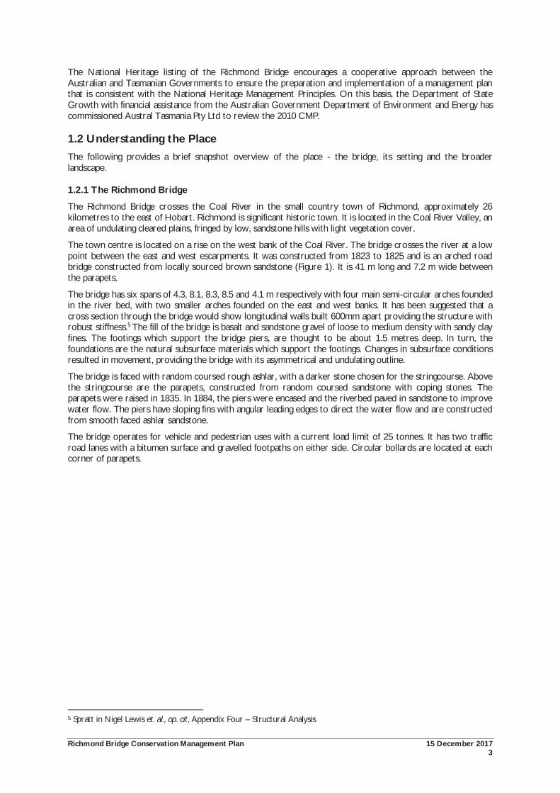
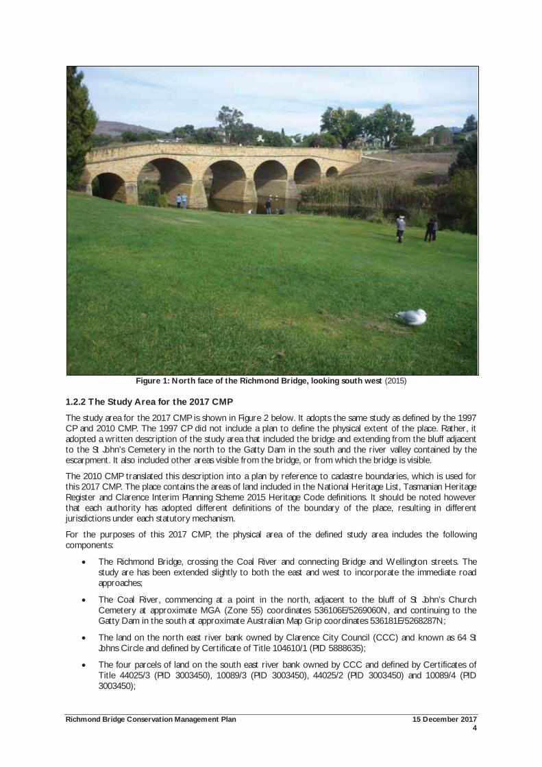
The town centre is located on a rise on the west bank of the Coal River. The bridge crosses the river at a low point between the east and west escarpments. It was constructed from 1823 to 1825 and is an arched road bridge constructed from locally sourced brown sandstone (Figure 1). It is 41 m long and 7.2 m wide between the parapets.
The bridge has six spans of 4.3, 8.1, 8.3, 8.5 and 4.1 m respectively with four main semi-circular arches founded in the river bed, with two smaller arches founded on the east and west banks. It has been suggested that a cross section through the bridge would show longitudinal walls built 600mm apart providing the structure with robust stiffness.5 The fill of the bridge is basalt and sandstone gravel of loose to medium density with sandy clay fines. The footings which support the bridge piers, are thought to be about 1.5 metres deep. In turn, the foundations are the natural subsurface materials which support the footings. Changes in subsurface conditions resulted in movement, providing the bridge with its asymmetrical and undulating outline.
The bridge is faced with random coursed rough ashlar, with a darker stone chosen for the stringcourse. Above the stringcourse are the parapets, constructed from random coursed sandstone with coping stones. The parapets were raised in 1835. In 1884, the piers were encased and the riverbed paved in sandstone to improve water flow. The piers have sloping fins with angular leading edges to direct the water flow and are constructed from smooth faced ashlar sandstone.
The bridge operates for vehicle and pedestrian uses with a current load limit of 25 tonnes. It has two traffic road lanes with a bitumen surface and gravelled footpaths on either side. Circular bollards are located at each corner of parapets.
5 Spratt in Nigel Lewis et. al., op. cit, Appendix Four – Structural Analysis
Richmond Bridge Conservation Management Plan 15 December 2017 4
Figure 1: North face of the Richmond Bridge, looking south west (2015)
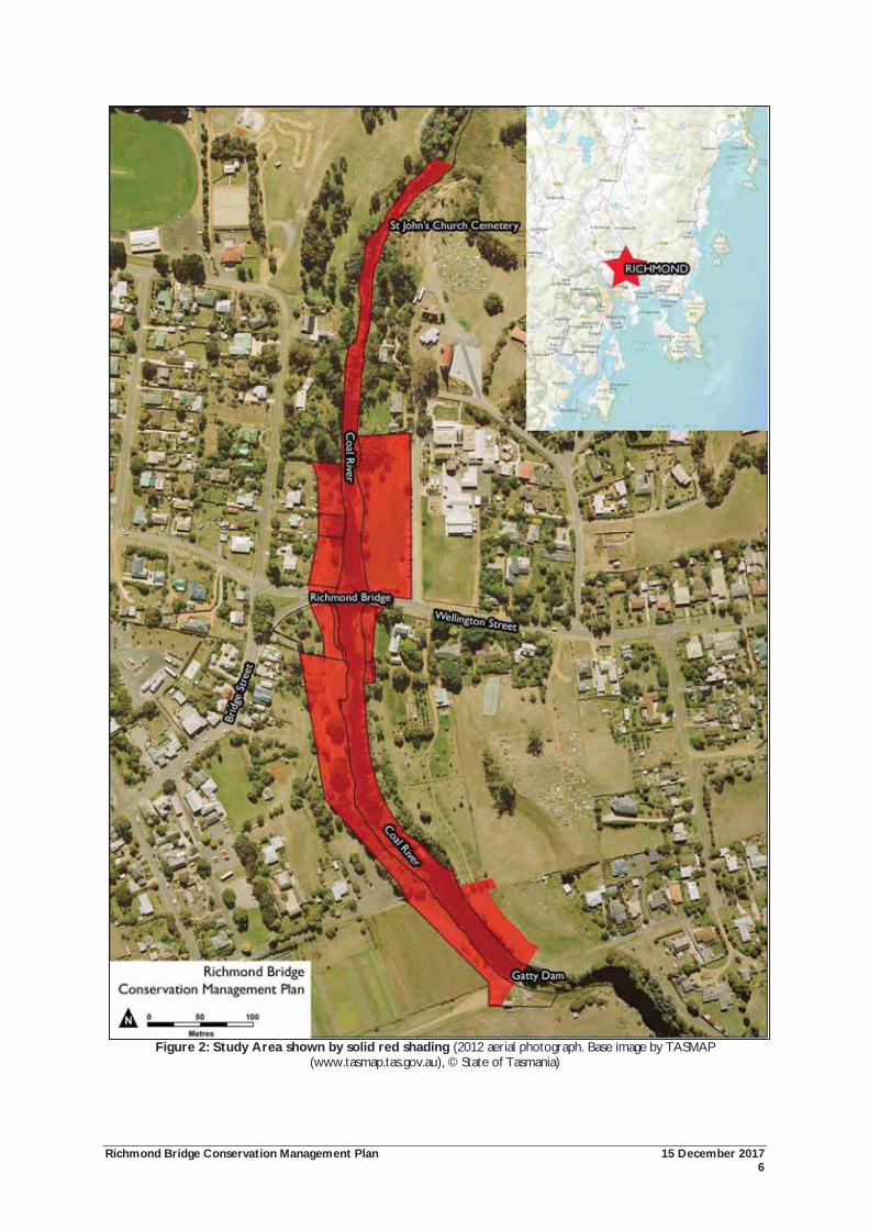
1.2.2 The Study Area for the 2017 CMP
The study area for the 2017 CMP is shown in Figure 2 below. It adopts the same study as defined by the 1997 CP and 2010 CMP. The 1997 CP did not include a plan to define the physical extent of the place. Rather, it adopted a written description of the study area that included the bridge and extending from the bluff adjacent to the St John’s Cemetery in the north to the Gatty Dam in the south and the river valley contained by the escarpment. It also included other areas visible from the bridge, or from which the bridge is visible.
The 2010 CMP translated this description into a plan by reference to cadastre boundaries, which is used for this 2017 CMP. The place contains the areas of land included in the National Heritage List, Tasmanian Heritage Register and Clarence Interim Planning Scheme 2015 Heritage Code definitions. It should be noted however that each authority has adopted different definitions of the boundary of the place, resulting in different jurisdictions under each statutory mechanism.
For the purposes of this 2017 CMP, the physical area of the defined study area includes the following components:
The Richmond Bridge, crossing the Coal River and connecting Bridge and Wellington streets. The study are has been extended slightly to both the east and west to incorporate the immediate road approaches;
The Coal River, commencing at a point in the north, adjacent to the bluff of St John’s Church Cemetery at approximate MGA (Zone 55) coordinates 536106E/5269060N, and continuing to the Gatty Dam in the south at approximate Australian Map Grip coordinates 536181E/5268287N;
The land on the north east river bank owned by Clarence City Council (CCC) and known as 64 St Johns Circle and defined by Certificate of Title 104610/1 (PID 5888635);
The four parcels of land on the south east river bank owned by CCC and defined by Certificates of Title 44025/3 (PID 3003450), 10089/3 (PID 3003450), 44025/2 (PID 3003450) and 10089/4 (PID 3003450);
Richmond Bridge Conservation Management Plan 15 December 2017 5
The area of public land located on the south east river bank adjacent to the Gatty Dam between approximate MGA (Zone 55) coordinates 536136E/5268372N in the north and coordinates 536191E/5268303N in the south. The tenure of the land is shown as a ‘road casement’, and presumably the responsibility of CCC, along with other local roads;
The three parcels of land on the north west bank river bank owned by CCC and defined by Certificates of Title 66866/1-3 (no PID); and
The three parcels of land on the south west bank of the river. This includes the land known as 68 Bridge Street inclusive of Certificates of Title 165030/1 (PID 2892815) and 146274/1 (PID (2892815), and the land known as 70 Bridge Street and defined by Certificate of Title 153169/1 (PID 2068367).
One parcel of land appears to have been omitted by error from the 2010 CMP study area plan. This is the lot known as 66 Bridge Street and defined by CT 161603/1 (PID 3120286). It is owned and managed by CCC as part of the public riverbanks. It is located on the south western riverbank, and forms part of the western approach to the bridge. It is vegetated open space and accessible by the public. It forms part of the immediate setting of the bridge and is subject to the same Zone and Code provisions under the Interim Planning Scheme. It would be desirable for this additional lot to be considered as part of the Richmond Bridge place for the purposes of future management.
In addition to providing a defined area for management as the Richmond Bridge and its setting, the 1997 CP and 2010 CMP identified the visual importance of the place to Richmond. Significant views to and from the place are identified in this CMP.
Richmond Bridge Conservation Management Plan 15 December 2017 6
Figure 2: Study Area shown by solid red shading (2012 aerial photograph. Base image by TASMAP (www.tasmap.tas.gov.au), © State of Tasmania)
Richmond Bridge Conservation Management Plan 15 December 2017 7
1.3 Approach to Preparing this Conservation Management Plan This 2017 CMP has been prepared for the Department of State Growth by Justin McCarthy and James Puustinen, Austral Tasmania Pty Ltd. It has been prepared as a review and revision of the previous 2010 CMP, which in turn, was a major review and revision of the initial 1997 Conservation Plan. This CMP has been prepared in accordance with the National Heritage Management Principles, The Burra Charter: the Australia ICOMOS Charter for Places of Cultural Significance, 2013 which provides a best practice standard for managing cultural heritage places in Australia, and key Tasmanian legislative and policy guidelines for the management of heritage places, principally the Historic Cultural Heritage Act 1995 and its associated documents of Assessing Historic Heritage Significance for application with the Historic Cultural Heritage Act 1995 (Version 5, October 2011) and Works Guidelines for Historic Heritage Places (November 2015). The following tasks have been carried out as part of this project:
Stage 1: Initial Review and Consultation. The 1997 and 2010 conservation plans were reviewed at project inception to identify strengths and weaknesses of the existing documentation and areas requiring revision. Works and projects which have been carried out post-2010 were also reviewed as part of this process. Principally this includes the results of vibration monitoring of the bridge and the preparation of a Vegetation Management Plan for the broader setting. Preliminary consultation with key stakeholders was carried out at the beginning to seek their input into the review process. The key stakeholders are the Department of State Growth; Clarence City Council; Heritage Tasmania (DPIPWE), Aboriginal Heritage Tasmania (DPIPWE); and Tasmanian Irrigation.
Stage 2: Physical Analysis. The bridge and its setting have been inspected to document the key features of the place. Written and photographic records of the place were made sufficient to illustrate the key characteristics of the place and the series of Site Inventory datasheets has been updated.
Stage 3: Review and Revision. The 2010 CMP is considered to be a sound document and has been reviewed and revised as necessary to form this 2017 CMP. Key revisions include updating the CMP to reflect works or other assessment projects which have been carried out since 2010; updating the management framework to reflect the extensive legislative changes which have occurred at State and local levels; and, revision of the conservation policies to reflect current requirements.
Stage 4: Consultation. The draft CMP has been made available to key stakeholder groups. Written submissions were sought on the adequacy of the draft CMP and these submissions were considered in preparing the final version.
1.4 Structure of this Conservation Management Plan The 2010 CMP provides a sound and thorough source for much of the historical, landscape and significance assessments, and the broader conservation policies. It also provides a logical structure which has been repeated in this CMP. The CMP been structured in the following manner:
An historical summary outlining the evolution of the Richmond Bridge and its setting to 2017;
An analysis of the setting of the Richmond Bridge. This has included an assessment of the cultural landscape values of the study area and the identification of significant views to and from the study area;
An assessment of the significance of the study area. The significance includes assessment at National, State and Local levels, considering the values against the criteria in the Historic Cultural Heritage Act 1995;
An overview of the management system for the Richmond Bridge and its setting at National, State and local levels;
Conservation Policies to assist in ensuring that the significance is maintained for present and future generations; and
Appendices that include the Site Inventory sheets and other supporting documentation.
Richmond Bridge Conservation Management Plan 15 December 2017 8
1.5 Limitations and Constraints This report has been commissioned as a review of the existing 2010 CMP. The advice, representations and recommended actions contained in this CMP are aimed at conserving the cultural heritage values of the Richmond Bridge and study area. The responsibility for assessing risks (real and/or perceived) arising from implementation of the report or aspects thereof rest solely with the owners and managers of the place.
No legal liability whatsoever is accepted by Austral Tasmania Pty Ltd for any direct or consequential loss, damage or injury (including without limitation any costs incurred in connection with proceedings either legal or arbitration) suffered by any person or entity which arises as a result of implementation of heritage conservation related advice at or about the place.
This report includes information summarised from previous investigations. Full and direct reference to the original source material is recommended.
This CMP is principally limited to consideration of historic heritage values. An Aboriginal heritage assessment has not been undertaken as part of this work, although preliminary enquiries were made to Aboriginal Heritage Tasmania, DPIPWE and the results incorporated into the recommendations made in this report.
Whilst every effort has been made to gain insight to the historic heritage profile of the subject study area, Austral Tasmania Pty Ltd cannot be held accountable for errors or omissions arising from such constraining factors.
1.6 Acknowledgements The assistance of the following people and organisations is gratefully acknowledged:
Mr David Spiers, Department of State Growth;
Mr Matt Davis, Department of State Growth;
Mr Vincent Tang, Department of State Growth;
Mr Darren McConnon, Department of State Growth;
Ms Jill Jones, Department of State Growth;
Ms Selena Dixon, Department of State Growth;
Mr Peter Spratt, Consulting Chartered Engineer;
Mr Ian Preece, Clarence City Council;
Mr Pete Smith, Heritage Tasmania, DPIPWE;
Mr Ian Boersma, Heritage Tasmania, DPIPWE;
Mr John Stephenson, Heritage Tasmania, DPIPWE;
Mr Adam Marshall, Aboriginal Heritage Tasmania, DPIPWE;
Mr Hugh Christie, Tasmania Irrigation;
Mr Peter Rand, Tasmanian Irrigation; and
Mr Perry Foster, Crown Land Services, DPIPWE.
Richmond Bridge Conservation Management Plan 15 December 2017 9
Historical Summary
Richmond Bridge Conservation Management Plan 15 December 2017 10
2.0 HISTORICAL SUMMARY
2.1 Chronology of the Richmond Bridge 1803 European exploration of the Coal River Valley.
1815 1,000 acre land grant issued to George William Evans, part of which now forms the north west portion of the Richmond township.
1819 Land grant of 710 acres to Lieutenant-Governor Sorell ‘commencing at the crossing place on the Coal River in the District of Ulva’, part of which now forms Richmond township.
18?? Land located to CW Murray, and subsequently granted to him, part of which now forms the north east portion of Richmond township.
1817 100 acre land grant to David Lord (with an additional 700 acres grant in 1819), part of which now forms the eastern portion of Richmond township.
By 1820 Road construction to Richmond commenced.
1820 Visit by John Thomas Bigge during his Commission of enquiry, recommending the erection of a bridge over the Coal River.
1823 first stone of bridge laid (11 December 1823).
1824 Transfer of 90 acres by David Lord to the Government for the use as a township site, and officially named Richmond by Lieutenant-Governor Sorell on 27 February 1824.
1824 Central part of township laid out.
1825 Bridge opens to traffic (1 January 1825).
1826 Report by Major Tobias Kirkwood on movement of piers. Water from the mill dam may have caused the damage.
1829-31 Windmill erected by Buscombe on the south west riverbank.
1834 New road constructed from Hobart across Grass Tree Hill to Richmond, the bridge was considered as the ‘best and most substantial in the colony’.
1834 The foundation stone of St Luke’s Church laid, and church consecrated 19 May 1838.
1835 The parapets of bridge raised at western end.
1836 Tenders were called for the erection of St John’s church. The church opened 1837.
1843 Artist Thomas Chapman prepares a watercolour sketch showing the bridge, the earliest known depiction. Two sketches from a similar period show the bridge and river.
1846 Possible flood damage to the bridge.
1849 Correspondence and plan for ‘proposed causeway across Pittwater’.
By 1856 George Burn erected mill on south east riverbank.
Post 1856 Photograph taken of bridge from north, the earliest known photograph of bridge.
1859 The bridge was considered dilapidated and unsafe. A report by Director of Public Works, WR Falconer recommended underpinning and the use of concrete.
1861 Richmond declared a municipality.
1872 Sorell causeway opened and railway extended to Campania.
1884 Cut water edges added to the piers. Spratt concludes that the river paving dates from this time.
1908 Buscombe’s Windmill dismantled.
1920 Eldershaw acquired and renovated Burns’ mill.
1923 Centenary celebrations of bridge (11 December). Construction dates are added to the bridge and a commemorative stone is installed on the inside of the northern parapet.
Richmond Bridge Conservation Management Plan 15 December 2017 11
1925 Narrow strip of land acquired by Richmond Municipality along west bank of river, downstream from the bridge.
1927-28 Repairs carried out to the bridge.
1935 Gatty Dam constructed downstream with consequent rise in water level.
1964 The Royal Australian Institute of Architecture called a meeting in July to consider the future of Richmond. An exhibition was held in February 1965, and a public meeting in March of that year. The Local Government Act was amended for preservation orders, and a public meeting was held in July 1967.
1969 Pembroke Street reservation of almost one acre was sold. This land once led to the eastern bank of the Coal River.
1969 Elizabeth Jones published ‘A Guide to the History of Richmond, Tasmania’, in the Papers and Proceedings of the Tasmanian Historical Research Association (vol. 16, no. 4, May 1969)
1973 Public acquisition of land on west bank of the river, up and downstream of the bridge.
Recutting and ‘darkening’ of the inscription stones. The method to darken the inscription is unknown.
1977 30 km/hr speed restriction introduced.
1978 The Richmond Bridge was entered in the Register of the National Estate (21 March 1978).
1985 25 tonne limit on the bridge.
1987 Car accident on the bridge caused a 1.5 metre hole in the downstream parapet wall and some loosening in the stone work. Some 75% of the stone was able to be recovered for reconstruction, and new stones were sought locally.
1988 A vehicle accident dislodged some six metres of the south east parapet wall.6
1989 The Richmond Council constructs the viewing platform and staircase to the south west.
1993 Richmond Interim Order gazetted (March). The Richmond Municipality was absorbed within the city of Clarence (April).7
1997 Historic Cultural Heritage Act 1995 (Tas) proclaimed.
1999 The Richmond Bridge was permanently entered in the Tasmanian Heritage Register (22 September).
2005 The Richmond Bridge was entered on the National Heritage List (25 November).
2007 Vehicular accident on the bridge (July) damaged the south western parapet wall above the first arch. Speeding was attributed as the cause of the accident.
2009 Initial testing carried out using a vibration meter to provide real time data on potential problems resulting from excessive vibrations. Testing work shown to be successful.
2010 Following the success of the 2009 testing, a permanent vibration meter linked to a camera was attached to the bridge.
2013 Department of State Growth awarded the Colin Crisp Award in recognition of the vibration monitoring work. The award is Engineers Australia’s premier recognition of excellence in engineering heritage projects.
2017 State Growth conducted geotechnical investigations of the foundations and riverbed at the Richmond Bridge.
6 Snowden, D, Richmond Cultural Resource Management Plan. Volume 3, A thematic history of the cultural resources of the township of Richmond, Clarence City Council and Australian Heritage Commission, 2000, p.71 7 Nigel Lewis et al, op. cit., pp.8-10
Richmond Bridge Conservation Management Plan 15 December 2017 12
2.2 Aboriginal History and Interaction with European Settlers The Coal River Valley is part of the country of the Oyster Bay people of Tasmania. Located on the east coast of Tasmania, their lands covered some 7,800 square kilometres, including 515 kilometres of coastline. Their country extended from St Patricks Head in the north, to the east bank of the Derwent estuary. Inland, it reached St Peters Pass in the Midlands, before following the Eastern Tiers to the Break O’Day River, where it returned to the coast at St Patricks Head.
Prior to European settlement, Ryan proposes that ten bands formed part of the Oyster Bay nation with a population of between 700-800 people, the largest group in Tasmania. The Risdon and Pittwater areas were the home of the Moomairremener band. The Moomairremener band enjoyed a diet of shellfish from estuarine areas, possums and kangaroo from their hunting grounds of the open forests and plains, and a variety of vegetable foods.
The band moved seasonally to take advantage of available foods, spending winters on the coast where shellfish, coastal birds and vegetables were found, before moving inland around October when the warmer weather allowed them to hunt larger game. As the summers progressed, the group moved further west, hunting and firing the bush to flush out game. Using well defined routes, the Moomairremener band’s route inland was west up to the Derwent River to New Norfolk, and then on to the Clyde and Ouse Rivers.8
The use of the land shaped the Tasmanian landscape over many thousands of years. Traditional management practices such as firing the land for hunting and gathering purposes, cleared the forests and the grass plains. These practices predisposed the area to the suitability for early land grants and settlement by Europeans.
In September 1803, Lieutenant John Bowen and a party of 49 convicts and military personnel established the first permanent European settlement in Tasmania. The chosen site was Risdon Cove, part of the Moomairremener country. The land had been subject to constant firing practices to flush out game. Bowen described the country as ‘more like a nobleman’s park in England than an uncultivated country’.9 The Risdon settlement was also on one of the well established routes to the shellfish and lagoon areas of the Coal River and Pittwater and the hunting grounds on the eastern shore of the Derwent. Initial contact between the British and Aboriginal people was uneasy. However, conflict soon escalated over land and food.
European settlement and the acquisition of land was done at great cost to the Aboriginal people of the district. Violence ensued, and the resulting reports are written by the settlers, not from the Aborigines perspective. As early as 1806, the hunting of kangaroos around Pittwater led to conflict and violence between the Tasmanians and Europeans. Conflicts increased with the growth of European population and the rapid expansion of land clearing, fencing and competition for land. In June 1814, Lieutenant-Governor Davey issued a proclamation regarding the ‘very marked and decided hostility ... lately ... evinced by the natives in the neighbourhood of the Coal River’. On enquiry, Davey learned that the violence had been caused by the abduction of Aboriginal children. The new Lieutenant-Governor, William Sorell inherited this situation. On his appointment in May 1817, he acknowledged how some Europeans would:
... pursue the women, for the purpose of compelling them to abandon their children. This last outrage is perhaps the most certain of all to excite in the sufferers a strong thirst for revenge against all white men ... With a view to prevent the continuance of the cruelty before-mentioned, of depriving the natives of their children; it is hereby ordered that the resident magistrates at the districts of Pitt Water and Coal River, and the District Constables in all other Districts, do forthwith take an account of all the native youths and children which are resident with any of the setters or stock-keepers, stating from whom, and in what manner they were obtained.10
During the 1820s, the European population of the colony boomed. Large land grants encouraged the development of the pastoral industry. In turn, this led to violence between the Aboriginal people and European settlers over land and food supplies. By 1824, the violence had escalated to a state of guerrilla warfare. Field police and the military were sent to fight the Aboriginal resistance. In November 1826, fourteen members of the Oyster Bay Tribe were killed by the military, and a further ten were captured soon after. No Europeans were charged with the murder of the Aborigines.
This conflict culminated in Lieutenant-Governor Arthur’s declaration of martial law in 1828. Arthur set up roving parties to capture Aborigines in the areas settled by Europeans. The most prominent party was headed
8 Ryan, L, The Aboriginal Tasmanians, Allen & Unwin: St Leonards, 1996, pp.15-17, 19 9 Morgan, S, Land Settlement in Early Tasmania. Creating an Antipodean England, Cambridge: Cambridge University Press, 1992, pp.43-44 10 Boyce, J, Van Diemen’s Land, Melbourne: Black Inc., 2008, p.88
Richmond Bridge Conservation Management Plan 15 December 2017 13
by the Richmond Chief District Constable, Gilbert Robertson. In November 1828, Robertson captured the chiefs Eumarrah and Jemmie, a young warrior,11 a lame man and a wife of a chief from the Stoney Creek group. Some of the captured Aborigines were imprisoned at the Richmond Gaol.12
George Augustus Robinson visited the Aborigines held at the Richmond gaol in October 1829, returning again in January 1830. On his return to Hobart, he was accompanied by ‘eight captive natives’, three women, two infants, a man and two boys.
In September 1830, Major Douglas devised the ‘Black Line’ as a human chain of military, police, settlers and convicts that swept across the settled districts of the island in the aim of forcing the Aborigines onto the Tasman Peninsula. The ‘Black Line’ failed in its purpose, capturing only two people.13
Attempts at using force to remove Aboriginal people from the areas settled by Europeans failed. More success was had by George Augustus Robinson who led a series of expeditions aimed at enticing and coercing the remaining Aboriginal people to leave their country. In January 1832, Robinson arrived in Hobart Town in the company of 26 surviving members of the Big River Tribe. They were sent to establishments in the Furneaux Islands ten days later.14
In 1847, the 47 remaining Aboriginal people at the mission on Flinders Island were transported to the former convict station at Oyster Cove, south of Hobart. Back on the Tasmanian mainland, the people would often leave Oyster Cove for weeks at a time to hunt, camp and collect traditional foods, with occasional trips to Hobart.15
2.3 European Settlement European settlement of Tasmania commenced with Lieutenant John Bowen’s arrival at Risdon Cove in September 1803. Shortly after the arrival of the British at Risdon Cove, settlers crossed the hills to east and into the valley where Richmond is situated. The settlers were in search of game: kangaroo and the Tasmanian Emu. Coal was discovered along the riverbanks, and the district was named Coal River.16
In the first years of European settlement, food shortage reached famine proportions. As a result, rations were supplemented by hunting game: kangaroos and emus in the Coal River vicinity.
Whishaw writes that no attempts at European settlement were made in the Coal River district until the relocation of Norfolk Islanders to Van Diemen’s Land in 1807-1808. These settlers were given grants throughout the colony, including in the Pittwater and Coal River areas. The land holdings of these early settlers were small, usually less than 50 acres, and housing was primitive – daub and split timber cottages.17
As Snowden writes, early European settlement in the Richmond area was closely linked to the acquisition of land and the establishment of pastoralism and agriculture. However, she also notes that it was the convicts who provided the cheap labour required for successful settlement. This social distinction between convicts and masters strongly influenced Richmond’s cultural history, and social stratification with division based on both religion and wealth. The acquisition and settlement of land was determined by British regulations. In the early years of British settlement, the approval of the Governor of New South Wales (and Van Diemen’s Land) was required for a settler to be granted land. In time, the size of the land grant became proportional to the amount of capital the settler could bring to the colony.18
11 Plomley notes that this ‘young chief’ was probably Cowerterminna or ‘Jack’, from Little Swanport, not Stoney Creek: Plomley, op. cit., p.107, f.n 65 12 Ryan, op. cit., pp. 7, 73, 75, 101 13 Snowden op. cit., pp.52-54 14 Ryan, op. cit., pp.157-158; Bonwick, J, The Last of the Tasmanians; or, the Black War of Van Diemen’s Land, Sampson Low, Son & Marston: London, 1870, pp.228-229; The Tasmanian Mail, 22 August 1896, p.17 15 Gough, J, ‘Oyster Cove’, in Alexander, A, (ed.), The Companion to Tasmanian History, Centre for Tasmanian Historical Studies, University of Tasmania: Hobart, 2005, pp.261-262; The Mercury, Friday 20 December 1861, p.2; The Mercury, Friday 25 May 1866, p.4; The Mercury, Friday 18 February 1870, p.2 16 Flinn, E, ‘John Bowen (1780-1827)’, in Australian Dictionary of Biography, Volume 1: 1788-1850, Melbourne University Press, 1966, pp.136-137, in Nigel Lewis et al, op. cit., p.17; Snowden, op. cit., p.17 17 Whishaw, MK, History of Richmond and Recollections from 1898-1920, Hobart: National Trust of Australia (Tas.), 1973., p.48 18 Snowden, op. cit., p.18
Richmond Bridge Conservation Management Plan 15 December 2017 14
Few land grants were made until 1813, when Governor Macquarie issued 356 grants, many to the former Norfolk Islanders, resettled to Van Diemen’s Land. In the Coal River district, Macquarie granted 1,000 acres to George William Evans. Evans later sold this land to Simeon Lord.19
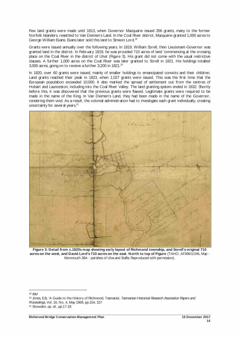
Grants were issued annually over the following years. In 1819, William Sorell, then Lieutenant-Governor was granted land in the district. In February 1819, he was provided 710 acres of land ‘commencing at the crossing place on the Coal River in the district of Ulva’ (Figure 3). His grant did not come with the usual restrictive clauses. A further 1,000 acres on the Coal River was later granted to Sorell in 1821. His holdings totalled 3,000 acres, going on to receive a further 3,200 in 1821.20
In 1820, over 60 grants were issued, mainly of smaller holdings to emancipated convicts and their children. Land grants reached their peak in 1823, when 1,027 grants were issued. This was the first time that the European population exceeded 10,000. It also marked the spread of settlement out from the centres of Hobart and Launceston, including into the Coal River Valley. The land granting system ended in 1832. Shortly before this, it was discovered that the previous grants were flawed. Legitimate grants were required to be made in the name of the King. In Van Diemen’s Land, they had been made in the name of the Governor, rendering them void. As a result, the colonial administration had to investigate each grant individually, creating uncertainty for several years.21
Figure 3: Detail from c.1820s map showing early layout of Richmond township, and Sorell’s original 710 acres on the west, and David Lord’s 710 acres on the east. North to top of Figure (TAHO, AF396/1/246, Map -
Monmouth 38A - parishes of Ulva and Staffa. Reproduced with permission).
19 Ibid 20 Jones, E.B, ‘A Guide to the History of Richmond, Tasmania’, Tasmanian Historical Research Association Papers and Proceedings, Vol. 16, No. 4, May 1969, pp.154, 157 21 Snowden, op. cit., pp.17-18
Richmond Bridge Conservation Management Plan 15 December 2017 15
The provision of cheap convict labour was crucial for successful settlement and economic development. Early land grants came with free convict labour for six months. Later, the settlers were required to provide for their convict labourers. Snowden’s research has found that a high proportion of convicts in the Coal River district accompanied the spread of settlement.22
In 1821, 105 male, and five female convicts were recorded in the Coal River. The free population of the district in 1823 was only 127, of whom; 86 were born free or arrived free. In 1831, the population of the Richmond district was 2,800, comprising 1,700 free settlers and 1,100 convicts.
Some emancipists took up land in the Richmond area. However the size of their grants was often too small to make a success from farming. At least one-fifth, but more likely more than half of those granted land before 1824 were emancipated convicts. Some though were very successful, including James Lord who amassed a large fortune through both farming, and illegal dealing in spirits.
Although not part of the township of Richmond, these early rural land grants are closely tied with its history. The first stage of the development of the economy was the establishment of the large estates. Land was cleared for pastoralism and agriculture, and later sold, subdivided and traded. The large landholders became the dominant figures in colonial society: its economy, political life, and the social structure. Land along the Coal River was some of the earliest to be explored and acquired by the British. Many of the rural grants predate the township of Richmond, and were established as self sufficient communities. When Richmond was established, the large estates continued to play an important role in the development of the economy. Richmond provided the market facilities for these estates. Town residents were also employed on the estates as labourers, shepherds, blacksmiths, carpenters, servants and gardeners.23
2.4 Establishment of Richmond Richmond was established in 1824, prompted by the construction of the bridge which began the previous year. The town was identified as a link to the south east region including a transit stop between Hobart, the east coast and the Tasman Peninsula. The area was also agriculturally productive, providing Richmond with a future role as a supply and service centre. The establishment of the town was closely related to the construction of the bridge.24
The establishment of the township of Richmond has its origins in the early large rural grants. The Land Commissioners recorded that Lieutenant-Governor Sorell sold his Richmond land to John Butcher and Dr Barnes. In settling a debt of £100, Butcher then sold 100 acres of land to David Lord, who appeared to already be aware that the land would be required for a township. Almost immediately, Lord exchanged the 90 acres for the township for a 1,400 acre grant at York Plains, near Oatlands. This 90 acre piece of land formed the basis of Richmond. Of this land, 40 acres were on the west bank of the Coal River, the remaining 50 were from Lord’s Richmond Park estate on the eastern side of the river.25
It appears that the Crown’s purchase of Lord’s land was highly irregular and representative of the misuse of land grants during the early nineteenth century. Lord’s biographer records this transaction as ‘one of his more notable land deals’.26 Even by the standards of the day, this transaction received comment. Crown Solicitor Alfred Stephen wrote in 1823: ‘The transaction of purchase appears the most extraordinary I ever heard of in such a matter but, so far as my duty is concerned which is merely to get a proper conveyance and title, the case is not complicated.’27 The Land Commissioners reported on this sale:
20 May 1826: Mr Butcher paid us a visit about a piece of land adjoining his, which we conceived both from the extent of Butchers land and the Chart to belong to Government, consequently we valued it as such. Mr Butcher said he had given Col. Sorell two thousand acres and five hundred pounds for this land, and he was assured that the whole Peninsular was his, and that his Grant mentioned it. Of course we referred him to the Surveyor General. Major de Gillern mentioned that immediately after the sale of this Grant to Mr Butcher, it was found necessary, to buy one hundred acres from him for the Township of Richmond, but it might not look well on the part of the Government buying it directly from Butcher,
22 Ibid., p.20 23 Ibid, op. cit., pp.21, 30-31 24 Michael Shield & Associates in association with Don Goldworthy & Associates, Richmond Cultural Resource Management Plan: a plan for managing the cultural resources of the township of Richmond, Tasmania, Clarence Council, 2001, p.5 25 Snowden, op. cit., p.31-32 26 Allen, S, 'Lord, David (1785 - 1847)', Australian Dictionary of Biography Volume 2, 1788-1850, Melbourne University Press, 1967, pp.126-127 27 TAHO, CSO 1/979/1283, in Jones, ‘A Guide to the History of Richmond, Tasmania’, p.155
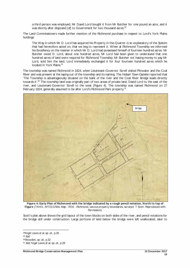
Richmond Bridge Conservation Management Plan 15 December 2017 16
a third person was employed, Mr David Lord bought it from Mr Butcher for one pound an acre, and it was shortly after disposed [of] to Government for two thousand acres.28
The Land Commissioners made further mention of the Richmond purchase in respect to Lord’s York Plains holdings:
The Way in which Mr D. Lord has acquired his Property in this Quarter is so explanatory of the System that had heretofore acted on, that we beg to represent it. When at Richmond Township we informed his Excellency on the manner in which Mr D. Lord had possessed himself of fourteen hundred acres. Mr Butcher owed D. Lord, about one hundred acres, Mr Lord had been given to understand that one hundred acres of land were required for Richmond Township, Mr Butcher not having money to pay Mr Lord, sold him the land. Lord immediately exchanged it for four fourteen hundred acres which he located in York Plains.29
The township was named Richmond in 1824, when Lieutenant-Governor Sorell visited Pittwater and the Coal River and was present at the laying out of the township and its naming. The Hobart Town Gazette reported that ‘The Township is advantageously situated on the bank of the river and the Coal River Bridge leads directly towards it’.30 The township land was originally part of two areas of private land, David Lord to the east of the river, and Lieutenant-Governor Sorell to the west (Figure 4). The township was named Richmond on 27 February 1824, generally assumed to be after Lord’s Richmond Park property.31
Figure 4: Early Plan of Richmond with the bridge indicated by a rough pencil notation. North to top of Figure (TAHO, AF721/1/564, Map - R/16 - Richmond, various property boundaries, surveyor T Scott. Reproduced with
Permission).
Scott’s plan above shows the grid layout of the town blocks on both sides of the river, and pencil notations for the bridge still under construction. Large portions of land below the bridge were left unallocated, later to
28Nigel Lewis et al, op. cit., p.26 29 Ibid 30Snowden, op. cit., p.32 31 Ibid; Nigel Lewis et al, op. cit., p.28
Bridge
Richmond Bridge Conservation Management Plan 15 December 2017 17
become River Place, or Street. This reserve continues to exist to a limited extent on the west bank, but not the east.
Initial settlement and growth was largely due to geographical position and links between Port Arthur and Hobart. Construction of the bridge provided impetus for expansion into the surrounding districts for agriculture whilst also stimulating town development as a service centre.32
2.5 Construction of the Richmond Bridge Prior to the construction of the bridge, the Coal River was crossed via fords. Nigel Lewis et. al. write that the location of these fords was indicated by several early road alignments leading towards the water’s edge. These crossing points may have existed upstream of the bridge, reached via the right of way. Another crossing point may have been at the end of Pembroke Street, on the east bank of the river, and slightly downstream from the bridge where the fresh and salt water met in the Coal River. The third ford may have been near the present weir of the Gatty Dam, accessed from the west by Torrens Street. 33
However, these fords were not permanent crossing points of the river, and regular floods and high tides often held up traffic. The Hobart Town Gazette wrote in 1816 that a bullock drawn cart drifted down stream whist crossing the river. The cart was lost but the bullocks were able to swim ashore.34
The need for a permanent crossing point of the river was identified by the Royal Commissioner, John Thomas Bigge, during his visit to Van Diemen’s Land in 1820 as part of the Commission of Inquiry on the State of Agriculture and Trade. Indeed, in its early days, the bridge was known as ‘Bigge’s Bridge’. Commissioner Bigge visited the Richmond area in 1820. His report of 1823 noted that:
It is on the tract of land called Clarence’s Plains, and more especially in the district of Pitt Water and the Coal River, that the pre-eminent fertility of the soil of Van Diemen’s Land is exhibited. The surface of these tracts is sufficiently varied and open to prevent the stagnation of the water, but not to impede cultivation. The soil consists of sandy loam, and in Pitt Water of a rich and reddish loam of some depth and tenacity. The timber hardly exceeds the proportion that would be requisite for ornament, and at present is insufficient for the construction of buildings and fences. The farms here are of a larger extent than in the other districts of Van Diemen’s Land, and the appearance of five or six farm-houses indicated attention to domestic comfort and agricultural improvement. … The cultivated lands of each farm are entirely open, and except upon an estate of Colonel Davey and one of Mr Lord, I did not observe a single fence … The cultivation of the other parts of the county of Buckinghamshire is extended to the banks of the Coal River, a small stream that falls into an arm of the sea at Pitt Water, on which there are some very fine and beautiful tracts of land, equally calculated for the purposes of grazing or tillage. In some portions of these tracts the effects of inundation are visible; but not more encumbered with wood that its wants will be found to require.35
In choosing the location for the bridge, Von Stieglitz writes that there was ‘heated discussion’ as property owners adjoining the river made claims for the crossing to be on their land, although the ford was obviously the best location.36
John Turnbull was appointed to the role of Superintendent of the Bridge Building, and the Superintendent of Stonemasons was William Wilson. The Hobart Town Gazette and Van Diemen’s Land Advertiser recorded on 13 December 1823 that works on the construction of the bridge had commenced. It published that:
The first stone of the bridge over the Coal River was laid on the 11th instant, there being present James Gordon, Esq. and G.W. Gunning Esq., Magistrates of the Pitt Water and Coal River Districts and a number of the respectable Settlers of the vicinity – This bridge secures a passage at all seasons to the fertile district on the farther side of the Coal River, Pitt Water and the township of Sorell, over a stream which is very generally flooded in the winter and spring. It received the name of Bigge’s Bridge, in compliment to his Majesty’s late Commissioner to these Colonies.37
32 Michael Shield & Associates, op. cit., p.6 33 Nigel Lewis et al, op. cit., pp.49, 76-77, 80 34 Whishaw, op. cit., p.49; Jones, E.B, Richmond – Tasmania: a Crossing Place, Hobart: Richmond Preservation and Development Trust, 1973, p.22 35 Bigge, JT, Report of the Commissioner of Inquiry on the State of Agriculture and Trade in the Colony of New South Wales, ordered by the House of Commons to be printed, 13 March 1823, p.25 in Nigel Lewis et al, op. cit., p.25 36 Von Stieglitz, KR, Richmond: the story of its people and its places, Launceston, 1953, p.15 in Nigel Lewis et al, op. cit., p.24 37 Hobart Town Gazette and Van Diemen’s Land Advertiser, Saturday 13 December 1823, p.2
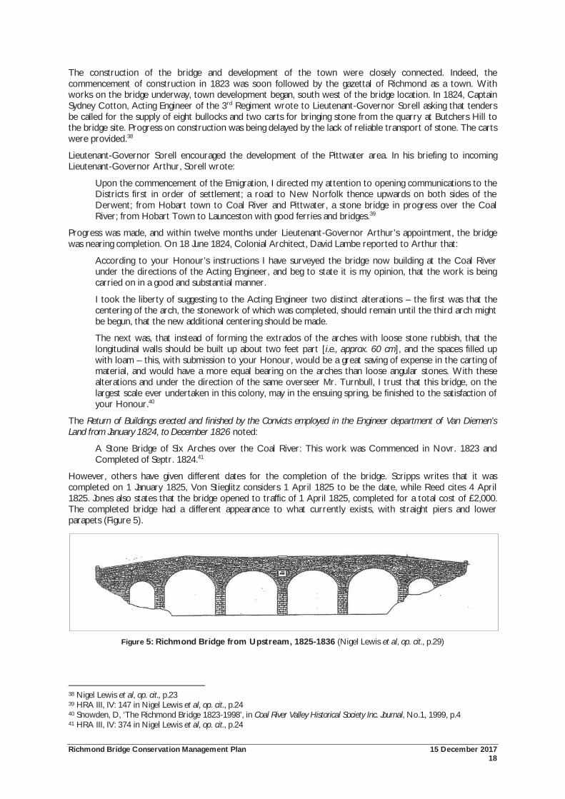
Richmond Bridge Conservation Management Plan 15 December 2017 18
The construction of the bridge and development of the town were closely connected. Indeed, the commencement of construction in 1823 was soon followed by the gazettal of Richmond as a town. With works on the bridge underway, town development began, south west of the bridge location. In 1824, Captain Sydney Cotton, Acting Engineer of the 3rd Regiment wrote to Lieutenant-Governor Sorell asking that tenders be called for the supply of eight bullocks and two carts for bringing stone from the quarry at Butchers Hill to the bridge site. Progress on construction was being delayed by the lack of reliable transport of stone. The carts were provided.38
Lieutenant-Governor Sorell encouraged the development of the Pittwater area. In his briefing to incoming Lieutenant-Governor Arthur, Sorell wrote:
Upon the commencement of the Emigration, I directed my attention to opening communications to the Districts first in order of settlement; a road to New Norfolk thence upwards on both sides of the Derwent; from Hobart town to Coal River and Pittwater, a stone bridge in progress over the Coal River; from Hobart Town to Launceston with good ferries and bridges.39
Progress was made, and within twelve months under Lieutenant-Governor Arthur’s appointment, the bridge was nearing completion. On 18 June 1824, Colonial Architect, David Lambe reported to Arthur that:
According to your Honour’s instructions I have surveyed the bridge now building at the Coal River under the directions of the Acting Engineer, and beg to state it is my opinion, that the work is being carried on in a good and substantial manner.
I took the liberty of suggesting to the Acting Engineer two distinct alterations – the first was that the centering of the arch, the stonework of which was completed, should remain until the third arch might be begun, that the new additional centering should be made.
The next was, that instead of forming the extrados of the arches with loose stone rubbish, that the longitudinal walls should be built up about two feet part [i.e., approx. 60 cm], and the spaces filled up with loam – this, with submission to your Honour, would be a great saving of expense in the carting of material, and would have a more equal bearing on the arches than loose angular stones. With these alterations and under the direction of the same overseer Mr. Turnbull, I trust that this bridge, on the largest scale ever undertaken in this colony, may in the ensuing spring, be finished to the satisfaction of your Honour.40
The Return of Buildings erected and finished by the Convicts employed in the Engineer department of Van Diemen’s Land from January 1824, to December 1826 noted:
A Stone Bridge of Six Arches over the Coal River: This work was Commenced in Novr. 1823 and Completed of Septr. 1824.41
However, others have given different dates for the completion of the bridge. Scripps writes that it was completed on 1 January 1825, Von Stieglitz considers 1 April 1825 to be the date, while Reed cites 4 April 1825. Jones also states that the bridge opened to traffic of 1 April 1825, completed for a total cost of £2,000. The completed bridge had a different appearance to what currently exists, with straight piers and lower parapets (Figure 5).
Figure 5: Richmond Bridge from Upstream, 1825-1836 (Nigel Lewis et al, op. cit., p.29)
38 Nigel Lewis et al, op. cit., p.23 39 HRA III, IV: 147 in Nigel Lewis et al, op. cit., p.24 40 Snowden, D, ‘The Richmond Bridge 1823-1998’, in Coal River Valley Historical Society Inc. Journal, No.1, 1999, p.4 41 HRA III, IV: 374 in Nigel Lewis et al, op. cit., p.24
Richmond Bridge Conservation Management Plan 15 December 2017 19
The result of its construction was that heavy traffic could proceed without delay between Hobart and the east coast and Tasman Peninsula when the Coal River was in flood. Despite its construction, passenger ferries continued to operate at Pittwater.42
2.5.1 The Design and Builders of the Bridge
Who was responsible for the design of the bridge remains a question of debate. Major Thomas Bell, David Lambe, and William Wilson have all been credited as the designers.
At the time of construction, public works were the responsibility of the Engineers Department, comprised of engineers and soldiers of the Royal Engineers. Bell was a military officer and engineer, who arrived in Van Diemen’s Land in 1818 to take control of the military garrison at Hobart Town. In the colony, Bell was appointed a justice of the peace, and acted as both engineer and inspector of public works. Under Lieutenant-Governor Sorell he was responsible for public buildings in Hobart, and roads at Macquarie Plains, and Constitution and Spring Hills in the Midlands. He was also given charge to complete the Wellington Bridge, Hobart, construct the sandstone causeway to Hunter Island and a build a new brick bridge across the Hobart Rivulet in Argyle Street. Thompson considers that his major accomplishment was the formation of the ‘Bell’s Line of Road’, later to become the main road to the north of the colony. Smith writes that it was Bell who was responsible for the Richmond Bridge. Bell was later criticised for his lack of technical skill and delegation of duties.43
David Lambe was an architect and farmer, born in London in 1803. He arrived in Van Diemen’s Land in May 1824, where he was soon appointed Colonial Architect. His role was to ‘draw out plans and specifications of all buildings proposed to be erected by the Crown, to inspect the progress of the work'. Lambe filled this position for over three years. Von Stieglitz writes that Lambe forwarded the plans for the bridge from England.
As noted in the 1997 Conservation Plan, it seems highly unlikely that Lambe was responsible for the design of the bridge. At the time he arrived in Van Diemen’s Land he was only 21 years old. As Lewis et. al. propose, it is improbable for Lambe to have designed the bridge from England, site unseen and prior to his appointment as Colonial Architect.
There is little evidence to assess Lambe’s skills as an architect. He did inspect and report upon works under construction, which included the nave of St John's Church at Launceston, St Matthew's Church at New Norfolk, and the church and parsonage at Sorell. As Smith writes, Lambe’s role with the Richmond Bridge was most likely that of inspection and reporting. 44
More recent research has suggested that the designer of the bridge was William Wilson. Wilson arrived in Van Diemen’s Land in 1820. It is unclear if he was appointed to the position of Superintendent of Stonemasons before his arrival in the colony. At the time of his arrival, the colonial administration did not have the services of a suitably qualified architect. Although untrained, Wilson was a highly skilled stonemason and he became in effect the de facto Colonial Architect. Wilson is known to have been involved in the construction of early buildings in the colony including the original Scots Church in Bathurst Street, a brewery in Davey Street, and the original court house.45
More is known about those in charge of the construction of the bridge, than the convicts who actually built it. This lack of knowledge has given the bridge its own local legend and folklore.
As Acting Engineer and Inspector of Public Works, Bell was responsible for choosing men fit for public works, and allocating the prisoners to their respective work gangs. The Gaol Gang was considered the harshest, where the prisoners were required to dig gravel and worked in the streets. Rations were allocated weekly. A convict in employment of the Crown received seven pounds of meat and seven pounds of flour a week. Each morning, the convicts were mustered and assigned to their different work gangs. The working day commenced at 5.00 a.m. and concluded at sunset, with breaks at breakfast and at lunch to avoid the heat of the midday sun. Bell was concerned with the lack of adequate supervision of the work gangs, as most overseers were convicts.
42 Austral Archaeology Pty Ltd, Spratt, P, Scripps, L, Tasmanian Historic Bridges Heritage Surveys. Commission No C14-93, 1994, p.19; Reed, TT, Historic Churches of Australia, MacMillan, South Melbourne, 1978, p.46; Von Stieglitz, op. cit., p.15; Jones, ‘A Guide to the History of Richmond, Tasmania’, p.162; Snowden, op. cit., pp.69-70 43Smith, R, Early Tasmanian Bridges, Launceston: Foot and Playsted, 1969, p.84; Smith, R, 'Lambe, David (1803-1843)', Australian Dictionary of Biography, Volume 2, 1788-1850, Melbourne University Press, 1967, pp.73-34; Newitt, L, Convicts and Carriageways. Tasmanian Road Development until 1880, Historical Committee of the Department of Main Roads, Tasmania, 1988, p.31 44 Von Stieglitz, op. cit., p.15; Nigel Lewis et al, op. cit., p.25; Smith, R, 'Lambe, David (1803-1843)', op. cit, pp.73-74 45 Wilson, L, ‘Of Chapels and Bridges’, in Coal River Valley Historical Society Inc. Journal, No.1, 1999, pp. 11, 15
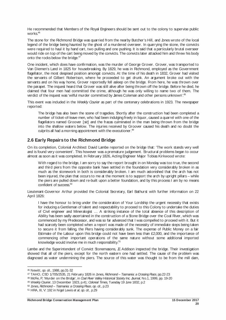
Richmond Bridge Conservation Management Plan 15 December 2017 20
He recommended that Members of the Royal Engineers should be sent out to the colony to supervise public works.46
The stone for the Richmond Bridge was quarried from the nearby Butcher’s Hill, and Jones wrote of the local legend of the bridge being haunted by the ghost of a murdered overseer. In quarrying the stone, the convicts were required to haul it by hand cart, two pulling and one pushing. It is said that a particularly brutal overseer would ride on top of the cart being moved by the convicts. The convicts later attacked him and threw his body onto the rocks below the bridge.47
One incident, which does have confirmation, was the murder of George Grover. Grover, was transported to Van Diemen’s Land in 1825 for housebreaking. By 1829, he was in Richmond, employed as the Government flagellator, the most despised position amongst convicts. At the time of his death in 1832, Grover had visited the servants of Gilbert Robertson, where he proceeded to get drunk. An argument broke out with the servants and on his way home, Grover reportedly fell asleep on the bridge. From here, he was thrown over the parapet. The inquest heard that Grover was still alive after being thrown off the bridge. Before he died, he claimed that four men had committed the crime, although he was only willing to name two of them. The verdict of the inquest was ‘wilful murder committed by James Coleman and other persons unknown’.48
This event was included in the Weekly Courier as part of the centenary celebrations in 1923. The newspaper reported:
The bridge has also been the scene of tragedies. Shortly after the construction had been completed a number of ticket-of-leave men, who had been indulging freely in liquor, caused a quarrel with one of the flagellators named Groover [sic] and the fracas culminated in the man being thrown from the bridge into the shallow waters below. The injuries received by Groover caused his death and no doubt the culprits all had a morning appointment with the executioner.49
2.6 Early Repairs to the Richmond Bridge On its completion, Colonial Architect David Lambe reported on the bridge that: ‘The work stands very well and is found very convenient’. This however was a premature judgement. Structural problems began to occur almost as soon as it was completed. In February 1826, Acting Engineer Major Tobias Kirkwood wrote:
With regard to the bridge, I am sorry to say the report brought in on Monday was too true, the second and third piers from the opposite bank have settled in the foundation very considerably broken in as much as the stonework in both is considerably broken. I am much astonished that the arch has not been injured, the plan that occurs to me at the moment is to support the arch by upright pillars – while the piers are pulled down and re-built upon a better foundation, and by this process I am by no means confident of success.50
Lieutenant-Governor Arthur provided the Colonial Secretary, Earl Bathurst with further information on 22 April 1826:
I have the honour to bring under the consideration of Your Lordship the urgent necessity that exists for inducing a Gentleman of talent and respectability to proceed to this Colony to undertake the duties of Civil engineer and Mineralogist … A striking instance of the total absence of this description of Ability has been sadly ascertained in the construction of a Stone Bridge over the Coal River, which was commenced by my Predecessor, and was so far advanced that I was compelled to proceed with it. But it had scarcely been completed when a report was made of the necessity of immediate steps being taken to secure it from falling, the Piers having considerably sunk. The expense of Public Money on a fair Estimate of the Labour upon this bridge could not have been less than £2,000, and the importance of commencing other important operations of the same nature without some additional imported knowledge would involve me in much responsibility.51
Lambe and the Superintendent of Convict Stonemasons, JE Addison inspected the bridge. Their investigation showed that all of the piers, except for the north eastern one had settled. The cause of the problem was diagnosed as water undermining the piers. The source of this water was thought to be from the mill dam,
46 Newitt, op. cit., 1988, pp.31-32 47 TAHO, CSO 1/705/2535, 21 February 1826 in Jones, Richmond – Tasmania: a Crossing Place, pp.22-23 48 McFie, P, ‘Murder on the Bridge’, in Coal River Valley Historical Society Inc. Journal, No.1, 1999, pp. 19-20 49 Weekly Courier, 13 December 1923, p.41; Colonial Times, Tuesday 19 June 1832, p.2 50 Jones, Richmond – Tasmania: a Crossing Place, op. cit., p.23 51 HRA, III, V: 192 in Nigel Lewis et al, op. cit., p.29
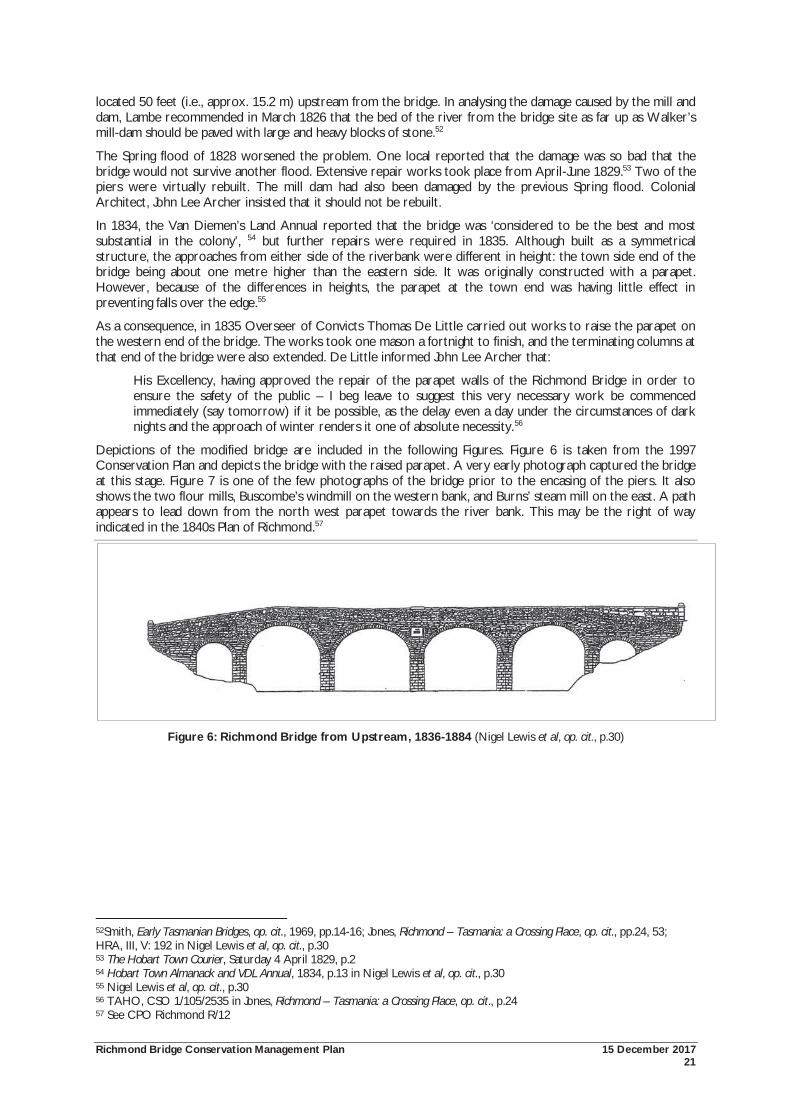
Richmond Bridge Conservation Management Plan 15 December 2017 21
located 50 feet (i.e., approx. 15.2 m) upstream from the bridge. In analysing the damage caused by the mill and dam, Lambe recommended in March 1826 that the bed of the river from the bridge site as far up as Walker’s mill-dam should be paved with large and heavy blocks of stone.52
The Spring flood of 1828 worsened the problem. One local reported that the damage was so bad that the bridge would not survive another flood. Extensive repair works took place from April-June 1829.53 Two of the piers were virtually rebuilt. The mill dam had also been damaged by the previous Spring flood. Colonial Architect, John Lee Archer insisted that it should not be rebuilt.
In 1834, the Van Diemen’s Land Annual reported that the bridge was ‘considered to be the best and most substantial in the colony’, 54 but further repairs were required in 1835. Although built as a symmetrical structure, the approaches from either side of the riverbank were different in height: the town side end of the bridge being about one metre higher than the eastern side. It was originally constructed with a parapet. However, because of the differences in heights, the parapet at the town end was having little effect in preventing falls over the edge.55
As a consequence, in 1835 Overseer of Convicts Thomas De Little carried out works to raise the parapet on the western end of the bridge. The works took one mason a fortnight to finish, and the terminating columns at that end of the bridge were also extended. De Little informed John Lee Archer that:
His Excellency, having approved the repair of the parapet walls of the Richmond Bridge in order to ensure the safety of the public – I beg leave to suggest this very necessary work be commenced immediately (say tomorrow) if it be possible, as the delay even a day under the circumstances of dark nights and the approach of winter renders it one of absolute necessity.56
Depictions of the modified bridge are included in the following Figures. Figure 6 is taken from the 1997 Conservation Plan and depicts the bridge with the raised parapet. A very early photograph captured the bridge at this stage. Figure 7 is one of the few photographs of the bridge prior to the encasing of the piers. It also shows the two flour mills, Buscombe’s windmill on the western bank, and Burns’ steam mill on the east. A path appears to lead down from the north west parapet towards the river bank. This may be the right of way indicated in the 1840s Plan of Richmond.57
Figure 6: Richmond Bridge from Upstream, 1836-1884 (Nigel Lewis et al, op. cit., p.30)
52Smith, Early Tasmanian Bridges, op. cit., 1969, pp.14-16; Jones, Richmond – Tasmania: a Crossing Place, op. cit., pp.24, 53; HRA, III, V: 192 in Nigel Lewis et al, op. cit., p.30 53 The Hobart Town Courier, Saturday 4 April 1829, p.2 54 Hobart Town Almanack and VDL Annual, 1834, p.13 in Nigel Lewis et al, op. cit., p.30 55 Nigel Lewis et al, op. cit., p.30 56 TAHO, CSO 1/105/2535 in Jones, Richmond – Tasmania: a Crossing Place, op. cit., p.24 57 See CPO Richmond R/12
Richmond Bridge Conservation Management Plan 15 December 2017 22
Figure 7: Richmond Bridge, looking south, Buscombe’s windmill on right, Burn’s steam mill on left (TAHO, PH3/1/8948, Photograph - Richmond - view of Bridge, Windmill and Mill. Reproduced with permission)
2.7 Development of Richmond and the Coal Valley In the 1820s, Richmond became one of Lieutenant-Governor Arthur’s police district resulting in the construction of the gaol, court house, barracks and a watch house. The early and continued growth of Richmond relied on its importance as a convict station and a military post.
The town was described in 1827 by the Land Commissioners, writing ‘there is a large stone bridge over the coal river; a Brick court house, stables and stone jail recently built’. Other than this, the settlement was little more than an outstation, relying on Hobart for the supply of meat and flour.
Snowden’s analysis is that the township growth and decline and the accompanying development of the broader agricultural settlement was slow, but steady. This growth ceased with the opening of the Sorell Causeway in 1872 which diverted through traffic away from Richmond. The role of the town refocussed as a service centre for the surrounding rural district.58
Early township plans show the town laid out in a grid pattern on both sides of the Coal River. Initially, development was centred on the road to Kangaroo Point (i.e., Bellerive) on the western bank of the Coal River, and downstream of the bridge. From Kangaroo Point, a ferry connected the settlement with Hobart.
The first buildings to be constructed were the civic infrastructure required for the police and penal systems: the courthouse, gaol, gaoler’s quarters and residence for the Police Magistrate. Soon after, private residences began to appear. Within ten years of establishment, two inns were in operation.59
The Van Diemen’s Land Anniversary and Hobart Town Almanack for the year 1831 noted:
The town of Richmond is situated on the river, near the point, where the salt water ceases to flow. The Court-house, (connected with which, is the residence of Mr. Gordon the Police Magistrate of the district) is a handsome building, and with the gaol, two large and commodious inns, a neat stone bridge of several arches, and the lofty stone tower of the windmill, situated conspicuously in the centre, already give the appearance of a thriving English village.60
58 Snowden, op. cit., pp.78-79 59 Nigel Lewis et al, op. cit., p.28 60 Ross, in Snowden, op. cit., p.9
Richmond Bridge Conservation Management Plan 15 December 2017 23
This ‘lofty stone tower’ was James Kestall Buscombe’s windmill, located on the escarpment on the western bank of the Coal River.61
Richmond became a convenient overnight resting place for both travellers and convicts on their way to the east coast and Tasman Peninsula during the 1830s. By the 1830s, several roads led into and out of the town, and town services expanded with businesses including blacksmiths, wheelwrights, saddlers, stockyards, tanneries, a market place, a pound, brick and lime kilns, as well as general stores. Richmond became a prominent settlement in Tasmania, and in 1835 was Tasmania’s third largest town.
This rapid development was noted by the Quaker traveller James Backhouse. In 1832, Backhouse visited Richmond commenting that the town consisted of a Court house, the gaol, a windmill and about thirty dwelling houses, of which three were inns. Within two years when Backhouse returned, the town had almost doubled in size.
The first commercial buildings to be constructed were inns. On Bridge Street, Buscombe’s Lennox Arms opened in 1827, the Bridge Hotel in c.1830, and the Star and Garter c.1830. The Richmond Hotel was erected c.1830 on the corner of Henry and Bathurst Streets. Also in 1830, Gaby’s General Store was erected in 1830. Service industries were focussed on the main street, including the administrative centre of government. Most industry was related to primary production, a role that continued until the 1970s, when tourism began to have a major impact.62
Residential buildings also began to appear during this time. Richmond includes a fine collection of residences built between the 1830s-1850s. These places are characterised by a uniformity of scale and simplicity in design, although more prominent and detailed examples were also built. The first residence was Mayfield, which was set well back from Bridge Street. It was erected, c.1820 and preceded the establishment of Richmond. Other early housing including the ‘Colonial Cottage’ c.1830, Montacute’s House c.1830s, Red Coats Cottage (built in 1825 to house army officers), the District Magistrate James Gordon’s house 1831, the Police Barracks 1833, Emerald Cottage 1837, and Belmont 1837.63
Melville provided an early description of the town in his 1834 annual:
Richmond, the head-quarters of the police district of the same name, is pleasantly situated on the banks of the Coal River, about four miles [i.e., approx. 6.4 km] from the coast, and distant fourteen miles [i.e., approx. 22.5 km] from Hobart Town. It has a bridge built of stone, considered the best and most substantial in the Colony. Richmond has a gaol, court-house, where also divine service is performed every Sunday by a clergyman of the established church – two inns, and in the immediate neighbourhood are several well-built dwelling houses. The country around is well settled, and affords excellent tillage and pasturage.64
By 1835, Richmond had the largest district population in Van Diemen’s Land (Figure 8).65
61 McFie, P, The Miller's Cottage (Milton Cottage) (1837) and Tower Windmill, Richmond (1831-32), Coal River National Trust Group, 1986, in Nigel Lewis et al, op. cit., p.33 62 Snowden, op. cit., pp.8-9, 80-81 63 Granny Jones, Gossip and Facts about Richmond, Regal Publications: Launceston, 1992 in Nigel Lewis et al, op. cit., p.37 64 Melville, H, The Van Diemen’s Land Annual for the year 1834, p.13, in Snowden, op. cit., p.10 65 Snowden, op. cit., p.78
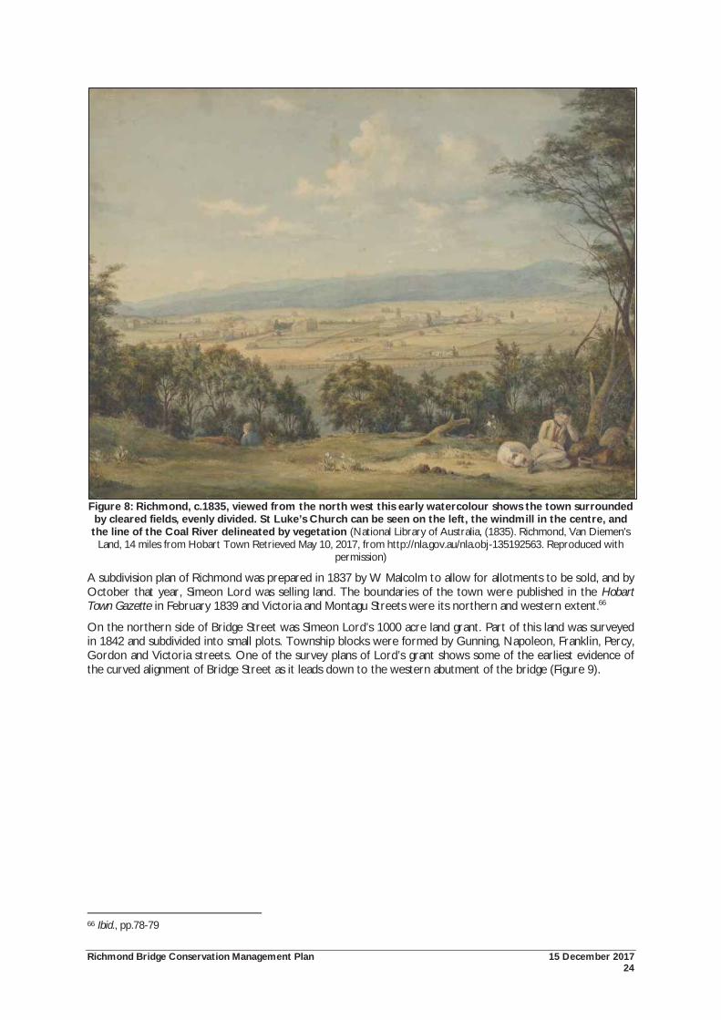
Richmond Bridge Conservation Management Plan 15 December 2017 24
Figure 8: Richmond, c.1835, viewed from the north west this early watercolour shows the town surrounded by cleared fields, evenly divided. St Luke’s Church can be seen on the left, the windmill in the centre, and the line of the Coal River delineated by vegetation (National Library of Australia, (1835). Richmond, Van Diemen's
Land, 14 miles from Hobart Town Retrieved May 10, 2017, from http://nla.gov.au/nla.obj-135192563. Reproduced with permission)
A subdivision plan of Richmond was prepared in 1837 by W Malcolm to allow for allotments to be sold, and by October that year, Simeon Lord was selling land. The boundaries of the town were published in the Hobart Town Gazette in February 1839 and Victoria and Montagu Streets were its northern and western extent.66
On the northern side of Bridge Street was Simeon Lord’s 1000 acre land grant. Part of this land was surveyed in 1842 and subdivided into small plots. Township blocks were formed by Gunning, Napoleon, Franklin, Percy, Gordon and Victoria streets. One of the survey plans of Lord’s grant shows some of the earliest evidence of the curved alignment of Bridge Street as it leads down to the western abutment of the bridge (Figure 9).
66 Ibid., pp.78-79
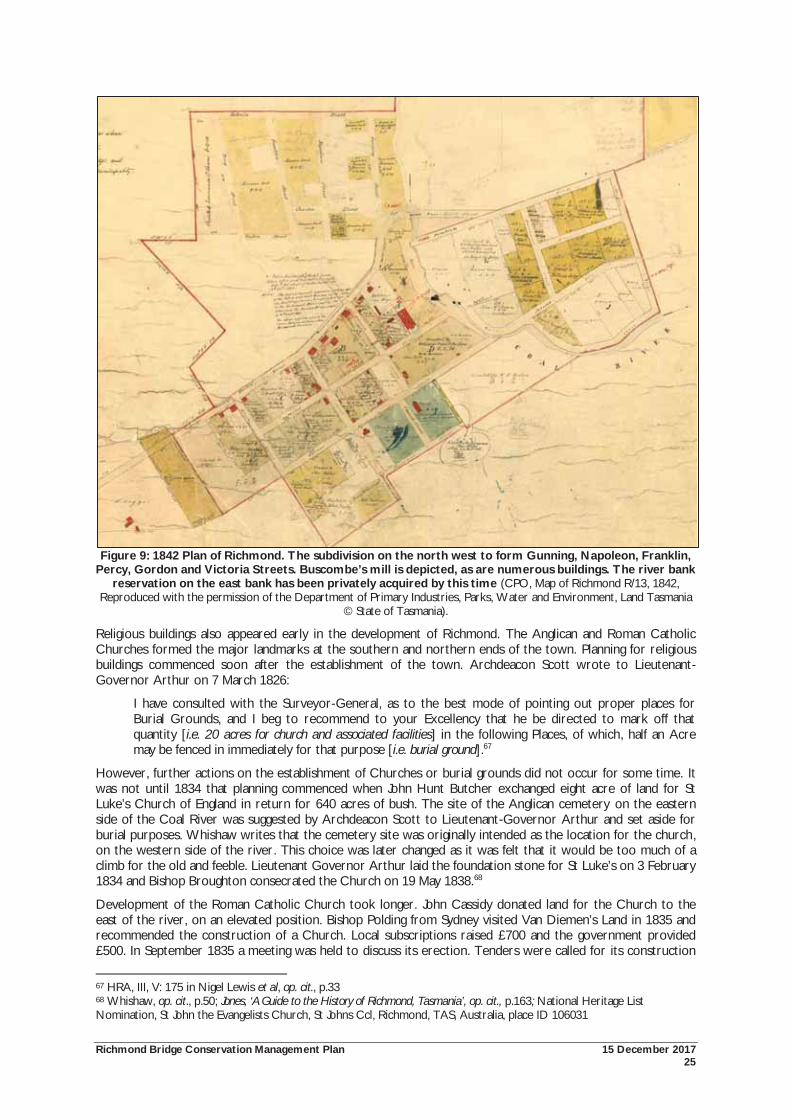
Richmond Bridge Conservation Management Plan 15 December 2017 25
Figure 9: 1842 Plan of Richmond. The subdivision on the north west to form Gunning, Napoleon, Franklin, Percy, Gordon and Victoria Streets. Buscombe’s mill is depicted, as are numerous buildings. The river bank
reservation on the east bank has been privately acquired by this time (CPO, Map of Richmond R/13, 1842, Reproduced with the permission of the Department of Primary Industries, Parks, Water and Environment, Land Tasmania
© State of Tasmania).
Religious buildings also appeared early in the development of Richmond. The Anglican and Roman Catholic Churches formed the major landmarks at the southern and northern ends of the town. Planning for religious buildings commenced soon after the establishment of the town. Archdeacon Scott wrote to Lieutenant-Governor Arthur on 7 March 1826:
I have consulted with the Surveyor-General, as to the best mode of pointing out proper places for Burial Grounds, and I beg to recommend to your Excellency that he be directed to mark off that quantity [i.e. 20 acres for church and associated facilities] in the following Places, of which, half an Acre may be fenced in immediately for that purpose [i.e. burial ground].67
However, further actions on the establishment of Churches or burial grounds did not occur for some time. It was not until 1834 that planning commenced when John Hunt Butcher exchanged eight acre of land for St Luke’s Church of England in return for 640 acres of bush. The site of the Anglican cemetery on the eastern side of the Coal River was suggested by Archdeacon Scott to Lieutenant-Governor Arthur and set aside for burial purposes. Whishaw writes that the cemetery site was originally intended as the location for the church, on the western side of the river. This choice was later changed as it was felt that it would be too much of a climb for the old and feeble. Lieutenant Governor Arthur laid the foundation stone for St Luke’s on 3 February 1834 and Bishop Broughton consecrated the Church on 19 May 1838.68
Development of the Roman Catholic Church took longer. John Cassidy donated land for the Church to the east of the river, on an elevated position. Bishop Polding from Sydney visited Van Diemen’s Land in 1835 and recommended the construction of a Church. Local subscriptions raised £700 and the government provided £500. In September 1835 a meeting was held to discuss its erection. Tenders were called for its construction
67 HRA, III, V: 175 in Nigel Lewis et al, op. cit., p.33 68 Whishaw, op. cit., p.50; Jones, ‘A Guide to the History of Richmond, Tasmania’, op. cit., p.163; National Heritage List Nomination, St John the Evangelists Church, St Johns Ccl, Richmond, TAS, Australia, place ID 106031
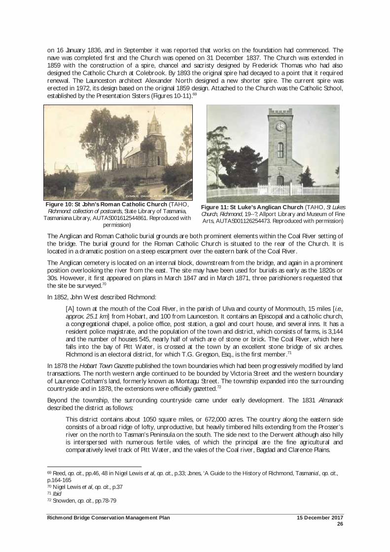
Richmond Bridge Conservation Management Plan 15 December 2017 26
on 16 January 1836, and in September it was reported that works on the foundation had commenced. The nave was completed first and the Church was opened on 31 December 1837. The Church was extended in 1859 with the construction of a spire, chancel and sacristy designed by Frederick Thomas who had also designed the Catholic Church at Colebrook. By 1893 the original spire had decayed to a point that it required renewal. The Launceston architect Alexander North designed a new shorter spire. The current spire was erected in 1972, its design based on the original 1859 design. Attached to the Church was the Catholic School, established by the Presentation Sisters (Figures 10-11).69
Figure 10: St John’s Roman Catholic Church (TAHO, Richmond: collection of postcards, State Library of Tasmania,
Tasmaniana Library, AUTAS001612544861. Reproduced with permission)
Figure 11: St Luke’s Anglican Church (TAHO, St Lukes Church, Richmond, 19--?, Allport Library and Museum of Fine Arts, AUTAS001126254473. Reproduced with permission)
The Anglican and Roman Catholic burial grounds are both prominent elements within the Coal River setting of the bridge. The burial ground for the Roman Catholic Church is situated to the rear of the Church. It is located in a dramatic position on a steep escarpment over the eastern bank of the Coal River.
The Anglican cemetery is located on an internal block, downstream from the bridge, and again in a prominent position overlooking the river from the east. The site may have been used for burials as early as the 1820s or 30s. However, it first appeared on plans in March 1847 and in March 1871, three parishioners requested that the site be surveyed.70
In 1852, John West described Richmond:
[A] town at the mouth of the Coal River, in the parish of Ulva and county of Monmouth, 15 miles [i.e., approx. 25.1 km] from Hobart, and 100 from Launceston. It contains an Episcopal and a catholic church, a congregational chapel, a police office, post station, a gaol and court house, and several inns. It has a resident police magistrate, and the population of the town and district, which consists of farms, is 3,144 and the number of houses 545, nearly half of which are of stone or brick. The Coal River, which here falls into the bay of Pitt Water, is crossed at the town by an excellent stone bridge of six arches. Richmond is an electoral district, for which T.G. Gregson, Esq., is the first member.71
In 1878 the Hobart Town Gazette published the town boundaries which had been progressively modified by land transactions. The north western angle continued to be bounded by Victoria Street and the western boundary of Laurence Cotham’s land, formerly known as Montagu Street. The township expanded into the surrounding countryside and in 1878, the extensions were officially gazetted.72
Beyond the township, the surrounding countryside came under early development. The 1831 Almanack described the district as follows:
This district contains about 1050 square miles, or 672,000 acres. The country along the eastern side consists of a broad ridge of lofty, unproductive, but heavily timbered hills extending from the Prosser’s river on the north to Tasman’s Peninsula on the south. The side next to the Derwent although also hilly is interspersed with numerous fertile vales, of which the principal are the fine agricultural and comparatively level track of Pitt Water, and the vales of the Coal river, Bagdad and Clarence Plains.
69 Reed, op. cit., pp.46, 48 in Nigel Lewis et al, op. cit., p.33; Jones, ‘A Guide to the History of Richmond, Tasmania’, op. cit., p.164-165 70 Nigel Lewis et al, op. cit., p.37 71 Ibid 72 Snowden, op. cit., pp.78-79
Richmond Bridge Conservation Management Plan 15 December 2017 27
Of this district, some 140,000 acres had been granted to settlers, being cultivated for pasture, or left wooded. Some 12,000 acres was being used for agriculture. The main crops were wheat, barley and oats. The area supported some 420 horses, 14,200 horned cattle and 95,000 sheep.73
By the 1840s, the Coal River Valley was notable for its advanced state of agriculture and associated dwellings and infrastructure. In 1848 Syme wrote:
A few miles to the eastward of Hobart Town are the populous and extensive districts of Gloucester and Sussex, commonly called Pitt Water. This is perhaps the richest settlement in the island, the soil both upon the hills and the low grounds being of the best quality and producing superior crops of grain. An extensive bay affords the inhabitants an opportunity of shipping their produce almost from their own doors, which is generally conveyed by steam or small craft to Hobart Town, though vessels of two hundred tons and even upwards have loaded there … To the north-west of Pitt Water lies the district of the Coal River, including Cambridge, Ulva, and Caedon of the new nomenclature. This tract is perhaps better watered than Pitt Water, but wants the advantage of a spacious navigable waterway. In other respects, it is very little inferior, and many of its farms, which are about a hundred in number, are exceedingly well cultivated. The greatest part of it has not been so long settled as the other district; and the majority of its settlers are respectable free settlers, with large grants of land.74
The original land grants in the area had also changed hands several times. When Lieutenant-Governor Davey returned to England in 1821, his 3,000 acre property, Carrington was transferred to his successors Sorell and later Arthur. Ultimately, the Carrington property was granted to William Thomas Parramore, Arthur’s private secretary. Parramore accepted the less demanding position of Police Magistrate of Richmond in 1832. He lived at the nearby property of Anglewood, originally granted to Thomas Birch in 1813. Because of his connections with Arthur, Parramore’s appointment was met with public criticism, and he was replaced as Police Magistrate. Instead, he took on the role of management of Arthur’s Richmond properties. In 1836, Carrington was acquired by teacher, editor and publisher of the Hobart Town Gazette and other journals, James Ross. Ross lived at Carrington until his death in 1838. His widow later operated a school at the property until it was sold in 1842 to Esh Lovell for £2,750.
Other estates were also well developed by this time. At Richmond Park, David Lord erected a residence in 1827, and at Lowlands, John Hunt Butcher built a house between 1828-32. Benjamin Guy purchased land from Butcher to the east of the main road in 1832-33, and here he erected his residence Belmont. To the west of the main road, Buscombe had built Prospect House in the 1830s.75
2.7.1 Accessing the River
Access to the Coal River for water supplies was an important issue for the early development of Richmond. John McPhail owned the land on the eastern end of the bridge. In October 1839, WJ Aislabie wrote to the Surveyor General that McPhail had erected a barrier on the north west side of his land and was collecting tolls from those who wanted to go to the river bank to collect water. Aislabie suggested as a solution that:
Victoria St. to which we are driven by the sale of rights of way to water at Richmond Bridge is not the most convenient watering place it is situate 1 ½ furlongs to the left of this side the Bridge and higher up the River – but a question may be made whether Government has not a right of way to water, if one can [be] made … The Bridge, I think does not occupy more that 40 ft at the utmost, 26 ft in that case remain for Road in the River. Now if the Govt. would mark out a fence the Road it would be seen what was the public right of way, [and] what [was] private property.76
In his response, the Surveyor General wrote that an area of 70 feet (i.e., approx. 21.2 m) was available for the use of the road and bridge. He suggested that the land on the south should be fenced to prevent further private property owners appropriating the riverbanks. This solution was apparently not acceptable, as Aislabie wrote again that the descent to the river of the south side was steep, and that it was on the northern side where the easiest access was available and which McPhail had fenced off (Figure 12). McPhail did ultimately remove his fence and stopped collecting tolls to access the river. A plan of c.1840 shows dotted lines heading
73 Ross, Ibid., in Snowden, op. cit., p.9 74 J Syme, Nine Years in Van Diemen’s Land, comprising an account of its discovery, possession, settlement, progress, population, value of land, herds flocks etc …. , Dundee, 1848, in Snowden, op. cit., pp.10-11 75 Levy, MCI, ‘William Thomas Parramore’ in Australian Dictionary of Biography, Vol 2, Melbourne University Press, 1967, pp.314-315; ‘James Ross’, in Australian Dictionary of Biography, Vol 2, Melbourne University Press, 1967, pp. 396-397; Nigel Lewis et al, op. cit., pp. 37-38 76 TAHO, LSD 1/23/87 in Nigel Lewis et al, op. cit., p.31
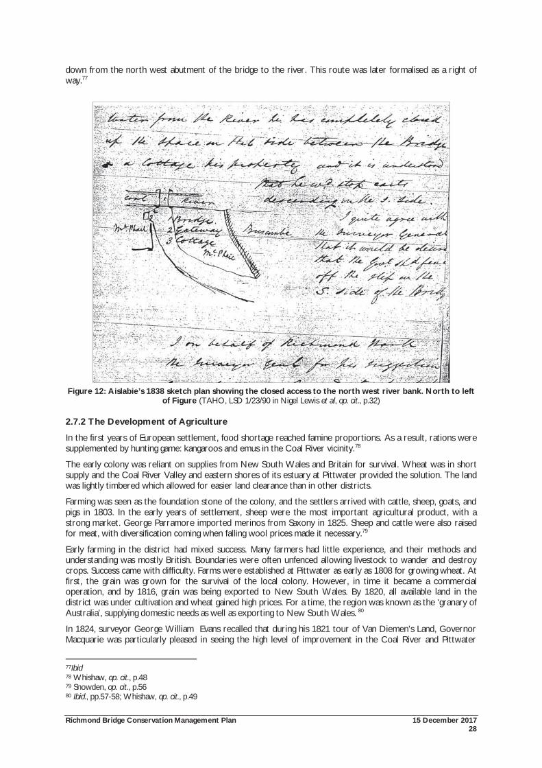
Richmond Bridge Conservation Management Plan 15 December 2017 28
down from the north west abutment of the bridge to the river. This route was later formalised as a right of way.77
Figure 12: Aislabie’s 1838 sketch plan showing the closed access to the north west river bank. North to left of Figure (TAHO, LSD 1/23/90 in Nigel Lewis et al, op. cit., p.32)
2.7.2 The Development of Agriculture
In the first years of European settlement, food shortage reached famine proportions. As a result, rations were supplemented by hunting game: kangaroos and emus in the Coal River vicinity.78
The early colony was reliant on supplies from New South Wales and Britain for survival. Wheat was in short supply and the Coal River Valley and eastern shores of its estuary at Pittwater provided the solution. The land was lightly timbered which allowed for easier land clearance than in other districts.
Farming was seen as the foundation stone of the colony, and the settlers arrived with cattle, sheep, goats, and pigs in 1803. In the early years of settlement, sheep were the most important agricultural product, with a strong market. George Parramore imported merinos from Saxony in 1825. Sheep and cattle were also raised for meat, with diversification coming when falling wool prices made it necessary.79
Early farming in the district had mixed success. Many farmers had little experience, and their methods and understanding was mostly British. Boundaries were often unfenced allowing livestock to wander and destroy crops. Success came with difficulty. Farms were established at Pittwater as early as 1808 for growing wheat. At first, the grain was grown for the survival of the local colony. However, in time it became a commercial operation, and by 1816, grain was being exported to New South Wales. By 1820, all available land in the district was under cultivation and wheat gained high prices. For a time, the region was known as the ‘granary of Australia’, supplying domestic needs as well as exporting to New South Wales. 80
In 1824, surveyor George William Evans recalled that during his 1821 tour of Van Diemen’s Land, Governor Macquarie was particularly pleased in seeing the high level of improvement in the Coal River and Pittwater
77Ibid 78 Whishaw, op. cit., p.48 79 Snowden, op. cit., p.56 80 Ibid., pp.57-58; Whishaw, op. cit., p.49
Richmond Bridge Conservation Management Plan 15 December 2017 29
areas, and noting that the agricultural settlers of the area carried out their operations on a much more extensive scale than any others in the colony. In the 1830s, James Backhouse described the scene where small areas of land had been cleared, but otherwise the valley was covered by trees and shrubs.81
With the district under production, Richmond played an important role as a market town and as a supply and service centre. It remained the district market town until 1872 when saleyards were opened in Sorell. The role as a supply and service centre lasted longer, continuing for much of the twentieth century. 82
2.7.3 Flour Milling
In addition to growing wheat for domestic and export needs, the Richmond district became an important milling centre, with mills located within the town. Flour milling was the first manufacturing industry to be established in Australia. Wheat and refined flour formed a staple of the early settlers diet, and from the beginning of settlement, Lieutenant-Governor David Collins was instructed to prepare as much ground as possible for sowing wheat.
To utilise the wheat, it had to be milled. In the early years of settlement, it was processed by either small millstones or more commonly, steel mills. Both devices were turned by hand. Not only was the work hard, but it only produced small yields. Even after the first purpose built mills were constructed, hand mills continued to be used whenever needed.
The wheat growing potential of the Coal River Valley was recognised shortly after settlement, soon to be ranked with Pittwater and Clarence Plains as the granary of Van Diemen’s Land. Recognising the potential of the area, by September 1824, John Walker applied for a grant of land in the township for the purposes of erecting a mill, completed that same year.83
Walker had previous experience as the Government Miller in Hobart Town. The site chosen for the water mill was south of the bridge and ford in ‘Mill Field’, on the east bank of the river. The dam for the mill was ‘not fifty feet (i.e., approx. 15.2 m) from the Bridge’, and its location and the rise in water level caused the piers of the bridge to be undermined by 1826. Walker sold the mill to Patrick Miller (or Millor) who was then ordered to remove the dam which was causing such damage. Miller was compensated for his financial losses, but also sought a grant of land as restitution. In 1829, Arthur agreed to help Miller erect a new dam, but refused to provide him with any more land. Walker shortly after sold the mill for use as a house for £125. Jones wrote in 1973 that a slight depression existed on the margin of the eastern bank of the river as an indication of the old mill race.84
Dr Henry Thomas purchased the Mill Field in 1832, but sold it to Gilbert Robertson in 1834. Robertson in turn, sold the land to George Burn with a triangular shaped block of land between Pembroke Road leading to the ford, and East Street. A steam powered mill was erected on this triangular lot of land, and it is the only surviving flour mill in Richmond.
This mill was constructed by George Burns in the late 1840s or early 1850s, and was driven by steam. Burns’ steam mill operated for many years, becoming the centre for the harvest milling in Richmond.85 The Mill was offered for sale in 1872, the advertisement noting:
The Mill which was erected by the late firm of Easby & Robertson, is substantially built and in perfect order, and the whole driven by a 9 horse power engine with 12 horse power tubular boiler by Clayton and Shuttleworth, London. Attached is a circular saw and bench capable of cutting from 30-40 tons of wood per diem. All in first class order and let to Mr. Bone at the low rental of £100 per annum.86
In 1903, the Mill was described in the Tasmanian Mail:
For some years the mill worked day and night and turned out flour of a first-class quality. When the owner died the mill was purchased by Mr Nichols who subsequently turned it into a butter factory. After running for some time the factory closed its doors and has not been used since in either direction, a circumstance much regretted locally.87
81 Jones, ‘A Guide to the History of Richmond, Tasmania’, op. cit., p.154 82 Snowden, op. cit., p.57; Michael Shield & Associates, op. cit., p.5 83 Cassidy, J, Preston, K, Thematic Study of the Tasmanian Flour Milling Industry, Queen Victoria Museum & Art Gallery, 2000, pp.7, 122 84 Jones, op. cit., p.53 85 Jones, ‘A Guide to the History of Richmond, Tasmania’, op. cit., p.162 86 Cassidy, Preston, op. cit., p.126 87 Ibid
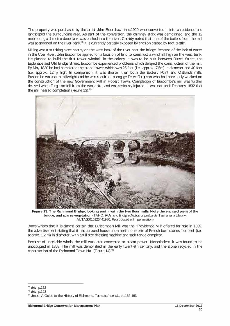
Richmond Bridge Conservation Management Plan 15 December 2017 30
The property was purchased by the artist John Eldershaw, in c.1920 who converted it into a residence and landscaped the surrounding area. As part of the conversion, the chimney stack was demolished, and the 12 metre long x 1 metre deep tank was pushed into the river. Cassidy noted that one of the boilers from the mill was abandoned on the river bank.88 It is currently partially exposed by erosion caused by foot traffic.
Milling was also taking place nearby on the west bank of the river near the bridge. Because of the lack of water in the Coal River, John Buscombe applied for a location of land to construct a windmill high on the west bank. He planned to build the first tower windmill in the colony. It was to be built between Russel Street, the Esplanade and Old Bridge Street. Buscombe experienced problems which delayed the construction of the mill. By May 1830 he had completed the stone tower which was 25 feet (i.e., approx. 7.5m) in diameter and 40 feet (i.e. approx. 12m) high. In comparison, it was shorter than both the Battery Point and Oatlands mills. Buscombe was not a millwright and he was required to engage Peter Ferguson who had previously worked on the construction of the new Government Mill in Hobart Town. Completion of Buscombe’s mill was further delayed when Ferguson fell from the work site, and was seriously injured. It was not until February 1832 that the mill neared completion (Figure 13).89
Figure 13: The Richmond Bridge, looking south, with the two flour mills. Note the encased piers of the
bridge, and sparse vegetation (TAHO, Richmond Bridge collection of postcards, Tasmaniana Library, AUTAS0016125441980. Reproduced with permission)
Jones writes that it is almost certain that Buscombe’s Mill was the ‘Providence Mill’ offered for sale in 1839, the advertisement stating that it had a round house underneath, one pair of French burr stones four feet (i.e., approx. 1.2 m) in diameter, with a full size dressing machine and sack tackle complete.
Because of unreliable winds, the mill was later converted to steam power. Nonetheless, it was found to be unoccupied in 1858. The mill was demolished in the early twentieth century, and the stone recycled in the construction of the Richmond Town Hall (Figure 14).90
88 Ibid., p.162 89 Ibid., p.123 90 Jones, ‘A Guide to the History of Richmond, Tasmania’, op. cit., pp.162-163
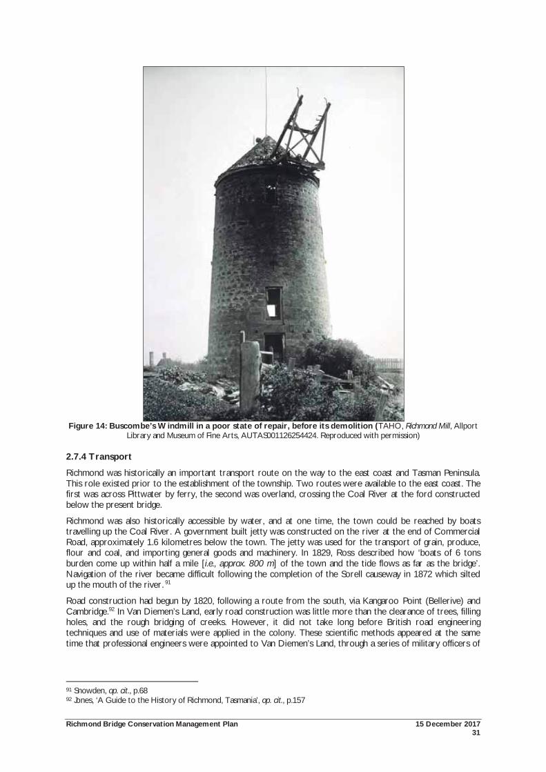
Richmond Bridge Conservation Management Plan 15 December 2017 31
Figure 14: Buscombe’s Windmill in a poor state of repair, before its demolition (TAHO, Richmond Mill, Allport
Library and Museum of Fine Arts, AUTAS001126254424. Reproduced with permission)
2.7.4 Transport
Richmond was historically an important transport route on the way to the east coast and Tasman Peninsula. This role existed prior to the establishment of the township. Two routes were available to the east coast. The first was across Pittwater by ferry, the second was overland, crossing the Coal River at the ford constructed below the present bridge.
Richmond was also historically accessible by water, and at one time, the town could be reached by boats travelling up the Coal River. A government built jetty was constructed on the river at the end of Commercial Road, approximately 1.6 kilometres below the town. The jetty was used for the transport of grain, produce, flour and coal, and importing general goods and machinery. In 1829, Ross described how ‘boats of 6 tons burden come up within half a mile [i.e., approx. 800 m] of the town and the tide flows as far as the bridge’. Navigation of the river became difficult following the completion of the Sorell causeway in 1872 which silted up the mouth of the river. 91
Road construction had begun by 1820, following a route from the south, via Kangaroo Point (Bellerive) and Cambridge.92 In Van Diemen’s Land, early road construction was little more than the clearance of trees, filling holes, and the rough bridging of creeks. However, it did not take long before British road engineering techniques and use of materials were applied in the colony. These scientific methods appeared at the same time that professional engineers were appointed to Van Diemen’s Land, through a series of military officers of
91 Snowden, op. cit., p.68 92 Jones, ‘A Guide to the History of Richmond, Tasmania’, op. cit., p.157
Richmond Bridge Conservation Management Plan 15 December 2017 32
the Royal Engineers. These officers applied their knowledge to design problems using traditional craft skills and military discipline.93
Another road route to Richmond was established in the 1830s. In 1832, a punt was established at Risdon, joining the east and west banks of the Derwent. From Risdon, a road over Grass Tree Hill was planned and constructed. The road was completed c.1836-38. The construction of this road was criticised, and disparagingly called the Carrington Cut. It was criticised as overly benefiting Lieutenant-Governor Arthur by providing him with a shorter route to his Carrington property. Other district roads followed, with routes to Tea Tree, Campania and Prosser Plains established.
The establishment of these roads also created alternate routes to the north of the island. Crossing the Derwent at Austins Ferry was the most common means of reaching the midlands and the northern districts. However, an early route existed by crossing the Derwent to Kangaroo Point and then proceeding in a northerly direction through the Coal River district to Jericho.
With the construction of these roads, Richmond was serviced by regular coaches, running to Kangaroo Point and Restdown (Risdon), but also onto Campania and Swansea. Travellers to the east coast also travelled via Richmond, the alternative being a sea voyage or a ferry across Pittwater.
The main east coast road also travelled via Richmond until the completion of the Sorell Causeway in 1872. The construction of the causeway created a more direct route to the coasts and Tasman Peninsula. The causeway soon followed by the Main Line Railway which also bypassed the town had an adverse affect on Richmond’s growth. In 1862, the population of the Richmond Municipality was 1,608, and this number remained stable for nearly a century. In 1957, the population was only 1,680. 94
2.8 Later Works to the Bridge Following the repairs to the parapet in 1835, further repairs were made as needed. It was reported that the bridge was ‘in part destroyed’ during the 1844 floods, The repairs were partially completed by January the following year. One parapet had been reconstructed, whilst the other replaced with a timber fence. Only a temporary solution, it is not clear when the bridge was returned to having two stone parapets. Von Stieglitz wrote that the last ‘really serious’ flood damage occurred in the autumn of 1846.95
In 1859, the Director of Public Works, WR Falconer wrote that the bridge was in a very dilapidated condition and was unsafe. Falconer recommended the underpinning of the piers, excavation of the loamy soil from the riverbed, filling the excavated areas with concrete and paving the riverbed to form an inverted arch between the piers and improve water flow. Correspondence to the Richmond Road Trust on 6 June 1859 suggests that repair works were carried out. However, the extent of the works carried out according to Falconer’s advice is uncertain as no plans have survived.96
The works which have had the greatest affect on the visual appearance of the bridge occurred in 1884 when the piers were stabilised. The Tasmanian Mail reported on these works:
The piers are getting cased with stone and brought to a cut water edge in line with the current’s course and newly pointed all under and over with cement. The roadway needs taking up for the top of the masonry to be grouted to throw soakage to weep holes in the sides instead of percolating through and driving the pointing out under the arches. It also requires crowning and side drains.97
Official records related to these works are sparse. The works were authorised under the Public Works Execution Act of 1884 (47º VIC, 31 Item 109). Archival documents only relate to the agreement with Martha Butcher at Lowlands to reopen the quarry for the stone, and a memorandum for acquiring scaffolding. Only outward correspondence exists in the general correspondence files, and these are largely requests for reports from the supervisor of the work, R Robinson.98 Responding to one of the reports, the Engineer of Roads wrote in April 1884:
93 Newitt, op. cit., pp.9-10, 12-13 94 Jones, ‘A Guide to the History of Richmond, Tasmania’, op. cit., pp.157-159; Nigel Lewis et al, op. cit., p.38; Snowden, op.cit., pp.68-71 95 Von Stieglitz, op. cit., p.15; Colonial Times, Tuesday 8 October 1844, p.3; Colonial Times, Saturday 18 January 1845, p.3 96; Nigel Lewis et al, op. cit., p.43 97 Tasmanian Mail, 12 July 1884: 28 in Nigel Lewis et al, op. cit., p.43 98 Austral Archaeology, et. al. op. cit., p.20
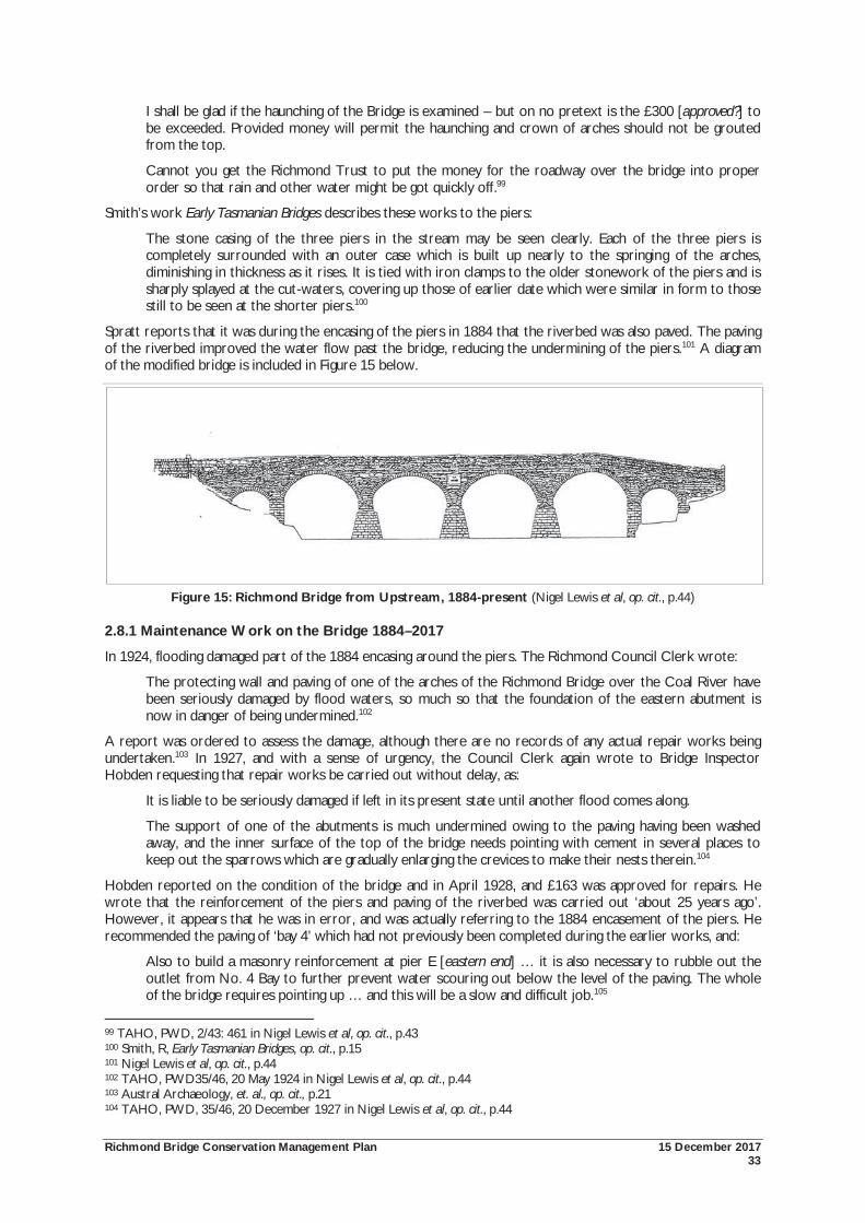
Richmond Bridge Conservation Management Plan 15 December 2017 33
I shall be glad if the haunching of the Bridge is examined – but on no pretext is the £300 [approved?] to be exceeded. Provided money will permit the haunching and crown of arches should not be grouted from the top.
Cannot you get the Richmond Trust to put the money for the roadway over the bridge into proper order so that rain and other water might be got quickly off.99
Smith’s work Early Tasmanian Bridges describes these works to the piers:
The stone casing of the three piers in the stream may be seen clearly. Each of the three piers is completely surrounded with an outer case which is built up nearly to the springing of the arches, diminishing in thickness as it rises. It is tied with iron clamps to the older stonework of the piers and is sharply splayed at the cut-waters, covering up those of earlier date which were similar in form to those still to be seen at the shorter piers.100
Spratt reports that it was during the encasing of the piers in 1884 that the riverbed was also paved. The paving of the riverbed improved the water flow past the bridge, reducing the undermining of the piers.101 A diagram of the modified bridge is included in Figure 15 below.
Figure 15: Richmond Bridge from Upstream, 1884-present (Nigel Lewis et al, op. cit., p.44)
2.8.1 Maintenance Work on the Bridge 1884–2017
In 1924, flooding damaged part of the 1884 encasing around the piers. The Richmond Council Clerk wrote:
The protecting wall and paving of one of the arches of the Richmond Bridge over the Coal River have been seriously damaged by flood waters, so much so that the foundation of the eastern abutment is now in danger of being undermined.102
A report was ordered to assess the damage, although there are no records of any actual repair works being undertaken.103 In 1927, and with a sense of urgency, the Council Clerk again wrote to Bridge Inspector Hobden requesting that repair works be carried out without delay, as:
It is liable to be seriously damaged if left in its present state until another flood comes along.
The support of one of the abutments is much undermined owing to the paving having been washed away, and the inner surface of the top of the bridge needs pointing with cement in several places to keep out the sparrows which are gradually enlarging the crevices to make their nests therein.104
Hobden reported on the condition of the bridge and in April 1928, and £163 was approved for repairs. He wrote that the reinforcement of the piers and paving of the riverbed was carried out ‘about 25 years ago’. However, it appears that he was in error, and was actually referring to the 1884 encasement of the piers. He recommended the paving of ‘bay 4’ which had not previously been completed during the earlier works, and:
Also to build a masonry reinforcement at pier E [eastern end] … it is also necessary to rubble out the outlet from No. 4 Bay to further prevent water scouring out below the level of the paving. The whole of the bridge requires pointing up … and this will be a slow and difficult job.105
99 TAHO, PWD, 2/43: 461 in Nigel Lewis et al, op. cit., p.43 100 Smith, R, Early Tasmanian Bridges, op. cit., p.15 101 Nigel Lewis et al, op. cit., p.44 102 TAHO, PWD35/46, 20 May 1924 in Nigel Lewis et al, op. cit., p.44 103 Austral Archaeology, et. al., op. cit., p.21 104 TAHO, PWD, 35/46, 20 December 1927 in Nigel Lewis et al, op. cit., p.44
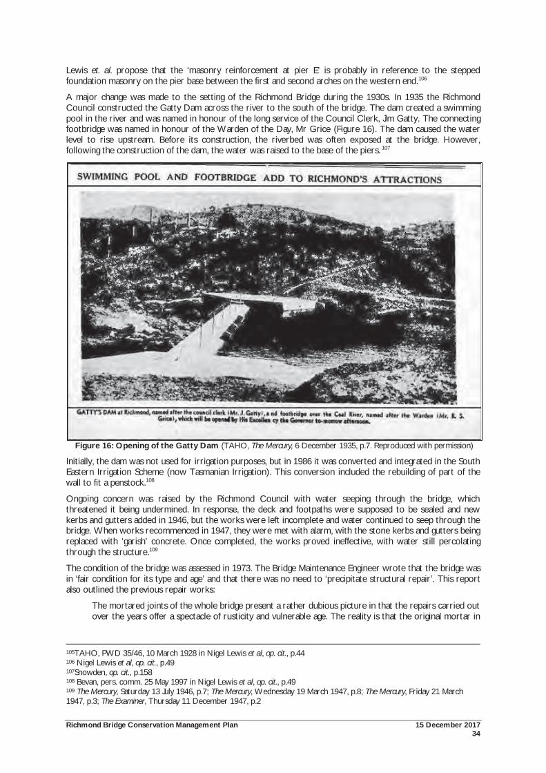
Richmond Bridge Conservation Management Plan 15 December 2017 34
Lewis et. al. propose that the ‘masonry reinforcement at pier E’ is probably in reference to the stepped foundation masonry on the pier base between the first and second arches on the western end.106
A major change was made to the setting of the Richmond Bridge during the 1930s. In 1935 the Richmond Council constructed the Gatty Dam across the river to the south of the bridge. The dam created a swimming pool in the river and was named in honour of the long service of the Council Clerk, Jim Gatty. The connecting footbridge was named in honour of the Warden of the Day, Mr Grice (Figure 16). The dam caused the water level to rise upstream. Before its construction, the riverbed was often exposed at the bridge. However, following the construction of the dam, the water was raised to the base of the piers. 107
Figure 16: Opening of the Gatty Dam (TAHO, The Mercury, 6 December 1935, p.7. Reproduced with permission)
Initially, the dam was not used for irrigation purposes, but in 1986 it was converted and integrated in the South Eastern Irrigation Scheme (now Tasmanian Irrigation). This conversion included the rebuilding of part of the wall to fit a penstock.108
Ongoing concern was raised by the Richmond Council with water seeping through the bridge, which threatened it being undermined. In response, the deck and footpaths were supposed to be sealed and new kerbs and gutters added in 1946, but the works were left incomplete and water continued to seep through the bridge. When works recommenced in 1947, they were met with alarm, with the stone kerbs and gutters being replaced with ‘garish’ concrete. Once completed, the works proved ineffective, with water still percolating through the structure.109
The condition of the bridge was assessed in 1973. The Bridge Maintenance Engineer wrote that the bridge was in ‘fair condition for its type and age’ and that there was no need to ‘precipitate structural repair’. This report also outlined the previous repair works:
The mortared joints of the whole bridge present a rather dubious picture in that the repairs carried out over the years offer a spectacle of rusticity and vulnerable age. The reality is that the original mortar in
105TAHO, PWD 35/46, 10 March 1928 in Nigel Lewis et al, op. cit., p.44 106 Nigel Lewis et al, op. cit., p.49 107Snowden, op. cit., p.158 108 Bevan, pers. comm. 25 May 1997 in Nigel Lewis et al, op. cit., p.49 109 The Mercury, Saturday 13 July 1946, p.7; The Mercury, Wednesday 19 March 1947, p.8; The Mercury, Friday 21 March 1947, p.3; The Examiner, Thursday 11 December 1947, p.2
Richmond Bridge Conservation Management Plan 15 December 2017 35
some places has fallen out, the joint begin covered with a sand/cement substitute .... this covers the joint but offers no support....
Some years ago the stonework of the crowns of the centre arches of the bridge was pierced in an attempt to drain collected roadway surface water and soakage water.... these should be filled with composition mortar.110
Remedial works were also recommended to direct water away from the eastern abutment where a soak led to water ponding beneath the first span. These works did not appear to take place. Minor, aesthetic works were carried out which included the recutting of the inscription and darkening of the inscription in the date stones, carved in 1923. These works were undertaken to make the bridge photographically more appealing.111
As part of his 1993 fabric assessment, Spratt noted works conducted in 1973. The Public Works Department reported:
Stone flagging slightly undercut at several stones adjacent to the pier cutwaters, spalls recommended on the downstream end of the stone flagging. Mortar fillets atop the chased stone sheathing to the piers required attention.
Rusting iron holding pier sheathing top course in place requires removal and replacement. Galvanised wire mesh was recommended to be used in the repairs to the mortar fillets.
Repointing repairs to be done in 1:2:12 cement mix so as not to cause stone damage. Cracking to arches and stone coursing to be measured and recorded. The stonework piercing at the crown of the centre arches put in to drain the roadway to be filled with mortar.112
Recognising its significance, in 1977, the speed limit on the bridge was reduced to 30 km/hr. A 25 tonne load limit was placed on the bridge in 1985. Repairs to the masonry took place during this period, first by Leo Luckman in 1979, and followed in 1987 with the repointing of the capping stones by Stephen Kaye. Works were also carried out on the deck of the bridge including the sealing of the road, and construction of concrete kerbs, retaining walls and gutter slabs in 1980. The bridge stonework was cleaned in 1981 using a 1% aqueous solution of quaternary ammonium, followed by a fungicide. A vehicle accident on the downstream side of the eastern end in 1988 required the reconstruction of 12 metres of the parapet.
Landscaping works were also carried out around the bridge in the mid-1980s. These works cost $10,000 and included the reclamation of the eroded river bank below the Miller’s Cottage, tree plantings, and the installation of furnishings. The geese were to be removed from the area, although other birds and ducks were to be encouraged. By the mid-1980s, increased traffic was becoming a major concern, and the inherent dangers and damage it caused to historic buildings and the bridge.
Adjacent to the bridge, a curved sandstone retaining wall was constructed in 1989 by the Richmond Council on the western end of the parapet. This provided a viewing platform, and later a position for a commemorative plaque erected by Engineers Australia. The bridge was included on the National Heritage List in 2005, in recognition of its outstanding value to Australia, and a plaque recognising this achievement has also recently been added to the platform.113
The 1997 Conservation Plan also made recommendations for works to the bridge and surrounds. Important works carried out in accordance with the 1997 Conservation Plan included the removal of the unsatisfactory mortars from the north and south faces of the bridge and removal of crack willows and other dense vegetation from the riverbanks.
The local community remain keenly involved in the care of the bridge and surrounds. A vehicle crash in July 2007 resulted in the destruction of part of the parapet. Although repaired, a community meeting was held with representatives from State and local government to explain how the bridge was being conserved.
Part of this work included the preparation of the 2010 Conservation Management Plan (CMP), in turn drawing on the detailed research and analysis carried out in 1997. The 2010 CMP was the first major review of the conservation requirements for the bridge and setting, with some 103 policies and actions identified. The Department of State Growth and Clarence City Council have primary responsible for the management and care of the place, and considerable work has been carried out since 2010 in implementing these findings. Perhaps the most notable has been the installation of a vibration meter to provide real time data on vibration
110 Nigel Lewis et al, op. cit., p.58 111 Ibid, p.63 112 Ibid 113 Snowden, op. cit., p.164; Nigel Lewis et al, op. cit., p.63
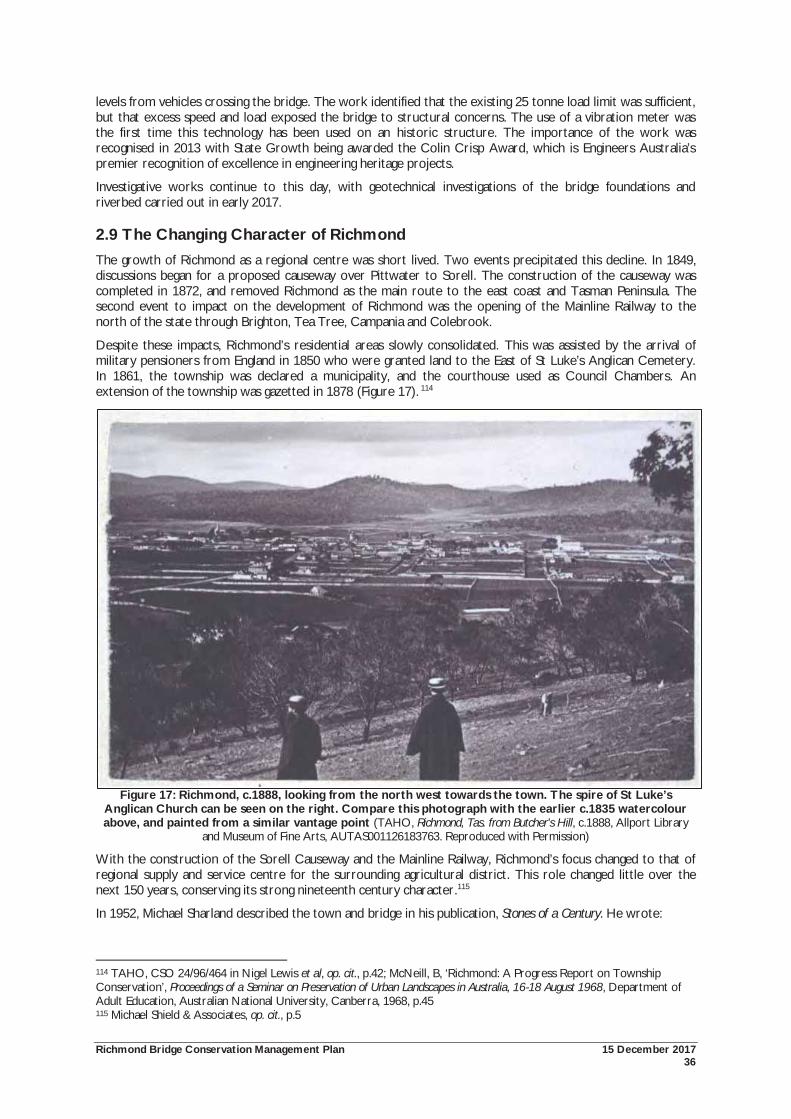
Richmond Bridge Conservation Management Plan 15 December 2017 36
levels from vehicles crossing the bridge. The work identified that the existing 25 tonne load limit was sufficient, but that excess speed and load exposed the bridge to structural concerns. The use of a vibration meter was the first time this technology has been used on an historic structure. The importance of the work was recognised in 2013 with State Growth being awarded the Colin Crisp Award, which is Engineers Australia’s premier recognition of excellence in engineering heritage projects.
Investigative works continue to this day, with geotechnical investigations of the bridge foundations and riverbed carried out in early 2017.
2.9 The Changing Character of Richmond The growth of Richmond as a regional centre was short lived. Two events precipitated this decline. In 1849, discussions began for a proposed causeway over Pittwater to Sorell. The construction of the causeway was completed in 1872, and removed Richmond as the main route to the east coast and Tasman Peninsula. The second event to impact on the development of Richmond was the opening of the Mainline Railway to the north of the state through Brighton, Tea Tree, Campania and Colebrook.
Despite these impacts, Richmond’s residential areas slowly consolidated. This was assisted by the arrival of military pensioners from England in 1850 who were granted land to the East of St Luke’s Anglican Cemetery. In 1861, the township was declared a municipality, and the courthouse used as Council Chambers. An extension of the township was gazetted in 1878 (Figure 17). 114
Figure 17: Richmond, c.1888, looking from the north west towards the town. The spire of St Luke’s Anglican Church can be seen on the right. Compare this photograph with the earlier c.1835 watercolour above, and painted from a similar vantage point (TAHO, Richmond, Tas. from Butcher's Hill, c.1888, Allport Library
and Museum of Fine Arts, AUTAS001126183763. Reproduced with Permission)
With the construction of the Sorell Causeway and the Mainline Railway, Richmond’s focus changed to that of regional supply and service centre for the surrounding agricultural district. This role changed little over the next 150 years, conserving its strong nineteenth century character.115
In 1952, Michael Sharland described the town and bridge in his publication, Stones of a Century. He wrote:
114 TAHO, CSO 24/96/464 in Nigel Lewis et al, op. cit., p.42; McNeill, B, ‘Richmond: A Progress Report on Township Conservation’, Proceedings of a Seminar on Preservation of Urban Landscapes in Australia, 16-18 August 1968, Department of Adult Education, Australian National University, Canberra, 1968, p.45 115 Michael Shield & Associates, op. cit., p.5
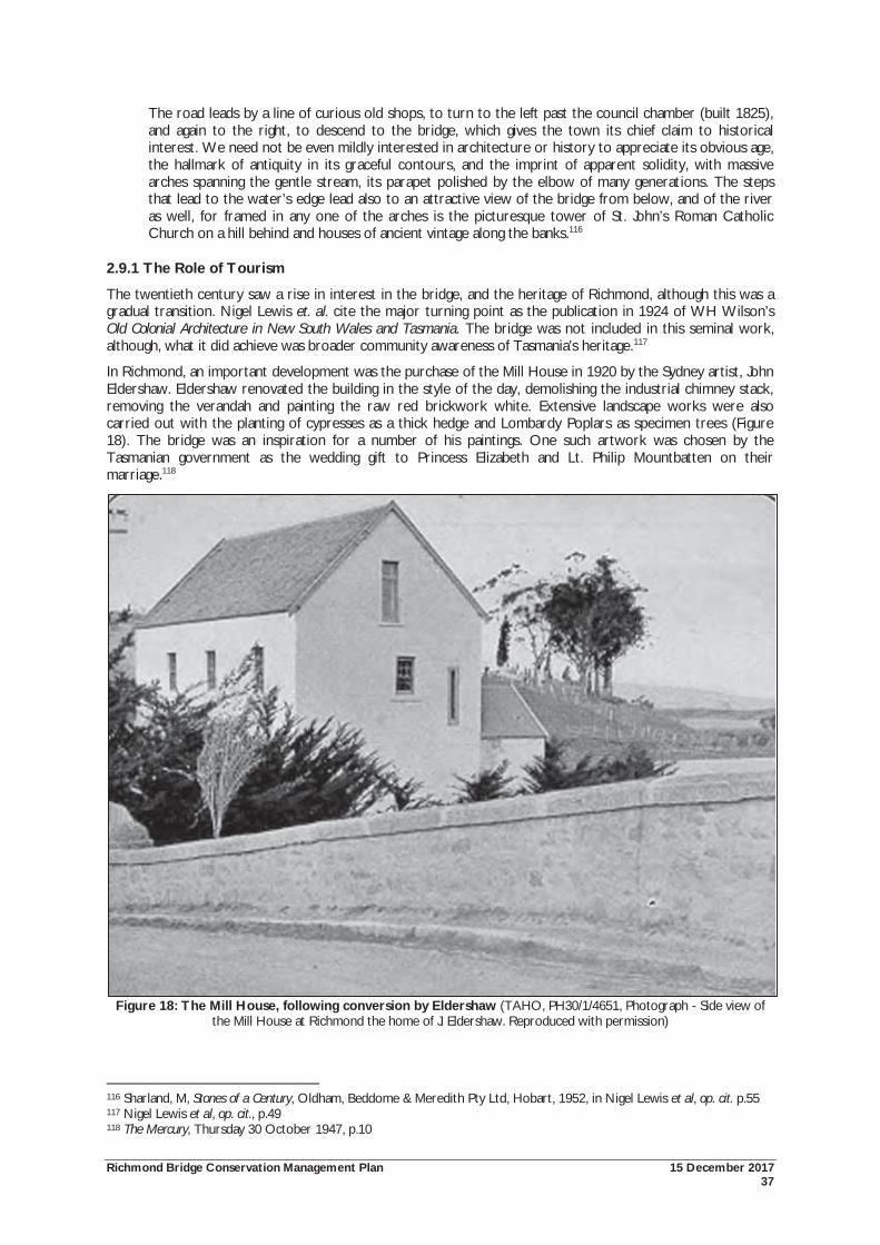
Richmond Bridge Conservation Management Plan 15 December 2017 37
The road leads by a line of curious old shops, to turn to the left past the council chamber (built 1825), and again to the right, to descend to the bridge, which gives the town its chief claim to historical interest. We need not be even mildly interested in architecture or history to appreciate its obvious age, the hallmark of antiquity in its graceful contours, and the imprint of apparent solidity, with massive arches spanning the gentle stream, its parapet polished by the elbow of many generations. The steps that lead to the water’s edge lead also to an attractive view of the bridge from below, and of the river as well, for framed in any one of the arches is the picturesque tower of St. John’s Roman Catholic Church on a hill behind and houses of ancient vintage along the banks.116
2.9.1 The Role of Tourism
The twentieth century saw a rise in interest in the bridge, and the heritage of Richmond, although this was a gradual transition. Nigel Lewis et. al. cite the major turning point as the publication in 1924 of WH Wilson’s Old Colonial Architecture in New South Wales and Tasmania. The bridge was not included in this seminal work, although, what it did achieve was broader community awareness of Tasmania’s heritage.117
In Richmond, an important development was the purchase of the Mill House in 1920 by the Sydney artist, John Eldershaw. Eldershaw renovated the building in the style of the day, demolishing the industrial chimney stack, removing the verandah and painting the raw red brickwork white. Extensive landscape works were also carried out with the planting of cypresses as a thick hedge and Lombardy Poplars as specimen trees (Figure 18). The bridge was an inspiration for a number of his paintings. One such artwork was chosen by the Tasmanian government as the wedding gift to Princess Elizabeth and Lt. Philip Mountbatten on their marriage.118
Figure 18: The Mill House, following conversion by Eldershaw (TAHO, PH30/1/4651, Photograph - Side view of the Mill House at Richmond the home of J. Eldershaw. Reproduced with permission)
116 Sharland, M, Stones of a Century, Oldham, Beddome & Meredith Pty Ltd, Hobart, 1952, in Nigel Lewis et al, op. cit. p.55 117 Nigel Lewis et al, op. cit., p.49 118 The Mercury, Thursday 30 October 1947, p.10
Richmond Bridge Conservation Management Plan 15 December 2017 38
The poplar trees later spread to the east bank of the river. Around this time, an important civic development occurred with the transfer of land on the west bank to the Richmond Council to create a public walkway. This walkway also provided views of the eastern bank and Mill House.
Nigel Lewis et. al. put forward that Eldershaw was an important figure in the centenary celebrations of the commencement of construction of the bridge on 11 December 1923.119 From newspaper coverage, the celebrations appear to have been a popular and important event. Photographic records show large numbers of people at the bridge, with horse and cart processions, and participants dressed in period costume. Included in the procession was a display by the Richmond Convent Schoolgirls, representing ‘Early Tasmanian Girls’. The event was presided over by local dignitaries including the Warden, Mr Grice, the Honourable JW Evans, and Mr WE Shoobridge.
In reporting the event, the Weekly Courier wrote:
Memories of the past were revived on Saturday, when the centenary of the bridge which spans the Coal River at Richmond was celebrated. The proceedings took the form of a procession, sports gathering and children’s picnic.120
At the time of the centenary, the bridge did not include any reference to its construction date. Although stone tablets had been built into the north and south faces of the bridge, no inscriptions had been made. As part of the celebrations, the Richmond Council later engraved ‘A.D 1823’ on these stones. On the inside of the northern parapet, an inscription was carved into the stone:
THE FIRST STONE OF THIS BRIDGE WAS LAID ON DECR 11TH 1823
IN THE PRESENCE OF JAMES GORDON AND G.W GUNNING ESQRS
MAGISTRATES
The Weekly Courier provided a whole page to the centenary celebrations (Figure 19).
119 Ibid., p.53 120 Weekly Courier, 13 December 1923, p.41
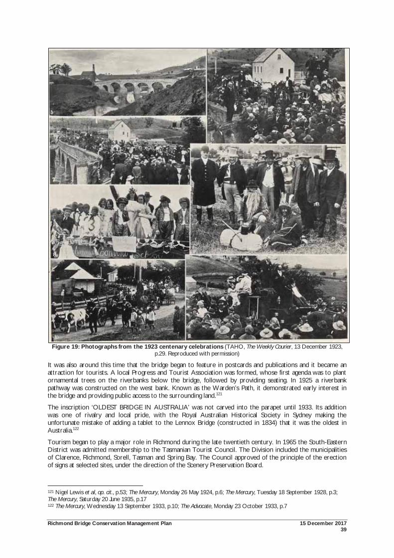
Richmond Bridge Conservation Management Plan 15 December 2017 39
Figure 19: Photographs from the 1923 centenary celebrations (TAHO, The Weekly Courier, 13 December 1923, p.29. Reproduced with permission)
It was also around this time that the bridge began to feature in postcards and publications and it became an attraction for tourists. A local Progress and Tourist Association was formed, whose first agenda was to plant ornamental trees on the riverbanks below the bridge, followed by providing seating. In 1925 a riverbank pathway was constructed on the west bank. Known as the Warden’s Path, it demonstrated early interest in the bridge and providing public access to the surrounding land.121
The inscription ‘OLDEST BRIDGE IN AUSTRALIA’ was not carved into the parapet until 1933. Its addition was one of rivalry and local pride, with the Royal Australian Historical Society in Sydney making the unfortunate mistake of adding a tablet to the Lennox Bridge (constructed in 1834) that it was the oldest in Australia.122
Tourism began to play a major role in Richmond during the late twentieth century. In 1965 the South-Eastern District was admitted membership to the Tasmanian Tourist Council. The Division included the municipalities of Clarence, Richmond, Sorell, Tasman and Spring Bay. The Council approved of the principle of the erection of signs at selected sites, under the direction of the Scenery Preservation Board.
121 Nigel Lewis et al, op. cit., p.53; The Mercury, Monday 26 May 1924, p.6; The Mercury, Tuesday 18 September 1928, p.3; The Mercury, Saturday 20 June 1935, p.17 122 The Mercury, Wednesday 13 September 1933, p.10; The Advocate, Monday 23 October 1933, p.7
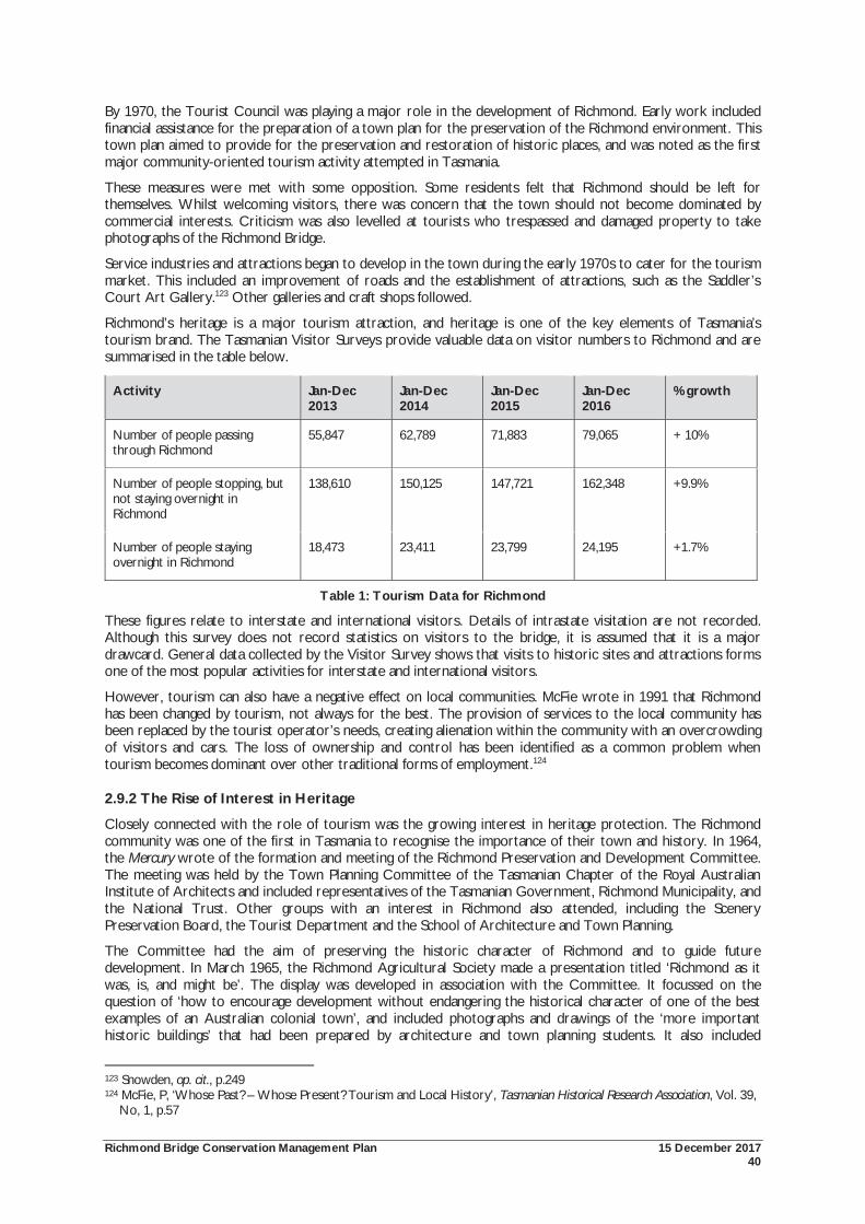
Richmond Bridge Conservation Management Plan 15 December 2017 40
By 1970, the Tourist Council was playing a major role in the development of Richmond. Early work included financial assistance for the preparation of a town plan for the preservation of the Richmond environment. This town plan aimed to provide for the preservation and restoration of historic places, and was noted as the first major community-oriented tourism activity attempted in Tasmania.
These measures were met with some opposition. Some residents felt that Richmond should be left for themselves. Whilst welcoming visitors, there was concern that the town should not become dominated by commercial interests. Criticism was also levelled at tourists who trespassed and damaged property to take photographs of the Richmond Bridge.
Service industries and attractions began to develop in the town during the early 1970s to cater for the tourism market. This included an improvement of roads and the establishment of attractions, such as the Saddler’s Court Art Gallery.123 Other galleries and craft shops followed.
Richmond’s heritage is a major tourism attraction, and heritage is one of the key elements of Tasmania’s tourism brand. The Tasmanian Visitor Surveys provide valuable data on visitor numbers to Richmond and are summarised in the table below.
Activity Jan-Dec 2013
Jan-Dec 2014
Jan-Dec 2015
Jan-Dec 2016
% growth
Number of people passing through Richmond
55,847 62,789 71,883 79,065 + 10%
Number of people stopping, but not staying overnight in Richmond
138,610 150,125 147,721 162,348 +9.9%
Number of people staying overnight in Richmond
18,473 23,411 23,799 24,195 +1.7%
Table 1: Tourism Data for Richmond
These figures relate to interstate and international visitors. Details of intrastate visitation are not recorded. Although this survey does not record statistics on visitors to the bridge, it is assumed that it is a major drawcard. General data collected by the Visitor Survey shows that visits to historic sites and attractions forms one of the most popular activities for interstate and international visitors.
However, tourism can also have a negative effect on local communities. McFie wrote in 1991 that Richmond has been changed by tourism, not always for the best. The provision of services to the local community has been replaced by the tourist operator’s needs, creating alienation within the community with an overcrowding of visitors and cars. The loss of ownership and control has been identified as a common problem when tourism becomes dominant over other traditional forms of employment.124
2.9.2 The Rise of Interest in Heritage
Closely connected with the role of tourism was the growing interest in heritage protection. The Richmond community was one of the first in Tasmania to recognise the importance of their town and history. In 1964, the Mercury wrote of the formation and meeting of the Richmond Preservation and Development Committee. The meeting was held by the Town Planning Committee of the Tasmanian Chapter of the Royal Australian Institute of Architects and included representatives of the Tasmanian Government, Richmond Municipality, and the National Trust. Other groups with an interest in Richmond also attended, including the Scenery Preservation Board, the Tourist Department and the School of Architecture and Town Planning.
The Committee had the aim of preserving the historic character of Richmond and to guide future development. In March 1965, the Richmond Agricultural Society made a presentation titled ‘Richmond as it was, is, and might be’. The display was developed in association with the Committee. It focussed on the question of ‘how to encourage development without endangering the historical character of one of the best examples of an Australian colonial town’, and included photographs and drawings of the ‘more important historic buildings’ that had been prepared by architecture and town planning students. It also included
123 Snowden, op. cit., p.249 124 McFie, P, ‘Whose Past? – Whose Present? Tourism and Local History’, Tasmanian Historical Research Association, Vol. 39,
No, 1, p.57
Richmond Bridge Conservation Management Plan 15 December 2017 41
hypothetical schemes depicting how development could occur, and how Richmond might look if restoration occurred. The display later moved to the Richmond Council Chambers and later the Tasmanian Tourist Bureau in Hobart. A public meeting was held to discuss the matter, and a key theme that emerged was that the people of Richmond were those most concerned with development and should be given the opportunity to discuss the issues themselves.
Early action was taken in September 1965, with the Preservation and Development Trust advising Council on making the guttering and kerbs near the bridge sympathetic in colour and form. Other work included the development of a ‘town centre’ covering the area behind the Council Chambers and hotel to the police station and gaol. The Trust also recognised the importance of gravelled roads over bitumen surfaces as important to retaining ‘atmosphere and charm’.
In 1968 the Local Government Act was amended to include new powers for issuing preservation orders. On the advice of the National Trust, local councils could prevent the demolition of further alteration of identified buildings and require that they be kept in good repair. Further progress was made in 1973 with a funding request to allow for the acquisition of properties in Richmond, including land at the gaol. A further $2,000 was provided towards the preparation of a conservation study of Richmond.125
Despite these gains, difficulty was still experienced in the conservation of heritage places. By May 1972, the Preservation and Development Trust and the Richmond Council were having difficulties on reaching agreement on some planning issues, and sometimes the advice of the National Trust was ignored during developments. By August of that year, the Development Trust recommended the preparation of a statutory plan that would control development and allow particular areas to be kept for specific uses. In response, a public meeting was held and a wide range of issues were raised including town planning and tourism. Funding was provided by the Tasmanian Government in 1973 to allow for the preparation of a plan. The Minister stated that there should be no undesirable development and careful planning was the only way to ensure this. Suggestions were even made for converting the main street into a pedestrian mall. The need for the town plan was heightened when plans were submitted for the construction of a third petrol station in the town in October 1973. The Richmond Council suggested that delays in its preparation were caused by technical and financial difficulties. The role of tourism also came into question, with the Council suggesting that they derived no financial benefit. The Richmond Gaol was the only paying attraction, and proceeds from visitors went to the National Parks and Wildlife Service.
In January 1974 the Richmond Residents Group was formed, partly in response to a proposal for future government housing plans on the approaches to Richmond. A public meeting was called to address concerns and consider community priorities for future development of Richmond. The Council suggested that Richmond would soon undergo rapid development at a rate not previously seen. This future development needed to be carefully planned.
By February 1975 the Planning Scheme had been prepared and approved. The retention of open space within the town was identified as an important provision. The Planning Scheme also included a Schedule of places of cultural significance, containing places identified for both the Register of the National Estate, and National Trust classified and recorded buildings. Another outcome of the Scheme was the formation of the Richmond Advisory Committee to advise on all development applications in the historic zone. Snowden writes that one of the most controversial aspects of the Town Plan was the proposed by-pass of the main street. This scheme resulted in public attention, and objections. The question of a Richmond by-pass continues to be a topical question within the community and Clarence City Council, raised each time the bridge parapets are damaged by vehicles. A by-pass to the west of the town and linking to Campania Road has been completed. However, the Government has not accepted the need for an east-west by-pass as the secondary road has been upgraded as the east-west freight route.
In 1993, the Richmond Council ceased to exist as a municipal area, the area being split between the Clarence City Council and the Southern Midlands Council. The Richmond township became part of the Clarence municipal area. The last meeting of the Richmond Council was held in March 1993.126
Joint funding from the Clarence City Council and the Australian Heritage Commission allowed for the preparation of further heritage analysis and conservation guidance for Richmond in 2000-2001. One part of this work involved the preparation of the Thematic History of the Cultural Resources of the Township of Richmond. This document provided a detailed thematic overview of Richmond, including a strong focus on social
125 Snowden, op. cit., pp.160-161 126 Ibid., pp.161-165
Richmond Bridge Conservation Management Plan 15 December 2017 42
history.127 It has been a valuable source of information in the preparation of the previous and this Conservation Management Plan.
This thematic study was also important in informing the outcomes of the Richmond Cultural Resource Management Plan (RCRMP), completed in 2001. The RCRMP was prepared in response to strong community interest in establishing the cultural values of the town and finding ways in which these values can be sustained.
The process undertaken by the study included:
Development of key issues and recommendations to deliver a framework for ongoing Council and community action to retain Richmond’s cultural values;
Extensive field assessment of the built fabric to review heritage listings, establishment of Precincts and recommendation of planning guidelines to assist conservation; and
The drawing together of a variety of data sources to produce a thematic history of Richmond.128
The first objective of this plan was to ensure the necessary statutory and administrative framework to foster the retention and conservation of the values and sites. The commitment of resources and activities to raise the profile of heritage within day-to-day activities in Richmond was recommended to Council. Eight broad recommendations were made in the RCRMP, which cover: townscape, streetscape, signage, traffic management, river management, heritage promotion, development control and community involvement. The results of the heritage survey led to new nominations to the Tasmanian Heritage Register.
127 Ibid 128 Michael Shield & Associates, op. cit., p.5
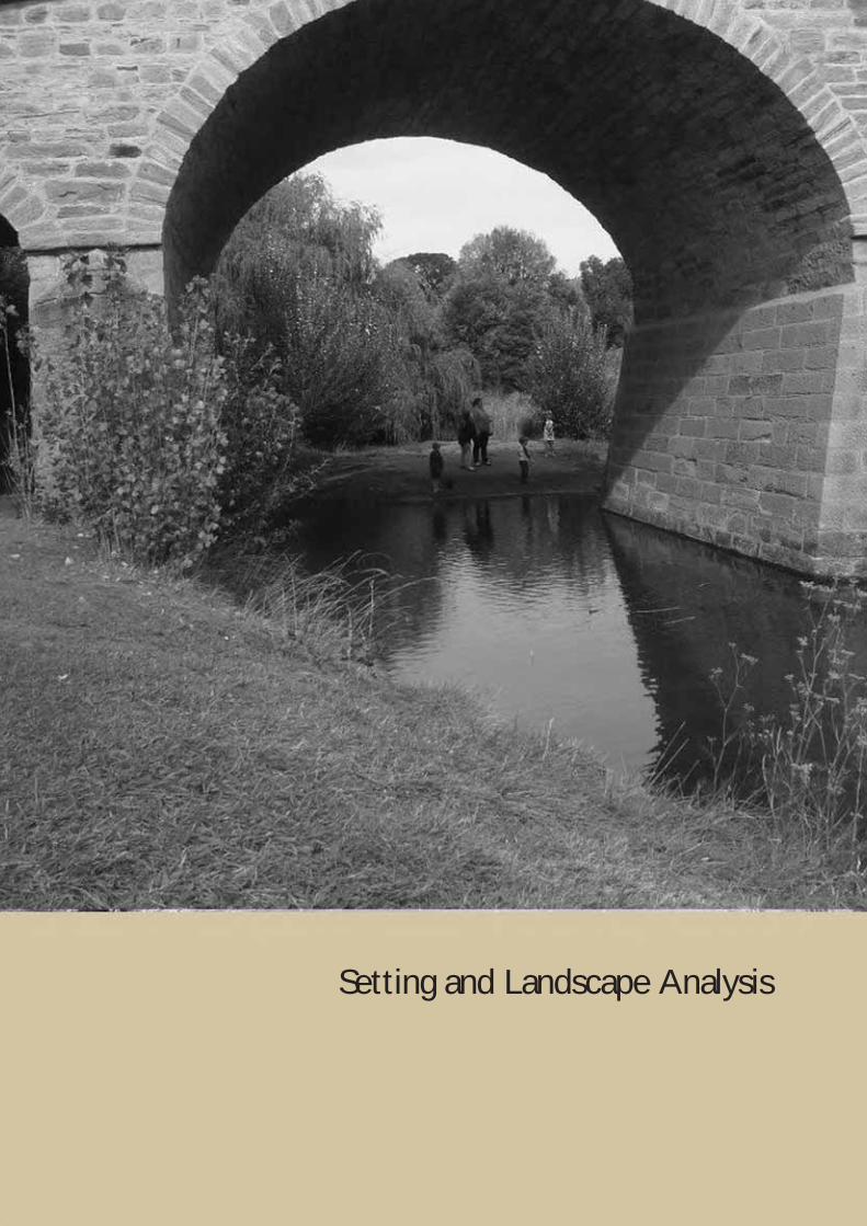
Richmond Bridge Conservation Management Plan 15 December 2017 43
Setting and Landscape Analysis
Richmond Bridge Conservation Management Plan 15 December 2017 44
3.0 SETTING AND LANDSCAPE ANALYSIS
3.1 Introduction The setting and landscape of the Richmond Bridge are important parts of its significance. The aesthetic characteristics of the place are formally recognised by listings on both the National Heritage List and Tasmanian Heritage Register. This includes the importance of the bridge as a source of inspiration for artists; its regular depiction in tourism promotion; the visual appeal of the bridge within its setting; and the relationship with the broader townscape.
This section analyses two aspects of the setting and landscape of the Richmond Bridge.
Firstly, is an assessment of the cultural landscape of the bridge and its setting. This part has considered the historical evolution of the setting of the bridge and the ways in which this has shaped the landscape. For the purposes of this Conservation Management Plan emphasis has been given to the cultural landscape values of the immediate study area. It should be noted though, that the landscape qualities of the bridge extend well beyond this immediate area. The relationship between the bridge, river, town and Coal River Valley form part of a broader cultural landscape.
Secondly, a visual assessment has been prepared to identify significant views to and from the bridge and its setting. Both the cultural landscape and view analysis incorporate work carried out for the previous Conservation Management Plans, and the more recent assessment of the Vegetation Management Plan.
3.2 An Approach to the Richmond Bridge Cultural Landscape A cultural landscape is a physically definable area with natural features modified by human activity resulting in patterns of evidence layered in the landscape. Cultural landscapes can broadly be categorised into three types: the designed landscape, the organically evolved and the associative. Although aspects of all three can be found at Richmond, the place most closely fits the category of ‘organically evolved’, where historical layers of social, economic and administrative forces have evolved in association with and in response to the natural environment. These evolved landscapes have developed over time often through incremental changes brought about by patterns of use, and often including designed elements. 129
The identification, description and assessment of a cultural landscape is most useful where it offers new insights or interpretations not available through the normal process of assessing a ‘place’. Methods of assessing and defining cultural landscapes vary, but are generally consistent in considering the land shaping processes, and defining the resulting components, or character elements of the landscape.
Defining heritage significance of cultural landscapes occurs through the standard assessment of historic, social and aesthetic values, Lennon and Matthews also identify other aspects to be considered in the assessment process. This includes rarity or uniqueness; representativeness; continuity of past and present; integrity of past and present; integrity of fabric and the relationship between components; interpretability; level of technical achievement; association; closeness and duration of association with event or theme; best expression of the type; how seminal or formative the activities, events, associations, and techniques evident in the landscape were; relative age; symbolic importance; and diversity represented in the landscape. 130
With regard to the Richmond Bridge and its setting, strong emphasis is placed on the cultural/social aspects, which in turn inform on the perceptual/aesthetic components. An historical understanding of the evolution of the Richmond Bridge and its setting is particularly relevant for understanding the cultural/social aspects. The following section defines and summarises the Richmond Bridge setting and cultural landscape. It is informed from the previous 1997 and 2010 Conservation Management Plans, and the more recent Vegetation Management Plan.
129 Heritage Victoria, Landscape Assessment Guidelines for Cultural Heritage Significance, prepared report for Heritage Victoria, 2002 130 Lennon, J, Matthews, S, Cultural Landscape Management: Guidelines for identifying, assessing and managing cultural landscapes in the Australian Alps National Parks, report prepared for the Cultural Heritage Working Group of the Australian Alps Liaison Committee, 1996, pp.7, 30-33
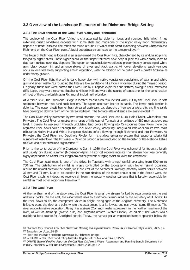
Richmond Bridge Conservation Management Plan 15 December 2017 45
3.3 Overview of the Landscape Elements of the Richmond Bridge Setting
3.3.1 The Environment of the Coal River Valley and Richmond
The geology of the Coal River Valley is characterised by dolerite ridges and rounded hills which fringe extensive quartz sandstone deposits with some shale and mudstone of the upper valley floor. Sedimentary deposits of basalt silts and fine sands are found around Pittwater with basalt extending between Campania and Richmond on the Coal River plain. Alluvial deposits are restricted to the stream valleys.131
The town of Richmond is located in an area termed the Coal River flats, characterised by its undulating plains, fringed by higher areas. These higher areas, or the ‘upper terraces’ have deep duplex soil with a sandy loam to clay loam surface over clay deposits. The upper terraces include woodlands, predominantly consisting of white gum, black peppermint and an understorey of silver and black wattle. At lower elevations, sandy terraces occur in localised areas, supporting similar vegetation, with the addition of the guitar plant (Lomatia tinctoria) as understorey growth.
On the Coal River flats, the soil is dark, heavy clay, with native vegetation populations of swamp and white gum and silver wattle. Surrounding the flats are low sandstone hills, typically formed during the Triassic period. Originally, these hills were named the Oven Hills by European explorers and setters, owing to their caves and cliffs. Later, they were renamed Butcher’s Hills or Hill and were the source of sandstone for the construction of most of the stone buildings in Richmond, including the bridge.132
At a micro level, the Richmond Bridge is located across a narrow incised valley cut by the Coal River in soft sediments between two hard rock barriers. The upper upstream barrier is basalt. The lower rock barrier is dolerite. The upper basalt barrier has retreated upstream. Lag deposits of terrace gravels, silts and fine sands have developed downstream of the retreating basalt. The terrace silts and sands are easily eroded.133
The Coal River Valley is crossed by two small streams, the Coal River and Duck Hole Rivulet, which flow into Pittwater. The Coal River originates on a range of hills east of Tunnack at an altitude of 580 metres above sea level. It travels its way south through undulating land before flowing into Craigbourne Dam. From there the regulated river flows south through the Coal River valley, accepting unregulated inflows from its two main tributaries Native Hut and White Kangaroo rivulets before flowing through Richmond and into Pittwater. At Pittwater, the Coal River and Duckhole Rivulet form a shallow estuarine system that supports substantial numbers of waterfowl. The Pittwater – Orielton Lagoon area is included on the Register of the National Estate as a wetland of international significance.134
Prior to the construction of the Craigbourne Dam in 1986, the Coal River was ephemeral for its entire length and usually dry during summer (November-April). Historical records indicate that stream flow was generally highly dependent on rainfall resulting from easterly winds bringing moist air over the catchment.
The Coal River catchment is one of the driest in Tasmania with annual rainfall averaging from 500mm to 700mm. The distribution of rainfall is largely controlled by the topography, with higher rainfall occurring around the upland areas in the north, west and east of the catchment. Average monthly rainfall varies between 37 mm and 71 mm. Due to its location in the rain shadow of the mountainous areas in the State’s west, the Coal River catchment does not receive rain from the westerly weather patterns that is largely responsible for rainfall in most other regions in Tasmania.135
3.3.2 The Coal River
At the northern end of the study area, the Coal River is a narrow stream flanked by escarpments on the east and west banks. On the east, the escarpment rises to a cliff face, surmounted by the cemetery of St John’s. As the river flows south, the escarpment varies in height, rising again at the Anglican cemetery. The Richmond Bridge crosses the river at a point where the escarpment is at its lowest and narrowest, some 55 metres. The river supports native vegetation. Phragmites australis (Common rush) is prevalent in the northern section of the river, as well as Juncus sp. (Native rush) and Triglochin procera (Water Ribbon), an edible tuber which was a traditional food source for Aboriginal people. Today, the native riparian vegetation is most apparent below the
131 Clarence City Council, Coal River Catchment: Planning and Implementation. Rosny Park: Clarence City Council, 2005, p.4 132 Snowden, op. cit., pp.14-15 133 File Note, P Spratt?, Heritage Tasmania File, Richmond Bridge 134 West Pitt Water, Richmond, TAS, Australia, Register of the National Estate, 14595 135 DPIWE, State of the River Report for the Coal River Catchment, Water Assessment and Planning Branch, Department of Primary Industries, Water and Environment, Hobart, 2003, pp.1-2
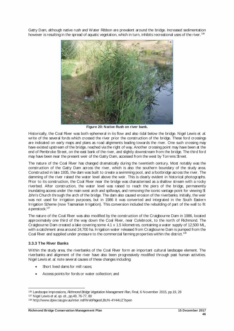
Richmond Bridge Conservation Management Plan 15 December 2017 46
Gatty Dam, although native rush and Water Ribbon are prevalent around the bridge. Increased sedimentation however is resulting in the spread of aquatic vegetation, which in turn, inhibits recreational uses of the river.136
Figure 20: Native Rush on river bank.
Historically, the Coal River was both ephemeral in its flow and also tidal below the bridge. Nigel Lewis et. al. write of the several fords which crossed the river prior the construction of the bridge. These ford crossings are indicated on early maps and plans as road alignments leading towards the river. One such crossing may have existed upstream of the bridge, reached via the right of way. Another crossing point may have been at the end of Pembroke Street, on the east bank of the river, and slightly downstream from the bridge. The third ford may have been near the present weir of the Gatty Dam, accessed from the west by Torrens Street.
The nature of the Coal River has changed dramatically during the twentieth century. Most notably was the construction of the Gatty Dam across the river, which is also the southern boundary of the study area. Constructed in late 1935, the dam was built to create a swimming pool, and a footbridge across the river. The damming of the river raised the water level above the weir. This is clearly evident in historical photographs. Prior to its construction, the Coal River near the bridge was characterised as a shallow stream with a rocky riverbed. After construction, the water level was raised to reach the piers of the bridge, permanently inundating access under the main west arch and spillways, and removing the iconic vantage point for viewing St John’s Church through the arch of the bridge. The dam also caused erosion of the riverbanks. Initially, the weir was not used for irrigation purposes, but in 1986 it was converted and integrated in the South Eastern Irrigation Scheme (now Tasmanian Irrigation). This conversion included the rebuilding of part of the wall to fit a penstock.137
The nature of the Coal River was also modified by the construction of the Craigbourne Dam in 1986, located approximately one third of the way down the Coal River, near Colebrook, to the north of Richmond. The Craigbourne Dam created a lake covering some 4.1 x 1.5 kilometres, containing a water supply of 12,500 ML, with a catchment area around 24,700 ha. Irrigation water released from Craigbourne Dam is pumped from the Coal River and supplied under pressure to the commercial farming properties within the district.138
3.3.3 The River Banks
Within the study area, the riverbanks of the Coal River form an important cultural landscape element. The riverbanks and alignment of the river have also been progressively modified through past human activities. Nigel Lewis et. al. note several causes of these changes including:
Short lived dams for mill races;
Access points for fords or water collection; and
136 Landscape Impressions, Richmond Bridge Vegetation Management Plan, Final, 6 November 2015, pp.19, 28 137 Nigel Lewis et al, op. cit., pp.49, 76-77, 80 138 http://www.dpiw.tas.gov.au/inter.nsf/WebPages/LBUN-4Y44UZ?open
Richmond Bridge Conservation Management Plan 15 December 2017 47
Notably, the construction of the Gatty Dam which raised the water level and caused erosion, most noticeably on the west bank downstream from the bridge.139
The Vegetation Management Plan (VMP) has divided the publicly owned river banks into separate ‘Management Zones’, identifying 16 specific zones. For brevity, the following described the riverbanks according to their position in relation to the bridge, that is, north east, north west, south east and south west. However, the full VMP is included in this report as an appendix.
The North West Bank
Several fords were constructed across the Coal River, corresponding to early road or track alignments. These likely ford crossing points are thought to have existed just to the upstream of the bridge on its western side (shown as a track on historic plans); on the eastern bank at the termination of what was Pembroke Street and crossing just below the bridge location; and thirdly, near what is now the Gatty Dam.140
On the north west bank above the bridge, the land was in private ownership as part of the 1815 grant to Surveyor Evans. This was later subdivided with parcels accessed by Gunning Street. However, the public did have access to the river from the north west bank, as a c.1840s plan notes a formed pathway, which was later formalised as a right of way. Nigel Lewis et. al. consider that it is this pathway that may have originally been one of the ford crossing points. The Crown acquired these parcels in 1973, and the land is now owned and managed by Clarence City Council.141
The north west bank is characterised by its steepness and low level of maintenance. Sandstone steps lead down from the bridge to the riverbank, and a cut and benched road formation follows the contour down to the river. Annual grasses and weeds dominate the site. The north west bank provides an important background for views of the bridge, and vantage point for views to the bridge (Figure 21)142
Figure 21: Richmond Bridge viewed from north west bank, looking south.
The North East Bank
The Catholic Church acquired the north east bank at an early date and used it for pasture. Currently, it is an open grassed area, located adjacent to the car park. It is one of the most visited parts of the site given the car park and its open views to the bridge. It has been acquired by Clarence City Council in recent years (Figure 22).
The area has an ‘open parkland’ character, with clear views towards the bridge. Lombardy Poplars are planted at the eastern abutments of the bridge; providing scale and framing seasonally changing views of the structure.
139 Nigel Lewis et al, op. cit., p.65 140 Ibid, pp.76-77, 80 141 Ibid 142 Landscape Impressions, op. cit., p.13
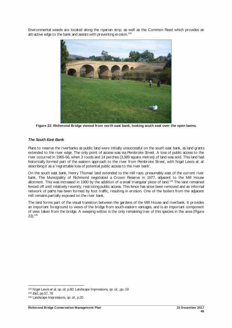
Richmond Bridge Conservation Management Plan 15 December 2017 48
Environmental weeds are located along the riparian strip, as well as the Common Reed which provides an attractive edge to the bank and assists with preventing erosion.143
Figure 22: Richmond Bridge viewed from north east bank, looking south east over the open lawns.
The South East Bank
Plans to reserve the riverbanks as public land were initially unsuccessful on the south east bank, as land grants extended to the river edge. The only point of access was via Pembroke Street. A loss of public access to the river occurred in 1965-66, when 3 roods and 14 perches (3,389 square metres) of land was sold. This land had historically formed part of the eastern approach to the river from Pembroke Street, with Nigel Lewis et. al. describing it as a ‘regrettable loss of potential public access to the river bank’.
On the south east bank, Henry Thomas’ land extended to the mill race, presumably east of the current river bank. The Municipality of Richmond negotiated a Crown Reserve in 1977, adjacent to the Mill House allotment. This was increased in 1990 by the addition of a small triangular piece of land.144 The land remained fenced off until relatively recently, restricting public access. This fence has since been removed and an informal network of paths has been formed by foot traffic, resulting in erosion. One of the boilers from the adjacent mill remains partially exposed on the river bank.
The land forms part of the visual transition between the gardens of the Mill House and riverbank. It provides an important foreground to views of the bridge from south-eastern vantages, and is an important component of view taken from the bridge. A weeping willow is the only remaining tree of this species in the area (Figure 23).145
143 Nigel Lewis et al, op. cit, p.80; Landscape Impressions, op. cit., pp.-19 144 Ibid., pp.57, 78 145 Landscape Impressions, op. cit., p.20
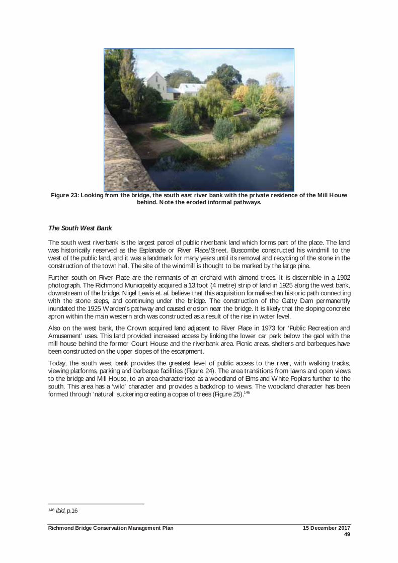
Richmond Bridge Conservation Management Plan 15 December 2017 49
Figure 23: Looking from the bridge, the south east river bank with the private residence of the Mill House
behind. Note the eroded informal pathways.
The South West Bank
The south west riverbank is the largest parcel of public riverbank land which forms part of the place. The land was historically reserved as the Esplanade or River Place/Street. Buscombe constructed his windmill to the west of the public land, and it was a landmark for many years until its removal and recycling of the stone in the construction of the town hall. The site of the windmill is thought to be marked by the large pine.
Further south on River Place are the remnants of an orchard with almond trees. It is discernible in a 1902 photograph. The Richmond Municipality acquired a 13 foot (4 metre) strip of land in 1925 along the west bank, downstream of the bridge. Nigel Lewis et. al. believe that this acquisition formalised an historic path connecting with the stone steps, and continuing under the bridge. The construction of the Gatty Dam permanently inundated the 1925 Warden’s pathway and caused erosion near the bridge. It is likely that the sloping concrete apron within the main western arch was constructed as a result of the rise in water level.
Also on the west bank, the Crown acquired land adjacent to River Place in 1973 for ‘Public Recreation and Amusement’ uses. This land provided increased access by linking the lower car park below the gaol with the mill house behind the former Court House and the riverbank area. Picnic areas, shelters and barbeques have been constructed on the upper slopes of the escarpment.
Today, the south west bank provides the greatest level of public access to the river, with walking tracks, viewing platforms, parking and barbeque facilities (Figure 24). The area transitions from lawns and open views to the bridge and Mill House, to an area characterised as a woodland of Elms and White Poplars further to the south. This area has a ‘wild’ character and provides a backdrop to views. The woodland character has been formed through ‘natural’ suckering creating a copse of trees (Figure 25).146
146 Ibid, p.16
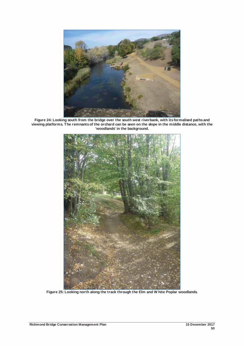
Richmond Bridge Conservation Management Plan 15 December 2017 50
Figure 24: Looking south from the bridge over the south west riverbank, with its formalised paths and
viewing platforms. The remnants of the orchard can be seen on the slope in the middle distance, with the ‘woodlands’ in the background.
Figure 25: Looking north along the track through the Elm and White Poplar woodlands.
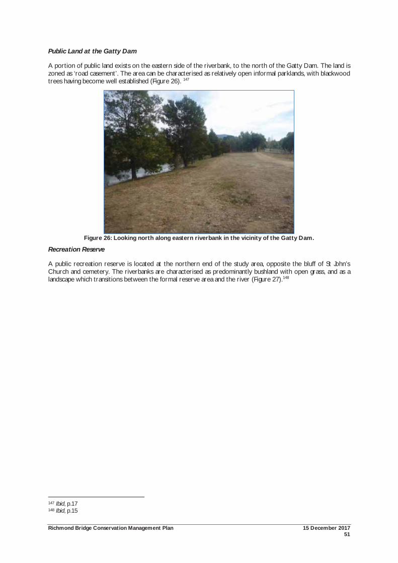
Richmond Bridge Conservation Management Plan 15 December 2017 51
Public Land at the Gatty Dam
A portion of public land exists on the eastern side of the riverbank, to the north of the Gatty Dam. The land is zoned as ‘road casement’. The area can be characterised as relatively open informal parklands, with blackwood trees having become well established (Figure 26). 147
Figure 26: Looking north along eastern riverbank in the vicinity of the Gatty Dam.
Recreation Reserve
A public recreation reserve is located at the northern end of the study area, opposite the bluff of St John’s Church and cemetery. The riverbanks are characterised as predominantly bushland with open grass, and as a landscape which transitions between the formal reserve area and the river (Figure 27).148
147 Ibid, p.17 148 Ibid, p.15
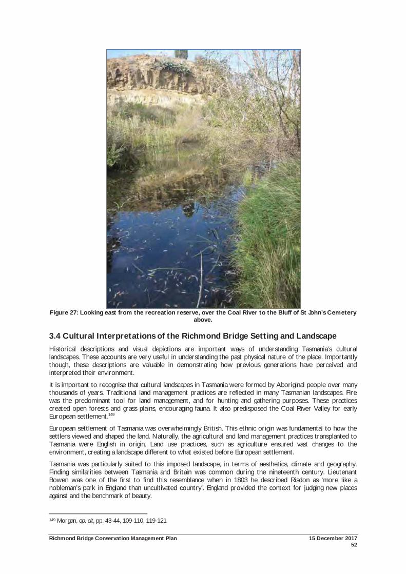
Richmond Bridge Conservation Management Plan 15 December 2017 52
Figure 27: Looking east from the recreation reserve, over the Coal River to the Bluff of St John’s Cemetery
above.
3.4 Cultural Interpretations of the Richmond Bridge Setting and Landscape Historical descriptions and visual depictions are important ways of understanding Tasmania’s cultural landscapes. These accounts are very useful in understanding the past physical nature of the place. Importantly though, these descriptions are valuable in demonstrating how previous generations have perceived and interpreted their environment.
It is important to recognise that cultural landscapes in Tasmania were formed by Aboriginal people over many thousands of years. Traditional land management practices are reflected in many Tasmanian landscapes. Fire was the predominant tool for land management, and for hunting and gathering purposes. These practices created open forests and grass plains, encouraging fauna. It also predisposed the Coal River Valley for early European settlement.149
European settlement of Tasmania was overwhelmingly British. This ethnic origin was fundamental to how the settlers viewed and shaped the land. Naturally, the agricultural and land management practices transplanted to Tasmania were English in origin. Land use practices, such as agriculture ensured vast changes to the environment, creating a landscape different to what existed before European settlement.
Tasmania was particularly suited to this imposed landscape, in terms of aesthetics, climate and geography. Finding similarities between Tasmania and Britain was common during the nineteenth century. Lieutenant Bowen was one of the first to find this resemblance when in 1803 he described Risdon as ‘more like a nobleman’s park in England than uncultivated country’. England provided the context for judging new places against and the benchmark of beauty.
149 Morgan, op. cit, pp. 43-44, 109-110, 119-121
Richmond Bridge Conservation Management Plan 15 December 2017 53
It is possible that the settlers described Tasmania in English terms because this was their frame of reference. Alternatively, an exaggerated perception of the colony could express both the joy of finding this ‘new’ land and the opportunities for its exploitation.
It is also relevant to consider the prevailing thought of the day that nature could, and should be improved. Introducing exotic flora and fauna was one way of ‘improving’ the landscape, whilst also serving nostalgic or sentimental purposes of introducing elements from Britain. However, practical and economic considerations were also at play in creating the Tasmanian landscape. Although green fields and hawthorn hedgerows had a nostalgic quality, they were above all an attempt at greater productivity and profit. 150
3.4.1 Modifying the Environment
European exploration of the Coal River Valley occurred shortly after European settlement at Risdon Cove in 1803. Settlers crossed the low hills to reach the valley, in search of game to supplement meagre supplies. The area was subject to early European settlement and the establishment of pastoralism and agriculture.
The light vegetation, excellent soils, water supply and proximity to the population centre on the Derwent made the Coal River Valley suitable for European settlement. Farming was seen as the foundation stone of the colony, firstly for survival, and later for export. Farms were established at Pittwater as early as 1808 for growing wheat and by 1816, grain was being exported to New South Wales. By 1820, all available land in the district was under cultivation. The region became known as the ‘granary of Australia’, supplying domestic needs as well as exporting to New South Wales.151
Richmond township maintains its strong sense of containment within the broader rural setting.
3.4.2 The Establishment of Richmond as a Crossing Place
A crossing point of the Coal River near the current bridge location existed before the construction of the bridge, and before the establishment of the town of Richmond. Access to the east coast and Tasman Peninsula was available via two routes: the first overland via the Coal River Valley, the second, was across Pittwater by ferry. Fords were constructed across the Coal River, though these were unsatisfactory, and impassable during times of flood and high tides.
John Bigge identified the need for a permanent crossing point of the river in 1820 during his Commission of Inquiry. The chosen location was upstream of the lower fords. Under a convict workforce, construction of the bridge commenced in December 1823, and was completed in 1825. The bridge allowed for more rapid transportation between Hobart and the Coast. By 1826, the bridge required extensive repairs. Water is thought to have undermined the foundations of two piers, resulting in them settling at a lower level, and providing the undulating appearance of the bridge which continues to exist to this day. Later repairs were required to raise the parapet of the bridge, followed by encasement of the piers during the 1880s.
The establishment of the town of Richmond followed the commencement of construction of the bridge. The first buildings constructed were the gaol, court house, barracks and a watch house, demonstrating the penal nature of the early colony. Town development was focused south west of the bridge. The early and continued growth of Richmond relied on its importance as a convict station and a military post. In time, Richmond became an important population and municipal centre, whilst acting as a regional supply and service centre for the surrounding agricultural districts. Several flour mills were established on the banks of the river. This growth ceased in the late nineteenth century with the construction of the Sorell causeway, which redirected traffic away from Richmond.
3.4.3 Historical Perceptions of the Coal River Valley and Richmond
The Coal River Valley and Richmond has historically been a focus of both written and visual depictions. Nineteenth century descriptions of Richmond and the Coal Valley frequently define the picturesque qualities of the area, regularly comparing it with England. The landscape was often described evocatively, drawing on painterly or literary allusions. The English picturesque qualities of Richmond were found in the combination of simple Georgian buildings constructed from the local, warm coloured stone, the small size of the village, the proximity of farmhouses, the valley setting with sparse tree cover and the focus on the bridge.152 George Augustus Robinson noted this picturesque quality in 1829, describing Richmond as:
150 Ibid., pp. 43-44, 109-110, 119-121 151 Snowden, op. cit., pp.17-18; Whishaw, op. cit., p.49 152 Nigel Lewis et al, op. cit., p.38
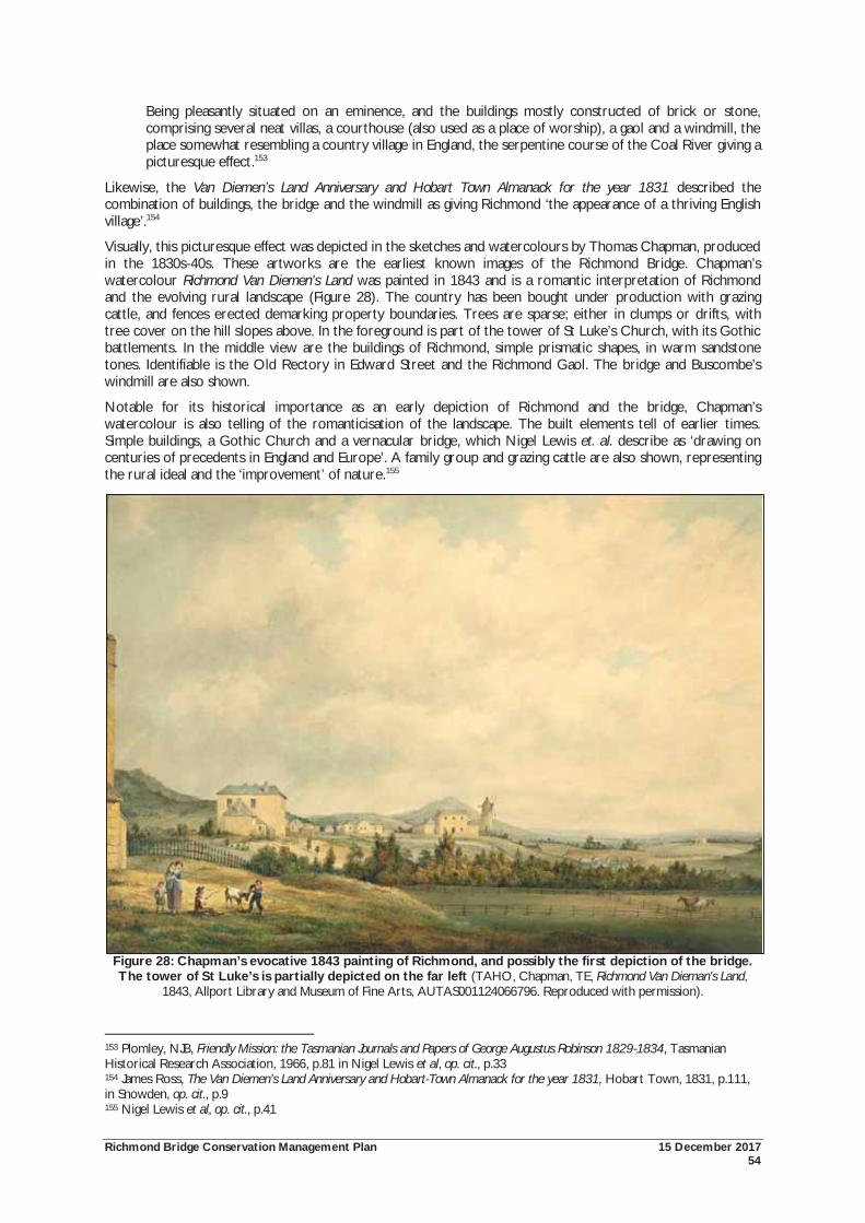
Richmond Bridge Conservation Management Plan 15 December 2017 54
Being pleasantly situated on an eminence, and the buildings mostly constructed of brick or stone, comprising several neat villas, a courthouse (also used as a place of worship), a gaol and a windmill, the place somewhat resembling a country village in England, the serpentine course of the Coal River giving a picturesque effect.153
Likewise, the Van Diemen’s Land Anniversary and Hobart Town Almanack for the year 1831 described the combination of buildings, the bridge and the windmill as giving Richmond ‘the appearance of a thriving English village’.154
Visually, this picturesque effect was depicted in the sketches and watercolours by Thomas Chapman, produced in the 1830s-40s. These artworks are the earliest known images of the Richmond Bridge. Chapman’s watercolour Richmond Van Diemen’s Land was painted in 1843 and is a romantic interpretation of Richmond and the evolving rural landscape (Figure 28). The country has been bought under production with grazing cattle, and fences erected demarking property boundaries. Trees are sparse; either in clumps or drifts, with tree cover on the hill slopes above. In the foreground is part of the tower of St Luke’s Church, with its Gothic battlements. In the middle view are the buildings of Richmond, simple prismatic shapes, in warm sandstone tones. Identifiable is the Old Rectory in Edward Street and the Richmond Gaol. The bridge and Buscombe’s windmill are also shown.
Notable for its historical importance as an early depiction of Richmond and the bridge, Chapman’s watercolour is also telling of the romanticisation of the landscape. The built elements tell of earlier times. Simple buildings, a Gothic Church and a vernacular bridge, which Nigel Lewis et. al. describe as ‘drawing on centuries of precedents in England and Europe’. A family group and grazing cattle are also shown, representing the rural ideal and the ‘improvement’ of nature.155
Figure 28: Chapman’s evocative 1843 painting of Richmond, and possibly the first depiction of the bridge. The tower of St Luke’s is partially depicted on the far left (TAHO, Chapman, TE, Richmond Van Dieman's Land,
1843, Allport Library and Museum of Fine Arts, AUTAS001124066796. Reproduced with permission).
153 Plomley, NJB, Friendly Mission: the Tasmanian Journals and Papers of George Augustus Robinson 1829-1834, Tasmanian Historical Research Association, 1966, p.81 in Nigel Lewis et al, op. cit., p.33 154 James Ross, The Van Diemen’s Land Anniversary and Hobart-Town Almanack for the year 1831, Hobart Town, 1831, p.111, in Snowden, op. cit., p.9 155 Nigel Lewis et al, op. cit., p.41
Richmond Bridge Conservation Management Plan 15 December 2017 55
Through prose, Richmond and the landscape was also idealised. In 1869, Thomas published an excursion guide for Tasmania. He relates a journey from Hobart to Richmond, describing English features along the way, and quoting poets to support the imagery:
And on one side a windmill in decay; Beyond a bridge that spans the river Cole. 156
Supporting this picturesque sense of decay, Thomas mocks the pace of life in Richmond and the state of the shops:
I suppose they are sometimes visited by customers. I did not see any; but I saw many commodities, fictile and textile, that might have been eligible for admission into a museum of antiquities. 157
Mention is also made of St John’s cemetery and its situation on a:
lofty and insulated knoll, along the base of which “A broad brook brawls o’er a shingly bed”. A scene more favourable to “meditation” can scarcely be imagined. 158
On the broader landscape, Thomas pays some attention where:
But what a contrast there must have been between the inward fret and repining stir in the exile’s mind and the pastoral repose and tranquil beauty of the surrounding landscape – the sleek kine [cows], grazing with such placid enjoyment in the fat pastures; the river sparkling in the sunshine and wrinkling in the breeze; the cloud shadows lazily drifting over garth and croft, brown fallow and yellow stubble; the chirp and twitter of the birds among the wattles; the miller leaning over the parapet of the bridge, and looking as though himself were carved out of freestone like the structure itself …159
By the twentieth century, Richmond Bridge and its landscape became a popular destination for photographers and artists. The bridge was also featured in numerous postcards, testament to the growing tourism interest in Richmond. A 1940 article in the magazine Woman’s World described the bridge where:
The massive buttresses, generous spacing of the arches and bold outline of the parapet, although typical of old bridges in the north of England, are reinterpreted in colonial style.160
Eldershaw painted the bridge a number of times. One of his watercolours reproduced below shows the bridge within a rural setting with horse and cart, a strong reference to the picturesque qualities of the landscape, and rural nature of Richmond (Figure 29).
156 Nigel Lewis et al, op. cit., pp.41-42 157 Ibid 158 Ibid 159 Ibid 160 Ibid, p.55
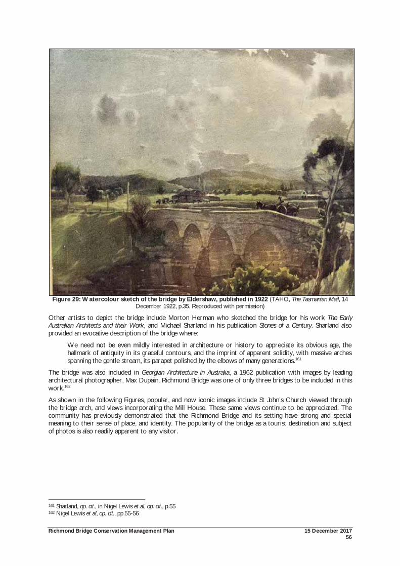
Richmond Bridge Conservation Management Plan 15 December 2017 56
Figure 29: Watercolour sketch of the bridge by Eldershaw, published in 1922 (TAHO, The Tasmanian Mail, 14 December 1922, p.35. Reproduced with permission)
Other artists to depict the bridge include Morton Herman who sketched the bridge for his work The Early Australian Architects and their Work, and Michael Sharland in his publication Stones of a Century. Sharland also provided an evocative description of the bridge where:
We need not be even mildly interested in architecture or history to appreciate its obvious age, the hallmark of antiquity in its graceful contours, and the imprint of apparent solidity, with massive arches spanning the gentle stream, its parapet polished by the elbows of many generations.161
The bridge was also included in Georgian Architecture in Australia, a 1962 publication with images by leading architectural photographer, Max Dupain. Richmond Bridge was one of only three bridges to be included in this work.162
As shown in the following Figures, popular, and now iconic images include St John’s Church viewed through the bridge arch, and views incorporating the Mill House. These same views continue to be appreciated. The community has previously demonstrated that the Richmond Bridge and its setting have strong and special meaning to their sense of place, and identity. The popularity of the bridge as a tourist destination and subject of photos is also readily apparent to any visitor.
161 Sharland, op. cit., in Nigel Lewis et al, op. cit., p.55 162 Nigel Lewis et al, op. cit., pp.55-56
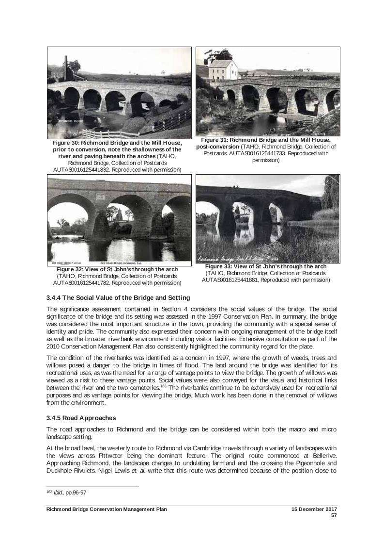
Richmond Bridge Conservation Management Plan 15 December 2017 57
Figure 30: Richmond Bridge and the Mill House, prior to conversion, note the shallowness of the
river and paving beneath the arches (TAHO, Richmond Bridge, Collection of Postcards
AUTAS0016125441832. Reproduced with permission)
Figure 31: Richmond Bridge and the Mill House, post-conversion (TAHO, Richmond Bridge, Collection of
Postcards. AUTAS0016125441733. Reproduced with permission)
Figure 32: View of St John’s through the arch (TAHO, Richmond Bridge, Collection of Postcards.
AUTAS0016125441782. Reproduced with permission)
Figure 33: View of St John’s through the arch (TAHO, Richmond Bridge, Collection of Postcards.
AUTAS0016125441881, Reproduced with permission)
3.4.4 The Social Value of the Bridge and Setting
The significance assessment contained in Section 4 considers the social values of the bridge. The social significance of the bridge and its setting was assessed in the 1997 Conservation Plan. In summary, the bridge was considered the most important structure in the town, providing the community with a special sense of identity and pride. The community also expressed their concern with ongoing management of the bridge itself as well as the broader riverbank environment including visitor facilities. Extensive consultation as part of the 2010 Conservation Management Plan also consistently highlighted the community regard for the place.
The condition of the riverbanks was identified as a concern in 1997, where the growth of weeds, trees and willows posed a danger to the bridge in times of flood. The land around the bridge was identified for its recreational uses, as was the need for a range of vantage points to view the bridge. The growth of willows was viewed as a risk to these vantage points. Social values were also conveyed for the visual and historical links between the river and the two cemeteries.163 The riverbanks continue to be extensively used for recreational purposes and as vantage points for viewing the bridge. Much work has been done in the removal of willows from the environment.
3.4.5 Road Approaches
The road approaches to Richmond and the bridge can be considered within both the macro and micro landscape setting.
At the broad level, the westerly route to Richmond via Cambridge travels through a variety of landscapes with the views across Pittwater being the dominant feature. The original route commenced at Bellerive. Approaching Richmond, the landscape changes to undulating farmland and the crossing the Pigeonhole and Duckhole Rivulets. Nigel Lewis et. al. write that this route was determined because of the position close to
163 Ibid., pp.96-97
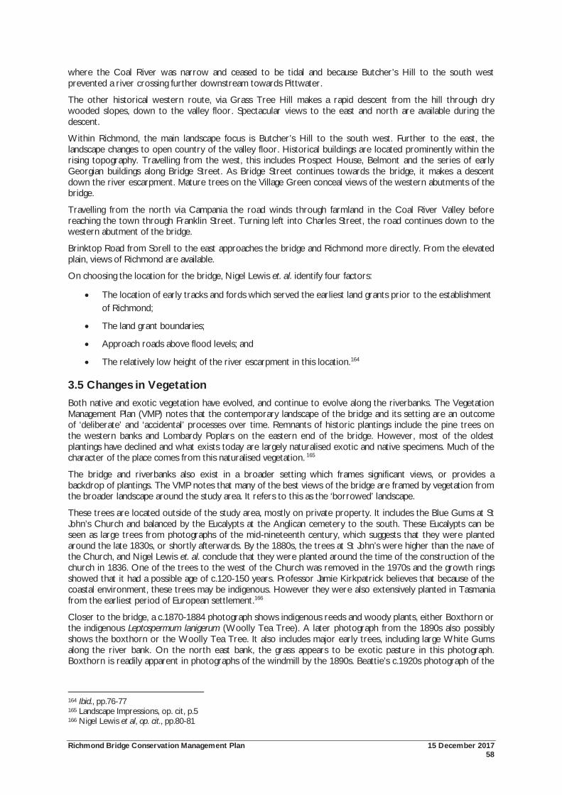
Richmond Bridge Conservation Management Plan 15 December 2017 58
where the Coal River was narrow and ceased to be tidal and because Butcher’s Hill to the south west prevented a river crossing further downstream towards Pittwater.
The other historical western route, via Grass Tree Hill makes a rapid descent from the hill through dry wooded slopes, down to the valley floor. Spectacular views to the east and north are available during the descent.
Within Richmond, the main landscape focus is Butcher’s Hill to the south west. Further to the east, the landscape changes to open country of the valley floor. Historical buildings are located prominently within the rising topography. Travelling from the west, this includes Prospect House, Belmont and the series of early Georgian buildings along Bridge Street. As Bridge Street continues towards the bridge, it makes a descent down the river escarpment. Mature trees on the Village Green conceal views of the western abutments of the bridge.
Travelling from the north via Campania the road winds through farmland in the Coal River Valley before reaching the town through Franklin Street. Turning left into Charles Street, the road continues down to the western abutment of the bridge.
Brinktop Road from Sorell to the east approaches the bridge and Richmond more directly. From the elevated plain, views of Richmond are available.
On choosing the location for the bridge, Nigel Lewis et. al. identify four factors:
The location of early tracks and fords which served the earliest land grants prior to the establishment of Richmond;
The land grant boundaries;
Approach roads above flood levels; and
The relatively low height of the river escarpment in this location.164
3.5 Changes in Vegetation Both native and exotic vegetation have evolved, and continue to evolve along the riverbanks. The Vegetation Management Plan (VMP) notes that the contemporary landscape of the bridge and its setting are an outcome of ‘deliberate’ and ‘accidental’ processes over time. Remnants of historic plantings include the pine trees on the western banks and Lombardy Poplars on the eastern end of the bridge. However, most of the oldest plantings have declined and what exists today are largely naturalised exotic and native specimens. Much of the character of the place comes from this naturalised vegetation. 165
The bridge and riverbanks also exist in a broader setting which frames significant views, or provides a backdrop of plantings. The VMP notes that many of the best views of the bridge are framed by vegetation from the broader landscape around the study area. It refers to this as the ‘borrowed’ landscape.
These trees are located outside of the study area, mostly on private property. It includes the Blue Gums at St John’s Church and balanced by the Eucalypts at the Anglican cemetery to the south. These Eucalypts can be seen as large trees from photographs of the mid-nineteenth century, which suggests that they were planted around the late 1830s, or shortly afterwards. By the 1880s, the trees at St John’s were higher than the nave of the Church, and Nigel Lewis et. al. conclude that they were planted around the time of the construction of the church in 1836. One of the trees to the west of the Church was removed in the 1970s and the growth rings showed that it had a possible age of c.120-150 years. Professor Jamie Kirkpatrick believes that because of the coastal environment, these trees may be indigenous. However they were also extensively planted in Tasmania from the earliest period of European settlement.166
Closer to the bridge, a c.1870-1884 photograph shows indigenous reeds and woody plants, either Boxthorn or the indigenous Leptospermum lanigerum (Woolly Tea Tree). A later photograph from the 1890s also possibly shows the boxthorn or the Woolly Tea Tree. It also includes major early trees, including large White Gums along the river bank. On the north east bank, the grass appears to be exotic pasture in this photograph. Boxthorn is readily apparent in photographs of the windmill by the 1890s. Beattie’s c.1920s photograph of the
164 Ibid., pp.76-77 165 Landscape Impressions, op. cit, p.5 166 Nigel Lewis et al, op. cit., pp.80-81
Richmond Bridge Conservation Management Plan 15 December 2017 59
bridge shows regrowth Woolly Tea Tree and White Gums on the riverbanks. Photographs from around this time looking south east also shows the river bank with regrowth of Woolly Tea Tree and White Gum.
Willows became dominant along the riverbanks by the late 1920s or early 1930s. Most of the willows on the western bank have now been removed. An isolated example has been left on the south east bank below the Mill House. After 1920, when John Eldershaw acquired the Mill House, Cupressus macrocarpa were planted along Wellington Street and returning along the river to enclose the property. A 1940s photograph shows large Lombardy Poplars near the south east abutment of the bridge. Lombardy Poplars were also established on the north east abutment by the 1950s. On the eastern bank of the river, below the Mill House, an extensive copse of Poplars has naturalised along the mill race, most likely because of the increased water following the construction of the Gatty Dam.167
These changes in vegetation can be partially understood through comparing historic aerial photographs (Figures 34-36). Beginning in 1946, the photographs indicate, the ‘scrubby’ nature of the north east and north west riverbanks, with relatively few trees to the south west. A few small trees can be seen in this location and may relate to the beautification works carried out during the 1920s and 1930s. Dense vegetation surrounds the Mill House. Individual trees were larger and more prominent by 1967 (Figure 35), but the most substantial changes occurred in the following decades. By 1989, dense groves of Elms and Poplars had emerged on both sides of the riverbank, to the south of the bridge (Figure 36). They continue to exist in some form to this day.
167 Ibid., pp.80-81
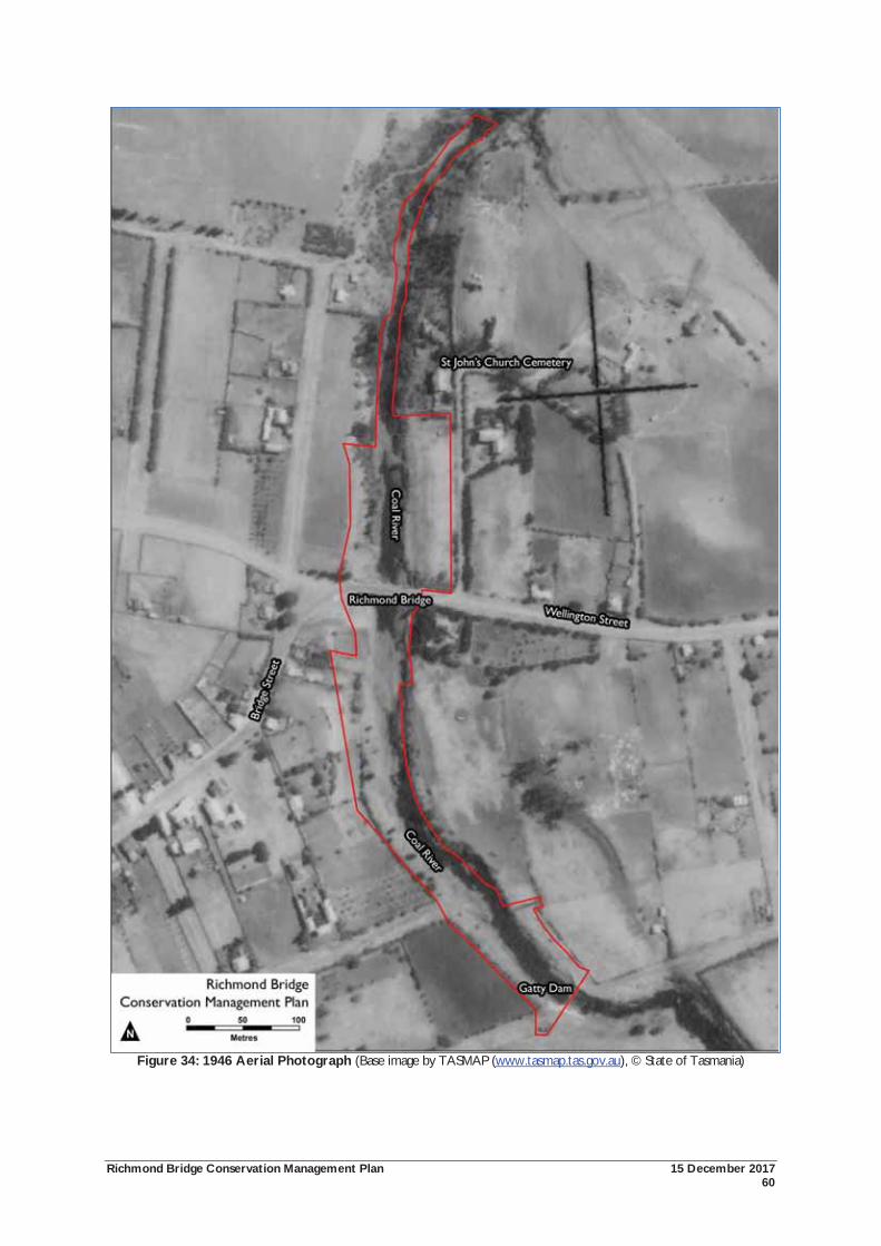
Richmond Bridge Conservation Management Plan 15 December 2017 60
Figure 34: 1946 Aerial Photograph (Base image by TASMAP (www.tasmap.tas.gov.au), © State of Tasmania)

Richmond Bridge Conservation Management Plan 15 December 2017 61
Figure 35: 1967 Aerial Photograph (Base image by TASMAP (www.tasmap.tas.gov.au), © State of Tasmania)
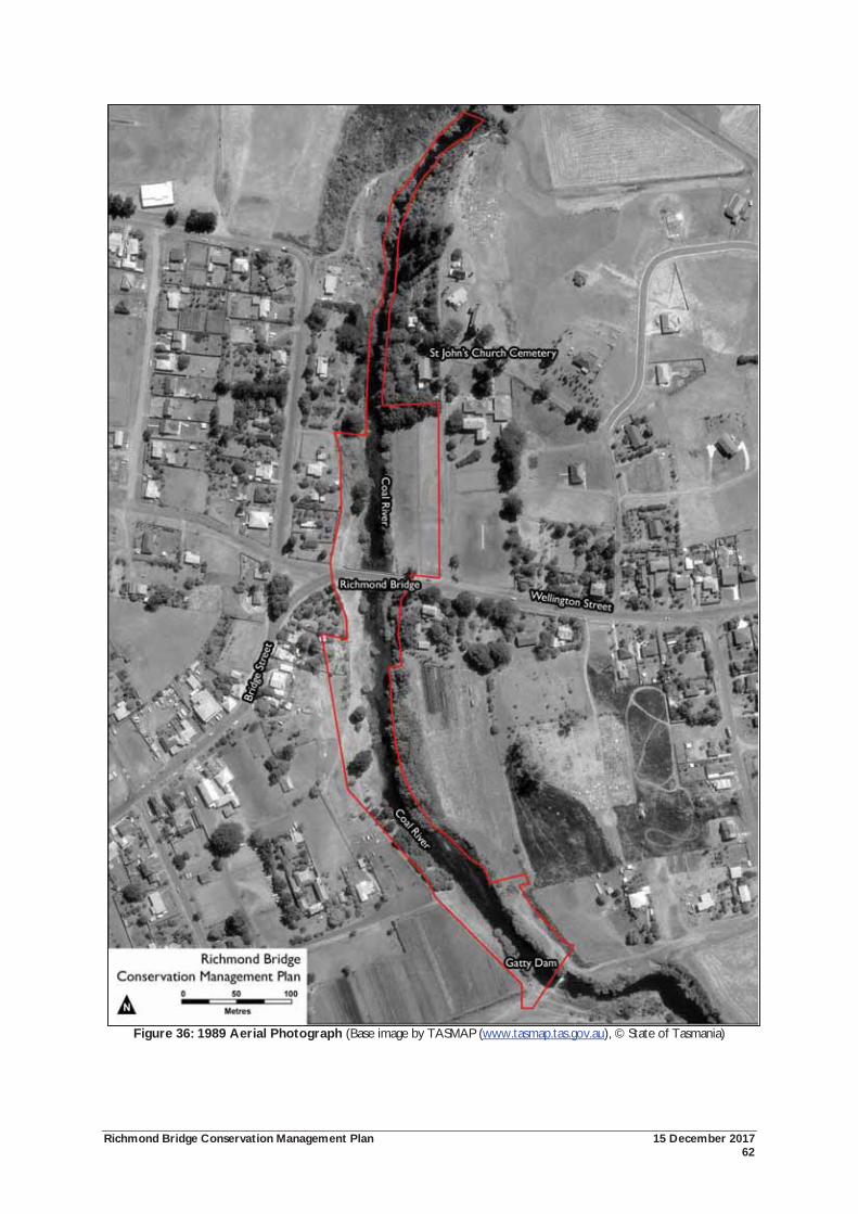
Richmond Bridge Conservation Management Plan 15 December 2017 62
Figure 36: 1989 Aerial Photograph (Base image by TASMAP (www.tasmap.tas.gov.au), © State of Tasmania)
Richmond Bridge Conservation Management Plan 15 December 2017 63
3.6 Identification of Significant Views The Richmond Bridge and its setting forms a rich cultural landscape. It is also notable for its important visual landscape qualities. These qualities come from the combination of built elements, topography and vegetation. The relationship with surrounding areas, such as the broader Coal River Valley landscape fringed by low hills and the Richmond township are important complementary elements. The aesthetic characteristics of the place have been formally recognised at both National and State levels.
The Richmond Cultural Resource Management Plan (RCRMP)168 identified the major townscape elements of Richmond. The main thematic importance was associated with those elements which demonstrated the early nineteenth century establishment of Richmond as a significant service provider for Government, early settlers and the surrounding countryside. Of relevance to this report, these elements included the bridge, the Coal River, parks and reserves, churches and significant vistas to and from the town.
From the identification of these elements, the RCRMP considered issues of view scapes and vistas of individual streetscape settings and also the overall setting of the town. The RCRMP recognised the integral heritage value of view lines where they form an overview of a curtilage or a direct relationship with the property itself. The value of the important relationship between the town and its surrounding rural landscape was also recognised.169
Both the previous Conservation Management Plans and the Vegetation Management Plan have identified significant views to and from the bridge. For the purpose of this report, consideration has been given to identifying important views to and from the study area. From this process, twelve important views have been identified. Largely depending on the elevation, these views vary from narrow vistas framed by vegetation and topography, to broader landscape and townscape appreciation. The views analysis has considered the bridge itself, as well as the broader landscape elements within the study area. The identification of these significant public views can also assist in managing potential visual impacts which may occur from development occurring adjacent to the place. In this report, the following terms have been used:
View: what can be seen;
Vantage Point: the specific location from where the view is taken;
Landscape: the subjective interpretation or perception of the view, for example, its aesthetic qualities.
The following Figure indicates the location of each of these vantage points and the general alignment of the views available. Each of these views is described in the following table.
168 The Richmond Cultural Resource Management Plan (2001) was prepared in response to strong community interest in establishing the cultural values of the town and finding ways in which these values can be sustained. 169 Michael Shield & Associates, op. cit., pp.27-30
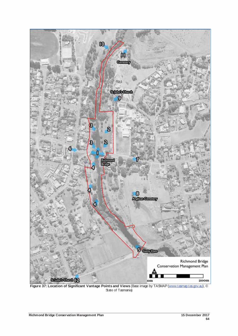
Richmond Bridge Conservation Management Plan 15 December 2017 64
Figure 37: Location of Significant Vantage Points and Views (Base image by TASMAP (www.tasmap.tas.gov.au), © State of Tasmania)
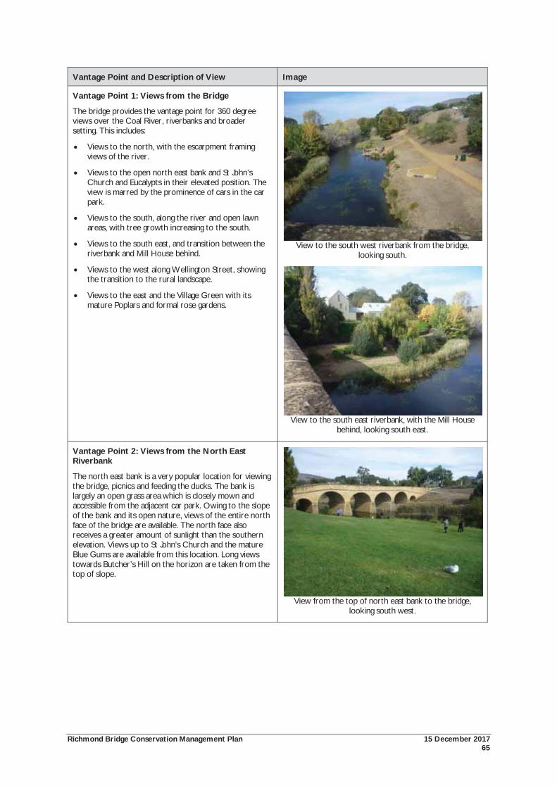
Richmond Bridge Conservation Management Plan 15 December 2017 65
Vantage Point and Description of View Image
Vantage Point 1: Views from the Bridge
The bridge provides the vantage point for 360 degree views over the Coal River, riverbanks and broader setting. This includes:
Views to the north, with the escarpment framing views of the river.
Views to the open north east bank and St John’s Church and Eucalypts in their elevated position. The view is marred by the prominence of cars in the car park.
Views to the south, along the river and open lawn areas, with tree growth increasing to the south.
Views to the south east, and transition between the riverbank and Mill House behind.
Views to the west along Wellington Street, showing the transition to the rural landscape.
Views to the east and the Village Green with its mature Poplars and formal rose gardens.
View to the south west riverbank from the bridge, looking south.
View to the south east riverbank, with the Mill House behind, looking south east.
Vantage Point 2: Views from the North East Riverbank
The north east bank is a very popular location for viewing the bridge, picnics and feeding the ducks. The bank is largely an open grass area which is closely mown and accessible from the adjacent car park. Owing to the slope of the bank and its open nature, views of the entire north face of the bridge are available. The north face also receives a greater amount of sunlight than the southern elevation. Views up to St John’s Church and the mature Blue Gums are available from this location. Long views towards Butcher’s Hill on the horizon are taken from the top of slope.
View from the top of north east bank to the bridge, looking south west.
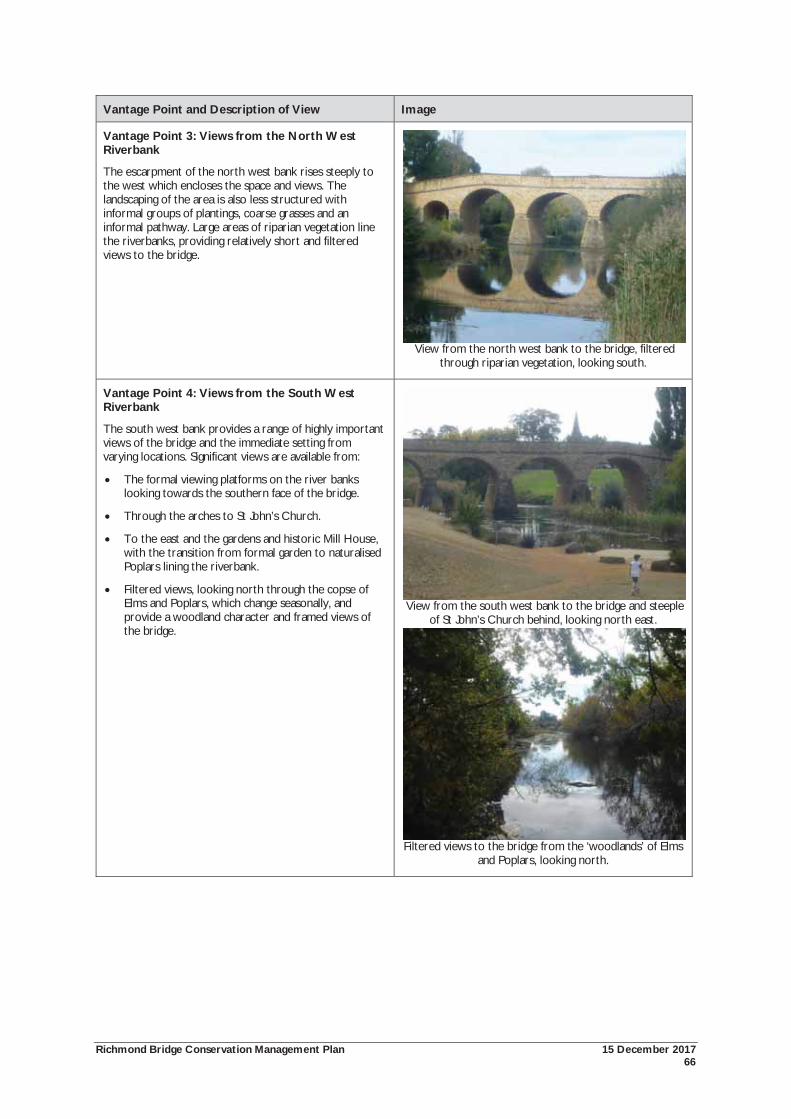
Richmond Bridge Conservation Management Plan 15 December 2017 66
Vantage Point and Description of View Image
Vantage Point 3: Views from the North West Riverbank
The escarpment of the north west bank rises steeply to the west which encloses the space and views. The landscaping of the area is also less structured with informal groups of plantings, coarse grasses and an informal pathway. Large areas of riparian vegetation line the riverbanks, providing relatively short and filtered views to the bridge.
View from the north west bank to the bridge, filtered through riparian vegetation, looking south.
Vantage Point 4: Views from the South West Riverbank
The south west bank provides a range of highly important views of the bridge and the immediate setting from varying locations. Significant views are available from:
The formal viewing platforms on the river banks looking towards the southern face of the bridge.
Through the arches to St John’s Church.
To the east and the gardens and historic Mill House, with the transition from formal garden to naturalised Poplars lining the riverbank.
Filtered views, looking north through the copse of Elms and Poplars, which change seasonally, and provide a woodland character and framed views of the bridge.
View from the south west bank to the bridge and steeple of St John’s Church behind, looking north east.
Filtered views to the bridge from the ‘woodlands’ of Elms and Poplars, looking north.
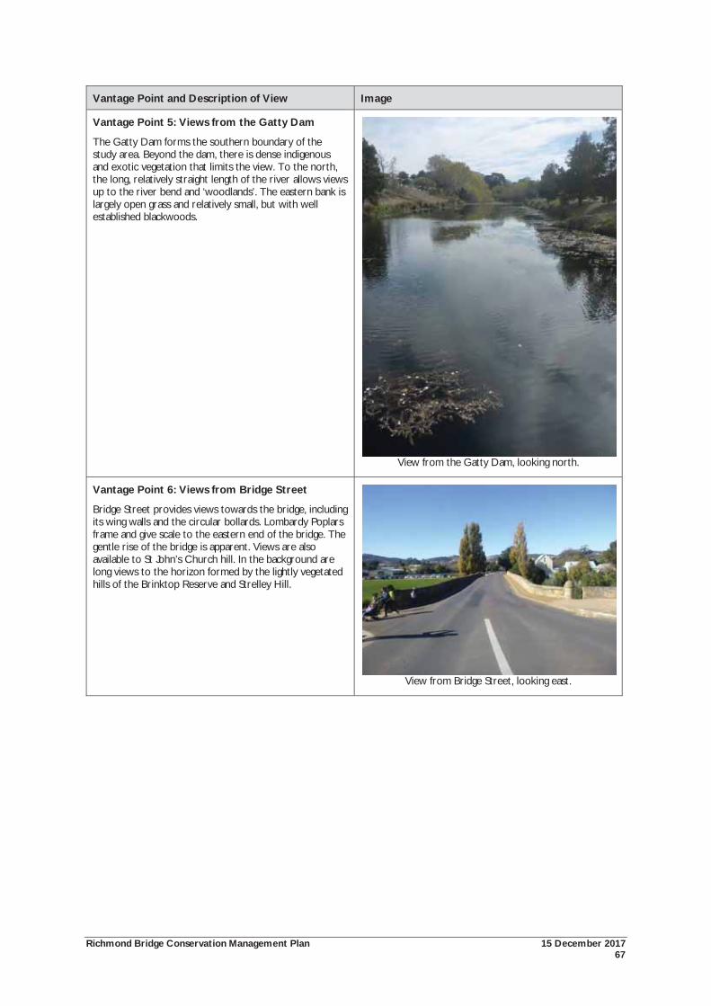
Richmond Bridge Conservation Management Plan 15 December 2017 67
Vantage Point and Description of View Image
Vantage Point 5: Views from the Gatty Dam
The Gatty Dam forms the southern boundary of the study area. Beyond the dam, there is dense indigenous and exotic vegetation that limits the view. To the north, the long, relatively straight length of the river allows views up to the river bend and ‘woodlands’. The eastern bank is largely open grass and relatively small, but with well established blackwoods.
View from the Gatty Dam, looking north.
Vantage Point 6: Views from Bridge Street
Bridge Street provides views towards the bridge, including its wing walls and the circular bollards. Lombardy Poplars frame and give scale to the eastern end of the bridge. The gentle rise of the bridge is apparent. Views are also available to St John’s Church hill. In the background are long views to the horizon formed by the lightly vegetated hills of the Brinktop Reserve and Strelley Hill.
View from Bridge Street, looking east.
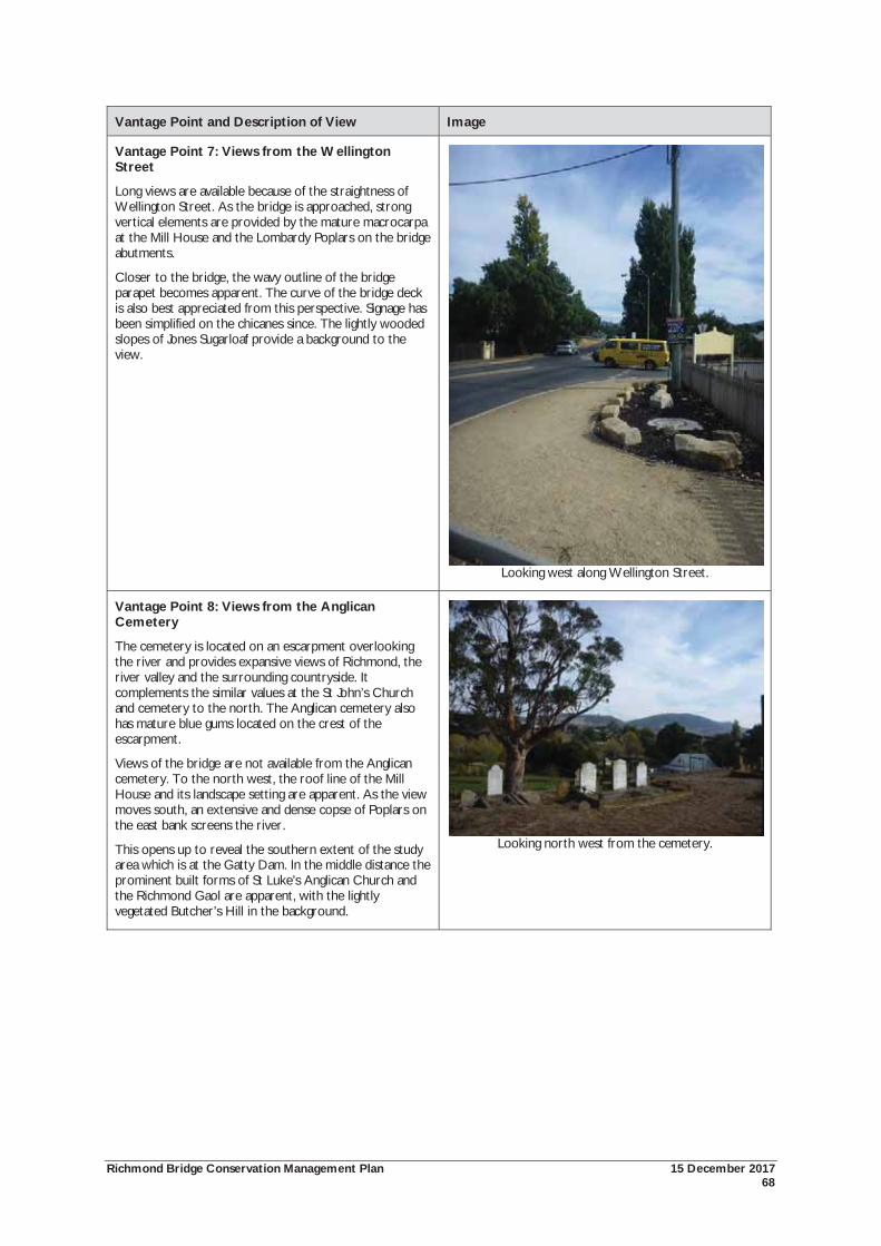
Richmond Bridge Conservation Management Plan 15 December 2017 68
Vantage Point and Description of View Image
Vantage Point 7: Views from the Wellington Street
Long views are available because of the straightness of Wellington Street. As the bridge is approached, strong vertical elements are provided by the mature macrocarpa at the Mill House and the Lombardy Poplars on the bridge abutments.
Closer to the bridge, the wavy outline of the bridge parapet becomes apparent. The curve of the bridge deck is also best appreciated from this perspective. Signage has been simplified on the chicanes since. The lightly wooded slopes of Jones Sugarloaf provide a background to the view.
Looking west along Wellington Street.
Vantage Point 8: Views from the Anglican Cemetery
The cemetery is located on an escarpment overlooking the river and provides expansive views of Richmond, the river valley and the surrounding countryside. It complements the similar values at the St John’s Church and cemetery to the north. The Anglican cemetery also has mature blue gums located on the crest of the escarpment.
Views of the bridge are not available from the Anglican cemetery. To the north west, the roof line of the Mill House and its landscape setting are apparent. As the view moves south, an extensive and dense copse of Poplars on the east bank screens the river.
This opens up to reveal the southern extent of the study area which is at the Gatty Dam. In the middle distance the prominent built forms of St Luke’s Anglican Church and the Richmond Gaol are apparent, with the lightly vegetated Butcher’s Hill in the background.
Looking north west from the cemetery.
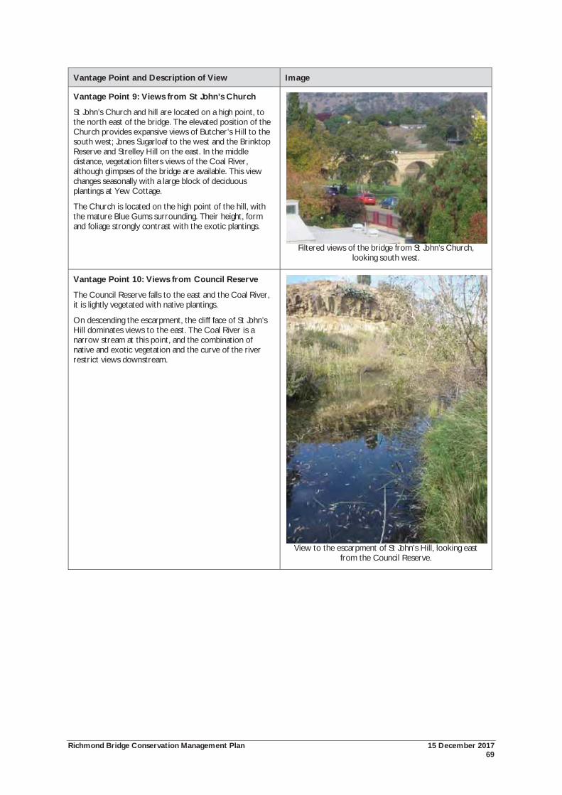
Richmond Bridge Conservation Management Plan 15 December 2017 69
Vantage Point and Description of View Image
Vantage Point 9: Views from St John’s Church
St John’s Church and hill are located on a high point, to the north east of the bridge. The elevated position of the Church provides expansive views of Butcher’s Hill to the south west; Jones Sugarloaf to the west and the Brinktop Reserve and Strelley Hill on the east. In the middle distance, vegetation filters views of the Coal River, although glimpses of the bridge are available. This view changes seasonally with a large block of deciduous plantings at Yew Cottage.
The Church is located on the high point of the hill, with the mature Blue Gums surrounding. Their height, form and foliage strongly contrast with the exotic plantings.
Filtered views of the bridge from St John’s Church, looking south west.
Vantage Point 10: Views from Council Reserve
The Council Reserve falls to the east and the Coal River, it is lightly vegetated with native plantings.
On descending the escarpment, the cliff face of St John’s Hill dominates views to the east. The Coal River is a narrow stream at this point, and the combination of native and exotic vegetation and the curve of the river restrict views downstream.
View to the escarpment of St John’s Hill, looking east from the Council Reserve.
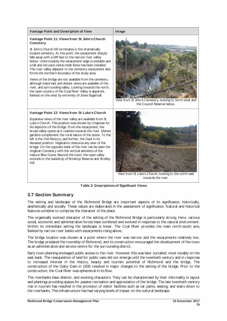
Richmond Bridge Conservation Management Plan 15 December 2017 70
Vantage Point and Description of View Image
Vantage Point 11: Views from St John’s Church Cemetery
St John’s Church hill terminates in the dramatically located cemetery. At this point, the escarpment sharply falls away with a cliff face to the narrow river valley below. Unfortunately the escarpment edge is unstable and a tall and intrusive metal mesh fence has been installed. The river valley adjacent to the cemetery escarpment also forms the northern boundary of the study area.
Views of the bridge are not available from the cemetery, although important and distant views are available of the river, and surrounding valley. Looking towards the north, the open country of the Coal River Valley is apparent, flanked on the west by extremity of Jones Sugarloaf.
View from St John’s Cemetery, looking to north west and the Council Reserve below.
Vantage Point 12: Views from St Luke’s Church
Expansive views of the river valley are available from St Luke’s Church. This position was chosen by Chapman for his depiction of the bridge. From the escarpment, the broad valley opens as it reaches towards the river. Market gardens complement the rural nature of the scene. To the left is the Old Rectory, and further, the Gaol in its elevated position. Vegetation obscures any view of the bridge. On the opposite bank of the river can be seen the Anglican Cemetery with the vertical elements of the mature Blue Gums. Beyond the town, the open valley extends to the backdrop of Brinktop Reserve and Strelley Hill.
View from St Luke’s Church, looking to the north east towards the river.
Table 2: Descriptions of Significant Views
3.7 Section Summary The setting and landscape of the Richmond Bridge are important aspects of its significance, historically, aesthetically and socially. These values are elaborated in the assessment of significance. Natural and historical features combine to comprise the character of the place.
The organically evolved character of the setting of the Richmond Bridge is particularly strong. Here, various social, economic and administrative forces have combined and evolved in response to the natural environment. Within its immediate setting the landscape is linear. The Coal River provides the main north-south axis, flanked by narrow river banks with escarpments rising above.
The bridge location was chosen at a point where the river was narrow and the escarpments relatively low. The bridge predated the township of Richmond, and its construction encouraged the development of the town as an administrative and service centre for the surrounding district.
Early town planning envisaged public access to the river. However this was later curtailed, most notably on the east bank. The reacquisition of land for public uses did not emerge until the twentieth century and in response to increased interest in the history, beauty and tourism potential of Richmond and the bridge. The construction of the Gatty Dam in 1935 resulted in major changes to the setting of the bridge. Prior to the construction, the Coal River was ephemeral in its flow.
The riverbanks have distinct, and evolving characters. They can be characterised by their informality in layout and plantings providing spaces for passive recreation and appreciation of the bridge. The late twentieth century rise in tourism has resulted in the provision of visitor facilities such as car parks, seating, and stairs down to the riverbanks. This infrastructure has had varying levels of impact on the cultural landscape.
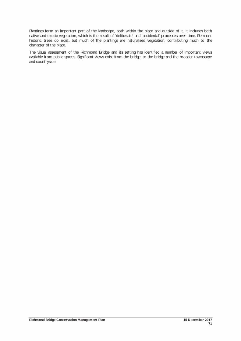
Richmond Bridge Conservation Management Plan 15 December 2017 71
Plantings form an important part of the landscape, both within the place and outside of it. It includes both native and exotic vegetation, which is the result of ‘deliberate’ and ‘accidental’ processes over time. Remnant historic trees do exist, but much of the plantings are naturalised vegetation, contributing much to the character of the place.
The visual assessment of the Richmond Bridge and its setting has identified a number of important views available from public spaces. Significant views exist from the bridge, to the bridge and the broader townscape and countryside.
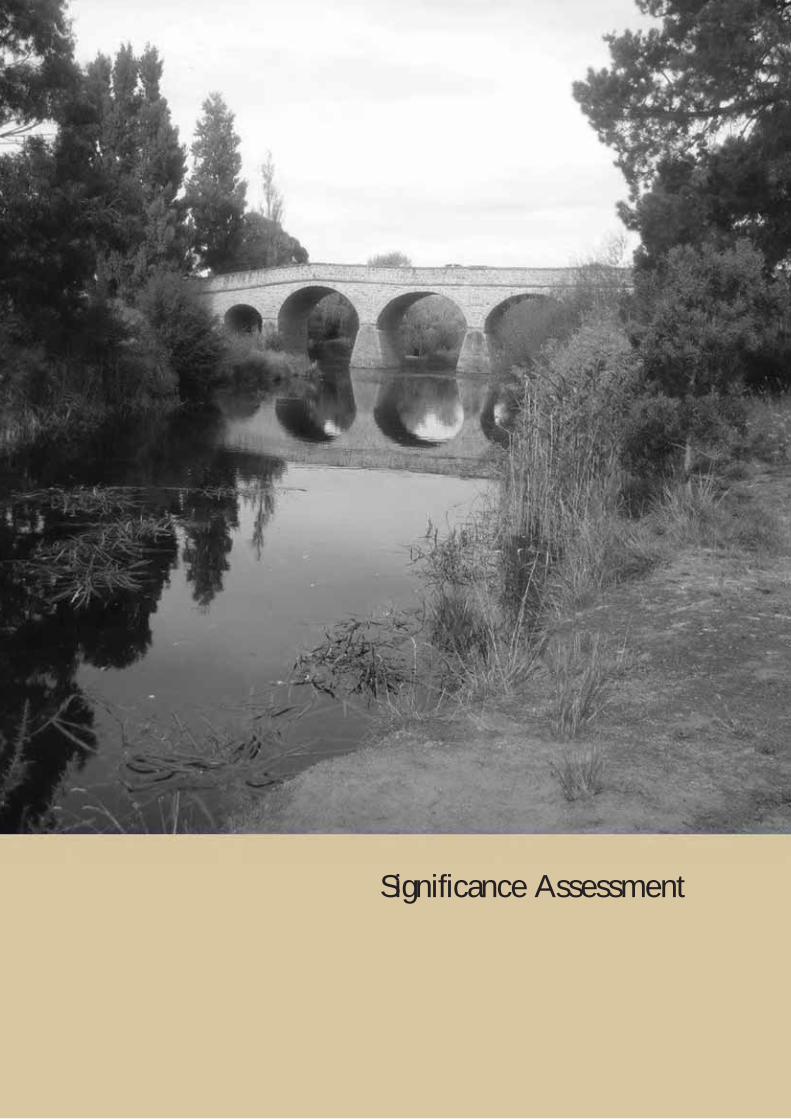
Richmond Bridge Conservation Management Plan 15 December 2017 72
Significance Assessment
Richmond Bridge Conservation Management Plan 15 December 2017 73
4.0 SIGNIFICANCE ASSESSMENT
4.1 Introduction The heritage significance of the Richmond Bridge has long been recognised at all levels of Government. At a national level, the bridge was entered in the Register of the National Estate in 1978, the Tasmanian Heritage Register in 1999 and the National Heritage List in 2005. At a local level, the bridge has been included in Heritage Schedules or Codes of previous and current planning schemes.
Each of these listings provides a differing assessment of heritage values, different definition of place, and comes with different management implications.
Since 2010, substantial changes have been made in Tasmania (and continue to be made) in identifying and distinguishing places according to their levels of significance. This level of significance determines the tier of government management. That is, places of extraordinary significance to the nation may be entered in the National Heritage List and be managed in accordance with the Environment Protection and Biodiversity Conservation Act 1999. Places important to the State will be identified and managed according to the relevant State legislation, while local places are the responsibility of Local Government. This distinction between levels of significance is not about ranking the values or importance of a place. Rather, it is about understanding the context in which the place is important, and how far that importance reaches.170
Within Tasmania, places of State historic cultural heritage significance may be entered in the Tasmanian Heritage Register, and places of local heritage significance included in the Heritage Codes of planning schemes.
In terms of management, each level of Government has different responsibilities for the conservation of heritage places. Section 5 of this report outlines the management system for the Richmond Bridge and setting at National, State and Local levels.
The formally assessed National Heritage values of the Richmond Bridge are included in the following assessment. In 2014, the Tasmanian Heritage Council made substantial amendments to the Tasmanian Heritage Register entry for the bridge. The amended registration addressed issues with regard to the definition of the place and its values, and now provides a greatly improved assessment of significance. The formal State values of the place are documented in this section.
At a local level, the Clarence Interim Planning Scheme 2015 currently applies, but does not include statements of significance for places included in the Heritage Code. The Tasmanian Government has commenced a process of extensive local planning reform. Places which are currently included as Local Heritage Places under interim schemes will be brought across into the new Local Provisions Schedules. However, where that place is also included on the Tasmanian Heritage Register (as with the Richmond Bridge), the Heritage Place provisions of the Heritage Code will not apply, except for mutually exclusive parts of the same lot or lots. This removes the need for dual management and approvals between the Tasmanian Heritage Council and the Planning Authority. Other mechanisms providing for local involvement in heritage management do exist, and it would be desirable for these to be considered by Clarence City Council.
The Tasmanian Planning Scheme is yet to come into effect in the Clarence municipality, and the Clarence Interim Planning Scheme 2015 continues to apply. The described local level values contained in the following tables should be considered informal, but may assist in future management.
4.2 Assessing Significance The assessment of cultural significance is a pivotal part of any Conservation Management Plan. In this report significance is firstly expressed in terms of the Australia ICOMOS Burra Charter 2013 (the Burra Charter) definition of cultural significance Article 1.2 of the Burra Charter defines:
Cultural significance means aesthetic, historic, scientific, social, or spiritual value for past, present or future generations.
Cultural significance is embodied in the place itself, its fabric, setting, use, associations, meanings, records, related places and related objects.171
170 Department of Primary Industries, Parks, Water and Environment, Assessing Historic Heritage Significance for application with the Historic Cultural Heritage Act, October 2011, p.6 171 Australia ICOMOS Burra Charter, Art. 1.2
Richmond Bridge Conservation Management Plan 15 December 2017 74
The National and State heritage values of the Richmond Bridge have already been assessed against the relevant criteria under each mechanism and the formally recognised values repeated here. The Clarence Interim Planning Scheme 2015 defines ‘historic cultural heritage significance’ as having the same meaning as in the Historic Cultural Heritage Act 1995 (HCHA 1995), namely, ‘its significance in terms of the registration criteria, which are:
a) the place is important to the course or pattern of Tasmania's history;
b) the place possesses uncommon or rare aspects of Tasmania's history;
c) the place has the potential to yield information that will contribute to an understanding of Tasmania's history;
d) the place is important in demonstrating the principal characteristics of a class of place in Tasmania's history;
e) the place is important in demonstrating a high degree of creative or technical achievement;
f) the place has a strong or special association with a particular community or cultural group for social or spiritual reasons;
g) the place has a special association with the life or works of a person, or group of persons, of importance in Tasmania's history;
h) the place is important in exhibiting particular aesthetic characteristics.
The most useful and detailed elaboration of the difference between State and Local significance is the Tasmanian Heritage Council’s Assessing Historic Heritage Significance for application with the Historic Cultural Heritage Act. At its simplest, the distinction between State and local is a question of whether the heritage values are important to a region or local community, or extend to being important to the whole of Tasmania.
In applying this distinction, thresholds have been developed to define the minimum required value/s that a place must possess to be considered as having heritage significance at either State or local levels. 172 This Conservation Management Plan has had regard to the principles contained in these Guidelines.
4.3 Assessment of Significance for the Richmond Bridge The following sections of this Conservation Management Plan provide the assessment of significance for the Richmond Bridge. The significance of the place has been identified at National, State and Local levels.
The formal assessment of National Heritage values by the Australian Heritage Council found that the place met two criteria - for its rarity and aesthetic characteristics.
The formal assessment of State heritage values by the Tasmanian Heritage Council found that the place met all eight criteria.
The formally assessed National Heritage List and Tasmanian Heritage Register assessment against criteria statements are repeated in the following tables. It is noted that in some instances, the same or similar attribute is recognised at both State and National levels.
There is no formal assessment of Local values for the place, and the following provides an assessment of Local significance for the purposes of this Conservation Management Plan.
4.3.1 Assessment of Historical Significance
The HCH Act 1995 provides that a place may be entered in the Tasmanian Heritage Register where it is important to the course or pattern of Tasmania's history.
The Illustrated Burra Charter states that historical values encompass the history of aesthetic, sciences and society, and therefore underlies other values. A place may have historic value because it has influenced, or has been influenced by, an historic figure, event, phase or activity. It may be the site of an important event. For any place the significance will be greater where the evidence of the association or event survives at the place, or where the setting is substantially intact, than where it has been changed or evidence does not survive.
172 DPIPWE, op. cit.

Richmond Bridge Conservation Management Plan 15 December 2017 75
However, some events or associations may be so important that the place retains significance regardless of subsequent treatment.173
With regard to the Heritage Council’s Assessment Guidelines, the following five significance indicators are considered to be of most relevance to the Richmond Bridge:
Association with an event, or series of events, of historical significance.
Demonstration of important periods or phases of settlement.
Association with important cultural phases or movements.
Demonstration of important historical processes or activities.
Symbolism and influence of place for its association with an important event, period, phase or movement. 174
As noted by McGee in the Guide to Heritage Bridge Management, bridge heritage is an important demonstration of non-indigenous settlement patterns at both State and regional levels in the provision of communications and transport. Sometimes the heritage significance is derived from the continuity of crossing at a particular location rather than necessarily from the bridge that is currently at a site.175
The earliness of a bridge can be considered for two areas of historical significance. Firstly, is the historical importance of the town or region as an early European settlement area where the bridge demonstrates important aspects of communication and transport technology. An understanding of the historical development of the crossing point is useful in this regard. The second relevant factor is considering whether the bridge in its design and form demonstrates an early application of a particular technology.
The earliest Tasmanian bridges were poorly constructed of timber with earth covered timber decks resulting in continuous problems. These bridges were short lived, and were quickly replaced with more permanent stone or brick arches. With responsible Government in 1856 came the need to locally finance construction. Timber again became the predominate material. Wrought iron and steel remained reserved for special situations.176
The inclusion in the National Heritage List against criterion (b.) rarity, relates to historical values associated with its age as the oldest surviving large bridge in Australia with a high degree of integrity and its construction by convict labour.
In the 1997 Conservation Plan, Nigel Lewis et. al. assessed the age of the Richmond Bridge in comparison with other structures. It was noted that throughout Australia, there are very few surviving bridge constructed prior to 1860. The oldest surviving bridge on the mainland Australia is the Horseshoe Bridge in New South Wales, completed in 1833. Similarly, surviving bridges in other States constructed prior to 1860 are rare.
Comparatively, Tasmania is fortunate in retaining fourteen stone bridges constructed between 1838 and 1847.177 The Richmond Bridge has long been described as Australia’s oldest bridge. However, it is likely that some surviving bridges contain elements that pre-date the completion of the Richmond Bridge in 1825.
For example, Evans writes that a causeway crossing the Elizabeth River at Campbell Town was completed c.1822-23 and is depicted in early illustrations. The causeway was constructed from earth and logs over some 200 feet (ie., approx. 70 metres), with culverts to allow the water to pass underneath. It may have included the small bridge that currently exists. The remaining bridge, has dry stone abutments and a timber deck. This is possibly a portion of the c.1823 causeway. However, Evans finds that whilst a number of early plans and illustrations of the bridge were located, there was found to be a substantive lack of written documentation of the first bridge/causeway at Campbell Town. An archaeological examination of the bridge in addition to further historical analysis was recommended to determine whether the bridge is the oldest surviving in Australia.178
The last substantial modifications to the Richmond Bridge occurred in 1884 with the sheathing of the piers. The Richmond Bridge continues to demonstrate to a high degree its period of construction, design, materials, workmanship and setting. Because of the lack of certainty regarding older structures, it can be concluded that
173 McGee, R, Guide to Heritage Bridge Management, Austroads Inc, 2001, pp.4, 6-11 174 DPIPWE, op. cit., 2011, pp.10-11 175 Ibid, pp.4, 6-11 176 Balsille, GD, ‘Notes on Tasmanian Highway Bridges’, Transactions of the Institution, Vol XV, 1934, pp.1-2 177 Nigel Lewis et al, op. cit., p.87 178 Evans, K, Old Bridge, Bridge Street Campbell Town, Historical Review, Tasmanian Heritage Council, 1998, pp.3-5
Richmond Bridge Conservation Management Plan 15 December 2017 76
the Richmond Bridge is Tasmania’s, and Australia’s oldest surviving large bridge which retains a high degree of integrity and continues to serve its original function.
The Richmond Bridge also had the distinction of having the longest span of any bridge in Australia for a period of eleven years. It was not until the construction of the Lansdowne Bridge, New South Wales in 1836 with a span of 33.5 metres that the Richmond Bridge was surpassed.
The construction of the Richmond Bridge is also significant as a demonstration of public works and the development of Richmond and transport links to the east coast of Tasmania. Tasmania’s first bridges were crude structures built as temporary crossing points as a matter of necessity. The appointment of Major Thomas Bell, Acting Engineer and Inspector of Public Works represented a major turning point in the design and construction of public infrastructure during the early nineteenth century. Bell’s list of achievements include public buildings in Hobart; important roads in the Southern Midlands; the completion of the Wellington Bridge, Hobart; the construction of the sandstone causeway to Hunter Island; and a new brick bridge across the Hobart Rivulet in Argyle Street. Later, Civil Engineer and Architect, John Lee Archer carried out remediation works to the Richmond Bridge in 1829. Archer made a major contribution to Tasmania’s architecture and engineering during the nineteenth century in the design of government buildings, numerous churches, the Ross Bridge, plans for improvements to Sullivan’s Cove and designs for the Bridgewater Causeway.
The construction of the Richmond Bridge also demonstrates important aspects of the early European settlement of Tasmania, and the development of Richmond as a significant regional centre. Lieutenant-Governor Sorell encouraged the British settlement of Tasmania and the development of agriculture. He also initiated the construction of the Richmond Bridge. The works were completed under Lieutenant-Governor Arthur. Arthur’s term witnessed the fastest growth to date in the European population. In 1823, the colony had a population of 10,009. This had increased to 43,895 by 1836.179
This rapid growth in population allowed for the expansion of European settlement beyond the nodes at Hobart and Launceston. It also required the development of transport infrastructure such as roads and bridges to allow for easier movement of people and goods. The Coal River Valley was an early place of European settlement in Tasmania. Relatively soon after colonisation, the district played a highly significant role in the supply of grain both internally, and later for export.
The construction of the bridge provided a permanent and safe crossing point of the Coal River on the route to the east coast, and later Tasman Peninsula. The combination of agricultural development, increased population and concentration of people crossing the Coal River at this point encouraged the establishment of the Richmond township. Early development focussed on providing military and penal services. In time, commercial, residential and civic infrastructure developed and the town became a major population and service centre in the early colony.
Other settlements such as Hobart, York Town, Launceston, New Norfolk, George Town, Pontville and Macquarie Harbour were established at an earlier date than Richmond. Nigel Lewis et. al. note that Richmond’s main development period occurred between initial settlement and the early 1840s. What distinguishes Richmond from many other early townships is its high level of intactness and ability to demonstrate its main period of historical development. Economic depression and later transport bypasses removed the town from later widespread development pressures. This has had the fortunate effect of conserving the townscape setting, street pattern, historic buildings and hierarchy of building forms.180
An important element of Richmond’s development was the retention of public access to the riverbanks. As early as 1824, plans were made to reserve large areas of land on both sides of the Coal River. Although these plans did not eventuate, during the twentieth century, areas of the riverbanks, particularly on the western bank were acquired by both State and Local tiers of government. This public acquisition of the land acknowledged the growing interest in the Richmond Bridge, and importantly, also created recreation areas.
Richmond emerged as one of the first Tasmanian towns to take an active role and interest in the conservation of their heritage, including the central role of the bridge. As early as 1964, organisations were formed to protect the historical character of Richmond and guide its future development. The Richmond community continues to be deeply interested in the conservation of its heritage and the character of the town.
179 Nigel Lewis et al, op. cit., pp.88-89 180 Ibid, p.92
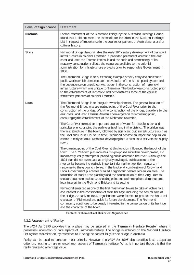
Richmond Bridge Conservation Management Plan 15 December 2017 77
Level of Significance Statement
National Formal assessment of the Richmond Bridge by the Australian Heritage Council found that it did not meet the threshold for inclusion in the National Heritage List in respect of importance in the course, or pattern, of Australia's natural or cultural history.
State Richmond Bridge demonstrates the early 19th century development of transport infrastructure in colonial Tasmania. It provided permanent access to the east coast and later the Tasman Peninsula and the scale and permanency of its masonry construction reflects the resources available to the colonial administration for infrastructure projects prior to responsible Government in 1856.
The Richmond Bridge is an outstanding example of very early and substantial public works which demonstrate the evolution of the British penal system and the dependence on unpaid convict labour in the construction of major civil infrastructure which was unique to Tasmania. The bridge was constructed prior to the establishment of Richmond and demonstrates some of the earliest settlement patterns of colonial Tasmania.
Local The Richmond Bridge is an integral township element. The general location of the Richmond Bridge was a crossing point of the Coal River prior to the construction of the bridge. With the construction of the bridge, travellers to the east coast, and later Tasman Peninsula converged on this crossing point, encouraging the establishment of the Richmond township.
The Coal River formed an important source of water for people, stock and agriculture, encouraging the early grants of land in the district. The bridge was the first structure in the town, followed by significant civic infrastructure such as the Gaol and Court House. In time, Richmond became an important population centre in early colonial Tasmania, developing into a substantial service and supply town.
The crossing point of the Coal River at this location influenced the layout of the town. The 1824 town plan indicates this proposed suburban development, and importantly, early attempts at providing public access to the river. Although the 1824 plan did not eventuate as originally envisaged, public access to the riverbanks became increasingly important during the twentieth century, in response to the growing interest in the bridge. A combination of Crown and Local Government purchases created a significant passive recreation area. The formation of tracks, tree plantings and the construction of the Gatty Dam to create a southern pedestrian crossing point and swimming hole demonstrates local interest in the Richmond Bridge and its setting.
Richmond emerged as one of the first Tasmanian towns to take an active role and interest in the conservation of their heritage, including the central role of the bridge. As early as 1964, organisations were formed to protect the historical character of Richmond and guide its future development. The Richmond community continues to be deeply interested in the conservation of its heritage and the character of the town.
Table 3: Statements of Historical Significance
4.3.2 Assessment of Rarity
The HCH Act 1995 provides that a place may be entered in the Tasmanian Heritage Register where it possesses uncommon or rare aspects of Tasmania's history. The bridge is included on the National Heritage List against this criterion, by reference to it being the earliest large stone bridge in Australia.
Rarity can be used to consider most criteria. However the HCH Act 1995 also specifies it as a separate criterion, relating to rare or uncommon aspects of Tasmania’s heritage. What is important though, is that the rarity relates to a heritage value.
Richmond Bridge Conservation Management Plan 15 December 2017 78
With regard to the Heritage Council’s Assessment Guidelines, the following four significance indicators are considered to be of most relevance to the Richmond Bridge:
Rare surviving evidence of an event, phase, period, process, function, movement, custom or way of life in Tasmanian history that continues to be practised or is no longer practised.
Evidence of a rare historical activity that was considered distinctive, uncommon or unusual at the time it occurred.
Distinctiveness in demonstrating an unusual historical, architectural, archaeological, scientific, social or technical attribute(s) that is of special interest.
Demonstrates an unusual composition of historical, architectural, archaeological, scientific, social or technical attributes that are of greater importance or interest as a composition/collection.181
With regard to the Richmond Bridge, factors to consider include the age, design, materials or form of the bridge in demonstrating an uncommon aspect of Tasmania’s heritage. The bridge may have been rare at the time of construction, or may have become rare, as other similar structures have been lost.
The mechanism for considering rarity is by comparison. Making comparisons between heritage places is a useful way to develop a statement of significance, and to determine a level of significance. In undertaking this process, it is important to compare like with like, by identifying those elements of significance which can be compared.182
As noted above, the earliest Tasmanian bridges were poorly constructed and temporary crossings. The resources available to the colonial administration allowed for these temporary bridges to be replaced by permanent stone or brick structures. By comparison, Tasmania maintains the largest number of pre-1860 bridges in Australia. The specific rarity values of the Richmond Bridge relates to:
Its earliness as Tasmania’s and Australia’s oldest surviving bridge with a high level of integrity that continues to serve its original function;
The distinction of having the longest bridge span for a period of eleven years; and
Its method and material of construction.
Beyond the bridge, the setting demonstrates important values as a rare surviving example of an early Australian colonial town. As noted above, Richmond experienced a short period of development and prominence. Relatively little subsequent development has resulted in a high number of heritage places being retained within the town. As noted in the 2001 Richmond Cultural Resource Management Plan, out of a total of 323 buildings in Richmond, nearly a third of them have heritage status. Shield notes that the built fabric and sense of place reflects the British colonial influence with architectural style, character, scale, siting and planning similar to that of English villages. Buildings demonstrate a consistent application of simple Georgian architecture providing a sense of cohesion. Furthermore, the retention of the rural setting and hills above reinforces the historic context.183
181 DPIPWE, op. cit., 2011, p.15 182 Making Comparisons, http://www.heritage.nsw.gov.au/10_subnav_03.htm accessed 13 August 2007 183 Michael Shield & Associates, op. cit., pp.6, 12
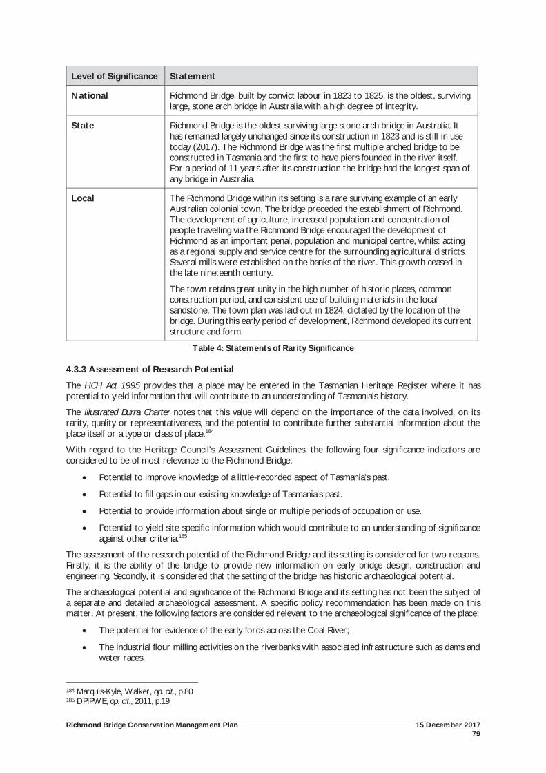
Richmond Bridge Conservation Management Plan 15 December 2017 79
Level of Significance Statement
National Richmond Bridge, built by convict labour in 1823 to 1825, is the oldest, surviving, large, stone arch bridge in Australia with a high degree of integrity.
State Richmond Bridge is the oldest surviving large stone arch bridge in Australia. It has remained largely unchanged since its construction in 1823 and is still in use today (2017). The Richmond Bridge was the first multiple arched bridge to be constructed in Tasmania and the first to have piers founded in the river itself. For a period of 11 years after its construction the bridge had the longest span of any bridge in Australia.
Local The Richmond Bridge within its setting is a rare surviving example of an early Australian colonial town. The bridge preceded the establishment of Richmond. The development of agriculture, increased population and concentration of people travelling via the Richmond Bridge encouraged the development of Richmond as an important penal, population and municipal centre, whilst acting as a regional supply and service centre for the surrounding agricultural districts. Several mills were established on the banks of the river. This growth ceased in the late nineteenth century.
The town retains great unity in the high number of historic places, common construction period, and consistent use of building materials in the local sandstone. The town plan was laid out in 1824, dictated by the location of the bridge. During this early period of development, Richmond developed its current structure and form.
Table 4: Statements of Rarity Significance
4.3.3 Assessment of Research Potential
The HCH Act 1995 provides that a place may be entered in the Tasmanian Heritage Register where it has potential to yield information that will contribute to an understanding of Tasmania’s history.
The Illustrated Burra Charter notes that this value will depend on the importance of the data involved, on its rarity, quality or representativeness, and the potential to contribute further substantial information about the place itself or a type or class of place.184
With regard to the Heritage Council’s Assessment Guidelines, the following four significance indicators are considered to be of most relevance to the Richmond Bridge:
Potential to improve knowledge of a little-recorded aspect of Tasmania’s past.
Potential to fill gaps in our existing knowledge of Tasmania’s past.
Potential to provide information about single or multiple periods of occupation or use.
Potential to yield site specific information which would contribute to an understanding of significance against other criteria.185
The assessment of the research potential of the Richmond Bridge and its setting is considered for two reasons. Firstly, it is the ability of the bridge to provide new information on early bridge design, construction and engineering. Secondly, it is considered that the setting of the bridge has historic archaeological potential.
The archaeological potential and significance of the Richmond Bridge and its setting has not been the subject of a separate and detailed archaeological assessment. A specific policy recommendation has been made on this matter. At present, the following factors are considered relevant to the archaeological significance of the place:
The potential for evidence of the early fords across the Coal River;
The industrial flour milling activities on the riverbanks with associated infrastructure such as dams and water races.
184 Marquis-Kyle, Walker, op. cit., p.80 185 DPIPWE, op. cit., 2011, p.19
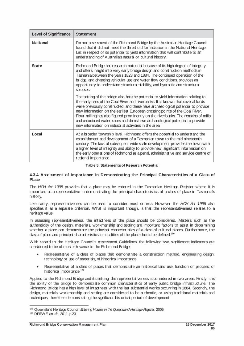
Richmond Bridge Conservation Management Plan 15 December 2017 80
Level of Significance Statement
National Formal assessment of the Richmond Bridge by the Australian Heritage Council found that it did not meet the threshold for inclusion in the National Heritage List in respect of its potential to yield information that will contribute to an understanding of Australia's natural or cultural history.
State Richmond Bridge has research potential because of its high degree of integrity and offers insight into very early bridge design and construction methods in Tasmania between the years 1823 and 1884. The continued operation of the bridge, and changing vehicular use and water flow conditions, provides an opportunity to understand structural stability, and hydraulic and structural stresses.
The setting of the bridge also has the potential to yield information relating to the early uses of the Coal River and riverbanks. It is known that several fords were previously constructed, and these have archaeological potential to provide new information on the earliest European crossing points of the Coal River. Flour milling has also figured prominently on the riverbanks. The remains of mills and associated water races and dams have archaeological potential to provide new information on industrial activities in the area.
Local At a broader township level, Richmond offers the potential to understand the establishment and development of a Tasmanian town to the mid nineteenth century. The lack of subsequent wide scale development provides the town with a higher level of integrity and ability to provide new, significant information on the early operations of Richmond as a penal, administrative and service centre of regional importance.
Table 5: Statements of Research Potential
4.3.4 Assessment of Importance in Demonstrating the Principal Characteristics of a Class of Place
The HCH Act 1995 provides that a place may be entered in the Tasmanian Heritage Register where it is important as a representative in demonstrating the principal characteristics of a class of place in Tasmania’s history.
Like rarity, representativeness can be used to consider most criteria. However the HCH Act 1995 also specifies it as a separate criterion. What is important though, is that the representativeness relates to a heritage value.
In assessing representativeness, the intactness of the place should be considered. Matters such as the authenticity of the design, materials, workmanship and setting are important factors to assist in determining whether a place can demonstrate the principal characteristics of a class of cultural places. Furthermore, the class of place and principal characteristics, or qualities of the place should be defined.186
With regard to the Heritage Council’s Assessment Guidelines, the following two significance indicators are considered to be of most relevance to the Richmond Bridge:
Representative of a class of places that demonstrate a construction method, engineering design, technology or use of materials, of historical importance.
Representative of a class of places that demonstrate an historical land use, function or process, of historical importance.187
Applied to the Richmond Bridge and its setting, the representativeness is considered in two areas. Firstly, it is the ability of the bridge to demonstrate common characteristics of early public bridge infrastructure. The Richmond Bridge has a high level of intactness, with the last substantial works occurring in 1884. Secondly, the design, materials, workmanship and setting are considered to be authentic, or using traditional materials and techniques, therefore demonstrating the significant historical period of development.
186 Queensland Heritage Council, Entering Houses in the Queensland Heritage Register, 2005 187 DPIPWE, op. cit., 2011, p.23
Richmond Bridge Conservation Management Plan 15 December 2017 81
As a class of places, the Richmond Bridge can be compared to other nineteenth century Tasmanian road bridges constructed from permanent materials. This class includes bridges such as:
The ashlar sandstone Ross Bridge;
The ashlar sandstone Tacky Creek Bridge, north of Ross;
The red brick Campbell Town Bridge;
The ashlar sandstone Lovely Banks Bridge;
The stone fill Spiky Bridge culvert, Swansea;
The ashlar sandstone Risdon Bridge; and
The random rubble Strathroy Bridge at Franklin Village.
These bridges share the common characteristics of being constructed from permanent materials, erected by a convict workforce and most continuing to used for their original transport function. The bridges vary from small structures that may be considered culverts, to large multi-span structures. Stone was the preferred material for these bridges, with brick being used less often. The arch form also figures prominently. These early bridges also demonstrate structural defects, notably the absence of solid quicklime mortars. For example, the use of site soil as stone bedding at Richmond has resulted in the undermining of the piers and entry of water. Strathroy Bridge is the exception to this, where proper quicklime mortar was used.
Secondly, at a macro level, Richmond is important in demonstrating the principal characteristics of an important regional centre up to the mid nineteenth century. These characteristics include:
The centrality of the bridge within the town and broader Coal River Valley;
The 1824 township plan which established a grid of streets and regularised subsequent development;
The establishment of Richmond as a Police District with the construction of associated civic buildings including the Gaol, courthouse, barracks and watch house; and
The later residential development, within the urban setting which displays consistency in simple building forms, setback, materials and roof pitch.
The large number of historic buildings, streetscapes and other elements combine to form an authentic townscape of essential heritage value. The Richmond Bridge and Coal River are central to these characteristics.
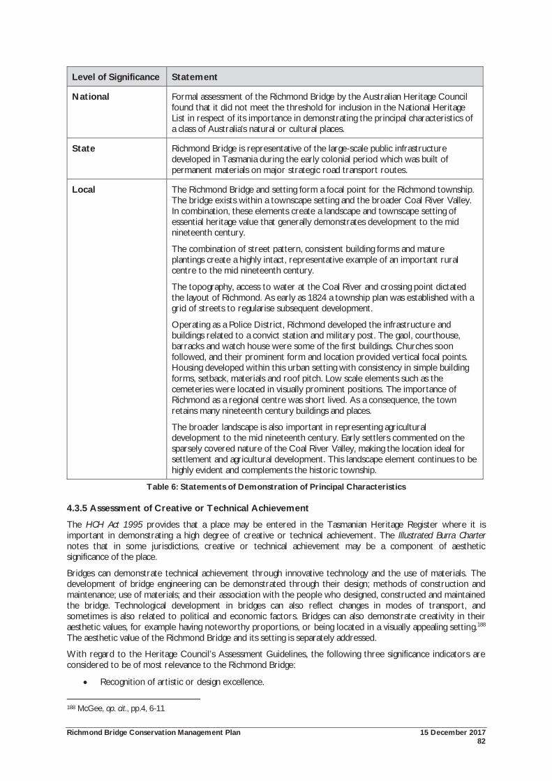
Richmond Bridge Conservation Management Plan 15 December 2017 82
Level of Significance Statement
National Formal assessment of the Richmond Bridge by the Australian Heritage Council found that it did not meet the threshold for inclusion in the National Heritage List in respect of its importance in demonstrating the principal characteristics of a class of Australia's natural or cultural places.
State Richmond Bridge is representative of the large-scale public infrastructure developed in Tasmania during the early colonial period which was built of permanent materials on major strategic road transport routes.
Local The Richmond Bridge and setting form a focal point for the Richmond township. The bridge exists within a townscape setting and the broader Coal River Valley. In combination, these elements create a landscape and townscape setting of essential heritage value that generally demonstrates development to the mid nineteenth century.
The combination of street pattern, consistent building forms and mature plantings create a highly intact, representative example of an important rural centre to the mid nineteenth century.
The topography, access to water at the Coal River and crossing point dictated the layout of Richmond. As early as 1824 a township plan was established with a grid of streets to regularise subsequent development.
Operating as a Police District, Richmond developed the infrastructure and buildings related to a convict station and military post. The gaol, courthouse, barracks and watch house were some of the first buildings. Churches soon followed, and their prominent form and location provided vertical focal points. Housing developed within this urban setting with consistency in simple building forms, setback, materials and roof pitch. Low scale elements such as the cemeteries were located in visually prominent positions. The importance of Richmond as a regional centre was short lived. As a consequence, the town retains many nineteenth century buildings and places.
The broader landscape is also important in representing agricultural development to the mid nineteenth century. Early settlers commented on the sparsely covered nature of the Coal River Valley, making the location ideal for settlement and agricultural development. This landscape element continues to be highly evident and complements the historic township.
Table 6: Statements of Demonstration of Principal Characteristics
4.3.5 Assessment of Creative or Technical Achievement
The HCH Act 1995 provides that a place may be entered in the Tasmanian Heritage Register where it is important in demonstrating a high degree of creative or technical achievement. The Illustrated Burra Charter notes that in some jurisdictions, creative or technical achievement may be a component of aesthetic significance of the place.
Bridges can demonstrate technical achievement through innovative technology and the use of materials. The development of bridge engineering can be demonstrated through their design; methods of construction and maintenance; use of materials; and their association with the people who designed, constructed and maintained the bridge. Technological development in bridges can also reflect changes in modes of transport, and sometimes is also related to political and economic factors. Bridges can also demonstrate creativity in their aesthetic values, for example having noteworthy proportions, or being located in a visually appealing setting.188 The aesthetic value of the Richmond Bridge and its setting is separately addressed.
With regard to the Heritage Council’s Assessment Guidelines, the following three significance indicators are considered to be of most relevance to the Richmond Bridge:
Recognition of artistic or design excellence.
188 McGee, op. cit., pp.4, 6-11

Richmond Bridge Conservation Management Plan 15 December 2017 83
Distinctiveness as a design solution, treatment or use of technology.
Adapts technology in a creative manner or extends the limits of available technology.189
It should be noted that ‘recognition of artistic or design excellence’ is more appropriately considered under Criterion (h.) aesthetic characteristics. The Assessment Guidelines have yet to be updated to reflect this criterion.
The intactness of the Richmond Bridge is also an important factor in considering its technical achievement. The authenticity of the design, materials and workmanship are important in determining whether the bridge can demonstrate its technical achievement. The following relevant factors have been considered:
The form, material and construction method of the bridge;
The technical achievement in being the first multiple arched bridge to be constructed with the piers in the river itself; and
The ongoing functioning of the bridge for its original purpose demonstrating the skill of the designer and those who constructed the bridge.
With regards to the setting of the bridge, the creative achievement of the riverbank setting has been considered. The landscape of the riverbanks can be characterised by their informality in the arrangement of trees, paths and open spaces. Although greatly complementing the rural nature of the place, this informality is not considered to demonstrate a particular creative achievement.
The factor that more clearly demonstrates a creative achievement is the continued effort to reserve riverbank land for public access. Scott’s 1824 plan of Richmond created the regular grid layout for the urban development of the town. It also reserved large areas of the east and west riverbanks below the bridge. Private land acquisitions greatly curtailed this reservation. However, during the twentieth century, both State and local governments progressively acquired riverbank land, particularly on the west bank. This provided permanent public access to the riverbanks for a combination of recreational uses, as well as locations from which to appreciate the bridge.
In this sense, the creative achievement is considered to be the innovative urban planning design for the town that was first envisaged by Scott. Scott’s 1824 plan that provided for public access to the riverbanks demonstrates a creative approach to the provision of public space. It is also a very early example of such planning, particularly within a rural context. These plans were not properly realised until the twentieth century.
189 DPIPWE, op. cit., 2011, p.28
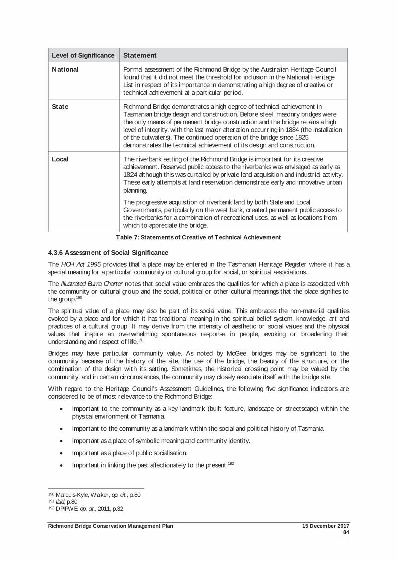
Richmond Bridge Conservation Management Plan 15 December 2017 84
Level of Significance Statement
National Formal assessment of the Richmond Bridge by the Australian Heritage Council found that it did not meet the threshold for inclusion in the National Heritage List in respect of its importance in demonstrating a high degree of creative or technical achievement at a particular period.
State Richmond Bridge demonstrates a high degree of technical achievement in Tasmanian bridge design and construction. Before steel, masonry bridges were the only means of permanent bridge construction and the bridge retains a high level of integrity, with the last major alteration occurring in 1884 (the installation of the cutwaters). The continued operation of the bridge since 1825 demonstrates the technical achievement of its design and construction.
Local The riverbank setting of the Richmond Bridge is important for its creative achievement. Reserved public access to the riverbanks was envisaged as early as 1824 although this was curtailed by private land acquisition and industrial activity. These early attempts at land reservation demonstrate early and innovative urban planning.
The progressive acquisition of riverbank land by both State and Local Governments, particularly on the west bank, created permanent public access to the riverbanks for a combination of recreational uses, as well as locations from which to appreciate the bridge.
Table 7: Statements of Creative of Technical Achievement
4.3.6 Assessment of Social Significance
The HCH Act 1995 provides that a place may be entered in the Tasmanian Heritage Register where it has a special meaning for a particular community or cultural group for social, or spiritual associations.
The Illustrated Burra Charter notes that social value embraces the qualities for which a place is associated with the community or cultural group and the social, political or other cultural meanings that the place signifies to the group.190
The spiritual value of a place may also be part of its social value. This embraces the non-material qualities evoked by a place and for which it has traditional meaning in the spiritual belief system, knowledge, art and practices of a cultural group. It may derive from the intensity of aesthetic or social values and the physical values that inspire an overwhelming spontaneous response in people, evoking or broadening their understanding and respect of life.191
Bridges may have particular community value. As noted by McGee, bridges may be significant to the community because of the history of the site, the use of the bridge, the beauty of the structure, or the combination of the design with its setting. Sometimes, the historical crossing point may be valued by the community, and in certain circumstances, the community may closely associate itself with the bridge site.
With regard to the Heritage Council’s Assessment Guidelines, the following five significance indicators are considered to be of most relevance to the Richmond Bridge:
Important to the community as a key landmark (built feature, landscape or streetscape) within the physical environment of Tasmania.
Important to the community as a landmark within the social and political history of Tasmania.
Important as a place of symbolic meaning and community identity.
Important as a place of public socialisation.
Important in linking the past affectionately to the present.192
190 Marquis-Kyle, Walker, op. cit., p.80 191 Ibid, p.80 192 DPIPWE, op. cit., 2011, p.32
Richmond Bridge Conservation Management Plan 15 December 2017 85
Consultation for the 2010 Conservation Management Plan highlighted the importance of the bridge for a range of reasons. These included:
Being Australia’s oldest bridge still serving its original function;
The importance of the bridge as an iconic and beautiful place, central to Richmond and a key tourism drawcard;
The importance of the bridge as part of the social fabric of Richmond.
Members of the community also expressed a number of concerns. This includes the risks of damage to the bridge from vehicles or floods and the importance of managing the heritage values of Richmond and the broader setting of the bridge.
As part of the preparation of the 1997 Conservation Plan, Nigel Lewis conducted a series of workshops to identify the ways in which the local community valued the bridge and broader setting. These workshops included community representatives, members of the Richmond Advisory Committee, and former and present members of Council. In summary, the community expressed the following sentiments:
The Richmond Bridge is the most important structure in the town. It provides residents with a sense of distinction and special sense of identity;
Pride was expressed that the bridge is an icon of the Tasmanian tourism industry. However, concern was also expressed that short visits to the bridge and Richmond on the way to other destinations degraded the full importance of the place;
It was important that the bridge continue to be used for its original purpose. However, concern was expressed on the impact of vehicles on the bridge, both structurally, but also the impact on the ability to appreciate the bridge;
A northern heavy vehicle by-pass was supported;
Concern was expressed about changes to the riverbanks, such as the growth of weeds and trees, and the risk of willows causing damage to the bridge in times of flood;
The riverbanks were valued as a place of recreation and picnicking;
A range of viewing points of the bridge was required;
Concern was expressed that the visitor facilities on the south west bank (car park, shelters, barbeques) were not fully utilised;
A sense of loss was felt because the river no longer served recreational functions as a swimming hole;
The growth of willows on the riverbanks was of concern because of the loss of vantage points for viewing the bridge;
There was general support for the conservation of Richmond and the bridge environs;
The cemeteries were identified as important for their historical and visual relationship with the river;
The community wanted advice on perceived visitor impacts, and how this could be improved; and
Mixed views were expressed on the amalgamation of the Richmond and Clarence Councils.193
193 Nigel Lewis et. al., op. cit., pp.96-97
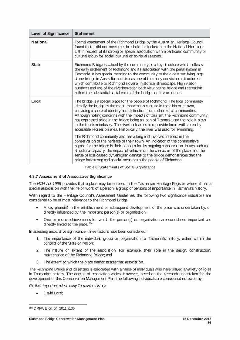
Richmond Bridge Conservation Management Plan 15 December 2017 86
Level of Significance Statement
National Formal assessment of the Richmond Bridge by the Australian Heritage Council found that it did not meet the threshold for inclusion in the National Heritage List in respect of its strong or special association with a particular community or cultural group for social, cultural or spiritual reasons.
State Richmond Bridge is valued by the community as a key structure which reflects the early settlement of Richmond and its association with the penal system in Tasmania. It has special meaning to the community as the oldest surviving large stone bridge in Australia, and also as one of the many convict era structures which contribute to Richmond’s overall historical streetscape. High visitor numbers and use of the riverbanks for both viewing the bridge and recreation reflect the substantial social value of the bridge and its surrounds.
Local The bridge is a special place for the people of Richmond. The local community identify the bridge as the most important structure in their historic town, providing a sense of identity and distinction from other rural communities. Although noting concerns with the impacts of tourism, the Richmond community has expressed pride in the bridge being an icon of Tasmania and the role it plays in the tourism industry. The riverbank areas also provide locals with a readily accessible recreation area. Historically, the river was used for swimming.
The Richmond community also has a long and involved interest in the conservation of the heritage of their town. An indicator of the community’s regard for the bridge is their concern for its ongoing conservation. Issues such as structural capacity, the impact of vehicles on the character of the place, and the sense of loss caused by vehicular damage to the bridge demonstrates that the bridge has strong and special meaning to the people of Richmond.
Table 8: Statements of Social Significance
4.3.7 Assessment of Associative Significance
The HCH Act 1995 provides that a place may be entered in the Tasmanian Heritage Register where it has a special association with the life or work of a person, a group of persons of importance in Tasmania’s history.
With regard to the Heritage Council’s Assessment Guidelines, the following two significance indicators are considered to be of most relevance to the Richmond Bridge:
A key phase(s) in the establishment or subsequent development of the place was undertaken by, or directly influenced by, the important person(s) or organisation.
One or more achievements for which the person(s) or organisation are considered important are directly linked to the place. 194
In assessing associative significance, three factors have been considered:
1. The importance of the individual, group or organisation to Tasmania’s history, either within the context of the State or region;
2. The nature or extent of the association. For example, their role in the design, construction, maintenance of the Richmond Bridge; and
3. The extent to which the place demonstrates that association.
The Richmond Bridge and its setting is associated with a range of individuals who have played a variety of roles in Tasmania’s history. The degree of association varies. However, based on the research undertaken for the development of this Conservation Management Plan, the following individuals are considered noteworthy:
For their important role in early Tasmanian history:
David Lord;
194 DPIPWE, op. cit., 2011, p.36
Richmond Bridge Conservation Management Plan 15 December 2017 87
Lieutenant-Governor Sorell;
As a group, the convict workforce responsible for the construction of the bridge;
Lieutenant-Governor Arthur;
Major Thomas Bell;
David Lambe;
William Wilson;
John Lee Archer; 195
For their important role during the twentieth century:
John Eldershaw;
Jim Gatty; and
Warden Grice.
195 Nigel Lewis et. al., op. cit., p.99
Richmond Bridge Conservation Management Plan 15 December 2017 88
Level of Significance Statement
National Formal assessment of the Richmond Bridge by the Australian Heritage Council found that it did not meet the threshold for inclusion in the National Heritage List in respect of its special association with the life or works of a person, or group of persons, of importance in Australia's natural or cultural history.
State Richmond Bridge is associated with a range of individuals and groups whose lives and work was important in Tasmania’s history. The bridge was recommended by Commissioner Bigge as part of his investigation into the state of colonial agriculture. Bigge’s work was important to the development of Van Diemen’s Land, including the recommendation that the island be granted separation from New South Wales. The bridge was constructed at the direction of Lieutenant-Governor Sorell who, during his office, encouraged the restoration of law and order, the encouragement of British settlement, and the development of agriculture and pastoralism.
The works on the bridge were overseen by Major Thomas Bell, Acting Engineer and Inspector of Public Works, who was responsible for many public buildings and roads in Hobart and the Southern Midlands, including the Wellington Bridge, Hobart, the sandstone causeway to Hunter Island, and a new brick bridge across the Hobart Rivulet in Argyle Street.
Soon after its completion, the Richmond Bridge required major stabilisation which was carried out by John Lee Archer, Civil Engineer and Architect, in 1829. Archer is widely acknowledged as one of Tasmania’s most important architects of the 19th century. For a period he was responsible for the design of all government buildings, including those for penal and military purposes. Buildings designed by Archer include Parliament House (former Customs House), the Public Offices, the Ordnance Stores and numerous churches. His engineering achievements include the Ross Bridge, plans for improvements to Sullivans Cove and the design for the Bridgewater Causeway.
Local The oral history conducted as part of the Richmond Cultural Resource Management Plan highlighted the many community figures associated with the development of Richmond who made valuable contributions to their community.
Individuals of particular note include David Lord. The land on which Richmond was established was part of property owned by David Lord. His acquisition, and later exchange of this land is acknowledged as highly irregular and demonstrates the misuse of land grants. Lord was a major landholder in early Tasmania and was said in 1827 to be the richest man in the colony. He was one of the founding subscribers of the Van Diemen’s Land Bank in 1823 and took an active interest in Church affairs.
In the 1920s, artist John Eldershaw acquired the Mill House adjacent to the bridge which he converted to a residence. Eldershaw appears to have played an important role in the centenary celebrations for the bridge in 1923. He also developed extensive landscaping of the setting of the bridge on the eastern riverbank.
The setting of the bridge also has a special association with the work of the former Richmond Council which acquired land on the riverbanks for public purposes so as to create important recreational spaces for locals and visitors alike. At the southern end of the river, the Council constructed the Gatty Dam, creating a swimming pool and named in honour of long serving Council Clerk, Jim Gatty. The connecting footbridge was named in honour of the Warden of the day, Mr Grice.
Table 9: Statements of Associative Significance
Richmond Bridge Conservation Management Plan 15 December 2017 89
4.3.8 Assessment of Aesthetic Significance
The HCH Act 1995 provides that a place may be entered in the Tasmanian Heritage Register where it is important in exhibiting particular aesthetic characteristics.
The Heritage Council’s Assessment Guidelines are yet to be amended to include information on the assessment of aesthetic significance, but provide some discussion of the topic. Typical parameters include:
The place being of landmark quality.
The place having, or contributing to, its significance setting or important vistas; and
Buildings that sit well within their landscape due to the use of local materials, form, scale or massing.
These factors can all be considered as having relevance to the Richmond Bridge.
The Richmond Bridge has been included in the National Heritage List against criterion (e.) aesthetic characteristics. This recognises the widely appreciated aesthetic values of the bridge; the tourism status of the bridge; and being a source of inspiration for artists.
The Illustrated Burra Charter defines aesthetic significance as including aspects of sensory perception (sight, touch, sound, taste and smell) for which criteria can and should be stated. These criteria may include consideration of the form, scale, colour, texture, and materials of the fabric; and the smells and sounds associated with the place and its use.196
Aesthetic significance is considered to be inclusive of views and vistas, and the form and layout and groupings of relations between different elements. Aesthetic significance may also be evident in design qualities of some landscapes, or for scenic beauty.
The cultural landscape and visual assessment has been crucial for understanding the aesthetic significance of the Richmond Bridge and its setting. Through this process, the various factors of the aesthetic significance of the place have been identified. This includes:
The built form of the bridge;
The position of the bridge within the landscape;
The views of the bridge;
The views available from the bridge;
The vegetated landscape;
The visual qualities of the Coal River;
The relationship between the bridge, Coal River and the broader townscape and valley landscape; and
The visual beauty of the bridge and landscape as depicted by artists and writers.
196 Marquis-Kyle, Walker, op. cit., p.80
Richmond Bridge Conservation Management Plan 15 December 2017 90
Level of Significance Statement
National The aesthetic significance of Richmond Bridge is appreciated locally, within Tasmania and nationally. Its picturesque image has been used widely in national and international tourism promotions since the 1920s and has inspired the work of major Australian artists.
State Picturesque images of the bridge and its riverbank setting have been used widely in state, national and international tourism promotions since the 1920s, and the scene has inspired the work of major Australian artists. Second to Port Arthur, the bridge is believed to be the most photographed and publicised historic structure in Tasmania. Views of St John’s Church through the arches of the bridge are iconic heritage images, and the relationship between the bridge, river and the broader townscape demonstrate an historic landscape of a nineteenth century rural village. The aesthetic value of Richmond Bridge is appreciated by locals and visitors alike, and is an integral part of cultural tourism promotion in Tasmania.
Local The Richmond Bridge, and its location within its river setting have important visual relationships with the surrounding town and broader Coal River Valley landscape. Located at a low point in the valley, the escarpment rises on both sides. To the east are St John’s Church and cemetery and the St Luke’s cemetery, providing historical vistas and focal points with the church spire and the mature native Blue Gums. The town centre is located on a rise on the west bank. The concentration of historic buildings from a similar period of construction, utilising local sandstone and simple, vernacular Georgian forms provide great architectural unity, creating an aesthetic character strongly reminiscent of Richmond’s nineteenth century rural origins. The combination of built forms and the landscape has long been perceived as evocative of an English country town.
Located at an elevation, broad views are available from the town of the Coal River surrounding rural countryside. The surrounding river valley is a rich cultural landscape, subject to very early European settlement and agricultural development. Flanking the valley are low, lightly covered hills.
Table 10: Statements of Aesthetic Significance
4.4 Statement of Heritage Significance The Richmond Bridge and its setting is a place of exceptional heritage significance at National, State and Local levels. The Richmond Bridge is Tasmania’s, and Australia’s oldest surviving large bridge which retains a high degree of integrity and continues to serve its original function. At its completion in 1825, the bridge had the record of having the longest span of Australia’s bridges, a record held until 1836.
The bridge is a significant representative example of public works erected by convict labour under the direction of the Royal Engineers. The bridge is significant in demonstrating the pivotal role played by convict labour in the early development of the colony. The continued operation of the bridge since 1825 for its original purpose also demonstrates the skills and technical achievement of bridge design and construction.
The bridge is important in demonstrating the early development of Tasmania and the provision of transport infrastructure in response to the growing population and emerging agricultural industry by providing access to the east coast and later Tasman Peninsula.
The combination of increasing population, development of agriculture and construction of the bridge resulted in travellers converging on the Richmond Bridge as a crossing point of the Coal River. In turn, this encouraged the establishment of the Richmond township as a significant rural service and supply centre. At first, town development focussed on civic and penal infrastructure, followed by residential growth.
The lack of subsequent development has resulted in Richmond being a rare surviving example of an early Australian colonial town. The town retains great unity in the high number of historic places, common construction period, and consistent use of building materials in the local sandstone, creating an aesthetic character strongly reminiscent of Richmond’s nineteenth century rural origins.
Richmond Bridge Conservation Management Plan 15 December 2017 91
The combination of the historical significance and high level of integrity provide the bridge and its setting with research potential. The bridge can contribute new, important information into very early bridge design and construction methods in Tasmania. The continued survival and operations of the bridge provides an opportunity to understand structural stability, and hydraulic and structural stresses. Potential evidence of the early fords and flour milling activities on the riverbanks also has archaeological significance requiring clarification. It is noted that further archaeological assessment of the place is required.
The Richmond Bridge and its setting has strong and special meaning to the community. The bridge and its setting are appreciated by both visitors and locals alike. From the social values assessment, the local community identified the bridge as the most important structure in their historic town, providing a sense of identity and distinction from other rural communities. The Richmond community also has a long and involved interest in the conservation of their heritage, including the central role of the bridge.
Numerous notable individuals and groups are associated with the Richmond Bridge. This includes Commissioner Bigge who recommended the construction of the bridge; David Lord on whose land the bridge and town were established; Lieutenant-Governor Sorell who encouraged the British settlement of the colony and authorised the construction of the bridge; William Wilson, Superintendent of Stonemasons who was likely to have designed the bridge; Major Thomas Bell, of the Royal Engineers who oversaw construction of the bridge; the convict workforce that built the bridge; David Lambe who supervised the completion of the bridge; Civil Engineer and Architect, John Lee Archer who undertook major stabilisation works; the important artist John Eldershaw who is likely to have played a role in the centenary celebrations and popularisation of the bridge; the former Richmond Council in acquiring riverbank land for recreational purposes; and Jim Gatty and Warden Grice who are commemorated in the naming of the dam across the river.
The Richmond Bridge is an iconic place. The bridge and its setting are an important place for their aesthetic significance. The aesthetic values of the bridge are appreciated locally, within Tasmania and nationally. Its picturesque image has been used widely in national and international tourism promotions since the 1920s and has inspired the work of major Australian artists, struck by both the beauty and historical qualities of the scene.
The bridge has an obvious sense of age in its design, construction and form. The bridge is a prominent visual landmark within a rich cultural landscape of natural topography, built elements and vegetation. In combination, these elements form a landscape of great scenic beauty.
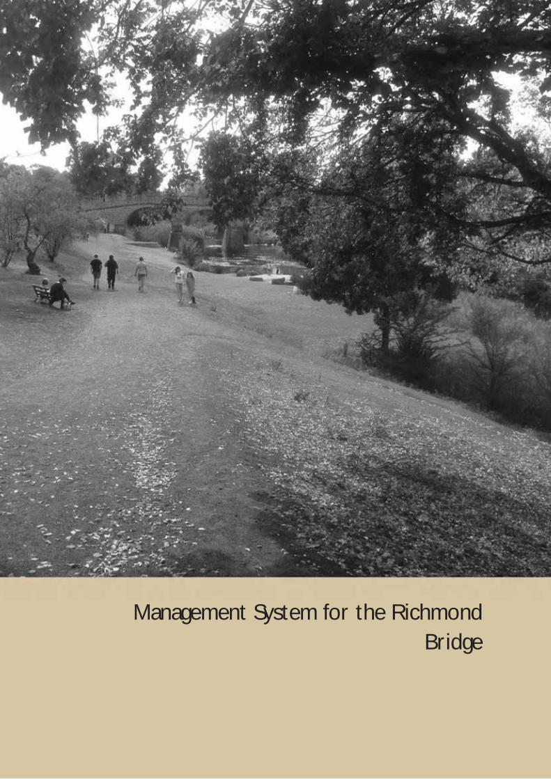
Richmond Bridge Conservation Management Plan 15 December 2017 92
Management System for the Richmond Bridge
Richmond Bridge Conservation Management Plan 15 December 2017 93
5.0 MANAGEMENT SYSTEM FOR THE RICHMOND BRIDGE
5.1 Introduction The Richmond Bridge and its setting fall under a complex management regime at all levels of government. This management regime includes responsibility for the bridge proper, the Coal River, the riverbanks and the town. As recognised in the National Heritage Management Principles, the management of National Heritage places should seek to integrate, where appropriate, any Commonwealth, State, and Local Government responsibilities for those places. Considerable advances have been made since 2010 in simplifying management, following Clarence City Council acquiring all land previously owned by the Archdiocese of Hobart and the Crown. Nonetheless, complexities of management for the bridge and setting do exist and opportunities to coordinate responses should be explored. The following section summarises the various responsibilities of each level of government.
5.2 Australian Government Since 2003, the Environment Protection and Biodiversity Conservation (EPBC) Act 1999 & 2003 (Heritage) Amendments has provided protective powers in relation to historic heritage that is regarded as having national level significance. The legislation provides for:
A National Heritage List (a list of places of national heritage significance);
A Commonwealth Heritage List (for significant heritage places that are Commonwealth owned or managed or are on Commonwealth land); and
The creation of an independent expert body, the Australian Heritage Council, to advise the Minister on the listing and protection of heritage places.
This legislation replaces and repeals the Australian Heritage Commission Act 1975 which provided protection for places of National Estate significance, but only in relation to Commonwealth activities or activities which occur through an agreement with the Commonwealth. The Register of the National Estate has been retained as an information source but no longer has any statutory meaning at a Commonwealth level.
5.2.1 The National Heritage List
The Richmond Bridge was entered in the National Heritage List on 14 November 2005. The National Heritage List is Australia's list of places with outstanding heritage value to the nation, and inclusive of natural, Indigenous or historic values. Places may be entered in this list where they are of outstanding heritage value to the nation and meet one or more of the nine criteria for entry. The National Heritage List criteria are:
(a) The place has outstanding heritage value to the nation because of the place's importance in the course, or pattern, of Australia's natural or cultural history;
(b) The place has outstanding heritage value to the nation because of the place's possession of uncommon, rare or endangered aspects of Australia's natural or cultural history;
(c) The place has outstanding heritage value to the nation because of the place's potential to yield information that will contribute to an understanding of Australia's natural or cultural history;
(d) The place has outstanding heritage value to the nation because of the place's importance in demonstrating the principal characteristics of:
(i) a class of Australia's natural or cultural places; or
(ii) a class of Australia's natural or cultural environments;
(e) The place has outstanding heritage value to the nation because of the place's importance in exhibiting particular aesthetic characteristics valued by a community or cultural group;
(f) The place has outstanding heritage value to the nation because of the place's importance in demonstrating a high degree of creative or technical achievement at a particular period;
(g) The place has outstanding heritage value to the nation because of the place's strong or special association with a particular community or cultural group for social, cultural or spiritual reasons;
Richmond Bridge Conservation Management Plan 15 December 2017 94
(h) The place has outstanding heritage value to the nation because of the place's special association with the life or works of a person, or group of persons, of importance in Australia's natural or cultural history; and
(i) The place has outstanding heritage value to the nation because of the place's importance as part of Indigenous tradition.
The Richmond Bridge has been assessed as meeting two of the nine criteria, which are:
(b) The place has outstanding heritage value to the nation because of the place's possession of uncommon, rare or endangered aspects of Australia's natural or cultural history; and
(e) The place has outstanding heritage value to the nation because of the place's importance in exhibiting particular aesthetic characteristics valued by a community or cultural group;
Places that are entered in the National Heritage List are subject to the EPBC Act 1999. Actions affecting places entered in the National Heritage List are considered to be matters of National Environmental Significance.
5.2.2 Management Requirements and the National Heritage Management Principles
The EPBC Act 1999 creates provisions to ensure that the values of the listed place will be protected and conserved. The guiding framework for how these places will be managed is contained in the National Heritage Management Principles. The seven Principles are:
1. The objective in managing National Heritage places is to identify, protect, conserve, present and transmit, to all generations, their National Heritage values.
2. The management of National Heritage places should use the best available knowledge, skills and standards for those places, and include ongoing technical and community input to decisions and actions that may have a significant impact on their National Heritage values.
3. The management of National Heritage places should respect all heritage values and seek to integrate, where appropriate, Commonwealth, State, Territory and local government responsibilities for those places.
4. The management of National Heritage places should ensure that their use and presentation is consistent with the conservation of their National Heritage values.
5. The management of National Heritage places should make timely and appropriate provision for community involvement, especially by people who:
(a) Have a particular interest in, or associations with, the place, and
(b) May be affected by the management of the place.
6. Indigenous people are the primary source of information on the value of their heritage. The active participation of Indigenous people in identification, assessment and management is integral to the effective protection of Indigenous heritage values.
7. The management of National Heritage places should provide for regular monitoring, review and reporting on the conservation of National Heritage values.
These Principles should be used when preparing, implementing and reviewing management plans.
The EPBC Act 1999 applies to the actions undertaken by: a constitutional corporation; the Commonwealth or a Commonwealth agency; or a person for the purposes of trade or commerce between Australia and another country, between States, between Territories, or between a State and a Territory.197 Given these limitations, the primary means of protecting the bridge and setting is the Historic Cultural Heritage Act 1995 (Tas).
An ‘action’ includes a project, a development, an undertaking, an activity, or series of activities, or an alteration to any of these things. This includes activities occurring both within a listed place, and those activities occurring outside the listed place that will have, or are likely to have a significant impact on the national heritage values of the place.
197 Australian Government, Department of the Environment, Matters of National Environmental Significance. Significant impact guidelines 1.1. Environment Protection and Biodiversity Conservation Act 1999, p.19

Richmond Bridge Conservation Management Plan 15 December 2017 95
5.2.3 Determining if Approval is Required
Where an action will, or is likely to have a significant impact on a matter of national environmental significance, the approval of the Commonwealth Minister is required to undertake that action. The process for determining whether a proposed action requires formal assessment and approval under the EPBC Act 1999 is called a ‘referral’.
In making a decision, the Minister will classify the action into one of the following three categories:
Controlled Action: Where the Minister decides that the action is likely to have a significant impact on a matter of national environmental significance, the action will require approval under Part 3 the EPBC Act 1999; or
Not Controlled Action ‘Particular Manner’: Where the Minister decides that the action is not likely to have a significant impact on a matter of national environmental significance and does not require approval under the EPBC Act 1999, because the action will be undertaken in a particular manner.
Actions that are not Controlled: Where the Minister decides that the action is not likely to have a significant impact on a matter of national environmental significance, the action will not require approval under the EPBC Act 1999. 198
5.2.4 Significant Impact Criteria for National Heritage Places
The Australian Government Department of the Environment have prepared a policy document providing practical guidance on whether an action is likely to have an impact on a matter of national environmental significance. Ministerial approval will be required if there is a real chance or possibility that the action will cause:
One or more of the National Heritage values to be lost;
One or more of the National Heritage values to be degraded or damaged; or
One or more of the National Heritage values to be notably altered, modified, obscured or diminished.199
For places with historic cultural heritage values, like the Richmond Bridge, an action is likely to have a significant impact if it will:
Permanently remove, destroy, damage or substantially alter the fabric200 of a National Heritage place in a manner which is inconsistent with relevant values;
Extend, renovate, refurbish or substantially alter a National Heritage place in a manner which is inconsistent with relevant values;
Permanently remove, destroy, damage or substantially disturb archaeological deposits or artefacts in a National Heritage place;
Involve activities in a National Heritage place with substantial and/or long-term impacts on its values;
Involve the construction of buildings or other structures within, adjacent to, or within important sight lines of, a National Heritage place which are inconsistent with relevant values; and
Make notable changes to the layout, spaces, form or species composition of a garden, landscape or setting of a National Heritage place in a manner which is inconsistent with relevant values.
Actions that may have a significant impact on other cultural heritage values can:
Restrict or inhibit the continuing use of a National Heritage place as a cultural or ceremonial site causing its values to notably diminish over time;
Permanently diminish the cultural value of a National Heritage place for a community or group to which its National Heritage values relate;
198 Ibid, pp.27-28 199 Ibid, p.19 200 ‘Fabric’ means physical material including structural elements or other components, fixtures, fittings, contents and items with historic value.

Richmond Bridge Conservation Management Plan 15 December 2017 96
Destroy or damage cultural or ceremonial, artefacts, features, or objects in a National Heritage place;
Notably diminish the value of a National Heritage place in demonstrating creative or technical achievement.
As shown above, there is a broad range of actions which may have a significant impact on the values of the place. Significant impacts may include actions on a part, element, or feature of a National Heritage place which embodies, manifests, shows, or contributes to the values of that place.
Guidance is also provided on identifying those actions which would not be expected to have a significant impact on a matter of national environmental significance. With regards to the Richmond Bridge, this has primary relevance to urban development and local government considerations. The following matters can be considered in this category:
Relevant Urban Development Considerations
Repairing, maintaining, or making alterations to commercial and domestic buildings and properties would not be expected to have a significant impact on a matter of national environmental significance, unless the repairs, maintenance or alterations are being made to a National Heritage place and are inconsistent with the values of the property or place.
Repairing and maintaining existing distribution infrastructure for utilities for power, water and sewage would not normally be expected to have a significant impact on a matter of national environmental significance, unless there is a substantial expansion or modification of these utilities.
Establishing a new subdivision within or adjacent to a National Heritage place is likely to have a significant impact on the National heritage values of that property or place.
Building a house in close proximity to a National Heritage place may have a significant impact on the values of the place, in particular where the place is located in a non-urban environment or where the proposed development would obstruct or detract from the viewing axes of the heritage place, where applicable.
Relevant Local Government Activities
Maintaining existing facilities such as visitor centres and roadside facilities would not be expected to have a significant impact on a matter of national environmental significance.
Routine vegetation management to maintain existing roads in or adjacent to a National Heritage place would not normally be expected to have a significant impact on a matter of national environmental significance.201
5.2.5 Approvals Process
Actions that are likely to have a significant impact on a matter of national environmental significance require approval under the EPBC Act 1999. A proposed action can be assessed by either the Australian Government or an accredited State or territory process.
The Minister is required to determine the application following the completion of the assessment. Decisions can be either to approve or not approve an application, or approval with conditions. Decisions are required to be made within 30 business days.202
5.2.6 Actions that may have a significant impact on the Richmond Bridge and Setting
The Tasmanian Government and Clarence City Council are responsible for the ownership and management of the Richmond Bridge and setting.
As discussed, the EPBC Act 1999 applies to the actions undertaken by: a constitutional corporation; the Commonwealth or a Commonwealth agency; or a person for the purposes of trade or commerce between Australia and another country, between States, between Territories, or between a State and a Territory.
Because of these limitations, it will depend on who is proposing an action to determine whether approval under the EPBC Act 1999 is required. Differences will exist if the action is proposed by the Tasmanian
201 Ibid, pp.32-33 202 Ibid, pp.28-29

Richmond Bridge Conservation Management Plan 15 December 2017 97
Government, the Clarence City Council, or a third party acting on behalf of the State or Local Government. In light of these complexities, it is important that the State and/or Local Government discuss with the Department of the Environment any action that may impact the National Heritage values before that action is undertaken. The proponent has the onus of referring a proposal to the Department of the Environment.
In assessing a proposed action, consideration will be given to whether it will have, or is likely to have a significant impact on the national heritage values of the Richmond Bridge. The National Heritage Values for the Richmond Bridge are:
Criterion (b) Rarity: Richmond Bridge, built by convict labour in 1823 to 1825, is the oldest, surviving, large, stone arch bridge in Australia with a high degree of integrity.
Criterion (e) Aesthetic characteristics: The aesthetic significance of Richmond Bridge is appreciated locally, within Tasmania and nationally. Its picturesque image has been used widely in national and international tourism promotions since the 1920s and has inspired the work of major Australian artists.
These values are wide in their description, referring to:
The historical value of being the oldest bridge;
Being constructed by convict labour;
Having a high degree of integrity;
Aesthetic values that are widely appreciated;
Being an iconic tourism place; and
Being a source of inspiration for artists.
Given the breadth of these values, there are a variety of actions that may potentially have an impact on the Richmond Bridge and its setting. The Conservation Policies recommended in this Plan do not anticipate a substantial amount of works or development occurring at the place. Rather, they largely refer to ongoing maintenance requirements to ensure the retention of the values. Planned actions that may require approval under the EPBC Act 1999 include:
Works which would substantially alter the form, appearance, materials or capacity of the bridge. For example, large scale stone replacement; altering the colour of the road surface; the traffic management measures for the bridge approaches;
Works which would impact on the appreciation of the bridge and setting. For example, the removal of significant trees; the installation of structures interrupting significant views; and modifications to the bridge inconsistent with its current form, appearance, materials; and
Works which would restrict public appreciation of the bridge by visitors and artists. For example, restricting public access to the bridge and publicly accessible vantage points.
5.3 Tasmanian Government Responsibility for the management of the Richmond Bridge and its setting comes under various State laws and authorities. Each has different roles and responsibilities. The following sections describe these roles.
5.3.1 Department of State Growth
The Transport Infrastructure Branch of the Department of State Growth has responsibility for the management of the existing road and bridge assets and planning for the future development of the Tasmanian Classified State Road Network. The Department is responsible for the ongoing management of the Richmond Bridge and commissioned the 1997 Conservation Plan with the assistance of funds made available under the National Estate Grant Program. The Department commissioned the 2010 and this current Conservation Management Plan with financial assistance from the Australian Government Department of the Environment.
5.3.2 Historic Cultural Heritage Act 1995
The Historic Cultural Heritage Act 1995 (HCH Act 1995) is the primary legislative means for the identification, assessment, protection and conservation of Tasmania’s historic heritage. The HCH Act 1995 establishes the Tasmanian Heritage Council, the Tasmanian Heritage Register (THR) for places of State significance and the
Richmond Bridge Conservation Management Plan 15 December 2017 98
processes for considering works to heritage registered places. The Richmond Bridge is permanently entered in the THR and therefore the HCH Act 1995 applies to the management of this place.
All types of places can be considered, including places, structures, shipwrecks (i.e., any maritime relic) and items physically or historically related to heritage places and shipwrecks. Places may be entered in the Tasmanian Heritage Register where they are of historic cultural heritage significance and meet one or more of the eight criteria for registration. The criteria recognise historical significance, rarity, research potential, important examples of certain types of places, creative and technical achievement, social significance, associations with important groups or people, and aesthetic importance. The Richmond Bridge and its setting have been included in the THR as meeting all eight criteria.
One of the roles of the Tasmanian Heritage Council is to work within the planning system to achieve the proper protection of Tasmania’s historic cultural heritage. Works to places included in the THR require approval, either through a Certificate of Exemption for works which will have no or negligible impact, or through a discretionary permit for those works which may impact on the significance of the place.
The definition of ‘works’ includes:
(a) any development; and
(b) any physical intervention, excavation or action which may result in a change to the nature or appearance of the fabric of a place; and
(c) any change to the natural or existing condition or topography of land; and
(e) any removal of vegetation or topsoil.
In turn, ‘development’ is defined as:
(a) the construction, exterior alteration or exterior decoration of a building; and
(b) the demolition or removal of a building; and
(c) the subdivision or consolidation of land, including buildings or airspace; and
(d) the placing or relocating of a building; and
(e) the construction, or putting up for display, of signs or hoardings.
Under Section 4A, the following must be taken into account in exercising any powers or carrying out any function in relation to the HCH Act 1995:
The retention of the historic cultural heritage of the place;
Any relevant provisions of the Building Act 2000 (now the Building Act 2016).
Functions or powers exercised under the Act must be consistent with the objectives of the resource management and planning system and the planning process (in Schedule 1 of the Land Use Planning Approvals Act 1993).
Works Process and Guidelines
Discretionary permit applications are lodged with the relevant local planning authority. On receipt, the application is sent to the Heritage Council, which will firstly decide whether they have an interest in determining the application. If the Heritage Council has no interest in the matter, the local planning authority will determine the application.
If the Heritage Council has an interest in determining the application, a number of matters may be relevant to its decision. This includes the likely impact of the works on the significance of the place; any representations; and any regulations and works guidelines issued under the HCHA 1995. The Heritage Council may also consult with the planning authority when making a decision.
In making a decision, the Heritage Council will exercise one of three options: consent to the discretionary permit being granted; consent to the discretionary permit being granted subject to certain conditions; or advise the planning authority that the discretionary permit should be refused.
The Heritage Council’s decision is then forwarded to the planning authority, which will incorporate the decision into any planning permit.
Richmond Bridge Conservation Management Plan 15 December 2017 99
The Tasmanian Heritage Council and Heritage Tasmania, DPIPWE, have issued Works Guidelines for Historic Heritage Places which must be applied when considering an application for an exemption or a discretionary permit. The guidelines provide a general reference for the types of works which may be exempt, or those where a permit will be required. They also define appropriate outcomes for a range of different works and development scenarios. The following categories are of most relevance to the Richmond Bridge, surrounding riverbanks and various uses:
Maintenance and repair of built elements;
Restoration and reconstruction;
Interpretation;
Excavation and archaeological investigation;
Access to heritage places;
New services;
Historic plantings and landscapes; and
Signage.
5.3.3 Aboriginal Heritage Act 1975
The Aboriginal Heritage Act 1975 (AH Act 1975) is the key Tasmanian legislation providing for the conservation of Aboriginal heritage. The AH Act 1975 applies to ‘relics’ which are defined as:
2 (3)(a) any artefact, painting, carving, engraving, arrangement of stones, midden, or other object, made or created by any of the original inhabitants of Australia or the descendants of any such inhabitants, which is of significance to the Aboriginal People of Tasmania; or;
(b) any object, site, or place that bears signs of the activities of any such original inhabitants or their descendants, which is of significance to the Aboriginal People of Tasmania; or
(c) the remains of the body of such an original inhabitant or of a descendant of such an inhabitant that are not interred in –
(i) any land that is or has been held, set aside, reserved, or used for the purposes of a burial-ground or cemetery pursuant to any Act, deed, or other instrument; or
(ii) a marked grave in any other land
2 (4) Despite subsection (3)(a) or (b), objects made, or likely to have been made, for the purposes of sale (otherwise than by way of barter or exchange in accordance with Aboriginal tradition) are not relics for the purposes of this Act.203
All relics are protected under the provisions of the Act, including those found during works. Permits are required for a range of activities, including to:
(a) destroy, damage, deface, conceal, or otherwise interfere with a relic;
(b) make a copy or replica of a carving or engraving that is a relic by rubbing, tracing, casting, or other means that involve direct contact with the carving or engraving;
(c) remove a relic from the place where it is found or abandoned;
(d) sell or offer or expose for sale, exchange, or otherwise dispose of a relic or any other object that so nearly resembles a relic as to be likely to deceive or be capable of being mistaken for a relic;
(e) take a relic, or cause or permit a relic to be taken, out of this State; or
(f) cause an excavation to be made or any other work to be carried out on Crown land for the purpose of searching for a relic.204
The 2010 CMP recommended that an Aboriginal heritage assessment be carried out.205 For the current project, preliminary consultation has taken place with Aboriginal Heritage Tasmania (AHT), DPIPWE, to
203 Aboriginal Heritage Act 1975, s2(3) 204 Ibid, s14 205 Richmond Bridge CMP 2010, policy 7.11.4, p.234

Richmond Bridge Conservation Management Plan 15 December 2017 100
determine if the place contains any previously recorded Aboriginal heritage sites, or if there is any potential for heritage sites to exist at the place. AHT has advised that there are no Aboriginal heritage sites recorded within the immediate area. A review of previous reports suggests that the area has a low probability of Aboriginal heritage being present. On this basis, there were no requirements for an Aboriginal heritage investigation.206
AHT also advised that the provisions of the Act will apply should Aboriginal heritage be discovered or suspected during works. An Unanticipated Discovery Plan should be implemented should Aboriginal Heritage be discovered or suspected during ground disturbance works.207 This Unanticipated Discovery Plan is included in Appendix 4.
Whilst AHT have no requirement for a separate Aboriginal heritage assessment, this CMP considers that such an assessment would assist in understanding if Aboriginal heritage items or values exist at the place and how they should be appropriately managed. Such an assessment is also consistent with the National Heritage Management Principles and that:
3. The management of National Heritage places should respect all heritage values and seek to integrate, where appropriate, any Commonwealth, state, territory and local government responsibilities for those places.
6. Indigenous people are the primary source of information on the value of their heritage and the active participation of Indigenous people in identification, assessment and management is integral to the effective protection of Indigenous heritage values.
5.3.4 Water Resources Management - the Coal River
After the bridge, the Coal River is the key defining element of the place. It makes a substantial contribution to the aesthetic values of the place and visitor amenity. Its management and use comes under the Water Management Act 1999, which sets outs the framework for freshwater management in Tasmania, and the need to:
Promote sustainable use and facilitate economic development of water resources;
Recognise and foster the significant social and economic benefits resulting from the sustainable use and development of water resources for the generation of hydro-electricity and for the supply of water for human consumption and commercial activities dependent on water;
Maintain ecological processes and genetic diversity for aquatic and riparian ecosystems;
Provide for the fair, orderly and efficient allocation of water resources to meet the community's needs;
Increase the community's understanding of aquatic ecosystems and the need to use and manage water in a sustainable and cost-efficient manner; and
Encourage community involvement in water resources management.
Responsibility for management, regulation and use of freshwater resources occurs through various bodies. This includes management of aquatic and riparian ecosystems, water pollution and public health, and the provision of water for drinking and irrigation.
The key use of water within the Coal River is for irrigation purposes. Irrigation uses are managed under the Water Management Act 1999 and the Irrigation Clauses Act 1973, which consolidates various provisions related to irrigation schemes into the one Act. The river forms part of the Pittwater - Coal Catchment and the South East Irrigation Schemes (SEIS). The water resource is managed by Tasmanian Irrigation, a State owned company that owns and operates irrigation schemes.
The SEIS Stage 2 commenced operation in May 1991. The scheme supplies 1,975 ML of water under pressure through a network of buried pipelines to the South East Water District Stage 2 which extends across the Richmond and Cambridge areas.
206 Email, Adam Marshall (Aboriginal Heritage Tasmania) to James Puustinen (Austral Tasmania), 10 December 2015: AHTP2649 - 2010 Richmond Bridge - Conservation Management Plan Review 207 Ibid
Richmond Bridge Conservation Management Plan 15 December 2017 101
The scheme was initially supplied from the Richmond Weir at the Gatty Dam using water released from Craigbourne Dam. The Daisy Banks Dam was completed in August 2000 and from the 2000-2001 irrigation season the scheme has been supplied by the bulk water authority (now TasWater). 208
The Coal River Catchment Management Plan
In 1998 a cooperative approach to the management of the Coal River catchment was developed. The Coal River Catchment Committee was established, including a broad range of interests to develop a common vision of the area. Representatives of tourism, agriculture, Landcare Australia, the Richmond Chamber of Commerce, forestry, aquaculture, commuters and hobby farmers were included on the Committee.209
The preferred approach of the Committee was education, cooperation, coordination and demonstration as opposed to legislative mechanisms. The Committee developed a common vision for the catchment. As a management document, the Plan made recommendations relevant to the bridge and setting, including:
The retention, protection and enhancement of native vegetation: Native vegetation across a range of diverse environments is seen as an integral part of the ecosystem of the Valley, protecting the soil, water quality and bio-diversity.
Weeds: A catchment free of the serious impacts of agricultural and environmental weeds.
Reserve and Habitat management: The retention of native vegetation and revegetation with native species on private land and the dedication by some landholders for the support of native flora and fauna in combination with public reserves will provide an extensive network of natural areas to sustain the range of ecosystems characteristic of the catchment.
Water: The reliable supply of good quality water available in the catchment is maintained or increased.
Aboriginal heritage: The Aboriginal heritage values of the Valley are respected and protected.
Development/Planning: The development of sustainable agricultural and related activities and maximising of the potential economic benefits of the South East Irrigation Scheme (now Tasmanian Irrigation) while maintaining the rural character of the area with ‘village’ type residential areas. Any subdivision and development should not detract from the natural and cultural heritage values of the area and not result in pollution of land, air, surface water or ground water.
The Catchment Management Plan was officially launched in 1998, and an implementation Committee formed. It is a non-statutory plan but is used by Clarence City Council as a reference document. Activities carried out under the plan included the management of weeds including horehound and African Boxthorn, and assisting in the development of a river care plan which led to on-ground works including the removal of willows, fencing off riparian zones and revegetation projects; salinity monitoring and management and tree planting.210
The vision developed by the Coal River Catchment Management Plan encourages river and riparian health and is of benefit to the conservation of the heritage values of the bridge and setting. It should be noted that with regards to the riverbanks of the Coal River near the bridge, some introduced plant species form an important part of the cultural values of the place and should be retained.
5.3.5 Land Use Planning and Approval Act 1993
At the local government level, the Land Use Planning Approval Act 1993 (the LUPA Act 1993) applies generally, but its main function in relation to historic heritage is to allow for the establishment of the Tasmanian Planning Scheme, consisting of State Planning Provisions and Local Provisions Schedules.
The general objectives for resource management in the LUPA Act 1993 are set out in Schedule 1 of the Act. Specific provision for cultural heritage is contained in Part 2 of Schedule 1:
The objectives of the planning process established by this Act are .... (g) to conserve those buildings, areas or other places which are of scientific, aesthetic, architectural or historical interest, or otherwise of special cultural value.
208 http://www.tasmanianirrigation.com.au/index.php/about/the-team/ 209 Clarence City Council, Coal River Catchment: Planning and Implementation. Rosny Park: Clarence City Council, 2005, p.5 210 Ibid, pp.13-14
Richmond Bridge Conservation Management Plan 15 December 2017 102
5.4 Local Government - Planning Reforms and the Clarence Interim Planning Scheme 2015 It should be noted that the Tasmanian Government has commenced a process of local planning reform, but these reforms are yet to come into effect. The Tasmanian Planning Scheme and State Planning Provisions have been approved, but implementation at a local level will require the creation of Local Provision Schedules in each municipality. Heritage Codes in Local Provision Schedules will include tables listing Local Heritage Places, Local Heritage Precincts, Local Historic Landscape Precincts, Places of Archaeological Potential and Significant Trees. Places that are already included as Local Heritage Places will be brought across to the new Local Provisions Schedules. However, where that place is also included on the Tasmanian Heritage Register (as with the Richmond Bridge), the Heritage Place provisions of the Heritage Code will not apply, except for mutually exclusive parts of the same lot or lots.211
This approach removes the need for dual approvals from both the Tasmanian Heritage Council and the Planning Authority. Local participation in heritage management should be encouraged, and Clarence City Council should consider other mechanisms under the Tasmanian Planning Scheme such as Local Heritage Precincts or Local Historic Landscape Precincts which would provide for this. The Richmond Bridge and setting is likely to be most valued by the people of Richmond, and opportunities for local involvement in management is desirable. The review of other mechanisms under the Local Provisions Schedules such as precincts or landscape precincts should be considered by Clarence City Council.
5.4.1 Clarence Interim Planning Scheme 2015
The Tasmanian Planning Scheme - Local Provisions Schedules are yet to come into effect within Clarence, and as such, the Clarence Interim Planning Scheme 2015 remains in operation and has a significant bearing on the management of the Richmond Bridge, setting, and the town. Clarence City Council maintains the local roads in Richmond, is the land owner and manager for the public riverbank areas and is the planning authority for development occurring at the place.
Development approval occurs through the Clarence Interim Planning Scheme 2015 (CIPS 2015) which sets out the requirements for use or development of land. It is likely that the Scheme will remain at an ‘interim’ stage until the single statewide planning scheme is finalised. The following therefore summarises the planning provisions as they currently exist.
The planning scheme area is divided into zones which set out the primary controls for the use or development of land. With regard to the Richmond Bridge, the two key zones are:
Open Space; and
Environmental Management.
In addition to zone provisions, the Scheme sets out codes which identify specific areas of land or planning issues which require additional matters to be complied with by new uses and developments. With regard to the Richmond Bridge and setting, the three codes are the:
Waterway and Coastal Protection Code;
The Historic Heritage Code; and
The Inundation Prone Areas Code.
The following sections summarises the applicable requirements of the zoning and codes, with particular reference to the bridge.
5.4.2 Open Space Zone
The Open Space Zone applies to the publicly accessible riverbanks owned and managed by Clarence City Council. The relevant Purpose of the zone is to provide land for open space, including passive recreation and natural or landscape amenity and to encourage networks linked through walking and cycling trails.212
211 Department of Justice, Tasmanian Government, Information Sheet - Amendments to SPP Local Historic Heritage Code, 23 August 2017; Tasmanian Planning Commission, Draft State Planning Provisions Report. A Report by the Tasmanian Planning Commission as required under section 25 of the Land Use Planning and Approvals Act 1993, p.32 212 CIPS 2015, Cl.19.1
Richmond Bridge Conservation Management Plan 15 December 2017 103
Passive recreation, natural and cultural values management and minor utilities do not require a permit within this zone. All other uses require a permit, are discretionary or prohibited. A series of ‘Use Standards’ are set out in Clause 19.3. These relate to hours of operation, noise, external lighting, commercial vehicle movements and discretionary uses and the impact such uses may have on nearby residential zones.
Development standards are also established for ‘building and works’ within the Open Space Zone. These provisions in Clause 19.4 relate to building height, setback, landscaping and fencing. The specific objectives include making positive contributions to the streetscapes; avoiding unreasonable impacts on residential amenity; and enhancing the appearance or attractiveness of the area.
Clause 19.5 provides the standards for subdivision within the Open Space Zone. The objective of the standards is to have lots appropriate to accommodate development consistent with the Zone Purpose and any relevant Local Area Objectives or Desired Future Character Statements.
5.4.3 Environmental Management Zone
The Environmental Management Zone applies to the Coal River. Of the defined reasons for the zoning, the following Purpose Statements are most applicable to the Richmond Bridge and surrounds:
To provide for the protection, conservation and management of areas with significant ecological, scientific, cultural or aesthetic value, or with a significant likelihood of risk from a natural hazard; and
To only allow for complementary use or development where consistent with any strategies for protection and management.
No permits are required for natural and cultural values management and passive recreation within this zone. A range of different uses are permitted provided a reserve management plan applies, whilst most other uses are discretionary or prohibited. ‘Use Standards’ are set out in Clause 29.3, to ensure that proposed uses are consistent with any strategies for the protection and management of reserved land.
Development standards for buildings and works and subdivisions are provided in the following sections, but are unlikely to have relevance to the Coal River itself.
5.4.4 Waterways and Coastal Protection Code
The Waterways and Coastal Protection Code applies to the Coal River itself. Of the stated purposes of the Code, most relevant to the Coal River at Richmond are the objectives of managing vegetation and soil disturbances in the vicinity of watercourses to minimise impact on water quality, natural values, river condition and natural ecological function of watercourses; and, minimise impacts on water quality in potable water supply catchment areas.
A series of different developments are exempt from the Code. Of most relevance are those exemptions related to:
Development not involving removing vegetation or soil disturbances or disturbances within a public garden or park;
The removal of declared weeds;
Works to rectify public or private safety or prevent environmental harm;
Maintenance works within 2 metres of existing infrastructure;
The erection or maintenance of boundary fences; and
Piped sewerage and stormwater works.
Development standards are established for buildings and works, buildings and works dependent on a coastal location and subdivision. Within the context of the Coal River, the most likely development scenarios would involve structures located over or within the river itself, such as jetties, pontoons, viewing platforms and so on. The objective of the standard is to avoid unnecessary or unacceptable impacts on natural values. Where development does not meet the specified acceptable solutions, it must meet the performance criteria, which emphasise avoiding or mitigating impact on natural values with regard to erosion, vegetation, stream banks and beds, and animal habitat and movement.213
213 CIPS 2015, Cl.E11.0
Richmond Bridge Conservation Management Plan 15 December 2017 104
5.4.5 Historic Heritage Code
The Historic Heritage Code applies to the Richmond Bridge and part of the riverbanks. The purpose of the Code is to recognise and protect the historic cultural heritage significance of places, precincts, landscapes and areas of archaeological potential by regulating development that may impact on their values, features and characteristics. It can apply to a Heritage Place, a Heritage Precinct, or both as is the case for the bridge and setting.
The ‘Richmond Bridge and Surrounds’ is included as a Heritage Place in Table E 13.1. This relates to the bridge structure proper. A broader area has also been defined as a Heritage Precinct for the town of Richmond. The precinct listing boundaries include the bridge itself, and the riverbanks to the north of the bridge.
The Code specifies certain exemptions for developments and separate management provisions for individual heritage places and precinct listings. These are summarised below.
Exemptions
The Scheme establishes a series of exemptions for development of heritage places and development within a precinct. With regard to development of a heritage place the following are exempt and of greater relevance to the bridge and setting:
The temporary structural stabilisation as certified by a structural engineer; and
Permanent stabilisation works considered by a suitably qualified person to meet the Purpose and Objectives of the Code.214
The following development within a heritage precinct or heritage place is exempt:
Works incidental to the maintenance of a garden or grounds, except where they are specifically part of the General Description of the place or precinct;
Minor attachments (e.g., services) to the side or rear of a building that are at least 1 metre from any boundary;
Temporary fencing for occasional events, construction works or public safety;
Planting, clearing or modification of vegetation (unless the vegetation is specifically part of the General Description) for the following reasons: within a garden or park unless the vegetation is protected by a permit condition or other mechanism; to allow for the maintenance, repair or protection of buildings or infrastructure; for soil conservation of rehabilitation works; to implement an approved vegetation management agreement; for safety reasons;
The provision of utilities and certain infrastructure.
Certain development within a heritage precinct (but not an individually listed heritage place) may also be exempt. With regard to the Richmond Bridge and surrounds, the following are perhaps of most relevance in their potential to have adverse visual impacts on the place:
Installing one satellite dish no more than 2 metres in diameter;
Installing solar panels and photovoltaic cells on a roof.215
Development Standards for Heritage Places
Clause E13.7 sets out the standards for three types of development of a heritage place and the provisions are applicable to the Richmond Bridge. These are demolition, buildings and works other than demolition and subdivision. There are no acceptable solutions for these types of development and therefore they must be assessed against the relevant performance criteria.
The potential adverse impact from demolition (in whole or part) is recognised in the provisions, noting that it is not to occur unless there are exceptional circumstances. Such circumstances are set out in the performance criteria. They include there being greater environmental, social, economic or safety reasons that outweigh the heritage values; the lack of prudent and feasible alternatives; significant fabric can be retained and reused; and significant fabric is documented. The threshold for demolition is high, with all criteria required to be met.216
214 CIPS 2015, Cl.E13.4(c)(d) 215 CIPS 2015, Cl.E13.4(c)(d) 216 CIPS 2015, Cl.E13.7.1
Richmond Bridge Conservation Management Plan 15 December 2017 105
A broader range of scenarios are set out for buildings and works other than demolition. The objective is that such works are not to result in the loss of heritage significance and that new work be designed to be subservient to the values of the place and responsive to its dominant characteristics. Again, no acceptable solutions exist for this type of development and the five performance criteria must be met. Most of the criteria relate to the modification or development of built places and would be of limited application to the bridge itself. However issues with regard to materials, colours, finishes and the loss of significant fabric would be relevant.217
The subdivision requirements of the Code are unlikely to have relevance as the extent of listing relates to the bridge itself and not its setting. 218
Development Standards for Heritage Precincts
The bridge and river banks to the north are located within the Richmond Heritage Precinct. The Statement of Historic Cultural Heritage Significance for the precinct is that Richmond is Tasmania’s finest Georgian village. Design Criteria/Conservation Policy have been established for Richmond requiring that the collective built integrity of the place be enhanced; that the distinctive character of the place (buildings, spaces, topography, gardens, scale, materials etc.) be retained; and that important views to the town landmarks and the surrounding rural countryside be retained.
Clause E13.8 sets out the standards for development within a heritage precinct, namely, demolition, buildings and works other than demolition and subdivision. There are no acceptable solutions for these types of development and therefore they must be assessed against the relevant performance criteria.
The potential adverse impact from demolition (in whole or part) is recognised in the provisions, noting that it is not to occur unless there are exceptional circumstances and must not result in the loss of elements that contribute to the significance of the precinct. Such contributory elements can include buildings or works, and other items such as plants, trees, fences, paths and so on. Some exceptions to restrictions on demolition do exist, and these again consider if greater environmental, social, economic or safety reasons exist; the lack of prudent and feasible alternatives; and if opportunities exist for improvement through new buildings more complementary to the precinct. The threshold for demolition is high, with all criteria required to be met.219
New buildings and works within the precinct must be sympathetic to its character. Performance criteria are set out for new buildings, extensions and fencing. Generally, the design and siting of new buildings and works must comply with the Design Criteria/Conservation Policy for Richmond, as given above. New buildings must be sympathetic in terms of bulk, setbacks, materials, colour scheme, form, and character of the place, streetscape and surrounding area. 220
Subdivision within the Heritage Precinct must be consistent with the historic patterns of development and most not create potential for future incompatible development. With regard to the setting of the bridge, ‘incompatible development’ would be one that had an adverse impact on significant views to and from the place.
In addition to complying with the Design Criteria/Conservation Policy for Richmond, subdivision must not result in the loss of significance of the precinct; must not result in an unsympathetic subdivision pattern; must not confuse an understanding of the development of the precinct; must not increase the likelihood for future incompatible development; and, must not result in the potential loss of raised view lines through urban areas to non-urban areas around Richmond.221
5.4.6 Inundation Prone Areas Code
The Inundation Prone Areas Code applies to the Coal River and surrounding riverbanks. The purpose of the Code is to identify areas at risk from inundation and mitigate such risks through managing or restricting development.
Specific application requirements are set out in clause E15.5 for development of land which is designated under this Code. It requires an assessment, and as necessary engineering detail of a range of matters, including flow paths of rainfall and modifications to these flows, and the management of stormwater. Additional information
217 CIPS 2015, Cl.E13.7.2 218 CIPS 2015, Cl.E13.7.3 219 CIPS 2015, Cl.E13.8.1 220 CIPS 2015, Cl.E13.8.2 221 CIPS 2015, Cl.E13.8.3
Richmond Bridge Conservation Management Plan 15 December 2017 106
may also be required, including an inundation risk management plan, a site analysis plan documenting flow paths, and evidence of how the development will withstand flood events.222
5.4.7 Non-Statutory Management Resources - Richmond Cultural Resource Management Plan
The Richmond Cultural Resource Management Plan is the key non-statutory heritage management guide for Richmond. It was prepared in 2001 in response to strong community interest in establishing the cultural values of the town and finding ways in which these values can be sustained. The Plan is not referred to in CIPS 2015, but Council does use it as reference material.223
The Plan is of considerable value and relevance to this CMP and its key findings are summarised here. Eight broad recommendations were made to Council to ensure statutory and administrative means of conserving heritage values and site. These recommendations covered the areas of:
1. Townscape;
2. Streetscape;
3. Signage;
4. Traffic management;
5. River management;
6. Heritage promotion;
7. Development control; and
8. Community involvement.
With regards to the Richmond Bridge, and the current review of the CMP, the following recommendations are most relevance:
Townscape
That Council adopt planning controls and guidelines which protect the heritage resource of Richmond from further inappropriate development which diminishes its character.
Traffic Management
Enhanced car parking within the town to improve pedestrian amenity;
Stage 1 of the Richmond by-pass to provide a link to the west of the town between Campania Road and Richmond Road to be completed by no later than June 2002. These works have subsequently been completed;
Stage 2 of the Richmond by-pass to provide an east-west link north of the town and across the Coal River to be commenced and constructed no later than June 2005 following appropriate investigation, design and feasibility. These works have not been completed but the land has been designated a Future Road Corridor under the CIPS 2015; and
For the Clarence City Council to make representation to both State and Federal Governments to reinforce the importance of the need for the by-pass construction to sustain the cultural and heritage values of Richmond for future generations.
River Management
Council prepare an appropriate landscape and use strategy for the river edge to enable an application for funding for the completion of a Rivercare Plan for the section of the Coal River a kilometre either side of the Richmond Bridge;224 and
Council is recommended to review other improvements to the river edge to enable an enhanced experience along/on the river.
222 CIPS 2015, Cl.15.5.2 223 Email, Ian Preece (CCC) to James Puustinen (Austral Tasmania), 20 April 2016 224 The Rivercare Plan for the Coal River was prepared in 1999 and is being progressively implemented by Coal River Products Association through its Landcare work. This mainly involves crack willow removal and revegetation with native plants in a controlled way, section by section, to avoid bank erosion and build up of woody debris which could threaten the bridge during flood.
Richmond Bridge Conservation Management Plan 15 December 2017 107
Heritage Promotion
The concept of heritage tourism as a resource opportunity in Richmond and the conservation of the heritage character should form the strategic base for all planning by Council in the area; and
Council to coordinate the preparation of applications and programs for the establishment of on-site interpretation of heritage sites and the establishment of an interactive and tourist information centre in the former Richmond Council Chamber. Funding should be sought from both Federal/State Governments in establishing and operating the proposed centre.225
5.4.8 Richmond By-pass
Proposals for a Richmond by-pass have existed since the 1970s. The Richmond Cultural Resource Management Plan considered that delays in the construction of the by-pass have had a significant detrimental impact on the management of Richmond’s cultural resource. Concern was also expressed at the lack of enforcement of the load limit on the bridge. Further, Shield wrote that Richmond suffered from the impact of larger articulated vehicles travelling through the town boundaries with the result that the cultural resource is losing an increasing amount of its tourism and pedestrian amenity.226
Similarly, Spry’s 1990 assessment of the stonework condition of the bridge considered that the solution to the slow deterioration of the Richmond Bridge was the diversion of traffic over a new bridge, and restricting the Richmond Bridge to foot traffic only.227
There has been progress on this matter since 2010. The Richmond heavy vehicle link road was completed in 2014, providing an alternative route for traffic with a new road located on the western outskirts of the town. Data on the effectiveness of this road in removing heavy vehicles from Richmond was not available for this CMP. Land has also been reserved for a by-pass to the north of the town and crossing the Coal River north of the escarpment of St John’s Church. However, the Tasmanian Government has not accepted this second by-pass option, as Tea Tree Road to the north provides an alternative by-pass route.
The assessment of by-pass options for Richmond is beyond the scope of this study. The effectiveness of a second by-pass in removing through traffic from Richmond would need to be carefully assessed. However, this CMP does not support restricting the use of the Richmond Bridge to pedestrian traffic. The bridge has continued to operate as a major piece of road infrastructure since 1825, responding to changing transport means. This continued use is an important aspect of its significance.
5.5 Summary of Management System As indicated in this section, the Richmond Bridge and its setting comes under a complex management system at National, State and Local Government levels. Each authority has different responsibilities for the management of the bridge and the various elements of its setting. A cooperative and coordinated approach between the various authorities will assist in the ongoing management of the bridge and setting.
Australian Government
The Richmond Bridge in entered in the National Heritage List and is subject to the provisions of the Environment Protection and Biodiversity Conservation (EPBC) Act 1999 & 2003 (Heritage) Amendments.
Ministerial approval is required for actions that impact, or may impact, the National Heritage Values if these actions are carried out by a constitutional corporation; the Commonwealth or a Commonwealth agency; or a person for the purposes of trade or commerce between Australia and another country, between States, between Territories, or between a State and a Territory. The definition of ‘action’ is broad and encompassing. Significant impacts can include the loss, degradation or damage of a National Heritage value. With specific reference to historic heritage places, actions including construction, vegetation clearance, introduction of intrusive elements with long term impacts, substantial alterations, and the loss of significant views can all have significant impacts.
225 Michael Shield & Associates, op. cit., pp.7-9 226 Ibid pp.35-36 227 Spry, AH, Richmond and Ross Bridges. Stonework Condition Report. Report C148 February 1990, Department of Roads and Transport, p.7
Richmond Bridge Conservation Management Plan 15 December 2017 108
Tasmanian Government
The ongoing management of the Richmond Bridge is the responsibility of State Growth. The Richmond Bridge is permanently entered in the Tasmanian Heritage Register, and therefore the Historic Cultural Heritage Act 1995 (HCH Act 1995) is applicable to its ongoing conservation. Heritage Works require the prior approval of the Tasmanian Heritage Council through either a permit or certificate of exemption. The definition of ‘works’ is broad in its application to encompass a wide variety of actions that may potentially affect the place. The Works Guidelines for Historic Heritage Places provide a very useful resource for the managers of the place when considering works and development, and define which works may be exempt and those which will require a permit. There has been no identification or assessment of potential Aboriginal heritage values at the place, but nonetheless, all Aboriginal heritage is protected via the Aboriginal Heritage Act 1975.
The allocation, licensing and regulatory system of the Coal River is also a State responsibility, as is the maintenance or enhancement of water quality. Salinity has been identified as a major water health issue for the Coal River. The river forms an integral element of significance for the Richmond Bridge and the enhancement of the water quality is of benefit to the conservation of the place.
Local Government
Clarence City Council has responsibilities for the conservation of the Richmond Bridge and its setting as a land manager and as the planning authority. Significant planning reforms are in progress, but are yet to come into effect within the Clarence municipality. Until this time, the Richmond Bridge and surrounds continues to be managed under a number of different zoning and code provisions of the 2015 Interim Planning Scheme. Of most relevance is the Heritage Code which sets out the standards and criteria for regulating potential heritage impacts arising from new uses and development of the place. The Heritage Code provisions apply to the bridge itself and riverbanks to the north of the bridge. It would be desirable for these provisions to also apply to all publicly owned riverbanks for consistency in the management of the heritage values of the place. The riverbanks also come under the Open Space zoning provisions, and should continued to be managed for passive recreation uses and, natural and cultural values management.
The potential for adverse heritage impacts arising from development adjacent to the place, or within important sight lines must be acknowledged. The precinct provisions of the Heritage Code are most applicable in this regard. The appropriate management of heritage throughout Richmond and the retention of significant public views to the bridge and setting is an important responsibility of Clarence City Council. This is also a relevant consideration for the Australian Government, which has identified that construction in close proximity to a National Heritage place may have a significant impact on the values of the place, particularly where the place is located in a non-urban environment or where the proposed development would obstruct or detract from the viewing axes of the heritage place.
Richmond Bridge Conservation Management Plan 15 December 2017 109
Conservation Policy
Richmond Bridge Conservation Management Plan 15 December 2017 110
6.0 CONSERVATION POLICY
6.1 Introduction The purpose of the conservation policies is to state how the conservation of the Richmond Bridge and its setting may be achieved both in the short, medium and long term, and is based on an understanding of the cultural significance of the place.
The policies cover many aspects of the conservation of the bridge; these range from recognition of the significance, to the physical conservation needs and ongoing operational requirements. The policy statements are accompanied where necessary by a short explanatory paragraph or definitions. These are followed by the strategies and actions that should be carried out in order to implement the policy.
In preparing these policies, the relevant sections of the previous Conservation Management Plans and background reports have been reviewed, and as necessary revised. Both the 1997 and 2010 Conservation Management Plans made recommendations for a schedule of works to implement the conservation policies. Where information is available, details of compliance with these works is noted.
6.1.1 Terminology
Much of the terminology used in conservation practice is standardised. The meanings of key terms used in this document are summarised below. These are underlined where they appear in conservation policies or explanatory statements to indicate the specific terms of reference which apply. The definitions are taken (almost verbatim) from the Australia ICOMOS Burra Charter, 2013.
Place means a geographically defined area. It may include elements, objects, spaces and views. Place may have tangible and intangible dimensions.
Cultural significance means aesthetic, historic, scientific, social or spiritual values for past, present or future generations.
Cultural significance is embodied in the place itself, its fabric, setting, use, associations, meanings, records, related places and related objects.
Places may have a range of values for different individuals or groups.
Fabric means all the physical material of the place including elements, fixtures, contents and objects.
Related Place means a place that contributes to the cultural significance of another place.
Associations means the connections that exist between people and a place.
Setting means the immediate and extended environment of a place that is part of or contributes to its cultural significance and distinctive character.
Conservation means all the processes of looking after a place so as to retain its cultural significance.
Maintenance means the continuous protective care of a place, and its setting.
Maintenance is to be distinguished from repair which involves restoration or reconstruction.
Preservation means maintaining a place in its existing state and retarding deterioration.
Restoration means returning the a place to a known earlier state by removing accretions or by reassembling existing elements without the introduction of new material.
Reconstruction means returning a place to a known earlier state and is distinguished from restoration by the introduction of new material.
Adaptation means modifying a place to suit the existing use or a proposed use.
Use means the functions of a place, including the activities and traditions and customary practices that may occur at the place or are dependent on the place
Compatible use means a use which respects the cultural significance of a place. Such a use involves no, or minimal, impact on cultural significance.

Richmond Bridge Conservation Management Plan 15 December 2017 111
Acronyms and Abbreviations
State Growth Department of State Growth
CCC Clarence City Council
THC Tasmanian Heritage Council
HT Heritage Tasmania, Department of Primary Industries, Parks, Water and Environment
DEE Australian Government Department of the Environment and Energy
W&MR Water & Marine Resources, Department of Primary Industries, Parks, Water and Environment
All parties State Growth, CCC, THC, HT, DEE, WRD
Conservation policies provide the philosophical basis for heritage management based on an understanding and recognition of the cultural significance of the place. Policies are not theoretical, but must take cognisance of the conservation needs of the place and relevant operational requirements. The conservation policies have been grouped into the following eleven key subjects:
General conservation policies;
Management system for the Richmond Bridge and setting;
Use of the Richmond Bridge and setting;
Management of the fabric of the Richmond Bridge;
Management of public riverbank land and infrastructure;
Vegetation management;
River management;
Traffic and road management;
Interpretation;
Further work;
Review and reporting.
Each policy has a unique number, statement, reason, implementation tasks, identification of the responsible party, and a priority for works.
Policies from 2010 which remain current and valid have been repeated in this current Conservation Management Plan. Others have been modified, or removed if specific works have been completed.
6.1.2 Priorities for Works and Actions
To assist the various managers and authorities conserve the significance of the place, a three tier priority system for works and actions has been established. These priorities are in addition to ongoing maintenance requirements. The tiers are:
High Priority 1: To be addressed within one year;
Moderate Priority 2: To be addressed within three years; and
Long-term Priority 3: To be addressed within five years.
The priorities have been determined through site visits undertaken by the consultants; reviews of the previous Conservation Plans; and works or actions that have been completed since 2010. The priorities have been determined with consideration given to the significance of the element, their apparent condition and potential issues and threats to the identified values.
The policies contained in this Conservation Management Plan reflect existing management approaches or maintenance actions and new areas to be addressed. It is noted that implementation of these policies will depend on available resources, with State Growth and the Clarence City Council having primary responsibility.
Richmond Bridge Conservation Management Plan 15 December 2017 112
6.2 Review of Previously Recommended Policies and Actions One means of determining whether or not the previous CMP has been a useful and practical management tool is to review the success or otherwise in implementing the policies and actions. The 2010 CMP included some 103 policies that varied from broad general considerations, to specific items requiring attention. A further 11 policies or strategies from the 1997 Conservation Plan were also identified and these had yet to be implemented by 2010.
The 2010 and 1997 policies which remain outstanding have been reviewed as part of this current CMP. Whilst many policies or actions represent ongoing or continual maintenance tasks, State Growth and Clarence City Council have implemented the vast majority of actions.
Some policies or actions have not been implemented. Non-compliance has occurred for a number of reasons including lack of resources, the lower priority of certain actions or new information becoming available suggesting a revised approach to management. Other policies do however remain applicable and have been repeated in this current CMP.
The review of the 1997 and 2010 policy implementation is included at Appendix 5.
Ric
hmon
d B
ridg
e C
onse
rvat
ion
Man
agem
ent
Pla
n 15
Dec
embe
r 20
17
11
3
6.3
Gen
eral
Con
serv
atio
n P
olic
ies
The
gen
eral
con
serv
atio
n po
licie
s pr
ovid
e th
e ov
erar
chin
g fr
amew
ork
for
man
agin
g th
e he
rita
ge s
igni
fican
ce o
f th
e R
ichm
ond
Brid
ge a
nd it
s se
ttin
g. I
t be
gins
with
rec
ogni
tion
of t
he
exce
ptio
nal
sign
ifica
nce
of t
he p
lace
. Fr
om t
his
reco
gniti
on,
the
gene
ral
and
deta
iled
polic
ies
are
deve
lope
d. T
he b
ridg
e an
d se
ttin
g ar
e co
mpr
ised
of
mul
tiple
ele
men
ts:
built
fab
ric,
sp
aces
, vis
itor
infr
astr
uctu
re a
nd t
he u
se o
f the
pla
ce. T
hese
ele
men
ts r
ange
in t
heir
leve
ls o
f sig
nific
ance
. Ass
essi
ng t
he le
vels
of c
ultu
ral s
igni
fican
ce a
llow
s fo
r an
und
erst
andi
ng o
f the
re
lativ
e va
lues
of t
he e
lem
ents
tha
t fo
rm t
he s
tudy
are
a an
d ap
prop
riat
e m
anag
emen
t pr
actic
es.
With
reg
ard
to t
he f
abri
c of
the
bri
dge,
the
per
iod
of s
igni
fican
ce d
ates
fro
m it
s co
nstr
uctio
n in
182
3, t
o th
e ce
nten
ary
cele
brat
ions
in 1
923.
Thi
s pe
riod
was
iden
tifie
d in
the
199
7 C
onse
rvat
ion
Plan
and
is c
onsi
dere
d to
acc
urat
ely
refle
ct t
he s
igni
fican
ce o
f the
bri
dge
fabr
ic. H
owev
er, n
ot a
ll va
lues
of t
he R
ichm
ond
Brid
ge a
nd it
s se
ttin
g ar
e de
mon
stra
ted
in t
he
fabr
ic o
f the
pla
ce. F
or e
xam
ple,
the
com
mun
ity s
igni
fican
ce r
elat
es t
o th
e pl
ace
as a
who
le, a
nd im
port
antly
its
cont
empo
rary
rec
reat
iona
l use
s. B
ecau
se o
f thi
s, b
eyon
d th
e br
idge
itse
lf,
the
cultu
ral s
igni
fican
ce is
em
bodi
ed in
cer
tain
ele
men
ts o
f fab
ric,
but
als
o th
e co
ntem
pora
ry s
ettin
g, u
se, a
ssoc
iatio
ns a
nd m
eani
ngs
of t
he p
lace
.
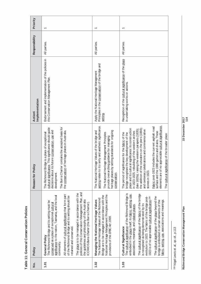
Ric
hmon
d B
ridg
e C
onse
rvat
ion
Man
agem
ent
Pla
n 15
Dec
embe
r 20
17
11
4
Tab
le 1
1: G
ener
al C
onse
rvat
ion
Pol
icie
s
No.
P
olic
y
Rea
son
for
Pol
icy
Act
ion\
Im
plem
enta
tion
R
espo
nsib
ility
P
rior
ity
1.01
G
ener
al P
olic
y T
he R
ichm
ond
Brid
ge a
nd it
s se
ttin
g m
ust
be
cons
erve
d as
a p
lace
of e
xcep
tiona
l cul
tura
l si
gnifi
canc
e to
the
nat
ion,
Tas
man
ia, a
nd t
he lo
cal
com
mun
ity.
All
elem
ents
of c
ultu
ral s
igni
fican
ce t
hat
form
par
t of
the
Ric
hmon
d Br
idge
and
its
sett
ing
shou
ld b
e re
tain
ed a
nd c
onse
rved
.
The
pla
ce is
to
be m
anag
ed in
acc
orda
nce
with
the
po
licie
s of
thi
s C
onse
rvat
ion
Man
agem
ent
Plan
, and
th
e gu
idel
ines
and
phi
loso
phy
of t
he A
ustr
alia
IC
OM
OS
Burr
a Ch
arte
r (th
e Bu
rra
Cha
rter
).
The
Ric
hmon
d Br
idge
is a
pla
ce o
f exc
eptio
nal
cultu
ral s
igni
fican
ce. T
his
signi
fican
ce s
houl
d gu
ide
deci
sions
abo
ut it
s fu
ture
con
serv
atio
n, u
se a
nd
deve
lopm
ent.
The
Burr
a C
hart
er c
onta
ins
the
acce
pted
bas
is fo
r th
e co
nser
vatio
n of
her
itage
pla
ces
in A
ustr
alia
.
Endo
rsem
ent
and
impl
emen
tatio
n of
the
pol
icie
s in
th
is C
onse
rvat
ion
Man
agem
ent
Plan
. A
ll pa
rtie
s.
1
1.02
M
anag
ing
the
Nat
iona
l Her
itag
e V
alue
s T
he N
atio
nal H
erita
ge V
alue
s of
the
Ric
hmon
d Br
idge
are
to
be m
anag
ed in
acc
orda
nce
with
the
N
atio
nal H
erita
ge M
anag
emen
t Pr
inci
ples
and
the
pr
ovisi
ons
of t
he E
PBC
Act 1
999.
The
Nat
iona
l Her
itage
Val
ues
of t
he b
ridg
e an
d se
ttin
g re
late
to
its r
arity
and
aes
thet
ic s
igni
fican
ce.
The
Nat
iona
l Her
itage
Man
agem
ent
Prin
cipl
es
prov
ide
over
arch
ing
guid
ance
for
man
agin
g he
rita
ge p
lace
s by
set
ting
stan
dard
s fo
r on
goin
g co
nser
vatio
n.
App
ly t
he N
atio
nal H
erita
ge M
anag
emen
t Pr
inci
ples
in t
he c
onse
rvat
ion
of t
he b
ridg
e an
d se
ttin
g.
All
part
ies.
1
1.03
C
ultu
ral S
igni
fican
ce
The
cul
tura
l sig
nific
ance
of t
he R
ichm
ond
Brid
ge is
em
bodi
ed in
the
pla
ce it
self,
its
fabr
ic, s
ettin
g, u
se,
asso
ciat
ions
, mea
ning
s, a
nd r
elat
ed p
lace
s.
The
cul
tura
l sig
nific
ance
of t
he fa
bric
of t
he b
ridg
e is
reco
gnise
d as
bei
ng d
emon
stra
ted
by it
s ev
olut
ion
to 1
923.
The
fabr
ic o
f the
bri
dge
post
-19
23 is
of n
o ap
prec
iabl
e cu
ltura
l sig
nific
ance
.228
The
cul
tura
l sig
nific
ance
of t
he p
lace
bey
ond
the
brid
ge is
em
bodi
ed in
cer
tain
ele
men
ts o
f the
fa
bric
, set
ting,
use
, ass
ocia
tions
and
mea
ning
s.
The
per
iod
of s
igni
fican
ce fo
r th
e fa
bric
of t
he
brid
ge r
ecog
nise
s th
e ke
y de
velo
pmen
t of
the
pl
ace
and
its c
ultu
ral s
igni
fican
ce: i
ts c
onst
ruct
ion
in 1
823-
1825
; reb
uild
ing
of t
he w
este
rn a
rche
s (la
te 1
820s
); ra
ising
the
wes
tern
par
apet
s (1
835)
; th
e ad
ditio
n of
the
cut
wat
ers
on th
e pi
ers
(188
4);
and
cent
enar
y ce
lebr
atio
ns a
nd c
omm
emor
ativ
e st
ones
in 1
923.
Fabr
ic p
ost-
1923
incl
udes
the
curr
ent
asph
alt
road
su
rfac
e an
d th
e 19
80 g
utte
rs a
nd d
rain
s. T
hese
el
emen
ts a
re o
f no
appr
ecia
ble
cultu
ral s
igni
fican
ce.
The
cul
tura
l sig
nific
ance
of t
he b
road
er p
lace
Rec
ogni
tion
of t
he c
ultu
ral s
igni
fican
ce o
f the
pla
ce
in u
nder
taki
ng w
orks
or
actio
ns.
All
part
ies.
1
228
Nig
el L
ewis
et.
al.,
op. c
it., p
.113
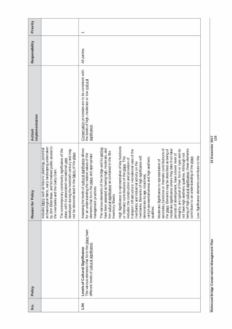
Ric
hmon
d B
ridg
e C
onse
rvat
ion
Man
agem
ent
Pla
n 15
Dec
embe
r 20
17
11
5
No.
P
olic
y
Rea
son
for
Pol
icy
Act
ion\
Im
plem
enta
tion
R
espo
nsib
ility
P
rior
ity
in
clud
es fa
bric
suc
h as
hist
oric
pla
ntin
gs, p
oten
tial
arch
aeol
ogic
al fa
bric
, ear
ly la
ndsc
apin
g un
dert
aken
by
John
Eld
ersh
aw, a
nd fo
rmal
ised
publ
ic a
cces
s to
th
e ri
verb
anks
and
the
Gat
ty D
am.
The
con
tem
pora
ry c
omm
unity
sig
nific
ance
of t
he
plac
e, w
ith it
s as
soci
ated
rec
reat
iona
l use
s de
velo
ped
duri
ng t
he t
wen
tieth
cen
tury
and
may
no
t be
dem
onst
rate
d in
the
fabr
ic o
f the
pla
ce.
1.04
Le
vels
of C
ultu
ral S
igni
fican
ce
The
var
ious
ele
men
ts t
hat
form
the
pla
ce h
ave
diffe
rent
leve
ls of
cul
tura
l sig
nific
ance
.
Ass
essin
g th
e le
vels
of c
ultu
ral s
igni
fican
ce a
llow
s fo
r an
und
erst
andi
ng t
he r
elat
ive
valu
es o
f the
el
emen
ts t
hat
form
the
pla
ce a
nd a
ppro
pria
te
man
agem
ent p
ract
ices
.
The
var
ious
ele
men
ts o
f the
bri
dge
and
its s
ettin
g ha
ve b
een
asse
ssed
as
havi
ng h
igh,
mod
erat
e, a
nd
low
cul
tura
l sig
nific
ance
as
cont
aine
d in
the
Site
In
vent
ory
Shee
ts.
Hig
h Si
gnifi
canc
e is
repr
esen
tativ
e of
key
func
tions
or
the
mat
ic c
ontr
ibut
ions
of t
he p
lace
. Thi
s in
clud
es: t
he c
onst
ruct
ion
and
prov
isio
n of
tr
ansp
ort i
nfra
stru
ctur
e; r
ecre
atio
nal u
ses
of t
he
rive
rban
ks; a
nd in
dust
rial
act
ivity
on
the
rive
rban
ks. E
lem
ents
of h
igh
signi
fican
ce w
ill
dem
onst
rate
its
age,
inta
ctne
ss,
rari
ty/r
epre
sent
ativ
enes
s an
d hi
gh a
esth
etic
qu
aliti
es.
Mod
erat
e Si
gnifi
canc
e is
repr
esen
tativ
e of
se
cond
ary
func
tions
or
them
atic
con
trib
utio
ns o
f th
e pl
ace.
Ele
men
ts m
ay b
e de
scrib
ed a
s be
ing
of
mod
erat
e si
gnifi
canc
e w
here
the
y da
te fr
om la
ter
peri
ods
of d
evel
opm
ent,
have
a lo
wer
leve
l of
inte
grity
, are
typ
ical
of t
heir
form
or
type
and
do
not
have
hig
h ae
sthe
tic q
ualit
ies.
Alth
ough
not
be
ing
of h
igh
cultu
ral s
igni
fican
ce, t
hese
ele
men
ts
cont
ribu
te t
o an
und
erst
andi
ng o
f the
pla
ce.
Low
Sig
nific
ance
ele
men
ts c
ontr
ibut
e to
the
Con
serv
atio
n pr
oces
ses
are
to b
e co
nsis
tent
with
th
e le
vels
of h
igh,
mod
erat
e or
low
cul
tura
l si
gnifi
canc
e.
All
part
ies.
1
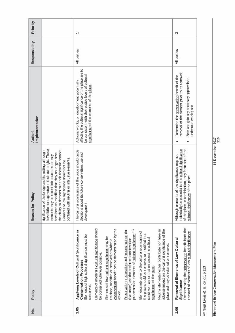
Ric
hmon
d B
ridg
e C
onse
rvat
ion
Man
agem
ent
Pla
n 15
Dec
embe
r 20
17
11
6
No.
P
olic
y
Rea
son
for
Pol
icy
Act
ion\
Im
plem
enta
tion
R
espo
nsib
ility
P
rior
ity
sign
ifica
nce
of t
he b
ridg
e an
d its
set
ting,
alth
ough
ha
ve li
ttle
her
itage
val
ue in
the
ir o
wn
righ
t. T
hese
el
emen
ts m
ay b
e re
cent
intr
oduc
tions
, or
may
ha
ve b
een
so m
odifi
ed t
hat
they
no
long
er h
ave
the
abili
ty t
o de
mon
stra
te t
heir
the
mat
ic c
onte
xt.
Elem
ents
of l
ow s
igni
fican
ce s
houl
d no
t be
co
nfus
ed w
ith n
eutr
al o
r in
trus
ive
elem
ents
.
1.05
A
pply
ing
Leve
ls o
f Cul
tura
l Sig
nific
ance
in
Con
serv
atio
n P
roce
sses
El
emen
ts o
f hig
h cu
ltura
l sig
nific
ance
mus
t be
co
nser
ved.
Elem
ents
of m
oder
ate
cultu
ral s
igni
fican
ce s
houl
d be
con
serv
ed w
here
ver
poss
ible
.
Elem
ents
of l
ow c
ultu
ral s
igni
fican
ce m
ay b
e re
tain
ed, m
odifi
ed o
r re
mov
ed p
rovi
ded
a co
nser
vatio
n be
nefit
can
be
dem
onst
rate
d by
the
actio
n.
Pres
erva
tion,
res
tora
tion
and
reco
nstr
uctio
n (in
th
at o
rder
) ar
e th
e pr
efer
red
cons
erva
tion
proc
esse
s fo
r el
emen
ts o
f cul
tura
l sig
nific
ance
.229
Elem
ents
intr
usiv
e to
the
cul
tura
l sig
nific
ance
of
the
plac
e sh
ould
be
rem
oved
or
mod
ified
in a
se
nsiti
ve m
anne
r th
at e
nhan
ces
the
cultu
ral
sign
ifica
nce
of t
he p
lace
.
Neu
tral
ele
men
ts n
eith
er c
ontr
ibut
e no
r ha
ve a
n ad
vers
e im
pact
on
the
cultu
ral s
igni
fican
ce o
f the
pl
ace
and
may
be
reta
ined
or
rem
oved
.
The
cul
tura
l sig
nific
ance
of t
he p
lace
sho
uld
guid
e de
cisio
ns a
bout
its
futu
re c
onse
rvat
ion,
use
and
de
velo
pmen
t.
Act
ions
, wor
ks, o
r de
velo
pmen
t po
tent
ially
af
fect
ing
the
cultu
ral s
igni
fican
ce o
f the
pla
ce a
re t
o be
con
sist
ent w
ith t
he r
elat
ive
leve
ls of
cul
tura
l si
gnifi
canc
e of
the
ele
men
ts o
f the
pla
ce.
All
part
ies.
1
1.06
R
emov
al o
f Ele
men
ts o
f Low
Cul
tura
l Si
gnifi
canc
e D
emon
stra
ting
the
cons
erva
tion
bene
fit fr
om t
he
rem
oval
of e
lem
ents
of l
ow c
ultu
ral s
igni
fican
ce
Alth
ough
ele
men
ts o
f low
sig
nific
ance
may
not
in
divi
dual
ly b
e es
sent
ial t
o th
e cu
ltura
l sig
nific
ance
of
the
pla
ce, i
n co
mbi
natio
n, t
hey
form
par
t of t
he
cultu
ral s
igni
fican
ce o
f the
pla
ce.
Det
erm
ine
the
cons
erva
tion
bene
fit o
f the
re
mov
al o
f the
ele
men
t pr
ior
to it
s re
mov
al;
Seek
and
gai
n an
y ne
cess
ary
appr
oval
s to
un
dert
ake
wor
ks; a
nd
All
part
ies.
3
229
Nig
el L
ewis
et.
al.,
op. c
it., p
.113
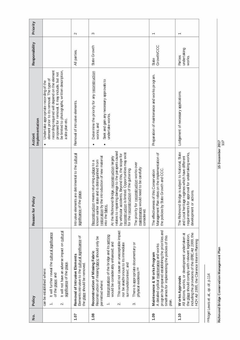
Ric
hmon
d B
ridg
e C
onse
rvat
ion
Man
agem
ent
Pla
n 15
Dec
embe
r 20
17
11
7
No.
P
olic
y
Rea
son
for
Pol
icy
Act
ion\
Im
plem
enta
tion
R
espo
nsib
ility
P
rior
ity
can
be e
stab
lishe
d w
here
:
1.It
will
furt
her
reve
al t
he c
ultu
ral s
igni
fican
ce
of t
he p
lace
; and
2.It
will
not
hav
e an
adv
erse
impa
ct o
n cu
ltura
l si
gnifi
canc
e of
the
pla
ce.
Und
erta
ke a
ppro
pria
te r
ecor
ding
of t
he
elem
ent
prio
r to
its
rem
oval
. The
typ
e of
re
cord
ing
requ
ired
will
dep
end
on t
he e
lem
ent
prop
osed
for
rem
oval
. It
may
incl
ude,
but
not
be
lim
ited
to p
hoto
grap
hs, w
ritt
en d
escr
iptio
n,
a sit
e pl
an e
tc.
1.07
R
emov
al o
f Int
rusi
ve E
lem
ents
El
emen
ts in
trus
ive
to t
he c
ultu
ral s
igni
fican
ce o
f th
e pl
ace
shou
ld b
e re
mov
ed.
Intr
usiv
e el
emen
ts a
re d
etri
men
tal t
o th
e cu
ltura
l si
gnifi
canc
e of
the
pla
ce.
Rem
oval
of i
ntru
sive
ele
men
ts.
All
part
ies.
2
1.08
R
econ
stru
ctio
n of
Mis
sing
Fab
ric
Rec
onst
ruct
ion
of m
issin
g fa
bric
sho
uld
only
be
perm
itted
whe
re:
1.In
terp
reta
tion
of t
he b
ridg
e an
d its
set
ting
wou
ld b
e co
nsid
erab
ly e
nhan
ced;
and
2.T
his
wou
ld n
ot c
ause
an
unac
cept
able
impa
ct
nor
be a
nach
rono
us t
o its
imm
edia
te
surr
ound
s/co
ntex
t; an
d
3.T
here
is a
ppro
pria
te d
ocum
enta
ry o
r ph
ysic
al e
vide
nce.
230
Rec
onst
ruct
ion
mea
ns r
etur
ning
a p
lace
to
a kn
own
earl
ier
stat
e an
d is
dist
ingu
ished
from
re
stor
atio
n by
the
intr
oduc
tion
of n
ew m
ater
ial
into
the
fabr
ic.
At
the
Ric
hmon
d Br
idge
, rec
onst
ruct
ion
larg
ely
rela
tes
to r
epai
ring
dam
age
to t
he p
arap
ets
caus
ed
by v
ehic
ular
acc
iden
ts. B
eyon
d th
is, t
he s
cope
for
reco
nstr
uctio
n is
limite
d. O
ppor
tuni
ties
may
exi
st
for
the
reco
nstr
uctio
n of
the
gut
teri
ng.
The
pri
ority
for
reco
nstr
uctio
n w
orks
ove
r m
aint
enan
ce w
ould
nee
d to
be
care
fully
co
nsid
ered
.
Det
erm
ine
the
prio
rity
for
any
reco
nstr
uctio
n w
orks
; and
Seek
and
gai
n an
y ne
cess
ary
appr
oval
s to
un
dert
ake
wor
ks.
Stat
e G
row
th
3
1.09
M
aint
enan
ce &
Wor
ks P
rogr
am
A d
etai
led
cycl
ical
mai
nten
ance
and
wor
ks
prog
ram
be
prep
ared
est
ablis
hing
the
pri
oriti
es a
nd
timef
ram
es fo
r im
plem
entin
g th
e po
licie
s of
thi
s pl
an.
The
effe
ctiv
enes
s of
thi
s C
onse
rvat
ion
Man
agem
ent
Plan
rel
ies
on t
he im
plem
enta
tion
of
the
polic
ies
by S
tate
Gro
wth
and
CC
C.
Prep
arat
ion
of m
aint
enan
ce a
nd w
orks
pro
gram
. St
ate
Gro
wth
/CC
C
1
1.10
W
orks
App
rova
ls
All
actio
ns, w
orks
, or
deve
lopm
ent
unde
rtak
en a
t th
e pl
ace
shou
ld c
ompl
y w
ith r
elev
ant
legi
slat
ion,
in
clud
ing
the
prov
isio
ns o
f the
EPB
C Ac
t 199
9, t
he
HCH
Act
199
5, t
he C
lare
nce
Inte
rim
Pla
nnin
g
The
Ric
hmon
d Br
idge
is s
ubje
ct t
o N
atio
nal,
Stat
e an
d Lo
cal h
erita
ge r
egim
es w
hich
hav
e di
ffere
nt
requ
irem
ents
for
appr
oval
for
unde
rtak
ing
wor
ks,
deve
lopm
ent
or a
ctio
ns.
Lodg
emen
t of
nec
essa
ry a
pplic
atio
ns.
Part
ies
unde
rtak
ing
wor
ks.
1
230 N
igel
Lew
is e
t. al
., op
. cit,
p.1
14
Ric
hmon
d B
ridg
e C
onse
rvat
ion
Man
agem
ent
Pla
n 15
Dec
embe
r 20
17
11
8
No.
P
olic
y
Rea
son
for
Pol
icy
Act
ion\
Im
plem
enta
tion
R
espo
nsib
ility
P
rior
ity
Sche
me
2015
and
the
Tas
man
ian
Plan
ning
Sch
eme
Stat
e Pl
anni
ng P
rovi
sion
s w
hen
they
com
e in
to
effe
ct.
Ric
hmon
d B
ridg
e C
onse
rvat
ion
Man
agem
ent
Pla
n 15
Dec
embe
r 20
17
11
9
6.4
Man
agem
ent
Syst
em o
f the
Ric
hmon
d B
ridg
e an
d Se
ttin
g A
s no
ted
in S
ectio
n 5,
the
Ric
hmon
d Br
idge
and
its
sett
ing
com
es u
nder
a c
ompl
ex m
anag
emen
t sy
stem
at
Nat
iona
l, St
ate
and
Loca
l Gov
ernm
ent
leve
ls. E
ach
auth
ority
has
diff
eren
t re
spon
sibi
litie
s fo
r th
e m
anag
emen
t of
the
bri
dge
and
the
vari
ous
elem
ents
of i
ts s
ettin
g.
The
Nat
iona
l Her
itage
list
ing
of t
he R
ichm
ond
Brid
ge e
ncou
rage
s a
coop
erat
ive
appr
oach
bet
wee
n th
e A
ustr
alia
n an
d T
asm
ania
n G
over
nmen
ts f
or t
he m
anag
emen
t of
the
Ric
hmon
d Br
idge
. O
n th
is b
asis
, it
has
been
rec
omm
ende
d th
at a
coo
rdin
ated
app
roac
h to
the
man
agem
ent
and
cons
erva
tion
of t
he R
ichm
ond
Brid
ge b
e ad
opte
d. T
he 2
010
Con
serv
atio
n M
anag
emen
t Pl
an r
ecom
men
ded
the
form
atio
n of
a m
anag
emen
t co
mm
ittee
as
a m
eans
of a
ddre
ssin
g th
e co
mpl
ex la
nd o
wne
rshi
p an
d m
anag
emen
t is
sues
and
invo
lvin
g th
e co
mm
unity
in
the
ong
oing
dec
isio
n m
akin
g an
d m
anag
emen
t of
the
bri
dge
and
sett
ing.
Lan
d ow
ners
hip
has
sim
plifi
ed s
ince
201
0, w
ith C
lare
nce
City
Cou
ncil
now
the
land
ow
ner
for
the
publ
icly
ac
cess
ible
riv
erba
nks.
Thi
s w
ill a
ssis
t in
con
sist
ent
deci
sion
mak
ing
for
thes
e ar
eas.
Bec
ause
of t
hese
cha
nges
, the
form
atio
n of
a s
peci
fic R
ichm
ond
Brid
ge m
anag
emen
t co
mm
ittee
may
be
less
use
ful.
Alth
ough
yet
to
com
e in
to e
ffect
, the
Tas
man
ian
Plan
ning
Sch
eme
Stat
e Pl
anni
ng P
rovi
sion
s w
ill r
esul
t in
the
rem
oval
of d
ual
appr
oval
s fr
om b
oth
the
Tas
man
ian
Her
itage
Cou
ncil
and
the
loca
l Pl
anni
ng A
utho
rity
whe
re t
he s
ame
plac
e is
reg
iste
red
at b
oth
Stat
e an
d lo
cal
leve
ls o
f m
anag
emen
t. O
ppor
tuni
ties
to m
aint
ain
loca
l in
volv
emen
t in
her
itage
man
agem
ent
shou
ld b
e co
nsid
ered
by
Cla
renc
e C
ity C
ounc
il, s
uch
as in
clus
ion
of t
he p
lace
as
a pr
ecin
ct o
r la
ndsc
ape
prec
inct
.
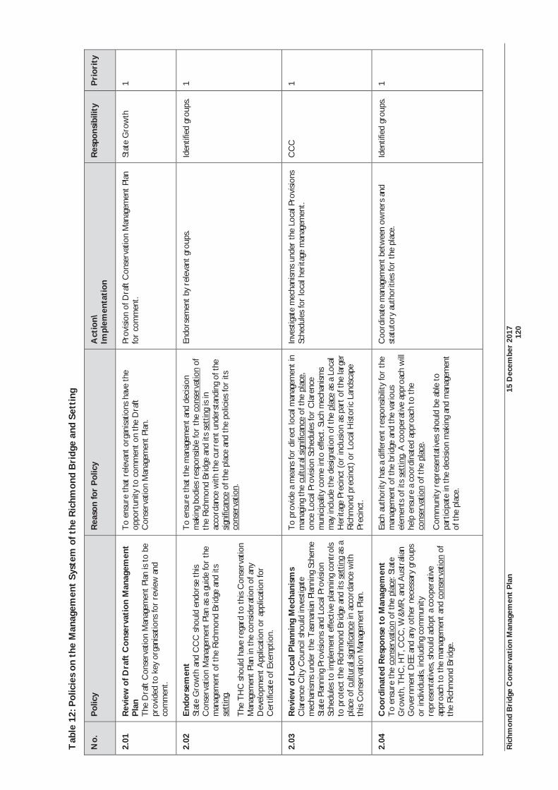
Ric
hmon
d B
ridg
e C
onse
rvat
ion
Man
agem
ent
Pla
n 15
Dec
embe
r 20
17
12
0
Tab
le 1
2: P
olic
ies
on t
he M
anag
emen
t Sy
stem
of t
he R
ichm
ond
Bri
dge
and
Sett
ing
No.
P
olic
y
Rea
son
for
Pol
icy
Act
ion\
Im
plem
enta
tion
R
espo
nsib
ility
P
rior
ity
2.01
R
evie
w o
f Dra
ft C
onse
rvat
ion
Man
agem
ent
Pla
n
The
Dra
ft C
onse
rvat
ion
Man
agem
ent
Plan
is t
o be
pr
ovid
ed t
o ke
y or
gani
satio
ns fo
r re
view
and
co
mm
ent.
To
ensu
re th
at r
elev
ant
orga
nisa
tions
hav
e th
e op
port
unity
to
com
men
t on
the
Dra
ft C
onse
rvat
ion
Man
agem
ent
Plan
.
Prov
isio
n of
Dra
ft C
onse
rvat
ion
Man
agem
ent
Plan
fo
r co
mm
ent.
Stat
e G
row
th
1
2.02
E
ndor
sem
ent
Stat
e G
row
th a
nd C
CC
sho
uld
endo
rse
this
Con
serv
atio
n M
anag
emen
t Pl
an a
s a
guid
e fo
r th
e m
anag
emen
t of t
he R
ichm
ond
Brid
ge a
nd it
s se
ttin
g.
The
TH
C s
houl
d ha
ve r
egar
d to
this
Con
serv
atio
n M
anag
emen
t Pl
an in
the
con
side
ratio
n of
any
D
evel
opm
ent
App
licat
ion
or a
pplic
atio
n fo
r C
ertif
icat
e of
Exe
mpt
ion.
To
ensu
re th
at t
he m
anag
emen
t an
d de
cisi
on
mak
ing
bodi
es r
espo
nsib
le fo
r th
e co
nser
vatio
n of
th
e R
ichm
ond
Brid
ge a
nd it
s se
ttin
g is
in
acco
rdan
ce w
ith t
he c
urre
nt u
nder
stan
ding
of t
he
sign
ifica
nce
of t
he p
lace
and
the
pol
icie
s fo
r its
co
nser
vatio
n.
Endo
rsem
ent
by r
elev
ant
grou
ps.
Iden
tifie
d gr
oups
. 1
2.03
R
evie
w o
f Loc
al P
lann
ing
Mec
hani
sms
Cla
renc
e C
ity C
ounc
il sh
ould
inve
stig
ate
mec
hani
sms
unde
r th
e T
asm
ania
n Pl
anni
ng S
chem
e St
ate
Plan
ning
Pro
visi
ons
and
Loca
l Pro
visi
on
Sche
dule
s to
impl
emen
t ef
fect
ive
plan
ning
con
trol
s to
pro
tect
the
Ric
hmon
d Br
idge
and
its
sett
ing
as a
pl
ace
of c
ultu
ral s
igni
fican
ce in
acc
orda
nce
with
th
is C
onse
rvat
ion
Man
agem
ent
Plan
.
To
prov
ide
a m
eans
for
dire
ct lo
cal m
anag
emen
t in
m
anag
ing
the
cultu
ral s
igni
fican
ce o
f the
pla
ce,
once
Loc
al P
rovi
sion
Sch
edul
es fo
r C
lare
nce
mun
icip
ality
com
e in
to e
ffect
. Suc
h m
echa
nism
s m
ay in
clud
e th
e de
sign
atio
n of
the
pla
ce a
s a
Loca
l H
erita
ge P
reci
nct
(or
incl
usio
n as
par
t of
the
larg
er
Ric
hmon
d pr
ecin
ct)
or L
ocal
Hist
oric
Lan
dsca
pe
Prec
inct
.
Inve
stig
ate
mec
hani
sms
unde
r th
e Lo
cal P
rovi
sion
s Sc
hedu
les
for
loca
l her
itage
man
agem
ent.
CC
C
1
2.04
C
oord
inat
ed R
espo
nse
to M
anag
emen
t
To
ensu
re th
e co
nser
vatio
n of
the
pla
ce: S
tate
G
row
th, T
HC
, HT
, CC
C, W
&M
R, a
nd A
ustr
alia
n G
over
nmen
t D
EE a
nd a
ny o
ther
nec
essa
ry g
roup
s or
indi
vidu
als,
incl
udin
g co
mm
unity
re
pres
enta
tives
, sho
uld
adop
t a
coop
erat
ive
appr
oach
to
the
man
agem
ent
and
cons
erva
tion
of
the
Ric
hmon
d Br
idge
.
Each
aut
hori
ty h
as a
diff
eren
t re
spon
sibi
lity
for
the
man
agem
ent o
f the
bri
dge
and
the
vari
ous
elem
ents
of i
ts s
ettin
g. A
coo
pera
tive
appr
oach
will
he
lp e
nsur
e a
coor
dina
ted
appr
oach
to
the
cons
erva
tion
of t
he p
lace
.
Com
mun
ity r
epre
sent
ativ
es s
houl
d be
abl
e to
pa
rtic
ipat
e in
the
dec
isio
n m
akin
g an
d m
anag
emen
t of
the
pla
ce.
Coo
rdin
ate
man
agem
ent
betw
een
owne
rs a
nd
stat
utor
y au
thor
ities
for
the
plac
e.
Iden
tifie
d gr
oups
. 1

Ric
hmon
d B
ridg
e C
onse
rvat
ion
Man
agem
ent
Pla
n 15
Dec
embe
r 20
17
12
1
No.
P
olic
y
Rea
son
for
Pol
icy
Act
ion\
Im
plem
enta
tion
R
espo
nsib
ility
P
rior
ity
2.05
C
omm
unit
y In
volv
emen
t M
etho
ds o
f inv
olvi
ng t
he c
omm
unity
in t
he o
ngoi
ng
man
agem
ent o
f the
Ric
hmon
d Br
idge
and
its
sett
ing
shou
ld b
e ex
plor
ed.
Reg
ular
eng
agem
ent
and
the
advi
ce o
f the
R
ichm
ond
Adv
isory
Com
mitt
ee s
houl
d be
sou
ght.
Stat
utor
y m
echa
nism
s ex
ist fo
r th
e co
mm
unity
to
com
men
t on
wor
ks m
atte
rs th
roug
h th
e H
istor
ic Cu
ltura
l Her
itage
Act
199
5 an
d th
e La
nd U
se P
lann
ing
and
Appr
oval
Act
199
3.
How
ever
, the
Ric
hmon
d co
mm
unity
has
de
mon
stra
ted
a st
rong
inte
rest
in t
he c
onse
rvat
ion
of t
he b
ridg
e an
d a
mor
e ho
listic
app
roac
h to
co
mm
unity
invo
lvem
ent
is d
esir
able
.
Inve
stig
ate
met
hods
for
com
mun
ity in
volv
emen
t in
th
e on
goin
g m
anag
emen
t of
the
Ric
hmon
d Br
idge
. In
clud
ing:
Act
ivel
y se
ekin
g th
e ad
vice
of t
he R
ichm
ond
Adv
isor
y C
omm
ittee
on
any
prop
osed
cha
nges
to
the
pla
ce r
equi
ring
a p
erm
it;
Publ
ic m
eetin
gs;
Publ
ic la
unch
of t
he r
epor
t on
the
co
nser
vatio
n of
the
pla
ce.
Stat
e G
row
th/C
CC
1
2.06
M
anag
emen
t of
Her
itag
e C
hara
cter
of
Ric
hmon
d C
lare
nce
City
Cou
ncil
has
prim
ary
resp
onsi
bilit
y fo
r m
anag
ing
the
cultu
ral s
igni
fican
ce o
f Ric
hmon
d as
a p
lace
.
Due
con
side
ratio
n is
to
be g
iven
to p
oten
tial
impa
cts
on t
he c
ultu
ral s
igni
fican
ce o
f the
R
ichm
ond
Brid
ge fr
om a
djac
ent
deve
lopm
ent,
or
deve
lopm
ent
that
may
hav
e an
impa
ct o
n im
port
ant
publ
ic v
iew
s to
the
Ric
hmon
d Br
idge
an
d its
set
ting.
The
Ric
hmon
d C
ultu
ral R
esou
rce
Man
agem
ent
Plan
sho
uld
be im
plem
ente
d to
ass
ist
in t
he m
anag
emen
t of t
he h
erita
ge c
hara
cter
of
Ric
hmon
d.
Dev
elop
men
t ou
tsid
e of
the
pla
ce t
hat
may
hav
e a
sign
ifica
nt im
pact
on
the
Nat
iona
l Her
itage
val
ues
of t
he R
ichm
ond
Brid
ge m
ay a
lso r
equi
re a
ppro
val
unde
r th
e EP
BC A
ct 1
999.
The
Ric
hmon
d Br
idge
and
its
sett
ing
is pa
rt o
f a
broa
der
tow
nsca
pe o
f cul
tura
l sig
nific
ance
. D
evel
opm
ent
with
in R
ichm
ond
has
the
pote
ntia
l to
have
impa
cts
on t
he c
ultu
ral s
igni
fican
ce o
f the
R
ichm
ond
Brid
ge a
nd it
s se
ttin
g, in
clud
ing
intr
udin
g on
impo
rtan
t pu
blic
vie
ws
of t
he p
lace
.
The
Ric
hmon
d C
ultu
ral R
esou
rce
Man
agem
ent
Plan
is t
he m
ost
thor
ough
and
det
aile
d pl
an fo
r th
e id
entif
icat
ion,
ass
essm
ent
and
man
agem
ent
of
cultu
ral h
erita
ge in
Ric
hmon
d.
The
EPB
C Ac
t 199
9 al
so e
xten
ds to
con
side
ring
ac
tions
occ
urri
ng o
utsi
de o
f a p
lace
if t
hey
have
th
e po
tent
ial t
o af
fect
the
Nat
iona
l Her
itage
V
alue
s.
Con
side
ratio
n of
pot
entia
l im
pact
s fr
om
adja
cent
dev
elop
men
t;
Ret
entio
n of
sig
nific
ant
publ
ic v
iew
s du
ring
de
velo
pmen
t;
Impl
emen
t R
ichm
ond
Cul
tura
l Res
ourc
e M
anag
emen
t Pl
an; a
nd
Ref
erra
l of a
ctio
ns u
nder
the
EPB
C Ac
t 199
9 w
here
wor
ks o
r de
velo
pmen
t m
ay r
esul
t in
po
tent
ial i
mpa
cts
on N
atio
nal H
erita
ge V
alue
s.
CC
C
1
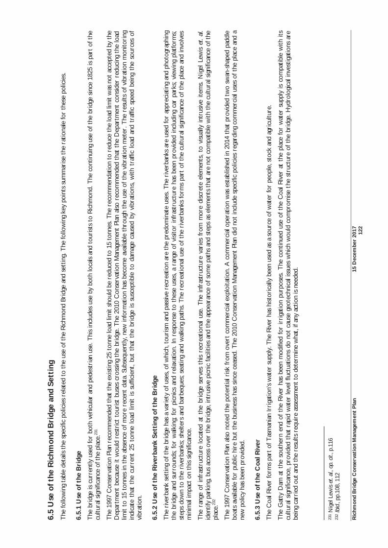
Ric
hmon
d B
ridg
e C
onse
rvat
ion
Man
agem
ent
Pla
n 15
Dec
embe
r 20
17
12
2
6.5
Use
of t
he R
ichm
ond
Bri
dge
and
Sett
ing
T
he fo
llow
ing
tabl
e de
tails
the
spe
cific
pol
icie
s re
late
d to
the
use
of t
he R
ichm
ond
Brid
ge a
nd s
ettin
g. T
he fo
llow
ing
key
poin
ts s
umm
aris
e th
e ra
tiona
le fo
r th
ese
polic
ies.
6.5.
1 U
se o
f the
Bri
dge
The
bri
dge
is c
urre
ntly
use
d fo
r bo
th v
ehic
ular
and
ped
estr
ian
use.
Thi
s in
clud
es u
se b
y bo
th lo
cals
and
tou
rist
s to
Ric
hmon
d. T
he c
ontin
uing
use
of t
he b
ridg
e si
nce
1825
is p
art
of t
he
cultu
ral s
igni
fican
ce o
f the
pla
ce.23
1
The
199
7 C
onse
rvat
ion
Plan
rec
omm
ende
d th
at t
he e
xist
ing
25 t
onne
load
lim
it sh
ould
be
redu
ced
to 1
5 to
nnes
. The
rec
omm
enda
tion
to r
educ
e th
e lo
ad li
mit
was
not
acc
epte
d by
the
D
epar
tmen
t be
caus
e it
wou
ld r
estr
ict
tour
ist
buse
s cr
ossi
ng t
he b
ridg
e. T
he 2
010
Con
serv
atio
n M
anag
emen
t Pl
an a
lso
reco
mm
ende
d th
at t
he D
epar
tmen
t co
nsid
er r
educ
ing
the
load
lim
it to
15
tonn
es in
the
abs
ence
of m
ore
rece
nt d
ata.
Sub
sequ
ently
, new
info
rmat
ion
has
beco
me
avai
labl
e th
roug
h th
e us
e of
the
vib
ratio
n m
eter
. The
res
ults
of v
ibra
tion
mon
itori
ng
indi
cate
tha
t th
e cu
rren
t 25
ton
ne l
oad
limit
is s
uffic
ient
, bu
t th
at t
he b
ridg
e is
susc
eptib
le t
o da
mag
e ca
used
by
vibr
atio
ns,
with
tra
ffic
load
and
tra
ffic
spee
d be
ing
the
sour
ces
of
vibr
atio
n.
6.5.
2 U
se o
f the
Riv
erba
nk S
etti
ng o
f the
Bri
dge
The
riv
erba
nk s
ettin
g of
the
bri
dge
has
a va
riet
y of
use
s, o
f whi
ch, t
ouri
sm a
nd p
assi
ve r
ecre
atio
n ar
e th
e pr
edom
inat
e us
es. T
he r
iver
bank
s ar
e us
ed fo
r ap
prec
iatin
g an
d ph
otog
raph
ing
the
brid
ge a
nd s
urro
unds
; for
wal
king
; for
pic
nics
and
rel
axat
ion.
In r
espo
nse
to t
hese
use
s, a
ran
ge o
f vis
itor
infr
astr
uctu
re h
as b
een
prov
ided
incl
udin
g ca
r pa
rks;
vie
win
g pl
atfo
rms;
st
eps
dow
n to
the
riv
erba
nks;
she
lters
and
bar
bequ
es; s
eatin
g an
d w
alki
ng p
aths
. The
rec
reat
iona
l use
of t
he r
iver
bank
s fo
rms
part
of t
he c
ultu
ral s
igni
fican
ce o
f the
pla
ce a
nd in
volv
es
min
imal
impa
ct o
n th
is s
igni
fican
ce.
The
ran
ge o
f in
fras
truc
ture
loc
ated
at
the
brid
ge s
erve
s th
is r
ecre
atio
nal
use.
The
inf
rast
ruct
ure
vari
es f
rom
mor
e di
scre
te e
lem
ents
, to
vis
ually
int
rusi
ve i
tem
s. N
igel
Lew
is e
t. al
. id
entif
y pa
rkin
g, b
us a
cces
s ov
er t
he b
ridg
e, in
trus
ive
picn
ic fa
cilit
ies
and
the
appe
aran
ce o
f som
e pa
ths
and
step
s as
ele
men
ts t
hat
are
not
com
patib
le w
ith t
he c
ultu
ral s
igni
fican
ce o
f the
pl
ace.
232
The
199
7 C
onse
rvat
ion
Plan
als
o no
ted
the
pote
ntia
l ris
k fr
om o
vert
com
mer
cial
exp
loita
tion.
A c
omm
erci
al o
pera
tion
was
est
ablis
hed
in 2
014
that
pro
vide
d tw
o sw
an-s
hape
d pa
ddle
bo
ats
avai
labl
e fo
r pu
blic
hir
e bu
t th
e bu
sine
ss h
as s
ince
cea
sed.
The
201
0 C
onse
rvat
ion
Man
agem
ent
Plan
did
not
incl
ude
spec
ific
polic
ies
rega
rdin
g co
mm
erci
al u
ses
of t
he p
lace
and
a
new
pol
icy
has
been
pro
vide
d.
6.5.
3 U
se o
f the
Coa
l Riv
er
The
Coa
l Riv
er fo
rms
part
of T
asm
ania
n Ir
riga
tion’
s w
ater
sup
ply.
The
Riv
er h
as h
isto
rica
lly b
een
used
as
a so
urce
of w
ater
for
peop
le, s
tock
and
agr
icul
ture
.
The
Gat
ty D
am a
t th
e so
uthe
rn e
nd o
f th
e R
iver
has
bee
n m
odifi
ed f
or ir
riga
tion
purp
oses
. T
he c
ontin
ued
use
of t
he C
oal R
iver
at
the
plac
e fo
r w
ater
sup
ply
is c
ompa
tible
with
its
cultu
ral s
igni
fican
ce, p
rovi
ded
that
rap
id w
ater
leve
l flu
ctua
tions
do
not
caus
e ge
otec
hnic
al is
sues
whi
ch w
ould
com
prom
ise
the
stru
ctur
e of
the
bri
dge.
Hyd
rolo
gica
l inv
estig
atio
ns a
re
bein
g ca
rrie
d ou
t an
d th
e re
sults
req
uire
ass
essm
ent
to d
eter
min
e w
hat,
if an
y ac
tion
is n
eede
d.
231
Nig
el L
ewis
et.
al.,
op. c
it., p
.116
23
2 Ib
id.,
pp.1
08, 1
12
Ric
hmon
d B
ridg
e C
onse
rvat
ion
Man
agem
ent
Pla
n 15
Dec
embe
r 20
17
12
3
The
Coa
l Riv
er w
as a
lso
hist
oric
ally
use
d fo
r sw
imm
ing,
with
the
con
stru
ctio
n of
the
Gat
ty D
am c
reat
ing
a sw
imm
ing
hole
. The
infe
stat
ion
of t
he a
rea
with
cra
ck w
illow
s re
sulte
d in
the
en
d of
thi
s us
e. T
he s
ocia
l val
ues
asse
ssm
ent
unde
rtak
en in
199
7 hi
ghlig
hted
tha
t th
is lo
ss o
f us
e ha
d an
adv
erse
effe
ct o
n th
e co
mm
unity
val
ues
of t
he p
lace
. Cra
ck w
illow
s in
the
vi
cini
ty o
f the
Dam
hav
e su
bseq
uent
ly b
een
rem
oved
but
req
uire
ong
oing
mon
itori
ng.
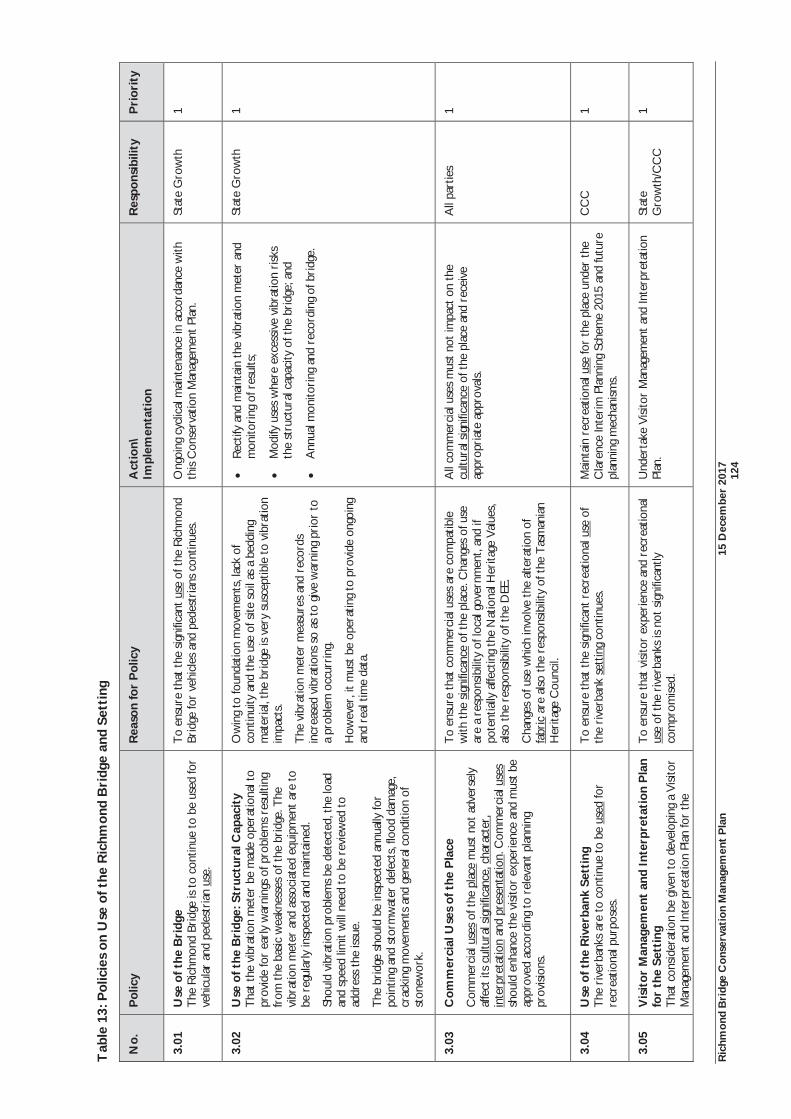
Ric
hmon
d B
ridg
e C
onse
rvat
ion
Man
agem
ent
Pla
n 15
Dec
embe
r 20
17
12
4
Tab
le 1
3: P
olic
ies
on U
se o
f the
Ric
hmon
d B
ridg
e an
d Se
ttin
g
No.
P
olic
y
Rea
son
for
Pol
icy
Act
ion\
Im
plem
enta
tion
R
espo
nsib
ility
P
rior
ity
3.01
U
se o
f the
Bri
dge
The
Ric
hmon
d Br
idge
is t
o co
ntin
ue t
o be
use
d fo
r ve
hicu
lar
and
pede
stri
an u
se.
To
ensu
re th
at t
he s
igni
fican
t us
e of
the
Ric
hmon
d Br
idge
for
vehi
cles
and
ped
estr
ians
con
tinue
s.
Ong
oing
cyc
lical
mai
nten
ance
in a
ccor
danc
e w
ith
this
Con
serv
atio
n M
anag
emen
t Pl
an.
Stat
e G
row
th
1
3.02
U
se o
f the
Bri
dge:
Str
uctu
ral C
apac
ity
T
hat
the
vibr
atio
n m
eter
be
mad
e op
erat
iona
l to
prov
ide
for
earl
y w
arni
ngs
of p
robl
ems
resu
lting
fr
om t
he b
asic
wea
knes
ses
of t
he b
ridg
e. T
he
vibr
atio
n m
eter
and
ass
ocia
ted
equi
pmen
t ar
e to
be
reg
ular
ly in
spec
ted
and
mai
ntai
ned.
Shou
ld v
ibra
tion
prob
lem
s be
det
ecte
d, t
he lo
ad
and
spee
d lim
it w
ill n
eed
to b
e re
view
ed t
o ad
dres
s th
e iss
ue.
The
bri
dge
shou
ld b
e in
spec
ted
annu
ally
for
poin
ting
and
stor
mw
ater
def
ects
, flo
od d
amag
e,
crac
king
mov
emen
ts a
nd g
ener
al c
ondi
tion
of
ston
ewor
k.
Ow
ing
to fo
unda
tion
mov
emen
ts, l
ack
of
cont
inui
ty a
nd t
he u
se o
f site
soi
l as
a be
ddin
g m
ater
ial,
the
brid
ge is
ver
y su
scep
tible
to
vibr
atio
n im
pact
s.
The
vib
ratio
n m
eter
mea
sure
s an
d re
cord
s in
crea
sed
vibr
atio
ns s
o as
to
give
war
ning
pri
or t
o a
prob
lem
occ
urri
ng.
How
ever
, it
mus
t be
ope
ratin
g to
pro
vide
ong
oing
an
d re
al t
ime
data
.
Rec
tify
and
mai
ntai
n th
e vi
brat
ion
met
er a
nd
mon
itori
ng o
f res
ults
;
Mod
ify u
ses
whe
re e
xces
sive
vib
ratio
n ri
sks
the
stru
ctur
al c
apac
ity o
f the
bri
dge;
and
Ann
ual m
onito
ring
and
rec
ordi
ng o
f bri
dge.
Stat
e G
row
th
1
3.03
C
omm
erci
al U
ses
of t
he P
lace
Com
mer
cial
use
s of
the
pla
ce m
ust
not
adve
rsel
y af
fect
its
cultu
ral s
igni
fican
ce, c
hara
cter
, in
terp
reta
tion
and
pres
enta
tion.
Com
mer
cial
use
s sh
ould
enh
ance
the
vis
itor
expe
rien
ce a
nd m
ust
be
appr
oved
acc
ordi
ng t
o re
leva
nt p
lann
ing
prov
ision
s.
To
ensu
re th
at c
omm
erci
al u
ses
are
com
patib
le
with
the
sig
nific
ance
of t
he p
lace
. Cha
nges
of u
se
are
a re
spon
sibi
lity
of lo
cal g
over
nmen
t, an
d if
pote
ntia
lly a
ffect
ing
the
Nat
iona
l Her
itage
Val
ues,
al
so t
he r
espo
nsib
ility
of t
he D
EE.
Cha
nges
of u
se w
hich
invo
lve
the
alte
ratio
n of
fa
bric
are
also
the
res
pons
ibili
ty o
f the
Tas
man
ian
Her
itage
Cou
ncil.
All
com
mer
cial
use
s m
ust
not
impa
ct o
n th
e cu
ltura
l sig
nific
ance
of t
he p
lace
and
rec
eive
ap
prop
riat
e ap
prov
als.
All
part
ies
1
3.04
U
se o
f the
Riv
erba
nk S
etti
ng
The
riv
erba
nks
are
to c
ontin
ue t
o be
use
d fo
r re
crea
tiona
l pur
pose
s.
To
ensu
re th
at t
he s
igni
fican
t re
crea
tiona
l use
of
the
rive
rban
k se
ttin
g co
ntin
ues.
M
aint
ain
recr
eatio
nal u
se fo
r th
e pl
ace
unde
r th
e C
lare
nce
Inte
rim
Pla
nnin
g Sc
hem
e 20
15 a
nd fu
ture
pl
anni
ng m
echa
nism
s.
CC
C
1
3.05
V
isit
or M
anag
emen
t an
d In
terp
reta
tion
Pla
n fo
r th
e Se
ttin
g T
hat
cons
ider
atio
n be
giv
en t
o de
velo
ping
a V
isito
r M
anag
emen
t an
d In
terp
reta
tion
Plan
for
the
To
ensu
re th
at v
isito
r ex
peri
ence
and
rec
reat
iona
l us
e of
the
riv
erba
nks
is no
t sig
nific
antly
co
mpr
omis
ed.
Und
erta
ke V
isito
r M
anag
emen
t an
d In
terp
reta
tion
Plan
. St
ate
Gro
wth
/CC
C
1
Ric
hmon
d B
ridg
e C
onse
rvat
ion
Man
agem
ent
Pla
n 15
Dec
embe
r 20
17
12
5
No.
P
olic
y
Rea
son
for
Pol
icy
Act
ion\
Im
plem
enta
tion
R
espo
nsib
ility
P
rior
ity
Ric
hmon
d Br
idge
and
its
sett
ing.
The
Visi
tor
Man
agem
ent
Plan
sho
uld
cons
ider
the
nee
ds o
f the
m
obili
ty im
pair
ed a
nd a
cces
s to
the
bri
dge
and
sett
ing.
For
con
sist
ency
in a
ppro
ach
and
stra
tegi
es,
it w
ould
be
usef
ul t
o co
nsid
er a
Visi
tor
Man
agem
ent
and
Inte
rpre
tatio
n Pl
an fo
r R
ichm
ond
as a
who
le, i
nclu
sive
of t
he b
ridg
e an
d ri
verb
ank
sett
ing.
The
Visi
tor
Man
agem
ent
Plan
sho
uld
also
co
nsid
er t
ouri
st v
ehic
le a
nd p
edes
tria
n m
ovem
ents
/rou
tes
thro
ugh
Ric
hmon
d.
3.06
U
se o
f the
Coa
l Riv
er
The
Coa
l Riv
er c
ontin
ue t
o be
use
d in
a
sust
aina
ble
man
ner
for
wat
er s
uppl
y as
a
com
patib
le u
se. T
he a
naly
sis o
f hyd
rolo
gica
l in
vest
igat
ions
is r
equi
red
to d
eter
min
e an
y ge
otec
hnic
al is
sues
at
the
brid
ge a
ssoc
iate
d w
ith
rapi
d w
ater
fluc
tuat
ions
at
the
brid
ge.
The
use
of t
he C
oal R
iver
for
wat
er s
uppl
y pu
rpos
es in
volv
es n
o, o
r m
inim
al im
pact
on
the
cultu
ral s
igni
fican
ce o
f the
pla
ce. H
owev
er, t
his
shou
ld b
e co
nfir
med
thr
ough
hyd
rolo
gica
l in
vest
igat
ions
.
The
man
agem
ent
of w
ater
flow
in t
he r
iver
at
the
Ric
hmon
d Br
idge
may
req
uire
rev
iew
follo
win
g an
alys
is of
the
hyd
rolo
gica
l ass
essm
ent.
Stat
e G
row
th/
Tas
man
ian
Irri
gatio
n/C
CC
/W
&M
R, D
PIPW
E
1

Ric
hmon
d B
ridg
e C
onse
rvat
ion
Man
agem
ent
Pla
n 15
Dec
embe
r 20
17
12
6
6.6
Man
agin
g th
e Fa
bric
of t
he R
ichm
ond
Bri
dge
The
fol
low
ing
two
tabl
es d
etai
l the
spe
cific
pol
icie
s re
late
d to
man
agin
g th
e fa
bric
of
the
Ric
hmon
d Br
idge
. The
pol
icie
s pr
ovid
e bo
th b
road
and
det
aile
d ap
proa
ches
to
man
agin
g th
e fa
bric
and
hav
e be
en s
truc
ture
d ac
cord
ing
to t
heir
pri
ority
. The
hig
hest
pri
ority
has
bee
n gi
ven
to t
hose
pol
icie
s th
at a
ddre
ss t
he w
eakn
esse
s of
the
bri
dge
and
will
ass
ist
in p
reve
ntin
g fu
rthe
r da
mag
e. S
econ
dary
pol
icie
s ha
ve b
een
prov
ided
for
long
er t
erm
issu
es s
uch
as m
aint
enan
ce, r
ecor
ding
and
aes
thet
ic c
onsi
dera
tions
.
The
fol
low
ing
sect
ions
pro
vide
an
over
view
of
the
brid
ge a
nd i
ts k
ey c
onse
rvat
ion
issu
es.
It in
clud
es d
ocum
enta
tion
from
pre
viou
s in
vest
igat
ions
, an
d ne
w s
tudi
es t
hat
have
bee
n co
mpl
eted
sin
ce 2
010.
6.6.
1 T
he G
eolo
gy o
f the
Sit
e an
d it
s E
ffect
s on
the
Bri
dge
A s
truc
tura
l ass
essm
ent
of t
he b
ridg
e fo
rmed
par
t of
the
199
7 C
onse
rvat
ion
Plan
, but
has
not
bee
n re
peat
ed s
ince
. The
ass
essm
ent
prep
ared
by
Pete
r Sp
ratt
& A
ssoc
iate
s be
gan
by
inve
stig
atin
g th
e ge
olog
y of
the
bri
dge
cros
sing
site
. The
bri
dge
is lo
cate
d ac
ross
a n
arro
w in
cise
d va
lley
cut
by t
he C
oal R
iver
in s
oft
sedi
men
ts b
etw
een
two
hard
roc
k ba
rrie
rs. T
he
uppe
r up
stre
am b
arri
er is
bas
alt.
The
low
er r
ock
barr
ier
is d
oler
ite. T
he u
pper
bas
alt
barr
ier
has
retr
eate
d up
stre
am. L
ag d
epos
its o
f ter
race
gra
vels
, silt
s an
d fin
e sa
nds
are
deve
lope
d do
wns
trea
m o
f the
ret
reat
ing
basa
lt. T
he t
erra
ce s
ilts
and
sand
s ar
e ea
sily
ero
ded,
whi
ch S
prat
t de
term
ined
was
pro
babl
y th
e re
ason
why
the
riv
erbe
d be
twee
n th
e pi
ers
was
pav
ed in
18
84. F
urth
er, t
he m
ovem
ent
in t
hese
sed
imen
ts a
fter
cons
truc
tion
prob
ably
acc
ount
s fo
r th
e un
dula
tions
acr
oss
the
brid
ge.
The
geo
logi
cal
cond
ition
app
eare
d to
be
a ke
y is
sue
for
the
stru
ctur
al d
isto
rtio
ns t
o th
e br
idge
. Fo
r ex
ampl
e, t
he p
oor
foun
datio
n co
nditi
ons
wer
e lik
ely
caus
es o
f th
e hi
stor
y of
cr
acki
ng a
t ea
ch e
nd o
f the
bri
dge,
and
the
und
erm
inin
g of
the
pie
rs. H
owev
er, a
t th
at t
ime,
the
geo
tech
nica
l con
ditio
ns o
f the
gro
und
near
the
bri
dge
rem
aine
d un
know
n, a
nd S
prat
t re
com
men
ded
thes
e w
orks
sho
uld
occu
r. 2
33
The
nee
d fo
r a
geot
echn
ical
inv
estig
atio
n w
as i
dent
ified
in
the
2010
Con
serv
atio
n M
anag
emen
t Pl
an.
The
se w
orks
wer
e co
mpl
eted
in
2017
, fo
llow
ing
the
iden
tific
atio
n of
rap
idly
ch
angi
ng w
ater
leve
ls r
esul
ting
from
ext
ract
ion
of w
ater
for
irri
gatio
n. A
ris
k w
as id
entif
ied
that
the
se w
ater
leve
l flu
ctua
tions
may
be
adve
rsel
y af
fect
ing
the
inte
grity
of t
he fo
unda
tion
mat
eria
ls (i
.e.,
the
natu
ral s
ubsu
rfac
e m
ater
ials
whi
ch s
uppo
rt t
he c
onst
ruct
ed b
ridg
e fo
otin
gs).23
4
Geo
tech
nica
l dr
illin
g w
as c
arri
ed o
ut i
n ea
rly
2017
at
seve
n si
tes
betw
een
the
arch
es o
f th
e br
idge
. V
ertic
al d
rilli
ng w
as u
nder
take
n at
a n
umbe
r of
pla
ces
to n
omin
al d
epth
s of
10
met
res
bene
ath
the
arch
es, a
nd a
ngle
d dr
illin
g ca
rrie
d ou
t be
neat
h pi
ers
2 an
d 4
to t
est
the
foot
ings
of t
he t
wo
pier
s.23
5
The
dri
lling
gen
eral
ly s
uppo
rts
the
publ
ished
geo
logy
of t
he a
rea,
sho
win
g 1-
3 m
etre
s of
Qua
tern
ary
allu
vium
with
in t
he r
iver
cha
nnel
, ove
rlyi
ng c
lays
and
san
ds t
o de
pths
of a
t le
ast
10
met
res
whi
ch a
re in
ferr
ed t
o be
Ter
tiary
in a
ge.
Ang
led
test
dri
lling
was
car
ried
out
at
four
site
s be
neat
h pi
ers
and
2 an
d 4.
The
dri
ll fu
lly r
ecov
ered
the
san
dsto
ne b
lock
s an
d m
orta
r (w
here
pre
sent
) of t
he fo
otin
gs.23
6
Full
core
rec
over
y of
san
dsto
ne b
lock
s an
d in
terv
enin
g m
orta
r (w
here
pre
sent
) is
tho
ught
to
have
bee
n ac
hiev
ed. W
here
no
core
was
rec
over
ed fr
om d
rilli
ng, i
t ha
s be
en a
ssum
ed t
hat
sand
ston
e fo
otin
gs w
ere
abse
nt, a
nd t
he n
on-r
ecov
ered
mat
eria
l was
loos
e al
luvi
um. O
n th
is b
asis
, san
dsto
ne fo
otin
gs w
ere
not
enco
unte
red
in d
rill
hole
s at
ver
tical
dep
ths
(rel
ativ
e to
233
Spra
tt in
Nig
el L
ewis
et.
al.,
op. c
it, A
ppen
dix
Four
– S
truc
tura
l Ana
lysis
23
4 C
rom
er, W
C, D
epar
tmen
t of S
tate
Gro
wth
: Rich
mon
d Br
idge
, Rich
mon
d Ta
sman
ia. G
eote
chni
cal D
rillin
g of
Foo
tings
and
Fou
ndat
ions
: Int
erim
Rep
ort,
Apr
il 5
2017
, p.3
23
5 Ib
id, o
p. c
it., p
p.7-
8 23
6 Ib
id, p
p.11
-12
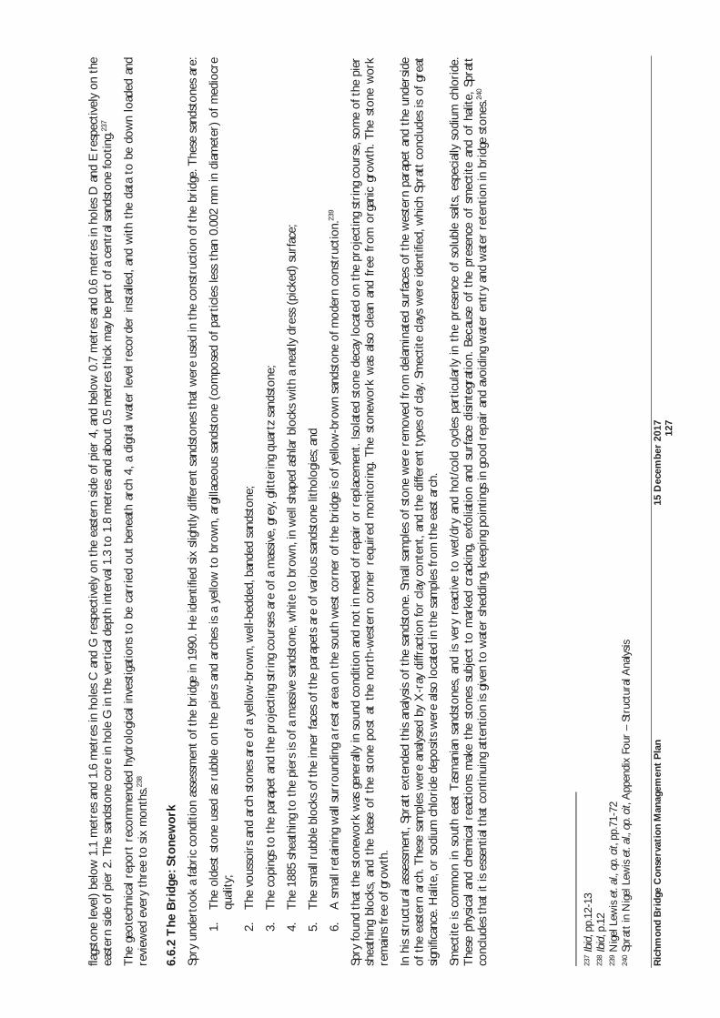
Ric
hmon
d B
ridg
e C
onse
rvat
ion
Man
agem
ent
Pla
n 15
Dec
embe
r 20
17
12
7
flags
tone
leve
l) be
low
1.1
met
res
and
1.6
met
res
in h
oles
C a
nd G
res
pect
ivel
y on
the
eas
tern
sid
e of
pie
r 4,
and
bel
ow 0
.7 m
etre
s an
d 0.
6 m
etre
s in
hol
es D
and
E r
espe
ctiv
ely
on t
he
east
ern
side
of p
ier
2. T
he s
ands
tone
cor
e in
hol
e G
in t
he v
ertic
al d
epth
inte
rval
1.3
to
1.8
met
res
and
abou
t 0.
5 m
etre
s th
ick
may
be
part
of a
cen
tral
san
dsto
ne fo
otin
g.23
7
The
geo
tech
nica
l rep
ort
reco
mm
ende
d hy
drol
ogic
al in
vest
igat
ions
to
be c
arri
ed o
ut b
enea
th a
rch
4, a
dig
ital w
ater
leve
l rec
orde
r in
stal
led,
and
with
the
dat
a to
be
dow
n lo
aded
and
re
view
ed e
very
thr
ee t
o si
x m
onth
s.23
8
6.6.
2 T
he B
ridg
e: S
tone
wor
k
Spry
und
erto
ok a
fabr
ic c
ondi
tion
asse
ssm
ent
of t
he b
ridg
e in
199
0. H
e id
entif
ied
six
slig
htly
diff
eren
t sa
ndst
ones
tha
t w
ere
used
in t
he c
onst
ruct
ion
of t
he b
ridg
e. T
hese
san
dsto
nes
are:
1.T
he o
ldes
t st
one
used
as
rubb
le o
n th
e pi
ers
and
arch
es is
a y
ello
w t
o br
own,
arg
illac
eous
san
dsto
ne (
com
pose
d of
par
ticle
s le
ss t
han
0.00
2 m
m in
dia
met
er)
of m
edio
cre
qual
ity;
2.T
he v
ouss
oirs
and
arc
h st
ones
are
of a
yel
low
-bro
wn,
wel
l-bed
ded,
ban
ded
sand
ston
e;
3.T
he c
opin
gs t
o th
e pa
rape
t an
d th
e pr
ojec
ting
stri
ng c
ours
es a
re o
f a m
assi
ve, g
rey,
glit
teri
ng q
uart
z sa
ndst
one;
4.T
he 1
885
shea
thin
g to
the
pie
rs is
of a
mas
sive
san
dsto
ne, w
hite
to
brow
n, in
wel
l sha
ped
ashl
ar b
lock
s w
ith a
nea
tly d
ress
(pi
cked
) su
rfac
e;
5.T
he s
mal
l rub
ble
bloc
ks o
f the
inne
r fa
ces
of t
he p
arap
ets
are
of v
ario
us s
ands
tone
lith
olog
ies;
and
6.A
sm
all r
etai
ning
wal
l sur
roun
ding
a r
est
area
on
the
sout
h w
est
corn
er o
f the
bri
dge
is o
f yel
low
-bro
wn
sand
ston
e of
mod
ern
cons
truc
tion.
239
Spry
foun
d th
at t
he s
tone
wor
k w
as g
ener
ally
in s
ound
con
ditio
n an
d no
t in
nee
d of
rep
air
or r
epla
cem
ent.
Isol
ated
sto
ne d
ecay
loca
ted
on t
he p
roje
ctin
g st
ring
cou
rse,
som
e of
the
pie
r sh
eath
ing
bloc
ks,
and
the
base
of
the
ston
e po
st a
t th
e no
rth-
wes
tern
cor
ner
requ
ired
mon
itori
ng.
The
sto
new
ork
was
als
o cl
ean
and
free
fro
m o
rgan
ic g
row
th.
The
sto
ne w
ork
rem
ains
free
of g
row
th.
In h
is s
truc
tura
l ass
essm
ent,
Spra
tt e
xten
ded
this
anal
ysis
of t
he s
ands
tone
. Sm
all s
ampl
es o
f sto
ne w
ere
rem
oved
from
del
amin
ated
sur
face
s of
the
wes
tern
par
apet
and
the
und
ersi
de
of t
he e
aste
rn a
rch.
The
se s
ampl
es w
ere
anal
ysed
by
X-r
ay d
iffra
ctio
n fo
r cl
ay c
onte
nt, a
nd t
he d
iffer
ent
type
s of
cla
y. S
mec
tite
clay
s w
ere
iden
tifie
d, w
hich
Spr
att
conc
lude
s is
of g
reat
si
gnifi
canc
e. H
alite
, or
sodi
um c
hlor
ide
depo
sits
wer
e al
so lo
cate
d in
the
sam
ples
from
the
eas
t ar
ch.
Smec
tite
is c
omm
on in
sou
th e
ast
Tas
man
ian
sand
ston
es, a
nd is
ver
y re
activ
e to
wet
/dry
and
hot
/col
d cy
cles
par
ticul
arly
in t
he p
rese
nce
of s
olub
le s
alts
, esp
ecia
lly s
odiu
m c
hlor
ide.
T
hese
phy
sica
l an
d ch
emic
al r
eact
ions
mak
e th
e st
ones
sub
ject
to
mar
ked
crac
king
, ex
folia
tion
and
surf
ace
disi
nteg
ratio
n. B
ecau
se o
f th
e pr
esen
ce o
f sm
ectit
e an
d of
hal
ite,
Spra
tt
conc
lude
s th
at it
is e
ssen
tial t
hat
cont
inui
ng a
tten
tion
is g
iven
to
wat
er s
hedd
ing,
kee
ping
poi
ntin
gs in
goo
d re
pair
and
avo
idin
g w
ater
ent
ry a
nd w
ater
ret
entio
n in
bri
dge
ston
es.24
0
237
Ibid
, pp.
12-1
3 23
8 Ib
id, p
.12
239
Nig
el L
ewis
et.
al.,
op. c
it, p
p.71
-72
240
Spra
tt in
Nig
el L
ewis
et.
al.,
op. c
it, A
ppen
dix
Four
– S
truc
tura
l Ana
lysis
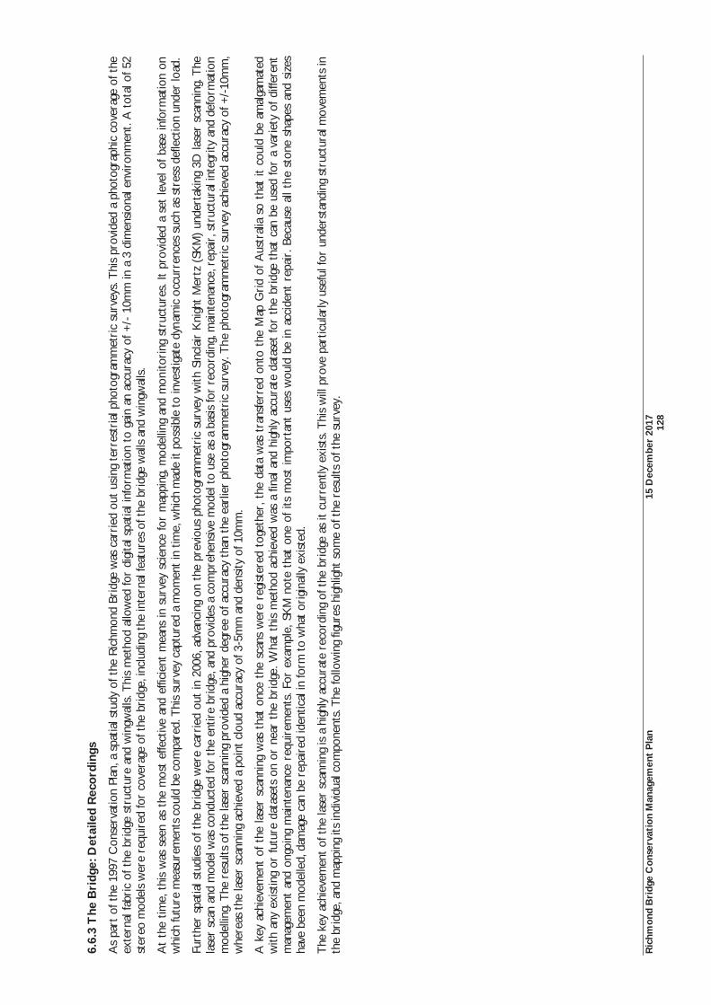
Ric
hmon
d B
ridg
e C
onse
rvat
ion
Man
agem
ent
Pla
n 15
Dec
embe
r 20
17
12
8
6.6.
3 T
he B
ridg
e: D
etai
led
Rec
ordi
ngs
As
part
of t
he 1
997
Con
serv
atio
n Pl
an, a
spa
tial s
tudy
of t
he R
ichm
ond
Brid
ge w
as c
arri
ed o
ut u
sing
ter
rest
rial
pho
togr
amm
etri
c su
rvey
s. T
his
prov
ided
a p
hoto
grap
hic
cove
rage
of t
he
exte
rnal
fabr
ic o
f the
bri
dge
stru
ctur
e an
d w
ingw
alls
. Thi
s m
etho
d al
low
ed fo
r di
gita
l spa
tial i
nfor
mat
ion
to g
ain
an a
ccur
acy
of +
/- 1
0mm
in a
3 d
imen
sion
al e
nvir
onm
ent.
A t
otal
of 5
2 st
ereo
mod
els
wer
e re
quir
ed fo
r co
vera
ge o
f the
bri
dge,
incl
udin
g th
e in
tern
al fe
atur
es o
f the
bri
dge
wal
ls a
nd w
ingw
alls
.
At
the
time,
thi
s w
as s
een
as t
he m
ost
effe
ctiv
e an
d ef
ficie
nt m
eans
in s
urve
y sc
ienc
e fo
r m
appi
ng, m
odel
ling
and
mon
itori
ng s
truc
ture
s. It
pro
vide
d a
set
leve
l of b
ase
info
rmat
ion
on
whi
ch fu
ture
mea
sure
men
ts c
ould
be
com
pare
d. T
his
surv
ey c
aptu
red
a m
omen
t in
tim
e, w
hich
mad
e it
poss
ible
to
inve
stig
ate
dyna
mic
occ
urre
nces
suc
h as
str
ess
defle
ctio
n un
der
load
.
Furt
her
spat
ial s
tudi
es o
f the
bri
dge
wer
e ca
rrie
d ou
t in
200
6, a
dvan
cing
on
the
prev
ious
pho
togr
amm
etri
c su
rvey
with
Sin
clai
r K
nigh
t M
ertz
(SK
M)
unde
rtak
ing
3D la
ser
scan
ning
. The
la
ser
scan
and
mod
el w
as c
ondu
cted
for
the
entir
e br
idge
, and
pro
vide
s a
com
preh
ensi
ve m
odel
to
use
as a
bas
is fo
r re
cord
ing,
mai
nten
ance
, rep
air,
str
uctu
ral i
nteg
rity
and
def
orm
atio
n m
odel
ling.
The
res
ults
of t
he la
ser
scan
ning
pro
vide
d a
high
er d
egre
e of
acc
urac
y th
an t
he e
arlie
r ph
otog
ram
met
ric
surv
ey. T
he p
hoto
gram
met
ric
surv
ey a
chie
ved
accu
racy
of +
/-10
mm
, w
here
as t
he la
ser
scan
ning
ach
ieve
d a
poin
t cl
oud
accu
racy
of 3
-5m
m a
nd d
ensi
ty o
f 10m
m.
A k
ey a
chie
vem
ent
of t
he la
ser
scan
ning
was
tha
t on
ce t
he s
cans
wer
e re
gist
ered
tog
ethe
r, t
he d
ata
was
tra
nsfe
rred
ont
o th
e M
ap G
rid
of A
ustr
alia
so
that
it c
ould
be
amal
gam
ated
w
ith a
ny e
xist
ing
or fu
ture
dat
aset
s on
or
near
the
bri
dge.
Wha
t th
is m
etho
d ac
hiev
ed w
as a
fina
l and
hig
hly
accu
rate
dat
aset
for
the
brid
ge t
hat
can
be u
sed
for
a va
riet
y of
diff
eren
t m
anag
emen
t an
d on
goin
g m
aint
enan
ce r
equi
rem
ents
. For
exa
mpl
e, S
KM
not
e th
at o
ne o
f its
mos
t im
port
ant
uses
wou
ld b
e in
acc
iden
t re
pair
. Bec
ause
all
the
ston
e sh
apes
and
siz
es
have
bee
n m
odel
led,
dam
age
can
be r
epai
red
iden
tical
in fo
rm t
o w
hat
orig
inal
ly e
xist
ed.
The
key
ach
ieve
men
t of
the
lase
r sc
anni
ng is
a h
ighl
y ac
cura
te r
ecor
ding
of t
he b
ridg
e as
it c
urre
ntly
exi
sts.
Thi
s w
ill p
rove
par
ticul
arly
use
ful f
or u
nder
stan
ding
str
uctu
ral m
ovem
ents
in
the
brid
ge, a
nd m
appi
ng it
s in
divi
dual
com
pone
nts.
The
follo
win
g fig
ures
hig
hlig
ht s
ome
of t
he r
esul
ts o
f the
sur
vey.
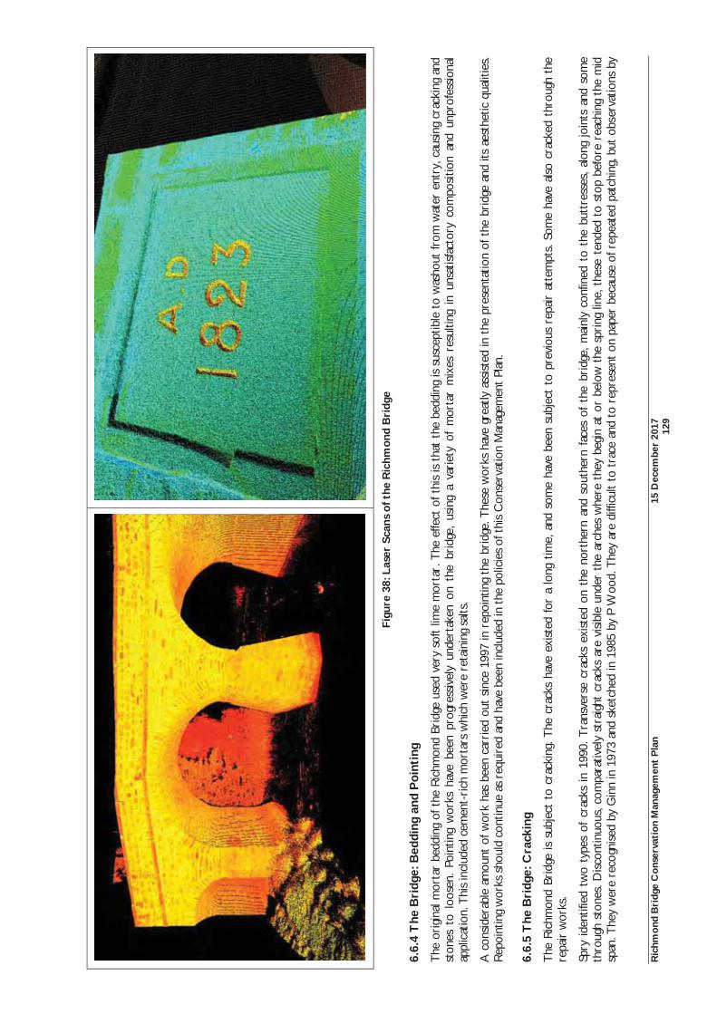
Ric
hmon
d B
ridg
e C
onse
rvat
ion
Man
agem
ent
Pla
n 15
Dec
embe
r 20
17
12
9
Figu
re 3
8: L
aser
Sca
ns o
f the
Ric
hmon
d B
ridg
e
6.6.
4 T
he B
ridg
e: B
eddi
ng a
nd P
oint
ing
The
ori
gina
l mor
tar
bedd
ing
of t
he R
ichm
ond
Brid
ge u
sed
very
sof
t lim
e m
orta
r. T
he e
ffect
of t
his
is t
hat
the
bedd
ing
is s
usce
ptib
le t
o w
asho
ut fr
om w
ater
ent
ry, c
ausi
ng c
rack
ing
and
ston
es t
o lo
osen
. Po
intin
g w
orks
hav
e be
en p
rogr
essi
vely
und
erta
ken
on t
he b
ridg
e, u
sing
a v
arie
ty o
f m
orta
r m
ixes
res
ultin
g in
uns
atis
fact
ory
com
posi
tion
and
unpr
ofes
sion
al
appl
icat
ion.
Thi
s in
clud
ed c
emen
t-ri
ch m
orta
rs w
hich
wer
e re
tain
ing
salts
.
A c
onsi
dera
ble
amou
nt o
f wor
k ha
s be
en c
arri
ed o
ut s
ince
199
7 in
rep
oint
ing
the
brid
ge. T
hese
wor
ks h
ave
grea
tly a
ssis
ted
in t
he p
rese
ntat
ion
of t
he b
ridg
e an
d its
aes
thet
ic q
ualit
ies.
Rep
oint
ing
wor
ks s
houl
d co
ntin
ue a
s re
quir
ed a
nd h
ave
been
incl
uded
in t
he p
olic
ies
of t
his
Con
serv
atio
n M
anag
emen
t Pl
an.
6.6.
5 T
he B
ridg
e: C
rack
ing
The
Ric
hmon
d Br
idge
is s
ubje
ct t
o cr
acki
ng. T
he c
rack
s ha
ve e
xist
ed f
or a
long
tim
e, a
nd s
ome
have
bee
n su
bjec
t to
pre
viou
s re
pair
att
empt
s. S
ome
have
als
o cr
acke
d th
roug
h th
e re
pair
wor
ks.
Spry
ide
ntifi
ed t
wo
type
s of
cra
cks
in 1
990.
Tra
nsve
rse
crac
ks e
xist
ed o
n th
e no
rthe
rn a
nd s
outh
ern
face
s of
the
bri
dge,
mai
nly
conf
ined
to
the
butt
ress
es,
alon
g jo
ints
and
som
e th
roug
h st
ones
. Dis
cont
inuo
us, c
ompa
rativ
ely
stra
ight
cra
cks
are
visi
ble
unde
r th
e ar
ches
whe
re t
hey
begi
n at
or
belo
w t
he s
prin
g lin
e, t
hese
ten
ded
to s
top
befo
re r
each
ing
the
mid
sp
an. T
hey
wer
e re
cogn
ised
by
Gin
n in
197
3 an
d sk
etch
ed in
198
5 by
P W
ood.
The
y ar
e di
fficu
lt to
tra
ce a
nd t
o re
pres
ent
on p
aper
bec
ause
of r
epea
ted
patc
hing
, but
obs
erva
tions
by
Ric
hmon
d B
ridg
e C
onse
rvat
ion
Man
agem
ent
Pla
n 15
Dec
embe
r 20
17
13
0
Spry
sug
gest
tha
t th
ey m
ight
be
mor
e ab
unda
nt t
han
depi
cted
by
Woo
d in
198
5. S
mith
(19
69)
refe
rred
to
a re
com
men
datio
n by
Lam
be in
182
4 th
at ‘i
nste
ad o
f for
min
g th
e ex
trad
os o
f th
e ar
ches
with
loos
e st
one
rubb
ish,
tha
t lo
ngitu
dina
l wal
ls s
houl
d be
bui
lt ab
out
two
feet
apa
rt [
i.e.,
appr
ox. 6
0 cm
] an
d th
e sp
aces
fille
d w
ith lo
am’.
Tes
t pi
ts w
ere
dug
adja
cent
to
the
upst
ream
and
dow
nstr
eam
par
apet
wal
ls i
n Ju
ne 1
993
to p
rovi
de d
ata
on t
he c
onst
ruct
ion
of t
he a
rch
barr
el a
nd t
he n
atur
e of
the
fill
mat
eria
ls.
It w
as f
ound
tha
t th
e fil
l m
ater
ial
cons
ists
of m
oist
bas
alt
and
sand
ston
e gr
avel
of l
oose
to
med
ium
den
se c
ompa
ctio
n w
ith s
andy
cla
y fin
es. T
he e
xtra
dos
wer
e fo
und
to h
ave
been
coa
ted
with
a h
ard
tar-
base
d m
ater
ial,
whi
ch is
a m
ater
ial o
f her
itage
sig
nific
ance
. The
mas
onry
form
ing
the
arch
is g
rout
ed fu
ll-de
pth
by v
ery
soft
lime
mor
tar.
Spry
als
o su
spec
ted
that
the
se in
tern
al lo
ngitu
dina
l str
uctu
res
mig
ht c
ontr
ol t
he fo
rmat
ion
of lo
ngitu
dina
l cra
cks.
Sta
te G
row
th h
ad p
revi
ousl
y fix
ed g
lass
pla
tes
acro
ss t
hese
cra
cks
as a
w
ay o
f ind
icat
ing
mov
emen
t. V
anda
ls d
estr
oyed
the
se g
lass
pla
tes,
alth
ough
the
ir lo
catio
ns a
re s
till e
vide
nt.
Diff
eren
t co
nclu
sion
s ha
ve b
een
reac
hed
as t
o th
e po
tent
ial
effe
cts
of t
hese
cra
cks
on t
he b
ridg
e. I
n hi
s st
onew
ork
cond
ition
ass
essm
ent,
Spry
(a
geol
ogis
t) p
rovi
ded
advi
ce o
n en
gine
erin
g m
atte
rs. H
e fo
und
that
the
cra
cks
have
the
pot
entia
l to
caus
e st
ruct
ural
pro
blem
s. In
par
ticul
ar, o
n th
e ab
ility
of t
he b
ridg
e to
act
as
a co
mpl
ete
mem
ber
unde
r ho
rizo
ntal
fo
rces
suc
h as
tho
se c
ause
d by
floo
d. H
owev
er, t
he s
truc
tura
l ass
essm
ents
of
Spra
tt a
nd Jo
rdan
cam
e to
diff
eren
t co
nclu
sion
s. S
prat
t’s s
truc
tura
l ass
essm
ent
iden
tifie
d cr
acki
ng r
ight
ac
ross
the
bri
dge
road
way
and
par
apet
s at
eac
h en
d of
the
fla
t ar
ch N
o. 5
fro
m t
he w
est
side
. H
e co
nsid
ered
tha
t th
is c
rack
ing
may
be
caus
ed b
y fo
unda
tion
sett
lem
ent.
Spra
tt’s
conc
lusi
on w
as t
hat
the
brid
ge d
id n
ot s
uffe
r fr
om m
ajor
cra
ckin
g, a
nd t
hat
thos
e cr
acks
tha
t di
d ex
ist,
did
not
requ
ire
inte
rven
tion
of t
he fa
bric
or
stru
ctur
e. S
imila
rly,
Jord
an’s
bri
ef
stru
ctur
al a
sses
smen
t ob
serv
ed a
few
min
or c
rack
s in
the
arc
h ba
rrel
s. H
is c
oncl
usio
n w
as t
hat
mov
emen
t in
the
se c
rack
s w
as a
res
ult
of s
easo
nal
effe
cts.
The
bri
dge
is a
nnua
lly
insp
ecte
d in
acc
orda
nce
with
the
Vic
Roa
ds B
ridg
e In
spec
tion
Man
ual.
Thi
s in
clud
es c
ontin
ual
mon
itori
ng o
f th
e cr
acks
. St
ate
Gro
wth
has
fou
nd t
hat
ther
e ha
s be
en n
o lo
ng t
erm
m
ovem
ent
in t
he c
rack
s.
In s
umm
ary,
the
pre
viou
s as
sess
men
ts f
ound
tha
t th
e br
idge
was
gen
eral
ly in
goo
d co
nditi
on. I
n hi
s st
onew
ork
cond
ition
ass
essm
ent,
Spry
, a g
eolo
gist
pro
vide
d ad
vice
on
stru
ctur
al
mat
ters
, not
ing
that
giv
en t
he a
ge a
nd c
ontin
ued
use
of t
he R
ichm
ond
Brid
ge, i
t di
d no
t ap
pear
to
be in
dan
ger
of e
arly
fai
lure
if c
urre
nt c
ondi
tions
hol
d. H
owev
er, t
he c
rack
s in
the
br
idge
sho
uld
be c
onsi
dere
d to
hav
e th
e po
tent
ial f
or d
amag
e ei
ther
slo
wly
due
to
cont
inui
ng e
xist
ing
use,
or
quic
kly
if su
bjec
ted
to s
udde
n ex
cess
ive
stre
ss.24
1 Ow
ing
to f
ound
atio
n m
ovem
ents
, lac
k of
con
tinui
ty a
nd t
he u
se o
f site
soi
l as
a be
ddin
g m
ater
ial,
the
brid
ge is
sus
cept
ible
to
vibr
atio
n im
pact
s.
6.6.
6 T
he B
ridg
e: D
rain
age
The
effe
ctiv
e re
mov
al o
f w
ater
aw
ay f
rom
the
bri
dge
has
been
a c
ontin
ual p
robl
em.
Spry
fou
nd t
hat
poor
ly d
irec
ted
surf
ace
rain
wat
er d
rain
age
on t
he s
outh
ern
side
of
the
east
ern
abut
men
t ha
s ca
used
pon
ding
and
acc
umul
atio
n of
soi
l moi
stur
e, r
esul
ting
in r
isin
g sa
line
dam
p in
the
sto
new
ork.
Som
e jo
ints
and
sto
nes
wer
e st
aine
d w
ith w
hite
sal
t ef
flore
scen
ce a
nd
som
e st
ones
are
dec
ayed
.
The
199
7 C
onse
rvat
ion
Plan
rec
omm
ende
d th
e w
ater
proo
fing
of t
he b
ridg
e de
ck a
nd m
odifi
catio
n of
the
roa
dway
gra
des
to im
prov
e th
e w
ater
she
ddin
g. T
hese
wat
erpr
oofin
g w
orks
ha
ve b
een
carr
ied
out.
How
ever
dra
inag
e pr
oble
ms
cont
inue
to
resu
lt in
pro
blem
s w
ith d
amp,
sal
t ef
flore
scen
ce a
nd s
tone
deg
rada
tion
in t
he e
aste
rn a
rch.
Pri
ority
sho
uld
be g
iven
to
thos
e w
orks
whi
ch p
reve
nt p
oint
ing
defe
cts
and
wat
er e
ntry
into
the
bri
dge
ston
ewor
k.
Spry
als
o re
com
men
ded
that
the
soi
l sho
uld
be b
uilt
up t
o th
e le
vel o
f the
dep
ress
ion
and
the
surf
ace
drai
nage
mod
ified
so
as t
o di
rect
the
run
-off
into
the
riv
er. G
iven
the
sm
ectit
e cl
ay
cont
ent
of t
he s
ands
tone
, Spr
att
also
rec
omm
ende
d th
at w
ater
she
ddin
g fr
om t
he r
oadw
ay s
houl
d be
impr
oved
.
Subs
tant
ial w
orks
wer
e ca
rrie
d ou
t in
201
3. T
he b
ridg
e de
ck w
as w
ater
proo
fed
and
rese
aled
in 2
013.
The
pat
hs w
ere
also
re-
grav
elle
d, b
ut n
ot w
ater
proo
fed.
Con
serv
atio
n w
orks
w
ere
carr
ied
out
to r
epai
r th
e da
mag
ed s
tone
wor
k an
d m
orta
r jo
ints
in t
he e
aste
rn a
rch.
The
gro
und
depr
essi
on w
as fi
lled
and
a gr
avel
led
drai
n in
stal
led
to a
ssis
t w
ith w
ater
rem
oval
. D
espi
te t
he e
xten
t of
wor
ks a
nd r
epai
rs, d
rain
age
cont
inue
s to
be
an o
ngoi
ng p
robl
em w
ith p
ondi
ng in
the
eas
tern
arc
h. F
urth
er in
vest
igat
ion
of d
rain
age
man
agem
ent
for
the
who
le
brid
ge is
rec
omm
ende
d.
241
Nig
el L
ewis
et.
al.,
op. c
it, p
.75,
App
endi
x Fo
ur –
Str
uctu
ral A
naly
sis; B
ill Jo
rdan
& A
ssoc
iate
s Pt
y Lt
d, R
ichm
ond
Brid
ge, R
ichm
ond,
Stru
ctur
al A
sses
smen
t, Se
ptem
ber
2001
Ric
hmon
d B
ridg
e C
onse
rvat
ion
Man
agem
ent
Pla
n 15
Dec
embe
r 20
17
13
1
6.6.
7 T
he B
ridg
e: L
oad
Lim
it
For
seve
ral d
ecad
es, t
he lo
ad li
mits
pla
ced
on t
he b
ridg
e ha
ve b
een
a m
atte
r of
deb
ate.
A s
truc
tura
l ana
lysi
s w
as u
nder
take
n fo
r th
e 19
97 C
onse
rvat
ion
Plan
. The
Car
diff/
Tra
nspo
rt
Roa
d R
esea
rch
Labo
rato
ry M
ason
ry A
rch
Ass
essm
ent
Pack
age
(CT
AP)
was
use
d to
inve
stig
ate
the
stru
ctur
al c
apac
ity o
f the
bri
dge.
Thi
s m
etho
d dr
aws
on t
wo
form
s of
ana
lysi
s:
1.T
he T
rans
port
Roa
d R
esea
rch
Labo
rato
ry (
TR
RL)
mec
hani
sm a
naly
sis;
and
2.T
he U
nive
rsity
of W
ales
Col
lege
of C
ardi
ff (U
WC
C)
elas
tic a
naly
sis
whi
ch u
ses
the
theo
ry o
f Cas
tiglia
no.
The
TR
RL
met
hod
was
use
d to
pro
vide
det
ails
of t
he c
ritic
al lo
ad p
atte
rn a
nd p
ositi
on. L
ive
load
s ap
plie
d to
the
bri
dge
cons
iste
d of
var
ious
axl
e gr
oup
and
shor
t ve
hicl
e co
mbi
natio
ns
whi
ch w
ere
run
indi
vidu
ally
acr
oss
Span
Nos
. 3, 4
, and
5 o
f the
bri
dge.
Fro
m e
ach
of t
he c
ombi
natio
ns, t
he m
inim
um c
olla
pse
load
and
cor
resp
ondi
ng p
ositi
on w
as c
alcu
late
d.
The
UW
CC
ela
stic
ana
lysi
s su
pple
men
ted
this
wor
k by
: ver
ifyin
g th
e m
inim
um c
olla
pse
load
and
pro
vidi
ng d
ata
on d
efle
ctio
ns, s
tres
ses,
col
laps
e m
ode
and
path
to
failu
re. T
he in
put
vari
able
s in
thi
s an
alys
is in
clud
e th
e ef
fect
s of
arc
h an
d fil
l mat
eria
l on
over
all c
olla
pse.
The
res
ults
of t
he C
TA
P an
alys
is w
as t
hat
Span
No.
5 (
east
ern
rive
r sp
an)
was
foun
d to
be
criti
cal t
o th
e lo
ad li
mit.
Thi
s w
as p
rim
arily
bec
ause
of
the
redu
ced
heig
ht o
f fill
ove
r th
e cr
own
of t
he a
rch
as c
ompa
red
with
the
oth
er r
iver
spa
ns. T
he a
naly
sis
show
ed t
hat
the
shap
e of
thi
s ar
ch is
mar
kedl
y de
form
ed d
ue t
o se
ttle
men
t of
the
pie
rs. T
he a
naly
sis
then
co
nsid
ered
the
pot
entia
l ef
fect
s of
veh
icle
loa
ds o
n th
e br
idge
, ac
ross
var
ious
axl
e co
nfig
urat
ion
and
truc
k lo
ads.
Fro
m t
his,
it
was
det
erm
ined
tha
t th
e ex
istin
g 25
ton
ne l
oad
limit
shou
ld b
e re
duce
d to
15
tonn
es a
s an
app
ropr
iate
mea
sure
to
cove
r a
rang
e of
sho
rt v
ehic
les.
242
On
the
basi
s of
thi
s as
sess
men
t, th
e 19
97 C
onse
rvat
ion
Plan
rec
omm
ende
d th
at t
he lo
ad li
mit
shou
ld b
e re
duce
d to
15
tonn
es. T
he p
rede
cess
or o
f the
Dep
artm
ent
of S
tate
Gro
wth
did
no
t ac
cept
thi
s re
com
men
datio
n on
the
bas
is o
f th
at it
wou
ld r
estr
ict
tour
ist
buse
s fr
om c
ross
ing
the
brid
ge. S
ubse
quen
tly, f
urth
er in
form
atio
n ha
s co
me
to h
and
that
que
stio
ns t
he
accu
racy
of t
he C
TA
P St
ruct
ural
Ass
essm
ent.
In S
epte
mbe
r 20
01 a
bri
ef s
truc
tura
l ass
essm
ent
repo
rt w
as p
repa
red
by B
ill Jo
rdan
& A
ssoc
iate
s ba
sed
on a
vis
ual i
nspe
ctio
n of
the
bri
dge.
Thi
s as
sess
men
t re
view
ed t
he fi
ndin
gs o
f the
19
97 C
onse
rvat
ion
Plan
and
the
rec
omm
enda
tion
to r
educ
e th
e lo
ad li
mit
to 1
5 to
nnes
.
Jord
an n
otes
tha
t th
e C
TA
P pr
ogra
m w
as t
he b
est
avai
labl
e at
tha
t tim
e, b
ut w
as b
ased
on
the
empi
rica
l MEX
E fo
rmul
a w
hich
has
bee
n sh
own
to b
e ov
erly
con
serv
ativ
e. S
ince
the
n, t
he
mor
e ac
cura
te c
ompu
ter
base
d ‘D
iscr
ete
Elem
ent
Met
hod’
had
bee
n de
velo
ped
for
asse
ssin
g m
ason
ry a
rch
brid
ges.
Usi
ng t
his
appr
oach
, Jor
dan
note
s th
at b
ridg
es f
orm
erly
ass
esse
d us
ing
the
MEX
E fo
rmul
a ha
ve h
ad t
heir
saf
e lo
ads
upgr
aded
from
7.5
ton
nes
to 4
0 to
nnes
with
out
requ
irin
g ad
ditio
nal s
tren
gthe
ning
. He
cons
ider
ed it
like
ly t
hat
an a
sses
smen
t us
ing
the
Dis
cret
e El
emen
t A
naly
sis
wou
ld u
pgra
de t
he lo
ad li
mit
on t
he R
ichm
ond
Brid
ge.
Jord
an u
nder
took
a s
ite v
isit
to t
he b
ridg
e an
d ob
serv
ed a
few
min
or c
rack
s in
the
arc
h ba
rrel
s, t
hat
wer
e la
rgel
y ci
rcum
fere
ntia
l, th
at is
, loc
ated
on
the
oute
r bo
unda
ry o
f the
cir
cula
r ar
ea. T
hese
cra
cks
are
unde
r co
ntin
ual m
onito
ring
and
sho
w o
nly
seas
onal
effe
cts.
Jor
dan
conc
lude
d th
at n
one
of t
he c
rack
s ar
e co
nsid
ered
to
have
str
uctu
ral i
mpl
icat
ions
. Fur
ther
, ot
her
than
the
se c
rack
, no
evi
denc
e w
as f
ound
of
sign
s of
dis
tres
s in
the
mas
onry
joi
nts
whi
ch m
ight
be
asso
ciat
ed w
ith m
ovem
ent
unde
r lo
ad.
Supp
ortin
g th
is c
oncl
usio
n, J
ord
an
com
pare
d th
e re
cent
sof
t lim
e re
poin
ting,
as
oppo
sed
to t
he o
lder
, har
der
and
mor
e br
ittle
Por
tland
cem
ent-
base
d m
orta
r. H
e co
nsid
ered
tha
t if
dist
ress
was
occ
urri
ng, t
he h
arde
r Po
rtla
nd c
emen
t ba
sed
mor
tar
wou
ld s
how
evi
denc
e of
cra
ckin
g. N
o su
ch c
rack
ing
was
obs
erve
d, a
nd t
here
fore
str
uctu
ral d
istr
ess
wou
ld n
ot a
ppea
r to
be
asso
ciat
ed w
ith t
he 2
5 to
nne
load
lim
it.
242
Nig
el L
ewis
et.
al.,
op. c
it, A
ppen
dix
Four
– S
truc
tura
l Ana
lysi
s
Ric
hmon
d B
ridg
e C
onse
rvat
ion
Man
agem
ent
Pla
n 15
Dec
embe
r 20
17
13
2
Jord
an c
oncl
uded
tha
t th
e R
ichm
ond
Brid
ge w
as in
a s
atis
fact
ory
cond
ition
and
tha
t it
was
like
ly t
hat
an a
sses
smen
t of
the
load
car
ryin
g ca
paci
ty u
sing
the
Dis
cret
e El
emen
t A
naly
sis
wou
ld r
esul
t in
a s
afe
capa
city
of a
t le
ast
25 t
onne
s.24
3
The
201
0 C
onse
rvat
ion
Man
agem
ent
Plan
con
side
red
thes
e co
ntra
stin
g fin
ding
s; o
ne r
ecom
men
ding
a r
educ
tion
of lo
ad t
o 15
ton
nes,
and
the
oth
er fi
ndin
g th
at t
he 2
5 to
nne
load
lim
it w
as a
ccep
tabl
e. N
o st
ruct
ural
ass
essm
ent
was
car
ried
out
for
the
2010
CM
P, a
nd a
dopt
ing
a ca
utio
n ap
proa
ch, i
t w
as r
ecom
men
ded
that
furt
her
cons
ider
atio
n be
giv
en t
o re
duci
ng t
he
load
lim
it.
The
red
uctio
n in
load
lim
it ha
s no
t oc
curr
ed. S
ince
201
0, n
ew im
port
ant
info
rmat
ion
abou
t th
e st
ruct
ural
cap
acity
of t
he b
ridg
e ha
s be
en d
eriv
ed t
hrou
gh t
he m
onito
ring
of v
ibra
tion
leve
ls.
Info
rmat
ion
rega
rdin
g th
e vi
brat
ion
mon
itori
ng i
s pr
ovid
ed b
elow
. In
sum
mar
y, t
he e
xist
ing
25 t
onne
loa
d lim
it ha
s be
en f
ound
to
be a
ccep
tabl
e, b
ut s
houl
d co
ntin
ue t
o be
m
onito
red.
6.7
Add
ress
ing
the
Wea
knes
ses
of t
he B
ridg
e C
ause
d by
Vib
rati
on
Acc
ordi
ng t
o Sp
ratt
, the
bas
ic w
eakn
esse
s of
the
bri
dge
are:
1.A
his
tory
of f
ound
atio
n m
ovem
ents
due
to
rive
r be
d er
osio
n an
d se
ttle
men
t;
2.A
ltera
tions
whi
ch h
ave
give
n a
lack
of
cont
inui
ty d
ue t
o th
e la
ter
cons
truc
tions
not
ach
ievi
ng a
n or
igin
al b
ond
entr
y. T
he i
mpl
icat
ions
of
this
are
that
the
bri
dge
will
be
sens
itive
to
vibr
atio
n im
pact
;
3.T
he u
se o
f site
soi
l as
ston
e be
ddin
g gi
ves
a m
ater
ial r
eadi
ly w
ashe
d ou
t by
ent
erin
g w
ater
. The
re is
no
bond
bet
wee
n st
ones
and
the
res
ult
is t
hat
the
brid
ge is
ver
y se
nsiti
ve
to v
ibra
tion
and
if w
ash
out
occu
rs t
hen
ston
e fr
actu
re a
nd s
ettle
men
t be
com
es h
ighl
y lik
ely.
The
em
phas
is is
aga
in o
n th
e ne
ed t
o pr
even
t w
ater
ent
ry.24
4
In s
umm
ary,
the
se w
eakn
esse
s de
mon
stra
te t
he s
usce
ptib
ility
of t
he b
ridg
e to
vib
ratio
ns. S
prat
t no
tes
five
caus
es o
f vib
ratio
n on
the
Ric
hmon
d Br
idge
. The
se c
ause
s ar
e:
1.T
raffi
c lo
ad;
2.T
raffi
c sp
eed;
3.Be
ddin
g lo
ss;
4.Fo
unda
tion
mov
emen
t; an
d
5.Br
idge
dec
k po
thol
es.
In r
espo
nse
to t
hese
wea
knes
ses,
a v
ibra
tion
met
er w
as fi
rst
tria
lled
on t
he b
ridg
e in
200
9. A
met
er w
as in
stal
led
and
mea
sure
d th
e vi
brat
ion
caus
ed b
y di
ffere
nt s
ized
veh
icle
s an
d at
di
ffere
nt s
peed
s. T
he m
easu
re o
f ris
k fr
om v
ibra
tion
was
the
Ger
man
sta
ndar
d D
IN41
50. F
or s
truc
ture
s of
gre
at v
alue
or
sens
itivi
ty t
o vi
brat
ion
(suc
h as
the
Ric
hmon
d Br
idge
), t
he
Ger
man
sta
ndar
d re
quir
ed t
hat
tran
sien
t vi
brat
ion
shou
ld n
ot e
xcee
d a
peak
par
ticle
vel
ocity
of 3
mm
/s a
t lo
w fr
eque
ncie
s. T
he S
tand
ard
allo
wab
le le
vels
incr
ease
to
8mm
/s a
t 50
Hz
and
10m
m/s
at
100H
z an
d ab
ove.
The
tri
als
foun
d th
at v
ehic
les
obey
ing
the
spee
d lim
it an
d w
ith r
easo
nabl
e lo
ads
wer
e no
t ca
usin
g da
mag
e to
the
bri
dge.
The
eas
t en
d of
the
bri
dge
and
cent
re o
f th
e ea
st r
iver
spa
n nu
mbe
r 7
cons
iste
ntly
ret
urne
d th
e hi
ghes
t vi
brat
ion
leve
ls, w
hich
acc
orde
d w
ith p
revi
ous
stru
ctur
al t
estin
g. 2
45
243
Bill
Jord
an &
Ass
ocia
tes
Pty
Ltd,
Rich
mon
d Br
idge
, Rich
mon
d, S
truct
ural
Ass
essm
ent,
Sept
embe
r 20
01
244
Spra
tt in
Nig
el L
ewis
et.
al.,
op. c
it, A
ppen
dix
Four
– S
truc
tura
l Ana
lysis
and
Spr
att,
Rich
mon
d Br
idge
– C
onse
rvat
ion
Man
agem
ent P
lan
Revie
w, 2
5 M
arch
200
8; S
prat
t, le
tter
rep
ort t
o G
HD
, 31
Mar
ch 2
008
Ric
hmon
d B
ridg
e C
onse
rvat
ion
Man
agem
ent
Pla
n 15
Dec
embe
r 20
17
13
3
The
tri
al fo
und
that
the
eas
t en
d of
the
bri
dge
and
the
cent
re o
f the
eas
t ri
ver
span
wer
e th
e m
ost
sens
itive
loca
tion
of t
he b
ridg
e w
here
the
hig
hest
vib
ratio
n le
vels
wer
e re
cord
ed.
Spee
d w
as s
how
n to
hav
e a
very
larg
e im
pact
on
vibr
atio
n, a
s di
d th
e lo
ngitu
dina
l pav
emen
t fa
ilure
. In
conc
lusi
on, t
he t
rial
s de
mon
stra
ted
that
vib
ratio
n m
onito
ring
is a
pra
ctic
al b
ridg
e m
anag
emen
t to
ol.24
6
A k
ey b
enef
it of
the
met
er w
as in
pro
vidi
ng r
eal t
ime
data
on
any
grad
ual m
ovem
ent
whi
ch m
ay b
e oc
curr
ing,
whi
lst
a st
ruct
ural
ass
essm
ent
only
pro
vide
s in
form
atio
n fo
r a
give
n po
int
in t
ime.
247 In
effe
ct, t
he v
ibra
tion
met
er c
an p
rovi
de p
rior
war
ning
of a
pro
blem
res
ultin
g fr
om t
he b
asic
wea
knes
ses
of t
he b
ridg
e.
The
200
9 tr
ials
wer
e sh
own
to b
e a
succ
ess
in p
rovi
ding
rea
l tim
e da
ta fo
r th
e br
idge
and
act
ing
as a
n ea
rly
war
ning
sys
tem
to
mon
itor
exce
ssiv
e vi
brat
ions
cau
sed
by v
ehic
le lo
ad a
nd
spee
d. T
he s
yste
m w
as i
mpl
emen
ted
and
inst
alle
d pe
rman
ently
on
the
brid
ge i
n la
te 2
010.
Ana
lysi
s of
the
dat
a co
llect
ed t
o da
te in
dica
tes
that
the
re w
ere
peri
odic
exc
eeda
nces
of
trig
ger
limits
from
hea
vier
veh
icle
s su
ch a
s bu
ses
and
truc
ks w
ith o
r w
ithou
t tr
aile
rs. T
hese
wer
e po
ssib
ly t
rigg
ered
from
hig
h sp
eeds
and
bra
king
act
ions
ove
r th
e cr
est.
Con
firm
atio
n of
th
is t
heor
y is
yet
to
occu
r an
d w
ill r
equi
re fu
rthe
r te
stin
g to
be
agre
ed b
etw
een
Stat
e G
row
th a
nd C
lare
nce
City
Cou
ncil,
and
the
mon
itori
ng e
quip
men
t be
ing
mad
e op
erat
iona
l.248
Ope
ratio
nal d
iffic
ultie
s ha
ve o
ccur
red
on t
wo
occa
sion
s si
nce,
and
the
mon
itori
ng s
yste
m is
cur
rent
ly o
fflin
e fo
r m
aint
enan
ce. R
ectif
ying
thi
s pr
oble
m a
nd e
nsur
ing
cont
inua
l ope
ratio
n m
ust
be a
pri
ority
.
245
Spra
tt, P
, Rich
mon
d Br
idge
Eva
luat
ion
of V
ibra
tion
Mon
itorin
g of
Tra
ffic
for B
ridge
Man
agem
ent,
prep
ared
for
DIE
R, 1
June
200
9 24
6 Sp
ratt
, Rich
mon
d Br
idge
– C
onse
rvat
ion
Man
agem
ent P
lan
Revie
w, 2
5 M
arch
200
8 24
7 Sp
ratt
, let
ter
repo
rt t
o G
HD
, 31
Mar
ch 2
008
248
Emai
l, V
ince
nt T
ang
(Sta
te G
row
th)
to Ja
mes
Puu
stin
en (
Aus
tral
Tas
man
ia),
11 A
pril
2017
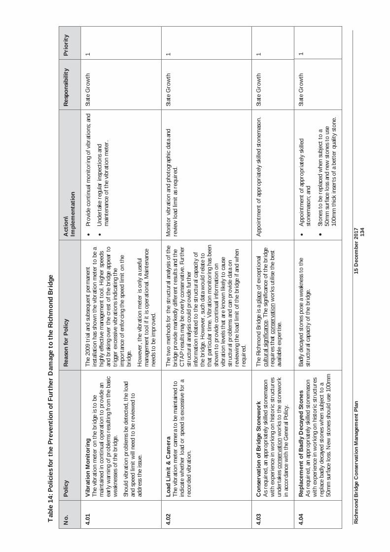
Ric
hmon
d B
ridg
e C
onse
rvat
ion
Man
agem
ent
Pla
n 15
Dec
embe
r 20
17
13
4
Tab
le 1
4: P
olic
ies
for
the
Pre
vent
ion
of F
urth
er D
amag
e to
the
Ric
hmon
d B
ridg
e
No.
P
olic
y
Rea
son
for
Pol
icy
Act
ion\
Im
plem
enta
tion
R
espo
nsib
ility
P
rior
ity
4.01
V
ibra
tion
Mon
itor
ing
The
vib
ratio
n m
eter
on
the
brid
ge is
to
be
mai
ntai
ned
in c
ontin
ual o
pera
tion
to p
rovi
de a
n ea
rly
war
ning
of p
robl
ems
resu
lting
from
the
basi
c w
eakn
esse
s of
the
bri
dge.
Shou
ld v
ibra
tion
prob
lem
s be
det
ecte
d, t
he lo
ad
and
spee
d lim
it w
ill n
eed
to b
e re
view
ed t
o ad
dres
s th
e iss
ue.
The
200
9 tr
ial a
nd s
ubse
quen
t pe
rman
ent
inst
alla
tion
has
show
n th
e vi
brat
ion
met
er t
o be
a
high
ly e
ffect
ive
man
agem
ent
tool
. Hig
her
spee
ds
and
brak
ing
over
the
cre
st o
f the
bri
dge
appe
ar t
o tr
igge
r ex
cess
ive
vibr
atio
ns in
dica
ting
the
impo
rtan
ce o
f enf
orci
ng t
he s
peed
lim
it on
the
br
idge
.
How
ever
, the
vib
ratio
n m
eter
is o
nly
a us
eful
m
anag
emen
t too
l if i
t is
ope
ratio
nal.
Mai
nten
ance
ne
eds
to b
e im
prov
ed.
Prov
ide
cont
inua
l mon
itori
ng o
f vib
ratio
ns; a
nd
Und
erta
ke r
egul
ar in
spec
tions
and
m
aint
enan
ce o
f the
vib
ratio
n m
eter
.
Stat
e G
row
th
1
4.02
Lo
ad L
imit
& C
amer
a T
he v
ibra
tion
met
er c
amer
a to
be
mai
ntai
ned
to
indi
cate
whe
ther
load
or
spee
d is
exce
ssiv
e fo
r a
reco
rded
vib
ratio
n.
The
tw
o m
etho
ds fo
r th
e st
ruct
ural
ana
lysis
of t
he
brid
ge p
rovi
de m
arke
dly
diffe
rent
res
ults
and
the
C
TA
P re
sults
may
be
over
ly c
onse
rvat
ive.
Fur
ther
st
ruct
ural
ana
lysis
cou
ld p
rovi
de fu
rthe
r in
form
atio
n re
late
d to
the
str
uctu
ral c
apac
ity o
f th
e br
idge
. How
ever
, suc
h da
ta w
ould
rel
ate
to
that
par
ticul
ar t
ime.
Vib
ratio
n m
onito
ring
has
bee
n sh
own
to p
rovi
de c
ontin
ual i
nfor
mat
ion
on
vibr
atio
n le
vels
that
are
kno
wn
likel
y to
cau
se
stru
ctur
al p
robl
ems
and
can
prov
ide
data
on
revi
ewin
g th
e lo
ad li
mit
of t
he b
ridg
e if
and
whe
n re
quir
ed.
Mon
itor
vibr
atio
n an
d ph
otog
raph
ic d
ata
and
revi
ew lo
ad li
mit
as r
equi
red.
Stat
e G
row
th
1
4.03
C
onse
rvat
ion
of B
ridg
e St
onew
ork
As
requ
ired
, an
appr
opri
atel
y sk
illed
sto
nem
ason
w
ith e
xper
ienc
e in
wor
king
on
hist
oric
str
uctu
res
unde
rtak
es c
onse
rvat
ion
wor
ks t
o th
e st
onew
ork
in a
ccor
danc
e w
ith t
he G
ener
al P
olic
y.
The
Ric
hmon
d Br
idge
is a
pla
ce o
f exc
eptio
nal
cultu
ral s
igni
fican
ce. T
he s
igni
fican
ce o
f the
bri
dge
requ
ires
tha
t co
nser
vatio
n w
orks
util
ise t
he b
est
avai
labl
e ex
pert
ise.
App
oint
men
t of a
ppro
pria
tely
ski
lled
ston
emas
on.
Stat
e G
row
th
1
4.04
R
epla
cem
ent
of B
adly
Dec
ayed
Sto
nes
As
requ
ired
, an
appr
opri
atel
y sk
illed
sto
nem
ason
w
ith e
xper
ienc
e in
wor
king
on
hist
oric
str
uctu
res
repl
ace
badl
y de
caye
d st
ones
whe
n su
bjec
t to
a
50m
m s
urfa
ce lo
ss. N
ew s
tone
s sh
ould
use
100
mm
Badl
y de
caye
d st
ones
pos
e a
wea
knes
s to
the
st
ruct
ural
cap
acity
of t
he b
ridg
e.
App
oint
men
t of a
ppro
pria
tely
ski
lled
ston
emas
on; a
nd
Ston
es t
o be
rep
lace
d w
hen
subj
ect
to a
50
mm
sur
face
loss
and
new
sto
nes
to u
se
100m
m t
hick
inse
rts
of a
bet
ter
qual
ity s
tone
.
Stat
e G
row
th
1
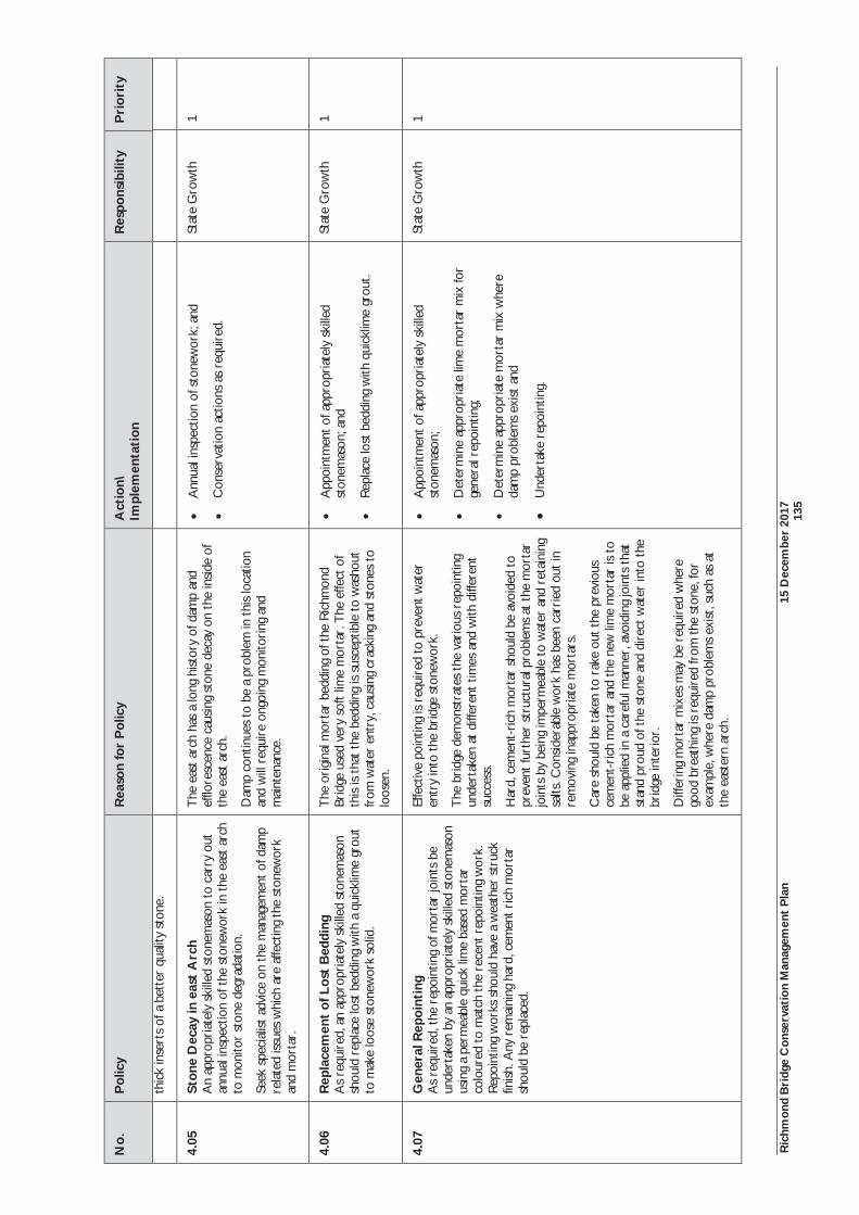
Ric
hmon
d B
ridg
e C
onse
rvat
ion
Man
agem
ent
Pla
n 15
Dec
embe
r 20
17
13
5
No.
P
olic
y
Rea
son
for
Pol
icy
Act
ion\
Im
plem
enta
tion
R
espo
nsib
ility
P
rior
ity
thic
k in
sert
s of
a b
ette
r qu
ality
sto
ne.
4.05
St
one
Dec
ay in
eas
t A
rch
An
appr
opri
atel
y sk
illed
sto
nem
ason
to
carr
y ou
t an
nual
insp
ectio
n of
the
sto
new
ork
in t
he e
ast
arch
to
mon
itor
ston
e de
grad
atio
n.
Seek
spe
cial
ist a
dvic
e on
the
man
agem
ent
of d
amp
rela
ted
issue
s w
hich
are
affe
ctin
g th
e st
onew
ork
and
mor
tar.
The
eas
t ar
ch h
as a
long
hist
ory
of d
amp
and
efflo
resc
ence
cau
sing
sto
ne d
ecay
on
the
insi
de o
f th
e ea
st a
rch.
Dam
p co
ntin
ues
to b
e a
prob
lem
in t
his
loca
tion
and
will
req
uire
ong
oing
mon
itori
ng a
nd
mai
nten
ance
.
Ann
ual i
nspe
ctio
n of
sto
new
ork;
and
Con
serv
atio
n ac
tions
as
requ
ired
.
Stat
e G
row
th
1
4.06
R
epla
cem
ent
of L
ost
Bed
ding
A
s re
quir
ed, a
n ap
prop
riat
ely
skill
ed s
tone
mas
on
shou
ld r
epla
ce lo
st b
eddi
ng w
ith a
qui
cklim
e gr
out
to m
ake
loos
e st
onew
ork
solid
.
The
ori
gina
l mor
tar
bedd
ing
of t
he R
ichm
ond
Brid
ge u
sed
very
sof
t lim
e m
orta
r. T
he e
ffect
of
this
is th
at t
he b
eddi
ng is
sus
cept
ible
to
was
hout
fr
om w
ater
ent
ry, c
ausi
ng c
rack
ing
and
ston
es t
o lo
osen
.
App
oint
men
t of a
ppro
pria
tely
ski
lled
ston
emas
on; a
nd
Rep
lace
lost
bed
ding
with
qui
cklim
e gr
out.
Stat
e G
row
th
1
4.07
G
ener
al R
epoi
ntin
g
As
requ
ired
, the
rep
oint
ing
of m
orta
r jo
ints
be
unde
rtak
en b
y an
app
ropr
iate
ly s
kille
d st
onem
ason
us
ing
a pe
rmea
ble
quic
k lim
e ba
sed
mor
tar
colo
ured
to
mat
ch t
he r
ecen
t rep
oint
ing
wor
k.
Rep
oint
ing
wor
ks s
houl
d ha
ve a
wea
ther
str
uck
finish
. Any
rem
aini
ng h
ard,
cem
ent
rich
mor
tar
shou
ld b
e re
plac
ed.
Effe
ctiv
e po
intin
g is
req
uire
d to
pre
vent
wat
er
entr
y in
to t
he b
ridg
e st
onew
ork.
The
bri
dge
dem
onst
rate
s th
e va
riou
s re
poin
ting
unde
rtak
en a
t di
ffere
nt t
imes
and
with
diff
eren
t su
cces
s.
Har
d, c
emen
t-ri
ch m
orta
r sh
ould
be
avoi
ded
to
prev
ent
furt
her
stru
ctur
al p
robl
ems
at t
he m
orta
r jo
ints
by
bein
g im
perm
eabl
e to
wat
er a
nd r
etai
ning
sa
lts. C
onsi
dera
ble
wor
k ha
s be
en c
arri
ed o
ut in
re
mov
ing
inap
prop
riat
e m
orta
rs.
Car
e sh
ould
be
take
n to
rak
e ou
t the
pre
viou
s ce
men
t-ri
ch m
orta
r an
d th
e ne
w li
me
mor
tar
is t
o be
app
lied
in a
car
eful
man
ner,
avo
idin
g jo
ints
tha
t st
and
prou
d of
the
sto
ne a
nd d
irect
wat
er in
to t
he
brid
ge in
teri
or.
Diff
erin
g m
orta
r m
ixes
may
be
requ
ired
whe
re
good
bre
athi
ng is
req
uire
d fr
om th
e st
one,
for
exam
ple,
whe
re d
amp
prob
lem
s ex
ist, s
uch
as a
t th
e ea
ster
n ar
ch.
App
oint
men
t of a
ppro
pria
tely
ski
lled
ston
emas
on;
Det
erm
ine
appr
opri
ate
lime
mor
tar
mix
for
gene
ral r
epoi
ntin
g;
Det
erm
ine
appr
opri
ate
mor
tar
mix
whe
re
dam
p pr
oble
ms
exist
and
Und
erta
ke r
epoi
ntin
g.
Stat
e G
row
th
1
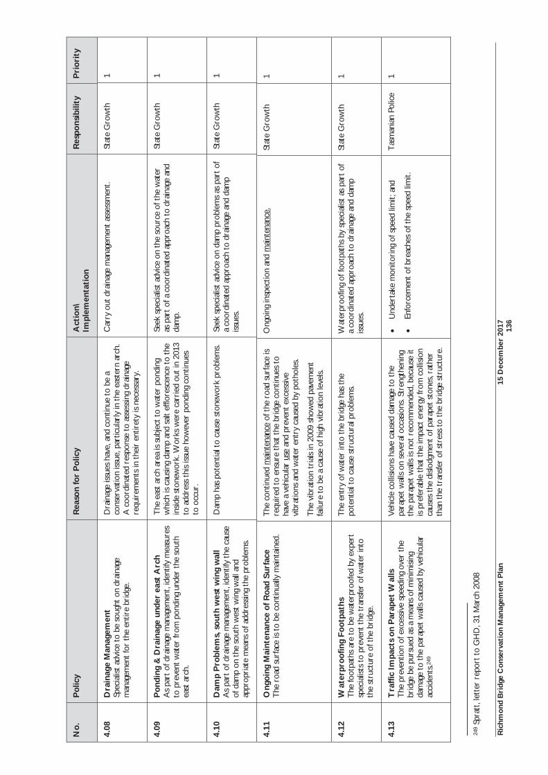
Ric
hmon
d B
ridg
e C
onse
rvat
ion
Man
agem
ent
Pla
n 15
Dec
embe
r 20
17
13
6
No.
P
olic
y
Rea
son
for
Pol
icy
Act
ion\
Im
plem
enta
tion
R
espo
nsib
ility
P
rior
ity
4.08
D
rain
age
Man
agem
ent
Spec
ialis
t ad
vice
to
be s
ough
t on
dra
inag
e m
anag
emen
t for
the
ent
ire
brid
ge.
Dra
inag
e is
sues
hav
e, a
nd c
ontin
ue t
o be
a
cons
erva
tion
issu
e, p
artic
ular
ly in
the
eas
tern
arc
h.
A c
oord
inat
ed r
espo
nse
to a
sses
sing
dra
inag
e re
quir
emen
ts in
the
ir e
ntir
ety
is n
eces
sary
.
Car
ry o
ut d
rain
age
man
agem
ent
asse
ssm
ent.
Stat
e G
row
th
1
4.09
P
ondi
ng &
Dra
inag
e un
der
east
Arc
h A
s pa
rt o
f dra
inag
e m
anag
emen
t, id
entif
y m
easu
res
to p
reve
nt w
ater
from
pon
ding
und
er t
he s
outh
ea
st a
rch.
The
eas
t ar
ch a
rea
is s
ubje
ct t
o w
ater
pon
ding
w
hich
is c
ausi
ng d
amp
and
salt
efflo
resc
ence
to
the
insi
de s
tone
wor
k. W
orks
wer
e ca
rrie
d ou
t in
201
3 to
add
ress
thi
s iss
ue h
owev
er p
ondi
ng c
ontin
ues
to o
ccur
.
Seek
spe
cial
ist a
dvic
e on
the
sou
rce
of t
he w
ater
as
par
t of
a c
oord
inat
ed a
ppro
ach
to d
rain
age
and
dam
p.
Stat
e G
row
th
1
4.10
D
amp
Pro
blem
s, s
outh
wes
t w
ing
wal
l A
s pa
rt o
f dra
inag
e m
anag
emen
t , id
entif
y th
e ca
use
of d
amp
on t
he s
outh
wes
t w
ing
wal
l and
ap
prop
riat
e m
eans
of a
ddre
ssin
g th
e pr
oble
ms.
Dam
p ha
s po
tent
ial t
o ca
use
ston
ewor
k pr
oble
ms.
Seek
spe
cial
ist a
dvic
e on
dam
p pr
oble
ms
as p
art
of
a co
ordi
nate
d ap
proa
ch t
o dr
aina
ge a
nd d
amp
issue
s.
Stat
e G
row
th
1
4.11
O
ngoi
ng M
aint
enan
ce o
f Roa
d Su
rfac
e
The
roa
d su
rfac
e is
to b
e co
ntin
ually
mai
ntai
ned.
T
he c
ontin
ued
mai
nten
ance
of t
he r
oad
surf
ace
is
requ
ired
to
ensu
re t
hat
the
brid
ge c
ontin
ues
to
have
a v
ehic
ular
use
and
pre
vent
exc
essi
ve
vibr
atio
ns a
nd w
ater
ent
ry c
ause
d by
pot
hole
s.
The
vib
ratio
n tr
ials
in 2
009
show
ed p
avem
ent
failu
re t
o be
a c
ause
of h
igh
vibr
atio
n le
vels.
Ong
oing
insp
ectio
n an
d m
aint
enan
ce.
Stat
e G
row
th
1
4.12
W
ater
proo
fing
Foot
path
s T
he fo
otpa
ths
are
to b
e w
ater
proo
fed
by e
xper
t sp
ecia
lists
to
prev
ent t
he t
rans
fer
of w
ater
into
th
e st
ruct
ure
of t
he b
ridg
e.
The
ent
ry o
f wat
er in
to t
he b
ridg
e ha
s th
e po
tent
ial t
o ca
use
stru
ctur
al p
robl
ems.
W
ater
proo
fing
of fo
otpa
ths
by s
peci
alist
as
part
of
a co
ordi
nate
d ap
proa
ch t
o dr
aina
ge a
nd d
amp
issue
s.
Stat
e G
row
th
1
4.13
T
raffi
c Im
pact
s on
Par
apet
Wal
ls
The
pre
vent
ion
of e
xces
sive
spe
edin
g ov
er t
he
brid
ge b
e pu
rsue
d as
a m
eans
of m
inim
isin
g da
mag
e to
the
par
apet
wal
ls ca
used
by
vehi
cula
r ac
cide
nts.
249
Veh
icle
col
lisio
ns h
ave
caus
ed d
amag
e to
the
pa
rape
t wal
ls on
sev
eral
occ
asio
ns. S
tren
gthe
ning
th
e pa
rape
t w
alls
is no
t re
com
men
ded,
bec
ause
it
is pr
efer
able
tha
t th
e im
pact
ene
rgy
from
col
lisio
n ca
uses
the
disl
odgm
ent
of p
arap
et s
tone
s, r
athe
r th
an t
he t
rans
fer
of s
tres
s to
the
bri
dge
stru
ctur
e.
Und
erta
ke m
onito
ring
of s
peed
lim
it; a
nd
Enfo
rcem
ent
of b
reac
hes
of t
he s
peed
lim
it.
Tas
man
ian
Polic
e 1
249
Spra
tt, l
ette
r re
port
to
GH
D, 3
1 M
arch
200
8
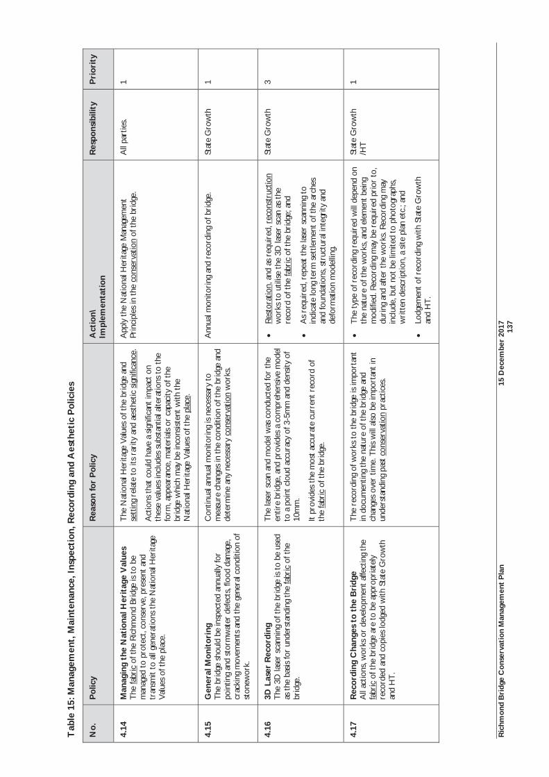
Ric
hmon
d B
ridg
e C
onse
rvat
ion
Man
agem
ent
Pla
n 15
Dec
embe
r 20
17
13
7
Tab
le 1
5: M
anag
emen
t, M
aint
enan
ce, I
nspe
ctio
n, R
ecor
ding
and
Aes
thet
ic P
olic
ies
No.
P
olic
y
Rea
son
for
Pol
icy
Act
ion\
Im
plem
enta
tion
R
espo
nsib
ility
P
rior
ity
4.14
M
anag
ing
the
Nat
iona
l Her
itag
e V
alue
s T
he fa
bric
of t
he R
ichm
ond
Brid
ge is
to
be
man
aged
to
prot
ect,
cons
erve
, pre
sent
and
tr
ansm
it to
all
gene
ratio
ns t
he N
atio
nal H
erita
ge
Val
ues
of t
he p
lace
.
The
Nat
iona
l Her
itage
Val
ues
of t
he b
ridg
e an
d se
ttin
g re
late
to
its r
arity
and
aes
thet
ic s
igni
fican
ce.
Act
ions
tha
t co
uld
have
a s
igni
fican
t im
pact
on
thes
e va
lues
incl
udes
sub
stan
tial a
ltera
tions
to
the
form
, app
eara
nce,
mat
eria
ls or
cap
acity
of t
he
brid
ge w
hich
may
be
inco
nsis
tent
with
the
N
atio
nal H
erita
ge V
alue
s of
the
pla
ce.
App
ly t
he N
atio
nal H
erita
ge M
anag
emen
t Pr
inci
ples
in t
he c
onse
rvat
ion
of t
he b
ridg
e.
All
part
ies.
1
4.15
G
ener
al M
onit
orin
g Th
e br
idge
sho
uld
be in
spec
ted
annu
ally
for
poin
ting
and
stor
mw
ater
def
ects
, flo
od d
amag
e,
crac
king
mov
emen
ts a
nd th
e ge
nera
l con
ditio
n of
st
onew
ork.
Con
tinua
l ann
ual m
onito
ring
is n
eces
sary
to
mea
sure
cha
nges
in t
he c
ondi
tion
of t
he b
ridg
e an
d de
term
ine
any
nece
ssar
y co
nser
vatio
n w
orks
.
Ann
ual m
onito
ring
and
rec
ordi
ng o
f bri
dge.
St
ate
Gro
wth
1
4.16
3D
Las
er R
ecor
ding
Th
e 3D
lase
r sc
anni
ng o
f the
bri
dge
is to
be
used
as
the
bas
is fo
r un
ders
tand
ing
the
fabr
ic o
f the
br
idge
.
The
lase
r sc
an a
nd m
odel
was
con
duct
ed fo
r th
e en
tire
brid
ge, a
nd p
rovi
des
a co
mpr
ehen
sive
mod
el
to a
poi
nt c
loud
acc
urac
y of
3-5
mm
and
den
sity
of
10m
m.
It pr
ovid
es t
he m
ost
accu
rate
cur
rent
rec
ord
of
the
fabr
ic o
f the
bri
dge.
Res
tora
tion,
and
as
requ
ired
, rec
onst
ruct
ion
wor
ks t
o ut
ilise
the
3D
lase
r sc
an a
s th
e re
cord
of t
he fa
bric
of t
he b
ridg
e; a
nd
As
requ
ired
, rep
eat
the
lase
r sc
anni
ng t
o in
dica
te lo
ng t
erm
set
tlem
ent
of t
he a
rche
s an
d fo
unda
tions
, str
uctu
ral i
nteg
rity
and
defo
rmat
ion
mod
ellin
g.
Stat
e G
row
th
3
4.17
R
ecor
ding
Cha
nges
to
the
Bri
dge
All
actio
ns, w
orks
or
deve
lopm
ent
affe
ctin
g th
e fa
bric
of t
he b
ridg
e ar
e to
be
appr
opri
atel
y re
cord
ed a
nd c
opie
s lo
dged
with
Sta
te G
row
th
and
HT
.
The
rec
ordi
ng o
f wor
ks t
o th
e br
idge
is im
port
ant
in d
ocum
entin
g th
e na
ture
of t
he b
ridg
e an
d ch
ange
s ov
er t
ime.
Thi
s w
ill a
lso
be im
port
ant i
n un
ders
tand
ing
past
con
serv
atio
n pr
actic
es.
The
type
of r
ecor
ding
req
uire
d w
ill d
epen
d on
th
e na
ture
of t
he w
orks
, and
ele
men
t be
ing
mod
ified
. Rec
ordi
ng m
ay b
e re
quir
ed p
rior
to,
du
ring
and
afte
r th
e w
orks
. Rec
ordi
ng m
ay
incl
ude,
but
not
be
limite
d to
pho
togr
aphs
, w
ritt
en d
escr
iptio
n, a
site
pla
n et
c.; a
nd
Lodg
emen
t of
rec
ordi
ng w
ith S
tate
Gro
wth
an
d H
T.
Stat
e G
row
th
/HT
1
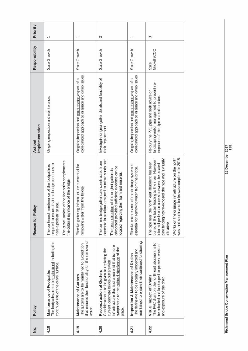
Ric
hmon
d B
ridg
e C
onse
rvat
ion
Man
agem
ent
Pla
n 15
Dec
embe
r 20
17
13
8
No.
P
olic
y
Rea
son
for
Pol
icy
Act
ion\
Im
plem
enta
tion
R
espo
nsib
ility
P
rior
ity
4.18
M
aint
enan
ce o
f Foo
tpat
hs
The
foot
path
s ar
e to
be
mai
ntai
ned
incl
udin
g th
e co
ntin
ued
use
of t
he g
rave
l sur
face
.
The
con
tinue
d m
aint
enan
ce o
f the
foot
path
s is
requ
ired
to
ensu
re t
hat
the
brid
ge c
ontin
ues
to
have
a p
edes
tria
n us
e.
The
gra
vel s
urfa
ce o
f the
foot
path
s co
mpl
emen
ts
the
cultu
ral s
igni
fican
ce o
f the
bri
dge.
Ong
oing
insp
ectio
n an
d m
aint
enan
ce.
Stat
e G
row
th
1
4.19
M
aint
enan
ce o
f Gut
ters
T
he g
utte
rs a
re t
o be
mai
ntai
ned
to a
con
ditio
n th
at e
nsur
es t
heir
func
tiona
lity
for
the
rem
oval
of
wat
er.
Effe
ctiv
e gu
tter
ing
infr
astr
uctu
re is
ess
entia
l for
re
mov
ing
wat
er fr
om t
he b
ridg
e.
Ong
oing
insp
ectio
n an
d m
aint
enan
ce a
s pa
rt o
f a
coor
dina
ted
appr
oach
to
drai
nage
and
dam
p is
sues
. St
ate
Gro
wth
1
4.20
R
econ
stru
ctio
n of
Gut
ters
C
onsi
dera
tion
is to
be
give
n to
rep
laci
ng t
he
curr
ent
conc
rete
bri
dge
gutt
ers
with
in
fras
truc
ture
tha
t is
of a
mat
eria
l tha
t is
mor
e sy
mpa
thet
ic t
o th
e cu
ltura
l sig
nific
ance
of t
he
plac
e.
The
cur
rent
bri
dge
gutt
ers
are
cons
truc
ted
from
co
ncre
te in
a c
olou
r de
signe
d to
mim
ic s
ands
tone
.
The
rec
onst
ruct
ion
of t
he o
rigi
nal g
utte
rs is
ad
voca
ted
prov
ided
suf
ficie
nt e
vide
nce
can
be
loca
ted
rega
rdin
g th
eir
form
and
mat
eria
l.
Inve
stig
ate
orig
inal
gut
ter
deta
ils a
nd fe
asib
ility
of
thei
r re
plac
emen
t. St
ate
Gro
wth
3
4.21
In
spec
tion
& M
aint
enan
ce o
f Dra
ins
The
dra
ins
are
to b
e re
gula
rly
insp
ecte
d an
d m
aint
aine
d to
ens
ure
thei
r co
ntin
ued
func
tioni
ng.
Effe
ctiv
e m
aint
enan
ce o
f the
dra
inag
e sy
stem
is
esse
ntia
l for
rem
ovin
g w
ater
from
the
bri
dge.
O
ngoi
ng in
spec
tion
and
mai
nten
ance
as
part
of a
co
ordi
nate
d ap
proa
ch t
o dr
aina
ge a
nd d
amp
issu
es.
Stat
e G
row
th
1
4.22
V
isua
l Im
pact
of D
rain
s
The
PV
C d
rain
on
the
nort
h ea
st a
butm
ent
is to
be
reb
urie
d an
d la
ndsc
aped
to
prev
ent
eros
ion
and
expo
sure
of t
he d
rain
.
The
pipe
nea
r th
e no
rth
east
abu
tmen
t ha
s be
en
buri
ed in
the
bat
ter
lead
ing
to t
he r
iver
. How
ever
, in
form
al p
edes
tria
n ac
cess
bet
wee
n th
e tr
eate
d pi
ne fe
ncin
g ha
s re
- exp
osed
the
pip
e an
d is
vis
ually
in
trus
ive.
Wor
ks o
n th
e dr
aina
ge in
fras
truc
ture
on
the
nort
h w
est
and
sout
h w
est
bank
s w
as c
ompl
eted
in 2
015.
Re-
bury
the
PV
C p
ipe
and
seek
adv
ice
on
land
scap
ing/
visi
tor
man
agem
ent
to p
reve
nt r
e-ex
posu
re o
f the
pip
e an
d so
il er
osio
n.
Stat
e G
row
th/C
CC
3
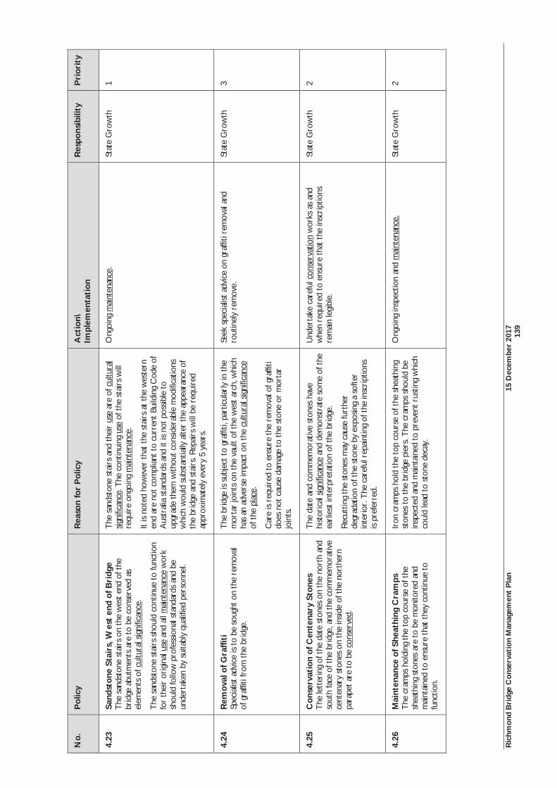
Ric
hmon
d B
ridg
e C
onse
rvat
ion
Man
agem
ent
Pla
n 15
Dec
embe
r 20
17
13
9
No.
P
olic
y
Rea
son
for
Pol
icy
Act
ion\
Im
plem
enta
tion
R
espo
nsib
ility
P
rior
ity
4.23
Sa
ndst
one
Stai
rs, W
est
end
of B
ridg
e T
he s
ands
tone
sta
irs
on t
he w
est
end
of t
he
brid
ge a
butm
ents
are
to
be c
onse
rved
as
elem
ents
of c
ultu
ral s
igni
fican
ce.
The
san
dsto
ne s
tair
s sh
ould
con
tinue
to
func
tion
for
thei
r or
igin
al u
se a
nd a
ll m
aint
enan
ce w
ork
shou
ld fo
llow
pro
fess
iona
l sta
ndar
ds a
nd b
e un
dert
aken
by
suita
bly
qual
ified
per
sonn
el.
The
san
dsto
ne s
tair
s an
d th
eir
use
are
of c
ultu
ral
sign
ifica
nce.
The
con
tinui
ng u
se o
f the
sta
irs
will
re
quir
e on
goin
g m
aint
enan
ce.
It is
not
ed h
owev
er t
hat
the
stai
rs a
t th
e w
este
rn
end
are
not
com
plia
nt t
o cu
rren
t Bu
ildin
g C
ode
of
Aus
tral
ia s
tand
ards
and
it is
not
pos
sible
to
upgr
ade
them
with
out c
onsi
dera
ble
mod
ifica
tions
w
hich
wou
ld s
ubst
antia
lly a
lter
the
appe
aran
ce o
f th
e br
idge
and
sta
irs.
Rep
airs
will
be
requ
ired
ap
prox
imat
ely
ever
y 5
year
s.
Ong
oing
mai
nten
ance
. St
ate
Gro
wth
1
4.24
R
emov
al o
f Gra
ffiti
Sp
ecia
list
advi
ce is
to
be s
ough
t on
the
rem
oval
of
gra
ffiti
from
the
bri
dge.
The
bri
dge
is su
bjec
t to
gra
ffiti,
par
ticul
arly
in t
he
mor
tar
join
ts o
n th
e va
ult
of t
he w
est
arch
, whi
ch
has
an a
dver
se im
pact
on
the
cultu
ral s
igni
fican
ce
of t
he p
lace
.
Car
e is
req
uire
d to
ens
ure
the
rem
oval
of g
raffi
ti do
es n
ot c
ause
dam
age
to t
he s
tone
or
mor
tar
join
ts.
Seek
spe
cial
ist a
dvic
e on
gra
ffiti
rem
oval
and
ro
utin
ely
rem
ove.
St
ate
Gro
wth
3
4.25
C
onse
rvat
ion
of C
ente
nary
Sto
nes
The
lett
erin
g of
the
dat
e st
ones
on
the
nort
h an
d so
uth
face
of t
he b
ridg
e, a
nd t
he c
omm
emor
ativ
e ce
nten
ary
ston
es o
n th
e in
side
of t
he n
orth
ern
para
pet
are
to b
e co
nser
ved.
The
dat
e an
d co
mm
emor
ativ
e st
ones
hav
e hi
stor
ical
sig
nific
ance
and
dem
onst
rate
som
e of
the
ea
rlie
st in
terp
reta
tion
of t
he b
ridg
e.
Rec
uttin
g th
e st
ones
may
cau
se fu
rthe
r de
grad
atio
n of
the
sto
ne b
y ex
posi
ng a
sof
ter
inte
rior
. The
car
eful
rep
aint
ing
of t
he in
scri
ptio
ns
is pr
efer
red.
Und
erta
ke c
aref
ul c
onse
rvat
ion
wor
ks a
s an
d w
hen
requ
ired
to
ensu
re t
hat
the
insc
ript
ions
re
mai
n le
gibl
e.
Stat
e G
row
th
2
4.26
M
aint
enan
ce o
f She
athi
ng C
ram
ps
The
cra
mps
hol
ding
the
top
cou
rse
of t
he
shea
thin
g st
ones
are
to
be m
onito
red
and
mai
ntai
ned
to e
nsur
e th
at t
hey
cont
inue
to
func
tion.
Iron
cra
mps
hol
d th
e to
p co
urse
of t
he s
heat
hing
st
ones
to
the
brid
ge p
iers
. The
cra
mps
sho
uld
be
insp
ecte
d an
d m
aint
aine
d to
pre
vent
rus
ting
whi
ch
coul
d le
ad t
o st
one
deca
y.
Ong
oing
insp
ectio
n an
d m
aint
enan
ce.
Stat
e G
row
th
2
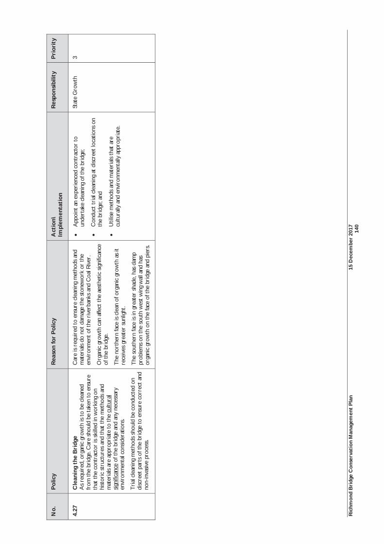
Ric
hmon
d B
ridg
e C
onse
rvat
ion
Man
agem
ent
Pla
n 15
Dec
embe
r 20
17
14
0
No.
P
olic
y
Rea
son
for
Pol
icy
Act
ion\
Im
plem
enta
tion
R
espo
nsib
ility
P
rior
ity
4.27
C
lean
ing
the
Bri
dge
As
requ
ired
, org
anic
gro
wth
is t
o be
cle
aned
fr
om t
he b
ridg
e. C
are
shou
ld b
e ta
ken
to e
nsur
e th
at t
he c
ontr
acto
r is
ski
lled
in w
orki
ng o
n hi
stor
ic s
truc
ture
s an
d th
at t
he m
etho
ds a
nd
mat
eria
ls ar
e ap
prop
riat
e to
the
cul
tura
l si
gnifi
canc
e of
the
bri
dge
and
any
nece
ssar
y en
viro
nmen
tal c
onsi
dera
tions
.
Tri
al c
lean
ing
met
hods
sho
uld
be c
ondu
cted
on
disc
reet
par
ts o
f the
bri
dge
to e
nsur
e co
rrec
t an
d no
n-in
vasiv
e pr
oces
s.
Car
e is
req
uire
d to
ens
ure
clea
ning
met
hods
and
m
ater
ials
do n
ot d
amag
e th
e st
onew
ork
or t
he
envi
ronm
ent o
f the
riv
erba
nks
and
Coa
l Riv
er.
Org
anic
gro
wth
can
affe
ct t
he a
esth
etic
sig
nific
ance
of
the
bri
dge.
The
nor
ther
n fa
ce is
cle
an o
f org
anic
gro
wth
as
it re
ceiv
es g
reat
er s
unlig
ht.
The
sou
ther
n fa
ce is
in g
reat
er s
hade
, has
dam
p pr
oble
ms
on t
he s
outh
wes
t w
ing
wal
l and
has
or
gani
c gr
owth
on
the
face
of t
he b
ridg
e an
d pi
ers.
App
oint
an
expe
rien
ced
cont
ract
or t
o un
dert
ake
clea
ning
of t
he b
ridg
e;
Con
duct
tri
al c
lean
ing
at d
iscre
et lo
catio
ns o
n th
e br
idge
; and
Util
ise m
etho
ds a
nd m
ater
ials
that
are
cu
ltura
lly a
nd e
nvir
onm
enta
lly a
ppro
pria
te.
Stat
e G
row
th
3
Ric
hmon
d B
ridg
e C
onse
rvat
ion
Man
agem
ent
Pla
n 15
Dec
embe
r 20
17
14
1
6.8
Man
agem
ent
of P
ublic
Riv
erba
nk L
and
and
Infr
astr
uctu
re
The
pub
lic r
iver
bank
land
form
s a
cruc
ial p
art
of t
he s
igni
fican
ce o
f th
e pl
ace.
It a
lso
prov
ides
impo
rtan
t to
uris
m a
nd p
assi
ve r
ecre
atio
n us
es fo
r re
laxa
tion,
pic
nics
and
app
reci
atin
g th
e br
idge
and
sur
roun
ds. T
hese
val
ues
have
bee
n ar
ticul
ated
in p
revi
ous
Con
serv
atio
n Pl
ans
and
the
mor
e re
cent
Veg
etat
ion
Man
agem
ent
Plan
. Con
serv
atio
n po
licie
s ha
ve b
een
prep
ared
, ba
sed
on t
his
sign
ifica
nce,
the
phy
sica
l nat
ure
of t
he p
lace
, and
the
lim
ited
com
patib
le u
ses
avai
labl
e. S
ince
201
0, t
he fe
nce
loca
ted
on t
he s
outh
-eas
t br
idge
abu
tmen
t ha
s be
en r
emov
ed,
allo
win
g ac
cess
to
the
publ
ic r
iver
bank
s de
fined
by
CT
s 10
089/
3, 1
0089
/4 a
nd 4
4025
/2. I
nfor
mal
ped
estr
ian
trac
ks h
ave
emer
ged
in t
his
area
but
req
uire
con
solid
atio
n an
d m
anag
emen
t to
pre
vent
ero
sion
. Foo
t tr
affic
has
als
o pa
rtia
lly e
xpos
ed t
he c
ylin
dric
al a
nd r
ivet
ed ir
on b
oile
r on
ce a
ssoc
iate
d w
ith t
he a
djac
ent
flour
mill
. Rus
t ha
s ca
used
ero
sion
and
the
re is
a
pote
ntia
l ris
k of
ped
estr
ian
dam
age
to t
he b
oile
r an
d pe
rson
al in
jury
. A n
ew p
olic
y is
pro
vide
d to
man
age
the
boile
r.
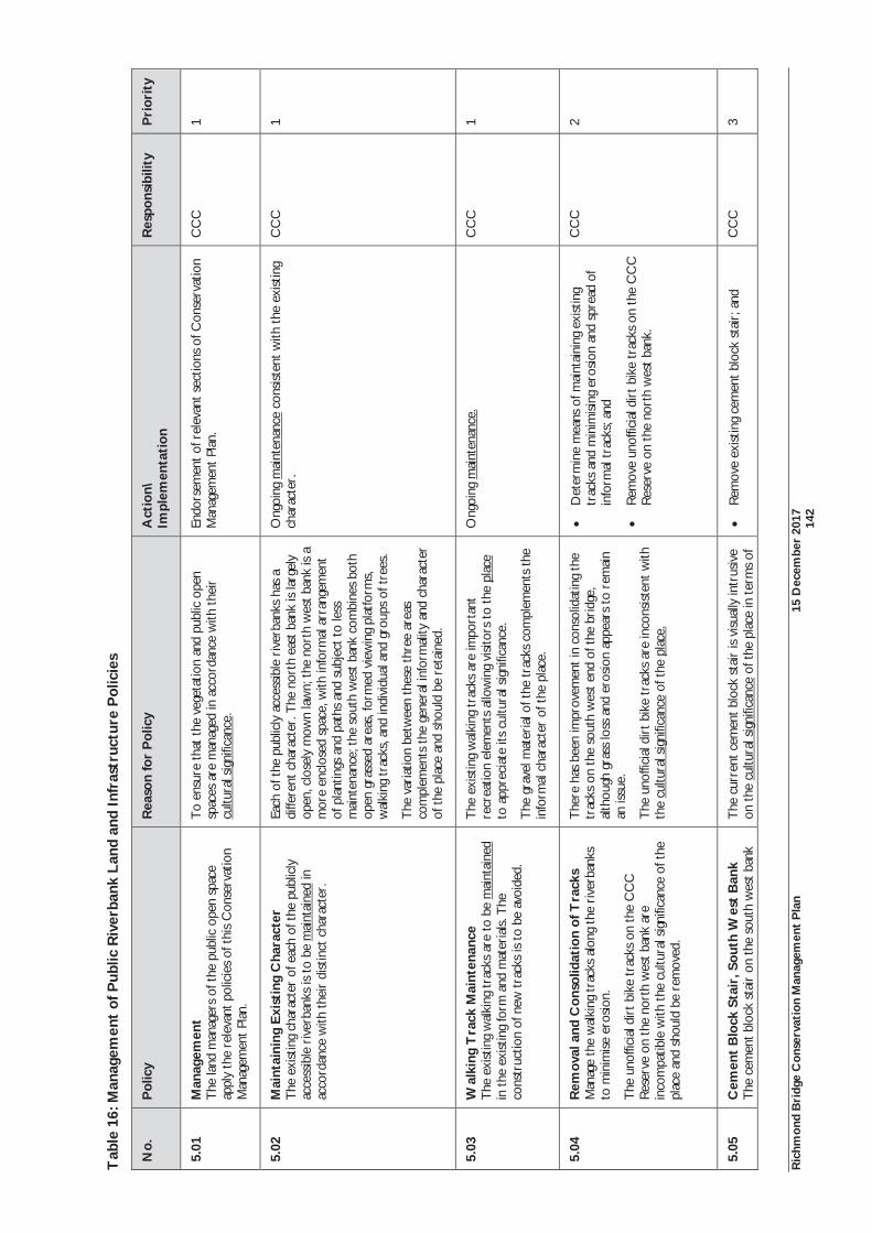
Ric
hmon
d B
ridg
e C
onse
rvat
ion
Man
agem
ent
Pla
n 15
Dec
embe
r 20
17
14
2
Tab
le 1
6: M
anag
emen
t of
Pub
lic R
iver
bank
Lan
d an
d In
fras
truc
ture
Pol
icie
s
No.
P
olic
y
Rea
son
for
Pol
icy
Act
ion\
Im
plem
enta
tion
R
espo
nsib
ility
P
rior
ity
5.01
M
anag
emen
t T
he la
nd m
anag
ers
of t
he p
ublic
ope
n sp
ace
appl
y th
e re
leva
nt p
olic
ies
of t
his
Con
serv
atio
n M
anag
emen
t Pl
an.
To
ensu
re th
at t
he v
eget
atio
n an
d pu
blic
ope
n sp
aces
are
man
aged
in a
ccor
danc
e w
ith t
heir
cu
ltura
l sig
nific
ance
.
Endo
rsem
ent
of r
elev
ant s
ectio
ns o
f Con
serv
atio
n M
anag
emen
t Pl
an.
CC
C
1
5.02
M
aint
aini
ng E
xist
ing
Cha
ract
er
The
exi
stin
g ch
arac
ter
of e
ach
of th
e pu
blic
ly
acce
ssib
le r
iver
bank
s is
to b
e m
aint
aine
d in
ac
cord
ance
with
the
ir d
istin
ct c
hara
cter
.
Each
of t
he p
ublic
ly a
cces
sibl
e ri
verb
anks
has
a
diffe
rent
cha
ract
er. T
he n
orth
eas
t ba
nk is
larg
ely
open
, clo
sely
mow
n la
wn;
the
nor
th w
est
bank
is a
m
ore
encl
osed
spa
ce, w
ith in
form
al a
rran
gem
ent
of p
lant
ings
and
pat
hs a
nd s
ubje
ct t
o le
ss
mai
nten
ance
; the
sou
th w
est
bank
com
bine
s bo
th
open
gra
ssed
are
as, f
orm
ed v
iew
ing
plat
form
s, w
alki
ng t
rack
s, an
d in
divi
dual
and
gro
ups
of t
rees
.
The
var
iatio
n be
twee
n th
ese
thre
e ar
eas
com
plem
ents
the
gene
ral i
nfor
mal
ity a
nd c
hara
cter
of
the
pla
ce a
nd s
houl
d be
ret
aine
d.
Ong
oing
mai
nten
ance
con
sist
ent
with
the
exi
stin
g ch
arac
ter.
C
CC
1
5.03
W
alki
ng T
rack
Mai
nten
ance
T
he e
xist
ing
wal
king
tra
cks
are
to b
e m
aint
aine
d in
the
exi
stin
g fo
rm a
nd m
ater
ials.
The
co
nstr
uctio
n of
new
tra
cks
is to
be
avoi
ded.
The
exi
stin
g w
alki
ng t
rack
s ar
e im
port
ant
recr
eatio
n el
emen
ts a
llow
ing
visi
tors
to
the
plac
e to
app
reci
ate
its c
ultu
ral s
igni
fican
ce.
The
gra
vel m
ater
ial o
f the
trac
ks c
ompl
emen
ts th
e in
form
al c
hara
cter
of t
he p
lace
.
Ong
oing
mai
nten
ance
. C
CC
1
5.04
R
emov
al a
nd C
onso
lidat
ion
of T
rack
s
Man
age
the
wal
king
tra
cks
alon
g th
e ri
verb
anks
to
min
imis
e er
osio
n.
The
uno
ffici
al d
irt
bike
tra
cks
on th
e C
CC
R
eser
ve o
n th
e no
rth
wes
t ba
nk a
re
inco
mpa
tible
with
the
cul
tura
l sig
nific
ance
of t
he
plac
e an
d sh
ould
be
rem
oved
.
The
re h
as b
een
impr
ovem
ent
in c
onso
lidat
ing
the
trac
ks o
n th
e so
uth
wes
t en
d of
the
bri
dge,
al
thou
gh g
rass
loss
and
ero
sion
appe
ars
to r
emai
n an
issu
e.
The
uno
ffici
al d
irt
bike
tra
cks
are
inco
nsis
tent
with
th
e cu
ltura
l sig
nific
ance
of t
he p
lace
.
Det
erm
ine
mea
ns o
f mai
ntai
ning
exi
stin
g tr
acks
and
min
imis
ing
eros
ion
and
spre
ad o
f in
form
al t
rack
s; a
nd
Rem
ove
unof
ficia
l dir
t bi
ke t
rack
s on
the
CC
C
Res
erve
on
the
nort
h w
est
bank
.
CC
C
2
5.05
C
emen
t B
lock
Sta
ir, S
outh
Wes
t B
ank
The
cem
ent b
lock
sta
ir o
n th
e so
uth
wes
t ba
nk
The
cur
rent
cem
ent
bloc
k st
air
is v
isua
lly in
trus
ive
on t
he c
ultu
ral s
igni
fican
ce o
f the
pla
ce in
ter
ms
of
Rem
ove
exist
ing
cem
ent b
lock
sta
ir; a
nd
CC
C
3
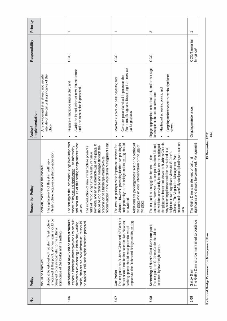
Ric
hmon
d B
ridg
e C
onse
rvat
ion
Man
agem
ent
Pla
n 15
Dec
embe
r 20
17
14
3
No.
P
olic
y
Rea
son
for
Pol
icy
Act
ion\
Im
plem
enta
tion
R
espo
nsib
ility
P
rior
ity
shou
ld b
e re
mov
ed.
Shou
ld it
be
esta
blish
ed t
hat s
tair
infr
astr
uctu
re
is re
quir
ed a
t th
is po
int,
any
new
sta
ir s
houl
d be
de
sign
ed t
o be
sym
path
etic
to
the
cultu
ral
sign
ifica
nce
of t
he b
ridg
e an
d its
set
ting.
loca
tion,
mat
eria
ls an
d th
e ha
ndra
il.
The
rep
lace
men
t of
thi
s st
air
with
new
in
fras
truc
ture
req
uire
s ca
refu
l con
side
ratio
n.
Any
rep
lace
men
t st
air
shou
ld n
ot v
isual
ly
intr
ude
on t
he c
ultu
ral s
igni
fican
ce o
f the
pl
ace.
5.06
In
trod
ucti
on o
f new
Vis
itor
Infr
astr
uctu
re
Prep
are
a la
ndsc
ape
mas
terp
lan
and
revi
ew b
uilt
elem
ents
suc
h as
sea
ting,
rub
bish
bin
s, w
alki
ng
trac
ks, s
helte
rs e
tc. N
ew in
fras
truc
ture
sho
uld
be a
void
ed u
ntil
such
a p
lan
has
been
pre
pare
d.
The
set
ting
of t
he R
ichm
ond
Brid
ge is
an
impo
rtan
t as
pect
of i
ts c
ultu
ral s
igni
fican
ce. T
he in
form
ality
an
d ru
ral n
atur
e of
thi
s se
ttin
g co
mpl
emen
ts th
ese
valu
es.
The
intr
oduc
tion
of n
ew in
fras
truc
ture
pre
sent
s ri
sks
of in
trod
ucin
g fu
rthe
r vi
sual
ly in
trus
ive
elem
ents
, and
an
unsu
stai
nabl
e us
e of
the
pla
ce. I
t sh
ould
be
coor
dina
ted
and
man
aged
thr
ough
the
pr
epar
atio
n of
a la
ndsc
ape
mas
terp
lan
as
reco
mm
ende
d in
the
Veg
etat
ion
Man
agem
ent
Plan
.
Prep
are
a la
ndsc
ape
mas
terp
lan;
and
Avo
id t
he in
trod
uctio
n of
new
infr
astr
uctu
re
until
the
mas
terp
lan
is p
repa
red.
CC
C
1
5.07
C
ar P
arks
T
he c
ar p
arks
on
St Jo
hns
Cir
cle
and
off B
athu
rst
Stre
et s
houl
d no
t be
incr
ease
d in
siz
e. N
ew c
ar
park
ing
spac
es s
houl
d av
oid
pote
ntia
l visu
al
impa
cts
to t
he R
ichm
ond
Brid
ge a
nd it
s se
ttin
g.
The
tw
o ca
r pa
rks
prov
ide
impo
rtan
t se
rvic
es fo
r vi
sito
rs. H
owev
er, p
rovi
ding
furt
her
car
park
ing
in
such
pro
xim
ity t
o th
e br
idge
and
its
sett
ing
shou
ld
be a
void
ed.
Add
ition
al c
ar p
arki
ng p
oses
risk
s to
the
set
ting
of
the
plac
e an
d an
ove
r in
tens
ifica
tion
of t
he u
se o
f th
e pl
ace.
Mai
ntai
n cu
rren
t ca
r pa
rk c
apac
ity; a
nd
Con
side
r po
tent
ial v
isual
impa
cts
on t
he
Ric
hmon
d Br
idge
and
its
sett
ing
from
new
car
pa
rkin
g sp
aces
.
CC
C
1
5.08
Sc
reen
ing
of N
orth
Eas
t B
ank
car
park
Th
e ca
r pa
rk o
n St
John
s C
ircl
e sh
ould
be
scre
ened
by
low
hei
ght p
lant
s.
The
car
par
k is
a ne
glig
ible
ele
men
t in
the
la
ndsc
ape.
How
ever
, the
car
par
k is
ofte
n fu
ll an
d th
e ve
hicl
es a
re v
isual
ly in
trus
ive
on t
he s
ettin
g of
th
e pl
ace
and
impo
rtan
t vi
ews
to S
t Jo
hn’s
Chu
rch.
A
ny s
cree
ning
pla
nts
shou
ld b
e m
aint
aine
d at
a
heig
ht t
o re
tain
sig
nific
ant v
iew
s to
St
John
’s C
hurc
h. T
he V
eget
atio
n M
anag
emen
t Pl
an
reco
mm
ends
car
eful
ly d
esig
ned
plan
tings
to
scre
en
cars
.
Enga
ge a
ppro
pria
te a
rbor
icul
tura
l, an
d/or
her
itage
la
ndsc
ape
arch
itect
to
advi
se o
n:
Plan
ting
of s
cree
ning
pla
nts;
and
Ong
oing
mai
nten
ance
to
reta
in s
igni
fican
t vi
ews.
CC
C
3
5.09
G
atty
Dam
T
he G
atty
Dam
is t
o be
mai
ntai
ned
to c
ontin
ue
The
Gat
ty D
am is
an
elem
ent
of c
ultu
ral
sign
ifica
nce
and
shou
ld b
e co
nser
ved.
Man
agem
ent
Ong
oing
mai
nten
ance
. C
CC
/Tas
man
ian
Irri
gatio
n/
1

Ric
hmon
d B
ridg
e C
onse
rvat
ion
Man
agem
ent
Pla
n 15
Dec
embe
r 20
17
14
4
No.
P
olic
y
Rea
son
for
Pol
icy
Act
ion\
Im
plem
enta
tion
R
espo
nsib
ility
P
rior
ity
to fu
nctio
n.
resp
onsib
ilitie
s fo
r th
e da
m s
houl
d be
res
olve
d be
twee
n re
leva
nt p
artie
s.
Tas
Wat
er
5.10
R
ehab
ilita
tion
of N
orth
Eas
t E
mba
nkm
ent
Are
a
Tha
t pr
ofes
siona
l lan
dsca
pe a
dvic
e be
sou
ght
on
prev
entin
g pe
dest
rian
acc
ess
dire
ctly
adj
acen
t to
th
e no
rth
east
bri
dge
abut
men
t w
hich
has
cau
sed
eros
ion
and
expo
sure
of t
he P
VC
dra
inag
e pi
pe.
A t
imbe
r st
air
was
pre
viou
sly
loca
ted
at t
his
poin
t an
d th
e 20
10 C
MP
reco
mm
ende
d its
rem
oval
. The
st
air
was
sub
sequ
ently
rem
oved
, but
no
new
sta
ir
infr
astr
uctu
re w
as in
trod
uced
at a
noth
er lo
catio
n.
The
res
ult
is th
at p
eopl
e co
ntin
ue t
o w
alk
dow
n th
e st
eep
rive
rban
k ad
jace
nt t
o th
e no
rth
east
ab
utm
ent
caus
ing
eros
ion
and
visu
ally
mar
ring
the
ar
ea.
Con
tinua
tion
of t
he tr
eate
d pi
ne fe
nce
alon
g th
e fo
otpa
th a
nd t
he in
trod
uctio
n of
nat
ive
gras
s sp
ecie
s m
ay h
elp
disc
oura
ge p
edes
tria
n ac
cess
at
this
poin
t.
Opt
ions
for
crea
ting
a ne
w s
tair
tow
ards
the
ce
ntre
or
nort
hern
end
of t
he n
orth
eas
t ba
nk
shou
ld b
e co
nsid
ered
as
a m
eans
of d
iscou
ragi
ng
visi
tors
usi
ng t
he in
form
al t
rack
.
Seek
pro
fess
iona
l adv
ice
on r
ehab
ilita
ting
the
area
and
disc
oura
ging
ped
estr
ian
acce
ss a
t th
is po
int;
and
Con
stru
ct a
new
sym
path
etic
sta
ir t
owar
ds
the
cent
re o
r no
rthe
rn e
nd o
f the
nor
th e
ast
bank
.
CC
C
1
5.11
M
anag
emen
t of
CC
C R
eser
ve, N
orth
W
est
Ban
k
Effo
rt s
houl
d be
mad
e to
con
trol
the
ille
gal
dum
ping
of r
ubbi
sh a
t th
e C
CC
Res
erve
. Rub
bish
sh
ould
be
regu
larl
y co
llect
ed fr
om t
he a
rea
and
the
dum
ping
of f
ill o
n th
e st
eep
esca
rpm
ent
shou
ld c
ease
.
The
dum
ping
of r
ubbi
sh a
nd fi
ll at
the
CC
C
Res
erve
is in
cons
iste
nt w
ith t
he c
ultu
ral
sign
ifica
nce
of t
he p
lace
.
Ong
oing
mon
itori
ng a
nd m
aint
enan
ce o
f the
CC
C
Res
erve
to
prev
ent
the
illeg
al d
umpi
ng o
f rub
bish
an
d fil
l.
CC
C
1
5.12
M
anag
emen
t of
Boi
ler,
Sou
th E
ast
Ban
k
The
uppe
r po
rtio
n of
the
boi
ler
shou
ld b
e ca
refu
lly a
rcha
eolo
gica
lly e
xcav
ated
for
reco
rdin
g pu
rpos
es.
The
adv
ice
of a
con
serv
ator
sho
uld
be s
ough
t fo
r lo
ng t
erm
man
agem
ent
stra
tegi
es fo
r th
e bo
iler.
The
boi
ler
is a
n ite
m o
f cul
tura
l sig
nific
ance
and
sh
ould
be
cons
erve
d. It
sho
uld
be r
ecor
ded
in
deta
il an
d lo
ng t
erm
con
serv
atio
n st
rate
gies
de
velo
ped.
Car
ry o
ut d
iscre
te a
rcha
eolo
gica
l exc
avat
ion
and
reco
rdin
g of
the
boi
ler;
and
Obt
ain
and
impl
emen
t lo
ng t
erm
con
serv
atio
n ad
vice
.
CC
C
2
Ric
hmon
d B
ridg
e C
onse
rvat
ion
Man
agem
ent
Pla
n 15
Dec
embe
r 20
17
14
5
6.9
Veg
etat
ion
Man
agem
ent
Veg
etat
ion
form
s an
impo
rtan
t pa
rt o
f th
e se
ttin
g of
the
Ric
hmon
d Br
idge
. Nat
ive
ripa
rian
ree
ds a
re fo
und
alon
g th
e ri
ver
in c
erta
in lo
catio
ns, w
hile
mat
ure
exot
ic t
rees
are
loca
ted
alon
g th
e ri
verb
anks
pro
vidi
ng s
hade
, var
iatio
ns in
hei
ght
and
form
and
sea
sona
l tra
nsiti
ons.
The
se p
lant
ings
incl
ude
both
spe
cific
ally
pla
nted
spe
cim
ens
and
natu
ralis
ed s
peci
es o
n th
e ri
verb
anks
. The
sig
nific
ance
of t
hese
pla
ntin
gs w
as r
ecog
nise
d in
pre
viou
s co
nser
vatio
n pl
ans.
The
201
0 C
onse
rvat
ion
Man
agem
ent
Plan
rec
omm
ende
d th
e pr
epar
atio
n of
a V
eget
atio
n M
anag
emen
t Pl
an (
VM
P). T
his
deta
iled
stud
y w
as c
omm
issi
oned
by
Cla
renc
e C
ity C
ounc
il an
d pr
epar
ed b
y La
ndsc
ape
Impr
essi
ons
in 2
015.
It
is i
nclu
ded
as a
n ap
pend
ix i
n th
is C
onse
rvat
ion
Man
agem
ent
Plan
. T
he f
ollo
win
g se
ctio
ns s
umm
aris
es i
ts k
ey f
indi
ngs
and
reco
mm
enda
tions
. Rec
omm
enda
tions
hav
e be
en t
rans
ferr
ed in
to p
olic
ies
belo
w.
The
VM
P pr
ovid
es a
n as
sess
men
t fo
r th
e m
aint
enan
ce a
nd r
enew
al o
f veg
etat
ion
in t
he v
icin
ity o
f the
Ric
hmon
d Br
idge
. It
incl
udes
a s
ite a
naly
sis, w
eed
asse
ssm
ent
and
an a
rbor
icul
tura
l as
sess
men
t of
tre
es t
o in
form
dec
isio
n m
akin
g on
long
ter
m v
eget
atio
n m
anag
emen
t. T
he V
MP
note
s th
at t
he c
onte
mpo
rary
land
scap
e of
the
bri
dge
and
its s
ettin
g is
an
outc
ome
of
‘del
iber
ate’
and
‘acc
iden
tal’
proc
esse
s ov
er t
ime.
Rem
nant
s of
his
tori
c pl
antin
gs in
clud
e th
e pi
ne t
rees
on
the
wes
tern
ban
ks a
nd L
omba
rdy
Popl
ars
on t
he e
aste
rn e
nd o
f the
bri
dge.
How
ever
, mos
t of
the
old
est
plan
tings
hav
e de
clin
ed
and
wha
t ex
ists
tod
ay a
re la
rgel
y na
tura
lised
exo
tic a
nd n
ativ
e sp
ecim
ens.
Muc
h of
the
cha
ract
er o
f the
pla
ce c
omes
from
thi
s na
tura
lised
veg
etat
ion.
The
VM
P ad
opts
the
app
roac
h th
at it
is a
ppro
pria
te t
o le
t th
e pl
antin
gs la
ndsc
ape
of t
he b
ridg
e co
ntin
ue t
o ev
olve
with
a s
imila
r ch
arac
ter
to w
hat
curr
ently
exi
sts.
Som
e el
emen
ts o
f th
e bu
ilt la
ndsc
ape
do h
owev
er r
equi
re a
tten
tion
such
as
path
s an
d dr
aina
ge, s
igna
ge, r
ubbi
sh b
ins
and
seat
ing.
250 K
ey fi
ndin
gs fr
om t
he V
MP
are
sum
mar
ised
bel
ow.
6.9.
1 K
ey P
rinc
iple
s
The
VM
P ha
s be
en in
form
ed b
y th
e fo
llow
ing
eigh
t ke
y pr
inci
ples
:
1.Pr
eser
ve h
isto
rica
l and
cul
tura
l val
ues
in t
he la
ndsc
ape,
incl
udin
g vi
ews
to a
nd fr
om t
he b
ridg
e.
2.Pr
ovid
e a
safe
and
ple
asan
t en
viro
nmen
t fr
om w
hich
to
enjo
y th
e ch
arac
ter
and
ambi
ence
of t
he R
ichm
ond
Brid
ge.
3.R
espe
ct a
nd c
eleb
rate
the
val
ues
that
com
bine
to
mak
e th
is a
n at
trac
tive
and
char
acte
rful
‘pla
ce’.
4.En
sure
a r
elat
ivel
y sm
ooth
suc
cess
ion
of v
eget
atio
n ov
er t
ime
so t
hat
dras
tic o
r su
dden
land
scap
e ch
ange
s ar
e m
inim
ised
.
5.En
sure
‘wee
ds’ a
re n
ot a
llow
ed t
o sp
read
to
neig
hbou
ring
pro
pert
ies.
6.M
inim
ise
the
finan
cial
bur
den
of m
anag
emen
t an
d m
aint
enan
ce o
f the
land
scap
e to
cur
rent
and
futu
re g
ener
atio
ns.
7.T
he c
hara
cter
of t
he p
lace
is t
o be
pre
serv
ed o
ver
time
by m
aint
aini
ng, a
s fa
r as
pos
sibl
e, v
eget
atio
n ty
pe a
nd s
truc
ture
sim
ilar
to t
he c
urre
nt (
2015
) lan
dsca
pe.
8.H
isto
rica
lly im
port
ant
spec
ies,
whi
ch a
re o
ften
now
dec
lare
d w
eed
spec
ies,
sho
uld
be r
epla
ced
with
mod
ern
culti
vars
of t
he s
ame
vari
ety
to p
rese
rve
land
scap
e ch
arac
ter
whi
lst
min
imis
ing
man
agem
ent
cost
s an
d da
mag
e to
his
tori
cal o
r cu
ltura
l ass
ets.
251
The
VM
P in
clud
es a
rec
omm
ende
d pl
antin
g pa
lett
e, id
entif
ying
a r
ange
of n
ativ
e an
d ex
otic
(ev
ergr
een
and
deci
duou
s tr
ees)
as
wel
l as
smal
ler
nativ
e sh
rubs
and
gra
sses
.252
250
Land
scap
e Im
pres
sions
, Rich
mon
d Br
idge
Veg
etat
ion
Man
agem
ent P
lan,
Fin
al, 6
Nov
embe
r 20
15, p
.5
251
Ibid
, p.6
Ric
hmon
d B
ridg
e C
onse
rvat
ion
Man
agem
ent
Pla
n 15
Dec
embe
r 20
17
14
6
6.9.
2 A
quat
ic V
eget
atio
n
The
VM
P no
tes
that
the
maj
ority
of
aqua
tic v
eget
atio
n w
ithin
the
Coa
l Riv
er is
nat
ive,
incl
udin
g Ph
ragm
ites
aust
ralis
(co
mm
on r
eed)
dom
inat
ing
the
nort
hern
end
of t
he r
iver
, rus
hes
(Junc
us s
pp.,
Eleo
char
is gr
acilis
etc
.) an
d R
ibbo
n W
eed
(Trig
loch
in p
roce
ra).
Som
e of
the
se p
lant
ings
dom
inat
e th
e ri
verb
anks
, suc
h as
the
com
mon
ree
d in
the
nor
ther
n se
ctio
n an
d ri
bbon
w
eed
thro
ugho
ut. S
ome
of t
hese
pla
ntin
gs a
re p
rote
ctin
g th
e ri
verb
anks
from
ero
sion
and
may
filte
r hi
gh n
utri
ent
runo
ff fr
om s
urro
undi
ng a
reas
. The
pla
ntin
gs a
re li
kely
to
cont
inue
to
spre
ad t
hrou
ghou
t th
e ri
ver
as it
con
tinue
s to
sha
llow
due
to
sedi
men
tatio
n.25
3
6.9.
3 W
eed
Stra
tegy
A s
epar
ate
Wee
d St
rate
gy i
s co
ntai
ned
in t
he V
MP.
It
ackn
owle
dges
tha
t so
me
wee
ds a
re n
atur
alis
ed s
peci
men
s of
his
tori
cal
plan
tings
on
or a
djac
ent
to t
he s
tudy
are
a, a
nd m
ay
ther
efor
e be
impo
rtan
t el
emen
ts c
ontr
ibut
ing
to t
he c
hara
cter
of
the
plac
e. D
ue t
o th
e lo
ng h
isto
ry o
f Eu
rope
an s
ettle
men
t, th
is c
hara
cter
is e
ssen
tially
a ‘E
urop
ean’
land
scap
e. T
he
obje
ctiv
e is
to
mai
ntai
n th
is c
hara
cter
but
bal
ance
d ag
ains
t m
inim
isin
g en
viro
nmen
tal
and
econ
omic
im
pact
s of
wee
ds,
and
in p
artic
ular
, m
anag
emen
t of
the
eig
ht i
dent
ified
‘pr
iori
ty
wee
ds’ w
hich
are
inco
nsis
tent
with
the
cha
ract
er o
f the
pla
ce a
nd it
s us
e. A
six
poi
nt s
trat
egy
is a
dopt
ed fo
r w
eed
man
agem
ent:
1.Bi
mon
thly
mon
itori
ng e
ach
Man
agem
ent
Zon
e fo
r is
olat
ed s
peci
men
s of
pri
ority
wee
d sp
ecie
s.
2.O
n-th
e-sp
ot (
i.e. a
t in
spec
tion
time)
man
ual r
emov
al o
f sm
all s
peci
men
s of
pri
ority
wee
ds.
3.U
sing
GPS
tag
ging
of l
arge
r pr
iori
ty w
eed
spec
imen
s an
d sc
hedu
ling
a fo
llow
-up
rem
oval
wor
ks r
eque
st t
o be
act
ione
d w
ithin
one
mon
th.
4.In
the
Rip
aria
n M
anag
emen
t Z
ones
, st
art
wee
d co
ntro
l w
orks
up-
stre
am.
Ensu
re a
ll w
eed
debr
is i
s re
mov
ed f
rom
the
site
to
a C
ounc
il no
min
ated
loc
atio
n an
d tr
eate
d in
ac
cord
ance
with
Cou
ncil’
s w
eed
man
agem
ent
polic
y.
5.T
he s
elec
ted
met
hod
of e
radi
catin
g ea
ch w
eed
spec
imen
/clu
mp
will
be
site
and
spe
cies
spe
cific
. The
obj
ectiv
e is
to
min
imis
e di
stur
banc
e of
sur
roun
ding
veg
etat
ion
at a
ll tim
es
and
to ‘w
ork
in fr
om t
he e
dges
’ of l
arge
r in
fest
atio
ns.
6.So
w/p
lant
des
irab
le s
peci
es w
here
larg
er a
reas
of ‘
bare
gro
und’
hav
e be
en e
xpos
ed. T
his
will
be
site
-spe
cific
.254
6.9.
4 M
anag
emen
t Z
one
App
roac
h
The
VM
P di
vide
d th
e pu
blic
ly o
wne
d ri
ver
bank
s in
to s
epar
ate
‘Man
agem
ent
Zon
es’ b
ased
on
the
ratio
nale
tha
t th
e di
ffere
nt a
reas
hav
e un
ique
land
scap
e ch
arac
teri
stic
s w
arra
ntin
g di
ffere
nt a
ppro
ache
s to
land
scap
e m
anag
emen
t. T
he V
MP
iden
tifie
s 16
spe
cific
zon
es. E
leve
n of
the
se r
elat
e to
the
pub
licly
acc
essi
bly
rive
rban
ks (
Zon
es A
-K)
and
five
rela
te t
o R
ipar
ian
Man
agem
ent
Zon
es (
1-5)
. Thi
s zo
ning
is s
how
n in
the
Fig
ure
belo
w w
ith a
des
crip
tion
of t
he k
ey fi
ndin
gs fo
r ea
ch z
one.
252
Ibid
, pp.
24-2
7 25
3 Ib
id, p
.28
254
Ibid
, p.2
9
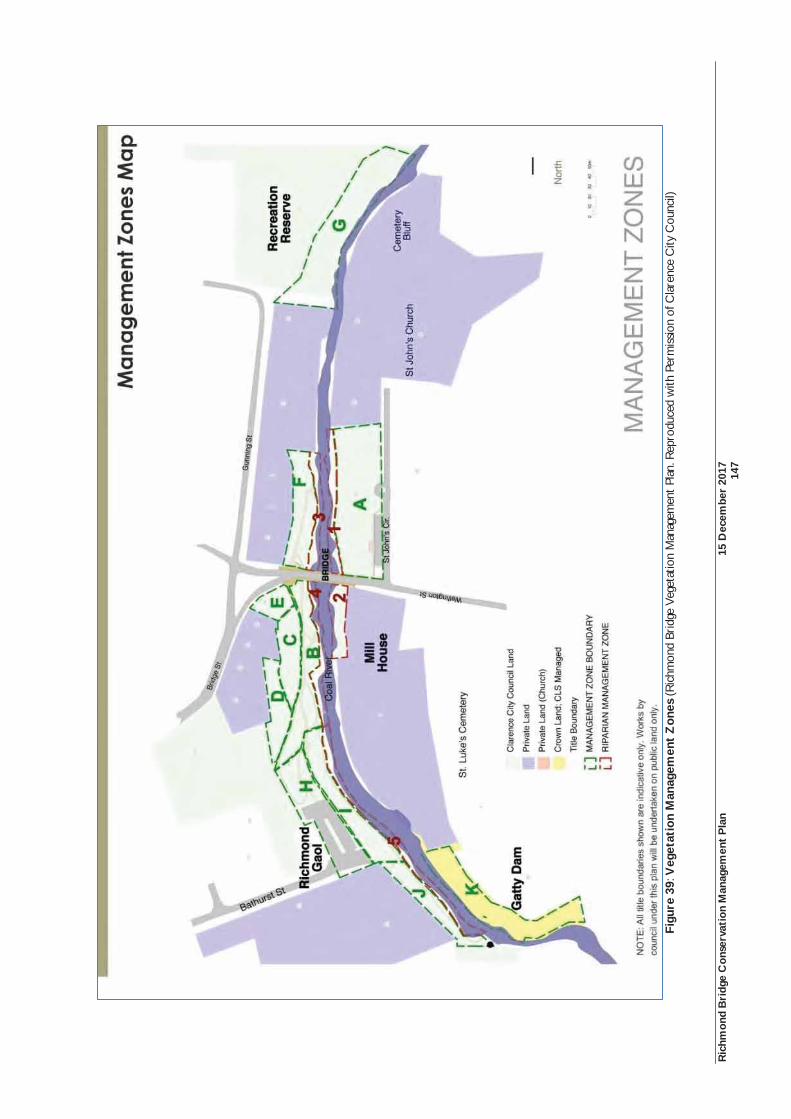
Ric
hmon
d B
ridg
e C
onse
rvat
ion
Man
agem
ent
Pla
n 15
Dec
embe
r 20
17
14
7
Fi
gure
39:
Veg
etat
ion
Man
agem
ent
Zon
es (R
ichm
ond
Brid
ge V
eget
atio
n M
anag
emen
t Pl
an. R
epro
duce
d w
ith P
erm
issio
n of
Cla
renc
e C
ity C
ounc
il)
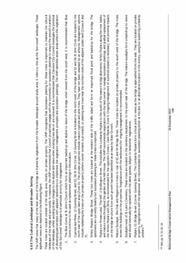
Ric
hmon
d B
ridg
e C
onse
rvat
ion
Man
agem
ent
Pla
n 15
Dec
embe
r 20
17
14
8
6.9.
5 T
he C
ultu
ral L
ands
cape
and
Bro
ader
Set
ting
The
VM
P no
tes
that
man
y of
the
bes
t vi
ews
of t
he b
ridg
e ar
e fr
amed
by
vege
tatio
n fr
om t
he b
road
er la
ndsc
ape
arou
nd s
tudy
are
a. It
ref
ers
to t
his
as t
he ‘b
orro
wed
’ lan
dsca
pe. T
hese
si
gnifi
cant
vie
ws
are
depi
cted
in t
he fo
llow
ing
Figu
re.
The
se t
rees
are
loc
ated
out
side
of
the
stud
y ar
ea,
mos
tly o
n pr
ivat
e pr
oper
ty.
The
VM
P re
cogn
ises
tha
t su
cces
sion
pla
ntin
g fo
r th
ese
tree
s is
im
port
ant
to m
aint
ain
the
cultu
ral
land
scap
e of
the
bri
dge
and
surr
ound
s. In
res
pons
e, t
he V
MP
reco
mm
ends
tha
t C
ounc
il pr
oact
ivel
y en
gage
with
the
com
mun
ity o
n su
cces
sion
pla
ntin
gs t
o en
sure
the
sm
ooth
tra
nsiti
on
of t
he la
ndsc
ape,
whi
lst
avoi
ding
dra
stic
cha
nges
to
the
skyl
ine
and
view
s w
hen
exis
ting
tree
s di
e or
are
rem
oved
. It
is r
ecom
men
ded
that
Cla
renc
e C
ity C
ounc
il in
vest
igat
e th
e po
tent
ial
of d
evel
opin
g pa
rtne
rshi
ps w
ith a
djac
ent
land
owne
rs t
o im
plem
ent
the
vege
tatio
n m
anag
emen
t pr
inci
ples
and
suc
cess
ion
plan
tings
. The
VM
P id
entif
ies
seve
n ar
eas
whe
re t
he v
eget
atio
n of
thi
s ‘b
orro
wed
’ lan
dsca
pe is
of p
artic
ular
pri
ority
for
man
agem
ent:
1.T
he B
lue
Gum
s at
St
John
’s C
hurc
h w
hich
form
an
impo
rtan
t ba
ckdr
op a
nd s
kylin
e to
vie
ws
of t
he b
ridg
e, w
hen
view
ed fr
om t
he s
outh
wes
t. It
is r
ecom
men
ded
that
Blu
e G
ums
cont
inue
to
be u
sed
as r
epla
cem
ent
plan
tings
in t
his
loca
tion.
2.C
ypre
ss a
nd P
ines
, 12
Gun
ning
Str
eet,
and
52, 5
6 St
John
Cir
cle:
12
Gun
ning
Str
eet
is lo
cate
d to
the
nor
th w
est
of t
he b
ridg
e an
d 52
and
56
St Jo
hn C
ircl
e ar
e lo
cate
d to
the
no
rth
east
of t
he o
pen
law
n ar
ea (
Zon
e A
). T
he p
riva
te p
rope
rtie
s in
clud
e m
atur
e cy
pres
s an
d pi
ne t
rees
. The
y ha
ve n
ot b
een
asse
ssed
by
an a
rbor
ist.
Man
agem
ent
optio
ns
incl
ude
repl
antin
g th
e tr
ees
on t
he p
riva
te p
rope
rty
(whe
re o
wne
r co
nsen
t is
pro
vide
d), o
r pl
antin
g ne
w t
rees
nea
r th
e no
rthe
rn e
nds
of t
he a
djac
ent
publ
ic la
nd (
Zon
es A
and
F)
.
3.W
hite
Pop
lars
, Br
idge
Str
eet.
The
se t
wo
tree
s ar
e lo
cate
d at
the
wes
tern
sid
e of
the
tra
ffic
isla
nd a
nd f
orm
an
impo
rtan
t fo
cal
poin
t an
d ba
ckdr
op f
or t
he b
ridg
e. T
he
spec
imen
s ar
e cu
rren
tly h
ealth
y bu
t su
cces
sion
pla
nnin
g fo
r th
ese
tree
s is
impo
rtan
t.
4.Po
plar
s on
Pri
vate
Lan
d, ‘T
he M
ill’,
2 W
ellin
gton
Str
eet.
Thi
s in
clud
es t
he L
omba
rdy
Popl
ars
to t
he s
outh
of t
he e
aste
rn b
ridg
e ab
utm
ents
; Whi
te P
opla
rs a
long
the
riv
er b
anks
; an
d m
atur
e tr
ees
thro
ugho
ut t
he g
arde
n of
the
Mill
Hou
se. T
he V
MP
reco
mm
ends
neg
otia
tion
with
the
land
ow
ner
to m
anag
e su
cces
sion
plan
tings
, and
gra
dual
rep
lace
men
t of
th
e W
hite
Pop
lars
with
Elm
s, a
s re
com
men
ded
for
the
oppo
site
Zon
es I,
J an
d R
ipar
ian
Zon
e 5.
Ong
oing
man
agem
ent
of s
ucke
red
popl
ars
is n
eces
sary
, and
pot
entia
l im
pact
s on
the
bri
dge
stru
ctur
e fr
om s
uch
grow
th h
as b
een
iden
tifie
d as
an
issu
e by
Sta
te G
row
th.
5.M
atur
e Eu
caly
pt, S
he-O
ak a
nd P
eppe
rcor
n tr
ees
to r
ear
of 6
2 an
d 64
Bri
dge
Stre
et. T
hese
tre
es a
re lo
cate
d on
pri
vate
pro
pert
y to
the
sou
th w
est
of t
he b
ridg
e. T
he t
rees
sc
reen
the
bui
ldin
gs o
n th
e pr
oper
ties.
Neg
otia
tions
with
the
land
owne
rs fo
r on
goin
g m
anag
emen
t is
rec
omm
ende
d.
6.Eu
caly
pts
wes
t of
St
Luke
’s C
emet
ery.
The
se t
rees
are
loca
ted
on t
he c
emet
ery
esca
rpm
ent,
to t
he s
outh
eas
t of
the
bri
dge.
The
mat
ure
euca
lypt
s fo
rm a
bac
kdro
p to
vie
ws
and
shou
ld e
vent
ually
be
repl
aced
with
the
sam
e sp
ecie
s, s
ubje
ct t
o la
ndow
ner
nego
tiatio
ns.
7.Po
plar
s, 5
1 Br
idge
Str
eet
(Cor
ner
Gun
ning
Str
eet)
. The
Lom
bard
y Po
plar
s fo
rm a
foca
l poi
nt t
o vi
ews
as t
he b
ridg
e is
app
roac
hed
from
the
eas
t. T
hey
are
loca
ted
on p
riva
te
prop
erty
. Neg
otia
tions
with
the
land
owne
r ar
e re
com
men
ded
for
succ
essi
on p
lann
ing
eith
er a
t th
is s
ite, o
r an
alte
rnat
ive
loca
tion
in t
he v
icin
ity, u
sing
low
-suc
keri
ng L
omba
rdy
popl
ars.
255
255
Ibid
, pp.
8, 3
1-32
, 34
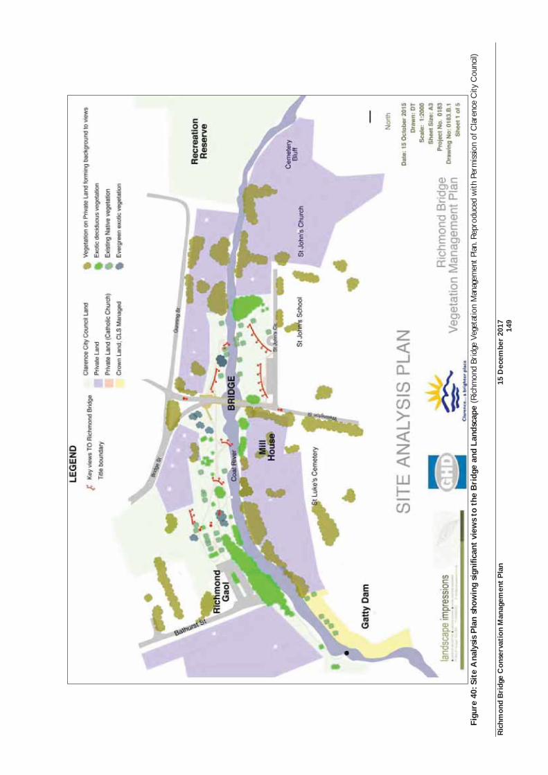
Ric
hmon
d B
ridg
e C
onse
rvat
ion
Man
agem
ent
Pla
n 15
Dec
embe
r 20
17
14
9
Fi
gure
40:
Sit
e A
naly
sis
Pla
n sh
owin
g si
gnifi
cant
vie
ws
to t
he B
ridg
e an
d La
ndsc
ape
(Ric
hmon
d Br
idge
Veg
etat
ion
Man
agem
ent
Plan
. Rep
rodu
ced
with
Per
mis
sion
of C
lare
nce
City
Cou
ncil)
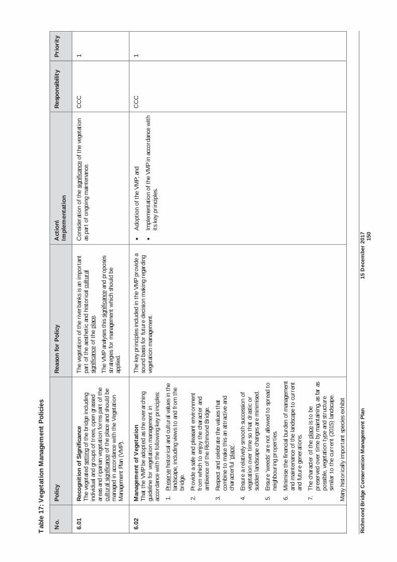
Ric
hmon
d B
ridg
e C
onse
rvat
ion
Man
agem
ent
Pla
n 15
Dec
embe
r 20
17
15
0
Tab
le 1
7: V
eget
atio
n M
anag
emen
t P
olic
ies
No.
P
olic
y
Rea
son
for
Pol
icy
Act
ion\
Im
plem
enta
tion
R
espo
nsib
ility
P
rior
ity
6.01
R
ecog
niti
on o
f Sig
nific
ance
T
he v
eget
ated
set
ting
of t
he b
ridg
e in
clud
ing
indi
vidu
al a
nd g
roup
s of
tre
es, o
pen
gras
sed
area
s an
d ri
pari
an v
eget
atio
n fo
rms
part
of t
he
cultu
ral s
igni
fican
ce o
f the
pla
ce a
nd s
houl
d be
m
anag
ed in
acc
orda
nce
with
the
Veg
etat
ion
Man
agem
ent
Plan
(VM
P).
The
veg
etat
ion
of t
he r
iver
bank
s is
an im
port
ant
part
of t
he a
esth
etic
and
hist
oric
al c
ultu
ral
sign
ifica
nce
of t
he p
lace
.
The
VM
P an
alys
es t
his
signi
fican
ce a
nd p
ropo
ses
stra
tegi
es fo
r m
anag
emen
t w
hich
sho
uld
be
appl
ied.
Con
side
ratio
n of
the
sig
nific
ance
of t
he v
eget
atio
n as
par
t of
ong
oing
mai
nten
ance
. C
CC
1
6.02
M
anag
emen
t of
Veg
etat
ion
Tha
t th
e V
MP
be a
dopt
ed a
s th
e ov
erar
chin
g gu
idel
ine
for
vege
tatio
n m
anag
emen
t in
ac
cord
ance
with
the
follo
win
g ke
y pr
inci
ples
:
1.Pr
eser
ve h
istor
ical
and
cul
tura
l val
ues
in t
he
land
scap
e, in
clud
ing
view
s to
and
from
the
br
idge
.
2.Pr
ovid
e a
safe
and
ple
asan
t en
viro
nmen
t fr
om w
hich
to
enjo
y th
e ch
arac
ter
and
ambi
ence
of t
he R
ichm
ond
Brid
ge.
3.R
espe
ct a
nd c
eleb
rate
the
valu
es t
hat
com
bine
to
mak
e th
is an
att
ract
ive
and
char
acte
rful
‘pla
ce’.
4.En
sure
a r
elat
ivel
y sm
ooth
suc
cess
ion
of
vege
tatio
n ov
er t
ime
so t
hat
dras
tic o
r su
dden
land
scap
e ch
ange
s ar
e m
inim
ised
.
5.En
sure
‘wee
ds’ a
re n
ot a
llow
ed t
o sp
read
to
neig
hbou
ring
pro
pert
ies.
6.M
inim
ise
the
finan
cial
bur
den
of m
anag
emen
t an
d m
aint
enan
ce o
f the
land
scap
e to
cur
rent
an
d fu
ture
gen
erat
ions
.
7.T
he c
hara
cter
of t
he p
lace
is t
o be
pr
eser
ved
over
tim
e by
mai
ntai
ning
, as
far
as
poss
ible
, veg
etat
ion
type
and
str
uctu
re
sim
ilar
to t
he c
urre
nt (
2015
) lan
dsca
pe.
Man
y hi
stor
ical
ly im
port
ant
spec
ies
exhi
bit
The
key
pri
ncip
les
incl
uded
in t
he V
MP
prov
ide
a so
und
basi
s fo
r fu
ture
dec
isio
n m
akin
g re
gard
ing
vege
tatio
n m
anag
emen
t.
Ado
ptio
n of
the
VM
P; a
nd
Impl
emen
tatio
n of
the
VM
P i n
acc
orda
nce
with
its
key
pri
ncip
les.
CC
C
1
Ric
hmon
d B
ridg
e C
onse
rvat
ion
Man
agem
ent
Pla
n 15
Dec
embe
r 20
17
15
1
No.
P
olic
y
Rea
son
for
Pol
icy
Act
ion\
Im
plem
enta
tion
R
espo
nsib
ility
P
rior
ity
unde
sira
ble
trai
ts, a
nd in
sev
eral
cas
es a
re n
ow
decl
ared
wee
ds. R
epla
cem
ent
plan
ting
and
succ
essio
n pl
antin
g sh
ould
be
impl
emen
ted
in-
line
with
the
VM
P re
com
men
datio
ns t
o in
crem
enta
lly r
epla
ce t
hese
spe
cies
with
mod
ern
culti
vars
or
new
spe
cies
tha
t w
ould
mai
ntai
n th
e ch
arac
ter
of t
he p
lace
.256
6.03
W
eed
Man
agem
ent
Tha
t th
e W
eed
Stra
tegy
con
tain
ed in
the
VM
P be
im
plem
ente
d, a
ckno
wle
dgin
g th
at s
ome
wee
ds
are
natu
ralis
ed s
peci
men
s of
hist
oric
al p
lant
ings
on
or
adja
cent
to
the
stud
y ar
ea, a
nd m
ay
ther
efor
e be
impo
rtan
t el
emen
ts c
ontr
ibut
ing
to
the
char
acte
r of
the
pla
ce. 25
7
The
cha
ract
er o
f the
pla
ce is
ess
entia
lly t
hat
of a
Eu
rope
an la
ndsc
ape.
The
obj
ectiv
e of
mai
ntai
ning
th
is ch
arac
ter
need
s to
be
bala
nced
aga
inst
m
inim
isin
g en
viro
nmen
tal a
nd e
cono
mic
impa
cts
of
wee
ds, a
nd in
par
ticul
ar t
he e
ight
iden
tifie
d ‘p
rior
ity w
eeds
’. 258
Impl
emen
t th
e si
x po
int
stra
tegy
for
wee
d m
anag
emen
t as
cont
aine
d in
the
VM
P.
CC
C
1
6.04
M
anag
emen
t th
roug
h Z
onin
g T
hat
the
zoni
ng o
f the
pla
ce b
e us
ed a
s th
e m
echa
nism
for
man
agin
g th
e ch
arac
ter,
val
ues,
an
d is
sues
for
each
zon
ing
area
.
The
VM
P di
vide
d th
e pu
blic
ly o
wne
d ri
ver
bank
s in
to s
epar
ate
‘Man
agem
ent Z
ones
’ bas
ed o
n th
e ra
tiona
le t
hat
the
diffe
rent
are
as h
ave
uniq
ue
land
scap
e ch
arac
teri
stic
s w
arra
ntin
g di
ffere
nt
appr
oach
es t
o la
ndsc
ape
man
agem
ent.
The
VM
P id
entif
ies
16 s
peci
fic z
ones
. Ele
ven
of t
hese
rel
ate
to t
he p
ublic
ly a
cces
sibly
riv
erba
nks
(Zon
es A
-K)
and
five
rela
te t
o R
ipar
ian
Man
agem
ent
Zon
es (
1-5)
.
Ado
pt t
he o
bjec
tives
for
each
of t
he
man
agem
ent z
ones
;
Add
ress
the
key
veg
etat
ion
man
agem
ent
issu
es
for
each
zon
e; a
nd
Impl
emen
t th
e m
ain
pres
crip
tions
for
each
zo
ne.
CC
C
1
6.05
M
anag
emen
t of
the
Bro
ader
Veg
etat
ed
Sett
ing
Tha
t C
CC
pro
activ
ely
enga
ge w
ith t
he
com
mun
ity a
nd p
riva
te la
ndow
ners
on
vege
tatio
n m
anag
emen
t, in
clud
ing
succ
essio
n pl
antin
gs t
o en
sure
the
sm
ooth
tra
nsiti
on o
f the
land
scap
e.
The
bro
ader
Ric
hmon
d to
wns
cape
and
its
plan
tings
pr
ovid
e an
impo
rtan
t bac
kgro
und
or s
ettin
g fo
r th
e br
idge
land
scap
e.
The
se t
rees
are
on
priv
ate
prop
erty
and
out
side
of
the
area
s of
land
ow
ned
and
man
aged
by
Cla
renc
e C
ity C
ounc
il.
A c
oope
rativ
e ap
proa
ch t
o m
anag
e th
is ve
geta
tion
is re
com
men
ded.
Mec
hani
sms
unde
r th
e Pl
anni
ng
Sche
me
may
als
o as
sist
in m
anag
ing
chan
ges
to
Ado
pt a
coo
pera
tive
appr
oach
with
the
la
ndow
ners
of s
igni
fican
t ve
geta
tion
loca
ted
on
priv
ate
prop
ertie
s as
iden
tifie
d in
the
VM
P.
CC
C
1
256
Ibid
, p.6
25
7 Ib
id, p
.29
258
Ibid
, p.2
9
Ric
hmon
d B
ridg
e C
onse
rvat
ion
Man
agem
ent
Pla
n 15
Dec
embe
r 20
17
15
2
No.
P
olic
y
Rea
son
for
Pol
icy
Act
ion\
Im
plem
enta
tion
R
espo
nsib
ility
P
rior
ity
vege
tatio
n.
6.06
V
eget
atio
n M
anag
emen
t P
lan
Act
ion
Pla
n A
dopt
the
VM
P A
ctio
n Pl
an (
App
endi
x 1
of t
he
VM
P) a
s th
e pl
an fo
r ac
hiev
ing
the
vege
tatio
n m
anag
emen
t obj
ectiv
es.
The
Act
ion
Plan
doc
umen
ts th
e va
riou
s ac
tions
re
com
men
ded
to im
plem
ent
the
prin
cipl
es a
nd
stra
tegi
es o
f the
VM
P. T
he A
ctio
n Pl
an id
entif
ies
spec
ific
vege
tatio
n w
orks
suc
h as
tre
e re
mov
al o
r pr
unin
g, a
nd r
emov
al o
f stu
mps
, shr
ubs
of w
eeds
. Ea
ch a
ctio
n is
allo
cate
d a
prio
rity
of h
igh
(with
in 6
m
onth
s), m
oder
ate
(6-1
8 m
onth
s) o
r lo
w (1
8 m
onth
s-3
year
s), a
nd id
entif
ies
the
resp
onsib
le
part
y, b
ased
on
land
ow
ners
hip,
nam
ely
Cla
renc
e C
ity C
ounc
il an
d St
ate
Gro
wth
.
Impl
emen
t th
e V
MP
Act
ion
Plan
. C
CC
/Sta
te
Gro
wth
1-
3
6.07
P
roce
sses
for
Wor
ks
Seek
nec
essa
ry C
omm
onw
ealth
, Sta
te a
nd L
ocal
he
rita
ge a
ppro
vals
whe
n un
dert
akin
g ac
tions
, w
orks
or
deve
lopm
ent
whi
ch m
ay a
ffect
si
gnifi
cant
veg
etat
ion.
The
her
itage
list
ing
of t
he p
lace
incl
udes
its
vege
tate
d se
ttin
g, p
rinc
ipal
ly t
he p
ublic
ally
ac
cess
ible
riv
erba
nks.
Seek
and
obt
ain
all n
eces
sary
per
mits
. Pa
rtie
s pr
opos
ing
wor
ks
1
Ric
hmon
d B
ridg
e C
onse
rvat
ion
Man
agem
ent
Pla
n 15
Dec
embe
r 20
17
15
3
6.10
Riv
er M
anag
emen
t
Afte
r th
e br
idge
, the
Coa
l Riv
er is
the
dom
inan
t el
emen
t of
the
pla
ce.
It ha
s im
port
ant
hist
oric
al a
nd a
esth
etic
val
ues
prov
idin
g a
stro
ng n
orth
-sou
th a
xis
with
in t
he li
near
land
scap
e.
Enha
ncin
g th
e he
alth
of t
he C
oal R
iver
bri
ngs
both
env
iron
men
tal a
nd c
ultu
ral b
enef
its.
An
area
of c
once
rn a
re t
he r
isks
it p
oses
to
the
brid
ge d
urin
g tim
es o
f flo
od. F
lood
dam
age
to
the
brid
e ha
s al
so b
een
prev
ious
ly id
entif
ied
by t
he c
omm
unity
as
a co
ncer
n.
In 1
995,
a fl
ood
plai
n st
udy
of R
ichm
ond
was
und
erta
ken.
The
stu
dy a
imed
to
dete
rmin
e th
e ex
tent
and
hei
ght
of fl
oodi
ng d
ue t
o flo
odin
g ev
ents
in t
he C
oal R
iver
. The
ana
lysi
s fo
und
that
the
are
a w
as p
rone
to
flood
ing
at s
elec
ted
risk
leve
ls a
nd h
ence
can
be
used
to
guid
e de
velo
pmen
t an
d pl
anni
ng w
ithin
cer
tain
are
as. B
ette
r in
form
atio
n on
floo
d le
vels
and
flow
s w
ould
impr
ove
the
accu
racy
of t
he r
esul
ts, a
nd it
was
rec
omm
ende
d th
at d
urin
g flo
ods
the
Ric
hmon
d Br
idge
sho
uld
be u
sed
as a
hyd
rogr
aph
to a
id t
he g
augi
ng o
f flo
w d
urin
g th
e flo
od.
The
stu
dy a
lso f
ound
tha
t th
e br
idge
itse
lf co
uld
pote
ntia
lly h
ave
a si
gnifi
cant
impa
ct o
n flo
w in
the
riv
er.
The
mod
ellin
g sh
owed
tha
t an
Ann
ual E
xcee
danc
e Pr
obab
ility
(A
EP)
of 1
:20
wou
ld r
esul
t in
floo
ding
of t
he r
iver
bank
are
as o
f Ric
hmon
d. A
EP’s
at
1:50
or
1:10
0 pr
obab
ilitie
s w
ould
res
ult
in t
he fl
oodi
ng o
f ext
ensi
ve a
reas
to
the
nort
h ea
st o
f St
John
’s C
hurc
h an
d on
the
sou
th e
ast
rive
rban
k.25
9 The
199
5 st
udy
prov
ides
impo
rtan
t in
form
atio
n on
ana
lysi
ng fl
ood
risk
. How
ever
, it
does
not
pro
vide
rec
omm
enda
tions
on
how
to
man
age
flood
ris
ks.
A h
ydra
ulic
ana
lysi
s w
as p
repa
red
for
the
1997
Con
serv
atio
n Pl
an. T
he h
ydra
ulic
ana
lysi
s fo
und
that
bec
ause
of t
he s
hallo
w r
iver
bed
slop
e, t
here
wer
e m
inim
al d
iffer
ence
s in
hyd
rost
atic
pr
essu
re b
etw
een
the
upst
ream
and
dow
nstr
eam
bri
dge
face
s. S
houl
d w
ater
lev
els
incr
ease
abo
ve t
he a
rch
soffi
ts,
wat
er w
ould
flo
w a
cros
s th
e ro
ad a
nd b
ehin
d th
e pa
rape
t w
alls
. A
lthou
gh it
was
con
clud
ed t
hat
this
wat
er m
ovem
ent
wou
ld e
nsur
e m
inim
al d
iffer
entia
l hyd
rost
atic
pre
ssur
e on
the
ups
trea
m p
arap
et w
all,
heav
y de
bris
cou
ld p
ose
a pr
oble
m.
The
av
erag
e re
curr
ence
inte
rval
for
floo
ds r
each
ing
the
mai
n ar
ch s
offit
was
onc
e ev
ery
90 y
ears
. Fl
ood
leve
ls r
each
ing
the
top
of t
he p
avem
ent
of t
he b
ridg
e ar
e es
timat
ed a
s oc
curr
ing
ever
y 25
0 ye
ars,
and
rea
chin
g th
e to
p of
the
par
apet
s on
ce e
very
100
0 ye
ars.
The
hyd
raul
ic a
naly
sis
reco
gnis
ed t
hat
flood
ris
k co
uld
be r
educ
ed w
here
the
cap
acity
of
the
rive
r co
uld
be im
prov
ed. T
hat
is, a
10%
red
uctio
n in
the
‘rou
ghne
ss’ o
f th
e ri
verb
anks
w
ould
res
ult
in a
cor
resp
ondi
ng 1
0% in
crea
se in
flow
cap
acity
. Fo
r th
is r
easo
n, it
was
rec
omm
ende
d th
at w
illow
s an
d ot
her
dens
e gr
owth
sho
uld
be r
igor
ousl
y co
ntro
lled.
As
note
d,
cons
ider
able
wor
k ha
s be
en a
chie
ved
in r
emov
ing
will
ows
from
the
riv
erba
nks.
How
ever
, att
entio
n sh
ould
be
give
n to
nor
th e
ast
rive
rban
k be
low
St
John
’s C
emet
ery
bluf
f. T
he r
emov
al
of w
illow
s w
ill r
equi
re c
ontin
ual w
ork.
Not
ing
the
risk
and
pre
ssur
es d
ebri
s co
uld
pose
to
the
brid
ge, t
he h
ydra
ulic
ana
lysi
s re
com
men
ded
the
rem
oval
of i
tem
s lik
e fe
nces
in t
he li
ne o
f th
e flo
odw
ay.26
0
The
Dep
artm
ent
has
prev
ious
ly a
dvis
ed t
hat
the
1997
hyd
raul
ic a
naly
sis
rem
ains
app
licab
le.
Thi
s C
MP
reco
mm
ends
a c
oord
inat
ed a
ppro
ach
to m
itiga
ting
flood
ris
ks t
hrou
gh t
he
prep
arat
ion
of a
floo
d m
anag
emen
t pl
an. T
he fl
ood
man
agem
ent
plan
sho
uld
revi
ew p
revi
ous
stud
ies
and
mor
e re
cent
info
rmat
ion
or d
ata
on fl
ood
risk
ass
essm
ents
and
man
agem
ent
appr
oach
es.
The
com
plet
ion
of t
he C
raig
bour
ne D
am in
198
7 re
gula
ted
the
flow
of w
ater
dow
nstr
eam
, and
has
mod
erat
ed p
revi
ous
seas
onal
fluc
tuat
ions
. Pri
or t
o th
e co
nstr
uctio
n of
the
dam
, the
ri
ver
wou
ld c
ease
flo
win
g an
d dr
y up
fre
quen
tly d
urin
g su
mm
ers.
Geo
tech
nica
l te
stin
g w
as c
arri
ed o
ut i
n 20
17 a
nd h
ydro
logi
cal
inve
stig
atio
ns a
re u
nder
way
to
dete
rmin
e if
rapi
d flu
ctua
tions
in w
ater
leve
ls a
t th
e br
idge
hav
e th
e po
tent
ial t
o ca
use
geot
echn
ical
issu
es w
hich
wou
ld c
ompr
omis
e th
e st
ruct
ural
inte
grity
of t
he b
ridg
e. In
vest
igat
ions
are
ong
oing
, and
th
e re
sults
of t
his
hydr
olog
ical
wor
k w
ill b
e us
ed t
o de
term
ine
wha
t, if
any,
act
ion
is n
eede
d.
259
Hyd
ro E
lect
ric
Com
miss
ion,
Tas
man
ia, W
ater
Res
ourc
es D
epar
tmen
t, Ri
chm
ond
Floo
d Pl
ain
Stud
y. D
epar
tmen
t of P
rimar
y In
dust
ry a
nd F
isher
ies,
Tasm
ania
. Lan
d &
Wat
er R
esou
rces
Divi
sion,
June
199
5, R
epor
t N
o. 0
01-0
546-
CR-
001,
pp.
7, 2
2, F
lood
Inun
datio
n M
ap
260
Nig
el L
ewis
et.
al.,
op. c
it, p
p. 6
5-66
Ric
hmon
d B
ridg
e C
onse
rvat
ion
Man
agem
ent
Pla
n 15
Dec
embe
r 20
17
15
4
Tab
le 1
8: R
iver
Man
agem
ent
Pol
icie
s
No.
P
olic
y
Rea
son
for
Pol
icy
Act
ion\
Im
plem
enta
tion
R
espo
nsib
ility
P
rior
ity
7.01
G
ener
al M
anag
emen
t of
Coa
l Riv
er
The
Coa
l Riv
er is
to
be m
anag
ed a
s an
ele
men
t of
cultu
ral s
igni
fican
ce.
The
Coa
l Riv
er is
a d
efin
ing
elem
ent
of t
he p
lace
an
d an
inte
gral
par
t of
the
hist
ory
and
perc
eptio
n of
the
bri
dge
and
ther
efor
e its
cul
tura
l sig
nific
ance
.
Cha
nges
to
the
natu
re o
f the
Coa
l Riv
er, f
or
exam
ple
flow
and
wat
er q
ualit
y, s
houl
d be
co
nsid
ered
for
thei
r im
pact
on
the
cultu
ral
sign
ifica
nce
of t
he p
lace
.
Tas
man
ian
Irri
gatio
n/W
&M
R 1
7.02
H
ealt
h of
Coa
l Riv
er
The
wat
er q
ualit
y of
the
Coa
l Riv
er s
houl
d be
en
hanc
ed.
The
hea
lth o
f the
Coa
l Riv
er is
impo
rtan
t fo
r en
viro
nmen
tal r
easo
ns.
It al
so a
ssis
ts in
the
con
serv
atio
n of
the
rip
aria
n ve
geta
tion
whi
ch is
an
impo
rtan
t el
emen
t of
cu
ltura
l sig
nific
ance
.
Ong
oing
mon
itori
ng o
f wat
er h
ealth
.
W&
MR
1
7.03
Fl
ood
Man
agem
ent
Pla
n A
floo
d m
anag
emen
t pl
an is
to
be p
repa
red
to
assis
t in
pre
vent
ing
dam
age
to t
he b
ridg
e.
Floo
ds p
rese
nt a
risk
to
the
Ric
hmon
d Br
idge
. A
man
agem
ent p
lan
allo
ws
for
a co
ordi
nate
d an
d m
ore
effe
ctiv
e ap
proa
ch t
o m
itiga
ting
risk
s.
The
floo
d m
anag
emen
t pl
an s
houl
d re
view
pr
evio
us s
tudi
es a
nd m
ore
rece
nt in
form
atio
n or
da
ta o
n flo
od r
isk a
sses
smen
ts a
nd m
anag
emen
t ap
proa
ches
.
As
part
of a
coo
rdin
ated
app
roac
h to
floo
d ri
sk,
prep
are
a Fl
ood
Man
agem
ent
Plan
invo
lvin
g al
l ne
cess
ary
stak
ehol
ders
.
All
part
ies
1
7.04
R
emov
ing
Floo
d R
isks
Deb
ris
shou
ld b
e re
mov
ed fr
om u
pstr
eam
of t
he
brid
ge, w
hich
cou
ld p
ose
a ri
sk d
urin
g tim
es o
f flo
od.
Supp
ort
and
enco
urag
emen
t sh
ould
be
give
n to
the
w
ork
of L
andc
are
Aus
tral
ia in
rem
ovin
g cr
ack
will
ow a
nd d
ebri
s fr
om u
pstr
eam
of t
he b
ridg
e.
Land
care
Aus
tral
ia p
rovi
des
an im
port
ant
serv
ice
in r
emov
ing
crac
k w
illow
s an
d as
soci
ated
deb
ris
from
pub
lic, a
nd w
here
allo
wed
, pri
vate
land
.
The
Riv
erca
re P
lan
for
the
Coa
l Riv
er w
as
prep
ared
in 1
999
and
is b
eing
pro
gres
sivel
y im
plem
ente
d by
Coa
l Riv
er P
rodu
cts
Ass
ocia
tion
thro
ugh
its L
andc
are
Aus
tral
ia w
ork.
Thi
s m
ainl
y in
volv
es c
rack
will
ow r
emov
al a
nd r
eveg
etat
ion
with
nat
ive
plan
ts in
a c
ontr
olle
d w
ay, s
ectio
n by
se
ctio
n, t
o av
oid
bank
ero
sion
and
bui
ld u
p of
w
oody
deb
ris
whi
ch c
ould
thr
eate
n th
e br
idge
du
ring
floo
d.
The
rem
oval
of t
hese
ele
men
ts h
elps
miti
gate
floo
d ri
sk.
As
part
of a
coo
rdin
ated
app
roac
h to
floo
d ri
sk:
Rem
ove
debr
is fr
om u
pstr
eam
of t
he b
ridg
e;
Supp
ort
and
enco
urag
e th
e w
ork
of L
andc
are
Aus
tral
ia; a
nd
Ong
oing
mai
nten
ance
will
be
requ
ired
to
prev
ent
rein
fest
atio
n.
All
part
ies
1
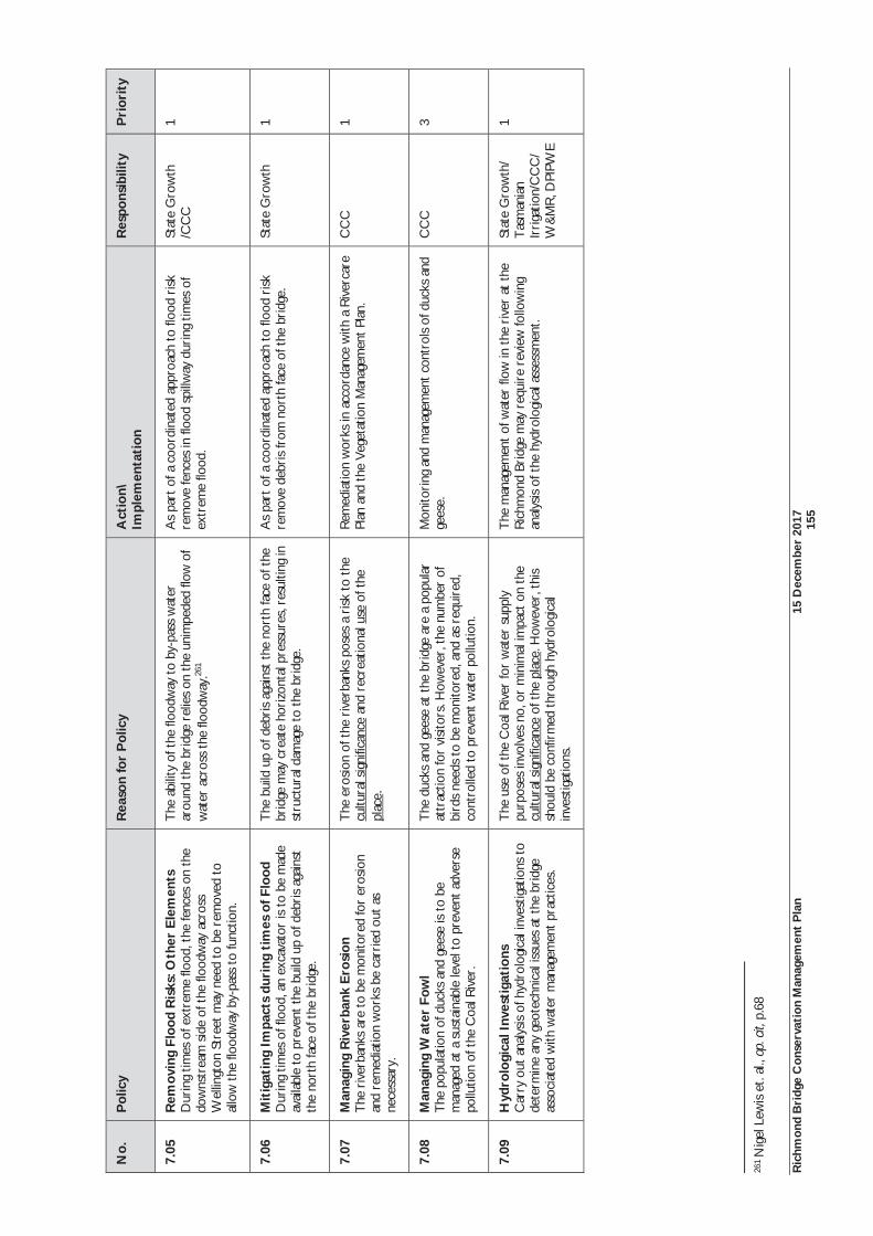
Ric
hmon
d B
ridg
e C
onse
rvat
ion
Man
agem
ent
Pla
n 15
Dec
embe
r 20
17
15
5
No.
P
olic
y
Rea
son
for
Pol
icy
Act
ion\
Im
plem
enta
tion
R
espo
nsib
ility
P
rior
ity
7.05
R
emov
ing
Floo
d R
isks
: Oth
er E
lem
ents
D
urin
g tim
es o
f ext
rem
e flo
od, t
he fe
nces
on
the
dow
nstr
eam
sid
e of
the
floo
dway
acr
oss
Wel
lingt
on S
tree
t m
ay n
eed
to b
e re
mov
ed t
o al
low
the
floo
dway
by-
pass
to
func
tion.
The
abi
lity
of t
he fl
oodw
ay t
o by
-pas
s w
ater
ar
ound
the
bri
dge
relie
s on
the
uni
mpe
ded
flow
of
wat
er a
cros
s th
e flo
odw
ay.26
1
As
part
of a
coo
rdin
ated
app
roac
h to
floo
d ri
sk
rem
ove
fenc
es in
floo
d sp
illw
ay d
urin
g tim
es o
f ex
trem
e flo
od.
Stat
e G
row
th
/CC
C
1
7.06
M
itig
atin
g Im
pact
s du
ring
tim
es o
f Flo
od
Dur
ing
times
of f
lood
, an
exca
vato
r is
to b
e m
ade
avai
labl
e to
pre
vent
the
bui
ld u
p of
deb
ris
agai
nst
the
nort
h fa
ce o
f the
bri
dge.
The
bui
ld u
p of
deb
ris
agai
nst
the
nort
h fa
ce o
f the
br
idge
may
cre
ate
hori
zont
al p
ress
ures
, res
ultin
g in
st
ruct
ural
dam
age
to t
he b
ridg
e.
As
part
of a
coo
rdin
ated
app
roac
h to
floo
d ri
sk
rem
ove
debr
is fr
om n
orth
face
of t
he b
ridg
e.
Stat
e G
row
th
1
7.07
M
anag
ing
Riv
erba
nk E
rosi
on
The
riv
erba
nks
are
to b
e m
onito
red
for
eros
ion
and
rem
edia
tion
wor
ks b
e ca
rrie
d ou
t as
ne
cess
ary.
The
ero
sion
of t
he r
iver
bank
s po
ses
a ri
sk t
o th
e cu
ltura
l sig
nific
ance
and
rec
reat
iona
l use
of t
he
plac
e.
Rem
edia
tion
wor
ks in
acc
orda
nce
with
a R
iver
care
Pl
an a
nd t
he V
eget
atio
n M
anag
emen
t Pl
an.
CC
C
1
7.08
M
anag
ing
Wat
er F
owl
The
pop
ulat
ion
of d
ucks
and
gee
se is
to
be
man
aged
at
a su
stai
nabl
e le
vel t
o pr
even
t ad
vers
e po
llutio
n of
the
Coa
l Riv
er.
The
duc
ks a
nd g
eese
at
the
brid
ge a
re a
pop
ular
at
trac
tion
for
visi
tors
. How
ever
, the
num
ber
of
bird
s ne
eds
to b
e m
onito
red,
and
as
requ
ired
, co
ntro
lled
to p
reve
nt w
ater
pol
lutio
n.
Mon
itori
ng a
nd m
anag
emen
t co
ntro
ls of
duc
ks a
nd
gees
e.
CC
C
3
7.09
H
ydro
logi
cal I
nves
tiga
tion
s C
arry
out
ana
lysis
of h
ydro
logi
cal i
nves
tigat
ions
to
dete
rmin
e an
y ge
otec
hnic
al is
sues
at
the
brid
ge
asso
ciat
ed w
ith w
ater
man
agem
ent
prac
tices
.
The
use
of t
he C
oal R
iver
for
wat
er s
uppl
y pu
rpos
es in
volv
es n
o, o
r m
inim
al im
pact
on
the
cultu
ral s
igni
fican
ce o
f the
pla
ce. H
owev
er, t
his
shou
ld b
e co
nfir
med
thr
ough
hyd
rolo
gica
l in
vest
igat
ions
.
The
man
agem
ent
of w
ater
flow
in t
he r
iver
at
the
Ric
hmon
d Br
idge
may
req
uire
rev
iew
follo
win
g an
alys
is of
the
hyd
rolo
gica
l ass
essm
ent.
Stat
e G
row
th/
Tas
man
ian
Irri
gatio
n/C
CC
/ W
&M
R, D
PIPW
E
1
261 N
igel
Lew
is e
t. al
., op
. cit,
p.6
8
Ric
hmon
d B
ridg
e C
onse
rvat
ion
Man
agem
ent
Pla
n 15
Dec
embe
r 20
17
15
6
6.11
Tra
ffic
and
Roa
d M
anag
emen
t T
he c
ontin
ued
use
of t
he b
ridg
e fo
r its
ori
gina
l pur
pose
form
s pa
rt o
f its
sig
nific
ance
. How
ever
, tra
ffic
man
agem
ent
rem
ains
an
ongo
ing
conc
ern
with
dam
age
aris
ing
from
:
vehi
cle
colli
sion
s w
ith t
he p
arap
ets;
The
inad
equa
cy o
f the
cur
rent
tra
ffic
calm
ing
mea
sure
s in
pre
vent
ing
spee
ding
ove
r th
e br
idge
;
The
vis
ual i
ntru
sion
of t
he c
urre
nt t
raffi
c ca
lmin
g m
easu
res;
The
vis
ual a
nd a
udito
ry im
pact
from
veh
icle
s on
the
aes
thet
ic s
igni
fican
ce a
nd v
isito
r ex
peri
ence
; and
The
lack
of m
onito
ring
and
enf
orce
men
t of
the
spe
ed a
nd lo
ad li
mit
over
the
bri
dge.
The
late
st A
nnua
l A
vera
ge D
aily
Tra
ffic
(AA
DT
) da
ta f
or t
he R
ichm
ond
Brid
ge d
ates
fro
m 2
014,
at
whi
ch t
ime
3,45
7 ve
hicl
es p
er d
ay w
ere
reco
rded
. Pre
viou
s A
AD
T d
ata
for
the
brid
ge n
oted
, 3,1
14 v
ehic
les
in 2
008;
2,8
71 v
ehic
les
in 2
004
and
2,32
8 ve
hicl
es in
200
0.
Dat
a fr
om 2
004
also
pro
vide
d so
me
info
rmat
ion
abou
t th
e ty
pe o
f veh
icle
s cr
ossi
ng t
he b
ridg
e at
tha
t tim
e. It
was
obs
erve
d th
at s
choo
l and
bus
tra
ffic
form
ed t
he b
ulk
of t
raffi
c on
the
br
idge
and
tha
t, so
me
90 li
ght
truc
ks c
ross
ed t
he b
ridg
e. In
Mar
ch a
nd A
pril
2000
, a t
hree
wee
k ve
hicl
e cl
assi
ficat
ion
surv
ey w
as u
nder
take
n to
exa
min
e if
vehi
cles
in e
xces
s of
the
25
tonn
e lo
ad li
mit
wer
e cr
ossi
ng t
he b
ridg
e. M
ore
than
60,
000
vehi
cles
wer
e re
cord
ed. T
hree
, one
-way
cro
ssin
gs b
y se
mi t
raile
rs w
ere
reco
rded
. The
sur
vey
tech
niqu
e di
d no
t m
easu
re
vehi
cle
mas
ses.
How
ever
it w
as c
oncl
uded
tha
t th
ere
was
no
evid
ence
tha
t ve
hicl
es e
xcee
ded
the
load
lim
it.
As
note
d in
the
pol
icie
s fo
r m
anag
ing
the
fabr
ic o
f the
bri
dge,
the
str
uctu
re is
sus
cept
ible
to
vibr
atio
ns, a
nd t
wo
of t
he c
ause
s of
vib
ratio
n re
late
to
traf
fic lo
ad a
nd t
raffi
c sp
eed.
An
issu
e of
som
e co
nten
tion
rem
ains
the
cur
rent
25
tonn
e ve
hicl
e lo
ad li
mit.
Pre
viou
s C
onse
rvat
ion
Man
agem
ent
Plan
s re
com
men
ded
that
thi
s be
red
uced
to
15 t
onne
s, a
dvic
e w
hich
w
as n
ot a
dopt
ed. T
he m
ore
rece
nt d
ata
obta
ined
fro
m v
ibra
tion
mon
itori
ng h
as s
how
n th
at t
he 2
5 to
nne
limit
is a
ccep
tabl
e, b
ut t
hat
vibr
atio
n ri
sks
incr
ease
sub
stan
tially
with
hig
h sp
eeds
and
bra
king
act
ions
ove
r th
e cr
est
of t
he b
ridg
e. T
his
2017
Con
serv
atio
n M
anag
emen
t Pl
an d
oes
not
reco
mm
end
a re
duct
ion
in l
oad
limit,
but
rat
her
the
limit
shou
ld b
e co
ntin
ually
rev
iew
ed t
hrou
gh v
ibra
tion
mon
itori
ng. O
f co
nsid
erab
le im
port
ance
is t
he n
eed
to a
lter
driv
er b
ehav
iour
. The
mos
t ef
fect
ive
mea
ns o
f do
ing
so is
thr
ough
enf
orce
men
t of
th
e sp
eed
limit.
Idea
lly t
his
wou
ld b
e fr
om a
fixe
d sp
eed
cam
era
on t
he a
ppro
ach
to t
he b
ridg
e. W
here
a fi
xed
cam
era
is n
ot i
nsta
lled,
mob
ile c
amer
as s
houl
d be
use
d at
the
cro
ssin
g w
ith g
reat
er r
egul
arity
as
a m
easu
re o
f cha
ngin
g dr
iver
beh
avio
ur.
App
ropr
iate
tra
ffic
man
agem
ent
solu
tions
sho
uld
be d
eter
min
ed b
etw
een
Stat
e G
row
th a
nd C
lare
nce
City
Cou
ncil.
In a
dditi
on t
o ad
dres
sing
the
roa
d tr
eatm
ent
and
appr
oach
es t
o th
e br
idge
, her
itage
issu
es s
houl
d be
con
side
red
in t
raffi
c m
anag
emen
t pl
anni
ng fo
r th
e br
idge
. Thi
s in
clud
es:
Inve
stig
ate
the
poss
ibili
ty o
f ins
talli
ng a
per
man
ent
spee
d ca
mer
a at
the
cro
ssin
g po
int
as a
mea
ns o
f enf
orci
ng t
he s
peed
lim
it;
If a
perm
anen
t sp
eed
cam
era
is n
ot in
stal
led,
the
reg
ular
use
of m
obile
spe
ed c
amer
as;
Pede
stri
an s
afet
y on
the
bri
dge
and
appr
oach
es;
Con
side
ratio
n of
app
ropr
iate
sta
ndar
d lig
hts
that
are
mor
e sy
mpa
thet
ic t
o th
e cu
ltura
l sig
nific
ance
of t
he p
lace
;
Con
side
ratio
n of
app
ropr
iate
sig
nage
reg
imes
; and
Ric
hmon
d B
ridg
e C
onse
rvat
ion
Man
agem
ent
Pla
n 15
Dec
embe
r 20
17
15
7
Inte
llige
nt A
cces
s R
ecor
ding
(IA
R)
on p
erm
it ve
hicl
e m
ovem
ent.
IAR
allo
ws
Stat
e G
row
th t
o re
mot
ely
mon
itor
the
mov
emen
t of
hea
vy v
ehic
les,
and
wou
ld p
rovi
de d
ata
on
perm
it ve
hicl
es e
xcee
ding
the
upp
er lo
ad li
mit
whi
ch h
ave
cros
sed
the
brid
ge. I
t is
env
isag
ed t
hat
IAR
for
the
brid
ge w
ould
form
par
t of
a m
onito
ring
pro
gram
for
the
broa
der
Stat
e ro
ad n
etw
ork.
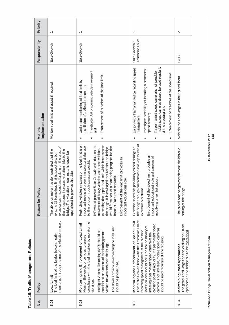
Ric
hmon
d B
ridg
e C
onse
rvat
ion
Man
agem
ent
Pla
n 15
Dec
embe
r 20
17
15
8
Tab
le 1
9: T
raffi
c M
anag
emen
t P
olic
ies
No.
P
olic
y
Rea
son
for
Pol
icy
Act
ion\
Im
plem
enta
tion
R
espo
nsib
ility
P
rior
ity
8.01
Lo
ad L
imit
T
he lo
ad li
mit
of t
he b
ridg
e be
con
tinua
lly
mon
itore
d th
roug
h th
e us
e of
the
vib
ratio
n m
eter
.
The
vib
ratio
n m
eter
has
dem
onst
rate
d th
at t
he
exist
ing
25 t
onne
load
lim
it is
acc
epta
ble,
but
ex
ceed
ance
s in
spe
ed a
nd b
raki
ng o
n th
e cr
est
of
the
brid
ge p
ose
incr
ease
d vi
brat
ion
risk
s to
the
br
idge
. The
vib
ratio
n m
eter
mus
t ho
wev
er b
e op
erat
iona
l to
prov
ide
this
data
.
Mon
itor
road
lim
it an
d ad
just
if r
equi
red.
Stat
e G
row
th
1
8.02
M
onit
orin
g an
d E
nfor
cem
ent
of L
oad
Lim
it
Mon
itor
the
wei
ght
of v
ehic
les
to e
nsur
e co
mpl
ianc
e w
ith t
he lo
ad li
mita
tion
by m
onito
ring
vi
brat
ion.
Inte
llige
nt A
cces
s R
ecor
ding
(IA
R) s
houl
d be
co
nsid
ered
as
a m
eans
of m
onito
ring
per
mit
vehi
cle
mov
emen
ts o
ver
the
brid
ge.
The
dri
vers
of v
ehic
les
exce
edin
g th
e lo
ad li
mit
shou
ld b
e pr
osec
uted
.
Res
tric
ting
vehi
cles
in e
xces
s of
the
load
lim
it is
an
impo
rtan
t m
eans
of p
reve
ntin
g st
ruct
ural
dam
age
to t
he b
ridg
e th
roug
h ex
cess
ive
wei
ght.
IAR
wou
ld p
rovi
de S
tate
Gro
wth
with
dat
a o n
the
m
ovem
ent
of h
eavy
veh
icle
s, a
nd t
hose
veh
icle
s ex
ceed
ing
the
uppe
r lo
ad li
mit
whi
ch h
ave
cros
sed
the
brid
ge. I
t is
env
isag
ed t
hat
IAR
for
the
brid
ge
wou
ld fo
rm p
art
of a
mon
itori
ng p
rogr
am fo
r th
e br
oade
r St
ate
road
net
wor
k.
Enfo
rcem
ent
of t
he lo
ad li
mit
prov
ides
an
impo
rtan
t ed
ucat
iona
l rol
e.
Und
erta
ke m
onito
ring
of l
oad
limit
by
inst
alla
tion
of a
vib
ratio
n m
onito
r;
Inve
stig
ate
IAR
on
perm
it ve
hicl
e m
ovem
ent;
and
Enfo
rcem
ent
of b
reac
hes
of t
he lo
ad li
mit.
Stat
e G
row
th
1
8.03
M
onit
orin
g an
d E
nfor
cem
ent
of S
peed
Lim
it
Tha
t St
ate
Gro
wth
liai
se w
ith t
he T
asm
ania
n Po
lice
rega
rdin
g sp
eed
man
agem
ent
at th
e cr
ossin
g.
Inve
stig
atio
ns s
houl
d oc
cur
on t
he p
ossib
ility
of
inst
allin
g a
perm
anen
t sp
eed
cam
era
at t
he
cros
sing
poin
t as
a p
rior
ity. I
f a p
erm
anen
t sp
eed
cam
era
is n
ot in
stal
led,
mob
ile s
peed
cam
eras
sh
ould
be
used
reg
ular
ly a
t th
e cr
ossin
g.
Exce
ssiv
e sp
eed
has
prev
ious
ly c
ause
d da
mag
e to
th
e br
idge
thr
ough
col
lisio
ns a
nd is
a k
ey s
ourc
e of
ex
cess
ive
vibr
atio
ns.
Enfo
rcem
ent
of t
he s
peed
lim
it pr
ovid
es a
n im
port
ant
educ
atio
nal r
ole
and
a m
eans
of
mod
ifyin
g dr
iver
beh
avio
ur.
Liai
son
with
Tas
man
ian
Polic
e re
gard
ing
spee
d m
anag
emen
t;
Inve
stig
ate
poss
ibili
ty o
f ins
talli
ng a
per
man
ent
spee
d ca
mer
a;
If a
perm
anen
t sp
eed
cam
era
is n
ot p
ossib
le,
mob
ile s
peed
cam
eras
sho
uld
be u
sed
regu
larl
y at
the
cro
ssin
g; a
nd
Enfo
rcem
ent
of b
reac
hes
of t
he s
peed
lim
it.
Stat
e G
row
th /
Tas
man
ian
Polic
e 1
8.04
M
aint
aini
ng R
oad
App
roac
hes
The
gra
vel r
oad
verg
es o
n th
e W
ellin
gton
Str
eet
appr
oach
to
the
brid
ge a
re t
o be
mai
ntai
ned.
The
gra
vel r
oad
verg
es c
ompl
emen
t th
e hi
stor
ic
sett
ing
of t
he b
ridg
e.
Mai
ntai
n th
e ro
ad v
erge
s in
the
ir g
rave
l for
m.
CC
C
2
Ric
hmon
d B
ridg
e C
onse
rvat
ion
Man
agem
ent
Pla
n 15
Dec
embe
r 20
17
15
9
6.12
Inte
rpre
tati
on
Inte
rpre
tatio
n re
fers
to
all
the
way
s of
pre
sent
ing
the
signi
fican
ce o
f th
e pl
ace.
It
may
be
a co
mbi
natio
n of
the
tre
atm
ent
and
fabr
ic o
f th
e pl
ace;
the
use
of
the
plac
e; t
he u
se o
f in
terp
retiv
e m
edia
, suc
h as
eve
nts,
act
iviti
es, s
igns
and
pub
licat
ions
, or
activ
ities
, but
is n
ot li
mite
d to
the
se e
xam
ples
. Int
erpr
etat
ion
can
form
an
inte
gral
par
t of
the
vis
itor
expe
rien
ce t
o he
rita
ge p
lace
s.26
2
The
Nat
iona
l Her
itage
Man
agem
ent
Prin
cipl
es a
lso
incl
ude
the
obje
ctiv
e of
pre
sent
ing
and
tran
smitt
ing
the
Nat
iona
l Her
itage
Val
ues
to a
ll ge
nera
tions
.
The
199
7 C
onse
rvat
ion
Plan
rec
omm
ende
d in
terp
reta
tion
wor
ks a
s a
prio
rity
and
tha
t in
terp
reta
tion
was
to
enco
mpa
ss t
he e
ntir
e hi
stor
y of
the
pla
ce,
base
d on
aut
hent
icity
. It
prov
ided
a n
umbe
r of
com
pone
nts
incl
udin
g:
Res
tora
tion
of t
he la
ndsc
ape
sett
ing
to t
he s
igni
fican
t pe
riod
(i.e
. to
1923
);
Ret
entio
n or
ree
stab
lishm
ent
of v
iew
ing
poin
ts, e
spec
ially
vie
ws
to S
t Jo
hn’s
;
Det
erm
ine
appr
opri
ate
wal
king
rou
tes,
pre
pare
map
and
gui
de a
nd d
iscr
eetly
def
ine
maj
or r
oute
s ne
ar t
he b
ridg
e us
ing
grou
nd le
vel m
arke
rs; a
nd
Publ
icat
ions
ran
ging
from
han
dout
s to
det
aile
d bo
oks.
263
At
pres
ent,
ther
e is
on-
site
int
erpr
etat
ion
incl
udin
g th
e ce
nten
ary
com
mem
orat
ion
ston
es,
info
rmat
ion
pane
ls,
the
view
ing
plat
form
adj
acen
t to
the
so
uth
wes
t ab
utm
ent,
and
two
view
ing
plat
form
s on
the
sou
th w
est
bank
from
whi
ch t
o ap
prec
iate
the
bri
dge
and
recr
eate
vie
ws
from
the
riv
er e
dge
look
ing
to S
t Jo
hn’s
Chu
rch
thro
ugh
the
arch
es o
f th
e br
idge
. C
erta
in a
spec
ts o
f the
her
itage
sig
nific
ance
of t
he R
ichm
ond
Brid
ge a
re e
asily
app
reci
ated
. For
exa
mpl
e, it
s hi
gh a
esth
etic
val
ues
and
stro
ng s
ense
of a
ge w
hich
rel
ates
to
the
hist
oric
al
impo
rtan
ce o
f th
e br
idge
. In
terp
reta
tion
of t
he h
isto
rica
l us
e an
d sig
nific
ance
of
the
sett
ing
of t
he b
ridg
e is
les
s w
ell
unde
rsto
od b
ut e
xpla
ined
in
sum
mar
y fo
rm t
hrou
gh t
he
inte
rpre
tatio
n pa
nels
. The
Nat
iona
l Her
itage
Val
ues
of t
he b
ridg
e ar
e al
so a
ckno
wle
dged
on
a pa
nel i
nsta
lled
in r
ecen
t ye
ars.
Impo
rtan
tly, t
he b
ridg
e an
d its
set
ting
form
par
t of
a b
road
er la
ndsc
ape
and
tow
nsca
pe. R
elat
ions
hips
exi
st b
etw
een
the
brid
ge a
nd n
umer
ous
othe
r si
tes
such
as
the
gaol
, cou
rt h
ouse
, ce
met
erie
s an
d co
ttag
es n
ear
the
brid
ge. A
ny in
terp
reta
tion
shou
ld p
rovi
de a
hol
istic
app
roac
h to
pre
sent
ing
the
sign
ifica
nce
of t
he b
ridg
e w
ithin
thi
s br
oade
r se
ttin
g.
A v
arie
ty o
f opt
ions
may
be
appr
opri
ate
for
the
brid
ge a
nd it
s se
ttin
g. W
hat
is im
port
ant
is t
hat
it st
imul
ates
vis
itors
and
enh
ance
s th
eir
unde
rsta
ndin
g of
the
pla
ce. O
ptio
ns m
ay in
clud
e:
Con
side
r op
tions
tha
t in
tegr
ate
the
brid
ge a
nd s
ettin
g in
to a
bro
ader
Ric
hmon
d vi
sito
r ex
peri
ence
, for
exa
mpl
e, t
he R
ichm
ond
Gao
l, th
e M
iller
’s C
otta
ge, B
ridg
e St
reet
, and
th
e C
hurc
hes
and
cem
eter
ies;
The
use
of t
he p
lace
for
tem
pora
ry e
vent
s, fo
r ex
ampl
e, c
omm
unity
func
tions
, ’T
en D
ays
on t
he Is
land
’, D
ark
MO
FO in
stal
latio
ns o
r ev
ents
;
Dow
nloa
dabl
e w
alks
pro
vidi
ng a
rec
omm
ende
d w
alki
ng r
oute
for
vis
itors
, and
mul
timed
ia in
terp
reta
tion
of t
he p
lace
and
its
feat
ures
(th
e Su
lliva
ns C
ove
pod
wal
k m
ight
be
usef
ul t
o co
nsid
er a
s a
mod
el);
Incl
usio
n of
the
Ric
hmon
d Br
idge
with
in e
xist
ing
Tou
rism
Tas
man
ia S
mar
tpho
ne a
pps
such
as
App
nGo,
or
deve
lopi
ng a
new
one
sim
ilar
to e
xist
ing
apps
for
Tas
man
ia’s
tou
ring
re
gion
s;
Soci
al m
edia
suc
h as
Fac
eboo
k, T
witt
er o
r In
stag
ram
whe
re n
ew in
form
atio
n on
the
bri
dge
can
be s
hare
d w
ith t
he p
ublic
; and
262
New
Sou
th W
ales
Her
itage
Offi
ce, H
erita
ge In
form
atio
n Se
ries:
Her
itage
Inte
rpre
tatio
n Po
licy,
2005
26
3 N
igel
Lew
is e
t. al
., op
. cit,
p.1
17
Ric
hmon
d B
ridg
e C
onse
rvat
ion
Man
agem
ent
Pla
n 15
Dec
embe
r 20
17
16
0
Ann
ual c
eleb
ratio
ns o
f the
ann
iver
sary
of t
he b
ridg
e.
The
abo
ve o
ptio
ns a
re p
rovi
ded
to p
rovo
ke t
houg
ht a
nd i
deas
and
not
nec
essa
rily
spe
cific
int
erpr
etat
ion
prop
osal
s. B
efor
e de
velo
ping
spe
cific
pro
posa
ls, i
t is
rec
omm
ende
d th
at a
se
para
te In
terp
reta
tion
Plan
be
prep
ared
for
the
brid
ge a
nd s
ettin
g. A
n in
terp
reta
tion
plan
est
ablis
hes
the
polic
ies,
str
ateg
ies
and
advi
ce fo
r in
terp
retin
g a
heri
tage
item
. It
is b
ased
on
rese
arch
and
ana
lysis
and
pla
ns t
o co
mm
unic
ate
the
signi
fican
ce o
f th
e ite
m.
The
pla
n id
entif
ies
key
them
es,
stor
ylin
es a
nd a
udie
nces
and
pro
vide
s re
com
men
datio
ns a
bout
in
terp
reta
tion
med
ia. I
t al
so in
clud
es a
dvic
e on
how
to
impl
emen
t th
e pl
an.26
4 Thi
s re
com
men
datio
n w
as m
ade
in t
he 2
010
Con
serv
atio
n M
anag
emen
t Pl
an a
nd r
emai
ns r
elev
ant.
Whi
lst
reco
gnis
ing
the
impo
rtan
ce o
f int
erpr
etat
ion,
it is
con
side
red
that
con
veyi
ng t
he v
alue
s of
the
bri
dge
need
s to
occ
ur in
a c
oord
inat
ed a
nd c
onsi
sten
t m
anne
r, h
ence
the
nee
d fo
r a
sepa
rate
pla
n. A
n im
port
ant
aspe
ct o
f the
sig
nific
ance
of t
he s
ettin
g of
the
bri
dge
is it
s in
form
ality
, and
str
ong
rura
l cha
ract
er. F
or t
his
reas
on, c
aref
ul c
onsi
dera
tion
shou
ld t
here
fore
be
giv
en t
o an
y fu
rthe
r on
-site
inte
rpre
tatio
n st
ruct
ures
tha
t co
uld
pote
ntia
lly c
ompr
omis
e th
e va
lues
and
cha
ract
er o
f the
pla
ce b
y in
trod
ucin
g fu
rthe
r vi
sual
clu
tter
.
Ric
hmon
d is
an
impo
rtan
t to
uris
m d
estin
atio
n, w
ith 1
62,3
48 in
tern
atio
nal o
r in
ter-
stat
e vi
sito
rs s
topp
ing
in t
he t
own
duri
ng 2
016.
Alth
ough
spe
cific
vis
itor
stat
istic
s ar
e no
t av
aila
ble,
it
coul
d be
ass
umed
tha
t th
e R
ichm
ond
Brid
ge is
a s
igni
fican
t dr
awca
rd fo
r to
uris
ts.
The
imag
e of
the
bri
dge
is c
erta
inly
pro
mot
ed t
o to
uris
ts in
bot
h ad
vert
isin
g m
ater
ial a
nd s
ouve
nirs
. T
ouri
sm c
an p
rovi
de s
igni
fican
t ec
onom
ic b
enef
its t
o a
com
mun
ity. I
t ca
n al
so e
xpla
in t
he im
port
ance
of a
pla
ce t
o a
broa
der
audi
ence
.
How
ever
, the
loca
l com
mun
ity h
as p
revi
ousl
y ex
pres
sed
conc
ern
with
sho
rt v
isits
to
the
brid
ge a
nd R
ichm
ond
whi
ch d
egra
de t
he fu
ll im
port
ance
of t
he p
lace
. Soc
ial m
edia
or
tour
ism
ap
ps t
hat
prom
ote
heri
tage
, gas
tron
omic
, win
e an
d co
mm
erci
al a
ttra
ctio
ns w
ithin
Ric
hmon
d an
d th
e C
oal R
iver
val
ley
coul
d go
som
e w
ay in
exp
andi
ng a
ppre
ciat
ion
of t
he r
egio
n.
Mor
e br
oadl
y, t
ouri
sm c
an c
reat
e al
iena
tion
with
in a
com
mun
ity w
ith a
loss
of t
radi
tiona
l ind
ustr
ies
and
serv
ices
, and
an
over
crow
ding
of v
isito
rs a
nd c
ars.
265 F
or t
hese
rea
sons
, it
wou
ld
be d
esir
able
to
unde
rsta
nd w
hat
tour
ism
act
iviti
es a
re s
usta
inab
le in
the
long
ter
m w
ithou
t ha
ving
an
adve
rse
soci
al im
pact
on
the
loca
l com
mun
ity.
The
nee
d to
pro
mot
e th
e va
lues
and
to
uris
m p
oten
tial o
f Ric
hmon
d an
d th
e br
idge
nee
ds t
o be
bal
ance
d w
ith t
he R
ichm
ond
com
mun
ity’s
asp
irat
ions
for
thei
r to
wn.
For
thi
s re
ason
, it
has
been
rec
omm
ende
d th
at t
here
w
ould
be
bene
fit t
o pr
epar
ing
a V
isito
r M
anag
emen
t Pl
an a
nd In
terp
reta
tion
Plan
for
Ric
hmon
d as
a w
hole
.
264
New
Sou
th W
ales
Her
itage
Offi
ce, H
erita
ge In
form
atio
n Se
ries:
Her
itage
Inte
rpre
tatio
n Po
licy,
2005
26
5 M
cFie
, P, ‘
Who
se P
ast?
– W
hose
Pre
sent
? T
ouri
sm a
nd L
ocal
Hist
ory’
, Tas
man
ian
Hist
oric
al R
esea
rch
Ass
ocia
tion,
Vol
. 39,
No,
1, p
.57
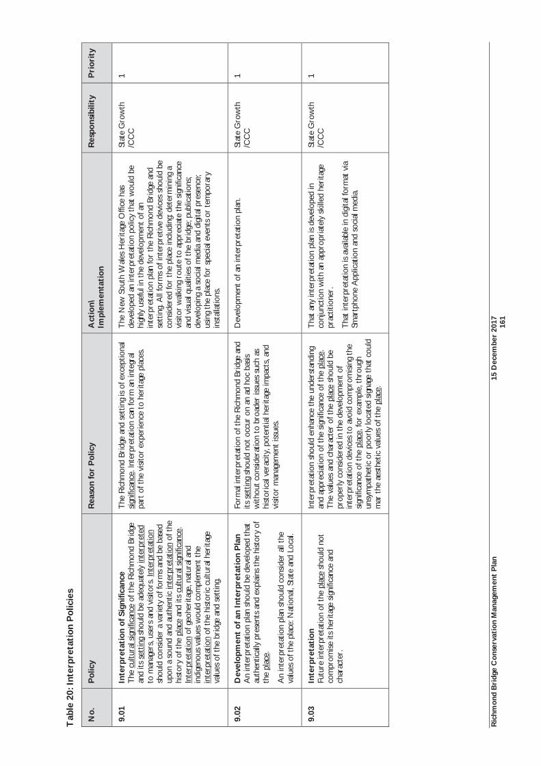
Ric
hmon
d B
ridg
e C
onse
rvat
ion
Man
agem
ent
Pla
n 15
Dec
embe
r 20
17
16
1
Tab
le 2
0: In
terp
reta
tion
Pol
icie
s
No.
P
olic
y
Rea
son
for
Pol
icy
Act
ion\
Im
plem
enta
tion
R
espo
nsib
ility
P
rior
ity
9.01
In
terp
reta
tion
of S
igni
fican
ce
The
cul
tura
l sig
nific
ance
of t
he R
ichm
ond
Brid
ge
and
its s
ettin
g sh
ould
be
adeq
uate
ly in
terp
rete
d to
man
ager
s, u
sers
and
vis
itors
. Int
erpr
etat
ion
shou
ld c
onsi
der
a va
riet
y of
form
s an
d be
bas
ed
upon
a s
ound
and
aut
hent
ic in
terp
reta
tion
of t
he
hist
ory
of t
he p
lace
and
its
cultu
ral s
igni
fican
ce.
Inte
rpre
tatio
n of
geo
heri
tage
, nat
ural
and
in
dige
nous
val
ues
wou
ld c
ompl
emen
t th
e in
terp
reta
tion
of t
he h
isto
ric
cultu
ral h
erita
ge
valu
es o
f the
bri
dge
and
sett
ing.
The
Ric
hmon
d Br
idge
and
set
ting
is o
f exc
eptio
nal
sign
ifica
nce.
Inte
rpre
tatio
n ca
n fo
rm a
n in
tegr
al
part
of t
he v
isito
r ex
peri
ence
to
heri
tage
pla
ces.
The
New
Sou
th W
ales
Her
itage
Offi
ce h
as
deve
lope
d an
inte
rpre
tatio
n po
licy
that
wou
ld b
e hi
ghly
use
ful i
n th
e de
velo
pmen
t of
an
inte
rpre
tatio
n pl
an fo
r th
e R
ichm
ond
Brid
ge a
nd
sett
ing.
All
form
s of
inte
rpre
tive
devi
ces
shou
ld b
e co
nsid
ered
for
the
plac
e in
clud
ing:
det
erm
inin
g a
visi
tor
wal
king
rou
te t
o ap
prec
iate
the
sig
nific
ance
an
d vi
sual
qua
litie
s of
the
bri
dge;
pub
licat
ions
; de
velo
ping
a s
ocia
l med
ia a
nd d
igita
l pre
senc
e;
usin
g th
e pl
ace
for
spec
ial e
vent
s or
tem
pora
ry
inst
alla
tions
.
Stat
e G
row
th
/CC
C
1
9.02
D
evel
opm
ent
of a
n In
terp
reta
tion
Pla
n A
n in
terp
reta
tion
plan
sho
uld
be d
evel
oped
tha
t au
then
tical
ly p
rese
nts
and
expl
ains
the
hist
ory
of
the
plac
e.
An
inte
rpre
tatio
n pl
an s
houl
d co
nsid
er a
ll th
e va
lues
of t
he p
lace
: Nat
iona
l, St
ate
and
Loca
l.
Form
al in
terp
reta
tion
of t
he R
ichm
ond
Brid
ge a
nd
its s
ettin
g sh
ould
not
occ
ur o
n an
ad
hoc
basi
s w
ithou
t co
nsid
erat
ion
to b
road
er is
sues
suc
h as
hi
stor
ical
ver
acity
, pot
entia
l her
itage
impa
cts,
and
visi
tor
man
agem
ent
issu
es.
Dev
elop
men
t of
an
inte
rpre
tatio
n pl
an.
Stat
e G
row
th
/CC
C
1
9.03
In
terp
reta
tion
Fu
ture
inte
rpre
tatio
n of
the
pla
ce s
houl
d no
t co
mpr
omis
e its
her
itage
sig
nific
ance
and
ch
arac
ter.
Inte
rpre
tatio
n sh
ould
enh
ance
the
unde
rsta
ndin
g an
d ap
prec
iatio
n of
the
sig
nific
ance
of t
he p
lace
. T
he v
alue
s an
d ch
arac
ter
of t
he p
lace
sho
uld
be
prop
erly
con
side
red
in t
he d
evel
opm
ent
of
inte
rpre
tatio
n de
vice
s to
avo
id c
ompr
omis
ing
the
sign
ifica
nce
of t
he p
lace
, for
exa
mpl
e, t
hrou
gh
unsy
mpa
thet
ic o
r po
orly
loca
ted
signa
ge t
hat
coul
d m
ar t
he a
esth
etic
val
ues
of t
he p
lace
.
Tha
t an
y in
terp
reta
tion
plan
is d
evel
oped
in
conj
unct
ion
with
an
appr
opri
atel
y sk
illed
her
itage
pr
actit
ione
r.
Tha
t in
terp
reta
tion
is a
vaila
ble
in d
igita
l for
mat
via
Sm
artp
hone
App
licat
ion
and
soci
al m
edia
.
Stat
e G
row
th
/CC
C
1
Ric
hmon
d B
ridg
e C
onse
rvat
ion
Man
agem
ent
Pla
n 15
Dec
embe
r 20
17
16
2
6.13
Fur
ther
Wor
k T
he N
atio
nal H
erita
ge M
anag
emen
t Pr
inci
ples
enc
oura
ges
furt
her
wor
k in
the
iden
tific
atio
n an
d pr
otec
tion
of t
he h
erita
ge v
alue
s of
the
bri
dge
and
sett
ing
in t
wo
area
s. In
sum
mar
y,
thes
e ar
e:
1.O
ngoi
ng t
echn
ical
and
com
mun
ity in
put
to d
ecis
ions
and
act
ions
tha
t m
ay h
ave
a si
gnifi
cant
impa
ct o
n th
eir
Nat
iona
l Her
itage
val
ues;
and
2.M
anag
emen
t sh
ould
res
pect
all
heri
tage
val
ues.
The
nee
d fo
r he
rita
ge t
rain
ing
has
been
rec
omm
ende
d as
a s
peci
fic p
olic
y. C
omm
unity
invo
lvem
ent
in d
ecis
ion
mak
ing
is a
lso
to b
e pu
rsue
d. R
egul
ar e
ngag
emen
t an
d th
e ad
vice
of t
he
Ric
hmon
d A
dvis
ory
Com
mitt
ee (
a co
mm
ittee
of C
lare
nce
City
Cou
ncil)
is li
kely
to
be t
he m
ost
effe
ctiv
e m
eans
of c
omm
unity
eng
agem
ent
in m
anag
emen
t of
the
pla
ce.
An
impo
rtan
t N
atio
nal H
erita
ge M
anag
emen
t Pr
inci
ple
is r
espe
ct fo
r al
l her
itage
val
ues.
The
Nat
iona
l Her
itage
val
ues
of t
he p
lace
rel
ate
to h
isto
ric
heri
tage
val
ues.
The
exi
sten
ce o
f any
A
bori
gina
l her
itage
val
ues
are
at t
his
stag
e un
know
n. P
relim
inar
y co
nsul
tatio
n w
ith A
bori
gina
l Her
itage
Tas
man
ia, D
PIPW
E de
term
ined
tha
t th
e pl
ace
does
not
con
tain
any
pre
viou
sly
reco
rded
Abo
rigi
nal h
erita
ge s
ites
and
that
the
re w
ere
no r
equi
rem
ents
for
an A
bori
gina
l her
itage
inve
stig
atio
n as
par
t of
thi
s C
onse
rvat
ion
Man
agem
ent
Plan
. The
abs
ence
of p
revi
ousl
y re
cord
ed A
bori
gina
l her
itage
item
s sh
ould
not
nec
essa
rily
be
inte
rpre
ted
as a
con
clus
ion
that
tha
t su
ch v
alue
s do
not
pot
enti
ally
exi
st a
t th
e pl
ace.
Thi
s C
onse
rvat
ion
Man
agem
ent
Plan
co
ntin
ues
to r
ecom
men
d an
Abo
rigi
nal h
erita
ge a
sses
smen
t be
pre
pare
d fo
r th
e pl
ace.
Alth
ough
the
Tas
man
ian
Her
itage
Reg
iste
r ac
know
ledg
es a
rcha
eolo
gica
l va
lues
at
the
plac
e, t
here
is
yet
to b
e a
surv
ey o
f su
ch v
alue
s. T
he n
eed
for
an h
isto
rica
l ar
chae
olog
ical
as
sess
men
t re
mai
ns a
pri
ority
in t
his
Con
serv
atio
n M
anag
emen
t Pl
an.
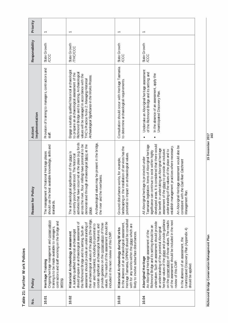
Ric
hmon
d B
ridg
e C
onse
rvat
ion
Man
agem
ent
Pla
n 15
Dec
embe
r 20
17
16
3
Tab
le 2
1: F
urth
er W
ork
Pol
icie
s
No.
P
olic
y
Rea
son
for
Pol
icy
Act
ion\
Im
plem
enta
tion
R
espo
nsib
ility
P
rior
ity
10.0
1 H
erit
age
Tra
inin
g O
ngoi
ng h
erita
ge m
anag
emen
t an
d co
nser
vatio
n tr
aini
ng is
to
be m
ade
avai
labl
e to
man
ager
s,
cont
ract
ors
and
staf
f wor
king
on
the
brid
ge a
nd
sett
ing.
The
man
agem
ent
of N
atio
nal H
erita
ge p
lace
s sh
ould
use
the
bes
t av
aila
ble
know
ledg
e, s
kills
and
st
anda
rds.
Prov
ision
of t
rain
ing
to m
anag
ers,
con
trac
tors
and
st
aff.
Stat
e G
row
th
/CC
C
1
10.0
2 H
isto
rica
l Arc
haeo
logy
Ass
essm
ent
A s
uita
bly
qual
ified
hist
oric
al a
rcha
eolo
gist
sh
ould
pre
pare
an
arch
aeol
ogic
al a
sses
smen
t of
the
Ric
hmon
d Br
idge
and
its
sett
ing.
Suc
h an
as
sess
men
t sho
uld
prov
ide
an u
nder
stan
ding
of
the
arch
aeol
ogic
al v
alue
s of
the
pla
ce (t
he b
ridg
e,
rive
r an
d ri
verb
anks
); in
clud
ing
its p
oten
tial t
o co
ntai
n sig
nific
ant
arch
aeol
ogic
al fe
atur
es; a
nd
prov
ide
guid
ance
on
the
cons
erva
tion
of t
hose
va
lues
. The
res
ults
of t
he a
sses
smen
t sh
ould
be
incl
uded
in t
he n
ext
revi
ew o
f thi
s C
MP.
The
arc
haeo
logi
cal s
igni
fican
ce o
f the
pla
ce is
cu
rren
tly p
oorl
y un
ders
tood
. The
hist
oric
al
activ
ities
tha
t ha
ve o
ccur
red
at t
he p
lace
(e.
g. fo
rds
acro
ss t
he r
iver
, flo
ur m
illin
g) h
ave
pote
ntia
l to
be
dem
onst
rate
d th
roug
h ar
chae
olog
ical
fabr
ic a
t th
e pl
ace.
Arc
haeo
logi
cal v
alue
s m
ay b
e pr
esen
t in
the
bri
dge,
th
e ri
ver
and
the
rive
rban
ks.
Enga
ge a
sui
tabl
y qu
alifi
ed h
istor
ical
arc
haeo
logi
st
to p
repa
re a
n ar
chae
olog
ical
ass
essm
ent
of t
he
Ric
hmon
d Br
idge
and
its
sett
ing.
Arc
haeo
logi
cal
valu
es w
ill b
e m
anag
ed in
acc
orda
nce
with
the
T
HC
’s Pr
actic
e N
ote
2: M
anag
ing
Hist
orica
l Ar
chae
olog
ical S
igni
fican
ce in
the
Wor
ks P
roce
ss.
Stat
e G
row
th
/TH
C/C
CC
1
10.0
3 H
isto
rica
l Arc
haeo
logy
dur
ing
Wor
ks
In t
he a
bsen
ce o
f an
arch
aeol
ogic
al a
sses
smen
t, H
erita
ge T
asm
ania
, DPI
PWE
shou
ld b
e co
nsul
ted
with
for
any
wor
ks w
ithin
the
pla
ce w
hich
are
lik
ely
to in
volv
e su
bsur
face
dist
urba
nces
.
Gro
und
dist
urba
nce
wor
ks, f
or e
xam
ple,
la
ndsc
apin
g or
the
inst
alla
tion
of s
ervi
ces
has
the
pote
ntia
l to
impa
ct o
n ar
chae
olog
ical
val
ues.
Con
sulta
tion
shou
ld o
ccur
with
Her
itage
Tas
man
ia
to d
eter
min
e ar
chae
olog
ical
req
uire
men
ts.
Stat
e G
row
th
/CC
C
1
10.0
4 A
bori
gina
l Her
itag
e A
n A
bori
gina
l Her
itage
ass
essm
ent
of t
he
Ric
hmon
d Br
idge
and
its
sett
ing
shou
ld b
e an
un
dert
aken
. Suc
h an
ass
essm
ent s
houl
d pr
ovid
e an
und
erst
andi
ng o
f the
pot
entia
l Abo
rigi
nal
heri
tage
val
ues
of t
he p
lace
and
pro
vide
gui
danc
e on
the
con
serv
atio
n of
tho
se v
alue
s. T
he r
esul
ts
of t
he a
sses
smen
t sh
ould
be
incl
uded
in t
he n
ext
revi
ew o
f thi
s C
MP.
In t
he a
bsen
ce o
f an
asse
ssm
ent,
the
Una
ntic
ipat
ed D
iscov
ery
Plan
(A
ppen
dix
4)
shou
ld b
e ap
plie
d.
All
Abo
rigi
nal h
erita
ge is
pro
tect
ed u
nder
T
asm
ania
n le
gisl
atio
n. It
ems
of A
bori
gina
l her
itage
si
gnifi
canc
e ca
n co
ntin
ue t
o ex
ist w
ithin
hig
hly
deve
lope
d ar
eas.
It is
con
side
red
that
the
re w
ould
be
ben
efit
in u
nder
taki
ng a
n A
bori
gina
l her
itage
as
sess
men
t of t
he p
lace
to
prov
ide
an in
clus
ive
unde
rsta
ndin
g of
the
val
ues
of th
e pl
ace
and
to
esta
blish
man
agem
ent
prac
tices
whe
re n
eces
sary
.
An
Abo
rigi
nal H
erita
ge a
sses
smen
t w
ould
als
o be
co
nsis
tent
with
the
Coal
Rive
r Cat
chm
ent
Man
agem
ent P
lan.
Und
erta
ke a
n A
bori
gina
l her
itage
ass
essm
ent
of t
he R
ichm
ond
Brid
ge a
nd it
s se
ttin
g; a
nd
In t
he a
bsen
ce o
f an
asse
ssm
ent,
appl
y th
e U
nant
icip
ated
Disc
over
y Pl
an.
Stat
e G
row
th
/CC
C
1
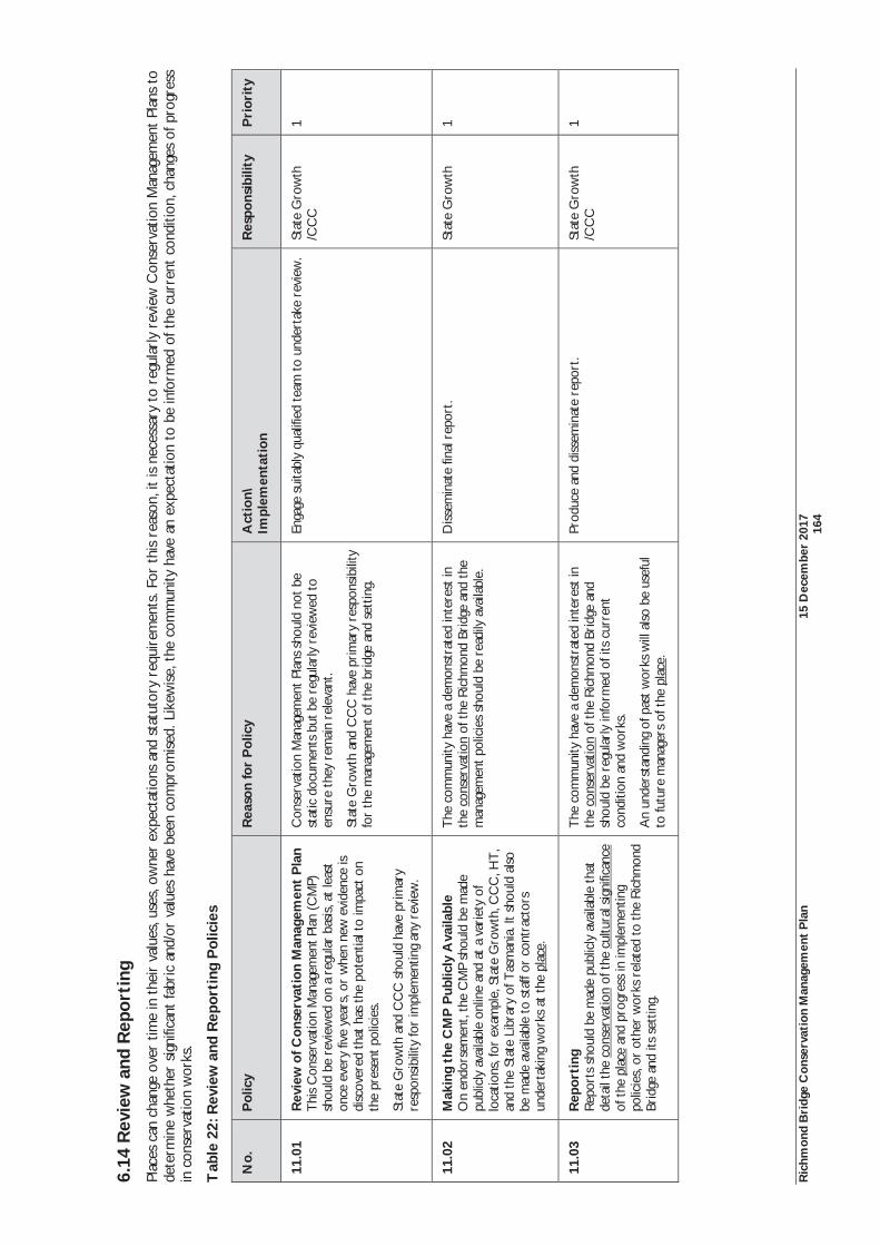
Ric
hmon
d B
ridg
e C
onse
rvat
ion
Man
agem
ent
Pla
n 15
Dec
embe
r 20
17
16
4
6.14
Rev
iew
and
Rep
orti
ng
Plac
es c
an c
hang
e ov
er t
ime
in t
heir
val
ues,
use
s, o
wne
r ex
pect
atio
ns a
nd s
tatu
tory
req
uire
men
ts. F
or t
his
reas
on, i
t is
nec
essa
ry t
o re
gula
rly
revi
ew C
onse
rvat
ion
Man
agem
ent
Plan
s to
de
term
ine
whe
ther
sig
nific
ant
fabr
ic a
nd/o
r va
lues
hav
e be
en c
ompr
omis
ed. L
ikew
ise,
the
com
mun
ity h
ave
an e
xpec
tatio
n to
be
info
rmed
of t
he c
urre
nt c
ondi
tion,
cha
nges
of p
rogr
ess
in c
onse
rvat
ion
wor
ks.
Tab
le 2
2: R
evie
w a
nd R
epor
ting
Pol
icie
s
No.
P
olic
y
Rea
son
for
Pol
icy
Act
ion\
Im
plem
enta
tion
R
espo
nsib
ility
P
rior
ity
11.0
1 R
evie
w o
f Con
serv
atio
n M
anag
emen
t P
lan
Thi
s C
onse
rvat
ion
Man
agem
ent
Plan
(C
MP)
sh
ould
be
revi
ewed
on
a re
gula
r ba
sis,
at
leas
t on
ce e
very
five
yea
rs, o
r w
hen
new
evi
denc
e is
disc
over
ed t
hat
has
the
pote
ntia
l to
impa
ct o
n th
e pr
esen
t pol
icie
s.
Stat
e G
row
th a
nd C
CC
sho
uld
have
pri
mar
y re
spon
sibi
lity
for
impl
emen
ting
any
revi
ew.
Con
serv
atio
n M
anag
emen
t Pl
ans
shou
ld n
ot b
e st
atic
doc
umen
ts b
ut b
e re
gula
rly
revi
ewed
to
ensu
re t
hey
rem
ain
rele
vant
.
Stat
e G
row
th a
nd C
CC
hav
e pr
imar
y re
spon
sibi
lity
for
the
man
agem
ent
of t
he b
ridg
e an
d se
ttin
g.
Enga
ge s
uita
bly
qual
ified
tea
m t
o un
dert
ake
revi
ew.
Stat
e G
row
th
/CC
C
1
11.0
2 M
akin
g th
e C
MP
Pub
licly
Ava
ilabl
e O
n en
dors
emen
t, th
e C
MP
shou
ld b
e m
ade
publ
icly
ava
ilabl
e on
line
and
at a
var
iety
of
loca
tions
, for
exa
mpl
e, S
tate
Gro
wth
, CC
C, H
T,
and
the
Stat
e Li
brar
y of
Tas
man
ia. I
t sh
ould
als
o be
mad
e av
aila
ble
to s
taff
or c
ontr
acto
rs
unde
rtak
ing
wor
ks a
t th
e pl
ace.
The
com
mun
ity h
ave
a de
mon
stra
ted
inte
rest
in
the
cons
erva
tion
of t
he R
ichm
ond
Brid
ge a
nd t
he
man
agem
ent p
olic
ies
shou
ld b
e re
adily
ava
ilabl
e.
Diss
emin
ate
final
rep
ort.
Stat
e G
row
th
1
11.0
3 R
epor
ting
R
epor
ts s
houl
d be
mad
e pu
blic
ly a
vaila
ble
that
de
tail
the
cons
erva
tion
of t
he c
ultu
ral s
igni
fican
ce
of t
he p
lace
and
pro
gres
s in
impl
emen
ting
polic
ies,
or
othe
r w
orks
rel
ated
to t
he R
ichm
ond
Brid
ge a
nd it
s se
ttin
g.
The
com
mun
ity h
ave
a de
mon
stra
ted
inte
rest
in
the
cons
erva
tion
of t
he R
ichm
ond
Brid
ge a
nd
shou
ld b
e re
gula
rly
info
rmed
of i
ts c
urre
nt
cond
ition
and
wor
ks.
An
unde
rsta
ndin
g of
pas
t w
orks
will
also
be
usef
ul
to fu
ture
man
ager
s of
the
pla
ce.
Prod
uce
and
diss
emin
ate
repo
rt.
Stat
e G
row
th
/CC
C
1

Richmond Bridge Conservation Management Plan 15 December 2017 165
References
Richmond Bridge Conservation Management Plan 15 December 2017 166
7.0 REFERENCES 7.1 Secondary Materials 7.1.1 Published & Unpublished Sources
Aboriginal Heritage Act 1975
Allen, S, 'Lord, David (1785 - 1847)', Australian Dictionary of Biography Volume 2, 1788-1850, Melbourne University Press, 1967
Austral Archaeology Pty Ltd, Spratt, P, Scripps, L, Tasmanian Historic Bridges Heritage Surveys. Commission No C14-93, 1994
Australian Government, Department of the Environment, Matters of National Environmental Significance. Significant impact guidelines 1.1. Environment Protection and Biodiversity Conservation Act 1999
Balsille, GD, ‘Notes on Tasmanian Highway Bridges’, Transactions of the Institution, Vol XV, 1934
Bill Jordan & Associates Pty Ltd, Richmond Bridge, Richmond, Structural Assessment, September 2001
Bonwick, J, The Last of the Tasmanians; or, the Black War of Van Diemen’s Land, Sampson Low, Son & Marston: London, 1870
Boyce, J, Van Diemen’s Land, Melbourne: Black Inc., 2008
The Burra Charter: The Australia, ICOMOS Charter for Places of Cultural Significance, 2013
Cassidy, J, Preston, K, Thematic Study of the Tasmanian Flour Milling Industry, Queen Victoria Museum & Art Gallery, 2000
Clarence City Council, Coal River Catchment: Planning and Implementation. Rosny Park: Clarence City Council, 2005
Clarence Interim Planning Scheme 2015
Cromer, WC, Department of State Growth: Richmond Bridge, Richmond Tasmania. Geotechnical Drilling of Footings and Foundations: Interim Report, April 5 2017
Department of Justice, Tasmanian Government, Information Sheet - Amendments to SPP Local Historic Heritage Code, 23 August 2017
Department of Primary Industries, Parks, Water and Environment, Assessing Historic Heritage Significance for application with the Historic Cultural Heritage Act, October 2011
Department of Primary Industries, Water and Environment, State of the River Report for the Coal River Catchment, Water Assessment and Planning Branch, Department of Primary Industries, Water and Environment, Hobart, 2003
Environment Protection and Biodiversity Conservation Act 1999
Evans, K, Old Bridge, Bridge Street Campbell Town, Historical Review, Tasmanian Heritage Council, 1998
File Note, P Spratt?, Heritage Tasmania File, Richmond Bridge
Flinn, E, ‘John Bowen (1780-1827)’, in Australian Dictionary of Biography, Volume 1: 1788-1850, Melbourne University Press, 1966
GHD Pty Ltd, Richmond Bridge. Conservation Management Plan, Department of Infrastructure, Energy and Resources, January 2010
Gough, J, ‘Oyster Cove’, in Alexander, A, (ed.), The Companion to Tasmanian History, Centre for Tasmanian Historical Studies, University of Tasmania: Hobart, 2005
Granny Jones, Gossip and Facts about Richmond, Regal Publications: Launceston, 1992
Heritage Victoria, Landscape Assessment Guidelines for Cultural Heritage Significance, prepared report for Heritage Victoria, 2002
Historic Cultural Heritage Act 1995
Richmond Bridge Conservation Management Plan 15 December 2017 167
Hydro Electric Commission, Tasmania, Water Resources Department, Richmond Flood Plain Study. Department of Primary Industry and Fisheries, Tasmania. Land & Water Resources Division, June 1995, Report No. 001- 0546-CR-001
Irrigation Clauses Act 1973
‘James Ross’, in Australian Dictionary of Biography, Vol 2, Melbourne University Press, 1967
Jones, E.B, ‘A Guide to the History of Richmond, Tasmania’, Tasmanian Historical Research Association Papers and Proceedings, Vol. 16, No. 4, May 1969
Jones, E.B, Richmond – Tasmania: a Crossing Place, Hobart: Richmond Preservation and Development Trust, 1973
Land Use Planning Approvals Act 1993
Landscape Impressions, Richmond Bridge Vegetation Management Plan, Final, 6 November 2015
Lennon, J, Matthews, S, Cultural Landscape Management: Guidelines for identifying, assessing and managing cultural landscapes in the Australian Alps National Parks, report prepared for the Cultural Heritage Working Group of the Australian Alps Liaison Committee, 1996
Levy, MCI, ‘William Thomas Parramore’ in Australian Dictionary of Biography, Vol 2, Melbourne University Press, 1967
Marquis-Kyle, P, Walker, M, The Illustrated Burra Charter, Australia ICOMOS, 2004
McFie, P, ‘Murder on the Bridge’, in Coal River Valley Historical Society Inc. Journal, No.1, 1999
McFie, P, The Miller's Cottage (Milton Cottage) (1837) and Tower Windmill, Richmond (1831-32), Coal River National Trust Group, 1986
McFie, P, ‘Whose Past? – Whose Present? Tourism and Local History’, Tasmanian Historical Research Association, Vol. 39, No, 1
McGee, R, Guide to Heritage Bridge Management, Austroads Inc, 2001
McNeill, B, ‘Richmond: A Progress Report on Township Conservation’, Proceedings of a Seminar on Preservation of Urban Landscapes in Australia, 16-18 August 1968, Department of Adult Education, Australian National University, Canberra, 1968
Michael Shield & Associates in association with Don Goldworthy & Associates, Richmond Cultural Resource Management Plan: a plan for managing the cultural resources of the township of Richmond, Tasmania, Clarence Council, 2001
Morgan, S, Land Settlement in Early Tasmania. Creating an Antipodean England, Cambridge: Cambridge University Press, 1992,
National Heritage List Nomination, St John the Evangelists Church, St Johns Ccl, Richmond, TAS, Australia, place ID 106031
New South Wales Heritage Office, Heritage Information Series: Heritage Interpretation Policy, 2005
Newitt, L, Convicts and Carriageways. Tasmanian Road Development until 1880, Historical Committee of the Department of Main Roads, Tasmania, 1988
Nigel Lewis Richard Aitken Pty Ltd, Corney, G, Nichols, G, Richmond Bridge, Tasmania. Conservation Plan, Department of Transport, 1997
Queensland Heritage Council, Entering Houses in the Queensland Heritage Register, 2005
Reed, TT, Historic Churches of Australia, MacMillan, South Melbourne, 1978
Ryan, L, The Aboriginal Tasmanians, Allen & Unwin: St Leonards, 1996
Sharland, M, Stones of a Century, Oldham, Beddome & Meredith Pty Ltd, Hobart, 1952
Smith, R, Early Tasmanian Bridges, Launceston: Foot and Playsted, 1969
Smith, R, 'Lambe, David (1803-1843)', Australian Dictionary of Biography, Volume 2, 1788-1850, Melbourne University Press, 1967
Richmond Bridge Conservation Management Plan 15 December 2017 168
Snowden, D, Richmond Cultural Resource Management Plan. Volume 3, A thematic history of the cultural resources of the township of Richmond, Clarence City Council and Australian Heritage Commission, 2000
Snowden, D, ‘The Richmond Bridge 1823-1998’, in Coal River Valley Historical Society Inc. Journal, No.1, 1999
Spratt, P, Richmond Bridge Evaluation of Vibration Monitoring of Traffic for Bridge Management, prepared for DIER, 1 June 2009
Spratt, P, Richmond Bridge – Conservation Management Plan Review, 25 March 2008; Spratt, letter report to GHD, 31 March 2008
Spry, AH, Richmond and Ross Bridges. Stonework Condition Report. Report C148 February 1990, Department of Roads and Transport
Tasmanian Planning Commission, Draft State Planning Provisions Report. A Report by the Tasmanian Planning Commission as required under section 25 of the Land Use Planning and Approvals Act 1993
Von Stieglitz, KR, Richmond: the story of its people and its places, Launceston, 1953
Water Management Act 1999
West Pitt Water, Richmond, TAS, Australia, Register of the National Estate, 14595
Whishaw, MK, History of Richmond and Recollections from 1898-1920, Hobart: National Trust of Australia (Tas.), 1973
Wilson, L, ‘Of Chapels and Bridges’, in Coal River Valley Historical Society Inc. Journal, No.1, 1999
7.1.2 Newspapers
The Advocate, Monday 23 October 1933, p.7
Colonial Times, Tuesday 19 June 1832, p.2
Colonial Times, Tuesday 8 October 1844, p.3
Colonial Times, Saturday 18 January 1845, p.3
The Examiner, Thursday 11 December 1947, p.2
The Hobart Town Courier, Saturday 4 April 1829, p.2
Hobart Town Gazette and Van Diemen’s Land Advertiser, Saturday 13 December 1823, p.2
The Mercury, Friday 20 December 1861, p.2
The Mercury, Friday 25 May 1866, p.4
The Mercury, Friday 18 February 1870, p.2
The Mercury, Monday 26 May 1924, p.6
The Mercury, Tuesday 18 September 1928, p.3
The Mercury, Wednesday 13 September 1933, p.10
The Mercury, Saturday 20 June 1935, p.17
The Mercury, Saturday 13 July 1946, p.7
The Mercury, Wednesday 19 March 1947, p.8
The Mercury, Friday 21 March 1947, p.3
Tasmanian Mail, 12 July 1884, 28
The Tasmanian Mail, 22 August 1896, p.17
Weekly Courier, 13 December 1923, p.41
7.1.3 Websites
http://www.dpiw.tas.gov.au/inter.nsf/WebPages/LBUN-4Y44UZ?open
Making Comparisons, http://www.heritage.nsw.gov.au/10_subnav_03.htm ac
http://www.tasmanianirrigation.com.au/index.php/about/the-team/
Richmond Bridge Conservation Management Plan 15 December 2017 169
7.2 Primary Materials 7.2.1 Published Materials
Bigge, JT, Report of the Commissioner of Inquiry on the State of Agriculture and Trade in the Colony of New South Wales, ordered by the House of Commons to be printed, 13 March 1823
Historical Records of Australia, Sydney: Library Committee of the Commonwealth Parliament, Canberra, AGPS, 1914-1925
Hobart Town Almanack and VDL Annual, 1834
Melville, H, The Van Diemen’s Land Annual for the year 1834
Plomley, NJB, Friendly Mission: the Tasmanian Journals and Papers of George Augustus Robinson 1829-1834, Tasmanian Historical Research Association, 1966
Ross, J, The Van Diemen’s Land Anniversary and Hobart-Town Almanack for the year 1831, Hobart Town, 1831
Syme, J, Nine Years in Van Diemen’s Land, comprising an account of its discovery, possession, settlement, progress, population, value of land, herds flocks etc …. , Dundee, 1848
Thomas, H, Guide to Excursionists between Australia and Tasmania, Melbourne, 1870
7.2.2 Archival Materials
TAHO, CSO 1/105/2535
TAHO, CSO 1/705/2535, 21 February 1826
TAHO, CSO 1/979/1283
TAHO, CSO 24/96/464
TAHO, LSD 1/23/87
TAHO, PWD, 2/43: 461
TAHO, PWD35/46, 20 May 1924
7.2.3 Historic Plans, Images etc.
CPO, Map of Richmond R/13, 1842
NLA, (1835) Richmond, Van Diemen's Land, 14 miles from Hobart Town Retrieved May 10, 2017, from http://nla.gov.au/nla.obj-135192563
TAHO, AF396/1/246, Map - Monmouth 38A - parishes of Ulva and Staffa
TAHO, AF721/1/564, Map - R/16 - Richmond, various property boundaries, surveyor T Scot
TAHO, Chapman, TE, Richmond Van Dieman's Land, 1843, Allport Library and Museum of Fine Arts, AUTAS001124066796
TAHO, The Mercury, 6 December 1935, p.7
TAHO, PH3/1/8948, Photograph - Richmond - view of Bridge, Windmill and Mill
TAHO, PH30/1/4651, Photograph - Side view of the Mill House at Richmond the home of J. Eldershaw
TAHO, Richmond Bridge, Collection of Postcards, AUTAS0016125441832
TAHO, Richmond: collection of postcards, State Library of Tasmania, Tasmaniana Library, AUTAS001612544861
TAHO, Richmond Bridge, Collection of Postcards. AUTAS0016125441733
TAHO, Richmond Bridge, Collection of Postcards. AUTAS0016125441782
TAHO, Richmond Bridge, Collection of Postcards. AUTAS0016125441881
TAHO, Richmond Bridge collection of postcards, State Library of Tasmania, Tasmaniana Library, AUTAS0016125441980
TAHO, Richmond Mill, Allport Library and Museum of Fine Arts, AUTAS001126254424
Richmond Bridge Conservation Management Plan 15 December 2017 170
TAHO, Richmond, Tas. from Butcher's Hill, c.1888, Allport Library and Museum of Fine Arts, AUTAS001126183763
TAHO, St Lukes Church, Richmond, 19--?, Allport Library and Museum of Fine Arts, AUTAS001126254473
TAHO, The Weekly Courier, 13 December 1923, p.29
TAHO, The Tasmanian Mail, 14 December 1922, p.35
7.2.4 Personal Communications
Bevan, R, Water Bailiff, Richmond District, via Richley, L, Regional Soils Officer, Land and Water Resources Division, Department of Primary Industries and Fishers, Tasmania, pers. comm. 25 May 1995
Email, Adam Marshall (Aboriginal Heritage Tasmania) to James Puustinen (Austral Tasmania), 10 December 2015: AHTP2649 - 2010 Richmond Bridge - Conservation Management Plan Review
Email, Ian Preece (CCC) to James Puustinen (Austral Tasmania), 20 April 2016
Email, Vincent Tang (State Growth) to James Puustinen (Austral Tasmania), 11 April 2017

Richmond Bridge Conservation Management Plan 15 December 2017 171
APPENDIX 1: SITE INVENTORY SHEETS
Appendix 1: Site Inventory Sheets
Richmond Bridge Conservation Management Plan 15 December 2017 172
Introduction
The purpose of the following Site Inventory Sheets is to document key elements of the place, or conservation issues which require addressing. The Sheets are structured into those components related to the bridge, and key items of conservation concern and infrastructure such as stairs, car parks and so on. The conclusion from this analysis is that the heritage values of the place have been retained, and in some cases enhanced since 2010. The Inventory Sheets have been simplified from the 2010 version. Some Inventory items have been removed for works that have been completed, whilst in other cases multiple elements have been grouped into single inventories, where they logically relate to each other.
The Inventory Sheets provide concise information regarding each element, including (as relevant):
A brief description of the element, including any historical information, physical description, and as identified its current condition;
An assessment of significance including the overall level of significance of the element;
Applicable policies and actions; and
Current identified risks to the element.
Historical information has been sourced from this Conservation Management Plan, and unless otherwise stated, the original references have not been repeated.
The 2010 Conservation Management Plan included Inventory Sheets for the riverbanks and plantings. This information has now been superseded by the Vegetation Management Plan (VMP) which is now incorporated into this Conservation Management Plan. The VMP should be referred to for its principles, zoning, objectives and actions as relevant.
Levels of Significance
The various elements that form the Richmond Bridge and setting have different levels of cultural significance. Understanding this hierarchy of significance provides guidance on the appropriate conservation processes. That is, proposed actions, works, or development potentially affecting the cultural significance of the place should be consistent with the relative levels of cultural significance of the elements of the place.
Providing levels of significance can also allow for the prioritisation of conservation works and the sound allocation of resources. Specific policies have been prepared on how the levels of significance are to be applied.
Each element has been given a rating of significance, from high, moderate to low. Neutral and intrusive elements are similarly identified. In combination, the various elements form a place of exceptional significance, as acknowledged by the National Heritage listing. It should be noted that there is no ranking of elements in the National Heritage values; all are of equal outstanding value to the nation.
High Significance
Those elements considered representative of key functions or thematic contributions of the place. This include: the construction and provision of transport infrastructure; recreational uses of the riverbanks; and industrial activity on the riverbanks.
Elements of high significance will demonstrate earliness, intactness, rarity/representativeness and high aesthetic qualities. Elements of high cultural significance must be conserved.
Moderate Significance
Those elements considered representative of secondary functions or thematic contributions of the place. Elements may be described as being of moderate significance where they date from later periods of development, have a lower level of integrity, are typical of their form or type and do not have high aesthetic qualities. Although not being of high significance, these elements contribute to an understanding of the place. Elements of moderate cultural significance should be conserved wherever possible.
Low Significance
Those elements that contribute to the significance of the bridge and its setting, although have little heritage value in their own right. These elements may be recent introductions, or may have been so modified that they no longer have the ability to demonstrate their thematic context.
Richmond Bridge Conservation Management Plan 15 December 2017 173
Elements of low significance should not be confused with neutral or intrusive elements. Elements of low cultural significance may be retained, modified or removed provided a conservation benefit can be demonstrated by the action.
Neutral and Intrusive Elements
The following Inventory Sheets also identify those neutral and intrusive elements. Neutral elements make no contribution to the significance of the place, nor do they have an adverse impact on the place. Conversely, intrusive elements do have an adverse impact and should be removed.
Other Considerations
Providing the various elements of the place with levels of significance is particularly useful when considering fabric based values. However, not all values of the Richmond Bridge and its setting may be demonstrated in the fabric of the place. For example, the community significance relates to the place as a whole, and specifically its recreational uses. The recreational uses are complemented by a range of infrastructure. The infrastructure varies from discrete to intrusive elements. Where an element of infrastructure associated with recreational uses is recommended for removal, consideration should be given to what impact that may have on the community use, and therefore appreciation of the place.
Another area where the values may not be demonstrated in fabric are certain elements of aesthetic significance. Aspects such as the reflections and sound of water, and the seasonal changes in the landscape are more intangible in their nature.
.
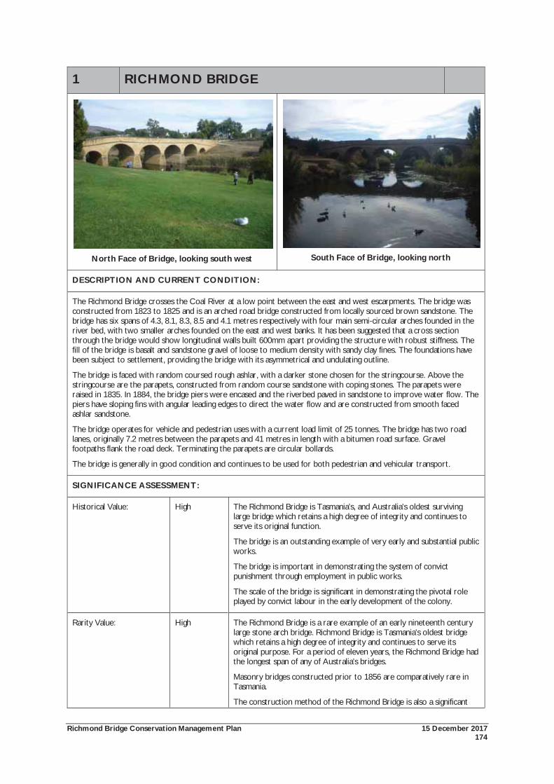
Richmond Bridge Conservation Management Plan 15 December 2017 174
1 RICHMOND BRIDGE
North Face of Bridge, looking south west
South Face of Bridge, looking north
DESCRIPTION AND CURRENT CONDITION:
The Richmond Bridge crosses the Coal River at a low point between the east and west escarpments. The bridge was constructed from 1823 to 1825 and is an arched road bridge constructed from locally sourced brown sandstone. The bridge has six spans of 4.3, 8.1, 8.3, 8.5 and 4.1 metres respectively with four main semi-circular arches founded in the river bed, with two smaller arches founded on the east and west banks. It has been suggested that a cross section through the bridge would show longitudinal walls built 600mm apart providing the structure with robust stiffness. The fill of the bridge is basalt and sandstone gravel of loose to medium density with sandy clay fines. The foundations have been subject to settlement, providing the bridge with its asymmetrical and undulating outline.
The bridge is faced with random coursed rough ashlar, with a darker stone chosen for the stringcourse. Above the stringcourse are the parapets, constructed from random course sandstone with coping stones. The parapets were raised in 1835. In 1884, the bridge piers were encased and the riverbed paved in sandstone to improve water flow. The piers have sloping fins with angular leading edges to direct the water flow and are constructed from smooth faced ashlar sandstone.
The bridge operates for vehicle and pedestrian uses with a current load limit of 25 tonnes. The bridge has two road lanes, originally 7.2 metres between the parapets and 41 metres in length with a bitumen road surface. Gravel footpaths flank the road deck. Terminating the parapets are circular bollards.
The bridge is generally in good condition and continues to be used for both pedestrian and vehicular transport.
SIGNIFICANCE ASSESSMENT:
Historical Value: High The Richmond Bridge is Tasmania’s, and Australia’s oldest surviving large bridge which retains a high degree of integrity and continues to serve its original function.
The bridge is an outstanding example of very early and substantial public works.
The bridge is important in demonstrating the system of convict punishment through employment in public works.
The scale of the bridge is significant in demonstrating the pivotal role played by convict labour in the early development of the colony.
Rarity Value: High The Richmond Bridge is a rare example of an early nineteenth century large stone arch bridge. Richmond Bridge is Tasmania’s oldest bridge which retains a high degree of integrity and continues to serve its original purpose. For a period of eleven years, the Richmond Bridge had the longest span of any of Australia’s bridges.
Masonry bridges constructed prior to 1856 are comparatively rare in Tasmania.
The construction method of the Richmond Bridge is also a significant
Richmond Bridge Conservation Management Plan 15 December 2017 175
1 RICHMOND BRIDGE and rare aspect.
Research Potential: Moderate From an engineering perspective, the bridge offers insight into very early bridge design and construction methods in Tasmania. The continued operations of the bridge and changing conditions in vehicles and water flow provides an opportunity to understand structural stability, and hydraulic and structural stresses.
Representative Value: Moderate The Richmond Bridge is representative of the large-scale public infrastructure developed in Tasmania during the early colonial period.
Technical Achievement: High The Richmond Bridge demonstrates a high degree of technical achievement in Tasmanian bridge design and construction.
The Richmond Bridge was the first multiple arched bridge to be constructed in Tasmania and the first with the piers actually founded in the river itself.
Using the ancient method of rubble construction, the Richmond Bridge is important in demonstrating the skills of its designer, Major Thomas Bell and the skill and workmanship of the convict workforce in its construction.
The continued operation of the bridge since 1825 demonstrates the technical achievement of the design and construction.
Social Value: High The Richmond Bridge is an iconic place. The bridge within its riverbank setting and the historic Richmond township form a landscape that is appreciated and valued by locals and visitors alike. The bridge has formed an integral destination of cultural tourism and promotion since the mid twentieth century.
The social value of the place is also demonstrated by visitation to the bridge and use of the riverbanks as vantage points for viewing the bridge as well as for passive recreation.
The bridge is a special place for the people of Richmond. The local community identify the bridge as the most important structure in their historic town, providing a sense of identity and distinction from other rural communities.
Associational Value: High The Richmond Bridge is associated with a range of individuals and groups whose lives and work was important in Tasmania’s history. This includes:
Commissioner Bigge;
Lieutenant-Governor Sorell;
Superintendent of Stonemasons, William Wilson;
Major Thomas Bell;
The convict workforce;
Colonial Architect, David Lambe;
Civil Engineer and Architect, John Lee Archer.
Aesthetic Value: High The aesthetic significance of Richmond Bridge is appreciated locally, within Tasmania and nationally. Its picturesque image has been used widely in national and international tourism promotions since the 1920s and has inspired the work of major Australian artists.
The form of the bridge has an obvious sense of antiquity.
The Richmond Bridge is a prominent visual landmark within the
Richmond Bridge Conservation Management Plan 15 December 2017 176
1 RICHMOND BRIDGE landscape.
The relationship between the built form of the bridge, topography, Coal River and vegetation, combine to form a view of great scenic beauty.
OVERALL LEVEL OF SIGNIFICANCE: High
POLICIES: & ACTIONS
The Richmond Bridge is to be managed in accordance with the policies of this Conservation Management Plan. Policies of particular relevance include:
The General Policies: General Policy (1.01), Managing the National Heritage Values (1.02), Cultural Significance (1.03), Levels of Cultural Significance (1.04), Applying Levels of Cultural Significance in Conservation Processes (1.05), Removal of Elements of Low Cultural Significance (1.06), Removal of Intrusive Elements (1.07), Reconstruction of Missing Fabric (1.08), Maintenance & Works Program (1.09), Works Approvals (1.10);
Use of the Richmond Bridge Policies: Use of the Bridge (3.01), Use of the Bridge: Structural Capacity (3.02); Commercial Uses of the Place (3.03); Use of the Coal River (3.06);
Managing the Fabric of the Bridge Policies – Policies for the Prevention of Further Damage: Vibration monitoring (4.01), Load Limit (4.02), Conservation of Bridge Stonework (4.03), Replacement of Badly Decayed Stones (4.04), Stone Decay in the East Arch (4.05), Replacement of Lost Bedding (4.06), General Repointing (4.07), Drainage Management (4.08), Ponding & Drainage under East Arch (4.09), Damp Problems south west Wing Wall (4.10), Ongoing Maintenance of Road Surface (4.11), Waterproofing Footpaths (4.12), and Traffic Impact on Parapet Walls (4.13);
Managing the Fabric of the Bridge Policies – Management, Maintenance, Inspection, Recording and Aesthetic Policies: Managing the National Heritage Values (4.14), General Monitoring (4.15), 3D Laser Recording (4.16), Recording Changes to the Bridge (4.17), Maintenance of Footpaths (4.18), Maintenance of Gutters (4.19), Reconstruction of Gutters (4.20), Inspection & Maintenance of Drains (4.21), Visual Impact of Drains (4.22), Sandstone Stairs west end of Bridge (4.23), Removal of Graffiti (4.24), Conservation of Centenary Stones (4.25), Maintenance of Sheathing Cramps (4.26), Cleaning the Bridge (4.27);
Vegetation Management Policies: As in Accordance with the Vegetation Management Plan;
River Management Policies: Flood Management Plan (7.03), Removing Flood Risks (7.04 and 7.05), Mitigating Impacts during times of Flood (7.07), Hydrological Investigations (7.09); and
Traffic and Road Management Policies: Load Limit (8.01), Monitoring and Enforcement of Load Limit (8.02), Monitoring and Enforcement of Speed Limit (8.03).
Full details of these policies are included in the Conservation Policies Section, and as required, the following individual Inventory Sheets.
THREATS:
Inherent weaknesses of the bridge from foundation movements due to river bed erosion and settlement; alterations which have given a lack of continuity due to the later constructions not achieving an original bond entry, and the use of site soil as stone bedding;
Susceptibility of the bridge to vibrations resulting from traffic load, traffic speed, bedding loss, foundation movement and bridge deck potholes;
Lack of adequate ongoing maintenance;
Lack of appropriate ongoing repair work;
Lack of monitoring of condition of the bridge;
Damage due to vehicular usage including heavy loads, excessive speed accidents and wear due to ongoing use;
Drainage and damp has potential to cause stonework problems;
Graffiti problems;
Adverse impacts from adjacent development;

Richmond Bridge Conservation Management Plan 15 December 2017 177
1 RICHMOND BRIDGE Damage from vegetation growth;
Flood risks;
Lack of enforcement of speed and load limits.
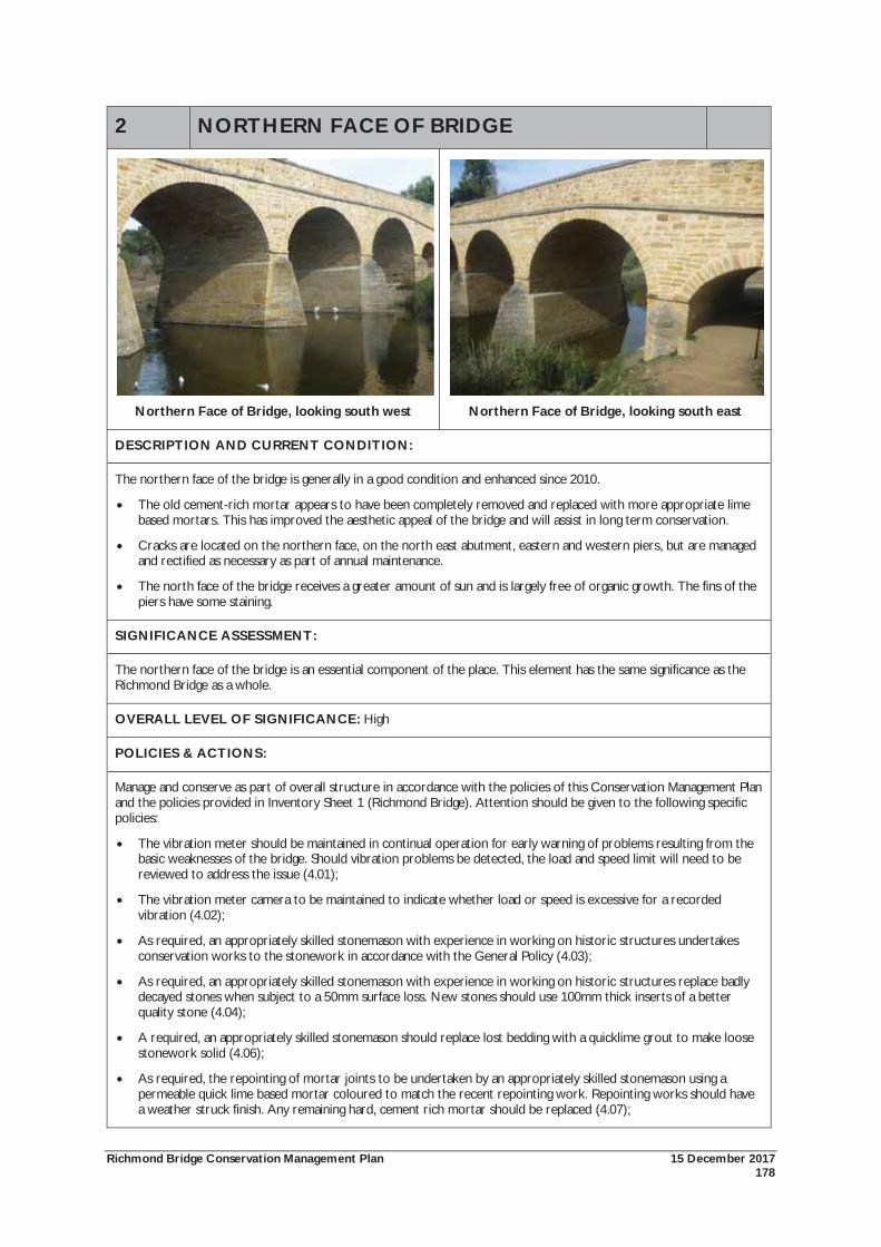
Richmond Bridge Conservation Management Plan 15 December 2017 178
2 NORTHERN FACE OF BRIDGE
Northern Face of Bridge, looking south west
Northern Face of Bridge, looking south east
DESCRIPTION AND CURRENT CONDITION:
The northern face of the bridge is generally in a good condition and enhanced since 2010.
The old cement-rich mortar appears to have been completely removed and replaced with more appropriate lime based mortars. This has improved the aesthetic appeal of the bridge and will assist in long term conservation.
Cracks are located on the northern face, on the north east abutment, eastern and western piers, but are managed and rectified as necessary as part of annual maintenance.
The north face of the bridge receives a greater amount of sun and is largely free of organic growth. The fins of the piers have some staining.
SIGNIFICANCE ASSESSMENT:
The northern face of the bridge is an essential component of the place. This element has the same significance as the Richmond Bridge as a whole.
OVERALL LEVEL OF SIGNIFICANCE: High
POLICIES & ACTIONS:
Manage and conserve as part of overall structure in accordance with the policies of this Conservation Management Plan and the policies provided in Inventory Sheet 1 (Richmond Bridge). Attention should be given to the following specific policies:
The vibration meter should be maintained in continual operation for early warning of problems resulting from the basic weaknesses of the bridge. Should vibration problems be detected, the load and speed limit will need to be reviewed to address the issue (4.01);
The vibration meter camera to be maintained to indicate whether load or speed is excessive for a recorded vibration (4.02);
As required, an appropriately skilled stonemason with experience in working on historic structures undertakes conservation works to the stonework in accordance with the General Policy (4.03);
As required, an appropriately skilled stonemason with experience in working on historic structures replace badly decayed stones when subject to a 50mm surface loss. New stones should use 100mm thick inserts of a better quality stone (4.04);
A required, an appropriately skilled stonemason should replace lost bedding with a quicklime grout to make loose stonework solid (4.06);
As required, the repointing of mortar joints to be undertaken by an appropriately skilled stonemason using a permeable quick lime based mortar coloured to match the recent repointing work. Repointing works should have a weather struck finish. Any remaining hard, cement rich mortar should be replaced (4.07);
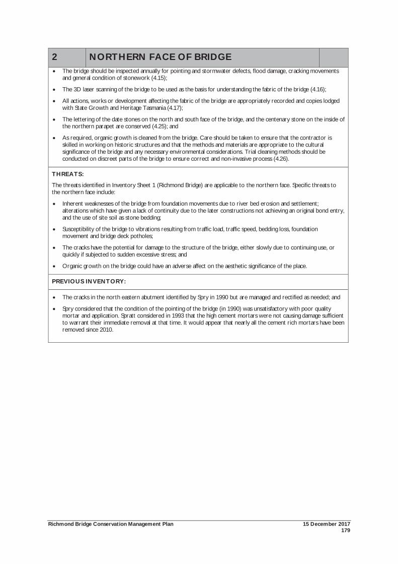
Richmond Bridge Conservation Management Plan 15 December 2017 179
2 NORTHERN FACE OF BRIDGE The bridge should be inspected annually for pointing and stormwater defects, flood damage, cracking movements and general condition of stonework (4.15);
The 3D laser scanning of the bridge to be used as the basis for understanding the fabric of the bridge (4.16);
All actions, works or development affecting the fabric of the bridge are appropriately recorded and copies lodged with State Growth and Heritage Tasmania (4.17);
The lettering of the date stones on the north and south face of the bridge, and the centenary stone on the inside of the northern parapet are conserved (4.25); and
As required, organic growth is cleaned from the bridge. Care should be taken to ensure that the contractor is skilled in working on historic structures and that the methods and materials are appropriate to the cultural significance of the bridge and any necessary environmental considerations. Trial cleaning methods should be conducted on discreet parts of the bridge to ensure correct and non-invasive process (4.26).
THREATS:
The threats identified in Inventory Sheet 1 (Richmond Bridge) are applicable to the northern face. Specific threats to the northern face include:
Inherent weaknesses of the bridge from foundation movements due to river bed erosion and settlement; alterations which have given a lack of continuity due to the later constructions not achieving an original bond entry, and the use of site soil as stone bedding;
Susceptibility of the bridge to vibrations resulting from traffic load, traffic speed, bedding loss, foundation movement and bridge deck potholes;
The cracks have the potential for damage to the structure of the bridge, either slowly due to continuing use, or quickly if subjected to sudden excessive stress; and
Organic growth on the bridge could have an adverse affect on the aesthetic significance of the place.
PREVIOUS INVENTORY:
The cracks in the north eastern abutment identified by Spry in 1990 but are managed and rectified as needed; and
Spry considered that the condition of the pointing of the bridge (in 1990) was unsatisfactory with poor quality mortar and application. Spratt considered in 1993 that the high cement mortars were not causing damage sufficient to warrant their immediate removal at that time. It would appear that nearly all the cement rich mortars have been removed since 2010.
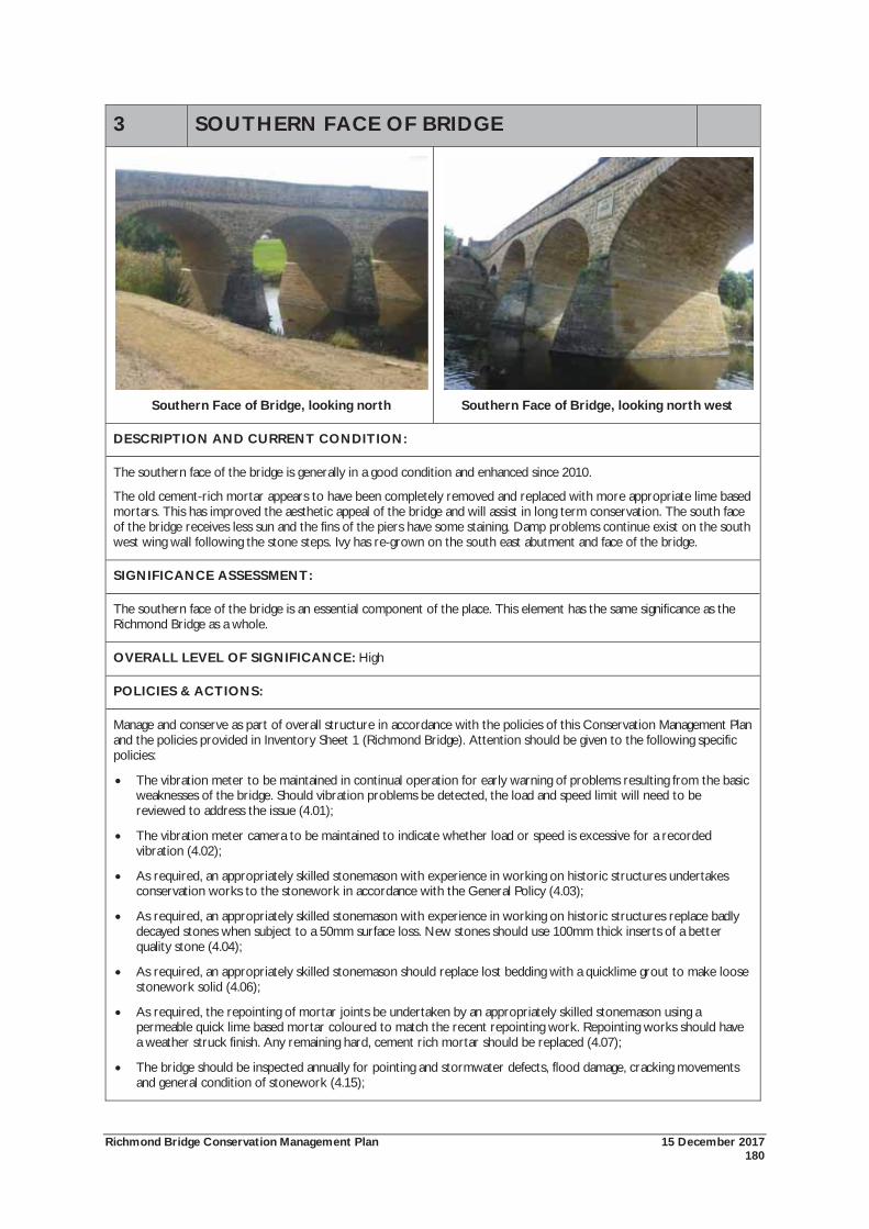
Richmond Bridge Conservation Management Plan 15 December 2017 180
3 SOUTHERN FACE OF BRIDGE
Southern Face of Bridge, looking north
Southern Face of Bridge, looking north west
DESCRIPTION AND CURRENT CONDITION:
The southern face of the bridge is generally in a good condition and enhanced since 2010.
The old cement-rich mortar appears to have been completely removed and replaced with more appropriate lime based mortars. This has improved the aesthetic appeal of the bridge and will assist in long term conservation. The south face of the bridge receives less sun and the fins of the piers have some staining. Damp problems continue exist on the south west wing wall following the stone steps. Ivy has re-grown on the south east abutment and face of the bridge.
SIGNIFICANCE ASSESSMENT:
The southern face of the bridge is an essential component of the place. This element has the same significance as the Richmond Bridge as a whole.
OVERALL LEVEL OF SIGNIFICANCE: High
POLICIES & ACTIONS:
Manage and conserve as part of overall structure in accordance with the policies of this Conservation Management Plan and the policies provided in Inventory Sheet 1 (Richmond Bridge). Attention should be given to the following specific policies:
The vibration meter to be maintained in continual operation for early warning of problems resulting from the basic weaknesses of the bridge. Should vibration problems be detected, the load and speed limit will need to be reviewed to address the issue (4.01);
The vibration meter camera to be maintained to indicate whether load or speed is excessive for a recorded vibration (4.02);
As required, an appropriately skilled stonemason with experience in working on historic structures undertakes conservation works to the stonework in accordance with the General Policy (4.03);
As required, an appropriately skilled stonemason with experience in working on historic structures replace badly decayed stones when subject to a 50mm surface loss. New stones should use 100mm thick inserts of a better quality stone (4.04);
As required, an appropriately skilled stonemason should replace lost bedding with a quicklime grout to make loose stonework solid (4.06);
As required, the repointing of mortar joints be undertaken by an appropriately skilled stonemason using a permeable quick lime based mortar coloured to match the recent repointing work. Repointing works should have a weather struck finish. Any remaining hard, cement rich mortar should be replaced (4.07);
The bridge should be inspected annually for pointing and stormwater defects, flood damage, cracking movements and general condition of stonework (4.15);
Richmond Bridge Conservation Management Plan 15 December 2017 181
3 SOUTHERN FACE OF BRIDGE The 3D laser scanning of the bridge is used as the basis for understanding the fabric of the bridge (4.16);
All actions, works or development affecting the fabric of the bridge are appropriately recorded and copies lodged with State Growth and Heritage Tasmania (4.17);
The lettering of the date stones on the north and south face of the bridge, and the centenary stone on the inside of the northern parapet are conserved (4.25);
As required, organic growth is cleaned from the bridge. Care should be taken to ensure that the contractor is skilled in working on historic structures and that the methods and materials are appropriate to the cultural significance of the bridge and any necessary environmental considerations. Trial cleaning methods should be conducted on discreet parts of the bridge to ensure correct and non-invasive process (4.26); and
That the ivy growing on south east end of the bridge should be continually removed.
THREATS:
The threats identified in Inventory Sheet 1 (Richmond Bridge) are applicable to the southern face. Specific threats to the southern face include:
Inherent weaknesses of the bridge from foundation movements due to river bed erosion and settlement; alterations which have given a lack of continuity due to the later constructions not achieving an original bond entry, and the use of site soil as stone bedding;
Susceptibility of the bridge to vibrations resulting from traffic load, traffic speed, bedding loss, foundation movement and bridge deck potholes;
The cracks have the potential for damage to the structure of the bridge, either slowly due to continuing use, or quickly if subjected to sudden excessive stress; and
Organic growth on the bridge could have an adverse affect on the aesthetic significance of the place.
PREVIOUS INVENTORY:
It would appear that the vast majority of cement rich mortars have been removed since 2010 improving the visual aesthetics of the bridge and stone conservation.
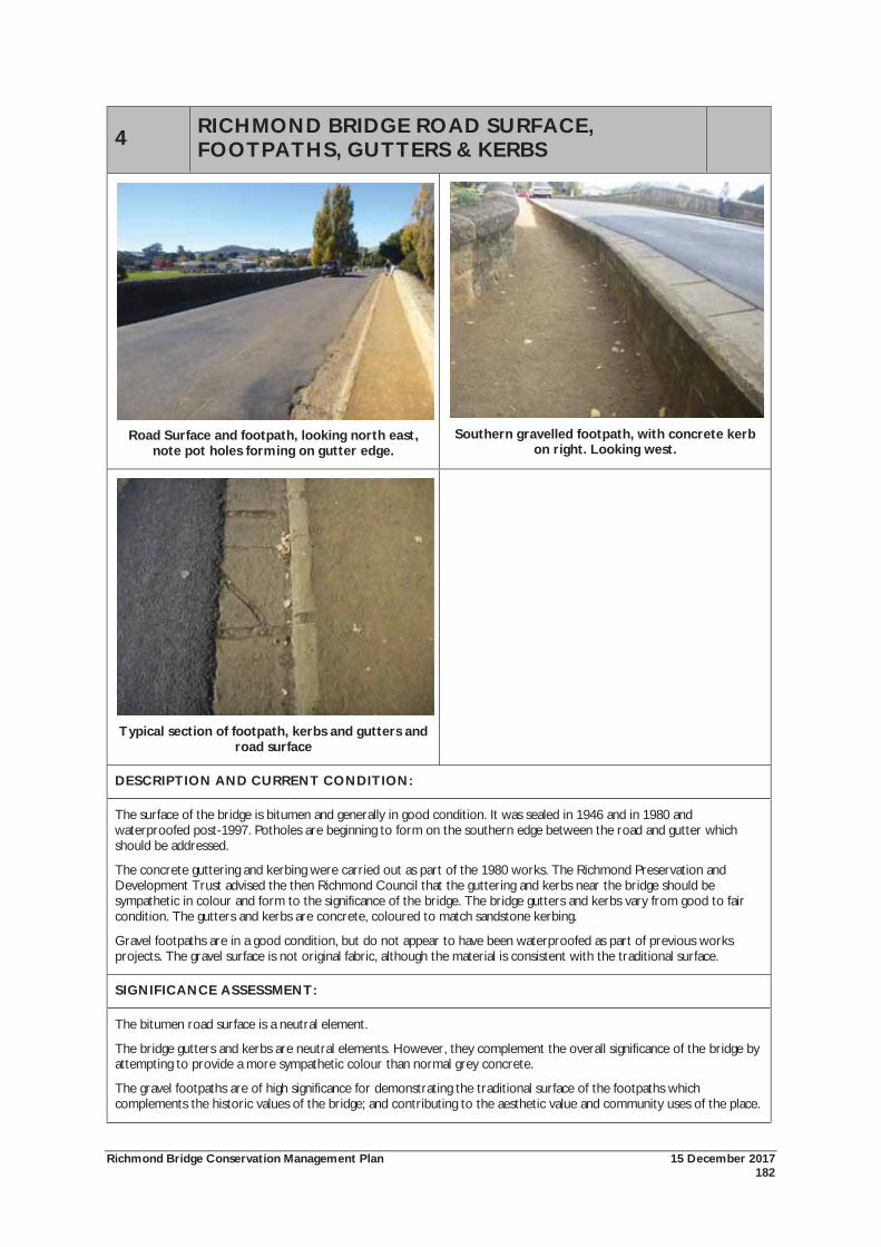
Richmond Bridge Conservation Management Plan 15 December 2017 182
4 RICHMOND BRIDGE ROAD SURFACE, FOOTPATHS, GUTTERS & KERBS
Road Surface and footpath, looking north east,
note pot holes forming on gutter edge.
Southern gravelled footpath, with concrete kerb
on right. Looking west.
Typical section of footpath, kerbs and gutters and
road surface
DESCRIPTION AND CURRENT CONDITION:
The surface of the bridge is bitumen and generally in good condition. It was sealed in 1946 and in 1980 and waterproofed post-1997. Potholes are beginning to form on the southern edge between the road and gutter which should be addressed.
The concrete guttering and kerbing were carried out as part of the 1980 works. The Richmond Preservation and Development Trust advised the then Richmond Council that the guttering and kerbs near the bridge should be sympathetic in colour and form to the significance of the bridge. The bridge gutters and kerbs vary from good to fair condition. The gutters and kerbs are concrete, coloured to match sandstone kerbing.
Gravel footpaths are in a good condition, but do not appear to have been waterproofed as part of previous works projects. The gravel surface is not original fabric, although the material is consistent with the traditional surface.
SIGNIFICANCE ASSESSMENT:
The bitumen road surface is a neutral element.
The bridge gutters and kerbs are neutral elements. However, they complement the overall significance of the bridge by attempting to provide a more sympathetic colour than normal grey concrete.
The gravel footpaths are of high significance for demonstrating the traditional surface of the footpaths which complements the historic values of the bridge; and contributing to the aesthetic value and community uses of the place.
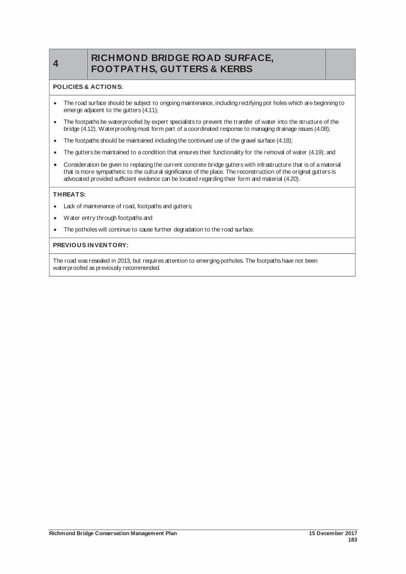
Richmond Bridge Conservation Management Plan 15 December 2017 183
4 RICHMOND BRIDGE ROAD SURFACE, FOOTPATHS, GUTTERS & KERBS
POLICIES & ACTIONS:
The road surface should be subject to ongoing maintenance, including rectifying pot holes which are beginning to emerge adjacent to the gutters (4.11);
The footpaths be waterproofed by expert specialists to prevent the transfer of water into the structure of the bridge (4.12). Waterproofing must form part of a coordinated response to managing drainage issues (4.08);
The footpaths should be maintained including the continued use of the gravel surface (4.18);
The gutters be maintained to a condition that ensures their functionality for the removal of water (4.19); and
Consideration be given to replacing the current concrete bridge gutters with infrastructure that is of a material that is more sympathetic to the cultural significance of the place. The reconstruction of the original gutters is advocated provided sufficient evidence can be located regarding their form and material (4.20).
THREATS:
Lack of maintenance of road, footpaths and gutters;
Water entry through footpaths and
The potholes will continue to cause further degradation to the road surface.
PREVIOUS INVENTORY:
The road was resealed in 2013, but requires attention to emerging potholes. The footpaths have not been waterproofed as previously recommended.
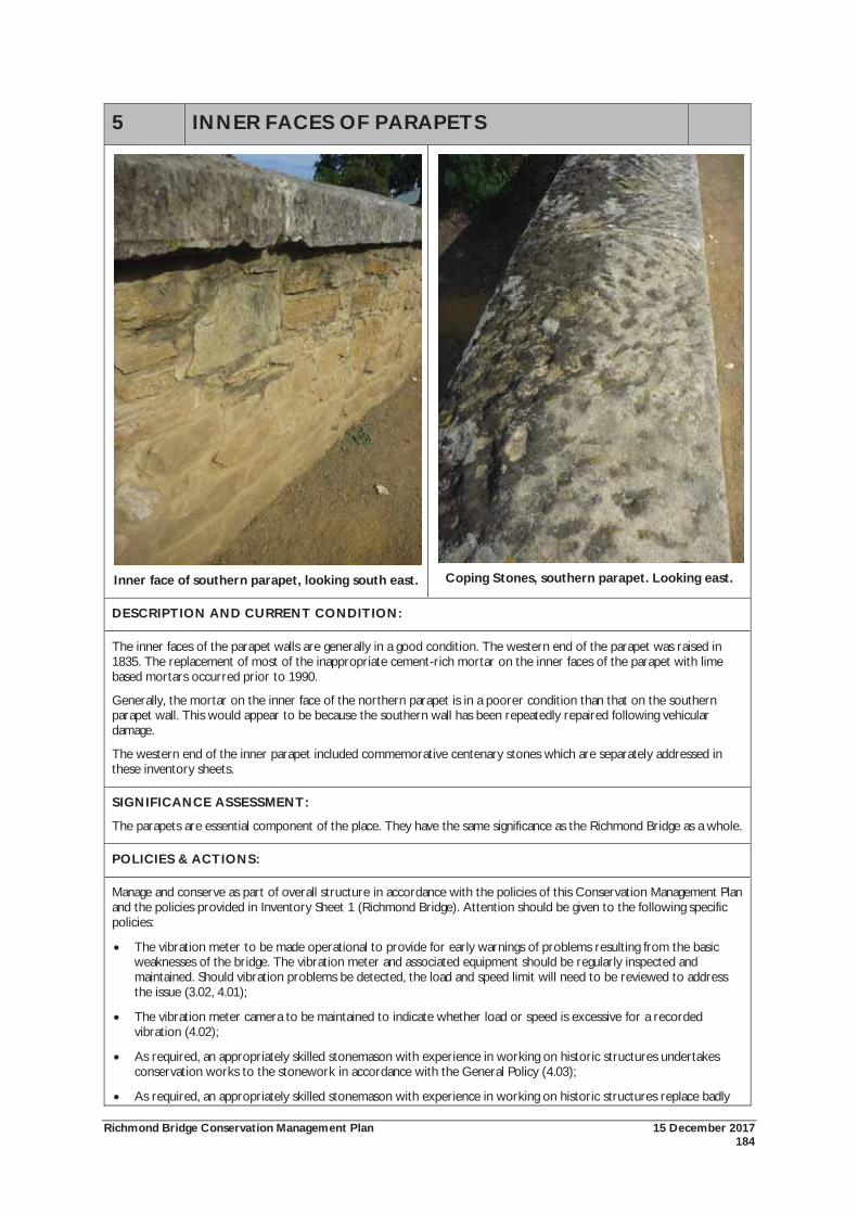
Richmond Bridge Conservation Management Plan 15 December 2017 184
5 INNER FACES OF PARAPETS
Inner face of southern parapet, looking south east.
Coping Stones, southern parapet. Looking east.
DESCRIPTION AND CURRENT CONDITION:
The inner faces of the parapet walls are generally in a good condition. The western end of the parapet was raised in 1835. The replacement of most of the inappropriate cement-rich mortar on the inner faces of the parapet with lime based mortars occurred prior to 1990.
Generally, the mortar on the inner face of the northern parapet is in a poorer condition than that on the southern parapet wall. This would appear to be because the southern wall has been repeatedly repaired following vehicular damage.
The western end of the inner parapet included commemorative centenary stones which are separately addressed in these inventory sheets.
SIGNIFICANCE ASSESSMENT:
The parapets are essential component of the place. They have the same significance as the Richmond Bridge as a whole.
POLICIES & ACTIONS:
Manage and conserve as part of overall structure in accordance with the policies of this Conservation Management Plan and the policies provided in Inventory Sheet 1 (Richmond Bridge). Attention should be given to the following specific policies:
The vibration meter to be made operational to provide for early warnings of problems resulting from the basic weaknesses of the bridge. The vibration meter and associated equipment should be regularly inspected and maintained. Should vibration problems be detected, the load and speed limit will need to be reviewed to address the issue (3.02, 4.01);
The vibration meter camera to be maintained to indicate whether load or speed is excessive for a recorded vibration (4.02);
As required, an appropriately skilled stonemason with experience in working on historic structures undertakes conservation works to the stonework in accordance with the General Policy (4.03);
As required, an appropriately skilled stonemason with experience in working on historic structures replace badly

Richmond Bridge Conservation Management Plan 15 December 2017 185
5 INNER FACES OF PARAPETS decayed stones when subject to a 50mm surface loss. New stones should use 100mm thick inserts of a better quality stone (4.04);
As required, an appropriately skilled stonemason should replace lost bedding with a quicklime grout to make loose stonework solid (4.06);
As required, the repointing of mortar joints be undertaken by skilled stonemason using a permeable quick lime based mortar coloured to match the recent repointing work. Repointing works should have a weather struck finish. Any remaining hard, cement rich mortar should be replaced (4.07);
The prevention of excessive speeding over the bridge to be pursued as a means of preventing damage to the parapet walls caused by vehicular accidents (4.13);
The bridge should be inspected annually for pointing and stormwater defects, flood damage, cracking movements and general condition of stonework (4.15);
The 3D laser scanning of the bridge be used as the basis for understanding the fabric of the bridge (4.16);
All actions, works or development affecting the fabric of the bridge are appropriately recorded and copies lodged with State Growth and Heritage Tasmania (4.17); and
As required, organic growth is cleaned from the bridge. Care should be taken to ensure that the contractor is skilled in working on historic structures and that the methods and materials are appropriate to the cultural significance of the bridge and any necessary environmental considerations. Trial cleaning methods should be conducted on discreet parts of the bridge to ensure correct and non-invasive process (4.27).
THREATS:
Lack of ongoing inspection and maintenance;
Vehicle collisions;
Strengthening the parapet walls;
Water entry into joints from open joints; and
Hard, cement-rich mortar causing structural problems.
PREVIOUS INVENTORY:
The condition of the parapets appears to have been maintained since 2010. Open joints appear to have been filled. Ongoing monitoring and maintenance will be required.
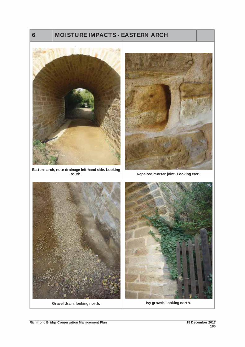
Richmond Bridge Conservation Management Plan 15 December 2017 186
6 MOISTURE IMPACTS - EASTERN ARCH
.
Eastern arch, note drainage left hand side. Looking south.
Repaired mortar joint. Looking east.
Gravel drain, looking north.
Ivy growth, looking north.
Richmond Bridge Conservation Management Plan 15 December 2017 187
6 MOISTURE IMPACTS - EASTERN ARCH
DESCRIPTION AND CURRENT CONDITION:
Of all components of the bridge, the most extensive conservation works post-2010 have been carried out in the eastern arch. The arch was in a poor condition, largely caused by moisture. Specific problems included water ponding; longitudinal cracks; salt efflorescence on the stones and mortar joints; severe stone and mortar loss; the presence of hard, cement rich mortars and ivy growing on the exterior.
A substantial amount of work has been carried out in the eastern arch including its entire repointing, the installation of a drainage system, removal of the tree and filling of the depression. Despite these works, damp continues to be a problem within the arch, and salt efflorescence is beginning to re-emerge. The ivy from the adjoining property has also regrown and will require continual maintenance and removal.
SIGNIFICANCE:
The intrados of the eastern arch is an essential component of the place. This element has the same significance as the Richmond Bridge as a whole.
POLICIES & ACTIONS:
Manage and conserve as part of overall structure in accordance with the policies of this Conservation Management Plan and the policies provided in Inventory Sheet 1 (Richmond Bridge). Moisture problems appear to be a particular problem for the eastern arch, and attention should be given to the following specific policies:
The vibration meter to be made operational to provide for early warnings of problems resulting from the basic weaknesses of the bridge. The vibration meter and associated equipment should be regularly inspected and maintained. Should vibration problems be detected, the load and speed limit will need to be reviewed to address the issue (3.02, 4.01);
The vibration meter camera to be maintained to indicate whether load or speed is excessive for a recorded vibration (4.02);
As required, an appropriately skilled stonemason with experience in working on historic structures undertakes conservation works to the stonework in accordance with the General Policy (4.03);
As required, an appropriately skilled stonemason with experience in working on historic structures replace badly decayed stones when subject to a 50mm surface loss. New stones should use 100mm thick inserts of a better quality stone (4.04);
As required, an appropriately skilled stonemason should replace lost bedding with a quicklime grout to make loose stonework solid (4.06);
As required, the repointing of mortar joints be undertaken by skilled stonemason using a permeable quick lime based mortar coloured to match the recent repointing work. Repointing works should have a weather struck finish. Any remaining hard, cement rich mortar should be replaced (4.07);
That specialist advice be sought on drainage management for the entire bridge, including preventing the ponding of water under the south east arch (4.08, 4.09);
The bridge should be inspected annually for pointing and stormwater defects, flood damage, cracking movements and general condition of stonework (4.15); and
That the ivy growing on south east end of the bridge should be continually removed.
THREATS:
Lack of ongoing maintenance;
Spry identified two threats relating to the cracks. Firstly, slow damage due to continuing existing use, and secondly, rapid damage caused by sudden excessive stress;
Structural problems caused by stone decay;
Water entry into joints from open joints;
Hard, cement-rich mortar causing structural problems;
Water entering the structure of the bridge by poorly maintained, inoperative or ineffective water shedding
Richmond Bridge Conservation Management Plan 15 December 2017 188
6 MOISTURE IMPACTS - EASTERN ARCH methods; and
The ivy has the potential to cause damage to the stone.
PREVIOUS INVENTORY:
Problems with the eastern arch were identified in the 1997 and 2010 CMPs. Extensive works have been carried out in the area, which have greatly improved the arch structurally and aesthetically. However water ponding and removal continues to be an ongoing issue and must be considered as part of a comprehensive analysis of water removal from the bridge.
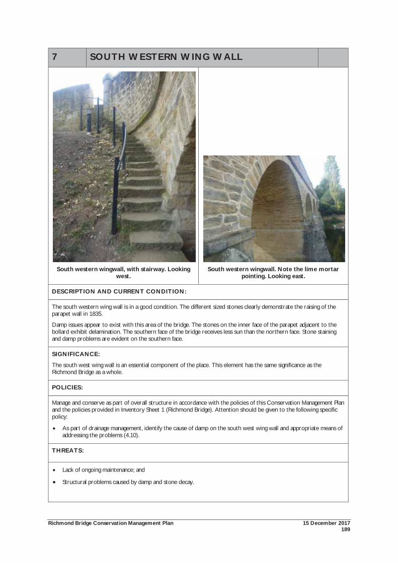
Richmond Bridge Conservation Management Plan 15 December 2017 189
7 SOUTH WESTERN WING WALL
South western wingwall, with stairway. Looking
west.
South western wingwall. Note the lime mortar
pointing. Looking east.
DESCRIPTION AND CURRENT CONDITION:
The south western wing wall is in a good condition. The different sized stones clearly demonstrate the raising of the parapet wall in 1835.
Damp issues appear to exist with this area of the bridge. The stones on the inner face of the parapet adjacent to the bollard exhibit delamination. The southern face of the bridge receives less sun than the northern face. Stone staining and damp problems are evident on the southern face.
SIGNIFICANCE:
The south west wing wall is an essential component of the place. This element has the same significance as the Richmond Bridge as a whole.
POLICIES:
Manage and conserve as part of overall structure in accordance with the policies of this Conservation Management Plan and the policies provided in Inventory Sheet 1 (Richmond Bridge). Attention should be given to the following specific policy:
As part of drainage management, identify the cause of damp on the south west wing wall and appropriate means of addressing the problems (4.10).
THREATS:
Lack of ongoing maintenance; and
Structural problems caused by damp and stone decay.

Richmond Bridge Conservation Management Plan 15 December 2017 190
PREVIOUS INVENTORY:
The 2010 CMP identified damp issues with the south western wingwall. Repointing works have been carried out, however damp continues to be an issue.
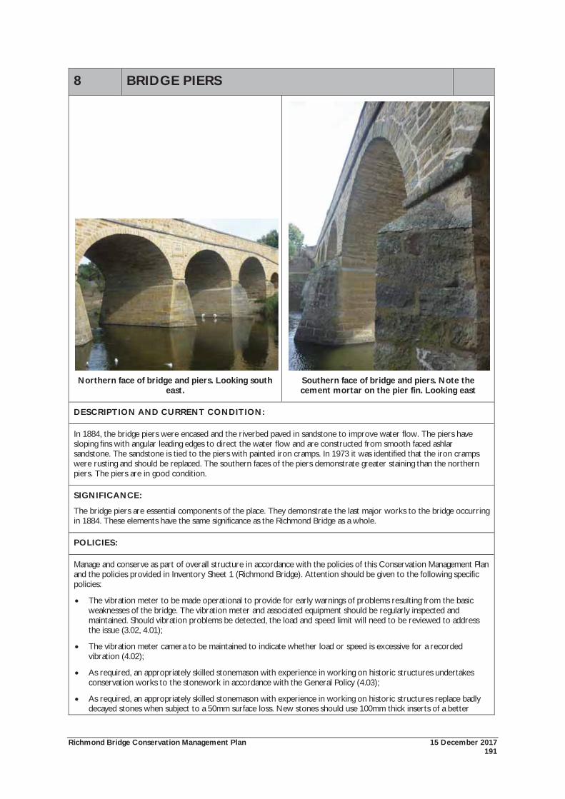
Richmond Bridge Conservation Management Plan 15 December 2017 191
8 BRIDGE PIERS
Northern face of bridge and piers. Looking south
east.
Southern face of bridge and piers. Note the cement mortar on the pier fin. Looking east
DESCRIPTION AND CURRENT CONDITION:
In 1884, the bridge piers were encased and the riverbed paved in sandstone to improve water flow. The piers have sloping fins with angular leading edges to direct the water flow and are constructed from smooth faced ashlar sandstone. The sandstone is tied to the piers with painted iron cramps. In 1973 it was identified that the iron cramps were rusting and should be replaced. The southern faces of the piers demonstrate greater staining than the northern piers. The piers are in good condition.
SIGNIFICANCE:
The bridge piers are essential components of the place. They demonstrate the last major works to the bridge occurring in 1884. These elements have the same significance as the Richmond Bridge as a whole.
POLICIES:
Manage and conserve as part of overall structure in accordance with the policies of this Conservation Management Plan and the policies provided in Inventory Sheet 1 (Richmond Bridge). Attention should be given to the following specific policies:
The vibration meter to be made operational to provide for early warnings of problems resulting from the basic weaknesses of the bridge. The vibration meter and associated equipment should be regularly inspected and maintained. Should vibration problems be detected, the load and speed limit will need to be reviewed to address the issue (3.02, 4.01);
The vibration meter camera to be maintained to indicate whether load or speed is excessive for a recorded vibration (4.02);
As required, an appropriately skilled stonemason with experience in working on historic structures undertakes conservation works to the stonework in accordance with the General Policy (4.03);
As required, an appropriately skilled stonemason with experience in working on historic structures replace badly decayed stones when subject to a 50mm surface loss. New stones should use 100mm thick inserts of a better
Richmond Bridge Conservation Management Plan 15 December 2017 192
8 BRIDGE PIERS quality stone (4.04);
As required, an appropriately skilled stonemason should replace lost bedding with a quicklime grout to make loose stonework solid (4.06);
As required, the repointing of mortar joints be undertaken by skilled stonemason using a permeable quick lime based mortar coloured to match the recent repointing work. Repointing works should have a weather struck finish. Any remaining hard, cement rich mortar should be replaced (4.07);
The bridge should be inspected annually for pointing and stormwater defects, flood damage, cracking movements and general condition of stonework Any remaining hard, cement rich mortar should be replaced (4.07);
The bridge should be inspected annually for pointing and stormwater defects, flood damage, cracking movements and general condition of stonework (4.15);
That the cramps holding the top course of the sheathing stones be monitored and maintained to ensure that they continue to function (4.26); and
As required, organic growth is cleaned from the bridge. Care should be taken to ensure that the contractor is skilled in working on historic structures and that the methods and materials are appropriate to the cultural significance of the bridge and any necessary environmental considerations. Trial cleaning methods should be conducted on discreet parts of the bridge to ensure correct and non-invasive process (4.27).
THREATS:
Lack of adequate ongoing maintenance;
Rusting of iron cramps causing damage to the stonework of the piers; and
Organic growth on the bridge could have an adverse affect on the aesthetic significance of the place.
PREVIOUS INVENTORY:
The 1997 CMP noted that the iron cramps tying the top of the sheathing to the pier were cleaned and painted and the adjacent fillet reformed with cement mortar and that they were in good condition. They have not been addressed since.
Spry identified biocide application followed by water jetting as having been effective in cleaning the bridge. Cleaning works occur as required.
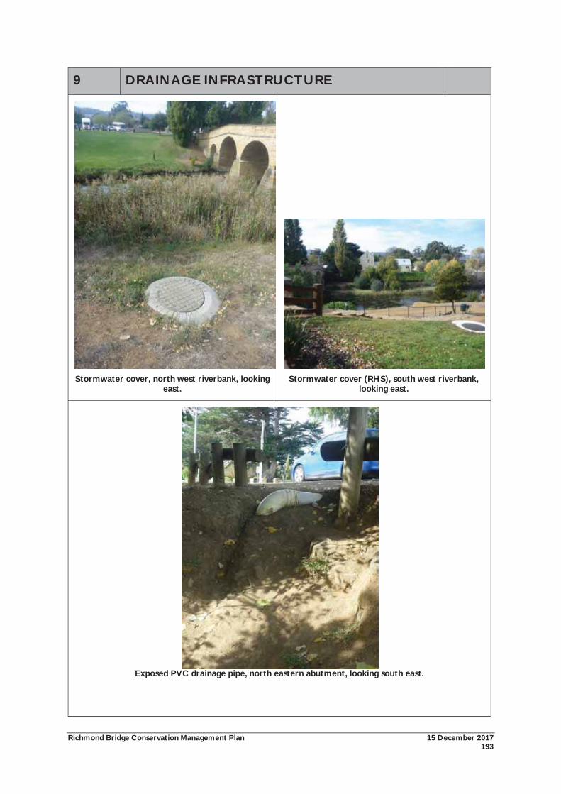
Richmond Bridge Conservation Management Plan 15 December 2017 193
9 DRAINAGE INFRASTRUCTURE
Stormwater cover, north west riverbank, looking
east.
Stormwater cover (RHS), south west riverbank,
looking east.
Exposed PVC drainage pipe, north eastern abutment, looking south east.
Richmond Bridge Conservation Management Plan 15 December 2017 194
9 DRAINAGE INFRASTRUCTURE
DESCRIPTION AND CURRENT CONDITION:
Drainage infrastructure on the north east, north west and south west banks has been improved since 2010. Some redundant infrastructure has been removed, which has improved the aesthetic qualities of the place. Specialist advice has been sought on the drainage of the bridge, however issues continue to exist, particularly with the eastern arch. The concrete stormwater covers are necessary, but visually intrusive.
SIGNIFICANCE:
Drainage infrastructure on the north east, north west and south west riverbanks are intrusive elements.
POLICIES & ACTIONS:
Specialist advice to be sought on drainage management for the entire bridge (4.08);
The drains to be regularly inspected and maintained to ensure their continued functioning (4.21); and
The PVC drain on the north east abutment to be reburied and landscaped to prevent erosion and exposure of the drain (4.22).
THREATS:
Lack of ongoing maintenance;
Water entering the structure of the bridge by poorly maintained, inoperative or ineffective water shedding methods; and
Visual impact on intrusive infrastructure.
PREVIOUS INVENTORY:
Substantial improvements have been made to rectifying drainage infrastructure since 2010, although damp does remain a continuing problem. The visual appearance of the concrete drainage infrastructure on the western bank could be improved through painting a darker colour.
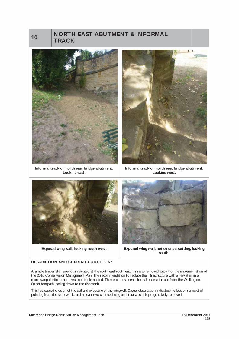
Richmond Bridge Conservation Management Plan 15 December 2017 195
10 NORTH EAST ABUTMENT & INFORMAL TRACK
Informal track on north east bridge abutment.
Looking east.
Informal track on north east bridge abutment.
Looking west.
Exposed wing wall, looking south west.
Exposed wing wall, notice undercutting, looking
south.
DESCRIPTION AND CURRENT CONDITION:
A simple timber stair previously existed at the north east abutment. This was removed as part of the implementation of the 2010 Conservation Management Plan. The recommendation to replace the infrastructure with a new stair in a more sympathetic location was not implemented. The result has been informal pedestrian use from the Wellington Street footpath leading down to the riverbank.
This has caused erosion of the soil and exposure of the wingwall. Casual observation indicates the loss or removal of pointing from the stonework, and at least two courses being undercut as soil is progressively removed.
Richmond Bridge Conservation Management Plan 15 December 2017 196
10 NORTH EAST ABUTMENT & INFORMAL TRACK
SIGNIFICANCE:
The north east abutment is an essential components of the place. It has the same significance as the Richmond Bridge as a whole.
The informal track is an intrusive element. It is damaging the fabric of the bridge and the appearance of the setting.
POLICIES & ACTIONS:
As required, an appropriately skilled stonemason with experience in working on historic structures undertakes conservation works to the stonework in accordance with the General Policy (4.03);
As required, the repointing of mortar joints be undertaken by skilled stonemason using a permeable quick lime based mortar coloured to match the recent repointing work. Repointing works should have a weather struck finish (4.07); and
Professional landscape advice to be sought on preventing pedestrian access directly adjacent to the north east bridge abutment which has caused erosion and exposure of the PVC drainage pipe. Construct a new sympathetic stair towards the centre or northern end of the north east bank (5.01).
THREATS:
Structural problems caused by erosion.
PREVIOUS INVENTORY:
No previous inventory. This is a new conservation issue that has emerged since 2010 and the removal of the former stair.
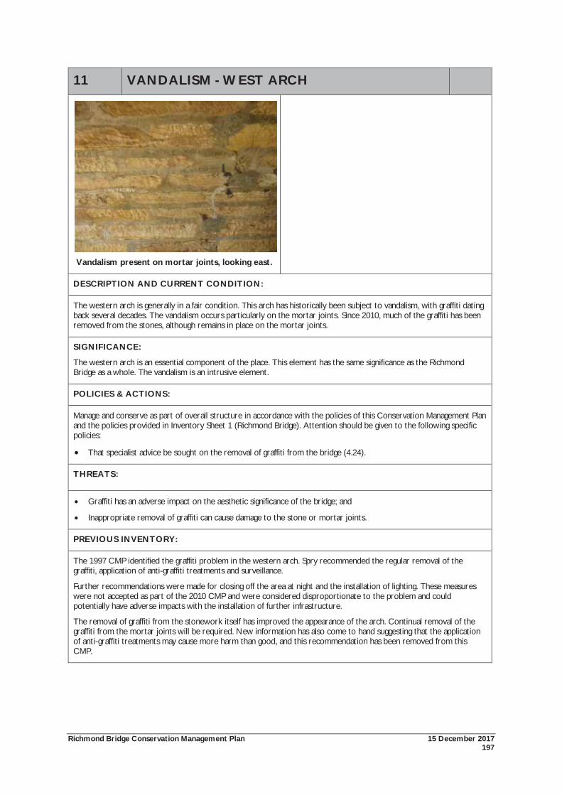
Richmond Bridge Conservation Management Plan 15 December 2017 197
11 VANDALISM - WEST ARCH
Vandalism present on mortar joints, looking east.
DESCRIPTION AND CURRENT CONDITION:
The western arch is generally in a fair condition. This arch has historically been subject to vandalism, with graffiti dating back several decades. The vandalism occurs particularly on the mortar joints. Since 2010, much of the graffiti has been removed from the stones, although remains in place on the mortar joints.
SIGNIFICANCE:
The western arch is an essential component of the place. This element has the same significance as the Richmond Bridge as a whole. The vandalism is an intrusive element.
POLICIES & ACTIONS:
Manage and conserve as part of overall structure in accordance with the policies of this Conservation Management Plan and the policies provided in Inventory Sheet 1 (Richmond Bridge). Attention should be given to the following specific policies:
That specialist advice be sought on the removal of graffiti from the bridge (4.24).
THREATS:
Graffiti has an adverse impact on the aesthetic significance of the bridge; and
Inappropriate removal of graffiti can cause damage to the stone or mortar joints.
PREVIOUS INVENTORY:
The 1997 CMP identified the graffiti problem in the western arch. Spry recommended the regular removal of the graffiti, application of anti-graffiti treatments and surveillance.
Further recommendations were made for closing off the area at night and the installation of lighting. These measures were not accepted as part of the 2010 CMP and were considered disproportionate to the problem and could potentially have adverse impacts with the installation of further infrastructure.
The removal of graffiti from the stonework itself has improved the appearance of the arch. Continual removal of the graffiti from the mortar joints will be required. New information has also come to hand suggesting that the application of anti-graffiti treatments may cause more harm than good, and this recommendation has been removed from this CMP.
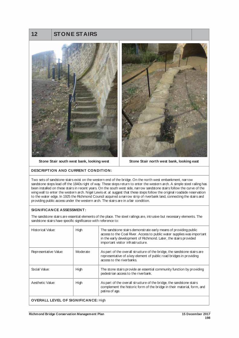
Richmond Bridge Conservation Management Plan 15 December 2017 198
12 STONE STAIRS
Stone Stair south west bank, looking west
Stone Stair north west bank, looking east
DESCRIPTION AND CURRENT CONDITION:
Two sets of sandstone stairs exist on the western end of the bridge. On the north west embankment, narrow sandstone steps lead off the 1840s right of way. These steps return to enter the western arch. A simple steel railing has been installed on these stairs in recent years. On the south west side, narrow sandstone stairs follow the curve of the wing wall to enter the western arch. Nigel Lewis et. al. suggest that these steps follow the original roadside reservation to the water edge. In 1925 the Richmond Council acquired a narrow strip of riverbank land, connecting the stairs and providing public access under the western arch. The stairs are in a fair condition.
SIGNIFICANCE ASSESSMENT:
The sandstone stairs are essential elements of the place. The steel railings are, intrusive but necessary elements. The sandstone stairs have specific significance with reference to:
Historical Value: High The sandstone stairs demonstrate early means of providing public access to the Coal River. Access to public water supplies was important in the early development of Richmond. Later, the stairs provided important visitor infrastructure.
Representative Value: Moderate As part of the overall structure of the bridge, the sandstone stairs are representative of a key element of public road bridges in providing access to the riverbanks.
Social Value: High The stone stairs provide an essential community function by providing pedestrian access to the riverbank.
Aesthetic Value: High As part of the overall structure of the bridge, the sandstone stairs complement the historic form of the bridge in their material, form, and patina of age.
OVERALL LEVEL OF SIGNIFICANCE: High

Richmond Bridge Conservation Management Plan 15 December 2017 199
12 STONE STAIRS
POLICIES & ACTIONS:
Manage and conserve as part of overall structure in accordance with the policies of this Conservation Management Plan and the policies provided in Inventory Sheet 1 (Richmond Bridge). Attention should be given to the following specific policy:
The sandstone stairs on the west end of the bridge abutments are to be conserved as elements of cultural significance. The sandstone stairs should continue to function for their original use and all maintenance work should follow professional standards and be undertaken by suitably qualified personnel (4.23).
THREATS:
Lack of continued maintenance; and
The potential inappropriate upgrading to meet safety standards e.g. balustrade heights, dimensions of stones.
PREVIOUS INVENTORY:
The 1997 Conservation Plan identified the north west stairs as being of some cultural significance. The 2010 CMP assessed it as being of high significance.
The stairs are not compliant to current standards and it is not possible to upgrade them without considerable modifications which would substantially alter the appearance of the bridge and stairs. Re-packing and grouting of the bedding for the steps was carried out in 2014/15. Repairs will be required approximately every 5 years.
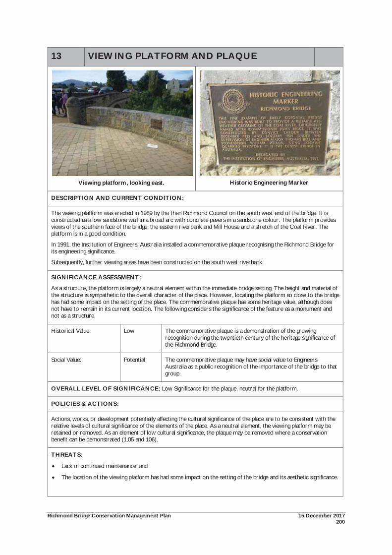
Richmond Bridge Conservation Management Plan 15 December 2017 200
13 VIEWING PLATFORM AND PLAQUE
Viewing platform, looking east.
Historic Engineering Marker
DESCRIPTION AND CURRENT CONDITION:
The viewing platform was erected in 1989 by the then Richmond Council on the south west end of the bridge. It is constructed as a low sandstone wall in a broad arc with concrete pavers in a sandstone colour. The platform provides views of the southern face of the bridge, the eastern riverbank and Mill House and a stretch of the Coal River. The platform is in a good condition.
In 1991, the Institution of Engineers, Australia installed a commemorative plaque recognising the Richmond Bridge for its engineering significance.
Subsequently, further viewing areas have been constructed on the south west riverbank.
SIGNIFICANCE ASSESSMENT:
As a structure, the platform is largely a neutral element within the immediate bridge setting. The height and material of the structure is sympathetic to the overall character of the place. However, locating the platform so close to the bridge has had some impact on the setting of the place. The commemorative plaque has some heritage value, although does not have to remain in its current location. The following considers the significance of the feature as a monument and not as a structure.
Historical Value: Low The commemorative plaque is a demonstration of the growing recognition during the twentieth century of the heritage significance of the Richmond Bridge.
Social Value: Potential The commemorative plaque may have social value to Engineers Australia as a public recognition of the importance of the bridge to that group.
OVERALL LEVEL OF SIGNIFICANCE: Low Significance for the plaque, neutral for the platform.
POLICIES & ACTIONS:
Actions, works, or development potentially affecting the cultural significance of the place are to be consistent with the relative levels of cultural significance of the elements of the place. As a neutral element, the viewing platform may be retained or removed. As an element of low cultural significance, the plaque may be removed where a conservation benefit can be demonstrated (1.05 and 106).
THREATS:
Lack of continued maintenance; and
The location of the viewing platform has had some impact on the setting of the bridge and its aesthetic significance.

Richmond Bridge Conservation Management Plan 15 December 2017 201
PREVIOUS INVENTORY:
The 1997 Conservation Plan identified the viewing platform as having some cultural significance. The 2010 CMP assessed the plaque as having low significance and the viewing platform being neutral.
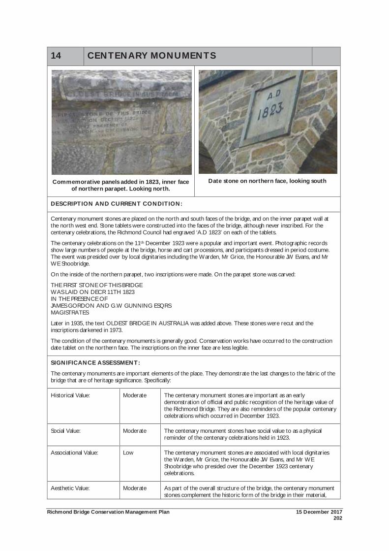
Richmond Bridge Conservation Management Plan 15 December 2017 202
14 CENTENARY MONUMENTS
Commemorative panels added in 1823, inner face
of northern parapet. Looking north.
Date stone on northern face, looking south
DESCRIPTION AND CURRENT CONDITION:
Centenary monument stones are placed on the north and south faces of the bridge, and on the inner parapet wall at the north west end. Stone tablets were constructed into the faces of the bridge, although never inscribed. For the centenary celebrations, the Richmond Council had engraved ‘A.D 1823’ on each of the tablets.
The centenary celebrations on the 11th December 1923 were a popular and important event. Photographic records show large numbers of people at the bridge, horse and cart processions, and participants dressed in period costume. The event was presided over by local dignitaries including the Warden, Mr Grice, the Honourable JW Evans, and Mr WE Shoobridge.
On the inside of the northern parapet, two inscriptions were made. On the parapet stone was carved:
THE FIRST STONE OF THIS BRIDGE WAS LAID ON DECR 11TH 1823 IN THE PRESENCE OF JAMES GORDON AND G.W GUNNING ESQRS MAGISTRATES
Later in 1935, the text OLDEST BRIDGE IN AUSTRALIA was added above. These stones were recut and the inscriptions darkened in 1973.
The condition of the centenary monuments is generally good. Conservation works have occurred to the construction date tablet on the northern face. The inscriptions on the inner face are less legible.
SIGNIFICANCE ASSESSMENT:
The centenary monuments are important elements of the place. They demonstrate the last changes to the fabric of the bridge that are of heritage significance. Specifically:
Historical Value: Moderate The centenary monument stones are important as an early demonstration of official and public recognition of the heritage value of the Richmond Bridge. They are also reminders of the popular centenary celebrations which occurred in December 1923.
Social Value: Moderate The centenary monument stones have social value to as a physical reminder of the centenary celebrations held in 1923.
Associational Value: Low The centenary monument stones are associated with local dignitaries the Warden, Mr Grice, the Honourable JW Evans, and Mr WE Shoobridge who presided over the December 1923 centenary celebrations.
Aesthetic Value: Moderate As part of the overall structure of the bridge, the centenary monument stones complement the historic form of the bridge in their material,
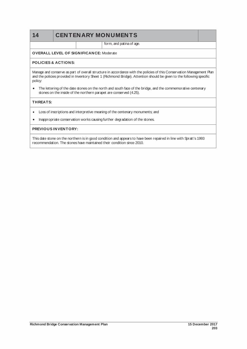
Richmond Bridge Conservation Management Plan 15 December 2017 203
14 CENTENARY MONUMENTS form, and patina of age.
OVERALL LEVEL OF SIGNIFICANCE: Moderate
POLICIES & ACTIONS:
Manage and conserve as part of overall structure in accordance with the policies of this Conservation Management Plan and the policies provided in Inventory Sheet 1 (Richmond Bridge). Attention should be given to the following specific policy:
The lettering of the date stones on the north and south face of the bridge, and the commemorative centenary stones on the inside of the northern parapet are conserved (4.25).
THREATS:
Loss of inscriptions and interpretive meaning of the centenary monuments; and
Inappropriate conservation works causing further degradation of the stones.
PREVIOUS INVENTORY:
This date stone on the northern is in good condition and appears to have been repaired in line with Spratt’s 1993 recommendation. The stones have maintained their condition since 2010.
Richmond Bridge Conservation Management Plan 15 December 2017 204
15 STAIRS SOUTHWEST BANK
Stairs, looking south.
Stairs, looking south west.
DESCRIPTION AND CONDITION:
The cement block stair was constructed in 1989 by the then Richmond Council. It leads off the southern end of the sandstone viewing platform also constructed at that time. The stairs are in a fair condition. Some attempt has been made to address the sensitivity of the location with sandstone capping on the risers and eastern side of the stairs. A track has been developed on its eastern side.
SIGNIFICANCE ASSESSMENT:
The current cement block stair is visually intrusive on the cultural significance of the place in terms of location, materials and the handrail. The replacement of this stair with new infrastructure requires careful consideration.
POLICIES & ACTIONS:
The cement block stair on the south west bank should be removed. Should it be established that stair infrastructure is required at this point, any new stair should be designed to be sympathetic to the cultural significance of the bridge and its setting (5.05).
THREATS:
Ongoing visual intrusion from the stair.
PREVIOUS INVENTORY:
The 1997 and 2010 Conservation Management Plans identified this as an intrusive element.
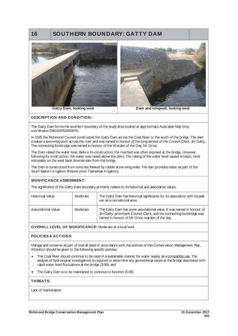
Richmond Bridge Conservation Management Plan 15 December 2017 205
16 SOUTHERN BOUNDARY: GATTY DAM
Gatty Dam, looking west Dam and wingwall, looking west
DESCRIPTION AND CONDITION:
The Gatty Dam forms the southern boundary of the study area located at approximate Australian Map Grip coordinates 536181E/5268287N.
In 1935 the Richmond Council constructed the Gatty Dam across the Coal River to the south of the bridge. The dam created a swimming pool across the river and was named in honour of the long service of the Council Clerk, Jim Gatty. The connecting footbridge was named in honour of the Warden of the Day, Mr Grice.
The Dam raised the water level. Before its construction, the riverbed was often exposed at the bridge. However, following its construction, the water was raised above the piers. The raising of the water level caused erosion, most noticeably on the west bank downstream from the bridge.
The Dam is constructed from concrete flanked by rubble stone wing walls. The dam provides water as part of the South Eastern Irrigation Scheme (now Tasmanian Irrigation).
SIGNIFICANCE ASSESSMENT:
The significance of the Gatty Dam boundary primarily relates to its historical and associative values.
Historical Value: Moderate The Gatty Dam has historical significance for its association with its past use as a recreational area.
Associational Value: Moderate The Gatty Dam has some associational value. It was named in honour of Jim Gatty, prominent Council Clerk, and the connecting footbridge was named in honour of Mr Grice, warden of the day.
OVERALL LEVEL OF SIGNIFICANCE: Moderate at a local level.
POLICIES & ACTIONS:
Manage and conserve as part of overall place in accordance with the policies of this Conservation Management Plan. Attention should be given to the following specific policies:
The Coal River should continue to be used in a sustainable manner for water supply as a compatible use. The analysis of hydrological investigations is required to determine any geotechnical issues at the bridge associated with rapid water level fluctuations at the bridge (3.06); and
The Gatty Dam is to be maintained to continue to function (5.09).
THREATS:
Lack of maintenance.

Richmond Bridge Conservation Management Plan 15 December 2017 206
PREVIOUS INVENTORY:
The 1997 CMP identified the Gatty Dam as a neutral element. The 2010 and 2017 CMP’s identify it as a feature with local level of significance.
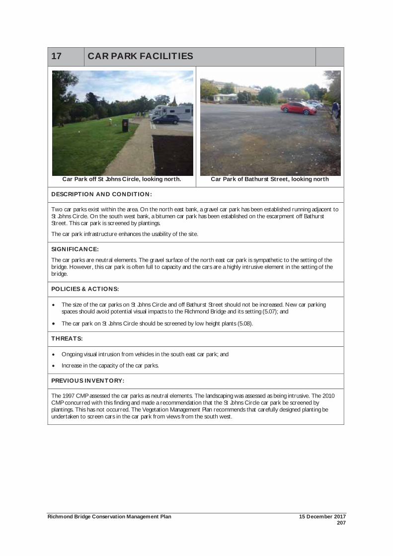
Richmond Bridge Conservation Management Plan 15 December 2017 207
17 CAR PARK FACILITIES
Car Park off St Johns Circle, looking north. Car Park of Bathurst Street, looking north
DESCRIPTION AND CONDITION:
Two car parks exist within the area. On the north east bank, a gravel car park has been established running adjacent to St Johns Circle. On the south west bank, a bitumen car park has been established on the escarpment off Bathurst Street. This car park is screened by plantings.
The car park infrastructure enhances the usability of the site.
SIGNIFICANCE:
The car parks are neutral elements. The gravel surface of the north east car park is sympathetic to the setting of the bridge. However, this car park is often full to capacity and the cars are a highly intrusive element in the setting of the bridge.
POLICIES & ACTIONS:
The size of the car parks on St Johns Circle and off Bathurst Street should not be increased. New car parking spaces should avoid potential visual impacts to the Richmond Bridge and its setting (5.07); and
The car park on St Johns Circle should be screened by low height plants (5.08).
THREATS:
Ongoing visual intrusion from vehicles in the south east car park; and
Increase in the capacity of the car parks.
PREVIOUS INVENTORY:
The 1997 CMP assessed the car parks as neutral elements. The landscaping was assessed as being intrusive. The 2010 CMP concurred with this finding and made a recommendation that the St Johns Circle car park be screened by plantings. This has not occurred. The Vegetation Management Plan recommends that carefully designed planting be undertaken to screen cars in the car park from views from the south west.
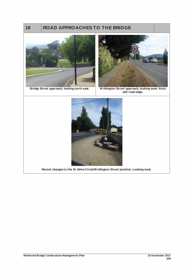
Richmond Bridge Conservation Management Plan 15 December 2017 208
18 ROAD APPROACHES TO THE BRIDGE
Bridge Street approach, looking north east. Wellington Street approach, looking west. Note soft road edge.
Recent changes to the St Johns Circle/Wellington Street junction. Looking west.
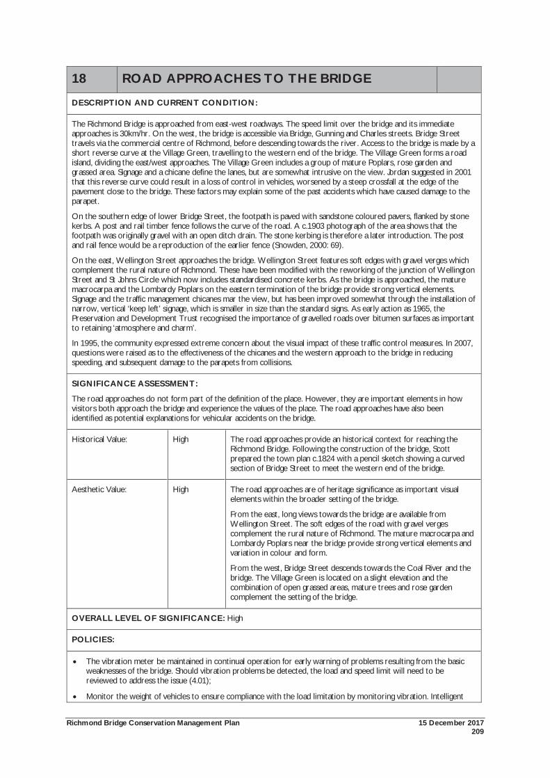
Richmond Bridge Conservation Management Plan 15 December 2017 209
18 ROAD APPROACHES TO THE BRIDGE
DESCRIPTION AND CURRENT CONDITION:
The Richmond Bridge is approached from east-west roadways. The speed limit over the bridge and its immediate approaches is 30km/hr. On the west, the bridge is accessible via Bridge, Gunning and Charles streets. Bridge Street travels via the commercial centre of Richmond, before descending towards the river. Access to the bridge is made by a short reverse curve at the Village Green, travelling to the western end of the bridge. The Village Green forms a road island, dividing the east/west approaches. The Village Green includes a group of mature Poplars, rose garden and grassed area. Signage and a chicane define the lanes, but are somewhat intrusive on the view. Jordan suggested in 2001 that this reverse curve could result in a loss of control in vehicles, worsened by a steep crossfall at the edge of the pavement close to the bridge. These factors may explain some of the past accidents which have caused damage to the parapet.
On the southern edge of lower Bridge Street, the footpath is paved with sandstone coloured pavers, flanked by stone kerbs. A post and rail timber fence follows the curve of the road. A c.1903 photograph of the area shows that the footpath was originally gravel with an open ditch drain. The stone kerbing is therefore a later introduction. The post and rail fence would be a reproduction of the earlier fence (Snowden, 2000: 69).
On the east, Wellington Street approaches the bridge. Wellington Street features soft edges with gravel verges which complement the rural nature of Richmond. These have been modified with the reworking of the junction of Wellington Street and St Johns Circle which now includes standardised concrete kerbs. As the bridge is approached, the mature macrocarpa and the Lombardy Poplars on the eastern termination of the bridge provide strong vertical elements. Signage and the traffic management chicanes mar the view, but has been improved somewhat through the installation of narrow, vertical ‘keep left’ signage, which is smaller in size than the standard signs. As early action as 1965, the Preservation and Development Trust recognised the importance of gravelled roads over bitumen surfaces as important to retaining ‘atmosphere and charm’.
In 1995, the community expressed extreme concern about the visual impact of these traffic control measures. In 2007, questions were raised as to the effectiveness of the chicanes and the western approach to the bridge in reducing speeding, and subsequent damage to the parapets from collisions.
SIGNIFICANCE ASSESSMENT:
The road approaches do not form part of the definition of the place. However, they are important elements in how visitors both approach the bridge and experience the values of the place. The road approaches have also been identified as potential explanations for vehicular accidents on the bridge.
Historical Value: High The road approaches provide an historical context for reaching the Richmond Bridge. Following the construction of the bridge, Scott prepared the town plan c.1824 with a pencil sketch showing a curved section of Bridge Street to meet the western end of the bridge.
Aesthetic Value: High The road approaches are of heritage significance as important visual elements within the broader setting of the bridge.
From the east, long views towards the bridge are available from Wellington Street. The soft edges of the road with gravel verges complement the rural nature of Richmond. The mature macrocarpa and Lombardy Poplars near the bridge provide strong vertical elements and variation in colour and form.
From the west, Bridge Street descends towards the Coal River and the bridge. The Village Green is located on a slight elevation and the combination of open grassed areas, mature trees and rose garden complement the setting of the bridge.
OVERALL LEVEL OF SIGNIFICANCE: High
POLICIES:
The vibration meter be maintained in continual operation for early warning of problems resulting from the basic weaknesses of the bridge. Should vibration problems be detected, the load and speed limit will need to be reviewed to address the issue (4.01);
Monitor the weight of vehicles to ensure compliance with the load limitation by monitoring vibration. Intelligent
Richmond Bridge Conservation Management Plan 15 December 2017 210
18 ROAD APPROACHES TO THE BRIDGE Access Recording (IAR) should be considered as a means of monitoring permit vehicle movements over the bridge (8.02);
That State Growth liaise with the Tasmanian Police regarding speed management at the crossing. Investigations should occur on the possibility of installing a permanent speed camera at the crossing point as a priority. If a permanent speed camera is not installed, mobile speed cameras should be used regularly at the crossing (8.03); and
That the gravel road verges on the Wellington Street approach to the bridge be maintained (8.04).
THREATS:
Risk of vehicular accidents on the bridge caused by western approach;
Risks of vehicles in excess of load limit crossing the bridge;
Ongoing visual intrusion from traffic calming measures and signage; and
Replacement of gravel road verges.
PREVIOUS INVENTORY:
The 1997 and 2010 CMP identified the road approaches as significant elements. The visual intrusion of the signage on the eastern, Wellington Street approach has been improved since 2010 with smaller, but still clear signage. A similar signage regime on the western, Bridge Street approach should be considered.
Improvements to the junction of Wellington Street and St Johns Circle have replaced the gravel road verges with standard concrete kerbing and gutters. It would be undesirable from aesthetic perspective to extend this further along Wellington Street.
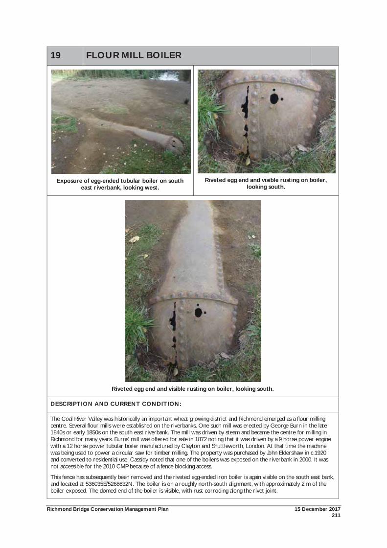
Richmond Bridge Conservation Management Plan 15 December 2017 211
19 FLOUR MILL BOILER
Exposure of egg-ended tubular boiler on south
east riverbank, looking west.
Riveted egg end and visible rusting on boiler,
looking south.
Riveted egg end and visible rusting on boiler, looking south.
DESCRIPTION AND CURRENT CONDITION:
The Coal River Valley was historically an important wheat growing district and Richmond emerged as a flour milling centre. Several flour mills were established on the riverbanks. One such mill was erected by George Burn in the late 1840s or early 1850s on the south east riverbank. The mill was driven by steam and became the centre for milling in Richmond for many years. Burns’ mill was offered for sale in 1872 noting that it was driven by a 9 horse power engine with a 12 horse power tubular boiler manufactured by Clayton and Shuttleworth, London. At that time the machine was being used to power a circular saw for timber milling. The property was purchased by John Eldershaw in c.1920 and converted to residential use. Cassidy noted that one of the boilers was exposed on the riverbank in 2000. It was not accessible for the 2010 CMP because of a fence blocking access.
This fence has subsequently been removed and the riveted egg-ended iron boiler is again visible on the south east bank, and located at 536035E/5268632N. The boiler is on a roughly north-south alignment, with approximately 2 m of the boiler exposed. The domed end of the boiler is visible, with rust corroding along the rivet joint.
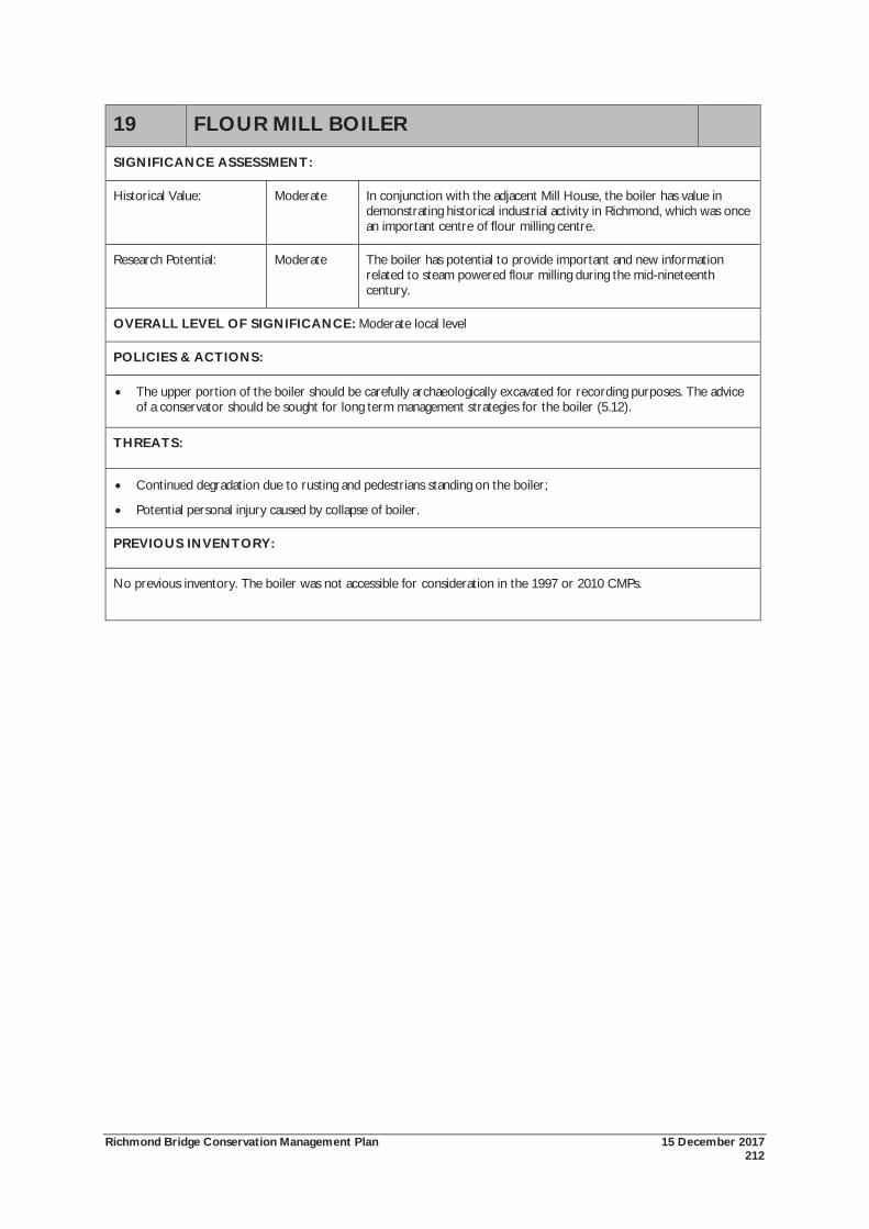
Richmond Bridge Conservation Management Plan 15 December 2017 212
19 FLOUR MILL BOILER
SIGNIFICANCE ASSESSMENT:
Historical Value: Moderate In conjunction with the adjacent Mill House, the boiler has value in demonstrating historical industrial activity in Richmond, which was once an important centre of flour milling centre.
Research Potential: Moderate The boiler has potential to provide important and new information related to steam powered flour milling during the mid-nineteenth century.
OVERALL LEVEL OF SIGNIFICANCE: Moderate local level
POLICIES & ACTIONS:
The upper portion of the boiler should be carefully archaeologically excavated for recording purposes. The advice of a conservator should be sought for long term management strategies for the boiler (5.12).
THREATS:
Continued degradation due to rusting and pedestrians standing on the boiler;
Potential personal injury caused by collapse of boiler.
PREVIOUS INVENTORY:
No previous inventory. The boiler was not accessible for consideration in the 1997 or 2010 CMPs.

Richmond Bridge Conservation Management Plan 15 December 2017 213
APPENDIX 2: VEGETATION MANAGEMENT PLAN
Appendix 2: Vegetation Management Plan
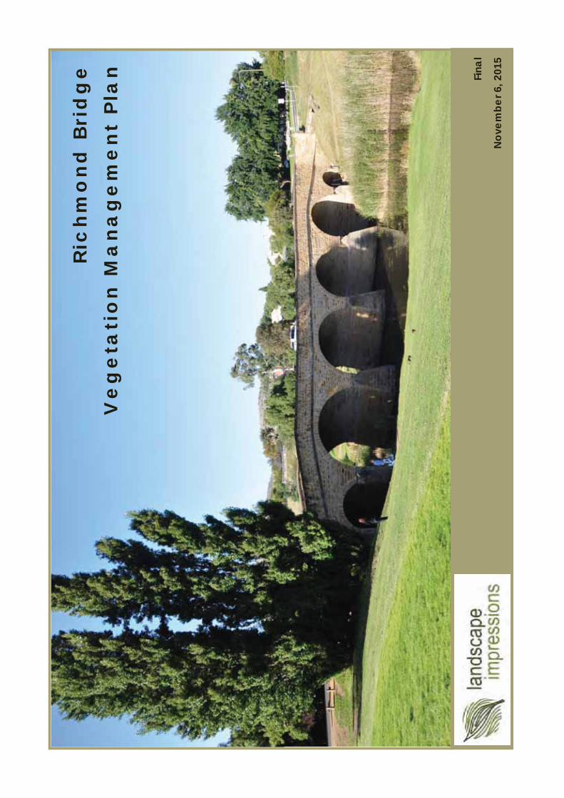
Ric
hm
on
d B
rid
ge
Ve
ge
tati
on
Ma
na
ge
me
nt
Pla
n Fina
l
Nov
embe
r 6, 2
015
2Ri
chm
ond
Brid
ge
Veg
etat
ion
Man
agem
ent P
lan
|
Page
Intro
duct
ion .
......
......
......
......
......
......
......
......
......
......
......
......
......
......
......
......
......
......
... 3
Land
scap
e C
onte
xt fo
r Veg
etat
ion
Man
age
men
t Pla
n ...
......
......
......
......
......
..... 4
V
eget
atio
n M
anag
emen
t Pla
n St
ruct
ure
and
Prin
cipl
es ..
......
......
......
......
......
......
5 M
anag
emen
t Pla
n Zo
nes M
ap ...
......
......
......
......
......
......
......
......
......
......
......
......
..... 6
M
anag
emen
t Zon
e Pr
escr
iptio
ns ...
......
......
......
......
......
......
......
......
......
......
......
......
.. 7-2
3Pl
antin
g Sc
hedu
le (R
ecom
men
ded
Pla
ntin
g Pa
lett
e) ..
......
......
......
......
......
......
....2
4-27
W
ater
way
Man
agem
ent ..
......
......
......
......
......
......
......
......
......
......
......
......
......
......
.... 2
8 W
eed
Stra
tegy
......
......
......
......
......
......
......
......
......
......
......
......
......
......
......
......
......
..... 2
9-30
The
‘Bor
row
ed’ L
ands
cape
......
......
......
......
......
......
......
......
......
......
......
......
......
......
..31-
32Im
plem
enta
tion
Gui
de ..
......
......
......
......
......
......
......
......
......
......
......
......
......
......
......
. 33
App
endi
ces
1. A
ctio
n Pl
an
2.Pl
ans (
A3
SET)
Site
Ana
lysis
Pla
n
Man
agem
ent Z
ones
Plan
ting
Plan
(Nor
th)
Pl
antin
g Pl
an (S
outh
)
Borro
wed
Lan
dsca
pe
Not
es
3. V
eget
atio
n C
ondi
tion
as a
t Feb
ruar
y 20
15 (A
boric
ultu
ral S
urve
y Re
port)
Page
Con
tent
s
Ack
now
ledg
emen
ts
We
wou
ld lik
e to
ack
now
led
ge th
e in
put o
f Se
lena
Dixo
n, L
illia
n Re
ard
on a
nd D
arre
n M
cCon
non
(Sta
te G
row
th);
Russ
ell D
obie
(H
erita
ge T
asm
ania
); G
ary
Eva
ns (C
row
n La
nd
Serv
ices
, DPI
PWE)
; Sal
ly T
aylo
r, Ia
n Pr
eece
, M
atth
ew G
raha
m(C
lare
nce
City
Cou
ncil)
; Ald
C
hong
(CC
C a
nd R
ichm
ond
Adv
isory
C
omm
ittee
) and
the
resid
ents
of R
ichm
ond
and
di
stric
t who
con
tribu
ted
to th
e pr
epa
ratio
n a
nd
revi
ew o
f the
Dra
ft V
eget
atio
n M
ana
gem
ent
Pla
n.

3Ri
chm
ond
Brid
ge
Veg
etat
ion
Man
agem
ent P
lan
|
In J
anua
ry 2
010,
a C
onse
rvat
ion
Plan
for t
he R
ichm
ond
Br
idg
e (1
997)
was
revi
ewed
by
GHD
und
er a
com
miss
ion
by th
e fo
rmer
Dep
artm
ent o
f Inf
rast
ruct
ure
Ener
gy a
nd
Reso
urce
s.
A n
umbe
r of p
olic
y re
com
men
datio
ns o
f the
2010
Rich
mon
d Br
idg
e C
onse
rvat
ion
Man
agem
ent P
lan
(CM
P)re
late
d to
the
asse
ssm
ent,
mai
nten
ance
and
Intro
duct
ion
rene
wal
of v
eget
atio
n in
the
vici
nity
of t
he
Rich
mon
d Br
idg
e. T
his V
eget
atio
n M
anag
emen
t Pl
an re
spon
ds t
o th
ose
pol
icy
reco
mm
enda
tions
.
Cla
renc
e C
ity C
ounc
il’s b
rief f
or th
e V
eget
atio
n M
anag
emen
t Pla
n se
t out
req
uire
men
ts fo
r the
key
elem
ents
of t
he p
lan,
incl
udin
g;
Site
Ana
lysis
– in
clud
ing
cons
ider
atio
n of
the
site’
s hist
ory,
the
cultu
ral h
erita
ge
valu
e an
d sig
nific
ance
of e
xist
ing
pla
ntin
gs a
nd o
ther
re
leva
nt e
xist
ing
site
cond
ition
s suc
h a
s w
eeds
, pub
lic u
se, a
esth
etic
s, ac
cess
, in
frast
ruct
ure,
etc
.
Ana
lysis
of e
xist
ing
Vege
tatio
nC
ondi
tions
–
incl
udin
g th
e en
gag
emen
t of a
n a
rbor
ist to
as
sess
the
curre
nt h
ealth
and
est
imat
ed
lifes
pan
of t
he h
istor
ic a
nd n
atur
alis
ed
plan
tings
.
Wee
d m
anag
emen
t stra
tegy
– in
clud
ing
the
cons
ider
atio
n of
the
exist
ing
site
pla
ntin
g
cond
ition
s, an
y w
eed
issu
es a
nd o
ngoi
ng
man
agem
ent a
ctiv
ities
.
Futu
re p
lant
ing
Stra
tegy
/pla
n –
ad
dres
sing
the
long
term
con
serv
atio
n of
the
hist
oric
an
d a
esth
etic
sett
ing
of th
e Br
idg
e.
Met
hodo
logy
:
Con
sulta
tions
with
the
Cla
renc
e C
ity C
ounc
il,
Herit
age
Tasm
ania
, the
Dep
artm
ent o
f Sta
te
Gro
wth
and
the
Dep
artm
ent o
f Prim
ary
Ind
ustri
es, P
ark
s, W
ater
and
Env
ironm
ent C
row
n La
nd S
ervi
ces w
ere
unde
rtake
n to
gat
her
info
rmat
ion
per
tinen
t to
veg
etat
ion
man
agem
ent f
rom
the
per
spec
tives
of e
ach
auth
ority
.
Don
Tho
mso
n, R
egist
ered
Lan
dsca
pe A
rchi
tect
an
d P
rinci
pal o
f Lan
dsc
ape
Imp
ress
ions
, un
der
took
site
insp
ectio
ns a
nd fi
eldw
ork
dur
ing
St
udy
Are
aN
orth
Cla
renc
e C
ity C
ounc
il La
nd
Priv
ate
Land
Priv
ate
Land
(Chu
rch)
Cro
wn
Land
; CLS
Man
aged
Title
bou
ndar
y
STU
DY
AR
EA
512
4
1218 52
5664
4629
66
64
62
6058
54
2
39
56
3170
3537
4
38
112
LEG
END
:
Brid
ge S
t
Bathurst St
BR
IDG
E
St J
ohn'
s C
hurc
h
Coa
l Riv
er
Cem
eter
yB
luff
St J
ohn'
s C
ir.
Ric
hmon
dG
aol
Gat
ty D
am
St J
ohn'
s S
choo
l
Mill
Hou
se
Rec
reat
ion
Res
erve
Gun
ning
St
Wellington St
St L
uke'
s C
emet
ery
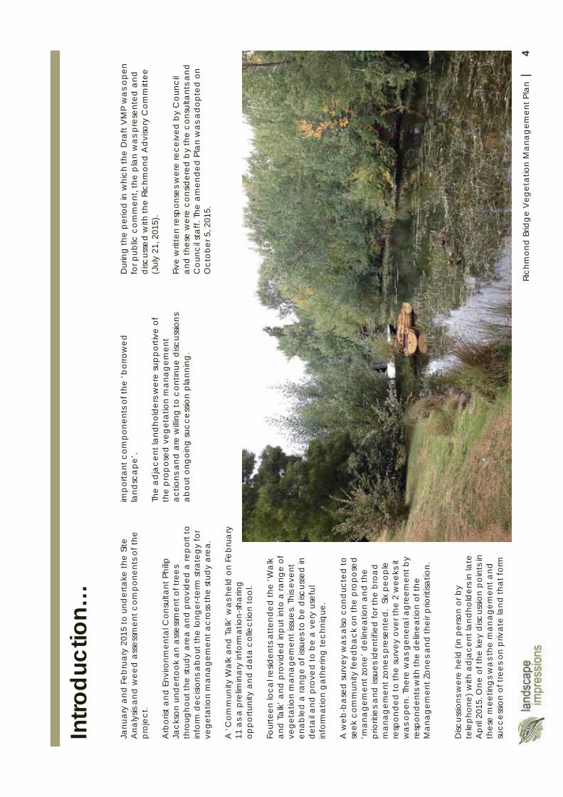
4Ri
chm
ond
Brid
ge
Veg
etat
ion
Man
agem
ent P
lan
|
Intro
duct
ion…
imp
orta
nt c
ompo
nent
s of t
he ‘b
orro
wed
la
ndsc
ape
’.
The
adj
acen
t lan
dhol
ders
wer
e su
ppo
rtive
of
the
prop
osed
veg
etat
ion
man
agem
ent
actio
ns a
nd a
re w
illing
to c
ontin
ue d
iscus
sions
ab
out o
ngoi
ng su
cces
sion
pla
nnin
g.
Janu
ary
and
Feb
ruar
y 20
15 to
und
erta
ke th
e Sit
e A
naly
sis a
nd w
eed
asse
ssm
ent c
ompo
nent
s of t
he
proj
ect.
Arb
orist
and
Env
ironm
enta
l Con
sulta
nt P
hilip
Ja
ckso
n un
der
took
an
asse
ssm
ent o
f tre
es
thro
ugho
ut th
e st
udy
area
and
pro
vid
ed a
rep
ort t
o in
form
dec
ision
s abo
ut th
e lo
nger
-term
stra
tegy
for
vege
tatio
n m
ana
gem
ent a
cros
s the
stud
y ar
ea.
A ‘C
omm
unity
Wal
k an
d T
alk
’ wa
s hel
d o
n Fe
brua
ry
11 a
s a p
relim
inar
y in
form
atio
n-sh
arin
g
oppo
rtuni
ty a
nd d
ata
colle
ctio
n to
ol.
Four
teen
loca
l res
iden
ts a
tten
ded
the
‘Wa
lk
and
Ta
lk’ a
nd p
rovi
ded
inp
ut in
to a
rang
e of
ve
geta
tion
man
age
men
t iss
ues.
This
even
t en
able
d a
rang
e of
issu
es to
be
disc
usse
d in
de
tail a
nd p
rove
d to
be
a v
ery
usef
ul
info
rmat
ion
gat
herin
g te
chni
que
.
A w
eb-b
ased
surv
ey w
as a
lso c
ond
ucte
d to
se
ek c
omm
unity
feed
back
on
the
prop
osed
‘m
ana
gem
ent z
one’
del
inea
tion
and
the
prio
ritie
s and
issu
es id
entif
ied
for t
he b
roa
d m
anag
emen
t zon
es p
rese
nted
. Six
peo
ple
resp
onde
d to
the
surv
ey o
ver t
he 2
wee
ks it
w
as o
pen.
The
re w
as g
ener
al a
gree
men
t by
resp
onde
nts w
ith th
e d
elin
eatio
n of
the
Man
agem
ent Z
ones
and
thei
r prio
ritisa
tion.
Disc
ussio
ns w
ere
held
(in
pers
on o
r by
tele
phon
e) w
ith a
djac
ent l
andh
old
ers i
n la
te
Ap
ril 2
015.
One
of t
he k
ey d
iscus
sion
poin
ts in
th
ese
mee
ting
s wa
s the
man
agem
ent a
nd
succ
essio
n of
tree
s on
priv
ate
land
that
form
Dur
ing
the
perio
d in
whi
ch th
e D
raft
VM
P w
as o
pen
for p
ublic
com
men
t, th
e p
lan
wa
s pre
sent
ed a
nd
disc
usse
d w
ith th
e Ri
chm
ond
Adv
isory
Com
mitt
ee
(Jul
y 21
, 201
5).
Five
writ
ten
resp
onse
s wer
e re
ceiv
ed b
y C
ounc
il an
d th
ese
wer
e co
nsid
ered
by
the
cons
ulta
nts a
nd
Cou
ncil
staf
f. Th
e am
ende
d Pl
an w
as a
dopt
ed o
n O
ctob
er 5
, 201
5.
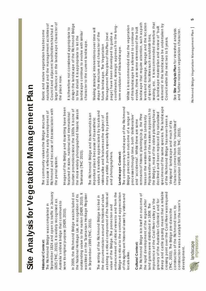
5Ri
chm
ond
Brid
ge
Veg
etat
ion
Man
agem
ent P
lan
|
Hist
oric
al C
onte
xt:
The
Ric
hmon
d B
ridge
was
com
plet
ed in
Se
ptem
ber 1
824
and
ope
n to
traf
fic in
Ja
nuar
y 18
25 (T
HC
, 201
5). I
t is w
idel
y re
cogn
ised
as
Aus
tralia
’s o
ldes
t brid
ge th
at c
ontin
ues t
o se
rve
its o
rigin
al p
urpo
se (D
IER,
201
0).
In 2
005,
the
Rich
mon
d B
ridge
was
incl
uded
on
the
Na
tiona
l Her
itage
List
, in
reco
gniti
on o
f its
ou
tsta
ndin
g v
alu
e to
the
natio
n (D
IER,
201
0). I
t w
as lis
ted
on
the
Tasm
ani
an
Herit
age
Reg
ister
in
Sep
tem
ber 1
999
(TH
C, 2
015)
.
The
sett
ing
of t
he R
ichm
ond
Brid
ge is
cite
d in
th
e do
cum
enta
tion
aro
und
its h
istor
ical
va
lue
as b
eing
a c
ritic
al c
omp
onen
t of t
he h
istor
ical
va
lue
of th
e Br
idge
. The
pro
tect
ion
and
enha
ncem
ent o
f crit
ical
vie
ws t
o an
d fro
m th
e Br
idge
is c
ritic
al to
the
cont
inue
d a
ppre
ciat
ion
of th
is sig
nific
ant h
istor
ica
l ass
et b
y vi
sitor
s and
lo
cals
alik
e.
Cul
tura
l Con
text
:Th
e Ri
chm
ond
Brid
ge is
in it
self
an o
utco
me
of
the
rap
id d
evel
opm
ent o
f the
regi
on a
fter
land
gra
nts w
ere
dist
ribut
ed in
180
8. T
he
impo
rtanc
e of
the
Coa
l Riv
er v
alle
y a
s ‘th
e gr
ana
ry o
f the
Aus
tralia
n C
olon
ies’
and
for
shee
p a
nd c
attle
gra
zing
mea
nt th
at a
relia
ble
cros
sing
poin
t ove
r the
Coa
l Riv
er w
as re
qui
red
(T
HC, 2
015)
. The
Brid
ge
pre
-dat
es th
e co
nstru
ctio
n of
the
Rich
mon
d to
wn;
its
cons
truct
ion
wa
s a c
ata
lyst
for t
he to
wn’
s de
velo
pm
ent.
Site
Ana
lysis
for V
eget
atio
n M
anag
emen
t Pla
n Th
e co
mm
unity
val
uest
he B
ridge
stru
ctur
e be
caus
e it
refle
cts t
he e
arly
dev
elop
men
t of
Rich
mon
d a
nd b
ecau
se o
f its
ass
ocia
tion
with
th
e pe
nal s
yste
m.
Imag
es o
f the
Brid
ge a
nd it
s set
ting
hav
e be
en
fea
ture
d in
sta
te, n
atio
nal a
nd in
tern
atio
nal
tour
ism p
rom
otio
ns si
nce
the
1920
s. It
is on
e of
th
e m
ost w
idel
y p
hoto
grap
hed
hist
oric
site
s in
Tasm
ania
(TH
C 2
015)
.
The
Rich
mon
d B
ridge
and
its s
urro
und
s is a
n im
porta
nt p
lace
bec
ause
of i
ts a
esth
etic
va
lues
. It i
s wid
ely
appr
ecia
ted
by lo
cals
and
vi
sitor
s alik
e a
nd fe
atu
res a
s the
subj
ect o
f m
any
arti
stic
pur
suits
, esp
ecia
lly b
y pa
inte
rs a
nd p
hoto
gra
phe
rs.
Land
scap
e C
onte
xt:
Th
e co
ntem
pora
ry la
ndsc
ape
of th
e Ri
chm
ond
Br
idge
pre
cinc
t is a
n ou
tco
me
of a
rang
e of
pr
oces
ses t
hrou
gh ti
me,
bot
h ‘d
elib
erat
ive’
an
d ‘a
ccid
enta
l’. W
hilst
ther
ea
re so
me
rem
nant
s of h
istor
ic p
lant
ings
(e.g
. the
Pin
e tre
es o
n th
e w
este
rn b
ank
s; th
e Lo
mba
rdy
Pop
lars
eith
er si
de o
f the
eas
tern
ap
proa
ch to
th
e Br
idg
e), m
ost o
f the
old
est p
lant
ings
hav
e d
eclin
ed a
nd b
een
rep
lace
d by
nat
ural
ised
sp
ecim
ens o
f the
sam
e sp
ecie
s. Th
e la
ndsc
ape
of
the
Rich
mon
d B
ridge
has
nev
er b
een
a
‘des
igne
d’ la
ndsc
ape
and
muc
h of
its
cha
ract
er c
omes
from
this
‘nat
ural
ised’
ve
geta
tion
(DIE
R, 2
010;
THC
, 201
5).
Exot
ic a
nd n
ativ
e ve
geta
tion
has b
ecom
e na
tura
lised
and
the
man
agem
ent a
ctiv
ities
of
Cou
ncil
and
adj
acen
t lan
dhol
ders
ha
s ha
d a
la
rge
influ
ence
on
the
land
sca
pe c
hara
cter
of
the
plac
e no
w.
It is
ther
efor
e no
tcon
sider
edap
prop
riate
to
desig
n th
e la
ndsc
ape
of t
he R
ichm
ond
Brid
ge
tofin
e de
tail.
It is
ap
prop
riate
to le
t the
la
ndsc
ape
con
tinue
to e
volv
e w
ith si
mila
r ch
ara
cter
to th
e cu
rrent
land
sca
pe.
Ma
king
stra
teg
ic in
terv
entio
ns o
ver t
ime
will
sha
pe
the
stru
ctur
e a
nd c
hara
cter
of t
he
futu
re la
ndsc
ape
. The
Veg
etat
ion
Man
agem
ent P
rinci
ples
of t
his P
lan
(nex
t pa
ge) h
ave
been
dev
elop
ed to
gui
de a
co
ordi
nate
d, st
rate
gic
app
roa
ch to
the
long
-te
rm e
volu
tion
of th
is la
ndsc
ape.
Whi
lstit
is re
com
men
ded
that
the
vege
tatio
n of
this
land
scap
e be
allo
wed
to c
ontin
ue to
evol
ve,t
here
are
som
e el
emen
ts o
f the
bui
ltla
ndsc
ape
tha
t req
uire
att
entio
n, su
ch a
s pat
h le
vels
and
dra
inag
e, si
gnag
e an
d th
e lo
catio
n of
spec
ific
faci
litie
s suc
h a
s rub
bish
bin
s, se
atin
g, e
tc.
It is
reco
mm
ende
d th
eref
ore
that
a
land
sca
pe m
aste
rpla
n a
nd re
view
of ‘
built
el
emen
ts’ i
n th
e la
ndsc
ape
be
unde
rtake
n by
C
ounc
il w
ithin
the
next
two
to 5
yea
rs.
See
Site
Ana
lysis
Pla
nfo
r vie
wsh
ed a
naly
sis
and
furth
er n
otes
on
vege
tatio
n ch
ara
cter
.
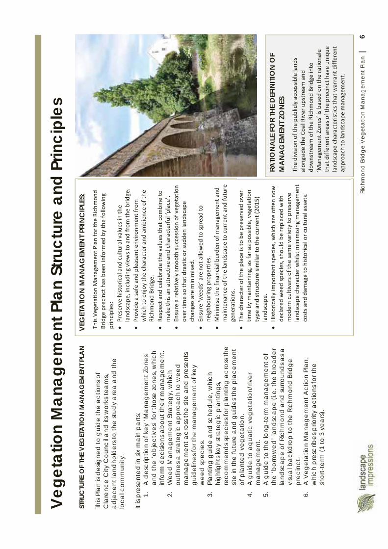
6Ri
chm
ond
Brid
ge
Veg
etat
ion
Man
agem
ent P
lan
|
VEG
ETA
TION
MA
NA
GEM
ENT
PRIN
CIP
LES:
Vege
tatio
n M
anag
emen
t Pla
n St
ruct
ure
and
Prin
cipl
es
STRU
CTU
RE O
F TH
E V
EGET
ATI
ON
MA
NA
GEM
ENT P
LAN
This
Plan
is d
esig
ned
to g
uide
the
actio
ns o
f C
lare
nce
City
Cou
ncil a
nd it
s wor
ks te
am
s, ad
jace
nt la
ndho
lder
s to
the
stud
y a
rea
and
the
loca
l com
mun
ity.
It is
pres
ente
d in
six
mai
n pa
rts:
1.A
des
crip
tion
of k
ey ‘M
ana
gem
ent Z
ones
’ an
d th
e ‘o
bje
ctiv
es’ f
or th
ose
zone
s, w
hich
in
form
dec
ision
s abo
ut th
eir m
anag
emen
t.2.
Wee
d M
anag
emen
t Stra
teg
y, w
hich
ou
tline
s a st
rate
gic
app
roa
ch to
wee
d m
ana
gem
ent a
cros
s the
site
and
pre
sent
s gu
idel
ines
for t
he m
ana
gem
ent o
f key
w
eed
spec
ies.
3.Pl
ant
ing
gui
de a
nd sc
hed
ule,
whi
ch
high
light
s key
stra
teg
ic p
lant
ings
, re
com
men
ds s
peci
es fo
r pla
ntin
g a
cros
s the
sit
e in
the
futu
re a
nd g
uide
s the
pla
cem
ent
of p
lant
ed v
eget
atio
n.4.
A g
uide
to a
quat
ic v
eget
atio
n/riv
er
man
agem
ent.
5.A
gui
de to
the
long
-term
man
agem
ent o
f th
e ‘b
orro
wed
’ lan
dsca
pe (i
.e. t
he b
road
er
land
sca
pe o
f Ric
hmon
d an
d su
rroun
ds a
s a
visu
al b
ackd
rop
to th
e Ri
chm
ond
Brid
ge
prec
inct
.6.
A V
eget
atio
n M
anag
emen
t Act
ion
Plan
, w
hich
pre
scrib
es p
riorit
y ac
tions
for t
he
shor
t-te
rm (1
to 3
yea
rs).
RATIO
NA
LE F
OR
THE
DEF
INITI
ON
OF
MA
NA
GEM
ENT Z
ON
ES
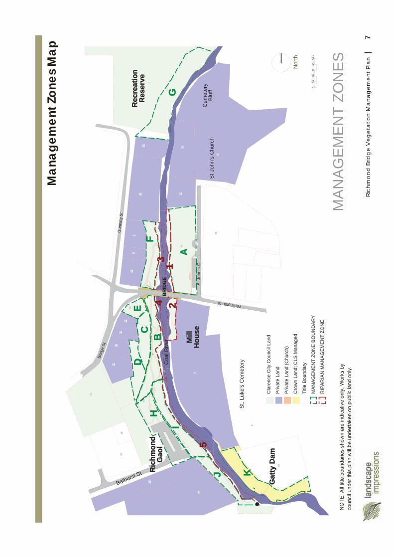
7Ri
chm
ond
Brid
ge
Veg
etat
ion
Man
agem
ent P
lan
|
512
4
1218 52
5664
4629
66
64
62
6058
54
2
39
56
3170
3537
4
38
112
A
BC
DE
F
I
J K
H
23
4
5
1G
Brid
ge S
t
Bathurst St
BR
IDG
E
St J
ohn'
s C
hurc
h
Coa
l Riv
er
Cem
eter
yB
luff
St J
ohn'
s C
ir.
Ric
hmon
dG
aol
Gat
ty D
am
St.
Luke
's C
emet
ery
Mill
Hou
se
Rec
reat
ion
Res
erve
Gun
ning
St
Wellington St
MA
NA
GE
ME
NT
ZON
ES
Nor
th
Cla
renc
e C
ity C
ounc
il La
nd
Priv
ate
Land
Priv
ate
Land
(Chu
rch)
Cro
wn
Land
; CLS
Man
aged
Title
Bou
ndar
y
MA
NA
GE
ME
NT
ZON
E B
OU
ND
AR
Y
RIP
AR
IAN
MA
NA
GE
ME
NT
ZON
E
010
2030
4050
m
Man
agem
ent Z
ones
Map
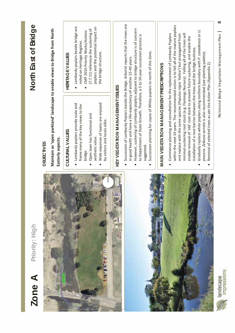
8Ri
chm
ond
Brid
ge
Veg
etat
ion
Man
agem
ent P
lan
|
Nor
th
Zone
A
OBJ
ECTIV
ES
MA
IN V
EGET
ATI
ON
MA
NA
GEM
ENT P
RESC
RIPT
ION
S
CUL
TURA
L V
ALU
ES
HERI
TAG
E V
ALU
ES
KEY
VEG
ETA
TION
MA
NA
GEM
ENT I
SSUE
S
Nor
th E
ast o
f Brid
ge
Prio
rity:
Hig
h
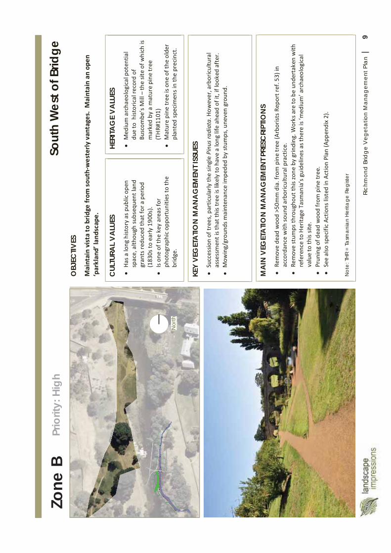
9Ri
chm
ond
Brid
ge
Veg
etat
ion
Man
agem
ent P
lan
|
Nor
th
Zone
B
OBJ
ECTIV
ES
MA
IN V
EGET
ATI
ON
MA
NA
GEM
ENT P
RESC
RIPT
ION
S
Not
e: T
HR
= Ta
sma
nia
n H
erita
ge R
egist
er
CUL
TURA
L V
ALU
ES
HERI
TAG
E V
ALU
ES
KEY
VEG
ETA
TION
MA
NA
GEM
ENT I
SSUE
S
Sout
h W
est o
f Brid
ge
Prio
rity:
High
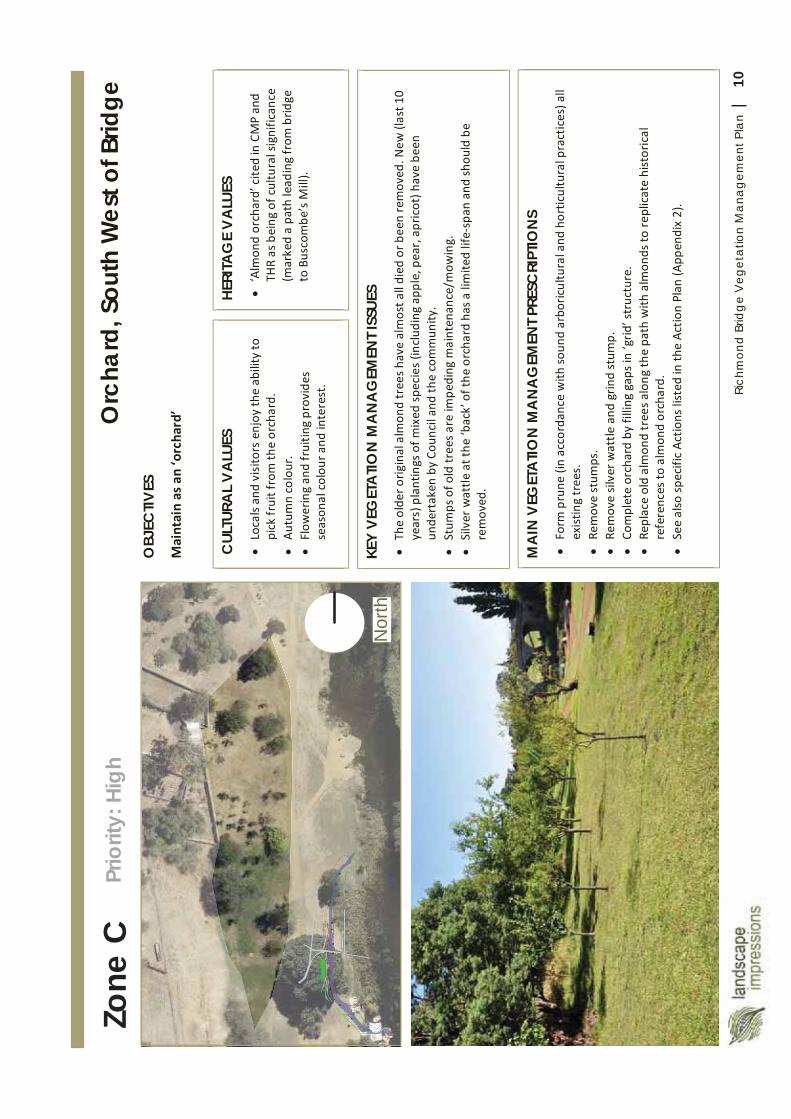
10Ri
chm
ond
Brid
ge
Veg
etat
ion
Man
agem
ent P
lan
|
Nor
th
Zone
C
OBJ
ECTIV
ES
MA
IN V
EGET
ATI
ON
MA
NA
GEM
ENT P
RESC
RIPT
ION
S
CUL
TURA
L V
ALU
ES
HERI
TAG
E V
ALU
ES
KEY
VEG
ETA
TION
MA
NA
GEM
ENT I
SSUE
S
Orc
hard
, Sou
th W
est o
f Brid
ge
Prio
rity:
Hig
h
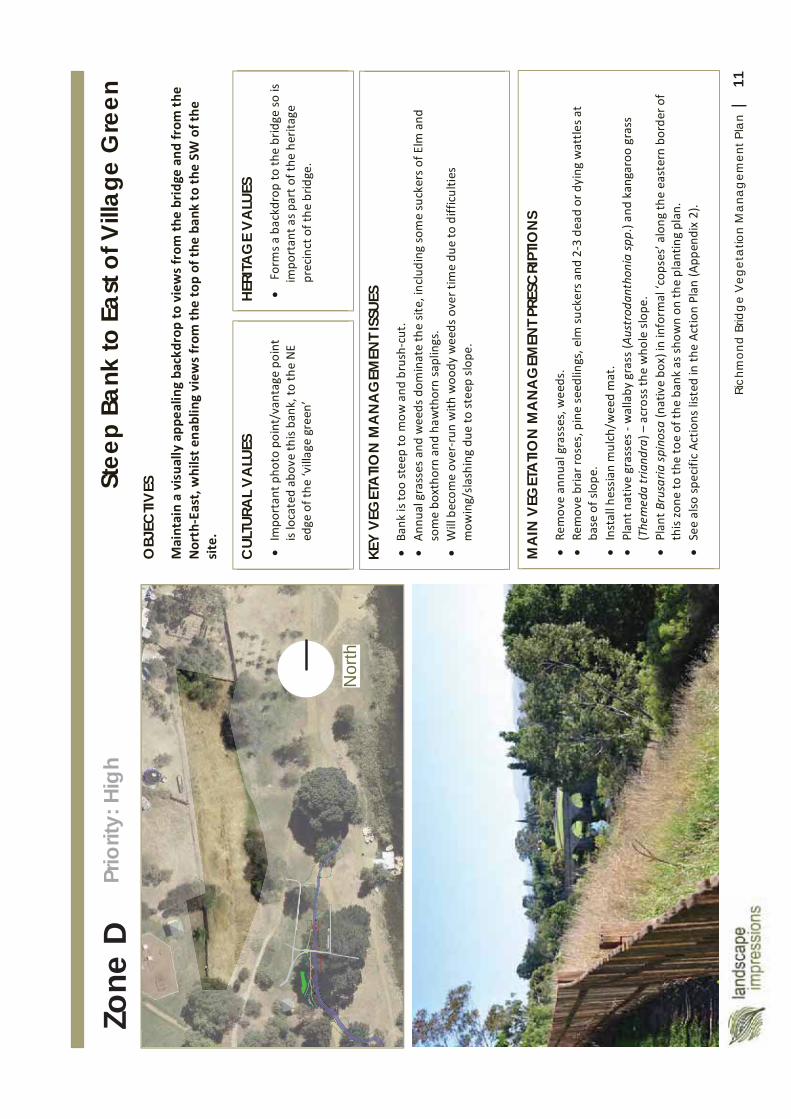
11Ri
chm
ond
Brid
ge
Veg
etat
ion
Man
agem
ent P
lan
|
Nor
th
Zone
D
OBJ
ECTIV
ES
MA
IN V
EGET
ATI
ON
MA
NA
GEM
ENT P
RESC
RIPT
ION
S
CUL
TURA
L V
ALU
ES
HERI
TAG
E V
ALU
ES
KEY
VEG
ETA
TION
MA
NA
GEM
ENT I
SSUE
S
Stee
p Ba
nk to
Eas
t of V
illag
e G
reen
Pr
iorit
y: H
igh
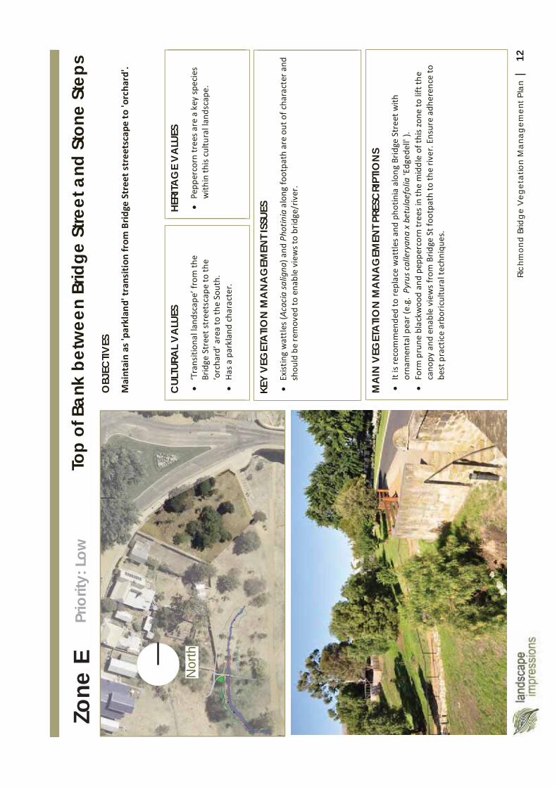
12Ri
chm
ond
Brid
ge
Veg
etat
ion
Man
agem
ent P
lan
|
Nor
th
Zone
E
OBJ
ECTIV
ES
MA
IN V
EGET
ATI
ON
MA
NA
GEM
ENT P
RESC
RIPT
ION
S
CUL
TURA
L V
ALU
ES
HERI
TAG
E V
ALU
ES
KEY
VEG
ETA
TION
MA
NA
GEM
ENT I
SSUE
S
Top
of B
ank
betw
een
Brid
ge S
treet
and
Sto
ne S
teps
Pr
iorit
y: L
ow
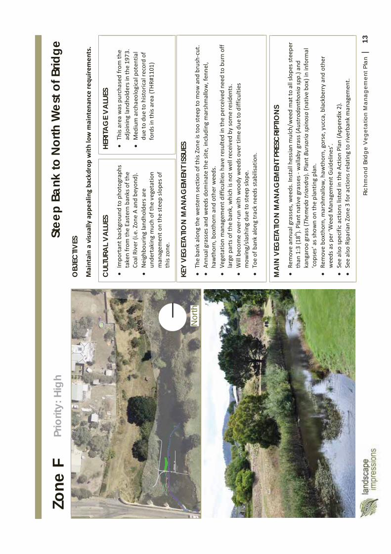
13Ri
chm
ond
Brid
ge
Veg
etat
ion
Man
agem
ent P
lan
|
Nor
th
Zone
F
OBJ
ECTIV
ES
MA
IN V
EGET
ATI
ON
MA
NA
GEM
ENT P
RESC
RIPT
ION
S
CUL
TURA
L V
ALU
ES
HERI
TAG
E V
ALU
ES
KEY
VEG
ETA
TION
MA
NA
GEM
ENT I
SSUE
S
Stee
p Ba
nk to
Nor
th W
est o
f Brid
ge
Prio
rity:
Hig
h
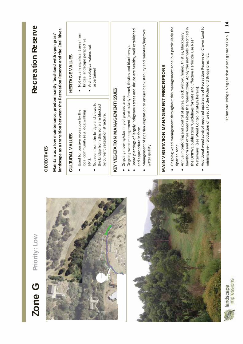
14Ri
chm
ond
Brid
ge
Veg
etat
ion
Man
agem
ent P
lan
|
46
Nor
thN
orth
Zone
G
OBJ
ECTIV
ES
MA
IN V
EGET
ATI
ON
MA
NA
GEM
ENT P
RESC
RIPT
ION
S
CUL
TURA
L V
ALU
ES
HERI
TAG
E V
ALU
ES
KEY
VEG
ETA
TION
MA
NA
GEM
ENT I
SSUE
S
Recr
eatio
n Re
serv
e Pr
iorit
y: L
ow
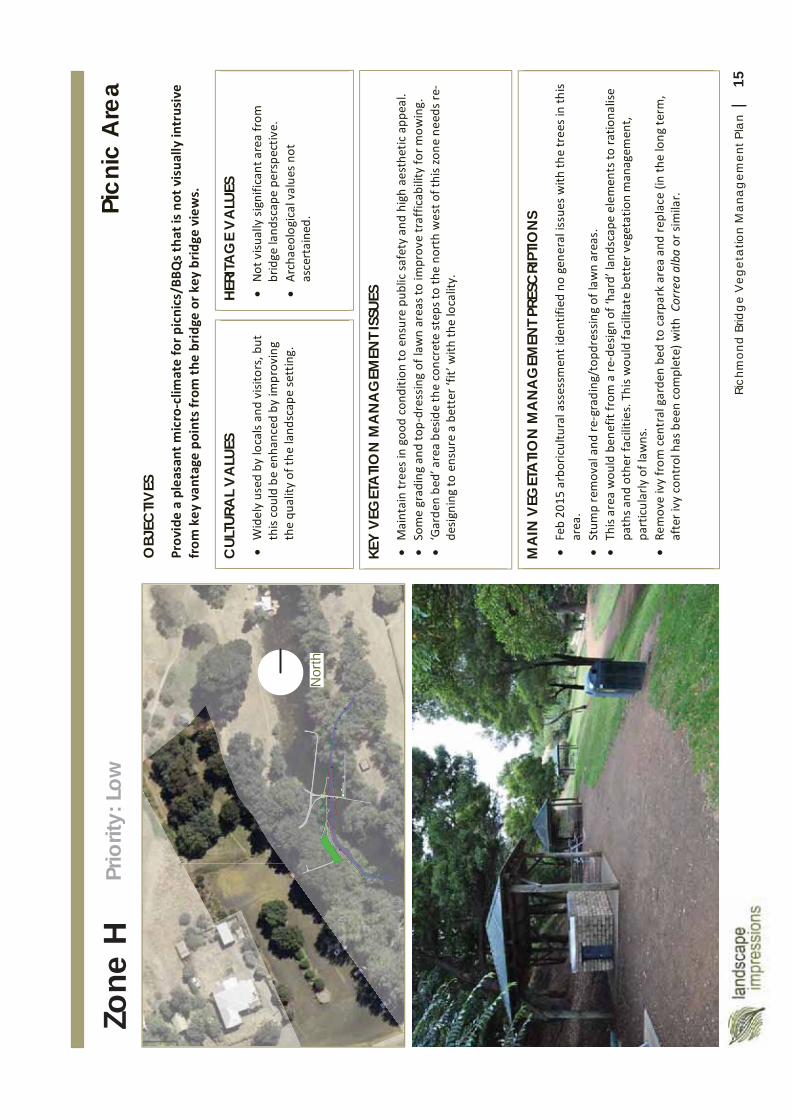
15Ri
chm
ond
Brid
ge
Veg
etat
ion
Man
agem
ent P
lan
|
Nor
th
Zone
H
OBJ
ECTIV
ES
MA
IN V
EGET
ATI
ON
MA
NA
GEM
ENT P
RESC
RIPT
ION
S
CUL
TURA
L V
ALU
ES
HERI
TAG
E V
ALU
ES
KEY
VEG
ETA
TION
MA
NA
GEM
ENT I
SSUE
S
Picn
ic A
rea
Prio
rity:
Low
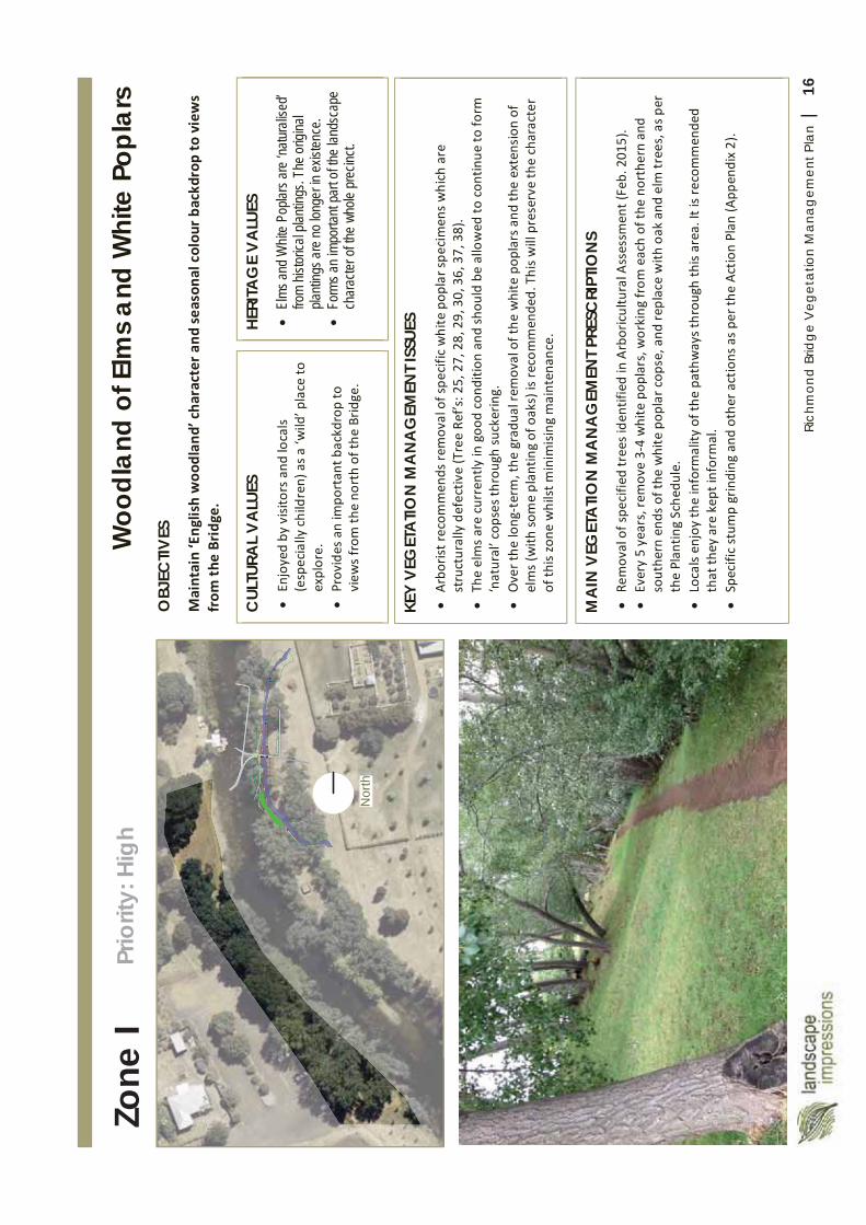
16Ri
chm
ond
Brid
ge
Veg
etat
ion
Man
agem
ent P
lan
|
Nor
th
Zone
I O
BJEC
TIVES
MA
IN V
EGET
ATI
ON
MA
NA
GEM
ENT P
RESC
RIPT
ION
S
CUL
TURA
L V
ALU
ES
HERI
TAG
E V
ALU
ES
El
ms an
d W
hite
Popla
rs ar
e ‘na
turali
sed’
from
histo
rical
plant
ings.
The o
rigina
l pla
nting
s are
no lo
nger
in ex
isten
ce.
Fo
rms a
n im
porta
nt pa
rt of
the
lands
cape
char
acter
of th
e wh
ole pr
ecinc
t.
KEY
VEG
ETA
TION
MA
NA
GEM
ENT I
SSUE
S
Woo
dlan
d of
Elm
s an
d W
hite
Pop
lars
Pr
iorit
y: H
igh
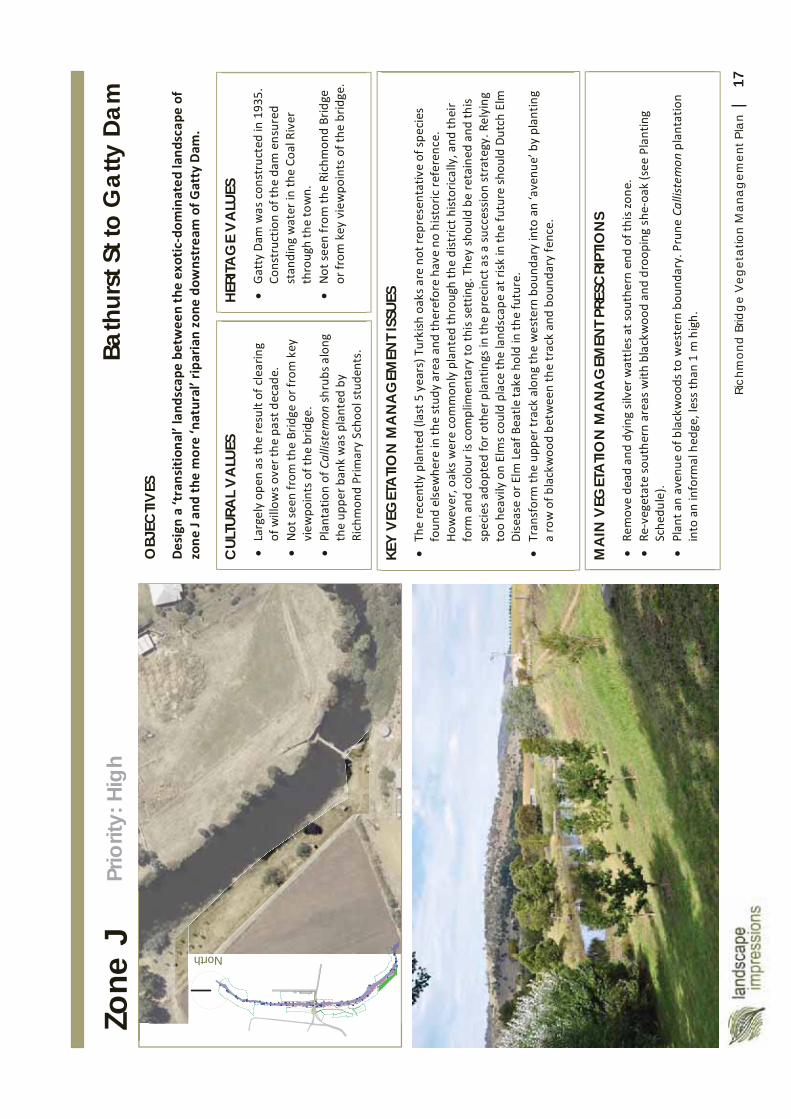
17Ri
chm
ond
Brid
ge
Veg
etat
ion
Man
agem
ent P
lan
|
North
Zone
J
OBJ
ECTIV
ES
MA
IN V
EGET
ATI
ON
MA
NA
GEM
ENT P
RESC
RIPT
ION
S
CUL
TURA
L V
ALU
ES
HERI
TAG
E V
ALU
ES
KEY
VEG
ETA
TIO
N M
AN
AG
EMEN
T ISS
UES
Bath
urst
St t
o G
atty
Dam
Pr
iorit
y: H
igh
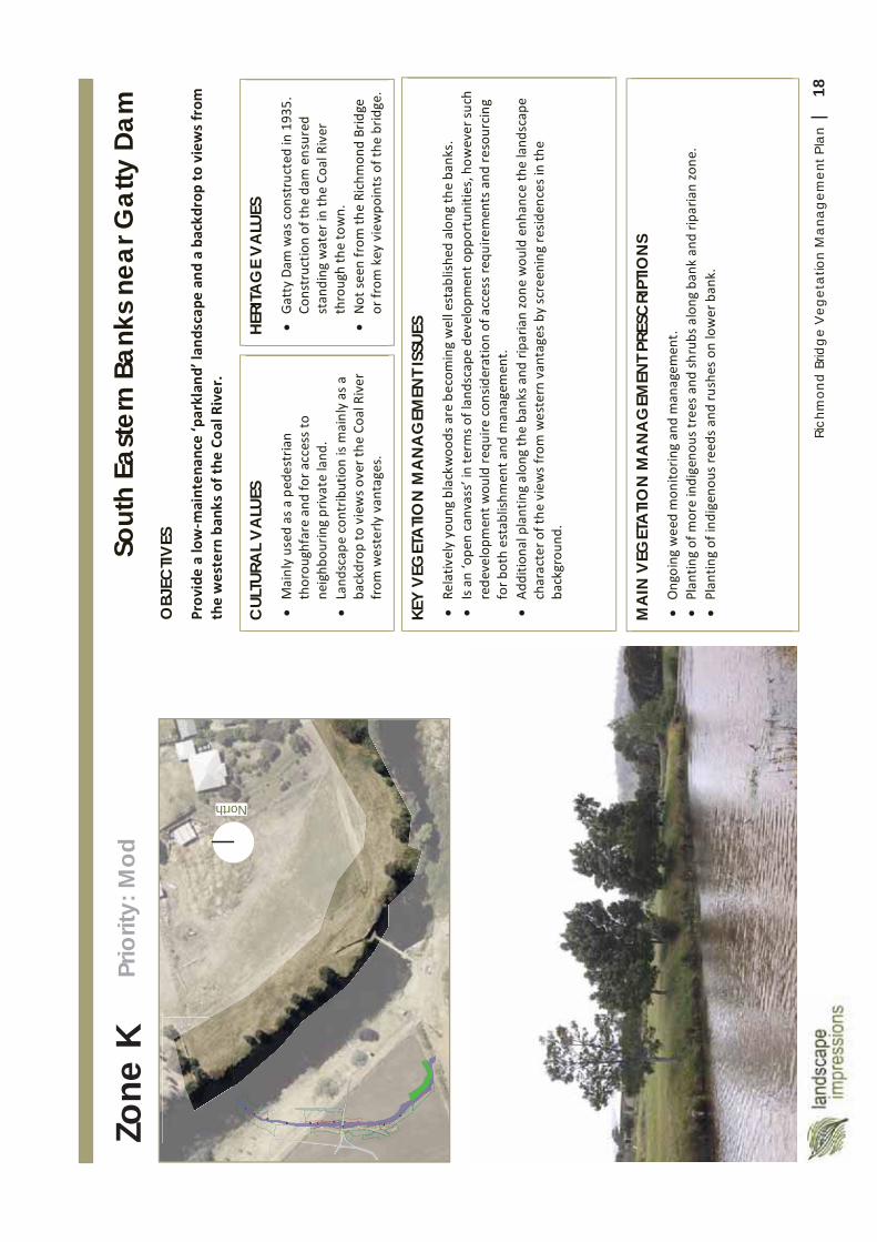
18Ri
chm
ond
Brid
ge
Veg
etat
ion
Man
agem
ent P
lan
|
North
Zone
K
OBJ
ECTIV
ES
MA
IN V
EGET
ATI
ON
MA
NA
GEM
ENT P
RESC
RIPT
ION
S
CUL
TURA
L V
ALU
ES
HERI
TAG
E V
ALU
ES
KEY
VEG
ETA
TION
MA
NA
GEM
ENT I
SSUE
S
Sout
h Ea
ster
n Ba
nks
near
Gat
ty D
am
Prio
rity:
Mod
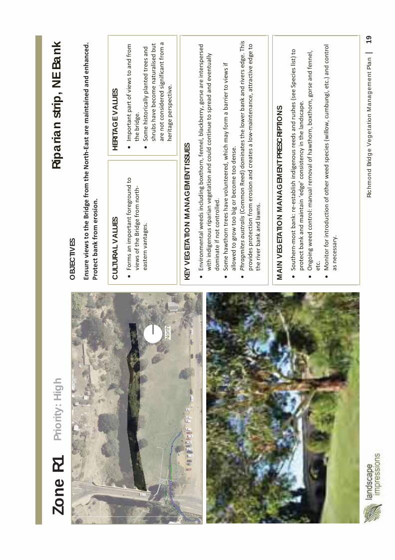
19Ri
chm
ond
Brid
ge
Veg
etat
ion
Man
agem
ent P
lan
|
Nor
th
Zone
R1
MA
IN V
EGET
ATI
ON
MA
NA
GEM
ENT P
RESC
RIPT
ION
S
CUL
TURA
L V
ALU
ES
HERI
TAG
E V
ALU
ES
KEY
VEG
ETA
TION
MA
NA
GEM
ENT I
SSUE
S
OBJ
ECTIV
ES
Ripa
rian
strip
, NE
Bank
Pr
iorit
y: H
igh
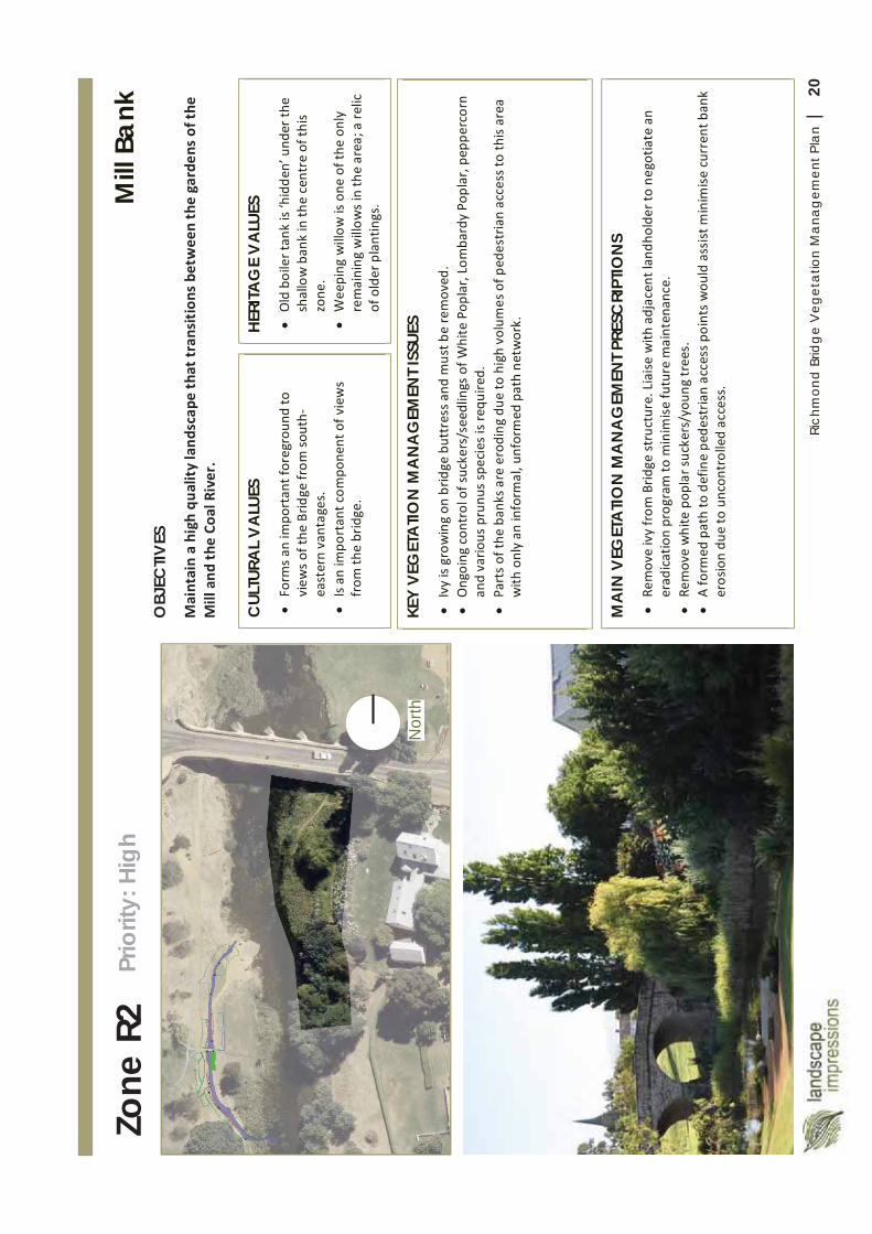
20Ri
chm
ond
Brid
ge
Veg
etat
ion
Man
agem
ent P
lan
|
Nor
th
Zone
R2
MA
IN V
EGET
ATI
ON
MA
NA
GEM
ENT P
RESC
RIPT
ION
S
CUL
TURA
L V
ALU
ES
HERI
TAG
E V
ALU
ES
KEY
VEG
ETA
TIO
N M
AN
AG
EMEN
T ISS
UES
OBJ
ECTIV
ES
Mill
Ban
k Pr
iorit
y: H
igh
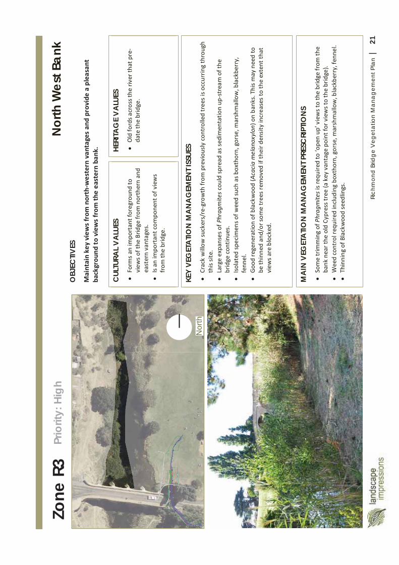
21Ri
chm
ond
Brid
ge
Veg
etat
ion
Man
agem
ent P
lan
|
Nor
th
Zone
R3
MA
IN V
EGET
ATI
ON
MA
NA
GEM
ENT P
RESC
RIPT
ION
S
CUL
TURA
L V
ALU
ES
HERI
TAG
E V
ALU
ES
KEY
VEG
ETA
TION
MA
NA
GEM
ENT I
SSUE
S
OBJ
ECTIV
ES
Nor
th W
est B
ank
Prio
rity:
Hig
h
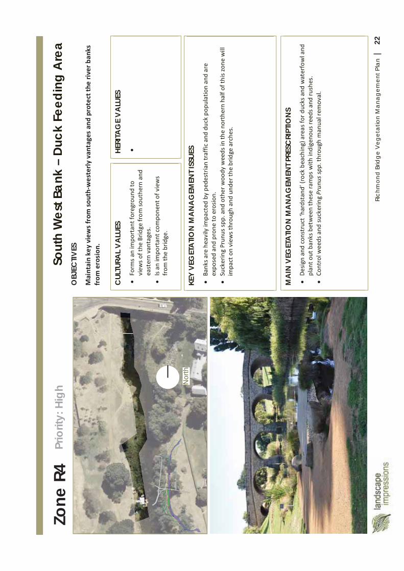
22Ri
chm
ond
Brid
ge
Veg
etat
ion
Man
agem
ent P
lan
|
Nor
th
Zone
R4
MA
IN V
EGET
ATI
ON
MA
NA
GEM
ENT P
RESC
RIPT
ION
S
CUL
TURA
L V
ALU
ES
HERI
TAG
E V
ALU
ES
KEY
VEG
ETA
TION
MA
NA
GEM
ENT I
SSUE
S
OBJ
ECTIV
ES
Sout
h W
est B
ank
– Du
ck F
eedi
ng A
rea
Prio
rity:
Hig
h
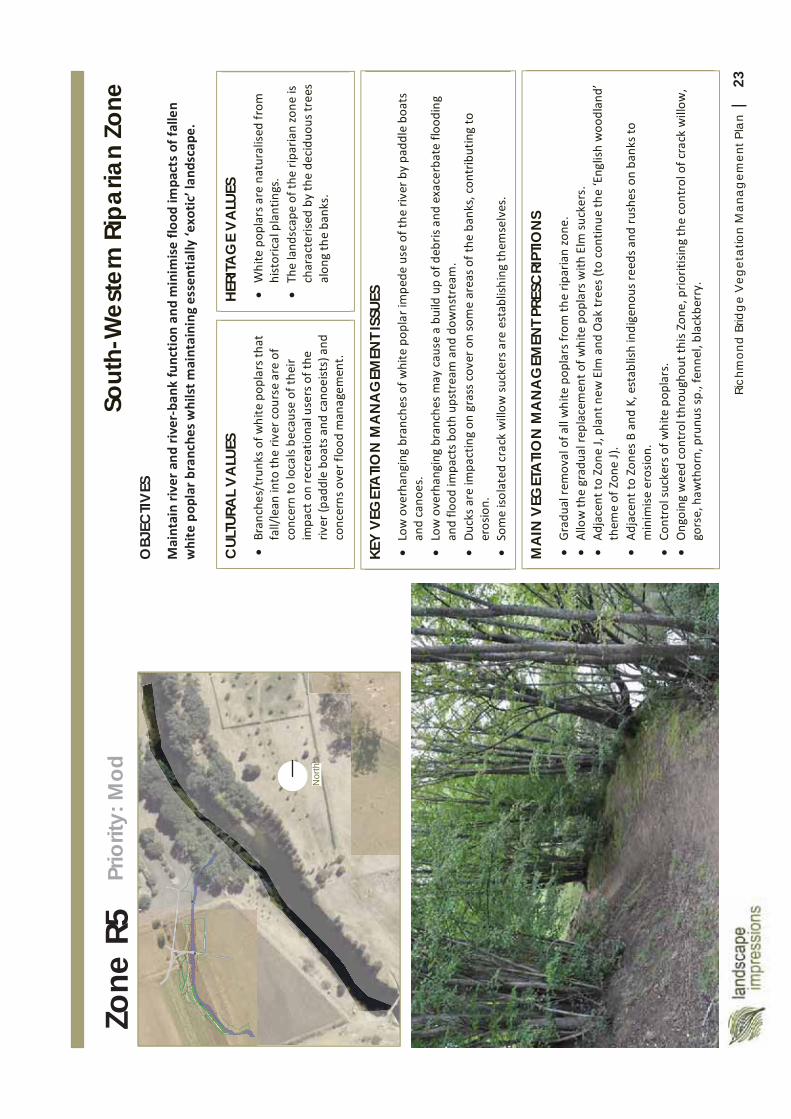
23Ri
chm
ond
Brid
ge
Veg
etat
ion
Man
agem
ent P
lan
|
Nor
th
Zone
R5
MA
IN V
EGET
ATI
ON
MA
NA
GEM
ENT P
RESC
RIPT
ION
S
CUL
TURA
L V
ALU
ES
HERI
TAG
E V
ALU
ES
KEY
VEG
ETA
TION
MA
NA
GEM
ENT I
SSUE
S
OBJ
ECTIV
ES
Sout
h-W
este
rn R
ipar
ian
Zone
Pr
iorit
y: M
od
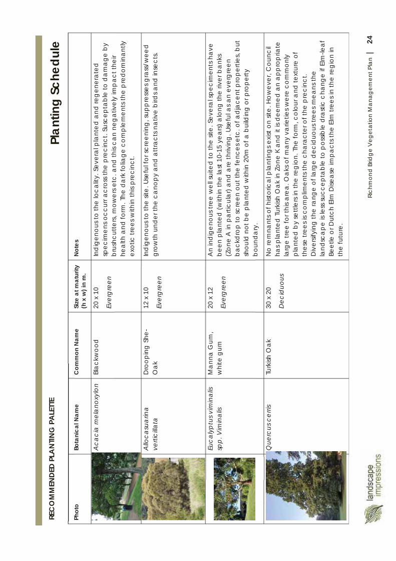
24Ri
chm
ond
Brid
ge
Veg
etat
ion
Man
agem
ent P
lan
|
Plan
ting
Sche
dule
Ph
oto
Bota
nica
l Nam
eC
omm
on N
ame
Size
at m
atur
ity
(h x
w) i
n m
.N
otes
Aca
cia
mel
ano
xylo
nBl
ackw
ood
20 x
10
Ever
gre
en
Ind
igen
ous t
o th
e lo
calit
y. S
ever
al p
lant
ed a
nd re
gen
erat
ed
spec
imen
s occ
urr a
cros
s the
pre
cinc
t. Su
scep
tab
le to
da
mag
e b
y b
rush
cutte
rs, m
ower
s etc
. and
this
can
neg
ativ
ely
imp
act t
heir
heal
th a
nd fo
rm. T
he d
ark
folia
ge c
ompl
emen
ts th
e p
redo
min
antly
ex
otic
tree
s with
in th
is pr
ecin
ct.
Allo
casu
arin
a ve
rtici
llata
D
roop
ing
She
-O
ak
12 x
10
Ever
gre
en
Ind
igen
ous t
o th
e sit
e. U
sefu
l for
scre
enin
g, su
ppre
sses
gra
ss/w
eed
grow
th u
nder
the
cano
py
and
att
ract
s nat
ive
bird
s and
inse
cts.
Euca
lypt
us v
imin
alis
sp
p. V
imin
alis
Man
na G
um,
whi
te g
um20
x 1
2
Ever
gre
en
An
indi
geno
us tr
ee w
ell s
uite
d to
the
site.
Sev
era
l spe
cim
ents
hav
e be
en p
lant
ed (w
ithin
the
last
10-
15 y
ears
) alo
ng th
e riv
er b
anks
(Z
one
A in
pa
rticu
lar)
and
are
thriv
ing
. Use
ful a
s an
ever
gre
en
back
dro
p to
scre
en o
ut th
e fe
nces
etc
. of a
djac
ent p
rope
rties
, but
sh
ould
not
be
pla
nted
with
in 2
0m o
f a b
uild
ing
or p
rope
rty
boun
da
ry.
Que
rcus
cer
risTu
rkish
Oak
30 x
20
Dec
iduo
us
No
rem
nant
s of h
istor
ica
l pla
ntin
gs e
xist
on
site.
How
ever
, Cou
ncil
has p
lant
ed T
urki
sh O
ak in
Zon
e K
and
it is
dee
med
an
app
rop
riate
la
rge
tree
for t
his a
rea.
Oak
s of m
any
varie
ties w
ere
com
mon
ly
pla
nted
by
settl
ers
in th
e re
gio
n. T
he fo
rm, c
olou
r and
text
ure
of
thes
e tre
es is
com
plim
ents
the
char
acte
r of t
he p
reci
nct.
Div
ersif
ying
the
rang
eof
larg
e de
cidu
ous t
rees
mea
ns th
e la
ndsc
ape
is le
ss su
ccep
tabl
e to
pos
sible
dra
stic
cha
nge
if El
m-le
af
Beet
le o
r Dut
ch E
lm D
iseas
e im
pact
s the
Elm
tree
s in
the
regi
on
in
the
futu
re.
REC
OM
MEN
DED
PLA
NTIN
G P
ALE
TTE
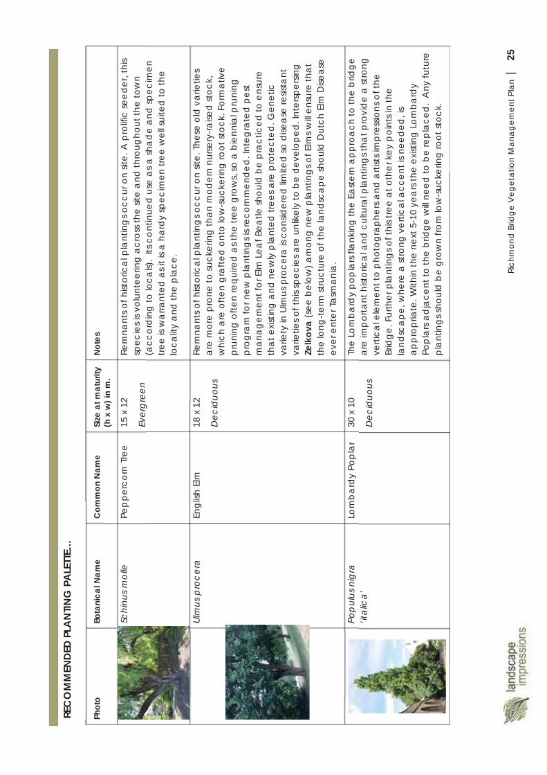
25Ri
chm
ond
Brid
ge
Veg
etat
ion
Man
agem
ent P
lan
|
Phot
oBo
tani
cal N
ame
Com
mon
Nam
eSi
ze a
t mat
urity
(h x
w) i
n m
.N
otes
Schi
nus
mol
lePe
ppe
rco
rn T
ree
15 x
12
Ever
gre
en
Rem
nant
s of h
istor
ica
l pla
ntin
gs o
ccur
on
site.
A p
rolif
ic se
eder
, thi
s sp
ecie
s is v
olun
teer
ing
acr
oss t
he si
te a
nd th
roug
hout
the
tow
n (a
ccor
ding
to lo
cals)
. Its
con
tinue
d us
e as
a sh
ad
e an
d sp
ecim
en
tree
is w
arra
nted
as i
t is a
har
dy sp
ecim
en tr
ee w
ell s
uite
d to
the
loca
lity
and
the
pla
ce.
Ulm
us p
roce
raEn
glish
Elm
18 x
12
Dec
iduo
us
Rem
nant
s of h
istor
ica
l pla
ntin
gs o
ccur
on
site.
The
se o
ld v
arie
ties
are
mor
e pr
one
to su
cker
ing
than
mod
ern
nurse
ry-ra
ised
stoc
k,
whi
ch a
re o
ften
gra
fted
ont
o lo
w-s
ucke
ring
root
stoc
k. F
orm
ativ
e pr
unin
g o
ften
requ
ired
as t
he tr
ee g
row
s, so
a b
ienn
ial p
runi
ng
prog
ram
for n
ew p
lant
ing
s is r
ecom
men
ded.
Inte
gra
ted
pest
m
ana
gem
ent f
or E
lm L
eaf B
eatle
shou
ld b
e p
ract
iced
to e
nsur
e th
at e
xistin
g a
nd n
ewly
pla
nted
tree
s are
pro
tect
ed. G
enet
ic
varie
ty in
Ulm
us p
roce
ra is
con
sider
ed lim
ited
so d
iseas
e re
sista
nt
varie
ties o
f thi
s spe
cies
are
unl
ikel
y to
be
deve
lope
d. In
ters
pers
ing
Ze
lkov
a(s
ee b
elow
) am
ong
new
pla
ntin
gs o
f Elm
s w
ill en
sure
that
th
e lo
ng-te
rm st
ruct
ure
of th
e la
ndsc
ape
shou
ld D
utch
Elm
Dise
ase
ever
ent
er T
asm
ania
.
Pop
ulus
nig
ra
‘ital
ica’
Lom
bard
y Po
plar
30 x
10
Dec
iduo
us
The
Lom
bard
y po
pla
rs fla
nkin
g th
e Ea
ster
n ap
proa
ch to
the
brid
ge
are
imp
orta
nt h
istor
ica
l and
cul
tura
l pla
ntin
gs th
at p
rovi
de a
stro
ng
verti
cal e
lem
ent t
o p
hoto
grap
hers
and
arti
sts i
mp
ress
ions
of t
he
Brid
ge. F
urth
er p
lant
ings
of t
his t
ree
at o
ther
key
poi
nts i
n th
e la
ndsc
ape
, whe
re a
stro
ng v
ertic
al a
ccen
t is n
eed
ed, i
s a
ppro
pria
te. W
ithin
the
next
5-1
0 ye
ars
the
exist
ing
Lom
bard
y Po
pla
rs ad
jace
nt to
the
brid
ge w
ill ne
ed to
be
repl
aced
. A
ny fu
ture
p
lant
ings
shou
ld b
e gr
own
from
low
-suc
kerin
g ro
ot st
ock.
REC
OM
MEN
DED
PLA
NTIN
G P
ALE
TTE…
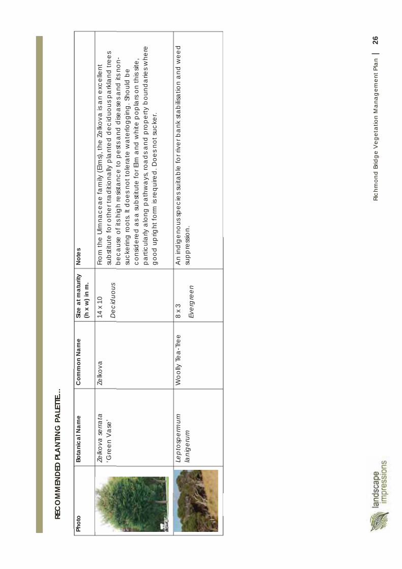
26Ri
chm
ond
Brid
ge
Veg
etat
ion
Man
agem
ent P
lan
|
REC
OM
MEN
DED
PLA
NTIN
G P
ALE
TTE…
Phot
oBo
tani
cal N
ame
Com
mon
Nam
eSi
zeat
mat
urity
(h
x w
) in
m.
Not
es
Zelk
ova
serra
ta
‘Gre
en V
ase’
Zelk
ova
14 x
10
Dec
iduo
us
From
the
Ulm
nace
ae fa
mily
(Elm
s), t
he Z
elko
va is
an
exce
llent
su
bstit
ute
for o
ther
tra
ditio
nally
pla
nted
dec
iduo
us p
ark
land
tree
s be
caus
e of
its h
igh
resis
tanc
e to
pes
ts a
nd d
isea
ses a
nd it
s non
-su
cker
ing
root
s. It
doe
s not
tole
rate
wat
erlo
ggin
g. S
houl
d be
cons
ider
ed a
s a su
bstit
ute
for E
lm a
nd w
hite
pop
lars
on th
is sit
e,
parti
cula
rly a
long
pat
hwa
ys, r
oads
and
pro
perty
bou
nda
ries w
here
go
od u
prig
ht fo
rm is
requ
ired.
Doe
s not
suck
er.
Lep
tosp
erm
um
lani
geru
mW
oolly
Tea
-Tre
e8
x 3
Ever
gre
en
An
indi
geno
us sp
ecie
s sui
tabl
e fo
r riv
er b
ank
stab
ilisat
ion
and
wee
d su
pp
ress
ion.
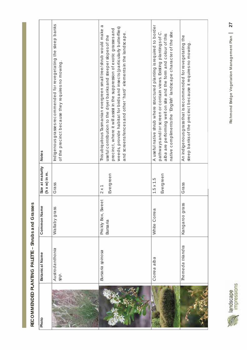
27Ri
chm
ond
Brid
ge
Veg
etat
ion
Man
agem
ent P
lan
|
Phot
oBo
tani
cal N
ame
Com
mon
Nam
eSi
ze a
t mat
urity
(h
x w
) in
m.
Not
es
Aus
trod
ant
honi
a sp
p.
Wa
llaby
gra
ssG
rass
In
dig
enou
s gra
sses
reco
mm
ende
d fo
r rev
eget
atin
g th
e st
eep
bank
s of
the
pre
cinc
t bec
aus
e th
ey re
quire
s no
mow
ing.
Bursa
ria sp
inos
aPr
ickl
y Bo
x, S
wee
t Bu
rsaria
2 x
1
Ever
gre
en
This
ubiq
uito
us T
asm
ania
n ev
ergr
een
smal
l tre
e/sh
rub
wou
ld m
ake
a
usef
ul c
ontri
butio
n to
the
drye
r ba
nks a
nd st
eepe
r slo
pes o
f the
pr
ecin
ct, w
here
it w
ill a
ssist
in th
e su
ppre
ssio
n of
exo
tic g
rass
es a
nd
wee
ds, p
rovi
deha
bita
t for
bird
s and
inse
cts (
parti
cula
rly b
utte
rflie
s)
and
scre
ens f
ence
s and
oth
er ‘h
ard’
ele
men
ts in
the
land
sca
pe.
Cor
rea
alb
aW
hite
Cor
rea
1.5
x 1.
5
Ever
gre
en
A u
sefu
l nat
ive
shru
b w
here
stru
ctur
ed p
lant
ing
is re
quire
d to
bor
der
path
wa
ys a
nd/o
r scr
een
or c
onta
in v
iew
s. Ex
istin
g p
lant
ings
of C
. al
ba
are
per
form
ing
wel
l on
site
and
the
form
and
col
our o
f thi
s na
tive
com
plim
ents
the
‘Eng
lish’
land
sca
pe c
hara
cter
of t
he si
te.
Them
eda
tria
ndra
Kang
aro
o g
rass
Gra
ss
An
ind
igen
ous g
rass
tha
t is r
ecom
men
ded
for r
eveg
eta
ting
the
stee
p ba
nks o
f the
pre
cinc
t bec
ause
it re
quire
s no
mow
ing
.
REC
OM
MEN
DED
PLA
NTIN
G P
ALE
TTE
– Sh
rubs
and
Gra
sses

28Ri
chm
ond
Brid
ge
Veg
etat
ion
Man
agem
ent P
lan
|
Wat
erw
ay M
anag
emen
t
AQ
UATIC
VEG
ETA
TIO
N
Whi
lst a
n ex
haus
tive
surv
ey o
f aqu
atic
pla
nts h
as n
ot b
een
und
erta
ken
as p
art
of th
is V
eget
atio
n M
ana
gem
ent P
lan,
it a
ppe
ars
tha
t the
m
ajor
ity o
f aqu
atic
pla
nts w
ithin
the
Coa
l Riv
er a
re n
ativ
e.
The
Phra
gm
ites a
ustra
lis(c
omm
on re
ed) t
hat d
omin
ate
s m
uch
of th
e no
rther
n se
ctio
n of
the
Coa
l Riv
er is
val
uabl
e in
pro
tect
ing
ban
ks fr
om
eros
ion
and
filte
ring
hig
h nu
trien
t-lo
ad
runo
ff fro
m a
djac
ent l
awns
. It
ma
y b
e sp
rea
ding
thro
ugh
the
bed
of t
he ri
ver,
but
this
is a
resu
lt of
sh
allo
win
g o
f the
rive
rbed
due
to se
dim
enta
tion.
Whi
lst ‘d
row
ning
’ by
cutti
ng th
e re
eds o
ff be
low
wa
ter l
evel
ma
y st
op it
s sp
rea
d a
nd c
ontro
l th
e re
ed in
the
shor
t ter
m, c
ontin
uing
sedi
men
tatio
n w
ill ex
acer
bate
this
‘pro
ble
m’ i
n th
e lo
ng te
rm. P
hrag
mite
sdoe
s not
pos
e a
pro
blem
to
flood
ing
, unl
ike
the
intro
duce
d b
ull-r
ush
(Cum
bun
gi),
beca
use
it lie
s d
own
und
er fl
ood
wa
ter (
and
pro
tect
s ban
ks in
doi
ng so
).
Rush
es (J
uncu
s spp
.,El
eoch
aris
gra
cilis
, etc
.)p
lay
a sim
ilar r
ole
in
prot
ectin
g th
e riv
erba
nks f
rom
ero
sion
and
with
sta
nd m
uch
of th
e im
pact
s of t
he h
igh
duc
k p
opul
atio
n in
Brid
ge p
reci
nct.
Rib
bon
wee
d (T
riglo
chin
pro
cera
)is a
dom
ina
nt a
quat
ic p
lant
with
in th
e C
oal R
iver
that
is a
lso lik
ely
to b
e ‘s
prea
din
g’ i
nto
the
mai
n ch
anne
l of
the
river
due
to se
dim
enta
tion.
A lo
ng-te
rm st
rate
gy fo
r con
tinue
d u
se o
f the
rive
r by
boa
ts a
nd c
anoe
s w
ould
be
to re
verse
the
sed
imen
tatio
n p
roce
ss. H
owev
er, t
his w
ould
m
ost l
ikel
y re
qui
re th
e re
mov
al o
r mod
ifica
tion
of G
att
y D
am
and
/or
mec
hani
cal m
odifi
catio
n of
the
river
bed
(i.e
. dre
dgin
g).
A m
ajor
floo
d
ma
y a
lso h
ave
the
effe
ct o
f sco
urin
g ou
t the
rive
rbed
, dee
peni
ng it
in
plac
es. T
hese
scen
ario
s sho
uld
be
the
sub
ject
of a
sepa
rate
and
de
taile
d h
ydro
logi
cal a
nd fl
uvia
l geo
mor
phol
ogic
al in
vest
igat
ions
.
29Ri
chm
ond
Brid
ge
Veg
etat
ion
Man
agem
ent P
lan
|
Wee
d St
rate
gy
INTR
OD
UCTI
ON
As w
ell a
s the
usu
al a
rray
of g
ard
en e
scap
ees a
nd
agric
ultu
ral w
eeds
com
mon
acr
oss t
he re
gion
, ma
ny
of th
e ‘w
eeds
’ with
in th
e st
udy
area
are
nat
ura
lised
sp
ecim
ens o
f hist
oric
al p
lant
ings
on o
r ad
jace
nt to
the
stud
y a
rea.
Som
e ‘w
eeds
’ of t
his s
ite a
reth
eref
ore
impo
rtant
el
emen
ts o
f the
cha
ract
er o
f thi
s la
ndsc
ape
.
It is
ther
efor
ea
ppro
pria
te th
at a
bal
ance
bet
wee
n pr
eser
ving
cul
tura
l land
sca
pe v
alue
s whi
lst m
inim
ising
en
viro
nmen
tal a
nd e
cono
mic
impa
cts o
f wee
ds.
Due
to th
e lo
ng h
istor
y of
Eur
opea
n se
ttlem
ent o
n th
is sit
e, th
e Ri
chm
ond
Brid
ge a
nd e
nviro
ns is
larg
ely
a ‘E
urop
ean’
land
scap
e. M
ain
tain
ing
this
cha
ract
er is
a
ppro
pria
te g
iven
the
hist
oric
al s
igni
fica
nce
of th
e sit
e.
The
‘la
ndsc
ape
prin
cipl
es’ s
et o
ut o
n Pa
ge 6
of t
his
repo
rt in
clud
e re
fere
nce
to th
e m
anag
emen
t of
wee
d sp
ecie
s in
the
over
all l
and
scap
e co
ntex
t. Th
e ov
errid
ing
prin
cip
les r
elat
ing
to ‘w
eed
’ man
age
men
t a
re th
at:
‘D
ecla
red
wee
ds’
be
cont
rolle
d an
d er
adi
cate
d
from
the
site
with
in 5
yea
rs.
Wee
ds a
re n
ot to
be
allo
wed
to sp
rea
d to
ad
jace
nt p
rope
rties
.
Whe
re fe
asib
le, e
xotic
spec
ies t
hat a
re p
rofu
se
suck
erin
g va
rietie
s be
repl
aced
with
mod
ern
culti
vars
and
/or s
peci
men
s gra
fted
on to
low
-su
cker
ing
root
stoc
k.
STRA
TEG
Y
The
reco
mm
ende
d st
rate
gic
ap
proa
ch to
w
eed
ma
nage
men
t rec
omm
ende
d fo
r the
sit
e is
base
d o
n th
e ‘B
rad
ley
Met
hod
’#of
wee
d c
ontro
l. Th
e ba
sic p
rinci
ples
of t
hat
met
hod
are
:
W
ork
from
goo
d to
ba
d ar
eas.
D
istur
b th
e so
il as
little
as p
ossib
le.
A
llow
the
rate
of r
egen
erat
ion
to
dict
ate
the
rate
of c
lear
ing
.
In th
e ca
se o
f the
Ric
hmon
d B
ridge
pr
ecin
ct, t
his c
an b
e a
pplie
d b
y:
1.Bi
mon
thly
mon
itorin
gea
ch
Man
agem
ent Z
one
for i
sola
ted
spec
imen
s of p
riorit
y w
eed
spec
ies (
see
next
pag
e).
2.O
n-th
e-sp
ot (i
.e. a
t ins
pect
ion
time)
m
anua
l rem
oval
of s
mal
l spe
cim
ens o
f pr
iorit
y w
eeds
.3.
Usin
g G
PS ta
ggin
g o
f lar
ger p
riorit
y w
eed
spec
imen
s and
sche
dulin
g a
follo
w-u
p re
mov
al w
orks
requ
est t
o be
a
ctio
ned
with
in o
ne m
onth
.4.
In th
e Ri
paria
n M
anag
emen
t Zon
es,
star
t wee
d c
ontro
l wor
ks u
p-s
trea
m.
Ensu
re a
ll w
eed
deb
ris is
rem
oved
from
th
e sit
e to
a C
ounc
il no
min
ated
lo
catio
n a
nd tr
eate
d in
acc
ord
ance
w
ith C
ounc
il’s w
eed
ma
nage
men
t p
olic
y.
Def
initi
on o
f Wee
d
A w
eed
is a
ny p
lant
gro
win
g ou
t of p
lace
, cau
sing
ad
vers
e ec
onom
ic, e
nviro
nmen
tal a
nd/o
r soc
ial
impa
cts.
Wee
ds ‘D
ecla
red’
und
er th
e W
eed
Man
agem
ent
Act(
1999
) pos
e a
sign
ifica
nt th
reat
to T
asm
ania
’s
envi
ronm
enta
l and
/or a
gric
ultu
ral v
alue
s. L
and
owne
rs/m
anag
ers h
ave
a le
gal r
espo
nsib
ility
to
cont
rol d
ecla
red
wee
ds o
n th
eir l
and.
5.Th
e se
lect
ed m
etho
d o
f era
dica
ting
each
wee
d sp
ecim
en/c
lum
p w
ill be
sit
e an
d sp
ecie
s spe
cific
^. T
he
obje
ctiv
e (in
line
with
the
Bra
dle
y M
etho
d) is
to m
inim
ise d
istur
ban
ce o
f su
rroun
ding
veg
eta
tion
at a
ll tim
es
and
to ‘w
ork
in fr
om
the
edge
s’ o
f la
rger
infe
stat
ions
.6.
Sow
/pla
nt d
esira
ble
spec
ies w
here
la
rger
are
as o
f ‘ba
re g
roun
d’ h
ave
been
exp
osed
. Thi
s will
be si
te-s
peci
fic
(refe
r to
the
Plan
ting
Pla
n).
#Br
ad
ley,
J. 2
002.
Brin
ging
Ba
ck th
e Bu
sh: T
he B
rad
ley
Met
hod
of B
ush
Rege
nera
tion.
New
Hol
land
.
^Ref
er to
the
DPI
PWE
pub
lica
tion
Gui
del
ines
for S
afe
a
nd E
ffect
ive
Her
bic
ide
Use
Nea
r Wa
terw
ays
as a
gu
ide
to h
erb
icid
e us
e w
ithin
the
are
a d
efin
ed b
y th
is V
eget
atio
n M
ana
gem
ent P
lan.
ava
ilab
le a
t: ht
tp:/
/dp
ipw
e.ta
s.go
v.a
u/D
ocu
men
ts/h
erb
icid
e_gu
idel
ines
FIN
AL2
012.
pd
f
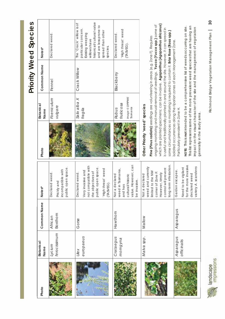
30Ri
chm
ond
Brid
ge
Veg
etat
ion
Man
agem
ent P
lan
|
Prio
rity
Wee
d Sp
ecie
s Ph
oto
Bota
nica
l N
ame
Com
mon
Nam
eN
otes
*
Lyci
um
fero
ciss
imum
Afri
can
Boxt
horn
Dec
lare
d w
eed
.
Pric
kly
and
in
com
pat
ible
with
p
ublic
op
en
spa
ce.
Ulex
eu
ropa
eus
Gor
seD
ecla
red
wee
d.
Ver
y in
vasiv
e a
nd
not c
omp
atib
le w
ith
the
obje
ctiv
es o
f p
ublic
op
en
spa
ce.
‘Hig
h th
rea
t’ w
eed
(T
ASV
EG).
Cra
taeg
us
mom
gyn
aHa
wth
orn
Not
a d
ecla
red
w
eed
in T
asm
ani
a,
and
ha
s cu
ltura
l/hist
oric
va
lue.
Ho
wev
er, c
an
be
inva
sive.
Mal
va sp
p.
Mal
low
Not
a d
ecla
red
w
eed
and
cur
rent
ly
limite
d to
the
NW
co
rner
of Z
one
F.
How
ever
, tim
ely
cont
rol w
ill pr
eve
nt
long
-ter
m in
fest
atio
n.
Asp
arag
us
offic
inal
isA
spar
agus
G
ard
en e
sca
pee
.
Nee
d to
be
vig
ilant
fo
r the
mor
e in
vasiv
e d
ecla
red
wee
d
varie
ty A
. sca
nden
s
Phot
oBo
tani
cal
Nam
eC
omm
on N
ame
Not
es*
Foen
icul
um
vulg
are
Fenn
elD
ecla
red
wee
d.
Salix
alb
a X
fra
gila
Cra
ck W
illow
The
‘Cra
ck’ w
illow
is o
f p
arti
cula
r con
cern
. Ex
istin
g w
eep
ing
w
illow
s ha
ve
hist
oric
al/c
ultu
ral v
alu
e a
nd a
re le
ss p
rone
to
spre
ad
tha
n ot
her
spec
ies.
Rub
us
fruiti
cosa
Ima
ge
© D
PIPW
E Ta
sma
nia
Blac
kber
ryD
ecla
red
wee
d.
‘Hig
h th
rea
t’ w
eed
(T
ASV
EG).
Oth
er P
riorit
y ‘w
eed’
spe
cies
NO
TE:
This
is no
tint
ende
d to
be
a co
mpr
ehen
sive
list o
f wee
ds o
ccur
ring
on si
te.
This
list r
epre
sent
s som
e of
the
mor
e pr
eval
ent w
eed
spec
ies t
hat a
re h
avin
g an
im
pac
t on
the
visu
al c
hara
cter
of t
he si
te a
nd th
e m
ana
gem
ent o
f veg
etat
ion
gene
rally
in th
e st
udy
area
.
31Ri
chm
ond
Brid
ge
Veg
etat
ion
Man
agem
ent P
lan
|
The
‘bor
row
ed’ l
ands
cape
IN
TRO
DUC
TIO
N
Man
y of
the
bes
t vie
ws o
f the
Ric
hmon
d Br
idge
are
fra
med
by
vege
tatio
n fro
m th
e ‘b
orro
wed
land
scap
e’ (t
he b
road
er
land
sca
pe a
roun
d th
e st
udy
are
a).
The
mat
ure
blu
e gu
ms i
n fro
nt o
f St J
ohns
C
hurc
h; th
e pi
ne a
nd c
ypre
ss tr
ees o
n pr
ivat
e la
nd to
the
north
of t
he st
udy
area
;th
e sil
ver p
opla
rs in
the
traffi
c isl
and
on
Brid
ge
Stre
et to
the
wes
t of t
he b
ridge
; and
the
whi
te p
opla
rs al
ong
the
bank
s of t
he C
oal
Rive
r sou
th-e
ast o
f the
brid
ge a
re k
ey
exa
mpl
es.
The
succ
essio
n of
this
vege
tatio
n is
imp
orta
nt
to m
ain
tain
ing
the
cultu
ral l
ands
cape
of t
he
Rich
mon
d B
ridge
and
its s
urro
unds
.
SUC
CES
SIO
N P
LAN
TIN
G
It is
reco
mm
ende
d th
at C
ounc
il tak
e a
pro
activ
e a
ppro
ach
to e
nsur
ing
the
smoo
th
trans
ition
of t
he b
roa
der l
ands
cape
so th
at
dra
stic
cha
nges
to th
e sk
ylin
e, n
ear a
nd
mid
dle
-dist
ant
vie
ws a
re n
ot d
isrup
ted
whe
n th
e ex
istin
g ve
geta
tion
decl
ines
and
has
to
be re
mov
ed.
In so
me
inst
ance
s, th
ere
is ro
om a
roun
d th
e ex
istin
g v
eget
atio
n to
ena
ble
new
pla
ntin
gs
to o
ccur
now
and
for t
hat v
eget
atio
n to
b
ecom
e es
tab
lishe
d in
tim
e fo
r the
eve
ntua
l de
clin
e of
the
exist
ing
trees
. In
oth
er c
ases
, re
mov
al o
f the
exi
stin
g tre
es w
ill be
requ
ired
befo
re n
ew p
lant
ings
ca
n be
und
erta
ken.
Rega
rdle
ss o
f the
ap
pro
ach
to su
cces
sion
pla
ntin
g, it
is im
por
tant
tha
t the
com
mun
ity is
w
ell i
nfor
med
of t
he p
lans
for s
ucce
ssio
n of
la
rge
trees
. If t
he c
omm
unity
is a
ssur
ed th
at
the
wor
ks a
re p
art o
f a lo
ng-te
rm
rep
lace
men
t pro
gra
m a
nd th
at t
he d
isrup
tion
to th
e la
ndsc
ape
will
be te
mp
ora
ry, t
hey
will
be
mor
e a
ccep
ting
of t
he n
eed
to re
mov
e ol
d tr
ees.
The
prio
rity
area
s of t
he ‘b
orro
wed
’ la
ndsc
ape
whe
re su
cces
sion
pla
ntin
gs a
re
parti
cula
rly re
quire
d ar
e:
St J
ohns
Chu
rch,
Blu
e G
ums.
The
mat
ure
blu
e gu
ms f
orm
an
imp
orta
nt
back
dro
p a
nd sk
ylin
e to
vie
ws o
f the
Brid
ge,
parti
cula
rly fr
om th
e so
uth
wes
t. Re
mov
al o
f a
sene
scen
t tre
e to
the
sout
h ea
st o
f the
ch
urch
occ
urre
d re
lativ
ely
rece
ntly
. Thi
s tre
e w
as re
plac
ed w
ith a
n oa
k tre
e. T
his s
peci
men
ca
n re
ma
in, b
ut it
is re
com
men
ded
that
blu
e gu
ms b
e re
pla
nted
in o
ther
are
as a
long
the
sout
hern
bou
nda
ry o
f the
chu
rch,
mak
ing
allo
wa
nce
for t
he sa
fe re
mov
al o
f the
exis
ting
tre
es. T
he m
ore
open
ca
nopy
of e
ucal
ypts
, an
d th
e re
fere
nce
to h
istor
ic tr
ees,
it is
sugg
este
d, is
a p
refe
rab
le so
lutio
n to
oak
tre
es. D
etai
led
site
des
ign
is re
com
men
ded
to
ensu
re n
ew tr
ees a
re lo
cate
d a
ppro
pria
tely
so
as n
ot to
imp
act o
n th
e st
ruct
ure
of th
e ch
urch
or o
ther
infra
stru
ctur
e.
Cyp
ress
and
Pin
es, 1
2 G
unni
ng S
t & 5
6 &
52 S
t Jo
hn C
ircle
.
The
old
pin
e an
d c
ypre
ss (P
inus
radi
ata
&C
upre
ssus
mac
roca
rpa)
on
priv
ate
land
nor
th
of th
e m
ain
Rich
mon
d B
ridge
pre
cinc
t fo
rm
an
imp
orta
nt b
ackd
rop
to th
e cu
ltura
l la
ndsc
ape
of t
he B
ridge
env
irons
. The
se tr
ees
have
not
bee
n a
sses
sed
by
an
arb
orist
as
part
of th
is V
eget
atio
n M
anag
emen
t Pla
n,
how
ever
, due
to th
eir a
ge th
ere
is a
need
to
com
men
ce su
cces
sion
pla
nnin
g fo
r the
ir ev
entu
al d
emise
. The
re a
re tw
o m
ain
optio
ns
a) n
egot
iate
with
the
curre
nt la
ndho
lder
s to
disc
uss o
ptio
ns fo
r rep
laci
ng th
ese
trees
ove
r tim
e; o
r b) p
lant
pin
e a
nd/o
r cyp
ress
tree
s at
the
north
ern
end
of Z
one
F. A
fact
or in
de
cid
ing
whi
ch o
ptio
n is
mos
t ap
prop
riate
is
the
fact
that
it is
likel
y th
at a
cces
s for
rem
oval
of
the
exist
ing
trees
on
12 G
unni
ng S
t mig
ht
have
to o
ccur
thro
ugh
Cro
wn
land
(Zon
e F)
.
Whi
te P
opla
rs, B
ridge
Stre
et.
The
two
larg
e w
hite
pop
lars
to th
e w
este
rn
side
of th
e ‘t
raffi
c isl
and’
to B
ridge
St
reet
/Gun
ning
Stre
et fo
rm a
n im
porta
nt
foca
l poi
nt a
nd b
ackd
rop
to th
e Br
idge
as i
t is
app
roac
hed
from
the
east
. A
lthou
gh
curre
ntly
hea
lthy
and
with
a lik
ely
long
life
a
hea
d of
them
, suc
cess
ion
pla
nnin
g fo
r the
se
spec
imen
s is i
mp
orta
nt. T
here
is ro
omto
the
East
of t
hese
tree
s to
esta
blis
h ne
w p
lant
ings
. W
hite
pop
lars
shou
ld b
e re
-pla
nted
.
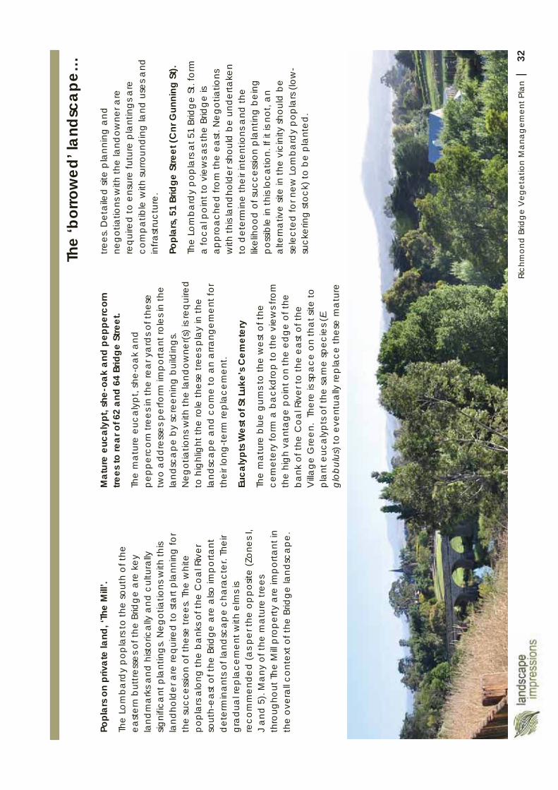
32Ri
chm
ond
Brid
ge
Veg
etat
ion
Man
agem
ent P
lan
|
Popl
ars
on p
rivat
e la
nd, ‘
The
Mill
’.
The
Lom
bard
y po
pla
rs to
the
sout
h of
the
east
ern
but
tress
es o
f the
Brid
ge
are
key
la
ndm
ark
s and
hist
oric
ally
and
cul
tura
lly
signi
fica
nt p
lant
ings
. Neg
otia
tions
with
this
land
hold
er a
re re
quire
d to
sta
rt pl
ann
ing
for
the
succ
essio
n of
thes
e tre
es. T
he w
hite
po
pla
rs a
long
the
bank
s of t
he C
oal R
iver
so
uth-
east
of t
he B
ridge
are
also
impo
rtant
d
eter
min
ant
s of l
and
sca
pe
cha
ract
er. T
heir
gra
dua
l rep
lace
men
t with
elm
s is
reco
mm
ende
d (a
s per
the
oppo
site
(Zon
es I,
J
and
5).
Man
y of
the
mat
ure
trees
th
roug
hout
The
Mill
pro
perty
are
impo
rtant
in
the
over
all c
onte
xt o
f the
Brid
ge la
ndsc
ape.
Mat
ure
euca
lypt
, she
-oak
and
pep
perc
orn
trees
to re
ar o
f 62
and
64 B
ridge
Stre
et.
The
mat
ure
euca
lypt
, she
-oak
and
pe
pper
corn
tree
s in
the
rea
r ya
rds o
f the
se
two
add
ress
es p
erfo
rm im
porta
nt ro
les i
n th
e la
ndsc
ape
by
scre
enin
g bu
ildin
gs.
Neg
otia
tions
with
the
land
owne
r(s) i
s req
uire
d
to h
ighl
ight
the
role
thes
e tre
es p
lay
in th
e la
ndsc
ape
and
com
e to
an
arra
ngem
ent f
or
thei
r lon
g-te
rm re
pla
cem
ent.
Euca
lypt
s W
est o
f St L
uke’
s C
emet
ery
The
mat
ure
blu
e gu
ms t
o th
e w
est o
f the
ce
met
ery
form
a b
ackd
rop
to th
e vi
ews f
rom
th
e hi
gh v
ant
age
poi
nt o
n th
e ed
ge o
f the
b
ank
of t
he C
oal R
iver
to th
e ea
st o
f the
V
illage
Gre
en.
Ther
e is
spac
e on
that
site
to
pla
nt e
ucal
ypts
of t
he sa
me
spec
ies (
E.
glob
ulus
) to
even
tual
ly re
pla
ce th
ese
ma
ture
trees
. Det
aile
d si
te p
lann
ing
and
ne
gotia
tions
with
the
land
owne
r are
re
quire
dto
ens
ure
futu
re p
lant
ings
are
co
mpa
tible
with
surro
undi
ng la
nd u
ses a
nd
infra
stru
ctur
e.
Popl
ars,
51
Brid
geSt
reet
(Cnr
Gun
ning
St).
The
Lom
bard
y po
pla
rs at
51
Brid
ge
St. f
orm
a
foca
l poi
nt to
vie
ws a
s the
Brid
ge is
ap
pro
ache
d fro
m th
e ea
st. N
egot
iatio
ns
with
this
land
hold
er sh
ould
be
unde
rtake
n to
det
erm
ine
thei
r int
entio
ns a
nd th
e lik
elih
ood
of su
cces
sion
pla
ntin
g b
eing
po
ssib
le in
this
loca
tion.
If it
is n
ot, a
n a
ltern
ativ
e sit
e in
the
vici
nity
shou
ld b
e se
lect
ed fo
r new
Lom
bard
y po
pla
rs (l
ow-
suck
erin
g st
ock)
to b
e pl
ant
ed.
The
‘bor
row
ed’ l
ands
cape
…
33Ri
chm
ond
Brid
ge
Veg
etat
ion
Man
agem
ent P
lan
|
Impl
emen
tatio
n G
uide
M
any
of t
he re
com
men
dat
ions
of t
his
Veg
eta
tion
Ma
nage
men
t Pla
n re
late
to
rout
ine
land
ma
nage
men
t and
arb
oric
ultu
ral
prac
tices
.
Effe
ctiv
e w
eed
man
agem
ent r
equi
res
stra
tegi
c, ti
mel
y a
nd re
gul
ar w
ork
s to
be
carri
ed o
ut b
y tra
ined
sta
ff. R
egul
ar w
eed
m
anag
emen
t sho
uld
be in
clud
ed in
all
prog
ram
med
mai
nten
ance
for t
he w
hole
sit
e.
Tree
rem
ova
l and
rep
lace
men
t in
hist
oric
pr
ecin
cts m
ay b
e co
ntro
lled
und
er v
ario
us
Stat
e, N
atio
nal a
nd L
oca
l legi
slatio
n. T
he
spec
ific
Nat
iona
l, St
ate
and
Loc
al
Gov
ernm
ent l
egisl
ativ
e fra
mew
orks
with
in
whi
ch th
e p
rop
osed
act
ions
are
to b
e gu
ided
are
disc
usse
d b
elow
.
Nat
iona
l
The
Nat
iona
l Her
itage
listin
g in
clud
es th
e Br
idge
, and
the
north
wes
t and
sout
h w
est
river
bank
s tha
t are
in p
ublic
ow
ners
hip
(but
no
t its
setti
ng).
Com
mon
wea
lth a
ppr
ova
l will
be re
quire
d w
here
an
actio
n ha
s, w
ill ha
ve o
r is
likel
y to
hav
e a
signi
fican
t im
pac
t on
the
Nat
iona
l Her
itage
val
ues o
f the
pla
ce.
An
actio
n is
likel
y to
hav
e a
signi
fican
t im
pact
un
der t
he im
pac
t gui
delin
es (p
.20)
if th
ere
is a
rea
l cha
nce
or p
ossib
ility
tha
t it w
ill ca
use:
on
e or
mor
e of
the
Na
tiona
l Her
itage
va
lues
to b
e lo
st
on
e or
mor
e of
the
Na
tiona
l Her
itage
va
lues
to
be d
egra
ded
or d
am
aged
, or
on
e or
mor
e of
the
Na
tiona
l Her
itage
va
lues
to
be
nota
bly
alte
red
, mod
ified
, ob
scur
ed o
r d
imin
ished
.
The
reco
mm
ende
d ve
get
atio
n m
anag
emen
t w
orks
are
not
con
sider
ed to
resu
lt in
a si
gni
fican
t im
pact
on
the
iden
tifie
d h
erita
ge v
alue
s of t
he
Rich
mon
d B
ridge
.
Stat
e
Imp
lem
enta
tion
of A
ctio
ns su
gges
ted
with
in th
is V
eget
atio
n M
ana
gem
ent P
lan
are
to b
e gu
ided
by
the
Her
itag
e Ta
sma
nia
Pra
ctic
e N
otes
– H
istor
ic
pla
ntin
gs a
nd la
ndsc
ape
s(H
erita
ge T
asm
ania
, 20
15).
Herit
age
Tasm
ania
will
gen
eral
ly is
sue
a ce
rtific
ate
of e
xem
ptio
n fo
rgen
era
l mai
nten
anc
e of
la
ndsc
ape
s inc
lud
ing
act
ions
such
as:
G
ener
al m
owin
g; se
edin
g, t
op-d
ress
ing
, ae
ratio
n/co
ring
of l
awns
; rem
ova
l of d
ead
pla
nts;
dise
ase
cont
rol;
mul
chin
g; s
pray
ing
etc.
Re
mov
al o
f dea
d or
dyi
ng m
inor
shru
bs; h
erb
s, pe
renn
ials
etc.
orp
lant
s of n
o sig
nific
anc
e.
G
ener
al w
eed
con
trol,
notin
g th
at so
me
herit
age
spec
ies a
re e
nviro
nmen
tal w
eed
s, in
w
hich
cas
e a
wor
ks a
ppl
icat
ion
will
be
requ
ired.
Tree
surg
ery,
hed
ging
, pru
ning
and
tri
mm
ing
are
also
gen
era
lly e
ligib
le fo
r a
certi
ficat
e of
exe
mpt
ion
if th
e w
orks
are
ca
rried
out
by
qual
ified
arb
orist
(s) o
r ho
rticu
ltura
lists
with
an
app
reci
atio
n of
the
herit
age
valu
e of
the
vege
tatio
n un
der
treat
men
t.
Ther
efor
e, th
e m
ajor
ity o
f the
wor
ks
reco
mm
ende
d in
this
Veg
eta
tion
Man
agem
ent P
lan
will
requ
ire a
per
mit
from
Her
itage
Tas
ma
nia
.
Ap
prov
al w
ill b
e re
quire
d fo
r:
St
ump
grin
ding
, in
area
s with
in
mod
erat
e a
nd h
igh
arc
haeo
logi
cal
inte
rest
(as n
oted
in th
e M
anag
emen
t Zo
nes d
escr
iptio
ns) i
f the
grin
ding
is
deep
er th
an
30cm
.
Tr
ee re
mov
al.
Re
plac
emen
t of t
rees
whe
re th
e ne
w
trees
are
not
of t
he sa
me
spec
ies a
s th
ose
rem
oved
.
N
ew p
lant
ings
(i.e
. tre
e or
shru
b
pla
ntin
gs in
are
as w
here
no
pla
ntin
g ha
s bee
n p
rese
nt h
istor
ical
ly, b
ut m
ay
impa
ct o
n vi
ews
to o
r fro
m h
istor
ica
lly
signi
fica
nt fe
atur
es o
r lan
dsca
pes)
.
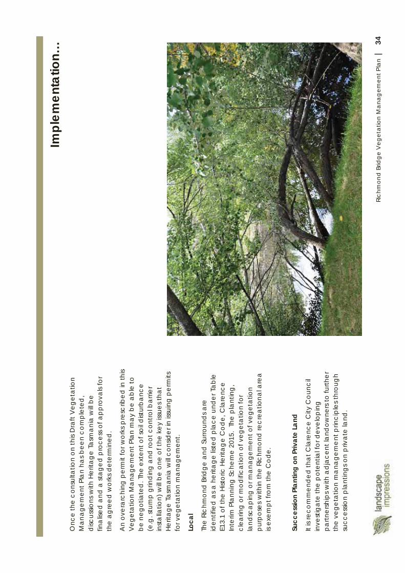
34Ri
chm
ond
Brid
ge
Veg
etat
ion
Man
agem
ent P
lan
|
Onc
e th
e co
nsul
tatio
n on
this
Dra
ft V
eget
atio
n M
anag
emen
t Pla
n ha
s bee
n co
mpl
eted
, d
iscus
sions
with
Her
itag
e Ta
sman
ia w
ill be
fin
alis
ed a
nd a
sta
ged
proc
ess o
f app
rova
ls fo
r th
e ag
reed
wor
ks d
eter
min
ed.
An
over
arc
hing
per
mit
for w
orks
pre
scrib
ed in
this
Veg
eta
tion
Ma
nage
men
t Pla
n m
ay
be a
ble
to
be n
egot
iate
d. T
he e
xten
t of s
oil d
istur
banc
e (e
.g. s
tum
p g
rindi
ng a
nd ro
ot c
ontro
l bar
rier
inst
alla
tion)
will
be o
ne o
f the
key
issu
es th
at
Herit
age
Tasm
ania
will
cons
ider
in is
suin
g p
erm
its
for v
eget
atio
n m
ana
gem
ent.
Loca
l
The
Rich
mon
d B
ridge
and
Sur
roun
ds a
re
iden
tifie
d as
a h
erita
ge lis
ted
plac
e un
der T
able
E1
3.1
of th
e H
istor
ic H
erita
ge
Cod
e, C
lare
nce
Inte
rim P
lann
ing
Sche
me
2015
. Th
e pl
antin
g,
clea
ring
or m
odifi
catio
n of
veg
eta
tion
for
land
sca
ping
or m
anag
emen
t of v
eget
atio
n p
urpo
ses
with
in th
e Ri
chm
ond
recr
eatio
nal a
rea
is
exem
pt fr
om
the
Cod
e.
Succ
essio
n Pl
antin
g on
Priv
ate
Land
It is
reco
mm
ende
d th
at C
lare
nce
City
Cou
ncil
inve
stig
ate
the
pot
entia
l for
dev
elop
ing
pa
rtner
ship
s with
adj
acen
t la
ndow
ners
to fu
rther
th
e ve
geta
tion
ma
nage
men
t prin
cip
les t
hrou
gh
succ
essio
n pl
ant
ings
on
priv
ate
land
.
Impl
emen
tatio
n…
35Ri
chm
ond
Brid
ge
Veg
etat
ion
Man
agem
ent P
lan
|
App
endi
ces
1. A
ctio
n Pl
an
2.Pl
ans (
A3
SET)
Site
Ana
lysis
Pla
n
Man
agem
ent Z
ones
Plan
ting
Plan
(Nor
th)
Pl
antin
g Pl
an (S
outh
)
Borro
wed
Lan
dsca
pe
Not
es
3. V
eget
atio
n C
ondi
tion
as a
t Feb
ruar
y 20
15 (A
boric
ultu
ral S
urve
y Re
port)
35Ri
chm
ond
Brid
ge V
eget
atio
n M
ana
gem
ent P
lan
|
App
endi
ces
1. A
ctio
n Pl
an
2.Pl
ans (
A3
SET)
Site
Ana
lysis
Pla
n
Man
agem
ent Z
ones
Plan
ting
Plan
(Nor
th)
Pl
antin
g Pl
an (S
outh
)
Borro
wed
Lan
dsca
pe N
otes
3.
Veg
etat
ion
Con
ditio
n as
at F
ebru
ary
2015
(Abo
ricul
tura
l Sur
vey
Repo
rt)
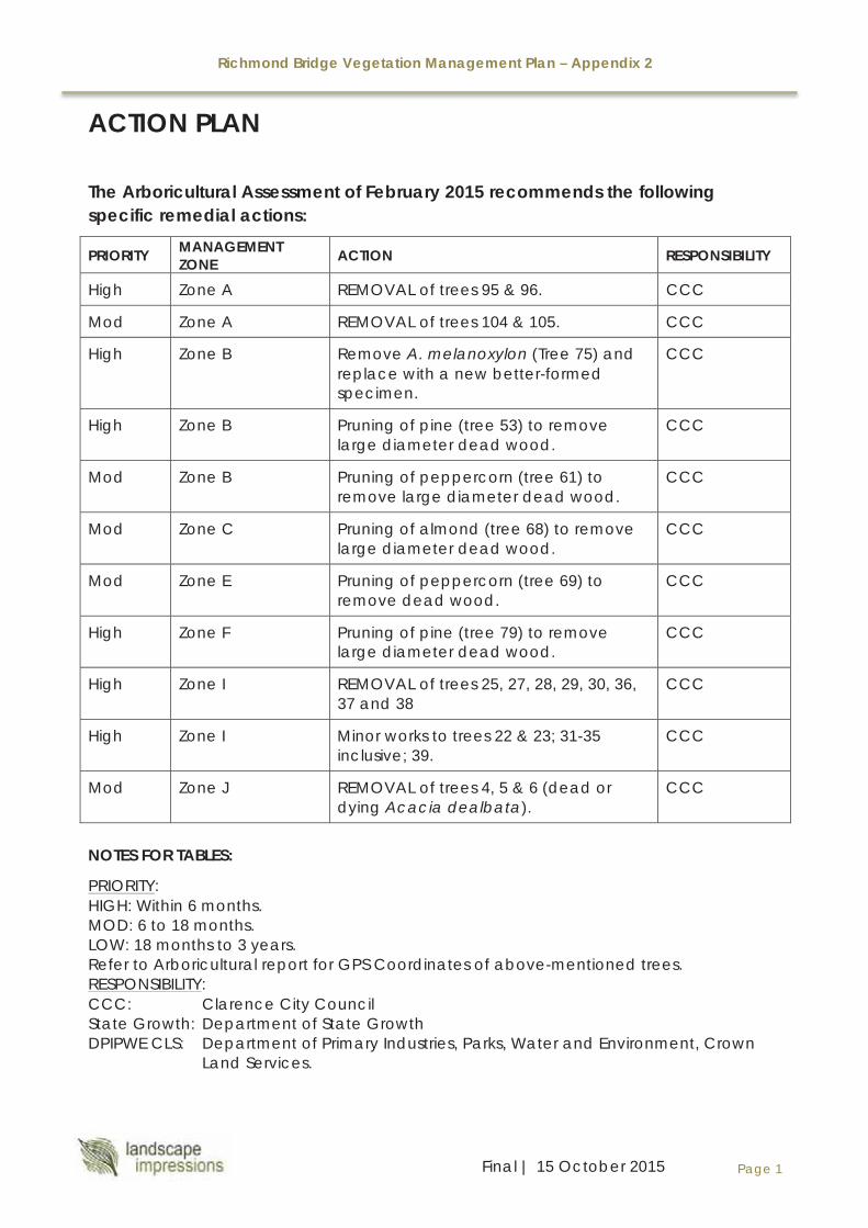
Richmond Bridge Vegetation Management Plan – Appendix 2
Page 1 Final | 15 October 2015
ACTION PLAN
The Arboricultural Assessment of February 2015 recommends the following specific remedial actions:
PRIORITY MANAGEMENT ZONE ACTION RESPONSIBILITY
High Zone A REMOVAL of trees 95 & 96. CCC
Mod Zone A REMOVAL of trees 104 & 105. CCC
High Zone B Remove A. melanoxylon (Tree 75) and replace with a new better-formed specimen.
CCC
High Zone B Pruning of pine (tree 53) to remove large diameter dead wood.
CCC
Mod Zone B Pruning of peppercorn (tree 61) to remove large diameter dead wood.
CCC
Mod Zone C Pruning of almond (tree 68) to remove large diameter dead wood.
CCC
Mod Zone E Pruning of peppercorn (tree 69) to remove dead wood.
CCC
High Zone F Pruning of pine (tree 79) to remove large diameter dead wood.
CCC
High Zone I REMOVAL of trees 25, 27, 28, 29, 30, 36, 37 and 38
CCC
High Zone I Minor works to trees 22 & 23; 31-35inclusive; 39.
CCC
Mod Zone J REMOVAL of trees 4, 5 & 6 (dead or dying Acacia dealbata).
CCC
NOTES FOR TABLES:
PRIORITY: HIGH: Within 6 months.MOD: 6 to 18 months.LOW: 18 months to 3 years.Refer to Arboricultural report for GPS Coordinates of above-mentioned trees.RESPONSIBILITY: CCC: Clarence City CouncilState Growth: Department of State GrowthDPIPWE CLS: Department of Primary Industries, Parks, Water and Environment, Crown
Land Services.
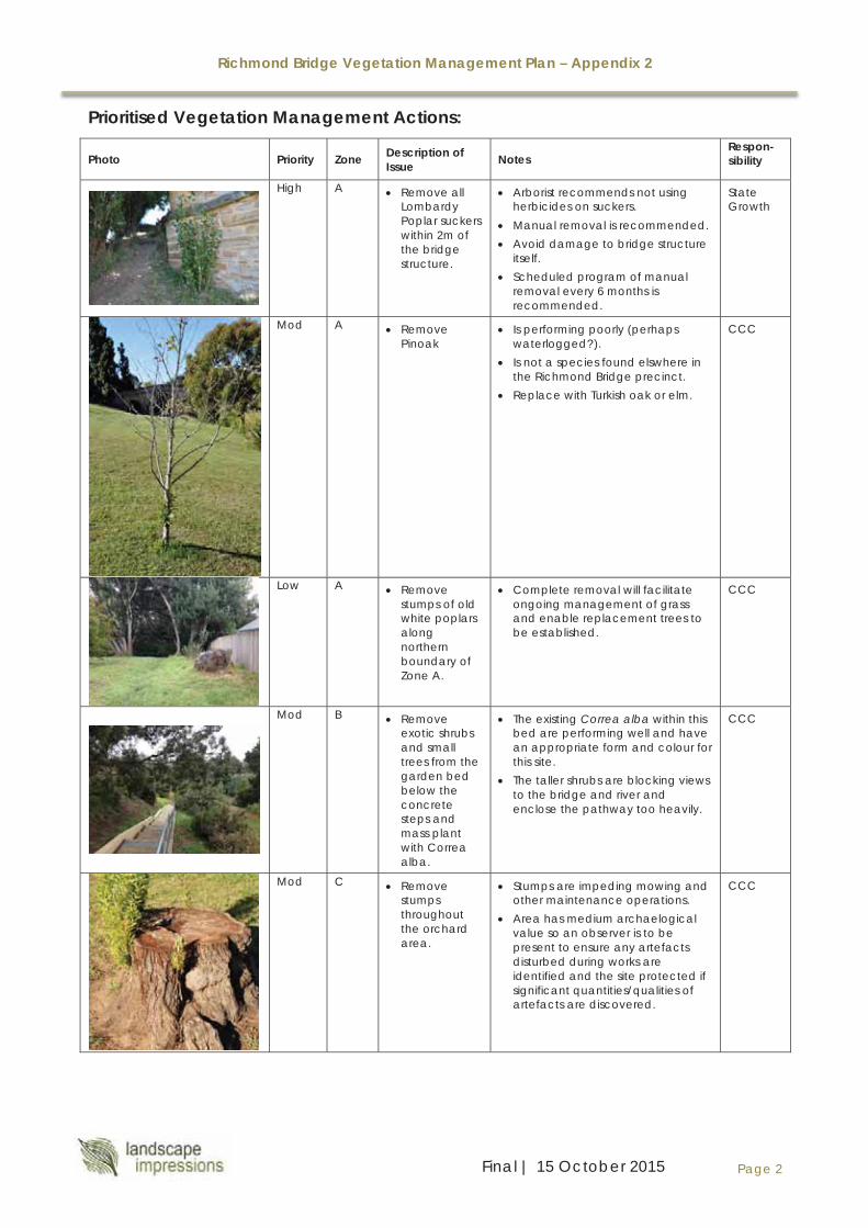
Richmond Bridge Vegetation Management Plan – Appendix 2
Page 2 Final | 15 October 2015
Prioritised Vegetation Management Actions:
Photo Priority Zone Description of Issue Notes
Respon-sibility
High A Remove all Lombardy Poplar suckers within 2m of the bridge structure.
Arborist recommends not using herbicides on suckers.
Manual removal is recommended. Avoid damage to bridge structure
itself. Scheduled program of manual
removal every 6 months is recommended.
State Growth
Mod A Remove Pinoak
Is performing poorly (perhaps waterlogged?).
Is not a species found elswhere in the Richmond Bridge precinct.
Replace with Turkish oak or elm.
CCC
Low A Remove stumps of old white poplars along northern boundary of Zone A.
Complete removal will facilitate ongoing management of grass and enable replacement trees to be established.
CCC
Mod B Remove exotic shrubs and small trees from the garden bed below the concrete steps and mass plant with Correa alba.
The existing Correa alba within this bed are performing well and have an appropriate form and colour for this site.
The taller shrubs are blocking views to the bridge and river and enclose the pathway too heavily.
CCC
Mod C Remove stumps throughout the orchard area.
Stumps are impeding mowing and other maintenance operations.
Area has medium archaelogical value so an observer is to be present to ensure any artefacts disturbed during works are identified and the site protected if significant quantities/qualities of artefacts are discovered.
CCC

Richmond Bridge Vegetation Management Plan – Appendix 2
Page 3 Final | 15 October 2015
Photo Priority Zone Description of Issue Notes
Respon-sibility
High D Remove elm suckers at toe of bank in Zone D.
Use ‘cut and paint’ method or manual remove,ensuring as much of the parent root material is also removed.
CCC
Mod D RemoveAcacia dealbatabetween concrete steps and the picked fence on top of the embankment of Zone D.
Will start to decline in health and should be removed to enable the re-planting of this bank.
CCC
Mod D Remove wattles.
Retain eucalypt.
Specimens are ‘leggy’ and their removal will enable the revegetation of the adjacent bank with indigenous grasses.
Replace with Bursaria spinosa as per the planting plan.
CCC
Low D Revegetate the steep banks of Zone D with indigenous grasses.
Control existing grass and weed cover using a knock-down, broad-spectrum herbicide.
Leave residue in situ. Lay hession weed mat downslope
to cover the entire slope. Establish wallaby grass
(Austrodanthonia spp.) and kangaroo grass (Themeda triandra).
Options for establishment include: hydroseeding or planting seedlings. The latter would be more expensive and take longer to establish a thick enough cover to suppress weed incursions. Hydroseeding is therefore the preferred option.
CCC
High F Remove yucca, pine seedlings and boxthorn throughoutthis zone.
Manual removal of these plants will be required.
Yucca re-growth will need to be monitored and herbicide treatment may be necessary. Eradication of Yucca is recommended before attempting revegetation of banks with indigenous grasses.
CCC
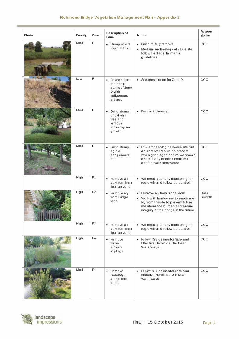
Richmond Bridge Vegetation Management Plan – Appendix 2
Page 4 Final | 15 October 2015
Photo Priority Zone Description of Issue Notes
Respon-sibility
Mod F Stump of old cypress tree.
Grind to fully remove. Medium archaelogical value site:
follow Heritage Tasmania guidelines.
CCC
Low F Revegetate the steep banks of Zone D with indigenous grasses.
See prescription for Zone D. CCC
Mod I Grind stump of old elm tree and remove suckering re-growth.
Re-plant Ulmus sp. CCC
Mod I Grind stump og old peppercorn tree.
Low archaeological value site but an observer should be present when grinding to ensure works can cease if any historical/cultural artefacts are uncovered.
CCC
High R1 Remove all boxthorn from riparian zone
Will need quarterly monitoring for regrowth and follow-up control.
CCC
High R2 Remove ivy from Bridge face.
Remove ivy from stone work. Work with landowner to eradicate
Ivy from this site to prevent future maintenance burden and ensure integrity of the bridge in the future.
State Growth
High R3 Remove all boxthorn from riparian zone
Will need quarterly monitoring for regrowth and follow-up control.
CCC
High R4 Remove willow suckers/ saplings.
Follow ‘Guidelines for Safe and Effective Herbicide Use Near Waterways’.
CCC
Mod R4 Remove Prunus sp.sucker from bank.
Follow ‘Guidelines for Safe and Effective Herbicide Use Near Waterways’.
CCC
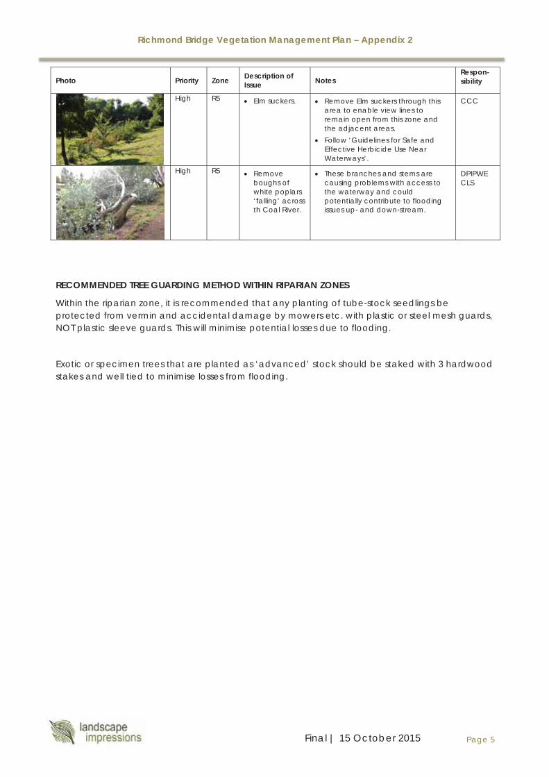
Richmond Bridge Vegetation Management Plan – Appendix 2
Page 5 Final | 15 October 2015
Photo Priority Zone Description of Issue Notes
Respon-sibility
High R5 Elm suckers. Remove Elm suckers through this area to enable view lines to remain open from this zone and the adjacent areas.
Follow ‘Guidelines for Safe and Effective Herbicide Use Near Waterways’.
CCC
High R5 Remove boughs of white poplars ‘falling’ across th Coal River.
These branches and stems are causing problems with access to the waterway and could potentially contribute to flooding issues up- and down-stream.
DPIPWE CLS
RECOMMENDED TREE GUARDING METHOD WITHIN RIPARIAN ZONES
Within the riparian zone, it is recommended that any planting of tube-stock seedlings be protected from vermin and accidental damage by mowers etc. with plastic or steel mesh guards, NOT plastic sleeve guards. This will minimise potential losses due to flooding.
Exotic or specimen trees that are planted as ‘advanced’ stock should be staked with 3 hardwood stakes and well tied to minimise losses from flooding.

24
18
5664
46
64
62
6058
54
2
39
31
35
4
38
112
Brid
ge S
t
Bathurst St
BBR
IDG
E
St J
ohn'
s C
hurc
h
Coa
l Riv
er
Cem
eter
yB
luff
St J
ohn'
s C
ir.
Ric
hmon
dG
aol
Gat
ty D
am
St J
ohn'
s S
choo
l
Mill
Hou
se
Rec
reat
ion
Res
erve
Gun
ning
St
Wellington St
St L
uke'
s C
emet
ery
SIT
E A
NA
LYS
IS P
LAN
Dat
e: 15
Oct
ober
201
5D
raw
n: D
TSc
ale:
1:2
000
Shee
t Siz
e: A
3Pr
ojec
t No.
018
3D
raw
ing
No:
018
3.B
.1Sh
eet 1
of 5
Nor
th
Ric
hmon
d B
ridge
Vege
tatio
n M
anag
emen
t Pla
nPO
Box
97 W
ynya
rd T
AS 73
25
P:
0409
6022
21
E
: don
@lan
dsca
pepla
n.com
.au
Cla
renc
e C
ity C
ounc
il La
nd
Priv
ate
Land
Priv
ate
Land
(Cat
holic
Chu
rch)
Cro
wn
Land
; CLS
Man
aged
Vege
tatio
n on
Priv
ate
Land
form
ing
back
grou
nd to
vie
ws
Exo
tic d
ecid
uous
veg
etat
ion
Exi
stin
g N
ativ
e ve
geta
tion
Eve
rgre
en e
xotic
veg
etat
ion
Key
vie
ws
TO R
ichm
ond
Brid
ge
Title
bou
ndar
y
LLEG
END
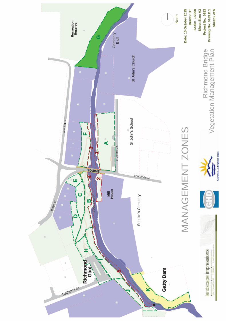
512
4
1218 52
5664
4629
66
64
62
6058
54
2
39
56
3170
3537
4
38
112
AA
BC
DE
F
I
J K
H
23
4
5
1G
Bathurst St
BRIDGE
St J
ohn'
s C
hurc
h
Coa
l Riv
er
Cem
eter
yB
luff
Ric
hmon
dG
aol
Gat
ty D
am
St J
ohn'
s S
choo
l
Mill
Hou
se
Rec
reat
ion
Res
erve
Brid
ge S
t
Gun
ning
St
Wellington St
St J
ohn'
s C
ir.
St L
uke'
s C
emet
ery
MA
NA
GE
ME
NT
ZON
ES
Dat
e: 15
Oct
ober
201
5D
raw
n: D
TSc
ale:
1:2
000
Shee
t Siz
e: A
3Pr
ojec
t No.
018
3D
raw
ing
No:
018
3.B
.1Sh
eet 2
of 5
Nor
th
Ric
hmon
d B
ridge
Vege
tatio
n M
anag
emen
t Pla
nPO
Box
97 W
ynya
rd T
AS 73
25
P:
0409
6022
21
E
: don
@lan
dsca
pepla
n.com
.au
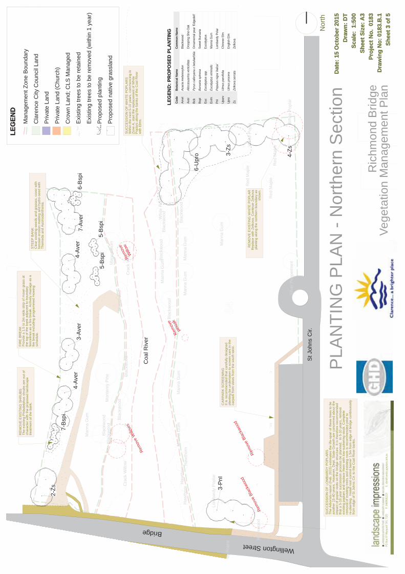
512
4
12 5664
29
Man
na G
um
Whi
te P
opla
r
Mon
tere
y P
ine
Man
na G
um
Bla
ckw
ood
Bla
ckw
ood
Haw
thor
n
Man
na G
um
orn
Haw
thor
nH
awth
orn
Man
na G
umM
anna
Gum
Man
na G
um
Man
na G
um
Silv
er P
eppe
rmin
t
Bla
ckw
ood
Cra
ck W
illow
Red
Map
le
Red
Map
le Red
Map
le
Man
na G
um
Bla
ckw
ood
Bla
ckw
ood
Bla
ckw
ood
Whi
te P
opla
r
Bla
ckw
ood
Bla
ckw
ood
Lom
bard
y P
opla
r
mba
rdy
Pop
lar B
lack
woo
d
Cra
ck W
illow
Bla
ckw
ood
Whi
te P
opla
r
3-P
nI
4-Zs
6-B
spi
7-Av
er4-
Aver
3-Av
er4-
Aver
5-B
spi
5-B
spi
6-U
pro 3-
Zs
7-B
spi
2-Zs
Wellington Street
Bridge
St J
ohns
Cir.
Coa
l Riv
er
PLA
NTI
NG
PLA
N -
Nor
ther
n S
ectio
nDD
ate:
15
Oct
ober
2015
Dra
wn:
DT
Scal
e: 1
:500
Shee
t Siz
e: A
3Pr
ojec
t No.
018
3D
raw
ing
No:
018
3.B
.1Sh
eet 3
of 5
Nor
th
Ric
hmon
d B
ridge
Vege
tatio
n M
anag
emen
t Pla
nPO
Box
97 W
ynya
rd T
AS 73
25
P:
0409
6022
21
E
: don
@lan
dsca
pepla
n.com
.au
SU
CC
ES
SIO
N O
F LO
MB
AR
DY
PO
PLA
RS
The
Arb
oris
ts re
port
(Feb
. 201
5) e
stim
ates
the
life-
span
of t
hese
tree
s to
be
anot
her 1
5-40
yea
rs. H
owev
er, D
ept.
Sta
te G
row
th a
re c
once
rned
abo
ut th
e im
pact
of p
opla
r roo
ts o
n th
e br
idge
stru
ctur
e. It
is th
eref
ore
reco
mm
ende
d th
at a
5-1
0 ye
ar s
ucce
ssio
n pr
oces
s be
pla
nned
. In
5-1
0 ye
ars,
rem
ove
exis
ting
popl
ars
and
repl
ace
them
with
low
-suc
kerin
g st
ock.
Com
plet
e re
mov
al o
f exi
stin
g tre
es a
nd e
xist
ing
root
s is
reco
mm
ende
d pr
ior t
o re
-pla
ntin
g. In
stal
l roo
t con
trol b
arrie
r 1.5
m fr
om e
dge
of b
ridge
con
tinuo
usly
from
edg
e of
St J
ohns
Cir.
to th
e C
oal R
iver
ban
ks.
SU
CC
ES
SIO
N O
F W
HIT
E P
OP
LAR
SW
ithin
the
next
5-1
0 ye
ars,
com
men
cing
inZo
ne A
, sta
rt th
e re
plac
emen
t of W
hite
Pop
lars
alo
ng th
e ba
nks
of th
e C
oal R
iver
with
Elm
s.
RE
MO
VE
EX
ISTI
NG
WH
ITE
PO
PLA
RR
epla
ce w
ith Z
elko
va. C
ontin
ue Z
elko
vapl
antin
g al
ong
the
north
ern
boun
dary
as
show
n.
CA
RPA
RK
SC
RE
EN
ING
It is
reco
mm
ende
d th
at c
aref
ully
des
igne
d pl
antin
g be
und
erta
ken
to s
cree
n ca
rs in
the
carp
ark
from
vie
ws
from
the
sout
h w
est.
STE
EP
BA
NK
Cle
ar e
xist
ing
wee
ds a
nd g
rass
es, c
over
with
he
ssia
n er
osio
n m
attin
g an
d hy
dro-
seed
with
Th
emed
a an
d A
ustro
dant
honi
a.
RE
MO
VE
EX
ISTI
NG
SH
RU
BS
The
exis
ting
Phi
lade
lphu
s sh
rubs
are
out
of
char
acte
r with
the
prop
osed
land
scap
e tre
atm
ent o
f the
ban
k.
Rem
ove
Blac
kwoo
d
Rem
ove
pino
ak
Rem
ove
Willo
ws`
Rem
ove
Willo
w
Code
Bota
nica
l Nam
eCo
mm
on N
ame
Amel
Acac
ia m
elan
oxylo
nBl
ackw
ood
Aver
Allo
casu
arin
a ve
rticil
lata
Droo
ping
She
-Oak
Bcb
Pyru
s ca
llery
ana
x be
tula
efol
iaO
rnam
enta
l pea
r 'Ed
gede
ll'
Bspi
Burs
aria
spi
nosa
Swee
t Bur
saria
Euc
Euca
lyptu
s sp
p.Eu
calyp
tus
Evim
Euca
lyptu
s vim
inal
isM
anna
Gum
PnI
Popu
lus
nigr
a 'ita
lica'
Lom
bard
y Po
lar
Upar
vUl
mus
par
vifol
iaCh
ines
e El
m
Upro
Ulm
us p
roce
raEn
glish
Elm
ZsZe
lkova
ser
rata
Zelko
va
LEG
END
: PR
OPO
SED
PLA
NTI
NG
Rem
ove
Blac
kwoo
d
LEG
END
Man
agem
ent Z
one
Bou
ndar
y
Cla
renc
e C
ity C
ounc
il La
nd
Priv
ate
Land
Priv
ate
Land
(Chu
rch)
Cro
wn
Land
; CLS
Man
aged
Exi
stin
g tre
es to
be
reta
ined
Exi
stin
g tre
es to
be
rem
oved
(with
in 1
yea
r)
Pro
pose
d pl
antin
g
Pro
pose
d na
tive
gras
slan
d
thor
nH
aw 4-Av
er
FIR
E B
RE
AK
Pro
vide
a 1
.5 to
2m
wid
e st
rip o
f mow
n gr
ass
at th
e to
p of
the
bank
adj
acen
t to
boun
dary
fenc
elin
es a
s a
fire
brea
k. A
ctiv
ely
man
age
as a
fire
brea
k in
clud
ing
prog
ram
med
mow
ing
sche
dule
.
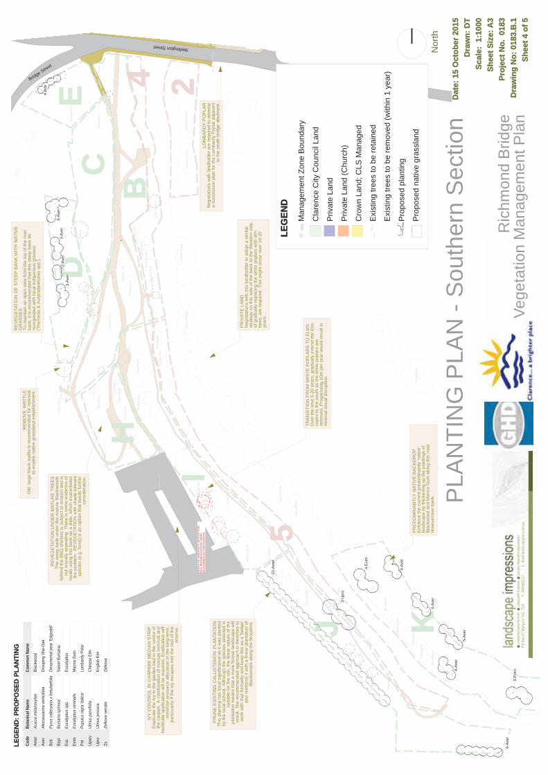
66
64
62
6058
2
39
56
3170
3537
4
38
11
BC
DE
I
J K
H
24
5
Eng
lish
Elm
Whi
te P
opla
r
Whi
te P
opla
r
Whi
te P
opla
r
Whi
te P
opla
r
Bla
ckw
ood
Bla
ckw
ood
Bla
ckw
ood
Bla
ckw
ood
Eng
lish
Elm
Mon
tere
y P
ine
Eng
lish
Elm
Bla
ckw
ood
Com
mon
Ash
Chi
nese
Elm
Eng
lish
Elm
Silv
er W
attle
Pep
perc
orn
Pep
perc
orn
Hon
ey M
yrtleSilv
er P
eppe
rmin
t
Silv
er W
attle
Bla
ckw
ood
Eng
lish
Elm
Eng
lish
Elm
Eng
lish
Elm
Eng
lish
Elm
Pep
perc
orn
Pep
perc
orn
Pep
perc
orn
Pep
perc
orn
Cra
ck W
illow
Cra
ck W
illow
Cra
ck W
illow
Whi
te P
opla
r
Eng
lish
Elm
Bla
ckw
ood
Pep
perc
orn
Euc
alyp
tus
Euc
alyp
tus Blu
e G
um
Whi
te P
opla
r
Lom
bard
y P
opla
r Bla
ckw
ood
Wee
ping
Willo
w
Com
mon
Ash
Turk
ish
Oak
Silv
er W
attle
Silv
er W
attle
Bla
ckw
ood
Bla
ckw
ood
Bla
ckw
ood
Bla
ckw
ood
Bla
ckw
ood
Haw
thor
nSilv
er W
attle
5-Av
er
3-Av
er2-
Aver
3-Av
er
6-Av
er
22-A
mel
3-U
pro
4-Av
er
4-Av
er
5-Av
er
4-E
vim
3-E
vim
4-B
cb
4-Av
er
RE
FER
TO
AR
BO
RIS
TS R
EP
OR
T FO
R G
PS
RE
FER
EN
CE
S F
OR
TR
EE
S R
EC
OM
ME
ND
ED
FO
R R
EM
OVA
L
Wellington Street
Bridge Street
Code
Bota
nica
l Nam
eCo
mm
on N
ame
Amel
Acac
ia m
elan
oxylo
nBl
ackw
ood
Aver
Allo
casu
arin
a ve
rticil
lata
Droo
ping
She
-Oak
Bcb
Pyru
s ca
llery
ana
x be
tula
efol
iaO
rnam
enta
l pea
r 'Ed
gede
ll'
Bspi
Burs
aria
spi
nosa
Swee
t Bur
saria
Euc
Euca
lyptu
s sp
p.Eu
calyp
tus
Evim
Euca
lyptu
s vim
inal
isM
anna
Gum
PnI
Popu
lus
nigr
a 'ita
lica'
Lom
bard
y Po
lar
Upar
vUl
mus
par
vifol
iaCh
ines
e El
m
Upro
Ulm
us p
roce
raEn
glish
Elm
ZsZe
lkova
ser
rata
Zelko
va
PLA
NTI
NG
PLA
N -
Sou
ther
n S
ectio
nD
ate:
15 O
ctob
er 2
015
Dra
wn:
DT
Scal
e: 1
:100
0Sh
eet S
ize:
A3
Proj
ect N
o. 0
183
Dra
win
g N
o: 0
183.
B.1
Shee
t 4 o
f 5
Nor
th
Ric
hmon
d B
ridge
Vege
tatio
n M
anag
emen
t Pla
nPO
Box
97 W
ynya
rd T
AS 73
25
P:
0409
6022
21
E
: don
@lan
dsca
pepla
n.com
.au
IVY
CO
NTR
OL
IN C
AR
PAR
K M
ED
IAN
STR
IPE
radi
cate
the
Ivy
in th
e ga
rden
bed
in th
e ce
ntre
of
the
carp
ark.
A c
ombi
natio
n of
man
ual r
emov
al a
ndhe
rbic
ide
appl
icat
ion
will
be
requ
ired.
Era
dica
tion
will
min
imis
e re
sour
ce a
lloca
tion
in th
e lo
ng-te
rm,
parti
cula
rly if
the
ivy
esca
pes
into
the
rest
of t
here
serv
e.
RE
VE
GE
TATI
ON
UN
DE
R M
ATU
RE
TR
EE
STh
e st
eep
bank
und
er th
e m
atur
e B
lack
woo
dsbe
hind
the
BB
Q s
helte
rs is
sub
ject
to e
rosi
on a
nd is
not v
isua
lly a
ppea
ling.
The
re is
som
e ev
iden
ce o
flo
cals
usi
ng th
is b
ank
as a
slid
e, w
hich
exa
cerb
ates
the
prob
lem
. R
EV
EG
ETA
TIO
N w
ith s
hade
-tole
rant
spec
ies
(e.g
. fer
ns) i
s an
opt
ion
that
nee
ds fu
rther
cons
ider
atio
n.
PR
UN
E E
XIS
TIN
G C
ALL
ISTE
MO
N P
LAN
TATI
ON
This
pla
ntin
g ha
s lo
cal s
igni
fican
ce a
s it
was
pla
nted
by th
e lo
cal s
choo
l. A
lthou
gh th
e sp
ecie
s se
lect
ed is
suita
ble
for t
he s
ite, t
he li
near
nat
ure
of th
epl
anta
tion
mea
ns th
at a
mor
e fo
rmal
land
scap
e w
illre
sult.
The
reco
mm
ende
d ap
proa
ch is
ther
efor
e to
wor
k w
ith th
at fo
rmal
ity a
nd k
eep
this
as
a 'h
edge
'an
d re
info
rce
it w
ith a
line
ar p
lant
atio
n of
Bla
ckw
oods
alo
ng th
e fe
ncel
ine.
PR
ED
OM
INA
NTL
Y N
ATIV
E B
AC
KD
RO
PE
nhan
ce th
e cu
rren
t pre
dom
inan
tly 'n
ativ
e' la
ndsc
ape
by th
icke
ning
up
the
plan
tings
of
Bla
ckw
ood
and
Man
na G
um a
long
this
road
re
serv
e/riv
er b
ank.
PR
IVAT
E L
AN
DN
egot
iatio
ns w
ith th
is la
ndho
lder
to a
dopt
a s
imila
r st
rate
gy o
n th
is s
ide
of th
e ba
nk to
the
Wes
tern
sid
e, of
gra
dual
ly re
plac
ing
the
whi
te p
opla
rs w
ith e
lm
trees
, are
requ
ired.
Thi
s m
ight
occ
ur o
ver 1
0-20
ye
ars.
TRA
NS
ITIO
N F
RO
M W
HIT
E P
OP
LAR
S T
O E
LMS
Ove
r the
nex
t 5-2
0 ye
ars,
gra
dual
ly e
xten
d th
e E
lm
cope
s to
the
sout
h as
the
whi
te p
opla
rs a
re re
mov
ed. P
rogr
essi
ng 1
0m p
er y
ear w
ould
resu
lt in
min
imal
vis
ual d
isru
ptio
n.
LOM
BA
RD
Y P
OP
LAR
Neg
otia
tions
with
land
hold
er a
re re
quire
d to
dev
elop
a su
cces
sion
pla
n fo
r the
Lom
bard
y P
opla
r adj
acen
tto
the
sout
h br
idge
abu
tmen
t.
RE
VE
GE
TATI
ON
OF
STE
EP
BA
NK
WIT
H N
ATIV
E G
RA
SS
ES
To m
aint
ain
an o
pen
view
from
the
top
of th
e riv
er ba
nk, i
t is
reco
mm
ende
d th
at th
is s
teep
ban
k be
re
vege
tate
d w
ith lo
cal i
ndig
enou
s gr
asse
s (T
hem
eda
& A
ustro
dant
honi
a sp
p.).
RE
MO
VE
WAT
TLE
Old
, lar
ge b
lack
wat
tle is
reco
mm
ende
d fo
r rem
oval
to e
nabl
e na
tive
gras
slan
d es
tabl
ishm
ent.
LEG
END
Man
agem
ent Z
one
Bou
ndar
y
Cla
renc
e C
ity C
ounc
il La
nd
Priv
ate
Land
Priv
ate
Land
(Chu
rch)
Cro
wn
Land
; CLS
Man
aged
Exi
stin
g tre
es to
be
reta
ined
Exi
stin
g tre
es to
be
rem
oved
(with
in 1
yea
r)
Pro
pose
d pl
antin
g
Pro
pose
d na
tive
gras
slan
d
thor
nH
aw 4-Av
er
LEG
END
: PR
OPO
SED
PLA
NTI
NG
31
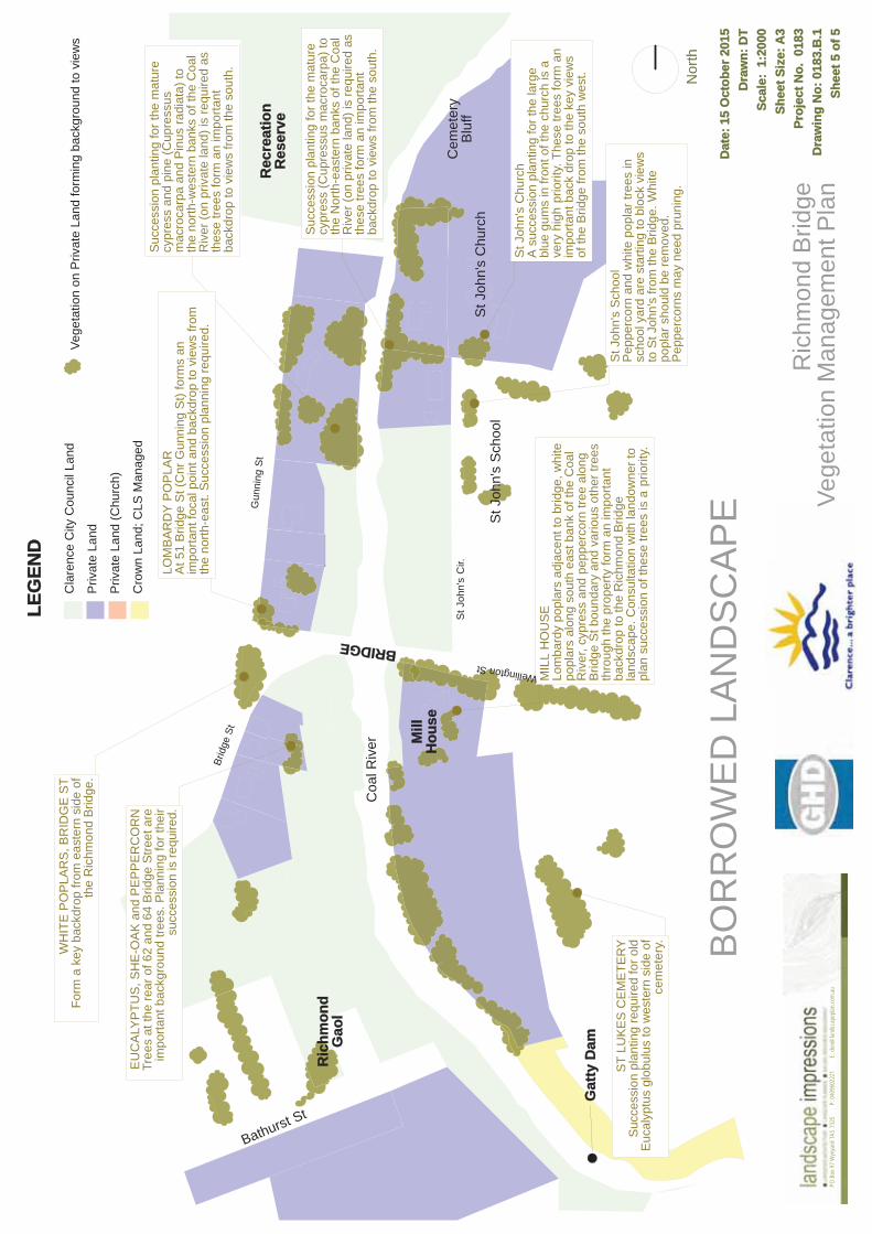
St J
ohn'
s C
hurc
hA
suc
cess
ion
plan
ting
for t
he la
rge
blue
gum
s in
fron
t of t
he c
hurc
h is
ave
ry h
igh
prio
rity.
The
se tr
ees
form
an
impo
rtant
bac
k dr
op to
the
key
view
s of
the
Brid
ge fr
om th
e so
uth
wes
t.
Suc
cess
ion
plan
ting
for t
he m
atur
e cy
pres
s an
d pi
ne (C
upre
ssus
m
acro
carp
a an
d P
inus
radi
ata)
to
the
north
-wes
tern
ban
ks o
f the
Coa
l R
iver
(on
priv
ate
land
) is
requ
ired
as
thes
e tre
es fo
rm a
n im
porta
nt ba
ckdr
op to
vie
ws
from
the
sout
h.
ST
LUK
ES
CE
ME
TER
YS
ucce
ssio
n pl
antin
g re
quire
d fo
r old
Euc
alyp
tus
glob
ulus
to w
este
rn s
ide
ofce
met
ery.
MIL
L H
OU
SE
Lom
bard
y po
plar
s ad
jace
nt to
brid
ge, w
hite
popl
ars
alon
g so
uth
east
ban
k of
the
Coa
l R
iver
, cyp
ress
and
pep
perc
orn
tree
alon
g B
ridge
St b
ound
ary
and
vario
us o
ther
tree
s th
roug
h th
e pr
oper
ty fo
rm a
n im
porta
nt ba
ckdr
op to
the
Ric
hmon
d B
ridge
la
ndsc
ape.
Con
sulta
tion
with
land
owne
r to
plan
suc
cess
ion
of th
ese
trees
is a
prio
rity.
WH
ITE
PO
PLA
RS
, BR
IDG
E S
TFo
rm a
key
bac
kdro
p fro
m e
aste
rn s
ide
ofth
e R
ichm
ond
Brid
ge.
LOM
BA
RD
Y P
OP
LAR
At 5
1 B
ridge
St (
Cnr
Gun
ning
St)
form
s an
im
porta
nt fo
cal p
oint
and
bac
kdro
p to
vie
ws
from
the
north
-eas
t. S
ucce
ssio
n pl
anni
ng re
quire
d.
EU
CA
LYP
TUS
, SH
E-O
AK
and
PE
PP
ER
CO
RN
Tree
s at
the
rear
of 6
2 an
d 64
Brid
ge S
treet
are
impo
rtant
bac
kgro
und
trees
. Pla
nnin
g fo
r the
irsu
cces
sion
is re
quire
d.
St J
ohn'
s S
choo
lP
eppe
rcor
n an
d w
hite
pop
lar t
rees
insc
hool
yar
d ar
e st
artin
g to
blo
ck v
iew
s to
St J
ohn'
s fro
m th
e B
ridge
. Whi
te po
plar
sho
uld
be re
mov
ed.
Pep
perc
orns
may
nee
d pr
unin
g.
Brid
ge S
t
Bathurst St
BRIDGE
St J
ohn'
s C
hurc
h
Coa
l Riv
er
Cem
eter
yB
luff
St J
ohn'
s C
ir.
Ric
hmon
dG
aol
Gat
ty D
am
St J
ohn'
s S
choo
l
Mill
Hou
se
Rec
reat
ion
Res
erve
Gun
ning
St
Wellington St
Suc
cess
ion
plan
ting
for t
he m
atur
e cy
pres
s (C
upre
ssus
mac
roca
rpa)
to
the
Nor
th-e
aste
rn b
anks
of t
he C
oal
Riv
er (o
n pr
ivat
e la
nd) i
s re
quire
d as
th
ese
trees
form
an
impo
rtant
back
drop
to v
iew
s fro
m th
e so
uth.
BO
RR
OW
ED
LA
ND
SC
AP
ED
ate:
15 O
ctob
er 2
015
Dra
wn:
DT
Scal
e: 1
:200
0Sh
eet S
ize:
A3
Proj
ect N
o. 0
183
Dra
win
g N
o: 0
183.
B.1
Shee
t 5 o
f 5
Nor
th
Ric
hmon
d B
ridge
Vege
tatio
n M
anag
emen
t Pla
nPO
Box
97 W
ynya
rd T
AS 73
25
P:
0409
6022
21
E
: don
@lan
dsca
pepla
n.com
.au
Cla
renc
e C
ity C
ounc
il La
nd
Priv
ate
Land
Priv
ate
Land
(Chu
rch)
Cro
wn
Land
; CLS
Man
aged
Vege
tatio
n on
Priv
ate
Land
form
ing
back
grou
nd to
vie
ws
LLEG
END

Richmond Bridge Conservation Management Plan 15 December 2017 215
APPENDIX 3: HERITAGE LISTINGS
Appendix 3: Heritage Listings
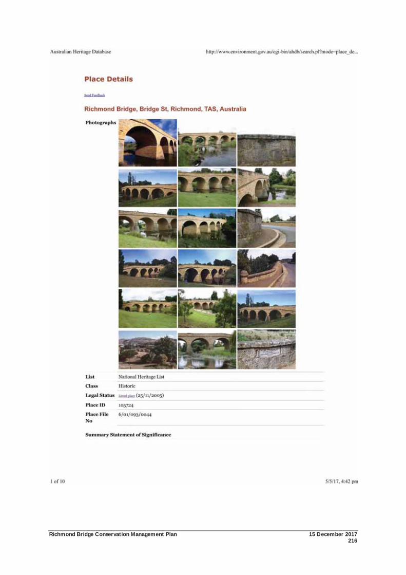
Richmond Bridge Conservation Management Plan 15 December 2017 216
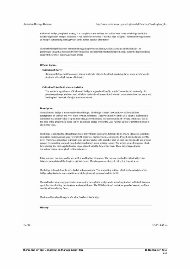
Richmond Bridge Conservation Management Plan 15 December 2017 217
Richmond Bridge Conservation Management Plan 15 December 2017 218
Richmond Bridge Conservation Management Plan 15 December 2017 219
Richmond Bridge Conservation Management Plan 15 December 2017 220
Richmond Bridge Conservation Management Plan 15 December 2017 221
Richmond Bridge Conservation Management Plan 15 December 2017 222
Richmond Bridge Conservation Management Plan 15 December 2017 223

Richmond Bridge Conservation Management Plan 15 December 2017 224
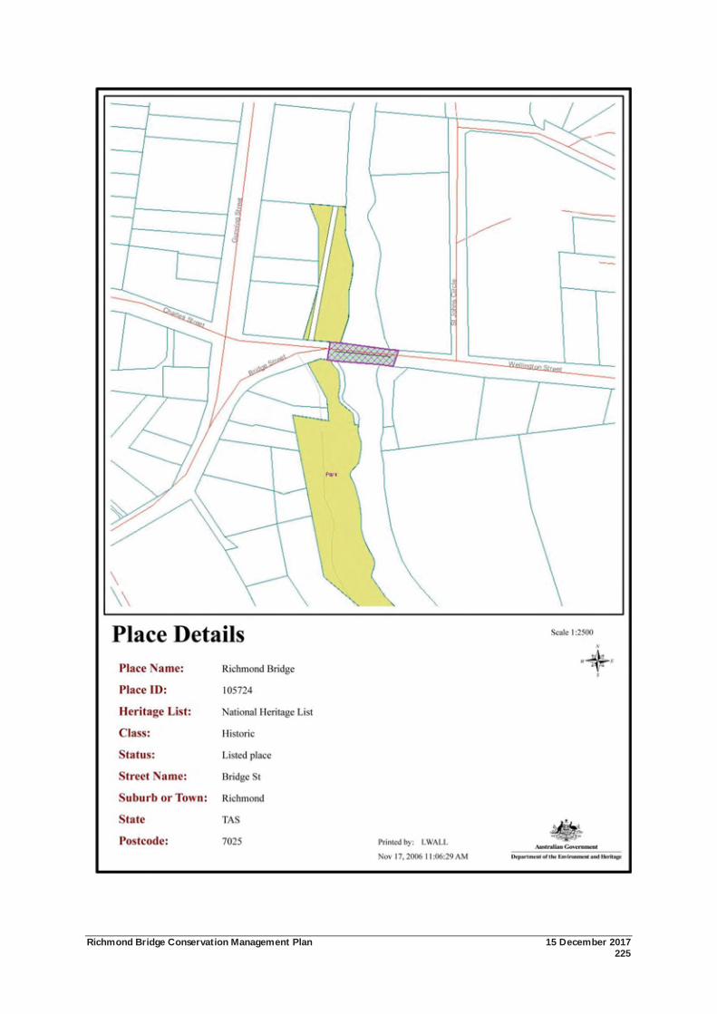
Richmond Bridge Conservation Management Plan 15 December 2017 225
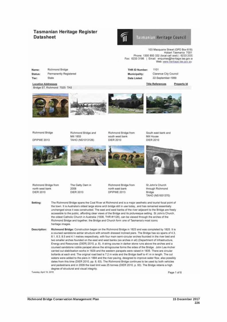
Richmond Bridge Conservation Management Plan 15 December 2017 226
Richmond Bridge Conservation Management Plan 15 December 2017 227
Richmond Bridge Conservation Management Plan 15 December 2017 228
Richmond Bridge Conservation Management Plan 15 December 2017 229
Richmond Bridge Conservation Management Plan 15 December 2017 230
Richmond Bridge Conservation Management Plan 15 December 2017 231
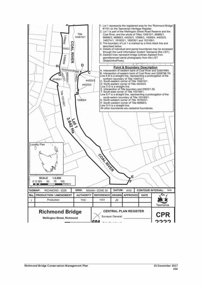
Richmond Bridge Conservation Management Plan 15 December 2017 232

Richmond Bridge Conservation Management Plan 15 December 2017 233
APPENDIX 4: ABORIGINAL HERITAGE UNANTICIPATED DISCOVERY PLAN
Appendix 4: Aboriginal Heritage Unanticipated Discovery Plan
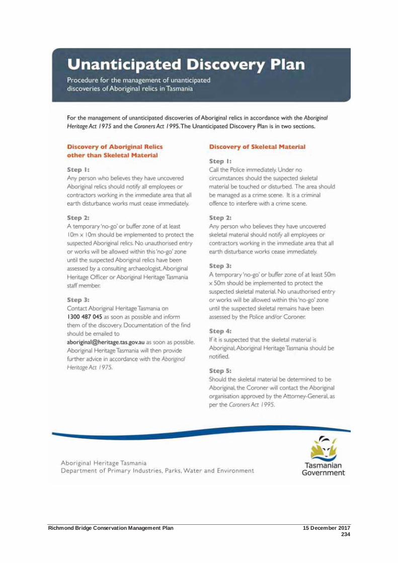
Richmond Bridge Conservation Management Plan 15 December 2017 234
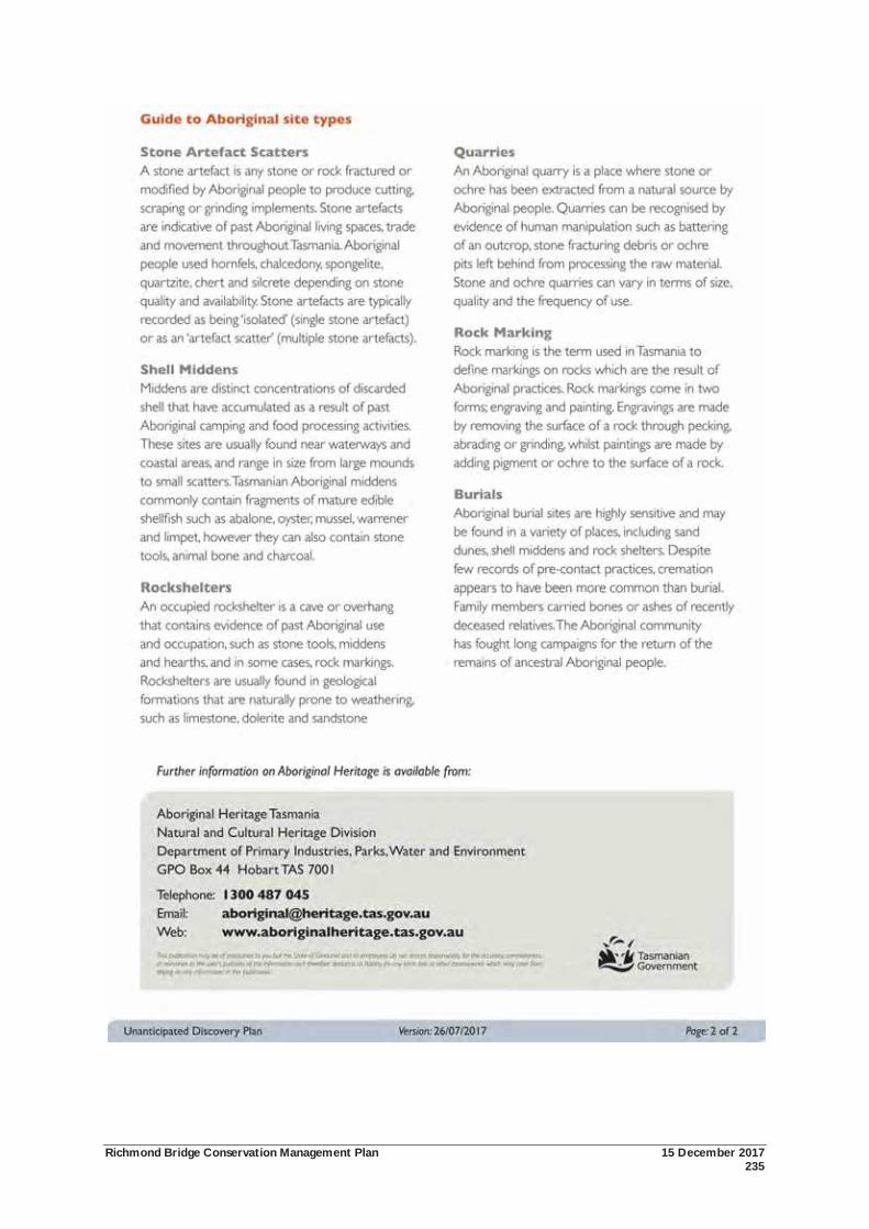
Richmond Bridge Conservation Management Plan 15 December 2017 235

Richmond Bridge Conservation Management Plan 15 December 2017 236
APPENDIX 5: 1997 & 2010 CONSERVATION POLICY IMPLEMENTATION
Appendix 5: 1997 & 2010 Conservation Policy Implementation
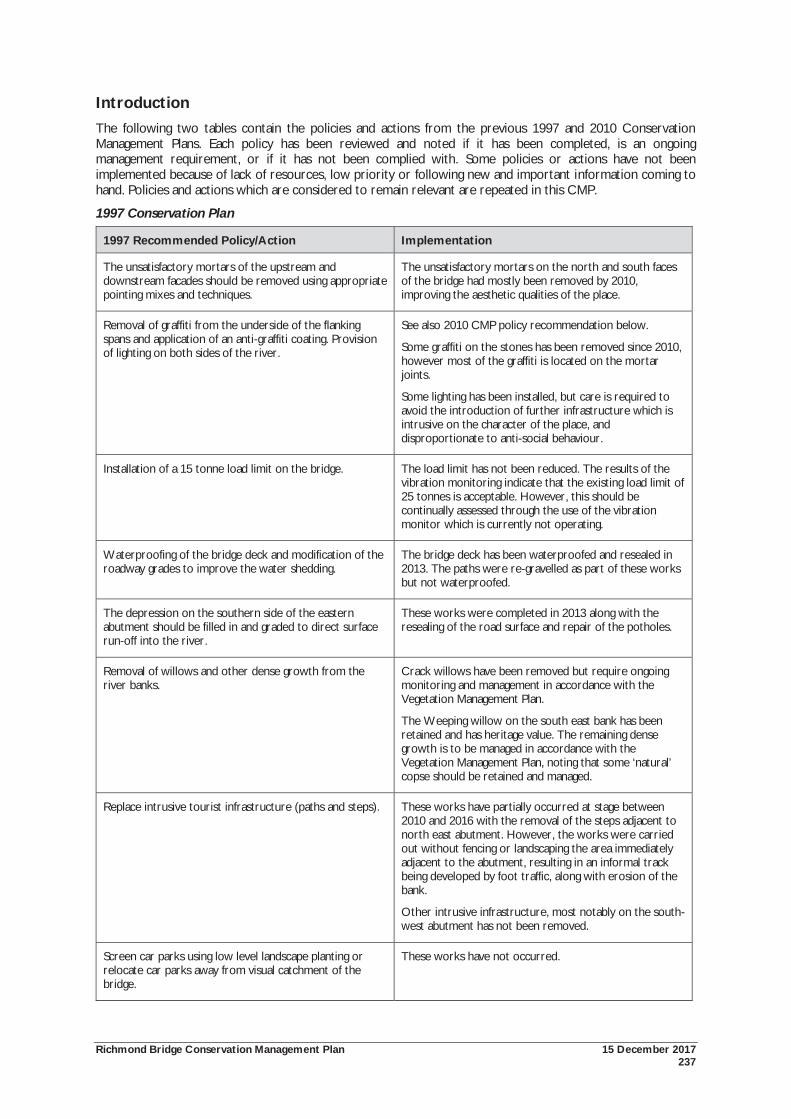
Richmond Bridge Conservation Management Plan 15 December 2017 237
Introduction The following two tables contain the policies and actions from the previous 1997 and 2010 Conservation Management Plans. Each policy has been reviewed and noted if it has been completed, is an ongoing management requirement, or if it has not been complied with. Some policies or actions have not been implemented because of lack of resources, low priority or following new and important information coming to hand. Policies and actions which are considered to remain relevant are repeated in this CMP.
1997 Conservation Plan
1997 Recommended Policy/Action Implementation
The unsatisfactory mortars of the upstream and downstream facades should be removed using appropriate pointing mixes and techniques.
The unsatisfactory mortars on the north and south faces of the bridge had mostly been removed by 2010, improving the aesthetic qualities of the place.
Removal of graffiti from the underside of the flanking spans and application of an anti-graffiti coating. Provision of lighting on both sides of the river.
See also 2010 CMP policy recommendation below.
Some graffiti on the stones has been removed since 2010, however most of the graffiti is located on the mortar joints.
Some lighting has been installed, but care is required to avoid the introduction of further infrastructure which is intrusive on the character of the place, and disproportionate to anti-social behaviour.
Installation of a 15 tonne load limit on the bridge. The load limit has not been reduced. The results of the vibration monitoring indicate that the existing load limit of 25 tonnes is acceptable. However, this should be continually assessed through the use of the vibration monitor which is currently not operating.
Waterproofing of the bridge deck and modification of the roadway grades to improve the water shedding.
The bridge deck has been waterproofed and resealed in 2013. The paths were re-gravelled as part of these works but not waterproofed.
The depression on the southern side of the eastern abutment should be filled in and graded to direct surface run-off into the river.
These works were completed in 2013 along with the resealing of the road surface and repair of the potholes.
Removal of willows and other dense growth from the river banks.
Crack willows have been removed but require ongoing monitoring and management in accordance with the Vegetation Management Plan.
The Weeping willow on the south east bank has been retained and has heritage value. The remaining dense growth is to be managed in accordance with the Vegetation Management Plan, noting that some ‘natural’ copse should be retained and managed.
Replace intrusive tourist infrastructure (paths and steps). These works have partially occurred at stage between 2010 and 2016 with the removal of the steps adjacent to north east abutment. However, the works were carried out without fencing or landscaping the area immediately adjacent to the abutment, resulting in an informal track being developed by foot traffic, along with erosion of the bank.
Other intrusive infrastructure, most notably on the south-west abutment has not been removed.
Screen car parks using low level landscape planting or relocate car parks away from visual catchment of the bridge.
These works have not occurred.

Richmond Bridge Conservation Management Plan 15 December 2017 238
1997 Recommended Policy/Action Implementation
As part of the ongoing maintenance, the bridge should be inspected annually for pointing and stormwater defects, flood damage and cracking movements.
State Growth makes annual inspections of the condition of the bridge.
As part of the ongoing maintenance, terrestrial photogrammetrical plotting should be carried out on a 5 year basis to monitor long term settlement of the arches and foundations.
State Growth has undertaken laser scanning of the bridge which provides a more accurate recording than terrestrial photogrammetrical plotting.
As part of the ongoing maintenance, regular police surveillance of the bridge.
It is unknown whether surveillance occurs.
2010 Conservation Management Plan
2010 Recommended Policy/Action Implementation
General Conservation Policies
7.2.1 General Policy
That the Richmond Bridge and its setting must be conserved as a place of exceptional cultural significance to the nation, Tasmania, and the local community.
All elements of cultural significance that form part of the Richmond Bridge and its setting should be retained and conserved.
The place is to be managed in accordance with the policies of this Conservation Management Plan and the guidelines and philosophy of the Australia ICOMOS Burra Charter (the Burra Charter).
Ongoing. The cultural significance of the place has been maintained.
7.2.2 Managing the National Heritage Values
That the National Heritage Values of the Richmond Bridge be managed in accordance with the National Heritage Management Principles and the provisions of the EPBC Act 1999.
Ongoing. The National Heritage Values of the place have been maintained.
7.2.3 Cultural Significance
That the cultural significance of the Richmond Bridge is comprised in the place itself, its fabric, setting, use, associations, meanings, and related places.
The cultural significance of the fabric of the bridge is recognised as being demonstrated by its evolution to 1923. The fabric of the bridge post-1923 is of no appreciable cultural significance.
That the cultural significance of the place beyond the bridge is embodied in certain elements of fabric, the setting, use, associations and meanings.
Ongoing.
7.2.4 Levels of Cultural Significance
That the various elements that form the place have different levels of cultural significance (see also policy 7.2.5).
Ongoing
7.2.5 Applying Levels of Cultural Significance in Ongoing.
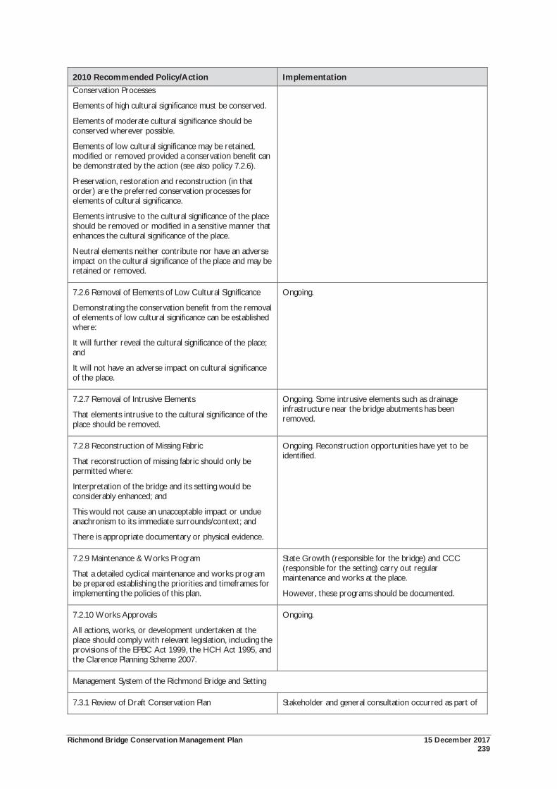
Richmond Bridge Conservation Management Plan 15 December 2017 239
2010 Recommended Policy/Action Implementation Conservation Processes
Elements of high cultural significance must be conserved.
Elements of moderate cultural significance should be conserved wherever possible.
Elements of low cultural significance may be retained, modified or removed provided a conservation benefit can be demonstrated by the action (see also policy 7.2.6).
Preservation, restoration and reconstruction (in that order) are the preferred conservation processes for elements of cultural significance.
Elements intrusive to the cultural significance of the place should be removed or modified in a sensitive manner that enhances the cultural significance of the place.
Neutral elements neither contribute nor have an adverse impact on the cultural significance of the place and may be retained or removed.
7.2.6 Removal of Elements of Low Cultural Significance
Demonstrating the conservation benefit from the removal of elements of low cultural significance can be established where:
It will further reveal the cultural significance of the place; and
It will not have an adverse impact on cultural significance of the place.
Ongoing.
7.2.7 Removal of Intrusive Elements
That elements intrusive to the cultural significance of the place should be removed.
Ongoing. Some intrusive elements such as drainage infrastructure near the bridge abutments has been removed.
7.2.8 Reconstruction of Missing Fabric
That reconstruction of missing fabric should only be permitted where:
Interpretation of the bridge and its setting would be considerably enhanced; and
This would not cause an unacceptable impact or undue anachronism to its immediate surrounds/context; and
There is appropriate documentary or physical evidence.
Ongoing. Reconstruction opportunities have yet to be identified.
7.2.9 Maintenance & Works Program
That a detailed cyclical maintenance and works program be prepared establishing the priorities and timeframes for implementing the policies of this plan.
State Growth (responsible for the bridge) and CCC (responsible for the setting) carry out regular maintenance and works at the place.
However, these programs should be documented.
7.2.10 Works Approvals
All actions, works, or development undertaken at the place should comply with relevant legislation, including the provisions of the EPBC Act 1999, the HCH Act 1995, and the Clarence Planning Scheme 2007.
Ongoing.
Management System of the Richmond Bridge and Setting
7.3.1 Review of Draft Conservation Plan Stakeholder and general consultation occurred as part of
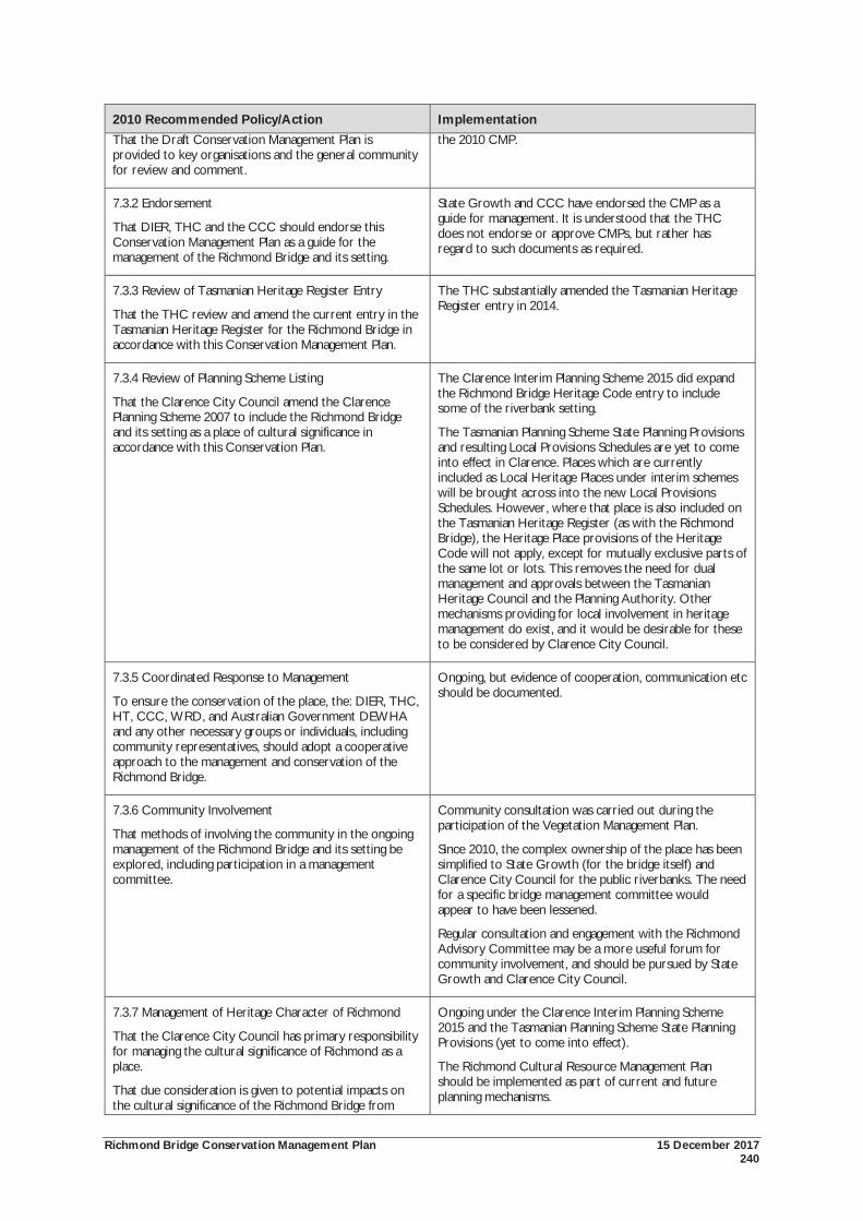
Richmond Bridge Conservation Management Plan 15 December 2017 240
2010 Recommended Policy/Action Implementation That the Draft Conservation Management Plan is provided to key organisations and the general community for review and comment.
the 2010 CMP.
7.3.2 Endorsement
That DIER, THC and the CCC should endorse this Conservation Management Plan as a guide for the management of the Richmond Bridge and its setting.
State Growth and CCC have endorsed the CMP as a guide for management. It is understood that the THC does not endorse or approve CMPs, but rather has regard to such documents as required.
7.3.3 Review of Tasmanian Heritage Register Entry
That the THC review and amend the current entry in the Tasmanian Heritage Register for the Richmond Bridge in accordance with this Conservation Management Plan.
The THC substantially amended the Tasmanian Heritage Register entry in 2014.
7.3.4 Review of Planning Scheme Listing
That the Clarence City Council amend the Clarence Planning Scheme 2007 to include the Richmond Bridge and its setting as a place of cultural significance in accordance with this Conservation Plan.
The Clarence Interim Planning Scheme 2015 did expand the Richmond Bridge Heritage Code entry to include some of the riverbank setting.
The Tasmanian Planning Scheme State Planning Provisions and resulting Local Provisions Schedules are yet to come into effect in Clarence. Places which are currently included as Local Heritage Places under interim schemes will be brought across into the new Local Provisions Schedules. However, where that place is also included on the Tasmanian Heritage Register (as with the Richmond Bridge), the Heritage Place provisions of the Heritage Code will not apply, except for mutually exclusive parts of the same lot or lots. This removes the need for dual management and approvals between the Tasmanian Heritage Council and the Planning Authority. Other mechanisms providing for local involvement in heritage management do exist, and it would be desirable for these to be considered by Clarence City Council.
7.3.5 Coordinated Response to Management
To ensure the conservation of the place, the: DIER, THC, HT, CCC, WRD, and Australian Government DEWHA and any other necessary groups or individuals, including community representatives, should adopt a cooperative approach to the management and conservation of the Richmond Bridge.
Ongoing, but evidence of cooperation, communication etc should be documented.
7.3.6 Community Involvement
That methods of involving the community in the ongoing management of the Richmond Bridge and its setting be explored, including participation in a management committee.
Community consultation was carried out during the participation of the Vegetation Management Plan.
Since 2010, the complex ownership of the place has been simplified to State Growth (for the bridge itself) and Clarence City Council for the public riverbanks. The need for a specific bridge management committee would appear to have been lessened.
Regular consultation and engagement with the Richmond Advisory Committee may be a more useful forum for community involvement, and should be pursued by State Growth and Clarence City Council.
7.3.7 Management of Heritage Character of Richmond
That the Clarence City Council has primary responsibility for managing the cultural significance of Richmond as a place.
That due consideration is given to potential impacts on the cultural significance of the Richmond Bridge from
Ongoing under the Clarence Interim Planning Scheme 2015 and the Tasmanian Planning Scheme State Planning Provisions (yet to come into effect).
The Richmond Cultural Resource Management Plan should be implemented as part of current and future planning mechanisms.
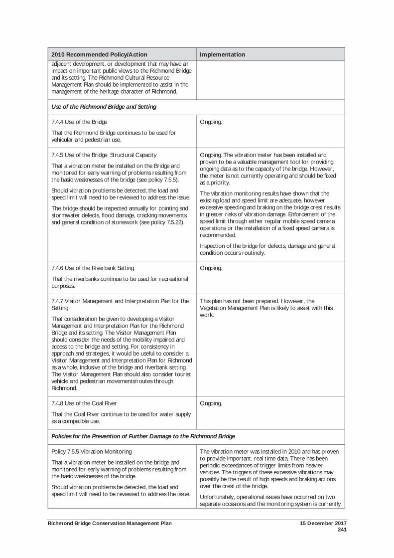
Richmond Bridge Conservation Management Plan 15 December 2017 241
2010 Recommended Policy/Action Implementation adjacent development, or development that may have an impact on important public views to the Richmond Bridge and its setting. The Richmond Cultural Resource Management Plan should be implemented to assist in the management of the heritage character of Richmond.
Use of the Richmond Bridge and Setting
7.4.4 Use of the Bridge
That the Richmond Bridge continues to be used for vehicular and pedestrian use.
Ongoing.
7.4.5 Use of the Bridge: Structural Capacity
That a vibration meter be installed on the Bridge and monitored for early warning of problems resulting from the basic weaknesses of the bridge (see policy 7.5.5).
Should vibration problems be detected, the load and speed limit will need to be reviewed to address the issue.
The bridge should be inspected annually for pointing and stormwater defects, flood damage, cracking movements and general condition of stonework (see policy 7.5.22).
Ongoing. The vibration meter has been installed and proven to be a valuable management tool for providing ongoing data as to the capacity of the bridge. However, the meter is not currently operating and should be fixed as a priority.
The vibration monitoring results have shown that the existing load and speed limit are adequate, however excessive speeding and braking on the bridge crest results in greater risks of vibration damage. Enforcement of the speed limit through either regular mobile speed camera operations or the installation of a fixed speed camera is recommended.
Inspection of the bridge for defects, damage and general condition occurs routinely.
7.4.6 Use of the Riverbank Setting
That the riverbanks continue to be used for recreational purposes.
Ongoing.
7.4.7 Visitor Management and Interpretation Plan for the Setting
That consideration be given to developing a Visitor Management and Interpretation Plan for the Richmond Bridge and its setting. The Visitor Management Plan should consider the needs of the mobility impaired and access to the bridge and setting. For consistency in approach and strategies, it would be useful to consider a Visitor Management and Interpretation Plan for Richmond as a whole, inclusive of the bridge and riverbank setting. The Visitor Management Plan should also consider tourist vehicle and pedestrian movements/routes through Richmond.
This plan has not been prepared. However, the Vegetation Management Plan is likely to assist with this work.
7.4.8 Use of the Coal River
That the Coal River continue to be used for water supply as a compatible use.
Ongoing.
Policies for the Prevention of Further Damage to the Richmond Bridge
Policy 7.5.5 Vibration Monitoring
That a vibration meter be installed on the bridge and monitored for early warning of problems resulting from the basic weaknesses of the bridge.
Should vibration problems be detected, the load and speed limit will need to be reviewed to address the issue.
The vibration meter was installed in 2010 and has proven to provide important, real time data. There has been periodic exceedances of trigger limits from heavier vehicles. The triggers of these excessive vibrations may possibly be the result of high speeds and braking actions over the crest of the bridge.
Unfortunately, operational issues have occurred on two separate occasions and the monitoring system is currently
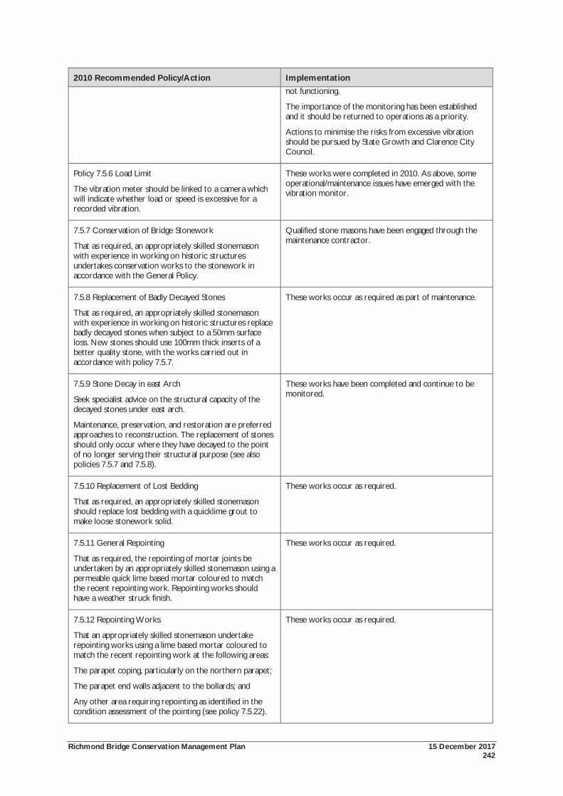
Richmond Bridge Conservation Management Plan 15 December 2017 242
2010 Recommended Policy/Action Implementation not functioning.
The importance of the monitoring has been established and it should be returned to operations as a priority.
Actions to minimise the risks from excessive vibration should be pursued by State Growth and Clarence City Council.
Policy 7.5.6 Load Limit
The vibration meter should be linked to a camera which will indicate whether load or speed is excessive for a recorded vibration.
These works were completed in 2010. As above, some operational/maintenance issues have emerged with the vibration monitor.
7.5.7 Conservation of Bridge Stonework
That as required, an appropriately skilled stonemason with experience in working on historic structures undertakes conservation works to the stonework in accordance with the General Policy.
Qualified stone masons have been engaged through the maintenance contractor.
7.5.8 Replacement of Badly Decayed Stones
That as required, an appropriately skilled stonemason with experience in working on historic structures replace badly decayed stones when subject to a 50mm surface loss. New stones should use 100mm thick inserts of a better quality stone, with the works carried out in accordance with policy 7.5.7.
These works occur as required as part of maintenance.
7.5.9 Stone Decay in east Arch
Seek specialist advice on the structural capacity of the decayed stones under east arch.
Maintenance, preservation, and restoration are preferred approaches to reconstruction. The replacement of stones should only occur where they have decayed to the point of no longer serving their structural purpose (see also policies 7.5.7 and 7.5.8).
These works have been completed and continue to be monitored.
7.5.10 Replacement of Lost Bedding
That as required, an appropriately skilled stonemason should replace lost bedding with a quicklime grout to make loose stonework solid.
These works occur as required.
7.5.11 General Repointing
That as required, the repointing of mortar joints be undertaken by an appropriately skilled stonemason using a permeable quick lime based mortar coloured to match the recent repointing work. Repointing works should have a weather struck finish.
These works occur as required.
7.5.12 Repointing Works
That an appropriately skilled stonemason undertake repointing works using a lime based mortar coloured to match the recent repointing work at the following areas:
The parapet coping, particularly on the northern parapet;
The parapet end walls adjacent to the bollards; and
Any other area requiring repointing as identified in the condition assessment of the pointing (see policy 7.5.22).
These works occur as required.
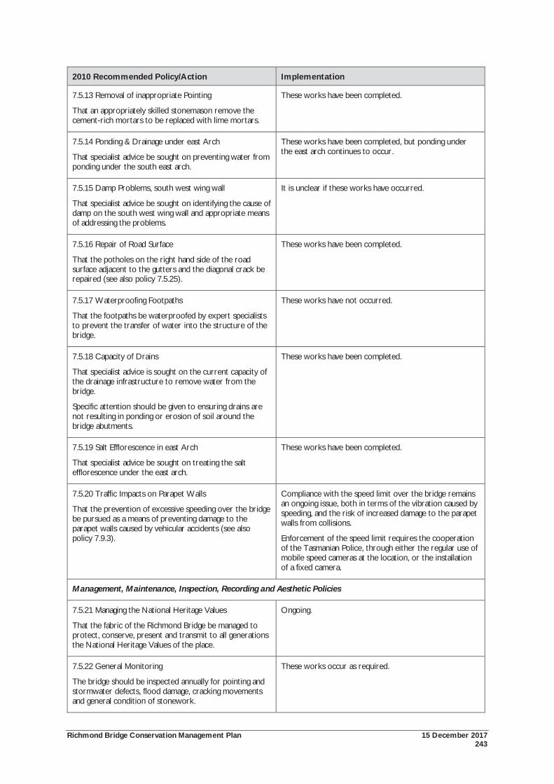
Richmond Bridge Conservation Management Plan 15 December 2017 243
2010 Recommended Policy/Action Implementation
7.5.13 Removal of inappropriate Pointing
That an appropriately skilled stonemason remove the cement-rich mortars to be replaced with lime mortars.
These works have been completed.
7.5.14 Ponding & Drainage under east Arch
That specialist advice be sought on preventing water from ponding under the south east arch.
These works have been completed, but ponding under the east arch continues to occur.
7.5.15 Damp Problems, south west wing wall
That specialist advice be sought on identifying the cause of damp on the south west wing wall and appropriate means of addressing the problems.
It is unclear if these works have occurred.
7.5.16 Repair of Road Surface
That the potholes on the right hand side of the road surface adjacent to the gutters and the diagonal crack be repaired (see also policy 7.5.25).
These works have been completed.
7.5.17 Waterproofing Footpaths
That the footpaths be waterproofed by expert specialists to prevent the transfer of water into the structure of the bridge.
These works have not occurred.
7.5.18 Capacity of Drains
That specialist advice is sought on the current capacity of the drainage infrastructure to remove water from the bridge.
Specific attention should be given to ensuring drains are not resulting in ponding or erosion of soil around the bridge abutments.
These works have been completed.
7.5.19 Salt Efflorescence in east Arch
That specialist advice be sought on treating the salt efflorescence under the east arch.
These works have been completed.
7.5.20 Traffic Impacts on Parapet Walls
That the prevention of excessive speeding over the bridge be pursued as a means of preventing damage to the parapet walls caused by vehicular accidents (see also policy 7.9.3).
Compliance with the speed limit over the bridge remains an ongoing issue, both in terms of the vibration caused by speeding, and the risk of increased damage to the parapet walls from collisions.
Enforcement of the speed limit requires the cooperation of the Tasmanian Police, through either the regular use of mobile speed cameras at the location, or the installation of a fixed camera.
Management, Maintenance, Inspection, Recording and Aesthetic Policies
7.5.21 Managing the National Heritage Values
That the fabric of the Richmond Bridge be managed to protect, conserve, present and transmit to all generations the National Heritage Values of the place.
Ongoing.
7.5.22 General Monitoring
The bridge should be inspected annually for pointing and stormwater defects, flood damage, cracking movements and general condition of stonework.
These works occur as required.
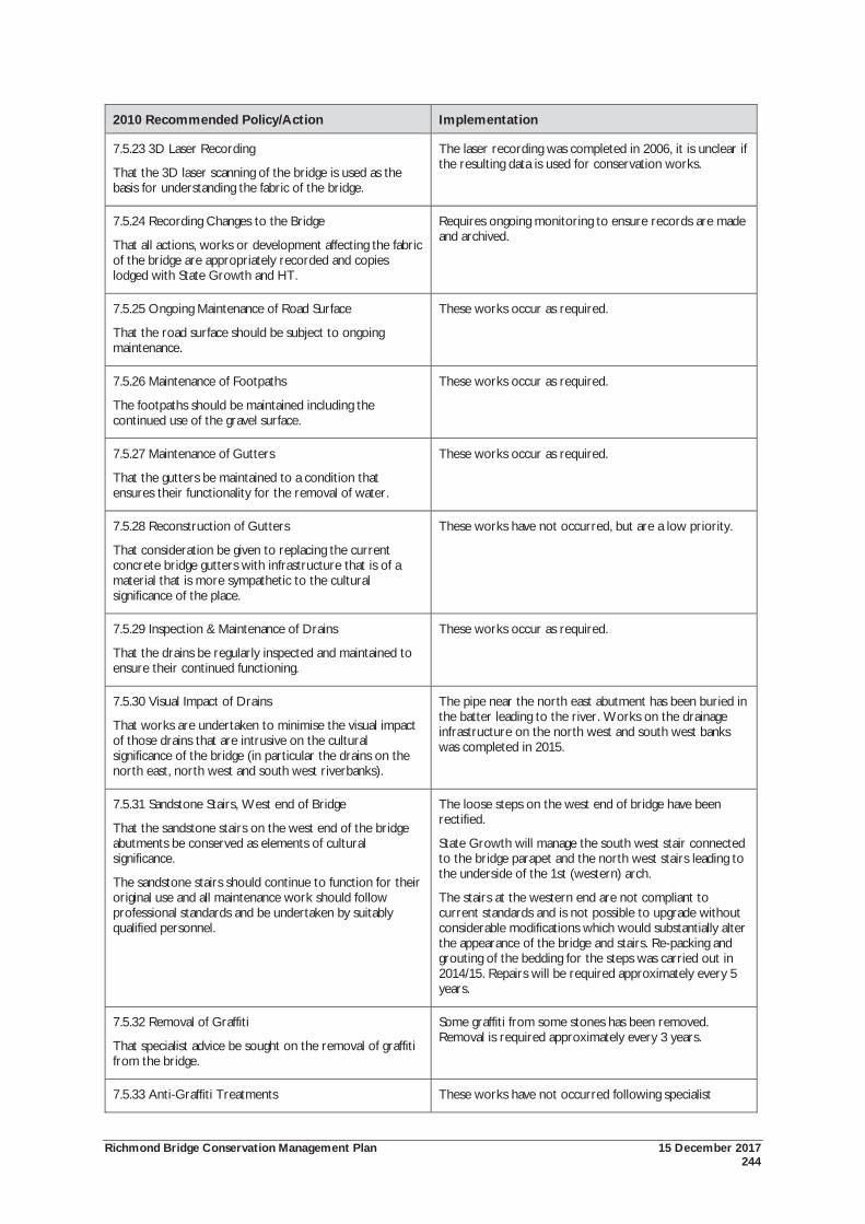
Richmond Bridge Conservation Management Plan 15 December 2017 244
2010 Recommended Policy/Action Implementation
7.5.23 3D Laser Recording
That the 3D laser scanning of the bridge is used as the basis for understanding the fabric of the bridge.
The laser recording was completed in 2006, it is unclear if the resulting data is used for conservation works.
7.5.24 Recording Changes to the Bridge
That all actions, works or development affecting the fabric of the bridge are appropriately recorded and copies lodged with State Growth and HT.
Requires ongoing monitoring to ensure records are made and archived.
7.5.25 Ongoing Maintenance of Road Surface
That the road surface should be subject to ongoing maintenance.
These works occur as required.
7.5.26 Maintenance of Footpaths
The footpaths should be maintained including the continued use of the gravel surface.
These works occur as required.
7.5.27 Maintenance of Gutters
That the gutters be maintained to a condition that ensures their functionality for the removal of water.
These works occur as required.
7.5.28 Reconstruction of Gutters
That consideration be given to replacing the current concrete bridge gutters with infrastructure that is of a material that is more sympathetic to the cultural significance of the place.
These works have not occurred, but are a low priority.
7.5.29 Inspection & Maintenance of Drains
That the drains be regularly inspected and maintained to ensure their continued functioning.
These works occur as required.
7.5.30 Visual Impact of Drains
That works are undertaken to minimise the visual impact of those drains that are intrusive on the cultural significance of the bridge (in particular the drains on the north east, north west and south west riverbanks).
The pipe near the north east abutment has been buried in the batter leading to the river. Works on the drainage infrastructure on the north west and south west banks was completed in 2015.
7.5.31 Sandstone Stairs, West end of Bridge
That the sandstone stairs on the west end of the bridge abutments be conserved as elements of cultural significance.
The sandstone stairs should continue to function for their original use and all maintenance work should follow professional standards and be undertaken by suitably qualified personnel.
The loose steps on the west end of bridge have been rectified.
State Growth will manage the south west stair connected to the bridge parapet and the north west stairs leading to the underside of the 1st (western) arch.
The stairs at the western end are not compliant to current standards and is not possible to upgrade without considerable modifications which would substantially alter the appearance of the bridge and stairs. Re-packing and grouting of the bedding for the steps was carried out in 2014/15. Repairs will be required approximately every 5 years.
7.5.32 Removal of Graffiti
That specialist advice be sought on the removal of graffiti from the bridge.
Some graffiti from some stones has been removed. Removal is required approximately every 3 years.
7.5.33 Anti-Graffiti Treatments These works have not occurred following specialist
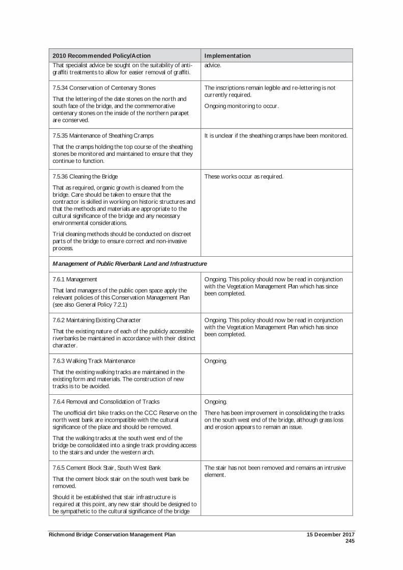
Richmond Bridge Conservation Management Plan 15 December 2017 245
2010 Recommended Policy/Action Implementation That specialist advice be sought on the suitability of anti-graffiti treatments to allow for easier removal of graffiti.
advice.
7.5.34 Conservation of Centenary Stones
That the lettering of the date stones on the north and south face of the bridge, and the commemorative centenary stones on the inside of the northern parapet are conserved.
The inscriptions remain legible and re-lettering is not currently required.
Ongoing monitoring to occur.
7.5.35 Maintenance of Sheathing Cramps
That the cramps holding the top course of the sheathing stones be monitored and maintained to ensure that they continue to function.
It is unclear if the sheathing cramps have been monitored.
7.5.36 Cleaning the Bridge
That as required, organic growth is cleaned from the bridge. Care should be taken to ensure that the contractor is skilled in working on historic structures and that the methods and materials are appropriate to the cultural significance of the bridge and any necessary environmental considerations.
Trial cleaning methods should be conducted on discreet parts of the bridge to ensure correct and non-invasive process.
These works occur as required.
Management of Public Riverbank Land and Infrastructure
7.6.1 Management
That land managers of the public open space apply the relevant policies of this Conservation Management Plan (see also General Policy 7.2.1)
Ongoing. This policy should now be read in conjunction with the Vegetation Management Plan which has since been completed.
7.6.2 Maintaining Existing Character
That the existing nature of each of the publicly accessible riverbanks be maintained in accordance with their distinct character.
Ongoing. This policy should now be read in conjunction with the Vegetation Management Plan which has since been completed.
7.6.3 Walking Track Maintenance
That the existing walking tracks are maintained in the existing form and materials. The construction of new tracks is to be avoided.
Ongoing.
7.6.4 Removal and Consolidation of Tracks
The unofficial dirt bike tracks on the CCC Reserve on the north west bank are incompatible with the cultural significance of the place and should be removed.
That the walking tracks at the south west end of the bridge be consolidated into a single track providing access to the stairs and under the western arch.
Ongoing.
There has been improvement in consolidating the tracks on the south west end of the bridge, although grass loss and erosion appears to remain an issue.
7.6.5 Cement Block Stair, South West Bank
That the cement block stair on the south west bank be removed.
Should it be established that stair infrastructure is required at this point, any new stair should be designed to be sympathetic to the cultural significance of the bridge
The stair has not been removed and remains an intrusive element.
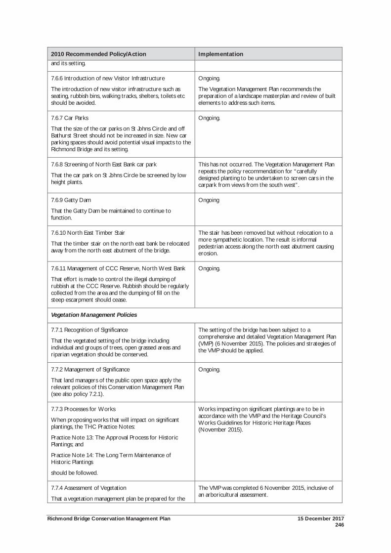
Richmond Bridge Conservation Management Plan 15 December 2017 246
2010 Recommended Policy/Action Implementation and its setting.
7.6.6 Introduction of new Visitor Infrastructure
The introduction of new visitor infrastructure such as seating, rubbish bins, walking tracks, shelters, toilets etc should be avoided.
Ongoing.
The Vegetation Management Plan recommends the preparation of a landscape masterplan and review of built elements to address such items.
7.6.7 Car Parks
That the size of the car parks on St Johns Circle and off Bathurst Street should not be increased in size. New car parking spaces should avoid potential visual impacts to the Richmond Bridge and its setting.
Ongoing.
7.6.8 Screening of North East Bank car park
That the car park on St Johns Circle be screened by low height plants.
This has not occurred. The Vegetation Management Plan repeats the policy recommendation for “carefully designed planting to be undertaken to screen cars in the carpark from views from the south west”.
7.6.9 Gatty Dam
That the Gatty Dam be maintained to continue to function.
Ongoing
7.6.10 North East Timber Stair
That the timber stair on the north east bank be relocated away from the north east abutment of the bridge.
The stair has been removed but without relocation to a more sympathetic location. The result is informal pedestrian access along the north east abutment causing erosion.
7.6.11 Management of CCC Reserve, North West Bank
That effort is made to control the illegal dumping of rubbish at the CCC Reserve. Rubbish should be regularly collected from the area and the dumping of fill on the steep escarpment should cease.
Ongoing.
Vegetation Management Policies
7.7.1 Recognition of Significance
That the vegetated setting of the bridge including individual and groups of trees, open grassed areas and riparian vegetation should be conserved.
The setting of the bridge has been subject to a comprehensive and detailed Vegetation Management Plan (VMP) (6 November 2015). The policies and strategies of the VMP should be applied.
7.7.2 Management of Significance
That land managers of the public open space apply the relevant policies of this Conservation Management Plan (see also policy 7.2.1).
Ongoing.
7.7.3 Processes for Works
When proposing works that will impact on significant plantings, the THC Practice Notes:
Practice Note 13: The Approval Process for Historic Plantings; and
Practice Note 14: The Long Term Maintenance of Historic Plantings
should be followed.
Works impacting on significant plantings are to be in accordance with the VMP and the Heritage Council’s Works Guidelines for Historic Heritage Places (November 2015).
7.7.4 Assessment of Vegetation
That a vegetation management plan be prepared for the
The VMP was completed 6 November 2015, inclusive of an arboricultural assessment.
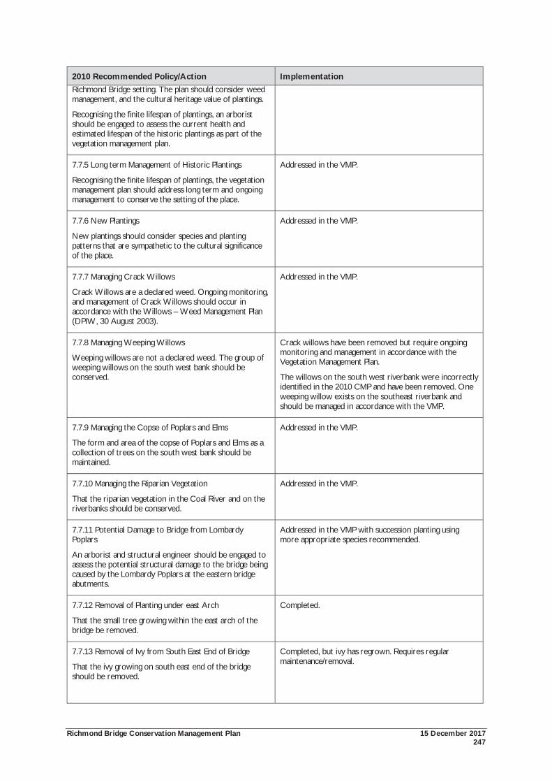
Richmond Bridge Conservation Management Plan 15 December 2017 247
2010 Recommended Policy/Action Implementation Richmond Bridge setting. The plan should consider weed management, and the cultural heritage value of plantings.
Recognising the finite lifespan of plantings, an arborist should be engaged to assess the current health and estimated lifespan of the historic plantings as part of the vegetation management plan.
7.7.5 Long term Management of Historic Plantings
Recognising the finite lifespan of plantings, the vegetation management plan should address long term and ongoing management to conserve the setting of the place.
Addressed in the VMP.
7.7.6 New Plantings
New plantings should consider species and planting patterns that are sympathetic to the cultural significance of the place.
Addressed in the VMP.
7.7.7 Managing Crack Willows
Crack Willows are a declared weed. Ongoing monitoring, and management of Crack Willows should occur in accordance with the Willows – Weed Management Plan (DPIW, 30 August 2003).
Addressed in the VMP.
7.7.8 Managing Weeping Willows
Weeping willows are not a declared weed. The group of weeping willows on the south west bank should be conserved.
Crack willows have been removed but require ongoing monitoring and management in accordance with the Vegetation Management Plan.
The willows on the south west riverbank were incorrectly identified in the 2010 CMP and have been removed. One weeping willow exists on the southeast riverbank and should be managed in accordance with the VMP.
7.7.9 Managing the Copse of Poplars and Elms
The form and area of the copse of Poplars and Elms as a collection of trees on the south west bank should be maintained.
Addressed in the VMP.
7.7.10 Managing the Riparian Vegetation
That the riparian vegetation in the Coal River and on the riverbanks should be conserved.
Addressed in the VMP.
7.7.11 Potential Damage to Bridge from Lombardy Poplars
An arborist and structural engineer should be engaged to assess the potential structural damage to the bridge being caused by the Lombardy Poplars at the eastern bridge abutments.
Addressed in the VMP with succession planting using more appropriate species recommended.
7.7.12 Removal of Planting under east Arch
That the small tree growing within the east arch of the bridge be removed.
Completed.
7.7.13 Removal of Ivy from South East End of Bridge
That the ivy growing on south east end of the bridge should be removed.
Completed, but ivy has regrown. Requires regular maintenance/removal.
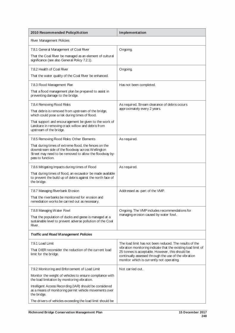
Richmond Bridge Conservation Management Plan 15 December 2017 248
2010 Recommended Policy/Action Implementation
River Management Policies
7.8.1 General Management of Coal River
That the Coal River be managed as an element of cultural significance (see also General Policy 7.2.1).
Ongoing.
7.8.2 Health of Coal River
That the water quality of the Coal River be enhanced.
Ongoing.
7.8.3 Flood Management Plan
That a flood management plan be prepared to assist in preventing damage to the bridge.
Has not been completed.
7.8.4 Removing Flood Risks
That debris is removed from upstream of the bridge, which could pose a risk during times of flood.
That support and encouragement be given to the work of Landcare in removing crack willow and debris from upstream of the bridge.
As required. Stream clearance of debris occurs approximately every 2 years.
7.8.5 Removing Flood Risks: Other Elements
That during times of extreme flood, the fences on the downstream side of the floodway across Wellington Street may need to be removed to allow the floodway by-pass to function.
As required.
7.8.6 Mitigating Impacts during times of Flood
That during times of flood, an excavator be made available to prevent the build up of debris against the north face of the bridge.
As required.
7.8.7 Managing Riverbank Erosion
That the riverbanks be monitored for erosion and remediation works be carried out as necessary.
Addressed as -part of the VMP.
7.8.8 Managing Water Fowl
That the population of ducks and geese is managed at a sustainable level to prevent adverse pollution of the Coal River.
Ongoing. The VMP includes recommendations for managing erosion caused by water fowl.
Traffic and Road Management Policies
7.9.1 Load Limit
That DIER reconsider the reduction of the current load limit for the bridge.
The load limit has not been reduced. The results of the vibration monitoring indicate that the existing load limit of 25 tonnes is acceptable. However, this should be continually assessed through the use of the vibration monitor which is currently not operating.
7.9.2 Monitoring and Enforcement of Load Limit
Monitor the weight of vehicles to ensure compliance with the load limitation by monitoring vibration.
Intelligent Access Recording (IAR) should be considered as a means of monitoring permit vehicle movements over the bridge.
The drivers of vehicles exceeding the load limit should be
Not carried out.
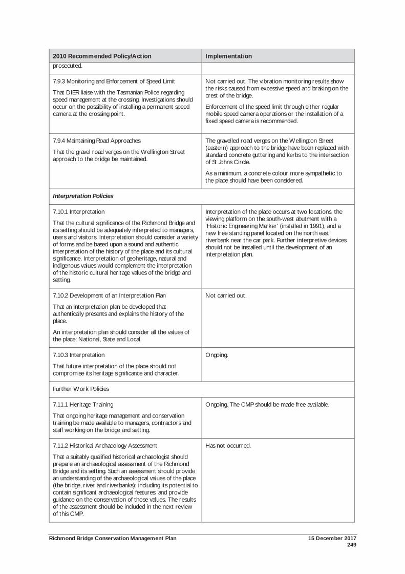
Richmond Bridge Conservation Management Plan 15 December 2017 249
2010 Recommended Policy/Action Implementation prosecuted.
7.9.3 Monitoring and Enforcement of Speed Limit
That DIER liaise with the Tasmanian Police regarding speed management at the crossing. Investigations should occur on the possibility of installing a permanent speed camera at the crossing point.
Not carried out. The vibration monitoring results show the risks caused from excessive speed and braking on the crest of the bridge.
Enforcement of the speed limit through either regular mobile speed camera operations or the installation of a fixed speed camera is recommended.
7.9.4 Maintaining Road Approaches
That the gravel road verges on the Wellington Street approach to the bridge be maintained.
The gravelled road verges on the Wellington Street (eastern) approach to the bridge have been replaced with standard concrete guttering and kerbs to the intersection of St Johns Circle.
As a minimum, a concrete colour more sympathetic to the place should have been considered.
Interpretation Policies
7.10.1 Interpretation
That the cultural significance of the Richmond Bridge and its setting should be adequately interpreted to managers, users and visitors. Interpretation should consider a variety of forms and be based upon a sound and authentic interpretation of the history of the place and its cultural significance. Interpretation of geoheritage, natural and indigenous values would complement the interpretation of the historic cultural heritage values of the bridge and setting.
Interpretation of the place occurs at two locations, the viewing platform on the south-west abutment with a ‘Historic Engineering Marker’ (installed in 1991), and a new free standing panel located on the north east riverbank near the car park. Further interpretive devices should not be installed until the development of an interpretation plan.
7.10.2 Development of an Interpretation Plan
That an interpretation plan be developed that authentically presents and explains the history of the place.
An interpretation plan should consider all the values of the place: National, State and Local.
Not carried out.
7.10.3 Interpretation
That future interpretation of the place should not compromise its heritage significance and character.
Ongoing.
Further Work Policies
7.11.1 Heritage Training
That ongoing heritage management and conservation training be made available to managers, contractors and staff working on the bridge and setting.
Ongoing. The CMP should be made free available.
7.11.2 Historical Archaeology Assessment
That a suitably qualified historical archaeologist should prepare an archaeological assessment of the Richmond Bridge and its setting. Such an assessment should provide an understanding of the archaeological values of the place (the bridge, river and riverbanks); including its potential to contain significant archaeological features; and provide guidance on the conservation of those values. The results of the assessment should be included in the next review of this CMP.
Has not occurred.
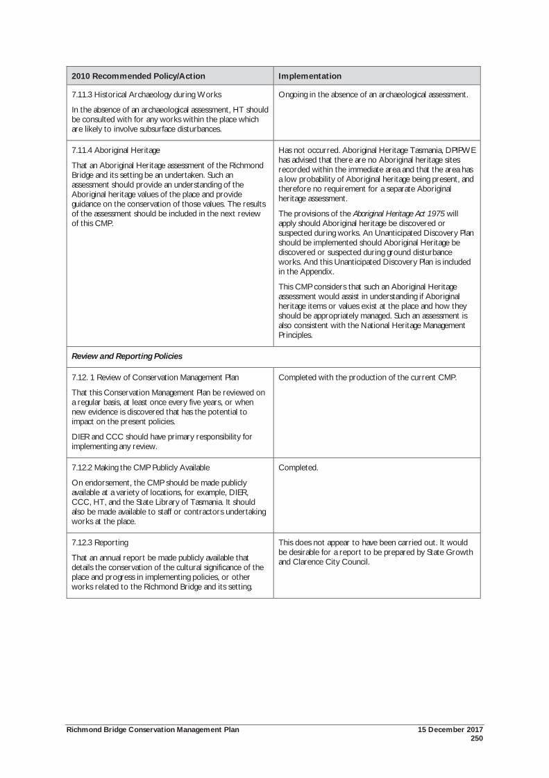
Richmond Bridge Conservation Management Plan 15 December 2017 250
2010 Recommended Policy/Action Implementation
7.11.3 Historical Archaeology during Works
In the absence of an archaeological assessment, HT should be consulted with for any works within the place which are likely to involve subsurface disturbances.
Ongoing in the absence of an archaeological assessment.
7.11.4 Aboriginal Heritage
That an Aboriginal Heritage assessment of the Richmond Bridge and its setting be an undertaken. Such an assessment should provide an understanding of the Aboriginal heritage values of the place and provide guidance on the conservation of those values. The results of the assessment should be included in the next review of this CMP.
Has not occurred. Aboriginal Heritage Tasmania, DPIPWE has advised that there are no Aboriginal heritage sites recorded within the immediate area and that the area has a low probability of Aboriginal heritage being present, and therefore no requirement for a separate Aboriginal heritage assessment.
The provisions of the Aboriginal Heritage Act 1975 will apply should Aboriginal heritage be discovered or suspected during works. An Unanticipated Discovery Plan should be implemented should Aboriginal Heritage be discovered or suspected during ground disturbance works. And this Unanticipated Discovery Plan is included in the Appendix.
This CMP considers that such an Aboriginal Heritage assessment would assist in understanding if Aboriginal heritage items or values exist at the place and how they should be appropriately managed. Such an assessment is also consistent with the National Heritage Management Principles.
Review and Reporting Policies
7.12. 1 Review of Conservation Management Plan
That this Conservation Management Plan be reviewed on a regular basis, at least once every five years, or when new evidence is discovered that has the potential to impact on the present policies.
DIER and CCC should have primary responsibility for implementing any review.
Completed with the production of the current CMP.
7.12.2 Making the CMP Publicly Available
On endorsement, the CMP should be made publicly available at a variety of locations, for example, DIER, CCC, HT, and the State Library of Tasmania. It should also be made available to staff or contractors undertaking works at the place.
Completed.
7.12.3 Reporting
That an annual report be made publicly available that details the conservation of the cultural significance of the place and progress in implementing policies, or other works related to the Richmond Bridge and its setting.
This does not appear to have been carried out. It would be desirable for a report to be prepared by State Growth and Clarence City Council.


