Embed Size (px)
Citation preview
Finding 20th Century Architecture in Richmond
When I agreed to reach Twentieth Century Architecture for the fall of 2010, I wanted to create a project that would engage the students in local building and city historyat the same time they were reading about more global examples in their class text. This would move the concepts beyond the classroom to the city they navigate daily. I also wanted to create a tool that could help students analyze and visualize the growth of the city over time usinga map and set criteria for filtering this information. Beyond the classroom this mobile-capable site might be of use to anyone interested in twentieth-century architecture in Richmond, Virginia. But of course the best laid plans are often altered an some change were made to the original proposal I send to our Center for Teaching and Learning in the spring of 2010. Though I thought the goals were rather clear, the road to making them materialize has been riddled with forks and bypasses. What I have found in this process is that the most apparent partnerships on campus are not always the most fruitful. Circumstances beyond your control, and often unknown to you, will have an effect on the way a project is carried out. Sometimes you need to look beyond the obvious and a forge new partnerships across campus that will give a project life.
The Research ProjectsAs mentioned before, the goal of this project was to
get the students out into the city to visit buildings that they could relate back to those mentioned in their readings.TO find research topics, I first scoured HABS (the Historic Architectural Building Survey), web sites on architecture inRichmond, and the National Register for possible candidates.Then I drove around the city to find others. I needed to besure students would be able to find enough material on theirbuildings not only to populate the site, but also to write research papers. The final list included a mix of well-documented buildings and some that would require a good amount of original detective work and observation. Some of
the better documented options were: Richard Neutra’s Rice House; Gordon Bunschaft’s Reynolds Metals Headquarters; JohnRussell Pope’s Union Station; and the University of RichmondCampus by Ralph Adams Cram. Those that would require more primary research were: The Philip Morris Leaf Storage Warehouse, Willow Lawn Shopping Center, and the residence at4509 Monument Avenue. The remainder of the list included: the Canal Walk, New City Hall, the Central National Bank, the Byrd Theatre, the National Theatre, the Landmark Theatre, the Richmond Coliseum, and the Tredeger Iron Works (this topic would focus on 20th Century preservation issues).
What Technology to Use?In an ideal world I would be able to use an already
existing iPhone or Android application that would allow me, or my students, to plug in information and have the software, capable of interpreting that information, already in place. There were a few products used by tour companies to facilitate self-guided walking tours, similar in concept to audio guides in museums. They often use an iPhone or Android application. Some examples of these types of tours are: a walking tour of Florence,1 a walking tour of Impressionist Paris,2 and a 9/11 walking tour3 available on iTunes. Other options would be to create podcasts for the audio portion of the proposal – Rick Steves produces podcasts and has apps for the iPhone for walking tours in Europe.4 AUDIOCONEXUS, a “Location Based Media and Entertainment company”5 has several tour apps that would fulfill part of my project requirements. But, given that I
1 http://itunes.apple.com/us/app/florence-walking-tours-map/id348148136?mt=82 http://itunes.apple.com/us/app/impressionist-paris-walking/id380558777?mt=83 http://itunes.apple.com/us/app/explore-9-11/id387986451?mt=84 http://www.ricksteves.com/radio/podcast.htm, http://www.ricksteves.com/news/mobile_apps/iphone.htm 5 http://www.audioconexus.com/about-us.php
have not budget for this course, I wanted this project to bean analytical tool in addition to a guide, I wanted the siteto work on multiple platforms, and I did not think I could burden students with both the research (much of it primary for some) and time for creating and editing audio or video content (which would include training on equipment and software), I had to find another solution for my desired product.
To begin my search for a solution I headed to CTLT – the Center for Teaching and Learning. This group on campus is part of Information Services and handles products such asBlackboard, Clickers, Podcasts, Blogs and the like. There are several CTLT liaisons each responsible for several departments and schools. The liaison will direct you to theappropriate person, with expertise in a particular area, if necessary, for you to receive the help that you need. This is quite useful because they know their strengths better than you do. There are usually five liaisons for the entirecampus: one for Arts; one for Math and Computer Science; onefor Business, Law and Leadership; one for Biology and Chemistry; and one for all of the rest of Humanities. Areasof technical expertise for the liaisons included blogs, programming and coding, imaging, video and the like.
At the end of June 2010 I send my liaison my proposal with a link to a blog and Flickr project run by Francine Stock at Tulane University in New Orleans.6 I had seen her present her project at a conference a few years ago and wanted to use that as a starting point for my project. She uses Geotagging, Flickr, and a Flickr map to document Regional Modernism in New Orleans and she had a project thatwas documenting structures destined for demolition after Hurricane Katrina. After taking a look at my goals, my liaison directed me to Jake Kulstad, the liaison for math and computer science. Unfortunately when I met with him forthe first time in late July I found out he was leaving the university in a week. Not just leaving for a vacation, but relocating to the west coast. Jake to a look at Francine’s 6 Regional Modernism on Flickr, http://www.flickr.com/photos/24288497@N02/
site and had a few suggestions in terms of tools and open-source coding I might use.
One of the first solutions he suggested was a blog, buthe admitted that though it is easy to create, it would not really be able to analyze and map my data. One might use itas a splash page, but not for the entire project. Other questions or concerns we discussed were: First, server space– “Where would this project live on the university network?”Unfortunately there is no server space for this kind of course project and I am currently using my personal webfilesspace for the html page. One issue with this is that the URL is long, and second, it is technically a secure site andtherefore causes some hiccups with some browsers, Internet Explorer in particular. For image storage we decided to proceed with hosting images on Flickr. The Visual ResourcesCenter already has a Flickr Pro account so this platform would give us some flexibility in terms of storing the images or how we might want to share the images and image sets with others in other venues.
The second big issue was that of technical support for this project. There really is none at the moment due to staffing changes and changing policy. To account for this Ineeded to choose something that either I could handle on my own or could find a tech savvy student to help with it in the future. The dearth of technical support on campus for this kind of project has not always been an issue. But, theincreased number of faculty seeking support from this group makes it difficult for the five liaisons to spend much time on more complicated projects such as mine. There are plans for a new facility on campus to take over where CTLT leaves off, but it is not yet in place.
So, once Jake showed me a few alternatives, we settled on an open-source software called Exhibit developed by the SIMILE project at MIT. SIMILE stands for Semantic Interoperability of Metadata and Information in Unlike Environments and the group has produced such projects as Timeline (which I use on the Richmond Architecture site), Gadget (an XML verifier), Referee (which allows you to see who links your web pages and what they say about them), and
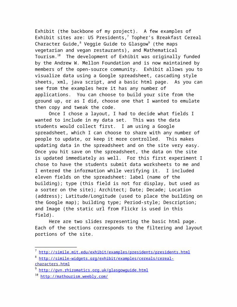
Exhibit (the backbone of my project). A few examples of Exhibit sites are: US Presidents,7 Topher’s Breakfast CerealCharacter Guide,8 Veggie Guide to Glasgow9 (the maps vegetarian and vegan restaurants), and Mathematical Tourism.10 The development of Exhibit was originally fundedby the Andrew W. Mellon Foundation and is now maintained by members of the open-source community. Exhibit allows you tovisualize data using a Google spreadsheet, cascading style sheets, xml, java script, and a basic html page. As you cansee from the examples here it has any number of applications. You can choose to build your site from the ground up, or as I did, choose one that I wanted to emulate then copy and tweak the code.
Once I chose a layout, I had to decide what fields I wanted to include in my data set. This was the data students would collect first. I am using a Google spreadsheet, which I can choose to share with any number of people to update, or keep it more controlled. This makes updating data in the spreadsheet and on the site very easy. Once you hit save on the spreadsheet, the data on the site is updated immediately as well. For this first experiment Ichose to have the students submit data worksheets to me and I entered the information while verifying it. I included eleven fields on the spreadsheet: label (name of the building); type (this field is not for display, but used as a sorter on the site); Architect; Date; Decade; Location (address); Latitude/Longitude (used to place the building onthe Google map); building type; Period-style; Description; and Image (the static url from Flickr is used in this field).
Here are two slides representing the basic html page. Each of the sections corresponds to the filtering and layoutportions of the site.
7 http://simile.mit.edu/exhibit/examples/presidents/presidents.html 8 http://simile-widgets.org/exhibit/examples/cereals/cereal-characters.html 9 http://gvn.rhizomatics.org.uk/glasgowguide.html 10 http://mathourism.weebly.com/
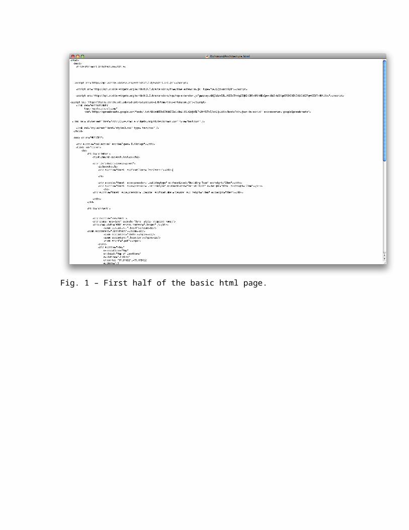
Fig. 1 – First half of the basic html page.
Fig. 2 – second half of the basic html page.
The main page of the site includes six main sections each pulling data from the Google spreadsheet (fig. 3). Thefirst four are located to the left side of the site. These four allow the user to filter the buildings based on a keyword search, by selecting building type, period-style, and/or decade. You can apply multiple filters if desired. First I have filtered on residences and we got three results(fig. 4). Next I filtered on decade, the 1960s, and went toone result, Richard Neutra’s Rice House (fig. 5). Then whenI sued the keyword search box to look for gardens, no results were returned. If there are no results, the map

will be devoid of location indicators, and the filter boxes will be empty (fig. 6).
Fig. 3 – Richmond Architecture main page.
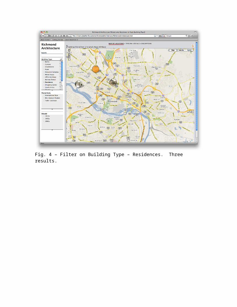
Fig. 4 – Filter on Building Type – Residences. Three results.
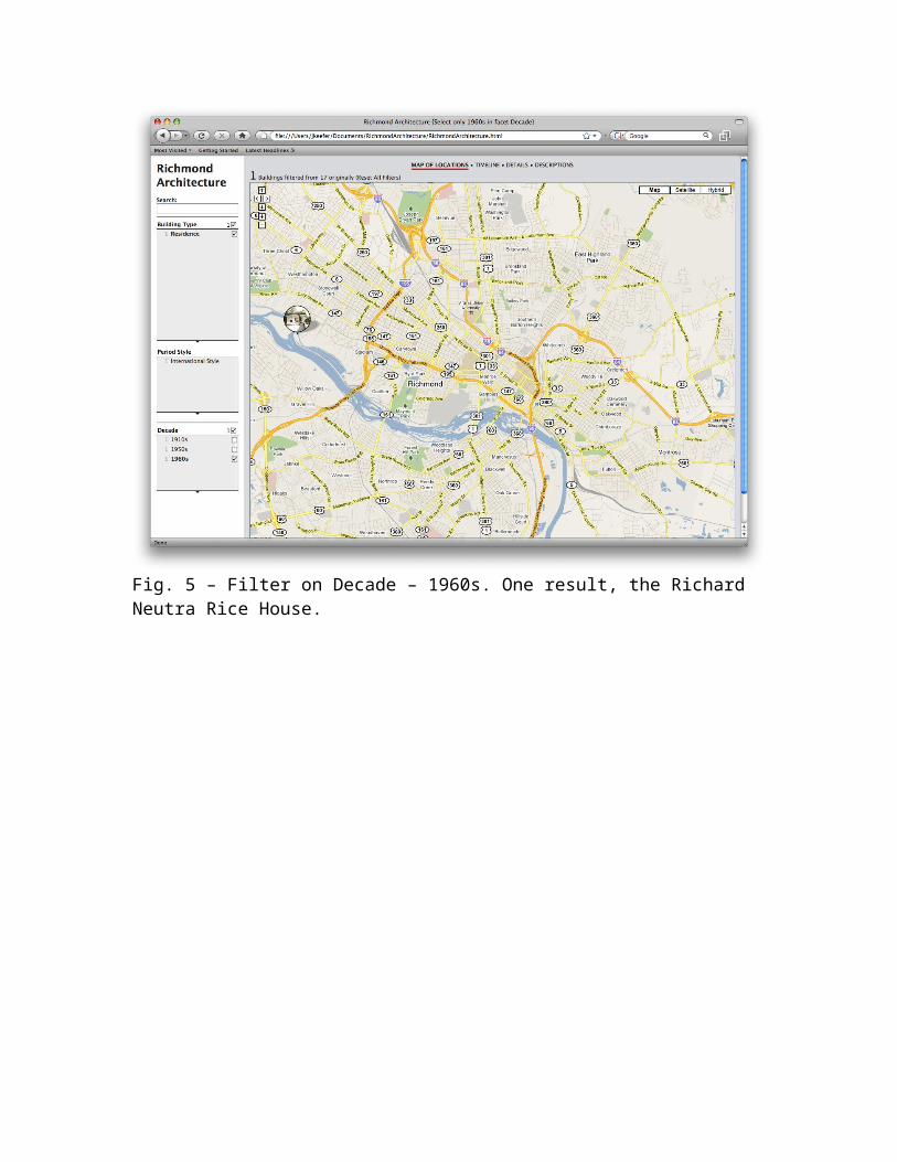
Fig. 5 – Filter on Decade – 1960s. One result, the Richard Neutra Rice House.
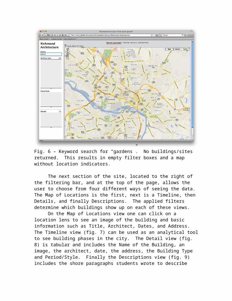
Fig. 6 – Keyword search for “gardens”. No buildings/sites returned. This results in empty filter boxes and a map without location indicators.
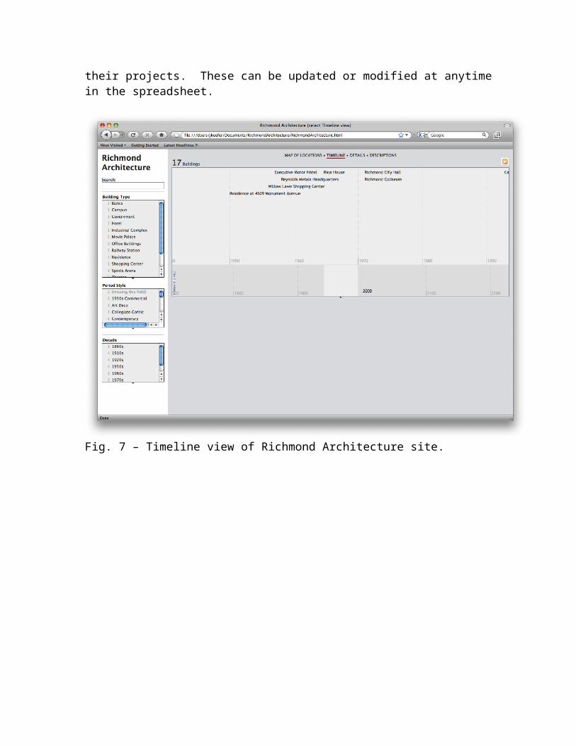
The next section of the site, located to the right of the filtering bar, and at the top of the page, allows the user to choose from four different ways of seeing the data. The Map of Locations is the first, next is a Timeline, then Details, and finally Descriptions. The applied filters determine which buildings show up on each of these views.
On the Map of Locations view one can click on a location lens to see an image of the building and basic information such as Title, Architect, Dates, and Address. The Timeline view (fig. 7) can be used as an analytical toolto see building phases in the city. The Detail view (fig. 8) is tabular and includes the Name of the Building, an image, the architect, date, the address, the Building Type and Period/Style. Finally the Descriptions view (fig. 9) includes the shore paragraphs students wrote to describe
their projects. These can be updated or modified at anytimein the spreadsheet.
Fig. 7 – Timeline view of Richmond Architecture site.
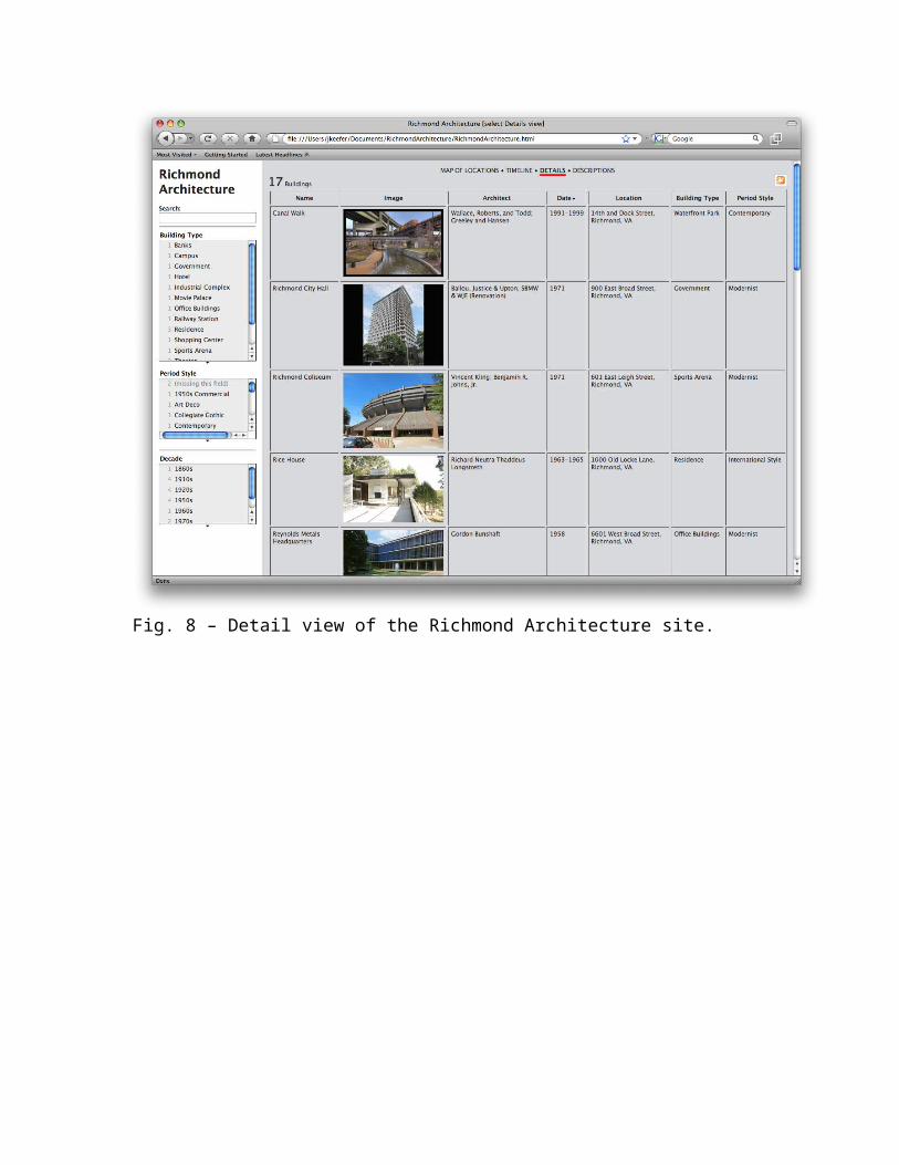
Fig. 8 – Detail view of the Richmond Architecture site.
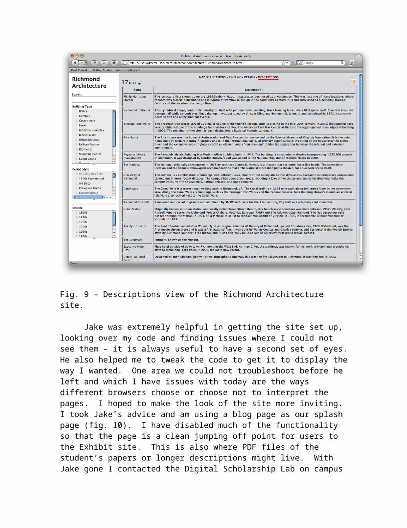
Fig. 9 – Descriptions view of the Richmond Architecture site.
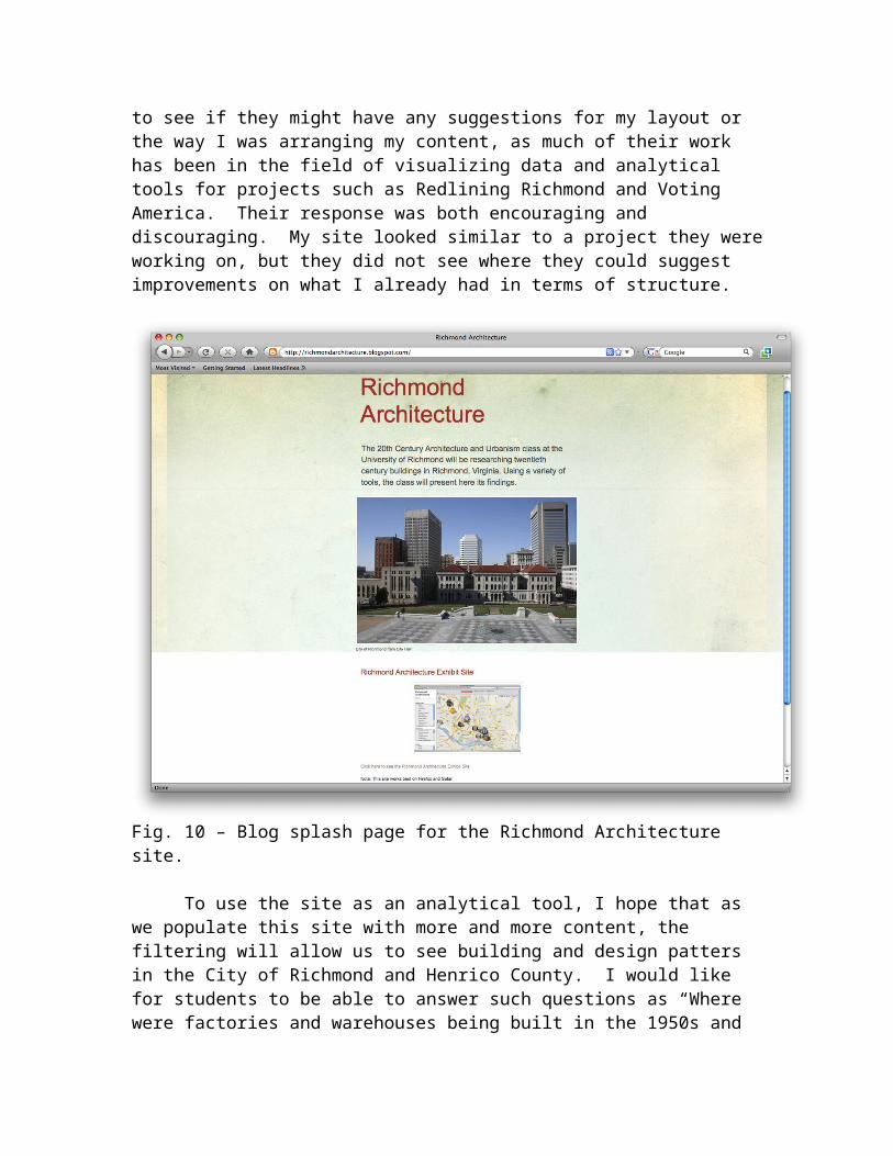
Jake was extremely helpful in getting the site set up, looking over my code and finding issues where I could not see them – it is always useful to have a second set of eyes.He also helped me to tweak the code to get it to display theway I wanted. One area we could not troubleshoot before he left and which I have issues with today are the ways different browsers choose or choose not to interpret the pages. I hoped to make the look of the site more inviting. I took Jake’s advice and am using a blog page as our splash page (fig. 10). I have disabled much of the functionality so that the page is a clean jumping off point for users to the Exhibit site. This is also where PDF files of the student’s papers or longer descriptions might live. With Jake gone I contacted the Digital Scholarship Lab on campus
to see if they might have any suggestions for my layout or the way I was arranging my content, as much of their work has been in the field of visualizing data and analytical tools for projects such as Redlining Richmond and Voting America. Their response was both encouraging and discouraging. My site looked similar to a project they wereworking on, but they did not see where they could suggest improvements on what I already had in terms of structure.
Fig. 10 – Blog splash page for the Richmond Architecture site.
To use the site as an analytical tool, I hope that as we populate this site with more and more content, the filtering will allow us to see building and design patters in the City of Richmond and Henrico County. I would like for students to be able to answer such questions as “Where were factories and warehouses being built in the 1950s and
how did that differ from the locations of the nineteenth century?” One might guess that the Scott’s Addition area just north of Broad Street. Or “When did the government andinstitutions start moving into Modernist structures in the 20th century?” Personally I am more interested in the patterns of growth in the city rather than individual structures separate from their neighborhoods. This content and usefulness will come in the future.
ResultsAs I mentioned before, my original intent was to have
the students research the structures and produce all of the content including images, audio and video. We decided not to include audio or video files on this go-around. First because our product does not handle them very well (though we could always upload files to Flicr) and second because the time required of students to produce this portion of theproject was going to take away from their research and writing time. Students are still feeding me data sheets andmost have e-mailed me two or three images of their buildings, which I then uploaded to Flickr. This being the first time teaching this particular course at the Universityof Richmond, I really had not fully considered ancillary issues such as transportation. Many students on our campus have their own cards, but I got a group of many who do not. Public transportation access to downtown is getting better, but still widely unknown to the students.
So, where do I, and this project, go from here? I am in the process of forging a new partnership to get the life of this project to live beyond a one-semester class. Recently I reached out to the Bonner Center for Civic Engagement. This division of Academic Affairs is the hub for outreach to the communities in and around Richmond. In fact, they are using a similar Exhibit site to identify community partnerships. Each fall, the Center coordinates atour of downtown Richmond and my site might be a tool for them to use when introducing students to the city. We are discussing how this site might be a tool for them to use in their community outreach and a tool for students to get to
know the city of Richmond on their own. On a more practicalnote, the Bonner Center encourages faculty to have a class or two at the University of Richmond Downtown campus and familiarize students with our host city. Both are endeavorsI will take advantage of in the future to facilitate students’ research activities.
I have also been in contact with the Spatial Analysis Lab, this is a GIS lab that produces maps and data sets. I am very interested in mapping the 20th century history of Richmond using data from the Sanborn Fire Insurance Maps. Thee maps have been important tools for the students in getting to know the sites of their buildings an dhow they have changed in use over time. I hope that a new data set will add to the complexity and analytical capabilities of the site.
In conclusion, though the beginning of this project wasa bit rocky, I think I have the skeleton of something that can grow in the future and take on a life of its own separate from my 20th Century Architecture course. I have also found that thinking outside the box in terms of seekingpartners across campus can be a very positive and encouraging process.


