Embed Size (px)
Citation preview
INTERNATIONAL COURT OF JUSTICE
MARITIME DELIMITA TI ON BETWEEN NICARAGUA AND HONDURAS
IN THE CARIBBEAN SEA (NICARAGUA v. HONDURAS)
REPLYOFTHE GOVERNMENT OF NICARAGUA
VOLUME!
13 JANUARY 2003
TABLE OF CONTENTS
INTRODUCTION ......................................................................................... 1 1. Brief Reminder of the Procedure ............................................................ 1 Il. Main Issue in Dispute ........................................................................... 2 Ill. Outline of the Reply ............................................................................. 3
CHAPTER 1: MAIN FEATURES OF THE HONDURAN COUNTER-MEMORIAL ................................................................................................... 5
1. Points of Agreement of the Parties ......................................................... 5 A. }URISDICTION OF THE COURT AND ADMISSIBILITY OF THE APPLICA Tl ON .......•....• 5 B. OBJECT OF THE DISPUTE ......••...................••..•...•.••.....•....•.•.....•.....••.•..•....• 6 C. PARTIAL AGREEMENT OF THE PARTIES CONCERNING THE MARITIME DELIMITATION
··············································································································· 8 Il. The Honduran Case as Presented in the Counter-Memorial ............... 11
A. THE HONDURAN POSTULA TES ................................................................. 11 B. HONDURAS IGNORES THE RULES AND PRINCIPLES OF MARITIME DELIMITATION. 14
CHAPTER II: MARITIME DELIMITATION: THE METHODOLOGY ADOPTED BY HONDURAS ..................................................................... 15
1. Introduction: the Honduran A version to Coastal Relationships ........... 15 Il. The Honduran Caricature of the Geographical Context of the Dispute .................................................................................................... 15 III. The Honduran Argument has No Relation to the Geographical Context. ................................................................................................... 16 IV. The Concept of Relevant Circumstances Adopted by Honduras is Erroneous ................................................................................................. 21 V. Conclusion .......................................................................................... 24
CHAPTER III: THE LEGAL AND POLITICAL GEOGRAPHY OF THE REGION ...................................................................................................... 27
1. Introduction .......................................................................................... 27 Il. Geography of the Area ........................................................................ 27
A. THE GENERAL ORIENT A TION OF THE COAST ............................................... 27 B. THE GENERAL ORIENTATION OF THE LAND BOUNDARY ................................ 28 C. THE SPECIAL CHARACTER OF THE RIVER COCO ........................................... 29 D. THENICARAGUAN RISE .......................................................................... 30 E. THE ISLETS AND ROCKS SITUA TED IN THE AREA TO BE DELIMITED .................. 30
III. The Legal Context - The Relevance of Delimitation Agreements in the Region and Elsewhere ....................................................................... 34
A. THE TREATIES HONDURAS CONSIDERS OF PARTICULAR IMPORTANCE .............. 35 B. 0THER TREATIES REFERRED TO IN THE TEXT OF THE COUNTER-MEMORIAL ....... 40 C. DELIMITA Tl ON AGREEMENTS IN THE CARIBBEAN REGION AND ELSEWHERE .•...• 40 D. THE VIEW OF THE COURT AND OTHER INTERNATIONAL TRIBUNALS ................. 45

CHAPTER IV: THE RELEVANCE OF THE UT! POSSIDETIS PRINCIPLE ................................................................................................. 49
1. Introduction .......................................................................................... 49 A. THE POSITION OF HONDURAS .........•....•.............••...•..•.••........•.•.•••.•..•...••.. 49 B. THE POSITION OF NICARAGUA •............••....•...•..............•.•.•••.............••...••. 50
II. The limited relevance of the A ward of 1906 ...................................... 51 III. Uti possidetis iuris outside the 1906 A ward? .................................... 57
A. No ISLAND UT/ POSSIDETIS [URIS EXISTS IN THE AREA IN DISPUTE •.•••.•.•.••.•••.. 59 B. No MARITIME UT! POSSIDETIS lU RIS EXISTS IN THE AREA IN DISPUTE .•.....••.•••.. 65
IV. Conclusions ....................................................................................... 68
CHAPTER V: THE RELEVANCE OF THE EFFECTIVITÉS TO MARITIME DELIMITATION ................................................................... 71
1. Introduction .......................................................................................... 71 A. THE EFFECTIVITÉS ACCORDING TO HONDURAS ............................................ 71 B. THE EFFECTIVITÉS ACCORDING TO NICARAGUA .......••...••...•.•.•••...•.........•..•.• 72 C. HONDURAS HAS NO LEGAL AND ADMINISTRATIVE EFFECTIVITÉS IN THE AREA IN
DISPUTE ....••............•..•...........•••.••.•..•........•.•....•..•......•.•.•..•.•••.•...•.......••.• 73 D. No HONDURAN EFFECTIVITÉS EXJST REGARDING ECONOMJC ACTJVITY IN THE
AREA IN DISPUTE •.........••........•..•..................••...•.•............•....•••..••..•......... 76 E. HONDURAS HAS NO OTHER EFFECTIVITÉS IN THE AREA IN DISPUTE ••...•....•...••.. 84 F. CONCLUSION •..•......•..•••.......•...••..•.•.............•.......•.....•.•......•.•.•••.•..••..••. 89
CHAPTER VI: TITLE TO THE ISLETS AND ROCKS ........................... 91 1. The bases of the Honduran claim ......................................................... 93
A. THE HISTORY OF THE DISPUTE DU RING THE COLONIAL PERIOD AND THE !9TH
CENTURY AND THE RELEVANCE OF THE PRINCIPLE OF UT/ POSSIDETIS fU RIS .•••.••••• 96 B. THE ARBITRAL A WARD OF THE KING OF SPAIN OF 1906 .................................. 97 C. THE PRACTICE OF HONDURAS BETWEEN 1906 AND 1960 ............................... 97 D. LEGISLATION OF HONDURAS .................•................•.•..............•.••.•••..•..... 98 E. CARTOGRAPHie EVIDENCE ••.........................•..•..........•...•.••••..........•...•.••. 99 F. CONCLUSIONS ON THE HONDURAN ARGUMENTS CONCERNING TITLE TO THE ISLETS
IN DISPUTE .......••......•..•.........•...........•.•...•.............••.••.•........•••..••..•.•.•... 124 II. The bases of the Nicaraguan claim (including effectivités) .............. 126
A .THE UT/ POSSIDETIS IURIS OF 1821 ........................................................... 127 B. THE TURTLE FISHING DISPUTE .•........••...•.......•.•..•••..•.•.•..•.•..•.••......•.•••••• 128 C. THE ARBITRAL A WARD OF THE KING OF SPAIN OF 1906 ................................. 129 D. THELEGISLATIONOFNICARAGUA .......................................................... 129 E. CARTOGRAPHie EVIDENCE ..•.......•..••........•..•.••........•...•..••.....••..•.••........ J3Q F. EFFECTIVITÉS AND THE EXERCISE OF NICARAGUAN SOVEREJGNTY AND
JURISDICTION OVER THE ISLETS IN DISPUTE .................................................. )33 III. Conclusions on the Nicaraguan Arguments concerning the Title to the Islets in Dispute ..................................................................................... 138
CHAPTER VII: THE WEAKNESS OF THE HONDURAN ARGUMENT BASEDONCONDUCT ........................................................................... 141
1. Introduction ........................................................................................ 141 Il

Il. Con du ct of the parties be fore 1963 ................................................... 142 Ill. Con du ct of the parties between 1963 and 1977 ............................... 145 IV. The conduct of the parties since 1977 ............................................. 152 V. Conclusion ......................................................................................... 165
CHAPTER VIII: THE APPLICABLE PRINCIPLES OF THE LAW OF THE SEA (THE METHODS OF DELIMITA TI ON) ............................... 167
1. The Applicability of The 1982 United Nations Convention On The Law of The Sea .............................................................................................. 167 Il. The Legal Princip les Applicable to the Case .................................... 170
CHAPTER IX: THE COURSE OF THE BOUNDARY ........................... 179 1. The Purpose ........................................................................................ 179 Il. The Delimitation on the Basis of a Single Maritime Boundary ........ 179 III. The Bisector Method of Delimitation .............................................. 180 IV. Relevant Circumstances: Equitable Criteria Confirming the Equitable Result Produced by the Bisector Method .............................................. 182
A. THE INCIDENCE OF NA TI ON AL RESOURCES ............................................... 182 B. THE INCIDENCE OF FISHER !ES AND HYDROCARBONS IN THE DJSPUTED AREA ... 182 C. THE PRINCIPLE OF EQUITABLE ACCESS TO THE NATURAL RESOURCES OF THE
DISPUTED AREA ..................................................................................... 183 D. THE GEOLOGY AND GEOMORPHOLOGY OF THE NICARAGUAN RI SE ................ 183 E. SECURITY CONSIDERATIONS .................................................................. 184 F. THE CONDUCT OF THE PARTIES .............................................................. 185 G. ÜIL AND GAS CONCESSIONS .................................................................. 186 H. F!SHING ACTIVITIES ............................................................................ 187 1. NAVALANDAERIALPATROLS ................................................................ 187
V. The Ambiguous Position of Honduras in Relation to the Equitable Princip les and the Geographical Configuration ..................................... 187
A. THE REFERENCE TO EQUITABLE PRINCIPLES IN THE INTRODUCTION TO CHAPTER 7
........................................................................................................... 188 B. THE SUPERFICIAL INVOCA Tl ON OF RELEVANT CIRCUMSTANCES ..................... 189 C. THE REFERENCE TOEQUITABLE PRINCIPLES IN PARAGRAPHS 7.29-7.30 ........... 189 D. THE REFERENCE TO EQUITABLE PRINCIPLES IN CHAPTER 8 ........................... 189
VI. The Effects of other Delimitations in the Same Region .................. 190 VII. The Cri teri on or Factor of Proportiona1ity ..................................... 193 VIII. Conclusion .................................................................................... 194
CHAPTER X: THE POINT OF DEPARTURE AND THE TERMINUS OF THE MARITIME BOUNDARY ............................................................... 195
1. The Point of Departure of The Maritime Boundary ........................... 195 A. REITERATION OF THE NICARAGUAN POSITION ........................................... 195 B. THE HONDURAN ARGUMENT ................................................................. 197 C. THE APPLICABLE GENERAL PRINCIPLES ................................................... 203
II. The Terminus of The Delimitation of The Maritime Boundary ....... 206
III
SUBMISSIONS ......................................................................................... 209 ADDENDUM ............................................................................................ 211 LIST OF MAPS AND FIGURES .............................................................. 213 LIST OF ANNEXES ................................................................................. 214
IV

INTRODUCTION
1. This Reply is filed pursuant to the Order of the Court of 13 June 2002 fixing 13 January 2003 as the time-limit for the filing of the Reply of the Republic of Nicaragua.
1. Brief Reminder of the Procedure
2. This case has been brought to the Court by Nicaragua on the basis of an Application of 8 December 1999, which was filed after severa} failed attempts to find a negotiated solution to the dispute between the Parties conceming the delimitation of their respective maritime areas.
3. In this Application, Nicaragua has stated that the jurisdiction of the Court is based first on the optional declarations made by both Parties under Article 36, paragraph 2, of the Statute of the Court and, second, on Article XXXI of the American Treaty on Pacifie Settlement of Disputes of 30 April 1948 (the "Pact of Bogota") according to which the jurisdiction of the Court is compulsory ipso facto and without the necessity of any special agreement for ali disputes of a juridical nature conceming (among others) any question of international law.
4. On 21 March 2000, the Court issued an Order fixing 21 March 2001 as the time-Iimit for the filing of the Memorial of Nicaragua and 21 March 2002 for the Counter-Memorial of Honduras. Both written pleadings were filed within the assigned time-limits.
5. However, in her Counter-Memorial, Honduras relied heavily on documents that were not annexed to her Counter-Memorial, but merely deposited with the Registry. Most of these documents were in Spanish and had not been translated into one of the official languages of the Court. As the Agent of Nicaragua noted during a meeting held on 5 June 2002 by the President of the Court with the Agents of the Parties, such a behaviour was clearly inconsistent with Articles 50 and 51 of the Rules of Court.
6. During this same meeting it was then agreed that:
"1) Within the next three weeks, Honduras, having regard to the relevant references [to those deposited

documents 1 in its Counter-Memorial, will inform the Registry which of these additional documents it is intending to produce as documents annexed to the said Counter-Memorial.
"2) By 13 September 2002 at the latest, Honduras will file in the Registry 125 copies of the documents so selected, which will be considered as documents annexed to its Counter-Memorial under Article 50 of the Ru les of Court. As provided in paragraph 2 of that Article, '[i]f only parts of a document are relevant, only such extracts as are necessary for the purpose of the pleading in question need be annexed'.
"3) In conformity with article 51, paragraph 3, of the Rules of Court, if such documents are not in one of the official languages of the Court, Honduras will provide translations into one of these languages certified as accurate".
7. The agreement of the parties on this procedure was acknowledged by a letter of the Registrar to the Agent of Honduras of 6 June 2002 (the text of this letter is reproduced in Honduras' Additional Annexes to Volume 2 of her Counter-Memorial dated 13 September 2002, p. ix).
8. In conformity with this agreement, on 25 June 2002, the Co-Agent of Honduras sent a Ietter to the Registrar to which was attached a list of 74 documents which she presented as new annexes to her Counter-Memorial. The documents were annexed in their original language and the passages Honduras considered relevant in those documents in Spanish were highlighted and finally translated into English and formally presented on 13 September 2002 as "Additional Annexes to Volume 2 filed under Article 50 of the Rules of Court Pursuant to the Agreement of the Parties of 5 June 2002". These new annexes are numbered 170 to 231.
II. Main Issue in Dispute
9. The main difference between the Parties, the basic issue in dispute is that whilst Honduras "maintains that there is a boundary between the maritime spaces of the two States which has its origins in the principle of uti possidetis iuris and which is firmly rooted in the practice of both Honduras and Nicaragua and confirmed by the
2

practice of third States"1, Nicaragua for her part "has consistently
maintained the position that its maritime Caribbean boundary with Honduras has not been delimited."2
1 O. The his tory of the dispute is am ply explained and documented in Chapters III to V of Nicaragua's Memorial and will not be reiterated in this Reply except when necessary to clarify erroneous or inexact statements or interpretations of facts in the Honduran Counter Memorial.
11. For the above reason Nicaragua will mere1y recall that it is an undisputed historical fact that during the whole 19th century and up to January 1963 Nicaragua exercised whatever sovereignty and jurisdiction were possible in the Caribbean coast in areas that reached further north than the present boundary located at the thalweg of the River Coco.3
12. When it became apparent in the 1970s that the international community would recognize maritime zones that went beyond the traditional 3 mile territorial sea, Nicaragua proposed to Honduras to initiate negotiations for a maritime delimitation in the Caribbean in 1977. This was the first time that any official steps were taken to begin negotiations and Hondura's response was an unequivocal and unconditional acceptance of Nicaragua's offer to start negotiations. No mention was made then by Honduras of the existence of any traditionalline of delimitation4
.
13. The change of Government that occurred in Nicaragua in 1979, and the hostilities that broke out in the region in the context of the EastWest confrontation, were taken advantage of by Honduras to claim, for the first time officially in 1982, that there was a traditionalline of delimitation that conveniently gave ber the lion's share of the maritime areas available for division between the two States.5
III. Outline of the Re ply
14. Postulating that there is already a maritime boundary between the two Parties - while the purpose of the Nicaraguan Application precisely is to ask the Court to draw such a tine - Honduras bas chosen to build ber case on a contrived argument based on alleged
1 HCM, Vol. 1, Chap. 1 para. 1.4. 2 NM, Vol. 1 Chap. 1 para. 1.6. 3 NM, Vol. 1, Chap. Ill. 4 NM, Vol. 1, Chap. IV. 5 NM, Vol. 1, Chap. V.
3
conduct of both Parties, without answering Nicaragua's case based on the law of maritime delimitation.
15. Contrary to the way Honduras proceeded in her Counter-Memorial, Nicaragua intends to fully address the other Party's arguments, even though, for the most part, they are not directed to the points at issue in the present case. In accordance with the text and spirit of Article 49, Paragraph 3, of the Rules of Court, Nicaragua will direct the main part of this Reply to rebutting the arguments made in the Counter-Memorial. However, since that pleading discusses points which seem highly irrelevant to the present dispute, Nicaragua will refocus the debate on the real point, namely, the determination of a boundary line in accordance with the principles and rules of maritime delimitation, as embodied in the 1982 Convention on the Law of the Sea.
16. Accordingly, the present Reply will be divided into 10 Chapters:
• Chapter I addresses the main features of the Honduran Counter Memorial including the points of agreement of the Parties.
• Chapter II examines the methodology adopted by Honduras in her Counter Memorial in relation to the maritime delimitation.
• Chapter III recapitulates what constitutes the relevant legal and political geography for the maritime delimitation.
• Chapter IV examines the relevance of the uti possidetis principle for the present case.
• Chapter V analyses the relevance of the effectivités to maritime delimitation.
• Chapter VI is an anal y sis of title to islets and rocks. • Chapter VII demonstrates the weakness of the Honduran
argument that there exists a boundary line based on the conduct of the Parties.
• Chapter VIII analyses the legal principles applicable to the case with special attention on the methods of delimitation and the role of equity.
• Chapter IX reaffirms the position of Nicaragua on the course of the maritime boundary.
• Chapter X addresses the point of departure and the terminus of the maritime boundary.
4

CHAPTERI MAIN FEATURES OF THE HONDURAN COUNTER-MEMORIAL
1.1 The Honduran Counter-Memorial conspicuously ignores the rather important points of agreement of the Parties. While there is no question that there is a dispute between them - a point that is not challenged by Honduras -, this does not imply that they disagree on ali and every point of fact or of law relevant for the seulement of this dispute. And it is striking that such points of agreement do exist in the present case (Section 1) even though Honduras does not draw the same consequences from them as Nicaragua and presents her own case in a most debatable and partial way (Section II).
1. Points of Agreement of the Parties
A. JURISDICTION OF THE COURT AND ADMISSIBILITY OF THE APPLICATION
1.2 While regretting that no compromis has been signed between the Parties, Honduras:
"welcomes the prospect of the Court giving an authoritative determination of the boundary between the seabed and maritime spaces appertaining to the two States. Honduras agrees that the Court should determine the location of a single maritime boundary and that it should do so 'in accordance with equitable principles and relevant circumstances recognized by general international law"'6
1.3 While noting that it makes no difference whether the case is brought by an Application based on the former agreement of the Parties or by a special agreement, Nicaragua is pleased about this similarity of views between them as to the importance of the Court's Judgment in this case, which will put an end to a long lasting dispute between the two States as res judicata. She nevertheless regrets that Honduras did not accept to submit the whole of this dispute to the Court when Nicaragua proposed it in 1997.7 This would have avoided the
6 HCM, Vol. 1, para. 1.2. 7 See affidavit of Dr. Alejandro Montiel in Vol. II Annex 1 and Chapter VII, para. 7.62.
5
problem created by the Honduran ratification of the Treaty with Colombia in November 1999, a Treaty that ignored the existence of this dispute and, even more, aggravated the existing situation between the two States.
B. ÜBJECT OF THE DISPUTE
1.4 It is also striking that both Parties globally agree on the object and scope of the dispute, both geographically and in respect of the general characteristics of the li ne to be decided by the Court.
1.5 Concerning the first aspect, it must be noted that the Honduran extreme claim ex tends south only as far as the so-called "151
h
parallel" (on the precise definition of this misleading expression, see below, Chapter X paragraph 1 0.3), a parallel she chooses as the maritime boundary between the Parties8
• Nowhere in the CounterMemorial does Honduras suggest that she could have claims south of this tine. Nicaragua of course does not accept this tine which has never been accepted as the boundary in the past and which is based on no relevant rule or princip le of the law of the sea and would result in a grossly inequitable solution. However, it is nonetheless clearly apparent that the Parties "agree on their disagreement" in this respect, and that the dispute is confined to the area north of the 151
h
parallel. As Honduras puts it:
"The maritime areas off the coasts of Honduras and Nicaragua which are the subject of these proceedings are those which are located in the area north of latitude 14°59.8', traditionally referred to as the '151
h parallel' from Cape Gracias a Dios, north and south of the mouth of the Coco/Segovia/Wanks River"9
•
1.6 The other aspect of the agreement between the Parties in relation with the object of the dispute, pertains to the very request made to the Court: it is asked by both (Nicaragua Memorial, paragraphs 2-19; see also Submissions, page 167) and Honduras (Counter-Memorial, paragraph 7 .38; see also Submissions, page 151 ), to draw a single maritime boundary between them. As the Court noted in severa) recent cases, when the Parties so agree, it is its task to determine accordingly a single tine of delimitation (see I.C.J., Chamber, Judgment of 12 October 1984, Delimitation of the Maritime Boundary in the Gulf of Maine Area, ICJ Rep. 1984, p. 267, para.
x See the Honduran Submissions, HCM, Vol. 1, p. 151. 9 HCM, Vol. 1, para. 8.3; see also, NM, Vol. 1, para. 8.
6
27; I.C.J., Judgment of 16 March 2001, Maritime Delimitation and Territorial Questions Between Qatar and Barhain, para. 168 or Judgment of 10 October 2002, Land and Maritime Boundary Between Cameroon and Nigeria, para. 286).
1.7 lt is, however, to be regretted that Honduras, while agreeing in principle that the task of the Court in this case is to draw a single maritime boundary, endeavours to empty this common request of part of its significance.
1.8 As the Court noted in The Qatar/Bahrain case, "the concept of 'single maritime boundary' may encompass a number of functions" (Judgment pree., paragraph 169). lt may mean on the one hand that the line is single for both the continental shelf and the economie exclusive zone - in this respect, the Parties in the present case seem to be in full agreement. It may also mean, on the other hand, that the line follows a single direction in both the territorial sea and beyond. From this point of view, the Honduran position is ambiguous to say the least: in fact, the line Honduras suggests for the delimitation of the respective territorial sea of the Parties, is the continuation westward of the line she proposes with respect of the continental shelf and the exclusive economie zone10
; but, at the same time, she states that "[t]he Court should begin the line only at the outer limit of territorial waters" (ibid).
1.9 With this request, Honduras tries to indirectly appropriate the part of land formed on the right bank of the Ri ver Coco after December 1962, without confronting the issue of the consequences of the A ward of the King of Spain of 1906 regarding the end point of the land boundary, an issue which is fatal to her case, as will be shown in sorne detail in Chapter X below (see also, paragraphs 1.12-1.14 ).
1.10 In any case, while both Parties agree that it might be prudent for the Court not to fix a line beginning at the actual mouth of the River Coco (see below, paragraph 1.22), it would indeed be most inappropriate to leave such a wide area undelimited - ail the more so that Honduras would, no doubt, invoke her unacceptable claim to get a foothold on the right bank of the River Coco.
10 HCM, Vol. 1, para. 7.41. 7
C. PARTIAL AGREEMENT OF THE PARTIES CONCERNING THE MARITIME DELIMITATION
1.11 There can be no doubt that the Parties strongly disagree with regard to the method of delimitation to be applied in the present case. However, even in this respect, sorne important points of agreement can be noted, in particular concerning sorne aspects related to:
-the terminus of the land boundary (see above, paragraphs 1.7-1.1 0); - the impossibility to draw a strict median line; and - the role of islands in the maritime delimitation in the present case.
/. The Terminus Po ill! of the Land Boundary
1.12 In her Counter-Memorial, Honduras stresses that "a further factor, of the greatest significance for the Court's task, is the graduai movement eastwards of the actual mouth of the River Coco" 11
• Even though it would be more accurate to describe this move as being "north-eastwards" than purely "eastwards", this statement echoes the findings in the Memorial: "The delta of the Coco, where the land boundary as it enters the sea, has been rapidly increasing and projecting Cape Gracias a Dios towards the sea" 12
1.13 Moreover, both Parties also agree that "[ijt follows from this that the mouth of the river identified as the endpoint of the boundary established by the A ward of the King of Spain in 1906 will change from ti me to ti me". 13 And, for both, the conclusion from this fact is that: "[t]hus prudence (and res judicata) would suggest that the Court should not be requested to determine either the location of the river, or even the starting point of the line immediately east of this point" (Honduran Counter-Memorial, paragraph 7.41; c.f. Nicaraguan Memorial, paragraph 22: "Thus, seeking a degree of permanence of the maritime boundary, Nicaragua considers that the instability and the wide fluctuations in the course of the Coco River, particularly at its mouth, justifies setting the starting point of the maritime delimitation for present purposes at a prudent distance from the mouth of the River").
1.14 Two remarks must nevertheless be made in this respect:
(a) As explained above (paragraphs 1.7-1.1 0), as a consequence of the continuing changes in the mouth of the River Coco, Honduras proposes to fix the starting point of the maritime delimitation at 12 nautical miles from the coast. This is not a
11 HCM, Vol. 1, para. 7.39; see also para. 7.12.
12 NM, Vol. l, paras. 19, 22 or 30; see also paras. 17-19.
13 HCM, Vol. 1, para. 7 .39; c.f. NM, para. 20 or, para. 23 (ii).
8
"prudent distance", but a very exaggerated one inspired by the Honduran hope that, owing to this, it would surreptitiously get a foot-hold on the right bank of the River Coco.
(b) Whatever the Honduran allegations (see e.g. Honduran Counter-Memorial, page 72, paragraph 5.6), Nicaragua certainly does not challenge that the 1906 A ward of the King of Spain, as interpreted by the Court's Judgment of 1960, is binding upon the Parties (Nicaraguan Memorial, paragraph 18; cf. Honduran Counter-Memorial, paragraph 1.18 or 7.41) nor that, beginning at Cape Gracias a Dios, the land boundary between the Parties follows the thalweg of the River Coco (Nicaraguan Memorial, paragraph 9; cf. Honduran CounterMemorial, paragraph 7.41 ). Nicaragua wishes to make absolutely clear that she does not put them into question. Quite the contrary, Nicaragua relies on them and it is the Honduran attempt to take over part of the right bank of the River Coco that constitutes a violation of the Arbitral A ward of the King of Spain that clearly determined that the right bank of the River Coco is part of the territory of Nicaragua.
1.15 Nicaragua has also noted that Honduras now recognizes that: "With respect to the starting point for the 1962 delimitation Honduras has always considered, and continues to consider, that the demarcation line is at parallel 14°59.8"' (paragraph 1.30; and this correct statement is repeated elsewhere - see e.g.: pages 25-27, paragraphs 2.25-2.27 or 7 .35).
2. Partial Agreement of the Parties With Respect of Certain Criteria Applying to the Princip/es of Delimitation
1.16 With respect to the law applicable to this case, Honduras contends that it is "the positive customary law of the sea as reflected by the practice of States, the relevant articles of the 1982 Convention, and the international case law, beginning with the judgments of the International Court of Justice" (Honduran Counter-Memorial, page 60, paragraph 4.8). Nicaragua does not take issue with this general statement. Unfortunately, as will be shown below (paragraphs 1.34-1.36 and Chapter VIII), Honduras does not draw the correct consequences there from and, indeed, hardly draws any consequences from this correct statement since she entirely ignores the requirements and rules of the law of the sea.
9
1.17 However, it is worth noting that the Parties agree on two "negative" but important points:
- jïrst, both of them agree that a strict median line would be impracticable in the present case; - second, they also both consider that the islands or islets in the area have no effect on the delimitation.
1.18 As to the first point of agreement, Nicaragua explained in her Memorial that a mechanical application of the equidistance principle is not workable in this case since the points of reference would unavoidably be the two single points on both banks of the river mouth, which is, moreover, an unstable and moving feature 14
• For her part, "Honduras agrees with Nicaragua that, [in the sector of the territorial sea], there are 'special circumstances' which, under Article 15 of the 1982 Convention on the Law of the Sea, require a delimitation by a line other than a strict median line" 15
• This is an important point of agreement which must be duly acknowledged and the consequences of which will be further developed in Chapter VIII below.
1.19 Similarly, both Parties agree that the islands and islets in the area have no consequences on the delimitation of the boundary line, whether they appertain to Honduras (quod non as will be demonstrated in Chapter VI below), or to Nicaragua (cf. Honduras Counter-Memorial, paragraph 7.28 or Nicaraguan Memorial, paragraph 31 ).
1.20 It then appears that, while still opposed on severa! crucial points, the Parties are in agreement on sorne points which, if properly construed and taken in due consideration, should have important consequences for the solution of the present dispute. Unfortunately, Honduras either ignores those consequences or ultimately contradicts the agreement she gives in principle to Nicaragua's positions, thus blowing simultaneously hot and cold.
14 See NM, Vol. 1, para. 23. 15 HCM, Vol. 1, para. 7.39.
10
II. The Honduran Case as Presented in the Counter-Memorial
1.21 The Honduran Counter-Memorial presents two most significant main features:
- on the one hand it loftily ignores the rules and principles of delimitation according to the law of the sea, thus omitting to address most of the Nicaraguan case (Section B);
- the "explanation" for this surprising approach is supposed to be found in sorne postulates on which Honduras bases her own case (Section A).
A. THE HONDURAN POSTULA TES
1.22 The whole Honduran case rests on a few postulates, closely linked to one another, which can be summed up as follows:
(i) Honduras bases her legal title on the maritime areas she now daims from the uti possidetis principle;
(ii) this legal title has been supposedly confirmed by the continuo us presence of Honduras north of the "151
h parallel"; however and paradoxically,
(iii) the issue of sovereignty over the islands in the area cannot be submitted to the Court by Nicaragua.
Those points will be dealt with in sorne details in the next chapters of this Reply; however, they deserve straight-away sorne general re marks.
1. The Uti Possidetis Principle as a "Legal Title"
1.23 According to Honduras, "[t]he uti possidetis juris is a legal title" 16•
In support of this strong affirmation, Honduras mentions the Judgments of two Chambers of this Court in the cases concerning the Frontier Dispute between Burkina Faso and Mali and The Land, Island and Maritime Frontier Dispute between El Salvador and Honduras (Nicaragua intervening) (Ibid. pages 78-82, paragraphs. 5.19-5.28).
1.24 Had Honduras read more completely and objectively those Judgments, she would have noted that they say nothing of the kind. It results from both decisions that the uti possidetis principle is not a title per se. It is a firmly established rule which may guide the Courts
16 HCM, Vol. 1, para. 5.19. 11
and Tribunats insofar as it "freezes the territorial title" (!Cl Reports 1986, p. 568, para. 30) provided such a territorial title was clear. However, as the Chamber explained in the 1992 Judgment:
" ... certain and stable frontiers are not the ones that find their way before international tribunats for decision. These latter frontiers are almost invariably the ones in respect of which uti possidetis speaks for once with an uncertain voice. It can indeed almost be assumed that boundaries which . . . have remained unsettled since independence, are ones for which the uti possidetis juris argument are themselves the subject of the dispute" 17
.
1.25 These considerations are ali the more meaningful in the present case in that it concerns maritime areas which, as such, were not before 1821 the object of particular care by the Spanish colonizer. It might be true that the Spanish Crown claimed a six miles territorial sea (cf. Honduran Counter-Memorial, paragraph 5.34), but this tells nothing with regard to the limit of this territorial sea between the Provinces of Honduras and Nicaragua. Moreover and in any case, as will be explained in Chapter IV paragraphs 4.60 and 4.61 below, the Provinces had no jurisdiction on maritime areas. In respect of these fondamental issues, "uti possidetis speaks . . . with an uncertain voice" since, as will be shown in Chapter IV and VI below, Honduras has not offered a single evidence of any pre-1821 title of the Province of Honduras over either the islands or, globally, the maritime areas she now cl ai ms north of the" !51
h parallel".
2. The Colltinuous Presence Honduras claims North of the 15111 Pa ralle! Since 1821
1.26 Honduras does not hesitate to accuse Nicaragua of re-opening "almost two centuries of settled history" 18
• This is an intriguing statement in view of the complete Jack of any evidence on the part of Honduras of her presence à titre de souverain either, again, on the islands she now claims or in the neighbouring waters, at !east before the critical date, that is, at the time when negotiations on maritime delimitation were initiated by the two States in 1977 at the request of Nicaragua.
17 ICJ Reports 1992, p. 386, para. 41. 1g HCM, Vol. 1, para. 2.12.
12

1.27 As will be demonstrated in Chapters IV, V and VI below, the effectivités now invoked by Honduras:
- are virtually ali subsequent to this critical date and sorne even postdate the initiation of these proceedings; - quite often are not specifie with regard to the precise area and/or island concerned; - do not meet the requirements for being taken into consideration for the establishment of a legal title, in particular since they are not à titre de souverain; and - are contradicted by important effectivités from Nicaragua, which reinforce the title of the latter and, at least, show that the alleged jurisdiction of Honduras on the area has never been peaceful and unchallenged, after as weil as before the critical date.
1.28 It must also be noted that the A ward of the King of Spain of 1906, confirmed by the International Court of Justice in 1960, is of no help for the Honduran case. In spite of strong Honduran assertions to the contrary (see e.g. Honduran Counter-Memorial, page 5, paragraph 1.16 or pages 72-74, paragraphs 5.6-5.12) it will be evident to the Court that the A ward was only concemed with the land delimitation and drew a boundary starting at the mouth of the River Coco and with its back: to the Ocean. Moreover, this was also the interpretation of the Parties during the pleading before this Court and during the implementation process in the OAS after the Judgment of 1960.
3 .. The Honduran Paradoxical Position in Respect of the Issue of Sovereignty Over the Islands
1.29 In Paragraph 8.2 of her Counter-Memorial, Honduras attempts to forbid Nicaragua to "transform this dispute into a case conceming, in substantial part, the question of sovereignty over certain islands, cays, reefs and fishing banks" (page 147; see also page 68, paragraph 4.32). Besides the fact that it is odd that Honduras arrogates such a power to herself, this statement is highly paradoxical for several reasons.
1.30 In the first place, this statement does not properly reflect the Nicaraguan position. As will be apparent from a simple reading of the Memorial, Nicaragua does not give a prominent importance to the sovereignty over the islets and other maritime features in the disputed area. She limits herself to explaining that they must be treated "on their merits" (Nicaraguan Memorial, page 138). At most, the activities of the Parties on said islets à titre de souverain, may appear as indications of their jurisdiction in the area.
13

1.31 Second, it is, in fact, Honduras which gives fondamental importance to those islets and cays to which she devotes a whole Chapter of her Counter-Memorial (Chapter 6, pages 87-131 ), something which has no equivalent in the Nicaraguan Memorial.
1.32 Third, this position of Honduras is ali the more puzzling that, as shawn above (paragraph 1.19), both Parties agree that the islands and islets in the area have no consequences on the delimitation of the boundary line.
1.33 Fourth, Nicaragua consistent with her position on the negligible effect of the islets on the delimitation had seen no reason to explain her own not ali negligible activities on and around those islets. This will now be shawn in Chapter VI below.
B. HONDURAS IGNORES THE RULES AND PRINCIPLES OF MARITIME DELIMITATION
1.34 An eccentric trait of the Honduran Counter-Memorial is that it devotes only 24 pages (out of 151) to discussing the maritime delimitation proper. And those twenty-four pages are extraordinarily conceived: in Chapter 4, Honduras gives her views on "The Applicable Law", then, after two long excursions on the uti possidetis principle and the Honduran effectivités, in Chapter 7, she applies "the relevant circumstances" and proposes a line, virtually without any kind of justification as to its direction.
1.35 Moreover, as will be explained in Chapters II, VIII and IX, the methodology (if any) applied by Honduras implies a very peculiar conception of the "relevant circumstances" most of them being devoid of any relation to the law of the sea and mainly involving the conduct of third States not Parties to the present dispute (on this aspect, see also Chapter III of the present Reply).
1.36 Nicaragua does not contend that "lai case dealing with the law of maritime delimitation cannat be envisaged exclusively within this specifie branch of public international law" 19
• But one thing is to apply also any other possible pertinent rule of international law, quite another thing is to completely ignore the principles and rules of maritime delimitation in a case concerning . . . "exclusive! y" a maritime delimitation as Honduras herself strongly stresses20 (see above, paragraph 1.29).
19 HCM, Vol. 1, para. 4.23. 20 HCM, Vol. 1, para. 8.2.
14
CHAPTERII MARITIME DELIMITATION:
THE METHODOLOGY ADOPTED BY HONDURAS
I. Introduction:: the Honduran A version to Coastal Relationships
2.1 The purpose of the second chapter of the Reply is to examine the methodology adopted by Honduras in her Counter-Memorial. In this context a major feature of the Counter-Memorial is that it sets aside the coastal geography of the region and the principal coastal relationships. In face of this, it is ironical that the Government of Honduras asserts that Nicaragua "ignores geography": CounterMemorial, paragraph 1.14.
2.2 In the "Conclusions" (at paragraph 8.11) the Government of Honduras alleges that "the method of delimitation proposed by Nicaragua is not equitable and does not lead to an "equitable result". However, neither in this passage nor elsewhere in the pleading does Honduras seek to justify this assertion. Nowhere in the CounterMemorial is there any discussion of, or reference to, the substantial section of the Nicaraguan Memorial in which the bisector method is formulated and legally justified as an effective reflection of the coastal relationships prevailing in the disputed area: see the Memorial, pages 95-122, and Figure Il.
II. The Honduran Caricature of the Geographical Context of the Dispute
2.3 The highly unconventional approach to geography adopted by Honduras is confirmed by the content of the second chapter of the pleading entitled "The Geographical Context of the Dispute".
2.4 Section I is entitled "Geography of the Maritime Areas, including the Islands and Fishing Banks". This section is devoted exclusively to certain islands lying to the north of the 151
h parallel, together with certain fishing banks. There is no discussion of the coasts, or the coastal relationships of the mainlands of Honduras and Nicaragua: see, on coastal relationships, the Memorial, pages 114-117.
15
2.5 Section II of the chapter is devoted to "The Importance of Delimitation Treaties in the Region" (at pages 20-23). But this does not involve any discussion of coastal relationships in the region.
2.6 The third section relates to the Nicaraguan Rise, which is obviously not a matter of coastal relationships, and the fourth section is concerned with the significance of the !5th parallel, which is not a part of the geographical context.
2. 7 It must therefore be concluded that the Hon duran conception of the geographical context is artificial, legally inadequate and unhelpful to the Court, being confined to certain islands and fishing banks.
III. The Honduran Argument bas No Relation to the Geographical Context
2.8 The content of the Honduran Counter-Memorial as a whole reveals very clearly that the argument is based exclusively upon the alleged conduct of the parties in relation to the !5th parallel. This is confirmed in the following passages: paragraphs 1.24- 1.27, 2.25 -2.28, 3.18- 3.36, 4.26- 4.27, 6.76- 6.77, 7.15 -7.25, and 8.7- 8.9. The Honduran argument based upon the conduct of the parties is examined in detail in Chapter VII below. For present purposes, the question at hand is the relation of the Honduran argument exclusively based upon conduct to the geographical context and the principles of maritime delimitation.
2.9 The short answer might be that, given the Honduran decision to rely exclusively upon the conduct of the parties and the !5th parallel, as "the traditional boundary" (see the Counter-Memorial, paragraph 2.25, and the heading of the section), the issue of geographical relationships simply does not arise, and the principles of maritime delimitations become redundant.
2.10 At this point two questions must be addressed. The first relates to the absence of any substantial Honduran argument in the alternative and based upon equitable principles. Whilst Honduras makes her own choice of arguments, in the circumstances it is an omission which is very eloquent. lt is eloquent precisely because the Honduran argument has no relation of any kind to the geographical context. lt follows that any attempt by Honduras to develop an alternative argument would involve underlining the inequitable character of the 151
h parallel as a maritime boundary. The same
16

source of embarrassment may explain the reticence of the Honduran pleading evident in the brevity of the comments upon the argument of Nicaragua based upon equitable principles.
2.11 And there is a second question arising from the exclusive reliance of Honduras upon the 151
h parallel as the "traditional boundary". In principle consent, including consent arising from the conduct of the parties, is per se in conformity with equitable principles. To put the matter another way, incompatibility with the equitable principles goveming maritime delimitation does not as such invalidate the principle of consent.
2.12 However, in the situation in which the claim line of one of the parties is unequivocally and essentially incompatible with the legal criteria (based upon geography) of an equitable result, what is the position? At the outset there can be no question that a parallel of latitude, given the significant change in the direction of the coast, is essentially inequitable. Not only is it inequitable but such a claim line transgresses the primary equitable principle prohibiting the cutting-off of a state, in this case Nicaragua, from the continental shelf or exclusive economie zone lying in front of its coasts (see Volume Il, Figure 1).
2.13 The equitable criterion of preventing any eut-off of the seaward projection of the coast of either of the States concemed was affirmed by the Chamber in the Gulf of Maine case in the following passage:
'157.. There has been no systematic definition of the equitable criteria that may be taken into consideration for an international maritime delimitation, and this would in any event be difficult a priori, because of their highly variable adaptability to different concrete situations. Codification efforts have left this field untouched. Such criteria have however been mentioned in the arguments advanced by the parties in cases conceming the determination of continental shelf boundaries, and in the judicial or arbitral decisions in those cases. There is, for example, the criterion expressed by the classic formula that the land dominates the sea~ the criterion advocating, in cases where no special circumstances require correction thereof, the equal division of the areas of overlap of the maritime and submarine zones appertaining to the respective coasts of
17
neighbouring States; the cri te rion th at, whenever possible, the seaward extension of a State's coast should not encroach upon areas that are too close to the coast of another State; the criterion of preventing, as far as possible, any eut-off of the seaward projection or of part of the coast of either of the States concerned; and the criterion whereby, in certain circumstances, the appropriate consequences may be drawn from any inequalities in the extent of the coasts of two States in the same area of delimitation.'(emphasis added). 21
2.14 This principle was applied in the North Sea cases; see I.C.J. Reports, 1969, pages 17-18, paragraph 8; pages 31-32, paragraph 44; and pages 36-37, paragraph 57. And in the more recent jurisprudence it was applied by the Court of Arbitration in the Guinea!Guinea Bissau Maritime Delimitation case: International Law Reports, Volume 77, page 636 at pages 681-682, paragraph 1 03.
2.15 In the cases referred to it was the geography of the coasts which provoked reference to the criterion of preventing eut-off. In the present case it is the daim tine based upon parallel 15°, in relation to the coastal geography, which leads to a potential breach of the principle prohibiting the cutting off of Nicaragua from the maritime areas appurtenant. Whilst the normal cause of a eut-off effect is the use of the equidistance method in geographically inappropriate circumstances, the use of a parallel of latitude in relation to a sector of coast in which there is a marked change in the general direction of the coast will have similarly objectionable results.
2.16 Whilst such incompatibility with equitable principles does not as such produce the invalidity of an agreed delimitation, the conspicuously inequitable outcome of a claim line based upon a parallel must have the legal consequence that agreement, and certainly not tacit agreement, should not be presumed and should be the object of a rigorous standard of proof. In the absence of proof of agreement, the daim is inequitable and legally invalid.
2.17 In this context, the Tunisia!Libya case does not constitute a useful comparison. As the Judgment makes dear, the conduct of the parties in that case had a direct relation to the lines which the parties themselves may have considered equitable, and which had elements of mutuality. In the words of the Court:
21 I.C.J. Reports, 1984, pp.ll2-1!3. 18
"lt should be made clear that the Court is not here making a finding of tacit agreement between the Parties - which, in view of their more extensive and firmly maintained claims, would not be possible - nor is it holding that they are debarred by conduct from pressing clairns inconsistent with such conduct on sorne such basis as estoppel. The aspect now under consideration of the dispute which the Parties have referred to the Court, as an alternative to settling it by agreement between themselves, is what method of delimitation would ensure an equitable result: and it is evident that the Court must take into account whatever indicia are available of the line or lines which the Parties themselves may have considered equitable or acted upon as such - if only as an interim solution affecting part only of the area to be delimited. In this connection, the Court notes that Libya, while emphasising that the de facto line between the concessions was "at no time accepted by Libya as the legal line of delimitation", observed that it was one that did "suggest the kinds of lines that, in the context of negotiations, might have been put forward for discussion", that is to say, with a view to achieving an agreed delimitation ... "22
2.18 The Court then emphasizes that the line "was drawn by each of the two States separately.'m No such elements of mutuality are to be found in the present case.
2.19 The Honduran position is expressed qui te clearly (paragraph 7.25 quoted below, paragraph 2.23): the "equities" propounded by contemporary principles of maritime delimitation cannot be employed to "demand a revision of the agreement" on which the parallel claim line is based in order to establish an "equitable delimitation" de novo. But, if this is the position, there is no question of the equitable principles of delimitation, including relevant circumstances, applying to any extent. The nature of the Honduran pleading confirms that the 15° parallel claim line is not based upon the principles of maritime delimitation but is "sovereignty" -related. The content of paragraph 8.5
22 I.C.J. Reports, 1982, p.84, para 118. 23 I.C.J. Reports, 1982, p.84, para 118.
19

(quoted in paragraph 2.26 below) provides confirmation of the emphasis upon arguments related to sovereignty.
2.20 The "territorial" and "sovereignty-related" character of the Honduran claim line is clearly visible in the following passages of the Counter Memorial:
2.21
2.22
2.23
2.24
'6.4.The object of this Chapter is not to prove Honduran title to the islands, but rather to demonstrate that the maritime boundary proposed by Nicaragua is inconsistent with Honduras' continuous and peaceful exercise of sovereignty and jurisdiction over the islands, cays, reefs, banks and maritime area north of the !5th parallel. That exercise of sovereignty and jurisdiction constitutes a relevant factor of prime importance for the purposes of delimiting the boundary - if not the most important relevant factor. The evidence tendered by Honduras confirms what has previously been recognised by both Parties to these proceedings (in the case of Nicaragua until 1980) as well as by third States, international organisations and corporations and other private actors, namely that the !5th parallel constitutes, and has long constituted, the maritime boundary between Honduras and Nicaragua.' (footnotes omitted).
'6.68 Beyond the reco~nition by inter alia fishermen and oil companies of the 15t parallel as the maritime boundary between Honduras and Nicaragua, a number of States have recognised Honduran sovereignty and jurisdictional rights over the islands and waters north of the !5th parallel ... '
'7.25.Based on this evidence, and on the review of the longestablished common practice in Chapter 6 a maritime frontier running eastwards along approximately the !5th parallel was well-established by 1979. No rule of law required that the Parties should embody their agreement in formai, written treaty form, however desirable that may be. lt would be quite wrong to allow the new Government of one Party to reassess the "eguities" of the situation and demand a revision of the agreement, as of right, orto argue, as Nicaragua now does, that no agreement exists and an equitable delimitation must be established de novo'. (emphasis added)
'7.42. In the submission of the Honduran Government, and based on the evidence and argument in this CounterMemorial, this sector of the boundary should be the traditional boundary along the !5th parallel (14°59.8'),
20
eastwards until it reaches the longitude at which the 1986 Honduran/Colombian maritime boundary begins (82 °00' 00").'
2.25 '7.43.1t will be seen that such aline would maintain the place of the islands of Bobel Cay, Port Royal Cay, Savanna Cay and South Cay on the Honduran side, in accordance with the long-established Honduran sovereignty over these islands; but it would not accord to the two most southerly islands, Bobel Cay and South Cay, a full 12-mile territorial sea. Honduras does not seek to change this. The recognition of this parallel as a boundary by both States long precedes the general recognition that such features are entitled to a 12-mile territorial sea. Honduras, however, does not seek to update this maritime frontier by claiming a 12-mile arc around the se islands, creating a deviation in the traditional line.' ( emphasis added)
2.26 '8.5. The law applicable to the case includes the principle of uti possidetis iuris of 1821 and the Honduran effectivités since that date, in particular during the 201
h century and continuing up to the present time. The well-established principle of uti possidetis is the basis of initial Honduran title to the territorial sea and the islands, which, in their turn, have a substantial effect upon the delimitation of the continental shelf and the EEZ. Further, the principle of uti possidetis iuris gives rise to a presumption of Honduran title to the continental shelf and EEZ north of the 151
h parallel (14°59.8'). In each case, and independently of the applicability of the principle of uti possidetis iuris, Honduras effectivités since independence in 1821 confirm Honduran sovereignty north of the 151
h parallel.' ( emphasis added)
IV. The Concept of Relevant Circumstances Adopted by Honduras is Erroneous
2.27 A further eccentricity featured in the Counter-Memorial is a pervasive confusion between State practice as evidence of title to islands and relevant circumstances as factors to be taken into account in determinïng a maritime boundary. This confusion appears in Chapter 6 of the pleading, in which the alleged evidence of effectivités is applied both to islands and the waters 'in the disputed area north of the 151
h parallel': see at page 81, paragraph 6.1.
21

2.28 This confusion is maintained, and increased, in Chapter 7, in the section on 'The Relevant Circumstances Ignored by Nicaragua' (at pages 137-140). As the content of the section and the rubric make clear, the material is presented in the context of maritime delimitation.
2.29 In Chapters 6 and 7 the Government of Honduras invokes certain types of material in the context of maritime delimitation.
a) The regulation of immigration (paragraphs 6.51 - 6.59).
b) Military and naval patrols (paragraphs 6.60- 6.62).
c) Search and rescue operations (paragraphs 6.62).
d) Navigational aids (paragraphs 6.64- 6.66).
e) Scientific surveys (paragraph 6.67).
2.30 The five types of activity are inadmissible as forms of relevant circumstances to be taken into account for the purposes of determining a single maritime boundary. Such activities might be Jegally relevant to issues of title if certain conditions are satisfied. However, such activities do not constitute relevant circumstances as a matter of law.
2.31 The primary reason for this is the requirement that the candidate relevant circumstance should relate to an objective envisaged by States when they put forward daims to sea-bed areas. For this reason economie considerations (the relative economie position of the parties) do not qualify but the incidence of natural resources almost certainly would qualify: see the Judgment in the Libya!Malta case, I.C.J. Reports, 1985, page 41, paragraph 50.
2.32 A second reason for discounting this type of evidence is the fact that activities such as naval patrolling, or search and rescue operations, cannot be attributed to the exercise of continental shelf rights or rights relating to an exclusive economie zone. It may be recalled that in the Gulf of Maine case the Chamber refused to give any significant effect to this type of evidence: see the Judgment, I.C.J. Reports, 1984, pages 339-343, paragraphs 230-238. A similar attitude of caution was adopted in respect of acts of naval patrolling and search and rescue operations by the Eritrea/Yemen Arbitration Tribunal Award in the first phase: see International Law Reports, Volume 114, paragraphs 284-311, 493-496. lt is to be recalled that the first phase of the arbitration was not concerned with maritime delimitation.
22
2.33 There is a further, logically connected point, which is that, in principle, only those circumstances which are compatible with the form of title are relevant to a delimitation. As the Court observed in the Libya/Malta case:
"Y et although there may be no legal Ii mit to the considerations which States may take account of, this can hardly be true for a court applying equitable procedures. For a court, although there is assuredly no closed list of considerations, it is evident that only those that are pertinent to the institution of the continental shelf as it has developed within the law, and to the application of equitable principles to its delimitation, will qualify for inclusion. Otherwise, the legal concept of continental shelf could itself be fundamentally changed by the introduction of considerations strange to its nature."( emphasis added)24
2.34 This principle has been recognised by Professor Weil, a significant authority on the subject of maritime delimitation: see Weil, The Law of Maritime· Delimitation - Reflections, Cambridge, 1989, pages 258-259.
2.35 These sources, which reflect the position both for the continental shelf and for the exclusive economie zone, insist on the connection between the title of the coastal state, based upon its coastal frontage, and the concept of relevant circumstances. Relevant circumstances must either reflect the nature of the title (the existence of a coastal front) or, as in the case of security interests, reflect the content of the legal interest which the coastal State has in the shelf or exclusive economie zone. The type of activities put forward by Honduras do not qualify. Thus, military and naval patrols are unrelated to the existence or not of a coastal front, and have no necessary connection with shelf rights or the exclusive economie zone. The same is true of search and rescue operations, navigational aids, and scientific surveys.
24 I.C.J. Reports, 1985, pp. 40-41, para. 48. 23
V. Conclusion
2.36 The Honduran argument in this case is fundamentally flawed. The position can now be presented succinctly. Honduras presents two arguments, which can be characterized as the conduct argument (the parallel) and the law of the sea argument (also the parallel). There can be no objection to the availability of more than one argument, provided the arguments are compatible. But the two arguments fielded by Honduras are incompatible.
2.37 The passages quoted from the Counter-Memorial (see above, paragraphs 2.21-2.26) indicate, very cl earl y, that the conduct argument is independent of the law of the sea argument: see the Reply, paragraphs 7.25, 7.43 and 8.5. In paragraph 7.25 Honduras in effect treats the parallel as a form of legal status quo based upon agreement but an agreement which cannot be changed in any way.
2.38 Thus, the Counter Memorial not only presents two incompatible arguments but indicates a preference for the conduct argument. The necessary consequence is that the conduct argument eliminates the law of the sea argument. The further consequence must be that the conduct argument is independent of the law of the sea argument and does not qualify as a relevant circumstance.
2.39 The argument based on conduct, in the submission of Nicaragua, must in any event fail on the evidence (see Chapter VII). ln this context, the conspicuously inequitable outcome of a claim line based upon a parallel must have the consequence that agreement should not be presumed and the issue should be the object of a rigorous standard of proof.
2.40 The contradictions in the arguments of Honduras are carried over into the position of Honduras concerning the applicable law. As paragraphs 7.25, 7.43 and 8.5 reveal (as quoted above) the claim line is based upon an applicable law relating to the uti possidetis of 1821 and the principle of continuity. This fact provides confirmation that the claim li ne is incompatible with the law of the sea.
2.41 The consequence is that the inter-temporal law invoked does not include the international law of the sea. The substance of the Counter-Memorial, represented by the passages quoted above, ignores these issues of inter-temporal law and contradicts the assertions, elsewhere in the Counter-Memorial, that the Law of the Sea Convention is applicable: see pages 59-63, paragraphs 4.5-4.17.
24
2.42 The eccentric features of the Honduran methodology indicated above derive from a single cause. The Honduran claim line is not, in legal terms, and as a matter of essence, a maritime delimitation but a fine intended to allocate sovereignty: see above, paragraphs 2.20-2.27. This is the explanation of the reliance upon effectivités and the confusion between effectivités and relevant circumstances. The claim line is an alleged "traditional boundary" and bears no relation to the geography of coasts or relevant circumstances.
25
CHAPTERIII THE LEGAL AND POLITICAL GEOGRAPHY OF THE REGION
1. Introduction
3.1 The purpose of this Chapter is to recapitulate what constitutes the relevant legal and political geography for the maritime delimitation between Nicaragua and Honduras and to point out what differences and points of agreement exist between Nicaragua and Honduras in this respect.
II. Geography of the Area
3.2 As can be appreciated from a perusal of the Counter-Memorial, Honduras almost completely ignores the legal and political geography of the area of relevance for the delimitation of the maritime boundary between Nicaragua and herself. The CounterMemorial focuses almost exclusively on a number of islets located in the maritime area in dispute between Nicaragua and Honduras and does not look at the overall coastal relationship between both States in the light of the alignment of the ir land boundary. Nicaragua considers it appropriate to shortly recapitulate what was said in this respect in the Memorial, in the light of the arguments presented in the Counter-Memorial. Subsequently, this Chapter will assess the Honduran analysis of the practice of third states and the consequences of the presence of third states for the delimitation the Court is requested to effect. On both points, the Counter-Memorial only gives a partial rendering of the relevant facts, which lead to unacceptable conclusions.
A. THE GENERAL ORIENT A TION OF THE COAST
3.3 In the Memorial Nicaragua submitted that the general orientation of the mainland coasts forms one of the most relevant geographical circumstances in establishing the course of the maritime boundary between Nicaragua and Honduras25
• The method of delimitation
25 NM, Vol. 1. p. 14, para. 31. 27
proposed by Nicaragua is a bisector between the general directions of the relevant coasts of Nicaragua and Honduras.26
3.4 Honduras has not rejected the description of the relevant coasts that has been provided by Nicaragua. However, Honduras considers that the method of delimitation proposed by Nicaragua is completely impractical because of the presence of a number of islets to the south of the bisector line proposed by Nicaragua. 27 Honduras asserts that it has a title to these islets.28 As will be argued in Chapter VI, Honduras has not established the existence of a Honduran title to these islets. In any case, Honduras herself considers that her daim in respect of the maritime boundary is based on her mainland coast.29
The Counter-Memorial states in this respect:
"Honduras does not use these islands as basepoints, and daims neither shelf nor economie zone for the islands as such. Its claim is based on its mainland and the lon§ history of an established, accepted boundary".3
3.5 Nicaragua respectfully submits that the recognition by both States that the mainland coasts are of decisive importance for the maritime delimitation and that the islets in the area of relevance for the delimitation have to be disregarded in this respect has to be reflected in the method the Court will adopt to delimit the maritime boundary between both States. This is achieved by the method of delimitation proposed by Nicaragua, but not by the method proposed by Honduras.
8. THE GENERAL ORIENTATION OF THE LAND 80UNDARY
3.6 Honduras attributes particular significance to the fact that the terminal point of the land boundary between Nicaragua and Honduras is situated approximately at the parallel of 15° N. Honduras considers that already in colonial times this terminal point was projected seaward along a parallel to give her title to both insular and maritime areas to the north of this paraJJe(" That this assertion is unfounded in fact and law is further addressed in Chapters IV and VII of the Reply.
26 NM, Vol. 1, pp. 95-1 14, paras. 20-61; p. 16 7, Submissions; NR, Cha p. IX. 27 HCM, Vol. 1, para. 7.28. 2x See e.g. HCM, Vol. 1, para. 2.5. 29 See HCM, Vol. 1, para. 7.28. 30 HCM, Vol. 1, para. 7.28. 31 See e.g. HCM, Vol. 1, para. 5.35.
28

3. 7 ln stating that the 1906 Arbitral A ward did not recognize any degree of Nicaraguan sovereignty in relation to land territory (territorial areas) north of Cape Gracias a Dios,32 Honduras closes her eyes to the fact that the land boundary in the River Coco in a number of places meanders north of the parallel of 15° N. There is no indication that in establishing the land boundary this parallel was taken into account in any way.33
3.8 The general direction of the River Coco or the land boundary in general clearly have no relationship to the parallel of 15° N. The only straight line segment of the land boundary between Nicaragua and Honduras is located in the Pacifie region. This line, which is not a meridian or a parallellies south of 13° N. The general direction of the land boundary between Nicaragua and Honduras along the River Coco can be established by drawing a straight line between the point at which the River Coco becomes the boundary and the point at which it flows into the Caribbean Sea. Such a straight line approximately has a northeasterly bearing?4
3.9 Honduras also refuses to recognize another characteristic of the land boundary, namely that it terminates at a cape at which the mainland coast dramatically changes direction?5 This characteristic is taken into account by the method of delimitation proposed by Nicaragua.36
The method of delimitation proposed by Honduras does not have any relation to this characteristic of the land boundary.
C. THE SPECIAL CHARACTER OF THE RIVER Coco
3.10 Nicaragua and Honduras agree that the mouth of the River Coco is shifting seawards due to a continuous process of accretion.37 They also agree that this implies that the terminal point of the land boundary does not remain fixed at the same point.38 Finally, Nicaragua and Honduras both accept that the land boundary in the River Coco is formed by the thalweg.39 This implies that the
32 HCM, Vol. 1, para. 1.18. 33 See further NR, Vol. 1, Chap. IV. 34 For a map depicting this general direction of the land boundary see NR, Vol. II, Figure II. 35 NM, Vol. 1, paras. 31-32. 36 NM, Vol. 1, paras. 21-25 and 23-30. 37 NM, Vol. 1, para. 20;. HCM, Vol. 1, p. 144, para. 7.39. 38 NM, Vol. 1, para. 19;. HCM, p. 144, para. 7.40. 39 NM, Vol. 1, para. 9, HCM, Vol. 1,, para. 7.41. The Arbitral A ward of the King of Spain of 1906 defined the boundary as:
"Starting from the mouth of the Segovia or Coco, the frontier line will follow the vaguada or thalweg of the river upstream, without interruption until it reaches the
29
terminal point of the land boundary is also located in the thalweg of the River Coco at the point the river reaches the sea. Nicaragua submits that Honduras has not correctly applied the conclusions that have to be drawn from these findings in establishing the starting point of the territorial sea boundary between Nicaragua and Honduras. This issue will be further addressed in Chapter X of the Reply.
D. THE NICARAGUAN RISE
3.11 The Nicaraguan Rise is described in considerable detail in the Memorial.40 Nicaragua and Honduras agree on the geophysical description of the Nicaraguan Rise. However, they differ over the relevance of this feature for the delimitation of the single maritime boundary. This point will be further discussed in Chapter IX of the Reply.
E. THE ISLETS AND ROCKS SITUATED IN THE AREA TO BE DELIMITED
3.12 Honduras submits that Nicaragua ignores that there are four "important islands" to the north of the parallel of 15° N. 41 As will be argued in the present Reply, Nicaragua has not ignored the existence of these islands, but does reach different conclusions in respect of the title to these islands. As far as the rote of the islets and rocks to the north of the parallel 15° N in a delimitation is concerned, there does not seem to be a fundamental difference between Nicaragua and Honduras. Nicaragua considers that ali of the islands in the area of relevance for the delimitation should not be taken into consideration in establishing a maritime boundary, and so does, in the final analysis, Honduras. The Counter-Memorial states that Honduras does not use these islets as basepoints. Instead, her claim is based on her mainland and a supposedly established boundary.42
3.13 Honduras repeatedly expresses surprise at the fact that Nicaragua refers to the presence of "islets and rocks" to describe the islands in the area of relevance for the delimitation.43 A comparison of the size of these cays, which Honduras considers of singular importance, and the largest island in the area of relevance for the delimitation,
place of its confluence with the Poteca or Bodega [ ... ]" (I.C.J. Reports 1960, p. 203).
40 SeeNM, Vol.l,paras.42-45and 14-21. 41 HCM, Vol. 1, para. 2.3. 42 HCM, Vol. 1, para. 7.28. 43 See e.g. HCM, Vol. 1, para 1.23 and para. 2.6.
30

indicates that this surprise is misplaced. The four cays to which Honduras refers44 have the following size:
a. Savanna Cay: 0.022 km2;
b. Bobel Cay: 0.029 km2;
c. Port Royal Cay: 0.0028 km2; and
d. South Cay: 0.019 km2•45
On the other band, the largest island in the area of relevance for the delimitation between Nicaragua and Honduras is the Nicaraguan island of Miskito Cay, which has a total area of more than 21.6 km2
.46 The Morrison Dennis Cays, to the northwest of Miskito Cay,
have a total area of 1.0 km2•47
3.14 The reference to rocks by Nicaragua is also warranted by the fact that large areas off the mainland coasts of Nicaragua and Honduras are covered by shallow waters in which coral reefs abound.
3.15 Definitions of islets clearly indicate that it is full y justified to refer to the four above mentioned ca ys as 'islets'. A number of writers make reference to a definition of the International Hydrographie Bureau referring to a 'small islet' as being between 1 and 10 square kilometers in size.48 Hodgson defines an 'islet' as having an area of between 0.001 square miles (0.00259 square kilometers) and 1 square mile (2.59 kilometers).49
44 See e.g. HCM, Vol. 1,, para. 2.3. 45 Figures provided by the United Kingdom Hydrographie Office, Law of the Sea Division; see NR, Vol. Il, Figure III. A comparison of the geographical coordinates which Honduras provides for South Cay (HCM, Vol. 1, p. 14, footnote 3) and a nautical chart (chart 1218 of the United Kingdom Hydrographie Office) shows that on the latter South Cay is at the position of Alargado Ca y. 46 This also answers the Honduran observation (HCM, Vol. 1, p. 7, footnote 15) that Nicaragua refers to certain of the islands under her sovereignty as 'islands'. 47 Figures provided by the United Kingdom Hydrographie Office, Law of the Sea Division; see NR, Vol. Il, Figure IV. 48 See e.g. E.D. Brown, Sea-bed Energy and Minerais: The International Legal Regime, Dordrecht, 1992, p. 38; D. C. Kapoor and A.J. Kerr, A Guide to Maritime Boundary Delimitation, Toronto, 1986, p. 68; M.P. Strohl, The International Law of Bays, The Hague, 1963, p. 69, footnote 6. 49 R.D. Hodgson, Islands: Normal and Special Circumstances (Department of State, Research Study RGES- 3; December 10, 1973), p. 17.
31
3.16 A final example of use of the term 'islet' is provided by a decision of the Court. In the Libya/Malta Continental Shelf case, the Court addressed the significance of the 'islet of Fi1fla' 50
• Filfla, measuring Jess than 0.1 km2
, is larger than the four above mentioned cays.
3.17 Honduras also asserts that Nicaragua appears not to appreciate that sorne of the islets located between the maritime boundaries proposed by Nicaragua and Honduras are inhabited. The relevance of habitation of the islets for the issue of title will be further discussed in Chapter VI. At this point it suffices to note that the cays, due to their size and other conditions can not be permanently inhabited, but at best are used as a shelter by fishermen in the fishing season. The islets, which are only a couple of feet above sea level, are complete) y washed over by the sea in heavy weather.51 Moreover, the islets are located in an area that is regularly hit by hurricanes. This makes them hardly fit for permanent habitation. As is pointed out by Honduras, two cays that earlier were above water at high tide are now both submerged.52 This further illustrates the instability of these islets and indicates that they should in no case provide the basis for the delimitation of a maritime boundary that is located in an area which is dominated by the mainland coasts of Nicaragua and Honduras.
3.18 Nicaragua does not consider that it is it necessary to establish if there are any islands in the area of relevance for the delimitation that fall under the definition of rocks of article 121 (3) of the United Nations Convention on the Law of the Sea. Nicaragua and Honduras agree that the delimitation has to be effected on the basis of the mainland coasts.53
3.19 Although Honduras suggests that Nicaragua has limited knowledge of the islets off the mainland coasts of both States,54 the CounterMemorial shows that Honduras herself is not weil acquainted with the geography of the area. For instance, Honduras points out that Serranilla Cay is actually a bank and not a cay as Nicaragua submits in the Memorial.55 However, there are a number of cays on the Serranilla Bank, and reference is made to either Serranilla Cay or Serranilla Cays. As a matter of fact, this practice has also been
50 I.C.J. Reports 1985, p. 48, para. 64. 51 See e.g. Sailing Directions (Enroute), Caribbean Sea, Vol. II, Defense Mapping Agency, 5'h Edition (1995), p. 116, para. 6.02. Reproduced in NR, Vol. II, Anne x 2. This part of the document has not been reproùuced in HCM, Annex 230. 52 HCM, p. 14, footnote 2. 53 See further infra Chapter IX and HCM, Vol. 1, para. 7 .28. 54 See for instance HCM, Vol. 1, paras. 2.7 and 2.8. 55 HCM, Vol. 1, p. 17, para. 2.7. Reference to Serranilla Cay is, for instance, made in NM, Vol. 1, p. 166.
32
followed in Honduran diplomatie notes.56 Another example of the limited knowledge of the geography of the area in dispute is provided by the Honduran Constitution of 1982. The Constitution does not refer to any of the four ca ys which Honduras in its CounterMemorial describes as "important islands", but only to Media Luna Cay,57 which according to Honduras is now submerged.58 The only other explanation for this omission, apart from a limited knowledge of the geography of the area, would be that in 1982 Honduras did not consider having a title to these islets.
3.20 A final example ofHonduras' lack ofknowledge of the geography of the Caribbean coast is a reference to Savanna Cay in footnote 19 at page 18 of the Counter-Memorial. Honduras suggests that this concems om~ of the islets in dispute in the present proceedings. Thus Honduras fails to recognize that there is another Savanna Cay opposite the Laguna de Perlas in Nicaragua. The source to which Honduras refers leaves little doubt that this latter cay was concemed.59 If the reference were to concem the other Savanna Cay, north of the parallel of 15° N, this still would not be helpful to Honduras. The source Honduras quotes indicates that documents of title were drawn up for a number of cays in 1917, including Savanna Ca y. At the time of publication of the source concemed ( 1973), these documents were included in the Libro de Pro~iedades del Departamento de Zelaya in Bluefields in Nicaragua.6 Registration of private ownership of a piece of land by aState clearly is an act à titre de souverain.
56 See e.g. the Honduran note N. 408-DA of 28 June 1984 (reproduced in HCM, Vol. 2, Annex 37) and the Honduran note of 5 October 1984 (reproduced in HCM, Vol. 2, Annex 38). 57 Article 10 of the 1982 Constitution pro vides:
"lt belongs to Honduras the territories located on the mainland within its territorial limits, internai waters and islands, islets and cays in the Gulf of Fonseca, that historically, geographically and legally belong to her, as weil as the Bay Islands, Swan Islands, also known as Santanilla or Santillana, Virillos, Seal or foca (or Becerro), Caratasca, Cajones or Hobbies, Mayores de Cabo Falso, Cocorocuma, Palo de Campeche, Los Bajos Pichones, Media Luna, Gorda and los Bancos Salmedina, Providencia, De Coral, Cabo Falso, Rosalinda and Serranilla, and ail other located in the Atlantic that historically, geographically, and legally belong to her".
58 HCM, p. 14, footnote 2. 59 See B. Nietschmann, Between Land and Water, New York, 1973, pp. 118 and 119 and figure 26. Reference is to a number of offshore cays, ali of which are situated opposite Laguna the Perlas. 60 B. Nietschmann, Between Land and Water, New York, 1973, pp. 118 and 119 and footnote 11.
33
3.21 The discussion in this section shows that Nicaragua does appreciate the true significance of the islets, rocks and reefs in the area of relevance for the delimitation. Ail information on the islets indicates that they are minor insular features that do not have the importance that Honduras attributes to them. Even Honduras herself does not attribute any weight to the islets in explaining the choice for a maritime boundary in the Counter-Memoria1.61 The suggestion that Nicaragua has a limited knowledge of the geography of the area is not borne out by the facts either. The examples provided above indicate rather that Honduras herself is not familiar with the geography of the Caribbean Sea.
III. The Legal Context - The Relevance of Delimitation Agreements in the Region and Elsewhere
3.22 Honduras asserts that there has been a strategie decision by Nicaragua to ignore (or minimize the importance of) treaties which have been adopted between States in the region.62 Honduras maintains that three treaties are particularly relevant in this context:
(a) the 1928 Nicaragua/Colombia Treaty;
(b) the 1986 Honduras/Colombia Treaty; and
(c) the 1993 Jamaica/Colombia Treaty.63
It can be noted that a common feature of these treaties is that Colombia is one of the parties. Maritime delimitation is a part of the case between Nicaragua and Colombia before this Court.
3.23 Honduras submits that these bilateral treaties are relevant for at !east two reasons. First, Honduras holds that the Court is entitled to presume that the provisions of these treaties are reasonable. Secondly, according to Honduras, these treaties, and other treaties in the Caribbean region and elsewhere show that the use of parallels of latitude and meridians of longitude to delimit maritime boundaries is widely relied upon.64 Honduras contends that the Court and other international tribunals have confirmed its views on the significance
61 See HCM, Vol. 1, p. 141, para. 7.28. 62 HCM, Vol. 1, p. 20, para. 2.13. 63 HCM, Vol. 1, p. 21, para. 2.14. 64 HCM, Vol. 1, p. 23, para. 2.20.
34
of delimitation agreements "involving the Parties to the dispute or neighboring States" .65
3.24 The fact that the Memorial of Nicaragua does not refer in detail to the agreements which Honduras considers of particular relevance is not inspired by the motives suggested by Honduras. Nicaragua opted for this approach because these treaties do not have the relevance that Honduras seeks to ascribe to them. As will be argued below, Honduras in her Counter-Memorial has given a partial rendering of the three treaties Honduras considers particularly relevant. Likewise, Honduras gives an incomplete picture of the maritime delimitation agreements that have been concluded in the Caribbean region. Finally, an analysis of the pronouncements of this Court and international tribunals points out that these do not support the position of Honduras.
A. THE TREATIES HONDURAS CONSIDERS OF PARTICULAR IMPORTANCE
3.25 Honduras considers a 1928 Treaty between Nicaragua and Colombia as "one of the most relevant circumstances in the present case".66
Honduras seems to base this conclusion on two considerations. First, she maintains that Nicaragua and Colombia have accepted a line, the meridian of 82° W, as a maritime boundary. Secondly, Honduras suggests that this line stops at the parallel of 15° N.67 The implication of these assumptions seems to be, according to Honduras, that Nicaragua has accepted that the point located at 15° N and 82° W forms the tri-junction point of the maritime boundaries of Nicaragua, Colombia and Honduras.68 The validity and interpretation of the 1928 Treaty is a part of the case between Nicaragua and Colombia before this Court.69
3.26 As far as the acceptance of the meridian of 82° W as a maritime boundary by Nicaragua is concerned, even the Counter-Memorial expresses doubt in this respect, observing that:
"[The 1928] agreement established the 82nd meridian as the limit of sovereignty between Nicaraguan and Colombian possessions. Since the entry into force of this treaty, the 82nd
65 HCM, Vol. 1, p. 20, para. 2.13; see also pp. 141-142, paras. 7.29-7.30. 66 HCM, Vol. 1, para. 4.22. The Treaty is reproduced in HCM, Vol. 2, Annex 35. 67 HCM, Vol. 1, para. 4.22. 68 HCM, Vol. 1, para. 4.22. 69 Territorial and Maritime Dispute (Nicaragua v. Colombia).
35
meridian has been regarded by Colombia as a maritime boundary."70
3.27 In another part of the Counter-Memorial, Honduras does claim that the 82nd meridian was regarded as the maritime boundary by Nicaragua and Colombia for more than 50 years. According to Honduras, it was only in 1980, with the new Sandinista government, that Nicaragua rejected this. 71 No proof is offered by Honduras that Nicaragua ever accepted the 82nd meridian as a maritime boundary. No explanation is offered on how it was possible for two States in 1928 to be fixing maritime boundaries located over 80 miles distant from their shores. The assertion that Nicaragua accepted the meridian for more than 50 years as a maritime boundary only seems intended to suggest, as is also done in a number of other instances, that there only was a change in the Nicaraguan position on maritime delimitation in the Caribbean Sea after the change of government in Nicaragua in 1979. However, there is abundant evidence that this is not the case.
3.28 At the end of the 1960s and the beginning of the 1970s Nicaragua and Colombia exchanged a number of diplomatie notes that also addressed the status of the meridian of 82° W. A diplomatie note of Colombia of 4 June 1969 indicated that this meridian limited the continental shelf of Nicaragua.72 This daim was immediately rejected by Nicaragua in a note of 12 June 1969.73 Another example is a diplomatie note of 1972 addressed to the Colombian Minister of Foreign Affairs, in which Nicaragua stated that:
"Nicaragua cannot accept the criteria upheld by the enlightened Government of Colombia on the order that Meridian 82 of Greenwich, which is referred to in the Legislative Decree of 5 April 1930 and the Protocol of Exchange of Ratifications of the Barcenas Meneses-Esguerra Treaty, constitutes the boundary line of the respective maritime areas or zones because said assertion is an interpretation that does not coïncide with the letter and spirit in which it
711 HCM, Vol. 1, para. 4.22 (emphasis added, footnotes omitted). The Nicaraguan instrument of ratification contained an understanding that the Archipelago of San Andres and Providencia mentioned in article 1 of the Treaty did not extend to the west of the meridian of 82° W (NR, Vol. Il, Annex 3. This understanding was affirmed in the Act of Exchange of Ratifications NR, Vol. II, Annex 4. 71 HCM, Vol. 1, para. 2.15. 72 Note No. 092 of 4 June 1969 (see NR, Vol. Il Anne x 5). 73 Note No. 00021 of 12 June 1969 (see NR, Vol. II Annex 6).
36
was written, which was clearly and decisively to express that the Archipelago of San Andres and Providencia mentioned in the first provision of the Treaty, do not ex tend West beyond said Meridian."74
3.29 A note of the Minister of Foreign Affairs of Costa Rica to the Ambassador of Nicaragua to Costa Rica indicates that the other Central American States were aware of the dispute between Nicaragua and Colombia over this matter.75
3.30 These facts indicate that Nicaragua never accepted the meridian of 82° W as a maritime boundary. But rather emphatically and publicly rejected it the first time it was claimed by Colombia. Even more importantly, they point to the fact that it is difficult for Honduras to maintain that she was not aware of this. A Honduran Memorandum of 11 July 1980,76 which makes reference to the "banks of Quita Suefio [sic], in Nicaraguan waters", confirms that Honduras at that time did not consider that the meridian of 82° W constituted a maritime boundary. The bank of Quitasuefio is situated to the east of the meridian of 82° W. In the light of these circumstances, it is curious that Honduras relied on the meridian of 82° Win connection with the conclusion of a treaty with Colombia on maritime delimitation in 1986 and now considers that the 1986 Treaty is of concern for the present proceedings.77
3.31 As was noted above, Honduras assumes that the line used in connection with the 1928 Treaty between Nicaragua and Colombia terminates at the parallel of 15° N. Otherwise, it cannot be explained how Colombia and Honduras could adopt the intersection of this parallel with the meridian of 82° W as the starting point of their maritime boundary in the 1986 Treaty.
3.32 The text of the 1928 Treaty bas no reference to the meridian of 82° W or to any parallel to the North. The instrument of ratification of Nicaragua ïndicated that she was ratifying the Treaty in the understanding that the San Andres Archipelago did not go further West than the 82 Meridian. There is nothing in the text of the 1928 Treaty or in the Nicaraguan instrument of ratification of it to suggest that Nicaragua intended the line of allocation of islands running along the meridian of 82° W to extend to or stop at the parallel of
74 Note IEO. 053 of 7 October 1972 (see NR, Vol. II Annex 7). 75 Note No. 68.682- PE of 18 October 1972 (see NR, Vol. II Annex 8). 76 Reproduced in HCM, Vol. 2, Annex 155. 77 HCM, Vol. 1, p. 65, para. 4.22.
37
15° N.78 Obviously, Colombia and Honduras cannot bind Nicaragua to an interpretation of Nicaragua's instrument of ratification of a treaty by concluding a later bilateral treaty.
3.33 The 1986 delimitation agreement between Colombia and Honduras is the second agreement Honduras considers of particular relevance for the present case.79 According to Honduras:
" ... the significance of the treaty lies in its recognition by Colombia that the maritime area to the north of the 151
h parallel forms part of Honduras, and that the 82nct meridian is the appropriate terminus for the delimitation."80
lt remains unclear on what grounds Honduras considers that this treaty has any legal consequences for Nicaragua. As is recognized by Honduras, 81 Nicaragua already in 1986 protested the conclusion of this treaty because Nicaragua considered this to be an encroachment on her maritime areas in the Caribbean Sea. 82 Nicaragua has protested the Treaty a number of times after 1986.83 In view of the imminent ratification of the 1986 Treaty by Honduras, Nicaragua brought a case against Honduras before the Central American Court of Justice on 29 November 1999. Nicaragua requested interim measures of protection in order to stop the process of ratification by Honduras. The Court Ordered Honduras to suspend the process of ratification of the Treaty it had signed with Colombia in 1986. This Order was ignored by Honduras who proceeded to ratify the Treaty. On the merits, Nicaragua inter alia requested the Court to declare the absolute nullity of the process of approval and ratification of the 1986 Treaty by Honduras. In its judgment of 27 November 2001, the Central American Court of Justice held on this point that the ratification of the 1986 Treaty by Honduras had infringed the Protocol of Tegucigalpa to the Charter of the Organization of Central American States. Furthermore, the Central American Court determined that there existed a Central American Territorial Patrimony that consisted of the territories claimed by the member States. This Judgment, therefore, makes clear that there is no
7g Reproduced in NR, Vol. II, Annex 3.
79 The text of this agreement is reproduced in NM, Vol. 2, Annex 6. xo HCM, Vol. 1, para. 2.17 ( emphasis added). Xl HCM, Vol. 1, para. 7.36. g
2 Note AJ N. 080 of 8 September 1986 (reproduced in NM, Vol. 2, Anne x 70). x3 The Memorial sets out in detail the Nicaraguan protests against the 1986 Agreement (NM, Vol. I, pp. 58-61, paras. 62-69).
38
3.34
3.35
regional acceptance of the 82° meridian or the 15° parallel as maritime boundaries of Nicaragua in the Caribbean Sea.84
Honduras fails to explain how a treaty that bas been protested by a third State upon its conclusion and which State bas continued to do so afterwards, could have any legal effects for that third State. Moreover, already before 1986 Honduras was weil aware of the fact that Nicaragua did not accept that the meridian of 82° W and the parallel of 15° N bad any relevance for the delimitation of Nicaragua's maritime zones.85
The final treaty considered of particular relevance b~ Honduras is an agreement of 1993 between Colombia and Jamaica. 6 Again, this is a treaty to which Colombia is one of the parties and which was concluded well after the dispute between Nicaragua and Honduras over their maritime boundary arose. This treaty is concerned with insular territories and maritime areas which are part of the case between Nicaragua and Colombia before this Court. Nicaragua bas repeatedly indicated that she rejects treaties concluded by Colombia affecting ber sovereignty and jurisdiction. For instance, a diplomatie note of 23 August 1995 from the Foreign Minister of Nicaragua to the Foreign Minister of Co lombia states that:
"To this effect, the Government of Nicaragua categorically reiterates its rejection of and refusai to acknowledge the validity of any Treaty signed by Colombia with third States that affects its sovereignty and territorial integrity by attempting to place territorial and jurisdictional boundaries that do not correspond with those conferred by International Law".87
Otherwise, this agreement bas no relevance for the present proceedings. The maritime boundary proposed by Nicaragua does not
84 See Demanda incoada por el Estado de Nicaragua en contra del Estado de Honduras por violacion de normativa y principios comunitarios centroamericanos, contenidos en diversos instrumentos jurîdicos, asî como que se determine la responsabilidad internacional de Honduras y las reparaciones a que esta obligada ante el Estado de Nicaragua y el sistema institucional centroamericano por haber ratificado el Tratado de Delimitacion Marîtima entre la Republica de Honduras y la Republica de Colombia, denominado Tratado LOpez-Ramîrez, of 27 Nov. 2002. The Orders and Judgments can also be seen in the website ofthe Central American Court of Justice: www.ccj.org.ni. 85 See supra para. 3.30 and NM, Vol. 1, p. 42, paras. 13 and 14. 86 Reproduced in HCM, Vol. 2, Annex Il. 87 Reproduced at NR, Vol. II, Annex 9. Similar statements are, for instance, contained in a diplomatie note of 19 May 1993 from the Foreign Minister of Nicaragua to the Foreign Minister of Co lombia (reproduced at NR, Vol. II, Annex 1 0).
39
imply an encroachment on the right to maritime zones Jamaica may have to the north of the maritime boundary Jamaica agreed with Co lombia in 1993.88
B. ÜTHER TREATIES REFERRED TO IN THE TEXT OF THE COUNTER-MEMORIAL
3.36 In the concluding chapter of the Counter-Memorial, reference is made to two further agreements that allegedly are of particular relevance for the present proceedings. This concerns an agreement between the United States and Colombia of 1972 and an agreement of 2001 between Honduras and the United Kingdom.89 Although these treaties are mentioned in passing in the Counter-Memorial, their "relevance" for the present proceedings is never explained by Honduras. This suggests that their inclusion in the concluding Chapter is only intended to add sorne weight to the Honduran assertions in respect of the relevance of agreements of third States vis-à-vis Nicaragua.
3.37 Nicaragua does not accept that these treaties have any relevance for the present proceedings. The Agreement between Honduras and the United Kingdom establishes a maritime boundary that is weil to the north of the maritime boundary submitted by Nicaragua in the present proceedings. The Treaty between the United States and Colombia of 1972 is not concerned with maritime delimitation but concerns the status of Quitasuefio, Roncador and Serrana. The status of these features, which are located to the south of the maritime boundary proposed by Honduras in the present proceedings, is a part of the case between Nicaragua and Colombia before this Court.
C. DELIMITATION AGREEMENTS IN THE CARIBBEAN REGION AND ELSEWHERE
3.38 Honduras refers to the existence of a number of delimitation agreements, apart from the agreements discussed above, that bear witness to the fact that the use of meridians and parallels is widespread. Nicaragua considers the analysis of this practice is flawed for a number of reasons.
3.39 In her analysis, Honduras limits herself to c1tmg a number of delimitation agreements. Honduras does not in any way assess if the geography of these delimitations bears any resemblance to the
xx See further infra Chapter X. XY HCM, Vol. 1, p. 149, para. 8.1 O. The text of the se agreements is reproduced in HCM, Vol. 2, Annexes 10 and 14.
40
geography of the coasts of Nicaragua and Honduras. Delimitation methods that have been applied in a specifie geographical context can only have relevance for another case if the geography is comparableY0 This is not the case for the examples cited by Honduras in footnote 38 at pages 23 and 24 of volume 1 of the Counter-Memorial. None of the agreements invoked by Honduras is characterized by a geography that is similar to the one set out in Section A of this chapter.
3.40 Two examples may suffice to illustrate that the agreements invoked by Honduras do not support the use of a parallel to delimit the maritime boundary between Nicaragua and Honduras. The Agreement between Portugal and Spain on the delimitation of the continental shelf of 12 February 1976 delimits the continental shelf off the two land boundaries between the two States by respective] y a meridian and a parallel. In both cases, the relevant coasts near the land boundary are comparatively straight, showing no similarity with the coasts of Nicaragua and Honduras near the terminal point of the ir land boundary.91 In the geographical situation between Spain and Portugal, use of a meridian and a parallel cornes close to using a bisector of the general direction of the coast. Another example is provided by the Agreement between the Government of the United Kingdom of Great Britain and Northern Ireland and the Government of Ireland concerning the delimitation of zones of continental shelf between the two States of 7 November 1988. This Agreement delimits the continental shelf of both States in two areas. This is not done by using one meridian or parallel, but by using a large number of such lines. A comparison between the two boundary lines and equidistance lines shows that they generally have the same direction and lead to similar results.92 An analysis of this agreement has noted that different methods were used in different sectors in order to achieve an equitable result. The methods considered included equidistance., modified equidistance and bisecting coastal fronts.93
Again, an example invoked by Honduras on closer consideration is supportive of the method of delimitation proposed by Nicaragua and not that of Honduras.
90 The Memorial does explain how the bisector proposed by Nicaragua takes into account the relevant coastal geography (NM, Vol. 1, p. 96, paras. 23-25). In respect of the examples of the use of the bisector method in State practice provided by Nicaragua (NM, Vol. 1, pp. 111-114, paras. 50-60), it can be noted that the bisector method by definition reflects the relevant coastal geography, in contrast to meridians or parallels. 91 For a depiction of these continental shelf boundaries see NR, Vol. Il, Figure V. 92 For a depiction of these continental shelf boundaries see NR, Vol. Il, Figure VI. 93 J.I. Chamey and L.M. Alexander, International Maritime Boundaries, Dordrecht, 1993, p. 1770.
41

3.41 Honduras suggests that meridians and parallels have been widely used in the Caribbean Sea,94 but at the same time disregards the fact that this method of delimitation has not been used (exclusively) in a large majority of maritime delimitations in the Caribbean Sea. This is already evident from Plate 5 between pages 22 and 23 of Volume 1 of the Honduran Counter-Memorial. For six boundaries portrayed on this map other methods of delimitation than parallels and meridians have been used for ali or a part of their course. In the Caribbean region, the number of delimitation agreements not using parallels and meridians for ali or part of their course is even larger, totaling a number of 23 agreements (including the six boundaries referred to above).95 Fifteen agreements do not use parallels or
94 HCM, Vol. 1, p. 23, para. 2.20. 95 This concerns the following agreements: Agreement by Exchange of Notes between the Republic of Cuba and the United States of Mexico Concerning the Delimitation of Sea Space of 26 July 1976 (1390 UNTS, p. 49); Agreement between the Republic of Haïti and the Republic of Cuba Re garding the Delimitation of Maritime Boundaries between the Two States of 27 October 1977 (J.I. Charney and LM. Alexander, International Maritime Boundaries, Dordrecht, 1993, p. 560); Agreement on the Delimitation of Maritime Boundaries between Colombia and Haïti of 17 February 1978 (ibid., p. 500); Treaty on the Delimitation of Marine and Submarine Areas Between the Dominican Republic and the Republic of Venezuela of 3 March 1979 (ibid., p. 588); Delimitation Treaty between the Kingdom of the Netherlands and the Republic of Venezuela of 31 March 1978 (1140 UNTS, p. 323); Maritime Boundary Treaty between the United States of America and the Republic of Venezuela of 28 March 1978 (1273 UNTS, p. 25); Agreement on Maritime Delimitation between The Government of Dominica and the Government of the French Republic of 7 September 1987 (1.1. Charney and LM. Alexander, International Maritime Boundaries, Dordrecht, 1993, p. 714); Treaty between His Majesty in Respect of the United Kingdom and the President of the United States of Venezuela Relating to the Submarine Areas of the Gulf Paria of 26 February 1942 (ibid., p. 651); Agreement between the Republic of Trinidad and Tobago and the Republic of Venezuela on the Delimitation Marine and Submarine Areas of 4 August 1989 (ibid., p. 670); Treaty between the Republic of Trinidad and Tobago and the Republic of Venezuela on the Delimitation of Marine and Submarine Areas of 18 April 1990 ( 1654 UNTS, p. 300); Delimitation Convention between the French Republic and the Government of Saint Lucia of 4 March 1981 (1264 UNTS, p. 425); Treaty Between the Government of the United States of America and the Government of the United Kingdom of Great Britain and Northern Ireland on the Delimitation in the Caribbean of a Maritime Boundary Relating to Puerto Rico/U.S. Virgin Islands and the British Virgin Islands of 5 November 1993 (J.I. Charney and LM. Alexander, International Maritime Boundaries, The Hague, 1998, p. 2167); Treaty Between the Government of the United States of America and the Government of the United Kingdom of Great Britain and Northern Ireland on the Delimitation in the Caribbean of a Maritime Boundary Relating to the US Virgin Islands and Anguilla of 5 November 1993 (ibid., p. 2177); Agreement between the Government of Jamaica and the Government of the Republic of Cuba on the Delimitation of the Maritime Boundary between the Two States of 18 February 1994 (ibid., p. 2214); Agreement on Maritime Delimitation between the Government of the French Republic and the Government of the United Kingdom concerning St. Martin and St. Barthelemy, on the one hand, and Anguilla, on the other of 27 June 1996 (ibid., p. 2224); Agreement on Maritime Delimitation between the Government of the French Republic and the Government of the United Kingdom concerning Guadeloupe and Montserrat of 27 June 1996 (ibid., p. 2232); Agreement between the Dominican Republic and the United
42

meridians at all.96 These are striking numbers if it is realized that there is only one agreement in the Caribbean that only uses meridians to delimit a maritime boundary.97 It has to be concluded that the method of delimitation proposed by Honduras is completely at variance with the regional practice in the Caribbean Sea.
3.42 The clearest illustration that meridians and parallels do not always form an appropriate method of delimitation is provided by Honduras herself. Honduras has to delimit her maritime zones with Belize and Guatemala in the Gulf of Honduras. The use of one parallel or meridian in this case is altogether impossible, as such !ines would eut across the territory of the States concerned. The delimitation of maritime zones between Belize and Guatemala has been considered by a Panel of Facilitators of the Organization of American States. On 30 August 2002 the Panel presented proposais to the SecretaryGeneral of the Organization. The Panel acknowledges the support Honduras has given to the Process, in particular to the proposais on maritime delimitation.98 The proposai of the Panel results in a maritime boundary between Honduras and Guatemala that approximates a bisector between the mainland coasts of Honduras and Belize. This boundary has approximately the same bearing as the maritime boundary proposed by Nicaragua in the present proceedings.99 The proposais of the Panel state that the boundaries of the territorial sea, continental shelf and exclusive economie zones of Belize, Guatemala and Honduras:
Kingdom of Great Britain and Northem Ire land concerning the delimitation of the maritime boundary between the Dominican Republic and the Turks and Caicos Islands of 2 August 1996 (ibid., p. 2242). 95 The 8 agreements that do use meridians or parallels to delimit part of a boundary are those between Colombia and Costa Rica; Colombia and the Dominican Republic; Colombia and Honduras; Colombia and Jamaica; Colombia and Panama; Venezuela and the Netherlands; and two of the agreements between Venezuela and Trinidad and Tobago. I can be noted that ali of these agreements concern either Colombia or Venezuela and another State. 96 The 8 agreements that do use meridians or parallels to delimit part of a boundary are those between Colombia and Costa Rica; Colombia and the Dominican Republic; Colombia and Honduras; Colombia and Jamaica; Colombia and Panama; Venezuela and the Netherlands; and two of the agreements between Venezuela and Trinidad and Tobago. I can be noted that ali of these agreements concern either Colombia or Venezuela and another State. 97 This concems the Delimitation Treaty between the Government of the Republic of Venezuela and the Govemment of the French Republic of 17 July 1980 (J.I. Charney and L.M. Alexander, International Maritime Boundaries, Dordrecht, 1993, p. 613). 98 Proposais from the Facilitators, Presented to the Secretary General of the Organization of American States, 30 August 2002 (available at <www.belizeguatemala.gov .bzlpress __ releases/proposals/proposal_facilitator.html> ), section B .1. 99 The Proposais from the Facilitators indicate (section B.3) that the maritime boundaries they propose are indicated on indicative maps. The maps are available at <http://www.belize-guatemala.gov.bz/press_releases/proposals/maps.html>.
43

" ... shall be as provided for in their respective national laws and in accordance with international law, taking into account the requirements of the 1982 UN Convention for the Law of the Sea that areas over which States have sovereign rights should be delimited 'by agreement on the basis of international law ... in order to achieve an equitable solution"'. 100
Due to the similar geographical situation, this proposai on maritime delimitation between Honduras and Guatemala provides a precedent for the delimitation between Nicaragua and Honduras.
3.43 In conclusion, the bilateral delimitation treaties invoked by Honduras do not have the implications that Honduras attributes to them. Honduras has produced no evidence that Nicaragua ever considered that the 1928 Treaty between Nicaragua and Colombia established a maritime boundary. Moreover, Honduras has neglected that there is abundant practice of Nicaragua indicating her position that this line is not a maritime boundary. Honduras also fails to recognize that Nicaragua has consistently rejected the 1986 Treaty on delimitation between Honduras and Colombia and the other Colombian delimitation agreement invoked by Honduras. Notwithstanding the continued Nicaraguan protests against these treaties Honduras now argues that Nicaragua is bound by the terms of the 1986 treaty and that the other treaties are of relevance for the present proceedings.
3.44 Honduras has failed to show that there is a widespread practice indicating that the use of meridians or parallels as a method of delimitation is mandated in the present case. Honduras has not produced any example in which such methods are applied in a geographical situation similar to that between Nicaragua and Honduras. To the contrary, examples invoked by Honduras support the method proposed by Nicaragua. 101 A review of the practice in the Caribbean region shows that an overwhelming majority of this practice does not or does not exclusively use meridians or parallels to establish boundaries.
100 Proposais from the Facilitators, section B.2. 101
See supra for the discussion of the delimitation agreements between Portugal and Spain and between the United Kingdom and Ireland.
44

D. THE VIEW OF THE COURT AND OTHER INTERNATIONAL TRIBUNALS
3.45 Honduras submits that over many years the Court and other tribunals have made clear the relevance of maritime delimitation agreements with, or between neighboring States. 102 Nicaragua agrees with Honduras that the Court has consistently considered the impact on third States of a delimitation it is requested to make by the parties to a case. However, Nicaragua rejects the analysis of the Court's practice by Honduras and the conclusions Honduras reaches.
3.46 Honduras starts its analysis on this point with a reference to the North Sea Continental Shelf cases. However, Honduras takes no notice at ali of what actually was the substance of this case. This is ali the more surprising because the case shows a striking similarity with the present case as it is presented by Honduras.
3.47 Two of the parties to the proceedings in the North Sea Continental Shelf cases,, the Netherlands and Denmark, had concluded a delimitation agreement, using the method of equidistance to delimit their continental shelf boundary in the North Sea. 103 Moreover, each of these States had concluded an agreement with the Federal Republic of Germany delimiting part of the continental shelf boundary by the same method of delimitation. 104 Denmark and the Netherlands also had concluded bilateral agreements with the United Kingdom that delimited their continental shelf boundary in the North Sea by equidistance in the area of relevance for the delimitation with the Federal Republic. 105 Finally, the equidistance method was also used in delimitation agreements in the North Sea between the United Kingdom and Norway and between Denmark and Norway. 106
102 HCM, Vol. 1, para. 7.29. 103 Agreement between the Government of the Kingdom of the Netherlands and the Government of the Kingdom of Denmark concerning the delimitation of the continental shelf under the North Sea between the two countries of 31 March 1966 (664 UNTS, p. 213). 104 Agreement (with Protocol) between the Kingdom of Denmark and the Federal Republic of Germany concerning the delimitation, in the coastal regions, of the continental shelf of the North Sea of 9 June 1965 (570 UNTS, p. 91); and Treaty between the Kingdom of the Netherlands and the Federal Republic of German y concerning the lateral delimitation of the continental shelf in the vicinity of the coast of 1 December 1964 (550 UNTS, p. 123). 105 Agreement between the Government of the United Kingdom of Great Britain and Northern Ireland and the Government of the Kingdom of Denmark relating to the delimitation of the continental she1f between the two countries of 3 March 1966 (592 UNTS, p. 209); and Agreement between the Government of the Kingdom of the Netherlands and the Government of the United Kingdom of Great Britain and Northern lreland relating to the delimitation of the continental shelf under the North Sea between the two countries of 6 October 1965 (595 UNTS, p. 113). 106 Agreement between Denmark and Norway relating to the delimitation of the continental shelf of 8 December 1965 (634 UNTS, p. 71); and Agreement between the Government of
45

3.48 If the reasoning of Honduras in respect of the relevance of the practice of third States would have been applied in the North Sea Continental Shelf cases, the Court could not have found otherwise than that the continental shelf boundaries between the three States concerned had to be delimited by the method of equidistance. This method had been used by the Federal Republic and the other States concerned and also in the North Sea region at large. However, the Court found that the equidistance method was not binding on the Federal Republic. 107
3.49 The outcome of the North Se a Continental Shelf cases a Iso indicates that Honduras does not grasp the significance of the part of the dispositif of the Judgment that is quoted in paragraph 7.29 of the Counter-Memorial. This part of the dispositif provides that an equitable delimitation requires account to be taken "of the effects, actual or prospective, of any other continental shelf delimitations between adjacent States in the same region". 108 This does not imply that aState has to accept delimitation agreements concluded by third States, as Honduras apparently considers. Rather, it indicates, that in delimiting their maritime boundaries, States have to take care not to encroach upon areas in which third States also have an outstanding daim. In concluding the 1986 delimitation agreement, Honduras and Colombia have in fact disregarded this latter directive of the Court, by not taking into account the legitimate claims of Nicaragua.
3.50 Honduras considers that the Guinea/Guinea Bissau arbitration also supports her position concerning the relevance of the general pattern of delimitation agreements in a region. 109 An analysis of this case again points out that the Honduran position is not supported by the facts. The Tribunal starts its reasoning from the proposition that it is necessary to consider how existing and future delimitations fit in with the general configuration of the West African coastline. 110 The consequences of this proposition are completely disregarded by Honduras. Nowhere in the Counter-Memorial is it explained how the delimitation line proposed by Honduras and her 1986 delimitation agreement with Colombia lead to an equitable result for ali the States in the Western Caribbean Sea in the light of the geographical framework of the region.
the United Kingdom of Great Britain and Northern Ireland and the Government of the Kingdom of Norway relating to the delimitation of the continental shelf between the two countries of 10 March 1965 (551 UNTS, p. 214). 107 I.C.J. Reports 1969, p. 53, para. 101(A). 108 I.C.J. Reports 1969, p. 54, para. 101(0)(1). 109 HCM, Vol. 1, para. 7.30. 110 Guinea/Guinea Bissau arbitration, A ward of 14 February 1985, para. 109.
46

3.51 The delimitation effected by the Tribunal in the Guinea/Guinea Bissau arbitration did not align the maritime boundary between the two States with existing delimitation lines, but in large part is formed by a perpendicular to the general direction of the West African coast. This boundary has a completely different bearing from the line that had been established unilaterally by Guinea as a boundary with Sierra Leone. This latter line is a parallel of latitude, which has no relationship to the general direction of the coast as defined by the Tribunal in the Guinea/Guinea Bissau arbitration. 111
If the Tribunal would have considered that this parallel had any relevance for the delimitation between Guinea and Guinea-Bissau, the boundary it had to establish would have followed a different course.
3.52 Finally, Honduras invokes the Tunisia!Libya case. 112 In this case, Nicaragua finds no objection with the Honduran conclusions. 113 As Honduras indicates, and is confirmed by a consistent case law, delimitations with or between third States can weil limit or circumscribe: the maritime area relevant to the dispute between the parties. 114 The delimitation line proposed by Nicaragua does not lead to encroachment of any maritime areas of third States, as will be shown in more detail in Chapter X of this Re ply.
3.53 The Judgments on the merits in the Case concerning Maritime Delimitation and Territorial Questions between Qatar and Bahrain and the Case concerning the Land and Maritime Boundary between Cameroon and Nigeria confirm that the Court considers that it cannot take a decision that might affect the rights of third States. In both cases the Court indicated the direction of the boundary beyond a defined point, without indicating the terminal point of the boundary. 11 The method of delimitation proposed by Nicaragua follows the same approach. 116
3.54 The above analysis indicates that the Court and other international tribunats have dealt differently with delimitation agreements of third States than Honduras suggests. The situation in the present proceedings shows a striking resemblance with that of the North Sea Continental Shelf cases as far as the practice of third States is
111 See NR, Vol. Il, Figure VII. 112 HCM, Vol. 1, para. 7.30. 113 As a matter of fact the Memorial refers to the same paragraph of the Judgment in the Tunisia!Libya case in this connection (NM, Vol. 1, p. 96, para. 26) as the CounterMemorial. 114 HCM, Vol. 1, para. 7 .30. 115 Judgment of 16 March 2001, para. 249; and Judgment of 10 October 2002, para. 307. 116 See further infra Chapter IX.
47
concerned. The Court in those cases took exactly the opposite approach as Honduras is now proposing. The other cases discussed above also indicate that coastal geography is of primary importance in the delimitation process. Agreements concluded by third States or one of the States involved in a litigation cannot lead to ignoring the geography of a case to the detriment of the other State involved.
48
CHAPTERIV THE RELEVANCE OF THE UTI POSSIDETIS PRINCIPLE
1. Introduction
4.1 In dealing with a territorial dispute between successor States of administrative or colonial entities, ali subject to the same sovereign, it must be borne in mind that "the application of the principle of uti possidetis resulted in administrative boundaries being transformed into international frontiers in the full sense of the term," and that the essence of the principle lies "in its primary aim of securing respect for the territorial boundaries at the moment when independence is achieved."117 The uti possidetis iuris "freezes the territorial title; it stops the clock, but does not put back the bands," it is "the photograph of the territorial situation" on the day of independence. 118
A. THE POSITION OF HONDURAS
4.2 Aware th at it is impossible to present the "151h Paraliel" as an
"equitable" maritime boundary in accordance with the principles of the International Law of the Sea and taking into account relevant circumstances, particularly the geography of the area in dispute, 119
Honduras drastically reduces "the place and role of equity" which, she affirms, "cannot override relevant legal circumstances ali of which (emphasis by Honduras) must be taken into account". 120
4.3 Among these circumstances Honduras cites, first of ali, the historical basis of the title in the principle of uti possidetis iuris121 and then attempts to show the existence of an effective boundary during the colonial times that was inherited by Nicaragua and Honduras at
117 Frontier Dispute (Burkina Faso/Mali), Judgment of 22 December 1986, (ICJ Reports, 1986, p. 566, para. 23). 118 lb., p. 568, para. 30. 119 See supra Chap.III; infra Chap. IX, Section V. 120 See HCM, paras. 4.118-4.27, 7.1-7.3 and 8.4-8.5. 121 See HCM, para. 1.4, 1.8 and 1.9, which summarize the essence of the Honduran thesis, developed in Chap. 5 (paras. 5.1-5.38).
49

independence in 1821, as successors of the provinces of the same names belonging to the Audience of Guatemala. 122
4.4 According to Honduras 123 the princip le of uti possidetis iuris applies to both land and maritime areas; but beyond the territorial sea of the mainland coast north of the 151
h Parallel, the uti possidetis iuris would only be: 1) the basis for an initial title over the islands, Jater confirmed and continued by events subsequent to 1821, which is the relevant date 124
; and, 2) the basis for a presumed Honduran title over the continental shelf and the exclusive economie zone north of the 151
h Parallel.
4.5 Honduras also accuses Nicaragua of a "selective use of historical material, particularly in relation to the principle of uti possidetis iuris" 125 as, she asserts, Nicaragua has not invoked this principle in her Memorial to support her claim 126 in contrast to what she does in her Application of 6 December 2001 against Colombia. 127
4.6 Moreover, according to Honduras one of the main, and concealed, objectives of the Nicaraguan Memorial (NM) is to draw the Court into disregarding the legal consequences of the 1906 Arbitral A ward and the 1960 Judgment by the Court. 128 Nicaragua, Honduras asserts, "has chosen tore-open almost two centuries of settled history." 129
B. THE POSITION OF NICARAGUA
4.7 Nicaragua does not have the objectives that Honduras attributes to her. Nicaragua does not "fear" the application of the Rrinciple of uti possidetis iuris nor does she contradict herself. L
0 Even more
m See HCM, paras. 5.4-5.18. 123 See HCM, para. 5.38. See also HCM, para. 8.5. 124 See HCM, paras. 5.19-5.37. 125 See HCM, paras. 1.28-1.29. 126 See HCM, para. 5.3. 127 This is reiterated in HCM, paras. 5.31 and 5.38. 12
R See HCM, paras. 1.15-1.18. m See HCM, para. 2.12, in fine. 130 See HCM, para. 5.31. Precisely because Nicaragua is coherent it does not invoke the 1821 uti possidetis iuris in the dispute of a maritime delimitation with Honduras while it does - strongly - in the territorial and maritime dispute with Colombia, with regard to its territorial dimension. This is worth pointing out because Honduras explicitly asserts, incorrectly, that: "Nicaragua accepts the application of the uti possidetis iuris in its insular and maritime dimension." The islands and cays in dispute in that case - contrary to this case - have been specifically mentioned in documents of relevance for establishing a title based on the principle of uti possidetis iuris.
50
emphatically Nicaragua does not attempt to avoid the legal consequences of the Arbitral Award of 1906 or the 1960 Judgment of the Court.
4.8 In sorne cases Honduras distorts reality and in other cases she ignores it and deliberately confuses the questions of title of acquisition over islands, those of sovereignty and maritime jurisdiction, and that of delimitation between neighboring States. 131
4.9 The present chapter rebuts the Honduran assertions on the relevance of the uti possidetis princip le to the present case. With this objective, an explanation is given of the effects the A ward of the King of Spain of 1906 might have on the delimitation of the maritime areas of Nicaragua and Honduras in the Caribbean. This Award applied the uti possidetis iuris of 1821 to the delimitation of the land boundary but it is only relevant for the maritime delimitation in so far as the outermost land boundary in the Atlantic Coast is the point of departure for the maritime delimitation (Section Il).
4.10 Afterwards (Section Ill) a distinction is drawn between the applicability of the principle of uti possidetis iuris to the islands and cays in dispute (Section III, A) and the application of this principle to the attribution of the maritime areas (Section Ill, B). The objective of Nicaragua is to prove that the uti possidetis situation over the islands in any case favors Nicaragua and that, on the other hand, it would be art:ificial and bizarre to try to use this principle to directly or indirectly attribute maritime areas or result in a delimitation of these areas.
4.11 The conclusions will be formulated accordingly (Section IV).
II. The limited rel ev ance of the A ward of 1906
4.12 At no time has Nicaragua attempted, nor does she attempt to overlook that the Arbitral A ward of the King of Spain in 1906 and the 1960 Judgment of the Court132 are res iudicata or that the award was based on the 1821 uti possidetis iuris. On the contrary Nicaragua complied with the Judgment even if this involved renouncing her own effectivités, and she accepted the findings of the Royal Arbitrator that backed the Honduran claim over territories that
131 See supra Chap. II, Section IV. 132 See /CJ Reports, 1960, pp. 192 ff.
51
she did not, nor had ever, occupied. It so happens, however, that the 1906 Award defined what was exclusively a land boundary.
4.13 "The issue in question in this arbitration," the Award states emphatically in the last of its whereas clauses (Resultandos), "is to determine the boundary line of both Republics, between a point on the Atlantic coast and the... Pass of Teotecacinte (Portillo de Teotecacinte )."
4.14 Further on, in one of the Consideranda, it states that "having adopted Cape Gracias a Dios as the common boundary between the two disputing States on the Atlantic coast, proceeds to determine the boundary between that point and the Pass of Teotecacinte (Portillo de Teotecacinte)." (emphasis added)
4.15 Consequently, in the operative part, after stating that:
"The extreme common boundary point of the coast of the Atlantic will be the mouth of the Coco River, Segovia or Wanks, where it flows out in the sea close to Cape Gracias a Dios, taking as the mouth of the river that of its principal arm between Hara and the Island of San Pio where said cape is situated ... "
the A ward goes on to state:
" ... Starting from the mouth of the Segovia or Coco, the frontier line will follow the vaguada or thalweg of the river upstream, without interruption until it reaches the place of its confluence with the Poteca or Bodega .. .'' 133
4.16 In spite of this clear wording, Honduras insists that Nicaragua refuses to acknowledge the maritime and insular consequences of the Royal A ward of 1906, ,_,.., although these consequences do not exist outside Honduras' imagination. Clearly, the Award drew a boundary with its back to the Ocean. The 1906 Award, the validity of which was confirmed by the 1960 Court Judgment, has no reference to what Honduras daims are attributions of maritime areas to one side or the other; it does not even include territorial attributions of islands, and Honduras' reasoning on this is pure speculation. The assertions made by Honduras, specifically in paragraph 1.16 of her Counter-Memorial, reveal a very loose interpretation given that the
133 See /CJ Reports, 1960, pp. 202-203. 134 See HCM, para. 5.6.
52
Award never indicates that the King of Spain reached his conclusion "by reference to express consideration of matters pertaining to the relevant territorial seas".
4.17 The only point in the 1906 Award that touches on mant1me delimitation is, precisely, the one dealing with the end of the land boundary on the coast that, as such, is an initial or starting point for the maritime boundary. This point was duly appreciated and considered by Nicaragua in her Memorial. 135
4.18 Regarding the islands, ail those attributed in the A ward at the mouth of the Coco River are river islands "leaving to Honduras the islets and shoals existing within the said principal arm before reaching the harbour bar .. " No reference is made to islands, islets or shoals beyond and east of the mouth of the Coco River.
4.19 The award adjudicated the islands on the Coco River whose course follows part of the land boundary, not islands at sea beyond the mouth of the river. And it did so precisely as a result of the delimitation, not as a premise for, or independent of, the same. The Award cannot be given unwarranted implications, and Honduras' attempts to do so are simply, wishful thinking.
4.20 Thus, in paragraph 5.9 of the Counter-Memorial Honduras asserts:
" ... many of the texts on which the Award is based include references to the territories situated to the north and to the south of Cape Gracias a Dios. The former are treated as part of Honduras, the latter form part of the territorial sovereignty of Nicaragua. This necessarily implies that taking Cape Gracias a Dios as the basis for a west-east projection places ail areas to the north within Honduras and ali to the south to Nicaragua. Although concerned with the territorial limits, the King of Spain could not ignore the islands adjacent to the coast, which were weil known in the cartography of the eighteenth and nineteenth centuries. The Award on the limits of the continental territory necessarily had to have effects on the Spanish islands adjacent to the
135 It was Nicaragua that recalled that in 1962 the Mixed Commission gave the precise location as Parallel 14" 59.8' N (and 83° 08.9' W) and which brought up the problems arising from the modification of this point due to the sedimentary accumulation, and which proposed solutions in li ne with the nature of said changes. See NM, VII and Infra Chap. X.
53
continent, which were attributed before independence to one or another provincial administration."
4.21 The Honduran statement is incorrect: 1) referring to north and south of Cape Gracias a Dios is not the same as using a parallel; 2) it is arbitrary to make Cape Gracias a Dios the basis for a west-east seaward projection and, consequently, the implied result that ali the maritime areas north of the Cape are Honduran and those to the south are Nicaraguan; 3) the statement that the 1906 Award also dealt with islands beyond the mouth of the Coco River is unfounded, as we have already established; and 4) no document exists to support the claim that the islets and cays located in the area in dispute were attributed to the province of Honduras during the Colonial era.
4.22 One could also characterize as wishful thinking the statements made by Honduras in 5.10:
"The Arbitral Award of 1906 rejected Nicaragua's claim to delimit the territory by 'the meridian which passes by Cape Camar6n and following this meridian up to the coast.' Faced with a choice between a meridian (the meridian that passes by Cape Camar6n) and a parallel (151
h parallel, that passes by Cape Gracias a Dios), and giving full effect to the overwhelming evidence, the King of Spain chose the latter. Indeed, the use of meridians and parallels coïncident with well-known geographical accidents for the delimitation of the administrative limits of the Spanish Crown was a technique used frequently during the colonial period."
4.23 It was not a matter, as Honduras claims, of the Arbitrator choosing between a meridian (85°, that passes by Cape Camar6n) and a parallel (15° th at passes by Cape Gracias a Di os). It follows clearly from the Nicaraguan claim to a boundary defined in its last section by a meridian, that its location was exclusively on land: "the meridian which passes by Cape Camar6n and following this meridian up ta the coast" (emphasis added). On the other hand, during the arbitral proceedings Honduras never referred to the 151
h
parallel as an alternative; in fact, Honduras asked the King of Spain for a boundary to the coast (at Sandy Bay) along a parallel more than fifty kilometers south of Cape Gracias a Dios. Given this state of affairs, the Arbitrator chose to follow the course of the Coco River.
54
The Award explicitly rejects the use of meridians and parallels, considering that: "by either designating Cape Camar6n or Sandy Bay one would have to resort to artificial boundary lines that in no way correspond to well-marked natural boundaries, as is recommended by the Gamez-Bonilla Treaty."
4.24 Similarly, in paragraph 5.11, Honduras states:
"It is obvious that the Nicaraguan claim before the King of Spain, based as it was on meridian 85, implied a claim of Nicaraguan sovereignty over the islands situated to the North and to the East of said meridian, including (expressly) the Swan Islands and (impliedly) the Honduran islands which Nicaragua now claims."
But the fact that this claim was not taken into consideration by the Arbitrator does not imply, as Honduras would have it, that "Nicaragua cannot now aspire to sovereignty and jurisdiction over maritime spaces and islands situated to the north of Cape Gracias a Dios which formed part of its earlier-rejected-claim."
4.25 In the first place, only Nicaragua laid a claim to islands in the arbitration. Honduras said nothing on this subject; if she had, the parallel she proposed as the boundary to the coast, if continued into the sea would have split sorne cays in half. Secondly, the Award never mentions the Honduran Swan Islands, or any other sea islands. Consequently, one cannot assert that the Award rejected the Nicaraguan claims to those islands or to any other islands, but simply that the question of islands was not included in the subject of the arbitration. On the other hand, this is not surprising because when the Parties themselves had tried to indicate on a map the points of disagreement along the border, they failed to point out any dispute over islands and cays in the Caribbean. 136 Lastly, Cape Gracias a Dios is not in and of itself the terminus of the land boundary, nor is the parallel that passes through it extended by the A ward in order to attribute islands and maritime spaces north and south of the same, which is the erroneous conclusion Honduras reaches in paragraph 5.12.
136 See Vol. Il Map 1.. See also in Memoire du Gouvernement de la République du Honduras. Annexes Volume VI (Annexe cartographique), 1 de juin 1988. Carte A.20. Affaire relative au différend frontalier terrestre, insulaire et maritime, El SalvadorHonduras, Nicaragua intervenant.
55
4.26 Honduras makes a misleading identification between the Cape and the Parallel, between the land border ordered by the King of Spain in 1906 and the mant1me boundaries, which remain to be determined. 137 The parallel was unrelated to the land border and, therefore, even more so unrelated to the maritime delimitation, which was not affected by the arbitral award. 138
4.27 What is the basis for this west-east projection that, starting from Cape Gracias a Dios, would make ail areas north of the Cape Honduran and ail those south of it Nicaraguan? 139 The Cape, orto be more precise, the mouth of the Coco River, is the beginning of the delimitation between Honduras and Nicaragua in the Caribbean; but, where are the legal grounds, according to the 1821 uti possidetis, to support the thesis that this boundary follows along the 151
h parallel rather than a line more consistent with the direction of the coast at that point? If the geography is taken into account, any extrapolation of the line of the Award seaward would result in the cays being attributed to Nicaragua, as they are located to the south of the Main Cape Channel and more closely linked to the islands to the south than to those to the north of this Channel.
4.28 Contrary to the position of Honduras, Nicaragua does not favor transforming a decision on land boundary delimitation into a decision that attributes cays, adjudicates maritime spaces and fixes maritime boundaries, with no respect for the content of the original decision and the period in which it was made.
4.29 The 1906 Award (and the 1960 Judgment) did not acknowledge, or even hint at Honduran sovereignty over islands in the Caribbean or any other maritime area. Nor, by any means, did it proceed to delimit those that may belong to the Parties from the point, at the mouth of the Coco River, where the land border between them ended on the Atlantic coast.
137 See, in particular, HCM, para. 5.16. LlH Even the Honduran assertion that Nicaragua does not have any title to land territory to the north of the Parallel passing through Cape Gracias a Dios is incorrect. The land boundary between Nicaragua and Honduras, established by the Award, which took into account the principle of uti possidetis iuris, in part is to the north of said parallel. uy This west-east projection presented in the HCM, para. 5.9, is reiterated in para. 5.32, now in an attempt to compare it to the west-east projection (towards San Andrés and Providencia) of the coast of Nicaragua which would be deduced from the Nicaraguan Application against Co lombia of December 6, 2001. Honduras ignores a very relevant fact. That coast south of Cape Gracias a Dios ali the way to the Nicaraguan border with Costa Rica is practically vertical, contrary to the Honduran coast, the projection of which is basically horizontal.
56
III. Uti possidetis iuris outside the 1906 A ward?
4.30 One must assume that, if the 1821 uti possidetis iuris had been applicable to the islands in the Caribbean and maritime areas adjacent to the Atlantic Coast, the Royal Arbitrator, after having heard the parties, would have made a finding on this point in the Award. It must be recalled that both Parties were familiar with the convenience of delimiting maritime areas, as evidenced by their agreement to establish a maritime boundary in the Gulf of Fonseca (Act No. II of the Mixed Boundary Commission, 1900).140
4.31 In spite of this, although the 1906 Award did not decide on the sovereignty of the islands in the Caribbean Sea or on the maritime projection of the land border, Nicaragua agrees that if in 1821 there had been a uti possidetis iuris over the islets and cays located in the area in dispute and maritime areas adjacent to the Atlantic Coast, this would have been relevant to the delimitation now in question.
4.32 However, after reviewing the entire "history during the colonial period and the 19th century"141 Honduras was unable to provide a single document, a single act by the Crown, making reference to the jurisdiction of one province or the other of the Audiencia of Guatemala over the islands, much less, the maritime areas in the area in dispute.
4.33 On the other hand, there are no "colonial effectivités", that is, acts of effective administration by the local authorities that, one way or another, provide proof of the exercise of jurisdiction over the "islands" in the area under dispute142 nor, needless to say, over maritime areas.
4.34 Honduras can only cite sorne descriptions of the province and of the Gulf of Honduras, made in the middle of the 18th century, and a "Report rendered by Don Juan Antonio de Tarnos, Governor of the
140 ICJ Reports 1960. Case concerning the arbitral award made by the King of Spain on 23 December 1906. Vol. 1 pp. 234-238 Annex 9. 141 The title for Honduras' Section II of chapter 3 (paras. 3.3-3.8) of the HCM. 142 In the Frontier Dispute (Burkina Faso/Mali) the Court referred to the "colonial effectivités" as "the conduct of the administrative authorities as proof of the effective exercise of territorial jurisdiction in the region during the colonial period" (ICJ Reports, 1986, pp. 586, para. 63). Also, Land, Island and Maritime Frontier Dispute (El Salvador/Honduras, Nic:aragua intervening), ICJ Reports, 1992, pp. 388-389, para. 45.
57
Prol'ince of Honduras, on the visit made to said province (1816) in accordance with the Provisions of the Ordenanza de Intendentes." 143
4.35 The descriptions on1y show that Cape Gracias a Dios was a wellknown point. As for the Governor Tornos' report, Honduras says: "In 1816 the Spanish Governor of the Province of Honduras informed the President of the Council of the Indies that his Province, which included the Judicial District of Gracias a Dios, was "situated between 13 and 15 degrees, northern latitude." This reference, according to Honduras, "reflects a customary practice during the colonial era of relying on parallels to define territories and the territorial limits of the Spanish jurisdictions in America." The reference would be "also consistent with the view that Cape Gracias a Dios was chosen as a colonial limit precisely because it coincided with the 151
h parallel and with the mouth of a river." 144
4.36 The abovementioned document and the references to it In the Honduran Counter-Memorial, merit the following comments:
1) ln no part of the report does Governor Tornos mention, in spi te of what the Honduran Counter-Memorial suggests, the existence of a judicial district of Gracias a Dios in the province; this has been added by the authors of the Counter-Memorial, as a part of a systematic policy of supplementing documents with self-serving interpolations reflecting the current Honduran interests;
2) Governor Tornos' report does not establish the boundaries of the province. The references to parallels 13 and 15 are merely to indicate its location 145
: the terri tory was ne ver limited to the boundaries of those parallels. If it had been so limited one would have to conclude that the coast of Honduras did not end, but rather began, at Cape Gracias a Dios and that it included the whole of present day El Salvador and half the territory of Guatemala and Nicaragua. Even the Spanish treaty acknowledging the Republic of Honduras, on March 15, 1866, belies any territorial alignment along parallels of latitude with Nicaragua, by stating in Article 1 that the territory of
143 These documents were already provided by Honduras in the arbitration of its land border with Guatemala (1932-1933) and are now reproduced, at !east in part, in the Honduran Counter-Memorial, Vol. 2, Annexes 1-3. 144 See HCM, para. 2.1 1. 145 This was common practice. The Court itself has resorted to this method to describe the geographical context of a dispute. Thus, in Continental Shelf (Libya/Tunisia), the Court noted that, "The more westerly of the two States is Tunisia, lying approximately between 30° N and 38° N and between 7° E and 12° E. To the east and south-east of it lies Libya, approximately between 19° N and 34° N and between 9° E and 25° E." (Judgment. of 24 February 1982, para. 19) !Cl Reports, 1982, p. 34.
58

Honduras is bounded in the "East, Southeast and South by the Republic of Nicaragua"146
;
3) Following the 1906 Award, the 1821 uti possidetis iuris is that which is reflecteél in the Award, and it is incorrect to assert that "Cape Gracias a Dios was chosen as a colonial limit precisely because it coincided with the 151
h Parallel and with the mouth of a river." The mouth of the river was what was adopted as a boundary in the Cape, making no mention of the parallel. If the 151
h Parallel were part of the 1821 uti possidetis iuris why did Honduras not argue this in the arbitration of the King of Spain which led to the 1906 Award.
4.37 Thus, Honduras' attempts to establish her claims by means of uti possidetis iuris are ineffective.
A. No ISLAND UT! POSSIDETIS [URIS EXISTS IN THE AREA IN DISPUTE
4.38 As Honduras has offered no proof that the principle of uti possidetis iuris points to the existence of a title of Honduras to the islets and cays between the maritime boundary presented by Nicaragua and the parallel passing through Cape Gracias a Dios, it tries to make up for this Jack of evidence by linking an alleged "initial" title based on the application of the principle of uti possidetis iuris to subsequent effectivités.
4.39 Nicaragua shares the view taken by the Chamber of the Court in its Judgment of 11 September 1992, and on which Honduras places such trust. 147 According to this position, if there is no relevant legal documentation to support one side or the other, it is necessary to consider the conduct of the interested parties in the years immediately following independence, insofar as this may indicate how the situation was perceived at the time. A possession backed by the exercise of sovereignty can be considered in this case as proof that confirms the uti possidetis iuris: " .. .In the case of the islands, where the historical material of colonial times is confused and contradictory, and the accession to independence was not immediately followed by unambiguous acts of sovereignty, this is
146 See HCM, Vol. 2, Annex 8. 147 To back its claim over the "islands" in the area in dispute invoking the 1821 uti possidetis iuris, Honduras leans heavily on the reasoning of the Court's Judgment in The Land, Island and Maritime Frontier Dispute Case (El Salvador/Honduras, Nicaragua intervening), of Il September 1992, related to the islands of the Gulf of Fonseca. Honduras specifically cites paras. 333, 341, 346, 347, 367 and 368 of the Judgement. See HCM, paras. 5.21-5.28.
59

practically the only way in which the uti possidetis iuris could find formai expression so as to be judicially recognized and determined," as the Judgment of 1992 148expresses the matter.
4.40 Sorne uninhabited "islands," only used occasionally as a shelter for the shipwrecked and for fishermen, with little or no economie importance during centuries are natural candidates for the application of these considerations. In the case of the far more important islands of the Gulf of Fonseca, the Chamber of the Court was able, with sorne effort, to establish sovereignty over islands using this method. Applied to the islets and cays in the area now in dispute in the Caribbean, a much more difficult exercise to accomplish, the only possible conclusion would be the affirmation of the sovereignty of Nicaragua.
4.41 If nothing can be found in the legislative and administrative records of the Spanish Monarchy to establish Honduran or Nicaraguan jurisdiction over islets and cays in the area in dispute, there is nothing in the conduct of Honduras related to, not just the "islands", but to the entire Atlantic Coast during the greater part of the 191
h
century. During this time, Great Britain oversaw that area and U.S. adventurers and speculators explored it seeking guano, placing their flag on any uninhabited places above sea levet with guano deposits. Honduras has not presented any evidence of activities or of Honduran control in the years following 1821, the date of independence. 149 The explanation for this is simple. At that time Honduras exercised no control over this area or even areas further to the north and the west. Even the names of the cays (Bobet Cay, Savanna Cay, South Cay ... ) do not reflect the 1821 uti possidetis iuris. The 1ater Honduran claims were vague and, when they became specifie, controversial.
4.42 The treaty signed by Honduras with Her Majesty of Great Britain in Comayagua on 28 November 1859 (Cruz-Wyke Treaty) ending the British protectorate of the Honduran Mosquitia and acknowledging the sovereignty of Honduras over the Bay Islands, 150 is irrelevant for the purposes at hand. Not only does this treaty refrain from establishing her boundaries and eventual island dependencies, but also it explicitly excludes (article Il) "any question of boundary between the Republics of Honduras and Nicaragua." A few weeks later, on 28 January 1860, the Zeled6n-Wyke Treaty was signed by Great Britain recognizing "as an integral part under Nicaraguan
14x /Cl Reports, /992, p. 566, para. 347. 149 See infra Chap. V. 150 See HCM, Vol 2, Annex 7.
60

sovereignty the country up until now occupied or claimed by the Mosquito Indians," forcing it to "cease its protectorate" (article 1 ). 151
4.43 lt is also worth mentioning that the treaty of recognition of the independence of Honduras signed with Her Majesty, the Queen of Spain, in Madrid on March 15, 1866,152 which extends (article 1) to "the adjacent islands that lie along its coasts," is very similar to the language used previously in the treaty acknowledging the independence of Nicaragua (Madrid, 25 July 1850). 153 Neither of these instruments makes unambiguous reference to islands. 154
4.44 Finally, the Decree (23 November 1868) creating the department of the Honduran Mosquitia155 established what were clearly land boundaries. Thus, the department of the Mosquitia bordered "to the East with Cape Gracias a Dios, to the West with the Aguan River; to the North with the Atlantic Ocean and adjacent islands; and to the South with the summit of the mountains which separate this area from the inhabited zone of the Department of Olancho" (article 1). The islets and cays in the area in dispute are located to the east of Cape Gracias a Dios and are not mentioned in the Decree. This omission is the more significant because the decree makes a specifie reference to adjacent islands (not included in the Department) when defining its northem boundary.
4.45 The postcolonial effectivités, when present, are attributable to Nicaragua.156 The boundary treaties of 4 July 1869 (Ferrer-Medina Treaty) and of 1 September 1870 (Ferrer-Uriarte Treaty), which
151 See case concerning the arbitral A ward made by the King of Spain o 23 December 1906 (Honduras v. Nicaragua) ICJ Report 1960, Vol 1. Annex 5, p. 217. 152 See HCM, Vol. 2, Annex 8. 153 Article 1: The King of Spain "forever renounces in the most formai and solemn mann er, for himself and his successors the sovereignty, rights and actions he has over the American territory located between the Atlantic and the Pacifie Sea with its adjacent islands, known previously as the Province of Nicaragua, now the Republic of the same name." Further on, article 2 reads, "His Catholic Majesty recognizes as a free, sovereign and independent nation the Republic of Nicaragua and ali the terri tories belonging to it from sea to sea" (emphasis added). See NR, Vol. II, Annex 11. 154 The Spanish-Honduran Treaty of 1866, if anything, argues in favour of Nicaragua since its article 1 defines that the territory of Honduras is bound in the "East, Southeast and South by the Republic of Nicaragua." The reference of Nicaragua being located to the East of Honduras can only be explained if the islets and cays in the area in dispute were considered to be part of Nicaragua. 155 See HCM, Vol. 2, Annex 62. 156 In Land, Island and Maritime Frontier Dispute the Court warns that "(it) may have regard also, in certain instances, to documentary evidence of post-independence effectivités when it considers that they afford indications in respect of the 1821 uti possidetis iuris boundary, providing a relationship exists between the effectivités concerned and the determination of that boundary" (JCJ Reports, 1992, pp. 398-399, para. 62).
61

were not ratified, recognized the traditional presence of Nicaragua north of the Coco River. 157 Nicaraguan possession of the entire river ended only with the implementation in 1962-1963 of the 1906 Award. 158
4.46 But the most instructive history is the dispute over turtle fisheries between the Government of His British Majesty and Nicaragua, which Honduras herself refers to in extenso, 159 under the mistaken belief that it benefits her cause. This was not, be it said, the first conflict which Nicaragua had had with Great Britain over the exercise of jurisdiction over islands in the Caribbean. ln Decree of 4 October 1864 the Government of Nicaragua declared the islands and islets adjacent to its Atlantic Coast to belong to the State, regulating the import and export trade. The British Government considered that this decree contradicted the Zeled6n-Wyke Treaty, but Nicaragua replied that the Treaty recognized her sovereignty over the Mosquitia and, therefore, the adjacent islands and islets were the sovereign property of Nicaragua.
4.47 The documentation cited by Honduras shows that in 1869 Nicaragua had already issued legislation on turtle fishing in an island "jurisdictional district" in the Caribbean, subjecting the fishermen to payment of a duty 160 which she attempted to collect in or before 1896, once her authorities were effectively established on the Atlantic Coast. Nicaragua went as far, in 1904, as seizing severa! Cayman schooners.
4.48 Throughout these negotiations, according to Honduras, 161 Nicaragua made no daims regarding any islands north of the !5th parallel. This is not true. Thus, the concession granted by the Government of Nicaragua on Il April 1904 to Mr. Deogracias Gross for the exploitation of coconut palms belonging to the Nation located on the Atlantic Coast and the adjacent islands and cays, contained -according to information from the British Consul in Greytown in a letter on the following 9 of May- a list of these islands and cays that included False Cape Cays, clearly located north of the !5th Parallel
157 See NM, III, B, 29-31. 15xNM, III; A, 1-3. 159 See HCM, paras. 3.9-3.13. 160
The ordinance, according to the HCM, p. 33, footnote 10, establishes that 'The vessels that may arrive at the islands and cays of the jurisdictional district to turtle fish ... were to paya levy." The ordinance did not detail the area covered by the "jurisdictional district." 161 See HCM, para. 3.11.
62
(15° 33' 8" N 83° 9' 14" W), and even to the north of the ca ys situated in the area currently in dispute. 162
4.49 lt must not be lost to sight that Nicaragua was not discussing any boundary or maritime jurisdiction with Great Britain, but rather the supposed historical right of Cayman islanders to fish in the vicinity of the islands and cays that Nicaragua considered her own. In spite of what Honduras now claims, it does not appear that Nicaragua had, under those circumstances, a "clear and formai opportunity" to present claims, given that eventually Great Britain accepted the creation of a Joint Commission to deal with the issue under the condition of limiting it to the Miskito Cays, Morrison, and the surrounding areas. 163 Whether these were located north or south of the 15th Parallel was irrelevant.
4.50 And what was Honduras doing in the meantime? Either there was no Cayman fishing activity north of the 15th Parallel and in that case the silence of Nicaragua was more than justified, or there was such activity, in which case, how does one justify the Honduran silence? This silence is ali the more significant in the light of the fact that the turtle fishing dispute took place at a time when Nicaragua and Honduras were involved in a dispute over the delimitation of their land boundary in the same area, in the course of which Honduras presented a claim to the land boundary that ended on the Atlantic Coast opposite the main area of turtle fishing.
4.51 In fact, apart from the Cayman islanders, it was the Miskito Indians to the south of the Coco River who were involved in turtling in the waters around the cays off the coast of Nicaragua in the Caribbean Sea. As is noted in an ethnographical survey of the Miskito Indians: "The Miskito inhabiting the immediate seashore from Cape Gracias a Dios on southward are excellent seamen; they were already noted for their courage on the sea by the buccaneers ... The Miskito living to the north of that settlement, however, navigate the lagoons and rivers, and rarely venture on the sea."164
4.52 During the 19th century and first decades of the 20th, there were no Honduran port facilities in the Caribbean in the area in dispute. The only Port in the area was Port Cape Gracias that has been
162 See HCM Documents 3.09 deposited by Honduras with the Registry as referred in the HCM. 163 That was the area most exploited by fishing activities of the Cayman islanders. See B. Nietschmann, Between Land and Water (Seminar Press, 1973), pp. 37, 48. 164 E. Conzemius, Ethnographical Survey of the Miskito and Sumu lndians of Honduras and Nicaragua, Smithsonian Institution, Bureau of American Ethnology, Bulletin 106, Washington, 1932, p. 54.
63
administered by Nicaragua since the 191h century to these days. The
nearest Honduran port was located over 1 00 miles north west of Cape Gracias a Dios. lt was only weil into the 201
h century that Honduras built the present Puerto Lempira within Lake Caratasca, the main lagoon where the Miskito Indians living North of the Coco River traditionally fished, as was pointed out in the above paragraph.
4.53 Honduras, by offering the history of the conflict between Nicaragua and Great Britain over the fishing of turtles, has helped to demonstrate the lengthy presence and interest of Nicaragua in an area in which Honduras has been practically absent until very recently. The Treaty ending this affair is Annex 12 of this Reply.
4.54 Nicaragua cannot accept the Honduran claim that from the principle of uti possidetis "it followed that Nicaragua could have no claim to the adjacent islands and maritime spaces to the north of the Cape," 165 because this cannot be deduced from the uti possidetis iuris nor from any of the documents mentioned by Honduras. It is one thing to adjudicate islands adjacent to the mainland coast in accordance with a boundary line, and a totally different matter to assert - simply because Honduras says so and it is Honduras' interest for it to be so - that this line is the extension of the parallel that passes through the final point of the land border.
4.55 In this context, a significant paragraph is found in the Rapport de la Commission d'examen, which assisted the King of Spain as Arbitrator, reproduced by Honduras in her Counter-Memorial. 166
The report notes that:
"le 15 novembre 1843, le Gouvernement du Honduras a édicté un décret, autorisant la légation du Nicaragua à représenter le Honduras, et à soutenir et faire respecter les droits découlant dudit traité, conformément aux instructions, dans 1 'article 6 duquel il est dit que le ministre doit déclarer que tout le territoire Mosquito et ses îles adjacentes appartiennet à 1' Amérique centrale, et par conséquent au Honduras et au Nicaragua (Réplique du Honduras, page 140) conformément à leur ligne de frontière."
165 See HCM, Vol. 1, para. 3.7, emphasis added. 166 See HCM, Vol. 1, para. 3.8
64

4.56 The emphasïs was added by Honduras, according to which: "It was clear that Honduras and Nicaragua considered their claims to the adjacent islands and maritime spaces as following the line of the land frontier between them," 167 a conclusion which reflects her interests, not logic. What can be deduced from the text is that there is a Honduran Mosquitia and a Nicaraguan one, both with islands determined by the boundary, the definition of which is undetermined. No mention is made of the boundary extending out into the sea by means of the extension of a parallel. As a matter of fact, the general direction of the land boundary established by the A ward of 1906 would lead to a seaward projection in a northeastern direction, attributing the islets and cays in the area in dispute in the present proceedings to Nicaragua.
4.57 Honduras cannot demonstrate sovereignty over the islands based on the situation of the uti possidetis iuris of the continental land mass. There is a contradiction, a vicious circle in the Honduran argument that the cays north of the 151
h parallel are Honduran, because the maritime boundary projects eastwards following a parallel starting from the land boundary at Cape Gracias a Dios. This is precisely what must be proven: that the boundary was already there in colonial times, at the time of independence. If this is not the case, there is no uti possidetis iuris, but simply a lack of definition if no other title is found. The claimed title arising from subsequent practice cannot help confirrn a non-existent uti possidetis, and much less, its projection over maritime areas adjacent to the "islands."
B. NO MARITIME UT/ POSSIDETIS lU RIS EXISTS IN THE AREA IN DISPUTE
4.58 Honduras pursues her attempts to exploit the 1821 uti possidetis iuris (and the effectivités) mixing "maritime areas" and "islands,"168
in the hope that, perhaps by osmosis, these areas would benefit from this principle. Once the island- related claim based upon uti possidetis iuris in the area in dispute is eut to size, then its eventual effects on maritime areas also disappears.
4.59 Honduras is mistaken when it questions Nicaragua's support of the 1821 uti possidetis iuris. It is not necessary to invoke this principle if the goal is to reaffirm that the mainland or island coasts of the Parties enjoyed in 1821 a narrow strip of jurisdictional waters.
167 See HCM, Vol. 1, para. 3.8. 168 See, i.e., HCM, Vol. 1, paras. 5.19, 5.30, 5.31.
65
4.60 It should also be noted that as a general rule the Crown did not assign jurisdiction over the sea, even in these jurisdictional waters, to provincial authorities but rather to higher authorities- Audiences, Captaincies General, Viceroyalties. Consequently, one cannot truly speak of any provincial maritime limits, and therefore, of any applicable uti possidetis iuris.
4.61 In addition, the Monarch' s orders to his Captains General and other authorities to oppose piracy, the corsairs and trade in contraband in a more or Jess defined geographical area, by no means can be confused with acts of attribution of territorial jurisdiction on the high seas. 169
4.62 In any case, whatever the nature and scope of the royal orders allotting different spheres of action to different authorities in the struggle that Spain carried out on the high seas to free its territories of the trade in contraband, the corsairs and piracy, it is clearly inappropriate to rely upon such activities to establish a maritime uti possidetis over the continental shelf and exclusive economie zone which are modern legal concepts. Nicaragua does not believe that the Kings of Spain, however wise they may have been- and sorne of
169 This initial suggestion by Honduras (HCM, para. 5.7) goes then (para. 5.13) to the extreme of claiming that Cape Gracias a Di os was the traditional boundary of the Captaincy General of Guatemala. Honduras cites the Royal Order (Real Cédula) of 23 August 1745 by which two military jurisdictions were created, one from Yucatan to Cape Gracias a Dios and the other from the Cape to the Chagres River (not included). Clearly this is a misinterpretation, among other reasons because it suggests the use of a parailel to define the jurisdiction, a parallel that is nowhere mentioned, or even implied, in the text. Honduras concludes: "In other words, Cape Gracias a Dios also expressly constitutes a limit separating the areas of jurisdiction of the military authorities for the exercise of their competences in the land and maritime areas for guarding the coasts. This constitutes an important expression of the maritime uti possidetis iuris in the colonial period under Spain." Honduras even dares (para. 5.17) to invoke the Royal Order of 20 November 1803 in order to confirm the role of Cape Gracias a Di os as a maritime and continental boundary between Honduras and Nicaragua. Although different interpretations have been made of this Royal Order regarding the uti possidetis iuris of Nicaragua and Columbia, not even the latter neo-Granadian Republic has gone as far as to claim - as Honduras does - that Nicaragua (and Costa Rica) was (were) part of the Viceroyalty of Santa Fe, breaking the very concept of Central America (which originally included the provinces that had made up the Audience of Guatemala). Based on this, Honduras maintains that if Nicaragua toda y has an Atlantic Coast this is thanks to a title granted by Columbia through the 1928 treaty. "Nicaragua cannot have any right to claim a greater continental or insular territory or maritime spaces than that granted by the treaty with Columbia, since at the time of the colonial succession Nicaragua possessed no coast on the Caribbean Sea, and hence could have no sovereignty over the adjacent islands" (para.5.18). Honduras contradicts her own acts, some of which are included in the same CM, such as the 1848 letter authorizing a Representative of Nicaragua to represent Honduras as weil in dealing with Great Britain over matters regarding the Mosquitia (See HCM, Vol. 2, Annex 6). See also the treaty of 25 July 1850 between Nicaragua and the Kingdom of Spain in which the former sovereign recognizes the Republic of Nicaragua "with ail the terri tories belonging to it from sea to sea" (emphasis added). See supra para. 4.43.
66
them certainly were not- had a time machine available to carry them to the second half of the 20th century in order to illuminate their Royal Orders with jurisdictional foresight.
4.63 In 1989, in the case of the determination of the maritime boundary between Guinea-Bissau and Senegal, the Court of Arbitration, noted the Jack of precedents in the American continent of the application of uti possidetis iuris to the delimitation of maritime spaces because of the recent evolution of the Law of the Sea, that "on ne peut prétendre trouver des précédents au siècle dernier, épo~ue où les Etats de l'Amérique latine accédèrent à l'indépendence." 17
4.64 Given that the 1821 uti possidetis iuris is absolutely inadequate to attribute areas which, like the continental shelf and exclusive economie zone, flow directly from sovereignty over the coast according to International Law, one can only guess that Honduras' convoluted arguments for the use of this principle as the origin of an initial title over them is a novelty aimed at supporting an anomalous extension of the Honduran limits at sea.
4.65 In fact, Honduras goes to considerable trouble to maintain that the uti possidetis is the initial title whose continuity and extension over maritime areas must be - and is, according to Honduras - confirmed by Honduran postcolonial effectivités: "the maritime effectivités here are significant in explaining how the original title, initially applicable to land, islands and territorial waters, extended in the course of the middle of the 201
h century towards these new emerging areas, by means of the practice and reciprocal conduct of both countries, mainly by their respective constitutional and domestic legislation." 171
4.66 This invocation of the juridical concept of uti possidetis iuris as support for a maritime delimitation is completely contrived. But Honduras insists on making the uti possidetis iuris the basic principle of the agreement referred to in articles 74 and 83 of the United Nations Convention on the Law of the Sea of 1982. This agreement can be found - and, Honduras claims, is found between Honduras and Nicaragua - "in the form of reciprocal conduct which may show the existence of acquiescence or sorne other form of tacit consent, capable of generating and/or modifying rights and obligations between the parties." 172 Once again, to take such a route resort to the uti possidetis iuris is unnecessary. It would be enough
170 Award of 31 July 1989, paras. 63 and 64 (RSA, Vol. XX, pp. 119 ff.; or RGDIP, 1990, pp. 204 ff.). English text in ILR, 1990, Vol. 83, pp. 49 ff. 171 See HCM, para. 5.35. 172 See HCM, para. 5.37.
67
for Honduras to prove the "agreement." But it cannot do so, 173 nor can it age it in the casks of the King of Spain.
IV. Conclusions
4.67 Honduras takes the Parallel that passes through Cape Gracias a Dios and hurls it into the Caribbean Sea, and tries to impe] it seaward with the fictitious motor of the uti possidetis iuris. According to Honduras, this legal principle is a sort of legal panacea that can attribute sovereignty over islands and territorial waters and that it also, weil over one hundred years in advance of the recognition of the existence of a continental shelf and an exclusive economie zone, was able to delimit these areas between Nicaragua and Honduras in the Caribbean Sea. Apparently, Honduras feels that endless repetition is equivalent to evidence. It trusts that by repeating a fallacy over and over, the Court will end up believing it.
4.68 The conclusions of Nicaragua regarding the role of the 1821 uti possidetis iuris in relation to the objective of the current case can be summarized as follows:
i) The 1906 Award of the King of Spain determined the land boundary between Nicaragua and Honduras from the Atlantic Coast to the Pass of Teotecacinte, according to the 1821 uti possidetis iuris. For the purposes of the current case, this A ward is only relevant to the degree that the end of the land boundary along the Atlantic Coast is the starting point for a maritime delimitation. The Award had no effects on islands or maritime areas beyond the mouth of the Coco River.
ii) The islets and cays located in the area in dispute cannot be attributed to Honduras based on the 1821 uti possidetis iuris, nor can that principle be considered a relevant circumstance in this regard. Honduras has not presented any acts by the Crown or colonial effectivités that establish, or even imply, such an attribution. Regarding postcolonial effectivités the only ones identifiable from non suspecta eras are those of Nicaragua.
iii) Lastly, there is no uti possidetis iuris of 1821 that attributes or delimits maritime areas. The exercise of authority on the high seas by representatives of the Crown must not be confused with acts attributing territorial jurisdiction, much Jess could it
173 See infra Chap. VI. 68
establish any rights of sovereignty and jurisdiction over areas that emerged much later. As far as jurisdiction at sea was a competence of supraprovincial Authorities it is inappropriate to speak of maritime boundaries of the provinces during the colonial period.
69
CHAPTERV THE RELEV ANCE OF THE EFFECTIVITÉS TO MARITIME
DELIMITATION
I. Introduction
5.1 In the following paragraphs of this chapter Nicaragua will give the criteria applicable to the effectivités claimed by Honduras, in regard to the maritime delimitation in the area in dispute. The next chapter has a detailed discussion of those dealing with the acquisition of title of sovereignty over islets and cays located in the area. The distinction is made because, when effectivités are relied upon for establishing a claim of sovereignty over islets and cays, this does not necessarily have legal consequences affecting maritime delimitation, much Jess for establishing a claim, as Honduras seeks to do in the present case, to a boundary along the 151
h Parallel.
A. THE EFFECTIVITÉS ACCORDING TO HONDURAS
5.2 Among the legal circumstances relevant to maritime delimitation, according to Honduras, and outstanding among these174 are her effectivités "extending over severa} decades and more" over islands and waters north of the 151
h Parallel. The effectivités, Honduras says, reassert the maritime boundary deduced from the uti possidetis iuris175
, and also provide an independent foundation for the Honduran title over these areas.176 Honduras attempts to portray a continuum between the uti possidetis iuris of 1821 and the effectivités that would be additional to and confirmatory of the exercise of the right deduced from her legal title. However, "even if this is a case in which legal title is not capable of showing exactly the territorial expanse to which it relates", Honduras argues referring to the Judgment in the Frontier Dispute (Burkina Faso/Mali), that the Court "has recognized that effectivités can theo play an essential role in showing how the title is interpreted in practice." 177
174 See HCM, para. 6.4. 175 See HCM, para. 1.29. 176 See HCM, para. 8.5. See also, paras. 1.4, 1.8 and 1.9. 177 /CJ Reports 1986, para. 63 (at p. 587). See HCM, para. 6.6.
71
5.3 In Chapter 6 (paragraphs 6.1-6. 78) Honduras presents her supposed effectivités over the islands and adjacent waters north of the 151
h
Parallel. Honduras daims that Nicaragua has made no effort whatsoever to address the fact that Honduras has long exercised full and effective sovereignty. 178 The Honduran effectivités would make this deficiency even more evident as, according to Honduras, Nicaragua "has provided no evidence of the exercise by it of jurisdiction or State functions in respect of any of the areas, including the islands, which it now claims." 179
B. THE EFFECTIVITÉS ACCORDING TO NICARAGUA
5.4 The way the effectivités are approached by Honduras requires sorne examination prior to a detailed consideration of those effectivités specifically invoked:
178
i) Having discarded the colonial and postcolonial effectivités as confirmatory of a title based on the 1821 uti possidetis iuris, 180 it only remains to examine if they have sorne relevance in any other respect;
ii) Not ali the effectivités presented by Honduras are, legally speaking, truly effectivités, that is, they are not ali legislative, judicial and executive acts of administration and the provision of public services by the state through its institutions and agents in the territories over which a claim of sovereignty is being made. For example, the references to laws that are applied generically to the en tire national terri tory, territorial sea or maritime areas, without specifie mention of their application in the islets and cays in the area in dispute do not constitute effectivités. Similarly, the exercise of an economie activity (fishing) in these areas by private parties are not effectivités. Nor can activities such as navigational aids or search and rescue operations carried out on the high seas be presented as effectivités to establish the boundaries of an exclusive economie zone or the continental shelf, as these have nothing to do with the exercise of jurisdiction over such areas;
iii) Considering that Nicaragua occupied the Atlantic Coast north of the Coco River until January 1963, it is hard to imagine Honduran effectivités in the area in dispute prior to that date. In
See HCM, paras. 6. 1 and 6.2. 17
Y See HCM, para. 6. 3. 1 xo See supra Chap. IV.
72
the first half of the 201h century, the only port operating in the
entire area was the Nicaraguan port of Gracias a Dios which, to this day, continues to be inside Nicaraguan territory. In fact, the only effectivités existing were those of Nicaragua. 181
iv) It is necessary to rule out ali supposed effectivités created after the date at which the dispute between the parties arose. In this case the cri ti cal date can be established as 1977, that is, the year in which Nicaragua proposed negotiations with Honduras in order to delimit the maritime areas in the Caribbean Sea (NM, Vol. II, Annexes 3 and 4); everything after that date is a paper claim, activities conceived of and carried out to artificially improve one's position. It is interesting to note that Honduras' supposed effectivités in the area in dispute are dated after 1980, that is, beginning with the civil conflict in Nicaragua supported and financed by the United States in cooperation with Nicaragua' s neighbors, particularly Honduras. 182
v) As a result of iii) and iv), the Honduran effectivités would have to date from the short period between Nicaragua's withdrawal from the coastal region attributed to Honduras by the Award of the King of Spain, and the Nicaraguan proposai to hold negotiations to delimit maritime areas in the Caribbean Sea, that is, between 1963 and 1977;
vi) The proof of facts that are presented as effectivités must not be confused with their value to create, or prove the title over which sovereignty is claimed. Those presented by Honduras are irrelevant for these purposes, individually and as a whole.
C. HONDURAS HAS NO LEGAL AND ADMINISTRATIVE EFFECTIVITÉS IN THE AREA IN DISPUTE
5.5 The first line of effectivités presented by Honduras refers to control d 1. . f d . . . 183 • . 1 d . "1 1 184 an app tcation o a mmtstrattve, - cnmma an CIVl aws.
However, although Honduras says this application is "longstanding,"185 "continuous and uninterrupted... for many
181 See e.g. above Chap. IV, para. 4.52. 182 See case concerning Military and Paramilitary Activities in and Against Nicaragua (Nicaragua v. United States of America), Merits, Judgment, ICJ Reports, 1986, p. 14 and the Memorial filed by Nicaragua on 8 December 1989 in the case concerning Border and Transborder Armed Actions (Nicaragua v. Honduras). 183 See HCM, paras. 6.9-6.17. 184 23 See HCM, paras. 6.18-6. . 185 See HCM, para. 6.8.
73

decades," 186 the proof provided does nothing to confirm this. The legal references are generic: there is no point in looking in them for a specifie mention of the area in dispute or its geographie features, much Jess for a determination of their territorial scope. The large majority of the laws and regulations cited were created after the controversy arose and the same can be said of the administrative actions subsequent to these laws. The cases given are not examples, they are "the cases," there are no others, and "the cases" are not relevant.
5.6 Thus, to say that Article 340 of the Honduran Constitution, the General Law on Administration, and the administrative law of the Department of Gracias a Dios, are applicable to the islands and adjacent waters is futile when those islands and waters are not mentioned. 187 The same is true of the administrative laws that are cited: Article 5 of the 1927 Law on the Use of National Waters, which confirmed the state's ownership of islands and cays in the "maritime zone," Articles 619 and 621 of the Civil Code recognizing state ownership of "ali natural resources that exists or can exist in its continental shelf and insular zones" over which Honduras has sovereignty, as weil as the other laws cited such as the Fishing Law of 1959, the Petroleum Law of 1962, the Mining Code of 1968, the Law on the Exploitation of the Natural Resources of the Sea from 1980, the Hydrocarbon Law of 1984, the General Law of Mining, as recent as 1998. 188 Nicaragua also has legislation with very similar wording. "State property" over the "maritime zone" and other generic formulas do not imply that Bobel Cay, Savanna Cay, etc., are part of the "maritime zone" just because the Counter-Memorial now says they are.
5.7 With this background, it makes no sense to complain that Nicaragua has not provided any evidence that she has ever objected to the Honduran laws and their implementation in the area in dispute. 189
These have no relevance to the matter of maritime delimitation, not only because of their dates (those after 1977) but because of their content, which regulates matters within areas of Honduran sovereignty and jurisdiction with no specifie mention of the islands, cays and maritime areas in the area in dispute and no clarification th at the sc ope of the ir application reached the 151
h Parallel N. Therefore Nicaragua, which has followed the same type of conduct, had no reason to protest. Honduras, so skillful at depositing
1x6 See HCM, para. 6.18. IX? See HCM, para. 6.9. 188
See HCM, para. 6.10. Honduras also makes mention of these laws in paras. 3.29-3.30 when dealing with "legislation of parties over maritime spaces." IXY See HCM, para. 6.16.
74
documents with the Registry of the Court, has provided none of the laws she mentions, undoubtedly aware of their irrelevance to the objectives she pursues.
5.8 Honduras complains that Nicara~ua has failed to make a comparable presentation of her legislation. 19 This was not done in the Memorial because Nicaragua, in contrast to Honduras, is not attempting to distort reality by a forced interpretation of her legislation. But if Nicaragua were to follow the Honduran tine, she could also point to a whole series of laws that can be applied in the islands and cays, on the continental shelf, fishing zone, or any other maritime zone of the Republic. 191
5.9 Honduras also does not provide, nor can provide, to the Court a pertinent administrative practice to prove the exercise of sovereignty or jurisdiction over the islands and adjacent maritime areas. The only document that Honduras has filed are the witness statements of her own current civil servants: thus the Customs Supervisor in Gracias a Dios Department, describing his work, says that "since 1970" fish caught around the cays in dispute have been exported to Jamaica and other countrïes. 192 Or it mentions a resolution (from the year 2000!) by the Ministry of Agriculture and Livestock and the Directorate General of Fishing of Honduras, applying conservation measures north of the l51
h Parallel. 193
5.10 Regarding Honduran cri minai and civil legislation, the assertion of its application in the area in dispute "in a continuous and uninterrupted manner for many decades"194 is not accompanied by the necessary proof. Although Honduras asserts that there is "extensive evidence,"195 which she tries to bolster by presenting the cases as "examples", the impression is clear that the "example" is the only specimen of the species that, in any event, only evolved in the last decade of the 201
h century. Honduras mentions three cri minai cases involving theft and a dispute over the ownership of a boat
190 See HCM, para. 6.16. 191 See infra NR, Vol. II, Annex 13. 192 See HCM, para. 6.11. Once again, Honduras resorts to a confusing narration of events. In this case, after the customs inspector from the Department of Gracias a Dios states that there have been exports of fish caught around the area in dispute "since 1970," the Honduran document goes on to state that: "The Customs Supervisor further confirms that Honduran fisheries exports have been taking place since 1940." The fact that Honduras has been exporting fish since that date is totally irrelevant to this case. This makes one think that the purpose of stating this is to give the reader the impression that ex ports of Honduran fish caught in the cays goes back as far as 1940. See infra Chap. VI. 193 See HCM, para. 6.15. 194 See HCM, para. 6.18. 195 See HCM, para. 6.19.
75
which took place between 1996 and 1998 in Puerto Lempira. No further pertinent details are given to establish jurisdiction, such as the possible nationality or residence in Honduras of the people concerned or whether the goods in question were found in that country. 196 Similarly, sorne decisions are mentioned regarding compensation for work-related accidents involving divers. In these cases, jurisdiction may be based on severa) criteria such as, for example, the flag of the ship where the crewmember worked and the residency of the ship owner. 197 In ali the cases cited, the ships were Honduran and based in Guanaja, the Bay Islands, where the ship owners resided. No details are given as to the location of the accidents, which may have been north of the area in dispute.
5.11 These and other supposed effectivités presented by Honduras are amply disqualified infra, Chapter VI. For present purposes it can be pointed out that given their dates, the witness statements presented by Honduras are irrelevant in terms of asserting and confirming Honduran sovereignty and jurisdiction.
0. NO HON DURAN EFFEC11VITÉS EXIST REGARDING ECONOMIC ACTIVITY IN THE AREA IN DISPUTE
5.12 The second tier of the Honduran effectivités refers to the regulation of economie activities in the area in dispute, primarily the exploration and exploitation of oil and gas 198 and fisheries. 199
/. Concessions for oit and gas exploration
5.13 Honduras argues that her concessions for oil exploration have al ways been north of the 151
h Parallel and Nicaragua' s south of that Parallel. From that she draws the conclusion that the 1 51
h Parallel is the boundary acknowledged by both parties.200
5.14 Regarding her concessions Honduras claims to have granted 21 concessions for the exploration and/or exploitation of oil and gas between 1955 and 1983. Nicaragua, she states, never objected to any of these. 201 Honduras does not go into any further detail about her considerations concerning the Honduran practice.
196 See HCM, para. 6.20. 197 See HCM, para. 6.22. 19x See HCM, paras. 6.24-6.28. See also, paras. 4.26, 7.18-7.19. 199 See HCM, paras. 6.29-6.50. See also paras. 7.20-7.22. 201
l See HCM, para. 6.24. 201 See HCM, para. 6.26.
76
5.15 On the second subject, Nicaraguan concessions, Honduras places these between 1968 and 197 5 and states th at they used the 151
h
Parallel as the northern boundary of Nicaraguan territory.202 This is incorrect on both counts.
5.16 Nicaraguan legislation on the exploration of gas and oil began with the General Law on Exploitation of Natural Resources, of 20 March 1958,203 and was further regulated by the Special Law on the Exploration and Exploitation of Petroleum of 2 December of that same year.204
5.17 According to the legislation enactecl in 1958, Nicaragua proceeded to grant, beginning at the end of 1965, a series of concessions for the exploration of oil and gas fields on her continental shelf, on both the Atlantic and the Pacifie coasts. The result of this activity was "the acquisition of 25,000 km. of seismic lines and the drilling of 24 offshore and two onshore wells."205 However, ali this came to an end in 1979. Explorations ended and wells were closed without the resources found leading to the initiation of commercial exploitation.
5.18 The first requests for concessions in the area north of Nicaragua were for the Pure Oil Company of Central America and date from 18 December 1962. Three of these, called Pure II, Pure III and Pure IV were located on Nicaragua's continental shelf in a continuous and successive manner. The western limit for Pure II was the line of the Nicaraguan coast. The eastern limit of Pure IV was at meridian 82° 15' W. The common southern limit of the three areas was located on Parallel 14° 30' N. The interior limits between areas II and III and III and IV were set at mericlians 82° 55' W and 82° 35' W. However, the northern limits of the three areas were not defined. In these three cases, once the farthest southeastern point was established, they extended toward the North "to the intersection with the borderline with the Republic of Honduras, which remains undefined"; reaching that point, the line would head directly West until it reached the meridian fixing its northwestern limit.206
202 See HCM, para. 6.27. 203 Decree number 316, of 20 March 1958, La Gaceta, Diario Oficial, N° 83, of 17 April. Reproduced in NR, Vol. Il, Annex 13 a. 204 Decree number 372, 2 December 1958, La Gaceta, Diario Oficial, No 278, 3 December. Reproduced in NR, Vol. Il, Annex 13 b. 205 See M. DARCE et al., "New Concepts Point Toward Oil, Gas Potential in Nicaragua," Oit & Gas Journal, February 7, 2000, p. 70. 206 Decree N. 33-DRN, 30 November, 1965. See excerpt from this decree and resolution in Annex 14.
77
5.19 The company requesting the concession noted that due to the lack of definition of the boundary with the Republic of Honduras, it could not verify the size of the concessions Pure II, Pure III and Pure IV. Because of this, it asked "for the purposes of investment and the deposit of a guarantee stipulated by Articles 12 and 38 of the Special Law on Exploration and Exploitation of Petroleum" that its legal obligations be established in relation to a determined "conventional area," with the understanding that this would be revised and modified "following the date when the borderline is determined, and understanding as incorporated into these concessions granted ... those hectares that complete the maximum area allowed by law."207 The Government of Nicaragua granted the concessions on the terms requested.
5.20 These provisions contrast with the exact definition of the continental land area in the Pure I concession. Pure I goes west from the coastline up to Meridian 83° 30' W. Its northern limit is stated as "at the intersection with the border line with the Republic of Honduras at the mouth of the Coco River," at which point it follows "the borderline up river on the Coco River to its intersection with Meridian 83° 30' W."208
5.21 Later on, the rights of the Pure Oil Company of Central America were transferred to the Union Oil Company of Central America.209
Given that the concession would expire on 3 March 1972, Union Oil renewed its requests for concessions on 25 February 1972, under the same terms but now with the names Union Il, Union III and Union IV. The lack of definition of the boundary with Honduras is repeated, as weil as the consequences of the same.210
207 See in NR, Vol. II, Annex 13.b Special Law on Oil Exploration and Exploitation. Arts. 12and38. 208
The Government of Nicaragua granted the concessions on the terms requested, setting a "conventional area" for the purposes of investment and the deposit of a guarantee established by Decree N° 33-RDN, of 30 November 1965. Excerpts from this decree are reproduced in NR, Vol. II, Annex 14. 209
Decree N° 73-DRN, of 5 February 1968, which benefited from an extension (Decree No 105-DRN, 3 January 1969. 210
The Government of Nicaragua granted the new concessions as requested, through Decree N° 192-DRN, of Il May 1972, authorizing operations to start with Resolution N° 368-DRN, of 19 May that same year. These concessions were extended for three years through W 78-DRN, of 15 March 1975, and Resolution W 121-DRN, of 7 April 1975. In 1978 Union Oit kept the same areas and concession system for three years (Decree No 206-DRN, of 23 June, and Resolution N° 246-DRN, of 22 July). Excerpts from these decrees and resolutions are reproduced in NR, Vol. II, Annex 15.
78
5.22 On 28 January 1966 Mobil Exploration Corporation requested an exploration area contiguous to Pure IV that it called Mobil One. This area was in the shape of an inverted L as its eastern boundary at Meridian 81° 54' W went south of Parallel 14° 30' N (base of the Pure concessions) to Parallel 14° 11 '40" N. From that point it headed west to the intersection with Meridian 82° 25' W, and theo went northward until it reached the base of Pure IV. Mobil was granted the concession211 and kept it until 1973.
5.23 Contrary to Pure, Mobil One located its northern limit at Parallel 14° 59' 08" N. However, once Mobil abandoned oil exploration in the Caribbean in 1973, Union Oil, which bad already taken over the Pure concessions, extended operations to and took over Mobile One, dividing it into two areas Union V and Union VI.212 Instead of taking on the northern limit of Mobil One, these concessions followed the criteria of Union's other concessions (II-IV) which bad formerly be1onged to Pure. Since "the border line with the Republic of Honduras bas yet to be defined" it does not detail the northern limit of the concessions claimed but rather adopts the "conventional area" to be revised and modified, "following the date when the borderline is determined" and "understanding as incorporated into these concessions granted ... those hectares that complete the maximum area allowed by law."
5.24 In sum, the whole of the Union concessions (II-VI) comprise a front of over one hundred and thirty kilometers in length from the coast to meridian 81" 54' W with a northern limit that was left open due to the Jack of definition of the boundary between Nicaragua and Honduras beyond the acknowledgement of Parallel 14° 59.8' N as the final point of the land boundary.
211 Decree N° 38-DRN, of 3 May 1966. Excerpts from this decree are reproduced in NR, Vol. Il, Annex 16. 212Union Oil requested on 20 November 1973 the northwestern portion of Mobil One. The Government of Nicaragua granted this concession, which became known as Union V, with Decree ~ 25-DRN, of 19 February 1974, and Resolution No 75-DRN, of 20 March of the same year. Reproduced in NR, Vol. II, Annex 17. Months 1ater, on 26 September 1974, Union Oil requested an additional area (Union VI) that included the rest of Mobil One and extended a bit beyond it, as it's south western corner was the intersection of Meridian 82° 25' W with Paralle1 14° 08' N, projected toward the east isobath 100 fathoms, "on the edge of the continental shelf'' (Decree N° 73-DRN, of 9 October 1974 and Resolution N° 112-DRN, of 14 January 1975). The Union V and Union VI concessions were extended in 1977 (the former by Decree N° 170-DRN, of 11 February, and Resolution N° 207-DRN, of 27 April, and the latter by Decree N° 190-DRN, of 22 November and Resolution N° 225-DRN, of 15 December). Excerpts from these decrees and resolutions are reproduced in NR, Vol. II, Annex 18.
79

5.25 There is no basis to assert the existence of effectivités relating to the maritime delimitation deduced from the oil and gas exploration concessions made by the Parties.213 Th us, the plates ( 11, 12, 13, 21 and 22) with which the Honduran Counter-Memorial attempts to illustrate graphically the oil concessions in the area do not correctly reflect reality, and indicate a nonexistent boundary.
5.26 One of the documents provided by Honduras to support her point of view on the "Coco Marina Joint Operation" clearly shows that, in 1969, Honduras was still studying what should be the boundary of the continental shelf with Nicaragua, and this study was not followed up by any proposais to Nicaragua on this subject in the following years. In fact, the (undated) Opinion of an "Interstate Study Commission" which, in spite of the name, was a Honduran commission, asserted that: "the line proposed with Honduras to serve as a maritime boundary with the Republic of Nicaragua is the parallel that passes through the final point of the terrestrial line ... " (emphasis added). Both the point mentioned, as weil as points 2 and 3 of the Opinion, reflected the Honduran Commission's opinion on what should be the Honduran claim of 14° 59' 08" N as a boundary with Nicaragua in relation to oil concessions; and nothing else. This did not lead to any kind of diplomatie exchange between Honduras and Nicaragua.214
5.27 In the end, even if one did accept, for the sake of argument, the importance of the Honduran effectivités regarding the exploration of hydrocarbons up to the 151
h Parallel, their importance in determining the boundary of the maritime areas with Nicaragua would depend: 1) on their being considered as an element of a tacit agreement between the parties and this position would have to be adopted against, among others, the evidence that Nicaragua granted concessions with no limit to the North because there existed no maritime boundary with Honduras; or, 2) on its scope as one of the relevant circumstances for maritime delimitation. This will be dealt with in Chapters VII and IX.
213 See infra Chap. VI, where the licensing practice is considered in relation to the issue of sovereignty over the islets and cays in the area in dispute. 214
Again, Honduras manipulates the documentation she provides by asserting (HCM, para. 6.28) that the "Opinion" of the Commission "stated that the maritime boundary with Nicaragua was at 14° 59' 08"," which is untrue, as can be confirmed (HCM, Vol. 2, Annex 109).
80
2. The fis he ries
5.28 lt is at this stage necessary to examine fisheries. 215 Fishing activity between the islands of Roatân and Guanaja and the 151
h Parallel have been subject, to Honduran regulation "for many decades," with no evidence that Nicaragua has done the same?16 And, at least since the 1930s, Honduran-registered fishing boats based on these islands were active in the vicinity of Savanna Cay, Bobel Cay and Rosalind Bank?17
5.29 These statements have no foundation. Even if true, no precedent is set by the fact that Honduran fishing boats worked in the areas around Savanna Cay or Bobel Cay in a period when fishing on the high seas was open to ali. Probably those same boats also fished south of the 151
h Parallel, along with vessels from Jamaica and the Cayman Islands, which, along with Nicaraguan vessels, frequented the whole area with no regard for boundaries, be they the 151
h
Parallel or any other tine.
5.30 To bolster her claim, Honduras mentions a few reports on fisheries. One such report, from the Fish and Wildlife Service Department of the Interior of the United States and the Office of the Coordinator of Inter American Affairs of the United States (1943) is called "The Fisheries and Fishery Resources of Honduras". lt describes, according to the Counter-Memorial, the fishing potential "offshore Cape Gracias a Dios" as - it cites - "a great expanse of shallow water with many cays, reefs and shoals ... A number of important banks occur in this section. They include Gorda Bank, Rosalind Bank, Serranilla Bank, Thunder Knoll and others.'.218
5.31 However, the authors of the report limit themselves to an evaluation of resources without making any statement on matters of sovereignty, which in any case was the ]east of their concerns in 1943 given the narrow breadth of territorial sea accepted at that ti me. The list of the banks mentioned in the report includes Serranilla, over which Honduras has already renounced any claim.219
5.32 The other reports cited are from a series of FAO projects. One was the Regional Project of Fishing Development in Central America. Honduras refers specifically to the reports developed on the occasion of the exploratory and simulated commercial fishing operations
215 See HCM, paras. 6.29-6.50. See also paras. 7.20-7 .22. 216 See HCM, para. 6.47. 217 See HCM, para. 6.30. 218 See HCM, para. 6.31. 219 See infra Chap. VI, referring to this report with regard to the islets and cays in the area in dispute.
81
carried out by FAO between December 1970 and October 1971. Honduras asserts that this project "treat(s) the area as falling within the territory of Honduras."220
5.33 This statement is entirely inaccurate. The documents mentioned offer a good deal of information on the Nicaraguan Rise (Saliente de Honduras-Nicaragua or Promontorio de Nicaragua) and its fishing resources, but nothing included therein can be construed as for or against the territorial claims of the countries in the region.
5.34 The project was the result of a regional initiative financed by UNDP and implemented by F AO. Bef ore 1940, with the exception of tu na fishing carried out by sorne foreign vessels, industrial fishing in Central America was non-existent. The interest in industrial fishing arose in the fifties as a response to the demand for shrimp in the United States. lt was in this context of predominantly traditional subsistence fishing with very simple boats, low productivity and often insufficient and unsanitary handling of the catch, that the countries of the region requested (January 1963), through the Economie Cooperation Committee, technical and financial assistance of the UNPD Special Fund for a program to develop regional fishing.
5.35 In the "Report on Project Results," issued by the FAO in September 1972, it specifically notes that: "The names employed in this document and map and the way the presented data appears does not imply, on the part of the United Nations or the United Nations Organization for Agriculture and Food, any judgment on the legal or constitutional situation of any of the countries, territories or maritime areas cited, nor regarding border delimitations."221
~0 . - See HCM, para. 6.32. See also HCM, Vol. 2, Annex 163, wh1ch reproduces only a few passages of the account of one of the explorations carried out by the "Canopus" under Captain Marc Giudicelli between May and November 1970. 221
Costa Rica, El Salvador, Guatemala, Honduras, Nicaragua, Panama: Regional Project for Fishing Development in Central America: Report on Project Results; Conclusions and Recommendations (FI: DP/RLA/65/030; Final Report, Rome, September 1972), p. iv. See infra Vol. Il, Annex 19. Honduras (HCM, para. 6.67) again mentions the FAO/UNDP program about fisheries in Central America when arguing for effectivités in the field of scientific research. There it presents very biased quotations from one of the reports (HCM, Vol. 2, Annex 163). Honduras cannat use this Program's results to testify to her claimed rights, as the documents in question expressly refrain from making any statement on political and territorial disputes.
82
5.36 On the other hand, when the Project was implemented Honduras- in contrast to Nicaragua222
- had not passed legislation claiming fishin~ jurisdiction beyond the twelve-mile boundary of the territorial sea.Z2
The "Report on Project Results" confirms the open sea system in effect in Honduras even in the early seventies.224 Because of this it would be difficult to speak of the formation of a boundary line over a maritime area under a non-existent national jurisdiction. Moreover, the part of the project devoted to the study of legislation of the region's countries does not mention the existence of maritime boundaries between them.Z25 Although speaking in lay terms of "Honduran" or "Nicaraguan waters," in legal terms the underlying concept is "high seas". The same report, for example, in evaluating the snapper population in the eastern part of the continental shelf of Honduras and along the continental shelf of Nicaragua, states: "This population is already exploited by foreign vessels, which shows its export value. lt could also be exploited by Central American ships. "226
5.37 The other FAO report, in collaboration with UNPD and IDB, was a program on "Investigation and Commercial Evaluation of the Main Maritime Fishing Capacities of Honduras in the Northern Zone". This report was in response to a request for financial assistance from the IDB made by the Honduran National Investment Corporation (CONADI). lt was the Honduran CONADI that included in the project, which was implemented after the controversy between Nicaragua and Honduras had begun, the references to Half Moon or Thunder Knoll.227 The Honduran Government also states that this FAO report, dated 1985,228 "refer(s) to this area, treating it as falling within the territory of Honduras."229 Once again, this report does not
222 In Nicaragua Decree N° 1 L, 5 April 1965, provided for a national fishing zone including waters between the coast and a line parallel to the same, 200 nautical miles out to sea. Any fishing activity within this area was subject to the General Law on the Exploitation of Natural Resources and complementary provisions (Special Law on the Exploitation of Fishing, Decree N° 557, 20 January 1961). Reproduced in NR, Vol. II, Annexes 13.a 13.c. and 13.d. 223 Honduras applied the Fishing Law of 9 June 1959 (Decree N° 154). See J. L. GONZÂLEZ L6PEZ, "Estudio de la legislaci6n pesquera y relacionada", Proyecto Regional de Desarrollo Pesquero en Centroamérica, V Reunion de Trabajo, San José de Costa Rica, 28-30 de noviembre de 1967, CA/FI/67/26, San Salvador, 1968, pp. 6, 32. Reproduced in NR, VoL 2, Annex 20. 224 See para. 2.6.4 of the Report (NR, Vol. Il, Annex 19). 225See CA/FI/67 /26 of the Project. Reproduced in NR, Vol. II, Anne x 20. 226 See para. 2.2.3.3. of the Report (NR, Vol. Il, Annex 19). 227 See HCM, Vol.2, Annex 161. 228 See HCM, Vol. 2, Annex 158, which provides sorne information on this. 229 See HCM, para. 6.33.
83

bring Honduras closer to her objectives, given its date and, above ali, the political neutrality imposed by its very nature.230
5.38 Honduras also speaks of her authorities granting fishing concessions to companies "for severa) decades."231 However, the merely two documents it provides, from 1962 and 1978,232 only show that the concessionaires are authorized to fish in ali the areas of Honduran sovereignty from the Bay of Puerto Cortés to the mouth of the Coco River ("in a northbound direction," the 1962 document specifies), 233
and no where does it state that the 151h Parallel is the boundary with
Nicaragua.
5.39 Honduras also invokes having issued logbooks (bitacoras) to fishermen since the seventies that include areas presently in dispute.234 lt must be presumed that the first ones were issued in 1978 since the ones reproduced in Volume 3, plate 31 of the Counter-Memoria are from this year and the Honduran Navy had been established shortly before.235 But these logbooks in the best of cases could only be proof of Honduran aspirations of extending her sovereignty and not that she was the sovereign. The phrase "in the best of cases" is apt because of the two logbooks reproduced in the Counter-Memorial, one confuses parallel 16° with parallel 15°, includes areas south of this parallel and scarcely goes a few minutes beyond meridian 83° W, and the other logbook goes amply beyond meridian 80° W. The conclusion can only be that these logbooks either fall short or go beyond the present claims of Honduras.
E. HONDURAS HAS NO OTHER EFFECTIVITÉS lN THE AREA IN DISPUTE
5.40 As a matter of law it must be observed that marine or air patrols on the high seas are not equivalent to an effectivité, but rather the exercise of freedom of navigation in areas where the presence of such units provides security and facilitates the protection of general interests of the State. Specifically, the participation in operations of
230 The sa me is true of the other report mentioned in the HCM, p. 104, footnote 63, of which sorne passages are reproduced in the HCM, Vol. 2, Annex 160. 231 See HCM, para. 6.43. 231 See HCM, Vol. 2, Annexes 1 19 and 120. 233 Applying the Honduran logic, this would mean to resort to a meridian originating at the mou th of the Coco River. 234 See HCM, para. 6.44.Honduras defines the "bitacora" as "a document which indicates the area in which fishing is permitted and which is to be returned to the Honduran authorities with an indication of the quantity and type of the fish which have been caught as weil as the location". 235 See para. 5.42 below.
84
Search and Rescue is absolutely irrelevant as regards a claim over the continental shelf or exclusive economie zone.236
5.41 As a matter of fact, Honduran naval patrols fail to improve the image of the effectivités upon which Honduras bases her claims.237 In the first place, these patrols could only have begun in 1976, as the Honduran Navy did not exist prior to that year.238 As a result, it is difficult to imagine how Honduras might have, before that date, enforced her claimed sovereignty over the cays and adjacent waters, or applied her fishing or immigration laws that she boasts about and for which she provides no evidence. Furthermore, according to the evidence provided by Honduras itself, the patrols only took place occasionall~ and it was only after 1983 that they occurred regularl y. 23
5.42 It should not be overlooked that the date of the establishment of the Honduran Navy and the beginning of any possible patrols coïncides with the Nicaraguan proposai to delimit maritime areas?40
5.43 Honduras claims that it is she and not Nicaragua that patrols north of the 151
h Parallel. Honduras further claims that she is the one that enforces fishery laws, even against Nicaraguan boats, and has filed in support of this assertion, documents purporting to record events that occurred on dates as recent as 23 September 2000241 and July 2001, well after the Nicaraguan Application was filed on 8 December 1999.
5.44 Apparently, Honduras does not consider the seizure of Honduran boats by the Nicaraguan coastguard as an act of State that confirms Nicaragua's exercise of sovereignty and jurisdiction. Rather, borrowing the words of a very convenient "witness", these actions were only meant "to bother" legitimate fishing activity authorized by Honduran authorities.242 But, how could Nicaraguan coastguards seize and "bother" Honduran fishermen north of the 151
h Parallel if, according to the witness statements of other fishermen provided by Honduras, they had not been seen in that area for decades?243 Those statements are contradicted by others, also presented by Honduras, stating that Nicaraguan patrol boats operated north of the 151
h
236 See Gulf of Maine, ICJ Reports, 1984, pp. 339-343, para. 230-238; Libya-Malta, /CJ Reports, 1985, pp. 40-41, para. 49; Eritrea/Yemen (Phase 1) A ward, para. 286. 237 See HCM, paras. 6.60-6.63. 238 See HCM, para. 6.62. 239 See HCM, para. 6.48, and Vol. 2, Annex 84. 240See below Chap. VII para. 7.31. 241 See HCM, Vol. 2, Annex 141. 242 See HCM, Vol. 2, Annex 66. 243 See HCM, paras. 7.23-7.25). For more on these testimonies see infra Chap. VI.
85

Parallel and carried out seizures for illegal fishing in 1973.244 Similar witness statements are included in this Nicaraguan Reply.245
5.45 Honduras suffers selective amnesia and this leads her to completely ignore the seizures of Honduran boats north of the 151
h Parallel by Nicaraguan coast guards, although this is amply illustrated by the exchange of diplomatie notes between the parties.246 Honduras unabashedly maintains, based on the fishermen's statements, that Honduran boats seized for fishing i llegally south of the 151
h parallel are escorted by Nicaraguan coastguards to the parallel and released there. 247
5.46 The witness statements gathered by Nicaragua reveal that in the seventies Honduran units were not patrolling in the disputed area. Thus, Mr. Arturo Mohrke Vega, a member of the Navy of War of the National Guard, in which he reached the rank of colonel, and who operated out of the Port of El Bluff, stated under oath that in 1975 "one of his responsibilities was the purchase of four (4) Daburtype and two Debora-type speedboats that were custom built in
244 See HCM, Vol. 2, Annex 90 (Deposition by Mr. Eri Melvin Hide Moore): To the question "Do you know if Nicaraguan patrol boats have entered the area north of parallel fifteen, and on what date and year did th ose occur," the interested party, a Honduran fisherman living in Guanaja, Bay Islands, responds: "Y es, they have entered the area north of para lie! fifteen in the year nineteen seventy-three ( 1973), they captured me on the vesse! DEFENDER, and they tried to force me to sign a document which stated that I was fishing in Nicaraguan waters, which was not true and I did not agree to sign." 245 See NR, Vol. 2, Annexes 21 and 22. Herman Emmanuel Presida, ship captain, states under oath, " ... At that time I was twenty years old and there were six 1obster boats, we fished in the South Cay and there were no Honduran patrols there, but the Nicaraguan coast guard would come by ... I remember the men in charge of the Coast Guard, one man's last name was Brenes, and another one's was Solis ... " Similarly, Hayword Clark McLean, a ship captain, states under oath: 'That he has been working fishing in the Caribbean Sea since nineteen seventy-five ... Fishing for lobster around the Half Moon Reefs, Alargado Cay, South Cay, which are north of Parallel 15, where Nicaraguans patrolled, which is why they were never bothered ... In the eighties he left for Colombia and continued his activity in that same area on Colombian vessels that sent us to Nicaragua to fish in the abovementioned area, and we had to be on the watch for Nicaraguan patrols ... However, in recent years Honduran authorities have devoted themselves to obstructing the work of Nicaraguan fishermen, and there have been sorne seizures of boats and fishermen, and because of this sorne of them currently a void fishing in that zone." 246 See NM, V, para. 24. Notes 32 to 34 gather a series of relevant diplomatie notes, reproduced later in Vol. II (Annexes 11-13, 15-16 and 21-69). At !east fourteen of the Notes that Honduras contributes in the CM, sent by the Foreign Minister to his Nicaraguan counterpart orto the Nicaraguan Ambassador in Tegucigalpa, are also related to the seizure of fishing boats and incidents between naval and air units of the Parties in the area in dispute: See Notes from 9 February, 7 and 14 November, 12 and 16 December of 1983, 18 June 1985, 30 January and 3 July 1987, 22 and 30 October, and 5 December 1991, 27 December 1995, and 9 January and 7 August 1997 (HCM, Vol. 2, Annexes 26, 32-35, 41, 43-47 and 56-58). 247 See HCM, paras. 6.49, 7.24. See infra Chap. VII.
86
Israel for the National Guard of Nicaragua. Sorne of these were assigned to operate in the Nicaraguan Caribbean Coast, to carry out patrols in areas around parallel seventeen (17). At no time were there conflicts either with fishermen or between the Navies of War from both countries, but both organizations maintained frequent radio communications." Colonel Mohrke adds that not only he, but also "other boat captains from the Navy of War and traditional and commercial fishermen were sure that the maritime border between Nicaragua and Honduras was not parallel fifteen (15), but rather the oblique line that began at the mouth of the Coco River in the Caribbean sea and proceeded northeast. That the Hondurans were fully aware of this, both the Navy of War and fishermen, who did not navigate or work south of that line. That everyone was aware that the cays and banks that were south of that line belonged to Nicaragua, but not the Vivorillos and Cajones Cays, which belonged to Honduras."248
5.47 Businessman Mr. Jorge Morgan Britton, a self-made man, who began his fishing activities in the Caribbean Sea as a traditional fisherman in 1960, confirms this testimony. Thirty years later he owned the largest fleet of lobster boats in the region. According to the sworn statement of Mr. Morgan - who lived outside of Nicaragua between 1980 and 1990 due to the political changes in the country - "l'hat during the fourteen (14) years from nineteen sixty (1960) to nineteen seventy-four (1974) during which he worked as a crew member and captain of fishing boats, it was usual for said boats, which operated with Nicaraguan fishing licenses, to carry out the ir work in the north up to parallel seventeen ( 17), in the areas near Rosalinda Bank, and that the product of the fishing activities were unloaded at the processing plants that were then located in the area of Bluefields and El Bluff in Nicaragua ... That ... from nineteèn seventy-four (1974) to nineteen eighty (1980) he did not participate directly in fïshing activities in open sea because he was managing his company... but he is also aware that these vessels operated normally in the north up to parallel seventeen ( 17) as part of the Nicaraguan fishing zone in the Caribbean Sea. He can confirm this because as owner of this company, it was his duty to constantly monitor the positions of his vessels and ali the daily details that are part of fishing activity ." Between 1960 and 1980, Mr. Morgan goes on to say, "there were also fishing vessels from other countries such as Panama and Honduras that operated in the Nicaraguan Caribbean Sea under a commercial fishing exploitation license issued by the Nicaraguan authorities to a certain processing plant located in El Bluff, and later on Corn Island. The owners of these vessels made
248 See NR, Vol. Il, Annex 23. 87
contracts with the Nicaraguan processing plant... lt was quite common for said foreign vessels that operated under a Nicaraguan license to also carry out fishing activities up to parallel seventeen ( 17) ... " Mr. Morgan then states that "up until nineteen seventy-four (1974), when he was fishing in that area up to parallel seventeen ( 17), in which it was corn mon to see Nicaraguan boats working alongside foreign boats operating with Nicaraguan licenses, they never detected any presence of Honduran civilian or military authorities and he never knew of any problem between these vessels and Honduran authorities ... "249
5.48 Incidents arose later, in the eighties when, as reflected in the diplomatie notes, Honduran units entered waters that were regularly patrolled by the Nicaraguan Naval Force, leading to sorne seizures in the area in dispute, as weil as confrontations between the coastguards from the two countries. Navigation logs confirm this. The documents provided by Honduras on this subject are significant?m It is revealing that Honduras accuses Nicaragua of not providing evidence of having patrolled north of the !5th Parallel before 1982,251 when the first of the documents supplied by Honduras is dated the 18th of September of that same year.
5.49 The reference to air patrols is made without providing any further information. Honduras wrongly alleges that "There are no patrols by the Nicaraguan authorities, and there have never been such patrols" north of Parallel 15° N.252 This contradicts, among other incidents reflected in the correspondence, the protest note sent by Honduras on 1 0 October 1984 over the operation plan for search and rescue of persons missing at sea and 1 aircraft (SAR) presented by Nicaragua at the 35th meeting of Directors of Civil Aviation of Central America.253 The Nicaraguan plan included operations north of Cape Gracias a Dios, up to Parallel 15° 18' N and Meridian 82° 14' W, following the azimuth of 21 o E for a distance of one hundred and ten kilometers. The Honduran note confirms that Nicaragua exercised activities in the area north of the 151
h Parallel.
14Y See NR, Vol. Il, Annex 24. Similar content is found in the testimony of Mr. Leonel
Aguirre Sevi lia, who during the seventies was General Manager of the business that owned the largest shrimp tleet in the region (NR, Vol. II, Annex 25). 250 See HCM, para. 6.62. 251 See HCM, para. 6.63. 252 See HCM, para. 7.23. See also para. 4.26. 253 See HCM, p. 46, footnote 61, and Vol. 2, Annex 39.
88
F. CONCLUSION
5.50 The Honduran argument is contrived. The adjectives used in the Counter Memorial are so abundant and resounding that they end up being counterproductive. Nothing can give these arguments the strength that they intrinsically lack. Honduras repeats the same documents, and the same elaborate witness statements over and over, to back up those effectivités that are presented as the heart of an overwhelming, unquestionable254 practice that, in fact, does not exist.
254 Honduras claims to provide overwhelming longstanding evidence of Honduran sovereignty and jurisdiction (HCM, paras. 6.46 and 6.5). Similarly, in para. 6.7: "In this case the evidence of the exercise by Honduras of sovereignty over the islands and surrounding waters north of the 15th parallel is compelling and it is longstanding."
89

CHAPTERVI TITLE TO THE ISLETS AND ROCKS
6.1 Honduras submits that Nicaragua's claim in large part is premised on an unstated invitation to the Court to ignore entirely the islands, reefs and banks which are located to the north of the parallel of 15° N?55 Honduras even ventures to assert that this approach no doubt is based on Nicaragua's recognition that those islands, reefs and banks have been treated by Honduras as part of her national territory since the 19th century ?56 Honduras further main tains that Nicaragua has very little, if any knowledge of the islands, banks and reefs in question and that Nicaragua has not protested the longstanding application by Honduras of her laws and regulations to activities on and around the islands?57
6.2 Honduras submits that 'the evidence of the exercise by Honduras of sovereignty over the islands and the surrounding waters north of the 15th parallel is compelling, and it is longstanding.' 258 A large part of the Counter-Memorial tries to build a case that Honduras has a valid title to these features. However, if this evidence is closely scrutinized, little if anything remains of it. Broadly speaking, the evidence of Honduras cao be divided into two categories. Material from before the critical date presented by Honduras does not contain any proof of her alleged sovereignty over the cays in question. Most materials presented by Honduras concern the period after the critical date. A significant part of these materials is even related to events in the second half of the 1990s or even after the filing of the Application instituting the present proceedings. These latter materials make at times reference to the cays in question. As will be shown, most of this material is irrelevant to the establishment of a title to the islets in dispute. Otherwise, to the extent this evidence is self serving it should not be taken into consideration by the Court.
6.3 Honduras herself seems to be uncomfortable about the Jack of conclusive evidence from before the critical date as defined by Honduras. Honduras tries to resolve this problem by surreptitiously linking events which took place after the critical date to events before that date. As an example, reference cao be made to an
255 HCM, Vol. l, para. 1.22. 256 HCM, Vol. l, para. 1.22. 257 HCM, Vol. l, para. 2:.7. The former pointis addressed in Chap. Ill. 258 HCM, Vol. l, para. 6.7.
91
Arrangement between Honduras and the United States of 1976.259
This Arrangement does not contain any definition of the territory of Honduras whatsoever. Nonetheless, Honduras asserts that activities in the islets in dispute included the installation of triangulation markers 'pursuant to the 1976 Honduras/United States Arrangements'. 260 The quotation omits to mention that these markers were only installed in 1981, at which ti me Nicaragua was involved in an armed conflict with inter alia Honduras and the United States. (See above Chapter V, paragraph 5.4 (iv) The Annex containing the relevant information repeats this approach. In its title it only includes the year 1976, and not the year of installation, which is only mentioned in the text of the Annex?61 In view of the poverty of the Honduran evidence, it is not credible that Honduras reproaches Nicaragua that Nicaragua never regulated activities in the area. 262 As will be shown in Section II of this chapter, this is also an incorrect rendering of the pertinent facts. The Honduran assertion that no third State or other party has recognized Nicaraguan sovereignty or jurisdiction over the area north of the parallel of !5° N263 is also incorrect. 264
6.4 The following analysis will first of ali address the evidence in respect of the islets in dispute that has been presented by Honduras. Generally, the order in which issues are presented in the CounterMemorial will be maintained in the present Reply. Next, the evidence of a Nicaraguan title to the islets will be set out. As will become clear, this analysis demonstrates that Honduras has not offered any proof of a title to the islets, notwithstanding Honduras' indignant assertion that Nicaragua has not dealt with this issue in the Memorial. The evidence presented in the Reply will show that the title to the islets rests with Nicaragua.
6.5 Paradoxically, at the same time that Honduras asserts that Nicaragua has not dealt with the issue of title to the islets, she also accuses Nicaragua of 'surreptitiously attempting to transform a delimitation case into a litigation on the attribution of sovereignty over insular features' .265 However, it is rather Honduras which seeks to achieve such a transformation, failing to address most arguments in respect of maritime delimitation contained in the Memorial.266 The
25y HCM, Vol. 2, Annex 152. 260 HCM, Vol. 1, para. 6. 70. 261 HCM, Vol. 2, Annex 154. 262 HCM, Vol. 1, para 6.77. 263 HCM, Vol. 1, para 6.75. 264 See further infra para. 6.1 14. 265 HCM, Vol. 1, para. 4.32. 266 See further NR, Chaps. II and VIII.
92
Memorial has already assessed the role of ali the islands in the area of relevance for the delimitation. The Counter-Memorial leaves Nicaragua no other choice but to deal with the issue of sovereignty over the islets in much more detail in this Reply. It is to be regretted that this requires an analysis of a great deal of evidence presented by Honduras that is neither relevant to the issue of sovereignty over the islets in dispute nor to the delimitation of maritime zones.
1. The bases of the Honduran claim
6.6 The Honduran claim to the islets in dispute is based on a number of considerations:
i) uti possidetis iuris;
ii) the Arbitral A ward of the King of Spain of 1906;
iii) the conduct of Honduras and Nicaragua; and
iv) recognition of a Honduran title by third States and international organizations.
6.7 lt is appropriate, at the outset of this section evaluating acts of Honduras that allegedly have a bearing on the question of title to the islets in dispute, to recall the standard such acts have to meet and the relationship between effectivités and the right derived from a legal title.
6.8 In the Frontier Dispute (Burkina Faso/Republic of Mali) case, the Court pronounced itself on the latter issue, observing that:
"The role played in this case by such effectivités is complex, and the Chamber will have to weigh carefully the legal force of these in each particular instance. lt must however state forthwith, in general terms, what legal relationship exists between such acts and the titles on which the implementation of the principle of uti possidetis is grounded. For this purpose, a distinction must be drawn among several eventualities. Where the act corresponds exactly to law, where effective administration is additional to the uti possidetis juris, the only role of effectivité is to confirm the exercise of
93

the right derived from a legal title. Where the act does not correspond to the law, where the territory which is the subject of the dispute is effectively administered by a State other than the one possessing the legal title, preference should be given to the holder of the title. In the event that the effectivité does not co-exist with any legal title, it must invariably be taken into consideration. Finally, there are cases where the legal title is not capable of showing exactly the territorial expanse to which it relates. The effectivités can then play an essential role in showing how the title is interpreted in practice. "267
As will be shown, Nicaragua is the holder of the title to the islets in dispute. This indicates that in the present case, effectivités of Honduras, to the extent that they actually exist, must not be given any role in establishing the title to the islets.
6.9 The Tribunal in the Eritrea/Yemen (Phase I) arbitration observed in respect of the intention to claim islands à titre de souverain:
"Evidence of intention to daim the Islands à titre de souverain is an essential element of the process of consolidation of title. That intention can be evidenced by showing a public daim of right or assertion of sovereignty to the Islands as weil as legislative acts openly seeking to regulate activity on the Islands. The Tribunal notes that the evidence submitted by both Parties is replete with assertions of sovereignty and jurisdiction that fail to mention any islands whatsoever, and with general references to "the islands" with no further specificity ."268
6.10 The Judgment of the Court in the Minquiers and Ecrehos case is also relevant in this respect. The Court concluded that it:
" ... does not fi nd that the facts, invoked by the French Government, are sufficient to show that France has a valid title to the Minquiers. As to the above-mentioned acts from the nineteenth and twentieth centuries in particular, including
267 I.C.J. Reports 1986, pp. 586-587, para. 63. 211 ~ Eritrea/Yemen A ward (Phase 1), l.L.R. Vol. 114, p. 1 at para. 239.
94
the buoying outside the reefs of the group, such acts can hardly be considered as sufficient evidence of the intention of that Government to act as a sovereign over the islets; nor are those acts of such a character that they can be considered as involving a manifestation of State authority in respect of the islets."269
6.11 Another condition that attaches to the display of power and authority by a State is that this be done on a peaceful and continuous basis. The Island of Palmas case provides a weil known expression of this doctrine. The sole arbitrator, Max Huber, noted that:
" ... practice, as well as doctrine, recognizes -though under different legal formulae and with certain differences as to the conditions required - that the continuous and peaceful display of territorial sovereignty (peaceful in relation to other States) is as good as title?70
[ ... ]
If, however, no conventional line of sufficient topographical precision exists or if there are gaps in the frontiers otherwise established, or if a conventional line leaves room for doubt, or if, as e.g. in the case of an island situated in the high seas, the question arises whether a title is valid erga omnes, the actual continuous and peaceful display of State functions is in case of dispute the sound and natural criterium of territorial sovereignty. "271
A more recent expression of the principle was expounded by the Tribunal in the Eritrea/Y emen arbitration:
"The modern international law of the acquisition (or attribution) of territory generally requires that there be: an intentional display of power and authority over the terri tory, by the
269 I.C.J. Reports I953, p. 71. 270 Reports of International Arbitral Awards (RIM), Vol. Il, p. 839. 271 Reports of International Arbitral Awards ( RIM), Vol. II, p. 840.
95
exercise of jurisdiction and state functions, on a continuous and peaceful basis.'m2
6.12 The analysis of the evidence presented by Honduras to establish the existence of a title to the islets in dispute shows that it does not meet the standards set out above. Honduras has not presented any evidence of an intention to claim the islets by showing a public claim of right or assertion of sovereignty to the islets or legislative acts openly seeking to regulate activity on the islets. Just as is the case for the evidence presented in the Eritrea/Yemen arbitration, the evidence submitted by Honduras is replete with assertions of sovereignty and jurisdiction that fail to mention any islands whatsoever or refer to "islands" without any further specification. As is clear from the evidence presented by Honduras, she only started to claim the islets in dispute after 1980, and this claim was then immediately rejected by Nicaragua.
6.13 Nor has the display of power and authority over the area in dispute by Honduras been on a continuous and peaceful basis. Honduras only presents evidence in respect of the 1980s and beyond. As has been extensively documented in the Memorial, the military conflict in Central America during this period involving Nicaragua and Honduras also led to numerous incidents in the offshore area in the Caribbean Sea.273 After the termination of this conflict, incidents involving Nicaraguan and Honduran authorities and fishermen have continued up to the present day. 274
A. THE HISTORY OF THE DISPUTE DURING THE COLONIAL PERIOO AND THE ]9TH CENTURY
AND THE RELEVANCE OF THE PRINCIPLE OF UT! POSSIDETIS lU RIS
6.14 As was argued in Chapter V of the present Reply, Honduras has not provided any evidence that the islets which are now in dispute were ever mentioned in the colonial period in connection with jurisdictional limits. It was further demonstrated that the analysis of the uti possidetis iuris of 1821 by Honduras does not contain any proof of the existence of a title of Honduras to the islets in dispute in the present proceedings. Finally, Chapter V of the Reply shows that the practice of Honduras in the 191
1! century does not provide any proof that the islets which are now in dispute between Nicaragua and Honduras were considered to form part of Honduras.
272 Eritrea/Yemen A ward (Phase 1), l.L.R. Vol. 114, p. 1 at para. 239. m NM, Chap. V. 274 NM, Chap. V.
96
B. THEARBlTRALAWARDOFTHEKINGOFSPAINOF 1906
6.15 The relevance of the Arbitral Award of the King of Spain of 1906 for the issue of sovereignty over the islets in dispute between Nicaragua and Honduras is also discussed in Chapter V of the present Reply. The conclusions of this discussion can be recapitulated as follows:
a) The Award only established the land boundary between Nicaragua and Honduras up to the mouth of the River Coco and did not address the sovereignty over the islets which are presently in dispute between Nicaragua and Honduras;
b) The A ward rejected the use of parallels or meridians to establish the land boundary. This refutes the Honduran claim that the Award took into account the parallel of 15° N in establishing the land boundary and excludes the possibility that this parallel was implicitly adopted by the Arbitrator to establish sovereignty over the islets off the mouth of the River Coco; and
c) In ber pleadings in the case before the King of Spain Honduras did not make any reference to the islets that are now in dispute between Nicaragua and Honduras. The boundary she referred to in ber pleadings in that arbitration. indicates that it was proposed without taking into account the islets off the Central American mainland coast.
C. THE PRACTICE OF HONDURAS BETWEEN 1906 AND 1960
6.16 The analysis. in Chapter VII of the present Reply in respect of the practice of Honduras in the period between 1906 and 1960 also provides evidence of the fact that Honduras did not consider the parallel of 15° N to be a line allocating insular territories to either herself or Nicaragua. As was pointed out, in diplomatie correspondence of 1928 Honduras claimed sorne cays to the south of this parallel as Honduran but not the islets presently in dispute.
97
D. LEGISLATION OF HONDURAS
6.17 Honduras maintains that her legislation expressly identifies the islands, cays banks and reefs located within her maritime areas.275 In this connection, Honduras cites various items of legislation, which, however, do not identify specifie islands. For instance, reference is made to a Decree of 1950, which proclaimed a continental shelf and a 200 nautical mile zone. The Decree, which is not reproduced in relevant part in the text of the Counter-Memorial or in an Annex to it, only makes reference to 'the continental shelf of the national territory, both of the mainland and the islands' and 'islands of Honduras in the Atlantic Ocean' .276 Even more significantly, a Decree of 1957, establishing the Department of Gracias a Dios, indicates that the Department does not extend to the east beyond the mainland coast or the mouth of the River Coco.277 Thus, the Decree proves that the Honduran Department bordering on the area of relevance for the present delimitation did not include the islets which are now in dispute between Nicaragua and Honduras. These islets are located to the east of the mainland coast off the mouth of the River Coco.
6.18 Honduras also re fers to her Constitutions of 1957, 1965 and 1982. The Constitutions do make reference to specifie islands. However, these references are in no way helpful to the Honduran position in respect of the islets in dispute in the present proceedings. The Constitutions of 1957 and 1965 do mention certain islands and islets by name, but do not include a reference to the disputed islets. Only the Constitution of 1982, adopted five years after the dispute over maritime delimitation became apparent, contains an express reference to Media Luna Cay. According to Honduras, Media Luna Cay is now submerged,278 and thus is not one of the four islands, which she now considers to be "important islands".279 In other words, even in 1982 Honduras did not include a reference to these four islets in her Constitution. The fact that only in 1982 Honduras for the first time included a reference to an islet located in the area dispute in its Constitution is telling in itself. Other legislation of Honduras on the law of the sea also faits to mention the islets by
275 HCM, Vol. 1, para. 3.29. 276 Decree N.96 of 28 January 1950 approved by Legislative Decree N. 25 of 17 January 1951, Arts. 2 and 3. An English text of the Decrees is reproduced in UNLS/LEG/SER.B/1, pp. 302-303. 277 Decree N. 52 of 21 February 1957; reproduced in HCM, Vol. 2, Annex 63. For a fuller discussion of this Decree see Cha p. VII. 27xHCM, Vol. 1, p. 14, footnote 2. m HCM, Vol. 1, para. 2.3.
98

name.280 In addition, sorne of this legislation is of very recent origin (the second half of the 1990s).
6.19 In conclusion, Honduran legislation does not offer evidence of an intention to claim the islets à titre de souverain and does not contribute to proving the existence of a Honduran title to the islets in dispute in the present proceedings. To the contrary, the consecutive Honduran Constitutions indicate that Honduras only started to pay limited attention to these islets after the critical date in ber dispute with Nicaragua to delimit their maritime boundary.
E. CARTOGRAPHie EVIDENCE
6.20 Cartographie: evidence plays a role in most disputes concerning the title to territory or the establishment of boundaries. The Court bas been given ample opportunity to address the significance of such evidence. The Chamber of the Court dealing with the Frontier Dispute (Burkina Faso/Republic of Mali) case made the following statement of principle on the evidentiary value of maps:
" ... maps merely constitute information which varies in accuracy from case to case; of themselves, and by virtue solely of their existence, they cannot constitute a territorial title, that is, a document endowed by international law with intrinsic legal force for the purpose of establishing territorial rights. Of course, in sorne cases maps may acquire such legal force, but where this is so the legal force does not arise solely from their intrinsic merits: it is because such maps fall into the category of physical expressions of the will of the State or States concerned. This is the case, for example, when maps are annexed to an official text of which they form an integral part. Except in this cleady defined case, maps are only extrinsic evidence of varying reliability or unreliability which may be used, along with other evidence of a circumstantial kind, to establish or reconstitute the real facts."281
280 See the legislation reproduced in HCM, Vol. 1, pp. 44-45, footnotes 51-55. 281 J.C.J. Reports /986, p. 582, para. 54.
99
This statement of principle was reconfirmed by the Court in the case concerning Kasikili/Sedudu Island (Botswana!Namibia) (I.C.J. Reports 1999, p. 1098, para. 84 ).
In this latter case, the Court concluded that:
" ... in the light of the uncertainty and inconsistency of the cartographie material submitted to it, the Court considers itself unable to draw conclusions from the map evidence produced in this case. That evidence cannot therefore "endors[el a conclusion at which a court has arrived by other means unconnected with the maps" (Frontier Dispute (Burkina Faso/Republic of Mali), I.C.J.Reports 1986, p.583, para. 56).282
6.21 Honduras relies on maps as confirming her title to the islets in dispute in the present proceedings. Honduras makes reference to a number of maps that she considers to be relevant.283 An analysis of these maps points out that they do not prove what Honduras would like the Court to believe. In addition, Honduras avoids reference to the fact that there are other relevant maps that do not include these same islets.284 Thus, the map evidence presented by Honduras shows the 'uncertainty and inconsistency' which led the Court in the case concerning Kasikili/Sedudu Island (Botswana!Namibia) to reject the relevance of the cartographie evidence submitted by the parties.
6.22 One important caveat has to be made to this general conclusion. The analysis of the map material presented by Honduras contradicts the Honduran assertion that there exists aline along the parallel of 15° N dividing insular territory or maritime zones between Nicaragua and Honduras. This map evidence has to be taken into account in rejecting the Honduran claim in this respect. The fact that maps of a State contradicting its position have evidentiary value has, for instance, been recognized in the Beagle Channel arbitration285 and the Eritrea/Yemen (Phase 1) arbitration?86
2x2 I.C.J. Reports 1999, p. 1 1 00, para. 87. zx.l HCM, Vol. 1, p. 47, para 3.36 and p. 56, paras. 3.58 and 3.59. zx~ For sorne examples in this respect see infra paras. 6.28 and 6.29. zxs Beagle Channel A ward, l.L.R. Vol. 52, p. 99 at para. 142. zxn Eritrea!Yemen A ward (Phase 1), l.L.R. Vol. 114, p. 1 at para. 374.
100
6.23 Honduras points to the fact that an Official Map of Honduras of 1933 bas an inset with a line entitled 'jurisdictional maritime line of Honduras', 287 which comprises the islets in dispute in the present proceedings.288 Honduras fails to mention a number of relevant points in this connection. First of ail, although the inset shows the area in which the islets are located, without, however, indicating ail but one of the islets, the main map does not show any of the islets, as the area concerned is not included in it. On the other band, the map does show the Swan Islands in a separate box, which is a continuation of the main map. This failure to include the islets in such a separate box indicates that they were not considered to be part of the territory of Honduras. Secondly, the inset does not provide an explanation of what is intended by the 'jurisdictional maritime line of Honduras'. lt is in no way clear th at this should be considered to include a claim to insular territories. Finally, the 'jurisdictional maritime line of Honduras' does not follow the parallel of 15° N but extends much to the south of it. In this way it includes areas in which undisputed terri tory of Nicaragua is situated. Extension of this line to the south of the parailel of 15° N is further proof of the fact that Honduras did not consider that the paral1el of 15° N formed a limit between the maritime areas and insular territory of Nicaragua and Honduras.
6.24 Honduras further submits that this 1933 map was re-edited in 1954 and 1978, with the line titled "Continental Shelf of Honduras" which comprised ali the islands and banks lying just north of the 15th parallei.289 The Counter-Memorial fails to provide a reproduction of the 1978 map. As far as the 1954 map is concerned, the following observations can be made. 290 As is the case for the 1933 map, the main map does not include the area in which the islets in dispute in the present proceedings are located. Even more significant, the main map is continued eastward in an inset which shows a number of cays, including the Cayos Cinco Palos and the Cayos Pichones. These cays are similar or even smaller than the islets in dispute. Ali of these cays are situated to the north and west of the line that bas been advanced by Nicaragua as a maritime boundary. None of the islets in dispute in the present proceedings is shown in this continuation of the main map.
6.25 The inset in the 1954 map to which Honduras makes reference is also inconclusive. The inset only includes the line of words "Continental Shelf of Honduras". Clearly, a reference to the
287 HCM, Vol. 1, para. 3.36. 288 HCM, Vol. 3 (part 2)1, Plate 23. 289 HCM, Vol. 1, para. 3.36. 290 HCM, Vol. 3 (part 2), Plate 25.
lOI
continental shelf does not constitute a claim to insular territory. In any case the words "Continental Shelf of Honduras" are placed in the upper right corner of the inset and not in the area in which the islets in dispute are located. Finally, it can be noted that of these islets only Cayo Media Luna is included in the inset. The inset also contains numerous islands and islets to which Honduras has never made any claim. The inset does not distinguish between these latter islands and islets and Cayo Media Luna.
6.26 Honduras also makes reference to a Map of Honduras published by the Pan-American Institute of History and Geography in 1933.291 As an Official Map of Honduras of the same year does not provide any evidence that Honduras considered she had a title to the islets in dispute in the present proceedings,292 the evidentiary value of the Institute's map is in any case dubious. Furthermore, the map of the Institute also includes islands of Nicaragua to the south of the parallel of 15° N in the Atlantic Ocean, and in the Gulf of Fonseca the Farallones of Nicaragua and Meanguera and Meanguerita of El Salvador. The map does not make any distinction between the islets in dispute and these other islands and islets. Finally, the Map contains a statement that it is without prejudice to any questions relating to the boundaries of Honduras with neighboring States.
6.27 An Official Map of Honduras of 1886293 does include ali the islets in dispute in the present proceedings. Honduras maintains that this map clearly shows these islets as being part of Honduras.294 In contrast to what is maintained by Honduras, this map is not clear in this respect. The map not only shows these islets, but also numerous cays to the south of the parallel of 15° Nin the Atlantic Ocean, and in the Gulf of Fonseca the Farallones of Nicaragua and Meanguera and Meanguerita of El Salvador. The map does not make any distinction between the islets in dispute and these other islands and islets. A further imprecision in this map is that it does not include the Swan Islands, although these had already been claimed by Honduras in 1867.
6.28 A further example of a map which does not include the islets in dispute in the present proceedings as territory of Honduras, apart from the two Official Maps of Honduras of 1933 and 1954 discussed above, is an 1899 Map of Honduras prepared by Francisco Altschul for the National Directorate of Honduras.295 Another example in this
1 91 - HCM, Vol. 3 (part 2), Plate 24. 2n See supra para. 6.23. 293 HCM, Vol. 3 (part 1 ), Plate 8. 294 HCM, Vol. 1, para. 3.58. 295 NR, Vol. II, Map II.
102
respect is provided by a map prepared by the Mixed Boundary Commission that was charged with establishing the boundary in the terms agreed upon in the 1894 Treaty between Nicaragua and Honduras.Z96 Finally, reference can be made to a school map of the Republic of Honduras published in 1984?97 The main map does not include the area in which the islets in dispute in the present proceedings are located. Even more significant, the main map is continued eastward in an inset which shows a number of cays, including the Cayos Cinco Palos, the Cayos Cocorocuma and the Cayos Pichones. These cays are similar or even smaller than the islets in dispute. All of the cays included in the inset are situated to the north and west of the line that has been advanced by Nicaragua as a maritime boundary. None of the islets in dispute in the present proceedings is shown in this continuation of the main map. This map also does not show any line along the parallel of 15° N dividing the maritime areas or insular territories between Nicaragua and Honduras. On the other hand, the boundary between Nicaragua and Honduras in the Gulf of Fonseca, established under the 1894 Treaty between both States is indicated on the map.
6.29 Honduras attaches significance to the fact that Nicaragua did not protest the Official Map of Honduras of 1933 or the Map published by the Pan-American Institute of History and Geography in the same year.298 In the light of fact that the maps produced by Honduras do not have any evidentiary value, or even point to the absence of a Honduran claim over the islets in dispute in the present proceedings, it is obvious that the absence of a protest of Nicaragua is without relevance for these proceedings. Moreover, at that time Nicaragua was in possession of the mainland coast weil to the west and north of the islets in dispute, further obviating the need for a protest.299
6.30 Chapter 6 of the Counter-Memorial gives a detailed account of the acts of Honduras and activities that supposedly support a Honduran title to the islets in dispute in the present proceedings. The present part of the Reply will deal with these arguments in the order in which they have been presented by Honduras in the CounterMemorial.
296 NR, Vol. II, Map 1. 297 NR, Vol. II, Map III. 298 HCM, Vol. 1, para. 3.36. 299 See further NM, Chap. III.
103

1. Exercise of Administrative Control over and Application of Honduran Public and Administrative Legislation and Laws to the A rea
6.31 Honduras maintains that the islets in dispute have long been treated as falling within her territory and being subject to her legislative, regulatory and other administrative contro1.300 To support this claim, Honduras makes reference to official maps of Honduras and the fact that the area concerned falls within the Department of Gracias a Dios.301 As was argued above, the cartographie evidence invoked by Honduras strongly suggests that Honduras did not consider the islets to be included in her territory before the dispute with Nicaragua over the ir maritime boundary surfaced. 302 Legislation of Honduras defining her political subdivisions indicates that these islets were not included in the relevant administrative units. 303
6.32 Otherwise, Chapter 6 of the Counter-Memorial lists legislation of Honduras, 304 but does not pro vide any evidence that this legislation has been applied to the islets in dispute. The fact that this legislation applies to the territory of Honduras is obvious, but at the same time irrelevant for proving the extent of this territory.
6.33 Honduras invokes a number of examples of administrative acts in respect of the islets in dispute in the present proceedings in the introductory part of Chapter 6 of the Counter-Memorial. As this practice is discussed in more detail at a later stage in the CounterMemorial, a full discussion of these acts is provided below. As will become apparent, most of the practice invoked by Honduras stems from the 1990s, more than a decade after the critical date. This includes practice which is subsequent to the filing of the application by Nicaragua that instituted the present proceedings in December 1999.305
6.34 The material presented in the introductory part of Chapter 6 of the Counter-Memorial is symptomatic of the way Honduras tries to built up a case by suggestively linking events that are unrelated and omitting certain relevant facts. For instance, paragraph 6.11 of the Counter-Memorial makes reference to a statement of the current Customs Supervisor of the Department of Gracias a Dios.306 The Counter-Memorial refers to the deposition in connection with the assertion that Honduran customs laws have been applied to the islets
300 HCM, Vol. 1, para. 6.9. 301 HCM, Vol. 1, para. 6.9. 102 See further supra paras. 6.20-6.29. 1().1 s . ee turther Chap. V and supra paras. 6.17-6.19. 304 HCM. Vol. 1, para. 6.10. 305 See e.g. HCM, Vol. 1, para. 6.15. 300 HCM, Vol. 1, para. 6.1 1.
104
in dispute since a long time, going as far back as 1940. However, the deposition only states that the person concerned has issued export permits to persons carrying out fishing activities close to the Cays known as South, Bobel and Savanna, without linking these activities to the islets themselves.307 Moreover, the person concerned can only have issued such permits in the period after 1990 (the date he took up his position as customs supervisor in the Department of Gracias a Dios). The deposition also makes reference to exports since 1940. However, these exports are neither linked specifically to the cays in question. Moreover, whilst the Counter-Memorial states that the person concerned 'confirms' that exports have been taken place since 1940, the deposition itself is less explicit in this respect, using the words 'he has heard from other persons'. Honduras has not produced any further evidence to corroborate this irrelevant hearsay statement.
2. The Application and Enforcement of Criminal Law and Civil Law
6.35 Honduras deals with the application of her criminal law in two paragraphs of the Counter-Memorial.308 Ali the examples Honduras provides in this respect stem from the 1990s, long after the critical date in the present dispute between Nicaragua and Honduras. Moreover, the facts of these cases indicate that they may have been brought in a Honduran court because it concerned Honduran nationals and not necessarily because the alleged facts took place in Honduran terri tory. The examples that Honduras provides of the application of her civil law not only took place after the critical date, but are in no way related to the islets in dispute in the present proceedings. 309
3. Exploration and Exploitation of Oit and Gas in the A rea in Dispute
6.36 Honduras maintains that Nicaragua and Honduras have long treated the parallel of 15° N as the southern and northern boundaries of their national territory for the purpose of issuing concessions for the exploration and exploitation of oil and gas.310 This practice is addressed in detail in Chapter V of the Reply as far as its alleged relevance for the delimitation of a maritime boundary is concerned. This practice is also addressed in this chapter on the title to the islets
307 HCM, Vol. 2, Annex 69. 308 HCM, Vol. 1, paras. 6.20-6.21. 309 See HCM, Vol. 1, para. 6.22. 310 HCM, Vol. l, para. 6.24.
105

in dispute as the Counter-Memorial apparently considers that the concession practice is of relevance for this issue.311
6.37 The conclusions on the concessions that are reached in Chapter V of the Reply are also relevant for the question of sovereignty over the islets in dispute. Two conclusions in respect of the concession practice of Nicaragua are that:
a) this practice did not accept the parallel passing through Cape Gracias a Dios as a maritime boundary or as any other type of divisional line; and
b) this practice envisaged that Nicaraguan concession areas could ex tend to the north of this li ne.
6.38 The latter conclusion is particularly relevant for the islets in dispute between Nicaragua and Honduras. These islets are located just north of the parallel passing through Cape Gracias a Dios. Even a minimal extension of one of the Nicaraguan concession areas northward of this parallel would have placed the islets in dispute inside the concession area concerned. This indicates that at the time the concessions were issued, Nicaragua did not consider that the islets were under the sovereignty of Honduras but under the sovereignty of Nicaragua. The existence of a Honduran title to the islets would have prevented the approach Nicaragua actually took in her concession practice. The practice of Nicaragua and Honduras shows that it is not consistent as far as the title to the islets is concerned. The Court has indicated that only in case there would have been such a consistency, such practice might have had relevance in establishing this title.312
6.39 An approach similar to that of Nicaragua, involving the creation of concession areas stopping short of certain islands considered to be part of the State concerned, was followed by Ethiopia in her licensing practice in the 1970s. The Tribunal in the Eritrea/Yemen arbitration observed in respect of this practice:
"Ethiopia in the 1970s entered into a number of offshore concession agreements, which stop short of the deep trough that runs through the middle of the Red Sea. At that time, oil
311 The discussion of this practice does not make any express reference to the islets in dispute (see HCM, Vol. 1, paras. 6.24-6.28), but is included in a section entitled "The Indicia of Honduran Exercise of Sovereignty", which starts at page 89 of Volume 1 of the Counter-Memorial. 31 ~ Case concerning the Land and Maritime Boundary between Cameroon and Nigeria (Cameroon v. Nigeria; Equatorial Guinea intervening), Judgment of 10 October 2002, para. 215; see also ibid. para. 304).
106

technology was unable to support drilling in so deep a trough. While Y emen maintains that these agreements-which it rather than Eritrea introduced in these proceedings-showed a recognition by Ethiopia and the companies concerned that Ethiopia was not entitled to issue concessions embracing the disputed islands, in the view of the Tribunal these agreements simply reflect technological and commercial realities and carry no implication for the rights of the parties at issue in these proceedings. It is reinforced in this conclusion by the fact that Ethiopian concessions typically contain a formula such as the following (as, mutatis mutandis, do maps attached to Y erne ni concessions): "The description of the eastern boundary of the contract area does NOT necessarily conform to the international boundaries of Ethiopia and accordingly nothing said herein above is to be deemed to affect or prejudice in any way whatsoever the rights of the Government in respect of its sovereign rights over any of the islands or the seabed and subsoil of the submarine area beneath the high seas contiguous to its territorial waters or areas within its economie zone."313
As this quotation shows, the Tribunal considered that the disclaimer contained in the concessions was not even considered to be a necessary requirement, but only reinforced the conclusion that the concessions did not carry any implication for the entitlement to the islands in dispute in that case. As is indicated in Chapter V of the present Reply, concessions issued by Nicaragua also contain a disclaimer.
6.40 The Honduran licensing practice is also directly relevant to the question of sovereignty over the islets for another reason. This practice indicates that Honduras ignored the presence of these islets. The limits of the concession areas of Honduras do not in any way indicate that they have been drawn on the basis of the location of the islets, rocks and reefs in the area concemed. These limits even indicate that they have been drawn without acknowledge of the location of the islets in dispute. Sorne lines indicating the extent of the Honduran concession areas are drawn across areas that according
313 Eritrea/Yemen (Phase 1) A ward, I.L.R. Vol. 114, p. 1 at para. 423. 107
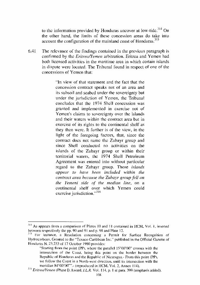
to the information provided by Honduras uncover at Iow-tide.314 On the other hand, the limits of these concession areas do take into account the configuration of the mainland coast of Honduras.315
6.41 The relevance of the findings contained in the previous paragraph is confirmed by the Eritrea/Yemen arbitration. Eritrea and Yemen had both licensed activities in the maritime area in which certain islands in dispute were located. The Tribunal found in respect of one of the concessions of Yemen that:
"ln view of that statement and the fact that the concession contract speaks not of an area and its subsoil and seabed under the sovereignty but under the jurisdiction of Yemen, the Tribunal concludes that the 1974 Shell concession was granted and implemented in exercise not of Yemen's claims to sovereignty over the islands and their waters within the contract area but in exercise of its rights to the continental shelf as they then were. It further is of the view, in the light of the foregoing factors, that, since the contract does not name the Zubayr group and since Shell conducted no activities on the islands of the Zubayr group or within their territorial waters, the 1974 Shell Petroleum Agreement was entered into without particular regard to the Zubayr group. Those islands appear to have been included within the contract area because the Zubayr group fel/ on the Yemeni side of the median line, on a continental shelf over which Yemen could exercise jurisdiction."316
31 ~ As appears from a comparison of Plates 10 and Il contained in HCM, Vol. 1, inserted between respectively the pp. 90 and 91 and p. 98 and Plate 12. 315 For instance, a Resolution concerning a Permit for Surface Recognition of Hydrocarbons, Granted to the 'Texaco Caribbean Inc." published in the Oftïcial Gazette of Honduras N. 23.233 of 17 October 1980 provides:
"Starting from the point (PP), where the parallel 15°00'00" crosses with the intersection of the Coast, being this point on the border between the Republic of Honduras and the Republic of Nicaragua.- From this point (PP), we follow the Coast in a North-west direction, until its intersection with the meridian 84°00'00"".- (reproduced in HCM, Vol. 2, Annex 114).
316 Eritrea/Yemen (Phase I) A ward, l.L.R. Vol. 114, p. 1 at para. 399 (emphasis added). 108
The Tribunal further found that:
"The Production Sharing Agreement does not in terms state a daim of sovereignty of Y emen over the concession area, and, as noted, it takes no notice of the Islands within it, verbally or in the annexed map. It could be interpreted as a concession issued within the area demarcated by a median line in implementation of Yemen's rights on its continental shelf, a concession which includes the Zubayr group but stops just short of including Jabal al-Tayr. It may be said that if it was the intention of Y emen in issuing the concession to assert sovereignty over the disputed islands, the concession would have included Jabal al-Tayr. What seems likelier is that this concession, as others, was issued with commercial considerations in mind and without particular regard to the existence of the Islands."317
These observations show that a striking resemblance exists with the Honduran concessions to which reference was made in the preceding paragraph. The Honduran concessions also do not take notice of the islets included in them in any way.
4. The Regulation of Fishing Activities
6.42 In its discussion of the regulation of fishing activities,318 the Counter-Memorial fails to make any clear distinction between activities that have a relevance for the delimitation of maritime zones, and activities that purportedly have a relevance for establishing a title to the islets in dispute in the present proceedings. The present section will show that the Counter-Memorial does not present any evidence that the regulation of fishing activities by Honduras proves a title to the islets in dispute.
6.43 Honduras asserts that she has long regulated fisheries activities in the area in which the islets in dispute in the present proceedings are included.319 To support this assertion reference is made to Plate 14 contained in Volume 1 of the Counter-Memorial between pages 104 and 105. No indication whatsoever is given on what information this map is based or what it actually intends to prove. Apparently, this is
317 Eritrea/Yemen (Phase 1) A ward, I.L.R. Vol. 114, p. 1 at para. 412 (emphasis added). 318 HCM, Vol. 1, paras. 6.29-6.50. 319 HCM, Vol. 1, para. 6.30.
109
another attempt to make an impression with visual displays, where actual proof is lacking. At the same time, Plate 14 is remarkably imprecise. The area that supposedly includes the islets in dispute is actually located to the north of these islets.
6.44 Honduras starts her analysis of the regulation of fishing activities with a reference to the alleged recognition of the Honduran position on the issues in dispute in the present proceedings by third parties. A general observation in respect of the material invoked by Honduras is that this concerns expert opinions, which however do not concern an expertise in public international law. This limits the significance of such expert opinion for the issue of sovereignty over territory.
6.45 First of ali, the Counter-Memorial refers to a 1943 report of a United States agency, the Fish and Wildlife Service of the Department of the Interior. The part of this report cited in the Counter-Memorial refers to the presence of many cays, reefs and shoals in the area offshore from the Honduran mainland coast, without identifying any specifie islands.320 The Report as reproduced in Annex 162 of Volume 2 of the Counter-Memorial offers a clarification. The paragraph preceding the one cited in paragraph 6.32 of the CounterMemorial provides:
'There are a number of islands and cays lying off the coast. The most important are the Bay Islands: Roatan, Bonacca, Utila, and the Caratasca Cays. The Bay Islands are populated, and they offer shelter for small boats".321
The Caratasca Cays, which are situated to the north of Cape Gracias a Dios are possibly even Jess significant than the islets in dispute in the present proceedings. As these latter islets are mentioned nowhere in the Report, the inevitable conclusion is that they were not considered to be part of the territory of Honduras. The report also indicates that only the Bay Islands are populated and offer shelter for small boats. The Caratasca Cays were not inhabited and were not considered to offer shelter for small boats. This is a further confirmation that historically the small cays off the mainland coast of Nicaragua and Honduras were of limited importance.
320 HCM, Vol. 1, para. 6.32. 321
The citation is taken from the original document and not from Annex 162, which con tains a number of typographical errors.
110

6.46 A report of the FAO of a project which took place in the late 1960s and the beginning of the 1970s is not conclusive in respect of the issue of sovereignty over the islets, as Honduras submits.322 The report shows maps using the parallel of 15° N as a divisional line. However, a closer examination of the project documents shows that this fact does not have relevance for the issue of sovereignty over the islets. First of ali, there is no discussion whatsoever of the islets in the project documents. Other divisional lines used in the project documents have no relation to what Honduras considers to be its maritime boundaries. For instance, the Report indicates that only El Salvador, Guatemala and Nicaragua have a continental shelf in the Pacifie Ocean outside the Gulf of Fonseca?23 The Report also includes a map that indicates a number of zones in the Caribbean Sea. Zone 1 is named 'Opposite of Honduras'. Zone 2 is entitled 'Projection of Honduras-Nicaragua'. To the east Zone 2 is bounded by a meridian to the east of the meridian of 84 o west weil to the north of the area in which the islets in dispute are located.324
6.47 The Final Report of the project also con tains a statement to the effect that along the Caribbean coasts of Nicaragua and Honduras the continental shelf extends for hundreds of kilometers. In this connection reference is made to a map showing the 100 fathoms isobath.325 The continental shelf as defined by this isobath extends for hundreds of kilometers from the coast to the north of the parallel of 15° N. The report thus indicates that the continental shelf of Nicaragua is located to the north of this parallel. This implies that this parallel cannot be a line allocating territory or continental shelf rights. Finally, the Final Report of the Project indicates that:
"The designation employed and this document and map and the presentation of material in this publication do not imply the expression of any opinion whatsoever on the part of United Nation or the Food and Agriculture Organization of the
322 HCM, Vol. 1, para. 6.32. 323 J.S. Cole and R. Wieme, Results of Exploratory Fishing in the Pacifie Ocean Region of Central America by the RIV Sagitario December 1967 to December /968 (Proyecto Regional de Desarrollo Pesquero en Centro América, Boletfn Técnico, Vol. Ill, No. 4, San Salvador 1970), p. 9. 324 M. Giudicelli, Expl'oraciones Pesqueras en el Mar Caribe de Centra América con énfasis en Aguas Profundas, RIV "Canopus" Abri/ a Octubre 1971 (Proyecto Regional de Desarrollo Pesquero en Centro América, Boletfn Técnico, Vol. 5, No. 5, San Salvador 1971) p. 56, Figure 6; reproduced in NR, Vol. Il, Annex 26. 325 Costa Rica, El Salvador, Guatemala, Honduras, Nicaragua, Panamâ; Proyecto Regional de Desarrollo Pesquero en Centroamérica; Informe sobre los Resultados del Proyecto; Conclusiones y Recomendaciones (FI:DP/RLA/65/030; Informe Terminal; Roma, septiembre 1972), p. 6; reproduced in NR, Vol. Il, Annex 19.
Ill
United Nations concerning the legal or constitutional status of any country, territory or maritime area or concerning the delimitation of its frontiers or boundaries."326
6.48 A further report of the F AO and other organizations to which Honduras refers:m was drawn up after the critical date of the present dispute. This Report was drawn up under a program "Investigation and Commercial Evaluation of the Main Maritime Fishing Capacities of Honduras in the Northern Zone" resulting from a request for financial assistance by the National Investments Corporation of Honduras (CONADI). The project document which Honduras reproduces in Annex 162 to the Counter-Memorial and which includes a reference to Media Luna, was drawn up by the CONADI and not by the FAO or one of the other organizations involved. This document thus reflects the position of Honduras herself and not of the intergovernmental organizations.
6.49 Honduras maintains that she has long granted fisheries licenses to her nationals and to nationals of third States to fish in the area north of the paralle1 of 15° N.328 Honduras has not presented any evidence that her regulation of fishing activities is relevant to establishing a title to the islets in dispute. Honduras has not produced any fisheries legislation or Iicenses making reference to the islets. A notification concerning a concession of 1962 that has been submitted by Honduras rather indicates that it applies to an area to the north and west of the area in which the islets in dispute are located. In relevant part, the document reads:
"2.- The area destined for fishing will include the area from the Bay of Puerto Cortés up to the mouth of the River Wans fsicj Coco or Segovia, in a North ho und direction ... "329
6.50 The bitacora,330 a document provided to fishermen by the Honduran authorities since the tate 1970s, does show the area to the north,
326 Costa Rica. El Salvador, Guatemala, Honduras, Nicaragua, Panama; Proyecto Regional de Desarrollo Pesquero en Centroamérica; Informe sobre los Resultados del Proyecto; Conclusiones y Recomendaciones (FI:DP/RLA/65/030; Informe Terminal; Roma, septiembre 1972), p. iv. See NR Vol. II, Annex 19. 327 HCM, Vol. 1, para. 6.32. 32
x HCM, Vol. 1, para. 6.30. 329 Emphasis provided. An excerpt from the notification is contained in HCM, Vol. 2, Annex 119. 330 The Counter-Memorial does not provide a translation of the term 'bitâcora', but observes that this is a document which indicates the area in which fishing is permitted and
112

south and east of Cape Gracias a Dios, but none of the islets in disgute are included nor a limit of any kind along the parallel of 15° N. 1 On the other hand, the two bitacoras reproduced by Honduras include the Bay Islands and two fishing banks and the names of many geographie features on the mainland coast of Honduras.
6.51 Honduras has submitted a number of depositions of fishermen in respect of their activities in the Caribbean Sea. Sorne of these statements make reference to the islets in dispute in the present proceedings or to islets in general.
6.52 The significance of witness statements conceming fishing activities to establish a title to islands has been discussed in the Eritrea/Yemen arbitration. The Tribunal observed that:
"Numerous witness statements were submitted by both sides as to the longevity and importance of their respective fishing practices and the significance of fishing in the lives of their people. Yet, although substantial evidence of individual fishing practices in the record may be taken as a different form of "effectivité" - i.e., one expressive of the generally effective attitude and practice of individual citizens of Eritrea or of Y emen - it is not indicative as such of state activity supporting a claim for administration and control of the Islands. This varied and interesting evidence, on both sides, speaks eloquently conceming the apparent long attachment of the populations of each coast to the fisheries in and around the Islands, and in particular that around the Zuqar-Hanish islands. However it does not constitute evidence of effectivités for the simple reason that none of these functions are acts à titre de souverain. For state activity capable of establishing a claim for sovereignty, the Tribunal must look to the state licensing and enforcement activities concerning fishing described above."332
which is to be returned to the Honduran authorities with an indication of the quantity and type offish which have been caught as weil as the location (HCM, Vol. 1, para. 6.44). 331 See HCM, Vol. 3, Plate 31. The bitacoras are also discussed in Chap. V of the Reply in relation to the question of maritime delimitation. 332 Eritrea/Yemen (Phase 1) A ward, l.L.R. Vol. 114, p. 1 at para. 315.
113

6.53 Apart from this general observation, there are other considerations which disqualify the depositions presented by Honduras as evidence of the existence of a title to the islets in dispute. The CounterMemorial quotes from a number of depositions, in which people make statements in respect of the islets in dispute in the present proceedings. This leads to a partial rendering of the contents of these depositions, which is shown by a systematic analysis of the depositions contained in Annexes 66 to 96 and 99 of Volume 2 to the Honduran Counter-Memorial.
6.54 Ali the depositions that address activities in general terms, and are not related to a specifie act or activity in one or more of the islets in dispute, contain a statement to the effect that they place on record:
" ... se veral matters related to the exercising of sovereignty of the Republic of Honduras and, in particular, the exercising of the jurisdiction of the Administrative District of Gracias a Dios, in the Caribbean Sea or in The Antilles, in the Northeast coast of Honduras and regarding the islands, islets, cays, Banks and the maritime zone commencing at the meridian eighty five (85°) up to the para/le/ of latitude thal passes through the mouth of the River Segovia or Coco".333
6.55 This definition is of critical importance for understanding the relevance of the depositions for the issue of sovereignty over the islets in dispute in the present proceedings. The area between the meridian of 85° W and the parallel passing through the mouth of the River Coco not only contains these islets, but also the following islands and islets: Swan Islands, Cayos Vivorillos, Cayos Cajones, Cayos Caratasca, Cayos Becerro, Cayos Cocorocuma, Cayos Pichones, and Cayo Gorda.
6.56 Any of the depositions concerned make only a general reference to cays or mention specifie activities in respect of one of the islets in dispute and then continue with a general statement about "cays". Such general references to 'cays' do not have any relevance for the issue of sovereignty over the islets in dispute in the present proceedings as these may as weil refer to the other islands and islets
m This quotation is taken from HCM, Vol. 2, Annex 66 (emphasis added). A similar statement is contained in 25 of the other 29 depositions analyzed here. These ali make reference to this same meridian and parallel.
114
listed above. This concerns statements in more than 10 of the depositions. 334
6.57 A second point concerns the islets that are specifically mentioned in the depositions. At the beginning of the Counter-Memorial, Honduras identifies "four important islands" lying between the maritime boundaries claimed by Nicaragua and Honduras: Savanna Cay, South Cay, Bobel Cay and Port Royal Cay.335 A number of the depositions make reference to three of these cays. However, Port Royal Cay is not mentioned in any of the depositions that have been presented to the Court by Honduras. This is in conformity with the silence of the Counter-Memorial on Port Royal Cay in general.
6.58 The depositions in general do not link specifie events to specifie dates. As most depositions do indicate the period in which persons were active as fishermen, this might give the impression that any statement specifically dealing with the islets in dispute also concerns this whole period. Such a view is of course erroneous. If specifie events are linked to a specifie date this is generally after the critical date. A number of depositions give "hearsay" evidence. Sorne of the persons concerned have never been in the islets at ail or not in the period of relevance for the present dispute.336
6.59 Two of the depositions are of a certain interest because they contradict the Honduran assertion that the islets in dispute have been inhabited for a long time.337 Both fishermen were active in the area containing the islets in dispute in the period up to 1974 or 1975. One of them states that Media Luna, Savanna, Bobel and South Cays were not occupied by anyone.338 The other statement indicates that the person concerned is not aware that Savanna, South and Bobel Cays were occupied by foreign persons.339
334 For instance, the deposition in Annex 71 at p. 199 refers to activities that take place "at the cays"; the deposition in Annex 72 at p. 202 makes reference to a visit to "the Cays" after 1999; the deposition in Annex 75 at p. 214 refers to fisheries around "cays"; the deposition in Annex 76 at p. 218 refers to banks close to "the cays"; the deposition in Annex 77 at p. 223 refers to "the area of the Ca ys in Honduras"; the deposition in Annex 78 at p. 227 refers to occupants of "the Cays"; the deposition in Annex 79 at p. 231 refers to Jamaicans that occupy "the Cays"; the deposition in Annex 81 at p. 214 refers to people working in "the cays"; none the depositions in Annex 89 to 94 specify which islets were concemed in response to a question which makes also reference to islets that are outside the area in dispute in the present proceedings. 335 HCM, Vol. 1, para. 2.3. 336 This concerns e.g. the depositions contained in HCM, Vol. 2, Annexes 70, 78 and 81. 337 This concerns the depositions in Annexes 82 and 83 of Vol. 2 of the HCM. 338 HCM, Vol. 2, Annex 82. 339 HCM, Vol. 2, Annex 83.
115
6.60 The Court has indicated that habitation of an island by a group of people does not constitute an act à titre de souverain. In the case concerning Kasikili/Sedudu Island (Botswana/Namibia) the Court observed that:
"It follows from this examination that even if links of allegiance may have existed between the Masubia and the Caprivi authorities, it has not been established that the members of this tribe occupied the Island à titre de souverain, i.e., that they were exercising functions of State authority there on behalf of those authorities. lndeed, the evidence shows that the Masubia used the Island intermittently, according to the seasons and their needs, for exclusively agricultural purposes; this use, which began prior to the establishment of any colonial administration in the Caprivi Strip, seems to have subsequently continued without being linked to territorial claims on the part of the Authority administering the Caprivi."340
This observation also applies to the present case. Apart from the fact that there is very scarce evidence of people staying in the islets, Honduras has not shawn that she has sought to regulate any activity of such persans in the islets in dispute before 1999.341
6.61 In conclusion, the depositions of fishermen do not provide any support for the Honduran assertion that she has a title to the islets in dispute in the present proceedings.
5. The Regulation of Immigration
6.62 Honduras maintains that she has long regulated immigration into the area north of the parai! el of 15° N including the islets in dispute. 342
As is the case for many other matters Honduras allegedly has regulated for a long time, the Counter-Memorial tries to build up a case by linking recent Honduran practice to activities not attributable to Honduras that took place at an earlier date. Honduras only provides evidence of her regulatory activity in 1999 and beyond.343
The Counter-Memorial then refers to the presence of persans in the
3~0 I.C.J. Reports 1999, pp. 1105-1106, para. 98. 3~ 1 See further ùifra paras. 6.62 and 6.87g). 342 HCM, Vol. 1, para. 6.51. 343
See e.g. the references in HCM, Vol. 1, p. 1 18, footnote 107 and p. 119, footnotes lill 13 and 115-1 16.
116
cays for a much longer period, without submitting any proof that such presence has been regulated from the date concemed by Honduras.344
6.63 Honduras also refers to guano exploitation on Bobel Cay in the 191h
Century and more recently. The proof that Honduras presents is either inconclusive or damages her case. A concession granted by Honduras to aMr. Jacob Baiz does not make any reference to Bobel Cay, but only to "islands, small islands and keys of the Atlantic belonging to the State".345 The deposition of Mr. Daniel Bordas Nixon refers to a visit to Bobel Cay in the 1920s. As is apparent from his deposition, at that time Mr. Bordas was living in Nicaragua and not in Honduras.346 This is further proof of the fact that historically there are links between Nicaragua and the islets in question. His very broad reference to exports to the United States does not clarify which country regulated these exports or when they took place.347
6. Military and Naval Patrols and Search and Rescue
6.64 Honduras indicates that she has carried out naval patrols in the disputed area since 1976 to enforce her fisheries legislation and maintenance of security ?48 The relevance of naval patrols and search and rescue for the issue of maritime delimitation is discussed in Chapter IX. Such activities are not of direct relevance for the issue of sovereignty over the islets in dispute as they in general do not concem acts à titre de souverain in the islands.
6.65 In any case, Honduras has not provided any evidence of such activities in respect of these islets before the critical date. To the contrary, a witness statement indicates that Honduras before the critical date in the present dispute did not carry out any operations around the parallel of 15° N, but only in the area to the north of a line running in a northeasterly direction from the mouth of the River Coco.349 Another witness statement indicates that Honduran authorities only have started to pose a problem to Nicaraguan fishing vessels to the north of the parallel of 15° N in recent years. 350
344 See e.g. HCM, Vol. 1, para. 6.53. 345 See HCM, Vol. 2, Annex 169. 346 HCM, Vol. 2, Annex 70. 347 HCM, Vol. 2, Annex 70. 348 HCM, Vol. 1 para. 6.60. 349 NR, Vol. II Annex 23. 350 NR, Vol. Il, Annex 24 and Annex 27.
117
6.66 Search and rescue operations are irrelevant for the establishment of a title to the islets in dispute. 351 In the Eritrea/Yemen arbitration the Tribunal observed in respect of such an operation that:
"Since there is under the law of the sea a generalized duty incumbent on any person or vesse) in a position to render assistance to vessels in distress, no legal conclusions can be drawn from these events."352
7. Public Works and Scientific Surveys
6.67 Honduras maintains that she has carried out public works on the islands, including Bobel, Cay, South Cay and Savanna Cay.353 As can be noted this is another case in which Port Royal Cay, one of the four "important islands" identified as such by Honduras,354 is m1ssmg. Again, the arguments provided by Honduras are inconclusive. Activities took place after the critical date, did not take place in the islets in dispute, or do not support the conclusions that Honduras draws.
6.68 As was already discussed before, the 1976 Arrangement between Honduras and the United States to which Honduras refers355 does not mention the islets. Activities under this arrangement specifically linked to the islets in dispute only took place after the critical date. There are a number of arguments that indicate the irrelevance of these acts for the issue of sovereignty.
6.69 A report on the installation of beacons and buoys of 1980 does not make any reference to the islets in dispute, but includes reference to other islets.356 Moreover, the placing of beacons and buoys is not directly relevant for the establishment of a title to islands.357
6.70 The irrelevance of the FAO project to which Honduras refers in paragraph 6.67 of the Counter-Memorial for the issue of sovereignty over the disputed islets has already been discussed extensively at paragraph 6.48 of this chapter.
351 Reference to such operations is made in HCM, para. 6.62. 352 Eritrea!Yemen A ward (Phase 1), l.L.R. Vol. 114, p. 1 at para. 286. 353 HCM, Vol. 1, para. 6.64. 354 HCM, Vol. 1, para. 2.3. 355 HCM, Vol. 1, para. 6.65. 156 This Report is reproduced in HCM, Vol. 2, Annex 145. m See e.g. I.C.J. Reports 1953, p. 71; Eritrea!Yemen A ward (Phase l), I.L.R. Vol. 114, p. 1 at para. 283.
118
8. The Recognition of Honduran Sovereignty by Third States
6.71 Honduras mainly refers to two States that supposedly have recognized Honduran sovereignty over the islets in dispute in the present proceedings, Jamaica and the United States. Honduras submits that the recognition of Jamaica is reflected in the activities of Jamaican nationals in the waters north of 15° N and by the export of fish caught in those waters. Honduras also makes reference to a request by Jamaica to have access to Honduran waters in 1977.358
6.72 As can be established, Honduras only refers to activities in the waters concerned and to the export of fish to Jamaica, implying a tacit recognition of the fact that these activities are not relevant to establish a t:itle to the islets in dispute. Otherwise, there is one isolated fact possibly related to one of the islets in dispute. In this case, it is not clear whether the Jamaican request is actually concerned with one of the islets in dispute in the present proceedings. The request shows uncertainty over the name of the islet concerned and does not indicate the coordinates at which it is located.359 The Honduran view that these acts form a recognition of her position by Jamaica is contradicted by negotiations on maritime delimitation that took place between Nicaragua and Jamaica in 1996 and 1997.360
6.73 Honduras asserts that the recogmtwn by the United States is reflected in numerous activities carried out by the United States in and around the islets in dispute.361 Honduras again refers to a 1976 Arrangement between the United States and Honduras, failing to mention that this arrangement has no relevance for the issue of sovereignty over the islets, as it includes no reference to any of them. Only in 1981, at which time Nicaragua was involved in an armed conflict with inter alia Honduras and the United States, were markers placed on three of the islets in dispute in the present proceedings.362 Furthermore, as can be appreciated from Plates 16 to 18 included between pages 126 and 127 of Volume 1 of the CounterMemorial, the markers concerned are just a metal dise in a concrete base, making them only detectable at a close distance.
358 HCM, Vol. 1, para. 6.68. 359 The Jamaican note is reproduced in HCM, Vol. 2, Annex 19. 360 See further infra paras. 6.115-6.116. 361 HCM, Vol. 1, para. 6.70. 362 The photo of a marker reproduced at Plate 16 after p. 126 of the Counter-Memorial, which allegedly is located at Savanna Cay, does not show any information on its location.
119
6.74 The drug enforcement operations carried out by Honduras and the United States only took place in 1993 and no evidence is offered of acts in the islets in dispute.
6.75 Honduras also refers to a number of documents that can be considered to provide expert opinion. A general observation in respect of these materials invoked by Honduras is that, although they concern expert opinions, they do not concern an expertise in public international law. This limits the significance of such expert opinion for the issue of sovereignty over territory.
6.76 For instance, Honduras again refers to a 1943 Report of the Fish and Wildlife Service of the United States Department of the Interior and the Office of the Coordinator of Inter-American Affairs. This is the only instance of Unite States "recognition" mentioned by Honduras that predates the critical date. As was already noted before, this report only refers to cays to the north of the area in dispute in the present proceedings (Caratasca Cays). The language employed strongly suggests that the cays in dispute in the present proceedings were not considered to be included in the territory of Honduras.363
6.77 Honduras also refers to a number of United States Reports identifying specifie cays as being either in Nicaragua or Honduras.364 Again, this concerns materials subsequent to the critical date in the present dispute. Moreover, the suggestion made by Honduras that the reports "are partially based on Honduran and Nicaraguan official information" is misleading. As footnote 152 at page 128 of Volume 1 of the Counter-Memorial indicates the reports reproduced in two of the Annexes to the Counter-Memorial provide "Wherever possible, gazeteer production is carried out with the cooperation of the country concerned".365 Honduras provides no evidence that this was the case for Nicaragua in 1985, a time when she was involved in an armed conflict with inter alia Honduras and the United States. The excerpts from the Gazetteers reproduced in the Annexes in the Counter-Memorial also omit the following passage,"Geographic names or their spellings do not necessarily reflect recognition of the political status of an area by the United States Government."
In the light of this disclaimer, it is curious that Honduras considers that the Gazetteers provide positive proof of recognition of a Honduran title to the islets in dispute. Honduras also refers to a 2000 Gazetteer of a United States Agency. This document could not be
363 See further supra para. 6.45. 364 HCM, Vol. 1, para. 6. 70. 365 HCM, Vol. 2, Annexes 167 and 168.
120
checked as the internet site on which it should be located was not available.366
6. 78 Honduras further submits th at the 1995 "Sailing Directions" for the Caribbean Sea issued by the US Defense Mapping Agency contribute to establish a Honduran title to the islets in dispute.367 In this connection, Honduras refers to the fact that two sectors described in this publication are divided by a line that in part is roughlls equivalent with the parallel passing through Cape Gracias a Dios.3 8 Honduras fails to indicate that the Preface to the Sailing Directions provides that "This publication is divided in geographie areas called "Sectors"."369 Furthermore, the limit between the sectors including the Nicaraguan mainland coast (sector 5) and the Honduran mainland coast (sector 6) in large part is situated to the north of the parallel that Honduras considers to be her maritime boundary with Nicaragua. In addition, the sector off the Nicaraguan mainland extends well beyond the parallel of 82° W, which according to Honduras limits the maritime areas of Nicaragua with Colombia. Finally, the description of the maritime area off the mainland coast of Central America confirms that the division in sectors in no way concerns recognition of the Honduran position in respect of the islets in dispute. For instance, it is noted that:
"The W Caribbean, outside the 200m curve off Nicaragua and Honduras, is fouled and marked by scattered banks, cays, and islands. Cayos de Albuquerque, located about 1 07 miles E of Bluefïelds, and Serranilla Bank, located about 187 miles ENE of Cabo Gracias a Dios, are the S and E dangers of those described in this sector. Rosalind Bank and the dan~ers W and NW of it are described in Sector 6." 70
366 The address of the site is given in HCM, Vol. 1, p. 128, footnote 153. Access was sought on 26 June 2002 and 8 July 2002. 367 HCM, Vol. 1, para. 6.71. 368 It should be noted that this is a very thick line, covering an area which on the Earth's surface would at least measure some 10 kilometers in width. Some of the islets in dispute (which are not included in the map) are not to the north of this line, but the line over1aps with them. 369 Sailing Directions (Enroute); Caribbean Sea; Vol. 2, Fifth Edition (Defense Mapping Agency, 1995), p. iii (emphasis added). The document referred to in this and the following footnote were included in the materials deposited with the Registry by Honduras, but are not included in the additiona1 Annexes of the HCM. The relevant part of the document is reproduced in NR, Vol. Il, Annex 2. 370 Sailing Directions (Enroute); Caribbean Sea; Vol. 2. Fifth Edition (Defense Mapping Agency, 1995), p. 93 (emphasis added). The relevant part of the document is reproduced in NR, Vol. Il, Annex 2.
121
As this quotation indicates, it is considered that ali of the area described lies off the coasts of both Nicaragua and Honduras. There is no indication in the "Sai ling Directions" that any of these features are considered to fall under the sovereignty of either of the two States.
6.79 Honduras also refers to the fact that a Pilot published by the Hydrographer of the Navy of the United Kingdom includes the islets in dispute in a subsection entitled "Cabo Gracias a Dios to Cabo Falso".371 The Pilot to which Honduras refers contains a number of indications that it does not provide recognition of the fact that the islets in dispute are Honduran. First of ali, it is noted that the section concerned:
" ... covers the who le of the E coasts of Costa Rica and Nicaragua and the NE coast of Honduras, from Punta Tirbi (9° 26' N, 82° 21' W) (3.18) to Cabo Camar6n (16° 00' N, 85° 02' W) (3.193) 422 miles NNW, including the reef areas on Miskito (Mosquito) Bank, off the E coast of Nicaragua. "372
Subsequently, the Pilot indicates that the Miskito bank includes the Arrecife Alargado and the Arrecifes de la Media Luna, both of which are to the north of the parallel passing through Cape Gracias a Dios.373 If it were to be accepted that the geographical descriptions contained in the Pilot contribute to establishing a title to the disputed islets, they would form part of Nicaragua, as they are located in the Miskito Bank off the east coast of Nicaragua.
6.80 Other forms of alleged recognition mentioned by Honduras are not related to the islets in dispute.374 One incident referred to took place at the point 15° 1 0' N and 83° 1 0' W, that is to the north of the li ne which has been presented by Nicaragua as a maritime boundary in her Memorial. 375
371 HCM, Vol. 1, para. 6.71. 372 East Coasts of Central America and Gulf of Mexico Pilot; Western Caribbean Sea and the Gulf of Mexico from Punta Tirbi to Cape Sable including Yucatan Channel; second edition (Hydrographer of the Navy, 1993), p. 61. 373 East Coasts of Central America and Gulf of Mexico Pilot; Western Caribbean Sea and the Gulf of Mexico from Punta Tirbi to Cape Sable including Yucatan Channel; second edition (Hydrographer of the Navy, 1993), p. 74. 374 HCM, Vol. 1, para. 6.72. 375 This concerns the incident to which reference is made Note N. 106 dated 27 June 1978 reproduced in HCM, Vol. 2, Annex 144.
122

9. The "Recognition" of Sovereignty by Other Entities
6.81 Honduras also points to recognition of the parallel of 15° N as a manttme boundary by the FAO and other international organizations.376 As was already argued/77 the FAO project that took place in the late 1960s and early 1970s does not provide any evidence of a recognition of this fact or that the islets in dispute were recognized as Honduran. The other project to which reference is made in this context took place after the critical date in the present dispute. The project document which Honduras reproduces in Annex 162 to the Counter-Memorial and which includes a reference to Media Luna, was drawn up by the Honduran Corporation, CONADI, and not by the FAO or one of the other organizations involved. This document thus reflects the position of Honduras herself and not of the intergovernmental organizations.
6.82 Honduras states that private companies have also reco~nized
Honduran sovereignty to the north of the parallel of 15° N.37 As a general rule, such "recognition" has to be rejected as irrelevant and unreliable. Moreover, although Honduras refers to the recognition of sovereignty, the incident to which she refers in this context is in no way linked to any of the islets in dispute in the present proceedings. The example Honduras provides is from 1994, again weil after the critical date in the present dispute.
JO. A Basis for the Title to the Islets Implicitly Re lied upon by Honduras
6.83 Honduras fails to address one basis for the title to the islets in dispute she has employed in support of this claim. This concerns the argument that the islets are located in the maritime zones of Honduras and because of this location fall un der her sovereignty. Although never explicitly mentioned in the Counter-Memorial, this argument is implicitly made when it is submitted that:
"Honduras does not use these islands as basepoints, and daims neither shelf nor economie zone for the islands as such. Its claim is based on its mainland and the lon~ history of an established, accepted boundary. " 79
This statement indicates that the islets are included in the seaward projection of the Honduran mainland coast. This same idea is contained in a diplomatie note of Honduras in respect of other cays
376 HCM, Vol. 1, para. 6.73. 377 See supra paras. 6.46-6.48. 378 HCM, Vol. l, para. 6.74. 379 HCM, Vol. 1, para. 7.28.
123

in the Caribbean Sea. This diplomatie note of 27 June 1984 states in respect of an Official Map of Nicaragua:
"There are included in a inset, without any clarification, the banks and cays of Rosalinda an Seranilla, located on the Honduran continental shelf and belonging to our country". 380
6.84 Finally, this idea is presented when Honduras discusses her national legislation. The Counter-Memorial states:
"the legislation of the Republic of Honduras expressly identifies the islands, cays, banks and reefs located within her maritime areas".381
6.85 The reason why Honduras was discouraged from openly including this basis of title in the Counter-Memorial can be easily explained. As Honduras has not presented any conclusive evidence of another basis of entitlement to the islets, the Court would have been explicitly invited to base its decision in favor of Honduras on this criterion. As has been extensively argued by Nicaragua, a division of the overlapping maritime projections of the mainland coasts of Nicaragua and Honduras does not lead to a maritime boundary along the parallel of 15° N as this is a patently inequitable outcome. Such a division has to lead to the adoption of a tine to the north of the islets in dispute.
F. CONCLUSIONS ON THE HON DURAN ARGUMENTS CONCERNING TITLE TO THE ISLETS IN DISPUTE
6.86 Honduras has provided no evidence that establishes the existence of a title to the islets in dispute in the present proceedings. Honduras has not presented any evidence of acts she has carried out à titre de souverain on the islands before the critical date. This is ali the more remarkable because Honduras maintains that there are four "important islands" located in the area between the maritime boundaries advanced by Nicaragua and Honduras. If these islands have the importance Honduras asserts they have, she should not have had any problem in finding abundant materials evidencing her title to them.
3 ~0 Note N. 408-DA of27 June 1984; reproduced in HCM, Vol. 2, Annex 37. JXt HCM, Vol. 1, para. 3.29 (footnote omitted; emphasis added).
124

6.87 The following points can be specifically noted in respect of the arguments Honduras has made to support her title to the islets in dispute:
a) The uti possidetis iuris of 1821 does not provide a basis for the existence of a Honduran title to the islands.
b) The A ward of the King of Spain of 1906 did not address the issue of sovereignty over islets and rejected the use of parallels and meridians as a land boundary.
c) The A ward of the King of Spain of 1906 excludes the possibility that the parallel of 15° N was implicitly adopted by the Arbitrator to establish sovereignty over the islets off the mouth of the River Coco.
d) The land boundary Honduras submitted in her pleadings in this arbitration was proposed without taking into account the islets off the Central American mainland coast.
e) Cartographie evidence presented by Honduras is either inconclusive or points to the fact that Honduras considered that the islets in dispute did not form part of her terri tory.
f) Honduras has not presented any evidence that she considered the parallel of 15° N to be a line allocating the sovereignty to islets to the north of it to Honduras and to the south of it to Nicaragua at any time before the critical date in the present dispute. To the contrary, Honduras has provided evidence and arguments that indicate that she considered that no such line existed.
g) Honduras has not presented any evidence that she sought to regulate activities in the islets before the critical date. Honduras only actively started to assert a claim over the area north of the parallel of 15° N in the 1980s. Even for this period Honduras provides hardly any concrete evidence in respect of the islets. Most evidence of such regulation stems from the second half of the 1990s and beyond. Once the Honduran claim to the islets became apparent in the 1980s Nicaragua immediately reacted by rejecting this claim.
h) Honduras has not provided any evidence of recognition of her claims to the islets in dispute by third States or international organizations. A United States report from 1943 invoked by Honduras rather proves that the islets did not form part of the terri tory of Honduras.
125
i) Honduras does not provide any evidence in respect of Honduran acts, even after the critical date, in respect of Port Royal Cay, one of the four islets described by Honduras as "important islands".
j) Honduras has not shown the existence of her historical, uninterrupted and unchallenged exercise of sovereignty over the islets in dispute. Ali the so-called evidence presented by Honduras to substantiate her claim stems from the period after the critical date. Such self serving evidence in any case does not contribute to establishing a title to the islets in dispute.
II. The bases of the Nicaraguan daim (including effectivités)
6.88 The analysis of the bases of the Nicaraguan claim will mainly address two issues. The Counter-Memorial seeks to give specifie meaning to acts and omissions of Nicaragua. It has to be established to what extent the Counter-Memorial gives a correct interpretation of the practice of Nicaragua. A second issue that is addressed is the evidence that substantiates the title of Nicaragua over the islets in dispute.
6.89 The islets in dispute are located in a region that until recently has attracted relatively little attention. Moreover, the islets in dispute are very small and have mainly been used as a resting place by fishermen in the fishing season. In this connection, it is appropriate to draw an analogy with the Eritrea/Yemen arbitration, which was concerned with the title to a number of islands. In analyzing the evidence before it, the Tribunal observed that:
"The factual evidence of "effectivités" presented to the Tribunal by both parties is voluminous in quantity but is sparse in useful content. This is doubtless owing to the inhospitability of the Islands themselves and the relative meagreness of their human history. The modern international law of the acqu1s1t1on (or attribution) of territory generally requires that there be: an intentional display of power and authority over the territory, by the exercise of jurisdiction and state functions, on a continuous and peaceful basis. The latter two criteria are
126
tempered to suit the nature of the territory and the size of its population, if any."382
These conclusions will have to be taken into consideration by the Court in evaluating the evidence before it in the present proceedings.
A. THE UT/ POSSIDETIS IURJS OF 1821
6.90 There is no documentary evidence that there exists a title to the disputed islets on the basis of the uti possidetis iuris of 1821 of either Nicaragua or Honduras. This is not surprising as the territory in dispute concerns a number of small islets located in an area that in 1821 had hardly any economie or strategie significance. In the absence of any documentary evidence on the uti possidetis of 1821 there is one other consideration that is relevant to establish the situation in 1821. This is the location of the islets in dispute in relation to other territories of the states concerned. The islets in dispute form part of a chain of islands and islets that extend from the Nicaraguan mainland coast to the Main Cape Channel off the mouth of the River Coco. If a 6 nautical mile maritime belt (the breadth applied in Central America in 1821) were to be drawn around ali features that qualify as a baseline un der international law, the re would be an almost uninterrupted maritime area extending from the Nicaraguan mainland and Miskito Ca~ to the Main Cape Channel, including ali the islets in dispute.3 3 The Main Cape Channel separates the islets and reefs located to either side of it and forms an important navigational channel.384
6.91 This argument of adjacency is not unfamiliar to the States in the region. 1t was employed in the turtle fishing dispute between Nicaragua and the United Kingdom at the turn of the 19th cent ury to determine the title to small islets off the mainland coast of
382 (Eritrea/Yemen A ward (Phase 1), l.L.R. Vol. 114, p. 1 at para. 239). 383 See NR, Vol. Il, Figure VIII. 384 For instance, a Pilot prepared by the Hydrographer of the United Kingdom Navy indicates that:
"Main Cape Channel (15° ION [sic], 82° 55' W) is one of the main channels crossing the Miskito Bank, leading from the vicinity of Cabo Gracias a Dios (15° OO'N, 83° 09' W) to deep water NNE. General depths in the fairway, which is at least 5 miles wide, are 18 to over 30m (East Coasts of Central America and Gulf of Mexico Pilot; Western Caribbean Sea and the Gulf of Mexico from Punta Tirbi to Cape Sable including Yucatan Channel; second edition" (Hydrographer of the Navy, 1993), p. 74).
127
Nicaragua.385 This dispute is discussed in detail in Chapter IV of the Reply.
6.92 The relevance of adjacency to establish title to small islets was recognized in the Eritrea/Yemen arbitration. The Tribunal noted that the activities relied upon by the parties, though many, sometimes spoke with an uncertain voice. In such circumstances, the Tribunal considered it could look at other possible factors that might strengthen the basis of decision.386 The Tribunal noted that an obvious such factor was:
" ... the geographical situation that the majority of the islands and islets and rocks in issue form an archipelago extending across a relatively narrow sea between the two opposite coasts of the sea. So there is sorne presomption that any islands off one of the coasts may be thought to belong by appurtenance to that coast unless the State on the opposite coast has been able to demonstrate a clearly better title."387
B. THE TURTLE FI SI-liNG DISPUTE
6.93 The turtle fishing dispute between Nicaragua and the United Kingdom at the turn of the 191
h century concerned a fishery in the islets and banks off the main land coast of Nicaragua to the south and the north of the parallel of 15° N. Honduras did not intervene in this dispute at any moment, which indicates that she did not consider that these islets formed part of her territory. The claim to regulate the fishery by Nicaragua in this dispute was based on her sovereignty over the islands and islets around which the turtle fishery took place.388
3x5 See NR, Vol. II, Annex 28. See also Document 3-02 deposited with the Registry by Honduras, p. 269. 3x6 Eritrea/Yemen A ward (Phase 1), I.L.R. Vol. 114, p. 1 at para. 457. 3x7 Eritrea/Yemen A ward (Phase 1), I.L.R. Vol. 114, p. 1 at para. 458 (emphasis added). The Tribunal expressed some doubt as to the applicability of this factor in case there is a chain of islands extending beyond the territorial sea of the mainland coast. However, the reasoning of the Tribunal admits the application of this theory also in this case, although it is capable of being rebutted by evidence of a su peri or title (ibid, para. 4 74 ). This indicates that this factor can be taken into account in the absence of a superior title. 3xx For a detailed analysis of the dispute see NR, Chap. IV.
128
C. THEARBITRALAWARD OF THE KING OF SPAIN OF 1906
6.94 As was argued above, the Arbitral Award of the King of Spain was only concerned with the land boundary between Nicaragua and Honduras. Only Nicaragua made a reference to islands (the Swan Islands) in her pleadings in this arbitration. Honduras holds that it is obvious that this claim of Nicaragua before the King of Spain implied a claim to the islets that are now in dispute between Nicaragua and Honduras.389 If the Honduran assertion of an implied claim to the islets that are now in dispute is accepted, the only conclusion that logically follows is that Honduras through her silence on this point accepted that these islets formed part of the territory of Nicaragua.390
D. THE LEGISLA Tl ON OF NICARAGUA
6.95 Honduras considers there is a "pattern of imprecision and Jack of identification of the islands, cays, banks and reefs" included in the territory of Nicaragua that is characteristic of the entire Nicaraguan legislation.391 Honduras further submits that the relevant provisions do not provide any evidence that the insular features to which Nicaraguan legislation refers were located north of the parallel of 15o N.r92
6.96 This argument of Honduras is wholly without merit. The legislation of most States does not make specifie reference to ali the mainland and island territories to which it applies. The most recent example in this respect for Nicaragua is given by the Law on Maritime Areas of 5 March 2002.393 The Law, which establishes a 12 nautical mile territorial sea, 24 nautical mile contiguous zone, exclusive economie zone and continental shelf, makes reference to the "coasts" and "baselines". If legislation is stated to apply to islands in general, it has to be assumed to be applicable to ali the islands that a State considers to be included in her territory. Even if no reference is made to islands at ali, legislation will in general be applicable to ali of the territory of a State unless there are specifie provisions which provide otherwise.
3~9 HCM, Vol. 1, para. 5.11. 390 See further supra para. 6.15. 391 HCM, Vol. 1, para. 3.28. 392 HCM, Vol. 1, para. 3.28. 393 See NR Vol. II, Annex 29.
129

6.97 The cnticism of Honduras becomes even more incomprehensible once it is realized that only in 1982, after the critical date, the Honduran Constitution included a reference to one of the islets in dispute in the present proceedings. Before that time, the Honduran Constitution and other legislation did not contain any reference to these islets.
6.98 Honduras refers to a Decree of Nicaragua (Decree No. 43-91 of 31 October 1991) and a Report on the Situation in the Caribbean Coast of Nicaragua, both define a specifie area, which does not include the islets in dispute.394 The Decree to which reference is made contains a Declaration establishing a Marine Biological Reserve. 395 This Declaration defines an area with a radius of forty kilometers centered on Miskito Cay. This area does not extend to the parallel of 15° N and also excludes islets and rocks to the south of the islets in dispute. Clearly, this definition is intended to indicate the extent of a natural reserve and not the extent of the terri tory of Nicaragua.
6.99 The other document concerned is a report in connection with a project for improving the capacity to organize natural resources of the Caribbean coast, issued in 1999.396 The fact that the islets in dispute are not included in this document does not entai! a recognition by Nicaragua that she considers that the islets in dispute are not included in her territory. This claim at that time was widely known and advanced by Nicaragua. Exclusion of the disputed islets from the project document is easily explained by its nature. This document seeks to establish a policy and management framework. It would be of little use to include disputed areas in such a framework as it would not be possible to execute it in such an area.
E. CARTOGRAPHie EVIDENCE
6.100 Honduras accuses Nicaragua of relying on cartographical evidence that is recent and self-serving and has been prepared by Nicaragua "for the purpose of these proceedings, and much of it post-dates the filing of Nicaragua's Application".397 This assertion is patently untrue, as Nicaragua has presented no cartographie evidence postdating the filing of her Application. As a matter of fact, Honduras fails to make any reference to material presented by Nicaragua in support of this assertion. The Honduran accusation becomes even more astonishing when it is realized that it is Honduras which has
Wl HCM, Vol. 1, para. 6.17. 395 Reproduced in HCM, Vol. 2, Annex 164. 396 Reproduced in HCM, Vol. 2, Annex 165. 397 HCM, Vol. 1, para. 3.59.
130
relied on recent and self-serving evidence that in a number of cases post-dates the filing of Nicaragua's Application.398
6.101 Honduras has reproduced a number of maps that have been published in Nicaragua.399 The Counter-Memorial fails to mention one aspect of these maps, which, in the light of the arguments of Honduras, is of fundamental importance. None of the maps includes a maritime boundary running along the parallel of 15° N or a line running along this parallel to indicate the extent of the insular territory of Nicaragua in the Caribbean Sea. This omission becomes even more significant once it is realized that the maps concerned do show a boundary between Nicaragua and Honduras in the Gulf of Fonseca.400 Depiction of the latter boundary leads to the conclusion that the maps not only intend to show the terrestrial boundaries of Nicaragua, but also its offshore boundaries. The maps indicate that Nicaraguan sources considered that no boundary between Nicaragua and Honduras existed in the Caribbean Sea.
6.102 Honduras fmther argues that maps published in Nicaragua:
" ... do not include any of the islands and ca ys which Nicaragua now daims as being located within Nicaraguan terri tory. The daim set forth in Nicaragua's Memorial ignores its own cartography, both historical and present day. The omissions become even clearer when it is noted that ali of these maps do include the islands and cays which lie south of the 151
h
parallel over which Nicaraguan sovereignty is claimed and recognized."401
A review of the maps published in Nicaragua that have been presented by Honduras reveals that the above statement does not accurately reflect the information which is included in the maps. First of ali, Honduras suggests that ali islands and cays which lie south of the parallel of 15° N are included in these maps. However,
398 For instance, Honduras relies on a Treaty of 4 December 2001 she concluded with the United Kingdom (HCM,. Vol. 1, para. 8. JO) and temporary work permits issued on 6 and 10 January 2000 (HCM, Vol. 1, para. 6.53). As is noted in Chap. III, para. 3.37 of the present Reply, the Treaty between Honduras and the United Kingdom is not relevant for the present ~roceedings. 99 See HCM, Vol. 3 (Part 2), Plates 28 and 29; and HCM, Additiona1 Annexes to Volume
2, Annex 177 to 179. 400 This concerns ail of the maps, except the map contained in HCM, Additional Annexes to Volume 2, Annex 177, which does not cover the Gulf of Fonseca and was drawn up at a ti me the boundary in the Gulf had not y et been established. 401 HCM, Vol. 1, para. 3.59 (emphasis in the original).
131
ali these maps only give an approximate idea of the extent of the insular territory of Nicaragua in the Caribbean Sea. For instance, the map reproduced as Annex 178 to the Counter-Memorial only shows Miskito Cay and one other islet to the north of it. In reality there are numerous islets around Miskito Cay. Secondly, Honduras fails to indicate that two of the maps concerned indicate that the insular domain of Nicaragua includes the islets in dispute in the present proceedings. The Official Map, dated 1898, includes islets to the north and the south of the islets in dispute in the present proceedings.402 This leaves little doubt that these latter islets were also considered to be Nicaraguan. An inset in a map of 1993 shows the contours of a number of reef areas, one of which extends to the north of the parallel of 15° N. This area includes the islets in dispute . h d' 403 m t e present procee mgs. -
6.103 The official map of Nicaragua prepared in 1982 also contradicts the Honduran assertions in respect of cartographie evidence originating from Nicaragua.404 As is the case for other such maps, this map does show a boundary between Nicaragua and Honduras in the Gulf of Fonseca, but not in the Caribbean Sea. The map also includes the "Reefs of Media Luna" and the "Reefs of Alargado", which areas contain the islets in dispute in the present proceedings.
6.104 The 1998 edition of the Official Map of Nicaragua was annexed to the Memorial as Figure B, Volume III. The Nicaraguan Memorial mistakenly indicated that this map contained the following inscription: "The maritime frontiers in the Pacifie Ocean and the Caribbean Sea have not been juridically delimited." (See Chapter II, paragraph 47 of the Nicaraguan Memorial) In fact, this inscription is written in earlier editions. Honduras points to this error in paragraph 3.34 of her Counter Memorial. For this reason, the 1997 edition of the Official Map, which has the inscription, is reproduced in Volume II of this Reply as Map V.
6.105 Honduras asserts that Nicaraguan geographers have recognized that the islets in dispute are not part of Nicaragua.405 To provide evidence of this affirmation Honduras refers to the publication Geograffa de Nicaragua of 1964.406 However, even in the incomplete and selective translation of the text provided by Honduras, it is clear that this publication contains a non-limitative enumeration, as the islets to which specifie reference is made are preceded by the words 'such
402 HCM, Additional Annexes to Volume 2, Annex 177.
403 HCM, Additional Annexes to Volume 2, Annex 179, Map 179 A. 404 Reproduced in NR, Vol. II, Map IV. m HCM, Vol. 1, para. 3.28. 406 HCM, Vol. 1, p. 42, footnote 45.
132

as' .407 There is nothing in the text to suggest that the islets in dispute were excluded from this enumeration.
6.106 There is another publication prepared by Dr. Jaime Incer, one of the authors of the publication Geografia de Nicaragua of 1964, which is relevant in the present context. This publication, an Indice Geogrâfico de Nicaragua of 1971, which constitutes expert evidence, includes a reference to Media Luna, which is described as:
"Group of cays and reefs localted approximately 70 km east of Cape Gracias a Dios, on the submarine shelf. It includes the following islets: Logwood, Bobel, Savanna, South, Half Rock, Alargado Reef and Cock Rock. It is located at latitude 15° 10' North and Longitude 82° 35' ."408
This is one of the very limited instances in which materials preceding the critical date in the present dispute explicitly and unequivocally refer to the islets in dispute as forming part of the territory of one of the parties to the present proceedings. As such, it is of particular significance for the issue of the sovereignty over the islets in dispute.
F. EFFECTIVITÉS AND THE EXERCISE OF NICARAGUAN SOVEREIGNTY AND JURISDICTION
OVER THE ISLETS IN DISPUTE
1. Fisheries Legislation, Activities and Enforcement
6.107 Honduras asserts that:
"Nicaragua has provided no evidence to the Court to show that it has ever applied or enforced - or even sought to apply and enforce - its fisheries laws north of the 151
h parallel."409
As was already pointed out above in evaluating the Honduran arguments in relation to the regulation of fisheries activities, the issuing of fishing licenses or adoption of fisheries legislation is not directly relevant for the issue of title to territory. As a consequence,
407 NR, Vol. Il, Annex 30. See also HCM Vol. 2 Annex 166. 408 Indice Geognifico de Nicaragua; Volumen I (Rfos, Lagos y Litorales) (lnstituto Geogrâfico Nacional, Managua, septiember 1971), p. 124; NR, Vol. Il, Annex 31. 409 HCM, Vol. 1, para. 6.47.
133
it suffices to note in this Chapter that Nicaragua has regulated fisheries in the Caribbean Sea for a long time. Nicaraguan legislation in no way indicates that such regulation was limited only to areas south of the parallel of 15° N. For instance, Decree No. 11 of 5 April 1965 establishes a 200 nautical mile national fishing zone "in the Atlantic and Pacifie Oceans".410
6.108 As far as the control and enforcement of fishing activities in the area in which the disputed islets are located is concerned, Nicaragua can point to a much longer presence than Honduras. The turtle fishing dispute between Nicaragua and the United Kingdom at the turn of the 191
h century concerned a fishery in the islets and banks off the mainland coast of Nicaragua to the south and the north of the parai! el of !5o N. Honduras did not intervene in this dispute at any time, which indicates that she did not consider that these islets formed part of her terri tory. The claim to regulate the fishery by Nicaragua in this dispute was based on her sovereignty over the islands and islets around which the turtle fishery took place.411
6.109 Nicaraguan and foreign fishing vessels licensed by Nicaragua have been fishing in the area to the north of the parallel of !5° N since a long time. For instance, Mr. Jorge Morgan Britton states that:
" ... during fourteen (14) years from nineteen sixty (1960) to nineteen seventy-four (1974) during which he worked as a crew member and captain of fishing boats, it was usual for said boats, which operated with Nicaraguan fishing licenses, to carry out their work in the north up to the parallel seventeen (17), in the areas near Rosalinda Bank, and that the product of the fishing activities were unloaded at the processing plants that were then located in the area of Bluefields and El Bluff in Nicaragua, where it was processed and packed as a frozen product and later shipped to export markets. That, as stated before, from nineteen seventyfour (1974) to nineteen eighty (1980) he did not participate directly in fishing activities in open sea because he was managing his WILL BOWER company, with which he operated his own vessels and contracted his own captains and crews; but he is also aware that these
410 NR, Vol. II, Annex 13.c. 411 For a detailed analysis of the dispute see NR, Cha p. IV.
134

vessels operated normally in the north up to parallel seventeen ( 17) as part of the Nicaraguan fishing zone in the Caribbean Sea. He can confirm this because as owner of this company, it was his duty to constantly monitor the positions of his vessels and ali the daily details that are part of fishing activity. [ ... ]
[U]p until nineteen seventy-four (1974), when he was fishing in that area up to parallel seventeen ( 17), in which it was common to see Nicaraguan boats working alongside foreign boats operating with Nicaraguan licenses, they never detected any presence of Honduran civilian or military authorities and he never knew of any problem between these vessels and Honduran authorities."412
Mr. Leonel Aguirre Sevilla, who held the position of General Manager of PESCANICA S.A. between 1970 and 1979, states that:
"Said company at that time had the largest shrimp fleet, comprised of thirty (30) industrial vessels, each one measuring over seventy-two feet in length, ali of which operated under the commercial fishing license of the PESCANICA S.A. Company, and each of their respective permits and navigation patents issued by Nicaraguan authorities. In his role as General Manager, one of his responsibilities was to monitor, up to twice a day, the positions of the ships and other details pertinent to fishing activities; and that it was common that severa! of the vessels frequently carried out fishing activities in the North, up to Parallel seventeen (17)."413
6.110 Nicaragua has controlled the activities of fishermen to the north of the parallel of 15° N, including the area in which the islets in dispute in the present proceedings are contained. The National Guard of Nicaragua acquired a number of new patrol vessels in 1975. As is explained by Mr. Arturo Mohrke Vega, at that time a Colonel in the Navy of War of the National Guard of Nicaragua:
412 NR, Vol. II, Annex 24. 413 NR, Vol. II, Annex 25.
135

"Sorne of these were assigned to operate in the Nicaraguan Caribbean Coast, to carry out patrols in areas around parallel seventeen ( 17). At no time were there conflicts either with fishermen or between the Navies of War from both countries, but both organizations maintained frequent radio communications. Both the appearing party and other boat captains from the Navy of War and traditional and commercial fishermen were sure that the mant1me border between Nicaragua and Honduras was not paralle1 fifteen (15), but rather the oblique line that began at the mouth of the Coco River in the Caribbean sea and proceeded northeast. That the Hondurans were fully aware of this, both the Navy of War and fishermen, who did not navigate or work south of that 1ine. That everyone was aware that the cays and banks that were south of that line belonged to Nicaragua, but not the Vivorillos and Cajones Cays, which be1onged to Honduras. "414
Thus, not only did Nicaragua patrol the area in dispute, but this was accepted by Honduras. Mr. Clark McClean, who fished in the area in dispute from 1975 unti1 the 1980s a1so indicates that the area around the islets in dispute was being patrolled by Nicaragua415
6.111 The deposition of Mr. Morgan Britton indicates that the islets in dispute in the present proceedings were not permanently inhabited, although there were fishermen who used sorne of the ca ys and banks near Cape Gracias a Dios as an intermediate resting place during their fishing activities.416 This confirms what is said in this respect in two of the depositions annexed to the Counter-Memorial417 and refutes the Honduran assertion that the islets have been inhabited for a long time.
6.112 In the Counter-Memorial, Honduras expressly recognizes that Nicaragua has patrolled the area north of 15° N, including the islets in dispute in the present proceedings.418 However the language in
414 NR, Vol. II, Annex 23. 415 NR, Vol. II, Annex 22. 416 NR, Vol. II Annex 24. 417 See supra paras. 6.108 and 6.190. 41X S C ee H M, Vol. 1, para. 6.42.
136
which this admission is couched is not acceptable to Nicaragua. For instance, the Counter-Memorial concludes:
6.113 While the Nicaraguan presence is found to be "bothersome" by Honduras, the Honduran presence has impeded the activities of fishermen that have been duly licensed by Nicaragua. For instance, one witness has noted that:
"In recent years, he knows that there have been sorne problems with Honduran authorities in the area from parallel seventeen ( 17) to fifteen (15) which has affected fishing operations of Nicaraguan vessels and foreign vessels still operating under a Nicaraguan license, and he is even aware that there have been sorne seizures of boats and fishermen by Honduran authorities; because of this he has instructed his captains to not enter that fishing zone, as any seizure of one of his vessels or crew members would imply major !osses for his company."419
2. Oit concessions
6.114 The practice of Nicaragua in respect of the granting of concessions for the exploration and exploitation of oil and gas has been discussed above in connection with the practice of Honduras in this respect. The conclusions reached at that point can be recapitulated as follows. The practice of Nicaragua and Honduras shows that a) there was no agreement on the existence of a line of allocation of sovereignty; and b) Nicaragua considered th at the islets in dispute in the present proceedings formed part of her terri tory.
3. The Recognition of Nicaraguan Sovereignty by Third States
6.115 Honduras maintains that no third State has recognized Nicaraguan sovereignty over the islets north of the parallel of 15° N.420 However, there are a number of instances in which such sovereignty was recognized and it was explicitly or implicitly acknowledged that the parallel of 15° N did not constitute aline of allocation of territory or a maritime boundary. A first instance to which reference can be made is the t:urtle fishing dispute between Nicaragua and the United
419 NR, Vol. II, Annex 24. An example of Honduran harassment of Nicaraguan authorities is provided by the Note DAJ No. 056 of 19 April 1983 (NM, Vol. II, Annex Il). The situation in the area in dispute in the 1980s and beyond is described in detail in Chap. V of the Memorial. 420 HCM, Vol. 1, para. 6.78.
137
Kingdom, at the end of the 191h and beginning of the 201
h cent ury .421
Fishermen from the Cayman Islands also visited islets to the north of the parallel of 15° N and Nicaragua indicated that she considered to have sovereignty over at )east one islet to the north of this parallel. The United Kingdom accepted that it had to negotiate an agreement with Nicaragua to settle the dispute over the turtle fishery and Honduras was in no way involved in this dispute.
6.116 Nicaragua and Jamaica conducted negotiations on the delimitation of a maritime boundary in 1996 and 1997. During the second and third meetings between the two States delimitation !ines were presented and discussed.422 A Jamaican proposai for the delimitation of the maritime boundary recognized Media Luna Cay as part of the
. fN. 4"~ terntory o 1caragua. --
6.117 These negotiations indicate that Jamaica has not recognized that the islets in dispute between Nicaragua and Honduras in the present proceedings are Honduran. On the risk of stating the obvious, the Jamaican position also implies that she did not consider that the parallel of 15° N served to limit the maritime areas or sovereignty over islands of Nicaragua. In other words, Honduras is mistaken when she submits that Jamaica had recognized Honduran sovereignty and jurisdiction in the area in dispute between Nicaragua and Honduras.424
III. Conclusions on the Nicaraguan Arguments concerning the Title to the Islets in Dispute
6.118 The evidence provided by Nicaragua indicates that, compared to the evidence presented by Honduras, and if ali circumstances are taken into consideration, there can be no doubt that the title to the islets in dispute rests with Nicaragua.425 This concerns in particular:
a) To establish the situation in 1821, the date of independence of Nicaragua and Honduras, reference can be had to the location of the islets in dispute in relation to other territories of the states concerned. The islets are adjacent to other Nicaraguan territory, but not to other territories of Honduras.
421 This dispute is discussed in more detail in Chap. IV. 422 See NR, Vol. II, Annex 32. 423 See NR, Vol. II, Annex 33. 424 For the Honduran affirmations in this respect see HCM, Vol. 1, para. 6.68. 425 The conclusions in respect of Honduras are presented above at para. 6.87.
138
This fact indicates, in the absence of any other title, that the islets in dispute in the present proceedings in 1821 were part of Nicaragua.
b) The turtle fishing dispute between Nicaragua and the United Kingdom confirms this title of Nicaragua over the islets and an absence of an interest of Honduras in the islets. The existence of a Nicaraguan title to the islets in dispute is highly significant as it indicates that there rests a burden of proof on Honduras to demonstrate that this title at a later stage has reversed to Honduras.
c) The Arbitral A ward of the King of Spain did not address the title to the islets in dispute. However, the arguments of Nicaragua and Honduras in the proceedings suggest that only Nicaragua considered herself to have a title to the islets in dispute.
d) Cartographie evidence ongmating from Nicaragua shows that the parallel of 15° N was never considered to be either a line dividing insular territory or a maritime boundary. No such map depicts this parallel. In addition, the publication Indice Geogrâfico de Nicaragua of 1971 indicates the islets in dispute to be included in the territory of Nicaragua.
e) Nicaragua has regulated fishing activities in the area including the islets for a long time, at least since the end of the 191
h century. Regulation of these activities has continued in the 1980s and beyond.
f) The oil and gas concessions issued by Nicaragua in the 1960s and 1970s indicate the absence of a line along the parallel of 15° N either allocating sovereignty over territory or serving as a maritime boundary. The concession practice of Nicaragua indicates that she considered to have sovereignty over the islets in dispute.
g) There are a number of instances of recogmtwn by third States of the fact that the territory and maritime zones of Nicaragua are not limited by the parallel of 15° N.
139
CHAPTER VII THE WEAKNESS OF THE HONDURAN ARGUMENT BASED ON
CONDUCT
1. Introduction
7.1 In the preceding chapters Nicaragua has shown that the alleged effectivités of Honduras in the area in dispute do not confirm any title based on the 1821 uti possidetis iuris 426 and are not an incipient basis of such a title.427 The intention in this chapter is to reject the existence of a boundary line based on the conduct of the Parties.
7.2 According to Honduras, Nicaragua "ignores the traditional use by both States of parallel 15 as a boundary."428 The assertion is frequently rer:eated that this boundary line arises from the conduct of both parties.' 29 Honduras also asks the Court to take this conduct into account as one of the relevant legal circumstances in drawing the boundary, according to the applicable norms of the International Law of the Sea. This argument seems a reversai of the assertions in her diplomatie notes that the boundary line already exists as a result of the tacit agreement between the Parties, or Nicaragua's acquiescence, that is, "consent evinced by inaction"430 against the Honduran claim.
7.3 However, the argument of conduct as acquiescence is not disregarded in this Reply because the Honduran Counter-Memorial proposes elsewhere that the agreement referred to in Articles 74 and 83 of the 1982 United Nations Convention on the Law of the Sea can be manifested - and, Honduras claims, is manifested between Honduras and Nicaragua -"in the form of reciprocal conduct which may show the existence of acquiescence or sorne other form of tacit consent, capable of generating and/or modifying rights and obligations between the parties."431
426 See supra Chap. IV. 427 See supra Chap. V and Chap. VI. 428 See HCM, paras. 1.24-1.27. 429 See HCM, paras. 2.25-2.28, 3.18-3.36, 4.26-4.27, 6.76-6.77, 7.15-7.25 and 8.4-8.5. 43° Continental Shelf(Libya/Tunisia), Ind. Op. Judge Ago, ICJ Reports, 1982, p. 97, para. 4. 431 See HCM, para. 5.37.
141
7.4 In response it must be noted: 1) th at the Honduran claim that the 151h
Parallel is the boundary of maritime areas with Nicaragua was not made formally until 1982 or according to Honduras in her CounterMemorial, 1979;432 2) that the claim was immediately, rejected by Nicaragua. Thus, the history of the dispute over the past twenty years has been the history of a persistent dispute regarding the relevance of the 151
h Parallel, and therefore an endless list of Nicaraguan actions expressly contradicting the Honduran claim.
7.5 Ali in ali Honduras has only her own dogmatic assertions that "Throughout this period Honduras continuously exercised sovereign authority over the islands and waters north of the 151
h Parallel. It did so openly and without protest from Nicaragua".433 But invoking a "consistent"434 or "well-established and well-documented"435
practice over an extended ti me prior to 1979 is not enough. Proof has to be provided and Honduras fails to do this.
II. Conduct of the parties before 1963
7.6 Honduras asserts that Nicaraguan treatment of (history and) historical titles is brief and rudimentary, particularly for the period prior to 1963.
7.7 Having said this, and given the Honduran critique of the Nicaraguan Memorial's brief historical analysis, one would expect Honduras to provide a comprehensive and detailed analysis of this subject. However, Honduras which - as ide from the history of the diplomatie exchange between Nicaragua and Great Britain on turtle fishing in that part of the Caribbean436
- took care of the colonial period and the entire 191
h century in a page and a half,437 and went on to deal with the first half of the 201
h century ( 1906-1960) in Jess than one page.438 In the end, Honduras wrote Jess than Nicaragua, which devoted eleven pages to the period prior to 1963.439
432 See below Section IV. 433 See HCM, para. 3.18. 434 See HCM, para. 3.21. m See HCM, para. 3.24. 436 See HCM, paras. 3.9-3.13. See supra Chap. IV. 437 See HCM, paras. 3.3-3.8. See supra Chap. IV. 43
g See HCM, paras. 3.14-3.17. 439 See NM, III, pp. 21-31.
142

7.8 Chapter 3 of the Honduran Counter-Memorial, which purportedly focuses on "the historical and political background to the proceedings," Jacks legal content pertinent to the matter at hand. If it shows anything, it is that until the nineteen seventies, maritime delimitation in the Caribbean was of no primary interest to the Parties because they had very little population on that coast, the display of public activities and services was limited and maritime activities were reduced to traditional fishing activities of the communities living in that area with no notion or concem for boundaries.
7.9 With respect to the period from 1906-1960, the Honduran CounterMemorial basically confines itself to quoting parts of the 1906 Arbitral Award and a paragrafch from the 1960 Judgment of the Court upholding that Award.4 0 Honduras finds it "striking" that Nicaragua, in spite of having attempted during that period to contest the land boundary determined in 1906, did not assert any claim to the islands and maritime areas nor reserved her right to do so. Honduras also contends that Nicaragua did not challenge "the many assertions of sovereignty ... by Honduras north of the 151
h parallel."441
7.10 The latter contention is baseless. There were no manifestations of Honduran sovereignty regarding the islands, cays, banks and waters in the area in dispute, and therefore, no need for protests. The former, on the other hand, was unnecessary because, as the turtle fisheries effectivités indicate, Nicaragua was exercising uncontested sovereignty in the maritime areas in dispute. And if that were not the case why would Nicaragua complain to Honduras, which waited until 1982 or, according to their own assertion, until 1979 to formally state her claim that the 151
h Parallel was the maritime boundary?
7.11 Another example showing that the Hon duran claim to the Caribbean north of the 151
h Parallel lacked any consistency, are the Notes sent by the Honduran Foreign Minister on 16 November 1928 upon the signing of the Barcenas-Esguerra Treaty, to his Nicaraguan and Colom bian colleagues. These notes reveal: 1) the non-existence at the time of a traditional boundary at the 151
h Parallel, and 2) how Honduras manipulates her own documents, given the construction that the Counter-Memorial seeks to place upon the diplomatie notes.
440 See HCM, paras. 3.14-3.17. 441 See HCM, para. 3.17 ..
143

7.12 According to Honduras:
"In these Notes, Honduras stated the following: first, that she considered as applicable the reference of the 1906 A ward to Cape Gracias a Dios and to the exact limit there established as a borderline; second, that the islands and adjacent cays situated to the north of this line were implicitly considered as Honduran, and not only with regard to her neighbour to the south, Nicaragua, but also in relation to other nonCentral American countries of the area."442
7.13 However, this is not what the Notes of 16 November say, according to the English translation provided by Honduras in her annexes.443
The Note to Nicaragua states that the Honduran government hopes that the treaty between Nicaragua and Colombia "has respected the territorial rights of Honduras in the area of Cape Gracias a Dias, and ta the West, adjudicated to this Republic by the Award made by His Majesty the King of Spain on 23 December 1906 ... " (emphasis added). Similarly, in her Note to Colombia, the Honduran Government "assumes that in mentioning Cape Gracias a Dios" the Colombian Government "will have taken into consideration the rights adjudicated to Honduras in the said area and to the west, up to Cape Camaron, by the Award made by His Majesty the King of Spain on 23 December 1906 ... " lt shou1d be recalled that the islets in dispute lie in an easterly direction.
7.14 This is not the only pearl to be fou nd in the Honduran Notes of 16 November 1928, since the Note to Colombia expresses the Honduran Government's "surprise" at seeing Quitasuefio and Roncador cays included in a Treaty with Nicaragua since, Honduras alleges, she had sovereignty over them. If the "traditional" line between Honduras and Nicaragua followed the 151
h Parallel, wh at was the origin of these "uncontested legal titles" of Honduras over Quitasuefio and Roncador which are 1ocated on paralle1s 14° and 13° 15' N? When did Honduras decide to silence that claim? Could it have been when it decided to adopt the 151
h Parallel policy?
7.15 Th at the re was no Honduran cl ai rn to the disputed area be fore the better part of the 201
h century is also highlighted by the fact that as Jate as 21 February 1957, shortly before the Application by Honduras was made in the case of the Arbitral A ward of the King of Spain, the Department of Gracias a Di os was created without making
442 See HCM, para. 3.15. 443 See HCM, Vol. 2, Annexes, 15 and 16.
144
reference to the islets and cays presently in dispute. The decree indicates the limits of this Department as "to the North and East with the Caribbean Sea; to the South, with the line which follows the thalweg of the Segovia River also known as Coco to its mouth; to the West, with the Meridian 85 degrees west of Greenwich."444
According to this legal definition, the graphie representation of said department made in the Honduran Counter-Memorial, including islets, cays and fishing banks, is merely a fiction. 445
III. Conduct of the parties between 1963 and 1977
7.16 In the chapter devoted to "the historical and political background to the proceedings," Honduras covers the years 1960-1979 in forty-one lines, thirteen of which are taken up by the reproduction of part of a 1972 diplomatie note, which, like the entire section, is insubstantial.446 After ail, Nicaragua devotes six pages to the 1963-1980 period,. including considerations that continue to be totally relevant and to which we also refer here.447
7.17 lt is interesting to observe that Honduras makes no effort to ex plain her position in the process of codification and progressive development of the International Law of the Sea at the III Conference of the United Nations or in contradicting the views of Nicaragua on this subject in her Memorial.448
7.18 In dealing with "the conduct of the parties between 1960 and 1979" Honduras notes that it took such forms as the grant of oil and gas concessions, the regulation of fisheries, and the exercise of civil and criminal jurisdiction, referring to Chapter 6 for further details.449
7.19 However:
1) No document is provided indicating the exercise of civil and criminal jurisdiction in the area in dispute during this period.
2) Nor are there any effectivités related to the fisheries; to the contrary, it has been demonstrated that during this period the Nicaraguan
444 See HCM, Vol. 2, Annex 63. 445 See HCM, Plate 10 "Administrative Region of Gracias a Di os (Inclusive of Islands and Fisheries Banks"), between pp. 90 and 91. 446 See HCM, paras. 3.18-3.21. 447 See NM, IV, pp. 33-38. 448 See NM, IV, B. 449 See HCM, paras. 3.18-3.21.
145

coastguard patrolled north of the 151h Parallel to enforce compliance
with Nicaraguan fishing legislation. (see Chapter V above)
3) There is no basis for the assertion that Nicaragua accepted Parallel 14° 59.8' N (in its adulterated version 14° 59' 08") as a maritime boundary based on her behavior in the granting of oil exploration concessions on the continental shelf.450
7.20 Du ring this period Honduras ne ver made a formai claim to the 151h
Parallel, as a maritime boundary with Nicaragua in the Caribbean, not even based on its oil concessions. Not a single diplomatie note supports Honduras' supposed claim, faced with which Nicaragua's silence could have been interpreted as acquiescence. In fact, one must wait until 1995 to discover the first trace in the diplomatie correspondence that the Honduran Foreign Ministry said it considered the oil concessions as evidence of a traditional boundary in the Caribbean Sea.451
7.21 Honduras has to resort to a Note (N° 686, Il April 1972) from her Minister of Foreign Affairs to the Ambassador of Nicaragua in Tegucigalpa over the close season of shrimp fishing to try to give credibility to her supposed practice and Nicaragua's alleged passivity.452 This is ali that Honduras was able to find in the Foreign Ministry's archives. But the Note only reports that the Ministry of Natural Resources of Honduras had decided to impose a prohibition on the fishing of shrimp between April 10 and May 10 of that year "in the area of the jurisdictional sea between the mouth of the Patuca river and Cape Gracias a Dios," requesting Nicaragua's cooperation "in transmitting this resolution to the fishing vessels ... which operate near to the area in question." Why would Nicaragua have reason to respond negatively to this kind of announcement of conservation measures in an area near the mainland coast located west and north of Cape Gracias a Dios?453
7.22 In its recent Judgment of 10 October 2002 (Land and Maritime Boundary between Cameroon and Nigeria) the Court concludes, after consideration of the jurisprudence, that oil concessions and oil wells "only if they are based on express or tacit agreement between
450 See supra Chap. V. 451 See Note N. 226-SAM-95, of Il July 1995, and N. 363-SAM-95, of 27 December 1995 (HCM, Vol. 2, Annexes 54 and 56). 452 See HCM, para. 3.19, and Vol. 2, Annex 17. 453 The note could even be seen as the admission that Nicaraguan fishermen carried out their work in said area, without any control from Honduran authorities.
146
the parties may they be taken into account".454 But neither in this case nor in any other case to date has the existence of a maritime boundary been decided through the assertion of a tacit agreement based exclusively on the conduct of the parties related to the granting of oil concessions.455
7.23 In any case, the circumstance of granting concessions in the area in dispute does not justify the conclusion that a tacit agreement existed. In the first place, the drilling of wells based on an administrative concession does not in itself provide a basis to assert a title over a specifie area.456 In dealing, on the other band, with a dispute over territorial sovereignty, it is not appropriate to assume lightly the consent of a State from its silence. One could perhaps accuse the Nicaraguan Government during that period of excessive prudence in its attempts to avoid conflicts following the resolution of the longstanding dispute over the land boundary, or even of lack of foresight that Honduras could use her oil concessions in the future to obtain advantage in a delimitation of the continental shelf. But it is inappropriate to conclude, from the fact that she did not formally protest the Honduran concessions, that this implied consent to a boundary line for the continental shelf in the Caribbean at the 151
h
Parallel. To claim acquiescence, Honduras would have had to express a clear claim calling for a positive reaction from Nicaragua, i.e., a protest or an objection.457 In fact, once Honduras finally formulated that claim, Nicaragua did reject it vigorously and insistently. The fact that Nicaragua's silence was not tantamount to acceptance of a boundary is implicit in the fact that the Nicaraguan concessions left their northern boundary undefined awaiting a maritime delimitation with Honduras. These concessions, in turn, were not protested by Honduras, as would have been appropriate if the latter felt they violated her territorial sovereignty and jurisdiction.
454 Judgment of 10 October 2002 (Land and Maritime Boundary between Cameroon and Nigeria), para. 304. The Court declares in clear-cut terms that "oil concessions and oil wells are not in themselves to be considered as relevant circumstances justifying the adjustment or shifting of the provisional delimitation line" (ib.). See supra Chap. V. 455 See Delimitation of the Maritime Boundary in the Gulf of Maine Area (ICJ Reports, 1984, pp. 310-311, paras. 149-152); Continental Shelf(Libya/Malta) (ICJ Reports, 1985, PK 28-29, paras. 24-25). 4 6 "The existence of actual drilling or exploitation in a certain place cannot be considered in the present circumstances to base a title on prescription, or on prior user or occupation, nor is it to be assimilated to 'historie title' ... " noted Judge Jessup in the sep. op. in the cases of the North Sea Continental Shelf (20 February 1969), ICJ Reports, 1969, p. 80. 457 Acquiescence, according to the classic definition by Mac Gibbon ("The Scope of Acquiescence in International Law", BYBIL, XXXI, 1954, p. 143): is the "silence or absence of protest in circumstances which generally cali for the positive reaction signifying an objection."
147
7.24 To strengthen her case, Honduras invokes as a precedent the reasoning of the Court in the case of the continental shelf between Libya and Tunisia: the coïncidence between Nicaragua, whose concessions did not surpass the l51
h Parallel, and Honduras, whose concessions did not go south of that same parallel - "it is hard to distinguish from the coïncidence of Libyan and Tunisian practice in observing the 26 degree line from Ras Adjir (sic)."458 It is not possible to see this line of coïncidence, Honduras concludes "as anything other than a maritime boundary".459
7.25 The Honduran comparison does not hold up if one goes a few steps beyond a superficial reading. To determine the boundary line between Tunisia and Libya the Court takes into account, first of ail, the geographical context of the dispute and a number of geographical features which should be taken into account as relevant circumstances which characterize the area, among them the general direction of the coast, the change in the direction of the coastline ("not far west of the point [Ras Ajdir] at which the land frontier between Libya and Tunisia commences on the sea coast"460
), the body of islands, islets and low-tide elevations which form a constituent part of the Tunisian littoral, and the position of the undisputed land frontier ("or more precisely the position of its intersection with the coastline"461
). Ali of them are legally significant in the context of the application of equitable principles. After taking into account the particular geographical situation, and especially the extent and features of the area found to be relevant to the delimitation, in order to satisfy the fondamental requirement of achieving an overall equitable result, the Court divided the area into two sectors (the sector close to the coasts of the Parties and the sector further offshore) to be treated differently.462
458 See HCM, para. 7.18. 459 See HCM, paras. 7.18-7.19. 460/Cl R eparts, 1982, p. 34, para. 19. 4~ 1 !Cl Reports, 1982, p. 64, para. 81. 4~2 /Cl Reports, 1982, p. 82, para. 114.
148
7.26 The line established by the Court as a boundary did not coïncide with the lines claimed by the Parties, both of which were rejected,463
but rather a third, "the line designed to be 'normal' or 'perpendicular' to that section of the coast where the land frontier begins."464
7.27 The Court noted "the existence of a de facto line from Ras Ajdir at an angle of sorne 26° east of north, which was the result of the manner in which both Parties initially granted concessions for offshore exploration and exploitation of oil and gas." This line of adjoining concessions, "tacitly respected for a number of years and which approximately corresponds furthermore to the line perpendicular to the coast at the frontier point," does appear to the Court to constitute "a circumstance of great relevance for the delimitation."465
7.28 However:
1) This li ne had a precedent: it went back to a tacit modus vivendi between Italy (which had succeeded Turkey in sovereignty over Tripolitania) and France (which exercised the protectorate over Tunis) establishing- as of 1914 based on Italy's proposai and with no objection from France - a dividing line between the Libyan and Tunisian sponge banks that was respected for many years. In the present, there has never been such a Honduran proposai;
2) On the other band, in spite of the fact that data could point to the existence of a tacit agreement because of a French acquiescence over the Italian proposai (a view reflected in the individual opinions of two of the judges that voted in favor of the Judgment466
), the Court accepted the modus vivendi "as a historical justification
463 Tunisia claimed the ZV (Zenith vertical) 45° line northeast, and Libya, the northward line continuing seawards the last segment of the land frontier. Both claims had been translated into laws or old official maps annexed to them that the court understood as not opposable to the other Party (ICJ Reports, 1982, pp. 67-69, paras. 88-92, 117). Specifically in reference to the Libyan claim, the Court notes: "There is no doubt that Libya in 1955, by enacting the Petroleum Law and Petroleum Regulation N° 1, purported to claim sovereign rights over shelf resources; but the mere indication on the map of the tine in question is not sufficient even for the mere purpose of defining a formai claim at the levet of international relations to a maritime or continental shelf boundary" (lb. p. 69, para. 92). The Honduran claim did not figure in Honduran legislation. 464 /CJ Reports, 1982, p. 70, para. 93. 465 /CJ Reports, 1982, p. 71, para. 96. 466 Judge Ago (ICJ Reports, 1982, pp. 95-98) and the ad hoc judge named by Libya, Jiménez de Aréchaga. (lb., pp. 131-132).
149

for the choice of the method for the delimitation of the continental shelf between the two States," but considered "that the evidence of the existence of such a modus vivendi, resting only on the silence and Jack of protest on the side of the French authorities responsible for the external relations of Tunisia, falls short of proving the existence of a recognized maritime boundary between the two Parties"467
; and,
3) The Court states specifically, concerning the de facto line dividing the concession areas, that it "is not here making a finding of tacit agreements between the Parties - which in view of their more extensive and firmly maintained daims, would not be possible- nor is it holding that they are debarred by conduct from pressing daims inconsistent with such conduct on sorne such basis as estoppel." The aspect now under consideration "is what method of delimitation would ensure an equitable result" and the Court "must take into account whatever indicia are available of the line or !ines which the Parties themselves may have considered equitable or acted upon as such - if on! y as an interim solution affecting part on! y of the area to be delimited."468
4) In this connection, the Court notes that "Libya, while emphasizing that the de facto line between the concessions was 'at no time accepted by Libya as the legal line of delimitation,' observed that it was one that did 'suggest the kinds of !ines that, in the context of negotiatiOns, might have been put forward for discussion,' that is to say, with a view to achieving an agreed delimitation."469
5) However, the line thus adopted was not arbitrary. The Court recalls "that in the context of delimitation of the territorial sea, the methods of delimitation, other than equidistance, examined by the Committee of Experts for the ILC in 1953 were the continuation in the seaward direction of the land frontier, the drawing of a perpendicular to the coast at the point of its intersection
467 /Cl Reports. 1982, p. 70, para. 95. 46x /Cl Reports, 1982, p. 84, para. 118. See also /Cl Reports, 1985, p. 212, para. 37, where the Court clarifies what it considered important in the "alignment" of the Iimits of the oil concessions, to with, the indication of the type of Iine that the two parties considered equitable at that date and up to a certain latitude. 46
Y /Cl Reports, 1982, p. 84, para. 118. 150
with the land frontier, and the drawing of a line perpendicular to the line of general direction of the coast. "470
6) And the Court adds: "The factor of perpendicularity to the coast and the concept of prolongation of the general direction of the land boundary are, in the view of the Court, relevant criteria to be taken into account in selecting a line of delimitation calculated to ensure an equitable solution,"471 for Judge Ago, even "the most equitable" one and "the one which best safeguards the equality of the rights of the two adjacent countries" in relation to a coastline with the characteristics of the African coast on either side of Ras Ajdir.472
7) Precisely because it understands that it would not be equitable, the Court does not extend the line of the first sector (in which it takes into account, among other factors, the practice of concessions) to the second, very influenced by "the radical change in the general direction of the Tunisian coastline."473 "lt would not... be proper to assume," the Court notes, "that, because the Parties were ready to adopt this line to demarcate concessions comparatively close inshore, they would both necessarily acceptas equitable its effects further out to sea ... "474
7.29 The reason for admitting conduct as a circumstance relevant to delimitation is the consideration that the Parties associate it with an equitable result. lt is obvious that it is not possible to attribute to that circumstance a preferential value because, in that case, the result would be a configuration of conduct as a tacit agreement. On the other hand, the fact that one or both Parties repudiate the line does not exactly increase the value of the conduct as an indication of the perception of equity. In the end, the harmonious conduct of the Parties over a certain period, up to a certain point, and regarding these activities, ends up being a circumstance that corroborates and confirms the equitable character of a specifie line determined by judges or arbitrators based on ali the circumstances, primarily geographie, relevant to the area affected by the delimitation. If what is equitable, according to these circumstances, does not match that conduct, the conduct by itself cannot be considered relevant. And it
470 JCJ Reports, 1982, p. 84, para. 119. 471 ICJ Reports, 1982, p. 85, para. 120. 472 /CJ Reports, 1982, p. 97, para. 4. 473 JCJ Reports, 1982, pp. 85-87, paras. 121-124. 474 /CJ Reports, 1982, p. 87, para. 125.
151

is dear that although the method of using the 151h Parallel as a
division in the context of Honduran and Nicaraguan branches of the same United States oil companies was convenient for their own ends, by no means can it be considered as equitable for the Parties who today bring their claims before the Court, taking into account ali the relevant circumstances of the area.
IV. The conduct of the parties since 1977
7.30 Honduras attempts- and does so repeatedly throughout the CounterMemorial- to daim that Nicaraguan practice changed radically after the triumph of the Sandinista Revolution in July 1979.475 Honduras goes as far as to assert that because of this, and, having presented no evidence whatsoever as to the exercise of sovereignty or jurisdiction north of Parallel !5° N, Nicaragua "is estopped from making such a claim."476
7.31 The change of practice only exists, however, in the imagination of Honduras. This is confirmed by the negotiations proposed by the Nicaraguan Government in 1977 - two years before the 1979 change of Government-, the corresponding exchange of diplomatie notes,477
and the statements by the Nicaraguan Foreign Minister published that same year.478 Honduras is economical with the truth when referring to the diplomatie correspondence between the Parties when she asserts "ali of which post-date 1979."479
7.32 The Nicaraguan Government that came into power in 1979 emphasized, but did not alter, a path that had already been marked. It did so not only out of its renewed national consciousness but also because it governed during a time when the focus on maritime resources coincided with the culmination of expansionist policies regarding the sovereignty and jurisdiction of coastal States over maritime areas adjacent to their coasts. After July 1979 Nicaragua did not ignore, as Honduras daims, nearly a century of effective control by Honduras over the area in dispute, simply because this control did not exist.480
475 See, i.e., HCM, paras. 5.36, 6.63, 6.69. 7.17 and 8.7. 476 See HCM, para. 8.9. 477 See NM, II, Annexes 4 and 5; HCM, Vol. 2, Annex 20. m See NM, IV, D. m See HCM, para. 1.29. 480 s c ee supra hap. V.
152

7.33 If the re was a change during this period it was on the part of Honduras, who saw in the 151
h Parallel doctrine a means of expanding to the maximum her territory in the Caribbean Sea, and found in the armed conflict with Nicaragua an opportunity to practice engineering of the effectivités, and discovered in Colombiaand vice versa - a natural ally to trample the rights of Nicaragua, ignoring any sense of belonging to the Central American community. This prompted Nicaragua to file a case against Honduras before the highest judicial organ in the Central American region, the Central American Court of Justice. See above Chapter III, paragraph 3.33.
7.34 According to Honduras, the bilateral negotiations held at the end of the seventies., "are in no way inconsistent with the general pattern of the practice of the two States and, contrary to what is suggested by Nicaragua, do not point to any uncertainty on the part of Honduras regarding her sovereignty over the islands and maritime areas north of the 151
h parallel. The acceptance by Honduras of the proposais for negotiations and the opening of bilateral consultations," the CounterMemorial maintains "was motivated only by an entirely understandable desire to achieve a written agreement formally and finally delimiting the single maritime boundary along what was already a line accepted and applied in practice, and fully respected by both Parties until that time."481 However, it is only necessary to review the notes exchanged in 1977 to recall the ample and unconditional terms of the negotiations proposed by Nicaragua and accepted by Honduras.
7.35 Nicaragua has maintained and main tains that the defense of the 151h
Parallel as a purported maritime boundary is part of the Honduran policy taken on later and formally expressed only in 1982, or if the Honduran explanation is accepted, 1979. Honduras is the one that should show, in her case, that this is not true: to do so it must go beyond denying that statement by invoking a "consistent"482 or "well-established and well-documented"483 practice during the extremely long period prior to 1979, no trace of which has been found.
7.36 Honduras persistently seeks a contrast between the attitude of the Nicaraguan Government before and after the 1979 Revolution, and expresses this in caricature: while Honduras continued her peaceful administration of "her" islands and maritime areas north of the 151
h
Parallel, Nicaragua "ignored her own practice for weil over a century
481 See HCM, para. 3.20 and 3.22. 482 See HCM, para. 3.21. 483 See HCM, para. 3.24.
153
7.37
7.38
7.39
7.40
and aggressively began to advance its claim in the Caribbean Sea."484 The only aggressions occurring during that period were being committed against Nicaragua, as can easily be attested in the cases brought to the Court by Nicaragua in the eighties against the United States and Honduras.485
No such contrast exists, just as there was no shift in the policy on maritime territory after 1990 when, again, Governments of different political colours assumed the Government of Nicaragua.
Honduras falsely accuses Nicaragua of artificially creating a controversy by detaining, inspecting, and seizing Honduran fishing boats within the jurisdictional waters of Honduras. Thus, when the coastguard is Honduran and the fishermen are Nicaraguan this is called an effective control of islands and maritime areas; however, if the fishermen are Honduran and the coastguard Nicaraguan, this is considered harassment, aggression and incursion. If the Nicaraguan practice is "recent and fragile,"486 how can that of Honduras be described?
In general on this point the obvious must be recalled. It is juridically inconceivable that Nicaragua could possibly have followed a centennial practice of accepting Parallel 15° N as the boundary line with regard to the continental shelf or exclusive economie zone.
Turnin~ her attention to "the legislation of the parties on maritime areas," 87 Honduras states that the Nicaraguan Continental Shelf and Adjacent Sea Act, of 19 December 1979, was enacted in the context of the country's political revolution. This law declared Nicaraguan sovereignty and jurisdiction over an area 200 miles from her coasts. This step was not unprecedented. Similar legislation had been enacted in severa! countries in the region and had precedents even in Nicaragua.
4x4 See HCM, para. 3.23. The idea cornes back in para. 3.25: "The Sandinista Revolution ... resulted in a dramatic change in Nicaragua's policy concerning the maritime areas th at traditionally appertained to Honduras and Nicaragua in the Caribbean Sea". Later on, in para. 6.2: "Honduras' exercise ofjurisdiction and state functions has been continuous and uninterrupted and, un til the change of Government in Nicaragua in 1979, peaceful". 4x5 See case concerning Border and transborder anned actions (Nicaragua v. Honduras) and Military and Paramilitary Activities in and against Nicaragua (Nicaragua v. United States of America. See a iso military and paramilitary See supra Cha p. V, para. 5.4. 4x6 See HCM. para. 3.24. 4x7 See HCM, paras. 3.25-3.26.
154
7.41 In effect, the 1979 Nicaraguan law, is a continuation - as even the HCM acknowledges488
- of a series of previous regulations, both constitutional (the Constitutions of 1948, Art. 2; 1950 Art. 5; 1974, Art. 3)489 and legislative (the Fishing Exploitation Act of 20 December 1960; Decree No. 557 of 20 January 1961; Decree No. 1 L, 5 April 1965, establishing a national fishing zone of 200 nautical miles).490
7.42 At about the same time, according to Honduras, Nicaragua "also sought to make a tabula rasa of her relations with other countries, unilaterally declared null and void the 1928 Treaty concerning Territorial Questions at issue between Colombia and Nicaragua (a treaty long considered as in force and duly registered at the League of Nations)."491 It must be recalled that the dispute with Colombia over the interpretation of this Treaty dated at least form the 1960s and did not reflect a change of policy of the new Govemment but, at most, a change of style.
7.43 But in any case, these are different situations. There is no tabula rasa with Honduras, simply because there is no tabula.
7.44 To illustrate her statement about a change in position after the Sandinista Government took power, Honduras refers to conversations supposedly held in January 1979 as a result of Nicaragua's 1977 proposai, which had been accepted by Honduras. According to the Honduran account, her delegation clearly stated that the 151
h parallel N had always been respected as the traditional boundary and consequently the object of such conversations had to be the express recognition of the parallel through a definitive agreement. "These negotiations," Honduras adds, "were interrupted by the Nicaraguan Revolution of July 1979."492 Honduras does not provide the specifie dates of this meeting, nor any documentation, much Jess any mention of the position taken by Nicaragua. For her part, Nicaragua has no record of this meeting, the occurrence of which would seem highly unlikely in early 1979 given that this was the peak of the armed confrontation that toppled the Govemment then in power in July 1979. The Deputy Minister of Foreign Affairs of Nicaragua at the ti me of these alleged negotiations was the person
488 See HCM, para. 3.27.. 489 See NR, Vol. Il, Annex 34. 490 See NR. Vol II, Annex 13.a and 13.c. 491 See HCM, para. 3.26. 492 See HCM, para. 3.42.
!55
in charge of legal matters and he does not recall any negotiation during this chaotic period in the history of the country.493
7.45 If incidents occurred after that time apart from the political climate, it must also be recalled that the difference matured at a time when coastal States were extending their activities over the adjacent seas and looking for a more systematic and commercial utilization of natural resources.
7.46 Honduras tells of the incident on 18 September 1979, in which the Nicaraguan Naval Force captured a Honduran fishing vesse) in waters near Alagarto (or Alargate or Alargado) Reef, eight miles north of the 151
h parallel. Honduras maintains that in the note of 21 September 1979 her Foreign Minister had already emphasized that the incident had taken place "eight miles north of the fifteenth parallel that serves as the limit between Honduras and Nicaragua," 494 and that this observation was not objected to by the Acting Foreign Minister of Nicaragua495 who offered - in the note of 24 September 1979 - to consider this matter according to the existing fraternal relations.496
7.47 To emphasize is "to bring (a thing, fact, etc.) into special prominence" or "to lay stress on (a word in speaking)."497 The 21 September 1979 note may have been the first diplomatie text in which Honduras referred to the 151
h Parallel as the boundary between Honduras and Nicaragua, but it seems exaggerated to cali emphatic what appears to be a collateral remark. The Nicaraguan note reveals that the official in charge of the Foreign Ministry limited himself to a polite answer in the face of an incident that had occurred only two months after the triumph of the revolution and the subsequent change of Government in Nicaragua and avoided going into issues of principle which, thereafter, when they were set forth as such, received a firm and unequivocal response. The note from the Foreign Ministry, in fact, practically repeats the same terms as the Honduran note, except for any reiteration of the explanation of the alleged events and the consequences drawn by Honduras.
4Y
3 See Affidavit of Mr. Harry Bodan-Shields, NR, Vol. II, Annex 35. 4~4 See HCM, paras. 3. 37-3.38, and Vol. 2, Annex 21. This note is not fou nd in the archives of the Nicaraguan Ministry of Foreign Affairs. 4~5 At that ti me, this was Âlvaro Ramfrez Gonzalez. 496 See HCM, para. 3.38, and Vol. 2, Annex 22. This note is not found in the archives of the Nicaraguan Ministry of Foreign Affairs. 497
See The Oxford Compact English Dictionary, Oxford University Press, 1998. 156

7.48 Similarly, the Counter-Memorial alludes to a confidential report from 12 July 1982, addressed to the Minister of Foreign Affairs of Honduras by the Secretary of the Honduran Delegation which, three days earlier, had participated in a meeting in Puerto Corinto (Nicaragua) between the representatives of the naval forces of both countries.498 The report reads: "With regard to the problems in the Atlantic Ocean, the two delegations accepted that Parallel 14° 59' 08" (known as the 15th Parallel) has always been respected as the traditional maritime boundary between the two Republics and wherefore, on the basis of this line ... it could be possible to negotiate the creation of a security and tolerance zone five miles to the North and five miles to the South of the aforementioned Parallel, for the purpose of reducing the number of incidents involving weapons and to guarantee fishing and the safety of the fishermen of both countries. "499
7.49 The use of this type of report is questionab1e; in any case, the members of the Nicaraguan delegation at the meeting have denied the contents of the same. According to a sworn statement of clarification made by Lieutenant Colonel Oscar Rafael Guevara Oc6n, the primary instruction received by the members of the Nicaraguan delegation attending the meeting was that "the issue of maritime delimitation is a subject that should not be discussed under any circumstances since, due to its very nature, it is beyond the scope of military conversations." At the meeting, the Honduran delegation proposed the establishment of a tolerance zone, both in the Gulf of Fonseca and the Caribbean Sea, suggesting that this could be five miles north and five miles south of the 15th Parallel; but "the Nicaraguan delegation soundly rejected this, refusing to discuss the subject as per the instructions received from the High Command." In the end, no document was signed by the delegations. 500
7.50 Is it believable that the sponsors of the "change" would endorse the Honduran viewpoint regarding a traditional boundary in the context of incidents and diplomatie correspondence to the contrary, particularly, just a few weeks after the Note of 14 April 1982?
7.51 This seems even odder considering Note N° 060 DA, 9 February 1983, from the Honduran Minister of Foreign Affairs to the Nicaraguan Ambassador in Tegucigalpa,501 about an incident which had purportedly taken place between a Honduran fishing boat and a
498 See HCM, p. 50, footnote 81, and p. 127, footnote 146. 499 See HCM, Vol. 2, Annexes 24 and 97. 500 See NR, Vol. Il, Annex 36. 501 This Note is reproduced in the HCM, Vol. 2, Annex 26.
157
Nicaraguan plane 15 miles northeast of Cape Gracias a Dios. In it, Foreign Minister Paz Barnica notes that: "In order to prevent these regrettable incidents, my Government proposed to Nicaragua the creation of a series of mechanisms, contained in a document which was delivered to the Nicaraguan authorities last year by the Commander-in-Chief of the Honduran Navy during the meeting which took place in Corinto, Nicaragua." It seems that if more took place in said meeting a Note of protest such as this one would have been an ideal place to recall those events.
7.52 The Minister of Foreign Affairs of Honduras when these events transpired published his Memoirs in 1986. He refers to the meeting in question in the following terms: "The first meeting took place between the Chiefs of the Naval Forces during the month of July in the Port of Corinto. On that occasion the Chief of the Honduran Naval Forces presented to the Nicaraguan delegation an important plan in order to avoid maritime incidents that included the creation of demilitarized zones, zones of tolerance, the placement of buoys along the maritime boundary, the continuation of the delimitation tine in the waters of the Gulf of Fonseca and respect for parallel 15 in the Atlantic. Nicaragua promised to study the plan and respond during the next meeting, which never took place because of the Jack of decision and response from that country."502 If the Nicaraguan officiais had accepted the Honduran proposai, the Foreign Minister would certainly have made a note of this important diplomatie coup in his memoirs but, quite the contrary, he specifically indicates that no agreement was reached on this point.
7.53 One could say that Honduras seems to be uneasy when handling the diplomatie correspondence, white the Nicaraguan Memorial is based primarily on this correspondence in order to reconstruct the history of the dispute. 503 Honduras shies away from a full and systematic examination of the correspondence, treating it in a very one-sided manner, as if it were too hot to touch. When forced to admit the statements made by Nicaragua, Honduras complains about the implicit suggestions she perceives in these statements to the effect that she has acted in bad faith. 504
7.54 One of the points that Honduras rectifies is the location of the final point of the land border which, in turn, would be the starting point for the maritime boundar/05 and, according to Honduras, would be
502 Paz Barnica, Edgardo, La Polftica Exterior de Honduras, 1982-1986, Second Edition, Editorial Iberoamericana, Madrid, enero, 1986, p. 57. 503 See NM, Chap. V. 504 See, i. e., HCM, para. 1.30. 505 See NM, Chap. VII.
158
projected out to the intersection of the maritime areas of the parties with those of a third State.506 Honduras repeats the credo of 14° 59.8' N, acknowledging that any suggestion on ber part to locate the point at 14° 59' 08" N was the result of a translation error in 1963.
7.55 Although she corn plains that the Nicaraguan Memorial implicitly suggests the presence of bad faith in sorne of Honduras' actions,507
Honduras is not even willing to correct the errors of fact that she acknowledges in ber 1986 Treaty with Colombia. The reasons for not doing so are totally inconsistent. Obviously if it were true -which it is not - that the traditional boundary between Honduras and Nicaragua were 14° 59.8' N Nicaragua would have every right to demand that Honduras modify the treaty she signed with Colombia in 1986. The repetition in that treaty of a mistake about the location of the end of the land border between Honduras and Nicaragua (which was only established in 1962-1963) and its projection over the Caribbean Sea to create a "traditional" and, as Honduras asserts, centuries-old line demonstrates the superficial way with which Honduras handles even the most basic documents, and creates distrust about ber geographie and historical positions.
7.56 It is clear, on the other band, that Honduras now seeks an acceptable framework for ber reinterpretation of the 3 May 1982 - Paz Barnica - Note508 which makes it more than uncomfortable. lt is an operation in three movements. Thus, in Chapter 1 Honduras attempts to undermine the Note saying that it "is nothing more than a statement of the obvious, namely that there bas not been a formai agreement between the Parties as to the maritime boundary. That is not inconsistent," it adds, "with the view that such a boundary is wellestablished by reference to historie title and the practice of the relevant States."509
7.57 Later on, in Chapter 3, she suggests that the meaning of the Foreign Minister's comment when he agreed with his Nicaraguan counterpart that "the maritime border between Honduras and Nicaragua bas not been legally delimited" could be, "in view of the reaffirmations by Honduras over the traditional line in previous Notes" nothing other "than to agree that the line was not defined in terms of a formai and written bilateral treaty."510
506 See HCM, paras. 2.25-2.28. 507 See HCM, para. 1.30 .. 508 See NM, Vol. II, Annex 70. 509 See HCM, para. 1.30 .. 510 See HCM, para. 3.41 ..
159
7.58 And further: the statements by the Honduran Foreign Minister "do not raise any doubts asto the existence of a traditionalline between the two States; on the contrary, he reaffirmed it. Moreover, his proposai of a temporary tine or zone was made only in the interest of preserving peaceful relations between the two States."511
7.59 Faced with ali of this, it is appropriate to reaffirm ali that has already been stated by Nicaragua in her Memorial:
"The Honduran Government has done its bests to substantially modify the scope of the Paz Barn ica Note under the pretext of its interpretation. Nevertheless, this Note recognized without qualification that the maritime boundary had not been delimited and Mr. Paz Barnica was in fact only recognizing what his predecessors had already acknowledged in the past".512
7.60 The Counter-Memorial deals with the fishing incidents and the diplomatie notes generated by the same under the title "The policy of harassment and incidents provoked by Nicaragua."513 Nicaragua must begin by denouncing these incorrect statements phrased in such undiplomatic terms that are used here and repeated elsewhere.514 It cannot be considered "harassment" or "provocation" or "aggressive incursions"515 when the Naval Force demands respect for the sovereignty and jurisdiction of the Republic. In this context, Nicaragua cannot but point out that her Memorial has dealt with the other Party in a much more respectful manner.
7.61 The witness statements of fishermen, to which Honduras resorts, include contradictions: sorne of them say that they have never seen Nicaraguan patrols; others claim to have been harassed by these patrols north of the 151
h Parallel. 516 In any case, the incidents registered in the diplomatie correspondence prove that it was not true that there were no Nicaraguan fishing boats and coastguards
511 See HCM, para. 3.46. 512 See NM, Chap. V. B. 511 See HCM, paras. 3.37-3.47. 514 See, i.e., HCM, para. 6.42 : "Another fisherman, Mario Dominguez, maintained a fishing base at South Cay for nine years until it was ransacked by Nicaraguans in December 2000." The authors of the Counter-Memorial have gone beyond the words of this testimony: "he believes, on the basis of the account provided by the two persans that were in charge of the installations that the offenders were Nicaraguan ... " See also, again, para. 6.57. 515 See HCM, paras. 3.37, 3.47 and 3.55. 516 See supra Chap. VI.
160
north of said parallel 15.517 Honduras, finally, concedes that "sorne unauthorised fishing by Nicaraguan vessels has undoubtedly occurred north of the 151
h parallel," but "the Honduran authorities have vigorously attempted to stop ali (this) unauthorised fishing."518
7.62 Aside from the fishing incidents, the Honduran Counter-Memorial deals selectively with the diplomatie correspondence and the contacts that took place during the nineties.519 In this connection:
517
i. Honduras maintains that she had no official knowledge of the "unrealistic extension of the Nicaraguan claim... up to parallel 17'' before the Nicaraguan diplomatie note of 12 December 1994.520
Furthermore, in view of the Nicaraguan submissions, it is incorrect to state, as Honduras does in the Counter-Memorial, "that Nicaragua's claim now extends beyond the 171
h parallel"521;
ii. Honduras gives particular importance to her Note of 11 July 1995,522 and accuses Nicaragua of ignoring the same.523 This is not true. In fact, Nicaragua dealt with this Note in paragraph 40 on page 52 of the Memorial;
iii. In explaining the establishment and failure of the ad hoc commission by the parties in 1996 to define a joint fishing zone, Honduras speaks of the incidents "created" by Nicaragua "in an attempt to reinforce its juridical position through the expedient of a paper claim,"524
- a concept to be rejected - and says that the Nicaraguan counterproposal consisted of establishing a joint fishing zone between parallels 15° and 17°, "that is to say, in Honduran waters."525 This is also incorrect: those were not Honduran waters but rather waters in dispute and precisely as such were
See supra Chap. V. 518 See HCM, para. 7.8. 519 See HCM, paras. 3.48-3.57. 520 See HCM, para. 3.50. 521 See HCM, para. 3.50. 522 See HCM, Vol. 2, Annex 54. 523 See HCM, para. 3.52 .. 524 See HCM, para. 3.53. Honduras cites a phrase taken from Great Britain's suit against Argentina and Chile (May 1955) on issues related to Antarctica (ICJ Memorials ... , 1955, p. 30), which it had already used in the case Land, Island and Maritime Frontier Dispute (HCM, Vol. 2, p. 501). 525 See HCM, para. 3.53 ..
161
suggested as a common zone in order to avoid incidents while the delimitation was resolved;
IV. In referring to the Jatest negotiation attempts in Guatemala ( 1-2 October 1997) Honduras continues to use an unacceptable language about Nicaragua ("incidents north of the 151
h parallel continued to be instigated by Nicaragua").526 According to Honduras, during those conversations her delegation proposed an agreement for a territorial sea based on parallel 14° 59.8' N and submitting the delimitation of the exclusive economie zone to the Court or to arbitration, and that Nicaragua did not refer to delimitations either in the Caribbean or the Pacific.527
According to Dr. Alejandro Montiel Argüello, who headed the Nicaraguan delegation to this meeting (and to a Jater one held in Costa Rica on 6-7 November 1997528
), it was at the second meeting, on 6-7 November 1997, that the head of the Honduran delegation made said proposai that he, as head of the Nicaraguan delegation, declared unacceptable, proposing instead that the Parties should submit to the decision of International Court of Justice the delimitation of ali the maritime spaces of the two countries in the Caribbean Sea. The Honduran delegate rejected this, and no further meetings of the Commission were held.529 The fact that a proposai of this type was made shows that Honduras was aware of the weakness of the "tradition" of a boundary line over "non-traditional" areas.
7.63 Honduras proposes biased conclusions on the diplomatie correspondence after 1979.530 If, as claimed, Honduras has upheld her position of a traditional boundary at Parallel 14° 59.8' N
510 See HCM, para. 3.54. 527 See HCM, Vol. 2, Annex 98, which reproduces the testimony of Carlos Roberto Reina, then President of Honduras, who corroborates these statements. According to Dr. Alejandro Montiel Argüello, who headed the Nicaraguan delegation to this meeting (and to a later one held in Costa Rica on 6-7 November 1997, see NM, Vol. II, Annex 97), it was at the second meeting, on 6-7 November 1997, that the head of the Honduran delegation made said proposai that he, as head of the Nicaraguan delegation, declared unacceptable, proposing instead that the International Court of Justice decides the delimitation of ali the maritime spaces of the two countries in the Caribbean Sea. The Honduran delegate rejected this, and no further meetings of the Commission were held. (See NR, Vol. II, Anne x 1 ). 51x See NM, Vol. 2, Annex 97. 52~ See NR, Vol. II, Annex 1. 530 See HCM, para. 3.53.
162

(although she mistakenly located it at 14° 59' 08" N) and her sovereignty and jurisdiction over ali island and maritime spaces north of said line, it can also be deduced from the correspondence -although Honduras prefers not to mention this - that Nicaragua has systematically and insistently rejected this claim since it was first enunciated, and has persevered in considering as her own the cays and maritime spaces. References by Honduras to the absence of peaceful control by Nicaragua over the waters north of the 151
h
Parallel, framed in the usual derogatory language ("despite its policy of harassment of Honduran fishing vessels"531
), ignore that Nicaragua, without resorting to this type of language, can state the same about Honduras. In fact, if as stated in the Honduran CounterMemorial, "the diplomatie correspondence also demonstrates the absence of peaceful occupation and control by Nicaragua of the waters north of the 151
h parallel,"532 one can also say the same of Honduras, which bases her claim almost exclusively on a practice fabricated after the dispute arose.533
7.64 Seeking signs of acquiescence, Honduras embarks upon a suspicious story in reference to the concession made on 17 November 1986 by the Nicaraguan Fishing Institute (INPESCA) for the fishing of lobster in Nicaraguan waters to a group of around thirty Honduran boats, represented by Ramon Sanchez Borba, and including -according to clause 6 of the concession and the attached map -waters north of the 151
h Parallel. A letter from the Honduran Minister of Foreign Affairs to his Nicaraguan counterpart, dated 20 March 1987, stated that said concession included "maritime areas un der the exclusive sovereignty of the Republic of Honduras" and went "against the traditional maritime border existing between Honduras and Nicaragua, established at Parallel 14° 56' 09" (sic). INPESCA had the viltue, Honduras claims, of quickly correcting this concession and adopting a resolution on 7 April 1987 to modify clause 6 of the concession to read that "the fishing area for each fishing boat shall be determined by INPESCA in areas south of parallel15."534
7.65 Although the facts expressed are, in any case, irrelevant to the purposes at hand, Nicaragua is in the obligation of pointing out their Jack of essential truth, the frivolity of the unproven statement, and the irregularities in the story told by Honduras.
531 See HCM, para. 3.55 .. 532 See HCM, para. 3.55 .. 533 See supra Chap. V. 534 See HCM, para. 6.50 .. See also para. 7. 22.
163

7.66 Honduras has reproduced the documents to support her version of events in Annexes 121-124 of the Counter-Memorial. These do not include, however, the note with which the Nicaraguan Foreign Minister would have responded to the missive from his Honduran counterpart, had the latter been received. No Notes exchanged in 1987 figure in the list of diplomatie Notes included in the Nicaraguan Memorial. The Honduran Note, in addition, commits the mistake of setting the parallel through which the traditional border supposedly runs at a location three minutes and one second beyond the "traditional" mistaken location adopted in the correspondence from the Honduran Foreign Ministry. The modification, lastly, of clause 6 of the concession appears in a certification signed not by Luis Adrian Pichardo Chavez, who signed the INPESCA concession, but rather by an unnamed legal adviser, who in any case lacked the power to make such a modification.
7.67 According to Article 6 of the Organic Law of INPESCA535 the General Director - and Assistant Director if invested with this responsibility - was the only person authorized to sign and modify contracts with persons to whom Fishing Licenses were granted.536
7.68 In a sworn statement, then General Director of INPESCA Dr. Pichardo Chavez states that he did in fact sign the contract mentioned in the Honduran CM and that he was the only person authorized to modify said contract. He says that he has a clear memory both of Mr. Sanchez Borba and of the contract signed, and he also remembers that "during the entire time that he worked at INPESCA (he was General Director until 1988) he never authorized any modifications to that contract.". Dr. Pichardo Chavez adds, "in no case were these (areas for fishing exploitation) limited to spaces south of Parallel fifteen ( 15)." INPESCA, he concludes, "had se veral Legal Advisors, but their responsibilities did not include the power to sign or modify fishing concession contracts; therefore, any such actions by any of those Ad vi sors would have been in violation of the Statutes of the institution and without any legal value".537
7.69 Moreover, not a single map of Honduras reflects the boundary of maritime areas with Nicaragua in the Caribbean Sea.538 A "traditional" line is not necessarily an invisible Iine. lt may be expressed very weil through illustration. The maps of Nicaragua from 1965 and 1982 reproduced by Honduras did include a maritime
535 See Organic Law of INPESCA in NR, Vol. 2, Annex 37. 536 See witness statement of then General Director Luis Adrian Pichardo Chavez, in NR, Vol. II, Annex 38. 537 See NR, Vol. II, Annex 38. 538 On the maps, see supra Chap. VI.
164

boundary between Honduras and Nicaragua in the Gulf of Fonseca, agreed upon in 1900 (Minute no II, 24 February 1900, of the Mixed Commission), but did not include a maritime boundary in the Caribbean because no such boundary existed.
V. Conclusion
7.70 Under the title "the Conduct of the Parties"539 Honduras cornes back to the effectivités from Chapter 6 of her Counter-Memorial. Honduras confuses the concepts of custom, tacit agreement, and effectivités. The first, to exist, must be bilateral, equivalent and difficult to distinguish from the tacit agreement which, if it existed and were established - a decision that cannot be taken lightly in matters of sovereignty - would be more than a relevant circumstance, since consent by the parties would result in a line which could be presumed equitable. But, in the event, the line that Honduras claims has been accepted by Nicaragua is so manifestly inequitable if we look at it from the point of view of the relevant circumstances and International Law, that any agreement would have to be unequivocally proven in order to override this inequity. The effectivités of one side accepted by the other can be elements of proof of an agreement, but if the agreement is not proven, then, they could not be used as criteria for delimitation when the object is to reach an equitable result.540 Honduras herself seems to be aware of this, as she carefully avoids the term effectivités in this section, although the term was persistently used in Chapter 6,541 and she makes the common acceptance of the line - rather than its effectiveness -the test of the equity of the result. 542
7. 71 It could be said that Honduras, ruling out the possibility that the Court could accept a line based on a genuine tacit agreement, hopes that her allegations relating to conduct, taken with other circumstances, could help to work the miracle.
539 See HCM, paras. 7.15-7.25. 540 See supra Chap. Il. 541 Indeed, the terrn etfectivités appears only once, errors and omissions excepted, in Chapter 7 (see HCM, para. 7.2). 542 See HCM, paras. 7.15-7.16. But this observation obliges to be extremely cautious dealing with the deduction of consent from a conduct.
165

7.72 Nicaragua cannot insist enough that everything that Honduras has to say about Nicaragua's acceptance of the 151
h Parallel N as a boundary must be based on facts and documents prior to 1977, when negotiations about the delimitation were proposed. In any case, the subsequent effectivités shou1d be rejected even if they tru1y were effectivités, which they are not, because: 1) they cannot establish acceptance of agreement by the other party; and, 2) without this acceptance they are not in and of themselves relevant to an equitable delimitation. Those dates, alone, exclude any hypothesis of acceptance of a line over maritime areas conceived (exclusive economie zone) or transformed (continental shelf) at a later date. Similarly, in regard to the fishing activities and the naval patrols, it is hard to imagine when a tacit acceptance of a line could have been established, given that the patrols only began in 1976, according to Honduras. 543
7.73 Honduras mixes together the regime of islands with those of maritime areas.544 She also plays on confusion and turns things topsy-turvy when, while accusing Nicaragua of ignoring geography,545 she herself completely exiles geography from the delimitation process546 favoring the combination of circumstances -she says -of a legal nature (uti possidetis, effectivités, acquiescence, treaties on territorial matters and maritime delimitation in the region)547 that are not relevant to carry out a delimitation, but rather to make one irrelevant.
7.74 Honduras definitely sets out to obscure the relevant geographical circumstances with a screen of putative legal circumstances that, if taken into account to determine the boundary tine in this case, would lead to a manifestly inequitable decision.548
543 See HCM, para. 6.62. 544 See supra Chap.II; infra Chap. IX. 545 See HCM, para. 1.14. 546 See HCM, paras. 7.1-7.3. See supra Chap. II; infra Chap. IX. 547 See HCM, para. 4.20. 54x See supra Chap. II.
166

CHAPTER VIII THE APPLICABLE PRINCIPLES OF THE LAW OF THE SEA
(THE METHODS OF DELIMITATION)
8.1 The passages devoted by Honduras to the applicable law are rather unpleasant in tone and besides the point as far as their substance is concerned: Honduras harshly criticizes the Nicaraguan Memorial as being "contradictory and even confused",549 "confusing and internally inconsistent"550 or "confused and inconsistent"551
, etc. -but, at the end of the day, she eventually agrees on the same general conclusions with respect to the applicable law.
8.2 Therefore, the present chapter will be limited to correcting sorne errors of interpretation made by Honduras and to briefly reaffirm Nicaragua's position with respect to the applicability of the 1982 Convention on the Law of the Sea (Section I) and of the legal principles applicable to the case with special emphasis on the methods of delimitation (Section Il), including the place and role of equity. In her Chapter on the applicable law, Honduras also deals with "the legal definition and treatment of islands"552 and with "the Nicaraguan geomorphological argument",553 however, since these developments mainly concem the implementation of the relevant method of delimitation, they will be tackled in other parts of the present Reply, Chapter II and IX.
1. The Applicability of The 1982 United Nations Convention On The Law of The Sea
8.3 Honduras devotes great efforts to denouncing the "rather tortuous line of argument followed in the Nicaraguan Memorial".554 She, however, reaches exactly the same conclusions:
i) the 1982 Convention on the Law of the Sea is applicable in this case; and
549 HCM, Vol. 1, para. 1.20. 550 HCM, Vol. 1, para. 4 .1. 551 HCM, Vol. 1, para. 4.10. 552 HCM, Vol. 1, paras. 4.28-4.32. 553 HCM, Vol. 1, paras. 4.33-4-35. 554 NM, Vol. 1, para. 4.6.
167
ii) the Convention reflects the positive customary international law, at least as far as the Articles most relevant in the present case (mainly Articles 15, 74 and 83) are concerned.
8.4 In trying to justify these findings, Honduras goes as far as relying precisely on the same quote as that referred to by Nicaragua in her Memorial, a quotation which she attributes erroneously to the Court555
, thus reproducing a mistake made by Nicaragua at page 69 of her Memorial, at paragraph 16, where a line had been inadvertently omitted. As the context made clear, it should read:
"many of the relevant elements of customary law are incorporated in the provisions of the Convention" (Arbitral Award, 17 December 1999, Eritrea/Yemen (Maritime Delimitation), p. 39, para. 130; see also: ICJ, Judgment, 3 June 1985, Continental Shelf (Libyan Arab Jamahiriya/Malta), ICJ Reports 1985, p. 30, para. 27 - the inadvertently omitted references in NM are in bold; cited in NM, p. 69, para. 16 and reproduced with the same mistake in HCM, p. 60, para. 4.7).
In any case, on the substance, this is hardly a disputable fact and Honduras could have found other quotes to the same effect (see e.g.: ICJ, Judgment, 14 June 1993, Maritime Delimitation in the Area between Green/and and Jan Mayen, p. 59, para. 47; Judgment, 16 March 2001, Maritime Delimitation and Territorial Questions between Qatar and Bahrain (Merits), para. 167; see also, para. 175 and 201 or Arbitral Award, 17 July 1986, Filleting within the Gulf of St. Lawrence (Canada/France), UNRIAA, Vol. XIX, pp. 256-257, para. 51).
8.5 This being so, Nicaragua sees no point in debating with Honduras on the correct reasoning to be followed in order to reach these conclusions since there is no disagreement between the Parties in this respect. She will only note en passant that Honduras herself stresses that Nicaragua has only become a Party after having filed her Application; therefore it might be thought that it was not superfluous to explain why the Montego Bay Convention was, nevertheless, applicable.
555 HCM, para. 4.7. 168
8.6 In any case, both Parties agree at least on the sources of the rules to be applied and it is then sufficient for the Court to take note of the agreement of the Parties in this respect as it has often done in the past (see e.g., among an extensive case-law: ICJ, 3 June 1985, Continental Shelf (Libyan Arab Jamahiriya/Malta), ICJ Reports 1985, p. 31, para. 29 or p. 38, para. 45; 14 June 1993, Maritime Delimitation in the Area between Greenland and Jan Mayen, p. 59, para. 47; Kasikili-Sedudu Island, ICJ Reports 1999, p. 1104, para. 95; 16 March 2001, Maritime Delimitation and Territorial Questions between Qatar and Bahrain (Merits ), para. 167 and 17 5; 1 0 October 2002, Land and Maritime Boundary Between Cameroon and Nigeria, para. 286). As correctly explained in paragraph 8.4 of the Honduran Counter-Memorial, "[ w ]ith the 1982 United Nations Convention on the Law of the Sea now in force between the two Parties, the law applicable to the case is the positive customary international law of the sea, as reflected by the practice of States, the relevant articles of the 1982 Convention [ which, for her part, Nicaragua would have mentioned first], and the international caselaw beginning with the judgments of the International Court of Justice"556 (Honduran Counter-Memorial, p. 148).
8.7 However, anxious to find differences between the Parties, artificial as they may be on this point, Honduras twice accuses Nicaragua of relying on the 1958 Convention on the Continental Shelf557
, even though Nicaragua had very clearly acknowledged that neither Party had ratified this Convention558
. The reason for Honduras' insistence seems to be that Nicaragua uses (among many other arguments) what Honduras calls a "geomorphological argument"559
• It is highly revealing that Honduras has not been able to find a single passage in Nicaragua's Memorial referring to the 1958 Convention in support of the argument based on the Nicaraguan Rise and rightly so: there is no such mention.
8.8 This being said, Nicaragua maintains what has been explained in paragraph 4 of Chapter VI of her Memorial, that is, that the Geneva Conventions can be of relevance for establishing the existence of a customary rule.
8.9 As for the relevance of the Nicaraguan Rise as a relevant circumstance for the delimitation of a single maritime boundary in the present case, see below Chapter IX paragraphs 9.20-9.25 and
556 HCM, Vol l, para. 8.4. 557 See HCM,Vol. 1, para. 1.21 and para. 4.9. 558 See NM, Vol. 1, para. 4. 559 See HCM, Volt, para. 1.21 and paras. 2.21-2.23, p. 61, para. 4.9 and paras. 4.33-4.35 or para. 7.4.
169

above Chapter II paragraph 2.6 and the Nicaraguan Memorial, paragraphs 42-45 and, paragraphs. 14-11.
II. The Legal Principles Applicable to the Case
8.10 In Chapter 4 of her Counter-Memorial, Honduras undertakes to advice Nicaragua on how her case should have been presented. According to the Respondent State, the Applicant should have first put forward "the fundamental norm of customary international law [according to whichl 'delimitation must be effected by the application of equitable criteria and by the use of practical methods capable of ensuring, with regard to the geographie configuration of the area and other relevant circumstances, an equitable result' (I.C.J., Judgment, 12 October 1984, Delimitation of the Maritime Boundary in the Gulf of Maine Area, ICJ Reports 1984, pp. 299-300, para. 112)"560
. According to Honduras, the way Nicaragua proceeds in her Memorial creates a confusion since she deals jointly with the goal and the methods of delimitation561 and tries to introduce surreptitiously the equidistance principle, of which the bisector method would be "nothing more than a variation".562
8.11 For her part, Honduras, quoting the Court, recalls that the "statement of an 'equitable solution' [in Articles 74, paragraph 1, and Article 83, paragraph 1, of the UN Convention of the Law of the Sea] as the aim of any delimitation process reflects the requirements of customary law as regards the delimitation both for the continental shelf and of the exclusive economie zone",563 a quotation which, indeed, also appears in the Nicaraguan Memorial (at Chapter VI, paragraph 22). Nonetheless, Honduras devotes herself to minimizing the place and role of equity in maritime delimitation, which she strictly limits to the taking into consideration of the relevant circumstances listed in paragraph 4.20 of her Counter-Memorial:
"( 1) the historie root of title in the princip le uti possidetis juris ( ... );
soo HCM, Vol. 1, para. 4.1 O. 561 see HCM, Vol. 1, paras. 4.11-4.12. 562 HCM, Vol. 1, para. 4.13. 503
ICJ, Judgment, 14 June 1993, Maritime Delimitation in the Area between Green/and and Jan Mayen, p. 50, para. 93 - cf. HCM, Vol. 1, para. 4.14.
170

"(2) the effectivités extending over several decades and more, on the part of Honduras in the islands and waters north of the 15th parallel ( ... ) ;
"(3) Honduran sovereignty and exercise of jurisdiction over the islands and surrounding waters north of the 15th parallel ( ... );
"(4) the acquiescence on the part of Nicaragua in the exercise of sovereignty and jurisdiction by Honduras, in the islands and maritime spaces north of the 15th parallel; and
"(5) the treaties resolving territorial questions and maritime delimitation in the region. "564
8.12 lt will be apparent from this enumeration that ali these so-called "relevant circumstances" are extraneous to the law of the sea.
8.13 Nicaragua certainly does not deny that "[a] case dealing with the law of maritime delimitation cannot be envisaged exclusively within this specifie branch of public international law. Quite evidently, it is also to be settled in conformity with any other pertinent rule of international law".565 However, "also" does not mean "exclusively": in order to carry out a maritime delimitation, one has to apply also -and in the first place - the relevant rules of the law of the sea and to take into consideration the relevant circumstances pertaining to this branch of public international law.
8.14 lt is significant in this respect that, in its Judgment of 1985 in Libya/Malta, the Court, first recalls that "ali the relevant circumstances" must be taken into consideration,566 then it makes clear what is meant by "relevant circumstances" in a passage conspicuously ignored by Honduras, that purposefully and expressly circumscribes her argument to what the Court said in 1969, quoted in the Honduran Counter-Memorial567 that is that "there is no legal limit to the considerations which States may take account of for the purpose of making sure that they apply equitable procedures" .568
But, after having quoted this same passage, the Court in 1985 went on to explain:
564 HCM, Vol. 1, paras. 4.18-4.22 - footnotes omitted. 565 HCM, Vol. 1, para. 4.23- emphasis added. 566 3 June 1985, ICJ Reports 1985, para. 45- quoted with insistence in HCM, p. 64, para. 4.19. 567HCM, Vol. 1, para. 4.16. 568 Judgment, 20 February 1969, North Sea Continental Shelf, ICJ Rep. 1969, p. 50, para. 93.
171
"Yet although there may be no legal limit to the considerations which States may take into account of, this can hardly be true for a court applying equitable procedures. For a court, although there is assuredly no closed list of considerations, it is evident that on/y those that are pertinent to the institution of the continental shelf as it has developed within the law, and to the application of equitable principles of delimitation, will qualify for inclusion." 569
Then the Court went on to explain what were the relevant circumstances in that case: the respective length of the coasts of the Parties and the general geographical context (cf. page 52, paragraph 73).
8.15 More recently, in the case concerning Maritime Delimitation in the Area between Greenland and Jan Mayen, the Court asserted:
" ... th at special circumstances are th ose circumstances which might modify the result produced by an unqualified application of the equidistance principle. General international law, as it has developed through the case-law of the Court and arbitral jurisprudence, and through the work of the Third United Nations Conference on the Law of the Sea, has employed the concept of 'relevant circumstances'. This concept can be described as a fact necessary to be taken into account in the delimitation process."570
The Court has quoted this very passage with approval in its recent Judgments in the cases concerning Maritime Delimitation and Territorial Questions between Qatar and Bahrain (Merits) (paragraph 229) and the Land and Maritime Boundary Between Cameroon and Nigeria (Merits) (paragraph 289).
8.16 In neither of those cases, did the Court apply any of the so-called "relevant circumstances" as listed by Honduras (see above, paragraph 8.1 1 ). And for good reasons: these elements may be relevant factors which could, if proven, induce the Court to shift the solution adopted in conformity with the principles of the law of the sea, but, by no means, can they be held as "relevant circumstances" in the usual meaning of these terms as far as maritime delimitation is concerned. Moreover, as shown in other parts of this Reply, none of
sw ICJ Rep. 1985, p. 40, para. 48 - emphasis added. 570 ICJ Rep. 1993, p. 62, para. 55 - emphasis added.
172
th ose so-called "relevant circumstances" are relevant in the present case:
- the principle uti possidetis iuris is of no assistance to the Honduran case (see Chapter IV above);
- the effectivités are of limited relevance: the relevant period is very limited in time and, during this limited period, Honduras can invoke no significant act "à titre de souverain" on the islands she daims (see Chapters V, VI and VII above);
- Honduras has exercised no sovereignty or jurisdiction over the islands and surrounding waters north of the 151
h parallel (see Chapter VI and Chapter VII above);
- Nicaragua herself, not Honduras, has exercised jurisdiction on the islands and in maritime spaces north of the 151
h
parallel (see Chapters V to VII, above); and
- the treaties invoked by Honduras do not resolve territorial questions and maritime delimitation in the region, otherwise this case would not be pending before the Court (see Chapters III and IX).
8.17 lt is highly sïgnificant that, in the sections of her Counter-Memorial where she dea1s with the applicable law, Honduras does not mention any relevant circumstance which is pertinent to the various institutions of the law of the sea at stake: the territorial sea, the continental shelf or the exclusive economie zone. And even in the other parts of her Counter-Memorial, there is hardly any mention of any such circumstances besicles the presence of "islands" (a circumstance which is dealt with in another Chapter of this Reply -see Chapter IX). In particular, Honduras is mute with respect of:
- the geology and geomorphology of the area, to which Honduras seems to deny any relevance571 in contradiction with the case-law of the Court (see e.g.: 20 February 1969, North Sea Continental Shelf, ICJ Rep. 1969, p. 54, para. 10l.C.(2); 24 February 1982, Continental Shelf (Tunisia/Libyan Arab Republic), ICJ Reports 1982, pp. 57-59, paras. 66-69 or Arbitral Award, 14 February 1985, Delimitation of the Maritime Boundary between Guinea and Guinea Bissau, ILM Vol. 25, 1986, pp. 298-300, paras. 112-117);
571See e.g.: HCM, Vol. l, paras. 4.33-4.35. 173

- the access to natural resources (ICJ Reports 1969, p. 51, para. 97; 12 October 1984, Delimitation of the Maritime Boundary in the Gulf of Maine Area, ICJ Reports 1984, pp. 343-344, paras. 238-240; 3 June 1985, Continental Shelf (Libyan Arab Jamahiriya/Malta), ICJ Reports 1985, p. 41, para. 50; 14 June 1993, Maritime Delimitation in the Area between Green/and and Jan Mayen, pp.71-74, paras. 75-80 or 16 March 2001, Maritime Delimitation and Territorial Questions between Qatar and Bahrain, para. 236);
- the general configuration of the coasts of the Parties (ICJ Reports 1969, p. 54, para. 101.0 (2); Arbitral Award 1985, ILM, Vol. 25, 1986, pp. 293-296, paras. 100-1 04) and their possible change of direction (ICJ Reports 1982, p. 63, para. 78, p. 87, para. 124 and p. 93, para. 133.B (2); 10 October 2002, Land and Maritime Boundary Between Cameroon and Nigeria (Merits), para. 297);
- the respective length of the relevant coasts of the Parties (ICJ Reports 1969, p. 54, para. 101.0 (3); Arbitral Award, 30 June 1977, United Kingdom-France Continental Shelf, RIAA, Vol. XVIII, p. 253; ICJ Reports 1982, p. 91, para. 131 and p. 93, para. 133.B (5); ICJ Reports 1984, pp. 322-323, paras. 184-185 or pp. 334-335, para. 218; ICJ Reports 1985, pp. 44-45, para. 57-58 or pp. 49-50, para. 67; ICJ Rep. 1993, pp. 67-69, para. 65-69; Qatar/Bahrain, para. 241-243; Arbitral Award, 17 Oecember 1999, Eritrea/Yemen (Maritime Delimitation), p. 47, para. 165; Cameroon/Nigeria, para. 301); and
- "the land boundary between the Parties" (ICJ Reports 1982, p. 66, para. 85 or p. 93, para. 133.B (4)).
Ali these circumstances are relevant and have a role to play in the delimitation and cannot be ignored as Honduras very consistently does. Nicaragua will come back on their respective (and unequal) role in the present case in Chapter IX of this Reply.
8.18 Once again, Nicaragua does not deny that other rules may interfere with the application of the law of the sea but submits that, as the Court explained in its Judgment of 1985 (see above, paragraph 8.15), the "relevant circumstances" to be taken into consideration for the purpose of maritime delimitation must be pertinent to the different maritime areas which are to be delimited.
8.19 In this respect, Honduras is wrong in reproaching Nicaragua for making a distinction between the delimitation of the territorial sea and that of the maritime areas situated beyond its outer limit. The United Nations Convention on the Law of the Sea, which is the main source of applicable rules in the present case, provides for slightly different methods of delimitation for both sectors, as Nicaragua
174

recalled in her Memorial by reproducing Article 15 on the one band and Articles 74 and 83 on the other hand.572 As far as the territorial sea is concerned, Article 15 requires the application of the principle "equidistance/special circumstances". For their part, Articles 74 and 83 relate to the delimitation respectively of the exclusive economie zone and the continental shelf and limit themselves to impose on the concerned States "to achieve an equitable solution".
8.20 However, the methods of delimitation of the three zones have largely come together. This trend justifies the Nicaraguan request for a single line and enables the Court to answer this request and to apply the same principles both to the delimitation of the territorial sea on the one hand and the continental shelf and exclusive economie zone on the other hand.
8.21 As the Court recalled in Qatar/Bahrain:
" ... the concept of a single maritime boundary does not stem from multilateral treaty law but from State practice, and ( ... ) it finds its explanation in the wish of States to establish one uninterrupted boundary tine delimiting the various - partially coïncident - zones of maritime jurisdiction appertaining to them. In the case of coïncident jurisdictional zones, the determination of a single boundary for the different objects of delimitation."
" ... can only be carried out by the application of a criterion, or combination of criteria, which does not give preferential treatment to one of these ... objects to the detriment of the other, and at the same time is such as to be equally sui table to the division of either of them",
As was stated by the Chamber of the Court in the Gulf of Maine case (I.C.J. Reports 1984, p. 327, para. 194). In that case, the Chamber was asked to draw a single tine which would delimit both the continental shelf and the superjacent water column.
"Delimitation of territorial seas does not present comparable problems, since the rights of the coastal State in the area concerned are not functional but territorial, and entait sovereignty over the sea-bed and the superjacent waters and
572 NM, Vol. 1, Chap. VI, para. 18. 175
air column. Therefore, when carrying out that part of its task, the Court has to apply first and foremost the principles and rules of international customary law which refer to the delimitation of the territorial sea, while taking into account that its ultimate task is to draw a single maritime boundary that serves other purposes as well".573
8.21 However, as shown in Nicaragua's Memorial,574 both principles have progressively converged:
- the delimitation of the territorial sea must achieve an equitable result as weil (and this is why the consideration of the "special circumstances" is called upon to correct the strict application of the equidistance principle); and;
- for delimiting the continental shelf and the exclusive economie zone, the required equitable solution will usually be reached by first drawing an equidistance line and, then, correcting it in consideration of the relevant circumstances.
8.23 As the Court noted, again in its Judgment of 2001 in Qatar/Bahrain,
" ... the equidistance/special circumstances rule, which is applicable in particular to the delimitation of the territorial sea, and the equitable principles/relevant circumstances rule, as it has been developed since 1958 in case-law and State practice with regard to the delimitation of the continental shelf and the exclusive economie zone, are closely interrelated"575
.
8.24 As the Court also recalled, it is:
" ... in accord with precedents to begin with the median tine as a provisionalline and then to ask whether 'special circumstances' require any adjustment or shifting of that line".576
573 ICJ, Judgment. 16 March 2001, paras. 173-174. 574 NM, Vol. 1, Chap. VI, paras. 19-25. 575 Judgment of 2001 in Qatar!Bahra, at para. 231. See a Iso 10 October 2002, Land and Maritime Boundary Between Cameroon and Nigeria, para. 288. 576 Judgment, 14 June 1993, Maritime Delimitation in the A rea between Green/and and Jan Mayen, p. 61, para. 51, this passage is also quoted in the Judgment of 16 March 2001,
176
This is the method applied by the Court in cases where the coasts of the Parties were opposite (in Jan Mayen for example - see ICJ Reports 1993, p. 62, para. 53; see also ICJ Reports 1985, p. 47, para. 63) as weil as in cases where the coasts were adjacent (in Qatar/Bahrain - see para. 230 et seq. or in Cameroon!Nigeria, para. 290 et seq.; see also ICJ Reports 1984, p. 335, para. 218).
8.25 Therefore, Nicaragua submits that it is appropriate in the present case to apply the same method - that is to draw an approximate median line and to test it against the special/relevant circumstances of the region in order to ascertain that it achieves an equitable solution. This is ali the more appropriate in that the Parties agree to draw a single line of delimitation between their maritime areas; the above method is "best suited for use in such a multi-purpose delimitation" .577
8.26 However, the method can only be transposed mutatis mutandis in the present case. In effect, as shown in Chapter X of the Nicaraguan Memorial (at paragraph 25) the particular geographical features of the coast imply that the basepoints would be located on a very narrow space on each side of the River Coco; moreover, it would push the delimitation line further north than the direction generated by the generalized use of the bisector method, a situation that could be seen as inequitable for Honduras.
8.27 These principles and the resulting method are applied in the next chapter of the present Reply.
Maritime Delimitation and Territorial Questions between Qatar and Bahrain (Merits), para. 227, and in that of lü October 2002, Land and Maritime Delimitation Between Cameroon and Nigeria, para. 289. 577 Cf. ICJ, Chamber, Judgment, 12 October 1984, Delimitation of the Maritime Boundary in the Gulf of Maine A rea, ICJ Re p. 1984, p. 327, para. 194 or 10 October 2002, Land and Maritime Boundary Between Cameroon and Nigeria, para. 287.
177
CHAPTERIX THE COURSE OF THE BOUNDARY
1. The Purpose
9.1 The purpose of the present chapter is to reaffirm the position of Nicaragua on the course of the maritime boundary. In the course of doing so, the Government of Nicaragua will respond to the relevant sections of the Honduran Counter-Memorial.
9.2 The ancillary question of the relationship between the delimitation of the single maritime boundary and the equitable solution to be applied within the territorial sea bas been examined sufficiently in the previous chapter, paragraphs 8.19 - 8.22. The related topic, the identification of the point of departure of the single maritime boundary, is examined below in Chapter X.
II. The Delimitation on the Basis of a Single Maritime Boundary
9.3 As the Comt will have observed, both parties have requested a delimitation in the form of a single maritime boundary. The legal underpinnings of the single maritime boundary are described in the Nicaraguan Memorial, pages 87-95, paragraphs 1-9, and the Court is respectfully referred to the Memorial.
9.4 In the Counter-Memorial Honduras does not offer any criticisms of the views expressed in the Nicaraguan Memorial on this aspect of the methodology. Indeed, Honduras accepts the principle of a single maritime boundary. In the words of the Counter-Memorial:
"Honduras agrees that the Court should determine the location of a single maritime boundary and that it should do so " in accordance with equitable principles and relevant circumstances recognised by the general international law. "578
578HCM,Vol. 1, p. 1, para 1.2. 179
9.5 Reference to a single manttme boundary also occurs at page 2, paragraph 1 .5, and at page 145 (the heading). White the Honduran Government clearly recognizes the concept of the single maritime boundary, it may be noted that in substance, the claim line adopted by Honduras is not a maritime boundary, single or otherwise, but the so-called 'traditional boundary along the 151
h parallel', based upon the alleged 'conduct of the parties', and based upon the alleged exercise of sovereignty by Honduras: see Chapter 6 of the CounterMemorial, passim.
III. The Bisector Method of Delimitation
9.6 The justification of the use of the bisector method has been set forth at length in the Memorial, pages 95-122, paragraphs 20-83, and the Court is respectfully referred thereto.
9. 7 In response to the careful exploration of the positton in the Nicaraguan Memorial, Honduras has little or nothing to say about the status and the value of the bisector method. The only Honduran comment of substance involves pointing out that the bisector method is closely related to equidistance, which is accepted in the Memorial: see the Honduran Counter-Memorial, pages 6-7, paragraph 1.20, and pages 62-63, paragraph 4.14. The relationship between equidistance and the bisector method is examined in the Nicaraguan Memorial, pages 136-8, paragraphs 26-30. The Government of Nicaragua affirms the position adopted therein, together with the conclusion:
"In the present context the Government of Nicaragua has the objective of emphasising that the result of using the bisector method is compatible with the result of using the equidistance method in the geographical circumstances of the present case, in which the use of the bisector method is made necessary for two reasons. First, it avoids entanglement with the problematical aspects of the terminus of the land boundary and, secondly, it avoids giving undue influence to very minor and aberrant coastal features."
9.8 In spite of the close relationship of the bisector method to the equidistance method, Honduras complains that the bisector employed by Nicaragua 'bears no relation to the actual configuration
180
of the coastline': see the Counter-Memorial, page 149, paragraph 8.11. But this criticism is not elaborated in any way.
9.9 In the Memorial Nicaragua explains that the bisector method treats the islets and rocks off the mainland coasts in accordance with the criteria of equity: see pages 138-144, paragraphs 31-43. The Government of Nicaragua now affirms this analysis.
9.10 Honduras objects to the weight the single maritime boundary presented in the Memorial of Nicaragua accords to the islets and rocks in the area of relevance for the delimitation. There are two aspects to this Honduran contention. One is that Honduras considers that she has a title over certain islets located between the single maritime boundary proposed by Nicaragua and the parallel of 15°N. The other is that, 'when speaking of "islets and rocks", Nicaragua tries to establish a calculated legal disqualification of true islands'.: Counter-Memorial, I, paragraph 4.29.
9.11 The first of these aspects has already been dealt with in Chapter VI of this Reply. The analysis in that chapter points out that Honduras has not submitted any evidence that she has a better title over the islets locatecl between the single maritime boundary proposed by Nicaragua and the 15° parallel. There are a number of considerations pointing to the existence of the title of Nicaragua. Nicaragua respectfully submits that the delimitation to be effected by the Court should respect the se conclusions on sovereignty.
9.12 The only remaining question is whether the treatment of islets and rocks in the maritime delimitation proposed by Nicaragua is in accordance with the law of maritime delimitation.
9.13 Honduras makes much of the fact that Nicaragua refers to 'islets and rocks' in discussing the insular features located between the single maritime boundary proposed by Nicaragua and the 15° N parallel. Honduras even wonders if it is the intention of Nicaragua to depart from the definition of islands contained in article 121 of the United Nations: see the Counter-Memorial, I, paragraph 4.30.
9.14 As was argued in Chapter VI, the reference to 'islets and rocks' reflects the normal terminology used to refer to minor insular features. There can be no doubt that the islets in dispute are such minor insular features. The use of this terminology by Nicaragua has been frequently adopted in the case law .579 The terminology
579 See e.g. North Sea Continental Shelf cases referring to 'the presence of islets, rocks and minor coastal projections (I.C.J. Reports,l969 p.36, para. 57); Gulf' of Maine case referring to 'tiny islands, uninhabited rocks or low tide elevations (ibid 1984, p. 329,
181

adopted by Nicaragua is intended to give an accurate idea of the significance of these features both in general and in relation to the mainland coasts of Nicaragua and Honduras.
9.15 Nicaragua can reassure Honduras that she does not have the intention to depart from the definition of islands contained in article 121 of the United Nations Convention on the Law of the Sea. This should be abundantly clear from the fact that the reference employed by Nicaragua is not only limited to 'rocks' but also includes 'islets'. More importantly, the weight to be accorded to these islets and rocks is discussed by Nicaragua in the context of the delimitation. What has to be considered is not the entitlement of these features to maritime zones, but whether their treatment in the establishment of a maritime boundary is equitable, taking into account the relevant circumstances of the case. In any case it has been accepted by the parties that they will not be taken into consideration.
IV. Relevant Circumstances: Equitable Criteria Confirming the Equitable Result Produced by the Bisector Method
9.16 The analysis of this material presented in the Memorial is affirmed: see the Memorial, pages 123-136, paragraphs 1-25. Honduras does not seek to challenge the general significance of relevant circumstances. However, it is necessary to examine the specifie positions adopted in the Honduran Counter-Memorial one by one.
A. THE INCIDENCE OF NATIONAL RESOURCES
9.17 This type of relevant circumstance, as described in the Nicaraguan Memorial (pages 123-127), is not the subject of comment in the Counter-Memorial.
B. THE INCIDENCE OF FISHER lES AND HYDROCARBONS IN THE DISPUTED AREA
9.18 This form of relevant circumstance is described in the Nicaraguan Memorial (page 127). The Counter-Memorial offers no comment whatsoever.
para. 201 )1 Guinea!Guinea Bissau Arbitration referring to 'les ilots éparpillés plus au sud' (R.G.D.l.P. 1985, p.523, para. 95); and Libya!Malta Continental Shelf case referring to the 'islet of Filfla' (l.C.J. Reports 1985, p.46, para. 64).
182
C. THE PRINCIPLE OF EQUITABLE ACCESS TO THE NATURAL RESOURCES OF THE DISPUTED
AREA
9.19 This type of relevant circumstance is invoked in the Memorial (pages 128-30) but Honduras responds with silence.
D. THE GEOLOGY AND GEOMORPHOLOGY OF THE NICARAGUAN RISE
9.20 The Memorial (pages 131-33) includes a carefully expressed argument leading to the following conclusion:
"The Nicaraguan Rise, as reflected in its geomorphological alignment, can be considered to constitute such a boundary zone. As such, its alignment does not mandate a boundary but it does confirm the equitable nature of the course of the boundary arrived at on the basis of other considerations. This boundary proposed by Nicaragua respects the unitary character of the Nicaraguan Rise, by dividing the Rise in approximately equal halves between Nicaragua and Honduras. In view of the general equality of the coastal fronts of Nicaraguan and Honduras facing the submerged parts of the Nicaraguan Rise, such an equal division is inherently equitable (see also I.C.J. Reports 1969, p.50, para. 91)."580
9.21 The Honduran Counter-Memorial describes the Nicaraguan argument as 'purely geomorphological': paragraphs 4.33-4.34. This is not the case, as the passage quoted above makes clear. In severa] passages in the pleading, Honduras characterizes the argument as legally unfounded as a consequence of the Libya/Malta case: see the Counter-Mernorial, paragraph 2.33, 4.34; and 7.3-7 .4. However, the Counter-Mernorial avoids addressing the Nicaraguan argument as it is actually formulated.
9.22 In addition, the Honduran pleading relies exclusively on the judicial response in the Libya/Malta case, in which both the geological data and the Libyan arguments were of a wholly different character. In that case Libya was advancing an ambitious argument according to which the 'Rift Zone' south of Malta constituted a geological, and therefore, a legal, boundary. Libya was arguing for a geological division of the sea-bed as between the cases of opposite States.
580 See NM, V o. I, para 21. 183
9.23 In the present proceedings Nicaragua is simply painting to the relevance of the geomorphology in a situation in which there is an absence of natural dividing !ines. As Nicaragua has expressed the matter:
"It is recognised by Nicaragua that this Court has rejected the view that geologie or geomorphologie discontinuities of the seabed can be used to establish the location of maritime boundaries within the 200 nautical mile limit. However, the present argument of Nicaragua is basically different, namely that the Nicaraguan Rise is one single feature shared by Nicaragua and Honduras, which is characterised by the absence of any natural dividing lines."581
9.24 In the present context Nicaragua is not proposing a boundary based upon geology. Moreover, the general geographical situation in the present proceedings is fundamentally different to that in the Libya/Malta case. Honduras and Nicaragua are adjacent States in a highly specialized geographical and political context resulting from the location of the land boundary in relation to the coast.
9.25 It must be noted that on severa! occasions Honduras asse1ts that the geomorphological 'authenticity' of the Nicaraguan Rise is 'dubious': see the Counter-Memorial, paragraphs 2.22, 8.3. These passages make no attempt to justify this assessment. Of course, the authenticity of the Nicaraguan Rise as a geomorphological feature can be ascertained by reference to the standard bathymetrie charts: see UKHO Chart 1218, published by the Hydrographer of the Navy, Taunton, 1987. The feature in question is clearly labeled on this chart. See also the Memorial, Figure A.
E. SECURITY CONSIDERATIONS
9.26 The Memorial (pages 134-136) also invokes security considerations as a relevant circumstance which has received a high level of recognition in the jurisprudence of international tribunals.
9.27 Honduras accepts that security has been recognized by the Court as a relevant circumstance: Counter-Memorial, paragraph 7.5. Honduras contends that there is no threat to security in fact: ibid. However,
sxJ NM, Vol. 1, para 17.
184

her reliance upon the parallel of latitude conspicuously involves an encroachment upon the coastal front of Nicaragua. In the LibyaMalta case the Court acknowledged that nearness to the coast constituted a factor pertinent to considerations of security. In the words of the Court:
"Malta contends that the "equitable consideration" of security and defence interests confirms the equidistance method of delimitation, which give each party a comparable lateral control from its coasts. Security considerations are of course not unrelated to the concept of the continental shelf. They were referred to when this legal concept first emerged, particularly in the Truman Proclamation. However, in the present case neither Party has raised the question whether the law at present attributes to the coastal State particular competences in the military field over its continental shelf, including competence over the placing of military deviees. In any event, the delimitation which will result from the application of the present Judgment is, as will be seen below, not so near to the coast of either Party as to make questions of security a particular consideration in the present case". (emphasis added)582
F. THE CONDUCT OF THE PARTIES
9.28 Honduras advances the conduct of the parties as a relevant circumstance: see the Counter-Memorial, paragraphs 7.15-7.25. Although conduct is sometimes regarded as a relevant circumstance, the position in this case is that the Honduran argument is based exclusively upon the conduct of the parties as a form of acquiescence (on the part of Nicaragua) or a tacit consent. This issue is discussed in Chapter VII of this Reply.
9.29 In the circumstances, the alleged conduct would provide an autonomous legal basis for the 151
h parallel claim line, and not a relevant circumstance affirming a delimitation based upon equitable principles. Neither acquiescence nor tacit consent constitute relevant circumstances properly so-called.
582 I.C.J. Reports, 1985, p.42, para 51. 185

G. ÜIL AND GAS CONCESSIONS
9.30 Honduras invokes ail and gas concessions as an aspect of the conduct of the parties: see the Counter-Memorial, paragraphs 7.18-7.19. This evidence is examined in Chapters V, VI and VII of this Re ply. On the issue of princip le, it is clear that the Nicaraguan concessions do not constitute evidence of acquiescence or consent because they expressly reserve the question of delimitation: see Chapters V paragraphs 5.13-5.27 and VII, paragraph 7.23. The key element is the general evidential picture and the indication provided by the concessions as to the understanding of the parties. As the Court stated in the Judgment in the Cameroon v. Nigeria case:
"Overall, it follows from the jurisprudence that, although the existence of an express or tacit agreement between the parties on the sitting of their respective oil concessions may indicate a consensus on the maritime areas to which they are entitled, oil concessions and oil wells are not in themselves to be considered as relevant circumstances justifying the adjustment or shifting of the provisional delimitation line. Only if they are based on express or tacit agreement between the parties may they be taken into account. In the present case there is no agreement between the Parties regarding oil concessions.
The Court is therefore of the opinion that the oil practice of the Parties is not a factor to be taken into account in the maritime delimitation in the present case."583
9.31 The passages relating to oil concessions in the A ward of the Arbitral Tribunal in the arbitration between Eritrea and Yemen (Second Phase) (17 December 1999) reflect the findings on sovereignty in the first phase and other circumstances specifie to the proceedings: see the Award, paragraphs 75 to 86. In the result the Tribunal gave only limited effect to the oil concession evidence in the second phase.
5x3Cameroon v. Nigeria case, Judgment of 10 October 2002, para 304. 186
H. FISHING ACTIVITIES
9.32 Fishing activities are also invoked by Honduras as an aspect of the conduct of the parties: see the Counter-Memorial, paragraphs 7.20-7.22. This evidence is examined in Chapter V, paragraphs 5.28-5.39 and Chapter VI, paragraphs 6.42-6.61 and 6.106-6.112 and Chapter VII, paragraphs 64-68 in this Reply.
1. NA V AL AND AERIAL PA TROLS
9.33 Honduras invokes naval and aerial patrols as evidence of the conduct of the parties, which is itself offered as a relevant circumstance: see the Counter··Memorial, paragraphs 7.23-7.25. The evidence is examined in the present Reply: see Chapter V, paragraphs 5.40-5.49 and Chapter VI, paragraphs 6.64-6.66.
9.34 For present purposes it is necessary to emphasize that activities such as naval patrolling are equivocal in purpose and thus cannot provide evidence either of conduct of the parties or entitlement to maritime areas. Such activities have only an ambiguous relation to the legal interest of a coastal State in the continental shelf or exclusive economie zone.
V. The Ambiguous Position of Honduras in Relation to the Equitable Principles and Geographical Configuration
9.35 The Honduran Counter-Memorial bas not presented an alternative claim line, and thus relies exclusively on the claim line based on the 151
h parallel. Honduras is obviously entitled to design ber pleading as she sees fit. There is, however, a major anomaly in the CounterMemorial constituted by the intermittent appearance of references to geography, to equitable principles, and to relevant circumstances. Given the principal focus on conduct of the parties, and the absence of any claim line related to coastal geography, these references to geography and equitable principles remain in the pleading as ghosts of an equitable claim line which Honduras cannot deploy in practice.
9.36 The ghosts of an equitable claim appear as follows in the CounterMemorial:
187
A. THE REFERENCE TO EQUITABLE PRINCIPLES IN THE INTRODUCTION TO CHAPTER 7
9.37 Chapter 7 of the Counter-Memorial opens with the following two passages:
"7 .1 The Court has al ways made it clear that the determination of an equitable result requires account to be taken of ali relevant circumstances or factors. It is the complex task of identifying, weighing, and then balancing ali the relevant circumstances that often proves so difficult, for these factors vary in weight and sorne may even prove to have little relevance. But ali must be taken into account."
"7 .2 The Nicaraguan Memorial has chosen to ignore this precept. It has taken account of the geographical configuration of the two coasts -which is certainly one relevant factor - and ignored many others: the long-established, traditional maritime frontier along the 151
h
parallel, the existence of Honduran islands and Honduran effectivités just to the north of this parallel, the delimitations already made in the area under the 1928 Nicaragua/Colombia Treaty and the 1986 Colombia/Honduras Treaty."
9.38 These two paragraphs propose the application of the standard set of equitable principles and relevant circumstances. Indeed, the first sentence of paragraph 7.1 makes a citation to the following passage in the Judgment in the Libya/Malta Judgment:
"Judicial decisions are at one - and the Parties themselves agree - in holding that delimitation of a continental shelf boundary must be effected by the application of equitable principles in ali the relevant circumstances in order to achieve an equitable result.';584
9.39 But the reader of the Counter-Memorial will not find any effective application of these equitable principles. Moreover, paragraph 7.2, quoted above, has no relation to the equitable principles. It is true that, exceptionally in this pleading, there is a reference to 'the geographical configuration of the two coasts', which is accepted as
5 ~4 Malta!Libya, I.C.J. Reports 1985, p.38, para 45. 188
being 'certainly one relevant factor'. But there is no further reference to this 'relevant factor' in Chapter 7 and the Honduran claim line does not take this 'relevant factor' into consideration at ali. Instead, the emphasis is upon the conduct of the parties and the 'traditional maritime frontier along the 151
h parallel' (see paragraph 7.2).
B. THE SUPERFICIAL INVOCATION OF RELEVANT CIRCUMSTANCES
9.40 Both in paragraph 7.1 of Chapter 7 and in Section III of the Chapter (paragraphs 7.15- 7.25) Honduras invokes the category of relevant circumstances. However, the treatment is superficial, to say the least, and much of the substance is related to alleged evidence of the conduct of the parties. As in other parts of the Counter-Memorial, there is a major confusion between effectivités and the relevant circumstances.
C. THE REFERENCE TO EQUITABLE PRINCIPLES IN PARAGRAPHS 7.29-7.30
9.41 In paragraphs 7.29 and 7.30 of Chapter 7 there is a further appearance of reference to equitable principles and citations of the North Sea cases, the Guinea/Guinea Bissau arbitration and the Tunisia/Libya case.
D. THE REFERENCE TO EQUITABLE PRINCIPLES IN CHAPTER 8
9.42 Finally, in Chapter 8 there is a further ghostly appearance in the following passage:
"With the 1982 United Nations Convention on the Law of the Sea now in force between the two Parties, the law applicable to the case is the positive customary international law of the sea, as reflected by the practice of States, the relevant articles of the 1982 Convention, and the international case law, beginning with the judgments of the International Court of Justice. Accordingly, the achievement of an equitable solution constitutes the aim of the delimitation, taking into account ali relevant circumstances characterizing the relevant maritime area. Any reference to equity in maritime delimitation
189

cannot run against those circumstances of a legal nature which are pertinent to the case." (paragraph 8.4)
9.43 This declaration appears near the end of the pleading and, like the other references to equitable principles, is a promise with no fulfillment. It is in any case flawed by the mysterious proviso contained in the final sentence, and contradicted by the following paragraph (paragraph 8.5), which declares:
"The law applicable to the case includes the principle of uti possidetis juris of 1821 and the Honduran effectivités since that date, in particular during the 201
h century and continuing up to the present time. The wellestab1ished principle of uti possidetis is the basis of initial Honduran title to the territorial sea and the islands, which, in their turn, have a substantial effect upon the delimitation of the continental shelf and the EEZ. Further, the principle of uti possidetis juris gives rise to a presomption of Honduran title to the continental shelf and EEZ north of the 151
h
parallel (14°59.8'). In each case, and independently of the applicability of the principle of uti possidetis juris, Honduras effectivités since independence in 1821 confirm Honduran sovereignty north of the 151
h
parallel".
9.44 Like much of the Honduran argument, this passage confuses a claim to territorial sovereignty (based on effectivités) with the issue of maritime delimitation (based on equitable principles and relevant circumstances). These two passages in sequence encapsulate the contradiction between the pseudo-reliance by Honduras upon equitable principles and the real claim based upon the 151
h parallel, tacit consent and effectivités.
VI. The Effects of other Delimitations in the Same Region
9.45 The Counter-Memorial refers to other delimitations in the same region for two purposes. The exposition is far from adequate but the first purpose is to insist on the 'importance' and 'relevance' of
190

delimitation treaties in the region: see the Counter-Memorial, paragraphs 2 .. 13-20; 7.29-7.37; and 8.10.
9.46 The Counter-Memorial seeks to explain the relevance of these treaties on two bases. The first basis is as follows:
"Honduras submits that these bilateral treaties are relevant for at least two reasons. First, because the Court is entitled to presume that the provisions of these treaties - individually and, ali the more so, collectively - are reasonable. This is an approach taken by the Court in relation to maritime and land delimitations, notwithstanding the differences in the applicable legal regime. Second, these treaties make use of parallels of latitude and meridians of longitude in drawing the delimitation tine, an approach which is widely relied upon in the Caribbean region and elsewhere". (footnotes omitted)( Counter-Memorial, paragraph 2.20)
9.47 The two reasons referred to are in fact linked. This passage manages to leave the issue of relevance in obscurity. No argument is formulated in relation to a regional custom. Moreover, given the specificity of the argument concerning the 151
h parallel as the traditional boundary, based upon the conduct of the parties in this case, it is difficult to see how the practice of other States in the region could be legally relevant.
9.48 In any event the citations employed to support the propositions in the paragraph quoted above provide no support whatsoever to these propositions, but deal with other subjects.
9.49 The second basis which Honduras uses to explain the relevance of other maritime delimitations in the region is as follows:
"7 .29 Over many years the Courts have made clear the relevance of maritime delimitation agreements with, or between, neighbouring States. In the North Sea Cases this Court stressed that an equitable delimitation required account to be taken "[ ... ]of the effects, actual or prospective, of any other continental shelf delimitation between adjacent States in the same region".
[ .... ] 191
"The rationale for this approach is clear. Such delimitations, whether with or between third States, can weil limit or circumscribe the maritime area relevant to the dispute between the Parties. Moreover, the test of proportionality (if and when applied) requires account to be taken of third State interests, for the area to be attached to a Party must end where the area attached to a third State begins. The relevance of these third State delimitations will be especially acute in a semi-enclosed sea, like the sea in this case, where the whole maritime area has to be shared by severa) States."(Counter-Memorial, paragraphs 7.29-7.30).
9.50 These passages are ambiguous and it is not clear whether the concept of 'circumscribing' used by Honduras is an appropriate description of the issue to which the Court is referring in the North Sea cases. The legal principles to which Honduras appears to be pointing are not in reality related to the merits of maritime delimitation but to other questions. Weil provides a neat summary of the regime when he observes:
"Taking account of delimitations affecting third States thus covers two concepts and two approaches which should be carefully distinguished. On the one hand, it may lead the court to limit its decision so as not to encroach on future delimitations affecting States not party to the case. On the other hand, it may lead the court to extend its investigation to geographical facts falling outside the dispute before it. In the first case, it is the extent of the judicial function which is at issue. In the second, it is the determination of the relevant coat and the area of delimitation. In neither case is the purpose oftaking other delimitations into account to test the equidistance line. In short, therefore, it is not a relevant circumstance in the proper meaning of the term."585
5~5 See Weil, The Law of Maritime Delimitation- Reflections, Cambridge, 1989, p.256. 192
9.51 This analysis reflects the jurisprudence (especially the Tunisia/Libya and Malta/Libya Judgments) and is respectfully recommended to the Court.
9.52 In conclusion, two points are worthy of emphasis. First, the presentation based upon the alleged conduct of the parties and socalled long-established, traditional maritime frontier along the 151
h
parallel' (Counter-Memorial, paragraph 7.2) cannot be assisted by reference to the three Colombian delimitations: see Chapter III, paragraphs 3.22-3.35 above. Secondly, the other delimitations do not constitute a relevant circumstance properly so-called, and are not related to the merits of the claim li ne in question.
VII. The Criterion or Factor of Proportionality
9.53 The bisector method satisfies the criterion of proportionality in the geographical circumstances of the present case. Honduras has made no attempt to fault the bisector method or the delimitation proposed by Nicaragua beyond the territorial sea by reference to proportionality. The subject is ignored in the Counter-Memorial and the key chapter on delimitation (Chapter 7) contains only a passing reference in the context of the position in relation to third States: see at paragraph 7 .30.
9.54 It is curious that Honduras also refers to the test of proportionality in connection with the interests of third States. Nicaragua has no problem in admitting that a test of proportionality (if and when applied) cannot take into account maritime areas of third States. If this finding is applied to the Honduran position, it is incomprehensible how Honduras can maintain that the delimitation line she proposes in the present proceedings leads to an equitable result. No exact calculations have to be carried out to establish that this is a glaring disproportion between the maritime spaces that Honduras attributes to herself and those she considers to be Nicaraguan, bounded by the parallel of l5°N. (See Figure 1) At the same time, the coasts of Nicaragua and Honduras facing the area of relevance for the delimitation are equal in length: see the Memorial, Chapter Il, paragraphs 6-7.
193
VIII. Conclusion
9.55 The Counter-Memorial has three over-arching features. First of ali, the Honduran claim is not based upon principles of maritime delimitation but upon a so-called 'traditional boundary line', the !5th parallel, allegedly founded upon consent and the state activities asserted to be involved as effectivités. Secondly, the claim line employed involves a substantial breach of the principles of nonencroachment and eut-off, and the result is therefore grossly inequitable in terms of the law of maritime delimitation. Thirdly, there is no alternative claim presented by Honduras based upon the law of maritime delimitation.
9.56 These characteristics of the Counter-Memorial have a joint product: the absence of any substantial examination of the geography of the region and the pertinent equitable principles. The geography is referred to exclusively in terms of the presence of certain islands and fishing banks; see the Counter-Memorial, paragraphs 2.1-2.12 and 7.2, 7.26-7.28, 8.2, and 8.6. Jt is a striking fact that in these passages the focus is upon the islands and fishing banks and not upon the coasts of the mainlands of Honduras and Nicaragua.
9.57 In the context of this somewhat confused pleading, it is not surprising to find that Honduras has major difficulties in finding a legal role for relevant circumstances. The first difficulty consists of the logical incompatibility of the claim line based on the 15th parallel, which is not even prima facie equitable, with the operation of relevant circumstances as confirmatory of the equitable result. Looked at in another way, if (which is not admitted) consent is the basis of a claim line, relevant circumstances become superfluous. Conversely, the !5th parallel cannot function as a relevant circumstance available to confirm a claim line based upon equitable principles, simply because there is no Honduran claim line based upon such principles.
9.58 The role of relevant circumstances is essentially to confirm the equitable character of a line which reflects the geographical situation. The Honduran line has no relation to the geographical situation.
9.59 In conclusion, the Government of Nicaragua confirms the submissions presented in the Memorial relating to the course of the delimitation beyond the territorial sea.
194

CHAPTERX THE POINT OF DEPARTURE AND THE TERMINUS OF THE
MARITIME BOUNDARY
10.1 In the previous chapter of this Re ply, Nicaragua has described the course of the maritime boundary and explained the legal basis for the line separating the maritime areas appertaining respectively to Nicaragua and to Honduras. However, the question of the end points of the line has been left aside. The purpose of the present chapter is to fill up this lacuna in respect of both the starting point of the maritime boundary from the mainland (or, more accurately, from the mouth of the Coco River) (Section I) and the terminus at sea (Section Il).
1. The Point of Departure of The Maritime Boundary
A. REITERATION OF THE NICARAGUAN POSITION
10.2 In her Memorial, Nicaragua explained that three basic instruments determine the terminus of the land boundary in the Caribbean coast:
-the 1906 Arbitral A ward of the King of Spain;
-the Judgment of the Court of 1960; and
- the determination made by the Mixed Commission established under the auspices of the OAS on 15 December 1962.586
10.3 The latter calculated the geographical coordinates of the terminus point as established by the A ward in general terms:
" ... reconoci6 el punto de partida del lfmite natural entre los dos pafses en 'la desembocadura del brazo principal del rio Coco, sefialado en el piano del Comisi6n de Ingenieros con el nombre de "Brazo del Este", punto que esta situado a los catorce grados cincuenta y nueve minutos y ocho décimos de
586 See NM, Vol. 1, paras. 28-32. 195

minuto (14° 59.8') Latitud Norte y ochenta y tres grados ocho minutos y nueve décimos de minuto (83° 08.9') Longitud Oeste del meridiano de Greenwich"' (NM, Volume II, Anne x 1, page 1 0).
The English translation made by the Pan American Union erroneously translates "catorce grados cincuenta y nueve minutos y ocho décimos de minuto (14° 59.8') Latitud Norte y ochenta y tres grados ocho minutos y nueve décimos de minuto (83° 08.9') Longitud Oeste" as ''fourteen degrees, fifty nine minutes, eight seconds (14° 59' 8") North Latitude and eighty three degrees, eight minutes, nine seconds (83° 8' 9") West Longitude".587 The correct translation of the original Spanish text is as follows:
" ... the starting point of the natural boundary between Honduras and Nicaragua was at the mouth of the main branch of the Coco River, indicated on the map prepared by the Committee of Engineers as 'Brazo del Este', a point situated at fourteen degrees, fifty-nine minutes and eight tens of minute (14°59.8') North Latitude and eighty-three degrees, eight minutes and nine tenth of minute (83°08.9') West Longitude, Greenwhich meridian".588
In any case, Honduras acknowledges the discrepancy between the Spanish original version and the mistaken English translation.589
10.4 Moreover, Nicaragua also explained that, since then, the mouth of the river has continued to move, as it had done before, in a northeastern direction and that, as a consequence, the point determined in 1962 is nowadays located about a mile south-eastwards from the actual mouth of the Coco River590as shown on the Spot photograph of 25 February 2000 which was reproduced as Figure VII in the Nicaraguan Memorial, Volume 1.
10.5 As a consequence of this rather uncommon- but not unprecedentedsituation, Nicaragua has suggested that it would be justified to legally neutra! ize the effects of the instability and fluctuations of the course of the Coco River on the course of the maritime delimitation, and to establish the starting point of the maritime boundary at a point
5K
7 NM Vol. II, Annex 1. SKK See NM, Vol. 1, pp. 30-31, fn. 14. 5
K0 See HCM, paras. 2.27-2.28 and p. 146, para. 7.44, fn. 51.
500 NM, Vol. 1, Cha p. VII, paras. 17-18. 196

situated three nautical miles out at sea from the mouth of the River Coco. This point, as indicated in Chapter X, paragraph 27 of the Nicaraguan Memorial, represents an approximate median line and the sector produced by this method is coïncident with the alignment resulting from the bisector method explained in Chapter VIII of the Memorial and further developed in the previous Chapter of this Reply. With respect to the first portion of three nautical miles of the maritime boundary, Nicaragua suggested that the Parties be invited to negotiate a solution.591
10.6 For her part, Honduras has also underlined "the graduai movement eastwards of the actual mouth of the River Coco"592
- a statement which is, however, somewhat misleading since, as shown on Figure IX, Volume II of this Reply, this movement clearly is not "eastwards" but east-north-eastwards. The Respondent State then goes on to state that the 1906 Award of the King of Spain is still binding (ibid. para. 7.40 - a fact which is not challenged by Nicaragua) and to assert that "[i]t is clearly undesirable to seek from the Court a li ne which, however accurate it may be on the day of the Judgment, becomes less accurate as a reflection of the obligations of the Parties under the A ward of 1906 with the passage of time" (ibid., pp. 144-145, para. 7.41). lt follows that both Parties agree that it would be appropriate for the Court not to attempt to try to crystallize in a Judgment to which the res judicata principle applies a constantly moving situation on the ground.
B. THE HONDURAN ARGUMENT
1 O. 7 However, Honduras goes on to invite the Court to di vide the boundary into three sectors and describes the first of these as follows:
"A straight and horizontal line following the thalweg of the River Coco from the point identified in 1962 by the Honduras/Nicaragua Mixed Commission to the current mouth, where it reaches the sea as agreed by the two Parties".593
Figure X illustrates this proposai (Nicaraguan Reply, Volume Il).
591 See NM, Vol. I, Chap. VII, para. 23, and pp. 85-86, paras. 29-30. 592 HCM, Vol. 1, para. 7.39; see also p. 136, paras. 7.9-7.12. 593 HCM, Vol. 1, para. 7.41.
197
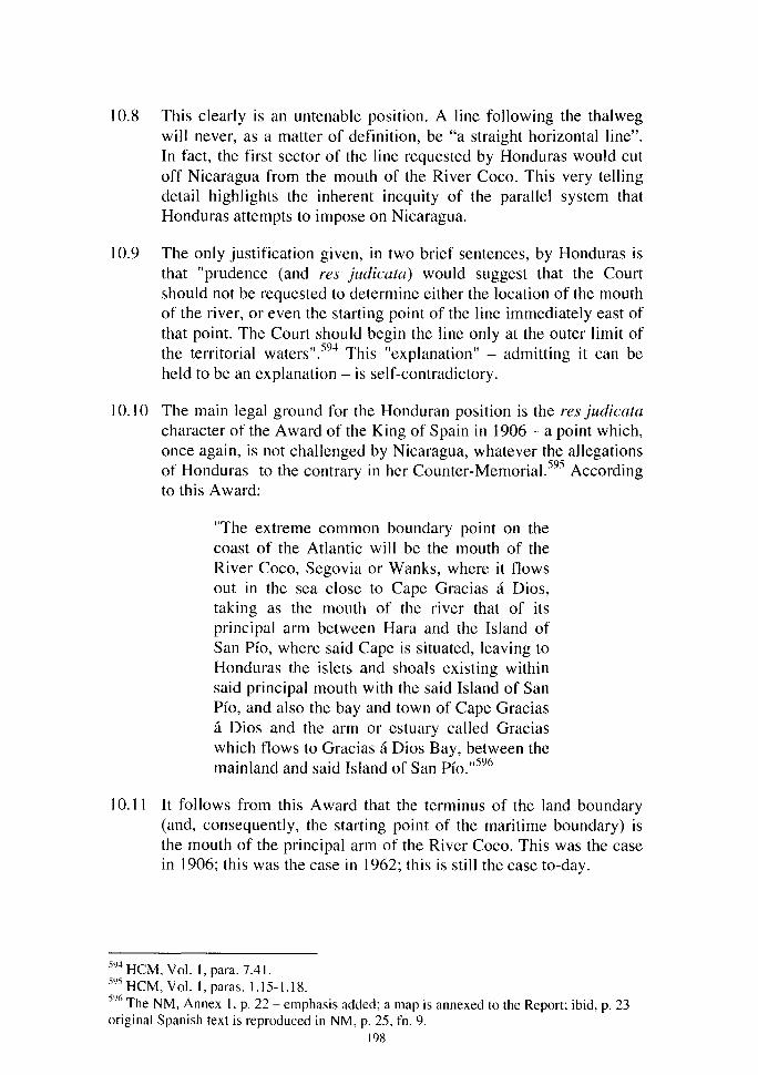
1 0.8 This clearly is an untenable position. A line following the thalweg will never, as a matter of definition, be "a straight horizontal line". In fact, the first sector of the line requested by Honduras would eut off Nicaragua from the mouth of the River Coco. This very telling detail highlights the inherent inequity of the parallel system that Honduras attempts to impose on Nicaragua.
10.9 The only justification given, in two brief sentences, by Honduras is that "prudence (and res judicata) would suggest that the Court should not be requested to determine either the location of the mouth of the river, or even the starting point of the line immediate! y east of that point. The Court should begin the line only at the outer limit of the territorial waters".594 This "explanation" - admitting it can be held to be an explanation- is self-contradictory.
10.10 The main legal grou nd for the Hon duran position is the res judicata character of the A ward of the King of Spain in 1906- a point which, once again, is not challenged by Nicaragua, whatever the allegations of Honduras to the contrary in her Counter-Memorial.595 According to this A ward:
"The extreme common boundary point on the coast of the Atlantic will be the mouth of the River Coco, Segovia or Wanks, where it flows out in the sea close to Cape Gracias a Dios, taking as the mouth of the river that of its principal arm between Hara and the Island of San Pfo, where said Cape is situated, leaving to Honduras the islets and shoals existing within said principal mouth with the said Island of San Pfo, and also the bay and town of Cape Gracias a Dios and the arm or estuary called Gracias which flows to Gracias a Dios Bay, between the mainland and said Island of San Pfo." 596
10.11 It follows from this A ward that the terminus of the land boundary (and, consequently, the starting point of the maritime boundary) is the mouth of the principal arm of the River Coco. This was the case in 1906; this was the case in 1962; this is still the case to-day.
5Y4 HCM,Vol.l,para.7.41.
sYs H CM, Vol. 1, paras. 1. 15-1.18. SY6 The NM, Annex 1, p. 22 - emphasis added; a map is annexed to the Report; ibid, p. 23 original Spanish text is reproduced in NM, p. 25, fn. 9.
198

10.12 lt is significant in this respect that, after the Judgment of this Court confirming the 1906 Award, the Mixed Commission charged with the mission of verifying "[u]nder the terms of the Arbitral A ward of December 23, 1906, [ ... ] the starting point of the natural boundary between the two countries at the mouth of the Coco River" (Pan American Union, 16 July 1963, Report of the International Peace Committee, Appendix 1, 13 March 1961, Basis of Arrangement, paragraph 4 (b) - Nicaraguan Memorial, Anne x l, page 16), ascertained the said starting point on the basis of the geographical situation at that time, thus implementing the self-evident idea that the starting point of the land boundary westwards as weil as, consequently, of the sea boundary eastwards, was situated at the mouth of the main arm of the River Coco as it theo was.
10.13 lt is very significant in this respect that in its Report on the Studies made at the mouth of the Coco, Segovia, or Wanks River, the Honduran-Nicaraguan Joint Boundary Commission remarked:
"In comparing this map [the aerial photo map of the region of the mouth of the Coco River prepared by the Commission] with that prepared by the British Navy for the area of Cabo de Gracias a Dios, and with that of Maximiliano Sonnenstem- but especially with the former, which appears to have been prepared more carefully and in greater detail -it is noted that the topography of this area has undergone constant changes through the years, sorne caused by the closing of secondary channels and the appearance of new ones, while others resulted when parts of the Gracias a Dios Bay filled up and Sunbeam Bay appeared. In general, it has been noted that in this region of the mouth of the Coco River, the land has been advancing toward the sea. On the British map mentioned, there are various notes that indicate topographical changes in the years 1883, 1886, and 1912. The numerous changes in the topography of the region through the years can be seen very clearly in the aerial photographs taken. "597
It is theo apparent that the Commission was clearly conscious of the changes which had occurred in the topographical situation since the
597 The NM, Annex 1, p. 28 (Emphasis added). 199

1906 Award, and it is with full knowledge of these changes that it determined the point of departure of the land boundary, taking into account the situation as it then (in 1962) was.
10.14 It goes without saying that the legal situation is identical toda y: in conformity with the Award of the King of Spain of 1906, the land boundary ends where the main arm of the mouth of the River Coco joins the sea; and the maritime boundary starts at this same point. Given the progress of the River in an east-north-east direction, this starting point, as can be appreciated in Figure IX, is now situated at 15°00'08"N and 83°08'00.6"W.
10.15 Clearly, the thalweg of the River Coco now joins the sea severa) seconds north and east of the point identified by the Joint Boundary Commission in December 1962. This progress into the sea can be appreciated clearly in Figure IX of this Reply which indicates where the River met the sea circa 1830/1843, in December 1962 and in January 1998. Clearly, the topographical situation is still evolving and will continue to do so in the predictable future.
1 0.16 For these reasons, the Parties seem to agree that it would be improper to ask the Court to fix ne varietur the maritime boundary immediately from this point. As explained above (paragraph 1 0.5), this is the reason why Nicaragua has suggested that the point of departure of the line to be decided in the Judgment of the Court should be placed at a reasonable distance from the coast and that this point could be situated three nautical miles from the mouth of the Coco River. This distance would leave a considerable delay before the line decided by the Court would have to be reconsidered due to the seaward advance of the land mass and the mouth of the river: approximately one mile during the last 40 years.
10.17 However, Nicaragua wishes to make clear that:
(i) the point of departure of the maritime boundary between the two countries is the thalweg of the main arm of the estuary of the River Coco as it reaches the sea and is presently located at the coordinates indicated in paragraph 10.14 above;
(ii) the distance of three miles from this point is only a suggestion and Nicaragua would have no objection to the Court's fixing another distance (or no distance at ali if the Court deems it more appropriate; but, in such a case, it would seem to be proper that the Judgment also indicates a method for future adaptations);
200
(iii) if the Court follows this suggestion, it would be incumbent upon the Parties to negotiate a line representing the boundary between the point of departure of the boundary at the mouth of the River Coco and the point of departure from which the Court will have determined the boundary line; Nicaragua submits that it would be proper that, in their agreement, the Parties agree on a method allowing them to adapt the line in accordance with the possible future changes of direction of the main arm of the River Coco.
10.18 In any case, Nicaragua firmly maintains that the suggestion of Honduras to draw the first section of the boundary as a straight and horizontalline from the point identified in 1962 toward the sea is not acceptable. This is clearly an attempt by Honduras to induce the Court to allocate to her a portion of land situated south of the mouth of the River Coco which appertains to Nicaragua as was determined by the Award of the King of Spain of 1906. As shown on Figure X, Volume II of this Reply, this position of Honduras, implicitly but necessarily, entails that the portion of the right bank situated north of the line joining points A belongs to Honduras, in direct contradiction of the A ward (see above, paragraph 10.1 0).
1 0.19 In this respect, it must be kept in mi nd that Honduras herself has formally acknowledged that the King of Spain's Award "is still binding and the application of its terms requires the Parties to verify the position of the mouth from time to time and to agree on any necessary re-drawing of the boundary on their maps".598 The Repondent State is legally bound by this acknowledgement (see above paragraph 8.4) and would be estopped from concluding otherwise.
10.20 Moreover, Honduras has cons tan tl y affirmed that the relevant parts of the Award were crystal clear; commenting on the operative paragraphs of the Award and more specifically the second one, according to which:
"Starting from the mouth of the Segovia or Coco,. the frontier line will follow the watercourse or thalweg of this river upstream without interruption until it reaches the place of its confluence with the Poteca or Bodega ... ",
Herbert Briggs, Counsel for Honduras, declared on 24 September 1960, that these operative paragraphs:
598HCM, Vol. 1, para. 7.40. 201

" ... are a mode! of clarity. Even if the A ward had merely designated the river as the boundary, it might have been assumed that the thalweg rule would apply. The beautifully written opinion of Mr. Justice Cardozo in New Jersey v. Delaware, 291 United States Supreme Court Reports, 361 ( 1934), traces the historical evolution of the thalweg doctrine in international law and finds that it had acquired precision by the end of the eighteenth century, the middle of a navigable river being regarded for jurisdictional purposes as the middle of the main channel. One may also cite the award of 6 June 1904 of the King of ltaly in the BrazilBritish Guiana Boundary, 99 British and Foreign State Papers 930; Kristian Gleditsch, 'Rivers as International Boundaries', 2 Acta Scandinavia Juris Gentium, page 15 pages 20-30 ( 1952); and Paul Geouffre de La Pradelle, La frontière, pages 202 and the following (1928).
"However, the Award of the King of Spain is explicit: the river boundary from its principal designated mouth upstream without interruption is to follow the thalweg" (ICJ, Pleadings, Oral Arguments, Documents - case concerning the Arbitral A ward Made by the King of Spain on 23 December 1906, Oral Argument of Mr. Briggs (Honduras), 23 IX 60, p. 203; see also the "Réplique de M. Guggenheim (Honduras), 7 X 60", ibid., p. 422: "La sentence est d'une absolue précision sur ce point en décidant que la frontière doit suivre le thalweg 'à partir de l'embouchure du fleuve' 'vers l'amont sans interruption"' and the Réplique du Honduras (3 VIII 59), ibid., pp. 538-540).
10.21 It is then qui te apparent that Honduras has al ways interpreted the Award as applying the thalweg principle, a fact which has been formally acknowledged by the Court in its Judgment of 18 November 1960 (ICJ Reports 1960, pp. 216-217). lt cannot now put it into question and invite the Court to decide on another basis, the reasons for justification for which, moreover, are not in the !east explained.
202
10.22 The position Honduras now takes not only does not accord with the text and the spirit of the Arbitral Award of 1906 and cannot be reconciled with the interpretation that the Parties had given to that Award in 1962, it also contradicts the usual principles applicable to the allocation of territory to States in case of accretion or of change of direction of a border river.
C. THE APPLICABLE GENERAL PRINCIPLES
10.23 With respect to accretion, the princip le is clearly stated in the ninth edition of Oppenheim: if new islands:
"rise in rivers ( ... ) or within the territorial sea of a state, they are accretions to the territory of that state. If an island rises within the territorial sea, it accrues to the littoral state, and the extent of the maritime belt may now be measured from the shore of the newborn island" (Sir Robert Jennings and Sir Arthur Watts eds., London, Longman, 1992, p. 698; see also, Gilbert Gidel, Le droit international public de la mer, Paris, Sirey, Vol. 3, pp. 664-726)
And, more generally, "[a]ccretion must ... be considered as a mode of acquiring territory" (Oppenheim's 9th edition, pree., page 696).
This makes clear that the new alluvial lands which have appeared on the right bank since 1962 entirely belong to Nicaragua, since they are situated south of the main arm of the River Coco, and it would be improper to allocate them to Honduras, even indirectly, as would be the result if the Honduran position were to be adopted.
1 0.24 In relation to the question of the course of the boundary from the point determined in 1962 down to the actual mouth of the River Coco, it is not open to discussion that it follows the thalweg and there is certainly no legal objection to the determination of the point of departure of the maritime boundary on the mouth of the River Coco if the Court deems it useful to so proceed. In this respect, the well-established principles of the effects of the changes that occur in the course of a river are extremely helpful.
203

10.25 As explained by Charles Rousseau:
" ... fc]'est un principe établi de la pratique internationale que toute modification importante survenant dans le cours d'un fleuve frontière entraîne une modification corrélative de la délimitation à laquelle il sert de support, et cela que la frontière ait été fixée à la ligne médiane, au thalweg ou sur l'une des rives" (Droit international public, tome III, Les compétences, Paris, Sirey, 1977, p. 261; see also: J. Andrassy, "Les obligations de voisinage", Recueil des cours, 1951, Vol. 79, p. 149; A.O. Cukwurah, The Settlement of Boundary Disputes in International Law, Manchester U.P., 1967, pp. 59-60; Charles De Visscher, Problèmes de confins en droit international public, Pedone, Paris, 1969, p. 62; J.H.W. Verzijl, International Law in Historical Perspective, Vol. III, Leiden, 1970, pp. 565-569; Daniel Bardonnet, Les frontières terrestres et la relativité de leur tracé (Problèmes juridiques choisis), Recueil des cours 1976-V, Vol. 153, p. 94 or Haritini Dipla, Les règles de droit international en matière de délimitation fluviale: Remise en question?, R.G.D.I.P. 1985, p. 611 and the references cited, including Nys, Hyde and McNair).
10.26 This rule has been acknowledged by Honduras during the oral pleading in the case concerning the Land, Island and Maritime Frontier Dispute (see the Judgment of the Chamber of 11 September 1992, ICJ Reports 1992, page 546, paragraph 308). Thus, Professor Bardonnet, speaking as Counsel for Honduras, opposed the Salvadoran claim concerning the effects of the claimed change in the course of the River Goascoran by invoking:
" ... la sentence Hughes rendue le 23 janvier 1933 dans l'affaire Guatemala/Honduras [... qui] a clairement reconnu, à propos du Rio Tinto et du Rio Motagua, que dans l'hypothèse d'une avulsion comme d'ailleurs dans l'hypothèse d'une érosion, la frontière suivra le déplacement des cours d'eau 'in the interest of a definite and satisfactory seulement to secure a lasting peace between the Republics' (RSA, Vol. II; cf. CMH fin the
204
1992 case], Vol. II, Chap. XI, p. 568-571, par. 80-81)"(C4/CR 92/27,21 May 1991, p. 26).
10.27 The international case-law clearly confirms this view. Th us in the famous Chamizal case, the majority of the International Boundary Commission stressed the "well-known principles of international law [according to which, absent special provisions to the contrary in a boundary agreement, a] fluvial boundary would continue, notwithstanding modification of the course of the river caused by graduai accretion on the one bank or degradation on the other bank" (Award of 15 June 1911, R.I.A.A. XI, p. 320; the dissenting Commissioner did not challenge this principle, but only its partial application in the case - see ibid. pp. 337-341 - and the U .S. held the A ward as void on other grounds; see also the Arbitral A ward of 23 January 1933 on the Borders between Honduras and Guatemala, R.I.A.A. II, p. 1362: " ... the boundary is established on the right banks of these ri vers at mean high mark, and, in the event of changes in these streams in the course of time, whether due to accretion, erosion or avulsion, the boundary shall follow the mean high water mark upon the actual banks of both ri vers").
1 0.28 The decisions of domestic Courts in federal States also confirm this principle; thus, in Nebraska v. Iowa, the Supreme Court of the United States stated that:
"lt is settled law, that when grants of land border on running water, and the bank are changed by that graduai process known as accretion, the riparian owner's boundary line still remains the stream, although, during the years, by this accretion, the actual area of his possessions may vary" (29 February 1892, 143 U.S. 359, 12 S. Ct. 396; see also the impressive apparatus of quotes and citations ibid. and 2 February 1931, Louisiana v. Mississipi, 282 U.S. 458, 51 S. Ct. 197; Kansas v. Missouri, 8 May 1944, 322 U.S. 213,64 S. Ct. 975 orLouisiana v. Mississipi et al., 2 April 1984, 466 U.S. 96, 104 S. Ct. 1645; see also the decision of 12 November 1969 of the Argentinian Commission for Inter-Provincial Boundaries concerning the Rio Desaguadero at the border between the provinces of Mendoza and San Luis-- cited by D. Bardonnet, op. cit; pp. 94 and 154, fn. 429).
205

10.29 After a careful consideration of the practice of States and of the international and domestic case-law, Professor Bardonnet concludes:
"Même en cas de silence des traités frontaliers, la ligne divisoire suit les déplacements lents du fleuve frontière, montrant ainsi qu'il n'existe pas de règle suivant laquelle la limite fluviale serait immuable et inaltérable" (op. cit., p. 95).
10.30 In the present case, it is therefore crystal clear that the end point of the mainland border has moved together with the course of the River Coco and that the end point of the mainland boundary is nowadays, as it has legally been since the A ward of the King of Spain of 1906, "the mouth of the River Coco, Segovia or Wanks, where it flows out in the sea close to Cape Gracias a Dios, taking as the mouth of the river that of its principal arm". It is at that point, and not at the one suggested by Honduras that the land boundary ends. Then, seawards, both Parties agree in principle that it would be within the bounds of common sense to fix a starting point at a reasonable distance from the point at the mouth of the River. This starting point should be placed on the bisector line as explained in Chapter X of the Nicaraguan Memorial.
II. The Terminus of The Delimitation of The Maritime Boundary
10.31 The Parties have not yet dealt in detail with the end point of the delimitation at sea. However, Nicaragua clearly indicated that "[t]he li ne produced by the application of the bisector method continues up to the area of seabed occupied by Rosalinda Bank, in which area the claims of third states come into play". As shown on Figure XI of this Reply and in Map A of her Memorial, Nicaragua has not fixed an end point for the delimitation in order to take fully into consideration the rights of third States in the region, more particularly of Jamaica.See further Chapter IX, Section VI.
10.32 Such a proposai is in keeping with the usual princip les of maritime delimitation when the rights of third States might be affected by a tribunal's decision. The case-law of the Court itself clearly reflects this principle.
10.33 Indeed, there can be no doubt that when the Court determines a maritime boundary, it takes into account the claims of third States. It is well-known, for example, that in Tunisia/Libya or in Libya/Malta,
206

or, more recently, in Cameroon v. Nigeria, the Court abstained from prejudging the rights which other States, respectively Malta, Italy and Equatorial Guinea, may have claimed in the region, and confined itself to indicating the general direction of the boundary (see Judgment of 24 February 1982, Continental Shelf (Tunisia/Libyan Arab Jamahiriya), ICJ Reports 1982, p. 91, para. 130, see also the map, at p. 90; Continental Shelf (Lib yan A rab Jamahiriya/Malta), Judgments of 21 March 1984, Application by Italy for Permission to Intervene, ICJ Reports 1984, p. 27 and of 3 June 1985, ICJ Reports 1985, pp. 26-28, paras. 21-23, and Judgment of 1 0 October 2002, Land and Maritime Boundary Between Cameroon and Nigeria, paras. 238, 245 and 307). As the Arbitral Tribunal put it in the Award of 17 December 1999 between Eritrea and Yemen (Maritime Delimitation):
"The Tribunal has the competence and the authority according to the Arbitration Agreement to decide the maritime boundary between the two Parties. But it has neither competence nor authority to decide on any of the boundaries between either of the two Parties and neighbouring States. It will therefore be necessary to terminate either end of the boundary line in such a way as to avoid trespassing upon an area where other claims might fall to be considered" (Award, p. 40, para. 136).
This is the reason why Nicaragua avoided specifying in her Memorial the point where the delimitation requested in the present case must end. In conformity with these precedents, the Court is not called upon to fix a tripoint where the maritime boundary between Nicaragua and Honduras meets the limit of the maritime jurisdiction of any third State.
10.34 By contrast, Honduras asks the Court to declare that the boundary line extends "along the 151
h parallel (14° 59' 8") until it reaches the longitude at which the 1986 Honduras/Colombian maritime boundary begins (meridian 82)" (Honduran Counter-Memorial, Submission 2, page 151 ; see also page 146, (3 ), and page 150, paragraph 8.13). Such a request clearly contradicts the above mentioned jurisprudence according to which the Court considers that it "is not entitled" to fix a tripoint in cases concerning maritime boundaries where only 2 of the 3 States involved are Parties to the
207

case (see Judgment of 10 October 2002, Land and Maritime Boundary Between Cameroon and Nigeria, paragraph 238).
1 0.35 The developments above show that the terminus of the Nicaraguan line, as weil as the line as a whole, do not encroach on the claims of third States. Furthermore, that the treaties of third States cited by Honduras are by no means opposable to Nicaragua.
599 This mention of the c/aims of third States does not imply that Nicaragua recognizes them as legally well-founded. 600 See HCM, paras. 2.18-2.20 or 7.37.
208
SUBMISSIONS
In accordance with Article 49 paragraph 4 of the Rules of Court, the Government of the Republic of Nicaragua confirms the Submissions previously made in the Memorial submitted to the Court on 21 March 2001.
209
The Hague, 13 January 2003.
Carlos J. ARGÜELLO G6MEZ
Agent of the Republic of Nicaragua

ADDENDUM
This Addendum contains further information on the question of the turtle fisheries that has been dealt with above in Chapter IV paragraphs 4.46 to 4.53 and in Chapter VI paragraphs 6.91, 6.93, 6.108 and 6.115. The documents reproduced in Annex 39, which are the subject of this Addendum, were received after Nicaragua had sent this Reply to the printers. They proceed from the United Kingdom Public Record Office and deal with the negotiations between the Nicaraguan and the British Govemments for the extension of the Turtle Treaty that was to expire on 14 August 1959.
These documents include an extract from a letter from Commander R. H. Kennedy of the British Admiralty to Mr. E.C. Burr of the Colonial Office dated 27 November 1958 attached with a list of cays and reefs that could be daimed by Nicaragua and a sketch showing the sort of base line system that could be adopted by Nicaragua in making a daim to territorial seas under the 1958 Geneva Conventions. This opinion of Commander Kennedy was for the purpose of illustrating the British officiais of the type of maritime daims Nicaragua could make during the negotiation of a new Turtle Treaty. It must be recalled that the British Govemment had been negotiating these types of agreements with Nicaragua since the 191
h Century and were weil aware of the position of Nicaragua and the daims she would make. In fact, as can be appreciated in the letter of Mr. K.W Blackbume to His Excellency A. G. Battle on 7 April 1959, the British negotiators were worried that the daims of Nicaragua might become more extensive after the Second UNCLOS Convention that was to take place in 1960 and was expected to increase the extent of the territorial sea and fishing zones. In the event, no agreement was reached on a new treaty and the UNCLOS Convention did not produce the expected results.
What is important is that the map and list of cays prepared by Commander Kennedy indudes the islets, cays and reefs claimed by Nicaragua in the area in dispute with Honduras. The list and the map indude ali islets, cays and reefs up to the Main Cape Channel. This was only to be expected. As pointed out in Chapter IV paragraph 4.52 above, the only port in the area was the Nicaraguan Port of Cape Gracias a Dios and that channel was the main channel for entering and leaving the Port. The Note on "Turtle Fishing in Nicaraguan Waters" with copy sent to the Commissioner of the Cayman Islands, initialed and dated 18-12-58 indicates the procedure that the Caymanians had to follow in order to fish in Nicaraguan waters: "they are first obliged to go to Cape Gracias in order to formally 'enter' Nicaraguan territorial waters, and to dear from Cape Gracias on the way home."
211
What was the role of Honduras when ali these events took place? In Chapter IV paragraph 4.50 the point is made that when the Pleadings before the King of Spain were taking place in 1905-1906 Honduras was silent about the areas presently in dispute.
The documents in Annex 39 of this Reply bring matters up to date. In 1958-1959 when these last negotiations were taking place between Nicaragua and Great Britain, Nicaragua and Honduras were before the Court Pleading in the case conceming the Arbitral A ward of the King of Spain. The A ward in question involved areas in the vicinity of Cape Gracias a Dios. There is not a single reference by Honduras to these islets and cays in those Pleadings.
The record of the turtle fishery negotiation between Nicaragua and Great Britain, and the actual fishing going on in the area in dispute since the 191
h
century, clearly demonstrate that the only sovereign in the area in dispute is and has been Nicaragua. The greatest maritime super power of the period knew the sovereign they had to negotiate with in order to fish in the vicinity of Cape Gracias a Di os.
212
The Hague, 13 January 2003.
Carlos J. ARGÜELLO G6MEZ
Agent of the Republic of Nicaragua
LIST OF MAPS AND FIGURES (VOLUME II)
FIGURES
Figure 1 Cut-off effect the use of the 15° parallel would have on the Nicaraguan maritime areas if it were used as a line of delimitation with Honduras.
Figure II General direction of the land boundary along the River Coco and its projection seawards.
Figure III Sizes of Savanna Cay, Bobel Cay, Port Royal Cay, and South Cay.
Figure IV Relative sizes of The Morrison Dennis Cays and Miskito Cay.
Figure V The Agreement between Portugal and Spain on the delimitation of the continental shelf, of 12 February 1976.
Figure VI Agreement delimiting the continental shelf of United Kingdom and Ireland.
Figure VII The delimitation effected by the Tribunal in the Guinea/Guinea Bissau arbitration with and indication of the general direction of the West African coast.
Figure VIII 6 nautical mile territorial sea limit from the mouth of the River Coco to the Main Cape Channel.
Figure IX Movement northeastwards of the actual mouth of the River Coco.
Figure X Effect of the Honduran proposais for delimitation on the Nicaraguan Island at the mounth of the River Coco.
Figure XI The delimitation proposed by Nicaragua has no end point and does not affect the rights of third States in the region.
Mapi
Mapii
Map III MapiV MapV
MAPS
Map prepared by the Mixed Boundary Commission that was charged with establishing the boundary in the terms agreed upon in the 1894 Treaty between Nicaragua and Honduras. Map of Honduras prepared for the National Directorate of Honduras in 1899 by Francisco Altschul. School map of the Republic of Honduras published in 1984. Official map of Nicaragua prepared in 1982. Official Map of Nicaragua, 1997 edition.
213

Annex 17 b:Resolution concerning an Oil Concession Granted to ··union Oil Company of Central America ··, Resolution No. 75-DRN. Published in the Official Gazette of Nicaragua N. 130 of 12 June 1974 ........................ 91 Annex 18: Oil Concession Granted to "Union Oil Company of Central America" ............................................................................. 93 Annex 18 a: Resolution concerning an Oil Concession Granted to ··union Oil Company of Central America ··, Decree N. 73 - DRN. Published in the Official Gazette of Nicaragua N. 22 of27 January 1975 ...................... 93 Annex 18 b: Resolution concerning an Oil Concession Granted to ·union Oil Company of Central America ··, Resolution N. 112-DRN. Published in the Official Gazette of Nicaragua N. 22 of 27 January 1975 .................. 95 Annex 18 c: Resolution concerning an Extension of an Oil Concession to "Union Oil Company of Central America", Decree N. 170-DRN. Published in the Official Gazette of Nicaragua N. 108 of 18 May 1977 ............... 96 Annex 18 d: Resolution concerning an Extension of an Oil Concession to ··union Oïl Company of Central America", Resolution N. 207-DRN. Published in the Official Gazette of Nicaragua N. 108 of 18 May 1977 ... 98 Annex 18 e: Resolution concerning an Extension of an Oil Concession to ··union Oil Company of Central America", Decree N. 190-DRN. Published in the Official Gazette of Nicaragua N. 291 of22 December 1977 ............ 99 Annex 18 f:Resolution concerning an Extension of an Oil Concession to ··union Oil Company of Central America", Resolution N. 225-DRN. Published in the Official Gazette of Nicaragua N. 291 of 22 December 1977 ............................................................................................................ 101 Annex 19: Excerpt from pages IV, 6, 11, 12 and 29 of "Regional Project for Fisheries Development In Central America. Project Accomplishment Report, Conclusions and Recommendations" FI: DP/RLN65/030 by Food and Agriculture Organization (FAO). Roma, September 1972 .................. 1 03 Annex 20: "Regional Project for Fisheries Development In Central America. V Working Meeting." CNFI/67/26 San José, Costa Rica. 28-30 November 1967. Pp. 6 and 32 .................................................... 109 Annex 21: Witness Statement of Mr. Herman Emmanuel Presida ......... 121 Annex 22: Witness Statement of Mr. Hayword Clark Mclean ............... 123 Annex 23: Witness Statement of Mr. Arturo Mohrke Vega ................... 127 Annex 24:Witness Statement of Mr. Jorge Morgan Britton .................. 131 Annex 25:Witness Statement of Mr. Leone) Aguirre Sevilla ................ 135 Annex 26: Fishing Explorations in the Central America Caribbean Sea with Emphasis on Deep Waters. R/V CANO PUS April to October 1971, by Marcel Giudicelli. El Salvador, 1971. Figure 6 ................................ 139 Annex 27:Witness Statement of Mr. Arturo Mohrke Vega .................. 141 Annex 28: "Turtle Fisheries off the Mosquito Cays", Printed for the use of the Foreign Office, June 1905. Pp. 266 and 269 ............................... 143 Annex 29: Law on Maritime Spaces of Nicaragua, Law N. 420. Published in the Official Gazette of Nicaragua N. 57 of 22 March 2002 .................. 147 Annex 30: Excerpt from page 37 of "Geografia de Nicaragua" by Professor Francisco Tenin, UNESCO Expert on duty in Nicaragua and Doctor Jaime
216
Incer Barquero, Scientific Advisor to the Ministry of Public Education of Nicaragua First Edition, Managua, Nicaragua, C.A. 1964, sponsored by the Central Bank of Nicaragua ....................................................... 149 Annex 31: "Geographie Index of Nicaragua. River, Lakes and Beaches" by Jaime Incer Barquero. VOL 1, Managua, Nicaragua, 1971. Prologue and Pd. 124 ................................................................................ 151 Annex 32: Minutes of Agreements of the Meetings between Jamaica and Nicaragua ............................................................................ 155 Annex 32 a:Minutes of Agreements of the Second Meeting between Jamaica and Nicaragua to negotiate a Maritime Delimitation Treaty. Dated 29 and 30th May 1996 .............................................................. 155 Annex 32 b:Minutes of Agreements of the Third Meeting between Jamaica and Nicaragua to negotiate a Maritime Delimitation Treaty. Dated 29 November 1996 .................................................................... 157 Annex 33:Diplomatic Note From the Deputy Solicitor General of Jamaica to the Ministry of Foreign Affairs of Nicaragua. Dated 8th January 1997 .... 161 Anne x 34:Political Constitutions of Nicaragua ................................ 163 Annex 34 a: Article 2 of the Political Constitution of Nicaragua (1948) .. 163 Annex 34 b:Article 5 of the Political Constitution of Nicaragua ( 1950) .. 163 Annex 34 c:Article 3 of the Political Constitution of Nicaragua (1974) . .163 Annex 35: Certification of Mr. Harry Bodan-Shields. Dated 30th August 2002 .................................................................................. 165 Annex 36: Statement of Clarification of Mr. Oscar Rafael Guevara Oc6n ................................................................................. 167 Annex 37: Organic Law of the Nicaraguan Fishing Institute (INPESCA), Decree N. 1,426. Published in the Official Gazette of Nicaragua N. 82 of 26 April1984 ........................................................................... 169 Annex 38: Witness Statement of Mr. Luis Adrian Pichardo ................. 173 Annex 39: Turtle fishery treaty negotiation documents 1958-1959 ......... 177
217