Embed Size (px)
Citation preview
REGIONAL SUBDIVISION REGULATIONS
THE CITY OF SAVANNAH
Adopted
August 2006 Amended 11/8/2018

PREPARED FOR
THE SAVANNAH
MUNICIPAL/REGIONAL PLANNING COMMISSION
August 2006
PREPARED BY
WEST TENNESSEE OFFICE TENNESSEE DEPARTMENT OF
ECONOMIC AND COMMUNITY DEVELOPMENT LOCAL PLANNING ASSISTANCE OFFICE
JACKSON, TENNESSEE

SAVANNAH SUBDIVISION REGULATIONS I - 1
TABLE OF CONTENTS PAGE ARTICLE I GENERAL PROVISIONS ........................................................ I - 1 A. PURPOSE ................................................................... I - 1 B. AUTHORITY ................................................................ I - 2 C. JURISDICTION ........................................................... I - 2 D. POLICY ....................................................................... I - 2 E. TECHNICAL SPECIFICATIONS INCLUDED AS PART OF THE REGULATIONS ............................ I - 2 F. BASIC DEFINITIONS AND INTERPRETATIONS ................................................... I - 2 ARTICLE II PROCEDURE FOR SUBDIVISION APPROVAL ..................... II - 1 A. GENERAL ................................................................... II - 1 B. APPLICATION ADMINISTRATION AND FEES .......... II - 1 C. MASTER DESIGN PLAN............................................. II - 3 D. CONSTRUCTION PLAT .............................................. II - 5 E. FINAL PLAT ................................................................ II - 9 F. MINOR SUBDIVISION ................................................. II - 12 ARTICLE III GENERAL REQUIREMENTS AND STANDARDS OF DESIGN ................................................................................... III - 1 A. GENERAL DESIGN CONCEPTS ................................ III - 1 B. WATER DRAINAGE .................................................... III - 2 C. STREET LAYOUT ....................................................... III - 3 D. STREET LIGHTING ................ .................................. ….III - 9 E. LOT LAYOUT .............................................................. III - 10 F. OPEN SPACE AND EASEMENTS .............................. III - 12 G. SUITABILITY OF LAND .............................................. III - 13 ARTICLE IV PREREQUISITES TO FINAL SUBDIVISION APPROVAL ...... IV - 1 A. GENERAL REQUIREMENTS ...................................... IV - 1 B. SURVEY MONUMENTS ............................................. IV - 1 C. STORM DRAINAGE .................................................... IV - 2 D. STREET IMPROVEMENTS ........................................ IV - 4
SAVANNAH SUBDIVISION REGULATIONS I - 2
PAGE E. PRIVATE STREET IMPROVEMENTS ........................ IV - 6 F. SIDEWALKS, CURBS, GUTTERS AND HANDICAP RAMPS .................................................... IV - 8 G. ENVIRONMENTAL PROTECTION AND PRESERVATION ........................................................ IV - 9 H. INSTALLATION OF UTILITIES AND SANITARY SEWERS .................................................. IV - 10 I. SCREENING AND LANDSCAPING ............................ IV - 12 J. PERFORMANCE BOND IN LIEU OF COMPLETED IMPROVEMENTS ................................ IV - 13 ARTICLE V VARIANCES, APPEALS AND AMENDMENTS ...................... V - 1 A. VARIANCES ................................................................ V - 1 B. APPEALS....................................................................... V - 1 C. AMENDMENTS ........................................................... V - 2 ARTICLE VI LEGAL STATUS PROVISIONS .............................................. VI - 1 A. POWERS OF THE PLANNING COMMISSION ........... VI - 1 B. ENFORCEMENT OF SUBDIVISION REGULATIONS ........................................................... VI - 1 C. COMPLAINTS REGARDING VIOLATIONS ................ VI - 2 D. PENALTIES FOR VIOLATION .................................... VI - 2 E. PROVISIONS OR REGULATIONS DECLARED TO BE MINIMUM REQUIREMENTS ........................... VI - 3 ARTICLE VII SEVERABILITY ....................................................................... VII - 1 ARTICLE VIII ADOPTION AND EFFECTIVE DATE ...................................... VIII - 1 A. PUBLIC HEARING ...................................................... VIII - 1 B. EFFECTIVE DATE ...................................................... VIII - 1 APPENDIX ................................................................................................ A - 1
FINAL PLAT CERTIFICATES
SAVANNAH SUBDIVISION REGULATIONS I - 3
SUBDIVISION REGULATIONS
SAVANNAH MUNICIPAL/REGIONAL PLANNING COMMISSION
SAVANNAH, TENNESSEE (08/08/06)
(11/08/18 amended)
ARTICLE I
GENERAL PROVISIONS A. PURPOSE
Land subdivision is the first step in the process of community development. Once land has been cut up into streets, lots and blocks and publicly recorded, the correction of defects is costly and difficult. Subdivision of land sooner or later becomes a public responsibility, in that roads and streets must be maintained and various public services customary to urban areas must be provided. The welfare of the entire community is thereby affected in many important respects. It is therefore to the interest of the public, the developer and the future owners that subdivision be conceived, designed and developed in accordance with sound rules and proper minimum standards.
The following subdivision standards guiding the Planning Commission are
designed to secure a coordinated layout with adequate provisions for traffic, light, air, recreation, transportation, water, drainage, and sanitary facilities and services; to promote a distribution of population and traffic which will tend to create conditions favorable to health, safety, convenience and prosperity.
The following regulations set forth the minimum standards to be adhered to by
developers of lands for residential, commercial, and industrial uses, and to provide a guide for the Planning Commission and other city officials exercising their duties pertaining to the review, approval and administration of land subdivision development within the jurisdiction of the the Savannah Planning Region.
B. AUTHORITY These subdivision regulations and the procedures and standards set forth herein
are adopted by the Savannah Municipal/Regional Planning Commission under authority granted by Tennessee Code Annotated Sections 13-3-401 through 13-3-411. The Planning Commission has fulfilled the requirements set forth in these statutes as prerequisite to the adoption of such standards, having filed a certified copy of the Major Road Plan in the office of the Registrar of Hardin County, Tennessee.
SAVANNAH SUBDIVISION REGULATIONS I - 4
C. JURISDICTION These regulations shall govern all subdivision of land outside of the corporate
limits of Savannah located within the Savannah Planning Region. For the purpose of these regulations, “Planning Region” shall refer to this area. Within these regulations the term "subdivision" shall mean the division of a tract or parcel of land into two (2) or more lots, sites, or other divisions requiring new street or utility construction, or any division of less than five (5) acres for the purpose, whether immediate or future, of sale or building development, and includes re-subdivision and when appropriate to the context, relates to the process of resubdividing or to the land or area subdivided.
Any owner of land within the Planning Region wishing to subdivide land shall
submit to the City of Savannah an application for subdivision according to the procedures outlined in Article II, which submittal shall conform to the minimum requirements as set forth in Article III. A copy of the certified deed shall be presented with the application for subdivision. In instances where the subdivider is not the owner a letter from the owner authorizing the subdivider to act on the owner's behalf shall be presented. Improvements shall be installed as required by Article IV of these regulations.
D. POLICY It shall be the policy of the Savannah Municipal/Regional Planning Commission
to encourage subdivision development which enhances the health, safety and welfare of the community and which optimizes the use of the land while providing a prudent balance between the economic considerations of the developer and the public interest. Conversely, it shall be the policy of the Planning Commission to disapprove proposed subdivision development which is deemed to be inefficient use of land, inconsistent with the needs and character of the community, economically untimely, or otherwise not in the public interest. Further, it shall be the policy of the Savannah Municipal/Regional Planning Commission to consider each proposed subdivision development on its merits in context with existing or planned land use, population and traffic distribution, and the needs and best interest of the community; consequently, the mere compliance with the minimum standards set forth in these regulations does not grant to the developer an implicit or explicit right to subdivision approval; accordingly, the Planning Commission may require that a proposed subdivision development exceed the minimum standards to satisfy site peculiar conditions or to conform to the existing neighborhood.
E. TECHNICAL SPECIFICATIONS INCLUDED AS PART OF THE REGULATIONS The "Local Government Public Works Standards and Specifications" by the
Municipal Technical Advisory Service of the University of Tennessee as amended is hereby adopted as the Technical Specifications of the City of Savannah.
F. BASIC DEFINITIONS AND INTERPRETATIONS Except as specifically defined herein all words used in these regulations have
their customary dictionary definitions where not inconsistent with the context.

SAVANNAH SUBDIVISION REGULATIONS I - 5
For the purposes of these regulations and in order to carry out the provisions and intentions as set forth herein certain words, terms, and phrases are to be used and interpreted as defined hereinafter. Words used in the present tense include the future tenses; words in the singular number include the plural, and words in the plural number include the singular; the word "person" includes a firm, partnership, or corporation as well as an individual; the word "lot" includes the word plot or parcel; the word building: "structure"; and the terms "shall" and "will" are always mandatory and not directory; and the word "may" is permissive.
The following words, terms and phrases are hereby defined as follows and shall
be interpreted as such throughout these regulations. Arterial. Major highways. Block. A tract of land bounded by streets, or by a combination of streets and
public parks, cemeteries, railroad rights-of-way, shorelines of waterways, or boundary lines of municipalities.
Bond. Any form of security including a cash deposit, surety bond, collateral,
property, or instrument of credit in an amount and form satisfactory to the Planning Commission. All bonds shall be approved by the Planning Commission whenever a bond is required by these regulations.
Building. Any structure built for the support, shelter, or enclosure of persons,
animals, or movable property of any kind, and includes any structure. Building Setback Line. A line in the interior of a lot which is generally parallel to,
and a specified distance from, the street right-of-way and the lot line or lines; which creates a space between such lines in which no building shall be placed.
Buildable Area of a Lot. That portion of a lot bounded by the required rear and
side yards and the building setback line. Collector. Streets that carry traffic from local streets to the major system of
arterial streets. Cul-de-sac. Permanent dead-end streets with a turnaround provided at the
dead-end. Dedication. The setting aside of land and/or improvements for a particular use. Master Design Plan. A map of a proposed subdivision showing the lot sizes, and
layout, location and sizes of streets and used as an aid in discussing the design of the proposed subdivision.
SAVANNAH SUBDIVISION REGULATIONS I - 6
Developer. An individual, partnership, corporation, or other legal entity or agent thereof which undertakes the activities covered by these regulations. In as much as the subdivision plan drawings are merely a necessary means to the end of assuring satisfactory development, the term "developer" includes "subdivider", "owner" or "builder" even though the persons and their precise interests may vary at different project stages.
Easement. The right to use another person's property but only for a limited and
specifically named purpose, the owner generally continues to make use of such land since he has given up only certain, and not all, ownership rights.
Easement Area. A strip of land over, under, or through which an easement has
been granted.
Easement, Travel. The right granted by the owner of land to another party by deed or prescription permanently recorded into perpetuity, to allow access across one parcel of land to another. Easements for the purpose of access as further defined in Tennessee Code Annotated 13-3-411 and 13-4-308 for areas in the Planning Region and City respectively.
Easement, Utility. The right granted by the owner of land to allow utility facilities
to be constructed, maintained or preserved. Utility easements shall include, but is not limited to, easements for storm drainage, water lines, sewer lines, electric power lines, and pipe lines.
Engineer. A qualified civil engineer registered and currently licensed to practice
engineering in the State of Tennessee. Engineering Plan Submission. A site plan of a proposed subdivision including
engineering design and construction documents for streets, drainage and utilities.
Final Plat. The map or plan or record of a subdivision and any accompanying
material as described in these regulations. Floodplain. An area of a river or stream, together with appropriate adjacent land,
established to insure adequate and safe drainage. Frontage. That side of a lot abutting on a street and ordinarily regarded as the
front of the lot. Grade. The slope of a road, street, or other public way, specified in percentage
(%) terms. Health Department. Hardin County Health Department.
SAVANNAH SUBDIVISION REGULATIONS I - 7
Highway Department. Hardin County Highway Department. Improvements. Physical changes made to the raw land and structures on or
under the land surface in order to make the land more usable for man's activities. Typical improvements in these regulations would include but not be limited to grading, street pavement, curbs, gutters, drainage ditches, storm and sanitary sewers, street name signs, and street trees.
Individual Sewage Treatment Facility. A sewage disposal system developed to
function on an individual lot basis. A septic tank is a type of individual sewage treatment facility.
Local Streets. Streets that provide access to property abutting the public right-
of-way. (Also known as minor streets.) Lot. A parcel of land which is or may be occupied by a building and its
accessory building or use, customarily incidental thereto, together with such yards or open spaces within the lot lines as may be required by these regulations.
Lot Corner. A lot of which at least two (2) adjoining sides abut on a street, provided that the interior angle at the intersection of two such sides is less than one hundred thirty-five (135) degrees.
Lot Area. That dimension of a lot or portion of a lot abutting on a street
excluding the side dimension of a corner lot. Lot Depth. The average distance from the street line of the lot to its rear line
measured in the general direction of the side lines of the lot. Lot Frontage. That dimension of a lot or portion of a lot abutting on a street
excluding the side dimension of a corner lot. Lot Lines. The lines bounding a lot as defined herein. Lot Number. The official number assigned to a lot for identification purposes. Lot Width. The width of a lot at the building setback line measured at right
angles to its depth. Major Road Plan. The official plan adopted by the Savannah Municipal/Regional
Planning Commission designating types and locations of streets within the corporate limits and Planning Region.
Monuments. Markers placed on or in the land.
SAVANNAH SUBDIVISION REGULATIONS I - 8
Percolation Test. An examination of subsoil used in determining the acceptability of the site and the design of the subsurface disposal system.
Planning Commission. The Municipal/Regional Planning Commission of
Savannah, Tennessee. Private Streets. A street which has not been dedicated to public use, and to
which the general public is denied access. Protective Covenants. Contracts between the land subdivider and lot purchaser
expressing agreement covering use of the land. Public Sewer System. A central sewer system, owned, operated and maintained
by the City of Savannah. Public Hearing. A meeting for the review of a matter where opinions may be
presented by the public. These hearings may take place during the regular Planning Commission meetings and are held according to state laws.
Public Street. A street dedicated to the public use and open to the public
access. Public Uses. Public parks, schools, and administrative, cultural and service
buildings, not including public land or buildings devoted solely to storage and maintenance of equipment and material.
Public Utility. Any person, firm, corporation, municipal department or board duly
authorized to furnish under state or municipal regulations to the public: electricity, gas, steam, communications, telegraph, transportation, water, or sewer.
Recreational Facilities. Country clubs, riding stables, golf courses, and other
similar recreational areas and facilities including swimming pools. Register of Deeds. Hardin County Register of Deeds. Reserve Strip. A portion of land set aside to prevent and prohibit access to
adjoining property or public thoroughfare. Re-subdivision. A change in a map of an approved or recorded subdivision plat
if such change affects any street layout on such map or area reserved thereon for public use, or any lot line; or if it affects any map or plan legally recorded prior to the adoption of any regulations controlling subdivision.
Right-of-Way. A dedication of land to be used generally for streets, alleys, or
other public uses wherein the owner gives up all his rights to the property as long

SAVANNAH SUBDIVISION REGULATIONS I - 9
as it is being used for the dedicated purpose. Also, a land measurement term meaning the distance between fronting lot property lines which generally contain not only the street pavement but also the sidewalks, grass area and utilities.
Road. For the purpose of these regulations, "road" shall be defined the same as
"street". Roadway. The portion of the street right-of-way which contained the street
pavement, curb and gutter, and is used primarily as a channel for vehicular movement and secondarily as a drainage channel for storm water. In these regulations the pavement is measured from face to face of the curbs or from edge of pavement to opposite edge of pavement.
Sanitary Sewer System. A public or community sewage disposal system of a
type approved by the State Department of Environment and Conservation. Secretary. The person designated by the Planning Commission as its secretary. Septic Tank. See Individual Sewage Treatment Facility. Setback. The distance required to obtain the minimum front, side and rear
yards. Street. A general term used to describe a right-of-way which provides a channel
for vehicular and pedestrian movement between certain points in the community, which may provide for vehicular and pedestrian access to properties adjacent to it, and which may also provide space for the location of underground and above ground utilities.
Street, Half. A street having width less than required by these and other appropriate regulations. Street, Intersecting. Any street which joins another street at an angle, whether or not it crosses the other.
Street Classification. Types of streets as set forth in the Major Street Plan. Street Furniture. Any improvements placed within the street right-of-way, such
as utility poles, street signs, etc. Street Grade. The officially established grade of the street upon which a lot
fronts. If there is no officially established grade, the existing grade of the street at the mid-point of the lot shall be taken as the street grade.
Street Line. The legal line between street right-of-way and abutting property.
SAVANNAH SUBDIVISION REGULATIONS I - 10
Street Sign. The sign designating the official name of the street. Subdivision. The division of a tract or parcel of land into two (2) or more lots,
sites, or other divisions requiring new street or utility construction, or any division of five (5) acres or less for the purpose, whether immediate or future, of sale or building development, and includes re-subdivision and when appropriate to the context, relates to the process of resubdividing or to the land or area subdivided.
Surveyor. A qualified surveyor registered and currently licensed to practice
surveying in the State of Tennessee. Test Holes. Openings dug, bored or drilled in the ground for conducting soil
tests. Unit. A subsection of a total subdivision developed as a complete segment. Use. The specific purpose for which land or a building is designed, arranged,
intended, or for which it is or may be occupied or maintained. The term "permitted use" or its equivalent shall not be deemed to include any non-conforming use.
Way. A street or alley or other thoroughfare or easement permanently
established for passage of persons or vehicles. Yard, Front. An open unoccupied space on the same lot with a main building,
extending the full width of the lot and situated between the street line and the front line of the building projected to the side lines of the lot. The depth of the front yard shall be measured between the front line of the lot and extending the full width of the lot.
Yard, Side. An open unoccupied space on the same lot with the building,
situated between the building and the side line of the lot and extending from the front yard to the rear yard. Any lot line not a rear line or a front line shall be deemed a side line.
Zoning Ordinance. The duly adopted Zoning Regulations of Savannah,
Tennessee.

SAVANNAH SUBDIVISION REGULATIONS II - 1
ARTICLE II
PROCEDURE FOR SUBDIVISION APPROVAL A. GENERAL The subdivider shall consult early and informally with the Planning Commission
and its technical staff for advice and assistance before the preparation of the Master Design Plan and its formal application for approval. This will enable him to become thoroughly familiar with these regulations, the Major Thoroughfare Plan and other official plans or public improvements which might affect the area. Such informal review should prevent unnecessary and costly revisions.
The procedure for review and approval of subdivisions and its documentation consists of three (3) separate steps. The first formal step is the preparation of a Master Design Plan submitted for administrative content review and approval for subsequent acceptance and placement on the agenda for review and approval by the Planning Commission. The second step is the Construction Plat which must be reviewed and approved by administrative and technical staff designated by the Planning Commission. Unless special consideration is requested by the developer relative to staff review concerns or provisions of these regulations, the Planning Commission will not review the Construction Plat. The third step is the preparation and submittal of a Final Subdivision Plat with all the required certificates for submission to the Planning Commission consistent with Section “E” of this Article. In the event the developer requests special consideration for approval of the Construction Plat, said plat may be considered by the Planning Commission upon review of the Final Plat. No final plat shall be accepted on the agenda of the Planning Commission until the Master Design Plan has been reviewed and approved by the Planning Commission and the Construction Plat reviewed and approved by designated review staff or the Planning Commission. The Final Plat, once approved by the Planning Commission and signed by the Secretary of the Planning Commission becomes the instrument to be recorded by the developer at the Office of the Hardin County Register of Deeds.
B. APPLICATION ADMINISTRATION AND FEES Any owner of land lying within the area of the jurisdiction of the
Municipal/Regional Planning Commission wishing to divide such land into two (2) or more residential or commercial lots, sites or divisions (including remaining land from the predivided property) for the purpose of either immediate or future sale or building shall make application to the Planning Commission by submitting the required plans or plat of the proposed subdivision, along with the application and fees to the Community Development Department. Such plans and plats shall conform to the minimum standards for subdivision design as set forth in

SAVANNAH SUBDIVISION REGULATIONS II - 2
Articles III and IV of these regulations and such additional site peculiar criteria as may be deemed necessary by the Planning Commission or its technical staff.
1. Official Submission Dates and Deadlines
All plans and plats of subdivisions requiring a review by the Planning
Commission shall be submitted to the Community Development Department no less than fifteen (15) days prior to the regularly scheduled meeting of the Planning Commission. Plans submitted but not meeting compliance with or the content requirements of these regulations shall not be accepted for placement on the agenda for review by the Planning Commission. Any plan or plat in compliance with required content and design standards of these provisions but submitted less than 15 days prior to the regularly scheduled Planning Commission meeting will not be accepted for placement on the agenda or otherwise considered by the Planning Commission until the subsequent meeting. The Engineering submittal may not be reviewed by the Planning Commission but shall be reviewed by designated staff and any discrepancies identified therein shall be resolved prior to acceptance of the Final Plat on the agenda for review by the Planning Commission or upon request by the developer, a review of the Engineering Submittal by the Planning Commission.
For the purpose of these regulations, the official submission date for
Planning Commission review items shall be the date of the first regularly scheduled Planning Commission meeting after the submittal has been administratively approved and accepted for placement on the Planning Commission agenda. The statutory period required for formal approval or disapproval shall not begin to run until that date.
2. Official Submission of Revisions to Plats
Plans or plats that have been resubmitted to be placed on the agenda of a
subsequent Planning Commission meeting shall be submitted to the Community Development Department no less than fifteen (15) days prior to the regularly scheduled meeting of the Planning Commission.
3. Required Submission and Review
Prior to commencing any street improvements, grading, installation of utilities or any horizontal construction, the developer shall submit and obtain approval of engineering construction documents. Review of street and drainage plans shall be conducted by Technical Staff designated by the Planning Commission. Water and sewer plans shall be reviewed by the Savannah Utility Division and must be reviewed and approved by the Tennessee Department of Environment and Conservation.

SAVANNAH SUBDIVISION REGULATIONS II - 3
Upon approval of the Construction Plat by the designated review staff or the Planning Commission, the developer may commence construction to the grades and elevations required by the approved Construction Plat. No construction of structures shall commence until after approval has been given the final plat nor shall any building permits be issued. It shall be the responsibility of the developer to arrange for necessary inspections of road construction and infrastructure installation.
4. Certified Copy of Deed Required
A certified copy of the deed for property proving ownership of the land to
be subdivided or the deed and a letter authorizing the applicant to act on the owner's behalf will accompany all subdivision applications.
5. Application Fees
A schedule of subdivision application and review fees are established by the Savannah Board of Commissioners as may be amended from time to time and are reflected in the appendix of these provisions.
The subject fees are intended to defray the costs of the respective reviews and compilation of estimates by technical review staff designated by the Planning Commission. The fees shall also be applied to the cost of construction review carried out by technical staff designated by the Planning Commission.
C. MASTER DESIGN PLAN
The Master Design Plan is the initial formal plan for a proposed subdivision and shall include the entire area of the affected property or properties though the subdivision may be developed in stages. The purpose of the Master Design Plan is to insure that the proposed subdivision conforms with the zoning ordinance and all related plans and regulations. The developer should consult early on with the planning staff, and review the city's major road plan, drainage plan, water and sewer maps prior to preparing submitting the Master Design Plan.
1. Submission of the Master Design Plan
After consultation with the Planning Commission and/or staff, but not less than fifteen (15) days prior to the meeting at which the Planning Commission shall consider the Master Design Plan, the developer shall submit to the Savannah Community Development Department, four (4) copies of the plan drawn to a scale that reasonably reflects the layout of lots and transportation corridors together with application and appropriate fee.
SAVANNAH SUBDIVISION REGULATIONS II - 4
2. Contents of the Master Design Plan
The Master Design Plan shall meet the minimum standards of design as
set forth in Article III and shall give the following information:
a. The proposed subdivision's name and location.
b. The name(s), address(es) and phone number(s) of the owner or owners and of the designer of the Master Design Plan.
c. Date, approximate north point, and graphic scale.
d. The location of existing property lines, streets, buildings, bridges,
rights-of-way and easements and drainage ditches.
e. The location, dimensions and names of proposed streets, alleys and lots.
f. Present zoning classification both on lot to be subdivided and
adjoining land.
g. The area of the smallest, largest and average lot.
h. The acreage of the land to be subdivided.
i. Location map showing the relationship of the subdivision site to the applicable vicinity of the City.
j. In addition to the required information, the following information,
though not required, would assist in design review and would help avoid later redesign and engineering expense:
(1) Contours at vertical intervals of not more than five (5) feet.
(2) Location and line size of closest existing water and sewer
lines.

SAVANNAH SUBDIVISION REGULATIONS II - 5
3. Planning Commission Review
Within sixty (60) days after review of the Master Design Plan, the Planning Commission will indicate its approval, disapproval, or approval subject to modifications. If a plan is disapproved, reasons for such disapproval shall be stated in writing. If approved, subject to modifications, the nature of the required modifications will be indicated.
If revisions to the Master Design Plan are requested by the Planning
Commission, the developer shall submit the revised Master Design Plan to the Community Development Department fifteen (15) days prior to a subsequent Planning Commission meeting.
4. Effect of Approval on Subsequent Plan Submissions
The approval of the Master Design Plan by the Planning Commission will
not constitute acceptance of the Construction Plat and will not be indicated on the Master Design Plan.
5. Expiration of Approval
The approval of the Master Design Plan shall lapse unless an approvable
Construction Plat based thereon is submitted within three (3) years from the date of such approval or unless an extension of time is applied for and granted by the Planning Commission.
D. CONSTRUCTION PLAN SUBMITTAL The Construction Plat is a fully engineered design of all or part of the proposed
subdivision in sufficient detail for the local and state review agencies to determine compliance with the public works construction standards, State Environment and Conservation regulations and other applicable regulations.
1. Submission of Engineering Plan
After the Master Design Plan has been approved, the developer shall
submit six (6) copies of the Construction plat including all road plans and profiles to the Community Development Department.
2. Conformance With the Master Design Plan
If, in the process of completing the Construction Plat, it becomes
necessary to redesign the subdivision, a revised Master Design Plan shall be resubmitted to the Planning Commission for their review.
SAVANNAH SUBDIVISION REGULATIONS II - 6
3. Contents of the Construction Plat
The Construction Plat shall, at least, meet the minimum design standards in Article III, meet the construction standards included or referenced herein and conform substantially to the Master Design Plan.
a. The Construction Plat shall contain the following information for the
whole subdivision even when the subdivision is to be developed in phases or sections.
(1) The proposed subdivision's name and location, the name(s)
and address(es) and phone number(s) of the owner or owners, and the name, address and phone number of the designer of the plat who shall be an engineer.
(2) Date, approximate north point and graphic scale.
(3) The location of existing and platted property lines, existing
streets, buildings, water courses, sewers or areas reserved for septic disposal, bridges, culverts, drain pipes, water mains, and any public utility easements or lines, the present zoning classification, both on the land to be subdivided and on the adjoining land; and the names of adjoining property owners or subdivisions.
(4) The proposed street names and the locations and
dimensions of proposed streets, alleys, easements, parks and other open spaces, reservations, lot lines, building setback lines and utilities.
(5) Contours at vertical intervals of not more than two (2) feet.
All new developments greater than fifty (50) lots or five (5) acres, whichever is lessor, shall include base flood elevation data. If any portion of the land being subdivided is subject to flooding, the plat will show the limit and elevation of the 100-year floodplain.
(6) The acreage of the land to be subdivided.
(7) Location sketch map showing relationship of subdivision site
to area and town.
(8) A comprehensive drainage plan shall be included. At the request of the planning commission or designated City Staff, such plan shall be designed by a certified professional engineer and include, but not be limited to, an analysis of
SAVANNAH SUBDIVISION REGULATIONS II - 7
the drainage area, a storm water routing plan showing maximum quantities of flow and maximum rates of flow before and after development. A map of the drainage area in which the subdivision is located shall be included with the drainage plan and shall include the drainage structures leading to and from the subdivision with their sizes. The scale of the required map can not be less than one inch equals one hundred feet (1” = 100’).
(9) The location and sizes of proposed water and gas lines.
b. When the subdivision is developed in phases or sections, the
following information is required for the phase or section to be developed. When the subdivision is not developed in phases, the following information is required for the whole subdivision.
(1) Plans and profiles of proposed utility layouts (sewer, gas,
water, and electricity) showing feasible connections to the existing or any proposed utility systems.
(2) A grading plan showing the existing contours in dashed lines
and the finished contours in solid lines plotted at vertical intervals of not more than two (2) feet. Contours shall be extended fifty (50) feet beyond property boundary.
(3) Development plans for drainage structures and channels.
Where engineered design of drainage improvements is required by the planning commission, plans shall include the hydraulic data used in designing and sizing such structures and channels, the water surface profiles in open channels at peak flow and peak backwater conditions. The limits of the drainage design parameters shall be determined by technical review staff designated by the Planning Commission.
(4) Plan and profile sheets showing all engineering data
necessary for construction of proposed streets, storm drainage controls for surface and ground water, and utility layout (water, gas, sewer, and electricity) and showing all connections to existing and/or proposed streets, storm drainage, and utility systems. The street profiles shall be plotted along the centerline showing the existing and finished grades, and sewer locations, drawn to a scale of not less than one inch equals one hundred feet (1" = 100') horizontal and one inch equals ten feet (1”=10’) vertical. Typical street cross sections shall be shown.
SAVANNAH SUBDIVISION REGULATIONS II - 8
(5) Erosion Control Plan which shall include adequate plans
showing all erosion and sediment control measures or other protective devices to be constructed in connection with or as a part of the proposed work as follows: i. Vicinity map locating the site in relation to the
surrounding area. ii. Existing contours of the site shall be shown over a
boundary survey of the site.. iii. Existing vegetation including tree lines, grassy areas
and unique vegetation. iv. The boundary of different soil types. v. The direction of north in relation to the site. vi. Areas with potentially serious erosion problems. vii. The dividing lines and the direction of flow for the
different drainage areas of the site. viii. Final contours reflecting grading changes to the
existing contours. ix. Limits of clearing and grading reflecting all areas of
disturbed vegetation, excavation and fill over existing grade.
x. The locations of erosion and sediment control and
stormwater management practices proposed on the site.
xi. Detail drawings and explanations of measures
reflecting construction and installation of structural practices indicated on the plan.
4. Estimate Cost of Improvements by Designated Technical Staff
While Technical Staff designated by the Planning Commission are
reviewing the Construction Plat, an estimate of the cost of installing all improvements in the subdivision will be prepared and presented to the Planning Commission for bonding purposes if applicable upon Final Plat
SAVANNAH SUBDIVISION REGULATIONS II - 9
approval. This cost should include anticipated inflation during and after the plat approval period.
5. Planning Commission Review
Within sixty (60) days after review of the Construction Plat, the designated
review staff or the Planning Commission shall indicate approval, disapproval, or approval subject to modifications. A certification of action shall be issued by review staff or the Planning Commission noting approval, modifications to which the approval is subject, or if disapproved, a list of reasons for disapproval.
If modifications are requested by review staff or the Planning Commission,
the developer shall resubmit the revised Construction Plat, and may include a letter addressing the revisions requested.
6. Expiration of Approval
The vesting period for a Master Design Plan shall be extended by two
years in accordance with Tennessee Code Annotated once a Construciton Plat is approved. The Construciton Plat shall have the same vesting period as a final plat in accordance with Tennessee Code Annotated.
7. Commencing Construction Prior to Final Approval
After staff or Planning Commission approval of the Construction Plat, the
contractor may commence the grading, installation of utilities and streets in accordance with the public works standards and subject to inspection by Technical Staff designated by the Planning Commission. No construction of structures and no building permit shall be issued prior to final plat approval.
E. FINAL PLAT The Final Plat is the culmination of the land subdivision process. When
approved and duly recorded as provided by law, the Final Plat becomes a permanent public record of the survey of the lots or parcels, rights-of-way, easement and public lands, and the restrictive covenants as may be applicable to the lots or parcels within the boundary of the subdivision. As such, it serves as a vital instrument in the sale and transfer of real estate, in the dedication of rights-of-way, easements, and public lands, and in future land survey of the properties contained in or adjoining the subdivision.
1. Submission of Final Plat

SAVANNAH SUBDIVISION REGULATIONS II - 10
a. The developer shall submit four (4) copies of the Final Plat to the Community Development Department no less than fifteen (15) days prior to the Planning Commission meeting at which it is to be considered. The Final Plat shall conform substantially to the approved Construction Plat.
b. The original of the Final Plat shall be in black permanent ink on a
sheet of moisture resistant drawing cloth or drafting film, twenty-four inches by thirty inches (24" x 30"), to a scale of one inch equals one hundred feet (1" = 100'). If more than one (1) sheet is required, an index sheet of the same size shall be filed and shall show a key map of the entire area being platted. The separate sheets of the Final Plat shall match lines with the adjoining sheets.
2. Contents of Final Plat
The Final Plat shall include the following information:
a. The lines of all streets and roads, alley lines, lot lines, building
setback lines, lots numbered in numerical order, reservations for easements and any areas to be dedicated to public use or sites for other than residential use with notes stating their purpose and any limitations.
b. Sufficient data to determine readily and reproduce on the ground,
the location, bearing and length of every street line, lot line, boundary line, block line and building line whether curved or straight, and curved property lines that are not the boundary of curved streets.
c. All dimensions to the nearest one hundredth (100th) of a foot and
bearings to the nearest minute.
d. Location and description of monuments.
e. The names and locations of adjoining subdivisions and streets and the location and ownership of adjoining unsubdivided property.
f. Date, title, name and location of subdivisions and streets and the
location and ownership of adjoining unsubdivided property.
g. Date, title, name and location of subdivision, graphic scale, and true north point.
h. Any restrictive covenants which are to apply to lots or other parcels
within the subdivision.
SAVANNAH SUBDIVISION REGULATIONS II - 11
3. Certificates Required on Plat
The following certificates are required on the plat (forms are in the appendix):
a. Certification of the landowner and dedication of rights-of-way for
streets, utilities and any sites for public use to the City of Savannah or appropriate County Government;
b. Certification by surveyor or engineer to accuracy of survey and plat
and placement of monuments;
c. Certification of approval and installation of water systems or certification stating the amount of sufficient financial surety to insure completion of all required improvements signed by the Savannah Utility Division;
d. Certification of receipt of a letter from Tennessee Department of
Environment and Conservation of their approval of water and sewage system plans signed by a designated representative of the Savannah Utility Division; or certification of adequate individual sewage disposal systems signed by the County Enviornmentalist.
e. Certification of approval of installation of streets and drainage
signed by the County Highway Superintendent; or certification stating the amount of sufficient financial surety to insure completion of all required improvements signed by Staff designated by the Planning Commission;
f. Certification of approval to be signed by the Secretary of the
Planning Commission on each page to be recorded.
4. Planning Commission Review
Within sixty (60) days after review of the Final Plat, the Planning Commission shall indicate approval, disapproval, or approval subject to modifications. A certification of action shall be issued by the Planning Commission noting approval, modifications to which the approval is subject, and if disapproval, a list of reasons for disapproval.
5. Effect of Final Plat Approval
Approval of the Final Plat by the Planning Commission shall not constitute acceptance by the public of the dedication of any streets or other public ways or grounds, until all water, sewer, streets, drainage, and other

SAVANNAH SUBDIVISION REGULATIONS II - 12
improvements shall have been installed, approved, and accepted by the City of Savannah.
6. Recording of the Approved Final Plat
Upon approval of the Final Plat by the Planning commission, the Secretary of the Planning Commission shall attest to approval by signing the appropriate certificate on the plats. Two (2) of the final plats shall be returned to the Developer, one for recordation and one for the Developer's file records. One (1) of the plats shall be retained by the City Recorder for his file records. The other copy of the plat will be filed by the Cummunity Development staff in the County Register’s office. A fee of $50.00 will assed to the Developer.
F. MINOR SUBDIVISION When an existing property line between two (2) existing parcels is being
relocated; two (2) existing parcels are being combined into one (1); or when lots are being created; and there is no adjustment to an existing street or extension of water or sewer lines required, the subdivision will be considered a minor subdivision. Vertical contour lines of not more than five (5) fee shall be required on any minor subdivision plat submitted in which five (5) or more lots are being created. The procedure for approval of a minor subdivision plat shall consist of presenting a Final Plat per Section E of this article.
G. TWO LOT SUBDIVISIONS
Whenever a subdivision meets the criteria described below, the secretary of the Municipal/Regional Planning Commission may approve a subdivided plat without the approval of the planning commission. 1) The divided tract involves no more than two (2) lots.
2) The planning staff of the planning commission certifies that the
subdivision meets all the regulations adopted by the planning commission, and;
3) No request for variance from the adopted regulations of the planning
commission has been made.
SAVANNAH SUBDIVISION REGULATIONS III - 1
ARTICLE III GENERAL REQUIREMENTS AND STANDARDS OF DESIGN A. GENERAL DESIGN CONCEPTS Land subdivision design is a compromise among competing and often conflicting
objectives. Users of these regulations should recognize that land subdivision is far more than a means of marketing land; it is primarily the first step in the process of building a community. Once land has been divided into lots, streets established, utilities installed and buildings constructed, correction of defects is costly and difficult. Moreover, the development pattern is permanently ingrained in the community and unlikely to be changed. Ultimately, subdivided land becomes a public responsibility requiring the maintenance of improvements and the provisions of public services. Additionally, for the sake of future owners and the community, subdivided lands should not only be presently marketable, but should remain competitive with future developments, thereby presenting a stable and liquid investment. Therefore, the interests of the public, the developer, and future owners are served by adherence to sound concepts and standards of design. To achieve the desired objectives, all subdivisions within the Savannah Planning Region must conform to the following four (4) basic design concepts.
1. External Factors
Subdivision design must provide for external factors of community-wide concern including the proper extension of major streets, extensions of utilities, preservation of major drainage channels and related floodlands, the reservation of needed school and park sites, and the preservation of sanitary services. Additional external factors to be considered include proximity to local, community, and regional shopping centers; to places of employment; to educational and recreational facilities; and to public transportation.
2. Land Use
Subdivision design must be related to the proposed and existing land uses. The layout of a subdivision is inseparable from the use to which the land is to be put. Moreover, adjacent land use patterns must be considered. Some uses, such as parks, certain institutional uses, and bodies of surface water, may be used in the design to create value. Others, such as railroads, power lines and associated easements, poorly subdivided lands, and unsightly strip commercial developments, may require special design techniques to minimize their depreciatory effect on property values.
SAVANNAH SUBDIVISION REGULATIONS III - 2
3. Natural Environment
Subdivision design must give due consideration to the natural environment. Areas of natural beauty, such as fine stands of trees and prominent terrain, should be conserved by the design.
Low areas subject to flooding or areas of unsuitable soil or ground water conditions should be avoided and not be put to enclosed uses. The disposal of sewage and the preservation of ground water shall be considered paramount in the development of property in the Savannah Planning Region.
4. Internal Details
Subdivision design must give attention to internal design details including the proper layout of the streets, utilities, needed open space and adjustment of the design to topography and soil capabilities of the land. A major aspect of internal detailing is careful attention to drainage.
B. WATER DRAINAGE Storm water drainage is a major aspect of land subdivision design; however, it
should not dominate over other important design considerations. Nevertheless, considerable attention must be given to drainage design because of the potentially disastrous effects on life and property resulting from defective design. Accordingly, no land subdivision shall be approved within the Savannah Planning Region unless a detailed drainage plan for such subdivision has been submitted to and approved by Technical Review Staff and/or the Planning commission. The following principles are to be applied to all drainage design for land subdivision within the Savannah Planning Region.
1. Internal Regulation of Drainage
The rate at which water is discharged from all sources leaving a subdivision or other developed areas shall not be increased by more than 10% after development than before development unless approved by designated Technical Review Staff or the Planning Commission.
2. Drainage System Design
The storm water drainage system shall consist of a major and a minor element. The major element, which will operate infrequently, shall be designed to prevent the loss of life and significant property damage from any reasonable, foreseeable, rainfall event. The minor element, operating
SAVANNAH SUBDIVISION REGULATIONS III - 3
frequently, shall provide for an acceptable degree of convenient access to property during and after frequent, normal rainfall events.
C. STREET LAYOUT The layout or arrangement of streets is the singularly, most important aspect of
subdivision design. To a large extent, it determines the effectiveness of the drainage system. Additionally, the street layout determines the shape, size, and orientation of building sites and, to a major extent, the character and beauty of residential neighborhoods and the attractiveness of non-residential developments.
1. Conformity to the Major Street Plan
The location and width of all streets and roads shall conform to the official Major Street Plan and any other plans of the City of Savannah.
2. Relation to Adjoining Street System
The arrangement of streets in a subdivision shall provide for the continuation of existing streets in adjoining subdivisions (or their proper projection when adjoining property is not subdivided). The width shall be the same or greater than the existing street, but, in no case, less than the minimum width required. The arrangement of streets shall be such as to provide for future extension of utilities and storm water drainage, to prevent creation of severed parcels of land, and to cause no undue hardship on owners of adjoining properties.
3. Relation to Existing Topography
The arrangement of streets in a subdivision shall make optimum use of the existing natural topography by designing the layout around the natural drainage routing and by carefully adjusting the streets to the topography so as to minimize grading and drainage problems. Collector streets should generally follow valley lines. Land access streets should cross contours at right angles. Side hill street locations are to be avoided where possible.
4. Relation to Land Use Density
The arrangement of streets shall, insofar as is practical, optimize the total length of streets such that the cost per lot or building site for the construction and maintenance of streets, underground utilities, and other improvements are minimal. The use of cul-de-sacs in a subdivision may be an effective means of optimizing land use density relative to other improvements.

SAVANNAH SUBDIVISION REGULATIONS III - 4
5. Relation of Street Elevation to Drainage
Surface street elevation, at all points, shall be set to preclude periodic inundation due to the overflow of constructed or natural open channels, or due to local storm water runoff which has a flow depth exceeding the curb height. Where in commercial and industrial areas extruded curb and in residential areas v-ditch are not installed, no appreciable amount of runoff water shall be permitted on streets. Street elevation may be raised by fill embankment, providing such embankment does not result in flooding of lots or building sites within the subdivision, nor in increased flood heights upstream and downstream. Drainage openings through roadbed embankments shall not impede the flow of water, except where such embankment is an integral part of a planned detention basin requiring regulated outflow. In no case shall flooding of residential lots or building sites be permitted by design.
6. Street Right-of-Way
Street right-of-way, measured from lot line to lot line, shall be as shown on the Major Street Plan and shall not be less than listed below. In no case shall lots be reflected inclusive of dedicated right of way nor shall the street widths be modified solely for the purpose of increasing the area of marketable land, nor to accommodate a land use which might otherwise be inappropriate.
a. Arterial ............................................................... 80-150 feet*
Arterial streets are major thoroughfares connecting neighborhoods and centers of commerce within the community or state wide.
* or as may be established by the Tennessee Department of Transportation
b. Collector ............................................................ 60 feet
Collector streets are those which provide major circulation within neighborhoods and carry traffic from local streets to arterial streets.
c. Local ................................................................. 50 feet
Local streets provide access from properties fronting thereon to collector or arterial streets. Moving traffic is a secondary function of local streets.

SAVANNAH SUBDIVISION REGULATIONS III - 5
d. Dead-End Street (cul-de-sac)............................. 100 feet
Cul-de-sacs are permanent dead-end streets or courts designed so that they cannot be extended in the future. Within the Savannah Corporate Limits, Cul-de-sacs or dead-end streets shall not exceed 1200 feet in length and shall serve no more than 30 lots regardless of frontage widths, dead-end street shall not exceed 2000 feet in length and shall not serve more than 50 lots within Savannah’s Planning Region. They shall be provided at the closed end with a right of way/property line radius of at least fifty (50) feet with an outside pavement radius of at least forty (40) feet. (Amended 11/08/18)
e. Temporary Cul-de-sacs ..................................... 50 feet Where in the opinion of the Planning Commission it is desirable to provide for street access to adjoining property, proposed streets shall be extended by dedication to the boundary of such property. Such dead-end streets having a length greater than two hundred (200) feet shall be provided with a temporary turn around of either a circular or back-and-turn design. Where deemed necessary by the Planning Commission, adequate rights of way shall be dedicated to connect with any temporary dead-end streets adjoining the subdivision.
7. Additional Width on Existing Streets
a. The entire right-of-way shall be provided where any part of the
subdivision is on both sides of the existing street.
Streets designated as arterial or collector status streets on the Savannah Major Road Plan which do not have the minimum pavement widths shall have the additional pavement width and curb and gutter provided by the subdivider on both sides of the street.
b. Where the subdivision is located on only one side of an existing
street, one-half (1/2) of the required right-of-way measured from the center line of the existing right-of-way shall be provided.
Streets designated as arterial or collector status streets on the Savannah Major Road Plan shall have the additional pavement width and curb and gutter added by the developer on the side of the street on which the subdivision is located.
SAVANNAH SUBDIVISION REGULATIONS III - 6
8. Restriction of Access
a. Where a subdivision fronts on an arterial street or highway, or where a non-residential use abuts on a street opposite a residential use area, the Planning Commission may require that frontage be provided on a marginal access street. Double frontage shall not be permitted between any residential or major street and a marginal access street.
b. For residential subdivisions bordering on an arterial street or
highway, the Planning Commission may require, in lieu of a marginal access street, that "through" and "corner" lots be provided with double frontage on both the arterial street or highway and a minor residential street. In this case, the right of vehicular access to the arterial street or highway shall be permanently dissolved and such dissolution shall be noted permanently on the Final Plat of the Subdivision.
9. Street Alignment and Grades
In setting the alignment and grades for streets, due consideration shall be given to storm drainage. In general, the depth of flow in gutters and the allowable spread of water shall be consistent with the functional classification of the street. Arterial streets shall be designed to remain virtually free of water. Deeper flows and wider spreads may be tolerated on collector and land access streets. Street alignments and grades shall be designed so that, during severe rainfall events, the collector and minor land access streets can serve as open channels supplementary to the, normally piped, storm drainage system without flooding the adjoining lots or building sites; therefore, mid-block sags in street grades are to be avoided and grades are to be set so as to generally parallel storm sewer gradients. During frequent normal rainfall events, appreciable runoff shall not be permitted to flow across intersections. The rate of flow for runoff contained on streets shall not normally exceed ten (10) cubic feet per second.
10. Maximum Street Grades
Grades on arterial and collector streets shall not exceed seven (7) percent. Grades on all other streets shall not exceed ten (10) percent.
11. Horizontal Curves
Where a deflection angle of more than ten (10) degrees in the alignment of a street occurs, a curve of reasonably long radius shall be introduced. On streets with right of ways of sixty (60) feet or more in width, the
SAVANNAH SUBDIVISION REGULATIONS III - 7
centerline radius of curvature shall not be less than two hundred (200) feet. In all cases, horizontal curves shall be designed to provide a minimum of two hundred (200) feet of sight distance between any two points within the driving area over the paved street surface.
12. Vertical Curves
Every change in street grade shall be connected by a vertical curve designed to afford a minimum sight distance of two hundred (200) feet as measured from a driver's eyes, which are assumed to be four and one-half (4 1/2) feet above the pavement surface, to an object four (4) inches high on the pavement. Vertical curves shall be of standard parabolic design.
13. Intersections
a. The angle of intersection between two major streets or between a
major street and a minor land access street shall, generally, be a right angle, but, in no case, shall such intersection be less than eighty (80) degrees. All other street intersections shall be as near a right angle as possible, but, in no case, less than seventy-five (75) degrees.
b. Property line radii at street intersections involving an arterial or
collector street shall be not less than thirty-five (35) feet. All other intersections shall have property line radii of not less than twenty-five (25) feet.
14. Tangents
A tangent street segment shall be introduced between reverse or compound curves, where necessary, to provide a minimum sight distance of two hundred (200) feet between any two points within the paved street surface. Between reverse curves on arterial and collector streets, a tangent of not less than one hundred (100) feet in length shall be provided.
15. Street Jogs or Offsets
Street jogs with centerline offsets of less than one hundred twenty-five (125) feet shall not be allowed.

SAVANNAH SUBDIVISION REGULATIONS III - 8
16. Dead-End Streets
a. Cul-de-sacs designed to have one end permanently closed shall be no more than 1200 feet in length or a maximum of thirty (30) lots. They shall be provided at the closed end with a turnaround having an outside roadway diameter of at least eighty (80) feet and a street right-of-way diameter of at least one hundred (100) feet. The Planning Commission may approve an alternate design to meet unusual site conditions.
b. Where the Planning Commission determines a need for future
access to adjacent properties, proposed subdivision streets shall be extended or additional street segments provided to the boundary of the subdivision at locations specified by the Planning Commission. Such extensions or additions shall be designed as temporary turnarounds having paved area with a diameter equal to the width of the required street right-of-way.
17. Private Streets and Travel Easements
A permanent travel easement may be permitted under certain conditions pursuant to Tennessee Code Annotated, Sections 13-3-411 and 13-4-308. These easements shall meet the following minimum standards, requirements and any special conditions attached by the Planning Commission, and the requirements and special conditions for the easement shall be placed on the Final Plat for recording.
a. A permanent easement shall be of a required width of no less than
fifty (50) feet. However, the Planning Commission may require greater widths if necessary to meet special conditions presented by the site or reflected on the Final Plat.
(1) In instances, where a Travel Easement is connected to a
street that is non-conforming, because its existence precedes the Town’s adoption of Subdivision Regulations, then that easement shall only be required to have the width of the right-of-way of the street to which it connects.
(2) In instances, where the Planning Commission finds that a
property is constrained topographically, in such a manner, that any further subdivision would be an impossibility a Travel Easement of 20 feet in width for a residential property or 30 feet in width for a commercial property may be allowed. Any further subdivision of a property after it is granted a 20 or 30 feet in width Travel Easement shall constitute a forfeiture of the 20 or 30 feet in width travel
SAVANNAH SUBDIVISION REGULATIONS III - 9
easement. The property would then be required to meet all of the requirements for an improved street set forth in Article III of these regulations, including the requirement of at least 50 feet in width of right-of-way dedication.
b. A permanent easement providing legal access to more than one lot
shall be improved to meet the road and construction standards as specified herein for public street improvements. Modification of said standards may be directed by the Planning Commission to meet site specific conditions.
c. Permanent easement improvements shall be maintained by the
developer/owner or by a legally established home owner’s association or other similar group approved by the Planning Commission. The legal documents establishing the easement and the Home Owner’s Association shall be submitted with the Final Plat for review and approval and shall be recorded with the Final Plat.
d. If, at any future date, a permanent easement is submitted for
acceptance as a public street or road, it shall be submitted to the Planning Commission for approval and recommendation to the City Board of Commissioners. In considering the easement for approval as a public street or road, the Planning Commission shall require the improvements to the easement to meet the minimum street construction standards in effect at the time the request for public acceptance is made.
e. A building permit may be issued for a building to be located on a
recorded lot of record prior to the effective date of these regulations, which lot fronts on a permanent easement with access to an existing public street or road; provided, however, that any future subdivision of said lot or parcel shall be subject to these provisions.
18. Street Names
Proposed streets which are obviously in alignment with other already existing named streets shall bear the names of existing streets. In no case shall the name for a proposed street duplicate an existing street name irrespective of the suffix used, i.e., street, avenue, boulevard, drive, parkway, cove, court, or place. The names of all proposedstreets shall be approved by the E911 Board.
19. Alleys

SAVANNAH SUBDIVISION REGULATIONS III - 10
Alleys may be provided to serve the rear of lots or building sites used for commercial or industrial purposes. Alleys shall not be provided in any solely residential block. Re-subdivision of land for residential use in areas where alleys are existing shall provide for the vacation of such alleys.
D. STREET LIGHTING
Within the Savannah Planning Region, street lighting may be provided at the discretion of the subdivider. However if provided, standard street lights as recommended by the Tennessee Valley Electric Cooperative shall be installed and ownership and future maintenance of street lighting shall be the responsibility of a homeowner's association established by the subdivider. Any cost differential as a result of a deviation from the standard street lighting provisions of the utility provider having jurisdiction including underground service or special fixtures shall be paid by the subdivider.
E. LOT LAYOUT In general, all lots within a subdivision shall have about the same area; however,
a subdivision plan should not be predicated solely upon producing a maximum density. The lot layout plan should give balanced consideration to the natural topography of the tract being subdivided, to the conservation and preservation of the natural environment, to the provision of adequate open space, to the enhancement of the character and beauty of the community, to the optimization of "lot density to improvements" ratio, and to the protection of life and property.
1. Adequate Building Sites
Each lot shall contain a building site not subject to flooding or other hazards as defined in Section G of this article; and, such site shall be outside the limits of any easements, rights-of-way, building lines, side yards, rear yards, buffers, screens, or landscaped areas which are required by the Planning Commission.
2. Arrangement of Lots
Where practical, side lot lines shall be at right angles to straight street lines and radial to curved street lines. Each lot shall front on a minimum of fifty feet on a public street or road which has a right-of-way width of not less than fifty (50) feet. Where lots abut on an arterial street; double frontage, marginal access or other acceptable arrangements shall be made to control ingress and egress onto such streets from the individual lots.
3. Minimum Size of Lots
SAVANNAH SUBDIVISION REGULATIONS III - 11
The size, shape, and orientation of lots or building sites shall be as the Planning Commission deems appropriate for the intended use, topography of the site and for the protection of life and property on adjoining land.
All lots lots outside the City but within the planning region shall meet the size requirements of the TDEC county enviornmental specialist. Restrictions required by the county environmentalist for lot development shall be recorded on the plat.
4. Building Setback and Yard Requirements
a. All lots or tracts shall have at least the minimum front, side, and rear yards that are required by the Planning Commission. To accommodate conditions peculiar to a site, such as side yard drainage, the Planning Commission may require an increase in the yard requirements for a given lot or tract.
c. In the case of electrical transmission lines where easement widths
are not definitely established, there shall be a minimum building setback line from the center of the transmission line as follows:
VOLTAGE LINE MINIMUM BUILDING SETBACK 46 KV 37 1/2 feet 69 KV 50 feet 161 KV 75 feet
5. Large Tracts or Parcels
Where land is subdivided into larger parcels than ordinary building sites, such parcels shall be arranged to allow for future opening of streets and for logical re-subdivision. In no case shall this be construed to allow the creation of severed parcels.
6. Lot Drainage and Grading
Where possible, lots shall drain toward the street or toward both the street and the rear lot lines. In case of drainage to the rear lot line, lateral drainage along rear lot lines shall be required, necessitating careful attention to grading. Where necessitated by the topography, side yard drainage may be required, in which case it may be necessary to increase minimum side yard requirements. Terracing of lots, particularly in a residential subdivision, shall be avoided unless essential for erosion control or to reduce the velocity of runoff.
SAVANNAH SUBDIVISION REGULATIONS III - 12
F. OPEN SPACE AND EASEMENTS No single aspect of subdivision design contributes more to the attractiveness and
value of a subdivision development than the effective use of open space. The provision of open space and easements, preferably designed for multiple uses, is an essential consideration in the planning and design of both residential and non-residential subdivisions.
1. Open Space for Control of Storm Water Runoff
Where necessary, design of permanent and temporary storm water detention or retention ponds shall be an integral part of subdivision design. Such design shall consider opportunities to create open space landscaped areas for storm water management ponds while at the same time considering dual uses, such as public neighborhood parks and playgrounds or private recreational areas.
2. Easements for Open Channel Drainage
Each open channel, natural or constructed, drainage way shall be provided an easement of width sufficient to accommodate major rainfall events. Such an easement shall also provide for operation of construction and maintenance equipment, erosion control, insect vector control, landscaping, and operations of any water-level flow control structures.
3. Easements for Utilities
As a matter of policy and practice, utility components shall be situated within the limits of public right of ways. The Planning Commission may require easements of not less than five (5) feet in width where deemed necessary to permit the efficient layout of utilities or to provide access to such utilities provided such easements shall not exceed a maximum of fifteen (15) feet in width. Unless approved by the Planning Commission, no landscape plantings except for lawn grasses and other appropriate ground cover vegetation, shall be permitted within a required utility easement. Planting restrictions within utility easements shall be noted on the final Plat.
4. Landscaped Buffers and Screens
Open space shall be reserved for fences, vegetative screening and other landscaped areas as required by the Planning Commission and by these Subdivision Regulations. The design of landscaped buffers and screens shall be in accordance with the Technical Specifications of the City of Savannah and shall be subject to review and approval of the Planning Commission. Where residential lots have a double frontage on public
SAVANNAH SUBDIVISION REGULATIONS III - 13
streets, there shall be a continuous screening of acceptable design along the rear of such lots.
5. Conservation and Preservation of Community Assets
For all types of land uses, due consideration shall be given to providing open space needed to conserve notable features of the natural environment such as large trees, watercourses, and prominent scenic terrain. Adequate provision shall be made to protect and preserve historical sites or similar community assets which add to the attractiveness and value of property.
6. Private Use Open Space
Open space may be reserved for private use pursuant to provisions of a home owner's association; however, such open space will not become the responsibility of the City of Savannah or Hardin County, rather the owners or members of an owner's association shall have full responsibility for all care, preservation, and maintenance of the grounds and facilities contained within the reserved open space. An appropriate provision, declaring the responsibilities of the owner or owner's association and absolving the City of Savannah and Hardin County of any responsibility for private use open space, shall be included in the covenants and restrictions of the subdivision.
7. Preservation of Open Space
Once an area has been designated as a greenbelt, landscaped area, buffer, screen or other permanent open space, whether for public or private use, it shall not be encroached upon by any building, structure, or parking area, and shall be so noted on the Final Plat of the subdivision.
G. SUITABILITY OF LAND
The Planning Commission shall not approve the subdivision of any land where it has been found that, in the public interest, the land is not suitable for subdivision development of the type proposed. Any land use which may result in increased upstream or downstream flooding, endanger health, life, or property or aggravate downstream erosion, sedimentation or pollution shall not be approved for subdivision. Any land within a proposed subdivision which is unsuitable for the intended use shall be reserved for open space or other compatible uses which will not be endangered by any inherent hazard of the site. 1. Residential Land Use
SAVANNAH SUBDIVISION REGULATIONS III - 14
Land, which is subject to flooding or which has unsuitable soil or ground water conditions, shall not be subdivided for any type of residential use.
2. Building Site Suitability
No lot or tract intended for use as a building site shall be permitted where a natural or man-made condition, on or adjacent to such lot or tract, may endanger the integrity of any building or structure erected on the site.

SAVANNAH SUBDIVISION REGULATIONS IV - 1
ARTICLE IV PREREQUISITES TO FINAL SUBDIVISION APPROVAL A. GENERAL REQUIREMENTS As a condition precedent to the final acceptance of any subdivision, subdivision
addition or resubdivision, every subdivision developer shall be required to grade and improve streets and other public ways to install survey monuments, utilities, curbs, sidewalks, sewer, water mains, storm water inlets, surface and ground water drainage channels and structures, and buffer screens, and to prepare and plant landscaping in accordance with these regulations and standards referenced herein. In lieu of the completion of such improvements, prior to final subdivision acceptance, the Planning Commission may accept a bond, in an amount and with surety and conditions satisfactory to it, providing for and securing to the public by way of the Regional Planning Commission those moneys necessary to the actual construction and installation of such improvements within a period specified by the Savannah Municipal/Regional Planning Commission.
B. SURVEY MONUMENTS Permanent and semi-permanent survey monumentation is an essential by-
product of the land subdivision process. Such monumentation facilitates resurvey of the lands contained within the subdivision and provides survey control points for future cadastral and cartographic surveys and mapping. Each subdivision developer shall provide, at his expense, all survey monumentation and documentation specified herein.
1. Permanent Monuments Concrete monuments four (4) inches in diameter or four (4) inches
square, three (3) feet long, with a flat top, shall be set at all street corners, at all points where street lines intersect the exterior boundaries of the subdivision, and at angle points and points of curve in each street. The top of the monument shall have an indented cross to identify properly the location and shall be set flush with the finished grade.
2. Semi-permanent Monuments
a. All corners in the Subdivision not set with a permanent monument shall be marked with an iron rod not less than five-eighths (5/8") inch in diameter and twenty-four (24") inches long, and set flush with the finished grade of the surrounding surface.
b. Upon completion of subdivision development, these metal rods shall be protected by one (1) or more flagged guard stakes.

SAVANNAH SUBDIVISION REGULATIONS IV - 2
3. Unauthorized Survey Marks Survey reference marks, benchmarks, witness marks, or auxiliary corners
which are unsightly or damaging to curbs, gutters, sidewalks, driveways, and street pavements, shall not be permitted. Any such unauthorized marks and corners shall be removed or repaired by the developer at his expense, prior to the final approval of the subdivision plat.
a. Survey Documentation The developer shall provide to the Community Development
Department, prior to the final plat approval, a detailed description of all new and recovered permanent survey monuments lying within or on the boundary of the subdivision. Each description shall include:
i. A physical description of the monument. ii. Instructions for locating the monument with respect to a
fixed prominent landmark. iii. Survey data in addition to that shown on the final plat which
shall, when available, consist of adjusted plane coordinates and elevations, survey precision and accuracy, and datum to which coordinates and elevation refer.
iv. If the proposed subdivision consists of any property in a
designated floodplain, as reflected on the Flood Insurance Rate Maps per the City’s participation in the National Flood Insurance Program, the developer shall be responsible for completing and submitting a FEMA Elevation Certificate to the City Recorder.
C. STORM DRAINAGE The developer shall construct and install, at his expense within the subdivision,
all channels, ditches and structures with sufficient hydraulic capacity to control stormwater run-off and emergent groundwater originating within and upstream of the subdivision. Drainage improvements also included proper building site and lot grading, and erosion and insect control.
SAVANNAH SUBDIVISION REGULATIONS IV - 3
1. Drainage Channels and Structures
a. The size and quantity of drainage channels and structures shall conform to the drainage plan approved for the subdivision. The required drainage facilities include retention or detention ponds, all underground pipe, inlets, catch basins, manholes, open-channel ditches, porous pipe and french drains.
b. All storm drainage pipe shall be reinforced concrete pipe. The
maximum size of underground storm sewer shall be sixty (60) inch diameter and the minimum size shall be eighteen (18) inches in diameter.
c. All open channel drainage requiring a cross-sectional area of one-
hundred (100) square feet or less shall be contained in stabilized ditches. Where cross sections in excess of one hundred (100) square feet are required, the developer shall pave the ditch to the required cross section and provide an easement wide enough to contain the paved ditch in those instances where the ditch joins an existing downstream paved ditch. Where the downstream ditch is not paved, the developer may either (1) pave that ditch to the required cross section and provide the appropriate easement or, (2) improve the ditch and provide sufficient easement and capacity for drainage, bank stabilization and for access for maintenance equipment.
2. Insect Vector Control All drainage channels and structures shall be constructed to eliminate
breeding areas for mosquitoes and other insect pests. Other improvements such as widening, deepening, relocating, clearing, protecting or otherwise improving streambeds and other water courses which may be required of the developer within the subdivision for the control of mosquitoes and other public health nuisances, shall be provided in accordance with the standards and requirements of the Planning Commission.
3. Lot and Building Site Drainage
a. The developer shall provide to each builder within the subdivision a detailed, coordinated grading plan designed to ensure proper drainage of all lots and building sites. Lot and site grading by individual builders shall conform to the coordinated grading plan furnished by the subdivision developer.

SAVANNAH SUBDIVISION REGULATIONS IV - 4
b. All lots and building sites within the subdivision shall be graded to provide drainage away from all principal use buildings, and all accessory use buildings, covering two-hundred (200) square feet or more of the lot or site. A minimum of 3.3 percent slope shall be required to provide positive drainage of front yards to adjacent streets, or to an adequate drainage system. Deviations from this requirement may be allowed for unusual topographic conditions only with prior approval of Technical Staff designated by the Planning Commission.
4. Non-Residential Development Drainage Requirements
Commercial and industrial developments shall have all drainage
structures designed by the retention and slow release method. The design calculations for such structures shall be submitted to Technical Review Staff designated by the Planning Commission for approval prior to construction. The drainage design should be such as to accommodate the amount of rainfall in a ten (10) year storm without pooling in the parking lot longer than four (4) hours.
D. STREET IMPROVEMENTS The developer shall construct all public streets, roads and alleys at his expense
to the approved alignments, grades and cross sections. Deviations due to site peculiar conditions may be allowed only with prior approval of the Planning Commission.
1. Special Precautions Where streets are constructed under or adjacent to existing electric
transmission lines or over gas transmission lines, the nearest edge of the pavement shall be a minimum of fifteen (15) feet from any transmission line structure. All street grading shall be done in a manner which will not disturb the structure nor result in erosion endangering the structure. In the case of electric transmission lines, the clearance from the pavement surface to the nearest conductor shall meet the requirements of the National Electrical Safety Code.
2. Minimum Street Width (face of curb to face of curb or pavement edge to
pavement edge)
a. Arterial Streets ....................................................................... 48 feet (or greater) b. Collector Street ...................................................................... 36 feet

SAVANNAH SUBDIVISION REGULATIONS IV - 5
c. Minor Residential Streets ....................................................... 22 feet d. Marginal Access ..................................................................... 22 feet e. Residential Dead-end Streets (cul-de-sac). ............... ............22 feet (Maximum 30 dwelling units not to exceed 1200 feet in length) (Amended 11/08/18)
3. Roadway Subgrade Preparation
a. Clearing and Grubbing Before roadway grading for public or private streets and access
easements is started, the entire right-of-way area shall be cleared of all stumps, brush, roots, all trees not intended for preservation, and all other objectionable materials, the cleared and grubbed material shall be disposed of in a legal manner, generally away from the construction site.
b. Excavation During construction, roadbed excavations for public or private
streets and access easements should be maintained in a smooth condition with sufficient slope to ensure adequate drainage under all weather conditions. All obstructions such as roots, stumps, boulders and other similar materials, shall be removed to a depth of two (2) feet below subgrade. Rock, when encountered, shall be scarified to a depth of twelve (12") inches below subgrade. All loose material in the roadway shall be compacted in the manner specified per the Technical Specifications of the City of Savannah.
c. Embankment All suitable material from roadway excavations for public and
private streets or access easements may be used in construction of roadway embankments. Excess or unusable materials shall be legally disposed of away from the construction site. The fill material used in the construction of embankment shall be spread in layers not to exceed six (6") inches loose and shall be compacted at optimum moisture content by a sheep foot roller or other compaction equipment approved by Technical Staff designated by the Planning Commission. During construction, embankments shall be maintained in a smooth condition with sufficient slope to ensure adequate drainage under all weather conditions.
SAVANNAH SUBDIVISION REGULATIONS IV - 6
4. Pavement Base Course After preparation of the subgrade, the roadbed for public streets shall be
surfaced with an approved material conforming to the "Local Government Public Works Standards and Specifications" by the Municipal Technical Advisory Service of the University of Tennessee as amended. Gravel base material shall be hard, durable road type gravel with size gradation, from two (2") inches down to dust fines. After compaction, the gravel base shall be at least six (6") inches thick or more. Prior to the issuance of a building permit, the base shall be installed and inspected. The maintenance of the base will be the developer's responsibility.
5. Roadway Surfacing
In areas that lie outside Savannah’s corporate limits but inside of Savannah’s Planning Region that are not pending annexation by the city, the Planning Commission may allow streets to be surfaced using Double Bituminous Surface Treatment as outlined in the “Local Government Public Works Standards & Specifications.” Where asphalt surfaces are desired by the developer, street surfacing shall consist of two (2") inches of approved asphalt over a bituminous prime coat pursuant to provisions of the "Local Government Public Works Standards and Specifications" by the Municipal Technical Advisory Service of the University of Tennessee as amended. Asphalt and prime coat shall laid along the centerline of the street right-of-way except where approved by the staff.
Before laying asphalt, a prime coat of bituminous material shall be
uniformly applied to the base at a rate of .40 to .60 gallons per square yard. The base course shall be allowed to settle for a minimum period of six (6) months prior to surfacing.
Technical Review Staff or the Planning Commission may specify
additional requirements for road improvements warranted by soil conditions or the type and amount of traffic.
E. CURBS, DITCHES AND HANDICAP RAMPS The developer shall install, at his expense, drainage improvements, curb cuts
and driveway aprons and handicap ramps within the subdivision where required by the Planning Commission. All requirements for curbing shall be in accordance with TCA 13-7-301.
1. Drainage Ditches, Curb, and Gutter
SAVANNAH SUBDIVISION REGULATIONS IV - 7
In all subdivisions, improvements shall be installed that are appropriate to the character, the density of development, and the availability of connecting street improvements. Such features shall conform to the approved drainage plan and meet the appropriate specification as follows:
a. Concrete ditches shall be seven inches by twenty-four I
nches (7” x 24”) with a one inch (1”) fall in the center.
b. Curb and Gutter shall be permanent integral type six inch 6”) concrete curbs with twenty-four inch (24”) concrete gutters.
c. Drainage ditches (non-curb and gutter shoulders) shall be
sloped no steeper than three to one (3:1), shall be vegetated or rip-rapped to prevent erosion, and shall provide a shoulder sufficient to guarantee the integrity of the pavement edge.
2 Handicap Ramps In all subdivisions where sidewalks are required, handicap ramps shall be
installed at all crosswalks so as to make the transition from street to sidewalk easily negotiable for physically handicapped persons in wheelchairs and for others who may have difficulty in making the step up or down from curb level to street level. This requirement is not subject to waiver.
3 Curb Cuts and Driveway Aprons All curb cuts and the installation of driveway aprons shall be approved by
Technical Staff designated by the Planning Commission and shall be in a manner which ensures positive drainage to the street. An expansion joint with filler shall be provided at each edge of the driveway apron where it abuts the curb and gutter.
4 Quality of Concrete All sidewalks, curbs, and gutters, handicap ramps and driveway aprons
shall be constructed of high quality durable portland cement concrete. The concrete shall be ready-mixed, air entrained, 3,000 lb. concrete. All concrete shall be Class A and shall be placed, cured, and tested in accordance with the Technical Specifications of Savannah.
G. ENVIRONMENTAL PROTECTION AND PRESERVATION
SAVANNAH SUBDIVISION REGULATIONS IV - 8
Protection and preservation of the environment, particularly its natural features such as ground cover, trees, soils, and watersheds are an essential element of subdivision design. The developer shall provide at his expense, all erosion control revegetation planting, and protection for existing vegetation. 1. Erosion Control
a. During all phases of subdivision development, positive measures shall be taken to minimize erosion by wind and water. Where necessary, appropriate erosion protection shall be provided to prevent interference with drainage and roadways by build-up of eroded soil and associated debris. Such eroded material shall be promptly removed by the developer and where necessary streets shall be cleaned at the developer's expense.
b. Erosion control measures to be accomplished by the developer
shall consist of appropriate landscaping, grading, mulching, seeding, sprigging, sodding, tree planting, and construction of erosion check dams. Specific measures required shall be as approved or directed by the Planning Commission.
2. Preservation of Trees and Revegetation During subdivision construction no trees of a diameter of ten (10") inches
or larger measured five (5) feet above the surrounding ground surface shall be removed if at all possible, and special attention shall be given to preserving larger trees. For removal of trees greater than twelve (12") inches in diameter, Technical Staff or the Planning Commission may require a plan of revegetation, in order to recover soil stabilization, percolation or buffering lost by removal of such tree.
H. INSTALLATION OF UTILITIES AND SEWAGE DISPOSAL SYSTEMS After roadway grading is completed and approved, and before any base course
is applied, all of the underground work on water mains, sewers, etc., and all service connections shall be installed completely, inspected and approved pursuant to standards of the Savannah Utility Division throughout the length of the roadway and across lateral sections.
1. Water Supply System
The subdivider shall construct and install an approved water distribution system including 6 inch water mains and adequate appurtenances in each subdivision to adequately serve all lots for domestic use and fire protection. Fire hydrants shall be provided as part of the water supply system and shall be located no further than five hundred (500) feet apart

SAVANNAH SUBDIVISION REGULATIONS IV - 9
and so situated that hydrants be placed at common property lines when possible. All construction of water lines and appurtenances may be made by the Savannah Utility Department either with their own forces or by contract, upon the subdivider making proper financial arrangements or bond with said department. Construction and installation of said water system shall be in conformance with the "Local Government Public Works Standards and Specifications" as modified by the Savannah Utility Department and in conformance with "Design Criteria for Water Works" as established by the Tennessee Department of Environment and Conservation. The subdivider may construct said water lines and appurtenances but said construction shall be subject at all times to the inspection and approval of said utility department and Tennessee Department of Environment and Conservation. Water mains in the subdivision, as recommended by the Savannah Utility Department shall be connected to the city water system. The water system in the subdivision shall be looped so as to provide adequate water pressure for fire protection. The water mains will be a minimum six (6") inches with fire hydrants no further apart than five-hundred (500') feet. A greater line size may be required when it is determined by the Planning Commission that future development will require the additional size. The Fire Hydrant requirements in this section shall be required in the corporate limits of Savannah and not within Savannah’s Planning Region. (Amended 11/08/18) a. All pipe solder or flux, which is used in the installation or repair of
any water system, shall be lead free; provided, however, this shall not apply to lead joints necessary for the repair of cast iron pipes.
b. All water mains installed within the subdivision shall be designed to
minimize the infiltration of flood water. c. The developer shall be responsible for installing individual lot
services to property line consisting of connection to water main, service tubing, curb stop and meter box.
d. All water supply system construction plans and specifications shall
be approved by the area Office of the Tennessee Department of Environment and Conservation prior to any construction in accordance with Section 68-13-102, Tennessee Code Annotated, copies of comments and certificates of approval from the above agency shall be forwarded to the Savannah Utility Department.
2. Sanitary Sewer Systems

SAVANNAH SUBDIVISION REGULATIONS IV - 10
Within the City of Savannah, the subdivider shall construct and install an approved sanitary sewage distribution system including sewer mains and appurtenances in each subdivision pursuant to standards of the Savannah Utility Department to adequately serve all lots. The subdivider shall extend and properly connect sewer mains and appurtenances to the community public sanitary sewage disposal system. Any subdivision, as defined herein, of which any portion lies within five hundred (500) feet of a public sewerage system shall be served by, and must connect with, the public sanitary sewer system. Development located in excess of five hundred (500) feet of a public sewer may be required to connect to the public sewer system but such connection must be predicated upon an agreement with the City of Savannah to provide a sewer connection to within five hundred (500) feet of the proposed subdivision. Sanitary sewers shall be installed by the developer. Sewer lines shall be a minimum of eight (8) inches in diameter for gravity lines and shall be a minimum of four (4) inches for force mains. Should the subdivision have elevations which are below those of the nearest public sanitary sewer, a lift station shall be installed by the subdivider. All sanitary sewer construction shall be built in accordance with the standards and regulations of the Tennessee Department of Environment and Conservation and pursuant to standards of the Savannah Utility Department. Construction and installation of said sewer system shall be in conformance with the "Local Government Public Works Standards and Specifications" as modified by the Savannah Utility Department and in conformance with "Design Criteria for Sewerage Works" as established by the Tennessee Department of Environment and Conservation. The subdivider is further responsible for submittal to and approval by the Tennessee Department of Environment and Conservation. All construction of sewer lines and appurtenances may be made by the Savannah Utility Department either with their own forces or by contract upon the subdivider making proper financial arrangements or bond with said department. The subdivider may construct said sewer lines and appurtenances but said construction shall be subject at all times to the inspection and approval of said departmnent and local health authority. Technical Review Staff designated by the Planning Commission or the Planning Commission may require greater line sizes, pumping stations or other design modifications upon recommendation by the Savannah Utility Department. All subdivisions within the city limits will be required to connect to the municipal sewer system at the developer's expense. All systems shall be designed to minimize or eliminate infiltration of flood water. a. The developer shall be responsible for installing individual lot
services to property line consisting of connection to main and service pipe with plug.

SAVANNAH SUBDIVISION REGULATIONS IV - 11
b. All sewer line construction plans and specifications shall be
approved by the area office of the Tennessee Department of Public Health, Environmental Health Services, prior to any construction in accordance with Section 68-13-102, Tennessee Code Annotated. Copies of comments and certificates of approval from the above agency are required and shall be forwarded to the City of Savannah.
Within the Savannah Planning Region, all lots shall be approved for subsurface sewage disposal systems by the County Environmentalist in accordance with TCA 68-221-401 through 68-221-414. Certification of approval of subsurface sewage disposal systems shall be included on the final plat and shall list all restriction on such systems for each lot in the subdivision containing a proposed subsurface sewage disposal system.
J. PERFORMANCE BOND IN LIEU OF COMPLETED IMPROVEMENTS
In the absence of acceptable completed required improvements, the developer shall furnish to the City of Savannah a construction performeance bond or other instrument of surety acceptable by the Municipal/Regional Plannign Commission prior to or at the time of final plat approval. The amount and terms of the bond or surety shall be as determined by Technical Staff designated by the Municipal/Regional Planninc Commision in accordance with Section 13-4-303 and 13-3-403. Tennessee Code Annotated. The amount of the bond or surety will be equal to the cost of installation of the improvements plus one year’s inflation and shall remain in effect from date of Final Plat approval until completion, inspection and acceptance of required public improvements installed by the developer. The planning Commision shall have the power to leave bond in place for one year after completion and acceptance as a warranty period.
1. Enforcement of Bonds Failure of the developer to comply with any or all parts of these
regulations subsequent to final subdivision plat approval shall be grounds for issuance of a stop work order by Building Inspector and enforcement of the performance bond by the City of Savannah.

SAVANNAH SUBDIVISION REGULATIONS V - 1
ARTICLE V VARIANCES, APPEALS AND AMENDMENTS A. VARIANCES Variances to the general requirements, design standards and extent of
improvements required by these regulations may be granted or imposed by the Planning Commission. All requests for variances shall be submitted in writing. The Planning Commission may grant or impose variances under the following conditions:
1. Hardship Where it can be shown that strict adherence to the provisions of these
regulations would cause unnecessary hardship, a variance may be granted, except that, in no case shall this be construed to permit subdivision of land which is unsuitable or otherwise inadequate for the intended use, nor to permit waiver of any requirements which are necessary to the protection of life or property.
2. Site Peculiar Conditions Where the Planning Commission determines that the topography or other
site peculiar conditions warrant, and departure from these regulations would not destroy their intent, a variance may be granted or required. In this regard, the Planning Commission may impose additional requirements and higher standards to cope with site peculiar conditions. Any variance thus authorized shall be stated in writing in the Minutes of the Planning Commission with the reasons justifying the variance.
B. APPEALS
For matters falling within the scope of the regulating powers granted to the Planning Commission by Sections 13-3-401 through 13-3-411, Tennessee Code Annotated, any person or persons, or any board, taxpayer, department, board or bureau of the City aggrieved by any decision, finding or interpretation of the Planning Commission may seek review by a court of record of such decision, finding or interpretation, in the manner provided by the laws of the State of Tennessee. Decisions, findings and interpretations of the Planning Commission with regard to the standards and extent of improvements required for subdivision approval shall in all instances be final administrative decisions.

SAVANNAH SUBDIVISION REGULATIONS V - 2
C. AMENDMENTS The procedures, policies, design standards, requirements and restrictions set
forth in these Regulations may from time to time be amended, supplemented, changed, or rescinded by the Planning Commission. Before adoption of any amendment, a public hearing thereon shall be held by the Planning Commission in accordance with Section 13-4-403, Tennessee Code Annotated. At least thirty (30) days notice of the time and place of such hearing shall be published in a newspaper of general circulation in the region.
Amended 11/08/18
SAVANNAH SUBDIVISION REGULATIONS VI - 1
ARTICLE VI LEGAL STATUS PROVISIONS A. POWERS OF THE PLANNING COMMISSION These regulations are in accordance with the provisions of Chapter 3, Title 13,
Tennessee Code Annotated, which grants to the Planning Commission the powers to regulate the subdivision of land within the City of Savannah Planning Region. In accordance with Sections 13-3-104, Tennessee Code Annotated, the Planning Commission, its members and employees, in the performance of its work, may enter upon any land and make examinations and surveys and place and maintain necessary monuments and marks thereon. The code further provides that, in general, the Planning Commission shall have powers as may be necessary to enable it to perform its purposes and to promote regional planning.
B. ENFORCEMENT OF SUBDIVISION REGULATIONS The enforcement of these regulations is provided for by State law in the authority
granted by public acts of the State of Tennessee.
1. Submission of Subdivision Plat for Approval No plat of subdivision of land into two (2) or more lots or tracts located
within the City of Savannah shall be admitted to the land records of Hardin County or received or recorded by the Hardin County Register of Deeds until such plat shall have been submitted to and approved by the Planning Commission and such approval entered in writing on the plat by the Secretary of the Planning Commission as provided in Sections 13-3-402, Tennessee Code Annotated.
2. Acceptance of and Improvements of Unapproved Streets No board, public official, or authority shall accept, lay out, open, improve,
grade, pave or light any street or lay or authorize any water mains or sewers or connection to be laid in any street within the Savannah Planning Region unless such shall have otherwise received the legal status of a public street prior to adoption of these regulations, or unless such street corresponds in its location and lines to a street shown on a subdivision plat approved by the Planning Commission as provided in Sections 13-3-406, Tennessee Code Annotated; however, the appropriate legislative jurisdiction may locate and construct or may accept any other street, provided that the Ordinance or Resolution or other measure for such location and construction or for such acceptance be first submitted to the Planning Commission for its approval, and if disapproved by the
SAVANNAH SUBDIVISION REGULATIONS VI - 2
Commission, be passed by a majority of the entire membership of legislative body; and a street approved by the Planning Commission or constructed or accepted by said majority vote after disapproval by the Commission, shall have the status of an approved street as fully as though it had been originally shown on a subdivision plat made and adopted by the Commission.
3. Issuance of Building Permits No building permit shall be issued and no building shall be erected on any
lot within the Savannah Planning Region unless the street giving access to the lot upon which said building is proposed to be placed, shall have been accepted or open as or shall have otherwise received the legal status of a public street prior to the adoption of these regulations or unless such street corresponds in its location and lines with a street shown on a subdivision plat approved by the Planning Commission or on a street plat made and adopted by the Commission, or with a street located or accepted by the appropriate legislative body, or as a street platted as a private travel easement as provided in Sections 13-3-406, Tennessee Code Annotated.
C. COMPLAINTS REGARDING VIOLATIONS Whenever a violation of these regulations occurs, or is alleged to have occurred,
any person may file a written complaint stating fully the causes and basis thereof. Such complaint shall be filed with the Building Inspector. He shall record properly such complaint, investigate, take necessary action within his authority or refer the complaint to the City Attorney or other official designated by the City Commission. A report of all violations of these regulations shall be included in the minutes of a regular meeting of the Planning Commission.
D. PENALTIES FOR VIOLATION The penalties for the filing or recording of a plat, transfer or sale of land, and
erection of a building, in violation of these regulations, are provided for by State law on authority granted by Public Acts of the State of Tennessee.
1. Recording of Unapproved Subdivision Plat No County Register shall receive, file, or record a plat of a subdivision
within the City of Savannah or the Savannah Planning Region without the approval of the Planning Commission as required in Section 13-3-402, Tennessee Code Annotated.
2. Transfer or Sale of Land Without Prior Subdivision Approval

SAVANNAH SUBDIVISION REGULATIONS VI - 3
Section 13-3-410, Tennessee Code Annotated, provides that whoever being the owner or agent of the owner of any land, transfers or sells or agrees to sell or negotiates to sell such land by reference to or exhibition of or by other use of a plat of such subdivision or such land without having submitted a plat of such subdivision to the Planning Commission and obtained its approval as required before such plat be recorded in the Office of the County Register, shall be deemed guilty of a misdemeanor punishable as other misdemeanors as provided by law; and the description by Metes and Bounds in the instrument of transfer or other document used in the process of selling or transferring shall not exempt the transaction from such penalties. The City of Savannah through its jurisdiction's attorney or other official designated by the Governing Body having jurisdiction, may enjoin such transfer or sale, or agreement by action or injunction.
3. Unlawful Structures Any building erected or to be erected in violation of these regulations shall
be deemed an unlawful structure, and the appropriate County Building Commissioner or Inspector or County Attorney or Attorney of the City of Savannah or other official designated by the Governing Body having jurisdiction, may bring action to enjoin such erection or cause it to be vacated or removed as provided in Section 13-4-308, Tennessee Code Annotated.
E. PROVISIONS OR REGULATIONS DECLARED TO BE MINIMUM
REQUIREMENTS In their interpretation and application, the provisions of these regulations shall be
held to be minimum requirements, adopted for the public interest and orderly development of the City of Savannah and the adjoining Planning Region and its environs. Wherever the requirements of these regulations are at variance with the requirements of any other lawfully adopted rules, regulations, ordinances, or deed restrictions, the most restrictive, or that imposing the higher standards shall govern.
SAVANNAH SUBDIVISION REGULATIONS VII - 1
ARTICLE VII SEVERABILITY Should any section or provision of these Subdivision Regulations be declared by the courts to be unconstitutional or invalid, such decision shall not affect the validity of the Regulations as a whole, or any part thereof other than the part so declared to be unconstitutional or invalid.
SAVANNAH SUBDIVISION REGULATIONS VIII - 1
ARTICLE VIII ADOPTION AND EFFECTIVE DATE A. PUBLIC HEARING
Before adoption, amendment, revisions, or rescission of all or part of these Subdivision Regulations, a Public Hearing as required by Section 13-4-303, Tennessee Code Annotated, was afforded any interested person or persons.
B. EFFECTIVE DATE
The attachment of the Planning Commission's subdivision jurisdiction and these Subdivision Regulations, shall be in full force and effect from and after their adoption and effective date. The effective date of any adoption, amendment, revision or rescission of these Subdivision Regulations shall be the date such adoption, amendment, revision or recession shall have been adopted by the Planning Commission. Adopted by the Planning Commission _____ day of _____________, 1998.
_______________________________ CHAIRMAN SAVANNAH PLANNING COMMISSION ATTEST: _______________________________ SECRETARY

SAVANNAH SUBDIVISION REGULATIONS A - 1
A P P E N D I X
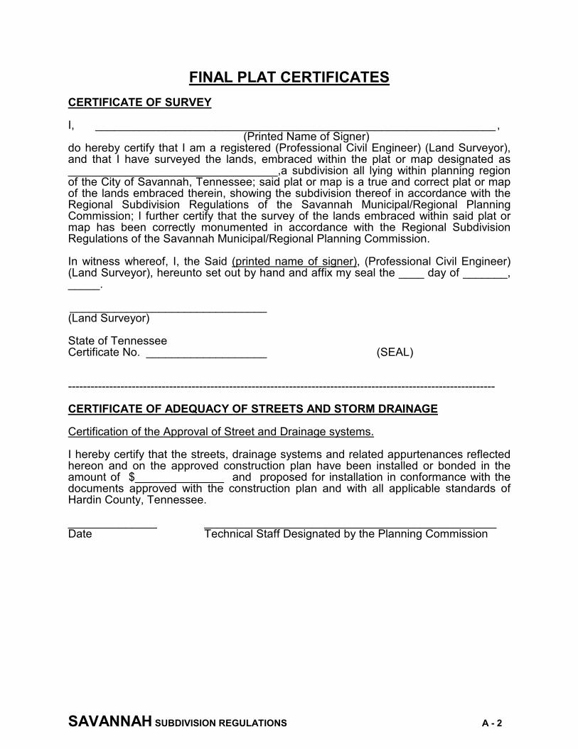
SAVANNAH SUBDIVISION REGULATIONS A - 2
FINAL PLAT CERTIFICATES CERTIFICATE OF SURVEY I, _______________________________________________________________ , (Printed Name of Signer) do hereby certify that I am a registered (Professional Civil Engineer) (Land Surveyor), and that I have surveyed the lands, embraced within the plat or map designated as _________________________________,a subdivision all lying within planning region of the City of Savannah, Tennessee; said plat or map is a true and correct plat or map of the lands embraced therein, showing the subdivision thereof in accordance with the Regional Subdivision Regulations of the Savannah Municipal/Regional Planning Commission; I further certify that the survey of the lands embraced within said plat or map has been correctly monumented in accordance with the Regional Subdivision Regulations of the Savannah Municipal/Regional Planning Commission. In witness whereof, I, the Said (printed name of signer), (Professional Civil Engineer) (Land Surveyor), hereunto set out by hand and affix my seal the ____ day of _______, _____. _______________________________ (Land Surveyor) State of Tennessee Certificate No. ___________________ (SEAL) ------------------------------------------------------------------------------------------------------------------ CERTIFICATE OF ADEQUACY OF STREETS AND STORM DRAINAGE Certification of the Approval of Street and Drainage systems.
I hereby certify that the streets, drainage systems and related appurtenances reflected hereon and on the approved construction plan have been installed or bonded in the amount of $______________ and proposed for installation in conformance with the documents approved with the construction plan and with all applicable standards of Hardin County, Tennessee.
______________ ______________________________________________ Date Technical Staff Designated by the Planning Commission

SAVANNAH SUBDIVISION REGULATIONS A - 3
CERTIFICATE OF THE APPROVAL OF UTILITIES Certificate of the Approval of Public Water and Sewage Systems. I hereby Certify that the public water and/or sewage disposal utility system or systems installed or bonded in the amount of $______________ and proposed for installation are in conformance with the engineering documents approved with the preliminary submittal and/or fully meet all applicable provisions contained herein and meet the requirements of the Tennessee Department of Environment and Conservation.
______________ _____________________________________ Date Director, Savannah Utility Department ------------------------------------------------------------------------------------------------------------------ PLANNING COMMISSION CERTIFICATE I, hereby certify that the subdivision plat shown here has been found to comply with the Subdivision regulation of the Savannah Municipal/Regional Planning Commission with the exception of such variance, If any, as are noted in the minutes of the Planning Commission and that it has been approved for recording in the office of the County Registrar. ___________ _________________________________________________ Date Secretary, Savannah Municipal/Regional Planning Commission ------------------------------------------------------------------------------------------------------------------ OWNER'S CERTIFICATE I, ______________________________, the undersigned owner of the property shown hereon, hereby adopt this as my plan of subdivision and dedicate the streets, easements, rights-of-way, rights of access as shown and all utilities to public use forever, and hereby certify that I am the owner in fee simple, duly authorized so to act, and that said property is unencumbered by any taxes that have become due and payable. _____________________ Signature of Owner

SAVANNAH SUBDIVISION REGULATIONS A - 4
STATE OF TENNESSEE COUNTY OF ______________________ Before me, the undersigned, a notary public in and for the State and County aforesaid, duly commissioned and qualified, personally appeared ___________________ with whom I am personally acquainted and who, upon oath, acknowledge himself to be owner of the ________________________ subdivision, and he as such owner, executed the foregoing instrument for the purpose therein contained by signing his name as owner. In witness whereof, I hereunto set my hand and affix my seal this ____ day of ___________________, 20 __. ___________________________________ (NOTARY PUBLIC) MORTGAGEE CERTIFICATE We, the undersigned, _________________________________________________ , Mortgagee of the property shown hereon, hereby adopt this plat as our plan of subdivision and dedicate the streets, rights-of-way utilities, easements and rights of access as shown to public use forever and hereby certify that we are the mortgagee duly authorized so to act and that said property is not unencumbered by any taxes which have become due and payable. ___________________________________ Signature of Mortgagee STATE OF TENNESSEE COUNTY OF ______________________ Before me, the undersigned, a notary public in and for the State and County aforesaid, duly commissioned and qualified, personally appeared ___________________ with whom I am personally acquainted and who, upon oath, acknowledge himself to be owner of the ________________________ subdivision, and he as such owner, executed the foregoing instrument for the purpose therein contained by signing his name as owner. In witness whereof, I hereunto set my hand and affix my seal this ____ day of ___________________, 20 . ___________________________________ (NOTARY PUBLIC)

SAVANNAH SUBDIVISION REGULATIONS A - 5
CERTIFICATE OF APPROVAL OF INDIVIDUAL SEWAGE SYSTEMS COUNTY OF _________________ This plat of subdivision has been approved by the Department of Health Ground Water Protection and a copy of the Permit for Construction of Subsurface Sewage Disposal System is permanently attached to this plat. The following restrictions are attached to development: Any cutting, filling or alterations of the soil conditions may void this permit. ___________________________________ Signature of County Environmentalist Use only if a Individual Sewage Systems is being used.

i
A - 2
![[MSC 281(85)] - Chapter II - Subdivision and Damage Stability Regulations](https://img.dokumen.tips/doc/110x75/6314e32185333559270ce6bd/msc-28185-chapter-ii-subdivision-and-damage-stability-regulations.jpg)


