Embed Size (px)
Citation preview
Journal of Asian Earth Sciences 85 (2014) 26–39
Contents lists available at ScienceDirect
Journal of Asian Earth Sciences
journal homepage: www.elsevier .com/locate / jseaes
Provenance analysis of the Miocene accretionary prism of the HengchunPeninsula, southern Taiwan, and regional geological significance
http://dx.doi.org/10.1016/j.jseaes.2014.01.0211367-9120/� 2014 Elsevier Ltd. All rights reserved.
⇑ Corresponding author at: Key Laboratory of Marginal Sea Geology, GuangzhouInstitute of Geochemistry, Chinese Academy of Sciences, Guangzhou 510640, China(C.-Y. Huang). Tel.: +86 20 85290212.
E-mail addresses: [email protected] (Y. Yan), [email protected] (C.-Y.Huang).
Xinchang Zhang a,b, Yi Yan a,⇑, Chi-Yue Huang a,c,⇑, Duofu Chen a, Yehua Shan a, Qin Lan a,b,Wenhuang Chen a,b, Mengming Yu a,b
a Key Laboratory of Marginal Sea Geology, Guangzhou Institute of Geochemistry, Chinese Academy of Sciences, Guangzhou 510640, Chinab University of Chinese Academy of Sciences, Beijing 100049, Chinac Department of Earth Sciences, National Cheng Kung University, Tainan, Taiwan
a r t i c l e i n f o
Article history:Received 31 July 2013Received in revised form 11 January 2014Accepted 20 January 2014Available online 3 February 2014
Keywords:ProvenanceTaiwanHengchun accretionary prismTurbidite sequences
a b s t r a c t
Petrographic analysis, detrital zircon U–Pb geochronology and Neodymium isotope are applied to theMiddle-Late Miocene turbidite sequences in the Hengchun accretionary prism, southern Taiwan, to con-strain the provenance and nature of sedimentation in the Manila subduction system. Both petrographicstudy and detrital zircon U–Pb ages show that the Middle-Late Miocene turbidite sequences were primar-ily derived from Mesozoic granites and volcanic rocks of the Cathaysian Block in SE China, which weretransported southeastward via rivers like Minjiang and Jiulongjiang to the Taiwan area. This conclusionis further supported by Nd isotope analyses of shales intercalated within sandstone sequences showingnegative eNd values (�13.3 to �10.5) of a continental origin. During the Late Miocene when global sea-level fell significantly, the SE China coastline shifted seaward to the eastern part of the present TaiwanStrait, which would have facilitated these continent-derived sediments being transported southeastwardto the shelf-upper slope of the Chinese continental margin. These turbidite sequences were thendeformed and accreted into the accretionary prism of the Hengchun Peninsula when the South ChinaSea oceanic lithosphere subducted eastward beneath the Philippine Sea Plate in the Late Miocene. Ourstudy suggests that sedimentary deposition of the turbidite sequences in the Hengchun Peninsula couldbe strongly controlled by different river system supply, submarine channeling transport and fluctuationsof sea-level.
� 2014 Elsevier Ltd. All rights reserved.
1. Introduction
The Taiwan Island is located at the boundary between theEurasian Plate and the Philippine Sea Plate (Fig. 1A). During theEarly Cenozoic, the Eurasia continent in east China had experi-enced normal faulting to develop a series of NE-trending rift basins(Li and Rao, 1994; Huang et al., 2001). Among them the SouthChina Sea oceanic lithosphere spread in Oligocene-Middle Miocene(32–17 Ma, Taylor and Hayes, 1983; 32–16 Ma, Briais et al., 1993;31–20.5 Ma, Barckhausen and Roeser, 2004; 37–15 Ma, Hsu et al.,2004). Soon after cessation of oceanic spreading, the South ChinaSea oceanic lithosphere subsequently subducted eastward alongthe Manila Trench beneath the west-moving Philippine Sea Plate
to develop the Hengchun Ridge accretionary prism and the Luzonarc–forearc basin (Fig. 1; Huang et al., 1992, 1997; Reed et al.,1992). The formation of this accretionary prism marks the transi-tion of the Asian continental margin from the passive to activemargin.
Sequences in the accretionary prism of the upper plate are sed-iments originally deposited on the subducting lower plate. Duringsubduction, parts of these passive margin sediments are scrapedoff and accreted into the accretionary prism in the overlying upperplate (Cathy and Raymond, 1995; Clift and Vannucchi, 2004).Accordingly, the Miocene sequences in the accretionary prism ofthe Hengchun Peninsula were originally deposited on the passiveAsian continental margin before they were accreted into the accre-tionary prism. Nowadays the Hengchun Peninsula is about 400 kmaway from the SE China mainland coast (Fig. 1A). Southward orsoutheastward paleocurrent measurements in the Hengchun Pen-insula indicate that Miocene turbidite sequences were mostlytransported from China continent to the northwest (Huang,1984). However, northwestward paleocurrents are also reported
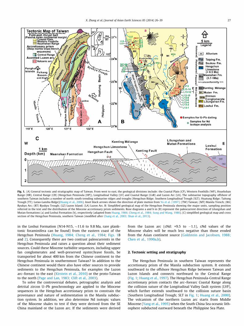
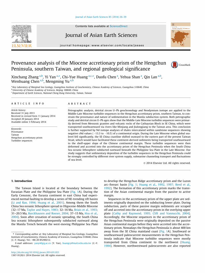
Fig. 1. (A) General tectonic and stratigraphic map of Taiwan. From west to east, the geological divisions include: the Coastal Plain (CP), Western Foothills (WF), HsuehshanRange (HR), Central Range (CR) (Hengchun Peninsula (HP)), Longitudinal Valley (LV) and Coastal Range (CoR) and Luzon Arc (LA). The submarine topography offshore ofsouthern Taiwan includes a number of north–south trending submarine ridges and troughs (Hengchun Ridge; Southern Longitudinal Trough (SLT); Huatung Ridge; TaitungTrough (TT); Lutao-Lanshu Ridge)(Huang et al., 2006). Inset black arrows shows the direction of plate motion from Yu et al. (1997); (TW) Taiwan; (MT) Manila Trench; (RA)Ryukyu Arc; (RT) Ryukyu Trough; (LZ) Luzon Island; (LA) Luzon Arc. B: Simplified geological map of the Hengchun Peninsula showing the major units, sampling positionreferred in the text and the distribution of the Miocene accretionary prism sediments. Rose diagrams a and b in (B) represent the paleocurrent direction of Lilungshan andMutan formations (a) and Loshui Formation (b), respectively (adapted from Huang, 1984; Cheng et al., 1984; Sung and Wang, 1986). (C) simplified geological map and crosssection of the Hengchun Peninsula, southern Taiwan (modified after Chang et al., 2003; Shan et al., 2013).
X. Zhang et al. / Journal of Asian Earth Sciences 85 (2014) 26–39 27
in the Loshui Formation (N14-N15, �11.6 to 9.8 Ma, rare plank-tonic foraminifera can be found) from the eastern coast of theHengchun Peninsula (Huang, 1984; Cheng et al., 1984; Figs. 1Band 2). Consequently there are two contrast paleocurrents in theHengchun Peninsula and raises a question about their sedimentsources. Could these Miocene turbidite sequences, including upperfan conglomerates and well-preserved oyster/leave fossils, betransported for about 400 km from the Chinese continent to theHengchun Peninsula in southernmost Taiwan? In addition to theChinese continent would there also have other sources to providesediments to the Hengchun Peninsula, for examples the Luzonarc–forearc to the east (Kirstein et al., 2010) or the proto-Taiwanto the north (Page and Lan, 1983; Clift et al., 2003).
To solve the controversial debates, petrographic analysis anddetrital zircon U–Pb geochronology are applied to the Miocenesequences in the Hengchun accretionary prism to constrain theprovenance and nature of sedimentation in the Manila subduc-tion system. In addition, we also determine Nd isotopic valuesof the Miocene shales to test if they were derived from the SEChina mainland or the Luzon arc. If the sediments were derived
from the Luzon arc (eNd: +9.5 to �1.1), eNd values of theMiocene shales will be much less negative than those erodedfrom the Asian continent source (Goldstein and Jacobsen, 1988;Chen et al., 1990a,b).
2. Tectonic setting and stratigraphy
The Hengchun Peninsula in southern Taiwan represents theaccretionary prism of the Manila subduction system. It extendssouthward to the offshore Hengchun Ridge between Taiwan andLuzon Islands and connects northward to the Central Range(Fig. 1; Huang et al., 1997). The Hengchun Peninsula-Central Rangeaccretionary prism contacts the arc–forearc Coastal Range alongthe collision suture of the Longitudinal Valley fault system (LVF),which further extends southward to the collision suture basin(Southern Longitudinal Trough; SLT in Fig. 1; Huang et al., 2000).The volcanism of the northern Luzon arc starts from MiddleMiocene (Yang et al., 1995) when the South China Sea oceanic lith-osphere subducted eastward beneath the Philippine Sea Plate.
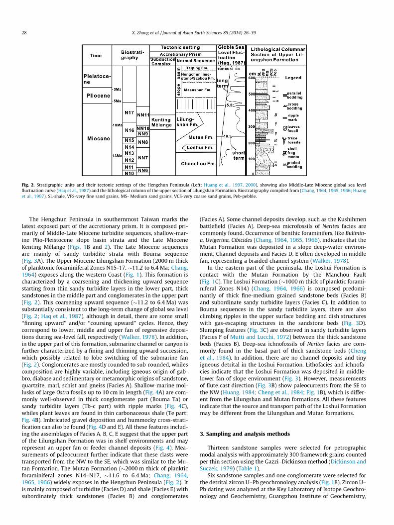
Fig. 2. Stratigraphic units and their tectonic settings of the Hengchun Peninsula (Left; Huang et al., 1997, 2000), showing also Middle-Late Miocene global sea levelfluctuation curve (Haq et al., 1987) and the lithological column of the upper section of Lilungshan Formation. Biostratigraphy compiled from (Chang, 1964, 1965, 1966; Huanget al., 1997). SL-shale, VFS-very fine sand grains, MS- Medium sand grains, VCS-very coarse sand grains, Peb-pebble.
28 X. Zhang et al. / Journal of Asian Earth Sciences 85 (2014) 26–39
The Hengchun Peninsula in southernmost Taiwan marks thelatest exposed part of the accretionary prism. It is composed pri-marily of Middle-Late Miocene turbidite sequences, shallow-mar-ine Plio-Pleistocene slope basin strata and the Late MioceneKenting Mélange (Figs. 1B and 2). The Late Miocene sequencesare mainly of sandy turbidite strata with Bouma sequence(Fig. 3A). The Upper Miocene Lilungshan Formation (2000 m thickof planktonic foraminiferal Zones N15-17, �11.2 to 6.4 Ma; Chang,1964) exposes along the western Coast (Fig. 1). This formation ischaracterized by a coarsening and thickening upward sequencestarting from thin sandy turbidite layers in the lower part, thicksandstones in the middle part and conglomerates in the upper part(Fig. 2). This coarsening upward sequence (�11.2 to 6.4 Ma) wassubstantially consistent to the long-term change of global sea level(Fig. 2; Haq et al., 1987), although in detail, there are some small‘‘finning upward’’ and/or ‘‘coursing upward’’ cycles. Hence, theycorrespond to lower, middle and upper fan of regressive deposi-tions during sea-level fall, respectively (Walker, 1978). In addition,in the upper part of this formation, submarine channel or canyon isfurther characterized by a fining and thinning upward succession,which possibly related to lobe switching of the submarine fan(Fig. 2). Conglomerates are mostly rounded to sub-rounded, whilescomposition are highly variable, including igneous origin of gab-bro, diabase and sedimentary or metamorphic origins of sandstone,quartzite, marl, schist and gneiss (Facies A). Shallow-marine mol-lusks of large Ostra fossils up to 10 cm in length (Fig. 4A) are com-monly well-observed in thick conglomerate part (Bouma Ta) orsandy turbidite layers (Tb-c part) with ripple marks (Fig. 4C),whiles plant leaves are found in thin carbonaceous shale (Te part;Fig. 4B). Imbricated gravel deposition and hummocky cross-strati-fication can also be found (Fig. 4D and E). All these features includ-ing the assemblages of Facies A, B, C, E suggest that the upper partof the Lilungshan Formation was in shelf environments and mayrepresent an upper fan or feeder channel deposits (Fig. 4). Mea-surements of paleocurrent further indicate that these clasts weretransported from the NW to the SE, which was similar to the Mu-tan Formation. The Mutan Formation (�2000 m thick of plankticforaminiferal zones N14–N17, �11.6 to 6.4 Ma; Chang, 1964,1965, 1966) widely exposes in the Hengchun Peninsula (Fig. 2). Itis mainly composed of turbidite (Facies D) and shale (Facies E) withsubordinately thick sandstones (Facies B) and conglomerates
(Facies A). Some channel deposits develop, such as the Kushihmenbattlefield (Facies A). Deep-sea microfossils of Nerites facies arecommonly found. Occurrence of benthic foraminifers, like Bulimin-a, Uvigerina, Cibicides (Chang, 1964, 1965, 1966), indicates that theMutan Formation was deposited in a slope deep-water environ-ment. Channel deposits and Facies D, E often developed in middlefan, representing a braided channel system (Walker, 1978).
In the eastern part of the peninsula, the Loshui Formation iscontact with the Mutan Formation by the Manchou Fault(Fig. 1C). The Loshui Formation (�1000 m thick of planktic forami-niferal Zones N14) (Chang, 1964, 1966) is composed predomi-nantly of thick fine-medium grained sandstone beds (Facies B)and subordinate sandy turbidite layers (Facies C). In addition toBouma sequences in the sandy turbidite layers, there are alsoclimbing ripples in the upper surface bedding and dish structureswith gas-escaping structures in the sandstone beds (Fig. 3D).Slumping features (Fig. 3C) are observed in sandy turbidite layers(Facies F of Mutti and Lucchi, 1972) between the thick sandstonebeds (Facies B). Deep-sea ichnofossils of Nerites facies are com-monly found in the basal part of thick sandstone beds (Chenget al., 1984). In addition, there are no channel deposits and tinyigneous detrital in the Loshui Formation. Lithofacies and ichnofa-cies indicate that the Loshui Formation was deposited in middle-lower fan of slope environment (Fig. 3). However, measurementsof flute cast direction (Fig. 3B) show paleocurrents from the SE tothe NW (Huang, 1984; Cheng et al., 1984; Fig. 1B), which is differ-ent from the Lilungshan and Mutan formations. All these featuresindicate that the source and transport path of the Loshui Formationmay be different from the Lilungshan and Mutan formations.
3. Sampling and analysis methods
Thirteen sandstone samples were selected for petrographicmodal analysis with approximately 300 framework grains countedper thin section using the Gazzi–Dickinson method (Dickinson andSuczek, 1979) (Table 1).
Six sandstone samples and one conglomerate were selected forthe detrital zircon U–Pb geochronology analysis (Fig. 1B). Zircon U–Pb dating was analyzed at the Key Laboratory of Isotope Geochro-nology and Geochemistry, Guangzhou Institute of Geochemistry,
Fig. 3. Field photos at Hengchun Peninsula. (A) Turbidite strata with typical Bouma sequence, Tb-e, found in Loshui Formation, (B) flute cast can be seen easily in MutanFormation and Loshui Formation (arrow pointing downstream), (C) slumping phenomenon in the Loshui Formation, (D) dish and plume structure are common in LoshuiFormation showing a rapid deposition, (E) and (F) Flysch deposition in Mutan Formation.
X. Zhang et al. / Journal of Asian Earth Sciences 85 (2014) 26–39 29
Chinese Academy of Sciences. The LA-ICPMS system is composed ofan Agilent 7500a ICP-MS coupled with a Resonetic RESOLution 50-M ArF-Excimer laser source (k = 193 nm). NIST610 and TEM(206Pb/238U = 415 ± 5 Ma) were used as external calibration stan-dards and 29Si as the internal standard. The calculation of isotoperatios was calculated using ICPMSDataCal 7.7 (Liu et al., 2010a,b).The age relative probability of detrital zircons was processed usingIsoplot (Version 3.23) (Ludwig, 2000, 2003). For statistical pur-poses, zircon ages with discordance <10% are considered as to bevalid (Hu et al., 2012a), therefore zircon ages with discordance>10% were deleted, by which more than 53 valid data were ob-tained for each study sample (Data Repository) for further analy-ses. Usually, detrital zircon U–Pb dating needs more than 100grains to get good enough statistics (Vermeesch, 2004). Due tothe analytical limitations, the number of analyzed grains in somesamples is less than the prescribed minimum of 100 (Vermeesch,2004) and certain fraction of the population comprising less than5% of the total may be missed. This deficiency should not have sig-nificant impact on our inferences since we are concerned morewith the general provenance of the sediment. Following Griffinet al. (2004) ages of 207Pb/206Pb and 206Pb/238U were determined,respectively, for the older (>1 Ga) and younger ages (<1 Ga) of zir-con grains. All results from the samples are shown in DataRepository.
In addition, twenty-seven shale samples in the Miocene strataof the Hengchun Peninsula were selected for Neodymium geo-chemical analysis (Table 2 and Fig. 1B). The samples were first re-acted with 2 N of acetic acid (HAc) to remove biogenic carbonates.The Nd isotopic measurements were performed on a MicroMassIsoprobe multi-collector-inductively coupled plasma-mass spec-trometer (MC–ICP–MS) at the State Key Laboratory of Isotope Geo-chemistry at Guangzhou Institute of Geochemistry, ChineseAcademy of Sciences. Mass bias during Nd isotope measurementswas normalized using 146Nd/144Nd = 0.7219. A standard Nd solu-tion, BHVO-2, was measured together with the samples, yieldinga mean value of 0.512972 ± 7 (2r) for 143Nd/144Nd. For details ofthe method, see Wei et al. (2002).
4. Results
4.1. Petrogrphic study result
Sandstones of Hengchun Peninsula are mostly poorly sortedand angular to sub-rounded in shapes. Monocrystalline quartzcommonly has wavy extinction (Fig. 5a) and there is lots of poly-crystalline quartz, whose internal crystals is crenulated and su-tured (Fig. 5b). Sandstones of the Lilungshan Formation are lithic
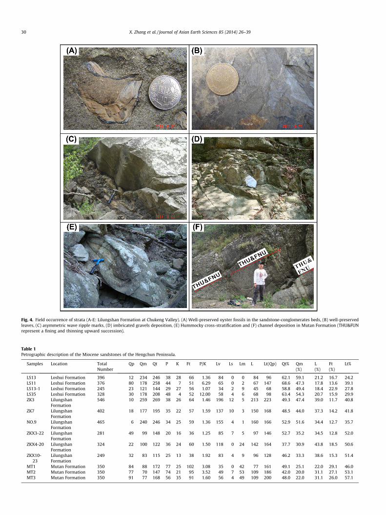
Fig. 4. Field occurrence of strata (A-E: Lilungshan Formation at Chukeng Valley). (A) Well-preserved oyster fossils in the sandstone-conglomerates beds, (B) well-preservedleaves, (C) asymmetric wave ripple marks, (D) imbricated gravels deposition, (E) Hummocky cross-stratification and (F) channel deposition in Mutan Formation (THU&FUNrepresent a fining and thinning upward succession).
Table 1Petrographic description of the Miocene sandstones of the Hengchun Peninsula.
Samples Location TotalNumber
Qp Qm Qt P K Ft P/K Lv Ls Lm L Lt(Qp) Qt% Qm(%)
L(%)
Ft(%)
Lt%
LS13 Loshui Formation 396 12 234 246 38 28 66 1.36 84 0 0 84 96 62.1 59.1 21.2 16.7 24.2LS11 Loshui Formation 376 80 178 258 44 7 51 6.29 65 0 2 67 147 68.6 47.3 17.8 13.6 39.1LS13-1 Loshui Formation 245 23 121 144 29 27 56 1.07 34 2 9 45 68 58.8 49.4 18.4 22.9 27.8LS35 Loshui Formation 328 30 178 208 48 4 52 12.00 58 4 6 68 98 63.4 54.3 20.7 15.9 29.9ZK3 Lilungshan
Formation546 10 259 269 38 26 64 1.46 196 12 5 213 223 49.3 47.4 39.0 11.7 40.8
ZK7 LilungshanFormation
402 18 177 195 35 22 57 1.59 137 10 3 150 168 48.5 44.0 37.3 14.2 41.8
NO.9 LilungshanFormation
465 6 240 246 34 25 59 1.36 155 4 1 160 166 52.9 51.6 34.4 12.7 35.7
ZKX3-22 LilungshanFormation
281 49 99 148 20 16 36 1.25 85 7 5 97 146 52.7 35.2 34.5 12.8 52.0
ZKX4-20 LilungshanFormation
324 22 100 122 36 24 60 1.50 118 0 24 142 164 37.7 30.9 43.8 18.5 50.6
ZKX10-23
LilungshanFormation
249 32 83 115 25 13 38 1.92 83 4 9 96 128 46.2 33.3 38.6 15.3 51.4
MT1 Mutan Formation 350 84 88 172 77 25 102 3.08 35 0 42 77 161 49.1 25.1 22.0 29.1 46.0MT2 Mutan Formation 350 77 70 147 74 21 95 3.52 49 7 53 109 186 42.0 20.0 31.1 27.1 53.1MT3 Mutan Formation 350 91 77 168 56 35 91 1.60 56 4 49 109 200 48.0 22.0 31.1 26.0 57.1
30 X. Zhang et al. / Journal of Asian Earth Sciences 85 (2014) 26–39
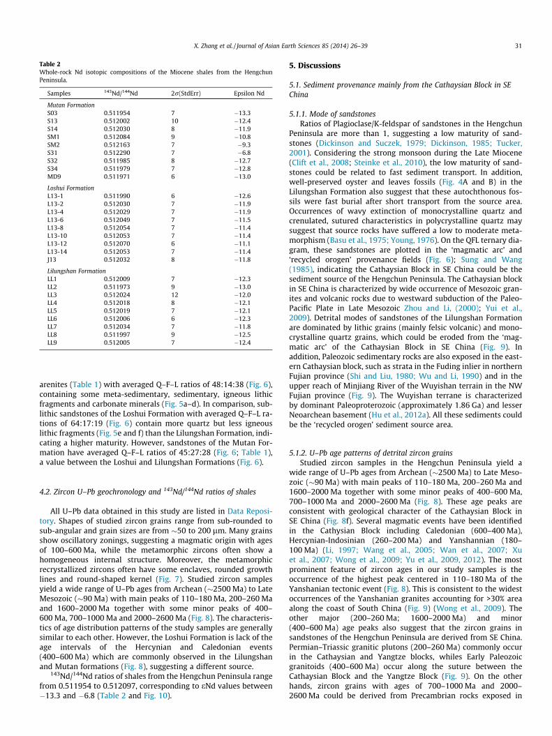
Table 2Whole-rock Nd isotopic compositions of the Miocene shales from the HengchunPeninsula.
Samples 143Nd/144Nd 2r(StdErr) Epsilon Nd
Mutan FormationS03 0.511954 7 �13.3S13 0.512002 10 �12.4S14 0.512030 8 �11.9SM1 0.512084 9 �10.8SM2 0.512163 7 �9.3S31 0.512290 7 �6.8S32 0.511985 8 �12.7S34 0.511979 7 �12.8MD9 0.511971 6 �13.0
Loshui FormationL13-1 0.511990 6 �12.6L13-2 0.512030 7 �11.9L13-4 0.512029 7 �11.9L13-6 0.512049 7 �11.5L13-8 0.512054 7 �11.4L13-10 0.512053 7 �11.4L13-12 0.512070 6 �11.1L13-14 0.512053 7 �11.4J13 0.512032 8 �11.8
Lilungshan FormationLL1 0.512009 7 �12.3LL2 0.511973 9 �13.0LL3 0.512024 12 �12.0LL4 0.512018 8 �12.1LL5 0.512019 7 �12.1LL6 0.512006 6 �12.3LL7 0.512034 7 �11.8LL8 0.511997 9 �12.5LL9 0.512005 7 �12.4
X. Zhang et al. / Journal of Asian Earth Sciences 85 (2014) 26–39 31
arenites (Table 1) with averaged Q–F–L ratios of 48:14:38 (Fig. 6),containing some meta-sedimentary, sedimentary, igneous lithicfragments and carbonate minerals (Fig. 5a–d). In comparison, sub-lithic sandstones of the Loshui Formation with averaged Q–F–L ra-tions of 64:17:19 (Fig. 6) contain more quartz but less igneouslithic fragments (Fig. 5e and f) than the Lilungshan Formation, indi-cating a higher maturity. However, sandstones of the Mutan For-mation have averaged Q–F–L ratios of 45:27:28 (Fig. 6; Table 1),a value between the Loshui and Lilungshan Formations (Fig. 6).
4.2. Zircon U–Pb geochronology and 143Nd/144Nd ratios of shales
All U–Pb data obtained in this study are listed in Data Reposi-tory. Shapes of studied zircon grains range from sub-rounded tosub-angular and grain sizes are from �50 to 200 lm. Many grainsshow oscillatory zonings, suggesting a magmatic origin with agesof 100–600 Ma, while the metamorphic zircons often show ahomogeneous internal structure. Moreover, the metamorphicrecrystallized zircons often have some enclaves, rounded growthlines and round-shaped kernel (Fig. 7). Studied zircon samplesyield a wide range of U–Pb ages from Archean (�2500 Ma) to LateMesozoic (�90 Ma) with main peaks of 110–180 Ma, 200–260 Maand 1600–2000 Ma together with some minor peaks of 400–600 Ma, 700–1000 Ma and 2000–2600 Ma (Fig. 8). The characteris-tics of age distribution patterns of the study samples are generallysimilar to each other. However, the Loshui Formation is lack of theage intervals of the Hercynian and Caledonian events(400–600 Ma) which are commonly observed in the Lilungshanand Mutan formations (Fig. 8), suggesting a different source.
143Nd/144Nd ratios of shales from the Hengchun Peninsula rangefrom 0.511954 to 0.512097, corresponding to eNd values between�13.3 and �6.8 (Table 2 and Fig. 10).
5. Discussions
5.1. Sediment provenance mainly from the Cathaysian Block in SEChina
5.1.1. Mode of sandstonesRatios of Plagioclase/K-feldspar of sandstones in the Hengchun
Peninsula are more than 1, suggesting a low maturity of sand-stones (Dickinson and Suczek, 1979; Dickinson, 1985; Tucker,2001). Considering the strong monsoon during the Late Miocene(Clift et al., 2008; Steinke et al., 2010), the low maturity of sand-stones could be related to fast sediment transport. In addition,well-preserved oyster and leaves fossils (Fig. 4A and B) in theLilungshan Formation also suggest that these autochthonous fos-sils were fast burial after short transport from the source area.Occurrences of wavy extinction of monocrystalline quartz andcrenulated, sutured characteristics in polycrystalline quartz maysuggest that source rocks have suffered a low to moderate meta-morphism (Basu et al., 1975; Young, 1976). On the QFL ternary dia-gram, these sandstones are plotted in the ‘magmatic arc’ and‘recycled orogen’ provenance fields (Fig. 6); Sung and Wang(1985), indicating the Cathaysian Block in SE China could be thesediment source of the Hengchun Peninsula. The Cathaysian blockin SE China is characterized by wide occurrence of Mesozoic gran-ites and volcanic rocks due to westward subduction of the Paleo-Pacific Plate in Late Mesozoic Zhou and Li, (2000); Yui et al.,2009). Detrital modes of sandstones of the Lilungshan Formationare dominated by lithic grains (mainly felsic volcanic) and mono-crystalline quartz grains, which could be eroded from the ‘mag-matic arc’ of the Cathaysian Block in SE China (Fig. 9). Inaddition, Paleozoic sedimentary rocks are also exposed in the east-ern Cathaysian block, such as strata in the Fuding inlier in northernFujian province (Shi and Liu, 1980; Wu and Li, 1990) and in theupper reach of Minjiang River of the Wuyishan terrain in the NWFujian province (Fig. 9). The Wuyishan terrane is characterizedby dominant Paleoproterozoic (approximately 1.86 Ga) and lesserNeoarchean basement (Hu et al., 2012a). All these sediments couldbe the ‘recycled orogen’ sediment source area.
5.1.2. U–Pb age patterns of detrital zircon grainsStudied zircon samples in the Hengchun Peninsula yield a
wide range of U–Pb ages from Archean (�2500 Ma) to Late Meso-zoic (�90 Ma) with main peaks of 110–180 Ma, 200–260 Ma and1600–2000 Ma together with some minor peaks of 400–600 Ma,700–1000 Ma and 2000–2600 Ma (Fig. 8). These age peaks areconsistent with geological character of the Cathaysian Block inSE China (Fig. 8f). Several magmatic events have been identifiedin the Cathysian Block including Caledonian (600–400 Ma),Hercynian-Indosinian (260–200 Ma) and Yanshannian (180–100 Ma) (Li, 1997; Wang et al., 2005; Wan et al., 2007; Xuet al., 2007; Wong et al., 2009; Yu et al., 2009, 2012). The mostprominent feature of zircon ages in our study samples is theoccurrence of the highest peak centered in 110–180 Ma of theYanshanian tectonic event (Fig. 8). This is consistent to the widestoccurrences of the Yanshanian granites accounting for >30% areaalong the coast of South China (Fig. 9) (Wong et al., 2009). Theother major (200–260 Ma; 1600–2000 Ma) and minor(400–600 Ma) age peaks also suggest that the zircon grains insandstones of the Hengchun Peninsula are derived from SE China.Permian–Triassic granitic plutons (200–260 Ma) commonly occurin the Cathaysian and Yangtze blocks, whiles Early Paleozoicgranitoids (400–600 Ma) occur along the suture between theCathaysian Block and the Yangtze Block (Fig. 9). On the otherhands, zircon grains with ages of 700–1000 Ma and 2000–2600 Ma could be derived from Precambrian rocks exposed in
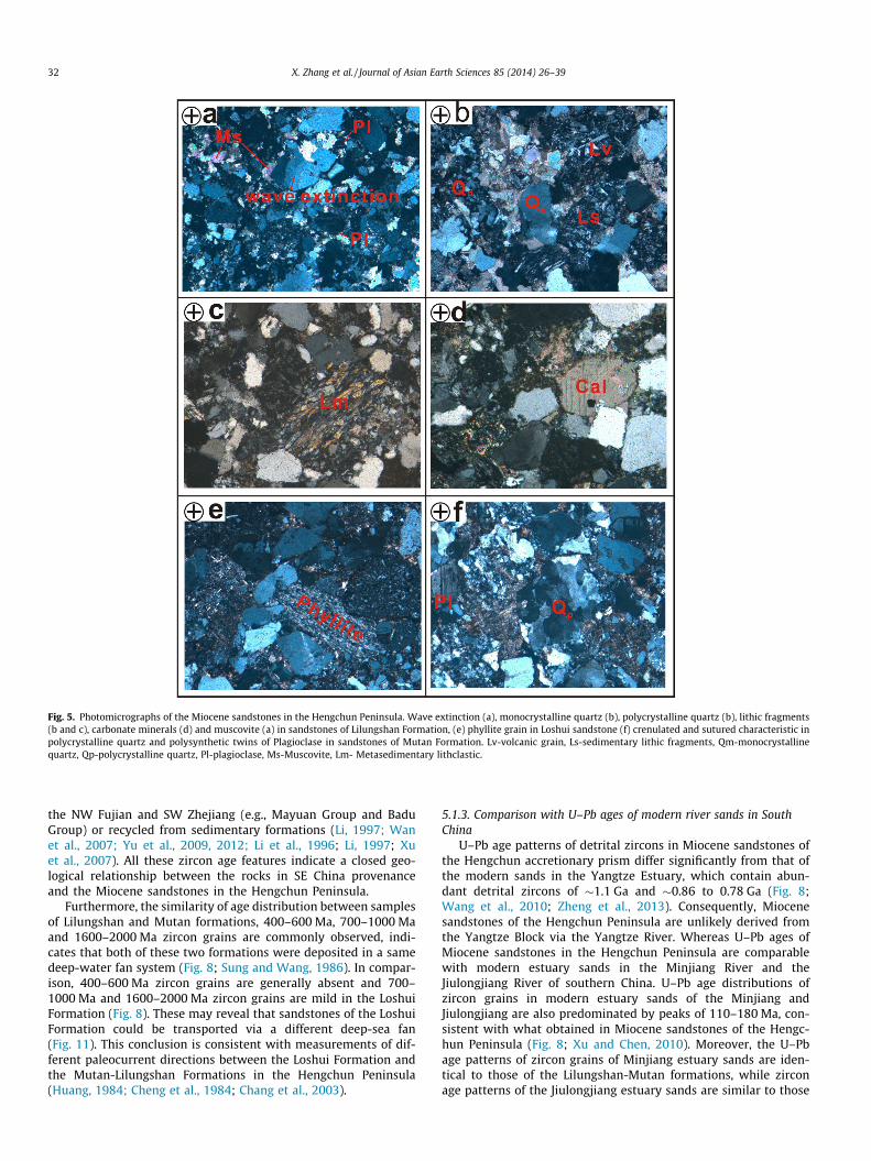
Fig. 5. Photomicrographs of the Miocene sandstones in the Hengchun Peninsula. Wave extinction (a), monocrystalline quartz (b), polycrystalline quartz (b), lithic fragments(b and c), carbonate minerals (d) and muscovite (a) in sandstones of Lilungshan Formation, (e) phyllite grain in Loshui sandstone (f) crenulated and sutured characteristic inpolycrystalline quartz and polysynthetic twins of Plagioclase in sandstones of Mutan Formation. Lv-volcanic grain, Ls-sedimentary lithic fragments, Qm-monocrystallinequartz, Qp-polycrystalline quartz, Pl-plagioclase, Ms-Muscovite, Lm- Metasedimentary lithclastic.
32 X. Zhang et al. / Journal of Asian Earth Sciences 85 (2014) 26–39
the NW Fujian and SW Zhejiang (e.g., Mayuan Group and BaduGroup) or recycled from sedimentary formations (Li, 1997; Wanet al., 2007; Yu et al., 2009, 2012; Li et al., 1996; Li, 1997; Xuet al., 2007). All these zircon age features indicate a closed geo-logical relationship between the rocks in SE China provenanceand the Miocene sandstones in the Hengchun Peninsula.
Furthermore, the similarity of age distribution between samplesof Lilungshan and Mutan formations, 400–600 Ma, 700–1000 Maand 1600–2000 Ma zircon grains are commonly observed, indi-cates that both of these two formations were deposited in a samedeep-water fan system (Fig. 8; Sung and Wang, 1986). In compar-ison, 400–600 Ma zircon grains are generally absent and 700–1000 Ma and 1600–2000 Ma zircon grains are mild in the LoshuiFormation (Fig. 8). These may reveal that sandstones of the LoshuiFormation could be transported via a different deep-sea fan(Fig. 11). This conclusion is consistent with measurements of dif-ferent paleocurrent directions between the Loshui Formation andthe Mutan-Lilungshan Formations in the Hengchun Peninsula(Huang, 1984; Cheng et al., 1984; Chang et al., 2003).
5.1.3. Comparison with U–Pb ages of modern river sands in SouthChina
U–Pb age patterns of detrital zircons in Miocene sandstones ofthe Hengchun accretionary prism differ significantly from that ofthe modern sands in the Yangtze Estuary, which contain abun-dant detrital zircons of �1.1 Ga and �0.86 to 0.78 Ga (Fig. 8;Wang et al., 2010; Zheng et al., 2013). Consequently, Miocenesandstones of the Hengchun Peninsula are unlikely derived fromthe Yangtze Block via the Yangtze River. Whereas U–Pb ages ofMiocene sandstones in the Hengchun Peninsula are comparablewith modern estuary sands in the Minjiang River and theJiulongjiang River of southern China. U–Pb age distributions ofzircon grains in modern estuary sands of the Minjiang andJiulongjiang are also predominated by peaks of 110–180 Ma, con-sistent with what obtained in Miocene sandstones of the Hengc-hun Peninsula (Fig. 8; Xu and Chen, 2010). Moreover, the U–Pbage patterns of zircon grains of Minjiang estuary sands are iden-tical to those of the Lilungshan-Mutan formations, while zirconage patterns of the Jiulongjiang estuary sands are similar to those
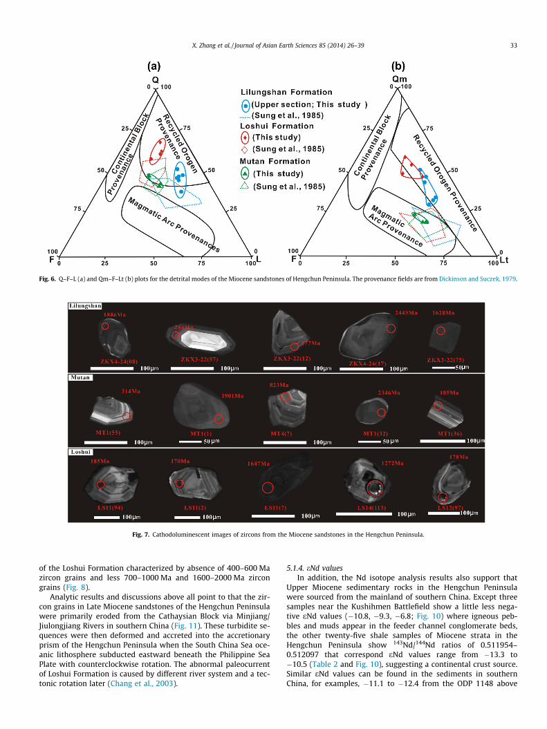
Fig. 6. Q–F–L (a) and Qm–F–Lt (b) plots for the detrital modes of the Miocene sandstones of Hengchun Peninsula. The provenance fields are from Dickinson and Suczek, 1979.
Fig. 7. Cathodoluminescent images of zircons from the Miocene sandstones in the Hengchun Peninsula.
X. Zhang et al. / Journal of Asian Earth Sciences 85 (2014) 26–39 33
of the Loshui Formation characterized by absence of 400–600 Mazircon grains and less 700–1000 Ma and 1600–2000 Ma zircongrains (Fig. 8).
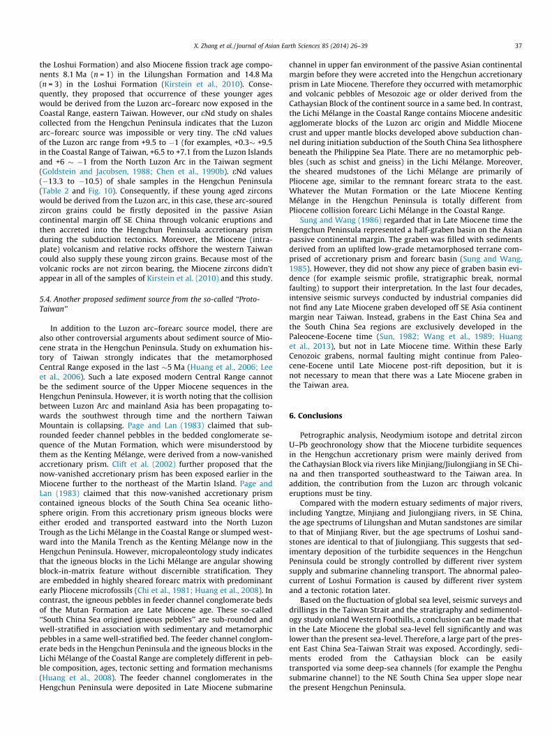
Analytic results and discussions above all point to that the zir-con grains in Late Miocene sandstones of the Hengchun Peninsulawere primarily eroded from the Cathaysian Block via Minjiang/Jiulongjiang Rivers in southern China (Fig. 11). These turbidite se-quences were then deformed and accreted into the accretionaryprism of the Hengchun Peninsula when the South China Sea oce-anic lithosphere subducted eastward beneath the Philippine SeaPlate with counterclockwise rotation. The abnormal paleocurrentof Loshui Formation is caused by different river system and a tec-tonic rotation later (Chang et al., 2003).
5.1.4. eNd valuesIn addition, the Nd isotope analysis results also support that
Upper Miocene sedimentary rocks in the Hengchun Peninsulawere sourced from the mainland of southern China. Except threesamples near the Kushihmen Battlefield show a little less nega-tive eNd values (�10.8, �9.3, �6.8; Fig. 10) where igneous peb-bles and muds appear in the feeder channel conglomerate beds,the other twenty-five shale samples of Miocene strata in theHengchun Peninsula show 143Nd/144Nd ratios of 0.511954–0.512097 that correspond eNd values range from �13.3 to�10.5 (Table 2 and Fig. 10), suggesting a continental crust source.Similar eNd values can be found in the sediments in southernChina, for examples, �11.1 to �12.4 from the ODP 1148 above
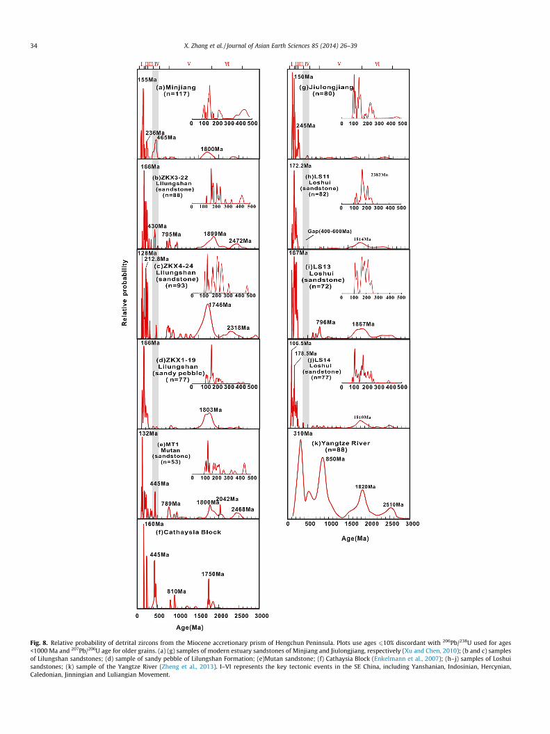
Fig. 8. Relative probability of detrital zircons from the Miocene accretionary prism of Hengchun Peninsula. Plots use ages 610% discordant with 206Pb/238U used for ages<1000 Ma and 207Pb/206U age for older grains. (a) (g) samples of modern estuary sandstones of Minjiang and Jiulongjiang, respectively (Xu and Chen, 2010); (b and c) samplesof Lilungshan sandstones; (d) sample of sandy pebble of Lilungshan Formation; (e)Mutan sandstone; (f) Cathaysia Block (Enkelmann et al., 2007); (h–j) samples of Loshuisandstones; (k) sample of the Yangtze River (Zheng et al., 2013). I–VI represents the key tectonic events in the SE China, including Yanshanian, Indosinian, Hercynian,Caledonian, Jinningian and Luliangian Movement.
34 X. Zhang et al. / Journal of Asian Earth Sciences 85 (2014) 26–39
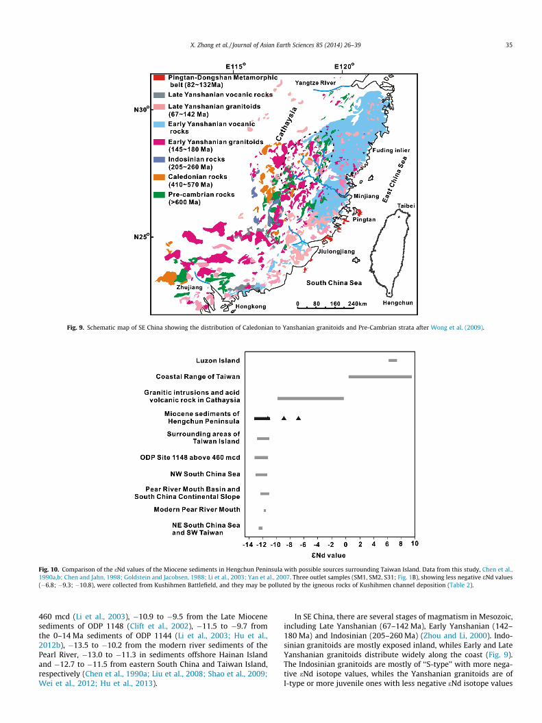
Fig. 9. Schematic map of SE China showing the distribution of Caledonian to Yanshanian granitoids and Pre-Cambrian strata after Wong et al. (2009).
Fig. 10. Comparison of the eNd values of the Miocene sediments in Hengchun Peninsula with possible sources surrounding Taiwan Island. Data from this study, Chen et al.,1990a,b; Chen and Jahn, 1998; Goldstein and Jacobsen, 1988; Li et al., 2003; Yan et al., 2007. Three outlet samples (SM1, SM2, S31; Fig. 1B), showing less negative eNd values(�6.8; �9.3; �10.8), were collected from Kushihmen Battlefield, and they may be polluted by the igneous rocks of Kushihmen channel deposition (Table 2).
X. Zhang et al. / Journal of Asian Earth Sciences 85 (2014) 26–39 35
460 mcd (Li et al., 2003), �10.9 to �9.5 from the Late Miocenesediments of ODP 1148 (Clift et al., 2002), �11.5 to �9.7 fromthe 0–14 Ma sediments of ODP 1144 (Li et al., 2003; Hu et al.,2012b), �13.5 to �10.2 from the modern river sediments of thePearl River, �13.0 to �11.3 in sediments offshore Hainan Islandand �12.7 to �11.5 from eastern South China and Taiwan Island,respectively (Chen et al., 1990a; Liu et al., 2008; Shao et al., 2009;Wei et al., 2012; Hu et al., 2013).
In SE China, there are several stages of magmatism in Mesozoic,including Late Yanshanian (67–142 Ma), Early Yanshanian (142–180 Ma) and Indosinian (205–260 Ma) (Zhou and Li, 2000). Indo-sinian granitoids are mostly exposed inland, whiles Early and LateYanshanian granitoids distribute widely along the coast (Fig. 9).The Indosinian granitoids are mostly of ‘‘S-type’’ with more nega-tive eNd isotope values, whiles the Yanshanian granitoids are ofI-type or more juvenile ones with less negative eNd isotope values
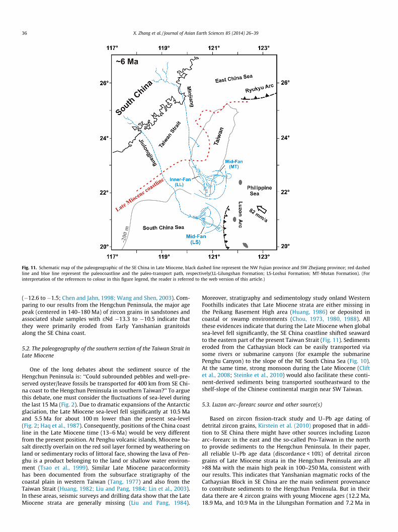
Fig. 11. Schematic map of the paleogeographic of the SE China in Late Miocene, black dashed line represent the NW Fujian province and SW Zhejiang province; red dashedline and blue line represent the paleocoastline and the paleo-transport path, respectively(LL-Lilungshan Formation; LS-Loshui Formation; MT-Mutan Formation). (Forinterpretation of the references to colour in this figure legend, the reader is referred to the web version of this article.)
36 X. Zhang et al. / Journal of Asian Earth Sciences 85 (2014) 26–39
(�12.6 to �1.5; Chen and Jahn, 1998; Wang and Shen, 2003). Com-paring to our results from the Hengchun Peninsula, the major agepeak (centered in 140–180 Ma) of zircon grains in sandstones andassociated shale samples with eNd �13.3 to �10.5 indicate thatthey were primarily eroded from Early Yanshanian granitoidsalong the SE China coast.
5.2. The paleogeography of the southern section of the Taiwan Strait inLate Miocene
One of the long debates about the sediment source of theHengchun Peninsula is: ‘‘Could subrounded pebbles and well-pre-served oyster/leave fossils be transported for 400 km from SE Chi-na coast to the Hengchun Peninsula in southern Taiwan?’’ To arguethis debate, one must consider the fluctuations of sea-level duringthe last 15 Ma (Fig. 2). Due to dramatic expansions of the Antarcticglaciation, the Late Miocene sea-level fell significantly at 10.5 Maand 5.5 Ma for about 100 m lower than the present sea-level(Fig. 2; Haq et al., 1987). Consequently, positions of the China coastline in the Late Miocene time (13–6 Ma) would be very differentfrom the present position. At Penghu volcanic islands, Miocene ba-salt directly overlain on the red soil layer formed by weathering onland or sedimentary rocks of littoral face, showing the lava of Pen-ghu is a product belonging to the land or shallow water environ-ment (Tsao et al., 1999). Similar Late Miocene paraconformityhas been documented from the subsurface stratigraphy of thecoastal plain in western Taiwan (Tang, 1977) and also from theTaiwan Strait (Huang, 1982; Liu and Pang, 1984; Lin et al., 2003).In these areas, seismic surveys and drilling data show that the LateMiocene strata are generally missing (Liu and Pang, 1984).
Moreover, stratigraphy and sedimentology study onland WesternFoothills indicates that Late Miocene strata are either missing inthe Peikang Basement High area (Huang, 1986) or deposited incoastal or swamp environments (Chou, 1973, 1980, 1988). Allthese evidences indicate that during the Late Miocene when globalsea-level fell significantly, the SE China coastline shifted seawardto the eastern part of the present Taiwan Strait (Fig. 11). Sedimentseroded from the Cathaysian block can be easily transported viasome rivers or submarine canyons (for example the submarinePenghu Canyon) to the slope of the NE South China Sea (Fig. 10).At the same time, strong monsoon during the Late Miocene (Cliftet al., 2008; Steinke et al., 2010) would also facilitate these conti-nent-derived sediments being transported southeastward to theshelf-slope of the Chinese continental margin near SW Taiwan.
5.3. Luzon arc–forearc source and other source(s)
Based on zircon fission-track study and U–Pb age dating ofdetrital zircon grains, Kirstein et al. (2010) proposed that in addi-tion to SE China there might have other sources including Luzonarc–forearc in the east and the so-called Pro-Taiwan in the northto provide sediments to the Hengchun Peninsula. In their paper,all reliable U–Pb age data (discordance < 10%) of detrital zircongrains of Late Miocene strata in the Hengchun Peninsula are all>88 Ma with the main high peak in 100–250 Ma, consistent withour results. This indicates that Yanshanian magmatic rocks of theCathaysian Block in SE China are the main sediment provenanceto contribute sediments to the Hengchun Peninsula. But in theirdata there are 4 zircon grains with young Miocene ages (12.2 Ma,18.9 Ma, and 10.9 Ma in the Lilungshan Formation and 7.2 Ma in
X. Zhang et al. / Journal of Asian Earth Sciences 85 (2014) 26–39 37
the Loshui Formation) and also Miocene fission track age compo-nents 8.1 Ma (n = 1) in the Lilungshan Formation and 14.8 Ma(n = 3) in the Loshui Formation (Kirstein et al., 2010). Conse-quently, they proposed that occurrence of these younger ageswould be derived from the Luzon arc–forearc now exposed in theCoastal Range, eastern Taiwan. However, our eNd study on shalescollected from the Hengchun Peninsula indicates that the Luzonarc–forearc source was impossible or very tiny. The eNd valuesof the Luzon arc range from +9.5 to �1 (for examples, +0.3� +9.5in the Coastal Range of Taiwan, +6.5 to +7.1 from the Luzon Islandsand +6 � �1 from the North Luzon Arc in the Taiwan segment(Goldstein and Jacobsen, 1988; Chen et al., 1990b). eNd values(�13.3 to �10.5) of shale samples in the Hengchun Peninsula(Table 2 and Fig. 10). Consequently, if these young aged zirconswould be derived from the Luzon arc, in this case, these arc-souredzircon grains could be firstly deposited in the passive Asiancontinental margin off SE China through volcanic eruptions andthen accreted into the Hengchun Peninsula accretionary prismduring the subduction tectonics. Moreover, the Miocene (intra-plate) volcanism and relative rocks offshore the western Taiwancould also supply these young zircon grains. Because most of thevolcanic rocks are not zircon bearing, the Miocene zircons didn’tappear in all of the samples of Kirstein et al. (2010) and this study.
5.4. Another proposed sediment source from the so-called ‘‘Proto-Taiwan’’
In addition to the Luzon arc–forearc source model, there arealso other controversial arguments about sediment source of Mio-cene strata in the Hengchun Peninsula. Study on exhumation his-tory of Taiwan strongly indicates that the metamorphosedCentral Range exposed in the last �5 Ma (Huang et al., 2006; Leeet al., 2006). Such a late exposed modern Central Range cannotbe the sediment source of the Upper Miocene sequences in theHengchun Peninsula. However, it is worth noting that the collisionbetween Luzon Arc and mainland Asia has been propagating to-wards the southwest through time and the northern TaiwanMountain is collapsing. Page and Lan (1983) claimed that sub-rounded feeder channel pebbles in the bedded conglomerate se-quence of the Mutan Formation, which were misunderstood bythem as the Kenting Mélange, were derived from a now-vanishedaccretionary prism. Clift et al. (2002) further proposed that thenow-vanished accretionary prism has been exposed earlier in theMiocene further to the northeast of the Martin Island. Page andLan (1983) claimed that this now-vanished accretionary prismcontained igneous blocks of the South China Sea oceanic litho-sphere origin. From this accretionary prism igneous blocks wereeither eroded and transported eastward into the North LuzonTrough as the Lichi Mélange in the Coastal Range or slumped west-ward into the Manila Trench as the Kenting Mélange now in theHengchun Peninsula. However, micropaleontology study indicatesthat the igneous blocks in the Lichi Mélange are angular showingblock-in-matrix feature without discernible stratification. Theyare embedded in highly sheared forearc matrix with predominantearly Pliocene microfossils (Chi et al., 1981; Huang et al., 2008). Incontrast, the igneous pebbles in feeder channel conglomerate bedsof the Mutan Formation are Late Miocene age. These so-called‘‘South China Sea origined igneous pebbles’’ are sub-rounded andwell-stratified in association with sedimentary and metamorphicpebbles in a same well-stratified bed. The feeder channel conglom-erate beds in the Hengchun Peninsula and the igneous blocks in theLichi Mélange of the Coastal Range are completely different in peb-ble composition, ages, tectonic setting and formation mechanisms(Huang et al., 2008). The feeder channel conglomerates in theHengchun Peninsula were deposited in Late Miocene submarine
channel in upper fan environment of the passive Asian continentalmargin before they were accreted into the Hengchun accretionaryprism in Late Miocene. Therefore they occurred with metamorphicand volcanic pebbles of Mesozoic age or older derived from theCathaysian Block of the continent source in a same bed. In contrast,the Lichi Mélange in the Coastal Range contains Miocene andesiticagglomerate blocks of the Luzon arc origin and Middle Miocenecrust and upper mantle blocks developed above subduction chan-nel during initiation subduction of the South China Sea lithospherebeneath the Philippine Sea Plate. There are no metamorphic peb-bles (such as schist and gneiss) in the Lichi Mélange. Moreover,the sheared mudstones of the Lichi Mélange are primarily ofPliocene age, similar to the remnant forearc strata to the east.Whatever the Mutan Formation or the Late Miocene KentingMélange in the Hengchun Peninsula is totally different fromPliocene collision forearc Lichi Mélange in the Coastal Range.
Sung and Wang (1986) regarded that in Late Miocene time theHengchun Peninsula represented a half-graben basin on the Asianpassive continental margin. The graben was filled with sedimentsderived from an uplifted low-grade metamorphosed terrane com-prised of accretionary prism and forearc basin (Sung and Wang,1985). However, they did not show any piece of graben basin evi-dence (for example seismic profile, stratigraphic break, normalfaulting) to support their interpretation. In the last four decades,intensive seismic surveys conducted by industrial companies didnot find any Late Miocene graben developed off SE Asia continentmargin near Taiwan. Instead, grabens in the East China Sea andthe South China Sea regions are exclusively developed in thePaleocene-Eocene time (Sun, 1982; Wang et al., 1989; Huanget al., 2013), but not in Late Miocene time. Within these EarlyCenozoic grabens, normal faulting might continue from Paleo-cene-Eocene until Late Miocene post-rift deposition, but it isnot necessary to mean that there was a Late Miocene graben inthe Taiwan area.
6. Conclusions
Petrographic analysis, Neodymium isotope and detrital zirconU–Pb geochronology show that the Miocene turbidite sequencesin the Hengchun accretionary prism were mainly derived fromthe Cathaysian Block via rivers like Minjiang/Jiulongjiang in SE Chi-na and then transported southeastward to the Taiwan area. Inaddition, the contribution from the Luzon arc through volcaniceruptions must be tiny.
Compared with the modern estuary sediments of major rivers,including Yangtze, Minjiang and Jiulongjiang rivers, in SE China,the age spectrums of Lilungshan and Mutan sandstones are similarto that of Minjiang River, but the age spectrums of Loshui sand-stones are identical to that of Jiulongjiang. This suggests that sed-imentary deposition of the turbidite sequences in the HengchunPeninsula could be strongly controlled by different river systemsupply and submarine channeling transport. The abnormal paleo-current of Loshui Formation is caused by different river systemand a tectonic rotation later.
Based on the fluctuation of global sea level, seismic surveys anddrillings in the Taiwan Strait and the stratigraphy and sedimentol-ogy study onland Western Foothills, a conclusion can be made thatin the Late Miocene the global sea-level fell significantly and waslower than the present sea-level. Therefore, a large part of the pres-ent East China Sea-Taiwan Strait was exposed. Accordingly, sedi-ments eroded from the Cathaysian block can be easilytransported via some deep-sea channels (for example the Penghusubmarine channel) to the NE South China Sea upper slope nearthe present Hengchun Peninsula.
38 X. Zhang et al. / Journal of Asian Earth Sciences 85 (2014) 26–39
Acknowledgments
We are grateful to two anonymous reviewers and the editor-in-chief professor Bor-ming Jahn for their critical reviews and helpfulsuggestions. This work was financially co-supported by the Knowl-edge Innovation Program of the Chinese Academy of Sciences(Grant KZCX2-EW-101), the National Natural Science Foundationof China (Grant 41176041 and 91128211) and Major StateBasic Research Program of the People’s Republic of China(2009CB219401). This is contribution No. IS-1816 from GIGCAS.
Appendix A. Supplementary material
Supplementary data associated with this article can be found, inthe online version, at http://dx.doi.org/10.1016/j.jseaes.2014.01.021.
References
Barckhausen, U., Roeser, H.A., 2004. Seafloor spreading anomalies in the SouthChina Sea revisited. In: Clift, P., Wang, P., Kuhnt, W., et al. (Eds.), Continent-Ocean Interations within East Asian Marginal Seas, AGU Geophys Monogr,vol. 149. pp. 121–125.
Basu, A., Suttner, L.J., James, W.C., Mack, G.H., 1975. Re-evaluation of the use ofundulatory extinction and polycrystallinity in detrital quartz for provenanceinterpretation. J. Sed. Petrol. 45 (4), 873–882.
Briais, A., Patriat, P., Tapponnier, P., 1993. Updated interpretation of magneticanomalies and seafloor spreading stages in the South China Sea: Implicationsfor the Tertiary tectonics of Southeast Asia. J. Geophys. Res. Sol. Ea. (1978–2012)98 (B4), 6299–6328.
Cathy, J.B., Raymond, V.I., 1995. Tectonics of Sedimentary Basins. Blackwell Science,Cambridge, Massachusetts, USA.
Chang, L.S., 1964. A biostratigraphic study of the tertiary in the HengchunPeninsula, Taiwan, based on smaller foraminifera (I: Northern Part). Proc.Geol. Soc. China 7, 48–62.
Chang, L.S., 1965. A biostratigraphic study of the tertiary in the HengchunPeninsula, Taiwan, based on smaller foraminifera (II: Middle Part). Proc. Geol.Soc. China 8, 9–18.
Chang, L.S., 1966. A biostratigraphic study of the tertiary in the HengchunPeninsula, Taiwan, based on smaller foraminifera (III: Southern Part).Proceedings of the Geological Society of China 9, 55–63.
Chang, C.P., Angelier, J., Lee, T.Q., Huang, C.Y., 2003. From continental marginextension to collision orogen: structural development and tectonic rotation ofthe Hengchun peninsula, southern Taiwan. Tectonophysics 361, 61–82. http://dx.doi.org/10.1016/S0040-1951(02)00561-9.
Chen, J.F., Jahn, B.M., 1998. Crustal evolution of southeastern China: Nd and Srisotopic evidence. Tectonophysics 284, 101–133. http://dx.doi.org/10.1016/S0040-1951(97)00186-8.
Chen, C.H., Jahn, B.M., Lee, T.P., Chen, C.H., Jean, C., 1990a. Sm–Nd isotopicgeochemistry of sediments from Taiwan and implications for the tectonicevolution of southeast China. Chem. Geol. 88, 317–332. http://dx.doi.org/10.1016/0009-2541(90)90096-P.
Chen, C.H., Shieh, Y.N., Lee, T., Chen, C.H., Mertzman, S.A., 1990b. Nd–Sr–O isotopicevidence for source contamination and an unusual mantle component underLuzon Arc. Geochim. Cosmochim. Acta 54 (9), 2473–2483. http://dx.doi.org/10.1016/0016-7037(90)90234-C.
Cheng, Y.M., Huang, C.Y., Yen, J.J., 1984. The Loshui formation: Deeper-watersandstones on the Hengchun Peninsula, Southern Taiwan. Acta Geol. Taiwanica22, 100–117.
Chi, W.R., Namson, J., Suppe, J., 1981. Stratigraphic record of the plate interactions ofthe Coastal Range of eastern Taiwan. Memoir Geol. Soc. China 4, 155–194.
Chou, J.T., 1973. Sedimentology and palegeography of the upper Cenozoic system ofwestern Taiwan. Proc. Geol. Soc. China 16, 111–143.
Chou, J.T., 1980. Stratigraphy and sedimentology of the Miocene in western Taiwan.Petrol. Geol. Taiwan 17, 33–52.
Chou, J.T., 1988. Eocene formations in Taiwan. Petrol. Geol. Taiwan 24, 51–59.Clift, P.D., Vannucchi, P., 2004. Controls on tectonic accretion versus erosion in
subduction zones: implications for the origin and recycling of the continentalcrust. Rev. Geophys. 42 (2). http://dx.doi.org/10.1029/2003RG000127.
Clift, P.D., Lee, J.I., Clark, M.K., Blusztajn, J., 2002. Erosional response of south Chinato arc rifting and monsoonal strengthening; a record from the South China Sea.Marine Geol. 184 (3–4), 207–226.
Clift, P.D., Schouten, H., Draut, A.E., 2003. A general model of arc-continent collisionand subduction polarity reversal from Taiwan and the Irish Caledonides.Geological Soc., London, Special Publications 219 (1), 81–98.
Clift, P.D., Hodges, K.V., Heslop, D., Hannigan, R., Van Long, H., Calves, G., 2008.Correlation of Himalayan exhumation rates and Asian monsoon intensity. Nat.Geosci. 1 (12), 875–880.
Dickinson, W.R., 1985. Interpreting provenance relations from detrital modes ofsandstones. NATO ASI Ser., Ser. C Mathe. Phys. Sci. 148, 333–361.
Dickinson, W.R., Suczek, C.A., 1979. Plate tectonics and sandstone compositions.AAPG Bull. 63, 2164–2182.
Enkelmann, E., Weislogel, A., Ratschbacher, L., Eide, E., Renno, A., Wooden, J., 2007.How was the Triassic Songpan-Ganzi basin filled? A provenance study.Tectonics 26, TC4007.
Goldstein, S.J., Jacobsen, S.B., 1988. Nd and Sr isotopic systematics of River watersuspended material – implications for crustal evolution. Earth Planetary Sci.Lett. 87 (3), 249–265.
Griffin, W.L., Belousova, E.A., Shee, S.R., Pearson, N.J., O’Reilly, S.Y., 2004. Archeancrustal evolution in the northern Yilgarn Craton: U–Pb and Hf isotope evidencefrom detrital zircons. Precambr. Res. 131, 231–282. http://dx.doi.org/10.1016/j.precamres.2003.12.011.
Haq, B.U., Hardenbol, J., Vail, P.R., 1987. Chronology fluctuating sea levels since theTriassic. Science 235, 1156–1167. http://dx.doi.org/10.1126/science.235.4793.1156.
Hu, X.M., Huang, Z.C., Wang, J.G., Yu, J.H., Xu, K.D., Jansa, L.B., Hu, W.X., 2012a.Geology of the Fuding inlier in southeastern China: implication for latePaleozoic Cathaysian paleogeography. Gondwana Res. 22, 507–518. http://dx.doi.org/10.1016/j.gr.2011.09.016.
Hu, D., Böning, P., Köhler, C.M., Hillier, S., Pressling, N., Wan, S., Brumsack, H.-J., Clift,P.D., 2012b. Deep sea records of the continental weathering and erosionresponse to East Asian monsoon intensification since 14 ka in the South ChinaSea. Chem. Geol. 326–327, 1–18. http://dx.doi.org/10.1016/j.chemgeo.2012.07.024.
Hu, D., Clift, P.D., Böning, P., Hannigan, R., Hillier, S., Blusztajn, J., Wang, S., Fuller,D.Q., 2013. Holocene evolution in weathering and erosion patterns in the PearlRiver delta. Geochem. Geophys. Geosyst. 14, 2349–2368. http://dx.doi.org/10.1002/ggge.20166.
Huang, C.Y., 1982. Study on Smaller Foraminifera from the Oligocene and MioceneFormations of Northern Taiwan. Doctoral thesis, Institute of Geology, NationalTaiwan University.
Huang, C.Y., 1984. Field Trip Guide to the Hengchun Peninsula, Southern Taiwan.Sino-French Colloquium on Geodynamics of the Eurasian – Philippine Sea PlateBoundary, April 26–30, pp. 77–94.
Huang, C.Y., 1986. Oligocene and Miocene stratigraphy of the Kuohsing area, centralTaiwan. Acta Geol. Taiwanica 24, 281–318.
Huang, C.Y., Shyu, C.T., Lin, S.B., Lee, T.Q., Sheu, D.D., 1992. Marine geology in thearc-continent collision zone off southeastern Taiwan: implications for lateNeocene evolution of the coastal range. Mar. Geol. 107, 183–212. http://dx.doi.org/10.1016/0025-3227(92)90167-G.
Huang, C.Y., Wu, W.Y., Chang, C.P., Lin, C.W., 1997. Tectonic evolution of theaccretionary prism in the arc-continent collision terrane of Taiwan.Tectonophysics 281, 31–51. http://dx.doi.org/10.1016/S0040-1951(97)00157-1.
Huang, C.Y., Yuan, P.B., Lin, C.W., Wang, T.K., 2000. Geodynamic processes of Taiwanarc-continent collision and comparison with analogs in Timor, Papua NewGuinea, Urals and Corsica. Tectonophysics 325, 1–21. http://dx.doi.org/10.1016/S0040-1951(00)00128-1.
Huang, C.Y., Xia, K.Y., Yuan, P.B., Chen, P.G., 2001. Structural evolution fromPaleogene extension to Latest Miocene-Recent arc-continent collision offshoreTaiwan: comparison with on land geology. J. Asian Earth Sci. 19, 619–639.http://dx.doi.org/10.1016/S1367-9120(00)00065-1.
Huang, C.Y., Yuan, P.B., Tsao, S.J., 2006. Temporal and spatial records of active arc-continent collision in Taiwan: a synthesis. Geol. Soc. America Bull. 118 (3–4),274–288. http://dx.doi.org/10.1130/B25527.1.
Huang, C.Y., Chien, C.W., Yao, B., Chang, C.P., 2008. The Lichi Mélange: A collisionmélange formation along early arcward backthrusts during forearc basinclosure, Taiwan arc-continent collision. In: Draut, A.E., Clift, P.D., Scholl, D.W.,(Eds.), Formation and Applications of the Sedimentary Records in Arc ContinentCollision Zone. Geological Society of America Special Paper 436, pp. 127–154,doi: 10.1130/2008.2436(06).
Hsu, S.K., Yeh, Y.C., Doo, W.B., Tsai, C.H., 2004. New bathymetry and magneticlineations identifications in the northeasternmost South China Sea and theirtectonic implications. Mar. Geophys. Res. 25 (1), 29–44.
Huang, C.Y., Yen, Y., Liew, P.M., He, D.J., Chi, W.R., Wu, M.S., Zhao, M.X., 2013.Significance of indigenous Eocene larger foraminifera Discocyclina dispansa inWestern Foothills, Central Taiwan: a Paleogene marine rift basin in Chinesecontinental margin. J. Asian Earth Sci. 62, 425–437.
Kirstein, L.A., Carter, A., Chen, Y.G., 2010. Testing inferences from palaeocurrents:application of zircon double-dating to Miocene sediments from the HengchunPeninsula, Taiwan. Terra Nova 22 (6), 483–493. http://dx.doi.org/10.1111/j.1365-3121.2010.00970.x.
Lee, Y.H., Chen, C.C., Liu, T.K., Ho, H.C., Lu, H.Y., Lo, W., 2006. Mountain buildingmechanisms in the Southern Central Range of the Taiwan Orogenic Belt – Fromaccretionary wedge deformation to arc-continental collision. Earth PlanetarySci. Lett. 252, 413–422. http://dx.doi.org/10.1016/j.epsl.2006.09.047.
Li, X.H., 1997. Timing of the Cathaysia Block formation: constraints from SHRIMP U–Pb zircon geochronology. Episodes 20, 188–192.
Li, P., Rao, C., 1994. Tectonic characteristics and evolution history of the Pearl RiverMouth Basin. Tectonophysics 235, 13–25.
Li, S.G., Chen, Y.Z., Ge, N.J., Hu, X.J., Liu, D.L., 1996. Isotopic ages of MetavolcanicRocks and Metacryst Mylonite in the Badu Group in SouthwesternZhejiang Province and their implication for tectonics. Acta Petrol. Sin. 12 (1),79–87.
Li, X.H., Wei, G.J., Shao, L., Liu, Y., Liang, X.R., Jian, Z.M., Sun, M., Wang, P.X., 2003.Geochemical and Nd isotopic variations in sediments of the South China Sea: a
X. Zhang et al. / Journal of Asian Earth Sciences 85 (2014) 26–39 39
response to Cenozoic tectonism in SE Asia. Earth Planetary Sci. Lett. 211, 207–220. http://dx.doi.org/10.1016/S0012-821X(03)00229-2.
Lin, A.T., Watts, A.B., Hesselbo, S.P., 2003. Cenozoic stratigraphy and subsidencehistory of the South China Seamargin in the Taiwan region. Basin Res. 15, 453–478. http://dx.doi.org/10.1046/j.1365-2117.2003.00215.x.
Liu, C.H., Pang, Y.S., 1984. Seismic stratigraphic study on the tertiary sequences inthe Hsinchu Basin, Taiwan. Petrol. Geol. Taiwan 20, 97–112.
Liu, Z.F., Tuo, S.T., Colin, C., Liu, J.T., Huang, C.Y., Selvaraj, K., Chen, C.T.A., Zhao, Y.L.,Siringan, F.P., Boulay, S., Chen, Z., 2008. Detrital fine-grained sedimentcontribution from Taiwan to the northern South China Sea and its relation toregional ocean circulation. Mar. Geol. 255 (3–4), 149–155. http://dx.doi.org/10.1016/j.margeo.2008.08.003.
Liu, Y.S., Gao, S., Hu, Z.C., Gao, C.G., Zong, K.Q., Wang, D.B., 2010a. Continental andoceanic crust recycling-induced melt-peridotite interactions in the Trans-NorthChina Orogen: U–Pb dating, Hf isotopes and trace elements in zircons frommantle xenoliths. J. Petrol. 51 (1–2), 537–571. http://dx.doi.org/10.1093/petrology/egp082.
Liu, Y.S., Hu, Z.C., Zong, K.Q., Gao, C.G., Gao, S., Xu, J., Chen, H.H., 2010b.Reappraisement and refinement of zircon U–Pb isotope and trace elementanalyses by LA-ICP-MS. Chin. Sci. Bull. 55 (15), 1535–1546. http://dx.doi.org/10.1007/s11434-010-3052-4.
Ludwig, K.R., 2000. Isoplot/Ex version 2.3. – A Geochronological Toolkit forMicrosoft Excel. Berkeley Geochronology Center, Special, Publication No. 1a.
Ludwig, K.R., 2003. User’s Manual for Isoplot 3.0: Geochronological Toolkit forMicrosoft Excel. Berkeley Geochronology Center Special Publication 4, 1–70.
Mutti, E., Lucchi, F.R., 1972. Turbidites of the Northern Apennines: introduction tofacies analysis. Int. Geol. Rev. 20, 125–166.
Page, B.M., Lan, C.Y., 1983. The Kenting Mélange and its record of tectonic events.Mem. Geol. Soc. China 5, 227–248.
Reed, D.L., Lundberg, N., Liu, C.S., Luo, B.Y., 1992. Structural relations along themargins of the offshore Taiwan accretionary wedge: implications for accretionand crustal kinematics. Acta Geol. Taiwanica Sci. Rep. Natl. Taiwan Univ. 30,105–122.
Shan, Y.H., Nie, G.J., Yan, Y., Huang, C.Y., 2013. The transition from the passive toactive continental margin: a case study of brittle fractures in the MioceneLoshui Sandstone on the Hengchun Peninsula, southern Taiwan. Tectonics 32,65–79. http://dx.doi.org/10.1029/2012TC003178.
Shao, L., Qiao, P.J., Pang, X., Wei, G.J., Li, Q.Y., Miao, W.L., Li, A., 2009. Nd isotopicvariations and its implications in the recent sediments from the northern SouthChina Sea. Chin. Sci. Bull. 54 (2), 311–317. http://dx.doi.org/10.1007/s11434-008-0453-8.
Shi, Y.S., Liu, S.H., 1980. Discovery of flysch construction at Nanxi, Fuding:implications to the Paleozoic basement and tectonics (in Chinese with Englishabstract). J. Nanjing Univ. (Nat. Sci.) 4, 121–127.
Sun, C.S., 1982. The Tertiary basins of offshore Taiwan. In: Proc. 2nd ASCOPEConference and Exhibition, Manila, Philippines, 1981, pp. 125–135.
Sung, Q.C., Wang, Y., 1985. Petrofacies of late Miocene sediments in the HengchunPeninsula and its tectonic implication. Proc. Geol. Soc. China 28, 23–44.
Sung, Q.C., Wang, Y., 1986. Sedimentary environments of the Miocene sediments inthe Hengchun Peninsula and their tectonic implications. Mem. Geol. Soc. China7, 325–340.
Steinke, S., Groeneveld, J., Johnstone, H., Rendle-Bühring, R., 2010. East Asiansummer monsoon weakening after 7.5 Ma: Evidence from combined planktonicforaminifera Mg/Ca and d18O (ODP Site 1146; northern South China Sea).Palaeogeography, Palaeoclimatology, Palaeoecology 289 (1), 33–43.
Tang, C.H., 1977. Late Miocene erosional unconformity on the subsurface Peikanghigh between the Chiayi-Yunlin coastal plain, Taiwan. Geol. Soc. China 2, 155–167.
Taylor, B., Hayes, D.E., 1983. Origin and history of the South China Sea basin. In:Hayes, D.E., (Ed.), The Tectonic and Geologic Evolution of Southeast Asian Seasand Islands: Part 2. Geophys. Monogr. Ser., AGU, Washington, D.C., vol. 27, pp.23–56 doi:10.1029/GM027p0023.
Tsao, S.J., Song, S.R., Lee, C.Y., Shea, K.S., 1999. Penghu Islands, Geologic Map ofTaiwan. Central Geological Survey, Xinbei.
Tucker, M.E., 2001. Sedimentary Petrology: An Introduction to the Origin ofSedimentary Rocks, 3rd ed. Blackwell Science, London (pp. 262).
Vermeesch, P., 2004. How many grains are needed for a provenance study? Earthand Planetary Science Letters 224 (3), 441–451.
Walker, R.G., 1978. Deep-water sandstone facies and ancient submarine fans:models for exploration for stratigraphic traps. The American Assoc. Petrol. Geol.62 (6), 932–966.
Wan, Y.S., Liu, D.Y., Xu, M.H., Zhang, J.M., Song, B., Shi, Y.R., Du, L.L., 2007. SHRIMPU–Pb zircon geochronology and geochemistry of metavolcanic andmetasedimentary rocks in Northwestern Fujian, Cathaysia Block, China:tectonic implications and the need to redefine lithostratigraphic units.Gondwana Res. 12, 166–183. http://dx.doi.org/10.1016/j.gr.2006.10.016.
Wang, D.Z., Shen, W.Z., 2003. Genesis of granitoids and crustal evolution insoutheast China (in Chinese with English abstract). Earth Sci. Front. (ChinaUniversity of Geosciences, Beijing) 10 (3), 210–219.
Wang, N., He, X., Lu, S., 1989. Cenozoic Paleobiota of the Continental Shelf of theEast China Sea (Foraminifera). Geological Publishing House, Beijing (pp. 6–136).
Wang, Q., Li, J.W., Jian, P., Zhao, Z.H., Xiong, X.L., Bao, Z.W., Xu, J.F., Li, C.F., Ma, J.L.,2005. Alkaline syenites in eastern Cathaysia (South China): link to Permian-Triassic transtension. Earth Planet. Sci. Lett. 230 (3–4), 339–354. http://dx.doi.org/10.1016/j.epsl.2004.11.023.
Wang, Y., Zhang, F., Fan, W., Zhang, G., Chen, S., Cawood, P.A., Zhang, A., 2010.Tectonic setting of the South China Block in the early Paleozoic: resolvingintracontinental and ocean closure models from detrital zircon U–Pbgeochronology. Tectonics 29, TC6020 (doi:10.1029/2010TC002750).
Wei, G.J., Liang, X.R., Li, X.H., Liu, Y., 2002. Precise measurement of Sr isotopiccomposition of liquid and solid base using (LP) MC-ICPMS (in Chinese withEnglish abstract). Geochimica 31 (3), 295–299.
Wei, G.J., Liu, Y., Ma, J.L., Xie, L.H., Chen, J.F., Deng, W.F., Tang, S., 2012. Nd, Srisotopes and elemental geochemistry of surface sediments from the SouthChina Sea: implications for Provenance Tracing. Mar. Geol. 319, 21–34. http://dx.doi.org/10.1016/j.margeo.2012.05.007.
Wong, J., Sun, M., Xing, G., Li, X.H., Zhao, G., Wong, K., Yuan, C., Xia, X., Li, L., Wu, F.,2009. Geochemical and zircon U–Pb and Hf isotopic study of the Baijuhuajianmetaluminous A-type granite: extension at 125–100 Ma and its tectonicsignificance for South China. Lithos 112, 289–305. http://dx.doi.org/10.1016/j.lithos.2009.03.009.
Wu, Q., Li, X.M., 1990. Carboniferous stratigraphy and tectonic environment inFuding, Fujian (in Chinese with English abstract). Reg. Geol. China 4, 327–333.
Xu, Y.H., Chen, J., 2010. Uranium-lead dating of detrial zircons from the Minjiangand Jiulong Estuaries in the western coast of the Taiwan Strait: implication forits provenance (in Chinese with English abstract). Acta Oceanolog. Sin. 32, 110–117.
Xu, X.S., O’Reilly, S.Y., Griffin, W.L., Wang, X.L., Pearson, N.J., He, Z.Y., 2007. The crustof Cathaysia: age, assembly and reworking of two terranes. Precambr. Res. 158,51–78. http://dx.doi.org/10.1016/j.precamres.2007.04.010.
Yan, Y., Xia, B., Lin, G., Carter, A., Hu, X.Q., Cui, X.J., Liu, B.M., Yan, P., Song, Z.J., 2007.Geochemical and Nd isotope composition of detrital sediments on the northmargin of the South China Sea: provenance and tectonic implications.Sedimentology 54, 1–17. http://dx.doi.org/10.1111/j.1365-3091.2006.00816.x.
Yang, T.Y., Tien, J.L., Chen, C.H., Lee, T., Punongbayan, R., 1995. Fission-track datingof volcanics in the northern part of the Taiwan-Luzon arc: eruption ages andevidence for crustal contamination. J. SE Asian Earth Sci. 11, 81–93.
Young, S.W., 1976. Petrographic textures of detrital polycrystalline quartz as an aidto interpreting crystalline source rocks. J. Sed. Petrol. 46, 595–603.
Yu, S.B., Chen, H.Y., Kuo, L.C., 1997. Velocity field of GPS stations in the Taiwan area.Tectonophysics 274, 41–59. http://dx.doi.org/10.1016/S0040-1951(96)00297-1.
Yu, J.H., Wang, L.J., O’Reilly, S.Y., Griffin, W.L., Zhang, M., Li, C.Z., Shu, L.S., 2009. Apaleoproterozoic orogeny recorded in a long-lived cratonic remnant (Wuyishanterrane), eastern Cathaysia Block, China. Precambr. Res. 174 (3–4), 347–363.http://dx.doi.org/10.1016/j.precamres.2009.08.009.
Yu, J.H., O’Reilly, S.Y., Zhou, M.F., Griffin, W.L., Wang, L.J., 2012. U–Pb geochronologyand Hf–Nd isotopic geochemistry of the Badu Complex, Southeastern China:Implications for the Precambrian crustal evolution and paleogeography of theCathaysia Block. Precambr. Res. 222–223, 424–449. http://dx.doi.org/10.1016/j.precamres.2011.07.014.
Yui, T.F., Okamoto, K., Usuki, T., Lan, C.Y., Chu, H.T., Liou, J.G., 2009. Late Triassic–Late Cretaceous accretion/subduction in the Taiwan region along the easternmargin of South China – evidence from zircon SHRIMP dating. Int. Geol. Rev. 51(4), 304–328. http://dx.doi.org/10.1080/00206810802636369.
Zheng, H., Clift, P.D., Wang, P., Tada, R., Jia, J., He, M., Jourdan, F., 2013. Pre-Miocenebirth of the Yangtze River. Proceedings of the National Academy of Sciences 110(19), 7556–7561.
Zhou, X.M., Li, W.X., 2000. Origin of Late Mesozoic igneous rocks in SoutheasternChina: implications for lithosphere subduction and underplating of maficmagmas. Tectonophysics 326 (3–4), 269–287. http://dx.doi.org/10.1016/S0040-1951(00)00120-7.


