Embed Size (px)
Citation preview
ProPlaNET – Web 2.0 based Sustainable Project Planning
Nils Giesen, Patrick Jürgens, Jorge Marx Gómez, Hamed Omumi,
Matthias Rieken, Hermine Stepanyan, Daniel Süpke
Carl von Ossietzky Universität Oldenburg
Fakultät II - Department für Informatik - Abt. Wirtschaftsinformatik I
Ammerländer Heerstr. 114-118 26129 Oldenburg / Germany [email protected], [email protected],
[email protected], [email protected],
[email protected], [email protected], [email protected]
Abstract
The ProPlaNET application is a web based tool which supports sustainable project planning based on eParticipation and Web 2.0 techniques. Sustainable development is the only viable concept for long term survival. Public and com-pany projects nowadays often require to consider these aspects and to include the views of the affected population. However, in reality considering a multitude of views and often contradictory goals is not trivial. Furthermore, sup-porting these demands with currently existing tools is not suitable most of the time. ProPlaNET provides a web based platform to inform and involve people throughout the entire planning process. The main goal is to create a transpa-rent and comprehensive decision process based on indicators which result in a multi criteria decision analysis. The results will be published, documented and explained for interested persons.
1. Introduction
Sustainable development as the only viable concept for long term survival is becoming a focal point of so-ciety. There are a number of definitions with the most prominent one being from the Brundlandt commis-sion, stating it as “development that meets the needs of the present without compromising the ability of future generations to meet their own needs” (Brundlandt 1987). While this concept – and the need for it– is relatively easy to grasp, its application is not. For real world problems the optimal, most sustainable, way is unclear most of the time. This is mainly because of a) complex interdependencies, having simulta-neous effects on economical, ecological, and social aspects and b) different views and interests of people affected by projects. Despite such problems, companies, on national and international level, are more and more legally obli-gated to consider environmental impacts when planning projects and to include local communities (e.g. Planungsfeststellungsverfahren §§ 72-78 (VwVfG)). To deal with this, complex planning projects often-times use specifically designed tools and methods. A general, reusable and standardized, hence efficient planning platform is not available. We developed a software tool that enables organizations of any kind to solve a large variety of planning problems. This tool provides a standardized procedure to create and compare scenarios, using expert knowledge and multi-criteria-decision-analysis (MCDA) to find the optimal solution. A further novelty is to include the public interest along every step of the process, having access to individual reports and the possibility to provide feedback.
436
EnviroInfo 2010 (Cologne/Bonn)Integration of Environmental Information in Europe
Copyright © Shaker Verlag 2010. ISBN: 978-3-8322-9458-8
The scientific exploitation of this tool will be conducted by publishing three papers. The first one focused on the methodology, the third one will provide an in-depth comparison with similar software. While these aspects will be included, this second publication will focus on eParticipation (i.e. web 2.0) aspects. The paper is structured as following: After this introduction, important definitions and similar work will be presented. The third chapter will give an example of a project conducted with this software, focusing on participatory elements. The fourth chapter will discuss alternative approaches and highlight possible prob-lems with this solution, especially considering participatory elements. Finally, after a short technical over-view, conclusion and outlook will present further development and practical applications being planned.
2. Related work
However since there has been a paradigm shift in how internet users work with the possibilities of today’s social internet -also called Web 2.0- the public interest in taking part in decision processes by electronical-ly participation (eParticipation) has grown. The challenge which arises from this knowledge is to create a net based platform which is able to benefit from this movement and can be used for the goals mentioned above. Some service providers already tried to meet that demand by offering a platform which allows eParticipa-tion in connection with public decision making processes of sustainable development. One of the most successful and popular net based applications in this context is “Beteiligung-Online”. This software is dis-tributed as an application service provided by the entera Umweltplanung & IT. Although their platform supports the decision making process by the usage of many tools and technologies, it does not allow to analyze or calculate project related information and indicators. That is the point where the strength of ProPlaNET and its antecessor SPOINK becomes apparent. Up to now, there has not been a tool consisting of a combination of Web 2.0 influences, eParticipation possibilities and a Multi Criteria Decision Analysis in one integrated open source software. In the summer-semester of 2005 and the following winter-semester the project SPOINK had de-veloped a web-based system for decision support for sustainable development. It supports com-panies in their project plans to minimize damage to the environmentand to conduct their projects under terms of sustainability. The resulting outcome could not, however, compete with the devel-opments that came up within the field of Internet technologies and Web 2.0, so that a re-development of this system was entitled to develop a new, modern version.(Giesen et al. 2006) The project ProPlanet has built its work on the findings of the project SPOINK. The goal of ProP-lanet was to take up the idea of a decision support system for sustainable development, to up-grade with new technologies and features linked to achievements of Web 2.0 and to optimize in terms of usability and design. The public involvement in the decision making process was always the focus of the project team members, so besides the most fundamental features also a large community area was created. Another work for the development of a decision support system that takes into account the sus-tainable development is the project WSM300 (WSM300.com).The goal of this project is to de-velop just for the integrated water management planning in small catchment areas up to 300 km² a decision support system (DSS) to maintain or to establish the good ecological status of waters. As the above described projects, has the project WSM300 also for its goal the MCDA procedure Promethee II used. Promethee II is a a multi criteria decision analysis (MCDA) procedure of which is also used by ProPlaNET and explained later. In the introduction it was already referred to the scientific claim of the project. Consequently, it is not simply the provision of a system but rather to deal with a subject of social relevance, using
437
Copyright © Shaker Verlag 2010. ISBN: 978-3-8322-9458-8
scientific methods and techniques. The system ProPlanet refers primarily to the Corporate Envi-ronmental Information Systems (CEIS), dealing with the collection of operating environment, planning and management of environmental measures (Hilty / Rautenstrauch 1997, page 385). In the research landscape CEIS are located in the overlap between economic and environmental computer science. The research subject of economic Information science is corporate information systems, including CEIS. The science research activities of the environment are, among other in the information-technical implementation of environmental information systems (Rautenstrauch 1999, page 11). Environmental information systems are used in addition to the collection of envi-ronmental data for the support of measures to prevent, reduce and eliminate environmental dam-ages (Page / Hilty 1995, page 17). ProPlanet also aims at supporting projects while taking into account sustainability with its three pillars: economical, environmental and social.
3. Application Overview
The ProPlaNET application is a Web 2.0 based sustainable project planning application. The idea is to support companies and local authorities advertising regional projects. The goal is a comprehensive and sustainable decision process towards the best solution, choosing from multiple alternatives for a public project The ProPlaNET application draws on six user groups with different functions. Every user group plays its own role and is important for the over-all process. Starting by the guest user, who may be an interested person, over the normal user, who has a registered account and participates in the community, downwards to special user groups. The first special group is the expert: An expert is a person nominated by the opera-tor of the platform to make qualified analyses and forecasts regarding the indicators used in the applica-tion. The project manager is someone who wants to realize a project. He is the decision maker and defines the project parameters. Next to this the consultants can suggest project alternatives. The administrator group is reserved for the operators of the platform. After this explanation of the concerned parties,an over-view of the most important components follows. The main components of the application are the project management system and the indicator system, which contains the indicators. These indicators from the triple bottom line (social, economic and ecologi-cal impacts) will be used by the experts within the project management system. Every indicator is like a class with special attributes. It contains the indicator values which are stored with a regional and temporal (period) reference. An example for an indicator could be air pollution and a specific indicator value the ac-tual air pollution of Oldenburg in 2008. These values will be used in two ways, on the one hand to have an overview about the environmental, eco-logical and social situation in a specific region and on the other hand they are the basis to make project de-cisions actually measurable. The next part will illustrate the function in the over-all process.
4. Application flow
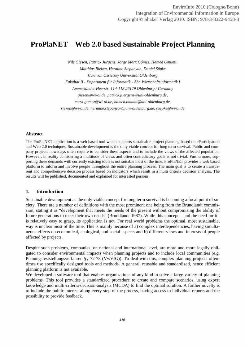
The overall process of the ProPlaNET application (shown in figure 1) is separated into four steps. These steps are: project design, project development, project evaluation and project decision, being the main processes within the application accompanied by some cross functions. The GIS system helps to create a geographical reference for the projects and indicators. The eParticipation of users will be explained in the next chapter, while the MCDA supports the decision step. The user groups mentioned before have differ-ent tasks to complete main the steps.
438
Copyright © Shaker Verlag 2010. ISBN: 978-3-8322-9458-8
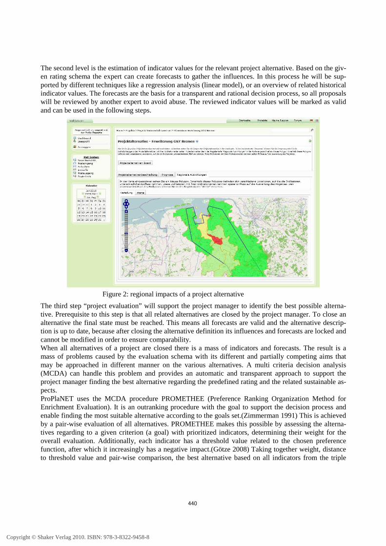
The project definition phase starts when a contributor plans a project. Therefore he provides a detailed de-scription of the planned project and the related problem e.g. enhancement of the transport infrastructure plus a geographical project area, supported by a geo information system (GIS). Next to the verbal descrip-tion of the project objectives, he has to create an evaluation schema (rating). The main aim of the rating is to ensure comparability and transparency concerning the project objectives. It consists of a set of different indicators from the triple bottom line. The chosen indicators can be weighted by the project manager to focus on specific aim e.g. minimize air pollution. The result is a collection of weighted indicators with their different optimization criteria. This evaluation schema is mandatory for all alternatives which will be suggested for this project. Every project has furthermore a blog where the project manager and consultants can inform the public and a discussion board to give interested people and companies the chance to contribute. The second phase starts when a related company, in the role of a consultant, suggests an alternative. It contains a possible approach to solve the project problem. Next to the detailed verbal description there has to be a reference to a geographical relation where this alternative takes place. Naturally this is a sub area of the project region. Like the project itself the alternatives have their own discussion boards where the public can discuss alternative related topics. Like mentioned before, the alternative inherits the evaluation schema from the project. Experts will create forecasts for the present indicators to gather the influences of this alternative concerning the affected regions. This takes place on two levels: The first level is a GIS based map, which offers the project area with all the containing regions. The influence of the current al-ternative on the project area is shown (like displayed in figure 2) by tinting the regions in different colors from green (no impact) to red (big impact). The public can recognize the affected regions easily and ex-perts can use this information for the second level.
Figure 1: Application flow in ProPlaNET
439
Copyright © Shaker Verlag 2010. ISBN: 978-3-8322-9458-8
The second level is the estimation of indicator values for the relevant project alternative. Based on the giv-en rating schema the expert can create forecasts to gather the influences. In this process he will be sup-ported by different techniques like a regression analysis (linear model), or an overview of related historical indicator values. The forecasts are the basis for a transparent and rational decision process, so all proposals will be reviewed by another expert to avoid abuse. The reviewed indicator values will be marked as valid and can be used in the following steps.
The third step “project evaluation” will support the project manager to identify the best possible alterna-tive. Prerequisite to this step is that all related alternatives are closed by the project manager. To close an alternative the final state must be reached. This means all forecasts are valid and the alternative descrip-tion is up to date, because after closing the alternative definition its influences and forecasts are locked and cannot be modified in order to ensure comparability. When all alternatives of a project are closed there is a mass of indicators and forecasts. The result is a mass of problems caused by the evaluation schema with its different and partially competing aims that may be approached in different manner on the various alternatives. A multi criteria decision analysis (MCDA) can handle this problem and provides an automatic and transparent approach to support the project manager finding the best alternative regarding the predefined rating and the related sustainable as-pects. ProPlaNET uses the MCDA procedure PROMETHEE (Preference Ranking Organization Method for Enrichment Evaluation). It is an outranking procedure with the goal to support the decision process and enable finding the most suitable alternative according to the goals set.(Zimmerman 1991) This is achieved by a pair-wise evaluation of all alternatives. PROMETHEE makes this possible by assessing the alterna-tives regarding to a given criterion (a goal) with prioritized indicators, determining their weight for the overall evaluation. Additionally, each indicator has a threshold value related to the chosen preference function, after which it increasingly has a negative impact.(Götze 2008) Taking together weight, distance to threshold value and pair-wise comparison, the best alternative based on all indicators from the triple
Figure 2: regional impacts of a project alternative
440
Copyright © Shaker Verlag 2010. ISBN: 978-3-8322-9458-8
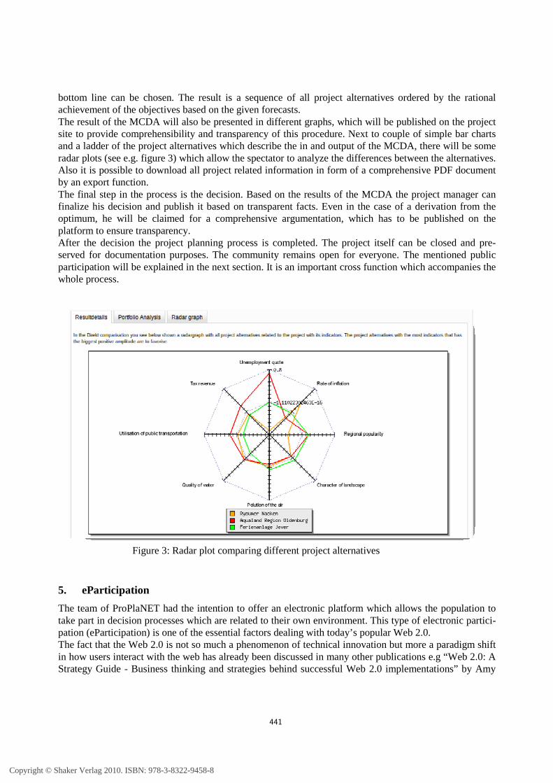
bottom line can be chosen. The result is a sequence of all project alternatives ordered by the rational achievement of the objectives based on the given forecasts. The result of the MCDA will also be presented in different graphs, which will be published on the project site to provide comprehensibility and transparency of this procedure. Next to couple of simple bar charts and a ladder of the project alternatives which describe the in and output of the MCDA, there will be some radar plots (see e.g. figure 3) which allow the spectator to analyze the differences between the alternatives. Also it is possible to download all project related information in form of a comprehensive PDF document by an export function. The final step in the process is the decision. Based on the results of the MCDA the project manager can finalize his decision and publish it based on transparent facts. Even in the case of a derivation from the optimum, he will be claimed for a comprehensive argumentation, which has to be published on the platform to ensure transparency. After the decision the project planning process is completed. The project itself can be closed and pre-served for documentation purposes. The community remains open for everyone. The mentioned public participation will be explained in the next section. It is an important cross function which accompanies the whole process.
5. eParticipation
The team of ProPlaNET had the intention to offer an electronic platform which allows the population to take part in decision processes which are related to their own environment. This type of electronic partici-pation (eParticipation) is one of the essential factors dealing with today’s popular Web 2.0. The fact that the Web 2.0 is not so much a phenomenon of technical innovation but more a paradigm shift in how users interact with the web has already been discussed in many other publications e.g “Web 2.0: A Strategy Guide - Business thinking and strategies behind successful Web 2.0 implementations” by Amy
Figure 3: Radar plot comparing different project alternatives
441
Copyright © Shaker Verlag 2010. ISBN: 978-3-8322-9458-8
Shuen . The challenge which arises from this knowledge is to create a net based platform which is able to benefit from this movement. Therefore it is essential to get in contact with a wide range of people and to attract them to the project system of ProPlaNET. Ideas for features and tools are suitable for this intention and can be seen on many other platforms which have been successful in gaining the long-term interest of the internet users e.g. Twitter, Facebook and Flickr. But there are not only social criteria which have to receive attention. Considering the variable forms of eParticipation there has to be differentiated between social and political methods of participating in an electronic environment. The social platforms like they have been mentioned below can be seen as the first mover and initiators of today’s known way of eParticipation but by degrees the deployment for political ideas and aspects became popular. In fact there are a lot of possibilities to take part electronically in political decision making processes. The topic for this way of electronic communication between the governments and the citizens is electronic government (eGovernment). This term includes other specific sub-items like ePetitions, eConsultations and eVotings. Dealing with these different terms it becomes clear that they are all trying to achieve a common purpose: Gaining and increasing the political interest of the citizens and motivating them to take part in elections, environmental and ecological decisions and all other kinds of political discussions. This common aim builds the bridge to the web based system of ProPlaNET. The developed platform al-lows its users to act and to react within an electronic network which develops sustainable projects, allows decisions with high transparency and advances profound discussions between politicians, engineers, project-managers and all other interested people. Summarizing all requirements for a successful electronic platform concerning social and political partici-pation, a modern net based application has to offer discussion boards, blogs, personalized views and areas to its users in order to meet their demands and to allow them a high eParticipation within the system. ProPlaNET contains all of these components and brings them together in one concentrated network. Going back to the concept of ProPlaNET the importance of eParticipation becomes apparent. The opinions and arguments of the people who take part in the decision making process are the basis for informed dis-cussions related to the projects being planned. To achieve a high level of transparency, the involvement of the public members who are affected is indispensable. That is why ProPlaNET provides e.g. project-related blogs which are guided by the project managers but can be commented on by the users in order to have an exchange of views. The configuration of an individual user-profile with its own user-blog enables the people to present their assumption to different topics and additionally to communicate with other users inside the network. The interaction of RSS-Feeds, discussion boards, an internal mailing system, a custo-mizable dashboard and other features of the application with focus on sustainable development, demon-strates the distinctiveness of the ProPlaNET platform. According to the topic of eParticipation, ProPlaNET can be seen as a comprehensive platform which brings the requirements of political and social networks together and consequently creates an own way of bringing people and their social but also ecological environment together.
6. Technical overview
The software system has been developed as a web application. With such kind of software a large com-munity will be able to inform and involve themselves about projects planned in their local area. The plat-form of the web application is based on the Zend-Framework (Zend 2010). This rapid web development framework provide an implementation of the Model-View-Controller (MVC) design pattern, which is the best current practice to develop modern web applications.
442
Copyright © Shaker Verlag 2010. ISBN: 978-3-8322-9458-8
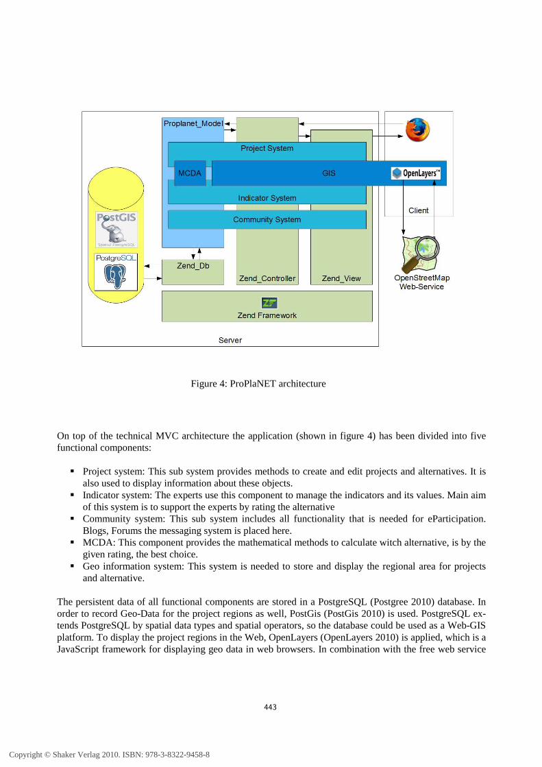
On top of the technical MVC architecture the application (shown in figure 4) has been divided into five functional components:
� Project system: This sub system provides methods to create and edit projects and alternatives. It is also used to display information about these objects.
� Indicator system: The experts use this component to manage the indicators and its values. Main aim of this system is to support the experts by rating the alternative
� Community system: This sub system includes all functionality that is needed for eParticipation. Blogs, Forums the messaging system is placed here.
� MCDA: This component provides the mathematical methods to calculate witch alternative, is by the given rating, the best choice.
� Geo information system: This system is needed to store and display the regional area for projects and alternative.
The persistent data of all functional components are stored in a PostgreSQL (Postgree 2010) database. In order to record Geo-Data for the project regions as well, PostGis (PostGis 2010) is used. PostgreSQL ex-tends PostgreSQL by spatial data types and spatial operators, so the database could be used as a Web-GIS platform. To display the project regions in the Web, OpenLayers (OpenLayers 2010) is applied, which is a JavaScript framework for displaying geo data in web browsers. In combination with the free web service
Figure 4: ProPlaNET architecture
443
Copyright © Shaker Verlag 2010. ISBN: 978-3-8322-9458-8
of OpenStreetmap (OpenStreetmap 2010) and the Dojo-Toolkit (Dojo 2010) to enrich usability, these mark the technologies used within the ProPlaNET system. From the beginning of the project, the team decided to publish the software under an open source license. For this reason we selected toolkits and frameworks that also developed under an open source license. So the barrier of deploying the software on an own server is very low. Every organization, which wants to use ProPlaNET needs only a PHP enabled web server and a PostgreSQL database with PostGis extension. All these components can also used for free. Therefore the total costs of ownership of the system are very low. Another advantage of the software is the integration potential. The application provide web Services to in-tegrate the ProPlaNET data objects in other legacy systems. An example of this SOAP (Simple Object Access Protocol) based web services is the possibility to post a geographical position described by longi-tude, latitude and a radius to retrieve the indicator values corresponding with this area.
7. Conclusion
The ProPlaNET application builds a foundation for sustainable project planning. The chosen concepts and techniques create a simple and transparent decision process. The public is not only a spectator but rather a participant supported by different Web 2.0 technologies. The geographical relation and the use of indica-tors make the alternatives measureable and lead to the best possible solution, published in a transparent process. In future the application could be enhanced by stronger integration of web services like the de-statis web services from Statistisches Bundesamt (Statischtisches Bundesamt) to enrich the indicator quality. Another enhancement for future version could include alternative MCDA-algorithms like Macbeth. Finally a concrete project conducted with the ProPlaNET software will demonstrate its real world applica-bility. We are currently in contact with different communities and companies and will publish the results once the project has been started. A public demo system is available for free and can be found at http://proplanet.uni-oldenburg.de.
8. Literature
Bruntland, G. (ed.): “Our common future: The World Commission on Environment and Development", Oxford, Oxford University Press. 1987
Dojo 2010, The Dojo Toolkit - Unbeatable JavaScript Tools, online http://www.dojotoolkit.org/ N. Giesen, L. Chen, N. Dahlem, J. Finke, O. Hornischer, A. Lederer, D. Süpke, U. Vogel, J. Yang, N.
Zurhorst und Michael Sonnenschein: „ Ein Informationssystem zur Bewertung regionaler Projekte unter Berücksichtigung nachhaltiger Entwicklung“, M. Müller(Hrsg.), 2006 in Simulation in Umwelt- und Geowissenschaften. Workshop Leipzig 2005- ASIM-Mitteilung AM 106, ISBN 3-8322-5132-4, pp. 99-108
Götze, U: “Investitionsrechnung: Modelle und Analysen zur Beurteilung von Investitionsvorhaben“, Berlin, Springer Verlag 2008
Hilty, L. M./Rautenstrauch, C. (1997): Konzepte Betrieblicher Umweltinformationssysteme für Produktion und Recycling. In: Wirtschaftsinformatik 39 (4), S.385-393
Openlayers, “OpenLayers: Free Maps for the Web”, online http://openlayers.org/ (30.06.2010) OpenStreetMap: “OpenstreetMap official website”, http://www.openstreetmap.org/ (30.06.2010) Page, B./Hilty, L. M. (1995a): Umweltinformatik als Teilgebiet der Angewandten
Informatik. In: Page, B./Hilty, L. M. (Hrsg.) (1995): Umweltinformatik – Informatikmethoden
444
Copyright © Shaker Verlag 2010. ISBN: 978-3-8322-9458-8
für Umweltschutz und Umweltforschung, 2. A. München,Wien, S. 15-31. PostgreSQL, PostgreSQL: “The world's most advanced open source database”, 2010
http://www.postgresql.org/ (30.06.2010) PostGIS, “PostGIS spatial database extension for PostgreSQL”, 2010, http://postgis.refractions.net/
(30.06.2010) Rautenstrauch, C.: Betrieblich Umwelinformationssysteme-Grundlagen, Konzepte und Systeme, Springer-
Verlag Berlin Heidelberg, 1999 Shuen, Amy: "Web 2.0: A Strategy Guide - Business thinking and strategies behind successful Web 2.0
implementations", O’Reily Media 2008 Statistisches Bundesamt, “Genisis online Webservice“,
https://www-genesis.destatis.de/genesis/online?Menu=Webservice (30.06.2010) WSM.com, Internet:http://www.wsm300.de/wsm300/ (30.06.2010) Zend 2010, Zend-Framwork – Official web site online http://framework.zend.com/ Zimmerman, H.J ; Gutsche, L.: Multi-Criteia-Analyse: Einführung in die Theorie der Entscheidungen bei
Mehrfachzielsetzungen. Springer, 1991.
445
Copyright © Shaker Verlag 2010. ISBN: 978-3-8322-9458-8


