Embed Size (px)
Citation preview
Montréal Metropolitan Region 2001-2021 June, 2001
A Shared Vision for Action
PLANNING FRAMEWORK AND GOVERNMENT ORIENTATIONS


Montréal Metropolitan Region 2001-2021 June, 2001
A Shared Vision for Action
PLANNING FRAMEWORK AND GOVERNMENT ORIENTATIONS
Ministère desAffaires municipales
et de la Métropole
Published by theSous-ministériat aux politiques età la concertation métropolitaineof the ministère des Affaires municipales et de la Métropole
Reproduction in whole or in part is authorized on condition that the source ismentioned.
Legal deposit – June 2001Bibliothèque nationale du QuébecNational Library of CanadaISBN 2-550-39670-7
© Gouvernement du Québec – 2001
MESSAGE FROM THE MINISTER
The creation of the Communauté métropolitaine de Montréalin 2000 was a major milestone in the development of GreaterMontréal. Henceforth it becomes the Government’sprivileged partner in land use planning and development. Thepreparation of the land use and development plan theCommunity is undertaking gives the Government theopportunity to clarify and publicize its orientations forGreater Montréal’s development. These orientations take onconsiderable importance, both for the Government and forthe Montréal metropolitan region.
The Planning Framework is being transmitted to the CMMand to the neighbouring RCMs, indicating the orientationsthat the government, its departments and agencies, and publicbodies intend to pursue in development matters, inaccordance with section 128 of the Act respecting theCommunauté métropolitaine de Montréal (2000, c. 34).These orientations, which the Government is transmitting tothe Communauté métropolitaine de Montréal, are inspired bythose that have been communicated to the municipalitiessince 1994 and those adopted by the Conseil des ministresregarding Greater Montréal.
The Planning Framework’s orientations flow from a vision ofthe future over a twenty-year horizon. Because of itsimportance within Québec and its North American andinternational vocation, the necessary measures must be takenso that the territorial growth of the Greater Montréal urbanregion is planned according to a longer-term comprehensiveapproach. The Communauté métropolitaine de Montréal istherefore invited to put the urban region on the path tosustainable development.
The Conseil des ministres has also ratified the PlanningFramework as a frame of reference for all governmentdepartments and agencies intervening in Greater Montréalland use planning. Thus, the Government henceforth isbound by a planning framework which expresses amobilizing project for the metropolitan region forgovernment departments, agencies and municipalities and
which will help ensure the coherence of their interventionswithin the territory of the metropolitan region.
As a form of spatial organization, the Planning Framework is basedon the polycentric trends already at work and ensures solidarity andconsideration of the strengths of Greater Montréal with a view togreater economic growth. The Planning Framework also emphasizesthe importance of protecting and reclaiming the great natural spacesand agricultural potential of its territory. The Government isaffirming its choice for a spatial organization that promotes theoptimum use of mass transit infrastructures as part of an objective ofsustainable development and improvement of environmentalquality.
The ultimate purpose of the Planning Framework is to offer thecommunity a rallying project that will make it possible to positionthe metropolitan region among the world’s highest quality urbanregions.
The Minister of State for Municipal Affairs and Greater Montréal,
LOUISE HAREL
“And standing on the said mountain, we saw and took cognizance of morethan thirty leagues therefrom. To the north there was a mountain range,extending to the east and west, and the same to the south. Between these
mountains is the land, the most beautiful that it is possible to see, tillable,unbroken and flat. And from the middle of the said lands, we see the said
river…”
Jacques Cartier, October 3, 1535

Table of contents
Planning Framework and Government Orientations for the Montréal Metropolitan Region vii
Table of contents
List of tables .............................................................x
List of graphs ............................................................x
List of maps .............................................................xi
List of acronyms .....................................................xii
Introduction
A Planning Framework to ensure the coherentdevelopment of the metropolitan region ...............3
A Planning Framework based on the principle ofsustainable development .......................................3
A new partner for the Government: the Communautémétropolitaine de Montréal ...................................4
The Planning Framework: a partnership agreementbetween the Government and the Communautémétropolitaine de Montréal ...................................5
The Planning Framework in the historical context ofmetropolitan planning: the urgent need for action 6
The mandate entrusted to the InterdepartmentalCommittee and the approach of drafting thePlanning Framework .............................................6
The territory of application of the PlanningFramework ............................................................7
Presentation of the report ..........................................8
Part One: General presentation of themetropolitan region
The territory ............................................................11
The socioeconomic profile .....................................11a) Population and households ...........................11b) Age of the population ...................................13c) Household composition ...............................13d) Household income and mode of
... residential occupancy ...................................15e) Residential mobility .....................................16f) Immigration .................................................17g) Disadvantage ................................................18
Demographic projections ........................................19a) Population and households ...........................19b) Population aging ..........................................21c) Immigration to the MCMA ..........................24
Projected growth in the neighbouring RCMs of theMCMA ................................................................24
The economy and employment ...............................27a) The primary sector .......................................27
b) The secondary sector ......................................27c) The tertiary sector ..........................................28d) International economic poles .........................28
Transport of goods ....................................................29a) Québec in a time of free trade ........................29b) The Montréal region: crossroads
of transportation networks .............................30
Transporting people and trips ...................................30a) Modal distribution of trips .............................31b) Motorization of households ...........................33c) Service to the principal poles of employment by
mass transit ....................................................33
Components of the territory ......................................34a) Land use .........................................................34b) Industrial and commercial spaces ..................35c) Residential density .........................................36d) Vacant land ....................................................37e) Contaminated land .........................................38
The agricultural zone and activities ..........................39
Natural environments ................................................40a) Green spaces, forests and wetlands ................40b) Metropolitan blue spaces ...............................41c) Protected areas ...............................................43
Metropolitan infrastructures and facilities ................44
Part Two: General problem
The context: an expanding metropolis ......................49
Consolidation of a polycentric structure ...................49
Montréal: a slowly growing metropolis comparedto the rest of North America and the world ...........51
The land use planning problem in themetropolitan region ...................................................54
1. The absence of a shared vision of developmentresulting from fragmented management of theterritory ..............................................................541.1 A multitude of administrative entities in the
region ..........................................................541.2 The challenge of harmonization of strategic
development plans ......................................54
2. Costly and unplanned urbanization on ametropolitan scale ..............................................552.1 Loss of farmland .........................................552.2 Loss of natural spaces and inaccessibility of
riparian environments .................................562.3 Contaminated land hindering the
development of the centre ..........................562.4 A supply of new facilities on the periphery,
while the centre’s facilities are notoptimized ....................................................57
Table of contents
Planning Framework and Government Orientations for the Montréal Metropolitan Regionviii
2.5 Congestion: an increase in motorizationcombined with a diminishing use of masstransit ........................................................59
2.6 A deterioration of the environment resultingfrom the increase in greenhouse gasemissions ..................................................64
2.7 A necessary improvement of oldneighbourhoods in the centre of the urbanregion ........................................................67
2.8 Socioeconomic disparities in themetropolitan region ..................................69
The necessity for a shared vision on a metropolitanscale to ensure coherent land use planning anddevelopment interventions ..................................70
Part Three: The Government’s visionstatement on land use planning anddevelopment and the concept of spatialorganization
For an attractive, competitive and viable metropolisworking in solidarity ...........................................73
A vision statement for land use planning ................74Social mission .....................................................74Educational and cultural mission .........................75Economic and environmental mission ................75Governance and justice mission ..........................77
The concept of spatial organization ........................78A concept based on nine elements articulated around
the principle of sustainable development ............781. A dynamic centre for the urban region and
central neighbourhoods that can be revitalizedat the heart of the metropolitan region .........79
2. Six priority economic poles where theinternational activities to be reinforced areconcentrated and on which metropolitaneconomic development can be based ...........79
3. Outlying suburbs surrounding the centre of theurban region, interfacing between the urbanfabric, the agricultural zone and the majorbasins ...........................................................80
4. An east-west industrial axis including the Saint-Laurent / Dorval, Downtown and Anjou /Mercier poles, which should be networked andserved by an efficient transportation service.80
5. A north-south service axis linking the prioritypoles and secondary poles to be networked anddeveloped, based on their mass transitinfrastructures ..............................................81
6. An agricultural zone occupying 54 % of theterritory of the MCMA, which must beprotected and reclaimed ...............................81
7. An accessible network of green spaces andmajor basins to be protected and reclaimed ...82
8. A network of census urban areas located on theperimeter of the MCMA, supporting theeconomic and urban development of GreaterMontréal and which will be home to nearly338,000 people in 2021 ..................................82
9. A rural ring outside the MCMA, requiringplanning, protection and enhancement of itsnatural and cultural character and touristpotential .........................................................83
Part Four: The Government’s orientations andexpectations regarding the Communautémétropolitaine de Montréal
First concern: An urbanization strategy intended tolimit the costs of infrastructures and collectivefacilities within the MCMA and outside the MCMA .88
Government orientations ..........................................88
Reminder of the problem ..........................................88
The issues at stake ....................................................88
Departmental concerns .............................................89
Government expectations regarding the Communautémétropolitaine de Montréal ...................................90
Government support and commitments ....................92
Second concern: Urbanization and housing typescontributing to ensure a diversified social composition ..............................................................95
Government orientation ............................................95
Reminder of the problem ..........................................95
The issue at stake ......................................................95
Government concerns ...............................................95
Government expectations regarding the Communautémétropolitaine de Montréal ...................................96
Government support and commitments ....................96
Third concern: An improved quality of life in old ordeteriorated neighbourhoods ....................................97
Government orientation ............................................97
Reminder of the problem ..........................................97
The issues at stake ....................................................97
Government concerns ...............................................97
Government expectations regarding the Communautémétropolitaine de Montréal ...................................98
Government support and commitments ....................99
Table of contents
Planning Framework and Government Orientations for the Montréal Metropolitan Region ix
Fourth concern: Strengthening of the economic polescontributing to maintain Greater Montréal’sinternational competitiveness ...............................101
Government orientation ........................................101
Reminder of the problem ......................................101
The issues at stake ................................................102
Government concerns ...........................................102
Government expectations regarding the Communautémétropolitaine de Montréal ...............................103
Government support and commitments ................103
Fifth concern: Planning of public transportationequipment and infrastructures with the aim ofconsolidating the existing urban zones and themajor economic poles, while reducinggreenhouse gases ..................................................106
Government orientation ........................................106
Reminder of the problem ......................................106
The issues at stake ................................................107
Government concerns ...........................................108
Government expectations regarding the Communautémétropolitaine de Montréal ...............................108
Government support and commitments ................109
Sixth concern: Protection and reclamation of theagricultural zone and economy ............................111
Government orientation ........................................111
Reminder of the problem ......................................111
The issues at stake ................................................111
Government concerns ...........................................111
Government expectations regarding the Communautémétropolitaine de Montréal ...............................112
Government support and commitments ................113
Seventh concern: Protection and reclamation ofgreen and blue spaces and protection of heritageand landscapes under a strategy on a metropolitan scale ...............................................116
Government orientation ........................................116
Reminder of the problem ......................................116
The issues at stake ................................................117
Government concerns ...........................................117
Government expectations regarding the Communautémétropolitaine de Montréal ...............................118
Government support and commitments ................120
Eighth concern: Consideration of disaster risks inland use planning and economic developmentdecisions .................................................................123
Government orientation ..........................................123
Reminder of the problem ........................................123
The issues at stake ..................................................123
Government concerns .............................................123
Government expectations regarding the Communautémétropolitaine de Montréal .................................124
Government support and commitments ..................126
Ninth concern: Interregional harmonization of theinterventions of the CMM, the regions and theneighbouring RCMs in a spirit of reciprocity andstrategic alliance ....................................................127
Government orientation ..........................................127
Reminder of the problem ........................................127
Government concerns .............................................127
Government expectations regarding the neighbouringRCMs of the Communauté métropolitaine deMontréal ..............................................................128
Government support and commitments ..................128
Part Five: Government equipment andinfrastructure projectsFacilities and services for people ............................131
a)Ministère de la Culture et des Communications131b)Ministère de l’Éducation .................................132c)Ministère de la Santé et des Services sociaux ..133d)Société immobilière du Québec .......................140
Transportation infrastructures .................................140a)Highway transportation ...................................141b)Mass transit ......................................................147c)Power transmission ..........................................151
Tourist and recreational facilities ...........................152
Conclusion .....................................................155
Bibliography...................................................159
Glossary .........................................................163
Index of tables and graphs
Planning Framework and Government Orientations for the Montréal Metropolitan Regionx
LIST OF TABLESPart One
Table 1 : Population growth by age, MCMA,1981-2001 ................................................14
Table 2 : Household typology, MCMA,1996 .........................................................14
Table 3 : Median household income in theMCMA by mode of residential occupancy,1996 .........................................................15
Table 4 : Growth of the rate of homeownershipin the MCMA, 1976-1996 .......................16
Table 5 : Internal residential mobility matrix inthe MCMA, 1991-1996 ...........................17
Table 6 : Growth of population and households,MCMA, 2001-2021 .................................20
Table 7 : Population projection under age 24,MCMA, 2001-2021 .................................21
Table 8 : Population projection age 65 and over,MCMA, 2001-2021 .................................23
Table 9 : Growth of population and households,neighbouring RCMs of the MCMA,2001-2021 ................................................25
Table 10 : Expected modal distribution,according to the distance between places ofresidence and Métro stations ...................32
Table 11 : Distribution of urbanized and vacantterritory by land use, MCMA, 1997 ........36
Table 12 : Vacant land area, MCMA, 1997 ...37
Table 13 : Decreed agricultural zone, MCMA,1996 .........................................................40
Table 14 : Principal natural and manmade greenspaces, MCMA, 2001 ..............................42
Part Two
Table 15 : Growth of employment, metropolitaneconomic poles, MCMA, 1996-1999 ......51
Table 16: Construction and expansion ofeducational buildings, MCMA,1994-2001 ................................................58
Table 17: Impact on the local population ofautomobile trips by non-residents, morningrush hour, 1998 .......................................69
LIST OF GRAPHSPart One
Graph 1 : Distribution of population andhouseholds, MCMA, 2001 ......................12
Graph 2 : Relative share of population andhouseholds in the MCMA, 2001 .............12
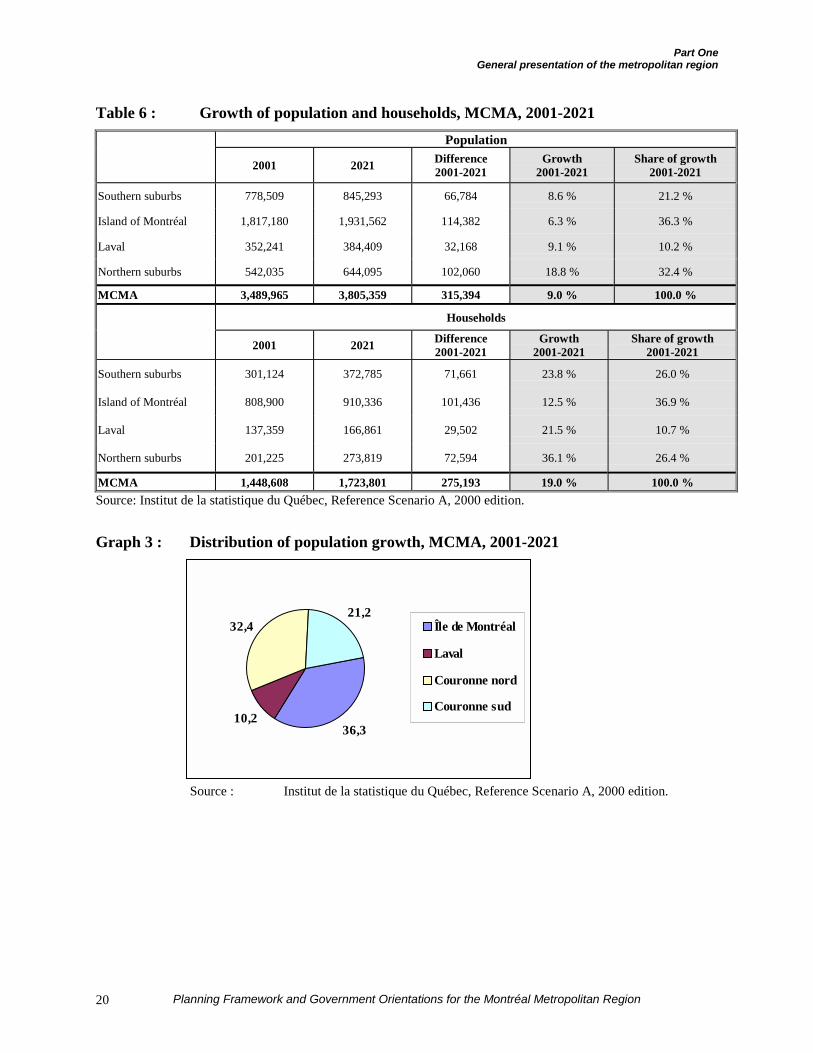
Graph 3 : Distribution of population growth,MCMA, 2001-2021 .................................20
Graph 4 : Distribution of household growth,MCMA, 2001-2021 .................................21
Graph 5 : Modal distribution of trips, MCMA,1998 .........................................................31
Graph 6 : Annual number of mass transit tripsper inhabitant, MCMA, 1998 32
Graph 7: Household motorization characteris-tics, MCMA, 1998 ..................................33
Graph 8 : Modal share of mass transit heading tothe principal poles of employment in themetropolitan region, morning rush hour,1998 .........................................................34
Part Two
Graph 9 : Changes in urban and agricultural landuse of the territory, MCMA, 1981-1996 .49
Graph 10 : Growth of population andhouseholds, MCMA, 1981-1996 .............49
Graph 11 : Growth of the human population,automobile population and trips byautomobile and by mass transit, MCMA,1987-1998 ...............................................61
Graph 12 : Forecast growth of greenhouse gasemissions, per sector, MCMA, 1990-2026 ..............................................66
List of Maps
Planning Framework and Government Orientations for the Montréal Metropolitan Region xi
List of Maps
Map 1: Territory of the Communauté métropolitaine de Montréal
Map 2: International economic poles, MCMA
Map 3: Identification of the major commercial and industrial poles, MCMA
Map 4: Net residential density, MCMA
Map 5: Vacant and urbanized spaces and decreed agricultural zone, MCMA
Map 6: Major green and blue spaces, MCMA
Map 7: Location of marinas and piers
Map 8: Metropolitan mass transit network, MCMA
Map 9: Strategic transport network, MCMA
Map 10: Wooded areas and wetlands in the process of urbanization, CMM
Map 11: Spatial organization concept
List of Acronyms
xii Planning Framework and Government Orientations for the Montréal Metropolitan Region
List of Acronyms
AMT : Agence métropolitaine detransport
CHSLD : Residential and long-termcare centre
CIT : Conseil intermunicipal detransport
CLSC : Local community servicecentre
CMM : Communauté métropolitainede Montréal
CPTAQ : Commission de protectiondu territoire agricole duQuébec
CUM : Communauté urbaine deMontréal
INRS : Institut national de la recherchescientifique
ISQ : Institut de la statistique duQuébec
MAMM : Ministère des Affaires muni-cipales et la Métropole
MAPAQ : Ministère de l’Agriculture, desPêcheries et de l’Alimentation
MCC : Ministère de la Culture etdes Communications
MCMA : Montréal census metropolitanarea
MENV : Ministère de l’Environnement
MEQ : Ministère de l’Éducation
MRCI : Ministère des Relations avecles citoyens et de l’Immigration
MRN : Ministère des Ressourcesnaturelles
MSP : Ministère de la Sécuritépublique
MTQ : Ministère des Transports
RCM : Regional county municipality(in French: MRC)
RDC : Regional development council(in French: CRD)
REC : Regional environment council(in French: CRE)
SIQ : Société immobilière du Québec
STCUM : Société de transport de laCommunauté urbaine deMontréal
STL : Société de transport de Laval
INTRODUCTION

Introduction
Planning Framework and Government Orientations for the Montréal Metropolitan Region 3
A PLANNING FRAMEWORK TO ENSURE THECOHERENT DEVELOPMENT OF THE METRO-POLITAN REGION
The Greater Montréal metropolitan region isQuébec’s main population basin and mostimportant economic centre. Over the pastdecade, it has increased its population byover 245,000 people, a growth rate of 7.6 %.Between 1996 and 1999, some 290,000 jobswere added in Greater Montréal’s territory.The Montréal region is already very wellpositioned in relation to the rest of NorthAmerica, since 2000, it ranked 15th amongNorth America’s major urban regions interms of population.
By 2021, the region’s population willincrease by 9 % and the number ofhouseholds by 15 %1. However, if we judgeby the planning done over the past twentyyears, the region’s development couldcontinue to generate high economic, socialand environmental costs and a waste ofresources.
As a medium and long-term project, themetropolitan region’s harmonious andsustainable development depends, first andforemost, on wise utilization of its territory’sresources through integrated planning. Theend purpose of this overall planning is thesustainable protection of the builtenvironment, facilities and infrastructuresalready in place, the agricultural zone andthe natural environments and theirreclamation for the benefit of futuregenerations.
A frame of reference for the metropolitanregion’s land use planning is now necessaryif we want to benefit from the populationand economic growth the region willexperience, while assuring an excellent
1 Institut de la statistique du Québec, Reference Scenario A,
June 2000.
quality of life for the entire population andprotection of its territory’s resources forfuture generations. The Planning Frameworkand the metropolitan land use anddevelopment plan of the Communautémétropolitaine de Montréal will constitutethis frame of reference. These instrumentshenceforth will serve as keystones for thecontents of a long-term development projectfor the metropolitan region.
A PLANNING FRAMEWORK BASED ON THEPRINCIPLE OF SUSTAINABLE DEVELOPMENT
To carry out this vast planning operation forthe metropolitan region, the PlanningFramework is based on the principle ofsustainable development2. It subscribes tothe three underlying objectives that itestablishes as basic principles:
¶ conservation of the territory’s ecologicalintegrity and biological diversity;
¶ improvement of equity among individualsand between generations;
¶ optimization of development interven-tions within an economic growthperspective and in accordance with thecharacteristics and carrying capacity ofthe environment.
This document as a whole, including abackground statement, a statement of theproblems, a vision statement and theplanning and development orientations,
2 The report of the United Nations World Commission on
Environment and Development, better known as theBrundtland Report, defines sustainable development as:“development that meets the needs of the present withoutcompromising the ability of future generations to meet theirown needs”. The World Union for the Conservation of Nature(WUCN), the World Wildlife Fund (WWF) and the UnitedNations Environment Program (UNEP) defined sustainabledevelopment, in the Nature Conservation Strategy in 1991, as“improving the quality of human life while living within thecarrying capacity of the Earth’s supporting eco-systems”.
Planning Framework and Government Orientations for the Montréal Metropolitan Region4
serves as the basis for a future projectproposed by the Government for themetropolitan region.
These components are meant to bereferences for the government orientationspresented to the Communauté métropo-litaine de Montréal for land use planning.They also respond to the concerns of thegovernment departments and agencies.
Guided by the great principles of sustainabledevelopment, conservation and reclamationof resources, this development projectproposed by the Government involvesplanning choices in turn. These choices areparticularly reflected by a generalurbanization management strategy whichembodies these principles of sustainabledevelopment and which is inspired by theplanning vision statement and the spatialorganization concept presented in PartThree.
A NEW PARTNER FOR THE GOVERNMENT:THE COMMUNAUTÉ MÉTROPOLITAINE DEMONTRÉAL
The publication of the White Paper onMunicipal Reorganization in April 20003
and the adoption of Bill 134 introduced anew metropolitan development player: theCommunauté métropolitaine de Montréal(CMM). As the White Paper pointed out:
“The creation, in the urban regionswhere urban communities currentlyexist, of metropolitan communitiesthat will replace them and will havejurisdiction over an expandedterritory encompassing the essentialparts of the census metropolitan area,is an indispensable component ofmunicipal reorganization. In fact,
3 Gouvernement du Québec, La réorganisation municipale:
changer les façons de faire, pour mieux servir les citoyens,April 2000, 131 pages and 3 maps.
certain issues can be taken overadequately only on this scale, becausethey extend beyond the territories ofthe local municipalities, even whenthey are reorganized4.”
The Government of Québec wants tosupport the development of the metropolitanregion through appropriate and coherentplanning actions. However, in a contextwhere land use planning is a jurisdictionshared between the State and the municipallevel, the government cannot take soleresponsibility for the entire land useplanning process in the metropolitan region.At the same time, the number of municipalentities – and the diversity of theirrespective interests – in the metropolitanregion makes dialogue difficult between thegovernment and the region in this matter.The creation of the Communautémétropolitaine de Montréal thereforeappears to be a major milestone in theregion’s development. It will now becomethe Government’s privileged partner forintervention in land use planning on thescale of the metropolitan region.
Under its constituting act5, the Communautémétropolitaine de Montréal has jurisdictionover land use planning and, in this capacity,is required to “prepare, adopt and maintainin force, at all times and in the part of itsterritory formed by the territory of theregional county municipalities that issituated entirely within its own territory, thedevelopment plan provided for in the Actrespecting land use planning anddevelopment6”.
4 Idem, pp. 76-77.5 An Act respecting the Communauté métropolitaine de
Montréal, 2000, c. 34, s. 119 (1º).6 Idem, section 126.
Introduction
Planning Framework and Government Orientations for the Montréal Metropolitan Region 5
THE PLANNING FRAMEWORK : APARTNERSHIP AGREEMENT BETWEEN THEGOVERNMENT AND THE COMMUNAUTÉMÉTROPOLITAINE DE MONTRÉAL
Because land use planning is a jurisdictionshared between the Government and themunicipal level, it is important that theadministrative entities responsible for itagree on the objectives to achieve and theactions to carry out. This concerted action iseven more indispensable in the case of aregion as vast and populated as themetropolitan region.
Within the context of the municipalreorganization it has implemented sinceApril 2000, the Government of Québecintends to support the Communautémétropolitaine de Montréal and deploy thenecessary means of action to contribute tothe optimum development of themetropolitan region. For this purpose, thePlanning Framework in the future will serveas the planning reference and discussiondocument between the Government and theCMM to ensure Greater Montréal’ssustainable development. This will be thebasis for concretizing the public will on landuse planning in the region. The PlanningFramework will fulfil three functions in thisperspective.
In the first place, the Planning Frameworkrepresents the commitment of the Govern-ment and its departments, agencies andbodies to promote quality land use andsustainable development of the metropolitanregion. Based on these orientations, itproposes to serve as a benchmark forapproval of the interventions of governmentdepartments and agencies within GreaterMontréal.
Thus, the strategic plans of the governmentdepartments and agencies and their capital
works programs that must be submitted tothe Conseil exécutif under the PublicAdministration Act (2000, c. 38) mustconform to the orientations of the PlanningFramework, just like their sector policies.By making its general action subject toplanning rules, the Government wants to setan example in articulating its interventionscoherently and making rational planningchoices for the metropolitan territory.
Secondly, the Planning Frameworkstands in lieu of an orientation andexpectations document regardingthe Communauté métropolitaine deMontréal. The Framework in thissense meets the requirements ofthe Act respecting the Communautémétropoli taine de Montréal , whichprovides, among other things,under section 128, that:
“…the Minister of Municipal Affairsand Greater Montréal shall inform theCommunity of governmental land usepolicies in the territory to which theplan of the Community applies,including equipment and infrastruc-ture projects.7 ”
Thus, the Planning Framework will serve asa frame of reference for approval of themetropolitan land use and development planwhich the CMM will have to produce8. Inthe future, all the land use planning anddevelopment instrumentation in the metro-politan region will have to conform to theFramework’s provisions.
Finally, complementary to its first twofunctions, the Planning Framework willanchor the respective approaches forimplementation of the Planning Frameworkand the CMM’s development plan. Theseapproaches will depend on agreements
7 Idem, section 128.8 Livre blanc sur la réorganisation municipale, op. cit., p. 81.
Planning Framework and Government Orientations for the Montréal Metropolitan Region6
between the CMM and the Government,with firm commitments regarding theirapplication9.
THE PLANNING FRAMEWORK IN THEHISTORICAL CONTEXT OF METROPOLITANPLANNING: THE URGENT NEED FOR ACTION
For more than forty years, many proposalshave been made to circumscribe the problemof structured land use planning in themetropolitan region.
In 1967, the Plan témoin Horizon 2000,produced on the initiative of the City ofMontréal already outlined a highlyurbanized metropolitan region at the dawnof the 21st century.
Similarly, in the wake of development workon the Montréal Airport at Mirabel, theCommission de développement de la régionde Montréal had proposed a developmentoutline for the region north of Montréal.This action plan provided for moreintegrated planning of the Laurentians – thencalled Region 06-North – with that of theIsland of Montréal after the commissioningof Mirabel Airport. However, the plan onlycovered the development of part of themetropolitan region.
In 1978, the government tabled the Optionpréférable d’aménagement for the Montréalregion and reaffirmed it in 1983. However,little follow-up had been done to ensure itsimplementation. Subsequently, the Groupede travail sur Montréal et sa région in 1993and the Forum sur la Commission dedéveloppement de la Métropole in 1996, setup by the Ministère de la Métropole, in turnemphasized the urgency of acting onmetropolitan development by formulating a
9 Idem, page 80.
comprehensive and structuring land useplanning approach.
Moreover, during the 1970s and 1980s, thecreation of the Communauté urbaine deMontréal and of the regional countymunicipalities (RCMs) provided the regionwith planning structures and its firstdevelopment plans.
In reviewing the record, it must berecognized that the action of the regionalbodies in land use planning is essentiallylimited to the interventions dictated by theAct respecting land use planning anddevelopment, namely the production ofdevelopment plans, without this resulting ina common development project for theentire metropolitan region.
Relying on these past experiences andreflecting the context and reality of theworld’s great city-regions at the beginningof the 21st century, the Planning Frameworknow affirms the importance of sustainableand concerted reconciliation of land useplanning and development so as to preservethe quality of life for today’s citizens andthose of future generations. The ultimatepurpose of the Planning Framework is toguide all of the players in the metropolitanregion to a project behind which they canrally, supported by the CMM’s metropolitanland use and development plan, which willmake it possible to position the metropolitanregion in 2021 among the world’s greatquality urban regions.
THE MANDATE ENTRUSTED TO THEINTERDEPARTMENTAL COMMITTEE AND THEAPPROACH OF DRAFTING THE PLANNINGFRAMEWORK
Resulting from a consensus, the PlanningFramework is the culmination of concerted
Introduction
Planning Framework and Government Orientations for the Montréal Metropolitan Region 7
action by all government departments andagencies.
In September 1996, the Conseil desministres declared its concern regarding thecoherence of government and municipalinterventions within the territory of theMontréal metropolitan region.
The Conseil des ministres therefore adoptedthree general land use planning orientations,which, to put it plainly, sought toconsolidate urbanization, strengthen thepoles of activity and give priority to theconservation and optimum utilization ofexisting infrastructures and facilities.
In February 1997, these three orientationswere published jointly by the Minister ofMunicipal Affairs and the Minister forGreater Montréal.
In this context, the Conseil des ministresasked an interdepartmental committeechaired by the Deputy Minister of MunicipalAffairs to formulate a government positionon a Planning Framework for the Montréalmetropolitan region. It also asked thatadministrative mechanisms be proposed toensure the coherent implementation ofgovernment action.
A technical committee was established bythe interdepartmental committee to evaluatethe compliance of the policies, programs andcapital works projects of the departmentsand agencies concerned with the orientationsadopted by the Conseil des ministres and toprepare adjustments to these policies,programs and projects10. This committeesubmitted a report in March 1998, whichproposed a series of orientations andintervention measures for better control of
10 Letter from Mr Alain Gauthier, Deputy Minister of Municipal
Affairs, to Mr J.-Y. Therrien, Deputy Minister for GreaterMontréal, March 19, 1998.
land use and development in the metro-politan region.
The work then slowed down due to theresumption of the debate on municipalreform. In October 1999, the Comitéministériel de la région de Montréal(CMRM) authorized the resumption of workon the Planning Framework. Two reportswere tabled at the CMRM: a first inFebruary 2000 and a second in February2001. Following this second report, theCommittee ratified, in principle, eightorientations proposed for land use planningin the metropolitan region, subject toadjusting the wording as needed, andauthorized the Ministère des Affairesmunicipales et de la Métropole to holdconsultations on the proposed orientations.The Committee also requested that a finalproposal and land use planning orientationsbe submitted for the metropolitan region,based on a schedule that would alloworientations to be transmitted to theCommunauté métropolitaine de Montréal inaccordance with the provisions of itsconstituting act ( An Act respecting theCommunauté métropolitaine de Montréal,2000, c. 34).
THE TERRITORY OF APPLICATION OF THEPLANNING FRAMEWORK
When formulation of the Planning Frame-work began in 1996, the creation of theCMM was not yet envisioned. The territorialreference which had been adopted at thattime for the Framework’s application wasthe Montréal Census Metropolitan Area(MCMA), as established by StatisticsCanada. It must be added that the manyproposals for changes to the territory of theCMM during preparation of the PlanningFramework did not allow discussion of theentire metropolitan problem based on data
Planning Framework and Government Orientations for the Montréal Metropolitan Region8
that followed the Community’s territorialboundaries. All the analyses were thereforeconducted based on the MCMA’s territory.
The creation of the CMM, which does nothave exactly the same boundaries as theMCMA, although it changes the statisticaldata due to the variation in the number ofmunicipalities affected, in no way alters thegeneral problem and the land use planningfactors to be considered. Also, even thoughthe analyses in this document pertain to theMCMA, the government orientations regar-ding the metropolitan region and theexpectations for the municipal level remainthe same and are still applicable to theterritory of the Community as a whole.
PRESENTATION OF THE REPORT
The report is divided into five main parts.
Part One is a general presentation of themetropolitan region, its population, itseconomy and the principal components ofthe territory (resources, environments, etc.).
Part Two sets forth the general land useplanning problem in the metropolitan regionin terms of the major trends and theanticipated projects for urban and demo-graphic development.
Part Three presents the land use planningorientation and the concept of spatialorganization proposed by the Governmentfor implementation of a sustainable develop-ment project for the metropolitan region.
Part Four of the report contains thegovernment orientations and the expec-tations that the Government must present tothe Communauté métropolitaine deMontréal in accordance with section 128 ofthe Act respecting the Communauté
métropolitaine de Montréal. This fourth parttherefore presents, grouped by concern, allof the Government’s land use planningorientations and the Government’s expec-tations regarding the Communauté métro-politaine de Montréal which the latter isinvited to integrate into its developmentplan.
Finally, Part Five of the report presents thelist of facilities and infrastructure projectsthat the government, its departments andagencies intend to pursue within the metro-politan territory.
PART ONE GENERAL PRESENTATION OF THE METROPOLITAN REGION

Part OneGeneral presentation of the metropolitan region
Planning Framework and Government Orientations for the Montréal Metropolitan Region 11
THE TERRITORY
The Montréal Census Metropolitan Area(MCMA) is located in the northeastern partof North America. Lodged in the St.Lawrence Valley, the MCMA extendsbetween the Canadian Shield and theAppalachian Mountains. Its position at theconfluence of the continent’s great north-eastern waterways (the St. Lawrence Riverand its extension in the Gulf of the samename; the Ottawa River and the Great Lakesto the west; the Richelieu River, LakeChamplain and the Hudson River to thesouth) have always made it a predominantmeeting point, especially for trade andcommerce.
The MCMA extends over a vast territory ofnearly 4,000 square kilometres in south-western Québec. Many basins and bodies ofwater cross the region and subdivide itsterritory (Map 1)1. The 1996 MCMAincluded a total of 111 municipalities.Following the municipal reform undertakenin 1999 and 2000, this territory willencompass 73 municipalities as of 20022.
The metropolitan territorial boundaries alsoinclude, without integrating them in theirentirety, the territory of five administrativeregions (Montréal, Laval, Montérégie,Laurentides (Laurentians), Lanaudière),bounded by the major waterways.
1 The maps can be found at the end of the document.2 When work on the Planning Framework began in 1996, the
MCMA included 111 municipalities. Since then, mergers havereduced the number of municipalities in the region. Bill 170,adopted in December 2000, provides for a redrawing of themunicipal limits of the MCMA, which will come into forceeffective in January 2002. Thus, the CUM will disappear andthe 28 existing municipalities will be merged into a singleentity, Ville de Montréal. Ville de Longueuil will be mergedwith 7 other municipalities. Officially, the number ofmunicipalities in the MCMA will then be 73. Given themunicipalities removed from the CMM’s territory and themunicipal reorganization under Bill 1709 the total number ofmunicipalities in the CMM will be 67. Other merger projectsare under study, which could further reduce the number ofmunicipalities both in the MCMA and in the CMM.
THE SOCIOECONOMIC PROFILE
A) Population and households
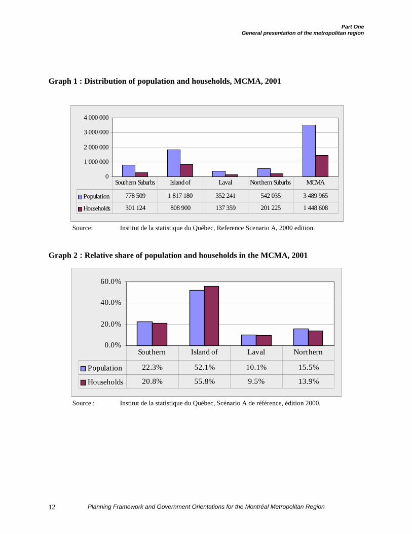
In 2001, the MCMA has nearly 3.49 millioninhabitants and 1.45 million households(Graph 1).
The distribution of population andhouseholds shows substantial differences indifferent parts of the territory. Thus, theIsland of Montréal has 1.8 million inhabi-tants in 2001, for a relative share of 52 % ofthe MCMA. More than half the populationof the Island of Montréal (57 %) lives in theterritory of the existing Ville de Montréal(1.037 million).
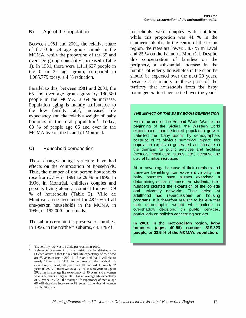
The same goes for the Island of Montréal’srelative share in terms of households: theIsland of Montréal accounts for nearly 56 %of the region’s households. The other partsof the territory have smaller relative sharesof households than of population (Graph 2).This can be attributed to the fact that theIsland of Montréal, on the average, has aconcentration of more but smallerhouseholds than the suburban munici-palities.
As for the territory of the Communautémétropolitaine de Montréal, its totalpopulation in 2000 was 3,376,499. With its1,795,844 inhabitants, the Island ofMontréal accounted for 53 % of the CMM’spopulation, Laval (with 349,910 inhabitants)represented 10.4 % of the Community’spopulation, the northern suburbs had454,821 people (13.5 % of the CMM’spopulation) and the southern suburbsaccounted for 775,924 people (23 % of theCommunity’s population).
Part OneGeneral presentation of the metropolitan region
Planning Framework and Government Orientations for the Montréal Metropolitan Region12
Graph 1 : Distribution of population and households, MCMA, 2001
Source: Institut de la statistique du Québec, Reference Scenario A, 2000 edition.
Graph 2 : Relative share of population and households in the MCMA, 2001
Source : Institut de la statistique du Québec, Scénario A de référence, édition 2000.
0
1 000 000
2 000 000
3 000 000
4 000 000
Population 778 509 1 817 180 352 241 542 035 3 489 965
Households 301 124 808 900 137 359 201 225 1 448 608
Southern Suburbs Island of Laval Northern Suburbs MCMA
0.0%
20.0%
40.0%
60.0%
Population 22.3% 52.1% 10.1% 15.5%
Households 20.8% 55.8% 9.5% 13.9%
Southern Island of Laval Northern
Part OneGeneral presentation of the metropolitan region
Planning Framework and Government Orientations for the Montréal Metropolitan Region 13
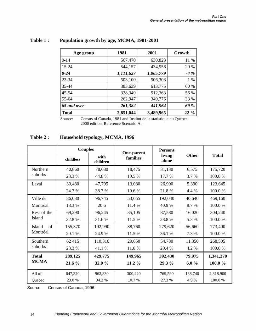
B) Age of the population
Between 1981 and 2001, the relative shareof the 0 to 24 age group shrank in theMCMA, while the proportion of the 65 andover age group constantly increased (Table1). In 1981, there were 1,111,627 people inthe 0 to 24 age group, compared to1,065,779 today, a 4 % reduction.
Parallel to this, between 1981 and 2001, the65 and over age group grew by 180,580people in the MCMA, a 69 % increase.Population aging is mainly attributable tothe low fertility rate3, increased lifeexpectancy and the relative weight of babyboomers in the total population4. Today,63 % of people age 65 and over in theMCMA live on the Island of Montréal.
C) Household composition
These changes in age structure have hadeffects on the composition of households.Thus, the number of one-person householdsrose from 27 % in 1991 to 29 % in 1996. In1996, in Montréal, childless couples andpersons living alone accounted for over 59% of households (Table 2). Ville deMontréal alone accounted for 48.9 % of allone-person households in the MCMA in1996, or 192,000 households.
The suburbs remain the preserve of families.In 1996, in the northern suburbs, 44.8 % of
3 The fertility rate was 1.5 child per woman in 2000.4 Reference Scenario A of the Institut de la statistique du
Québec assumes that the residual life expectancy of men whoare 65 years of age in 2001 is 15 years and that it will rise tonearly 18 years in 2021. Among women, the residual lifeexpectancy is nearly 20 years in 2001 and will be nearly 22years in 2021. In other words, a man who is 65 years of age in2001 has an average life expectancy of 80 years and a womenwho is 65 years of age in 2001 has an average life expectancyof 85 years. In 2021, the average life expectancy of men at age65 will therefore increase to 83 years, while that of womenwill be 87 years.
households were couples with children,while this proportion was 41 % in thesouthern suburbs. In the centre of the urbanregion, the rates are lower: 38.7 % in Lavaland 25 % on the Island of Montréal. Despitethis concentration of families on theperiphery, a substantial increase in thenumber of elderly households in the suburbsshould be expected over the next 20 years,because it is mainly in these parts of theterritory that households from the babyboom generation have settled over the years.
THE IMPACT OF THE BABY BOOM GENERATION
From the end of the Second World War to thebeginning of the Sixties, the Western worldexperienced unprecedented population growth.Labelled the “baby boom” by demographersbecause of its obvious numerical impact, thispopulation explosion generated an increase inthe demand for public services and facilities(schools, healthcare, stores, etc.) because thesize of families increased.
At an advantage because of their numbers andtherefore benefiting from excellent visibility, thebaby boomers have always exercised adetermining social influence. As students, theirnumbers dictated the expansion of the collegeand university networks. Their arrival atadulthood had repercussions on housingprograms. It is therefore realistic to believe thattheir demographic weight will continue toovershadow decisions on public services,particularly on policies concerning seniors.
In 2001, in the metropolitan region, babyboomers (ages 40-55) number 819,823people, or 23.5 % of the MCMA’s population.
Part OneGeneral presentation of the metropolitan region
Planning Framework and Government Orientations for the Montréal Metropolitan Region14
Table 1 : Population growth by age, MCMA, 1981-2001
Age group 1981 2001 Growth0-14 567,470 630,823 11 %15-24 544,157 434,956 -20 %0-24 1,111,627 1,065,779 -4 %23-34 503,100 506,308 1 %35-44 383,639 613,775 60 %45-54 328,349 512,363 56 %55-64 262,947 349,776 33 %65 and over 261,382 441,964 69 %Total 2,851,044 3,489,965 22 %
Source: Census of Canada, 1981 and Institut de la statistique du Québec,2000 edition, Reference Scenario A.
Table 2 : Household typology, MCMA, 1996
Couples
childless withchildren
One-parentfamilies
Personslivingalone
Other Total
Northernsuburbs
40,86023.3 %
78,68044.8 %
18,47510.5 %
31,13017.7 %
6,5753.7 %
175,720100.0 %
Laval 30,48024.7 %
47,79538.7 %
13,08010.6 %
26,90021.8 %
5,3904.4 %
123,645100.0 %
Ville deMontréal
86,08018.3 %
96,74520.6
53,65511.4 %
192,04040.9 %
40,6408.7 %
469,160100.0 %
Rest of theIsland
69,29022.8 %
96,24531.6 %
35,10511.5 %
87,58028.8 %
16 0205.3 %
304,240100.0 %
Island ofMontréal
155,37020.1 %
192,99024.9 %
88,76011.5 %
279,62036.1 %
56,6607.3 %
773,400100.0 %
Southernsuburbs
62 41523.3 %
110,31041.1 %
29,65011.0 %
54,78020.4 %
11,3504.2 %
268,505100.0 %
TotalMCMA
289,12521.6 %
429,77532.0 %
149,96511.2 %
392,43029.3 %
79,9756.0 %
1,341,270100.0 %
All ofQuebec
647,32023.0 %
962,83034.2 %
300,42010.7 %
769,59027.3 %
138,7404.9 %
2,818,900100.0 %
Source: Census of Canada, 1996.
Part OneGeneral presentation of the metropolitan region
Planning Framework and Government Orientations for the Montréal Metropolitan Region 15
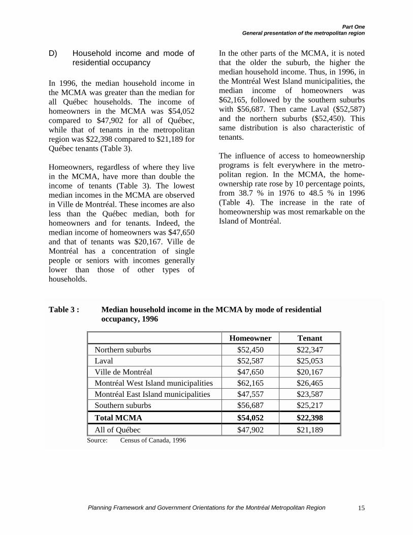
D) Household income and mode ofresidential occupancy
In 1996, the median household income inthe MCMA was greater than the median forall Québec households. The income ofhomeowners in the MCMA was $54,052compared to $47,902 for all of Québec,while that of tenants in the metropolitanregion was $22,398 compared to $21,189 forQuébec tenants (Table 3).
Homeowners, regardless of where they livein the MCMA, have more than double theincome of tenants (Table 3). The lowestmedian incomes in the MCMA are observedin Ville de Montréal. These incomes are alsoless than the Québec median, both forhomeowners and for tenants. Indeed, themedian income of homeowners was $47,650and that of tenants was $20,167. Ville deMontréal has a concentration of singlepeople or seniors with incomes generallylower than those of other types ofhouseholds.
In the other parts of the MCMA, it is notedthat the older the suburb, the higher themedian household income. Thus, in 1996, inthe Montréal West Island municipalities, themedian income of homeowners was$62,165, followed by the southern suburbswith $56,687. Then came Laval ($52,587)and the northern suburbs ($52,450). Thissame distribution is also characteristic oftenants.
The influence of access to homeownershipprograms is felt everywhere in the metro-politan region. In the MCMA, the home-ownership rate rose by 10 percentage points,from 38.7 % in 1976 to 48.5 % in 1996(Table 4). The increase in the rate ofhomeownership was most remarkable on theIsland of Montréal.
Table 3 : Median household income in the MCMA by mode of residentialoccupancy, 1996
Homeowner TenantNorthern suburbs $52,450 $22,347Laval $52,587 $25,053Ville de Montréal $47,650 $20,167Montréal West Island municipalities $62,165 $26,465Montréal East Island municipalities $47,557 $23,587Southern suburbs $56,687 $25,217Total MCMA $54,052 $22,398All of Québec $47,902 $21,189
Source: Census of Canada, 1996
Part OneGeneral presentation of the metropolitan region
Planning Framework and Government Orientations for the Montréal Metropolitan Region16
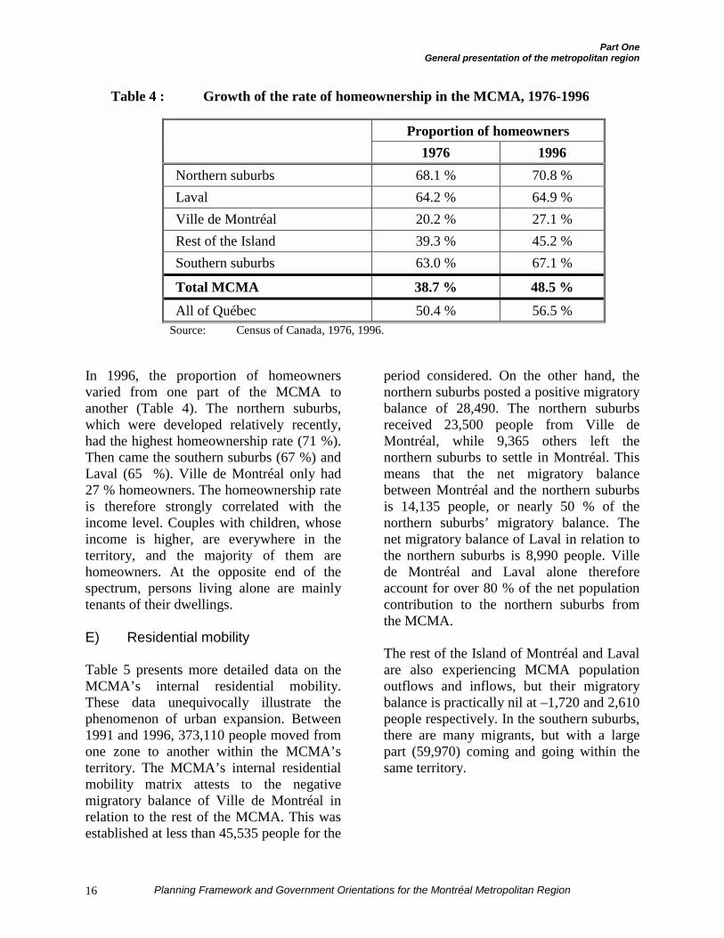
In 1996, the proportion of homeownersvaried from one part of the MCMA toanother (Table 4). The northern suburbs,which were developed relatively recently,had the highest homeownership rate (71 %).Then came the southern suburbs (67 %) andLaval (65 %). Ville de Montréal only had27 % homeowners. The homeownership rateis therefore strongly correlated with theincome level. Couples with children, whoseincome is higher, are everywhere in theterritory, and the majority of them arehomeowners. At the opposite end of thespectrum, persons living alone are mainlytenants of their dwellings.
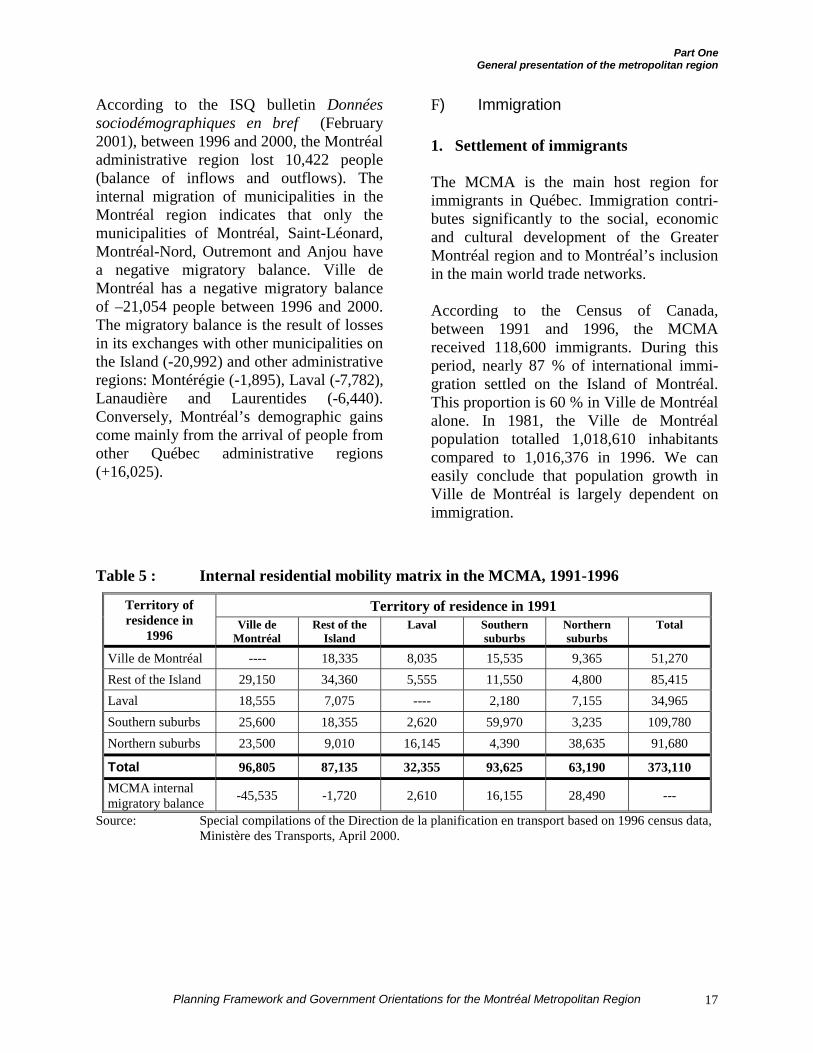
E) Residential mobility
Table 5 presents more detailed data on theMCMA’s internal residential mobility.These data unequivocally illustrate thephenomenon of urban expansion. Between1991 and 1996, 373,110 people moved fromone zone to another within the MCMA’sterritory. The MCMA’s internal residentialmobility matrix attests to the negativemigratory balance of Ville de Montréal inrelation to the rest of the MCMA. This wasestablished at less than 45,535 people for the
period considered. On the other hand, thenorthern suburbs posted a positive migratorybalance of 28,490. The northern suburbsreceived 23,500 people from Ville deMontréal, while 9,365 others left thenorthern suburbs to settle in Montréal. Thismeans that the net migratory balancebetween Montréal and the northern suburbsis 14,135 people, or nearly 50 % of thenorthern suburbs’ migratory balance. Thenet migratory balance of Laval in relation tothe northern suburbs is 8,990 people. Villede Montréal and Laval alone thereforeaccount for over 80 % of the net populationcontribution to the northern suburbs fromthe MCMA.
The rest of the Island of Montréal and Lavalare also experiencing MCMA populationoutflows and inflows, but their migratorybalance is practically nil at –1,720 and 2,610people respectively. In the southern suburbs,there are many migrants, but with a largepart (59,970) coming and going within thesame territory.
Table 4 : Growth of the rate of homeownership in the MCMA, 1976-1996
Proportion of homeowners1976 1996
Northern suburbs 68.1 % 70.8 %Laval 64.2 % 64.9 %Ville de Montréal 20.2 % 27.1 %Rest of the Island 39.3 % 45.2 %Southern suburbs 63.0 % 67.1 %
Total MCMA 38.7 % 48.5 %All of Québec 50.4 % 56.5 %
Source: Census of Canada, 1976, 1996.
Part OneGeneral presentation of the metropolitan region
Planning Framework and Government Orientations for the Montréal Metropolitan Region 17
According to the ISQ bulletin Donnéessociodémographiques en bref (February2001), between 1996 and 2000, the Montréaladministrative region lost 10,422 people(balance of inflows and outflows). Theinternal migration of municipalities in theMontréal region indicates that only themunicipalities of Montréal, Saint-Léonard,Montréal-Nord, Outremont and Anjou havea negative migratory balance. Ville deMontréal has a negative migratory balanceof –21,054 people between 1996 and 2000.The migratory balance is the result of lossesin its exchanges with other municipalities onthe Island (-20,992) and other administrativeregions: Montérégie (-1,895), Laval (-7,782),Lanaudière and Laurentides (-6,440).Conversely, Montréal’s demographic gainscome mainly from the arrival of people fromother Québec administrative regions(+16,025).
F) Immigration
1. Settlement of immigrants
The MCMA is the main host region forimmigrants in Québec. Immigration contri-butes significantly to the social, economicand cultural development of the GreaterMontréal region and to Montréal’s inclusionin the main world trade networks.
According to the Census of Canada,between 1991 and 1996, the MCMAreceived 118,600 immigrants. During thisperiod, nearly 87 % of international immi-gration settled on the Island of Montréal.This proportion is 60 % in Ville de Montréalalone. In 1981, the Ville de Montréalpopulation totalled 1,018,610 inhabitantscompared to 1,016,376 in 1996. We caneasily conclude that population growth inVille de Montréal is largely dependent onimmigration.
Table 5 : Internal residential mobility matrix in the MCMA, 1991-1996
Territory of residence in 1991Territory ofresidence in
1996Ville de
MontréalRest of the
IslandLaval Southern
suburbsNorthernsuburbs
Total
Ville de Montréal ---- 18,335 8,035 15,535 9,365 51,270Rest of the Island 29,150 34,360 5,555 11,550 4,800 85,415Laval 18,555 7,075 ---- 2,180 7,155 34,965Southern suburbs 25,600 18,355 2,620 59,970 3,235 109,780Northern suburbs 23,500 9,010 16,145 4,390 38,635 91,680
Total 96,805 87,135 32,355 93,625 63,190 373,110MCMA internalmigratory balance -45,535 -1,720 2,610 16,155 28,490 ---
Source: Special compilations of the Direction de la planification en transport based on 1996 census data,Ministère des Transports, April 2000.
Part OneGeneral presentation of the metropolitan region
Planning Framework and Government Orientations for the Montréal Metropolitan Region18
Indeed, the Island of Montréal is the hostand residence zone of 75 % of Québecimmigrants and 85 % of all MCMA immi-grants since 1995. The Island of Montréalreceived over 105,000 immigrants, an av-erage of 21,000 per year. A traditional hostzone for immigration and institutionsfounded by ethnic groups, the Island ofMontréal requires special interventions,particularly in public services and linguisticintegration.
In contrast, the northern suburbs onlyreceived 3,600 migrants from outsideQuébec, including 1,605 from internationalimmigration, or barely 320 persons per yearbetween 1991 and 1996.
2. Immigrant settlement factors
According to a number of studies conductedin the 1990s, the district or neighbourhoodof first settlement on the Island of Montréalis determined by three interdependentcharacteristics: life cycle, socioeconomicstatus and knowledge or lack of knowledgeof the French language. The dimension ofethnic origin5 therefore is not a reliable,valid or even representative basic indicator.
Moreover, the analysis of the responsescollected in the 1991 census indicates thatonly 18 of the 736 census tracts of theMCMA have a proportion of immigrantsgreater than 50 % of the resident population.Seven of these tracts are located in Côte-des-Neiges, six in Parc-Extension, three inSaint-Laurent, one in Ahuntsic and the lastin the current district of Ville-Marie.However, it is important to consider that theCôte-des-Neiges neighbourhood is recog-nized as a universal first settlement location,a place that newcomers leave two or threeyears after their arrival in Québec.
5 Ethnic origin refers to the sense of belonging that individuals
have to an ancestral national culture.
G) Disadvantage6
INRS-Urbanisation has established a map ofdisadvantage by sector in the MCMA basedon four indicators: one-parent families, low-income households, unemployment rate andschooling. Some Montréal neighbourhoods(Southwest, Centre-Sud, Hochelaga-Maison-neuve) are particularly affected. Poverty iswidespread in Ville de Montréal, includingCôte-des-Neiges and Cartierville, amongother neighbourhoods. It is particularlyspreading into the eastern part of the Islandand parts of Lachine in the southwest. Off-island, Saint-Jérôme, Sainte-Thérèse, Beau-harnois, certain sectors of Laval and severalsectors of Longueuil also show disadvantageprofiles.
While disadvantage is gradually spreadingto the older suburbs, it tends, there as inMontréal, to be concentrated in very specificzones or neighbourhoods. The trends givereason to anticipate an accentuation ofsocioeconomic polarization between thecentre of the Island of Montréal, the rest ofthe Island and the outlying suburbs. Thiswill have an impact on the supply of publicservices, especially with regard to schoolsand health services.
6 The purpose of measuring disadvantage is to better delineate
the structural causes of poverty. The Conseil scolaire de l’îlede Montréal has developed an index to measure the spatialdistribution of poverty on the Island of Montréal. Thus, for agiven sector, four indicators are used: rate of low-incomehouseholds, percentage of one-parent families headed by awoman, percentage of mothers with little schooling,percentage of male family heads inactive on the job market forat least 18 months. The index uses a scale of 0 to 100,proportion to disadvantage, with 0 meaning that there is nodisadvantage in the sector and 100 meaning that the subjectsector’s population is completely deprived. Thus, for example,Westmount has an index of 3.63 while the Centre-Sudneighbourhood has an index of 89.86.
Part OneGeneral presentation of the metropolitan region
Planning Framework and Government Orientations for the Montréal Metropolitan Region 19
DEMOGRAPHIC PROJECTIONS
A) Population and households
As in Québec as a whole, the MCMA willexperience a slowdown in its total popu-lation growth over the next few years,falling from 19 % for the period from 1981to 2001 to 9 % for the period from 2001 to2021.
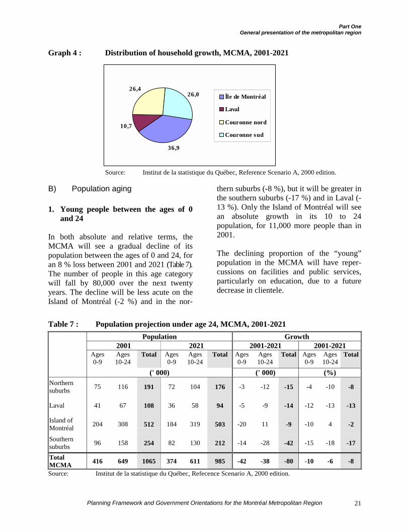
According to the ISQ’s Reference ScenarioA, between 2001 and 2021, the greatestproportion of population growth will befound on the Island of Montréal, or 36.3 %(Table 6 and Graph 3), compared to 10 %between 1981 and 2001. The Island ofMontréal will also receive the highesthousehold growth share, with 37 % (Table 6and Graph 4); the growth share for theIsland was 31 % between 1981 and 2001.
In proportion, the northern suburbs none-theless should continue to have the region’sstrongest demographic growth, both in termsof population (18.8 %) and households(36.1 %) between 2001 and 2021 (Table 6).
Between 2001 and 2021, the growth in thenumber of households (19 %) will be morethan double the population growth (9 %)throughout the MCMA (Table 6). Thisphenomenon is mainly attributable to thehousehold fragmentation rate, which willremain high. Indeed, the proportion ofchildless families and persons living aloneshould continue to grow over the nexttwenty years, which explains why theincrease in households is proportionatelygreater than the increase in population.Thus, between 2001 and 2021, the numberof persons per household will decline from2.41 to 2.21 for the MCMA as a whole.
Moreover, during the 2001-2021 period, theannual new household formation rate will be
less than 1 %, meaning that about 13,750households per year should be added in theMCMA.
Applied within the limits of the CMM, thedemographic projections illustrate trendscomparable to those prevailing for theMCMA’s territory. Accounting for theboundaries of the Communauté métro-politaine de Montréal and the data availablein June 2001, the CMM’s population isestimated at 3,419,000 inhabitants and thenumber of households at 1,419,000. Thenew South Shore city has nearly 384,000inhabitants and 155,000 households.
In 2021, the demographic projections for theCMM should be similar to those of theMCMA. The Community’s populationshould then be 3,715,000 people, for agrowth rate of 9 %, and the number ofhouseholds should increase to 1,682,000, fora growth rate of about 19 %. In 2021, thepopulation of the new South Shore city willgrow by 5 % to nearly 402,000 inhabitantsand the number of households will increaseby 17 %, or 181,0007.
7 Estimates by the MAMM.
Part OneGeneral presentation of the metropolitan region
Planning Framework and Government Orientations for the Montréal Metropolitan Region20
Table 6 : Growth of population and households, MCMA, 2001-2021Population
2001 2021 Difference2001-2021
Growth2001-2021
Share of growth2001-2021
Southern suburbs 778,509 845,293 66,784 8.6 % 21.2 %
Island of Montréal 1,817,180 1,931,562 114,382 6.3 % 36.3 %
Laval 352,241 384,409 32,168 9.1 % 10.2 %
Northern suburbs 542,035 644,095 102,060 18.8 % 32.4 %
MCMA 3,489,965 3,805,359 315,394 9.0 % 100.0 %
Households
2001 2021 Difference2001-2021
Growth2001-2021
Share of growth2001-2021
Southern suburbs 301,124 372,785 71,661 23.8 % 26.0 %
Island of Montréal 808,900 910,336 101,436 12.5 % 36.9 %
Laval 137,359 166,861 29,502 21.5 % 10.7 %
Northern suburbs 201,225 273,819 72,594 36.1 % 26.4 %
MCMA 1,448,608 1,723,801 275,193 19.0 % 100.0 %Source: Institut de la statistique du Québec, Reference Scenario A, 2000 edition.
Graph 3 : Distribution of population growth, MCMA, 2001-2021
Source : Institut de la statistique du Québec, Reference Scenario A, 2000 edition.
36,310,2
32,421,2
Île de Montréal
Laval
Couronne nord
Couronne sud
Part OneGeneral presentation of the metropolitan region
Planning Framework and Government Orientations for the Montréal Metropolitan Region 21
Graph 4 : Distribution of household growth, MCMA, 2001-2021
Source: Institut de la statistique du Québec, Reference Scenario A, 2000 edition.
B) Population aging
1. Young people between the ages of 0and 24
In both absolute and relative terms, theMCMA will see a gradual decline of itspopulation between the ages of 0 and 24, foran 8 % loss between 2001 and 2021 (Table 7).The number of people in this age categorywill fall by 80,000 over the next twentyyears. The decline will be less acute on theIsland of Montréal (-2 %) and in the nor-
thern suburbs (-8 %), but it will be greater inthe southern suburbs (-17 %) and in Laval (-13 %). Only the Island of Montréal will seean absolute growth in its 10 to 24population, for 11,000 more people than in2001.
The declining proportion of the “young”population in the MCMA will have reper-cussions on facilities and public services,particularly on education, due to a futuredecrease in clientele.
Table 7 : Population projection under age 24, MCMA, 2001-2021Population Growth
2001 2021 2001-2021 2001-2021Ages0-9
Ages10-24
Total Ages0-9
Ages10-24
Total Ages0-9
Ages10-24
Total Ages0-9
Ages10-24
Total
(' 000) (' 000) (%)Northernsuburbs 75 116 191 72 104 176 -3 -12 -15 -4 -10 -8
Laval 41 67 108 36 58 94 -5 -9 -14 -12 -13 -13
Island ofMontréal 204 308 512 184 319 503 -20 11 -9 -10 4 -2
Southernsuburbs 96 158 254 82 130 212 -14 -28 -42 -15 -18 -17
TotalMCMA 416 649 1065 374 611 985 -42 -38 -80 -10 -6 -8
Source: Institut de la statistique du Québec, Refecence Scenario A, 2000 edition.
36,9
10,7
26,426,0 Île de Montréal
Laval
Couronne nord
Couronne sud
Part OneGeneral presentation of the metropolitan region
Planning Framework and Government Orientations for the Montréal Metropolitan Region22
2. People age 65 and over
According to the ISQ’s recent demographicforecasts8, in 2021, the MCMA’s populationage 65 and over will increase by about302,000 people, for a 68 % growth rate over2001 (Table 8). The population between theages of 65 and 79 will increase by 66 %throughout the MCMA, while the populationage 80 and over will grow by 77 %. Regard-less of the part of the territory considered,the category of persons age 80 and over willincrease in greater proportions than the 65 to79 age category.
Between 2001 and 2021, in terms ofabsolute growth, 105,000 people age 65 andover will be added on the Island ofMontréal, and a similar quantity of 105,000people will expand the 65 and over agegroup in the northern suburbs, includingLaval. In the southern suburbs, the 65 andover category will increase by 92,000people.
In relative growth terms, Table 8 shows thatthe increase in the senior population willmainly be felt in the northern and southernsuburbs. In the northern suburbs and Laval,the increases in people age 65 and over willbe 160 % and 174 %, while the relativegrowth will be 120 % in the southernsuburbs. Conversely, on the Island ofMontréal, the number of people age 65 andover, although also growing, will increase ata lower rate of only 38 %. This trend willhave the effect of restoring a certain balancein the proportion of seniors throughout theterritory. In other words, the aging pheno-menon will extend throughout the MCMAand not only to the central part. In all, 62.6 %of the MCMA’s entire population age 65and over lives can be found on the Island of
8 Institut de la statistique du Québec, Données sociodémo-
graphiques en bref, February 2001, volume 5, nº 2.
Montréal in 2001. In 2021, this proportionwill fall to 51.3 %.
In 2021, the proportion of people age 80 andover will grow significantly throughout theMCMA. Nevertheless, the greatest propor-tion will still be found on the Island ofMontréal (105,000 of the 181,000 peopleage 80 and over in the MCMA, or 58 %).The absolute growth of this population willreach 79,000 more people by 2021 in theMCMA, including 34,000 more people onthe Island of Montréal, which will thereforeremain the main concentration area forseniors.
This growth will have a determininginfluence, in particular, on the needs forhousing, social services and healthcare.Aging will have repercussions in all sectorsof activity and everywhere in the territory.Nevertheless, these effects will be felt morein the suburbs, which up to now have donelittle planning for the needs of seniorhouseholds. As an ISQ bulletin reminds us:
“[…] but while the Island of Montréal haslong offered services to an elder population,the Montréal perimeter has been developedby and for young households. The suburbs,soon populated by thousands of retirees,must therefore prepare for this impendingregionalization of third-age and fourth-ageneeds.9”
In this context, population aging in thesuburban municipalities will pose manyplanning challenges over the next fewdecades. Among the factors likely to beaffected by aging in the suburban munici-palities, we should mention:
¶ Housing: how to ensure that seniors cancontinue to live in the community wherethey have chosen to live for decades
9 Esther Létourneau, Institut de la statistique du Québec,
Données sociodémographiques en bref, February 2001,volume 5, nº 2.
Part OneGeneral presentation of the metropolitan region
Planning Framework and Government Orientations for the Montréal Metropolitan Region 23
without having to assume the effort,alone or as a couple, of maintaininghomes that are too big or too costly fortheir needs?
¶ Health services: while the suburbs havelong made a large place for pediatricsand family clinics, how can a transitionbe ensured to geriatric services or spe-cialized services that meet the needs ofseniors?
¶ Urban development: should the nor-thern and southern suburbs adoptplanning modes closer to those of thecentral cities to enable seniors to haveaccess to services without having to usea car?
¶ Public security: with aging, the sense ofinsecurity also increases. Because oftheir more reduced mobility and theirincreasing vulnerability, seniors demandmore care and attention and betteradapted services in terms of policesecurity, fire prevention, ambulance ser-vices, etc. How can the suburbanmunicipalities deal with the necessity ofadapting services, which up to now haveinvolved few financial commitments forthem, to the needs of an aged popu-lation?
¶ Transportation: seniors, who are lessmobile, could need adapted transportservices. How will the municipalities beable to deal with this?
Table 8 : Population projection age 65 and over, MCMA, 2001-2021
Population Growth2001 2021 2001-2021 2001-2021
Ages65-79
Ages80 andover
Total Ages65-79
Ages80 andover
Total Ages65-79
Ages80 andover
Total Ages65-79
Ages80 andover
Total
(' 000) (' 000) ( %)Northernsuburbs 35 7 42 90 19 109 55 12 67 157 171 160
Laval 37 9 46 62 22 84 25 13 38 66 142 174
Island ofMontréal 206 71 277 277 105 382 71 34 105 35 47 38
Southernsuburbs 62 15 77 134 35 169 72 20 92 117 136 120
TotalMCMA 340 102 442 563 181 744 223 79 302 66 77 68
Source: Institut de la statistique du Québec, Reference Scenario A, 2000 edition.
Part OneGeneral presentation of the metropolitan region
Planning Framework and Government Orientations for the Montréal Metropolitan Region24
C) Immigration to the MCMA
The government immigration plan adoptedfor the 2001 to 2003 period provides for asubstantial increase in the admission ofnewcomers to Québec. Thus, in all, between113,100 and 124,600 new immigrants areexpected over the next three years. Theadmission objective for 2003 is even set at45,000 people. Regardless of the exactnumber of newcomers, the Ministère desRelations avec les citoyens et de l’Immigrationwants 25 % of this population to settleoutside the metropolitan region.
In addition, planning of immigration levelsand categories (family, independents andrefugees) also includes an increase in theproportion of foreign nationals who knowFrench upon their arrival in Québec. Therecruiting objectives for this group havebeen set for 2001, 2002 and 2003respectively at 15,000, 18,000 and 20,000immigrants. The general objective is that,among the new immigrants, the proportionof those who know French upon their arrivalwill represent 50 % of the total movement.
In this context, and in the light of thereorganization of immigrant integrationservices, the MRCI intends to pursue theconsolidation of the four integration centresestablished on the Island of Montréal (north,south, east and west).
PROJECTED GROWTH IN THE NEIGH-BOURING RCMS OF THE MCMA
The phenomenon of urban expansion, causedby the dispersion of the population, is notonly visible in the northern and southernsuburbs around the Island of Montréal. Infact, in terms of urbanization, outside theofficial limits of the MCMA, demographicgrowth will be observed in the RCMsringing the territory. The growth in certain
regional urban areas could be attributed tothe drawing power of resort centres.
Thus, between 2001 and 2021, growth in theparts of the administrative regions outsidethe MCMA will reach 10 % in Lanaudière,15 % in the Laurentians (Laurentides) and2 % in Montérégie, according to thedemographic growth projections establishedby the Institut de la statistique du Québec.
The RCMs outside the MCMA will growmoderately. Between 2001 and 2021, thepopulation will grow by 6 % (35,433 morepeople) while households will grow by 18 %over the same period, for 44,047 additionalhouseholds (Table 9).
The RCMs located north of the MCMA willexperience the strongest growth. Theirprojected growth will be 14 % for populationand 24 % for households. The growth willprobably be more significant in the RCMslocated in the axis of Autoroute 15. This ismainly the case for MRC de la Rivière-du-Nord which will see its population increaseby 8,369 people, a growth rate of 34 %, andmore than 4,200 households, up 45 %. MRCdes Pays-d’en-Haut, located further north,will see its population grow by 16 % andhouseholds grow by 25 %.
The RCMs located south of the MCMA willsee slight population growth, or 1.7 %. Theincrease in the number of households will bemore significant, nearly 15 %. The lowpopulation growth is explained, among otherfactors, by a population decline in certainRCMs, including Le Bas-Richelieu, LesMaskoutains, Les Jardins-de-Napierville,Rouville and Beauharnois-Salaberry. Thehighest growth will be found in MRC deVaudreuil-Soulanges that will see itspopulation grow by 21 % and householdsincrease by 38 %.
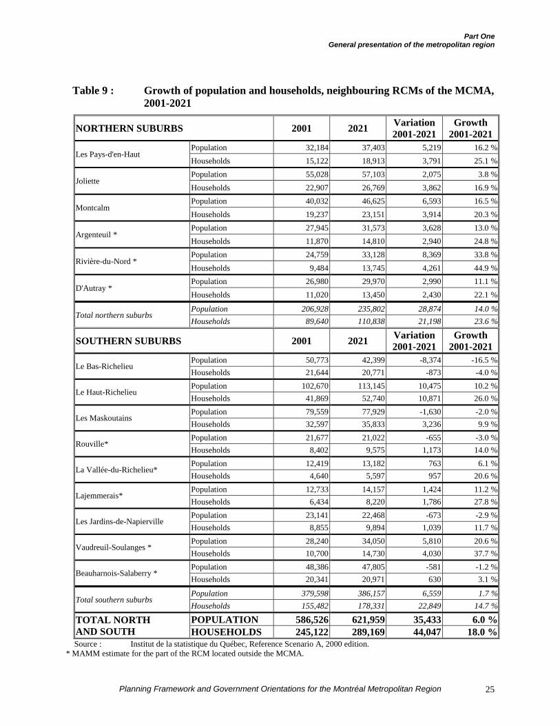
Part OneGeneral presentation of the metropolitan region
Planning Framework and Government Orientations for the Montréal Metropolitan Region 25
Table 9 : Growth of population and households, neighbouring RCMs of the MCMA,2001-2021
NORTHERN SUBURBS 2001 2021 Variation2001-2021
Growth2001-2021
Population 32,184 37,403 5,219 16.2 %Les Pays-d'en-Haut
Households 15,122 18,913 3,791 25.1 %Population 55,028 57,103 2,075 3.8 %
JolietteHouseholds 22,907 26,769 3,862 16.9 %Population 40,032 46,625 6,593 16.5 %
MontcalmHouseholds 19,237 23,151 3,914 20.3 %Population 27,945 31,573 3,628 13.0 %
Argenteuil *Households 11,870 14,810 2,940 24.8 %Population 24,759 33,128 8,369 33.8 %
Rivière-du-Nord *Households 9,484 13,745 4,261 44.9 %Population 26,980 29,970 2,990 11.1 %
D'Autray *Households 11,020 13,450 2,430 22.1 %
Population 206,928 235,802 28,874 14.0 %Total northern suburbs
Households 89,640 110,838 21,198 23.6 %
SOUTHERN SUBURBS 2001 2021 Variation2001-2021
Growth2001-2021
Population 50,773 42,399 -8,374 -16.5 %Le Bas-Richelieu
Households 21,644 20,771 -873 -4.0 %Population 102,670 113,145 10,475 10.2 %
Le Haut-RichelieuHouseholds 41,869 52,740 10,871 26.0 %Population 79,559 77,929 -1,630 -2.0 %
Les MaskoutainsHouseholds 32,597 35,833 3,236 9.9 %Population 21,677 21,022 -655 -3.0 %
Rouville*Households 8,402 9,575 1,173 14.0 %Population 12,419 13,182 763 6.1 %
La Vallée-du-Richelieu*Households 4,640 5,597 957 20.6 %Population 12,733 14,157 1,424 11.2 %
Lajemmerais*Households 6,434 8,220 1,786 27.8 %Population 23,141 22,468 -673 -2.9 %
Les Jardins-de-NapiervilleHouseholds 8,855 9,894 1,039 11.7 %Population 28,240 34,050 5,810 20.6 %
Vaudreuil-Soulanges *Households 10,700 14,730 4,030 37.7 %Population 48,386 47,805 -581 -1.2 %
Beauharnois-Salaberry *Households 20,341 20,971 630 3.1 %
Population 379,598 386,157 6,559 1.7 %Total southern suburbs
Households 155,482 178,331 22,849 14.7 %
POPULATION 586,526 621,959 35,433 6.0 %TOTAL NORTHAND SOUTH HOUSEHOLDS 245,122 289,169 44,047 18.0 %Source : Institut de la statistique du Québec, Reference Scenario A, 2000 edition.
* MAMM estimate for the part of the RCM located outside the MCMA.
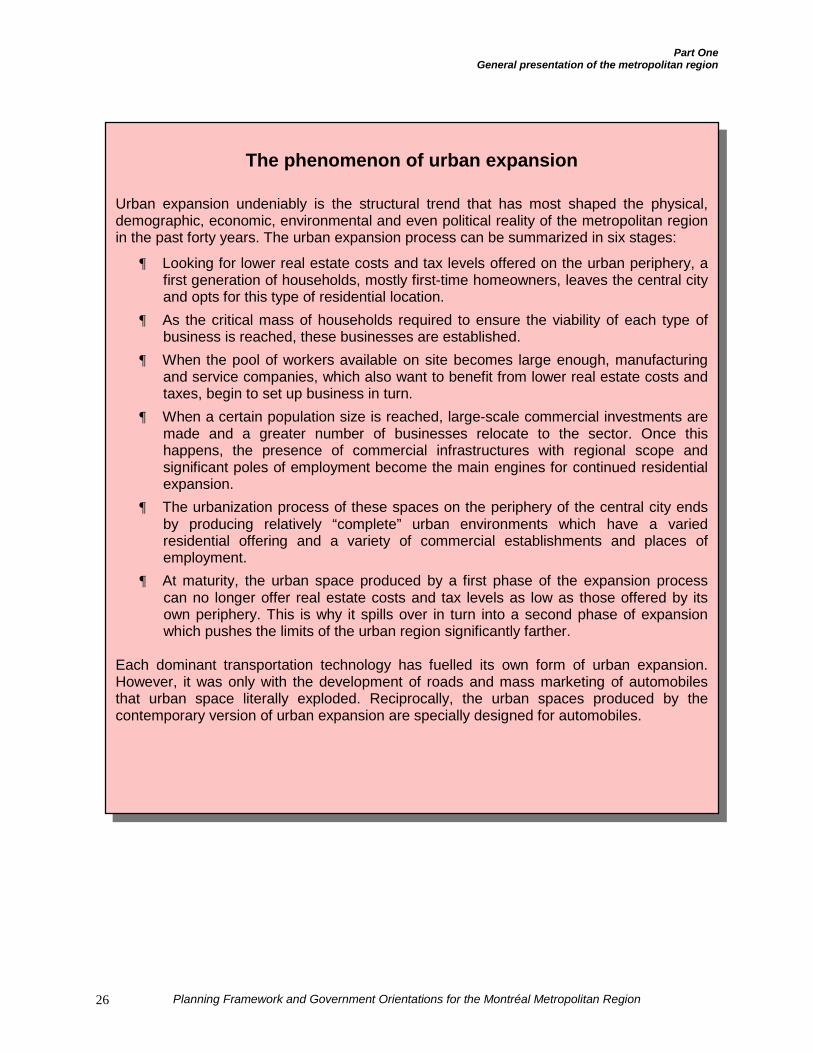
Part OneGeneral presentation of the metropolitan region
Planning Framework and Government Orientations for the Montréal Metropolitan Region26
The phenomenon of urban expansion
Urban expansion undeniably is the structural trend that has most shaped the physical,demographic, economic, environmental and even political reality of the metropolitan regionin the past forty years. The urban expansion process can be summarized in six stages:
¶ Looking for lower real estate costs and tax levels offered on the urban periphery, afirst generation of households, mostly first-time homeowners, leaves the central cityand opts for this type of residential location.
¶ As the critical mass of households required to ensure the viability of each type ofbusiness is reached, these businesses are established.
¶ When the pool of workers available on site becomes large enough, manufacturingand service companies, which also want to benefit from lower real estate costs andtaxes, begin to set up business in turn.
¶ When a certain population size is reached, large-scale commercial investments aremade and a greater number of businesses relocate to the sector. Once thishappens, the presence of commercial infrastructures with regional scope andsignificant poles of employment become the main engines for continued residentialexpansion.
¶ The urbanization process of these spaces on the periphery of the central city endsby producing relatively “complete” urban environments which have a variedresidential offering and a variety of commercial establishments and places ofemployment.
¶ At maturity, the urban space produced by a first phase of the expansion processcan no longer offer real estate costs and tax levels as low as those offered by itsown periphery. This is why it spills over in turn into a second phase of expansionwhich pushes the limits of the urban region significantly farther.
Each dominant transportation technology has fuelled its own form of urban expansion.However, it was only with the development of roads and mass marketing of automobilesthat urban space literally exploded. Reciprocally, the urban spaces produced by thecontemporary version of urban expansion are specially designed for automobiles.
Part OneGeneral presentation of the metropolitan region
Planning Framework and Government Orientations for the Montréal Metropolitan Region 27
THE ECONOMY AND EMPLOYMENT
In the first quarter of 2001, Greater Montréalhad 1.7 million jobs and included nearly49.2 % of Québec’s active population. ItsQuébec-wide economic weight far exceedsits simple demographic weight. Thus, in1999, the MCMA represented:
¶ 52 % of manufacturing shipments from all ofQuébec;
¶ 70 % of high technology manufacturingestablishments;
¶ 70 % of exports out of Québec;
¶ 90 % of total research and developmentexpenditures for all of Québec.
Moreover, the MCMA’s economic per-formance is honourable. It ranks 8th amongthe top 25 North American metropolitanregions in terms of job creation.
Montréal’s role in terms of quality of lifemade it a highly competitive urban region atthe international level in 2000. According toa study by the William H. Mercer Companyof New York on the position of 215 citiesaround the world, Montréal ranked 19th forits quality of life index (index of 103),higher than New York which had an indexof 100, the survey’s benchmark value.According to the Mercer survey, Montréal’squality of life compares to that of cities suchas Luxembourg, Tokyo or Toronto.
In addition to its quality of life, Montréal has acost of living among the lowest in theworld’s great metropolises. According to thedata of another Mercer survey on the cost ofliving in 132 world cities, Montréal ranked
120th with an index of 5910. AmongCanada’s major cities, only Calgary posted alower cost of living index than Montréal, or56. The MCMA therefore offers one of thebest cost-benefit ratios on the planet, whichpositions it advantageously in terms ofinternational economic competitiveness toattract companies and investment.
A) The primary sector
The primary sector of the Greater Montréaleconomy is limited to agricultural pro-duction. Since the Montréal region is highlyurbanized, its economy obviously does notinclude mining or forestry.
In 1996, the MCMA counted a total of 2,510agricultural enterprises employing 10,584people. Income from metropolitan agri-foodproduction accounted for 7 % of all Québecincome related to agriculture. The GreaterMontréal share of the agricultural GDP is16 %.
B) The secondary sector
The metropolitan region’s secondary sectoris mainly divided between traditional manu-facturing production and high technologyactivity.
Montréal ranks first among major Canadianregions in terms of manufacturing jobs with17.9 %.
Moreover, the metropolitan region isincreasingly oriented to the high techsectors. Greater Montréal concentrates65.8 % of all Québec jobs related toknowledge-based companies. A recent studyof the performance of 15 of the biggest
10 New York’s index of 100 is still the benchmark in this
instance. An index below 100 means that it costs less to live inthe city in question than in New York.
Part OneGeneral presentation of the metropolitan region
Planning Framework and Government Orientations for the Montréal Metropolitan Region28
North American metropolises even revealsthat Montréal ranks 4th in the high techsectors for the number of jobs per capita11.The information technology sector alone hada 15 % job growth rate in 1999-2000.
According to the survey reported byTechnovision Montréal, Greater Montréaloccupies an important place in NorthAmerica, particularly in:
¶ aerospace (40,000 jobs), 5th of 15;
¶ the information technology sector(117,000 jobs), 9th of 15;
¶ biopharmaceuticals (14,000 jobs),8t h of 15.
C) The tertiary sector
In 1997, the metropolitan region accountedfor 48.5 % of Québec’s tertiary businesses.These businesses are mainly found in fourfields:
¶ retailing (19.8 %);
¶ business services (18.1 %);
¶ wholesaling (11.0 %);
¶ accommodations and restaurants (8.3%).The INRS-Urbanisation study by Coffey andPolèse12 also specifies that, in terms ofemployment structure, the Montréal regionis in the top ranks of North Americanmetropolises for education, consumerservices, transportation, communications andpublic utilities.
Conversely, the Montréal region ranks lastin the dynamic tertiary sector: financialservices, insurance and real estate, andbusiness services.
11 Technovision Montréal bulletin, Leadership Montréal,
November 2000.12 See Coffey, W. and M. Polèse (1999).
D) International economic poles
Economic poles are a key factor in aregion’s production and activity structure.The concentration of jobs and companiescombined with the services found therecontribute to the development of synergybetween the companies and organizationspresent, as well as favouring public andprivate investment. By their distribution inthe territory and their characteristic function,the poles are a structuring element for ametropolitan region’s land use planning anddevelopment. In an age of globalization andopen markets, the MCMA’s competitivenesswith other major city-regions in the worlddepends on the affirmation of poles which,in its territory, offer the highest potentialinternational drawing power.
The MCMA has 6 international metropolitaneconomic poles in its territory (Map 2)13.These are:
¶ Downtown Montréal: 296,720 jobs;
¶ Saint-Laurent / Dorval: 142,487 jobs;
¶ Anjou / Mercier: 58,814 jobs;
¶ Laval city centre: 50,047 jobs;
¶ Longueuil Nord / Boucherville: 28,159jobs;
¶ The Mirabel International Trade Zone:10,780 jobs.
These poles were determined on the basis oftheir concentration of jobs and their growthpotential14. Five criteria particularly allow 13 The MAMM inventory made it possible to identify 12
metropolitan economic poles within the MCMA’s territory.The Planning Framework gives priority to the 6 internationalpoles because of the choice it has made to promote themetropolitan region’s influence on the international scene. Itwill be up to the CMM to identify and rank the economic polesin its territory more completely.
14 An economic pole is a place : where high value-addedbusinesses and production activities are concentrated (relativeconcentration compared to the MCMA as a whole); whichgenerates a phenomenon of attraction for other activities andfunctions and for the population; which involves trips to and
Part OneGeneral presentation of the metropolitan region
Planning Framework and Government Orientations for the Montréal Metropolitan Region 29
the poles to be referenced in terms of theirinternational character:
¶ growth potential for international activities;
¶ recognition as a pole in certain sectorpolicies of the Government;
¶ availability of space for development;
¶ economic impact of the pole on itsimmediate periphery;
¶ the number of jobs found there or thathave been created there.
Regarding job growth in the metropolitanpoles, it should be noted that the Anjou /Mercier corridor and Laval city centreshowed the most substantial growth between1996 and 1999. The Mirabel InternationalTrade Zone pole, according to the analysesproduced, offers excellent potential fordevelopment of international activities.Indeed, despite a 5 % decline in jobsbetween 1996 and 1999, this pole meets theestablished selection criteria. The loss ofjobs at Mirabel between 1996 and 1999 isattributable to the transfer of internationalflights to Dorval. However, since January2000, 2,400 jobs have been created atMirabel and by 2002, creation of 6,000additional jobs has been announced,including 4,000 at the Bombardier plant. Weshould remember that the Mirabel Interna-tional Trade Zone was established by theGovernment following the adoption in 1998of a job-creating economic developmentstrategy and thereby benefits from financialsupport for its development.
In the metropolitan territory as a whole,between 1981 and 1996, the northern andsouthern suburbs showed the most remark-
from the rest of the territory for work or commercialexchanges; where processes occur for creation and spreadingof innovations; where certain types of facilities exist; where alarge volume of private and public investments can bemeasured.
able total job growth. There was a 55 %increase in employment in the northernsuburbs and nearly 53 % in the southernsuburbs. Even in terms of the share of growth,the northern and southern suburbs, takentogether, accounted for nearly half the totalmetropolitan job growth between 1981 and1996, or 49.7 %.
TRANSPORT OF GOODS
A) Québec in a time of free trade
According to the Plan de gestion desdéplacements, the trip management plan ofthe Ministère des Transports, the value ofexports of Québec goods totalled $87.4billion in 1998, or 45 % of its gross domesticproduct.
The global economic climate has gonethrough many upheavals in the past tenyears. The changes in the economy haveresulted in much freer trade with theopening of borders. For Québec, thissituation has increased trade with the UnitedStates. Thus, between 1990 and 1996, thevalue of Québec exports to the United Statesmore than doubled, from $19.4 billion to$39.7 billion. During the same period, theQuébec trade surplus with the United Statesgrew from $4.8 billion to $17.4 billion. In aparallel phenomenon, the value of exports toother Canadian provinces declined slightlyby $0.8 billion between 1990 and 1996,from $22.6 billion to $21.8 billion.
This increase in trade with the Americanmarket clearly had the consequence ofincreasing the number of jobs related to theexport sector by 50,000 throughout Québecbetween 1990 and 1997. In 1997, 800,000jobs were directly related to exports inQuébec and it is estimated that 560,000 ofthese jobs pertained to the trade in goods.
Part OneGeneral presentation of the metropolitan region
Planning Framework and Government Orientations for the Montréal Metropolitan Region30
B) The Montréal region: crossroadsof transportation networks
In this context of open markets, especiallythe American market, the Montréal metro-politan region has a major geographicadvan-tage. Located in southern Québec andlinked to the rest of North America by mosttransportation networks (highway, railway,marine and air), the MCMA enjoys aprivileged position which makes it a freighthub in Québec.
In terms of highway infrastructures, themetropolitan region can count on ninehighway axes to connect it to the outsideworld. This is a major factor, given that twothirds of the trade between Québec and theUnited States is by truck. In fact, over 70 %of truck trips from neighbouring jurisdic-tions (mainly Ontario and the United States)enter Québec by Autoroutes 20, 15 or 40 orby the A-35 / Route 133 axis. The value ofgoods transported on these highways wasaround $30 billion in 1995, solely for tradewith the United States. The region alsobenefits from the presence of Autoroute10 which connects with Autoroute 55, theother major axis in terms of market valueafter Autoroute 20, on which the value oftrade with the United States totalled $4.5billion.
This transportation activity has an impact onthe region’s international highway system.The axes of Autoroutes 40 and 20 (betweenDorval and the Turcot Interchange) andAutoroutes 13 and 15 and the A-20 / A-25junction are the most heavily used by trucks.More than 7,000 daily truck trips arecounted on each of these axes between6 a.m. and 7 p.m. in both directions.
Regarding rail transport, the MTQ notes thatall continental railway lines crossing Québecconverge on the Island of Montréal, where
the marshalling yards and container handlingterminals are located. In 1997, the Québecrailway network carried over 23 milliontonnes of goods, including 55 % to theUnited States. The value of goods exportedto the United States was $8.6 billion in 1997,while imports totalled $3.2 billion.
The Port of Montréal is another avenue forthe transport of goods. It annually receivesone million containers. In 1999, the Porthandled nearly 21 million tonnes of cargo,including 45 % containerized goods, makingit one of the leading ports in North America.In this regard, the Port handles morecontainerized goods than any other port onthe east coast of the United States. Thepresence of other transportation systems(rail and road) largely explains the Port ofMontréal’s competitive advantage.
Finally, the presence of two internationalairports contributes to the metropolitanregion’s influence in terms of transport ofgoods. Indeed, most Québec air freight ishandled at Montréal’s airports. Here again,trade with the United States remainsimportant: 20 % of the goods handled at Dorvaland Mirabel go to or come from Americanterritory, for a total value of $9.6 billion in1998.
TRANSPORTING PEOPLE AND TRIPS
The questions of land use planning andtransport are closely related. The densemultifunctional built environments typical ofthe most central and oldest parts of themetropolitan region are conducive to theestablishment of attractive and efficientmass transit services. This explains whypractically all heavy mass transit infra-structures have been concentrated in thispart of the territory. Conversely, theautomobile is the almost mandatory mode of
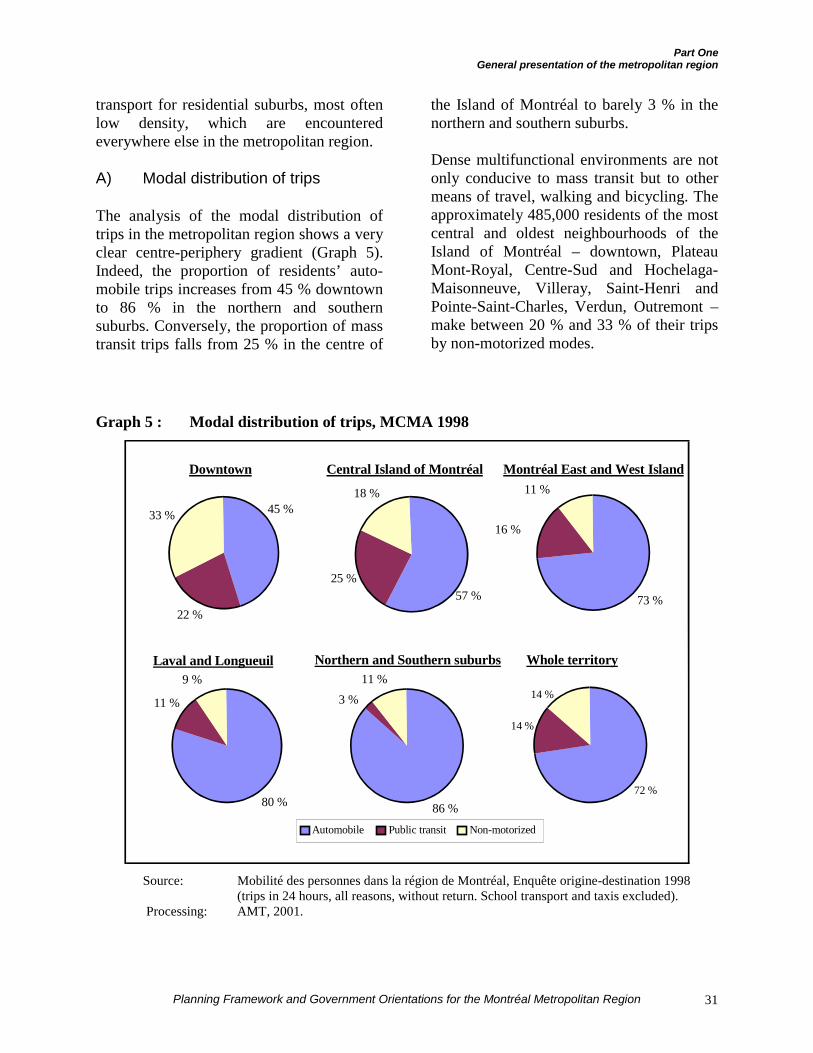
Part OneGeneral presentation of the metropolitan region
Planning Framework and Government Orientations for the Montréal Metropolitan Region 31
transport for residential suburbs, most oftenlow density, which are encounteredeverywhere else in the metropolitan region.
A) Modal distribution of trips
The analysis of the modal distribution oftrips in the metropolitan region shows a veryclear centre-periphery gradient (Graph 5).Indeed, the proportion of residents’ auto-mobile trips increases from 45 % downtownto 86 % in the northern and southernsuburbs. Conversely, the proportion of masstransit trips falls from 25 % in the centre of
the Island of Montréal to barely 3 % in thenorthern and southern suburbs.
Dense multifunctional environments are notonly conducive to mass transit but to othermeans of travel, walking and bicycling. Theapproximately 485,000 residents of the mostcentral and oldest neighbourhoods of theIsland of Montréal – downtown, PlateauMont-Royal, Centre-Sud and Hochelaga-Maisonneuve, Villeray, Saint-Henri andPointe-Saint-Charles, Verdun, Outremont –make between 20 % and 33 % of their tripsby non-motorized modes.
Graph 5 : Modal distribution of trips, MCMA 1998
Source: Mobilité des personnes dans la région de Montréal, Enquête origine-destination 1998(trips in 24 hours, all reasons, without return. School transport and taxis excluded).
Processing: AMT, 2001.
Northern and Southern suburbs Whole territory
Downtown Central Island of Montréal Montréal East and West Island
Laval and Longueuil
22 %
33 % 45 %
25 %
18 %
57 % 73 %
16 %
11 %
80 %
11 %
9 %
86 %
3 %11 %
72 %
14 %
14 %
Automobile Public transit Non-motorized
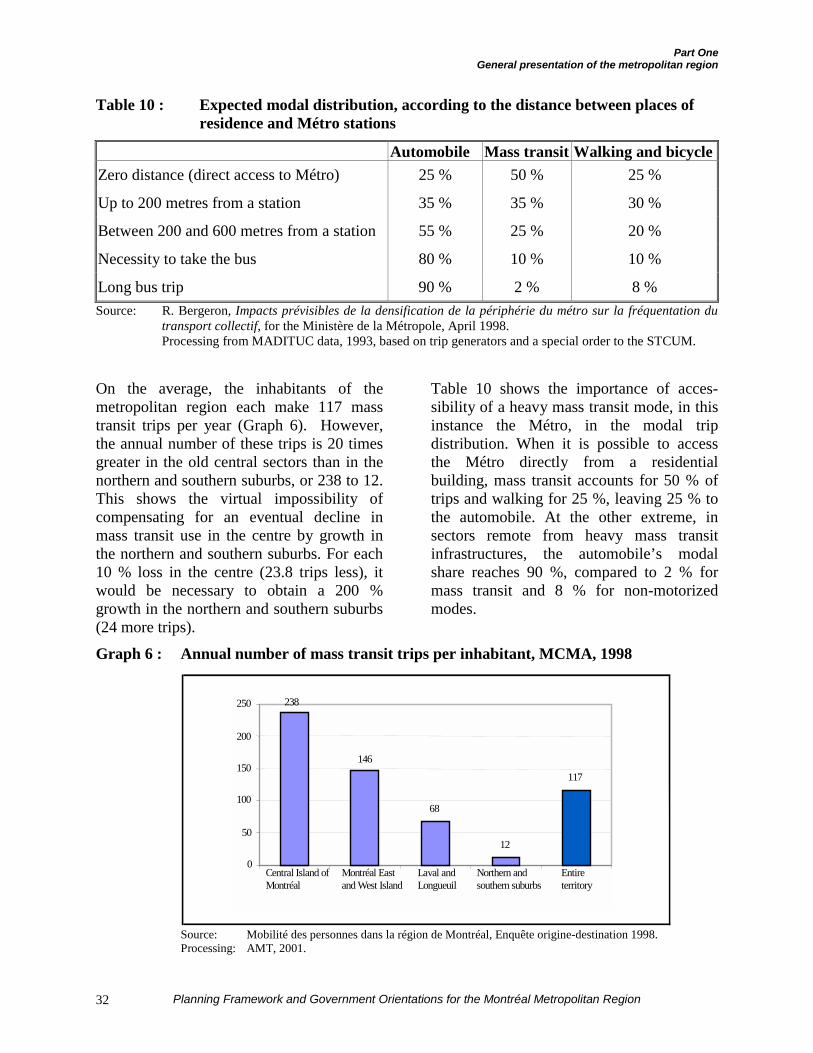
Part OneGeneral presentation of the metropolitan region
Planning Framework and Government Orientations for the Montréal Metropolitan Region32
Table 10 : Expected modal distribution, according to the distance between places ofresidence and Métro stations
Automobile Mass transit Walking and bicycleZero distance (direct access to Métro) 25 % 50 % 25 %
Up to 200 metres from a station 35 % 35 % 30 %
Between 200 and 600 metres from a station 55 % 25 % 20 %
Necessity to take the bus 80 % 10 % 10 %
Long bus trip 90 % 2 % 8 %Source: R. Bergeron, Impacts prévisibles de la densification de la périphérie du métro sur la fréquentation du
transport collectif, for the Ministère de la Métropole, April 1998.Processing from MADITUC data, 1993, based on trip generators and a special order to the STCUM.
On the average, the inhabitants of themetropolitan region each make 117 masstransit trips per year (Graph 6). However,the annual number of these trips is 20 timesgreater in the old central sectors than in thenorthern and southern suburbs, or 238 to 12.This shows the virtual impossibility ofcompensating for an eventual decline inmass transit use in the centre by growth inthe northern and southern suburbs. For each10 % loss in the centre (23.8 trips less), itwould be necessary to obtain a 200 %growth in the northern and southern suburbs(24 more trips).
Table 10 shows the importance of acces-sibility of a heavy mass transit mode, in thisinstance the Métro, in the modal tripdistribution. When it is possible to accessthe Métro directly from a residentialbuilding, mass transit accounts for 50 % oftrips and walking for 25 %, leaving 25 % tothe automobile. At the other extreme, insectors remote from heavy mass transitinfrastructures, the automobile’s modalshare reaches 90 %, compared to 2 % formass transit and 8 % for non-motorizedmodes.
Graph 6 : Annual number of mass transit trips per inhabitant, MCMA, 1998
Source: Mobilité des personnes dans la région de Montréal, Enquête origine-destination 1998.Processing: AMT, 2001.
146
68
12
117
238
0
50
100
150
200
250
Central Island ofMontréal
Montréal Eastand West Island
Laval andLongueuil
Northern andsouthern suburbs
Entireterritory
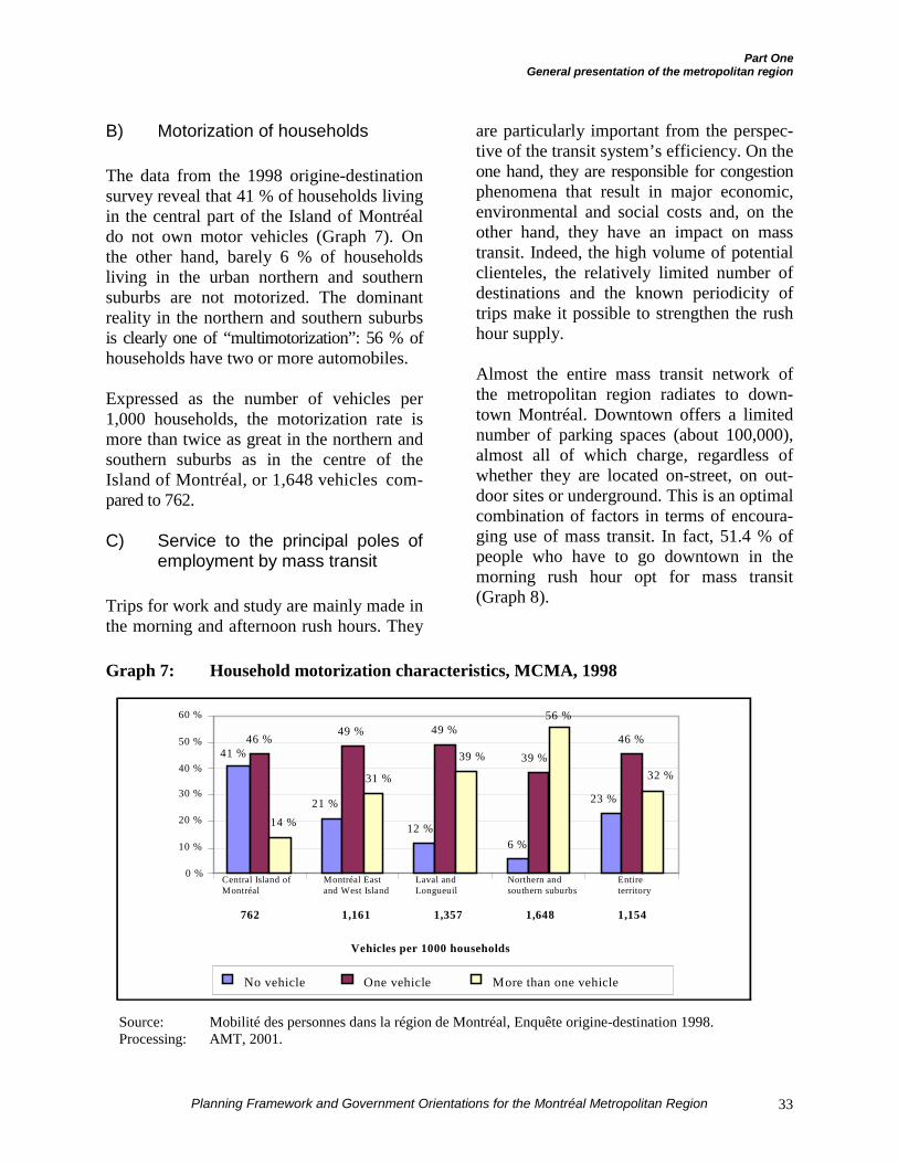
Part OneGeneral presentation of the metropolitan region
Planning Framework and Government Orientations for the Montréal Metropolitan Region 33
B) Motorization of households
The data from the 1998 origine-destinationsurvey reveal that 41 % of households livingin the central part of the Island of Montréaldo not own motor vehicles (Graph 7). Onthe other hand, barely 6 % of householdsliving in the urban northern and southernsuburbs are not motorized. The dominantreality in the northern and southern suburbsis clearly one of “multimotorization”: 56 % ofhouseholds have two or more automobiles.
Expressed as the number of vehicles per1,000 households, the motorization rate ismore than twice as great in the northern andsouthern suburbs as in the centre of theIsland of Montréal, or 1,648 vehicles com-pared to 762.
C) Service to the principal poles ofemployment by mass transit
Trips for work and study are mainly made inthe morning and afternoon rush hours. They
are particularly important from the perspec-tive of the transit system’s efficiency. On theone hand, they are responsible for congestionphenomena that result in major economic,environmental and social costs and, on theother hand, they have an impact on masstransit. Indeed, the high volume of potentialclienteles, the relatively limited number ofdestinations and the known periodicity oftrips make it possible to strengthen the rushhour supply.
Almost the entire mass transit network ofthe metropolitan region radiates to down-town Montréal. Downtown offers a limitednumber of parking spaces (about 100,000),almost all of which charge, regardless ofwhether they are located on-street, on out-door sites or underground. This is an optimalcombination of factors in terms of encoura-ging use of mass transit. In fact, 51.4 % ofpeople who have to go downtown in themorning rush hour opt for mass transit(Graph 8).
Graph 7: Household motorization characteristics, MCMA, 1998
Source: Mobilité des personnes dans la région de Montréal, Enquête origine-destination 1998.Processing: AMT, 2001.
6 %
46 %49 % 49 %
46 %
56 %
23 %
12 %
21 %
41 % 39 %32 %
39 %
31 %
14 %
0 %
10 %
20 %
30 %
40 %
50 %
60 %
No vehicle One vehicle More than one vehicle
762 1,161 1,357 1,648 1,154
Vehicles per 1000 households
Central Island ofMontréal
Montréal Eastand West Island
Laval andLongueuil
Northern andsouthern suburbs
Entireterritory
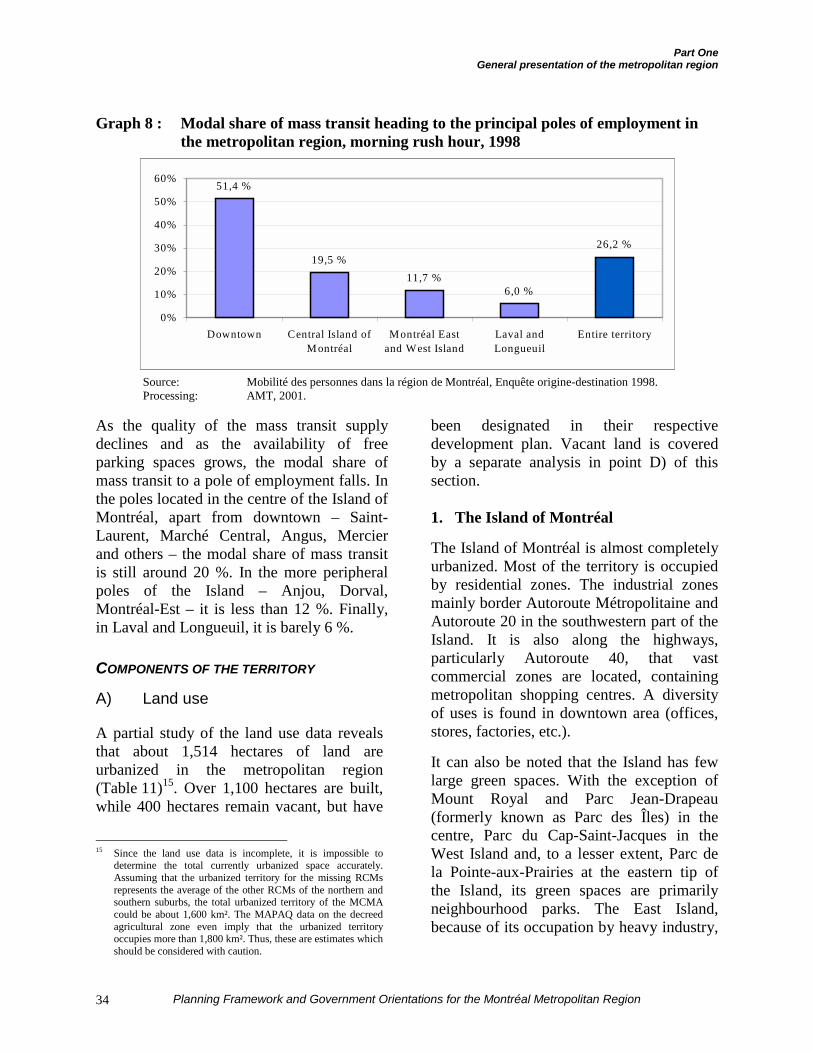
Part OneGeneral presentation of the metropolitan region
Planning Framework and Government Orientations for the Montréal Metropolitan Region34
Graph 8 : Modal share of mass transit heading to the principal poles of employment inthe metropolitan region, morning rush hour, 1998
Source: Mobilité des personnes dans la région de Montréal, Enquête origine-destination 1998.Processing: AMT, 2001.
As the quality of the mass transit supplydeclines and as the availability of freeparking spaces grows, the modal share ofmass transit to a pole of employment falls. Inthe poles located in the centre of the Island ofMontréal, apart from downtown – Saint-Laurent, Marché Central, Angus, Mercierand others – the modal share of mass transitis still around 20 %. In the more peripheralpoles of the Island – Anjou, Dorval,Montréal-Est – it is less than 12 %. Finally,in Laval and Longueuil, it is barely 6 %.
COMPONENTS OF THE TERRITORY
A) Land use
A partial study of the land use data revealsthat about 1,514 hectares of land areurbanized in the metropolitan region(Table 11)15. Over 1,100 hectares are built,while 400 hectares remain vacant, but have
15 Since the land use data is incomplete, it is impossible to
determine the total currently urbanized space accurately.Assuming that the urbanized territory for the missing RCMsrepresents the average of the other RCMs of the northern andsouthern suburbs, the total urbanized territory of the MCMAcould be about 1,600 km². The MAPAQ data on the decreedagricultural zone even imply that the urbanized territoryoccupies more than 1,800 km². Thus, these are estimates whichshould be considered with caution.
been designated in their respectivedevelopment plan. Vacant land is coveredby a separate analysis in point D) of thissection.
1. The Island of Montréal
The Island of Montréal is almost completelyurbanized. Most of the territory is occupiedby residential zones. The industrial zonesmainly border Autoroute Métropolitaine andAutoroute 20 in the southwestern part of theIsland. It is also along the highways,particularly Autoroute 40, that vastcommercial zones are located, containingmetropolitan shopping centres. A diversityof uses is found in downtown area (offices,stores, factories, etc.).
It can also be noted that the Island has fewlarge green spaces. With the exception ofMount Royal and Parc Jean-Drapeau(formerly known as Parc des Îles) in thecentre, Parc du Cap-Saint-Jacques in theWest Island and, to a lesser extent, Parc dela Pointe-aux-Prairies at the eastern tip ofthe Island, its green spaces are primarilyneighbourhood parks. The East Island,because of its occupation by heavy industry,
26,2 %
6,0 %11,7 %
19,5 %
51,4 %
0%
10%
20%
30%
40%
50%
60%
Downtown Central Island ofM ontréal
M ontréal Eastand West Island
Laval andLongueuil
Entire territory
Part OneGeneral presentation of the metropolitan region
Planning Framework and Government Orientations for the Montréal Metropolitan Region 35
is still less well equipped than the rest of theIsland in terms of green spaces.
2. Laval
In Laval, a quick review of land use showsthat the city is occupied by major residentialzones on its northern and southern shoresalong the rivers that border it. The city has alarge industrial zone at the junction ofAutoroutes 15 and 440 and two smallerzones along Autoroute 440. The north-eastern and west central areas feature thepresence of a large protected agriculturalsector. The centre of Île de Laval alsocontains large zones of vacant land. Finally,it should be noted that, apart from the golfcourses in the western part of the island andthe Centre de la Nature, Laval has no majorgreen space.
3. The northern suburbs
On the North Shore, most of the territory isoccupied by the agricultural zone. Urbandevelopment up to now has followed theroute of the two main highway axes,Autoroute 15 north-south and Autoroute 640east-west. The North Shore has about tenindustrial sectors and four commercialactivity zones of substantial size. On thenorthern fringe, it is also important to notethe presence of large wooded zones andforest cover. Finally, vacant land is mainlylocated in the sector between Blainville andLachenaie
4. The southern suburbs
In the western part of the Montérégie – i.e.Vaudreuil-Soulanges – within the MCMA’sterritory, the land is mainly designated foragriculture and housing. Large parcels ofland are still vacant in the municipalities ofSaint-Lazare, Vaudreuil-Dorion and ÎlePerrot. The commercial and industrial
sectors of this part of the MCMA are mainlyfound in Vaudreuil-Dorion.
In the eastern part of the South Shore, acrossfrom the Island of Montréal, the almostcompletely urbanized territory of MRC deChamplain is surrounded by agriculturalsectors to the south and agricultural andforest zones in the northeast. A largeindustrial zone extends along Autoroute 20,while industrial and vacant spaces aredeployed in the axis of Autoroute 30. Thecommercial zones are mainly located withinthe territory of MRC de Champlain.
Finally, the South Shore benefits from thepresence of remarkable green spaces, both interms of size and reputation, particularlyParc du Mont-Saint-Bruno, Parc des Îles-de-Boucherville, Parc du Mont-Saint-Hilaireand Parc du Fort-Chambly. Contrary to thesituation prevailing in the northern suburbs,the wooded zones, although numerous, aremainly found at the centre of the agriculturalsectors.
B) Industrial and commercial spaces
Table 11 shows that the largest share (41 %)of built industrial spaces are found on theIsland of Montréal, for an industrial landarea of 59.8 km². Although the largest shareof built commercial land (26.3 km², or 35 %of the built commercial land) is alsoconcentrated on the Island, one third of thebuilt commercial space (24.8 km², or 33 %)is concentrated on the South Shore.
Mapping of the industrial and commercialspaces shows that these spaces are mainlyfound in determining axes (Map 3). Linkingseveral of the region’s economic poles, theseaxes suggest a solid skeleton conducive tosustainable networking of the region’seconomic structure.
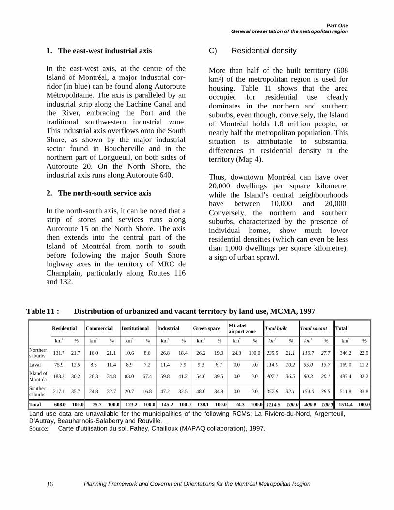
Part OneGeneral presentation of the metropolitan region
Planning Framework and Government Orientations for the Montréal Metropolitan Region36
1. The east-west industrial axis
In the east-west axis, at the centre of theIsland of Montréal, a major industrial cor-ridor (in blue) can be found along AutorouteMétropolitaine. The axis is paralleled by anindustrial strip along the Lachine Canal andthe River, embracing the Port and thetraditional southwestern industrial zone.This industrial axis overflows onto the SouthShore, as shown by the major industrialsector found in Boucherville and in thenorthern part of Longueuil, on both sides ofAutoroute 20. On the North Shore, theindustrial axis runs along Autoroute 640.
2. The north-south service axis
In the north-south axis, it can be noted that astrip of stores and services runs alongAutoroute 15 on the North Shore. The axisthen extends into the central part of theIsland of Montréal from north to southbefore following the major South Shorehighway axes in the territory of MRC deChamplain, particularly along Routes 116and 132.
C) Residential density
More than half of the built territory (608km²) of the metropolitan region is used forhousing. Table 11 shows that the areaoccupied for residential use clearlydominates in the northern and southernsuburbs, even though, conversely, the Islandof Montréal holds 1.8 million people, ornearly half the metropolitan population. Thissituation is attributable to substantialdifferences in residential density in theterritory (Map 4).
Thus, downtown Montréal can have over20,000 dwellings per square kilometre,while the Island’s central neighbourhoodshave between 10,000 and 20,000.Conversely, the northern and southernsuburbs, characterized by the presence ofindividual homes, show much lowerresidential densities (which can even be lessthan 1,000 dwellings per square kilometre),a sign of urban sprawl.
Table 11 : Distribution of urbanized and vacant territory by land use, MCMA, 1997
Residential Commercial Institutional Industrial Green space Mirabelairport zone Total built Total vacant Total
km2 % km2 % km2 % km2 % km2 % km2 % km2 % km2 % km2 %
Northernsuburbs 131.7 21.7 16.0 21.1 10.6 8.6 26.8 18.4 26.2 19.0 24.3 100.0 235.5 21.1 110.7 27.7 346.2 22.9
Laval 75.9 12.5 8.6 11.4 8.9 7.2 11.4 7.9 9.3 6.7 0.0 0.0 114.0 10.2 55.0 13.7 169.0 11.2
Island ofMontréal 183.3 30.2 26.3 34.8 83.0 67.4 59.8 41.2 54.6 39.5 0.0 0.0 407.1 36.5 80.3 20.1 487.4 32.2
Southernsuburbs 217.1 35.7 24.8 32.7 20.7 16.8 47.2 32.5 48.0 34.8 0.0 0.0 357.8 32.1 154.0 38.5 511.8 33.8
Total 608.0 100.0 75.7 100.0 123.2 100.0 145.2 100.0 138.1 100.0 24.3 100.0 1114.5 100.0 400.0 100.0 1514.4 100.0
Land use data are unavailable for the municipalities of the following RCMs: La Rivière-du-Nord, Argenteuil,D’Autray, Beauharnois-Salaberry and Rouville.Source: Carte d’utilisation du sol, Fahey, Chailloux (MAPAQ collaboration), 1997.
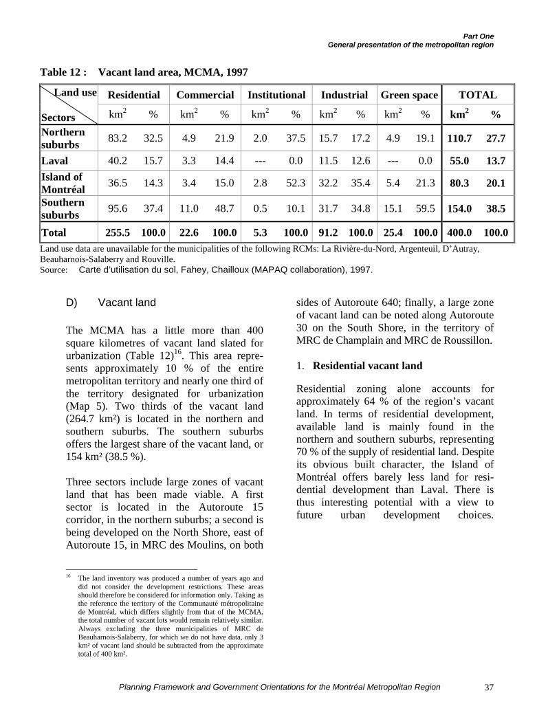
Part OneGeneral presentation of the metropolitan region
Planning Framework and Government Orientations for the Montréal Metropolitan Region 37
Table 12 : Vacant land area, MCMA, 1997
Residential Commercial Institutional Industrial Green space TOTALLand use
Sectors km2 % km2 % km2 % km2 % km2 % km2 %Northernsuburbs 83.2 32.5 4.9 21.9 2.0 37.5 15.7 17.2 4.9 19.1 110.7 27.7
Laval 40.2 15.7 3.3 14.4 --- 0.0 11.5 12.6 --- 0.0 55.0 13.7Island ofMontréal 36.5 14.3 3.4 15.0 2.8 52.3 32.2 35.4 5.4 21.3 80.3 20.1
Southernsuburbs 95.6 37.4 11.0 48.7 0.5 10.1 31.7 34.8 15.1 59.5 154.0 38.5
Total 255.5 100.0 22.6 100.0 5.3 100.0 91.2 100.0 25.4 100.0 400.0 100.0Land use data are unavailable for the municipalities of the following RCMs: La Rivière-du-Nord, Argenteuil, D’Autray,Beauharnois-Salaberry and Rouville.Source: Carte d’utilisation du sol, Fahey, Chailloux (MAPAQ collaboration), 1997.
D) Vacant land
The MCMA has a little more than 400square kilometres of vacant land slated forurbanization (Table 12)16. This area repre-sents approximately 10 % of the entiremetropolitan territory and nearly one third ofthe territory designated for urbanization(Map 5). Two thirds of the vacant land(264.7 km²) is located in the northern andsouthern suburbs. The southern suburbsoffers the largest share of the vacant land, or154 km² (38.5 %).
Three sectors include large zones of vacantland that has been made viable. A firstsector is located in the Autoroute 15corridor, in the northern suburbs; a second isbeing developed on the North Shore, east ofAutoroute 15, in MRC des Moulins, on both
16 The land inventory was produced a number of years ago and
did not consider the development restrictions. These areasshould therefore be considered for information only. Taking asthe reference the territory of the Communauté métropolitainede Montréal, which differs slightly from that of the MCMA,the total number of vacant lots would remain relatively similar.Always excluding the three municipalities of MRC deBeauharnois-Salaberry, for which we do not have data, only 3km² of vacant land should be subtracted from the approximatetotal of 400 km².
sides of Autoroute 640; finally, a large zoneof vacant land can be noted along Autoroute30 on the South Shore, in the territory ofMRC de Champlain and MRC de Roussillon.
1. Residential vacant land
Residential zoning alone accounts forapproximately 64 % of the region’s vacantland. In terms of residential development,available land is mainly found in thenorthern and southern suburbs, representing70 % of the supply of residential land. Despiteits obvious built character, the Island ofMontréal offers barely less land for resi-dential development than Laval. There isthus interesting potential with a view tofuture urban development choices.
Part One:General Presentation of the metropolitan region
Planning Framework and Government Orientations for the Montréal Metropolitan Region38
2. Commercial vacant land
Regarding commercial space, land isavailable in the southern suburbs, which has48.7 % of the land designated for this purpose(11 km²). The commercial land available onthe Island of Montréal is mainly concen-trated downtown. In Laval, available landcan be observed around the intersection ofAutoroutes 15 and 440.
3. Industrial vacant land
In terms of industrial development, theIsland of Montréal and the southern suburbshave more than 30 km² of vacant land each,or 70 % of the total supply of industrial land.On the Island of Montréal, the available landis concentrated mainly around Autoroute 40west of Saint-Laurent and in the eastern partof the Island, in Montréal-Est and Rivière-des-Prairies.
E) Contaminated land
In 1993, the Comité interministériel sur lessols contaminés de l’île de Montréal, underthe auspices of the Ministère du Conseilexécutif, estimated that 60 % of all publicand private vacant land on the Island ofMontréal showed signs of contamination.These lands, earmarked for residential,commercial and industrial uses, representedan area of approximately 4,200 hectares. Itis estimated that the average cost of theirdecontamination is $300,000 per hectare.When the northern and southern suburbs areadded, it is no exaggeration to consider thatthe contaminated land area in the MCMAamounts to 5,000 hectares. According toMENV data, it could cost about $1.5 billionto proceed with complete decontaminationof the metropolitan region.
Land contamination may be of organic(hydrocarbons), inorganic (metals) or mixedorigin. For the MCMA as a whole, based onapproximately 1,600 files recorded in theBanque de données du système de gestiondes terrains contaminés17, the contaminatedland management system database of theMinistère de l’Environnement, certain trendscan be observed. Thus, the south central areaof the Island of Montréal, containing the oldindustrial zones, mainly includes lands withcontamination of inorganic or mixed origin.A concentration of lands with organic conta-mination is found in Montréal East Islandand in Varennes, in the southern suburbs,associated with the petrochemical complexes.Finally, land contaminated by organicsources associated with the presence ofunderground oil tanks is found throughoutthe MCMA’s territory, but these lands donot represent a large area.
It is also appropriate to remember thatcontaminated soil treatment and disposalcentres are located within the MCMA’sterritory. The disposal site of the Cinteccompany in LaSalle, the soil treatmentcentres belonging to the oil companies inMontréal East Island, the treatment site ofSolution eau, air, sol inc., also located on theEast Island, and the Onyx Industries Inc. sitein Chambly can receive contaminated soilfrom all over Québec.
17 The number 1,600 corresponds to the number of files being
processed for analysis and evaluation for the entire MCMA.According to the MENV information, 900 files concern landon the Island of Montréal. Moreover, the number ofcontaminated sites would be greater than the number of filesprocessed. An exhaustive inventory of the number of sites andcontaminated areas has not been constituted and the datatherefore remains very partial.
We must also mention that the degree of contamination variesfrom one site to another. Despite the large number of“contaminated” sites, their level of contamination, which ishighly variable, does not make them unfit for urbanization orunusable.
Part One:General Presentation of the metropolitan region
Planning Framework and Government Orientations for the Montréal Metropolitan Region 39
THE AGRICULTURAL ZONE AND ACTIVITIES
The decreed agricultural zone covers214,431 hectares, or 54 % of the entire terri-tory of the metropolitan region (Table 13and Map 5). The region’s agricultural acti-vity is carried on by approximately 10,600people working in about 2,510 operations.Agriculture ensures $335 million in annualincome and represents a capital value ofover $1.2 billion. Agricultural activity hasspinoffs, since it provides 30,000 jobs in thesecondary sector and 100,000 jobs in thetertiary sector18.
Without being exhaustive, the followingprofile locates the agricultural and agri-foodactivities, as well as their importance anddevelopment potential within the MCMA’sterritory.
1. North Shore
¶ Numerous dairy, pork and poultryproducers;
¶ Presence and development of productionof major cash crops (especially seed cornand soybeans) throughout the territory;
¶ Market, orchard and ornamental garde-ning is continuously growing throughoutthe territory, especially on the peripheryof the urbanized cores;
¶ Massive concentration of apple produ-cers in the hills of Saint-Joseph-du-Lacand Oka;
¶ Major development of agri-touristactivities among apple producers, mapleproducers, market gardeners, berryproducers, vineyards, equestrian centres,etc.
18 The data for the agricultural zone within the CMM’s territory
does not change significantly. The decreed agricultural zonerepresents 219,329 hectares in 2000, or 57.6 % of the CMM’sterritory. There were 2,551 operators in 1996 within theCMM’s territory, agricultural income for the CMM’s territorywas $338 million and the capital value was $1.245 billion.
2. Laval
¶ Major presence of greenhouse cultiva-tion in the western part;
¶ Major presence of market gardeningfarms in the eastern part.
3. Island of Montréal and Île Bizard
¶ Vegetable and apple production on ÎleBizard.
4. Montérégie
¶ Presence and development of productionof major cash crops (particularly seedcorn and soybeans) throughout theterritory. Underutilized or fallow land isbeen reactivated for this purpose;
¶ Numerous dairy farms still present,mainly in the South Shore municipalitieslocated outside the urban fabric as such;
¶ Almost complete absence of pork andpoultry production for high incomelevels, despite interesting potential insome sectors;
¶ Several racehorse and saddle horsebreeding farms and presence of manyequestrian centres in the municipalitieson the outlying urban fringe, particularlyin the Saint-Lazare sector;
¶ Interesting potential for non-traditionallivestock production (sheep, goats,rabbits, small and big game, etc.);
¶ Market gardening particularly well deve-loped around Ville de Mercier andconcentration of potato production in themunicipality of Saint-Amable.
Several berry and vegetable production unitsare also scattered through the territory:
¶ Apple production is still present on theperimeter of the Montérégie hills (MontSaint-Hilaire and, to a lesser extent,
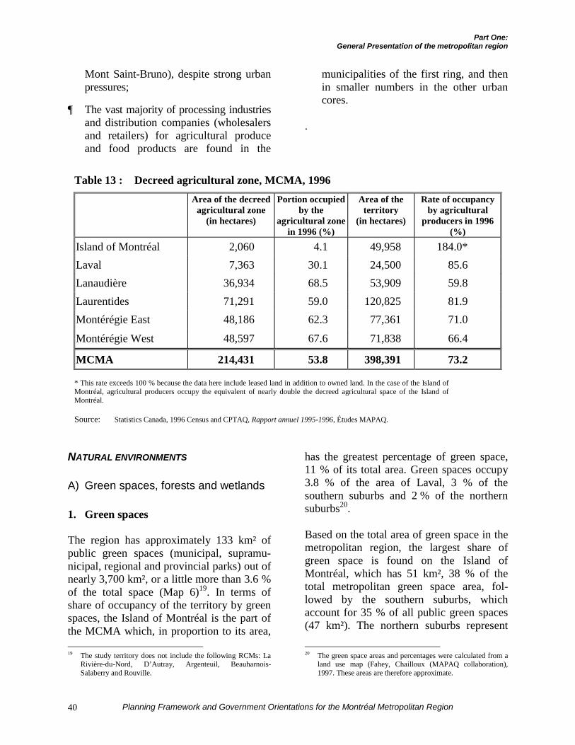
Part One:General Presentation of the metropolitan region
Planning Framework and Government Orientations for the Montréal Metropolitan Region40
Mont Saint-Bruno), despite strong urbanpressures;
¶ The vast majority of processing industriesand distribution companies (wholesalersand retailers) for agricultural produceand food products are found in the
municipalities of the first ring, and thenin smaller numbers in the other urbancores.
.
Table 13 : Decreed agricultural zone, MCMA, 1996Area of the decreed
agricultural zone(in hectares)
Portion occupiedby the
agricultural zonein 1996 (%)
Area of theterritory
(in hectares)
Rate of occupancyby agricultural
producers in 1996(%)
Island of Montréal 2,060 4.1 49,958 184.0*Laval 7,363 30.1 24,500 85.6Lanaudière 36,934 68.5 53,909 59.8Laurentides 71,291 59.0 120,825 81.9Montérégie East 48,186 62.3 77,361 71.0
Montérégie West 48,597 67.6 71,838 66.4
MCMA 214,431 53.8 398,391 73.2
* This rate exceeds 100 % because the data here include leased land in addition to owned land. In the case of the Island ofMontréal, agricultural producers occupy the equivalent of nearly double the decreed agricultural space of the Island ofMontréal.
Source: Statistics Canada, 1996 Census and CPTAQ, Rapport annuel 1995-1996, Études MAPAQ.
NATURAL ENVIRONMENTS
A) Green spaces, forests and wetlands
1. Green spaces
The region has approximately 133 km² ofpublic green spaces (municipal, supramu-nicipal, regional and provincial parks) out ofnearly 3,700 km², or a little more than 3.6 %of the total space (Map 6)19. In terms ofshare of occupancy of the territory by greenspaces, the Island of Montréal is the part ofthe MCMA which, in proportion to its area, 19 The study territory does not include the following RCMs: La
Rivière-du-Nord, D’Autray, Argenteuil, Beauharnois-Salaberry and Rouville.
has the greatest percentage of green space,11 % of its total area. Green spaces occupy3.8 % of the area of Laval, 3 % of thesouthern suburbs and 2 % of the northernsuburbs20.
Based on the total area of green space in themetropolitan region, the largest share ofgreen space is found on the Island ofMontréal, which has 51 km², 38 % of thetotal metropolitan green space area, fol-lowed by the southern suburbs, whichaccount for 35 % of all public green spaces(47 km²). The northern suburbs represent
20 The green space areas and percentages were calculated from a
land use map (Fahey, Chailloux (MAPAQ collaboration),1997. These areas are therefore approximate.
Part One:General Presentation of the metropolitan region
Planning Framework and Government Orientations for the Montréal Metropolitan Region 41
19 % of the total metropolitan green spacearea (26 km²) while Laval accounts for 7 %(9 km²) of the green space in themetropolitan region. Table 14 presents theMCMA’s principal natural and manmadegreen spaces for each part of the territory.
2. Forests
Forest cover occupies an area of 606 squarekilometres throughout the MCMA21. Thenorthern suburbs alone account for morethan half the forest cover in the metropolitanregion with 308.6 km² (51 %), followed bythe southern suburbs with 272.9 km² (45 %).Despite its highly advanced urbanization,the Island of Montréal still has 3.9 km² offorest. Forest covers 22 % of all the territoryof the northern suburbs, 17 % of thesouthern suburbs, 8.3 % of Laval and 0.8 %of the Island of Montréal.
3. Wetlands
The metropolitan region includes a total of21 square kilometres of wetlands (swamps,marshes, wet grasslands, etc.). These envi-ronments represent 0.6 % of the metropo-litan territory.
The southern suburbs account for 52 % ofall of the MCMA’s wetlands, or 11 km²,mainly in the territory of MRC deLajemmerais. The northern suburbs accountfor 8 km² of wetlands, representing 36 % ofthese environments in the metropolitanregion. Wetlands are mainly found in MRCdes Deux-Montagnes and MRC deL’Assomption. Finally, the Island of Montréaland Laval each have 1 km² of wetlands.
21 As in the case of green spaces, the areas presented are
approximate. These areas also do not include wooded areas onvacant land, precisely those that are the most threatened byurbanization.
B) Metropolitan blue spaces
The metropolitan hydrographic system iscomposed of eight bodies of water covering15 % of the region’s territory (Map 6). Inaddition to playing an important cultural,recreational and touristic and socioeconomicrole, these bodies of water supply the entirepopulation with drinking water. Some basinsand bodies of water in the metropolitanregion are suitable for commercial andpleasure navigation. They are also characte-rized by a major wealth of flora and fauna,despite the artificialization of the shores andthe deterioration of water quality in somelocations.
The eight bodies of water are:
1. the Saint Lawrence River: the mainwaterway of the MCMA, it is open tocommercial navigation and suppliesdomestic water to 45 % of Québec’spopulation. A major historical and heritageattraction of the metropolitan region, theriver remains a favoured place for floraand fauna to flourish, where variousspecies can live and reproduce. The riveralso remains a major waterway forboating, as evidenced by the large numberof marinas along its course (Map 7).
2. the approaches to the Lachine Canal:partially abandoned today, this space isbeing requalified and redeveloped,creating a major association betweenrecreation and tourism and the industrialheritage.
3. Lake Saint Louis: this body of water ismainly used for pleasure boating,commercial cruises and sports fishing;despite the presence of large deposits ofcontaminated sediments, Lake SaintLouis contains many wildlife sanctuarieson its shores and islands.
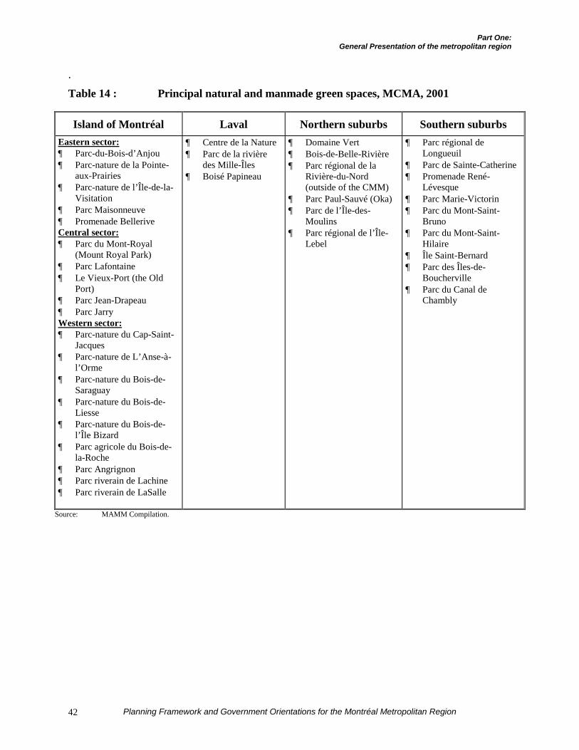
Part One:General Presentation of the metropolitan region
Planning Framework and Government Orientations for the Montréal Metropolitan Region42
.
Table 14 : Principal natural and manmade green spaces, MCMA, 2001
Island of Montréal Laval Northern suburbs Southern suburbsEastern sector:¶ Parc-du-Bois-d’Anjou¶ Parc-nature de la Pointe-
aux-Prairies¶ Parc-nature de l’Île-de-la-
Visitation¶ Parc Maisonneuve¶ Promenade BelleriveCentral sector:¶ Parc du Mont-Royal
(Mount Royal Park)¶ Parc Lafontaine¶ Le Vieux-Port (the Old
Port)¶ Parc Jean-Drapeau¶ Parc JarryWestern sector:¶ Parc-nature du Cap-Saint-
Jacques¶ Parc-nature de L’Anse-à-
l’Orme¶ Parc-nature du Bois-de-
Saraguay¶ Parc-nature du Bois-de-
Liesse¶ Parc-nature du Bois-de-
l’Île Bizard¶ Parc agricole du Bois-de-
la-Roche¶ Parc Angrignon¶ Parc riverain de Lachine¶ Parc riverain de LaSalle
¶ Centre de la Nature¶ Parc de la rivière
des Mille-Îles¶ Boisé Papineau
¶ Domaine Vert¶ Bois-de-Belle-Rivière¶ Parc régional de la
Rivière-du-Nord(outside of the CMM)
¶ Parc Paul-Sauvé (Oka)¶ Parc de l’Île-des-
Moulins¶ Parc régional de l’Île-
Lebel
¶ Parc régional deLongueuil
¶ Parc de Sainte-Catherine¶ Promenade René-
Lévesque¶ Parc Marie-Victorin¶ Parc du Mont-Saint-
Bruno¶ Parc du Mont-Saint-
Hilaire¶ Île Saint-Bernard¶ Parc des Îles-de-
Boucherville¶ Parc du Canal de
Chambly
Source: MAMM Compilation.
Part One:General Presentation of the metropolitan region
Planning Framework and Government Orientations for the Montréal Metropolitan Region 43
4. Lake of Two Mountains: together,Lake Saint Louis and Lake of TwoMountains contain most of the marinasin Greater Montréal. Mostly privatelyowned, the shores of Lake of TwoMountains hold several major recrea-tional and tourist facilities, particularlyParc Paul-Sauvé in Oka, which allowactivities such as hunting, fishing,swimming, camping, etc.
5. Rivière des Prairies: a mill site (forexample, Site des Moulins on Île-de-la-Visitation), this river is cut in two by animpassable hydroelectric dam which alsomakes the downstream section barelynavigable. Access to the Rivière desPrairies is limited upstream by theCheval Blanc rapids, which impose arestriction on pleasure navigation. Thedam has also resulted in changes to theecosystem, which nonetheless offers afew zones suitable for fishing and areasfor hunting wildfowl. Several regionalparks located on the Island of Montréaloccupy its shores.
6. Rivière des Mille-Îles: separating Lavalfrom the North Shore, this river, whichhas historically served as a site for manymills, is characterized by its shallowdepth which renders it suitable for smallcraft navigation and insular and riparianenvironments that are still in the naturalstate. Ecological and recreational andtourism reclamation work has beenslowly undertaken for the past severalyears.
7. Lac Saint-François: located in Sala-berry-de-Valleyfield, this lake is acces-sible from certain sections of the Seawaylocated in the Beauharnois Canal.
8. A project to reopen the SoulangesCanal, 23 kilometres long, to pleasurenavigation by private and public interests
is currently under study. Abandonedsince 1959, the canal is the object ofdiscussions with the aim of stimulatingrecreational and tourist developmentthrough the cultural and heritagedimension recalling the area’s history.
To these bodies of water should be addedthe Richelieu River, a section of which islocated in the MCMA between Carignan andNotre-Dame-de-Bonsecours in the southernpart and between Beloeil and Mont-Saint-Hilaire in the northern part. This body ofwater is not discussed directly, given thatonly part of the river runs through theMCMA. A joint task force made up of theCMM, MRC de Rouville, which is partiallyincluded in the CMM’s territory, and theRCMs through which the Richelieu Riverflows is necessary to produce a reclamationplan for the river.
C) Protected areas
Within the context of formulating theStrategy for Protected Areas, the Governmentof Québec has also determined the naturalland or marine areas dedicated for protectionand maintenance of biological diversity andthe associated natural and cultural resources.These natural spaces are legally designatedand administered to ensure their effectiveprotection and permanence22.
22 The definition of protected areas corresponds to the definition
of the World Union for the Conservation of Nature, namely: “ageographically defined portion of land, aquatic environment ormarine environment, specially dedicated to the protection andmaintenance of biological diversity and the associated naturaland cultural resources; for these purposes, this geographicspace must be legally designated, regulated and managed byeffective legal or other means.”
It will be understood that this definition excludes a large partof manmade green spaces, namely urban parks dedicated tosports and recreation and neighbourhood parks. Natural spaceswithout status and most wooded areas included in theagricultural zone established under the Québec Act to preserveagricultural land (QAPAL) are also excluded.
Part One:General Presentation of the metropolitan region
Planning Framework and Government Orientations for the Montréal Metropolitan Region44
According to the data of the Ministère del’Environnement23, the CMM includes 57protected areas covering an area of187.8 km², which corresponds to 4.3 % ofthe CMM’s territory. In comparison, theprotected areas in all of Québec represent2.84 % of the total area, while the worldaverage is about 8 %. The Island ofMontréal, with a total of 20 protected areas,has the biggest proportion of protectedareas, or 6 % of its territory. The areas in thenorthern and southern suburbs account for3.4 % of the territory of each of these rings,while in Laval, they represent less than 1 %.
Within the CMM’s territory, three quartersof the protected areas consist of wildlifehabitats, Québec parks and migratory birdsanctuaries. These various bodies of waterand shores contain most of the protectedareas in the CMM. An environment suitablefor flora and fauna to flourish, the Montréalarchipelago contains 42 of the 57 protectedareas, representing a total area of 144.47km². Within these areas, efforts to protectbiodiversity and natural and cultural resour-ces have mainly been directed at preservationof the Montérégiennes, particularly MountRoyal on the Island of Montréal, MontSaint-Hilaire and Mont Saint-Bruno on theSouth Shore, and the conservation ofregional parks such as Parc du DomaineVert on the North Shore.
Apart from the major basins and themountains, important natural environments,such as large wooded areas and wetlands,survive in the region. Some of these naturalenvironments are located within theurbanization perimeters. Designated for urbanpurposes and thus awaiting development,
23 Tellier, J. and Hodder, D., Stratégie sur les aires protégées.
Groupe de travail milieu urbain et périurbain. Supportingtechnical document. Summary report. (Consultation version).Ministère de l’Environnement, in collaboration with the CUM.May 2001.
these environments are gradually becomingfragmented or disappearing completely.
METROPOLITAN INFRASTRUCTURES ANDFACILITIES
The Montréal MCMA includes thefollowing metropolitan facilities and infra-structures :
¶ A Métro system consisting of 4 lines (65stations extending over nearly 61kilometres of track) (Map 8);
¶ A system of 4 commuter train linesincluding 40 stations over a network ofabout 180 kilometres (Map 8)24;
¶ A strategic transportation network(Map 9) integrating:
� the superior road network, namely allautoroutes and certain sections ofnational highways25;
� the two international airports, Dorvaland Mirabel;
� the Port of Montréal;� the two railway systems, Canadian
National and Canadian Pacific;� the Métro system, already mentioned,
is included in the strategictransportation network because of itsstrong influence on the regionaleconomy and the role it plays in tripsto the region’s major touristfacilities;
¶ 67 drinking water treatment facilities:41 treatment plants and 26 wells;
¶ 44 sewage treatment plants;
¶ 28 facilities for management of residualmaterials: 3 sanitary landfills, 7 dry
24 A fourth line (Mont-Saint-Hilaire / Montréal) came into
service in spring 2000 but is not yet completed.25 The superior road network covers 1,118 kilometres in the
MCMA.
Part One:General Presentation of the metropolitan region
Planning Framework and Government Orientations for the Montréal Metropolitan Region 45
material dumps, 18 sorting and recyclingcentres and transshipment stations.
In terms of facilities, the MCMA has:
¶ 37 higher education facilities (CEGEPsand universities) and many vocationaltraining and adult education centres;
¶ 148 health and social services facilities,including twenty general and specializedhospital centres26;
¶ 159 cultural facilities: 59 performancehalls, 43 museums and exhibition hallsand 57 libraries27 and archival documen-tation centres;
¶ 35 recreational and tourist facilities withmetropolitan influence;
¶ 189 classified historical monuments andheritage sites.
26 In all, the metropolitan region has 55 general and specialized
hospital centres. Only about twenty centres have ametropolitan or Québec-wide function.
27 It is important to note that municipal libraries are not includedin this inventory. Only libraries of metropolitan or Québec-wide scope are considered.

PART TWO GENERAL PROBLEM

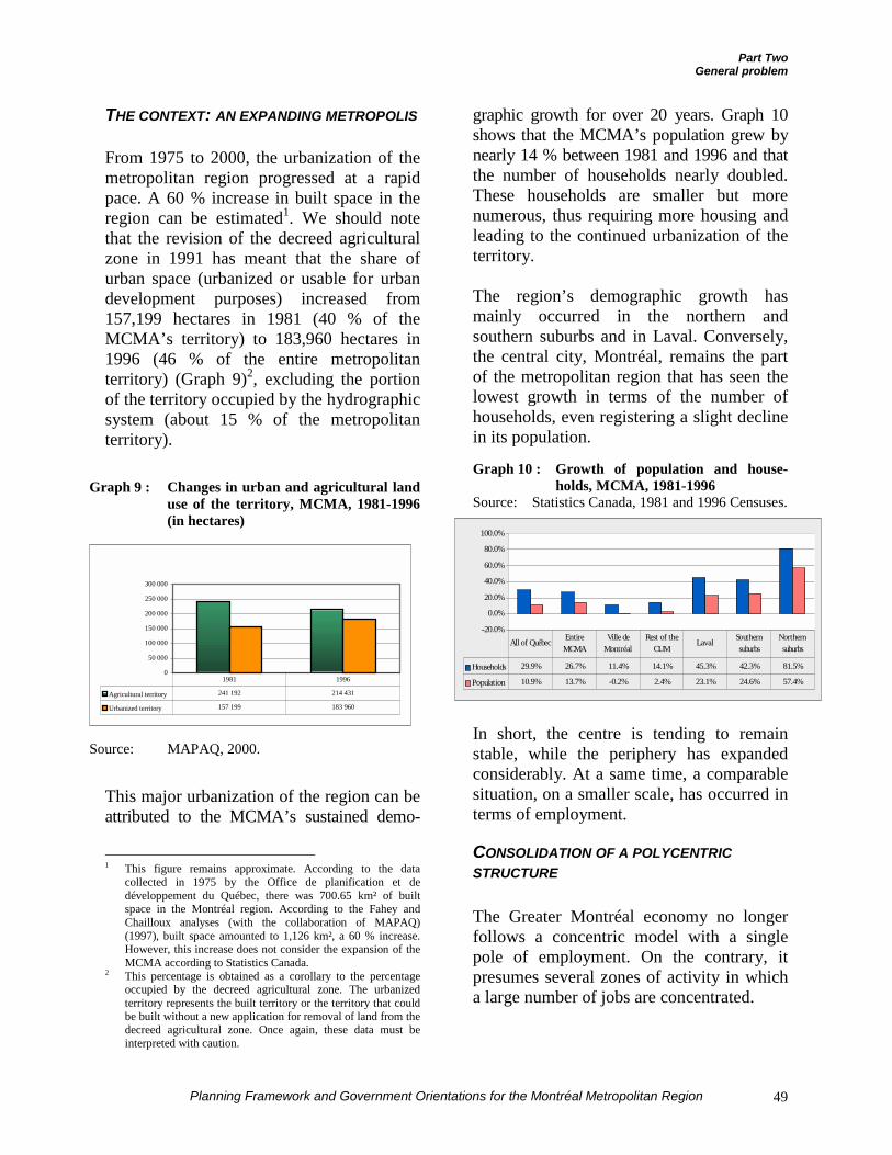
Part TwoGeneral problem
Planning Framework and Government Orientations for the Montréal Metropolitan Region 49
THE CONTEXT: AN EXPANDING METROPOLIS
From 1975 to 2000, the urbanization of themetropolitan region progressed at a rapidpace. A 60 % increase in built space in theregion can be estimated1. We should notethat the revision of the decreed agriculturalzone in 1991 has meant that the share ofurban space (urbanized or usable for urbandevelopment purposes) increased from157,199 hectares in 1981 (40 % of theMCMA’s territory) to 183,960 hectares in1996 (46 % of the entire metropolitanterritory) (Graph 9)2, excluding the portionof the territory occupied by the hydrographicsystem (about 15 % of the metropolitanterritory).
Graph 9 : Changes in urban and agricultural landuse of the territory, MCMA, 1981-1996(in hectares)
Source: MAPAQ, 2000.
This major urbanization of the region can beattributed to the MCMA’s sustained demo-
1 This figure remains approximate. According to the data
collected in 1975 by the Office de planification et dedéveloppement du Québec, there was 700.65 km² of builtspace in the Montréal region. According to the Fahey andChailloux analyses (with the collaboration of MAPAQ)(1997), built space amounted to 1,126 km², a 60 % increase.However, this increase does not consider the expansion of theMCMA according to Statistics Canada.
2 This percentage is obtained as a corollary to the percentageoccupied by the decreed agricultural zone. The urbanizedterritory represents the built territory or the territory that couldbe built without a new application for removal of land from thedecreed agricultural zone. Once again, these data must beinterpreted with caution.
graphic growth for over 20 years. Graph 10shows that the MCMA’s population grew bynearly 14 % between 1981 and 1996 and thatthe number of households nearly doubled.These households are smaller but morenumerous, thus requiring more housing andleading to the continued urbanization of theterritory.
The region’s demographic growth hasmainly occurred in the northern andsouthern suburbs and in Laval. Conversely,the central city, Montréal, remains the partof the metropolitan region that has seen thelowest growth in terms of the number ofhouseholds, even registering a slight declinein its population.
Graph 10 : Growth of population and house-holds, MCMA, 1981-1996
Source: Statistics Canada, 1981 and 1996 Censuses.
In short, the centre is tending to remainstable, while the periphery has expandedconsiderably. At a same time, a comparablesituation, on a smaller scale, has occurred interms of employment.
CONSOLIDATION OF A POLYCENTRICSTRUCTURE
The Greater Montréal economy no longerfollows a concentric model with a singlepole of employment. On the contrary, itpresumes several zones of activity in whicha large number of jobs are concentrated.
0
50 000
100 000
150 000
200 000
250 000
300 000
Agricultural territory 241 192 214 431
Urbanized territory 157 199 183 960
1981 1996
-20.0%
0.0%
20.0%
40.0%
60.0%
80.0%
100.0%
Households 29.9% 26.7% 11.4% 14.1% 45.3% 42.3% 81.5%
Population 10.9% 13.7% -0.2% 2.4% 23.1% 24.6% 57.4%
All of Québec Entire MCMA
Ville de Montréal
Rest of the CUM
Laval Southern suburbs
Northern suburbs
Part TwoGeneral problem
Planning Framework and Government Orientations for the Montréal Metropolitan Region50
Since 1981, the MCMA has confirmed andconsolidated six international poles domi-nating the metropolitan employment pool.Together, these six poles account for nearly82 % of the jobs of all the metropolitanpoles and represent nearly 34 % of theregion’s jobs. The global economicrestructuring, focused on exports, economicspecialization and international trade, hasaffected the MCMA’s employmentstructure: the poles of employment whichare consolidating and emerging are thosethat are focused on cross-border trade.
In general, between 1981 and 1996, jobswere concentrated in the metropolitan poles.They represented 39 % of all jobs in theMCMA in 1981, while in 1996, theirrelative share of metropolitan employmenthad risen to 40.6 %3. The position of themetropolitan poles of employment wasfurther strengthened during the 1996-1999period (Table 15).
This consolidation of employment is alsoconfirmed in the case of the six economicpoles where the international activities areconcentrated. They gained 92,115 jobsbetween 1981 and 1996, or 39.1 % of thejob growth observed for all poles. Between1996 and 1999, the six international polesagain achieved substantial growth of 20 %,an even higher rate than the othermetropolitan poles which grew theiremployment by 12 % between 1996 and1999.
3 See Coffey et al. (1999-2000), 2nd report, p. 44.
Visibly, downtown Montréal, whilemaintaining itself as the principal economicpole, is no longer the only sector that isgrowing constantly, making it the leadingplayer in the region’s economy. The Islandof Montréal includes other poles whichparticipate actively in metropolitaneconomic development. Other poles are alsobeginning to emerge on the periphery. Apolycentric urban form has therefore defineditself in Greater Montréal over the past 20years.
As in the case of households and population,employment in the MCMA mainly tends todevelop in the poles peripheral to downtownMontréal (Laval, Longueuil, Saint-Laurent /Dorval, Mirabel, etc.) instead of indowntown Montréal as such. There will thusbe some dispersion of jobs within a limitednumber of poles that dominate the metro-politan economic structure. With theglobalization of markets and internationa-lization of the economy, certain poles aretending to assert themselves as preponderantplayers in the metropolitan economy. Theseinternational poles should be developed ifthe MCMA wishes to take maximumadvantage of its achievements in terms ofeconomic development.
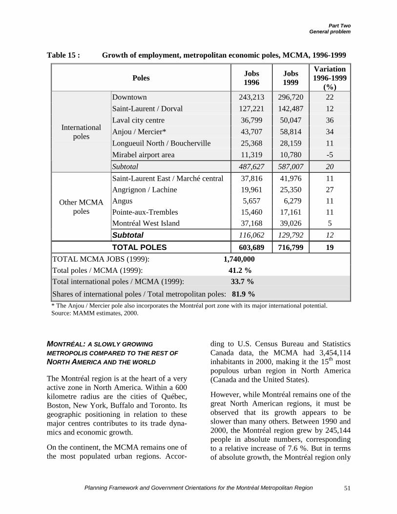
Part TwoGeneral problem
Planning Framework and Government Orientations for the Montréal Metropolitan Region 51
Table 15 : Growth of employment, metropolitan economic poles, MCMA, 1996-1999
Poles Jobs1996
Jobs1999
Variation1996-1999
(%)Downtown 243,213 296,720 22Saint-Laurent / Dorval 127,221 142,487 12Laval city centre 36,799 50,047 36Anjou / Mercier* 43,707 58,814 34Longueuil North / Boucherville 25,368 28,159 11Mirabel airport area 11,319 10,780 -5
Internationalpoles
Subtotal 487,627 587,007 20
Saint-Laurent East / Marché central 37,816 41,976 11Angrignon / Lachine 19,961 25,350 27Angus 5,657 6,279 11Pointe-aux-Trembles 15,460 17,161 11Montréal West Island 37,168 39,026 5
Other MCMApoles
Subtotal 116,062 129,792 12
TOTAL POLES 603,689 716,799 19TOTAL MCMA JOBS (1999): 1,740,000Total poles / MCMA (1999): 41.2 %Total international poles / MCMA (1999): 33.7 %Shares of international poles / Total metropolitan poles: 81.9 %* The Anjou / Mercier pole also incorporates the Montréal port zone with its major international potential.Source: MAMM estimates, 2000.
MONTRÉAL: A SLOWLY GROWINGMETROPOLIS COMPARED TO THE REST OFNORTH AMERICA AND THE WORLD
The Montréal region is at the heart of a veryactive zone in North America. Within a 600kilometre radius are the cities of Québec,Boston, New York, Buffalo and Toronto. Itsgeographic positioning in relation to thesemajor centres contributes to its trade dyna-mics and economic growth.
On the continent, the MCMA remains one ofthe most populated urban regions. Accor-
ding to U.S. Census Bureau and StatisticsCanada data, the MCMA had 3,454,114inhabitants in 2000, making it the 15th mostpopulous urban region in North America(Canada and the United States).
However, while Montréal remains one of thegreat North American regions, it must beobserved that its growth appears to beslower than many others. Between 1990 and2000, the Montréal region grew by 245,144people in absolute numbers, correspondingto a relative increase of 7.6 %. But in termsof absolute growth, the Montréal region only
Part TwoGeneral problem
Planning Framework and Government Orientations for the Montréal Metropolitan Region52
ranks 32nd among the metropolitan regionsof the United States and Canada. In absolutegrowth, the regions even slips to 193rd placein North America.
Even compared to metropolitan regions ofcomparable size, Montréal’s growth ismodest. Among metropolitan regions with atotal population of between 3 and 4 millionpeople in 2000, Montréal posted the lowestrelative growth (see the green circles on themap at the end of this section). Thus, theAtlanta, Miami / Fort Lauderdale, Seattle /Tacoma / Bremerton and Phoenix / Mesaregions all grew at a clearly higher rate thanMontréal, with respective increases of 39 %,21 %, 20 % and 45.3 % between 1990 and2000.
On the international economic front, theMCMA, even though it remains prosperous,maintains a modest position compared tosome of the world’s great cities. With its $82billion, the MCMA’s GDP only represents57 % of Toronto’s GDP ($144 billion), 54.6 %of Chicago’s GDP ($150 billion), 27 % of theParis GDP ($300 billion), barely 12 % of NewYork’s GDP ($650 billion) and less than10 % of Tokyo’s GDP of $850 billion in2000.
These data corroborate the figures takenfrom an analysis produced recently atUQAM on Québec’s place in the worldeconomy, and especially in the NorthAmerican economy4. Over the past tenyears, the cities of the southern and westernUnited States have appropriated the lion’sshare of demographic growth. These areabout the same cities that now influence theAmerican economy. A “Big L” followingthe north-south axis along the Pacific coastto Los Angeles and then running along aneast-west axis through the southern United 4 Luc-Normand Tellier, Évolution topodynamique mondiale des
productions : la place du Québec, UQAM, Départementd’études urbaines et touristiques, May 17, 2001, 20 pages.
States has defined itself. According toTellier, this accentuation of the “Big L” willcontinue so that, in the long term, NewYork’s economic influence will be sup-planted by that of Los Angeles and therebythat of the American southwest.
At a time of globalization of markets andtrade, a region’s success is directly related toits capacity to mobilize its political andsocioeconomic stakeholders so that theywork together on appropriate strategies toadopt to attract investments and assureinteresting living conditions for its citizens.While the Montréal region is still successfulin developing and still provides itsinhabitants with an interesting quality oflife, it must be observed that it does notderive full benefit from its achievements.Mobilization of all of its socioeconomicplayers is necessary to improve the region’scompetitiveness in relation to the rest of theworld.

Part TwoGeneral problem
Planning Framework and Government Orientations for the Montréal Metropolitan Region 53
Demographic growth in 1990-2000 and the “Big L”
According to economic growth projections produced at UQAM, the influence of the majorurban regions of the West coast and along the axis between Florida and California is gainingmore and more scope in the North American economy. The emergence of these new poles asagents dominating the continent’s economic system, and thereby its urban structure, has beencalled the “Big L” by Luc-Normand Tellier of UQAM.
The clear domination of the City of Los Angeles as the hub serving to articulate thesedynamics means that ultimately it will take over from New York as the continent’s economicleader. If this situation is concretized, it could have negative consequences for Montréal, whichis in New York’s area of influence.
WASHINGTON
MONTANA
OREGONIDAHO
WYAOMING
CALIFORNIA
NEVADAUTAH
ARIZONA
NEW MEXICO
COLORADO
NORTH DAKOTA
SOUTH DAKOTA
NEBRASKA
KANSAS
OKLAHOMA
TEXAS
MINNESOTA
IOWA
WISCONSIN
ILLINOIS
MISSOURI
ARKANSAS
MICHIGAN
INDIANA
OHIO
KENTUCKY
TENNESSEE
W.VA.
PENNSYLVANIA
NEW YORK
MD. DEL.
N.J.
VIGINIA
N.CAROLINA
VT.
N.H.
MAINE
MASS.R.I.
CONN.
S.CAROLINA
GEORGIAALABAMAMISSISIPI
FLORIDA
LOUISIANA
C A N A D A
Atlanta
BaltimoreWashington
Boston
Cincinnati
Columbus
Cleveland
Dallas
Denver
Detroit
Fort Worth
Houston
Indianapolis
Kansas City
Miami
Milwaukee
Minneapolis-St.Paul
Norfolk-Virginia Beach
OaklandPhiladelphia
Phoenix
Pittsburg
Portland
Sacramento
San Antonio
San Diego
San FranciscoSan Jose
Seattle
St.Louis
Tampa
Vancouver
Montréal
Toronto
O U E S T
S U D
CENTRE-OUESTNORD-EST
7,6%22%
83%
8,4%11%
28%
34%
30%
48%
Montréal
45 %
21 %
20 %
39 %
OUEST = WESTCENTRE-OUEST = MIDWESTNORD-EST = NORTHEASTSUD = SOUTH
Source: US Census Bureau and Statistics Canada.
NOTE: The data for Canadian cities are from 1991. The 2000 data are estimates that will have to be revised in the light of the2001 lt
Part Two:General problem
Planning Framework and Government Orientations for the Montréal Metropolitan Region54
THE LAND USE PLANNING PROBLEM IN THEMETROPOLITAN REGION
Specifically, the general problem of metro-politan land use is based on two majorpoints:
¶ The absence of a shared vision ofdevelopment resulting from fragmentedmanagement of the territory.
¶ Costly and unplanned urbanization on ametropolitan scale.
1. The absence of a shared vision ofdevelopment resulting from fragmentedmanagement of the territory
1.1 A multitude of administrative enti-ties in the region
Despite the reduction resulting from theadoption of Bill 170 in December 2000, thenumber of municipalities in GreaterMontréal’s territory still remains very high.Such a large number of local administrationsmake it difficult to achieve a consensusaround a shared development vision orproject. The superposition of administrativeplanning entities at various levels (RCM,RDC, REC, etc.) only increases this diffi-culty. The relevance of entrusting land useplanning and development to a singlemetropolitan entity – the Communautémétropolitaine de Montréal – is then betterperceived.
It is around the CMM Council, made up of28 members, that the debate on land useplanning will take place for the future ofGreater Montréal when the time comes toadopt the development plan. Drafted by asmaller council before being submitted topublic consultation, the strategic visionstatement and the metropolitan land use anddevelopment plan will allow faster and moreefficient convergence of all parts of theterritory around one and the same deve-lopment strategy. The reliance on a singleplan and the Government’s PlanningFramework will promote greater cohesion inland use and activate public decision-making on the question. Indeed, after thisplan comes into force, adherence to a sharedmetropolitan vision will contribute toensuring greater cohesion in drafting andimplementing municipal development plans.
1.2 The challenge of harmonization ofstrategic development plans
Government action in the metropolitanterritory has contributed to sector-basedstructuring of the region’s land use byarticulating development according to theterritory of the five administrative regionsoverlapping with the MCMA. Basing itsprograms and actions on criteria of spatialneutrality, partnership and consensus amongthe various stakeholders, the Governmenthad to respond to requests without basing itsresponses on a single metropolitan land usestrategy. Some examples presented later inthis document attest to this.
Moreover, the absence of vision is also feltin terms of economic development. Cove-ring five administrative regions and varyinglocal economic realities, the MCMA is notthe focus of a concerted economic deve-lopment strategy. In a context where each ofthe five administrative regions has adopted a
MCMA = 73 municipalities
3 municipalities representing 71 %of the MCMA’s population
5 administrative regions concerned
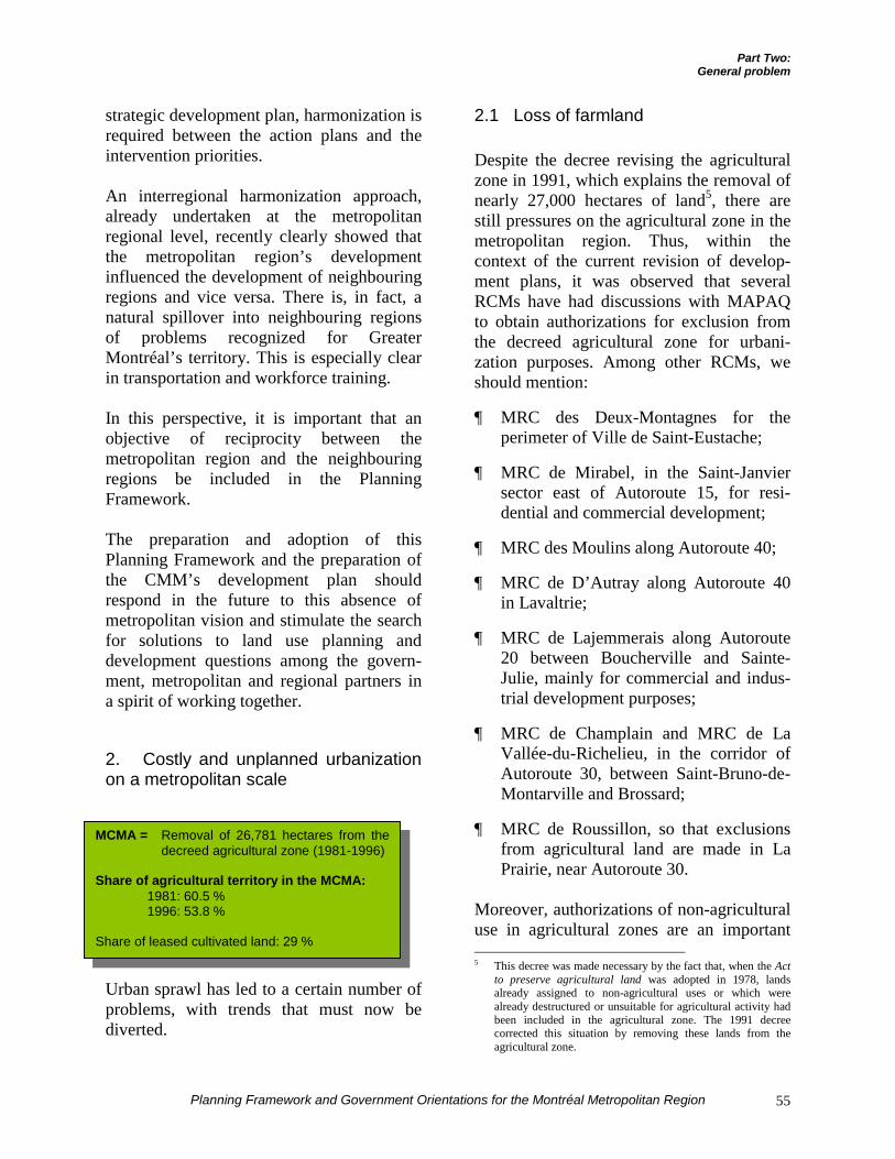
Part Two:General problem
Planning Framework and Government Orientations for the Montréal Metropolitan Region 55
strategic development plan, harmonization isrequired between the action plans and theintervention priorities.
An interregional harmonization approach,already undertaken at the metropolitanregional level, recently clearly showed thatthe metropolitan region’s developmentinfluenced the development of neighbouringregions and vice versa. There is, in fact, anatural spillover into neighbouring regionsof problems recognized for GreaterMontréal’s territory. This is especially clearin transportation and workforce training.
In this perspective, it is important that anobjective of reciprocity between themetropolitan region and the neighbouringregions be included in the PlanningFramework.
The preparation and adoption of thisPlanning Framework and the preparation ofthe CMM’s development plan shouldrespond in the future to this absence ofmetropolitan vision and stimulate the searchfor solutions to land use planning anddevelopment questions among the govern-ment, metropolitan and regional partners ina spirit of working together.
2. Costly and unplanned urbanizationon a metropolitan scale
Urban sprawl has led to a certain number ofproblems, with trends that must now bediverted.
2.1 Loss of farmland
Despite the decree revising the agriculturalzone in 1991, which explains the removal ofnearly 27,000 hectares of land5, there arestill pressures on the agricultural zone in themetropolitan region. Thus, within thecontext of the current revision of develop-ment plans, it was observed that severalRCMs have had discussions with MAPAQto obtain authorizations for exclusion fromthe decreed agricultural zone for urbani-zation purposes. Among other RCMs, weshould mention:
¶ MRC des Deux-Montagnes for theperimeter of Ville de Saint-Eustache;
¶ MRC de Mirabel, in the Saint-Janviersector east of Autoroute 15, for resi-dential and commercial development;
¶ MRC des Moulins along Autoroute 40;
¶ MRC de D’Autray along Autoroute 40in Lavaltrie;
¶ MRC de Lajemmerais along Autoroute20 between Boucherville and Sainte-Julie, mainly for commercial and indus-trial development purposes;
¶ MRC de Champlain and MRC de LaVallée-du-Richelieu, in the corridor ofAutoroute 30, between Saint-Bruno-de-Montarville and Brossard;
¶ MRC de Roussillon, so that exclusionsfrom agricultural land are made in LaPrairie, near Autoroute 30.
Moreover, authorizations of non-agriculturaluse in agricultural zones are an important 5 This decree was made necessary by the fact that, when the Act
to preserve agricultural land was adopted in 1978, landsalready assigned to non-agricultural uses or which werealready destructured or unsuitable for agricultural activity hadbeen included in the agricultural zone. The 1991 decreecorrected this situation by removing these lands from theagricultural zone.
MCMA = Removal of 26,781 hectares from thedecreed agricultural zone (1981-1996)
Share of agricultural territory in the MCMA:1981: 60.5 %1996: 53.8 %
Share of leased cultivated land: 29 %
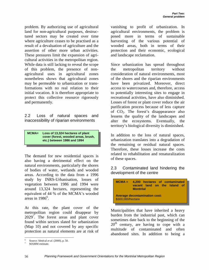
Part Two:General problem
Planning Framework and Government Orientations for the Montréal Metropolitan Region56
problem. By authorizing use of agriculturalland for non-agricultural purposes, destruc-tured sectors may be created over timewhere agriculture ceases to be practised as aresult of a devaluation of agriculture and theassertion of other more urban activities.These pressures limit the expansion of agri-cultural activities in the metropolitan region.While data is still lacking to reveal the scopeof this problem, the presence of non-agricultural uses in agricultural zonesnonetheless shows that agricultural zonesmay be permeable to urbanization or trans-formations with no real relation to theirinitial vocation. It is therefore appropriate toprotect this collective resource rigorouslyand permanently.
2.2 Loss of natural spaces andinaccessibility of riparian environments
The demand for new residential spaces isalso having a detrimental effect on thenatural environments, particularly the shoresof bodies of water, wetlands and woodedareas. According to the data from a 1996study by INRS-Urbanisation, losses ofvegetation between 1986 and 1994 werearound 13,324 hectares, representing theequivalent of 44 % of the MCMA’s woodedareas in 19866.
At this rate, the plant cover of themetropolitan region could disappear by20297. The forest areas and plant coverfound within sectors slated for urbanization(Map 10) and not covered by any specificprotection as natural elements are at risk of 6 Source: Sénécal et al. (2000), p. 50.7 MAMM estimate.
vanishing to profit of urbanization. Inagricultural environments, the problem isposed more in terms of sustainableharvesting of the various potential ofwooded areas, both in terms of theirprotection and their economic, ecologicaland landscape reclamation.
Since urbanization has spread throughoutthe metropolitan territory withoutconsideration of natural environments, mostof the shores and the riparian environmentshave been privatized. Moreover, directaccess to watercourses and, therefore, accessto potentially interesting sites to engage inrecreational activities, have also diminished.Losses of forest or plant cover reduce the airpurification process because of less captureof CO2. The forest’s disappearance alsolessens the quality of the landscapes andalter the ecosystems. Eventually, theterritory’s biological diversity is diminished.
In addition to the loss of natural spaces,urbanization translates into a degradation ofthe remaining or residual natural spaces.Therefore, these losses increase the costsrelated to rehabilitation and renaturalizationof these spaces.
2.3 Contaminated land hindering thedevelopment of the centre
Municipalities that have inherited a heavyburden from the industrial past, which cansometimes date back to the beginning of the20th century, are having to cope with amultitude of contaminated and oftenabandoned sites. In addition to being a
MCMA = 4,200 hectares of contaminatedvacant land on the Island ofMontréal
Average decontamination cost:$300,000/hectare
MCMA= Loss of 13,324 hectares of plantcover (forest, wooded areas, brush,etc.) between 1986 and 1994
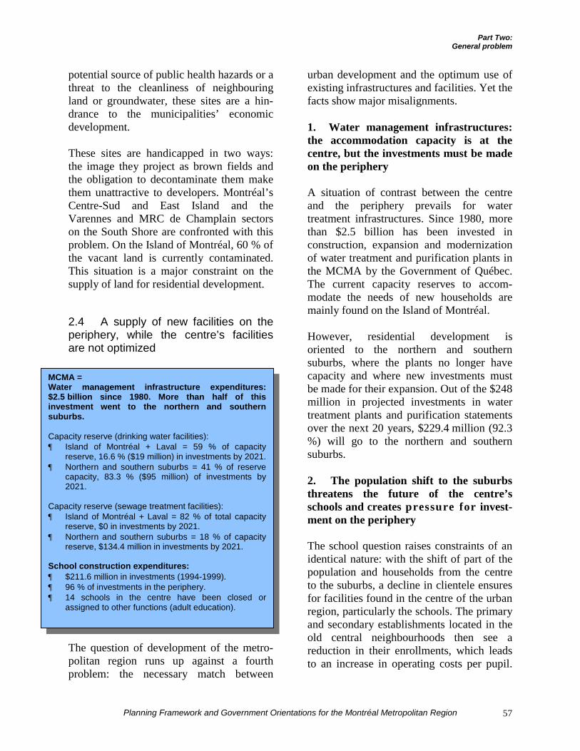
Part Two:General problem
Planning Framework and Government Orientations for the Montréal Metropolitan Region 57
potential source of public health hazards or athreat to the cleanliness of neighbouringland or groundwater, these sites are a hin-drance to the municipalities’ economicdevelopment.
These sites are handicapped in two ways:the image they project as brown fields andthe obligation to decontaminate them makethem unattractive to developers. Montréal’sCentre-Sud and East Island and theVarennes and MRC de Champlain sectorson the South Shore are confronted with thisproblem. On the Island of Montréal, 60 % ofthe vacant land is currently contaminated.This situation is a major constraint on thesupply of land for residential development.
2.4 A supply of new facilities on theperiphery, while the centre’s facilitiesare not optimized
The question of development of the metro-politan region runs up against a fourthproblem: the necessary match between
urban development and the optimum use ofexisting infrastructures and facilities. Yet thefacts show major misalignments.
1. Water management infrastructures:the accommodation capacity is at thecentre, but the investments must be madeon the periphery
A situation of contrast between the centreand the periphery prevails for watertreatment infrastructures. Since 1980, morethan $2.5 billion has been invested inconstruction, expansion and modernizationof water treatment and purification plants inthe MCMA by the Government of Québec.The current capacity reserves to accom-modate the needs of new households aremainly found on the Island of Montréal.
However, residential development isoriented to the northern and southernsuburbs, where the plants no longer havecapacity and where new investments mustbe made for their expansion. Out of the $248million in projected investments in watertreatment plants and purification statementsover the next 20 years, $229.4 million (92.3%) will go to the northern and southernsuburbs.
2. The population shift to the suburbsthreatens the future of the centre’sschools and creates pressure for invest-ment on the periphery
The school question raises constraints of anidentical nature: with the shift of part of thepopulation and households from the centreto the suburbs, a decline in clientele ensuresfor facilities found in the centre of the urbanregion, particularly the schools. The primaryand secondary establishments located in theold central neighbourhoods then see areduction in their enrollments, which leadsto an increase in operating costs per pupil.
MCMA =Water management infrastructure expenditures:$2.5 billion since 1980. More than half of thisinvestment went to the northern and southernsuburbs.
Capacity reserve (drinking water facilities):¶ Island of Montréal + Laval = 59 % of capacity
reserve, 16.6 % ($19 million) in investments by 2021.¶ Northern and southern suburbs = 41 % of reserve
capacity, 83.3 % ($95 million) of investments by2021.
Capacity reserve (sewage treatment facilities):¶ Island of Montréal + Laval = 82 % of total capacity
reserve, $0 in investments by 2021.¶ Northern and southern suburbs = 18 % of capacity
reserve, $134.4 million in investments by 2021.
School construction expenditures:¶ $211.6 million in investments (1994-1999).¶ 96 % of investments in the periphery.¶ 14 schools in the centre have been closed or
assigned to other functions (adult education).
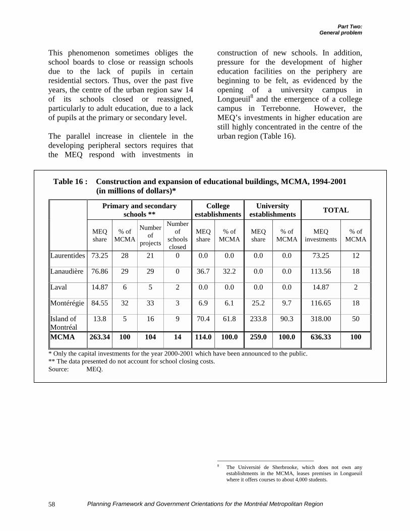
Part Two:General problem
Planning Framework and Government Orientations for the Montréal Metropolitan Region58
This phenomenon sometimes obliges theschool boards to close or reassign schoolsdue to the lack of pupils in certainresidential sectors. Thus, over the past fiveyears, the centre of the urban region saw 14of its schools closed or reassigned,particularly to adult education, due to a lackof pupils at the primary or secondary level.
The parallel increase in clientele in thedeveloping peripheral sectors requires thatthe MEQ respond with investments in
construction of new schools. In addition,pressure for the development of highereducation facilities on the periphery arebeginning to be felt, as evidenced by theopening of a university campus inLongueuil8 and the emergence of a collegecampus in Terrebonne. However, theMEQ’s investments in higher education arestill highly concentrated in the centre of theurban region (Table 16).
8 The Université de Sherbrooke, which does not own any
establishments in the MCMA, leases premises in Longueuilwhere it offers courses to about 4,000 students.
Table 16 : Construction and expansion of educational buildings, MCMA, 1994-2001(in millions of dollars)*
Primary and secondaryschools **
Collegeestablishments
Universityestablishments TOTAL
MEQshare
% ofMCMA
Numberof
projects
Numberof
schoolsclosed
MEQshare
% ofMCMA
MEQshare
% ofMCMA
MEQinvestments
% ofMCMA
Laurentides 73.25 28 21 0 0.0 0.0 0.0 0.0 73.25 12
Lanaudière 76.86 29 29 0 36.7 32.2 0.0 0.0 113.56 18
Laval 14.87 6 5 2 0.0 0.0 0.0 0.0 14.87 2
Montérégie 84.55 32 33 3 6.9 6.1 25.2 9.7 116.65 18
Island ofMontréal
13.8 5 16 9 70.4 61.8 233.8 90.3 318.00 50
MCMA 263.34 100 104 14 114.0 100.0 259.0 100.0 636.33 100
* Only the capital investments for the year 2000-2001 which have been announced to the public.** The data presented do not account for school closing costs.Source: MEQ.
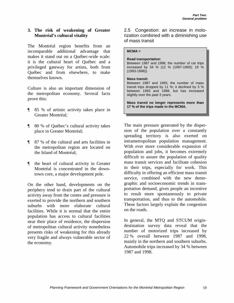
Part Two:General problem
Planning Framework and Government Orientations for the Montréal Metropolitan Region 59
3. The risk of weakening of GreaterMontréal’s cultural vitality
The Montréal region benefits from anincomparable additional advantage thatmakes it stand out on a Québec-wide scale:it is the cultural heart of Québec and aprivileged gateway for artists, both fromQuébec and from elsewhere, to makethemselves known.
Culture is also an important dimension ofthe metropolitan economy. Several factsprove this:
¶ 85 % of artistic activity takes place inGreater Montréal;
¶ 80 % of Québec’s cultural activity takesplace in Greater Montréal;
¶ 87 % of the cultural and arts facilities inthe metropolitan region are located onthe Island of Montréal;
¶ the heart of cultural activity in GreaterMontréal is concentrated in the down-town core, a major development pole.
On the other hand, developments on theperiphery tend to drain part of the culturalactivity away from the centre and pressure isexerted to provide the northern and southernsuburbs with more elaborate culturalfacilities. While it is normal that the entirepopulation has access to cultural facilitiesnear their place of residence, the dispersionof metropolitan cultural activity nonethelesspresents risks of weakening for this alreadyvery fragile and always vulnerable sector ofthe economy.
2.5 Congestion: an increase in moto-rization combined with a diminishing useof mass transit
The main pressure generated by the disper-sion of the population over a constantlyspreading territory is also exerted onintrametropolitan population management.With ever more considerable expansion ofpopulation and jobs, it becomes extremelydifficult to assure the population of qualitymass transit services and facilitate cohesionin their trips, especially for work. Thisdifficulty in offering an efficient mass transitservice, combined with the new demo-graphic and socioeconomic trends in trans-portation demand, gives people an incentiveto result more spontaneously to privatetransportation, and thus to the automobile.These factors largely explain the congestionon the roads.
In general, the MTQ and STCUM origin-destination survey data reveal that thenumber of motorized trips increased by22 % overall between 1987 and 1998,mainly in the northern and southern suburbs.Automobile trips increased by 34 % between1987 and 1998.
MCMA =
Road transportation:Between 1987 and 1998, the number of car tripsincreased by 34 % (12 % (1997-1993); 19 %(1993-1998)).
Mass transit:Between 1987 and 1993, the number of masstransit trips dropped by 11 %; it declined by 3 %between 1993 and 1998, but has increasedslightly over the past 3 years.
Mass transit no longer represents more than17 % of the trips made in the MCMA.
Part Two:General problem
Planning Framework and Government Orientations for the Montréal Metropolitan Region60
Parallel to this, the relative modal share ofuse of mass transit systems – Métro andcommuter trains – has declined constantlysince 1982, even though ridership on thesesystems could still be substantiallyincreased. Between 1993 and 1998, masstransit lost 3 % of its modal share. In thelight of the measures announced in theMTQ’s Plan de gestion des déplacements(trip management plan) and the AMT’s Planstratégique de développement (strategicdevelopment plan), it is an accepted factthat, within 10 years, the accommodationcapacity and flexibility of the mass transitsystems will have increased substantiallythanks to major government and metro-politan investments. The challenge over thenext few years will therefore be to convincemotorists to use mass transit services to theextent that these can better respond to theirtravelling needs.
However, since the population does not onlylive in the development axes defined above,the organization and optimization of publictransit systems adapted to the distribution ofclientele becomes difficult, particularly dueto the increase in these systems’ operatingcosts.
1. Origin-destination survey data andtrends
The data from the 1998 origin-destinationsurvey (Graph 11) comparing the changes inmass transit trips and by car between 1987and 1988 reveal that, everywhere, car tripshave increased by a greater proportion thanthe population.
Mass transit has lost ground mainly in thebest-served zones: 110,000 less daily trips inthe centre of the Island of Montréal, 58,000less in the rest of the Island, and 23,000 lessin Laval and Longueuil, representing a totalloss of 191,000 daily trips in these three
regions. Mass transit appears to have grownstrongly in the northern and southernsuburbs: 17,000 additional daily trips wereregistered between 1987 and 1998, for a34.7 % increase. However, this informationmust be put in perspective: out of 10 masstransit trips lost in the other three regions,less than one was recovered in the northernand southern suburbs. Mass transit onlyaccounted for 3 % of the growth ofmotorized trips in the northern and southernsuburbs, compared to 97 % for the auto-mobile. This is not surprising, because theautomobile population of the northern andsouthern suburbs grew by 162,000 vehicles,also between 1987 and 1998.
While population growth in the region canexplain the growth of number of cars in theterritory and therefore the increase inmotorized trips, some special conditions inmetropolitan demographic trends allow thisphenomenon to be qualified further. Threecauses more specifically explain the genera-lized increase in motorization and theabandonment of mass transit.
In the first place, the arrival at maturity ofthe baby boom age cohorts, the principalsegment of the active population, is a majorcause of increased motorization. The babyboom generation, because of its place in thejob market, has a greater tendency to travelby car than young people. The phenomenonis especially important given that house-holds from this generation have two activespouses, each often using a vehicle to getaround. We should add that the absence ofplanning and channeling of jobs in zonesspecifically served by mass transit hascertainly constituted an additional factorwhich has given part of the workforce anincentive to resort more readily to cars fortravel between home and work.
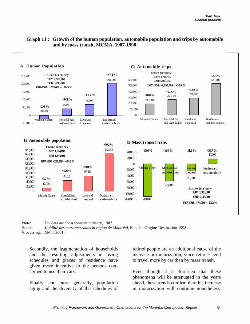
Part Two:General problem
Planning Framework and Government Orientations for the Montréal Metropolitan Region 61
Note: The data are for a constant territory, 1987.Source: Mobilité des personnes dans la région de Montréal, Enquête Origine-Destination 1998.Processing: AMT, 2001.
Secondly, the fragmentation of householdsand the resulting adjustments in livingschedules and places of residence havegiven more incentive to the persons con-cerned to use their cars.
Finally, and more generally, populationaging and the diversity of the schedules of
retired people are an additional cause of theincrease in motorization, since retirees tendto travel more by car than by mass transit.
Even though it is foreseen that thesephenomena will be attenuated in the yearsahead, these trends confirm that this increasein motorization will continue nonetheless.
A: Human Population
45,00071,000
204,000
-21,000
-50,000
0
50,000
100,000
150,000
200,000
250,000
Montréal Centre Montréal Eastand West Island
Laval andLongueuil
Northern andsouthern suburbs
-2.0 %
+6.3 %+11.7 %
+37.1 %Entire territory1987: 2,910,0001998: 3,209,000
1987-1998: +299,000 = +10.3 %
C: Automobile trips
193,000266,000 298,000
538,000
0
100, 000
200,000
300,000
400,000
500,000
600,000
Montréal Centre Montréal Eastand West Island
Laval andLongueuil
Northern andsouthern suburbs
+18.8 %+27.6 %
+33.0 %
+61.5 %Entire territory
1987: 3,768,4191998: 5,063,419
1987-1998: +1,195,000 = +34.4 %
B: Automobile population
12,976
46,83167,419
162,072
020,00040,00060,00080,000
100,000120,000140,000160,000180,000
+3.7 %
+15.6 %+23.8 %
+59.2 %Entire territory
1987: 1,204,6931998: 1,494,001
1987-1998: +289,308 = +24.0 %
Montréal Centre Montréal Eastand West Island
Laval andLongueuil
Northern andsouthern suburbs
D: Mass transit trips
-110,000
-58,000
17,000
-23,000
-120,000-100,000
-80,000
-60,000
-40,000
-20,0000
20,000
40,000 -15,6 % -16.0 % -11.2 % +34.7 %
Entire territory1987: 1,323,0001998: 1,149,000
1987-1998: -174,000 = - 13.2 %
Montréal Centre Montréal Eastand West Island
Laval andLongueuil
Northern andsouthern suburbs
Graph 11 : Growth of the human population, automobile population and trips by automobileand by mass transit, MCMA, 1987-1998
Part Two:General problem
Planning Framework and Government Orientations for the Montréal Metropolitan Region62
The MTQ’s most recent trip trend projec-tions for the Montréal region9 give reason tobelieve that if nothing is done:
¶ There will be 8.9 million trips per day inthe metropolitan region in 2021, or 9 %more than in 1998;
¶ The number of motorized trips will growfaster than the number of non-motorizedtrips, reaching 7.9 million per day, anincrease of nearly 12 % for the sameperiod;
¶ The number of self-driven trips duringthe morning rush hour10 will rise from923,000 to 1,103,000 between 1998 and2021, an increase of nearly 20 %;
¶ The bridges ringing the Island ofMontréal will be more heavily used in2021 in the morning rush hour becausethe number of self-driven trips onto theIsland of Montréal will increase by17,400, including 78 % on Rivière desPrairies alone;
¶ Mass transit demand will decline, for theregion as a whole, by around 42,000trips in the morning rush hour to around288,000 trips, a drop of nearly 13 %;
¶ Two thirds of this decline can beattributed to trips within the Island ofMontréal; mass transit trips in themorning rush hour will fall by 28,000between 1998 and 2021;
¶ On the Island of Montréal, car poolingtrips (automobiles with passengers) inthe morning rush hour will decline by14,900 between 1998 and 2021, com-
9 Déplacements des personnes dans la grande région de
Montréal: Scénario prévisionnel 2021 tendanciel, Service dela modélisation des systèmes de transport, MTQ, May 2001.
10 The morning rush hour is defined as the period from 6 a.m. to9 a.m.
pared to a drop of 12 %, or 29,000, forthe region as a whole;
¶ The combined effect of receding masstransit demand and increased automobiledemand will cause the modal share ofmass transit throughout the region to fallfrom 22 % in 1998 to 18 % in 2021, stillfor the morning rush hour;
¶ The number of bimodal trips, involvingboth the automobile and mass transit(particularly through incentive parking),will remain stable at approximately35,000 for the morning rush hour,between 1998 and 2021;
¶ The number of trips made by people age50 and over will increase by 57 %, whilethose by people ages 0 to 49 willdecrease by 4 %;
¶ Nearly 75 % of the projected decline inmass transit trips concerns trips todowntown and the centre of the Island ofMontréal. More than half of theadditional automobile trips will be madewithin each subregion.
These projections give an overview of thefuture by assuming maintenance of thetrends at work in previous years, that is, inthe absence of any initiative intended tochange this behaviour. Their function is toalert public and private decision-makers tothe problems that risk arising in the future ifno action is taken to change the trends ofpast years. It remains that increasedmotorization of the population, particularlywomen and young people, the growth in thenumber of automobile trips and thecontinued decline of mass transit are in noway inevitable.
Mass transit ridership is closely related tothe accessibility of heavy modes (Métro,
Part Two:General problem
Planning Framework and Government Orientations for the Montréal Metropolitan Region 63
train). In this regard, it must be pointed outthat between 1961 and 1991, the Métro’sdirect area of influence has lost 354,000inhabitants, one third of its originalpopulation, while the rest of the metro-politan region saw its population grow by1,373,000 inhabitants11. This situation ispartially attributable to the aging populationand the reduction of the size of householdsin the centre of the Island of Montréal.Nonetheless, the experience of Toronto,where the population in the areas ofinfluence of heavy modes of transport wasmaintained and even increased slightly by4,000 people between 1961 and 1991 thanksto residential development of the areas ofinfluence, proves that it is possible tocounterbalance these effects. The MCMAwould have every advantage in redevelopingthese spaces to guarantee a constant clientelefor mass transit infrastructures through apolicy of repopulation of the areas ofinfluence of heavy modes of mass transit.
In recent years, the population shift from thecentre to the northern and southern suburbshas certainly slowed, but have not reversed.Indeed, the most recent data from the Institutde la statistique du Québec indicate that,since 1996, the Island of Montréal hascontinued to lose an average of 3,000inhabitants per year, while the northern andsouthern suburbs are still gaining more than15,000 per year.
Regardless of the efforts applied to improvethe supply of mass transit in the northernand southern suburbs, it will never bepossible to compensate for the losses ofusers registered in the old central neighbour-hoods. The results of the 1987 and 1998origin-destination surveys are very clear inthis regard. Indeed, for every ten trips lost inthe centre, only one could be recovered in 11 See R. Bergeron, Évolution 1961-1991 des caractéristiques
socio-démographiques des populations vivant à proximité dumétro: Comparaison entre Montréal et Toronto, 1998.
the northern and southern suburbs, sincemass transit only assumed 3 % of the newdemand for motorized transportation.
Urban expansion today affects employmentand housing. Still according to the 1987 and1998 origin-destination surveys, the centralpart of the Island of Montréal lost 34,000employment destinations during this period,while the northern and southern suburbsgained exactly the same number. Expressedas a percentage, the loss is 6 % at the centre,while the gain is 41 % in the northern andsouthern suburbs. According to anothersource12, between 1981 and 1996, the zonesoutside the pole of employment receivedhalf of the 235,300 jobs that were addedduring this period in the metropolitanregion. The dispersion of jobs to urbanenvironments practically impossible to serveby mass transit, but easily accessible byautomobile, must be recognized as one ofthe leading factors in the decline of masstransit.
Although a levelling off of trips by personsin the next decade may contribute to limitingcongestion, the trends observed reinforce theimportance of continuing to develop mea-sures promoting more sustainable transpor-tation, whether in terms of land use planningor priority use of mass transit.
2. Transportation and economic activity
Historically, the MCMA’s superior roadnetwork was constituted on the basis ofserving the Island of Montréal as theprincipal employment and industrial zone, asevidenced by the convergence of the mainhighway axes. Today, the main highwaysleading to the centre of the urban region still 12 William J. Coffey, Claude Manzagol and Richard G.
Shearmur, “L’évolution spatiale de l’emploi dans la régionmétropolitaine de Montréal, 1981-1996”, Cahiers degéographie du Québec, Volume 44, nº 123, December 2000.
Part Two:General problem
Planning Framework and Government Orientations for the Montréal Metropolitan Region64
end at Autoroute 40 (Métropolitaine), whichtends to crystallize traffic congestion there.The network is also discontinuous, witheight highway arteries forming an incom-plete route13.
The Island of Montréal also brings togetherthe main industrial zones that generate or arehighly dependent on trucking activities,particularly due to the major presence ofmanufacturing companies, wholesalers andretailers. The performance of these econo-mic sectors remains heavily dependent onthe level and productivity of transport ofgoods by truck.
All these factors contribute to making itmore and more difficult to use the highways,particularly due to the heavy competitionbetween motorists and truckers during rushhours14. All the available data show thatcongestion problems are tending to worseninstead of lessening.
The daily traffic on weekdays on the 15bridges giving access to the Island ofMontréal is a prime indicator of the state ofcongestion in the metropolitan region.Between 1987 and 1998, it grew from935,000 vehicles to 1,325,000, an increaseof 42 %, corresponding to an average annualgrowth rate of 3.22 %. The Jacques-Cartierand Champlain Bridges are saturated everyday for many hours, with daily traffictotalling 120,000 vehicles for the former and150,000 for the latter.
The bridges act as bottlenecks for theregion’s entire overland transportationnetwork. They offer gripping images of theproblems caused by congestion. With thefunction of giving access to the Islands of
13 The same problem applies to the arterial network (for example,
the Rodolphe-Forget / Bourget axis, Boulevard Marien, etc.).14 In this regard, see Maps 5 and 6 of Plan de gestion des
déplacements (trip management plan) of the Ministère desTransports.
Montréal and Laval, the bridges also feedthe highway and arterial network with trafficthat becomes denser every day. Yet thecapacity reserve of the highway systemseems to be zero in many places on theIsland of Montréal and at the approaches tothe bridges leading there, on the near SouthShore and on part of the Laval network, aswell as on the bridges leading from theNorth Shore to Laval. This is whyautomobile transit traffic increasingly spillsover into the arterial network, and even intothe residential sectors. Today it can be saidthat congestion at the centre of the urbanregion is tending to become a problem thatis no longer localized and ad hoc, butgeneralized in space and time.
2.6 A DETERIORATION OF THE ENVIRON-MENT RESULTING FROM THE INCREASE INGREENHOUSE GAS EMISSIONS
The increase in the number of motorvehicles and their more frequent use for tripscombined with the decline in the modalshare of mass transit contribute directly tothe deterioration of the physical environ-ment because of greenhouse gas emissionsresulting from the high volume of gasolineconsumed.
These greenhouse gases contribute to globalwarming, which leads in turn to a deterio-ration of natural environments and eco-systems. The general quality of life in theMCMA is thereby reduced.
MCMA = Greenhouse gas emissionsattributable to transportation(CO2 equivalent):
1994: 10.3 million tonnes
2000: 12 million tonnes
Part Two:General problem
Planning Framework and Government Orientations for the Montréal Metropolitan Region 65
In Québec, in 1990, manmade greenhousegas emissions, expressed as CO2 equivalent,were estimated at 81.9 million tonnes. In1996, this volume increased to 83.4 milliontonnes. If nothing is done to limit theirgrowth15, it is forecast that the emissionswill reach 94.1 million tonnes in 2011, then105.7 million tonnes in 2026. For the entireperiod 1990-2026, the expected growth istherefore 23.8 million tonnes or 29 %. Weshould point out that when applied toQuébec, the Canadian target set at Kyoto, a6 % reduction in emissions by the 2008-2012 period from their 1990 level, wouldmean that total greenhouse gas emissions bythat date would correspond to a volume of77 million tonnes per year.
The transportation sector is producing thefastest increase in greenhouse gas emissions.For the entire 1990-2026 period, it isforecast that the volume will rise from 30.4million to 45.3 million tonnes, a 49 %increase. Thus, transportation, which ac-counted for 34 % of manmade greenhousegas emissions in 1990 in Québec and 38 %in 1998, could represent 43 % in 2026.
On the average, an automobile driving inQuébec produces 5 tonnes of greenhousegases per year, or 3.5 times its own weight.In the case of heavy trucks, the averageannual greenhouse gas production is around85 tonnes, clearly more than 10 times theempty weight of the vehicles.
In the Montréal metropolitan region, for theentire year 1994, it was estimated that thegreenhouse gas emissions totalled 24.4million tonnes (CO2 equivalent). The shareattributable to the automobile was 6.7million tonnes as opposed to 3.9 for urban
15 That is, according to the reference model of the Ministère des
Ressources naturelles du Québec. See Groupe de travail sur lestransports, Mécanisme québécois de concertation sur leschangements climatiques, Problématique des transports et deschangements climatiques au Québec, December 2000.
trucking and 0.3 for urban buses, orapproximately 11 million tonnes for thetransportation sector, 45 % of totalemissions. According to a MENV expert,this figure would currently be around 12million tonnes per year. The speed of thisgrowth is explained by the growth rate of2 % per year of the automobile population ofthe metropolitan region (289,000 morevehicles between 1987 and 1998) and 2.6 %per year in the daily number of truck trips(93,000 in 1990, 120,000 in 2000).
Graph 12 clearly shows the determining roleplayed by the metropolitan region in theenvironmental problem of transportation inQuébec. The growth of urban trucking forthe transport of goods and of automobile usein the northern and southern suburbs forindividual mobility are the two main enginesof the apprehended growth of manmadegreenhouse gas emissions in Québec.
Even though trucking is a dynamic andautonomous sector, it nonetheless would beappropriate to initiate a process of reflectionfor urban transport of goods, similar to theprocess over the past few years forpassenger transportation. Several channelsare available for this reflection, whether inland use planning (analysis of the potentialfor consolidating businesses and stores insectors or in poles targeted and served by thesuperior road network, establishment ofdistribution centres, etc.), the environment(use of vehicles with lower energyconsumption) or the search for betteradapted transportation strategies, parti-cularly by moving ahead with reflection onrail and road intermodality applied to thecase of the region.
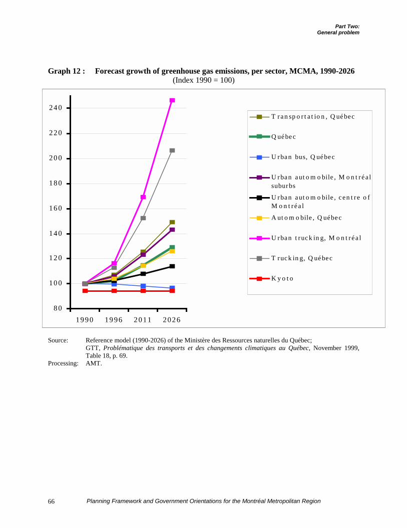
Part Two:General problem
Planning Framework and Government Orientations for the Montréal Metropolitan Region66
Graph 12 : Forecast growth of greenhouse gas emissions, per sector, MCMA, 1990-2026(Index 1990 = 100)
Source: Reference model (1990-2026) of the Ministère des Ressources naturelles du Québec;GTT, Problématique des transports et des changements climatiques au Québec, November 1999,Table 18, p. 69.
Processing: AMT.
8 0
10 0
12 0
14 0
16 0
18 0
20 0
22 0
24 0
199 0 19 96 2 011 202 6
T ra n sp o r t a t io n , Q ué bec
Q ué be c
U rba n bus, Q ué be c
U rba n a ut o m o bile , M o n t ré a lsuburbs
U rba n a ut o m o bile , c e n t re o fM o n t ré a l
A ut o m o bile , Q uébe c
U rba n t ruc k in g, M o n t ré a l
T ruc k in g, Q ué be c
K y o t o
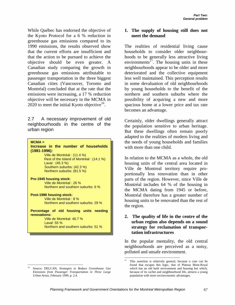
Part Two:General problem
Planning Framework and Government Orientations for the Montréal Metropolitan Region 67
While Québec has endorsed the objective ofthe Kyoto Protocol for a 6 % reduction ingreenhouse gas emissions compared to its1990 emissions, the results observed showthat the current efforts are insufficient andthat the action to be pursued to achieve theobjective should be even greater. ACanadian study comparing the growth ingreenhouse gas emissions attributable topassenger transportation in the three biggestCanadian cities (Vancouver, Toronto andMontréal) concluded that at the rate that theemissions were increasing, a 17 % reductionobjective will be necessary in the MCMA in2020 to meet the initial Kyoto objective16.
2.7 A necessary improvement of oldneighbourhoods in the centre of theurban region
16 Source: DELCAN, Strategies to Reduce Greenhouse Gas
Emissions from Passenger Transportation in Three LargeUrban Areas, February 1999, p. 2.4.
1. The supply of housing still does notmeet the demand
The realities of residential living causehouseholds to consider older neighbour-hoods to be generally less attractive livingenvironments17. The housing units in theseneighbourhoods appear to be older and moredeteriorated and the collective equipmentless well maintained. This perception resultsin some devaluation of old neighbourhoodsby young households to the benefit of thenorthern and southern suburbs where thepossibility of acquiring a new and morespacious home at a lower price and tax ratebecomes an advantage.
Certainly, older dwellings generally attractthe population sensitive to urban heritage.But these dwellings often remain poorlyadapted to the realities of modern living andthe needs of young households and familieswith more than one child.
In relation to the MCMA as a whole, the oldhousing units of the central area located inVille de Montreal territory require pro-portionally less renovation than in otherparts of the region. However, since Ville deMontréal includes 64 % of the housing inthe MCMA dating from 1945 or before,Montréal therefore has a greater number ofhousing units to be renovated than the rest ofthe region.
2. The quality of life in the centre of theurban region also depends on a soundstrategy for reclamation of transpor-tation infrastructures
In the popular mentality, the old centralneighbourhoods are perceived as a noisy,polluted and unsafe environment. 17 This assertion is relatively general, because a case can be
found that escapes this logic, that of Plateau Mont-Royalwhich has an old built environment and housing but which,because of its cachet and neighbourhood life, attracts a youngpopulation with more socioeconomic advantages.
MCMA =Increase in the number of households(1981-1996):
Ville de Montréal : (11.4 %)Rest of the Island of Montréal : (14.1 %)Laval : (45.3 %)Southern suburbs: (42.3 %)Northern suburbs: (81.5 %)
Pre-1945 housing stock:Ville de Montréal : 26 %Northern and southern suburbs: 6 %
Post-1986 housing stock:Ville de Montréal : 8 %Northern and southern suburbs: 29 %
Percentage of old housing units needingrenovations:
Ville de Montréal: 46.7 %Laval: 55 %Northern and southern suburbs: 51 %
Part Two:General problem
Planning Framework and Government Orientations for the Montréal Metropolitan Region68
A recent survey once again confirmed thatsafety for children and tranquility are thetwo main reasons why the majority ofhouseholds prefer the residential suburbs tothe central city18. Conversely, the mainadvantage invoked by those who, whilefinancially capable of leaving Montréal,nonetheless choose to live there, is to avoidbottlenecks. If there were a “winningcombination” it would consist of offeringsafe and peaceful living environments in thecentral city and in the centre of the urbanregion.
However, once residential developmentmoves away from urban activity and isestablished in the periphery to satisfyhouseholds seeking a tranquil environment,remoteness and the distances to be travelledgreatly complicate the establishment of amass transit service and give new residentsan incentive to use their cars.
Yet the factor that has the mostconsequences for the tranquility and securityof living environments undeniably isautomobile traffic. In this regard, it isappropriate to distinguish between residentand non-resident traffic, since the formertends to be considered as a legitimate rightand the latter as an invasion.
Table 17 shows the 89 % of vehicle tripsregistered downtown are made by non-residents, while the proportion is only10 %19 in the northern and southern suburbs.Thus, the downtown core is accuratelyperceived as noisy and unsafe, whileconversely the northern and southernsuburbs are rightly considered to be environ- 18 André Pratte, series of three articles published in La Presse on
June 10, 11 and 12, 2000. According to this survey, lowertaxes and home prices, or lower rents for tenants, are farbehind as reasons.
19 The available statistics pertain to the morning rush hour andthe entire day (24 hours). During the morning rush hour, it canbe considered that there is equivalency between origin tripsand resident trips, as is the case here. There is no reason forthe rates to be different over a 24-hour period, even though theavailable statistics cannot prove this.
ments offering tranquility and safety. Theseperceptions appear to be all the more well-founded when the number of non-residenttrips is considered. In the northern andsouthern suburbs, which cover a vastterritory, only 33,000 non-resident vehicletrips were counted in the morning rush hourin 1998. In the centre of the Island ofMontréal, where the grid of arteries andstreets absorbs the essential traffic flows,there were 189,000 vehicle trips. Thiscontributes to maintenance of an undesirablesituation where the central neighbourhoodshave to deal with unwanted automobiletraffic which indirectly fuels a persistentimage of a polluted and less safe environ-ment at the centre of the urban region.
A change of approach in urban developmentwhere services would be concentrated andwhere mass transit would be more valuedcould turn this situation around. To achievethis, development should be channeled tothe area of influence of heavy modes ofmass transit (Métro, trains) to encourageresidents to use them on a regular basis. Thisapproach would promote an improvement inthe quality of life limiting trips, whichwould reduce overall motorized traffic andthe nuisances associated with it20.
20 According to the Groupe de travail sur les transports, op.cit., on
the average each year for each household choosing to residenear the Métro instead of on the periphery of the metropolitanarea, the following could be estimated:
- 1,050 less automobile trips;- a 15,000 kilometre reduction in urban automobile
kilometrage;- which is the equivalent of the complete
elimination of one automobile, in this instance,the household’s second vehicle;
- a 6,000 kilogram reduction in greenhouse gasemissions;
- 625 more mass transit trips;- 425 more trips on foot or bicycle.
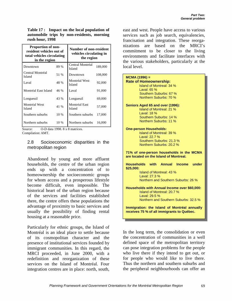
Part Two:General problem
Planning Framework and Government Orientations for the Montréal Metropolitan Region 69
Table 17 : Impact on the local population ofautomobile trips by non-residents, morningrush hour, 1998
Proportion of non-resident vehicles out of
total vehicles circulatingin the region
Number of non-residentvehicles circulating in
the region
Downtown 89 % Central MontréalIsland 189,000
Central MontréalIsland 51 % Downtown 108,000
Laval 48 % Montréal WestIsland 92,000
Montréal East Island 46 % Laval 91,000
Longueuil 43 % Longueuil 69,000
Montréal WestIsland 41 % Montréal East
Island 57,000
Southern suburbs 10 % Southern suburbs 17,000
Northern suburbs 10 % Northern suburbs 16,000
Source: O-D data 1998. 8 x 8 matrices.Compilation: AMT.
2.8 Socioeconomic disparities in themetropolitan region
Abandoned by young and more affluenthouseholds, the centre of the urban regionends up with a concentration of tohomeownership the socioeconomic groupsfor whom access and a prosperous lifestylebecome difficult, even impossible. Thehistorical heart of the urban region becauseof the services and facilities establishedthere, the centre offers these populations theadvantage of proximity to basic services andusually the possibility of finding rentalhousing at a reasonable price.
Particularly for ethnic groups, the Island ofMontréal is an ideal place to settle becauseof its cosmopolitan character and thepresence of institutional services founded byimmigrant communities. In this regard, theMRCI proceeded, in June 2000, with aredefinition and reorganization of theseservices on the Island of Montréal. Fourintegration centres are in place: north, south,
east and west. People have access to variousservices such as job search, equivalencies,francisation and integration. These reorga-nizations are based on the MRCI’scommitment to be closer to the livingenvironments and facilitate interfaces withthe various stakeholders, particularly at thelocal level.
In the long term, the consolidation or eventhe concentration of communities in a welldefined space of the metropolitan territorycan pose integration problems for the peoplewho live there if they intend to get out, orfor people who would like to live there.Thus the northern and southern suburbs andthe peripheral neighbourhoods can offer an
MCMA (1996) =Rate of Homeownership:
Island of Montreal: 34 %Laval: 65 %Southern Suburbs: 67 %Northern Suburbs: 70 %
Seniors Aged 65 and over (1996):Island of Montreal: 21 %Laval: 18 %Southern Suburbs: 14 %Northern Suburbs: 11 %
One-person Households:Island of Montreal: 39 %Laval: 22.7 %Southern Suburbs: 21.3 %Northern Suburbs: 20.2 %
71% of one-person households in the MCMAare located on the Island of Montreal.
Households with Annual Income under$25,000:
Island of Montreal: 43 %Laval: 27.3 %Northern and Southern Suburbs: 26 %
Households with Annual Income over $60,000:Island of Montreal: 20.7 %Laval: 29.5 %Northern and Southern Suburbs: 32.5 %
Immigration: the Island of Montréal annuallyreceives 75 % of all immigrants to Québec.
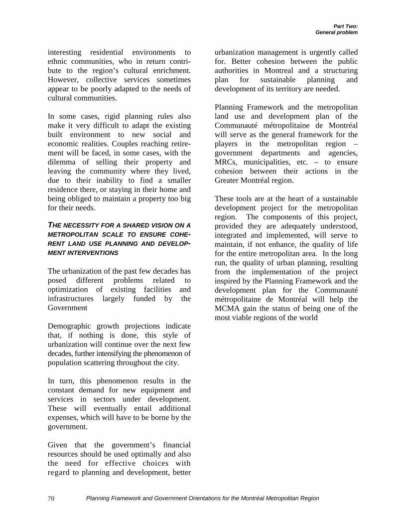
Part Two:General problem
Planning Framework and Government Orientations for the Montréal Metropolitan Region70
interesting residential environments toethnic communities, who in return contri-bute to the region’s cultural enrichment.However, collective services sometimesappear to be poorly adapted to the needs ofcultural communities.
In some cases, rigid planning rules alsomake it very difficult to adapt the existingbuilt environment to new social andeconomic realities. Couples reaching retire-ment will be faced, in some cases, with thedilemma of selling their property andleaving the community where they lived,due to their inability to find a smallerresidence there, or staying in their home andbeing obliged to maintain a property too bigfor their needs.
THE NECESSITY FOR A SHARED VISION ON AMETROPOLITAN SCALE TO ENSURE COHE-RENT LAND USE PLANNING AND DEVELOP-MENT INTERVENTIONS
The urbanization of the past few decades hasposed different problems related tooptimization of existing facilities andinfrastructures largely funded by theGovernment
Demographic growth projections indicatethat, if nothing is done, this style ofurbanization will continue over the next fewdecades, further intensifying the phenomenon ofpopulation scattering throughout the city.
In turn, this phenomenon results in theconstant demand for new equipment andservices in sectors under development.These will eventually entail additionalexpenses, which will have to be borne by thegovernment.
Given that the government’s financialresources should be used optimally and alsothe need for effective choices withregard to planning and development, better
urbanization management is urgently calledfor. Better cohesion between the publicauthorities in Montreal and a structuringplan for sustainable planning anddevelopment of its territory are needed.
Planning Framework and the metropolitanland use and development plan of theCommunauté métropolitaine de Montréalwill serve as the general framework for theplayers in the metropolitan region –government departments and agencies,MRCs, municipalities, etc. – to ensurecohesion between their actions in theGreater Montréal region.
These tools are at the heart of a sustainabledevelopment project for the metropolitanregion. The components of this project,provided they are adequately understood,integrated and implemented, will serve tomaintain, if not enhance, the quality of lifefor the entire metropolitan area. In the longrun, the quality of urban planning, resultingfrom the implementation of the projectinspired by the Planning Framework and thedevelopment plan for the Communautémétropolitaine de Montréal will help theMCMA gain the status of being one of themost viable regions of the world
PART THREE THE GOVERNMENT’S VISION STATEMENT ON LAND USE PLANNING AND DEVELOPMENTAND THE CONCEPT OF SPATIAL ORGANIZATION

Part Three:The Government’s vision statementand the concept of spatial organization
Planning Framework and Government Orientations for the Montréal Metropolitan Region 73
WHAT WILL THEGREATER
MONTRÉAL REGIONLOOK LIKE IN 2021?WHAT WILL BE THEQUALITY OF THE AIR
ITS INHABITANTSBREATHE?
WHAT WILL BE THEQUALITY OF LIFE IN
ITSNEIGHBOURHOODS?
FOR AN ATTRACTIVE, COMPETITIVE ANDVIABLE METROPOLIS WORKING INSOLIDARITY
What will the Greater Montréal region looklike in 2021? What will the quality of life ofits inhabitants be? Will we have achievedthe greenhouse gas reduction objectives?Will the mobility of passengers and goodsbe suitably ensured? Will the sustainabilityof agricultural land have been guaranteed?Will the quality of land use planning in theurban region be a factor favouringeconomic development? These areall questions raised by the PlanningFramework.
As mentioned in Part Two, theabsence of a metropolitan planningvision has contributed to thedispersion of population throughoutits territory1, leading to overcon-sumption of land, the destruction ofa large part of the agricultural zone
1 It is generally admitted that the urban development of major
cities in the second half of the 20th century has followed theCar Oriented Development (COD) model. With the emergenceof these various problems, urban development must now beoriented to systematic use of mass transit systems anddensification of the urban fabric, a model that the Americanshave labelled Transit Oriented Development (TOD), patternedon the routes of heavy modes of public transportation. In thisdevelopment model, mass transit is no more no less than theskeleton of the urban form.
and public costs of infrastructures and publicservices. It has also resulted in phenomenalgrowth in the number of automobiles on theroads and congestion on every bridge to theIsland of Montréal. The accentuation oftransport in the region translates into thedaily emission of nearly 33,000 CO2equivalent tonnes of greenhouse gases2,affecting air quality and public health.
These trends are asserting themselves eventhough the Québec Government has adheredto the major Kyoto objectives, established in
1997, and specifically to theCanadian objective of reducinggreenhouse gas emissions by 6 %from their 1990 levels. A change ofdirection is necessary3.
The Planning Framework points inthe same direction as the QuébecAction Plan on Climate Change,which relevantly cites the advan-tages of tighter control of urban
expansion and reduced automobile use:
“ … What are we to do about our urbanand rural areas? And, what are ourpriorities? ”
“ The social benefits in restraining urbanexpansion, reducing the use and role ofcars in cities, breathing a cleaner air,lowering noise pollution, using urbantransport means that promote physicalactivity and well-being, shortening transittime, revegetating and shading cities,maintaining the same level of comfort inour buildings using less energy, andpromoting mass transit, togetherness,public awareness, openness towards othercultures and renewing with collective
2 Estimate calculated based on the current share of emissions
attributable to transportation in the MCMA, which would be12 million tonnes (CO2 equivalent), a figure which itself is anestimate.
3 A report of the International Scientific Group on ClimateChange maintains that global warming in the 21st centurycould be worse than the most pessimistic scenarios advancedup to now (cited by L.G. Francoeur in Le Devoir, October 27,2000).
Part Three:The Government’s vision statementand the concept of spatial organization
Planning Framework and Government Orientations for the Montréal Metropolitan Region74
consciousness are numerous. Furthermore,these benefits are also accompanied byenvironmental, health and economicaladvantages.4 ”
A VISION STATEMENT FOR LAND USEPLANNING
The Government is adopting the followingvision statement for sustainable andcoherent development of the metropolitanregion. This statement constitutes thecornerstone on which the orientations willbe based. Its content and scope may alsoinspire the Communauté métropolitaine deMontréal in the preparation of its ownstrategic vision statement, as specified insection 127 of the Act respecting theCommunauté métropolitaine de Montréal.
Optimistic and inspired, this vision aims atthe 2021 horizon, after several disciplinedyears of land use planning and development.
Structured according to the main missionspursued by the Québec Government, thisvision takes on the challenge of greaterprosperity and a better individual andcollective quality of life for the future of theMontréal metropolitan region.
With sustainable development as itswatchword, this vision relies both onbiological diversity and the rational use ofresources, and on social ethics in the use ofthese resources, both between generationsand among the different groups of society.
Finally, four words forcefully illustrate theessentials of this vision: solidarity, attrac-tiveness, competitiveness and viability.
4 Québec Government, Québec Action Plan on Climate Change,
2000-2002, p. 19.
SOCIAL MISSION
n 2021… the economic prosperity of theGreater Montréal area will allowregional sharing of wealth in the name of
social solidarity. The focus on managedgrowth will be associated with a concern forsocial equity for present and futurecommunities. The real environmental andsocial cost of growth will thus be paid bythose who enjoy the benefits of this growth.
Greater Montréal’s old or deterioratedneighbourhoods will then be major elementsof the identity of Montréal region.Rehabilitated in respect for their historicalmemory, these neighbourhoods will benefitfrom a great urban quality of life.
In general, Montréal’s space will becharacterized by its great mix of residentpopulations. The metropolitan region will bemade up of many communities with adiversity of profiles. Each will offer avariety of habitats, and each will display itsown personality. These neighbourhoods willbe dense and stand out from each other.Public spaces will have been developedeverywhere to allow and encourage civicexchanges that are rewarding from everyperspective.
The organization of healthcare will beadapted to the special needs of an agingpopulation in a concern for accessibility andequity, while considering the singularvocation of Greater Montréal. First-linehealthcare services will thus be located nearthe clienteles, while many specializedservices and facilities, on the cutting edge ofnew technologies and metropolitan in scope,will remain accessible at the centre of theurban region. This specialization of thecentre of Greater Montréal, recognized andencouraged, will contribute to Québec’sself-sufficiency in healthcare.
I
Part Three:The Government’s vision statementand the concept of spatial organization
Planning Framework and Government Orientations for the Montréal Metropolitan Region 75
At the same time, the well-being andpersonal growth of children and youngergenerations will be valued. Both at thecentre of the urban region and in theneighbourhoods on the periphery, publicinitiatives will seek to attract and servefamilies based on their chosen place ofresidence.
EDUCATIONAL AND CULTURAL MISSION
n 2021… the acquisition of knowledgeand education, in their broadest accep-tance, will be every citizen’s concern.
Throughout the metropolitan region, a solidnetwork of primary and secondary schoolswill be deployed, designed to meet theeducation needs of the younger generationsbut also conceived to enrich local com-munity dynamics. The centre of GreaterMontréal will continue to accommodatemost of the institutions of higher educationand research centres, which will contributeoverall to the urban region’s competitiveadvantage. The contribution of institutionsof higher education to Greater Montréal’seconomic and cultural development will berecognized and encouraged.
In its dealings with foreign countries, themetropolitan region will proudly continue toaffirm its status as the biggest French-speaking population centre in the Americas,while benefiting from the cohabitation of thetwo founding peoples, its cosmopolitanismand the bilingualism – and evenmulticulturalism – of its population.
The Montréal region will be recognizedworldwide for the excellent creativity andvitality of its artistic community. Ville deMontréal, in particular, will remainQuébec’s main cultural pole and its drawingpower, encouraged by the public authorities,
will reflect on Québec as a whole. Parallel tothis, a wide variety of neighbourhoodcultural services will be offered to residentsof the northern and southern suburbs.
The Montréal metropolitan region will havemany heritage complexes and numerouscultural attributes admirably preserved. Thecultural dimension of water and nature willbe preserved and enhanced. These attrac-tions will contribute to the region’s touristpotential.
The Montréal metropolitan region will bedistinguished by its tolerance and opennessto diversity, an aspect that will contribute toits civic cohesion as a metropolitan entity.People of all origins will recognize eachother as citizens of the same regionalcommunity. The contribution of newcomersto the metropolitan region’s social, culturaland economic development will be solicitedand valued.
ECONOMIC AND ENVIRONMENTAL MISSION
n 2021… the economy of the Montréalmetropolitan region will be prosperous,viable, competitive, free trading, and
geared to knowledge and innovation. At thesame time, its structure will remaindiversified. The industrial sector, GreaterMontréal’s distinctive trademark in the past,will have been preserved. The engine ofQuébec’s economy, Greater Montréal, in theage of globalization, will also be its windowon the world, focused on exports and theinternational community.
The municipalities of the metropolitanregion will then be familiar with a viabledevelopment model which will meet theneeds and aspirations of their inhabitants.Growth will have been managed to preservea prosperous lifestyle and improve its
I
I
Part Three:The Government’s vision statementand the concept of spatial organization
Planning Framework and Government Orientations for the Montréal Metropolitan Region76
citizens’ quality of life. Greater Montréalwill offer a variety of living andemployment environments. The vision state-ment adopted twenty years earlier will havemade it possible to frame and establishpriorities concerning the new developmentprojects proposed.
The metropolitan region will be developedby consolidating and densifying a polycen-tric urban form within the urbanizationperimeter. The centre of the metropolitanregion will continue, in this context, to playa major role in employment. The concen-tration of major cultural and tourist facilitiesand of the healthcare and educationnetworks will contribute to the vigour of theregion’s centre.
At the same time, other poles likeAnjou / Mercier, Longueuil / Boucherville,Saint-Hubert, Saint-Laurent / Dorval, Lavalcity centre and the Montréal Foreign TradeZone at Mirabel will play an important rolein defining the region’s identity. Publicinvestments will be concentrated in thehistorical poles of employment and resi-dence. They will emerge from the region toconsolidate the vocation of these poles. Thedevelopment of structuring projects will befavoured in these areas. The results ofstrategy, adopted several years earlier, willprove to be particularly opportune in havingcontributed to the metropolitan region’scompetitiveness and viability.
The permanence of the territorial base forthe practice and development of agriculturewill have been assured. The priority use ofland in agricultural zones for agriculturalpurposes will then be an established fact.The agricultural zone will be considered anessential component of the urban ecosystemand an integral part of the sense of affiliationto the metropolitan community. The contri-bution of agricultural activity to Greater
Montréal’s economic dynamism will berecognized. The cohabitation betweenagricultural and non-agricultural uses inagricultural zones and the interface betweenthe agricultural zone and the urban zone willbe harmonious. The encroachment andexpansion of urbanization in the agriculturalzone will have been limited. Real estatespeculation will no longer be an obstacle toa dynamic agricultural metropolitaneconomy, since many agricultural lands willhave been reassembled and revitalized.Metropolitan agri-food production will thenbe recognized and renowned for its qualityand economic competitiveness.
For its recreational needs and touristpotential, the metropolitan region will relyon a network of major regional parks whichwill be completed by a large reserve ofgreen spaces located in the centre of GreaterMontréal. In the first place, Mount Royalwill be reclaimed and recognized by everyinhabitant of the region as the emblematicheritage site par excellence of the metro-politan region. The views of the mountainwill have been protected, which willbeautify the metropolitan landscape.
The shores, islands and bodies of water ofthe metropolitan territory will also havebeen protected and reclaimed, as well as theMonteregian hills. The region will benefitfrom air and water of outstanding quality.Important environments in terms ofbiological diversity will have been pre-served, while efforts to reduce industrialpollution attributable to atmospheric emis-sions will have borne fruit.
Public investments will support a growthstrategy for the region, inspired by theprinciples of sustainable development andresponding to planning choices. Urbandevelopment will primarily be geared towhat already exists: neighbourhoods, buil-
Part Three:The Government’s vision statementand the concept of spatial organization
Planning Framework and Government Orientations for the Montréal Metropolitan Region 77
dings, economic poles, infrastructures, va-cant spaces and decontaminated land. TheMontréal metropolitan region will be livingin an era of urban redevelopment.
Goods and people will benefit fromincreased mobility in the metropolitanregion. Manufacturing, distribution andemployment centres will be linked totransportation and communication networksin a planned and coordinated manner, whichwill help to ensure their reach.
The region’s inhabitants will be able to getaround easily to run errands, entertainthemselves and socialize. Walking, bicy-cling and mass transit will be attractivechoices to travel in the neighbourhood or getto regional service centres or places outsidethe urban area. Greater Montréal will berecognized for its low dependence on theautomobile.
From a land use planning and developmentperspective, the combined action of thevarious government authorities will beconsidered to have contributed, over theyears, to a significant tightening of theeffects of urban expansion. Governmentintervention ultimately will have favouredthe consolidation of the existing urban zonesand economic poles while ensuring theprotection of certain spaces (agriculturalzone; shores, islands and bodies of water;green spaces in the centre; woods on theperiphery; flood plains).
According to a management tradition thatwill be solidly rooted by then, governmentplanning of the use of unbuilt territory willconsider sensitive environments : water, soiland environments of interest because of theirflora, fauna or forests.
GOVERNANCE AND JUSTICE MISSION
n 2021… citizens will be closelyinvolved in civic life and democraticprocesses. Everyone will have the
impression that they have a forum andopportunity to be heard and to influencedecision-making. Political leadership andcommunity commitment will be recognizedas important values for collective well-being.
Personal security will be ensured throughoutthe metropolitan region so that harm topersons, property and goods is reduced to aminimum.
There will be a very great sense ofbelonging to the Montréal metropolitancommunity, which will contribute positivelyto the region’s dynamic spirit. The problemof fragmentation of territories, powers andservices will surely have been overcome byrespecting the imperatives of efficientmetropolitan management.
The region’s political and administrativeorganization will be based on the principalof subsidiarity and will make equity,partnership, quality of life and sustainabledevelopment its core values.
A vision of the Greater Montréal’s future,endorsed by all government departments andagencies and updated regularly, will ensurethe coherence of government interventionsin metropolitan territory.
I
Part Three:The Government’s vision statementand the concept of spatial organization
Planning Framework and Government Orientations for the Montréal Metropolitan Region78
n 2021… the MCMA will therefore rankin the forefront of major metropolitanregions in terms of its prosperity and
outstanding quality of life. It will gain thisenvied position after 20 years of makingsolidarity, attractiveness, competitivenessand viability the keys to its land useplanning and development.
Such, at least, is the wager that this vision ofthe future of the Montréal metropolitanregion allows us to make.
THE CONCEPT OF SPATIAL ORGANIZATION
To concretize this planning vision and beassured of sustainable development for thefuture, a form of organization is needed inwhich development can take root. Relyingon the region’s strengths, the spatialorganization concept presented here isdesigned to assure the desired sustainabilityfor the region’s development in the decadesahead.
The spatial organization concept comprisesthe main structuring elements of theMontréal metropolitan region in terms ofurbanization, land use and development ofthe territory. These elements representundeniable achievements that it nonethelessappears imperative to consolidate or reclaimas part of a comprehensive developmentstrategy. The spatial organization conceptbrings together the main strengths of themetropolitan region which, within a per-spective of consolidation and enhancement,would contribute to the concretization of thegovernment vision.
This concept has been formulated byconsidering the metropolitan region’s exis-ting development and the problems stated bythe government departments and agencies.The concept is also inspired by the various
works done previously, particularly by theCity of Montréal on the occasion of Plantémoin Horizon 2000 in 1967, by theCommission de développement de la régionde Montréal in 1970 on the development ofthe Mirabel Airport region and by the Officede planification et de développement duQuébec in 1978 during preparation of theOption préférable d'aménagement for theGreater Montréal region.
A CONCEPT BASED ON NINE ELEMENTSARTICULATED AROUND THE PRINCIPLE OFSUSTAINABLE DEVELOPMENT
The spatial organization concept comprisesthe following elements (Map 11):
1. A dynamic centre for the urban regionand central neighbourhoods that can berevitalized at the heart of the metropo-litan region.
2. Six priority economic poles where theinternational activities to be reinforcedare concentrated and on whichmetropolitan economic development canbe based.
3. Outlying suburbs surrounding the centreof the urban region, interfacing betweenthe urban fabric, the agricultural zoneand the major basins.
4. An east-west industrial axis includingthe Saint-Laurent / Dorval, Downtownand Anjou / Mercier poles, which shouldbe networked and served by an efficienttransportation service.
5. A north-south service axis linking thepriority poles and secondary poles to benetworked and developed, based on theirmass transit infrastructures.
I
Part Three:The Government’s vision statementand the concept of spatial organization
Planning Framework and Government Orientations for the Montréal Metropolitan Region 79
6. An agricultural zone occupying 54 % ofthe territory of the MCMA, which mustbe protected and reclaimed.
7. An accessible network of green spacesand major basins to be protected andreclaimed.
8. A network of census urban areas locatedon the perimeter of the MCMA,supporting the economic and urbandevelopment of Greater Montréal andwhich will be home to nearly 338,000people in 2021.
9. A rural ring outside the MCMA,requiring planning, protection andenhancement of its natural and culturalcharacter and tourist potential.
1. A DYNAMIC CENTRE FOR THE URBANREGION AND CENTRAL NEIGHBOUR-HOODS THAT CAN BE REVITALIZED ATTHE HEART OF THE METROPOLITANREGION
The spatial organization concept depends, inthe first place, on the consolidation andrevitalization of the centre of the urbanregion. The notion of “ centre of the urbanregion” was developed by the ministère desTransports within the context of itspreparation of the Plan de gestion desdéplacements (trip management plan). Thecentre of the urban region corresponds to azone of economic activity generallycontained between the centre of Île de Laval,between Autoroutes 15 and 19, on the north,the centre of the Island of Montréal, fromAnjou to Pointe-Claire running east to west,and from Rivière des Prairies to the SaintLawrence River, and most of the territory ofMRC de Champlain, on the South Shore.
The centre of the urban region is theprincipal place of the region’s employment(70 % of the jobs in the MCMA are foundthere), businesses and collective services. Itincludes the historical heart of the GreaterMontréal region from which the economicstructure of the metropolitan region hasdeveloped.
2. SIX PRIORITY ECONOMIC POLESWHERE THE INTERNATIONAL ACTI-VITIES TO BE REINFORCED ARECONCENTRATED AND ON WHICHMETROPOLITAN ECONOMIC DEVELOP-MENT CAN BE BASED
The spatial organization concept is based onthe presence of a series of economic poleswhere more than 34 % of the metropolitanregion’s 1.7 million jobs are concentrated.More specifically, the six economic poleshave a function that provides them withcrucial scope in the spatial organization ofthe metropolitan region because of thepresence of international companies andactivities already or potentially locatedthere. These poles are:
¶ Downtown Montréal : 296,720 jobs;
¶ Saint-Laurent/Dorval, bringing together142,487 jobs and including DorvalInternational Airport;
¶ Anjou / Mercier, including nearly 58,814jobs and an expanding port zone;
¶ Laval city centre, with 50,047 jobs;
¶ Longueuil / Boucherville / Saint-Hubert,which brings together 28,159 jobs andincludes an airport inventory with greatpotential and a regional commercialpole;
Part Three:The Government’s vision statementand the concept of spatial organization
Planning Framework and Government Orientations for the Montréal Metropolitan Region80
¶ The Mirabel Foreign Trade Zone, withfacilities and available space that make ita site with great development potentialand which has 10,780 jobs.
The territory also includes a group of publicservice centres and industrial sites withactivities that complement the priorityeconomic poles. The function and specificrole of each will have to be determined bythe Communauté métropolitaine during thepreparation of the metropolitan land use anddevelopment plan.
It is now an established fact that the MirabelForeign Trade Zone, chosen for its potentialfor attracting businesses with internationalreach, will be the focus of measuresintended to channel and structuredevelopment and growth there in a mannerthat respects the municipality’s dominantagricultural character, which the Govern-ment intends to preserve. The developmentmeasures for the Foreign Trade Zone will bedeveloped and implemented jointly by theGovernment, the Communauté métropo-litaine de Montréal and Ville de Mirabel.
3. OUTLYING SUBURBS SURROUNDINGTHE CENTRE OF THE URBAN REGION,INTERFACING BETWEEN THE URBANFABRIC, THE AGRICULTURAL ZONE ANDTHE MAJOR BASINS.
An outgrowth of the centre of the urbanregion, the outlying suburbs mostly containlow-density residential areas, 15 to 20housing units per hectare, and thus can beconsidered suburban residential areas. Theycover a territory between the centre of theurban region and the permanent agriculturalzone.
The development of this space should bepart of an objective of consolidation and
self-financing of existing public serviceswhile respecting existing agricultural acti-vities. Given the fact that part of theresidential development will still be done inthe northern and southern suburbs, theGovernment intends to deploy measures, inconjunction with the Communauté métro-politaine de Montréal, to channel develop-ment there so as to optimize the facilitiesand infrastructures currently in place andensure their permanence.
4. AN EAST-WEST INDUSTRIAL AXISINCLUDING THE SAINT-LAURENT /DORVAL, DOWNTOWN AND ANJOU /MERCIER POLES, WHICH SHOULD BENETWORKED AND SERVED BY ANEFFICIENT TRANSPORTATION SERVICE
Following the Island of Montréal’s east-westgeographical orientation, it can be observedthat three of the six priority economic polesadopted by the Planning Framework – Saint-Laurent / Dorval, Downtown Montréal andAnjou / Mercier – form a summary axialroute in the central part of the region. At theends of the Island of Montréal, the easternand western parts also include poles, asspecified in Part Two of the document (seeTable 15), namely the West Island, whichextends along Autoroute 20 and 40, andPointe-aux-Trembles in the East Island. Thecentre of the Island of Montréal also featuresthe presence of the Saint-LaurentEast / Marché Central pole. The distributionof this chain of poles between the easternand western ends of the Island in the centralpart of the region offers interesting potentialfor their consolidation and networking.
The two economic poles, Saint-Laurent / Dorval and Anjou / Mercier, are the twomost structuring industrial sectors of thisindustrial axis. The western part featureshigh technology and pharmaceutical
Part Three:The Government’s vision statementand the concept of spatial organization
Planning Framework and Government Orientations for the Montréal Metropolitan Region 81
production activities requiring a very low-nuisance environment. The eastern partinclude, among other things, a morepolluting industry (petrochemicals) andcompanies with activities linked to those ofthe Port of Montréal. Between the two, theDowntown core could continue to play arole as economic engine in the interfacingand development of these poles.
Because of their relative complementarity,these poles would gain from being linked byan efficient and safe transportation system.It must be noted, in conclusion, that thecentre of this chain of poles is found at thecentre of the region’s main highwayquadrilateral, bounded by Autoroute 40 onthe north, Autoroute 15 on the west, the axisof Autoroute 720 and rue Notre-Dame onthe south and Autoroute 25 on the east. Thesuccess of these poles will largely depend onthe performance level of this highwayquadrilateral.
5. A NORTH-SOUTH SERVICE AXISLINKING THE PRIORITY POLES ANDSECONDARY POLES TO BE NET-WORKED AND DEVELOPED, BASED ONTHEIR MASS TRANSIT INFRASTRUC-TURES
Similarly, within the limits of the MCMA, achain of priority poles are deployed fromnorth to south. From downtown, the centralpoint of the metropolitan skeleton, a north-south axis runs to Longueuil / Bouchervilleon the South Shore and, north of the Islandof Montréal, connects with the Laval citycentre pole. The chain extends north ofRivière des Mille-Îles to the service centresof Sainte-Thérèse and Blainville and, at thenorthern limit of the MCMA, the Saint-Jérôme regional pole.
The activities and public services located inthe poles along this axis play a preponderantrole in residential development. The MTQ’sPlan de gestion des déplacements (tripmanagement plan) provides for a Métroextension to Laval and Longueuil. The axisalso includes two commuter train lines,Montréal / Blainville on the North Shore andMontréal / Mont-Saint-Hilaire on the SouthShore. The projected residential develop-ment will therefore have to be established inthis axis as a priority, along the mass transitrights-of-way.
6. AN AGRICULTURAL ZONE OCCUPYING54 % OF THE TERRITORY OF THEMCMA, WHICH MUST BE PROTECTEDAND RECLAIMED
The decreed agricultural zone occupies 54 %of the metropolitan region’s territory. Itcontains 2,510 businesses and 10,600 directjobs. Metropolitan agricultural productionaccounts for 16 % of the value of Québec’sagricultural GDP. The agricultural sector isso dynamic that the metropolitan region’sproducers have to lease 29 % of the landthey farm. The agri-food sector even appearsto be a major job creator, since it employs30,000 people in the manufacturing andtransportation sector and 100,000 more inthe tertiary sector.
The spatial organization concept thusintegrates the permanent agricultural zone,which serves as a base for agri-food produc-tion but not as a land reserve for futureurban development. The challenge there-fore will be to implement efficient andadequate measures so that this agriculturalzone, as a territory already utilized at fullcapacity, can be protected and enhanced foragricultural and agri-food purposes whilerespecting the environment, natural settingsand the ecosystems’ tolerance capacity.
Part Three:The Government’s vision statementand the concept of spatial organization
Planning Framework and Government Orientations for the Montréal Metropolitan Region82
7. AN ACCESSIBLE NETWORK OF GREENSPACES AND MAJOR BASINS TO BEPROTECTED AND RECLAIMED
The spatial organization concept alsointegrates the network of green spaces andmajor metropolitan basins that must bereclaimed in conjunction with municipalbodies and community organizations. Themany parks and major green spaces arestrategic points for relaxation and forengaging in sports and outdoor activities, inaddition to promoting the maintenance ofplant cover and plant and wildlife habitats.Their networking within a ranked andintegrating concept where their accessibilitywould be improved and their protectionassured is therefore a guarantee of theMCMA’s successful development.
The concept also includes a series of largebasins which industrialization and designa-tion of the shores for residential purposes inthe 19th and 20th centuries have separatedfrom the majority of their potential users:the entire population. Their reclamation,already begun, combined with an objectiveof general accessibility, is a priority actionof the Planning Framework, as is theprotection of spaces offering the greatestinterest in terms of biological diversity,scenic quality and recreational and tourismpotential.
8. A NETWORK OF CENSUS URBAN AREASLOCATED ON THE PERIMETER OF THEMCMA, SUPPORTING THE ECONOMICAND URBAN DEVELOPMENT OFGREATER MONTRÉAL AND WHICH WILLBE HOME TO NEARLY 338,000 PEOPLEIN 2021
The spatial organization concept alsoincludes the major urban centres located on
the perimeter of the census metropolitanarea.
These urban areas have nearly 318,000inhabitants in 2001. By 2021, they will behome to nearly 338,000 people, a growthrate of approximately 6 %. There are sevenof them:
¶ On the North Shore:- Saint-Jérôme;
- Lachute;
- Joliette;
¶ On the South Shore:- Salaberry-de-Valleyfield;
- Saint-Jean-sur-Richelieu;
- Saint-Hyacinthe;
- Sorel.
In a context where part of the metropolitanpopulation will be reaching retirement ageand will want to settle in an environmentmore withdrawn from the big city, andbecause of the economic goods producingstructure of these regional urban centres,they will be called upon to play a major rolein the organization and planning of theMCMA as a whole.
These centres will accommodate part of themetropolitan region’s urbanization and willcontinue to sell a part of their goodsproduction, given that the performance ofthese centres is primarily based on exportingtheir production to the major centres. In thisregard, the harmonization of the regionalstrategic plans and the preparation of plansfor the urban centres will be majorcomponents of their development.
Part Three:The Government’s vision statementand the concept of spatial organization
Planning Framework and Government Orientations for the Montréal Metropolitan Region 83
9. A RURAL RING OUTSIDE THE MCMA,REQUIRING PLANNING, PROTECTIONAND ENHANCEMENT OF ITS NATURALAND CULTURAL CHARACTER ANDTOURIST POTENTIAL
The spatial organization concept alsoproposes the establishment of a “rural ring”.This ring, located on the outer perimeter ofthe MCMA, constitutes a vast area, thedominant natural or agricultural character ofwhich must be protected and reclaimed,particularly because of its great potential foractivities related to recreation and tourism.This reclamation must consider thecharacteristics of each part: agricultural,agri-food, agri-tourism, forests, naturalspaces to be protected, landscapes to bereclaimed, etc.
The spatial organization concept alsofavours a concentration of the population inthe census agglomerations of theneighbouring RCMs and in the prioritygrowth areas that will be determined by theCommunauté métropolitaine de Montréal.


PART FOUR THE GOVERNMENT’S ORIENTATIONS AND EXPECTATIONSREGARDING THE COMMUNAUTÉ MÉTROPOLITAINE DE MONTRÉAL

Part Four:The Government’s orientations and expectations
regarding the Communauté métropolitaine de Montréal
Planning Framework and Government Orientations for the Montréal Metropolitan Region 87
Part Four indicates the Government’s landuse planning orientations for theCommunauté métropolitaine de Montréal, inaccordance with section 128 of the Actrespecting the Communauté métropolitainede Montréal (2000, c. 34). It also includes anorientation specifically addressed to theMetropolitan Community’s neighbouringRCMs.1
These orientations arise from theGovernment’s concerns and the issues raisedin the Planning Framework for the Montréalmetropolitan region. These orientations are inaddition to those already communicated tothe municipalities in 1994, 1995 and 19972,and those adopted by the Conseil desministres in 1996 regarding GreaterMontréal. In fact, they specify and completethese orientations, to which the Communautémétropolitaine de Montréal will also have toconform.
Expectations are also indicated to ensure theimplementation of each of the Governmentorientations. These expectations were definedby considering all of the Community’sjurisdictions. Some expectations refer toCommunity’s jurisdictions not pertaining toland use planning. The Community maytherefore make a contribution and fulfil itsobligation by formulating various sectorstrategies integrated into its metropolitanland use and development plan, particularlywith regard to transportation planning,
1 Argenteuil, Deux-Montagnes (part not incorporated into the
CMM’s territory), La-Rivière-du-Nord, Montcalm, Joliette,D'Autray, Vaudreuil-Soulanges (part not incorporated into theCMM’s territory), Beauharnois-Salaberry (part not incorporatedinto the CMM’s territory), Les Jardins-de-Napierville, Le Haut-Richelieu, Rouville (part not incorporated into the CMM’sterritory), Les Maskoutains, La-Vallée-du-Richelieu (part notincorporated into the CMM’s territory) and Le Bas-Richelieu.
2 Ministère des Affaires municipales du Québec. (1994) Lesorientations du gouvernement en matière d'aménagement duterritoire; (1995) Les orientations du gouvernement en matièred'aménagement du territoire, complementary document; (1997)Les orientations du gouvernement en matière d'aménagementdu territoire – La protection du territoire et des activitésagricoles, complementary document.
economic development, cultural developmentand the environment.
The preparation of the Community’s land useand development plan is seen as an overallplanning exercise. This should allow theCommunity to include orientations that canbe adopted for all of its fields of intervention,regardless of whether these orientations aredirectly or indirectly related to its land useplanning and development. Such an approachwill promote an integrated planning processwithin the Community.
The orientations and expectations presentedin the Planning Framework are also beingtransmitted to the RCMs with all or part oftheir territory included within theCommunity. Within the context of review oramendment of its development plan, each ofthese RCMs will have to incorporate theseorientations and expectations, adapting themto ensure the smooth transition between thecurrent situation and the territory’s newplanning context which will begin followingthe adoption of the metropolitan land use anddevelopment plan in 2005.
This part also presents the support that thevarious government departments andagencies intend to provide to theCommunauté métropolitaine de Montréal tohelp it meet the indicated expectations.
Part Four:The Government’s orientations and expectations
regarding the Communauté métropolitaine de Montréal
Planning Framework and Government Orientations for the Montréal Metropolitan Region88
FIRST CONCERN
AN URBANIZATION STRATEGYINTENDED TO LIMIT THE COSTS OFINFRASTRUCTURES AND COLLECTIVEFACILITIES WITHIN THE MCMA ANDOUTSIDE THE MCMA
GOVERNMENT ORIENTATIONS
ORIENTATION N° 1:
Consolidate the existing urban zones andlimit urbanization on the periphery of thesezones to the sectors that already haveinfrastructures and services, such as drinkingwater, sewage treatment, electricity, schools,roads, mass transit infrastructures, etc.
ORIENTATION N° 2:
Maintain and improve the existing facilities,infrastructures and collective services andcontrol public investments better in theunserviced sectors on the periphery of theurban areas and in the sectors in periphery ofthe metropolitan region.
REMINDER OF THE PROBLEM
The demographic growth of the past 20 yearshas triggered a growth in demand forresidential space on the periphery, primarilyin the existing urban zones, and a shift ofjobs from the centre to the periphery. Thishas resulted in:
¶ Heavy consumption of space, which hasled of a downward revision of 27,000
hectares to the agricultural zone;
¶ Sustained urbanization in the MCMA,which has lost the equivalent of 13,324hectares of plant cover and a large part ofthe area of the flood plain;
¶ A marked increase in the demand forfacilities, infrastructures and publicservices on the periphery;
¶ A devaluation of the centre of themetropolitan area as industrial space anda living environment, and a reduction ofhousehold size in the centre of themetropolitan area;
¶ An increase in mobility from or to low-density peripheral urban areas, translatinginto an increase in the number ofmotorized trips, the average distancetravelled, use of automobiles and schoolbuses, atmospheric pollution and,reciprocally, the decline of mass transitand non-motorized trips;
¶ Environmental deterioration characte-rized by intense pressure on the water,land and atmospheric environments.
Since urbanization has not been adequatelyplanned, it tends to continue outside of themetropolitan region, in areas previouslyrecognized as resort sectors.
THE ISSUES AT STAKE
¶ Develop the territory to promoteurbanization that limits the social andenvironmental costs and impacts andoptimize use of all existing infra-structures and facilities.
¶ Develop the territory by consideringheavy mass transit infrastructures as thebackbone and ribs of the metropolitanregion’s future urban development.
Part Four:The Government’s orientations and expectations
regarding the Communauté métropolitaine de Montréal
Planning Framework and Government Orientations for the Montréal Metropolitan Region 89
DEPARTMENTAL CONCERNS
Government departments are regularly facedwith the obligation to meet new needsoccasioned by the dispersion of the popu-lation, which leads to an increase in thedemand for various public services.
The Ministère des Affaires municipales etde la Métropole considers that urbanexpansion has negative consequences for thedevelopment of the metropolitan region,wastes resources and unduly increases publicspending. The establishment of the Commu-nauté métropolitaine de Montréal and thepreparation of the metropolitan land use anddevelopment plan provide the opportunity formunicipalities to come up with a sharedvision of the progress of urbanization andadopt concerted actions to ensure theharmonious and complementary develop-ment of all parts of the territory. Bettermanagement of urbanization should improvethe living environment, the quality of life andthe standard of living, both in the cities andin the rural communities. It does not meanstopping urban development, but managing itwell.
The Ministère des Transports and theAgence métropolitaine de transportconsider that the increase in the supply ofmass transit services already specified intheir respective Plan de gestion desdéplacements (trip management plan) andPlan stratégique (strategic plan) is likely toremain ineffective if it is not supported byadequate urban development control anddensification measures and by measuresintended to limit individual use of theautomobile.
The Ministère des Transports alsoconsiders it important to make land useplanning choices which, on the one hand,consider the capacity of transportationnetworks and systems and preserve their
functionality and, on the other hand, allowmaintenance and improvement of theaccessibility and development potential ofmarine, air and railway equipment andinfrastructures.
The Ministère de l'Environnementconsiders that integrated management of landuse planning would also allow betterprotection of natural environments (wetlands,watercourses, wooded areas, flood zones)and cultivated land and reduce pollutingemissions at the source. This department isalso determined that Québec respect itsinternational commitments regarding theConvention on Biological Diversity (1992)and the United Nations Framework Conven-tion on Climate Change (1992).
The Ministère de l'Environnement is alsoconcerned about priority use of contaminatedlands by companies that can take advantageof the soil decontamination program, whichcontributes to maintaining the population inthe sectors to be rehabilitated.
The Ministère de la Culture et desCommunications is interested in theconsequences of urban expansion andparticularly in the demand resulting fromurban development in terms of new culturalfacilities outside the centre of the metro-politan area.
The Ministère de l’Industrie et duCommerce is concerned about the absenceof metropolitan planning regarding thelocation and development of industrial areasand the consolidation of existing andviabilized industrial areas.
At a time when immigration objectives havejust been increased to between 113,100 and124,000 newcomers by 2003, the Ministèredes Relations avec les citoyens et del’Immigration wants to diversify the
Part Four:The Government’s orientations and expectations
regarding the Communauté métropolitaine de Montréal
Planning Framework and Government Orientations for the Montréal Metropolitan Region90
newcomers’ first settlement locations, cur-rently concentrated in the neighbourhoods atthe centre of the metropolitan area.
The Ministère de l’Éducation observes thaturban expansion has had major repercussionson the needs for school facilities, because itis exerting pressure on construction ofprimary schools.
The Société d'habitation du Québec isconcerned about the quality of housing andthe social costs associated with the currenttype of development and considers that it isimportant to maintain the supply on themarket and access to quality housing, ataffordable and accessible prices, for all typesof households.
Hydro-Québec is concerned about theimpact of the dispersion of development onthe use of the existing power system. It wantsbetter cooperation between municipalitiesand utilities to consider the concerns andexpectations of each.
Tourisme Québec considers that theelimination of vacant land in downtownMontréal integrates into a set of measuresthat promote the improvement of urbanplanning and contribute to the quality of thevisitors’ stay and their appreciation ofMontréal.
GOVERNMENT EXPECTATIONS REGARDINGTHE COMMUNAUTÉ MÉTROPOLITAINE DEMONTRÉAL
Management of urbanization
¶ Consolidate the existing built urbanenvironment based on criteria such asdevelopment sequences that favouroptimum use of vacant land andinfrastructures, or replanning of terri-tories with redevelopment potential.
¶ Orient urban development within theurbanization perimeters by consideringthe availability and capacity of publicservices, equipment and infrastructures.
¶ Propose urbanization criteria to ensure amix of functions and public servicesapplicable both to the new sectors to bedeveloped and the existing urban zones.
¶ The CMM is also invited to integratecriteria for environmental quality,architectural and construction quality,energy conservation and compatibilityamong the various urban functions in theplanning and development of its territory.
Consolidation of major infrastructuresand mass transit services
¶ Orient urban development as a priority tothe sectors served, or which will beserved in the near future, by mass transitnetworks, whether Métro, commutertrains, surface light rail (SLR) andmetropolitan bus corridors. For thePlanning Framework, the objectivesought is the development of an area ofinfluence extending up to a maximum of750 metres from a mass transit accesspoint.
¶ Densify the viabilized residential sectorslocated in the area of direct influence ofthe metropolitan mass transitinfrastructures. In this regard, theGovernment proposes the followingdensity targets3:
3 To set the extremes, a net density of around 200 dwellings per
hectare is common in old neighbourhoods such as Hochelaga-Maisonneuve, Verdun or Plateau Mont-Royal. Considering themore generous size of new dwellings, this density correspondsto construction on an average of four levels (ground floor + 3).The net density of 25 dwellings per hectare corresponds toindividual residences constructed on 400 square metre lots(4,300 square feet). The targets would apply to land that couldbe the object of residential development or redevelopment.
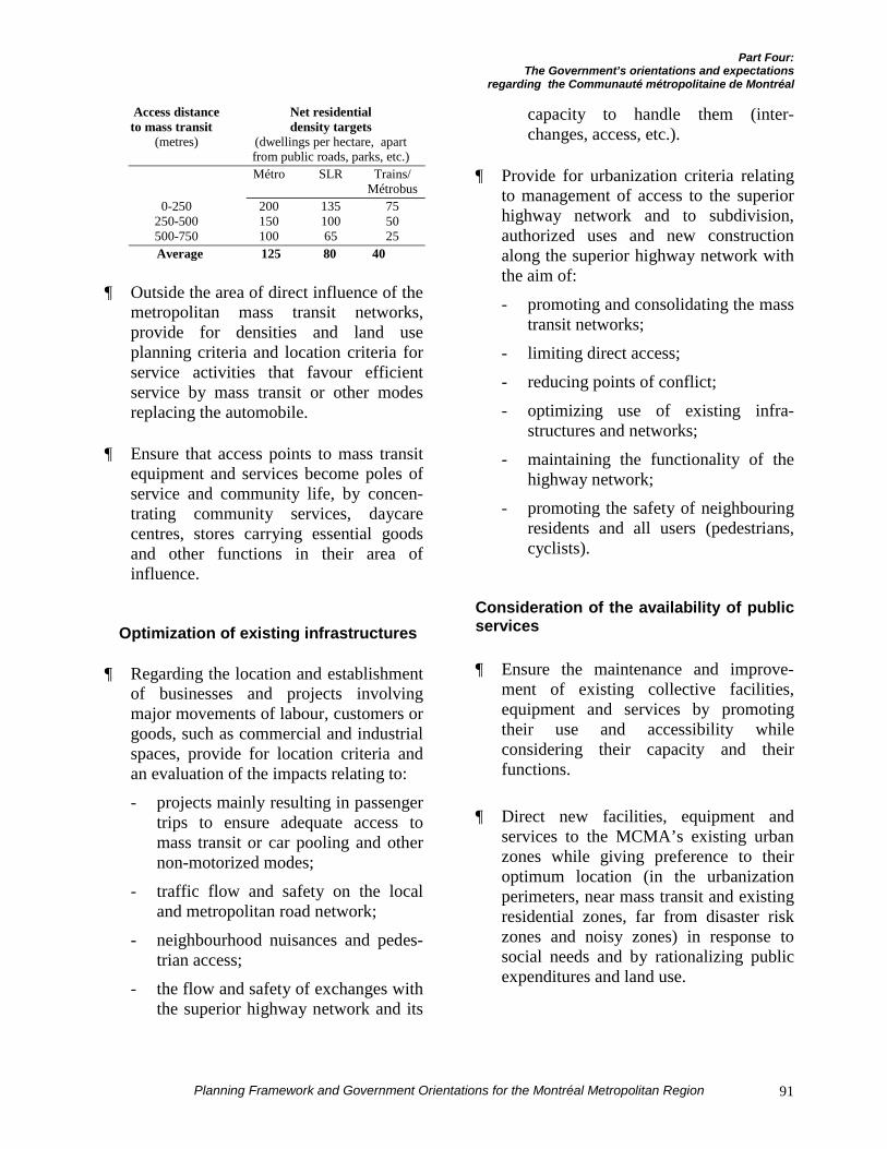
Part Four:The Government’s orientations and expectations
regarding the Communauté métropolitaine de Montréal
Planning Framework and Government Orientations for the Montréal Metropolitan Region 91
Access distance Net residentialto mass transit density targets
(metres) (dwellings per hectare, apartfrom public roads, parks, etc.)Métro SLR Trains/
Métrobus0-250 200 135 75
250-500 150 100 50500-750 100 65 25Average 125 80 40
¶ Outside the area of direct influence of themetropolitan mass transit networks,provide for densities and land useplanning criteria and location criteria forservice activities that favour efficientservice by mass transit or other modesreplacing the automobile.
¶ Ensure that access points to mass transitequipment and services become poles ofservice and community life, by concen-trating community services, daycarecentres, stores carrying essential goodsand other functions in their area ofinfluence.
Optimization of existing infrastructures
¶ Regarding the location and establishmentof businesses and projects involvingmajor movements of labour, customers orgoods, such as commercial and industrialspaces, provide for location criteria andan evaluation of the impacts relating to:
- projects mainly resulting in passengertrips to ensure adequate access tomass transit or car pooling and othernon-motorized modes;
- traffic flow and safety on the localand metropolitan road network;
- neighbourhood nuisances and pedes-trian access;
- the flow and safety of exchanges withthe superior highway network and its
capacity to handle them (inter-changes, access, etc.).
¶ Provide for urbanization criteria relatingto management of access to the superiorhighway network and to subdivision,authorized uses and new constructionalong the superior highway network withthe aim of:
- promoting and consolidating the masstransit networks;
- limiting direct access;
- reducing points of conflict;
- optimizing use of existing infra-structures and networks;
- maintaining the functionality of thehighway network;
- promoting the safety of neighbouringresidents and all users (pedestrians,cyclists).
Consideration of the availability of publicservices
¶ Ensure the maintenance and improve-ment of existing collective facilities,equipment and services by promotingtheir use and accessibility whileconsidering their capacity and theirfunctions.
¶ Direct new facilities, equipment andservices to the MCMA’s existing urbanzones while giving preference to theiroptimum location (in the urbanizationperimeters, near mass transit and existingresidential zones, far from disaster riskzones and noisy zones) in response tosocial needs and by rationalizing publicexpenditures and land use.

Part Four:The Government’s orientations and expectations
regarding the Communauté métropolitaine de Montréal
Planning Framework and Government Orientations for the Montréal Metropolitan Region92
¶ Ensure that the presence of the publicservice networks is considered inmunicipal subdivision plans to promoteconcerted action by the stakeholdersdirectly concerned while allowing betterintegration of the networks in newresidential developments (for example:power lines, gas lines, road rights-of-way, etc.).
¶ Provide for the necessary permit issuingconditions to prevent construction or usesin public servitudes (e.g. power trans-mission lines, highway rights-of-way).
GOVERNMENT SUPPORT AND COMMITMENTS
The Ministère des Transports, in its Plande gestion des déplacements de la régionmétropolitaine de Montréal (tripmanagement plan for the Montréal metro-politan region), has presented its transportplanning objectives and orientations. Theplan gives priority to interventions promotingthe revitalization of the territory at the centreof the metropolitan area, economic develop-ment and improvement of the quality of life.It also specifies the investments that thedepartment intends to realize by 2010,particularly regarding demand managementand improvement of the supply of highwaytransportation and mass transit. The CMMwill also have at its disposal the Lanaudière,Laurentides and Montérégie regionaltransportation plans, which will specify theproblems and stakes of transportation andland use planning on the periphery. Thedepartment intends to implement a perma-nent concerted action mechanism for themain transportation partners to support theCMM in its planning process and theexercise of its jurisdictions regardingtransportation, particularly in determining themetropolitan arterial network.
The Strategic Plan of the Agencemétropolitaine de transport containsinformation useful to the CMM onmanagement of transportation demand andthe supply, promotion and development ofmass transit. The close complementaryrelationship between land use planning andtransportation is central to this PlanningFramework. The two truly metropolitaninstitutions, the AMT and the CMM, aretherefore called upon to work closely witheach other. For the year ahead, the AMT willrevise its Strategic Plan and the CMM willproduce its Strategic Vision Statement. Thesetwo processes will reach their conclusionsimultaneously in June 2002. The AMThopes that the CMM will get activelyinvolved in revising its Strategic Plan. It isalso willing to provide the CMM with all thecooperation it considers useful for thepreparation of its Strategic Vision Statement.
The AMT also intends, in collaboration withthe CMM, to participate in defining thepolicies intended to control the supply ofparking spaces on the CMM’s territory basedon mass transit services, density, commercialactivities and services (on-street parking, by-laws prescribing a maximum number ofparking spaces to be offered per dwelling orper built area of commercial or office space).
The Ministère de l’Environnement intendsto support the CMM so that the orientationsof the sustainable development imple-mentation guide are concretized in the metro-politan land use planning concept.
In addition, the Ministère de l’Environ-nement, in 1996, adopted its Stratégie demise en œuvre de la Convention sur ladiversité biologique (implementation strategyfor the Convention on Biological Diversity),which particularly gives preference to morecompact development of urban zones whilepromoting integration of green spaces into
Part Four:The Government’s orientations and expectations
regarding the Communauté métropolitaine de Montréal
Planning Framework and Government Orientations for the Montréal Metropolitan Region 93
the built territory’s land use planning. ThePlan d’action québécois 2000-2002 sur leschangements climatiques (2000-2002Québec action plan on climate change)presents nearly forty actions which shouldenable Québec to respect its internationalcommitments in the struggle against theeffects of climate change. The department iscurrently preparing an implementation guidefor sustainable development, the Guide demise en œuvre du développement durable,which can inspire the preparation of themetropolitan land use and development plan.It also points out the necessity of integratingthe Politique de protection des rives, dulittoral et des plaines inondables (policy onpreservation of banks, shoreline and floodplains), considering the restrictions and othermeasures specified during the preparation ofthe maps of land use restrictions. Finally, itnotes the support offered by the rehabilitationprogram for contaminated urban land, theProgramme de réhabilitation des terrainscontaminés en milieu urbain – Revi-Sols –Phase 3.
Hydro-Québec offers its cooperation to theCMM regarding the residential, commercialand industrial development choices thatfavour optimum siting in view of theavailability of power sources. Several meanshave been developed and made available.The utility therefore proposes that the CMMstudy the document Lotissement et réseauxde distribution : Guide des bonnes pratiques,the good practices guide to subdivision anddistribution systems, which resulted from acollaboration with Bell Canada and theUnion des municipalités du Québec, and thedocuments Le Bon arbre au bon endroit (Theright tree in the right place) and Répertoiredes arbres et des arbustes ornementaux(Directory of trees and ornamental shrubs),which are tools for preventive urban forestmanagement.
In addition, wherever possible, Hydro-Québec intends to:
¶ Harmonize its interventions withthose of other users of the territoryof the Communauté métropolitainede Montréal;
¶ Establish an interactive relationship withthe bodies responsible for the CMM’sland use planning and development;
¶ Incorporate the CMM’s projects into itsintervention plans;
¶ Participate in the regional forumsestablished on the CMM’s initiative,which will discuss topics likely to havean impact on the implementation andmanagement of power system equipment,such as water management, extension ofurbanization, public safety, etc.
Société immobilière du Québec intends toderive more benefit from the recyclingpotential offered by unused publicfacilities such as schools, municipal andfederal buildings and parapublic insti-tutional buildings.
The Ministère des Relations avec lescitoyens et de l'Immigration intends toparticipate in the preparation of the CMM’smetropolitan land use and development planso that the concern for integration ofnewcomers is taken into account through theuse of municipal activities, services, facilitiesand equipment.
In planning of collective facilities, theMinistère de la Culture et des Commu-nications intends to share its metropolitanvision of cultural facilities with themetropolitan and municipal bodies. Thisvision will also establish the distribution ofresponsibilities among the various stake-holders.
Part Four:The Government’s orientations and expectations
regarding the Communauté métropolitaine de Montréal
Planning Framework and Government Orientations for the Montréal Metropolitan Region94
The department will continue to supportmunicipal bodies in the establishment of anetwork of neighbourhood facilities such asthe library network and to assist non-profitorganizations in the consolidation andimplementation of specific facilities, inclu-ding production sites. In this context, theMCC will promote the reutilization of publicbuildings and religious buildings left vacant.
The Ministère de la Culture et des Commu-nications will enter into agreements withreligious bodies to establish an action planfor consolidation of religious properties ofheritage interest.
The departments concerned with the qualityof housing, the quality of life, architecturalintegrity and protection of the landscapeintend to promote the use of architecturalcompetitions for the construction ofcollective facilities in a perspective ofexemplary excellence.
This practice could be concretized, amongother means, by the adoption of an urbanplanning and architecture competition policyfor the production of studies of potential, sitedevelopment plans and architecture conceptsfor the development or redevelopment pro-jects located in the area of direct influence ofmajor mass transit infrastructures.
Part Four:The Government’s orientations and expectations
regarding the Communauté métropolitaine de Montréal
Planning Framework and Government Orientations for the Montréal Metropolitan Region 95
SECOND CONCERN
URBANIZATION AND HOUSING TYPES
CONTRIBUTING TO ENSURE A
DIVERSIFIED SOCIAL COMPOSITION
GOVERNMENT ORIENTATION
ORIENTATION N° 3:
Promote and support urbanization that seeksdiversity of housing types and collectiveservices within the perspective of a socialmix.
REMINDER OF THE PROBLEM
The Montréal metropolitan region iscomposed of different living environmentsand populations with various characteristics.The gathering of socioeconomic groups insectors specific to each makes it moredifficult to share common values around acoherent development project.
The centre of the metropolitan area ischaracterized by the presence of a largeproportion of households with below-averagesocioeconomic conditions, often comprisinga single person. The presence of seniors isgreater and the centre remains the primaryplace of accommodation of internationalimmigrants.
The northern and southern suburbs areoccupied in greater proportions by younghomeowner family households with higherincomes.
THE ISSUE AT STAKE
¶ Create socially diversified living environ-ments.
GOVERNMENT CONCERNS
Several government agencies are concernedabout the concentration of poverty in thecentral neighbourhoods of the urban region.
For the Ministère de l'Éducation, theconcentration of poverty makes it difficult toimplement educational programs and assis-tance and support measures for the mostdisadvantaged pupils, with the objective ofpromoting the academic success of thegreatest number.
One of the measures proposed by the MEQto support pupils who are disadvantaged orhave learning difficulties is the reduction ofthe teacher-pupil ratio, with gradual imple-mentation over the period from 2000-2001 to2003-2004. This reduction is greater in thecase of schools in disadvantaged environ-ments, which are found in great numbers inthe urban zones.
Better heterogeneity among groups of pupilswould promote academic success andproduce better results in terms of learningabout cultural, social and economic diversity.
The Ministère de l'Éducation is particularlyconcerned about the supply of public services(pools, arenas, libraries, cultural centers, etc.)for school age youth in the neighbourhoodsat the centre of the metropolitan area, wherea high concentration of poverty currentlyexists.
Part Four:The Government’s orientations and expectations
regarding the Communauté métropolitaine de Montréal
Planning Framework and Government Orientations for the Montréal Metropolitan Region96
For the Ministère de la Santé et desServices sociaux, too much homogeneity ofland use makes it more difficult to implementcentres and services for seniors, who want toremain in their respective living envi-ronments.
For Société d'habitation du Québec, thenecessity to assure all households of accessto housing adapted to their needs assumesdiversification of the supply of housing and abetter balance in spatial distribution. Thismust consider the diversification of house-holds and their choice of living environment,which particularly includes the concern forfacilitating the maintenance of seniors intheir environment and the presence offamilies with children in the central neigh-bourhoods through an appropriate supply ofservices and land use planning.
The Ministère des Relations avec lescitoyens et de l'Immigration intends toachieve greater diversity of the places ofaccommodation and settlement ofnewcomers. The MCMA has received 85 %of all immigrants to Québec since 1995.However, 75 % of immigrants settle on theIsland of Montréal upon their arrival. Thedepartmental objective is to ensure that 25 %of newcomers settle outside the MCMA. Inthe interim, improvement of the quality ofland use planning in the Island’s centralneighbourhoods remains a priority for theMRCI, in view of the fact that the majority ofimmigrants still choose to live there.
GOVERNMENT EXPECTATIONS REGARDINGTHE COMMUNAUTÉ MÉTROPOLITAINE DEMONTRÉAL
Residential and social diversity in theplanning of the urban framework
¶ Provide for urbanization criteria thatmake it possible to assure a balance in the
supply of housing for all types ofhouseholds in each development project.
¶ Provide for planning criteria that ensurethe availability of housing that meets theneeds of families with children, espe-cially in the neighbourhoods where newimmigrants settle.
¶ Consider access to ownership for low-income households in the criteria forrevitalization of old neighbourhoods.
¶ Integrate the criteria for the supply ofcollective sports facilities (pools, arenas,bicycle paths, etc.), educational facilities(libraries, etc.), cultural facilities (culturalcentres, etc.) and health facilities in themanagement of urbanization at the metro-politan level and in each borough.
GOVERNMENT SUPPORT AND COMMITMENTS
The Ministère des Relations avec lescitoyens et de l'Immigration intends to be amajor participant in better defining the needsof newcomers, particularly in the Côte-des-Neiges, Parc-Extension and Saint-Laurentneighbourhoods. These needs also pertain tothe improvement of the diversity of housingin the central neighbourhoods of the subur-ban municipalities.
Société d'habitation du Québec intends topursue its collaboration in the establishmentof housing needs and respond to themthrough its housing assistance and habitatimprovement programs.
Part Four:The Government’s orientations and expectations
regarding the Communauté métropolitaine de Montréal
Planning Framework and Government Orientations for the Montréal Metropolitan Region 97
THIRD CONCERN
AN IMPROVED QUALITY OF LIFE IN OLD
OR DETERIORATED NEIGHBOURHOODS
GOVERNMENT ORIENTATION
ORIENTATION N° 4:
Rehabilitate and reclaim old or deterioratedneighbourhoods in an objective of improvingthe quality of life, the habitat, collectivefacilities and services and the urban andarchitectural heritage, giving priority to thecentre of the metropolitan area.
REMINDER OF THE PROBLEM
The region is composed of different types ofhabitats and living environments, the generalquality of which varies according to theneeds and expectations of various types ofhouseholds. Family households are primarilylooking for space and safety so that they canraise their young children, while non-familyhouseholds, often poorer and childless, areconcentrated in old neighbourhoods wherethey can quickly find the services they needand cheaper housing.
The declining attraction of certain old andcentral neighbourhoods is explained, amongother factors, by dilapidated public infra-structures, a high nuisance level attributableto traffic, contaminated soil, poor qualityhousing unsuited to family needs, etc.
To ensure a geographic balance in accom-modating 275,000 new households that willbe added by 2021, it is essential to maintainor ensure a quality of life in the centralneighbourhoods that would be comparable tothat of the peripheral sectors in the existingurban zones.
THE ISSUES AT STAKE
¶ Maintain a quality of life in old neigh-bourhoods comparable to that of the newsubdivisions.
¶ Preserve the diversity of functions andthe vitality of Downtown Montréal andthe old and central neighbourhoods of themetropolitan region.
GOVERNMENT CONCERNS
Preservation and improvement of the qualityof life throughout the metropolitan territoryare a government priority.
The means that should respond to thisgovernment concern involve the estab-lishment of measures, particularly in the oldand central neighbourhoods, which wouldseek to support:
¶ access to homeownership;
¶ improvement of the general quality of theold housing stock;
¶ improvement of the quality of the livingenvironment and the urban environment.
The quality of the living environment alsoinvolves the protection of the heritagefeatures of old sectors, historic sites orproperties, not only at the centre of themetropolitan area but throughout the metro-politan territory.
Part Four:The Government’s orientations and expectations
regarding the Communauté métropolitaine de Montréal
Planning Framework and Government Orientations for the Montréal Metropolitan Region98
Regarding access to homeownership andimprovement of the quality of the oldhousing stock, Société d’habitation duQuébec considers that measures for thispurpose should be part of the intersectorurban renewal strategies mobilizing all theplayers of the communities concerned andtaking advantage of the applicable govern-ment programs.
Parallel interventions are necessary toimprove the general living environment so asto meet the public’s expectations. Theseinterventions include improving the qualityof public facilities, increasing the area ofparks and wooded areas, street design,improving the environment (air quality, noiselevel, cleanliness and safety, automobiletraffic alleviation measures) and strength-ening of mass transit infrastructures.
Also, as was previously mentioned, theMinistère des Relations avec les citoyens etde l'Immigration has adopted a newimmigration policy intended to increase thenumber of immigrants significantly over thenext few years. This immigration involves alarge proportion of young families andseniors. The department is therefore con-cerned about the diversity of the supply ofhousing in the central neighbourhoods,particularly the availability of large dwellingscorresponding to the needs of families withchildren and residences for seniors.
GOVERNMENT EXPECTATIONS REGARDINGTHE COMMUNAUTÉ MÉTROPOLITAINE DEMONTRÉAL
An intersector metropolitan strategy
¶ Integrate into the development plan ametropolitan strategy for rehabilitation ofurban centres and old neighbourhoods,taking into consideration the presence
and capacity of the existing infra-structures.
¶ Give priority to redevelopment of sectorswhere traffic-related nuisances (noise,airborne dust) will be reduced. The CMMis particularly invited to determine theconstraints (industries, quarries, sandpits, sewage treatment plants, wastedisposal sites, transport, etc.) and assigndesignations that minimize conflictinguses.
¶ Ensure the maintenance of affordablehousing in revitalization projects for oldneighbourhoods, including possibilitiesof access to homeownership for moderateincome households.
¶ Recognize, protect and reclaim sectors,heritage sites or properties and heritageenvironments, and consider archeologicalresources when redeveloping old neigh-bourhoods.
¶ Specify the potential for reuse of heritagereligious properties currently abandonedor in the process of abandonment andenhance cultural facilities as a lever forredevelopment of old neighbourhoods.
Tranquility and safety of livingenvironments in the centre neigh-bourhoods
¶ Plan or replan the public domain so as tomake the central neighbourhoods safeand peaceful urban environments andliving environments. The Community isinvited to pay special attention to the areaof influence of metropolitan mass transitnetworks.
Part Four:The Government’s orientations and expectations
regarding the Communauté métropolitaine de Montréal
Planning Framework and Government Orientations for the Montréal Metropolitan Region 99
¶ Determine the thoroughfares in thecentral neighbourhoods for which thecurrent or projected presence raises majorconstraints to nearby land use and adoptthe appropriate by-laws, in accordancewith the Politique sur le bruit routier(policy on highway noise) set forth by theMinistère des Transports.
¶ Integrate the criteria intended to protectand increase green places in the builtdevelopment.
¶ Integrate urbanization criteria and trafficcalming standards into the rehabilitationof old neighbourhoods.
GOVERNMENT SUPPORT AND COMMITMENTS
The Ministère de la Culture et desCommunications is currently formulating agovernment policy on Québec’s culturalheritage and will continue to protectproperties with national legal status, throughits programs among other means. It alsointends to pursue its collaboration with themunicipalities by signing cultural deve-lopment agreements. These agreements arethe preferred instrument for planning,management, access and participation incultural life arising from the adoption of acultural policy by the municipalities. Theseagreements will continue to establish, forexample, the sharing of funding forrestoration of heritage buildings and recla-mation of the historic districts of OldMontréal and La Prairie, and the mainlandmarks of memory throughout theterritory. Finally, the MCC recalls thatChapter 4 of the Cultural Property Act givesprotective powers to the municipalities.
The Ministère de la Culture et desCommunications intends to support theCMM by promoting renovation and imple-mentation of cultural facilities in old
neighbourhoods in a perspective of ensuringthe vitality of the neighbouring sectors, withpart of the emphasis on the determination oflandmarks of memory in a perspective ofnetworking and valuing of urban lifestyles.
The Ministère de l'Éducation hasundertaken a study to evaluate the conditionof the school board real estate inventorythroughout Québec. Upon completion of thisstudy, it will be able to have an objectiveand precise reading of the special needs ofschools in old neighbourhoods of theMontréal metropolitan region. The prioritymeasures to be implemented by the MEQregarding the restoration and improvementof school buildings will be established basedon the study’s conclusions and the financialresources available.
Société d'habitation du Québec intends tocontinue its support for revitalization of oldneighbourhoods by ensuring that theinterventions are made in an intersectorperspective integrating all dimensions of thehabitat and promoting renovation of housing,improved planning of living environments,redevelopment of available buildings andaccess to homeownership, especially foryoung families, in these neighbourhoods.
The Ministère de l'Environnement willfavour the selection of developmentproposals and projects based on the prin-ciples of urban ecology, principles based oncriteria of sustainability and protection of theenvironment. It will also give preference tointerventions contributing to the im-provement of the quality of the livingenvironment of city dwellers by putting theemphasis on environmental health and publichealth.
The Ministère de l'Environnement alsointends to associate the CMM with thedetermination of intervention priorities for

Part Four:The Government’s orientations and expectations
regarding the Communauté métropolitaine de Montréal
Planning Framework and Government Orientations for the Montréal Metropolitan Region100
the implementation of the Programme deréhabilitation des terrains contaminés enmilieu urbain Revi-Sols – Phases I and II(rehabilitation program for contaminatedurban land) and the rehabilitation ofprotected areas.
The Government intends to support thedevelopment of architectural criteria relatedto densification, use of mass transit andelectric cars, the presence of communitygardens and management of residual mate-rials, recycling of materials and energysaving in its rehabilitation programs for oldneighbourhoods.
The MTQ and the AMT intend to providetechnical assistance, through guides or other-wise, to contribute to the development oftools for improvement of the quality of life,tranquility and safety in the central neigh-bourhoods. Some of the subjects that can beenvisioned pertain to:
¶ determination of a metropolitan arterialnetwork and a functional ranking of thelocal road network (municipal andboroughs);
¶ traffic management that fosters thereduction of motorized trips on resi-dential streets and in the other sectorsconcerned;
¶ revision of the speed limits on residentialstreets and in the other sectors concerned,taking the road ranking into consi-deration;
¶ street layouts that make it difficult todrive faster than the authorized speedlimits. Speed moderation particularlypresumes a sharing of space morefavourable to pedestrians and cyclists,rotary junctions, reduction of sight lines,speed bumps, elongated humps, deadends, etc.;
¶ revision of the geometry of intersectionswith the aim of reducing the opportu-nities for conflicts among pedestrians,cyclists and motorists;
¶ localized reduction of street availabilityby recovery of the space devolved to on-street parking and other means;
¶ increase in the space exclusively reservedfor pedestrians and cyclists;
¶ increase in planted or landscaped areas.
Hydro-Québec wants to take the opportunityoffered to it by the preparation of themetropolitan land use and development planto inform the CMM about the imple-mentation of its program to put thedistribution system underground, theProgramme d’enfouissement du réseau dedistribution. The three components of thisprogram are intended to increase thesystem’s reliability while improving theesthetic quality of the urban landscape. Thisprogram can also contribute to thereclamation and rehabilitation of old andcentral neighbourhoods.
Part Four:The Government’s orientations and expectations
regarding the Communauté métropolitaine de Montréal
Planning Framework and Government Orientations for the Montréal Metropolitan Region 101
FOURTH CONCERN
STRENGTHENING OF THE ECONOMIC
POLES CONTRIBUTING TO MAINTAIN
GREATER MONTRÉAL’S INTERNATIONAL
COMPETITIVENESS
GOVERNMENT ORIENTATION
ORIENTATION N° 5:
Support the international development of theMontréal metropolitan region by contri-buting, as a priority, to strengthening the sixmajor economic poles where internationalactivities are concentrated:
¶ Downtown Montréal;
¶ Saint-Laurent / Dorval;
¶ Centre de Laval;
¶ Longueuil / Boucherville / Saint-Hubert;
¶ Anjou / Mercier, including the port zone;
¶ Mirabel Foreign Trade Zone.Network the major economic poles with theexisting and emerging poles of secondaryactivity, taking into account their functionsand complementary relationship.
REMINDER OF THE PROBLEM
The Montréal metropolitan region ranks 15th
among the greater North American urbanregions in terms of population and 32nd forpopulation growth from 1990 to 2000(245,000 people). Over the past ten years, thedemographic centre of gravity and that of theNorth American market have continued to
shift to the south and west, where themetropolitan regions have a growth rateranging from 28 % to 83 %, while that of theMontréal region is at 7.6 %. The effect of thisphenomenon has been to marginalize thenortheast geographically. However, since1993, the northeast, including Montréal, hasrepositioned itself in terms of the neweconomy.
Added to this is the increased competitionamong the world’s major cities and urbanregions which have a gross domestic productexceeding that of some countries: Tokyo(over $850 billion, New York ($650 billion),Paris ($300 billion), Chicago ($150 billion).In 2000, the GDP of the Toronto, Montréal,Vancouver and Calgary regions was $144billion, $82 billion, $50 billion and$33 billion respectively.
This competition among major cities invitesGreater Montréal to attach great importanceto its priority economic poles and targetniches capable of driving its economy in theinternational market, especially since poly-centric urban regions perform the best.
Some economic poles, given their scope andthe companies that comprise them, exert adetermining influence on the capacity toattract activities and companies from the neweconomy or play a key role in the inter-national positioning of Greater Montréal.These are Downtown Montréal, Saint-Laurent / Dorval, Anjou / Mercier, Centre deLaval, Boucherville / Longueuil / Saint-Hubert and the Mirabel Foreign Trade Zone.
The economic poles are not all structured forefficient service by mass transit. Service byautomobile is often the municipalities’ mainurbanization criteria for planning and deve-lopment of employment and service poles intheir territory. This results in increasedcongestion, which reduces their accessibilityby road for freight and employment.
Part Four:The Government’s orientations and expectations
regarding the Communauté métropolitaine de Montréal
Planning Framework and Government Orientations for the Montréal Metropolitan Region102
THE ISSUES AT STAKE
In a context where competition among theworld’s major urban regions is increasinglyactive, the prosperity of the Montréalmetropolitan region is greatly dependent onits ability to compete with the world’s othermetropolitan regions.
In a planning perspective, the issues relatedto maintenance of this economic compet-itiveness are as follows:
¶ Reduce corporate production coststhrough an advantageous location neartransportation infrastructures, taking thecapacity of these infrastructures intoaccount;
¶ Ensure easy mobility for the workforce;
¶ Preserve an outstanding quality of life inthe urban region, a factor that in-creasingly influences corporate locationdecisions;
¶ Ensure development of the territory basedon the priority economic poles.
GOVERNMENT CONCERNS
In general, the Government’s economicconcerns for the Montréal metropolitanregion primarily concern the improvement ofthe ability to attract foreign investment, andconsolidation of their competitive positionand export support for established com-panies.
The impact of traffic congestion on theability to attract foreign investment and onthe consolidation of the competition positionof established companies is of specialconcern to the Ministère des Transports.
More specifically, Tourisme Québec wouldlike to see the sustained extension of touristdevelopment all year round and not only
during the summer months, particularly byensuring a better match between the supplyof urban stays and the convention andoutdoor activities during the winter months.In this regard, the expansion of the Palais desCongrès and the strengthening of theinfluence of Dorval Airport will help toalleviate this problem. The improvement ofthe quality of development in DowntownMontréal would also be essential to therecovery of tourist activity.
Complementary to this, the Ministère de laCulture et des Communications, whilerecognizing the importance of accessibility ofcultural resources for the population as awhole, is concerned about maintaining thecultural industry’s influence in themetropolitan and Québec economy.
The Ministère des Affaires municipales etde la Métropole recalls that it considers itessential to reconcile economic developmentwith land use planning. Commercial andindustrial development acts as a structuringfactor in land use planning. If it is notplanned adequately so that it is integratedinto land use planning, this development maylead to overconsumption of land and theresulting urban expansion.
Land use planning must integrate themetropolitan region’s economic developmentchoices in terms of promotion and prioritydevelopment axes with the considerations ofland use and ranking of various urbanfunctions. However, several departmentshave prepared strategies associated witheconomic development objectives that have ascope beyond the limits of the MCMA. Thissituation will necessitate, at the governmentand municipal levels, the design of aharmonization mechanism between admin-istrative regions and with the outlying RCMsto ensure coherent interventions within theterritory (see the Ninth Concern).
Part Four:The Government’s orientations and expectations
regarding the Communauté métropolitaine de Montréal
Planning Framework and Government Orientations for the Montréal Metropolitan Region 103
GOVERNMENT EXPECTATIONS REGARDINGTHE COMMUNAUTÉ MÉTROPOLITAINE DEMONTRÉAL
Support for economic developmentand strengthening of the majoreconomic poles
¶ Specify and recognize the six majorinternational economic poles presented inthe Planning Framework as the principalcomponents of the metropolitan region’seconomic structure.
¶ Rank the poles of activity in its territoryso that they are complementary with thesix major economic poles of the PlanningFramework.
¶ Promote a geographical consolidation ofrecognized universities, world-renownedcentres of expertise, head offices of majorcommunications companies and researchcentres with solid reputations, andcontribute to strengthening the existingpools of creative people, organizationsand cultural services.
¶ Strengthen the central part of the urbanregion as the economic heart of greaterMontréal because of its characteristicsrelated to employment, commerce,tourism, housing, entertainment andculture.
¶ Promote the enhancement of DowntownMontréal’s image as the historical, cul-tural and socioeconomic centre of themetropolitan region.
¶ Integrate the objectives of increasingmass transit use and reducing automobileuse into the planning and service of newor existing economic poles.
¶ Promote the concentration of commercialdevelopment in the sectors served by theMétro in Montréal and by an efficientmass transit network in the othermunicipalities, while fostering themaintenance and revitalization of thebusiness axes of the central sectors.
¶ Ensure a mix of functions in the priorityeconomic poles, including residentialspaces near the major mass transitinfrastructures, by providing for criteriaof compatibility of the various uses toensure the best possible quality of life.
¶ Integrate public services and utilities,including those provided by Hydro-Québec into the planning process thatleads to the siting of any majorequipment to serve the major economicpoles.
¶ The Communauté métropolitaine deMontréal is also invited, in conjunctionwith the government departments with aneconomic mission, to set up a centraldevelopment database with a view toestablishing an accurate picture of themetropolitan economic structure.
GOVERNMENT SUPPORT AND COMMITMENTS
The Ministère des Transports willcontribute to reducing congestion on theMontréal highway network and to improveservice to the poles by implementing its tripmanagement plan for the Montréal metro-politan region, the Plan de gestion des dépla-cements de la région métropolitaine deMontréal. It will maintain its action onpolicies, standards and financial support toback up the marine, rail and air transportationpartners and promote the development ofintermodal services.
Part Four:The Government’s orientations and expectations
regarding the Communauté métropolitaine de Montréal
Planning Framework and Government Orientations for the Montréal Metropolitan Region104
The AMT’s strategic plan provides forimprovement of the supply of mass transitservices in the axes serving one or moremetropolitan economic poles. Ultimately, theAMT is aiming at complete service to thepriority economic poles through an offeringof mass transit services of sufficient qualityto compete with the automobile.
Planning of passenger and freight transpor-tation integrated with land use planning isessential to allow the implementation of localand government actions likely to encourage agreater number of companies to locate in theeconomic poles.
Regarding electrical infrastructures, Hydro-Québec offers municipal bodies expertiseand support in supplying power to commer-cial and industrial complexes. The economicpoles should be able to count on the presenceof a reliable and efficient power system,capable of adapting to the service qualityrequirements of this specific clientele.
The Ministère de la Culture et desCommunications intends to develop apartnership with Tourisme Montréal and theregional tourism associations (RTA) con-cerned in the form of agreements to promotethe territory's cultural attractions andactivities, to improve Downtown Montréal’surban environment and to stimulate tourismthroughout the region. In this regard, thedepartment is already supporting the imple-mentation of a cultural showcase and a ticketoffice.
The Ministère de la Culture et des Commu-nications intends to contribute, in conjunc-tion with its government and municipalpartners, to:
¶ make the vitality of the communicationssector and the wealth of cultural attrac-
tions the major assets of a metropolitaneconomic development strategy;
¶ provide for a strategic of tax or otherincentives, on a territorial basis, toaccentuate development of key sectors,particularly in communications;
¶ produce an international developmentstrategy based on tourism and culture(heritage, major festivals, creative anddissemination facilities with internationalreach, etc.) in a perspective of deployingin the regions cultural events with touristpotential and potential for attractingforeign audiences.
The Ministère de l'Environnement recallsthat the Government of Québec, guided bythe principle of precaution, intends to favourthe implementation of commercial andindustrial projects that comply with theinternational commitments made by Québecwhen it adhered to the United NationsFramework Convention on Climate Change.The Government also intends to foster theeconomy’s competitiveness by supportingenergy efficiency programs and making moreefficient use of resources that lead to areduction of production costs and putcompanies in a better position to faceinternational competition, as recommendedby the Plan d’action québécois 2000-2002sur les changements climatiques (p. 22)(2000-2002 Québec action plan on climatechange).
The Ministère de l'Environnement alsointends to associate the Communauté métro-politaine de Montréal, within the context ofthe preparation of its metropolitan land useand development plan, with the preparationof a metropolitan action plan that includesthe following aims, among others:
Part Four:The Government’s orientations and expectations
regarding the Communauté métropolitaine de Montréal
Planning Framework and Government Orientations for the Montréal Metropolitan Region 105
¶ adherence of companies to theProgramme de protection du niveau deréférence (reference level protectionprogram) which has the purpose ofassuring the participating organizationsthat reductions of greenhouse gases willbe taken into account. The metropolitanaction plan also seeks to encouragecompanies to join ÉcoGESte, a voluntaryregistration program for greenhouse gasreduction by companies that will set upbusiness in the six major economic poles,by offering them a coaching program toaccomplish this;
¶ implementation of industrial ecology pro-grams which support the reclamation ofresidual materials and the application of aclosed-circuit production cycle, characte-rized by the transformation of pollutingraw materials and low production ofresidual materials;
¶ environmental research and developmentto allow development and maintenance ofa true environment industry, concretizedby the emergence, for example, of hightech companies specializing in thereclamation of polluting materials andtheir transformation into energy sub-stances or raw materials;
¶ implementation of a mobilization pro-gram for decision-makers intended formunicipal, agricultural and industrialbodies to promote the implementation ofurban and industrial ecology measures;
¶ practical applications for sustainabledevelopment through the network ofbusinesses and industries established inthe economic poles to promote compet-itiveness and emulation among thesecompanies.
The Ministère de l'Environnement alsointends to associate the Communauté métro-politaine de Montréal with the production of
an opportunity study on the establishment, inone of the poles, of a research institute onclimate change, from which the network willbe established to link all six economic poles.
The Ministère de l'Environnement, incollaboration with the Ministère des Rela-tions internationales, intends to pursue itsefforts to attract international organizationsrelated to the environment sector toMontréal.
The Ministère des Ressources naturelles isseeking recognition for Montréal as a worldpulp and paper centre. For this purpose, thedepartment intends to promote the retentionand development of head offices alreadylocated in Montréal (e.g.: move from Torontoto Montréal of the Abitibi-Price head office)and the development of R & D infra-structures (e.g.: expansion of Paprikan,implementation of COESI, through ad hocassistance) and the development of pulp andpaper facilities. The MRN is also supportingthe research and development projects ofthese companies under its technologicalmastery program, the Programme de maîtrisetechnologique.
The government also intends to work withthe CMM so that economic considerationsare incorporated into land use planning. Afterthe Government’s orientations are tabled, theMinistère des Affaires municipales et de laMétropole, in conjunction with thedepartments with an economic mission, willinform the CMM of the various componentsthat are the focus of specific governmentconcern.
Part Four:The Government’s orientations and expectations
regarding the Communauté métropolitaine de Montréal
Planning Framework and Government Orientations for the Montréal Metropolitan Region106
FIFTH CONCERN
PLANNING OF PUBLIC TRANSPORTATION
EQUIPMENT AND INFRASTRUCTURES
WITH THE AIM OF CONSOLIDATING THE
EXISTING URBAN ZONES AND THE MAJOR
ECONOMIC POLES, WHILE REDUCING
GREENHOUSE GASES
GOVERNMENT ORIENTATION
ORIENTATION Nº 6:
Encourage and support an urban form withthe following aims:
¶ Regarding passenger transportation,increased use of mass transit and non-motorized modes and a reduction of useof the automobile;
¶ Regarding freight, optimum use of thestrategic transportation network, strength-ening of Montréal’s competitive positionas a manufacturing centre and continentalfreight hub;
¶ Regarding service to the major economicpoles, support for their developmentthrough better integration of passengerand freight transportation systems andnetworks.
REMINDER OF THE PROBLEM
From 1987 to 1998, motorized trips in-creased by 22% to over 7 million trips perday, while the population only rose by 10%.According to the MTQ’s trend scenario, there
will be more than 7.8 million more motorizedtrips per day in the MCMA, or 825,000 morethan in 1998 (an 11.7% growth rate).
The growing motorization of the past fewdecades depends, among other factors, on theaging population, its dispersion as urbansprawl increases and the increasing access ofwomen to the job market. Householddispersion, accompanied by the spreading outof jobs and services, is currently so great thatintersuburban trips, more difficult to serve bymass transit, are those experiencing thegreatest growth.
The increase in automobile trips observedover the past few decades is accompanied inparallel by a decrease in mass transitridership. In 1973, the modal shares were64% for cars versus 36% for mass transit(motorized transportation only). In 1998, themodal share of the automobile had grown to81.5%, leaving only 18.5% for mass transit.
Moreover, the Agence métropolitaine detransport has calculated that, on the average,every year, for each household choosing toreside near the Métro instead of on theperiphery of the metropolitan region, thereare:
� 1,050 automobile passenger trips less;
� a 15,000 km reduction in urban auto-mobile kilometrage;
� which is the equivalent of completeelimination of one automobile, or thesecond vehicle in a household;
� a 6,000 kilogram reduction in greenhousegases;
� 625 more mass transit trips;
� 425 more trips on foot or bicycle.
However, the many advantages offered bymass transit, both from the individual and
Part Four:The Government’s orientations and expectations
regarding the Communauté métropolitaine de Montréal
Planning Framework and Government Orientations for the Montréal Metropolitan Region 107
collective point of view, will remain purelytheoretical as long as the vast majority ofhouseholds opt for residential sectors farfrom the mass transit axes, instead of for theimmediate periphery of the metropolitanmass transit infrastructures.
If nothing is to attempt to change the currenttrends, the MTQ forecasts that, between 1998and 2006, the number of mass transit tripswill have declined by 8,600 heading to theIsland of Montréal during the morning rushhour. This would build to a reduction of37,100 trips in 2021.
The centre of the metropolitan area stillconcentrates a large proportion of truckinggenerating companies, which means that thecentral highway network is crucial to trucktraffic. The increase in car and truck tripsresults in major congestion.
Since the early 1990s, the daily number oftruck movements is growing at more than 2%per year in the metropolitan region.Montréal’s function as a continental freighthub, one of its economic advantages,partially explains this growth. The vigour ofits manufacturing sector, made dynamic byNAFTA and more generally by the globa-lization process, has also contributed to theincrease in trucking. However, a significantshare of this increase remains attributable tothe dispersion of stores, offices, services andcompanies. About 85% of the approximately120,000 daily truck trips registered in theyear 2000 was internal to the region,meaning that their origin and destinationwere both located within it.
For manufacturing companies heavilydependent on deliveries of goods by truckand for those playing a role in Montréal’shub function, the increase in congestionpenalizes them in terms of transportationcosts and thereby reduces their compe-
titiveness. For motorists, congestion isdegrading traffic conditions and increasingtravelling time. For stores, offices, servicesand non-manufacturing companies, conges-tion translates into an increase in the endselling price of goods and services. Forresidents living near highways and arterialnetworks and at the centre of themetropolitan area, congestion reduces thequality of their living environments and theenvironment as a whole due to the atmos-pheric and noise pollution it causes.
Finally, we should remember that by 2010the Plan de gestion des déplacements (tripmanagement plan) and the AMT’s 1997-2007 Strategic Plan forecast that theGovernment will invest $1.56 billion in newmass transit infrastructures, including $500million for renewal of assets. If all theprojects currently under study are realized,these investments could even total $5 billion.The Government will also invest $2.27billion to improve and redevelop existinghighway infrastructures, without counting theprojects under study for highway devel-opment.
THE ISSUES AT STAKE
¶ Integrate transportation planning within ametropolitan perspective into land useplanning;
¶ Develop mass transit so that it is thepreferred mode of travel for people livingin or travelling to the centre of themetropolitan region;
¶ Improve the functionality of the Québecstrategic highway network and thereforeits role in supporting the economicdevelopment of the MCMA, theneighbouring regions and Québec as awhole.
Part Four:The Government’s orientations and expectations
regarding the Communauté métropolitaine de Montréal
Planning Framework and Government Orientations for the Montréal Metropolitan Region108
GOVERNMENT CONCERNS
The government departments and agenciesare concerned about the constant increase inautomobile trips and the relative decline ofmass transit.
The Ministère des Transports considersthat improving the mobility of passengersand freight, within the perspective ofconsolidation of urban zones and reductionof the impacts on the environment, raisesvery important challenges. Concerted actionis therefore necessary with the partners forbetter integration of networks and services.
The Ministère de l'Agriculture, desPêcheries et de l'Alimentation is appre-hensive about the possibility that companieswill move to locations near highways in theperiphery to avoid the constant hindrance totheir trucking activities by highwaycongestion in the centre of the metropolitanarea. These moves would exert strongpressure on the decreed agricultural zone andcould weaken existing zones of industrialactivity.
The Agence métropolitaine de transportobserves that these apprehended moves bycompanies from the centre, even though theyare well served by the major mass transitinfrastructures, to the periphery which ispractically inaccessible except by auto-mobile, would be at cross purposes to therecovery of mass transit if they wereconfirmed.
The Ministère de l'Environnement isconcerned about the impact of the increase inautomobile trips on ambient air quality andpublic health. It confirms the importance ofpromoting the use of mass transit, reducingthe use of individual vehicles and promotingthe use of vehicles with low energyconsumption.
GOVERNMENT EXPECTATIONS REGARDINGTHE COMMUNAUTÉ MÉTROPOLITAINE DEMONTRÉAL
Note: the following expectations complementthose presented under Orientation Nº 2.
Strengthening the functionality ofroad networks
¶ Determine a metropolitan arterial net-work in support of the highway networkunder the MTQ’s responsibility.
¶ Provide for criteria to rank the existingand projected local road network(municipal and borough) so that planningand development choices can be made,particularly taking advantage of theexisting road infrastructures.
¶ Prescribe minimum management stan-dards for the arterial road network andstandards for harmonization of trafficsignal and traffic control rules betweenthe arterial network and the othermunicipal networks.
¶ Consider questions relating to transpor-tation safety within the context ofpreparation of the development plan.
¶ Integrate, within the context of itstransportation actions, specific targets forreduction of automobile use andnuisances caused by traffic in residentialcommunities, and encourage the munici-palities to adopt the appropriate rules andmeans for land use planning.
¶ Integrate the criteria proposed by theMTQ for management of access andurbanization along major highway axesto protect their functionality and improvehighway safety.
Part Four:The Government’s orientations and expectations
regarding the Communauté métropolitaine de Montréal
Planning Framework and Government Orientations for the Montréal Metropolitan Region 109
¶ Integrate criteria relating to the visualenvironment and signage into the plan-ning of the passenger and freight net-works.
Support for the development of masstransit and replacement options forself-driven trips
¶ In the exercise of its general jurisdictionregarding mass transit and the metro-politan arterial network, ensure adequatemass transit service to the major eco-nomic poles.
¶ Adopt, within the context of its trans-portation jurisdiction, targets to increasemass transit use adapted to each type ofurban context and each type of user.
¶ Adopt urbanization rules or criteria togive priority to urban development orredevelopment interfaced with metropo-litan mass transit infrastructures, andencourage the use of these infrastructuresas the principal levers of metropolitanand local urban development (seeOrientation Nº 2).
Urban freight
¶ Participate with the MTQ and its shipperand carrier partners, in developing adiagnosis of freight in the metropolitanregion.
¶ Integrate the problem of urban truckinginto the metropolitan land use anddevelopment plan, with priority to thefollowing stakes:
- location of stores, offices and com-panies;
- harmonization of by-laws relating tolocal delivery schedules;
- support for the less energy consu-ming, less noisy and less pollutingvehicles for distribution of goods inthe urban environment;
- support for the development of theintermodality and complementarity ofgoods transportation equipment, net-works and systems.
¶ Respect the trucking network establishedby the MTQ and recognize a truckingnetwork on local roads, in relation to therealities or planning choices resulting inheavy traffic.
GOVERNMENT SUPPORT AND COMMITMENTS
The government departments and agenciesgive preference to the centre of themetropolitan area, near the metropolitanmass transit infrastructures, to locate andconsolidate government or collective faci-lities and services with metropolitan scope.They will also consider the presence,capacity and functionality of the highwaynetwork.
The Ministère des Transports and theAgence métropolitaine de transport willimplement mass transit network extensionand demand management projects specifiedin their respective Plan de gestion desdéplacements (trip management plan) andStrategic Plan.
The other actions planned by the MTQ areto:
¶ propose by November 15, 2001 a reviewof the institutional and financial frame-work of mass transit in the Montréalmetropolitan region;
¶ support the development of alternativemodes such as car pooling, bicycling,
Part Four:The Government’s orientations and expectations
regarding the Communauté métropolitaine de Montréal
Planning Framework and Government Orientations for the Montréal Metropolitan Region110
walking and taxis. In particular, it willcontribute to bicycle tourism with afinancial contribution to the completionof the Green Road in 2005;
¶ propose legislative amendments tofacilitate the optimization of mass transitservices within the CMM’s territory(integration of the CITs, harmonizationof the organizations’ territories);
¶ continue the review of the adaptedtransport assistance program and the legalsupervision of the taxi industry andreview the Programme d’aide gouverne-mentale au transport en commun(government assistance program for masstransit).
The MTQ also intends to help companiesthat will set up Employer programs to reducethe number of car trips. An amount of $10.3million is budgeted for this purpose for the2000-2005 period. Some 5,000 companiesand educational institutions are the prioritytargets in the Montréal region under the Pland’action québécois 2000-2005 sur leschangements climatiques (p. 33) (2000-2005Québec action plan on climate change).
The AMT also intends to developurbanization criteria, with the collaborationof the Communauté métropolitaine deMontréal, which would make it possible toenhance the physical and symbolic presenceof mass transit in the urban environment,particularly concerning:
¶ use of soil materials;
¶ specific urban signage and movables;
¶ the definition of mass transit accessroutes giving priority to pedestrian com-fort and safety;
¶ development of covered and heatedwaiting areas for the benefit of masstransit users.
The Ministère de l’Environnement, inorder to contribute to the reduction ofgreenhouse gas emissions, 55% of which aregenerated by light vehicle passenger trans-portation, intends to implement a mandatoryvehicle inspection and maintenance programin phases starting in 2002. The first phase ofthis program will apply to heavy vehicles inall regions, except for the northern territories,and to light vehicles in the Montréal region,under the Plan d’action québécois 2000-2005 sur les changements climatiques (p. 35and 36) ( 2000-2005 Québec action plan onclimate change).
The Government also intends to involve theCMM in the promotion of initiatives with theaim of implementing conditions favourableto car pooling to the detriment of one-passenger car trips, particularly throughEmployer programs and a parking policy.
Finally, the Government intends to associatethe CMM with the promotion of mass transitmodes adapted to the needs and demand,such as tramways (surface light rail: SLR),collective taxis, minibuses, self-servicevehicles and others, giving priority to serviceto the downtown area and the other economicand employment poles of the metropolitanregion.
Part Four:The Government’s orientations and expectations
regarding the Communauté métropolitaine de Montréal
Planning Framework and Government Orientations for the Montréal Metropolitan Region 111
SIXTH CONCERN
PROTECTION AND RECLAMATION OF
THE AGRICULTURAL ZONE AND
ECONOMY
GOVERNMENT ORIENTATION
ORIENTATION Nº 7:
Ensure the permanence and the sustainableland use planning of the decreed agriculturalzone by promoting optimum enhancement ofmetropolitan agricultural and agri-foodpotential, in a perspective of economicgrowth, job creation and environmentalprotection.
REMINDER OF THE PROBLEM
Between 1981 and 1996, nearly 27,667 hec-tares of land was removed from the decreedagricultural zone located within the territoryof the Communauté métropolitaine deMontréal after the agricultural territory’slimits were revised. Parallel to this, the areaused by agricultural operations increased by12,645 hectares during the same period.
Non-agricultural uses in the agricultural zoneand applications for removal of arable land toexpand the urbanization perimeters exertpressure on the agricultural zone and threatenits permanence.
At the same time, this concentration ofagricultural activities in certain regions is thesource of special concern, as recalled by thereport of the Commission sur la gestion de
l’eau au Québec (2000) of the Bureaud’audiences publiques sur l’environnement:
“While the areas used fell from 3.4 millionto 1.9 million hectares, agricultural activitieswere concentrated in certain regions thatnow face serious problems: diffuse andepisodic pollution, degradation of soilquality, loss of biodiversity and wetland andaquatic habitats, conflicting uses related todegradation of watercourses, contaminationof drinking water sources, and others.4”
THE ISSUES AT STAKE
There are three kinds of issues related toagriculture and the agri-food industry:
¶ Integrate agriculture and the agri-foodsectors as full components of the metro-politan region’s economic planning;
¶ Ensure the permanence of metropolitanagricultural territory and activities;
¶ Promote the development of agriculturalactivities and harmonious cohabitation ofuses within the agricultural territory.
GOVERNMENT CONCERNS
The government departments and agenciesare mainly concerned about the followingpoints:
¶ urban expansion and diffuse urbanizationin the agricultural zone and the lack ofcontrol of non-agricultural uses in thedecreed agricultural zone;
¶ the lack of control of public and privateinvestments in the unserviced sectors onthe periphery of the urban zone and in thesectors on the periphery of the MCMA;
4 Commission sur la gestion de l'eau au Québec, L'eau, ressource
à protéger, à partager et à mettre en valeur, May 3, 2000,Tome 2, p. 4. (Our translation.)
Part Four:The Government’s orientations and expectations
regarding the Communauté métropolitaine de Montréal
Planning Framework and Government Orientations for the Montréal Metropolitan Region112
¶ the lack of reclamation for agriculturalpurposes of underutilized or unutilizedsectors of the agricultural zone that haveagricultural potential;
¶ the lack of accessibility experienced byagricultural producers to underutilized orunutilized lands of the agricultural zonethat are fit for agriculture;
¶ the lack of integration of agricultural andagri-food activity into the metropolitaneconomy by enhancing its commercial,industrial, tourist and cultural dimen-sions.
The government departments and agencieswant the decreed agricultural zone to beperceived from now on as an integratedcomponent of the metropolitan region. Theywant to rely on its dynamism to ensure itsoptimum economic development. They alsowant to reclaim the agricultural heritage and,in this perspective, preserve the majorheritage or scenic features of the agriculturalterritory. In short, the government depart-ments and agencies remain greatly concernedabout the difficulty of ensuring harmoniouscohabitation of the agricultural and resi-dential functions, both in the agriculturalzone and on the fringe separating the urbanfrom the agricultural environments.
GOVERNMENT EXPECTATIONS REGARDINGTHE COMMUNAUTÉ MÉTROPOLITAINE DEMONTRÉAL
Protection of the agricultural zone
¶ Exercise restrictive control of urbanexpansion and diffuse urbanization. Forthis purpose, the CMM is invited to:
- use the measures for management ofurbanization within the urbanization
perimeters to limit the impacts on thedevelopment of agricultural activitiesin the contiguous sectors and evaluatethe possibility of reducing the area ofthe urbanization perimeters when it isunjustified;
- contribute to reducing the speculativepressure on the urban periphery andrecommend measures for recon-version of currently unutilized land toagricultural purposes;
- allow reinclusion in the agriculturalzone of adjacent sectors with agri-cultural potential which, based on thegrowth profile established, cannot bedeveloped over the next 20 years and,in the event of non-reinclusion, allowagricultural activities in these sectors.
¶ Adopt and implement measures promo-ting the complementarity of the work ofthe metropolitan agricultural advisorycommittee (AAC) and existing AACs inthe RCMs included in the MCMA.
Land use planning in the agriculturalzone
¶ Encourage the municipalities toprovide for land use planning by-lawsthat favour the cohabitation offunctions and accessibility of servicesfor the resident populations;
¶ Create a framework conducive to themaintenance and development of agri-cultural activities by exercising veryrestrictive control of non-agriculturaluses outside the urbanizationperimeters and destructured blocks;
¶ Implement measures to ensure harmo-nious cohabitation of agricultural andnon-agricultural uses in conjunction
Part Four:The Government’s orientations and expectations
regarding the Communauté métropolitaine de Montréal
Planning Framework and Government Orientations for the Montréal Metropolitan Region 113
with the ACC. In this regard, the CMMis invited to:
- promote the establishment and sup-port of agri-environmental clubs in itsterritory to sensitize agriculturalproducers to the need to adopt prac-tices that will protect the environ-ment;
- emphasize agricultural practices thathelp to protect wildlife habitats andfavour ecotourism activities;
- integrate into its plan the minimumstandards that should serve to deter-mine separating distances in theagricultural environment.
¶ Protect the wooded areas and wetlandsof the agricultural zone.
Reclamation of the agricultural zonefor economic development
¶ Prepare a strategic plan for agriculturaland agri-food development, taking intoaccount the plans of the neighbouringregions, and formulate recommendationsconcerning the use of the MetropolitanDevelopment Fund;
¶ Give priority to the development ofagricultural activities in the agriculturalzone;
¶ Apply different measures to promote theagricultural reclamation of underutilizedland in the agricultural zone (e.g.:reassembly program, tax incentives fordevelopment of farming operations,surtax on underutilized land).
Reclamation of the heritage andcultural character of the metropolitanagricultural zone
¶ Recognize and protect the heritagefeatures of the agricultural zones,particularly:
- Landscapes (inventory and quali-fication);
- Traditional agricultural productionenvironments (livestock production,maple syrup production, orchards,natural fruit production zones, etc.);
- Recognized historic sectors asso-ciated with a traditional agriculturalmode of production which is specificor exclusive to them.
GOVERNMENT SUPPORT AND COMMITMENTS
The Ministère de l'Agriculture, des Pêche-ries et de l'Alimentation and its partnerswill give preference in their strategicplanning to the development of agriculturalmarkets and the competitiveness of agri-cultural operations, food security, theenvironment and regional development. Thefirst regional development target is support toadaptation of agricultural operations to thenew economic realities, development andgrowth of the metropolitan agricultural andagri-food sector as a whole and reclamationand promotion of the agricultural sector.
The MAPAQ, in conjunction with itspartners, intends to maintain the followinglevers of intervention:
¶ Financial support: for agriculture andthe agri-food industry, the programsoffered cover crop insurance,agricultural financing, regional assis-tance to businesses, assistance to agri-environmental investments, livestockhealth improvement, support to
Part Four:The Government’s orientations and expectations
regarding the Communauté métropolitaine de Montréal
Planning Framework and Government Orientations for the Montréal Metropolitan Region114
research and support to sector andregional concerted action, and partialproperty tax rebates to agriculturaloperations;
¶ Professional support: these measuresinclude consulting services tobusinesses, research and development,technology transfer, livestock healthservices, training of human resourcesand economic and commercial watch;
¶ Regulatory supervision: this mainlyinvolves ensuring control of the safetyand sanitation of agricultural, marineand food products, sanitary protectionof animals, protection of theagricultural territory and activities, andcollective marketing of agricultural andfishery products.
The MAPAQ will also encourage the adop-tion and implementation of interim controlmeasures, allowing adequate verification ofthe implementation of new non-agriculturaluses by the time the metropolitan land useand development plan comes into force.
The MAPAQ also intends to pursuediscussions with the CMM for the creation ofan agri-food commission which would bringtogether representatives of the municipal,agricultural and industrial communities. Thiscommission would have the mandate, inparticular, to prepare the strategic develop-ment plan for the agri-food sector and therecommendations for promotion of thissector and for use of the MetropolitanDevelopment Fund.
The MAPAQ also recalls that it isimplementing various programs and acti-vities such as the establishment of aphytosanitary warning network to ensurerational use of pesticides, financial andtechnical support to technical guidance clubsand agri-environmental clubs, and financialsupport to the five agri-food round tables.
The Ministère de l'Environnement intendsto:
¶ Make the following documentsavailable upon their adoption, normallyscheduled for 2001:
- Politique québécoise sur la gestion del’eau (Québec policy on water mana-gement);
- Stratégie québécoise sur les airesprotégées (Québec strategy for pro-tected areas);
- Stratégie québécoise sur la diversitébiologique (Québec strategy for bio-logical diversity);
- Guide de mise en œuvre dudéveloppement durable (Sustainabledevelopment implementation guide);
- Guide d’élaboration d’un plan degestion des matières résiduelles(Guide to preparation of a residualmaterial management plan).
¶ Promote participation and concertedaction by the MENV’s internal andexternal partners and other governmentdepartments and agencies and makethem aware of the importance ofenvironmental questions in land useplanning.
The Ministère des Ressources naturellesintends to pursue its work for reclamation ofprivate woods in the agricultural zone:
¶ The MRN offers owners of thesewoods financial and technicalassistance for forest managementinterventions by means of its privateforest reclamation assistance program,the Programme d’aide à la mise envaleur des forêts privées;
Part Four:The Government’s orientations and expectations
regarding the Communauté métropolitaine de Montréal
Planning Framework and Government Orientations for the Montréal Metropolitan Region 115
¶ The department also intends tomaintain its forest resourcesreclamation program, the Programmede mise en valeur des ressources dumilieu forestier. This program offersfinancial assistance for inventoryproduction, planning or reclamation ofvarious resources (wildlife, recreation,landscape, wood material) in the forestenvironment. It is administered withthe contribution of the regionaldevelopment council in each region.
Currently, each regional agency iscompleting a plan for protection andreclamation of private forests in its region(Plan de protection et de mise en valeur desforêts privées), which can serve as an inputfor sustainable land use planning of theagricultural zone. The MRN intends tocontribute to the dissemination of theseplans to strengthen and reclaim thecharacteristics of the permanent agriculturalzone.
Part Four:The Government’s orientations and expectations
regarding the Communauté métropolitaine de Montréal
116 Planning Framework and Government Orientations for the Montréal Metropolitan Region
SEVENTH CONCERN
PROTECTION AND RECLAMATION OF
GREEN AND BLUE SPACES AND PRO-TECTION OF HERITAGE AND LAND-SCAPES UNDER A STRATEGY ON A
METROPOLITAN SCALE
GOVERNMENT ORIENTATION
ORIENTATION Nº 8:
Protect and reclaim the green spaces and bodiesof water in the metropolitan region, thelandscapes and the heritage components of theterritory:
¶ Recognition of the importance of MountRoyal as an emblematic heritage site ofGreater Montréal, a major green space andthe biggest mountain of the Monteregianchain;
¶ Protection of the Monteregians for theirenvironmental, visual and recreationalcharacter;
¶ Protection and reclamation of green spacesof strategic interest for their biodiversity;
¶ Protection and concerted reclamation of themajor basins of the metropolitan region;
¶ Increased public access to the shores, bodiesof water and some islands of GreaterMontréal if access does not harm thediversity and conservation of the threatenedand vulnerable species or their habitats.
Protect and reclaim the natural, historical andarchitectural heritage and the landscapes.
REMINDER OF THE PROBLEM
1. The forest and protected areas
From 1986 to 1994, the metropolitan regionlost 30% of its forest and plant cover, or133 km2, to the benefit of urbanization ofthe territory. A large share of the vacantareas designated for residential use in theRCM development plans is superimposed onwooded areas and therefore threatens tomake these natural spaces disappear. If thetrend continues, in 28 years all the existingwooded areas will have been destroyed(467 km2).
There are also 57 protected areas in themetropolitan region, covering an area of187.8 km2. This area corresponds to 4.3% ofthe territory, while the world average is 8%.
For many years, strong pressure has beenobserved related to development of the areaslocated around Mount Royal. Yet for theseprojects to consider the mountain’s physicalintegrity and contribute to its protection, themunicipal, institutional, government andprivate stakeholders would have to share thesame vision of Mount Royal’s development.Given the large number of projects, thedetermination of this shared vision is agovernment priority.
2. Shores, banks and bodies of water
Secondly, the number and quality ofwatercourses and the area of the flood plainshave diminished over the past 20 years,particularly as a result of residential devel-opment.
The vast majority of the shores and banks ofthe metropolitan region are private, meaningthat the public cannot have easy access.
Part Four:The Government’s orientations and expectations
regarding the Communauté métropolitaine de Montréal
Planning Framework and Government Orientations for the Montréal Metropolitan Region 117
Finally, and even more seriously, the waterlevels in the region’s basins are falling dueto lower flows from the Great Lakes. FromJune to September 1999, there was a sharpdrop in the water levels in the GreaterMontréal hydric system. This prolonged lowwater level was even more severe than thatof 1964, the year which had been consideredthe benchmark up to then. The decliningwater levels risk having serious effects onthe region, its ecosystem and its economy.
3. Heritage and landscapes
The MCMA has nearly 200 historicmonuments classified under the CulturalProperty Act. The mountains and basinsbreak up its territory and offer the regionunique landscapes that characterize it andrepresent a major attraction of its heritageand a key factor in the quality of life itprovides to its residents. The view of certainvillage perimeters, like the profile of MountRoyal and the silhouette of the downtownskyscrapers are impressive spectacles bothfor tourists and for residents.
However, neither the metropolitan heritagenor the landscapes have been covered by atrue policy of concerted and structuredreclamation on a regional scale. The heritageprotection agencies act on a local basis,without an overall vision. The Communautémétropolitaine de Montréal, because of itsjurisdiction over land use planning andculture, could play an active role in definingthis vision, in conjunction with thegovernment departments and agenciesconcerned. This reclamation would improvethe residents’ quality of life and contributeto the tourist growth of Greater Montréal,which would generate economic spin-offs.
THE ISSUES AT STAKE
¶ Develop a shared vision at the metro-politan level for the protection andreclamation of major natural spaces andfor improvement of public access tothem;
¶ Alleviate the economic and environ-mental impacts of declining water levels.
GOVERNMENT CONCERNS
The government departments and agenciesare concerned about the lack of reclamationof metropolitan bodies of water. Despite thefact that the Montréal archipelago is one ofthe biggest and most beautiful that can beadmired in any urban region in the world,the people who live here cannot really takeadvantage of it. This concern extends to theregion’s major parks and to the green spaceslocated inland from the major waterways.
The Government would like the region’sbasins, like its green spaces and naturalenvironments, be reclaimed to the benefit ofthe population to improve their quality oflife. In particular, Tourisme Québecattaches great importance to the reopeningof the Soulanges Canal to open up a majortourist pole in this sector of the region.
Société de la faune et des parcs du Québecand the Ministère de l'Environnement areconcerned about the future of biodiversityand the protection of wildlife and planthabitats. Société de la faune et des parcs duQuébec is especially concerned about thedisappearance of certain species due tourbanization, overharvesting of naturalresources, changes to the forest environmentor backfilling and diking work.
Part Four:The Government’s orientations and expectations
regarding the Communauté métropolitaine de Montréal
Planning Framework and Government Orientations for the Montréal Metropolitan Region118
Even more important is the falling level ofthe major watercourses. In a context wherethe concept of sustainable developmentguides the essentials of the land use plan-ning process, particular importance shouldbe given to this problem, which is likely tohave long-term repercussions on:
¶ water inlets and filtration plants;
¶ sewage treatment plants;
¶ blue and green riverside recreational andtourist projects in Greater Montréal;
¶ commercial navigation between theMontréal region and the Great Lakes;
¶ pleasure navigation;
¶ hydroelectric generating capacity at theBeauharnois, Carillon and Rivière-des-Prairies generating stations;
¶ the archipelago’s ecosystems.
GOVERNMENT EXPECTATIONS REGARDINGTHE COMMUNAUTÉ MÉTROPOLITAINE DEMONTRÉAL
Protection, reclamation and acces-sibility of green and blue spaces
¶ Prepare a conservation and reclamationplan for the green and blue naturalterritories of interest, taking into consi-deration their cultural, heritage, educa-tional and recreational and touristfunctions5. On this basis, the CMM isinvited to:
5 Based on this expectation, the CMM is invited to pursue
implementation of the projects inventoried in 1992 by theComité interministériel des espaces verts et bleus du GrandMontréal (interdepartmental committee on green and bluespaces of Greater Montréal) and the Ministère du Loisir, de laChasse et de la Pêche, specifically:¶ the greening of the Island of Montréal;¶ the Eastern Crescent interregional park;¶ the Ville de Montréal green network;
- Mount Royal;
- Determine and characterize themajor green and blue spaces to bereclaimed;
- Ensure the networked developmentof the major basins by consideringtheir historical, biophysical, heritageand cultural features and by formu-lating thematic approaches for each;
- Consider the constraints imposed bythe operation of existing hydroelec-tric generating stations and thegenerating potential of these bodiesof water.
¶ Implement mechanisms for studying theimpact of major development projects onthe environment, the natural landscapeand the cultural landscape.
¶ Establish criteria for public access tobodies of water, including mass transit,that local municipalities will have toinclude in their respective developmentplans.
¶ Provide for measures for the munici-palities to limit public access to fragileenvironments at clearly specified loca-tions.
¶ Integrate preservation measures for thebanks, shoreline and flood plains inaccordance with the Environment Qua-
- the north-south corridor;- the riverside itinerary;
¶ the Communauté urbaine de Montréal green network:- consolidation of the CUM’s regional parks;- rehabilitation of streams, shores and islands;- the green corridors;
¶ development of Rivière des Mille Îles;¶ development of Rivière des Prairies;¶ the Ville de Laval woods;¶ the North Shore peripheral bicycle network;
¶ the South Shore bicycle network;¶ the Rivière Saint-Jacques regional park and the Saint-
Lambert – Brossard – La Prairie bicycle link.
Part Four:The Government’s orientations and expectations
regarding the Communauté métropolitaine de Montréal
Planning Framework and Government Orientations for the Montréal Metropolitan Region 119
lity Act, the Act respecting the conser-vation and development of wildlife andthe Fisheries Act, by implementingmeasures to counter the problemsrelating to backfilling of watercourses,particularly on the banks of the Riche-lieu River.
Protection and reclamation ofheritage and landscapes
¶ Contribute to the protection of the mainlandmarks of memory which havemarked the territory’s history anddevelopment, and formulate, for theurban zones to be consolidated, usescompatible with preservation of theheritage features of real estate inventoryoffering recycling potential. On thisbasis, the CMM is invited to determinethe potential for reutilization of religioussites of heritage interest that arecurrently abandoned or in the process ofabandonment and reclaim culturalfacilities as a redevelopment lever forold neighbourhoods.
¶ Protect the main natural sites that haveecological and heritage value.
Cultural and heritage reclamation ofgreen and blue spaces
¶ Adopt permanent protective measuresfor the territory of Mount Royal by:
- determining, in conjunction withVille de Montréal, a body which willensure concerted management ofMount Royal;
- ensuring maintenance and impro-vement of the quality of green spacesin the zone where Mount Royal islocated;
- protecting and reclaiming the signi-ficant components of the built envi-ronment, the scenic environment andspaces for which development isinterest-worthy;
- ensuring preservation of the views ofMount Royal.
� Provide for measures to protect thelandscape of the Monteregian moun-tains.
Protection and reclamation of forestsand woods
¶ Specify in the plan:
- the woods and forest zones;
- private lands where there is awildlife development agreement be-tween the property owners and thegovernment;
- sectors conducive to development ofwooded corridors favouring wildlifemovements and preservation of bio-diversity.
¶ Propose conservation and reclamationmeasures for wooded zones.
¶ Record the standards for protection oftrees and woods in the complementarydocument.
Protection of habitats of threatenedor vulnerable wildlife species
¶ Record in the metropolitan land use anddevelopment plan the existing wildlifehabitats and sanctuaries and participate,in collaboration with Société de la fauneet des parcs and the MENV, in de-termining new wildlife habitats andsanctuaries.
Part Four:The Government’s orientations and expectations
regarding the Communauté métropolitaine de Montréal
Planning Framework and Government Orientations for the Montréal Metropolitan Region120
¶ Record in the plan the habitats ofthreatened or vulnerable species cur-rently protected by regulation andimplement designations, uses andstandards which preserve and developthem.
¶ Specify in its plan any exceptional naturalsite or landscape or fragile ecosystemwhich could be designated as a site ofecological interest or as a conservationsite.
The Government also invites the CMM torecognize and protect the wildlife habitats,particularly those where species likely to bedesignated as threatened or vulnerable areencountered.
GOVERNMENT SUPPORT ANDCOMMITMENTS
In general, all of the government depart-ments and agencies or their agents willparticipate in the conservation and recla-mation of significant components of thebuilt environment and the landscape.
More specifically for Mount Royal,Ministère de la Culture et des Com-munications will pay special attention to itsprotection and reclamation through con-certed action by the various governmentpartners.
The Ministère de la Culture et des Com-munications will develop the concept ofcultural landscape in collaboration with thecommunity. Case studies will be producedto determine the specific characteristics andneeds of the CMM’s territory. An actionplan will follow these studies.
The department is particularly concernedabout preservation of religious properties. It
proposes to enter into agreements withreligious institutions to establish an actionplan for consolidation of religious propertiesof heritage interest.
Finally, the department will share itsapproach to cultural facilities with themetropolitan and municipal bodies. Thisapproach will establish a sharing ofresponsibilities. It will continue to supportthe municipal bodies in instituting a networkof neighbourhood facilities (e.g.: libraries)and in supporting non-profit organizations inthe consolidation and implementation ofspecific facilities (e.g. : production sites).For these purposes, the department willpromote recycling of public buildings andreligious buildings left vacant.
Société de la faune et des parcs du Québechas adopted a strategic plan with inter-ventions in four sectors.
¶ Regarding conservation, the Sociétégives priority to conservation of wildlifehabitats in forest or agricultural sectors.
¶ Regarding species, efforts will beintensified to protect species withprecarious status and ensure control ofremoval of wildlife resources.
¶ Wildlife development will be optimizedwithin a sustainable development per-spective so as to promote regionaleconomic development.
¶ Development and management of thenetwork of parks and other naturalenvironments will focus on conser-vation of environments representative ofQuébec’s natural regions or exceptionalenvironments. Among the activitiescompatible with the notion of conser-vation, those geared to the discovery ofthe natural and cultural environment ofthese regions and their landscapes will
Part Four:The Government’s orientations and expectations
regarding the Communauté métropolitaine de Montréal
Planning Framework and Government Orientations for the Montréal Metropolitan Region 121
be favoured. The Société’s action in thisfield will contribute actively toconcretizing the objectives of the Stra-tégie québécoise sur les aires protégées(Québec strategy for protected areas).
Regarding protection of wetlands, Société dela faune des parcs du Québec and theMENV intend to work closely with theCMM in concretizing the Politique deprotection des rives, du littoral et desplaines inondables (policy on preservationof banks, shoreline and flood plains).
Similarly, Société de la faune des parcs duQuébec intends to involve the Communautémétropolitaine de Montréal in developmentof national parks by inviting it to present itsposition during creation of a park andparticipate in the harmonization tables thatwill be established by the Société to discusspark development perspectives.
Working actively on the preparation of theStratégie québécoise sur les aires protégées(Québec strategy on protected areas), theMinistère de l'Environnement intends tocollaborate with the CMM to achieve thestrategy’s objective. The MENV intends tosensitize the CMM and the municipalities inits territory to the necessity of integratingthe priorities related to the protection ofnatural species that will have been targetedin the Stratégie québécoise sur les airesprotégées (Québec strategy for protectedareas), and in the Stratégie québécoise sur ladiversité biologique (Québec strategy forbiology diversity) in the reclamation ofgreen and blue spaces and other naturalenvironments.
The Ministère des Finances will study thepossibility of introducing tax or otherincentives for donors of land for thepurposes of conservation and reclamation ofnatural spaces, shores or bodies of water.
The department will announce its position atthe appropriate time.
The Ministère des Ressources naturellesplans to update basic information (location,uses, conceded rights, constraints, etc.)concerning the lands over which it assumesmanagement within the CMM’s territory.
The department is also willing to cede theselands to any organization that will bemandated to carry out a project forreclamation of green spaces and bodies ofwater in the metropolitan region.
Regarding forest reclamation, the Ministèredes Ressources naturelles intends to rely onall of its public and private partners tocontribute to the conservation of exceptionalforest ecosystems (old forest, rare forest,refuge forest for vulnerable species orspecies likely to be designated asvulnerable) found in private woods and onpublic lands. In this regard, the MRN’sframework of intervention recognizes 89sites within the territory of the MCMA, 12of which have received scientific rec-ognition.
Finally, Hydro-Québec, whenever possible,intends to:
¶ Harmonize its interventions with thoseof other users of the Communautémétropolitaine de Montréal’s territory;
¶ Establish a relationship with the peopleresponsible for the CMM’s land useplanning and development;
¶ Integrate the CMM’s projects into itsintervention plans;
Part Four:The Government’s orientations and expectations
regarding the Communauté métropolitaine de Montréal
122 Planning Framework and Government Orientations for the Montréal Metropolitan Region
¶ Participate in regional forums, organizedon the CMM’s initiative, which willdiscuss topics likely to have effects onthe implementation and management ofpower system equipment and facilities,such as water management, extension ofurbanization, public safety, etc.
Part Four:The Government’s orientations and expectations
regarding the Communauté métropolitaine de Montréal
Planning Framework and Government Orientations for the Montréal Metropolitan Region 123
EIGHTH CONCERN
CONSIDERATION OF DISASTER RISKS IN
LAND USE PLANNING AND ECONOMIC
DEVELOPMENT DECISIONS
GOVERNMENT ORIENTATION
ORIENTATION Nº 9:
Contribute to public health, safety and well-being and to the permanence of investmentsby considering the risks of natural andmanmade disaster in the decisions dictatingeconomic development and land useplanning.
REMINDER OF THE PROBLEM
Several problem situations can cause disas-ters in the MCMA, such as floods, land-slides or catastrophes of technologicalorigin.
The Communauté métropolitaine deMontréal’s territory is not free from the risksof natural or technological disaster. Thefloods caused by high water in the GreatLakes and the Ottawa River are notorious.We also know the effects of winter mildspells on the Châteauguay River and theannual floods of the Richelieu River. Theconcentration of industrial activities andmanagement of residual materials alsoengender certain risks which can degenerateinto disasters of potentially unexpectedproportions. In the past few years, tech-nological accidents have occurred in theMCMA, particularly the Saint-Basile-le-Grand PCB fire in 1988 and the used tire
dump fire in Saint-Amable on May 16,1990. Bringing together diverse activitiesand 47% of Québec’s population, themetropolitan region has a higher concen-tration of disaster risks than Québec’s otherregions.
THE ISSUES AT STAKE
Plan and develop the territory to ensurepublic health, safety and well-being whilemitigating the risks and constraints:
¶ of natural or manmade origin;
¶ inherent in certain natural phenomena,particularly those related to flooding,both by free-flowing water and by icejams, or to earth movements.
GOVERNMENT CONCERNS
The government departments and agenciesobserve that disaster risks, regardless ofwhether they are of natural or technologicalorigin, are not always consider in thedecisions concerning land use planning oreconomic development in the metropolitanregion.
The Ministère de la Sécurité publique andthe Ministère des Transports are alsoconcerned about the development ofresidential and public sites near trans-portation routes for hazardous materials(roads, railway tracks). Better integration ofthe planning of freight and urbanizationappears to be necessary.
Finally, the Ministère des Ressourcesnaturelles is concerned about the safety ofcitizens living in the residential zoneslocated near the petrochemical productionsectors in the eastern part of the Island ofMontréal. The existing buffer zones appear
Part Four:The Government’s orientations and expectations
regarding the Communauté métropolitaine de Montréal
Planning Framework and Government Orientations for the Montréal Metropolitan Region124
to be insufficient and original measures willhave to be deployed to alleviate the risks,given the sector’s highly urbanized natureand the proximity of industrial and resi-dential zones.
The problem of technological risksassociated with buildings, works andactivities differs depending on whether welook at the sensitive sectors already built(where residential, institution andrecreational uses are found) or those forwhich a development is foreseen.
In the case of sectors already built, it will beimportant, in the short term, to provide themetropolitan region with a plan to reducethe probability of a future technological orindustrial accident and to mitigate itsconsequences (e.g.: municipal civil securityplan).
In the case of sectors which are not yetdeveloped but for which a development isforeseen, it is appropriate to plan land usebased on segregated and complementaryuses and functions, and on setting up bufferzones with the purpose of reducing subse-quent disaster risks.
Therefore, actions should be modulated,whether in designation of land use,establishment of buffer zones or com-patibility of uses. These actions shouldconsider the nature of the recognizedconstraint, its probability of occurrence ormanifestation (including the threshold ofsocial acceptability), the potential conse-quences that it would produce in case ofdisaster, and the spatial and physicalcharacteristics of each part of the territory.Based on the analysis, special protective andcivil security measures should beimplemented under a metropolitan emer-gency plan to respond efficiently to emer-gencies.
GOVERNMENT EXPECTATIONS REGARDINGTHE COMMUNAUTÉ MÉTROPOLITAINE DEMONTRÉAL
Consideration of flood zones
Certain expectations are a partial repetitionof those already asked of all RCMs inQuébec. They confirm the importance of thepublic health and safety component in landuse planning and specify, where necessary,the collaboration expected from the Com-munauté métropolitaine de Montréal. Theseexpectations can be summed up as follows:
¶ Incorporate into its plan:
- the official map of flood zonesestablished under the Canada-Québec Agreement;
- the flood levels at its disposal,namely those determined duringofficial mapping operations beforethe Programme de détermination descotes de crue (PDCC) (flood leveldetermination program);
- the section or sections at risk spe-cified by the PDCC;
- the flood levels determined under thePDCC as soon as they are madeavailable by the MENV;
- the river section or sections and thezones susceptible to ice jam floodingwhich the MSP intends to specify toit.
¶ Adopt, for all zones at risk of flooding(0-20 year and 20-100 year recurrence),a normative framework with a minimumequivalent to the provisions of thePolitique de protection des rives, dulittoral et des plaines inondables (banks,shoreline and flood plain preservationpolicy).
Part Four:The Government’s orientations and expectations
regarding the Communauté métropolitaine de Montréal
Planning Framework and Government Orientations for the Montréal Metropolitan Region 125
¶ Record in its complementary documentthe description of any immovablesubject to an exemption for a type ofland use, construction or work prohibitedby the general rules set down by thePolitique de protection des rives, dulittoral et des plaines inondables orobtained under the Canada-QuébecAgreement Respecting Flood RiskMapping Applied to Flood PlainPreservation and Sustainable Develop-ment of Water Resources.
¶ Ensure that the municipalities prohibitestablishment of residential constructionin the zones subject to ice jam floodingand adopt a normative framework togovern construction and developmentthere, in accordance with the standardsproposed in the Guide pour détermineret délimiter les zones inondables (guideto determine and define the boundariesof flood zones).
Consideration of earth movementrisks
¶ Incorporate into its plan the governmentmaps of the zones exposed to earthmovements and, for the zones whichhave necessitated intervention andrequests for financial assistance, desig-nate all shoreline talus of bodies of waterthat are more than 5 metres high andhave a slope greater than 25 %.
¶ Adopt a normative framework with aminimum equivalent to the Governmentnormative framework to governconstruction and development in zonesexposed to earth movements determinedby the Government or by itself givingpriority to zones which have necessitatedintervention in the field and requests forfinancial assistance.
Consideration of technological risks
¶ Determine and locate the sources ofmajor technological risks present in itsterritory (immovables, works, activities)which have been specified (recognizedand located) by a governmentdepartment or agency or a company.
¶ Provide for rules regarding buffer zonesbased on the principle of reciprocity, soas to prevent new sources (immovables,works, activities) presenting risks tosettle near sensitive uses (residential,institutional, recreational) and con-versely, to prevent these sensitive uses tosettle near the sources of constraint.
Control of environmental impacts ofmanmade origin
¶ Take ecological constraints into accountso as to reduce the environmental andsocial impacts during preparation of theresidual material management plan.
¶ Ensure the compatibility of designatedland uses with:
- production and treatment sites ofhazardous materials and contami-nated soil,
- residual material disposal and recy-cling sites,
- septic tank sludge disposal and treat-ment sites,
- the presence of water purificationand sewage treatment plants through-out its territory.
Part Four:The Government’s orientations and expectations
regarding the Communauté métropolitaine de Montréal
126 Planning Framework and Government Orientations for the Montréal Metropolitan Region
In this regard, the CMM will have toproduce the required inventories.
¶ For reasons of manmade constraints andpublic safety, consider the proximity ofrailway, marine and air transportationequipment and infrastructures and powertransformer substations in the desig-nations, uses, criteria and locationstandards, particularly:
- by limiting urbanization in theproximity of potential sources ofnuisance such as airports, railwaytracks, marshalling yards, wastedisposal sites, sewage treatmentplants and power transformersubstations;
- by providing for and maintainingbuffer zones between these facilitiesand sensitive uses (residential, insti-tutional and recreational);
- by assuring them of adequate access;
- by providing for conditions of accessto the railway corridors for emer-gency response teams;
- by determining zoning compatiblewith the existing facilities.
GOVERNMENT SUPPORT ANDCOMMITMENTS
Regarding risk management and publicsafety, the Ministère de la Sécurité publiqueseeks to ensure the safety of people,property, and public equipment and infra-structures in flood and landslide risk zonesas well as regarding the sources of risk oftechnological origin constituted byimmovables, works and activities involvingpresent or future risks in the territory.
In this perspective, the Ministère de laSécurité publique intends to make the fol-lowing commitments:
¶ In partnership with the Ministère del’Environnement, the department willcontinue to determine zones whereflooding and ice jam risks exist;
¶ In partnership with the Ministère desTransports du Québec, the departmentintends to provide ad hoc expertise onlandslides and proposes to undertake aprogram to complete the determinationof zones where risks of earth movementsin clayey soil exist. In the near future, itwill also propose a new normativeframework to govern construction anddevelopment in the sectors subject tolandslides.
Bill 173 on civil security, scheduled foradoption in autumn 2001, will clarify thedifferent components of the Québec civilsecurity system and the responsibilitiesincumbent on all parties concerned.
The bill proposes the drafting of supra-municipal civil security plans. Its adoptionwill be followed by the publication ofdepartmental orientations guiding the draf-ting of these plans and, subsequently, thedrafting of an appropriate regulation.
Part Four:The Government’s orientations and expectations
regarding the Communauté métropolitaine de Montréal
Planning Framework and Government Orientations for the Montréal Metropolitan Region 127
NINTH CONCERN
INTERREGIONAL HARMONIZATION OF
THE INTERVENTIONS OF THE CMM,THE REGIONS AND THE NEIGH-BOURING RCMS IN A SPIRIT OF
RECIPROCITY AND STRATEGIC ALLIANCE
GOVERNMENT ORIENTATION
This orientation concerns the RCMsbordering the territory of the Communautémétropolitaine de Montréal.
ORIENTATION Nº 10:
¶ Ensure integration of the agglomerationdevelopment plans into the developmentplans of the RCMs bordering the CMMfor each of the following urban censusagglomerations: Lachute, Saint-Jérôme,Joliette, Sorel, Saint-Hyacinthe, Saint-Jean-sur-Richelieu and Salaberry-de-Valleyfield.
¶ Protect and reclaim the country-life andheritage character of the territory’svillages and consolidate the economyand the agricultural zone.
¶ Control public investments in the unser-viced sectors on the periphery of theurban and village areas.
REMINDER OF THE PROBLEM
The phenomenon of urban expansion is notonly visible in the northern and southern
suburbs around the Island of Montréal. Infact, with regard to urbanization, outside theofficial limits of the MCMA, demographicgrowth will be observed in the geographicalaxes following the main highway trafficroutes.
Thus, between 2001 and 2021, growth in theparts of the administrative regions outsidethe MCMA will reach 10 % in Lanaudière,15 % in the Laurentians (Laurentidesadministrative region) and 2 % in Monté-régie, according to the demographic growthprojections established by the MTQ.
The agglomerations will receive asubstantial share of the growth in theirrespective RCM. Thus, in the northernsuburbs, the Blainville and Saint-Sauveuragglomerations will receive more than threequarters of the demographic growth of theRCM of which they are part. On the SouthShore, the three agglomerations outside theMCMA (Saint-Hyacinthe, Drummondvilleand Granby) will receive between 60 % and92 % of the growth of their respective RCM.
Several government departments havedeveloped strategies associated witheconomic development objectives, the scopeof which extends beyond the MCMA’slimits. This situation will necessitate thedevelopment of a harmonization mechanismat the government and municipal levelsamong the administrative regions and withthe peripheral RCMs to ensure coherentinterventions within the territory.
GOVERNMENT CONCERNS
Government orientations in land useplanning for the Communauté métropo-litaine de Montréal will circumscribe the
Part Four:The Government’s orientations and expectations
regarding the Communauté métropolitaine de Montréal
Planning Framework and Government Orientations for the Montréal Metropolitan Region128
activities that the regions intend to supportor carry out.
The Ministère des Régions has clearlyexpressed its concerns about the interfacingrequired between strategic planning in theadministrative regions and the planning theCommunauté métropolitaine de Montréalwill have to initiate in preparing itsmetropolitan land use and development plan.
The Ministère des Affaires municipales et dela Métropole must ensure consistencybetween the CMM’s orientations and thoseof the peripheral RCMs and coherentmanagement of urbanization to preventdispersion of the population outside themetropolitan territory, among other conse-quences.
GOVERNMENT EXPECTATIONS REGARDINGTHE NEIGHBOURING RCMS OF THECOMMUNAUTÉ MÉTROPOLITAINE DEMONTRÉAL
¶ For each urban census agglomeration,prepare an agglomeration plan based onall of the component municipalities.
¶ Determine the urbanization perimetersand the needs for infrastructures andpublic facilities, regardless of themunicipal limits, on the basis of theentire census agglomeration.
¶ Integrate the problems and objectives ofprotection and reclamation of thecountry-life character of the territory’svillages into the land use anddevelopment plan of each municipality.
GOVERNMENT SUPPORT ANDCOMMITMENTS
The Ministère des Affaires municipales etde la Métropole intends to maintain itssupport to the regions in order to ensureharmonization of their interventions and theGovernment’s orientations regarding theCMM. Thus, the Government intends toinclude a principle of reciprocity andstrategic alliance around the followingharmonization fields:
¶ concerted international economic pro-motion of the metropolitan region(investments, products and services);
¶ strengthening of the MCMA’s priorityeconomic poles;
¶ workforce training;
¶ development of social housing;
¶ artistic and cultural development;
¶ development of freight;
¶ development of mass transit;¶ reclamation of the bodies of water and
green spaces of the Greater Montréalmetropolitan region.
PART FIVE GOVERNMENT EQUIPMENT AND INFRASTRUCTURE PROJECTS

Part Five:Equipment and infrastructure projects
Planning Framework and Government Orientations for the Montréal Metropolitan Region 131
As specified in section 128 of the Actrespecting the Communauté métropolitainede Montréal, this fifth part indicates to theCMM the equipment and infrastructureprojects that the government departmentsand agencies intend to pursue or implementwithin the territory of the Communautémétropolitaine de Montréal.
Although they are presented, these projectsdo not bind the department or agency whichproposes them to an implementationschedule. The presentation of these projectsprimarily serves to improve the delineationof the land use planning operation which theCommunauté métropolitaine de Montréalwill undertake shortly. Discussions willcontinue between the Government and theCommunity over the next few months tospecify the needs of all partners andintegrate the projects better into themetropolitan urban fabric.
The equipment and infrastructure projectsare presented according to three themes:
¶ Facilities and services for people;
¶ Transportation infrastructures;
¶ Tourist and recreational facilities.
FACILITIES AND SERVICES FOR PEOPLE
The Government intends to maintain andimprove collective facilities and serviceswhile maximizing their spin-offs for theurbanized environment. It therefore expectsthat the Communauté métropolitaine deMontréal, in conjunction with themunicipalities and the government depart-ments and agencies responsible, will givepreference to optimum location and use ofcollective equipment in response to the
public’s economic and social needs. Thislocation will have to be done within aperspective of redevelopment and reuse ofthe existing facilities before new publicinvestments are allocated.
A) MINISTÈRE DE LA CULTURE ET DESCOMMUNICATIONS
The Ministère de la Culture et des Com-munications advocates public accessibilityof existing cultural products and facilities,particularly in the sectors of the visual arts,theatre arts, heritage, archival resources andlibraries.
The department intends to assist the muni-cipalities and support the Communautémétropolitaine de Montréal in the renovationand revitalization of cultural facilities at thecentre of the metropolitan area, within theperspective of boosting its recovery, byputting the focus on heritage throughrecognition of landmarks of memory at theheart of neighbourhood life.
The department wishes to maintain thiscultural vitality, especially in the downtowncore, which remains the major cultural polein the metropolitan region. For this purpose,it therefore intends, over the next few years,to develop two major projects within theterritory of the Communauté métropolitainede Montréal:
¶ The first is the construction of theQuébec library, the Grande Biblio-thèque du Québec, on the site of theexisting Palais du commerce. TheGrande Bibliothèque was the object of agovernment decision in 1998. Anarchitectural competition was held in2000 and the project is currently at theplans and specifications stage. Construc-tion work should begin in 2001 and end

Part Five:Equipment and infrastructure projects
Planning Framework and Government Orientations for the Montréal Metropolitan Region132
around summer 2003. Occupancy of thebuilding is normally scheduled forautumn 2003.
¶ The second project will be carried out inconjunction with Société immobilière duQuébec, namely the relocation of theQuébec conservatories of dramatic artsand music. The two conservatories,which occupy the building at 100, Notre-Dame Est in Montréal (the Old CourtHouse) will be relocated over the nexttwo years so that major modernizationwork can be done on the building. Themodernization work at 100, rue Notre-Dame Est will end in 2003.
B) MINISTÈRE DE L'ÉDUCATION
Under its constituting act, the mission of theMinistère de l'Éducation is to promote,develop and ensure public access toeducation and knowledge. In Québec,schooling is compulsory from 6 to 16 yearsof age and is free until the end of college.These parameters create the obligation forthe Ministère de l'Éducation to offer educa-tional services to young people near theirplace of residence, particularly until the endof secondary school. Therefore, thedepartment must provide for the needs ofresidential sectors under development by theconstruction of new schools.
As was shown in the previous parts of thereport, in a context where urbanization iscontinuing according to low-densitydevelopment models and in the assumptionthat the department would want to limitinvestments in construction of new schools,it would nonetheless be necessary to ensurethat the existing schools are served byadapted school transportation. If the dis-tances separating the schools from theresidential neighbourhoods to be served
increase, so will transportation costs andgreenhouse gas emissions.
Furthermore, the Ministère de l’Éducationdoes not originate school building con-struction or expansion projects. It is theschool boards, the CEGEPs and theuniversities which annually submit theirrequests for additional space to thedepartment.
Thus, the school board or the college oruniversity which proceeds with a requestmust prove to the Ministère de l'Éducationthat it is necessary to construct or expand aschool building to meet its clientele’s needs.After analysis, the Minister of Educationwill decide on the relevance of including thesubmitted project in the requests forauthorization of capital expenditures that hesubmits annually to the Conseil du trésor.Following a favourable decision from theConseil du trésor, the Minister willannounce to the educational institution theamount of the allocation granted to developthe investment project under consideration.
In this context, the Ministère de l'Éducationcan only announce capital spending projectsin the school system at the end of the budgetprogram process which usually ends inautumn of each year. The departmentnonetheless considers it essential thatadequate planning of the supply of schoolfacilities and services be done in themetropolitan region to limit public invest-ments in construction of new schools andensure optimum use of existing facilities.For this purpose, the department expects theoptimum use of Communauté métropolitainede Montréal to implement an urbandevelopment strategy which will combinediversity of housing and residentialdensification to ensure a constant clientelefor the existing schools.
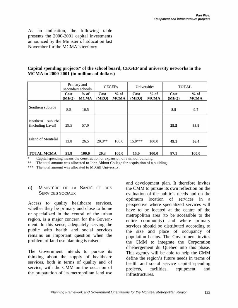
Part Five:Equipment and infrastructure projects
Planning Framework and Government Orientations for the Montréal Metropolitan Region 133
As an indication, the following tablepresents the 2000-2001 capital investmentsannounced by the Minister of Education lastNovember for the MCMA’s territory.
Capital spending projects* of the school board, CEGEP and university networks in theMCMA in 2000-2001 (in millions of dollars)
Primary andsecondary schools CEGEPs Universities TOTAL
Cost(MEQ)
% ofMCMA
Cost(MEQ)
% ofMCMA
Cost(MEQ)
% ofMCMA
Cost(MEQ)
% ofMCMA
Southern suburbs 8.5 16.5 8.5 9.7
Northern suburbs(including Laval) 29.5 57.0 29.5 33.9
Island of Montréal 13.8 26.5 20.3** 100.0 15.0*** 100.0 49.1 56.4
TOTAL MCMA 51.8 100.0 20.3 100.0 15.0 100.0 87.1 100.0* Capital spending means the construction or expansion of a school building.** The total amount was allocated to John Abbott College for acquisition of a building.*** The total amount was allocated to McGill University.
C) MINISTÈRE DE LA SANTÉ ET DESSERVICES SOCIAUX
Access to quality healthcare services,whether they be primary and close to homeor specialized in the central of the urbanregion, is a major concern for the Govern-ment. In this sense, adequately serving thepublic with health and social servicesremains an important question when theproblem of land use planning is raised.
The Government intends to pursue itsthinking about the supply of healthcareservices, both in terms of quality and ofservice, with the CMM on the occasion ofthe preparation of its metropolitan land use
and development plan. It therefore invitesthe CMM to pursue its own reflection on theevaluation of the public’s needs and on theoptimum location of services in aperspective where specialized services willhave to be located at the centre of themetropolitan area (to be accessible to theentire community) and where primaryservices should be distributed according tothe size and place of occupancy ofpopulation basins. The Government invitesthe CMM to integrate the Corporationd'hébergement du Québec into this phase.This agency will be able to help the CMMdefine the region’s future needs in terms ofhealth and social service capital spendingprojects, facilities, equipment andinfrastructures.
Part Five:Equipment and infrastructure projects
Planning Framework and Government Orientations for the Montréal Metropolitan Region134
The Government recalls that the regionalboards are responsible for choosing regionalpriorities. Therefore, the Communautémétropolitaine de Montréal should evaluatethe needs in conjunction with these bodiesand invite them to participate in drafting thedevelopment plan. This evaluation of needswill have to consider the Government’sreality and budget choices and the presenceof existing healthcare facilities, which mustbe optimized before considering the additionof new installations.
Given that the problems and needs of themetropolitan region in terms of health andsocial services remain complex, the Minis-tère de la Santé et des Services sociaux willplay an active role with the CMM and theregional boards in the definition of long-term priorities.
The department intends to pursue variouskinds of interventions within the CMM’sterritory. Most concern existing facilitieswhich will be renovated or expanded.
On the Island of Montréal, a total of 49projects under study and in the implemen-tation phase will affect some 38 facilities.Among the major projects under study, thefollowing must be noted:
¶ Construction of an ambulatory centreand improvements made to the PavillonMarcel-Lamoureux of Hôpital Maison-neuve-Rosemont ($40.5 million);
¶ The implementation of an ambulatorycentre at Hôpital Sacré-Cœur deMontréal ($31.6 million);
¶ The consolidation of the four campusesof the Batshaw Youth and FamilyCentres in Westmount ($30 million).
Many projects (33 in all) are in theimplementation phase and concern 25facilities. It is appropriate to mention:
¶ Modernization of the ambulatory centreof the Lakeshore General Hospital inPointe-Claire ($65.3 million);
¶ The three hospital centres attached to theCHUM which will be the object ofexpansion and development (total cost:$74.7 million).
It must also be remembered that two majorprojects already announced are in theplanning and needs evaluation phase:
¶ Centre hospitalier de l'Université deMontréal (CHUM), which will belocated near the Rosemont Métrostation;
¶ The McGill University Health Centre(MUHC), which will be established nearthe Vendôme Métro station.
The needs evaluation currently in progressmeans that these two projects are not yet atthe plans and specifications production stage(projects under study).
In Laval, three projects are currently understudy, including one major one, constructionof an ambulatory centre in the Chomedeyneighbourhood at a cost of $35 million.Only one project is currently in theimplementation phase, construction of a 96-bed CHSLD in Sainte-Rose.
In the northern suburbs, a major construc-tion project for an ambulatory centre inLachenaie is in the implementation phase.Construction of a 128-bed CHSLD inL'Assomption is under study, as is anexpansion project for CLSC Lamater inTerrebonne.
Part Five:Equipment and infrastructure projects
Planning Framework and Government Orientations for the Montréal Metropolitan Region 135
Finally $40 million of the $60 million ofcapital expenditures in projects under studyin the southern suburbs will go to HôpitalPierre-Boucher for redevelopment of thebirthing centre and improvement ofambulatory services. Only one project is inthe implementation phase, the project toexpand Foyer de Châteauguay by theaddition of 46 beds.
The following table presents the inventoryof capital expenditures of the Ministère de laSanté et des Services sociaux in the MCMA.
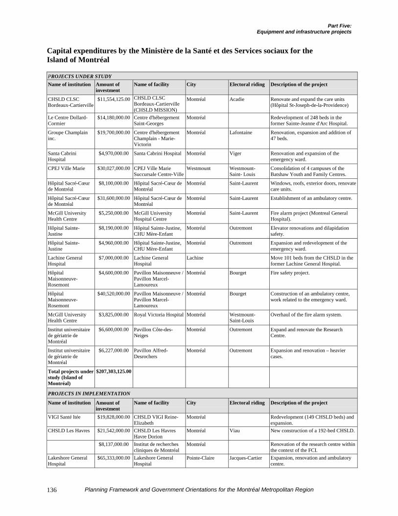
Part Five:Equipment and infrastructure projects
Planning Framework and Government Orientations for the Montréal Metropolitan Region136
Capital expenditures by the Ministère de la Santé et des Services sociaux for theIsland of Montréal
PROJECTS UNDER STUDYName of institution Amount of
investmentName of facility City Electoral riding Description of the project
CHSLD CLSCBordeaux-Cartierville
$11,554,125.00 CHSLD CLSCBordeaux-Cartierville(CHSLD MISSION)
Montréal Acadie Renovate and expand the care units(Hôpital St-Joseph-de-la-Providence)
Le Centre Dollard-Cormier
$14,180,000.00 Centre d'hébergementSaint-Georges
Montréal Redevelopment of 248 beds in theformer Sainte-Jeanne d'Arc Hospital.
Groupe Champlaininc.
$19,700,000.00 Centre d'hébergementChamplain - Marie-Victorin
Montréal Lafontaine Renovation, expansion and addition of47 beds.
Santa CabriniHospital
$4,970,000.00 Santa Cabrini Hospital Montréal Viger Renovation and expansion of theemergency ward.
CPEJ Ville Marie $30,027,000.00 CPEJ Ville MarieSuccursale Centre-Ville
Westmount Westmount-Saint- Louis
Consolidation of 4 campuses of theBatshaw Youth and Family Centres.
Hôpital Sacré-Cœurde Montréal
$8,100,000.00 Hôpital Sacré-Cœur deMontréal
Montréal Saint-Laurent Windows, roofs, exterior doors, renovatecare units.
Hôpital Sacré-Cœurde Montréal
$31,600,000.00 Hôpital Sacré-Cœur deMontréal
Montréal Saint-Laurent Establishment of an ambulatory centre.
McGill UniversityHealth Centre
$5,250,000.00 McGill UniversityHospital Centre
Montréal Saint-Laurent Fire alarm project (Montreal GeneralHospital).
Hôpital Sainte-Justine
$8,190,000.00 Hôpital Sainte-Justine,CHU Mère-Enfant
Montréal Outremont Elevator renovations and dilapidationsafety.
Hôpital Sainte-Justine
$4,960,000.00 Hôpital Sainte-Justine,CHU Mère-Enfant
Montréal Outremont Expansion and redevelopment of theemergency ward.
Lachine GeneralHospital
$7,000,000.00 Lachine GeneralHospital
Lachine Move 101 beds from the CHSLD in theformer Lachine General Hospital.
HôpitalMaisonneuve-Rosemont
$4,600,000.00 Pavillon Maisonneuve /Pavillon Marcel-Lamoureux
Montréal Bourget Fire safety project.
HôpitalMaisonneuve-Rosemont
$40,520,000.00 Pavillon Maisonneuve /Pavillon Marcel-Lamoureux
Montréal Bourget Construction of an ambulatory centre,work related to the emergency ward.
McGill UniversityHealth Centre
$3,825,000.00 Royal Victoria Hospital Montréal Westmount-Saint-Louis
Overhaul of the fire alarm system.
Institut universitairede gériatrie deMontréal
$6,600,000.00 Pavillon Côte-des-Neiges
Montréal Outremont Expand and renovate the ResearchCentre.
Institut universitairede gériatrie deMontréal
$6,227,000.00 Pavillon Alfred-Desrochers
Montréal Outremont Expansion and renovation – heaviercases.
Total projects understudy (Island ofMontréal)
$207,303,125.00
PROJECTS IN IMPLEMENTATION
Name of institution Amount ofinvestment
Name of facility City Electoral riding Description of the project
VIGI Santé ltée $19,828,000.00 CHSLD VIGI Reine-Elizabeth
Montréal Redevelopment (149 CHSLD beds) andexpansion.
CHSLD Les Havres $21,542,000.00 CHSLD Les HavresHavre Dorion
Montréal Viau New construction of a 192-bed CHSLD.
$8,137,000.00 Institut de recherchescliniques de Montréal
Montréal Renovation of the research centre withinthe context of the FCI.
Lakeshore GeneralHospital
$65,333,000.00 Lakeshore GeneralHospital
Pointe-Claire Jacques-Cartier Expansion, renovation and ambulatorycentre.
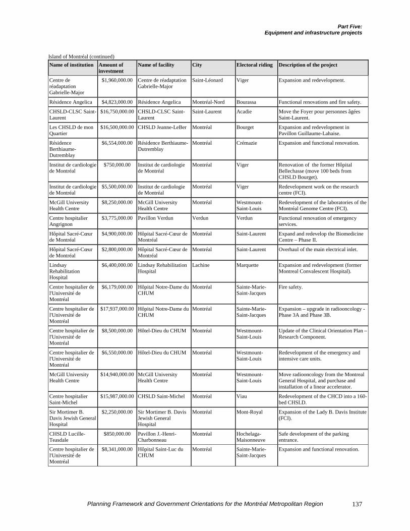
Part Five:Equipment and infrastructure projects
Planning Framework and Government Orientations for the Montréal Metropolitan Region 137
Island of Montréal (continued)Name of institution Amount of
investmentName of facility City Electoral riding Description of the project
Centre deréadaptationGabrielle-Major
$1,960,000.00 Centre de réadaptationGabrielle-Major
Saint-Léonard Viger Expansion and redevelopment.
Résidence Angelica $4,823,000.00 Résidence Angelica Montréal-Nord Bourassa Functional renovations and fire safety.
CHSLD-CLSC Saint-Laurent
$16,750,000.00 CHSLD-CLSC Saint-Laurent
Saint-Laurent Acadie Move the Foyer pour personnes âgéesSaint-Laurent.
Les CHSLD de monQuartier
$16,500,000.00 CHSLD Jeanne-LeBer Montréal Bourget Expansion and redevelopment inPavillon Guillaume-Lahaise.
RésidenceBerthiaume-Dutremblay
$6,554,000.00 Résidence Berthiaume-Dutremblay
Montréal Crémazie Expansion and functional renovation.
Institut de cardiologiede Montréal
$750,000.00 Institut de cardiologiede Montréal
Montréal Viger Renovation of the former HôpitalBellechasse (move 100 beds fromCHSLD Bourget).
Institut de cardiologiede Montréal
$5,500,000.00 Institut de cardiologiede Montréal
Montréal Viger Redevelopment work on the researchcentre (FCI).
McGill UniversityHealth Centre
$8,250,000.00 McGill UniversityHealth Centre
Montréal Westmount-Saint-Louis
Redevelopment of the laboratories of theMontréal Genome Centre (FCI).
Centre hospitalierAngrignon
$3,775,000.00 Pavillon Verdun Verdun Verdun Functional renovation of emergencyservices.
Hôpital Sacré-Cœurde Montréal
$4,900,000.00 Hôpital Sacré-Cœur deMontréal
Montréal Saint-Laurent Expand and redevelop the BiomedicineCentre – Phase II.
Hôpital Sacré-Cœurde Montréal
$2,800,000.00 Hôpital Sacré-Cœur deMontréal
Montréal Saint-Laurent Overhaul of the main electrical inlet.
LindsayRehabilitationHospital
$6,400,000.00 Lindsay RehabilitationHospital
Lachine Marquette Expansion and redevelopment (formerMontreal Convalescent Hospital).
Centre hospitalier del'Université deMontréal
$6,179,000.00 Hôpital Notre-Dame duCHUM
Montréal Sainte-Marie-Saint-Jacques
Fire safety.
Centre hospitalier del'Université deMontréal
$17,937,000.00 Hôpital Notre-Dame duCHUM
Montréal Sainte-Marie-Saint-Jacques
Expansion – upgrade in radiooncology -Phase 3A and Phase 3B.
Centre hospitalier del'Université deMontréal
$8,500,000.00 Hôtel-Dieu du CHUM Montréal Westmount-Saint-Louis
Update of the Clinical Orientation Plan –Research Component.
Centre hospitalier del'Université deMontréal
$6,550,000.00 Hôtel-Dieu du CHUM Montréal Westmount-Saint-Louis
Redevelopment of the emergency andintensive care units.
McGill UniversityHealth Centre
$14,940,000.00 McGill UniversityHealth Centre
Montréal Westmount-Saint-Louis
Move radiooncology from the MontrealGeneral Hospital, and purchase andinstallation of a linear accelerator.
Centre hospitalierSaint-Michel
$15,987,000.00 CHSLD Saint-Michel Montréal Viau Redevelopment of the CHCD into a 160-bed CHSLD.
Sir Mortimer B.Davis Jewish GeneralHospital
$2,250,000.00 Sir Mortimer B. DavisJewish GeneralHospital
Montréal Mont-Royal Expansion of the Lady B. Davis Institute(FCI).
CHSLD Lucille-Teasdale
$850,000.00 Pavillon J.-Henri-Charbonneau
Montréal Hochelaga-Maisonneuve
Safe development of the parkingentrance.
Centre hospitalier del'Université deMontréal
$8,341,000.00 Hôpital Saint-Luc duCHUM
Montréal Sainte-Marie-Saint-Jacques
Expansion and functional renovation.
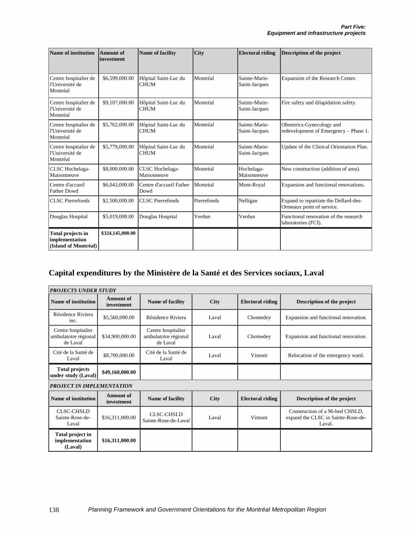
Part Five:Equipment and infrastructure projects
Planning Framework and Government Orientations for the Montréal Metropolitan Region138
Name of institution Amount ofinvestment
Name of facility City Electoral riding Description of the project
Centre hospitalier del'Université deMontréal
$6,599,000.00 Hôpital Saint-Luc duCHUM
Montréal Sainte-Marie-Saint-Jacques
Expansion of the Research Centre.
Centre hospitalier del'Université deMontréal
$9,107,000.00 Hôpital Saint-Luc duCHUM
Montréal Sainte-Marie-Saint-Jacques
Fire safety and dilapidation safety.
Centre hospitalier del'Université deMontréal
$5,762,000.00 Hôpital Saint-Luc duCHUM
Montréal Sainte-Marie-Saint-Jacques
Obstetrics-Gynecology andredevelopment of Emergency – Phase 1.
Centre hospitalier del'Université deMontréal
$5,779,000.00 Hôpital Saint-Luc duCHUM
Montréal Sainte-Marie-Saint-Jacques
Update of the Clinical Orientation Plan.
CLSC Hochelaga-Maisonneuve
$8,000,000.00 CLSC Hochelaga-Maisonneuve
Montréal Hochelaga-Maisonneuve
New construction (addition of area).
Centre d'accueilFather Dowd
$6,043,000.00 Centre d'accueil FatherDowd
Montréal Mont-Royal Expansion and functional renovations.
CLSC Pierrefonds $2,500,000.00 CLSC Pierrefonds Pierrefonds Nelligan Expand to repatriate the Dollard-des-Ormeaux point of service.
Douglas Hospital $5,019,000.00 Douglas Hospital Verdun Verdun Functional renovation of the researchlaboratories (FCI).
Total projects inimplementation(Island of Montréal)
$324,145,000.00
Capital expenditures by the Ministère de la Santé et des Services sociaux, Laval
PROJECTS UNDER STUDY
Name of institution Amount ofinvestment Name of facility City Electoral riding Description of the project
Résidence Rivierainc. $5,560,000.00 Résidence Riviera Laval Chomedey Expansion and functional renovation.
Centre hospitalierambulatoire régional
de Laval$34,900,000.00
Centre hospitalierambulatoire régional
de LavalLaval Chomedey Expansion and functional renovation.
Cité de la Santé deLaval $8,700,000.00 Cité de la Santé de
Laval Laval Vimont Relocation of the emergency ward.
Total projectsunder study (Laval) $49,160,000.00
PROJECT IN IMPLEMENTATION
Name of institution Amount ofinvestment Name of facility City Electoral riding Description of the project
CLSC-CHSLDSainte-Rose-de-
Laval$16,311,000.00 CLSC-CHSLD
Sainte-Rose-de-Laval Laval VimontConstruction of a 96-bed CHSLD,
expand the CLSC in Sainte-Rose-de-Laval.
Total project inimplementation
(Laval)$16,311,000.00
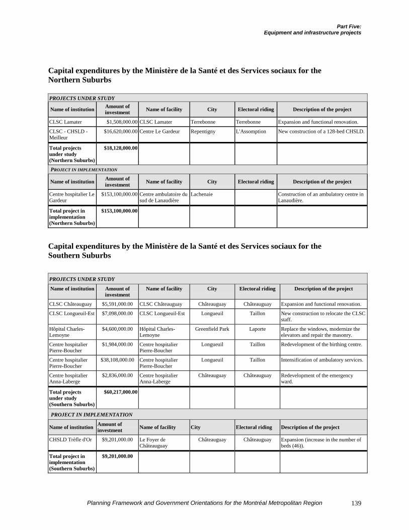
Part Five:Equipment and infrastructure projects
Planning Framework and Government Orientations for the Montréal Metropolitan Region 139
Capital expenditures by the Ministère de la Santé et des Services sociaux for theNorthern Suburbs
PROJECTS UNDER STUDY
Name of institution Amount ofinvestment Name of facility City Electoral riding Description of the project
CLSC Lamater $1,508,000.00 CLSC Lamater Terrebonne Terrebonne Expansion and functional renovation.
CLSC - CHSLD -Meilleur
$16,620,000.00 Centre Le Gardeur Repentigny L'Assomption New construction of a 128-bed CHSLD.
Total projectsunder study(Northern Suburbs)
$18,128,000.00
PROJECT IN IMPLEMENTATION
Name of institution Amount ofinvestment Name of facility City Electoral riding Description of the project
Centre hospitalier LeGardeur
$153,100,000.00 Centre ambulatoire dusud de Lanaudière
Lachenaie Construction of an ambulatory centre inLanaudière.
Total project inimplementation(Northern Suburbs)
$153,100,000.00
Capital expenditures by the Ministère de la Santé et des Services sociaux for theSouthern Suburbs
PROJECTS UNDER STUDY
Name of institution Amount ofinvestment
Name of facility City Electoral riding Description of the project
CLSC Châteauguay $5,591,000.00 CLSC Châteauguay Châteauguay Châteauguay Expansion and functional renovation.
CLSC Longueuil-Est $7,098,000.00 CLSC Longueuil-Est Longueuil Taillon New construction to relocate the CLSCstaff.
Hôpital Charles-Lemoyne
$4,600,000.00 Hôpital Charles-Lemoyne
Greenfield Park Laporte Replace the windows, modernize theelevators and repair the masonry.
Centre hospitalierPierre-Boucher
$1,984,000.00 Centre hospitalierPierre-Boucher
Longueuil Taillon Redevelopment of the birthing centre.
Centre hospitalierPierre-Boucher
$38,108,000.00 Centre hospitalierPierre-Boucher
Longueuil Taillon Intensification of ambulatory services.
Centre hospitalierAnna-Laberge
$2,836,000.00 Centre hospitalierAnna-Laberge
Châteauguay Châteauguay Redevelopment of the emergencyward.
Total projectsunder study(Southern Suburbs)
$60,217,000.00
PROJECT IN IMPLEMENTATION
Name of institution Amount ofinvestment Name of facility City Electoral riding Description of the project
CHSLD Trèfle d'Or $9,201,000.00 Le Foyer deChâteauguay
Châteauguay Châteauguay Expansion (increase in the number ofbeds (46)).
Total project inimplementation(Southern Suburbs)
$9,201,000.00
Part Five:Equipment and infrastructure projects
Planning Framework and Government Orientations for the Montréal Metropolitan Region140
D) SOCIÉTÉ IMMOBILIÈRE DU QUÉBEC
Société immobilière du Québec has themission of accommodating the QuébecGovernment’s departments and agencies inpremises adapted to their needs.
The SIQ attaches great importance toaccessibility of government offices andservices. For this purpose, it acquired a 26-storey building in 2000 at 500, boulevardRené-Lévesque Ouest in Montréal. Locatedin the heart of downtown and accessible bythe two main Métro lines and by theBonaventure terminus, this building will becompletely dedicated to government usewithin the next twelve years.
In addition to the projects for renovation ofthe building located at 100, rue Notre-DameEst in Old Montréal, which houses theMontréal conservatories of music and dra-matic arts, the SIQ is also planning formajor renovations inside the Palais dejustice (1, rue Notre-Dame Est). In this case,the work normally will be spread out until2005.
Finally, following redeployment of theactivities of the Sûreté du Québec station inSaint-Laurent, the SIQ intends to find a siteto provide for the agency’s increased needs.
TRANSPORTATION INFRASTRUCTURES
Transportation concerns passengers andfreight as well as infrastructures for trans-porting energy. These networked infrastruc-tures are an important component of theurban skeleton and thus of the shape of theurban region. Planned in relation to themajor land use designations and usedadequately, these infrastructures can exert a
determining influence on the region’seconomy and thus contribute to maintenanceof the quality of life and the environment.
The Government of Québec also affirmed allof its concerns for passenger and freighttransportation in the orientations it adoptedwith the tabling of the trip management planfor the Montréal metropolitan region inApril 2000, the Plan de gestion des dépla-cements pour la région métropolitaine deMontréal. These four orientations sought to:
¶ “Favour interventions that support thecompetitiveness of the regional andQuébec economy”;
¶ “Favour interventions that promoterevitalization of the centre of the metro-politan area and facilitate the achieve-ment of the Government’s economicdevelopment, land use planning andenvironmental objectives”;
¶ “Give priority to the strengthening andmodernization of the existing transpor-tation networks”;
¶ “Ensure the efficiency and equity offunding”.1
For this purpose, the priority interventionstrategy adopted by the Ministère desTransports in the trip management plan isdefined along 6 axes:
¶ Demand management;
¶ An integrated strategy for the easternpart of the urban region;
¶ Increase in mass transit supply;
1 Ministère des Transports, Plan de gestion des déplacements,
région métropolitaine de Montréal, April 2000, p. 37-41. (Ourtranslation.)
Part Five:Equipment and infrastructure projects
Planning Framework and Government Orientations for the Montréal Metropolitan Region 141
¶ Interventions on the highway network atthe centre of the metropolitan area;
¶ Interventions on the highway networkleading to the centre of the metropolitanarea;
¶ Interventions to repair the transportationnetworks.
Also, certain projects, both in mass transitand in the improvement and development ofthe highway network, will require additionalstudies before a decision is made.
In general, regarding passenger transpor-tation, the Government wants the public toderive maximum benefit from the masstransit networks and systems established.
The main organizations dedicated to thepromotion of transportation are concernedabout the gradual abandonment of masstransit in favour of the automobile, mainly intrips between home and work. This situationresults in underutilization of non-pollutingbut efficient infrastructures and, parallel tothis, highway congestion and in increase ingreenhouse gas emissions. Delivery offreight is also compromised.
Regarding freight, the strategic networkneeds to be fluid to play its role efficientlyin the economic promotion of the metro-politan region.
However, the over-extensive use of thehighway network by motorists in tripsbetween home and work accentuatescongestion and saturation of the arteries,which increases freight delivery time andincreases prices due to lost time.
The Government wants more concertedaction by all transportation partners to putconditions in place that promote greaterefficiency of the existing networks and
systems. To the extent that they aresupported by all of the partners, particularlyby land use planning and demandmanagement measures, these actions willcontribute to optimum use of the networks.
The Government also wants the public tofavour mass transit in its trips for work andstudy. The Government considers that theestablishment of mass transit networks, boththose that exist and those that it plans toimplement over the next few years, canreally be profitable only if the region’surban development seeks to develop thesenetworks in turn. This is why it is imperativethat development be concentrated in theexisting axes of heavy mass transit modes(Métro, commuter trains) and especially inthe service area of these infrastructures.
A) HIGHWAY TRANSPORTATION
The mission of the Ministère des Transportsis to ensure the mobility of passengers andfreight through efficient and safetransportation networks that contribute toQuébec’s economic development throughthe development, planning and operation ofintegration transportation infrastructures.For this purpose, the department ensures thenecessary funding of transportation infra-structures, whether for highway transpor-tation or mass transit.
The vast majority of the Ministère desTransports’ interventions pertain to thehighway network and are intended toimprove the mobility of passengers andfreight. However, these actions are likely toremain ineffective if they are not supportedby citizen efforts to switch over to masstransit for more of their trips for work andstudy. The projects that the AMT intends topursue (presented in the next section) should
Part Five:Equipment and infrastructure projects
Planning Framework and Government Orientations for the Montréal Metropolitan Region142
support the MTQ’s parallel actions regar-ding highway transportation.
In the MCMA, the Ministère des Transports’interventions over the next few years,specified in the Plan de gestion desdéplacements and in its regular program,which have an impact in terms of land useplanning, are on four levels:
¶ Interventions on the highway network inthe centre of the metropolitan area;
¶ Interventions on the highway networkleading to the centre of the metropolitanarea;
¶ Interventions under study within thecontext of the Plan de gestion desdéplacements;
¶ The other projects under study in thefive-year plan for the 2001-2006 period.
These interventions add up to investments of$3.03 billion, including the projects understudy.
There are seven interventions on thehighway network at the centre of themetropolitan area. They largely concern theimprovement or rehabilitation of certainarteries of the superior highway network.The biggest projects in terms of capitalbudget are:
¶ Optimization of Autoroute 40 ($762.3million);
¶ Modernization of rue Notre-Dame ($285million);
¶ Redevelopment of the Dorval A-20 / A-520 traffic circle ($140 million).
The Plan de gestion des déplacements alsoprovides for an MTQ/Ville de Montréal jointaction plan intended to improve servicebetween the superior highway network and
the municipal arterial network. Among theproposed interventions, we must mention:
¶ Redevelopment of the L’Acadie trafficcircle ($43 million);
¶ Rehabilitation of the Décarie corridor($32.7 million);
¶ Connection of Cavendish BoulevardNorth-South and Royalmount ($24million).
The interventions on the highway networkleading to the centre of the metropolitan areawill be mainly made on the South Shore,although a major investment project shouldbe established in principle between Lavaland the Island of Montréal. Three projectsretain our attention here:
¶ Completion of Autoroute 30 betweenChâteauguay and Vaudreuil-Dorion($530 million);
¶ Extension of Autoroute 25 betweenLaval and Montréal ($329 million);
¶ Completion of Autoroute 30 betweenCandiac and Sainte-Catherine ($110million).
Regarding interventions under study concer-ning the highway network in the tripmanagement plan, the Ministère desTransports will pursue its study of twoprojects:
¶ Improvement of Autoroute 20 on theIsland of Montréal ($341 million);
¶ Improvement of Autoroutes 15 and 640on the North Shore ($89 million).
Finally, the department envisions variousmore localized interventions within themetropolitan region over the 2001-2006period. These investments, although minor,will improve the quality of life of the
Part Five:Equipment and infrastructure projects
Planning Framework and Government Orientations for the Montréal Metropolitan Region 143
highway’s neighbouring residents and thesafety of motorists or will facilitate access tothe superior highway network in some cases.Among the most important interventionsare:
¶ In MRC Thérèse-de-Blainville, construc-tion of a weaving lane on Autoroute 640,between Route 117 and Autoroute 15(about $23 million);
¶ In MRC des Moulins, the addition ofcollectors on Autoroute 40 in Lachenaieand Charlemagne ($19.9 million);
¶ In MRC de L'Assomption, constructionof a noise barrier on Autoroute 40 inRepentigny ($18.7 million);
¶ In MRC de Mirabel, construction of anew interchange on Autoroute 50 (about$12 million);
¶ In MRC de Roussillon, reconstruction ofpart of Route 104 in La Prairie (about$8.6 million);
¶ In MRC de Laval, the Ministère desTransports is considering the con-struction of noise barriers on Autoroutes15 and 25 (total cost of $10.7 million);
¶ On the Island of Montréal, rede-velopment of access ramps at theintersection of Autoroute 40 andboulevard Bourget ($1.5 million).
The following table presents all of theinterventions projected by the Ministère desTransports to improve the highway network.
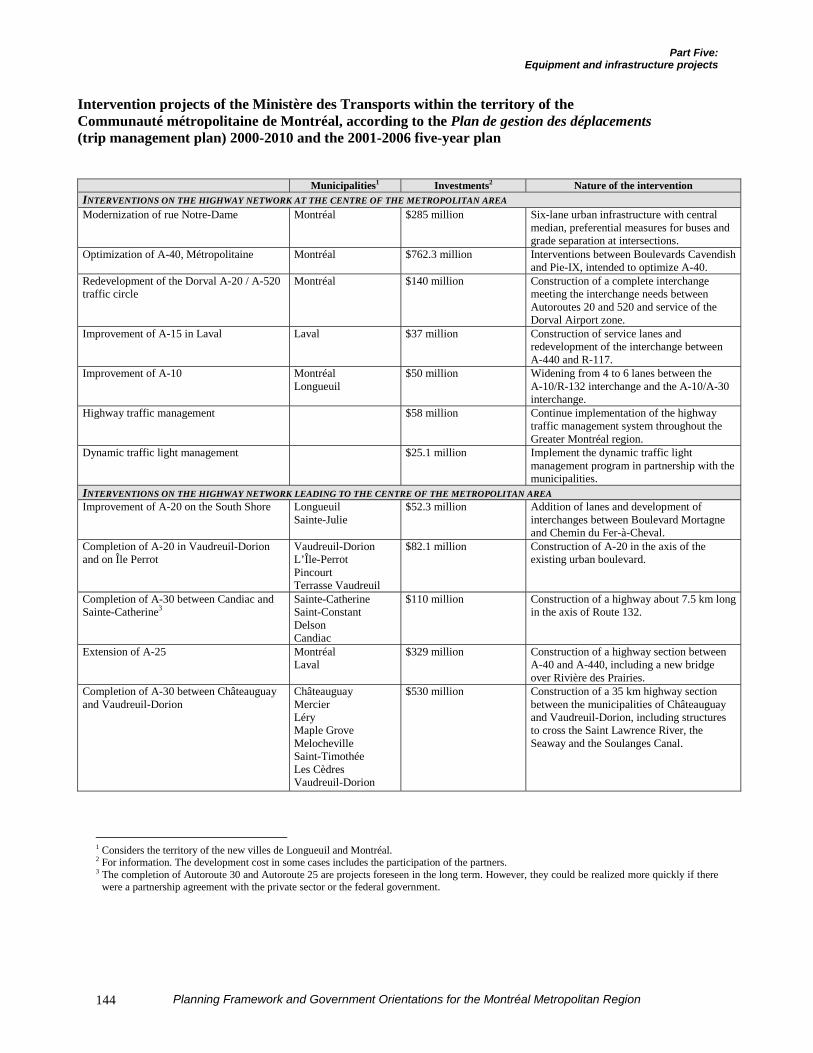
Part Five:Equipment and infrastructure projects
Planning Framework and Government Orientations for the Montréal Metropolitan Region144
Intervention projects of the Ministère des Transports within the territory of theCommunauté métropolitaine de Montréal, according to the Plan de gestion des déplacements(trip management plan) 2000-2010 and the 2001-2006 five-year plan
Municipalities1 Investments2 Nature of the interventionINTERVENTIONS ON THE HIGHWAY NETWORK AT THE CENTRE OF THE METROPOLITAN AREAModernization of rue Notre-Dame Montréal $285 million Six-lane urban infrastructure with central
median, preferential measures for buses andgrade separation at intersections.
Optimization of A-40, Métropolitaine Montréal $762.3 million Interventions between Boulevards Cavendishand Pie-IX, intended to optimize A-40.
Redevelopment of the Dorval A-20 / A-520traffic circle
Montréal $140 million Construction of a complete interchangemeeting the interchange needs betweenAutoroutes 20 and 520 and service of theDorval Airport zone.
Improvement of A-15 in Laval Laval $37 million Construction of service lanes andredevelopment of the interchange betweenA-440 and R-117.
Improvement of A-10 MontréalLongueuil
$50 million Widening from 4 to 6 lanes between theA-10/R-132 interchange and the A-10/A-30interchange.
Highway traffic management $58 million Continue implementation of the highwaytraffic management system throughout theGreater Montréal region.
Dynamic traffic light management $25.1 million Implement the dynamic traffic lightmanagement program in partnership with themunicipalities.
INTERVENTIONS ON THE HIGHWAY NETWORK LEADING TO THE CENTRE OF THE METROPOLITAN AREAImprovement of A-20 on the South Shore Longueuil
Sainte-Julie$52.3 million Addition of lanes and development of
interchanges between Boulevard Mortagneand Chemin du Fer-à-Cheval.
Completion of A-20 in Vaudreuil-Dorionand on Île Perrot
Vaudreuil-DorionL’Île-PerrotPincourtTerrasse Vaudreuil
$82.1 million Construction of A-20 in the axis of theexisting urban boulevard.
Completion of A-30 between Candiac andSainte-Catherine3
Sainte-CatherineSaint-ConstantDelsonCandiac
$110 million Construction of a highway about 7.5 km longin the axis of Route 132.
Extension of A-25 MontréalLaval
$329 million Construction of a highway section betweenA-40 and A-440, including a new bridgeover Rivière des Prairies.
Completion of A-30 between Châteauguayand Vaudreuil-Dorion
ChâteauguayMercierLéryMaple GroveMelochevilleSaint-TimothéeLes CèdresVaudreuil-Dorion
$530 million Construction of a 35 km highway sectionbetween the municipalities of Châteauguayand Vaudreuil-Dorion, including structuresto cross the Saint Lawrence River, theSeaway and the Soulanges Canal.
1 Considers the territory of the new villes de Longueuil and Montréal.2 For information. The development cost in some cases includes the participation of the partners.3 The completion of Autoroute 30 and Autoroute 25 are projects foreseen in the long term. However, they could be realized more quickly if there
were a partnership agreement with the private sector or the federal government.
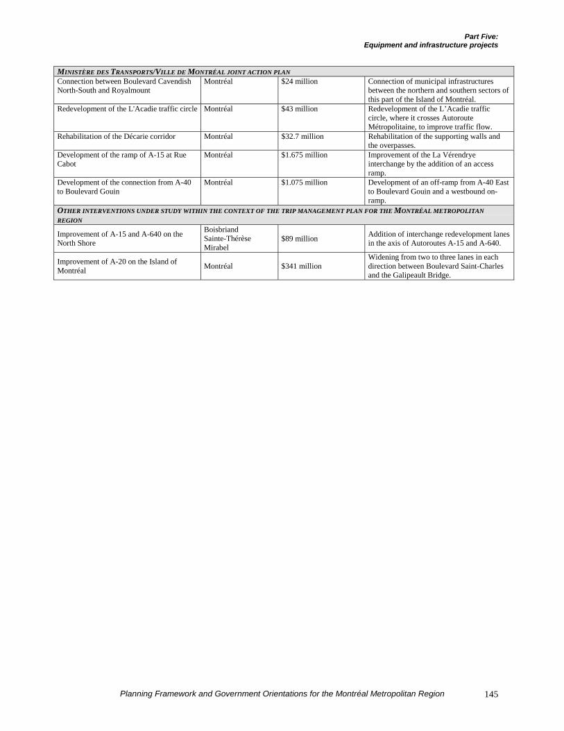
Part Five:Equipment and infrastructure projects
Planning Framework and Government Orientations for the Montréal Metropolitan Region 145
MINISTÈRE DES TRANSPORTS/VILLE DE MONTRÉAL JOINT ACTION PLANConnection between Boulevard CavendishNorth-South and Royalmount
Montréal $24 million Connection of municipal infrastructuresbetween the northern and southern sectors ofthis part of the Island of Montréal.
Redevelopment of the L'Acadie traffic circle Montréal $43 million Redevelopment of the L’Acadie trafficcircle, where it crosses AutorouteMétropolitaine, to improve traffic flow.
Rehabilitation of the Décarie corridor Montréal $32.7 million Rehabilitation of the supporting walls andthe overpasses.
Development of the ramp of A-15 at RueCabot
Montréal $1.675 million Improvement of the La Vérendryeinterchange by the addition of an accessramp.
Development of the connection from A-40to Boulevard Gouin
Montréal $1.075 million Development of an off-ramp from A-40 Eastto Boulevard Gouin and a westbound on-ramp.
OTHER INTERVENTIONS UNDER STUDY WITHIN THE CONTEXT OF THE TRIP MANAGEMENT PLAN FOR THE MONTRÉAL METROPOLITANREGION
Improvement of A-15 and A-640 on theNorth Shore
BoisbriandSainte-ThérèseMirabel
$89 million Addition of interchange redevelopment lanesin the axis of Autoroutes A-15 and A-640.
Improvement of A-20 on the Island ofMontréal Montréal $341 million
Widening from two to three lanes in eachdirection between Boulevard Saint-Charlesand the Galipeault Bridge.
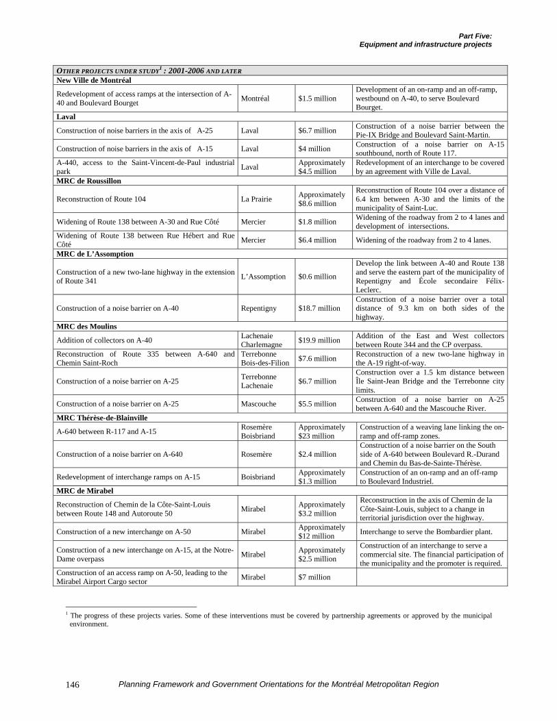
Part Five:Equipment and infrastructure projects
Planning Framework and Government Orientations for the Montréal Metropolitan Region146
OTHER PROJECTS UNDER STUDY1 : 2001-2006 AND LATERNew Ville de Montréal
Redevelopment of access ramps at the intersection of A-40 and Boulevard Bourget Montréal $1.5 million
Development of an on-ramp and an off-ramp,westbound on A-40, to serve BoulevardBourget.
Laval
Construction of noise barriers in the axis of A-25 Laval $6.7 million Construction of a noise barrier between thePie-IX Bridge and Boulevard Saint-Martin.
Construction of noise barriers in the axis of A-15 Laval $4 million Construction of a noise barrier on A-15southbound, north of Route 117.
A-440, access to the Saint-Vincent-de-Paul industrialpark Laval Approximately
$4.5 millionRedevelopment of an interchange to be coveredby an agreement with Ville de Laval.
MRC de Roussillon
Reconstruction of Route 104 La Prairie Approximately$8.6 million
Reconstruction of Route 104 over a distance of6.4 km between A-30 and the limits of themunicipality of Saint-Luc.
Widening of Route 138 between A-30 and Rue Côté Mercier $1.8 million Widening of the roadway from 2 to 4 lanes anddevelopment of intersections.
Widening of Route 138 between Rue Hébert and RueCôté Mercier $6.4 million Widening of the roadway from 2 to 4 lanes.
MRC de L’Assomption
Construction of a new two-lane highway in the extensionof Route 341 L’Assomption $0.6 million
Develop the link between A-40 and Route 138and serve the eastern part of the municipality ofRepentigny and École secondaire Félix-Leclerc.
Construction of a noise barrier on A-40 Repentigny $18.7 millionConstruction of a noise barrier over a totaldistance of 9.3 km on both sides of thehighway.
MRC des Moulins
Addition of collectors on A-40 LachenaieCharlemagne $19.9 million Addition of the East and West collectors
between Route 344 and the CP overpass.Reconstruction of Route 335 between A-640 andChemin Saint-Roch
TerrebonneBois-des-Filion $7.6 million Reconstruction of a new two-lane highway in
the A-19 right-of-way.
Construction of a noise barrier on A-25 TerrebonneLachenaie $6.7 million
Construction over a 1.5 km distance betweenÎle Saint-Jean Bridge and the Terrebonne citylimits.
Construction of a noise barrier on A-25 Mascouche $5.5 million Construction of a noise barrier on A-25between A-640 and the Mascouche River.
MRC Thérèse-de-Blainville
A-640 between R-117 and A-15 RosemèreBoisbriand
Approximately$23 million
Construction of a weaving lane linking the on-ramp and off-ramp zones.
Construction of a noise barrier on A-640 Rosemère $2.4 millionConstruction of a noise barrier on the Southside of A-640 between Boulevard R.-Durandand Chemin du Bas-de-Sainte-Thérèse.
Redevelopment of interchange ramps on A-15 Boisbriand Approximately$1.3 million
Construction of an on-ramp and an off-rampto Boulevard Industriel.
MRC de Mirabel
Reconstruction of Chemin de la Côte-Saint-Louisbetween Route 148 and Autoroute 50 Mirabel Approximately
$3.2 million
Reconstruction in the axis of Chemin de laCôte-Saint-Louis, subject to a change interritorial jurisdiction over the highway.
Construction of a new interchange on A-50 Mirabel Approximately$12 million Interchange to serve the Bombardier plant.
Construction of a new interchange on A-15, at the Notre-Dame overpass Mirabel Approximately
$2.5 million
Construction of an interchange to serve acommercial site. The financial participation ofthe municipality and the promoter is required.
Construction of an access ramp on A-50, leading to theMirabel Airport Cargo sector Mirabel $7 million
1 The progress of these projects varies. Some of these interventions must be covered by partnership agreements or approved by the municipal
environment.
Part Five:Equipment and infrastructure projects
Planning Framework and Government Orientations for the Montréal Metropolitan Region 147
B) MASS TRANSIT
The Agence métropolitaine de transport actsas the government’s agent in planning masstransit in the metropolitan region. The MTQensures funding of infrastructures. Thecombined action of the AMT and the MTQhas produced encouraging results: since thecreation of the AMT in 1995, the number ofmass transit trips only declined by 3%between 1993 and 1998, compared to 11%between 1987 and 1993. The efforts appliedhelped mitigate the general trend tomotorization.
However, the municipal field – with theCommunauté métropolitaine de Montréal inthe lead – will have to change certain landuse planning situations so that the Govern-ment’s interventions in mass transitconsolidate and, in the longer term, evenincrease the mass transit share of passengertrips. In this regard, the AMT and the MTQintend to foster a constant dialogue with theCommunity to find the most advantageousand most efficient land use planningsolutions so as to give heavy mass transitmodes an active role in passenger transpor-tation in the MCMA.
While it is currently reviewing its strategicplan, the Agence métropolitaine de trans-port, within the context of improvement ofits metropolitan mass transit infrastructures,will pursue different infrastructure projectsin the nine metropolitan mass transitcorridors. The AMT will integrate most ofthe projects intended to improve mass transitproposed by the MTQ into the trip mana-gement plan. Among the projects alreadyannounced, it is appropriate to recall:
¶ The extension of Métro Line 5 toboulevard Pie-IX (total cost of $63.5million) and then from Pie-IX to Anjou(total cost of $317 million);
¶ The extension of Métro Line 2 to Laval($380 million);
¶ The extension of Métro Line 4 inLongueuil to boulevard Roland-Therrien($333.4 million);
¶ The full commissioning of theMontréal / Mont-Saint-Hilaire commutertrain line ($32.8 million);
¶ Several reserved lane developments areplanned, particularly improvements tothe Champlain Bridge reserved lane andin the northern part of the region throughimprovements between the Island ofMontréal (Lachapelle Bridge, Marcel-Laurin / Côte Vertu) and the northernsuburbs;
¶ It should also be noted that the AMTplans to expand several of its incentiveparking lots over the next few years,which will increase the total number ofparking places to 28,777.
Regarding projects under study, the AMTintends the major investments to go to theimprovement of service by the acquisition ofnew equipment and the development ofreserved lanes.
In the northern suburbs:
¶ Purchase of 22 new cars on the Deux-Montagnes / Montréal commuter trainline ($66 million).
In the southern suburbs:
¶ Development of a reserved lane betweenthe Clément Bridge and AutorouteBonaventure ($5.08 million);
¶ The study of the development project fora SLR network on the Champlain Bridgeice boom ($154 million for the busproject). The complete development of
Part Five:Equipment and infrastructure projects
Planning Framework and Government Orientations for the Montréal Metropolitan Region148
the project will presume a partnershipwith the private sector and will cost atotal of $576 million.
It is also appropriate to recall that the Plande gestion des déplacements proposes themore thorough study of certain mass transitprojects; decisions will have to be madeconcerning them. Even though they are notofficially announced, the development ofthese longer-term projects could have animpact on land use planning. In addition tothe projects presented in the following, weshould mention:
¶ The extension of Métro Line 2 West inSaint-Laurent to the Bois-Francs trainstation ($155 million);
¶ The study of a mass transit networkbetween Dorval Airport and DowntownMontréal (between $65 million and $130million);
¶ The study of a mass transit networkbetween downtown and Parc Jean-Drapeau (about $300 million).
In all, over the next ten years, capitalexpenditures on mass transit in the MCMAshould total nearly $1.6 billion. Thefollowing table presents the details of theprojected interventions.
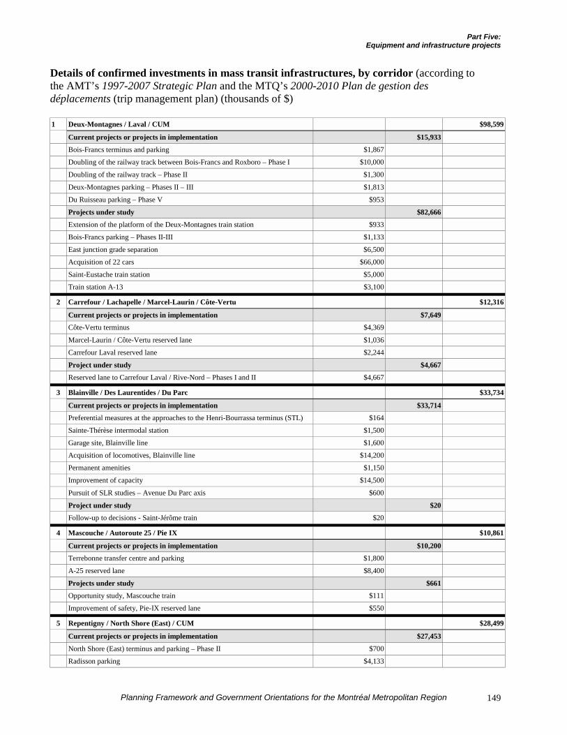
Part Five:Equipment and infrastructure projects
Planning Framework and Government Orientations for the Montréal Metropolitan Region 149
Details of confirmed investments in mass transit infrastructures, by corridor (according tothe AMT’s 1997-2007 Strategic Plan and the MTQ’s 2000-2010 Plan de gestion desdéplacements (trip management plan) (thousands of $)
1 Deux-Montagnes / Laval / CUM $98,599
Current projects or projects in implementation $15,933Bois-Francs terminus and parking $1,867
Doubling of the railway track between Bois-Francs and Roxboro – Phase I $10,000
Doubling of the railway track – Phase II $1,300
Deux-Montagnes parking – Phases II – III $1,813
Du Ruisseau parking – Phase V $953
Projects under study $82,666Extension of the platform of the Deux-Montagnes train station $933
Bois-Francs parking – Phases II-III $1,133
East junction grade separation $6,500
Acquisition of 22 cars $66,000
Saint-Eustache train station $5,000
Train station A-13 $3,100
2 Carrefour / Lachapelle / Marcel-Laurin / Côte-Vertu $12,316
Current projects or projects in implementation $7,649Côte-Vertu terminus $4,369
Marcel-Laurin / Côte-Vertu reserved lane $1,036
Carrefour Laval reserved lane $2,244
Project under study $4,667Reserved lane to Carrefour Laval / Rive-Nord – Phases I and II $4,667
3 Blainville / Des Laurentides / Du Parc $33,734
Current projects or projects in implementation $33,714Preferential measures at the approaches to the Henri-Bourrassa terminus (STL) $164
Sainte-Thérèse intermodal station $1,500
Garage site, Blainville line $1,600
Acquisition of locomotives, Blainville line $14,200
Permanent amenities $1,150
Improvement of capacity $14,500
Pursuit of SLR studies – Avenue Du Parc axis $600
Project under study $20Follow-up to decisions - Saint-Jérôme train $20
4 Mascouche / Autoroute 25 / Pie IX $10,861
Current projects or projects in implementation $10,200Terrebonne transfer centre and parking $1,800
A-25 reserved lane $8,400
Projects under study $661Opportunity study, Mascouche train $111
Improvement of safety, Pie-IX reserved lane $550
5 Repentigny / North Shore (East) / CUM $28,499
Current projects or projects in implementation $27,453
North Shore (East) terminus and parking – Phase II $700
Radisson parking $4,133
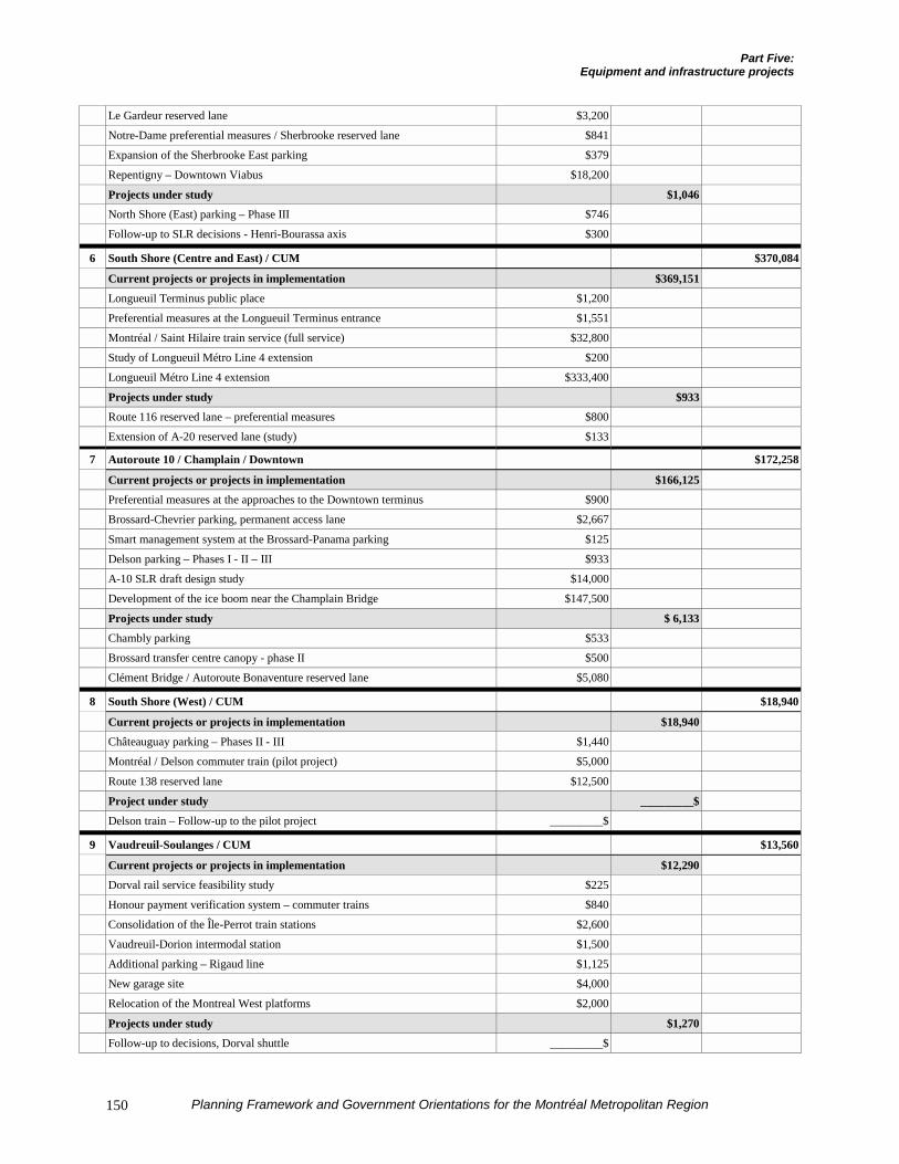
Part Five:Equipment and infrastructure projects
Planning Framework and Government Orientations for the Montréal Metropolitan Region150
Le Gardeur reserved lane $3,200
Notre-Dame preferential measures / Sherbrooke reserved lane $841
Expansion of the Sherbrooke East parking $379
Repentigny – Downtown Viabus $18,200
Projects under study $1,046North Shore (East) parking – Phase III $746
Follow-up to SLR decisions - Henri-Bourassa axis $300
6 South Shore (Centre and East) / CUM $370,084
Current projects or projects in implementation $369,151Longueuil Terminus public place $1,200
Preferential measures at the Longueuil Terminus entrance $1,551
Montréal / Saint Hilaire train service (full service) $32,800
Study of Longueuil Métro Line 4 extension $200
Longueuil Métro Line 4 extension $333,400
Projects under study $933Route 116 reserved lane – preferential measures $800
Extension of A-20 reserved lane (study) $133
7 Autoroute 10 / Champlain / Downtown $172,258
Current projects or projects in implementation $166,125Preferential measures at the approaches to the Downtown terminus $900
Brossard-Chevrier parking, permanent access lane $2,667
Smart management system at the Brossard-Panama parking $125
Delson parking – Phases I - II – III $933
A-10 SLR draft design study $14,000
Development of the ice boom near the Champlain Bridge $147,500
Projects under study $ 6,133Chambly parking $533
Brossard transfer centre canopy - phase II $500
Clément Bridge / Autoroute Bonaventure reserved lane $5,080
8 South Shore (West) / CUM $18,940
Current projects or projects in implementation $18,940Châteauguay parking – Phases II - III $1,440
Montréal / Delson commuter train (pilot project) $5,000
Route 138 reserved lane $12,500
Project under study _________$Delson train – Follow-up to the pilot project _________$
9 Vaudreuil-Soulanges / CUM $13,560
Current projects or projects in implementation $12,290Dorval rail service feasibility study $225
Honour payment verification system – commuter trains $840
Consolidation of the Île-Perrot train stations $2,600
Vaudreuil-Dorion intermodal station $1,500
Additional parking – Rigaud line $1,125
New garage site $4,000
Relocation of the Montreal West platforms $2,000
Projects under study $1,270Follow-up to decisions, Dorval shuttle _________$
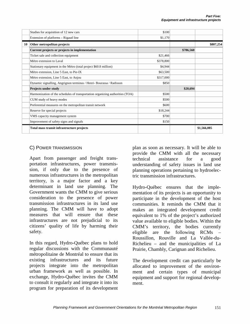
Part Five:Equipment and infrastructure projects
Planning Framework and Government Orientations for the Montréal Metropolitan Region 151
Studies for acquisition of 12 new cars $100
Extension of platforms – Rigaud line $1,170
10 Other metropolitan projects $807,254
Current projects or projects in implementation $786,560Ticket sale and collection equipment $21,466
Métro extension to Laval $378,800
Stationary equipment in the Métro (total project $60.8 million) $4,944
Métro extension, Line 5 East, to Pie-IX $63,500
Métro extension, Line 5 East, to Anjou $317,000
Dynamic signalling, Angrignon terminus / Henri- Bourassa / Radisson $850
Projects under study $20,694Harmonization of the schedules of transportation organizing authorities (TOA) $500
CUM study of heavy modes $500
Preferential measures on the metropolitan transit network $600
Reserve for special projects $18,244
VMS capacity management system $700
Improvement of safety signs and signals $150
Total mass transit infrastructure projects $1,566,085
C) POWER TRANSMISSION
Apart from passenger and freight trans-portation infrastructures, power transmis-sion, if only due to the presence ofnumerous infrastructures in the metropolitanterritory, is a major factor and a keydeterminant in land use planning. TheGovernment wants the CMM to give seriousconsideration to the presence of powertransmission infrastructures in its land useplanning. The CMM will have to adoptmeasures that will ensure that theseinfrastructures are not prejudicial to itscitizens’ quality of life by harming theirsafety.
In this regard, Hydro-Québec plans to holdregular discussions with the Communautémétropolitaine de Montréal to ensure that itsexisting infrastructures and its futureprojects integrate into the metropolitanurban framework as well as possible. Inexchange, Hydro-Québec invites the CMMto consult it regularly and integrate it into itsprogram for preparation of its development
plan as soon as necessary. It will be able toprovide the CMM with all the necessarytechnical assistance for a goodunderstanding of safety issues in land useplanning operations pertaining to hydroelec-tric transmission infrastructures.
Hydro-Québec ensures that the imple-mentation of its projects is an opportunity toparticipate in the development of the hostcommunities. It reminds the CMM that itmakes an integrated development creditequivalent to 1% of the project’s authorizedvalue available to eligible bodies. Within theCMM’s territory, the bodies currentlyeligible are the following RCMs –Roussillon, Rouville and La Vallée-du-Richelieu – and the municipalities of LaPrairie, Chambly, Carignan and Richelieu.
The development credit can particularly beallocated to improvement of the environ-ment and certain types of municipalequipment and support for regional develop-ment.
Part Five:Equipment and infrastructure projects
Planning Framework and Government Orientations for the Montréal Metropolitan Region152
Regarding projects, Hydro-Québec is ulti-mately considering implementation of onlyone project, development of the Saint-Césaire-Hertel 735 kilovolt transmission linein the Montérégie. This line is currentlyawaiting the government authorizationsnecessary for its construction. Developed asa strategy in response to the January 1998ice storm, this line is intended to provide theHertel substation with a new principal powersource of 2,000 megawatts coming from ageographically distinct axis to prevent alarge-scale weather phenomenon, such asthe ice storm, from disrupting all lines at thesame time. In this way, a total population of920,000 people, representing a large part ofdowntown and West End Montréal and partof the South Shore, will see the security oftheir power supply increased.
TOURIST AND RECREATIONAL FACILITIES
The Government considers that tourism is amajor economic development sector. Ittherefore considers that, because of itscultural, heritage, natural and scenic attrac-tions, the metropolitan region offers a widerange of resources which justify that theCommunauté métropolitaine de Montréalprepare a strategic plan for development ofthe tourist sector.
The Government intends to deploy allnecessary measures to highlight the built andnatural attractions of the metropolitan regionin the development of Québec tourism toattract as broad a clientele as possible.
Tourisme Québec is in charge of redevelop-ment of the Soulanges Canal. This projectaims to provide the Montréal region with a“four seasons” recreational and touristattraction by opening the Soulanges Canal topleasure navigation and by creating anautical event to attract tourists coming byland. This project should include two hotels
and a port village. Tourisme Québec shouldreceive contractor bids at the end ofSeptember 2001. The first phase wouldbegin in summer 2002.
The complete development of the projectwill involve total disbursements of around$500 million. The Government plans toinvest $90 million. The complete reopeningof the canal and the development of allelements related to the project (stores,residential tourist complexes, etc.) should bespread over a period of about five years, upto 2006.
CONCLUSION

Conclusion
Planning Framework and Government Orientations for the Montréal Metropolitan Region 155
Because of its importance within the Québeccommunity and its declared North Americanand international vocation, the Montréalmetropolitan region fully justifies acomprehensive and concerted approach toits land use planning and development.
The Conseil des ministres, in 1996, declaredits concern to this effect by adopting threegeneral land use planning orientations forthe metropolitan region. These orientationsreflected the government preference forconsolidation of urbanization, strengtheningof economic poles and preservation andoptimum use of existing infrastructures andfacilities.
Resolutely staying the course on theseorientations, the Québec Government, armedwith this Planning Framework, is now goingeven further.
In the first place, the Conseil des ministres isendorsing new land use planning anddevelopment orientations for the Montréalregion, as well as renewing those alreadyadopted.
Thus, the Conseil des ministres is now asser-ting its preference for mixed land use andrehabilitation of old neighbourhoods. It isalso taking a stand in favour of internationaldevelopment of the MCMA. The Conseildes ministres also confirms its preference formass transit with regard to passenger tripsand intends to ensure the permanence andsustainable development of the agriculturalzone. Public access to Greater Montréal’sgreen and blue spaces also concerns it, asdoes the question of the effects of a trend tofalling water levels in the basins of themetropolitan archipelago. Finally, theConseil des ministres is committed torecognize and consolidate an optimum urbanform within the MCMA’s territory, based onthe presence of six economic poles
concentrating activities with internationalinfluence.
Above all, the Québec Government is nowbound – and binds all of its governmentdepartments and agencies working in themetropolitan territory – to a Governmentplanning framework expressing a mobilizingplanning project for the Montréal region. Atthe same time, the Government is makingthis Planning Framework the frame ofreference to support the partnership it nowintends to pursue with the Communautémétropolitaine de Montréal in land useplanning and development.
This Planning Framework is basically pre-sented as a planning tool and adopts a long-term horizon. It affirms planning choicesthat reflect the Government’s will to reversecertain general trends, such as poorly con-trolled urbanization, the increase in green-house gas emissions or deficient optimiza-tion of major existing infrastructures andfacilities.
The project underlying the PlanningFramework arises from a non-complacentpicture of the Montréal metropolitan regionas it appears today and as projected over thenext 20 years. A vision of the region’s futureis outlined, forcefully supported by thevalues of an attractive, competitive andviable metropolis working in solidarity.Orientations are proposed, some of whichattest to bold choices. Expectations areaffirmed and presented to the CMM andGovernment support is set forth in the formof targets to achieve or actions to be taken.
The Planning Framework is initially inten-ded to serve as an unavoidable frame ofreference for Government action in theMontréal metropolitan region. In this sense,it will lend cohesion to public policies andshould allow all government departments
Planning Framework and Government Orientations for the Montréal Metropolitan Region156
and agencies to share a common repre-sentation of Greater Montréal’s future.
At the same time, the Planning Frameworkexpresses to the Government’s partner, theCommunauté métropolitaine de Montréal,the Government’s major expectations con-cerning land use planning and developmentof the Montréal region. From this point ofview, it is an invitation for a mutualtakeover of a planning project likely to putthe Montréal metropolitan region on the pathto sustainable development.

BIBLIOGRAPHY

Bibliography
Planning Framework and Government Orientations for the Montréal metropolitan region 159
Bergeron, R. (1998) : Évolution 1961-1991des caractéristiques socio-démogra-phiques des populations vivant àproximité du métro: Comparaison entreMontréal et Toronto, 18 pages and mapappendix.
Coffey, W. and M. Polèse (1999): Larestructuration de l’économie montréa-laise : positionnement et comparaisonsavec d’autres métropoles, Observatoiremétropolitain, Université de Montréaland INRS-Urbanisation, 140 pages.
Coffey, W.J., C. Manzagol and R. Shearmur(1999-2000): L'évolution intramétropo-litaine de la localisation des activitéséconomiques dans la régionmétropolitaine de Montréal, 1981-1996, Montréal, Université deMontréal/ INRS-Urbanisation, 3reports.
Comité interrégional pour le transport desmarchandises (CITM) (1999) : Lacongestion routière et le transport desmarchandises, diagnosis, preliminarydocument, 40 pages and appendices.
_________ (2000) : Les conditionsfavorables au développement del’industrie du transport des marchan-dises, diagnosis, 85 pages.
Conseil scolaire de l'île de Montréal (CSIM)(1999): Défavorisation des famillesavec enfants en milieu montréalais,Companion guide to the Island ofMontréal disadvantage map, January,63 pages.
DELCAN Corporation (1999): Strategies toReduce Greenhouse Gas Emissionsfrom Passenger Transportation inThree Large Urban Areas, multiplepagination.
Gouvernement du Québec (2000): Pland'action québécois sur les changementsclimatiques, Phase 1 (2000-2002),26 pages.
INRS-Urbanisation (edited by G. Grégoire)(1999): Atlas, Région de Montréal,premières explorations, 32 pages.
Ministère de l'Agriculture, des Pêcheries etde l'Alimentation du Québec (2000):Faits saillants sur l'agriculture dans laMétropole, Working document, April,16 pages and maps.
Ministère de l’Environnement du Québec(2000) : Cadre d’aménagement métro-politain, sector report, 31 pages.
Ministère des Affaires municipales duQuébec (1994): Les orientations dugouvernement en matière d'aména-gement du territoire, 70 pages.
_________ (1995): Les orientations dugouvernement en matière d'aména-gement du territoire, Complementarydocument, unpaginated.
_________ (1996): L'aménagement duterritoire dans la région métropolitainede Montréal, May 1, 32 pages.
_________ (1997): Les orientations dugouvernement en matière d'aména-gement - La protection du territoire etdes activités agricoles, Complementarydocument, 29 pages and appendices.
Ministère des Transports du Québec (1993) :Plan de transport, région de Montréal,(Groupe 4 : Transport des personnes),évaluation de l’offre de transport,103 pages and appendices.
_________ (1995) : Vers un plan detransport pour la région de Montréal,Phase 1 : Choisir, Diagnostic etorientations, reference document,458 pages and 26 maps.
Planning Framework and Government Orientations for the Montréal metropolitan region160
Ministère des Transports du Québec (2000) :Plan de gestion des déplacements,région métropolitaine de Montréal,82 pages and 21 maps.
Sénécal, G., P.J. Hamel, R. Haf, C. Poitrasand N. Vachon (2000) : L'étude sur laproblématique québécoise concernantl'aménagement du territoire et leschangements climatiques, INRS-Urbanisation, 142 pages.
Société d'habitation du Québec (2000):Cadre d’aménagement métropolitain,Rapport d'étape de la SHQ, January 31,41 pages and appendices.
Société de transport de la Communautéurbaine de Montréal (2000): Uneentreprise à découvrir, multiplepagination.
GLOSSARY

Glossary
Planning Framework and Government Orientations for the Montréal metropolitan region 163
Designation: Principal use that one intendsto confer on a territory. The followingdesignations are commonly the most in use:residential, institutional, commercial, indus-trial, agricultural, green space or naturalenvironment.
Protected area: " … a geographicallydefined portion of land, aquatic environmentor marine environment, specially dedicatedto the protection and maintenance ofbiological diversity and the associatednatural and cultural resources; for thesepurposes, this geographic space must belegally designated, regulated and managedby effective legal or other means". (Unioninternationale pour la conservation de lanature. (Our translation.)
Accommodation capacity: Sum total ofunits (expressed, as the case may be, innumber of inhabitants, housing units orvehicles, etc.) that a facility of an infra-structure network can accommodate.
Centre of the metropolitan area: Thecentre of the metropolitan area extendswestward, on the Island of Montréal, toPointe-Claire and Saint-Laurent andeastward to Anjou, Mercier and Montréal-Nord. In Laval, it encompasses theChomedey, Laval-des-Rapides and Pont-Viau neighbourhoods and, on the SouthShore, it includes the territory of MRC deChamplain. However, the MTQ excludesSaint-Hubert. (This definition essentiallyborrows that of the MTQ, which excludesVille de Saint-Hubert from the centre of themetropolitan area.)
Demographic growth: Difference ex-pressed in terms of the number ofinhabitants or households, or as apercentage, separating two specified past,present or projected reference years, for agiven territory.
Residential density: In general, the averagenumber of housing units per square kilo-metre.
Gross residential density: Average numberof housing units per square kilometre of amunicipality’s territory.
Net residential density: Average number ofhousing units per square kilometre of amunicipality’s territory designated forresidential use.
Facility: Building, installation or group ofbuildings or installations, usually publiclyowned, serving a collective function or toensure collective well-being. Particularlyconsidered as facilities are cultural andheritage, healthcare, education, tourism,sports and recreation facilities.
Infrastructure: Group of publicly-ownednetworks and works. In this document,highway networks, mass transit networksand water purification and sewage treatmentfacilities are usually considered to beinfrastructures.
Social mix: Diversity observed in thedistribution of social, cultural and economiccharacteristics among the individuals orhouseholds of a given territory.
Share of demographic growth: Distri-bution of the net increase in population orhouseholds, which can be expressed as anabsolute number or as a percentage,observed between two reference years,depending on the location of this populationor these households in specified parts of themetropolitan territory (municipalities, RCMsor others).
Urbanization perimeter: Spatial entity of amunicipality characterized by its oldness, itspluralism of functions and the density ofoccupation within its built environment.
Glossary
Planning Framework and Government Orientations for the Montréal metropolitan region164
Montréal Census Metropolitan Area(MCMA): "A census metropolitan area(CMA) is a very large urban area (known asthe urban core) together with adjacent urbanand rural areas (known as urban and ruralfringes), that have a high degree of socialand economic integration with the urbancore. A CMA has an urban core populationof at least 100,000, based on the previouscensus". (Statistics Canada, 1996 CensusDictionary, p. 183).
Reserve of capacity: Difference orremaining sum that a site, a facility or aninfrastructure network can accommodatewithout the need for expansion.
Urbanization: Process whereby a territory,usually in the natural or agricultural state,receives the characteristics specific to thecity’s environment and becomes perma-nently inhabited or occupied.
Planning Framework and Government Orientations for the Montréal Metropolitan Region 165
THE INTERDEPARTMENTAL TECHNICAL COMMITTEE ON THE PLANNING FRAMEWORK
Chairman: Mr Bryant McDonoughAssistant Deputy MinisterSous-ministériat aux politiques et à la concertation métropolitaine
Ministère des Affaires municipales et de la Métropole
Project coordinator: Yvan Rompré
Research and writing: Yvan RompréJean-François MarchandChristine Caillé
Sous-ministériat aux politiqueset à la concertation métropolitaine: Luc Brunelle
Ginette ChenardFrançois DesrochersLouise DionAgnès GatignolYves LafortuneDenis PéloquinStéphane PineaultFrancis ReidPierre RouleauJulie Tellier
Direction de l'aménagementet du développement local: Carole Jutras
Richard AudettePierre BarilBenoît BosséRenée MarceauLouis Massicotte
Service des politiques municipales: Fernand MartinMonique DesrochersCéline Soucy
Member government departments and agencies
Ministère de l'Agriculture, des Pêcherieset de l'Alimentation: Marcel Tremblay
André GauthierLucie Tanguay
Ministère de la Culture et des Communications: Francine ÉmondMonique BarriaultMonique HamelinMario Brodeur
Ministère de l'Éducation: Marie-France BenesMichèle FafardPierre Lambert
Ministère de l'Environnement: Gérard CussonJean RivetHélène Ross
166 Planning Framework and Government Orientations for the Montréal Metropolitan Region
Ministère de l'Industrie et du Commerce: Odette Guertin
Ministère de la Santé et des Services sociaux: Charles Hardy
Ministère de la Sécurité publique: Lise AsselinJacques HébertMarc Morin
Ministère des Finances: Jean-Guy LebelAndré BrindamourYves Ouellet
Ministère des Régions: Pierre-Paul RoyJean-Guy Tremblay
Ministère des Relations avec les citoyenset de l'Immigration: Madeleine Gagné
Raynald Leblanc
Ministère des Ressources naturelles: Paul-Émile ValléeSerge Vaugeois
Ministère des Transports: Christine Caron Christine Duby
Ministère du Conseil exécutif: Michel BeauléDenise Desmeules
Agence métropolitaine de transport: James ByrnsRichard Bergeron
Société de la faune et des parcs du Québec: Sylvain Laramée
Société d'habitation du Québec: Hélène AubéJacques Trudel
Société Hydro-Québec: Maria VaccaroClaude Aubry
Société immobilière du Québec: Francine Guérin
Tourisme Québec: Michel Trudel
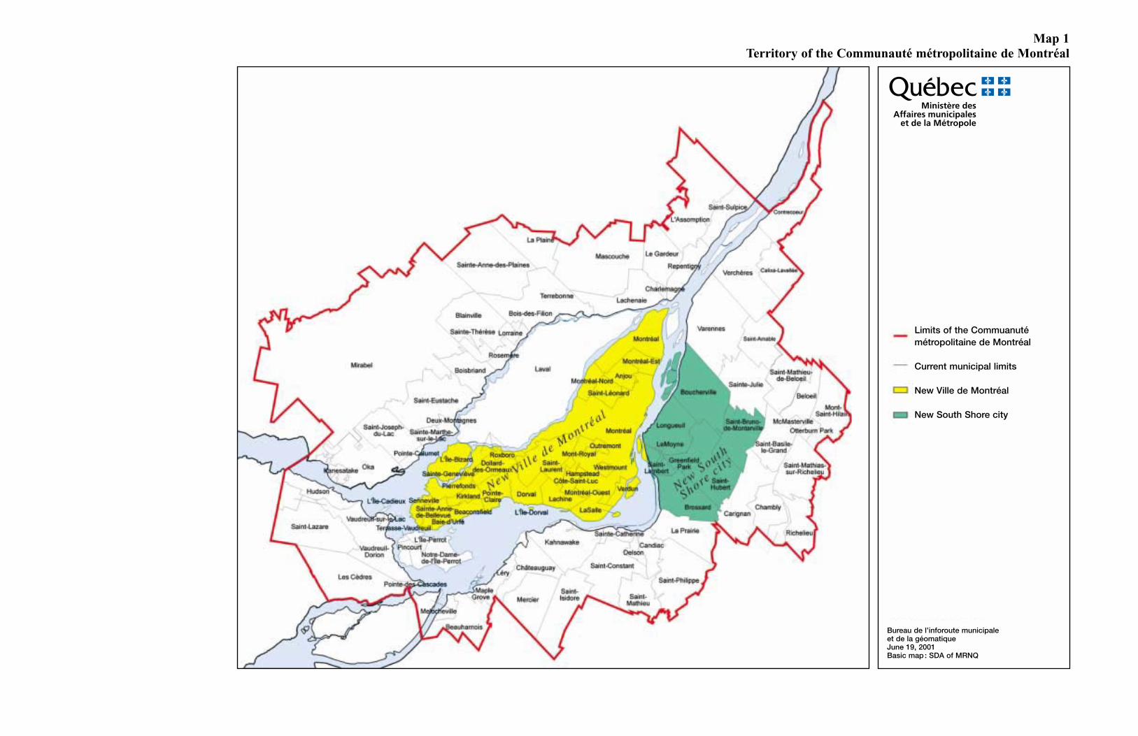
Map 1Territory of the Communauté métropolitaine de Montréal
Ministère desAffaires municipales
et de la Métropole
Limits of the Commuanutémétropolitaine de Montréal
Current municipal limits
New Ville de Montréal
New South Shore city
Bureau de l’inforoute municipaleet de la géomatiqueJune 19, 2001Basic map : SDA of MRNQ
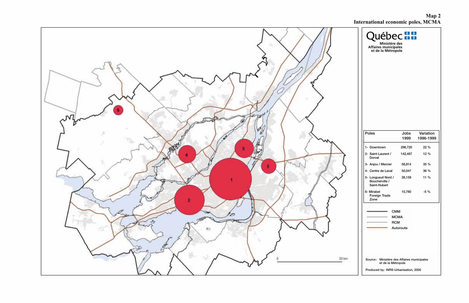
Map 2International economic poles, MCMA
Ministère desAffaires municipales
et de la Métropole
CMM
MCMA
RCM
Autoroute
Source : Ministère des Affaires municipaleset de la Métropole
Produced by : INRS-Urbanisation, 2000
Poles Jobs Variation1999 1996-1999
1- Downtown 296,720 22 %
2- Saint-Laurent / 142,487 12 %Dorval
3- Anjou / Mercier 58,814 35 %
4- Centre de Laval 50,047 36 %
5- Longueuil Nord / 28,159 11 %Boucherville /Saint-Hubert
6- Mirabel 10,780 -5 %Foreign TradeZone
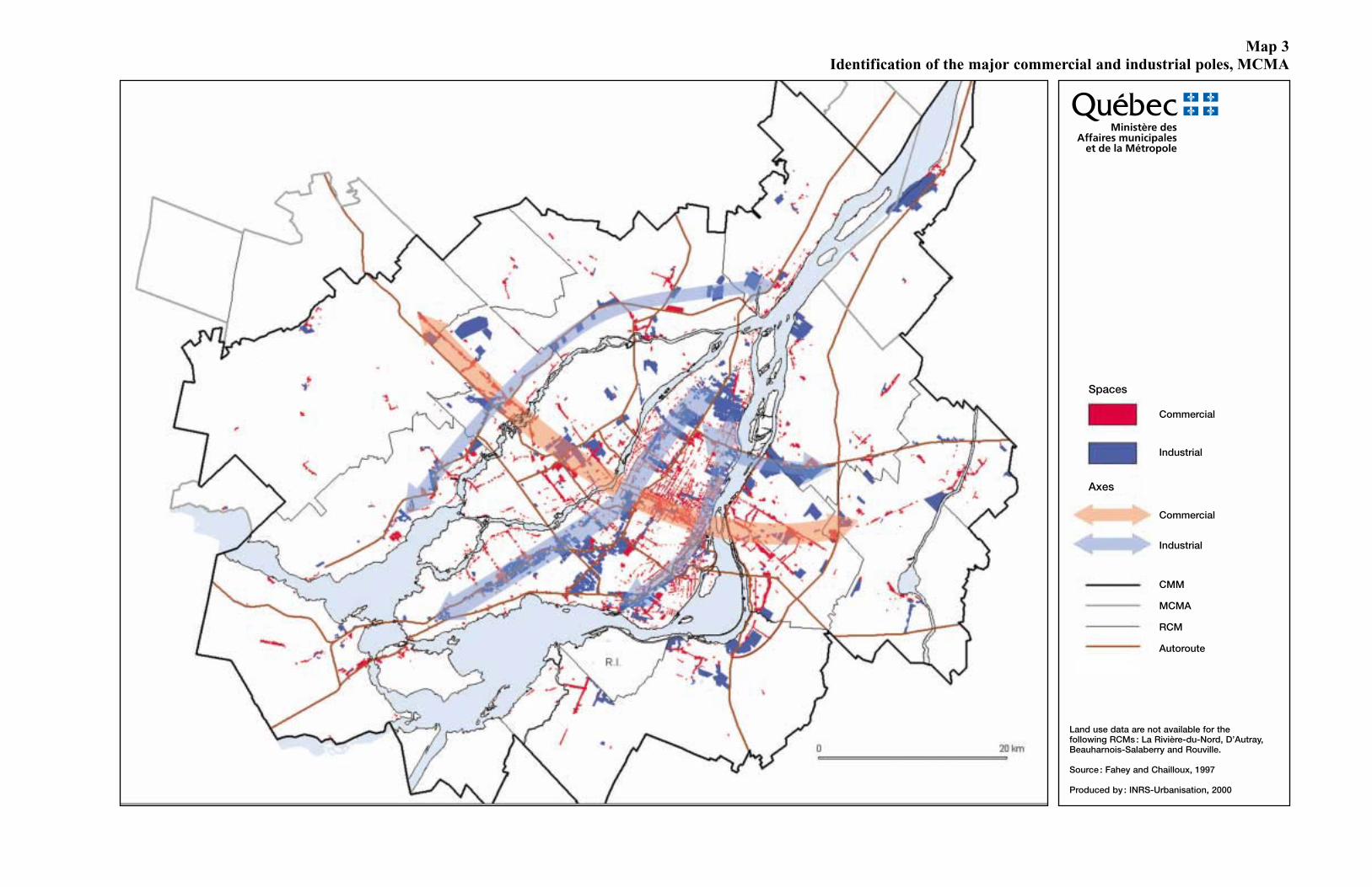
Map 3Identification of the major commercial and industrial poles, MCMA
Ministère desAffaires municipales
et de la Métropole
Land use data are not available for thefollowing RCMs : La Rivière-du-Nord, D’Autray,Beauharnois-Salaberry and Rouville.
Source : Fahey and Chailloux, 1997
Produced by : INRS-Urbanisation, 2000
Spaces
Commercial
Industrial
Axes
Commercial
Industrial
CMM
MCMA
RCM
Autoroute
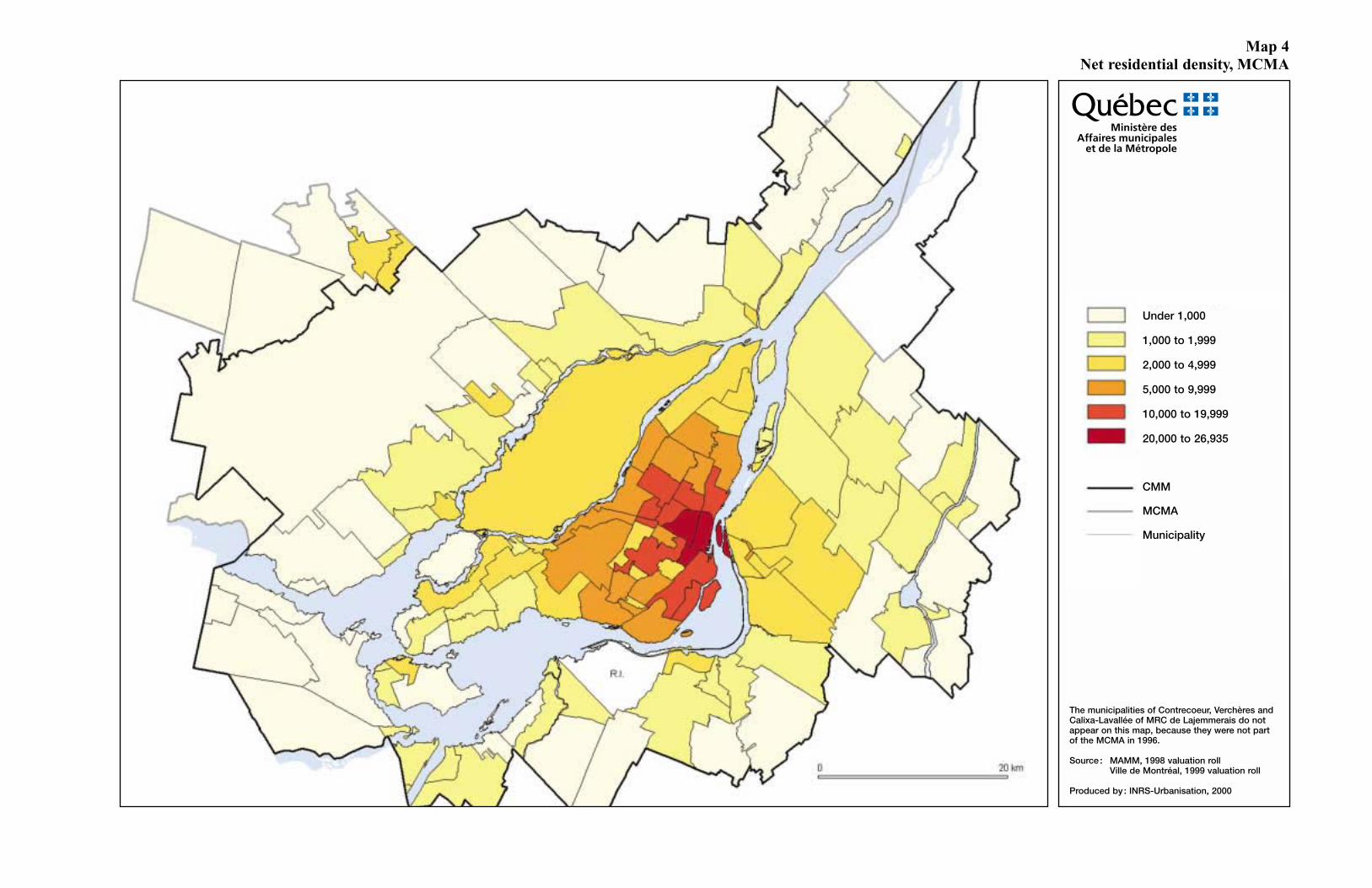
Map 4 Net residential density, MCMA
Ministère desAffaires municipales
et de la Métropole
The municipalities of Contrecoeur, Verchères andCalixa-Lavallée of MRC de Lajemmerais do notappear on this map, because they were not partof the MCMA in 1996.
Source : MAMM, 1998 valuation rollVille de Montréal, 1999 valuation roll
Produced by : INRS-Urbanisation, 2000
Under 1,000
1,000 to 1,999
2,000 to 4,999
5,000 to 9,999
10,000 to 19,999
20,000 to 26,935
CMM
MCMA
Municipality
Map 5Vacant and urbanized spaces and decreed agricultural zone, MCMA
Ministère desAffaires municipales
et de la Métropole
Vacant land
Residential
Commercial
Institutional
Industrial
Occupied space
Green and wooded space
Decreed agricultural zone
Hydrographic zone
CMM
MCMA
RCM
Autoroute
Square Island of Suburbskilometres Montreal Laval Southern Northern Total
Residential 36,5 40,2 96,6 83,2 251,8Commercial 3,4 3,3 11,0 4,9 22,6Institutional 2,8 0,5 2,0 5,3Industrial 32,2 11,5 31,7 15,7 91,2Green space 5,4 15,1 4,9 25,4
Total 80,3 55,0 154,9 110,7 396,3
Vacant land areas
Land use data are not available for thefollowing RCMs: La Rivière-du-Nord, D’Autray,Beauharnois-Salaberry and Rouville.
Source : Fahey and Chailloux, 1997MAPAQ, 1996
Map 6Major green and blue spaces, MCMA
Ministère desAffaires municipales
et de la Métropole
Land use data are not available for thefollowing RCMs: La Rivière-du-Nord, D’Autray,Beauharnois-Salaberry and Rouville.
Source : Fahey and Chailloux, 1997MAPAQ, 1994
Produced by : INRS Urbanisation, 2000
Green space
Forest
Hydrographic system
Submerged vegetation
Wetland
CMM
MCMA
RCM
Map 7Location of marinas and piers
Ministère desAffaires municipales
et de la Métropole
Source : Cartosynthèse, 1999
Marina or pier
Map 8Metropolitan mass transit network, MCMA
Ministère desAffaires municipales
et de la Métropole
June 2001
TERMINUS
Existing terminus
Project
RESERVED LANES
Existing reserved bus lane
Project
VIABUS / MÉTROBUS
INCENTIVE PARKING LOTS
Existing incentive parking lot
Project
COMMUTER TRAINS, MÉTRO AND SLR
Project
Commuter train
Deux-Montagnes commuter trainTrack doubling – Phase 1Track doubling – Phases 2 and 3
Study of new SLR service
Study of new rail service
Métro line and station
Métro extension
Project under study (Métro and station)
Highway network
National network
Regional network
Collector network
Municipal limits
Railway network
AMT territorial limits
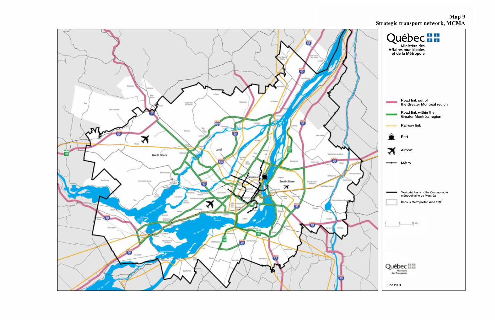
Map 9Strategic transport network, MCMA
Ministère desAffaires municipales
et de la Métropole
June 2001
Road link out ofthe Greater Montréal region
Road link within theGreater Montréal region
Railway link
Port
Airport
Métro
Territorial limits of the Communautémétropolitaine de Montréal
Census Metropolitan Area 1996
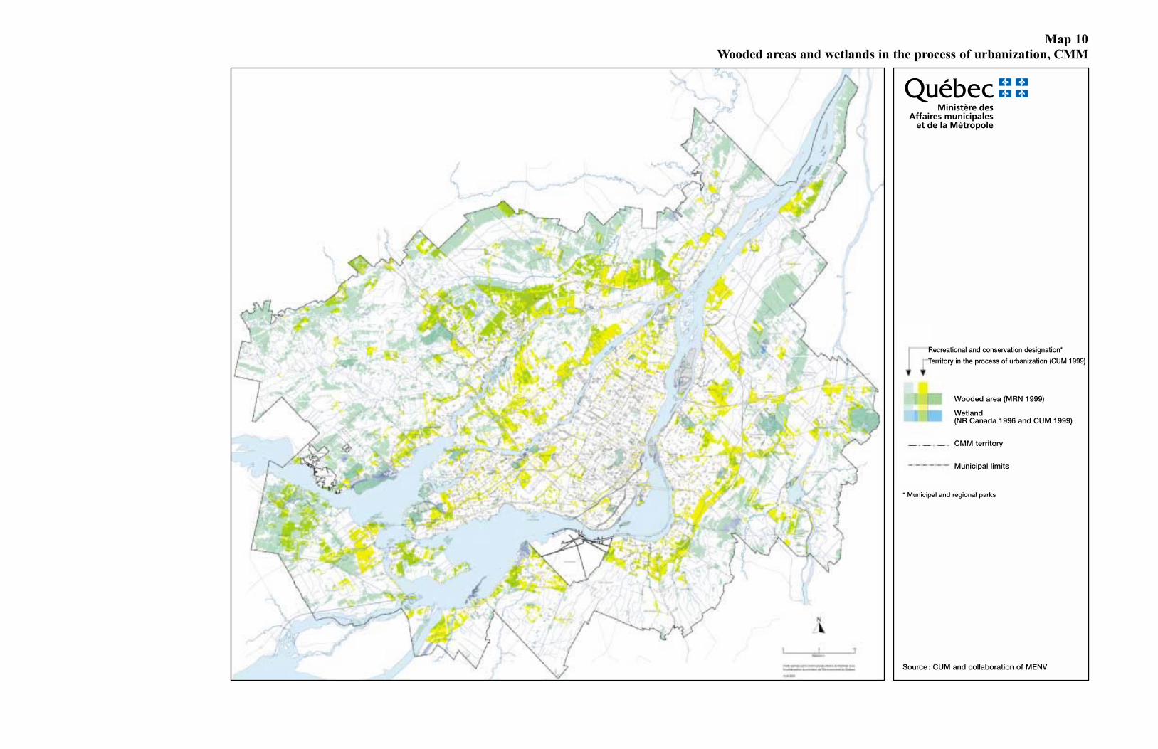
Map 10Wooded areas and wetlands in the process of urbanization, CMM
Ministère desAffaires municipales
et de la Métropole
Source : CUM and collaboration of MENV
Recreational and conservation designation*
Territory in the process of urbanization (CUM 1999)
Wooded area (MRN 1999)
Wetland(NR Canada 1996 and CUM 1999)
CMM territory
Municipal limits
* Municipal and regional parks
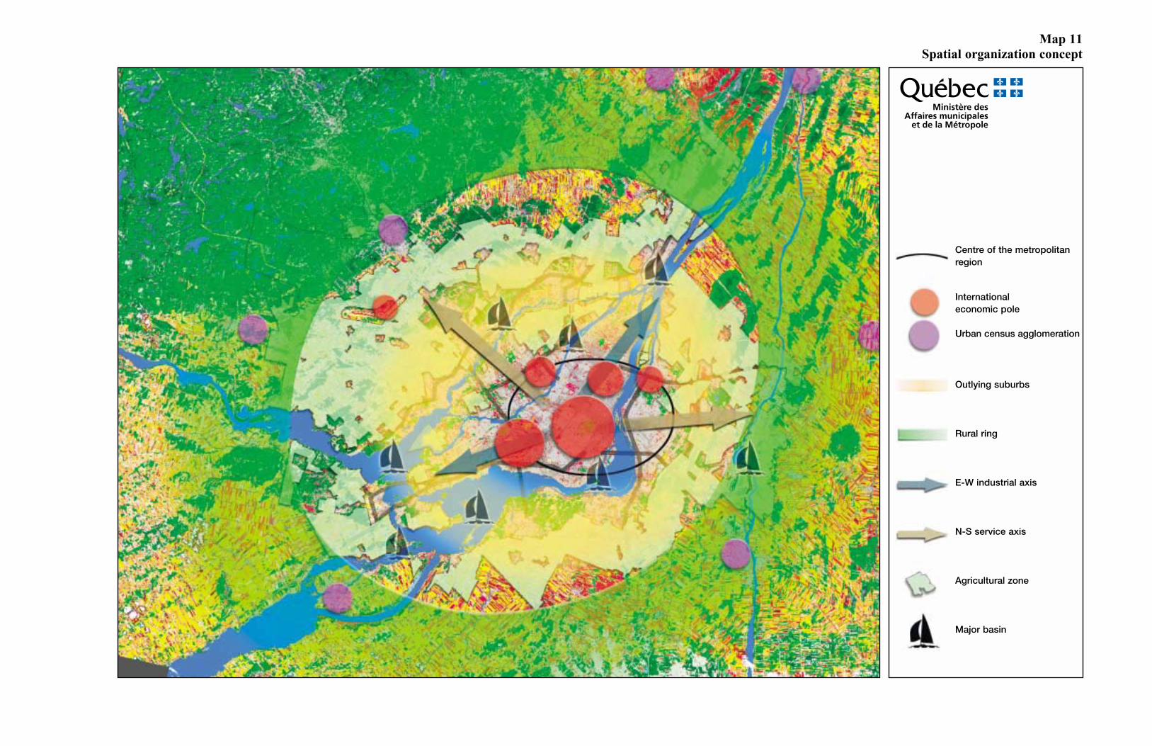
Map 11Spatial organization concept
Ministère desAffaires municipales
et de la Métropole
Centre of the metropolitanregion
Internationaleconomic pole
Urban census agglomeration
Outlying suburbs
Rural ring
E-W industrial axis
N-S service axis
Agricultural zone
Major basin


