Embed Size (px)
Citation preview
Piggyback tectonics: Long-term growth of Kilauea
on the south flank of Mauna Loa
Peter W. Lipman a,*, Thomas W. Sisson a, Michelle L. Coombs b,Andrew Calvert a, Jun-Ichi Kimura c
a U.S. Geological Survey, Menlo Park, CA 94025, USAb U.S. Geological Survey, Alaskan Volcano Observatory, Anchorage, AK 99508, USA
c Department of Geoscience, Shimane University, Matsue 690-8504, Japan
Accepted 15 July 2005
Available online 16 November 2005
Abstract
Compositional and age data from offshore pillow lavas and volcaniclastic sediments, along with on-land geologic, seismic, and
deformation data, provide broad perspectives on the early growth of Kilauea Volcano and the long-term geometric evolution of its
rift zones. Sulfur-rich glass rinds on pillow lavas and volcaniclastic sediments derived from them document early underwater
growth of a large compositionally diverse alkalic edifice. The alkalic rocks yield 40Ar/ 39Ar ages as old as about 275 ka;
transitional-composition lavas, which mark beginning of the shield stage while most or all the edifice remained below sea
level, probably first erupted after about 150 ka, and tholeiitic lavas of present-day type are probably younger than 100 ka. Breccia
clasts from Papau Seamount and along the lower southwest corner of the Hilina bench are derived from subaerial Mauna Loa,
requiring that Mauna Loa’s flank underlies western parts of Kilauea at shallow depth. The volume of the Kilauea edifice is
therefore smaller (~10,000 km3) than previous estimates (15–40,000 km3); lava-thickness accumulation rates appear to have
remained nearly constant during edifice growth, as effusion rates increased from ~25�106 m3/yr at end of the alkalic stage to the
present-day tholeiite rate of ~100�106 m3/yr. Seismic and gravity data show that the deep plumbing system for Kilauea’s magma
supply extends nearly vertically through the oceanic crust at least to mantle depths of 30–35 km, directly below its present-day
caldera.
Proximity of Kilauea caldera to the surface boundary with Mauna Loa and the presence of Mauna Loa rocks at shallow depth
beneath the south flank are difficult to reconcile with a submarine origin for early Kilauea alkalic lavas, unless geometric relations
between the two volcanoes have changed substantially during growth of the Kilauea shield. Seismic and ground deformation data
suggest seaward spreading of the entire south flank of Hawai‘i Island, independently of the boundary between Kilauea and Mauna
Loa, along a landward-dipping detachment fault system near the basal contact of the composite volcanic edifices with underlying
oceanic crust. Current steady-state horizontal displacements increase seaward, at rates of ~1.5 cm/yr on the lower flank of Mauna
Loa and reaching 5–8 cm/yr at the Kilauea coastline. Infrequent (~100 yr?) large earthquakes generate similar geometries, but 102
larger displacements per event.
Present-day Kilauea is the more dynamic edifice, but prior to inception of Kilauea and during its early growth, Mauna Loa is
inferred to have undergone intense volcano spreading, involving the Kaoiki–Honuapo fault system (considered a geometric analog
of the Hilina system on Kilauea). Cumulative deformation of Mauna Loa’s south flank during growth of Kilauea since 200–300 ka
is estimated to have involved N10 km of seaward spreading, displacing the rift zones of Kilauea while its deep plumbing system
0377-0273/$ - see front matter. Published by Elsevier B.V.
doi:10.1016/j.jvolgeores.2005.07.032
* Corresponding author.
E-mail address: [email protected] (P.W. Lipman).
Journal of Volcanology and Geothermal Research 151 (2006) 73–108
www.elsevier.com/locate/jvolgeores
and summit magma reservoir remained nearly fixed in space. Kilauea’s rift zones, rather than migrating southward with time solely
due to dike emplacement preferentially on the mobile seaward side, alternatively are interpreted to have been transported passively
southward, bpiggybackQ style, during shield-stage growth of Kilauea as a blister on the still-mobile south flank of Mauna Loa. Such
an evolution of Kilauea accounts for the arcuate geometry of the present-day rift zones, proximity of the summit magma supply to
the exposed flank of Mauna Loa, initial submarine growth of the ancestral edifice, and present-day location of Mauna Loa rocks at
shallow depth beneath the south flank of Kilauea.
Published by Elsevier B.V.
Keywords: Hawaii; Kilauea; Mauna Loa; flank structure; growth history
1. Introduction
Kılauea and Mauna Loa are respectively the most
active and the largest volcanoes on Earth, and the
Hawaiian Islands have long been an archetypal example
of ocean-island basaltic volcanism (e.g., Dana, 1849;
Dutton, 1884; Hitchcock, 1909; Brigham, 1909;
Stearns, 1966; Macdonald and Abbott, 1970; Clague
and Dalrymple, 1987; Moore and Clague, 1992). As
such, Hawai‘i has been the sustained focus of detailed
studies throughout the last century, and a wealth of
volcanologic, geophysical, and petrologic data has
been acquired, especially for subaerial parts of these
enormous ocean-island volcanoes. Much less studied
until recently have been the deep offshore submarine
slopes (to depths of 5500 m), especially those below the
2000-m limit of most research submersibles available in
Hawaiian waters during the past 25 years.
Between 1998 and 2002, collaborative Japan–U.S.
research, utilizing the ROV Kaiko and manned Shinkai
6500 submersible operated by the Japan Marine Re-
search and Technology Center (JAMSTEC) made about
90 dives, mostly at depths greater than 2000 m, to study
the subaqueous geology around Hawai‘i, early-stage
growth of its volcanoes, and the giant submarine land-
slides that pose infrequent but catastrophic tsunami
hazards to the Pacific Basin (Naka and Scientific
Team, 2000; Takahashi et al., 2002). Comprehensive
SeaBeam bathymetric and side-scan sonar surveys,
made between dive operations, greatly augmented cov-
erage of the submarine flanks of Hawaiian volcanoes (J.
Smith et al., 2002; Eakins et al., 2003). Sixteen of the
dives on the south flank of Hawai‘i Island, targeted at
the underwater slopes of Kılauea and Mauna Loa vol-
canoes, have provided new insights into the early
growth and petrologic evolution of Kılauea (Lipman
et al., 2000, 2002; Naka et al., 2002; Sisson et al., 2002;
Sisson, 2003; Coombs et al., 2004a, 2006-this issue;
Calvert and Lanphere, 2006-this issue; Kimura et al.,
2006-this issue). The submarine south flank is far more
morphologically complex than the adjacent subaerial
slopes, due to preservation of earlier events in growth
of the island’s volcanic edifices at depths sufficient to
have escaped large-scale coverage by shoreline-cross-
ing young lava flows. Recent Japan–U.S. studies of the
submarine flanks of several older volcanoes along the
Hawaiian Ridge (Takahashi et al., 2002; Coombs et al.,
2004b; other papers in this issue), indicate that the flank
of Hawai‘i Island provides a unique study area, due to
the presence of a small young volcano (Kılauea) low on
the flank of a larger but still active edifice (Mauna Loa).
This report focuses on interactions between these
two volcanoes, especially evidence that their geometry
has been strongly affected by sustained processes of
gravitationally driven volcano spreading (Borgia and
Treves, 1992; Clague and Denlinger, 1994; Delaney et
al., 1998; Borgia et al., 2000; Morgan et al., 2003) that
have affected the entire south flank of Hawai‘i Island,
modifying features of both volcanoes during their
growth. Many of Kılauea’s structures, rather than hav-
ing developed solely in response to events specific to
this volcano, alternatively are here interpreted in sub-
stantial part as consequences of a blister-like Kılauea
edifice carried seaward bpiggybackQ style on the mobile
south flank of Mauna Loa. First we review the broad
geologic and geophysical framework for these two vol-
canoes, then summarize important new and published
data bearing on interactions between them during their
growth, and finally develop structural interpretations.
Central to our presentation is concern that the short
historical record and high-resolution geophysical data
document only a portion of the overall behavior of these
volcanoes. Integration with the prehistoric geologic re-
cord is key to interpreting long-term volcano growth.
2. Present-day geometry and structure of Kılauea
Numerous varied geologic, petrologic and geophys-
ical studies have documented the surface geology and
internal structure of Kılauea (e.g., Eaton and Murata,
1960; Swanson et al., 1976; Decker et al., 1987; Tilling
and Dvorak, 1993). Especially notable at Kılauea have
been the frequency of eruptions, high levels of volcanic
seismicity and associated ground deformation, and the
P.W. Lipman et al. / Journal of Volcanology and Geothermal Research 151 (2006) 73–10874

complex interplay between events localized near its
summit caldera and those at substantial distances
down the rift zones. Varied geometric and structural
features of Kılauea relative to Mauna Loa have long
hinted at complexly interrelated growth of these two
active volcanoes, as outlined in the following summary.
For Kılauea, salient observations include: (1) the pres-
ent map-view proximity of its summit area to the flank
of Mauna Loa; (2) the arcuate geometry of its rift zones
anomalously seaward of the summit caldera, despite (3)
gravity and seismic data indicating long-stable location
of the magmatic conduit beneath the summit caldera;
and (4) large-scale recent deformation on Kılauea’s
south flank during growth of the Hilina fault system.
2.1. Asymmetry of Kılauea
The proximity of south-flank Mauna Loa lavas to
Kılauea caldera, which marks the apex of this highly
active volcano’s deep magmatic plumbing system, is
striking and puzzling (Fig. 1). Distal lavas of Mauna
Loa extend down slope to within 2 km of the northwest
rim of Kılauea’s caldera, and the highest elevation on
Kılauea (Uwekahuna Bluff, 1242 m) stands only 38 m
above the saddle with Mauna Loa. In contrast, Kılauea
lavas are continuously exposed at the surface for 50 km
to the southeast, to the base of the island edifice at
water depths of more than 5000 m.
Such asymmetry could result from concurrent
growth of Mauna Loa and Kılauea through much of
their eruptive history, with lava flows interfingered
along a steep boundary between the two volcanoes, as
inferred in some growth models for propagation of the
Hawaiian Ridge (e.g., DePaolo and Stolper, 1996;
DePaolo et al., 2001; Baker et al., 2003). Mauna Loa
appears to have grown to close to its present size by
N100 ka (Lipman, 1995), however, while new geochro-
nologic results for early growth of Kılauea indicate that
this volcano only entered a vigorous tholeiitic shield-
building stage at b150 ka (Lipman et al., 2002; Calvert
and Lanphere, 2006—this issue). Interfingering of lava
between the two edifices seems necessarily limited to
shallow depths, late during growth of Mauna Loa.
Further complicating Kılauea’s geometry is the
newly documented existence of thick sections of sub-
marine-erupted preshield-stage pillow lavas of diverse
alkalic and transitional compositions on its south flank,
emplaced in water as deep as several kilometers (Sisson
et al., 2002; Coombs et al., 2006-this issue). From the
present-day configuration of these two volcanoes, how-
ever, it is difficult to generate a cross-section through
the south flank of Hawai‘i Island in which growth of
Fig. 1. Oblique view of present-day subaerial and submarine structures on Kılauea and adjacent lower south flank of Mauna Loa. Historical
eruptions on land depicted in black. Coarse dashed line indicates margins of Kılauea volcano; fine-dashed lines are approximate boundaries between
compositional and depositional units of Kılauea. Dashed white line, shoreline. Hachured lines, at southwest base of Kılauea submarine flank
indicate inferred large slump blocks. Digital bathymetric image provided by Joel Robinson, USGS.
P.W. Lipman et al. / Journal of Volcanology and Geothermal Research 151 (2006) 73–108 75

Kılauea above the current deep magma-supply system
(beneath the summit caldera) could have been initiated
in deep water. Even if growth of Kılauea commenced at
or near the base of a large landslide scar along the
Kaodiki-Honu‘apo fault system on the south flank of
Mauna Loa, as seems structurally plausible (see below),
a near-vertical scarp a kilometer or more high would
have been required just to reach down to present-day
sea level. Because of sustained gravitational subsidence
along the Hawaiian Ridge during volcano growth
(Moore, 1987; Moore and Thomas, 1988), the required
height of such a scarp above sea level would have been
ever greater (perhaps 1700 m above sea level at 275 ka,
plus any underwater continuation) to permit even shal-
low submarine eruption of pillow lavas from the crest
of ancestral Kılauea.
2.2. Arcuate rift zones
Oceanic-island rift zones typically are related to
edifice shape: in ideal geometry three rifts radiate at
1208 angles for an equant edifice, two opposing rifts for
elongate edifices (Fiske and Jackson, 1972; Mitchell,
2001; Walter and Troll, 2003). Rift zones of a volcano
that forms on the flank of an adjacent larger edifice tend
to be parallel to this flank, as exemplified by Kılauea’s
east and southwest rift zones aligned with the south
flank of adjacent Mauna Loa.
Long-standing puzzles concerning the structure and
shape of Kılauea have been the abrupt bend in its
proximal east rift zone to connect with the summit
caldera area along the Chain of Craters and associated
en-echelon fractures, and the role of the Ko‘ae fault
system that connects between the east and southwest
rift zone with a nearly linear overall trend. A common
interpretation has been that that the east rift zone has
migrated southward with time, caused by preferential
intrusions of dikes along the mobile south flank rather
than symmetrically along the rift crest (Swanson et al.,
1976). Additionally, it has been proposed that the
present geometry is evolving toward a single
bbreakawayQ rift system, in which the summit area is
increasingly being bypassed by extension along the
Ko‘ae faults (Fiske and Swanson, 1992).
2.3. Location of Kılauea’s magmatic conduit
The magma conduit at Kılauea has long been rec-
ognized as involving a shallow storage reservoir and a
deeper magma conduit, located directly beneath the
summit caldera (Eaton and Murata, 1960; Ryan et al.,
1981; Klein et al., 1987; Ryan, 1988; Okubo et al.,
1997), which has remained fixed in position relative to
the lithospheric mantle and oceanic crust during edi-
fice growth. Seismic and geodetic measurements pro-
vide the primary evidence for a shallow magma-
storage region at depths of 3–5 km beneath the caldera
that inflates between eruptions and deflates during
magma discharge. A large positive Bouguer gravity
anomaly (~20 mgal) centered directly beneath the
present-day summit (Kinoshita et al., 1963; Kauahi-
kaua, 1993) is inferred to record magmatic intrusions
and olivine cumulates in the feeder conduit during
growth of Kılauea (Clague and Denlinger, 1994;
Kauahikaua et al., 2000), as is also characteristic of
the crests of other Hawaiian volcanoes. A steeply
plunging concentration of seismic hypocenters, forms
a near-vertical cylindrical volume at least to depths of
30–35 km (Eaton, 1962; Klein et al., 1987, fig. 43.17),
down through the inferred location of Cretaceous
oceanic crust, well below the base of the volcanic
edifice as defined by seismic refraction surveys (Hill
and Zucca, 1987).
Positive linear gravity anomalies that coincide with
the rift zones have been analogously interpreted as due
to dense dike rocks intruded laterally along the rifts.
Several intrusive events have been documented by
seismic and geodetic data, which record dike propa-
gation from the summit magma supply at rates of
500–700 m/hr (Duffield et al., 1982; Dvorak et al.,
1986; Klein et al., 1987; Okamura et al., 1988; Cer-
velli et al., 2002a). In contrast to the deep roots of the
summit conduit, seismic and geodetic evidence sug-
gests that the rift intrusions have blade-like shapes,
confined to depths of 5–10 km within the volcanic
pile (Ryan et al., 1981; Dieterich, 1988; Okamura et
al., 1988).
2.4. Subaerial structure and deformation
The subaerial south flank of Kılauea is dominated by
seaward-stepping downdropped lenticular blocks of the
Hilina fault system (Fig. 2). Minimum displacements
on individual fault scarps are as much as 300 m, as
measured by topographic height of the scarps; total
displacement is partly concealed by lavas that locally
drape the scarps and pond at their bases. Cumulative
displacement on land is on the order of 600 m (Walker,
1969; Cannon and Burgmann, 2001), and additional
offset along the submarine continuation of the south
flank is suggested by terraces and scarps adjacent to
shoreline.
Varied geodetic measurements have documented
sustained high rates of deformation on the subaerial
P.W. Lipman et al. / Journal of Volcanology and Geothermal Research 151 (2006) 73–10876
south flank, involving seaward spreading and subsi-
dence (e.g., Swanson et al., 1976; Owen et al.,
2000). These motions are modified, and at times
reversed by episodic localized magma-related defor-
mation, involving summit inflation or deflation
above the magma reservoir, and rift-zone spreading
accompanying dike-intrusion events. First documen-
ted from data obtained by triangulation and leveling
surveys at the beginning of the 20th century,
Kılauea’s south-flank deformation has been subse-
quently determined with increased precision and
more synoptic coverage by electronic-distance mea-
surements (EDM), and most recently by differential
global positioning surveys (GPS). The dominant dis-
placement direction on the south flank has been
subhorizontal seaward motion (Swanson et al.,
1976; Denlinger and Okubo, 1995); displacements
increase down slope, at times having reached rates
of up to 8 cm/yr at the coastline (Owen et al., 2000;
Miklius et al., in press).
3. Submarine observations and ancestral Kılauea
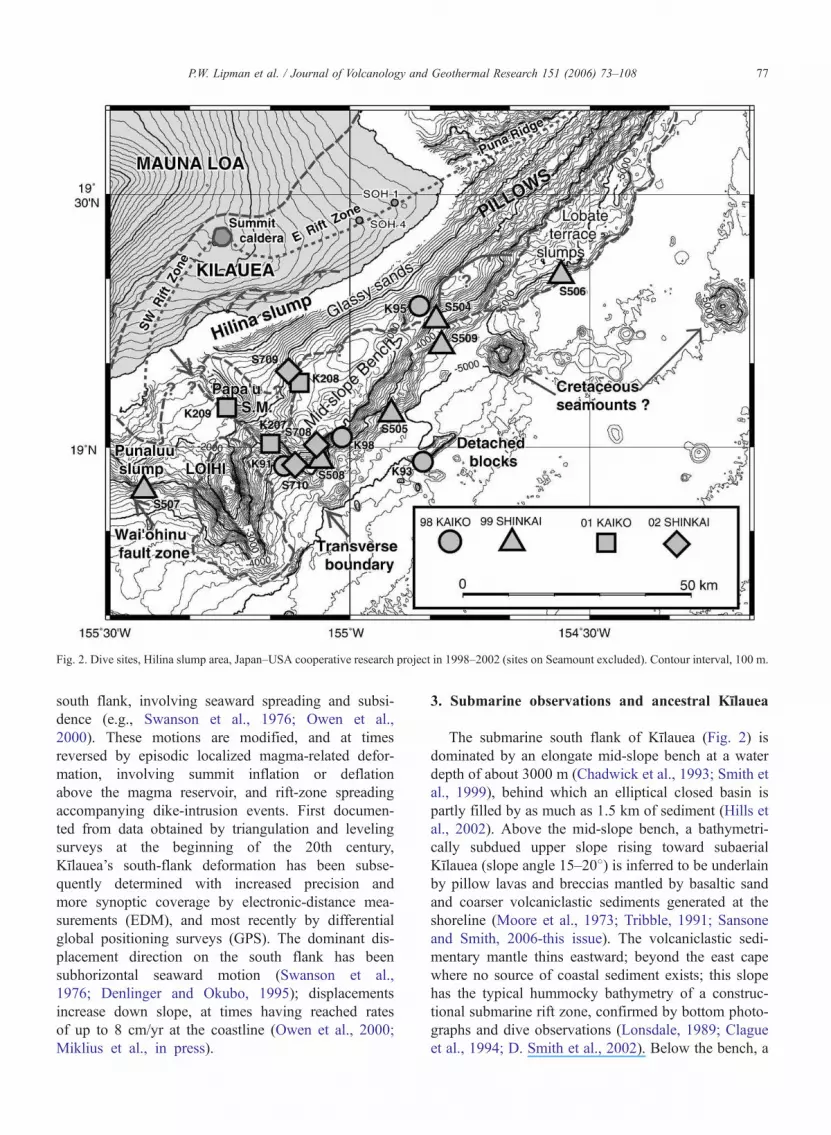
The submarine south flank of Kılauea (Fig. 2) is
dominated by an elongate mid-slope bench at a water
depth of about 3000 m (Chadwick et al., 1993; Smith et
al., 1999), behind which an elliptical closed basin is
partly filled by as much as 1.5 km of sediment (Hills et
al., 2002). Above the mid-slope bench, a bathymetri-
cally subdued upper slope rising toward subaerial
Kılauea (slope angle 15–208) is inferred to be underlain
by pillow lavas and breccias mantled by basaltic sand
and coarser volcaniclastic sediments generated at the
shoreline (Moore et al., 1973; Tribble, 1991; Sansone
and Smith, 2006-this issue). The volcaniclastic sedi-
mentary mantle thins eastward; beyond the east cape
where no source of coastal sediment exists; this slope
has the typical hummocky bathymetry of a construc-
tional submarine rift zone, confirmed by bottom photo-
graphs and dive observations (Lonsdale, 1989; Clague
et al., 1994; D. Smith et al., 2002). Below the bench, a
Fig. 2. Dive sites, Hilina slump area, Japan–USA cooperative research project in 1998–2002 (sites on Seamount excluded). Contour interval, 100 m.
P.W. Lipman et al. / Journal of Volcanology and Geothermal Research 151 (2006) 73–108 77
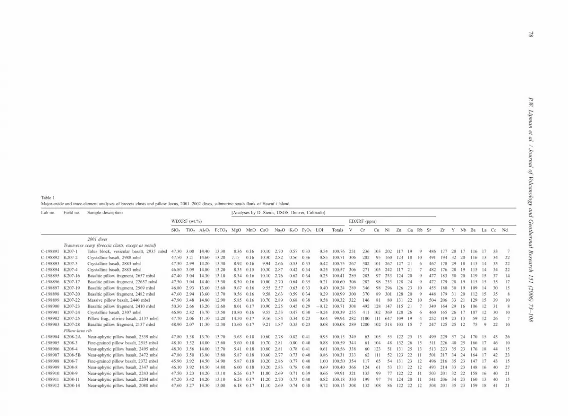
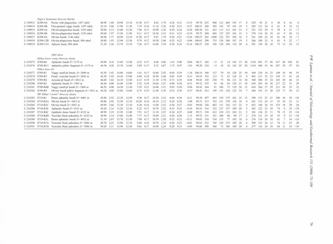
Table 1
Major-oxide and trace-element analyses of breccia clasts and pillow lavas, 2001–2002 dives, submarine south flank of Hawai‘i Island
Lab no. Field no. Sample description [Analyses by D. Siems, USGS, Denver, Colorado]
WDXRF (wt.%) EDXRF (ppm)
SiO2 TiO2 Al2O3 FeTO3 MgO MnO CaO Na2O K2O P2O5 LOI Totals V Cr Cu Ni Zn Ga Rb Sr Zr Y Nb Ba La Ce Nd
2001 dives
Transverse scarp (breccia clasts, except as noted)
C-198891 K207-1 Talus block, vesicular basalt, 2935 mbsl 47.30 3.00 14.40 13.30 8.36 0.16 10.10 2.70 0.57 0.33 0.54 100.76 251 236 103 202 117 19 9 486 177 28 17 116 17 33 7
C-198892 K207-2 Crystalline basalt, 2988 mbsl 47.50 3.21 14.60 13.20 7.15 0.16 10.30 2.82 0.56 0.36 0.85 100.71 306 202 95 160 124 18 10 491 194 32 20 116 13 34 22
C-198893 K207-3 Crystalline basalt, 2883 mbsl 47.30 2.99 14.20 13.30 8.92 0.16 9.94 2.66 0.53 0.33 0.42 100.75 267 302 101 267 127 21 6 467 178 29 18 113 14 33 22
C-198894 K207-4 Crystalline basalt, 2883 mbsl 46.80 3.09 14.80 13.20 8.35 0.15 10.30 2.87 0.42 0.34 0.25 100.57 306 271 103 242 117 21 7 482 176 28 19 115 14 34 22
C-198895 K207-16 Basaltic pillow fragment, 2657 mbsl 47.40 3.04 14.30 13.10 8.34 0.16 10.10 2.76 0.62 0.34 0.25 100.41 289 283 97 233 124 20 9 477 183 30 20 119 15 37 14
C-198896 K207-17 Basaltic pillow fragment, 22657 mbsl 47.50 3.04 14.40 13.30 8.30 0.16 10.00 2.70 0.64 0.35 0.21 100.60 306 282 98 233 128 24 9 472 179 28 19 115 15 35 17
C-198897 K207-19 Basaltic pillow fragment, 2569 mbsl 46.80 2.93 13.60 13.60 9.67 0.16 9.55 2.57 0.63 0.33 0.40 100.24 289 346 98 296 126 23 10 455 180 30 19 109 14 30 15
C-198898 K207-20 Basaltic pillow fragment, 2482 mbsl 47.60 2.94 13.60 13.70 9.56 0.16 9.58 2.63 0.59 0.34 0.29 100.99 300 370 89 301 128 20 9 448 179 31 20 112 15 35 8
C-198899 K207-22 Massive pillow basalt, 2440 mbsl 47.90 3.48 14.80 12.90 5.85 0.16 10.70 2.89 0.68 0.38 0.58 100.32 322 146 81 80 131 22 10 504 206 33 21 129 15 39 10
C-198900 K207-23 Basaltic pillow fragment, 2410 mbsl 50.30 2.66 13.20 12.60 8.01 0.17 10.90 2.25 0.45 0.29 �0.12 100.71 308 492 128 147 115 21 7 349 164 29 16 106 12 31 8
C-198901 K207-24 Crystalline basalt, 2307 mbsl 46.80 2.82 13.70 13.50 10.80 0.16 9.55 2.53 0.47 0.30 �0.24 100.39 255 411 102 369 128 26 6 460 165 26 17 107 12 30 10
C-198902 K207-25 Pillow frag., olivine basalt, 2137 mbsl 47.70 2.06 11.10 12.20 14.50 0.17 9.16 1.84 0.34 0.23 0.64 99.94 282 1180 111 647 109 19 4 252 119 23 13 59 12 26 7
C-198903 K207-28 Basaltic pillow fragment, 2137 mbsl 48.90 2.07 11.30 12.30 13.60 0.17 9.21 1.87 0.35 0.23 0.08 100.08 289 1200 102 518 103 15 7 247 125 25 12 75 9 22 10
Pillow-lava rib
C-198904 K208-2A Near-aphyric pillow basalt, 2539 mbsl 47.80 3.58 13.70 13.70 5.63 0.18 10.60 2.78 0.82 0.41 0.95 100.15 349 63 105 55 122 25 13 499 229 37 24 170 15 43 26
C-198905 K208-3 Fine-grained pillow basalt, 2515 mbsl 48.10 3.52 14.00 13.60 5.60 0.18 10.70 2.81 0.80 0.40 0.88 100.59 344 61 104 48 132 26 15 511 226 40 25 166 17 46 10
C-198906 K208-4 Near-aphyric pillow basalt, 2495 mbsl 48.30 3.56 14.00 13.70 5.41 0.18 10.80 2.81 0.78 0.41 0.61 100.56 338 60 123 51 131 25 13 513 223 35 23 176 18 44 15
C-198907 K208-5B Near-aphyric pillow basalt, 2472 mbsl 47.80 3.50 13.80 13.80 5.87 0.18 10.60 2.77 0.73 0.40 0.86 100.31 333 62 111 52 123 22 11 501 217 34 24 164 17 42 23
C-198908 K208-7 Fine-grained pillow basalt, 2372 mbsl 45.90 3.92 14.50 14.90 5.87 0.18 10.20 2.86 0.77 0.40 1.00 100.50 354 117 65 54 131 23 12 496 216 35 23 147 17 43 15
C-198909 K208-8 Near-aphyric pillow basalt, 2347 mbsl 46.10 3.92 14.50 14.80 6.00 0.18 10.20 2.83 0.78 0.40 0.69 100.40 366 124 61 53 131 22 12 493 214 33 23 148 16 40 27
C-198910 K208-9 Near-aphyric pillow basalt, 2243 mbsl 47.50 3.23 14.20 13.10 6.26 0.17 11.00 2.69 0.71 0.39 0.66 99.91 321 135 99 77 122 22 11 503 201 32 22 158 16 40 21
C-198911 K208-11 Near-aphyric pillow basalt, 2204 mbsl 47.20 3.42 14.20 13.10 6.24 0.17 11.20 2.70 0.73 0.40 0.82 100.18 330 199 97 74 124 20 11 541 206 34 23 160 13 40 15
C-198912 K208-14 Near-aphyric pillow basalt, 2080 mbsl 47.60 3.27 14.30 13.00 6.18 0.17 11.10 2.69 0.74 0.38 0.72 100.15 308 132 108 86 122 22 12 508 201 35 23 159 18 41 21
P.W.Lipmanet
al./JournalofVolca
nologyandGeotherm
alResea
rch151(2006)73–108
78
Papa‘u Seamount (breccia blocks)
C-198913 K209-4A Picrite with plagioclase, 1457 mbsl 48.90 1.68 10.90 12.10 15.30 0.17 8.62 1.79 0.26 0.21 �0.15 99.78 252 960 112 669 101 17 4 229 95 21 8 50 8 16 8
C-198914 K209-4B Fine-grained vuggy basalt, 1457 mbsl 52.10 2.06 13.90 11.50 7.19 0.16 11.10 2.26 0.30 0.23 �0.27 100.53 288 395 143 97 101 19 5 285 112 24 9 61 9 18 12
C-198915 K209-6A Olivine-plagioclase basalt, 1329 mbsl 50.60 2.12 13.80 12.20 7.96 0.17 10.90 2.30 0.29 0.24 �0.28 100.30 331 423 113 113 101 21 5 251 125 29 9 59 8 21 b7
C-198916 K209-6B Olivine-plagioclase basalt, 1329 mbsl 50.60 1.97 13.20 11.90 9.11 0.17 10.30 2.15 0.31 0.23 �0.19 99.75 294 685 127 225 101 15 5 270 114 26 10 61 9 20 12
C-198917 K209-8A Olivine basalt, 1146 mbsl 48.90 1.77 10.90 12.10 15.50 0.17 8.91 1.79 0.28 0.21 �0.26 100.27 262 1040 122 741 105 16 5 241 104 22 10 61 10 16 b7
C-198918 K209-12B Olivine-plagioclase basalt, 888 mbsl 50.80 1.93 12.90 12.30 9.79 0.17 10.20 2.08 0.32 0.22 �0.06 100.65 290 735 128 248 107 19 5 266 109 23 8 63 9 22 b7
C-198919 K209-13A Aphyric basal, 888 mbsl 51.50 2.26 13.70 12.10 7.26 0.17 10.40 2.38 0.38 0.26 �0.14 100.27 329 328 128 104 110 20 6 291 138 28 10 72 13 28 12
2002 dives
Hilina lower scarp (breccia clasts)
C-210375 S708-R6 Aphanitic basalt D =3175 m 44.90 4.18 15.60 13.40 4.23 0.17 8.68 4.88 1.63 0.98 0.06 98.71 202 b5 21 14 145 23 30 1130 491 57 56 417 40 100 61
C-210376 S708-RU1 Aphanitic pillow fragment D =3175 m 44.50 4.20 15.70 12.60 3.89 0.17 8.72 4.87 1.75 0.97 1.83 99.20 234 b5 18 18 145 25 29 1110 500 55 56 427 39 97 56
Pillow-lava rib
C-210377 S709-R1 Vuggy small-pl basalt, D =2048 m 45.50 3.92 14.80 14.60 5.41 0.17 10.40 2.92 0.69 0.39 1.34 100.14 368 127 70 54 128 25 10 504 210 34 23 148 18 44 19
C-210378 S709-R3 Finely vesicular basalt D =2036 m 45.50 3.95 14.30 15.00 6.04 0.18 10.20 2.84 0.65 0.38 0.51 99.55 355 113 71 55 128 23 9 492 213 35 23 159 17 41 24
C-210379 S709-R4 Acicular-pl basalt D =2012 m 46.60 3.42 14.10 12.80 6.33 0.19 11.30 2.70 0.71 0.39 0.88 99.42 330 220 75 84 121 16 10 540 206 33 24 165 20 44 23
C-210380 S709-R5 Aphanitic basalt D =1965 m 46.60 4.00 14.40 12.90 5.52 0.18 10.60 3.21 0.90 0.50 0.51 99.32 355 83 68 65 120 21 10 636 265 38 30 217 22 51 28
C-210381 S709-R6B Vuggy small-pl basalt D =1868 m 46.30 4.00 14.30 13.20 5.39 0.21 10.40 3.21 0.95 0.50 0.96 99.42 364 91 106 73 129 26 13 626 264 37 29 211 20 52 32
C-210382 S709-R9 Olivine basalt pillow fragment D =1821 m 44.20 4.68 13.80 14.60 6.75 0.19 11.40 2.39 0.53 0.30 0.57 99.41 412 199 133 128 125 24 7 444 191 33 20 123 17 38 12
SW Hilina bcornerQ (breccia clasts)
C-210383 S710-R1 Dense aphanitic basalt D =4401 m 45.00 2.52 12.30 12.50 9.30 0.17 14.30 2.24 0.64 0.30 0.11 99.38 457 465 154 175 101 19 13 398 131 23 21 180 16 38 b10
C-210384 S710-R2A Olivine basalt D =4367 m 49.00 2.02 12.50 12.10 10.20 0.16 10.10 2.12 0.29 0.24 1.00 99.73 313 763 131 270 110 18 4 261 115 24 11 53 10 21 11
C-210385 S710-R2C Olivine basalt D =4367 m 49.00 2.66 13.30 12.10 8.20 0.16 11.00 2.52 0.56 0.37 �0.03 99.84 328 463 111 182 113 22 9 432 169 26 19 133 18 39 24
C-210386 S710-R3E Aphanitic basalt D =4121 m 50.20 2.14 13.20 12.10 8.22 0.17 10.70 2.22 0.33 0.23 �0.16 99.35 316 532 127 157 109 20 5 283 122 23 10 74 9 25 b10
C-210387 S710-R4C Apahnitic dense basalt D =4122 m 49.90 2.19 13.50 12.00 7.91 0.17 11.10 2.25 0.34 0.27 0.08 99.71 330 413 128 133 102 21 5 301 124 25 11 70 13 25 b10
C-210388 S710-R4D Vesciular black pahoehoe D =4122 m 49.90 2.14 13.60 12.40 7.37 0.17 10.40 2.21 0.20 0.20 1.13 99.72 311 351 100 86 99 17 2 274 121 23 10 53 9 21 b10
C-210389 S710-R5x Dense aphanitic basalt D =4032 m 51.10 2.07 13.70 12.30 7.09 0.17 10.70 2.28 0.32 0.23 �0.11 99.85 318 334 125 77 103 18 6 276 118 26 10 61 7 16 b10
C-210390 S710-R7A Vesicular black pahoehoe D =3886 m 49.70 2.23 12.90 11.70 9.48 0.16 10.70 2.18 0.36 0.25 �0.01 99.65 333 745 120 273 109 20 6 309 125 24 12 78 11 25 20
C-210391 S710-R7D Vesicular black pahoehoe D =3886 m 50.20 2.11 12.90 12.20 9.02 0.17 10.40 2.24 0.28 0.23 �0.09 99.66 309 566 73 186 100 20 4 277 116 24 10 64 11 14 b10
P.W.Lipmanet
al./JournalofVolca
nologyandGeotherm
alResea
rch151(2006)73–108
79

steep lower scarp (averages 25 degrees overall; some
segments near vertical) descends 2000 m to the base of
the island at about �5000 m. The lower scarp is fluted
and embayed with a morphology suggestive of small
landslide scars, and an alluvial-appearing apron and a
few large elongate outlying blocks provide a record of
mass wasting from these scarps (Smith et al., 1999;
Lipman et al., 2002; Leslie et al., 2002). To the south-
west, the mid-slope bench is bounded by a linear
transverse scarp trending to the northwest, with a high
point at Papa‘u Seamount (Fig. 2). To the northeast the
bench narrows and merges with the south flank of the
Puna Ridge.
Prior to inception of the Japan–USA collaborative
studies of the underwater flanks of Hawaiian volcanoes
in 1998, no dive observations, deep photography, or
dredging had been undertaken on the submarine south
flank of Kılauea. Direct observations by observers in
the manned Shinkai 6500, video and still-camera
images, and samples collected during 16 dives have
now provided voluminous data leading to insights
concerning the ancestral growth of Kılauea. Major
recent observations (Lipman et al., 2000, 2002; Sisson
et al., 2002; Naka et al., 2002; Kimura et al., 2006-this
issue; Coombs et al., 2006-this issue) include: (1) all
outcrops on the lower scarp are volcaniclastic rocks; (2)
pillow-lava sequences form bedrock of the upper slope;
(3) breccia-clast and pillow compositions in both areas
are diverse submarine-erupted alkalic and transitional
basalts, without tholeiite of present-day Kılauea com-
position; (4) a voluminous component of tholeiitic sand
in the volcaniclastic rocks was derived from subaerial
Mauna Loa and probably Mauna Kea; (5) geochrono-
logic determinations indicate unexpectedly young ages
for early growth of ancestral Kılauea. These results are
summarized briefly below to document the ancestral
submarine growth of Kılauea and to provide a frame-
work for interpretations in this paper.
3.1. Volcaniclastic rocks on the lower scarp
Eight dives at widely distributed sites on the lower
scarp (Fig. 2) encountered thick sections of volcaniclas-
tic rocks, without interlayered pillow lavas or other
primary volcanic deposits (Lipman et al., 2002; Coombs
et al., 2006-this issue). The dominant volcaniclastic
rocks are coarse debris-flow breccia, interbeded with
indurated sandstone beds consisting dominantly of well-
sorted basaltic glass. Bedding in the volcaniclastic se-
quence dips gently, but fractures and shears indicate
deformation, presumably compression during uplift of
the bench to form the closed basin behind it. The
assemblage of volcaniclastic rocks has been interpreted
as recurrently emplaced debris-flow and turbidite
deposits derived from the ancestral submarine Kılauea
edifice, along with coastal detritus from older volcanoes
of Hawai‘i Island (Mauna Loa, Mauna Kea).
3.2. Pillow lavas above and east of the mid-slope bench
Rock ribs that project through the weakly consoli-
dated sediment mantle on slopes above the bench ex-
pose cliff outcrops of massive pillow lava, as traversed
by four dives (K95, K208, S504, S709). An 800-m high
outcropping rib, exposed and sampled at depths of
�2600 to �1800 m (dives K208, S709), consists of
weakly alkalic pillow basalt (Coombs et al., 2006-this
issue; Kimura et al., 2006-this issue). Along the east
margin of the mid-slope bench and up slope, offshore
from the proximal east rift zone, two dives (dives K95,
S504) traversed a similar thick pillow-lava sequence
(�3700 to �2900 m) of uniform transitional basalt
(Sisson et al., 2002). All large outcrops at these
upper-slope sites are truncated pillows; primary depo-
sitional surfaces have been disrupted by slumping or
landsliding along steep slopes. Such outcrops thus ex-
pose sections through the primary constructional edifice
of submarine Kılauea, rather than drapes of pillow lava
that mantle pre-existing steep slopes. Bedded volcani-
clastic sediments are nearly absent (a few beds 1–2 m
thick were encountered near the top of dive S709), in
contrast to the clastic sequence on the lower scarp.
3.3. Compositions of submarine south-flank lavas and
clasts
Nearly all clasts from breccias on the lower scarp and
pillow lavas from the upper slope are diverse alkalic and
transitional basalts (Table 1; Fig. 3). Almost all clast and
pillow samples with preserved glass rinds have substan-
tial S, CO2, and H2O contents suggestive of submarine
eruption at depths of as much as several kilometers
(Coombs et al., 2006-this issue). Sampled clasts have
diverse alkalic melt compositions, including rare neph-
elinite with SiO2 as low as 38% and phonotephrite with
as much as 9% total alkalis (Lipman et al., 2002, Fig. 7;
Sisson et al., 2002, Table 2). The observed composi-
tional range of this suite, interpreted as representing the
early pre-shield growth of Kılauea, is far more diverse
than at Lo‘ihi Seamount (Moore et al., 1982; Garcia et
al., 1995a), and includes alkalic magma types unknown
from elsewhere on Hawai‘i Island. Proportions of highly
alkalic clasts show a general upward decrease as abun-
dance of transitional basalt increases (Lipman et al.,
P.W. Lipman et al. / Journal of Volcanology and Geothermal Research 151 (2006) 73–10880
2002, Fig. 6). No obvious reversal or repetitions were
detected, suggesting that the lower scarp section is
largely structurally coherent, although the volcaniclastic
nature of these deposits precludes assigning detailed
stratigraphic significance to the succession of clast com-
positions. A few vesicular clasts, having distinct Loa-
type compositions (in contrast to Kea-type—e.g., lower
SiO2, higher TiO2 and alkalis, associated trace-element
variations: Wright, 1971; Jackson et al., 1972; Garcia et
al., 1995b; Rhodes, 1996), are inferred to have been
derived from the subaerial Mauna Loa edifice at the time
of growth of ancestral Kılauea.
Samples from the pillow rib above the central mid-
slope bench (dives K208, S709), have high volatile
contents and uniform weakly alkalic compositions
(Coombs et al., 2006-this issue; Kimura et al., 2006-
this issue). A similarly thick sequence of higher-SiO2
transitional-composition pillow lavas at the east end of
the mid-slope bench (dives K98, S504) are also volatile
rich and therefore submarine erupted, and plot within
the tholeiite field, but are well removed in composition
from present-day Kılauea lavas. No in-place outcrops of
highly alkalic pillow lavas (basanite, phonotephrite,
nephelinite) were sampled; clasts in the lower-scarp
breccias with these compositions therefore are inter-
preted as derived from older deeper parts of the ances-
tral Kılauea edifice, now buried beneath the weakly
alkalic and transitional lavas.
A single pillow lava sample from the mid-slope
bench (S504-R5) is degassed and has a composition
similar to present-day Kılauea flows (Fig. 3); this is
interpreted as a late slope-draping flow (Lipman et al.,
2002), a lone exception to all other in-place samples of
pillow lava. Only one recovered clast, from a breccia
above the mid-slope bench (K207-R23), has a compo-
sition similar to present-day Kılauea tholeiite (Table 1;
Coombs et al., 2006-this issue), indicating that no
sizable shield-stage collapse occurred during the main
accumulation of volcaniclastic deposits underlying the
mid-slope bench. The scarcity of Kılauea-type tholeiite,
either as lavas or clasts from the summit and proximal
rifts of this volcano, is striking, especially in compar-
ison with the well-sampled upper submarine flank of
Mauna Loa in South Kona, which is draped by shore-
line-crossing degassed pillow lavas (Garcia and Davis,
2001; Morgan and Clague, 2003; Yokose and Lipman,
2004).
3.4. Sandstones and breccia matrix
Turbidite sandstones and matrix of breccias on the
lower scarp consist dominantly of low-S tholeiitic glass
derived from subaerially erupted lava flows that crossed
the shoreline; both Kea and Loa compositional types
are present. Such sand is a major component of the
lower-scarp sections, overall at least 50% by volume.
Grains of mafic alkalic glass, with compositions
encompassing but even more diverse than the breccia
clasts (Sisson et al., 2002, 2003), are sparsely scattered
through most sandstones and the matrix of breccias.
Alkalic grains are abundant in a few sandstone samples,
especially low along the lower scarp and the rare sand-
Fig. 3. Alkali–silica diagram, basaltic pillow lavas and breccia clasts, from dive sites (in parentheses) in Hilina slump area. Dashed lines, IUGG rock
classification, and boundary between tholeiite and alkalic basalt (Macdonald and Katsura, 1964). Data for Hilina flank are from Tables 1 and 2,
Sisson et al. (2002), and Coombs et al. (2006-this issue); Puna Ridge analyses are from Clague et al. (1995). Compositions of some extremely
alkalic clasts (nephelinite, phonotephrite: Lipman et al., 2002, Fig. 7) plot outside the figure area.
P.W. Lipman et al. / Journal of Volcanology and Geothermal Research 151 (2006) 73–108 81
stones exposed in the upper-slope alkalic pillow rib.
Nearly all of the highly alkalic sand grains are high S
(N400 ppm), in contrast to the tholeiitic glass grains
that overwhelmingly have low volatile concentrations
indicative of subaerial degassing (Sisson et al., 2002,
fig. 2; Coombs et al., 2006-this issue, fig. 4). Compo-
sitionally and petrogenetically coherent suites of alkalic
glass grains are present in some sandstone samples
(Sisson, 2003), indicating that those alkalic grains
were of local origin and were not transported long
distances by littoral processes.
3.5. Ar–Ar ages of south flank basalts
Tholeiitic Hawaiian basalts generally have been dif-
ficult to date by K–Ar or Ar–Ar methods because of
low potassium contents, excess radiogenic Ar derived
from magma generation in the mantle (e.g., Dalrymple
and Moore, 1968; Lipman et al., 1990), and the mobil-
ity of potassium due to the location of this element in
glass or weakly devitrified matrix (Lipman et al., 1990;
Teanby et al., 2002). The south-flank breccia clasts and
pillow lavas of alkalic composition have higher K
contents and have yielded a coherent suite of incremen-
tal heating 40Ar–39Ar ages (13 samples dated), ranging
from 280 to 125 ka (Calvert and Lanphere, 2006-this
issue). The most alkalic clasts, from low along the
lower scarp, have the oldest ages (Fig. 4); especially
analytically well constrained are mica ages of 235–240
ka, from two clasts of phlogopite-bearing nephelinite.
In contrast, five samples of in-place weakly alkalic
basalt from the pillow rib at water depths of �2400
to �1800 m above the mid-slope bench yielded coher-
ent ages of 140–165 ka. Two difficult-to-date transi-
tional pillow samples yielded ages of 230 and 140 ka,
necessarily with large analytical uncertainties (~F50
ka, F1r). Thus, at least the bulk of shield-stage tho-
leiitic eruptions at Kılauea were probably younger than
150 ka, probably less than 100 ka.
Overall, in conjunction with recognition of thick
submarine sections of alkalic and transitional pillows,
the new 40Ar–39Ar results suggest probable approxi-
mate time spans (likely uncertainty, F25 ka) for dom-
inant eruption of the compositional sequence: diverse
early alkalic, 275–200 ka; late weakly alkalic, 200–150
ka; transitional, 150–100 ka; tholeiitic, 100 ka-continu-
ing. Ages as old as 436 ka, reported for present-day-
type Kılauea tholeiites from drill holes along the middle
east rift zone (Guillou et al., 1997; Quane et al., 2000),
are inconsistent with the simple covariation of ages,
compositions, and geologic setting of the submarine
Kılauea samples. The reported ages for the drill-hole
tholeiites may be erroneous, perhaps due to excess
radiogenic Ar.
4. Mauna Loa and its south flank structure
Mauna Loa is a larger and older volcano than
Kılauea, but these two volcanoes have similar gross
geometries, with a summit caldera, opposed arcuate
rift zones, and a steep south flank that lacks eruptive
vents (Stearns and Macdonald, 1946; Wolfe and Morris,
Fig. 4. Summary of interpreted ages for events related to growth of Kılauea Volcano. Data sources: 1. Radiocarbon (Beeson et al., 1996); 2. Ar–Ar
(Lipman et al., 2002; Calvert and Lanphere, 2006-this issue); 3. Sedimentation rate (Naka et al., 2002); 4. Ar–Ar (Sharp et al., 1996); 5. Unspiked
K–Ar, SOH hole (Guillou et al., 1997).
P.W. Lipman et al. / Journal of Volcanology and Geothermal Research 151 (2006) 73–10882
1996). In contrast to Kılauea, the north to west flanks of
Mauna Loa contain scattered radial vents (Lockwood
and Lipman, 1987). Like Kılauea, the summit of Mauna
Loa is associated with a large positive Bouguer gravity
anomaly, evidence of dense intrusive and cumulate
rocks at depth. This anomaly extends farther seaward
(~ 20 km), and asymmetrically southeast of the summit
caldera, than the anomaly at Kılauea (~10 km across)
centered on the caldera (Kauahikaua, 1993; Kauahikaua
et al., 2000), suggesting more intense lateral seaward
spreading at Mauna Loa.
4.1. Eruptive history
Overall, individual historical Mauna Loa eruptions
have been less frequent, but larger in volume than those
on Kılauea. Typical eruptive cycles have sequentially
involved a brief summit eruption, followed within
months to a few years by a longer-duration rift eruption
(Stearns and Macdonald, 1946, p. 79; Macdonald and
Abbott, 1970, p. 55; Lockwood et al., 1987). Most
historical rift-zone and radial-vent eruptions have
been relatively brief in duration (a few weeks to
months) but with high discharge rates that favor distal
emplacement of lava as a‘a rather than pahoehoe.
Some evidence suggests that Mauna Loa reached
approximately its present size before 100 ka, and that
its rate of growth as a tholeiitic shield has since been
declining (Lipman, 1995). Historical behavior of
Mauna Loa has varied greatly, with frequent eruptions
(avg. ~every 3.6 yr) from initial records in the early
19th century up through 1950 (Stearns and Macdonald,
1946; Macdonald and Abbott, 1970). In the half century
since 1950, however, only a single summit-rift eruptive
cycle has occurred (1975–84: Lockwood et al., 1987).
Geologic mapping and radiocarbon dating have provid-
ed a longer-term perspective on eruptive activity, which
suggests that the early historical period was a time of
atypically high eruptive activity at Mauna Loa, at least
relative to the past few thousand years (Lipman, 1980a;
Lockwood, 1995).
Several structures on the south flank of Mauna
Loa hint of an earlier growth history more closely
akin to that characterizing present-day Kılauea: (1)
the Kao‘iki–Wai‘ohinu fault system as a now-weakly-
active counterpart to the Hilina system on Kılauea;
(2) continuing south-flank deformation and seismicity
on Mauna Loa in addition to that at Kılauea, indicat-
ing that more than the south flank of Kılauea is
involved the overall active tectonics of Hawai‘i Is-
land; (3) a large-scale landslide (Punalu‘u slump)
prior to growth of Kılauea, suggesting that volcani-
clastic Mauna Loa rocks underlie the Hilina Bench.
Submersible observations along the southwest margin
of the Hilina mid-slope bench now confirm that
Mauna Loa was a large subaerial tholeiitic shield
prior to initial growth of Kılauea.
4.2. Kaodiki–Honudapo fault system
The Kao‘iki–Honu‘apo fault system is a northeast-
trending zone of lava-draped fault scarps and fractures
traceable, at elevations from sea level to 1800 m, for
50 km along the south flank of Mauna Loa (Stearns
and Macdonald, 1946; Wolfe and Morris, 1996). The
largest remnant scarps, in the Ninole Hills area, are as
high as 200 m. Fault scarps indicate dominant sea-
ward-down displacements, but amounts of offset at
many sites are difficult to estimate because of cover-
age by younger Mauna Loa lava flows. Some flows
draping scarps are as old as 9.8 ka, without obvious
offset (Lipman, 1980b; Rubin et al., 1987; Lipman et
al., 1990), but the fault zone is a locus of continuing
seismicity (Endo, 1985; Klein et al., 1987; Jackson et
al., 1992). It has been inferred, at least since Stearns
and Clark (1930, p. 96–97), that the Kao‘iki–Hon-
u‘apo faults represent a nearly inactive counterpart
on Mauna Loa to the Hilina system on Kılauea (Lip-
man et al., 1990).
4.3. South-flank deformation on Mauna Loa
High levels of deformation and seismicity have been
recorded at Kılauea throughout the past half century,
since the advent of instrumental monitoring. Under-
standing of analogous activity on Mauna Loa has
lagged, both because of the relative quiescence of this
volcano since the large southwest rift eruption in 1950
and because the size and inaccessibility of upper parts
of this enormous edifice have drastically impeded de-
tailed geophysical measurements. For example, after
the 1975 summit eruptions, a substantial effort was
made by staff of the Hawaiian Volcano Observatory
to augment the seismic stations and to establish defor-
mation networks (trilateration by EDM, some leveling)
along the rift zones and south flank of Mauna Loa.
These networks provided improved resolution during
the 1984 northeast rift eruption and precursor events
Lockwood et al., 1987). Deformation measurements by
EDM nicely tracked precursor summit inflation and
extension along the northeast rift that accompanied
dike intrusion as magma flowed to the eruptive vent
(Lockwood et al., 1987). In contrast, the vast size and
curvature of the Mauna Loa shield precluded measure-
P.W. Lipman et al. / Journal of Volcanology and Geothermal Research 151 (2006) 73–108 83
ments on flanks in detail comparable to those routinely
obtained at Kılauea.
Through the 1980s, most EDM surveys were insuf-
ficiently robust, and inadequately referenced to stable
areas of Hawai‘i Island, to permit resolution of small
displacements (cm-scale) across the south flank of
Mauna Loa and the degree to which deformation high
on this edifice was accommodated by adjacent Kılauea.
In association with the M =7.2 Kalapana earthquake in
1975, however, displacement solutions for trilateration
stations low on the south flank of Mauna Loa all show
seaward motions of 0.4 to as much as 1.2 m, even
though the three most distal stations were arbitrarily
held as fixed to provide reference points for the geo-
detic network (Lipman et al., 1985).
Since 1990, geodetic monitoring by GPS has made it
possible routinely to resolve cm-scale displacements on
the flanks of Mauna Loa (Miklius et al., 1995). The first
decade of observations, while still a brief interval,
defines a consistent pattern of small seaward motions
on the south flank. Horizontal displacements increase in
amplitude down slope, from largely below instrumental
delectability at high elevations, to about 1–1.5 cm/yr
adjacent to the boundary with Kılauea (Fig. 5; Owen et
al., 2000; Miklius et al., in press). Thus, despite growth
of Kılauea, currently at rates that are substantially more
vigorous than for Mauna Loa (Lipman, 1995; DePaolo
and Stolper, 1996; DePaolo et al., 2001), prehistoric
displacements along Kao‘iki–Honu‘apo faults, deforma-
tion during the large 1868 and 1975 earthquakes, and
recent GPS determinations all document persistent sea-
ward displacement of Mauna Loa’s lower south flank.
On both volcanoes, near-summit and rift-zone dis-
placements are strongly influenced by inflation/defla-
tion of their magma chambers and dike intrusion along
rift zones (Swanson et al., 1976; Duffield et al., 1982;
Dvorak et al., 1986). In contrast, the regional pattern of
horizontal deformation shows sustained seaward dis-
placements that progressively increase down the south
flank of Hawai‘i Island, seemingly independent of the
surface boundary between the two volcanoes (Fig. 5).
Some dislocation models have been used to infer that
the motions on Mauna Loa are shallow secondary
responses to displacements bounded at depth by
Kılauea’s rift zones (Owen et al., 2000), but such
interpretations seem inconsistent with the broad distri-
bution of earthquakes beneath Mauna Loa’s south
flank, as discussed below.
4.4. Seismicity on Mauna Loa
In addition to eruption-related earthquakes concen-
trated at the summit of Mauna Loa and along its rift
zones, the entire south side of Hawai‘i Island is charac-
terized by broad diffuse levels of seismicity. The south
flank of Mauna Loa is marked by frequent small and
intermittent large earthquakes (including M =5.5 in
1974 and M =6.6 in 1983); these are commonly
known as Kao‘iki earthquakes, although most occur
upslope from the surface Kao‘iki fault zone (Fig. 6).
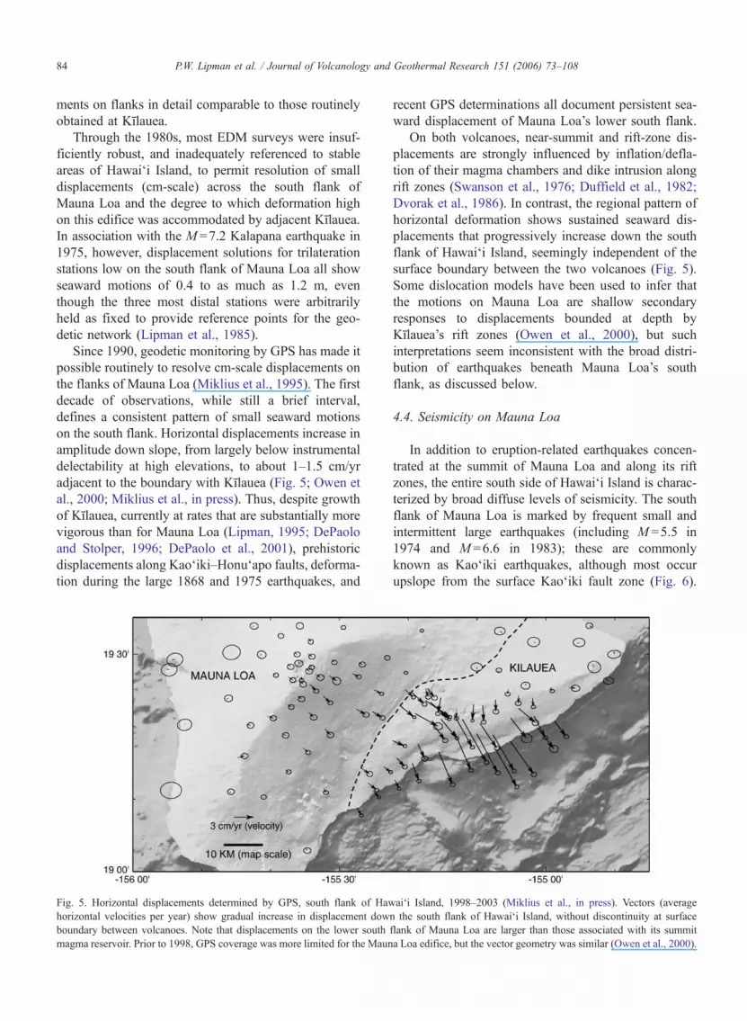
Fig. 5. Horizontal displacements determined by GPS, south flank of Hawai‘i Island, 1998–2003 (Miklius et al., in press). Vectors (average
horizontal velocities per year) show gradual increase in displacement down the south flank of Hawai‘i Island, without discontinuity at surface
boundary between volcanoes. Note that displacements on the lower south flank of Mauna Loa are larger than those associated with its summit
magma reservoir. Prior to 1998, GPS coverage was more limited for the Mauna Loa edifice, but the vector geometry was similar (Owen et al., 2000).
P.W. Lipman et al. / Journal of Volcanology and Geothermal Research 151 (2006) 73–10884
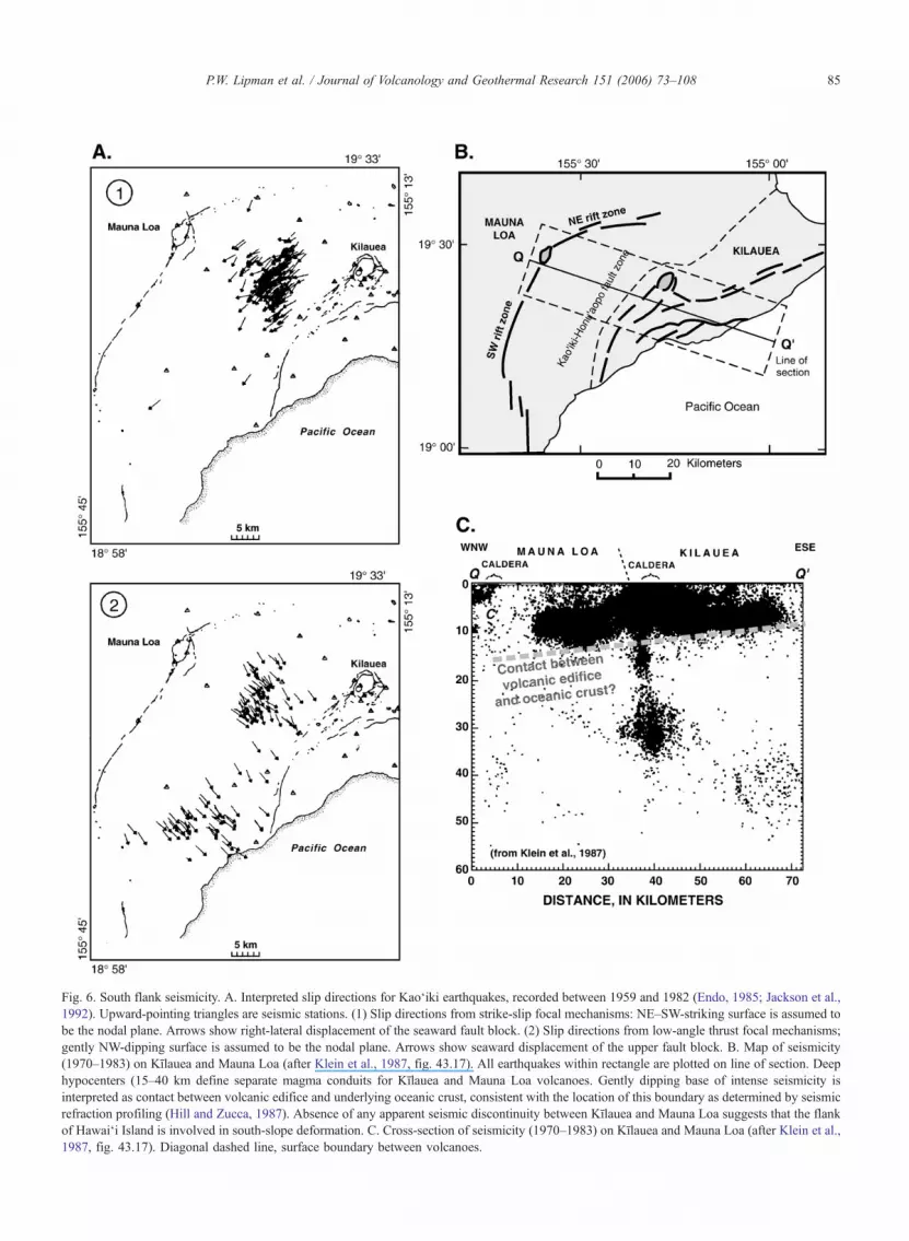
Fig. 6. South flank seismicity. A. Interpreted slip directions for Kao‘iki earthquakes, recorded between 1959 and 1982 (Endo, 1985; Jackson et al.,
1992). Upward-pointing triangles are seismic stations. (1) Slip directions from strike-slip focal mechanisms: NE–SW-striking surface is assumed to
be the nodal plane. Arrows show right-lateral displacement of the seaward fault block. (2) Slip directions from low-angle thrust focal mechanisms;
gently NW-dipping surface is assumed to be the nodal plane. Arrows show seaward displacement of the upper fault block. B. Map of seismicity
(1970–1983) on Kılauea and Mauna Loa (after Klein et al., 1987, fig. 43.17). All earthquakes within rectangle are plotted on line of section. Deep
hypocenters (15–40 km define separate magma conduits for Kılauea and Mauna Loa volcanoes. Gently dipping base of intense seismicity is
interpreted as contact between volcanic edifice and underlying oceanic crust, consistent with the location of this boundary as determined by seismic
refraction profiling (Hill and Zucca, 1987). Absence of any apparent seismic discontinuity between Kılauea and Mauna Loa suggests that the flank
of Hawai‘i Island is involved in south-slope deformation. C. Cross-section of seismicity (1970–1983) on Kılauea and Mauna Loa (after Klein et al.,
1987, fig. 43.17). Diagonal dashed line, surface boundary between volcanoes.
P.W. Lipman et al. / Journal of Volcanology and Geothermal Research 151 (2006) 73–108 85
First-motion solutions for Kao‘iki earthquakes (Fig.
6-A) have two divergent geometries (Endo, 1985; Jack-
son et al., 1992; Got and Okubo, 2003): (1) left-lateral
strike slip, trending northeast, parallel to the Kao‘iki
fault zone; and (2) southeast-trending low-angle thrust,
similar to orientations for large deep decollement earth-
quakes on Kılauea, such as the 1975 Kalapana event
(Ando, 1979; Crosson and Endo, 1982). Strike-slip
events may accommodate differential motions between
the Kılauea and Mauna Loa magmatic systems along
Kao‘iki faults. Thrust events are likely associated with
the seaward spreading of the Mauna Loa south flank, as
recorded by GPS displacements and geometrically con-
sistent with displacements during the 1975 Kalapana
earthquake measured by trilateration.
Additional seismic evidence for recent mobility of
Mauna Loa’s south flank is provided by the 1868
M =~8 earthquake (Brigham, 1909; Wood, 1914),
which appears to have been similar in rupture geometry
to the 1975 Kalapana quake, involving low-angle sea-
ward slip at the base of the volcanic pile (Wyss, 1988).
This largest historical earthquake on Hawai‘i Island
appears to have been centered on the south flank of
Mauna Loa, in contrast to the Kılauea locus of the 1975
Kalapana quake. Lateral motions appear to have been
dominant, with horizontal displacements along the
Wai’ohinu tear fault (Fig. 1) of as much as 2–3 m
(Hitchcock, 1909, p. 105–106; Wood, 1914; Lipman,
1980a), accompanied by widespread coastal subsidence
(Brigham, 1909).
Plotted in cross-section, earthquakes on Hawai‘i
Island define a continuous diffuse band across Kılauea
and the south flank of Mauna Loa, with depth gradu-
ally increasing inland (e.g., Klein et al., 1987, fig.
43.17 for time interval 1970–83; Denlinger and
Okubo, 1995, fig. 5—relocated for time interval
1970–89). The deepest earthquake hypocenters, in-
creasing landward from about 9 km below the coastline
to 12 km below upper slopes of Mauna Loa (Fig.
6B,C), coincide closely with the base of the volcanic
edifice as determined independently by seismic-refrac-
tion profiling (Hill and Zucca, 1987; Thurber and Li,
1989). When a subset of earthquakes below the upper
flank of Kılauea were relocated more precisely by
relative-muliplet methods (Got et al., 1994; Got and
Okubo, 2003), the cloud of hypocenters collapses to
define a plane dipping about 68 northwestward at the
base of the volcanic pile, compatible with slip along a
bounding decollement fault. Even within the area stud-
ied by Got et al. (1994), this fault likely separates the
south flank of Mauna Loa, beneath the Kılauea edifice
as discussed in a later section, from the underlying
oceanic crust. Thus, the combined seismic and defor-
mation data are consistent with processes of seaward
gravitational spreading of the entire south flank of
Hawai‘i Island, encompassing the edifices of both
Mauna Loa and Kılauea, largely occurring along a
basal decollement at the boundary between old seafloor
and the volcanic pile.
4.5. Punalu‘u slump and underwater south flank
The volcanoes of Hawai‘i Island are surrounded by
large submarine landslides (Moore, 1964; Lipman et
al., 1988; Moore et al., 1989). Existence of the Puna-
lu‘u slump south of Mauna Loa was originally inferred
on the basis of seaward truncation of structurally high
erosional remnants of old Mauna Loa rocks on the
subaerial south flank (Ninole Hills) and limited ba-
thymetry and side-scan sonar for adjacent underwater
areas (Lipman et al., 1990). High-resolution SeaBeam
bathymetry (Chadwick et al., 1993; J. Smith et al.,
2002; Eakins et al., 2003) now documents a mid-
slope bench west of Lo‘ihi Seamount with its outer
lip at about �2500 m (Figs. 1, 2). A steep lower scarp
descends to about �4000 m, below which a relatively
steep smooth fan of presumed slide debris merges with
the Cretaceous sea floor. An irregular slope above the
bench is probably mantled by post-slump shoreline-
crossing Mauna Loa lavas, and in part by flows from
the lower southwest rift zone of Kılauea, a structure
that has only modest morphologic expression underwa-
ter, especially compared to the Kılauea’s Puna Ridge
(Fig. 2).
Dive S507 with the Shinkai 6500 submersible tra-
versed the lower Punalu‘u scarp from �3500 to �2700
m. Other than one cliff-forming layer of relatively
crystalline aphyric tholeiite that may represent ponded
lava or a sill at �2750 m, the lower-scarp slope con-
sisted entirely of weakly indurated breccias, and all 10
collected samples were similar of olivine-rich (5–30%)
basalt fragments (Lipman et al., 2002, Appendix). All
analyzed samples (including those from the cliff-form-
ing aphyric basalt) are tholeiite compositionally similar
to young subaerial Mauna Loa lavas, and all large clasts
that preserve glassy margins are low S (30–300 ppm;
avg. 150 ppm: Sisson et al., 2002, Appendix), indica-
tive of subaerial eruption. No young-appearing lavas
were sampled that could have erupted from the Kılauea
southwest rift, nor do any of the analyzed samples have
Kılauea-like compositions.
Ocean-floor turbidites south of Hawai‘i Island (Naka
et al., 2002) also record a large landslide from this side
of Mauna Loa, as marked by a meter-thick layer of
P.W. Lipman et al. / Journal of Volcanology and Geothermal Research 151 (2006) 73–10886
tholeiitic glass sand with an age (interpolated from
sedimentation rates) of ~400 ka, older than any of the
newly determined 40Ar / 39Ar ages for ancestral alkalic
Kılauea. The basaltic sand in the turbidite layer is
compositionally similar to modern Mauna Loa tholeiite
glasses, with low S contents, indicating origin from
subaerial lava flows that were quenched and disaggre-
gated as they crossed the shoreline. This turbidite may
provide a distal record of emplacement of the Punalu‘u
slump at ~400 ka (Fig. 4). Such an age for this event,
implying existence of a sizable subaerial edifice, is
earlier than the 300-ka date estimated by Moore and
Clague (1992) for emergence of Mauna Loa above sea
level.
4.6. Mauna Loa rocks at southwest margin of Hilina
mid-slope bench
Two dives (K209, S710) along the southwest margin
of the Hilina bench, made late during the Japan–USA
research program, encountered massive debris-flow or
landslide breccias in which all clasts consist of subaer-
ially erupted a‘a and phoehoe of Loa-type compositions
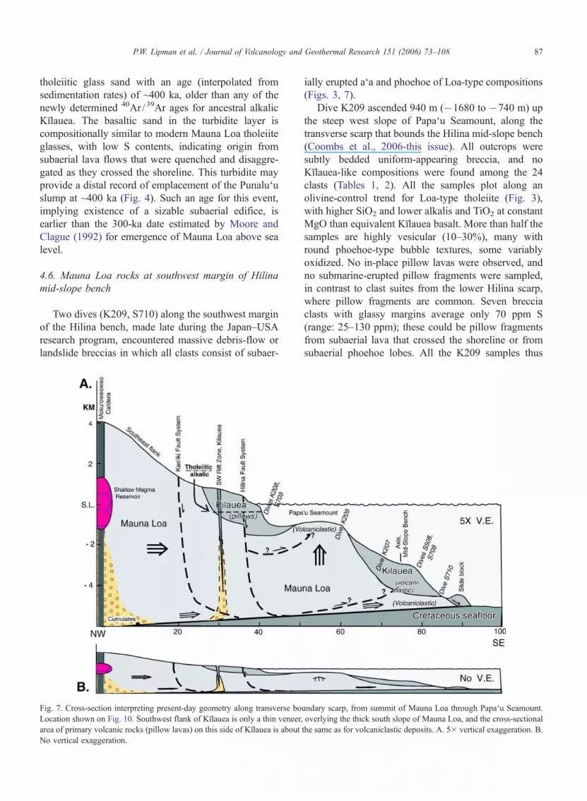
(Figs. 3, 7).
Dive K209 ascended 940 m (�1680 to �740 m) up
the steep west slope of Papa‘u Seamount, along the
transverse scarp that bounds the Hilina mid-slope bench
(Coombs et al., 2006-this issue). All outcrops were
subtly bedded uniform-appearing breccia, and no
Kılauea-like compositions were found among the 24
clasts (Tables 1, 2). All the samples plot along an
olivine-control trend for Loa-type tholeiite (Fig. 3),
with higher SiO2 and lower alkalis and TiO2 at constant
MgO than equivalent Kılauea basalt. More than half the
samples are highly vesicular (10–30%), many with
round phoehoe-type bubble textures, some variably
oxidized. No in-place pillow lavas were observed, and
no submarine-erupted pillow fragments were sampled,
in contrast to clast suites from the lower Hilina scarp,
where pillow fragments are common. Seven breccia
clasts with glassy margins average only 70 ppm S
(range: 25–130 ppm); these could be pillow fragments
from subaerial lava that crossed the shoreline or from
subaerial phoehoe lobes. All the K209 samples thus
Fig. 7. Cross-section interpreting present-day geometry along transverse boundary scarp, from summit of Mauna Loa through Papa‘u Seamount.
Location shown on Fig. 10. Southwest flank of Kılauea is only a thin veneer, overlying the thick south slope of Mauna Loa, and the cross-sectional
area of primary volcanic rocks (pillow lavas) on this side of Kılauea is about the same as for volcaniclastic deposits. A. 5� vertical exaggeration. B.
No vertical exaggeration.
P.W. Lipman et al. / Journal of Volcanology and Geothermal Research 151 (2006) 73–108 87
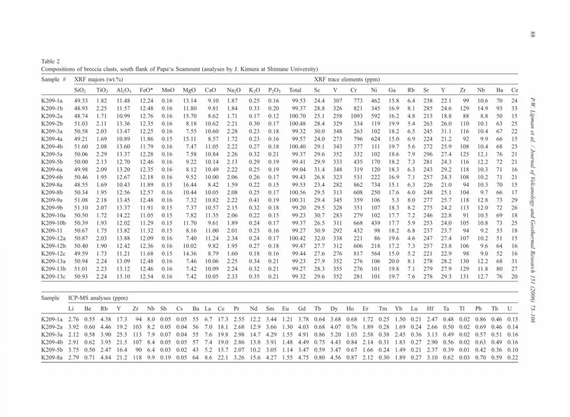
Table 2
Compositions of breccia clasts, south flank of Papa‘u Seamount (analyses by J. Kimura at Shimane University)
Sample # XRF majors (wt.%) XRF trace elements (ppm)
SiO2 TiO2 Al2O3 FeO* MnO MgO CaO Na2O K2O P2O5 Total Sc V Cr Ni Ga Rb Sr Y Zr Nb Ba Ce
K209-1a 49.33 1.82 11.48 12.24 0.16 13.14 9.10 1.87 0.25 0.16 99.53 24.4 307 773 462 15.8 6.4 238 22.1 99 10.6 70 24
K209-1b 48.93 2.25 11.57 12.48 0.16 11.80 9.81 1.84 0.33 0.20 99.37 28.8 326 821 345 16.9 8.1 285 24.6 129 14.9 93 33
K209-2a 48.74 1.71 10.99 12.76 0.16 15.70 8.62 1.71 0.17 0.12 100.70 25.1 258 1093 592 16.2 4.8 213 18.8 88 8.8 50 15
K209-2b 51.03 2.11 13.36 12.35 0.16 8.18 10.62 2.21 0.30 0.17 100.48 28.4 329 334 119 19.9 5.4 263 26.0 110 10.1 63 25
K209-3a 50.58 2.03 13.47 12.25 0.16 7.55 10.60 2.28 0.23 0.18 99.32 30.0 348 263 102 18.2 6.5 245 31.1 116 10.4 67 22
K209-4a 49.21 1.69 10.89 11.86 0.15 15.11 8.57 1.72 0.23 0.16 99.57 24.0 273 796 624 15.0 6.9 224 21.2 92 9.9 66 15
K209-4b 51.60 2.08 13.60 11.79 0.16 7.47 11.05 2.22 0.27 0.18 100.40 29.1 343 377 111 19.7 5.6 272 25.9 108 10.4 68 23
K209-5a 50.06 2.29 13.37 12.28 0.16 7.58 10.84 2.26 0.32 0.21 99.37 29.6 352 332 102 18.6 7.9 296 27.4 125 12.1 76 21
K209-5b 50.00 2.13 12.70 12.46 0.16 9.22 10.14 2.13 0.29 0.19 99.41 29.9 333 435 170 18.2 7.3 281 24.3 116 12.2 72 21
K209-6a 49.98 2.09 13.20 12.35 0.16 8.12 10.49 2.22 0.25 0.19 99.04 31.4 348 319 120 18.3 6.3 243 29.2 118 10.3 71 16
K209-6b 50.46 1.95 12.67 12.18 0.16 9.52 10.00 2.06 0.26 0.17 99.43 26.8 323 531 222 16.9 7.1 257 24.3 108 10.2 71 21
K209-8a 48.55 1.69 10.43 11.89 0.15 16.44 8.42 1.59 0.22 0.15 99.53 23.4 282 862 734 15.1 6.3 226 21.0 94 10.3 70 15
K209-8b 50.34 1.95 12.56 12.57 0.16 10.44 10.05 2.08 0.25 0.17 100.56 29.5 313 608 250 17.6 6.0 248 25.1 104 9.7 66 17
K209-9a 51.08 2.18 13.45 12.48 0.16 7.32 10.82 2.22 0.41 0.19 100.31 29.4 345 359 106 5.3 8.0 277 25.7 118 12.8 73 29
K209-9b 51.10 2.07 13.37 11.91 0.15 7.37 10.57 2.15 0.32 0.18 99.20 29.5 328 351 107 18.3 8.2 275 24.2 113 12.0 72 26
K209-10a 50.50 1.72 14.22 11.05 0.15 7.82 11.35 2.06 0.22 0.15 99.23 30.7 283 279 102 17.7 7.2 246 22.8 91 10.5 69 18
K209-10b 50.39 1.93 12.02 11.29 0.15 11.70 9.61 1.89 0.24 0.17 99.37 26.5 311 668 439 17.7 5.9 253 24.0 105 10.8 73 25
K209-11 50.67 1.75 13.82 11.32 0.15 8.16 11.00 2.01 0.23 0.16 99.27 30.9 292 432 98 18.2 6.8 237 23.7 94 9.2 53 18
K209-12a 50.87 2.03 13.88 12.09 0.16 7.40 11.24 2.34 0.24 0.17 100.42 32.0 338 221 86 19.6 4.6 247 27.4 107 10.2 51 15
K209-12b 50.40 1.90 12.42 12.36 0.16 10.02 9.82 1.95 0.27 0.18 99.47 27.7 312 606 218 17.2 7.3 257 23.8 106 9.6 64 16
K209-12c 49.59 1.73 11.21 11.68 0.15 14.36 8.79 1.60 0.18 0.16 99.44 27.6 276 817 564 15.0 5.2 221 22.9 98 9.0 52 16
K209-13a 50.94 2.24 13.09 12.48 0.16 7.46 10.06 2.25 0.34 0.21 99.23 27.9 352 276 106 20.0 8.1 278 28.2 130 12.2 68 31
K209-13b 51.01 2.23 13.12 12.46 0.16 7.42 10.09 2.24 0.32 0.21 99.27 28.3 355 276 101 19.8 7.1 279 27.9 129 11.8 80 27
K209-13c 50.93 2.24 13.10 12.54 0.16 7.42 10.05 2.33 0.35 0.21 99.32 29.6 352 281 101 19.7 7.6 278 29.3 131 12.7 76 20
Sample ICP-MS analyses (ppm)
Li Be Rb Y Zr Nb Sb Cs Ba La Ce Pr Nd Sm Eu Gd Tb Dy Ho Er Tm Yb Lu Hf Ta Tl Pb Th U
K209-1a 2.76 0.55 4.38 17.3 94 8.0 0.05 0.05 55 6.7 17.3 2.55 12.2 3.44 1.21 3.78 0.64 3.68 0.68 1.72 0.25 1.50 0.21 2.47 0.48 0.02 0.86 0.46 0.15
K209-2a 3.92 0.60 4.46 19.2 103 8.2 0.05 0.04 56 7.0 18.1 2.68 12.9 3.66 1.30 4.03 0.68 4.07 0.76 1.89 0.28 1.69 0.24 2.66 0.50 0.02 0.69 0.46 0.14
K209-3a 2.12 0.58 3.90 25.5 113 7.9 0.07 0.04 55 7.6 19.8 2.98 14.7 4.29 1.55 4.91 0.86 5.20 1.03 2.58 0.38 2.45 0.36 3.13 0.49 0.02 0.57 0.51 0.16
K209-4b 2.91 0.62 3.95 21.5 107 8.4 0.05 0.05 57 7.4 19.0 2.86 13.8 3.91 1.48 4.49 0.75 4.43 0.84 2.14 0.31 1.83 0.27 2.90 0.56 0.02 0.63 0.49 0.16
K209-5b 3.75 0.50 2.47 16.4 90 6.4 0.03 0.02 43 5.2 13.7 2.07 10.2 3.05 1.14 3.47 0.59 3.47 0.67 1.66 0.24 1.49 0.21 2.37 0.39 0.01 0.42 0.36 0.10
K209-8a 2.79 0.71 4.84 21.2 118 9.9 0.19 0.05 64 8.6 22.1 3.26 15.6 4.27 1.55 4.75 0.80 4.56 0.87 2.12 0.30 1.89 0.27 3.10 0.62 0.03 0.70 0.59 0.22
P.W.Lipmanet
al./JournalofVolca
nologyandGeotherm
alResea
rch151(2006)73–108
88
appear to have been derived from subaerial Mauna Loa.
Their compositions exclude prior interpretations of
Papa‘u as a debris flow or landslide from a shallow
embayment in KılaueaTs submarine flank (Fornari et al.,
1979; Morgan et al., 2003). Geometric relations be-
tween Papa‘u and volcaniclastic sequences on the
Hilina lower scarp, where most clasts came from an-
cestral alkalic Kılauea, are interpretable as involving
simple onlap of the Kılauea debris against the subma-
rine flank of Mauna Loa, along with uplift accompa-
nying formation of the Hilina bench, although more
elaborate tectonic reconstructions have been proposed
(e.g., Morgan et al., 2003).
A second dive (S710) traversed diverse breccias low
(�4430 to �3890 m) on the bcornerQ between the
Hilina lower scarp and transverse boundary structure
at depths of (Fig. 7). All breccia outcrops sampled
during this dive also have Loa-type compositions and
variably oxidized vesicular textures indicative of sub-
aerial origin. A few clasts, from a long talus run during a
middle segment of the dive (where outcrops were ab-
sent) are alkalic basalt similar to those sampled farther
northeast along the Hilina lower scarp. The alkalic clasts
may indicate interbeded Mauna Loa and early Kılauea
lithologies, but the talus samples could instead be en-
tirely from stratigraphically above the massive Loa-type
breccias sampled in outcrop. In either instance, the
preponderance of subaerial Mauna Loa clasts low at
the southwest end of the Hilina lower scarp section,
and constituting all of Papa‘u Seamount, are important
evidence showing that Mauna Loa’s flank broadly
underlies Kılauea. Inference of Mauna Loa rocks be-
neath the south flank of Kılauea is not new (e.g., Stearns
and Clark, 1930; Stearns and Macdonald, 1946, p. 132;
Swanson et al., 1976, fig. 16; Lipman et al., 1985, fig.
20; Moore and Chadwick, 1995, p. 22), but the dive
results provide the first observational confirmation for
such interpretations and also provide a geometric basis
for improved volume estimates for the volcanoes.
4.7. Volcano–tectonic interactions with Kilauea
A long-standing issue has been the extent of inter-
actions between Mauna Loa and Kılauea edifices, with
inferred consequences for seismicity, magma composi-
tion, deformation, and eruptive behavior. Among these
are: proposed interplay between locations of earth-
quakes and eruptibility at the two volcanoes (Klein,
1982; Jackson et al., 1992), petrogenetic significance
of rare overlaps in magma composition (Rhodes et al.,
1989; Garcia et al., 1995b), influence of gravitationally
induced stress on Mauna Loa’s south flank as controls
on the orientation of Kılauea’s rift zones (Fiske and
Jackson, 1972; Swanson et al., 1976), intertwined de-
formation responses on these adjacent volcanoes (Lip-
man et al., 1985; Miklius and Cervelli, 2003), and
effects of loading the older Mauna Loa flank by but-
tressing growth of the younger Kılauea, leading to
changed geometry of volcano spreading (Lipman,
1980b; Morgan, 2006-this issue).
Some studies have suggested that eruptive activity at
the two volcanoes could be either linked (e.g., Jagger,
1917), or antithetic with frequent large rift eruptions
from Mauna Loa prior to the 1950s, when Kılauea erup-
tions were mainly low-discharge activity within the cal-
dera, versus frequent Kılauea rift eruptions during the
last 50 years accompanied by much-reduced activity at
Mauna Loa (Stearns and Macdonald, 1946, p. 134;
Klein, 1982). A possible mechanism is that magma rise
and inflation at one edifice impedes similar behavior at
the other. Such processes also have the potential for
triggering synchronous behavior (Miklius and Cervelli,
2003). Within short time intervals, at least, behavior of
the two volcanoes can be largely independent; the 1984
rift eruption at Mauna Loa progressed to completion
without seemingly affecting the then-cyclic eruptive
behavior at Pu‘u ‘O‘o or producing any detectable inflec-
tions in seismic or geodetic records for stations on
Kılauea (Lockwood et al., 1987). In the discussion that
follows, we consider volcano–tectonic interactions be-
tween these two volcanoes through geologically long
intervals, focusing on implications of Kılauea’s growth
on the flank of an already large subaerial Mauna Loa.
5. Discussion
Collectively, published data for subaerial Kılauea
and Mauna Loa and recently acquired submarine obser-
vations on the south slope of Hawai‘i Island provide a
basis for new perspectives on the intertwined growth
histories of these two active volcanoes.
5.1. South flank of Mauna Loa during growth of
Kılauea
Continued eruptive activity and flank spreading on
Mauna Loa, after inception of Kılauea on the submarine
flank of the larger edifice, is here interpreted to have
strongly influenced the structural evolution and present-
day geometry of Kılauea.
5.1.1. Pre-Kılauea edifice of Mauna Loa
Prior to the birth of Kılauea, the south-flank struc-
ture of Mauna Loa is inferred to have been dominated
P.W. Lipman et al. / Journal of Volcanology and Geothermal Research 151 (2006) 73–108 89
by gravitational volcano spreading involving slumping
of shield-stage tholeiitic lavas along faults of the
Kao‘iki–Honu‘apo system, associated with sustained
seaward displacements. Such a structural geometry
would have been much like that of the present-day
Kılauea edifice. South-flank spreading and slump fault-
ing along the Kao‘iki–Honu‘apo system are inferred to
have gradually declined on Mauna Loa, as ancestral
Kılauea grew and entered its tholeiitic shield stage
(probably starting ~75–100 ka).
Large-scale landslide failure of the subaerial Mauna
Loa flank deposited widespread breccias on the adja-
cent submarine slopes; these include the Punalu‘u
slump as presently mapped, as well as the breccias of
Loa-type composition that constitute Papa‘u Seamount
and the deep southwestern part of the Hilina bench.
Although now draped by debris-flow and turbidite
deposits from ancestral Kılauea, rocks of both Papa‘u
Seamount and the deeper interior Hilina bench may
have originated as a northeastward continuation of the
Punalu‘u slump, or as smaller debris flows shed from
the Punalu‘u slump and its headwall scarp.
Long before inception of Kılauea, Mauna Loa must
have already grown into a large subaerial volcano.
Based on evidence from lava-accumulation rates and
paleo-shorelines, Mauna Loa is known to have attained
nearly its present size and elevation above sea level by
about 100 ka (Lipman, 1995; Lipman and Moore,
1996). Results from submersible studies now show
that Mauna Loa had developed a large subaerial edifice
even before initial growth of Kılauea (275–300 ka) and
perhaps before 400 ka (Punalu‘u slump). Breccias of
the Punaludu slump, within Papa‘u Seamount, and deep
along the southwest corner of the Hilina bench were all
derived from subaerial Mauna Loa lavas, and the brec-
cias at the latter two localities underlie debris from
ancestral alkalic Kılauea along a low-relief contact
(Fig. 7). Existence of a large pre-Kılauea Mauna Loa
shield and the gently dipping offshore contact between
the two edifices (Fig. 7) are inconsistent with recent
interpretations of a relatively short interval (0.2–0.3
m.y.) between growth of these adjacent volcanoes and
a near-vertical interfingering contact between their lava
accumulations (DePaolo and Stolper, 1996; Baker et al.,
2003).
5.1.2. Mauna Loa ancestry of the transverse boundary
scarp
The transverse scarp that bounds the southwest side
of the Hilina bench (Fig. 2) is interpreted to have
initiated either as a tear fault during emplacement of
the Punalu‘u slump or during subsequent activity on the
south flank of Mauna Loa, based on the ~15 km
southeast-stepping offset in Mauna Loa breccia depos-
its at water depths of 3000–4000 m. The lip of the
submarine Hilina mid-slope bench has a linear trend
(0408) all the way to its intersection with the transverse
scarp. This trend is oblique by about 208 to the shore-
line of the island, to its submerged continuation west of
Ka’ena Point, and to the long lower east rift zone of
Kılauea (below Napau Crater, ~800 m elevation). The
oblique linear geometry suggests that the trend of the
mid-slope bench may have been imposed by spreading
of Mauna Loa’s south flank before and early in the
history of Kılauea, rather than due primarily to growth
of the tholeiitic Kılauea shield and to slump processes
along Hilina faults.
The transverse scarp has no structural expression on
land, despite thorough mapping of ground cracks and
other structures along the southwest rift zone of Kılauea
(Holcomb, 1980; Wolfe and Morris, 1996; D. Swanson
and R Fiske, written commun., 2002). On gravity and
aeromagnetic maps, the topographic and geologic axes
of the southwest rift zone can be followed without
detectable offset across the projected intersection with
the submarine transverse boundary structure, suggest-
ing that most displacement along the transverse bound-
ary preceded major growth of this rift zone. Amplitudes
of both geophysical anomalies along the southwest rift
zone decrease near the projected intersection, however,
and presence of the transverse structure in Mauna Loa
rocks may have impeded propagation of this Kılauea
rift farther to the southwest. Furthermore, the slope
exposing in-place weakly alkalic Kılauea pillow lavas
is continuous in trend and aspect with the flank of the
tholeiitic Puna Ridge, suggesting that major displace-
ments along the transverse boundary preceded eruption
of the weakly alkalic basalts. Accordingly, the trans-
verse boundary seems unlikely to have developed
chiefly during the late tholeiitic shield stage of Kılauea
(since ~40 ka), as proposed by Morgan et al. (2003).
In contrast to the absence of subaerial structural
expression of the transverse scarp adjacent to the sub-
aerial Hilina faults, the similar-trending Wai‘ohinu fault
that bounds southwest margins of the Kaodiki–Hon-
u‘apo fault system on subaerial Mauna Loa is defined
by a lava-draped scarp and open fractures. This struc-
ture is traceable offshore as a bathymetric scarp that
bounds the Punalu‘u slump to N�3500 m depth. The
Wai‘ohinu fault accommodated at least 2 m of lateral
offset during the 1868 south flank M =8.1 earthquake
(Hitchcock, 1909, p. 105–106; Wood, 1914) and is
historically the more active of the two transverse struc-
tures, at least above sea level.
P.W. Lipman et al. / Journal of Volcanology and Geothermal Research 151 (2006) 73–10890
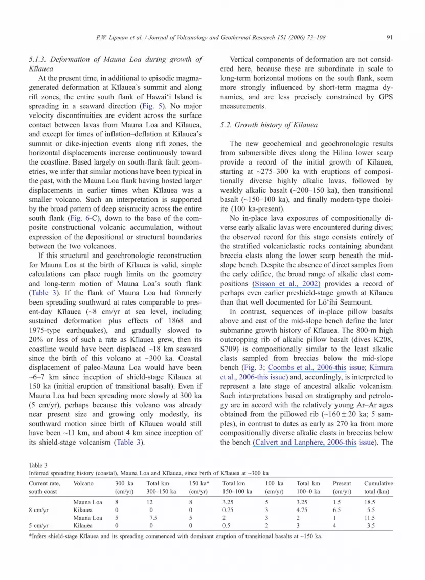
5.1.3. Deformation of Mauna Loa during growth of
Kılauea
At the present time, in additional to episodic magma-
generated deformation at Kılauea’s summit and along
rift zones, the entire south flank of Hawai‘i Island is
spreading in a seaward direction (Fig. 5). No major
velocity discontinuities are evident across the surface
contact between lavas from Mauna Loa and Kılauea,
and except for times of inflation–deflation at Kılauea’s
summit or dike-injection events along rift zones, the
horizontal displacements increase continuously toward
the coastline. Based largely on south-flank fault geom-
etries, we infer that similar motions have been typical in
the past, with the Mauna Loa flank having hosted larger
displacements in earlier times when Kılauea was a
smaller volcano. Such an interpretation is supported
by the broad pattern of deep seismicity across the entire
south flank (Fig. 6-C), down to the base of the com-
posite constructional volcanic accumulation, without
expression of the depositional or structural boundaries
between the two volcanoes.
If this structural and geochronologic reconstruction
for Mauna Loa at the birth of Kılauea is valid, simple
calculations can place rough limits on the geometry
and long-term motion of Mauna Loa’s south flank
(Table 3). If the flank of Mauna Loa had formerly
been spreading southward at rates comparable to pres-
ent-day Kılauea (~8 cm/yr at sea level, including
sustained deformation plus effects of 1868 and
1975-type earthquakes), and gradually slowed to
20% or less of such a rate as Kılauea grew, then its
coastline would have been displaced ~18 km seaward
since the birth of this volcano at ~300 ka. Coastal
displacement of paleo-Mauna Loa would have been
~6–7 km since inception of shield-stage Kılauea at
150 ka (initial eruption of transitional basalt). Even if
Mauna Loa had been spreading more slowly at 300 ka
(5 cm/yr), perhaps because this volcano was already
near present size and growing only modestly, its
southward motion since birth of Kılauea would still
have been ~11 km, and about 4 km since inception of
its shield-stage volcanism (Table 3).
Vertical components of deformation are not consid-
ered here, because these are subordinate in scale to
long-term horizontal motions on the south flank, seem
more strongly influenced by short-term magma dy-
namics, and are less precisely constrained by GPS
measurements.
5.2. Growth history of Kılauea
The new geochemical and geochronologic results
from submersible dives along the Hilina lower scarp
provide a record of the initial growth of Kılauea,
starting at ~275–300 ka with eruptions of composi-
tionally diverse highly alkalic lavas, followed by
weakly alkalic basalt (~200–150 ka), then transitional
basalt (~150–100 ka), and finally modern-type tholei-
ite (100 ka-present).
No in-place lava exposures of compositionally di-
verse early alkalic lavas were encountered during dives;
the observed record for this stage consists entirely of
the stratified volcaniclastic rocks containing abundant
breccia clasts along the lower scarp beneath the mid-
slope bench. Despite the absence of direct samples from
the early edifice, the broad range of alkalic clast com-
positions (Sisson et al., 2002) provides a record of
perhaps even earlier preshield-stage growth at Kılauea
than that well documented for Lo‘ihi Seamount.
In contrast, sequences of in-place pillow basalts
above and east of the mid-slope bench define the later
submarine growth history of Kılauea. The 800-m high
outcropping rib of alkalic pillow basalt (dives K208,
S709) is compositionally similar to the least alkalic
clasts sampled from breccias below the mid-slope
bench (Fig. 3; Coombs et al., 2006-this issue; Kimura
et al., 2006-this issue) and, accordingly, is interpreted to
represent a late stage of ancestral alkalic volcanism.
Such interpretations based on stratigraphy and petrolo-
gy are in accord with the relatively young Ar–Ar ages
obtained from the pillowed rib (~160F20 ka; 5 sam-
ples), in contrast to dates as early as 270 ka from more
compositionally diverse alkalic clasts in breccias below
the bench (Calvert and Lanphere, 2006-this issue). The
Table 3
Inferred spreading history (coastal), Mauna Loa and Kılauea, since birth of Kılauea at ~300 ka
Current rate,
south coast
Volcano 300 ka
(cm/yr)
Total km
300–150 ka
150 ka*
(cm/yr)
Total km
150–100 ka
100 ka
(cm/yr)
Total km
100–0 ka
Present
(cm/yr)
Cumulative
total (km)
Mauna Loa 8 12 8 3.25 5 3.25 1.5 18.5
8 cm/yr Kilauea 0 0 0 0.75 3 4.75 6.5 5.5
Mauna Loa 5 7.5 5 2 3 2 1 11.5
5 cm/yr Kilauea 0 0 0 0.5 2 3 4 3.5
*Infers shield-stage Kılauea and its spreading commenced with dominant eruption of transitional basalts at ~150 ka.
P.W. Lipman et al. / Journal of Volcanology and Geothermal Research 151 (2006) 73–108 91
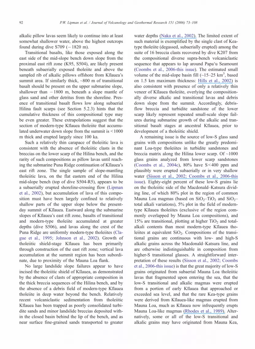
alkalic pillow lavas seem likely to continue into at least
somewhat shallower water, above the highest outcrops
found during dive S709 (�1820 m).
Transitional basalts, like those exposed along the
east side of the mid-slope bench down slope from the
proximal east rift zone (K95, S504), are likely present
beneath subaerially exposed tholeiite and above the
sampled rib of alkalic pillows offshore from Kılauea’s
summit area. If similarly thick, ~800 m of transitional
basalt should be present on the upper submarine slope,
shallower than �1800 m, beneath a slope mantle of
glass sand and other detritus from the shoreline. Pres-
ence of transitional basalt flows low along subaerial
Hilina fault scarps (see Section 5.2.3) hints that the
cumulative thickness of this compositional type may
be even greater. These extrapolations suggest that the
section of modern-type Kılauea tholeiite that accumu-
lated underwater down slope from the summit is b1000
m thick and erupted largely since 100 ka.
Such a relatively thin carapace of tholeiitic lava is
consistent with the absence of tholeiitic clasts in the
breccias on the lower scarp of the Hilina bench, and the
rarity of such compositions as pillow lavas until reach-
ing the submarine Puna Ridge continuation of Kılauea’s
east rift zone. The single sample of slope-mantling
tholeiitic lava, on the flat eastern end of the Hilina
mid-slope bench (top of dive S504-R5), appears to be
a subaerially erupted shoreline-crossing flow (Lipman
et al., 2002), but accumulation of lava of this compo-
sition must have been largely confined to relatively
shallow parts of the upper slope below the present-
day summit of Kılauea. Eastward along the submarine
slopes of Kılauea’s east rift zone, basalts of transitional
and modern-type tholeiite accumulated at greater
depths (dive S506), and lavas along the crest of the
Puna Ridge are uniformly modern-type tholeiites (Cla-
gue et al., 1995; Johnson et al., 2002). Growth of
tholeiitic shield-stage Kılauea has been primarily
through construction of the east rift zone; vertical lava
accumulation at the summit region has been subordi-
nate, due to proximity of the Mauna Loa flank.
No large landslide slope failures appear to have
incised the tholeiitic shield of Kılauea, as demonstrated
by the absence of clasts of appropriate composition in
the thick breccia sequences of the Hilina bench, and by
the absence of a debris field of modern-type Kılauea
tholeiite in deep water beyond the bench. Relatively
recent volcaniclastic sedimentation from tholeiitic
Kılauea has been trapped as poorly consolidated turbi-
dite sands and minor landslide breccias deposited with-
in the closed basin behind the lip of the bench, and as
near surface fine-grained sands transported to greater
water depths (Naka et al., 2002). The limited extent of
such material is exemplified by the single clast of Kea-
type tholeiite (degassed, subaerially erupted) among the
suite of 16 breccia clasts recovered by dive K207 from
the compositional diverse supra-bench volcaniclastic
sequence that appears to lap around Papa‘u Seamount
(Coombs et al., 2006-this issue). The estimated small
volume of the mid-slope basin fill (~15–25 km3, based
on 1.5 km maximum thickness: Hills et al., 2002) is
also consistent with presence of only a relatively thin
veneer of Kılauea tholeiite, overlying the composition-
ally diverse alkalic and transitional lavas and debris
down slope from the summit. Accordingly, debris-
flow breccia and turbidite sandstone of the lower
scarp likely represent repeated small-scale slope fail-
ures during submarine growth of the alkalic and tran-
sitional basalt stages at ancestral Kılauea, prior to
development of a tholeiitic shield.
A remaining issue is the source of low-S glass sand
grains with compositions unlike the greatly predomi-
nant Loa-type tholeiites in turbidite sandstones and
breccia matrix along the Hilina lower scarp. Of ~1000
glass grains analyzed from lower scarp sandstones
(Coombs et al., 2004c), 80% have Sb400 ppm and
plausibly were erupted subaerially or in very shallow
water (Sisson et al., 2002; Coombs et al., 2006-this
issue). Eighty-eight percent of these low-S grains lie
on the tholeiitic side of the Macdonald–Katsura divid-
ing line, of which 80% plot in the region of common
Mauna Loa magmas (based on SiO2–TiO2 and SiO2–
total alkali variations), 5% plot in the field of modern-
type Kılauea tholeiites (exclusive of the region com-
monly overlapped by Mauna Loa compositions), and
15% are transitional, plotting at higher TiO2 and total-
alkali contents than most modern-type Kılauea tho-
leiites at equivalent SiO2. Compositions of the transi-
tional grains are continuous with low- and high-S
alkalic grains across the Macdonald–Katsura line, and
are otherwise indistinguishable in composition from
higher-S transitional glasses. A straightforward inter-
pretation of these results (Sisson et al., 2002; Coombs
et al., 2006-this issue) is that the great majority of low-S
grains originated from subaerial Mauna Loa tholeiitic
lavas that fragmented upon entering the sea, that the
low-S transitional and alkalic magmas were erupted
from a portion of early Kılauea that approached or
exceeded sea level, and that the rare Kea-type grains
were derived from Kılauea-like magmas erupted from
Mauna Loa, much as Kılauea now infrequently erupts
Mauna Loa-like magmas (Rhodes et al., 1989). Alter-
natively, some or all of the low-S transitional and
alkalic grains may have originated from Mauna Kea,
P.W. Lipman et al. / Journal of Volcanology and Geothermal Research 151 (2006) 73–10892
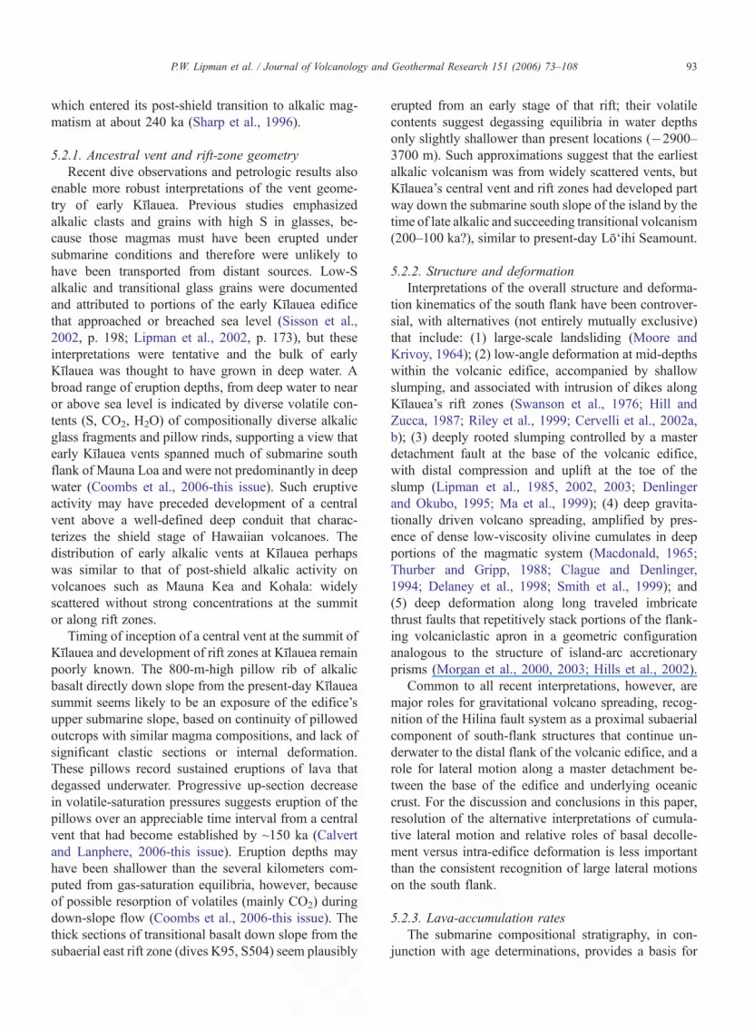
which entered its post-shield transition to alkalic mag-
matism at about 240 ka (Sharp et al., 1996).
5.2.1. Ancestral vent and rift-zone geometry
Recent dive observations and petrologic results also
enable more robust interpretations of the vent geome-
try of early Kılauea. Previous studies emphasized
alkalic clasts and grains with high S in glasses, be-
cause those magmas must have been erupted under
submarine conditions and therefore were unlikely to
have been transported from distant sources. Low-S
alkalic and transitional glass grains were documented
and attributed to portions of the early Kılauea edifice
that approached or breached sea level (Sisson et al.,
2002, p. 198; Lipman et al., 2002, p. 173), but these
interpretations were tentative and the bulk of early
Kılauea was thought to have grown in deep water. A
broad range of eruption depths, from deep water to near
or above sea level is indicated by diverse volatile con-
tents (S, CO2, H2O) of compositionally diverse alkalic
glass fragments and pillow rinds, supporting a view that
early Kılauea vents spanned much of submarine south
flank of Mauna Loa and were not predominantly in deep
water (Coombs et al., 2006-this issue). Such eruptive
activity may have preceded development of a central
vent above a well-defined deep conduit that charac-
terizes the shield stage of Hawaiian volcanoes. The
distribution of early alkalic vents at Kılauea perhaps
was similar to that of post-shield alkalic activity on
volcanoes such as Mauna Kea and Kohala: widely
scattered without strong concentrations at the summit
or along rift zones.
Timing of inception of a central vent at the summit of
Kılauea and development of rift zones at Kılauea remain
poorly known. The 800-m-high pillow rib of alkalic
basalt directly down slope from the present-day Kılauea
summit seems likely to be an exposure of the edifice’s
upper submarine slope, based on continuity of pillowed
outcrops with similar magma compositions, and lack of
significant clastic sections or internal deformation.
These pillows record sustained eruptions of lava that
degassed underwater. Progressive up-section decrease
in volatile-saturation pressures suggests eruption of the
pillows over an appreciable time interval from a central
vent that had become established by ~150 ka (Calvert
and Lanphere, 2006-this issue). Eruption depths may
have been shallower than the several kilometers com-
puted from gas-saturation equilibria, however, because
of possible resorption of volatiles (mainly CO2) during
down-slope flow (Coombs et al., 2006-this issue). The
thick sections of transitional basalt down slope from the
subaerial east rift zone (dives K95, S504) seem plausibly
erupted from an early stage of that rift; their volatile
contents suggest degassing equilibria in water depths
only slightly shallower than present locations (�2900–
3700 m). Such approximations suggest that the earliest
alkalic volcanism was from widely scattered vents, but
Kılauea’s central vent and rift zones had developed part
way down the submarine south slope of the island by the
time of late alkalic and succeeding transitional volcanism
(200–100 ka?), similar to present-day Lo‘ihi Seamount.
5.2.2. Structure and deformation
Interpretations of the overall structure and deforma-
tion kinematics of the south flank have been controver-
sial, with alternatives (not entirely mutually exclusive)
that include: (1) large-scale landsliding (Moore and
Krivoy, 1964); (2) low-angle deformation at mid-depths
within the volcanic edifice, accompanied by shallow
slumping, and associated with intrusion of dikes along
Kılauea’s rift zones (Swanson et al., 1976; Hill and
Zucca, 1987; Riley et al., 1999; Cervelli et al., 2002a,
b); (3) deeply rooted slumping controlled by a master
detachment fault at the base of the volcanic edifice,
with distal compression and uplift at the toe of the
slump (Lipman et al., 1985, 2002, 2003; Denlinger
and Okubo, 1995; Ma et al., 1999); (4) deep gravita-
tionally driven volcano spreading, amplified by pres-
ence of dense low-viscosity olivine cumulates in deep
portions of the magmatic system (Macdonald, 1965;
Thurber and Gripp, 1988; Clague and Denlinger,
1994; Delaney et al., 1998; Smith et al., 1999); and
(5) deep deformation along long traveled imbricate
thrust faults that repetitively stack portions of the flank-
ing volcaniclastic apron in a geometric configuration
analogous to the structure of island-arc accretionary
prisms (Morgan et al., 2000, 2003; Hills et al., 2002).
Common to all recent interpretations, however, are
major roles for gravitational volcano spreading, recog-
nition of the Hilina fault system as a proximal subaerial
component of south-flank structures that continue un-
derwater to the distal flank of the volcanic edifice, and a
role for lateral motion along a master detachment be-
tween the base of the edifice and underlying oceanic
crust. For the discussion and conclusions in this paper,
resolution of the alternative interpretations of cumula-
tive lateral motion and relative roles of basal decolle-
ment versus intra-edifice deformation is less important
than the consistent recognition of large lateral motions
on the south flank.
5.2.3. Lava-accumulation rates
The submarine compositional stratigraphy, in con-
junction with age determinations, provides a basis for
P.W. Lipman et al. / Journal of Volcanology and Geothermal Research 151 (2006) 73–108 93
estimating lava- and sediment-accumulation rates dur-
ing Kılauea’s growth (Table 4). Such estimates are
weakly constrained for the early alkalic rocks, sam-
pled only as breccia clasts and alkalic glass grains in
sandstones from the lower scarp. The shape of the
ancestral Kılauea edifice, overlying the flank of
Mauna Loa is poorly understood, and the volcaniclas-
tic rocks have been compressed and uplifted, either by
simple shortening of modest extent (Lipman et al.,
2000) or, alternatively, by long-traveled imbricate
thrust faults (Morgan et al., 2000). Volcaniclastic
rocks in the 2-km-high lower scarp appear to have
accumulated during the interval 275 to b150 ka (pos-
sibly 300 to 100 ka), based on the dated clasts of
these ages (limiting values, based on the absence of
modern-type Kılauea tholeiites as clasts and the like-
lihood that the oldest alkalic material has not been
sampled). Such ranges yield average sedimentation
rates of 10–15 mm/yr for the volcaniclastic sec-
tion—seemingly plausible (even if not appreciably
thickened by deformation) for accumulation on the
steep seaward flank of a rapidly-growing elongate
edifice. Because the majority of grains in lower-
scarp sandstones are from subaerial Mauna Loa, and
sandstone is a significant fraction of exposures, sedi-
mentation rates from early alkalic Kılauea were likely
in the range 5–10 mm/yr.
Lava-accumulation rates during the late alkalic stage
are better defined, from relations above the mid-slope
bench. Alkalic basalts on the pillow rib east of Papa‘u,
sampled from �2570 to 1820 m (dives K208, S709),
were emplaced near present water depths (Coombs et
al., 2006-this issue). Four dated samples from the lower
half of this sequence (dive K208) have similar ages,
averaging ~160 ka (Calvert and Lanphere, 2006-this
issue); compositionally similar alkalic basalt pillows
higher on the rib (S709) must be younger. These out-
crops, with a combined stratigraphic thickness of ~800
m, probably represent an area of rapid lava accumula-
tion directly down slope from the present-day summit of
Kılauea. If they represent the interval 200–150 ka, as
seems reasonable, then the accumulation rate would
have been ~15 mm/yr.
Transitional-composition basalts at the east end of
the mid-slope bench are exposed from �3730 to
�3530 m (S504) and �3280 to �2870 m (K95),
suggesting a composite thickness of 860 m or more
(possibly complicated by structural disruption between
the two dive sites?). These exposures, although down
slope from the east rift zone rather than the summit
area, may also have accumulated rapidly, because the
Kılauea edifice should have thickened in this direction
away from the south flank of Mauna Loa. If these lavas
were erupted mainly 150–100 ka (as estimated in Table
4), the lava-accumulation rate would have been 16 mm/
yr. A similar accumulation rate (16.4 mm/yr) has been
interpreted for tholeiite flows in the SOH1 drill core
(directly upslope from the S504 site), based on mag-
netic paleointensity variations that indicate eruption of
the entire subaerial section (740 m) since 45 ka (Teanby
et al., 2002). Extrapolation to the bottom of this hole
(1685 m), which projects in cross-section to nearly the
same stratigraphic level as the shallowest transitional
basalts sampled by dive S504 (Lipman et al., 2002, Pl.
1A), suggests an age of ~100 ka for inception of
tholeiite eruptions, as well as nearly uniform long-
term accumulation rates for transitional and tholeiitic
flows from the middle east rift.
Although dive S709 to the top of the pillowed rib of
alkalic basalt failed to locate any major compositional
boundary, transitional basalt almost certainly accumu-
lated above the alkalic pillows and below the present-
day tholeiitic lavas that are present all along the shore-
line of Kılauea. For transitional and tholeiitic lava to
have accumulated from the highest sampled outcrop of
alkalic pillows at �1820 m to present sea level since
150 ka requires an average accumulation rate of 12
mm/yr). If the transitional lavas above the pillow rib
are approximately similar in thickness to the composite
section of dives K95-S504 (850 m), then about half the
section above the pillowed rib would be transitional
basalt, and half tholeiite. If the age of the uppermost
alkalic pillows (perhaps even shallower than the highest
sample at �1820 m) is ~150 ka, and accumulation rates
were relatively constant during eruption of the overly-
ing transitional and tholeiitic lava, then dominant erup-
Table 4
Estimated lava-accumulation rates, submarine south flank of Kılauea
Composition Age (ka) Time interval (yr�103) Water depth (m) Thickness (m) Accumulation rate (mm/yr)
Modern tholeiite 100–0 100 0 to ~1000? ~1000 ~10
Transitional basalt 150–100 50 b1800 to ~1000? ~800 ~16
Late alkalic basalt 200–150 50 N2570 to b1820 N750 ~15
Alkalic+ trans. 275–100 175 3100 to 5000 ~2000 ~10
Volcaniclastic rocks (Deformed detritus)
P.W. Lipman et al. / Journal of Volcanology and Geothermal Research 151 (2006) 73–10894
tion of transitional compositions would have changed
to present-day tholeiite at ~75 ka. Alternatively, if the
upper 1000 m of the offshore south-flank section is
tholeiite erupted since 100 ka, its lava-accumulation
rate would have been ~10 mm/yr. Thus, the overall
preshield alkalic phase of Kılauea’s growth (275–150
ka?) was more prolonged than either of the subsequent
transitional and tholeiitic stages, but lava-accumulation
rates may have remained nearly constant (F20%), as
increasing magma supply roughly kept pace with the
growth in surface area of the edifice.
The transitions between compositional groups are
poorly defined from available data at Kılauea or other
volcanoes but likely to be prolonged and complex in
detail. Perhaps the best example of a prolonged transi-
tion is provided by a few young lava flows of transi-
tional basalt (Table 5) and the volumetrically minor but
widespread AD 600–1000 Kulanadokua‘iki tephra
(Fiske et al., 1999; analyses in Dzurisin et al., 1995)
that overlie tholeiitic lavas on subaerial Kılauea. These
subaerial transitional flows and tephra, erupted about
1000 yr ago, are indistinguishable in composition from
the pillow lavas at the east end of the mid-slope bench
in water depths as great as �3700 m, with an estimated
age of 150–100 ka. The subaerial flows are texturally
distinctive in comparison to the pillow lavas, however,
containing abundant plagioclase microphenocrysts;
such groundmass crystallization was probably retarded
by retained volatiles at submarine confining pressures
in the compositionally similar underwater flows. De-
spite some uncertainties due to subaerial weathering
(especially affecting K2O), subaerial Kılauea flows
with transitional compositions appear to become in-
creasingly common low along Hilina fault scarps
(e.g., Chen et al., 1996, Table 1EK6B-77, EK-9-77),
below the Pokaka‘a Ash dated at 39 ka or older
(Easton, 1987; Beeson et al., 1996). Comparisons
based on abundances of incompatible trace elements
(Nb, Zr, Y, Ce) suggest to us that nearly half the flows
(7 of 15) analyzed by Chen et al. from below the
Pokaka’a Ash along the Pu‘u Kapukapu scarp have
compositional affinities to the transitional pillow basalts
sampled east of the Hilina mid-slope bench. A substan-
tial section of interlayered transitional and tholeiitic
basalts may thus be present near sea level along
Kılauea’s south flank.
Other examples of complex transitions include the
pillow rib above the mid-slope bench, where thin vol-
caniclastic sandstones containing abundant basanite
glass grains are locally interbedded with the weakly
alkalic basalt (Coombs et al., 2006-this issue). High on
Lo‘ihi Seamount, pre-shield alkalic and transitional
basalt interfinger complexly (Garcia et al., 1995a).
Complex interfingering of subtly differing tholeiitic
lavas in the early shield-stage of submarine Mauna
Kea has been documented by the Hawai‘i Scientific
Drilling Project (Rhodes and Vollinger, 2004). Alterna-
tions between tholeiitic and alkalic compositions have
also been documented during the transition to post-
shield volcanism at Molokai (Beeson, 1976) and
Table 5
Major-oxide and trace-element analyses of subaerial transitional basalt, Kılauea
Lava flow, Puka Keana Bihopa. Sample sites; Two tumuli north of Hilina Pali road, at 2600’ elevation.
Sample. no. Whole-rock XRF analyses by D. Siems, USGS, Denver
SiO2 TiO2 Al2O3 FeTO3 MgO MnO CaO Na2O K2O P2O5 LOI Total
(%) (%) (%) (%) (%) (%) (%) (%) (%) (%) (%)
01L-01 49.1 2.91 13.8 12.3 7.61 0.16 11.0 2.36 0.64 0.33 b0.01 100.21
01L-02 49.2 3.03 13.8 12.5 7.27 0.17 11.0 2.40 0.66 0.33 b0.01 100.36
Sample no. Ba Ce Cr Cu Ga La Nb Nd Ni Rb Sr V Y Zn Zr
(ppm) (ppm) (ppm) (ppm) (ppm) (ppm) (ppm) (ppm) (ppm) (ppm) (ppm) (ppm) (ppm) (ppm) (ppm)
01L-01 162 38 426 125 21 15 23 26 172 14 435 323 28 112 178
01L-02 166 41 329 127 23 15 22 21 145 13 446 311 27 115 183
Uwekahuna–Kulanadokua‘iki tephra (Dzurisin et al., 1995, Table 4; Fiske et al., 1999)
Sample no. Electon microprobe analyses of glass shards
SiO2 TiO2 Al2O3 FeTO3 MgO MnO CaO Na2O K2O P2O5 LOI Total
L-85-45A 48.6 3.20 13.8 12.8 6.63 0.17 11.2 2.45 0.71 0.39 99.95
L-83-16A 49.4 3.16 13.7 12.8 6.82 0.17 11.5 2.53 0.72 0.35 101.15
P.W. Lipman et al. / Journal of Volcanology and Geothermal Research 151 (2006) 73–108 95
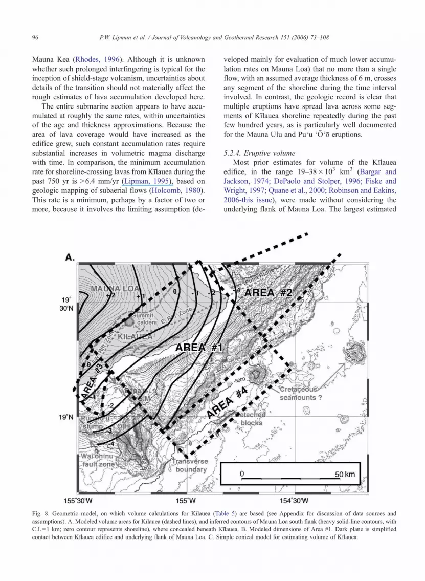
Mauna Kea (Rhodes, 1996). Although it is unknown
whether such prolonged interfingering is typical for the
inception of shield-stage volcanism, uncertainties about
details of the transition should not materially affect the
rough estimates of lava accumulation developed here.
The entire submarine section appears to have accu-
mulated at roughly the same rates, within uncertainties
of the age and thickness approximations. Because the
area of lava coverage would have increased as the
edifice grew, such constant accumulation rates require
substantial increases in volumetric magma discharge
with time. In comparison, the minimum accumulation
rate for shoreline-crossing lavas from Kılauea during the
past 750 yr is N6.4 mm/yr (Lipman, 1995), based on
geologic mapping of subaerial flows (Holcomb, 1980).
This rate is a minimum, perhaps by a factor of two or
more, because it involves the limiting assumption (de-
veloped mainly for evaluation of much lower accumu-
lation rates on Mauna Loa) that no more than a single
flow, with an assumed average thickness of 6 m, crosses
any segment of the shoreline during the time interval
involved. In contrast, the geologic record is clear that
multiple eruptions have spread lava across some seg-
ments of Kılauea shoreline repeatedly during the past
few hundred years, as is particularly well documented
for the Mauna Ulu and Pu‘u ‘O‘o eruptions.
5.2.4. Eruptive volume
Most prior estimates for volume of the Kılauea
edifice, in the range 19–38�103 km3 (Bargar and
Jackson, 1974; DePaolo and Stolper, 1996; Fiske and
Wright, 1997; Quane et al., 2000; Robinson and Eakins,
2006-this issue), were made without considering the
underlying flank of Mauna Loa. The largest estimated
Fig. 8. Geometric model, on which volume calculations for Kılauea (Table 5) are based (see Appendix for discussion of data sources and
assumptions). A. Modeled volume areas for Kılauea (dashed lines), and inferred contours of Mauna Loa south flank (heavy solid-line contours, with
C.I.=1 km; zero contour represents shoreline), where concealed beneath Kılauea. B. Modeled dimensions of Area #1. Dark plane is simplified
contact between Kılauea edifice and underlying flank of Mauna Loa. C. Simple conical model for estimating volume of Kılauea.
P.W. Lipman et al. / Journal of Volcanology and Geothermal Research 151 (2006) 73–10896
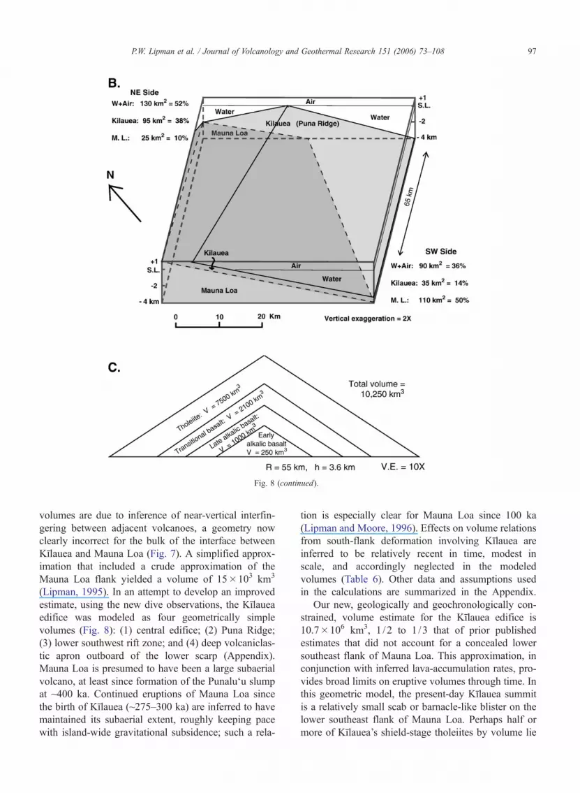
volumes are due to inference of near-vertical interfin-
gering between adjacent volcanoes, a geometry now
clearly incorrect for the bulk of the interface between
Kılauea and Mauna Loa (Fig. 7). A simplified approx-
imation that included a crude approximation of the
Mauna Loa flank yielded a volume of 15�103 km3
(Lipman, 1995). In an attempt to develop an improved
estimate, using the new dive observations, the Kılauea
edifice was modeled as four geometrically simple
volumes (Fig. 8): (1) central edifice; (2) Puna Ridge;
(3) lower southwest rift zone; and (4) deep volcaniclas-
tic apron outboard of the lower scarp (Appendix).
Mauna Loa is presumed to have been a large subaerial
volcano, at least since formation of the Punalu‘u slump
at ~400 ka. Continued eruptions of Mauna Loa since
the birth of Kılauea (~275–300 ka) are inferred to have
maintained its subaerial extent, roughly keeping pace
with island-wide gravitational subsidence; such a rela-
tion is especially clear for Mauna Loa since 100 ka
(Lipman and Moore, 1996). Effects on volume relations
from south-flank deformation involving Kılauea are
inferred to be relatively recent in time, modest in
scale, and accordingly neglected in the modeled
volumes (Table 6). Other data and assumptions used
in the calculations are summarized in the Appendix.
Our new, geologically and geochronologically con-
strained, volume estimate for the Kılauea edifice is
10.7�106 km3, 1 /2 to 1 /3 that of prior published
estimates that did not account for a concealed lower
southeast flank of Mauna Loa. This approximation, in
conjunction with inferred lava-accumulation rates, pro-
vides broad limits on eruptive volumes through time. In
this geometric model, the present-day Kılauea summit
is a relatively small scab or barnacle-like blister on the
lower southeast flank of Mauna Loa. Perhaps half or
more of Kılauea’s shield-stage tholeiites by volume lie
Fig. 8 (continued).
P.W. Lipman et al. / Journal of Volcanology and Geothermal Research 151 (2006) 73–108 97

along the east rift zone and Puna Ridge, and the tho-
leiitic lava exposed so widely on subaerial Kılauea
thinly veneers diverse alkalic and transitional basalts
of ancestral Kılauea that in turn overlie lower-flank
volcaniclastic rocks of Mauna Loa. Such a geometry
also requires that the deep magmatic plumbing system
of Kılauea, both below the summit caldera and along its
rift zones, passes through rocks of Mauna Loa’s shield-
stage south flank that continued to spread seaward as
the Kılauea edifice has grown (Fig. 7).
5.2.5. Changing magma supply
In combination, the estimated lava-accumulation
rates and overall edifice volume permit approximating
the magma supply with time as ancestral Kılauea
progressed from alkalic to tholeiitic stages. With a
total volume for the Kılauea edifice of ~10,000 km3,
the entire Kılauea edifice could have formed within
100,000 yr at the present-day magma-production rate
of ~100�106 m3/yr (Dzurisin et al., 1984; Dvorak and
Dzurisin, 1993). Clearly, magma-production rates have
increased from the early alkalic phase to the present-
day tholeiitic eruptions, as estimated for other Hawai-
ian volcanoes (Wise, 1982; Lipman, 1995; DePaolo
and Stolper, 1996). A model to maintain the approx-
imately constant lava-accumulation rates for the alka-
lic–transitional–tholeiitic sequence observed on the
upper submarine south flank (Table 4), generalized
from a simple conical geometry for the growing
Kılauea shield (Fig. 8C), yields an increase from
25�106 m3/yr at end of alkalic volcanism, to
50�106 m3/yr at end of the transitional basaltic
stage, to 100�106 at the present-day shield stage
(Table 7). From this simple model, about 1250 km3
of alkalic basalt would have erupted at Kılauea (275–
150 ka); 1875 km3 of transitional basalt (150–100 ka);
and 7500 km3 of tholeiite (100 ka–present).
Table 6
Model volume calculations for Kilauea
A. Volume of area #1: central flank and Hilina slope (Fig. 8)
Average NE side (95 km2)+SW side (35 km2)=130 km2 / 2=65 km2
Volume=average side area (65 km2)� length (65 km)=4225 km3
B. Volume of area #2: Puna Ridge:
Length (70 km)�width (35 km)�height (5 km)�1 /4=3062 km2
C. Volume of area #3: lower SW rift zone:
Length (25 km)�width (15 km)�height (1 km)�1 /4=94 km2
D. Volume of area #4: deep volcaniclastic apron:
Length (65 km)�width (15 km)�height (1 km)=975/2=488 km2
Half vol., from Mauna Loa and Mauna Kea :Kilauea
volume=245 km2
E. Volume of average subsidence since 300 ka (area A, only)
Length (65 km)�width (50 km)�height 0.75 Km)=2438 km2
F. Volume of 1-km-high Kao‘iki scarp wedge area
Length (65 km)�avg width (37.5 km)�avg height
(0.25 km)=609 km3
Total Kilauea volume: 10.7�103 km3
(see Appendix for discussion of data sources and assumptions).
In comparison, prior estimates for Kilauea volume:
Bargar and Jackson (1974) 19.4�103 km3.
Lipman (1995) 15�103 km3 [vol. of M.L. estimated].
DePaolo and Stolper (1996) 20–25�103 km3.
Fiske and Wright (1997) 21.1–37.8�103 km3.
Table 7
Estimated lava-supply and growth history of Kilauea
A. Simple conical model for lava volumes (Fig. 8C)
Unit Age
(ka)
Span Accumulation rate Height Radius Cumulative volume Unit volume
(k.y.) (m/yr) (km) (km)
Tholeiitic 100–0 100 0.010 3.25 55 10280 6883
Transitional 150–100 50 0.015 2.25 38 3397 2168
Late alkalic 200–150 50 0.015 1.50 28 1230 1003
Early alkalic 275–200 75 0.010 0.75 17 227 227
B. Estimated lava supply and volume
Composition Age
(ka)
Lava-supply
(�106 m3/yr)
Volume
(km3)
Start End Start rate End rate Average
Modern tholeiite 100 0 50 100 75 7500
Transitional basalt 150 100 25 50 37.5 1875
Late alkalic basalt 200 150 7 25 16 800
Early alkalic basalt 275 200 0 7 3.5 263
Total: 10175
[Excludes endogenous growth by intrusion and cumulates]
P.W. Lipman et al. / Journal of Volcanology and Geothermal Research 151 (2006) 73–10898

The conical model (Fig. 8C) is a gross simplifica-
tion, because the shape of Kılauea at any time during its
growth differed in at least two obvious respects: (1) the
summit vent area is asymmetrically upslope from max-
imum lava accumulation on the seaward flank, and (2)
eruptive growth was highly elongate parallel to the
direction of the rift propagation. Nevertheless, the sim-
plified conical model probably provides a plausible
approximation of changes in magma supply with com-
positional evolution. Even though most or all the alkalic
basalt accumulated down slope from the summit, and
much of the tholeiite erupted along the lower east rift
zone and the Puna Ridge, more complex models, in-
volving overlapping elliptical cones, yield roughly sim-
ilar results.
5.3. Implications for geometry of Kılauea’s structure
Growth of Kılauea as a relatively thin blister-like
edifice, riding piggyback on the lower south flank of
Mauna Loa as it continued to spread seaward, helps
account for several previously puzzling aspects of
Kılauea’s structure, especially: (1) location of the sum-
mit magmatic vent so close to the subaerial margin of
the Mauna Loa edifice despite the voluminous subma-
rine eruption of thick pillow lavas during early growth;
(2) contrasting lengths and eruptive activity along
Kılauea’s rift zones; (3) anomalous location of both
Kılauea rift zones; seaward of the summit caldera;
and (4) uniquely arcuate shape of its proximal east
rift zone (Fig. 9).
5.3.1. Location of the summit vent
The present-day proximity to the Mauna Loa flank
of Kılauea’s summit caldera and underlying deep
magmatic plumbing system is a severe geometric
constraint for the submarine eruption of the late alkalic
and transitional basalts, in water as deep as 2–3 km as
indicated by their volatile contents (Coombs et al.,
2006-this issue). The highly variable volatile contents
of early alkalic Kılauea eruptions suggest that a dif-
fuse plumbing system fed widely scattered eruptive
vents for these compositionally diverse basalts. Erup-
tions may have became increasingly focused near the
shallow submarine base of the Kaodiki–Honu‘apo fault
zone and headwall for the Punalu‘u slide, as later
weakly alkalic eruptions increased in volume and a
volcanic edifice became established. A scaled cross-
section through the present-day south flank seemingly
lacks space for such underwater Kılauea eruptions,
however, even if high scarps are assumed along the
fault zone.
Such a geometry for focused submarine eruptions
at ancestral Kılauea is geometrically more feasible if
the Mauna Loa flank and its fault zone were farther
northwest at the time of early Kılauea eruptions at
200–300 ka, providing space for eruptions low on this
flank. Continued seaward spreading of Mauna Loa’s
south flank (Table 3), would subsequently have carried
the Kaodiki–Honu‘apo faults closer to the central con-
duit of Kılauea that remained nearly vertically above
its mantle magma supply, even as the growing Kılauea
edifice was carried seaward along with the entire south
flank of the island. Such spreading would also have
transported the late alkalic pillow basalts away from
the fixed summit conduit and vent, helping account
for the volatile-saturation pressures near present out-
crop depths (Coombs et al., 2006-this issue). The
absence of a Mauna-Loa-side btailQ on the Kılauea
summit gravity anomaly (Kauahikaua et al., 2000)
indicates that the magma conduit has not migrated
southeast along with the edifice, despite tendency for
plate movement to carry the volcano away from the
hot-spot locus, or that the bulk of the gravity anomaly
results from olivine-rich cumulates that became volu-
minous only during the relatively recent (~100 ka)
tholeiitic stage when Kılauea has been fed by picritic
primary magmas (Clague et al., 1995).
Fig. 9. Schematic diagrams of present-day Kılauea structures (A), and
inferred relations at ~200 ka (B), assuming ~10 km of subsequent
south-flank seaward spreading. The summit conduit of Kılauea,
through which magma rises from the mantle, is inferred to have
remained fixed during shield growth (since ~200 ka). Seaward spread-
ing of the mobile south flank of Mauna Loa has carried upper slopes
of this volcano closer to the Kılauea magma conduit, while carrying
the Kılauea rift zones passively southward and generating their arcu-
ate axes. The present-day Ko‘ae fault zone (K.f.z) marks the former
connection between more rectilinear ancestral rift zones.
P.W. Lipman et al. / Journal of Volcanology and Geothermal Research 151 (2006) 73–108 99
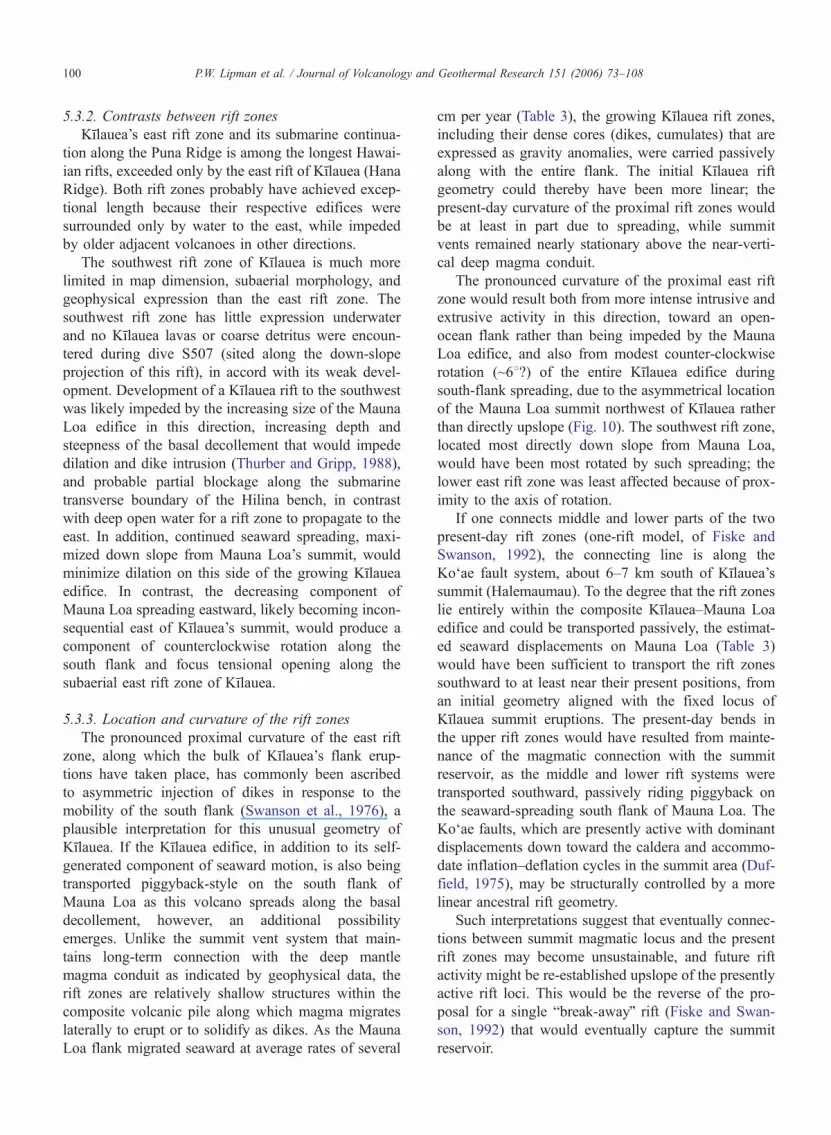
5.3.2. Contrasts between rift zones
Kılauea’s east rift zone and its submarine continua-
tion along the Puna Ridge is among the longest Hawai-
ian rifts, exceeded only by the east rift of Kılauea (Hana
Ridge). Both rift zones probably have achieved excep-
tional length because their respective edifices were
surrounded only by water to the east, while impeded
by older adjacent volcanoes in other directions.
The southwest rift zone of Kılauea is much more
limited in map dimension, subaerial morphology, and
geophysical expression than the east rift zone. The
southwest rift zone has little expression underwater
and no Kılauea lavas or coarse detritus were encoun-
tered during dive S507 (sited along the down-slope
projection of this rift), in accord with its weak devel-
opment. Development of a Kılauea rift to the southwest
was likely impeded by the increasing size of the Mauna
Loa edifice in this direction, increasing depth and
steepness of the basal decollement that would impede
dilation and dike intrusion (Thurber and Gripp, 1988),
and probable partial blockage along the submarine
transverse boundary of the Hilina bench, in contrast
with deep open water for a rift zone to propagate to the
east. In addition, continued seaward spreading, maxi-
mized down slope from Mauna Loa’s summit, would
minimize dilation on this side of the growing Kılauea
edifice. In contrast, the decreasing component of
Mauna Loa spreading eastward, likely becoming incon-
sequential east of Kılauea’s summit, would produce a
component of counterclockwise rotation along the
south flank and focus tensional opening along the
subaerial east rift zone of Kılauea.
5.3.3. Location and curvature of the rift zones
The pronounced proximal curvature of the east rift
zone, along which the bulk of Kılauea’s flank erup-
tions have taken place, has commonly been ascribed
to asymmetric injection of dikes in response to the
mobility of the south flank (Swanson et al., 1976), a
plausible interpretation for this unusual geometry of
Kılauea. If the Kılauea edifice, in addition to its self-
generated component of seaward motion, is also being
transported piggyback-style on the south flank of
Mauna Loa as this volcano spreads along the basal
decollement, however, an additional possibility
emerges. Unlike the summit vent system that main-
tains long-term connection with the deep mantle
magma conduit as indicated by geophysical data, the
rift zones are relatively shallow structures within the
composite volcanic pile along which magma migrates
laterally to erupt or to solidify as dikes. As the Mauna
Loa flank migrated seaward at average rates of several
cm per year (Table 3), the growing Kılauea rift zones,
including their dense cores (dikes, cumulates) that are
expressed as gravity anomalies, were carried passively
along with the entire flank. The initial Kılauea rift
geometry could thereby have been more linear; the
present-day curvature of the proximal rift zones would
be at least in part due to spreading, while summit
vents remained nearly stationary above the near-verti-
cal deep magma conduit.
The pronounced curvature of the proximal east rift
zone would result both from more intense intrusive and
extrusive activity in this direction, toward an open-
ocean flank rather than being impeded by the Mauna
Loa edifice, and also from modest counter-clockwise
rotation (~68?) of the entire Kılauea edifice during
south-flank spreading, due to the asymmetrical location
of the Mauna Loa summit northwest of Kılauea rather
than directly upslope (Fig. 10). The southwest rift zone,
located most directly down slope from Mauna Loa,
would have been most rotated by such spreading; the
lower east rift zone was least affected because of prox-
imity to the axis of rotation.
If one connects middle and lower parts of the two
present-day rift zones (one-rift model, of Fiske and
Swanson, 1992), the connecting line is along the
Ko‘ae fault system, about 6–7 km south of Kılauea’s
summit (Halemaumau). To the degree that the rift zones
lie entirely within the composite Kılauea–Mauna Loa
edifice and could be transported passively, the estimat-
ed seaward displacements on Mauna Loa (Table 3)
would have been sufficient to transport the rift zones
southward to at least near their present positions, from
an initial geometry aligned with the fixed locus of
Kılauea summit eruptions. The present-day bends in
the upper rift zones would have resulted from mainte-
nance of the magmatic connection with the summit
reservoir, as the middle and lower rift systems were
transported southward, passively riding piggyback on
the seaward-spreading south flank of Mauna Loa. The
Ko‘ae faults, which are presently active with dominant
displacements down toward the caldera and accommo-
date inflation–deflation cycles in the summit area (Duf-
field, 1975), may be structurally controlled by a more
linear ancestral rift geometry.
Such interpretations suggest that eventually connec-
tions between summit magmatic locus and the present
rift zones may become unsustainable, and future rift
activity might be re-established upslope of the presently
active rift loci. This would be the reverse of the pro-
posal for a single bbreak-awayQ rift (Fiske and Swan-
son, 1992) that would eventually capture the summit
reservoir.
P.W. Lipman et al. / Journal of Volcanology and Geothermal Research 151 (2006) 73–108100
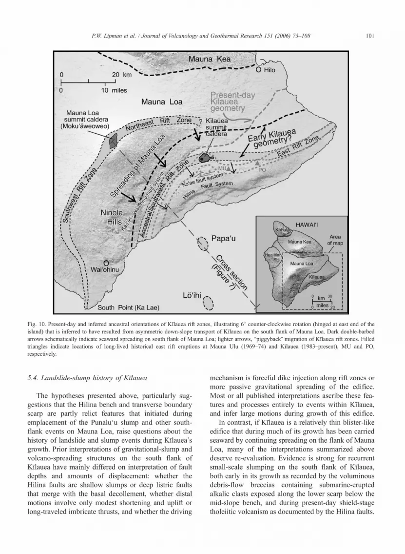
5.4. Landslide-slump history of Kılauea
The hypotheses presented above, particularly sug-
gestions that the Hilina bench and transverse boundary
scarp are partly relict features that initiated during
emplacement of the Punalu‘u slump and other south-
flank events on Mauna Loa, raise questions about the
history of landslide and slump events during Kılauea’s
growth. Prior interpretations of gravitational-slump and
volcano-spreading structures on the south flank of
Kılauea have mainly differed on interpretation of fault
depths and amounts of displacement: whether the
Hilina faults are shallow slumps or deep listric faults
that merge with the basal decollement, whether distal
motions involve only modest shortening and uplift or
long-traveled imbricate thrusts, and whether the driving
mechanism is forceful dike injection along rift zones or
more passive gravitational spreading of the edifice.
Most or all published interpretations ascribe these fea-
tures and processes entirely to events within Kılauea,
and infer large motions during growth of this edifice.
In contrast, if Kılauea is a relatively thin blister-like
edifice that during much of its growth has been carried
seaward by continuing spreading on the flank of Mauna
Loa, many of the interpretations summarized above
deserve re-evaluation. Evidence is strong for recurrent
small-scale slumping on the south flank of Kılauea,
both early in its growth as recorded by the voluminous
debris-flow breccias containing submarine-erupted
alkalic clasts exposed along the lower scarp below the
mid-slope bench, and during present-day shield-stage
tholeiitic volcanism as documented by the Hilina faults.
Fig. 10. Present-day and inferred ancestral orientations of Kılauea rift zones, illustrating 68 counter-clockwise rotation (hinged at east end of the
island) that is inferred to have resulted from asymmetric down-slope transport of Kılauea on the south flank of Mauna Loa. Dark double-barbed
arrows schematically indicate seaward spreading on south flank of Mauna Loa; lighter arrows, bpiggybackQ migration of Kılauea rift zones. Filled
triangles indicate locations of long-lived historical east rift eruptions at Mauna Ulu (1969–74) and Kılauea (1983–present), MU and PO,
respectively.
P.W. Lipman et al. / Journal of Volcanology and Geothermal Research 151 (2006) 73–108 101

Less convincing is evidence for large-scale slope failure
at any stage during the evolution of Kılauea. Features
indicating the absence of any major failure include: (1)
the primarily depositional nature of Kılauea’s upper
submarine slope, above the mid-slope bench; (2) the
linear continuity of the submarine south flank between
the pillowed ribs on the south flank and the Puna
Ridge; (3) concordance of the subaerial–submarine to-
pographic inflection with present-day sea level along
most of the coastline; (4) absence of any documented
extensive debris field southeast of Kılauea; and (5) on-
land geologic evidence that the Hilina faults are rela-
tively young (b39 ka, date for Pokaka‘a Ash, exposed
low in Hilina scarps: Easton, 1987; Beeson et al.,
1996).
(1) The planar to seaward-concave geometry of
Kılauea’s upper south slope, although enhanced by
subsidence along the Hilina fault system, is interpreted
as primarily a constructional feature. Recurrent subsi-
dence of successive summit calderas, and intrusion-
generated uplift associated with development of the
Ko‘ae fault system on the caldera’s seaward side,
have impeded flowage of summit-erupted lava down
adjacent seaward slopes of Kılauea during much of its
growth. No young shoreline-crossing lava flows were
imaged as reflective areas on the mid-slope bench in
side-scan sonar images or were encountered during
dives down slope from the summit. In contrast, sus-
tained activity along upper segments of the rift zones,
especially the proximal east rift have no comparable
topographic barriers to impede seaward flowage of
lava, resulting in augmented submarine lava accumula-
tion relative to the slope segment below the caldera
area. Comparable summit-rift geometry on Mauna Loa,
at elevations above 2000 m, where unmodified by the
Kaodiki–Honu‘apo faults, has also produced a planar
south slope, in contrast to the more arcuate contours
and domical shape of its north flank.
(2) The submarine south flank of Kılauea, expressed
by resistant ribs protruding through coast-derived sed-
iment, is in nearly linear continuity with constructional
pillow-lava slopes of the Puna Ridge beyond the east
cape of the island. This continuity suggests that the
south flank is largely a primary depositional slope,
only modestly modified by sedimentation and small-
scale slumping. In accord with this interpretation, lon-
gitudinal height /distance ratios to the axis of the east
rift zone from the constructional base of the Kılauea
submarine edifice (base of the upper submarine slope at
the mid-slope bench and base of the Puna Ridge) are
nearly constant, consistent with only modest modifica-
tion by slumping.
(3) Paleo-shorelines of Hawaiian volcanoes, when
submerged by subsidence are well defined by inflec-
tions in slope-between steep (originally submarine) and
gentler (originally subaerial). Adjacent to much of the
eastern Hilina fault zone, the slope inflection coincides
with the present shoreline because coverage by lava
flows has been sufficient to compensate for effects of
slump subsidence. Only west of Ka‘ena Point, down
slope from the summit area where lava is impeded from
reaching the coast as just noted, does the shoreline
slope inflection become submerged; even here, the
submerged shoreline just hinges downward to �700
m maximum depth without deflection in trend (0608),
indicating that little in the way of lateral transport has
accompanied downward displacement along this Hilina
fault segment.
(4) Deposits from large submarine debris ava-
lanches around the Hawaiian Islands were recognized
early as swaths of hummocky terrain extending tens to
over 100 km from the bases of the islands (Moore,
1964; Moore et al., 1989). Such bathymetry is absent
southeast of the Hilina bench (Fig. 1). Instead, two
prominent and as many as ten small conical seamounts
that rise from the smoothly sedimented seafloor at
�5000 m depth, are probably Cretaceous seamounts
(Moore and Chadwick, 1995; Smith et al., 1999). Two
low linear ridges parallel the Hilina lower scarp. Sub-
mersible observations and analyses of glasses from the
larger ridge (dive K93) show that it consists of bed-
ded, glassy volcaniclastics similar to rocks of the
Hilina bench, and the linear ridges are interpreted as
slide blocks shed from the bench’s nearby steep front-
al scarp (Lipman et al., 2002; Sisson et al., 2002). The
proximal volcaniclastic apron at the base of the lower
scarp (Fig. 8) likely consists largely of more-fragmen-
ted small-scale slump and slide debris shed from this
scarp (Smith et al., 1999; Leslie et al., 2002). The
absence of an extensive landslide debris field, lack of
thick turbidite layers with shield-stage Kılauea sand
where sampled by piston core south of Hawai‘i Island
(Naka et al., 2002), and the exposures of probable
Cretaceous basement are further evidence against
major flank collapses of Kılauea.
(5) The entire Hilina fault system as exposed on land
appears to have developed late in the growth of
Kılauea. Topographically expressed offsets along
Hilina faults appear entirely to postdate the deposits
of Pahala Ash (Easton, 1987), a widespread stratigraph-
ic marker on the south flank of Hawai‘i Island that was
deposited after about 39 ka (Beeson et al., 1996). No
evidence is preserved on land or underwater for earlier
movement on the Hilina faults.
P.W. Lipman et al. / Journal of Volcanology and Geothermal Research 151 (2006) 73–108102

Thus, the south flank of Kılauea appears to owe its
present morphology and structure largely to construc-
tional volcanic growth, accompanied by seaward
spreading of the entire south flank of Hawai‘i Island,
small-scale slumping that produced the breccia deposits
exposed along the lower scarp early during volcano
growth (as indicated by the absence of tholeiitic clasts),
and relatively late subsidence along the Hilina faults.
Large-scale slumping or landslide failures are likely
future events for the rapidly deforming south flank of
this actively growing volcano.
Acknowledgments
We thank the Japan Marine Science and Technology
Center (JAMSTEC) for multi-year support of ship-based
research on the flanks of Hawaiian volcanoes, chief
scientists Jiro Naka and Eiichi Takahashi for their lead-
ership and guidance during cruises and subsequent data
analysis, and members of the collaborative Japan–USA
scientific team for sharing observations, samples, and in-
progress interpretations. Asta Miklius generously pro-
vided pre-publication geodetic data from the Hawai‘i
Volcano Observatory (plotted in Fig. 5). The manuscript
benefited from review comments by J.K. Morgan, J.M.
Rhodes, R.I. Tilling, and an anonymous referee. Ongo-
ing multi-year discussions with Morgan, despite some-
what divergent perspectives, have been especially
conducive to improved data analysis and interpretation.
Appendix A. Model calculations for eruptive volume
of Kılauea
To estimate the eruptive volume of Kılauea, making
use of the new dive observations, the edifice was
modeled as consisting of four geometrically simple
volumes (Fig. 8): (1) central edifice, (2) Puna Ridge,
(3) lower southwest rift zone, and (4) deep volcaniclas-
tic apron outboard of the lower scarp (Fig. 8). Results
of the volume calculations are listed in Table 6. Only
eruptive volumes were estimated; Kılauea-related intru-
sions and cumulates within the Mauna Loa flank below
the Kılauea’s edifice were neglected.
A.1. Area #1 (central edifice)
In simplified shape, the bulk of subaerial Kılauea
and its adjacent submarine flank lie within a rectangular
block 65�50 km�5 km high (+1 km elevation to �4
km: Fig. 8B). The south flank of Kılauea is morpho-
logically far more complex than the sloping plane of the
model, but scaled cross-sections suggest positive devia-
tions such as the top of the Hilina fault scarp and lip of
the mid-slope bench would be largely offset by a neg-
ative fit along the mid-slope basin. Computed volume
for this simplified and least-constrained segment of
Kılauea is 4225 km3.
Based on generalized contouring for the lower
slope of Mauna Loa (Fig. 8A), rocks of this volcano
appear to underlie the Kılauea edifice across much of
the rectangular area, thinning from southwest to north-
east. With increasing distance from Mauna Loa, the
cross-sectional area of Kılauea becomes proportionally
larger to the east, down rift from its summit. Even
here, Kılauea could be overprinting and re-using a
buried continuation of the Mauna Loa northeast rift,
a possibility hinted by electrical and magnetic trends
(Flannigan and Long, 1987; Hildenbrand et al., 1993)
that could substantially further reduce the calculated
volume for Kılauea.
Also complicating the resulting volume estimate are
uncertainties concerning the degree of interfingering
with Mauna Loa lavas as Kılauea grew, especially if
high scarps were present along the Kao‘iki–Honu‘apo
fault system. Banking of Kılauea lavas against a tapered
scarp, modeled as 1 km high at the west corner of area
#1 and decreasing to zero at the east corner, lowers the
basal plane of the model and adds 610 km3 of additional
volume (Table 6, F). In addition, about 750 m of con-
current shoreline subsidence would have affected area
#1 during the 300,000 yr since inception of Kılauea, at
the present-day rate of 2.5 mm/yr (Moore, 1970, 1987),
further lowering the basal plane separating rocks of
these two volcanoes. Greater subsidence likely occurred
inland, less along the distal submarine flank of this
block. The calculated subsidence volume is 2440 km3.
This model probably overestimates the Kılauea vol-
ume of area #1 by amounts that are difficult to quantify.
During early alkalic growth of Kılauea (perhaps 300–
200 ka), only part of area #1 was likely occupied by
Kılauea rocks; remaining subsided portions would have
been infilled byMauna Loa lavas. Volcaniclastic rocks at
the southeast margin of area #1, along lower scarp,
contain large proportions of sandstone and breccia-ma-
trix sand (at least 50% by volume in exposed dive sec-
tions) derived from subaerial Mauna Loa and perhaps
Mauna Kea. In addition, the concealed southeast-flank
contours on Mauna Loa likely are convex seaward (Fig.
8A), not planar as in the simplified model for area #1
(Fig. 8B). All three such relations would lead to over-
estimate of the area #1 volume of Kılauea, thereby
offsetting any underestimate associated with a steep
contact between volcanoes along the Kao‘iki–Honu‘apo
faults.
P.W. Lipman et al. / Journal of Volcanology and Geothermal Research 151 (2006) 73–108 103
Another complication in reconstructing the shape of
ancestral Kılauea (though probably not the volume
estimates) involves evidence that the initial alkalic
Kılauea lavas at 275–300 ka erupted over a wide
range of elevations, from deep water to near or
above sea level (Coombs et al., 2006-this issue),
consistent with the interpretation that Mauna Loa
already was a large subaerial volcano at that time
and that growth of Kılauea began on its flank. In
contrast, later alkalic and transitional pillow lavas
sampled above the mid-slope bench, which appear
related to presence of a central vent and rift zones,
erupted consistently under water, at depths as much as
several thousand meters. Such geometry requires an
additional process on the south flank to provide room
for an underwater central vent, suggested here to
involve something on the order of 10 km of seaward
spreading of the south flank of Mauna Loa during the
growth of Kılauea.
A.2. Area #2 (Puna Ridge)
The Puna Ridge was treated as a simple tapered
prism 35 km wide, 70 km long, and 5 km high at its
proximal end—the east cape of Hawai‘i Island. No
Mauna Loa rocks are modeled as underlying the
prism, and no sizable gravitational subsidence is in-
ferred for this distal part of the volcano, where most
lava has likely accumulated only since beginning of
transitional- and tholeiitic-stage volcanism at ~150 ka.
Calculated volume is 3060 km3.
A.3. Area #3 (lower SW rift zone)
The lower southwest rift is west of the central
rectangle, beyond the transverse boundary scarp (Fig.
8A). Erupted lavas represent only a thin scab on the
flank of Mauna Loa, and the lower southwest rift
structures must largely cut through the Mauna Loa
flank, rather than lying entirely within the Kılauea
edifice (Fig. 7). This portion of the rift zone is only
weakly expressed as a morphologic feature on land
and underwater, its boundaries are uncertain underwa-
ter, and its volume small. Treating this feature as a
simple tapered prism 15 km wide, 25 km long, and 1
km high at its proximal end, the calculated volume is
95 km3.
A.4. Area #4 (deep volcaniclastic apron)
Outboard of the lower scarp is a deep debris field
and volcaniclastic apron, wedging seaward from about
�4500 to �5500 m water depth (Smith et al., 1999;
Leslie et al., 2002). The volcaniclastic apron is broad-
est down slope from the Punalu‘u slump area, narrow-
ing to the northeast beneath the Hilina lower scarp
(Fig. 2; Moore and Chadwick, 1995, fig. 2), thus
suggesting a major detrital component from Mauna
Loa. If half the wedge of debris down slope from the
Hilina scarp (modeled as 15 km wide�65 km
long�1 km high) was derived from Mauna Loa
(and/or Mauna Kea?) as suggested by dominant com-
ponents from these sources in sandstones and breccia
matrix of the scarp sequence, the resulting Kılauea
volume is 245 km3. Contributions from distal ocean-
floor turbidites are neglected; no thick turbidite layers
sampled south of Hawai‘i Island by piston core have
shield-stage Kılauea sand as a primary component
(Naka et al., 2002).
References
Ando, M., 1979. Low-angle faulting due to forceful injection of
magma. J. Geophys. Res. 84, 7616–7626.
Baker, M.B., Stolper, D.A., Stolper, E.M., Fialko, Y., 2003. Modeling
the growth of Hawaiian volcanoes [abs.]. Eos Trans. AGU 84,
F1469.
Bargar, K.E., Jackson, E.D., 1974. Calculated volumes of individual
shield volcanoes along the Hawaiian–Emperor chain. J. Res. U. S.
Geol. Surv. 2, 545–550.
Beeson, M.H., 1976. Petrology, mineralogy, and geochemistry of the
East Molokai Volcanic Series, Hawai‘i. U.S. Geol. Surv. Prof.
Pap. 961, 53 pp.
Beeson, M.H., Clague, D.A., Lockwood, J.P., 1996. Origin and
depositional environment of clastic deposits in the Hilo drill
hole, Hawai‘i. J. Geophys Res. 101, 11,617–11,630.
Borgia, A., Treves, B., 1992. Volcanic plates override the ocean crust:
structure and dynamics of Hawaiian volcanoes. Spec. Publ. Geol.
Soc. London 60, 277–299.
Borgia, A., Delaney, P.T., Denlinger, R.P., 2000. Spreading volcanoes.
Annu. Rev. Earth Planet. Sci. 28, 539–570.
Brigham, W.T., 1909. The Volcanoes of Kılauea and Mauna Loa. B.P.
Bishop Museum Mem. vol. 2. 222 pp.
Calvert, A., Lanphere, M., 2006. Argon geochronology of Kılauea’s
early submarine history. J. Volcanol. Geotherm. Res. 151, 1–18.
doi:10.1016/j.jvolgeores.2005.07.023 (this issue).
Cannon, E.C., Burgmann, R., 2001. Prehistoric fault offsets of the
Hilina fault system, south flank of Kılauea Volcano, Hawai‘i. J.
Geophys. Res. 106, 4207–4219.
Cervelli, P.F., Seagall, P., Amelung, F., Garbeil, H., Meertens, C.M.,
Owen, S.E., Miklius, A., Lisowski, M., 2002. The 12 September
1999 Upper East Rift Zone dike intrusion at Kılauea Volcano
Hawai‘i. J. Geophys. Res. 107, ECV3-1–ECV3-13.
Cervelli, P.F., Seagall, P., Johnson, K., Lisowski, M., Miklius, A.,
2002. Sudden aseismic fault slip on the south flank of Kılauea
Volcano. Nature 415, 1014–1018.
Chadwick Jr., W.W., Smith, J.R., Moore, J.G., Clague, D.A., Garcia,
M.O., Fox, C.G., 1993. Bathymetry of South Flank of Kılauea
Volcano, Hawai‘i. U.S. Geol. Surv. Misc. Field Studies Map, vol.
MF-2231.
P.W. Lipman et al. / Journal of Volcanology and Geothermal Research 151 (2006) 73–108104
Chen, C.-Y., Frey, F.A., Rhodes, J.M., Easton, R.M., 1996. Tempo-
ral geochemical evolution of Kılauea Volcano: comparison of
Hilina and Puna basalt. Geophys. Monogr. Am. Geophys. Union
95, 161–181.
Clague, D.A., Dalrymple, G.B., 1987. The Hawaiian–Emperor vol-
canic chain. Part I. Geologic evolution. U.S. Geol. Surv. Prof. Pap.
1350, 5–73.
Clague, D.A., Denlinger, R.P., 1994. The role of cumulus dunite in
destabilizing the flanks of Hawaiian volcanoes. Bull. Volcanol.
56, 425–434.
Clague, D.A., Hon, K.A., Anderson, J.L., Chadwick Jr., W.W., Fox,
C.G., 1994. Bathymetry of Puna Ridge, Kılauea Volcano,
Hawai‘i. U.S. Geol. Survey Misc. Field Studies Map, vol.
MF-2237.
Clague, D.A., Moore, J.G., Dixon, J.E., Friesen, W.B., 1995. Petrol-
ogy of submarine lavas from Kılauea’s Puna Ridge, Hawai‘i. J.
Petrol. 36, 299–349.
Coombs, M.L., Sisson, T.W., Kimura, J.I., 2004a. Ultra-high Cl in
submarine Kılauea glasses: evidence for direct assimilation off
brine by magma. Earth Planet. Sci. Lett. 217, 297–313.
Coombs, M.L., Clague, D.A., Moore, G.F., Cousens, B.L., 2004b.
The growth and collapse of Wai‘anae Volcano, Hawai‘i, as
revealed by exploration of its submarine flanks. Geochem. Geo-
phys. Geosyst. doi:10.1029/2004GC000717.
Coombs, M.L., Sisson, T.W., Lipman, P.W., 2004c. Major-Element,
S, and Cl Compositions of Submarine Kılauea Glasses Collected
during 1998–2002 JAMSTEC Hawai‘i Cruises. U.S. Geol. Sur-
vey Open-File Report 2004-1378 http://pubs.usgs.gov/of/2004/
1378/.
Coombs, M.L., Sisson, T.W., Lipman, P.W., 2006. Growth history of
Kılauea inferred from volatile concentrations in submarine-col-
lected basalts. J. Volcanol. Geotherm. Res. 151, 19–49.
doi:10.1016/j.jvolgeores.2005.07.037 (this issue).
Crosson, R.S., Endo, E.T., 1982. Focal mechanism and locations of
earthquakes in the vicinity of the 1975 Kalapana earthquake
aftershock zone 1970–1979. Tectonics 1, 495–542.
Dalrymple, G.B., Moore, J.G., 1968. Argon-40: excess in submarine
pillow basalts from Kılauea Volcano, Hawai‘i. Science 161,
1132–1135.
Dana, J.D., 1849. Geology. United States Exploring Expedition, vol.
10. George P. Putnam, New York. 436 pp.
Decker, R.W., Wright, T.L, Stauffer, P.H., 1987. Volcanism in
Hawai‘i. U. S. Geol. Surv. Prof. Pap. 1350. 1667 pp.
Delaney, P.T., Denlinger, R.P., Lisowski, M., Miklius, A., Okubo,
P.G., Okamura, A.T., Sako, M.K., 1998. Volcano spreading at
Kılauea, 1976–1996. J. Geophys. Res. 103, 18,003–18,024.
DePaolo, D.J., Stolper, E.M., 1996. Models of Hawaiian volcano
growth and plume structure: implications of results from the
Hawai‘i scientific drilling project. J. Geophys. Res. 101,
11,643–11,654.
DePaolo, D.J., Bryce, J.G., Dodson, A., Shuster, D.L, Kennedy, B.M.,
2001. Isotopic evolution of Mauna Loa and the chemical structure
of the Hawaiian plume. Geochem. Geophys. Geosyst. 2
(20000GC000139, 23 pp.).
Denlinger, R.P., Okubo, P., 1995. Structure of the mobile south
flank of Kılauea Volcano, Hawai‘i. J. Geophys. Res. 100,
24,499–24,507.
Dieterich, J.H., 1988. Growth and persistence of Hawaiian volcanic
rift zones. J. Geophys. Res. 93, 4258–4270.
Duffield, W.A., 1975. Structure and origin of the Ko‘ae fault
system, Kılauea Volcano, Hawai‘i. U. S. Geol. Surv. Prof. Pap.
856. 12 pp.
Duffield, W.A., Christiansen, R.L., Koyanagi, R.Y., Swanson, D.A.,
1982. Storage, migration, and eruption of magma at Kılauea
Volcano, Hawai‘i, 1971–1972. J. Volcanol. Geotherm. Res. 13,
273–307.
Dutton, C.E., 1884. The Hawaiian volcanoes. U.S. Geol. Survey 4th
Ann. Rept., pp. 75–219.
Dvorak, J.J., Dzurisin, D., 1993. Variations in magma supply at
Kılauea Volcano. J. Geophys. Res. 98, 22,255–22,268.
Dvorak, J.J., Okamura, A.T., English, T.T., Koyanagi, R.Y., Nakata,
J.S., Sako, M.K., Tanigawa, W.T., Yamashita, K.M., 1986. Me-
chanical response of the south flank of Kılauea Volcano, Hawai‘i,
to intrusive events along the rift systems. Tectonophysics 124,
193–209.
Dzurisin, D., Konanagi, R.Y., English, T.T., 1984. Magma supply and
storage at Kılauea Volcano, Hawai‘i 1956–1983. J. Volcanol.
Geotherm. Res. 21, 177–206.
Dzurisin, D., Lockwood, J.P., Casadevall, T.J., Rubin, M., 1995. The
Uwekahuna ash: product of large prehistoric phreatomagmatic
eruptions at Kılauea Volcano, Hawai‘i. J. Volcanol. Geotherm.
Res. 66, 163–184.
Eakins, B.W., Robinson, J.E., Kanamatsu, T., Naka, J., Smith, J.R.,
Takahashi, E., Clague, D.A., 2003. Hawai‘i Volcanoes Revealed.
U.S. Geol. Survey Geol. Map Invest. Series I-2809.
Eaton, J.P., 1962. Crustal structure and volcanism in Hawai‘i. Geo-
phys. Monogr. Am. Geophys. Union 6, 13–29.
Eaton, J.P., Murata, K.J., 1960. How volcanoes grow. Science 132,
925–938.
Easton, R.M., 1987. Stratigraphy of Kılauea Volcano. U.S. Geol.
Surv. Prof. Pap. 1350, 243–260.
Endo, E.T., 1985. Seismotectonic framework for the southeast flank
of Mauna Loa Volcano, Hawai‘i. PhD thesis, Univ. Washington,
Seattle. 349 pp.
Fiske, R.S., Jackson, E.D., 1972. Orientation and growth of Hawaiian
volcanic rifts: the effect of regional structure and gravitational
stresses. Proc. R. Soc. London 329, 299–326.
Fiske, R.S., Swanson, D.A., 1992. One-rift, two-rift paradox at
Kılauea Volcano, Hawai‘i [abs.]. Eos Trans. AGU 73, 506.
Fiske, R.S., Wright, T.L., 1997. Volume of Kılauea: estimates and
implications [abs.]. Eos Trans. AGU 78, F644–F645.
Fiske, R.S., Rose, T.R., Swanson, D.A., McGeehin, J.C., 1999. The
KulanadokuaTiki tephra: product of newly recognized pyroclastic
eruptions at Kılauea Volcano, Hawai‘i [abs.]. Eos Trans. AGU 80,
F1196–F1197.
Flannigan, V.J., Long, C.L., 1987. Aeromagnetic and near-surface
electrical expression of the Kılauea and Mauna Loa rift systems.
U. S. Geol. Surv. Prof. Pap. 1350, 935–946.
Fornari, D.J., Moore, J.G., Calk, L., 1979. A large submarine sand-
rubble flow on Kılauea Volcano, Hawai‘i. J. Volcanol. Geotherm.
Res. 5, 239–256.
Garcia, M.O., Davis, M.G., 2001. Submarine growth and internal
structure of ocean island volcanoes based on submarine observa-
tions of Mauna Loa Volcano, Hawai‘i. Geology 29, 163–166.
Garcia, M.O., Foss, D.J.P., West, H.B., Mahoney, J.J., 1995a. Geo-
chemical and isotopic evolution of Lo‘ihi Volcano, Hawai‘i. J.
Petrol. 36, 1647–1674.
Garcia, M.O., Hulsebosch, T.P., Rhodes, J.M., 1995b. Olivine-rich
submarine basalts from the southwest rift zone of Mauna Loa
Volcano; implications for magmatic processes and geochemical
evolution. Monogr. Am. Geophys. Union 92, 219–239.
Got, J.-L., Okubo, P., 2003. New insights into Kılauea’s volcano
dynamics brought by large-scale relative relocation of microearth-
quakes. J. Geophys. Res. 108 (2337). doi:10.1029/2002JB00260.
P.W. Lipman et al. / Journal of Volcanology and Geothermal Research 151 (2006) 73–108 105
Got, J.-L., Frechet, J., Klein, F.W., 1994. Deep fault plane geometry
inferred from multiplet relative relocation beneath the south flank
of Kılauea. J. Geophys. Res. 99, 15,375–15,386.
Guillou, H., Turpin, L., Garnier, F., Charbit, S., Thomas, D.M.,
1997. Unspiked K–Ar dating of Pleistocene tholeiitic basalts
from the deep core SOH-4, Kılauea, Hawai‘i. Chem. Geol. 140,
81–88.
Hildenbrand, T.G., Rosenbaum, J.G., Kauahikaua, J.P., 1993. Aero-
magnetic study of the Island of Hawai‘i. J. Geophys. Res. 98,
4099–4119.
Hill, D.P., Zucca, J.J., 1987. Geophysical constraints on the structure
of Kılauea and Mauna Loa volcanoes, and some implications for
seismomagmatic processes. U.S. Geol. Surv. Prof. Pap. 1350,
903–917.
Hills, D.J., Morgan, J.K., Moore, G.F., Leslie, S.C., 2002. Structural
variability along the submarine south flank of Kılauea Volcano,
Hawai‘i, from a multi-channel seismic reflection survey. Geophys.
Monogr. Am. Geophys. Union 128, 105–124.
Hitchcock, C.H., 1909. Hawai‘i and its Volcanoes. The Hawaiian
Gazette, Co., Honolulu, 314 pp.
Holcomb, R.T., 1980. Preliminary geologic map of Kılauea Volcano,
Hawai‘i. Open-File Rep. U. S. Geol. Surv., 80–796.
Jackson, E.D., Silver, E.A., Dalrymple, G.R., 1972. Hawaiian–Em-
peror chain and its relation to Cenozoic circum-Pacific tectonics.
Geol. Soc. Am. Bull. 83, 601–618.
Jackson, M.D, Endo, E.T., Delaney, P.T, Arnadottir, T., Rubin, A.M.,
1992. Ground ruptures of the 1974 and 1983 Kaoiki earth-
quakes, Mauna Loa Volcano, Hawai‘i. J. Geophys. Res. 97,
8775–8796.
Jagger, T.A., 1917. Lava flow from Mauna Loa, 1916. Am. J. Sci.
193, 255–288.
Johnson, K.T.M., Reynolds, J.R., Vonderhaar, D., Smith, D.K., Kong,
L.S.L., 2002. Petrological systematics of submarine basalt glasses
from the Puna Ridge, Hawai‘i: implications for rift zone plumbing
and magmatic processes. Geophys. Monogr. Am. Geophys. Union
128, 143–159.
Kauahikaua, J., 1993. Geophysical characteristics of the hydrother-
mal systems of Kılauea Volcano, Hawai‘i. Geothermics 22,
271–300.
Kauahikaua, J., Hildenbrand, T., Webring, M., 2000. Deep magmatic
structures of Hawai‘i volcanoes, imaged by three-dimensional
gravity models. Geology 28, 883–886.
Kimura, J.-I., Sisson, T.W., Nakano, N., Coombs, M.L., Lipman,
P.W., 2006. Isotope geochemistry of early Kılauea magmas from
the submarine Hilina bench: the nature of the Hilina mantle
component. J. Volcanol. Geotherm. Res. 151, 51–72.
doi:10.1016/j.jvolgeores.2005.07.024 (this issue).
Kinoshita, W.T., Krivoy, H.L, Mabey, D.R., MacDonald, R.R., 1963.
Gravity survey of the Island of Hawai‘i. U.S. Geol. Surv. Prof.
Pap. 475-C, C114–C116.
Klein, F.W., 1982. Patterns of historic eruptions of Hawaiian volca-
noes. J. Volcanol. Geotherm. Res. 12, 1–35.
Klein, F.W., Koyanagi, R.Y., Nakata, J.S., Tanigawa, W.R., 1987. The
seismicity of Kılauea’s magma system. U.S. Geol. Surv. Prof. Pap.
1350, 1019–1185.
Leslie, S.C., Moore, G.F., Morgan, J.K., Hills, D.J., 2002. Seismic
stratigraphy of the frontal Hawaiian moat: implications for sedi-
mentary processes at the leading edge of an oceanic hotspot trace.
Mar. Geol. 184, 143–162.
Lipman, P.W., 1980a. Rates of volcanic activity along the south-
west rift zone of Mauna Loa, Hawai‘i. Bull. Volcanol. 43,
703–725.
Lipman, P.W., 1980b. The southwest rift zone of Mauna Loa: impli-
cations for structural evolution of Hawaiian volcanoes. Am. J. Sci.
280-A, 752–776.
Lipman, P.W., 1995. Declining growth of Mauna Loa during the last
100,000 yr: rates of lava accumulation vs. gravitational subsi-
dence. Geophys. Monogr. Am. Geophys. Union 92, 45–80.
Lipman, P.W., Moore, J.G., 1996. Mauna Loa lava accumulation
rates at the Hilo drill site: formation of lava deltas during a
period of declining overall volcanic growth. J. Geophys. Res.
101, 11,631–11,641.
Lipman, P.W., Lockwood, J.P., Okamura, R.T., Swanson, D.A.,
Yamashita, K.M., 1985. Ground deformation associated with the
1975 magnitude-7.2 earthquake and resulting changes in activity
of Kılauea Volcano, Hawai‘i. U. S. Geol. Surv. Prof. Pap. 1276,
45 pp.
Lipman, P.W., Normark, W.R., Moore, J.G., Wilson, J.B., Gutmacher,
C.E., 1988. The giant submarine Alika debris slide, Mauna Loa,
Hawai‘i. J. Geophys. Res. 93, 4279–4299.
Lipman, P.W., Rhodes, J.M., Dalrymple, G.B., 1990. The Ninole
basalt—implications for the structural evolution of Mauna Loa
Volcano, Hawai‘i. Bull. Volcanol. 53, 1–19.
Lipman, P.W., Sisson, T.W., Ui, T., Naka, J., 2000. In search of
ancestral Kılauea Volcano. Geology 28, 1079–1082.
Lipman, P.W., Sisson, T.W., Ui, J., Naka, J., Smith, J.R., 2002.
Ancestral submarine growth of Kılauea Volcano and instability
of its south flank. Geophys. Monogr. Am. Geophys. Union 92,
161–191.
Lipman, P.W., Eakins, B., Yokose, H., 2003. Ups and downs on
spreading flanks of ocean-island volcanoes: evidence from
Mauna Loa and Kılauea. Geology 31, 841–844.
Lockwood, J.P., 1995. Mauna Loa eruptive history—the radiocarbon
record. Geophys. Monogr. Am. Geophys. Union 92, 81–94.
Lockwood, J.P, Lipman, P.W., 1987. Holocene eruptive history of
Mauna Loa Volcano. U.S. Geol. Surv. Prof. Pap. 1350, 509–536.
Lockwood, J.P., Dvorak, J.J., English, T.T., Koyanagi, R.Y., Oka-
mura, A.T., Summer, M.L., Tanigawa, W.R., 1987. Mauna Loa
1974–1984: a decade of intrusive and extrusive activity. U.S.
Geol. Surv. Prof. Pap. 1350, 537–570.
Lonsdale, P., 1989. A geomorphological reconnaissance of the sub-
marine part of the East Rift Zone of Kılauea Volcano, Hawai‘i.
Bull. Volcanol. 51, 123–144.
Ma, K.-F., Kanamori, H., Satake, K., 1999. Mechanism of the 1975
Kalapana, Hawai‘i, earthquake inferred from tsunami data. J.
Geophys. Res. 104, 13,153–13,168.
Macdonald, G.A., 1965. Hawaiian calderas. Pac. Sci. 19, 320–334.
Macdonald, G.A., Abbott, A.T., 1970. Volcanoes in the Sea: the
Geology of Hawai‘i. Univ. Hawai‘i Press, 441 pp.
Macdonald, G.A., Katsura, T., 1964. Chemical composition of Ha-
waiian lavas. J. Petrol. 5, 83–133.
Miklius, A., Cervelli, P., 2003. Interaction between Kılauea and
Mauna Loa. Nature 421, 229.
Miklius, A., Lisowski, M., Delaney, P.T., Denlinger, R.P, Dvorak, J.J.,
Okamura, A.T., Sato, M.K., 1995. Recent inflation and flank
movement of Mauna Loa Volcano. Geophys. Monogr. Am. Geo-
phys. Union 92, 199–206.
Miklius, A., Cervelli, P., Lisowski, M.,Owen, S., Sako, M., Segall, P.,
in press. Global positioning system measurements on the Island of
Hawai‘i: 1997–2003. Open-File Rep. U. S. Geol. Surv., 2005.
Mitchell, N.C., 2001. The transition from circular to stellate forms of
submarine volcanoes. J. Geophys. Res. 106, 1987–2003.
Moore, J.G., 1964. Giant submarine landslides on the Hawaiian
Ridge. U. S. Geol. Surv. Prof. Pap. 501-D, D95–D98.
P.W. Lipman et al. / Journal of Volcanology and Geothermal Research 151 (2006) 73–108106
Moore, J.G., 1970. Relationship between subsidence and volcanic
load, Hawai‘i. Bull. Volcanol. 34, 562–576.
Moore, J.G., 1987. Subsidence of the Hawaiian Ridge. U.S. Geol.
Surv. Prof. Pap. 1350, 85–100.
Moore, J.G., Chadwick Jr., W.W., 1995. Offshore geology of Mauna
Loa and adjacent areas, Hawai‘i. Geophys. Monogr. Am. Geo-
phys. Union 92, 21–44.
Moore, J.G., Clague, D.A., 1992. Volcano growth and evolution of
Hawai‘i Island. Geol. Soc. Am. Bull. 104, 1471–1484.
Moore, J.G., Krivoy, H.L., 1964. The 1962 flank eruption of Kılauea
Volcano and structure of the east rift zone. J. Geophys. Res. 69,
2033–2045.
Moore, J.G., Thomas, D.M., 1988. Subsidence of Puna, Hawai‘i,in-
ferred from sulfur content of drilled lava flows. J. Volcanol.
Geotherm. Res. 35, 165–171.
Moore, J.G., Philips, R.L., Grigg, R.W., Peterson, D.W., Swanson,
D.A., 1973. Flow of lava into the sea, 1969–1971, Kılauea
Volcano, Hawai‘i. Geol. Soc. Am. Bull. 84, 537–546.
Moore, J.G., Clague, D.A., Normark, W.R., 1982. Diverse basalt
types from Kılauea Seamount, Hawai‘i. Geology 10, 88–92.
Moore, J.G., Clague, D.A., Holcomb, R.T., Lipman, P.W., Normark,
W.R., Torresan, M.E., 1989. Prodigious submarine landslides on
the Hawaiian Ridge. J. Geophys. Res. 94, 17465–17484.
Morgan, J.K., 2006. Volcano tectonic interactions between Mauna
Loa and Kılauea: insights from 2-D discrete element simulations.
J. Vol. Geotherm. Res. 151, 109–131 doi:10.1016/j.jvolgeores.
2005.07.025 (this issue).
Morgan, J.K., Clague, D.A., 2003. Volcanic spreading on Mauna Loa
Volcano, Hawai‘i. Evidence from accretion, alteration, and exhu-
mation of volcaniclastic sediments. Geology 30, 411–414.
Morgan, J.K., Moore, G.F., Hills, D.J., Leslie, S., 2000. Overthrusting
and sediment accretion along KVlauea’s mobile south flank,
Hawai‘i: evidence for volcanic spreading from marine seismic
reflection data. Geology 28, 667–670.
Morgan, J.K., Moore, G.F., Clague, D.A., 2003. Papa’u Seamount
and the Hilina slump: slope failure and volcanic spreading along
the mobile south flank of Kılauea Volcano, Hawai‘i. J. Geophys.
Res. 108, EPM1-1-23. doi:10.1029/2003JB002411.
Naka, J., Scientific Team, 2000. Tectono–magmatic processes inves-
tigated at deep water flanks of Hawaiian volcanoes. Eos Trans.
AGU 81, 221–227.
Naka, J., Kanamatsu, T., Lipman, P.L., Sisson, T.W., Tsuboyama, N.,
Morgan, J., Smith, J.R., Ui, T., 2002. Deep-sea volcaniclastic
sedimentation around the southern flank of Hawai‘i Island. Geo-
phys. Monogr. Am. Geophys. Union 128, 29–50.
Okamura, A.T., Dvorak, J.T., Koyanagi, R.Y., Tanigawa, W.R., 1988.
Surface deformation during dike propagation. U.S. Geol. Surv.
Prof. Pap. 1463, 165–182.
Okubo, P., Benz, H.M., Chouet, B.A., 1997. Imaging the crustal
magma sources beneath Mauna Loa and Kılauea volcanoes,
Hawai‘i. Geology 25, 867–870.
Owen, S., Segall, P., Lisowski, M., Miklius, A., Denlinger, R., Sako,
M., 2000. Rapid deformation of Kılauea Volcano: global posi-
tioning system measurements between 1990 and 1996. J. Geo-
phys. Res. 105, 18,983–18,998.
Quane, S.L., Garcia, M.O., Guillou, H.J., Hulsebosch, T.P., 2000.
Magmatic history of the east rift zone of Kılauea Volcano,
Hawai‘i, based on drill core from SOH 1. J. Volcanol. Geotherm.
Res. 94, 233–250.
Rhodes, J.M., 1996. Geochemical stratigraphy of lava flows sampled
by the Hawaiian scientific drilling project. J. Geophys. Res. 101,
11,729–11,746.
Rhodes, J.M., Vollinger, M.J., 2004. Compositions of basaltic lavas
sampled by Phase-2 of the Hawaiian Scientific Drilling Project:
geochemical stratigraphy and magma types. Geochem. Geophys.
Geosyst. 5. doi:10.1029/2002GC000434.
Rhodes, J.M., Wentz, M.K, Neal, C., Sparks, J., Lockwood, J.P.,
1989. Geochemical evidence for invasion of Kılauea’s plumbing
system by Mauna Loa magma. Nature 337, 257–260.
Riley, C.M., Diehl, J.F., Kirschvink, J.L., Ripperdam, R.L., 1999.
Paleomagnetic constraints on fault motion in the Hilina fault
system, south flank of Kılauea Volcano, Hawai‘i. J. Volcanol.
Geotherm. Res. 102, 319–338.
Robinson, J.E., Eakins, B.W., 2006. Calculated volumes of indi-
vidual shield volcanoes at the young end of the Hawaiian
Ridge. J. Volcanol. Geotherm. Res. 151, 309–317. doi:10.1016/
j.jvolgeores.2005.07.033 (this issue).
Rubin, M., Gargulinski, L.K., McGeehin, J.P., 1987. Hawaiian radio-
carbon dates. U.S. Geol. Surv. Prof. Pap. 1350, 213–242.
Ryan, M.P., 1988. The mechanics and three-dimensional internal
structure of active magmatic systems: Kılauea Volcano, Hawai‘i.
J. Geophys. Res. 93, 4213–4248.
Ryan, M.P., Koyanagi, R.Y., Fiske, R.S., 1981. Modeling the
three-dimensional structure of magma transport systems: appli-
cation to Kılauea Volcano, Hawai‘i. J. Geophys. Res. 80,
1295–1308.
Sansone, F.J., Smith, J.R., 2006. Rapid mass wasting following
nearshore submarine volcanism on Kılauea Volcano. J. Volcanol.
Geotherm. Res. 151, 133–139. doi:10.1016/j.jvolgeores.2005.
07.026 (this issue).
Sharp, W.D., Turrin, B.D., Renne, P.R., 1996. The 40Ar / 39Ar and K/
Ar dating of lavas from the Hilo 1-km core hole, Hawai‘i Scien-
tific Drilling Project. J. Geophys. Res. 101, 11,607–11,616.
Sisson, T.W., 2003. Native gold in a Hawaiian alkalic magma. Econ.
Geol. 98, 643–648.
Sisson, T.W., Lipman, P.W., Naka, J., 2002. Submarine alkalic
through tholeiitic shield-stage development of Kılauea Volcano,
Hawai‘i. Geophys. Monogr. Am. Geophys. Union 128, 193–219.
Smith, J.R., Malahoff, A., Shor, A.N., 1999. Submarine geology of
the Hilina slump and morpho–structural evolution of Kılauea
Volcano, Hawai‘i. J. Volcanol. Geotherm. Res. 94, 59–88.
Smith, D.K., Long, L.S.I., Johnson, K.T.M., Reynolds, J.R., 2002.
Volcanic morphology of the submarine Puna Ridge, Kılauea
Volcano. Geophys. Monogr. Am. Geophys. Union 128, 125–142.
Smith, J.R., Satake, K., Suyehiro, K., 2002. Deep-water multibeam
sonar surveys along the southeastern Hawaiian Ridge. Geophys.
Monogr. Am. Geophys. Union 128, 3–9.
Stearns, H.T., 1966. Geology of the State of Hawai‘i. Pacific books,
Palo Alto, CA. 266 pp.
Stearns, H.T., Clark, W.O., 1930. Geology and water resources of the
Kau District, Hawai‘i. U.S. Geol. Surv. Water-Supply Pap. 616,
1–94.
Stearns, H.T., Macdonald, G.A., 1946. Geology and Ground Water
Resources of the Island of Hawai‘i. Hawai‘i Div. Hydrol. Bull.,
vol. 9, 363 pp.
Swanson, D.A., Duffield, W.A., Fiske, R.S., 1976. Displacement of the
south flank of Kılauea volcano: the result of forceful intrusion of
magma into the rift zones. U.S. Geol. Surv. Prof. Pap. 963, 39 pp.
Takahashi, E., Lipman, P.W., Garcia, M.O., Naka, J., Aramaki, S.,
2002. Hawaiian volcanoes: deep underwater perspectives. Geo-
phys. Monogr. Am. Geophys. Union 128, 418 pp.
Teanby, N., Laj, C., Gubbins, D., Pringle, M., 2002. A detailed
paleointensity and inclination record from drill core SOH1 on
Hawai‘i. Phys. Earth Planet. Inter. 131, 101–140.
P.W. Lipman et al. / Journal of Volcanology and Geothermal Research 151 (2006) 73–108 107
Thurber, C.H., Gripp, A.E., 1988. Flexure and seismicity beneath the
south flank of Kılauea Volcano and tectonic implications.
J. Geophys. Res. 93, 4271–4278.
Thurber, C.H., Li, Y., 1989. Seismic detection of a low-velocity layer
beneath the southeast flank of Mauna Loa, Hawai‘i. Geophys.
Res. Lett. 16, 649–652.
Tilling, R.I., Dvorak, J.J., 1993. Anatomy of a basaltic volcano.
Nature 363, 125–133.
Tribble, G.W., 1991. Underwater observations of active lava flows
from Kılauea Volcano, Hawai‘i. Geology 19, 633–636.
Walker, G.W., 1969. Geologic Map of the Kau Desert Quadrangle,
Hawai‘i. U.S. Geol. Survey Map, vol. GQ-827.
Walter, T.R., Troll, V.R., 2003. Experiments on rift zone evolution in
unstable volcanic edifices. J. Volcanol. Geotherm. Res. 127,
107–120.
Wise, W.S., 1982. A volume-time framework for the evolution of
Mauna Kea Volcano, Hawai‘i [abs.]. EOS Trans. AGU 63, 1137.
Wolfe, E.W., Morris, J.D., 1996. Geologic Map of the Island of
Hawai‘i. U.S. Geol. Survey Misc. Invest. Map, vol. I-2524.
Wood, H.O., 1914. On the earthquakes of 1868 in Hawai‘i. Bull.
Seismol. Soc. Am. 4, 169–203.
Wright, T.L., 1971. Chemistry of Kılauea and Mauna Loa lava in
space and time. U. S. Geol. Surv. Prof. Pap. 735, 49 pp.
Wyss, M., 1988. A proposed source model for the great Ka’u,
Hawai‘i, earthquake of 1868. Bull. Seismol. Soc. Am. 78,
1450–1462.
Yokose, H., Lipman, P.W., 2004. Emplacement mechanism of the
South Kona submarine slide complex, Hawai‘i Island: sampling
and observations by ROV Kaiko. Bull. Volcanol. 66, 569–584.
P.W. Lipman et al. / Journal of Volcanology and Geothermal Research 151 (2006) 73–108108


