Embed Size (px)
Citation preview
Available online at www.sciencedirect.com
www.elsevier.com/locate/asr
ScienceDirect
Advances in Space Research 55 (2015) 2405–2413
2012 Moon Mars Analog Mission Activities on Mauna Kea, Hawai’i
Lee Graham a,⇑, Trevor G. Graff b, R. Aileen Yingst c, Inge L. ten Kate d, Patrick Russell e
a Exploration Integration and Science, Mail Code X14, NASA Johnson Space Center, 2101 NASA Parkway, Houston, TX 77058, USAb JACOBS, Science Department, NASA Johnson Space Center, 2224 Bay Area Blvd, Houston, TX 77058, USA
c Planetary Science Institute, 1700 E. Ft. Lowell, Suite 106, Tucson, AZ 85719, USAd Department of Earth Sciences, Utrecht University, Budapestlaan 4, 3584 CD Utrecht, The Netherlands
e National Air & Space Museum, Smithsonian Institution, MRC 315, P.O. Box 37012, Washington DC 20013-7012, USA
Received 3 February 2014; received in revised form 5 September 2014; accepted 23 January 2015Available online 2 February 2015
Abstract
Rover-based 2012 Moon and Mars Analog Mission Activities (MMAMA) scientific investigations were completed at Mauna Kea,Hawaii. Scientific investigations, scientific input, and science operations constraints were tested in the context of an existing projectand protocols for the field activities designed to help NASA achieve the Vision for Space Exploration. Four separate science investiga-tions were integrated in a Martian analog environment with initial science operations planned based on a model similar to the operationscontrol of the Mars Exploration Rovers (MER). However, evolution of the operations process occurred during the initial planningsessions and as the analog mission progressed. We review here the overall program of the investigation into the origin of the valleyincluding preliminary sensor data results, an applicable methodology for developing an optimum science input based on productiveengineering, and science trades and the science operations approach for an investigation into the valley on the upper slopes of MaunaKea identified as “Apollo Valley”.Published by Elsevier Ltd. on behalf of COSPAR.
Keywords: Geology; Moon; Mars; Rover
1. Introduction
The 2012 Moon and Mars Analog Mission Activities(MMAMA) scientific investigations were completed onthe Mauna Kea volcano in Hawaii. Overall, four investiga-tions were integrated and accomplished as part of the over-all MMAMA test with a primary objective of investigatingthe valley origin using a Martian analog environment. Thetest provided additional practice in remote robotic scienceoperations, leveraging team member experience on theMars Exploration Rovers (MER) and Mars Science Labo-ratory (MSL) missions. The test was conducted on thesoutheast flank of the Mauna Kea volcano at an elevation
http://dx.doi.org/10.1016/j.asr.2015.01.024
0273-1177/Published by Elsevier Ltd. on behalf of COSPAR.
⇑ Tel.: +1 (281) 244 5192.E-mail address: [email protected] (L. Graham).
of 11,500 feet in an area known locally as “Apollo Valley”.The robotic science and instrument objectives defined forthe field investigation included (1) integrate the instrumentsonto the rover as part of the analog field test, (2) develop,demonstrate and evaluate operational concepts for remotescience investigations, (3) simulate a remote-controlledplanetary science mission by minimizing the number oftimes the rover was physically touched by an operatorand (4) determine whether the valley could have beenformed by volcanic action or by the release of an ice damon the upper slopes of the valley by investigating mineral-ogical sites in the valley. Subsequent discussions also pointto the possibility of a valley origin by lava flow over an icesheet or, more likely, lava flow over permafrost similar tosome areas in Athabasca Valles province of Mars(Dundas and Keszthelyi, 2013).

2406 L. Graham et al. / Advances in Space Research 55 (2015) 2405–2413
The four science investigations of the MMAMA fieldcampaign included the “Increasing Robotic Science”
(IRS) proposal, the Volatile Analysis by Pyrolysis of Reg-olith (VAPoR)/Mechanized Sample Handler (MeSH)instruments (a pyrolysis mass spectrometer and samplehandler) (ten Kate et al., 2013; Glavin et al., 2012), theMossbauer/X-ray fluorescence spectrometers (MIMOS II/MIMOS IIA), and an additional investigation designedto field test Science-Driven Rover Operations (SDRO) inan analog environment.
During operation in the field, three of the four roboticscience and instrument objectives defined for the fieldinvestigation were successfully met including (1) integra-tion of the instruments onto the rover, (2) development,demonstration and evaluation of operational concepts forremote science investigations, and (3) simulate a remote-controlled planetary science mission by severely restrictingthe rover from being physically touched by an operator.The only exception to this contact restriction rule provedto be the GPR data collection, where the operator had toactivate the system that was mounted on the rover for eachtransect it measured (several times each day). To accom-plish the remote hands-free operation, a combination wire-less and hardwired on-board instrument suite wasdeveloped, similar to a remote planetary rover design. Dur-ing the field test, control of the remaining instruments wasaccomplished by four operators remotely controlling spe-cific instruments and the rover using a wireless scheme(Fig. 1). Direct contact by the MIMOS IIA operator wasnever necessary during the actual test, however. The fourthobjective, determination as to whether the valley wasformed by volcanic action or by the release of an ice damon the upper slopes of the valley by investigating mineral-ogical sites in the valley, could not be definitively addressedwith the data gathered.
The MMAMA team utilized a rover, the JUNO II, pro-vided by the Canadian Space Agency (CSA) (Fig. 2). Theuse of this new rover posed some risk with respect to theintegration of the instrument suite. To reduce the overallrover integration risk and subsequent threat to operationin the field a risk reduction plan was implemented. First,the MMAMA team developed several computer graphicmodels for the mounting and operation of the instrumentsin the field, in close cooperation with the rover builders,Ontario Drive and Gear (ODG) of Canada. Second, oneof the most complex IRS instruments, the ground penetrat-ing radar (GPR), was brought to the Johnson Space Center(JSC) where several key attachment dimensions were con-firmed and the GPR was tested. Third, members of theteam flew to the ODG plant with several instruments toperform fit checks and local field tests to test the actualintegration and determine any operational constraints.The issues that were identified at the factory and duringtesting nearby were quickly resolved by the ODG roverteam and were key to the success of the field operations.In addition, during the actual field-testing, the special fea-tures of the rover design were nearly optimal for the condi-
tions expected at Mauna Kea. Steep slopes, loose tephra,boulder fields, and a’a lava flows were commonly encoun-tered during the valley traverses. The unique flexible platewheel design developed by ODG, combined with the capa-bility of the rover to tilt the entire vehicle to change thevehicle center-of-gravity, were used several times to getout of difficult surface terrain features. The rover per-formed very well in terrains far more difficult than thosetraversed by the rovers currently on the surface of Mars.
2. Field operations
The original goal of the supporting SDRO proposal wasto assist in designing and field testing operations strategiesand scenarios (when, how often, in what order and in whatpriority instruments are utilized) that effectively providegeologic context and allow science goals to support min-ing/prospecting goals. Because of the change from ananthropometric robot on a chassis to a new rover platform,however, the SDRO main goal was refined prior to the fieldtest. The new goal became to test how well the science oper-ations scenario allowed scientists to translate remotely-acquired rover data (e.g., visual and spectroscopic images,geochemical data from specific targets) into analysis toolsand products such as geologic and geomorphic maps, andwhether these products were sufficient to discriminatebetween the competing hypotheses of geologic processespresented for the site. To support this new goal, participat-ing instrument scientists and engineers were divided into arover field team (to support rover operations at the fieldsite, including monitoring rover mobility and data acquisi-tion) and a science backroom to plan the rover activities tobe executed each day. The science backroom team was notallowed to physically inspect the site until the test was com-plete. The teams came together at the end of rover activitiesfor each day, so that all instrument and rover data could bereviewed and changes to the next day’s tactical plan couldbe made, if necessary. Following this review, backroom sci-entists met to further discuss the data and debate hypoth-eses. Any additional refinements to the plan that camefrom this discussion were fed forward to the rover fieldteam for the next day’s activities. Following the three-daytest, the science backroom team was allowed into ApolloValley to see it in person for the first time. A detaileddescription and analysis of the operations scenario will bepublished in a follow-on work.
The mission timeline presented logistical problems whenscience objectives were put at potential risk by breakdownsin hardware, software or communications. However,because the rover field team and science backroomdebriefed together at the end of each day, the rover fieldteam members were well-versed enough in the scienceobjectives that they could carry out the intent of the sciencebackroom without the backroom being in the real-timeloop. This allowed the backroom scientists to utilize thetremendous data stream provided by real time or near-realtime operations to inform both the short-term (tactical)

Fig. 1. Rover control schematic.
Panoramic Video Camera
400 MHz GroundPenetrating Radar (GPR) antenna
Rover videocameratransmitter
Magnetic Susceptibility Sensor onActuator
GPS/Mossbauer/X-Ray Spectrometer Avionics Box
Mössbauer/X-Ray FluorescenceSpectrometer
J uno II R over withactuators forMossbauer, GP R, andMagnetic S us ceptibilityP robe (CS A)
GPR ControlBox
3-axis accelerometer
Panoramic Video CameraController Box
Rover videocamera
Fig. 2. ODG rover with MMAMA instruments.
L. Graham et al. / Advances in Space Research 55 (2015) 2405–2413 2407

Fig. 4. Pre-mission traverse plan – Day 1.
2408 L. Graham et al. / Advances in Space Research 55 (2015) 2405–2413
and long-term (strategic) goals of the mission. Thus, theoperations scenario used here may be useful in informingdiscussions of how to improve science-driven operationsefficiency for future rover missions, as it allowed formaximum rover usage and data acquisition time, givenhuman limitations in ingesting science data real-time. Thedecisions of the rover field team were informed by theirin situ knowledge of the field site, for example; in a realremote rover mission, these scientists would be limited intheir decisions by the data acquired by the rover. A rigor-ous test is needed of this promising operations scenario, toensure that other variables can be eliminated or lessened,and the potential benefits in lessening rover downtimeand increasing the ability of scientists to ingest and usedata as it is acquired, can be assessed.
The JUNO II rover traversed and explored a valleyregion largely composed of outwash material and thesurrounding terrain such as cinder cones (Fig. 3). In accom-plishing the field test, the CSA JUNO II rover performedextremely well traversing �5 km each day over extremelyrough terrain (Fig 4). The flexible instrument integrationdesign and all-terrain capabilities of the rover were integralto the rapid integration and successful instrument deploy-ment during the test. The instruments themselves wereselected based on several considerations. The major criteriaincluded: (1) applicability to the scientific investigation ofthe valley, (2) mobility, (3) availability, (4) remote controlcapability, and (5) weatherproofing capability. The instru-ments included the VaPOR/MeSH instrument, a ground-penetrating radar, a second-generation Mossbauer/X-rayFluorescence (XRF) spectrometer (MIMOS IIA), a pano-ramic video camera, a magnetic susceptibility meter, anda global positioning sensor (GPS) receiver. While theinstruments used in the test were not optimum for datagathering to address the various hypotheses for the originof the valley, they did provide important data whichallowed key inferences.
3. Science instruments used
One of the key instruments in the investigation was theground penetrating radar (GPR), which was used to
Fig. 3. Apollo Valley looking upslope to Mauna Kea peak.
investigate the subsurface features of Apollo Valley. The2012 MMAMA team conducted the first known GPR sci-ence investigation of Apollo Valley, collecting approxi-mately 4 km of data lines. The GPR used during this fieldtest was a commercially available Geophysical Survey Sys-tems, Inc. monostatic radar unit. Both a 400 MHz and a200 MHz antenna were deployed in Apollo Valley duringthis test, however only the 400 MHz unit was attached tothe rover on a trailing near-constant-height radar-transpar-ent composite support structure. The 400 MHz antenna hasa mass of 5 kg and measures 30� 30� 17 cm with a signalpenetration up to a maximum of 4 m in depth (the radiatedpeak power of the antenna is 1.7 W). The 200 MHz antennahas a mass of 20.5 kg and measures 60 � 60 � 30 cm with asignal penetration up to 9 m in depth (the radiated peakpower is 3 W.) During this investigation the 200 MHz radarwas manually dragged over particular areas of interestrequiring either verification of the 400 MHz radar resultsor requiring deeper penetration than the 400 MHz couldprovide (Grant et al., 2003, 2004). The different data col-lected allowed for a direct comparison and evaluation ofthe reflections of objects, layers and different materials.The GPR team was able to generally determine lava flowsunder the valley fill material with resolution providingdetailed interpretation of subsurface features such as sands,gravels, cinders that sometimes interfingered or stoppedagainst adjacent material (Fig. 5). This suggested multipleepisodes of various material movements (whether by wind,water, or mass wasting) and different source directions.
Another instrument carried on a fixed boom system atthe front of the rover was the Mossbauer/X-ray Fluores-cence (XRF) spectrometer is a MIMOS IIA (MiniaturizedMossbauer Spectrometer) with combined backscatterMossbauer and XRF capability (Blumers et al., 2010;Klingelhofer et al., 2011) It should be noted that theMIMOS team was also there on a separate MMAMAinvestigation with a portable battery/solar power MIMOSII unit. Similar MIMOS II instruments on board theMars Exploration Rovers (MER) have collected valuable

Fig. 5. Actual GPR traverses – Day 2.
L. Graham et al. / Advances in Space Research 55 (2015) 2405–2413 2409
scientific data of the Martian surface for more than sevenyears (Klingelhofer et al., 2003, 2004). For the Apollo Val-ley test however, the robotic-based MIMOS IIA unit wasmounted on a forward boom system and was the key scien-tific instrument for investigating the heavier element sam-ples. The innovative backscatter design allows for theMIMOS IIA instrument to be placed in contact with a rockor soil sample via tilting of the robotic platform, providingin situ analysis with no sample preparation. The advancedMIMOS IIA prototype uses new detector technologies andelectronic components to significantly increase the sensitiv-ity and performance of the instrument and thus reduces theintegration times for instrument sampling to 30 to 90 minper sample.
Similar to the MIMOS II instrument, it measured quan-titative Fe-mineralogical composition for one soil sampleand eight rocks tested in Apollo Valley (Fig. 6). In addi-tion, both MIMOS II and MIMOS IIA instruments mea-sured 3 common samples for comparison of Mossbauerperformance. The MIMOS IIA sample characterizationidentified several Fe-bearing phases including olivine,pyroxene, ilmenite, magnetite, hematite, basaltic glass,and nanophase ferric oxide (npOx) (Graff et al., 2012).
The panoramic video camera provided a scrollable videoshowing the area around the entire rover. The camera sys-tem is a Lucy-S, a professional-level panoramic capturesystem for collecting seamless 360� video. The camera headwas mounted on the JUNO II cross bar and is approxi-mately 13 cm in diameter, 20 cm tall, and has an approxi-mate mass of 2.5 kg. The video camera head is controlledby a small computer placed inside a weatherproof con-tainer mounted on the bed of the JUNO II rover. The videothat is recorded is also stored on this computer until man-ually uploaded to the Internet at the completion of theday’s testing. The panoramic video camera acquirednumerous video pans for site characterization and plan-ning. The integration of video into the strategic processfor rover operations was unique to this test and requires
further evaluation. An example of the video taken duringthe test can be seen at http://www.kogeto.com/dotspots/NM5M1Y5OSDH. The data from the panoramic videoverified the usefulness of video for situational awarenessand geologic context, and identified a need for improvedresolution for science-driven imaging. In this particularinvestigation, high resolution (2 cm/pixel) was available onlyfor nearby objects; resolution degraded rapidly for objects ata distance. This degradation was extremely noticeable andsignificantly impaired the team’s ability to resolve key dis-tant details or features, a critical lack for strategic planningpurposes. The implication is that the parameters of theimaging system of any rover that has a science-driven setof objectives must be determined as part of the design andimplementation process, with science in the loop. Basicissues such as resolution, color/multispectral and videocapabilities all directly affect what science results are possi-ble, and thus, whether science objectives can be met.
Another instrument used in the 2012 MMAMA testingwas the VAPoR/MeSH instrument. The VAPoR/MeSHinstrument is a pyrolysis mass spectrometer supported by acrusher/sieve apparatus. During operation, a sample is placedin MeSH, which crushes and sieves the sample to 150microns. The crushed sample is subsequently transferred toa sample holder and placed inside the VAPoR oven on arotating tray. The rotating tray is then placed under the massspectrometer and the sample is raised to come in contact witha small pressure dome. This small dome creates a vacuumtight seal and the system is pumped down to vacuum, typi-cally to the 10�7 torr region. The sample is then heated to1000 �C at a rate of 20 �C/minute and the gases that evolvefrom the sample are then analyzed by the mass spectrometer(ten Kate et al., 2010; Glavin et al., 2012). The instrument canhelp indicate the presence of clay minerals or carbonates, butcan also help identify which mineral is present based on theevolution temperature of H2O and CO2. Furthermore,VAPoR can show the presence of organic compounds thatare not detectable by most contact instruments.
Fig. 7 shows data from the sample collected at locationVAPoR3-20120716. This figure is used to illustrate thecapabilities of the VAPoR/MeSH instrument. VAPoRmeasures a range of evolving gases, which include inorganicspecies, such as CO2, H2O, SO2, and CO/N2. Currently,VAPoR is not matured enough to be able to distinguishbetween CO and N2 therefore they are plotted togetherand contributions of either gas are derived from presenceof CO2 and its spectral features and the additional spectrallines of N2. Water evolves at different temperatures,depending on its phase. Adsorbed atmospheric waterevolves between 100 and 200 �C, while structural water,present in hydrated minerals like clays, evolves at tempera-tures >300 �C, where different H2O evolution temperaturesare characteristic for specific clay minerals. CO2 can evolvefrom different sources, for example as trapped gases ininclusion, but also from carbonates that break down dueto heating. Fig. 6, left plot, shows the evolution tempera-tures of the four species mentioned before. The H2O shown

Fig. 6. Representative MIMOS IIA data.
Fig. 7. Representative VAPoR/MeSH data.
2410 L. Graham et al. / Advances in Space Research 55 (2015) 2405–2413
is most likely adsorbed atmospheric water. The lack of anyhigher H2O peaks points towards the lack of any waterbearing minerals, such as clays. CO2 shows three clearpeaks, one at 200 �C co-evolving with H2O, one around520 �C, and one around 750 �C. The latter two are indica-tive of the presence of carbonates, probably magnesiteand calcite, although additional contextual information isneeded to confirm this hypothesis. The first peak will be
discussed below. SO2 evolves at two high temperatureranges. The presence of SO2 in this environment is not sur-prising as this is a volcano, however, due to lack of contex-tual data it is at this stage not possible to attribute thesepeaks to certain minerals or the presence of adsorbed gas-eous SO2. The CO/N2 plot shows a similar pattern as doesthe CO2 plot, apart from a wider band between 500 and650 �C.

L. Graham et al. / Advances in Space Research 55 (2015) 2405–2413 2411
Fig. 7, right pane, shows the organic fragments evolvingfrom the same sample. These organic fragments did allevolve at the same time as the water, around 200 �C. Thisleads to the assumption that the organics and the waterare somehow related. This relation may include the pres-ence of CO2 at the same temperature. Several hypothesescan be posed here. One hypothesis is the presence of organ-ics from exhaust-gases adsorbed from the passing traffic onthe access road to the top of the volcano. The mobilizationof the atmospheric water at 200 �C may have helped mobi-lizing these compounds, driving them off at the same time.The CO2 could be an additional reaction product of hydro-carbons and water being heated at the same time. Anotherhypothesis is the presence of small microbial communitiesthat are decomposed at 200 �C. This hypothesis doesaddress the presence of the organic fragments, the CO2,and H2O. It could even be an explanation of the CO/N2
band between 500 and 650 �C, which could have bencaused by further decomposition of the microbial remains,releasing N2. This hypothesis is not further verifiable,because no instrument to test of biological activity was partof the instrument package and there is a lack of tempera-ture related evolved gas analysis data of microbes, in con-trast to high temperature pyrolysis data.
4. Lessons learned
Several key lessons learned in this field simulation areapplicable to future planetary surface explorations. Theseinclude:
A rigorous test is needed of the science operations sce-nario, to ensure that other variables can be eliminated orlessened, and the potential benefits in lessening roverdowntime and increasing the ability of scientists to ingestand use data as it is acquired, can be assessed.
The GPR proved to be a key instrument in the field testand it’s use should be expanded in future tests. Initial pre-mission discussions with individuals familiar with theApollo Valley indicated the radar wave penetration maybe limited to only 10–15 cm due to the ground water con-tent so there was limited planning for the instrument.Actual test results showed radar penetration to 4 m andoccasionally as deep as 6 m thus providing key informationof the valley underground structure.
The rover platform tilt capability was adequate for thisfield simulation, however, this limits MIMOS IIA targetselection to essentially horizontal rock and soil surfaces.Additional movement capability is necessary to allowplacement and contact with more vertical surfaces as well.
The parameters of an imaging system of any science-objective rover must be determined as an early part ofthe design and implementation process, with science inthe loop. Basic issues such as resolution, color/multispec-tral and video capabilities all directly affect what scienceresults are possible, and thus, whether even minimum sci-ence objectives can be met with the proposed system. Inter-active and often evaluations for the specific mission and
equipment need to be done to determine the optimum per-formance versus cost results for the system. Finally, as seenduring the field test and as demonstrated on the Curiosityrover on Mars, additional camera and/or sensor views arenecessary for obstacle avoidance, site/sample selection andsituational awareness of remote operations.
Not applicable to future planetary surface exploration,but key to future tests on Mauna Kea are cultural con-straints. These were not discussed earlier, however, theseconstraints initially presented several potential significantimpacts on proposed operations in Apollo Valley. The peo-ple of Hawai’i are understandably very protective of theirhistoric cultural activities on Mauna Kea. Early under-standing of these unique constraints involving restrictedpaths and potential historic points of interest significantlymodified the initial traverse plans. In addition, on morethan one occasion, a local geologist and a local anthropol-ogist also accompanied the rover team in the field. Futureinvestigations must ensure they are aware of these con-straints and can accommodate the additional personnel inthe field.
5. Summary
This multi-instrument investigation allowed scientists toutilize the tremendous data stream provided by real time ornear-real time operations to inform both the short-term(tactical) and long-term (strategic) goals of a semiautono-mous rover mission. Specifically, the operational strategyas employed (rather than as originally proposed) may bean ideal paradigm for future rover missions, as it allowedfor maximum rover usage and data acquisition time, whileavoiding overwhelming either the science team or the scien-tists on the ground. However, this test was an ad hoc solu-tion to an immediate problem, not a high-fidelity test. Thedecisions of the “on-the-ground” scientists were informedby their in situ knowledge of the field site, for example; ina real remote rover mission, these scientists would be lim-ited in their decisions by the data acquired by the rover.A rigorous test is needed of this promising operations sce-nario, to ensure that other variables can be eliminated orlessened, and the potential benefits in lessening roverdowntime and increasing the ability of scientists to ingestand use data as it is acquired, can be assessed.
The initial investigation in Apollo Valley was targeted toaddress the origin of the valley (using the available scienceinstruments) with two potential hypotheses to be tested: thedeposits were the result of (1) an ancient lava flow fromabove; or (2) the release of an ice dam at the head of thevalley. Subsequent discussion also highlighted two addi-tional possible origins: lava flow over ice or lava flow overice-rich permafrost. GPR, VAPoR/MeSH and MIMOSIIA data were re-reviewed to examine these additional ori-gin possibilities. Review of the GPR, VAPoR/MeSH andMIMOS IIA data showed no results indicative of lava flowover ice or permafrost. In addition, photographic review ofthe valley area traversed did not show any immediate
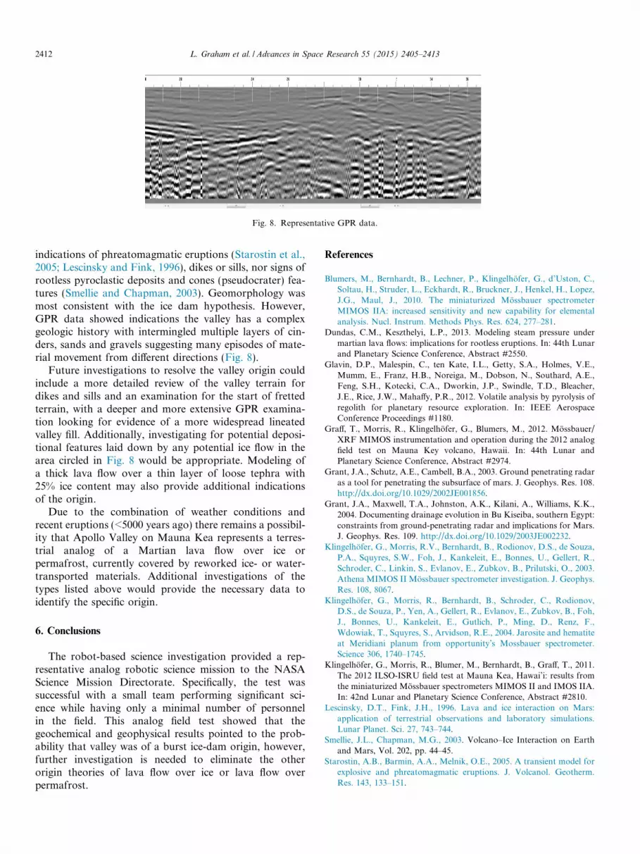
Fig. 8. Representative GPR data.
2412 L. Graham et al. / Advances in Space Research 55 (2015) 2405–2413
indications of phreatomagmatic eruptions (Starostin et al.,2005; Lescinsky and Fink, 1996), dikes or sills, nor signs ofrootless pyroclastic deposits and cones (pseudocrater) fea-tures (Smellie and Chapman, 2003). Geomorphology wasmost consistent with the ice dam hypothesis. However,GPR data showed indications the valley has a complexgeologic history with intermingled multiple layers of cin-ders, sands and gravels suggesting many episodes of mate-rial movement from different directions (Fig. 8).
Future investigations to resolve the valley origin couldinclude a more detailed review of the valley terrain fordikes and sills and an examination for the start of frettedterrain, with a deeper and more extensive GPR examina-tion looking for evidence of a more widespread lineatedvalley fill. Additionally, investigating for potential deposi-tional features laid down by any potential ice flow in thearea circled in Fig. 8 would be appropriate. Modeling ofa thick lava flow over a thin layer of loose tephra with25% ice content may also provide additional indicationsof the origin.
Due to the combination of weather conditions andrecent eruptions (<5000 years ago) there remains a possibil-ity that Apollo Valley on Mauna Kea represents a terres-trial analog of a Martian lava flow over ice orpermafrost, currently covered by reworked ice- or water-transported materials. Additional investigations of thetypes listed above would provide the necessary data toidentify the specific origin.
6. Conclusions
The robot-based science investigation provided a rep-resentative analog robotic science mission to the NASAScience Mission Directorate. Specifically, the test wassuccessful with a small team performing significant sci-ence while having only a minimal number of personnelin the field. This analog field test showed that thegeochemical and geophysical results pointed to the prob-ability that valley was of a burst ice-dam origin, however,further investigation is needed to eliminate the otherorigin theories of lava flow over ice or lava flow overpermafrost.
References
Blumers, M., Bernhardt, B., Lechner, P., Klingelhofer, G., d’Uston, C.,Soltau, H., Struder, L., Eckhardt, R., Bruckner, J., Henkel, H., Lopez,J.G., Maul, J., 2010. The miniaturized Mossbauer spectrometerMIMOS IIA: increased sensitivity and new capability for elementalanalysis. Nucl. Instrum. Methods Phys. Res. 624, 277–281.
Dundas, C.M., Keszthelyi, L.P., 2013. Modeling steam pressure undermartian lava flows: implications for rootless eruptions. In: 44th Lunarand Planetary Science Conference, Abstract #2550.
Glavin, D.P., Malespin, C., ten Kate, I.L., Getty, S.A., Holmes, V.E.,Mumm, E., Franz, H.B., Noreiga, M., Dobson, N., Southard, A.E.,Feng, S.H., Kotecki, C.A., Dworkin, J.P., Swindle, T.D., Bleacher,J.E., Rice, J.W., Mahaffy, P.R., 2012. Volatile analysis by pyrolysis ofregolith for planetary resource exploration. In: IEEE AerospaceConference Proceedings #1180.
Graff, T., Morris, R., Klingelhofer, G., Blumers, M., 2012. Mossbauer/XRF MIMOS instrumentation and operation during the 2012 analogfield test on Mauna Key volcano, Hawaii. In: 44th Lunar andPlanetary Science Conference, Abstract #2974.
Grant, J.A., Schutz, A.E., Cambell, B.A., 2003. Ground penetrating radaras a tool for penetrating the subsurface of mars. J. Geophys. Res. 108.http://dx.doi.org/10.1029/2002JE001856.
Grant, J.A., Maxwell, T.A., Johnston, A.K., Kilani, A., Williams, K.K.,2004. Documenting drainage evolution in Bu Kiseiba, southern Egypt:constraints from ground-penetrating radar and implications for Mars.J. Geophys. Res. 109. http://dx.doi.org/10.1029/2003JE002232.
Klingelhofer, G., Morris, R.V., Bernhardt, B., Rodionov, D.S., de Souza,P.A., Squyres, S.W., Foh, J., Kankeleit, E., Bonnes, U., Gellert, R.,Schroder, C., Linkin, S., Evlanov, E., Zubkov, B., Prilutski, O., 2003.Athena MIMOS II Mossbauer spectrometer investigation. J. Geophys.Res. 108, 8067.
Klingelhofer, G., Morris, R., Bernhardt, B., Schroder, C., Rodionov,D.S., de Souza, P., Yen, A., Gellert, R., Evlanov, E., Zubkov, B., Foh,J., Bonnes, U., Kankeleit, E., Gutlich, P., Ming, D., Renz, F.,Wdowiak, T., Squyres, S., Arvidson, R.E., 2004. Jarosite and hematiteat Meridiani planum from opportunity’s Mossbauer spectrometer.Science 306, 1740–1745.
Klingelhofer, G., Morris, R., Blumer, M., Bernhardt, B., Graff, T., 2011.The 2012 ILSO-ISRU field test at Mauna Kea, Hawai’i: results fromthe miniaturized Mossbauer spectrometers MIMOS II and IMOS IIA.In: 42nd Lunar and Planetary Science Conference, Abstract #2810.
Lescinsky, D.T., Fink, J.H., 1996. Lava and ice interaction on Mars:application of terrestrial observations and laboratory simulations.Lunar Planet. Sci. 27, 743–744.
Smellie, J.L., Chapman, M.G., 2003. Volcano–Ice Interaction on Earthand Mars, Vol. 202, pp. 44–45.
Starostin, A.B., Barmin, A.A., Melnik, O.E., 2005. A transient model forexplosive and phreatomagmatic eruptions. J. Volcanol. Geotherm.Res. 143, 133–151.

L. Graham et al. / Advances in Space Research 55 (2015) 2405–2413 2413
ten Kate, I.L., Cardiff, E.H., Dworkin, J.P., Feng, S.H., Holmes, V.,Malespin, C., Stern, J., Swindle, T.D., Glavin, D.P., 2010. VAPoR –volatile analysis by pyrolysis of regolith – an instrument for in situdetection of water, noble gases, and organics on the Moon. Planet.Space Sci. 58, 1007–1017.
ten Kate, I.L., Armstrong, R., Bernhardt, B., Blumers, M., Craft, J.,Boucher, D., Caillibot, E., Captain, J., D’Eleuterio, G.M.T., Farmer,
J.D., Glavin, D.P., Graff, T., Hamilton, J.C., Klingelhofer, G., Morris,R.V., Nunez, J.I., Quinn, J.W., Sanders, G.B., Sellar, R.G., Sigurdson,L., Taylor, R., Zacny, K., 2013. Mauna Kea, Hawai’i, as an analoguesite for future planetary resource exploration: results from the 2010ILSO-ISRU field-testing campaign. J. Aerosp. Eng. 26 (1), 183–196.http://dx.doi.org/10.1061/(ASCE)AS.1943-5525.0000200.


