Embed Size (px)
Citation preview

PIANC Guidance Document n° 124 - 2014
DreDging anD Port ConstruCtion: interaCtions with Features
oF arChaeologiCal or heritage interest
PIANC‘Setting the Course’
the world association for waterborne transport infrastructure

DreDging anD Port ConstruCtion: interaCtions with Features oF
arChaeologiCal or heritage interest
PianC guiDanCe DoCuMent n° 124gu enVironMental naVigation CoMMission
2014
PianCthe world association for
waterborne transport infrastructure

PIANC has Technical Commissions concerned with inland waterways and ports (InCom), coastal and ocean waterways (including ports and harbours) (MarCom), environmental aspects (EnviCom) and sport and pleasure navigation (RecCom).
This Report has been produced by an international Working Group convened by the En-vironmental Commission (EnviCom). Members of the Working Group represent several countries and are acknowledged experts in their profession.
The objective of this report is to provide information and recommendations on good practice. Conformity is not obligatory and engineering judgement should be used in its application, especially in special circumstances. This report should be seen as an expert guidance and state of the art on this particular subject. PIANC disclaims all responsibility in case this report should be presented as an official standard.
PianC secrétariat généralBoulevard du roi albert ii 20, B 3
B-1000 BruxellesBelgique
http://www.pianc.org
Vat Be 408-287-945
isBn 978-2-87223-221-5
© all rights reserved

I
Contents
1 INTRODUCTION............................................................................................................................ 1
2 CONTEXT...................................................................................................................................... 3
2.1 Overarching Global Policy and Guidance ....................................................................................... 3 International Council on Monuments and Sites (ICOMOS) Charter on the Protection and Management of Underwater Cultural Heritage (1996) ........................................................... 3 Convention Concerning the Protection of the World Cultural and Natural Heritage (the World Heritage Convention) (1972) ................................................................................................ 3 UNESCO Convention on the Protection of the Underwater Cultural Heritage (2001) ............. 3 United Nations Convention on the Law of the Sea (UNCLOS) (1982).................................... 4
2.2 Establishing the Relevant Regulatory Context ................................................................................ 4
2.3 Environmental Impact Assessment ................................................................................................. 6
2.4 Working with Nature ....................................................................................................................... 8
3 SCOPING ...................................................................................................................................... 9
3.1 Communication .............................................................................................................................. 9
3.2 Establishing Risk .......................................................................................................................... 10
3.3 Obtaining Data ............................................................................................................................. 11
4 ASSESSMENT ............................................................................................................................ 14
4.1 Desk-Based Assessment ............................................................................................................. 14
4.2 Geophysical and Geotechnical Survey ......................................................................................... 16
4.3 Ground-Truthing ........................................................................................................................... 20
4.4 Summary, Reporting and Archives ............................................................................................... 22
4.5 Impact Assessment ...................................................................................................................... 25 Assessing the Importance of Heritage ................................................................................ 25 Identifying Impacts ............................................................................................................. 26 Assessing Significant Effects .............................................................................................. 28
4.6 Mitigation and the Implementation of Measures ............................................................................ 29 Documenting the Mitigation Plan ........................................................................................ 29 Mitigation Hierarchy ............................................................................................................ 30 Avoidance (Preservation in Situ) ......................................................................................... 30 Offsetting Effects (Preservation by Record) ........................................................................ 31
5 CONCLUSIONS .......................................................................................................................... 38
6 BIBLIOGRAPHY.......................................................................................................................... 40
APPENDIX I: .............................................................................................................................................. 47 Strategic Context. Belgium’s Maritime Archaeological Challenges: Balancing the Economic Need with the Commitment to the UNESCO-Convention on Underwater Cultural Heritage (Authors: Marnix Pieters, Ine Demerre and Sven Van Haelst)
APPENDIX II: ............................................................................................................................................. 53 London Gateway Port Development: Sampling and Mitigation in Practice (Authors: Gill Andrews and Toby Gane)
APPENDIX III: ............................................................................................................................................ 59 Appendix III: Southampton Approach Channel Dredge: Geophysical, Archaeological and Geoarchaeological Investigations (Authors: Jack Russell and Sue Simmonite)
APPENDIX IV: ............................................................................................................................................ 65 Appendix IV: Shipwreck Investigation in the Port of Pori, Finland (Author: Maija Matikka)

II
APPENDIX V: ............................................................................................................................................. 73 Appendix V: The Monitoring Programme for Archaeology in the Maasvlakte 2 Construction Project, Port of Rotterdam (Authors: H.J.T. Weerts and W.G. Borst)
APPENDIX VI: ............................................................................................................................................ 76 Appendix VI: The Sea Way to the Port of Eemshaven and the Outer Harbour Mooring of Doekegat Rede: an Example of the Work-Through Process of Archaeological Investigations in The Netherlands (Author: Johan Opdebeeck)
APPENDIX VII: ........................................................................................................................................... 85 Appendix VII: Archaeological Monitoring of the Dredging for the Immersed Tunnel, Oslo, Norway. Rescuing Archaeological Heritage (Authors: Tori Falck and Jostein Gundersen)
APPENDIX VIII: .......................................................................................................................................... 97 Appendix VIII: Learning the Hard Way: Two South African Examples of Issues Related to Port Construction and Archaeology (Author: John Gribble)
APPENDIX IX: .......................................................................................................................................... 108 Appendix IX: Harbour Planning and Beneficial Use Strategy from a Cultural Resource Perspective: Mobile Harbour’s Archaeology and Channel Maintenance (Authors: Michael P. Fedoroff, Jeffrey M. Enright, Nick Linville and Larry Parson)

III
Background
In early 2013, PIANC’s EnviCom confirmed the need for a good practice guide to enable the navigation community to deal with features of archaeological and heritage interest in the development of navigation infrastructure projects. Whilst archaeology and heritage are clearly of great importance to certain new infrastructure projects, there are relatively few specialists in these disciplines within the existing PIANC Community. As such, the conventional approach of setting up a Working Group to prepare a technical guidance document was not appropriate. A different approach was therefore needed and Wessex Archaeology, a UK-based specialist organisation, agreed to assist PIANC in its endeavours. During 2013, PIANC EnviCom worked with Wessex Archaeology’s Coastal and Marine Director to organise a workshop. A number of specialists with relevant international experience and expertise were invited to prepare case study examples for presentation and discussion. The workshop was held at PIANC Headquarters in Brussels, Belgium in November 2013. The purpose of this workshop was to highlight a series of case studies and encourage an exchange of information on good practice in dealing with archaeological and heritage interests. The event was extremely successful in this respect and many useful contributions were made by workshop participants as well as by the presenters. Its outcomes were then collated by Diana Donohue, Victoria Cooper and Euan McNeill of Wessex Archaeology and used, together with written case studies, in the preparation of this guidance.
Keywords Coastal archaeology; marine archaeology; underwater cultural heritage; submerged prehistory; coastal occupation; maritime archaeology; aviation archaeology; dredging and port construction
Acknowledgements PIANC wishes to put on record the Association’s gratitude to Wessex Archaeology for their hard work in translating the workshop outcomes into this good practice guidance.
PIANC also acknowledges the contributions of the following individuals who prepared and/or presented the case study examples: Australia: Peta Knott, Wessex Archaeology. Belgium: Marnix Pieters, Director of International Activities Flanders Heritage Agency
Ine Demerre, Maritime Heritage Researcher Sven Van Haelst, Maritime Heritage Researcher
England: Gill Andrews, Cultural Heritage Consultant
Toby Gane, Wessex Archaeology Jack Russell, Wessex Archaeology Sue Simmonite, Associated British Ports
Finland: Maija Matikka, Superintendent, National Board of Antiquities Netherlands: Wil Borst (Port of Rotterdam)
Johan Opdebeeck (Cultural Heritage Agency) Henk Weerts (Cultural Heritage Agency) Norway: Tori Falck, Norwegian Maritime Museum
Jostein Gundersen, Directorate for Cultural Heritage

IV
South Africa: John Gribble, Sea Change Heritage Consultants USA: Michael P. Fedoroff, United States Army Corps of Engineers, Mobile District
Jeffrey M. Enright, Southeastern Archaeological Research Nick Linville, Southeastern Archaeological Research Larry Parson, United States Army Corps of Engineers, Mobile District
Finally, PIANC offers its thanks to Chris Pater of English Heritage for chairing the workshop and to all those who attended the workshop and contributed by way of follow-up correspondence.

1
1 INTRODUCTION
1.1.1 This guidance document is intended to promote the development of good practice for dredging and port construction in relation to underwater cultural heritage, comprising the physical remains of past cultures including:
Submerged prehistory – evidence of the occupation of prehistoric landscapes at times of lowered sea level
Coastal occupation – evidence of activities from the historic coastline that have been subsumed by the sea, due to erosion or flooding for example
Maritime – evidence dating from the prehistoric period to the modern era relating to human exploitation of the sea
Aviation – evidence dating from the advent of fixed wing-aviation in the early 1900s to c. the mid-20th century
1.1.2 Marine heritage is a valuable, fragile, finite and non-renewable resource and physical
impacts arising from dredging and port construction can result in permanent adverse effects. However, statutory protection for underwater cultural heritage is variable internationally and the need to consider these physical impacts is often poorly understood.
1.1.3 PIANC1 (The World Association for Waterborne Transport Infrastructure) is a professional body dedicated to the promotion of good practice inter alia for those working in the field of
dredging and port construction. PIANC has a number of permanent Commissions dealing with marine, inland and recreational navigation issues. There is also an Environment Commission, PIANC EnviCom. The need for technical guidance based on international good practice in areas of archaeological and heritage sensitivity was identified by EnviCom and in November 2013 an international workshop was held in Brussels, Belgium, to share examples of good practice. This guidance document is informed by the outcomes of the workshop, including case studies presented by leading experts in the field, so as to highlight lessons learned with regard to five vital steps in the assessment of potential impacts on features of archaeological and heritage interest:
Context: understanding the strategic and local context within which a scheme or project is planned
Scoping: understanding which type of impacts might be expected
Assessing: collecting data; understanding how archaeology and heritage interests might be impacted and the effects of such impacts
Mitigating: applying the mitigation hierarchy to avoid or minimise adverse effects
Measures: implementing measures, for example to protect the features of interest
1.1.4 The case studies presented at the workshop are included in full as appendices to this
document:
Belgium:
o Appendix I: ‘Strategic Context. Belgium’s Maritime Archaeological Challenges: Balancing the Economic Need with the Commitment to the UNESCO-Convention on Underwater Cultural Heritage’ Authors: Marnix Pieters, Ine Demerre and Sven Van Haelst
1 www.pianc.org

2
England:
o Appendix II: ‘London Gateway Port Development: Sampling and Mitigation in Practice’ Authors: Gill Andrews and Toby Gane
o Appendix III: ‘Southampton Approach Channel Dredge: Geophysical, Archaeological and Geoarchaeological Investigations’ Authors: Jack Russell and Sue Simmonite
Finland:
o Appendix IV: ‘Shipwreck Investigation in the Port of Pori, Finland’
Author: Maija Matikka
The Netherlands:
o Appendix V: ‘The Monitoring Programme for Archaeology in the Maasvlakte 2 Construction Project, Port of Rotterdam’ Authors: H.J.T. Weerts and W.G. Borst
o Appendix VI: ‘The Sea Way to the Port of Eemshaven and the Outer Harbour Mooring of Doekegat Rede: An Example of the Work-through Process of Archaeological Investigations in The Netherlands’ Author: Johan Opdebeeck
Norway:
o Appendix VII: ‘Archaeological Monitoring of the Dredging for the Immersed Tunnel,
Oslo, Norway. Rescuing Archaeological Heritage’ Authors: Tori Falck and Jostein Gundersen
South Africa:
o Appendix VIII: ‘Learning the Hard Way: Two South African Examples of Issues
Related to Port Construction and Archaeology’ Author: John Gribble
USA
o Appendix IX: ‘Harbour Planning and Beneficial Use Strategy from a Cultural Resource Perspective: Mobile Harbour’s Archaeology and Channel Maintenance’ Authors: Michael P. Fedoroff, Jeffrey M. Enright, Nick Linville and Larry Parson
1.1.5 This document is relevant to any group or individual involved in planning dredging and port
construction projects including regulatory and planning authorities, archaeological and heritage curators, developers, port authorities and harbour commissioners, contractors, archaeological consultants/contractors and all other stakeholders.
1.1.6 The advice focuses on projects that may impact the underwater cultural heritage, i.e. archaeology in the marine environment and throughout the document examples are drawn from the case studies presented in the appendices. It is important to remember, however, that port construction projects often traverse the boundary between land and sea and that archaeology in terrestrial and intertidal areas may also need to be accounted for when planning port construction projects. While much of the advice presented here may also be relevant to these environments, consideration of the issues that are specific to archaeology above low water is beyond the scope of the document.

3
2 CONTEXT
2.1 Overarching Global Policy and Guidance
2.1.1 This guidance has been prepared where applicable in accordance with available and relevant global policy and guidance relating to the management and protection of underwater cultural heritage. The overarching regulatory context relevant to this guidance document can be summarised as follows
International Council on Monuments and Sites (ICOMOS) Charter on the Protection and Management of Underwater Cultural Heritage (1996)2
2.1.2 The ICOMOS is a non-governmental international organisation dedicated to the
conservation of the world’s monuments and sites. This Charter encourages the protection and sensitive management of underwater cultural heritage and includes a series of statements regarding best practice. The intention of the Charter is to assist in bringing a high standard of archaeological expertise to bear on threats to underwater cultural heritage imposed by construction works in a prompt and efficient manner (amongst other such threats). The underwater cultural heritage is recognised in the Charter as an international resource which is both finite and non-renewable. The Charter ensures that all investigations are explicit in their aims, methodology and anticipated results so that the intention of each project is transparent to all.
2.1.3 The ICOMOS currently has 101 National committees. Contact details are available from the ICOMOS website3.
Convention Concerning the Protection of the World Cultural and Natural Heritage (the World Heritage Convention) (1972)4
2.1.4 Each State Party to this Convention recognises that the identification, protection,
conservation, presentation and transmission to future generations of the cultural and natural heritage, situated on its territory, belongs primarily to that State. Each State Party should therefore ensure that effective and active measures are taken for the protection and conservation of the cultural natural heritage situated on its territory.
2.1.5 As of September 2012, there are 191 State Parties which have adhered to the World Heritage Convention. Details of the Ratification Status for each of the State Parties can be found on the World Heritage Convention website5.
UNESCO Convention on the Protection of the Underwater Cultural Heritage (2001)6
2.1.6 The UNESCO Convention is a comprehensive attempt to codify the law internationally with
regards to underwater archaeological heritage with the intention of enabling State Parties to better protect this heritage. The Convention sets out basic principles for the protection of underwater cultural heritage, provides a detailed State co-operation system and provides practical Rules for the treatment and research of underwater cultural heritage. Ratifying members therefore have an obligation to preserve their underwater cultural heritage according to their capabilities.
2 http://www.international.icomos.org/charters/underwater_e.pdf 3 http://www.icomos.org/images/DOCUMENTS/Secretariat/Adresses/adresses-cn.pdf 4 http://whc.unesco.org/en/convention/ 5 http://whc.unesco.org/en/statesparties/ 6 http://www.unesco.org/new/en/culture/themes/underwater-cultural-heritage/

4
2.1.7 There are currently 48 State Parties which have adhered to the Convention. Details of the Ratification Status for each of the State Parties can be found on the UNESCO website7.
United Nations Convention on the Law of the Sea (UNCLOS) (1982)8
2.1.8 UNCLOS stipulates that states have the duty to protect objects of an archaeological and
historical nature found at sea. The law provides for coastal states to exert a degree of control over archaeological heritage resources 24 nautical miles from their respective territories. However, Article 95 states that, “warships on the high seas have complete immunity from the jurisdiction of any State other than the flag State”. This means that when a wreck of a warship or military aircraft is found, the flag state must be informed.
2.1.9 As of October 2013 there are 166 ratifications of, accessions and successions to the Convention. Details can be found on the United Nations website9.
The wreck of HMS A1, Britain's first commissioned submarine is a designated historic wreck under the Protection of Wrecks Act 1973. This picture was produced by using multi-beam and single
beam echosounders and sidescan sonar to map the different levels of the seabed. The data is put into a software programme called Fledermaus which converts it into an image.
2.2 Establishing the Relevant Regulatory Context
2.2.1 Despite the overarching regulatory context outlined above, the responsibility for the
underwater cultural heritage within a legal framework is not without complexities. Consideration of archaeology and heritage may be subsumed within local, regional or national planning regulations yet there may be no provision for archaeology and heritage below high water. Developmental constraints within the marine environment are frequently governed by an entirely different system from that on land, a particular difficulty for port developments straddling the intertidal boundary between terrestrial and marine resources.
2.2.2 It is paramount that the strategic and local context within which a scheme or project is planned is well understood at the onset of a project so that it can be managed effectively throughout the development process. Retrospective consideration of the legal obligations to consider heritage resources once a project is underway can often prove costly in both time delays and financial outlay.
7 http://www.unesco.org/eri/la/convention.asp?KO=13520&language=E&order=alpha 8 http://www.un.org/Depts/los/convention_agreements/convention_overview_convention.htm 9 http://www.un.org/Depts/los/reference_files/chronological_lists_of_ratifications.htm#The United Nations Convention on the Law of the Sea

5
2.2.3 Advice on the regulatory framework can be obtained from regulators or curators within the country, state or region in which a development is located. Within the countries presented in the case studies, for example, advice may be sought from:
Belgium:
o Flanders: Agency for Arts and Heritage and FARO (Flemish interface centre for cultural heritage)
Box 1.1: Case Study – Belgium
The regulatory context in Belgium provides one such example where the application of several different legal regimes can pose a major challenge to the management of underwater cultural heritage. Belgium is a federal state consisting of three regions (Flanders, Brussels Capital Region and Wallonia) and three communities (Flemish, French and German speaking). The regions essentially have responsibility for archaeology as it is considered to represent a territorial issue. However, should archaeological objects and documentation be transferred to a museum or archive, they are considered to represent a cultural issue and are therefore the responsibility of the communities.
Three zones can be identified within the Belgian part of the North Sea: (1) the intertidal zone, (2) the territorial sea and (3) the areas beyond the territorial sea (the continental shelf and the Exclusive Economic Zone (EEZ)). As Flanders is the only region in Belgium with a coastline, it has responsibility for the underwater cultural heritage within the intertidal zone. In the North Sea, the federal state has a so called residual competence on archaeology, as the North Sea as a territory belongs to neither a region nor a community. In addition, the management of heritage assets within Belgian rivers is subject to a different legal regime in every region. If a river comprises part of a state boundary, the responsibility for these assets is once more split up.
Belgium ratified the UNESCO Convention on August 5, 2013 and thereby has an obligation to preserve its underwater cultural heritage. As such there is an obvious need for dredging and port development proposals to work within a framework which harmonises the different approaches described above whilst achieving this aim. For this to operate with success, an awareness of the regulatory context for the marine historic environment is essential from the onset of a project. The SeArch project seeks to address these issues through preparing a correct implementation process relating to the commitments imposed by international conventions whilst developing comprehensive proposals for a transparent and sustainable management policy operating within the legal framework relevant to underwater cultural heritage in Belgium. Further details about this
case study can be found in Appendix I.
Box 1.2: Case Study – Norway The legal framework in Norway, by way of comparison, is far more straightforward than the one in Belgium. The Norwegian Cultural Heritage Act (1978) protects underwater archaeological remains older than 100 years and states that the developer has a duty to consider whether the project will affect protected archaeological sites or monuments before construction work begins. If a project has the potential to affect archaeological remains, the Directorate for Cultural Heritage (Riksantikvaren) decides if, and on what conditions, the project can be carried out. The act also
states that the developer has to pay for any means necessary to fulfil these conditions. Further
details about this case study can be found in Appendix VII.

6
o Brussels: Monuments and Sites
o Wallonia: Walloon Heritage Institute
England: English Heritage, the Marine Management Organisation, Local Government Archaeology Officers
Finland: National Board of Antiquities
The Netherlands: Netherlands Cultural Heritage Agency (RCE)
Norway: Norwegian Directorate for Cultural Heritage Management (National) and County Municipalities (Regional)
South Africa: South African Heritage Resources Agency
USA: National Park Service, Advisory Council on Historic Preservation, National Oceanographic and Atmospheric Administration and State Historic Preservation Officers.
2.2.4 Advice may also be sought from professional archaeological or heritage consultants.
Engagement of an archaeologist early in the life of a project may incur an initial cost, but can ultimately provide substantial cost benefits to port owners or developers in ensuring that suitable strategies to address heritage issues are followed from the start. An experienced professional will provide advice based upon their local knowledge and understanding of the context within which a project is planned and will consequently help owners and developers to minimise their commercial risk with respect to underwater cultural heritage.
2.2.5 A lower cost option may be to seek advice from local archaeologists or local clubs and societies. Local volunteer groups may also provide assistance during subsequent stages of archaeological assessment, including fieldwork. However, it should be borne in mind that while individuals, clubs or societies may have a clear understanding of the local context, they may not have sufficient experience of working within the regulatory environment. The engagement of a suitably qualified, experienced professional should, therefore, be considered preferable.
2.3 Environmental Impact Assessment
As illustrated in Box 1.3, the Environmental Impact Assessment (EIA) process includes steps to summarise the baseline environment, highlight the likely significance of effects of the proposed project and outline the mitigation measures adopted as part of the scheme. Consideration of the historic environment forms a key component of EIA, including the underwater cultural heritage for projects with marine elements. Within many regulatory contexts, EIAs comprise a mandatory part of the planning application process and ensure that the environmental implications of planning decisions are fully considered before a decision is made regarding consent for a project.

7
Box 1.3: Key Steps in the Environmental Impact Assessment Process
ESTABLISH REGULATORY CONTEXT:
Determine whether there is a legal requirement for formal impact assessment
CONSULTATION: Seek advice from curators or regulators, heritage consultants, groups or societies
SCOPING: Identify the potentially significant environmental impacts of the
project
CONSULTATION: Establish early communication between key stakeholders
DATA COLLECTION:
Research, collate and collect relevant data. Undertake additional surveys where necessary
CONSULTATION: Seek advice from curators or regulators, heritage consultants or archives/data offices
ASSESSMENT: Carry out investigations to establish the nature and significance of
impacts
CONSULTATION: Seek advice from curators or regulators or heritage consultants
MITIGATION: Identify and implement measures needed to avoid, minimise,
mitigate, manage or compensate for potentially significant impacts
CONSULTATION: To be agreed with the planning authorities, regulator or curator
REPORTING:
Prepare an Environmental (Impact) Statement to inform decision making
CONSULTATION: Supplied to and reviewed by the planning authorities, regulator or curator
MONITORING & REVIEW:
(If development is approved) monitor the predicted effects and the success of the mitigation measures. Review the results and follow
up as necessary
CONSULTATION: Sustain communications with the planning authorities, regulator or curator

8
2.3.1 In Europe, Directive 2011/92/EU sets out the requirement for EIA to identify, describe and assess in an appropriate manner, the direct and indirect effects (see Section 4.4) of a project on environmental factors including material assets and the historic environment:
A description of the aspects of the environment likely to be significantly affected by the proposed project, including, in particular, population, fauna, flora, soil, water, air, climatic factors, material assets, including the architectural and archaeological heritage, landscape and the interrelationship between the above factors.(Directive 2011/92/EU, Annex IV: 3)
2.3.2 In the USA, the National Environmental Policy Act (NEPA) requires federal agencies to
integrate environmental values into their decision making processes through a detailed statement known as an ‘Environmental Impact Statement’, considering the environmental impacts of their proposed actions and reasonable alternatives to those actions. Additionally, projects undertaken by Federal Agencies in the US are required to take into account impacts to cultural resources per the National Historic Preservation Act (Section 106). Even with a project that does not require NEPA, effects to cultural resources must still be evaluated by the Federal Agency. Furthermore, although certain projects have categorical exclusions for NEPA, cultural and heritage resources can never be categorically excluded.
2.3.3 Not all projects will require formal EIA and advice on the requirements for any given project should be sought from planning authorities, regulators or curators at the very start of planning any dredging or port construction project.
2.4 Working with Nature
2.4.1 PIANC’s Working with Nature philosophy (http://www.pianc.org/workingwithnature.php;
also Brooke, 2013) promotes a change in how navigation infrastructure projects are developed in their early stages. Specifically, Working with Nature encourages the project
proponent to identify and understand the characteristics of the natural and physical environment before making decisions about project design.
2.4.2 This philosophy applies equally to consideration of archaeology or heritage. Wherever it is practicable to do so, initial desk studies should therefore be undertaken – and dialogue with relevant local stakeholders should be commenced – prior to beginning the formal EIA process. This facilitates an early understanding of the likelihood of there being significant archaeological or heritage features in the general vicinity of the project.
2.4.3 If desk studies do identify such potential interest, consideration can be given to how the project might best proceed without unnecessarily damaging the resource in question. Depending on the location and nature of the features of interest, solutions could range from designing the project so as to avoid damage or destruction, to agreeing ways of showcasing the archaeology or heritage feature(s) as part of the project design – in turn enabling others to understand and appreciate its value.
2.4.4 If this type of knowledge can be realised before the design process begins, the developer will still have the widest possible range of options available. Action can therefore be agreed upon and taken to accommodate the archaeology or heritage interest. Applying the Working with Nature philosophy early can thus enable project promoters to avoid or reduce potential
delays and any associated extra costs.
2.4.5 Working with Nature can complement EIA. Depending on the point at which the formal EIA process begins, the Working with Nature philosophy might be applied before the EIA
commences or – as long as there is still sufficient flexibility in terms of design options – during the scoping and early desk study data collection stages.

9
3 SCOPING
3.1 Communication
3.1.1 In accordance with PIANCS’s Working with Nature philosophy, the main aim of the ‘scoping’ stage is to facilitate an early understanding of which type of impacts might be experienced i.e. in advance of assessment. A key component of gaining this understanding is through effective communication with key stakeholders from the outset of a project. In the first instance, the key stakeholders will comprise the developers and the archaeological curators (or regulators). In addition, as it is typically the responsibility of the developer, not the archaeological curators, to carry out archaeological assessment, this group of key stakeholders may also include heritage specialists or archaeological consultants commissioned by the developer to undertake such work.
3.1.2 It is essential that communication between the curatorial authorities, archaeological consultants and developers is established early in the development process so that any potential issues or factors can be addressed appropriately and reliably quantified, enabling risks to both the scheme and the historic environment to be stated and, where possible, avoided or minimised. Such early communication will allow for assessment results and proposed mitigation measures to be discussed and agreed and will ensure the developers awareness of the potential for archaeological remains to exist within the proposed development footprint at an early stage.
3.1.3 Through establishing well-founded lines of communication in the early stages of development, communication can continue to take place between key stakeholders throughout the duration of the project. Consultation with other parties of interest should also be considered as part of the scoping exercise. Such parties may include, but are not confined to, local historic societies, community groups, local industries (e.g. fishermen, divers) or indigenous people and local populations. In certain circumstances, for example where a project traverses the boundaries between states or countries, or where a wreck of a ship from a foreign flag state is located within a project boundary, stakeholders may also be international. VOC (Dutch East India Company) shipwrecks, for example, remain the property of the Dutch government regardless of location, whilst non-commercial naval warships, state vessels, aircraft and associated artefacts are provided Sovereign Immunity under customary international law. If historical account of loss of life is associated with a heritage asset located within the proposed development footprint, individuals or groups associated with such loss should also be contacted. It is desirable that development proposals take place with the consent and endorsement of such communities and groups where possible.
Box 1.4: Case Study – Algoa Bay, South Africa A lack of engagement by the port developer with the maritime archaeological potential of the development area during the EIA process resulted in the very late addressing of archaeological concerns. Initial assessments of the potential environmental impacts of the development made no reference to the maritime archaeological potential of the area, despite repeated requests from archaeological stakeholders to consider the presence of wrecks in the area. A tender for a maritime archaeological assessment of the proposed development area was eventually issued more than a year after the completion of the EIA process and after the construction of the port had already been authorised. These archaeological investigations identified a large wreck in the proposed development area and harbour construction and dredging work was delayed in the environs of the wreck until a permit was obtained from the heritage authorities to remove it. A limited amount of archaeological information was retrieved during the controlled wreck removal.
Further details about this case study can be found in Appendix VIII.

10
3.2 Establishing Risk
3.2.1 A key factor for consideration during scoping is the identification of which type of impacts
might be experienced during the proposed project:
to identify the potential for negative effects upon archaeological material and the mitigation that may be required to prevent significant effects from occurring
to establish and minimise the commercial risk to development associated with unexpected and unmitigated impacts to underwater cultural heritage
3.2.2 Further detail on the types of impact that might occur is provided in Section 4.4.
3.2.3 Awareness of the potential for archaeological remains to exist, in a variety of contexts, is essential to the early identification of potential commercial risks. The case studies which accompany this guidance document demonstrate that heritage assets can be preserved in even the most unlikely of environments (e.g. within areas which have been subject to regular dredging, where it is considered that any such archaeological remains would have been destroyed by previous invasive activities such as the Port of Pori, Finland). Consequently, developers should not make assumptions about heritage risks or likelihood of encountering archaeological material, even if an area has been previously dredged.
3.2.4 In accordance with PIANC’s Working with Nature philosophy, early consideration of the potential risks associated with impacts to the underwater cultural heritage can also serve to raise awareness of the costs involved with investigation, assessment and mitigation. Unexpected discoveries can lead to significant unexpected costs, even if this is not considered as a heritage issue, for example in the removal of large anthropogenic objects such as modern wrecks or unexploded ordnance (UXO). The methodologies employed in assessing cultural heritage (see Section 4) are frequently also effective in the identification of risk with regard to such obstructions, irrespective of heritage values. When cultural heritage issues are taken into account at an early stage of the planning process, provisions can be made for appropriate investigation to understand and minimise the costs in sufficient time so that they do not present constraints to the developer further through the process.
Box 1.5: Generic Types of Stakeholders
Developers
Archaeological Curators/Regulators
Tribal Governments (in the USA, for example)
Heritage Specialists/Archaeological consultants
Local/ National Interest Groups or Historic Societies
Community Groups
Fishermen
Divers
Port and Navigation Authorities

11
3.2.5 As part of the scoping exercise, a timetable should be assured in advance of any investigation to ensure that adequate time is granted to the necessary elements of the development process. This time table should take into account contingency plans so that underwater cultural heritage is afforded adequate consideration despite the occurrence of any interruption in anticipated timings.
3.3 Obtaining Data
3.3.1 All scoping studies will include a data gathering exercise that will inform the identification of
potential risks. This will include both archaeological and historical data on the submerged prehistory, coastal occupation, maritime and aviation potential within the proposed project footprint and data relating to the proposed project, including details of the development and the proposed approach to dredging or port construction.
Recording on the Swash Channel wreck site. © Crown copyright, photo taken by Wessex Archaeology
Box 1.6: Case Study – Port of Pori, Finland The development at the Port of Pori, Finland, provides an example whereby communication between archaeologists and developers was delayed at the early stages of the project and the potential risks were not fully understood. Although the project was ultimately able to proceed with both the protection of the cultural heritage and the port’s interests being taken into consideration, information regarding the construction project by the Port of Pori only reached the National Board of Antiquities when the implementation of the project was nearly at hand and the presence of a wreck site caused great concerns over the delay of the project. In response, the National Board of Antiquities had to react promptly, relying on geophysical data provided by an independent source to supplement initial investigations of the wreck. In order to manage the development of the port efficiently, the contractors should have been aware of the potential of cultural heritage at the outset of the project so that an archaeological survey could be undertaken at an early stage in the project planning to map the known and potential coastal and marine
historic environment. Further details about this case study can be found in Appendix IV.

12
3.3.2 The provision of existing records of archaeological sites and finds varies between individual countries and sometimes between individual states or regions. It may also be the case that a comprehensive database of sites and monuments exists for terrestrial archaeology but that no records are kept pertaining to the underwater cultural heritage. Publicly accessible, national, local or regional archives, however, will represent the starting point for data searches in most contexts. Examples of accessible archives within the countries presented in the case studies are as follows:
Belgium: Beschermd erfgoed (Flemish National Heritage Sites)10, Brussels Monuments and Sites11 and Walloon Heritage Institute12
England: National Record of the Historic Environment13, National Heritage List14, county Historic Environment Record/Sites and Monuments Records15, United Kingdom Hydrographic Office wrecks and obstructions database16
10 https://www.onroerenderfgoed.be/ 11 http://www.crms.irisnet.be/fr 12 http://www.walloonheritage.be/ 13 http://www.pastscape.org.uk/ 14 http://www.english-heritage.org.uk/professional/protection/process/national-heritage-list-for-england/ 15 http://www.heritagegateway.org.uk/gateway/ 16 UKHO wreck and obstruction data can only be accessed through third party service providers
Box 1.7: Case Study: Mobile Harbour, USA The scoping exercise undertaken as part of the Mobile Harbour channel maintenance project provides an example whereby a successful scoping process worked to the benefit of both the project and the underwater cultural heritage. The scoping exercise was broadly divided into three phases:
the archaeological archival and cartographic review of three potential disposal locations
the selection of the project location best suited to Beneficial Use (BU) with the least
impact to potential cultural resources
the creation of a scope of work and research design that would be able to identify
potential adverse effects to cultural resources from the project implementation
The presence of aspects relating to underwater cultural heritage comprised one of the initial criteria for the selection of BU, indicating its awareness and consideration from the outset of the project. Early archival research ultimately proved to be invaluable for this project, as it provided funding partners with a better sense of the purpose and need for archaeological investigations. A series of pre-planning meetings and co-ordination were taken and a large scoping meeting arranged. The meeting resulted in the identification of a development site assigned the highest priority for disposal material on the basis, amongst other factors, of its lower occurrence of cultural resources. It was understood at an early stage that in the event that significant heritage assets could not be avoided, mitigation would be necessary, and as such a larger development footprint was developed in order to allow for the avoidance of cultural resources identified during maritime survey. The use of a larger footprint enabled the project location some flexibility so that adverse impacts upon the underwater cultural heritage could be avoided. Further details about this case study can be found in Appendix IX.

13
Finland: Archives of the National Maritime Museum17, National Board of Antiquities18, Åland Wreck Register
The Netherlands: Rijksmonumentenregister19 (National Heritage Register)
Norway: Norwegian Maritime Museum20 and four regional museums responsible for wreck registers (the NTNU, Trondheim, the Maritime Museum in Stavanger, the Maritime Museum in Bergen and the Tromsø Museum at Tromsø University)
South Africa: South African Heritage Resources Information System21
USA: National Register of Historic Places22, records of the State Historic Preservation Offices23
3.3.3 Relevant archives may also be held by other states or countries and, particularly where no
data are available locally, consideration should be given to accessing sources from external sources as necessary.
3.3.4 Existing studies of the archaeology of the local area, including any pre-existing archaeological assessment or geophysical surveys, historic and modern charts and maps, and secondary sources (both published and published) will also provide useful information to inform a scoping exercise.
3.3.5 Internet resources can also provide useful tools, particularly through web-based Geographic Information Systems (GIS) resources to support cultural heritage management. The project Managing Cultural Heritage Underwater24 (MACHU) for example aims, ‘to support new and
better ways for effective management of our underwater cultural heritage and to make information about our common underwater cultural heritage accessible to researchers, policymakers and the general public’. MACHU GIS provides a tool for the scientific community and professional maritime stakeholders to exchange and explore underwater cultural heritage information.
3.3.6 Site visits and local information sources, including local libraries and archives, local clubs and societies and reports from fishermen, beachcombers and even dog walkers, can be useful sources of information. This local engagement will not only help to understanding the potential for heritage to be present but will also assist in the identification of the types of issues that may arise during more formal consultation.
3.3.7 The data gathering required for scoping will provide a basic understanding of the likelihood of encountering underwater cultural heritage. Where scoping provides no data, for example if records are not kept or are inaccessible, or if no previous archaeological work has been conducted in an area, there will be a greater reliance on newly contracted fieldwork to ensure that heritage assets are included within assessment. During the assessment stage further investigation, including both desk-based studies and fieldwork, will aim to establish the full extent of the resource that may be subject to impact.
17 http://www.nba.fi/en/museums/maritime_museum 18 http://www.nba.fi/en/information_services 19 http://monumentenregister.cultureelerfgoed.nl/php/main.php 20 http://www.marmuseum.no/ 21 http://www.sahra.org.za/declaredsites 22 http://nrhp.focus.nps.gov/natreg/docs/All_Data.html 23 http://www.cr.nps.gov/nr/shpolist.htm 24 http://www.machuproject.eu/index.html

14
4 ASSESSMENT
4.1 Desk-Based Assessment
4.1.1 The main objective of a desk-based assessment is to use existing primary and secondary sources to establish the baseline environment. This includes the identification of ‘known’ (previously recorded) heritage assets and to establish the ‘potential’ (as yet undiscovered) for further assets to be present. For example, the submerged maritime resource consists of both ‘known’ wrecks and wreck-related debris (i.e. sites known to exist at recorded locations) and ‘potential’ wrecks and wreck-related debris (i.e. sites which may exist based
on an understanding of the patterns of historic maritime activity, available archival information and supplementary survey data).
4.1.2 Archaeological desk-based assessments must be undertaken in accordance with current professional standards of archaeological documentation. By way of example, best practice in the United Kingdom for the compilation of desk-based assessments is set out in the Standard and Guidance for historic environment desk-based assessment25 document (Institute for Archaeologists 1994, revised November 2012). Similar guidance can be found in the Quality Standard for Dutch Archaeology26 (Kwaliteitsnorm voor de Nederlandse
Archeology, KNA) for archaeological investigations undertaken in The Netherlands. It is essential that any such assessments are undertaken in line with the available guidance relevant to the country in which the development scheme is proposed and, if no regional or national guidance exists, in line with the Rules set out in the Annex to the UNESCO convention27.
4.1.3 In undertaking desk-based assessment, one of the first steps is to define a Study Area. The extent of the Study Area will depend on the nature of the proposed development in question. A Study Area may be confined to the development footprint itself (i.e. the red line boundary) or may incorporate a buffer of the development footprint forming a larger area. The use of a buffer allows for valuable information to be captured in data searches where positional information often lacks precision accuracy. Study Areas which extend beyond the immediate development footprint should be chosen when significant impacts are predicted to take place beyond the immediate remits of the project boundary itself.
4.1.4 All aspects of the underwater cultural heritage must be considered as part of a desk-based review, with a robust assessment prepared for the submerged prehistoric archaeological resource (prehistoric sites, artefacts and assemblages, palaeolandscapes and palaeoenvironmental data); the submerged maritime resource (i.e. wreck sites, maritime related debris) and the submerged aviation resource (i.e. aircraft crash sites, aircraft related debris). In some locations, consideration may also need to be given to the potential presence of drowned historic settlements, settlements and the associated structures lost to the sea through coastal erosion or flooding, accidental or deliberate. Evidence of former coastal occupation that is now located within the marine environment may also include maritime installations associated with former port and harbour activities such as quays, jetties, piers, wharfs, harbour walls and breakwaters, for example.
4.1.5 As outlined in section 3.3, information relating to these aspects of the underwater cultural heritage are primarily held by national and regional datasets (although local information sources should also be consulted where possible) and archival documentation (including both primary and secondary source material). It is strongly advised that archaeological curators be consulted at the onset of a project so that both developers and archaeological contractors/consultants can be made aware of the variety of source material available for such archaeological investigations.
25 http://www.archaeologists.net/sites/default/files/node-files/DBA2012.pdf 26 http://erfgoedinspectie.nl/uploads/publications/knauk.pdf 27 http://www.unesco.org/new/en/culture/themes/underwater-cultural-heritage/2001-convention/annex-of-the-convention/

15
4.1.6 Where research frameworks exist that may further inform upon the archaeological desk-based assessment, the results of such assessments should be incorporated where relevant. In some countries, research strategies exist which have the potential to promote a cost-effective approach to data collection which avoids unnecessary time loss during the development process whilst ensuring an accurate evaluation of archaeological potential within a proposed development footprint. The SeArch project in Belgium provides one such example. The SeArch project aims to develop a reliable survey methodology based on geophysical and remote sensing techniques in offshore, near shore and intertidal contexts.
4.1.7 Due consideration must also be given to the ‘setting’ of the assets which constitute underwater cultural heritage. Setting is broadly considered to comprise the surroundings in which an asset is experienced and all heritage assets are considered to have a setting including those that are buried or underwater. By way of introducing additional or altering existing elements of a landscape, port developments thus have the potential to alter the setting of heritage assets. The setting of an asset may be considered to contribute towards an understanding of its significance and importance to a greater or lesser degree. It therefore follows that any development which may affect the setting of an asset may ultimately affect an understanding of the significance and importance of that same asset. For the effects of dredging and port development upon underwater cultural heritage to be managed effectively, best practice ensures that the setting of assets must therefore be considered as part of planning decisions.
Aerial photography survey during the Outer Hebrides Coastal Community Marine Archaeology Pilot Project (OHCCMAPP). Taken over the Sound of Harris, Outer Hebrides.
Copyright Wessex Archaeology.

16
4.1.8 A well-researched archaeological baseline provides the contextual foundation upon which the potential archaeological resource can be understood. It is often the case that very little is known about large areas of the seabed and the archaeological resource. However, even if there appear to be no data available, a desk based assessment will clearly identify any gaps that will need to be filled through survey and evaluation. In the marine environment this will primarily comprise remote techniques (geophysical and geotechnical survey) and ground-truthing through diver or ROV survey but may also comprise field-evaluation including trial excavations.
4.2 Geophysical and Geotechnical Survey
4.2.1 By using remote-survey techniques it is possible to map the seabed – and sub-seabed – and to identify anomalies that may correspond to heritage assets. Through comparison with the data collated during desk-based assessment, anomalies can be correlated to records of known assets, such as wrecks and aircraft, and assets that have not previously been recorded can be identified.
4.2.2 A summary of the typically used survey techniques and their application to archaeology is provided in the table below.
Box 1.8: Case Study – Mobile Harbour, USA
As previously referred to in Section 3, the desk-based work undertaken in advance of the Mobile Harbour project, represent a key example of good practice. Initial archaeological investigations comprised the development of a predictive model based on the environmental characteristics and maritime history of Mobile Bay, with the aim of helping to determine the potential for historic shipwrecks near the project location. This method was considered to save both time and money for the developer, as it enabled the archaeologists to discern patterns which led to efficient resource identification. Following the desk-based assessment for Mobile Harbour, archaeological assessment of remote-sensing data further sought to identify potential submerged heritage assets. This method of investigation yielded impressive results, including the identification of the remnants of the Civil War-era blockade and potential shipwrecks associated with blockade
running. Further details about this case study can be found in Appendix IX.

Geophysical Survey
Techniques
Method Specification Application
Sidescan Sonar
Measures the intensity and strength of the reflection from the seabed of an acoustic signal it emits. Upstanding areas of seabed or material reflect more energy back to the towfish and the morphology of the sea floor can be discerned.
High resolution sidescan sonar data suitable for archaeological surveys can be acquired by using a combination of high frequency and short range, typically >500 kHz at a range of 50 m or 75 m. Ideally, sidescan sonar data would be acquired at 200 % coverage. With 100 % coverage the area directly beneath the towfish isn’t surveyed. With 200 % coverage, this area is covered by a successive survey line.
Sidescan sonar produces images of the sea floor including anything cultural or natural that sits proud of the sea floor. It allows researchers the ability to take measurements of the anomaly and see the vertical profile in the acoustic shadow. Especially useful for low-relief sites as well as upstanding structure. Identification of shipwrecks, aircraft, isolated structural components of both and other anthropogenic material.
Multi-beam Bathymetry
Measures water depth below its transponder with a fan-shaped array of acoustic beams that extend below and to the sides of the survey vessel to acquire a swath of spot depths.
Resolution of the data is dependent on the distance between the sensor and the object: the greater the distance, the greater the water depth, the lower the resolution.
Can quickly map a single site, providing quantitative data to quite a high level of detail. Can have difficulty detecting small sites with little vertical expression.
Magnetometry
Detects alterations in the strength of the earth’s magnetic field. Surface towed or near-bottom, towed a sufficient distance from vessel to prevent pollution of data by vessel magnetic properties
Can be used either as a single magnetometer or as an array. Near bottom magnetometers allow for the detection of smaller pieces of ferrous material.
Surveys can detect buried ferrous material and can also aid the determination of a wreck as being metal or wooden hulled. In addition, they can be used to detect outlying ferrous material scattered around a wreck site. Data will, however, reveal all ferrous material, including modern debris.
Sub-Bottom Profilers
Seismic energy is emitted at a fixed rate, penetrating the seabed and partially reflected and refracted at each change in the rock or sediment properties.
Lower frequency, higher power systems (e.g. boomer) give greater depth penetration but lower resolution, whilst higher frequency lower power systems (e.g. pinger) giver higher resolution but lower depth penetration.
Used to image the sub-seabed geology and to identify sedimentary units of possible archaeological potential.

18
4.2.3 In addition to these established survey techniques, the application of other approaches such
as the echoscope (3-D sonar)28 and parametric sonar (3-D shallow water sub-bottom
profiler)29 are also being used more regularly in underwater archaeological survey as
equipment design evolves and their functions allow for increased archaeological
application.
4.2.4 Data may comprise either existing data or new data obtained specifically for a dredging or port construction project. Such data should be suitable for archaeological interpretation and must be assessed by a professionally qualified archaeologist. Where possible, survey programmes for a specific development proposal should be designed inclusive of archaeological objectives. This will ensure that data obtained primarily for non-archaeological purposes (i.e. to meet engineering objectives) will also be suitable to archaeological assessment. The specifications for an individual survey will vary according to the requirements of any given project. Typical factors for consideration include:
the age and extent of any existing survey data within a defined area (for example, older data may no longer be representative of the current conditions and existing data may provide insufficient coverage of the development footprint)
the nature of the development (for example, full data coverage of a defined area may be essential for capital dredging operation but may not be needed for small scale piling operations)
pre-existing archaeological and historic knowledge, possibly with specific requirements set out by the regulator at the scoping stage (for example, in areas of previously established high potential)
local conditions (for example, topography and geology, water conditions)
4.2.5 Data should be supplied for assessment as unprocessed digital data so that the
archaeological contractor can process the digital data with the best setting to facilitate interpretations. Data supplied as paper rolls can be assessed but this method allows for less accuracy in interpretation. Track-plots, recorded and retained during data collection, should also be supplied to facilitate interpretation. Advice on the survey requirements should be sought from the regulator, curator or from archaeological specialists in advance of the survey commencing.
4.2.6 Geophysical surveys are particularly useful where the visual detection of archaeological remains is unsuitable due to site conditions. For example, the massive sedimentation rate in Oslo meant that diving or ROV methods for mapping archaeology on the seabed as part of the immersed tunnel project were inappropriate as objects of archaeological interest were most likely to be embedded in the seabed and not visible on the seafloor.
28 For example http://www.hydro-international.com/news/id5603-D_Real_Time_Sonar_for_Emergency_Survey.html 29 For example http://www.innomar.com/application-very-shallow-water.php and http://www.wessexarch.co.uk/blogs/news/2014/09/02/drumbeg-shipwreck-sonar-surveys

19
4.2.7 Geotechnical surveys undertaken for a project, the collection of geological cores and grab samples can also contribute to a greater understanding, particularly of submerged prehistory. Combined with geophysical data interpretations and environmental analysis of geotechnical samples, geoarchaeologists use this data to understand former landscapes and environments and the timing of their inundation, as well as to map the potential for archaeological remains to be present. Assessments of these former environments can help to identify where prehistoric populations are likely to have been active and hence, where prehistoric archaeological material is most likely to be located.
4.2.8 The provision of core logs and samples from geotechnical investigations undertaken to meet engineering objectives often provide sufficient data without the need to commission additional surveys to meet archaeological objectives. If cores are not planned in areas of archaeological sensitivity then engaging archaeologists in the planning of engineering surveys will allow for additional cores to be taken if required at the same time. The integration of an archaeologist into a geotechnical team onboard the vessel is of particular benefit and can allow for information to be retrieved that may otherwise be lost.
4.2.9 Relative and absolute dating techniques are also applicable to the samples provided in cores and grabs. Stratigraphic relationships allow for the relative dating of geological deposits and of remains themselves, if they are located within secure contexts. Absolute dating involves scientific techniques such as C14 (radiocarbon) or optically stimulated luminescence.
Box 1.9: Case Study: London Gateway, England During the London Gateway project, detailed geophysical surveys were also used to enhance the understanding of the submerged archaeological resource as well as to meet project engineering requirements. Following the desk-based assessment and preliminary diving operations on potential significant known wreck sites, a series of surveys were undertaken along the London Gateway development footprint to clarify and quantify the presence of other sites on the seabed. The in-combination use of a variety of survey data correlated with desk-based records provided crucial information on the character and extent of both the known sites and the unknown ‘anomalies’ of anthropogenic origin, aiding an assessment of their importance (see Section 5). Further details of this case study can be found in Appendix II.
Box 1.10: Case Study: Rotterdam, The Netherlands The use of geotechnical data is well demonstrated through the port expansion project at Rotterdam, whereby the combination of desk-based knowledge of Mesolithic human adaptation in a drowning delta alongside modern surveying techniques and landscape modelling led to the finding of a Mesolithic hunter gathered camp at 17.5-20.0 m below OD in 17 m water depth.
Further details of this case study can be found in Appendix V.

20
4.3 Ground-Truthing
The Drumbeg wreck site in the Highland's is one of Scotland's Historic Marine Protected Areas. An WA Coastal & Marine archaeologist measuring the hull thickness.
Photograph by J. Benjamin (WA Coastal & Marine), © Copyright: Historic Scotland.
4.3.1 Depending on the nature and quality of the geophysical and geotechnical data, where
environmental conditions are appropriate, it may be considered necessary to supplement such survey data through ground-truthing exercises (e.g. diving and the use of ROVs), or by grab sampling or trial excavation at this stage of enquiry.
4.3.2 The choice of whether to deploy divers or an ROV will depend upon the data required and the nature of the location. Divers are able to make in situ interpretation and to undertake
small scale intrusive investigation if required to aid interpretation. They can use touch as well as sight in low visibility. Diver surveys can be limited by sea conditions, daylight restrictions, tidal windows, depth and time dependent limitations, visibility, team size and structure and the risk from large vessel traffic and other harbour operations.
Box 1.11: Case Study: Southampton, England The Southampton Approach Dredge Channel Dredge project provides an example of how geotechnical and geophysical data can be incorporated into archaeological investigations to provide a greater understanding of the submerged prehistoric archaeological resource within a development footprint. In order to understand the distribution of sediments and to better understand their archaeological potential, as part of the pre-dredge archaeological assessment, the locations of vibrocores and boreholes, and the interpreted sedimentary sequence were compared with the sub-bottom geophysical dataset, published geological sources, past sea levels and patterns of human occupation. The results of the assessment revealed two Units to have the potential to contain within them prehistoric archaeological material. Further details of
this case study can be found in Appendix III.

21
4.3.3 An ROV, in comparison, is not subject to these same limitations and, dependent on the type employed, may have further advantages over the deployment of divers. An ROV can be mounted with the same equipment as a diver plus further equipment that will increase its utility such as sector-scanning sonar, manipular arms and jetting gear. An experienced archaeologist should be integrated with the ROV deployment team to provide an assessment of the targets located and to direct the ROV pilot to ensure that sufficient information for each survey is obtained. However, ROV’s are limited by low visibility restrictions and are restricted in terms of the currents they can operate in and the sea conditions in which they can be deployed.
4.3.4 There may be specific circumstances where neither or diver nor an ROV will be able to locate an anomaly on the seabed, for example where a magnetic anomaly has been identified without a corresponding surface expression suggesting that material may be buried. In this instance, it may be possible to use a grab to retrieve a sample of the seabed at this location, although this is a destructive and imprecise method that should only be used with due consideration and where other techniques cannot be applied. Consideration should also be given, for example, to the potential presence of UXO.
4.3.5 Where a site of potential archaeological interest is known to exist prior to any development activities, it may also be considered necessary to undertake a trial excavation in order to better understand the site in question so that subsequent investigations can be planned accordingly.
4.3.6 These types of ground-truthing investigations may also be considered as part of the mitigation strategies adopted for the project rather than as part of the initial investigations.
Box 1.12: Case Study – Eemshaven, The Netherlands The process of archaeological research at Eemshaven can be divided into different stages which result in focussing to the sites with the greatest archaeological potential. The archaeological assessment of geophysical data for the port extension project at Eemshaven revealed the presence of 644 contacts with 92 of potential archaeological interest. Those of archaeological interest were examined in greater detail by use of a Remote Operated Hoist Platform (ROHP) which used video imaging and Dual Frequency Identification Sonar acoustic camera systems. This process narrowed the list of sites of possible archaeological interest down from 92 to 19, which were each subject to subsequent investigations as part of diving operations. Further
details of this case study can be found in Appendix VI.
Box 1.13: Case Study – Port of Pori, Finland Trial excavation was an approach taken with regards to the wreck located in the Port of Pori, Finland. In the trial excavation, including five days of fieldwork, the extent of the wreck site and the thickness of the soil layer covering it were investigated. The size of the visible part of the wreck, as well as the part remaining under the sand, was investigated by digging test pits and by probing with metal rods into the seabed. Further details of this case study can be found in
Appendix IV.

22
4.4 Summary, Reporting and Archives
4.4.1 A summary of the types of asset that may be encountered as part of the underwater cultural
heritage and the relevant data sources that may be used to assess the nature of the baseline environment is provided in the table below.
4.4.2 For each package of works, it will be necessary to collate the results for presentation in an illustrated report. This may result in a series of stand-alone technical reports or the results may be compiled within a chapter or section of the project Environmental Statement, for example. Any information obtained regarding the underwater cultural heritage as a result of a proposed development should be deposited in an institution that can provide for public access and permanent curation of the archive. It is good practice to identify the receiving institution early in the process, and in some cases they may also be involved in carrying out packages of work.
4.4.3 The results of work should also be disseminated into the public domain for the benefit of the public interest. Through publication, considerable opportunities are also provided to developers to demonstrate the public benefits of their projects and can be a useful public relations tool. The value of raising awareness of the underwater cultural heritage should not be underestimated. In countries such as Belgium where maritime archaeological research represents a relatively recent development, there is a limited knowledge of the extension of Belgian maritime heritage into the North Sea and in the rivers. Heightened awareness amongst both stakeholders and the public can aid the development of a sustainable management programme which balances the economic needs of the country with the commitments to underwater cultural heritage.

23
Theme Evidence Data Sources
Submerged Prehistory
Artefacts (e.g. stone tools, faunal remains) Records of previous discoveries
Geotechnical samples, excavation and ground-truthing
Structural remains and features (e.g. wooden trackways, buildings, human and animal footprints, stone structures)
Records of previous discoveries
Sampling, trial excavation and ground-truthing
Palaeoenvironments Geotechnical samples (analysis for diatoms, foraminifera, microflora and microfauna, pollen and charcoal)
Palaeolandscapes
Geotechnical samples (sedimentology and stratigraphy)
Geophysical data (identification of palaeolandscape features using seismic data)
Sea level modelling
Dating Geotechnical samples (C14 (radiocarbon) or optically stimulated luminescence)
Coastal Occupation
Artefacts (e.g. occupation debris) Records of previous discoveries
Occupation remains and features (e.g. remains of buildings and foundations, features associated with traditional coastal industry such as salt working and fish traps)
Records of previous discoveries
Historic and current charts and maps
Geophysical data (identification of submerged structures using sonar data)
Sampling, trial excavation and ground-truthing
Maritime installations (e.g. extant structures and archaeological examples of quays, jetties, piers, wharfs, harbour walls and breakwaters and lighthouses)
Records of previous discoveries
Historic and current charts and maps
Geophysical data (identification of submerged structures using sonar data)
Sampling, trial excavation and ground-truthing
Documented history
Records of villages, industries etc. lost to the sea
Records of flooding, natural or planned
Historic and current charts and maps (changing coastlines)
Topography Geophysical data (bathymetric survey)
Sea level modelling

24
Theme Evidence Data Sources
Maritime
Shipwrecks (e.g. intact or dispersed, prehistoric watercraft through to modern wrecks, ballast mounds, cargoes and anchors, structural debris and artefact assemblages)
Records of wrecks on the seabed
Records of obstructions and fasteners on the seabed
Records of shipping losses
Historic and current charts and maps
Sailing directions and records of historic anchorages
Geophysical data (identification of wrecks using sonar and magnetometer data)
Sampling, trial excavation and ground-truthing
Maritime artefacts (e.g. lost overboard, including UXO) Records of previous discoveries
Sampling, trial excavation and ground-truthing
Dating Timber samples (C14 (radiocarbon) and dendrochronology)
Aviation
Crashed aircraft (intact or dispersed)
Records of aircraft remains on the seabed
Records of obstructions and fasteners on the seabed
Records of aviation losses
Geophysical data (identification of aircraft remains using sonar and magnetometer data)
Sampling, trial excavation and ground-truthing
Aviation artefacts (lost from an aircraft, including UXO) Records of previous discoveries
Sampling, trial excavation and ground-truthing

25
4.5 Impact Assessment
Assessing the Importance of Heritage
4.5.1 Assessment of importance helps to characterise an asset, or a group of assets, and to
assess how representative it is in comparison to other similar archaeological, architectural, artistic or historic heritage assets. Understanding the importance of an asset is crucial to understating the significance of impacts to it that may be incurred during dredging or port construction.
4.5.2 Assessing the importance of underwater cultural heritage requires consideration of:
the character of an asset (or assets)
the physical context of assets (setting)
the social and cultural context of assets
the regulatory context
relevant research frameworks 4.5.3 Approaches to assigning a measure of ‘importance’ are, in general, descriptive and
illustrative, founded on elements of professional judgement and are subjective in nature. This is primarily because the ways in which individuals and communities value their heritage will vary in accordance with local ideas of what is important, dependent upon the physical, regulatory, social and cultural context in which an asset is located. Where research frameworks are available an asset may also be considered of heightened importance if it contributes to specific research questions or identified data gaps.
4.5.4 Criteria for assessing importance may include consideration of:
age and rarity (how many examples of a given type of asset are known)
diversity (diversity of forms in which a particular asset may survive and diversity of surviving features), survival, fragility and condition (how representative is this example in comparison to others that are known)
research potential (of the asset type, of a particular subject area and of wider regional, national or international research frameworks)
outreach potential (opportunities for public involvement and engagement, awareness raising)
group value (physical or cultural associations within a wider context) 4.5.5 The economic value of heritage assets should not be considered in assessments of
importance although the cultural-economic value, through tourism, research and outreach for example, may be a consideration, as suggested in the criteria above.
4.5.6 Assessments should also consider the ‘setting’ of an asset, the surroundings in which the asset is experienced, with consideration of views, noise, spatial associations and the understanding of historic relationships between places (group value). A project may not directly impact an asset but if the development affects the setting of that asset in a significant way then measures will also be required to reduce that impact.
4.5.7 Assessment in relation to such criteria will often be contextually specific. For example, in 2014 there is a much greater public awareness of the First World War as centenary

26
events are organised to commemorate the start of the war. As such, ships and aircraft lost during the First World War are much more a focus for public consciousness. It may also be the case that a specific asset may be of greater importance in a particular part of the world than another through, for example, associations with a local historic event.
4.5.8 It is also important to note that statutory protection may demonstrate that an asset is considered important but assets that are not subject to designation, scheduling, listing or any other type of legal protection, may be equally important. The lack of formal protection does not denote lesser importance.
4.5.9 It is often the case that there is insufficient information to fully assess importance (e.g. an unidentified shipwreck or a geophysical anomaly of suspected archaeological interest). In such cases a precautionary approach should be adopted and assets should be considered to be of high importance until further information can demonstrate otherwise. This will ensure that, where uncertainty occurs, impacts are not under assessed and significant impacts can be avoided.
4.5.10 Guidance on how to assess heritage importance may be available but it is crucial that professional advice is sought for such assessments so that a contextually current and accurate judgement can be made.
Identifying Impacts
4.5.11 During dredging and port construction heritage assets, if present, may be impacted
directly or indirectly by various activities.
4.5.12 Impacts will have an effect upon the heritage asset or assets which, if the effect is damage or destruction of an asset, or assets, and its physical surroundings, will be considered to be a significant adverse (or negative) effect. If the effect is the provision of additional protection to an asset or assets, by reburial, for example, or the provision of data which will provide a valuable contribution to research, outreach and awareness raising, then this effect will be considered beneficial (or positive).
4.5.13 Direct impacts are those which damage or disturb an asset and its physical surroundings. Significant adverse effects from direct impacts to underwater cultural heritage, if present, may occur during activities such as:
dredging (physical damage to archaeological material and disturbance of intact and coherent sites from the physical impact of the dredge head, removal of archaeological material within dredged sediment)
land reclamation and beach replenishment (displacement of archaeological material present within infill materials, loss of context)
piling (physical damage to archaeological material and deformation of the surrounding seabed deposits)
coffer dam installation (physical damage to archaeological material and deformation of the surrounding seabed deposits)
the construction of harbour walls and sea protection schemes (damage to archaeological material on or within seabed surficial sediments from the physical

27
placement of construction materials (compression), damage from pre-construction seabed preparation such as levelling and clearance)
maintenance and clearance operations (physical damage to, disturbance of and removal of archaeological material)
resettlement of wrecks and obstructions (dislocation of physical relationship between historic material and its original location, loss of wrecking context, damage to wreck during resettlement)
propeller wash and dynamic positioning (damage to or disturbance of archaeological material exposed or undermined by propeller wash)
anchoring and jack-up barges (physical damage to archaeological material and deformation of the surrounding seabed deposits, unexpected retrieval of archaeological material caught on anchors, etc.)
dredged material disposal (displacement of archaeological material present within disposed materials, loss of context)
4.5.14 Indirect impacts to heritage assets are largely caused by any changes that can be
predicted to occur to the prevailing physical processes within a study area. In general, archaeological material exposed to marine processes will deteriorate faster than those buried within seabed sediments and changes to physical processes that results in additional scour, slumping, destabilisation or sediment stripping can result in a negative effect upon buried heritage assets.
4.5.15 Significant adverse effects from indirect impacts to underwater cultural heritage, if present, may occur during activities such as:
Dredging (removal of sediments resulting in exposure, dispersal and destabilisation of sites)
Land reclamation (removal and deposition of sediments resulting in changes to physical processes beyond the range of natural variation, restricted access to surviving archaeological material within footprint)
Piling (increased scour around piles, destabilisation of sites)
Coffer dam installation (increased exposure of archaeological material within drained areas and through short-term localised scour)
The construction of harbour walls and sea protection schemes (changes to physical processes due to blocking effect, increased scour, restricted access to surviving archaeological material within footprint, destabilisation of sites)
Propeller wash and dynamic positioning (removal of sediments by propeller wash resulting in exposure and destabilisation of sites)
Dredged material disposal (deposition of sediments resulting in changes to physical processes beyond the range of natural variation, restricted access to surviving archaeological material within footprint)

28
4.5.16 The negative effect of the prevention of access to archaeological material for future research through new construction such as land reclamation and sea defences is well demonstrated by the Table Bay Container Terminal, South Africa (see Box 1.13).
4.5.17 Conversely, increased sediment cover can result in a positive effect upon exposed heritage assets that become buried and are afforded increased protection from erosion and deterioration. Beneficial effects from indirect impacts to underwater cultural heritage may occur during activities such as:
Land reclamation (potential accretion of protective sediments overlying exposed archaeological material)
Coffer dam installation (exposure of archaeological material within drained areas providing opportunities for recording and investigation)
Dredged material disposal (potential accretion of protective sediments overlying exposed archaeological material)
Potential increase in available archaeological data through survey, mitigation and dissemination activities
4.5.18 In addition to direct and indirect impacts developers should also consider the significance
of cumulative and transboundary effects. Significant cumulative effects may occur when the effect of an impact, not considered significant in itself, may be significant when considered as one of multiple effects from impacts relating to multiple past, present or reasonably foreseeable projects. Transboundary effects may occur when a project implemented by one country or state causes effects on the environment of another country or state. In Europe the EIA Directive (2011/92/EU) includes special provisions for the assessment of transboundary effects and developers should be aware of the implications of potential impacts.
Assessing Significant Effects
4.5.19 It is through the assessment of the magnitude of impacts set against the importance of
an asset, or assets, that the significance of the effect of these impacts can be identified.
4.5.20 Heritage assets are a finite resource. They cannot recover from effects in the same way biogenic resources can and all damage to an asset and its physical surroundings is permanent. Once damage occurs or an asset is lost it is not possible to retrieve the
Box 1.14: Case Study – Table Bay, South Africa The archaeological impact assessment undertaken for the Table Bay development suggested that the development could proceed as any wrecks that were subsequently located in the development area could be sampled and then preserved in situ by burial under landfill. While
in theory such treatment would not result in any adverse effect upon such heritage assets, they were also very unlikely to ever again be accessible for archaeological investigation. Such burial is too all intents and purposes, permanent. Further details of this case study can be
found in Appendix VIII.

29
information that is correspondingly lost. Consequently, the magnitude of any impact to a heritage asset is often considered to be high and it is nearly always the case that the effect of direct impacts to archaeological material will be considered significant.
4.5.21 However, mitigation is possible and a proportional strategy to prevent, reduce or offset significant effects to underwater cultural heritage should be agreed with the planning authorities or regulator before dredging or construction begins.
4.6 Mitigation and the Implementation of Measures
Documenting the Mitigation Plan 4.6.1 The mitigation measures considered as representations of good practice are varied and
depend on the nature of the identified assets, their archaeological importance and the physical context (i.e. the environment in which it is located alongside the nature of the prevailing hydrographic and sedimentary conditions present), as well as the type of development under consideration, the assessed significance of effects and the cost and time implications of the mitigation measures in question.
4.6.2 Once the potential impacts to heritage assets from a dredging or port construction project have been identified and significant effects assessed, mitigation measures to prevent impacts from occurring, or to reduce the significance of effects to acceptable levels, can be agreed between the developer and the planning authorities, regulator or curator. Once agreed, it is good practice for the methodology for all archaeological mitigation strategies to be outlined in a detailed mitigation plan. In the UK this document is an established requirement in the planning process termed a Written Scheme of Investigation. The document may variously be termed an Archaeological Mitigation Plan, Archaeological Management Plan or Archaeological Resource Management Report, for example. The document should also set out the responsibilities of the key stakeholders in implementing the mitigation and ensure that the requirements to prevent significant effects are clearly set out.
4.6.3 The mitigation plan is produced by the developer, or an archaeological consultant contracted by the developer, based on information provided through environmental assessment and will include, for example:
a description of the development
an overview of the historic environment within the defined area
a summary of the potential impacts to the historic environment from the development
a detailed outline of the mitigation agreed by the developer with the regulator, as advised by the curator including:
o details of any exclusion zones that have been implemented to prevent direct impacts
o details of works agreed to provide further information required to reduce the risk of direct impacts (such as further geophysical or geotechnical surveys, field evaluation/ ground-truthing)

30
o details of works agreed to offset direct impacts (such as recording or intrusive investigation)
o details of an agreed discoveries protocol
a clear description of the respective responsibilities of the developer, main contractors and archaeological contractors/consultants, to include contact details and formal lines of communication between the parties and with the curator
a scheme of investigations that sets out accepted standards and methodologies for the agreed archaeological works, including provision for the production of method statements for each piece of work
a commitment to reporting, publication, conservation and archiving requirements for the archaeological works undertaken in the course of the scheme
provision for monitoring, reviewing and updating the WSI
details of health and safety considerations applicable to archaeological works
4.6.4 The plan should be considered a live document that may be subject to alteration in the
light of new research and new information as it becomes available, if revisions to the mitigation strategy are required.
Mitigation Hierarchy
4.6.5 The types of mitigation that are commonly employed to address potential impacts to
heritage assets are outlined below. There are a number of mitigation measures which may be employed to address potential impacts to heritage assets. These measures can be perceived as adhering to a hierarchy ranging from the ‘best’ to ‘worst’ case scenario. For example, where possible, priority should be given to avoiding impacts upon heritage assets. Where avoidance is not practicable, it is desirable that mitigation measures should be adopted which minimise and manage the occurrence of such impacts. Where the effects of potential impacts cannot be reduced to acceptable levels, measures should be adopted which remedy or compensate for the residual impacts which are considered likely to occur as a result of the proposed development.
4.6.6 The mitigation measures that are commonly employed to address potential impacts to heritage assets are outlined below.
Avoidance (Preservation in Situ)
4.6.7 Where possible, heritage assets should be subject to as little disturbance as possible. On
this basis, preservation in situ is considered to be the most favoured form of mitigation
strategy in relation to the historic environment in marine and coastal contexts, in line with relevant policy and guidance (e.g. ICOMOS Charter on the Protection and Management of Underwater Cultural Heritage 1996, UNESCO Convention 2001). This strategy might entail the relocation of elements of the proposed development in order to ensure the avoidance of the heritage asset, or assets, identified within the initially proposed development footprint, such as the re-arrangement of a dredging channel to avoid any sites deemed to be of archaeological significance. Exclusion zones are commonly employed as a key mitigation strategy.

31
4.6.8 The implementation of archaeological exclusion or safety zones in themselves can still serve to facilitate the avoidance of sensitive heritage assets without the need of re-locating the entire project. The incorporation of such zones often enable the proposed development as a whole to remain in its originally intended location, as long as its overall design has the ability to accommodate any exclusion zones deemed necessary for the conservation of underwater cultural heritage.
4.6.9 Evidence from previous port development projects has revealed that the notion of ‘preservation in situ’ can vary in detail subject to interpretation. As demonstrated by the Table Bay Container Terminal, South Africa, preservation in situ through burial under landfill, is not considered good practice as this effectively permanently removes the opportunities to revisit sites to undertake further research. For the purposes of this guidance it is therefore considered that preservation in situ should only be considered appropriate should the immediate environs in which the wreck is sited also be ‘preserved in situ’ i.e. not be subjected to any man made alteration that has the potential to result in
the permanent burial of a heritage asset or material changes to the seabed conditions around that asset.
4.6.10 In practice, it is not always possible to avoid all heritage assets and in this instance further research and survey will be required to further assess and record assets that may be subject to impact. For example, as part of the Mobile Harbour project, if the avoidance of any anomaly was not considered to be feasible, additional archaeological investigation would be undertaken to determine the source of the anomaly and whether or not it was eligible for listing in the National Register of Historic Places. If an asset is to be partially or wholly destroyed during development then sufficient additional work will need to be carried out to ensure that the effect of this is offset and that the assets themselves are preserved by record.
Offsetting Effects (Preservation by Record)
4.6.11 At times when preservation through avoidance is not always practicable, the excavation
and subsequent recording of a heritage asset or site provide a mitigation strategy which promotes preservation by record. A documentary record of the past should never be
regarded as a suitable alternative to the preservation of an asset wherever possible, but in recognising that this is not always possible, the planning authorities, regulator or curator may permit the loss of an asset where the public benefit outweighs that loss.
Box 1.15: Case Study – Preservation In Situ In Practice As part of the London Gateway project the recognised need to preserve two potentially important wreck sites in situ (the second-rate warship the London lost in 1665 and the 17th/18th
century wreck currently known as the ‘Iron Bar Wreck’) resulted in the re-design of the channel to ensure the avoidance of these sites. Similarly, in relation to the port extension at Eemshaven, the location of the proposed anchorage was moved in order to avoid a historic shipwreck considered to be of high archaeological importance. The wreck site itself was subject to a 100 m exclusion zone. Further details of these case studies can be found in
Appendices II and VI.

32
4.6.12 In order for any such mitigation to be recognised as a good practice approach, any archaeological assessments and evaluations must be completed by suitably qualified archaeologists to demonstrably high professional standards. This does not preclude the involvement of community groups and volunteers as long as these professional standards are met. Furthermore, there are different degrees of excavation available as options for developers and the type of excavation chosen must be suitable according to the nature, condition and significance/sensitivity of the site in question. Should excavation form part of the mitigation strategies adopted for a specific project, the cost and timescale afforded to the conservation and re-stabilisation of any objects raised must be taken into due consideration.
Box 1.16: Case Study – Oslo, Norway The immersed tunnel project in Oslo, Norway, provides an example where failure to carry out adequate investigations at this early stage of enquiry resulted in the need to undertake archaeological investigations in parallel with construction work. The Norwegian Maritime Museum were invited to join with the geophysical mapping for the immersed tunnel project during the construction phase, at which time, scheduling and financial restrains made archaeological participation difficult. Due to inadequate mapping of cultural resources in advance, it was concluded that there was a potential for archaeological remains in the whole construction area, resulting in the archaeological monitoring of the dredging throughout the whole period of construction. It has since been considered that the mapping of underwater cultural heritage prior to construction work should have been given higher priority, as more sufficient preliminary investigations could have achieved better archaeological results potentially restricting the areas archaeologists had to monitor during the construction stages whilst at the same time proving to be a more efficient process for the project as a whole.
Although archaeological monitoring enabled the identification of a number of objects and finds from the harbour, the results of this method showed only an approximate average of what is considered to exist within the Oslo harbour. Moreover, this approach made it difficult to fully understand the depositional and contextual situation of the finds encountered during the construction works. As well as the challenges imposed upon the archaeological investigations themselves, the variety of sediments within the development area required different methods of excavation and transport, presenting challenging working conditions for the archaeologist on site which resulted in a need for carefully managed health and security precautions. The archaeological mapping ahead of construction work would have, by comparison, made it possible to better prioritise areas of investigations, leading to the adoption of more appropriate methods of investigation which would have provided a better understanding of the depositional and stratigraphic situations that varied across the development area. Further details of this case study can be found in Appendix VII.

33
4.6.13 In addition to excavation of known assets, depending on the scale and nature of the proposed development and the detail of the source data considered to inform the desk-based review, the need for additional data to supplement the initial investigation and assessment stages may be necessary. This may also be considered a means of offsetting possible impacts to ‘potential’ heritage assets and is most usefully employed for the investigation of submerged prehistory. Should further data be sought, survey methodologies must be suitable so that the results are appropriate for archaeological assessment.
4.6.14 For projects where desk-based review and geophysical/geotechnical assessment does not yield enough information to enable the archaeological character of a site to be fully understood, ground-truthing may be required. In some instances, ground-truthing
Box 1.17: Case Study – Port of Pori, Finland The decision to excavate and record was also made with respect to the wooden wreck located in the Port of Pori, Finland. Initial dendrochronological investigations revealed the wreck to be post-1861 in date and it was therefore decided that there was no need to preserve the wreck in situ. Trial excavations were undertaken so that more detailed investigations of the
wreck could be planned. These initial investigations revealed that visibility was too poor to undertake further underwater excavation. Further investigation was therefore facilitated through the implementation of a dam system, which enabled the water surrounding the wreck to be removed via a pump so that excavations could be undertaken in almost dry conditions. Laser scanning was used as a central method to document the wreck. After the excavation, the port removed the wreck with an excavator. The information attained from the excavation and post-excavation stages enabled the wreck to be identified as the probable remains of the Carl, a Swedish brig which sank in 1879. Further details of this case study can be found in
Appendix IV.
Box 1.18: Case Study – Southampton, England The Southampton Approach Channel Dredge project provides an example whereby geotechnical investigations are incorporated as part of the mitigation strategies employed throughout the development. Following the commencement of dredging activities, core samples were examined to further understand the potential for prehistoric remains to exist within the dredging area. The presence of peat in the samples indicated the presence of deposits of a Mesolithic date, initially thought unlikely to exist in this location due to port construction work in the mid-20th century. In response to this potential, mitigation measures ensured the recovery of a number of larger bulk samples which were analysed for prehistoric archaeological remains. Although no remains have been found to date, this approach is ongoing and will be modified depending on the sediment type and dredging equipment used to ensure that any archaeologically sensitive areas with submerged prehistoric potential are safeguarded against impacts imposed by dredging activities. Further details of this case study can be found in Appendix III.

34
exercises form part of the preliminary archaeological investigations rather than part of the mitigation strategies (see Eeshaven port extension example). However, it is not always possible in the project timescale to afford this level of investigation at the preliminary stages. As such, following the assessment stages outlined above, as part of a schemes mitigation strategies it may be deemed necessary to undertake ground-truthing exercises such as diving operations or through the use of ROVs. Such operations should be carried out by or in the presence of a suitably qualified archaeologist.
Unexpected Discoveries, Resettlement and Reducing the Risk of Significant Effects
4.6.15 Despite preliminary research and the archaeological assessment of survey data and ground-truthing, the possibility invariably remains for heritage assets to be present within a development footprint that could not be quantified during the early stages of investigation. The broad mitigation strategy types discussed above are largely catered for the management of known underwater cultural heritage, such as recorded or charted wrecks and aircraft or geophysical anomalies of anthropogenic origin. However, a large body of archaeological evidence in marine contexts remains ‘unknown’. That is, it is accepted that the known underwater cultural heritage only represent a relatively small portion of that which is expected to exist.
Box 1.19: Case Study: London Gateway, England Due to the vast quantity of largely unidentified sites, ground-truthing was utilised as part of the London Gateway project. However, taking into account the challenging operational environment posed by the Thames and the need to employ a cost-effective method of investigation, only a sample of ‘priority’ sites were able to be analysed in this way. For each site dived, a document known as a Clearance Mitigation Statement (CMS) was developed to provide a focus for further investigation and mitigation. CMSs were updated with the results of further stages of assessment.
Recording was also undertaken as part of the London Gateway project in circumstances where preservation in situ or re-settlement was considered inappropriate. This was achieved
by means of diving operations, so that records were made of important seabed finds enabling pre-dredge clearance of the channel to take place unimpeded. Further details of this case
study can be found in Appendix II.

35
4.6.16 The impacts of proposed development schemes upon the ‘potential’ resource are invariably difficult to quantify on both a temporal and spatial basis. Nonetheless, the importance and potential of this resource is well recognised and the need to protect it all the more apparent. As such, amongst a number of offshore industries, ‘protocols’ have been implemented as a form of mitigation strategy geared towards the potential underwater cultural heritage. Although a variety of protocols have been established to date, their overall role is the same and can be broadly considered into two essential factors. Firstly, protocols provide a forum by which unexpected archaeological discoveries can be reported by dredging or construction staff and prompt archaeological advice sought. Also, as part of the protocol implementation, an awareness programme for project staff can be conducted which enhances and promotes a general understanding of the underwater cultural heritage.
4.6.17 Finds protocols work by setting out an established line of communication whereby unexpected discoveries can be reported and measures taken to address those discoveries. This may involve designating an individual on site to which discoveries are promptly reported. It is then their responsibility to report those discoveries to a further individual, usually off-site, who can then pass this information on to the archaeological contractor responsible for the implementation of the protocol. The archaeological contractor can then provide advice on how to deal with the discovery and ensure that measures are taken to mitigate further impacts.
4.6.18 Discoveries may range from isolated artefacts found in a grab or dredging materials for example, when marine sediments are brought to the surface, to entire wrecks or aircraft that were previously unidentified, if for example they were buried, but then come to light when an obstruction is encountered for example during a dredged run or during piling. The advice provided can range from first aid measures to conserve artefacts raised from the seabed30 to the installation of temporary exclusion zones to prevent further work in an area until an obstruction is identified.
30 see for example http://cultureelerfgoed.nl/sites/default/files/publications/recognising_archeological_finds_in_aquatic_sediments.pdf
Box 1.20: Case Study: Algoa Bay, South Africa This is well evidenced by the port development in Algoa Bay, South Africa. Despite a desk-based assessment and the archaeological review of geophysical data, the remains of the County of Pembroke, an iron barque built in 1881, were not identified until a diver from a marine services company came across the remains while looking for a pipeline. The discovery of the wreck in this manner was in part due the lack of serious consideration of the archaeological potential in the EIA process: instead of a maritime archaeological assessment, the EIA relied on the geophysical survey report which stated that no significant shipwrecks appeared to be present in the dredge path or the dumping sites for the development. On this basis no further assessment or ground-truthing of seabed anomalies was considered necessary. This case study clearly demonstrates the need for developers and archaeologists alike to recognise the potential for unforeseen archaeological discoveries: an awareness which should be present from the outset of the project. Further
details of this case study can be found in Appendix VIII.

36
4.6.19 The use of protocols can also facilitate the safeguarding of known but unidentified sites, such as geophysical anomalies that have been identified as being of anthropogenic origin but for which the archaeological importance has not yet been verified. Their implementation may be regarded as particularly valuable in situations where it is not feasible due to restraints imposed by time, cost and environmental conditions to consider each anomaly on a site-by-site basis.
During operations where works are being carried out in areas of potential archaeological sensitivity it may also be of benefit to employ and archaeologist to carry out a watching brief. Although reporting protocols are applicable and effective in many circumstances, the presence of an archaeologist during a defined work stage can further reduce the risk of losing valuable information if an unknown heritage asset is encountered during development works. Watching briefs, however, are limited to activities during which material is brought to the surface. A watching brief will have limited application for activities such as pile driving or rock placement, for example, where sub-surface impacts are less likely to be observed and no material is recovered.
Box 1.21: Case Study – London Gateway, England The London Gateway project provides an example of this approach. The implementation of a Marine Archaeological Protocol was required to operate during dredging operations as part of the London Gateway Project to address the impacts of the development upon the many anomalies classified in the earlier stages of assessment as ‘uncertain’. Where abundant anomalies were identified, an on-board archaeological watching brief was also required to take place. To date, finds reported through the protocol have resulted in the discovery of a Junkers Ju 88T aircraft lost in 1943 as well as in excess of 600 finds dating from the 17 th century (or possibly earlier) to the modern period. Further details of this case study can be
found in Appendix II.
Box 1.22 Case Study – Oslo, Norway The immersed tunnel project in Oslo, Norway, provides an example of this approach to mitigation in safeguarding the potential archaeological resource. Due to the failure to undertake sufficient mapping exercises during the preliminary archaeological investigation stages, the developers were left in a position to accept that there was archaeological potential across the whole of the development area requiring constant archaeological monitoring during dredging operations. To facilitate the watching brief, a custom made steel sieve for each barge was constructed to prevent archaeological remains form disappearing into the barge basins. The sieve made it possible to collect larger archaeological finds with spacing between the bars of 12 cm. As part of the mitigation conditions, the dredging activities could be put on hold if the archaeologist found it necessary to inspect finds and to rescue archaeological remains. The contractor therefore always had a ‘plan B’ for dredging activity so that further work would not disturb the diving conditions of the archaeologists. Further details of this case study can be found in Appendix VII.

37
4.6.20 Where preservation in situ is not feasible and preservation by record not practical (i.e.
due to challenging site conditions which may be considered to hamper any detail archaeological investigations) it may be considered more appropriate to move an heritage asset to another location, away from any potential impacts imposed by the proposed development in question. For this mitigation strategy to operate with success, the asset in question must be suitable for re-location. For example, the remains of a dispersed wooden-hulled wreck are much less likely to withstand the disturbance caused by re-settlement in comparison to a coherent steel wreck. Any loss in the relationship between distinct objects which constitute an assemblage or site can jeopardise the meaning and ultimately the understanding of the significance of the asset in question. As such, it is of paramount importance that all aspects of a site or object are considered and that the original physical context of the asset is recorded to aid a comprehensive understanding of the site despite its revised siting.
4.6.21 Resettlement may also provide an opportunity to deliver public benefit through the establishment of dive sites following the re-location of a wreck site. The creation of an ‘archaeological reserve’ is considered as one possible way of dealing with metal wrecks that hinder economic development and that can’t be preserved in situ in Belgium.
Through re-locating metal wrecks following their archaeological investigation, archaeological reserves can be seen as beneficial in a number of ways, such as through stimulating biodiversity and by resulting in a growth in diving tourism.
Box 1.23: Case Studies – Resettlement and Removal in Practice Re-settlement formed part of the mitigation strategy adopted for the London Gateway project and was utilised for two wreck sites; the Dynamo and the East Oaze Light Vessel. However, experience obtained from this project demonstrates that archaeological recording should take place before any re-settlement. It was further thought that re-settlement is unlikely to be considered appropriate where loss of life was associated with a given vessel. Three shipwrecks located within the seaway to the Port of Eemshaven were considered to pose hazards to shipping and thus were also subject to recording prior to their removal to make way for the port extension. These wrecks were investigated underwater by a maritime archaeologist before being destroyed. Further details of these case studies can be found in Appendices II and VI.

38
5 CONCLUSIONS
5.1.1 This document has set out, using case studies, an approach to preventing or reducing commercial risk and significant effects with regard to underwater cultural heritage during dredging and port construction projects. A number of key conclusions may be drawn.
5.1.2 Firstly, effective communication is essential from the outset. During the project planning phase it is necessary to establish the regulatory context applicable to the project so that potential impacts to underwater cultural heritage can be effectively managed and to avoid the need to implement measures retrospectively in response to unexpected discoveries. Advice can be sought from regulators and curators, from archaeology and heritage professionals or from local specialists but can be fundamental to the success of a project that these lines of communication are in place from the very start of a project. This will include early communication with key stakeholders to understand the potential for remains to be present and to establish the commercial risk to the project if the underwater cultural heritage is not addressed. This early communication will integrate with PIANC’s Working with Nature philosophy (see Section 2.4) to encourage the project proponent to identify and understand the characteristics of the natural and physical environment before
making decisions about project design.
The Drumbeg wreck site in the Highland's is one of Scotland's Historic Marine Protected Areas.
The site contained 3 cannons and appeared to be a well-preserved and previously unknown
wreck of 17th - 18th century date.
Photograph by J. Benjamin (WA Coastal & Marine), © Copyright: Historic Scotland.

39
5.1.3 The nature of the underwater cultural heritage within the footprint of a project can be established through desk-based research supplemented by archaeological assessed geophysical and geotechnical data. It may also be relevant to undertake ground-truthing (ROV or diver), sampling and trial excavation to answer specific questions relevant to the assessment of potential impacts to heritage assets.
5.1.4 Direct impacts may occur during any activity which disturbs the seabed, or water column with regard to upstanding assets such as wrecks. Direct impacts that damage or destroy, wholly or in part, heritage assets and their physical surroundings are likely to be considered significant and should be prevented where possible. Indirect impacts may occur if a project significantly alters the environment resulting in charges to sediment cover that exposes or buries archaeological remains. The significance of the effect of potential impacts to heritage assets can be assessed by comparing the importance of an asset, or assets, and their setting against the magnitude of a potential impact. As all physical damage to assets is permanent, the magnitude of impacts is always likely to be considered high.
5.1.5 Finally, however, mitigation is possible to avoid, offset or reduce the effects of potential impacts. All mitigation measures should be agreed with the regulators/curators in advance of a dredging or port construction project commencing and should be set out in a project specific WSI. Such measures include the implementation of exclusion zones (to avoid effects), excavation and further recording through geophysical or geotechnical assessment and ground-truthing (to offset effects) and the use of recording protocols, resettlement and watching briefs (to reduce effects).
5.1.6 It is also important to remember that not all impacts are considered negative. It is often the case that a database is produced, especially during large construction projects, that contributes significantly to research of the underwater cultural heritage. There is also significant outreach value in many projects. Through enabling public engagement, an understanding of the port and shipping heritage can be used as a means by which local communities and visitors are able to give significance to both a proposed project as well as their underwater cultural heritage. In addressing heritage through the application of correct and rigorous methodologies, developers can promote public benefit, potentially reducing opposition to projects and resulting in the preservation of knowledge and assisting with the development of national identity through appreciation of the past.

40
6 BIBLIOGRAPHY
Alabama Historical Commission, State Site Files, 2012.
Amos H. (1990): “From Old South to New South in Mobile”, 1850–1900. Gulf Coast Historical Review. 5(2):114–127.
Anonymus (2008): “Samenwerkingsovereenkomst inzake archeologische vondsten tussen Havenbedrijf Rotterdam N.V.”, in: Rijksdienst voor de Archeologie, Cultuurlandschap en Monumenten. Rijksdienst voor de Archeologie, Cultuurlandschap en Monumenten, Amersfoort.
Bennie, J. (2002): “Historical study of wrecks in the vicinity of Coega (Ngqura)”, Port Elizabeth Museum.
Berendsen, H.J.A. and Stouthamer, E. (2001): “Palaeogeographic Development of the Rhine-Meuse Delta”, Amsterdam: Van Gorcum.
Bergeron, A. W. (1991): “Confederate Mobile”, University Press of Mississippi, Jackson.
Bosch, J.H.A. and Kok, H. (1994): “Toelichtingen bij de geologische kaart van Nederland 1:50.000”, Blad Gorinchem (Gorkum) West (38W), Utrecht: Rijks Geologische Dienst.
Brooke, J. (2013): “PIANC’s ‘Working with Nature’ Philosophy: An Introduction and Case Studies”, Keynote presentation to Coasts and Ports Conference, Sydney, Australia, 11-13 September 2013.
Burman, J. (1976): “The Bay of Storms: The Story of the Development of Table Bay,1503-1860”, Human and Rousseau: Cape Town.
Busschers, F.S. et al. (2005): “Sedimentary Architecture and Optical Dating of Middle and Late Pleistocene Rhine-Meuse Deposits – Fluvial Response to Climate Change, Sea-level fluctuation and glaciation”, Netherlands Journal of Geosciences – Geologie en Mijnbouw 84: pp 25-41.
Busschers, F.S. et al. (2007): “Late Pleistocene Evolution of the Rhine-Meuse System in the Southern North Sea Basin: Imprints of Climate Change, sea-level Oscillation and Glacio-isostacy”, Quaternary Science Reviews 26: pp 3216-3248.
Coastal and Environmental Services (2001): “Draft Subsequent Environmental Impact Report for the Port of Ngqura”, unpublished report for the Coega Development Corporation.
Coles, S.K.P., Van Den Bossche, P., Kupido, W., Woodburne, J. and Gibson, L. (2002): “Brief data processing and operations report for the Port of Ngqura/Coega geophysical survey, Port Elizabeth, South Africa”, Unpublished client report for the National Ports Authority, Report No. 2002-0277.
Dale, B. (1996)a E18: “Mellom Oslotunnelen og Ekebergtunnelen, marinarkeologiske forundersøkelser”, Report to Norsk Sjøfartsmuseum ved Dag Nævestad, Institutt for geologi, Universitetet i Oslo.

41
Dale, B. (1996)b E18: “Mellom Oslotunnelen og Ekebergtunnelen, marinarkeologiske forundersøkelser.” Supplementary Report to Norsk Sjøfartsmuseum ved Dag Nævestad, Institutt for geologi, Universitetet i Oslo.
Dale, B. and Dale, A. (2007): “Palynologiske undersøkelser av prøvehull 5 og 6 ved operahuset”, Bjørvika, Delrapport til T. Falck 2007, Prosjektnummer 2005281, Norsk Sjøfartsmuseum.
De Vries, S. (2012): “Boorbeschrijvingen Yangtzehaven Oost”, Deltares rapport 1204743 -000-BGS-001, Utrecht.
Durden, T.A. (1992): “An assessment of the maritime archaeological potential of Table Bay”, 1806 to 1900, Unpublished BA Honours thesis: University of Cape Town.
English Heritage. PastScape. [Online] Available at: http://www.pastscape.org.uk/
English Heritage. The National Heritage List for England. [Online] Available at: http://www.english-heritage.org.uk/professional/protection/process/national-heritage-list-for-england/
Enright, J. M. (2013): “Phase I Archaeology Marine Survey of Beneficial Use Areas for Mobile Bay Sediment Placement Project Mobile County, Alabama”, Prepared for United States Army Corps of Engineers Mobile District.
Fabel, R. (2007): “British West Florida, Encyclopedia of Alabama”, [Online] Available at: www.encyclopediaofalabama.org accessed August 19, 2013.
Falck, T. and Gundersen, J. (2012): Senketunnelprosjektet. Delrapport 1, “Administrative forhold, bak-grunn og problemstillinger”, Saksnummer 1994042, Rapport 2012:1, Norsk Maritimt Museum. Falck, T. (2007): Rapport. Akerselvallmenningen, “Arkeologiske boreprøver før peling”, Prosjektnummer 2005281, Norsk sjøfartsmuseum.
Fedoroff, M.P. (2012): “Mobile Bay Sediment Placement Strategy Cultural Resource Review”, Report submitted to the Mobile Harbor Interagency Working Group.
Firth, A., Callan, N., Scott, G., Gane, T. and Arnott, S. (2012): London Gateway: “Maritime Archaeology in the Thames Estuary”, Wessex Archaeology Report No. 30.
Garrison, E.G., Giammona, C.P., Kelly, F.J., Tripp, A.R. and Wolff, G.A. (1989): “Anomalies from Remote Sensing Surveys and Historic Shipwreck Patterns within the Northern Gulf of Mexico, Reevaluation of Historic Shipwreck Studies of the Northern Gulf of Mexico”, Volume II, Prepared for Minerals Management Service.
Guiran, A.J. and Moree, J.M. (2009): Rotterdam-Randstadrail: “Archeologisch onderzoek 6. Station Blijdorp en de westbuis van de tunnel. BOORrapporten 421”, Rotterdam: Bureau Oudheidkundig Onderzoek van gemeentewerken Rotterdam.
Gundersen, J. (2010): “Archaeological Challenges in Cooperating on a Large-Scale Construction Project: The Immersed Tunnel, Oslo, Norway”, The historic environment, Vol. 1 No. 1, p. 6-26.

42
Harris, L.B. (1993): “The Seaport, Table Bay: An Archaeological and Historical Perspective’, ECU Research Report No. 8.
Hessing, W.A.M., Sueur, C. and Vos, P.C. (2004): “Maasvlakte 2: Archeologisch Vooronderzoek Fase 1”, Bureauonderzoek, Risico-analyse en Aanbevelingen voor vervolgstappen, 175, Amerfoort: Vestigia.
Hijma, M. and Cohen, K.M. (2010): “Timing and Magnitude of the Sea-level Jump Preluding the 8200 yr Event”, Geology 38: pp 275-278.
Hijma, M.P. and Cohen, K.M. (2011): “Holocene Transgression of the Rhine River Mouth Area, The Netherlands/Southern North Sea: Palaeogeography and Sequence Strati-graphy”, Sedimentology 58: pp 1453-1485.
Hijma, M. et al.: “From River Valley to Estuary: the Evolution of the Rhine Mouth in the Early to Middle Holocene (Western Netherlands, Rhine-Meuse Delta)”, Netherlands Journal of Geosciences – Geologie en Mijnbouw 88: pp 13-53.
Himja, M. et al. (2012): “Pleistocene Rhine-Thames Landscapes: Geological Background for Hominin Occupation of the Southern North Sea Region”, Journal of QuaternaryScience 27: pp 17-39.
International Council on Monuments and Sites (ICOMOS). Charter on the Protection and Management of Underwater Cultural Heritage (1996). [Online] Available at: http://www.international.icomos.org/charters/underwater_e.pdf
International Council on Monuments and Sites (ICOMOS). Members of the Advisory Committee. [Online] Available at: http://www.icomos.org/images/DOCUMENTS/Secretariat/Adresses/adresses-cn.pdf
Institute for Archaeologists, (2012): “Standard and Guidance for historic environment desk-based assessment.” [Online] (Version 16th November 2012) Available at: http://www.archaeologists.net/sites/default/files/node-files/DBA2012.pdf
Institute of Historic Building Conservation, English Heritage and Association of Local Government Archaeological Officers. Heritage Gateway. [Online] Available at: http://www.heritagegateway.org.uk/gateway/
Kirkland, S.E. (2008a): Mobile: “Encyclopedia of Alabama”. [Online] Available at: www.encyclopediaofalabama.org, accessed August 19, 2013.
Kirkland, S. E. (2008b): Alabama Dry Dock and Shipbuilding Company. “Encyclopedia of Alabama”. [Online] Available at: www.encyclopediaofalabama.org, accessed August 19, 2013.
Kirkland, S.E. (2012): Port of Mobile. “Encyclopedia of Alabama”. [Online] Available at: www.encyclopediaofalabama.org, accessed August 19, 2013.
Kok, H. and de Groot, Th.A.M. (1998): “Toelichtingen bij de geologische kaart van Nederland 1:50.000”, Blad Rotterdam Oost (37O), Delft: Nederlands Instituut voor Toegepaste Geowetenschappen TNO, 1998.

43
Laugesen, J., Møskeland, T., Gundersen, J. and Hauge, A. (2011): “Sediment Mana-gement and Underwater Cultural Heritage”, Paper presented on the Sixth International Conference on Remediation of Contaminated Sediments, New Orleans.
Lightley, R.A. (1976): “An 18th century Dutch East Indiaman, found at Cape Town, 1971”, The International Journal of Nautical Archaeology 5, 305-316.
Louwe Kooijmans, L.P. (ed.): “Archeologie in de Betuweroute. Hardinxveld-Giessendam De Bruin. Een kampplaats uit het Laat-Mesolithicum en het begin van de Swifterbant-cultuur (5500-4450 v. Chr.)”, Rapportage Archeologische Monumentenzorg 88, Amersfoort: Rijksdienst voor Oudheidkundig Bodemonderzoek.
Louwe Kooijmans, L.P. (ed.): “Archeologie in de Betuweroute, Hardinxveld-Giessendam. Polderweg. Een mesolithisch jachtkamp in het rivierengebied (5500-5000 v. Chr.)”, Rapportage Archeologische Monumentenzorg 83, Amersfoort, 2001.
Maitland, V. (2009): “County of Pembroke Wreck Report”, unpublished report.
Manders, M. et al. (2008): “Wetenschappelijk kader voor de archeologische monumentenzorg bij de aanleg tweede Maasvlakte, Europoort-Rotterdam”, Rapportage Archeologische Monumentenzorg 169, Amersfoort: Rijksdienst voor de Archeologie, Cultuurlandschap en Monumenten (RACM).
McLachlan (1977): “Studies on the psammolittoral meiofaun of Algoa Bay, South Africa. I. Physical and chemical evaluation of the beaches”, Zoologica Africana 12: pp. 15-32.
Mistovich, T.S. and Vernon Knight, J. Jr. (1983): “Cultural Resources Survey of Mobile Harbor, Alabama”, Prepared for the US Army Corps of Engineers, Mobile District, OSM Archaeological Consultants, Moundville, Alabama.
National Board of Antiquities. Collection and Information Services. [Online] Available at: http://www.nba.fi/en/information_services
National Park Service, U.S. Department of the Interior. National Register of Historic Places. [Online] Available at: http://nrhp.focus.nps.gov/natreg/docs/All_Data.html
National Park Service, U.S. Department of the Interior. National Register of Historic Places Program: State Historic Preservation Officers (SHPO). [Online Available at: http://www.cr.nps.gov/nr/shpolist.htm
Nævestad, D. (1996): Rapport “E18-forbindelsen mellom Oslotunnelen og Ekeberg-tunnelen gjennom Bjørvika og Bispevika”, Norsk Sjøfartsmuseum.
Norsk Maritimt Museum. [Online] Available at: http://www.marmuseum.no/
Onroerend Erfgoed Intern Verzelfstandigd Agentschap (IVA). [Online] Available at: https://www.onroerenderfgoed.be/nl/
PIANC (The World Association for Waterborne Transport Infrastructure) [Online] Available at: http://www.pianc.org/home.php

44
Rijksdienst voor het Cultureel Erfgoed. Monumentenregister [Online] Available at: http://monumentenregister.cultureelerfgoed.nl/php/main.php
Schiltmans, D.E.A. (2012): “Evaluatierapport Rotterdam Yangtzehaven Karterend inventariserend veldonderzoek”, BOOR rapport 523, Rotterdam: Bureau Oudheidkundig Onderzoek van gemeentewerken Rotterdam.
Skar, B., Molaug, P.B. and Tønnesen, T.L. (1996): “E18 mellom Ekebergtunnelen og Oslotunnelen”, Utredning av kulturminner og kulturmiljø, Konsekvensutredning, NIKU oppdragsmelding 021, Norsk institutt for kulturminneforskning, Oslo.
South African Heritage Resources Agency (SAHRA). Declared Sites. [Online] Available at: http://www.sahra.org.za/declaredsites
The Regional Public Service Brussels. La Commission royale des Monuments et des Sites. [Online] Available at: http://www.crms.irisnet.be/fr
United Nations Education, Scientific and Cultural Organization (UNESCO). Convention on the Protection of the Underwater Cultural Heritage. Paris, 2 November 2001. [Online] Available at: http://www.unesco.org/eri/la/convention.asp?KO=13520&language=E&order=alpha
United Nations Education, Scientific and Cultural Organization (UNESCO). Rules concerning Activities directed at Underwater Cultural Heritage. [Online] Available at: http://www.unesco.org/new/en/culture/themes/underwater-cultural-heritage/2001-convention/annex-of-the-convention/
United Nations Education, Scientific and Cultural Organization (UNESCO). Safeguarding the |Underwater Cultural Heritage. [Online] Available at: http://www.unesco.org/new/en/culture/themes/underwater-cultural-heritage/
United Nations Education, Scientific and Cultural Organization (UNESCO). State Parties: Ratification Status. [Online] Available at: http://whc.unesco.org/en/statesparties/
United Nations Education, Scientific and Cultural Organization (UNESCO). The World Heritage Convention [Online] Available at: http://whc.unesco.org/en/convention/
United Nations Oceans & Laws of the Sea. United Nationals Convention on the Law of the Sea. [Online] (10th December 1982) Available at: http://www.un.org/Depts/los/convention_agreements/convention_overview_convention.htm
United Nations Oceans & Laws of the Sea. Chronological lists of ratifications of, accessions and successions to the Convention and the related Agreements. [Online] (29 th October 2013) Available at: http://www.un.org/Depts/los/reference_files/chronological_lists_of_ratifications.htm#The United Nations Convention on the Law of the Sea
Van Campenhout, K. (2009): “Vaarweg Eemshaven-Noordzee. Inventariserend veldonderzoek (onderwaterfase, verkennend)”, ADC Report 2023.

45
Van Campenhout, K. and van den Brenk, S. (2010): “Doekegat Reede-Waddenzee. Inventariserend onderzoek (onderwaterfase)”, Periplus Archeomare Report 10_A009.
Van den Brenk, Boom, S.P. and Waldus, W. (2008): “Bureauonderzoek, Vaarweg Eemshaven-Noordzee”, Periplus Archeomare Report 08_A001.
Van der Woude, J.D. (1983): “Holocene Paleoenvirental Evolution of a Perimarine Fluviatile Area. Geology and Paleobotany of the Area Surrounding the Archeological Excavation at the Hazendonk River Dune (Western Netherlands)”, Analecta Praehistoria Leidensia 16: pp 1-124.
Van der Woude, J.D. (1984): “The Fluvilagoonal Environment in the Fluviolagoonal Palaeoenvironment in the Rhine/Meuse Deltaic Plain”, Sedimentology 31: pp 395-400.
Van lil, R., van den Brenk, S. and Waldus, W. (2010): “Bureauonderzoek en inventariserend veldonderzoek. Doekegat Reede, Waddenzee”, Periplus Archeomare Report 09_A026.
Van Mierlo, B., van den Brenk, S. and Waldus, W. (2009): “Inventariserend veldonderzoek (opwaterfase). Vaarweg Eemshaven-Noordzee”, Periplus Archeomare Report 08_A019.
Van Staalduinen, C.J. (1979): “Toelichtingen bij de geologische kaart van Nederland 1:50.000”, Blad Rotterdam West (37W), Haarlem: Rijks Geologische Dienst.
Verweij, J. (2011): “Vaarweg Eemshaven-Noordzee. Archeologische begeleiding bij berging ijzeren scheepswrakken”, ADC Report 2495.
Vos, P. and Bazelmans, J. (2011): “Hoe zijn de kaarten tot stand gekomen?” in Vos, P. et al. (eds.): “Atlas van Nederland in het Holoceen. Landschap en bewoning vanaf de laatste ijstijd tot nu”, Amsterdam: Bert Bakker, pp 29-32.
Vos, P. et al. (2009): “Geoarcheologische bureaustudie ten behoeve van het Yangtzehavenproject (1e onderzoeksfase in het verkennend inventariserend veld-onderzoek)”, Deltares rapport 0906-0193, Utrecht.
Vos, P. et al. (2010): “Geoarcheologisch inventariserend veldonderzoek van het Yangtzehaven project (verkennende fase 2)”, Deltares rapport 1201894-000-BGS-0003, Utrecht.
Walloon Heritage Institute. [Online] Available at: http://www.walloonheritage.be/
Weerts, H. et al. (2011a.): “2000 n.Chr. Een door de mens geschapen land” in Vos, P. et al. (eds): “Atlas van Nederland in het Holoceen. Landschap en bewoning vanaf de laatste ijstijd tot nu”, Amsterdam: Bert Bakker, pp 78-82.
Weerts, H. et al.( 2011b.): “De grote rivieren vullen de delta.” in Vos, P. et al. (eds): “Atlas van Nederland in het Holoceen. Landschap en bewoning vanaf de laatste ijstijd tot nu”, Amsterdam: Bert Bakker, pp 18–19.

46
Werz, B.E.J.S. (2003): “Strategic Environmental Assessment for the Port of Cape Town and Environmental Impact Assessment for the Expansion of the Container Stacking Area: Specialist Study on Maritime Archaeology”, unpublished report.
Willems, W.J.H. and Brandt, R.W. (2004): “Dutch Archaeology Quality Standard”, The Netherlands: Den Haag. [Online] Available at: http://erfgoedinspectie.nl/uploads/publications/knauk.pdf>

47
APPENDIX I:
Strategic Context. Belgium’s Maritime Archaeological Challenges: Balancing the Economic Need with the Commitment to the UNESCO-
Convention on Underwater Cultural Heritage
Marnix Pieters (Senior Advisor Maritime and Underwater Heritage, Flanders Heritage Agency) Ine Demerre (Maritime Heritage Researcher, Flanders Heritage Agency)
Sven Van Haelst (Maritime Heritage Researcher, Flanders Heritage Agency)
Introduction As anywhere in the world nowadays, large parts of the Belgian continental shelf and the major riverine areas are increasingly affected by commercial activities, such as aggregate extraction, wind farming or other renewable energy installations, dredging, cable/pipeline projects, intensive fishing, construction works, etc. Closer to the shore, major infrastructural works for harbour extension and coastal protection are envisaged for the near future, amongst other measures to protect the country against the millennial storm surge. All these activities are in a position to incidentally affect the underwater cultural heritage (UCH) and eventually bring along unforeseen damage to it. However, a coherent and solid regulation regarding UCH is currently still lacking in Belgium but also in most countries in the world, this notwithstanding the increasing awareness at the political and administrative levels of the need to take care of this very vulnerable and non-renewable cultural asset. The increasing awareness at the political level can be deduced from the growing number of member states that ratify, or prepare to ratify, the UNESCO Convention on the Protection of the Underwater Cultural Heritage. Belgium ratified the UNESCO-Convention on August 5th, 2013, clearly making a statement that measures will be taken to stop the creeping erosion of this valuable cultural asset. Moreover, Belgium ratified on behalf of the three regions and three communities, clearly demonstrating that this intention is widely shared by the different authorities in this country.
Major Challenges A lot of maritime archaeological challenges at different levels can be identified. A first, and very important challenge for Belgium (and probably also for many other countries), is linked with the fact that several legal regimes apply or will come into effect in relation to the UCH. For the Belgian part of the North Sea, three zones can be identified: (1) the intertidal zone which is a part of the Flanders region, (2) the territorial sea and (3) the areas beyond the territorial sea, the continental shelf and Exclusive Economic Zone (EEZ). Concerning the rivers, there is a different legal regime in every region (Flanders, Brussels Capital Region and Wallonia) and in the German speaking community which has received from the Walloon Region the devolved responsibility for archaeology. Some of the rivers are state boundaries, meaning that the responsibility for the archaeological heritage in these rivers is once more split up. Where do these different zones for underwater cultural heritage come from? Belgium is a federal state consisting of three regions (Flanders, Wallonia and Brussels Capital Region) and three communities (Flemish, French and German speaking). The regions have responsibility for

48
territorial issues, including spatial planning, nature preservation and housing, within their territories. Communities have responsibility for personal issues, such as culture and education, also within their territories. Archaeology is mainly a territorial issue and thus the regions have the responsibility for archaeology, but only until the archaeological objects and the corresponding documentation of an archaeological excavation for instance, are transferred to a museum or an archive. After this transfer the communities become responsible for archaeology, as it has become a personal issue. Flanders is the only region in Belgium with a coastline, thus with responsibility for the UCH in the intertidal zone of the Belgian part North Sea. The Federal Government has territorial authority in the Belgian territorial sea and on the Belgian Continental Shelf (BCS) but has no responsibility for the matter of archaeology. In the North Sea, however, the federal state has a so called residual competence on archaeology, as the North Sea as a territory belongs neither to a region nor to a community. This situation explains the existence of the above-mentioned zones with a different legal regime for UCH in Belgium. The main challenge is to harmonise these different approaches with each other but also to link the management and legal regimes in application in these maritime zones with the regimes in vigour on land. Up to this day, UCH is treated substantially differently from heritage on land. This is the case in most parts of the world. This makes from a heritage-perspective no sense as the delimitation between under and above water is of a temporary nature and, therefore, a connected heritage management is necessary. We thus need to bridge the gap between the legal and management approach between heritage on land and heritage at sea. The UNESCO-Convention can certainly play a role in harmonising worldwide the legal and management approach to this heritage. A second major challenge is linked to the relatively recent development of maritime archaeology as a scientific discipline in Flanders/Belgium, but also in the rest of the world, compared to archaeology on land. Below a short overview is presented. Despite the fact that there has been important scientific underwater research in Belgium (for example in the Caves of Han-sur-Lesse in Wallonia) for several decades, the archaeological interest in the Belgian part of the North Sea is a relatively recent development. The Flanders Heritage Agency started in 2003 with a small and modest scientific unit dealing with maritime archaeology. The unit is, in fact, a spin-off of a research project focused on the deserted medieval fishing village ‘Walraversijde’ situated on the Belgian coast next to Ostend. From 2003 onwards the collaborators in this unit joined several European projects dealing with wetland and maritime archaeology such as PLANARCH (2003-2006), Managing Cultural Heritage Underwater [MACHU ; 2005-2009] and Archaeological Atlas of the 2 Seas [A2S ; 2009-2012]. The participation in these projects was basically to gain more experience and to be integrated into the existing scientific networks. Simultaneously, the maritime unit started to raise awareness of the UCH and already in 2006 the Flanders Heritage Agency published a first archaeological inventory of the Belgian part of the North Sea, in four languages and with online access31. In 2009 the Flanders Heritage Agency started on behalf of the minister responsible for archaeology in Flanders, the Project ‘De Kogge’, related to the medieval Cog wrecks found near Antwerp during harbour dock construction works in 2000. Harbour extension works are frequently the context of important maritime archaeological finds as the Doel cog finds show. This was, however, also already the case during the early 20th century development of the harbour of Antwerp.
31 : www.maritieme-archeologie.be

49
Last but not least, together with several partners (University of Ghent, Deltares, Flanders marine institute) Flanders Heritage is running, since the beginning of 2013, a four year research project ‘Archaeological Heritage in the North Sea’ (SeArch, 2013-2016). Legal concerns for archaeological remains in the North Sea are even more recent than scientific concerns for this heritage. In 2007 the federal government passed a new law dealing with shipwrecks lying in the Belgian territorial waters and replacing the Emperor Charles the Fifth’s 16 th century law, which was at that moment abolished. This ancient law mainly dealt with finding the owners of goods washed ashore which, in the absence of the owners, went to the treasury of the emperor. This law was theoretically still in place until 2007. The new law of 2007 has not yet been implemented, but the federal government has the intention to implement it in the near future. The relatively recent development of maritime archaeological research in Belgium (and in fact also worldwide compared to archaeology on land) means that we have a limited knowledge of the extension of our maritime heritage in the North Sea and in the rivers. There are several online databases and books with valuable information on a number of shipwrecks present in our waters, but the information is mainly limited to 20th century metal shipwrecks which can be relatively easily mapped by modern technology. Older, pre-19th century shipwrecks, are virtually absent from these databases. This is also the case for buried landscapes and drowned settlements, which definitely exist in the Belgian part of the North Sea and in the river areas but which are still mostly unknown. Therefore, a major challenge is to deal in an efficient and cost-effective way with areas for which no archaeological information is currently available. We need a methodology that is able to deal in a proactive way with this unknown heritage to avoid incidental damage at its maximum. A third and last challenge that needs to be faced is largely underestimated: the lack of awareness. Without awareness nothing can be achieved in the field. Once awareness is present a lot of opportunities occur. We can’t stress enough the need for raising awareness to stakeholders as well as to the public at large, even to the ‘landlubber’ part of the community of archaeologists. Simultaneously to raising awareness within the stakeholder community, we have, from the archaeological community’s side, to build our proposals on common sense as the starting point, indeed with the purpose of balancing the economic needs with the commitments to underwater cultural heritage.
The SeArch Project a Possible Way Forward? In the summer of 2012 our project proposal on ‘Archaeological Heritage in the North Sea’ was approved by the funding agency IWT, the Flemish Agency for Innovation by Science and Technology. We gave the project a shorter name SeArch as explained above. The strategy embedded in the project proposal was to do the thinking in advance and to deliver this work to the responsible authorities. At the time we started with the preparation of this project proposal (2011), we could not foresee the swift ratification of the UNESCO-convention by Belgium in 2013 as only the Brussels Capital Region and Flanders (Region and Community) had, at that time, already approved this convention. This means that we have to accelerate our project plan where possible. The SeArch project has the ambition to offer answers/solutions to the above described challenges through the realization of three major objectives:
a) To develop a reliable survey methodology based on geophysical and remote sensing techniques that allows accurate and cost-effective evaluation of the archaeological

50
potential of marine areas (offshore, near shore, intertidal). This will avoid damage to the heritage and losing valuable time during the preparatory and operational phase of the works.
This objective will be approached by the following chain of activities:
assessment of the archaeological potential of existing geophysical and remote sensing technology
selection of the best suited test sites finally carrying out the experimental survey work on these selected test sites
The basic idea is to test all the available technologies on areas which are archaeologically and geologically best known in order to be able to elaborate the best suited methodology. Often during archaeological projects only the easily available technology is used, while for licensing procedures for activities at sea or in rivers, the best suited methodology is required. If possible, we will also adapt, in the course of this project, the existing technologies in order to improve their archaeological performance so as to be able to maximally reduce the archaeological risks.
b) The second objective of the project is to prepare a correct implementation of the commitments imposed by international conventions with regard to UCH and work out comprehensive proposals for a transparent and sustainable management policy and for the further development and implementation of a legal framework related to UCH in Belgium. This legislative framework should protect the marine historic environment but simultaneously allow the necessary marine exploitation such as fishing, sand and gravel extraction, renewable energy activities and dredging. The starting point of this objective is to build the management regime and the legal framework on the newly elaborated technological methodology combined with a maximum interaction with the stakeholders. To be able to achieve this, several actions were already undertaken. We organised a large-scale consultation of all stakeholders at the start of the project in December 2012/January 2013. Based on practical experiences with stakeholders, and inspired by experiences abroad but adapted to the Belgian context, we already are finalising several finds protocols (dredging, fishing, aggregate extraction). From these actions two conclusions related to dredging/aggregate extraction clearly show up:
Firstly, an international archaeological approach is needed as there is no one-to-one relationship between the nationality of the extraction locality and the locality of further commercial exploitation. Ideally, the archaeological approach to the aggregate industry in the North Sea should be organised North Sea basin-wise.
Secondly, the sieving of sands aboard ships at sea causes archaeological threats which can’t be mitigated unless the coarse fraction is also kept aboard and not dumped on the spot back into the sea. The mixing of aggregates from different localities at sea during the sieving process on land is another issue to tackle.
c) Finally, the project aims to offer guidance for the stakeholders (marine industry, government agencies, fisheries, harbour authorities, and the public/social sector), on how to implement the new methodology and management approach and to increase the overall

51
awareness for UCH. Many positive contacts with the stakeholders already show that there is a lot of interest in UCH.
Other Important Recent Developments Related to UCH in Belgium Two initiatives of the federal minister for the North Sea are very important for the sake of UCH, namely the implementation of the ‘Wreck Law’ of 2007 and the new law on maritime spatial planning in the Belgian part of the North Sea. In short, this legislation of 2007 deals with wrecks and wreck parts lying in the Belgian territorial sea. Belgium will employ an official civil servant in some ways analogous to the UK’s Receiver of Wreck. There is an obligation to report wreck finds to the receiver and this official has a well-balanced system in place for rewarding the finder and, in some cases, the owner if found. A permit from the receiver is needed to raise wrecks, or parts of wrecks, from the sea. The law also creates the possibility to protect wrecks in situ. The main limitation of this ‘Wreck Law’ is that it only deals
with wrecks in the Belgian territorial sea and with activities directed at wrecks. None of the activities incidentally affecting wrecks are taken into consideration in this law so, from the heritage perspective, an additional legislation is needed. Furthermore, as mentioned above, this law has not been implemented yet. Currently, the federal government is preparing the implementation of the ‘Wreck Law’ of 2007 and, at the same time, extending it so as to integrate maximally the commitments of the UNESCO-Convention. The actual implementation proposal deals with UCH (and not only with wrecks) present in the territorial waters as well as on the Belgian Continental Shelf/in the EEZ, thus extending the law of 2007 territorially as well as content-wise. In the end the implementation of the ‘Wreck Law’ turned out to have become a replacement rather than an implementation. The new law is not called a ‘Wreck Law’ anymore but a law dealing with the protection of Cultural Heritage underwater. The law was signed by the King on April 4th, 2014 and the implementation order on April 25th,2014. The federal government is also preparing a law on Maritime Spatial Planning in the Belgian part of the North Sea. The Flanders Heritage Agency, and more specifically the people of the SeArch-project, were involved during the phases of preparation and consultation. As a result, UCH is taken into consideration and integrated in the documents related to the law on Maritime Spatial Planning. At this moment, the European Commission is also working on a Directive for a framework for Maritime Spatial Planning and Coastal Management. Also in relation to this initiative we can confirm that UCH is taken into account and will be probably part of the directive. The main challenge is to spatially integrate UCH into this process, in other words to claim space for archaeological heritage. As there are so many economically valuable activities going on at sea, such as gravel and sand extraction, wind farming, fishing and environmental preservation, there is not much room left. Licensing procedures for these activities would allow incidentally affected heritage to be taken into account. One possible way of dealing with metal shipwrecks that hinder the economic development at some point, and that can’t be preserved in situ, is to place them together, after archaeological study and
after eliminating the toxic and dangerous components, in a so-called archaeological reserve somewhere at sea where they don’t hinder development, this in analogy with nature reserves. Such archaeological reserves don’t need to be large and can contribute to the economy of the sea territory in several ways, for instance by stimulating the biodiversity as wrecks are widely known as hotspots for biodiversity or by creating more possibilities for the development of diving tourism.

52
However, this only could work for metal shipwrecks and is of no relieve for wooden shipwrecks or buried landscapes. As a conclusion to these important recent developments we hope that activities directed at UCH will be covered in the near future by the implementation of the ‘Wreck Law’ of 2007 and that activities incidentally affecting UCH in the context of Maritime Spatial Planning can be covered by licensing procedures linked to the commercial activities at sea. At the end of the SeArch-project we hope to fundamentally contribute to both legal initiatives.
Conclusions The North Sea is a rich environment for archaeological heritage, providing valuable information about our history and prehistory. As commercial activities are covering the entire Belgian sea territory, a fruitful dialogue is needed between the relevant stakeholders and the archaeological community based on common sense on one side and awareness for our heritage on the other. Together, important results can be realised, while in opposition hardly anything can be achieved. Awareness combined with technological progress and exchange of knowledge and information are the main keys to success in this field.

53
APPENDIX II:
London Gateway Port Development: Sampling and Mitigation in Practice
Gill Andrews (Cultural Heritage Consultant)
Toby Gane (Wessex Archaeology)
The London Gateway Project London Gateway comprises redevelopment of port facilities at the former Shell Haven oil refinery at Stanford-le-Hope, Essex, a 750 ha disused brownfield site 25 miles from central London. The project is being undertaken by DPWorld (DPW), one of the largest marine terminal operators in the world. The scheme will be the UK’s first 21st Century major deep-sea container port and Europe’s largest logistics park. The new 2.7 km-long River Thames frontage will accommodate the world’s largest container ships. To allow these ships to dock, the existing shipping channel is being deepened in a 400 m wide transect along the length of the estuary covering a distance of 100 km from the port itself to a minimum depth of 14 m below chart datum. Dredging has been confined to sections of the seabed that are higher than the required depth; this is intermittent across the length of the channel. The majority of the dredge material is being used to reclaim land for the port and logistics park. The latter, comprising an area of 227 ha, incorporates a new access road and rail improvements. Environmental Impact Assessment (EIA) started in 2000 and applications for permissions supported by EIAs were submitted in 2003. Permission for port work was granted as a Harbour Empowerment Order in 2008. Work started in the first quarter of 2010 and the port opened for business in quarter four of 2013.
Designing the Project The marine archaeological programme at London Gateway was a ’trail blazer‘. In 2002 the passing of the National Heritage Act extended English Heritage’s remit to England’s territorial waters (i.e. to waters up to 12 miles offshore). London Gateway was the first commercial project to be carried out under the new legislation. As a result of this, and the absence of an established corpus of practice, the regulator, port authority, archaeological contractor and client were all on a steep learning curve. The Thames has been the most important maritime route into England for many thousands of years, and especially so since the establishment of London as a major port in the Roman period. Despite periodic maintenance dredging, it was, therefore, considered highly likely that wreck material would be present in the shipping channel. There was a need to implement a programme of assessment and mitigation which was cost-effective, appropriately integrated into the construction programme and which would reassure regulators that requirements had been satisfactorily met. The massive scale of the development magnified the challenge this presented. In accordance with UK best practice, from the outset the archaeological programme was guided by a research strategy which aimed to explore the history of human inhabitation in relation to the changing dynamics of the Thames. In relation to the dredged channel, research themes

54
encompassed the history of shipwrighting; the remains of boats, ships and their former contents as evidence for the organisation of economic, social and military systems and invasion and defence with particular reference to the 18th century onwards. Research objectives and the methods for delivering them were agreed with regulators and set out in an Archaeological Mitigation Framework (AMF) document. Agreement to deliver the project in accordance with this document subsequently became a condition of planning permission.
A Staged Approach
Desk-Based Research In view of the uncertainty about appropriate strategies a staged approach was agreed with the regulators, allowing the effectiveness of each stage to be assessed before progressing to the next. The programme began with desk-based assessment, the principal sources being UKHO wreck and obstruction records and NHRE records. These indicated a substantial number of potential sites within the estuary, including shipwrecks, aircraft crash sites and wartime defensive structures. Initial records were entered into a GIS database to which information from other sources was added, including historical charts, sailing directions and other navigational records. Detailed research then took place to refine the data, for example, to weed out duplicate records and sites which had already been cleared, to clarify exact locations and to establish whether wrecks were dispersed or intact. This initial research revealed that two potentially important wrecks lay within the line of the new navigation channel. This was confirmed by preliminary diving. One of these was later confirmed as part of The ‘London’, an important second rate warship of 64 guns commissioned into the Commonwealth Navy in 1656 and, later in its history, part of the Squadron sent to retrieve Charles II from exile. The ‘London’ suffered a catastrophic explosion in 1665. The second wreck was known as the ‘Iron Bar Wreck’ due to the presence of folded iron bars. Wrecks with similar assemblages include the ‘Gresham Wreck’ (16th century), ‘Hollandia’ (18th century), the ‘West Bay Wreck’ (17th/18th century) and the ‘Hindostan’ (early 19th century). Although diving assessment was limited and a date for the wreck was not established, it was apparent that this was an important site with a likely date of deposition in the 17 th or 18th century. As a result, an early decision was made that the channel should be re-designed to allow these two wrecks to remain in situ. The ‘London’ was subsequently designated under the Protection of Wrecks Act 1973 and archaeological exclusion zones have been established around both it and the ‘Iron Bar Wreck’. As part of the mitigation programme the exclusion zones have been regularly monitored to ensure that the wrecks are not suffering damage as a result of channel dredging.
Survey Following desk-based assessment, a series of surveys was undertaken to clarify the presence of wrecks indicated by desk-based records. Initially, in 2001, a low resolution sidescan sonar survey was conducted as part of a seismic boomer survey. A frequency of 100 kHz was operated with a range of 150 m and two lines of data acquired. This was shown to be of limited use for identifying potential underwater heritage. The following year a higher resolution sidescan sonar survey was specifically tailored to suit archaeological objectives. A higher frequency of 400 kHz was operated with a resultant range of 75 m and four lines of data were acquired. This allowed for better resolution of potential archaeological material and the data gathered formed the basis of the EIA.

55
By 2005 survey technology had improved enough for yet higher resolution sidescan imagery to be acquired by the Port Authority, retaining the frequency of 400 kHz but reducing the range down to as little as 50 m for improved image clarity. All of the additional data was recorded in the GIS database and, where possible, correlated with the desk-based records. Whereas the initial surveys were helpful in locating wreck material, the later, more detailed surveys, supplemented by multi-beam bathymetry and magnetometer, provided much more detailed data. The in-combination use of these techniques consequently provided crucial information on the character and extent of both the recorded, charted sites and the unknown ‘anomalies’, aiding assessment of their potential importance.
Assessment of Importance Archaeological assessment of desk-based and survey data was undertaken to clarify as far as possible the significance of the material on the sea bed prior to the next investigative step - diving. In order to achieve this, as a first step all records were identified as having a rating indicative of confidence in their anthropogenic origin (low, medium or high). This was not intended to be indicative of archaeological importance. Second, potential archaeological importance was defined using low, medium, high, very high or uncertain. This could, therefore, conflict with the anthropogenic rating where, for example, a mooring would be tagged high on the first scale but low on the importance scale and vice versa. This exercise yielded literally thousands of potential targets. Even with further discrimination of records into categories, resulting in 600 site groups, there were clearly going to be far more potential targets than could be evaluated within the project budget. Professional judgement was therefore used to identify a final group of 29 sites of Certain, Probable and Possible Archaeological Interest and Uncertain. It was clear that diving was realistically the only way to establish if a target was archaeological in origin and equally clear that only a very small sample could be assessed in this way. The Thames is a challenging operational environment for archaeologists. Visibility is very poor due to the unique sediment, tidal and weather conditions in the Estuary and the presence of a busy shipping lane compounds the difficulties. Closely linked with the difficulties of the environment was the issue of cost – always likely to be a limitation on a developer funded archaeological scheme. Diving is expensive and the sites which could be assessed had to be prioritised. With the agreement of the regulators the 325 sites in the Uncertain category were not investigated further. As a result, the focus of diving investigation were the 29 sites which fell into the Certain, Probable and Possible categories. Inevitably, the outcome of this decision was that there were many anomalies in the Uncertain category whose character was not understood. With hindsight it would have been useful to have undergone an assessment exercise to at least sample this category, but with no available precedents or methodologies the main focus became the sites whose character was more apparent. A new document, the Clearance Mitigation Statement (CMS), was developed to provide a focus for further investigation and mitigation of the sites which were dived. Drawing initially on desk-based sources, CMSs were updated with the results of further stages of marine geophysical survey, documentary research and diving, as the scheme progressed. A CMS was prepared for each of the 29 sites and, when completed, the CMS became the means of securing regulatory sign off. Each CMS therefore represented a comprehensive collated record of work undertaken.

56
Pre-Dredge Clearance – Investigation Following the production of CMSs an assessment was made of mitigation requirements in the light of the position of sites within the channel and the anticipated impact. This revealed that some sites could be managed without further archaeological intervention – by avoidance or resettlement. Resettlement was employed on two sites (the ‘Dynamo’ and the ‘East Oaze Light’ Vessel) and involved shifting the wreck into deeper water. This was considered preferable to clearance, but it did occur without archaeological recording taking place which was later considered a possible oversight. It also raised the issue of the acceptable treatment of wreck sites when human remains are likely to be present. The Protection of Military Remains Act 1986 deals with the issue in relation to service vessels, but for civilian vessels sunk by enemy action and involving loss of life – such as the ‘Light’ Vessel – it is arguable that resettlement or clearance may not be an acceptable management strategy. Sites were selected for investigation by diving in order to determine importance and the need for any further mitigation. The focus of investigation was almost exclusively on wrecks dating to post-1800. This was perhaps inevitable given that larger modern vessels are often bound to the confines of the navigation channel, whilst smaller, potentially older craft have much more freedom of movement across the estuary. As already noted, uncertain anomalies were not sampled and may have represented some of this earlier archaeology; it could be that important remains were missed. Diving assessment took place in two stages. Stage I diving involved initial non-intrusive evaluation involving observation and record only, while Stage II diving was intrusive, designed to recover finds and record features in situ allowing the character, extent, quality and preservation of the site
to be more closely defined. As already explained, diving took place in difficult operational conditions which limited the time available. In addition, all diving operations had to be performed within the requirements of the UK diving regulations which impose obligations that have implications for time and cost. Eighteen of the sites were subject to Stage I diving, with seven investigated at Stage II. Information was recorded and a wide range of finds were recovered that helped to elucidate the industrial, commercial, military and social aspects of the wrecks that were investigated, as well as details of construction and craftsmanship. Once conserved, these will be accessioned by local museums in the near future. Diving took place either as a standalone operation by an archaeological team (albeit using the port Authority’s dedicated Diving Support Vessel and crew) or with one or two archaeologists integrated into a Port Authority dive team. Both structures operated well, and the deep-seated local knowledge offered by the Port Authority dive team helped at the planning and briefing stages to make things go more smoothly.
Dredging and the Marine Protocol Diving ensured that appropriate records were made of important seabed finds allowing pre-dredge clearance of the channel by the Port Authority to go ahead unimpeded. It was clear, however, that dredging operations could have an impact on the uncertain anomalies identified during geophysical assessment. To address this, and with the agreement of the regulators, dredging was conditional upon the implementation of a Marine Archaeological Protocol which included the requirement for an on-board archaeological watching brief in areas where the number of anomalies was high. The Protocol required the dredging contractor to report any finds recovered. Reports subsequently produced by the archaeological team have been provided in response, which have ensured that the contractor has remained engaged and motivated.

57
Implementation of the Protocol has so far delivered in excess of 600 finds, ranging from the 17 th
century (or possibly earlier) to modern and has helped to further characterise the potential archaeology within the navigation channel. The large numbers of timbers that have periodically been recovered from dredgers’ drag heads indicate the potential presence of wreck sites. Finds, such as an early carronade, a World War Two German aircraft prop hub and a matching batch of possibly eighteenth century sounding leads, also indicate the presence of important material. Unfortunately in most instances only an educated guess can be made as to where an object originated due to the long intervals between drag head recoveries – the point at which most finds are made. The track of the dredger may involve many kilometres of dredging activity and will intersect with, or pass close to, many anomalies. Establishing which anomaly is responsible for the discovery is in most cases impossible. Only one site has so far been discovered as a result of finds reported through the protocol. In late 2011 a group of finds was identified as material from a World War Two German aircraft. Targeted geophysical survey identified some anomalies which could potentially be anthropogenic within an area suggested by the dredger’s track plot. Ground-truthing by diving archaeologists confirmed the location of the aircraft remains and, in 2012, a recovery operation took place. Permission had been sought from the Ministry of Defence as the aircraft was automatically protected under the Protection of Military Remains Act 1986. Archaeological assessment has confirmed the aircraft, a Junkers Ju 88T, was a special operations photo-reconnaissance prototype lost in April 1943 and a rare variant of the type.
Conclusions The project has had a number of significant successes. The delivery of the archaeological project has been the result of close co-operation between a range of stakeholders, most notably between DPWorld, English Heritage, the Port of London Authority and the archaeological contractor. A robust framework for assessment and mitigation has been established by the implementation of a staged approach to survey and record. Considered ground-breaking at the start of the project the methods employed have now been widely adopted in the UK. The Marine Archaeological Protocol has established an effective way of integrating the work of archaeologists and dredging contractors during construction. Enhancement of the methodologies is now being progressed on future schemes in a way which would not have been possible without the extensive trials that London Gateway has afforded. The early decision to preserve in situ the ‘Iron Bar’ and ‘London’ wrecks was an important one. It
would have taken a huge financial sum and probably many years of work to have recorded by excavation, conserved the remains and published the results to an acceptable standard of mitigation. Even had such an excavation taken place, much of archaeological importance would have been lost. As it is, the wrecks will continue to be available for research and the London is
among the most important post-medieval wrecks in English waters today. Progress has been made in a number of research areas. In particular, the project has increased awareness of the importance of late 19th and 20th century wrecks and has provided a testing ground for archaeological approaches to material of this date. It has also indicated the potential for new areas of research including material relating to the first and second world wars, aerial warfare and the U-boat threat. The potential for smaller vessels and boats to inform knowledge of maritime life in and around the estuary has also been highlighted with new information now available on maritime trade and commerce, wooden sailing vessels and the introduction of steel hulls and steam power.

58
Because the marine archaeology component of the development was a ‘first’ there have inevitably been areas identified where improvements could be made in the future. The investigations focussed on targets identified through survey which were thought to be of high potential. Older sites and a whole range of vernacular craft undoubtedly exist as archaeological vestiges, as evidenced by some of the dredged finds, but they remained elusive using the methodologies adopted by the project. The development of a sampling strategy for geophysical anomalies is an area that was missed and this has been identified as a priority for the future. All of the work undertaken has now been published as London Gateway: Maritime Archaeology in the Thames Estuary. This publication both provides a critique of methodological approaches and assesses the value of the discoveries which have been made. It thus forms a key element of the project mitigation programme and one which it is hoped will contribute to debate and to development of the discipline in the future.
Reference Firth, A., Callan, N., Scott, G., Gane, T. and Arnott, S. (2012): “London Gateway: Maritime Archaeology in the Thames Estuary”, Wessex Archaeology Report No. 30.

59
APPENDIX III:
Southampton Approach Channel Dredge: Geophysical, Archaeological and Geoarchaeological Investigations
Jack Russell (Wessex Archaeology)
Sue Simmonite (Associated British Ports)
Introduction The Southampton Approach Channel Dredge (SACD) scheme has been designed to improve the access for vessels entering and leaving the Port of Southampton by deepening and widening the navigation channel at various locations within Southampton Water and isolated areas of the Solent. The scheme area extends from Southampton Water in the vicinity of the container terminal along the Solent to the Nab Channel c. 10 km east of the Isle of Wight (Figure 1). The scheme
involves deepening the existing channel from -12.6 m to -13.6 m CD. It has been estimated that approximately 11.6 million cubic metres of material will be dredged during the scheme using both a Trailing Suction Hopper Dredger (TSHD) and stiff clays and dense sand being dredged by a mechanical dredger with the material loaded directly into barges. The scheme includes two main components: capital and maintenance dredging. The channel dredge will result in a small increase/adjustment to existing maintenance dredge requirements. There are three distinct areas of significant capital dredging to increase the depth of the current Navigation Channel. These are shown on Figure 1 and are defined as:
The Nab Channel (Nab)
The Thorn Channel (Thorn)
Southampton Water (Marchwood, Fawley and Hook to BP Jetty)
A desk-based assessment (DBA) of the potential impact of the SACD scheme on offshore archaeological remains was commissioned as part of the Environmental Statement (ES) for the scheme. This assessment included a review of relevant records, geotechnical data and an archaeologically designed geophysical survey. For the collation of information a study area was defined which included the new dredge areas and also the course of the existing dredged channel (Figure 1).

60
Figure 1: SACD Scheme and Survey Location
The DBA indicated that the construction methodology had the potential to impact both known and potential archaeological remains. Therefore, an archaeological Written Scheme of Investigation (WSI), to include appropriate archaeological mitigation including archaeological diving, bulk sampling, geoarchaeological and palaeoenvironmental work and a protocol for archaeological discoveries, should be implemented. This was approved by the regulator (English Heritage) in 2008, however, the scheme was put on hold until 2012. At the time of writing (November 2013) the scheme has begun with works at Berth 201/2 and Marchwood at the northern end of the scheme (Figure 1) now largely complete.
Pre-Dredge Archaeological Survey and Assessment 2008
Geophysical Survey
In order to gain a better understanding of the archaeological impact of the scheme, a geophysical survey of the proposed dredging areas was conducted by Wessex Archaeology on the R/V Wessex Explorer between March 31st, 2008 and April 17th, 2008. The survey areas were defined as the polygons representing the proposed dredge areas and a 40 m buffer was added in each case. The buffer was to ensure survey coverage of sites located just in- or outside the dredge areas. Echo sounder, sidescan sonar, sub-bottom profiler (boomer) and magnetometer data were acquired and were subsequently processed and interpreted for archaeological purposes.

61
A total of 360 anomalies (objects of potential anthropogenic origin) were recorded during the interpretation of the sidescan and magnetometer data. These were grouped to filter out duplicates (where the same anomaly occurred in separate lines of geophysical data) and classified into type (e.g. seafloor disturbance, debris, etc.). Once grouped, this left 227 anomalies, of which 125 were assessed as being of archaeological potential. The 125 anomalies were further sub-divided as follows:
37 anomalies occurring outside the area to be dredged (and, therefore, unaffected by the
current proposal)
51 anomalies occurring within the current maintained channel (and, therefore, likely to be of
recent origin)
37 anomalies occurring within an area to be dredged that has not been subject to previous
dredging activities
The majority of these anomalies were classed as ‘debris’, the precise nature of which was impossible to ascertain on the basis of the geophysical data. There were also a number of magnetic anomalies, most of which are not associated with visible anomalies on the seabed, but which, by their nature, were thought likely to be anthropogenic in origin. The geophysical survey located four wrecks: three charted wrecks which lie outside areas to be affected by the scheme, and a previously unlocated modern wreck within the proposed Thorn dredge area. The results of the geophysical survey were then compared against known and recorded wrecks in the DBA. The results of the sub bottom geophysical data were also interpreted with regard to understanding potential palaeolandcapes in the areas and compared with the geoarchaeological review.
Geoarchaeological Review During 2008, 54 vibrocore and 10 boreholes were drilled for geotechnical engineering purposes, in and adjacent to the proposed dredging areas (Figure 1). The data from these investigations were archaeologically assessed and some selected vibrocore samples were chosen for detailed geoarchaeological recording. This work was undertaken to determine the archaeological potential of deposits within the areas to be impacted by the scheme. Four major sedimentary units were identified in the course of this work:
Unit 1: Tertiary Bedrock
Unit 2: Pleistocene valley gravels
Unit 3: Pleistocene and Holocene alluvium and peat
Unit 4: Recent alluvial sediments
In order to understand the distribution of the sediments at each site and to better understand their archaeological potential, the locations of the vibrocores and boreholes, and the interpreted sedimentary sequence, were compared primarily with the sub bottom geophysical dataset and published geological sources. The types of sediment and their elevation were also compared to past sea levels and patterns of human occupation of NW Europe. Unit 1, Tertiary Bedrock, comprised sediments though to be of c. 40 million years in age and, therefore, of little
archaeological interest. It was considered that Units 3 and 2 were considered to have been deposited in the periods of known occupation of NW Europe, within the last c. 900,000 years.

62
These were thought to have the potential to contain prehistoric, terrestrial archaeological material (e.g. flint tools) dating to periods prior to when the study area would have been submerged by the last sea level rise c. 8000 years ago. The peat deposits identified were indicative of land surfaces, now submerged but with the potential to preserve prehistoric waterlogged organic remains. Unit 4, the more recent sediments, was identified as the area where more recent and historical maritime archaeological remains might occur.
Desk-Based Assessment In order to fully assess the potential impact of the scheme upon archaeological remains a DBA was undertaken in accordance with best practice as set out by the Institute of Field Archaeologists’ Standards and Guidance for Archaeological Desk-based Assessment (IFA 1999). The principal sources consulted were:
records of wrecks and obstructions collated by the United Kingdom Hydrographic Office
records held in the maritime section of the National Record of the Historic Environment
records of known maritime archaeological sites held by the Isle of Wight Sites and Monuments
Record
records of known maritime archaeological sites held by the Southampton City Council Historic
Environment Record
records of known maritime archaeological sites held by the Hampshire County Archaeology
and Historic Buildings Record
additional background information was collated from secondary and documentary sources
held in Wessex Archaeology’s library
geophysical data from surveys conducted by Wessex Archaeology
geoarchaeological interpretation of engineering borehole and vibrocore data
All of the records of known maritime sites and casualty positions within the study area were compiled in a gazetteer and overlaid on a base map of the development area using a Geographical Information System (GIS). This information was supplemented by the geophysical survey data undertaken in areas directly impacted by the dredging (Figure 1). It was envisaged that this would reveal potentially unrecorded and/or older, wooden wrecks within those areas to be directly impacted by the proposed dredging. The DBA identified that the potential for wrecks within Southampton Water and the Solent covers all periods from as far back as when the area was submerged for the last time, probably at the end of the Mesolithic archaeological period (c. 6,000 years ago), to today. The research indicated
that the period between AD 1650 and 1800 was considered to have been particularly busy for maritime traffic. This was due to the growth of Portsmouth and Southampton and the Solent area, with the increased volume of traffic in the relatively narrow waterway experiencing hazards that can be expected to have caused maritime casualties in the past. In addition to shipwrecks, the past changes in sea level indicated that there was also some potential for the presence of submerged prehistoric archaeology within the study area and reported historical finds from the seabed within Southampton Water and the Solent, close to the scheme footprint, supported this. Records of prehistoric archaeological finds and sites, information from the amateur archaeologist and fisherman Michael White (see Michael White recovery areas, Figure 1) and information drawn from secondary sources were used to suggest patterns of human activity before the final marine transgression which would have submerged all of the proposed

63
dredging areas by c. 6,000 years ago. This information was cross referenced with the sub-bottom
geophysical data and the geoarchaeological review to identify specific areas of potential interest regarding prehistoric archaeological remains. The track plots of the sidescan sonar data were plotted in a format suitable for viewing using GIS software, where they could be overlaid with information about previously recorded sites and details of the development. The sidescan sonar data was interpreted visually in conjunction with the track plots. All geophysical anomalies identified in the sidescan sonar and magnetometer data were assessed in terms of archaeological potential. Thirty-seven anomalies, the archaeological nature of which are not known, were identified within areas of the scheme that had not been subject to previous dredging activities. Fourteen of these were magnetic anomalies and should be assumed to represent metal objects of anthropogenic, albeit relatively recent origin. Because the scheme would remove these 37 anomalies from the seabed and because of the possibility of prehistoric archaeological remains being present in some of the areas, an archaeological programme of sampling, palaeoenvironmental investigations, diving and a protocol to deal with chance discoveries was agreed with the regulators.
Ongoing Archaeological Investigations 2012-2013
Sampling and Palaeoenvironmental Investigations
Berth realignment and dredging began in 2012 in two areas: Berths 201/2 and Marchwood at the northern end of the scheme (Figure 1). Archaeological work in these areas has, therefore, progressed further. Core samples from the Berths 201/2 and Marchwood area have been examined for preserved palaeoenvironmental remains (plants, molluscs, insects, charcoal and diatoms with plants) to further understand the potential for terrestrial prehistoric archaeological remains. Peat deposits within the core samples contained the preserved organic remains of wetland and wooded areas comprising successive pine and alder forests, the seeds of which have been radiocarbon dated to between 11,000 to 8,000 years ago. This date is equivalent to the Mesolithic archaeological period and is prior to the final inundation of the area. Evidence of this sea level rise was also uncovered in the form of saltmarsh and brackish water tolerant plants and animals preserved within the samples. The results are of particular interest in the Berth 201/2 area where it had been thought that most deposits of this period had been removed by port construction work in the mid-20th century. In order to more fully assess the sediments for their archaeological contents, some larger (up to 100 litres) bulk samples were taken from specific sedimentary units. These sediments were identified as having archaeological potential. The samples were sieved and the residues scanned for archaeological material using standard techniques developed for terrestrial archaeological sites. So far, no prehistoric archaeological remains have been recovered using this method. The sampling and palaeoenvironmental investigations are ongoing and will be modified dependent on the equipment used for dredging each area and the types of sediment which will be impacted.
Diving
At the time of writing (November 2013) a diving plan to investigate 12 geophysical anomalies within the Hook to BP Jetty Area (Figure 1) which are likely to be affected by the dredging scheme

64
will be implemented in December 2013. The anomalies are small and have been discovered in both sidescan sonar and magnetometer datasets. The diving will be undertaken by archaeologists using surface supplied diving with GPS diver tracking. This allows the diver to be directed safely and efficiently to the anomaly location. The results of the diving will help inform the archaeological strategy for the Hook area and for the other areas which contain similar anomalies.
Protocol for Archaeological Discoveries
In order to cater for the possibility of chance finds made during the course of dredging and where sampling and/or diving is not warranted or practicable, a Finds Reporting Protocol will be implemented within appropriate areas. The Protocol will make provision for prompt reporting of archaeological material, the institution of temporary exclusion zones around areas of possible archaeological interest, prompt archaeological advice and, if necessary, for archaeological inspection of important features prior to further dredging in the vicinity.
Conclusions The effectiveness of a pre-dredge archaeologically designed geophysical survey and integration of this with engineering borehole and vibrocore data and desk-based research has so far proved valuable in assessing the potential impact of the scheme upon archaeological remains. As the scheme has only just begun it is too early to appraise the archaeological strategy. Appropriate archaeological mitigation, set out in WSIs for each of the areas, has been approved by the regulators and is being updated using the results of previous and ongoing work. It is envisaged that the present combination of diver surveys, sampling, palaeoenvironmental work and monitoring prior to, during and post dredging will mitigate against the potential impact of the scheme upon any significant archaeological remains.
References
Institute for Archaeologists (1999): “Standards and Guidance for Archaeological Desk-based Assessment” (online), Available: http://www.archaeologists.net/sites/default/files/node-files/DBA2012-Working-draft.pdf

65
APPENDIX IV:
Shipwreck Investigation in the Port of Pori, Finland
Maija Matikka (Intendant, National Board of Antiquities)
Introduction Pori is a coastal city with roughly 80,000 inhabitants located in western Finland, on the shores of the Gulf of Bothnia (Figure 1). The city was founded in the 1500s at the mouth of the Kokemäenjoki. The Port of Pori is a mid-sized Finnish port, which handles 5-6 million tonnes of cargo annually. Internationally speaking it is a small port, as are all ports in Finland. It is a port owned by the city, where many different types of cargoes are handled. Originally, the Port of Pori was in a river environment closer to the centre of the City of Pori, but due to the land uplift and the water becoming too shallow, the port had to be moved further out to the sea in the 1700s. Today, the port is situated roughly 20 km from the city centre (Figure 2).
Figure 1: Map Finland

66
Figure 2: Map Port of Pori
In the autumn of 2009, the National Board of Antiquities, which is responsible for the protection of the cultural heritage in Finland, in co-operation with the provincial museums and environmental authorities, was informed of a wreck of a wooden-hulled ship found in the Port of Pori (Figure 3, Figure 4). The wreck was located by Seppo Salonen, a Pori resident who studied maritime history as a hobby, with his own sidescan sonar. The wreck was found in an area of the port that has been heavily modified by man. However, the port is located in an environment where the locals have fished since the Middle Ages, with old channels and maritime cultural heritage sites, such as a pilot station from the mid-1800s and a lighthouse from the early 1900s. In connection with the notification concerning the discovery of the wreck, information about a construction project prepared by the Port of Pori was also received. The project involved filling in land at the exact location of the wreck. The port needed new fields, more quay space and a deeper harbour basin. The National Board of Antiquities contacted the Port of Pori and paid an inspection visit to the wreck. The port became concerned about possible difficulties with its project and the large financial losses due to any potential delay. When the inspection had proven that the wreck was a possible ancient monument, negotiations were started immediately with the port on what to do with the wreck. The goal was to proceed in such a way that both the protection of cultural heritage and the port's interests would be taken into account. The original goal of the port was that the construction would begin before the end of 2009; an EU-wide invitation to tender had already been issued for the construction contracts and tenders had been received. This created a rush.

67
Figure 3: View of the wreck site in the port Photo Pekka Paanasalo
Figure 4: Map wreck location in the port

68
Protection of Underwater Cultural Heritage in Finland The Antiquities Act (since 1963) determines that such wrecks of ships and other vessels, or parts thereof, that can be considered to be over one hundred years old are officially protected as ancient monuments. Other underwater man-made structures that tell us about Finnish history and habitation are also considered ancient monuments. The law obliges a developer implementing a public construction project to find out beforehand if the project will concern ancient monuments. In practice, this often means conducting an archaeological survey beforehand to find out whether the project has an effect on the underwater cultural heritage. The Antiquities Act also stipulates that, if the project will cause an ancient monument to be altered or damaged, the developer must pay for the investigation of the site or the actions to preserve it. The Act determines that the official protection of ancient monuments is supervised by the National Board of Antiquities, which gave the National Board of Antiquities the mandate to start taking care of the issue together with the Port of Pori. The National Board of Antiquities also has the opportunity to influence projects so that the underwater cultural heritage is taken into account; based on a statement by the National Board of Antiquities, the environmental authorities may not necessarily grant a project permission to be implemented before the obligations in accordance with the Antiquities Act have been fulfilled.
Investigation of the Wreck
Dendrochronological Dating and Trial Excavation The maritime archaeologist Stefan Wessman from the National Board of Antiquities played a central role in planning the investigation. Meetings were held with the Port of Pori and the procedure was planned together. The port approached the issue in a positive manner after it became clear that the port's construction project would not be delayed. A written agreement on implementing the investigation of the wreck was drawn up between the port and the National Board of Antiquities at the end of 2009. Dendrochronological samples of the wreck to get information of the dating were taken in December 2009. The ship proved to be from the latter half of the 1800s. It was discovered that the ship could not have been built before 1861. After the results of the dating, the wreck was still considered an ancient monument. The National Board of Antiquities considered that, after sufficient archaeological investigation, there was no need to preserve the wreck. It was determined that an underwater trial excavation of the wreck would be arranged first in order to find out more information for planning the investigation itself. In a trial excavation, conducted in the early summer of 2010, the extent of the wreck site and the thickness of the soil layer covering it were investigated. The trial excavation included five days of fieldwork as well as the reports. It was found that the wreck was situated underwater at a depth of 1.5-2.5 m, approximately 60 m from the shoreline of the harbour basin in the north-south direction. Very close to the wreck, the seabed descended to a depth of 8 m, because the area had been dredged in the 1990s. The seabed around the wreck consisted of sand, under which there was a thin layer of clay and below that there was coarse-grained gravel. The size of the visible part of the wreck, as well as the part remaining under the sand, was investigated by digging test pits and by sticking metal rods into the seabed. The length of the wreck was found to be 27 m and the width 7 m. The sand layer over the side of the wreck on the shore side was found to be 40-50 cm thick, and the thickness of the sand

69
layer on the sea side was 10-20 cm. Visibility proved to be very poor; it was 10 cm on average and only occasionally better when there was a break in port activities and ship traffic. The poor visibility had already been an extreme disadvantage when the dendrochronological samples were taken. The trial excavation showed that not many finds of objects could be expected from the wreck. Over the wreck, there were various types of rubbish that had been tossed into the harbour basin. At the end of the trial excavation, the location of the wreck was marked with several buoys.
Excavation of the Wreck Excavation Conditions
Without the extra time provided by delays to the port construction project, due to reasons not related to the protection of the cultural heritage, the schedule of the archaeological investigations would have been much more rushed. In 2010, an environmental protection association submitted an appeal to the administrative court due to nature conservation values concerning the environmental permit the project had received. This setback to the construction project that delayed the project by c. one year gave leeway to the schedule of the archaeological investigation.
In planning the investigation, it had to be taken into account that underwater investigation of the wreck at the site of discovery in the bottom of the harbour basin was not possible, because the visibility was almost non-existent. Moving the wreck to dry land for documentation one way or another was considered. However, the representatives of the port suggested that the wreck should be surrounded with a dam and the water inside the dam removed. It was agreed that the filling work could begin in an area where no ancient monuments or objects had been discovered. Once the filling had progressed close to the wreck, which was marked with buoys, the wreck would be left in a kind of basin, from which the water would be pumped out. If it would prove impossible to keep the water away, the wreck would be lifted to the ground for further study. However, it was possible to keep the water out of the basin and the archaeological investigation of the wreck could be conducted in almost dry ground conditions (Figure 5). Keeping the water out of the basin nonetheless required the use of two pumps throughout the whole excavation.
Figure 5: Archaeologists working 2011 Photo Riikka Tevali

70
Research Objectives
The general objective of the investigation was to preserve information for posterity concerning an object of maritime history that would be destroyed after the investigation. In the Pori region, no object of this kind had been studied before. Riikka Tevali, the archaeologist in charge of the excavation, defined the research question as follows: the purpose of the excavation was to gain a comprehensive general picture of the wreck and document the wreck with enough accuracy to determine the structure of the vessel and its construction method. It was hoped that any possible fragments of objects could give clues to the vessel's cargo and its origin. Reviewing archival sources was combined with the archaeological work; it was hoped that by using these sources, the wreck could be connected to events in the maritime history of the City of Pori and the Port of Pori. In the best case scenario, the vessel could be identified based on these sources. This could also explain how and why the vessel was wrecked. Fieldwork Methods
The excavation was conducted in the summer of 2011. The fieldwork lasted for five weeks and the field staff consisted of five archaeologists. Two months were reserved for two archaeologists to carry out the post-excavation work, go through the archival sources and create the reports. Laser scanning was used as a central documentation method. This method had not been used in documenting a wreck in Finland before. A layer of sand over the wreck was removed using shovels and trowels. Some fragments of objects were found, such as parts of a wooden pulley and parts of lids and staves from wooden barrels. They were documented, but not preserved, because it was not possible to be completely certain that they were a part of the wreck. A trench going in the same direction as the wreck was dug next to the wreck with an excavator, in order to observe the lower surface of the wreck and find out information on whether there was wood from the wreckage in the sand outside the fixed structure. There were no loose parts of the wreck found around the wreck. The preserved parts consisted of most of the starboard side of a carvel-built vessel, the lower part of the sternpost and the keel. The bow and the port side were missing. There were no structures left that would suggest the interior or the rigging of the vessel. There were no signs of engine power. The wreck's inner and outer boarding, frames, sternpost and keel were photographed, measured and drawn, as were the joints of the parts and the wooden dowels and iron pins used in the joints. The laser scanning was performed in two days by Muuritutkimus KY, a Finnish company specialising in archaeological documentation. A Faro 3-D device and Scene software were used in the work. The wreck was scanned from all sides. Two scans were taken from each of the selected spots. The first was taken with the accuracy of 5-6 mm over a distance of 10 m, and the second with the accuracy of 3 mm over a distance of 10 m. It was found that the scanning was well suited for documenting a three-dimensional structure with curved parts. It made it possible to gain a reliable picture of the whole efficiently (Figure 6). The scanning saved fieldwork time but, on the other hand, refining the measurement data into printed images required several weeks. After the excavation, the port removed the wreck with an excavator.

71
Figure 6: Laser-scan general view wreck seen from above Muuritutkimus KY
Research in Archival Sources
The finder of the wreck Seppo Salonen had already formed an assumption on the identification of the ship. In connection with the post-excavation work, a review of the newspaper information and the materials in the provincial archives was done. It is very likely that the wreck is the Swedish brig ‘Carl’, which sank in the port in October 1879. When another vessel in the port crashed into it during a storm, the ship's anchors failed and the crew was not able to save it. The accident resulted in a legal case. In the statements given by the ship's captain, the location where the ship sank and the position of the fallen vessel (the port side visible, leaving the starboard side towards the sea bottom) are mentioned so accurately that the connection with the wreck under investigation is likely. After the accident, equipment and timber cargo was salvaged from the wreck and sold in an auction. The wreck itself was also sold in an auction and the buyer was expected to remove it from the harbour basin. This means that it is likely that the parts of the wreck that could be reached were dismantled. With the help of the archival sources, it was possible to connect the archaeological site with its historical context. It is known that when the accident occurred, the vessel was being loaded with timber to be shipped to West Hartlepool, England. The wreck of the brig ‘Carl’ is connected to a phase in Finland's industrial and port history where sawmills were the fastest-growing branch of industry. The development of Pori into a significant sawmill industry city began in the early 1800s, but it only became a real sawmill city in the 1870s. At the time, almost half of Finnish export revenue came from timber, most of which was exported to Western Europe. One of the most important trading partners was Great Britain, where also this ship would have sailed, had the storm and the shipwreck not interfered.
Challenges and Lessons Learnt Information about the construction project by the Port of Pori did not reach the National Board of Antiquities early enough. The information was received when the implementation of the project was nearly at hand. A wreck in the port was a surprise to the port authority and it caused great concern over delays to the project. The National Board of Antiquities had to act in a hurry and rely on sidescan sonar material from a private individual. It is important that the ports, the consulting companies planning their construction projects and the environmental authorities are aware of the

72
possibility of underwater cultural heritage sites in port areas. Conducting an archaeological survey at an early stage in the project planning is a prerequisite for taking the cultural heritage into account in a controlled manner in the development of the port. This case proved that underwater cultural heritage sites can be found in Finland in port areas that have undergone heavy modifications over a long period of time. The sea off Pori is shallow and the operation of the port has required regular dredging of the channels and the port areas to make them deeper. It is often assumed that cultural heritage sites cannot be found in places such as this; it is expected that sites have already been destroyed. However, there is a need for recent archaeological survey information produced with modern seabed surveying techniques. During this investigation process, the challenges of a functioning port as an environment for archaeological activity became evident. The port environment contains safety hazards as well as other factors that make archaeological activity more difficult, such as the non-existent visibility underwater. When activities related to the protection and investigation of cultural heritage must be conducted in an environment like this, it is important that the procedures can be planned in an atmosphere of good understanding with the port personnel. With the Port of Pori, this worked well. The technical equipment and abilities of the port as well as their helpfulness during the excavation were necessary for the success of the archaeological activities. Financial factors form one of the challenges between the cultural heritage protection and the port's activities. In this case, the costs of the archaeological investigation due to the trial excavation, the excavation itself and the dendrochronological analysis were roughly € 100,000. The port felt that this was a large sum. From the point of view of the National Board of Antiquities, the costs should be considered in relation to the total budget of the construction project, which was in this case approximately € 22 million. When the perspective of cultural heritage is taken into account at an early stage in the planning process, provisions can be made for the costs in time and they will not come as a surprise. In order to take the cultural heritage into account in connection with construction projects in port areas, it is important to be aware of the possibility that there may be cultural heritage sites in port areas. One way of increasing awareness in Finland is to attempt to take the underwater cultural heritage into account in the master plans and urban area development plans that involve port areas. It is proposed that planning rules should be included in the plans, according to which the National Board of Antiquities must be contacted before the implementation of water construction projects in the areas in question, so that the evaluation of the need of an archaeological underwater survey, the survey itself and other possibly needed preserving actions can be completed sufficiently early.

73
APPENDIX V:
The Monitoring Programme for Archaeology in the Maasvlakte 2 Construction Project, Port of Rotterdam
H.J.T. Weerts, Netherlands Cultural Heritage Agency, Amersfoort
W.G. Borst, Port of Rotterdam, Rotterdam
Introduction This paper briefly summarises the results of the monitoring programme for archaeology in the Maasvlakte 2 construction project, Port of Rotterdam. The ever increasing size of container ships led the Main port Rotterdam to the decision to construct an entirely new harbour just west of the existing Maasvlakte port. As far back as the 1990s, during the first studies by the Main Port Rotterdam (PMR) project organisation for Maasvlakte 2, archaeology was recognised as a subject of high importance. When the studies were restarted in 2004 by the Port of Rotterdam Authorities (POR) it was decided to tackle this subject as a ‘risk’ item. Meetings were organised with the municipal and national responsible archaeological authorities, i.e. the Rotterdam Bureau of Archaeological Research (BOOR) and the Cultural Heritage Agency of the Netherlands (RCE), respectively. The Treaty of Malta (1992) makes it compulsory to look for archaeological remains in or on the seabed. In The Netherlands, this led in 2007 to the (revised) Archaeological Heritage (Management) Act (Wamz). At the start of the project it was clear that the RCE would be the competent authority for the archaeology at sea during construction of Maasvlakte 2. This study concerned two aspects: wrecks and drowned landscapes. Both were believed to be present at the Maasvlakte 2 location and possibly in the borrow areas offshore. At the start of the construction, an Archaeology Task Group was installed. Based on a guiding paper from RCE this group, with representatives of POR, RCE, and BOOR, prepared what the procedure would be depending on location and type of archaeological finds. Details were further worked out in protocols. At the same time, a fair amount of money was earmarked by POR as a budget reservation for possible archaeological finds. Money would be spent from this reservation, with a fixed maximum if deemed necessary by the Archaeology Task Group.
Areas of Interest
The archaeological investigation for Maasvlakte 2, which started in 2004, indicated that the investigation should focus on (Figure 1): 1. The location where Maasvlakte 2 was to be built 2. The place where the Yangtze Harbour was to be widened and deepened 3. The sand borrow area 10-15 kilometres off the coast, southwest of Maasvlakte 2 In these areas, research was carried on maritime archaeology, palaeontology and Stone Age archaeology in drowned Late-Pleistocene and Early Holocene landscapes. All results are summarised by Borst et al. (2014). More results concerning the Mesolithic site underneath the Yangtze harbour were published by Weerts et al. We do not repeat these results here. Both papers are added in an annex, with the journals’ permission. Comprehensive results of the Yangtze harbour excavation have been published by Moree & Sier (eds., 2014). All the research that was carried out stayed well within the budget of the reservation and has yielded sometimes spectacular results.

74
Figure 1: Areas of interest for archaeological research
Conclusions
Because archaeology was identified as a normal project risk at a very early stage of the project, it was successfully integrated into the Maasvlakte 2 construction project. All the research that was deemed necessary by the Archaeology Task Group could be carried out without interfering with the port construction. It did not delay the works at any moment. From the very beginning, the POR and RCE sought for an interdisciplinary approach. Scientists of different fields and disciplines (geology, archaeology, palaeontology, palaeobotany, malacology and so on) had to work together. At times, they had to use unconventional methods because of the unusual circumstances. The will to really work interdisciplinarily and the ability to think out of the box when new techniques had to be used surely contributed to the success of the research.
Annexes I: Borst, W., Weerts, H., Vellinga, T. and Otte, A. (2014): “Monitoring programme for the MV2, part
IV – Archaeological and palaeontological finds”, Aqua et Terra 135: 1-15. II: Weerts, H.J.T., Otte, A., Smit, B., Vos, P., Schiltmans, D., Waldus, W. and Borst, W. (2012): “Finding the Needle in the Haystack by Using Knowledge of Mesolithic Human Adaptation in a Drowning Delta”, In: Bebermeier, W., Hebenstreit, H., Kaiser, E. and Krause, J. (eds.): “Landscape Archaeology. Proceedings of the International Conference Held in Berlin”, June 6th-8th, 2012, eTopoi Journal for Ancient Studies, Special Volume 3: 17-24.


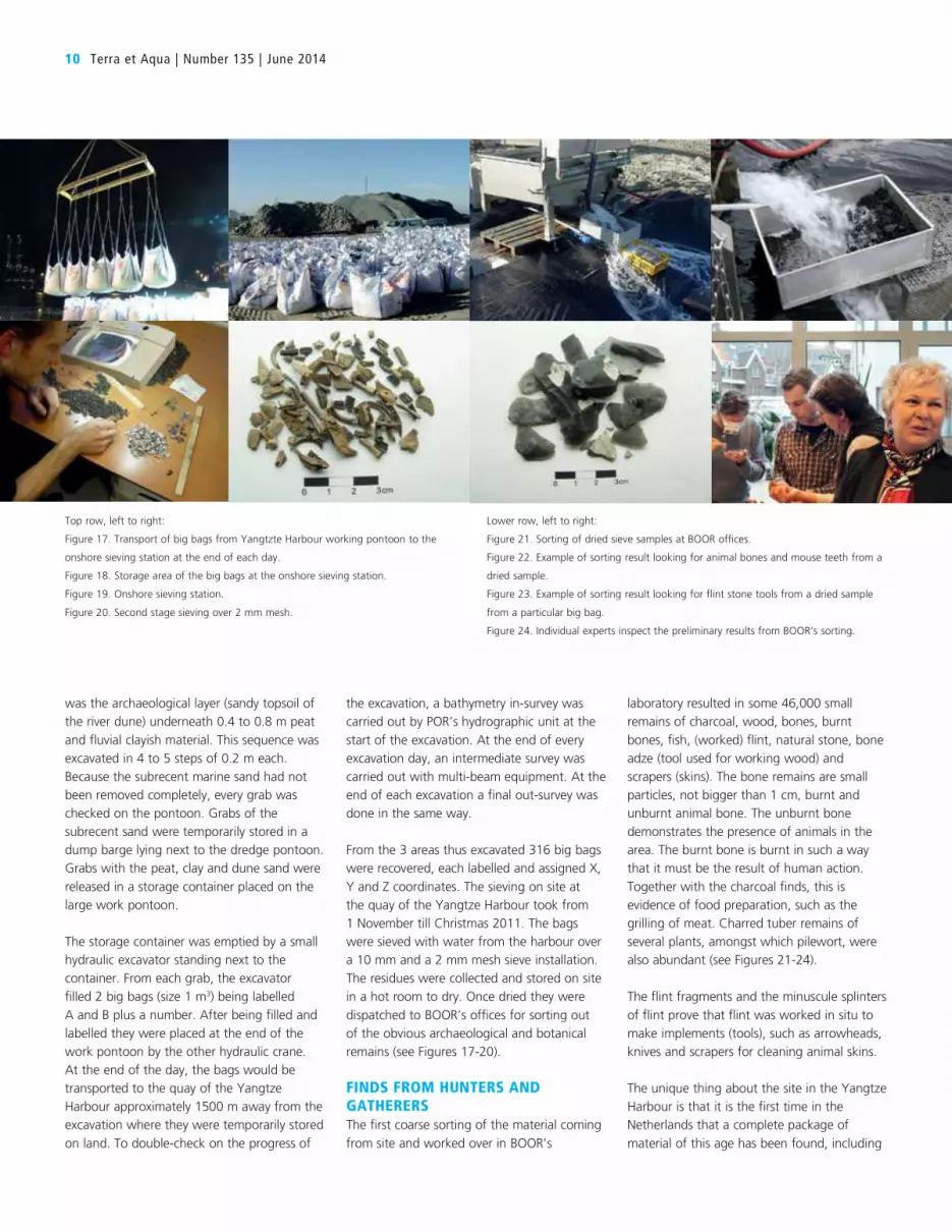


Special Volume 3 (2012), pp. 17–24
Henk Weerts – Andrea Otte – Bjørn Smit – Peter Vos – DimitriSchiltmans – Wouter Waldus – Wil Borst
Finding the Needle in the Haystack by UsingKnowledge of Mesolithic Human Adaptation in aDrowning Delta
in Wiebke Bebermeier – Robert Hebenstreit – Elke Kaiser – Jan Krause (eds.), LandscapeArchaeology. Proceedings of the International Conference Held in Berlin, 6th – 8th June 2012
Edited by Gerd Graßhoff and Michael Meyer,Excellence Cluster Topoi, Berlin
eTopoi ISSN 2192-2608http://journal.topoi.org
Except where otherwise noted,content is licensed under a Creative CommonsAttribution 3.0 License:http://creativecommons.org/licenses/by/3.0

Henk Weerts – Andrea Otte – Bjørn Smit – Peter Vos – DimitriSchiltmans – Wouter Waldus – Wil BorstFinding the Needle in the Haystack by UsingKnowledge of Mesolithic Human Adaptation ina Drowning Delta
Drowned landscapes; Mesolithic; Rhine-Meuse delta; underwater excavation.
IntroductionThe Port of Rotterdam is presently expanding Rotterdam harbour into the North Sea.A new 20m deep harbour canal is being dredged to connect to the existing harbour,thereby destroying buried Early Holocene drowned fluvio-deltaic landscapes. Archaeo-logical research in deposits of the Early Holocene age further upstream in the Rhinedelta have revealed that Mesolithic hunter-gatherers adapted to the drowning landscapeby using the highest parts of Late-Weichselian aeolian dunes for their hunting camps.This combined knowledge led to the challenge of finding such dunes in the harbour.At depths of 17–22m below OD in 17m water depth this was like looking for a needlein a haystack. Remnants of a river dune were indeed found followed by a spectacular—albeit small-scale—underwater investigation in 2011. This was the first time that manyMesolithic remains were encountered this deep and this far west.
Late-Weichselian to Middle-Holocene Landscape EvolutionThe landscape evolution of the Holocene Rhine-Meuse delta in the Netherlands is ex-tremely well-known.1 More recently, the research on landscape evolution of the delta wasextended further to the west and even offshore into the present southern North Sea.2
Meanwhile, the underlying Late-Pleistocene Rhine deposits were studied by Buschers etal.3 Landscape evolution and palaeogeography of the delta are thus very well known inspace and time.
In the Younger Dryas, the Rhine was a braided river with several braidplains slightlyincised in a Pleniglacial river terrace (Fig. 1a). In times of low discharge, large parts ofthe braidplains fell dry. Sand was blown out of the dry parts of the braidplains onto thelow river terrace where it was trapped by vegetation. This resulted in large aeolian riverdunes that reach heights of up to 15m above the terrace surface. These dunes are now for
For the following images all rights are reserved, in contrast to eTopoi’s Creative Commons licence usage:Figs. 1–2.
1 Berendsen and Stouthamer 2001 for an overview of the research and a complete palaeogeographicalreconstruction; Bosch and Kok 1994 and Kok and Groot 1998 for excellent 1:50 000 geological mapsheets and detailed cross sections.
2 Hijma et al. 2009, 13–53; Hijma and Cohen 2010, 275–278; Hijma et al. 2012, 17–39.3 Busschers et al. 2005, 25–41; Busschers et al. 2007, 3216–3284.

18 Henk Weerts et al.
the large part buried under Holocene fluvial deposits and peat. They are present all alongthe former braidplains from Germany to Rotterdam. West of Rotterdam, they seem todisappear. This is in fact a data-artefact: here they are buried too deep for the hand coredrillings to reach them. After the onset of the Holocene, the Rhine became a meanderingriver due to the ameliorating climate and more constant discharge (Fig. 1b). The fastrising sea-level in the Early-Holocene forced the Rhine to aggrade its floodplain. Beforefinal drowning of the western delta in the early Atlantic,4 a freshwater delta existed here(Fig. 1c). In this drowning delta, the tops of the river dunes were present as dry islands.
Dry Islands in the DeltaThe seasonal presence of Mesolithic hunter gatherers on the river dunes is well docu-mented from many sites that have been excavated in the past decades. Several of these well-documented excavations have become famous, e.g. the Hazendonk5 and the Hardinxveldsites.6 The latter two were large excavations prior to the construction of the Betuweroute cargo railway from the Rotterdam harbour to Germany. At Hardinxveld, the old-est Mesolithic inhumation at that time and a dugout-canoe were among the spectacularresults. Mesolithic hunter gatherers used the river dunes for their seasonal hunting camps.They kept coming back to the same locations for many years. This is hardly surprisingbecause the tops of the river dunes were the only dry islands in a very wet swamp. Thatswamp, however, was very rich in food and thus attractive for the Mesolithic huntergatherers. Although these excavations all took place on river dunes further east in thedelta, it is expected that river dunes further to the west may have been used in the sameway. Here the problem is how to find these dunes. Due to the Holocene sea-level rise,the Holocene deposits reach a thickness of up to 20m.7 The discovery of a small riverdune under the Rotterdam city centre in an excavation that was necessary because of theconstruction of a new subway station proved that river dunes are present in the area atstake as well.8 At that Rotterdam river dune location however, no archaeological remainswere found.9
Looking for the Needle in a HaystackThe deepening of the Yangtzeharbour (Fig. 2b) to 22m is part of the Maasvlakte 2 expan-sion of the Rotterdam harbour. In a preliminary desktop survey, the possible presenceof river dunes under the Maasvlakte 2 construction area was noticed (among many otherthings).10 Hence, further archaeological research here was necessary. A special agreementbetween the Port of Rotterdam, the Cultural Heritage Agency of the Netherlands andBOOR (Rotterdam Archaeological Department) in 2008 provided the formal frameworkfor further archaeological research that was necessary because of the construction ofMaasvlakte 2.11 The work in the Yangtzeharbour is part of that research, for whichManders et al.12 provided a scientific framework. Many Mesolithic artefacts have beenfound on the artificial beach of Maasvlakte 1.13 The sand for this beach was dredged from
4 Hijma and Cohen 2010, 275–278; Hijma and Cohen 2011, 1453–1485.5 van der Woude 1983; van der Woude 1984.6 Louwe Kooijmans 2001b; Louwe Kooijmans 2001a.7 van Staalduinen 1979; Vos and Bazelmans 2011, 30.8 Guiran and Moree 2009.9 Guiran and Moree 2009, 33.10 Hessing, Sueur, and Vos 2004, 10.11 Anonymus 2008.12 Manders et al. 2008.13 Manders et al. 2008, 15–16.

Finding the Needle in the Haystack by Using Knowledge of Mesolithic Human Adaptation 19
Fig. 1 | Younger Dryas to Early-Holocene landscape evolution in the Rhine-Meuse delta west ofRotterdam (see Fig. 2 for location). (a) Rhine-Meuse braidplain in the Late-Weichselian. Note the presenceof aeolian river dunes on the low river terrace adjacent to the braidplain. (b) Rhine-Meuse meandering riverin an aggrading floodplain in the Early-Holocene. (c) Aggrading anastomosing Rhine-Meuse branches in afreshwater deltaic setting at the Early- to Middle-Holocene transition. Block-diagrams from Weerts et al.2011b, 19.
the North Sea floor nearby. This, too, points to the possible presence of archaeologicalremains under the Yangtzeharbour. The challenge has now become how to find out

20 Henk Weerts et al.
Fig. 2 | The Yangtzeharbour location. (a) Location of the Maasvlakte, Rotterdam and Hardinxveld in theNetherlands. (b) Location of the Yangtzeharbour in the Maasvlakte. (c) Location of the river dune under theYangtzeharbour. (a) and (b) adapted from Weerts et al. 2011a, 81. (c) adapted from Vos et al. 2010 Bijlage 14.
if there is something under there, or not. This is much like looking for a needle in ahaystack. The part of the Yangtzeharbour that has to be deepened is over 3km long and500m wide. Water depth at the time was 17m.
A desktop study based on existing core descriptions and cone penetration tests dealingwith possible Mesolithic archaeology under the Yangtzeharbour was published by Vos etal.14 One of the conclusions was that additional data collecting was necessary. This “field-work” was carried out in 2010 and clearly showed the presence of an intact drowned EarlyHolocene fluvial landscape underneath younger shallow marine deposits.15 Based on shal-low seismics, existing cone penetration tests and 17 new piston cores with a penetrationrange from 2.2–4.5m, three areas with a high archaeological potential were recognised
14 Vos et al. 2009.15 Vos et al. 2010.

Finding the Needle in the Haystack by Using Knowledge of Mesolithic Human Adaptation 21
Tab. 1 | Archaeologicalremains in the sieve residues ofthe Yangtzeharbour excavation,first half of the sieve residue.
charcoal 9520wood 4plant material, burnt 15bone 4003bone, burnt 3582antler 0fish remains 147fish remains, burnt 0flint 1371flint, burnt 391stone other than flint 39
(Fig. 2c). In Areas 1 and 3, remnants of aeolian river dunes were expected. Area 2 showsa palaeo-channel of unknown origin with high grounds on either side. Area 3 was hard toaccess because of ship traffic. Areas 1 and 2 were selected for further detailed landscape re-search using new cone penetration tests, very detailed shallow seismics and 52 additionalpiston cores that yielded almost 200m of undisturbed sediment. In Area 1, the presenceof a river dune was attested. In Area 2, a filled-in fluvial channel is present. This channelwas later re-occupied by a tidal channel (from core-descriptions in de Vries16). Thirteenof the piston cores in Area 1 contained archaeological remains, predominantly charcoalbut also (burnt) bone and flint fragments.17 No remains were found in cores of Area 2.
The presence of archaeological remains on top of a buried river dune led, of course, toan underwater investigation, albeit on a small scale due to the circumstances. It was car-ried out in the autumn of 2011 using a special crane on a pontoon in the Yangtzeharbour.On three small locations on the dune, the sediment was removed to just above the levelwith archaeological remains. This level was carefully excavated using a special scrapinggrab with exact horizontal and vertical positioning. The sediment of each grab was trans-ferred into two big bags on board the pontoon, yielding 316 big bags. The sediment of thebig bags was subsequently sieved (10mm and 2mm mesh) on the Yangtzeharbour quayusing water from the harbour. The sieve-residues have been sorted, resulting in manyspectacular very well preserved (Early) Mesolithic remains including organics. Table 1gives an impression of the results half way through the sorting operation.
Final RemarksThe combination of knowledge of Mesolithic human adaptation in a drowning delta fromearlier research, modern surveying techniques and landscape modelling led to the findingof a needle in a haystack: a Mesolithic hunter gatherer camp at 17.5–20m below OD in17m water depth. Additional laboratory research (14C and OSL dating, palaeo-ecology),detailed description of the archaeological remains and final interpretation are underway.
Fig. 1 was drawn by Klaas van der Veen and adapted by Menne Kosian. Fig. 2 wascompiled by Menne Kosian from figures drawn by Marjolein Haars (a, b) and Deltares(c).
This paper is a contribution to Cost Action TD0902 SPLASHCOS Submerged Pre-historic Archaeology and Landscapes of the Continental Shelf.
16 de Vries 2012.17 Schiltmans 2012, 4.

22 Henk Weerts et al.
BibliographyAnonymus 2008
Anonymus. “Samenwerkingsovereenkomst inzake archeologische vondsten tussenHavenbedrijf Rotterdam N.V.”. In Rijksdienst voor de Archeologie, Cultuurlandschapen Monumenten. Rijksdienst voor de Archeologie, Cultuurlandschap en Monumenten.Amersfoort, 2008.
Berendsen and Stouthamer 2001H.J.A. Berendsen and E. Stouthamer. Palaeogeographic Development of the Rhine-MeuseDelta. Amsterdam: Van Gorcum, 2001.
Bosch and Kok 1994J.H.A. Bosch and H. Kok. Toelichtingen bijdegeologische kaart van Nederland 1:50.000.Blad Gorinchem (Gorkum) West (38W). Utrecht: Rijks Geologische Dienst, 1994.
Busschers et al. 2005F.S. Busschers et al. “Sedimentary Architecture and Optical Dating of Middle andLate Pleistocene Rhine-Meuse Deposits – Fluvial Response to Climate Change, Sea-level fluctuation and glaciation”. Netherlands Journal of Geosciences – Geologie en Mi-jnbouw 84 (2005), 25–41.
Busschers et al. 2007F.S. Busschers et al. “Late Pleistocene Evolution of the Rhine-Meuse System in theSouthern North Sea Basin: Imprints of Climate Change, sea-level Oscillation andGlacio-isostacy”. Quaternary Science Reviews 26 (2007), 3216–3248.
de Vries 2012S. de Vries. Boorbeschrijvingen Yangtzehaven Oost. Deltares rapport 1204743-000-BGS-0013. Utrecht, 2012.
Guiran and Moree 2009A.J. Guiran and J.M. Moree. Rotterdam-Randstadrail: Archeologisch onderzoek 6. Sta-tion Blijdorp en de westbuis van de tunnel. BOORrapporten 421. Rotterdam: BureauOudheidkundig Onderzoek van gemeentewerken Rotterdam, 2009.
Hessing, Sueur, and Vos 2004W.A.M. Hessing, C. Sueur, and P.C. Vos. Maasvlakte 2: Archeologisch VooronderzoekFase 1. Bureauonderzoek, Risico-analyse en Aanbevelingen voor vervolgstappen. 175.Amerfoort: Vestigia, 2004.
Hijma and Cohen 2010M. Hijma and K.M. Cohen. “Timing and Magnitude of the Sea-level Jump Preludingthe 8200 yr Event”. Geology 38 (2010), 275–278.
Hijma and Cohen 2011M.P. Hijma and K.M. Cohen. “Holocene Transgression of the Rhine River MouthArea, The Netherlands/Southern North Sea: Palaeogeography and Sequence Strati-graphy”. Sedimentology 58 (2011), 1453–1485.
Hijma et al. 2009M. Hijma et al. “From River Valley to Estuary: the Evolution of the Rhine Mouth inthe Early to Middle Holocene (Western Netherlands, Rhine-Meuse Delta)”. Nether-lands Journal of Geosciences – Geologie en Mijnbouw 88 (2009), 13–53.

Finding the Needle in the Haystack by Using Knowledge of Mesolithic Human Adaptation 23
Hijma et al. 2012M. Hijma et al. “Pleistocene Rhine-Thames Landscapes: Geological Background forHominin Occupation of the Southern North Sea Region”. Journal of QuaternaryScience 27 (2012), 17–39.
Kok and Groot 1998H. Kok and Th. A.M. de Groot. Toelichtingen bij de geologische kaart van Nederland1:50.000. Blad Rotterdam Oost (37O). Delft: Nederlands Instituut voor ToegepasteGeowetenschappen TNO, 1998.
Louwe Kooijmans 2001aL.P. Louwe Kooijmans, ed. Archeologie in de Betuweroute. Hardinxveld-Giessendam DeBruin. Een kampplaats uit het Laat-Mesolithicum en het begin van de Swifterbant-cultuur(5500–4450 v. Chr.) Rapportage Archeologische Monumentenzorg 88. Amersfoort:Rijksdienst voor Oudheidkundig Bodemonderzoek, 2001.
Louwe Kooijmans 2001bL.P. Louwe Kooijmans, ed. Archeologie in de Betuweroute. Hardinxveld-GiessendamPolderweg. Een mesolithisch jachtkamp in het rivierengebied (5500–5000 v. Chr.) Rap-portage Archeologische Monumentenzorg 83. Amersfoort, 2001.
Manders et al. 2008M. Manders et al. Wetenschappelijk kader voor de archeologische monumentenzorg bijde aanleg tweede Maasvlakte, Europoort-Rotterdam. Rapportage Archeologische Mon-umentenzorg 169. Amersfoort: Rijksdienst voor de Archeologie, Cultuurlandschapen Monumenten (RACM), 2008.
Schiltmans 2012D.E.A. Schiltmans. Evaluatierapport Rotterdam Yangtzehaven Karterend inventaris-erend veldonderzoek. BOOR rapport 523. Rotterdam: Bureau Oudheidkundig On-derzoek van gemeentewerken Rotterdam, 2012.
van der Woude 1983J.D. van der Woude. “Holocene Paleoenvirental Evolution of a Perimarine FluviatileArea. Geology and Paleobotany of the Area Surrounding the Archeological Exca-vation at the Hazendonk River Dune (Western Netherlands)”. Analecta PraehistoriaLeidensia 16 (1983), 1–124.
van der Woude 1984J.D. van der Woude. “The Fluvilagoonal Environment in the Fluviolagoonal Palaeo-environment in the Rhine/Meuse Deltaic Plain”. Sedimentology 31 (1984), 395–400.
van Staalduinen 1979C.J. van Staalduinen. Toelichtingen bij de geologische kaart van Nederland 1:50.000.Blad Rotterdam West (37W). Haarlem: Rijks Geologische Dienst, 1979.
Vos and Bazelmans 2011P. Vos and J. Bazelmans. “Hoe zijn de kaarten tot stand gekomen?”. In Atlas vanNederland in het Holoceen. Landschap en bewoning vanaf de laatste ijstijd tot nu. Ed. byP. Vos et al. Amsterdam: Bert Bakker, 2011, 29–32.

24 Henk Weerts et al.
Vos et al. 2009P. Vos et al. Geoarcheologische bureaustudie ten behoeve van het Yangtzehavenproject(1e onderzoeksfase in het verkennend inventariserend veldonderzoek). Deltares rapport0906–0193. Utrecht, 2009.
Vos et al. 2010P. Vos et al. Geoarcheologisch inventariserend veldonderzoek van het Yangtzehaven pro-ject (verkennende fase 2). Deltares rapport 1201894-000-BGS-0003. Utrecht, 2010.
Weerts et al. 2011aH. Weerts et al. “2000 n.Chr. Een door de mens geschapen land”. In Atlas van Ned-erland in het Holoceen. Landschap en bewoning vanaf de laatste ijstijd tot nu. Ed. byP. Vos et al. Amsterdam: Bert Bakker, 2011, 78–82.
Weerts et al. 2011bH. Weerts et al. “De grote rivieren vullen de delta”. In Atlas van Nederland in hetHoloceen. Landschap en bewoning vanaf de laatste ijstijd tot nu. Ed. by P. Vos et al.Amsterdam: Bert Bakker, 2011, 18–19.
Henk Weerts, Cultural Heritage Agency, PO Box 1600, Amersfoort, The Netherlands
Andrea Otte, Cultural Heritage Agency, PO Box 1600, Amersfoort, The Netherlands
Bjørn Smit, Cultural Heritage Agency, PO Box 1600, Amersfoort, The Netherlands
Peter Vos, Deltares, PO Box 85467, Utrecht, The Netherlands
Dimitri Schiltmans, BOOR, Ceintuurbaan 213b, 3051 KC Rotterdam, The Netherlands
Wouter Waldus, ADC Maritiem, PO Box 1513, Amersfoort, The Netherlands
Wil Borst, Port of Rotterdam, PO Box 662, Rotterdam, The Netherlands

75
References Borst, W., Weerts, H., Vellinga, T. and Otte, A. (2014): “Monitoring programme for the MV2, part IV – Archaeological and palaeontological finds”, Aqua et Terra 135: 1-15. Moree, J.M. and Sier, M.M. (eds.) (2014): “Twintig meter diep! Mesolithicum in de Yangtzehaven – Maasvlakte te Rotterdam. Landschapsontwikkeling en bewoning in het Vroeg Holoceen”, Bureau Oudheidkundig Onderzoek Rotterdam: 361 pp. Weerts, H.J.T., Otte, A., Smit, B., Vos, P., Schiltmans, D., Waldus, W. and Borst, W. (2012): “Finding the Needle in the Haystack by Using Knowledge of Mesolithic Human Adaptation in a Drowning Delta”, In: Bebermeier, W., Hebenstreit, H., Kaiser, E. and Krause, J. (eds.): “Landscape Archaeology. Proceedings of the International Conference Held in Berlin”, June 6th-8th, 2012, eTopoi Journal for Ancient Studies, Special Volume 3: 17-24.

76
APPENDIX VI:
The Seaway to the Port of Eemshaven and the Outer Harbour Mooring of Doekegat Rede: an Example of the Work-Through Process of
Archaeological Investigations in The Netherlands
Johan Opdebeeck (Maritime archaeologist, Dutch Cultural Heritage Agency)
The Monuments Act and the Process of Archaeological Investigations In The Netherlands, the protection of the cultural heritage is established in the Monuments Act of
1988. This law was extended in 2007 with the ‘European Agreements of Valetta’ and the expansion of the law to the contiguous zone of The Netherlands (24 nautical miles off the coast). The protection or mandatory archaeological assessment is also imbedded in the regulations as the ‘Environmental Impact Assessments’ (Milieu Effecten Rapport, MER) and the regulations on sand extraction and dredging.
The scheme of archaeological investigations is defined in the ‘Quality Standard for the Dutch Archaeology’ (‘Kwaliteitsnorm voor de Nederlandse Archeology’, KNA) which is described on the website of the ‘Organisation for Activities Relating to Soil Management’ (SIKB32). Underwater archaeology has its specific standard and processes which are defined in the ‘Quality Standard for Water/Sea Bottoms’ (KNA waterbodems 3.1). There are different stages in the archaeological process (Figure 1). Each of these stages are built on the results of the previous investigation and thus refining the archaeological potential of the affected area. It cannot be emphasised enough that in order to conduct a good and thoroughly archaeological investigation, this process should be taken in account as early as possible. Each stage in the archaeological scheme needs time to be carried out and the results worked out. The conclusions and advice of each report will be checked and evaluated by the competent authority and, if needed, the next stage of archaeological investigations will be initiated. The Dutch Cultural Heritage Agency (Rijksdienst voor het Cultureel Erfgoed, RCE) is for many governmental agencies their advisor in terms of cultural heritage and will act as verifying authority. There are two preliminary phases in the archaeological process:
desk-based research
preliminary investigation: o above water (mostly geophysical) o under water
If the site proves to be of archaeological interest, the next stage will determine the historical and archaeological value of the site:
archaeological assessment Depending on the results of the archaeological assessment there are different courses which can be taken. There are three main options:
32 , www.sikb.nl

77
in situ preservation
excavation
extraction
Figure 1: The process of underwater cultural heritage management (RCE, J. Opdebeeck)
There are many different versions in these options. Those versions can be influenced by variables such as time, money, historical importance and many more. As an example: there are different degrees of excavation, the inquiries and the extent of the investigations are put down before the start of the archaeological research in a report on the requirements (Programma van Eisen, PvE). Depending on the condition and nature of the objects, conservation must also be taken into account: objects which are found in excavations are property of the provinces or, in the case of the North Sea, the Dutch State in general. Before they are handed over, all objects must be stabilised and conserved.

78
The Extension of the Port of Eemshaven The extension of the harbour activities in the northern part of The Netherlands included a larger sea way to the port of Eemshaven and the creation of an anchorage outside the harbour.
Desk-Based Research The first phase in the scheme of archaeological investigations is a desk-based research. In this research all available/known resources are explored to determine the archaeological potential of the area. These archaeological potential includes:
shipwrecks
airplanes
drowned villages
prehistoric landscapes The different departments of the Ministry of Infrastructure and Environment (Rijkswaterstaat, RWS), the navy, local historic foundations, amateur archaeologists and local sport divers, all have their own or combined databases with positions of sunken vessels and/or aircrafts. These databases will be combined with other data from archives, old historical maps and possible information from other nearby archaeological investigations in the past. The prehistoric component will be investigated and evaluated on the basis of the information on the geological layers of the area. In broad terms, these layers are known in summary maps of the region. However, more specific data can be found in the numerous core drillings of sub-bottom data which have been made for scientific or economic research33. At the beginning of 2008, an archaeological company was asked to investigate the archaeological potential of the area of the waterway and new anchorage of the port (Figure 2). Their research concluded that there was a high possibility to encounter shipping related objects in the area, with an emphasis on 19th to 20th century shipwrecks. The implementation of the dredging was an imminent danger to any remaining cultural heritage. Their advice was to further investigate the locations by geophysical methods (Periplus Archeomare Report 08_A001).
33 www.dinoloket.nl

79
Figure 2: Desk-based research Eemshaven (RWS)
Preliminary Investigation: Above Water There are a wide variety of (geophysical) research methods which can be used to investigate the sea bottom:
the surface of the sea bottom can be investigated with sonar, multi-beam and/or video through means of a ROV/ROHP
magnetic field research can be used to located buried (metal) remains
other surface penetrating methods are sub-bottom profiler, chirp or boomer: like core drillings these methods can be used to investigate the prehistoric landscape component
Each method, or a combination of methods (depending on the research questions), is used to investigate the presence of potential (historic) sites. Sonar and multi-beam images will show disturbances in the topography of the water/sea bottom, which are referred to as contacts. By the end of 2008 the sonar inspections (Figure 3) were finished and the recordings yielded 644 contacts of which 92 contacts had possible archaeological expectation (Periplus Archeomare Report 08_A019). The location of the anchorage revealed 150 contacts of which 10 had an archaeological expectation (Periplus Archeomare Report 09_A026). Following the sonar recordings, the contacts with archaeological expectations were examined with Remote Operated Hoist Platform (ROHP). The ROHP used video imaging and DIDSON (Dual Frequency Identification Sonar) acoustic camera systems. The latter was used because the visibility underwater was best described as ‘very bad’, in which the normal optic systems didn’t provide any decent results. The operations with the ROHP narrowed the list of possible historical sites down from 92 to 11 in the seaway and from 10 to eight in the anchorage. Those 19 sites were advised to be further examined by diving inspections.

80
Figure 3: Above water investigation Eemshaven (RWS)

81
Preliminary Investigation: Under Water This research phase is developed to determine if certain contacts under water are man-made objects with (possible) historical value, such as shipwrecks. A trained geophysical surveyor will recognise a lot of the objects as natural or man-made through experience by examining the sonar and multi-beam images. However, there are many reasons why an object is not recognised: the settings and speed of recording, depth or just the angle of the object in the seabottom. To establish the true nature of a contact, visual inspection is needed through divers or ROV/ROHP images. The disadvantage of the ROHP is the lack of measurements and also the dependence on the visibility. Opposite to divers, a ROV/ROHP doesn’t have arms with sensing motion to recognise certain structural elements. In 2009, an archaeological company was given the assignment to investigate the site further with divers. From the 11 archaeological interesting contacts which were found in and the around the waterway, seven of them were fairly easy to be labelled as non-historical objects such as anchor buoys, cables, fishing equipment. The remaining four were shipwrecks. The examination of these wrecks proved that they were iron ships from recent times (20 th century). Those remains were labelled as low archaeological value. As a result no further investigations were needed. But if the shipwrecks were to be removed, it was to be under archaeological guidance so to extract any further information from the wreck (ADC Report 2023).
Archaeological Assessment The archaeological assessment follows the positive identification of an historical site. If the site is of conclusive historical importance, the assessment is needed to determine the archaeological value of the object. As an example: if the preliminary investigations have found a wooden sailing ship, the assessment will have to examine the possible age, ship type and construction, the amount of remains preserved, the presence of cargo or other items, the condition of the materials and so on. The results of this investigation will greatly determine the advice of the competent and verifying authority and, thus, the following course of actions. The underwater investigation in 2010 of the eight sites in the anchorage only gave one positive result, but the shipwreck was clearly a historical shipwreck which needed further investigation. The decision was made to start immediately with an archaeological assessment to determine the historical value of the site (Periplus Archeomare Report 10_A009). The multi-beam images of the preliminary investigation show a wreck mound of 15 metres long (Figure 4). Next to the mound in a scouring pit, several frames and pieces of the hull were found. Remains of the keel and other structural remains were found. The mound itself was made entirely of the ships cargo: nicely stacked roof tiles. They are an old hollow type of tiles which were used in the beginning of the 18th century. Dendrochronological examination of some structural wood remains, provided a date around 1725.

82
Figure 4: Multi-beam of the historic site (Periplus Archeomare)
Solutions
The Anchorage The location of the historic shipwreck was at the southern edge of the future mooring location. Because the archaeological value of the site was considered high, the probable destruction of this shipwreck would have been preceded by a possible (expensive) under water excavation. The solution was to move the location of the anchorage a few 100 metres to the North. Around (possible) historic monuments, sand extraction or soil disturbance are not allowed in a radius of 100 metres around the site. As a result of the change of planning, the dredging of the anchorage was further then 100 metres from the historic shipwreck and, thus, in no imminent danger. Further actions were not needed. It is, however, preferable to monitor known historic sites in the vicinity of big construction projects.

83
Seaway to the Port of Eemshaven In 2010, the departments of the Ministry of Infrastructure and Environment (RWS) decided to extract three iron shipwrecks which were considered a potential danger to the shipping (Figure 5). Following the advice of previous investigations, the removal of the shipwrecks was under the guidance of a (maritime) archaeologist. His job was to collect remaining information, such as objects, measuring interesting construction details and making lots of photographs. From the three wrecks that have been destroyed, two wrecks were identified by the collected data (ADC Report 2495). Wreck A91 was identified as the Denobola, a trawler from the beginning of the 20th century which was used in the First World War as a German Marine Patrol boat. She sunk after hitting a mine in 1917. The other wreck, A88, was identified as the ‘Anglia’, a freighter which sunk in 1903 during a severe storm. The name of wreck A87 could not be discovered. It was a steamship, probably from the end of the 19th to the beginning of the 20th century.
Figure 6: Archaeological guidance Eemshaven (RWS)
Important Notice All formerly conducted investigations are by no means conclusive. This means that during dredging, sand extraction or other bottom disturbing actions the possibility still exists that new, unknown historic sites can be found. Some sites/objects are completely covered by sediments and the chance of discovering them with non-intrusive methods is very small. The archaeological process prior to big contracting is to minimise the possibility of archaeological unexpected findings

84
which will slow down the work flow and, thus, cost considerable amounts of money. If unexpected discoveries are made, the Dutch legislation obliges the contractor to stop all works in that area and immediately contact the competent authorities.
References
Van den Brenk, S., Boom, P. and Waldus, W. (2008): “Bureauonderzoek, Vaarweg Eemshaven – Noordzee”, Periplus Archeomare Report 08_A001. Van Mierlo, B., van den Brenk, S. and Waldus, W. (2009): “Inventariserend veldonderzoek (opwaterfase)”, Vaarweg Eemshaven-Noordzee, Periplus Archeomare Report 08_A019. Van lil, R., van den Brenk, S. and Waldus, W. (2010): “Bureauonderzoek en inventariserend veldonderzoek”, Doekegat Reede, Waddenzee, Periplus Archeomare Report 09_A026. Van Campenhout, K. (2009): “Vaarweg Eemshaven-Noordzee, Inventariserend veldonderzoek (onderwaterfase, verkennend)”, ADC Report 2023. Van Campenhout, K. and van den Brenk, S. (2010): “Doekegat Reede-Waddenzee, Inventariserend onderzoek (onderwaterfase)”, Periplus Archeomare Report 10_A009. Verweij, J. (2011): “Vaarweg Eemshaven-Noordzee, Archeologische begeleiding bij berging ijzeren scheepswrakken”, ADC Report 2495.

85
APPENDIX VII:
Archaeological Monitoring of the Dredging for the Immersed Tunnel, Oslo, Norway. Rescuing Archaeological Heritage.
Tori Falck (Norwegian Maritime Museum)
Jostein Gundersen (Directorate for Cultural Heritage)
Backdrop and Location The city of Oslo, the capital of Norway, is situated in the innermost part of the Oslofjord, on both sides of the small river Akerselva. On the eastern shores of the harbour, a small town emerged at
the end of the Viking era. After a large fire wiped out the whole town in AD1624, the town was rebuilt on the other side of the harbour. Today, the modern city of Oslo incorporates areas far beyond the earlier city limits, and both the ‘old’ and ‘new’ town are located within the city centre. Even if the settlements on land have moved through time, the main harbour basin itself has been the same for more than 1000 years. At the turn of the last millennia, a new immersed tunnel through the central harbour was planned. The tunnel would connect to already existing tunnels on each land side, and had to cross through open water, jetties and quays (Figure 1). The water depth in the tunnel line varied from two to 16 metres and the trench for the tunnel had to be excavated down to around 22 metres the whole way. In all, the excavation of the tunnel trench included the dredging of 1,000,000 m3 of harbour sediments from an area also expected to be rich in archaeological remains (Figure 2).
Figure 1: The planned immersed tunnel in Bjørvika, Oslo (Norway) Source: Norwegian Road Administration

86
Figure 2: Method. Constructing the immersed tunnel Source: Norwegian Road Administration
The excavation of the tunnel trench started autumn 2005, and lasted until winter 2008, with continuous work, summer as winter. In the most work-intensive periods, two dredgers and four excavators were working parallel in three different parts of the trench. The spoil consisted of a mixture of highly polluted harbour sediments, sawdust from several hundred years of the saw mill industry in Oslo, natural sediments from the rivers and ocean, modern garbage and waste, jetty and quay constructions on top of land fillings, an old shipyard and a machine factory – and archaeological remains [Falck and Gundersen, 2012]. In addition, the tunnel is located at the outlet of the river Akerselva where a combination of natural and man-made sedimentation has been a challenge for the users of the harbour for centuries. Attempts to control the sedimentation by forcing the stream of the river to reach deeper waters and restricting the dumping of ballast to specific areas, was supplemented by man-powered dredging until the first steam-powered dredgers came into use in the 1860’s. In all, the combination of continuous sedimentation and everlasting efforts to keep the harbour deep enough for its users, has altered the original sea floor tremendously over the centuries. To understand why the Norwegian Maritime Museum came to monitor the process, a short introduction to the legal framework for the protection of cultural heritage in Norway is important. The Norwegian Cultural Heritage Act (1978, § 14) protects underwater archaeological remains older than 100 years (shipwrecks and its cargo). It also states that the developer has a duty to

87
consider whether the project will affect protected archaeological sites or monuments (§§ 9, c.f. 14), before the construction work begins. If it is found that a project will affect archaeological remains, the Directorate for Cultural Heritage (‘Riksantikvaren’) decides if and on what conditions the project can be carried out. Such conditions might typically be archaeological excavations and/or documentation of the protected remains before the construction work can begin. Furthermore, the act (§ 10) also states that the developer has to pay for any means necessary to fulfil these conditions, including excavations. In the immersed tunnel project this was the Norwegian Public Roads Administration (NPRA). In Oslo the methods for detecting archaeological remains embedded in the sea bed, in advance of the construction work, was not fit for delimiting areas with potential for archaeological remains.
This resulted in a situation where the Directorate for Cultural Heritage determined that the archaeological investigations should be conducted parallel to the construction work. The experiences from Oslo show that, despite the difficulties involved, the mapping of underwater cultural heritage prior to the construction work should have been given higher priority [Laugesen et al., 2011]. This would probably have given better archaeological results and it would potentially have restricted the areas the archaeologists would have had to monitor. Even considering the relatively high costs of doing adequate mapping, it is claimed that such investigation would pay off, considering the process and the project as a whole.
Attempts of Mapping and the Definition of Potential for Archaeological Remains
The standard method of first-hand mapping of the seabed in Norwegian underwater archaeology is using a Scuba-diver, alternatively an ROV, making a visual detection of the sea floor. Using side-scan sonar and high-resolution multi-beam echo sounders has also become regular during recent years. While many underwater sites we know of are discovered by amateur divers, more and more sites are now being detected by professional maritime archaeologists using high technology equipment doing surveying. Taking into account the massive sedimentation rate in the Oslo harbour, it was clear that these methods were unsuitable for finding archaeological remains. All objects of interest would be embedded in the seabed, covered by younger sediments and not visible on the surface of the sea floor. Attempts were therefore made to try to analyse the contents of the seabed with (acoustic) sub-bottom profiler. However, the high organic contents of the sediments, mainly caused by the sawdust from the saw mill industry in the 17th to 19th century, gave unexpected problems. The decaying sawdust produces hydrogen sulphide gas (H2S) which is captured in the sediments. The highly gas-rich sediments reflected the acoustic signals in a manner which, in practice, shadowed all other anomalies and made the method useless for locating objects or structures of archaeological interest. What the sub-bottom profiler did show, however, was that the sea bottom still contained large volumes of sawdust and thus that more than 100 years of power-driven dredging still had not removed all the sediments from the periods of archaeological significance. The question then, was how much of the older sediments, and possible archaeological remains were still present, and how much had already been removed and destroyed by earlier dredging. An effort to answer this was done by analysing core samples. In 1996 the Norwegian Maritime Museum, in collaboration with the University of Oslo, delivered a feasibility study of the sediments in Bjørvika (west harbour) and Bispevika (east harbour) to identify

88
any presence of intact sediments from the medieval and early modern times [Nævestad, 1996 ; Dale, 1996a, b]. It recorded a total of ten sediment cores and a reference sample from the Sørenga jetty. The core samples were examined visually for the presence of sawdust and sequences of samples were taken for analysis of spruce pollen and dinoflagellate cysts. The composition of pollen and cysts are influenced by climatic change, and assays could detect sediments from the medieval warm period around AD 1000-1300 [Dale, 1996a]. The presence of such a layer in the sediments would strengthen the possibility that the layers also could contain archaeological remains. The results showed that sediments from the medieval period were present in four of the samples from Bjørvika and in three of the samples of Bispevika (Figure 3).
Figure 3: Scoping and planning the archaeological investigation. Core samples analysed for the precence of dinoflagellate cysts and spruce pollen.
Map: K. Løseth/Norwegian Maritime Museum.
The results indicated that previous dredging in all probability had removed all traces of medieval (and younger) periods in the innermost parts of Bispevika and along the waterfront on the west side of the bay. In the tunnel route, however, it was likely that the sediments from the medieval period and thus possible archaeological remains from the period, were present. The medieval sediment horizon, defined in terms of climatic conditions, was about two metres thick in all positive samples. In Bispevika parts of the horizon was removed and, therefore, the full thickness was difficult to determine. At the deepest, the bottom of this horizon was nearly six metres below the present sea floor, in the area on the west side of the Bjørvika jetty.

89
In conclusion, the unlevelled vertical distribution of the medieval horizon in the seabed also showed that the layers which could contain protected archaeological remains were to be found both close to present sea floor and several metres down in the seabed34. Even with the additional two samples from 2007, a total of 12 samples of an area of altogether 64,000 m2, is insufficient to say something more convincing and definite on the potential for cultural remains. Later in the process, actually after the construction work had already started and the decision to monitor the whole process was made, the Norwegian Maritime Museum was invited to join the geophysical mapping of the level of contamination in the sediments (the Norwegian Geotechnical Institute). Regrettably, we were involved so late in the process, that the time schedule and financing of the conduct made true participation with archaeological questions and requests difficult. In retrospect, we believe that a more thorough visual analysis of the core samples from an archaeological point of view could have functioned as a more thorough mapping of the potential for archaeological remains in the harbour. During the period of the dredging we managed to identify large pockets consisting of sand, ballast and artefacts, that most certainly would have shown as defined layer changes in the core samples (Figure 4). These pockets were interpreted as remains that had ‘survived’ the extensive dredging in modern times. Systematic sampling and detection of the visual archaeological strata, could have worked as a tool for pointing out areas of interest and of special focus.
Figure 4: Dredging from barges in open water. On the custom made sieve a 19th century anchor has appeared.
Photo: Norwegian Maritime Museum.
34 In 2007, the Norwegian Maritime Museum conducted a comparable survey along the outlet of the Akerselva river [Falck, 2007 ; Dale and Dale, 2007]. Analysis was done on two of the six core samples and sediments from the medieval period were identified in both samples of between 9 and 13 metres below present sea level.

90
Due to inadequate mapping in advance, it was concluded that there was a potential for archaeological remains in the whole construction area. This resulted in the archaeological monitoring of the dredging throughout the whole period of the construction work for the planned tunnel.
Monitoring the Dredging: Challenges and Responses
Due to different contents of water, organic matter (sawdust) and pollution, the sediments and spoil from the tunnel trench had to be handled differently after excavation:
polluted ‘modern’ harbour sediments and clay was to be disposed in a deep water deposit
sediments with a high content of organic matter (sawdust) had to be transported to a land
deposit by lorries/trucks
clean marine clay and sediments would be used in the Oslo harbour remediation project
[Laugesen et al., 2011]
fillings from piers and quays were to be transported to a land deposit by lorries/trucks
modern garbage and timber constructions larger than 1 x 1 m had to be sorted out from the
sediments going to the different areas of disposal
The ‘destination’ of the sediments meant that different methods for excavation and transport were chosen. Furthermore, the monitoring process required on site visual and if needed, physical contact between archaeologist and dredged sediments at all times. This was considered a primary requirement if the presence of the archaeologists on site would be of any purpose viewed from an archaeological point of view. Obviously, this presence presented both archaeologists and contractors to challenges they had never before been confronted to. Many of these challenges can also be discussed in relation to the Health and Security management that guides the entirety of the work on such a construction site. Based on the sediments disposal, different barges and different equipment for dredging and excavation were chosen, which also resulted in different situations for the archaeologists to adjust to:
polluted ‘modern’ sediments and clay was dredged with a closed clam shell dredger, into
barges c. 600 m3 in size for transportation to a nearby deep water deposit
sawdust was dredged with a closed clam shell dredger onto a large flatbed barge to ‘dewater’,
before being loaded onto lorries for transportation to a land deposit (Figure 5)

91
Figure 5: Dredging old sawdust layer. Photo: Norwegian Maritime Museum.
- clean clay was dredged with an open clam shell dredger into small (c. 150 m3 ) barges for
towing and re-deposition in nearby areas with polluted sediments
- fillings from piers and quays were excavated by large excavators into piles on land, before
being transported to other deposits (Figure 6)
Figure 6: Dredging from the piers. Photo: Norwegian Maritime Museum.

92
All dredging of sediments required that the archaeologist were situated directly on the different dredging barges, while the excavation of the piers and quays required that the archaeologist were on-site close to the excavator (Figure 7).
Figure 7: Dredging from barges in open water. Archaeologist on board. Photo: Norwegian Maritime Museum.
The work took place all year, regardless of temperatures and weather conditions. Especially work during the relatively long and cold Oslo-winters was challenging, considering that the work often required the archaeologist to stay put outdoors on site for hours with little activity to keep them warm. Temperatures below minus 10 degrees centigrade were not unusual during the coldest months. The smell from the polluted sediments though, especially those consisting of H2S (hydrogen sulphide), was worse during the warm summer days than under cooler conditions. Considering health and security precautions, the most challenging situations was directly caused by the physical closeness of the archaeologist, both to highly polluted sediments causing potential health risks and the dredging machinery causing risk for physical injury. We experienced that the NPRA took these challenges very seriously. As a small museum, not yet familiar with working on large construction sites, we were introduced to a professional health and security regime. Although the system sometimes failed to meet all our requirements, it certainly prevented serious accidents to happen during the whole period of work. The fear of long-term health risks caused by pollution was met by several precautions and procedures. Any skin contact with the sediments was to be avoided, always using gloves and clothing to be fully protected. The archaeologist also carried a gas alarm, signalling when the level of gas (H2S) reached a certain level and masks were to be put on. All the workers on site were included in a blood surveillance programme, testing for both

93
contamination in the blood and for general changes in health conditions. All in all we were satisfied with the way our presence on site was solved, considering that the need to be close to the actual physical work often was in direct divergence to the recommendations according to the strict health and security regime.
How to Reach a Best Practice – Main Mitigation Measures Health and security measures were certainly important to make the monitoring process possible and secure. But also the implementations of other mitigation measures were necessary to be able to conduct the investigation with reasonable prospects of fulfilling the task of salvaging cultural heritage. Most important was the construction of a custom made steel sieve for each of the barges, which prevented archaeological remains from disappearing into the barge basins (Figure 8). Already during the first week of dredging, it became very clear that the earlier mentioned primary requirement; on site visual and if needed physical contact between archaeologist and dredged sediments, could not be met without something stopping the sediments from drowning and
disappearing directly in the water filled barges. The sieve made it possible to collect larger archaeological finds (ship timbers and anchors) and to a lesser degree smaller artefacts. It was made with parallel bars only, to let the sediments go through relatively easy. The spacing between the bars was 12 cm, and the bars themselves had the same width. This made it fairly easy to walk on the sieve to retrieve various objects if necessary.
Figure 8: Showing the custom made sieve. The sieve was constructed so that archaeological material would be prevented to disappear into the barges.
Photo: Norwegian Maritime Museum.
Another mitigation measure that deviates from a more ordinary archaeological investigation was the implementation of work shifts. To meet the required progression of the work, the work days on

94
a construction site are long (up to 12 hours), and the archaeologists had to adjust to this and be prepared to work sometimes earlier and other times later than normal. In addition, the project had to accept that the finds that were rescued were partly damaged and therefore also of a poorer scientific source value than they would have had under more ideal conditions. Yet another very important aspect was the agreement that the dredging could be put on hold, or moved to another part of the tunnel trench, if the archaeologist found it necessary to inspect finds and/or rescue archaeological remains. In practice, this meant that the dredging contractor always had to have a ‘plan B’ for the dredging each day, preferably some hundred metres apart so that any further work would not disturb the working conditions (mainly visibility) for diving archaeologists working at the sea bed. To meet the contractors flexibility, the museum had to have archaeologists being certified to dive at the site every day, even if it could be months between each time it was necessary to dive. The most important mitigation measures can be summed up as:
custom made sieve
overlapping work shifts, always archaeologists present
ability to put the construction works on hold/move it until findings were checked and rescued
(if necessary)
Both the sheer presence of the archaeologist on the construction site, and the actual power to put the work on hold, makes communication between the archaeologists and contractors/project owners of utmost importance. The mutual understanding of each other’s roles and responsibilities in all joints of the work chain can only be reached through good direct, face to face, communication on a personal level. Weekly meetings were held to make sure that consensus of progression plans and delays was maintained. In addition, the day to day communication between the archaeologists and the workers on the barges and excavators was equally important.
Results and Conclusion We had to accept that the method only would give us a selection of objects and finds from the harbour. Still, all in all, the results are believed to show an approximate average of what the sea bottom in the Oslo harbour consists of. More troubling from an archaeological point of view was the poor control of the depositional and contextual situation of the finds. Key archaeological results that were delivered: rescuing parts of 13 boat finds, numerous loose parts from boats, anchors and over 7,000 finds of cargo and objects lost from boats, etc. (Figure 9 and Figure 10). The 7,000 artefacts consisted of a range of different pieces of tools, ceramics, clay pipes, shoes and other personal and industrial items. Most of it was fragmented and the dating ranged from late 16th century through the industrial era. The boat finds must also be said to be very fragmented and damaged and we most certainly lost parts of boat – maybe even whole
boat finds as a result of the monitoring situations. Still, the finds can be claimed to provide knowledge of use for further scientific investigation. We also feel very sure that if there had been a ship of larger size in the tunnel route, we would have detected it. The main conclusion when it comes to achieve best practice is to put more effort into the mapping ahead of the construction work. This would, in the case of the immersed tunnel in Oslo, most certainly have made it possible to make a better priority of the areas of investigation, but also would have provided a better understanding of the depositional and stratigraphic situations that varied from area to area in the tunnel route.

95
Figure 9: Finding damaged boat parts on the pier. Photo: Norwegian Maritime Museum.
Figure 10: Some results. Boat parts and finds marked on map.
Map: K. Løseth/Norwegian Maritime Museum.

96
References
Dale, B. (1996a): “E18 mellom Oslotunnelen og Ekebergtunnelen, marinarkeologiske forundersøkelser”, Report to Norsk Sjøfartsmuseum ved Dag Nævestad, Institutt for geologi, Universitetet i Oslo. Dale, B. (1996b): “E18 mellom Oslotunnelen og Ekebergtunnelen, marinarkeologiske forundersøkelser”, Supplementary Report to Norsk Sjøfartsmuseum ved Dag Nævestad, Institutt for geologi, Universitetet i Oslo. Dale, B. and Dale, A. (2007): “Rapport. Palynologiske undersøkelser av prøvehull 5 og 6 ved operahuset, Bjørvika”, Delrapport til T. Falck 2007, Prosjektnummer 2005281, Norsk Sjøfartsmuseum. Falck, T. and Gundersen, J. (2012): “Senketunnelprosjektet. Delrapport 1. Administrative forhold, bak-grunn og problemstillinger”, Saksnummer 1994042, Rapport 2012:1, Norsk Maritimt Museum. Falck, T. (2007): “Rapport. Akerselvallmenningen. Arkeologiske boreprøver før peling”, Prosjektnummer 2005281, Norsk sjøfartsmuseum. Gundersen, J. (2010): “Archaeological Challenges in Cooperating on a Large-Scale Construction Project: The Immersed Tunnel, Oslo, Norway”, The historic environment, Vol. 1 No. 1, p. 6-26. Laugesen, J., Møskeland, T., Gundersen, J. and Hauge, A. (2011): “Sediment Management and Underwater Cultural Heritage”, Paper presented on the Sixth International Conference on Remediation of Contaminated Sediments, New Orleans. Norwegian Cultural Heritage Act Nævestad, D. (1996): “Rapport. E18-forbindelsen mellom Oslotunnelen og Ekebergtunnelen gjennom Bjørvika og Bispevika”, Norsk Sjøfartsmuseum. Skar, B., Molaug, P.B. and Tønnesen, T.L. (1996): “E18 mellom Ekebergtunnelen og Oslotunnelen. Utredning av kulturminner og kulturmiljø”, Konsekvensutredning, NIKU oppdragsmelding 021, Norsk institutt for kulturminneforskning, Oslo.

97
APPENDIX VIII:
Learning the Hard Way: Two South African Examples of Issues Related to Port Construction and Archaeology
John Gribble (Sea Change Heritage Consultants)
Summary
This paper considers the archaeological issues which arose in respect of two recent South African port developments. Both case studies need to be seen against the backdrop of a period in which a maritime archaeological capacity – both curatorial and practical – was still in its infancy in South Africa and each case study raised particular issues: in the case of the Port of Ngqura there were practical archaeological challenges and in the case of the Table Bay Container Terminal Expansion the issues were more philosophical questions about heritage management in the context of seabed development. The Port of Ngqura case study arose out of one of South Africa’s very first maritime archaeological impact assessments for port development, which was conducted in 2004 for the new deepwater Port of Ngqura at Coega in the Eastern Cape. Both the desk-based archaeological work and geophysical data review failed to identify a large steel shipwreck within the proposed development area. The presence of wreck was highlighted after construction work had started and, as the maritime archaeologist at the South African Heritage Resources Agency, I became involved in the subsequent work to deal with the discovery, which saw the wreck partially excavated and then removed. This case study will consider the issues and solutions as an example of the development of practice the hard way. The second case study will consider the potential maritime archaeological issues thrown up by a proposal to expand the container stacking area of the Table Bay container port through land reclamation seawards onto a piece of seabed that contains a greater density of historical shipwrecks that anywhere else in South Africa. The archaeological impact assessment suggested that the development could proceed and that any cultural heritage material in the development footprint was not being disturbed and would be preserved in situ. It was, however, going to be
buried under tons of landfill and concrete and was thus never again likely to be accessible for study. The proposed port extension was ultimately shelved, but the results of the archaeological impact assessment did raise questions with respect to whether such a proposed development could really be said not to be affecting the sites within its footprint and whether mitigation really wasn't required.
Introduction
This paper considers archaeological issues which arose in respect of recent development work and expansion proposals at two South African ports. In each case a distinct archaeological issue needed to be addressed: the late discovery of a shipwreck within the proposed turning circle of a new port development at Coega in the Eastern Cape gave rise to the practical challenge of what to do with the wreck, while in Cape Town a proposal to expand the Table Bay Container Terminal

98
seawards raised philosophical questions about maritime heritage management, site assessment and site preservation in the context of seabed development.
Context for the Case Studies
The Port of Ngqura is situated in Algoa Bay, about 20 km north of Port Elizabeth on the south-east coast of South Africa. Algoa Bay is the easternmost and largest of a series of bays along the south-eastern coast of South Africa. It faces the southwest Indian Ocean and the southward flowing Agulhas Current.
Figure 1: Locations of Port Elizabeth and Cape Town on the South African coast (copyright Google Earth).
Table Bay is about 700 km to the west, on South Africa’s Atlantic coast. The modern port lies below Table Mountain at the southern end of the bay. Most of the eastern shore of the bay consists of sandy beaches, which historically also extended along the southern shores of the bay, but now lie beneath extensive areas of land reclamation, of which the Port of Cape Town forms part. Both Table and Algoa Bay have been used as anchorages since the very earliest European maritime exploration of the southern African coast, and the modern cities of Port Elizabeth and Cape Town developed as a result of the use of these two anchorages. Neither, however, are particularly good natural harbours [Burman, 1976]. During the summer months, with its prevailing south-easterly wind – the so-called Cape Doctor which is responsible for Table Mountain’s famous tablecloth – Table Bay was a good anchorage. The north-westerlies of the Cape winter were another matter and turned the bay into a dangerous lee shore and notorious ship trap. Records indicate that, since the early sixteenth century, more than 360 vessels have been wrecked in Table Bay: the bulk of them fetching up in the surf or on the beaches of the south and south eastern end of the Bay [Burman, 1976 ; Durden, 1992 ; Harris, 1993]. This is also not a thing of the past, with the winter bringing regular new victims, even amongst the most modern of ships – for example the ‘Sealand Express’ in 2003 and the ‘Seli 1’ in 2009.

99
Until the construction of the modern harbour at Port Elizabeth, the historical anchorage in the lee of Cape Recife in the southern-western corner of Algoa Bay offered only limited shelter and could also quickly turn into a ship trap when the wind blew onshore. In under 50 years, between 1867 and 1903, more than 200 ships were wrecked in Algoa Bay [Bennie, 2002].
Maritime Archaeology in South Africa
Before getting on to the case studies, one last comment: both cases need to be seen against the backdrop of a period in which a maritime archaeological capacity – both curatorially and practically – was still in its infancy in South Africa. At the time there were five maritime archaeologists active in South Africa, only two of whom had permanent posts – one at the heritage agency and one at the then National Maritime Museum (now Iziko Museums of Cape Town). Their job, particularly in respect of responding to seabed development proposals, was made somewhat easier by successive pieces of strong heritage legislation – the National Monuments Act (Act 28 of 1969 as amended) and the National Heritage Resources Act (Act 25 of 1999) – under the terms of which any wreck and cargo, debris or artefacts associated with it, more than 50 and 60 years old respectively, enjoyed automatic protection.
The Coega Wreck In 1996 the South African government identified a number of industrial development zones (IDZ) around the country, which would provide business investment opportunities and encourage greater foreign investment in post-apartheid South Africa35. One of these was in Algoa Bay, in an area around the Coega River, about 20 km east of Port Elizabeth where 17,000 hectares of infrastructure for heavy, medium and light export driven industry were earmarked for development. The project plans also included a new deepwater port – the Port of Ngqura – to be constructed at the mouth of the Coega River36. This port would complement South Africa’s existing deepwater ports – Richard’s Bay on the north-east coast and Saldanha Bay on the west coast – and would have the capacity to accommodate bigger container vessels than any of South Africa's other seven commercial ports. The depth of more than 20 m proposed for the port was made possible by the presence of a palaeochannel associated with the Coega River. Even so, the inner harbour works required the excavation and removal of 13.8 million cubic metres of seabed material. The construction of the port was authorised by an Act of Parliament in 2002 and construction started in September of that year. An initial assessment of the potential environmental impacts of the development of the IDZ, required under the Environmental Conservation Act (No 73 of 1989), was produced in 1997 but made no reference to the maritime archaeological potential of the area proposed for the development of the port. This oversight was highlighted in a letter from National Monuments Council to the EIA consultants in July 1998, which listed three wrecks recorded in the NMC Shipwreck Database as having been lost at the mouth of the Coega River and indicated that the potential maritime archaeology of the
35 http:// www.coega.co.za/Content.aspx?objID=76 36 http://en.wikipedia.org/wiki/Coega

100
area needed to be taken into account in any plans for developing a port. The NMC suggested that a survey was undertaken as a matter of urgency. The letter warned that “should any wreck sites be identified that will be negatively affected by the proposed developments, [their] significance will need to be assessed well in advance ... and mitigatory work may be required before any development proceeds” (Letter from J Gribble to Dr Mike Cohen, 29 July 1998). No response was received. A second Environmental Impact Report (EIR) was published for public comment in 2001 [Coastal and Environmental Services, 2001]. As with the previous EIA, this report did not include a consideration of maritime archaeology in the baseline. It did, however, acknowledge the potential for maritime archaeological sites as an issue in the impacts section of the EIR which set out the legal requirements in respect of maritime heritage in the development area. This included the fact that Port Authority Division and Coega Development Corporation, as developers, would have to get authorisation from the NMC prior to proceeding with construction and dredging.
As part of the EIR, a geophysical survey of the Coega River estuary and the area offshore of the river mouth was apparently undertaken. The results of this survey were not translated into a maritime section in the report, as already mentioned, but on the basis of the sidescan sonar data, the Impacts Section of the EIR stated that ‘it is unlikely that wrecks will be found in the construction activities associated with the port’ [Coastal and Environmental Services, 2001:128]. The EIR nevertheless recommended that the developers establish what additional work, if any, needed to be conducted prior to the commencement of dredging or construction. At no stage was the NMC or its successor, the South African Heritage Resources Agency (SAHRA) approached for comment, nor were these data made available to them.
SAHRA responded to the public consultation on the EIR, requesting that as a matter of urgency, it be provided with details of what was being planned to properly identify whether there were any wrecks in the development area and what measures were being considered to mitigate any such sites (Letters from J Gribble to S Wren and FC Truter, 13 and 15 March 2001).
No response was received until more than a year later when, following the authorisation of the construction of the port by Parliament, the Environmental Manager at the National Ports Authority issued a tender for a maritime archaeological assessment of the Port of Ngqura (Proposal call from L. Greyling, 29 May 2002).
A desk-based assessment of the shipwreck potential of the site was carried out by Bayworld Museum [Bennie, 2002] and a sidescan sonar and magnetometer survey of the port area was conducted by the Marine Geoscience Unit of the South African Council for Geoscience [Coles et al., 2002].
The magnetometer data threw up a cluster of three significant (-150.4nT, +35.8nT and +15.7nT) magnetic anomalies close to the beach while a linear seabed structure was noted in the same area in the sidescan sonar data.
Together, these anomalies were identified as the saltwater intake pipe for the nearby Cerebos salt works. The results of the geophysical survey were reviewed by a maritime archaeologist – probably the first time in South Africa that this occurred in a seabed development context – and no anomalies that could potentially be shipwrecks were identified. This seemed to confirm the results of the desk-based assessment which stated that “there do not appear to be significant shipwrecks either in the dredge path or the dumping sites proposed for the Coega development” and on that basis no ground-truthing of the identified anomalies was deemed necessary [Coles et al., 2002].

101
In early May 2004 while looking for the Cerebos pipeline preparatory to clearing it from the seabed, a diver from Subtech, a Durban-based marine-services company, reported a wreck very close to the pipeline. The wreck was described as lying perpendicular to the shore in little more than 5 m of water. It was also estimated to be more than 60-m long and iron-hulled.
Figure 2: The approximate position of the wreck within the Port of Ngqura development (copyright Google Earth).
Initially thought to be the ‘John N Gamewell’, an American brigantine which sank in the area in
1880 after a fire on board, the mystery wreck was identified when divers started recovering loose items from the debris field around it. This included a section of the bow plating on which the faint outline of the ship’s name could be seen.
Figure 3: Aerial photograph showing the SubTech diving vessel over the wreck site (circled). Note the active dredging work going on in the vicinity (copyright SubTech, after Maitland, 2009).

102
She was the ‘County of Pembroke’, a 65 m, three-masted iron barque built in 1881, which fetched up on Port Elizabeth’s North End Beach on 14 November 1903, when one of the region's notorious south-easterly gales wrecked her and six other vessels on the same night. The wreck was refloated in March 1904, towed out to the Coega River mouth, scuppered and forgotten. A speedily commissioned multi-beam survey of the site revealed a coherent wreck with the bilge section of the hull almost entirely intact. The wreck lay near the newly constructed eastern breakwater of the harbour and in the middle of the future vessel turning circle. For the new multi-billion Rand port to work it would have to go.
Figure 4: Multibeam image of the County of Pembroke (copyright Transnet).
Harbour construction and dredging work continued around the wreck while the NPA and SAHRA considered what to do about the site. Under the terms of South African harbours legislation – the Legal Succession to the South African Transport Services Act (No.9 of 1989) – the NPA is legally entitled to “raise, remove or destroy any sunken, stranded or abandoned ship or wreck within the area of its jurisdiction”. SAHRA acknowledged that the wreck would eventually have to be removed but was keen to see if the manner of that removal could be something less than completely destructive. Happily the NPA was willing to co-operate and a number of ideas were considered, one of which was to cut up the wreck and relocate the sections outside the harbour. In the end, its sheer size (more than 1,500 tonnes) made such proposals prohibitively expensive and the physical success of such an operation was also questionable. The archaeological value of the site also counted against it: as a late 19th/early 20th century vessel it was difficult to argue that the costs involved were justifiable. The ultimate decision in 2007 was to break up and remove the wreck and a permit to do so was issued by SAHRA.

103
The permit came with conditions and required that the wreck removal was controlled, subject to archaeological input and that as much information of archaeological interest as possible would be retrieved during the process. Jenny Bennie from Bayworld and Vanessa Maitland, a local archaeologist, oversaw the operation, and Maitland produced a remarkable record of the wreck and its contents as it was gradually removed from the seabed [Maitland, 2009]. Substantial portions of the hull, in remarkably good condition, were recovered and recorded. A surprising amount of the ship’s original cargo was also found to still be in the hull and this material gave a fascinating glimpse of the array of everyday goods that were being imported into South Africa in the early 20th century: from crated bottles of Roses Lime Cordial and castor oil to barrels of cement and sulphur and from boxes of Lyles Golden Syrup and tins of paint to barrels of horseshoes. Much of this material was accepted by Bayworld into its collection.
Figure 5: Section of the bow of the County of Pembroke after recovery (copyright V Maitland)
The question of what to do with the recovered hull and fittings of this large iron wreck remained. In the end, the decision was taken to sell most of the metal for scrap – barring selected items which were retained by Bayworld – and the proceeds were set aside to fund the conservation of the wreck material that went into the museum collection.
Table Bay Container Terminal The second case is more brief and relates to archaeological questions thrown up by a proposal in 2003 to enlarge the stacking area of the Table Bay container terminal. As mentioned earlier, the historical anchorage in Table Bay was something of a ship trap at certain times of the year. This was remedied from the mid-19th century onwards by the construction of, what is now, Cape Town harbour. The port was constructed in phases, starting with the basins that now form part of the historical Victoria and Albert Waterfront precinct. A massive land reclamation exercise on the southern shore of Table Bay during the first half of the 20 th century then led to the construction of the modern working basins of the Port of Cape Town.

104
Figure 6: Map of the Cape Town Foreshore showing the original shoreline before the port-related land reclamation of the 19th and 20th centuries. The circled area shows proposed position of extention of
container stacking area (http://en.wikipedia.org/wiki/Foreshore,_Cape_Town#mediaviewer/File: Cape_Town_Foreshore_original_coastline.svg)
Towards the end of the 1990s, the NPA (Port of Cape Town) started considering the extension of the container terminal, particularly the container stacking area, which was coming under increased pressure for space. The NPA undertook a Strategic Environmental Assessment for the port as a whole and, based on scoping responses received, commissioned an Environmental Impact Assessment (EIA) for the container terminal extension [Werz, 2003]. The proposal on the table was to extend the container stacking area by reclaiming an area 300 metres wide and 2000 metres long, parallel to and seawards of the existing container terminal. This would increase the container terminal size by about 47.5 hectares. An archaeological desk-based assessment and review of geophysical data, collected from the area to be affected, was undertaken [Werz, 2003]. The geophysical survey was hampered by fact that the entire area is extremely magnetically ‘noisy’: a factor of, inter alia, the steel reinforcement and other metalwork in the container terminal structure. A diver survey, over a portion of the development area, of anomalies identified in the sidescan sonar data revealed that they were either modern debris or exposed bedrock [Werz, 2003]. This was not an enlightening result in an area which the desk-based element of the assessment confirmed contains a greater density of historical shipwreck than just about anywhere else on the South African coast. At least 155 (or 43 %) of the recorded total of 360 losses in Table Bay are described as having come ashore on Paarden Eiland, which is that portion of the coast adjacent to the proposed development area.

105
Although many wrecks were destroyed through dredging, or were buried under landf ill as part of the historical harbour construction process, the area proposed for the new development had not been previously impacted by seabed development and some very important historical wrecks are known in the vicinity. The archaeological impact assessment suggested that the development could proceed as any wrecks that were subsequently located in the development area could be sampled and then preserved in situ by burial under the landfill.
For SAHRA, this posed a philosophical problem. While one can make a case that burial under fill is, in fact, sealing any site and, in theory at least, not causing any damage and that mitigation is thus not required, the reality is that any such sites are very unlikely to ever again be accessible for archaeological investigation. Such burial is, to all intents and purposes, permanent. And although it is possible to argue that, were the landfill to be removed in future any buried site could then be investigated, experience in South Africa at least indicates that this seldom works very well. At least two such buried wrecks have been found during the redevelopment of areas of historical land reclamation on the Cape Town Foreshore and in neither case has the archaeological outcome been more than a limited investigation of the remains of the site. In 1970, during the construction of the Cape Town Civic Centre, a wooden wreck, believed to be the Dutch East Indiaman ‘Nieuwe Rhoon’, was found. Its discovery pre-dated any formal maritime archaeological capacity in South Africa and it was only due to the availability and interest of one of South Africa’s best ship model builders, Bob Lightley, and a group of volunteers that a very brief rescue excavation was possible. What’s left of the wreck now resides under the foundations of one of the tallest buildings in Cape Town [Lightley, 1976]. More recently, in 2012, a wooden wreck was found in excavations within the V&A Waterfront. A fair amount of damage was done to the site before it was recognised as a wreck. The archaeological recording of the remaining portions of the wreck was possible but under pressure – with plant on site standing by and project deadlines to meet (Jonathan Sharfman, pers comm.).
Figure 7: The Grain Silo wreck, shortly after it’s discovery during earthworks in the V&A Waterfront, Cape Town (Copyright J Sharfman).

106
Summing Up
So how does one deal with heritage sites and archaeological material in the context of seabed development such as harbour construction or dredging? In trying to draw some conclusions from these two cases, I came to realise that they probably raise more questions than they answer. In the case of the container terminal extension the issue was avoided, at least for the time being. The seaward extension of the Port of Cape Town container terminal was shelved in favour of the development of a nearby brownfields site, previously occupied by the Salt River Power Station. The results of the archaeological impact assessment did, however, raise some fundamental heritage management questions that will have to be dealt with at some stage in the future. Questions such as:
Can a development like that proposed really be said not to affect wreck sites within its
footprint?
What does in situ preservation mean in such a context – are you preserving the site or in reality
destroying it and can one legitimately call such an approach in situ preservation?
By taking such as approach are we not, as archaeologists, shirking our professional
responsibilities in the present by shifting them into some unknown future?
And finally, what might an appropriate mitigation response in such a situation be?
At Coega the issue couldn’t be sidestepped: the ‘County of Pembroke’ was very real and very much in the way. The removal of the wreck was the only viable and workable solution, if not the ideal archaeological one. What the case did highlight was that the EIA process had, in respect of the ‘County of Pembroke’, not worked as it should. The heritage agency was not consulted and its inputs appear to have been largely disregarded. That the maritime heritage of the development area was not rated as an issue for the EIA suggests failings on all sides to both raise its profile and understand its importance. There were clear failings too in respect of the interpretation of the geophysical data and its archaeological review, which with hindsight are clear to see. These are issues which could, in any similar future developments be addressed and remedied. What remained immutable was the wreck, and the fact that, no matter whether the EIA process had worked or not, it was a reality in the middle of the new port and the only possible way for forward was for it to be removed. And this raises for me a final question: did we (and under the circumstances could we) do right by the wreck? On one hand the nature of the site – a late 19th/early 20th wreck – means that it is unlikely to have been high on the archaeological priority list and it took a threat to its existence for it even to be investigated. On the other hand, seeing the wealth of what emerged as this wreck was dismantled raises real questions for me about the potential heritage value of a site like this, and whether we fully understand what, in the end, we lost.

107
Acknowledgements
My thanks to Jonathan Sharfman and Vanessa Maitland and to Shawn Berry, Tara van Niekerk, Pholoso More and Stephanie-Anne Barnardt at SAHRA.
References Bennie, J. (2002): “Historical study of wrecks in the vicinity of Coega (Ngqura)”, Port Elizabeth Museum. Burman, J. (1976): “The Bay of Storms: The Story of the Development of Table Bay, 1503-1860”, Human and Rousseau: Cape Town. Coastal and Environmental Services (2001): “Draft Subsequent Environmental Impact Report for the Port of Ngqura”, Unpublished report for the Coega Development Corporation. Coles, S.K.P., Van Den Bossche, P., Kupido, W., Woodburne, J. and Gibson, L. (2002): “Brief data processing and operations report for the Port of Ngqura/Coega geophysical survey, Port Elizabeth, South Africa”, Unpublished client report for the National Ports Authority, Report No. 2002-0277. Durden, T.A. (1992): “An assessment of the maritime archaeological potential of Table Bay, 1806 to 1900”, Unpublished BA Honours thesis: University of Cape Town. Harris, L.B. (1993): “The Seaport, Table Bay: An Archaeological and Historical Perspective”, ECU Research Report No. 8. Lightley, R.A. (1976): “An 18th century Dutch East Indiaman, found at Cape Town, 1971”, The International Journal of Nautical Archaeology 5, 305-316. Maitland, V. (2009): “County of Pembroke Wreck Report”, unpublished report. McLachlan, (1977): “Studies on the psammolittoral meiofaun of Algoa Bay, South Africa. I. Physical and chemical evaluation of the beaches”, Zoologica Africana 12: pp. 15-32. Werz, B.E.J.S. (2003): “Strategic Environmental Assessment for the Port of Cape Town and Environmental Impact Assessment for the Expansion of the Container Stacking Area: Specialist Study on Maritime Archaeology”, Unpublished report.

108
APPENDIX IX:
Harbour Planning and Beneficial Use Strategy from a Cultural Resource Perspective: Mobile Harbour’s Archaeology and Channel
Maintenance
Michael P. Fedoroff (United States Army Corps of Engineers, Mobile District) Jeffrey M. Enright (Southeastern Archaeological Research)
Nick Linville (Southeastern Archaeological Research) Larry Parson (United States Army Corps of Engineers, Mobile District)
Summary Mobile Harbour, Alabama is located in the Southeastern United States and is highly utilised for commercial shipping. With competition for dredging funds expected to increase in the near future, difficult choices will have to be made on how and where to prioritise available dredging funds, especially for specific navigation reaches within the Mobile Harbour Navigation project. The purpose of establishing a long-term Beneficial Use (BU) site in the upper Mobile Bay is to provide opportunities and alternatives to resume in-bay disposal practice options for the Mobile Bay navigation channel. One of the initial criterion discussed for BU selection involved cultural resources. Certain expectations are in the archaeological record due to the rich history of the area, thus United States Army Corps of Engineers (USACE) contractors developed a predictive model for potential submerged cultural resources based on the environmental characteristics and maritime history of Mobile Bay. The predictive model was utilised to help determine the potential for historic shipwrecks near the project location, as well as their likely design, composition and
age. The remote‐sensing data collected for this project were then processed in a manner that facilitates identifying potential submerged cultural resources. The predictive model provided a
historical context for the interpretation of the processed remote‐sensing data and a tool to help identify potential submerged cultural resources. The results were impressive and highlights include the identification of the remnants of an American Civil War-era blockade and potential shipwrecks associated with blockade running. These obstructions consist of shipwrecks, bricks, and wood pilings to contain the shipwrecks. USACE contractors also identified 14 magnetic anomalies within the Area of Potential Effect (APE) as potential submerged cultural resources. The success of this project in dealing with the cultural resource challenges cannot be overstated in terms of economy. Creative strategies utilised for this project, such as creating BU sites, are cost effective, sustainable and environmentally resilient.
Introduction Mobile Harbour, Alabama is located in the Southeastern United States (Figure 1) and is highly utilised for commercial shipping with a national ranking of nine by the Channel Portfolio Tool. Its estimated worth is US$ 18.7 billion in economic value (AL State Port Authority 2012), with an industrial complex as well as a trade and shipping centre. Large shipyards, paper mills, cement and ready-mix concrete manufacturing plants, petroleum and asphalt refineries, lumber manufacturing plants and chemical plants are contained within its boundaries. Its harbour facilities include large oil terminals and the Theodore Industrial Park.

109
Figure 1: Location of Mobile Harbour, Alabama

110
Currently, the main Mobile Bay channel consists of a 45-foot by 400-foot channel from the mouth of the Bay extending 29 miles northward to the mouth of Mobile River. This stretch of channel is typically dredged using hopper dredging equipment with disposal of the material in the approved Mobile-North Ocean Dredged Material Disposal Site (ODMDS) (Figure 2). Approximately 4 million cubic yards of material is removed from the channel annually and transported as much as 40 miles to the ODMDS at an annual cost of about US$ 12 million. Historically, maintenance dredging of this channel utilised cutterhead dredges with open-water disposal sites adjacent to the navigation channel. The open water disposal practice was no longer considered viable in the Water Resources Development Act 1986 which specified that dredged material from the Mobile Bay channel project shall be disposed of in the Gulf of Mexico. Therefore, in order to maintain the federally authorised Mobile Harbour navigation project, the Mobile District is restricted to using hopper dredging equipment and disposal of the material in the ODMDS.
Figure 2: Mobile-North Ocean Dredged Material Disposal Site
With competition for dredging funds expected to increase in the near future, difficult choices will have to be made on how and where to prioritize available dredging funds, especially for specific navigation reaches within the Mobile Harbour Navigation project. A restriction that confines the use to hopper dredges limits USACE access to a smaller percentage of the available dredging fleet which results in scheduling and cost constraints. Hopper dredging in Mobile Bay typically does not clear the channel template as well as a cutterhead dredge; thereby increasing the dredge

111
cycle frequency. The hopper dredging in Mobile Bay is also restricted to no overflow, which drastically reduces the volume hauled per load. The cost of hauling the material to the ODMDS site, especially in the upper reaches of the Bay channel is for the most part inefficient given the average U.S. fleet hopper volume. Having the ability to utilise both hopper and cutterhead dredging equipment would provide options and flexibility on maintenance scheduling and cost. This flexibility would allow USACE to maintain the product quality provided to our customer and the Nation. In addition to the operational constraints, hauling material from the Bay channel to the ODMDS permanently removes sediment from the natural system. It is believed that removal of sediment from the bay may have a correlation with bathymetric variations and accelerated shoreline recession that has been observed in certain portions of the bay. Re-establishing the option for in-bay disposal may contribute to the much needed conservation efforts for the protection of marshes, sea grasses, oyster reefs and other ecological resources. By reducing the amount of sediment disposal in the ODMDS, more of the bay sediment will subsequently be retained in the natural sediment transport system. The purpose of establishing a long-term BU site in the upper Mobile Bay is to provide opportunities and alternatives to resume in-bay disposal practice options for the Mobile Bay navigation channel and provide wetland nourishment. Having this option will allow the utilisation of cutterhead dredge equipment with more cost effective disposal practices and provide the flexibilities to utilise a greater percentage of the available dredging fleet. However, this area of Mobile Bay is known to have a vast array of cultural resources and potential for submerged shipwrecks.
Scoping Process The scoping consisted of three parts for this project: archaeological archival and cartographic review of the three potential disposal locations, selection of the project location best suited to BU with the least impact to potential cultural resources and creation of a scope of work and research design that will best identify the potential adverse effects to cultural resources from project implementation. One of the initial criterion discussed for BU selection involved cultural resources. Under the direction of an Interagency Working Group (IWG), established to guide the implementation of the BU site, three BU alternatives of placement locations for the Upper Mobile Bay area were developed (Figure 3). This was done early in the scoping process in order to identify known archaeological sites within the proposed alternatives and identify any fatal flaw obstacles. It was common knowledge that there were numerous Confederate Era obstructions in the upper Mobile Bay that needed consideration, thus prior to the IWG meeting, research was conducted by Mobile District Archaeologists to determine what was known about the area and what cultural resource surveys had been performed in these locations [Fedoroff, 2012]. Once this information was attained, the USACE Archaeologists co-ordinated with the Alabama State Historic Preservation Officer (ALSHPO) in order to determine if additional information was available.

112
Figure 3: Areas reviewed for cultural resource criteria
As in all reviews, documentation regarding submerged resources can be diverse with varying degrees of accuracy. One of the first complete documented studies of Mobile Harbour included data from sources such as newspapers, maps, official records, tax documents, histories, oral accounts and admiral logbooks [Mistovich and Knight, 1983]. These sources were consulted in addition to information available via the Alabama Historical Commission, historic nautical maps, Environmental Impact Statements, and archived USACE Mobile District reports. After careful review of the existing data, the following alternatives were ranked in terms of potential cultural resource impacts. Alternative #1 (1200 acres) Medium to high probability of impact in terms of proximity to known
resources and potential for impacting unknown resources as this is a medium to high probability area with large coverage. Alternative #2 (780 acres) Highest chance of impact in terms of proximity to known resources
and potential for impacting unknown submerged cultural resources as this is a high probability area.

113
Alternative #3 (700 acres) Medium to high probability of impacting unknown submerged cultural
resources based on historic records of shipwrecks in the area. In addition to these areas being sensitive for cultural resources, Mobile Bay’s large surface-to-volume ratio renders it highly susceptible to change by wind forces – particularly north winds which enhance river flow effects during ebb tides. This natural effect combined with poor early 19 th century survey techniques could result in a shift of known submerged cultural resources. Until the appropriate level of maritime archaeological Phase I investigation was conducted on these areas in the Bay, nothing could be known with certainty. Furthermore, the U.S. Department of the Interior technical report on Historic Shipwrecks lists Mobile Bay as not only a high probability location for submerged resources, but additionally the Bay was listed as an area amendable to good preservation [Garrison et al., 1989]. Based on these findings, it was the recommendation of the USACE Mobile District Archaeologist that a Phase I Maritime Archaeology survey be completed of the Preferred Alternative based on the review data. After a series of pre-planning meetings and co-ordination, the IWG decided a large scoping meeting was needed. On June 12, 2012 the Alabama State Port Authority and the USACE Mobile District hosted the meeting to discuss BU opportunities for dredged material in the upper Mobile Bay and the required archaeology work needed for such an undertaking. Among the scoping meeting participants were representatives from the following agencies and stakeholders:
Alabama State Port Authority
USACE, Mobile District
Alabama Dept. of Conservation and Natural Resources (ADCNR), State Lands Division
ADCNR, Marine Resources Division
Alabama Dept. of Public Health
U.S. Fish and Wildlife Service
National Marine Fisheries Service, Habitat Conservation Division
Mobile Bay National Estuarine Preserve
Mobile Airport Authority
Dauphin Island Sea Lab
The Nature Conservancy The criteria that were reviewed and agreed upon by the IWG for BU selection included:
proximity to the Port
potential to alter river and bay hydrodynamics
potential real estate/riparian rights issues
airfield buffer zone
size (must be big enough to provide significant capacity)
cost of construction
cultural resources
marine resources – Submerged Aquatic Vegetation (SAV), oysters, etc.
water depth
type of containment needed
acceptability to all agencies

114
Besides determining the location and footprint of the BU site, the group addressed what features the final design should provide. It was recognised that various salt marsh vegetation and species of SAV’s are prominent in the areas and should be considered when defining the end product. With this in mind, along with the anticipated airport buffer zone restrictions, the IWG came to the consensus that the BU site should concentrate on the creation/restoration of tidal marsh. A BU site with these features would be more valuable in self propagation and recruitment of SAV’s and other desirable marsh vegetation common to the area and would minimise bird restrictions associated with the airport buffer zone. In addition, such a feature would also minimise conversion of natural bay bottom to other types of habitat that could result in impacts to Essential Fish Habitat. Based on this decision, the group refined and prioritised the location and footprint of the sites previously selected (Figure 3). The site assigned the highest priority was the eastern-most site (green) due to its distance from Brookley Airfield and possible lower occurrence of cultural resources. If significant cultural resources could not be avoided, mitigation would be necessary. With this information in mind a larger footprint from the original 1,200 acres was developed in order to allow for avoidance of cultural resources identified during the maritime survey. Currently, this site is estimated at 2,531 acres. Because of the depth and hydrodynamic conditions that would have to be addressed, a medium priority was assigned to the middle area (red) which is estimated to be 780 acres. The western-most site (blue), estimated at 700 acres, was assigned lowest priority due to airport restrictions and proximity to the existing oyster beds. Given the assigned priorities, the cultural resource survey concentrated on the eastern-most site as the preferred location for the BU site (Figure 4). Further discussions also led to recommendations to consider breaking up the site into cells or partitions to promote rapid establishment of vegetation.
Figure 4: Preferred placement area surveyed for cultural resources

115
Nature of Investigations Undertaken As an agency of the United States Federal Government, USACE must consider the effects of the proposed action on historic properties, thus USACE contracted Southeastern Archaeological Research (SEARCH) to assist in meeting its obligation under Section 106 of the National Historic Preservation Act of 1966, as amended (89-665). SEARCH provided this assistance by identifying the presence/absence of potential submerged cultural resources and offering recommendations regarding the eligibility status of any resource for listing in the National Register of Historic Places. The project also was conducted in compliance with the Archeological and Historic Preservation Act, as amended (PL 93-291), the Abandoned Shipwreck Act of 1987 and the Advisory Council on Historic Preservation revised 36 CFR Part 800 Regulations. In order to understand how a Phase I maritime cultural resources survey in this region is conducted, the historic events of the greater Mobile area must be recounted. The environment of the Mobile Bay is the foundation upon which archaeological research design is set and is considered a rich historical area.
Archaeological Context of Mobile Bay (from Enright 2013) The original Federal project to improve navigable channels in Mobile Bay, Alabama was adopted by the United States Congress in 1826 and the USACE Mobile District was tasked with the responsibility for maintenance of the federally authorised navigation project. However, Mobile Bay has been a destination for seafaring commerce since the first Europeans explorers arrived and noted the broad waters of Mobile Bay early in the 16th century. The Spanish were the first to become familiar with the area, which they dubbed Bahia de Filipina. In 1519, Alonzo Álvarez de Pineda circumnavigated the Gulf of Mexico, passing through Mobile Bay and exploring the Mobile River, where he met local indigenous groups. Until 1559, the Spanish had only cursory contact with the bay area. In this year, Tristán de Luna sailed into Mobile Bay, but the colony he initiated was located at Pensacola. Many of the early Spanish explorers noted an abundance of timber, wildlife and other natural resources around the bay. They also noted Native American villages along the shore [Kirkland, 2008a]. Spain’s efforts to maintain a foothold in the northern Gulf of Mexico were focused on Pensacola, and their plans to expand their influence in the region were frustrated by wars in Europe. As their focus shifted, France stepped in to fill the void, sponsoring exploration and settlement on the bay. Pierre Le Moyne d’Iberville and his younger brother Jean-Baptiste founded a settlement they called Mobile in 1702. The name was derived from the Native American name Mabila. This first site of the city was located near Twenty-Seven Mile Bluff on the Mobile River. The French later relocated the settlement to the mouth of the Mobile River due to flooding, disease and Indian conflict that plagued the original site. The new Mobile emerged as a coveted location along the upper Gulf of Mexico due to its large bay and connecting rivers. The city served as the capitol of French Louisiana until 1720 [Kirkland, 2008a]. Mobile was a beneficial location despite the shallowness of its channel, which necessitated that large vessels lighter their cargoes to port from Dauphin Island. The cargoes were landed at the King’s Wharf, a wooden pier at the town. Fort Conde was then established to protect Mobile [Kirkland, 2012]. After the British defeated the Spanish and the French in the Seven Years’ War (1756-1763), the British created the province of West Florida, which included most of Alabama south of Birmingham. Along with the provincial capital of Pensacola, Mobile was the only other sizable town in the territory, which included parts of Florida, Mississippi and Louisiana. Most of Mobile’s population was military personnel who occupied Fort Conde. The trade that developed was reliant on deerskins harvested by Native Americans, who traded for muskets, textiles, hardware and rum.

116
A 130-tonne vessel arrived annually during the period of British rule to collect hides for sale in England. Immigrants laid out indigo, tobacco and rice plantations, although timber products proved to be the most profitable exports [Fabel, 2007]. The American Revolution brought change to Mobile. In 1778, James Willing and a US naval force laid waste to the plantations of West Florida. Spain was drawn into the conflict in 1779, siding with the Americans. Bernardo de Gálvez, the Spanish governor of Louisiana, besieged Mobile’s Fort Charlotte (known to the French as Fort Conde) in 1780. In thirteen days the small British force surrendered. The following year, the territory of West Florida surrendered. In the negotiations at the end of the war, Spain acquired West Florida [Fabel, 2007]. Spain ruled West Florida, including Mobile, between 1780 and 1813. The trade of the period was similar to that of the British period. In the context of the War of 1812, American forces captured Mobile from the Spanish in March 1813. Alabama, including Mobile, became a state in 1819. In the years leading up to the Civil War, Mobile was the South’s busiest port aside from New Orleans. Mobile was the commercial centre of Alabama and the state’s only port. The population dramatically increased in this period as new settlers rushed into the territory to establish plantations and farms and otherwise develop this frontier region. In this period, cotton became the ruling agricultural crop. Slavery became a crucial element of society, and plantation agriculture was the economic backbone of the young state [Kirkland, 2012]. When Alabama seceded from the Union on January 7, 1861, Confederates were deeply concerned with protecting the port of Mobile from Union occupation [Bergeron, 1991:7]. The Confederacy maintained possession of the port of Mobile for most of the Civil War, primarily because the Union was hesitant to attempt an invasion and instead focused on other areas of the South. Across the bay, the Confederate Army worked to strengthen defences. They laid obstructions at various points in the bay, including torpedoes, piles and sunken ships, with the hope that they would arrest any potential naval invasion (Figure 5). The US Navy blockaded the port, as well as the entire Gulf Coast, in an attempt to interrupt the flow of trade [Bergeron, 1991:18].
Figure 5: Archival map of Confederate Obstructions in Mobile Bay

117
After the Union established a blockade of Mobile and the southern coastline in April 1861, a small industry of blockade running arose. Often with great daring, these vessels attempted to slip by Union patrols to bring valuable cargo in and out of Mobile. Blockade runners made daring attempts to enter and exit the bay, but the US Navy’s effort was largely successful, and the once-booming port was cut off from trade. Admiral David Farragut led a Union naval expedition against Mobile in August 1864. The resulting Battle of Mobile Bay was the last major naval engagement of the Civil War and a Union victory [Bergeron, 1991:18]. The port of Mobile was in no condition to participate in trade in the months following the Union takeover. After Union forces captured the bay, one of the first steps the new government took was to officially close the port to foreign trade. In truth, foreign trade had practically ceased due to the blockade. In May 1865, a fire destroyed the wharves at Mobile after an ordnance depot exploded, further increasing the poor situation of the port. The closure of the port was not lifted until after the war in August 1865 [Amos, 1990:118]. Certain expectations are in the archaeological record due to this history of blockades and blockade running, thus SEARCH developed a predictive model for potential submerged cultural resources based on the environmental characteristics and maritime history of Mobile Bay. The predictive model was utilised to help determine the potential for historic shipwrecks near the project location,
as well as their likely design, composition and age. The remote‐sensing data collected for this project were then processed in a manner that facilitates identifying potential submerged cultural resources. The predictive model provided a historical context for the interpretation of the
processed remote‐sensing data and a tool to help identify potential submerged cultural resources. SEARCH has improved upon previous remote‐sensing data interpretation hypotheses to understand the characteristics that various vessel types and construction ages will produce in the
remote‐sensing record. SEARCH applied this research to the data collected during the remote‐sensing survey, cognizant of those shipwreck types expected in Mobile Bay by the predictive model, to determine whether or not potential submerged cultural resources exist within the project
location. SEARCH also paid special attention to remote‐sensing targets that might represent
potential submerged cultural resources other than shipwrecks, given the known Civil War‐era obstructions within the project location. Finally, SEARCH reviewed databases of reported shipwrecks and previous maritime archaeological investigations in the vicinity of the project location to identify shipwrecks or previously documented magnetic/acoustic signatures potentially indicative of submerged cultural resources. These data were correlated with the current survey data to assist in identifying potential submerged cultural resources. The results were impressive and highlights include the identification of the remnants of the Civil War-era blockade and potential shipwrecks associated with blockade running (Figures 6 to 9). SEARCH maritime archaeologists documented numerous navigation obstructions within the APE that had been placed in the upper bay during the American Civil War. These obstructions consist of shipwrecks, bricks and wood pilings to contain the shipwrecks. SEARCH also identified 14 magnetic anomalies within the APE as potential submerged cultural resources (Figure 10).

118
Figure 6: Sidescan sonar image of the vessel Phoenix
Figure 7: Sidescan sonar image of the vessel Thomas Sparks atop the vessel William R. King

119
Figure 8: Remote sensing map of the Civil War-era obstructions in Mobile Bay

120
Figure 9: Sidescan sonar example of extant blockade pilings

121
Figure 10: Anomaly map with avoidance buffers

122
Selection and Implementation of Mitigation Measures Based on the survey results, USACE recommended avoidance of the Civil War obstructions by a distance of 100 metres (328 feet) and avoidance of the 14 anomalies by a distance of 50 metres (164 feet) unless their sources are identified (Figures 10 and 11). If avoidance of any recommended anomaly is not feasible during construction, additional archaeological investigation to identify the anomaly source will be conducted to determine its eligibility for listing in the National Register of Historic Places. Additionally, an inadvertent discovery plan was developed in order to manage any cultural resources encountered during the project. This plan was developed and coordinated with the ALSHPO in order to help prevent impacts and protect the cultural heritage sites of Alabama.
Figure 1: Proposed 1400 acre Beneficial Use area – in Green
Lessons Learnt Some of the key lessons learnt from this project entailed involving key stakeholders and review agencies in the scoping process early. Also, ensure you have multiple alternatives to choose from and conduct reconnaissance level research on those options to identify any fatal flaw obstacles to an alternative early in the planning process. Additionally, start with a large footprint in order to afford your project location some room to shift and avoid any potential impacts to cultural resources identified during the Phase I cultural resource survey. Finally, employ a tested sensitivity

123
model on both the testing locations and raw data in order to discern any potential patterns which could lead to more efficient resource identification. Having a chance to get input and make the stakeholders aware of the need for cultural resources surveys creates a vested interest environment for cultural resource management and illuminates the process for conducting archaeological investigations for those who might be unfamiliar with these types of projects. By conducting some basic archival research prior to the larger scale study, USACE was able to provide funding partners with a better sense for the purpose and need of the Phase I archaeology investigations during the scoping meeting. Furthermore, this level of effort helped guide decision makers to expand the survey footprint to allow for design options if avoidance buffers became an issue. Finally, employing a tested sensitivity model developed by an experienced archaeologist saved a lot of time and money. By employing this on both the testing locations and raw data, the archaeologists were able to discern patterns which led to efficient resource identification. For instance, in this project crab pots and old buoy lines were not only filtered from the data set, but a clear and tested expectation for shipwreck signatures were identified prior to the survey in order to expedite data processing and interpretations. In conclusion, dredging and maintaining Mobile Harbour is wrought with many challenges. The success of this project in dealing with the cultural resource challenges cannot be overstated in terms of economy. Creative strategies such as creating BU sites are cost effective, sustainable, and environmentally resilient. BU is also duly suited for ‘cell’ development which aids in an avoidance plan for submerged cultural resources, as the BU site can be developed in multiple discontinuous cells. With this approach, the few sites within the APE can be avoided at a cost savings to the stakeholder, yet the living barriers created by the BU sites help preserve the resource in place for future generations.
References Alabama Historical Commission, 2012, State Site Files. Amos, H. (1990): “From Old South to New South in Mobile, 1850-1900”, Gulf Coast Historical Review. 5(2):114–127. Bergeron, A.W. (1991): “Confederate Mobile”, University Press of Mississippi, Jackson. Enright, J.M. (2013): “Phase I Archaeology Marine Survey of Beneficial Use Areas for Mobile Bay Sediment Placement Project Mobile County, Alabama”, Prepared for United States Army Corps of Engineers Mobile District. Fedoroff, M.P. (2012): “Mobile Bay Sediment Placement Strategy Cultural Resource Review”, Report submitted to the Mobile Harbour Interagency Working Group. Fabel, R. (2007): “British West Florida. Encyclopedia of Alabama”, Electronic document, www.encyclopediaofalabama.org, accessed August 19, 2013. Garrison, E.G., Giammona, C.P., Kelly, F.J., Tripp, A.R. and Wolff, G. A. (1989): “Anomalies from Remote Sensing Surveys and Historic Shipwreck Patterns within the Northern Gulf of Mexico, Reevaluation of Historic Shipwreck Studies of the Northern Gulf of Mexico, Volume II”, Prepared for Minerals Management Service.

124
Kirkland, S.E. (2008a): “Mobile. Encyclopedia of Alabama”, Electronic document, www.encyclopediaofalabama.org, accessed August 19, 2013. 2008b, “Alabama Dry Dock and Shipbuilding Company. Encyclopedia of Alabama”, Electronic document, www.encyclopediaofalabama.org, accessed August 19, 2013. 2012, “Port of Mobile. Encyclopedia of Alabama”, Electronic document, www.encyclopediaofalabama.org, accessed August 19, 2013. Mistovich, T.S. and Vernon J. Knight Jr. (1983): “Cultural Resources Survey of Mobile Harbor, Alabama”, Prepared for the US Army Corps of Engineers, Mobile District, OSM Archaeological Consultants, Moundville, Alabama.

PIANC Secrétariat GénéralBoulevard du Roi Albert II 20, B 3B-1000 BruxellesBelgique
http://www.pianc.orgVAT BE 408-287-945
ISBN 978-2- 87223-221-5EAN 9782872232215
978-2-87223-2215
COVER PICTURE: The Drumbeg wreck site in the Highland’s is one of Scotland’s Historic Marine Protected Areas. A marine archaeologist
measuring the area of preserved hull.Photograph by J. Benjamin (WA Coastal & Marine),
© Copyright: Historic Scotland.
PIANC wishes to put on record the Association’s gratitude to Wessex Archaeology for the use of their pictures.