Embed Size (px)
Citation preview

Jilid 45 JUNE Volume 45No. 2 2019 No. 2
ISSN 0126 - 5539; e-ISSN 2682 - 7549 PP2509/07/2013(032786)
WARTAWARTAWARTAWARTAWARTAWARTAWARTAWARTAWARTAWARTAGEOLOGI
PERSATUAN GEOLOGI MALAYSIAGEOLOGICAL SOCIETY OF MALAYSIA
Warta GeologiEditorWan Hasiah Abdullah,University of Malaya, Malaysia
Editorial BoardAzman A. Ghani, University of Malaya, MalaysiaHarry Doust, The Netherlands & Vrije Universiteit, AmsterdamRobert Hall, University of London, UKHoward Johnson, Imperial College London, UKIbrahim Komoo, Universiti Kebangsaan Malaysia, MalaysiaAlfredo Lagmay, University of the Philippine, PhilippineLee Chai Peng, University of Malaya, MalaysiaMohd Shafeea Leman, Universiti Kebangsaan Malaysia, MalaysiaIan Metcalfe, University of New England, AustraliaMohd. Nawawi Mohd. Nordin,Universiti Sains Malaysia, MalaysiaNg Tham Fatt, University of Malaya, MalaysiaPeter R. Parham, Universiti Teknologi Malaysia, MalaysiaJoy J. Pereira, Universiti Kebangsaan Malaysia, MalaysiaRajib Shaw, Keio University, JapanFelix Tongkul, Universiti Malaysia Sabah, Malaysia
Editorial GroupWan Hasiah Abdullah, Joy J. Pereira, Ng Tham Fatt,
Mazlan Madon, Lim Choun Sian, Anna Lee, Wan Aida
SecretariatAnna Lee, Wan Aida Wan Zahari
PERSATUAN GEOLOGI MALAYSIAGeological Society of Malaysia
Council 2019/2020
President : Abd. Rasid JaaparVice President : Askury Abd KadirSecretary : Lim Choun SianAssistant Secretary : Farah Fazulah AbdullahTreasurer : Ahmad Nizam Hasan Editor : Wan Hasiah AbdullahImmediate Past President : Mazlan MadonCouncillors : Ahmad Tariq Ahmad Ziyad
MohdHaririArifinNicholas JacobNorazianti AsmariJoy Jacqueline PereiraNur Iskandar TaibTan Boon KongYunus Abdul Razak
The Geological Society of Malaysia (GSM) was founded in 1967 with the aim of promoting the advancement of geoscience, particularly in Malaysia and Southeast Asia. The Society has a membership of about 600 local and international geoscientists.Warta Geologi is published quarterly by the Society. Warta Geologi publishes peer-reviewed short geological communications and original research on Earth Science. The scope includes local and regional geology, conservation geology, economic geology, engineering geology, environmental geology, geochemistry, geomorphology, geophysics, hydrogeology, palaeontology, petroleum geology, sedimentology, stratigraphy, structural geology and tectonics. Warta Geologi also reports on activities and news about GSM and the geoscience community in Malaysia. Warta Geologi is distributed free-of-charge to members of the Society and is available free online through the Society’s website: www.gsm.org.my.GSM is committed to upholding standards of ethical behaviour at all stages of the publication process and we recommend the Committee on Publication Ethics (COPE) Best Practice Guidelines (http://publicationethics.org/resources/guidelines).Further information can be obtained from:The Editor, Geological Society of Malaysia,c/o Department of Geology, University of Malaya, 50603 Kuala Lumpur, MalaysiaTel: 603-79577036 Fax: 603-79563900Email: [email protected].
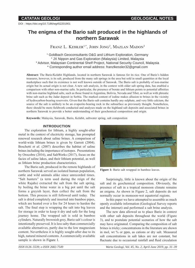
Cover photo: Northerly-striking, steeply east-dipping beds of massive turbiditic sandstones, mapped as the Tajau member of the Kudat Formation, which underlies a large part of Kudat Peninsula, Sabah. This photo, viewed northwards, showed two large spherical sandstone concretions that remain above the wave-cut platform while others have been totally weathered away, leaving circular cavities on the platform. Locality is at the “North Borneo Biostation”, a privately operated beach hotel about 3 km north of Pantai Bak Bak on the northeast coast of Kudat Peninsula. Coordinates: 6.962929, 116.831063. Photo taken by Mazlan Madon in April 2019.
CATATAN GEOLOGI GEOLOGICAL NOTES
ISSN 0126–5539; e-ISSN 2682-7549 Warta Geologi, Vol. 45, No. 2, April-June 2019, pp. 31–39
The enigma of the Bario salt produced in the highlands of northern Sarawak
Franz L. Kessler1,*, John Jong2, Mazlan Madon3
1 Goldbach Geoconsultants O&G and Lithium Exploration, Germany2 JX Nippon and Gas Exploration (Malaysia) Limited, Malaysia
3 Advisor, Malaysian Continental Shelf Project, National Security Council, Malaysia* Corresponding author email address: [email protected]
Abstract: The Bario/Kelabit Highlands, located in northern Sarawak is famous for its rice. One of Bario’s hidden treasures, however, is its salt, produced from the many salt springs in the area but sold in small quantities at the local marketplace such that its existence is not well known outside of Sarawak. The Bario salt is probably of non-marine origin but its actual origin is not clear. A new salt analysis, in the context with older salt spring data, has enabled a comparison with other non-marine salts. In particular, the presence of borate and lithium points to potential affinities with non-marine highland salts, such as those found in Argentina, Bolivia, Nevada and Tibet, as well as with phreatic brine salt such as the Jadar deposit in Serbia. The marked content of iodine makes allusion to brines in the vicinity of hydrocarbon-bearing reservoirs. Given that the Bario salt contains hardly any sulphate, and very little calcium, the source of the salt is unlikely to be an evaporite-bearing rock in the subsurface as previously thought. Nonetheless, there should be more fieldwork conducted and analyses made on the highland salt deposits and associated brines in northern Sarawak to provide a better understanding of their geochemical composition and origin.
Keywords: Malaysia, Sarawak, Bario, Kelabit, saltwater spring, salt composition
INTRODUCTIONThe exploration for lithium, a highly sought-after
metal in the context of electricity storage, has prompted renewed research about saline brines. A comparison of world-wide lithium brines is given by Garrett (2004). Boschetti et al. (2007) describes the habitat of saline brines including the importance of isotopes. Presentations by Orocobre (2016), and SaltWorks (2017), focus on the facies of saline lakes, and their lithium potential, as well as lithium brine production characteristics.
The Bario salt, produced in the remote highlands of northern Sarawak served an isolated human population, cattle and wild animals alike since unrecorded times. “Salt hunters” (a term used during the reign of the white Rajahs) extracted the salt from the salt spring, by boiling the brine water in a big pot until the salt forms a greyish layer, then collect the salt from the bottom. This process is still followed until today. The salt is dried completely and inserted into bamboo pipes, which are heated over a fire for 24 hours to harden the salt. The final step is wrapping the salt into big leaves for storage in order to keep it dry and safe for the long journey home. The wrapped salt is sold in bamboo cylinders. Naturally brownish grey, Bario salt’s colour is intentionally preserved. It is less salty than commercially available alternatives, partly due to the low magnesium content. Nevertheless it is highly sought-after due to its high, natural mineral contents. A commercially available sample is shown in Figure 1.
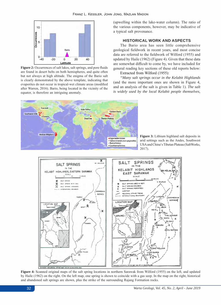
Surprisingly, little is known about the origin of the salt and its geochemical composition. Obviously, the presence of salt in a tropical monsoon climate remains an enigma. As shown in Figure 2, salt deposits do not normally occur in monsoon-wet equatorial regions.
In this paper we have attempted to assemble as much openly available information (Geological Survey reports and the internet) and performed a salt brine analysis.
The new data allowed us to place Bario in context with other salt deposits throughout the world (Figure 3), and to postulate potential scenarios of how the salt may have originated. Comparing the composition of salt brines is tricky; concentrations in the literature are shown in mol, wt % or ppm, as cations or dry salt. Measured salt concentrations in salt lakes are not constant, but fluctuate due to occasional rainfall and fluid circulation
Figure 1: Bario salt wrapped in bamboo leaves.
DOI : https://doi.org/10.7186/wg452201901
Warta Geologi, Vol. 45, No. 2, April - June 201932
Franz L. Kessler, John Jong, Mazlan Madon
Figure 4: Scanned original maps of the salt spring locations in northern Sarawak from Wilford (1955) on the left, and updated by Haile (1962) on the right. On the left map, one spring is shown to coincide with a gas seep. In the map on the right, historical and abandoned salt springs are shown, plus the strike of the surrounding Rajang Formation rocks.
Figure 2: Occurrences of salt lakes, salt springs, and pore fluids are found in desert belts on both hemispheres, and quite often but not always at high altitude. The enigma of the Bario salt is clearly demonstrated by the above template, indicating that evaporites do not occur in tropical-wet climate areas (modified after Warren, 2016). Bario, being located in the vicinity of the equator, is therefore an intriguing anomaly.
Figure 3: Lithium highland salt deposits in arid settings such as the Andes, Southwest USA and China‘s Tibetan Plateau (SaltWorks, 2017).
(upwelling within the lake-water column). The ratio of the various components, however, may be indicative of a typical salt provenance.
HISTORICAL WORK AND ASPECTS The Bario area has seen little comprehensive
geological fieldwork in recent years, and most concise data are referred to the fieldwork of Wilford (1955) and updated by Haile (1962) (Figure 4). Given that these data are somewhat difficult to come by, we have included for general reading key sections of these old reports below:
Extracted from Wilford (1955):“Many salt springs occur in the Kelabit Highlands
(and the more important ones are shown in Figure 4, and an analysis of the salt is given in Table 1). The salt is widely used by the local Kelabit people themselves,
Warta Geologi, Vol. 45, No. 2, April - June 2019 33
The enigma of the Bario salt produced in the highlands of northern Sarawak
traded with inhabitants of adjacent lowland areas, and used to feed Kelabit cattle which are said to come to their owners for their salt ration each evening. The amount of salt available is limited as it is obtained from small wells which often become diluted by heavy rain.
The best known springs are those of the Mein River described in 1909 (Sarawak Gazette, 1 March 1909), a small stream running into the Pa Mada, a tributary of the Baram. ‘ … We reached the Mein River in the early morning and I was shown several holes where the springs had either dried up or had nearly done so. These latter the Kelabits told me were much resorted to at certain times of the year by large birds, such as herons and storks, who walked about on the marshy ground near the spring drinking the water, apparently a sort of bird Marienbad. The Kelabits take advantage of this habit and, erecting leafy shelters near these springs, and shoot the birds down. We crossed the Mein River, the water of which is only slightly salty, but I was informed that on the occasion of a long drought it gets so salty that the fish all die; then ascending a low hill, we reached the first and largest spring, which belongs to a Kelabit chief called Gali Ballang, and has been worked by him and his ancestors for years and years, in fact as far as the memory of these people can go back. It consisted of a hole about 6 feet square and 4 feet deep, and the water was constantly filtering in through the sides. The water tasted very salty and acidic, though the natives here, by a strange subversion of taste, call it “Mein” which means sweet; “Pun Mein” being therefore “sweet spring” really. We then passed on to the factory, which was a bamboo house of about 60 feet long by 30 feet wide. Here a strange sight presented itself to our eyes, so accustomed to Bornean scenery and industry. The whole of the centre of the hut was taken up by rows and rows of furnaces running length wise and being fed at either end. On these furnaces were numbers of large iron cooking pots of about 4 feet in diameter, each furnace accommodating about 10 pots, which were filled with water from the spring and in various stages of boiling. The method employed is to keep on filling the pots with the water as it is boiled away, during the which process the salt coagulates around the sides of the pot whence it is scooped out and poured into bamboos or bark vessels, which are then thrust into the furnace and kept there until the bamboo, or bark has been burnt off, by which time the salt has solidified and comes out in long cylinders or whatever the shape of the vessel in which it was burnt, four fillings of one of these large cooking pots producing one cylinder of salt about 8 inches long and 3 inches diameter.’…”
Additional detailed descriptions were also provided by Haile (1962):
“More than 30 salt springs occur in the mountainous country between Lao Miatu and Ba Kelalan which is drained by the headwaters of the Baram and Trusan rivers. Years ago nearly all these springs were worked and there was a flourishing salt-making industry. At
that time the salt was more widely traded with people in the adjacent lowland areas, where the supply of imported salt was uncertain due to the effects of piracy on trade. The salt was much preferred to the imported varieties and was quite valuable currency at one time, as Hose (1929, p.191), who was resident in the Baram at the end of last century, records: ‘. . . this salt . . . has a widespread reputation and was exchanged with the neighbouring tribes for weapons and rubber. It has a reputation as a preventative of goitre . . . I had some analysed in London, and it showed the presence of iodine and lithium.
With the elimination of piracy on the coast imported salt became more generally available and the value of the local salt has since declined. In November 1957 springs at only four places were worked, and three other springs show signs of having been worked in recent years. The salt is mainly eaten by the Kelabit and Murut inhabitants and their cattle, and only small quantities are now traded with adjacent peoples. Some Kelabits work salt springs in Kalimantan.
Quantity of salt produced. As the springs are only worked on demand and by groups of people from different villages it is difficult to estimate the quantities of salt produced. Annual salt production at Pa Mein, the largest spring in the area, is estimated to be of the order of 3 tons and the total for the whole area to be about 5 tons. The annual production in the neighbouring parts of Indonesian Borneo is probably also several tons. The daily production at Pa Mein, when the springs were not diluted by rain water and when 24 iron pans were used night and day, was estimated by G.E. Wilford to be about 100 pounds. There is little doubt that production could be increased considerably if the demand rises but this seems unlikely unless supplies of imported salt are cut off. Improvements could be made in the quality of the salt produced if precautions were taken to prevent contamination of the salt water by ground water and animals; e.g., by the construction of concrete-lined and covered wells.
Quality of salt and chemical analysis. Most salt produced is a grey, buff or off-white colour; the main impurities responsible for the colour are vegetable remains in the salt water, burnt bamboo bark, and rust from iron pans. There is conspicuous variation in taste between the salt from different springs which is readily recognised by the inhabitants and is probably due to the variation in chemical content.”
GEOLOGICAL SETTING AND STRATIGRAPHY
The geological setting of the Bario/Kelabit Highlands has been summarised by Wilford (1955), Hutchison (1996, 2005), Ghazally Ismael & Laily Bin Din (1998), among others.
The occurrences of salt appear to be contiguous to the Oligocene to Lower Miocene Kelabit Formation.
Warta Geologi, Vol. 45, No. 2, April - June 201934
Franz L. Kessler, John Jong, Mazlan Madon
This formation is described to comprise of mudstone, sandstone, lignite, thin lenses of impure limestone, and rarely conglomerate beds. It outcrops in the Kelapang tributary of the Puak River that flows into the Ulu Baram River. There appears to be some uncertainty in respect of the said Kelabit Formation, given it is surrounded by turbidite sequences of the Rajang Formation. Could the Kelabit Formation be an allochthonous unit? Its mudstone member(s) are said to be commonly calcareous, sandy and poorly bedded. Its colour is stated to be brownish grey to light bluish grey. The limestone is well bedded. This formation yields fossils that are indicative of both Early Oligocene and Early Miocene ages. The strata are folded around north-south axes. A large number of salty water pools occur throughout the area of mudstone outcrops, suggesting that the mudstone outcrops are hosting the salt springs.
Haile (1962) provided the following additional details:Lithology: Mudstone and sandstone are the main
rock types, with some lignite and rare conglomerate. The mudstone is commonly calcareous, invariably sandy, poorly bedded, and typically shows spheroidal weathering and conchoidal fracture. The colour is brownish grey or light bluish grey. At many places it contains fragmentary plant remains and pieces of lignite. Nodules and lenses of clay-ironstone and of hard mudstone are common. Sandstone lenses and blocks, mostly 1 to 2 feet across, are common and have a distinctive irregular rather hackly surface. In most outcrops the sandstone is calcareous and pyritic, and at places contains beds and lenses of impure limestone and veins of calcite. A number of salt springs are associated with this mudstone.
The sandstone is well bedded, and in places contains abundant coalified plant remains and seams and lenses of lignite up to 4 inches thick. This type of sandstone is commonly interbedded with soft, carbonaceous, very sandy black shale, and light-grey mudstone with conchoidal fracture.
Conglomerate are found as boulders at Batu Patong in the Kelapang headwaters, is composed of pebbles up to 2 cm across mainly of red radiolarian chert, vein quartz, sandstone, and agate; the last appears to have been derived from vesicles in a lava without having been rounded to pebbles.
Tectonic aspect: The formation is moderately to steeply folded along north-south axes, and in general the dips are slightly less steep, and the folding more regular and less chaotic than those of the Setap Shale or Kelalan Formations. The mudstone is fairly hard, but no slaty rocks have been seen. The exposure at the mouth the Benaleh is unique in that it shows intense tight folding, including small recumbent folds a few feet across.
Thickness: As the boundaries are not known no reliable estimate of the thickness can be made. From the width of the outcrops it seems probable that the exposed thickness is at least several thousand feet.
Boundaries: Neither the top nor the basal boundary has been discovered. On general structural evidence,
and taking into account palaeontology and the regional geology, it seems probable that the Kelabit Formation overlies the Kelalan Formation either conformably or with a slight unconformity. To the west, the formation is probably overlain conformably by the Meligan Formation of the Tamabo Range. West of the Tamabo Range the formation has not been recognised. This is presumably due partly to the general hiatus in deposition in the Oligocene and partly to the lateral transition of the upper part of the formation into Setap Shale Formation.
Fossils and age: Fossils indicating both Lower Oligocene (Tc) and Lower Miocene (Te1-4) age have been found in the formation. A specimen of calcareous shale from the Kelapang River at the mouth of the Benaleh tributary was examined by R. Todd.
In summary, one might conclude the Kelabit Formation might be an allochthonous block within a sequence of shallow marine, transitional marine and fluvio-terrestrial deposits. Some indications of potential submarine volcanism are present, particularly in conglomerates. The Kelabit Block appears to be enveloped by deep marine turbidite sequences of the Rajang Formation. Perhaps the Kelabit Block belonged to an eastern Oligo-Miocene shelf, and was transported as a nappe westwards until it came to rest upon the anchi-metamorphic Rajang Formation. The Kelabit Block may equally be interpreted as a large size olistostrome.
BARIO SALT SPRINGS AND SALT HABITAT (CITATION OF GHAZALLY ISMAEL &
LAILY BIN DIN, 1998) “The origin of the salt is not known but the springs
occur in a belt parallel to the regional strike of the rocks in this region. A saltmarsh east of Bario at Pa’ Umor, which lies in the above belt, was examined to determine the mode of occurrence of the salty water. The saltish water was observed to occur in swampy ground.
No source was observed and the water thus seems to seep to the surface from below. No rock outcrop was seen at the surface in the vicinity of the swamp which occurs in the soil cover of the area.
Various explanations for the occurrence of the salt have been put forward. It has been postulated that the salt sources and water is probably derived from salt bearing beds from the subsurface rocks in the region - and Jordi (unpublished report of Sarawak Oilfields Ltd.) records that near another salt spring, at a place called Ba Kelalan, a rhythmic alteration of sandstone, siltstone and shale occurs which contain concretions of pyrite and gypsum, which can be the probable source of salts in that area. Another hypothesis to explain the source of salt is offered here. Clay-sized particles when laid down in a marine and brackish environment have very high porosity due to their being laid down in a flocculated condition, i.e., the particles are arranged in clumps - a ‘card house’ structure with edges of particles attracted to faces. When

Warta Geologi, Vol. 45, No. 2, April - June 2019 35
The enigma of the Bario salt produced in the highlands of northern Sarawak
Table 1: Brine analysis in percentage, published by Wilford in 1955.
PercentNaCl 94.08KCl 0.50Na2B4O7 2.30CaCO3 2.25SrCO3 0.32BaCO3 0.14KI 0.068SiO2 0.120Al2O3 + Fe2O3 0.055
99.83
the clay is above sea level and is exposed to freshwater moving through it the salt in the pore fluid is removed.”
BARIO SALT COMPOSITION(WILFORD, 1955)
The salt’s composition is summarised in the following Table 1.
These results can be re-calculated to compounds present in the sample dried at 300 °C (Haile, 1962).
The sample contains potassium iodate, Al2O3 + Fe2O3 are probably clays.
The sample did not exhibit any detectable radioactivity. Nitrates, nitrites and ammonium salts were not detected. A considerable amount of water-insoluble matter was present, amounting to 2.68 % of the dried salt. This is included in the above analysis and consists mainly of carbonates of calcium, strontium and barium.
The presence of an appreciable quantity of borate (2.3% Na2B4O7) is noteworthy. This is probably present in the original sample as borax, Na2[B4O5(OH)4].8H2O. The difference in water content is likely due to the
heating of the salt during the drying process. Equally noteworthy is the extremely high Na content (94.08% NaCl). In contrast, inland salt lakes studied by Orocobre (2016; Chile, Argentina, Bolivia, Nevada) and Boschetti et al. (2007; Salar de Atacama, Chile) have fairly low Na.
Haile (1962) also mentioned the presence of lithium in the salt, however there is no quantity mentioned. A packed Bario salt bottle, sold in a Miri supermarket some 10 years ago, also mentioned lithium as part of the composition. To verify this and other compositional aspects we therefore carried out a new analysis.
2019 SALT COMPOSITION ANALYSISSample preparation procedure• Some 50 g of Bario salt was cut from the cucumber-
shaped salt stick, and the leave cover removed; • The salt is a commercially available commodity and
packed in Miri, Sarawak (Figure 1); • The salt looks greyish, its taste being is indeed salty,
however with a strong bitter aftertaste;• Heated to above 300 °C to remove moisture and crystal
bound water; (300 °C such that the new analysis can be compared to Wilford, 1955);
Figure 5: Salt brine samples ready for dispatch to the lab for compositional analysis.
Warta Geologi, Vol. 45, No. 2, April - June 201936
Franz L. Kessler, John Jong, Mazlan Madon
Figure 6: Model by Özdemir (2018) for iodine-rich brines escaping from folded and thrusted rock hosting hydrocarbons.
Table 2: Results of the Bario salt analysis (2019).
• Preparation of a primary brine sample of 60 ml with 5 g dissolved salt;
• Filtering of the primary brine, 0.08 g of dark silty solids (= 0.016 %) were removed;
• The filtered brine looked dark yellow-brown, and was divided in two test tubes of 15 ml content each, containing 1.246 g salt (Figure 5);
• The samples were packed and sent to a specialised water laboratory in Germany for compositional analysis.
INTERPRETATION OF ANALYTICAL RESULTS
Wilford (1955) data and the new analysis are very similar (Table 2). The analysed data point to the presence of key components, which could help to explain where the source of the salt is located, as summarised below:• Borate (B4O7): The high content points to phreatic
steam eruptions. Boric acid, or sassolite, is found mainly in its free state in some volcanic districts, for example, in the Italian region of Tuscany, the Lipari Islands and the US state of Nevada. In these volcanic settings the borate is seen to emanate, in phase with steam, from fissures in the ground.
• Lithium (Li): The presence of lithium points to a volcanic or plutonic source, and enrichment in either super arid climate or, alternatively, the former presence of volcanic to phreatic vents.
• Strontium (SrCO3): Strontianite, a typical hydrothermal gang mineral.
• Barium (BaCO3): Witherite, forms in low temperature hydrothermal environments. It is commonly associated with fluorite.
• Fluorine (F): See above.
Figure 7: Sodium and lithium concentrations in thermal springs, oil-field brines, and related temperature trends in Rhine Graben Area; this in comparison with Bario, a low-temperature brine (blue triangle). Hot brines generally contain more lithium (modified after Dezayes et al., 2015).
• Phosphate (PO4): Non-diagnostic, could be contamination.
• Iodine (I): Typically found in salt brines and caliche, but also in escaping oilfield brines, in combination with other geological parameters such as tectonism and volcanism (Özdemir, 2018) (Figure 6). This view needs to be further explored given that at least one Bario salt spring coincides with an active gas seep.
• Absence of typical marine salt constituents in the old analysis: Magnesium (Mg), Sulphate (S04), Bromine (Br); some Mg was found in the new analysis, but hardly any SO4.
CATION RATIOS• Sodium to Lithium Ratio. Dezayes et al. (2015)
could prove on examples of several salty springs in the Rhine Graben a temperature relationship between sodium and lithium cation contents in the respective brines (Figure 7). Hot brines tend to be strongly enriched in lithium, whilst relative cool springs such
Warta Geologi, Vol. 45, No. 2, April - June 2019 37
The enigma of the Bario salt produced in the highlands of northern Sarawak
Figure 8: Bario and highland salts in light of borate and lithium contents.
Table 3: Bario in comparison with other lithium and borate salt brines.
as oilfield brines tend to carry little lithium only. The salty water of Bario is cool, and the observed Na/Li ratio could point to oilfield brine. Averaged sodium to lithium ratios are (from above cited literature): Geothermal brines: 170; Most saline highland lakes: 40-100; Oilfield brines: 1150; Bario: 3580.
• Lithium to Borate Ratio. High values of borate and lithium may point to proximity of a hot volcanic/phreatic source, whereas low values in both could be a characteristic for saline lakes without a strong volcanic association. Table 3 shows Bario results in context with highland salts (after Garrett, 2004). A crossplot between Na/Li versus B4O7/Li, shows that Bario salt may be compared to some highland salt deposits (Table 3), in particular to the composition of Clayton valley in Nevada (Figure 8).
DISCUSSION: IS THE SOURCE OF THE BARIO SALT AN EVAPORITIC SEQUENCE?
On the first glance, one might feel inclined to treat Bario salt as a derivative of an evaporitic sequence as suggested by Hutchison (1996), with the view that the
salty brine used for salt productions stems from a salt-bearing sequence in contact with shallow aquifers, hence resulting in salty groundwater. However, there are two important arguments against this interpretation:1. In the tropical rainforest climate of Bario, a near-
surface salt deposit would not last very long, and there seem to be no indications of dissolution cavities (dissolved salt, gypsum, etc.) in the ground. Some gypsum has been mentioned by Wilford (1955) and Ghazally Ismael & Laily Bin Din (1998), but it seems to be very localised and thin-bedded.
2. The original chemical analysis shown by Wilford (1955) found no sulphate, whereas the 2019 analysis showed 6.11 mg/l sulphur. If the Bario brine would be a product of groundwater leaching evaporitic beds, both the level of calcium and sulphur should be considerably higher. Given the elevated contents of borate and lithium, one might consider Bario as a highland salt that was formed under extremely arid condition in the shadow of high mountain ranges. However, there are also some locations in the world, where similar lithium/borate spring deposits are

Warta Geologi, Vol. 45, No. 2, April - June 201938
Franz L. Kessler, John Jong, Mazlan Madon
reported, yet without a prominence of evaporates. A classification of lithium salt and borate deposits by Warren (2016) is summarised in Table 4.Another potential analogue may be the Jadar deposit
near the town of Loznica in Serbia (SaltWorks, 2017). It is a prominent lithium deposit in addition to an inferred resource of boron minerals. Jadarite has so far only been identified in significant amounts within the 20 km long Jadar Basin of Serbia, which is similar in size as the Kelabit Block, and entrains oil shales, dolomicrites, pyroclastic sediments and evaporates. These deposits are believed to have been accumulated in an intermontane lacustrine environment. Jadarite is likely formed via a hydrothermally-facilitated interaction between saline brine and clastic/evaporitic sediment, either in a tuffaceous or clay host. It is possible that the host mineral for the Bario salt might be colemanite (secondary mineral after borax) or jadarite (a Na, Li, B silicate), which decompose in the groundwater realm and by doing so creates the brine.
Orocobre (2016) suggested the high Lithium content by reaction of hydrothermal fluids with volcanics or simply leaching of volcanics at lower temperature. A high sodium content has been reported in a number of cases and could be an indication for marine influences as in the case of Chaxa Lagoon (Salar de Atacama) or leaching of marine salt deposits.
Wilford’s older map shows a gas seep that coincides with a salt spring (Figure 4), and there might be an association between the Bario salt springs and hydrocarbon-bearing rock. This said, with only very little fieldwork data and even less geochemical samples, the jury is still out for the best explanation of the salt´s host rock and the origin of the salt itself.
CONCLUSIONS AND FURTHER WORKThe new analysis completes and corroborates the
Wilford (1955) results. Bario salt is a likely non-marine salt of yet unknown origin. It contains significant amounts of lithium, borate, and iodine as well as a marked presence
of strontium, barium and antimony. The new analysis, in context with older salt spring data has made a comparison with other equally non-marine salts possible. The presence of borate and lithium points to potential affinities with both non-marine highland salts from those found in Argentina, Bolivia, Nevada and Tibet, as well as with phreatic brine salt of the Jadar deposit in Serbia. The Bario salt contains little sulphur; further work should try to clarify whether or not the sulphur is related to minerals such as gypsum, or has originated from oxidation of pyrite. The calcium concentration is lower than in normal sea water, the Bario salt is therefore unlikely to have been derived from leaching evaporite-bearing sediments in the subsurface as has been suggested by earlier authors.
Clearly, there is a lack of data in almost every aspect. Whilst we are in no way critical of the fieldwork of the 1950’s to 1960’s, there should be more fieldwork conducted and more salt deposits, as well as brines analysed in northern Sarawak to provide a better understanding of their geochemical composition including several elemental ratios for a provenance study. It is noted that concurrently, a research study on salt brine samples is being conducted by a Masters student at Curtin University Malaysia. Based on additional data, it will be interesting to see, if the Bario salt can be put in comparison with other highland salts. We need to understand where the sources of both borate and lithium are located, and if the lithium content is sufficient for economic exploitation. Furthermore, a stable isotope analysis especially for barium could potentially help to unravel the origin of the Bario salt.
Interestingly, an earlier medical research article by Zaleha et al. (2002) has shown a correlation between high cognitive ability of Bario school children compared to other isolated communities due to their intake of Bario salt, which has high micronutrients, especially iodine. The relative high content of iodine might also point to an association of the Bario springs with hydrocarbon-bearing reservoir.
Table 4: Types and origins of lithium deposits (Warren, 2016 and SaltWorks, 2017).

Warta Geologi, Vol. 45, No. 2, April - June 2019 39
The enigma of the Bario salt produced in the highlands of northern Sarawak
Finally, is the Bario salt production, which has been going on for an unrecorded time, sustainable for an economic extraction of lithium? Will it help to continue support the iodine requirements of the local population? We believe there is a call for further action to address these questions.
ACKNOWLEDGEMENTSWe are indebted to the excellent fieldwork of the
Bario/Kelabit Highlands conducted by our pioneers that has laid the foundation for this discussion paper. We thank Dr. Mike Scherer for his enthusiastic review and feedback that improve the content and quality of the manuscript.
REFERENCESBoschetti, T., Cortecci, G., Barbieri, M. & Mussi, M., 2007. New
and past geochemical data on fresh to brine waters of the Salar de Atacama and Andean Altiplano, northern Chile. Geofluids, 7, 33–50.
Dezayes, C., Lerouge, C., Sanjuan, B., Ramboz, C. & Brach, M., 2015. Toward a better understanding of the fluid circulation in the Rhine Graben for a better geothermal exploration of the deep basins. World Geothermal Congress 2015, Apr 2015, Melbourne, Australia. Proceedings World Geothermal Congress 2015. <hal-00936646> .
Garrett, D, E., 2004. Handbook of Lithium and Natural Calcium Chloride. First Edition, Academic Press, Elsevier. 488 p.
Ghazally Ismail & Laily bin Din (eds), 1998. A Scientific Journey
Through Borneo: Bario the Kalabit Highlands of Sarawak. Faculty of Resource Science and Technology, University Malaysia Sarawak. Pelanduk Publications (M) Sdn Bhd. 35 p.
Haile, N.S., 1962. The geology and mineral resources of the Suai-Baram area, north Sarawak. Geological Survey Department British Territories in Borneo, Memoir 1.
Hutchison, C.S., 1996. Geological Evolution of South-East Asia. Geological Survey of Malaysia, Kuala Lumpur. 369 p.
Hutchison, C.S., 2005. Geology of North-West Borneo: Sarawak, Brunei and Sabah. Elsevier, Amsterdam. 421 p.
Orocobre, 2016. Lithium salt lake – Powering the future. Hydrominex Geoscience Consulting. Retrieved from https://www.orocobre.com/wp/?mdocs-file=1105.
Özdemir, A., 2018. Iodine-rich waters of Turkey and oil & gas potential of the onshore. Journal of Sustainable Engineering Applications and Technological Developments, 1(2), 103-150.
SaltWorks, 2017. Lithium in saline settings. Retrieved from http://www.saltworkconsultants.com/blog/tag/lithium_brine/.
Warren, J.K., 2016. Evaporites: A Geological Compendium. Second Edition, Springer. 1812 p.
Wilford, G.E., 1955. Salt springs in the Kelabit Highlands. Geological Survey Department British Territories in Borneo annual report.
Zaleha, M.I., A.R. Noor Hayaati, A.R. Mohd. Rizam & M. Jamaludin, 2002. Micronutrients and its correlation with mental performance among school children in Bario, Sarawak: A preliminary study. Med. J. Malaysia, 58(3), 309-319.
Manuscript received 20 February 2019Revised manuscript received 6 March 2019
Manuscript accepted 8 March 2019
CATATAN GEOLOGI GEOLOGICAL NOTES
ISSN 0126–5539; e-ISSN 2682-7549 Warta Geologi, Vol. 45, No. 2, April-June 2019, pp. 40–42
Correlation of seismic velocity and mechanical properties of metasandstone from CTW-1 well, Seri Iskandar, Perak, Malaysia
Norsyafiqah Salimun*, Abdul Ghani Rafek, Khairul Arifin Mohd. Noh
Department of Petroleum Geosciences, Universiti Teknologi PETRONAS (UTP),Bandar Seri Iskandar, 32610, Perak, Malaysia
*Corresponding author email address: [email protected]
Abstract: Laboratory rock testing offers an alternative for estimation of rock mass properties through correlation of P-wave velocity and rock strength parameters for preliminary investigation in engineering geology. However, limited studies have been conducted on sedimentary rocks; e.g., sandstones and limestone in the Peninsular Malaysia. In this study, two laboratory tests using 18 metasandstone core samples obtained from CTW-1 well have been conducted to determine the correlation between P-wave velocities and uniaxial compressive strength (UCS). Measurements were conducted using ultrasonic wave pulse transmission and Schmidt rebound hammer. Rock Quality Designation (RQD) of core samples was also correlated with the P-wave velocity obtained from well log data. Four correlations were established from the results as follows; i) RQD = 99.772 (Q) + 0.2351, ii) RQD = 0.0151(Vp) + 20.353, iii) UCS = 0.0472Vp – 144.12 and iv) UCS = 0.064Vs – 72.31 with regression value of 0.99, 0.87, 0.93 and 0.78 respectively. The findings show good to acceptable correlations between P-wave velocities and UCS, RQD and velocity index, Q of the rock mass. These correlations serve as an alternative for estimating rock materials and rock mass parameters, based on the P-wave velocities and velocity index, Q. Similar correlations can be established for other rock types.
Keywords: Seismic velocity, mechanical properties, metasandstone
INTRODUCTIONCTW-1 well is a 416 m vertical onshore well drilled
in sedimentary rock of the Kati Formation at the UTP campus, Seri Iskandar. The lithology is mainly composed of sandstone, metasandstone and mudstone or shale interbedded with sandstone (Alkhali & Chow, 2014). Since there is lacking study to quantify the geophysical and geomechanical properties of sedimentary rocks in Peninsular Malaysia, this research therefore aims to establish a correlation between these parameters. Thus, the availability of the cores from the CTW-1 well was used to establish correlations between P-wave seismic velocity and other parameters i.e., uniaxial compressive strength (UCS), rock quality designation (RQD) and velocity index (Q). Correlation between seismic velocity and rock mechanics parameters is commonly adapted in engineering geology and preferred as it is a non-destructive method with lower cost (Goh et al., 2016). For instance, correlations between UCS values and sonic velocity have been widely used to predict in situ rock strength because these models are quick and simple to understand (Butel & Hossack, 2014).
However, there are limited studies of this correlation for sedimentary rocks as a majority of the studies are confined to igneous (granite) and metamorphic rocks (schist) (Goh et al., 2015; 2016). Not many studies had been performed on sedimentary rocks such as sandstone, mudstone and shale due to the unavailability
of unweathered and hard rock samples that are essential for rock mechanics testing. The availability of fresh sedimentary core samples from the CTW-1 well was an opportunity that allows further study on rock physical and mechanical properties relationship for local geological reference.
METHODOLOGY A total of 18 metasandstone core samples was used
for the velocity test. The cores were taken at varying depths from the CTW-1 well. The core dimension is 6.35 cm ± 0.05 cm in diameter, and 7.62 cm ± 0.05 cm in length. To measure the P-wave velocity, a high frequency ultrasonic velocity test (at ambient conditions) was conducted using Sonic Viewer S-X equipment with a frequency of 200 kHz. The travel time of P-wave to travel from the transmitter to the receiver was obtained using the following equation:
Velocity = d x t-1 (1)Where, d is the height of the core sample and t is
the first (peak) arrival time of the wave. The P-wave velocity in the field is estimated from the sonic log well data, taken at similar depths as the core samples.
The uniaxial compressive strength was estimated using the rebound number R from Schmidt Hammer test. The hammer measures the rebound of a spring loaded mass impacting against the surface of a sample. UCS value
DOI : https://doi.org/10.7186/wg452201902
41Warta Geologi, Vol. 45, No. 2, April – June 2019
Correlation of seismic velocity and mechanical properties of metasandstone from CTW-1 well
was estimated using the existing formula for consolidated sandstone lithology, in this case metasandstone.
UCS = 2 * R (2) (Singh et al., 1983)
The core samples selected for this test were intact (fractures were cemented), petrographically uniform and representative of the rock mass domain (Aydin, 2014).
Rock quality designation (RQD) is defined as “the percentage of intact core pieces longer than 100 mm compared to the total length of the borehole” (Deere et al., 1967). It is a practical method in rock mass classification because of its simplicity and effectiveness for surface scanlines or borehole measurements (Sen, 2014). The RQD measurement followed the ASTM D 6032-01 (2006) using the formula in the following equation:
RQD = ((Sum of core pieces ≥ 100mm)/(Total length of borehole) x 100%), (3) (Deere et al., 1967)
RQD can also be estimated from the ratio of Vpf (P-wave velocity of in situ rock mass) to Vpo (P-wave velocity of the corresponding intact rock) (Liu et al., 2017). The ratio of Vfield / Vlab when squared is called the velocity index, Q. RQD is numerically close to the value of velocity index, Q and their rock quality as presented in Table 1.
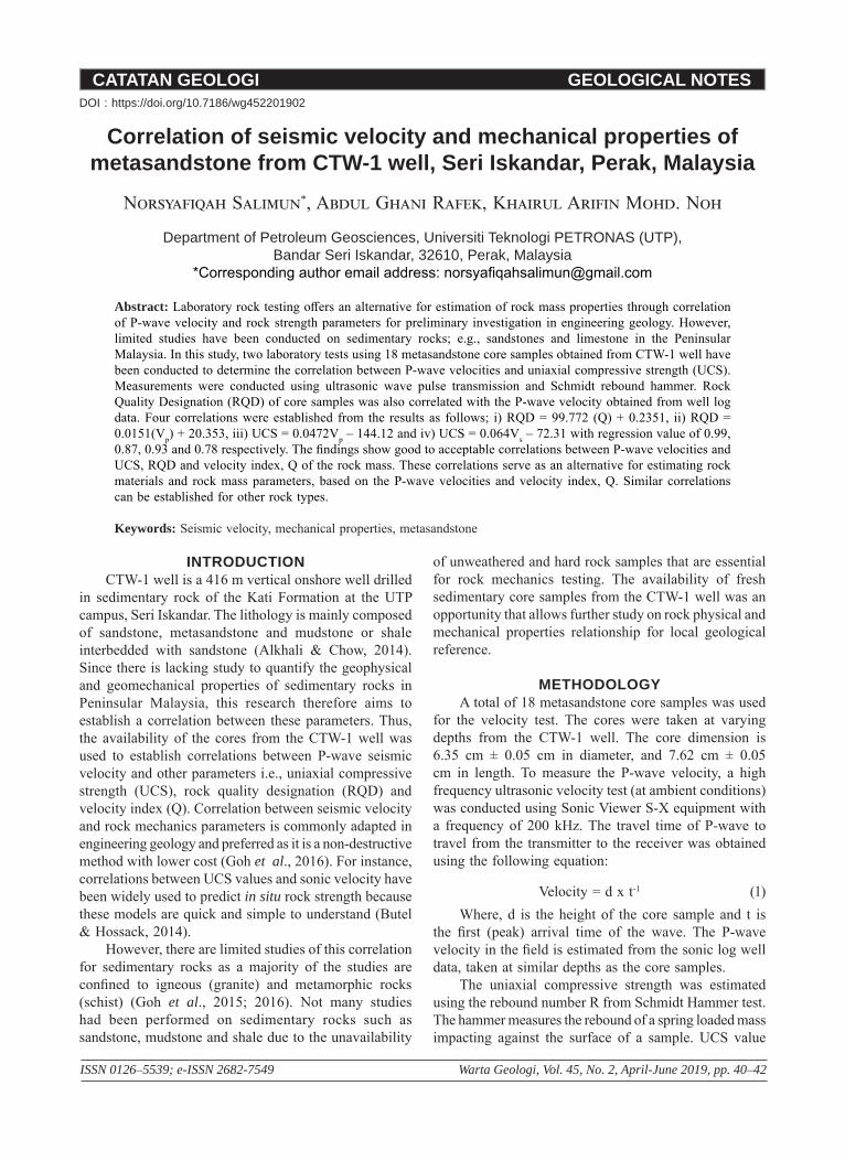
RESULTS AND DISCUSSIONTable 2 summarizes the empirical relationship
developed between P-wave velocity and UCS, RQD and Q-index parameters. The empirical formula developed a
linear relationship when P-wave velocity was correlated with UCS; UCS = 0.0472Vp – 144. The R2 obtained from the correlation is 0.93, showing good relationship between the parameters (Figure 1). Measured rebound values ranging from 15 to 30 will deem the rock as fairly strong rock, while greater than 30 will rate the rock as strong (Wang et al., 2017). The R values obtained from the Schmidt hammer test ranged from 26 to 52, this classified the rock as a fairly strong to strong rock.
The lowest average value of UCS was 49 MPa while the highest was 103 MPa. This showed that the grade of the rock strength is strong to very strong (Goel, 1999), that corresponded to the high value of velocity measured in the lab, ranging from 4000 ms-1 to 5500 ms-1. The equations were validated using different rock samples and compared with the values generated from the equations. The percentage of difference between the values is less than 5%. Hence, the equation can be acknowledged as an alternative for UCS estimation when seismic velocity is available for the specific lithology.
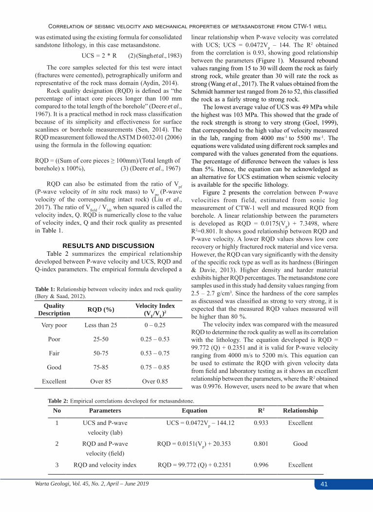
Figure 2 presents the correlation between P-wave velocities from field, estimated from sonic log measurement of CTW-1 well and measured RQD from borehole. A linear relationship between the parameters is developed as RQD = 0.0175(Vp) + 7.3498, where R2=0.801. It shows good relationship between RQD and P-wave velocity. A lower RQD values shows low core recovery or highly fractured rock material and vice versa. However, the RQD can vary significantly with the density of the specific rock type as well as its hardness (Biringen & Davie, 2013). Higher density and harder material exhibits higher RQD percentages. The metasandstone core samples used in this study had density values ranging from 2.5 – 2.7 g/cm3. Since the hardness of the core samples as discussed was classified as strong to very strong, it is expected that the measured RQD values measured will be higher than 80 %.
The velocity index was compared with the measured RQD to determine the rock quality as well as its correlation with the lithology. The equation developed is RQD = 99.772 (Q) + 0.2351 and it is valid for P-wave velocity ranging from 4000 m/s to 5200 m/s. This equation can be used to estimate the RQD with given velocity data from field and laboratory testing as it shows an excellent relationship between the parameters, where the R2 obtained was 0.9976. However, users need to be aware that when
Table 1: Relationship between velocity index and rock quality (Bery & Saad, 2012).
Quality Description RQD (%) Velocity Index
(VF/VL)2
Very poor Less than 25 0 – 0.25
Poor 25-50 0.25 – 0.53
Fair 50-75 0.53 – 0.75
Good 75-85 0.75 – 0.85
Excellent Over 85 Over 0.85
Table 2: Empirical correlations developed for metasandstone.
No Parameters Equation R2 Relationship
1 UCS and P-wavevelocity (lab)
UCS = 0.0472Vp – 144.12 0.933 Excellent
2 RQD and P-wave velocity (field)
RQD = 0.0151(Vp) + 20.353 0.801 Good
3 RQD and velocity index RQD = 99.772 (Q) + 0.2351 0.996 Excellent

42 Warta Geologi, Vol. 45, No. 2, April – June 2019
Norsyafiqah Salimun, Abdul Ghani Rafek, Khairul Arifin Mohd. Noh
utilizing these developed equations or those given in the literature, each estimation is only valid for a particular test condition and rock type (Kahraman & Yeken, 2008).
CONCLUSIONIn conclusion, the correlations established between
the P-wave velocity and other mechanical properties of the samples show good to excellent relationships. These empirical relationships can be utilised as an alternative approach to estimate the rock parameters for preliminary field investigations or, in situations where data is limited. The scope of this study only focused on metasandstone. However, it can also be extended to other rock types.
ACKNOWLEDGEMENTSSpecial thanks to the laboratory technician at the
Department of Geosciences who helped in the experimental processes. We would also like to thank University Research Internal Fund (URIF) for providing a grant for this project.
REFERENCESAlkhali H. A., & Chow W.S., 2014. The Kati Formation: A
review. In: Proceedings of the International Conference on Integrated Petroleum Engineering and Geosciences, Kuala Lumpur, Malaysia.
Aydin, A., 2014. ISRM Suggested Method for Determination of the Schmidt Hammer Rebound Hardness : Revised Version, 2007–2014. https://doi.org/10.1007/978-3-319-07713-0.
Bery, A. A., & Saad, R., 2012. Correlation of Seismic P-Wave Velocities with Engineering Parameters (N Value and Rock Quality) for Tropical Environmental Study. International Journal of Geosciences, 3, 749–757. https://doi.org/10.4236/ijg.2012.34075.
Biringen, E., Corporation, B. P., & Davie, J., 2013. Correlation Between Vs And RQD For Different Rock Types, 0–4.
Butel, N., & Hossack, A., 2014. Prediction of in situ rock strength using sonic velocity. Coal Operator’s Conference, 89–102.
Deere, D.U., Henderson, A.J., Patton, F.D. & Cording, E. J., 1967. Design of surface and near-surface construction in rock. In Failure and Breakage of Rock. Proc. Sym on Rock Mechanics. Charles Fairhurst (Ed.) AIMM&PE, New York., 8.
Goel, B. S. R. K., 1999. Rock Mass Classification: A practical approach in Civil Engineering. Elsevier Sciences, U.K. 267 p.
Kahraman, S., 2007. The correlations between the saturated and dry P-wave velocity of rocks. Ultrasonics, 46(4), 341–348. https://doi.org/10.1016/j.ultras.2007.05.003
Kahraman, S., & Yeken, T., 2008. Determination of physical properties of carbonate rocks from P-wave velocity. Bulletin of Engineering Geology and the Environment, 67(2), 277–281. https://doi.org/10.1007/s10064-008-0139-0
Goh. T.L., A.G. Rafek, Ailie. S.S, Hussin A.,& L. K. Ern, 2016. Use of ultrasonic velocity travel time to estimate uniaxial compressive strength of granite and schist in Malaysia. Sains Malaysiana, 45(2), 185–193.
Goh. T.L., A.G. Rafek, Ailie. S.S, Hussin A., Simon, N. & L. K. Ern, 2015. Empirical correlation of uniaxial compressive strength and primary wave velocity of Malaysian schists. Electronic Journal of Geotechnical Engineering, 20(5), 1801–1812.
Liu, J. Sen, Li, H. B., Zhang, G. K., & Deng, J., 2017. Correlations among Physical and Mechanical Parameters of Rocks. Applied Mechanics and Materials, 865, 366–372. https://doi.org/10.4028/www.scientific.net/AMM.865.366.
Şen, Z., 2014. Rock quality designation-fracture intensity index method for geomechanical classification. Arabian Journal of Geosciences, 7(7), 2915–2922. https://doi.org/10.1007/s12517-013-0975-5.
Singh, R.N., Hassani, F.P., & Elkington, P. A. S., 1983. The application of strength and deformation index testing to the stability assessment of coal measures excavations. In 24th
US Symp. On Rock Mech. (p. 599–609.). Texas.Wang, H., Lin, H., & Cao, P., 2017. Correlation of UCS Rating
with Schmidt Hammer Surface Hardness for Rock Mass Classification. Rock Mechanics and Rock Engineering, 50(1), 195–203. https://doi.org/10.1007/s00603-016-1044-7.
Figure 2: Relationship between field P-wave velocity and RQD.
Figure 1: Relationship between laboratory P-wave velocity and average UCS.
Manuscript received 5 July 2018Revised manuscript received 16 January 2019
Manuscript accepted 23 March 2019
CATATAN GEOLOGI GEOLOGICAL NOTES
ISSN 0126–5539; e-ISSN 2682-7549 Warta Geologi, Vol. 45, No. 2, April-June 2019, pp. 43–47
Stability of slope along steep road in Abha, Asir Region,Kingdom of Saudi Arabia
Saiful Islam1,*, Rini Asnida Abdullah1, Javed Mallick2, Mohd Ahmed2
1 Faculty of Civil Engineering, Universiti Teknologi Malaysia, Johor, Malaysia2 Department of Civil Engineering, King Khalid University, Kingdom of Saudi Arabia
*Corresponding author email address: [email protected]
Abstract: Slope stability plays a vital role in steep mountainous slopes. The main aim of this study is to investigate the slope stability of an area located along a steep road in Abha, Asir Region, Saudi Arabia using numerical simulation software -FLAC -3D. The area is frequently facing problems of slope failure due to various factors, including heavy rainfall, faulting planes, shear zones, weak rocks, narrow road sections with horizontal and vertical curves, and anthropogenic activities as well. The geotechnical parameters required as input data is determined from laboratory testing. From the analysis it was observed that the maximum displacement computed in the slope in the x-direction is 0.0162 m and the specific maximum displacement computed in the slope in the z-direction is 0.166 m. The analysis of XX stress shows that the tensile stress occurred along the top of the slope and its value is 45.68 kPa. While analysis of YY stress shows that the tensile stress occurred along the top of the slope and its value is 15.43 kPa. Similarly, it can be seen from the figure of ZZ stress contour that the tensile stress occurred along the top of the slope with value of 15.75 kPa. It was observed that negligible deformation occurred in the y-direction. The places at which the value of factor of safety showed less than one confirms instability.
Keywords: Slope stability, numerical simulation, factor of safety, failure surface
INTRODUCTIONIn Asir Region, most of the road and highway
constructions require significant rock cutting operations as these roads pass through complex terrains. Most of the cutting operations are generally done by blasting and mechanical excavation which in turn give rise to highly unstable slopes containing many weak zones. The climate in Asir Region is characterised by significant rainstorms during summer season, resulting in deterioration of the rock cuts and subsequently rendering the area as vulnerable due to high slope failures.
Currently, the problem of slope failures has become predominant due to anthropogenic activities (i.e. road cutting operations) and the development of the area for housing purposes, large infrastructures and quarries as well (Alemdag et al., 2014). The rock slope unstability is mostly caused by poor blasting operations, adverse changes in climate, and presence of discontinuities in the slopes (Li et al., 2009). Thus, it is very important to know the orientation, nature and properties of discontinuities and also the geological parameters and properties of intact rocks during slope stability investigations (Singh et al., 2013). Moreover, earthquake activities or high groundwater pressures (after rainstorms) will also lead to high risk of slope failures (Youssef & Maertz, 2013; Zhou et al., 2013; Bai et al., 2014; Igwe, 2015). The literal meaning of slope stability is the resistance of an inclined block to sliding or to collapse along a slip surface (Youssef et al., 2015). Several researchers (Goodman,
1989; Pettifer & Fookes, 1994; Wyllie & Mah, 2014) developed various important methods to analyze unstable slopes such as limit equilibrium approach, kinematical method and most predominantly the numerical technique. Kinematical analysis deals with only movement of slopes consisting of blocks without taking into account the forces that cause the block to move. Meanwhile, limit equilibrium approach considers various important parameters such as the shear strength of rock, intrinsic and external forces. On the contrary, numerical analysis are done in order to verify and check the results obtained through kinematic and limit equilibrium approaches (Gurocak et al., 2008). Hence, we can say that the numerical method proves to be a very important tool for slope stability analysis and currently, numerical techniques such as FEM, FDM, and DEM are the popular techniques to judge slope stability (Verma & Singh, 2010; Sarkar et al., 2012).
In this present study, Flac 3d is the numerical technique used to check the stability of a vulnerable slope by computing displacements in different directions. The factor of safety is also computed in order to determine the unstable region in the slope.
STUDY AREAThe study area is located in the southern most
mountainous part of Samma escarpment road that lies in Asir Province of Kingdom of Saudi Arabia, shown in Figure 1. The weather is characterized by substantial rainstorm during summer seasons; and this leads to
DOI : https://doi.org/10.7186/wg452201903
44 Warta Geologi, Vol. 45, No. 2, April – June 2019
Saiful Islam, Rini Asnida Abdullah, Javed Mallick, Mohd Ahmed
deterioration of the rock cuts and creating areas that are prone to slope failures. Currently these escarpment roads that are one of the passages connecting villages and cities such as Abha and Baha are facing rockslide problems.
As far as geological aspect is concern, the bedrock outcropping along the Samma road comes under Neoproterozoic Bahah Group. The dominant rock type is light-to-dark-colored phyllites (meta-mudstones and meta-siltstones) interbedded with massive graywackes, black graphitic slates, and cut by concordant diabase sills. Phyllites are commonly laminated and have well developed metamorphic foliations (parallel to bedding). Another structure that had originated after a large-scale folding activity is low-angle thrust faults (Youssef et al., 2015).
NUMERICAL MODELINGThe purpose of implementing the Flac-3D software is
to solve various problems related to geo-mechanics (Itasca, 2003). Three-dimensional nonlinear analysis scheme is used by implementing the finite difference code Flac-3D to study the slope of Samma escarpment road. Flac-3D exhibit self-generating 3D grid generator capabilities. The grids are generated by defining pre-defined shapes such as brick, wedge, pyramid and cylinder.
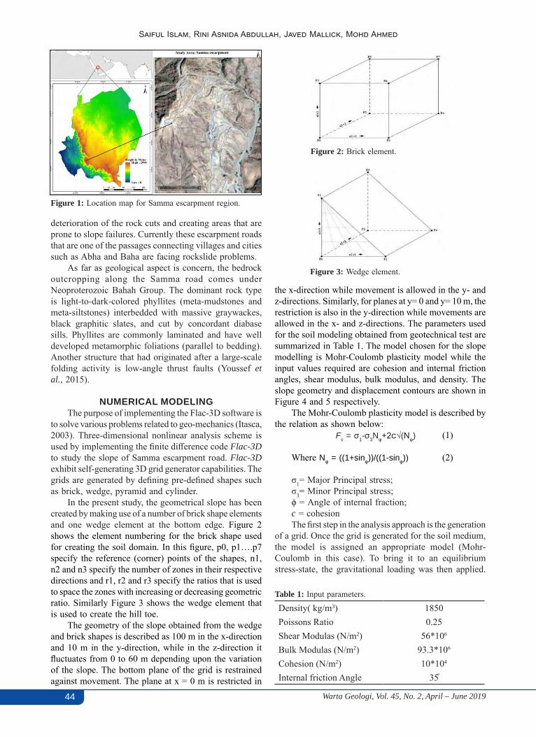
In the present study, the geometrical slope has been created by making use of a number of brick shape elements and one wedge element at the bottom edge. Figure 2 shows the element numbering for the brick shape used for creating the soil domain. In this figure, p0, p1….p7 specify the reference (corner) points of the shapes, n1, n2 and n3 specify the number of zones in their respective directions and r1, r2 and r3 specify the ratios that is used to space the zones with increasing or decreasing geometric ratio. Similarly Figure 3 shows the wedge element that is used to create the hill toe.
The geometry of the slope obtained from the wedge and brick shapes is described as 100 m in the x-direction and 10 m in the y-direction, while in the z-direction it fluctuates from 0 to 60 m depending upon the variation of the slope. The bottom plane of the grid is restrained against movement. The plane at x = 0 m is restricted in
Figure 1: Location map for Samma escarpment region.
Figure 2: Brick element.
Fs = σ1-σ3Nφ+2c√(Nφ)
Figure 3: Wedge element.
Table 1: Input parameters.
Density( kg/m3) 1850Poissons Ratio 0.25Shear Modulas (N/m2) 56*106
Bulk Modulas (N/m2) 93.3*106
Cohesion (N/m2) 10*104
Internal friction Angle 35֩
the x-direction while movement is allowed in the y- and z-directions. Similarly, for planes at y= 0 and y= 10 m, the restriction is also in the y-direction while movements are allowed in the x- and z-directions. The parameters used for the soil modeling obtained from geotechnical test are summarized in Table 1. The model chosen for the slope modelling is Mohr-Coulomb plasticity model while the input values required are cohesion and internal friction angles, shear modulus, bulk modulus, and density. The slope geometry and displacement contours are shown in Figure 4 and 5 respectively.
The Mohr-Coulomb plasticity model is described by the relation as shown below:
(1)
Where Nφ = ((1+sinφ))/((1-sinφ)) (2)
σ1= Major Principal stress; σ3= Minor Principal stress;ϕ = Angle of internal fraction;c = cohesionThe first step in the analysis approach is the generation
of a grid. Once the grid is generated for the soil medium, the model is assigned an appropriate model (Mohr-Coulomb in this case). To bring it to an equilibrium stress-state, the gravitational loading was then applied.
45Warta Geologi, Vol. 45, No. 2, April – June 2019
Stability of slope along steep road in Abha, Asir Region, Kingdom of Saudi Arabia
The slope model will attain its equilibrium condition when each grid point net nodal force vector reaches zero. However, in numerical simulation the maximum unbalanced forces will not reach zero but it is assumed to be in an equilibrium state when the maximum unbalanced force is negligibly small compared to the total applied force. The safety factor (FOS) computed by Zheng et al. (2005) is the ratio of total resisting forces to total driving forces along a certain slip line:
FOS = τ/τs (3)
where, τs = shear stress, τ = shear strength given by: τ = c+σn+tanφ (4) where c = cohesion, σn = total normal stress, and
φ= effective angle of internal friction
RESULTS AND DISCUSSIONSThe slope stability analysis results show that the
maximum value of displacement magnitude is 16.62 cm, that occurred at the top of the heel side. The x-displacement contour (Figure 6) shows that the displacement occurred at the downslope, just adjacent to the road and its value was observed to be 1.62 cm. It can be seen that the y-displacement (Figure 7) showed almost negligible values. Moreover, from the displacement vector figure it can be concluded that the soil at the downslope is sliding forward whereas settlement is observed at the upstream slope. The maximum value of the z-displacement (Figure 8) is observed to be 16.62 cm. From the analysis it can also be observed that the maximum displacement computed in the slope in the x-direction is 0.0162 m and the specific maximum displacement computed in the slope in the z-direction is 0.166 m. The analysis of XX
Figure 5: Displacement contour.
Figure 4: Slope geometry.
Figure 6: X-displacement contour.
Figure 7: Y-displacement contour.
Figure 8: Z-displacement contour.
stress (Figure 9) showed that the tensile stress occurred along the top of the slope and its value is 45.68 kPa. While analysis of YY stress (Figure 10) showed that the tensile stress occurred along the top of the slope and its value is 15.43 kPa. (Figure 11). It can be noted that negligible deformation occurred in the y-direction. The factor of safety was computed at critical sections at x = 0, 20, 40, 60, 66, 80 90 and 95 m respectively and with a difference of 5 m in the z-direction as shown in Figure 12 to judge the state of the slope. The slope besides the road at x = 66 m was found to be critical as the factor of safety is less than one. The places at which the factor of safety values is less that one confirms instability. Also, the plotted contour of FOS with reference to elevation and height indicates that it is unstable at higher heights while stable at lower heights. The contours also show trends of a circular failure.
CONCLUSIONThe research work deals with stability of slope by
computing the displacement, stress and factor of safety in three directions along the Samma escarpment road in Asir Region, Kingdom of Saudi Arabia. In this region

46 Warta Geologi, Vol. 45, No. 2, April – June 2019
Saiful Islam, Rini Asnida Abdullah, Javed Mallick, Mohd Ahmed
and particularly along the escarpment road, the problem of landslides and erosion features are most common which renders not only human lives under threat, but also triggering huge damages to highway and infrastructures. The slope stability analysis was performed by making use of a three-dimensional finite difference codes. From the analysis it was observed that the maximum displacement computed in the slope in the x-direction is 0.0162 m and the specific maximum displacement in the z-direction is 0.166 m. However, in the y-direction the deformation is almost negligible. The maximum stresses in the x-, y- and z-directions are at the top of slope surface. Thus, we can definitely conceive that the slope is undergoing large deformations which is found to be a circular failure. The places where the factor of safety values is less that one confirms instability. The slope is quite stable at lower heights, as shown by the factor of safety values. The factor of safety then decreases because of positive shear strain rate and further increases at higher heights because of negative shear strain rate. Hence it can be concluded that
Figure 12: Contour of Factor of Safety with reference to elevation and x-axis.
Figure 11: Stress in zz-direction.
Figure 9: Stress in xx-direction.
Figure 10: Stress in yy-direction.there are deformations at the Samma escarpment road and analysis results show that the slope is critically unsafe.
ACKNOWLEDGEMENTSThe authors of current work wish to thank Universiti
Teknologi Malaysia, Johor Bahru for their facilities and support. We would also like to thank King Khalid University, Abha, Asir Region, Saudi Arabia for providing the lab support.
REFERENCES Alemdag, S., A. Akgun, A. Kaya, & C. Gokceoglu, 2014. A
large and rapid planar failure: causes, mechanism, and consequences (Mordut, Gumushane, Turkey). Arabian Journal of Geosciences, 7 (3), 1205-1221.
Bai, S. B., J. Wang, B. Thiebes, C. Cheng, & Z. Y. Chang, 2014. Susceptibility assessments of the Wenchuan earthquake-triggered landslides in Longnan using logistic regression. Environmental Earth Sciences, 71 (2), 731-743.
Goodman, Richard E., 1989. Introduction to rock mechanics, Vol. 2. Wiley, New York. 576 p.
Gurocak, Zulfu, Selcuk Alemdag, & Musharraf M. Zaman, 2008. Rock slope stability and excavatability assessment of rocks at the Kapikaya dam site, Turkey. Engineering Geology, 96 (1-2), 17-27.
Igwe, O., 2015. Analyses of the October 2013 fatal slope failures on the metamorphic terrains of Obudu tourist area, South-Southeast Nigeria. Arabian Journal of Geosciences, 8 (9), 7425-7434.
Itasca, 2003. PFC3D User’s Manual, Version 3.0. Itasca Consulting Group Inc, Minneapolis, MN, USA.
Li, Z. H., H. W. Huang, Y. D. Xue, & J. Yin, 2009. Risk assessment of rockfall hazards on highways. Georisk, 3 (3), 147-154.
Maerz, Norbert H., Ahmed M. Youssef, Biswajeet Pradhan, & Ali Bulkhi, 2015. Remediation and mitigation strategies for rock fall hazards along the highways of Fayfa Mountain, Jazan Region, Kingdom of Saudi Arabia. Arabian Journal
47Warta Geologi, Vol. 45, No. 2, April – June 2019
Stability of slope along steep road in Abha, Asir Region, Kingdom of Saudi Arabia
of Geosciences, 8 (5), 2633-2651.Pettifer, G. S., & P. G. Fookes, 1994. A revision of the graphical
method for assessing the excavatability of rock. Quarterly Journal of Engineering Geology and Hydrogeology, 27 (2), 145-164.
Sarkar, Kripamoy, T. N. Singh, & A. K. Verma, 2012. A numerical simulation of landslide-prone slope in Himalayan region - A case study. Arabian Journal of Geosciences, 5 (1), 73-81.
Singh, T. N., S. P. Pradhan, & V. Vishal, 2013. Stability of slopes in a fire-prone mine in Jharia Coalfield, India. Arabian Journal of Geosciences, 6 (2), 419-427.
Verma, Amit K., & T. N. Singh, 2010. Assessment of tunnel instability - A numerical approach. Arabian Journal of Geosciences, 3 (2), 181-192.
Wyllie, Duncan C. & Chris Mah, 2014. Rock slope engineering. CRC Press, London, New York. 456 p.
Youssef, Ahmed M., & Norbert H. Maerz, 2013. Overview of some geological hazards in the Saudi Arabia. Environmental Earth Sciences, 70 (7), 3115-3130.
Youssef, Ahmed M., Biswajeet Pradhan, & Saad G. Al-Harthi, 2015. Assessment of rock slope stability and structurally controlled failures along Samma escarpment road, Asir Region (Saudi Arabia). Arabian Journal of Geosciences, 8 (9), 6835-6852.
Zheng, Hong, D. F. Liu, & Chun Guang Li, 2005. Slope stability analysis based on elasto‐plastic finite element method. International Journal for Numerical Methods in Engineering, 64 (14), 1871-1888.
Zhou, Jia-wen, Peng Cui, & Xing-guo Yang, 2013. Dynamic process analysis for the initiation and movement of the Donghekou landslide-debris flow triggered by the Wenchuan earthquake. Journal of Asian Earth Sciences, 76, 70-84.
Manuscript received 5 July 2018Revised manuscript received 16 January 2019
Manuscript accepted 23 March 2019
CATATAN GEOLOGI GEOLOGICAL NOTES
ISSN 0126–5539; e-ISSN 2682-7549 Warta Geologi, Vol. 45, No. 2, April-June 2019, pp. 48–51
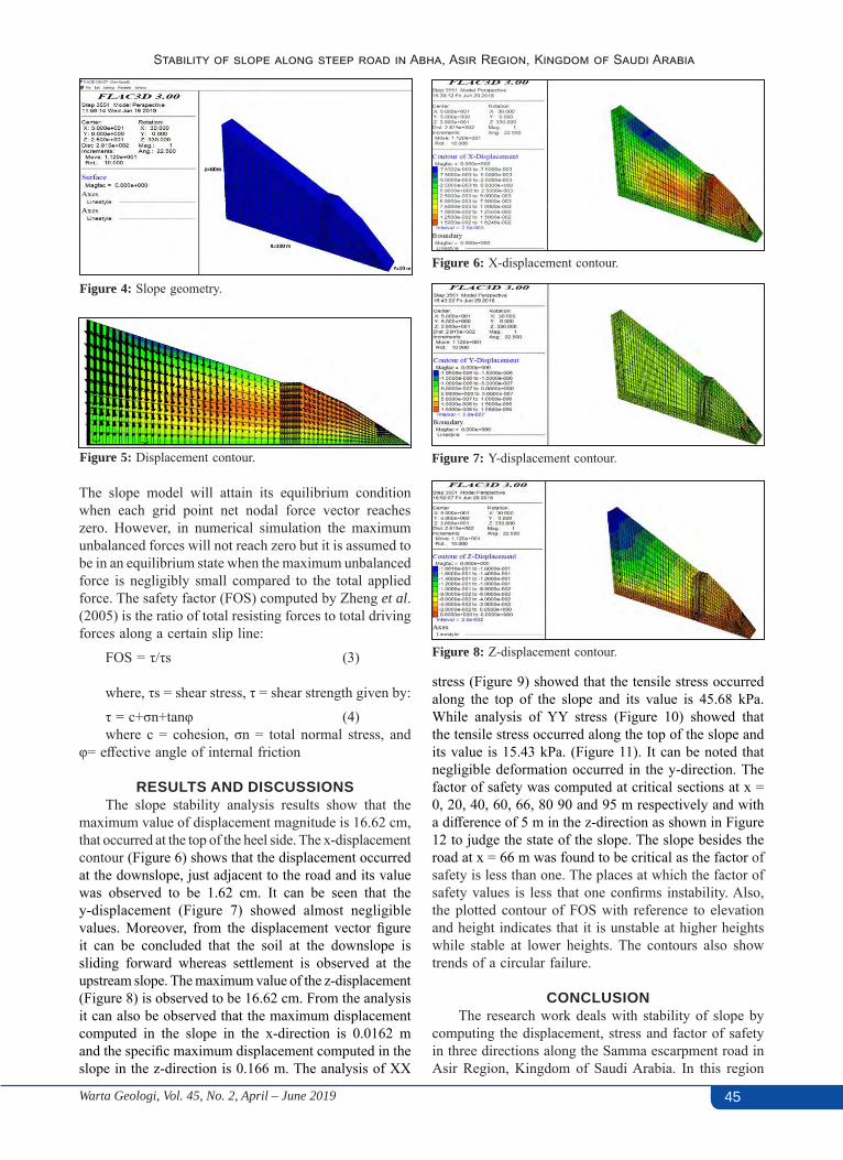
Dynamic slope stability analysis for Sabah earthquakeRini Asnida Abdullah1,*, Mohd Nur Asmawisham Alel1, Mohd Zamri Ramli1, Mariyana Aida Ab. Kadir1, Nor Zurairahetty Mohd Yunus1, Lee Sze Shan2,
Kamarudin Abdullah3
1 School of Civil Engineering, Faculty of Engineering, Universiti Teknologi Malaysia,81310 Johor Bahru, Malaysia
2 One Smart Engineering Pte Ltd, 21 Bukit Batok Cresent #06-75-76, WCEGA Tower,658065 Singapore
3 GJ Runding Sdn. Bhd., 5 & 7, Jalan Titiwangsa 3, Taman Tampoi Indah, 81200 Johor Bahru, Johor, Malaysia
*Corresponding author email address: [email protected]
Abstract: An earthquake commonly triggers widespread and destructive damages, which these can include building collapse, tsunami, liquefaction, and landslide. The earthquake that struck the western region of Sabah on June 5th, 2015, with a local magnitude of 5.9, induced severe and extensive land instabilities in areas such as Ranau, Tambunan, Tuaran, Kota Kinabalu, and Kota Belud. Unfortunately, there is only a very limited literature on earthquake induced landslides in Malaysia. Therefore, the aim of this study is to understand the mechanism of earthquake induced landslide at Sekolah Menengah Kebangsaan (SMK) Ranau using 2D finite element method in RS2. The displacement measured from the slope at SMK Ranau is used to verify the model and the effect of the seismic load has been monitored. A good agreement was found between the numerical model and actual site condition. In depth understanding of earthquake triggered slope failure was successfully studied using the RS2 software.
Keywords: Dynamic slope stability analysis, Sabah earthquake, finite element modelling, RS2
INTRODUCTIONSabah is located in the east of Malaysia, which is
classified as moderately active in seismicity. This area experiences earthquakes of local origins (Tjia, 2007) and also originating from the nearby area located over the southern Philippines, the Straits of Macassar, the Sulu Sea, and the Celebes Sea. Sabah suffers more earthquake activities than other states in Malaysia (Abas, 2001). The 2015 Sabah quake happened at around 07:15 local time on the 5th of June with a magnitude of 5.9. The quake’s epicentre was located 12 km WNW of Ranau, at a depth of 10 km. Roads and buildings, including schools and a hospital on Sabah’s west coast, were also damaged (USGS, 2015). Based on the earthquake history of Sabah, this was the most powerful earthquake in Sabah for 39 years, since 1976 (Bernama, 2015).
Earthquake induced landslides are among the most deadly disasters occurring to humans, and have caused thousands of deaths as well as great economic losses (Keefer, 1984). Earthquake motion generates a movement of natural or engineered slopes or earth structures; landslides will occur when the slope fails to sustain the force of gravity. The most dangerous impact is when the slope fails suddenly without warning and the speed of the soil materials can travel down the slope to damage people or property nearby. The slope materials can travel varying
distances, from a few centimeters to many kilometers, depending on the gradient of the slope and the volume of the materials.
This paper deals with the slope instability analysis using the finite element method (FEM) at SMK Ranau. The slope condition was assessed during the field visit to Ranau on the 10th June 2015 (Figure 1). The maximum settlement was found under the building with approximately 1.0 m and 0.6 m in vertical and horizontal directions respectively. Tension cracks were also observed that reflect slope movements due to the earthquake event.
Figure 1: On site slope condition, red circle mark as Point A.
DOI : https://doi.org/10.7186/wg452201904
49Warta Geologi, Vol. 45, No. 2, April – June 2019
Dynamic slope stability analysis for Sabah earthquake
METHOD OF ANALYSISModel generation
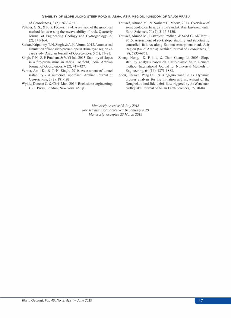
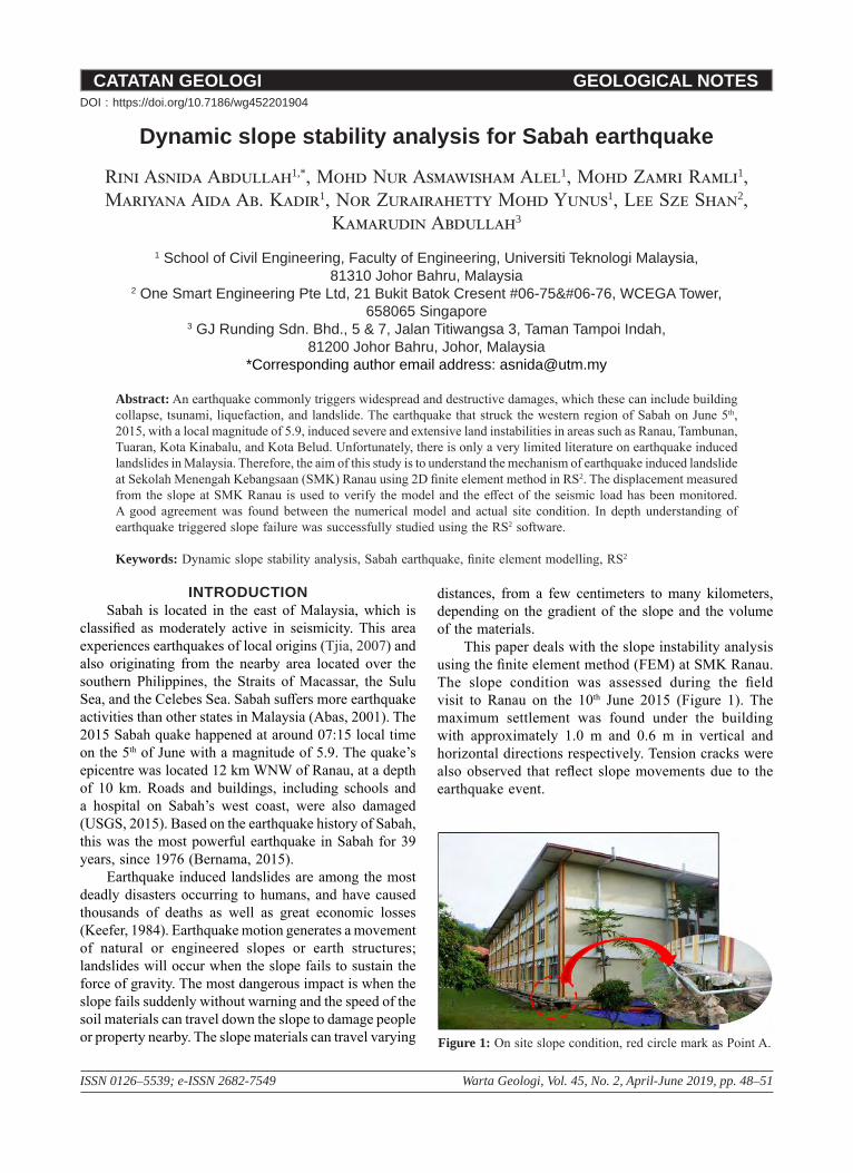
The RS2 software, a 2D FEM program was utilized in constructing the slope at SMK Ranau (Rocscience, 2015). The models were divided into two cases; 1) Case 1 is the initial state in a static condition before the earthquake and 2) Case 2 is the slope model with dynamic load, so as to simulate the earthquake event at SMK Ranau. The slope geometry is displayed in Figure 2, showing a building block located 12 m away from the slope crest. The slope consists of six benches with a slope angle of 55° and 50 m in height. The soil properties are tabulated in Table 1 (Kumpulan IKRAM (Sabah) Sdn. Bhd., 2002).
Uniform mesh with six (6) node triangles and employing 1500 elements was used in the modelling. The hydraulic condition was determined, and in using this model, the groundwater condition was assumed to be in a steady state. The boundary conditions of the slope model for the initial and dynamic analyses are as shown in Figure 3. The boundary at the base of the static model was fixed for both the x and y-directions, while the vertical side boundaries were fixed for the x-direction. For the dynamic model boundary conditions, a damping condition was assigned to the bottom boundary that would enable absorption of the incoming shear and pressure waves travelling through the soil. A transmit boundary condition was applied to the x-direction restraint segments to allow the input
wave motion to enter the soil system while absorbing the shear and pressure waves that would be leaving the soil domain.
Initial condition and dynamic loadingThe initial loading condition in this study was the field
stress and body force. Gravity stress was assigned as the field stress in the model, and the horizontal and vertical stresses were assumed to be equal. A uniform loading of 40 kN/m2 was applied in the model to take account of the 3-storey building on the site (British Standard, 1996).
In RS2, the dynamic analysis option can be used to examine earthquake, blast, and machine loading scenarios. Dynamic boundary conditions will allow the model to absorb incoming pressure and shear waves, transmit motion into the model, and insert user-defined dashpot dampers and nodal masses. In this study, earthquake records were input along the base of the model in terms of an acceleration time history. As such, the maximum
Table 1: Summary of soil properties.
EngineeringProperties
Clayey Sandy
Silt
Sandy Silt
Silt with Sandstone
Unit Weight (kN/m3) 20 22 22Young Modulus
(MPa) 30 30 50
Poisson Ratio 0.3 0.3 0.25Friction Angle (˚) 32 40 50Cohesion (kPa) 50 22 30 Figure 3: Boundary condition for (a) Case 1 and (b) Case 2.
Figure 2: Slope geometry of SMK Ranau.
50 Warta Geologi, Vol. 45, No. 2, April – June 2019
Rini Asnida, Mohd Nur Asmawisham, Mohd Zamri, Mariyana Aida, Nor Zurairahetty, Lee S.S., Kamarudin
displacement occurring between each stages of the dynamic analysis can be observed. With the time query capability, the maximum displacement, velocity and acceleration observed during the simulation at all nodes were recorded, however, the Shear Strength Reduction Factor (SSRF) cannot be determined due to the software limitation.
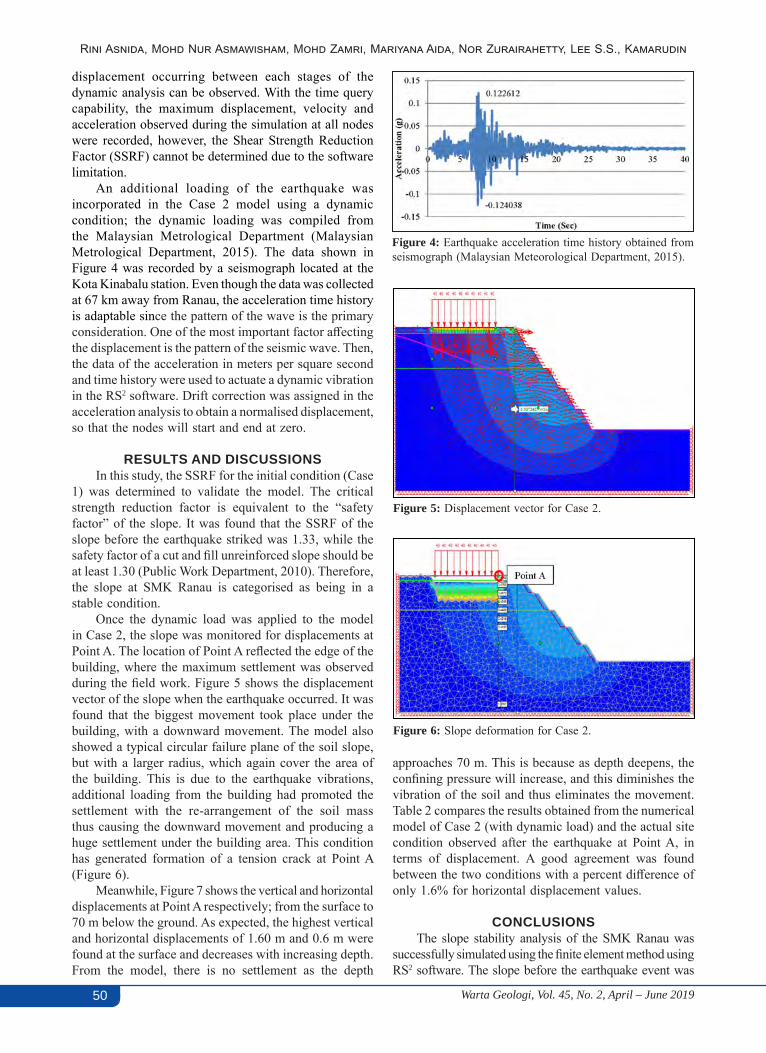
An additional loading of the earthquake was incorporated in the Case 2 model using a dynamic condition; the dynamic loading was compiled from the Malaysian Metrological Department (Malaysian Metrological Department, 2015). The data shown in Figure 4 was recorded by a seismograph located at the Kota Kinabalu station. Even though the data was collected at 67 km away from Ranau, the acceleration time history is adaptable since the pattern of the wave is the primary consideration. One of the most important factor affecting the displacement is the pattern of the seismic wave. Then, the data of the acceleration in meters per square second and time history were used to actuate a dynamic vibration in the RS2 software. Drift correction was assigned in the acceleration analysis to obtain a normalised displacement, so that the nodes will start and end at zero.
RESULTS AND DISCUSSIONSIn this study, the SSRF for the initial condition (Case
1) was determined to validate the model. The critical strength reduction factor is equivalent to the “safety factor” of the slope. It was found that the SSRF of the slope before the earthquake striked was 1.33, while the safety factor of a cut and fill unreinforced slope should be at least 1.30 (Public Work Department, 2010). Therefore, the slope at SMK Ranau is categorised as being in a stable condition.
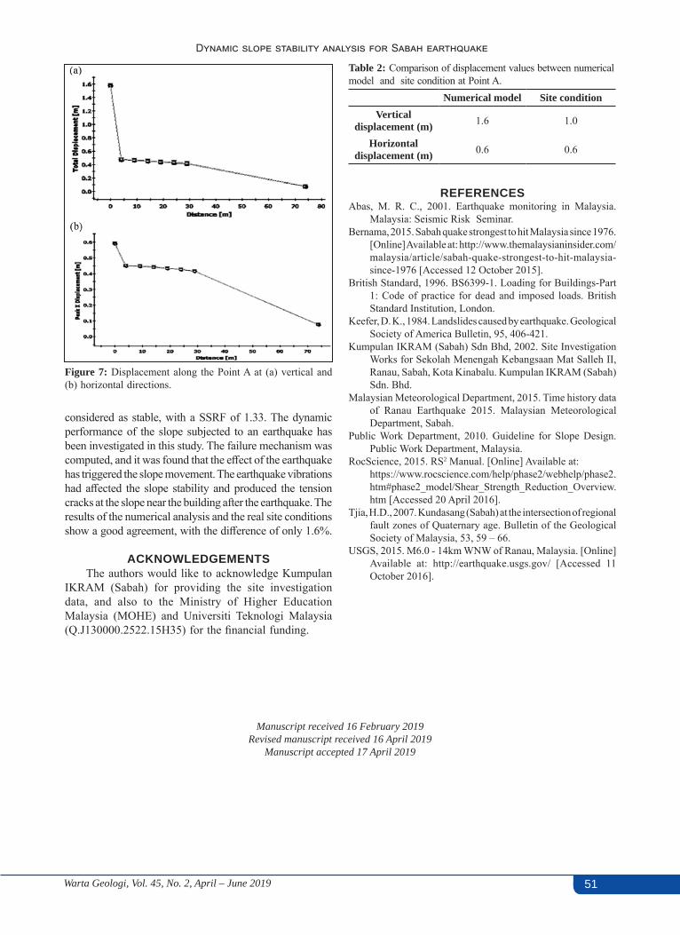
Once the dynamic load was applied to the model in Case 2, the slope was monitored for displacements at Point A. The location of Point A reflected the edge of the building, where the maximum settlement was observed during the field work. Figure 5 shows the displacement vector of the slope when the earthquake occurred. It was found that the biggest movement took place under the building, with a downward movement. The model also showed a typical circular failure plane of the soil slope, but with a larger radius, which again cover the area of the building. This is due to the earthquake vibrations, additional loading from the building had promoted the settlement with the re-arrangement of the soil mass thus causing the downward movement and producing a huge settlement under the building area. This condition has generated formation of a tension crack at Point A (Figure 6).
Meanwhile, Figure 7 shows the vertical and horizontal displacements at Point A respectively; from the surface to 70 m below the ground. As expected, the highest vertical and horizontal displacements of 1.60 m and 0.6 m were found at the surface and decreases with increasing depth. From the model, there is no settlement as the depth
Figure 4: Earthquake acceleration time history obtained from seismograph (Malaysian Meteorological Department, 2015).
Figure 5: Displacement vector for Case 2.
approaches 70 m. This is because as depth deepens, the confining pressure will increase, and this diminishes the vibration of the soil and thus eliminates the movement. Table 2 compares the results obtained from the numerical model of Case 2 (with dynamic load) and the actual site condition observed after the earthquake at Point A, in terms of displacement. A good agreement was found between the two conditions with a percent difference of only 1.6% for horizontal displacement values.
CONCLUSIONSThe slope stability analysis of the SMK Ranau was
successfully simulated using the finite element method using RS2 software. The slope before the earthquake event was
Figure 6: Slope deformation for Case 2.
51Warta Geologi, Vol. 45, No. 2, April – June 2019
Dynamic slope stability analysis for Sabah earthquake
Table 2: Comparison of displacement values between numerical model and site condition at Point A.
Numerical model Site condition Vertical
displacement (m) 1.6 1.0
Horizontal displacement (m) 0.6 0.6
considered as stable, with a SSRF of 1.33. The dynamic performance of the slope subjected to an earthquake has been investigated in this study. The failure mechanism was computed, and it was found that the effect of the earthquake has triggered the slope movement. The earthquake vibrations had affected the slope stability and produced the tension cracks at the slope near the building after the earthquake. The results of the numerical analysis and the real site conditions show a good agreement, with the difference of only 1.6%.
ACKNOWLEDGEMENTSThe authors would like to acknowledge Kumpulan
IKRAM (Sabah) for providing the site investigation data, and also to the Ministry of Higher Education Malaysia (MOHE) and Universiti Teknologi Malaysia (Q.J130000.2522.15H35) for the financial funding.
Manuscript received 16 February 2019Revised manuscript received 16 April 2019
Manuscript accepted 17 April 2019
Figure 7: Displacement along the Point A at (a) vertical and (b) horizontal directions.
REFERENCESAbas, M. R. C., 2001. Earthquake monitoring in Malaysia.
Malaysia: Seismic Risk Seminar.Bernama, 2015. Sabah quake strongest to hit Malaysia since 1976.
[Online] Available at: http://www.themalaysianinsider.com/malaysia/article/sabah-quake-strongest-to-hit-malaysia-since-1976 [Accessed 12 October 2015].
British Standard, 1996. BS6399-1. Loading for Buildings-Part 1: Code of practice for dead and imposed loads. British Standard Institution, London.
Keefer, D. K., 1984. Landslides caused by earthquake. Geological Society of America Bulletin, 95, 406-421.
Kumpulan IKRAM (Sabah) Sdn Bhd, 2002. Site Investigation Works for Sekolah Menengah Kebangsaan Mat Salleh II, Ranau, Sabah, Kota Kinabalu. Kumpulan IKRAM (Sabah) Sdn. Bhd.
Malaysian Meteorological Department, 2015. Time history data of Ranau Earthquake 2015. Malaysian Meteorological Department, Sabah.
Public Work Department, 2010. Guideline for Slope Design. Public Work Department, Malaysia.
RocScience, 2015. RS2 Manual. [Online] Available at: https://www.rocscience.com/help/phase2/webhelp/phase2.htm#phase2_model/Shear_Strength_Reduction_Overview.htm [Accessed 20 April 2016].
Tjia, H.D., 2007. Kundasang (Sabah) at the intersection of regional fault zones of Quaternary age. Bulletin of the Geological Society of Malaysia, 53, 59 – 66.
USGS, 2015. M6.0 - 14km WNW of Ranau, Malaysia. [Online] Available at: http://earthquake.usgs.gov/ [Accessed 11 October 2016].
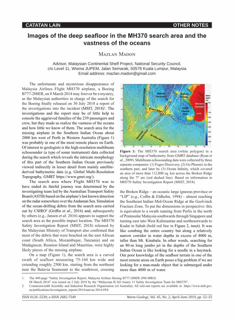
CATATAN LAIN OTHER NOTES
ISSN 0126–5539; e-ISSN 2682-7549 Warta Geologi, Vol. 45, No. 2, April-June 2019, pp. 52–55
Images of the deep seafloor in the MH370 search area and the vastness of the oceans
Mazlan Madon
Advisor, Malaysian Continental Shelf Project, National Security Council, c/o Level 11, Wisma JUPEM, Jalan Semarak, 50578 Kuala Lumpur, Malaysia
Email address: [email protected]
The unfortunate and mysterious disappearance of Malaysia Airlines Flight MH370 airplane, a Boeing B777-200ER, on 8 March 2014 may forever be a mystery, as the Malaysian authorities in charge of the search for the Boeing finally released on 30 July 2018 a report of the investigations into the incident (MSIT, 2018)1. The investigations and the report may be of little help to console the aggrieved families of the 239 passengers and crew, but they made us realize the vastness of the oceans and how little we know of them. The search area for the missing airplane in the Southern Indian Ocean about 2000 km west of Perth in Western Australia (Figure 1) was probably in one of the most remote places on Earth. Of interest to geologists is the high-resolution multibeam echosounder (a type of sonar instrument) data collected during the search which reveals the intricate morphology of this part of the Southern Indian Ocean previously viewed indirectly in lesser detail from mainly satellite-derived bathymetric data (e.g. Global Multi-Resolution Topography, GMRT https://www.gmrt.org/).
The search area where Flight MH370 was to have ended its fateful journey was determined by the investigating team led by the Australian Transport Safety Board (ASTB) based on the airplane’s last known detection on the radar somewhere over the Andaman Sea. Simulation of the ocean-drifting debris from the search area carried out by CSIRO2 (Griffin et al., 2016) and, subsequently by others (e.g., Jansen et al. 2016) appears to support the search area as the possible impact location. The MH370 Safety Investigation Report (MSIT, 2018) released by the Malaysian Ministry of Transport also confirmed that most of the debris that were beached on the east African coast (South Africa, Mozambique, Tanzania) and on Madagascar, Reunion Island and Mauritius, were highly likely pieces of the missing airplane.
On a map (Figure 1), the search area is a curved swath of seafloor measuring 75-160 km wide and extending roughly 2500 km, starting from the northeast near the Batavia Seamount to the southwest, crossing
the Broken Ridge – an oceanic large igneous province or “LIP” (e.g., Coffin & Eldholm, 1994) – almost reaching the Southeast Indian Mid-Ocean Ridge at the Geelvinck Fracture Zone. To put the dimensions in perspective: this is equivalent to a swath running from Perlis in the north of Peninsular Malaysia southwards through Singapore and turning east into West Kalimantan and northeastwards to Kudat in Sabah (bold red line in Figure 2, inset). It was like combing the entire country but along a relatively narrow corridor in water depths in excess of 4000 m, taller than Mt. Kinabalu. In other words, searching for an 80-m long jumbo jet in the depths of the Southern Indian Ocean is like looking for a needle in a haystack. Our poor knowledge of the seafloor terrain in one of the most remote areas on Earth poses a big problem if we are looking for a man-made object that is submerged under more than 4000 m of water.
1. The 449-page “Safety Investigation Report; Malaysia Airlines Boeing B777-200ER (9M-MRO)08 March 2014” was issued on 2 July 2018 by the “Malaysian ICAO Annex 13 Safety Investigation Team for MH370”.
2. Commonwealth Scientific and Industrial Research Organisation (of Australia). All relevant reports are available at https://www.atsb.gov.au/publications/investigation_reports/2014/aair/ae-2014-054/
Figure 1: The MH370 search area (white polygon) in a background map of bathymetry from GMRT database (Ryan et al., 2009). Multibeam echosounding data were collected by three separate companies: (1) Fugro Discovery, (2) Go Phoenix in the southern part, and later by (3) Ocean Infinity, which covered an area of more than 112,000 sq. km across the Broken Ridge along the 7th arc (red dashed line). Based on information in MH370 Safety Investigation Report (MSIT, 2018).
53Warta Geologi, Vol. 45, No. 2, April – June 2019
Images of the deep seafloor in the MH370 search area and the vastness of the oceans
53
The fact that much of the seafloor of the world’s oceans has not been surveyed to great detail is perhaps not well appreciated by the general public or even among scientists. According to GEBCO3, the consensus within the scientific community is that less than 20% of the world’s ocean floor has been mapped and that we probably know more about the topography of the Moon and Mars in greater detail than that of Planet Earth. Hence, although about 70% of the earth’s surface is covered by the oceans, more than 80% of it is unmapped, unexplored and unobserved (U.S. National Ocean Service, 2014). In his comprehensive review of the history of ocean mapping, Mayer (2017) pointed out that that 82% of the ocean floor has never had a direct measurement of depth at a 1 km × 1 km scale. According to other estimates (Wessel & Chandler, 2011; Smith et al., 2017) only 8% of the global ocean has been mapped. With these numbers, it is not surprising that of all long-haul commercial flights over the oceans, 60% are flown over those unmapped areas of the seafloor (Smith et al., 2017). The oceans are, indeed, the last frontier.
A map of the ship tracks with bathymetric measurement of the oceans may provide us with a better appreciation of the how little we know of the oceans, and how much effort is needed to fill up the large data gaps (Figure 3). These tracks represent point data acquired by single-beam echo soundings along the ship paths but they are single point measurement of water depth. Historical survey data do not necessarily solve the problem in finding any object on the seafloor, although they would give some idea of the water depths and seafloor terrain in the area of interest. For example, the information was needed to determine the type of autonomous underwater vehicle (AUV) to be deployed with the appropriate water
depth rating for the search of the missing airplane (Mayer, 2017). To find a 100m-long object, such as an airplane, a high-resolution multibeam, echo-sounding (sonar) data needed to be acquired after the incident of 8 March 2017, so that the presence of any extraneous object would be detected.
Most of the ocean floor has been mapped indirectly by satellite-derived gravity data (Smith & Sandwell, 1997), as used in the background of the map in Figure 1, with a resolution of about 5 km. As a comparison, the resolution of bathymetric data derived from satellite altimetry ranges from 20 to 200 km, although the interpolated grids based on those data have a resolution of 1-12 km; in contrast, multibeam sonar data has a resolution in the order of tens to hundreds of metres (normally 100 m). Unfortunately, only 10%–15% of the ocean basins, however, have been mapped using multibeam echo sounders. Rovere et al. (2015) estimated that 50% of the Earth’s surface is underlain by seafloor at 3200 m below mean sea level and that ~900 ship years of surveying would be needed to achieve a complete multibeam coverage of the world’s oceans!
In the Southeast Indian Ocean it was reported that only 5% of the seafloor was covered by echo-soundings
Figure 3: Ship tracks with single beam echo-sounding depth measurement from NCEI database. (A) global plot (B) Indian Ocean (C) Southern Indian Ocean, with the MH370 search area highlighted in yellow, showing large data gaps more apparent when plotted at smaller map scales. NCEI – National Centre for Environment Information https://www.ngdc.noaa.gov/mgg/geodas/trackline.html.
Figure 2: Bathymetry of the MH370 search area, with collected multibeam data. Source: screenshot of web presentation by Geoscience Australia, “The data behind the search for MH370”, https://geoscience-au.maps.arcgis.com/ accessed 4 May 2019. Inset at bottom right shows a rough comparison of a swath of similar length as the seach area through Malaysia. Scale bar is only an approximation.
3. GEBCO (General Bathymetric Chart of the Oceans) is a non-profit organization operating under the joint auspices of the International Hydrographic Organization (IHO) and the Intergovernmental Oceanographic Commission (IOC) of UNESCO.
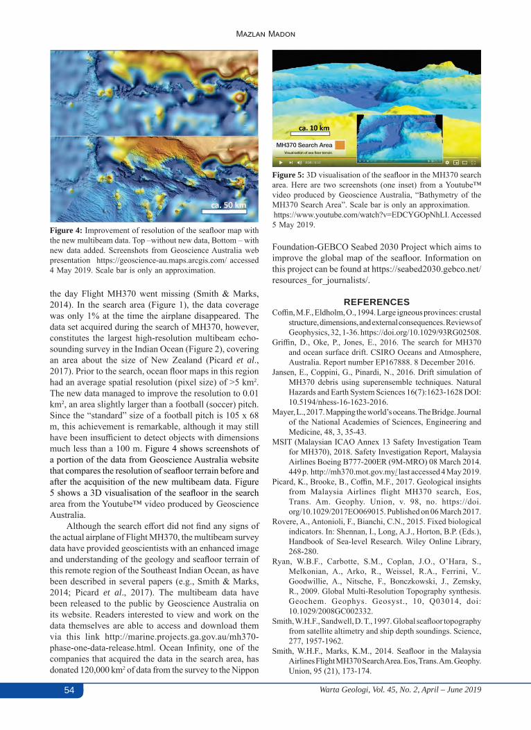
54 Warta Geologi, Vol. 45, No. 2, April – June 2019
Mazlan Madon
54
the day Flight MH370 went missing (Smith & Marks, 2014). In the search area (Figure 1), the data coverage was only 1% at the time the airplane disappeared. The data set acquired during the search of MH370, however, constitutes the largest high-resolution multibeam echo-sounding survey in the Indian Ocean (Figure 2), covering an area about the size of New Zealand (Picard et al., 2017). Prior to the search, ocean floor maps in this region had an average spatial resolution (pixel size) of >5 km2. The new data managed to improve the resolution to 0.01 km2, an area slightly larger than a football (soccer) pitch. Since the “standard” size of a football pitch is 105 x 68 m, this achievement is remarkable, although it may still have been insufficient to detect objects with dimensions much less than a 100 m. Figure 4 shows screenshots of a portion of the data from Geoscience Australia website that compares the resolution of seafloor terrain before and after the acquisition of the new multibeam data. Figure 5 shows a 3D visualisation of the seafloor in the search area from the Youtube™ video produced by Geoscience Australia.
Although the search effort did not find any signs of the actual airplane of Flight MH370, the multibeam survey data have provided geoscientists with an enhanced image and understanding of the geology and seafloor terrain of this remote region of the Southeast Indian Ocean, as have been described in several papers (e.g., Smith & Marks, 2014; Picard et al., 2017). The multibeam data have been released to the public by Geoscience Australia on its website. Readers interested to view and work on the data themselves are able to access and download them via this link http://marine.projects.ga.gov.au/mh370-phase-one-data-release.html. Ocean Infinity, one of the companies that acquired the data in the search area, has donated 120,000 km2 of data from the survey to the Nippon
Figure 4: Improvement of resolution of the seafloor map with the new multibeam data. Top –without new data, Bottom – with new data added. Screenshots from Geoscience Australia web presentation https://geoscience-au.maps.arcgis.com/ accessed 4 May 2019. Scale bar is only an approximation.
Figure 5: 3D visualisation of the seafloor in the MH370 search area. Here are two screenshots (one inset) from a Youtube™ video produced by Geoscience Australia, “Bathymetry of the MH370 Search Area”. Scale bar is only an approximation. https://www.youtube.com/watch?v=EDCYGOpNhLI. Accessed 5 May 2019.
Foundation-GEBCO Seabed 2030 Project which aims to improve the global map of the seafloor. Information on this project can be found at https://seabed2030.gebco.net/resources_for_journalists/.
REFERENCESCoffin, M.F., Eldholm, O., 1994. Large igneous provinces: crustal
structure, dimensions, and external consequences. Reviews of Geophysics, 32, 1-36. https://doi.org/10.1029/93RG02508.
Griffin, D., Oke, P., Jones, E., 2016. The search for MH370 and ocean surface drift. CSIRO Oceans and Atmosphere, Australia. Report number EP167888. 8 December 2016.
Jansen, E., Coppini, G., Pinardi, N., 2016. Drift simulation of MH370 debris using superensemble techniques. Natural Hazards and Earth System Sciences 16(7):1623-1628 DOI: 10.5194/nhess-16-1623-2016.
Mayer, L., 2017. Mapping the world’s oceans. The Bridge. Journal of the National Academies of Sciences, Engineering and Medicine, 48, 3, 35-43.
MSIT (Malaysian ICAO Annex 13 Safety Investigation Teamfor MH370), 2018. Safety Investigation Report, Malaysia Airlines Boeing B777-200ER (9M-MRO) 08 March 2014. 449 p. http://mh370.mot.gov.my/ last accessed 4 May 2019.
Picard, K., Brooke, B., Coffin, M.F., 2017. Geological insights from Malaysia Airlines flight MH370 search, Eos, Trans. Am. Geophy. Union, v. 98, no. https://doi.org/10.1029/2017EO069015. Published on 06 March 2017.
Rovere, A., Antonioli, F., Bianchi, C.N., 2015. Fixed biological indicators. In: Shennan, I., Long, A.J., Horton, B.P. (Eds.), Handbook of Sea-level Research. Wiley Online Library, 268-280.
Ryan, W.B.F., Carbotte, S.M., Coplan, J.O., O’Hara, S., Melkonian, A., Arko, R., Weissel, R.A., Ferrini, V.. Goodwillie, A., Nitsche, F., Bonczkowski, J., Zemsky, R., 2009. Global Multi-Resolution Topography synthesis. Geochem. Geophys. Geosyst., 10, Q03014, doi: 10.1029/2008GC002332.
Smith, W.H.F., Sandwell, D. T., 1997. Global seafloor topography from satellite altimetry and ship depth soundings. Science, 277, 1957-1962.
Smith, W.H.F., Marks, K.M., 2014. Seafloor in the Malaysia Airlines Flight MH370 Search Area. Eos, Trans. Am. Geophy. Union, 95 (21), 173-174.
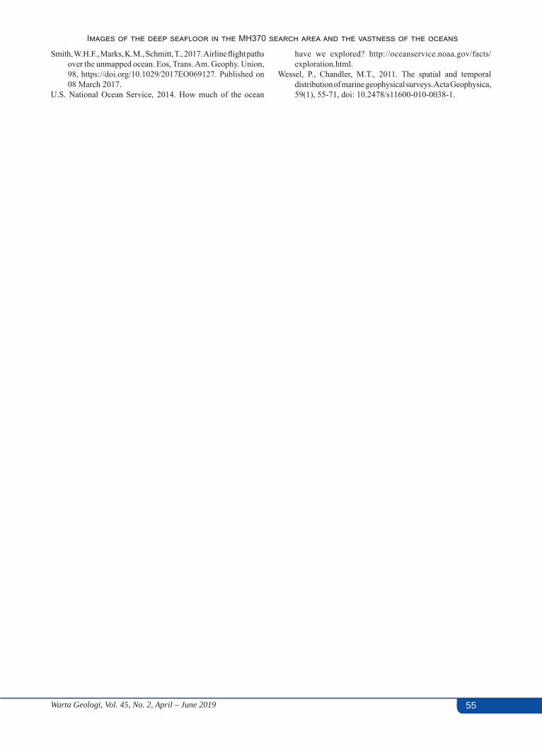
55Warta Geologi, Vol. 45, No. 2, April – June 2019
Images of the deep seafloor in the MH370 search area and the vastness of the oceans
55
Smith, W.H.F., Marks, K.M., Schmitt, T., 2017. Airline flight paths over the unmapped ocean. Eos, Trans. Am. Geophy. Union, 98, https://doi.org/10.1029/2017EO069127. Published on 08 March 2017.
U.S. National Ocean Service, 2014. How much of the ocean
have we explored? http://oceanservice.noaa.gov/facts/exploration.html.
Wessel, P., Chandler, M.T., 2011. The spatial and temporal distribution of marine geophysical surveys. Acta Geophysica, 59(1), 55-71, doi: 10.2478/s11600-010-0038-1.
CATATAN LAIN OTHER NOTES
ISSN 0126–5539; e-ISSN 2682-7549 Warta Geologi, Vol. 45, No. 2, April-June 2019, pp. 56–68
Historical perspective of the Geological Society of MalaysiaJohn Kuna Raj
Engineering Geology ConsultantNo.83, Jln Burhanuddin Helmi 2, Tmn Tun Dr, Ismail, 60000 KualaLumpur, Malaysia
Email address: [email protected]
Abstract: The Society was formally established on 31/01/1967 with its’ first decade (31/03/1967-25/03/1977) marked by the Annual General Meeting, often with a Presidential Address and Discussion Meeting, as the premier annual event. During the first decade, a Newsletter was issued every two months and seven Bulletins as well as the book on “Geology of the Malay Peninsula” published. The second decade (26/03/1977-28/04/1986) saw introduction of the Petroleum Geology Seminar (on 16/12/1977) which together with the Annual General Meeting and two-day Discussion Meeting then became the premier annual events. The Newsletter of the Geological Society of Malaysia (renamed Warta Geologi in January 1975) was issued every two to three months and ten Bulletins of the Geological Society of Malaysia were published.The third decade (28/04/1986-22/04/1995) saw the introduction of a two day Annual Geological Conference (on 28-29/04/1986) which together with the Annual General Meeting and the Petroleum Conference became the premier annual events. During this third decade, the Warta Geologi was issued every two to three months and nineteen Bulletins were published. Five Working Groups were appointed in March 1987, whilst the Institute of Geology Malaysia was established on 11/03/1989.The fourth decade (22/04/1995-29/04/2006) saw rebranding of the Petroleum Seminar as the Petroleum Geology Conference in 1995, and later renamed the Petroleum Geology Conference & Exhibition in 2002. This event, together with the Annual Conference and Annual General Meeting then became the premier annual events. During the fourth decade, the Warta Geologi was issued every two to four months and twelve Bulletins were published. An additional five Working Groups were appointed during the fourth decade which also saw formal representations being made for gazetting the Professional Geologist’s Act.The fifth decade (29/04/2006 - present) saw rebranding of the Annual Geological Conference as the National Geoscience Conference (12-13/06/2006) which together with the Annual General Meeting and the Petroleum Geology Conference & Exhibition (renamed Petroleum Geoscience Conference & Exhibition in 2011) then became the premier annual events. In 2009, the Society published the book on “Geology of Peninsular Malaysia”, and in 2014, uploaded all publications onto its website (www.gsm.org.my). On 15/07/2008, the Geologists Act 2008 (Act 689) was passed by the Malaysian Parliament, whilst in 2011, the Society Bulletin was recognized as a Scopus indexed publication.With its main annual events, i.e. National Geoscience Conference and General Meeting, as well as regularly organized technical talks, fieldtrips, Forums, Seminars and Conferences, sound financial position, and timely publication of the Warta Geologi and the Bulletin, the Society can look forward to continue being one of the more successful geological societies in SE Asia.
Keywords: Geological Society of Malaysia, history, National Geoscience Conference, Warta Geologi
INTRODUCTIONIn the early 1960’s, informal discussions amongst
geologists pointed to the increasing need for a Society where geologists from the then three major institutions, i.e. the Geological Survey, the University of Malaya and the mining industry, could meet and exchange ideas, and which would provide a means for publishing findings (GSM, 1966). All known geologists in Malaysia were invited to a meeting on 4 March 1966 at the Science Lecture Theatre in the University of Malaya where it was resolved that a “Geological Society of Malaysia” be formed. Fifteen geologists attended this Meeting during which a pro-tem Committee with N.S. Haile as Chairman was appointed to take all steps necessary to accomplish this, including drafting a constitution for, and registering, the Society (Haile & Teh, 1997).
In these early stages, it was envisaged that the possible functions of the Geological Society of Malaysia, were to encompass the following:-(a) Organizing talks and symposiums on geology, especially
the geology of Malaysia and the SE Asian region,(b) Issuing a Newsletter which would allow geologists
working in Malaysia or interested in the geology of Malaysia, and the SE Asian region, to be informed of current developments,
(c) Publishing from time to time a Bulletin, with papers and short notes on the geology of Malaysia and the SE Asian region,
(d) Informing the public on the cultural and practical value of geology, and
(e) Communicating with other national and international geological societies and institutions.
Warta Geologi, Vol. 45, No. 2, April - June 2019 57
Historical perspective of the Geological Society of Malaysia
The Geological Society of Malaysia was formally established on 31 January 1967 when it had its first Annual General Meeting (GSM, 1967). The Society has since then and over the past fifty years, more than successfully achieved the envisaged functions and has become one of the more active and successful geological societies in SE Asia. The Society is run by a Council comprising the President, Vice-President, Secretary, Assistant Secretary, Treasurer, Editor and eight Councillors who are elected at every Annual General Meeting (Table 1). The first President of the Society, N.S. Haile of the University of Malaya was elected at the first General Meeting on 31 January 1967. Subsequent Presidents of the Society have come from industry, government and academia with some serving for more than one term (Table 2).
It is difficult to summarize fifty years of history in limited space and time but it is interesting to note that the more important annual events of the Society have occurred at intervals of about ten years. The historical perspective of the Society is therefore, best described in terms of decades.
FIRST DECADE (31 JANUARY 1967 - 25 MARCH 1977)
During this first decade, the General Meeting, usually with a Presidential Address (Table 3), was the premier annual event and organized together with a Discussion Meeting (half-day to two days) and Society Dinner. The Newsletter of the Society, which first appeared in print in July 1966, was issued regularly every two months, and Bulletins 1 to 7 published, during the first decade (Table 4). Other notable publications include the book on the “Geology of the Malay Peninsula” and the 1:1,000,000 scale coloured geological map of the Malay Peninsula; both published in 1973 (GSM, 1973). The Society Library was also started on 31 January 1967 with the donation of several books by Dr. J. Katili.
Several activities were organized for members during the first decade and included technical talks by local and visiting geologists as well as fieldtrips and discussion meetings (Table 5). Two Regional Conferences were also organized, i.e. the inaugural Conference on the “Geology of Southeast Asia” (20-25 March 1972) (GSM, 1972) and the Conference on “Mineral Resources and Environment: The Role of Science Teaching” (12-15 April 1976). The Society also hosted the 5th Meeting of the IGCP Circum-Pacific Plutonism Project (12-13 November 1975).
SECOND DECADE (25 MARCH 1977 - 28 APRIL 1986)
The second decade started with the introduction of the Petroleum Geology Seminar (first held on 16 December 1977). An initially one-day event quickly evolved into a two day event due to over-whelming response from the petroleum sector (Table 6). During the second decade, there were thus two premier annual events, i.e. the Petroleum Geology Seminar, and the Annual General
Meeting which again was organized with a two-day Discussion Meeting, Annual Dinner and a Presidential Address (Table 3). The Newsletter of the Society (renamed Warta Geologi in January 1975) (GSM, 1975) was issued regularly every two to three months, and Bulletins 8 to 17 were published, during the second decade (Table 7).
Several fieldtrips and discussion meetings with specific themes were organized during the second decade as were Seminars on general topics (Table 8). A number of regional and international Meetings were also organized, including the “International Symposium on the Geology of Tin Deposits” (23-25 March 1978), the “Tin Training Course” (26 March-15 April 1978), the “Workshop on Stratigraphic Correlation of Thailand and Peninsular Malaysia” (8-11 September 1983) and the 5th International Congress (GEOSEA V) on the “Geology and Mineral Resources of Southeast Asia (9-13 April 1984) which was attended by over 300 participants (GSM, 1984). The second decade also marks the period when informal discussions started on the formation of the Institute of Geology Malaysia.
THIRD DECADE (28 APRIL 1986 - 22 APRIL 1995)
The third decade started with introduction of a two day Annual Geological Conference (first held on 28-29 April 1986) to replace the Discussion Meeting that used to be organized in conjunction with the Annual General Meeting (Table 9). This Annual Conference was introduced to provide the locale and opportunity for local and other geoscientists to meet and discuss ideas, experience and knowledge on topics relevant to Malaysian geology (GSM, 1986). Premier annual events during the third decade thus consisted of the Annual General Meeting, the two-day Petroleum Geology Seminar, and the two-day Annual Conference which was held at major towns in the different states of Malaysia. During the third decade, the Warta Geologi was regularly issued at intervals of two to three months and a total of 19 Bulletins were published (Table 10).
Working Groups on (a) Engineering Geology & Hydrogeology, (b) Economic Geology, (c) Stratigraphy & Sedimentology, (d) Petroleum Geology and (e) Structural Geology & Tectonics were appointed in March 1987 to encourage research in different fields of geology and provide forums for discussion and exchange of ideas and knowledge (GSM, 1987). Several technical talks, Forums, Seminars and fieldtrips were arranged by the Working Groups (Table 11), whilst the Society organized a local “Seminar on Tectonics and Environmental Geology” (8 August 1987), and the “International Symposium on Tectonic Framework on Energy Resources of the Western Margin of the Pacific Basin” (29 November - 2 December 1992) with over 500 participants (GSM, 1992). The third decade also saw the establishment of the Institute of Geology Malaysia and the preparatory work on drafting of the Professional Geologists Act.
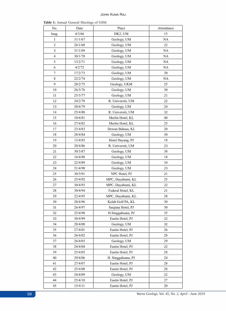
Warta Geologi, Vol. 45, No. 2, April - June 201958
John Kuna Raj
Table 1: Annual General Meetings of GSM.No. Date Place Attendance
Inag. 4/3/66 DK2, UM 151 31/1/67 Geology, UM NA2 26/1/68 Geology, UM 223 31/1/69 Geology, UM NA4 30/1/70 Geology, UM NA5 13/2/71 Geology, UM NA6 4/2/72 Geology, UM NA7 17/2/73 Geology, UM 308 22/2/74 Geology, UM NA9 28/2/75 Geology, UKM 2510 26/3/76 Geology, UM 3011 25/3/77 Geology, UM 2112 24/2/78 R. Universiti, UM 2213 20/4/79 Geology, UM 2414 25/4/80 R. Universiti, UM 3215 10/4/81 Merlin Hotel, KL 4016 27/4/82 Merlin Hotel, KL 2517 23/4/83 Dewan Bahasa, KL 2018 28/4/84 Geology, UM 3019 13/4/85 Hotel Dayang, PJ 1820 28/4/86 R. Universiti, UM 2321 30/3/87 Geology, UM 3822 16/4/88 Geology, UM 1823 22/4/89 Geology, UM 3424 21/4/90 Geology, UM 2325 30/3/91 NPC Hotel, PJ 2126 25/4/92 MPC, Dayabumi, KL 2527 30/4/93 MPC, Dayabumi, KL 2228 30/4/94 Federal Hotel, KL 2129 22/4/95 MPC, Dayabumi, KL 2830 20/4/96 Kelab Golf PA, KL 3031 26/4/97 Saujana Hotel, PJ 3032 25/4/98 H.Singgahsana, PJ 3533 30/4/99 Eastin Hotel, PJ 2234 28/4/00 Geology, UM 3235 27/4/01 Eastin Hotel, PJ 2636 26/4/02 Eastin Hotel, PJ 2837 26/4/03 Geology, UM 2938 24/4/04 Eastin Hotel, PJ 2239 23/4/05 Eastin Hotel, PJ 2840 29/4/06 H. Singgahsana, PJ 2441 27/4/07 Eastin Hotel, PJ 2842 25/4/08 Eastin Hotel, PJ 2843 24/4/09 Geology, UM 2244 25/4/10 Eastin Hotel, PJ 2745 15/4/11 Eastin Hotel, PJ 20
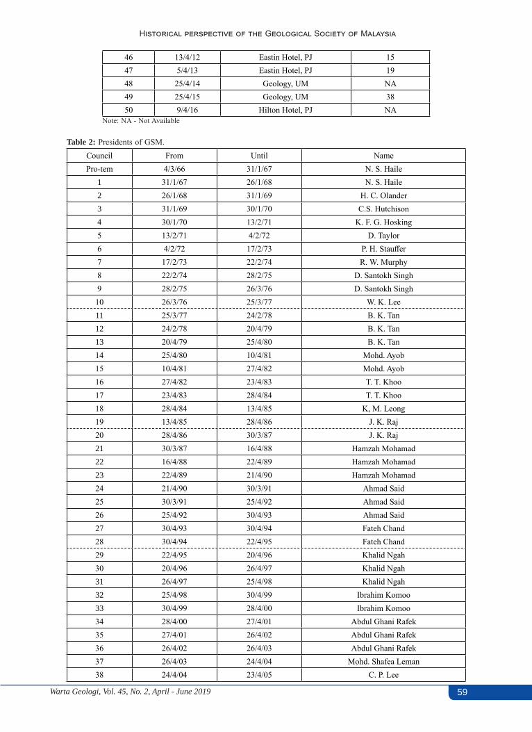
Warta Geologi, Vol. 45, No. 2, April - June 2019 59
Historical perspective of the Geological Society of Malaysia
46 13/4/12 Eastin Hotel, PJ 1547 5/4/13 Eastin Hotel, PJ 1948 25/4/14 Geology, UM NA49 25/4/15 Geology, UM 3850 9/4/16 Hilton Hotel, PJ NA
Note: NA - Not Available
Table 2: Presidents of GSM.Council From Until NamePro-tem 4/3/66 31/1/67 N. S. Haile
1 31/1/67 26/1/68 N. S. Haile2 26/1/68 31/1/69 H. C. Olander3 31/1/69 30/1/70 C.S. Hutchison4 30/1/70 13/2/71 K. F. G. Hosking5 13/2/71 4/2/72 D. Taylor6 4/2/72 17/2/73 P. H. Stauffer7 17/2/73 22/2/74 R. W. Murphy8 22/2/74 28/2/75 D. Santokh Singh9 28/2/75 26/3/76 D. Santokh Singh10 26/3/76 25/3/77 W. K. Lee11 25/3/77 24/2/78 B. K. Tan12 24/2/78 20/4/79 B. K. Tan13 20/4/79 25/4/80 B. K. Tan14 25/4/80 10/4/81 Mohd. Ayob15 10/4/81 27/4/82 Mohd. Ayob16 27/4/82 23/4/83 T. T. Khoo17 23/4/83 28/4/84 T. T. Khoo18 28/4/84 13/4/85 K, M. Leong19 13/4/85 28/4/86 J. K. Raj20 28/4/86 30/3/87 J. K. Raj21 30/3/87 16/4/88 Hamzah Mohamad22 16/4/88 22/4/89 Hamzah Mohamad23 22/4/89 21/4/90 Hamzah Mohamad24 21/4/90 30/3/91 Ahmad Said25 30/3/91 25/4/92 Ahmad Said26 25/4/92 30/4/93 Ahmad Said27 30/4/93 30/4/94 Fateh Chand28 30/4/94 22/4/95 Fateh Chand29 22/4/95 20/4/96 Khalid Ngah30 20/4/96 26/4/97 Khalid Ngah31 26/4/97 25/4/98 Khalid Ngah32 25/4/98 30/4/99 Ibrahim Komoo33 30/4/99 28/4/00 Ibrahim Komoo34 28/4/00 27/4/01 Abdul Ghani Rafek35 27/4/01 26/4/02 Abdul Ghani Rafek36 26/4/02 26/4/03 Abdul Ghani Rafek37 26/4/03 24/4/04 Mohd. Shafea Leman38 24/4/04 23/4/05 C. P. Lee

Warta Geologi, Vol. 45, No. 2, April - June 201960
John Kuna Raj
39 23/4/05 29/4/06 C. P. Lee40 29/4/06 27/4/07 C. P. Lee41 27/4/07 25/4/08 Yunus Abdul Razak42 25/4/08 24/4/09 Yunus Abdul Razak43 24/4/09 23/4/10 Yunus Abdul Razak44 23/4/10 5/4/11 J.J. Pereira45 5/4/11 13/4/12 J.J. Pereira46 13/4/12 5/4/13 J.J. Pereira47 5/4/13 25/4/14 J.J. Pereira48 25/4/14 25/4/15 Mazlan Madon49 25/4/15 29/4/16 Mazlan Madon50 29/4/16 21/4/ 17 Mazlan Madon51 21/4/17 Abd. Rashid Jaapar
Table 3: Addresses by Presidents of GSM.No President Title of Presidential Address1 N. S. Haile “Meaning, Precision, and Quantification in Geology”2 H. C. Olander Title not known3 C.S. Hutchison “Meditations on Metamorphism” 4 K. F. G. Hosking “The Search for Tungsten”
5 D. Taylor “Liberation of minor elements from rocks during plutonic igneous cycle and their subsequent con-centration for workable ores with particular reference to copper and tin”
6 P. H. Stauffer “Malaya and SE Asia in the pattern of continental drift”7 B. K. Tan “Structures in Peninsular Malaysia & their interpretations”8 Mohd. Ayob “Petroleum Exploration in Malaysia”
Table 4: Bulletins published during First Decade (31 Jan 1967 - 25 Mar 1976).No (Year) Title & Editor1 (1968) Studies in Malaysian Geology. 79 p. Edited by P.H. Stauffer.2 (1968) Bibliography and Index of the Geology of West Malaysia and Singapore. 152 p. D.J. Gobbett.3 (1970) Papers in Geomorphology and Stratigraphy (with Bibliography supplement). 146 p. Edited by P.H. Stauffer.4 (1971) Papers in Petrology, Structure and Economic Geology. 100 p. Edited by P.H. Stauffer.5 (1973) The Search for Tungsten Deposits. 70 p. K.F.G. Hosking.
6 (1973) Proceedings, Regional Conference on the Geology of SE Asia. A Collection of papers, Kuala Lumpur, March, 1972. 334 p. Edited by B.K. Tan.
7 (1973) A collection of papers on geology. 138 p. Edited by B.K. Tan.
FOURTH DECADE(22 APRIL 1995 - 29 APRIL 2006)
The fourth decade was marked by the rebranding of the Petroleum Geology Seminar on 11-12 December 1995 (GSM, 1995) as the Petroleum Geology Conference (and later known as the Petroleum Geology Conference and Exhibition or “PGCE” from 15 October 2002) (Table 6). The PGCE, Annual General Meeting, and the two-day Geology Conference then became the premier annual events of the Society. During the fourth decade, the Warta Geologi was issued at variable intervals of between two and four months, whilst Bulletins 37 to 49 were published (Table 12).
During the fourth decade, five more Working Groups were appointed, i.e. (a) Environmental Geology & Hydrology (1996), (b) Promotion of Geosciences (1998), (c) Geophysics (1998), (d) Young Geoscientists (2000) and (e) Society Website (2003). Several technical talks, Forums, Seminars and fieldtrips were organized by these new Working Groups as well as those set-up earlier (Table 13). A most commendable project during the fourth decade was that on “Redefinition of GSM” involving the Society Website Group and which culminated with setting-up of the Society’s official website (www.gsm.org.my) in 2004 (GSM, 2005).
The Society was also actively involved in a number of international Conferences during the fourth decade,
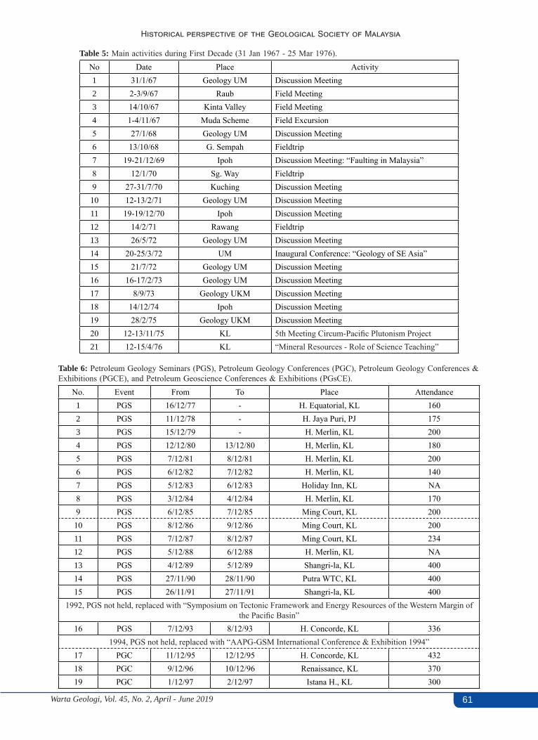
Warta Geologi, Vol. 45, No. 2, April - June 2019 61
Historical perspective of the Geological Society of Malaysia
Table 5: Main activities during First Decade (31 Jan 1967 - 25 Mar 1976).No Date Place Activity1 31/1/67 Geology UM Discussion Meeting2 2-3/9/67 Raub Field Meeting3 14/10/67 Kinta Valley Field Meeting4 1-4/11/67 Muda Scheme Field Excursion5 27/1/68 Geology UM Discussion Meeting6 13/10/68 G. Sempah Fieldtrip7 19-21/12/69 Ipoh Discussion Meeting: “Faulting in Malaysia”8 12/1/70 Sg. Way Fieldtrip9 27-31/7/70 Kuching Discussion Meeting
10 12-13/2/71 Geology UM Discussion Meeting11 19-19/12/70 Ipoh Discussion Meeting12 14/2/71 Rawang Fieldtrip13 26/5/72 Geology UM Discussion Meeting14 20-25/3/72 UM Inaugural Conference: “Geology of SE Asia”15 21/7/72 Geology UM Discussion Meeting16 16-17/2/73 Geology UM Discussion Meeting17 8/9/73 Geology UKM Discussion Meeting18 14/12/74 Ipoh Discussion Meeting19 28/2/75 Geology UKM Discussion Meeting20 12-13/11/75 KL 5th Meeting Circum-Pacific Plutonism Project21 12-15/4/76 KL “Mineral Resources - Role of Science Teaching”
Table 6: Petroleum Geology Seminars (PGS), Petroleum Geology Conferences (PGC), Petroleum Geology Conferences & Exhibitions (PGCE), and Petroleum Geoscience Conferences & Exhibitions (PGsCE).
No. Event From To Place Attendance1 PGS 16/12/77 - H. Equatorial, KL 1602 PGS 11/12/78 - H. Jaya Puri, PJ 1753 PGS 15/12/79 - H. Merlin, KL 2004 PGS 12/12/80 13/12/80 H, Merlin, KL 1805 PGS 7/12/81 8/12/81 H. Merlin, KL 2006 PGS 6/12/82 7/12/82 H. Merlin, KL 1407 PGS 5/12/83 6/12/83 Holiday Inn, KL NA 8 PGS 3/12/84 4/12/84 H. Merlin, KL 1709 PGS 6/12/85 7/12/85 Ming Court, KL 20010 PGS 8/12/86 9/12/86 Ming Court, KL 20011 PGS 7/12/87 8/12/87 Ming Court, KL 23412 PGS 5/12/88 6/12/88 H. Merlin, KL NA13 PGS 4/12/89 5/12/89 Shangri-la, KL 40014 PGS 27/11/90 28/11/90 Putra WTC, KL 40015 PGS 26/11/91 27/11/91 Shangri-la, KL 400
1992, PGS not held, replaced with “Symposium on Tectonic Framework and Energy Resources of the Western Margin of the Pacific Basin”
16 PGS 7/12/93 8/12/93 H. Concorde, KL 3361994, PGS not held, replaced with “AAPG-GSM International Conference & Exhibition 1994”
17 PGC 11/12/95 12/12/95 H. Concorde, KL 43218 PGC 9/12/96 10/12/96 Renaissance, KL 37019 PGC 1/12/97 2/12/97 Istana H., KL 300
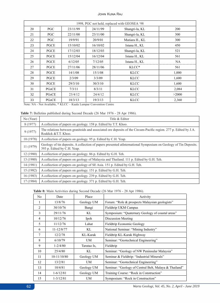
Warta Geologi, Vol. 45, No. 2, April - June 201962
John Kuna Raj
1998, PGC not held, replaced with GEOSEA ‘9820 PGC 23/11/99 24/11/99 Shangri-la, KL 20021 PGC 22/11/00 23/11/00 Shangri-la, KL 30022 PGC 19/9/91 20/9/01 Mutiara H., KL 30023 PGCE 15/10/02 16/10/02 Istana H., KL 45024 PGCE 17/12/03 18/12/03 Shangri-la, KL 52125 PGCE 15/12/04 16/12/04 Istana H., KL 56126 PGCE 6/12/05 7/12/05 Istana H., KL NA27 PGCE 27/11/06 28/11/06 KLCC* 56128 PGCE 14/1/08 15/1/08 KLCC 1,00029 PGCE 2/3/09 3/3/09 KLCC 1,60030 PGCE 29/3/10 30/3/10 KLCC 1,60031 PGsCE 7/3/11 8/3/11 KLCC 2,08432 PGsCE 23/4/12 24/4/12 KLCC >200033 PGsCE 18/3/13 19/3/13 KLCC 2,360
Note: NA - Not Available, * KLCC – Kuala Lumpur Convention Centre
Table 7: Bulletins published during Second Decade (26 Mar 1976 - 28 Apr 1986).No (Year) Title & Editor8 (1977) A collection of papers on geology. 158 p. Edited by T.T. Khoo.
9 (1977) The relations between granitoids and associated ore deposits of the Circum-Pacific region. 277 p. Edited by J.A. Roddick &T.T. Khoo.
10 (1978) A collection of papers on geology. 95 p. Edited by C.H. Yeap.
11 (1979) Geology of tin deposits. A collection of papers presented atInternational Symposium on Geology of Tin Deposits. 393 p. Edited by C.H. Yeap.
12 (1980) A collection of papers on geology. 86 p. Edited by G.H. Teh.13 (1980) A collection of papers on geology of Malaysia and Thailand. 111 p. Edited by G.H. Teh.14 (1981) A collection of papers on geology of SE Asia. 151 p. Edited by G.H. Teh.15 (1982) A collection of papers on geology. 151 p. Edited by G.H. Teh.16 (1983) A collection of papers on geology. 239 p. Edited by G.H. Teh.17 (1984) A collection of papers on geology. 371 p. Edited by G.H. Teh.
Table 8: Main Activities during Second Decade (26 Mar 1976 - 28 Apr 1986).No Date Place Activity1 13/8/76 Geology UM Forum: “Role & prospects Malaysian geologists”2 30/10/76 Bangi Fieldtrip UKM Campus3 29/11/76 KL Symposium: “Quaternary Geology of coastal areas”4 10/12/76 Ipoh Discussion Meeting5 11/12/76 Lahat Fieldtrip Economic Geology6 11-12/8/77 KL National Seminar: “Mining Industry”7 12/2/78 KL-Karak Fieldtrip KL-Karak Highway8 6/10/79 UM Seminar: “Geotechnical Engineering”9 1-2/4/80 Tarutao Is, Fieldtrip10 25/4/80 KL Seminar: “Geology of NW Peninsular Malaysia”11 10-11/10/80 Geology UM Seminar & Fieldtrip: “Industrial Minerals”12 13/2/81 UM Seminar: “Geotechnical Engineering”13 10/4/81 Geology UM Seminar: “Geology of Central Belt, Malaya & Thailand”14 1-6/12/81 Geology UM Training Course: “Rock in Construction”15 1-3/12/81 UM Symposium: “Rock in Construction”
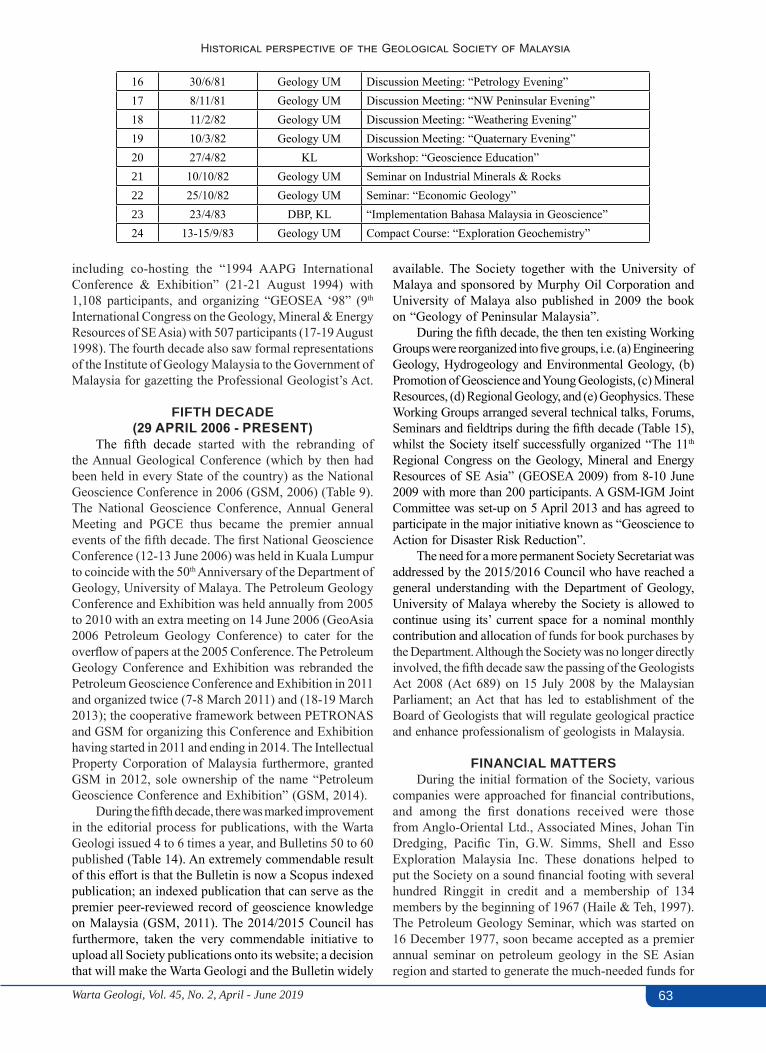
Warta Geologi, Vol. 45, No. 2, April - June 2019 63
Historical perspective of the Geological Society of Malaysia
16 30/6/81 Geology UM Discussion Meeting: “Petrology Evening”17 8/11/81 Geology UM Discussion Meeting: “NW Peninsular Evening”18 11/2/82 Geology UM Discussion Meeting: “Weathering Evening”19 10/3/82 Geology UM Discussion Meeting: “Quaternary Evening”20 27/4/82 KL Workshop: “Geoscience Education”21 10/10/82 Geology UM Seminar on Industrial Minerals & Rocks22 25/10/82 Geology UM Seminar: “Economic Geology”23 23/4/83 DBP, KL “Implementation Bahasa Malaysia in Geoscience”24 13-15/9/83 Geology UM Compact Course: “Exploration Geochemistry”
including co-hosting the “1994 AAPG International Conference & Exhibition” (21-21 August 1994) with 1,108 participants, and organizing “GEOSEA ‘98” (9th International Congress on the Geology, Mineral & Energy Resources of SE Asia) with 507 participants (17-19 August 1998). The fourth decade also saw formal representations of the Institute of Geology Malaysia to the Government of Malaysia for gazetting the Professional Geologist’s Act.
FIFTH DECADE (29 APRIL 2006 - PRESENT)
The fifth decade started with the rebranding of the Annual Geological Conference (which by then had been held in every State of the country) as the National Geoscience Conference in 2006 (GSM, 2006) (Table 9). The National Geoscience Conference, Annual General Meeting and PGCE thus became the premier annual events of the fifth decade. The first National Geoscience Conference (12-13 June 2006) was held in Kuala Lumpur to coincide with the 50th Anniversary of the Department of Geology, University of Malaya. The Petroleum Geology Conference and Exhibition was held annually from 2005 to 2010 with an extra meeting on 14 June 2006 (GeoAsia 2006 Petroleum Geology Conference) to cater for the overflow of papers at the 2005 Conference. The Petroleum Geology Conference and Exhibition was rebranded the Petroleum Geoscience Conference and Exhibition in 2011 and organized twice (7-8 March 2011) and (18-19 March 2013); the cooperative framework between PETRONAS and GSM for organizing this Conference and Exhibition having started in 2011 and ending in 2014. The Intellectual Property Corporation of Malaysia furthermore, granted GSM in 2012, sole ownership of the name “Petroleum Geoscience Conference and Exhibition” (GSM, 2014).
During the fifth decade, there was marked improvement in the editorial process for publications, with the Warta Geologi issued 4 to 6 times a year, and Bulletins 50 to 60 published (Table 14). An extremely commendable result of this effort is that the Bulletin is now a Scopus indexed publication; an indexed publication that can serve as the premier peer-reviewed record of geoscience knowledge on Malaysia (GSM, 2011). The 2014/2015 Council has furthermore, taken the very commendable initiative to upload all Society publications onto its website; a decision that will make the Warta Geologi and the Bulletin widely
available. The Society together with the University of Malaya and sponsored by Murphy Oil Corporation and University of Malaya also published in 2009 the book on “Geology of Peninsular Malaysia”.
During the fifth decade, the then ten existing Working Groups were reorganized into five groups, i.e. (a) Engineering Geology, Hydrogeology and Environmental Geology, (b) Promotion of Geoscience and Young Geologists, (c) Mineral Resources, (d) Regional Geology, and (e) Geophysics. These Working Groups arranged several technical talks, Forums, Seminars and fieldtrips during the fifth decade (Table 15), whilst the Society itself successfully organized “The 11th
Regional Congress on the Geology, Mineral and Energy Resources of SE Asia” (GEOSEA 2009) from 8-10 June 2009 with more than 200 participants. A GSM-IGM Joint Committee was set-up on 5 April 2013 and has agreed to participate in the major initiative known as “Geoscience to Action for Disaster Risk Reduction”.
The need for a more permanent Society Secretariat was addressed by the 2015/2016 Council who have reached a general understanding with the Department of Geology, University of Malaya whereby the Society is allowed to continue using its’ current space for a nominal monthly contribution and allocation of funds for book purchases by the Department. Although the Society was no longer directly involved, the fifth decade saw the passing of the Geologists Act 2008 (Act 689) on 15 July 2008 by the Malaysian Parliament; an Act that has led to establishment of the Board of Geologists that will regulate geological practice and enhance professionalism of geologists in Malaysia.
FINANCIAL MATTERSDuring the initial formation of the Society, various
companies were approached for financial contributions, and among the first donations received were those from Anglo-Oriental Ltd., Associated Mines, Johan Tin Dredging, Pacific Tin, G.W. Simms, Shell and Esso Exploration Malaysia Inc. These donations helped to put the Society on a sound financial footing with several hundred Ringgit in credit and a membership of 134 members by the beginning of 1967 (Haile & Teh, 1997). The Petroleum Geology Seminar, which was started on 16 December 1977, soon became accepted as a premier annual seminar on petroleum geology in the SE Asian region and started to generate the much-needed funds for
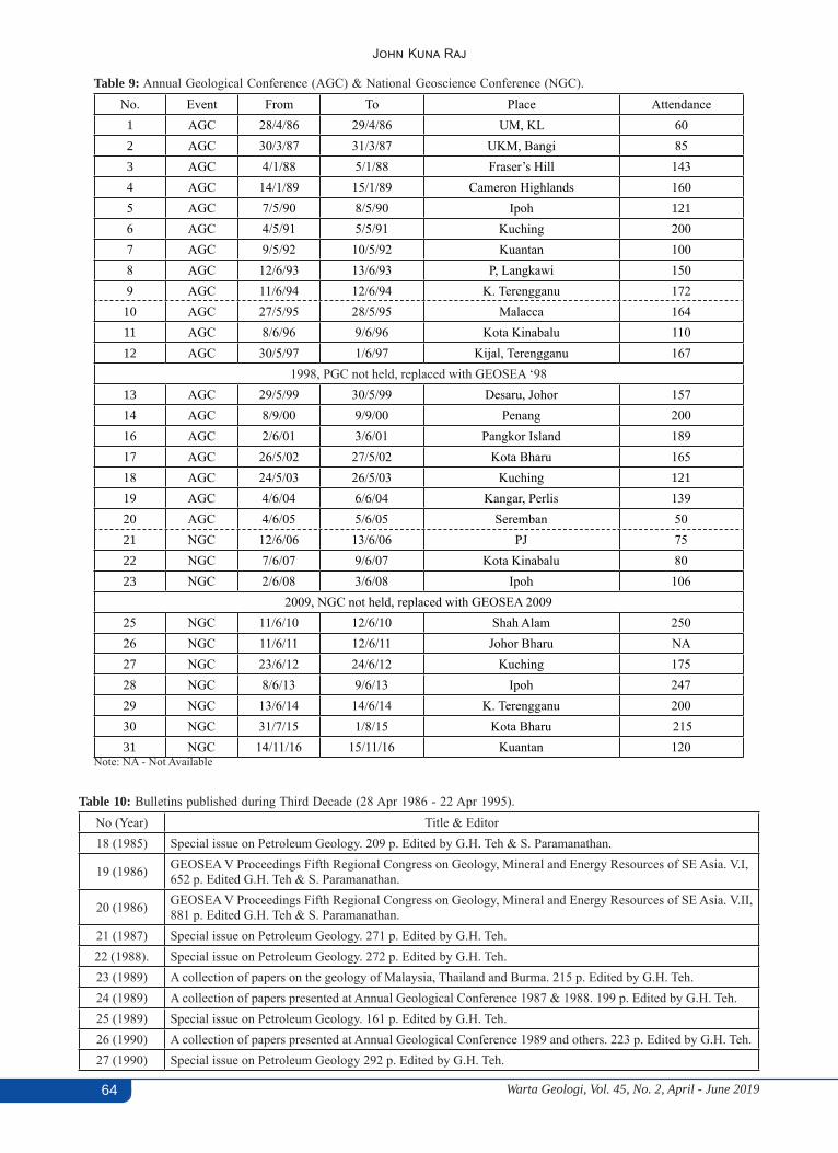
Warta Geologi, Vol. 45, No. 2, April - June 201964
John Kuna Raj
Table 9: Annual Geological Conference (AGC) & National Geoscience Conference (NGC).No. Event From To Place Attendance1 AGC 28/4/86 29/4/86 UM, KL 602 AGC 30/3/87 31/3/87 UKM, Bangi 853 AGC 4/1/88 5/1/88 Fraser’s Hill 1434 AGC 14/1/89 15/1/89 Cameron Highlands 1605 AGC 7/5/90 8/5/90 Ipoh 1216 AGC 4/5/91 5/5/91 Kuching 2007 AGC 9/5/92 10/5/92 Kuantan 1008 AGC 12/6/93 13/6/93 P, Langkawi 1509 AGC 11/6/94 12/6/94 K. Terengganu 172
10 AGC 27/5/95 28/5/95 Malacca 16411 AGC 8/6/96 9/6/96 Kota Kinabalu 11012 AGC 30/5/97 1/6/97 Kijal, Terengganu 167
1998, PGC not held, replaced with GEOSEA ‘9813 AGC 29/5/99 30/5/99 Desaru, Johor 15714 AGC 8/9/00 9/9/00 Penang 20016 AGC 2/6/01 3/6/01 Pangkor Island 18917 AGC 26/5/02 27/5/02 Kota Bharu 16518 AGC 24/5/03 26/5/03 Kuching 12119 AGC 4/6/04 6/6/04 Kangar, Perlis 13920 AGC 4/6/05 5/6/05 Seremban 5021 NGC 12/6/06 13/6/06 PJ 7522 NGC 7/6/07 9/6/07 Kota Kinabalu 8023 NGC 2/6/08 3/6/08 Ipoh 106
2009, NGC not held, replaced with GEOSEA 200925 NGC 11/6/10 12/6/10 Shah Alam 25026 NGC 11/6/11 12/6/11 Johor Bharu NA27 NGC 23/6/12 24/6/12 Kuching 17528 NGC 8/6/13 9/6/13 Ipoh 24729 NGC 13/6/14 14/6/14 K. Terengganu 20030 NGC 31/7/15 1/8/15 Kota Bharu 21531 NGC 14/11/16 15/11/16 Kuantan 120
Note: NA - Not Available
Table 10: Bulletins published during Third Decade (28 Apr 1986 - 22 Apr 1995).No (Year) Title & Editor18 (1985) Special issue on Petroleum Geology. 209 p. Edited by G.H. Teh & S. Paramanathan.
19 (1986) GEOSEA V Proceedings Fifth Regional Congress on Geology, Mineral and Energy Resources of SE Asia. V.I, 652 p. Edited G.H. Teh & S. Paramanathan.
20 (1986) GEOSEA V Proceedings Fifth Regional Congress on Geology, Mineral and Energy Resources of SE Asia. V.II, 881 p. Edited G.H. Teh & S. Paramanathan.
21 (1987) Special issue on Petroleum Geology. 271 p. Edited by G.H. Teh.22 (1988). Special issue on Petroleum Geology. 272 p. Edited by G.H. Teh.23 (1989) A collection of papers on the geology of Malaysia, Thailand and Burma. 215 p. Edited by G.H. Teh.24 (1989) A collection of papers presented at Annual Geological Conference 1987 & 1988. 199 p. Edited by G.H. Teh.25 (1989) Special issue on Petroleum Geology. 161 p. Edited by G.H. Teh.26 (1990) A collection of papers presented at Annual Geological Conference 1989 and others. 223 p. Edited by G.H. Teh.27 (1990) Special issue on Petroleum Geology 292 p. Edited by G.H. Teh.

Warta Geologi, Vol. 45, No. 2, April - June 2019 65
Historical perspective of the Geological Society of Malaysia
Table 11: Main Activities during Third Decade (28 Apr 1986 - 22 Apr 1995).No Date Place Group Activity1 3/4/88 K.Selangor SSG Fieldtrip to Jeram & Tuan Mee estate2 2/4/89 Pahang SGT Fieldtrip to Bentong-Raub area3 19/8/89 N.Sembilan SGT Fieldtrip to Bahau area4 12/11/89 Pahang EconG Fieldtrip to gold mines in Pahang5 6 - 9/12/89 UM PG “Modern & ancient deep-sea sedimentation”6 27-30/6/91 Johore SGT Fieldtrip to Endau-Rompin7 6/10/91 K.Selangor SSG Fieldtrip to Jeram & Batu Arang8 28-29/9/92 UM EngG Forum: “Dam Geology” & damsite visit9 11-13/1/93 UM EngG Forum: “Highway Geology” & site visits10 1 & 2/7/93 UM EngG Forum: “Urban Geology & Engineering”11 23-25/7/93 Pahang SGT Fieldtrip to Cameron Highlands - Pos Blau12 13-15/8/93 Trengganu SSG Fieldtrip to Jenderak & Kenyir13 11/1/94 UM EngG Forum: “Groundwater”14 15-17/4/94 Pahang SSG Permo-Triassic fieldtrip15 22/7/94 UM EngG Forum: “Geology & Hillside Development”
Note: Working Groups set-up March 1987: SSG - Stratigraphy & Sedimentology; EconG - Economic Geology; PG - Petroleum Geology; SGT - Structural Geology & EngG - Engineering Geology & Hydrology
Table 12: Bulletins published during Fourth Decade (22 Apr 1995 - 29 Apr 2006).No. (Year) Title & Editor
37 (1995) Proceedings AAPG-GSM International Conference 1994. SE Asian Basins: Oil and Gas for the 21st Century. 506 p. Edited by G.H. Teh
38 (1995) A collection of papers presented at GSM Annual Geological Conference 1994 and others. 190 p. Edited by G.H. Teh39 (1996) A collection of papers on geology. 258 p. Edited by G.H. Teh40 (1997) A collection of papers presented at Annual Geological Conference 1996 and others. 247 p. Edited by G.H. Teh41 (1997) A collection of papers presented at Petroleum Geology Conference 1996 and others. 165 p. Edited by G.H. Teh
42 (1998) Papers from Petroleum Geology Conference 1997, Seminar on Tertiary Basins of Peninsular Malaysia and others. 268 p. Edited by G.H. Teh
43 (1999) Papers from GEOSEA ’98 (Ninth Regional Congress on Geology, Mineral & Energy Resources of SE Asia). 698 p. Edited by G.H. Teh
44 (2000) A collection of papers from Annual Geological Conference 1999. Western Belt & Paleozoic of Peninsular Malaysia Seminar 1999 & others. 178 p. Edited by G.H. Teh
45 (2002) Annual Geological Conference 2002. Conference Issue. 375 p. Edited by G.H. Teh, Ismail Yusoff, Azman A. Ghani & T.F. Ng
46 (2003) Annual Geological Conference 2003 Issue. 489 p. Edited by G.H. Teh, Alex Unya Ambun, Askury Abd. Kadir & T.F. Ng47 (2003) Petroleum Geology Conference & Exhibition 2002. 179 p. Edited by G.H. Teh.48 (2004) Annual Geological Conference 2004 Issue. 130 p. Edited by Lee Chai Peng, Md. Shafeea Leman, J.J. Pereira & T.F. Ng49 (2004) Collection of Geological Papers. 167 p. Edited by K.K. Liew, Nur Iskandar Taib & T.F. Ng
28 (1991) Special issue on Petroleum Geology 292 p. Edited by G.H. Teh.29 (1991) A collection of papers presented at Annual Geological Conference 1990 and others. 255 p. Edited by G.H. Teh.30 (1992) Annotated bibliography of the geology of the South China Sea and adjacent parts of Borneo. 90 p. N.S. Haile.31 (1992) A collection of papers presented at Annual Geological Conference 1991 and others. 176 p. Edited by G.H. Teh.32 (1992) Special issue on Petroleum Geology. 283 p. Edited by G.H. Teh.
33 (1993) Proceedings Symposium on Tectonic Framework and Energy Resources of the Western Margin of the Pacific Basin. 419 p. Edited by G.H. Teh.
34 (1993). Publications of the Geological Society of Malaysia 1967-1993. 181 p. Compiled by T.F. Ng.35 (1994) A collection of papers presented at Annual Geological Conference 1992 and others. 174 p. Edited by G.H. Teh.36 (1994) Special issue on Petroleum Geology. 186 p. Edited by G.H. Teh.
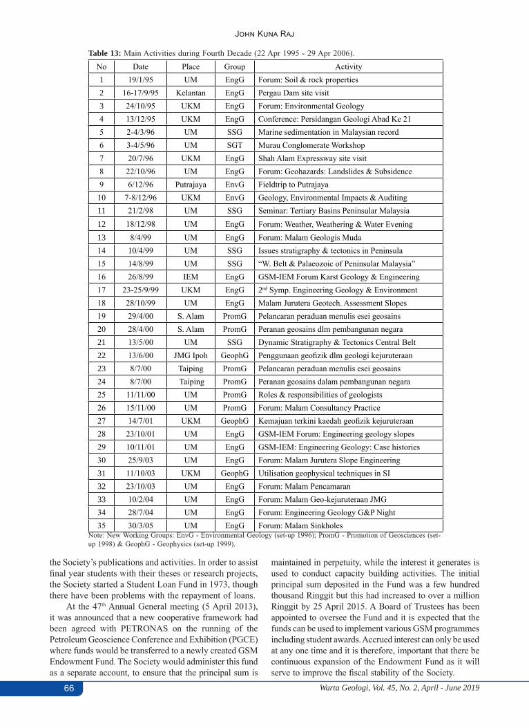
Warta Geologi, Vol. 45, No. 2, April - June 201966
John Kuna Raj
Table 13: Main Activities during Fourth Decade (22 Apr 1995 - 29 Apr 2006).No Date Place Group Activity1 19/1/95 UM EngG Forum: Soil & rock properties2 16-17/9/95 Kelantan EngG Pergau Dam site visit3 24/10/95 UKM EngG Forum: Environmental Geology4 13/12/95 UKM EngG Conference: Persidangan Geologi Abad Ke 215 2-4/3/96 UM SSG Marine sedimentation in Malaysian record6 3-4/5/96 UM SGT Murau Conglomerate Workshop7 20/7/96 UKM EngG Shah Alam Expressway site visit8 22/10/96 UM EngG Forum: Geohazards: Landslides & Subsidence9 6/12/96 Putrajaya EnvG Fieldtrip to Putrajaya10 7-8/12/96 UKM EnvG Geology, Environmental Impacts & Auditing11 21/2/98 UM SSG Seminar: Tertiary Basins Peninsular Malaysia12 18/12/98 UM EngG Forum: Weather, Weathering & Water Evening
13 8/4/99 UM EngG Forum: Malam Geologis Muda14 10/4/99 UM SSG Issues stratigraphy & tectonics in Peninsula15 14/8/99 UM SSG “W. Belt & Palaeozoic of Peninsular Malaysia”16 26/8/99 IEM EngG GSM-IEM Forum Karst Geology & Engineering17 23-25/9/99 UKM EngG 2nd Symp. Engineering Geology & Environment18 28/10/99 UM EngG Malam Jurutera Geotech. Assessment Slopes19 29/4/00 S. Alam PromG Pelancaran peraduan menulis esei geosains20 28/4/00 S. Alam PromG Peranan geosains dlm pembangunan negara21 13/5/00 UM SSG Dynamic Stratigraphy & Tectonics Central Belt22 13/6/00 JMG Ipoh GeophG Penggunaan geofizik dlm geologi kejuruteraan23 8/7/00 Taiping PromG Pelancaran peraduan menulis esei geosains24 8/7/00 Taiping PromG Peranan geosains dalam pembangunan negara25 11/11/00 UM PromG Roles & responsibilities of geologists26 15/11/00 UM PromG Forum: Malam Consultancy Practice27 14/7/01 UKM GeophG Kemajuan terkini kaedah geofizik kejuruteraan28 23/10/01 UM EngG GSM-IEM Forum: Engineering geology slopes29 10/11/01 UM EngG GSM-IEM: Engineering Geology: Case histories30 25/9/03 UM EngG Forum: Malam Jurutera Slope Engineering31 11/10/03 UKM GeophG Utilisation geophysical techniques in SI32 23/10/03 UM EngG Forum: Malam Pencamaran33 10/2/04 UM EngG Forum: Malam Geo-kejuruteraan JMG34 28/7/04 UM EngG Forum: Engineering Geology G&P Night35 30/3/05 UM EngG Forum: Malam Sinkholes
Note: New Working Groups: EnvG - Environmental Geology (set-up 1996); PromG - Promotion of Geosciences (set-up 1998) & GeophG - Geophysics (set-up 1999).
the Society’s publications and activities. In order to assist final year students with their theses or research projects, the Society started a Student Loan Fund in 1973, though there have been problems with the repayment of loans.
At the 47th Annual General meeting (5 April 2013), it was announced that a new cooperative framework had been agreed with PETRONAS on the running of the Petroleum Geoscience Conference and Exhibition (PGCE) where funds would be transferred to a newly created GSM Endowment Fund. The Society would administer this fund as a separate account, to ensure that the principal sum is
maintained in perpetuity, while the interest it generates is used to conduct capacity building activities. The initial principal sum deposited in the Fund was a few hundred thousand Ringgit but this had increased to over a million Ringgit by 25 April 2015. A Board of Trustees has been appointed to oversee the Fund and it is expected that the funds can be used to implement various GSM programmes including student awards. Accrued interest can only be used at any one time and it is therefore, important that there be continuous expansion of the Endowment Fund as it will serve to improve the fiscal stability of the Society.

Warta Geologi, Vol. 45, No. 2, April - June 2019 67
Historical perspective of the Geological Society of Malaysia
Table 15: Main activities during Fifth Decade (29 Apr 2006 - Present).No Date Place Group Activity1 21/6/06 UM EngG Forum: “Malam Jurutera 2006”2 20/9/06 UM EngG Forum: “MalamTunneling “3 21/3/07 UM EngG Forum: “Malam Cerun”4 31/7/07 UM EngG Forum: “Malam Jurutera 2007”5 3/8/08 UM PromG Forum: “Malam Geologi Kejuruteraan Muda”6 24/10/08 UM EngG Forum: “Malam Jurutera 2008”7 18/2/09 UM EngG Forum: “Malam Geologi Kejuruteraan Tua”8 14/8/09 UM IGC “Malam GEOSEA Reruns”9 11/11/09 UM EngG Forum: “Malam Jurutera 2009”10 21/12/09 UM IGC “Malam Airtanah 2009”11 21/12/09 UM EngG Forum: “Malam Airtanah 2009”12 26/5/10 UM IGC “Malam Airtanah”13 28/7/10 UM EngG Forum: “Malam Geologi Kejuruteraan I 2010”14 29/92010 UM EngG Forum: “Malam Geologi Kejuruteraan II 2010”15 20/10/10 UM EngG Forum: “Malam Jurutera 201016 25/3/11 UM EngG Forum: “MalamTunneling ”17 8/7/11 UM EngG Forum: “Malam Geologi Kejuruteraan I 2011”18 22/9/11 UM EngG Forum: “Malam Geologi Kejuruteraan II 2011”19 21/10/11 UM EngG Forum: “Malam Jurutera 2011”20 30/5/12 UM EngG Forum: “Malam Geologi Kejuruteraan 2012”21 5/7/12 UKM EngG Forum: “Malam Sekitaran I”22 18/7/12 UKM EngG Forum: “Malam Sekitaran II”23 8/4/13 UM EngG Forum: “Malam Geologi Kejuruteraan 2013”24 3 - 4/12/13 UMS, KK SbhG Seminar: “ Bencana Alam (BENCANA 2013)”25 3 - 4/12/14 UMS, KK SbhG Seminar: “ Bencana Alam (BENCANA 2014)”
Note: EngG - Engineering Geology, Hydrogeology & Environmental Geology (set-up 2008); SbhG - Working Group Sabah; IGC - IGM-GSM Joint Committee
Table 14: Bulletins published during Fifth Decade (29Apr 2006 - Present).No (Year) Title & Editor50 (2007) Bibliography and Index of GSM Publications 1994 – 2004. 160 p. Compiled by R.B. Tate.51 (2005) Annual Geological Conference 2005 Issue. 199 p. Edited by Nur Iskandar Taib.52 (2006) Collection of geological papers. 135 p. Edited by Nur Iskandar Taib.53 (2007) Collection of geological papers. 128 p. Edited by T.F. Ng, Nur Iskandar Taib & J.J. Pereira.54 (2008) Collection of geological papers. 169 p. Edited by T.F. Ng, Nur Iskandar Taib & Samsudin Hj. Taib.55 (2009) Collection of geological papers. 100 p. Edited by T.F. Ng & Y.L. Lau.56 (2010) Collection of geological papers. 132 p. Edited by Mohd Shafeea Leman, Basir Jasin, T.F. Ng & C.S. Lim.57 (2011) Collection of geological papers. 84 p. Edited by T.F. Ng, R.L. Kugler, J.J. Pereira & Ibrahim Komoo.58 (2012) Collection of geological papers. 96 p. Edited by T.F. Ng & M. Johansson.59 (2013) Collection of geological papers. 107 p. Edited by A.J. Reedman, Nguyen Thi Minh, C.S. Lim & T.F. Ng.60 (2014) Charles S. Hutchison Memorial Issue. 99 p. Edited by Lee C.P. & T.F. Ng
The Society mooted the Young Geoscientist Award in 1978 (though rules regarding award were only finalized in July 1979) to recognize good publications by young geoscientists (below 30 years of age), and launched the GSM Best Student Award (in Geology) for eligible final year students from each of the local Universities in July
1991. In 1995, the Geoscientist Award was established to award a member, or a group of members, for excellence in original geoscience research and contributed significantly towards the development of geology in Malaysia. At the last Annual General Meeting on 9 April 2016, however, it was reported that there has been a lack of interest in the Society
Warta Geologi, Vol. 45, No. 2, April - June 201968
John Kuna Raj
Awards perhaps due to poor publicity given to the awards and lack of initiative by relevant parties. The Council then decided to rejuvenate these Awards by renaming them as (a) N.S. Haile Publication Award (formerly Young Geoscientist Award), (b) Hutchison Best Student Award (formerly GSM Best Student Award) and (c) D.J. Gobbett Award (formerly Geoscientist Award). An award nomination committee was set-up to administer the awards with funds to be sourced from the GSM Endowment Fund.
CONCLUDING REMARKSIt is clear that the Society has since its formation in
1967 grown in strength over the past 50 years, starting with a initial membership of 134 in 1967 and now standing at 595 (on 8 September 2017). With its main annual events, i.e. National Geoscience Conference, and General Meeting, as well as the regularly organized technical talks, fieldtrips, Forums, Seminars and Conferences, sound financial position, and timely publication of the Warta Geologi and Bulletin, the Society can be said to be one of the most active and successful geological societies in SE Asia. The Society has also kept abreast with the evolution of geosciences in general through the years, from the early days of tin mining through development of the petroleum industry to involvement of geology in engineering projects and more recently in environmental projects. With such a sound track record, the Society can look forward to increasing involvement of geoscientists in national development, particularly with introduction of the Geologists Act (689) in 2008.
There is, however, a need for caution as the present number of Society members (595 on 8 September 2017) is not in tandem with the actual number of registered geologists in the country. On 31 July 2017, there was a total of 1,815 “geologists” registered with the Board of Geologists Malaysia, consisting of 1,228 Registered Professional Geologists, 272 Registered Graduate Geologists, 304 Registered Foreign Geologists and 11 Registered Practitioners. The membership of the Society has also fluctuated greatly over the past two decades with a maximum of 719 members on 31 December 2012 and a minimum of 409 members on 31 December 2000. Several Presidents of Councils in recent years have highlighted the decreasing number of participants at technical talks, Forums and Seminars and other events organized by the Society.
The discrepancy in numbers of “registered geologists” and GSM members, as well as poor participation at technical talks and other events, raises the question on the quality of “Registered Professional Geologists” for most of them do not appear to be interested in keeping their knowledge and skills current. “CPD” (Continuous Professional Development) is an essential prerequisite in many professional bodies throughout the world for registration as a member, or for extension of membership, as this ensures that the knowledge and skills of the “Professional” is current and up to date.
It is imperative that the Institute of Geology Malaysia and the Board of Geologists Malaysia consider “CPD” (usually calculated in terms of hours) as an essential prerequisite for registration, and extension of registration, of a “Professional Geologist”. The Geological Society of Malaysia will then directly benefit from such a prerequisite as participation in Society events and activities, including technical talks, Seminars, Forums and the like, can be used for calculation of “CPD Hours”. Such a prerequisite, more importantly, will ensure that the knowledge and skill of “Registered Professional Geologists” is current and up to date.
It is hoped that in the years to come, all geologists in the country will register as members of the Society and seek continuously to improve their knowledge and skills by attending and participating in all events and activities organized by the Society.
REFERENCESGSM (Geological Society of Malaysia), 1966. Editorial. Geological
Society of Malaysia, Newsletter No.1, July 1966.GSM (Geological Society of Malaysia), 1967. News of Society.
Geological Society of Malaysia, Newsletter No.5, March 1966.GSM (Geological Society of Malaysia), 1972. Report on Regional
Conference on Geology of SE Asia. Newsletter No.35, April 1972.
GSM (Geological Society of Malaysia), 1973. News of Society. Geological Society of Malaysia, Newsletter No.42, May 1973.
GSM (Geological Society of Malaysia), 1977. Editorial. Geological Society of Malaysia, Warta Geologi, 1(1), Jan-Feb 1975.
GSM (Geological Society of Malaysia), 1984. News of Society. Geological Society of Malaysia, Warta Geologi, 10(2), Mar-Apr 1984.
GSM (Geological Society of Malaysia), 1986. News of Society. Geological Society of Malaysia, Warta Geologi, 12(2), Mar-Apr 1986.
GSM (Geological Society of Malaysia), 1987. News of Society. Geological Society of Malaysia, Warta Geologi, 13(2), Mar-Apr 1987.
GSM (Geological Society of Malaysia), 1992. News of Society. Geological Society of Malaysia, Warta Geologi, 18(3), May-Jun 1992.
GSM (Geological Society of Malaysia) (1995): News of Society. Geological Society of Malaysia, Warta Geologi, V.21, No.6, Nov-Dec 1995.
GSM (Geological Society of Malaysia), 2005. News of Society. Geological Society of Malaysia, Warta Geologi, 30(1), Jan-Feb 2005.
GSM (Geological Society of Malaysia), 2006. News of Society. Geological Society of Malaysia, Warta Geologi, 32(3), May-June 2006.
GSM (Geological Society of Malaysia), 2011. News of Society. Geological Society of Malaysia, Warta Geologi, 37(2), Apr-June 2011.
GSM (Geological Society of Malaysia), 2014. News of Society. Geological Society of Malaysia, Warta Geologi, 40(1-2), Jan-June 2014.
Haile, N.S. & Teh, G.H., 1997. History of the Geological Society of Malaysia, Geological Society of Malaysia.
Manuscript received 7 November 2017 Revised manuscript received 19 December 2018
Manuscript accepted 10 February 2019
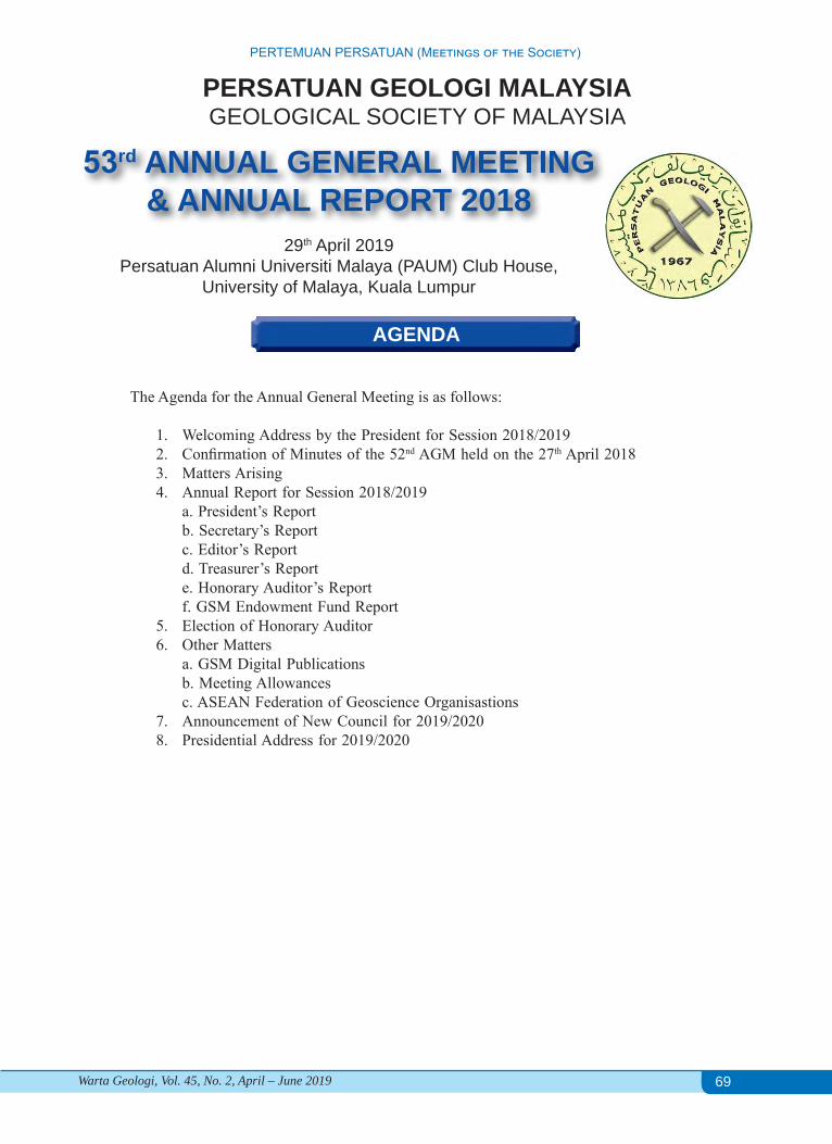
69
PERTEMUAN PERSATUAN (Meetings of the Society)
Warta Geologi, Vol. 45, No. 2, April – June 2019
AGENDA
The Agenda for the Annual General Meeting is as follows:
1. Welcoming Address by the President for Session 2018/20192. Confirmation of Minutes of the 52nd AGM held on the 27th April 20183. Matters Arising4. Annual Report for Session 2018/2019
a. President’s Reportb. Secretary’s Reportc. Editor’s Reportd. Treasurer’s Reporte. Honorary Auditor’s Reportf. GSM Endowment Fund Report
5. Election of Honorary Auditor6. Other Matters
a. GSM Digital Publicationsb. Meeting Allowancesc. ASEAN Federation of Geoscience Organisastions
7. Announcement of New Council for 2019/20208. Presidential Address for 2019/2020
PERSATUAN GEOLOGI MALAYSIAGEOLOGICAL SOCIETY OF MALAYSIA
53rd ANNUAL GENERAL MEETING& ANNUAL REPORT 2018
29th April 2019Persatuan Alumni Universiti Malaya (PAUM) Club House,
University of Malaya, Kuala Lumpur
70
PERTEMUAN PERSATUAN (Meetings of the Society)
Warta Geologi, Vol. 45, No. 2, April – June 2019
PERSATUAN GEOLOGI MALAYSIAGEOLOGICAL SOCIETY OF MALAYSIA (GSM)
MINUTES OF THE 52nd ANNUAL GENERAL MEETING
Date: 27th April 2018 Time: 5.30 p.m.Venue: Department of Geology, Universiti of Malaya, Kuala LumpurMember Present:
1. Welcoming Address by the President for Session 2017/2018Mr Abd Rasid Jaapar, the President of Geological Society of Malaysia acted as the Chairperson of theAGM and called the meeting to order at 5.30pm.
2. Adoption of AgendaThe Chairperson tabled the following agenda to the AGM for acceptance:1. Welcoming Address by the President for Session 2017/20182. Confirmation of Minutes of the 51st AGM held on the 21 April 20173. Matters Arising (51st AGM Minutes)4. Annual Report for Session 2017/2018 a. President’s Report b. Secretary’s Report c. Editor’s Report d. Treasurer’s Report e. Honorary Auditor’s Reports f. Endowment Fund Report 5. Election of Honorary Auditor 6. Other Matters 7. Announcement of New Council for 2017/2018 8. Presidential Address for 2017/2018
The agenda was unanimously accepted.
2. Confirmation of Minutes of the 51st AGM held on the 21 April 2017The Minutes of the 51st AGM was tabled for confirmation.Prof. Joy Pereira proposed that the minutes be confirmed, seconded by Dato’ Yunus Abdul Razak and Mr
Nicholas Jacob. The minutes were unanimously confirmed without any amendment.
1. Abd Rasid Jaapar2. Ahmad Nizam Hasan3. Ahmad Said4. Ahmad Tariq Ahmad Ziyad5. Askury Abd Kadir6. Che Aziz Ali7. Chin Lik Suan8. Chok Pit Yuen9. Choo Mun Keong10. Farah Fazulah Abdullah11. Gan Ain Tian12. Joy J. Pereira13. Kamar Shah Ariffin14. Lee Chai Peng15. Leong Khee Meng16. Lim Choun Sian
17. Mazlan Madon18. Meor Hakif Amir Hassan19. Muhammad Ashahadi Dzulkafli20. Ng Tham Fatt21. Nicholas Jacob22. Norbert Simon23. Nur Iskandar Taib24. Nura Abdulmumini Yelwa25. Peter Abolins26. Peter R Parham27. Tan Bock Kang28. Tan Boon Kong29. Wan Hasiah Abdullah30. Yunus Abd Razak31. Zuhar Zahir Tuan Harith
71
PERTEMUAN PERSATUAN (Meetings of the Society)
Warta Geologi, Vol. 45, No. 2, April – June 2019
3. Matters Arising (51st AGM Minutes)Matters Arising Responses
4a. To encourage all universities that offer geology program to encourage their students to collaborate in conducting geoscience activities.
i. The President of GSM visited and gave technical talks to universities to interact with geology students and club members.ii. To encourage joint geoscience activities, GSM allocates a sum of RM2,000 per university (Student Chapter of GSM/Geology Club) for student activities, by request basis.
4b.i. Poor attendance in council meeting - Sug-gestion to write reminder letter to who absent three consecutive meeting to remind them of their obligation in council meeting.ii. Review performance of Working Groups and consolidate as appropriate.
i. This year, the attendance is moderate.ii. The Council has tried to revive the inactive Working Groups and some activities were held under the WGs. GSM will revisit this in next council year.
4f. Recommendation from the Board of Trustees since 50th AGM (2016): Tax consultant for tax deductible status for GSM
The Council is still unable to find a tax consultant.
7a. PIDM on bank deposits The Council maintains current banking practices.7b. The AGM proposed to GSM to create a HD Tjia Award in honouring Prof Emeritus Tjia HD contribution.
The Council is yet to execute this suggestion as GSM still has not been very successful in filling up the nomination for existing 5 categories of Award each year (See Secretary Report).
For item (4f), the AGM tasked the Incoming Council to acquire the service of a tax consultant as soon as possible.Action: Incoming Council
4. Annual Report for Session 2017/2018 a. President’s Report Abd Rasid Jaapar tabled the President’s Report (Appendix A).The AGM discussed the following matters:• As potential Cooperating Organisation: Prof Joy Pereira, sharing experience from UKM, suggested GSM
to initiate a MoU with CCOP prior to be Cooperating Organisastion.• On paperless GSM publication: AGM supported the initiative with mixed responses, good for cost saving
but some cautious on new cost might incurred for automated or professional party to handle new system and impact on publication ranking.
• To step up joint collaboration with Board of Geology and Institute of Geology Malaysia.Action: Incoming Council
Mr Askury Abd Kadir proposed that the President’s Report to be accepted, seconded by Choo Mun Keong and Ahmad Tariq Ahmad Ziyad.
b. Secretary’s Report Lim Choun Sian tabled the Secretary’s Report and read Assistant Secretary’s Report (Appendix A).The AGM discussed the following matters:• Low nomination in GSM Awards: Council to write to all related universities to inform them about the
awards and request for nomination.• Dr Lee Chai Peng asked about is there any need or request for GSM to reprint publications that were
sold out.Action: Incoming Council
Dato’ Yunus Abd Razak proposed that the Secretary’s Report to be accepted, seconded by Nicholas Jacob and Ahmad Tariq Ahmad Ziyad. Prof Joy Pereira proposed that the Assistant Secretary’s Report to be accepted, seconded by Nicholas Jacob.
c. Editor’s Report Wan Hasiah Abdullah tabled the Editor’s Report (Appendix A).Dato’ Yunus Abd Razak proposed that the Editor’s Report to be accepted, seconded by Askury Abd Kadir.
72
PERTEMUAN PERSATUAN (Meetings of the Society)
Warta Geologi, Vol. 45, No. 2, April – June 2019
d. Treasurer’s ReportAhmad Nizam Hasan tabled the Treasurer’s and Honorary Auditor’s Report (Appendix A).The AGM discussed the following matters:
• Mr Ahmad Said requested GSM to rebuild relationship with PGCE. • NGC 2017: Low sponsorship and high overhead cost attributed by waived fee to large number
committee members. • Transfer more money to Fixed Deposit from Current Account. • Mr Choo Mun Keong proposed GSM to spend more for society activities (i.e field trip, technical talks)
for the benefit of members.Action: Incoming Council
Prof Joy Pereira and Mr KM Leong congratulated the Council for the success organization of NGC 2017. Prof
Joy Pereira proposed that the Treasurer’s and Honorary Auditor’s Report to be accepted, Dr Norbert Simon seconded.
e. Honorary Auditor’s ReportsAhmad Nizam Hasan tabled the Honorary Auditor’s Report (Appendix A).Prof Joy Pereira proposed that the Treasurer’s and Honorary Auditor’s Report to be accepted, Dr Norbert Simon
seconded.
f. GSM Endowment Fund Report Dato’ Yunus Abd Razak, on behalf of Chairman in Board of Trustees of the GSM Endowment Fund tabled the
GSM Endowment Fund Report and Recommendation from the Board of Trustees (Appendix A).Action: Incoming Council
Recommendation from the Board of Trustees was accepted by AGM.
5. Election of Honorary Auditor Ahmad Nizam Hasan proposed to continue appointing S.F. Lee & Co as the Honorary Auditor for the year 2017.The AGM unanimously agreed to the appointment.
6. Other Matters:No Other Matters was proposed or discussed during this session AGM.
7. Announcement of New Council for 2018/2019 The result from the election for GSM New Council 2018/2019: President : Mr. Abd. Rasid Jaapar (Geomapping Technology) Vice-President : Prof. Dr. Che Aziz Ali (UKM) Immediate Past President : Dr. Mazlan Madon (PETRONAS) Secretary : Mr. Lim Choun Sian (UKM) Assistant Secretary : Assoc. Prof. Askury Abd Kadir (UTP) Treasurer : Mr. Ahmad Nizam Hasan (GeoSolution Resources) Editor : Prof. Dr. Wan Hasiah Abdullah (UM)
Councillors (2 years) 2017/2019: Mr. Nicholas Jacob (JKR) Dr. Nur Iskandar Taib (UM) Mr. Tan Boon Kong (Consultant) Dato’ Yunus Abdul Razak (SEADPRI-UKM)
Councillors 2018/2020: Mr. Ahmad Tariq Ahmad Ziyad (Orogenic Resources Bhd) Dr. Mohd Hariri Arifin (UKM) [vacant] [vacant]
73
PERTEMUAN PERSATUAN (Meetings of the Society)
Warta Geologi, Vol. 45, No. 2, April – June 2019
9. Presidential Address for 2018/2019The President, Abd Rasid Jaapar expressed that it is a great honour for him to be re-elected to serve as the
President and followed by delivering his inaugural speech. He pledged that he and the new Council would try their best to serve for the good of the Society.The AGM adjourned at 7:00 pm.
LIM CHOUN SIANSecretary 2017/201827 April 2018
Note:Appendix A cited in this MINUTES OF 52nd ANNUAL GENERAL MEETING is the Document pack distributed at AGM 27 April 2018, as published in Warta 44(2), is not included for attachment in this meeting.
APPENDIX I
PRESIDENT’S REPORT
IntroductionThe Geological Society of Malaysia (GSM) has sustained its objective of actively promoting the advancement
of the geological sciences in the country and the region. Over the past year, GSM continued with activities that were designed to strengthen the capacity of geoscientists and had embarked on initiatives to formalise collaborations and alliances with key institutions within the geoscience fraternity.
Promotion and collaborationsThe IGM-GSM Joint Committee had met 2 times over the year. The Joint Committee will continue to oversee
the collaboration between the two institutions, especially on capacity building, outreach & promotion, geoscience policy and quality geoscience education in Malaysia. GSM will continue to work under Newton- Ungku Omar Fund Project until 2019.
GSM has signed Memorandum of Understanding (MOU) with US-based Society for Exploration Geophysicists (SEG) in 2017. Through this MOU, GSM may work with SEG to organise a special session on near surface geophysics as well as short course on geophysics in future. GSM will also continue its cooperation with another international organisation that has an established office in Malaysia, European Association for Geoscientists and Engineers (EAGE). The recently concluded 2nd Asia Pacific Meeting on Near Surface Geoscience and Engineering in Universiti Teknologi Malaysia jointly organised by EAGE and GSM between 22nd and 26th April 2019 was successfully executed. GSM was represented by the President as Chairman, Dr Mohd Hariri, Ahmad Nizam, Ahmad Tariq and Askury. Prof Dr Joy Pereira delivered one of the keynotes.
The Executive Secretary of Geological Society of London (GSL), Dr Richard Hughes has visited GSM on 28/1/2019. Hopefully, GSM will sign another MOU with GSL soon. I trust, GSM members will be benefited the most from the MOU. Another MOU will be with Universiti Malaysia Kelantan (UMK). With the MOU, GSM will also try to develop a model ‘GSM Students Club’ at UMK so that GSM can tap members and future leaders at very early stage even before students enter the real-world challenge. This will become model to other universities.
Universiti Kebangsaan Malaysia (UKM) with the support of GSM has successfully conducted a series of technical talks in its campus in Bangi. As part of the Society’s promotion to geoscience students, the President and/or the Working Group on Promotion will continue to visit as many geological departments in local universities possible throughout the year. The visit to Universiti Sains Malaysia and Curtin University, Sarawak has yet to be materialised.
Recently, GSM has supported the event by the Society for Engineering Geology & Rock Mechanics Malaysia (SEGRM), which is affiliated to ISRM and IAEG on ‘Science and Technology for Disaster Risk Reduction Week in Kundasang, Sabah from 25th February to 2nd March 2019 including Field Practice on Landslide Assessment by Prof Dr Chigira, Assoc Prof Dr Tajul Anuar (UKM) and Dr Ferdaus Ahmad (JMG).
GSM President attended the 54th CCOP Annual Session from 28th October to 1st November 2018 in Busan, Korea. GSM has informed the Director-General of Jabatan Mineral dan Geosains (JMG), the current chair of the CCOP (Coordinating Committee for Geoscience Programmes in East and Southeast Asia, based in Bangkok, Thailand), that GSM should remain as observer status in CCOP and be part of Malaysian delegations. We trust our members can
74
PERTEMUAN PERSATUAN (Meetings of the Society)
Warta Geologi, Vol. 45, No. 2, April – June 2019
benefit from the many events organised by CCOP. GSM also paid a courtesy visit to the DG of JMG on 9th January 2019 to enhance further the existing collaboration between JMG and GSM.
GSM delegations lead by the President has paid a courtesy visit to Madam Emeliana Rice-Oxley, Vice President of Exploration, Petronas Upstream on 20th December 2018. A fruitful discussion focused on issues to how strengthening back collaboration between GSM and Petronas.
GSM has approved the formation of Working Group on Marine & Quaternary Geology headed by Abdullah Sulaiman of JMG. The Working Group with JMG support aims to organise 10th International Conference on Asian Marine Geology in Malaysia in 2021.
National Geoscience Conference (NGC)The 31st edition of National Geoscience Conference 2018 (NGC2018) was successfully co-organised with the
USM and JMG Kedah/Pulau Pinang/Perlis between 18th and 20th September 2018 at Bayview Hotel, Georgetown, Pulau Pinang. The NGC2018 had also provided exhibition booths for exhibitors to promote their products and services. The 32nd National Geoscience Conference 2019 (NGC2019) will be co-organised with UMS and JMG Sabah at the Klagan Regency Hotel, 1 Borneo, Kota Kinabalu, Sabah from 1st to 3rd October 2019. Again, GSM would also like to encourage all members to participate in this annual event.
The 33rd National Geoscience Conference 2020 (NGC2020) will be held in Kuala Lumpur. I would like to propose that from the 33rd edition onwards, the conference should be known as GSM-IGM Geoscience Conference where IGM can actively participate in the event and the conference can also include the aspects of applications, professionalism, etc.
GEOSEAGSM continued to be the secretariat for GEOSEA. The 15th Regional Congress on Geology, Mineral and Energy
Resources of Southeast Asia (GEOSEA XV) was organised successfully in Hanoi, Vietnam between 16th and 17th
October 2018 with pre- and post-congress Field Excursions. During the GEOSEA members meeting, GSM has proposed the formation of ASEAN Federation of Geoscience Organisation (AFGeo) as well as roadmap to ASEAN Register of Professional Geologists. The President shall do a short presentation to members at the end of AGM. The next GEOSEA XVI will be organised by the Geological Society of the Philippines (GSP) from 7th to 9th December 2020 in Manila, the Philippines with the theme of ‘5 years after ASEAN integration: Milestones, Challenges and Perspectives for Geoscientists’. GEOSEA may havea new look in 2020. GSM would like to encourage our members to participate in the GEOSEAXVI. Hopefully, a MOU signing ceremony on the formation of AFGeo by all members can be done in Manila.
PublicationsThe GSM quarterly magazine, Warta Geologi has a new look, The Editorial team try to improve and upgrade
our Warta to be at least Scorpus-indexed.The GSM technical publication, the Bulletin of the Geological Society of Malaysia, was almost consistently
published twice a year. A detailed report shall be presented in Editor’s Report. We are on the right track to achieve ISI-index status. The index will ensure our Bulletin to become one of the sought-after publications in this region by researchers and readers. I would like to thank Editorial Team lead by Prof Dr Wan Hasiah, Associate Professor Dr Ng Tham Fatt, the Managing Editor for the Bulletin, Puan Aida, the editorial Executive for their tireless efforts.
We now have almost consistent 6 publications a year, at least. 2 Bulletins and 4 Warta Geologi. Unfortunately, the printing cost has also gone up tremendously. The Council has carried out survey on publication and the result will be tabled by Secretary later.
I strongly suggest that it is timely for GSM to have paperless publications. We may start with Warta Geologi.
Field ExcursionsI will maintain my last year use of old adage that ‘the best geologist is (the one) who has seen the most geology’
(Read, 1940), This year, the younger council members have taken initiative to start to organise field excursions. The field trip was organised last weekend on 27th and 28th April 2019 to Sungai Lembing ex-mining area and several other localities of geological interest. GSM will pursue further on similar activities like this even to other countries.
Way ForwardSame as previous year, I strongly urge the members of GSM to support on the improvement on the management
of GSM. We need to manage GSM professionally like a business entity, with more full-time staffs. GSM has started to re-vamp its current website to be more interactive with members and incorporate an on-line payment system, on-
75
PERTEMUAN PERSATUAN (Meetings of the Society)
Warta Geologi, Vol. 45, No. 2, April – June 2019
APPENDIX II
SECRETARY’S REPORT 2018/2019On behalf of the members of the Council of the Geological Society of Malaysia (GSM), it is my pleasure to
present the Secretary’s Report for the session 2018/2019.
Society structureThe Society’s stakeholders are the members of the Society led by an elected Council. The Council’s main
functions are to set directions to promote the advancement of geosciences, endorse activities and provide guidance for the execution of the activities of the Society.
The Council is supported by 9 Working Groups, 6 Regional Representatives and an Editorial Group. The Working Groups were increased from 6 to 9, with addition of Working Groups on International Collaboration; Quaternary; and Hydrogeology.
The CouncilThe Council for the Geological Society of Malaysia for 2018/2019 session resumed their office after the 52ndAGM on the 27 April 2018.
Council for 2018/2019Upon the closing of nominations, only single nominations were received respectively for the positions of President,
Vice President, Secretary, Treasurer, Assistant Secretary and Editor. There were two nominations for the four 2-year Councillor positions, and two vacant position were co-opted at first Council Meeting 1, June 2018.
The Council for 2018/2019:President : Mr. Abd Rasid Jaapar (Geomapping Technology)Vice-President : Prof. Che Aziz Ali (UKM) Immediate Past President : Dr. Mazlan Madon (Consultant) Secretary : Dr. Lim Choun Sian (UKM)Assistant Secretary : Prof. Madya Askury Abd Kadir (UTP)Treasurer : Mr. Ahmad Nizam Hasan (GeoSolution Resources)Editor : Prof. Dr. Wan Hasiah Abdullah (UM)
Councillors 2018/2019:Mr. Nicholas Jacob (JMG) Dr. Nur Iskandar Taib (UM)Mr. Tan Boon Kong (Consultant)Dato’ Yunus Abdul Razak (SEADPRI-UKM)
line technical papers submission, etc. GSM also has carried out preliminary brainstorming session among the council members and regional representatives on how to move forward. We will publish the findings in Warta Geologi soon.
GSM also targeting to achieve 1,000 memberships by the end of 2020.
Closing RemarksAs a final remark, I would like to encourage GSM, IGM and (Board of Geologists) BOG to come together
and come out with a solid national geoscience agenda and awareness or outreach to public on the importance of geoscience for nation building.
We would like to thank all the outgoing council members for the contributions; to all members for ideas and supports. Thanks to all organising chairs of all events, working group chairs and regional representatives. Last but not least, a big thank to the one and only secretariat member, Ms Anna Lee for another excellent year of contribution.
ABD RASID JAAPAR President 2018/2019Geological Society of Malaysia
Councillors 2018/2020:Mr. Ahmad Tariq Ahmad Ziyad (Orogenic Resources Bhd) Dr. Mohd Hariri Arifin (UKM)*Ms. Farah Fazulah Abdullah (Carigali Hess)*Ms. Norazianti Asmari (GDS Sdn Bhd)Note: * - co-opted
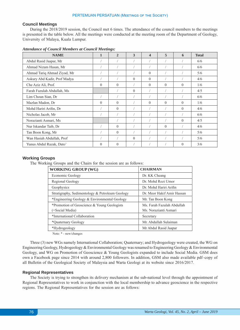
76
PERTEMUAN PERSATUAN (Meetings of the Society)
Warta Geologi, Vol. 45, No. 2, April – June 2019
Council MeetingsDuring the 2018/2019 session, the Council met 6 times. The attendance of the council members to the meetings
is presented in the table below. All the meetings were conducted at the meeting room of the Department of Geology, University of Malaya, Kuala Lumpur.
Attendance of Council Members at Council Meetings:NAME 1 2 3 4 5 6 Total
Abdul Rasid Jaapar, Mr / / / / / / 6/6Ahmad Nizam Hasan, Mr / / / / / / 6/6Ahmad Tariq Ahmad Ziyad, Mr / / / 0 / / 5/6Askury Abd Kadir, Prof Madya / / 0 0 / / 4/6Che Aziz Ali, Prof. 0 0 / 0 0 0 1/6Farah Fazulah Abdullah, Ms / 0 / / / 4/5Lim Choun Sian, Dr / / / / / / 6/6Mazlan Madon, Dr 0 0 / 0 0 0 1/6Mohd Hariri Arifin, Dr / 0 / / / 0 4/6Nicholas Jacob, Mr / / / / / / 6/6Norazianti Asmari, Ms / / / / 0 4/5Nur Iskandar Taib, Dr / 0 / / 0 / 4/6Tan Boon Kong, Mr / 0 / / / / 5/6Wan Hasiah Abdullah, Prof / / 0 / / / 5/6Yunus Abdul Razak, Dato’ 0 0 / / / 0 3/6
Working GroupsThe Working Groups and the Chairs for the session are as follows:
WORKING GROUP (WG) CHAIRMAN
Economic Geology Dr. KK CheangRegional Geology Dr. Mohd Rozi UmorGeophysics Dr. Mohd Hariri ArifinStratigraphy, Sedimentology & Petroleum Geology Dr. Meor Hakif Amir Hassan*Engineering Geology & Environmental Geology Mr. Tan Boon Kong*Promotion of Geoscience & Young Geologists(+Social Media)
Ms. Farah Fazulah AbdullahMs. Norazianti Asmari
*International Collaboration Secretary*Quaternary Geology Mr. Abdullah Sulaiman*Hydrogeology Mr Abdul Rasid JaaparNote: * - new/changes
Three (3) new WGs namely International Collaboration; Quaternary; and Hydrogeology were created, the WG on Engineering Geology, Hydrogeology & Environmental Geology was renamed to Engineering Geology & Environmental Geology, and WG on Promotion of Geoscience & Young Geologists expanded to include Social Media. GSM does own a Facebook page since 2014 with around 2,800 followers. In addition, GSM also made available pdf–copy of all Bulletin of the Geological Society of Malaysia and Warta Geologi at its website since 2016/2017.
Regional RepresentativesThe Society is trying to strengthen its delivery mechanism at the sub-national level through the appointment of
Regional Representatives to work in conjunction with the local membership to advance geoscience in the respective regions. The Regional Representatives for the session are as follows:

77
PERTEMUAN PERSATUAN (Meetings of the Society)
Warta Geologi, Vol. 45, No. 2, April – June 2019
REGIONAL REPRESENTATIVES (RR) REPRESENTATIVENorthern Peninsular Malaysia Dr. Kamar Shah AriffinCentral Peninsular Malaysia Assoc. Prof. Askury Abd Kadir (UTP)Eastern Peninsular Malaysia Dr. Mohammad Muqtada Ali Khan (UMK)Southern Peninsular Malaysia Dr. Mohamad Faizal Tajul Baharuddin (UTHM)Sarawak Dr. Dana Badang (JMG)Sabah Dr. Rodeano Roslee (UMS)
MembershipAs at 31st December 2018, the total number of members in the Society stands at 689, has increased from 634 as
of 2017. The increase is mainly from Student category and slight drop decrease in Full Member category. The table below presents the breakdown in membership categories and their geographical breakdown. The Secretary would like to apologise for the miscalculation in AGM Report in 2018, the actual total Student Members in 2017 was 100 instead of 200, resulted in erroneous reported value as 734.
Breakdowns of Membership:
COUNTRY Hon. Life Full Assoc. Student Inst. Total2018
Total2017
Total2016
Malaysia 12 (11) 363 (350) 91
(102) 8 (3) 136 (95) 0 610 561 634
Africa - (2) - - (1) - 0 3 -Australia 0 (1) 19 (18) - 1 (1) - - 20 20 20
Bangladesh - 1 (2) - - - - 1 2 1Brunei - 1 (1) - - - - 1 1 1Canada - 2 (1) - - - - 2 1 1China - 1 (1) - - (2) - 1 3 2Europe - 11 (12) 1 - - 2 (1) 14 13 13
Hong Kong - 2 (2) - - - - 2 2 1India - 1 (1) - - - - 1 1 1
Indonesia - 5 (2) - - 1 (1) - 6 3 3Japan - 3 (2) - - - - 3 2 2
Middle East+ Libya - 3 (1) - - (1) - 3 2 4
Pakistan - - - - 1 - 1 - -Philippines - 2 (2) - - - - 2 2 3Singapore - 8 (7) - (0) - 1 (1) 9 8 7Thailand - 3 (3) - - - - 3 3 3
USA - 10 (7) - - - - 10 7 7TOTAL 2018 12 435 92 9 138 3 689TOTAL 2017 12 414 102 4 100 2 634TOTAL 2016 2 393 108 4 193 3 703
Note: 1. X(Y) --- X=Number for year 2018, Y=Number for year 2017 2. Country – Based on Mailing Address, not Nationality-based
Activities, Project and SecretariatThe Society has successfully organised NGC 2018 in Penang on 18 – 19 September 2018, in collaboration with
USM and JMG; the next NGC 2019 will be in Kota Kinabalu, Sabah. Regionally, GSM jointly held GEOSEA 2018 in Hanoi on 13 – 21 October 2018; the next GEOSEA 2020 will be in the Philippines.
This Council year, the GSM-IGM Joint Committee met on 17 August 2018 and 8 March 2019. The Joint Committee, which is a requirement under the Agreement signed between GSM and IGM on 5 April 2013 and was tasked to set up various subcommittees with the objectives, among others, to promote education, research, and graduate membership,

78
PERTEMUAN PERSATUAN (Meetings of the Society)
Warta Geologi, Vol. 45, No. 2, April – June 2019
and to oversee and review geoscience curricula in Malaysian universities. The meetings discussed on future joint organisation of NGC, technical talks, geoscience curricula and continuous professional development programme. A few notable activities were carried out under (1) GSM-IGM Flagship on Geoscience to Action for Disaster Risk Reduction (G2A4DRR), which is supported by the Newton Ungku Omar Fund project entitled “Disaster Resilient Cities: Forecasting Local Level Climate Extremes and Physical Hazards for Kuala Lumpur”; and (2) Geoscience Business Working Group, a new working group on related to cater training and needs geoscience-related companies.
On research activity, GSM is one of the partner in the Research Project namely, Disaster Resilient Cities: Forecasting Local Level Climate Extremes and Physical Hazards for Kuala Lumpur, led by SEADPRI-UKM in conjunction with associated Partners in UK and Malaysia in securing the grant Newton-Ungku Omar Fund. GSM’s role is to benchmark the process and guide knowledge transfer in the research and expected completion in the end of 2019.
During the session, the Council with the cooperation of Working Groups, Regional Representatives, and in collaboration with UKM, UM, USM, UMS, IGM, CCOP, AAPG, JMG, Newton-Ungku Omar project partners and SEGRM were able to organise a total of 32+2 sessions inclusive of technical talks, workshops, conferences, short course and fieldtrip.
Summary of Activities1. 28 - 29 June 2018 | GSM-IGM Flagship on Disaster Risk Reduction: WORKSHOP ON DISASTER RESILIENT CITIES:
ADVANCES IN METEOROLOGICAL FORECASTING AND HAZARDS ASSESSMENT | Le Meriden Hotel KL2. 3 - 4 July 2018 | Inaugural SEGRM Symposium on Geo-engineering (SEGRM-GEO) by Society for Engineering Geology and
Rock Mechanics Malaysia (SEGRM) which is the National Group for IAEG and ISRM | UTM KL3. 9 August 2018 | Technical Talk | Application of high-resolution telemetered sensor technology to develop conceptual models
of catchment hydrogeological processes, by Professor Kevin M. Hiscock (University of East Anglia) |UM, Kuala Lumpur4. 18 August 2018 | GSM-SEGRM QUARTERLY FORUM ON ENGINEERING GEOLOGY & ROCK ENGINEERING Theme:
Challenges of Young Geologists in Construction Industry | UM KL5. 20 August 2018 | Technical Talk | Hydrocarbon Retention in Clastic Reservoirs of NW Borneo - Examples of Hydrocarbon
Trap, Reservoir, Seal and Implications on Hydrocarbon Column Length, by Dr Franz L Kessler | UM KL6. 24 August 2018 | Technical Talk | Carbon capture and storage: What are the big issues and opportunities facing the Petroleum
industry in Malaysia? By Prof John G Kaldi (University of Adelaide,) | UM KL7. 5 September 2018 | Technical Talk | Quantification of the Impact of Weathering on Geomechanical trengths: Granites and
Schists, by Speaker: Dr. Goh Thian Lai (UKM) | UM KL8. 12 September 2018 | Technical Talk |Basin physiographic controls on shoreline–shelf sedimentary processes and preservation:
Integrating numerical tidal modelling and sedimentary facies analysis in the Oligo– Miocene, NW Borneo, South China Sea, by Dr. Daniel S. Collins (Geological Survey of Japan) | UM KL
9. 18 - 19 September 2018 | National Geoscience Conference 2018 (NGC 2018). Theme: Georesources Development for a Sustainable Future, Bayview Hotel, Georgetown, Penang,
10. 18-20 September 2018 | Malaysia Window to Cambridge at UKM (MW2C@UKM): Workshop on Geohazards and Disaster Risk Reduction, @NGC 2018 Penang, Malaysia
11. GSM-IGM Flagship on Disaster Risk Reduction12. 10 October 2018 | Consultation Workshop on Landslide and Karst Susceptibility Modelling in Kuala Lumpur | UM KL13. 16 - 17 Oct 2018 | Regional Congress on Geology, Minerals and Energy Resources of Southeast Asia (GEOSEA) XIV | Hanoi,
Vietnam14. 22 October 2018 | 4th Symposium on Human Capital Development for the Mineral Resource Sector – UKM | Danau Golf Club,
UKM Bangi15. 29 – 30 October 2018 | Asia Geoscience Student Conference & Exhibition (AGSCE) | UTP Perak16. 31 October 2018 | Career Talk | Geophysicist in Geohazard / Hydrographic Survey by Mr. Abdul Azim Farid Bin Abdul Aziz
(FUGRO) / Alumni Geologi UKM | UKM Bangi17. 1 November 2018 |Technical Talk | Seismic geomorphology; mitigating lithology prediction risk and providing context for
further investigation, by Dr Henry W. Posamentier | UM KL18. 10 Nov 2018 | GSM Brainstorming and Strategic Planning Session |PAUM UM KL19. 12 September 2018 | Technical Talk | Basin physiographic controls on shoreline–shelf sedimentary processes and preservation:
Integrating numerical tidal modelling and sedimentary facies analysis in the Oligo–Miocene, NW Borneo, South China Sea by Dr. Daniel S. Collins (Geological Survey of Japan) | UM KL
20. 14 November 2018 | Technical Talk | Gempa Bumi di Palu, Indonesia by Ms. Norsyafiqah Salimun, Head of Academic Development at Yayazan Dana Kebajikan Muslim Malaysia | UKM Bangi
21. 15-16 November 2018 | Workshop on Status of Climate Science and Technology in Asia | Kuala Lumpur22. 18 November 2018 | Programme with Representative from American Association of Petroleum Gelologist (AAPG) and
Geological Society of Malaysia (GSM) - UMK Jeli Campus23. 24 Nov 2018 | GSM Young Geologist Network: Skills and challenges to excel in Petroleum Geology | Kuala Lumpur24. 28 November 2018 | Technical Talk |Microgravity in geotechnical/site investigations, by Mr. Jamaludin Othman | UKM Bangi25. 28 Jan 2019 | Visit by Executive Secretary of Geological Society of London (GSL), Richard Hughes

79
PERTEMUAN PERSATUAN (Meetings of the Society)
Warta Geologi, Vol. 45, No. 2, April – June 2019
26. 6 March 2019 Special Commemorative Lecture 2019 by Professor Dr Masahiro Chigira| UTM KUALA LUMPUR27. 13 March 2019 | Technical Talk | Petrologi and geokimia batuan volkanik di Blok Timur Malaya, Semenanjung Malaysia, by
Mr Muhammad Hatta Roslee | UKM Bangi28. 27 March 2019 | Technical Talk | Introduction to Modern Methods of Geophysical Site Investigations by Muhammad Mustaqim
Bin Mohd Rosli (Guideline Geo, APAC (ABEM / MALA)); and Thought-provoking Observation of the SEA World Gravity Map, by Dr. Zuhar Zahir Tuan Harith | UKM Bangi
29. 29 March 2019 | Educational Talk | Advancement of Seismic Technology for Oil and Gas in Malaysia Perspective by Prof Deva Ghosh (UTP)| UCSI Univ. Sunway
30. 1 April 2019 | Technical Talk |The Value of Leadership in your Geoscience career –Life Lessons from the Petroleum Industry, by Denise M Cox, AAPG President, 2018-2019 | UM KL
31. 16 April 2019 | GSM-IGM Flagship on DRR | Forum on “Disaster Risks, Business Continuity Management and Insurance: An Emerging Market for Geoscientists?” By Mr. Henry Ee is Founder & Director of Business Continuity Planning Asia Pte Ltd., Singapore; and Mr. Anuar Abd Shukur is Vice-President of the Malaysian Association of Risk and Insurance Management (MARIM) | UM KL
32. 17 April 2019 | Technical Talk | Uncharted Path of a Malaysian Hydrogeologist, by Datuk Ir. Dr. Azuhan bin Mohamed, P.Geol33. 27 – 28 April 2019 | Sg Lembing 2D1N Geo-Mining Tour34. 22 – 26 April 2019 | EAGE-GSM 2nd Meeting on Near Surface Geoscience and Engineering | UTM KL
GSM AwardsGSM has set up numerous awards for members. However out of 5 types of award, only “Hutchison Best Student
Award” or previously known as the “GSM Best Student Award” was given out.
Linkages and CollaborationsGSM maintained linkages with national and international institutions such as:• Institute of Geology Malaysia• Confederation of Scientific and Technological Association of Malaysia (COSTAM) – represented by two Council members: Mr. Tan Boon Kong and Mr. Nicholas Jacob• Formation Evaluation Society Malaysia (FESM)• American Association of Petroleum Geology (AAPG) - AAPG House of Delegates: represented by Dr. Mazlan Madon of PETRONAS. Mr. Askury Abd. Kadir
of University Teknologi Petronas is the alternative representative• Newton Ungku Omar Fund and IGM-GSM Flagship since July 2015• GEOSEA - GSM is the present host of the Permanent Secretariat up to 2020, represented by GSM Secretary and
Dato’ Yunus Abdul Razak - GEOSEA 2020 will be in the Philippines. GSM offered to host the next GEOSEA 2022 in Malaysia.• MoU with NrgEdge• Asian Network on Climate Science and Technology, and Newton-Ungku Omar project partners• Society of Exploration Geophysicists (SEG)• For the Student’s Geological Club Collaboration, only AAPG Student Chapter of University of Malaya
is collaborating with GSM at present
AcknowledgementThe Society would like to record its utmost appreciation to all the individuals and organisations in organising
the Society’s numerous activities during the session. Special mention must be made of the tremendous support by the Head and staff of the Geology Department, University of Malaya especially in the use of its premises for most of the Society’s meetings and activities. The continued co-operation and support extended by JMG, PETRONAS, UKM, UMS, UTP, IGM, ANCST and Newton-Ungku Omar project partners is recorded with gratitude. The unwavering support of Ms. Anna Lee and Ms Wan Aida in the administration of GSM is also very much appreciated. Last but not least, the Council also wishes to record its appreciation to all GSM members for their advice, guidance and support throughout the session.
LIM CHOUN SIAN Secretary 2018/2019Geological Society of Malaysia

80
PERTEMUAN PERSATUAN (Meetings of the Society)
Warta Geologi, Vol. 45, No. 2, April – June 2019
ASSISTANT SECRETARY’S REPORT
The publications stock until 31 December 2018 are as follows:
* - includes free copies to members; AGC – Annual Geological Conference;GESEA - Geological Evolution of SouthEast Asia; GPM - Geology of Peninsular Malaysia
2018 was not an active year for selling our publication, as our subscribers prefer to have an online or softcopy by downloading via our portal. We are planning to publish our bulletin online in future to save cost on printing and postage.
ASKURY ABD KADIRAssistant Secretary 2018/2019Geological Society of Malaysia
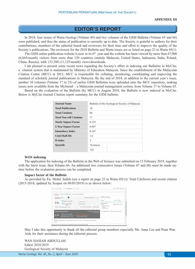
81
PERTEMUAN PERSATUAN (Meetings of the Society)
Warta Geologi, Vol. 45, No. 2, April – June 2019
APPENDIX III
EDITOR’S REPORTIn 2018, four issues of Warta Geologi (Volume 44) and two volumes of the GSM Bulletin (Volume 65 and 66)
were published, and thus the status of publication is currently up to date. The Society is grateful to authors for their contributions, members of the editorial board and reviewers for their time and effort to improve the quality of the Society’s publications. The reviewers for the 2018 Bulletin and Warta issues are as listed on page 23 in Warta 45(1).
The GSM online publication website is now in its 6th year and the website has been viewed by more than 67,900 (6,665/month) visitors from more than 120 countries (mainly Malaysia, United States, Indonesia, India, Poland, China, Russia), with 133,500 (11,125/month) views/downloads.
I am pleased to present some recent news regarding the Society’s effort in indexing our Bulletins in MyCite, a citation system that is maintained by Ministry of Education Malaysia. Since the establishment of the Malaysian Citation Centre (MCC) in 2011; MCC is responsible for collating, monitoring, coordinating and improving the standard of scholarly journal publications in Malaysia. By the end of 2018, in addition to the current year’s issue, another 10 volumes (Volume 17 to 25) of earlier GSM Bulletins were uploaded onto the MCC repository, making issues now available from the MyJurnal – a Malaysian journal management system, from Volume 17 to Volume 65.
Based on the evaluation of the Bulletin (by MCC) in August 2018, the Bulletin is now indexed in MyCite. Below is MyCite Journal Citation report summary for the GSM bulletin:
Journal Name Bulletin of the Geological Society of Malaysia
Total Publications 18
Total Citations 46
Total Non-self Citations 17
Yearly Impact Factor 0.125
5-Year Impact Factor 0.097
Immediacy Index 0.167
Cited Half-life 1.6
H-index 3
Quartile Sciences
Q1
WOS indexingThe application for indexing of the Bulletin in the Web of Science was submitted on 15 February 2019, together
with the latest issue, then Volume 66. An additional two consecutive issues (Volume 67 and 68) must be made on-time before the evaluation process can be completed.
Impact factor of the BulletinAs provided by En. Mohd. Salleh (see a report on page 22 in Warta 45(1)): Total CiteScore and recent citation
(2015-2018; updated by Scopus on 08/03/2019) is as shown below:
May I take this opportunity to thank all the editorial group members especially Ms. Anna Lee and Puan WanAida for their assistance during the editorial process.
WAN HASIAH ABDULLAHEditor 2018/2019Geological Society of Malaysia

82
PERTEMUAN PERSATUAN (Meetings of the Society)
Warta Geologi, Vol. 45, No. 2, April – June 2019
APPENDIX IV
TREASURER’S REPORTFor the Financial Year 2018, the society’s posted a deficit of RM 48,054.00 compared to deficit of RM 1,008.00
in year 2017.Operating revenue for year 2018 posted lower with a total income of RM 73,786.00 compared to year 2017 of
RM 90,638.00. The revenue posted for Subscription shows lower from RM 20,375.00 of year 2017 to RM 14,806.00 for year 2018 but Sales of publications are RM 28,250.00 higher compare to RM 13,825.00 for year 2017. Income for National Geoscience Conference (NGC) posted lower from RM 20,272.00 for NGC 2017 to RM 4,082.00 for NGC 2018 in Penang, jointly organized with Universiti Sains Malaysia. The slightly higher revenue of interest from fixed deposit of RM 18,489.00 for year 2017 to RM 19,142.00 for year 2018. The total principal amount held as fixed deposit Standard Chartered Bank is RM 637,702.00 where the tenor maturity period between 6 months to 15 month and an average interest rates ranging from 2.85% to 2.95% per annum.
Hence, income for sales of books shows lower which is Geology of Peninsular Malaysia RM 4,920.00 year 2018 to RM 9,520.00 year 2017 while shows slightly lower of RM 1,090.00 in year 2018 compare to RM1,949.00 for year 2017 for Geological Evolution of Southeast Asia.
Total operating expenditure for Financial Year 2018 shows higher from RM 90,822.00 for year 2017 to RM 121,705.00. Annual Dinner 2018 that was held at PAUM shows slightly lower from RM 2,693.00 for year 2017 to RM 2,086.00 and Honorarium shows higher from RM 19,280.00 of 2017 to RM 24,2750.00 for year 2018.
While an expenditure for Department of Geology and Website Developer shows higher for year 2018 with Department of Geology is RM 8,665.00 compare to year 2017 of RM 106.00 and Website Developer RM 11,129.00 compare to year 2017 of RM 1,802.00 due to expenses on upgrading and developing online payment platform of the GSM website. Nevertheless, printing of Warta Geologi are RM 19,734.00 lower compare to RM 21,865.00 for year 2017 and also Bulletin shows lower from RM 27,436.00 year 2017 to RM 25,650.00 for year 2018.
Expenses on speaker`s account shows slightly lower for year 2018 of RM 1,936.00 compare to RM 4,487.00 for year 2017 while Sponsorship for student’s activities slightly higher from RM 5,000.00 for year 2017 to RM 5,730.00 for year 2018. For year 2018, two best students selected from UM and UKM were given RM 1,000.00 each as GSM’s best student award in conjunctions with Konvokesyen 2018 amounting a total of RM 2,000.00 and cost after deducting sales of GSM souvenirs of collar pins and yellow field book was RM 4,570.00.
An Endowment fund for year 2018 shows an increase of RM 56,739.00 given a total amount of RM 1,729,239.00 compare to RM 1,672,520.00 for year 2017. The account was held as fixed deposit (FD) in UOB Bank given an accrued interest of RM 137,239.17 held in UOB Bank current account. The FD group account was break up to eight different account with tenor of 12 months and 35 months while maturity dates varying from April 2019 to February 2020. Therefore, with an expected average range of interest per annum from 3.2% to 3.85% (subject to UOB bank), the expected accrued interest gain for year 2019/2020 was RM 65,000.00.
Finally, the net current asset for year 2018 showed a slightly higher from RM 2,604,672.00 for year 2017 to RM 2,625,804.00.
The Treasurer would like to express a great appreciation to rest of the donors and sponsors on their contributions and supports throughout the year. Last but not least to Ms Anna Lee on her contribution managing the accounts throughout the year.
AHMAD NIZAM HASAN Treasurer 2018/2019Geological Society of Malaysia
NOTES1. The RM 10,799.00 are AAPG-UM student chapter fund and RM 27,099.00 from DRCKL held into our current account to finance their activities.2. Young geoscientist award fund of RM 3,143.00 still held as no candidates nominated.

83
PERTEMUAN PERSATUAN (Meetings of the Society)
Warta Geologi, Vol. 45, No. 2, April – June 2019
APPENDIX V
HONORARY AUDITOR’S REPORTFinancial Statements31 December 2018
84
PERTEMUAN PERSATUAN (Meetings of the Society)
Warta Geologi, Vol. 45, No. 2, April – June 2019

85
PERTEMUAN PERSATUAN (Meetings of the Society)
Warta Geologi, Vol. 45, No. 2, April – June 2019
86
PERTEMUAN PERSATUAN (Meetings of the Society)
Warta Geologi, Vol. 45, No. 2, April – June 2019
87
PERTEMUAN PERSATUAN (Meetings of the Society)
Warta Geologi, Vol. 45, No. 2, April – June 2019
88
PERTEMUAN PERSATUAN (Meetings of the Society)
Warta Geologi, Vol. 45, No. 2, April – June 2019
89
PERTEMUAN PERSATUAN (Meetings of the Society)
Warta Geologi, Vol. 45, No. 2, April – June 2019
90
PERTEMUAN PERSATUAN (Meetings of the Society)
Warta Geologi, Vol. 45, No. 2, April – June 2019
91
PERTEMUAN PERSATUAN (Meetings of the Society)
Warta Geologi, Vol. 45, No. 2, April – June 2019

92
PERTEMUAN PERSATUAN (Meetings of the Society)
Warta Geologi, Vol. 45, No. 2, April – June 2019
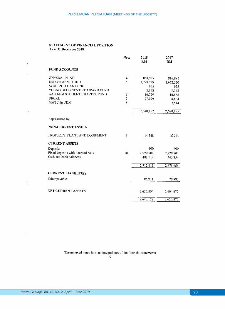
93
PERTEMUAN PERSATUAN (Meetings of the Society)
Warta Geologi, Vol. 45, No. 2, April – June 2019
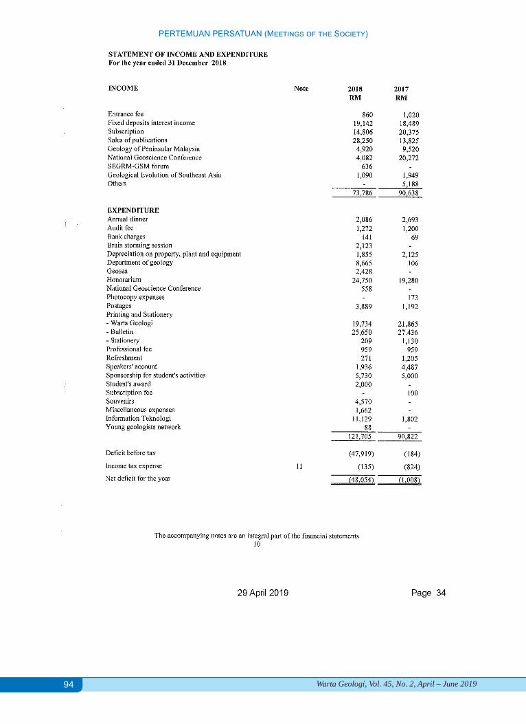
94
PERTEMUAN PERSATUAN (Meetings of the Society)
Warta Geologi, Vol. 45, No. 2, April – June 2019

95
PERTEMUAN PERSATUAN (Meetings of the Society)
Warta Geologi, Vol. 45, No. 2, April – June 2019
96
PERTEMUAN PERSATUAN (Meetings of the Society)
Warta Geologi, Vol. 45, No. 2, April – June 2019
97
PERTEMUAN PERSATUAN (Meetings of the Society)
Warta Geologi, Vol. 45, No. 2, April – June 2019
98
PERTEMUAN PERSATUAN (Meetings of the Society)
Warta Geologi, Vol. 45, No. 2, April – June 2019
99
PERTEMUAN PERSATUAN (Meetings of the Society)
Warta Geologi, Vol. 45, No. 2, April – June 2019

100
PERTEMUAN PERSATUAN (Meetings of the Society)
Warta Geologi, Vol. 45, No. 2, April – June 2019
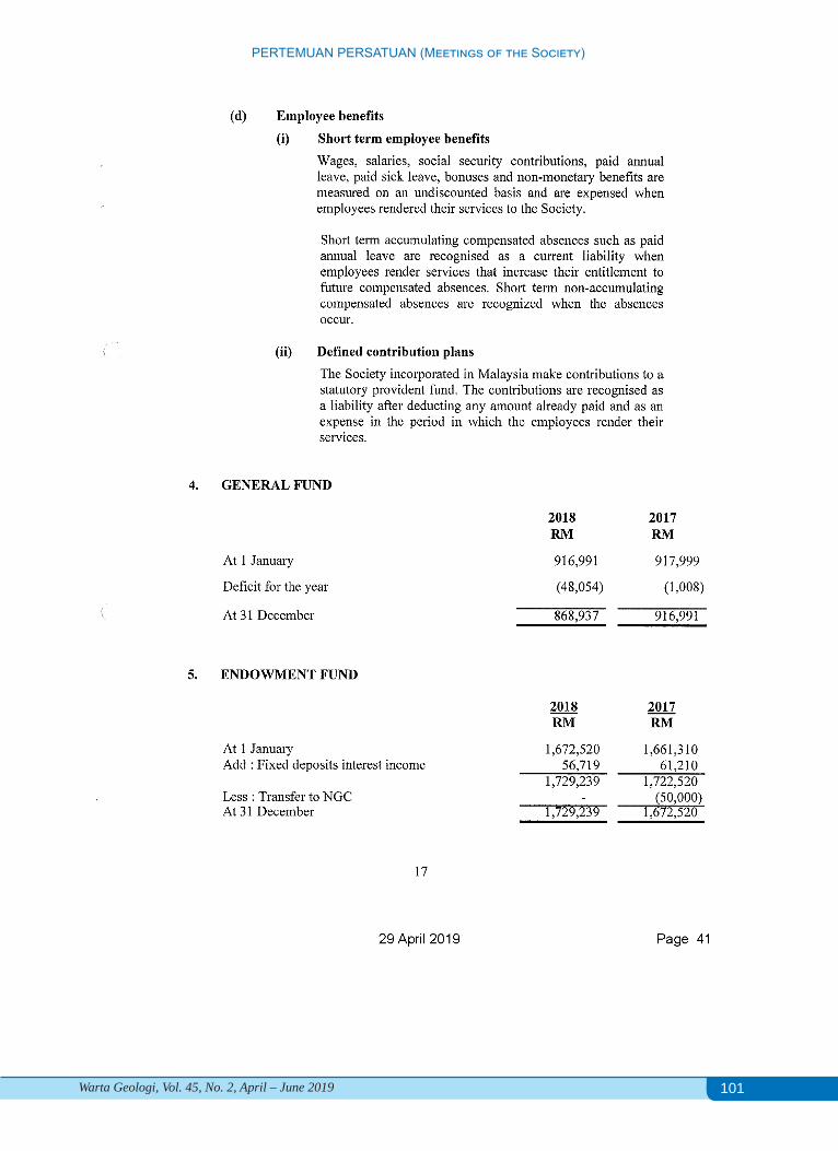
101
PERTEMUAN PERSATUAN (Meetings of the Society)
Warta Geologi, Vol. 45, No. 2, April – June 2019
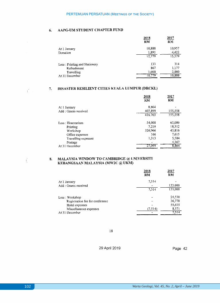
102
PERTEMUAN PERSATUAN (Meetings of the Society)
Warta Geologi, Vol. 45, No. 2, April – June 2019
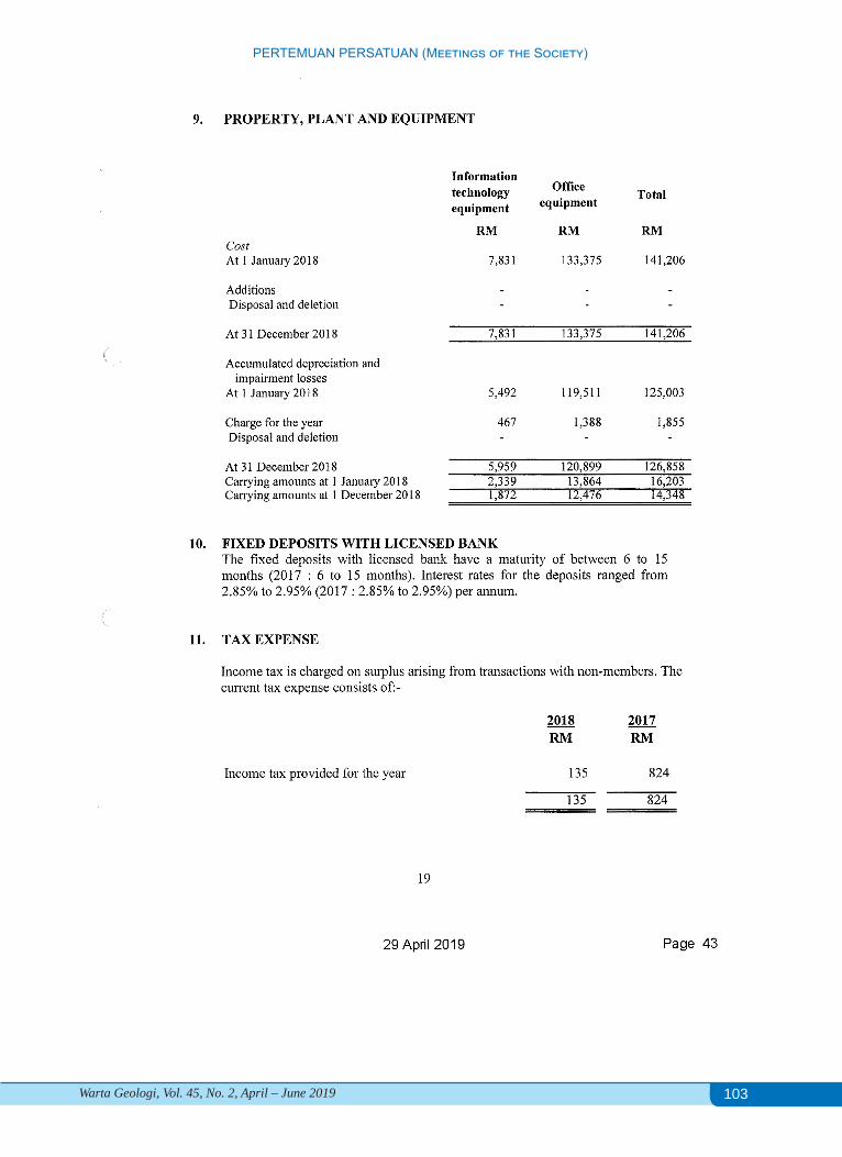
103
PERTEMUAN PERSATUAN (Meetings of the Society)
Warta Geologi, Vol. 45, No. 2, April – June 2019
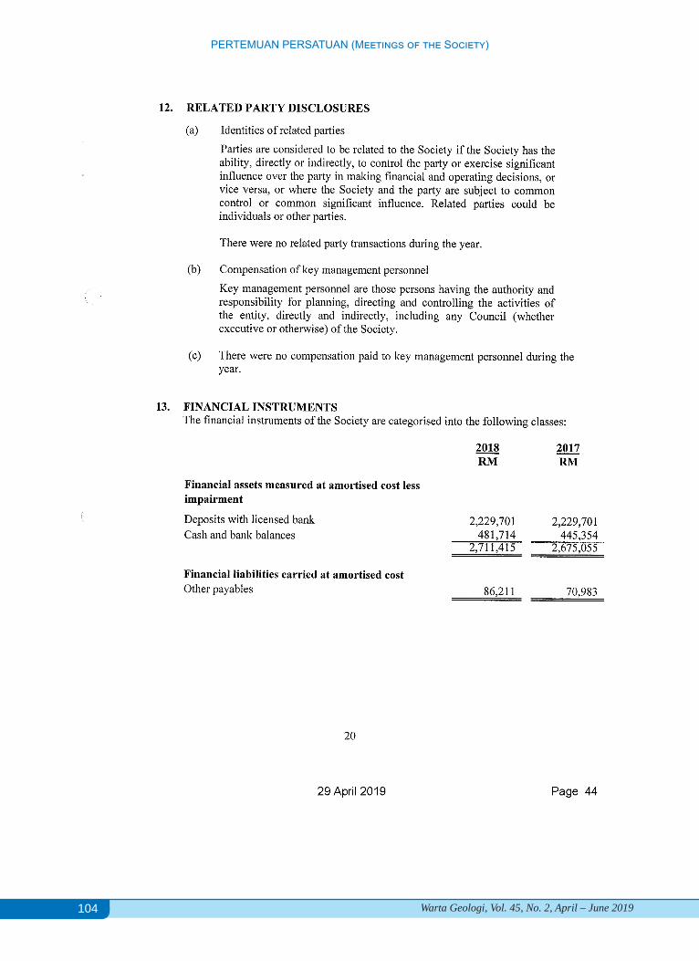
104
PERTEMUAN PERSATUAN (Meetings of the Society)
Warta Geologi, Vol. 45, No. 2, April – June 2019
105
PERTEMUAN PERSATUAN (Meetings of the Society)
Warta Geologi, Vol. 45, No. 2, April – June 2019
GSM ENDOWMENT FUND: BOARD OF TRUSTEES REPORT GSM ENDOWMENT FUND: BOARD OF TRUSTEES REPORT GSM ENDOWMENT FUND REPORT
APPENDIX VI
106
PERTEMUAN PERSATUAN (Meetings of the Society)
Warta Geologi, Vol. 45, No. 2, April – June 2019
107
PERTEMUAN PERSATUAN (Meetings of the Society)
Warta Geologi, Vol. 45, No. 2, April – June 2019
APPENDIX VIl
GSM ENDOWMENT FUND: BOARD OF TRUSTEES REPORT GSM ENDOWMENT FUND: BOARD OF TRUSTEES REPORT OTHER MATTERS
Three (3) items will be discussed under Other Matters. Two items (a & b) submitted by GSM Council, one item (c) by GSM President 2018/2019.
6a. GSM Digital PublicationsSince its establishment, GSM has been serving its members via Warta Geologi since 1966, and Bulletin of the
Geological Society Malaysia since 1967. The Bulletin has been indexed with Scopus and an application has recently been submitted for indexing by the WoS.
These publications, the quarterly Warta Geologi and biannual Bulletin of the Geological Society Malaysia are mailed to subscribing members. The cost of printing and postage has increased over the years. The cost of printing for both publications is reaching RM 45,000, and the cost of postage is about RM7,000.
In an effort to reduce GSM’s publication expenditure, the Council is proposing to go for full digital publication. An online survey to assess the willingness of members to receive Warta Geologi and Bulletin of the Geological Society Malaysia via email in digital pdf format in the period of 15 to 30 March 2018. The survey results are presented in Appendix IX.
6b. Meeting AllowancesThe Council agreed to the proposal in considering of some members’ travel distance and cost incurred to attend
GSM meetings particular to support expenses to early-carrier Council Members. The allowance can be on voluntary claim-basis and a ceiling amount was proposed tentatively set at RM100 per meeting to be approved by Treasurer.
6c. ASEAN Federation of Geoscience OrganisastionsMr Abd Rasid Jaapar will make proposal presentation on “Toward unified ASEAN professional geologists”.
APPENDIX VIll
GSM ENDOWMENT FUND: BOARD OF TRUSTEES REPORT GSM ENDOWMENT FUND: BOARD OF TRUSTEES REPORT Announcement of New Council for 2019/2020Nomination Committee chaired by Dr Mazlan Madon, certified by Prof. Azman Abd Ghani and Assoc. ProfNg Tham Fatt.
The Council for 2019/2020 :President : Mr. Abd Rasid Jaapar (Geomapping Technology)Vice-President : Mr. Askury Abd Kadir (Consultant)Immediate Past President : Dr. Mazlan Madon (Consultant)Secretary : Dr. Lim Choun Sian (UKM)Assistant Secretary : Ms. Farah Fazulah Abdullah (Carigali Hess)Treasurer : Mr. Ahmad Nizam Hasan (GeoSolution Resources) Editor : Prof. Dr. Wan Hasiah Abdullah (UM)
Councillors 2018/2019:Mr. Ahmad Tariq Ahmad Ziyad (Orogenic Resources Bhd) Dr. Mohd Hariri Arifin (UKM)Mr. Nicholas Jacob (JMG)Ms. Norazianti Asmari (GDS Sdn Bhd)Councillors 2019/2021:Prof. Joy Jacqueline Pereira (UKM)Dr. Nur Iskandar Taib (UM)Mr. Tan Boon Kong (Consultant)Dato’ Yunus Abdul Razak (SEADPRI-UKM)

108
PERTEMUAN PERSATUAN (Meetings of the Society)
Warta Geologi, Vol. 45, No. 2, April – June 2019
Report for survey for digital publications
Optional comments received:
1. Since GSM is a non-profit asscociation, chosing digital publication is very much welcomed2. I agree with the initiative but my suggestion is for once a year, there should be one hard copy of Warta Geologi,
maybe can cover on NGC papers. Thanks.3. I would like to suggest GSM to upgrade the article submission method from printed/hardcopy to digital online
system. Will support to contribute articles to GSM Bulletin. Cheers!!!4. This is a good move, especially in my household where we have multiple copies of the same issue sent to the
same address as more than one of us are members of the Society! Kudos for the paperless initiative (:5. I fully support the idea of a full digital publication. However, I would like to request for printed hard-copies
whenever available. For instance, this upcoming publication. Thank you.6. Print copy can be taken anywhere and can be read easily, whereas digital magazine need to power up and if
no internet, big problem. Anyway, in my opinion it is difficult as we are in the transition from paper to digital. Older generation like us of course prefer paper and nicer to feel the page by page, it will be sad that paper will be gone in the future. For digital, you need battery or power in order to open up your file. Best regards.
7. Better the cost of printing transfer to subsidise our members in terms of conference registration fee etc., as we experienced before.
8. Should have gone ahead with digital years ago as discussed. Cannot justify the high costs to satisfy some members (a minority) who still want hard copies.
9. Go digital.10. A print-on-demand option would be useful as I'm sure there may be certain issues that a member may want to
have a hard copy of. Print-on-demand means the association does not need to keep hard copies on standby but still receive payment when orders come in.
11. Excellent idea.12. Definitely will reduce costs of publication.13. I would prefer hard copy and willing to pay a higher membership fee if GSM decide to increase fees in order to
cover part of the printing cost. However, if GSM goes fully digital, I will support the move as well.14. Reluctant choice as I like print for review but digital saves the printing and mailing cost.15. Go green, go paperless.16. Hard copy for special publications only.
Survey for digital publications carried out from 15 March to 30 March 2019 via Google Online Form
SUMMARY:Responses:• Total 164 responses
Responses by membership types:• 57.7% Honorary/ Life Members• 23.2% Full Members• 17.7 Associate Members

109
PERTEMUAN PERSATUAN (Meetings of the Society)
Warta Geologi, Vol. 45, No. 2, April – June 2019
GSM 53rd AGM & LUNCHEON 2019
110
PERTEMUAN PERSATUAN (Meetings of the Society)
Warta Geologi, Vol. 45, No. 2, April – June 2019
Uncharted path of a Malaysian hydrogeologist
Datuk Ir. Dr. Azuhan bin Mohamed Date: 17 April 2019Venue: Bilik Mesyuarat, Program Geologi, Universiti Kebangsaan Malaysia
Summary: The lead agency for groundwater activity in Malaysia is Department of Minerals and Geoscience (DMG) which was formed through the merger of Geological Survey Department (GSD) and Department of Mines (DOM) in 1999. An attempt to streamline groundwater activity in the public sector was initiated in early 1980s whereby GSD to conduct general groundwater exploration nationwide whilst Public Works Department (PWD) and Department of Irrigation and Drainage (DID) to conduct groundwater exploration and development nationwide for public water supplies and irrigation respectively. In 2007, Sime Darby Berhad initiated the development of groundwater for public water supply on a grand scale. Both the public and private sector initiatives on groundwater development ended abruptly. At present groundwater for public water supply is mainly undertaken by Syarikat Air Kelantan Berhad whereby groundwater accounts for 43.5% of the raw water for public water supply in the state and the figure at national level is 1.3% (2017). Groundwater for private use is common nationwide and 55 Mld of groundwater is abstracted in Selangor in 2016. The second public groundwater initiative was launched by the inaugural meeting of National Water Council (MAN) on 25 February 2019 whereby the Ministry of Water, Land and Natural Resources (KATS) will explore the conjunctive use of groundwater and surface water. The groundwater fraternity looks forward to the success of the second public groundwater initiative for we cannot afford to fail twice.
CERAMAH TEKNIK TECHNICAL TALK
111
BERITA-BERITA PERSATUAN (News of the Society)
Warta Geologi, Vol. 45, No. 2, April - June 2019
NEW MEMBERSHIP
Full Membership1. Aidil Hannan Adnan2. Amirruddin Rosni3. Awg Mohd Faizal Awg Mohamad Hamssin 4. Kathrin Jothiran Navaretnamoney5. Keeshoore Apparavoo6. Maryam Syazana Dzulkifli7. Mazlan Abdullah8. Mohd Azizul Md Hashim9. Mohd Talha Anees10. Muhamad Muizzudin Mohd Jamludin11. Muhammad Hanif Haziq Mohammad12. Nor ‘Ain Ibrahim13. Nor Bakhiah Baharim14. Norshakira Ab Ghani15. Nur Syahidatul Zubaida Abilah @ Abdillah 16. Samantha Usun Sing17. Shyeh Sahibul Karamah Masnan18. Suhaila Suleiman19. Wan Muhammad Wan Ab Ghaffar20. Zahir Yahya
Associate Membership1. Abdul Hafidz Yusoff2. Lim Jun Xian3. Mohd Shafar Jefri Mokhatar
Student Membership1. Abdoul-Madjid Allane2. Amatul Syafi Abdul Basit3. Bawaa Tharaaneey Raja Kumar4. Chong Jeng Hann5. Marina Morzani6. Mohamad Syahid Mohamad Sulaiman7. Norazif Anuar Hasni8. Sathes Kumar Sandasegaran9. Siti Hanna Sofea Abdul Jalal10. Wahid Muhammad
Contact information wantedInformation on postal address, email address and handphone number of Mr. Johnny Ating Kading is very much
appreciated. Please contact GSM Secretariat @ Anna Lee if you have any information.
111
@Dear Members
Please update your contact details by sending your email address, telephone no. and fax no. to :[email protected]
112
BERITA-BERITA PERSATUAN (News of the Society)
Warta Geologi, Vol. 45, No. 2, April - June 2019
CHANGE OF ADDRESS
Abdul Jailani Che JohariNo. 36, Jalan AU 1A/3G,Taman Keramat Permai,54200 Kuala Lumpur
Azimah AliPetronas Group Technical Data,Petronas Tower 3, Level 44,Kuala Lumpur City Centre,50088 Kuala Lumpur
Badee Abdulqawi Hamood AlshameriR1, Iqra Apartments, National University of Sciences & Technology (UST), H-12, Islamabad Capital Territory, Pakistan
Herman DarmanPetronas Carigali Sdn. Bhd.,AsPac BPS, Petronas Tower 2, 12th Floor,Kuala Lumpur City Centre,50088 Kuala Lumpur
Ho Chee KwongNo 9, Jalan SL 16/1,Capa Residensi,Bandar Sg Long,43000 Kajang, Selangor
Jaizan Hardi Mohamed JaisLot 3102, Jalan Teberau,Ukay Heights,68000 Ampang, Selangor
James F. Benson6 Steed Road, Waitakere,Auckland 0816, New Zealand
Kevin John WrightWrightech Engineering,E-30-05, Block East,1-R/C, Section 7,40000 Shah Alam, Selangor
Khairul Faizal SepianOPUS International (M) Bhd.,PT 15833, Sura Gate Comm. Center,Jalan Sura Jeti,23000 Dungun, Terengganu
Mohd Badzran Mat TaibJabatan Mineral dan Geosains Malaysia,Level 9, Menara PJH,Jalan Tun Abdul Razak,Presint 2, 62100 Putrajaya
Nasaruddin AhmadNo 15, Jalan Tarun 27/23, Taman Subang Alam,Seksyen 27, 40400 Shah Alam, Selangor
Norazlina JainiTCDM-GRPC, PETRONAS,Level 59, Tower 2,PETRONAS Twin Towers,50088 Kuala Lumpur
Peter R. Parham117, West High Street,Tucumcari, New Mexico 88401, USA
Yves ChezeC-5-3, Residence Saffron,Jalan Sentul Indah,51100 Kuala Lumpur
Wan Zawawie Bin Wan Akil45, 9 Resident Park, Lorong Semariang 4,Jalan Semariang,Petra Jaya, 93050 Kuching, Sarawak
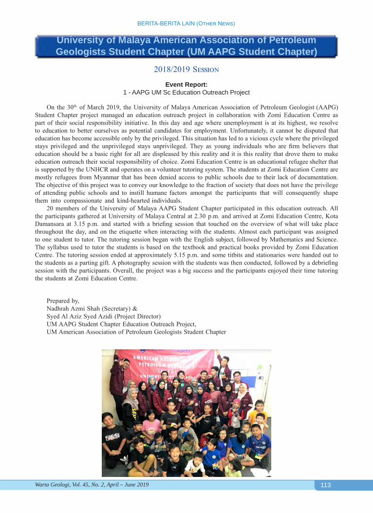
113
BERITA-BERITA LAIN (Other News)
Warta Geologi, Vol. 45, No. 2, April – June 2019
University of Malaya American Association of Petroleum Geologists Student Chapter (UM AAPG Student Chapter)
2018/2019 Session
Event Report: 1 - AAPG UM Sc Education Outreach Project
On the 30th of March 2019, the University of Malaya American Association of Petroleum Geologist (AAPG) Student Chapter project managed an education outreach project in collaboration with Zomi Education Centre as part of their social responsibility initiative. In this day and age where unemployment is at its highest, we resolve to education to better ourselves as potential candidates for employment. Unfortunately, it cannot be disputed that education has become accessible only by the privileged. This situation has led to a vicious cycle where the privileged stays privileged and the unprivileged stays unprivileged. They as young individuals who are firm believers that education should be a basic right for all are displeased by this reality and it is this reality that drove them to make education outreach their social responsibility of choice. Zomi Education Centre is an educational refugee shelter that is supported by the UNHCR and operates on a volunteer tutoring system. The students at Zomi Education Centre are mostly refugees from Myanmar that has been denied access to public schools due to their lack of documentation. The objective of this project was to convey our knowledge to the fraction of society that does not have the privilege of attending public schools and to instill humane factors amongst the participants that will consequently shape them into compassionate and kind-hearted individuals.
20 members of the University of Malaya AAPG Student Chapter participated in this education outreach. All the participants gathered at University of Malaya Central at 2.30 p.m. and arrived at Zomi Education Centre, Kota Damansara at 3.15 p.m. and started with a briefing session that touched on the overview of what will take place throughout the day, and on the etiquette when interacting with the students. Almost each participant was assigned to one student to tutor. The tutoring session began with the English subject, followed by Mathematics and Science. The syllabus used to tutor the students is based on the textbook and practical books provided by Zomi Education Centre. The tutoring session ended at approximately 5.15 p.m. and some titbits and stationaries were handed out to the students as a parting gift. A photography session with the students was then conducted, followed by a debriefing session with the participants. Overall, the project was a big success and the participants enjoyed their time tutoring the students at Zomi Education Centre.
Prepared by,Nadhrah Azmi Shah (Secretary) &Syed Al Aziz Syed Azidi (Project Director)UM AAPG Student Chapter Education Outreach Project,UM American Association of Petroleum Geologists Student Chapter
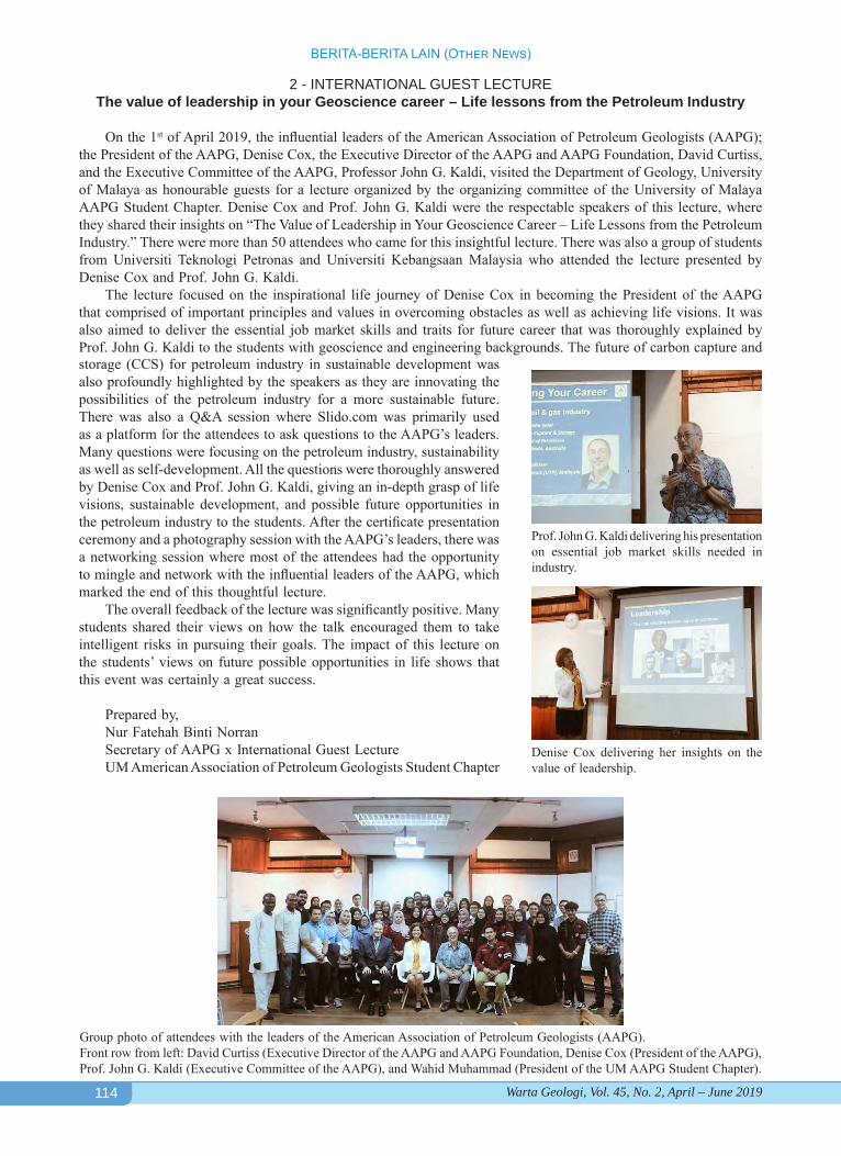
114
BERITA-BERITA LAIN (Other News)
Warta Geologi, Vol. 45, No. 2, April – June 2019
2 - INTERNATIONAL GUEST LECTUREThe value of leadership in your Geoscience career – Life lessons from the Petroleum Industry
On the 1st of April 2019, the influential leaders of the American Association of Petroleum Geologists (AAPG); the President of the AAPG, Denise Cox, the Executive Director of the AAPG and AAPG Foundation, David Curtiss, and the Executive Committee of the AAPG, Professor John G. Kaldi, visited the Department of Geology, University of Malaya as honourable guests for a lecture organized by the organizing committee of the University of Malaya AAPG Student Chapter. Denise Cox and Prof. John G. Kaldi were the respectable speakers of this lecture, where they shared their insights on “The Value of Leadership in Your Geoscience Career – Life Lessons from the Petroleum Industry.” There were more than 50 attendees who came for this insightful lecture. There was also a group of students from Universiti Teknologi Petronas and Universiti Kebangsaan Malaysia who attended the lecture presented by Denise Cox and Prof. John G. Kaldi.
The lecture focused on the inspirational life journey of Denise Cox in becoming the President of the AAPG that comprised of important principles and values in overcoming obstacles as well as achieving life visions. It was also aimed to deliver the essential job market skills and traits for future career that was thoroughly explained by Prof. John G. Kaldi to the students with geoscience and engineering backgrounds. The future of carbon capture and
Prof. John G. Kaldi delivering his presentation on essential job market skills needed in industry.
Denise Cox delivering her insights on the value of leadership.
Group photo of attendees with the leaders of the American Association of Petroleum Geologists (AAPG).Front row from left: David Curtiss (Executive Director of the AAPG and AAPG Foundation, Denise Cox (President of the AAPG), Prof. John G. Kaldi (Executive Committee of the AAPG), and Wahid Muhammad (President of the UM AAPG Student Chapter).
storage (CCS) for petroleum industry in sustainable development was also profoundly highlighted by the speakers as they are innovating the possibilities of the petroleum industry for a more sustainable future. There was also a Q&A session where Slido.com was primarily used as a platform for the attendees to ask questions to the AAPG’s leaders. Many questions were focusing on the petroleum industry, sustainability as well as self-development. All the questions were thoroughly answered by Denise Cox and Prof. John G. Kaldi, giving an in-depth grasp of life visions, sustainable development, and possible future opportunities in the petroleum industry to the students. After the certificate presentation ceremony and a photography session with the AAPG’s leaders, there was a networking session where most of the attendees had the opportunity to mingle and network with the influential leaders of the AAPG, which marked the end of this thoughtful lecture.
The overall feedback of the lecture was significantly positive. Many students shared their views on how the talk encouraged them to take intelligent risks in pursuing their goals. The impact of this lecture on the students’ views on future possible opportunities in life shows that this event was certainly a great success.
Prepared by,Nur Fatehah Binti NorranSecretary of AAPG x International Guest LectureUM American Association of Petroleum Geologists Student Chapter
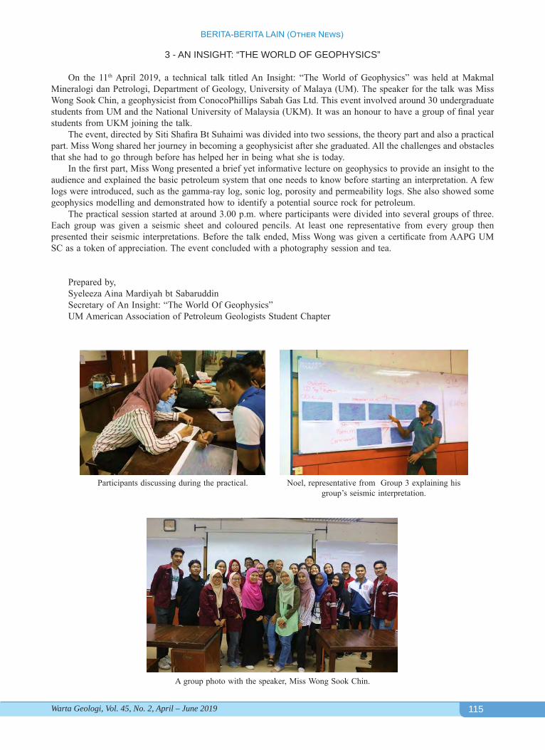
115
BERITA-BERITA LAIN (Other News)
Warta Geologi, Vol. 45, No. 2, April – June 2019
3 - AN INSIGHT: “THE WORLD OF GEOPHYSICS”
On the 11th April 2019, a technical talk titled An Insight: “The World of Geophysics” was held at Makmal Mineralogi dan Petrologi, Department of Geology, University of Malaya (UM). The speaker for the talk was Miss Wong Sook Chin, a geophysicist from ConocoPhillips Sabah Gas Ltd. This event involved around 30 undergraduate students from UM and the National University of Malaysia (UKM). It was an honour to have a group of final year students from UKM joining the talk.
The event, directed by Siti Shafira Bt Suhaimi was divided into two sessions, the theory part and also a practical part. Miss Wong shared her journey in becoming a geophysicist after she graduated. All the challenges and obstacles that she had to go through before has helped her in being what she is today.
In the first part, Miss Wong presented a brief yet informative lecture on geophysics to provide an insight to the audience and explained the basic petroleum system that one needs to know before starting an interpretation. A few logs were introduced, such as the gamma-ray log, sonic log, porosity and permeability logs. She also showed some geophysics modelling and demonstrated how to identify a potential source rock for petroleum.
The practical session started at around 3.00 p.m. where participants were divided into several groups of three. Each group was given a seismic sheet and coloured pencils. At least one representative from every group then presented their seismic interpretations. Before the talk ended, Miss Wong was given a certificate from AAPG UM SC as a token of appreciation. The event concluded with a photography session and tea.
Prepared by,Syeleeza Aina Mardiyah bt SabaruddinSecretary of An Insight: “The World Of Geophysics”UM American Association of Petroleum Geologists Student Chapter
Participants discussing during the practical. Noel, representative from Group 3 explaining his group’s seismic interpretation.
A group photo with the speaker, Miss Wong Sook Chin.
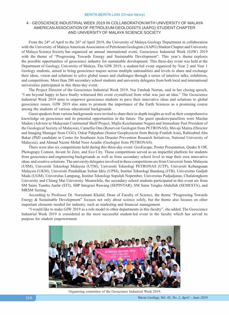
116
BERITA-BERITA LAIN (Other News)
Warta Geologi, Vol. 45, No. 2, April – June 2019
4 - GEOSCIENCE INDUSTRIAL WEEK 2019 IN COLLABORATION WITH UNIVERSITY OF MALAYA AMERICAN ASSOCIATION OF PETROLEUM GEOLOGISTS (AAPG) STUDENT CHAPTER
AND UNIVERSITY OF MALAYA SCIENCE SOCIETY
From the 24th of April to the 26th of April 2019, the University of Malaya Geology Department in collaboration with the University of Malaya American Association of Petroleum Geologists (AAPG) Student Chapter and University of Malaya Science Society has organized an annual international event, Geoscience Industrial Week (GIW) 2019 with the theme of “Progressing Towards Energy and Sustainable Development”. This year’s theme explores the possible opportunities of geoscience industry for sustainable development. This three-day event was held at the Department of Geology, University of Malaya. The GIW 2019, a student-led event organized by Year 2 and Year 1 Geology students, aimed to bring geoscience majors across multiple nationalities and levels to share and exchange their ideas, vision and solutions to solve global issues and challenges through a series of intuitive talks, exhibition, and competitions. More than 200 secondary school students and university delegates from both local and international universities participated in this three-day event.
The Project Director of the Geoscience Industrial Week 2019, Nur Fatehah Norran, said in her closing speech, “I am beyond happy to have finally witnessed this event crystallized from what was just an idea.” The Geoscience Industrial Week 2019 aims to empower geoscience students to pave their innovative ideas and solutions to global geoscience issues. GIW 2019 also aims to promote the importance of the Earth Sciences as a promising course among the students of various educational backgrounds
Guest speakers from various backgrounds were invited to share their in-depth insights as well as their comprehensive knowledge on geoscience and its potential opportunities in the future. The guest speakers/panellists were Mazlan Madon (Advisor to Malaysian Continental Shelf Project, Majlis Keselamatan Negara and Immediate Past President of the Geological Society of Malaysia), Camellia Onn (Reservoir Geologist from PETRONAS), Shivaji Maitra (Director and Imaging Manager from CGG), Oskar Pakpahan (Senior Geophysicist from Beicip-Franlab Asia), Rabieahtul Abu Bakar (PhD candidate in Center for Southeast Asia Disaster Prevention Research Initiatives, National University of Malaysia), and Ahmad Nazmi Mohd Noor Azudin (Geologist from PETRONAS).
There were also six competitions held during this three-day event: GeoEscape, Poster Presentation, Quake It Off, Photograpy Contest, Invent At Zero, and Eco City. These competitions served as an impactful platform for students from geoscience and engineering backgrounds as well as from secondary school level to map their own innovative ideas and creative solutions. The university delegates involved in these competitions are from Universiti Sains Malaysia (USM), Universiti Teknologi Malaysia (UTM), Universiti Teknologi PETRONAS (UTP), Universiti Kebangsaan Malaysia (UKM), Universiti Pendidikan Sultan Idris (UPSI), Institut Teknologi Bandung (ITB), Universitas Gadjah Mada (UGM), Universitas Lampung, Institut Teknologi Sepuluh Nopember, Universitas Padjadjaran, Chulalongkorn University and Chiang Mai University. Meanwhile, the secondary school students participated in this event are from SM Sains Tuanku Jaafar (STJ), SBP Integrasi Rawang (SEPINTAR), SM Sains Tengku Abdullah (SEMESTA), and MRSM Serting.
According to Professor Dr. Norzulaani Khalid, Dean of Faculty of Science, the theme “Progressing Towards Energy & Sustainable Development” focuses not only about science solely, but the theme also focuses on other important elements needed for industry, such as marketing and financial management.
“I would like to make GIW 2019 as a role model to other departments in this faculty”, she added. The Geoscience Industrial Week 2019 is considered as the most successful student-led event in the faculty which has served its purpose for student empowerment.
Organizing committee of the Geoscience Industrial Week 2019.
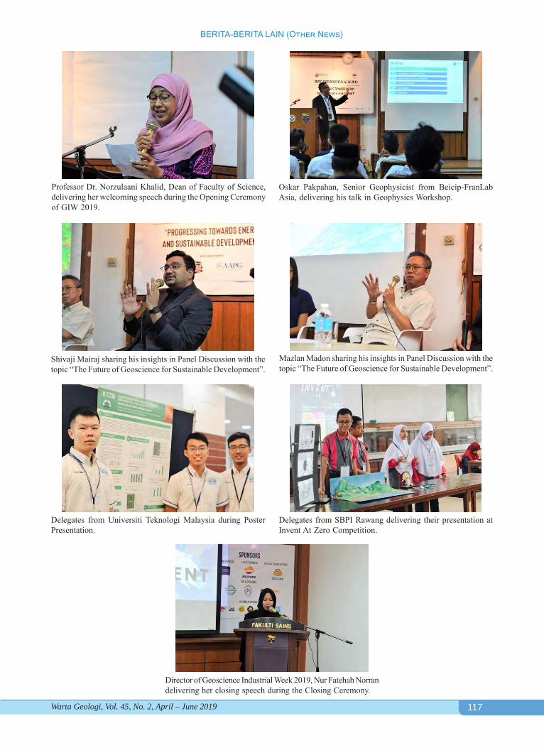
117
BERITA-BERITA LAIN (Other News)
Warta Geologi, Vol. 45, No. 2, April – June 2019
Oskar Pakpahan, Senior Geophysicist from Beicip-FranLab Asia, delivering his talk in Geophysics Workshop.
Professor Dr. Norzulaani Khalid, Dean of Faculty of Science, delivering her welcoming speech during the Opening Ceremony of GIW 2019.
Shivaji Mairaj sharing his insights in Panel Discussion with the topic “The Future of Geoscience for Sustainable Development”.
Mazlan Madon sharing his insights in Panel Discussion with the topic “The Future of Geoscience for Sustainable Development”.
Delegates from Universiti Teknologi Malaysia during Poster Presentation.
Delegates from SBPI Rawang delivering their presentation at Invent At Zero Competition.
Director of Geoscience Industrial Week 2019, Nur Fatehah Norran delivering her closing speech during the Closing Ceremony.
118
BERITA-BERITA LAIN (Other News)
Warta Geologi, Vol. 45, No. 2, April – June 2019
UPCOMING EVENTSAugust 1, 2019: Advanced Seminar on Economic Geol-ogy and Mineral Resources in Malaysia, University of Malaya, Kuala Lumpur. Contact K.K. Cheang, tel.: 012-327-1888 or email: [email protected] for more details.
August 7-8, 2019: The Art of Hydrocarbon Prediction: Managing Uncertainties (Technical Symposium), Bo-gor, Indonesia. Find out more at https://www.aapg.org/global/asiapacific/events/workshop.
August 26 - 28, 2019: EAGE/AAPG Workshop on Re-ducing Exploration Risk in Rift Basins, Kuala Lumpur, Malaysia. Visit the event page - https://events.eage.org/en/2019/eage-aapg-workshop-on-rift-basins for more details.
August 27-30, 2019: International Conference & Exhbi-tion (ICE 2019), Buenos Aires, Argentina. Visit website for details, https://buenosaires2019.iceevent.org/.
August 28-29, 2019: Machine Learning & AI For Upstream Onshore Oil & Gas 2019, Houstan, Texas. Further details can be found at www.machinelearning-ai-upstream-congress.com.
September 11-13, 2019 (conference) and September 9-10 & 14, 2019 (workshops): European Conference on Mineralogy and Spectroscopy (ECMS 2019), Prague (Břevnov Monastery), Czech Republic. For details, visit http://ecms2019.eu or email: [email protected].
September 15-20, 2019: Society of Exploration Geo-physicists SEG 19, San Antonia, Texas. More informa-tion at https://seg.org/Annual-Meeting-2019.
September 23-27, 2019: 12th Asian Regional Confer-ence of IAEG, Jeju Island, Korea. Further details can be found at http://www.iaegarc12.org/sub03/sub01.html.
September 25-27, 2019: Regional Geoheritage Con-ference 2019, Kuching, Sarawak, Malaysia. For more information, please download: Regional_Geoheritage_Conference_2019.pdf461.58 KB13/02/2019, 06:28.
October 3-4, 2019: Workshop on the use of the electron probe microanalyzer (EPMA) with particular emphasis
on modern developments and geological applications. For MSc students, PhD students, postdoctoral research-ers and early career scientists from across the EU and beyond. Agricultural University of Athens, Athens, Geece. Visit website https://ibaziotis7.wixsite.com/ep-maathens2019 for more details.
October 10-13, 2019: Euro-Mediterranean Conference for Environmental Integration (EMCEI), Sousse, Tuni-sia. Kindly contact the event organizer at www.emcei.net/ [email protected] for clarifications.
October 26-28, 2019: AAPG Geosciences Technology Workshop (GTW) New Tools, Challenges, and Oppor-tunities, Beijing, China. For questions and additional information please contact: Susan Nash, Director, In-novation and Emerging Science and Technology, tel.no.: +1 918 560 2604, email: [email protected].
October 29-30, 2019: Asia Petroleum Geoscience Conference & Exhibition (APGCE), Kuala Lumpur, Malaysia. For more details, please visit http://www.apgce.com/.
November 4-8, 2019: Africa Oil Week, Cape Town, South Africa. More details can be found at https://www.africa-oilweek.com/Home.
November 18-20, 2019: International Congress on Earth Sciences in SE Asia (ICES 2019), Bali, Indonesia. Visit website http://fos.ubd.edu.bn/foscon/ for more informa-tion.
January 13-15, 2020: International Petroleum Technol-ogy Conference (IPTC), Dhahran EXPO, Dammam, Saudi Arabia. Visit event website at https://www.2020.iptcnet.org to learn more about the conference.
February 25-27, 2020: 1st AAPG/EAGE PNG Petroleum Geoscience Conference & Exhibition, Port Moresby, Papua New Guinea. For information, contact AAPG Asia Pacific Programs Manager Adrienne Pereira, email add.: [email protected].
March 16-19, 2020: 14th Middle East Geosciences Con-ference and Exhibition, Bahrain. To find out more, visit website https://geo-expo.com/conference/.
Geological Society of Malaysia PublicationsInstruction to Authors
General PolicyPapers should be as concise as possible.
They may include original results of basic, applied and policy research of national or international significance, current reviews, or discussions on techniques, research programs, organisations, information, or national and international policies in geoscience.
Submission of PapersOnly papers that have not been published
elsewhere will be considered for publication. Authors must agree not to publish elsewhere a paper submitted and accepted. All papers will be subjected to review by two or more reviewers. Authors wishing to include published and unmodified figures or text passages are required to obtain permission from the copyright owner(s). Authors of English papers are strongly urged to have their manuscript edited for language before submission by a person whose first language is English.
The Editor reserves the right to reject all or any part of the paper submitted. The Geological Society of Malaysia assumes no responsibility for statements made by authors.
Manuscript should be submitted to:The Editor, Geological Society of Malaysiac/o Department of GeologyUniversity of Malaya50603 Kuala Lumpur,MalaysiaTel: (603) 7957 7036 Fax: (603) 7956 3900Email: [email protected]
ManuscriptThe paper can be written in Bahasa
Malaysia (Malay) or English. For English papers, use either British or American spelling but not a combination of both. The paper should be checked thoroughly for spelling and grammar. The manuscript must be printed at 1.5 spacing in a single column on one side of A4 paper. All pages should be numbered. Length of paper should be between 3,000 and 6,000 words for the Bulletin and between 2,000 and 3000 words for Warta Geologi, excluding tables and illustrations. Metric units should be used and all non-standard symbols, abbreviations and acronyms must be defined.
TitleTitle must be informative and reflects
the content of the paper. Title in Malay should include an English translation. It should be concise (less than 20 words). Avoid using abbreviation in the title.
Author’s AddressAddresses of all authors must be
provided. The addresses should be sufficient for correspondence. Please include email address, telephone and fax of the corresponding author.
AbstractAbstract in both Malay and English, each
in one paragraph and should not exceed 300 words. It should clearly identify the subject matter, results obtained, interpretations discussed and conclusions reached.
KeywordsPlease include 3 to 8 keywords that best
describe the content of the paper.
ReferencesIn the text, references should be cited
by author and year and listed chronologically (e.g. Smith, 1964; Jones et al., 1998; Smith & Tan, 2000). For both Malay and English paper, all references must be listed in English. Title of non-English articles should be translated to English.
The list of references should only include articles cited in the text. The list should be arranged in alphabetical order. Please ensure that the reference list is complete and the bibliographical details are accurate. The references should be in the following manner:Journal article:Suntharalingam, T., 1968. Upper Palaeozoic
stratigraphy of the area west of Kampar, Perak. Geol. Soc. Malaysia Bull., 1, 1-15.
Book:Hutchison, C.S., 1989. Geological Evolution of
South-east Asia. Clarendon Press, Oxford. 368 p.
Chapter of book and Symposium volume:Hosking, K.F.G., 1973. Primary mineral deposits.
In: Gobbett, D.J. and Hutchison, C.S. (Eds.), Geology of the Malay Peninsular (West Malaysia and Singapore). Wiley-Interscience, New York, 335-390.
Article in Malay:Lim, C.H. & Mohd. Shafeea Leman, 1994.
The occurrence of Lambir Formation in Ulu Bok Syncline, North Sarawak. Geol. Soc. Malaysia Bull., 35, 1-5. (in Malay with English abstract).
TablesAll tables should be cited in the text and
numbered consecutively. Tables should have a title and a legend explaining any abbreviation or symbol used. Each table must be printed on a separate piece of paper. Do not insert the tables within the text. Data in tables should be aligned using tab stops rather than spaces. Avoid excessive tabulation of data.
IllustrationsPlease make sure that all illustrations
are useful, necessary and of good quality. A maximum of ten (10) illustrations (photographs, graphs and diagrams) are allowed and these should be cited in the text and numbered consecutively as Figures. The papers are usually published in black-and-white but it may sometimes be possible to include colour figures at the author’s expense. The scales for maps and photomicrographs should be drawn on the figure and not given as a magnification. Originals should not be greater than A4 size and annotations should be capable of being reduced down to 50 percent. The caption should be listed on a separate piece of paper. Do not insert the illustration within the text.
Submission of Electronic FilesSubmission should be made through
email as attachment files or using CD-ROM. The submission should be accompanied with a listing of all files and the software (name and version) used. The file names should reflect the content of the files (e.g. Ali_Fig1.tif).
Preferred SoftwareText: Microsoft Word. Do not insert tables and illustration within the text.Tables: Microsoft Word or Microsoft Excel. Please submit as separate files.Illustrations – Vector Graphics: Adobe Illustrator (preferred), CorelDraw and Freehand. Final line thickness should be at least 0.5 point or 0.17 mm. For other software, please submit one copy in the native file format and export one copy as a PDF file with all fonts embedded and one copy as a high resolution TIFF or JPEG image.Photographs or bitmap (raster) images:Adobe Photoshop. Please save as TIFF or PSD files. Save/scan line art at 600 to 1200 dpi and greyscale figures at 300 to 600 dpi. High resolution JPEG, TIFF or GIF files from other sources are also acceptable. The resolution must be high enough for printing at 300 dpi.
ReprintsTwenty five copies of each article
published are supplied free of charge. Additional reprints are available at cost price provided that orders are placed prior to publication. Authors will also received a softcopy of the article published in .pdf format.
PP2509/07/2013(032786) ISSN 0126-5539; e-ISSN 2682-7549
PERSATUAN GEOLOGI MALAYSIA
Jilid 45, No. 2 • Volume 45, No. 2 • JUNE 2019
Published by the GEOLOGICAL SOCIETY OF MALAYSIADepartment of Geology, University of Malaya, 50603 Kuala Lumpur, MALAYSIA
Tel: 603-7957 7036 Fax: 603-7956 3900 E-mail: [email protected]
Printed by Art Printing Works Sdn. Bhd.29, Jalan Riong, 59100 Kuala Lumpur, MALAYSIA
KANDUNGAN (CONTENTS)CATATAN GEOLOGI (Geological Notes)Franz L. Kessler, John Jong, Mazlan Madon: The enigma of the Bario salt produced in the highlands 31of northern Sarawak Norsyafiqah Salimun, Abdul Ghani Rafek, Khairul Arifin Mohd. Noh: Correlation of seismic 40velocity and mechanical properties of metasandstone from CTW-1 well, Seri Iskandar, Perak, MalaysiaSaiful Islam, Rini Asnida Abdullah, Javed Mallick, Mohd Ahmed: Stability of slope along steep 43road in Abha, Asir Region, Kingdom of Saudi Arabia Rini Asnida Abdullah, Mohd Nur Asmawisham Alel, Mohd Zamri Ramli, Mariyana Aida Ab. Kadir, 48Nor Zurairahetty Mohd Yunus, Lee Sze Shan, Kamarudin Abdullah: Dynamic slope stability analysisfor Sabah earthquake
CATATAN LAIN (Other Notes)Mazlan Madon: Images of the deep seafloor in the MH370 search area and the vastness of the oceans 52John Kuna Raj: Historical perspective of the Geological Society of Malaysia 56
PERTEMUAN PERSATUAN (Meetings of the Society)53rd Annual General Meeting & Annual Report 2018 69Datuk Ir. Dr. Azuhan bin Mohamed: Uncharted path of a Malaysian hydrogeologist 110
BERITA–BERITA PERSATUAN (News of the Society)New Membership 111Contact Information Wanted 111Change of Address 112
BERITA LAIN (Other News)University of Malaya American Association of Petroleum Geologists Student Chapter (UM AAPG Student 113Chapter) - Report of eventsUpcoming Events 118
WARTA GEOLOGI