Embed Size (px)
Citation preview
M A s
APPROVED AND ADOPTED ;;_/_':": 990
T E R p
rove rea
L A N
:V:O\:-:·c;O\'.ER':' COC\:-:r· DE?AR-:"V.E\:7 O? ?AR;:: A\::) P:_A\:\:,~G
T,-l:: V.AR':':...-\'-:D-~A-:·:o:--:AL C..\P:--:-.-\'... ?,·\oX A:--:~J ?:....-'s:--:::--:G Co:v.:v.:ss:O'-: 8787 G::ORC:.-\ .-w:::--:~.-:: s::..VER s:os.::--:c, '.v'.:\R::..A:--:::i 289:J-376,;
Shady Grove Study Area
i1VAS:':.R. PLAN
A??ROV::) AND ADO?:::0
_;J:_y: 990
::r;
:\10\:-:-cm~:::?_Y Co~;\:-:-::· ::):=:?A::Z'""'."Y.::\:'""'." O? ?A?_:( :-\:S::) ?:.,.A\:\::\:G
~·:··:E >.:,\::'-.Y~_.,\~:1.:(.,\-;-'.0\:r\:.., C.·\:~:~:-.,\:_ :~/\~:.,: ,,\:(:1 :':~_\\:~::-,.:z:; c:)\'.>.::~S\;:-,-,:
8787 GE:0~(;:,,\ :\VC~:_:::: s::_v::~ s~R::-:c, v.A2--~·:...-\~:) 2:9:;J..3768
APPROVED AND ADOPTED
Shady Grove Study Area Master Plan
An Amendment to the Gaithersburg Vicinity Master Plan, 1985, as amended; a portion of the Potomac Subregion Master Plan, 1980, as amended; a portion of the Sector Plan for the Shady Grove Transit Station Area, 1977 as amended; Master Plan for Historic Preservation, 1979, as amended; the Master Plan of Bikeways, 197 8; being also an amendment to the General Plan for the Physical Development of the Maryland-Washington Regional District, as amended; and the Master Plan of Highways within Montgomery County, as amended.
Prepared By:
THE MARYLAND-NATIONAL CAPITAL PARK AND PLANNING COMMISSION Montgomery County Department of Park and Planning
8787 Georgia Avenue Silver Spring, MD 20910-3760
November 1989
Revised By:
THE MONTGOMERY COUNTY EXECUTIVE January 1990
Approved By:
THE MONTGOMERY COUNTY COUNCIL July 1990
Adopted By:
THE MARYLAND-NATIONAL CAPITAL PARK AND PLANNING COMMISSION September 1990
Abstract
TITLE
Shady Grove Study Area Master Plan
AUTHOR
The Maryland-National Capital Park and Planning Commission
SUBJECT
Master Plan for the Shady Grove Study Area
DATE
July 1990
PLANNING AGENCY
The Maryland-National Capital Park and Planning Commission
SOURCE OF COPIES
The Maryland-National Capital Park and Planning Commission 8787 Georgia Avenue, Silver Spring, MD 20910-3760
NUMBER OF PAGES
219
ABSTRACT
This document contains the text, with supporting figures, for the Shady Grove Study Area Master Plan. This Amendment to the Gaithersburg Vicinity Master Plan affects the Shady Grove Study Area, one of the few areas in the 1-270 Corridor with a large amount of vacant land suitable for employment and residential development which is close to 1-270, a Metro station, and the center of the County. The Gaithersburg Vicinity Master Plan designates most of the area as a "Research and Development (R&D) Village" and promotes the creation of a "high quality environment not only for research and development firms, but also for offices, corporate headquarters, light manufacturing and business support services."
One of the key features of the Plan is the emphasis on transit to implement the Plan land use recommendations, thereby encouraging additional economic growth. In addition to designating three separate transit rights-of-way in the Study Area, the Plan proposes high priority regional bus routes and two neighborhood bus "loops." The Land Use Plan proposes higher intensity uses at designated transit stations.
ii
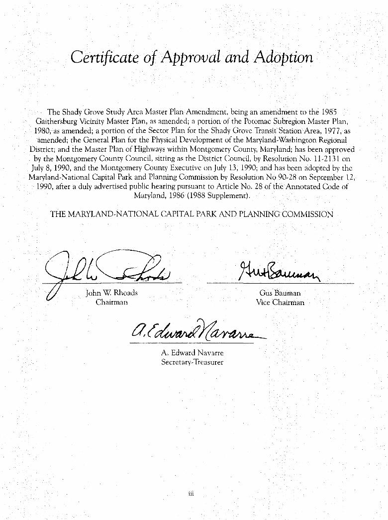
Certificate of Approval and Adoption
The Shady Grove Study Area Master Plan Amendment, being an amendment to the 1985 Gaithersburg Vicinity Master Plan, as amended; a portion of the Potomac Subregion Master Plan, 1980, as amended; a portion of the Sector Plan for the Shady Grove Transit Station Area, 1977, as amended; the General Plan for the Physical Development of the Maryland-Washington Regional
District; and the Master Plan of Highways within Montgomery County, Maryland; has been approved by the Montgomery County Council, sitting as the District Council, by Resolution No. 11-2131 on
July 8, 1990, and the Montgomery County Executive on July 13, 1990; and has been adopted by the Maryland-National Capital Park and Planning Commission by Resolution No 90-28 on September 12,
1990, after a duly advertised public hearing pursuant to Article No. 28 of the Annotated Code of Maryland, 1986 (1988 Supplement).
THE MARYLAND-NATIONAL CAPITAL PARK AND PLANNING COMMISSION
John W. Rhoads Chairman
A. Edward Navarre Secretary-Treasurer
iii
Gus Bauman Vice Chairman
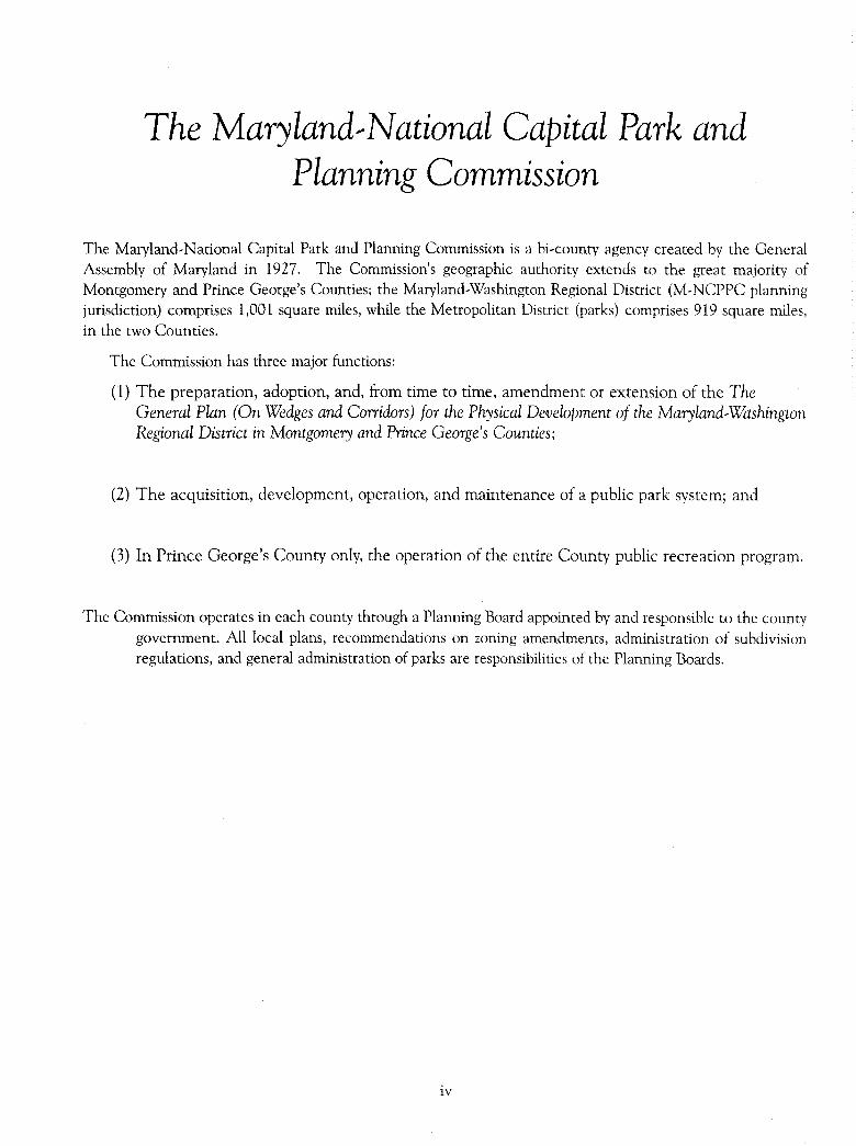
The Maryland.,National Capital Park and Planning Commission
The Maryland,National Capital Park and Planning Commission is a bi,county agency created by the General Assembly of Maryland in 1927. The Commission's geographic authority extends to the great majority of Montgomery and Prince George's Counties; the Maryland,Washington Regional District (M,NCPPC planning jurisdiction) comprises 1,001 square miles, while the Metropolitan District (parks) comprises 919 square miles, in the two Counties.
The Commission has three major functions:
(1) The preparation, adoption, and, from time to time, amendment or extension of the The General Plan (On Wedges and Corridors) for the Physical Development of the Maryland,Washington Regional District in Montgomery and Prince George's Counties;
(2) The acquisition, development, operation, and maintenance of a public park system; and
(3) In Prince George's County only, the operation of the entire County public recreation program.
The Commission operates in each county through a Planning Board appointed by and responsible to the county government. All local plans, recommendations on zoning amendments, administration of subdivision regulations, and general administration of parks are responsibilities of the Planning Boards.
iv
Elected and Appointed Officials
COUNTY COUNCIL
William E. Hanna, Jr., President Isiah Leggett, Vice President
Rose Crenca, President Pro Tern Bruce Adams, Council Member
Michael L. Gudis, Council Member Neal Potter, Council Member
Michael L. Subin, Council Member
COUNTY EXECUTIVE
Sidney Kramer
THE MARYLAND-NATIONAL CAPITAL PARK AND PLANNING COMMISSION
COMMISSIONERS
Montgomery County Planning Board
Gus Bauman, Chairman Richmond M. Keeney, Vice Chairman
Nancy M. Floreen Carol G. Henry John P. Hewitt
V
Prince George's County Planning Board
John Rhoads, Chairman Roy I. Dabney, Jr., Vice Chairman
Samuel Y. Botts Morgan Wootten Margaret Yewell
Notice to Reader
An area master plan, after approval by the County Council and adoption by The Maryland-National Capital Park and Planning Commission, constitutes an amendment to The General Plan for Montgomery County. As such, it provides a set of comprehensive recommendations and guidelines for the use of publicly and privately owned land within its planning area. Each area master plan reflects a vision of future development that responds to the unique character of the local community within the context of a County-wide perspective.
Area master plans are intended to provide a point of reference with regard to public policy. Together with relevant County-wide functional master plans, they should be referred to by public officials and private individuals when decisions are made that affect the use of land within the plan boundaries.
Master plans generally look ahead about 20 years from the date of adoption, although they are intended to be updated and revised about every 10 years. It is recognized that circumstances will change following adoption of a plan and that the specifics of a master plan may become less relevant over time. Any sketches or drawings in an adopted master plan are for illustrative purposes only and are intended to convey a general sense of desirable future character rather than a specific commitment to a particular detailed design.
Vl
The Master Plan Amendment Process
STAFF DRAFT PLAN - This document is prepared by the Montgomery County Department of Park and Planning for presentation to the Montgomery County Planning Board. The Planning Board reviews the Staff Draft Plan, makes preliminary changes as appropriate, and approves the Plan for public hearing. When the Board's changes are made, the document becomes the Public Hearing (Preliminary) Draft Plan.
PUBLIC HEARING (PRELIMINARY) DRAFT PLAN - This document is a formal proposal to amend an adopted master plan or sector plan. Its recommendations are not necessarily those of the Planning Board; it is prepared for the purpose of receiving public hearing testimony. The Planning Board holds a public hearing and receives testimony on the Draft Plan. After the public hearing record is closed, the Planning Board holds public worksessions to review the testimony and to revise the Public Hearing (Preliminary) Draft Plan as appropriate. When the Board's changes are made, the document becomes the Planning Board (Final) Draft Plan.
PLANNING BOARD (FINAL) DRAFT PLAN - This document is the Planning Board's recommended Plan and it reflects the revisions made by the Board in its worksessions on the Public Hearing (Preliminary) Draft Plan. The Regional District Act requires the Planning Board to transmit the Plan directly to the County Council with copies to the County Executive. The Regional District Act then requires the County Executive, within sixty days, to prepare and transmit a t1scal impact analysis of the Planning Board (Final) Draft Plan to the County Council. The County Executive may also forward to the Council other comments and recommendations regarding the Planning Board (Final) Draft Plan within the sixty-day period. After receiving the Executive's fiscal impact analysis and comments, the County Council may hold a public hearing to receive public testimony on the Plan. After the record of this public hearing is closed, the Council's Planning, Housing, and Economic Development (PHED) Committee holds public worksessions to review the testimony and then makes recommendations to the County Council. The Council holds its own worksessions, then adopts a resolution approving the Planning Board (Final) Draft Plan, as revised.
ADOPTED PLAN - The Master Plan approved by the County Council is forwarded to The Maryland-National Capital Park and Planning Commission for adoption. Once adopted by the Commission, the Plan officially amends the various master or sector plans cited in the Commission's adoption resolution.
vii
Table of Contents
CHAPTER ONE
Plan Summary . ...................................... 1 Plan Challenge ....................................... 1 Transit Concepts ...................................... 3 Plan Highlights ....................................... 3
Land Use and Design Concepts ........................ 3 Zoning Plan . . . . . . . . . . . . . . . . . . . . . . . . . . . . . . . . . . . . . .. 4 Transportation and Mobility Plan ....................... 5 Community Facilities ................................ 5 Environment ...................................... 6 Implementation .................................... 6
CHAPTER TWO
Plan Background . .................................... 7 Definition of Study Area ................................ 7
Major Properties in Study Area ........................ 7 Planning History of Study Area ........................ 7
The Amendment Process ............................... 10 Influential External Factors ............................. 12 Moderately-Priced Dwelling Units ........................ 12 Inter-Jurisdictional Issues ............................... 13
CHAPTER THREE
Development Profile ................................. 15 Existing and Approved Development ..................... 15
CHAPTER FOUR
Land Use and Design Objectives ........................ 19 A Vision of the Future ................................. 19 Vision Statement ..................................... 19 Plan Concepts ....................................... 21 Land Use and Design Objectives ......................... 21
CHAPTER FIVE
Land Use Plan Recommendations ....................... 47 Overview ........................................... 4 7 Employment and Housing Characteristics .................. 48
Housing Types .................................... 48 Jobs/Housing Mix . ................................. 51
Retail Recommendations ............................... 54 Land Use Plan Recommendations by Property ............... 54
ix
CHAPTER SIX
Zoning Plan . . . . . . . . . . . . . . . . . . . . . . . . . . . . . . . . . . . . . . 7 3 Zoning Plan Objectives .......................... .' ..... 73 Zoning Plan Recommendations .......................... 7 3 Zoning Recommendations by Parcel ...................... 7 5 Zoning Implementation Strategy ......................... 78
CHAPTER SEVEN
Transportation and Mobility Plan . ....................... 83 Objectives .......................................... 84 Transit Plan ......................................... 86
Existing Service ................................... 86 Transit Plan Recommendations ....................... 86 Exclusive Transitways ............................... 86 Neighborhood Bus Loops ............................ 89 Other Transit Recommendations ...................... 89
Relation of Corridor Cities Transit Easement Study to Plan Process .................................... 90
Street and Highway Plan ............................... 90 Local Streets and Neighborhood Concept ............... 97
High Occupancy Vehicle (HOV) ......................... 98 Intersection Conditions ................................ 99 Bikeway/Pedestrian System ............................ 104 Heliport Recommendations ............................ 105
Acreage Requirements ............................. 109 Heliport Location Criteria .......................... 109
CHAPTER EIGHT
Community Facilities . ............................... 111 Parks, Recreation and Open Space ...................... 111 Public Schools . . . . . . . . . . . . . . . . . . . . . . . . . . . . . . . . . . . . . . 116 Human Services ..................................... 119
Elderly ......................................... 119 Child Day-Care .................................. 120 Housing for Special Populations ...................... 121
Other Community Facilities ............................ 121 Library Services . . . . . . . . . . . . . . . . . . . . . . . . . . . . . . . . . . 121 Shady Grove Life Sciences Center .................... 121 Public Safety .................................... 122
CHAPTER NINE
Environmental Plan . ................................ 123 Stream Valley Protection .............................. 123 Erosion, Stormwater Management, and Flood Control ....... 125 Soil Limitations ..................................... 126 Noise Impacts ...................................... 127 Water Supply and Sewerage ............................ 129
X
CHAPTER TEN
Implementation . ................................... 131 Sectional Map Amendment (SMA) ...................... 131 Zoning Text Amendments ............................. 132 Capital Improvements Program (CIP) .................... 132 Subdivision Regulations ............................... 133 Staging of Development ............................... 134
Annual Growth Policy ............................. 134 Transferable Development Rights (TOR) .................. 135 lnterjurisdictional Cooperation ......................... 135
APPENDICES
A. Intersection Analysis ................................. 141 Possible Grade Separations .......................... 141
B. Transportation Systems Analysis ........................ 14 7 Analysis Results .................................. 14 7 Average Areawide Level of Service ................... 150 Methodology .................................... 153
C. Existing Child Care Centers ............................ 157 D. M-NCPPC Retail Study Findings ........................ 159 E. Capital Projects ..................................... 161 E Glossary of Terms .................................... 165 G. Summary of Zoning Classifications ....................... 173
Explanation of Euclidean and Floating Zones ............ 175 H. Interim Bus Transit System ............................ 1 77 I. Montgomery County Council Resolution No. 11-2131 ....... 1 79 ]. M-NCPPC Resolution to Adopt MCPB No. 90-31,
M-NCPPC No. 90-28 ............................. 217
xi
List of Figures
1. 1 Shady Grove Study Area Location Map ................... 2
2.1 Major Properties in Study Area ......................... 8 2.2 Corridor Cities Diagrams .............................. 9
3.1 Development Profile as of November 1988 ................ 16
4.1 Transit System ..................................... 22 4.2 Land Use and Design Concepts ........................ 24 4.3 Conceptual Neighborhood Diagram ..................... 26 4.4 Mix of Retail, Office, Residential and Public Spaces ......... 27 4.5 Interconnected Street System .......................... 28 4.6 Diversity of Housing Types ............................ 29 4. 7 Street Oriented Buildings ............................. 30 4.8 Mix of Active and Passive Open Space Areas .............. 31 4.9 Key Roads Concept .................................. 33 4.10 Key West Avenue ................................... 34 4.11 Redland Road ...................................... 35 4.12 Auto and Transit Oriented Development Options .......... 36 4.13 Roadway Network .................................. 38 4.14 Park and Open Space Systems ......................... 40 4.15 Historic Sites ...................................... 42 4.16 Potential Shuttle Bus Route to Link Educational Facilities .... 44 4.17 Executive Conference Center .......................... 46
5.1 Land Use Plan ..................................... 49 5.2 Comparison of Silver Spring and Bethesda CBD Land Areas
to Shady Grove Study Area ........................ 50 5.3 J/H Ratios Based on CGPS "Trend" Scenario .............. 52 5.4 Major Properties in Study Area ......................... 55
6.1 Zoning at the Time of Master Plan Adoption .............. 7 4 6.2 Recommended Base Zones at Sectional Map Amendment .... 76 6.3 Properties Proposed for Optional Zones .................. 7 7 6.4 Zoning and Highway Plan ............................. 80
xii
List of Figures (cont.)
7 .1 Transit Plan ....................................... 87 7. 2 Generalized Location of Recommended Alignments ......... 91 7.3 Highway Plan ...................................... 92 7 .4 Typical Highway Cross Sections ........................ 93 7.5 Potential High Occupancy Vehicle Lane Network ......... 100 7 .6 Pattern of Projected Intersection Congestion ............. 101 7. 7 Bike way Plan . . . . . . . . . . . . . . . . . . . . . . . . . . . . . . . . . . . . . 106 7 .8 Typical Bikeway Cross Sections ........................ 108 7. 9 Alternative Future Locations for a Heliport .............. 110
8.1 Parks, Recreation and Open Space ..................... 112 8.2 Existing and Proposed School Sites ..................... 117
9.1 Environmentally Sensitive Areas ...................... 124 9.2 Projected Roadway Noise Contours .................... 128
10.1 Transferable Development Rights Process ................ 136
A. l Schematic Grade Separation Proposal: Sam Eig Highway and Fields Road . . . . . . . . . . . . . . . . . . . . . . . . . . . . . . . . 14 2
A.2 Schematic Grade Separation Proposal: Great Seneca Highway and Key West Avenue .......... 144
A.3 Schematic Grade Separation Proposal: Shady Grove Road and Damestown Road ............. 14 5
C.1 Child Care and Senior Facilities ....................... 158
D.1 Existing Retail Centers .............................. 160
H.1 Interim Bus Transit System (Illustrative) ................. 177
xiii
List of Tables
2.1 Montgomery County Master Plan Development Process ...... 11
3 .1 Shady Grove Study Area Development Profile 1988 ......... 1 7
5 .1 Summary of Employment and Housing Characteristics in Shady Grove Study Area ......................... 48
5.2 Summary of Housing Types in Shady Grove Study Area ...... 48 5.3 Jobs/Housing Mix ................................... 51 5.4 Comparison of J/H Ratio of Shady Grove Study Area
and Gaithersburg Policy Area ....................... 51
6.1 Zoning Implementation Strategy ........................ 79
7 .1 Transportation Facility Function for Local Access and Through Traffic . . . . . . . . . . . . . . . . . . . . . . . . . . . . . . 84
7 .2 Identification of Master Plan Strategies for Improved Transportation in the Study Area .................... 85
7 .3 Highway and Transitway Plan Inventory in Shady Grove Study Area and Vicinity ........................... 95
7 .4 Samples of Likely Congested Intersections ............... l 02 7 .5 Bikeways in the Study Area Vicinity .................... 107
8.1 Summary of Parks, Recreation and Open Space Recommendations ............................... 113
8.2 Public Schools by High School Cluster Serving Shady Grove Study Area .......................... 118
B. l Summary of AM Peak Hour Trips ...................... 148 B.2 Estimated Transit Use for the Shady Grove Study Area ..... 149 B.3 Correspondence Between Transit Availability and Average
Level of Service Standards ........................... 151 B.4 Summary of Results of Areawide Analysis ................ 152 B.5 Mode Split Assumptions - Shady Grove Study Area
Outbound A.M. Peak ............................... 154 B.6 Current Transit Services in the Study Area Vicinity ........ 155
C.l Child Care Facilities In and Near the Shady Grove Area .... 157
E. l Capital Projects for the Shady Grove Study Area and Vicinity ................................... 161
G. l Summary of Zoning Classifications ..................... 173
xiv
Acknowledgements
Montgomery County Planning Department
Richard E Tustian, * Planning Director
Project Team
Lyn Coleman, Project Coordinator
John Carter, Urban Design Nellie Maskal, Community Planning North
Rebecca Sherblom*, Community Planning North Signy Schou*, Community Planning North
Technical Staff
Charles Coleman, Reproduction Mary Goodman, Proofreading
Romesh Puri, Mapping & Graphics Sheila Sampson, Word Processing
And special thanks to all the Planning Department staff who contributed to this Plan.
* No longer with the Planning Department.

lm[l~11J~lll 11111111111 SHDYGRV STDY AREA 90
CHAPTER ONE
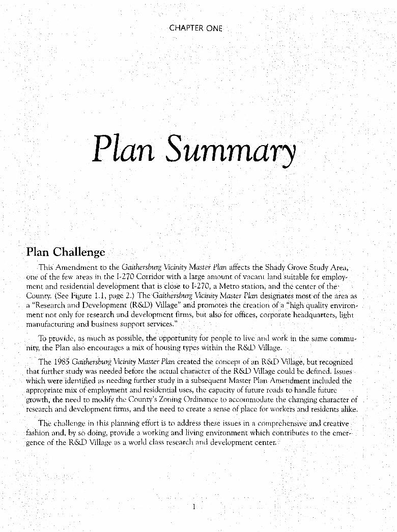
Plan Summary
Plan Challenge This Amendment to the Gaithersburg Vicinity Master Plan affects the Shady Grove Study Area,
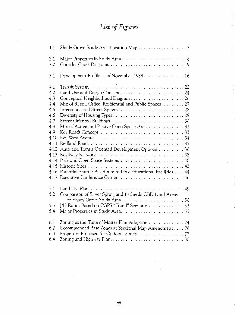
one of the few areas in the 1-270 Corridor with a large amount of vacant land suitable for employment and residential development that is close to I-270, a Metro station, and the center of theCounty. (See Figure 1.1, page 2.) The Gaithersburg Vicinity Master Plan designates most of the area as a "Research and Development (R&D) Village" and promotes the creation of a "high quality environment not only for research and development firms, but also for offices, corporate headquarters, light manufacturing and business support services."
To provide, as much as possible, the opportunity for people to live and work in the same community, the Plan also encourages a mix of housing types within the R&D Village.
The 1985 Gaithersburg Vicinity Master Plan created the concept of an R&D Village, but recognized that further study was needed before the actual character of the R&D Village could be defined. Issues which were identified as needing further study in a subsequent Master Plan Amendment included the appropriate mix of employment and residential uses, the capacity of future roads to handle future growth, the need to modify the County's Zoning Ordinance to accommodate the changing character of research and development firms, and the need to create a sense of place for workers and residents alike.
The challenge in this planning effort is to address these issues in a comprehensive and creative fashion and, by so doing, provide a working and living environment which contributes to the emergence of the R&D Village as a world class research and development center.
1
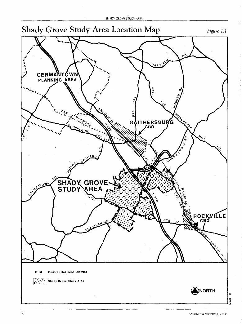
SHADY GROVE STUDY AREA
Shady Grove Study Area Location Map
.
. ~ . . . -~·--
CBD Central Business District
BJ Shady Grove Study Area
. . . . . ... ... ... , ... . . . .. .. =·
Figure 1.1
@NORTH 0 0. 0. 0 z L...-----------------------------------------------...Ji
2 APPROVED & ADOPTED July 1990
SHADY GROVE STUDY AREA: Plan Summary
Transit Concepts The importance of transit to the future of the Shady Grove Study Area cannot be
underestimated. This Plan designates three separate transitways as well as high priority regional and neighborhood bus routes. Higher intensity uses are directed to transit stops. In portions of the Study Area where lower intensity employment uses are recom, mended, the Plan encourages the clustering of buildings toward bus routes.
Transit is such an essential element of this Plan that it forms the basis for the land use and zoning recommendations. For this reason, a strong public/private commitment to the Plan's transit proposals must occur. In the absence of such a commitment, the Plan's land use proposals will have to be re,examined.
Plan Highlights This Plan manages and directs the dynamic growth potential of the Shady Grove
Study Area. The Study Area's remaining supply of vacant and uncommitted land provides an important resource in meeting several community and County,wide objectives. These objectives include:
• providing employment opportunities for a variety of businesses and enterprises;
• providing a sense of community identity for both existing and future residents;
• increasing the County's total housing stock and concurrently providing an appro, priate mix of affordable housing;
• providing a safe, efficient, and adequate transportation system;
• providing receiving areas for Transferable Development Rights (TDRs) to implement the County's Agricultural Preservation Program;
• encouraging the preservation of historic resources;
• providing facilities such as schools, parks, and recreation facilities on a timely and adequate basis; and
• encouraging the preservation of natural resources.
The Plan recommends that the Shady Grove Study Area continue to be designated as a major employment and housing center due to its strategic location in the 1,270 Corridor.
Land Use and Design Concepts This Plan strongly endorses traditional neighborhood concepts. Housing, employment, services, retail uses, and public spaces are integrated at the neighborhood level and tied together by transitways (for rail or bus), streets, bikeways, and sidewalks. These concepts are evident in older communities in Montgomery County which were <level, oped during the late nineteenth century up to World War II.
APPROVED & ADOPTED July 1990 3
SHADY GROVE STUDY AREA
This Plan:
• expands the R&D Village concept proposed in the 1985 Gaithersburg Vicinity Master Plan to include the Banks and Thomas Farms;
• proposes higher intensity uses at designated transit stops;
• encourages a mix of employment uses and densities;
• designates approximately 750 acres for primarily R&D uses in the vicinity of the Life Sciences Center;
• provides for a broad mix of residential units, including affordable housing;
• creates identifiable neighborhoods with a mix of residential and employment uses;
• enhances transit serviceability by orienting higher intensity development to desig~ nated busways and/or transit ways;
• provides a comprehensive park and open space system;
• recommends that historic sites be integrated into future development;
• supports a strong educational presence in the R&D Village;
• proposes an executive conference center site on the Traville property;
• proposes that a number of retail centers be developed to support the neighborhood concept on the Traville property and the Crown, King, and Thomas Farms;
• provides criteria for the designation of a heliport in the Study Area; and
• designates Key West Avenue as an R&D employment corridor.
Zoning Plan This Plan:
• proposes the use of floating zones as a means of achieving the Plan's land use and design objectives;
• recommends the coordinated planning and design of large parcels in accord with the neighborhood concept advocated in the Plan;
• defers comprehensive rezoning of properties by Sectional Map Amendment until there is evidence of a public/private commitment to implementation of transit;
• suggests the need for a new zone which will allow better implementation of the mixed use neighborhood concept in the Plan;
• eliminates the very detailed staging approach contained in the 1985 Gaithersburg Vicinity Master Plan; and
• recognizes the Annual Growth Policy as an effective mid~range staging mechanism.
4 APPROVED & ADOPTED July 1990
SHADY GROVE STUDY AREA: Plan Summnry
Transportation and Mobility Plan This Plan:
• recommends the location of three exclusive transitways through the Study Area to implement the Plan's land use recommendations;
• designates high-priority regional bus routes;
• designates neighborhood bus "loops" in the King Farm, R&D Village, and between the Johns Hopkins University, University of Maryland, and proposed conference area;
• recommends that buildings should be clustered and located closer to sidewalks to enhance transit serviceability along all roadways in the Study Area (except for major roadways, such as Sam Eig Highway);
• proposes several changes to the road network shown in the 1985 Gaithersburg Vicinity Master Plan, including several new roadway extensions and additions;
• recommends guidelines for subdivision and site plan applications to implement the neighborhood concept and transit-serviceable site design;
• recommends four intersections for future grade separations or equivalent at-grade solution;
• establishes criteria to site a public use heliport or vertiport within the Study Area;
• identifies potential High Occupancy Vehicle (HOV) lanes for Great Seneca Highway;
• proposes that two Park-and-Ride lots be located on the Banks Farm and Traville Property;
• recommends that pathways and sidewalk systems link residential areas, employment centers, and community facilities; and
• includes the findings of an areawide transportation analysis of the Land Use Plan.
Community Facilities This Plan:
• encourages developers of office and commercial projects to provide neighborhood and civic open space for employees and customers;
• encourages developers to provide pedestrian-oriented private recreation facilities within individual neighborhoods;
• designates conservation areas which include stream valley parks and private open space areas;
• proposes that four public schools (three elementary and one middle school) are needed to serve the projected public school age population of the Study Area;
APPROVED & ADOPTED July 1990 5
6
SHADY GROVE STUDY AREA
• recommends the provision of child day care facilities and housing for the elderly at appropriate locations in the Study Area; and
• recommends that, when appropriate, day care centers be considered as an amenity associated with applications for optional zones (such as MXPD and PD).
Environment This Plan:
• recommends that a reforestation plan to re-establish a natural stream valley in all conservation areas currently devoid of significant mature vegetation accompany development plans for individual properties;
• proposes that noise guidelines, prevention, or mitigation of noise impacts should be a major consideration throughout the land use planning and development approval processes;
• recommends that, at the time of preliminary plan review, detailed studies by a soils engineer be required to assess through field investigation the limitation of severely constraining soils, with recommendations for mitigation or avoidance; and
• designates conservation areas along stream valleys to enhance these functions. Within these conservation areas, development will be reviewed for compliance with regulatory controls and guidelines.
Implementation This Plan:
•
•
•
proposes mixed-use zones to implement the neighborhood concept;
recommends postponing preparation and adoption of the Sectional Map Amendment to implement the Master Plan until there is evidence of a public/private commitment to implement the Plan's transit recommendations;
recommends that those properties that are recommended for development in the near term be subject to the Annual Growth Policy (AGP) limitations; and reaffirms the 1985 Gaithersburg Vicinity Master Plan recommendations regarding interjurisdictional issues.
APPROVED & ADOPTED July 1990
CHAPTER TWO
Plan Background
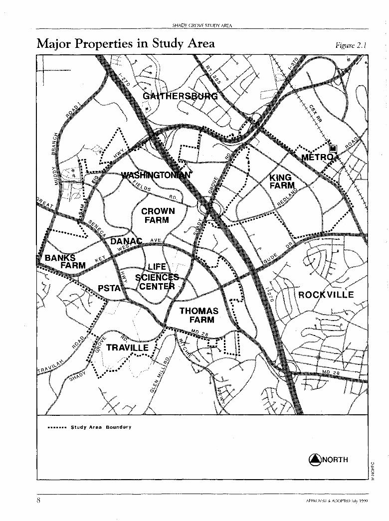
Definition of Study Area The boundaries of the Shady Grove Study Area are shown in Figure 2.1, page 8. This Study Area
is different from the one defined by the 1985 Gaithersburg Vicinity Master Plan in four respects:
• parcels annexed by the cities of Gaithersburg and Rockville have been excluded;
• the King Farm has been added to the Study Area;
• the Shady Grove Metro station has been added to the Study Area; and
• the southern boundary of the Study Area has been changed in the vicinity of the Traville (formerly Percon) property. The boundary now follows an edge of a residential subdivision rather than topographic features.
Major Properties in Study Area The major properties, which are discussed in this Plan, are shown in Figure 2.1, page 8. Working
farms constitute a significant portion of the Study Area.
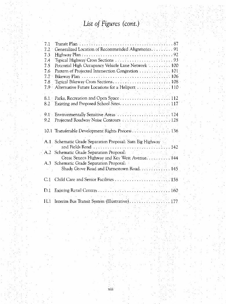
Planning History of Study Area The 1964 General Plan (On Wedges and Corridors) for the Physical Development of the Maryland
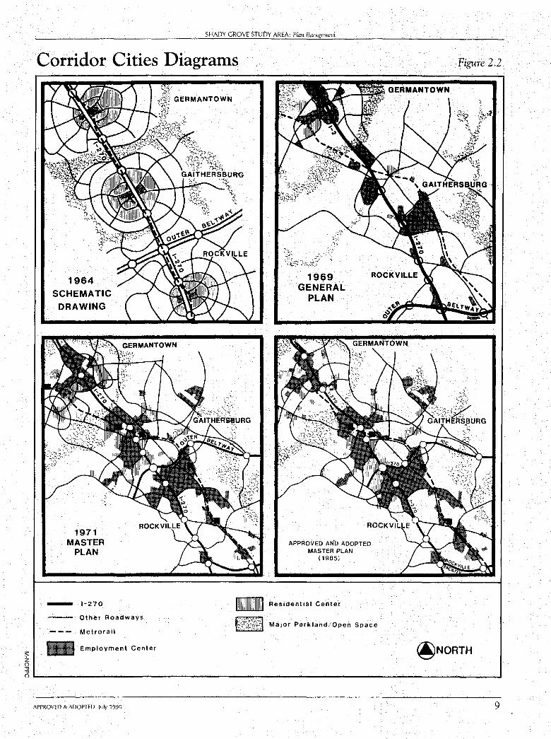
Washington Regional District in Montgomery and Prince George's Counties provided broad policy guidance for the development of the County and designated the Gaithersburg area as one of several "corridor cities" along I-270. Diagrammatically, a "corridor city," as originally envisioned, was to have a single center of employment and shopping activities surrounded by residential development. (See Figure 2.2, page 9.)
7
SHADY GROVE STUDY AREA
Major Properties in Study Area
••••••• Study Area Boundary
Figure 2.1
@NORTH 0 0.. 0.. 0 z .__ __________________________________________________ ___.1
8 APPROVED & ADOPTED July 1990
:;:: z 0 .,, .,,
SHADY GROVE STUDY AREA: Plan Background
Corridor Cities Diagrams
1964 SCHEMATIC
DRAWING
1971 MASTER
PLAN
- 1-270
GERMANTOWN
Other Roadways
--- Metrorail
- Employment Center
APPROVED AND ADOPTED MASTER PLAN
(1985)
m Residential Center
~{~i{ti:~A Major Parkland/Open Space
Figure 2.2
@NORTH
O'------------------------------------------------------__, APPROVED & ADOPTED July 1990 9
10
SHADY GROVE STUDY AREA
The residential area was intended to decrease from high-density, adjacent to the core, to low-density, at the edge of the "corridor city."
The 1971 Gaithersburg Vicinity Master Plan was undertaken to address growth issues brought about by the extension ofl-2 70 to the west of Gaithersburg. Development pressures increased for many growth centers within the Gaithersburg area rather than a single "corridor city." New employment centers were established along 1-270 and this generated new demand for housing in the area.
The municipalities of Gaithersburg, Rockville, and Washington Grove were not addressed by the 1971 Master Plan because each of these jurisdictions has its own planning and zoning authority and master plan.
The 1971 Master Plan encouraged several changes from the General Plan. It recommended the location of the Shady Grove Life Sciences Center (formerly called Montgomery County Medical Center) near Shady Grove Road and MD 28. The Plan also recommended the location of large amounts of office and residential development along Shady Grove Road. Another significant change incorporated the location of the Intercounty Connector (formerly called the Outer Beltway) through this area. The 1971 Master Plan also proposed a Metro station, at Shady Grove, to serve the transportation needs of employees in the area.
In 1977, a portion of the 1971 Master Plan was amended to include policy guidance for development within the Shady Grove Transit Station Area. An objective of the 1977 Shady Grove Sector Plan was to reduce the potential negative effects of the Metro station complex and the 300-acre County Service Park on the surrounding community. The Sector Plan recommended that the approximately 440-acre King Farm should not be rezoned from low-density residential to the industrial park (1-3) zone until sufficient transportation facilities are in place.
In 1985, the Gaithersburg Vicinity Master Plan was adopted (a minor amendment to the Plan was adopted in 1988, but the amendment made no substantive changes to the Shady Grove Study Area). The Shady Grove Study Area was designated a "Research and Development (R&D) Village" by the Gaithersburg Vicinity Master Plan. Due mainly to traffic concerns, the 1985 Master Plan recommended that the actual "end-state" land use of many of the parcels in the Shady Grove Study Area be determined as part of a future Master Plan Amendment.
In 1988, the Amendment process began. It is described in more detail in the next section.
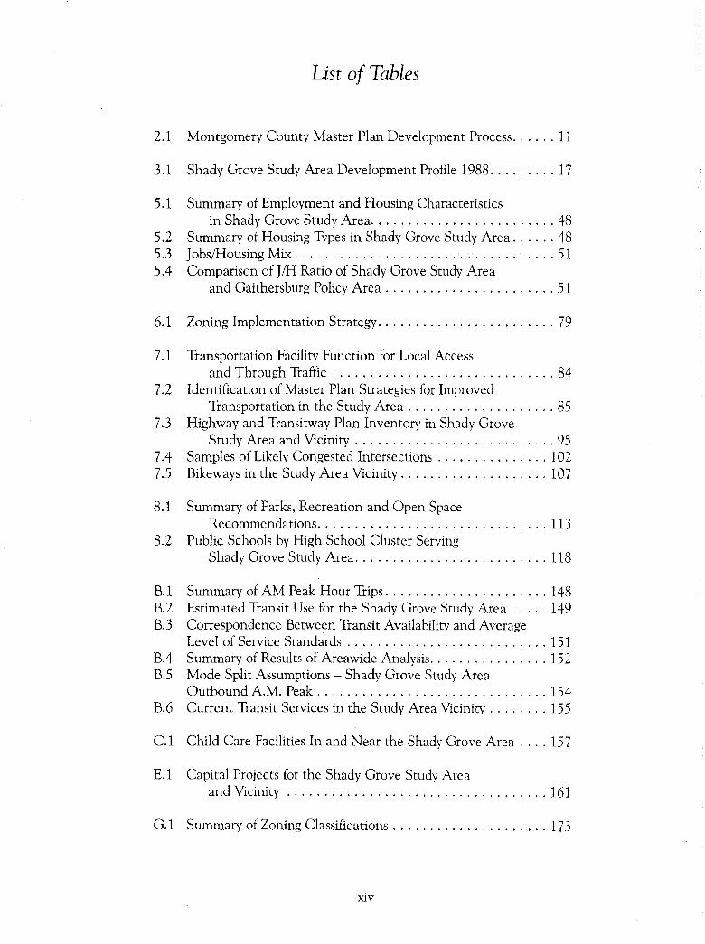
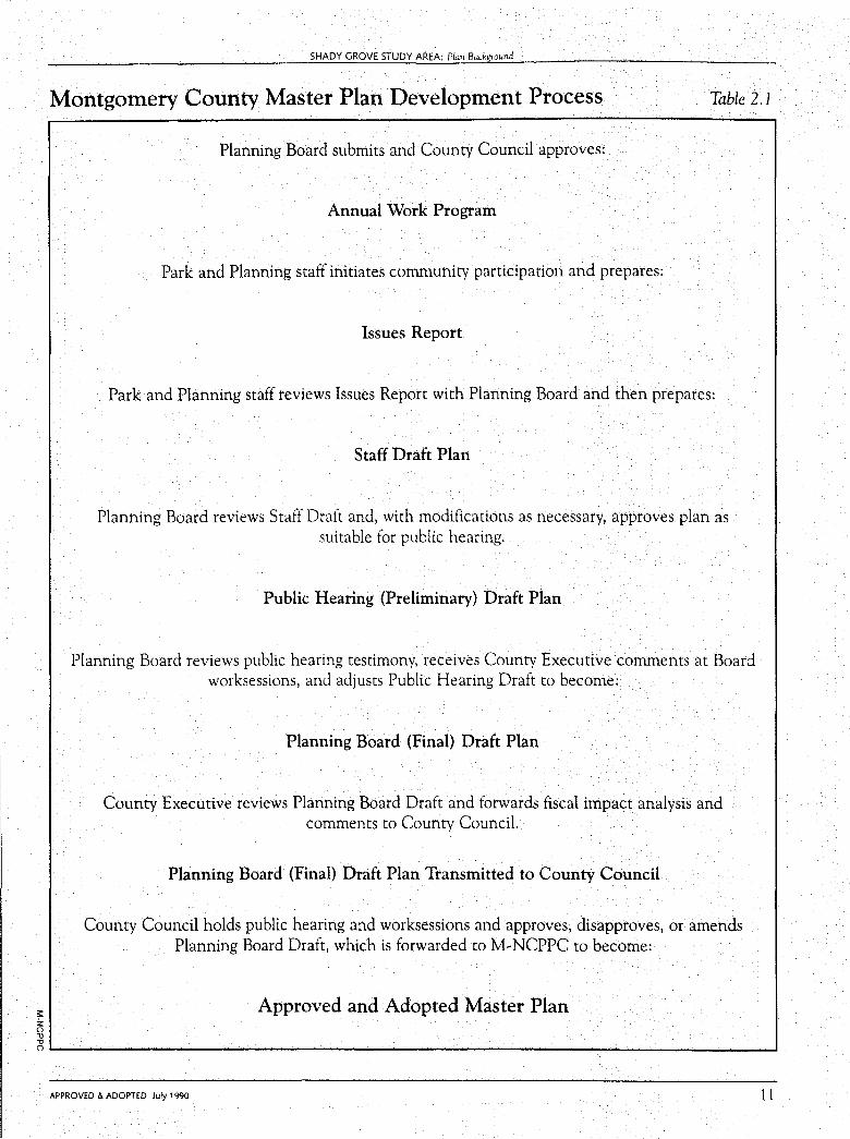
The Amendment Process The Master Plan Amendment process is summarized in Table 2.1, page 11. In
January 1988, the Planning Department staff completed the Issues and Trends Report, the first step in the Shady Grove Study Area Master Plan process.
APPROVED & ADOPTED July 1990
,: z 0 1l 1l
SHADY GROVE STUDY AREA: Plan Background
Montgomery County Master Plan Development Process Table 2.1
Planning Board submits and County Council approves:
Annual Work Program
Park and Planning staff initiates community participation and prepares:
Issues Report
Park and Planning staff reviews Issues Report with Planning Board and then prepares:
Staff Draft Plan
Planning Board reviews Staff Draft and, with modifications as necessary, approves plan as suitable for public hearing.
Public Hearing (Preliminary} Draft Plan
Planning Board reviews public hearing testimony, receives County Executive comments at Board worksessions, and adjusts Public Hearing Draft to become:
Planning Board (Final) Draft Plan
County Executive reviews Planning Board Draft and forwards fiscal impact analysis and comments to County Council.
Planning Board (Final) Draft Plan Transmitted to County Council
County Council holds public hearing and worksessions and approves, disapproves, or amends Planning Board Draft, which is forwarded to M-NCPPC to become:
Approved and Adopted Master Plan
0'-----------------------------------------1
APPROVED & ADOPTED July 1990 11
12
SHADY GROVE STUDY AREA
A Staff Draft Plan was published in March 1989 and proposed four land use options for the Shady Grove Study Area. In April 1989, the Preliminary Draft Plan was pub-lished. It continued the four land use options unchanged from the Staff Draft Plan with selected clarifications to the text. A Public Hearing on the Preliminary Draft was held in May 1989. Numerous Planning Board worksessions followed.
A Final Draft Plan was then submitted by the Planning Board to the Council and the County Executive. The County Council held a Public Hearing on the Final Draft Plan as modified by the County Executive in January 1990. After a series of Council worksessions, the County Council adopted the Plan in July 1990.
Influential External Factors There are several external factors, such as actions of the federal and State govern
ments, that could influence the outcome of this Master Plan. The likelihood and effects of these factors are difficult to predict because they would result from actions or factors not subject to County government control, such as the actions of the federal government, changes in energy supplies, and changes in lifestyles. In addition, technological research and innovation are capable of changing patterns of everyday life, but are also beyond the control of County Government.
These larger political, environmental, economic, and technological factors are global, national, or regional in nature. While beyond the scope of this Master Plan, they would nonetheless significantly affect the County.
Moderately-Priced Dwelling Units When consulting this Amendment, it is important to note chat, on any given prop
erty, the residential densities and allowable types of dwelling units shown include the requirements of the Montgomery County Moderately Priced Dwelling Unit (MPDU) Ordinance. This ordinance is designed to ensure that new development includes some housing that is affordable by households of modest means. It applies to any residential development of 50 or more dwelling units that is constructed in any residential zone with a minimum lot size of a half-acre or less or in any planned development, mixed use zone.
A portion of the units in any such development must be MPDUs. The prices of such units are controlled, and buyers or renters are subject to limitations on maximum income. The required number of MPDUs is based on the total number of dwelling units approved for the development. Effective in early 1989, the percentage ranges from 12.5 percent to 15 percent of the total number of dwelling units and is dependent on the level of density increase achieved on the site in question.
This density increase, or "MPDU bonus," is allowed as compensation for requiring some below-market-rate housing. The bonus may be no more than 22 percent above the normal density of the zone, according to the optional MPDU development
APPROVED & ADOPTED July 1990
SHADY GROVE STUDY AREA: Plan Background
standards in the Zoning Ordinance. In some zones, these standards also provide for smaller lot sizes and dwelling types than would be allowed otherwise. For example, the density of a subdivision in the R-200 Zone is normally 2 units per acre, the minimum lot size is 20,000 square feet, and only single-family, detached houses are permitted. In a subdivision developed according to MPDU standards, the maximum density may be as much as 2.44 units per acre, the lot size for a detached house may be as small as 6,000 square feet, and some units may be townhouses or other types of attached dwelling units.
All residential calculations in this Master Plan include a 20 percent density increase to reflect the MPDU Ordinance provisions.
Inter-Jurisdictional Issues The cities of Rockville and Gaithersburg are directly affected by the recommenda
tions of this Plan. Many of the undeveloped parcels border on one of these jurisdictions and a number of them lie within the maximum expansion limits (MEL) established by the two cities.
At the same time, planning decisions by the cities affect the Shady Grove Study Area (the 352-acre Kentlands development along MD 28 near Quince Orchard Boulevard in the city of Gaithersburg, for example, will have areawide transportation implications).
Issues of mutual concern to the cities and the County have been identified and discussed throughout the planning process.
There have been several meetings with the City of Rockville· to discuss the questions of a possible interjurisdictional agreement between the County and the City regarding the City's Maximum Expansion Limits. The Mid-County Planning Committee (MPC) has been formed to develop a coordinated inter-jurisdictional growth management program that recognizes the similarities and respects the differences between the affected jurisdictions. The MPC comprises staff representatives from the Montgomery County Council, County Executive, Cities of Rockville and Gaithersburg, Town of Washington Grove, and Montgomery County Planning Department.
APPROVED & ADOPTED July 1990 13
CHAPTER THREE
Development Profile
Existing and Approved Development The Study Area encompasses approximately 2,500 acres. About one half of this acreage is already
developed or so far along in the development process that this Master Plan will not affect the endstate land use. The remaining uncommitted, undeveloped acreage consists of approximately 1,300 acres.
Finally, about 85 acres, now developed in relatively low-density land uses, do have redevelopment potential. These include: King Pontiac along MD 355, the Bechtel property, the Shady Grove Metro parking lot between the station and MD 355, and a number of small lots near the Public Service Training Academy along Darnestown Road.
Figure 3.1, page 16, identifies the locations of all parcels in the Study Area by these three categories: committed, undeveloped, and redevelopable.
15
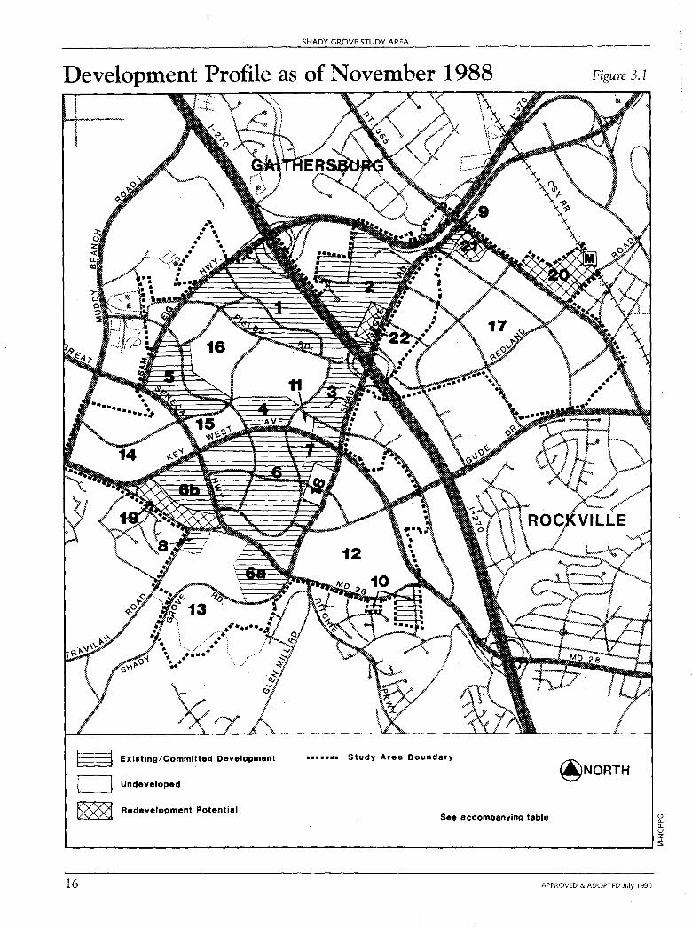
SHADY GROVE STUDY AREA
Development Profile as of November 1988
§ Existing/Committed Development
LJ Undeveloped
~ Redevelopment Potential
....... Study Area Boundary
See accompanying table
Figure 3.1
@NORTH
0 a.. a.. 0 z ,.._ ________________________________________________ .J~
16 APPROVED & ADOPTED July 1990
;':: z 0 .,, .,,
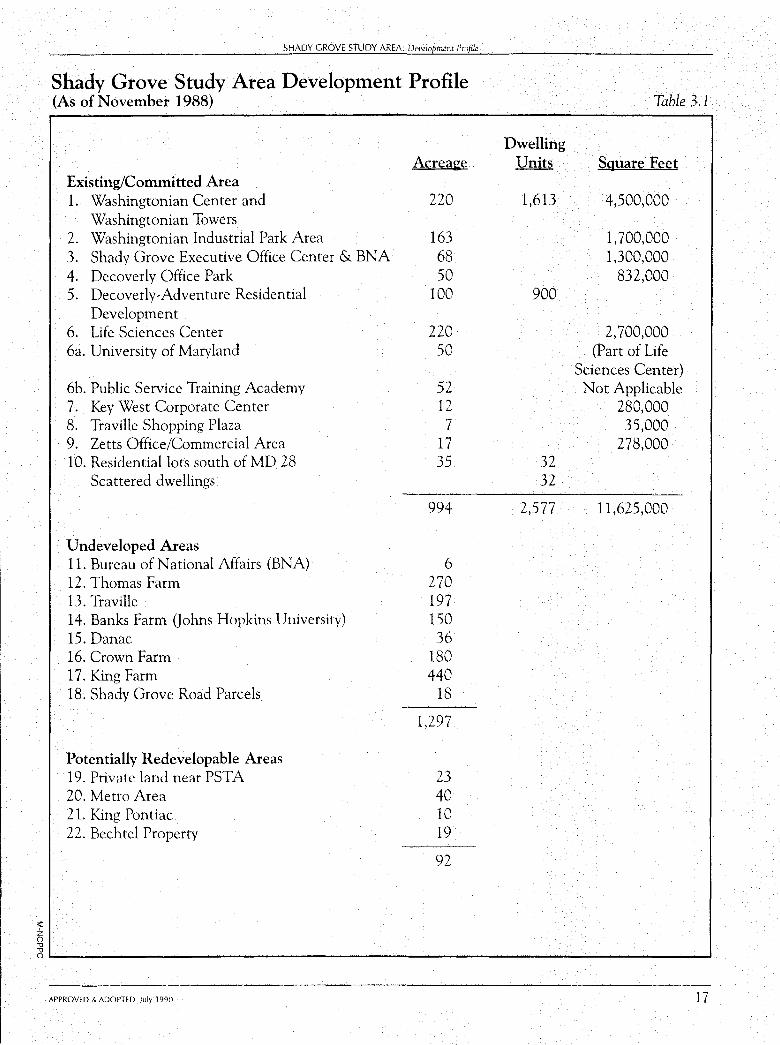
SHADY GROVE STUDY AREA: De\/dopment Profile
Shady Grove Study Area Development Profile (As of November 1988)
Acreaee Existing/Committed Area 1. Washingtonian Center and 220
Washingtonian Towers 2. Washingtonian Industrial Park Area 163 3. Shady Grove Executive Office Center & BNA 68 4. Decoverly Office Park 50 5. Decoverly-Adventure Residential 100
Development 6. Life Sciences Center 220 6a. University of Maryland 50
6b. Public Service Training Academy 52 7. Key West Corporate Center 12 8. Traville Shopping Plaza 7 9. Zetts Office/Commercial Area 1 7 10. Residential lots south of MD 28 35
Scattered dwellings
Undeveloped Areas 11. Bureau of National Affairs (BNA) 12. Thomas Farm 13. Traville 14. Banks Farm Qohns Hopkins University) 15. Danae 16. Crown Farm 17. King Farm 18. Shady Grove Road Parcels
Potentially Redevelopable Areas 19. Private land near PSTA 20. Metro Area 21. King Pontiac 22. Bechtel Property
994
6 270 197 150 36
180 440
18
1,297
23 40 IO 19
92
Table 3.1
Dwelling Units Sguare Feet
1,613 4,500,000
1,700,000 1,300,000
832,000 900
2,700,000 (Part of Life
Sciences Center) Not Applicable
280,000 35,000
278,000 32 32
2,577 11,625,000
0---------------------------------------APPROVED & ADOPTED July 1990 17
CHAPTER FOUR
Land Use and Design Objectives
A Vision of the Future This Plan has been guided by certain aspirations about how the area should develop over the next
20 to 30 years.
These aspirations are presented here as a vision of the future. The vision statement is in the present tense, as if we were reading a description of the area in the year 2010.
Vision Statement This Plan Envisions:
The Shady Grove Study Area as a major R&D center ...
The Shady Grove "R&D Village" has evolved into a world-class biotech and high-tech research area. The presence of two major universities, Johns Hopkins University and the University of Maryland, has helped attract tlrms interested in basic and applied research. Strong transit linkages between the universities, the National Institute of Standards and Technology, and the National Institutes of Health make the R&D Village an integral part of the larger Montgomery County research community.
The R&D Village, which includes the 4.5-million square-foot mixed-use Washingtonian Center, also offers attractive office sites to meet a variety of R&D needs.
19
20
SHADY GROVE STUDY AREA
with a strong emphasis on transit serviceability ...
A strong public transit system serves and supports the Shady Grove Study Area. Separate transitways through the area link development to Metro (service to the Shady Grove Metro station is provided on a regular basis and is substantially augmented during rush hour), the Life Sciences Center, and North Bethesda and Rockville. Within the Shady Grove Study Area, transit serviceability has been a major site planning concern. Clustering higher density residential and employment uses along designated transitways has promoted transit ridership. Bus service that links employment, residential, and retail uses is provided throughout the day so that residents and workers can shop and run errands via transit, reducing the dependency on the automobile.
that is a good place to work ...
Special care has been taken to cluster buildings along "main streets" and to integrate a mix of uses into employment areas so that workers may walk or shuttle between buildings and reach restaurants, retail uses, and open space areas on foot during the lunch hour. The "employment neighborhoods" which have resulted offer an attractive alternative to more typical single use, auto dependent, office parks.
that is a good place to live ...
The R&D Village includes well~defined residential neighborhoods that offer a variety of housing types and prices. Neighborhood retail uses have a "main street orientation" so that arrival by foot, by bicycle, or by bus is a pleasant experience. The integration of parks, open space, and schools within neighborhoods assures that opportunities for socializing, recreation, quiet, and solitude are all close at hand.
with a special cultural and recreational environment ...
Unlike many large R&D parks, the R&D Village is an active place after work hours. The area includes a diversity of uses designed to be fully active both day and night. The universities offer nighttime classes and sponsor cultural events for students and the larger community. The Washingtonian Center, with its retail center, health club, and lakefront restaurants, is a lively place that encourages people to "come and stay awhile" and enjoy its amenities. In the residential areas, schools and libraries provide a focal point for community services as well as informal community activities in the evenings. Trees line walkways and major roadways, providing an attractive view from the road and reinforcing the special identity of the R&D Village. Public and private open spaces and parks offering an opportunity for rest and quiet are found throughout the R&D Village.
for people of different ages and different income levels ...
The availability of low to moderate priced housing allows many technicians and service workers to live and work in the R&D Village. Many elderly seek housing in the area because of the excellent transit service and health~related programs offered by medical providers in the Life Sciences Center. Day care facilities, available in the residential neighborhoods as well as the employment centers, attract young families with children.
APPROVED & ADOPTED July 1990
SHADY GROVE STUDY AREA: Land Use and Design Objectives
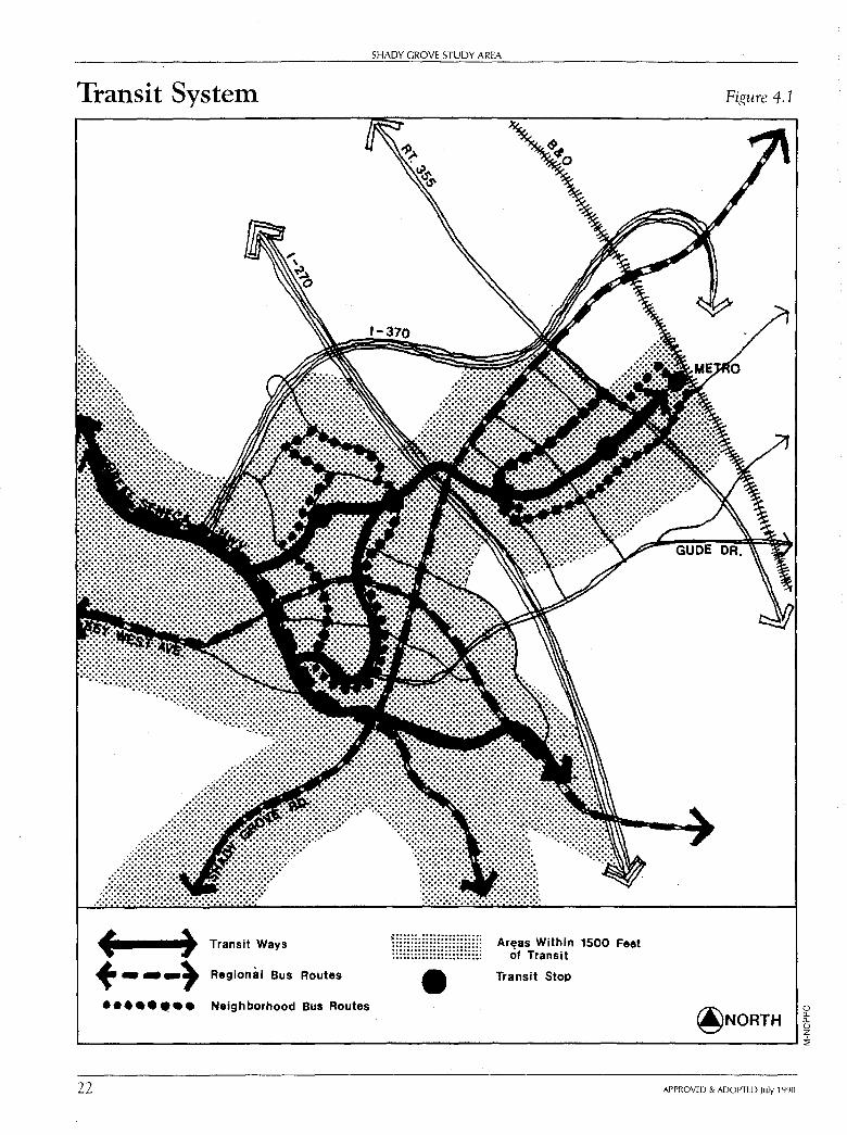
Plan Concepts This Plan proposes that the portion of the Study Area west of I-2 70 be designated
as the "R&D Village." The area east of I-2 70 bears a strong relationship to the Shady Grove Metro station and is identified as the "Metro Area." This Plan proposes a transit linkage between the two areas. (See Figure 4.1, page 22.)
Land Use and Design Objectives To help realize the Plan's vision of the future, the following land use and design objectives have guided the Plan process:
OBJECTIVE 1: Provide a comprehensive transit system that will reduce dependence upon the automobile.
This Plan proposes a comprehensive transit system which consists of three elements:
- A northern transitway provides a direct link to Shady Grove Metro station from the Study Area. Grade-separated crossings ofl-270 and Shady Grove Road are proposed to strengthen this connection.
- A southern transitway provides a transit link between the Study Area and Rockville and North Bethesda. This link has been suggested in the Comprehensive Growth Policy Study and will require further study.
- A Life Sciences Center transit spur ties the County's bio-medical research park to both the northern and southern transitways.
Although the mode of transit along these transitways (bus vs. light rail, for example) will be determined by future studies, this Plan will assure that the necessary rights-of-way will be dedicated at time of subdivision.
High Priority Regional Bus Routes. This Plan designates those roads which function as regional thoroughfares as high priority bus routes. Bus service along these roads, if planned in conjunction with Park-and-Ride lots outside the Study Area, could offer an attractive alternative to commuting by car to the Study Area.
Neighborhood Bus Loops. A number of neighborhood bus loops are proposed to serve the Metro area and one west of 1-270 in the R&D Village. These loops are planned with the pedestrian in mind: workers and residents will walk to transit stops on the loop, board small buses (like Ride-On), and then transfer to either the regional bus networks or one of the transitways.
Interim Transit Strategy. It may not be possible for the three transitways designated by this Plan to become operational in the short-term due to a variety of funding and engineering issues which must be resolved. Therefore, this Plan recommends an
APPROVED & ADOPTED July 1990 21
Transit System
f ) Transit Ways + ---} Regional Bus Routes
••• •• •• • Neighborhood Bus Routes
SHADY GROVE STUDY AREA
-Areas Within 1500 Feet
of Transit
Transit Stop
Figure 4.1
@NORTH 0 a.. a.. 0 z
L-------------------------------------------'::!;
22 APPROVED & ADOPTED July 1990
SHADY GROVE STUDY AREA: Land U,e and Design Objectives
"Interim Transit Strategy" to ensure that Shady Grove develops as a transit-oriented employment and residential community and to minimize any limitations on the ability of property owners to proceed with development. The Interim Transit Strategy would consist of intensive bus service on existing roads and would use the rights-of-way designated for the transitways wherever possible. An illustration of a potential interim strategy is shown in Appendix H.
OBJECTIVE 2: Encourage a mix of employment uses and densities.
This Plan proposes a range of development densities and employment uses to provide for a variety of employment opportunities and centers in the Shady Grove Study Area. This is important in an "R&D" area; firms which start out requiring small scale "incubator" buildings may, over time, expand and require more traditional office space. Accommodating a firm's changing spatial needs will allow employers to remain in the Study Area over a long period of time.
This Plan recommends higher density office uses along a Plan-designated transitway and clusters development at designated transit nodes.
Lower density, R&D employment uses are channeled to the southern portion of the Study Area in close proximity to the County's Life Sciences Center. Zoning recommendations in this area will help assure that a significant portion of the development will be R&D related.
The pattern of employment uses proposed in the Plan is shown in Figure 4.2, page 24.
OBJECTIVE 3: Provide for a broad mix of residential units, including affordable housing.
This Plan proposes a land use pattern which includes a variety of housing types: multi-family, attached, and detached. Rather than physically separating each unit type from another, this Plan envisions a mix of housing types at the neighborhood level. The number of units in each category varies depending on the scale, character, and density of development proposed for a given area.
This Plan strongly encourages the provision of affordable housing within the Study Area. Higher densities and a mix of detached multi-family unit types, along with the requirements of the Moderate Priced Dwelling Unit Ordinance, will help address this important need. To further ensure the availability of low- to moderate-income housing, the Plan proposes that higher density residential development on at least one property (Traville) be dependent on a mix of affordable and market rate housing.
The generalized locations of residential areas proposed in this Plan are shown in Figure 4.2, page 24.
APPROVED & ADOPTED July 1990 23
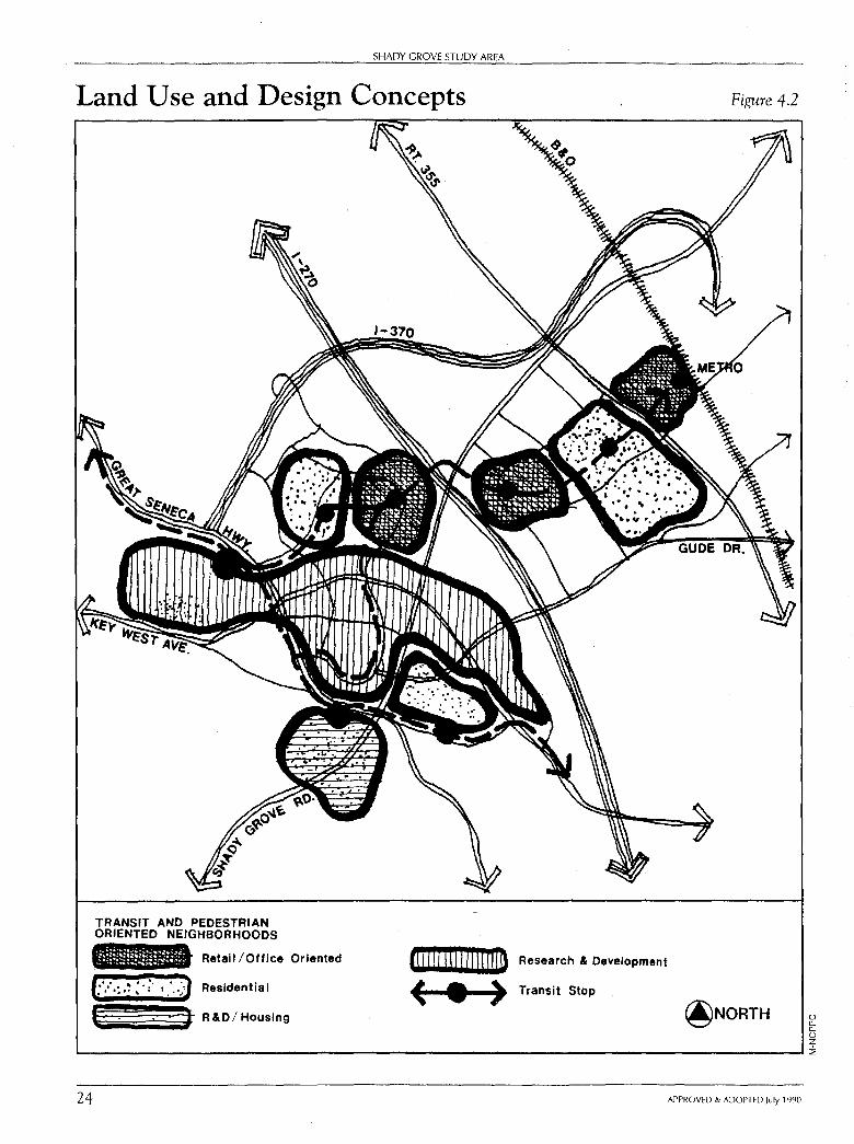
SHADY GROVE STUDY AREA
Land Use and Design Concepts
TRANSIT AND PEDESTRIAN ORIENTED NEIGHBORHOODS
Retail /Office Oriented
....... ·'.:- . J • • '• •• ' • I• • .:
Residential
(: . : . ' J R&D/ Housing
cm tO I Iii I I I < • >
Research & Development
Transit Stop
Figure 4.2
@NORTH 0 u. u. 0 z L--------------------------------------------':ia
24 APPROVED & ADOPTED July 1990
SHADY GROVE STUDY AREA: Lmd U,e and Design Objective.<
OBJECTIVE 4: Create identifiable residential and employment neighborhoods.
As part of this planning process, elements which contribute to a sense of place and which foster a sense of community at the neighborhood level have been identified. They are:
• mix of uses (retail, office, and housing);
• interconnected street system;
• diversity of housing types;
• street oriented buildings; and
• mix of active and passive open space areas.
These elements have been identified in response to a growing interest in neighborhoods which offer a greater variety of uses and which are less auto-dependent. As explained in Envisioning Our Future, the report of the Montgomery County Commission on the Future:
"We believe that small-scale, nearby service businesses are often integral to a neighborhood. Because the neighborhood businesses are so close and convenient, people are able to walk easily to them and thus are able to meet other neighbors .... Communities need a central location as a hub for neighborhood activities. It should be accessible not only by private auto but by public transportation and by foot and bicycle as well."
This Plan proposes a neighborhood development concept for the majority of vacant tracts in the Study Area. Employment, residential, retail uses, civic spaces, and parks relate to one another, and the street pattern supports pedestrian as well as auto and transit accessibility.
The one exception to the mixed use neighborhood concept is the Banks Farm, which will be developed as a research campus by Johns Hopkins University. Although no retail uses are proposed and only a small number of residences (50) will be provided, civic spaces and parkland are proposed to help create a sense of neighborhood.
The following pages illustrate the neighborhood elements which this Plan promotes.
APPROVED & ADOPTED July 1990 25
SHADY GROVE STUDY AREA
Conceptual Neighborhood Diagram Figure 4.3
(_) 0.. 0.. 0 z ..__ ________________________ ___,:i,
26 APPROVED & ADOPTED July 1990
;:: z SJ .,,
SHADY GROVE STUDY AREA: Land Use a,uJ Design Objectives
Mix of Uses
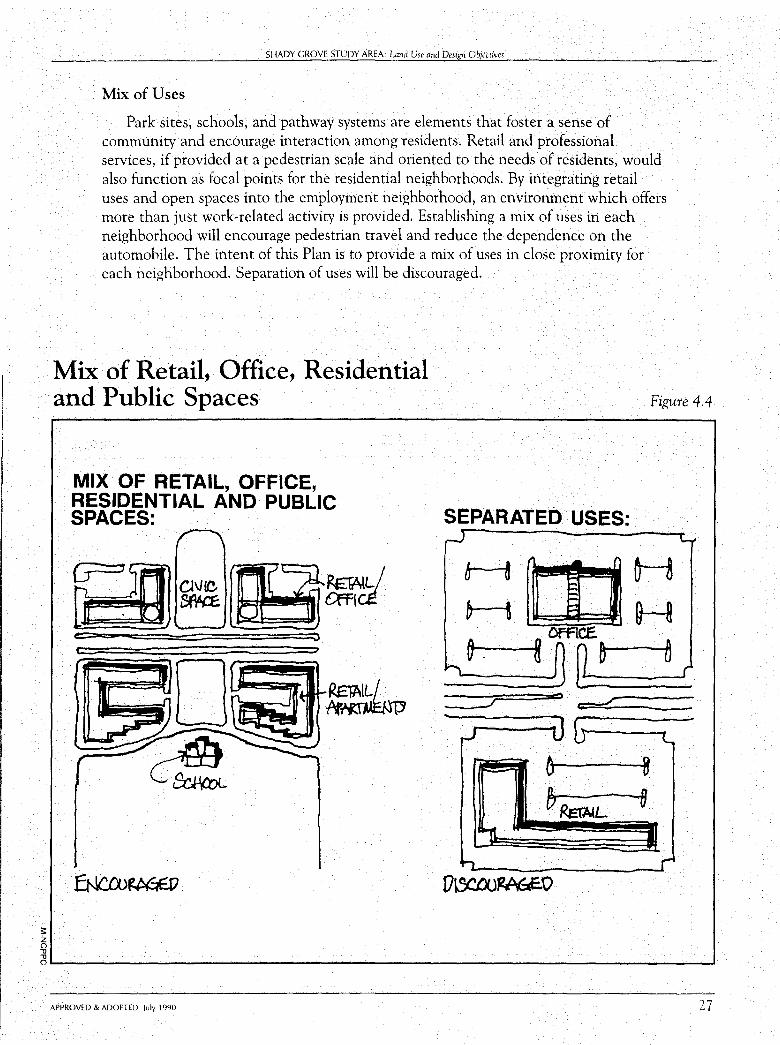
Park sites, schools, and pathway systems are elements that foster a sense of community and encourage interaction among residents. Retail and professional services, if provided at a pedestrian scale and oriented to the needs of residents, would also function as focal points for the residential neighborhoods. By integrating retail uses and open spaces into the employment neighborhood, an environment which offers more than just work,related activity is provided. Establishing a mix of uses in each neighborhood will encourage pedestrian travel and reduce the dependence on the automobile. The intent of this Plan is to provide a mix of uses in close proximity for each neighborhood. Separation of uses will be discouraged.
Mix of Retail, Office, Residential and Public Spaces Figure 4.4
MIX OF RETAIL, OFFICE, RESIDENTIAL AND PUBLIC SPACES: . SEPARATED USES:
;
" ,
~ ~ t':::
= =
o~------------------------------------' APPROVED & ADOPTED July 1990 27
SHADY GROVE STUDY AREA
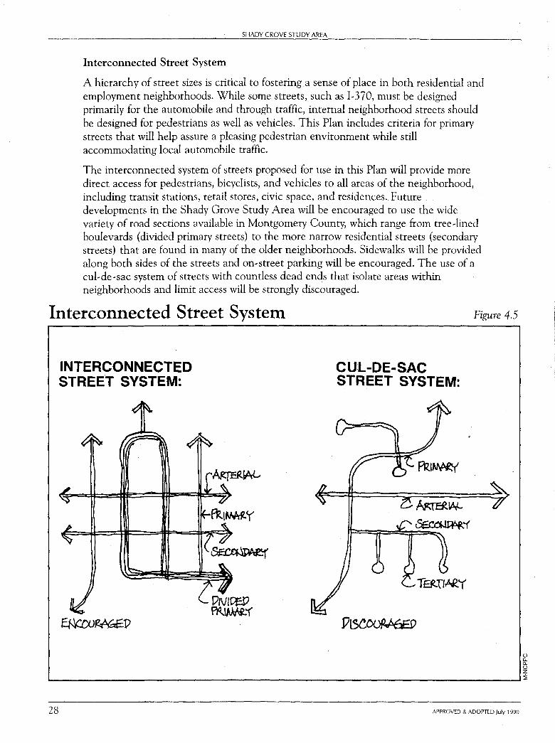
Interconnected Street System
A hierarchy of street sizes is critical to fostering a sense of place in both residential and employment neighborhoods. While some streets, such as 1-370, must be designed primarily for the automobile and through traffic, internal neighborhood streets should be designed for pedestrians as well as vehicles. This Plan includes criteria for primary streets that will help assure a pleasing pedestrian environment while still accommodating local automobile traffic.
The interconnected system of streets proposed for use in this Plan will provide more direct access for pedestrians, bicyclists, and vehicles to all areas of the neighborhood, including transit stations, retail stores, civic space, and residences. Future developments in the Shady Grove Study Area will be encouraged to use the wide variety of road sections available in Montgomery County, which range from tree-lined boulevards (divided primary streets) to the more narrow residential streets (secondary streets) that are found in many of the older neighborhoods. Sidewalks will be provided along both sides of the streets and on-street parking will be encouraged. The use of a cul-de-sac system of streets with countless dead ends that isolate areas within neighborhoods and limit access will be strongly discouraged.
Interconnected Street System
INTERCONNECTED STREE.T SYSTEM:
CUL-DE-SAC STREET SYSTEM:
TatTI~"(
Figure 4.5
0 0.. 0.. 0 z ...._ _____________________________________ _,:::\;
28 APPROVED & ADOPTED July 1990
;::
~ "
SHADY GROVE STUDY AREA: l..nnd Use and De,ign Objectives
Diversity of Housing Types
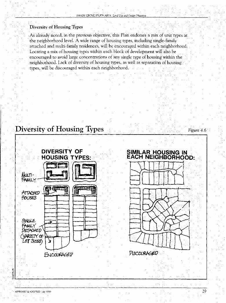
As already noted, in the previous objective, this Plan endorses a mix of unit types at the neighborhood level. A wide range of housing types, including single-family attached and multi-family residences, will be encouraged within each neighborhood. Locating a mix of housing types within each block of development will also be encouraged to avoid large concentrations of any single type of housing within the neighborhood. Lack of diversity of housing types, as well as separation of housing types, will be discouraged within each neighborhood.
Diversity of Housing Types Figure 4.6
(").._ __________________________________ ___.
APPROVED & ADOPTED July 1990 29
SHADY GROVE STUDY AREA
Street Oriented Buildings
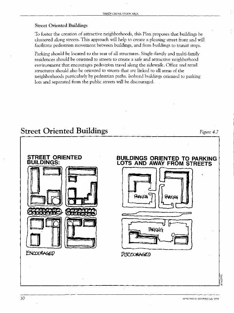
To foster the creation of attractive neighborhoods, this Plan proposes that buildings be clustered along streets. This approach will help to create a pleasing street front and will facilitate pedestrian movement between buildings, and from buildings to transit stops.
Parking should be located to the rear of all structures. Single-family and multi-family residences should be oriented to streets to create a safe and attractive neighborhood environment that encourages pedestrian travel along the sidewalk. Office and retail structures should also be oriented to streets that are linked to all areas of the neighborhoods particularly by pedestrian paths. Isolated buildings oriented to parking lots and separated from the public streets will be discouraged.
Street Oriented Buildings Figure 4.7
I
STREET ORIENTED BUILDINGS:
Ow r,.,
a ..._
BUILDINGS ORIENTED TO PARKING LOTS AND AWAY FROM STREETS
<
M. ~ L::= :l--r
0 a.. a.. 0 z .__ ___________________________________ __.:l:
30 APPROVED & ADOPTED July 1990
~ z 0 .,, .,,
SHADY GROVE STUDY AREA: Land Use and Design Objectives
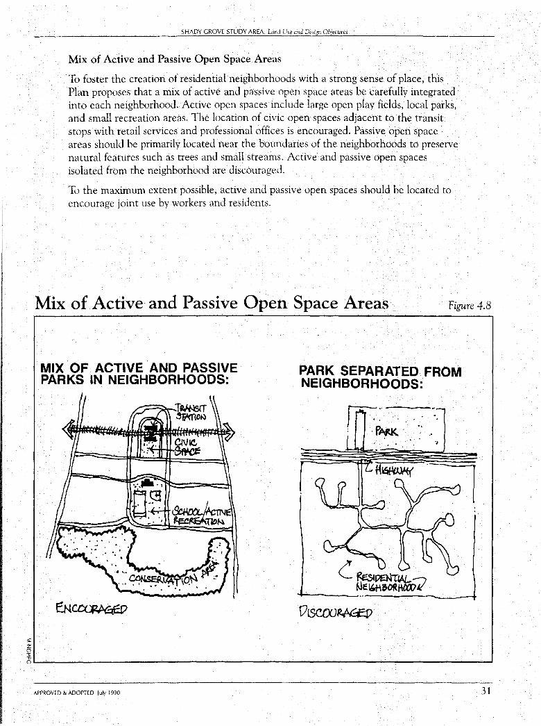
Mix of Active and Passive Open Space Areas
To foster the creation of residential neighborhoods with a strong sense of place, this Plan proposes that a mix of active and passive open space areas be carefully integrated into each neighborhood. Active open spaces include large open play fields, local parks, and small recreation areas. The location of civic open spaces adjacent to the transit stops with retail services and professional offices is encouraged. Passive open space areas should be primarily located near the boundaries of the neighborhoods to preserve natural features such as trees and small streams. Active and passive open spaces isolated from the neighborhood are discouraged.
To the maximum extent possible, active and passive open spaces should be located to encourage joint use by workers and residents.
Mix of Active and Passive Open Space Areas Figure 4.8
MIX ·oF ACTIVE .AND PASSIVE PARKS IN NEIGHBORHOODS:
PARK SEPARATED FROM NEIGHBORHOODS:
:
c ~oatt"L ~E "M&ORtt«.V 7 -----
0tSCTXJ~
oL-.-------------------------------------' APPROVED & ADOPTED July 1990 31
32
SHADY GROVE STUDY AREA
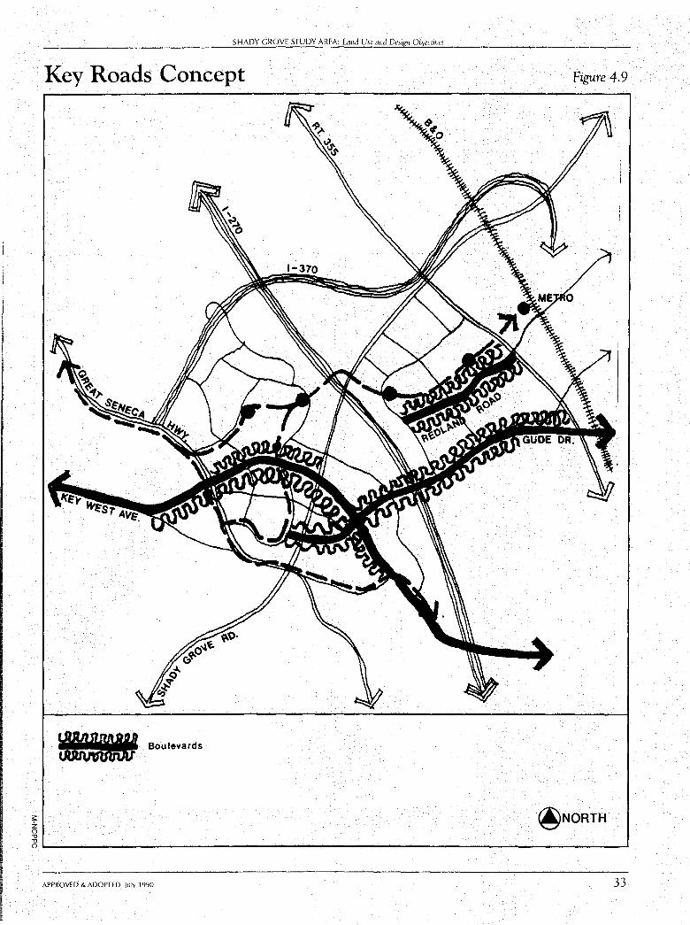
OBJECTIVE 5: Identify key roads which should have a special identity to help foster a sense of place.
This Plan designates three roads for special design treatment. Key West Avenue in the R&D Village, Redland Road on the King Farm, and Gude Drive (a proposed road on the Thomas Farm) are recommended to be treated as landscaped boulevards. In addition, a road on the King Farm should be designed as a "main street" to focus shopping and community activities in conjunction with transit access. This road may be Redland Road or a new road to be determined at the time of subdivision. The special character proposed for each of these roads is shown in the following illustrations.
This Amendment will be followed by a townscape study to provide a link between the broad streetscape objectives identified here and the review of development plans, preliminary plans, and site plans. This townscape study will further define the urban design elements of the street environment both visually and functionally for all users of the streets, including pedestrians, bicyclists, and transit users. This study will be undertaken by the Planning Department.
The townscape study will also identify building height and setbacks from the public right-of-way to achieve compatibility, orientation of buildings to achieve transit serviceability, the need to cluster housing and employment uses along streets, and the need for open space along streets.
APPROVED & ADOPTED July 1990
;;:: z () -0 -0
--------------'S=-H_A_DY_G_R_O_VE_S_T_UD_Y_AREA: Land Use and Design Objectives
Key Roads Concept
W Boulevards
Figure 4.9
@NORTH
OL-----------------------------------------' APPROVED & ADOPTED July 1990 33
SHADY GROVE STUDY AREA
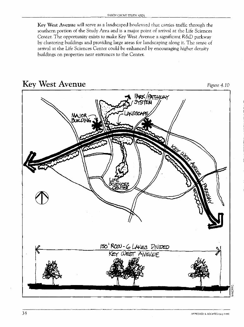
Key West Avenue will serve as a landscaped boulevard that carries traffic through the southern portion of the Study Area and is a major point of arrival at the Life Sciences Center. The opportunity exists to make Key West Avenue a significant R&D parkway by clustering buildings and providing large areas for landscaping along it. The sense of arrival at the Life Sciences Center could be enhanced by encouraging higher density buildings on properties near entrances to the Center.
Key West Avenue Figure 4.10
0 c.. c.. 0 z .___ _____________________________________ __.:;
34 APPROVED & ADOPTED July 1990
;:: z C) "tl "tl
SHADY GROVE STUDY AREA: Land Use and Design Objectives
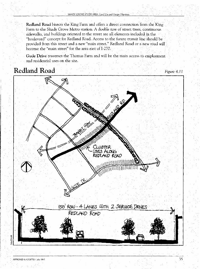
Redland Road bisects the King Farm and offers a direct connection from the King Farm to the Shady Grove Metro station. A double row of street trees, continuous sidewalks, and buildings oriented to the street are all elements included in the "boulevard" concept for Redland Road. Access to the future transit line should be provided from this street and a new "main street." Redland Road or a new road will become the "main street" for the area east of 1-270.
Gude Drive traverses the Thomas Farm and will be the main access to employment and residential uses on the site.
Redland Road Figure 4.11
o,..__ __________________________________ -.1
APPROVED & ADOPTED July 1990 35
SHADY GROVE STUDY AREA
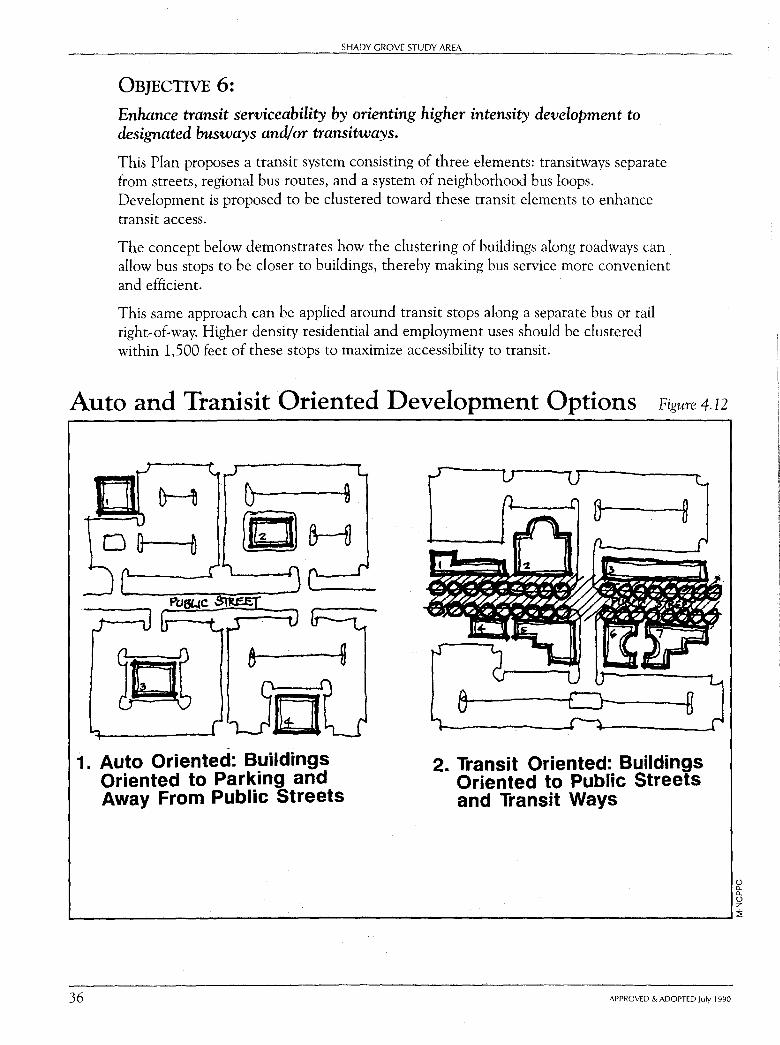
OBJECTIVE 6: Enhance transit serviceability by orienting higher intensity development to designated busways and/or transitways.
This Plan proposes a transit system consisting of three elements: transitways separate from streets, regional bus routes, and a system of neighborhood bus loops. Development is proposed to be clustered toward these transit elements to enhance transit access.
The concept below demonstrates how the clustering of buildings along roadways can . allow bus stops to be closer to buildings, thereby making bus service more convenient and efficient.
This same approach can be applied around transit stops along a separate bus or rail right~of~way. Higher density residential and employment uses should be clustered within 1,500 feet of these stops to maximize accessibility to transit.
Auto and Tranisit Oriented Development Options Figure 4.12
H
- --
1. Auto Oriented: Buildings Oriented to Parking and Away From Public Streets
2. Transit Oriented: Buildings Oriented to Public Streets and Transit Ways
0 0. 0. 0 z ...._ ___________________________________ .......... ::;;
36 APPROVED & ADOPTED July 1990
SHADY GROVE STUDY AREA: Lmd Use and Design Objectives
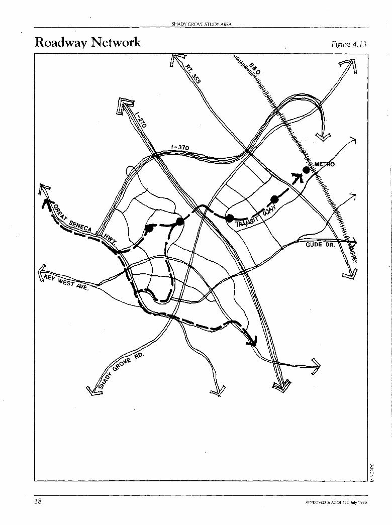
OBJECTIVE 7: Provide a roadway network which, in conjunction with the proposed transit system, will adequately serve the planned land uses at acceptable levels of service.
A generalized map of the highway network proposed for the Study Area is shown in Figure 4.13, page 38.
As part of this planning process, the roadway network (in conjunction with the transit system) has been tested in relation to anticipated long-term development patterns. This analysis projects that levels of service for the entire Gaithersburg Vicinity area will be acceptable, assuming increased transit service. In other words, additional capacity in the future will largely hinge upon public transportation and transportation management measures that reduce congestion to acceptable levels of service.
APPROVED & ADOPTED July 1990 37
SHADY GROVE STUDY AREA
Roadway Network Figure 4.13
0 (l_ (l_
0 z L-------------------------------------------'i
38 APPROVED & ADOPTED July 1990
SHADY GROVE STUDY AREA: Land Use and Design Objectives
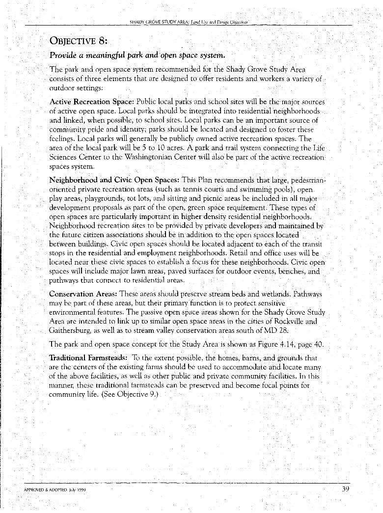
OBJECTIVE 8: Provide a meaningful park and open space system.
The park and open space system recommended for the Shady Grove Study Area consists of three elements that are designed to off er residents and workers a variety of outdoor settings:
Active Recreation Space: Public local parks and school sites will be the major sources of active open space. Local parks should be integrated into residential neighborhoods and linked, when possible, to school sites. Local parks can be an important source of community pride and identity; parks should be located and designed to foster these feelings. Local parks will generally be publicly owned active recreation spaces. The area of the local park will be 5 to 10 acres. A park and trail system connecting the Life Sciences Center to the Washingtonian Center will also be part of the active recreation spaces system.
Neighborhood and Civic Open Spaces: This Plan recommends that large, pedestrianoriented private recreation areas (such as tennis courts and swimming pools), open play areas, playgrounds, tot lots, and sitting and picnic areas be included in all major development proposals as part of the open, green space requirement. These types of open spaces are particularly important in higher density residential neighborhoods. Neighborhood recreation sites to be provided by private developers and maintained by the future citizen associations should be in addition to the open spaces located between buildings. Civic open spaces should be located adjacent to each of the transit stops in the residential and employment neighborhoods. Retail and office uses will be located near these civic spaces to establish a focus for these neighborhoods. Civic open spaces will include major lawn areas, paved surfaces for outdoor events, benches, and pathways that connect to residential areas.
Conservation Areas: These areas should preserve stream beds and wetlands. Pathways may be part of these areas, but their primary function is to protect sensitive environmental features. The passive open space areas shown for the Shady Grove Study Area are intended to link up to similar open space areas in the cities of Rockville and Gaithersburg, as well as to stream valley conservation areas south of MD 28.
The park and open space concept for the Study Area is shown as Figure 4.14, page 40.
Traditional Farmsteads: To the extent possible, the homes, barns, and grounds that are the centers of the existing farms should be used to accommodate and locate many of the above facilities, as well as other public and private community facilities. In this manner, these traditional farmsteads can be preserved and become focal points for community life. (See Objective 9.)
APPROVED & ADOPTED July 1990 39
--------------SHADY GROVE STUDY AREA
Park and Open Space System
Active Open Spaces
Local Parks
School Sites
ar-, •
Conservation Areas
Transit Station/ Civic Open Spaces
Figure 4.14
@NORTH (.) 0.. 0.. 0 z 1..-----------------------------------------':;;
40 APPROVED & ADOPTED July 1990
SHADY GROVE STUDY AREA: wnd Use and Design Objectives
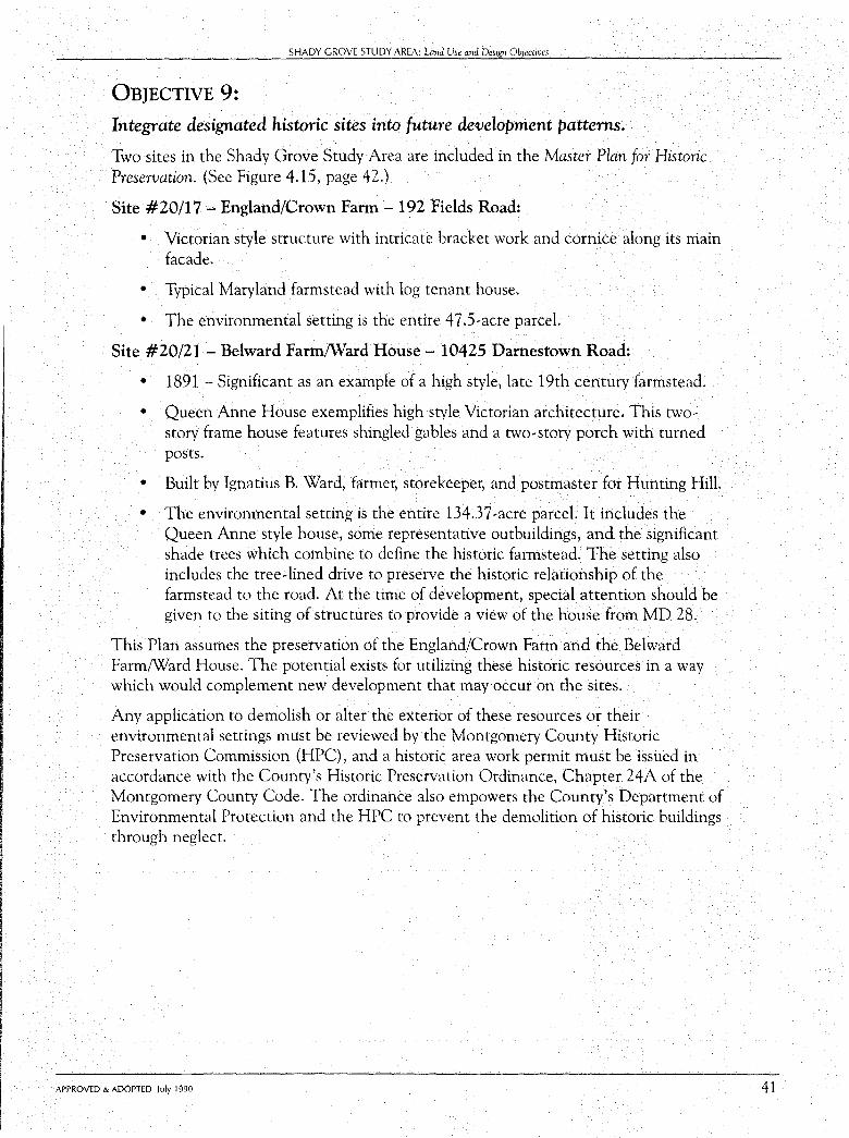
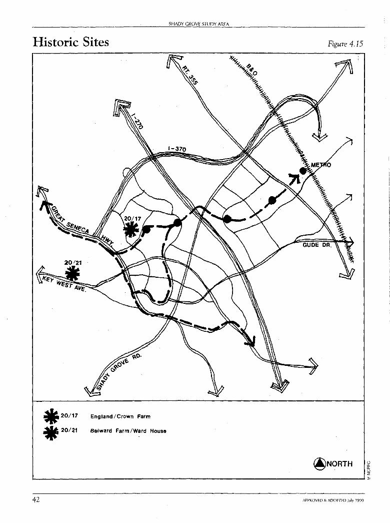
OBJECTIVE 9: Integrate designated historic sites into future development patterns.
Two sites in the Shady Grove Study Area are included in the Master Plan for Historic Preservation. (See Figure 4.15, page 42.)
Site #20/1 7 - England/Crown Farm - 192 Fields Road:
• Victorian style structure with intricate bracket work and cornice along its main facade.
• Typical Maryland farmstead with log tenant house.
• The environmental setting is the entire 4 7 .5-acre parcel.
Site #20/21 - Belward Farm/Ward House - 10425 Damestown Road:
• 1891 - Significant as an example of a high style, late 19th century farmstead.
• Queen Anne House exemplifies high style Victorian architecture. This twostory frame house features shingled gables and a two-story porch with turned posts.
• Built by Ignatius B. Ward, farmer, storekeeper, and postmaster for Hunting Hill.
• The environmental setting is the entire 134.3 7-acre parcel. It includes the Queen Anne style house, some representative outbuildings, and the significant shade trees which combine to define the historic farmstead. The setting also includes the tree-lined drive to preserve the historic relationship of the farmstead to the road. At the time of development, special attention should be given to the siting of structures to provide a view of the house from MD 28.
This Plan assumes the preservation of the England/Crown Farm and the Belward Farm/Ward House. The potential exists for utilizing these historic resources in a way which would complement new development that may occur on the sites.
Any application to demolish or alter the exterior of these resources or their environmental settings must be reviewed by the Montgomery County Historic Preservation Commission (HPC), and a historic area work permit must be issued in accordance with the County's Historic Preservation Ordinance, Chapter 24A of the Montgomery County Code. The ordinance also empowers the County's Department of Environmental Protection and the HPC to prevent the demolition of historic buildings through neglect.
APPROVED & ADOPTED July 1990 41
Historic Sites
.20/17
• 20/21
England/Crown Farm
Belward Farm /Ward House
SHADY GROVE STUDY AREA
Figure 4.15
@NORTH (.) 0.. 0.. (.) z '-------------------------------------------'::;
42 APPROVED & ADOPTED July 1990
SHADY GROVE STUDY AREA: Land U.se and Design Objectives
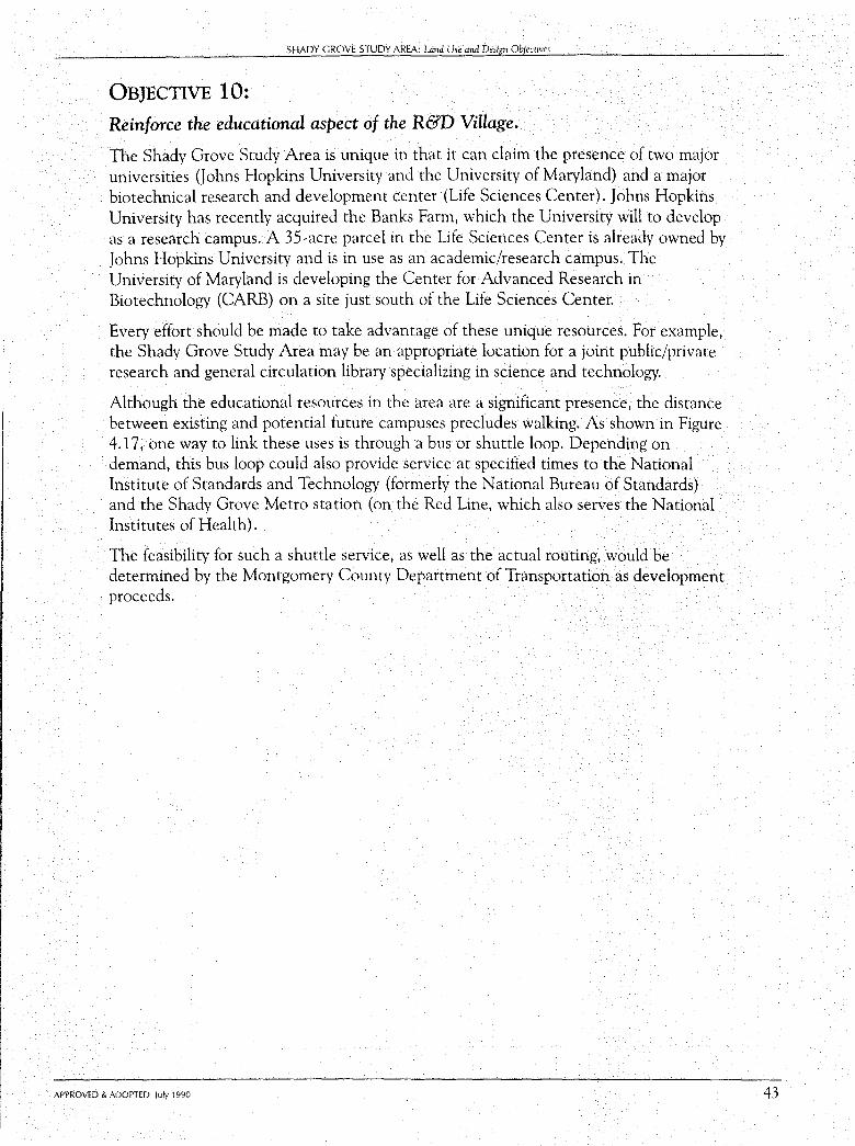
OBJECTIVE 10: Reinforce the educational aspect of the R&D Village.
The Shady Grove Study Area is unique in that it can claim the presence of two major universities Oohns Hopkins University and the University of Maryland) and a major biotechnical research and development center (Life Sciences Center). Johns Hopkins University has recently acquired the Banks Farm, which the University will to develop as a research campus. A 35-acre parcel in the Life Sciences Center is already owned by Johns Hopkins University and is in use as an academic/research campus. The University of Maryland is developing the Center for Advanced Research in Biotechnology (CARB) on a site just south of the Life Sciences Center.
Every effort should be made to take advantage of these unique resources. For example, the Shady Grove Study Area may be an appropriate location for a joint public/private research and general circulation library specializing in science and technology.
Although the educational resources in the area are a significant presence, the distance between existing and potential future campuses precludes walking. As shown in Figure 4.17, one way to link these uses is through a bus or shuttle loop. Depending on demand, this bus loop could also provide service at specified times to the National Institute of Standards and Technology (formerly the National Bureau of Standards) and the Shady Grove Metro station (on the Red Line, which also serves the National Institutes of Health).
The feasibility for such a shuttle service, as well as the actual routing, would be determined by the Montgomery County Department of Transportation as development proceeds.
APPROVED & ADOPTED July 1990 43
SHADY GROVE STUDY AREA
Potential Shuttle Bus Route to Link Educational Facilities Figure 4.16
() 0. ll. () z 1.---------------------------------- ~
44 APPROVED & ADOPTED July 1990
SHADY GROVE STUDY AREA: umd Use ana Design Objectives
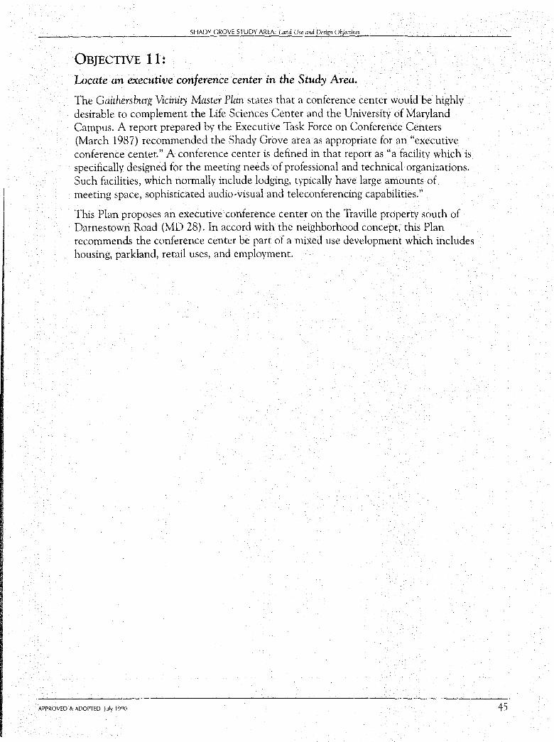
OBJECTIVE 11: Locate an executive conference center in the Study Area.
The Gaithersburg Vicinity Master Plan states that a conference center would be highly desirable to complement the Life Sciences Center and the University of Maryland Campus. A report prepared by the Executive Task Force on Conference Centers (March 1987) recommended the Shady Grove area as appropriate for an "executive conference center." A conference center is defined in that report as "a facility which is specifically designed for the meeting needs of professional and technical organizations. Such facilities, which normally include lodging, typically have large amounts of meeting space, sophisticated audio-visual and teleconferencing capabilities."
This Plan proposes an executive conference center on the Traville property south of Darnestown Road (MD 28). In accord with the neighborhood concept, this Plan recommends the conference center be part of a mixed use development which includes housing, parkland, retail uses, and employment.
APPROVED & ADOPTED July 1990 45
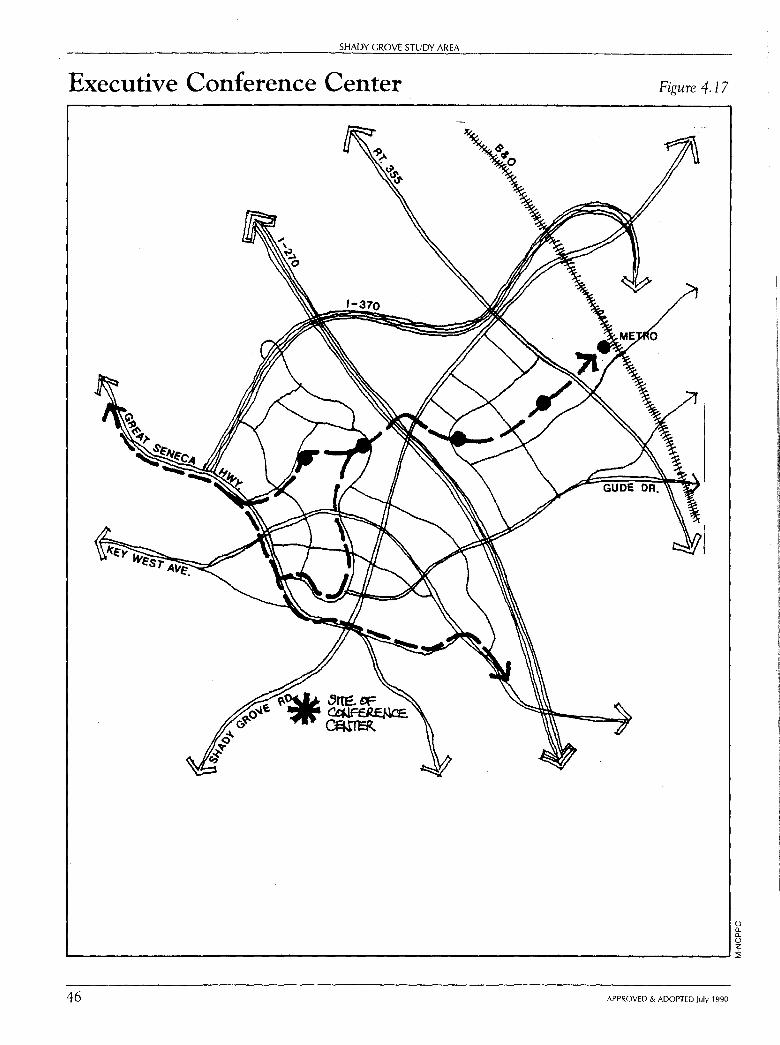
SHADY GROVE STUDY AREA
Executive Conference Center Figure 4.17
0 Q. Q. 0 z
'----------------------------------------- ::i;
46 APPROVED & ADOPTED July 1990
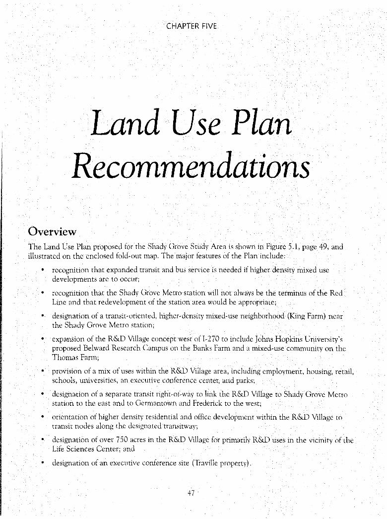
CHAPTER FIVE
Land Use Plan Recommendations
Overview The Land Use Plan proposed for the Shady Grove Study Area is shown in Figure 5.1, page 49, and illustrated on the enclosed fold-out map. The major features of the Plan include:
• recognition that expanded transit and bus service is needed if higher density mixed use developments are to occur;
• recognition that the Shady Grove Metro station will not always be the terminus of the Red Line and that redevelopment of the station area would be appropriate;
• designation of a transit-oriented, higher-density mixed-use neighborhood (King Farm) near the Shady Grove Metro station;
• expansion of the R&D Village concept west of I-270 to include Johns Hopkins University's proposed Belward Research Campus on the Banks Farm and a mixed-use community on the Thomas Farm;
• provision of a mix of uses within the R&D Village area, including employment, housing, retail, schools, universities, an executive conference center, and parks;
• designation of a separate transit right-of-way to link the R&D Village to Shady Grove Metro station to the east and to Germantown and Frederick to the west;
• orientation of higher density residential and office development within the R&D Village to transit nodes along the designated transitway;
• designation of over 7 50 acres in the R&D Village for primarily R&D uses in the vicinity of the Life Sciences Center; and
• designation of an executive conference site (Traville property).
47

48
SHADY GROVE STUDY AREA
Employment and Housing Characteristics The land use pattern proposed for the Shady Grove Study Area has the following employment and housing characteristics:
Summary of Employment and Housing Characteristics in Shady Grove Study Area
Existing/Committed Proposed TOTAL (rounded)
Employment (Sq.Ft. of Gross Floor Area)
11,625,000 13,225,000 24,850,000
Table 5.1
Housing (Number of Dwelling Units )
2,600 8,350
10,950
In keeping with the R&D Village concept as advocated in the 1985 Gaithersburg Vicinity Master Plan, this Plan proposes a significant amount of employment uses.
As can be seen in Table 5 .1, the Plan recommends more than 24 million square feet of employment. It should be noted that over 11 million square feet already exist, are under construction, or have been approved for development. The amount of square footage proposed in this Plan is difficult to visualize. For purposes of comparison, development in the Bethesda Central Business District and the Silver Spring Central Business District together totals 19 million square feet. As shown in Figure 5.2, page 50, however, the CBDs represent a much smaller geographic area than the Shady Grove Study Area.
In terms of residential uses, the Plan proposes a total of about 11,000 dwelling units. For purposes of comparison, this is about the same amount of housing now located in North Bethesda (13,000 units) and in all of Gaithersburg West (12,000).
Housing Types In terms of housing type, the types of units proposed by the Plan are shown in
Table 5.2.
Summary of Housing Types in Shady Grove Study Area Table 5.2
Existini:; % Protio§ed % Total%
Detached 64 (2%) 1,060 (13%) 1,124 (10%) Attached 900 (35%) 1,310 (16%) 2,210 (20%) Garden/Mid-Rise 1,404 (55%) 4,330 (52%) 5,734 (50%) High-Rise 209 (8%) 1,650 (20%) 1.859 (20%) Total Units (rounded) 2,600 8,350 10,900
Note: The mix of housing types will be determined at site plan for individual properties. The mix shown in this table reflects Master Plan policies that a range of housing types be provided.
APPROVED & ADOPTED July 1990
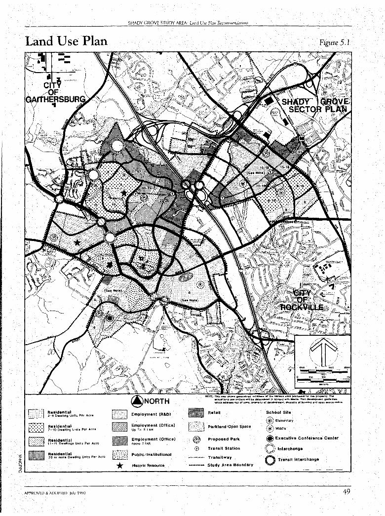
Land Use Plan
LLlliJ D ~
Resldenllal 2-e Dwelling Units Per Acre
Ruldential 7-10 Dwelling Unil& Per Acre
Ruldential 11-19 Dwelling$ Units Por Acre
~ --~ - ~~:~dm~~~lg~•llmo units Per Acre ~id(~
SHADY GROVE STUDY AREA: L:md Use Plan Recommendations
Employment (R&D)
Employment (Office) Up To .5 FAA
Employment (Office) AboVe .5 FAA
Pub Ii c /Institutional
Historic Resource
-[3] @ ©
Figure 5.1
NOT£:. Thi• m1p .tiow• generttlii~ klc•tloft• ,,,, the va,tc;01 UMI propo1ed fOI' thi• proJWotty. n .. act11al t1no u11 p•tt•m wlN be d111,min.d 11"1 accord with M.,.t•r Pl1n d~elopment QUkt1llrMK which addr111 mill of u.t11, intfllslty of d,tvelopment, dlveralty of houalr,g and opfll 1p1c111 nHd-.
Retail
Parkland/Open Space
Proposed Park
Tranel! Station
Transitway
Study Area Boundary
School Site
@ El@mentary
® Middle
{i, Executive Conference Center
,,f'~, ~,,l,' Interchange
0 Transit Interchange
2000
'
~ * 251..... ________________________________________ .;...=======--J
APPROVED & ADOPTED July 1990 49
SHADY GROVE STUDY AREA
Comparison of Silver Spring and Bethesda CBD Land Areas to Shady Grove Study Area
CBD Central Business District
Figure 5.2
@NORTH () a. a. 0 z .__ ___________________________ ~:::;
50 APPROVED & ADOPTED July 1990
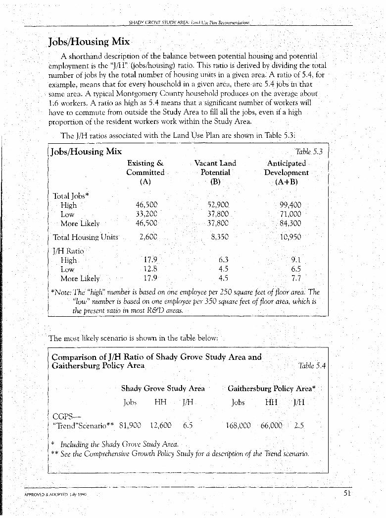
SHADY GROVE STUDY AREA: Land Use Plan Recommmdations
Jobs/Housing Mix A shorthand description of the balance between potential housing and potential
employment is the "J/H" (jobs/housing) ratio. This ratio is derived by dividing the total number of jobs by the total number of housing units in a given area. A ratio of 5.4, for example, means that for every household in a given area, there are 5.4 jobs in that same area. A typical Montgomery County household produces on the average about 1.6 workers. A ratio as high as 5.4 means that a significant number of workers will have to commute from outside the Study Area to fill all the jobs, even if a high proportion of the resident workers work within the Study Area.
The J/H ratios associated with the Land Use Plan are shown in Table 5.3:
Jobs/Housing Mix Table 5.3 Existing & Vacant Land Anticipated Committed Potential Development
(A) (B) (A+B)
Total Jobs* High 46,500 52,900 99,400 Low 33,200 37,800 71,000 More Likely 46,500 37,800 84,300
Total Housing Units 2,600 8,350 10,950
J/H Ratio High 17.9 6.3 9.1 Low 12.8 4.5 6.5 More Likely 17.9 4.5 7.7
*Note: The "high" number is based on one employee per 250 square feet of floor area. The "low" number is based on one employee per 350 square feet of floor area, which is the present ratio in most R&D areas.
The most likely scenario is shown in the table below:
Comparison of J/H Ratio of Shady Grove Study Area and Gaithersburg Policy Area Table 5.4
Shady Grove Study Area Gaithersburg Policy Area*
Jobs HH J/H Jobs HH J/H
CGPS-"Trend"Scenario** 81,900 12,600 6.5 168,000 66,000 2.5
* Including the Shady Grove Study Area. ** See the Comprehensive Growth Policy Study for a description of the Trend scenario.
APPROVED & ADOPTED July 1990 51
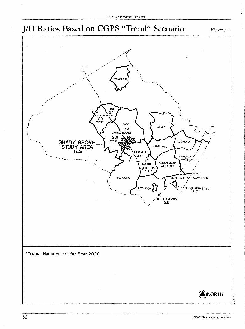
SHADY GROVE STUDY AREA
J/H Ratios Based on CGPS "Trend" Scenario
"Trend" Numbers are for Year 2020
SIL VER SPRING CBD
5.7
Figure 5.3
@NORTH 0 [L [L 0 z
L----------------------------------------------'::l:
52 APPROVED & ADOPTED July 1990
SHADY GROVE STUDY AREA: Lind Use Plan Recommendations
The most likely scenario is considered for three reasons: (1) present development is mostly office and on the high side, which will offset the rate of R&D employment, (2) developers of vacant parcels may have to scale down their plans in order to pass the local area review traffic test at time of subdivision, and (3) the average square footage per employee density experienced in R&D areas is presently the lower number and may be even lower in some university-related development.
As noted in the Plan Background chapter, a high J/H ratio County-wide would produce a very high level of congestion because many workers would presumably come from new ex-urban development. In any of the scenarios projected above, the Shady Grove Study Area will help contribute to a high County-wide J/H ratio. The magnitude of the effect will depend not only upon the amount of development proposed in Shady Grove, but also upon the amount of jobs and households proposed elsewhere in the County.
The effects of traffic congestion associated with a high J/H ratio can be mitigated with improved transit service and a change to a more balanced J/H ratio that is closer to the number of resident workers. The Shady Grove Study Area offers unique opportunities in terms of improved transit service for the following reasons:
The Shady Grove Metro station is within the Study Area.
- Transitways though the Study Area are proposed as a feature of the Plan.
- The opportunity exists in the Shady Grove Study Area to orient future land uses toward transitways.
One approach to achieve a lower J/H ratio would be to significantly increase housing units and reduce employment related uses.
This approach was evaluated early in the planning process. The results of that evaluation are presented below.
1. Reducing employment related uses could be accomplished by not designating any additional land for employment. This approach (which would not affect the 11 million square feet of floor area already committed in the area) would not capitalize on the features of the Study Area, which make it uniquely attractive to R&D firms, specifically the presence of two major universities and the Life Sciences Center.
2. Efforts to significantly increase housing would require densities resulting primarily in high-rise apartments. This approach would conflict with Master Plan objectives to provide a mix of housing types, including single-family detached units.
3. Although the likely jobs-to-housing ratio within the Study Area itself may be high, the job/housing ratio in the larger Gaithersburg Policy Area is expected to be significantly lower.
APPROVED & ADOPTED July 1990 53
54
SHADY GROVE STUDY AREA
Retail Recommendations The Planning Department staff has estimated the amount of neighborhood retail
space which could be supported in the Study Area based on the anticipated number of residents. Neighborhood retail convenience centers generally contain uses such as grocery stores, drug stores, restaurants, smaller eateries, ice cream parlors, and specialty fast foods. The average size of a neighborhood convenience center is approximately 100,000 square feet.
The retail analysis indicates retail demand would be strong enough to support a community shopping center in the southern portion of the Study Area. Public Hearing testimony by citizens from the surrounding residential areas supports this finding.
This Plan proposes a 100,000-square-foot shopping center be located on the Thomas Farm. Smaller amounts of retail square footage are proposed as part of the neighborhood concept for the Traville, Crown, and King properties.
Land Use Plan Recommendations by Property The vacant properties in the Study Area are identified in Figure 5.4, page 55.
As noted elsewhere in the Plan, most of the vacant properties in the Study Area are very large, varying in size from 130 acres to 450 acres. In accord with Plan objectives, a mix of uses is proposed on most of these large parcels. The neighborhood concept, with its emphasis on an attractive pedestrian environment, community focal points, interrelated streets, and a variety of housing types, has guided the Land Use Plan recommendations.
A key feature of the Land Use Plan is transit. This Plan assumes a strong public/private commitment to implementing transitways shown on the Plan. If such a commitment does not become a reality, then the land use recommendations for the Study Area will have to be re-examined.
The land use recommendations for the vacant properties are discussed below in two groupings. The Metro Area includes about 40 acres between the Metro station and MD 355 and the entire King Farm. Highest intensity uses occur at the Metro station. A less intense mix of residential, retail, and office uses are proposed for the King Farm.
The properties west of I-270 form the R&D Village. Highest intensity development occurs on those properties closest to I-270 and the proposed transitway. Less intense development, primarily of an R&D nature, is proposed for those properties located further south in the vicinity of the Life Sciences Center.
APPROVED & ADOPTED July 1990
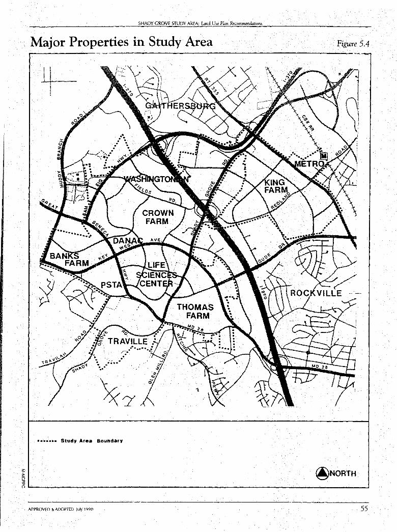
;;:: z ("') -n -n
SHADY GROVE STUDY AREA: Land Use Plan Recommendations
Major Properties in Study Area
I I
I l
1.
••••••• Study Area Boundary
Figure 5.4
@NORTH
nL....------------------------------------------' APPROVED & ADOPTED July 1990 55
56
SHADY GROVE STUDY AREA
Metro Area Properties
Shady Grove Metro Station
Acreage: 40 acres
Existing Land Use: Metro surface parking lot Low-density employment Retail center
Unique Features: •Within 1,500 feet of Shady Grove Metro • Adjoins County Solid Waste Disposal facility
Proposed Land Use Recommendations:
This Plan recommends that the Shady Grove Metro station's status as a "terminus" should change when transit is extended beyond Shady Grove toward Clarksburg. Presently, the Shady Grove Metro station is the first opportunity for patrons in the northern part of the County (north of Rockville) to board Metro. At present, the major land use policy at the Metro station is to provide significant amounts of parking for these patrons. The Shady Grove Sector Plan recommends that development around the station be low-intensity employment.
As transit service extends beyond Shady Grove, the character of the station and surrounding properties should be re-examined. This Plan proposes that an existing surface parking lot, located between the Metro station and MD 355, be considered for a mixed-use planned development.
The same opportunity for redevelopment is proposed for adjoining properties, now developed at relatively low intensities.
The Plan recommends high-density office uses (1.0 FAR) on the northwestern portion of the site adjoining the Montgomery County Solid Waste Disposal facility. Residential uses (50-65 dwelling units per acre) are proposed on the southeastern section of the site adjacent to the Metro station and along Redland Road. A range in density is proposed to allow 1,000 to 1,250 units. The higher density would be appropriate if residential structures are located in a manner compatible with the transfer station and if public and private places are provided to accommodate and encourage a variety of activities which support higher density residential development. The provision of structured parking would help provide needed space for these activities.
APPROVED & ADOPTED July 1990
SHADY GROVE STUDY AREA: Lmd Use Plan Recommendations
King Farm
Acreage: 440 acres
Existing Land Use: Agriculture
Unique Features: • Entire farm within one mile of Shady Grove Metro • Extensive frontage along MD 355 • Portion of farm (100 acres) lies within City of Rockville • Maximum Expansion Limits
Proposed Land V se Recommendations:
The Plan recommends a land use pattern which would achieve the following mix of uses:
Residential - 3,200 dwelling units (including MPDU's)
Retail/Commercial - 50,000 to 100,000 square feet
Employment - 3.0 to 3.4 million square feet (.3 to .75 FAR)·
All the employment and retail uses, as well as the majority of the higher density residential development, should be oriented to the transitway. Two transit stops are proposed as high density centers: One is predominantly residential, the other is predominantly employment.
The mix of residential housing types proposed for the King Farm reflects Plan objectives to concentrate development near transit but at the same time provide a variety of housing types. Care has been taken to designate densities on the Plan which will allow multi-family, attached, and detached units. Overall, this Plan proposes the following general mix of units for the King Farm:
Multi-family
Attached
Detached
- 70 to 80%
- 5 to 10%
10 to 20%
In accord with the neighborhood concept, a mix of detached, attached, and multifamily units is proposed between Redland Road and Gude Drive. The area adjoining the transitway should be predominantly multi-family.
This Plan recommends a total of 3 million square feet of employment uses. Approximately 2.1 million square feet are recommended to be located near the proposed transit stop closest to I-270.
The balance of square footage is proposed west of Piccard Drive Extended as R&D uses. This area is already characterized by employment and commercial uses.
Additional R&D employment (up to an additional 400,000 square feet) may be appropriate as "incubator" space if carefully integrated with residential and retail uses. The amount of additional R&D employment (if any) will depend upon its effect on the mix, intensity, and character of proposed residential areas.The park and open space network includes a local park, two school sites, conservation areas, and neighborhood
APPROVED & ADOPTED July 1990 57
58
SHADY GROVE STUDY AREA
park areas.
Two school sites are shown on the King Farm: a middle school (20 acres) and an elementary school (12 acres). The Land Use Plan identifies general locations for the schools but the actual sites will be determined during the development review process.
The location of the middle school shown on the Land Use Plan map would allow employees from adjoining office areas to use facilities such as the track and playfield when not programmed for school use. The location of the elementary school south of Redland Road would provide a community focal point for the residential area. Although shown as separate sites, consideration could be given to locating both schools together in a campus-like setting. These planning guidelines should be part of the final site selection process.
A number of arterial and industrial roadways are proposed for the King Farm. The ultimate alignment and character of two of these roadways-Pleasant Road (A-58) and Indianola Drive (A-52)- will be determined at time of subdivision and site plan review. The following land use and design objectives will help determine the location of these roadways:
Crossings of transitways should be minimized.
The location of the roadways and their design should be supportive of the Master Plan intent for a neighborhood, which is interconnected and pedestrian friendly.
The location and design of the roadways should not promote their use as an alternative to MD 355 as a through route.
Multiple residential access points should be permitted to foster the location of buildings along street frontage.
Proposed Development Guidelines:
The development guidelines are presented in relation to the five neighborhood elements identified as Plan objectives.
Mix of Uses
• Create two mixed use centers at the general locations shown in the Master Plan:
- A high-density employment center should be adjacent to the intersection of Piccard Drive and the transitway; small scale retail uses, and offices and civic spaces should be adjacent to the transit station; some residential uses may also be appropriate here.
A retail/residential center, with civic spaces adjacent to the transit stop, should be located along Redland Road between MD 355 and Gaither Road.
APPROVED & ADOPTED July 1990
SHADY GROVE STUDY AREA: umd Use Pwn Recommendations
Interconnected System of Streets
• Develop a "main street" as a focal point for the community with a concentration of higher intensity residential, retail, and employment uses. Pedestrian access should be provided from main street to transit stops.
• Develop Redland Road in accord with the cross-section shown in the Plan Objectives, which allows on-street parking.
• Provide a system of divided and undivided primary roads in accord with the guidelines contained in the Transportation Plan Chapter.
• Provide an interconnected system of secondary streets to provide multiple points of access to the surrounding major and arterial roads.
Street-Oriented Buildings
• Locate all retail, office, and residential buildings along street frontage.
• Encourage off-street parking to be located behind buildings.
Diversity of Housing Types
• Locate highest intensity of residential units adjacent to the transit stops and other roads designed for heavier traffic and that may be used as bus routes.
• Locate lowest density residential uses on the southern portion of the farm.
• Encourage a mix of unit types within each block.
Mix of Active and Passive Open Space Areas
• Provide active recreation areas at general locations shown on the Land Use Plan.
• Provide civic open spaces adjacent to each of the transit stops.
• Integrate neighborhood park facilities (such as tot lots, basketball courts, and tennis courts) throughout residential areas.
• Locate conservation areas along southern and northern property lines to preserve existing natural features and to re-enforce neighborhood boundary.
• Integrate the existing farmstead along Redland Road into the open space and community facilities pattern. To the extent possible, preserve the existing farmstead along MD 355 and integrate it into the employment development pattern.
APPROVED & ADOPTED July 1990 59
SHADY GROVE STUDY AREA
R&D Village Properties
Washingtonian Center
Acreage:
Existing Land Use:
Unique Features:
220 acres
Mixed use Washingtonian Center project under construction 209-unit Washingtonian Tower
• Frontage along I-270 • Existing ponds being expanded into lake
Proposed Land Use Recommendations:
This Plan confirms the 1985 Gaithersburg Vicinity Master Plan recommendations for this parcel which have guided the review and approval of the MXPD (Mixed Use Planned Development) Zone for the Washingtonian Center.
• Provide prestige "signature" office or research and development buildings.
• Respect the existence of the Washingtonian Tower and other adjoining communities in terms of site design quality and provide a vegetative buffer on the western edge of the Washingtonian Tower property.
• Mitigate the effects of noise from proposed I-370 through design and construction techniques.
• Provide vehicular access via the proposed loop and spine roads.
• Locate prestige "signature" buildings in the northwest portion of the site.
• Encourage decked or underground parking.
• Enhance existing ponds and landscaping.
• Retain or relocate existing vegetation to other areas on-site or along existing Fields Road.
• Retain trees along edge of proposed ramp from eastbound I-370 to southbound I-270.
• Locate the major focal-point building complex between the Washingtonian Tower and the existing motel.
• Encourage conference and hotel facilities.
• Encourage an interrelated development of office and residential uses; up to 1,500 residential units are envisioned by the Plan if residences are integrated throughout the site. The number should be reduced to approximately 750 units if residential development only occurs southwest of the Washingtonian Tower.
• Locate residential uses at a maximum density of 2 7 dwelling units per acre southwest of Washingtonian Tower.
60 APPROVED & ADOPTED July 1990
SHADY GROVE STUDY AREA: Land Use Plan Recommmda,ions
• Encourage a variety in the types and price range of residential 1;1-nits.
• Encourage a variety of heights in office and residential structures with highest intensity near the linear open space feature.
Crown Farm
Acreage:
Existing Land Use:
Unique Features:
180 acres
Agriculture
• Historic farmstead • Stream valley adjoins southern edge • Some significant tree stands
Proposed Land V se Recommendations:
The Plan recommends a land use pattern which would achieve the following mix of uses:
Residential - 2000 dwelling units
Retail/Commercial - 50,000 square feet
The Plan recommends a residential land use pattern which locates high-density housing near two proposed transit stops. The western portion of the farm is proposed for lower density housing in order to encourage a mix of apartments and attached and detached dwelling units.
This Plan proposes a total of 2,000 dwelling units on the Crown Farm. The majority of these units would be located near the transit stops and consist of multifamily units.
The balance of the housing would be located on the western portion of the farm. The housing mix suggested for this area is as follows:
Multi-family
Attached
Detached
40-50%
40-50%
10-20%
This Plan strongly encourages the provision of detached housing on the western portion of the Crown Farm, but the actual number that must be provided will be determined at time of subdivision and site plan review.
Small scale retail uses (approximately 50,000 square feet) would be appropriate near the transit stops if developed in concert with the residential uses.
A local park is proposed in the high-density residential area that adjoins the transit way. This approach should provide both residents and employees from nearby employment areas with recreational opportunities.
West of Decoverly Drive, an elementary school site will provide recreational facilities for residents. Adaptive re-use of the historic England Crown Farm as a
APPROVED & ADOPTED July 1990 61
62
SHADY GROVE STUDY AREA
community resource is strongly encouraged to provide another community focal point.
Proposed Development Guidelines:
The development guidelines are presented in relation to the five neighborhood elements identified as Plan objectives.
Mix of Uses
• Although this Plan proposes a residential community on the Crown Farm, the close proximity of over two million square feet of employment uses will allow residents in the area to live within walking distance of employment. To encourage and facilitate pedestrian access between the Crown Farm and adjoining employment, pathways and sidewalks should link the residential development with nearby office parks.
• A retail/higher density residential center, with civic spaces, should be located adjacent to a transit stop.
Interconnected System of Streets
• Provide a street network which links the two transit centers.
• Provide a primary road which links residential development west of Decoverly Drive to the transit centers; this road is not intended to function as an alternative to Fields Road or Decoverly Drive but to distribute local traffic movement through the neighborhood.
Street-Oriented Buildings
• Locate all retail and higher density residential buildings along street frontage.
• Encourage off-street parking to be located behind buildings.
Diversity of Housing Types
• Locate highest intensity of residential units adjacent to the transit stop and along Decoverly Drive and Fields Road.
• Encourage a mix of units types within each block.
Mix of Active and Passive Open Space Areas
•
•
•
•
Provide a large local park between Omega Drive and Decoverly Drive with a path system linking it to the Life Sciences Center and Washingtonian Center.
Provide civic spaces adjacent to each of the transit stations .
Integrate neighborhood park facilities (such as tot lots, basketball courts, and tennis courts) throughout residential areas.
Preserve the large area of trees and the small stream at the southern edge of the property.
APPROVED & ADOPTED July 1990
Life Sciences Center
Acreage:
Unique Features:
SHADY GROVE STUDY AREA: L:tnd Use Plan Recommendations
270 acres
• Johns Hopkins University and University of Maryland campuses and the Shady Grove Adventist Hospital located here
• Uses limited to life sciences research and supporting activities
Proposed Land V se Recommendations:
This Plan confirms the land use recommendations contained in the Shady Grove Life Sciences Center Development Plan Update, adopted by the County Council in September 1986. The current Development Plan creates a central core area of health care facilities. Educational and life sciences facilities are located on sites outside the central core. The Development Plan also encourages office/commercial and workerrelated retail development. This Master Plan supports future modification of the Development Plan to increase overall density to 0.5 FAR if the Plan's recommendation for a transitway loop around the Life Sciences Center is implemented.
Proposed Development Guidelines:
This Plan endorses the following site design-related development guidelines contained in the Life Sciences Center Development Plan Update:
• creation of a "commons" area to create a destination for pedestrians at the Center and to add a sense of place;
• designation of a "village street" to connect the front doors of the core facilities;
• extension of Blackwell Road across the core to Medical Center Drive;
• development of a comprehensive landscaping concept;
• creation of "gateways" to enhance the image of the Life Sciences Center; and
• orientation of buildings to the loop road to enhance the sense of arrival at key intersections.
Banks Farm Oohns Hopkins Belward Campus)
Acreage:
Unique Features:
APPROVED & ADOPTED July 1990
138 acres (150 acres if adjoining land in separate ownership is included)
• Historic farmstead • Tree-lined drive • Ownership by major university-Johns Hopkins University • Western portion lies in City of Gaithersburg Maximum
Expansion Limits (MEL)
63
SHADY GROVE STUDY AREA
Proposed Land Use Recommendations:
The Banks Farm occupies a strategic location along Key West Avenue. This Plan designates the Banks Farm as a component of the R&D Village to be developed as a research campus containing R&D uses, 50 university-related residences, and recreational uses. Higher density uses should be concentrated in the eastern part of the site, and buildings should be clustered along Key West Avenue and near the proposed transit station in the northeast section of the property.
The western portion of the farm (108 acres) fronts MD 28 and is surrounded by residential uses to the south (Potomac Subregion Master Plan) and to the east (City of Gaithersburg). The historic farmhouse is also located here. Development of this portion of the Bel ward Campus should be of a scale and intensity compatible with adjoining residential neighborhoods.
To help provide activity on the site after work hours and on weekends, nonemployment uses should be provided. This Plan recommends 50 university-related residences (which would be incidental and subordinate to the R&D campus) as well as recreational facilities and a private local park.
Proposed Development Guidelines:
• To assure that the early phases of development of the Belward Campus occur in the context of a unified concept plan for the entire Banks Farm, this Plan directs that a generalized concept plan for the entire farm be submitted at time of subdivision if any portion of the property is to be developed under the Optional Method of Development at a 0.5 FAR. This Plan, however, strongly encourages the submission of a concept plan, even if the entire property is developed at 0.3 FAR. The Plan's recommendation for 0.5 FAR on the eastern portion of the farm is dependent on the preparation of the generalized concept plan.
• Cluster employment development towards two site features:
Key West Avenue, a Plan designated "main street" and busway; and
the transitway as shown on the Master Plan.
• Provide a comprehensive system of pathways and sidewalks to provide easy and convenient access to the proposed transit stop and to Key West Avenue, a high priority regional bus route.
• Maintain significant views of the historic farmhouse from MD 28.
• Maintain 100-foot buffer along Damestown Road to enhance entry into R&D Village to help provide transition to residential units south of MD 28 and to provide an attractive setting for the Belward farmhouse.
• The main vehicular and pedestrian entrance should be via Key West Avenue or Darnestown Road, rather than Muddy Branch Road.
64 APPROVED & ADOPTED July 1990
Traville
Acreage
Unique Features:
SHADY GROVE STUDY AREA: Lmd Use Plan Recommendations
192 acres
• Located at the headwaters of Piney Branch • Characterized by many environmentally related
development constraints • Adjoins the University of Maryland Center for Advanced
Research in Bio-Technology (CARB)
Proposed Land Use Recommendations:
The 1985 Gaithersburg Vicinity Master Plan identifies the Traville property as the recommended location for a conference center. The Plan states:
"The major planning issue regarding this property is whether R&D uses should accompany a conference center since this area is designated as residential by the County's General Plan since it marks the beginning of the rural "wedge" area of Potomac. The relationship of R&D uses to the General Plan recommendation must be explored in more detail as part of a future Master Plan Amendment. For this reason, this Plan designates this area for low-to-moderate-intensity employment but recommends that the existing residential zoning (R-200) be continued until a Master Plan Amendment is completed. That Amendment will examine the appropriate mix, type, and intensity of residential and employment uses; the capacity of the Master Plan road network to accommodate such uses; and the relationship of employment uses to surrounding residential areas."
This Plan confirms the recommendation of the 1985 Gaithersburg Vicinity Master Plan that a conference center be located at Traville but proposes that such a conference center be developed as part of a mixed use neighborhood in the R&D village. The mix of uses proposed for the site include:
Executive conference center with a hotel;
R&D and some office uses;
Small scale retail uses;
Housing (including housing for low- to moderate-income households to help meet County housing goals)
Comprehensive natural open space system which preserves and protects the site's environmental features; and
Active open space network which provides recreational opportunities for residents, workers, and conference center visitors.
This Plan designates a transitway along the portion of Darnestown Road which forms the northern edge of the Traville site. It is also recommended that the area be served by a neighborhood bus loop and shuttle bus linking the transitway, conference center, and other educational and institutional facilities in the R&D Village. (See
APPROVED & ADOPTED July 1990 65
SHADY GROVE STUDY AREA
Transit Plan, Figures 7.3 and Objective 10.) The future availability of transit increases the attractiveness of Traville as a conference center/employment/residential area. To the maximum extent possible, development should be located to enhance convenient access to the transitway and bus loop. For those parts of the site more distant from transit, a comprehensive system of pathways and sidewalks should be provided to facilitate pedestrian access to transit.
The land use pattern proposed for Traville incorporates the following mix of uses:
• Up to 750 dwelling units, of which one-third will be affordable to low- and moderate-income households.
• A total of 1,500,000 square feet of nonresidential uses to include office, R&D, retail, and an executive conference center.
• A local park is proposed not just for the residents and workers on the Traville site, but for neighboring subdivisions as well. The park should include enough developable acreage to allow at least a regulation size soccer field.
The land use pattern proposed for Traville will achieve two public policy objectives: the provision of housing for low-to-moderate income households and the construction of an executive conference center. At the same time, this Plan continues to recognize that Traville marks the beginning of the "wedge" area of Potomac. To ensure a compatible transition from the Traville project to adjoining low density residential areas, development plans for Traville will be carefully reviewed in terms of the character, intensity, and mix of uses at the southern portion of the property.
Because this Plan proposes a mix of uses for Traville, a zoning approach which would require a comprehensive plan for the entire property is recommended. The Plan's recommendations regarding the amount of nonresidential uses (1,500,000 square feet) would be dependent on provision of a conference center and housing.
Proposed Development Guidelines:
• Recommend that the development plan for Traville reflect a strong transit orientation;
• Recommend that development not exceed a total of 750 dwelling units, onethird of which should be affordable to low- and moderate-income households;
• Recommend a total of 1,500,000 square feet of nonresidential uses to include office, R&D, retail, and an executive conference center;
• Recommend that employment uses be dependent on provision of a conference center and housing;
• Incorporate the Master Plan neighborhood design elements into the site design;
• Recommend residential development bear a close relationship to the employment uses and conference center;
• Provide an overall open space network which has the following characteristics:
66 APPROVED & ADOPTED July 1990
SHADY GROVE STUDY AREA: Land Use Plan Recommendations
Preservation of wetlands,
Pedestrian connections to the school planned just south of the Traville site, and
"Connectivity" through the site allowing pedestrian movement among all the uses;
• Incorporate the environmental protection features detailed in the Piney Branch Sewer Development Guidelines which are part of the Comprehensive Water Supply and Sewerage Systems Plan;
• Recommend that a road system which links Traville to the Center for Advanced Research and Bio-Technology (CARB) be explored;
• Provide a hierarchy of internal streets in accord with the primary road guidelines contained in the Transportation Chapter; and
• Provide a comprehensive system of pathways and sidewalks to provide easy and convenient access to the Plan-designated transitway and bus loops.
Public Service Training Academy (PSTA) Area
Acreage:
Unique Features:
75 acres (includes numerous privately owned parcels fronting MD 28)
• Public Service Training Academy (52 acres) • Numerous individual lots fronting Darnestown Road (total
of 23 acres)
Proposed Land Use Recommendations:
This property is a critical element in the R&D employment "main street" concept. Along with the Johns Hopkins University property, County-owned land at this locale will form the western "gateway" into the R&D Village.
In terms of the County-owned property, this Plan envisions the continued operation of the Public Service Training Academy (PSTA) for the foreseeable future. No change to the existing uses is proposed for the area. However, any expansion of facilities at the PSTA should take into account this site's important gateway location.
In terms of the 23 acres that are privately owned in this area, the entire frontage along MD 28 is divided into numerous parcels-all of which have driveway access to Darnestown Road (MD 28), a four-lane, undivided highway.
The challenge this Plan must address is how to promote the coordinated development of the Darnestown Road frontage in light of the fragmented ownership pattern.
This Plan proposes the following strategy:
1. Encourage the joint redevelopment of parcels fronting MD 28 by designating the area as suitable for 8 units/acre.
APPROVED & ADOPTED July 1990 67

SHADY GROVE STUDY AREA
2. Recommend that a density of 8 units/acre be allowed only if a,ccess is from a new frontage service road along MD 28.
3. Even if redevelopment of the parcels along MD 28 does not occur, the possibility of providing a service road for access to these lots should be explored.
4. Acquisition of the frontage lots for public use should be considered due to the proximity of the lots to the Public Service Training Academy, the potential need for public facilities in this area, and the opportunity for unified redevelopment of the area if in public ownership.
A small amount of privately owned land at the intersection of Key West Avenue and Darnestown Road is recommended for R&D uses in accord with the Key West Avenue employment concept.
Proposed Development Guidelines:
• For the small amount of privately owned acreage (Tropea property) recommended for R&D, access should be via Key West Avenue and buildings should also be oriented to Key West Avenue.
• For the frontage along Darnestown Road, assemblage of properties is encouraged to allow comprehensive redevelopment, served by a frontage road, in accord with the land use recommendations.
Danae
Acreage:
Unique Feature:
36 acres
• Affected by four roadways and the transitway
Proposed Land Use Recommendations:
The Danae property is part of the Key West Avenue employment corridor. This Plan recommends the entire parcel as suitable for light industrial office uses. Since this site will be heavily impacted by road and transit, taller office buildings are appropriate here.
Proposed Development Guidelines:
• Encourage clustering of development toward Key West Avenue.
• Encourage taller building(s) at the portion of the site nearest to Diamondback Drive to create a visual focal point midway along Key West Avenue.
68 APPROVED & ADOPTED July 1990
Johnson/Tyner
Acreage
SHADY GROVE STUDY AREA: Land Use Plan Recommendations
15.7
Unique Feature: • Contiguous to Life Sciences Center
Proposed Land Use Recommendation:
This property is located adjacent to the Life Sciences Center. The extension of Blackwell Road will provide direct access to the Life Sciences Center. This Plan recommends the property as suitable for R&D employment at a scale and density compatible with the Life Sciences Center.
Proposed Development Guidelines:
• Recommend clustering of buildings toward Blackwell Road Extended and not Shady Grove Road.
Thomas Farm
Acreage:
Unique Features:
270 acres
• Attractive grouping of farm buildings • Entire farm located in City of Rockville Maximum
Expansion Limits (MEL)
The Thomas Farm lies entirely within the Maximum Expansion Limits adopted by the City of Rockville. If the City annexes the Thomas Farm, it will then be served by the City's public water and sewer. It should be noted that implementation of the Land Use Plan (see Zoning Plan Recommendations Chapter) includes TDR zoning designations. As stated in the Gaithersburg Vicinity Master Plan:
"The citizens of the cities share in the benefits of the County's efforts to preserve agricultural and open space. The 'wedges and corridor' concept as stated in the General Plan assumes development in the 'wedges.' The Transfer of Development Rights program is a logical tool to accomplish this objective and should not be limited to corridor areas within the County and not within the cities. The County will, therefore, continue to recommend to the cities that they require the use of TD R's in their annexation agreements when TDR receiving areas are involved. In the absence of such requirement, the Plan recommends that upon annexation of such parcels, the County Council not concur in zoning densities greater than the base density shown in the Master Plan. For purposes of the requirements in Article 23-A, subsection 9(c) of the Maryland Annotated Code, the Master Plan land use shall be considered to be the base density."
Proposed Land Use Recommendations:
• Recommend 70 acres along both sides of Key West Avenue as suitable for employment uses to develop the employment "main street."
APPROVED & ADOPTED July 1990 69
70
SHADY GROVE STUDY AREA
• Recommend lower density R&D employment uses (0.3 FAR) on 40 to 50 acres east of Shady Grove Road to complement similar R&D uses west of Shady Grove Road in the Life Sciences Center. South of Gude Drive, employment uses should be oriented to Shady Grove Road.
• Recommend a mixed use neighborhood of 950 dwelling units and a neighborhood retail center.
• Recommend a neighborhood retail center be located along Gude Drive to meet retail needs of workers and residents.
• Recommend a mix of housing types (detached, attached, multi-family) on the balance of the property at a density of 6 units/acre.
• If feasible, a bus transit loop should link this area with the Life Sciences Center and proposed transitway on Medical Center Drive. (See Figure 7.3.)
• Higher density residential units should be located along Gude Drive near the retail center and bus loop. If a subregional transitway linking Shady Grove south to Montrose Road is adopted, an alignment traversing the northern portion of the site to serve these higher density uses should be considered. The feasibility of this transitway will be studied as part of a Countywide transit planning effort by M-NCPPC.
Proposed Development Guidelines:
• Encourage a development pattern which embraces the neighborhood concept.
• Encourage coordinated development of residential and retail uses.
• The approximate mix of residential units should be as follows:
Multi-family - 40-50%
Attached - 25-35%
Detached 20-30%
• Re-affirm the development guidelines contained in the 1985 Gaithersburg Vicinity Master Plan:
Preserve the scenic beauty of the farmhouse and drive by clustering new development away from them.
Provide wet stormwater management ponds in two valleys near the eastern edge of the farm.
Provide access from MD 28 and Shady Grove Road (at Life Sciences Center entrance).
Retain the woods in the stream valleys.
Locate the stormwater management ponds upstream from the woods in the valley.
APPROVED & ADOPTED July 1990
SHADY GROVE STUDY AREA: Lmd Use Plan Recommendations
Protect steep slopes and stream valleys.
Provide noise attenuation by devices such as landscaped berms along Shady Grove Road, MD 28, and proposed Key West Avenue Extended.
Build lower density residential in the southern part of the site along MD 28 to maintain the existing visual character along that roadway.
Provide a comprehensive system of pathways and sidewalks to provide easy and convenient access to Key West Avenue and Gude Drive (proposed as high priority regional bus routes) and to the transitway proposed along Darnestown Road.
Provide strong pedestrian connections between employment, residential, and retail uses.
Provide a primary roadway connection between Gude Drive and Darnestown Road; the location of the roadway will be determined at time of subdivision.
• Use Gude Drive Extended and Blackwell Road Extended to connect and integrate the retail center, the proposed school site, the farmstead, and employment and higher density residential uses.
• Design Gude Drive in the same manner as Redland Road.
APPROVED & ADOPTED July 1990 71
CHAPTER SIX
Zoning Plan
Zoning Plan Objectives • To encourage the coordinated planning and design of large parcels in accord with the
neighborhood concept advocated in the Plan.
• To encourage a mix of uses within neighborhoods as advocated in the Plan.
• To examine the need for a new zone which will allow better implementation of the mixed use neighborhood concept in the Plan.
• To encourage R&D uses in the vicinity of the Life Sciences Center.
• To encourage a high density mix of office and residential uses at the Shady Grove Metro station.
• To defer preparation and adoption of the Sectional Map Amendment until one of the following events occur:
- construction funds for the northern transitway and the Life Sciences Center transit spur are programmed by either the State or County;
- operating funds for an interim transit plan are identified; or
- a development district is approved.
• To defer consideration of floating zone applications until one of the events listed above occur.
Zoning Plan Recommendations The zoning pattern in the Study Area as of 1990 is shown in Figure 6.1, page 7 4.
73
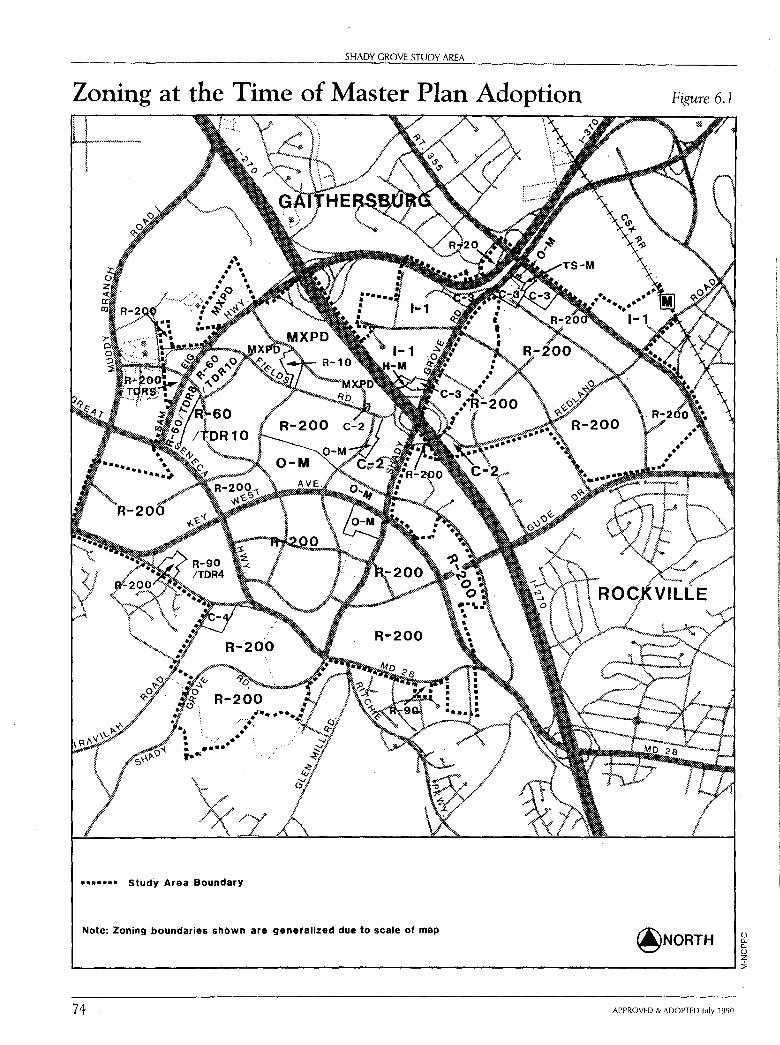
SHADY GROVE STUDY AREA
Zoning at the Time of Master Plan Adoption
••••u• Study Area Boundary
Note: Zoning boundaries shown are generalized due to scale of map
Figure 6.1
@NORTH () 0.. 0.. () z L--------------------------------------------------1:i;
74 APPROVED & ADOPTED July 1990
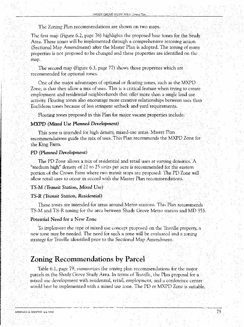
SHADY GROVE STUDY AREA: Zoning Plan
The Zoning Plan recommendations are shown on two maps.
The first map (Figure 6.2, page 76) highlights the proposed base zones for the Study Area. These zones will be implemented through a comprehensive rezoning action (Sectional Map Amendment) after the Master Plan is adopted. The zoning of many properties is not proposed to be changed and these properties are identified on the map.
The second map (Figure 6.3, page 77) shows those properties which are recommended for optional zones.
One of the major advantages of optional or floating zones, such as the MXPD Zone, is that they allow a mix of uses. This is a critical feature when trying to create employment and residential neighborhoods that offer more than a single land use activity. Floating zones also encourage more creative relationships between uses than Euclidean zones because of less stringent setback and yard requirements.
Floating zones proposed in this Plan for major vacant properties include:
MXPD (Mixed Use Planned Development)
This zone is intended for high density, mixed-use areas. Master Plan recommendations guide the mix of uses. This Plan recommends the MXPD Zone for the King Farm.
PD (Planned Development)
The PD Zone allows a mix of residential and retail uses at varying densities. A "medium high" density of 22 to 25 units per acre is recommended for the eastern portion of the Crown Farm where two transit stops are proposed. The PD Zone will allow retail uses to occur in accord with the Master Plan recommendations.
TS-M (Transit Station, Mixed Use)
TS-R (Transit Station, Residential)
These zones are intended for areas around Metro stations. This Plan recommends TS-Mand TS-R zoning for the area between Shady Grove Metro station and MD 355.
Potential Need for a New Zone
To implement the type of mixed use concept proposed on the Traville property, a new zone may be needed. The need for such a zone will be evaluated and a zoning strategy for Traville identified prior to the Sectional Map Amendment.
Zoning Recommendations by Parcel Table 6.1, page 79, summarizes the zoning plan recommendations for the major
parcels in the Shady Grove Study Area. In terms of Traville, the Plan proposal for a mixed use development with residential, retail, employment, and a conference center would best be implemented with a mixed use zone. The PD or MXPD Zone is suitable,
APPROVED & ADOPTED July 1990 75
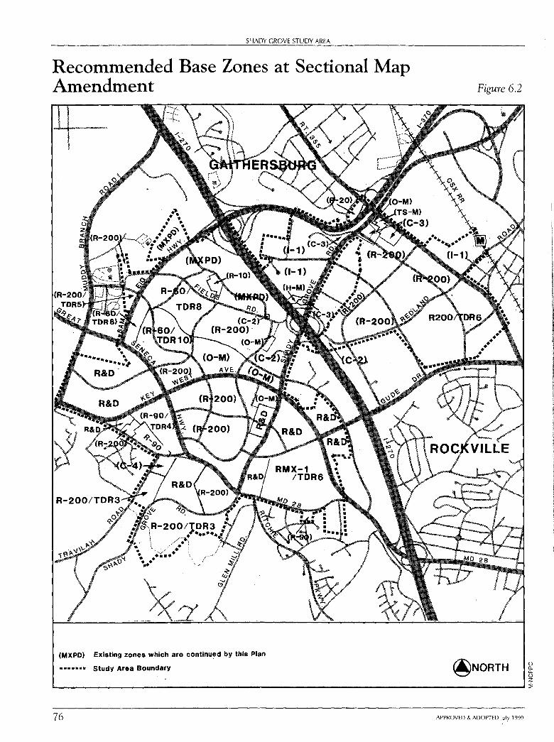
SHADY GROVE STUDY AREA
Recommended Base Zones at Sectional Map Amendment
(MXPD) Existing zones which are continued by this Plan
• ••••• • Study Area Boundary
Figure 6.2
@NORTH 0 a. ()._
0 z -----------------------------------------------i 76 APPROVED & ADOPTED July 1990
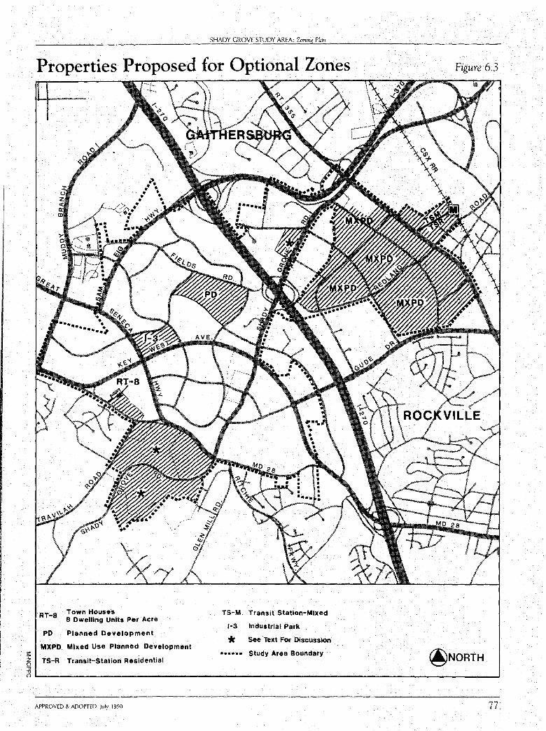
SHADY GROVE STUDY AREA: Zoning Plan
Properties Proposed for Optional Zones
;::
RT-8
PD
Town Houses 8 Dwelling Units Per Acre
Planned Development
MXPD. Mixed Use Planned Development
~ TS-A Transit-Station Residential "'O "'O
TS-M Transit Station-Mixed
1·3 Industrial Park
* See Text For Discussion
• ••• • • Study Area Boundary
Figure 6.3
0-------------------------------------------------..J APPROVED & ADOPTED July 1990 77
78
SHADY GROVE STUDY AREA
but a new zone, which allows a mix and intensity of uses in accord with the neighborhood concept proposed in this Plan, may be necessary to allow the Traville project to develop as envisioned.
Regardless of which zoning strategy is implemented (a PD, MXPD or a new zone), the land use plan recommendations regarding Traville will govern the mix, intensity, and interrelationship of uses on the site.
On the King farm, the MXPD Zone is recommended for the entire 440 acres. This approach will allow the integrated planning and development of the entire farm. However, it will also mean that the southern portion of the farm (180 acres) will be lost as a TDR receiving area. When reviewing the MXPD application for the King Farm, the Council should evaluate whether the loss of TD Rs is mitigated by other public purposes (such as the provision of affordable housing in addition to the MPDU requirements).
If the southern portion of the King Farm develops in accord with the TDR-6 zoning, it is not anticipated that the maximum allowable development permitted in the zone will be achieved due to the Plan recommendation that single-family detached units be provided. The TDR-6 Zone is recommended to allow multi-family units in addition to detached and attached units.
On the Thomas Farm, a zone (RMX-1/TDR at 6 units per acre)) is proposed for the residential portion of the farm (140 acres) which allows a mix of residential and retail uses subject to approval of a project plan and site plan by the Planning Board. The Master Plan establishes the amount of floor area for the retail and the maximum number of units (in this case, 100,000 square feet and 950 units respectively).
The purchase of development rights is a prerequisite to achieving the Master-Plandesignated density.
One property which may redevelop in future years is the 19-acre Bechtel property, located west of Shady Grove Road in the Washingtonian Industrial Park. This Plan recommends the site as suitable for a mixed-use floating zone (such as MXPD) to allow wider ranges of uses (in particular housing) than allowed in the 1-1 Zone.
Zoning Implementation Strategy As noted throughout the Plan, the land use recommendations assume the
development of transit. If transit does not become a reality, the land use proposals for the area will have to be re-examined. This fact makes it critical that a public/private commitment to transit be evident prior to rezoning properties to implement the Plan.
The northern transitway and transit spur through the Shady Grove Life Sciences Center serve two central functions in this amendment: they direct and guide use and density recommendations in the Land Use Plan and provide transportation elements critical to the overall infrastructure needed to serve future development. Given their significance, and the very preliminary status of planning for them, more study is
APPROVED & ADOPTED July 1990
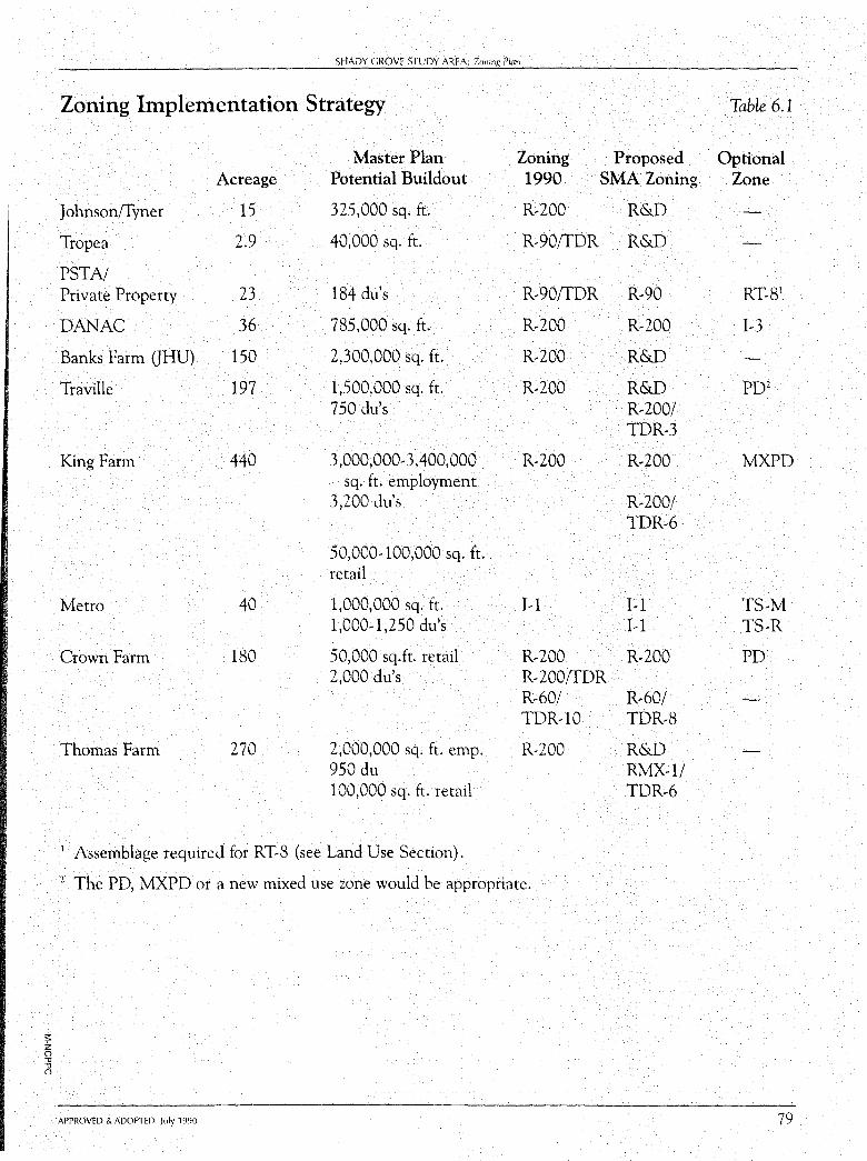
;:: z () "1l "1l ()
SHADY GROVE STUDY AREA: Zoning Plan
Zoning Implementation Strategy
Master Plan Zoning Proposed Acreage Potential Buildout 1990 SMA Zoning
J ohnson!f yner 15 325,000 sq. ft. R-200 R&D
Tropea 2.9 40,000 sq. ft. R-90!fDR R&D
PSTA/ Private Property 23 184 du's R-90!fDR R-90
DANAC 36 785,000 sq. ft. R-200 R-200
Banks Farm CTHU) 150 2,300,000 sq. ft. R-200 R&D
Traville 197 1,500,000 sq. ft. R-200 R&D 750 du's R-200/
TDR-3
King Farm 440 3 ,000,000-3,400,000 R-200 R-200 sq. ft. employment
3,200 du's R-200/ TDR-6
50,000-100,000 sq. ft. retail
Metro 40 1,000,000 sq. ft. 1-1 I-1 1,000-1,250 du's I-1
Crown Farm 180 50,000 sq.ft. retail R-200 R-200 2,000 du's R-200{fDR
R-60/ R-60/ TDR-10 TDR-8
Thomas Farm 270 2,000,000 sq. ft. emp. R-200 R&D 950 du RMX-1/ 100,000 sq. ft. retail TDR-6
1 Assemblage required for RT-8 (see Land Use Section). 2 The PD, MXPD or a new mixed use zone would be appropriate.
APPROVED & ADOPTED July 1990
Table 6.1
Optional Zone
RT-81
I-3
PD2
MXPD
TS-M TS-R
PD
79
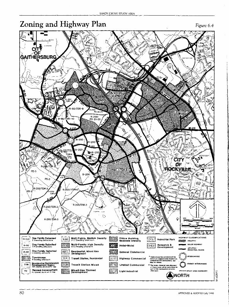
I R-200 I One FamNy Detached 2 Dwelling units/acre u~~~~H
B One Famiy Detached n 3.8 Oweling uoit6/acrn
I R-60 I One Family Detached 5 Dwelhng uiits/acre ~
E Townhouse !Jfrrl 8 Dwelling units/acre-
~ 9esidentlal. Transferable a evelopment Rights TOO dllf'l&ille& ari, shown on map
I PD_ I Planned Development ·ti~-~~ PD dc-nslties Ma shown on map
80
SHADY GROVE STUDY AREA
Mum-Family .Medium Density 21.7 Dwelling un1tl!!l/acre
Multi-Family High Density 43.5 Dwelllng units/acre
Residential, Mixed Use Development
Transit Station, Residential
Transit Station Mixed
Mixed-Use Planned Development
Office Building, Moderate Intensity
Hotel-Motel
General Commercial
~ Highway Commercial
~ limited Commercial ~ m light Industrial
Industrial Park
Research & Development
.TJ. .. P,Oj)Mii .. .,. proj:k)tlltd .. milled use ~ (~tlal, coinmetci,ai ~ ~ment).. 5" "'-foc'd.tllila.
•• The scale, ctiMM:ter and ~ of~road•d"'•...-mil',edM part of the ~proceH {SfftedJ
Figure 6.4
HIGHWAY CLASSIFICATIONS
FREEWAY
- MAJOR HIGHWAY
AATERIAL/ INDUSTRIAL AA.ODS
INTERCHA.NGE
~~ TRANSIT INfEACHANOE
~ .. ~ ••••• .. STUDY AREA BOUNDARY
@NORTH
APPROVED & ADOPTED July 1990
0 0.. 0.. 0 z ::i;
SHADY GROVE STUDY AREA: Zoning Plan
needed to determine both that the transitways can be built and to identify and schedule funding sources.
Therefore, this Plan recommends the following zoning strategy:
1. The Sectional Map Amendment (SMA) and floating zone applications should be deferred until one of the following events occur:
construction funds for the northern transitway and the Life Sciences Center transit spur are included in the State's Consolidated Transportation Program or the County's Capital Improvements Program;
operating funds for an interim transit plan are identified; or
a development district is approved.
2. To defer considerations of floating zone applications until one of the events listed above occur.
3. As soon as the Council implements one of the transit strategies described above, preparation of the SMA may proceed. The scope of the SMA may depend on the scope of the transit improvement program.
4. Since the Council wishes to proceed as quickly as practicable with the SMA (if possible, as early as 1991), this Plan directs the County Executive to forward to the Council a funding strategy for the transitways and/or interim transit plan. At a minimum, the funding strategy should include moneys for the transitway(s) or interim transit plan.
APPROVED & ADOPTED July 1990 81
CHAPTER SEVEN
Transportation and Mobility Plan
The developing Shady Grove Study Area will become a workplace and residential community of significant size in the future. Mobility will be a critical factor in assuring the viability and vitality of the area to attract the high caliber of employment and residential development envisioned. Therefore, the mobility needs of area residents and workers must be anticipated and planned to provide a variety of facilities serving trips to and from the area, connecting to regional Metrorail and conveniently linking activities within the area. The Plan includes a system of highways, access roadways, transit routes, and bikeway/ pathways to form an integrated network of access throughout the area. While this is a balanced approach, major emphasis is placed on exclusive transit rights-ofway through the area. These would limit congestion-related delays and make transit a travel mode of choice into and through the area. The land use plan has been designed around this particular transportation aspect to provide a high level of access to future stations from area development.
The mobility plan identifies the public facility improvements which will need to be implemented to provide for the future transportation needs of people in the area, assuming its end-state development. The need for these facilities, whether they be roadways, bikeways, or transitways, is highly dependent upon the rate and location of development, both in the Study Area and in surrounding areas.
The transportation system functions to serve both access for local traffic (to and from area development) and passage for through traffic moving between areas of the larger region. Most parts of the transportation system serve both of these functions. However, there is a general range of service differentiation which can be conceptualized, as shown in Table 7 .1. Quite simply, freeways and Metrorail are intended to serve the movement of longer-distance through traffic while local neighborhood streets and neighborhood bus loops, bikeways, and walkways tend to only provide access to the residential and business areas through which they pass. Major highways, transitways, arterial highways, and transit roadways fall between these extremes, serving a combination of through movement and local access.
83
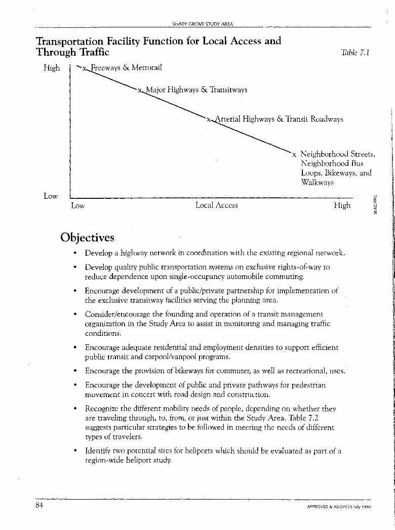
SHADY GROVE STUDY AREA
Transportation Facility Function for Local Access and Through Traffic Table 7.1
High
Low
84
.....,x Freeways & Metrorail
~ Major Highways & Transitways
x rterial Highways & Transit Roadways
x Neighborhood Streets, Neighborhood Bus Loops, Bikeways, and Walkways
Low Local Access High
Objectives • Develop a highway network in coordination with the existing regional network.
• Develop quality public transportation systems on exclusive rights-of-way to
reduce dependence upon single-occupancy automobile commuting.
•
•
•
•
•
•
•
Encourage development of a public/private partnership for implementation of the exclusive transitway facilities serving the planning area.
Consider/encourage the founding and operation of a transit management organization in the Study Area to assist in monitoring and managing traffic conditions.
Encourage adequate residential and employment densities to support efficient public transit and carpool/vanpool programs.
Encourage the provision of bikeways for commuter, as well as recreational, uses .
Encourage the development of public and private pathways for pedestrian movement in concert with road design and construction.
Recognize the different mobility needs of people, depending on whether they are traveling through, to, from, or just within the Study Area. Table 7 .2 suggests particular strategies to be followed in meeting the needs of different types of travelers.
Identify two potential sites for heliports which should be evaluated as part of a region-wide heliport study.
APPROVED & ADOPTED July 1990
u 0.. 0.. u z :i:
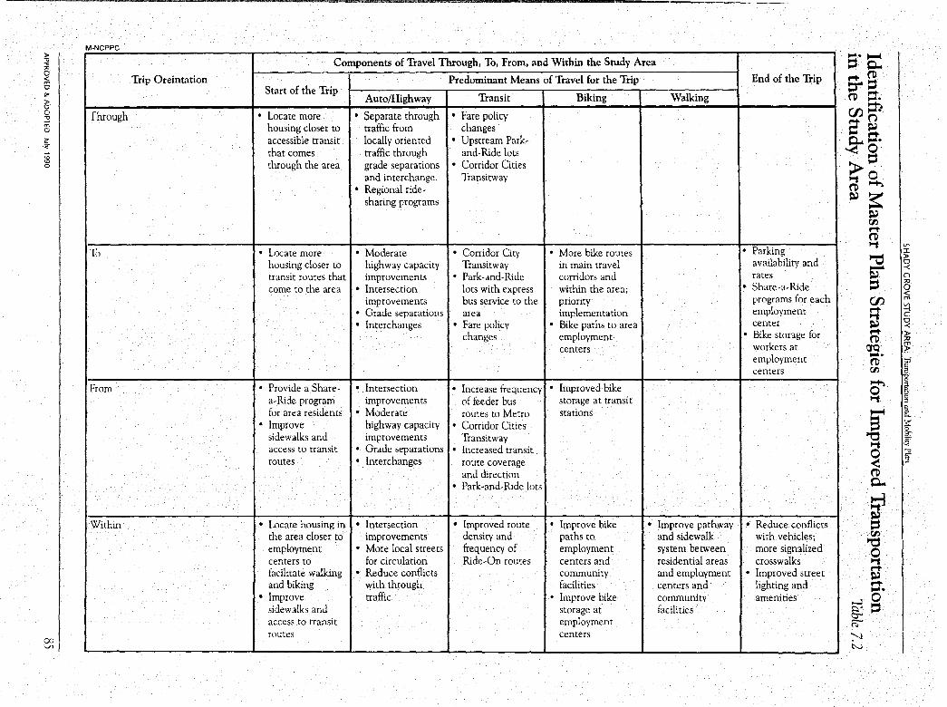
)> .,, .,, "' 0 < 8 "" )> 0 0 .,, _, m 0
-='<
:g 0
0:, ~
M-NCPPC
Trip Oreintation
Through
To
From
Within
Components of Travel Through, To, From, and Within the Study Area
Start of the Trip Auto/Highway
Predominant Means of Travel for the Trip
Transit Biking Walking
• Locate more • Separate through • Fare policy housing closer to traffic from changes accessible transit locally oriented • Upstream Park-that comes traffic through and-Ride lots through the area grade separations • Corridor Cities
and interchange. Transitway • Regional ride-
sharing programs
• Locate more • Moderate • Corridor City • More bike routes housing closer to highway capacity Transitway in main travel transit routes that improvements • Park-and-Ride corridors and come to the area • Intersection lots with express within the area;
improvements bus service to the priority • Grade separations area implementation • Interchanges • Fare policy • Bike paths to area
changes employment centers
• Provide a Share- • Intersection • Increase frequency • Improved bike a-Ride program improvements of feeder bus storage at transit for area residents • Moderate routes to Metro stations
• Improve highway capacity • Corridor Cities sidewalks and improvements Transitway access to transit • Grade separations • Increased transit routes • Interchanges route coverage
and direction • Park-and-Ride lots
• Locate housing in • Intersection • Improved route • Improve bike • Improve pathway the area closer to improvements density and paths to and sidewalk employment • More local streets frequency of employment system between centers to for circulation Ride-On routes centers and residential areas facilitate walking • Reduce conflicts community and emplo.yment and biking with through facilities centers and
• Improve traffic • Improve bike community sidewalks and storage at facilities access to transit employment routes centers
.... I--(
::s p.. End of the Trip l""t- ('O
t:r' ::s ('O ::t. en =n ag p.. ,... ~o > ::s ""'t 0 ('O ~
~~ ~ r:r, l""t-('O
• Parking availability and
""'t Vl I
~ )> 0 - -<
rates • Share-a-Ride
programs for each ~
C) ;o 0 < en m Vl
employment center
l""t- -I ""'t C
~ 0 -<
• Bike storage for workers at employment centers
l""t- )> ('O ;o
!J"Q ~ .... ('O !:;I
" r:r, a
o' C
! ""'t
a "' it :;:: C
"O s-: ""'t '~
0 --0 E"
<: " ('O p..
~ • Reduce conflicts ~
with vehicles; more signalized crosswalks
r:r, "O 0 ""'t
• Improved street l""t-~
lighting and l""t-.... amenities 0
~ ::s o-' ~
':'--1 N
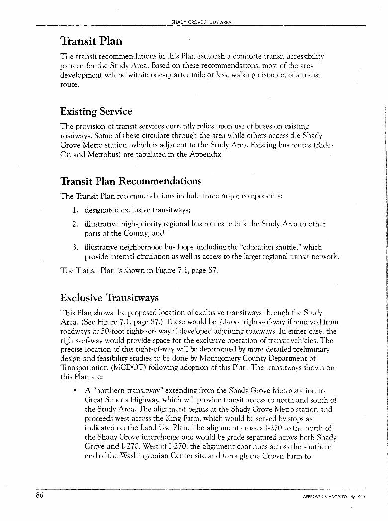
86
SHADY GROVE STUDY AREA
Transit Plan The transit recommendations in this Plan establish a complete transit accessibility pattern for the Study Area. Based on these recommendations, most of the area development will be within one,quarter mile or less, walking distance, of a transit route.
Existing Service The provision of transit services currently relies upon use of buses on existing roadways. Some of these circulate through the area while others access the Shady Grove Metro station, which is adjacent to the Study Area. Existing bus routes (Ride, On and Metrobus) are tabulated in the Appendix.
Transit Plan Recommendations The Transit Plan recommendations include three major components:
1. designated exclusive transitways;
2. illustrative high,priority regional bus routes to link the Study Area to other parts of the County; and
3. illustrative neighborhood bus loops, including the "education shuttle," which provide internal circulation as well as access to the larger regional transit network.
The Transit Plan is shown in Figure 7.1, page 87.
Exclusive Transitways This Plan shows the proposed location of exclusive transitways through the Study Area. (See Figure 7.1, page 87.) These would be 70,foot rights,of,way ifremoved from roadways or 50,foot rights,of, way if developed adjoining roadways. In either case, the rights,of,way would provide space for the exclusive operation of transit vehicles. The precise location of this right,of,way will be determined by more detailed preliminary design and feasibility studies to be done by Montgomery County Department of Transportation (MCDOT) following adoption of this Plan. The transitways shown on this Plan are:
• A "northern transitway" extending from the Shady Grove Metro station to Great Seneca Highway, which will provide transit access to north and south of the Study Area. The alignment begins at the Shady Grove Metro station and proceeds west across the King Farm, which would be served by stops as indicated on the Land Use Plan. The alignment crosses 1,270 to the north of the Shady Grove interchange and would be grade separated across both Shady Grove and 1,270. West ofl,270, the alignment continues across the southern end of the Washingtonian Center site and through the Crown Farm to
APPROVED & ADOPTED July 1990
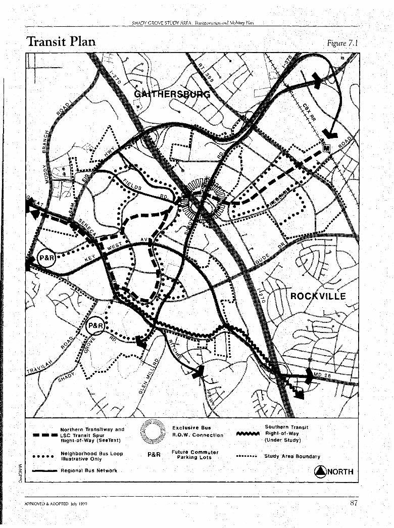
;:: z ()
Transit Plan
Northern Transitway and • - • LSC Transit Spur
Right-of-Way (SeeText)
••••• Neighborhood Bus Loop Illustrative Only
Regional Bus Network
SHADY GROVE STUDY AREA: Transportati011 and Mobility Plan
~~TIUP~ ~ ~ Exclusive Bus ~ · § R.O.W. Connection ~uDDl'l~
P&R Future Commuter Parking Lots
Southern Transit ~"tlh·~ Right-of-Way
(Under Study)
Figure 7.1
........ Study Area Boundary
@NORTH " " O'---------------------------------------------------...J
APPROVED & ADOPTED July 1990 87
88
SHADY GROVE STUDY AREA
Decoverly Drive. The Crown and Washingtonian sites would also be served by stops, as identified on the Land Use Plan. The alignment proceeds along Decoverly Drive to Great Seneca Highway where a grade separation may be required to connect with the extension of the alignment north along the Highway. From this point, the alignment should extend into the Banks Farm before extending northward along Great Seneca Highway. A stop would be located on the Banks Farm, which may require some minor relocation of the proposed transitway alignment on the site.
The Corridor Cities Transit Easement Study recommends linking the transitway to the Metropolitan Grove MARC station via an exclusive transitway extending north from Great Seneca Highway through GEISCO and the Bureau of Standards. To keep this option viable, this Plan recommends the enlargement of the Great Seneca Highway right-orway from 150 feet to 200 feet over the length of section from Decoverly Drive to GEISCO.
These options require further study by the Montgomery County Department of Transportation subsequent to the adoption of this Plan.
• A transitway along Omega Drive and Medical Center Drive will provide a transit "spur" to the Life Sciences area. This would connect from the Crown Farm station south to a point on Omega Drive and continue along the roadway to Medical Center Drive, then around to Great Seneca Highway, connecting north to Decoverly Drive. This forms a loop or spur through the Life Sciences area which could eventually be operated in conjunction with the transitway described above. Thus, transit could either interface with the other alignment at stops or operate around the Life Sciences area and through to the Shady Grove Metro station along a shared alignment across I-270.
The Life Sciences Center transit spur should be studied further by the Montgomery County Department of Transportation and incorporated into a future amendment to the Life Sciences Center Development Plan. Transit stops along the alignment should be identified as part of the Amendment process.
• A southern alignment for a transitway through the area would provide access to and from North Bethesda and Rockville. This extends from I-270 along the north side of Darnestown Road to Great Seneca Highway, thence north along Great Seneca Highway to Medical Center Drive. This alignment provides transitway service immediately adjacent to the Traville and Thomas Farm sites. Stops should be located to serve these areas, with the exact sites being identified in conjunction with the respective site plans. The alignment could also be located further north through the Thomas Farm in the vicinity of the proposed retail center and higher density residential area.
The southern alignment should be studied further as part of future transportation network studies to be undertaken by M-NCPPC.
All the Master Plan alignments are subject to further feasibility and engineering studies by the County Executive to determine their exact locations, cross-sections, and
APPROVED & ADOPTED July 1990
SHADY GROVE STUDY AREA: Tramponat,on and Mobility Plan
modes of operation. All options for use of these alignments should be considered in the course of subsequent study, including above, below, and at-grade locations. All alignments should be considered for vertical integration with surrounding land use where appropriate. Future studies should also determine a feasible funding schedule for construction of these transitways and the expected sources of funding.
High-Priority Regional Bus Routes
This Plan recognizes the need for high priority designated regional bus routes. This Plan illustrates a network of potential regional transit routes which would serve the Study Area. (See Figure 7 .3.) These designations are not intended to indicate exact routings, but to identify the key roadways where transit service may be implemented to provide improved regional access. They include:
- MD 355 (Rockville Pike)
- Shady Grove Road
Gude Drive
- Key West Avenue
- Great Seneca Highway
Sam Eig Highway
The Study Area is bisected by I-270. To strengthen transit connections across I-270, this Plan recommends an exclusive transit road link from Redland Road to Shady Grove Road in the Shady Grove interchange off I-270 northbound.
Neighborhood Bus Loops Neighborhood bus loops should be considered in the King Farm area and in the R&D Village as expanded. Small buses (Ride-On, for example) would continually circulate along these loops. Possible routes are shown on Figure 7 .1 to indicate a systems approach to those bus loops.
A "loop" system is also proposed to provide a high level of bus circulation among the Johns Hopkins University, the University of Maryland, and proposed conference areas. This emerging "University District" would have needs similar to major campuses where shuttle routes are used to connect buildings and parking areas. Other new primary roadways implemented in the development process throughout the area may prove to be more direct routes for buses and should be used accordingly.
Other Transit Recommendations To enhance transit serviceability along all roadways in the Study Area (except for major roadways like Sam Eig Highway,) buildings should be clustered and located closer to sidewalks. This minimizes both walking distance and exposure between transit stops and building entrances.
APPROVED & ADOPTED July 1990 89
90
SHADY GROVE STUDY AREA
To foster carpool formation and to provide "Park-and-Ride" services to Metro and down-County, this Plan identifies two Park-and-Ride lot locations. These lots should contain a minimum of 250 to 500 spaces and are proposed to be in the vicinity of Damestown Road near Great Seneca Highway and Muddy Branch and Damestown Road.
An interim transit plan may be developed and implemented to provide incremental improvements to area transit services in the period prior to the completion of proposed transitways. Such an interim transit plan is envisioned as a high level of bus service connection between the development areas such as Traville, the Life Sciences Center, and the Washingtonian, to the Shady Grove Metro Station via l-370. The goal would be to provide fast, direct, and convenient service to Metro using 1-370 in advance of an exclusive transitway crossing of I-270. Once the transitway right-of-way is in place, these services could be redirected or replaced by another type of service. Such a service plan is only interim in that development which occurs directly along the transitway right-of-way would be designed to be best served by transit service thereon directly to Metro, without intervening traffic conflicts or constraints.
Relation of Corridor Cities Transit Easement Study to Plan Process A transit easement extending north from the Shady Grove Metro station has been shown on the Master Plan of Highways and the Gaithersburg and Germantown Master Plans since the early 1970s. The original goal was to identify a right-of-way for the potential extension of Metro north to serve the Corridor Cities. A 70-foot-wide rightof-way is to be reserved and protected from development.
The location of the easement and its ultimate use have become more important as development has proceeded in the corridor over the past 15 years. Therefore, a twopart study has been initiated to study the alignment location and its use. The first study, The Corridor Cities Transit Easement Study (CCTES), recommended the best locations for the easement. (See Figure 7.2, page 91.) This is being followed with a study by the County Department of Transportation to determine the specific right-ofway to be preserved through the Shady Grove Study Area as well as through other critical sections of the alignment.
Street and Highway Plan The comprehensive system of roadways proposed to serve the Master Plan vicinity is shown in Figure 7.3, page 92.
The highway plan consists of freeway, major highway, and arterial/industrial street classifications. The typical cross-sections for these classifications, as specified in the Master Plan of Highways, are shown in Figure 7.4, page 93. Additional roadways to primarily serve development access as it is planned in the future must be designed and
APPROVED & ADOPTED July 1990
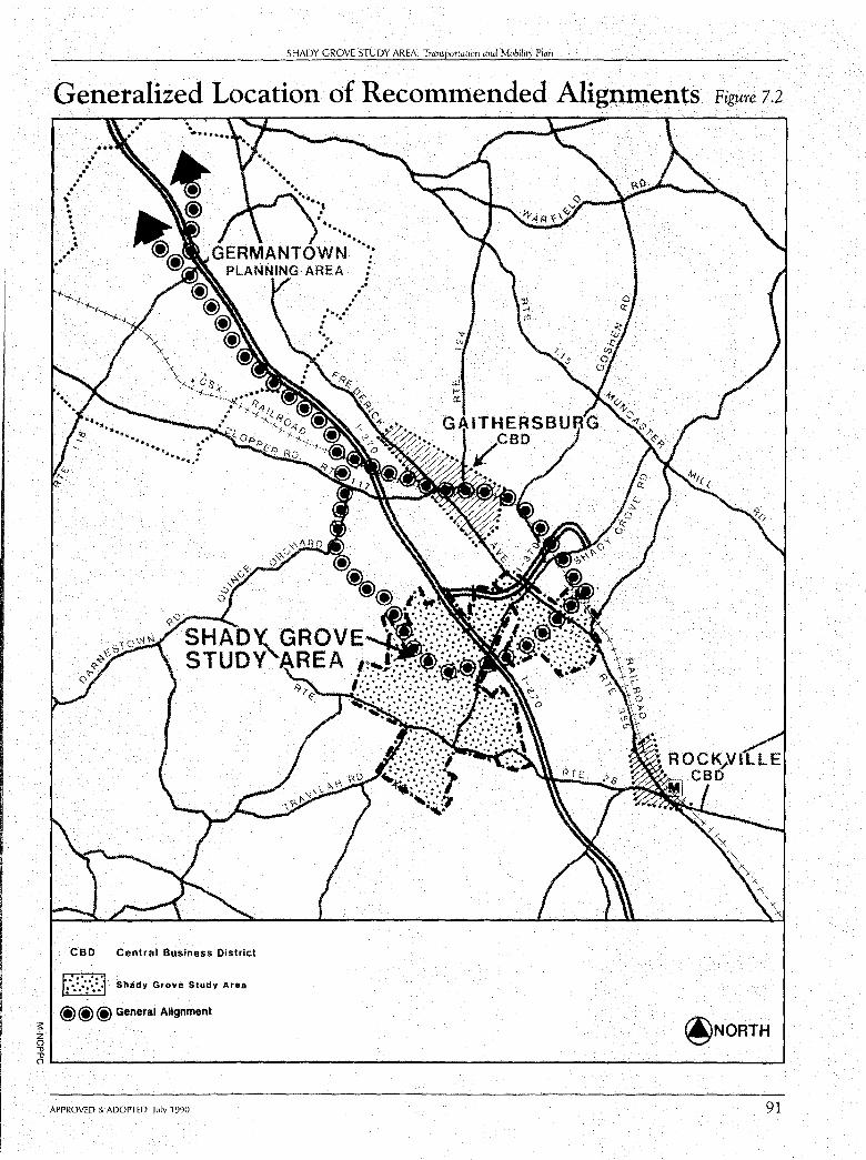
;:: z ()
" "
SHADY GROVE STUDY AREA: Transportation and Mobility Plan
Generalized Location of Recommended Aligt;iments Figure 1.2
.•·· ... .... ··
1' • . . + . . . .... .. ..
CBD Central Business District
5J Shady Grove Study Area
@@@ General Alignment
. . . .. . . . . . . : ·~.·
@NORTH
O"---------------------------------------------' APPROVED & ADOPTED July 1990 91
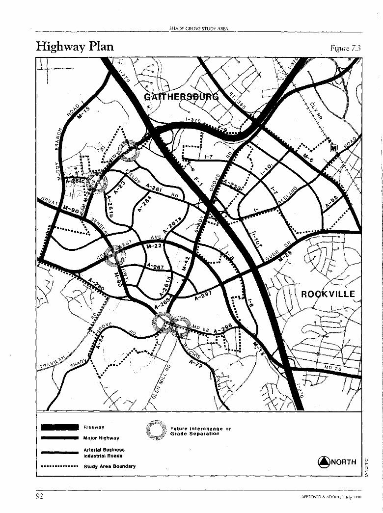
Highway Plan
..• -~ r.• ,,. ~ ., . . . / . . ~--·· • • • • •• . , ..
Freeway
Major Highway
Arterial Business Industrial Roads
• • .. • ..... • • •• Study Area Boundary
92
SHADY GROVE STUDY AREA
Future Interchange or Grade Separation
Figure 7.3
@NORTH
APPROVED & ADOPTED July 1990
() ll.. ll.. () z ::,
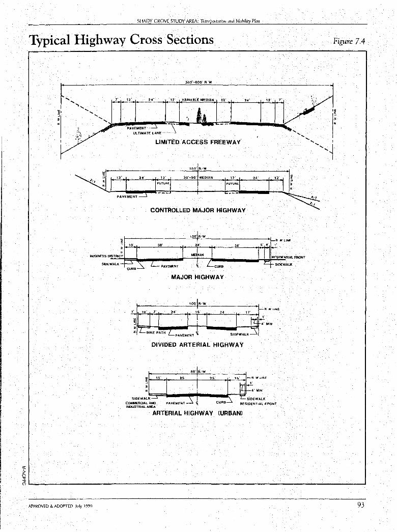
s: z 0 ,, ,,
SHADY GROVE STUDY AREA: Transportation and Mobility Plan
Typical Highway Cross Sections
300'-600' R•W
LIMITED ACCESS FREEWAY.
150' RtW
12· 24' J0' .. 50· M'EOIAN 12' 12·
FUTURE FUTURE
PAVEMENT
CONTROLLED MAJOR HIGHWAY
120 R,W ~ t------------'-C.,""--'-----------+I._A W LINE - 2~· 38' ,·
SIDEWALK
MEDIAN
PAVEMENT SIDEWALi(
MAJOR HIGHWAY
100' RiW
16' 24'
PAVEMENT£
DIVIDED ARTERIAL HIGHWAY
!t--''-"s_· --t---"2=-s·---1--'-'-'25"-'---i+--'-"--I-A W LINE
~
SIDEWALK~~=::j---~-.----llil:-""7i=" COMMERCIAL AND INDUSTRIAL AREA
PAVEMENT CURB RESIDENTIAL F'hONT
ARTERIAL HIGHWAY (URBANI
Figure 7.4
I"' z ::;
c,1-, _____________________________________________________ .....
APPROVED & ADOPTED July 1990 93
94
SHADY GROVE STUDY AREA
laid out within the framework of the highway system. Guidelines for, the future location of these primary (local) roadways as a part of the development process are included below.
The Highway Plan Map shows the ultimate highway system, just as the Land Use Plan describes the ultimate development pattern. All highway segments in the Study Area and vicinity are tabulated in Table 7.3, which specifies the maximum number of recommended lanes and the minimum required right-of-way width. Master Plan roadway alignments are used to preserve the right-of-way that will be needed for future construction of roadways. This preservation process ensures that space will be available when roadway construction is needed and that development is located and sited with appropriate relationship to the future roads. A developer of a large parcel ofland has some flexibility as to the alignment as it traverses the parcel so long as any changes made affect only that parcel.
This Plan proposes several changes to the road network shown in the 1985 Gaithersburg Vicinity Master Plan. These changes include several new roadway extensions and additions, which are described in the Appendix, and intersection improvements described later in this chapter. The rights-of-way have also been expanded for the major highway and arterial categories and on specific roadways which have been identified to include separate transitways.
Major highways have been increased from a master planned right-of-way of 120 feet to 150 feet with an increase from 80 feet to 100 feet for arterials. These increases are recommended to permit adequate space for continuous tum lanes, additional buffer/landscape space, and medians, as well as the typical street, sidewalk, and bikepath requirements. Attainment of the full recommended right-of-way in developed areas may not be feasible in all locations or cases.
This Plan recommends that the right-of-way of an arterial road or major highway be widened at intersections with arterial and/or major highways. This increased width will provide space for an additional left-turn lane and a right-tum lane on the approach side of the intersection, as well as an adjustment area on the departure side. The amount of additional right-of-way on the approach side is 24 feet wide for 500 feet from the intersection with a 400-foot taper. The departure side is 12 feet wide for 200 feet with a 180-foot taper. Both a divided arterial and a major highway with a 30-foot median can accommodate two left-tum lanes; only 12 feet of additional right-ofway is needed in those cases. An undivided arterial road needs an additional 8 feet of width to provide a median at the intersection for pedestrian and vehicular safety. In the case of transitway designation, the rights-of-way are increased 50 feet over that which would otherwise be required for the roadway right-of-way. The location or alignment of the additional 50 feet is on one side or the other of the existing right-ofway, or equivalently split off the center line. An example is the section of Great Seneca Highway from Decoverly Drive north. The location shown, to the west of the roadway, is subject to further review as part of the proposed feasibility study for preliminary engineering of the transitway. On Medical Drive through the Life Sciences Center, the extent of increased right-or-way, if any, will be examined in relation to possible future amendments to the Development Plan for the Life Sciences Center.
APPROVED & ADOPTED July 1 990
,1 l I
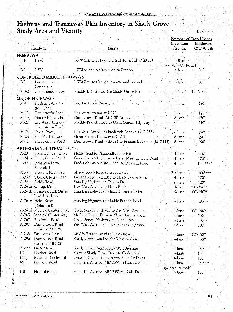
:;: z () -0 -0 ()
SHADY GROVE STUDY AREA: Transportation and Mobi!it, Plan
Highway and Transitway Plan Inventory in Shady Grove Study Area and Vicinity
Roadway Limits
FREEWAYS F-1 l-270
Table 7.3
Number of Travel Lanes Maximum Minimum
Recom. ROW Width
8-lane 250' 1-370/Sam Eig Hwy. to Damestown Rd. (MD 28)
I-270 to Shady Grove Metro Station (with 2-lane CD Roads)
F-9 I-370
CONTROLLED MAJOR HIGHWAYS F-9 lntercounty I-370 East to Georgia Avenue and beyond
Connector M-90 Great Seneca Hwy Muddy Branch Road to Shady Grove Road
MAJOR HIGHWAYS M-6 Frederick Avenue l-370 to Gude Drive
(MD 355) M-13 M-15 M-22
Darnestown Road Muddy Branch Rd Key West Avenue/ Darnestown Road Gude Drive
Key West Avenue to 1-270 Darnestown Road (MD 28) to I-270 Muddy Branch Road to Great Seneca Highway
Key West Avenue to Frederick Avenue (MD 355) Great Seneca Highway to 1-270
6-lane 300'
6-lane
6-lane
6-lane
7-lane 6-lane 6-lane
300'
150/200'*
150'
170'* 120' 150'
M-23 M-28 M-42
Sam Eig Highway Shady Grove Road Darnestown Road (MD 28) to Frederick Avenue (MD 355)
6-lane 6-lane 6-lane
150' 150' 150'
ARTERIAL/INDUSTRIAL HWYS. A-23 Louis Sullivan Drive Fields Road to Diamondback Drive 4-lane 100' A-34 Shady Grove Road Great Seneca Highway to Piney Meetinghouse Road 4-lane 100' A-52 Indianola Drive Frederick Avenue (MD 355) to Pleasant Road 4-lane 100'****
Extended A-58 Pleasant Road Ext. Shady Grove Road to Gude Drive 2-4 lane 100'*** A-253 Choke Cherry Road Piccard Road Extended to Shady Grove Road 4-lane 100' A-261 Fields Road Sam Eig Highway to Omega Drive 6-lane 120' A-261a Omega Drive Key West Avenue to Fields Road 4-lane 100'/150'* A-261b Diamondback Drive/ Sam Eig Highway to Medical Center Drive 4-lane 100'/150'*
Broschart Road A-261c Fields Road Sam Eig Highway to Muddy Branch Road 4-lane 100'
(Relocated) A-261d Medical Center Drive Great Seneca Highway to Key West Avenue 4-lane 100'/150'* A-263 Medical Center Way Medical Center Drive to Shady Grove Road 4-lane 100' A-267 Blackwell Road Great Seneca Highway to Gude Drive 4-lane 100' A-280 Darnestown Road Key West Avenue to Great Seneca Highway 4-lane 100'
(Existing MD 28) A-284 Decoverly Drive Muddy Branch Road to Fields Road 4-lane 100'/150'* A-296 Darnestown Road Shady Grove Road to Key West Avenue 4-lane 150'*
(Existing MD 28) A-297 Gude Drive Shady Grove Road to Key West Avenue 4-lane 150'** I-7 Gaither Road West of Shady Grove Road to Gude Drive 4-lane 100' I-8 Research Boulevard Omega Drive to Darnestown Road (MD 28) 4-lane 100' I-9 Redland Road Frederick Avenue (MD 355) to Piccard Road 4-lane 150'**
(plus service roads) I-10 Piccard Road Frederick Avenue (MD 355) to Gude Drive 4-lane 100'
APPROVED & ADOPTED July 1990 95
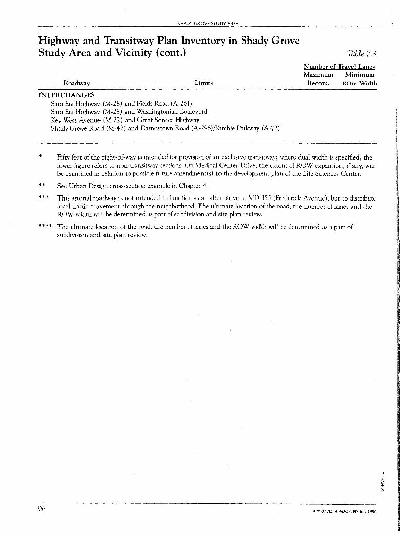
SHADY GROVE STUDY AREA
Highway and Transitway Plan Inventory in Shady Grove Study Area and Vicinity (cont.) Table 7.3
Number of Travel Lanes Maximum Minimum
Roadway Limits Recom. ROW Width
INTERCHANGES
*
** ***
Sam Eig Highway (M-28) and Fields Road (A-261) Sam Eig Highway (M-28) and Washingtonian Boulevard Key West Avenue (M-22) and Great Seneca Highway Shady Grove Road (M-42) and Darnestown Road (A-296)/Ritchie Parkway (A- 72)
Fifty feet of the right-of-way is intended for provision of an exclusive transitway; where dual width is specified, the lower figure refers to non-transitway sections. On Medical Center Drive, the extent of ROW expansion, if any, will be examined in relation to possible future amendment(s) to the development plan of the Life Sciences Center.
See Urban Design cross-section example in Chapter 4.
This arterial roadway is not intended to function as an alternative to MD 355 (Frederick Avenue), but to distribute local traffic movement through the neighborhood. The ultimate location of the road, the number of lanes and the ROW width will be determined as part of subdivision and site plan review.
**** The ultimate location of the road, the number of lanes and the ROW width will be determined as a part of subdivision and site plan review.
96 APPROVED & ADOPTED July 1990
() a. a. () z ~
SHADY GROVE STUDY AREA: Transportation and Mobility Plan
As part of the Plan process, the Master Plan recommendations for the connection of Great Seneca Highway to Ritchie Parkway were re-examined. One of the study objectives was to determine if recent roadway improvements along MD 28 could be incorporated into the connection. As a result of this re-examination this Plan recommends that the alignment of Great Seneca Highway be modified to follow the alignment of Darnestown Road to its point of intersection with Ritchie Parkway. The primary impetus for this modification is the desirability of maintaining the existing roadway (Darnestown Road), which is to be further improved through subdivisionrelated requirements. However, this alignment modification is proposed in conjunction with a recommendation that grade separation improvements be designated at Shady Grove Road and Ritchie Parkway. The combination of these modifications is intended to be designed such that traffic could circulate with equivalent ease from Great Seneca Highway to either Ritchie Parkway or Darnestown Road to the south.
Local Streets and the Neighborhood Concept As development and site planning progresses in the future, networks oflocal streets will be designed to provide local access to area residences and businesses. A key plan objective for implementing the neighborhood concept and transit-serviceable site design is providing continuous, interconnected local streets that form the major organizing element. Local streets are important for traffic capacity and circulation, but the total right-of-way is used for purposes in addition to the movement of vehicles. In this respect, local streets are equally important in terms of pedestrian activity and building orientation. The relationship between site design and road network planning becomes critical in creating pedestrian-oriented and transit- serviceable developments.
To provide the flexibility for the layout of the local road network to be determined in relation to a major development plan, and to assure interconnected pedestrian- and transit- oriented design, the following guidelines for subdivision and site plan applications are provided:
Hierarchy of Residential Streets
A hierarchy of residential streets should be created to establish neighborhood character and differentiate the functions between streets. In addition to the minimum right-of-way for each street shown in the Road Code and Subdivision Regulations, the hierarchy of residential streets should include the following:
• Primary and Secondary Divided Residential Streets-The use of primary and secondary divided residential streets which include wide medians will be encouraged to create variety and establish neighborhood scale.
• Primary Residential Streets-The primary street should be used in areas with over 200 dwelling units on one street. Frontage of houses and businesses onto the street is preferred.
• Secondary Residential Streets-The secondary residential street is the preferred street within residential neighborhoods. This street provides adequate
APPROVED & ADOPTED July 1990 97
98
SHADY GROVE STUDY AREA
space for public sidewalks and street trees along both sides of the street without conflicts with the storm drainage system.
• Tertiary Residential Streets-The use of tertiary streets with a right-of-way of 50 feet should be limited to minor streets with sidewalks and street trees on both sides. Tertiary streets with a right-of-way of less than 50 feet are discouraged because of the lack of space within the public right-of-way for sidewalks.
• Alley-The use of alleys will be encouraged in all residential neighborhoods to allow buildings to front on the streets.
Street Design Elements and Neighborhood Character
The specific design elements included in each neighborhood street are important features that establish the character of a neighborhood. The following elements are included to create pedestrian-oriented neighborhoods.
• Variable Right-of-Way-The right-of-way shown in the Design Standards for Montgomery County should be considered the minimum required. Additional right-of-way to provide adequate sidewalk space or create a unique character of streetscape is encouraged. This includes additional right-of-way for trails, bikeways, and parking as well as medians and linear parks.
• On-Street Parking-Parallel, on-street parking as well as angle parking will be encouraged along neighborhood streets to provide for street-oriented uses and to reduce the size of all off-street parking facilities.
• Eliminate Cul-de-Sacs-The use of cul-de-sacs should be discouraged to create a system of interconnected streets.
• Closed Section-All neighborhood streets should have a closed section with curb, gutter, and enclosed storm drainage systems to allow for sidewalks on both sides of streets within the public right-of-way.
• Sidewalks-Sidewalks within the public right-of-way along both sides of all neighborhood streets will be provided. The use of internal pedestrian pathways does not substitute for sidewalks along each street.
• Streetscape-A streetscape plan for all neighborhoods that emphasizes and delineates street lighting, trees, sidewalk paving, and sign locations should be required during the review of development plans and site plans.
High Occupancy Vehicle (HOV) High Occupancy Vehicle (HOV) lanes are for exclusive use by buses, van pools, and car pools. Generally, these lanes would be additions to existing roadways or provided on new HOV-exclusive roadways.
This Plan designates two highways for future consideration as HOV facilities: Great Seneca Highway and Sam Eig Highway. (See Figure 7.5, page 100.)
APPROVED & ADOPTED July 1990
SHADY GROVE STUDY AREA: Transportation and Mobility Plan
Great Seneca Highway is an important link between Germantown and Shady Grove. Sam Eig Highway provides direct access to Shady Grove Metro from both Great Seneca Highway and the Study Area.
Grade Separations An analysis of intersection conditions was prepared from the results of the areawide transportation analysis described in Appendix B. The result of the transportation analysis projects an areawide Level of Service (LOS) of D for the Gaithersburg East and West policy areas at buildout. The limitations of this analysis are discussed in the Appendix. However, the pattern of congestion resulting from the planned land use indicates that about eight of the intersections in the Study Area may operate at local levels of service more congested than the standard of mid-LOSE used in Local Area Transportation Review. Figure 7.6 shows the most congested intersections, based on traffic projections resulting from the master planned land use and transportation network. A list of the intersections analyzed is provided in Table 7 .4. At buildout, levels of congestion at some locations were projected to be significant enough to warrant treatment by grade separation, interchange design, or equivalent at-grade treatment. It should be noted that the intersections which are projected to exhibit the most congested conditions share a common feature: they are primarily located at the periphery of the Study Area. This peripheral congestion is due in large measure to regional through traffic using 1-270 and major arterials such as MD 28, the Great Seneca Highway, and MD 355. The latter intersections within the Study Area are already operating at LOS R See Appendix A for further discussion of these intersections.
The indication of future intersection congestion is a condition that will need to be monitored and reviewed several times over the course of the Master Plan buildout. Although the degree of accuracy for such long-range forecasting is limited, these estimates have been made because they are the best order-of-magnitude determination that can be made now of where problem areas are likely to occur or will continue to occur in the future.
Based upon the transportation analysis, a review was made of all major critical intersections to determine the feasibility and need for grade separation or equivalent at-grade treatment. The results of this review with regard to the designation of possible grade separations and those intersections not recommended for grade separation are discussed in Appendix A. The provision of grade separation removes and reduces the conflicts between opposing flows of traffic, resulting in improved operations through an intersection of roadways. However, such design treatments are expensive and take a considerably larger area of land than would otherwise be required at a typical at-grade intersection. Therefore, an advance determination of need must be made as part of the Master Plan process to preserve the needed interchange rights-of-way. Also, there may be at-grade treatments that would be equivalent in effect to grade separation, but may still require the same amount of land.
APPROVED & ADOPTED July 1990 99
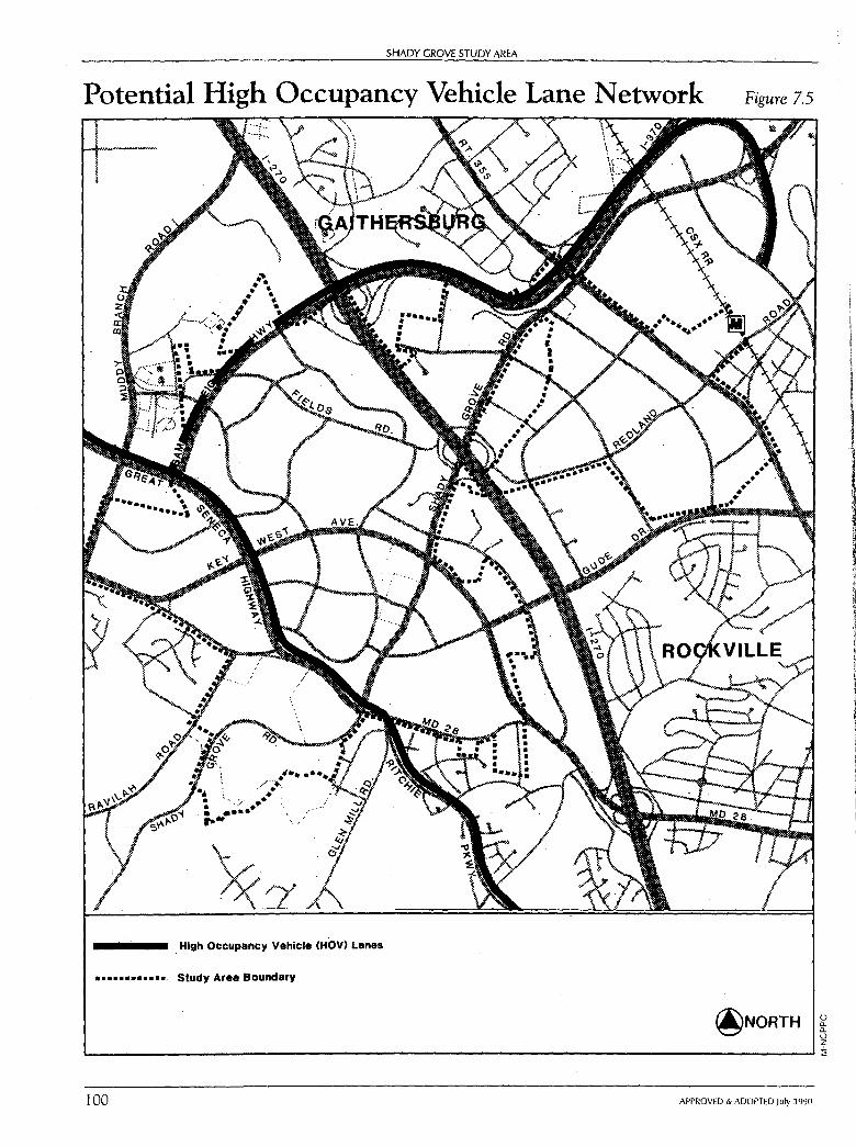
SHADY GROVE STUDY AREA
Potential High Occupancy Vehicle Lane Network
High Occupancy Vehicle (HOV) Lanes
·• •••• •••••.. Study Area Boundary
Figure 7.5
@NORTH 0 Cl. Cl. 0 z L..-----------------------------------------------------....1::i;
100 APPROVED & ADOPTED July 1990
l l
II,
l
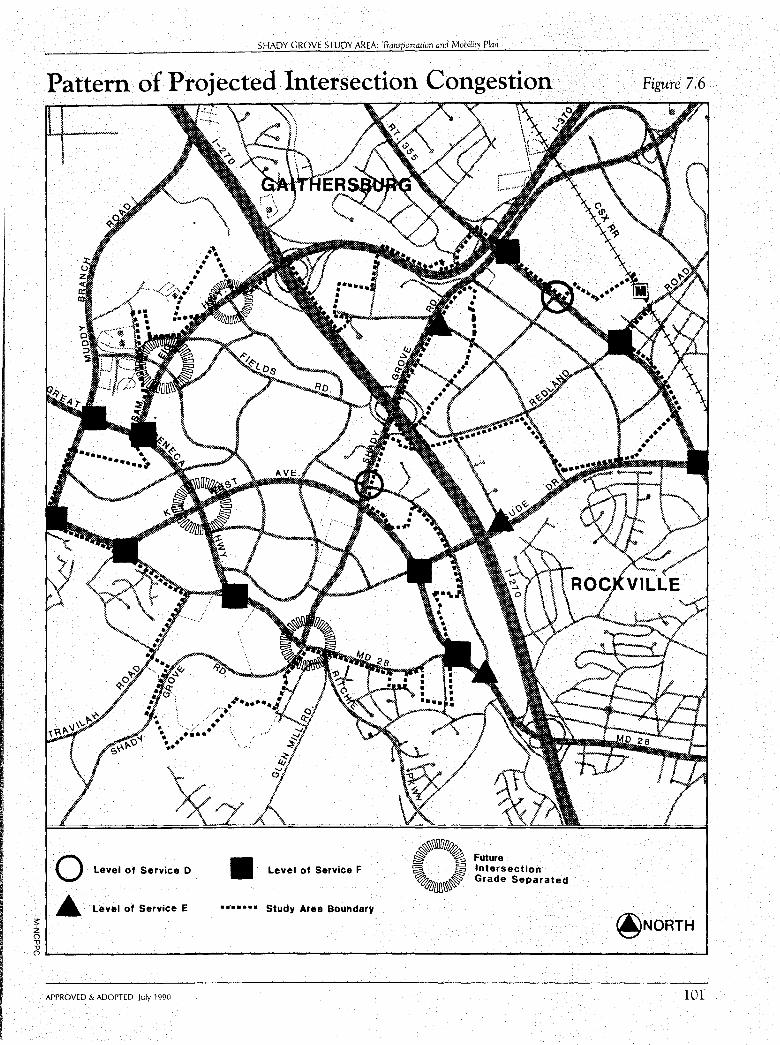
;:: z
SHADY GROVE STUDY AREA: Transportation and Mobility Plan
Pattern of Projected Intersection Congestion
0 Level of Service o
• Level of Service E
II Level of Service F
• ....... Study Area Boundary
~iuuu~ ~ ~ Future = ~ 'a = Intersection ~ ~ G ~.Ol]Jlt~ rade Separated
Figure 7.6
@NORTH 0 ,, ,, o,__ __________________________________________________ _i
APPROVED & ADOPTED July 1990 101
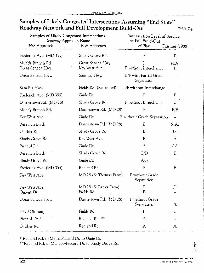
SHADY GROVE STUDY AREA
Samples of Likely Congested Intersections Assuming "End State" Roadway Network and Full Development Build-Out Table 7.4
Samples of Likely Congested Intersections Roadway Approach Name
N/S Approach E/W Approach
Frederick Ave. (MD 355) Shady Grove Rd.
Muddy Branch Rd. Great Seneca Hwy. Great Seneca Hwy. Key West Ave.
Great Seneca Hwy. Sam Eig Hwy.
Sam Eig Hwy. Fields Rd. (Relocated)
Frederick Ave. (MD 355) Gude Dr.
Darnestown Rd. (MD 28) Shady Grove Rd.
Muddy Branch Rd. Darnestown Rd. (MD 28)
Intersection Level of Service At Full Build-Out
of Plan Existing (1988)
F F
F N.A. F without Interchange B
E/F with Partial Grade Separation
E/F without Interchange
F F
F without Interchange C
F E/F
Key West Ave. Gude Dr. F without Grade Separation
Research Blvd. Damestown Rd. (MD 28)
Gaither Rd. Shady Grove Rd.
Shady Grove Rd. Key West Ave.
Piccard Dr. Gude Dr.
Research Blvd. Shady Grove Rd.
Shady Grove Rd. Gude Dr.
Frederick Ave. (MD 355) Redland Rd.
Key West Ave. MD 28 ( & Thomas Farm)
Key West Ave. MD 28 ( & Banks Farm) Omega Dr. Fields Rd.
Great Seneca Hwy. Darnestown Rd. (MD 28)
I-270 Off-ramp Fields Rd.
Piccard Dr. * Redland Rd.**
Gaither Rd. Redland Rd.
* Redland Rd. to Metro/Piccard Dr. to Gude Dr. **Redland Rd. to MD 355/Piccard Dr. to Shady Grove Rd.
102
E N.A.
E B/C
B A
A N.A.
CID E
A!B
F F
F without Grade Separation
F D B
F without Grade Separation A
B C
A
A A
APPROVED & ADOPTED July 1990
(..) D.. D.. 0 z :!;
SHADY GROVE STUDY AREA: Transportatimi and Mobility Plan
In general, the factors considered in reviewing and recommending J?Otential grade separation are:
projected operational problems,
impact on nearby land use,
impact on local access, and
spacing between intersections.
Concerns regarding the impact on local access and spacing between intersections have strongly influenced the Plan's recommendations for grade separations along Great Seneca Highway. Great Seneca Highway is a key roadway in the area for both local and through traffic. It connects Germantown to Rockville (via Darnestown Road) parallel to I-270, through the Study Area. Therefore, it carries traffic through the area as well as a significant amount of traffic into development in the area. It must serve both types of traffic and its intersections must provide for local access as well as accommodating significant through-flow. While grade separation/interchanges primarily reduce congestion for through traffic, they create limitations on local access (due to spacing requirements and land area taken up for ramp systems). Careful consideration was given to both the needs to reduce through-flow congestion and to preserving local, at-grade access in identifying potential grade separation locations and conceptual interchange design. While Great Seneca Highway may primarily be a throughway, it is not a freeway. Grade separations should be designed to balance both land use access and through traffic needs. The objective of this Plan is to reserve prudently sufficient rights-of-way to accommodate grade separations or equivalent atgrade solutions.
Based on an analysis of all the above factors, this Plan designated the following intersections for future grade separations or equivalent at-grade solutions:*
• Fields Road and Sam Eig Highway;
• Key West Avenue and Great Seneca Highway;
• Great Seneca Highway and Muddy Branch Road (transit only);
• Great Seneca Highway, Shady Grove Road, and Ritchie Parkway; and
• Great Seneca Highway and Decoverly Drive (bridge only).
Grade separations are not proposed for every intersection, which means some intersections are still anticipated to have future operational problems. This situation is not far outside the range of expectations for an area fully developed with the high level of quality transit service that is anticipated in Shady Grove.
This Plan recognizes that many events may occur in the future which could positively affect intersection levels of service.
* See Appendix A for discussion of possible designs for these intersections, and a discussion of those intersections not recommended for grade separation.
APPROVED & ADOPTED July 1990 103
104
SHADY GROVE STUDY AREA
These include:
1. Development-Buildout may be less than maximum allowed by zone. Individual property owners may choose to not build the full density on their parcels, or local environmental conditions may require less intensity on the site. Thus, in the long-term, there may be less development locally as well as in the area beyond the Study Area which could result in less local intersection congestion.
2. Regional Transportation Measures-the impact of through traffic on local conditions could be mitigated by broader transportation measures taken by the County or region in the future. Such measures, for example, could make auto use less attractive or intercept higher proportions of through traffic at stations or Park-and-Ride facilities outside the Study Area.
3. Local Transportation Measures-actions taken in the Stidu Area pertaining to the implementation of facilities and programs will directly address the particular problems and needs that develop. Targeted intersection improvements, grade separations, and road widenings will directly impact local traffic circulation and locations of congestion. Consideration should also be given in the future to the creation of some form of Traffic Management Organization in the Study Area to assist the public sector in monitoring and managing traffic conditions.
4. Transit Facilities-the proposed transit system may well serve more riders than presently projected, and consequently automobile traffic would be less. The particular technology and character of service using the transit easement and the actual experience with its usage will play a key role in the ability of the overall transportation system to perform well. The actual amount and location of local congestion at the time of the future development will be affected by these implementation actions which are still to come. The Plan offers a wide range of possibilities in developing these services and facilities.
Bikeway/Pedestrian System The emphasis and anticipation of the provision of a high level of transit facility development to serve the area's transportation needs dictates that pedestrian;bicycle circulation be an integral part of the transportation/land use development process.
To date, the bikeway system in the area has been provided only through the implementation of bikeways as part of County road projects. The County Road Code requires that these facilities be built in conjunction with new road construction, unless the particular bikeway is shown to be unwarranted or infeasible. Although the County Department of Transportation and the Department of Parks have independent budgets for bicycle and pedestrian facilities, their funds are limited and there are no independent projects programmed in the area. There are no major parks in the Study Area, although many are planned. Other independent bikeways and pathways may be
APPROVED & ADOPTED July 1990
SHADY GROVE STUDY AREA: Traruportation and Mobility Plan
required in the subdivision review process as a condition of approval of development plans by the Planning Board. These are designed during the site plan development process and should be coordinated with road-related bikeways to enhance development of a continuous network. In this regard, special attention should be given to the site plans for the major parcels in the planning area to assure integration into the areawide trail network.
The County should also consider further development of the area bikeway system through the implementation of trails along the transitways as they are developed, similar to the proposal for the Georgetown Branch right-of-way. This has the additional benefit of providing a pedestrian access along the transitway tying directly from neighborhoods to the transit stops.
The bikeway recommendations of this Plan, shown in Figure 7.7, page 106, are based on those specified in the Gaithersburg Vicinity Master Plan, the Master Plan of Bikeways, and the County's Capital Improvements Program for roadways. Segments of the system are shown in Table 7.5, which is updated to reflect the currently approved FY 1989-1994 Capital Improvements Program. Standard bikeway classification cross sections are shown in Figure 7 .8, page 107.
Bikeways should also be provided on a number of local streets and on neighborhood paths, particularly those providing access to transit, retail centers, and employment. These routes can be identified during the subdivision and site plan process.
Heliport Recommendations The need for a heliport facility in the southern portion of the I-270 Corridor has already been established in the General Aviation Master Plan Report prepared by Dynaplan, Inc. for the County Council. In addition, the Montgomery County Comprehensive Growth Policy Study presented a chapter regarding the Tiltrotor aircraft.* This Master Plan recommends that provision be made to site a public use heliport capable of serving both conventional and Tiltrotor craft within the Shady Grove Study Area. A heliport facility will be a positive contribution to the R&D Village concept by increasing accessibility to the Village.
* The military version of this new technology is currently under development. It is an aircraft that takes off and lands like a helicopter, then its rotor blades are tilted forward and it flies pretty much as a conventional propeller-driven airplane. Estimates are that a trip from the Washington area to a downtown New York heliport, for example, could be done in about 45 minutes. It is expected that the civilian versions of the Tiltrotor will be coming in use in the mid to late 1990s, pending continued budgetary support for its development.
APPROVED & ADOPTED July 1990 105
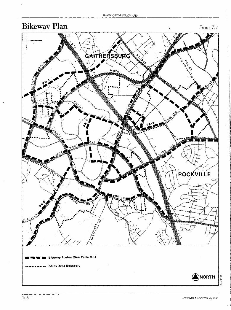
SHADY GROVE STUDY AREA
Bikeway Plan
• • • • Blkeway Routes (See Table 9.sl
_. • •.......... Study Area Boundary
Figure 7.7
@NORTH 0 ""-0 z L-------------------------------------------------.... ::ii
106 APPROVED & ADOPTED July 1990
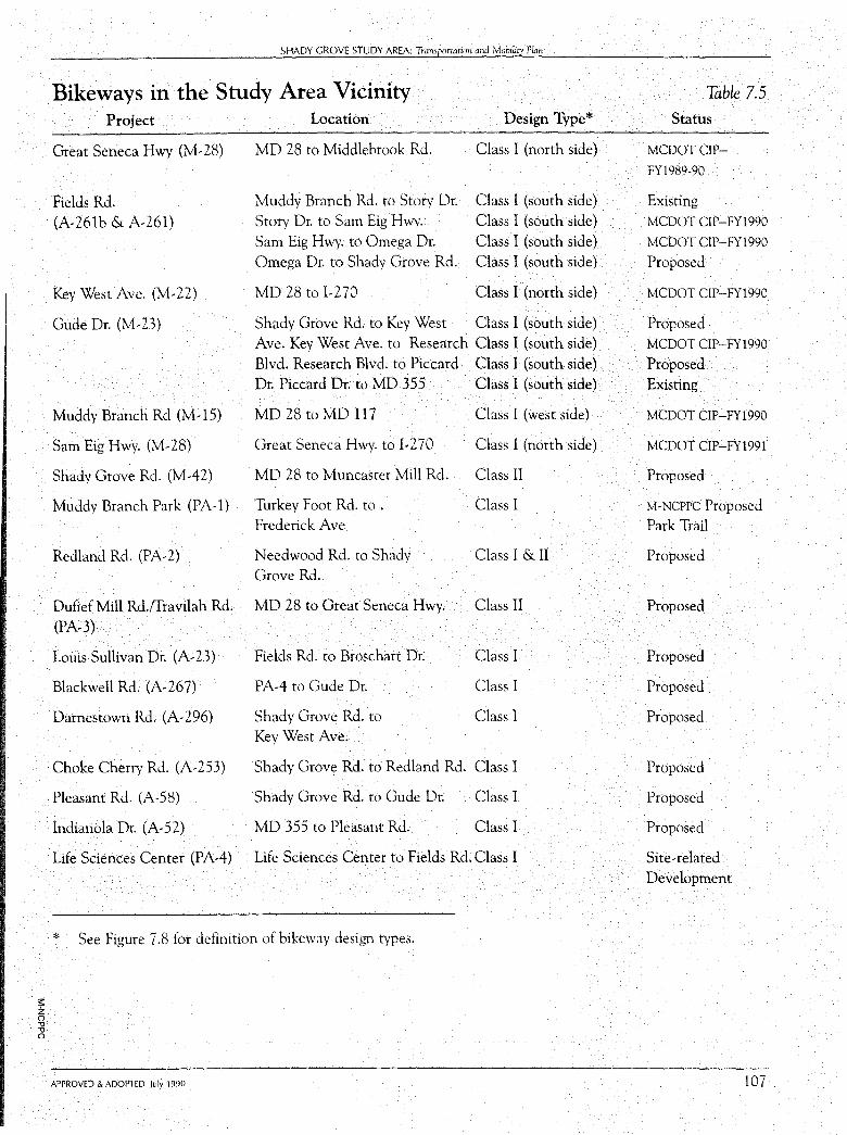
;:: z n -0 -0 n
SHADY GROVE STUDY AREA: Tramportation and Mobility Puin
Bikeways in the Study Area Vicinity Project Location Design Type*
Great Seneca Hwy (M-28) MD 28 to Middlebrook Rd. Class I (north side)
Fields Rd. Muddy Branch Rd. to Story Dr. Class I (south side)
(A-261b & A-261) Story Dr. to Sam Eig Hwy. Class I (south side) Sam Eig Hwy. to Omega Dr. Class I (south side) Omega Dr. to Shady Grove Rd. Class I (south side)
Key West Ave. (M-22) MD 28 to I-270 Class I (north side)
Gude Dr. (M-23) Shady Grove Rd. to Key West Class I (south side) Ave. Key West Ave. to Research Class I (south side) Blvd. Research Blvd. to Piccard Class I (south side) Dr. Piccard Dr. to MD 355 Class I (south side)
Muddy Branch Rd (M-15) MD 28 to MD 117 Class I (west side)
Sam Eig Hwy. (M-28) Great Seneca Hwy. to 1-270 Class 1 (north side)
Shady Grove Rd. (M-42) MD 28 to Muncaster Mill Rd. Class II
Muddy Branch Park (PA-1) Turkey Foot Rd. to. Class I Frederick Ave
Redland Rd. (PA-2) Needwood Rd. to Shady Class I & II Grove Rd.
Dufief Mill Rd./fravilah Rd. MD 28 to Great Seneca Hwy. Class II
(PA-3)
Louis Sullivan Dr. (A-23) Fields Rd. to Broschart Dr. Class I
Blackwell Rd. (A-267) PA-4 to Gude Dr. Class I
Darnestown Rd. (A-296) Shady Grove Rd. to Class I Key West Ave.
Choke Cherry Rd. (A-253) Shady Grove Rd. to Redland Rd. Class I
Pleasant Rd. (A-58) Shady Grove Rd. to Gude Dr. Class I
Indianola Dr. (A-52) MD 355 to Pleasant Rd. Class I
Life Sciences Center (P A-4) Life Sciences Center to Fields Rd. Class I
* See Figure 7 .8 for definition of bikeway design types.
APPROVED & ADOPTED July 1990
Table 7.5 Status
MCDOTCIP-
FY1989-90
Existing MCDOT CIP-FY1990
MCDOT CIP-FY1990
Proposed
MCDOT CIP-FY1990
Proposed MCDOT CIP-FY1990
Proposed Existing
MCDOT CIP-FY1990
MCDOT CIP-FY1991
Proposed
M-NCPPC Proposed Park Trail
Proposed
Proposed
Proposed
Proposed
Proposed
Proposed
Proposed
Proposed
Site-related Development
107
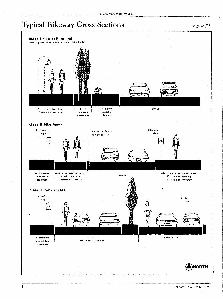
SHADY GROVE STUDY AREA
Typical Bikeway Cross Sections
class I bike path or trail (mixed pedestrian, bicycle use on bike trails)
s· minimum two•way s· minimum one-way
class II bike lanes
1 1.·2·
minimum clearance
4· minimum
pedestrian
sidewalk I parking prohibited or re- I
s.tricted ... bike lane ... s· minimum one-way
class Ill bike routes
4· minimum
pedestrian
sidewalk
Painted stripe or
raised barrier
4· minimum
pedestrian
sidewalk
mixed lraffic street
street
street
Figure 7.8
mb,ed-use widened sidewalk
a· minimum two-way 6' minimum one-way
service road
@NORTH (.) a. a. (.) z ._ ________________________________________________________ __.;::,
108 APPROVED & ADOPTED July 1990
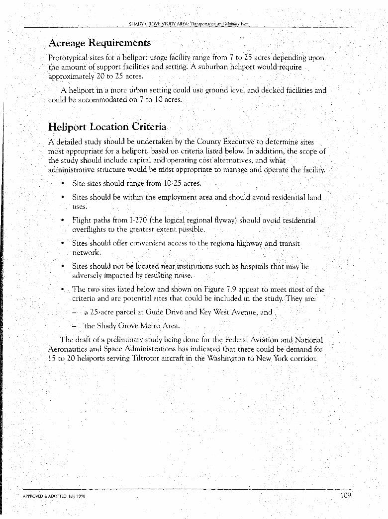
SHADY GROVE STUDY AREA: Transporu1tion and Mobility Plan
Acreage Requirements Prototypical sites for a heliport usage facility range from 7 to 25 acres depending upon the amount of support facilities and setting. A suburban heliport would require approximately 20 to 25 acres.
A heliport in a more urban setting could use ground level and decked facilities and could be accommodated on 7 to 10 acres.
Heliport Location Criteria A detailed study should be undertaken by the County Executive to determine sites most appropriate for a heliport, based on criteria listed below. In addition, the scope of the study should include capital and operating cost alternatives, and what administrative structure would be most appropriate to manage and operate the facility.
• Site sizes should range from 10-25 acres.
• Sites should be within the employment area and should avoid residential land uses.
• Flight paths from I-270 (the logical regional flyway) should avoid residential overflights to the greatest extent possible.
• Sites should offer convenient access to the regiona highway and transit network.
• Sites should not be located near institutions such as hospitals that may be adversely impacted by resulting noise.
• The two sites listed below and shown on Figure 7 .9 appear to meet most of the criteria and are potential sites that could be included in the study. They are:
- a 25-acre parcel at Gude Drive and Key West Avenue, and
- the Shady Grove Metro Area.
The draft of a preliminary study being done for the Federal Aviation and National Aeronautics and Space Administrations has indicated that there could be demand for 15 to 20 heliports serving Tiltrotor aircraft in the Washington to New York corridor.
APPROVED & ADOPTED July 1990 109
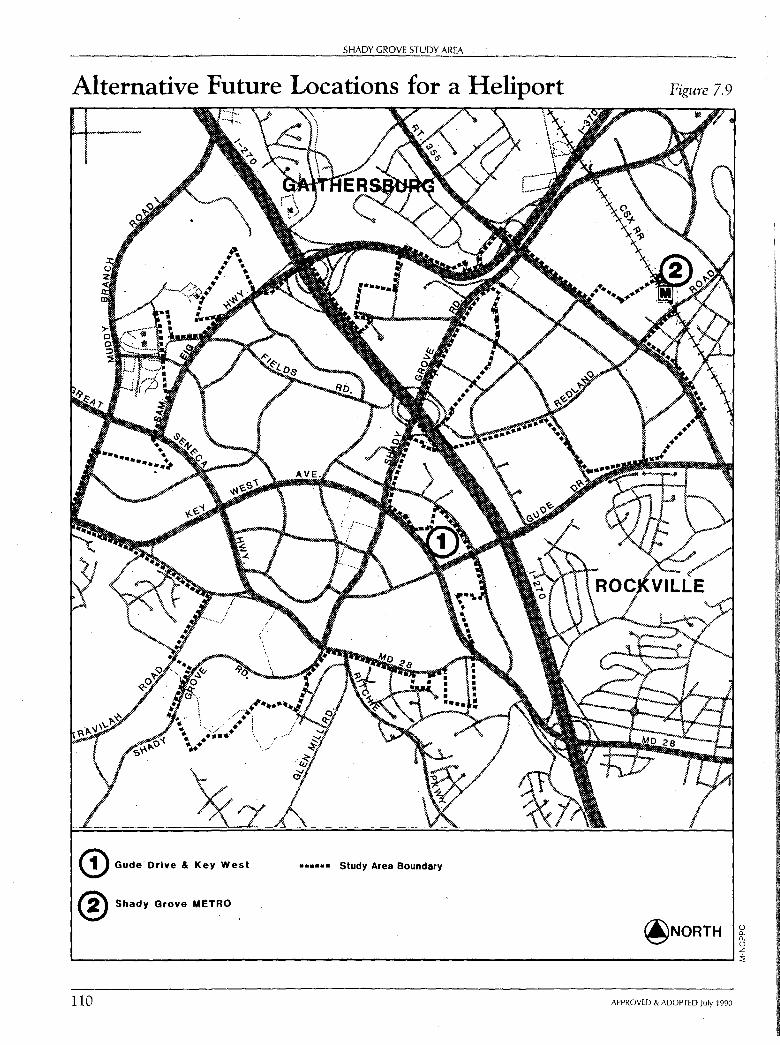
SHADY GROVE STUDY AREA
Alternative Future Locations for a Heliport
© Gude· Drive & Key West
® Shady Grove METRO .
...... Study Area Boundary
Figure 7.9
@NORTH 0 a. a. 0 z L------------------------------------------------------'i
110 APPROVED & ADOPTED July 1990
CHAPTER EIGHT
Community Facilities
Public schools, parks, libraries, community centers, and other public facilities should serve as "community magnets" to help provide a sense of community. Such facilities should be linked to the
_ neighborhood by pedestrian and bicycle paths, and p.ublic. transit and sbauld be utilized to the __ _ greatest extent possible for local recreational, cultural, and civic activities.
The major community facilities proposed in this Plan are parks and schools. These facilities are critical to the neighborhood concept advocated by this Plan. They will help provide public meeting places for residents and workers and create community focal points within the neighborhood.
Parks, Recreation and Open Space Plan Objective:
To provide conveniently located parks and other facilities for both active and passive recreation to meet the needs and interests of various segments of the community, including the handicapped.
Plan Recommendations:
This Plan proposes three general types of park, recreation, and open space: (See Figure 8.1 and the fold-out Land Use Plan Map.)
• active recreation areas,
• neighborhood recreation areas and civic open spaces, and
• conservation areas.
A description of each of these elements and the Plan's recommendations for each are contained in Table 8.1, page 113.
111
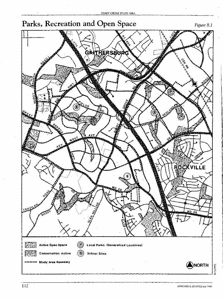
SHADY GROVE STUDY AREA
Parks, Recreation and Open Space
Active Open Space
Conservation Active
••••••••• Study Area Boundairy
® Local Parks (Generalized Locations)
.(W School Sites
Figure 8.1
@NORTH 0 a.. a.. 0 z L.-------------------------------------------------------'i
112 APPROVED & ADOPTED July 1990
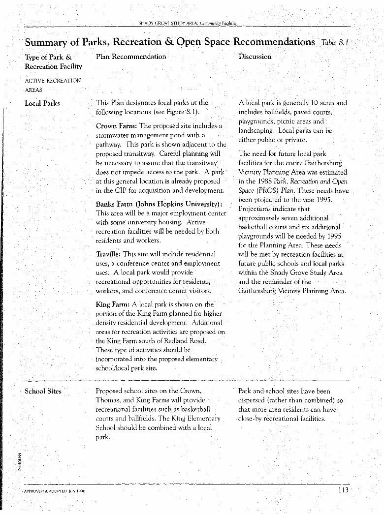
;::: z () ,, ,, ()
SHADY GROVE STUDY AREA: Community Facilitie_,
Summary of Parks, Recreation & Open Space Recommendations Table 8.1
Type of Park & Recreation Facility
ACTIVE RECREATION
AREAS
Local Parks
School Sites
APPROVED & ADOPTED July 1990
Plan Recommendation
This Plan designates local parks at the following locations (see Figure 8.1).
Crown Farm: The proposed site includes a stormwater management pond with a pathway. This park is shown adjacent to the proposed transitway. Careful planning will be necessary to assure that the transitway does not impede access to the park. A park at this general location is already proposed in the CIP for acquisition and development.
Banks Farm (Johns Hopkins University): This area will be a major employment center with some university housing. Active recreation facilities will be needed by both residents and workers.
Traville: This site will include residential uses, a conference center and employment uses. A local park would provide recreational opportunities for residents, workers, and conference center visitors.
King Farm: A local park is shown on the portion of the King Farm planned for higher density residential development. Additional areas for recreation activities are proposed on the King Farm south of Redland Road. These type of activities should be incorporated into the proposed elementary school/local park site.
Proposed school sites on the Crown, Thomas, and King Farms will provide recreational facilities such as basketball courts and ballfields. The King Elementary School should be combined with a local park.
Discussion
A local park is generally 10 acres and includes ballfields, paved courts, playgrounds, picnic areas and landscaping. Local parks can be either public or private.
The need for future local park facilities for the entire Gaithersburg Vicinity Planning Area was estimated in the 1988 Park, Recreation and Open Space (PROS) Plan. These needs have been projected to the year 1995. Projections indicate that approximately seven additional basketball courts and six additional playgrounds will be needed by 1995 for the Planning Area. These needs will be met by recreation facilities at future public schools and local parks within the Shady Grove Study Area and the remainder of the Gaithersburg Vicinity Planning Area.
Park and school sites have been dispersed (rather than combined) so that more area residents can have close-by recreational facilities.
113
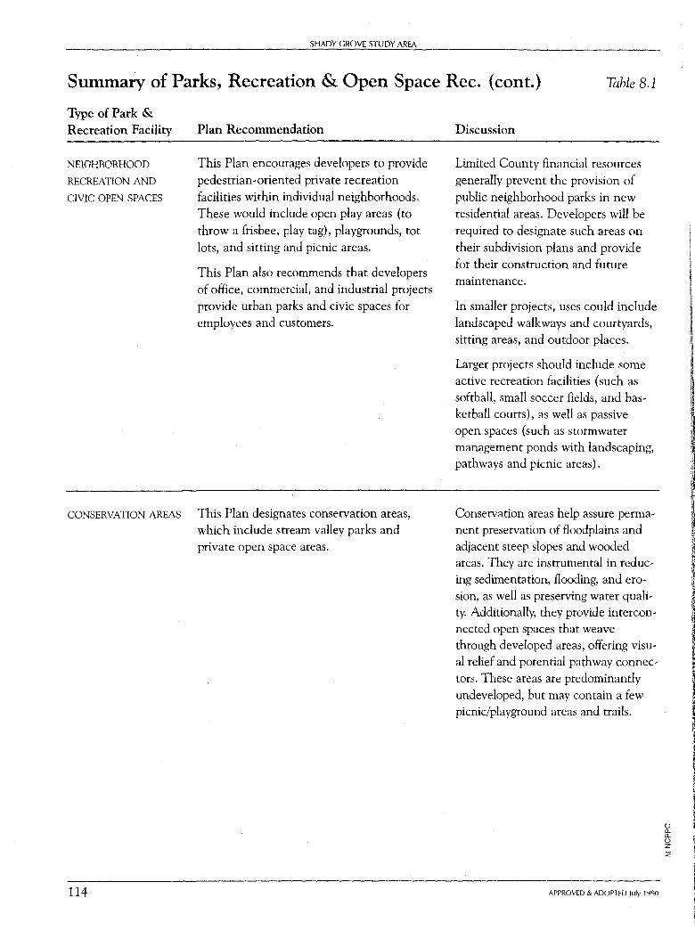
SHADY GROVE STUDY AREA
Summary of Parks, Recreation & Open Space Rec. (cont.) Table 8.1
Type of Park & Recreation Facility
NEIGHBORHOOD
RECREATION AND
CIVIC OPEN SPACES
Plan Recommendation
This Plan encourages developers to provide
pedestrian-oriented private recreation facilities within individual neighborhoods. These would include open play areas (to throw a frisbee, play tag), playgrounds, tot
lots, and sitting and picnic areas.
This Plan also recommends that developers of office, commercial, and industrial projects provide urban parks and civic spaces for employees and customers.
CONSERVATION AREAS This Plan designates conservation areas, which include stream valley parks and private open space areas.
114
Discussion
Limited County financial resources generally prevent the provision of public neighborhood parks in new residential areas. Developers will be
required to designate such areas on their subdivision plans and provide for their construction and future maintenance.
In smaller projects, uses could include landscaped walkways and courtyards, sitting areas, and outdoor places.
Larger projects should include some active recreation facilities (such as softball, small soccer fields, and basketball courts), as well as passive open spaces (such as stormwater management ponds with landscaping, pathways and picnic areas).
Conservation areas help assure permanent preservation of floodplains and adjacent steep slopes and wooded areas. They are instrumental in reducing sedimentation, flooding, and erosion, as well as preserving water quality. Additionally, they provide interconnected open spaces that weave through developed areas, offering visual relief and potential pathway connectors. These areas are predominantly undeveloped, but may contain a few picnic/playground areas and trails.
APPROVED & ADOPTED July 1990
0 Cl. Cl. 0 z ::!;
;: z () -0 -0 ()
SHADY GROVE STUDY AREA: Community Facilities
Summary of Parks, Recreation & Open Space Rec. (cont.) Table 8.1
Type of Park & Recreation Facility
CONSERVATION AREAS
(CONT.)
APPROVED & ADOPTED July 1990
Plan Recommendation Discussion
At the time of development, stream valley areas should be either dedicated as public parkland or retained as private conservation areas. Public parkland is usually restricted to those areas which tie into the existing or proposed park system in some way as a connector to a stream valley, local, or other type of park. Where there is no potential connection to a public park, private conservation areas should be designated on subdivision plans. These areas would be owned and maintained by a homeowners associations. Several future developments in the Shady Grove Study Area have designated conservation areas. They include: Traville, Thomas, Banks, and King Farms.
115
116
SHADY GROVE STUDY AREA
This Plan recommends all three types of park, recreation, and open space areas be provided as part of large development projects. This is especially important in higher density areas.
There are numerous park and recreation facilities outside the Study Area, but close enough to be easily accessible to Study Area residents. They include:
• Muddy Branch Stream Valley Park (located south of the Shady Grove Study Area), which contains over 800 acres for hiking, horseback riding, and nature study.
• The Seneca Creek State Park along Great Seneca Creek. The M-NCPPC owns the land upstream from MD 355, and the State of Maryland owns 5,600 acres along both sides of Great Seneca Creek, downstream from MD 355, to the Potomac River. A lake, built on Long Draught Branch in the State Park, provides water-oriented recreational opportunities.
• Two recreational parks (Gude and Muncaster), which will be constructed adjacent to the Study Area and will serve Shady Grove Study Area residents. These parks will provide a large number of active recreation facilities, such as ballfields, to help meet County-wide needs. They will also include other specialized facilities, such as large picnic areas and playgrounds.
Public Schools The public school is an essential component of community life and, therefore, must be an integral part of community design and development. The need for new schools is determined by both the capacity of existing schools and the projected increase in student enrollment.
Plan Objective:
To provide appropriate school facilities to meet the general and specialized educational needs of area residents.
Existing and Programmed Facilities:
While there are no existing public schools located within the Shady Grove Study Area, there are several schools in the immediate area which serve the Shady Grove Study Area. (See Figure 8.2, page 117.)
The enrollment policy for elementary schools in the Gaithersburg Vicinity Master Plan area has changed since the adoption of the 1985 Master Plan. Elementary school capacity at individual schools has increased from 400-500 students to approximately 690-7 40 students. This increase requires greater building area and more parking spaces. Also, additional classrooms are needed for specialized programs.
The Superintendent for Montgomery County Public Schools has indicated that the need for a proposed up-County mathematics/science program will be studied in FY 1991.
APPROVED & ADOPTED July 1990

;:: z 0 .,,
SHADY GROVE STUDY AREA: Community Facilities
Existing and Proposed School Sites
EXISTING
ELEMENTARY [!] PARK/SCHOOL iJ JUNIOR HIGH I • I
PROPOSED
® @ @
EXISTING PROPOSED SENIOR HIGH ~ @ • •••n Study Area Boundary
*The exact locatlon of schools will be determined at the time of subdivision review
Figure 8.2
@NORTH .,, oi----------------------------------------------------1
APPROVED & ADOPTED July 1990 117
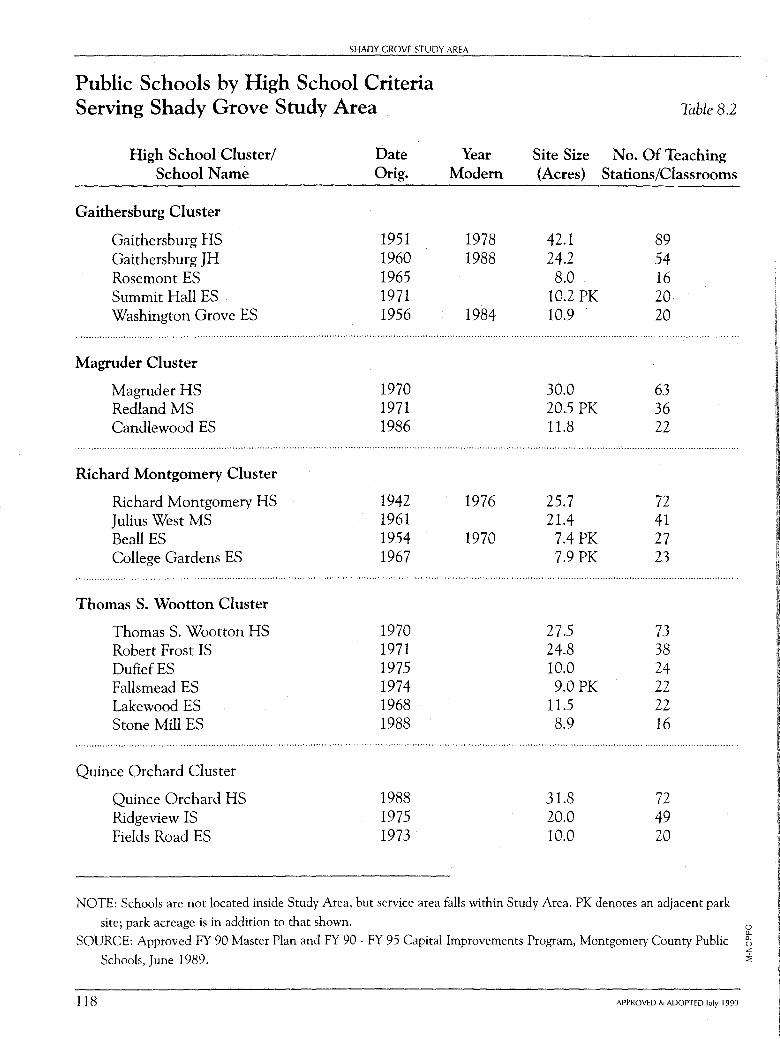
SHADY GROVE STUDY AREA
Public Schools by High School Criteria Serving Shady Grove Study Area
High School Cluster/ School Name
Gaithersburg Cluster
Gaithersburg HS Gaithersburg JH Rosemont ES Summit Hall ES Washington Grove ES
Magruder Cluster
Magruder HS Redland MS Candlewood ES
Richard Montgomery Cluster
Richard Montgomery HS Julius West MS Beall ES College Gardens ES
Thomas S. Wootton Cluster
Thomas S. Wootton HS Robert Frost IS DufiefES Fallsmead ES Lakewood ES Stone Mill ES
Quince Orchard Cluster
Quince Orchard HS Ridgeview IS Fields Road ES
Date Orig.
1951 1960 1965 1971 1956
1970 1971 1986
1942 1961 1954 1967
1970 1971 1975 1974 1968 1988
1988 1975 1973
Year Modem
1978 1988
1984
1976
1970
Site Size (Acres)
42.1 24.2 8.0
10.2 PK 10.9
30.0 20.5 PK 11.8
25.7 21.4 7.4PK 7.9 PK
27.5 24.8 10.0 9.0 PK
11.5 8.9
31.8 20.0 10.0
Table 8.2
No. Of Teaching Stations/Classrooms
89 54 16 20 20
63 36 22
72 41 27 23
73 38 24 22 22 16
72 49 20
NOTE: Schools are not located inside Study Area, but service area falls within Study Area. PK denotes an adjacent park
site; park acreage is in addition to that shown. 0 a.
SOURCE: Approved FY 90 Master Plan and FY 90 - FY 95 Capital Improvements Program, Montgomery County Public t z
Schools, June 1989. :::;
118 APPROVED & ADOPTED July 1990
SHADY GROVE STUDY AREA: Communi1' Facilitie_s
Plan Recommendations:
This Plan estimates that four public schools ( three elementary and one middle school) are needed to serve the projected public school age population of the Shady Grove Study Area. The proposed general locations for these schools are shown on Figure 8.1, page 112. The specific location of schools should be determined at the time of subdivision review. Elementary schools are generally 12 acres in size, while middle schools are 20 acres.
Human Services As the Shady Grove Study Area grows, the demand on social services, particularly in the area of child day-care, will increase.
The programming and delivery of human services are the responsibility of the County government and private service organizations. It is appropriate, however, for this Plan to recommend locations at which these services might be provided. Human services, such as elderly day-care, teen programs, child day-care, and recreation, should be provided throughout the Shady Grove Study Area.
This Plan identifies appropriate locations for the provision of human services facilities. These sites are identified because of their accessibility by public transit as well as automobile, and because of the ability of an appropriately scaled facility to be compatible with proposed land uses in the immediate area. This identification of locations is made to encourage the provision of facilities needed to meet the needs of the Shady Grove Study Area's residents.
Elderly Needs:
Although the Shady Grove Study Area's elderly population is modest, it is expected to increase as the Shady Grove Study Area continues to grow, its population matures, and housing opportunities are broadened. Demographic modeling for the County indicates that the percentage of individuals in the 20-30 age group will decrease in the future, and the total number and the percentage of people over 65 will increase. This outlook for an accelerated rate of increase in the elderly population indicates a potential for a population group whose prospective needs will provide a substantial challenge to a caring community.
Housing for the elderly will be needed in the Shady Grove Study Area, as will nursing homes. Programs and day care centers for the elderly parents of Shady Grove Study Area residents may also be needed. The existing and planned elderly facilities in and near the Shady Grove Study Area are summarized below:
• Shady Grove Adventist Adult Day Care and Nursing Center
• National Lutheran Home for the Aged
APPROVED & ADOPTED July 1990 119
120
SHADY GROVE STUDY AREA
• Collingswood Nursing Center
• Rockville Nursing Home
• Ring House Senior Housing (open 1989)
Plan Recommendations:
Support the provision of adult day care facilities.
- Encourage the location of elderly housing and elderly support services along designated bus routes.
- Encourage the provision of housing for the elderly at appropriate locations in the Shady Grove Study Area.
Child Day-Care Needs:
The number of working parents and the projected increases in the number of children of appropriate ages in the Shady Grove Study Area indicate a need for additional child day,care facilities and opportunities.
Facilities:
The Shady Grove Study Area is served by a wide variety of child care centers, programs, and arrangements. There are currently 18 licensed group child care centers. They are listed in Appendix C. The County Government (as part of a County,wide program) provides a site at the Life Sciences Center for a modular child care facility. The Life Sciences Center site was selected based upon criteria such as adequate parking, ease of drop,off for parents, potential for development of the Plan area, and access from major transportation arteries.
Plan Recommendations:
- When appropriate, consider day care centers as an amenity associated with applications for optional zones (such as MXPD and PD).
- Encourage the provision of child day,care facilities at appropriate locations in the Shady Grove Study Area.
- Consider the feasibility oflocating day-care facilities at proposed Park-and-Ride lots.
- If the Shady Grove Metro station area redevelops, require the provision of daycare facilities as part of the redevelopment process.
APPROVED & ADOPTED July 1990
SHADY GROVE STUDY AREA: Community Facilities
Housing for Special Populations People who are physically and mentally handicapped can often be cared for best in a noninstitutional setting such as home communities with others with similar special needs. Such people generally are those who need supervision or assistance to function in a larger community. As long as the parking does not create an adverse impact on the adjoining neighbors, such homes should be appropriate for any residential community. Efforts, however, should be made to avoid an over-concentration of such homes.
Other Community Facilities
Library Services The Shady Grove Study Area is served by the Gaithersburg Regional Library, the largest of the County's four regional libraries. The 30,000-square-foot facility is located outside the Study Area in Montgomery Village and houses the County's visual and performing arts specialty collection.
There is a small library collection managed by the County at the Public Service Training Academy (PSTA) that supports police and fire and rescue training. This collection is available for public use.
New specialty collections and services are not planned at this time, with the possible exception of one related to biomedical sciences. This might be planned in cooperation with the University of Maryland and the Johns Hopkins University, either in place of, or in addition to, the present small library shared jointly between the County and the Shady Grove Campus of the University of Maryland, which is located at the PSTA.
A small County branch library should be located on the King Farm. The facility is intended to provide limited service, such as check-out and drop-off of high circulation books and materials for transit passengers and residents of the surrounding high density employment and residential neighborhood. Therefore, it need not be a freestanding building, but could instead occupy space in a shopping area along the designated main street.
Shady Grove Life Sciences Center The Shady Grove Life Sciences Center contains a variety of public and private hospitals and institutions, such as Shady Grove Adventist Hospital, outpatient services, physicians' offices, and mental health services. The educational facilities of the University of Maryland and Johns Hopkins University are an important part of the Center.
APPROVED & ADOPTED July 1990 121
122
SHADY GROVE STUDY AREA
Public Safety Police protection is provided by the County and the City of Gaithersburg. Fire protection to the Study Area is currently provided by Stations 8 and 28 of the Gaithersburg Fire Department and Station 31 of the Rockville Fire Department. A fire station may be needed on the King Farm to serve the high density employment and residential community to be developed there. The need and location will be determined at the time of subdivision review. Other facilities may be necessary as development occurs.
APPROVED & ADOPTED July 1990
CHAPTER NINE
Environmental Plan
Significant environmental constraints to development in the Shady Grove Study Area consist of wetlands, stream valleys, and floodplain areas. Constraints generated by mans activities-in particular, traffic,related noise-potentially affect more extensive areas.
Stream Valley Protection Plan Objective:
To protect and enhance the multiple functions of stream valleys throughout the Study Area by designating them conservation areas.
Discussion:
Stream valleys, when examined as a whole, can fulfill many functions beyond their most obvious function as a conduit for floodwater. They can also function as:
safe havens for protection and propagation for wildlife, such as deer;
potential locations for regional stormwater management facilities that control and treat runoff and provide scenic amenities;
areas for passive recreation and enjoyment; natural filters for runoff pollutants, improving water quality and reducing quantity, particularly in wetland areas; and
- visual breaks between different types and intensities of land uses.
Plan Recommendations:
This Plan designates conservation areas along stream valleys (see Figure 9.1, page 124) to enhance these functions. Within these conservation areas, development will be reviewed for compliance with
123
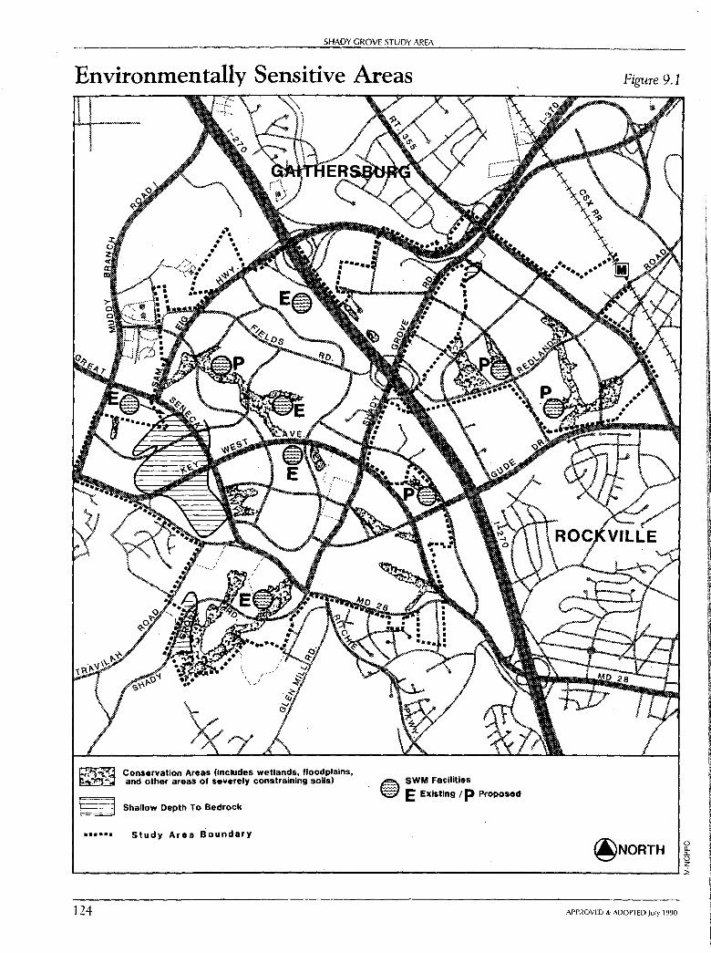
SHADY GROVE STUDY AREA
Environmentally Sensitive Areas
~ ~
......
Conservation Areas (Includes wetlands, floodplains, and other areas of severely constraining soils)
Shallow Depth To Bedrock
Study Area Boundary
~ SWM Facilities
~ E Existing / p Proposed
Figure 9.1
@NORTH 0 [l_ [l_
0 z '---------------------------------------------------------1i 124 APPROVED & ADOPTED July 1990
SHADY GROVE STUDY AREA: Environmmcal Plan
the following regulatory controls and guidelines:
The M-NCPPC stream valley protection guidelines, which seek to reduce much of the negative influence of development in a natural, non-invasive manner. An important benefit in this approach is that it has other positive spinoff effects on the environment. One of the most important of these is protection and enhancement of wildlife habitats.
State and Federal Wetland Protection Statutes.
Zoning Ordinance and Subdivision Regulations (these regulations prevent development in the 100-year ultimate floodplain).
This Plan recommends that, as individual properties are proposed for development, a reforestation plan be prepared by the applicant in consultation with the Maryland State Forest, Park, and Wildlife Service in all conservation areas currently devoid of significant mature vegetation to re-establish a natural stream valley area.
To protect and enhance the living resource habitat and improve water quality are the primary goals of the Planning Department's guidelines for the protection of slopes and stream valleys. The focus on water quality objectives should be supplemented by a living resource habitat protection and rehabilitation objective. While stream buffer protection works well in areas where natural, undisturbed stream valleys still exist, much of the Shady Grove Study Area has been, and continues to be, farmed with tilling in close proximity to streams. At a minimum, reforestation should occur within the entire stream valley buffer, as determined by M-NCPPC guidelines.
This recommendation will be enforced through the development process, but is also recommended for current implementation on farms as an appropriate soil conservation practice. This recommendation will improve water quality, extend the useful life of regional stormwater management facilities, and restore habitat areas, thus enhancing opportunities for diverse wildlife and fishery populations.
Erosion, Stormwater Management, and Flood Control Plan Objective:
To maintain a living, stable, and biologically diverse stream system in the Shady Grove Study Area.
Plan Recommendations:
To facilitate the provision of adequate safeguards against possible increased flooding, erosion damage, and water quality degradation due to development, the Montgomery County Department of Environmental Protection produced two studies. They are the Shady Branch Preliminary Stormwater Management Plan and a study of the Watts Branch Watershed in 1976, covering much of the Shady Grove Study Area. These studies provide the technical documentation and justification for development of possible regional stormwater management facilities for these developing basins. The
APPROVED & ADOPTED July 1990 125
126
SHADY GROVE STUDY AREA
location of possible regional facilities can be seen on the Environmentally Sensitive Areas map. (See Figure 9.1, page 124.)
Residential development is occurring in the Shady Branch watershed in the vicinity of the proposed regional facility at Site 3. Stormwater management controls for all development, including public projects such as roads, should be provided within the subwatershed, either by a regional facility or by on-site stormwater management.
Soil Limitations Plan Objective:
To assure safe and stable development that recognizes and addresses building constraints due to soil conditions.
Discussion:
Soil type is an important determinant of the capability of land to accommodate various land uses. Even if a particular use is marginally acceptable, the costs of safe construction may be a significant factor.
The predominant soils in the Shady Grove Study Area are Glenelg silt and Manor silt loams; these soils are well drained and very permeable. These soil types are well suited for most development and are capable of accommodating water quality infiltration practices.
Pockets of more severely constraining soil types occur throughout, principally within the floodplain areas of the streams. These soil types are the Calvert, Chrome and Conowingo, Worsham, and Wehadkee silt loams. According to the soil limitations class of the Montgomery County Soil Interpretations Guide, these soil limitations require avoidance through planning and design or very special construction measures.
Two large areas of severely constraining soils exist outside the stream valley. Chrome and Conowingo silt loams are located in the western section of the Study Area, southwest of Great Seneca Highway and north of MD 28. This area presently has tree cover with shallow root systems. These soils have a shallow depth to bedrock and generally require costly rock removal for any excavations.
Plan Recommendation:
At the time of preliminary plan review, detailed studies by a soils engineer will be required to assess, through field investigation, the limitation of severely constraining soils with recommendations for mitigation or avoidance.
APPROVED & ADOPTED July 1990
Noise Impacts Plan Objective:
SHADY GROVE STUDY AREA: Environmental Plan
To avoid significant traffic-generated noise impacts on residential development.
Discussion:
While natural constraints are generally confined to the stream valleys, constraints generated by man's activities are more extensive. Noise emanating from the numerous roadways crisscrossing the Shady Grove Study Area, for instance, is high enough to create significant impacts on adjacent residential properties if not mitigated. These excessive noise levels can be annoying and can have adverse effects on human activity, human well being, and a village experience. Excessive noise can disrupt sleep, interfere with vocal communication, and induce psychological stress. It follows that each land use category has a limit which should not be exceeded if that land use is to maintain its proper function. Residential land uses are most sensitive due to the nature of their activities, such as sleep and communication, and the presumption that windows will be opened, particularly in the spring and fall seasons of the year.
The roadway noise levels within the Shady Grove Study Area vary with traffic volume, speed, type of roadway, and the type of vehicles which utilize the roadway. I-270, Key West Avenue, Great Seneca Highway, Shady Grove Road, Fields Road, MD 28, and proposed arterial roadways are or will be the major sources of potential noise generation in the Study Area.
The extent of potential noise impacts in the Shady Grove Study Area are shown in Figure 9.2, page 128.
Plan Recommendations:
In keeping with the intent of noise-compatible land use planning, prevention or mitigation of noise impacts should be a major consideration throughout the land use planning and development approval processes. Consequently, to achieve the noise levels recommended in M-NCPPC's noise guidelines, the following noise reduction techniques (in priority order) shall be considered at time of subdivision:
Whenever consistent with other land use objectives, encourage development of noise-compatible land uses (commercial, office, industrial, recreational, and open space).
Develop high noise areas with site-specific, noise-compatible land uses, such as parking lots, garages, storage sheds, recreation areas, open space, stormwater management facilities, or any other use that allows noise-sensitive residential dwellings to be placed away or buffered from highways.
Construct landscaped berms which mimic natural landforms or orient residential structures so that the facade acts as a barrier and buffers private outdoor areas (patios or courtyards) from roadway traffic.
Construct aesthetic physical barriers for noise mitigation.
APPROVED & ADOPTED July 1990 127
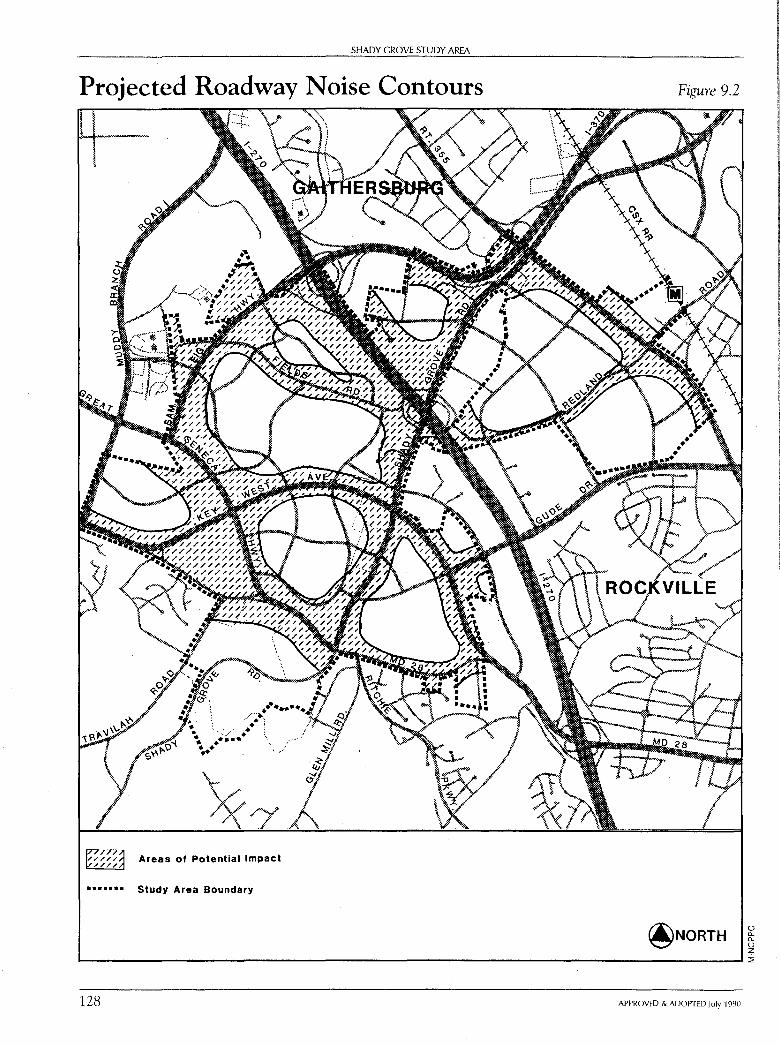
SHADY GROVE STUDY AREA
Projected Roadway Noise Contours
Areas of Potential Impact
••••••• Study Area Boundary
128
Figure 9.2
APPROVED & ADOPTED July 1990
0 [L [L 0 z i
SHADY GROVE STUDY AREA: Environmental Plan
If measures designed to produce a suitable exterior noise envirol).ment are infeasible or insufficient, interior levels of 45 dBA Ldn should be maintained through acoustical treatment of the building shell.
Noise mitigation measures must be consistent and supportive of other land use and design objectives of this Plan, including pedestrian access to mass transit and neighborhood design concepts that maximize transit serviceability.
Further discussion of noise level criteria and mitigation options may be found in Guidelines for the Consideration of Transportation Noise Impacts in Land Use Planning and Development (M-NCPPC, 1983).
In areas where existing development is adjacent to new or widened roadways, MCDOT's noise standard and noise mitigation implementation guidelines shall be used to determine the need and nature of noise mitigation measures.
Water Supply and Sewerage Plan Objective:
To develop and maintain water supply and sewerage systems with adequate capacity to meet demand.
Discussion:
Water supply and sewerage systems are available and generally adequate to serve the projected needs of the Shady Grove Study Area. The Washington Suburban Sanitary Commission (WSSC) is responsible for operating and maintaining the water supply and sewerage system for Montgomery County.
The Shady Grove Study Area, like most of Gaithersburg, lies within the Montgomery County "high pressure zone" for water service. The need for additional water supply and storage in this area has been identified by WSSC.
Since the Montgomery County High Zone serves an area which is experiencing rapid development (a trend which is expected to continue into the next century), WSSC has proposed a project-W-90.01, Montgomery County High Zone Supply Facility Plan-in the 1990-95 Capital Improvements Program. The objective of this Facility Plan is to develop a plan of supply for the Montgomery County High Zone and all dependent zones for the projected maximum day water consumption through the year 2020. Additional remedial measures are under study by the County and WSSC. This Plan supports the timely completion of the study.
Plan Recommendations:
The Montgomery County Comprehensive Water Supply and Sewerage Systems Plan is the County's program for providing community water and sewerage service.
This Plan recommends that the entire Study Area be eligible for sewer and water service within the next six years.
APPROVED & ADOPTED July 1990 129
130
SHADY GROVE STUDY AREA
The Plan's staging recommendations will affect the timing of development. The Ten Year Comprehensive Water Supply and Sewerage Systems Plan generally requires that category changes reflect the recommendations of the appropriate Master Plan. This linkage between the Master Plan and the Water Supply and Sewerage Systems Plan should ensure that category changes will be consistent with Master Plan staging policies.
APPROVED & ADOPTED July 1990
CHAPTER TEN
Implementation
The Master Plan for Shady Grove Study Area serves as a guide to the area's physical development. Public agencies and officials use the Plan to evaluate planning proposals and to allocate resources. The private sector also refers to the Plan for planning guidance.
Montgomery County has an opportunity to take advantage of the strong market potential for housing and employment in the Shady Grove Study Area. To do so, it must foster the Plan's recommendations by assuring the timely availability of necessary facilities and by regulating the quality of development. Among the measures available to implement the Plan's proposals and related County policies are:
• Sectional Map Amendment (SMA),
• Zoning Text Amendments,
• Capital Improvements Program (CIP),
• Subdivision Regulations,
• Staging of Development,
• Transfer of Development Rights (TDR), and
• Interjurisdictional Cooperation.
Sectional Map Amendment (SMA) A Sectional Map Amendment (SMA) is a comprehensive rezoning process which zones all properties within a planning area to correspond with the zoning recommendations in the master plan. The Planning Board files the SMA, and the Council, after public hearing, adopts the zoning. Once the rezoning occurs, it is the legal basis for all future local map amendment requests for Euclidean zones.
131
132
SHADY GROVE STUDY AREA
The SMA only implements Euclidean (base) zones and those floating zones having the owner's concurrence and which do not require a development plan at the time of rezoning. The Planned Development (PD) Zone, Mixed-Use Planned Development (MXPD) Zone and Transit Station (TS-M, TS-R) Zones require separate applications as local map amendments.
An SMA for the Shady Grove Study Area will implement this Plan's zoning recommendations.
Zoning Text Amendments To implement the mixed-used neighborhood concept, a new zone may be desirable. This zone would promote a mix of low to moderate intensity employment, residential, and commercial uses on large parcels of land.
Capital Improvements Program (CIP) The Executive Branch of County government is responsible for planning, programming, and budgeting for the County's mid-range needs. It does this through two interrelated six-year programs, which are annually updated. One is the Capital Improvements Program (CIP), which funds construction of all public buildings, roads, and other facilities planned by the County. The other is the Comprehensive Six Year Public Services Program and the Operating Budget, which funds County programs and coordinates them with capital expenditures. The Legislative Branch ( the County Council) adopts both the CIP and the Operating Budget.
Projects that are currently scheduled and those which are recommended for future inclusion in the CIP to implement the Plan's recommendation are listed in Appendix E. The County or State agencies responsible for design and development of each project are indicated in that table. The CIP assures that the projects necessary to fulfill the needs of the community, providing for orderly growth and development, are built at the appropriate time and in the proper location. The timetable for planning and construction of these projects should be coordinated with private development.
The description of each project should respond to the recommendations of this Plan in terms of their scope and nature. The funding should be adequate to provide for all aspects of the projects, including landscaping, fencing, grading, and pedestrian and bicycle paths.
The initial CIP description is generally sketchy as to the scope of a project, its cost, and its construction timetable. Each project is reviewed annually by the citizenry and public officials. During this review, projects can be deleted, modified, or added. This procedure allows the flexibility needed to balance available resources and public priorities.
In order to implement several of the recommendations of this Plan, funds need to
APPROVED & ADOPTED July 1990
SHADY GROVE STUDY AREA: Implementation
be provided for the construction and maintenance of special features. Many of the features recommended by this Plan will be funded by the Capital Improvements Program. The construction of features related to a particular subdivision should be funded by the developer and maintained by the owner. Others may be funded by local community groups.
Subdivision Regulations Subdivision regulations govern the process of dividing land into parcels, blocks, and lots. They prescribe specific standards for streets, street connections, open space, and the size and configuration of building lots. In addition, the subdivision regulations describe the filing and procedural requirements that must be followed in securing the approval of the Planning Board. The subdivision regulations are part of the Montgomery County Code. A property must be on a recorded lot in order to receive a building permit. Thus, all of the land in the Shady Grove Study Area that is not on a recorded lot or contained within an approved preliminary subdivision must go through the subdivision process in order to develop.
Methods of subdivision development are defined in the County's Zoning Ordinance. The Zoning Ordinance also prescribes variations and options to the standard regulations. Such variations include cluster development, optional method of development, and the bonus provisions that accompany moderately priced dwelling unit development. These options permit additional flexibility in site development as an incentive to meeting public goals. Cluster provisions permit smaller size lots and less rigid lot configurations in return for providing common open space and site plan controls. These controls provide greater protection for natural land forms, more usable open space, and more environmentally sensitive patterns of development. During subdivision review the precise delineation of any conservation easement is prepared and the easement conveyed to the M-NCPPC.
The Adequate Public Facilities Ordinance (APFO) is an important part of the subdivision regulations. The APFO requires that "public facilities ... adequate to support and service the proposed subdivision" must be existing or programmed for construction before the Planning Board may grant approval of a preliminary plan of subdivision. The APFO helps assure that new development does not proceed unless needed transportation and other facilities are in place or imminent.
The subdivision regulations were recently amended to require the Montgomery County Planning Board to take the recommendations of the appropriate master plan into account when considering preliminary subdivision plans. This amendment strengthens the recommendations and development guidelines contained in this Plan.
APPROVED & ADOPTED July 1990 133
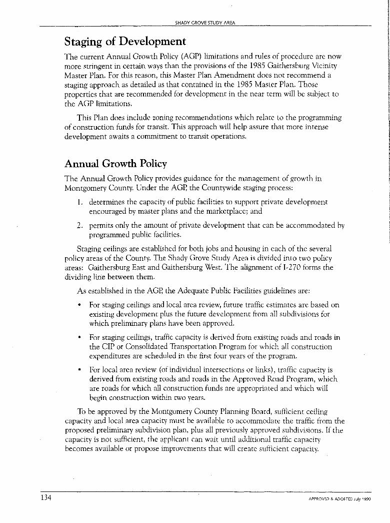
134
SHADY GROVE STUDY AREA
Staging of Development The current Annual Growth Policy (AGP) limitations and rules of procedure are now more stringent in certain ways than the provisions of the 1985 Gaithersburg Vicinity Master Plan. For this reason, this Master Plan Amendment does not recommend a staging approach as detailed as that contained in the 1985 Master Plan. Those properties that are recommended for development in the near term will be subject to the AGP limitations.
This Plan does include zoning recommendations which relate to the programming of construction funds for transit. This approach will help assure that more intense development awaits a commitment to transit operations.
Annual Growth Policy The Annual Growth Policy provides guidance for the management of growth in Montgomery County. Under the AGP, the Countywide staging process:
1. determines the capacity of public facilities to support private development encouraged by master plans and the marketplace; and
2. permits only the amount of private development that can be accommodated by programmed public facilities.
Staging ceilings are established for both jobs and housing in each of the several policy areas of the County. The Shady Grove Study Area is divided into two policy areas: Gaithersburg East and Gaithersburg West. Th_e alignment of 1~270 forms the dividing line between them.
As established in the AGP, the Adequate Public Facilities guidelines are:
• For staging ceilings and local area review, future traffic estimates are based on existing development plus the future development from all subdivisions for which preliminary plans have been approved.
• For staging ceilings, traffic capacity is derived from existing roads and roads in the CIP or Consolidated Transportation Program for which all construction expenditures are scheduled in the first four years of the program.
• For local area review ( of individual intersections or links), traffic capacity is derived from existing roads and roads in the Approved Road Program, which are roads for which all construction funds are appropriated and which will begin construction within two years.
To be approved by the Montgomery County Planning Board, sufficient ceiling capacity and local area capacity must be available to accommodate the traffic from the proposed preliminary subdivision plan, plus all previously approved subdivisions. If the capacity is not sufficient, the applicant can wait until additional traffic capacity becomes available or propose improvements that will create sufficient capacity.
APPROVED & ADOPTED July 1990

SHADY GROVE STUDY AREA: Implementation
Transferable Development Rights (TDR) The Plan recommends the suitability of development on certain properties using the TDR density option as part of the intent to preserve agriculture in Montgomery County. The goal of the 1980 Preservation of Agricultural and Rural Open Space Master Plan is to retain farmland in the upper portion of the County. To do so, allowable development of land must be discouraged or prevented. The Preservation of Agricultural and Rural Open Space Master Plan developed two mechanisms for farmland preservation in the Agricultural Reserve: the first reduces permitted residential development in the Agricultural Reserve to a density of one dwelling unit per 25 acres, and the second creates a mechanism to transfer development rights from the Agricultural Reserve to other parts of the County.
For property in the Agricultural Reserve that is classified in the Rural Density Transfer (RDT) Zone, the owner may sell transferable development rights equivalent to one development right for each five acres of RDT property. Land designated as appropriate for TDR receiving areas in the Germantown Master Plan and other master plans may be developed at the higher density shown by the use of TD R's equivalent to the difference between the base density and the increased density. When the TDR's from a particular parcel of RDT land are sold, a perpetual easement is recorded in the office of land records on the RDT land limiting the number of future one-family residences.
The TDR approach permits development rights to be transferred from parcels in the Agricultural Reserve to designated "receiving areas" in other parts of the County. Receiving areas are those places to which development rights are transferred to increase residential density. The TDR process is illustrated in Figure 10.1.
Each master plan, as it is developed, is examined to determine whether it should contain receiving areas and, if so, how many TDR's would be appropriate. The location of receiving areas must be consistent with the master plan's limitations on the ability and desirability of development in certain areas. These limits must be within the range of planned public facilities such as roads, utilities, parks, and schools. Development in receiving areas must be compatible with existing and planned development on adjacent or surrounding areas. They must also meet the County-wide criteria established for the designation of receiving areas and satisfy the development standards in the Montgomery County Zoning Ordinance; they will be included in the Sectional Map Amendment process for this Plan.
lnterjurisdictional Cooperation This Amendment re-affirms the 1985 Gaithersburg Vicinity Master Plan recommendations regarding interjurisdictional issues. They are summarized below:
• Any land annexed by either Gaithersburg or Rockville should include a staging component in the annexation agreement, similar to that which would be in effect if the tract remained outside the city.
APPROVED & ADOPTED July 1990 135
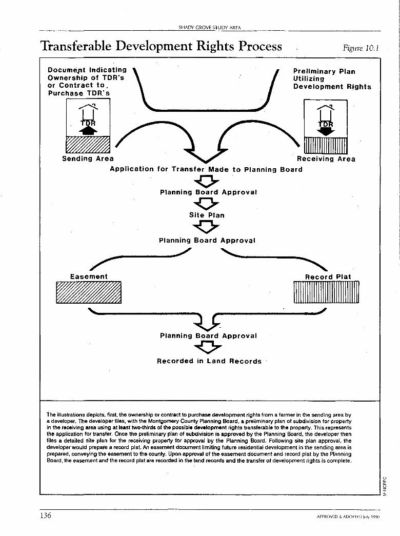
SHADY GROVE STUDY AREA
Transferable Development Rights Process
Documept Indicating Ownership of TDR's or Contract to. Purchase TOR.' s
Figure 10.1
Preliminary Plan Utilizing Development R!ghts
Receiving
Application for Transfer Made to Planning Board
0 Planning Board Approval
0 Site Plan
0 Planning Board Approval
Easement Record Plat
111111111111111111111111111111
' :u; Planning Board Approval
~ Recorded in Land Records
The illustrations depicts, first, the ownership or contract to purchase development rights from a farmer in the sending area by a developer. The developer files, with the Montgomery County Planning Board, a preliminary plan of subdivision for property in the receiving area using at least two-thirds of the possible development rights transferable to the property. This represents the application for transfer. Once the preliminary plan of subdivision is approved by the Planning Board, the developer then files a detailed site plan for the receiving property for approval by the Planning Board. Following site plan approval, the developer would prepare a record plat An easement document limiting future residential development in the sending area is prepared, conveying the easement to the county. Upon approval of the easement document and record plat by the Planning Board, the easement and the record plat are recorded in the land records and the transfer of development rights is complete.
0 a. 0.. 0 z '-----------------------------------------------Ii
136 APPROVED & ADOPTED July 1990
SHADY GROVE STUDY AREA: Implememation
• The cities should require the use of TD R's in their annexation agreements when TDR receiving areas are involved. In the absence of TD R's, the County Council should not concur in zoning densities greater than the base density shown in the Master Plan.
• The cities of Rockville and Gaithersburg and the County should agree to develop a memorandum of understanding on maximum expansion limits and annexation issues. This agreement would provide the policy basis for reviewing all future annexation applications.
APPROVED & ADOPTED July 1990 137
APPENDIX A
Intersection Analysis
Possible Grade Separations Following is a discussion of each intersection proposed to be grade-separated and a possible and feasible design. The schematic designs are illustrative only, since final design requires field study and survey. The design and proposed configuration may change as the result of this further study. Also, this study may indicate that equivalent at-grade solutions may work and are more appropriate. However, in all cases, the basic objective is to facilitate through movements.
a. Fields Road/Sam Eig Highway:
The potential grade separation of Fields Road would be at the southern intersection of Fields Road with Sam Eig Highway and should be done only in conjunction with the extension of Louis Sullivan Drive. The proximity of developed subdivisions and local streets north of Sam Eig Highway severely restricts the space for interchange design at this location. Therefore, the most feasible design option appears to be an urban diamond interchange with Fields Road passing over Sam Eig Highway and ramp connections on all four quadrants from Sam Eig Highway to Fields Road. This would permit free flow on Sam Eig Highway. The northern intersection of Fields Road may have to be closed to permit adequate space for this design. The extension of Louis Sullivan Drive would, in essence, connect the terminus of this section of Fields Road directly to the interchange. This design treatment will significantly improve traffic flow on Sam Eig Highway by removing at-grade intersections without serious detriment to local access. (See Figure A. l, page 142.)
Future consideration of implementation of this proposed grade separation must include or be preceded by a traffic analysis to determine the desirable interchange design characteristics and impacts on local, through, and area-wide traffic, if any. This analysis would take into account
141

SHADY GROVE STUDY AREA
Schematic Grade Separation Proposal: Sam Eig Highway and Fields Road
ILLUSTRATIVE ONLY: FURTHER STUDY MAY MODIFY FINAL DESIGN SUBSTANTIALLY
Figure A.I
/ /
() 11. 11. 0 z .._____ ________________________________ __, ::,!,
142 APPROVED & ADOPTED July 1990
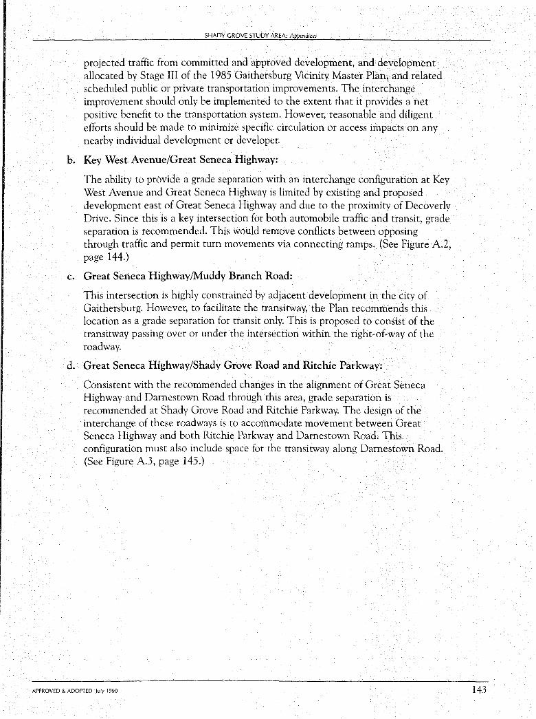
SHADY GROVE STUDY AREA: Appendices
projected traffic from committed and approved development, and development allocated by Stage III of the 1985 Gaithersburg Vicinity Master Plan, and related scheduled public or private transportation improvements. The interchange improvement should only be implemented to the extent that it provides a net positive benefit to the transportation system. However, reasonable and diligent efforts should be made to minimize specific circulation or access impacts on any nearby individual development or developer.
b. Key West Avenue/Great Seneca Highway:
The ability to provide a grade separation with an interchange configuration at Key West Avenue and Great Seneca Highway is limited by existing and proposed development east of Great Seneca Highway and due to the proximity of Decoverly Drive. Since this is a key intersection for both automobile traffic and transit, grade separation is recommended. This would remove conflicts between opposing through traffic and permit tum movements via connecting ramps. (See Figure A.2, page 144.)
c. Great Seneca Highway/Muddy Branch Road:
This intersection is highly constrained by adjacent development in the city of Gaithersburg. However, to facilitate the transitway, the Plan recommends this location as a grade separation for transit only. This is proposed to consist of the transitway passing over or under the intersection within the right-of-way of the roadway.
d. Great Seneca Highway/Shady Grove Road and Ritchie Parkway:
Consistent with the recommended changes in the alignment of Great Seneca Highway and Damestown Road through this area, grade separation is recommended at Shady Grove Road and Ritchie Parkway. The design of the interchange of these roadways is to accommodate movement between Great Seneca Highway and both Ritchie Parkway and Damestown Road. This configuration must also include space for the transitway along Damestown Road. (See Figure A.3, page 145.)
APPROVED & ADOPTED July 1990 143
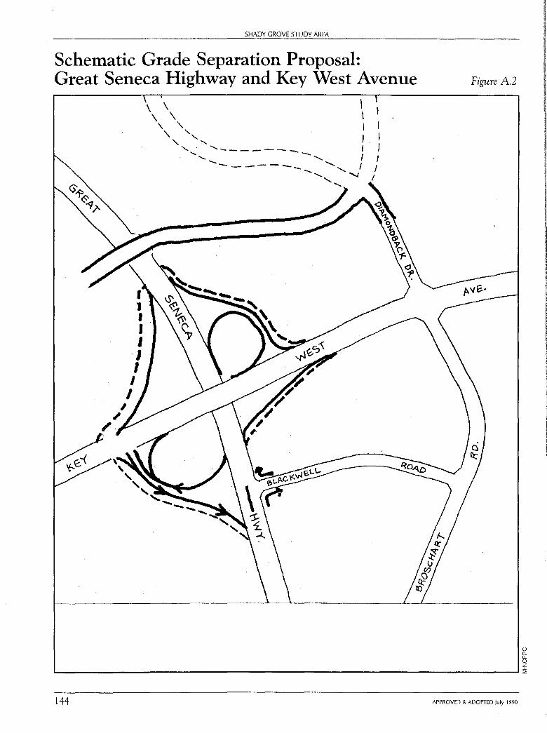
SHADY GROVE STUDY AREA
Schematic Grade Separation Proposal: Great Seneca Highway and Key West Avenue
" ~. '
I l I I I I I
I I
I
\ \ I \ \ \
\ '\. I '\. ' ' ', l '-, ,._______ I
' -......._ I ..________ -............_ I
"
Figure A.2
0 0.. 0.. 0 z
'------------------------------------' :i,
144 APPROVED & ADOPTED July 1990
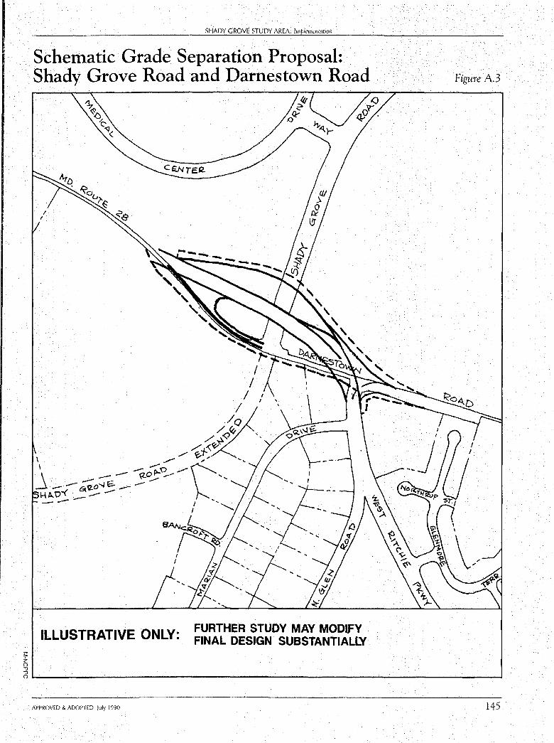
;:: z 0 ""Cl ""Cl
SHADY GROVE STUDY AREA: Implementation
Schematic Grade Separation Proposal: Shady Grove Road and Damestown Road
ILLUSTRATIVE ONLY:
' ' ' ' ' ' ' '
FURTHER STUDY MAY MODIFY FINAL DESIGN SUBSTANTIALLY
' ' '~
Figure A.3
OL..-----------------------------------1 APPROVED & ADOPTED July 1990 145
APPENDIX B
Transportation Systems Analysis
Analysis Results A major concern during any master plan process is whether the end-state transportation network proposed in a master plan can support the end-state land use pattern.
To address this concern, the master planned land use pattern has been tested against the endstate master plan transportation network. This analysis is based on a land use scenario which anticipates approximately 80,400 jobs and 11,300 households within the Shady Grove Study Area. A description of methodology is discussed later in this chapter.
A key issue in the Plan is the anticipated effect of the transitways proposed for the Shady Grove Study area on traffic. Table B.1 summarizes the number of A.M. peak-hour vehicle trips associated with the Land Use Plan, with and without the inclusion of the transitways envisioned in the Plan. One of the key features of this figure is the effect of transit availability upon travel mode. It shows that, due to the expected higher levels of transit use resulting from the active use of the transit easements traversing the Study Area, there will be a reduction in peak-hour vehicle trips which dampens the traffic effects of the development densities associated with the Plan. It is estimated that the Plan would produce approximately 8,500 outbound A.M. peak-hour vehicle trips from households and attract approximately 28,000 inbound trips to jobs within the Study Area. Transit ridership projections are based on the observed ridership patterns in areas such as Silver Spring, Takoma Park, Bethesda- Chevy Chase, North Bethesda, and Gaithersburg, as well as future transit ridership estimates resulting from the Comprehensive Growth Policy Study and the transportation analysis of the Shady Grove Study Area. These projections take into account such features as the transit serviceability of both the land use pattern and infrastructure of the Plan, as well as the anticipated nature and quality of the transit service to be provided.
As shown in Table B.2, the availability of transit significantly increases the percentage of people
147
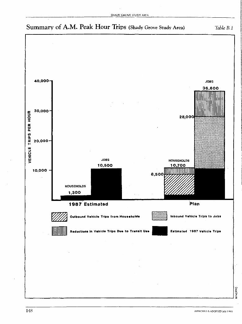
SHADY GROVE STUDY AREA
Summary of A.M. Peak Hour Trips (Shady Grove Study Area) Table B.l
a: :::, 0 :::c cc w 0. u, ~ a: I-w ..J (.)
·i; w >
40,000
30,000
20,000
10,000
HOUSEHOLDS
JOBS
10,500
1987 Estimated Plan
JOBS
36,600
~ Outbound Vehicle Trips from Households ltiltfl Inbound Vehicle Trips to Jobs
- Reductions In Vehicle Trips Due to Transit Use Estimated 1987 Vehicle Trips
u Q. Q. u z ..._ __________________________________________ ___.::;
148 APPROVED & ADOPTED July 1990
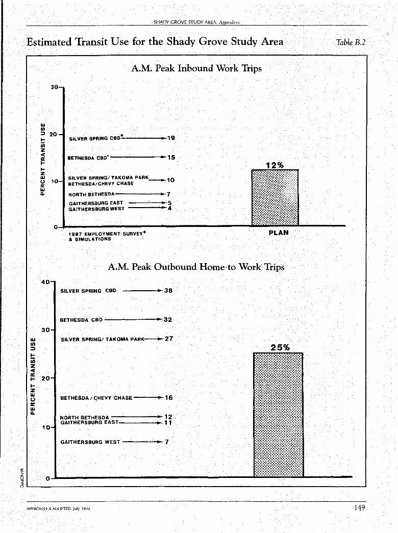
s::. z 0 -0 -0
SHADY GROVE STUDY AREA: Appendices
Estimated Transit Use for the Shady Grove Study Area Table B.2
liJ ,n ::)
!::: ,n z cC a: I-I-z liJ 0 a: liJ CL
A.M. Peak Inbound Work Trips
30-
w ti) ::, 20-
SILVER SPRING ceo* !:: 19 ti) z ci:
BETHESDA CBD. 15 a: I-I-
12% z w
10-SILVER SPRING/TAKOMA PARK--10 u a: BETHESDA/CHEVY CHASE
w CL NORTH BETHESDA 7
GAITHERSBURG EAST 5 GAITHERSBURG WEST - 4
0 1987 EMPLOYMENT SURVEY• PLAN & SIMULATIONS
A.M. Peak Outbound Home· to Work Trips
40-
30-
20-
10-
SILVER SPRING CBD. ------38
BETHESDA CBD --------32
SILVER SPRING/ TAKOMA PARK~27
BETHESDA/ C,HEVY CHASE ---~16
NORTH BETHESDA --------12 GAITHERSBURG EAST 11
GAITHERSBURG WEST------ 7
25%
0..1..-------------------_..,..;..;.;,,__.....,;...,;,,;,;__. ____ _ o.___ __________________________________________ _.
APPROVED & ADOPTED July 1990 149
150
SHADY GROVE STUDY AREA
living in the Study Area who travel by transit to work (work trip 01;-igin from homes). It is estimated that, on the average, approximately 25 percent of the people living in the Study Area will commute to work by transit.
For those people living outside the Study Area who commute to Shady Grove for employment, the impact of active use of the transit easement traversing the Study Area is equally significant. It is estimated that, on the average, approximately 12 percent of the home,to,work trips originating outside the Study Area which are bound for Shady Grove will arrive at work via transit. Hence, the effect of the transit easements upon transit ridership is projected to be substantial. It is unlikely, however, that a significant increase in transit ridership in and of itself will eliminate long,term roadway and intersection congestion in the Study Area. An analysis of intersection conditions was prepared from the results of the areawide transportation analysis and is presented in the Grade Separations section.
Average Areawide Level of Service The Annual Growth Policy, which assesses current conditions and allowable development levels, has established standards of acceptable average areawide level of service (LOS) based· upon the extent of available transit services. These are given in Table B.3. Currently, the Gaithersburg East and West policy areas are identified as Group III areas (moderate transit service), which has a corresponding standard of average LOS C/D. If the analyzed average LOS for the area exceeds the C/D level, the condition is unacceptable. The result of the areawide analysis is shown in Table B.4.
It is expected that the overall level of transit service currently available within Gaithersburg, and especially the Shady Grove Study Area, will be increased during the time frame of this Plan to provide public transit alternatives to automobile travel equivalent to or better than an area such as North Bethesda. The recent opening of the Shady Grove Metro Park,and,Ride lot expansion represents such a service increase. In addition, it is expected that the transit service that will be provided traversing the Study Area, as well as using the Transit Easement north of Shady Grove, through Germantown to Clarksburg (and possibly to Frederick), whether it be a bus, based or fixed guideway system, would have moderate, to high,transit travel characteristics. This service, linked to the Metro station at Shady Grove, would provide a transit alternative for both through and Gaithersburg,oriented commuter traffic. Beyond this, an extensive network of bus service is anticipated throughout the area, with route frequencies being increasingly demand,based as contrasted to current minimum policy frequencies of 30,minute service.
Therefore, the expected future transit availability within the Gaithersburg Area is sufficient to considering a standard average areawide level of service of at least LOS D (Group IV) as a standard of acceptability. In addition, an average areawide LOS D/E (Group V) may be considered appropriate within the Shady Grove Study Area, given the expectation of future transit service (which includes the existing Shady Grove Metro Station, as well as several anticipated transitways) within its boundaries.
APPROVED & ADOPTED July 1990
;,; " § 8 Qo
)> 0 0 u ...;
8 C
-< "' "' 0
...... Vt ......
Transit Services Available or Programmed '.)ddON-~
Average Level of Service
Standards
*
C
CID
D
DIE
*
Group Classifications
II
III
IV
V
VI
Public Transport
Alternatives to Automobile
Travel
Marginal
Limited
Moderate
Frequent
Full
Expanded
Auto Dependent System
Park/Ride Access
and/or Bus Base and/or
Community and Local
Bus Service
Systems Regional Park/Ride Express Bus and High Occupancy Vehicle Priority Systems
Marginal access Not available Not available to stations or bus routes outside of the area
Limited number Limited coverage Limited park/ride spaces or lots with local bus service
of park/ ride spaces and frequency
Moderate number Moderate coverage, Moderate express bus of park/ ride spaces, service limited to service in conjunction limited kiss/ride policy frequencies with a system of park/ service ride lots'
Moderate park/ ride spaces and moderate kiss/ride service
Limited park/ ride with full reliance on kiss/ride access
Moderate coverage, Priority treatment for combined policy frequent express buses, and frequent local circulation feeder demand-based services in conjunction service with a system of park/
ride lots
Full area coverage and a large number of routes with frequencies based on demand
Same as Group IV above
Expanded park/ride Expanded bus Same as Group IV above with reliance on frequencies; 100
kiss/ride access buses in PM peak
* See text of the Recommended FY 90 AGP for Methods and Standards of Measuring Traffic. Source: Montgomery County Planning Department.
Fixed Guideway Systems
Commuter Rail or
Light Rail Metrorail
Marginal Not available amount of the area is within walk access
Limited park/ ride access and walk access
Moderate
Park/ride and kiss/ride access limited to nearby stations outside of the area
Moderate parking or walk station coverage access with coverage in system transfers the area with
Same as Group III above
Same as Group III above
easier walk and
Sarne as Group III above
associated feeder access
More dense spacing of stations and bus routes
Full frequency and full reliance on kiss/ride,
bicycle access
Designated CBD; controlled parking; Transportation Mgmt. District
~n ("C 0 < '"'t ("C '"'t -("C 0 r:JJ ~ "'r:j
0 en ::t ("C 0.. ~ ("C I-'• ::t r') r') ("C ("C
en t:P ~ ("C ~ ~ ::t ~ 0.. ("C ~ ("C a. ::t r:JJ ~
'"'t
S"1 o-' ~
~ w
~ r:JJ I-'• ~
t ~ I-'• -~ I-'• -I-'• ~
[ t ("C '"'t ~
(J'Q ("C
V,
I )>
~ (") ;o
2 m
:cl C
~ )> ;o
;,: >
l:g: 9 "-a·
SHADY GROVE STUDY AREA
Summary Results of the Areawide Analysis Table B.4
E I GROUPV STANDARD LOS DIE .
>< . w 0 z I ....... w D STAN.QARD 0 Qw· LOS D . > . a: w
"' u. 0 , ..... ,,, ...J STANDARD w LOS CID > w ...J
w Cl I- GROUP II < c STAN_!>ARD a: w LOSC > . <
270 271 272 273 274 ·27s- 276 2n 27s<,ooo·s>
AM PEAK HOUR VEHICLE MILES TRAVELED IN GAITHERSBURG & VICINITY
0 a. a. 0 z L--------------------------------------------...1::i;
152 APPROVED & ADOPTED July 1990
SHADY GROVE STUDY AREA: Appendices
The result of the transportation analysis, based on an analysis area covering the Gaithersburg East and West policy areas, is an average areawide LOS D for the Master Planned land use.
Methodology To assess future transportation conditions for the Study Area, an approach was used that is comparable to that of the Annual Growth Policy to set Annual Staging Ceilings. This approach involves the use of a regional transportation model, with extra detail in Gaithersburg and adjoining areas, and the computation of an average areawide level-of-service.
The Land Use Plan for the Shady Grove Study Area was analyzed using the regional transportation model, assuming the employment and household levels in the Study Area and the effect of providing the transitways through the Study Area. To represent or "model" the effect of the transitways on the transportation system within the regional transportation model system, it was necessary to assign assumed potential mode splits to the land uses in the station service areas. A scale of probable transit usage was developed for the two major trip-making categories of household outbound trips and employment inbound trips in the morning peak period. This range is based on the levels of usage currently experienced around Metro stations and judgment developed in other model work from the Annual Growth Policy. Thus, development located closest to future transit stations is assumed to have a higher transit use than locations further away.
The primary development sites were identified and defined by their projected amount of households and employment according to the Land Use Plan. The total numbers of inbound and outbound trips were computed for each site using appropriate Institute of Transportation Engineers' trip generation rates. The total trips for each site were reduced by the mode split factors appropriate to each land use and site location. The ranges of mode split factors are shown on Table B.5 for the primary development sites considered in this analysis.
The reduction of trips computed from this methodology was applied to the regional transportation model to determine the potential impact on the transportation system. The transportation model computes the areawide average level-of-service conditions by policy area for each alternative and the corresponding vehicle-miles of travel.
The intersection movements resulting from the model trip distribution can be analyzed to determine intersection congestion. However, this application is a fairly coarse analysis due to the simplified network and zone system used for the model of the land use and transportation system. The model provides the turning movements at intersections which can be used to determine estimates of critical lane volumes and level of service. While this level of analysis has been completed, it must be noted that the aggregation of volumes of traffic to specific intersection movements are, in many cases, extremely high due to the limited paths available for assigning traffic movements in the model system. Therefore, the results are more indicative of conditions where
APPROVED & ADOPTED July 1990 153
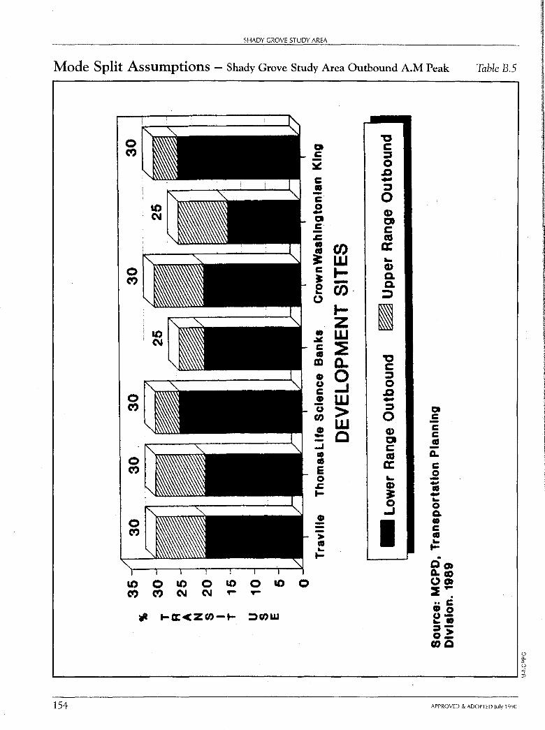
SHADY GROVE STUDY AREA
Mode Split Assumptions - Shady Grove Study Area Outbound A.M Peak
Q C -~ C ., -C 0 -Q C .c • u, ., ~ w C .... ~ -e Cl), 0
I-z • w ~ C ~ ., m a. • 0 (.) ..J C .! w 0 > en w • - C -..J
• ., E 0 .c I-
• --> ., ... I-
10 0 10 0 10 0 10 0 (") (") C\I C\I ... T'"
... 1-a:cz0-t- ::)(l)W
'0 C :, 0 D .. :, 0 Cl> Ct C as a: .. Cl> Q. Q. ::,
I '0 C :, 0 D ... :, 0
Cl> a C as a: ... G> ~ 0 ..J
I
Q C -C C G -~ C 0 --G -.. 0 Q. • C CG ... I-. 00) ~co 00) :E ... . •• C •o o.... ::::,-o.? 00
Table B.5
() (1-(1-() z L-..------------------------------------'::'i
154 APPROVED & ADOPTED July 1990
() a. a. () z ::E
SHADY GROVE STUDY AREA: Appendices
traffic is funneled into a limited number of arterial roadways comprising the master plan network, when in reality, the area will develop with a complementary set of access driveways and primary roadways to more evenly distribute traffic volumes generated by development. To replicate these conditions, it would be necessary to both know the detail of actual future site plans and to "construct" a much more complex model network (zones and traffic links) to more accurately model these circumstances.
Current Transit Services in the Study Area Vicinity Table B.6
Primary Approximate Route Between Service Area Service Frequency
Rush Non-Rush/ Hours Saturday
55 Montgomery College to Rockville Pike 30 min. 30 min. Rockville Metro (Germantown)
59 Montgomery Village to Rockville Pike 30 min. 30 min. Rockville Metro
61 Montgomery College to Rockville Pike 30 min. Shady Grove Metro (Germantown)
43 Life Sciences Center Life Sciences Center 20 min. 30 min. to Shady Grove Metro and Shady Grove
Road Areas
Q-2 Shady Grove Metro to Piccard/Research 30 min. Rockville Areas
54 Lake Forest Mall to Fields/Omega/ 30 min. 30 min. Rockville Metro Research Areas
56 Lake Forest Mall to Life Sciences 30 min. 30 min. Rockville Metro Center Area
APPROVED & ADOPTED July 1990 155
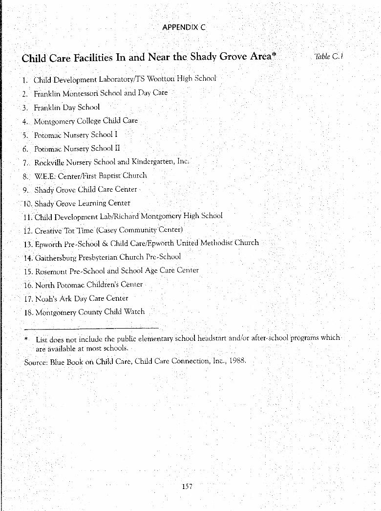
APPENDIX C
Child Care Facilities In and Near the Shady Grove Area* Table C.1
1. Child Development Laboratory/fS Wootton High School
2. Franklin Montessori School and Day Care
3. Franklin Day School
4. Montgomery College Child Care
5. Potomac Nursery School I
6. Potomac Nursery School II
7. Rockville Nursery School and Kindergarten, Inc.
8. WE.E. Center/First Baptist Church
9. Shady Grove Child Care Center
10. Shady Grove Learning Center
11. Child Development Lab/Richard Montgomery High School
12. Creative Tot Time (Casey Community Center)
13. Epworth Pre-School & Child Care/Epworth United Methodist Church
14. Gaithersburg Presbyterian Church Pre-School
15. Rosemont Pre-School and School Age Care Center
16. North Potomac Children's Center
17. Noah's Ark Day Care Center
18. Montgomery County Child Watch
* List does not include the public elementary school headstart and/or after-school programs which are available at most schools.
Source: Blue Book on Child Care, Child Care Connection, Inc., 1988.
157
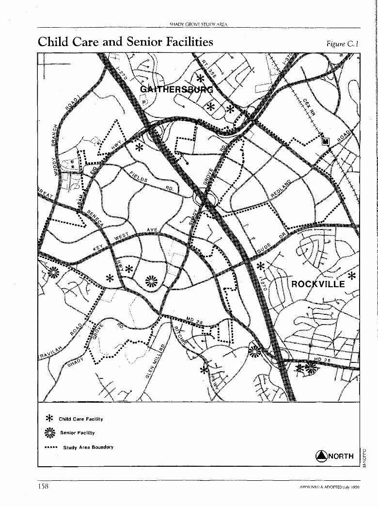
SHADY GROVE STUDY AREA
Child Care and Senior Facilities
* Child Care Facility
~,t.-~a{: Senior Facility
• • • • • Study Area Boundary
Figure C.1
0 0.. 0.. 0 z
L---------------------------------------------------------'1
158 APPROVED & ADOPTED July 1990
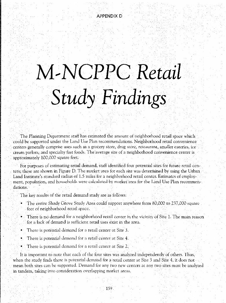
APPENDIX D
M--NCPPC Retail Study Findings
The Planning Department staff has estimated the amount of neighborhood retail space which could be supported under the Land Use Plan recommendations. Neighborhood retail convenience centers generally comprise uses such as a grocery store, drug store, restaurant, smaller eateries, ice cream parlors, and specialty fast foods. The average size of a neighborhood convenience center is approximately 100,000 square feet.
For purposes of estimating retail demand, staff identified four potential sites for future retail centers; these are shown in Figure D. The market area for each site was determined by using the Urban Land Institute's standard radius of 1.5 miles for a neighborhood retail center. Estimates of employment, population, and households were calculated by market area for the Land Use Plan recommen-dations. ·-
The key results of the retail demand study are as follows:
• The entire Shady Grove Study Area could support anywhere from 80,000 to 237,000 square feet of neighborhood retail space.
• There is no demand for a neighborhood retail center in the vicinity of Site 1. The main reason for a lack of demand is sufficient retail uses exist in the area.
• There is potential demand for a retail center at Site 3.
• There is potential demand for a retail center at Site 4.
• There is potential demand for a retail center at Site 2.
It is important to note that each of the four sites was analyzed independently of others. Thus, when the study finds there is potential demand for a retail center at Site 3 and Site 4, it does not mean both sites can be supported. Demand for any two new centers at any two sites must be analyzed in tandem, taking into consideration overlapping market areas.
159
SHADY GROVE STUDY AREA
Existing Retail Centers
* With Grocery
@ Without Grocery
•••••• Study Area Boundary
© -14' Potential Sites for Retail Centers. Evaluated \;!,I in Retail Demand Study (See Text)
These evaluated sites are not Proposed Retail Sites - See Land Use Section
Figure D.l
@NORTH () [L [L () z L---------------------------------------------'i
160 APPROVED & ADOPTED July 1990
;: z (") -u -u (")
SHADY GROVE STUDY AREA: Appendices
APPENDIX E
Capital Projects for the Shady Grove Study Area and Vicinity Table E.l
CIP Number1 Description
Responsible Agency
Estimated Project Cost
(1989 Dollars) 2
Projects in Current Approved Capital Improvements Program (FY 90-95)
7-66 Fields Rd/Muddy Branch to Omega: MCDOT $5,695,000 Construct 5 lanes of an ultimate 6-lane roadway
7-77 Great Seneca Highway-Phase I & MCDOT $21,080,000 II: Construct 4-lane divided major roadway
7-82 Gude Drive Extension: MCDOT/ $4,700,000 Reimbursement to Rockville for Rockville construction of 2 lanes for ultimate 4-lane divided highway
7-88 Key West Ave-Gude Dr to I-270: SMHA $440,000 Construct 6-lane divided roadway or 7-lane undivided
7-90 Key West Ave-Shady Grove to SMHA $5,993,000 Gude Drive: Construct 4 lanes of ultimate 6-lane divided roadway
7-92 Key West Ave and MD 28: SMHA $11,195,000 Construct 2 lanes of ultimate 6-lane roadway
7-95 Life Sciences Center (LSC) Roadway MCDOT $4,910,000 Improvements: Intersection improvements within LSC
7-118 Muddy Branch Road: MCDOT $13,997,000 Construct 4 lanes of ultimate 6-lane divided major roadway
7-133 Sam Eig Highway: MCDOT $15,974,000 Construct 6-lane divided major roadway from I-270 to Fields Road and 4 lanes from Fields Road to Great Seneca Highway
10-23 Metro Station Library Kiosk: Public $196,000 300 modular structure for rush hour Libraries library service
APPROVED & ADOPTED July 1990
Status
Under Construction
Operational
Phase I: 2 lanes completed Phase II: 2 new lanes--
Detailed Design Stage
Planning Stage
Phase I: Operational Phase II: Under
Construction
Phase I & II: Operational Phase III: Under
Construction
Planning Stage
Under Construction
Phase I: Bids let Phase II: Preliminary
Conceptual Stage
161
SHADY GROVE STUDY AREA
Capital Projects for the Shady Grove Study Area (con~.) Table E.1
CIP Number1
17-216
17-219
17-274
19-94
19-123
19-137
5-36
5-37
Description
Gaithersburg Area Public Elementary Schools: Construct 30 teacher stations to reach core capacity of 740 students
Summit Hall Elementary Addition: Construct 7 teacher stations to reach core capacity of 600 students
Stone Mill: Construct 34 teacher stations to reach core capacity of 7 40 students
Muddy Branch SV Park Unit 3: Acquire 2 acres and develop Stream Valley Park
Big Pines Local Park: Construct recreation shelter, athletic field, multi-use court, play equipment, parking area, benches, bicycle racks, drinking fountain and landscaping at existing 11-acre park
Fields Road Local Park: Acquisition and development of 10-acre park with a recreation shelter, athletic fields, tennis courts, multi-use court, play equipment, parking area, benches, bicycle rack, drinking fountain and landscaping
Life Sciences Center-New Design: Design and construct improvements to enhance the image of the Life Sciences Center
Shady Grove Life Sciences Center: Design and construction of site improvements to support the Johns Hopkins University Center for Advanced Studies
Responsible Agency
Public Schools
Public Schools
Public Schools
Estimated Project Cost
(1989 Dollars) 2
$7,069,000
$2,045,000
$8,860,000
M-NCPPC $627,000
M-NCPPC $537,000
M-NCPPC $385,000
County $4,000,000
County $6,976,000
Projects Not Included in Current Capital Improvements Program3
A Key West Avenue: SMHA
Widen from 4 lanes to 6 lanes from MD 28 west to Great Seneca Highway
162
Status
Planning Stage
Planning Stage
Final Stage of Construction and Furnishing
Acquisition: 99% complete
Conceptual Stage of Development
Conceptual Stage
Preliminary Engineering
Phase II: Under Construction
APPROVED & ADOPTED July 1990
0 Q._ Q._
0 z :::1:
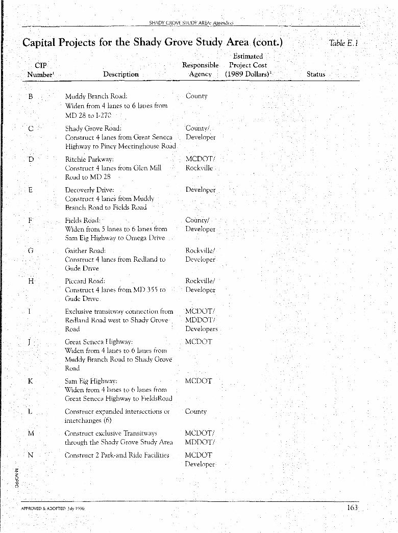
SHADY GROVE STUDY AREA: Appendices
Capital Projects for the Shady Grove Study Area (cont.) Table E.l
Estimated CIP Responsible Project Cost
Number1 Description Agency (1989 Dollars) 2 Status
B Muddy Branch Road: County
Widen from 4 lanes to 6 lanes from
MD 28 to I-270
C Shady Grove Road: County/ Construct 4 lanes from Great Seneca Developer Highway to Piney Meetinghouse Road
D Ritchie Parkway: MCDOT/ Construct 4 lanes from Glen Mill Rockville Road to MD 28
E Decoverly Drive: Developer Construct 4 lanes from Muddy Branch Road to Fields Road
F Fields Road: County/ Widen from 5 lanes to 6 lanes from Developer Sam Eig Highway to Omega Drive
G Gaither Road: Rockville/ Construct 4 lanes from Redland to Developer Gude Drive
H Piccard Road: Rockville/ Construct 4 lanes from MD 355 to Developer Gude Drive
I Exclusive transitway connection from MCDOT/ Redland Road west to Shady Grove MDDOT/ Road Developers
J Great Seneca Highway: MCDOT Widen from 4 lanes to 6 lanes from Muddy Branch Road to Shady Grove Road
K Sam Eig Highway: MCDOT Widen from 4 lanes to 6 lanes from Great Seneca Highway to FieldsRoad
L Construct expanded intersections or County interchanges (6)
M Construct exclusive Transitways MCDOT! through the Shady Grove Study Area MDDOT/
N Construct 2 Park-and Ride Facilities MCDOT Developer
;: z (") .,, .,, (")
APPROVED & ADOPTED July 1990 163
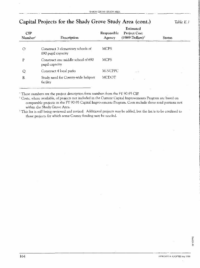
SHADY GROVE STUDY AREA
Capital Projects for the Shady Grove Study Area (cont.) Table E. l
Estimated CIP Responsible Project Cost
Number1 Description Agency (1989 Dollars) 2 Status
0 Construct 3 elementary schools of MCPS 690 pupil capaciry
p Construct one middle school of 690 MCPS pupil capacity
Q Construct 4 local parks M-NCPPC
R Study need for County-wide heliport MCDOT facility
1 These numbers are the project description form numbers from the FY 90-95 CIP. 2 Costs, where available, of projects not included in the Current Capital Improvements Program are based on
comparable projects in the FY 90-95 Capital Improvements Program. Costs include those road portions not within the Shady Grove Area.
3 This list is still being reviewed and revised. Additional projects may be added, but the list is to be confined to those projects for which some County funding may be needed.
164 APPROVED & ADOPTED July 1990
0 0. 0. 0 z i
APPENDIX F
Glossary of Terms
Adequate Public Facilities Ordinance (APFO): The APFO, adopted in 1973, is a tool to promote orderly growth by synchronizing development with the availability of the public facilities (roads, sewer, water, safety, police) needed to support it. Refinements to the ordinance were adopted in 1986.
The APFO is a part of the Subdivision Ordinance and is administered by the Planning Board at time of subdivision, after review by other agencies, including the County Executive. The subdivision regulations require that "public facilities" be existing or programmed for construction within a defined time period before approval can be granted. These facilities, therefore, would normally be included in the Capital Improvements Program (CIP), as described below. Criteria and guidelines for administration of the APFO are included in the Annual Growth Policy, which is adopted annually by the County Council.
Annual Growth Policy (AGP): A policy document adopted annually by the County Council intended to facilitate and coordinate government's powers in limiting or encouraging growth and development in the County. The AGP addresses conflicting policies of various agencies that may be serving different public interests, and provides guidance in resolving differences. It includes criteria and guidance for the administration of the APFO, and recommended development capacity Staging Ceilings for each policy area of the County. The overall purpose is to chart, each year, a direction for government which will
enhance the quality of life of the County's present and future residents.
The AGP is prepared by the Planning Board based on its comprehensive land use process, data collected through administration of the Adequate Public Facilities Ordinance, and through population and housing projections. It is prepared in close coordination with the Executive's CIP, and is transmitted to the County Executive in Final Draft Form, after public hearings. The County Executive submits his modifications in writing to the County Council, and Council must adopt the AGP by June 30 of each fiscal year. (The legislation providing for the AGP was adopted by the County Council in May 1986.)
Agricultural Reserve: Primary agricultural areas of Montgomery County, which include the majority of the County's remaining working farms and certain non-farm land uses.
Arterial Highway: A road that provides a similar amount of traffic service and land access functions. Commercial and industrial land uses may have driveway access, single-family residential may not. Master planned as four-lane roads (current design calls for either a landscaped median or a continuous left-tum lane) with curb and gutter (closed section) where traffic warrants four lanes, but may be two lanes with shoulders and open drainage system in areas of light traffic or on an interim basis. Right-of-way is usually 100 feet; older roads or roads to be maintained as two-lane roads may have 80-foot rights-of-way. Sidewalks and bikepaths are appropriate; bike paths may sometimes be adjacent to travel lanes.
165
166
SHADY GROVE STUDY AREA
Assisted Housing: Housing which is built and/or operated with government financial assistance, including subsidies, low interest loans and mortgage guarantees. There are two types of assisted housing: moderate-income housing, for which the eligibility standard for residents is an income less than 80 percent of the metropolitan area median income; and low-income housing, for which the eligibility standard is less than 50 percent of the metropolitan area median income.
Base Density: The maximum number of dwelling units or square footage of nonresidential space per unit of land that can be built in an area in the absence of bonuses which accrue from the application of transferable development rights (TDR's), floating zones, planned development zones, or public amenities and benefits recommended in a master plan; that density which is reasonable and acceptable from a planning perspective without consideration of such bonuses.
Base Zone: A Euclidean zone recommended in a master plan to achieve the base density.
Buffering: Isolation or separation of different land uses by a third land use, by open space, or by a physical separator such as a wall. Low density offices and townhouses are frequently used to separate commercial and detached residential areas.
Business District Street: Similar to Arterial Highway, but is only in commercial areas. Sidewalks are wider than those along an arterial. Bicycles may share travel lane with other vehicles.
Capital Improvements Program (CIP):
A six-year comprehensive statement of the objectives of capital programs, with cost estimates and proposed construction schedules for specific projects. The CIP is submitted annually to the County Council by the Executive.
The CIP is the tool through which locally funded public facilities, such as sewers, local roads, storm drains, schools, libraries, and parks, can be scheduled and built, in coordination with, and guided by, the Annual Growth Policy and area Master Plans. It is used in conjunction with the APFO to programming for public facilities needed to service subdivisions.
Concept Plan: A generalized idea or set of ideas that forms the basis for a master plan.
Consolidated Transportation Program (CTP): The State Highway Administration's five year construction program for roads and other transportation facilities within the State of Maryland. This program is an important consideration in transportation planning by the County since many of the major roads in the area are State highways.
Development Plan Review: Some zones require approval of a development plan at the time of rezoning. The development plan shows the layout, unit mix, uses, building densities, circulation, parking and open space configuration. When a development plan is required, the subsequent site plan must be in conformance with it. The preparation of an acceptable development plan helps to assure that the intent of the master plan is achieved.
APPROVED & ADOPTED July 1990
SHADY GROVE STUDY AREA: Appe11dices
Development Right: One dwelling unit of transferable density in the transferable development rights program. Also see Transfer of Development Rights.
Easement: A contractual agreement to gain temporary or permanent use of, and/or access through, a property.
End-State-Development: Future land use as prescribed by the most recent master plan, assuming total implementation of that plan. In actual practice, development densities rarely exceed 80 percent of ultimate land use.
Euclidean Zones: See Zoning
Floating Zones: See Zoning
Floodplain: That area of land adjoining a stream which is inundated temporarily by water whenever the stream overflows its banks. The ultimate 100-year floodplain represents the area which would be inundated by flooding due to a 100-year frequency storm after the ultimate planned development occurs.
Floor Area Ratio (FAR): The ratio of the gross floor area of a building to
the area of the lot on which it is located. Parking and unoccupiable space in the building are generally excluded from the computation. For example, a building with a gross floor area of one acre on a two-acre lot would have a Floor Area Ratio of 0.5.
Freeway: A road that provides total traffic service and no land access. A freeway has multiple lanes, interchanges to provide free flow traffic connections with cross-streets, and traffic moves at a high speed.
General Plan: The Countywide comprehensive plan entitled On Wedges and
APPROVED & ADOPTED July 1990
Corridors, adopted in 1964 and updated in 1969. It provides the overall framework for the County's future. Each master plan adopted since 1969 amends the General Plan.
Homeowners Associations: When development occurs under the cluster provisions of the subdivision regulations, a homeowners association is frequently required to assure the maintenance and operation of private open space, recreational facilities, private streets, and other common space in the subdivision. The homeowners association generally levies a fee in the form of a property assessment to maintain these facilities. It also must provide a management structure to supervise their orderly maintenance.
Impervious Surface: Land surface through which water cannot penetrate, usually because of pavement or buildings.
Industrial Street: Similar to Arterial Highway, but only in industrial areas.
• Sidewalks are wider than those along an arterial. Bicycles may share travel lane with other vehicles.
Infrastructure: The built facilities, such as streets, bridges, schools, water and sewer lines, other utilities, parks, etc., that service a community's developmental and operational needs.
Level of Service (LOS): A traffic engineering term that describes relative operating conditions and congestion levels on a segment of roadway or at an intersection. There are six levels, ranging from free flowing conditions (level of service "A") to very heavy traffic, extremely unstable flows, and long delays (level of service "F").
167
168
SHADY GROVE STUDY AREA
Local Map Amendment: A change of zoning, normally sought by the owner or other person having a proprietary interest. Applications for local map amendments may be filed only during the months of February, May, August, and November, and are considered according to procedures specified in the Zoning Ordinance. A local map amendment can include more than one tract of land. Land can be combined for purpose of rezoning. Approval of a local map amendment normally requires the affirmative vote of a majority (five members) of the County Council. If the proposed rezoning is contrary to the zone recommended in a master plan, however, approval requires affirmative vote of five Council members, unless the Planning Board has recommended in favor of that approval, in which case a four-vote majority of the Council is sufficient for approval.
Major Highway: A road that provides a high level of traffic service and a low degree of land access. Master planned for four or six travel lanes (usually six) and a landscaped median within a 120-, 150-, or 170-foot right-of-way. New construction is generally not allowed to have driveway connections and intersecting streets are spaced relatively far apart. Sidewalks and bikepaths are appropriate along a major highway.
Mandatory Referral: Under the Regional District Act "no road, park, or other public way or ground, no public (including Federal) buildings or structures, and no public utility whether publicly or privately owned shall be located, constructed, or authorized in the regional district until and unless the proposed location, character,
grade and extent thereof has been submitted to and approved by the [Maryland-National Capital Park and Planning] Commission." (Art. 28, #7-112 of the Regional District Act.) One of the major purposes of this review authority is to assure that public land acquisition and development are compatible with surrounding development, both existing and planned. Mandatory referral results in recommendations that are not binding on the public agency, but it does provide an opportunity to encourage the agency to modify their proposals, where necessary, in order to improve their compatibility.
Master Plan: A document which guides the government and private individuals in the way an area should be developed. In Montgomery County, master plans amend and/or detail, for portions of the County, the recommendations of the County's General Plan.
Mixed-Use Development: The integration of different, usually compatible or mutually supportive, land uses on a site or into a single building or complex.
Moderately Priced Dwelling Units (MPDU): A dwelling unit which meets price levels specified under Chapter 25A of the Montgomery County Code. The levels are adjusted annually by the County Executive. Developments of 50 or more units must include at least 12.5 percent which are MPDU's.
Nontidal Wetland: An area that is inundated or saturated by surface water or groundwater at a frequency and duration sufficient to support, and that under normal circumstances does support, a prevalence of vegetation typi-
APPROVED & ADOPTED July 1990
SHADY GROVE STUDY AREA: Appendices
cally adapted for life in saturated soil conditions, commonly known as hydrophytic vegetation; provided, however, that the Maryland Department of Natural Resources, in designating a nontidal wetland, shall use the approach (i.e., hydrology, soils and vegetation) enumerated in the April 1988, Revised Interim Final Draft Wetland Identification and Delineation Manual developed by the United States Environmental Protection Agency, and any subsequent amendments thereto.
On--Site Stormwater Management: Stormwater management techniques applied within a given site boundary, usually near the source of stormwater runoff.
One--Hundred Year Ultimate Floodplain: The floodplain that would result from a 100-year frequency flood, calculated on total development in a watershed.
Optional Density: Density in dwelling units, or square footage of nonresidential space per unit of land, that would be compatible with surrounding land uses (existing and proposed) and would be within the carrying capacity of the public facilities. Optional density can be achieved through the use of various bonuses, including transferred development rights (TDR's) or planned development (PD). Also see Planned Development Zoning and Transfer of Development Rights.
Planned Development Zoning (PD): A group of "floating" zones that allow a broad range of housing types, flexibility of design, and mix of land uses, and which encourage better land planning with greater efficiency, convenience, and more amenities than convention-
APPROVED & ADOPTED July 1990
al, or Euclidean, zoning categories. A development plan must be approved at the time of zoning.
Planning: The orderly, reasoned process of evaluating the existing and future needs of an area and its residents, and the preparation of alternatives and recommendations to meet those needs.
Primary Residential Street: A street that provides a moderate level of traffic service and a high level of land access. Two travel lanes are provided within a 70-foot right-of-way. An urban design provides 36 feet of roadway pavement-sufficient for two lanes of moving traffic with parking along each side-with curb and gutter. A rural design provides 24 feet of pavement with a shoulder (usually grass) and an open drainage system. Sidewalks are appropriate though extremely difficult to provide on the rural design. Residences are usually allowed to have driveways on this type of street. MCDOT will not provide neighborhood protection measures to reduce traffic along a master planned primary street.
Receiving Area: An area designated on a master plan to receive transferred development rights. The addition of development rights permits a higher density of development than that permitted by the base density, but the density may not exceed that recommended in the master plan. The base density may be increased by one dwelling unit for each development right received. Development rights are transferred by easement and the transfer is recorded in the County land records. Also see Base Density and Transfer of Development Rights.
169
170
SHADY GROVE STUDY AREA
Schematic Development Plan: A development plan for Planning Board review and County Council approval submitted as part of an application for the rezoning of land into floating zones at the option of the applicant. Such schematic development plans limit development to that specified in the application.
Secondary Residential Street: A street that provides very limited traffic service and a very high level of land access. This street is intended to serve the immediate residential area only. The street provides two travel lanes within a 60-foot right-of-way. An urban design provides 26 feet of paving with curb and gutter or 24 feet of paving with shoulders. Sidewalks are usually appropriate though difficult to provide in the rural design. Bicyclists should use the travel lane. MCDOT will provide neighborhood protection measures to reduce traffic along this type of street if needed. Tertiary streets provide land access to residences immediately adjacent to the street. Rightof-way may be as narrow as 2 7 feet.
Sectional Map Amendment: A comprehensive rezoning, initiated by the Planning Board or County Council, covering a section of the County, and usually including several tracts of land. It normally follows a master plan study. It may propose various zones to be applied to various individual tracts. The County Council must hold a public hearing on a proposed sectional map amendment. Since enactment of a sectional map amendment is considered a legislative action of the government, and is intended as a comprehensive implementation of public policy, it does not require a finding of
a change in the character of the neighborhood or a mistake in the original zoning. Approval is by majority vote of the council.
Setback: The required distance that a proposed structure or parking area must be located from the property lines or from other buildings. Setbacks are specified in certain zones.
Site Plan: A detailed plan, required in certain zones, that usually shows proposed development on a site in relation to immediately adjacent areas. It indicates roads, walks, parking areas, buildings, landscaping, open space, recreation facilities, lighting, etc. The Planning Board must approve the site plan before building permits can be issued.
Site Plan Review: The detailed site plans carry out the policies and recommendations of the master plan. As there is flexibility in the layout of buildings and other features on the site, the Planning Board and its staff carefully review these elements with ample room for public input.
Site plan review is required of all floating zones and as a result of the use of optional development provisions of other zones. Further, facilities that fall under the provisions of the County parking ordinance (part of the Zoning Ordinance) are also subject to site plan review for the parking areas.
Site plan review is more detailed than development plan review. It examines such elements as building mass and location, parking area design, grading, landscaping, lighting, fencing and signage. Through this review, issues of compatibility with adjacent land uses can be resolved.
APPROVED & ADOPTED July 1990
SHADY GROVE STUDY AREA: Appendices
Special Exception: Most zoning classifications include a set of permitted uses and a set of "special exception" or conditional uses. These are uses that, because of the level or nature of the activity associated with them, need to be carefully reviewed before being allowed to be developed on land in that zoning classification. In residential areas, for example, special exception uses include, among others, daycare centers for more than six children, medical clinics, and horticultural nurseries. Gas stations are always special exception uses. Hotels are special exception uses in most industrial zones.
The Zoning Ordinance contains, for each special exception use, a set of criteria that must be met by an application. The applications are reviewed by staff of the Montgomery County Planning Department and recommendations are made by The Montgomery County Planning Board. The decisions regarding each application are made by the Montgomery County Board of Appeals.
Staging: An element of a master plan and the County's growth management system that coordinates the schedule of public facility construction with the pace of private development.
Stormwater Management: The application of various techniques for mitigating the adverse effects of stormwater runoff.
Subdivision: (1) The division of a lot, tract, or parcel of land into two or more lots, plots, sites, tracts, parcels or other divisions for the purpose, whether immediate or future, of sale or building development. (2) The recombination of lots previously created into a new configuration.
APPROVED & ADOPTED July 1990
Ten-Year Comprehensive Water Supply and Sewerage System Plan: The program of the Washington Suburban Sanitary Commission, subject to approval by the County Council, for the provision of water and sewage service in Montgomery County.
Transit Serviceable: Having sufficient population, employment, and/or commercial density to be served efficiently by public transit.
Two-Year Storm: A storm with a 50 percent statistical probability of being equaled or exceeded in a given year.
Vehicular Capacity: The maximum number of vehicles that can pass through a given road segment, or intersection, during a given time period under prevailing roadway conditions. Also see Level of Service.
Watershed: The area contained within a topographic divide above a specified point on a stream; the area that drains into that stream.
Zoning: Zoning regulates the use of land. All land in Montgomery County (except public rights-of-way) is zoned. Within each zone, the County Zoning Ordinance permits certain uses by right and permits others conditionally. The Ordinance also excludes certain uses from each zone. Zoning is the division of a municipality or county into districts for the purpose of regulating the use of private land. These zones are shown on an official atlas which is part of the Zoning Ordinance. Within each of these districts, the text of the Zoning Ordinance specifies the permitted uses, the bulk of buildings, the required yards, the necessary off-street parking, and other prerequisites to obtaining permission to develop.
171
172
SHADY GROVE STUDY AREA
Maryland law permits the use of two types of zones, Euclidean and floating zones. There are important distinctions between the two which affect the manner in which they can be employed.
Euclidean Zones: A Euclidean zone is a zone that contains fixed standards. Certain uses are permitted in these zones, but they are subject to rigid requirements such as: lot size; front, side, and rear setbacks; and maximum height. Application for a Euclidean zone may be made either by the property owner or by the government, and thus it may be applied by sectional map amendment or local map amendment (see below).
Maryland law provides that a local map amendment rezoning to a Euclidean zone is permissible only if there has been a change in the planned character of the neighborhood since the last comprehensive rezoning or a mistake in the original zoning. All zones in Montgomery County that are not identified as floating zones (see next paragraph) are Euclidean zones.
Floating Zones: A floating zone does
not contain fixed standards. Findings of change or mistake, required for granting a Euclidean zone, do not have to be made before the application for a floating zone can be granted. Instead, the County Council must find that the proposed rezoning is compatible with surrounding uses and meets other requirements set forth in its "purpose clause."
All floating zones require Planning Board approval of a site plan for development of the property prior to the issuance of a building permit.
Zoning Map Amendment: A change to the regulations of a given zone or zones, as stated in the text of the Zoning Ordinance.
APPROVED & ADOPTED July 1990
APPENDIX G
Summary of Zoning Classifications Discussed in the Land Use and Zoning Chapter1
Zone
R-200 R-90 TDR-3 to 5
R-60 RT-8 TDR-8 to 10
R-20 R-10 RS-R TS-M
C-2 C-3 C-4 0-M H-M
1-1 1-3 R&D
Residential Zones3
Single-family Single-family Single-family
Single-family Single-family Attached Single-family (Detached,
Attached, and Multifamily)
Multi-Family Multi-Family Transit Station-Residential Transit Station-Mixed Uses
Commercial Zones
General Commercial Highway Commercial Limited Commercial Office Buildings Hotel-Motel
Employment Zones
Light Industrial Industrial Park Low Density Research
and Development
Maximum Density (Units Per Acre)2/ Building Height
2.0/Acre 3.6/Acre
Varies from 3.0 to 5.0/ acre as determined by
the Master Plan. 5.0/Acre 8.0/Acre
Varies from 8.0 to 10.0/ acre as determined by
the Master Plan. 21.7/Acre 43.5/Acre
150/Acre/2.5 FAR Variable/3.0 FAR
3 Stories/42 Feet 3 Stories/42 Feet 3 Stories/40 Feet 5 Stories/60 Feet
15 Stories/LO FAR
10 Stories/120 Feet 100 Feet 0.5 FAR4
50 Feet/0.3 FAR5
Planned Development and Mixed-Use Zones6
PD (Planned Development) Variable MXPD (Mixed-Use Planned Development)
Variable RMX0l/TDR Residential-Mixed Use
Development, Community Center/Transferable Development Rights
See Notes on Next Page. 173
Table G.1
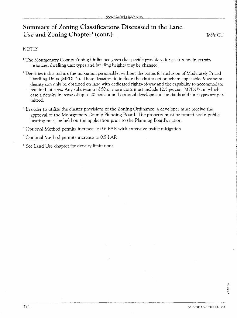
SHADY GROVE STUDY AREA
Summary of Zoning Classifications Discussed in the Land Use and Zoning Chapter1 (cont.)
NOTES
Table G.1
1 The Montgomery County Zoning Ordinance gives the specific provisions for each zone. In certain instances, dwelling unit types and building heights may be changed.
1 Densities indicated are the maximum permissible, without the bonus for inclusion of Moderately Priced Dwelling Units (MPDU's). These densities do include the cluster option where applicable. Maximum density can only be obtained on land with dedicated rights-of-way and the capability to accommodate required lot sizes. Any subdivision of 50 or more units must include 12.5 percent MPDU's, in which case a density increase of up to 20 percent and optional development standards and unit types are permitted.
3 In order to utilize the cluster provisions of the Zoning Ordinance, a developer must receive the approval of the Montgomery County Planning Board. The property must be posted and a public hearing must be held on the application prior to the Planning Board's action.
4 Optional Method permits increase to 0.6 FAR with extensive traffic mitigation.
5 Optional Method permits increase to 0.5 FAR
6 See Land Use chapter for density limitations.
174 APPROVED & ADOPTED July 1990
(_) [L [L (_) z ::;
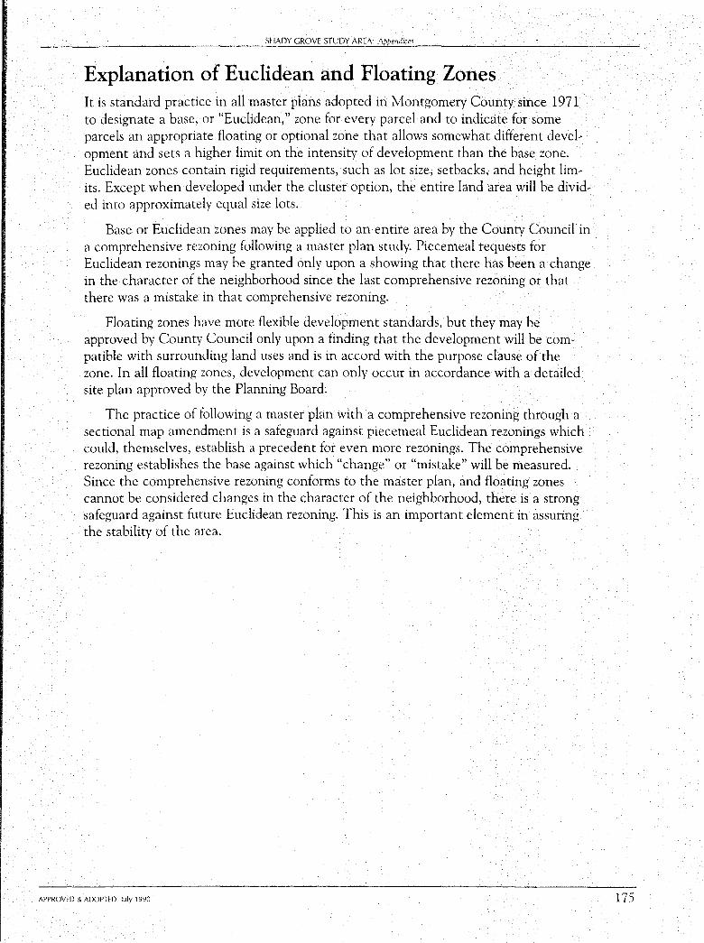
SHADY GROVE STUDY AREA: Appmdiw
Explanation of Euclidean and Floating Zones It is standard practice in all master plans adopted in Montgomery County since 1971 to designate a base, or "Euclidean," zone for every parcel and to indicate for some parcels an appropriate floating or optional zone that allows somewhat different development and sets a higher limit on the intensity of development than the base zone. Euclidean zones contain rigid requirements, such as lot size, setbacks, and height limits. Except when developed under the cluster option, the entire land area will be divided into approximately equal size lots.
Base or Euclidean zones may be applied to an entire area by the County Council in a comprehensive rezoning following a master plan study. Piecemeal requests for Euclidean rezonings may be granted only upon a showing that there has been a change in the character of the neighborhood since the last comprehensive rezoning or that there was a mistake in that comprehensive rezoning.
Floating zones have more flexible development standards, but they may be approved by County Council only upon a finding that the development will be compatible with surrounding land uses and is in accord with the purpose clause of the zone. In all floating zones, development can only occur in accordance with a detailed site plan approved by the Planning Board.
The practice of following a master plan with a comprehensive rezoning through a sectional map amendment is a safeguard against piecemeal Euclidean rezonings which could, themselves, establish a precedent for even more rezonings. The comprehensive rezoning establishes the base against which "change" or "mistake" will be measured. Since the comprehensive rezoning conforms to the master plan, and floating zones cannot be considered changes in the character of the neighborhood, there is a strong safeguard against future Euclidean rezoning. This is an important element in assuring the stability of the area.
APPROVED & ADOPTED July 1990 175
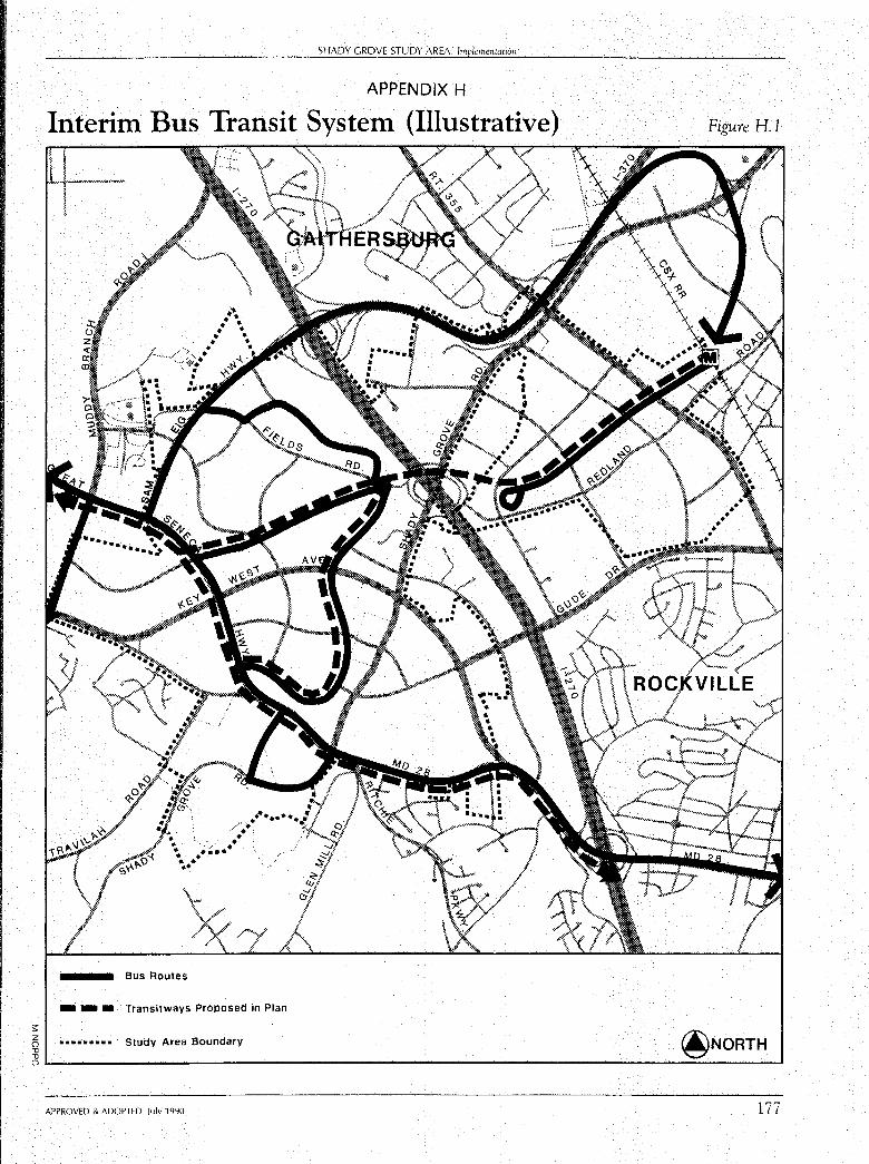
s: z () "O "O
SHADY GROVE STUDY AREA: lmpl,mentation
APPENDIX H
Interim Bus Transit System (Illustrative)
Bus Routes
/" .. ,- . ·, • '. . ', . ••••
- - • Transitways Proposed in Plan
••••••••• Study Area Boundary
Figure H.1
OL---------------------------------------------------------_, APPROVED & ADOPTED July 1990 177


