Embed Size (px)
Citation preview
I .
. . This dOcument contains inform1tion 1ffectin1 the nltio' .. ' ., .:nse of tJtt United Stites within the melnin1 of the Espion•ae Act, ~··/ U. s. C., 31 1nd 32, .S •mended. Its . tr1nsmiaion or the ""l1tior.. o1 its contents i,n.1ny m1nner to 1n un~uthorized person is prohibited bi ';tw.
G 2 Vi'II!Ullit ---·.----- ~--- ~-
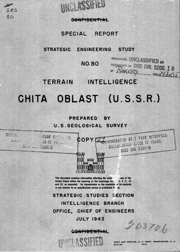
SPECIAL REPORT
S T R A T E G I C E N G I N E E R I N G
NO. 80
TERRAIN INTELLIGENCE
CHITA OBLAST (U.s.s.R.)
Prepared bya
Section of Military Geology u.s. Geological Survey
Department of the Interio~
STUDY
This document contains information affectine the national defense of the United States within the meanine of the Espionage Act, 50 U. S. C., 31 and 32, as amended. Its transmiS$ion or the revelation of its contents In any manner to an unauthorized person is prohibited by law.
St~ategic Studies Section Intelligence Branoh
Office, Chief cf.Engineers July. 1943
a9 i!UI !DkNfiXL
. .. : ~ .. ,
~· ~~·:.r
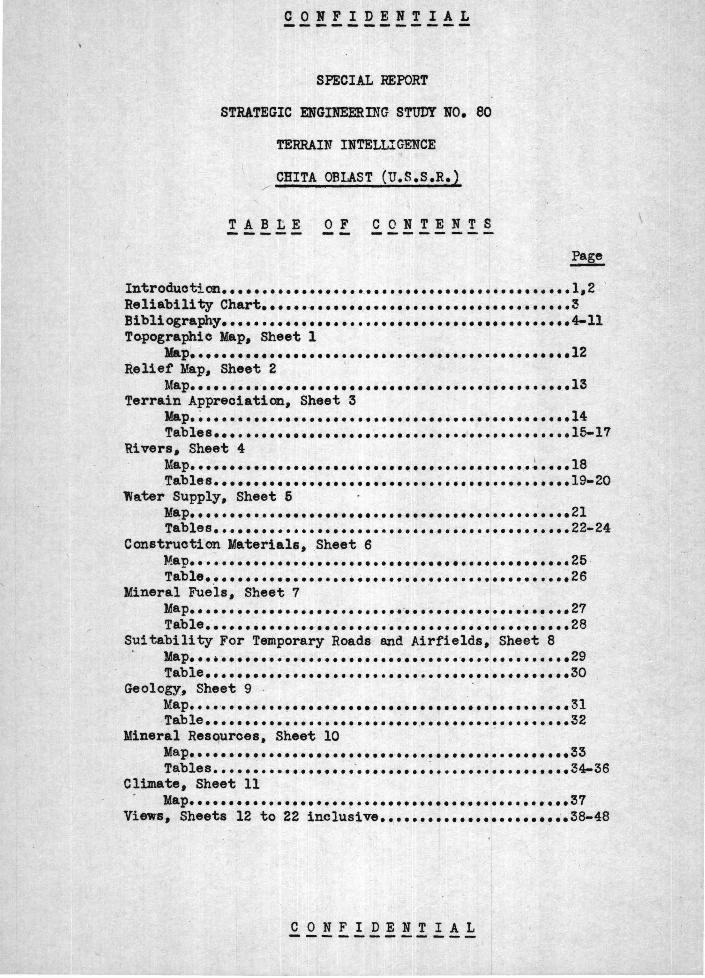
CONFIDENTIAL
SPECIAL REPORT
STRATEGIC ENGINEERING STUDY NO. 80
TERRAIN INTELLIGENCE
CHITA OBLAST (U.S.s.R.)
TABtE 0 F CONTENTS ------ ·--
Introductian••••••••••••••••••••••••••••••••••••••••••••1,2 ' Reliability Chart •••• ~ •·• •••••••••••••••••••••••••••••••• 3 Bibliography-•••••••••••••••••••••••••••••••••••••••••••• 4-ll Topographic Map; Sheet 1
Jla.p. ~ .............................. · ••••••••••••••••• 12 Relief Map, Sheet 2 ·
Map •• _. ••••••.•••••••••••••••••••.••• .••••••••••••••••• 13 Terrain Appreciation, S~eet 3
Map. ~ ••••.•••••••••••• .•••••••••••••••..••••••••••••••• 14 Table.s ••••••••••••••••••••••••••••••••••••••••••••• 15-17
'Rivers, Sheet 4 Map••••••••••••••••••••••••••·~··••••••••••••• ~ ••••l8 Tables ••••••••••••••• .•••••••••••••••••••••••••• • ••• 19•20
'Water Supply 1 Sheet 5 I
M~P••••••••••••••••••••••••••••••••••••••••••••••••21 Tables •• .•••••••••••••••••••••••••••••• .••••••••••••• 22-24
Construction Materials, Sheet 6 Map ••••.•••••••••••. • ••••••••••••••••••.•••••••••••• .-. 25 Table •••••••••••••••••• • • •••••••••••••••••••••••••• 2_6.
Mineral Fue'Is, Sheet 7 ' MaP•••••· ·~··•••••••••• •• ··-············•••••••••'••••••27 Table.· ••••• • ••••••• - ~ ••••••.••••••••••••••••••••••••• 28
S?itability For Temporary Roads and Airfields, Sheet 8 Map ••• • •••• · •••••••••••••••••••••••••••••••••••••••• 29 Table •••••••••••••••••••••••••••••••••••••••••••••• 3o
Geology; Sheet 9 Map •••• ·········~··•••••••••••••••••••••••••••••••••31 Table ••••••••••••••••••• ; • ~ ••••• .••••••••• ~ ••••••••• 32
Mineral Resources, Sheet 10 Map._ •••••••••••••• ;. •••••••••••••••••••••••••••••••• 33 Tables ••••• ~ •••••••••••• -••••••••• ~ ••••••••••••••••• ~4-36
Climate, Sheet 11 Map •••••••••••••••••••• ! ••••••••••••••••••••••.••• .•• 37
Views, Sheets ·12 to 22 inclusive •••• ••• ••• ••• •••• ••• •• .-.38-48
C 0 N F I D E N T I A L -----~-------
INTRODUCTION
-'!he following folio of ·maps and
1 explanatory tables ·outlines ·.the · :·
principal· terrain features o£ ithe Chita Oblast. Each map and · table : is devoted to a specialized ·set of problems; togethe·r . thty c·over 'such subjects as terrain appreciation, rivera, surface-water and groundwater supplies, construction materials, fuels., : Su:itabilitt tor · tfi~ porary roads -.nd · airfields, . mineral resources, and geology. These maps and ·da~· ,;,were , compiled by the United States Geological Survey.
,, ; -- . '
B. TERRAIN . APPRECIATION
The terrain appreciation sheet, based on. map reconnaissance, appraises. the e~fects of topography and kind . of ground on movement,· cover, and concealment of troops and supplies. Climate, effects of shell fire, movement, water .supply, observation, concealment and cover, and camouflage problems are SUIDDarized .tor Chita -Oblast .as a whole • . · . The area is · divided into 18 physiographic provinces. '!be topogra]Xly of each is sWIID8.rized as to average altituQe and reUet; nature and extent of hilltops, hillsides, arxi plains; and the character of streams and thtdr valleys. Brief mention is made or the kind, $1110unt,
· and distribution or soil -and bare rock. Type or· vegetation, settle- ·· ments, and existing roads and 'railroads are briefly summarized to complete the terrain setting; for p~oper appraisal of these factors . the reports of othe~ intelligenc~ units should be consulted.
C. WATER SUPPLY
Existing and potential Wa.ter supplies are reviewed primarily tor use ·in planning operations but also to assiet geologiat,e attaehed to water supply battalions in locating grounc;i water supplies. A map showing permeability or . bedrock is supplemented by intormation . on . wells, and springs. An attempt is ade to appraise the ·potential groum water resources, and to indicate the most promising sources of supply. Surface water supplies are discusse_d in a separate .table.
D. SUITABIUTY FOR TDPORARY ROADS AND- AIRFIELDS. .·· '.
Feasible transportation routes through the obiast at various seasons are .briefly reviewed, and seasonal construction problema inherent in regions of permanently frozen ground are: outlined. Description of each ot tive areas within the oblast includes such · features as topographic barriers, extent- of level areas, type ot ground, and drainage problema, and their efteet on problems or road and airfield construction. The oecurrenc~ of usetul construction materials .· is indicated. Roads, railroads, and rivers alreadJ' avaJ,.lable tor transport.ation are briefly mentioned.
CONFIDENTIAL -· -- _ .... ---,- - ~ - - ; - -
C 0 N .F "I . D E N .T I A L. - - _. ... ,.._ -~ - .- - -~ - ""
E. RIVERS • ~--· :' '· ' t .• , •
The Rivers sheet describes the principal valleys and streams of the Chita Oblast. Valley ch&racteristics, such as width., ._dr.ainage, ,. and slope; and river characteristics, such as discharge, gradient, · and ~ dateSL Of .. freezing: apd ,_ thavting are dis .cussed.- Ease of .travel along and ~.across rivers ,and .valleys .is· ,dis-cussed, as well :as the · possibi1lity of"· using r -ivers ;: as ·transportation. routes .•
F. CONSTRUCTION MATERIALS i ._,
·This sheet . . shows' the· distribution of. rocks suitable for _building stone, lime, ce~nt, concrete aggregate, road metal, ballast, riprap, and brick.
G. MINERAL ·FUELS
· .. The principal coal deposit~ · artd undeveloped oil shale deposits and oil-bearing .areas· are .shown on this sheet. . .The text outlines quality, mining methods, reserve~, past production,:. and. geology.
H. IJilf.ciRAL :RESOURCES
T"nis -sheet-: outlines the distribution, mining methods·, · past production, . geology,, and estimated reserves of mineral resources other than fuels. ~. >-.Lead,. zinc, iron, tungsten, tin, fluorite, bismuth, and .·gold are .the prin~ipal metals produced.
I. GIDLOGY
The basic data from which mu.ch of the foregoing w~s ·derived .Is ·· SUJDJ'Ii8r~zed;. on~ .. ~he geologic· map.. .This .osheet ·is intended primarily for geologis-ts· who .may be ... as~igned to speci:fic problems in the Chita Oblast to give ... {hem .a· geh~ral picture or ~ the ·. regional relations of the rocks · .. in order :to;. permit · better interpretation in ·small areas· where ~ geologic advice: .may\ .be needed.. ,, ,. .. .' :·;
. .f: -., " - -~ ~ ·~ _i : ~ .~, ~- •
J. . MISCEW\NEOUS ~. ·. ~ .. . . (
Climatic factors. are · summarized ·on: a ·sert.es::,O.f -~~~l;, }~l?s.~: . : Yi.ew~~. of typical terrain features'"' are' also included~·'-~" c :· "' •
-~ ··.. ~{ . . ~ ~ ·, .~ ~~ ·~r l ~ • •
f. Q.!! t !. !! ~ Jf! ''l 'li 1 · 2
v 0 ~ ~· 1 U ~ N T I A ~ _,__, ___ ~--------
Method of compilation and reliability of data
These data have bee.n assembled from published reports and maps of the geology of the area as listed on the geologic map of this set. The data presented necessarily involve more o,r l&ss interpretation on the part -of the compilers and the reliability depends very largely on the adequacy of the original reports and maps of the area, Each compilation is given a reliability rating as judged by the compilers. Th_eae ratings are:
Class A:
Class B:
Class C:
Class D:
Original data so complete that the compilation involves little or no interpretation by the compilers.
Original data. seem accurate but incomplete for this _ purpose. and have required na.tch interpretation.
Le-as ·accurate and less complete th$n B, better than D.
9riginal data very sketchy; inaccurate as well as incomplete•
Original source maps are rated in three classe~- for each seale of map as follows:
Surveyed map: Th.e original map represents an actual instl'\}lllental survey and should be entirely reliable for the scale.
Reconnaissance map t The original map wa.s not surveyed but seems to . have been oaretully prepared. General f'eatures are correctly shown but ,. the dett\.ils are incomplete and inaccurate for the soale.
Sketch map& 1'he original map is highly dia.gramma.tic and may contain gross errors.
CONFIDENTIAL ----~...-~---- ._. ..... --
3
.... ;
.. ,.
/
CONFfDENTIAL
BIBLIOGR.AP HI . ·· : CHITA ~ OBUST · I
*Articles have been ·most useful in preparation of_. this ~port.
Translation of title in parentheses () indicates t that .. translation was · given in original publication • ..
Translation of title in brackets r J indicat~s . translati~n by U • . S • . Geological Survey • .
Terrain:
, Anert, E. E., Geologicheskie issledovaniya po reke Zeye: : · Vsesoyuznoya Geologo-Razvedochnoya Obedineniya _NKTP 'SSSR, Trudy,_ vypusk .l81., 1932. (Anhert, E.; Itineraires geologiques dans la partie Est due baaein superieur de la riviere Zeia: United . Geological and Prospecting Service of U.S.S.R., Transactions, fascicle .181, 1932.) In Russian, French summary. Geology, · rivers, te~rain.
Arsenev, A. A., Olelano-Vitimska_ya gornqa strana. · Geologiya. pravoberezhya R. Vitima: Academiya Ns.uk Soyuza SSR, Institu.t .~ologicheskikh. Nauk, Trudy, vyp. 27, geologicheskaya seriya ·(No.. 7), 1940. (Arseniev, A. A., The Olekmo-Vitimskay mount&ins , regi.on. 'lbe geology of the right-bank of the Viti'll River): [Acadell\Y ot Science of U.S.S .• R., Institute of Geological Science,. 'Iruqv, fascicle :n, geologic series no. ?, 1940]. In Russian, ,very short English summar,y.
? ..
D 1 Almeida, P. C. , Russ~e, in Vidal de la Blache, P. and· Gallo is, . L. ; Geographie Universe·lle, tOme · 5, 1932. - In French• General geo-graphical information. ·A few pages on Chita .area.. -
* Olanilov, s. I., Reddish desert deposits iri south Trwb~k&l. steppe: Acadenv of Science U.S.S.R., Far Ea~tern Branch, vol. 2;7, pp. 146-148, 1937J -In Russian. ·Soil boring descriptions, . vegetation.
*Doskach, A. G., Fiziko-geograticheski ocherk Zeisko-B~insk~i .rav~ · niny: Akademiya Nauk SSSR, · Insti tut Geogratii, Trudy, vYP •. 27, ·
1937. (Doskatch, ih G., Etude geographique ·de la plain• ~ la Zeia et de la Boureia:) ~cadeiey" of Science U.S.S.R~, Geographical Institute, TrudY, fascicle 2:1, 1937J ~ .· In Russian, French . 8UJnm8.17. Peysiogra})lv: or reg:tcn. I Co~1ete description._ ...
. - .. ' ~"
Gerrare·, ~Yirtl Greater Russia, the continental empir.e , of'_; the old lterld, KacndJJan Co.,New Ycrk, 1904·. .In Fng1ish• . Popular geogaphical account. ·
. • .
*Gladtsin, I. N., Geomorfologiche.ski ocherk Zahaikalya: Akade~a _ Nauk SSSR, Institut Geogratii, Trudy 1 vyp. 29, 1938. (Gladcin, J. N., Geomorphological Description of -Transbaikalia): [lJ.S.S.R. Acadeuv of Science, Institute of Geography, Truey, fascicle ':8, pp. 116-195·, 19.38.] In Russian, English swnmary. Excellent brier description and map of p~siogr~phic provinces between Argun River B.ll:d Lake Baikal •
. CONFIOENT~AL . IJ
CONFIDENTIAL
Khlaponin, · A.· I., Leontovich, A. A., i Prinada, V. D., Geologicheskie issledov~a v Verkhne-Amurskom Raione: Vsesoyuznovo Geologo-
. "Razvedochnovo Ob 1edineniya N.I.T.P., S.S.S.R., vyp. 231, 1932. (Khlaponin, A. I., Leontovich, A. A., and Prinada, B. D., Geolo
·gical investigations in the Upper A.'Ill1r Region: · United Geological and Prospec-ting Service or U.S.S.R., Transactions, fascicle 231, 1932.) In Russian, English SUIIJIIla!7. Geology, rivers, terrain.
: I, ~ : .-t - 'v ~ : • - "~ •,."' ~ .~
Obruchev, V. A., Olekminsko-Vitimski zolotonosey raion: . Biblioteka "Gornovo Zhurnala", Geologicheski obzor zolotonosnykh raionov Sibiri, chast 3, Voatochna_ya Sibir, vyp. 1, 1933. [Obruchev, V. A., Olekma-Vitim gold-bearing region: Library of "Mining Journal", Geological survey of gold-bearing regions of Siberia, part 3,
· Eas.tern· Siberia, fascicle 1, Moscow, 192.3.]. In. Russian. Gold - 'statistics; ·geology; physiography.
*Pavlovsld., -· E. ·V., ·Vostochnqa chast Sredne-Vi timskoi gornoi stra~. Orono-Nichatski raion. . Geologicheski· ocherk: Akade~a Nauk SSSR, Geol()g.ichesky ·Institut; 'lruey, tom· J, 19.33. {Pavlovskii, E. V., Der oetllche Tell des Berglandes des mittleren Witim. Die 'Region"Oron-Nitschatka, Eine geologische Ubersicht:
·Academie ·des Sciences de l'URSS, Institut Geologique, Travaux, ·tome 31 jjp·•· 41-109, 19.33.) In Russian, Gennan summary. Physiogr~phy, st~~ture, stratigraphy, glaciation, pictures.
*Pavlovski," · E._ V~'J i Tsvetkov, A. I., Yuzhna.ya okraina Olekma-Vitimskovo nagorya, '· Geologo-petrogra.f'icheski ocherk po marshrutam 19.32 g.: Akademiya Nauk SSSR, Geologichesky Institut, Truey, tom 4, 1934. (Pavlovskij, E. V., und Cvetkov, A. I., Die sudliche -Grenz region des :·olekma~Wi tim Hochlandes ( eine geologis.ch-petrographische Ubersicht· nach den Forschrungen dett· Jahre 1932): Academie des Sciences de , l'URSS, Institut Geologique, Travaux, tQDe .4, pp. 13-68, 1934.) In F..ussian, German summary. Physiogra.phy, geology,
·. ,. pict~~&. : .. ; .. ~- ·· ·
Voznesenski, A'.·: B~, Godovol khod osadkov na territorii·· SSSR: Gosudar. stveim.y Gidrologicheski, Institut, torn 10, 1933. (Wosnessenskij,
···, A~,. v~·· ;' :~Karte .. des ·jahrlichen G&nges der Niederschlage aut de~JL -: 'ferritori\un :~der ·u. d. S.S.R.: · Institut Hydrologique, Memoires,
·volt. 10; -~pp. ··35-43. Leningrad, 1933.) In Russian, German · >! sUmlnEi17. ·•--Mean ,monthly precipitation tables; map with histograms.-
~ :~· l ._ ~ "'; • ... :~ f'. r~ ,. .. :~ .~.:_ .... : .. ~·.. h • •
GeologicheslO:Ya Li 'zsledovaniya ~ razvedochn:ira•: raboti-· po lin~i;-.Sibirskoi . zhe~eznoi dorogi, vyp. 1-28, 1898-1914,- s. Peterburg. (Explora-
'l ·'tions geologiqu$s ·et · minieres ··le• longc;du .. chemin de .. ·fer .'de Siberia., · '<tlir.al'sons 1~28'1 St. Peterb\irg : 189&--1914•,) In: ~asian, j french
and German swnrnaries. Physiography, lithology, minerall·resoltrces, gr9und water, structure, geologic maps, hatchure maps, good pictlire$,~ OUt ' of date. · .. :. -.. - :: , .'· · , . · . , . .: r, ·:
.t! i't )' c. ~. ': r. ' ·t ! .• } .: ~~. • P' < • • \.
5
CONFIDENTIAL
Geologicheskiyc:. izs1edovaniya v zolotonoseykh ob1astyakh Sibiri, Amursko-.Primorsld zolotonosny, raion, vyp. 1 to 21, 1900-1915. (Ex-
. p1orations. geologiques dans les regions auriferes de la Siberie, ·Region ~urifere de 1_1 it.Inour, .rascic1es 1 to .21, 1900 to 1915.) In Rus-sinn, French sll1Ill'Ila'ries. Rivers and terrain. Exp1oratlons mostly limited to river val.ieys.
Rivers:
Ma.lyshev, V. H., i Molociykh, I. F., Issledovaniya rek Vostochnoi Sibiri: Russkoye Geograficheskoye Obshchestvo, Vostochno-Sibirsky Otdel, Izvestiy&, tom 47, 1924. [Malyshev, V. M., and Molodykh, I. F., Investigation of rivers of Eastern Siberia: Russian· Geographical ,Society, Eastern-Siberian Division, Izvestiya, vol~ 47, pp. 54-104, 1924J In Russian. Ice thickness statistics.
Molodykh, I. F., Zadachi vodoputei v Vostochhoi Sibiri: Russkoye · GeC?graficheskoye Obshchestvo, Vostochno-Sibirsky Otde1, Izvestiya,
tom 49, 1926. D.~olodykh, . I. F., Problems of navigation in Ea~t~rn - Siberia: . Russian Geographical Society, Eastern-Siberian
·Division, Izvest~a, vol. 49, pp. 23-61, 1926J In Russian. Navig&tion statistics .. on Lena, Vitim, Olekma, Maya, Angara and Selenga.
Sumgin, M., Vechnaya merzlota pochvy v predelakhS.s.s.R.: N.K.Z., Dalne-Vostochnaya Geofizicheskaya Observator\ya, Vladivostok, 1927. [Swngin, M., Permanently frozen ground within the boundaries of U.S.~.R.: N.K.Z., Far-Eqstern Geophysical Observator,y1 Vladivostok, 1927J In Russian. Includes data on rivers, river regi-
, men, particularlY Zeya River.
* [Vinter, A. V., Krzhizhanovsl<Y, G. M., !Dmov, G. I. (editors), Atlas Energetic.Resources U.s.s.R., vol. 2, fasc. 13, Eastem-Siberian Krai, fasc. 14, Far-Eastern Krai, Yakut ASSR, ·Principal Ihergetic Administra.t1o.n, 1934.] In Russian. River statistics. ·
Water SupplY:
Dengin, Yu., Nekotorye mineralqye istochniki Tsentralnovo Zabaita~a: Vostochno-Sibirskoe Raionnoe r~ologo-Razvedochnoe Upravlenie, Materia~ po Geologii i PolezQy.m Iskopae~ Vostochnoi Sibiri, no. 4, 1931. (Denguin, Xury, Some mineral springs of the south part of the central Transb9-ika.lian region: East-Siberian Branch
. of . Geological and Prospecting survey, Record~ of: Geology and Mineral Resources of EF.st Siberia, No. 4, pp. ·57-73, 1931.) In
. Russian, English sw~y. - Descriptions, analyses, geology of hot and cold springs.
Dombrovskaya, N. C., Khlmicheskie issledovaniya pitevikh vod v raione Urovskoi bolezni v Vostochnom Zabaikale: Vtoroy Vsesoyuzny Gidrologiches~ Syezd, chast 2, 1939. (Dombrovskaia, N. S., Chemical investigations of the potable waters in the region of Urov illness in Eastern Transbaikalia: Second Hydrological Congress of U.s.s.R., Proceedings, Part II, pp. 519-520, 1929.) In Russian, English title. Brief note on water and effect and morbidity rate of disease.
CONFIDENTIAL 6
Makerov, Ya~ A •. , Mineralnye istoC?hnild. Dalnevosto~hnovo kraya: Akademiya Nauk SSSR, Dalnevostochqy .Filial, Vestnik, ,no. 28 (1), 1938. (Makerov, J. A., I!!ineral ·springs of the Fai-Eastern Region: AcadentY of S.c.ience: u.s. S.R., Far-East~rn Filial, :vestnik, no. 28 (1), · pp. ~36, 1938.) In Russian, English title • . De~eription of springs, . analyses. · ·
*------------- , Bassein Oldokon& i verkhnikh lev.ykh pritokov R. Oldoya: · Geologic.hesky Komitet, .Izv,estiya, tom. 34, no • . 7, Petrograd, 1915. (Ma.kerov, J. A., Bassin de 1 1 91dokon e .. t du cours superieur des tributaires .gauches de 1 101doi: Geological Committee Russia, Izvestia, tom 34, no. 7, pp. 726-763, Petrograd, 1915.) In Russian. Ground water conditions in vicinity or Scovorodino. Log or 450 foot well.
Presnyakov, E. A., Geologicheski ocherk okrestnostei kurorta Molokovka ·bliz Chity: Vostochno-Sibirskoe Raionnoe C~olo~ozvedochnoe Upravlenie, Materi~ po Geologii i Polezqym Iskopa~ Vostochnoi Sibiri,
·no. 3, Irkutsk, 1930 • . (Presniakov, E., Geological description of the .environs of the mineral watering place Molokovka near Chita: East-Siberian Branch of Geological and Prospecting Survey, Records of the Geology and Mineral Resources of East-Siberia, no. 3, pp. 5-34, trkutsk, 1930.) In Russian, English swnma.ry. Geology, ground-water conditions, ' chemical an~ses.
*Siungin, M. I., Kachurin, S. P., To1stikhin, N. I., Tumel, V. F., Obshchee merzlotovedenie, Akademiya Na.uk SSSR, Moskva-Leningrad, 1940. f.Sumgin, H. E., ICachurin, S. P., Tolstikhin, N. E., and Twne1, V. F., Textbook of Frozen Ground Science, Academy of Science U.S.S.R,., Moscow-Leningrad, 1940.] In Russian. General discussion of .frozen ground problems.
*Tolstikhin, N. I., Mineralny4l vody merzloi zony 1itosfery: Akademiya Nauk SSSR, Komitet po Vechnoi ~~erzlote, tom 6, 1938. (Tolstikhin, N. I., Mineral waters of the frozen zone of the lithosphere:) V1cademy of Science U.S.S.R., Committee on Permanently Frozen Ground, · Trudy, vol. 6, pp. 63-78, 1938.] In Russian, English summary. tYpes and distribution of mineral springs (distribution rr~p). Chemical analyses and discharge data. on some individual springs.
*Tolstikhin, .N. I., i Obidin, N. I., Naledi vostochnovo Z~baikalya: Gosudarstyennoye Ge~raf~.·?he~koye Obshchestvo~ Izvestia, tom . .
. 68, vyp. 6, 1937. LTolst~kh~n, . N. I., and Ob~din, N. I., NaledJ. of eastern Transbaikaliat] (Societe Russe de Geographie (Russia), Izvestia, vol. 68, n~. 6, 1937)~ In Russian. Summary of geologic ccquifers. Discussion of s~rings and subsurface water conditions.
CONFIDENTIAL
7
CON Fl DENTIAL
*Va.silevsld., M. M. 1 Borsuk, N. V., fi,~VWlova, N. A., i Shasherova, E. I •. , Skhema osnovnovo gidrogeologicheskovo raionirov~a ~iatskoi chasti SSSR:. Sovetskaya Geologiya, tom 9, no. ?, Iyul, 1939. · (Yasilevsky, M. M., Borsuk, N. V., Revunova, N. A., and Shasherova, E. I., A sche1ne of the basic ~rdrological regions of the Asiatic p~t of U.S.S.R.: Soviet Geology, Vol. 9; no. 7, pp~ 20-36, July, 1939 .] In Russian. Map of regions and ·artesian basins with very brief description and discussion of ·each major division.
*Spravochnik vodnf.kh Resursov SSSR' Gidrologiches~ Institut, Leningrad, 1936. [Hydrological Institute Leningrad, Handbook of water resources-~ of the U.S.S.R., vols. 16 and 17, 1936.J In. Russian. Well records. Water supply discussi~n. La.k~ and river statistics.
Construction Materials:
Reutovski, V. s., Polez~a iskbpae~a Sibiri, s. Peterburg, ~905. [Reutovski, V. s., Useful minerals of Siberia, St. Peterburg, 1905J In Russian. Map with quarry locations. Discussion of each location. Written in regard to construc.tion materials used for · TransSiberian Railroad.
Mineral Fuelsa
Muzylev, S. A., Usloviya zaleg~a rybnykh bituminoznykh slantsev v Vostochnom Zabaikale: Vsesoyuznoya Geologo-Razvedochrioy~ Obedi-
_ nen~a SSSR, Izvestiya, tom 51, vyp. 47, 1932. (Muzylev, S. A., Mode of occurrence of the bituminous fish shales in Eastern Transbaikalia: United Geological and Pr~specting Services ' of U.S.S.R., Bulletins, vol. 51, fascicle 47, 1932.) In Russian, English s~J. Ioc'ations, descriptions, chemical analyses ot ·oil shale deposits. Discussion of possible oil production in region. Cretaceous description.
*Otten, F. F. (redaktor), Miner~lnoe toplivo: tom 1, Mineralnie Resursy ·vostochnoi Sibiri, Irkutsk, 1937. [Otten, F. · F. (editor ), Mineral fuels: vol. 1 of Mineral Resources of Eastern Siberia, Irkutsk, 1937 .] In Russian. Location map; description and · statistics on all coal fields in Transbaikalia. Location map and descriptions of oil shale· deposits. Map and short discussion of possible oil producing areas.
International 17th Geological Congress, The Coal Resources of the . U.s·.s.n. . 1937. In English. LOcation map, brief description and statistics.
Specie~ Delegation of the Far Eastern Republic to the United States of A.rnerica, The · Coal Mining Industry of the Far Eastern Republic., · Washington, D. C., 1922. In English. · ·Brief description and statistics on regions and important mines. Out of date •
CONFIDENTIAL
8
.. '
CONFIDENTIAL
Geology:
Klparisova, L. D., K stratigrafii morskovo tr~aca v Vostochnom Zabaikale: Glavno~ · Geologo-!ta.zvedochnoe Upravlenie ·v.s.N.Kh. SSSR., vyp. 111, 1932. (~parisova, L., Contributions to the stratigraphy of the marine Trias of Eastern Transbaikalia: Geological and Prospecting Service of U.S.S.R., Transactions, fascicle 111, 19J2.) In Hussian English s~sry. General locations, correlation, brief lithologic description.
*Leuchs, Kurt, Geologie von Asi~n, band 1, teil 1, Berlin, 1935, in Krenkel, E., Geologie der Erde. In German. StrUcture, stratigraphy.
*Obrutschew, W. A., Geologie von Siberian: Fortschritte der Geologie und Paleontologie, heft 15, pp. 1-572, Berlin, 1926. In German. Structure, stratigraphy including some detailed location and lithology infor.nation on Chit~ area.
Shchukina, E. N., i Sokolov, D. S._, 0 vozraste i genezise shilldnskovo konglomerata: ~oskoyskoe Cbshchestvo Ispytatelei Prirody, Byulleten, Otdel Geologicheski, tom 10 (3-4), 1932. (Chtchou.kina, E. N. and Sokolov, D. s., Sur l'age et sur l'origine au conglomerat de Chilka (Siberie): Societe des Na.turalistes de 1-JoscoU:, Bulle tin, Section Geologique, tome 10 (3-4), pp. 470-475, 1932.) In Russian, French ti tie. Map and description of Tertiary conglomerates along Shilka River.
*Sheinmann, Yu. M., Denein, Yu. P., Lisovski., A. L., Voinovski- Kriy.er, K. G., i Presnyakov, E. A., Materialy po geologii Vostochnovo Zabaikal.ya: Glavnoe Geologo-Razvedochnoe Upravlenie V.S.N.Kh. S.S.S.R., vyp. 37, 1931. (Schoenmann, G., Dienguine, I., Lissovsky, A., Vojnovslcy"-Krieger, C., and Presniakov 1 E., Materiaux de la geologie de la Trans baikalie orientale: Geological and
. Prospecting Service of U.s.s.R., Transactions; fascicle 37, 1931.) In Russian, French surr~ies. Geologic maps, stratigrapA1, lithology, structure sections, brief notes on mineral aeposits and
, springs, of local areas southeast of Chita.
Mineral Resources: -
Azbelev, P. P., Domarev, Viet. S., i Do.rru;u-ev, Vlad. s., Surma: Geologicheski Komitet, Obzor Mineral.nykh Resursov S.S.S.R., vyp. 46s Leningrad, 1928. (Asbelev, P., Domarev, Victor, · and Domarev, Vlad.,
· .iult~ey: Geological Committee, Mineral Resources of the U.S.S.R., part 46, Leningrad, 1928.) In Russian, English title. Description of mines and deposits.
Berling, N. I.·, Konstantov, S. V., i Likhareva, !!. I., Rtut: Geologicheski Komitet, Obzor Mi.ne~al.nykh Resursov S.S.S.R., vyp. 37, Leningrad, 1927. (Boer ling, N., Konstantov, S., and L.tkhareva, M., Quicksilver: Geological Committee, Mineral Resources of the U.S.S.R., part. 37, Leningrad, 1927 .) In Russian, English title. · . Description of mines and deposits.
CONFIDENTIAL
9
CON Fl DENTIAL
. ''
Boldyrev, A. K., Rossypi volfrarnovykh, olovyannykh i _. vysrq.utovykh rud na Sherlovoi gore: Geologichesky Komit,t, Izvestia, tom -48, _no. 8, 1929. · {Boldyrev, _A. C;, _ The tungsten, - tin··and bismuth ore placers on Mount Sherlovaia: Comi te . Geologique, Bulletins., volr • . 48, no. 8, pp. 1155-1182, 1929.) In Russian; English s~. Ore prospects.
Dengin, Yu • . P, ., Vismut.; Geologicheski Komitet, Obzor. Mi.neralny~ Resursov S.S.S.R. ,. vyp. 11, . Leningrad, 1927• : (Denguin, G • . P., Bismuth: Geological Committee · Ydneral Resources of .the · U.~.S •. R., part 11, Leningrad, 1927.) In Russian, English. title. :Description of mines and deposits.·
----~--------, Volfram: · Geologicheski Komitet, Obzor Mineralni~ Resursov S.S.S.R., vyp. · 12, Le!lingrad, 1927. . (Denguin, G., Ttmgsten: Geological Cprnrni. t tee, Mineral Resources of the U.s. S. It. , part 12, Leningrad, 1927.) _In Russian,. :English tiile. · Descrip- . tion of mines and deposits. '
Kholmov, G. V., Resultaty mineralovo-petrograficheskoi cyernki Sherlovogorskovo volfrarnovogo mestorozhdeniya (Zabaikale) letom 1928g.: Geologichesky Komitet, Izvestia, tom 48, no.- a,· 1929. (Holmov, George V., The results of mineralogical-petrographical survey of Sherlova Gora (Transbaikalia) tungsten deposits, in the sunmer · of 1928: Comite Geologique, Bulletins, vol. 48, No. 8, pp. 1479-1518, 1929. ) In Russian, English summary.
*Kreiter, V. M., Mestorozhdeniya tsvetnykh metallov Vostochno-Sibirskogo Kraya (Cu, Ni, Pb, Ag): · Vostochno-Sibirski Geologo-Razvedochny · . trest, Truoy, vyp. 2, 1933 • . (Krauter, W., 'I'he non-ferrous metal deposits of east Siberia (Cu, Ni, Pb, Ag): East-Siberian Geological and Prospecting T.r.ust, Transactions, Fascicle 2, 1933.) In Russian. Locations map. Mine descriptions. Good.
*Srnirnov, S. s., Polimetallicheskie mestorozhdeniy& Vostochnovo Zabaikalya: Vsesoyuzl\V Geologo-Razvedochny Obyedineniya N.K,. T.P. U.S.S.R., vyp. 327, 1933. (Srr~rnov, s. S., The Polymetallic . Deposits of Eastern Transbaikalia: United Geological and Prospecting Sey;vice of U.S.S.R., Transactions, Fascicle 327, ,1933.) In Russian, English surnmary. Detail~d descriptions of all mines.
*------------- , Zhele.zorudnye mestorozhdeniyo. Vos~ochnosibirskovo kraya: Vostochnosibirski Geol~go-Razvedocl¥'1Y . Trest, . Irkuts,k, 1932. ~nirnov, s. s., Occurrences of Iron ore in ~h~ Eas~Siberian Krai, East-Siberian Geological-Prospecting Trust, Irkutsk, 1932.] In Russian. Good description of prospects, and reserves determined by boring and magnetometer.
*Stepanov, B; L., Rol Vostochnosibirskogo kraya v olovyannoi problema SSSR.: · Vostochno-Sibirski Geologo-Razvedochny Trest, Trudy, VtJP. 4, ·1933. (Stepanoff, B. L., Role of East Siberia in the tin problem of U.S.S.R.: East-Siberian Geological and Prospecting Trust, Transactions, Fascicle 4, 1933.) · In Russian, English sununary. Locations mp.p. Description of mines and deposits.
CON.FI DENTIAL
10
CONFIDENTIAL
Geologicheski Komitet, Sbornik statisticheskikh svedeni po gornoi i gornozavadskoi pro~sh1enosti s.s.s.R. za 1926/27 g., Leningrad, 1929. (Geological Committee, Statistical Summary on the Mineral
J Industry of the U.S.S.R. for 1926/27, Leningrad, 1929.) In Russian, English title. Statistics. Mostly by regions. Little detail on individual mines.
*Mineral Prcxiuction and Trade of U.S.s.R. __ (Russia): u. s. Bureau of Mines, Foreign Minerals Quarterly, vol. ~, no. 2, Section Two, June 1938. In English. General discussion. Few scattered details of single mines. Most1y total production and reserve figures for entire regions or the U.S.S.R.
Special Delegation of the Far Eastern Republic to the United States
Maps:
of America, Mineral Resources of tqe Far Eastern Republic, Washington, D. C., 1922. In English. Production figures, locations, of mines, smelters, plants. Brief. Out of date.
Geologichesk~a karta Soyuza Sovetskikh Sotsialisticheskikh Respublik, Orgkomitet po sozyvu 17 sessii mezhqynarodnovo geologicheskovo kongressa v Mos~e, 1937. (Geological map of the Union of Soviet Socialistic Rer~blics, scale 1:5,000,000, sheets 7 and 8, Organization Committee of the 17th International Geological Congress, 1937.) In Russian, English legend.
Bolshoi Sovetski atlas mira, tom 1, Moskva, 1937, tom 2, MOskva, 1940. [Great Soviet world atlas, vol. 1, Moscow, 1937, vol. 2, Moscow, '1940.1 In Russian~
Map of Asia, scale 1.:4,000,000, sheets 22 and 23, Geographical-Section, General Staff; no. 2957, British War Office:, 1931. In English.
Karta SSSR,. listya 22, 23, 30: Narodny Komissariat Vnutrennykh Del . SSSR. [Map of U.S.S.R., scale 1:2,500,000, soeet 22, 1938; sheet
23, 1939 and sheet 30, 1938, National Commissariat of Internal Affairs U.s.s.R.] In Russian.
Aziats~a chast S.S.S.R., l~ravlenie Voe~kh Topografov RKKA. · [Topographic map of Asiatic part of U.s.s.R., s~·ale 1:1,000,000,
sheets M-48, M-49, M-50, N-49, N-50, N-51, 0-50 and Q-51, Admini.: stration of Military Topographers R.K.I.A., 19401.1 Compiled from various sources, some quite old.
CONFtDENTIAL
II
,I
~UNtiUt:.N I 11\L
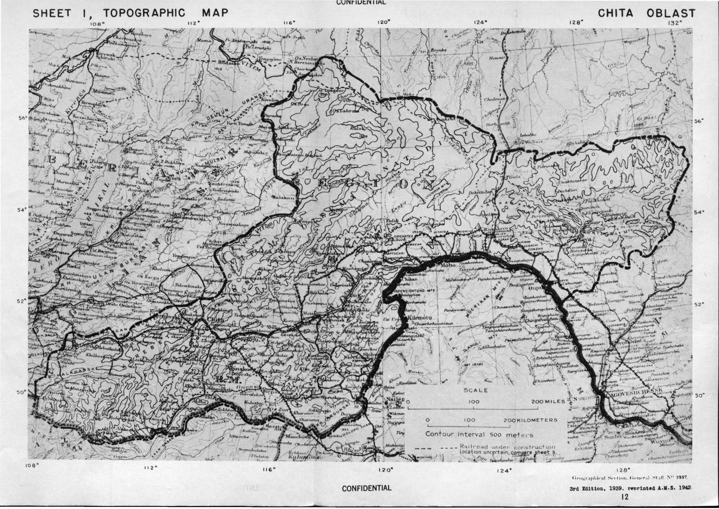
SHEET I I TOPOGRAPHIC MAP
,,,
1oa• I I 2 ° 12o•
CONFIDENTIAL
124.
SC ALE
100
0 100 200 KILOMETERS
Contour interval soo met ~t·s
R.\tlro<id unr.lr.r · A"ln~lr ct 1011
Location uncertain, com!/Jre fheet / \ 7m.Jc. :U ,1.
o. v., ro4>~,.,.,._ ~ "<H<> '·
CHIT A OBLAST 132°
5&"
54"
128°
3rd ldition, 1939. r~rinted A.M.S. 1942·
12
52°
so·
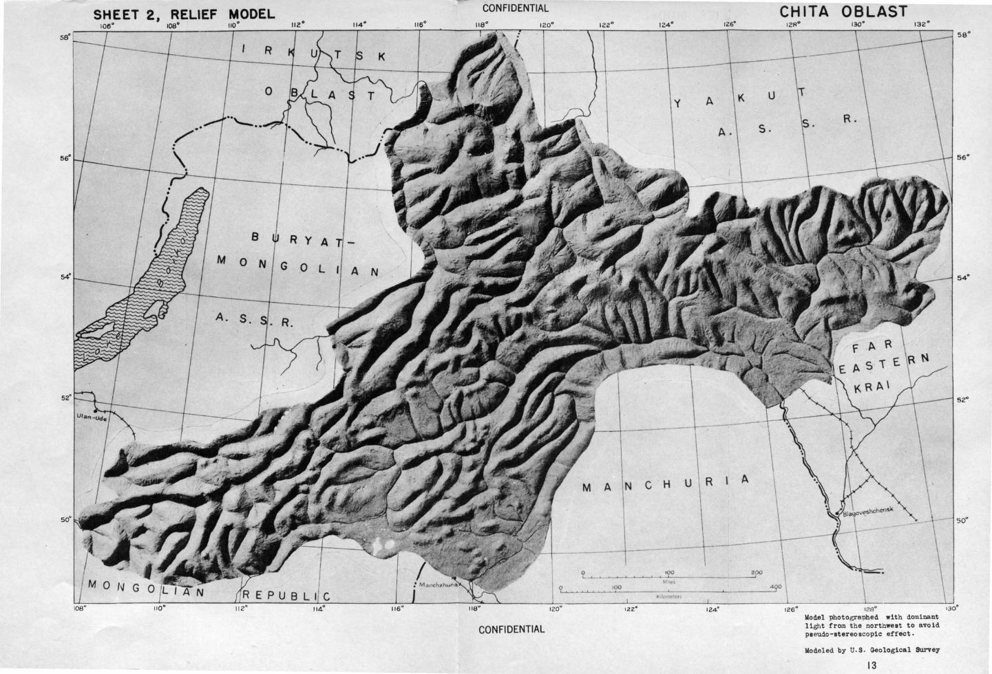
SHEET 2, RELIEF MODEL 110° 112°
R
8
M 0 N
A. S.
R y A
G .0 L
CONFIDENTIAL
A N
0
116° 120"
CONFIDENTIAL
126°
y A K u
A. s.
~--~-----------~---------
MANCHU R A
100
122°
CHITA OBLAST
126° 128° Wodel photographed with dominant light from the northwest to avoid pseudo-stereoscopic effect.
Wodeled by u. s. Geological Survey
13
sz•
so·
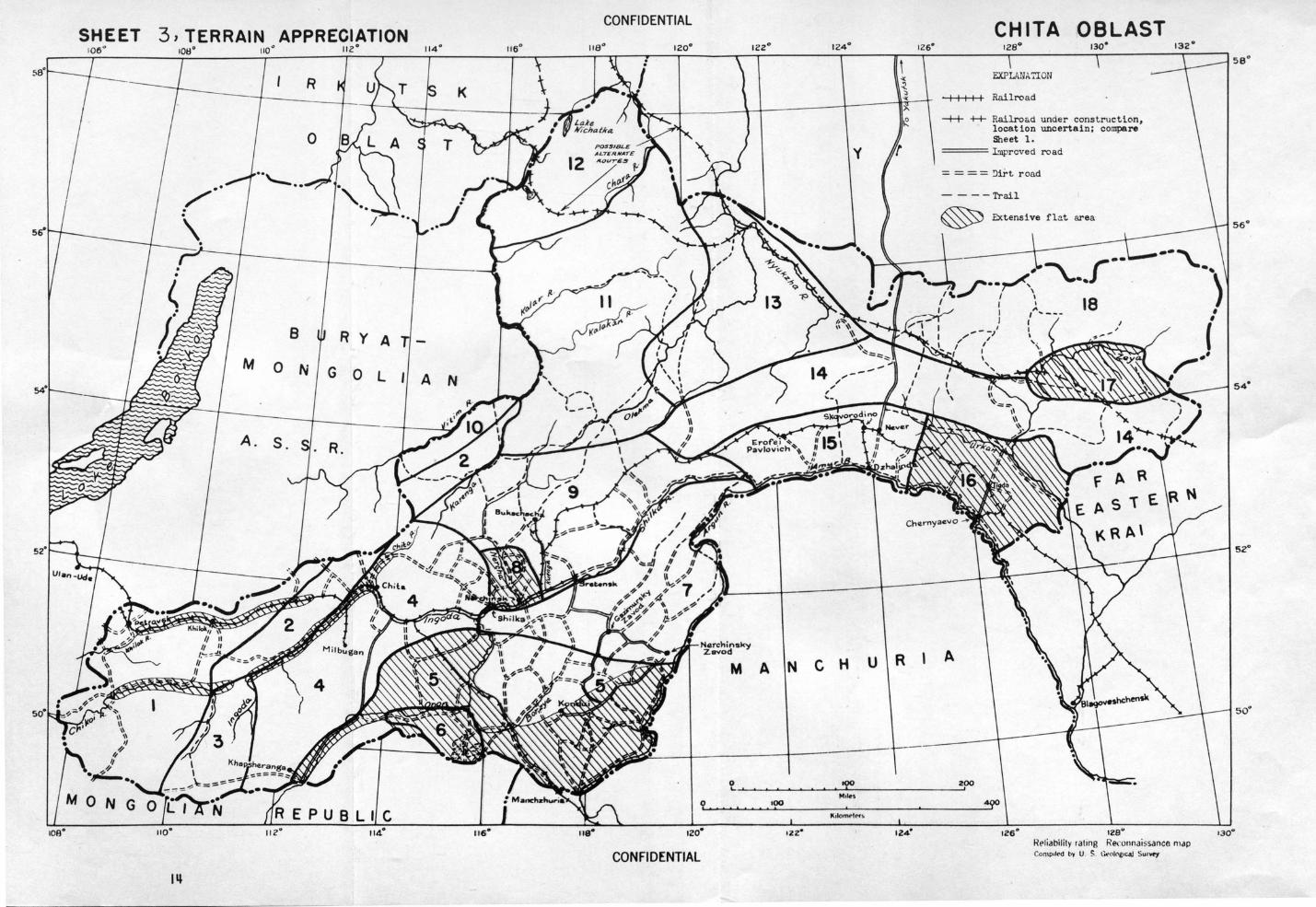
CONFIDENTIAL SHEET 3, TERRAIN APPRECIATION
106 ° 112° 114° 120°
K
8 R y A
M 0 N G 0 l A N
A. s.
M A
116°
CONFIDENTIAL
124° 126°
N C H u R
roo I
ozz• 124°
CHIT A OBLAST 130" 132°
EXPI.id/A 7IOU
I I I I I Railroad
-+-r +4- Railro&d under construction, location uncertain; compare Sheet 1.
==== l .'npr cved road
= = = = !Ji.Tt road
----Trail
fl.?.t area
18
A
IZ6° IZSU RPiiabilil y rat ing Re.:onnai~sance mclp Compolrd by U. ~ . G.eol~e•CAJ S urvey
sa•
54"
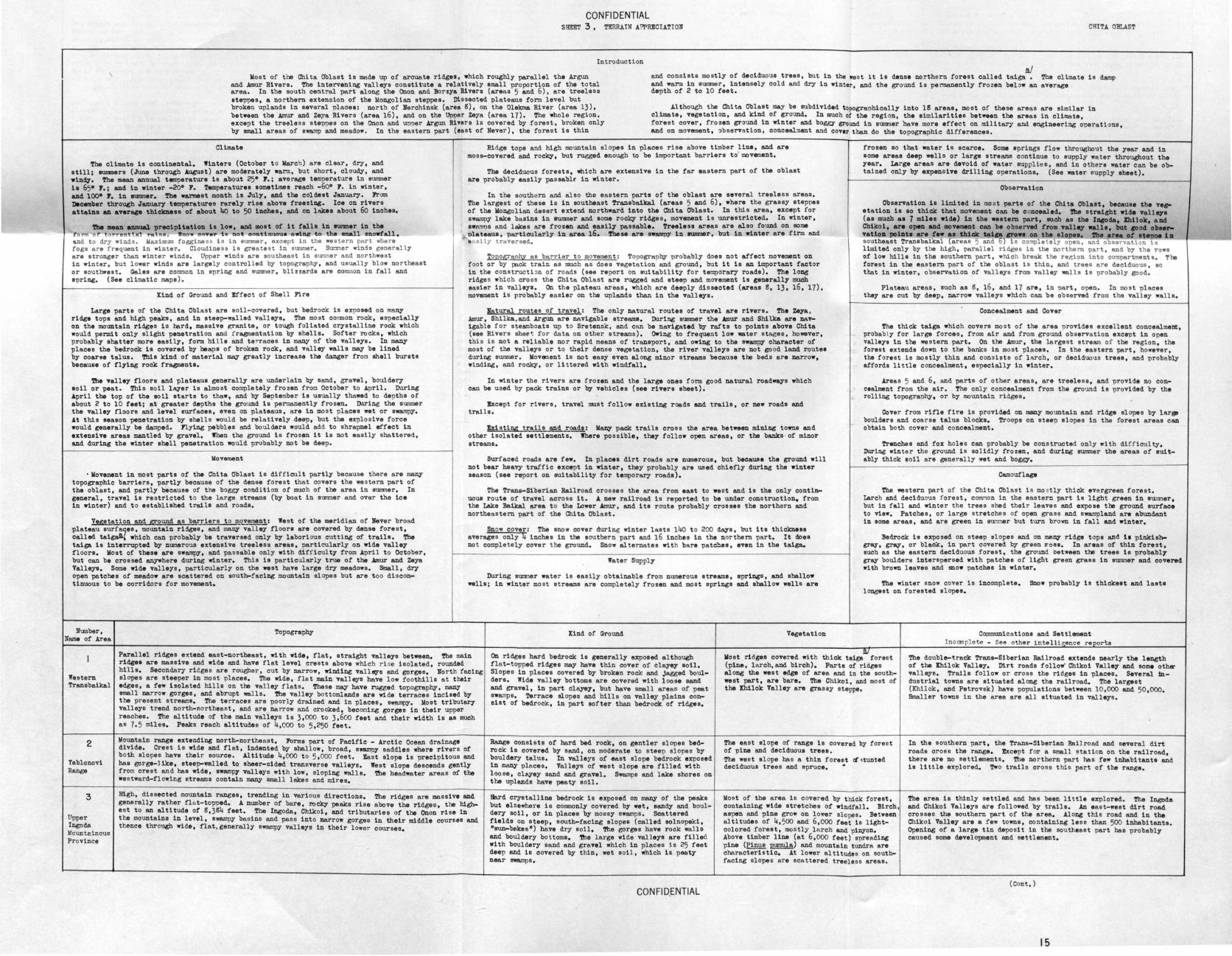
CON Fl DENTIAL SHEET 3 , TERRAIN A!'PRECIATION CR1TA OBLAST
Introduction ~
and consists mostly of deciduous trees, but in the wes t it is dense northern forest called taiga • The climate is ~~p and warm in summer, intensely cold and dry in winter, and the ground is pennanently frozen below an average
Vost of the Chi ta Oblast 1s made up of arcuate ridges, which roU&hly parallel the Argun
depth of 2 to 10 feet. and Amur Rivers. The intervening valleys constitute a relatively small proportion of the total area. In the south central part along the Onon and »orzya Rivers (areas 5 and 6), are treeless steppes, a northern extennion of the Mongolian steppes. Dissected plateaus form level but broken uplands in several placee: north of Nerchinsk (areaS), on the Olelana River (area 13), between the Amur and Zeya Rivers (area 16), and on the Upper Zeya (area 17). The whole region, exceot the treeless stepnes on the Onon and upner Argun Rivera is covered by forest, broken only by ~1 areas of swamp and meadow. In t he eastern part (east of Navar), the forest is thin
Although the Chita Oblast may be gubdividad topographically into 18 areas, most of these areas are similar in climate, vegetati on, and kind of ground. In much of the region, the similarities between the areas in climate, f orest cover, frozen ground in winter and boggy ground in summer have mora effect on military and engineering operations, and on movement, 'bservation, conceal:nant and cover than do the topographic diff erences.
Climate
The climate is continental, Winters (October t o Varch) are clear, dry, and still; .ummers (June throU&h August) are moderately warm, but short, cloudy, and wind7. The mean annual temperature is ~bout 25° J.; average temperature in summer 1• 65• 7.; and in winter -20° 7. Temperatures sometimes reach -60° J. in winter, and 100• 7. in llllllll!lar. The war-at month 1B July, and the coldest January. Jrom Dloeniber throU&h Janual7' temperatures rarely rise above freezing. Ice on rivers attains an average thiclmen of about 4o to 50 1Dches, and on lllkea about 6o inches,
!be mean ~ prec1p1tatlon la low, and moat of lt falls ln eummer ln the ro= o t<>rrent Taino . Snow e~>Y .- h not eo11Unuoue owing to the emall snowfall, ~d to dry winds. Waxtmuro f oggine ss is in aummer, except in t he western part where fogs are frequent in winter, Cloudine ss is greatest in summer . Sucmer winds generally are stronger than winter winds. Upper winds are sou theas t in summer and northwe s t in winter, but lower winds are largely controlled by topography, and usual ly blow northeast or southwest. Gales are common in snring and summer, blizzards are common in fall and apring. (See climatic maps). ·
Kind of Ground and Effect of Shell Fire
Large parts of the Chita Oblast are soil-covered, but bedrock is exposed on many ridge tops and high peaks, and in ateep-.,.alled valleys, The most conmon rock, especially on the mountain ridges to hard, mass! ve grant te, or tough foliated crystalline rock which would permit only slight penetration and fragmentation by shells. Softer rocks, which probably shatter more easily, form hills and terraces in many of the valleys. In many places the bedrock ia covered by heaps of broken rock, and valley walls may be lined by coarse talus. 'rhis kind of materit\l may greatly increase the danger fro:n shell bursts because of fl;ying rock fragments.
Tbe valley floors and plateaus generally are underlain by sand, gravel, bouldery soil or peat. This soil lAYer is almost completely frozen from October to April. During ~pril the top of the soil starts to thaw, and by September is usually thawed to depths of about 2 to 10 feet; at greater depths the gro-.md 1a permanently frozen. D.lring the summer the valley floors and level surfaces, even on plateaus, are in most places wet or swampy, ~t this season penetration by shells would be relatively deep, but the explosive force would generally be damped. Jlying pebbles and boulders would add to shrapnel effect in extensive areas mantled by gravel. When the ground i s frozen it is not easily shattered, and during the winter shall penatration would probably not be deep.
llovement
• llovement in most parts of the C"nita Oblast is difficult partly because there are many topographic barriers, partly because of the dense forest that covers t he western part of the oblast, and partly because of the boggy condition of much of the area in mxmmer, In general, travel 1a restricted t o the large streams (by boat in sum:ner and over the ice in winter) and to established trails and roads,
Vegetation and ground as barriers t o movement: West of the meridian of Never broad plateau surfaqes, mountain ridges, and many valley floors are covered by dense forest, called taig~' which can probably be traversed only by laborious cutting of trails. The taiga is interrupted by numerous extensive treeless areas, particularly on wide valley floors, llost of these are swampy, and passable only with diff iculty from April t o October, but can be crossed anywhere during winter, This is particularly true of the .Amur and Zeya Valleys, Some wide valleys, particularly on the west have large dry meadows. Small, dry open patches of meadow are scattered on south-facing mountain slopes but are too discontinuous to be corridors for movement.
Number, Name of Area
Topography
Ridge tops and high mountain slopes in places rise above timber ;ina, and are moss-covered and rocky, but rugged enough to be important barriers to movement,
The deciduous forests, which are extensive in the far eastern part of the oblast are probably easily passablr in winter.
In the southorn and also the eastern parts of the oblast are several treeless areas. The h.rgest of U1ese is in southeast Trans baikal (areas 5 and 6), where the grassy steppes of the llongolian desert extend northward into the Chi ta Oblast. In this area, except for swampy lake basins in aummer and some rocky ridges, movement is unrestricted, In winter, swll!m)s and lakes are frozen and eaail;y passable. Treeless areas are also found on some plateaus, particularly in area 16. These are swampy in INili!DIIr, but in winter are firm and easily traversed.
Topography as barrier to movement: Topography probably does not affect movement on foot or by pack train as much as does Yegetation and ground, but it is an important factor in the constructi on of roads (see report on suitability for temper~; roads). The loD& ridge s which cross the Chita Oblast are rugged and steep and movement is generally much easier in valleys. On the plateau areas, which are deeply dissected (areas S, 13, 16, 17), movement 1a probably ea sier on the uplands than in the valleys.
Natural route s of travel: The only natural routes of travel are rivers . The Zeya, .lmur, Shilka, and Argun are navigable streams, D.lring summer the .AIInlr and Shilka are navigable for steamboats up to Sretenok, and can be navigated by rafts to points above Chita (see Rivera shet>t. for data on other streams). Owing to frequent low -tar stages, however, this io not a reliable nor rapid means of transport, and owing to the s•&m?Y character of most of the valleys or to their dense vegetation, the river valleys are not go od land routes during IJillllll8r. llovement is not easy even along minor streams because the beds are narrow, winding, and rocky, or littered with windfall.
In winter the rivers are f rozen and the large ones form good natural roadways which can be used by pack trains or by vehicles (see rivers sheet).
~capt for rivers, travel must follow existing roads and trails, or new roads and trails.
histil!£ trails and roads: llany pack trails cross the area between mining towns and other isolated settlements. Where possible, they follow open areas, or the banks - of minor streams.
Surfaced roads are few. In places dirt roads are numerous, but because the ground will not bear heavy traffic except in winter, they· probably are used chiefly during the winter season (see report on suitability for temporary roada),
The Trans-Siberian Railroad crosse s t he area from east to wes t and is the only continuous route of travel across it. ~ new railroad i s reported to be under conotruction, from the Lake Baikal area to the Lower Amur, and its route probably crosses the northern and northeastern part of the Chita Oblast.
Snow cover: The snow cover during winter lMts 14o to 200 days, but its thiclcnasa averages only 4 inches 1n the southern part and 16 inches in the northern part. It does no t comple tely cover the ground. Snow alternates with bare patches, even in the taiga.
Water Supply
During summer wate r is easily obtainable from numerous streams, springs, and shallow walls; in winte r mo st streams are completely frozen and most springs and shallow wells are
Kind of Ground Vegetation
frozen so that water is scarce. Some apri~s flow throughout the year and in some areas deep wells or large streams cont inue to supply water throughout the year, Large areas are devoid of water supplies, and in others water can be obtained only by expenoive drilling operations. (See water supply aheet).
Observation
Observation is limited in most parta of the Chita Oblaat, because the ve,etation is so thick that movement can be c oncealed. '!'be straight wide vallqa (as muoh aa 7 miles wide) 1n the weetern part, such as the IDCOda, lhilok, alld Chikoi, are open aDd movelll81lt can be obseM*l from valley walla, but cood obeervatioll pollate are few •• thick taiga era•• 011 the dopea. '1'he area of ecepoe 111 southeast Transbaikal (areas 5 and 6) is comple tely open , and o servat1on 1o limited only by the high, parallel ridges in the northern par t, and by the rows of low hills in the southern part, which break the region into co:npartments. The forest in the eas tern part of the oblas t is thin, and trees are deciduous , so that in winter, observation of valleys from valley walls i s probably good.
Plateau areas, such as 8, 16, and 17 are, in nart , open . In most places they are cut by deep, narrow valleys which can be observed from the valley walls.
Concealment and Cover
The thick taiga which covers most of the area provides excellent concealment, probabl y for large forces, from air and from ground observa tion except in open valleys in the western part. On the Amur, the largest stream of the region, the forest extends down to the banks in most places. In the eastern part, however, the forest is mostly thin and conais ts of lArch, or deciduous trees, and probably aff ords little concealment, especially in winter.
Areas 5 and 6, and parts of other areas, are treeless, and provide no concealment from the air. The only concealment from the ground is provided by the rolling topography, or by mountain ridges,
Cover from rifle fire is provided on many mountain and ridge slopes by l~r~ boulders and coarse talus blocks, Troops on steep elopes in the forest areas can obtain both cover and concealment.
Trenches and fox holes can probably be constructed onty with difficulty. During winter the ground i s solidly frozen, and during 8lll!llller the areas of suitably thick soil are generally wet and boggy,
Camouflage
The western part of the Chita Oblas t i s mo ; tly thick evergreen forest. Larch and deciduous forest, corn.-:~o n in the eastern pa.rt is light green in au;mner, but in fall and winter the trees shed their leaves and expose the ground surface to view, Patcbes, or large stretches of open grass and swampland are abundant in some areas, and are green in sur.ner but turn brown 1n fall and winter,
:Bedrock 1a exposed on steep slopes and on many ridge tops and 11 pinkiah.gray, gray, or bla~. in part covered by green ~oss. In areas of thin forest, such as the eastern deciduous forest, the ground between the trees is probably gray boulders interspersed with patches of light green grass in 8UJ11n8r and covend with brown leaves and snow patches in winter.
The winter snow cover is incomplete. Snow probably is thickest and laata longest on forested sl opes,
Co~icatione and Settlement Incom plete - See other intelli~ence reports
Parallel ridges extend east-northeast, with wide, flat, straight valleys between, The main ridges are massive and wide and have flat level crests above which ri 5e isolated, rounded hills, Secondary r1C.ges are rouO!er, cut by narrow, winding valltG"s and gorges, North facing slopes are steeper in most places, The wide, flat main valleys have low foothills at their edges, a few isolated hills on the valley flats. These may have rugged topography, many
On ridges hl\rd bedrock 1s generally exposed although flat- topped ridges may have t hin cover of clayey soil, Slopes in places covered by broken rock and j~gged boulders. Wide valley bottoms are covered with loose sand and gravel, in part claye;y, but have small areas of peat swamps. Terrace slopes and hills on valley plains consist of bedrock, in part softer than bedrock of ridges,
. ~
Western Trans baikal
2
!ablonovi Range
3
tipper Ingoda Mountainous Province
small narrow gorges, and abrupt walls. 'rhe valley bottomlands are wide terraces incised by the present streams, The terraces are poorly drained and in places, swampy. Vost tributary valleys trend north-northea st, and are narrow and crooked, becomi ng gorges in their upper reaches. The altitude of the main valleys is 3,000 to 3,600 feet and their width is as much as 7.5 miles. Peaks reach altitudes of 4,000 to 5,250 feet.
Vountain range extending north-northeas t, Jorma part of Pacific - Arctic Ocean drair~ divide. Crest is wide and flat, indented by shallow, broad, swampy saddles where rivers of both slopes have their source. Altitude 4,000 to 5,000 feet. East slope is precipitous and has gorge-like, steep-walled to aheer-cided transverse valleys. West slope descends gently from crest and haa wide, swampy valleys with low, sloping walls. Tbe headwater areas of the we stward-flowing streams contain many small lakes and mires,
High, dissected mountain ranges, trending in various directions, The ridges are massive and generally rather fl a t-topped, A number of bare, roclcy peaks rise above the ridges, the highes t to an altitude of 8,384 feet. The Ingoda, Ch1ko1, and tributaries of the Onon rise in the mountains in level, swampy basins and pass into narrow gorges in their middle courses and thence through wide, flat,generally swampy valleya in their lower coursee,
Range consists of hard bed rock, on gentler slopes bedrock ia covered by sand, on moderate to s teep slopes by bouldary talus. In valleys of east slope bedrock exposed in many places. Valleys of west slope are filled with loose, clayey sand and gravel. Swamps and lake shores on the uplands have peaty soU.
Bard crystalline. bedrock 1s exposed on many of the peaks but elsewher e is commonly covered by wet, sandy and bouldery soil, or in places by mossy swamps. Scattered fields on steep, south-facing elopes (called aolnopeki, •sun-bekes") have dry soil , The gorges have rock walls and bouldery bottoms, !he large wide valleys are filled with bouldery sand and gravel which in places is 25 feet deep and ie covered by thin, wet soil, which is peaty near swarops .
CONFID,ENTIAL
Vost ridges cover ed with thick taiga forest (pine, l arch, and birch), Parts of ridges along the west edge of area and in the southwest part, are bare. The Chikoi, aod mos t of the Ihilok Valley are grassy steppe.
The eas t elope of range is covered by forest of pina and deciduous trees. The west elope has a thin forest ct •tun ted deciduous trees and spruce. •
llost of the area is cover ed by thick forest, containing wide stretches of windfall . Birch, aspen and pine grow on lower slopes. Between altitudes of 4,500 and 6,000 feet is lightcolored forest, mostly l~~.rch and pinyon. Above timber line (at 6,000 feet) spreading pine (Pinus pumula) and mountain tundra are characteristic, At lower altitudes on southfacing slope& are scnttered treeless areas.
The double-track Trans-Siberian Railroad extends nearly the length of the Ihilok Valley, Dir t roads follow" Chikoi Valle;y and some oth~r valleys, Trails follow or cross the ridges in places. Several industrial towns are e1 tuated along the railroad, The larges t (Khilok, and Petrovek ) heve populations between 10,000 and 50,000. Smaller towns in the area are all situated in valleys.
In the southern part, the Trans-Siberian Railroad and several dirt roads cross the range, hcapt f or a small station on the railroad, there are no settlements. The northern part has few 1nhab1 tante and is little explored.. Two trails cross this part of the range.
The area is thinly settled and has been little explored. The Ingoda and Chikoi Valleys are followed by trails. An east-west dirt road crosses the southern part of the area, Along this road and in the Chikoi Valley are a f ew towns, containing less than 500 inhabitants. Opening of a large tin deposit in the southeast part has probably caused some development and settlement,
(Cont.)
15
CONFIDENTIAL SHDT 3 , 'l'!RRAIN APPRJIJCUTION (2) CHITJ. OllLAST
Number, Topogra~ Kind of Ground Vegetation Communications and Settlement Name of Area
I ncompl ete - See othe r intel l i ~ence re ports
4 Northeas t trending rounded ridges. Near the Ingoda Valley above Cbita the altitude of the Bard, crystalline bedrock is exposed on val ley walla and ~ck taiga covers the northern part with Population concentrated in valleys. Chita (1939 pop. 102,555), the ridi;es is 1,6oo to 2,000 feet. To the south and east they become lower. To the northeast peaks, but most sl opes are covered wi~h wet sandy soil, the exception of the upper Ingoda and Chita capital of the oblaat, is a1 tuated on the Trans-Siberian Rail road. t hey rise to altitudes of more than 3,000 feet (about 1,000 feet above the Ingoda Valley). broken rock, and boulders, many slopes are swampy. Soft- Valleys in which wide bottomland& are grassy Several smaller towns (population from 500 to 10,000) are along the
Trans- The upper part of the Ingoda Valley and the Chita Valley are straight and have wide, terraced er bedrock (sandstone, conglomerate, shale) crops out in steppe, and in places bare sand. Taiga cover railroad, in the Ingoda and Chita Valleys and along a .urfaced road Yablonya floors. Terraces are wider on the north than on the south aides, riBiD& gradually to foot- places on the terrace slopes and in billa near the edges ia broken by treeless areas in the southern which runs southward from the railroad to the Onon River. 'ftle Chita
billa. last of Cbita the Ingoda Valley cuts through successive mountain ridges in narrow deep of the ~leya, but the valleys are mostly floored by part. and Ingoda Valleys have dirt roads and moat other ~leya have dirt valleys. South of Cbita, tributariea of the Ingoda and Onon also cut through mountain ridges. sand 'anr\ gravel and contain awampa (peaty soil) and lakea. roada or trails. Some of the smaller Btreama are dry except after raina.
5 . Broad plaine, or steppes, separated by bille or ridgea. In the northern part the plaine are Ridgea are bare or have thin sandy soil. Bedrock consist• Entire area is steppe. Lowlands covered by Single tracked Cbita - llanchuria Railroad crosses area. Many dirt separated by northeast trending ridges 2,000 feet or leas in height. The ridges have flattish of massive crystalline rock -and softer rocke, such as salt grass meadow, alopea by dry steppe, and road a. Northeast portion is a rich lead-zinc miniD& diatrict and tops, steep slopes, and alluvial fans at their bases. 'ftle plains are drained by meanderiD& aandatone and shale. J.lluvial fans and low plains are uplande by meadow gran, eage, and grove& of contain• a system of surfaced roads. Surfaced road follow• uoper OncQ
Southeast- rivera which now in swampy, ill-defined valleys. In the aouthern part, the plains are aep- covered by aand, gravel, and some cl~, generally aalty. birch and aspen. Valley and leada from western part of area to Cbita. Two towns bav-ern Trans- arated by conical billa and rocky lmolla of fantastic shape. The plains are drier, and there in,; populations between 2,000 and 10,000 are located on the railroad. baikal are DUmeroua dry lake beda or aalt lakes. In placea large streams such &a the Onon and lloreya Several smaller towns a~ from the railroad.
Rivera are incised 30 to 65 feet below the surface of the plains.
6 Wide, level plain about 2,200 feet in altitude. llounded on north by the Onon River whose Kostly gravel and sand; aome cl~. Bard massive crystal- Open, graaay ateppe, except for pine forest Several dirt roads erose the area and meet at apringa which form the valley 1e 150 to 200 feet below the plain; bounded on the south, east and west by higher land. line and foliated bedrock crops out in the highland& at in northeast corner. .fooua for stock herdiD&. .l few town• , which ban population leaa The southern part of the plain contain• two larp ancloaed lake baaina (ZUn-Torei and llarun- the edges of the area. 'fhe plaine are covered by obeatuut than 2,000.
I Cnon Plain '!brei) 150 to 200 .feet below the general level. '!'he basin• have area& of 116 and 168 squ&re brown, sandy aoila, and the baaina by aaline a oil a.
milea. !bey are almoat dT,r , but ao shallow that a riae in water leYel o.f 15 feet would fill thllln. At thll ba sin e~ea are seTeral t e rraces. Dry , .5 to 12 miles wide trout;ba open inw- -----...... t he lakea . 'l'hey have gentle slopes, i rregular and i ndefin ite margins, and ro lliD& !rummoclr:y n oora. Numerous smal l er lakes dot the plain.
7 Series of northeast trending ridges. Rise to an even level about 3,000 to 3,500 feet in al- Ridges composed of hard crystalline rock and softer rooks .lrea ia covered by pine-larch .foreat except Mostly a mining region. b nunerous mines and mining towns are titude. Individual peaks reach altitudea as much as 5,000 feet. !he ri~ea are rounded and auoh as shal e and sandstone. :Bedrock 1e covered in most for one ridge extending northeast, through connected by dirt roada, along valleys. .l surfaced road in southes t flattaned at the top. Valleys between ridges are narrow and deep (1,000 t o 1,6oo .feet). places by thin, rocky, sandy or clqey eon. Valley the middle of the area (Ononald. Ridge), which part connects Cla~timuralcy Zavod and Nerchinalcy Zavod (mining centers
last Trans- Most are parallel to the ridi;es. Valley alopea are steep, in places steep cli.ffa. Many val- bottoms contain boulders and gravel, and in wider, nat has dry aoil, and birch-aspen forest. Patches which had populations lese than 2,000, in 194o). Roads lead south baikal ley bottoms swampy. portions, cl~ey eand. Qround generally moht. Swampy r:L dry, open meadow in aome valleys. from both these towns. .l railroad connecting the area with SreteniE
areaa with peaty soil are numerous. ma;y be under construction. River porta with populations lese than 500 are scattered along the Shilke and .lrgun Rivera.
8 Basin-like plateau at an altitude of 2,000 to 2, 200 feet. Surrounded by billa riaiD& to al- !he plateau surface is bouldery sand and gravel, acme 'fhe area is covered by dry grassy ateppe. 'ftle double-tracked Trans-Siberian Railroad runG along the south and titudeaof 2,500 to 2,800 feet. 'ftle plateau is dissected by valleys as much aa 650 feet deep. cl~. The sandy soil 1a dry and strongly alkaline. lled- east edges. · TownG of lfercbinak and Shilke (population between 10.000 Ita surface is quite level in the northeast part but elsewhere is gantly rolling. !he vall eye rook 1B hard crystalline rock and softer shale and sand- and 50,000) are located on the railroad in the Sbilka Valley. Dirt
'!lerchinsk are steep-aided and narrow, but in places are as lllllCh aa a mile wide. Some valleys tributary atone; .crops out in val ley walls. roads connect t hese towna, and several roads lead north. Plain to the lruenga R1 ver have no atraama. On the south the plateau elopes steeply to the Shillca
River, is dissected, and from the river, has the appearance of a mountain ridge.
9 Northeast trending ridges, about 3,300 feet in altitude. Ridges are rounded, flat on top. Similar to area 7. Mountain tops are bare or covered with moss, .lrea crossed by Trans-Siberian Railroad, which follow& long valley& 'l'he Shllka tributaries in their upper courses flow between the ridi;ea, but cut through them to rhododendron, and in places groves of larch. between mountain ridges. Spur line extends north to llukachacha, a join the Shilke River. Valley heads are deep t'urrowa; the upper courses of the valleya are Valleys and slopes mostly covered with larch large coal mining center. Several dirt roads. Mining towns and
Mountainoua wide, straight and have rounded alopee and flat bottomland&; the lower oouraea are narrow, taiga. Part of the upper Nercha Valley is other amall towns scattered in area, but most have population under a.rea north windiD& and deep, and in places are l!l)rgea. open, and a wide atrip along the north side 500. 'l'wo large t owns on railroad have population between 10,000 and of Sbillca of the Shilka is open steppe, a continuation 50,000. River of the dry soil area of the Nerchlnsk Plain
(area 8). Open dry patches ( •sun bakes •) colllllOn within the taiga on eouth-!acing elopes.
10 The southern part of the wide Vitim Pl ateau which extends far to the north of the Chita Oblas~ The plateau baa much axposed bard, crystalline r ock. In 'l'be entire araa .is covered by dense taiga. .lrea not well explored. Contains two settlements that have popula.-In thia area, ita surface bas an altitude of abou t 3,300 feet but is sharply diaaeoted to a places it is overl ain by thin bouldery soil, or on slopes tiona leas than 500. Crossed by two trails which lead from the Vitim depth of about 300 feet by the Vitim River and ita tributaries. !he valley• of theae atreama by broken rook and boulders. 'l'he Vitim Valley is floored River across the Yablonovi Ridge (area 2).
Vi tim are narrow, rocky, and winding. by boulders and coarse gravel. Plateau
I I Mountainous province made up mos t l y of high, broad mountain masses, above which rise jagged Mountain areas made up mostly o.f hard crystalline rook Most of the area is covered with thick taiga Settlements :::ew; many unexplored areas .~/The only settlement in the peaks. !he northern part contains the highest land in the Chita Oblast, rising to al titudea covered in part by th i n bouldery soil, or, on slope a, by forest but several patches of ground in the northern part is at a gold mi ning district between the headwaters of
Vi tim- over 10 ,000 feet. ltaximum altitudes in the southern part are about 5, 600 feet. The valle;ra coarse tal Ull • Valley bottoms are covered with sand, Kalar Valley and on adjacent slopes are open. the Ialar River and the Olekma River., and bas less than 500 inhabi-Olekma are deep, steep-sided, flat-floored, u-abaped troughs which ~ontain lakes and BWS.'ll'p S. gravel and some ola.Y and peat. Peaks and upper mountain slopes are barren. tanta. .l trail leads from this place, down the upper course of the Divide ltalar River. In t he southern part, trails follow several of the
valleys, and there are at least two small settlements, one of which is at the junction of the Vitim and lralakan Rivers.
12 Area of rounded and rugged mountain mas ses, above which rise small peaks; The mountains in Mountains mostly bare, f oliated, metamorphic r ock ( schist~ The upper mountain slopes rise above timber lluoh ot area io unexplored. Uninhabited except for a town with lese the centr" l and northern parts, have steep, sharp, jagged aunmita, of alpine type and are dis- Valley bottoms contain bouldery clay, sand, and gravel. line. Thiel!: taiga covers most of the area, than 500 inhabitants near the bead of the Ohara River, and a few tinctly more rugged than the mountains of the rest of the oblast. The l'lll!lllits generally reach Peaty eoil in extensive swampy areas. but swamps are open and clear of trees. native dwellings. J. short trail on the uplands parallels the
Middle altitudes more than 5 ,800 feet. The highest peak is 6,700 feet, and the low portions of the Ohara River. The proposed llaikal - Amur Railroad ma;y cross the north Vi tim interstream divides are about 2,600 feet. Valleys are wide-bottomed, steep-walled, and u- end of the area and may be under construction at the present time.~ Mountainous shaped. 'ftley contain boul de ry fill with hummocky surfa ce, which is in places piled into Province ridges as much as 150 teet high oriented parallel to or across the valleys. Moat valleys con-
tain swamps and lakes, and extensive level boulder strewn areas, which are the basins of form-er lakes. The largest lake 1s Lake Nichatlca (23 miles long and 1 to 2.5 miles wide).
13 Plateau area 3,000 to 3,300 feet in altitude, dissected and terr~ced by the Olekma and Nyukzha !he rocks exposed on hills and elopes are hard, massive The highest hills and ridges are bare or have llany unexplored areas; few settlements. Trading post at the junction Rivers and their tributaries to depths of 1,000 to 1,150 feet. Individual low hUla and peaks granite and foliated metamorphic rook (schist). Plateaus scattered groves of larch, aspen, or pine. of the Olekma and Nyukzha Rivers. Gold mining district and warehouse rise 300 to 500 feet above the general level of the plateau. J. rook terrace borders many of covered with bouldery soil. Valley bottoms ~1 terraces The rest of the area is taiga-covered except between Olekma and Ialar Rivera. The proposed llaikal-Amur Railroad
Dissected the streams about 500 feet below the plateau surface, and in places along the main atreams are covered with gravel, sand, boulders, and some clay. for occasional open meadow• in valley bottoms. ma;y cross this area and possibly extend southeast along the Nyukzha Olekma widens into a lower plateau. In the headwater areas there are wide valle;ra with gentle sl opes , Valley • .!/ A pack trail parallels the Olekma River. starting from the Plateaus but a short distance downstream the valleys are steep-aided, deep valleys which are bordered Trans-Siberian Railroad, and probably l eadi~ t o t he head of naviga-
by rock terraces as much as 250 feet above river level. tion on the Olekma River.
14 Long, massive mountain r&D&e, trendine east. Altitude is abo ~t 1,700 to 2, 500 feet. Some The rock exposed on the rid&es is hArd, massive granite Lower mountain slopes and val leys covered in Hard-surfaced highway cros ses the range, connecting Never, on the ridges and peaks rise t o al t itudes of 3,000 t o 4,000 feet. 'lhese have steeper slopes than the and foliated metamorphic rook (schist), covered in many weatern part by thick pine-larch forest, and Trans-Siberian Railroad. with Tommot on t .he J.ldan River, north o.f lower moun tains but have flattened sumrni ts. Valleys on south slopes of the r&D&e, are trib- places by boulders and broken rock, which on steep slopes in eastern part by thin deciduous forest the Chi ta Oblast. !he only other routes of travel are trai l s and
Stan.>vik - utary t o the Amur and Urkan and are mos tly l onger than those on the north. In the east part , descend into the valle,:rs. The wet valley bottoms are (larch, birch, aspen, alder). Steep, debris- river boat on the Zeya. No settlements except at ~d mines. The Tukuringra t he range is cut by the Zeya Gorge. Most valleys have steep gradients, winding, rocky bottoms, filled with boulders and coarse gravel. covered slope• are bare. High ridges and pr oposed Beikal-Amur ~a i lroad may c r os s t his ar ea .b Range and steep, rocky elopes. Some valleys head in shallow, swampy basina. peaks are biU"e or have patches of moss and
lichen.
15 Region of l ow mountains rising to altitudes of 1,750 to 2,000 feet. The uolands are south- Ground mostly foliated hard r ock (schist) and sandstone Area covered mostly by pine-larch taiga, brok- Trans-Siberian Railroad crosses area along northern edge. .l spur trending ridges which descend from the mountains of area 14 toward the ~ River. !hey are covered by thin sandy soil. Valleys filled with aan~v en by scattered grassy meadows in valleys. line, probably originally constructed to obtain water for locomotive~ parallel, even-topped and h~ve wide, flat, or rounded summits. Rivera flow in valleys about gravel, 10 feet deep. Ground ever:f'l·here wet and boggy; Ground covered by moas and peat. extends to Dzhalinda on the ~~ur River. Several dirt roads lead from
Upper Amur 500 feet bel ow the rid&e tops. All valleys have flood plaino and terraces (up to 30 feet in places top soil is peaty. the railroad to the Amur, and small r1 ver ports are connected by region above river level) and are wet and s wampy. The Amur Valley is generally narrow but in places trail. Most of these ports have populations of less than 500. La1'-
widens t o mo re than 2 miles, and its flood plain i o covered with swamps and lakes. geat towns are situated on the Trans-Siberian Railroad, Skovorodino and :Zrofei Pavlovic!:! have populations betwee'\ 10, ')()() and 50,000.
16 Fla t, swampy plain at altitude of 1, ')()() to 1,500 feet formiD& d1 vide between Zeya and Amur The plain and upper valle,:r walla : aand,y, gravelly, and some Mo s tly thin deciduous forest (birch, larc!l, The Trano-Siberian Railroad follows the fl at, Amur-Ze;ya divide. Sev-Rivera. Di s sected by narrow, steep-walled valleys, as muc!l as 800 feet deep. Moat valle;r clayey soil to depths of 7 to 12 feet. Ground is wet and aspen, alder)~ The drainage diVide, however, eral dirt roads, a surf aced road, and a railroad spur, connect the walls are eo steep and dissected t hat the region seems mountainous when viewed from the rivers. swampy and in places covered with peat. Where the valleys is a wide s tretch of swa:npy, treeles s country railroad with the Amur River. .l dirt road follows the left bank of
Lo>'er Zeya - Tributary valleys widen upstream and pass al~ost imperceptibly into the plain. lbttoma, are wide, they have sand and gravel floodplains bordered which has mo s s and swamp vegetation. the Zeya River and joins the railroad in the ea stern part o! the area. Amur Plain slopesJ and va lley heads are swa~y. In places the Zeya and Amur Valleys widen to broad flood by slopes that have soil sLuilar to the upland aoila. J. poor trail followa the Amur River. The largest of several railroad
pl ains. Where valleys are constricted the walls are rocky. towns is Tigde which has between 2, 000 and 10,000 inhabitants. Sev-eral river po ,. ts are on t he Zeya and Amur~ mo s t of whi:b are smaller than Tigda.
CONFIDENTIAL ( Con~.)
16
-,.., •
./ \
Number, Topograpey :lame of J.rea
Level, swampy, upland plain about 1,500 teet in altitude i s incised 200 to 300 feet by the 17 Zeya River and ita tributariea, Valley bottoms are wid~ and awampy; valley walla are gentle;
and the tributary valleys paaa imperceptibly onto the ur land plain, A terrace 70 teet high · Upper bordere the Zeya River. Zeya Plain
last-trending range along the northeastern boundary of the Chita Oblast; lies on the Pacific -18 Arctic Ocean drainage divide, 'l'he range 1e complex with long ap\\rs, and high peaks extending
eouthward from the crest. The average altitud~ is 3,500 to 4,000 teet, but individual peaks Stanovoy attain 6,300 teet. Saddles are as low as 3,000 teet. 'l'hs south elope h mostly steep and in Range places abrupt, but the lower slopes are tla tter and billy, Most aaddles are gentle; aome con-
tain swamps and lakes, 'fhe valleys in the range head in deep gorges, but 3 to 6 miles down-atream they become shallow and wide, and their floors contain many swamps, larther downstream the;r again become narrow and swamps become rare.
CON Fl DENTIAL SBEE'l' 3 , '!'ZRIU.IN .Ll>pR!CIATION (3)
J:ind of Ground Vegetation l '!'he ground h mostly ooarae aand and gravel conrad by In the valleys is mostly mosa,, swamp and wet and swampy peaty aoil, eoattered larch trees, 'l'he.re are emall
patchea ot soil, which support grass, bruah and mixed woods. ~ upland plain is covered with thin forest ot larch, birch, aspen and alder.
Bedrock 1e maaai ve grant te and hard, foliated rook 'l'he highest parte of the range are bare. The ( echiot ), '!'he mountains have much expoeed bedrock, but south elope is covered with thin deciduous in ma.ny placee broken rock and talue cover the slopes, forest in the eastern part, and wi tb thick Valleys are wet or awampy, and floored by boulder•, gravel taiga in the western part. Vall~s are also and sand. forested, but swampy areas are mostly open,
Close to the divide the treeless awampa on the Talley floors widen and in places extend part way up the valley walla,
~
Taiga is dense forest, characteri s tic of these latitudes, It consist• principally of pine, larch, fir, B'Oruce, birch, and al.da~ 'lreea reach hai&ht of 100 foot ~d have eleDder tl'Wlk8, tlllderbrueh h moatly beJ'1'7'-producing shrubs. 'lindtall8 make danae tucle of dead tree•. In euo•oer ground 1e wet and air damp,
Y The location of the railroad that is under cons t.I"Jcti on in northern Chits Cblast is very unce r tain; few maps agree as to its position , The location indicat ed on sheet 3 is baaed on appraisal of the topography and scattered preliminary geological surveys for the ra i lroad and represents only one of several possible estimates of its positions,
CONFIDENTIAL
I
CHITA OBUST
Communications and Settlement Incomplete - See othe r intelligence r~porta
Sever al gold mining settlements and connecting truila at eaatern end ot area. A few river porta on the Zeya River have -pouulatione leas than 500. 'l'he main access to the area 1e by river boot on the Zeya, . The proposed route of the Baikal-Amur Railroad~ cross the area.~
~ever - !ommot Highway crosses the Stanovoy Range (see area 14), 'l'he only other crossings are several pack trail•, The area is unsettled and in part unexplored, Several wintering huta are along the- traile. The proposed r oute or the Baikal-Amur Railroad may cross the area.~
Re l iability ratings Class c. Compiled by U. s . Geol ogi cal Survey,
17
56°
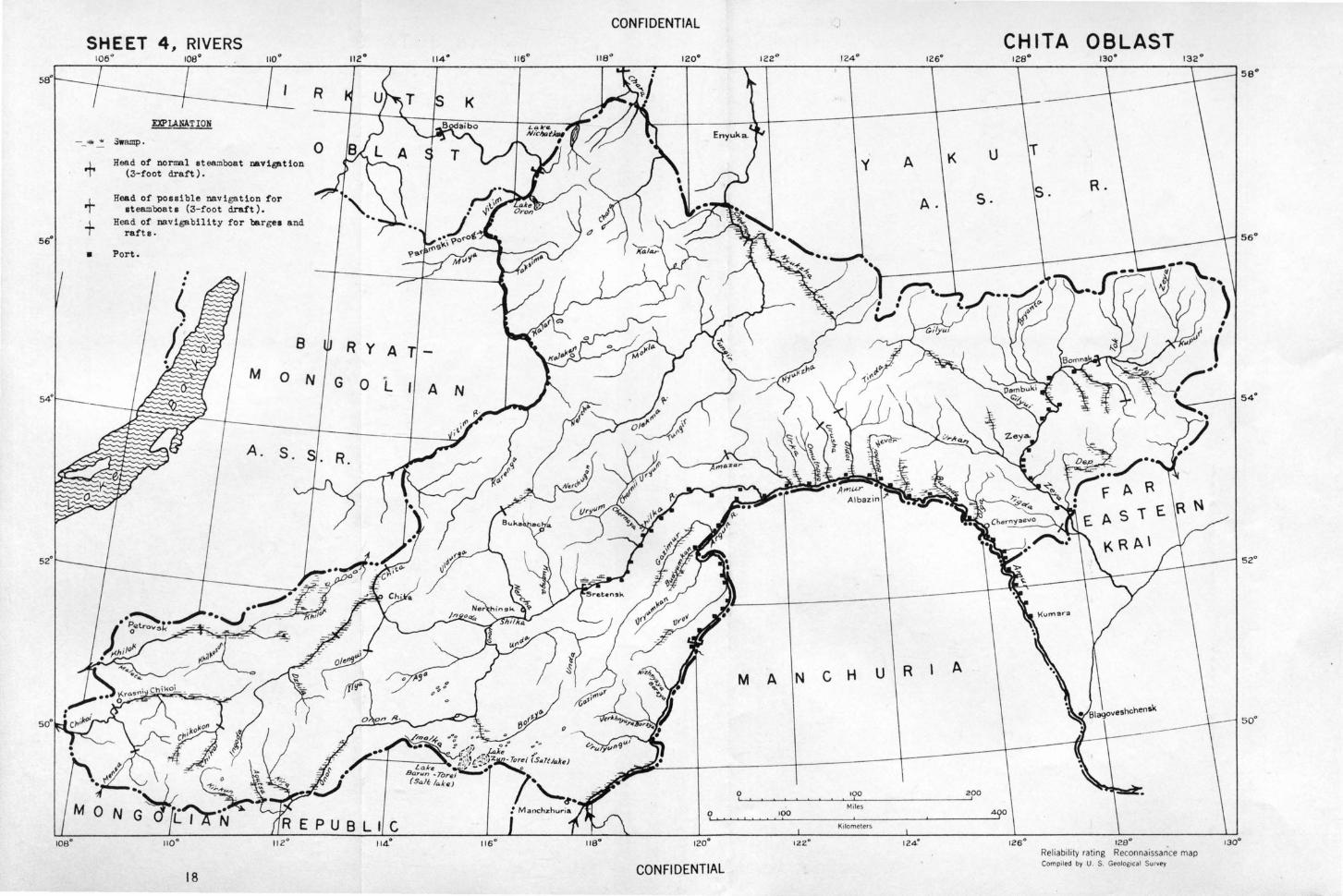
SHEET 4 106" ,
RIVERS 108°
R
EXPLANATION
Swamp.
Head of normal t Q (3-foot draft).eamboat navi~tion +
Head of possible steamboats (3-f~~igation for +
+ Head of navigabilit draft).
rafts. Y for bargea and
• Port.
8
0
s
N
R y A
R.
110° II: E puB L I c
114.0
18
CON Fl DENTIAL
A N
M A
0
0
120°
CONFIDENTIAL
CHIT A OBLAST 128° 130"
T y A K u
s. s. R. A.
56°
54°
N c H u R A \ so·
ooo 200
Miles 100 0
Kilometers
12Z0 124° 126 ° R J' b'. 128" e oa iloty rating Rec . • o30°
Compiled by u 5
G onnaossance map . . eolog•cal Survey
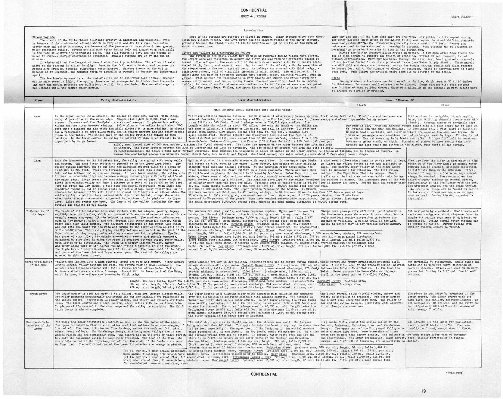
CONFIDENTIAL SHEET 4 , RIVERS CHIT A OBLAST
Introduction
stream Regimen Most of the streams e re subject to floods in stmlller, Minor streams often have shortlived but violent floods . The Zeya River has the largest floods af the major streams, probably because the flood crests of i te tributaries ere apt to arrive at the Zeya at about the seme time.
only far i .he part of the time that they ere ice-free , 116 vigation is interru pted dur !ng low water periods (most of ten in spring and fall); end rapids, bars and shift i ng channels make navi6 at1on difficult. Steamboats generally have a draft of 3 feet. Berges and rafts are used in ~ow •eter and on unnavigable streams. Some streams can be followed on boreeback\ bY crossing from side to aide of the stream bed.
The rivers or the ~bite Oblast fluctuate greatly in discharge and velocity. This is because of the continental climate which is very cold end dry in winter, but relatively warm end rainy in ~r. end because or the presence or impervious frozen ground, which increases runoff . Rivers contain moat water during J\lly and August wb en rain falls in the form or showers and .torrential rains. The fall season is dry, and the volume of water in streams sharply decreases in September. Smaller streams dry up by the end of October .
Rivers and Valleys as Transportation Routes The rivers of the Chite Oblest rosy be used as roadways during winter when frozen,
The larger ones ere m vigeble in sutmner end river valleys form the pr inc ipel routes of travel. The valleys in the east third of the oblest ere wooded with thin·; eeeUy penetrated birch, larch, an d aspen forest . In the rest af the oblest, with the exception of the steppe area in the south central pert, the valleys ere covered with thick taiga, e conif erous forest, full of windfalls , growing in moist ground. The entire reg ion is mountainous and most of the minor streams have narrow, rocky, mountain valleys, some in gorges. Flat uplands end floodplains in many places ere swamps and mires during the S\llllller rainy season , and during spring thaws. Because most of the land is so impenetreble, the beds of smeller streams are ~d as trails and larger streams are navigated,
Rivu s are better t ransportation r outes in wi nter . A few days after they freeze the ice is fin~ enough to support the weig ht of vehicles . Travel on ice , however , is not without difficulties. Many spring s break through the river ice, fonning sheets or mounds of ice (called •naledi") at their pointe of issue (see Water Supply Sheet). These neledi ere difficult and dangero~ to erose, as the ice breaks through easily end slush freezes t o horses feet end t .o the runners or wheels of vehicles. Units of caravans have at times been lost. Such places are avoided where possible by detours on the banks.
In winter all but the largest streams freeze from top to bottom. The volume of water added to the streams in winter is slight, because the fell season is dry, and because the ground also f reezes, reducing subsurface water sources . Streams freeze at the end of October or in November; the maximum depth of freezing is reached in January and lasts until April.
The ice breaks up usually at the end or April end in the first winter snow cover is light, the spring thaws are not accompanied by ing snow and ground moisture ere sufficient to fill the river beds. not reached until the sumner rsiny season .
part of May. Because floods , but the melt Maximum discharge i s
Only the Amur, Zeye, Shilke, end Argun Rivers are navigable by large boats, and
Forde During winter, all streews can be crossed on the ice, which reaches 35 to 80 inches
in th ickn ess. In summer smell streams can be forded. Large streams with rock bottoms are fordable at some rapids, Whereas those with alluvium in the channel in most places must be crossed by ferries or bri6ges,
River
Amur
Zeya
Tributaries of the Zeya
North Tributaries of the Amur
Argun River
Northwest Tributaries or the
Argun
Vall~ Cbareoterietics J River Characterietice Ease of MovementY
Valley RiveT'
AMUR DRAINAGE BASI:N (Drainage into Pacific Ocean)
I n the upper course above Albezin, the valley is straight, narrow, wi tb steep, rocky slopes close to the water edge, Slopes rise 1,500 to 2 ,000 feet above stream. Terraces end tl.e floodplain ere wet and swampy. In places the valley widens and the river becomes winding. Below Albazin the valley is cut about 500 feet into a plateau and has steep and billy slopes; it is more winding, in places has a floodplain 3 or more miles wide, end in others narrows and has rocky slopes close to the water. The middle pert of the valley within the oblast is open country. In the lower course tho valley is covered by thin larch forest; in the
The river contains numerous islands. Below Albazin it alternately breaks up into Trail along left bank,_ Floodplain and terraces ere Ent he river is navigable , thou{lh rapids , several channels, in places attaining a width up to 2 miles, and narrows in placee swampy and almost impassable during Simmer, bars , and shifting channels create some dif-to as little as 660 feet, Total drainage area is ?56,811 square· miles. Its ficulty . Average numbe~ of navigable days length within the oblast is about 350 miles . Between the IOOuth of the Shilke end per year is 140, From May th rough August boats with 3 . 5 foot draft can be used up. the town of Albazin, a distance or 148 miles, the fall is 180 feet (1.2 feet per to Sretensk (on the Amur and Sbilka) . In Sept ember only 3 foot draft is feasible . mile), mean annual flow 42,360 second-feet (cu. ft . per sec,), minimum flow Mosquito boats, gunboats , and river monitors ere used on the Al1lllr and Argun . In 4 , 412 second-feet. Between Albazin and Chernyeevo (ll8 miles) the f all is 161 low water passengers are sometimes carried on barges towed by tugs . Fording is not feet (1,4 feet per mile), mean annual flow 52,950 · second- feet, minimum flow 5 ,825 possible. Easiest crossing is by boats and rafts . Bridges difficult to construct
------~--------------------------------------~second-feet. Between Chernyaevo and Kumare (132 miles) the fell is 128 feet (.97 feet per because of great width, or depth . Planning of ponton bridges should take into mile), mean annual flow 60,000 second-feet, minimum flow ?,060 second-feet, The first ice appears on the river between the loth and 20th account the soft banks and bottom in the slower, wide parts of the stream,
upper pert by taiga rorest.
of' October. The river freezes between the 29th of October end the 13th of November . The ice breaks up between the loth end loth of April---------------------------------------at Blegoveshchensk, and about a week later farther upstream, Mean maximum ice thickness is about 52 inches in the upper course, 48 inches at Albazin, and 62 inches at Kumare . In summer the shallowest places a re normally deeper than 3 feet, but in July and August, the flood season, the water usually rises about 7 feet above normal stage,
From the headwaters to the tributary Tok, the valley is a gorge with rocky walls and bottom. The next lower section to Dambuki is in the UPper Zeya Plain. The valley widens somewhat but is cut into the alluvium-covered plain to e depth of about 200 to 300 feet. There are terraces about 70 feet high along the river . Both valley bottoms end upland ere swampy. In next lower section, the valley cuts n ~ougb e mountain ri des and becomes e deep , narrow gorge with rocky cliffs at the water edge . River leaves the mountains at the town of Zeye, below which it flows in a winding valley cut into e plateau to a depth or about 400 to 500 feet. Here the river has low banks, e wide sand end gravel floodplain, with lakes and abanaoned channels, but in places rests against e staep, rocky valley wall or is constricted between cli ffs wl th little or almost no floodplain on either side , The entire valley is more or less covered with thin leroh forest, except where the river cuts through the mountain ridge and in portions of the plain of the Upper Zeya. Lakes .and swamps are open. The length or the valley (inc ludi~ the part outside the ~blest) is 835 miles.
The heads or all tributaries have wide valleys with low slopes, passing imperceptibly into the divides, which are covered with weath ered material and which are usually swempy and open. ·Little bedrock is exposed. The northern tributaries, such as the Bryants, Gilyui, and Tok , descend into· rocky mountain gorges, which widen only near their mouths. The southern tributaries in the Upper Zeya Plain ere cut into the plain but are wide end swsmpy in the lower courses as well as at their headwaters. Tho Urkan, Tigda, and Dep Valleys are much like the part of the zeya into which they empty, being .winding streams cut into a plateau . The Dep has areas of wide, flat, floOdplain covered with swemps and cut-off channels, separated by stretches in which the river is confined between steep, rockY walla, with little or no floodplain . The Urken is a deeply incised valley, narrow and rocky along most Of its course and bee ~rwide floodplain only at its mouth. The Tigda has e floodplain along most or its course. The lower half of the Gilyui and parts of the lower Tok and Bryants are open. The rest of the valleys ere covered by tJ:tin larch fOrest ,
UPpermost portion is a mountain stream with rapid flow. In the Upper Zeye Plain the stream is wide, even .at low water; flows slowly, end breaks up into shifting channels. with bars end 1sl81lds between. At the mountain ridge above Zeye, the river becomes narrow and flows swiftly on a steep gradient. There are more than 20 rapids and in places the channel is blocked by boulders . Below Zeye the river widens, flows more slowly , and contains islands , cut-off channels, and l akes. Width varies, attaining 1,600 feet . The gradient from Zeye to the oblast boundary is slightly more than one foot per mile . Drainage area of entire river is 88,105 sq . mi. Mean annual discharge at the. town of Zeya is 40,000 second-feet and the minimum is ?80 second-feet. The upper portion freezes to the bottom. At Bomnek
A dirt road follows right bank up to th.e town of Zeye. In places the v~ley bottom is wet and difficult to pass. The narrow, rocky valley at the ridge above Zeya ie impassable for vehicles. The flat valley bottom in the uPper Zeya Plein is swampy . Short trails exist in that area but are usable only during dry periods in Sltlller. The uppermost pert of the velley is narrow and steep . Forest thin and eesi ly pass able.
the mean maxill!WD ice thickness is 4? inches , at Zeye, is 54 inches . River is ice free 15? days a year at Zeya . Floods occur in J\lly and August, and sometimes in June , Over a period of ?2 years, destructive floods have occurred in 30 percent or the years . Some have reached catastrophic proportions . During floods, discharge at the mouth approaches 1,000,000 second-feet, whereas the mean enllllal discharge is 70,000 second-feet ,
The streams BTe small, swift, and have numerous rapids . Upper portions are dry in dry periods and all freeze to the bottom during winter, except near their mouths . Tok River: Dreinege area, 2 ,705 sq. mi . ; length 128 mi .; falls 3,477 rt. (2? ft:"""per mi.); mean annual discharge , 2 ,?25 second-feet; mAan minimum dischex:ge 53 second-feet , Bryants River : Drainage area, 537 sq. mi.; length, 154 mi.; fells 3,936 ft. (26ft . per mi .); mean annual discharge , 540 second-feet;
SWamps make passage very difficult, particularly in the headwaters areas where even horses mire . Narrow, rocky portions require excavation in bedrock for passage or vehicles. A mining trail in the Argi Valley is usable only in dry periods during summer.
mean minimum discharge, 106 second-feet. Gilyui River: Drainage area 8 ,?81 eq. L-----------------------------------mi.; length , 325 mi.; fells 2,5 26 ft . (8 ft. per mi . ); mean annual discharge, 8,030 second-feet; minimum, 159 second-feet. Urkan River: Drainage area 6,284 eq . mi.; length, 191 mi.; fells 4,231 ft . (22ft . per mi.); mean annual discharge, 4,596 SeCOiid-feet; minimum, 106 second-feet. Argi River: Drainage area, 2,988 sq. mi.; length, 143 mi.; falls 1,279 f't. (9ft . per mi . ); mean annual discharge 2, 993 second-feet; minimum, ?0 second-feet; average maximum ice thickness near mouth , 25 inches. Dep River: Drainage area, 4,2?? sq. mi . ; length, 200 mi .; falls 1,502 ft . {7 . 5 ft. per mi . ); mean annual flow. 3,131 eecoiid-f"eet; minimum, 88 second-feet.
Valleys ere incised into a high plateau; heeds ere wide and swampy. Along almost Upper courses are dry in dry periods. Streams freeze top to bottom during winter, Thick forest and swampy ground make movement diffi-entire length, valley bOttoms are wide, end rivers flow in small channels. One except at mouths of larger ones . Bolshoi Never Ri ver: Drainage area, 800 sq. mi. cult . A railroad spur of the Trans-Siberian Railroad or more rock terraces covered with thin alluvi um border streem beds, Valley length, 68 mi.; falls 1,617 ft. (24 ft . per mi. );-iiiean annual discharge, 4?6 feat/ follows the Bolshoi Never Valley. At its heed the bottoms and terraces are wet and swempy. Except for the lower part of' the Urke, second; minimum, 14 second-feet . Oldoi River: Drainage area, 3 , 964 sq. mi . ; Bolshoi Never crosses the Never-Yakutsk highway. which is open, the valleys ere covered by thick taiga, length, 144 ~i .; falls, 2,388 ft. ~t. per mi . ); mean annual di scharge, 1,811 Trai l in the lower part of the Oldoi Valley .
--------~-----------------------------L second-feet; minimum ?8 second-feet. Uruehe River: Drainage area, 1,44? sq. mi .; L----------------------------length, BOO sq. 722 llq.
109 mi.; . falls, 2 ,42? ft. ( 22 ft. per mi.); mean annual discharge , 660 second-feet; minimum, 18 second-feet . Otrutnays River : Drainage area , mi.; length, 165 mi . ; falls 1,154 ft. (?ft. per mi.); mean annual discharge, 364 second-feet; minimum, zero. Urka~iver : Drainage area, mi.; · length, ·99 mi.; falls 3,096 ft. (31ft . per mi . ); mean annual discharge , 332 second-feet; minimum, zero . ---------
The upper course is flat and wide (1 to 6 miles), with low, gent ly sloping wells. The river meanders considerably and ewemps and cut-off channels ere widespread in the valley bottom. Vegetation is grassy steppe , and valley and uplands ere treeless . The lower course has a deep, narrow, rocky valley with nary-ow floodplain. In places cliffs descend to the river edge and the ve,lley is straigh-t . The thick taiga cover is almOst complete.
The upper course is a sluggish river which deposits much alluv i um end meanders over the floodplain in shifting channels with islands between . The climate is warmer and drier than in the l01ver course. In the lower course, the river flows more swiftly (velocity, 2. 3 to 5 ft. per sec.) is narrmver (300 to 650 feet) and erodes its channel. The total drainage area is 48 , 250 sq . mi . Length below the Urulyungui River is 531 mi .; fells 662 feet in this distance (1. 25 ft. per mi.); mean annual discharge is 9,??8 second-feet ; minimum ie 1,660 to 880 second-feet. The river freezes in the early pert of November.
The total drainage area is 15,440 sq. mi . The streams ere small, the largest
The lower course, being thickly wooded, narrow and steep, is difficult to t r averse. The upper course has a dirt road along the left bank . The relief is low en\} the valley is open, permitting good observation . swamps are numerous.
Dirt roads fOllow almost the entire valley of the Gezimur , Budyumkan, Uryumken, Urov, and Verkhnyaya Borzya. The upper· pert of the Uru l yungui Valley con
When ice free the river is nevi gable in high water up to the River Argi; in normal water Dembuki can be reached , although m vigation is difficult throu gh the mou!ltel.n ridge, because of rapids; in low water Zeye cannot always be reached . The fro zen river has naledi-forming springe in se~eral places, particularly at the confluence with the Tok. The uppermost course, end the gorge through t~e mounte.j.n ridge can be forded at rapids
in low water . Elsewhere boats or bridges must be used. During floods , crossing is difficult ,
Not navigable by steamboat . Smell boats and rafts can navigate a short di stance from the mouths but rapid s soon make it difficult .or impossible. During normal water streams can be forded at rapids . During floods even smaller streams cannot be forded.
Not mvigable by steamboats. Small boats and rafts can be used for short distances on several streams . Rivers ere shallow in many places but ford i ng is diff icul t due to sort bottoms .
The river is navigable by steamboat in the lower course . The uppe r course with its many bars, and shallow, shifting channel, is not navigable . No bridges , and the river can be bridged only with difficulty beceuee of wide , swampy floodplain .
The streams ere too small for nevi ation, even by small boats" or rafts . The~· can usual ly be fo rded, except When in fl ood.
The upper and lower tributaries contrast as much as the two parts of the Argun. 'l'he upper t ributaries flow in wide, alluvium-filled valleys in an open steppe, of low relief, The lower tributaries flow in deep, narrow (as much as ,3.to .6 mi. wide), rocky valleys. The Verkhnyaye Borzya , and Urulyungui Valleys are in the steppe region and ere completely open, The others ere in the area of taiga forest, but only the Budyumkan Valley is completely forested: The heed of the Urov, the the middle course of the Uryumkan, end all but the mouth of t he Cazimur are more or l ese open . The valley bOttoms of the lower tributaries are swampy in places.
being narrower than 160 feet . The upper tributar ies heed in dry regions where runoff is low, especially in the upper pert of the Urulyungui . Torrential showers cause flooding in JULY. end August . In dry years , smo.ll streams dry up. In winter the streams freeze from top to bottom. In spring, water flows over t he ice and there is no drift ice except in the lower parts of the Gezimur and Uryumkan. Gezimur River : Drainage area, 4 , 593 sq . mi . ; length , 322 mi .; fells 2,529 ft. TBft."":'per mi .); mean annual discharge, 808 second-feet; minimum , zero. Ice
tains e short dirt road. Some stretches of these L---------~-------------------------roedo are no more then narrow trails . The valleys in the open steppe offer ease of movement end observation. The lower tributaries, bei~ narrow, deep, thickly forested or in places swampy , are difficult to traverse, and observation is limited.
reaches thickne ss o~ 55 inches near headwaters . BudyumKan River: Drainage area , 5?5 sq. mi .; length, 52 mi.; fells 1,40? ft . (27ft . per mi.); mean annual discharge, 53 second-feet; minimum , zero . Uryuml<:an River: Drainage area , 1 , 698 sq. mi . ; length, 125 mi . ; falls,l,?9? ft . (14ft . per mi .); mean annual discharge, 155 eecond-feet; mini=, zero . Ice reach es thickness of 55 inches . .urov River: Ora inage area, 1 , 625 sq. ·mi . ; length, 159 mi . ; falls 1, ?61 ft. (11ft. per mi .); mean annual flow, lllsecond-feet; minimum , zero. Verkhnyeye Borzya River:--oreinege area, 1, 503 s(l. mi. ; length, ?8 mi .; falls 1,069 ft. (14ft. per mi . ); mean annual flow, Zl second-feet; mininrum , zero . Urulyur.gui River: Drainage area, 3 , 381 sq. mi .; lene th, 96 mi . : falls 469ft . (5 ft . per mi .); mean annual flow , 39 second-feet; mean minimum now, zero. I
CONFIDENTIAL (continued)
19
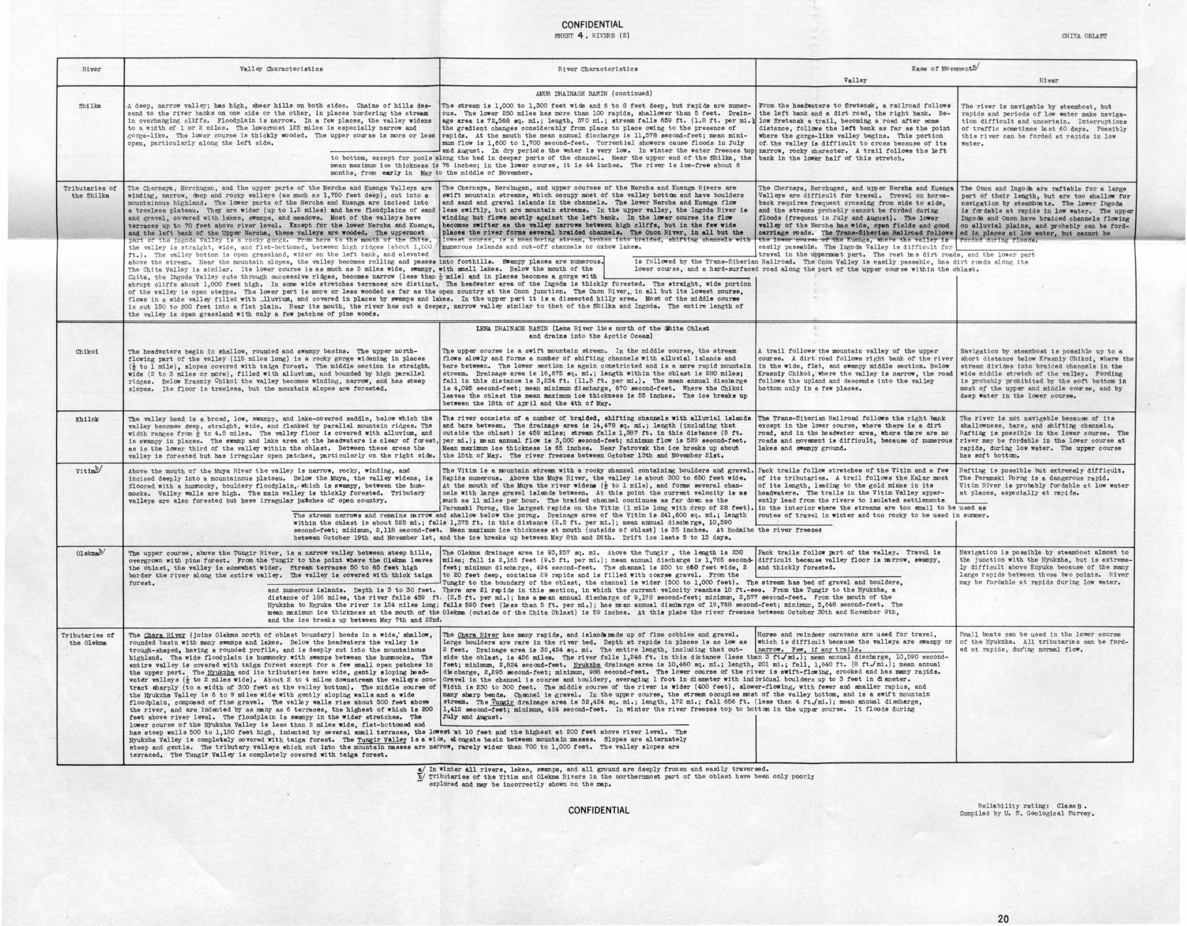
River
ShiUcs
Tributaries of the Shilka
Chikoi
Khilok
Vit~
Olelan&1lf
Tributaries ot the Olekma
CONFIDENTIAL SHEEr 4 , RIVmS ( 2) CHITA OBLAST
Vall~ Characteristics River Characteristics Ease of Movement!Y
-.A deep, narrow valley; has high, sheer hills on both sides. Chains of hills descend to the river banks on one side or the other, in places bordering the stream in overhanging cliffs. Floodplain is narrow. In a few places , the valley widens to a wid~h of 1 or 2 miles . The lowermost 125 miles is especially narrow and gorge-like . The lower course is thickly woOded. The upper course is more or less open, particularly along the left side,
AMUR DRAINAGE BASIN (continued)
' The stream is 1,000 to 1,300 feet wide and 6 to 8 feet deep, but rapids are numerous . The lower 250 miles has more than 100 rapids, shallower than 5 feet. Drainage area is 72,568 eq. mi.; length, :370 mi.; stream falls 659ft. (1.8 ft. per mi.~ the gradient changes considerably from place to place owing to the presence of rapids. At the mouth the mean annual discharge is 11,578 second-feet; mean minimum flow is 1,600 to 1,700 second-feet. Torrent~al showers cause floOds in JUly
---------------' and August. In dry peria:J s the water is very low. In winter the water freezes top to bottom, except for pools along the bed in deeper parts of the channel. Near the upper end of the Shilka, the mean maximum ice thickness is 76 inches; in the lower course, it is 44 inches. The river is ice-free about 6 months, frcm early in May to the middle or November.
Valley
From the headwaters to Sretenak, a railroad follows the left bank and a dirt road, the right bank. Below Sretensk a trail, becoming a road after some distance, foll01rs the lett bank as far as the point where the gorge- like valley begins. This portion of. the valley is difficult to cross because of its narrow, rocky character. A trail follows the left bank in the lower half Of this stretch.
The Chernaya, Nerchugan, and the upper parts of the Nercha and Kuanga Valleys are The Chernaya, Nerclrugan, and upper courses of the Nercha and Kuenge. Rivers are The Chernaya, Nerchugan, and upper Nereha and Kuenga winding, narrow, deep and rocky valleys (as much as 1,750 feet deep), cut into a swift mountain streams, which occupy most of t he valley bottom and have boulders Vall~s are difficult for travel . Travel on horse-mountainous highland . The lower parts of the Nercha and K\lenge. are incised into and sand an!i gravel islands in the channels. The l ower Nercha and Kuenga flow back requires freq_uent crossing from side to side, a treeless plateau . Tb~ are wider (up to 1,5 miles) and have floodplains of sand less swiftly , but are mountain streams . In the upper valley, the Ingoda River ie and the streams probably cannot be forded during and gravel, covered with lakes , awamps , and meadows. Most of the valleys have winding but· fl ows mostly against the l eft bank, In the l ow er course its now flOOds (frequent · in ;ruly and J.uguet) • . Tbe lower terraces up to 70 teet above river level . Except for the l ower Nercha and KUenga , becomes swifter ae the valley narrows betwe en high cliffs , but in t he f ew wide valley of the Nercha has wide, open fields and good and the left bank of the IJllp er Nercha, these valleys are wOOded, The uppermost places t he river f orme several braided channels. The Onon River , in all but t he carriage ro ads. The Trans-Siberian Railroad f ollows part or the Ingoda Val e i.s a rockY gorge . J.l'rom here to the mouth of the Chite, lowest course, is e meandering etreem, broken tnto brei.ded, shH'ti-tlg chann.U :tlt- the ow-er coati! tbe "' a, llh h va e i
River
The river is navigable by steamboat, but rapid.s end periods of low water make navigation difficult and uncertain . Interruptions of traffic sometimes le at 60 deye. Possibly this river can be forded at rapids in low water .
The Onon and Ingo oo are rartable ror a large part of their length, but are too shallow for navigation by steamhce ts. The lower Ingoda is fer dable at rspidB in low water. The upper Ingooo end Onon have braided channels flowing on alluvial plaine, and probably can be forded in places at low water, but cannot be
00 the valley is straight , wide , end flat-bottomed, between high ri dges (about 1, 500 numerous islands and cut -off channels or oxbow lakee. easily passable . The Ingoda Valley is difficult for~-------------------ft. ) . The valley bottom is open grassland, wider on the left bank, and elevated travel in the uppenoost psrt. The rest m s dirt roads, and t he l<n~er part above the stream. Near the mountain elopes , the valley becomes rolling and passes into foothills. SWampy places are numerousi is followed by the Trans-Siberian Railroad, The Onon Valley is easily passable , has dirt roads along its The Chits Valley is similar . Its lower course is as much as :3 miles wide, swampy, with !lllall lakes, Below the mouth or the lower course , and a hard-surfaced road along the part of the upper course within the oblast. Cnita , the Ingods valley cuts through ouccessi ve ridges, becomes narrow (lese than~ mile) ~d in places becomes a gorge with ~------------------------------------abrupt cliffs about 1,000 feet high. In some wide stretches terrace~ are distinct. The headwater area of the Ingoda is thickly forested. The straight, wide portion of the valley is open steppe . The lower pert is more or less wooded ae far as the open country at the Onon junction . The Onon Ri ver,, in all but its lowest course, flows in a wide vall~ filled with J.luvlum, and covered in places by swamps and lakes. In the upper pert it is a dissected hilly area. Most of the middle coune is cut 150 to 200 feet into a flat pla in . Near its mouth, the river has cut a deeper, narrow vall~ similar to that of the Shilka and Ingoda. The entire length of the valley is open grassland with only a raw patches or pine woOds .
Tbe headwaters begin in shallow, rounded and swampy basins. The upper northflowing pert of the valley (115 miles long) is a rocky gorge widening in places (t to 1 mile), slopes covered with taiga for est . The 'middle section is straight, wide (2 to :3 miles or more), filled wi th alluvium, and bounded by high parallel ridges . Below Krasniy Chikoi the valley becomes winding, narrow, and has steep slopes. Its floor is treeless, but the mountain elopes are forested.
The valley head is a broad, low, swampy , and lake-covered saddle, below which the valley becomes deep, straight, wide, end flanked by parallel mountain ridges. The width ranges from t to 4 . 5 ·miles. The valley floor is covered with alluvium, and is swampy in places. The swamp end lake area at the headwaters is clear of tareat, ss is the lower third of the vall~ within the oblast. Between these areas the valley is forested but has irregular open patches, pa~ticularly on the right side.
Above the m01;th of the Muya River the valley is narrow, roclcy, winding, and incised deeply into a mountainous plateau. Below the Muya, the valley widens, is $loored with a hummocky, bouldery floodplain, - which is swampy, between the hummocks. Valley wells are high . The main valley is thickly forested, Tri butery valleys are also forested but have irregular pat ches of open country,
LENA DRAINAGE BASIN (Lena River lies north of the <Jhita Oblast end drains into the Arctic Ocean)
The upper course is a swift mountain stream. In the middle course, the stream flows al<n~ly and forms a number of shifting channels with alluvial i alands and bars between. The lower section is again cOtll!tricted and is a m:>re rapid mountain stream. Drainage area 1s 16,675 sq. mi . ; length within the oblast is 280 miles; fall in this distance is :3,2:34 ft. (11 . 5 rt. per mi . ) . The mean annual discharge is 4 , 095 second-feet; mean minimum discharge , 670 second-teet, Where the Cbikoi leaves the oblast the mean maximum ice thickness is 55 inches. The ice breaks up between the 18th of April and the 4th o f May .
The river consists of a number or br~P. ded , shifting cheilllSls with alluvial islands and bars between. The drainage area is 14 , 478 eq. mi . ; length (including that outside the oblaet) is 459 miles; stream falls 1,:387 ft . in this distance (3 ft . per mi . ); DBan annual flow is :3,000 second-feet; minil!lllll flow is 529 second-teet , Mean maximum ice thickness is 65 inches. Near Petrovsk the ice breaks up about the 15th or May. The river freezes between October 13th and November 21st ,
A trail follows the mountain valley of the upper couree. A dirt road follows ri e;ht bank of the river in the wide, flat, and swampy middle section . Below Krasniy Chikoi , where the valley is narrow, the road follows the upland and descends into the valley bottom only in a few places,
The Trans- Siberian Railroad follows the right bank except in the lower course, where there is a d1 rt road , and in the headwater area, where there are no roads and movement is difficult, becauea or numerous lakes and swampy g round.
Peck trails follow stretches of the Vitim and a few of its tributaries . A trail follows the Kaler most of its length, leading to the gold mines in its headwaters . The trails in the Vitim Valley apparently lead from the rivers to isolated settlements
Navigation by steamboat is possible up to a short distance below Krssniy Chikci , where the stream divides into braided channels in the wide middle stretch of the valley . Fording is probably prohibited by the sort bottom in most of the upper and middle course, and by deep water in the lower course.
The river is not navigable becau811 of its shallowness, bars, and shifting channels, Rafting ie possible in the lower course. The river may be fordable in the lower course at rapids, during low water . The upper course has sort bottom.
Raf ting is possible but extremely difficult . The Peramski Fbrog is a dangerous rapid. Vitim River is probably fordable at low water at places, especially at rapids.
The Vitim is a mountain streem with e rocky channel containing boulders and gravel . Rapids numerous . Above the Muya River, the valley is about :300 to 650 feet wide. At the mouth of t he Muye the river widena (t to 1 mile), and forms several channels with large gravel islands between. At this point the current velocity is as much as ll miles per hour. The braided channel continues as fer down as the Parameki Fbrog, the largest rapids on the Vitim (1 mile long with drop ot 28 feet).
-::T::-!l-e-s'"'t_;r_e_am __ n_s:rr __ o_w_s_an-=-d-r_e_me_i-:-n-s_m_r_r_ow_..Jand shallow below the porog . Drainage area or the Vitim is 24l,600 sq . mi.; length in the interior where the streams are too small to be used as routes or travel in winter and too rocky to be used in summer.
within the oblest is about 525 mi·. ; falls 1,:375 rt. in this distance {2 . 5 ft . per mi . ); mean annual discmrge, 10,590 second- feet; minimum, 2,118 second-feet. ~~an maximum ice thickness at mouth (outside of oblest) is :35 inches. At Bodaibo between October 19th and November let, and the ice breaks up between May 8th and 26th. Drift ice lasts 5 to 1:3 days ,
the river freeze$
The upper course, above the TUngir River, is a narrow vall ey between steep hills, overgrown with pine forest, From the Tungir to the point where the Ol ekma leaves the oblast , the valley is somewhat wider. stream terraces 50 to 65 f eet high border the river along the entfre valley . The vall ey is covered with thick taiga
Tbe Olekme drainage area is 9:3,257 eq . mi. Above the Tung ir , the length is 2:30 miles; tall is 2,165 feet (9, 5 ft. per mi.); mean annual discharge is 1 , 755 secon~ feet ; minimum discharge, 494 second-feet , The channel 1e 250 to 660 feet wide , 2 to 20 feet deep , contains 29 rap ids and is filled with coar.ee gravel. From the
Pack trails follow part of the valley . Travel is difficult because valley (loor 1s mrrow, swampy, end thickly forested .
forest, ----------------------------------------~---• Tungir to the boundary of the oblast , the channel is wider (500 to 1,000 feet) . The stream has bed of gravel and boulders , and numerous islands. Depth is :3 to :30 feet. There are 21 rap ids in this section, in which the current· velocity reaches 10 ft . -sea . From the Tungir to the Nyukzhe, a distance of 185 miles , the river falls 459 ft, (2 . 5 ft . per mi . ); has elll8an annual discharge of 9,178 second- feet; minimum, 2 , 577 second-feet. From the mouth of the Nyukzha to Enyuka the river is 124 miles long; fells 590 feet flees than 5 ft . per mi . ); has lll!an annual discmrge or 19 ,768 second-feet; minimum, 5 , 648 second-feet, The mean mxiii1Uil". ice thickness at the mouth of the Olelcme. (outside of the Chits Oblast) is 59 inche s. At this plebe the river freezes between October 30th and November 9th , and the ice breaks up between May 7th end 22nd,
The Chara Ri yer (joins Olekma north or ablest boundary) heads in a wide,' shallow, rounded basin with many swamps and lakes. Below the headwaters the valley is trough-shaped , having a rounded profile , and is deeply cut into the mountainous highland. The wide floOdplain 1s hlll!IDocky with swamps between the hlll!IDocks , The entire valley is covered with taiga forest except for a .few small open patches in the upper pert . The~ and its tributaries have wide. gently e loping he edwntdr valleys !! to 2 miles wide), About 2 to 4 miles downstream the valleys contract Sharply (to a width of :300 feet at the val ley bottom) . Tbe middle course or the Nyukz}\a Valley is 6 to 9 miles wide with gently sloping wall s and a wide floodplain, ccnnpoeed of fine gravel, The valley we lls ri s e about 500 feet above the river, and are indented by as oony as 6 terrac es , the h ighe st o f whiah i s 200 feet abOve river level. The floodplain is swampy in the wider stretches. The lower course of th'e NYUkzha Valley is less than 2 miles wid e , flat-bottomed and
Tbe Chars River has many rapids , and islandamde up of fine cobbles and gravel , Horse and reindeer caravans are used for travel, Large boulders are rare in the river ~d. Depth at rapids in places is as low as which is difficult because the valleys ere swampy or 2 feet , Drainage area is :32,424 s q . mi . The entire length, including that out- narrow . Few if anY trails . eide the obleet , is 456 miles, The river falls 1 , 246 tt. in this distance (less then :3 ft ./ mi . ); mean annual discharge, 10,590 secondfeet; minimum, 2 ,824 second-feet . ~ dr{l.inage area is 10 ,460 sq. mi.; length , 201 mi.; fall, 1 , 540 ft . (8 ft ./mi.); mean annual discharge , 2 ,295 second-feet; minimum, 988 second-teet . The lower course of the river is swift-tlCJiring, crooke d end has many rapids. Gravel in the channel is coarse and bruldery, averaging 1 fo ot i n diameter wi th indi-vidual boulders up to :3 feet in diameter . Width is 2:30 to 300 teet . Tbe middle crurse of the river is •1der (400 feet), alower-flowing ,. with fewer end Bmaller rapid s, and many sharp bends. Chmnel is gravel . In the upper course , the stream occupies most of the valley bottom, and is a swift mountain stream. The Tungir drainage area 1s :32,424 eq . mi.; length, 172 mi.; fall 656ft . (lese then 4 ft ./mi . ); mean annUe.l discharge, 1 ,412 second-feet ; minimum, 424 second-feet. In winter the river freezes top to bottan in the upper course . It floods during J"uly and J.ugust.
has steep walls 500 to 1,150 feet high , indented by several smll terraces, the lowest 'at 10 teet !lnd the highest at 200 teet above river level. The NYUkzha Valley is completely covered with taiga forest . The Tungir Valley is e wi de, elongate basin between mountain masses. Slopes are alternately steep and gentle. The tributary vall~s which cut i nto the mountain masses are narrow, rarely wider than 700 to 1,000 feet , The valley slopes are terraced. The Tungir Vall~ is completely covered with taiga forest .
!f. In winter a l l rivers, lakes, swamps, and all ground are deeply frozen and easily traversed, b/ Tributaries ot the vitim and Olekma Rivers in the northernmost part of the oblast have beeri only poorly - eX]llored and may be incOTrectly shown on the ID!Ip,
CONFIDENTIAL
Navigation is possible by steamboat almost to the junction with the Nyukzha, but is extremely difficult above Enyuka because of the many l arge rapids between these two points. River may be fordable at rapids during low water .
Swal l boats can be used in the lower course of the Nyukzha . All tributaries can be forded at rapids , dur'i~ normal fl ow.
Reliability rating : Class B. Compiled by u. s. Geological Survey .
20
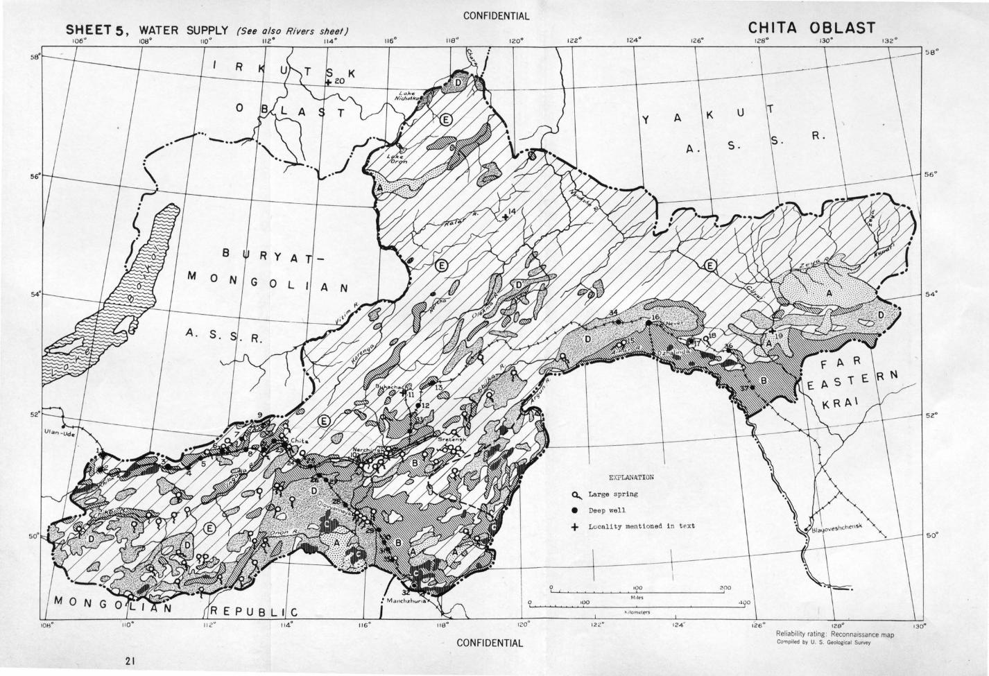
SHEET 5, WATER SUPPLY (See also Rivers sheet) 1 06~ 112 ° 11 4°
21
B
M o N
A. S.
R y A
G 0 L A N
CONFIDE:NTIAL
0
116°
CONFIDENTIAL
12 6°
A K u
A. S .
EXPLANATION
~ Lar ge s pri ng
e Deep \vell
+ Locality men t t oned i n t pxt
0 ~~~~~~~~'0~0------------~200 t.'\tles
100
CHITA OBLAST
128°
Reliability rating : Reconnaissance map Co'l1piled by U. S. Geological Survey
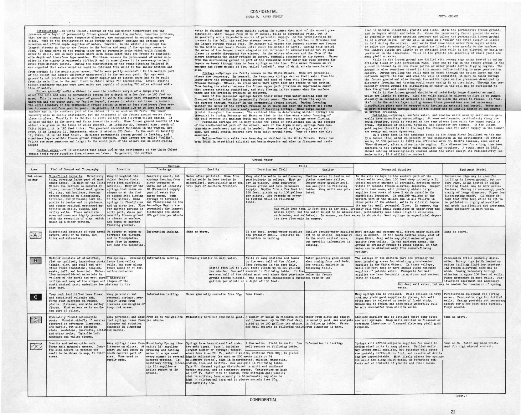
I ntroduction :-- I n Chi t a Oblast, because of the low winter temperature and the presence of a l ayer of permanently frozen ground beneath the surface, numerous problems, t het ere no common in more temperate cli~tes, ere encountered in securing water suppl ies. ~ost of the precipitation falls during t he summer; springs and streams ere numerous and afford ample supplies of water. However, in the winter all except the largest streams go dry or ere frozen t o the bottom end many of the springs cease to flow. In many parts of the region there ere no permeable rocks which could furnish water to wells, and in many places where such rocks exist they ere frozen to considerable depth and therefore hqpenneeble. l"or these reasons the procurement of weter su ppl ies in the winter is extremely difficult and in some places it is necessary to haul water from distant points. During the construction of the Trans-Siberian Railroad it was eXJ)ected tr.at wat e r supplies_, coulll be obtained from wells in the Talley bottoms and from springs in the w.ountair.ou ~ areas. Wells were partly successful in the western p~ rt of the obtest but almost uniformly unsuccessful in the eastern part. Spri~s were genera l ly not practicable sources of water supply and in places spurs had to be built from the main line to the Amur Riyer to obtain water for locomotives. Later, speci~l ten~er-condenser engines were used which are capable of running 700 miles without addition of water.
Frozen ground~1:--Chita Oblast is near the southern margin of a large area in which the soil and rock is perman.ently frozen for e depth of a few feet to 100 feet or more. This is overlain by a layer of ground in whioh the lower part frequently remains unfrozen and the upper part, or ~active layer~, freezes in winter and thaws in summer. The uJ:rer boundary of the penaanent ly frozen ground is more or less stationary from seaeon to season and from year to year. In seneral, it ia about 1.5 to 10 feet below the surface and ic the sou hern part of the obtes t it i s as much as 26 f eet . The lower boundar y a l so is near l y stationery, but the th i ckness of the fro zen ground varie s from place to place. Usually it is thicker in river valleys end alluvium-fi l led basins. It is a l so thicker in the north and thins toward the south. Some frozen ground records of the oblast are given in the table of wells records. At locality 20, Pspenski mine, north or Chita Oblest, it is 165 feet thick . The greatest recorded thickness in the ·region, however, is at locality 11, Bukechecha, where it attains 330 feet. In the east at locality 19 Pikan, it is 165 feet thick. In places permanently frozen ground is lacking, and so~times layers within frozen ground remain unfrozen. Such layers are called "taliks~. Taliks are more numerous ond larger in the south pert of the obtest and on south-facing slopes ·
3urfece weter:--It is estimated that about 3~ of the settlements of the Chits Oblest obtain their water supplies from streams or lakes. In general, the surface
Area
Not shown on map
-
1\:ind of Ground· and Topography
Superficial deposits. Relatively thin, covering large pert of most other areas. In moat of the Chits Oblest the bedrock is covered by loose, unconsolidated sand, gravel, clay , end boulders, forming stream deposita on floodplains, terraces, snd plateaus; lake deposits in basins end on plateaus; and coarse residual weathered material s on hills, slopes, and valley walls. These materials when unfrozen are highly permeable with the exception of clay, which makes up s minor portion.
Superficial deposits of wide areal extent, similar to above, but thick and extensiTB.
Bedrock consists of stratified, flet or inclined, impervious rocks (ahele, clay, and coal) and pervious rocks (sandstone, conglomerate, tuff, and breccia). Underlies unconsolidated materials in
Location
Many throughout the oblsst derive their water from surficial materiel. Many of the springs that issue on slopes or at the foot of s l opes stop flowing in the winter. Some springs in floodplains and on river ice. Flo~ for shorter periods in north part, where permanently frozen ground is closer to surface, and depth of surface freezing greeter.
On slopes at edges or terraces and plateau, and on floodplains. Most now in SUI!UIIer, but some are perennial.
Few springs. Generally issue from valley walls, but some along fault zones or at formation contacts.
Te l leya of the north end west parts; underlies TBlleys and many of the ridges and slopes of the south central pert; underlies low plateaus in the east part.
Snrirure Discharge
Generally small, but springs issuing from river terraces at Chita and at locality 10 (Xazakova) supply part or water for these towna. Some springs on terraces and floodplains in the Amur-Zeya Region are perennial; the largest discharges are about 125 gallons per minute
Information lacking.
Information lacking.
Trap rock (solidified lava flows) end associated volcanic ash. Forms flat surfaces on ridges, plains, pl~teaus, and wide Talley floors . Most extensive in southern part of oblast .
Many perennial and Information lacking. seasonal springs; gen-erally issue from crevices and margins of trap rock areas.
Moderately folded metamorphic Many perennial and seas From 15 to 300 gallons rocks. Consist chiefly of massive onal springs issue from per minute. fissured or cavernous limestone , fissures and solution and marble, but also includes channels in limestone slate, sandstone, quartzite, schis and marble. end other rocks. Underlie both mountain and valley slopes.
Granite and metamorphic rock. Forms main mountain masses. Granite also occurs in patches too small to be shown on map, in other areas.
~any springs issue from lri seures on elopes. At least 150 ere known in ~outh central part or jerea. Some used to ~&upply spas.
Gonshinsky Spring (locality 18) supplies drinking and bathing water to a spa used eTBry ewmner by several hundred persona. Ignashineky Spring (local ity 15) supplies e health resort of 20 houses.
CONFIDENTIAL SHFXJ' 5, WA"'ER SUPPLY
water is abundant and of good quality during the summer when most of the annual precipitation, which ranges from 10 to 17 inches, fa l ls as torrential reins, but it is generally not a dependable source of perennial supply . As the precipitation decreases in the fall, the smeller streams cease to flow during October or November and the larger streams freeze over. By january all except the largest streams are frozen to the bottom and remain frozen until about the middle or April. During this period the water of the larger rivers stagnates and increases in mineralization but et some places is usable throughout the winter. As the winter advances and the flow or the rivers decreases the water freezes in layers, commonly separated by air spaces . Water from the surrQunding ground or pert of the remaining river water may flow between the layers or break through them to form springs on the ice. This water freezes as it emerges and forma mounds of ice, called ~naledi", some of which attain considerable size. ~:--Springs are fairly common in the Chita Oblast. Some ere perennial,
others are temporary. In general, the temporary springs derive their water from the layer above the permanently frozen ground and most of them stop flowing. when it freezes through. others, i n areas where that layer does not freeze to the bott om, flow during the winter because the frozen upper part provides an impenaeable cover that creates artesian conditions, and stop fl.owing in the SWIIIII8r when the surface thews and the artesian pressure is relieTBd.
Most or the perennial springs derive their water from water-bearing beds or fissured bedrock below the pen118Dently frozen zone. The water finds its way to the surface through "taliks~ in the pe;t;'1181lently frozen ground. During freezing weather the water or the springs freezes as it poura out over the aurfece eod forma ~nda (neledi) which are e ready meana or loceting ~1Dga. SOM large neledi pers ist t hroughout t he summer. The critical time in determining whethe r springs are perenn ial is during February and March as that is the time when winter freezing of the soil reaches its maximum depth and the period when most springs cease flowing.
Perennial springs are in many places tbe locus of settlements end in the steppes of the south-central part of the obtest, west of the Argun River, springs form cente.rs where roads meet and stock is herded. S-:>me mineral springs supply water for epee, and small health resorts have been built around them. Some of these are also seaeon.al.
Wells : --Numerous wells have been dug or drilled in the Chita Obtest. Water has been fOiiiid in stratified alluvial and basin deposits and also in fissures and cad-
~elity
Water often polluted. Some from saline soils in lake basins is mineralized, particularly near cen tral pert of southern frontier.
Ground Water
Wells Location end Yie ld
Many shallow wells in settlements, particularly in valleys. Most go dry in winter. Some penet rete frozen ground and have panii8Dent supply. Depths from a few feet to 130 feet, yields up to 100 gallons per minute. See records or several typical wells in following table.
Quality
Shallow water in basins and plains sometimes saline. Deeper water usually good, see analysis in following table. Many wells are pol-luted.
CHITA OBLASI'
ties in mass ive l imestone, granite and slate , abo~ the permanentl y f rozen ground, and in layers within and be l ow it. Above the permanently frozen g r ound the water i s generally not unde r arte s ian pressure and unless t he permane ntl y frozen gr oUnd is at a grea t dept h or the well i s sunk i n a "talik" the water s upply is l ikely to ra il during the winte r . Deep we l ls t het draw t he i r water f r om layers withi n or below tt e permanentl y fro 7en ground are l ikel y t o r ise nea r l y t o the surfnce. The largest yields are likely to be obta i ned from wells in the a lluv i a l or basi n deposits or in the limestone . '¥e l ls in the granite ere generally of s ma ll yie l d end many yield no water.
Wells in the frozen ground are dri l led wi tt rotary rigs usi ng hea ted o r sal ine drilling fluid or with pe r cussi on rlgs. They can be dug in the frozen ground if t he ground is thawed by driven steam points or water points before digg i ng begi ns . The ground is also sometimes t hawed in t his manne r be f ore dri ll ing to mske penet ret ion easier. Du.ring drilling t he wells must be cased thrOU8h t he ac t ive l ayer end the unfrozen layers (teliks) and when the well i s completed, it mus t be cased through the frozen ground and alSo t hrough the active layer as the pres sures developed by alternate freezing and thawing would cause caving in an open hole. Through the permanently frozen ground the circulation of water in the wel l may be sufficient to thew the ground and cause slumping.
Wells in the frozen ground should be of relatively large diameter as smal l wells are likely to freeze. Also the wells a hould be allowed to flow or be pumped steadily as cessation of movement is likely to allow the water to freeze. In "telike~ or in the active layer during 8Ummer these precautions are not necessary. Distribution pipes .ust be wrapped with insulating aeterial end buried. ~eter aust be kept oirculat ing thl"ougb. thea in the winter and ia usually heeted at the source to prevent freez i ng.
Pollution : - -Springs, surface water, and shallo~ we l l s used by settleme nts generally have unsanitary surroundings. At s ome se t tlement s , pa rti cula r l y al ong the south frontier, stock is watered at the same plftce s from whi ch the human s upply is drawn. Epidemics of cholera, typhoid, and dys ent e ry Rre common. In t he Ol ekma gold region (locality 14 on the map) the stream~ used for wate r su ppl y in the summe r are swampy end cause dysentery.
In a large area in the drainage basin of the Argun River (outl i ned on the map by a dashed line) about 33 percent of the populati on in the settlements (98 settlements, 53 ,000 persons in 1927) are afflicted with Dr. Beck's disease, also called ~rov disease", after a river in the r egion. This disease has for a long time been ascribed to the spring water which supplies t he populace. A study, made in 1927, showed nothing mineralogically unusual about the wate r except its radioactivity (33 mache units, 12.2 millimicro curies).
Potential Supplies
In the wide valleys in the western part of the obtest wells less . than 130 feet deep probably will obtain moderate amounts of perennial artesian water within or beneath frozen alluvial deposits. Deeper wells in same area, will probably obtain larger supplies from rocks of area B which underlie the superficial deposit~. In smaller valleys or the western pert or the d> last and in all valleys in other parts of the oblast, wells in alluvial depos
EquijX!l8nt Needed
----------1--------------..J its may tap small perennial flows. In summer, dug dug wells less than 10 feet deep in a~ soil, probably will yield small quantities of water from the actiTB layer, but the water is ept to be mineralized, particularly near lakes (high in chlorides, carbonates, and sulfates). In summer, surface water is abundant. Voet springs in superficial deposits have flow only in summer.
Percussion rigs may be used for drilling in frozen ground, but rotary rigs, using heated or saline dril l ing f l ui d, may be more satistsctory. Casing is nece ssary, preferably of large diameter. Pipes for distributing water. All water except that from deep wells is apt to be polluted or highly mineralized and needs purification and treatmen~ Pumps necessary in mos t wells.
Same as above. In the east, ground-water supplies art probably smell. Specific information is lacking.
Probably simil• r to well water. Wells at many stations and towns on the west half or the oblast.
::--:-:---:----::-:::~--:--' tess frequent in the east half. Depths from 100 to 1,000 feet; yields up to 230 gallons
Shallow ground-water supplies apt to be saline, especially in the south central area, but specific information is lacking.
Water generally good except when coming from coal beds. See typical analysis in follnwing table.
Moat springs end streams will afford water supplies only in summer. In the south central area, west of Argun River, deep wells may yield water of good quality from taliks. In the northern areas, the ground is pro bebly frozen to great depths, so that water can be obtained only from summer-flowing springs.
The valleys or the western part are probably the most promising a.reas for obtaining ground-water supplies in the Chita Oblast. In these valleys, wells 100 feet deep or more should yield adequate supplies of potable water. Prospects for well supplies are less favorable in north ern and eastern parts of oblast.
Same as above.
Percussion drills probably desirable. Rotary rigs (with heated or saline drilling fluid for penetrating frozen alluvium) also may be used. Casing necessary through alluvium in upper 100 feet of wells. Pumps necessary in most wells. Pur
per minute. See well records in following table. In the~~--~--~---western half of the oblast most coal mines that penetrate below the frozen ground become flooded. One coal mine encountered a sustained flow of 156 gallons per minute at a depth of 100 feet. ------------~ ification equipment not necessary
for deep well water, but water.
may be needed for treatment of spring
'Rater gene rally contains free co2 • None known. Many springs can be utilized. Wells drilled in trap rock may yield good supplies in places, but well sites must be selected on basis of field study. Ground may be frozen and deep wells generally will be more successful then shallow wells.
Moderately hard but otherwise good. A number of welle in fissured slate Water from slate and schist Adequate supplies may be obtai ned where camp sites and limestone, up to 500 feet deep; is usually gpod, see analysis are near springs. Deep wells drilled in fissured or yield up to 100 gallons per minute. in following table. Water caTernous limestone or fissured slate may yield good See well recorda in following table from limestone is hard. supplies.
Springs have been classified under two main types. Type 1 includes largest number or springs; temper
A few wells. Yield is small. See well records on following table.
ature less than 39° F.; water alkaline, contains free C02; in highly radioactive (as much as 200 mache units or 74 millimicro curies), high in bicarbonates, calcium, magnesium, sodium, iron and sulfate. See analysis in following table. Type 2: thermal springs distributed in north and northeast border regions, and in southwest corner. Temperature as higb as 167° 1". Water rich in sodium, free nitrogen gas; usually rich in sulfate, less commonly in bicarbonate; may also be high in calcium and iron and in places contain free co2 • RadioactiTity low.
CON Fl DENTIAL
places
Intormat ion is lacking. Springs will afford adequate supplies for small to medium sized units in many places. Drilled wells may afford smal l supplies, but suitable well sites are probably difficult to find, and results of dri l ling are unpredictable. Most likely places for spri ngs and we l ls are along fault zones, at formation contacts and at contacts or granite and other rocks.
Purification equipment for spring water. Percussion rigs for drilled wells. Casing probabl y not necessar) except fo.r a few feet near surface. Pumps needed.
Same as above.
Same as B. •.qster may need treatment for high mineral content.
(Cont . )
22
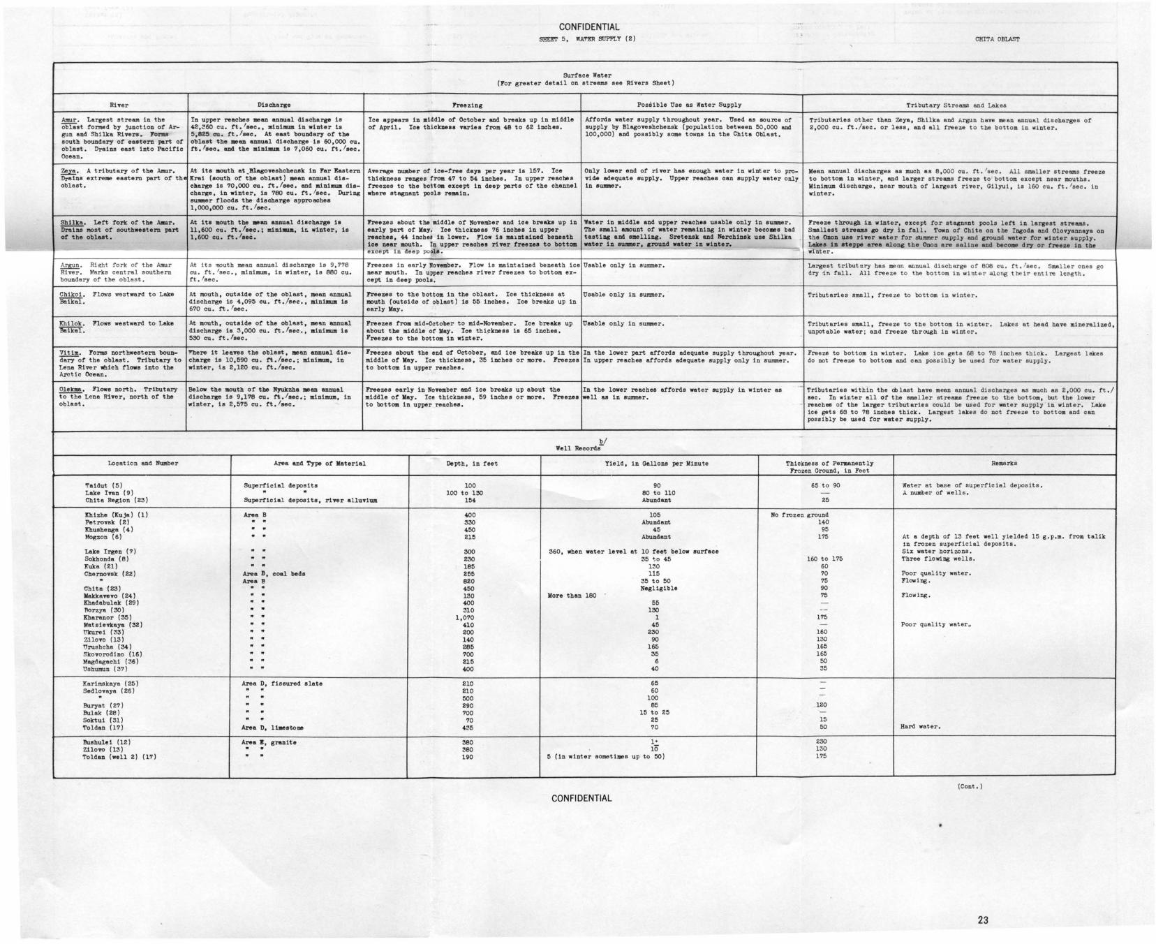
River
~· Largest stream in the ablest formed by junction or Ar-gun and Shilka Rivers. FOJ:"JJS south boundary or eastern pert or oblast. Drains east into Pacific Ocean.
Zeye. A tributary or the Amur. Dreins extreme eastern pert or the ablest.
Shllka. Lett fork or the Amur. Dra1iiS most or southwestern part or the oblaet.
Argun . Right fork of the Amur River. V.arks central southern boundary or the ablest .
Chikoi. Flows we3tward to Lake Baikal.
Khilok. Flows westward to Lake Beii(i;T.
Vi tim. Forms northwestern boun-dary or the ablest. Tributary to Lena River which flows into the Arctic Ocean.
Olek:m6. Flows north. Tributary t'Ot'h8 Lena River, north ot the a blast.
Location and Number
'!'aidut (5) Lake Ivan ( 9) Chits Region (23)
lrbizhe (Kuja) (1) Pet ronk ( 2) Kbushenga (4} Mogzon (6)
Lake Irgen ( 7) Sokhonda (8) Kuka (21) Chernovsk (22) .. Chits (23) lfaltkavevo ( 24) Khadabu1ak (29) florzya ( 30) Kharanor (35) Matsievkaya (32) Ukurei (33) Zilovo (13) 1Jrushc he ( 34 ) Skovorodino (16) Magdagachi (36) UshUllllln (37)
Karimskaya ( 25) Sedlovaya (26)
" Bury at (27) Bulak (28} Soktui (31) Toldan (17)
Buehulei (12) Zilovo (13) Toldan (well 2) (17)
Discharge
In upper reaches ean annual discharge is 42,~60 cu. rt.'sec., minimum in winter is 5,825 cu. rt.lsec. At eaet boundary or the oblast the 111ean annual discharge is 60,000 cu. rt,lsec. and the ainiaua is 7,060 cu. rt. / aec.
At ita aouth at _BlagoTBshchensk in Far !!:astern lrrei (south or the oblast) mean annual die-cllarge is 70,000 cu. rt,/eec. and JlliniJIIUJil die-charge, in winter, is 780 cu. rt .lsec. During SUJ!IIIer floods the discharge approsehes 1,000,000 cu. rt.lsec.
At its 110uth the •an annual discharge is 11,600 cu. rt .!sec.; mini-.ua, iL winter, is 1, 600 cu. tt .Ieee.
At its mouth mean annual discharge is 9,778 cu. tt. 'sec., miniJIIUJII, in winter, is 880 cu. rt. lsec.
At mouth, outside or the ablest, mean annual discharge 1s 4,095 cu. rt. /sec., minillwa is 670 cu. rt. /sec.
At mouth, outside or the oblaet, Han annual discharge ie 3,000 cu. rt.lsec., ainiJIIUJII is 530 cu. rt .Ieee.
'!'here it leaves the oblast, mean annual dis-charge is 10,590 cu. rt.lsec.; Jllini-, in winter, is 2,120 cu. 1't,/eec.
Below the aouth or the lfyukzba Jlean annual discharge is 9,178 cu. rt.lsec.; minimum, in winter, ie 2,575 cu. rt.lsec.
CONFIDENTIAL SHE!.T 5, WA'T'ER SUPPLY ( 2)
Surface Water (For greater detail on streams see Rivers Sheet)
Freezing Possible Use as Water Supply
Ice appears in middle or October and breaks up in middle Attords water supply throughout year. Used as source or or April. Ice thiclcneee varies rrom 48 to 62 inches. supply by Blagoveshchensk (population between 50,000 and
100,000) and possibly some taNns in the Chits Oblast.
Average number or ice-tree days per year is 157. Ice Only lower end or river has enough water in winter to pro-thickness ranges from 47 to 54 inches, In upper reaches Ticl.e adequate supply. Upper reaches can supply water only freezes to the bottom except in dee~ parts or the channel in summer. where stagnant poole remain.
Freezes about the Jlliddle or November and ice breaks up in Water in middle and upper reaches usable only in summer. early part or Kay. Ice thickness 76 inches in upper The small amount or water remaining in winter becomes bad reaches, 44 inches in lower. Flow is malntainsd beneath tasting and 11111ell1ng. Sretensk and Herchinsk use Shilka ice near mouth. In upper reaches river rreazea to bottOII water in au.aer, ground water in winter. ·-except in deep pools.
Freezes in early November. Flow is maintained beneath ice Usable only in summer. near mouth. In upper reaches river freezes to bottom ex-capt in deep poole.
Freezes to the bottom in the a blast. Ice thickness at Usable only in summer. mouth (outside or oblast) is 55 inches. Ice breaks up in early May.
Freezes rrom mid-October to mid-November. Ice breaks up Usable only in summer. about the middle or Kay. Ice thi_!:lrness is 65 inches. Freezes to the bottom in winter.
Freezes about the end or October, and ice breaks up in the In the lower part atrords adequate supply throughout year. Jlliddle or Kay. Ice thickness, 35 inohas or more. Freezes In upper reaches attords adequate supply only in summer. to bottom in upper reaches.
Freezes early in November and ice breaks up about the In the lower reaches attords water supply in winter as middle or Kay. Ice thickness, 59 inohee or more. Freeze a well as in summer. to bottom in upper reaches,
b/ Well Records-
CHITA OBu.sT
.
Tributary StreBIIIS and Lakes
Tributaries other than Zeya, Shilka and Argun have mean annua l discharges or 2,000 cu. tt./sec. or less, and all freeze to the bottom in winter.
Mean annual d,ischarges as much as 8,000 cu. rt. 1sec. All smaller streams freeze to bottom in winter, and larger streams freeze to bottom except near mouths. Minimum discharge, near mouth or largest river, Oilyui, is 160 cu . ft. lsec, in winter.
Freeze through in winter, except tor stagnant pools lett in largest streams. S1118Uest streams go dry l.n tall. Town or Chits on the Ingoda and Olovyannaya on the Onon use river water for summer eupply and ground water tor winter supply. Lakes in steppe area along the Onon are saline and becoll8 dry or freeze in tho w nter.
Largest tributery has mean annual discharge or 808 cu. rt. lsec. Smaller ones go dry 1n fall. All freeze to the bottom in winter along t heir entire length.
Tributaries small, freeze to bottom in winter.
Tributaries small, freeze to the bottom in winter. Lakes at head hove mi neralized, unpotable water ; and freeze tbrOU8h in wint er.
Freeze to bottom in winter. Lake ice gets 68 to 78 inches thick. Largest lakes do not freeze to bottom and can possibly be used for water supply .
. Tributaries within the cillast have mean annual discharges as much as 2,000 cu. rt . / sec. In winter all or the sme l ler streams freeze to the bottom, but the lower reaches or the larger tributaries could be used ror water supply in winter. Lake ice gets 6G to 78 inches thick. Largest lakes do not freeze to bottom and can possibly be used tor water supplf.
Area and Type or Material Depth, in teet Yield, in Gallons per Minute Thickness or Permanently Remarks Frozen Ground, in Feet
Superficial deposits 100 90 65 to 90 Water at base or superficial deposits. " " 100 to 130 80 to 110 - A number or wells.
Superficial deposits, river alluviUJI 154 Abundant 25
Area B 400 105 No frozen ground
" " 330 Abundant 140 " .. 450 45 95 " .. 21!1 Abundant 175 At a depth of 13 teet we ll yielded 15 g.p.m. from talik
in frozen superficial deposits. .. .. 300 360, when water level at 10 teet below surface Six water horizons. .. .. 230 35 <;o 45 160 to 175 Three flowing wells. .. .. 185 1:30 60 Area B, coal beds 255 115 70 Poor quality water. Area B 820 35 to 50 75 Flowing. .. .. 450 Negligible 90 .. .. 130 More than 180 75 Flowing. .. .. 400 55 -.. .. 310 130 --.. .. 1,070 1 175 .. .. 410 45 - Poor quality water~ .. .. 200 230 160 .. .. 140 90 130 .. .. 285 165 165 .. .. 700 35 165 .. .. 215 6 50 .. .. 400 40 35
Area D, fissured slate 210 65 -.. .. 210 60 --" .. 500 100 .. .. 290 85 120 .. .. 700 15 to 25 -.. .. 70 25 15
Area D, 11-.etone 435 70 50 Hard water.
Area B, granite 380 1+ 230 .. .. 380 1o 130 .. .. 190 5 (in winter sometimes up to 50) 175
(Cont . )
CONFIDENTIAL
23
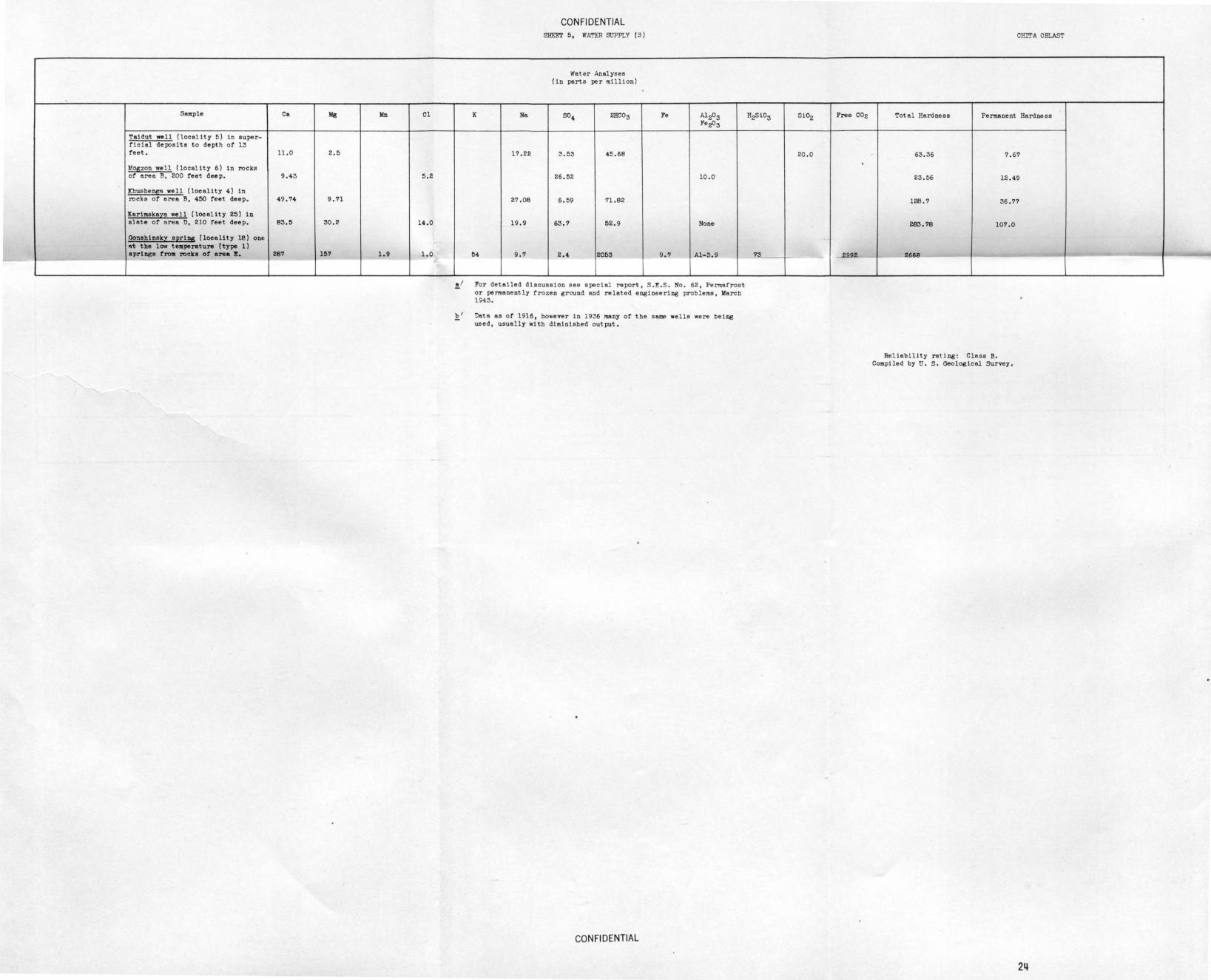
S!llllple Ca Mg Mn Cl
Taidut well (locality 5) in super-ficilll deposits to depth of 13 feet. 11 .0 2.5
l!oszon well (locality 6) in rocks of area B, 200 feet deep. 9.43 5.2
Khushe!!5e we 11 (locality 4) in rocks of area B, 450 feet deep. 49.74 9.71
Karimska~a well (locality 25) in slate of ares D, 210 feet deep. 83.5 30.2 14.0
Gonehinskv SEri!!! (locality 18) one "t the low telllperature (type 1) springe !ro111 rocks of area 1!!, 287 157 1.9 1.0 ,_ - - .
K Na
17.22
2?.08
19.9
ti4 9.?
CON Fl DENTIAL SHEET 5, 'II A'!'ER StJPPL Y ( 3)
Water Analyses (in parts per million)
504 2HC03
3.53 45.68
26.52
6.59 ?1.82
63.? 52.9
2.4 2053 -
l"e Al203 l"e~3
10.0
None
9.? Al-3.9
~I For detailed discussion see special report, S.E.S. No. 62 , Permafrost or permanently frozen ground and related engineering problems, llarch 1943.
b 1 Date as of 1916, however in 1936 many of the same wells were being used , usually with diminished output.
CONFIDENTIAL
CHITA Om.AST
H2Si03 Si02 Free C02 Total Hardness Permanent Hardness
20.0 63.36 7.6?
23.56 12.49
128.? 36.??
283.?8 10?.0
_J 73 ----..29.9 - !- 2668
~ I
Rel1ebil1ty rating: Class B. Compiled by u.s. Geological survey.
24
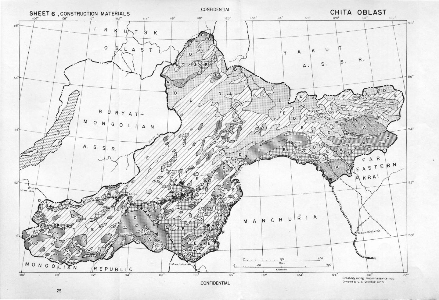
CONFIDENTIAL SHEET 6 , CONSTRUCTION MATERIALS
1oa• 11 0 " 11z " 114 ° 11 6 ° 11 8 °
8 R y A
M o N G 0 L A N
0
116°
CONFIDENTIAL
25
y A K u
A. s.
MANCHU R A
~~~~~~-'oLo ______________ ~zoo
100
KtlomctNs
CHITA OBLAST
126° 128" Rel iability rating Rcconnaissan.:e map Compolod by U. S. Geologico! Sur.ty
sa•
56°
5 2°
50°
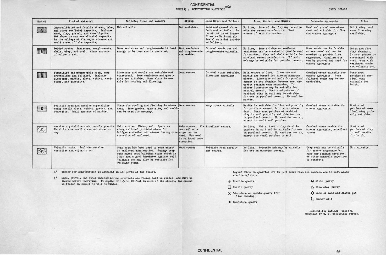
Symbol
f#Jil\*~
• • l lllll~llii l
EZI
--~-(J " v v " "
CONFIDENTIAL SHm6,
~'# CONSTRUCTION MATERIALS CRITA OBLA.ST
ltind of Material Building Stone and Masonry Riprap Road Wetal 'and :Ballast Lime, Wortar, and c-nt Concrete ~gregn te Bri ck
Unconeolidated and friable etream, lake, Not euitable. Bot 8111table. Sand and gravel abun- No lilne. Some of tbe clay 11111¥ be 1\11 t- Sand and gravel are abun- Brick clay, and and other surficial depoa1 tl. Includee dant and suitable. In able for cement manufacture. Beet dant and 11.1itable fo r fine eome fire clay eand, clay, gravel, and eome lignite. construction of Trans- eource of eand for mortar. and coa rse ac~egate. avail a"ole. Not shown on map are alluVial de-poaite Siberian Railroad al-in the valleys of the major atreama and luvial material provid-small areas of lake deposita. ed ballaat.
Bedded rocks: Sandstone, conglomerate, Some sandstone and conglomerate 1a hard Hard eandstoiB Crushed sandstone and 111o lime. Some friable or weathered Some sandstone 11 friable Brick Md fire shale, clay, and coal. Winor amounh enough to be u.eed and is quarried. end con«lomerate conglomerate 8ll1 table. sandstone can be crushed to provide sand or weathered and can be clay abundant. of volcanic ash. are uaable. for mortar. Clay and ahale eui table for cru.ehed to provide f i ne In mos t places is
portland cement lllllllllfacture. Volcanic aggregate. Congl anera te a s sociated 11'1 t h ash may be lalitable for puzzolan cement. can be (frushed and used for coal, &>me with
coarse aggreeate. weatbored shale and volcanic ash.
Stratified and metamorphic rock, some Limestone and marble are suitable and Good eouree. Crushed atone suitable. ~in eource of lilne. Limestone and Crushed atone suitable for Scattered crystalline and foliated. Includes widespread. Some sandstone and quart- Limestone excellent. marble are burned for lime at numerous coarse aggregate. Some -patches of rea-lime s tone, marble, elate, achiat, sand- dte are !lli table. Some elate 11 ue- places. Limestone suitable for portland foliated rocks may be un- idual clay &tone, end quartzite. able for roofing and nooring. cement is not abundant because moat de- desirable. sui table fo r
poei te contain some magnesiun. In brick . places limestone may be suitable for natural cement. Scattered patches of residual clay in soil may be sui table for use in portland cement. llo. a and for mortar.
Folia ted rock and massive crystalline Slate for roofing and flooring is abun- Good eource. Many rockB suitable. Warble is euitable for lime and possibly Crushed s tone sui t nble for Scattered rock; mostly alate, schi s t, gneiss, and dant. Some gneiss, quartzite, and marble for portland cement, but is not abun- coarse aggregate. -patches of rea-quartzite. Smal l amounts of marble. can be uaed for masonry. dant. Scattered patches of residual idual clay prob-
clay in soil probably suitable for use ably suitable. in portland cement. No sand for mortar, except in small soil patches.
Massive crystall ine rock, mo stly grani te. Main eource. Widespread. Quarriee Wain source. Al- Excellent source. No lime. White, kaolin clay found in Crus he~ stone usable for Scattered J'ound in eome small areas no t shown on along railroad provided stone for most all out- pa tches in soi l end is suitable for use coarse aggregate, excellent patches of clay map. brid&ee and other structures during con- crops can be in portland cement. No sand fo r mortar, source. in scil usable
struction of railroad. ueed. Waa used except for small -patches in soil. f or brick. in railroad con-struction.
Volcanic r ocks. Includes massive Trap rock has been used to some extent Good source. Volcanic rock excell- No li01e. Volcanic ash may be sui table Trap rock may be suitable Not sui table . varieties and volcanic ash. in railroad cons t ruction. Spongy trap ant source. for use in puzzolan cement. for coarse agr.regate but
rock makes good building stone which is some may contain zeolites, light and a good ineulator against cold. or other minerals injurious Volcanic ash may alao be suitable f or to concrete. buil ding s tone.
Timber f or cons truc t ion is abuneant ic all par ts of the oblast. Legend (Data on quarries are in part taken from old sources and in most areas are incomplete).
Sand, gravel , end othe r unconsoli da ted materials are frozen hard in winter, and must be thawed before quarrying. At depths of 1. 5 to 10 feet in much of the oblast, the ground is fro zen in s~er a s ~~11 a s winter.
CONFIDENTIAL
+ 0 X
•
Granite quarry
Marble quarry
Limestone or marble quarry (for lime burning)
Sandstone quarry
~ Slate quarry
6. Fire clay quarry
0 Sand or sand and gravel pit
L Lumber mill
Reliability rating: Clas s B. Compiled by U. S. Geological Survey.
26
SHEET 7, MINERAL FUELS CONFIDENTIAL
106° 108° 110° 112° 114° 116° 118° 120°
R K
0
8 R y A
M 0 N G 0 L A N
0
116° 120°
CONFIDENTIAL 27
CHIT A OBLAST 122° 124° 126° 128° 130° 132°
y A K u R.
A. s.
../' .. .../ \_ . .r·-.. \
MANCHU R A
0 100 200 ~~~~~~~~------------~
~Joles 100
Kdomc lct ~
124°
4 0
126° 128° Reliabili ty rating Reconnaissance map Compoled by U. S Geolosical Suovey
sa•
56°
54°
130°
I
"' _ , I1./ Nwn't.~r l:inin& Ar"n Quality Production B.nd Reserve~
I Bukachacr"' Hi &h- volatil e bitur..- 1936 production 375 ,900 tons . Probable reserTe s 39,205,000 tone.
inou~ coking coal . Possible additional reserves 107, 241,000 tons.
2 Tarbat;etai Brown coal. Slack! Es t ima ted reserves not more t~~ 35 ,000 ,000 tons. on exposure.
} 19)6 • "''"""'" 13 , COO t ons.
3 Khe.lyA.r t Brown coal . Sl acks on Estimated reserves 14 , 500 ,000 tons.
elt""llsure.
4 ChernovS:,. Brown coal . Slacks 1936 production 1,055 ,9?<:1 •.ons .
on exposure. Subject Probable reserves 116 ,191,000 tons. t o spont aneous combus- Po ~ sible additional reserves 4 ,296,000 tons . tion which ~es stor-ing C.ifficul t.
5 Arbagaro - Brown coal. 1922 monthly production wns about 4,000 tone. Kholbon Probable reserves 4,677,000 tone, Possible additional resorTee - 2,7 . ton . -
6 Kharano r Bror.n coe.l . Sl eeks 1922 n·onthly production about 6 , 500 tone,
bndly on exposure. Probabl e reserves 11 ,000 ,000 tons , Possible addit ional reserves 69,000 ,000.
7 Delun Brown coal. Production not known . Probable reser~es 6o2,000 tone. Probable additional rese~es 13,209,000 t ons,
8 l~ovo Hi t,h-Volntile bituro- Dep River reserves estimated (in 1922) to be up to 480,000 tone, Ya:npol- inous co~int; coal. Dep
9 Tolbuzin Bit~~inou~ conl. High Discovered i n 19)2. Developed since 1933 ·
ash content (29 to Production and r eserve s not known. 32~) due to t hin in ter beaded layers of shale.
. Locl\lities 1. ~checha 2. Tarbagatai
West oe.rt East oart Vola t ile matter 36.76~ 27. 54,., 38 .4)~ Asn 7.7b u-:-47 ~~')') 1Jo1sture 4. 3 ll.l!O 5· 55 CoKe 59 . 0-79. 0
Carbon 711 . 69 76. 02 75.12 Hyciro :;en b. 59 4 . 91 5. 38 Oxv"en and Nitroeen 1 • 1 .-'iO 1 • 7'1 Sulfur 0.67 1. 57 1.75
Hea tinl?: value in cnlories 8292 7>20-7850 6450-7415 (B.t.u. in ]')arenthea t•s) (14,8721 (1} , 175-14,130) (11, &10-13 . 347J neati~ value air-dried
in calo:."i.e s <;2, Q-<;q<;<; 4B01-57'i5 (B. t .u . in parenthHses) (9 .414-10 ,719) (8 ,642-10 ,359 )
Bi tu:oen 5. 54 Tar 14.31
CON Fl DENTIAL sam 7 , MIN"'...!UL FUELS
' COAL
' Accessibility 9.}
Minin& Uethods
On broad-gtge branch of Trana-Siberian Railroad, 43 milea Drifte and surface workings. Depth of permanently fro~en (70 lan.) 1•·11&· ground 330 feet (leo meters), below which the wo rkin&s
ha~e not yet been extended.
On ID8.in line of Trans-Siberian Railroad. Underground mines, Because ground is unfrozen timbering is used, Being in the Xhilok River valley, the workings need to be constantly punped.
Connected w1 th Trans-51 berian Railroad by spur, about 7 Drift mines. miles (12 km.) long, which crosses the Ihilok River over a wooden bridge.
On spur, two miles long , of Trans-Siberian Railroad, 12 Open pit mines. Frozen ground makes work di ffi cult and mile a (20 km.) from Chita, the capitol of t he ~rovince. seasonal.
!
On Trans-Siberian Railroad, ll miles (16 kc,) from the Underground minea. 126-foot shaft, The Xholbon workings town of llerchinak. ha" difficulty with mine water because clo .. to the
Shilka RiYer.
One mile ( t wo km. ) east of Chita-Menchuria Rai l road. Shafts and open pits. Two shafts (1922) . Surface stripp-ing expected to be more profitable.
On the Trans-Siberian Railroad 15 miles (25 kro.) eouth- liines are in perlll8.08ntly fro zen ground. west of the town of Sretensk.
' Z
Remote from railroad but on the Zeya River, a stream, navigable in s\rllr.l9r,
At left bank of Amur River (navigable in aummer). Con- Drift mines . nected by dirt road with Trans-Siberian Railroad. ~
Coal AnD.lysea
3· Khalyart 4. Chernovsk 5 · .lrbagaro- 1· Delun 8. Novo Te.mpol-Dep. 9· Tolbudn Kholban
39·~ 36. 77,. 34.96~ 29.22-35.18:0 18. !U-26.6o% 17 .OD-23 .00~ IS.~ ,2'J 9.b/ 11.56-29.21 1~.~00 ~
11.49 1'), !)8 B.41 5.2~r3;1~ o. 38- 1.22 b0 .04-70.39
69.36 71.36 63.35-75 . 56 ?.Ob 4.135 3.7b- 5.91
240< 22.42 20,00 or less 1. 56 0.6; 1. 43 2.1+- 5.64
5 , 761-7,169 (10,370-12 ,9Q4)
5J~l 'i 2'i0 ( ?) <9344) (9 .450 ?)
CHITA ORLI<ST
Geology
In Jurassic rocks, 3 ,000 feet in tCicknesa. Along t he enst edge of the mining area the beds dip west, Five work~ble beds.
In Upper Jurassic coal-bearing deposits 1,475 feet in total t hi clmess.
In tipper Jurassic rocks .
In JuraH ic coal -bearinG rocks more than 1 ,600 feet t hic..<.
In Jurassic coal-beari!l,!!; rocke 1,000 feet thick.
-In Cretaceoun rocks . Beds horizontal.
In Jurascic rocks surrounded by gravel. Jur-e.seic 2 ,300 feet t hick. 4 workable coal beds .
In Jurassic rocks.
In Jurassic rocks, cut by numerous igneoue intrusions, Six workable seems with total thickness of 50 feet.
Oil Shale: Bituminou~, combustible shale has been found in Lower Cretacec~s rocks and in coal-bearing Jurassic rockn, These depasits have ~Gas: NonA withi n Chita Oblaet province, 1) 011 and gaa seepa out along the shore of Lake Baikal , and t!le Qil can Some test borings have been made, but results wer e unfavorable (1940). 2) An area alone t he Aldan not been developed but are favorable f or development. The oil shales are found in surface exposures at all localities shown
locality 11 where oil shale was penetra ted by borings at a depth below 25 feet.
Analyses at Locality 10 (Shal e is in bed 30 t ? 40 inches thick)
Dense shale Fissile shale (in paper-thin sheets) Semple 1 Semple 2
Volatile matter (dry) 6. 5~ 5.6% 6.7% Colee (dry) 1.95 2.2 1.7 Ash (dry) 91. 57 92.02 91. 56
lloisture 10.66 7.26 7.56
Analysis at Locality 11
Moisture (at 110° c.) 3·5% Moisture (at super-hea ting) 27.10
Di sti llation in P1 Jcher retort at 5100 C: Water 5.6% Semi-coke 80.0 Tar 12,0 O..s end lose 2,4
on map except at be collected in barrels. River, several hundred miles north of the north boundary of the Chita Oblaat bAa oil seeps, and test borings heve proven favorable (1940). 3) The Crotaceoua depoalts containing oil shales ln the central part of t he oblast (the Eastern Trensbai~l area) have been &Uf~ested as possible oil-bearing areas, but no drilline has been done.
Peat: Peat deposits are widespread in aroas at aw~~s and lokes in the wide valley bot toms, and on some po orly drained upland& and elopes. The l ar gest deposits are in t he east, in the Amur -Zeya drainAge area. Because coal is abundant in the same regiona t he peat deposits hAve not been used for fuel except pos•ibly by a few individual households.
l~bera indicate producine coal fields, described above .. Areas containing workable coal.
• Coal basins whose bounderiea are not lmown. :::f'' Ju.ooo1o, ''''"''""''' "''''"' .,., oll ooo brown coals except tho se on the Amur River, some of which are bituroinoue.
e Areas of coal-bearing sedimentary rocks, probably containing coa
4 Localities et which oil ohale has been found.
c::) Area of oil nnd gas seeps on Lake Baikal.
. 2J Fo~ analyaee see table above.
~ In long tone.
~ Date of infortnAtion on extent of mining, 1937 excopt where otherwi se stated.
CONFIDENTIAL
Rel iability r a ting : Closs B. Compiled ·oy U. S, Geo! ogiCAl Survey.
28
SHEET 10!5°
CON Fl DENTIAL
8. SUITABILITY FOR TEMPORARY ROADS AND AIRFIELDS 101:1• 110" nz• 114• 115• ua• 12o•
t
K \
B R y A
M 0 N G 0 L A N
A. S.
110" 120"
29 CONFIDENTIAL
M
0 ...
A
100 I
124°
N z.emelnyi t
N C H u R
K•lnmrtrr ~
122" 124"
CHIT A OBLAST 126° 130" 132°
EXPLAHA TION
~+-~-+ Railroad
-+--+- -+-+ Railroad under construc tion, exact location not known
===== Improved road
= = = Dirt read
----Trail
A
200
Mean direction of upper winds
IZ6" 128° Reliability rating Reconnaiss.nce map ComP<IM by U. S. G.o~ococ•l Su....,
CONFIDENTIAL SHEET 6 , SUITABIUTY FOR TEMPORARY ROADS AND AlRYIELr:s!/ CHITA OBLAST
Introduction
Transportation routes ror vehicles after different problems in winter and summer. In winter (October to March) many of the frozen rivers may be used as roads ( see Rivers sheet) . At the same time the ground is frozen and all existing roads in valley bottoms are usable. SOme regions are level enoUgh and open enough to permit free movEI!lent of vehicles almost anywhere . Most or the region, including the minor stream valleys, is too thickly forested, however , to permit passage or vehicles without laborious clearing of the roreet. Tbue in winter the entire existing road system may be used end large streams may be used as roads; places far from large streams or from roads are inaccessible. 'nlese can b e reached only by new road construction.
At present, overland travel in ieolated regions is mostly by pack trains ot reindeer or horses which tallow river valleys or existing trails. Reindeer are preferred because rorage for them is abundant. On roads , horse-drawn wheeled vehicles are conmonly used the year around since snowfall 18 slight and much ie cleared otf by winds. Sleds or wagons are used on river ice.
Ertect ot permanently trozen ~ on construction. The DI)Stimportant factor intluencizi""road and other construction in the Chits
Oblast is pennanently frozen ground. This 1s encountered a short distance below the surface (gen!3rslly 1.5 to 10 teet; in southern part or oblaet as much as 26 feet) . Bedrock as well as loose, surficial materials are trozen. Permanently frozen groUnd, however, may not be present on mmy south- facing elopes. The ground above the permanently frozen ground, called the active layer, freezes 1n winter and thmrs 1n 8UIIID8r.
circulation. Fine sand and silt tend to flow end become unstable when tbmred, antl to heave when trozen. To overcome euch action, structures should be . anchored into the permanently rroz en gr ound by dri v1 ng pilings through the act1 ve layer, end secur 1ng them at the lower eitd. ·
In road and airfield construction, fills are preferred to cute, wh ich should be avoided if possible. Clean sand and g ravel 118ke a n excellent base or fill for roads or other construction. Dra i nage or the substructure ehould be provided for, and in most cases the thermal equi libri um of the g round should be disturbed as little as possible . Drainage ditches and borrow pits m ould be located as far from the road as 1s practicable. Clearing and destruct ion or the vegetation should be kept to a minimum. In spring the upper layers of the ground thaw and ere wet and swampy so that
travel over open country is impossible for vehicles, and IDBilY existing unimproved roads are unusable during spring and sumner. At this time or year only improved roads can be used by veh i c l es .
Movement in the Chits Oblast is easiest east-west, following the main river valleys. The double-tracked, Trans-Siberian Railroad crosses the ent ire length or the area. There ar e no continuous i mprove d roads in this direction, but in winter the rivers and stre t ches of unimproved roads could be used and probably would form a usable route of travel the entire length o f t he obla st.
The principal ~Jlstruction problema are to prevent heaving, or flow of groUnd and subseqUBnt settling~ prevent flooding by water isooing from unfrozen layers in the groum. Ground we.ter occurs above and below the permanently trozen ground and lillY also penetrate through layers or channels within it . The ground water is usually under pressure. This water comes to the surface as spr108s , may be tapped by excavations, or may break out if the over lying frozen ground 1e thinned by thawing. Warmed structures, unless insulated from the ground, will thaw the frozen ground end may cause ground water to break through to the surface, flooding the structure, or the ground around it . Soue houses have been filled to the top with ice. Moving water temds t o thaw trozen ground , and dr ainage ditches, such as those along roads my create springs which flood tha area. In winter this water treezes as it eerges and roads may become covered
Excavations in pel'll8nently frozen ground need no support, but if any unfrozen layer is encountered, or if' the base or the f rozen ground is reached , caving and floodine may resUlt. Unconsolidat ed materials are as hard to excavate as rock when frozen , but may be melted by driven steam poin~s or by circulating water. OWing t o the r es111ency or frozen ground, special EOCploelvee must be \13 ed ( lllmJJOnal and ammon! te), 1f the gro.>.nd i e excavated without thawing.
Movement north or south involves crossing mountain ridges and there are no continuous natural rou tea in these dl rections . However, an improved highway, which connects Never with Yakutsk crosses the eastern part of the oblast, and the southern part or the ablest is served by many unimproved and improved roads, some of which cross the eastwardt rending ridges and valleys.
Construction 1n the Chit a Oblast requires a careful preliminary survey of hydrologic BOd frozen ground conditiontj, and construction on oversaturated ground should be avoided • . If the permanently frozen ground is over 10 feet in thickness, the existing thermal !quilibrium in the ground should be maintained. If the thickness is lese than 10 feet, the per.manently frozen ground condition should be eliminated. For detailed discussion or the construction problems presented by permanently frozen gr nd, see the special report , S.E.S. No, 62, Permatroet or pel"JII8Jlent~ trozen grcnmd, lo!erob, 1943,
construction ot tsporary roads is d ifficUlt, because the deeper ground is perma-ne ro en, b sur1'aoe ie IIW8l!\P in ...,..er, many areas ere densely fOrested, and in wUb thick sheets or ice .
-y;'hen thawe d, unconso dated ll!Orficial mater iels are apt o liecome sa urate"d, or oversaturated with wat er because t he permanently frozen ground does not JBrmit downward
Fro1el' ground is a much poorer conductor of electricity than unrro~en ground . In the oblast , ~trozen aurf ace materials have a resistance ot about 50 ohms lo! /M, whereas the
many places g rades a r e s teep. Most r ivers can be c rossed i n s ummer only by bridge s or ferries , as they are all subj ect t o floOds.
~y-Tr<Tzen ground hae !Ill ~age re$iet11.nc ~ , , ohm ,
Area
2
3
4
5
Kind of Ground and Improvamente Needed
Wide, flat river valleys betwe en parallel ridges 1,000 to 2,000 Soil and loose materials as much as 100 feet deep , thinnest near teet above valle y floors . Form beet routes of travel in east or valley edgee, where bedrock cro p s out in many places . Soil con-west direction in the western part of the oblast. Main streams s1 s t s of sand, gravel and m1 nor amounts of cley; possi blV mica-are wide and must be crossed by bridges or terries, except when ceous. I n places ground is covered with swamps and peat , in frozen, but few river crossings are necessary . Most or small others, dry meadow. In a few mnall areas dry sand forme the tributary atreama require use of bridges or culverts b ecause of surface. Drainage is poor; most or surface soil probably un-summer torrents . Valley floors are wide and flat so that gradee suited for soil cement stabilization because or high organic can be low , and alternate routes and detours are easily constru::t- content and moisture . Ground loose, and easily worked w1 th ad . DuriD8 winter the main streams are suitable for use as roads graders i n slll1lll8r, but bard as rock when frozen and must be by heavy vehicles. thawed. Wet ground requ ires high substructures and drainage
ditches, but if ground is found to be permanently frozen -------s"'ir:dr.e:-:dimt:-:c:th:-::e:-:s:-:e:.:b:-::o::cUI:.-::;d;-::n-;;o"t"b:::e-c::-;-lo:::s~e to road and should be shallow . Ground should be disturbed as little as possible, to prevent change of thermal gradient . Deep borrow pits stiould be far from ro&d. Width of valley permits detours but they must be drained or surfaced with corduroy . Little clearing necessary.
Extensive , level plains , indented by shallow, ill-defined basins, Plains and basins covered by soil and loose material to depth or which are dry or contain salt lakes. In places, mostly in the 250 feet or more . Consists of sand, clay, and gravel. In gaoeastern pert, isola ted . bills or small ridges interrupt the plains. eral, gravel content increases w1th depth . Soil in lake be sine Relief low. The few r ivers ere meandering and broken into n~r- is more or less saline, and in places is highly so, but probably ous channels bordered bY small swamps and lakes. The area rorme all but the most mineralized soils are suitable for soil cement easiest corrtdor of movement between Manchuria and the most stabilization. Ridges end hills are bare, hard rock, except on settled part of the Chits Oblast . the lower slopes, which are covered w1 th all uv1um. Scraped
,oads are probably sui table in man;y places, but in places ground may be permanently . frozen, so that drainage and special construction methods are required. Soil apt to be dry end dusty, and treatment with selt or oil probably desirable .
Low plateau, surrounded by hills 500 to 600 f eet higjl. Level in northeast part but gently rolling elsewhere. Dissected by narrow, steep-walled valleys up to 650 feet deep . Probably easiest route between the Shilka Valley and the headwaters of the Vitim River . Open country, low grades possible, except at
Depth of soi l not known but probably is at least 10 feet. Consists of sand, gravel, and m1 nor amounts of clay . Along t he south edge the surface is gravel . Soil ie dry and alkaline, px'obably sui t able for soil cement stabilizat ion. Prob ably little construction necessa ry in plateau surface . Scrapers , alone, probably coUld 118ke road sui table for ligjlt traffic. SUrfaced road could easily be mede with graders borrowing sui table
river crossings . Steep plateau edges are ascendeG by tri~utary valleys in which grades are steep. Alternate routes and detours can be easily made on the plateau. -------...lfill and roed metal from ditches, but the ground may be perma
nently frozen, and construction methals s hould be appropriate. Blasting and difficult grading lllBY be required llhere deep valleys must be crossed, or at plateau edges. Ground is dusty during strong winds.
Highest parts or ri dges and peeks are bare rock, but most parts of uplands and slopes are fractured and broken rock overlain by thin, bouldery , micaceous, clayey soil, rarely more than 1 or 2 feet tb 1ck. Soil mostly wet, and covered w1 th danae forest . In places slopes have piles of broken rock . Low mount Bin saddles are usually wet and swampy, and soils may be peaty, particularly in the eastern part. Narrow valleys are filled with boulders or gravel. Wide portions heve floodplains of gravel, sand, and in places thin peaty soil . Deepest soils are in the rortbern part , where loose material s reach 1.30 feet in thickness, and c onsist mainly of bruldery gravel. Meet soils are unsui ted for soil cement stabilization. Uplan ds md valleys fore s ted in most place s . Clearing necessary , and in most places is difficult.
Suitability for Airfields
Prevailing lower 11!. nds are parallel to length or valleys. Runways in this direction can have unlimited extent. Runways in transverse direction can be built in few places because or lim! ted width or flat ground, and high ridges, blocking approach. Best sites on terraces above rivers which are never flooded. Best possibilities for transverse runways are where the valleys widen at the mouths of large tributaries. Fields can be easily located where no clearing or grading other than that tor drainage would be necessary. Coarse fill for sub-base, thick base course, and impervious top-dressing are necessary tor all- weather ue~~ and to prevent frost heave . ThE!MD!!.l e quilibrium ot ground should be disturbed as little as possible during construction. lakes at the head of the Kbilok Valley, and smaller ones in other places, can be used for winter landing fields, when frozen (October to A-pril).
Airfields can be located in almost all parts of the area. Runways can be oriented in any direction , unless close to hills or ridges. No stabilization or subgrades necessary Base course probably need not be thick but should be coarse and well-drained to prevent frost heave. Topdressing should be impervious. The groum is probably suitable in many places for emergency landing s or for temporary unimproved fields.
Good location for airfields . No cle aring and a minimum of grading nece ssary . Natural drainage , good. Add! tion of fill probably not necessary . Substructure should be coarse and well drained . Construction shoUld take into accrunt the probability that the ground is permanently frozen. Except ln wet weather , emergency landings can be made in many places on the plateau.
Most or area unsatisfactory for airfields. Few places ere level and unobstructed by topograJily . Some suitable areas in the uplands north of the Amur River, and elong the Olelam River , but these need difficult clearing and are wet. Some wi de parts of valley s in the southern part , and the U-shaped vall~s or the extreme northern part may be sui table . These areas are small, runways could be located only along the valleys; high obstruc t1ng mountains on either side . Unless located on terraces, fiel de would be subJ act to floOding. All runways need high, well- d rained substructure. The large lakes of the oorthern pe.rt, such as Lake Nichatke cru ld be used for landlnge in winter .
tl.ountain masses and ridges trending generally northeast to east . Main valleys generally pemllel the ridges and are narrow and steep-walled. Some or main streams, such as Vitim , Olelana, end Amur , can be used as roads during winter by heavy vehicles (see Ri vers Sheet), but localities on minor streams or in interior can be reached only over trails or ro eds which can be constructed Only with difficulty . Roads are most easily constructed in valleys but much rock excavation and many curves are necessary. streams must be crossed in numerous places (most can be forded, except during floods) . Mountain ridges in a rew places can be crossed at water gaps , such as those along the Zeye, Ingoda, and Nercha, but these are narrow and have steep, rocky walls . In other places, ridBes can be crossed at low saddles or passes at heads or valleys, generally covered with BWamps and lakes. Some of these are low, but o thers require steep grades or even tunnels . Some plateau areas, as along the Olekme River are most easily traversed on the upland surfaces, but difficult grading required to cross deep valleys. Many places have little or no room for alternate r outes or detours.
Rock cuts and embankments needed in many valley bottoms. Along large etreeme ordinary graders can be used but much fill is needed in places . CarefUl provision must be m de 'for presence of deep permanently frozen ground. tain passes or saddles roads need coarse substructure, end goOd drainage .
probably In moun-
Level plains incised by valleys 300 to 800 feet deep , which are steep-walled and narrow . Main valleys have d iscontinuous wide stretches of floodplain . Headwaters of t r ibutaries pass imperceptibly onto the uplands . Elsewhere the pleins break ort abruptly into the valleys. Reeds with low grades can be built ln many directions on the uplands. Valleys can best be reached or crossed by descending from the headwaters or tributaries . Many curves , some steep grades needed ln valleys . Minor streams can be fo!'ded, except during flOOds . Alternate routes and detours can be easi ly constructed on the uplands. In winter , these need little preparation , but in summer require cor duroy or addition or fill .
Plains covered by coarse sand and gravel, clayey in part and peaty; ? to 12 teet in thickness . Soil unsuited for soil cement stabilizat ion . Plains, beads of valleys and even most slopes are wet and swampy. Valley wells in narrow places are bare r ock, but elsewhere are covered with b~ldery soil. Wide floodpla ine are covered with sand and grave! , and have many swamps and lakes. Thin forest covers many valleys, and ell of the
Upland plains sui table for airfields. No topq>;r~hic obstructi ons except at outer edges, which are bounded by high r1 dgee . Rumrays can be ori entad in any direction. Grades can be low, but high, well-drained sub-base and subgrade are necessary . Clearing · necessary, except along Trans-Siberian Railroad.
plains, except for a wide stretch in the middle of the southwest plain (along Trans-Siberian Railroad). When unfrozen the ground can be easily worked with ordinary graders . On uplands wet ground requires a dditi on of fill, and high, well-drained substructure. Serre clearing necessary, but little grading except that necessary to provide drainage. Valleys are wet, require high substructure, end even the large ones need rock excavation where rock walls approach the river edge . Road,s in valleys will be subject to flooding in July and August.
!f Includes some data on other construction problems. :;_/ Cranite, limestone , trap rock, and sandstone are available in parts or each
and for distribution of some of quarries, see Construction Materials Sheet . Supply Sheet.
CONFIDENTIAL
area. For ¥atribution of these materials For details of Water Supply see Water
Construction Materiels Available£!
Sand and gravel in valley bottoms suitable for most construction. Abundant stone and timber on valley walls. Gran1t e quarries along r ailroad. Cement materials available in other parts of oblast. Oil and a sphalt probably available in small quantities fro m oil seeps at Lake Baikal. Water is plentiful trom streams during summer, but when rivers freeze water must be obtained from spring s or wells . Winterflowing springs not common . Vlells at several railroad s t ations. Possibility of d eveloping ground water supplies by wells 100 or more f'eet in depth 1s good.
Accessi bility
Dirt roads . follow all valleys, but are probab l y i mpassable during summer in many p l aces. TransSiberian Railroad fo l lows part or Ingoda and Khilok Valleys. Chits, and other l arge towns located along the railroad, mostly ln valleys, Airfield s or alrporte or some sort probably ex lst at Khilok and Chits.
Sand and gravel abundant . Rock for rpad netel Area c rosse d by the Chite-Man-or ·building stone available in ridges and hills cburian Railroad. Region thinly Sever al granite and limestone quarries locl!ted populated, except along the railalong r ailroad at north edge of area. Materials road. Several dirt road s on the tor portland cement available ln adjacent areas plains. to the north. Salt for surfacing , in lake basins at south edge of area . Trees are sparse but tirrber is plentiful t o the north and west. Water scarce duri~ winter when rivers freeze . Scattered perennial spr i ngs probably
-supply the only w1 nter source of water.
fiend and gravel abundant in soil. Clay plt s and quarries f or granit e, limestone, marble , and sandstone along railroad . Limest one end clay ]irobebly suitable for the manufactu re of portland cament. Timber plentifUl on surrounding slopes . Water in streams not available in winter . Several perennial springs in Shilka Valley. wells drilled on plateau might encounter water at depth s of a bout 100 feet, or more.
Sand end gravel elong :).arge streams . Stone for building or for crushing available everywhere. Materials for portland cement available in sw tha-n pe.rt and along north edge . Timber abundant. SUrface weter a.tpply available in summer, but scarce in winter because frozen . Beet source of water is fran perennial springe, many of which are known in southern part. Possibility of development of wells uncertain.
Trans- Siberian Railroa d , which fol lows. the Sbilka Valley borders the area on the south . Spur line t~ Bukacbacba a short d !stance east. of area. Several dirt roads cros s the area , connecting Shi lka and Nerchinsk (in the ~i lks Vel ley) and leading north from the railroad. An a1 rfield or airport of some sort probably located at Nerchinek .
Southern part served by numerous roads and by the Trans-Siberian Railroa d , except for the high mountainous area in the scutbwest. The northern pert ls inaccessible, crossed by a rew tra ils , and almost un inhabited; however, the proposed Baikel-Amur Railroad which wil l cros s the northern part of t h e ablest, may now be under
construction. Probably airports or airfields of sane sort at Aksenovo-Zilovskoe, Mogoche , end Skovorodino.
Sand and gravel available on plaine. Stone ror construction abundant in valley walls and in ridges adjacent to plains. Materiels tor portland cement available at eoutbern edge of southwest area (near Amur River) . Timber plant lful. 9.1 rface water available fran streams in sUDIIler but only from Amur and lower Zeya in winter; remaining streams freeze completely. Several springe rlow thrrug.hout the year . Rlesiblity of development or ground water supply uncertain.
Southern area crossed by TransSiberian Railroad, end several roads . Northern area is reached only by the Zeya River (navigation in summer, vehicle travel over ice in winter), and by a few poor trells. The area is to be crossed by the proposed BaikalAnrur Railroad Which may now be under construction . Airfield or airport of some sort may be located at Tigda.
Reliability ratihg: Class C. Compiled by u. s. Ceologlcal SUrvey .
30
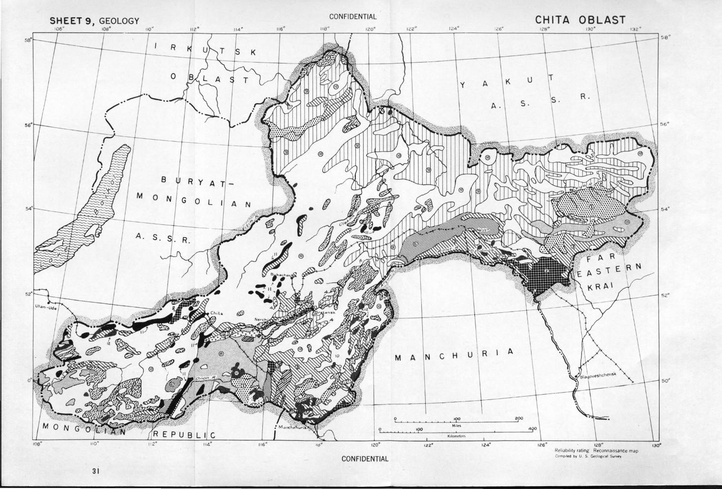
SHEET 9 I GEOLOGY CONFIDENTIAL
106" 106° 11 4 ° 116°
K
8 R y A
M 0 N G 0 l A
A. S.
0 '
116 ° 120°
CONFIDENTIAL
31
y A
MANCHU R
0 100
100 '
Ktlomctrr !-
K u
A. s.
A
200
CHITA OBLAST
126° 128° RelialJ11ity r at1ng Reconna1ssanct! map CC'Imp.te-d by U S. Ccoi<'C• C' J~I Survty
56°
52°
so·
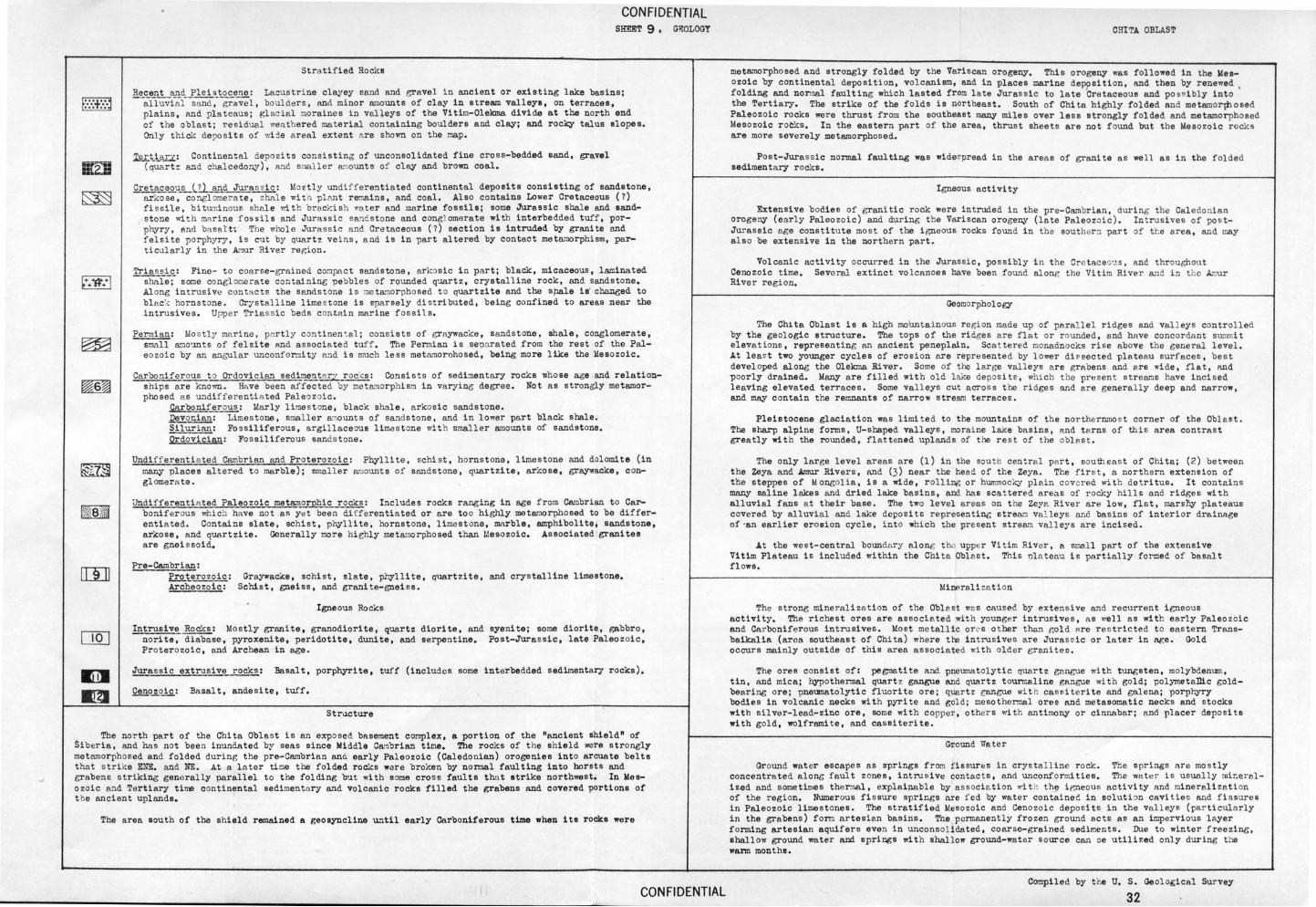
Stra tified Roclcs
CON Fl DENTIAL SHEET 9 , G~OLOGT
Recent ¥!_d Plei s_to~: Lacust rine clayey sand and eravel in ancient or existing lake basins; al luvial sand , gravel, boulders, and minor a~ounts of clay in stream valleys, on terraces, plains, and pl ateaus; gl acial moraines in valleys of the Vitim-Olekma divide at the north end of t he oblast; residual wea t hered material containing boulders and clay; and rocky talus slopes. Onl y thiclc deposits of wi :l.e a real extent ;o.re shown on the map .
12L~t~LL: Continental deposi ts consisting of unconsolidated fine cross-bedded sand, gravel (quart~ and chalcedo!'lY), a."ld smaller a":lounts of clay and brown coal,
CretaceovJLJLLL_and Juras~ ic: Mostly undiff erentiated continental deposits consisting of sandstone, arkose, co~lome~a te, ~hal e witn pl~t remains, and coal. Also contains Lower Cretaceous (7) fi ss ile, bitu'lli nous shale rlth brackish Yia ter and marine fossils; some Jurassic shale and sands tone "1. th mnri ne f ossils and Jura ssic sane s t one and congl omerate with interbedded tuff, porphyry, and ba sart~ The whole Jurassi<: and Cretaceous {-7) section is intruded by granite and felsite porphyry, is c11t by quart2 veins, and is in "Part altered by contact metamorphism, particularly in the Amur Ri ver region .
Triass ic: Fine- to coar se-grained compact sandstone, ark~sic in part; blaCk, micaceous, laminated shale; some conglo1:1erate containing pebbles of rounded quartz, crystalline rock, and sandstone. Al ong intrusive contacts the sandstone is me ta'llorpho sed to quartzite and the sPale i~ chnneed to bl p_c:-: hornstone. Crystalline lime s tone is sparsely distributed, being confined to areas near the intrusives. Upper Triassic beds c ~ntnin marine fossils.
Permian: Mostly marine, pnrtl y continen ~al; consists of graywacke , sandstone , shale, conglomerate, s~~ll a~o~ts of felsite and a ssocia ted tuff , The Permian is sepnrated from the rest of the Paleozoic by an angular unconformity ~d is much less metamorohosed, being more like the Mesozoic.
Carboniferous t o Ordovician sedimenta r T rcc~s: Consi sts of sedi~entary rocks whose age and relationships are known. Have been affected by ~eta'llOT1Jhls~ in varying degree. Not as strongly metamorphosed as ~"ldifferentiated Paleozoi c.
Carboniferous: Marly limestone, black stulle, a rkosic sandstone. Devo~ian: Limestone, smaller ~oounts of sandstone, and in lower part black shale. Silurian: Fossiliferous, argillace~s limes tone with smaller ~nounts of sandstone. Ordovician: Fossiliferous sandstone.
Undifferenti a ted Cambrian and Proterozoic: Phyllite, schi st , hornstone, limestone and dolomite (in many places altered to marble); smaller a~ounts of sandstone, quartzite, arkose, graywacke, conglomera te.
Undifferentiated Paleozoic meta~orphic rocks: Include s rocks ranging in age from Cambrian to Carboniferous whi&l have not as y~t been differentiated or are to o highly metamor1Jhosed to be differentiated. Contains slate, schis t, phyllite, hornstone, limestone, marble, amphibolite, sandstone, arkose, and quartzite. Generally more highly metwnorphosed than Lie so zoic. Associated grani tee are gnei ssoid.
Pre-Cambrian: Proterozoic: Ai=C!leou;rc:
Graywacke, schist, slate, p~$llite, quartzite, and crystalline limestone. Schist, gneiss, and granite-gneiss.
Igneous Rocks
Intrusive Rocks: Mostly granite, granodiorite, quartz diorite, and syenite; some diorite, gabbro, norite~~se, pyroxenite, peridotite, dunite, and serpentine. Post-Jurassi c, late Paleozoic, Proterozoic, and Archean in age.
Jurassic extrusive r ocks : Basalt, por1Jhyrite, tuff (includes some interbedded sedimentar; rocks).
Cenozoic: Basalt, andesite, tuff,
Str.1eture
The north part of the Chita Oblas t is an exposed basement complex, a portion of the "ancient shield" of Siberia, and has not been inundated by seas since Middle C~nbrian tioe, The rocks of t he shield were strongly metamorphosed and folded during t he pre-Cambrian and early Paleozoic (Caledonian) orogenies into arcuate belts that s trike ENE. and NE. At a l ater til:'\8 the folded rocks ware broken by normal faulting into horsts and grabens striking generally parallel to the folding but with some cross faults that strike northwest. In Weeazoic and Tertiary time continental sedimentar; and volcanic rocks filled the grabens and covered portions of t he ancient uplands.
The area south of the shield remained a geosyncline until early Carboniferous ttme when ita roCks were
CON Fl DENTIAL
C!JITA OBLAST
metamorphosed and strongly folded by the Variscan orogeny. This orogeny was followed in the Mesozoic by continental deposition, volcanism, and in places marine dePpsition , and then by renewed , folding and nonnal faulting which lasted from late Jurassic to late Cretaceous and pos sibly into the Tertiary, The strike of the folds is northeast. South of Chi ta highly folded and metamorphosed Paleozoic rocks were thrust from the southeast many miles over less strongly folded and metamorphosed Mesozoic roCks, In the eastern "Part of the area, thrust sheets are not found but t he Mesozoic rocks are more severely metamor1Jhosed.
Post-Jurassic normal faulting was wider.pread in the area s of granite as well as in the folded sedimentary rocks.
Igneous activity
Extensive bodies of graniti c rock were intruded in the pre-Cambrian, during the Caledonian orogeny (early Paleo zoic) and during t~e Variscan orogeny (late Paleozoic). In t rusives of "PO StJurassic age constitute most of the igneous rocks found i n the souther n part of t r.e area, and may a lso be extens ive in the northern part.
Volcanic activity occurred in the Jurassic, 1JOSSibly i n t he Cre taceou.s , and throughout Cenozoic time. Several extinct volcanoes have been found alonr, the Vitim River ~~d in t he AT.Ur River region.
Geomorphology
The Ch1ta Oblast is a high moUntainous region made up of parallel ridges and val1eys control led by the geologic structure. The tops of the ri dges are f lat or r ounded, end hnve concordant summit elevations, representing an ancient peneplain. Scat tered monadnocks rise above the general level. At least two younger cycles of erosion are represented by lower di ~ sected plateau surfaces, best developed along the Olekma River. Serna of the large valleys are grabens and a.re ..-ide, flat, nnd poorly drained. Many are filled with old lake depos it e, which the presen t streams have inci sed leaving elevated terraces. Some valleys cut across the ridges and are generally deep and narrow, and may contain the remnants of narrow stream terraces.
Pleistocene glaciation was limited to the mountains of th e northernmos t corner of the Oblast. The sharp alpine forms, U-shaped valleys , moraine lake basins, p~d t arns of this area contrast greatly wit h the rounded, flattened uplands of the rest of the obl ast .
The only large level areas are (1) in the sou~h centra l part, south eas t of Chl.ta; (2) between the Zeya ~nd Arnur Rivers, and (3) near the head of the Zeya. The fi r st , a northe rn extension of the steppes of Mongolia, is a wide, r olling or h\ll!'.mocky plain covered with detritus . It contains many saline lakes and dried lake basins, and has scattered areas of rocl~y hills and ridges with alluvial fans at their base. The two level a r eas on t he Zey~ River are low, flat, mars~~ plateaus covered by alluvial and lake dcpos i te representine strear.J valleys and basins of interi or drainage of ·an earlier erosion cycle, into which the present strea.":l valleys are incised.
At the west-central boundary along t h~ upper Vitim River, a small part of the extensive Vitim Plateau is included within the Chi ta Oblast . This olateau is partially formed of basal t flows.
MiMralizati on
The strong mineralizat ion of the Oblast was caused by extensive and recurrent i gneous activity. The richest ores are associ a ted with younger intrusives, as '-:el l as with early Paleozoi c and Carboniferous intrusives. Mo~t metallic orcs o t her t~~ gold are reetricted t o eas tern Transbaikalia (area southeast of Chi ta) where the intrusives are Juras~ ic or l ater in age. Gold occurs mainly outside of this area associated ... ith older granites .
The ores consist of: pegmatite and 1Jneumatolytic quartz gangue wi t h twlgsten, molybdenum, tin, and mica; hypothermal quart z gangue and quartz tourmaline gangue with gold; polymetaDic goldbearing ore; pneumatolytic fluorite ore ; quartz gangue wit h cas~iteri te and galena; porphyry bodies in volcanic necks with pyrite and gold; mesothermal ores and metasomatic necks and stocks with silver-lead-zinc ore, some with copper, other s with antimony or cinnabar; p...nd placer deposits with gold, wolframite, and cassiterite.
Ground \"later
Ground wat er escapes as springe from fissures in crystall ine rock . The springs nre mo s tly concentra ted along faul t zones, intrusive contacts, and unconformities. The wate r is usually mi~e ral ized and sometimes thermal, explaipable by association wit h th~ ir,neous activity and mineralization of t he region. Numerous fissure springs nre fed by water contained in solution cavities and fissures in Paleozoic limestones. The stratified Mesozoic and Cenozoic depo sits in the vall eys (particularly in the grabens) form artesian basins. The ,permanently frozen ground acts as an impervious layer forming artesian aquifers even in unconsolidated, coarse-grained sediments. Due to winter freezing, shallow ground water and springs with shallow ground-water source can oe utili7.ed only during the warm monthe.
Compiled by ti-.e U, S. Geological Survey
32
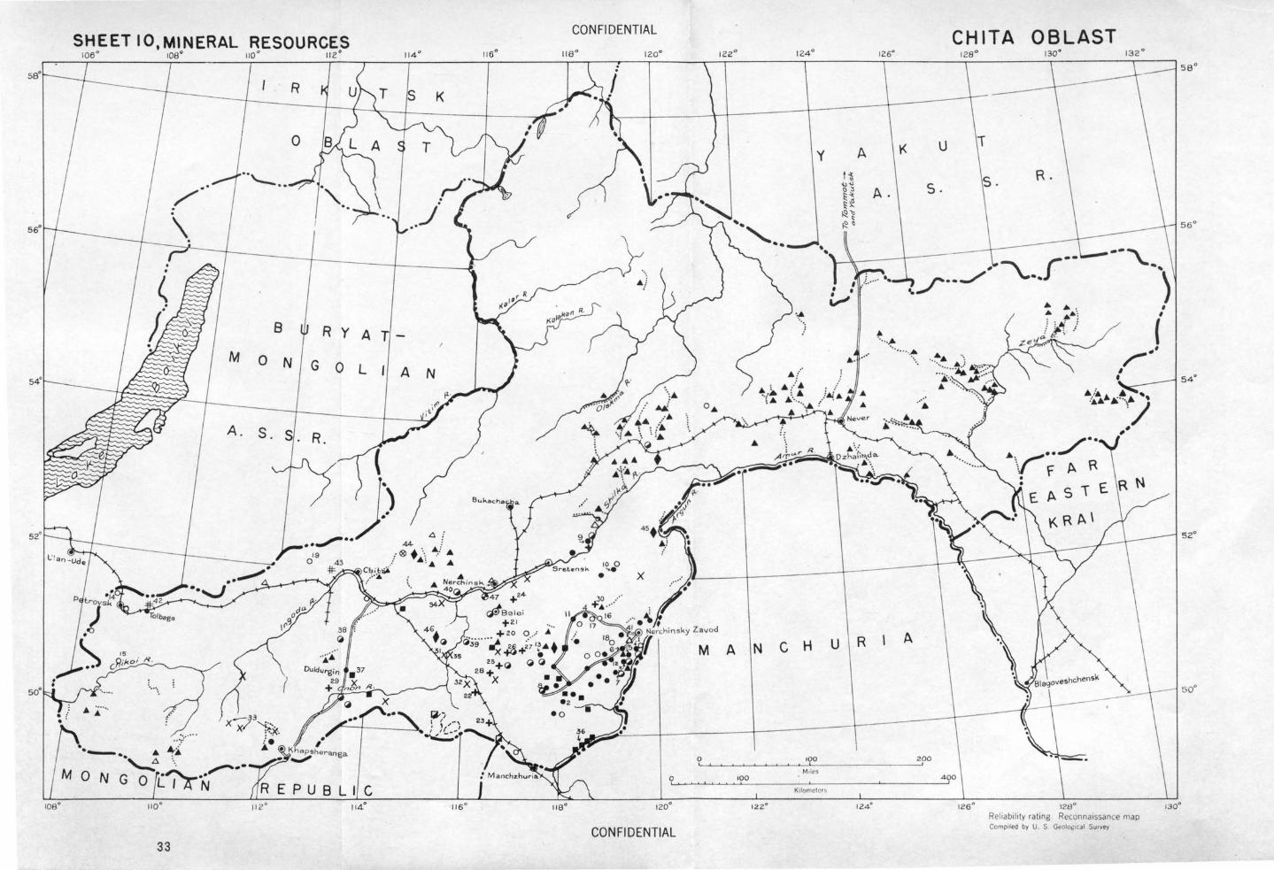
SHEETIO,MtNERAL RESOURCES r06 ° roe• 110 ° 112 °
CON Fl DENTIAL
y
••
8 R Y A T
A N M 0 N G 0 l
A. S . S. R.
M A N C H
Mtles 0 100
K•lomctcrs
122°
CONFIDENTIAL 33
A ~ ~
'1.>"" () :1 A. ~ "" ~ ~ ~ " ~ ~ a
• ,
:.,_.., •
• ·· ..... •.
u R
CHITA OBLAST
K u
R. s .
- ·· #
.. ,r·-../
·· ·· ·~.
A
126 ° 128° Reliability rating Reconna•ssance map Compo led by U . S Geolo,;ocJI Survey
56°
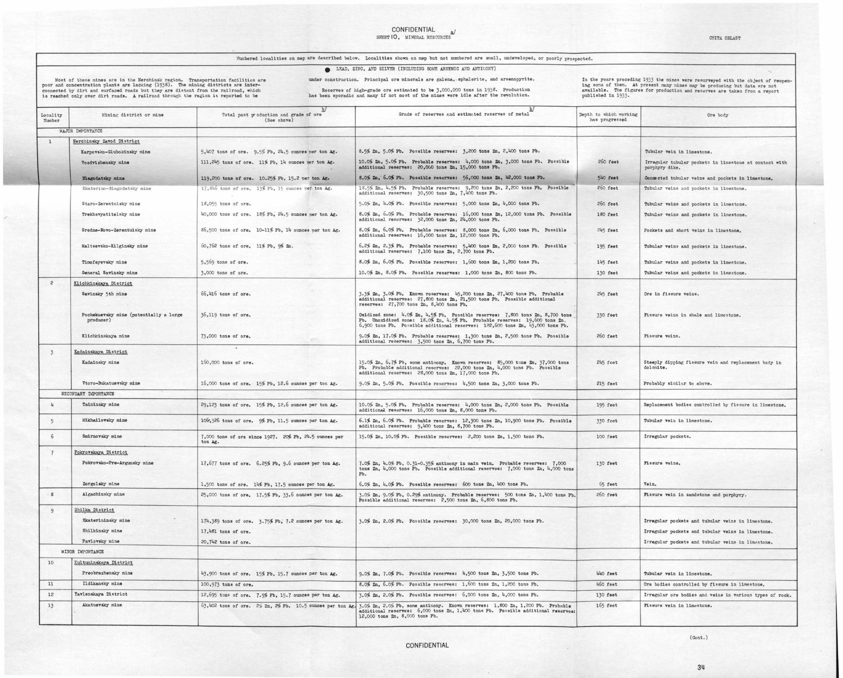
CONFIDENTIAL ~ MINERAL ~SOURCES C!HT.A. OBLAS T SHEET 10,
'
h\unbered localities on map are described below. Localities shown on map but not numbered are amall, undeveloped, or poorly prospected.
• LF.AD, ZINC, AliD SILVER (INCLUDING SO~!E ARSENIC AND ANTII~ONY)
Most of these mines are in t he Nerchinsk region. Transportation facilities are under construction. Principal ore minerals are galena, . ephalorite, and arsenopyrite. In the years preceding 1933 tr.e mines were resurveyed wi th the object of reope.n-poor and concentration plants are lacking (193B). The mining districts are inter- ing so~a of them. At present onny mines may be producing but data are not connected by dirt and surfaced roads but they are distant from the railroad, whi ch Reserves of high-grade oro estimAted to be 3,000 ,000 tons in 193B. Production available. The figures for production and reserves ere taken from a report is reached only over dirt roads. A railroad through t he region is reported to be bee been sporadic and many if not most of t he mines were idle after the revolution. published in 1933 .
E) .EJ Depth to which r.orking Locality Mining district or mine Total past V' eduction and grade of ore Grade of reserves and estimated reserves of metal Ore body
Number (See above) has progressed
MAJOR Ilo!PORTA...><CE
1 Nerch1n!5l Zavod District
Karpovako-Glubokinsky mine 5,407 tons of ore. 9 . 5% Pb, 24.5 ounces ner ton Ag. B.5~ Z'll, 5·0% Pb. Po ssible reserves: 3,200 tons zn, 2,400 tons Pb. Tubular vein in limestone.
Vo zdvi zhensky mine 111,245 tons of ore. 11% Pb, 14 ounces nor ton ig. 10.0~ Zn, 5.0% Pb. Probable reserves: 4,000 tons Zn, 3,000 tons Pb. Possible 260 feet Irregular tubular pocketo in limestone nt contect w1 th additional reserves: 20,()(.() tons Zn, 1.5,000 tons Pb. porphyry dike.
nacodataky mine 119,200 tons of ore. 10.25:' Pb, 15.2 ner ton Al;. s.o~ zn, · 6.~ Pb. Poaaible reaerve11 56,000 ton• ZD, 112,000 toni Pb, 540 feet Conna cted tubular veins and pockets in limestone. J I~
_,___ -Ekaterino-Blagodatsky mine 17 , 84~ tone of ore. 13~ Pb, 15 ounces ner ton Ag. 1B. 5% Zn, 4.5% Pb. Probable reserves: 9,200 tons Zn, 2,200 tone Pb, Po seibl.e 260 feet Tubule.r veins and pockets in limestone. additional reserves: 30,500 tons Zn, 7,400 tons Pb.
Staro-Zerentuisky mine 16,055 tons of ore. 5.o,; Zn, 4 .~ Pb. Possible reserves: 5 ,000 tons Zn, 4,000 tone Pb. 26o feet Tubular veins and pockets in limestone.
Trekbsvyatite1sky mine 40 ,000 tons of ore. 18% Pb, 24.5 ounces ner ton Ag. B.o% ZD, 6.~ Pb. Probable reservea: 16,000 tons ZD, 12,000 tons Pb. Possible 180 feet Tubular veins and pockets in limestone. o./ additional reserves: 32,000 tons zn, 24,000 tons Pb.
Sredne-Novo-Zerentuisky mine 66 , 500 tons of oro. lo-11% Pb, 14 ounces per ton Ag. B.~ Zn, 6.~ Pb. Probable reservea: B,OOO tons Zn, 6,000 tons Pb. Possible 245 feet Pockets and short veins in limestone. additional reserves: 16,000 tons Zn, 12,000 tons Pb.
Maltsevsko-Kilginaky mine Go , 762 tons of ore. 11% Pb, 'J1, ZD. 6.2% Zn, 2.3% Pb. Probable reserves: 5,400 tone ZD, 2,000 tons Pb. Possible 195 feet Tubular veins end pockets in limes tone. additional reserves: 7,100 tons zn, 2,700 tons Pb.
Timofeyevaky mine 5.569 tons of ore. B.~ Zn, 6.~ Pb. Possible reserves: 1,6oo tons Zn, 1,200 tons Pb. 145 feet Tubular veins el'ld pockets in lim..stone .
General Savinaky mine 3,000 tons of ore. 10.0% ZD, B.~ Pb. Possible reserves: 1,000 tons ZD, 800 tone Pb. 130 feet Tubular veins and pockets in limestone.
2 Klichkin&keya Distric!
Savinaky 5th mine 66,416 tons of oro. 3.3% Zn, 3.~ Pb. ltnown reserves: 45 ,200 tons Zn, 27,4oo tons Pb, Probable 245 feet Ore in fissure veins. additional reserves: 27,800 tons Zn, 21.500 tons Pb. Possible additional reserves: 27,700 tons Zn, B,400 tons Pb.
Pocbekuevaky mine (potentially a large 36,119 tons of are. Oxidized zone: 4.~ Zn, 4.5% Pb, Possible reserve a: 7,800 tons Zn, B,700 tone 330 feet Fissure veins in shale and limes tone. producer) Pb. Onoxidizod t:ane: lB.~ Zn, 4.5% Pb. Probable reserves: 19 ,6oo tons Zn.
6,900 tons Pb. Po ssible additional reserves: 1?.2,600 tons ZD, 43,000 tons Pb.
Klicbldnskaya mine 73,000 tons of ore. 9·~ Zn, 17.0:' Pb. Probable reserves: 1,300 tons ZD, 2,500 tone Pb. Possible 260 feet Fissure voi ns. additional reserves: 3,500 tons Zn, 6,700 tons Pb. .
3 Ke~ain~a District
Kadeinsky mine 15o ,ooo tons of ore. 15.0~ Zn, 6. 7% Pb, some antimony. Known reserves: 85,000 t ona ZD, 37,000 tons 245 feet Steeply dipping fissure vein and replacement body in Pb. Probable addi tional reservoez 22 , 000 tons Zn, 4,000 tons Pb. Possible dolOl:lite. additional reserves: 28,000 tons Zn, 17,000 tons Pb.
Vtoro-Bukatuevsky mine 16,000 tons of ore. 15% Pb, 12.6 ounces per ton Ag. 9-0% Zn, 5·~ Pb. Possible re serves! 4,500 tons Zn, 3,000 tons Pb. 215 feet Probably similar to above.
SECONDARY It!PORTANCE
4 Taininsky mine 29,123 tons of oro. 15% Pb, 1?..6 ounces per ton Ag. 10.0% Zn, 5.0% Pb. Probable reserves: 4,000 tons Zn, 2,000 tons Pb. Possible 195 feet Replacement bodies con t rolled by fis sure in limestone. additional reserves! 16,000 tone Zn, 6,000 tone Pb.
5 ldi.khe.1lovaky mine 1o&,326 tons of ore. 9~ Pb, 11.5 ounces per ton Ag. 6.1:' Zn, 6.~ Pb. Probable reserves: 12,300 tons Zn, 10,900 tons Pb. Possible 330 feet Tubular vein in limestone. additional reserves: 9.400 tons Zn, 6,700 tons Pb.
6 Smirnovaky mine 7,000 tons of ore since 1927. 2fY1, Pb, 24."5 ounces per 15.~ Zn, 10.0% Pb. Possible reserves: 2,20? tons ZD, 1, 500 tonn Pb. 100 f eet Irregular pockets. ton Ag.
7 Pokrov~a District .
Pokrovslco-Pre-Argunsky mine 17,677 tons of ore. 6.25% Pb, 9.6 ounces per ton Ag. 7.0% Zn, 4.0% Pb, 0.31-0.35% antimony in main vein. Probable reserves: 7,000 130 feet Fissure veina. tons Zn, 4,000 tons Pb. Possible additional reserves: 7,000 tons Zn, 4,000 tons Pb.
Zorgolsky mine 1,500 tons of ore. 14~ Pb, 17.5 ounces per ton Ag. 6.0% Zn, 4.0% Pb. Poaaible reserves! 6oo tone Zn, 400 tons Pb, 65 feet Vein.
8 Algachinsky mine 25,000 tons of ore. 17.5% Pb, 33.6 ounces per ton Ag. 3.0% Zn, 9-0% Pb, 0.29% antimony. Probable reserves: 500 tons zn, 1, 4oo tons Pb. 260 feet Fissure vein in sandstone end porphyry. Po ssible additional reserves: 2,500 tons Zn, 6,soo tons Pb.
9 Shilke District
Ekaterininaky mine . 174,3B9 tona of ore. 3·75~Pb; 7.2 ounces per ton Ag. 3·0% Zn, 2.0% Pb. Pos sible reserves: 30,000 tons Zn, 20,000 tons Pb. Irregular pockAts and tubular veins in limestone.
Shilkinsky mine 17 ,4Bl tons of ore. - Irregular pockets and tubuler veins in limestone.
Pavlovsky mi:le 20,742 tons of ore. Irregular pockets and tubular veins in limds tone .
MOOR IMPORTANCE
10 Kultumin~a District
Preobrazhenaky mine 43,900 tons of ore. 15% Pb, 15.7 ounces per ton Ag. 9.0% ZD, 7.~ Pb. Possible reserves: 4,500 tons Zn, 3.500 tons Pb. 440 feet Tubular vein in limestone.
' 11 Ildikansky mine 100,973 tons of ore. B.O% Zn, 6.0\t Pb. Possible re serves: 1,6oo tons Zn, 1,200 tons Pb. 460 feet Ore bodies controlled by fissure in limestone.
12 Tavlen~a District 12,695 t :ms of ore. 7.9% Pb, 15.7 ounces per ton Ag. 3.0% Zn, 2.0% Pb. Possible reserves: 6,000 tons Zn, 4,000 tons Pb. 130 feet Irregular ore bodies and veins in vnrious types of rock.
13 J.ketuevaky mine 63 ,402 tons of ore. 2;:1. Zn, 2% Po. 10.5 ounces par ton Ag 3.0% Zn, 2.0fo Pb, some antimony. Known reserves: 1,800 Zn, 1,200 Pb. Probable 165 feet Fissure vein in limdstone. additional reserves! 6,000 tons Zn, 1,400 tons Pb. Po ssible additional reserves: 12,000 tons Zn, B,OOO tons Pb.
(Cont.)
CONFIDENTIAL
3~
Locality :lame of depo sit number
14 Be.leginsky
15 Y.orotkovsky
16 Yakovlevsk:y
17 Bistrineky
18 Zheleznie Kryazh
. 19 Beklemi shevsky
Locality l·nme of deposit number
20 Bukuka
21 Bel ukha
22 Sherlovaya Go ra
23 Kharanor
24 Kazekov
2'j llalosoktu.i, 26 Bolshesoktui
27 Oldande.
28 An tan
29 l>.lldurgin
30 Ushnrunski Goleta
Locality Nnme of regi on number or deposit
31 Ononsky Lode
Placer
32 Sherlovaya Gora
33 Khapche rnngiosky (Exact location not known )
34 Zavitinsky Lode
Placer
35 1.\Rlo-Y.ulindinsky
II Smirnovsky (see lead-zir.c-silver locality 6) .
Grade of ore
47-75~ Fe, 0 .19% S, 0 . 04% P.
45-6o% Fe.
Go% Fe, 0 . 1% A s , o.oa::; s , 0 . 05-0 . 06% P.
39· 7% Fe, 0 . 89% P, o . o6~ s .
vunrtu~•, lti"\L ~
Slm:T 10, ll iN;:RJ.L R':SWRCES (2)
Q IRON DEPOSITS
From about 1929-31 the western part of Chita Oblast was explored by magnetometer; as a result many nen areas of iron ore were found and old ones were delimited. Most deuosits have been only prospected and are undevelooed (1932).
Reserves Occurrence
Probable re serves of ore: 3,139,000 tons; possible additional re- Ma<:netite. In contact metamorphic zone of limestone and granite. serves of ore: 308,000 worked by stripping.
Worked f or brief period at 100 ,000 tons.
Magnetometer estimate:
Magnetometer estimate: feet.
112,000 ,000 t ons of ore
Small deposit.
tone. 1,000,000 tons of t he reserves can be
in 1899, at which time reserves were estimated Magnetite associated with copper minerals. Contact metamorphic deposit.
4 , 000 ,000 tone of ore above depth of 330 feet. Magnetite and hematite.
14,000,000 toue of ore above depth of 30C Magnetite, specular hematite, pyrite, and chalcopyrite.
abo;; depth of 600 feet. ·-· Largest contact me t amor phic deposi t in rogion. Magnetite, sooe pyrit~ arsenopyrite, and pyrrhotite.
Sedimentary siderite ore •
+ TUNGSTEN rePOSITS
At one time Chita Oblast was t he only tungsten-producing region in the U.S.S.R. According to 1938 data , t he Bukuka and BelukPa deposits have t he lareest reserves in the U.S.S.R., but production is small. The se are probably the only mines worked in the district since the revolution. Bismuth has been a by-product at most mines.
CJHTA Oi'!LAST
Remarks
Worked since 1789. Ore smelted a t Petrov&k, 15 miles away to which mine is connected by railroad spur. Accordi ng to 194o dat a t he Petrovsk works were recently reconstructed and two open-heArth fur-naces and a gas generating plant were installed. It wa s also r eporte thot these works and the Komsomolsk works (on the 1ow~r ~~ River outside of Chitn Oblast) had a combined annual s teel production of 1, 500 ,000 tons. Most of th i s production wa s from the Petrovsk works.
Connected with Trans-Siberian Railroad by 100 mi les of dirt road.
Discovered in 1930. In Nerchin~ky Zavod zinc and lead district. Connected with other lead-zinc distric ts by eyetem of dirt and surfaced roads.
Chal copyrite used as copper ore. In Nerchinaky Zavod zinc-lead district.
In Nerchinsky Zavod di strict.
On dirt r oad 25 mi les f r om Trans-Siberian Rai l r oad:
Production ana grade of ore EstL~ted reserves Occurrence end ~ining Methods Accessibility Bismuth product i on a t tungsten mines
In 1917 produced 43.29 t ons of 701 1'1'] concentra te. 1919: 2.24 tons of 70% IVO~ concentrate. 1926-27 : ' 5. 8 tons of "olframite concentrate
2,098 tons of ~stan (1933). Wolframite-bearing quartz veins in granite. Connected with Trans-Siberian Railroad by dirt 1918 production: 0.1 ton Bi2s3 concentrate
road 44 miles long, passable for mo tor "i th 75% Bi. 1919 produc t i on: 0. 9 ton with and 5.48 ons of mixed wolframite-scheelite concentrate. Average 0. 3% 10-50% Bi. vehicles. wolfra:nite in quartz . In 1938, small production . Ore averages 0 .3% wolframite.
In 1917 produced ?2 .02 tons of 70% \V~ concentrate. 1919: 1. 46 tons 1, 776 tons of tungsten (1933). Wolframi te-bearing quartz veins. Concan tra tine On dirt road between Bukeka mi ne and Trans-of 70% 110) concentrate . Last half 19 6: 2, 523 tons of ore containing plant at mine. Siberian Railroad, about 30 miles away. 0 . 9% wo
3• Small production in 1938.
I In 1916 produced 7.61 tons of 70% wo3 concentrate. 1917: 4. 86 tons of Tens of thousands tons of ore. Lode and placer deposits. Connected with Chita-llancburia ReUroad by dirt Ore is baaobismuthite end native bismuth with 70% WO) concentrate. Average wo3 in ore - 0.5%- Nearby placer reserves estimated
in 1933 at 900 tons ( 65~ wo3). road 9 miles long. arsenopyrite. Reserves less than 1,000 tons.
In 1917 0.3 ton of concentrate wa s produced wit<l average bismuth content 50%.
1911-1915: nroduced 10.31 tons of 70% wo3 concentrate. 1916: 4.52 Probable reserves of tungsten 85 Wolframite and scheelite ore. Open pit mining. 5 mil es by dirt road from Chita-~ancburia Reil- 0. 42% native bismuth in biotite granite tons of 70% wo3 concentrate. 1917: 9.83 tons of 70% W~ concentrate. tons. road. arsenopyrite. Average wo3 in ore 0.6%.
In 1917 produced 0 .82 ton of 70% wo3 concentrate. No data. Scheelite in quartz-calcite veins. Large 22 miles by dirt road fro~ station on Trans- Small amoUI1t in placer deposit. placer deposit. Siberian Railroad.
In 1916 produced 5. 20 tous of 70% W~ concentrate. 1917: 19.4o tons Actual reserves of tungsten 22 Wolframite-bearing quartz veins in granite, 20 miles by dirt road from station on Chita-of 70% 'R~ concentrate. Q. 5- 0 .8'j, W03 in ore. tons. and placer deposits. Mmcburie Railroad.
In 1917 produced 1. 0 ton of 70~ wo3
concentrate. 0 . 5- 0 .8% 1103 in ore. \'lolframite vein.
Production not knovm, 0 .05-0 .1% ·_.:o3 in ore . 2 , 500-3,000 tons . Placer deposit.
I n 1917 produced 0 .17 ton 70% wo3 concentrate. Violfremi te vein. ~
Near town of J>.>.ldurgin which is on road between On on River and Trans-Siberi~ Railroad.
In 1917-18 produced 0. 3} ton 70% W03 concentrate. \'lolframite- beering quartz veins in schist.
)( TIN ~~OSITS
According t o 1938 data this region ~s the only well prospected tin district in U.S.S.R. Some deposits were worked in early part of 19th century; then practically no wo rk was done until about 1932 when the area was thoroughly prospected. Tho following is taken from a report published in 1933.
Production Grade of ore Re serves and size of deposit Occurrence Acce ssibility
Apparently no production since Averf!ge: 0 . 6% Sn. 1927 data. Known reserves: 114.10 tons Sn; probable Cassiterite-bearine quart z veins 1n met.Amor- 2 miles from station on Cbita-Mmcburia Railroad . Hi52. additional re serves : 163.40 tons So; possible additional pbosed sandy shale, containing coal seems.
reserves: 293-50 t one Sn.
Average: 0 .02- 0 . 03% Sn. About 25 tons Sn, in gravels 33-46 feet thick. Cassiterite placer deposit.
0.026-0.076% Sn. 1,825 tons cassiterite, in gravels 5-15 feet thick. Placer depoai t. 7 miles from station on Chits-Manchuria Railroad.
Reported to produce 65% of U.S.S.R. 3 .1 2% Sn. Tentative estimate: 7,000 to 10 ,000 tons of tin. Cassiterite-bearing quartz-ochre vein in Connected with Trans-Siberian Railroa~ by surfaced tin (194o ). This production would slate and chl orite schist. 200 miles long . probably &~ount to more than 4,500 tons .
0.')0~ Sn. Tin content 1-4 tons for each 23 Cassiterite-bearing pegmatite dikes. 6 miles froo station on Trans-Siberian Railroad. feet of depth. • 0. 02-0.03% Sn. 1. 5 miles l ong, 65-200 feet wide, 1.5-4 feet t hick . Cassiterite pl qcer deoosit.
Apparently no production since 0.1-0.7% Sn . No data. Cassi teri t.e in muscovite granite dikes. 5 miles fror.1 Chi ta-,'llnchurl(l. Railroad . u ;2o.
with
r oad
Three tented samples heve foll owing tin con- Tentative estimate: 500-1, 000 tons of 1-2% Sn ore to Polymetallic deposit worked for lead, zinc, 15 miles SW. of Nerchinslcy Zavod. Not easily accessible. t~nt: (1) 2.41-2. 54%; (2) 9 - 97-10.0~; (3) depth of 150-200 feet. and si 1 ver , as well as tin. 7.94~ . (Cont.)
CONFIDENTIAL 35
36
37
38
39
4o
41
42
43
CON Fl DENTIAL SHEET 10, IIIN~ ~URCE~3) CRITA OBLAST
• FLUORITE DEPOS ITS ® MOLIBDENU!4 !mPQSITS Apparently none producing as late as 1938 .
~1£,v1k (1938 data): Largest productive Rur.sian deposits. Principal source of fluorspar for artificial cryolite Qutai (1927 data): Possible reserves 16.3 tons. 85-87% MoS2 used in aluminum plants of U.S.S.R. Several hundred thousand tons of reserves. Vein deposits, Connected 44 3 .8 tons of concentrate were produced durine prospecting
with Chita-Manchuria Railroad by dirt road 50 miles long along the Argun River. -- work, In peg~Datite dike. Two main mines: Abagaitui: In 1927 produced 839 . 6 tons ore; delivered 1,368. 3 tons unsorted ore to railroad
(including ore from previous production); had 78 . 3 tons unsorted ore left on hand. • COPP~R DEPOSI TS (1933 data) Kalan~ : No producti on in 1927; delivered 165. 0 tons unsorted ore to railroad station (from Apparently ~o production as late a s 1938.
previ ous production ; had 229.8 tons of unsorted and 810.~ tons of sorted ore left on hand. 45 ~!!Jla Kudecha: Vein of chalcopyrite, bornite, and , in oxidized zone, malachi te. Average copper content of ore
Duldurgin (1 925 data): Actual rese rves 1,870 tons; poss ible additional reserves 11,475 tons above depth of 105 feet. 3-6%. increased to 15~ by ~orting. About 10 miles fro~ a port on Argun River. 1916 production: 65 tons. Probably not producing a t present. On hard surfaced road between the Onon River and the Trans-Siberian Railroad . 46 Voskhod~: Chalcopyrite ore. 1% Cu, less than 1% As, 3·5-7 ounces (loo-200 grams) per t on .A(!.. 200,000 tons ore
reserves, About 15 miles from Chita-l&anchuria Railroad. Q ANTIMONY DEPOSITS )
0 MONAZI TE D~OSITS (1 926 data) Apparently no production as late as 1938, The deposits below are described in a report dated 1928, They are
accessible by dirt roads. Several ant~ny deposits are associated with lead-zinc-silver deposita {see deacriptiona of 47 !2rshchovochnie: In biotite granite and gneiss end (with gold ) in placer deposita along etreama of the Borehchov-localitiee 3, 7, S, 13. ochnie ridge. 1 ton produced in 1926. Reserves of monazite at least several tene of thoueanda of tone,
66.64~ Between 5 and 10 miles from the Trans-Siberian Railroad across the Shi lka River. No road.
~: Ore 1e in quartz vein& (more than 10 inches thick) at contact of felsite porphyry with coal-bearing shale. etibnite 1n ore. (47.~ Sb, 19.04~ S). Prospected in 1915; 3 veins discovered, 15 tone of ore remoYed.
'~ GOLD DEPOSITS -
Us t-Ul.)!:atui: Ore is in t he centrel portion of quartz vein s cutting Lower Juras sic conglomerate, Stibnite erains are up ... Gold mine ............. Placer deposit to 1/2 inch in size, with a concentration of 30 to 50~. Area entirely undeveloped.
The province is one of the main gold-bearing regions of the U. S. S.R. Gold deposits have beert known and worked Uet-Onon: Four quartz veins containing up t o 25% stibnite . Veins 5 to 10 inches thick. s ince 1777 and the better or more aecesaible l ocations have been worked out. The location of mines and ptacer de-
~ posits shown on the map are based on 1937 data. The l argest gold deposit now worked (1 94D ) is the Ralei deposit
UF.RCURY DEPOSITS near Nerchinak. In the fiscal year 1929-27 the TransbaiLal (i.e., the region we st of the Argun Ri•er) produced Apparently no production as late as 1938. 3,261.6 lb! • (1,482. 55 kilograms) of lode and placer gold. In the s~e pnriod 649 . 35 lbs. (295.1 6 kilograms) of gold
In places veins contain were produced in the Zeya-Aldan r egion (this i~cludes the Zeya district of the Chita Oblast and also the Al dan River
11 dikan!!fz: Veins leas t han 2 1/2 inches wide containing dolomite breccia cemented by cinnabar. distric t which l ies north of and outside of the Chita Oblast, both containing l a rge deposita of gold). solid cinnabar, Veins · cut granite and dolomite . Near hard surfaced road.
ARSENIC DEPOStTS ~ine: Pokrovskaya lead-zinc- d1etr1ot, see (locality 7); Cinnabar found in lower levels of a lead-zinc mine, Ore con-
tains o . o8~ Bg. Most of the arsenic is obtained as a by-product in the smelting of lead-zinc ores. The ore mineral is areeno-pyrite. llany of the polymetal l ic mines (in the Nerchinsk region) contain large r eserve • of arsenic. Ponible re-
Placer denosita: Cinnabar fou_~d in many placer deposits , mostly gold placers, Richest contain 0.40% ~ s. serves exceed 80,000 tons. Ore contains from 1 to lS% &a. Apparently no arsenic was being produced ae late ae
'** ~~ ~Q§I:J:§ !~31 'We) 1934. ~: Muscovite in pegmatite dikes. • 10 muscoY e. tons of possible reserves. 15 tone mica produced in
1933: 17 . 5 tons in 1934. On the Trans-Siberian Railroad, 0 . 3 miles from town of Tolbe&"· SALT DEPOSITS
Kamenako-Chernovsk: Muscovite in pegmatite dikes . 10,800 tons of reserves. 19 mile s from Chita. About 10 miles by Salt is available in saline lake basins on the south-central frontier. dirt rol\d f rom Trans-Siberian Railroad.
~ For distribution of coal depo sits see Mineral Fuels sheet.
'2} Tonnt~&e figures throUGhout this sheet represent long tons.
CON Fl DENTIAL
Reli~bility rat i ng : Class B Oer.roiled by U. s. Geolo~cal Survey.
36
SHEET II, CLIMATE
/6
180
CON Fl DENTIAL CHITA OBLAST
MONTHLY PRECIPITATION DIAGRAMS
Each column represents one month
Mean annual precipitation in inches
• Meteorological station
Sourc.: GrtNJ/Sovi.tWorldAIIos, Vall MoSQW'37
""""' ,., .. '"""~ .·-- .. . +-oo. '"'"""_~·-...._.·1(·.! \r--. .. ,_ .~~-: .. -. .., ~ /' Jll'~'"· ;
_....--Turko ••. Pakrovka ·.._ .. '\:a· J /
,-" .. '"''"' ~ ~ ...... ~~ .. \, ,,.--·· \-.. .. ~.Borzyo •• .-J
'''-··-.. -··-· · .......... / Kho1lor
Notional H,tdrologicollnstitultl U.SSR /933
I IZ -~--;;,;;,~:_ __ _;;;:_~
I
( _ _,...
"'{'
N
-- Average maximum snow cover in inches ----Days of year with snow cover
Sourt:tl: 61-eotSovi.tWor/dAIIos, Vo/J lt{oSQW'J
Relative humidity at I P.M. in percent
--April - - - - October
Sourt:tl: {j,INJISornMWorldAIIos, Vo/J MoSQW'J7
CON Fl DENTIAL
37
rre: 61-INJI SoWM World Atlas, Vo/.1 MoSQW '37
Cloudiness in percent
- .-January ----July
rre: (j,INJISoWMWorldAIIos, Vol.! MoSQW '37
Compiled by U.S. Geologu:al Su rvey
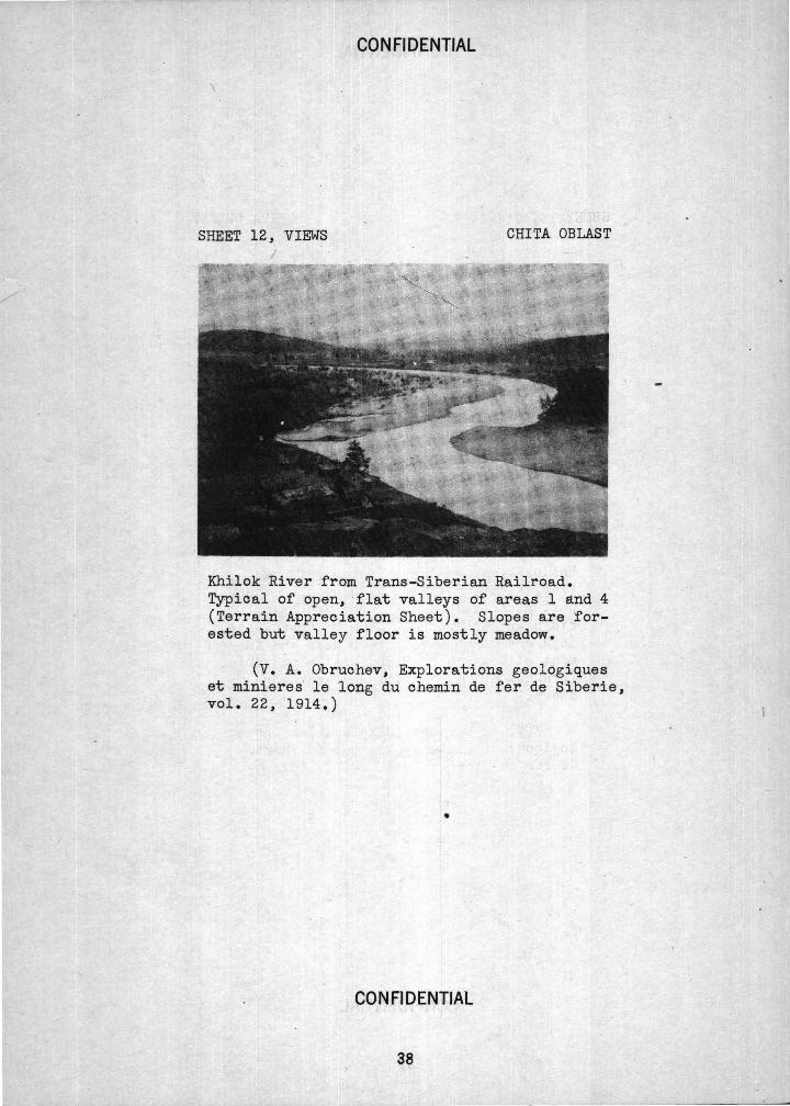
CONFIDENliiAL
SHEET 12, 'VIEW'S CHITA OBLAST
Khilok River from Trans-Siberian Railroad. Typical of open, ·flat valleys of areas 1 and 4 (Terrain Appreciation Sheet). Slopes are forested but valley floor is mostly meadow.
(V. A. Obruchev, Explorations geo1ogiques et minieres· le 1ong du chemin de fer de Siberie, vol. 22, '1914,)
•
CONFIDENTIAL
38
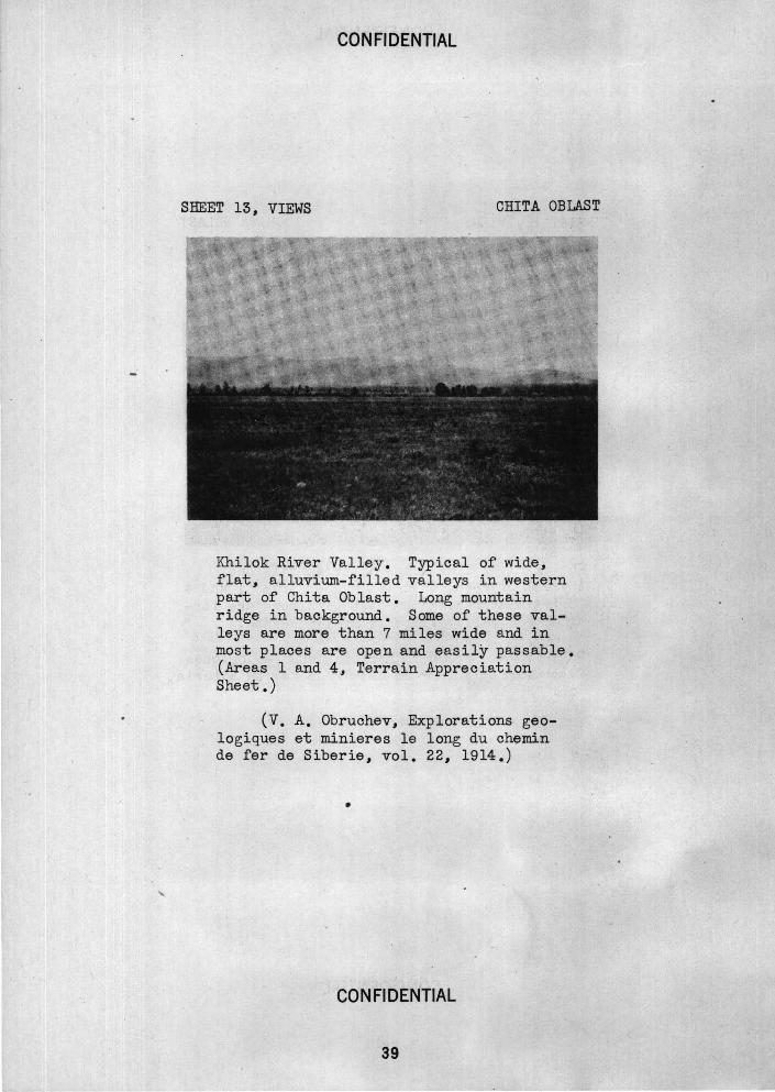
CON Fl DENTIAL
SHEET 13, VIEWS CHITA OBLA.ST
Khilok River Valley. Typical of wide, flat, alluvium-filled valleys in western part of Chita Oblast. Long mountain ridge in background. Some of these valleys are more than 7 miles wide and in most places are open and easily passable. (Areas l and 4~ Terrain Appreciation Sheet.)
(V. A. Obruchev, Explorations geologiques et minieres le long du ch~min de fer de Siberie, vol. 22, 1914.)
•
CONFIDENTIAL
39
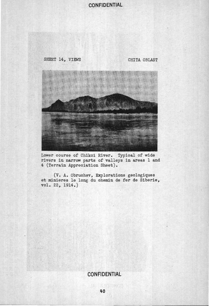
CONFIDENTIAL
CHITA OBLAST
Lower course of Chikoi River. Typical of wide rivers in narrow parts of valleys in areas 1 and 4 (Terrain Appreciation Sheet).
(V. A. Obruch~v, Explorations geologiques et minieres le long du chemin de fer de Siberie, vol. 22, 1914.)
CON·FlDENTIAL
r
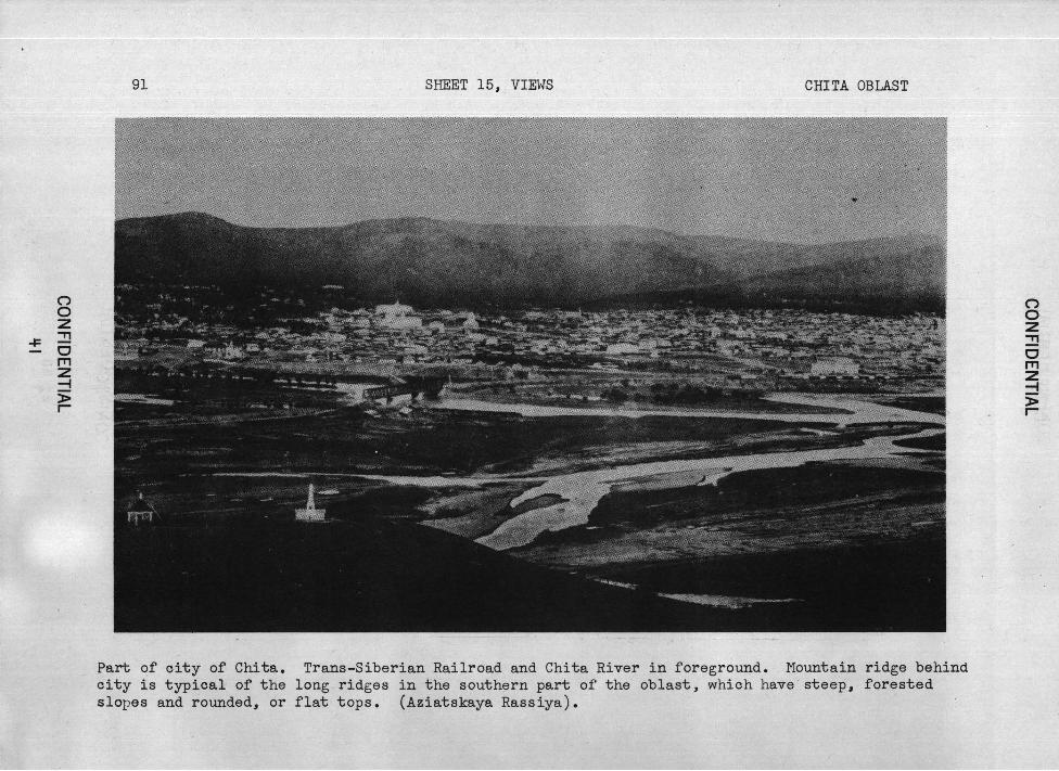
("') 0 z
-F ~ 0 rrl z -I )> r
91 SHEET 15, VIEWS CHITA OBLAST
Part -of city of Chita. Trans-Siberian Railroad and Chita River in foreground. Mountain ridge behind city is typical of the long ridges in the southern part of the oblast, which have steep, forested slopes and rounded, or flat tops. (Aziatskaya Rassiya).
("') 0 z ~ 0 rrl z -I )> r
CON Fl DENTIAL
SHEET 16, VIEWS CHITA OBLAST
Cut exposing bouldery soil -on a hillside in the northern part of area 5 (Terrain Appreciation Sheet). Typical of , thin, stony soil on slopes in ~ny parts of the obla.st. ·
(P. P. Sushchinsky, Tra.v. t1us. Geol. et Mineral, Petrograd, 1915.) _
. CONFIDENTIAL • ~ ' 1; • ~
, I
/ CONFIDENTIAL
SHEET 17, VIEWS CHITA OBLAST
View in open steppe region of Southeast Transbaikal, typical of areas 5 and 6 (Terrain Appr·eciation Sheet). Low hills in background. This region has much dry ground, few barriers to movement.
(P. P. Sushchinsky, Trav. Mus. Geol. et Mineral., Petrograd, 1915.)
' .. CONFfDENTIAL
CONFIDENTIAL
SHEET 18 I VIEWS CHITA OBLA.ST
Operi, dry steppe of area 5 (Tarrain Appreciation Sheet). Northward continuation . of steppes of Mongolia. The plain has many rocky knobs rising above it.
(P. P •. Sushchinsky, Trav. Mus. Geol. et Mineral., Petrograd, 1915.)
. CON Fl DENTIAL
CONFIDENTIAL
SHEET 19, VIEWS CHITA OBLAST
Floodplain of Argun River in area 5 (Terrain Appreciation Sheet). Shows wide meanders on swampy floodplain, and numerous cut-off channels or oxbow lakes. (Vidal de la Blache, Geographie Universelle, Yol~ 5, Paris, 1932.)
CONFIDENTIAL
IJ5
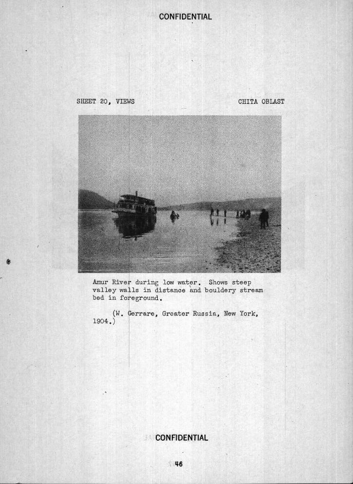
CONFIDENTIAL
SHEET 20 I VIEWS CHITA OBLAST
Amur River during low water. Shows steep valley walls in distance and bouldery stream bed in foreground.
(W. Gerrare, Greater Russia, New York, 1904.)
CONFIDENTIAL
IJ6
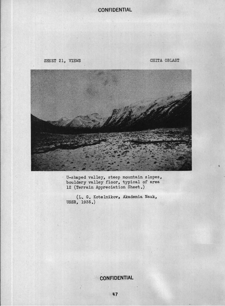
CONFIDENTIAL
SHEET 21 1 VIEWS - CHITA OBLAST
' U-shaped valley, steep mountain slopes, bouldery valley floor, typical of area 12 (Terrain Appreciation Sheet.)
(L. G. Kotelnikov, Akademia Nauk, USSR 1 1935.)
CONFIDENTIAL
. IJ 7
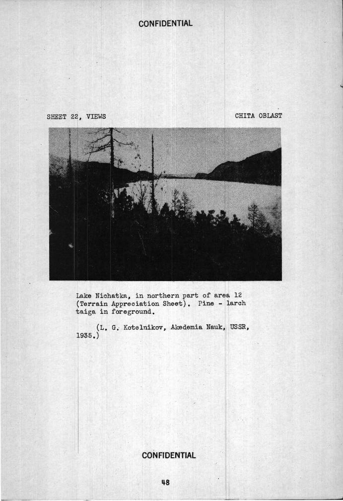
CONFIDENTIAL
SBEET 2 I VIEWS CHITA OBLAST
Nichatka, in northern part of area 12 Terrain Appreciation Sheet). Pine - larch aiga in foreground.
(L. G; . Kotelniko-v, Akedemia Nauk, USSR, 935.)
CONFrDENTIAL
~8
'