Embed Size (px)
Citation preview

North and East Coast Leaders’Initial Economic Program Plans
& Priority Projects
Aceh BesarAceh Besar
Parts B & C ( )Draft
Kabupaten Development Framework PlansKabupaten Development Framework Plans
ASIAN DEVELOPMENT BANKBADAN REKONSTRUKSI DAN REHABILITASI NAD-NIAS
Sinclair Knight Merz
December 2007
East and West Coast Infrastructure Development ProgramADB Grant No. 002-INO: Earthquake and Tsunami Emergency Support Project(Spatial Planning and Environmental Management Component) ETESP 32 Project No.39127
Kabupaten Development Framework Plans:
Parts B & C: (Draft) North and East Coast Leaders’ Initial Economic Program Plans & Priority Projects
Aceh Besar
Kabupaten Development Framework Plans:
Part B: (Draft) North and East Coast Leaders’ Initial Economic Program Plans & Priority Projects
Aceh Besar

Preface This report presents the initial thematic and applied economic development strategies of the Leadership of one of the nine North and East Coast Local Government areas. It illustrates the Initial Programmes through which the Leaders chose to apply the strategies and the first wave of selected priority activities within those programmes. An important quality of Leaders’ strategies is the degree of commonality and complementarities between them. Although the strategies were set out by the individual initiative of elected Leaders, they reflect a clear and often specific intention to avoid inefficiencies due to lost opportunities of economies of scale that would occur with any excessive diversity within strategies or destructive competition between them.
This volume represents the second part of Kabupaten Development Framework Plans for all nine EWCIDP assisted Local Governments: The first part was: Part A: North and East Coast Leaders’ Initial Economic Strategies. These strategies are shown collectively in a form that directly relates them to the RTRWP or Provincial Spatial Plan. The RTRW planning and Local Government strategies match very closely. That provides a reinforced basis for cooperation between the Provincial Government and these Kabupaten, as well as between these leaders’ strategies and their counterpart leaders and communities of the central and south western Aceh Kabupaten and Kota.
This volume shows the other components of the Kabupaten Development Framework Plans development framework reports are presented in separate volumes, one for each local government: Part B: Leaders’ Initial Economic Programme Plans, & part C: Leaders’ Priority Projects. Here the priority projects are set out in the elected leaders’ and head of Bappeda statements, appraisal summaries and project-specific reports.
Table of Contents
PART A _______SEPARATE VOLUME NOT INCLUDED HERE No. Document
Section Description Page /Figure
numbers
A North and East Coast Leaders Initial Economic Strategies (Related to Provincial Spatial Plan)
Separate volume
A1 Planning Approach .1 Summary .2 Context of this report .3 Approach adopted .4 methodology adopted .5 Relationship to further strategy and
programmatic planning
A2 The Background Factors that Strongly Influence LG Leaders’ Strategy Choices
.1 Introduction
.2 A regional perspective on the background planning considerations from the Provincial Spatial Plan
Figures 1-7
A3 Local Government Leaders’ Strategy Choices
.1 The range of thematic Strategies applied by Local Government Leaders
.2 The individual Local Government Leaders Strategies and Programmes: Aceh Besar, Pidie, Pidie Jaya, Bireuen, Aceh Utara, Lhokseumawe, Aceh Timur, Langsa, Aceh Tamiang. Together with priority ”Fast-track” project maps.
AB-Pgm, AB-Prj. PD-Pgm, PD-Prj PJ-Pgm, PJ-Prj BR-Pgm, BR-Prj AU-Pgm, AU-Prj LH-Pgm, LH-Prj TI-Pgm, TI-Prj LA-Pgm, LA-Prj TA-Pgm, TA-Prj
A4 LG Strategies in Region & Province Context
.1 Overview
.2 Strategies Related to Selective Planning considerations
_ Figures 8-21
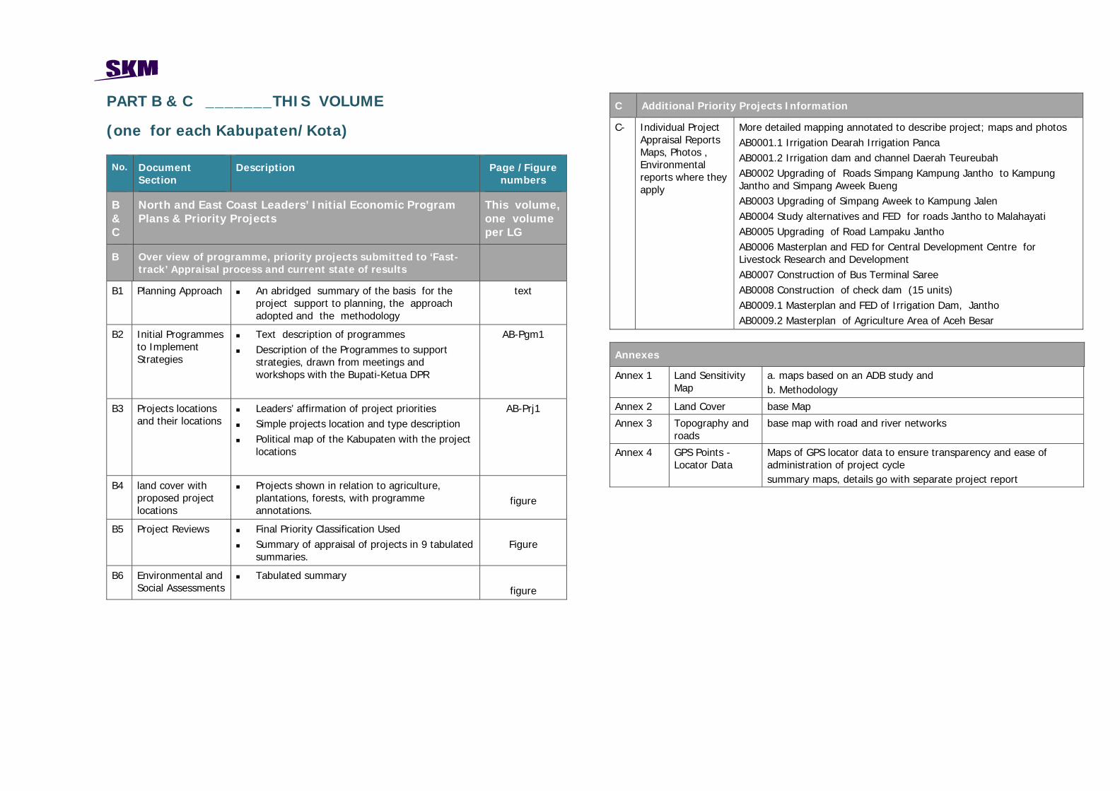
PART B & C _______THIS VOLUME
(one for each Kabupaten/Kota) No. Document
Section Description Page /Figure
numbers
B & C
North and East Coast Leaders’ Initial Economic Program Plans & Priority Projects
This volume, one volume per LG
B Over view of programme, priority projects submitted to ‘Fast-track’ Appraisal process and current state of results
B1 Planning Approach An abridged summary of the basis for the project support to planning, the approach adopted and the methodology
text
B2 Initial Programmes to Implement Strategies
Text description of programmes Description of the Programmes to support
strategies, drawn from meetings and workshops with the Bupati-Ketua DPR
AB-Pgm1
B3 Projects locations and their locations
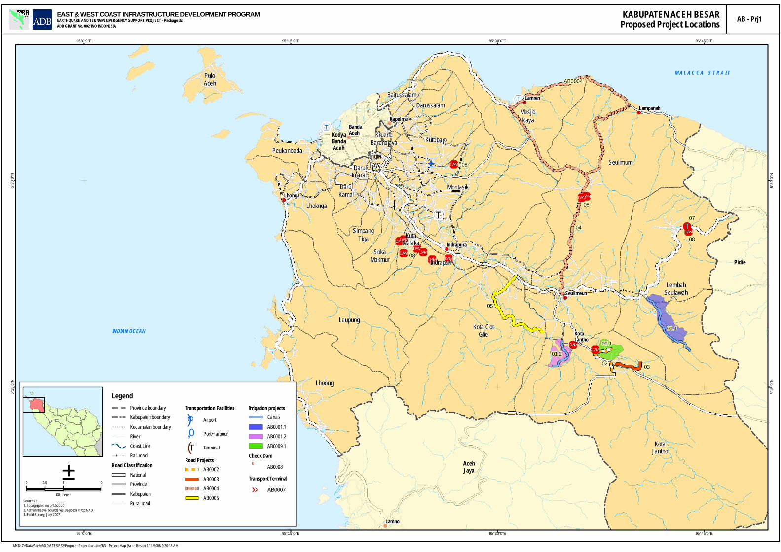
Leaders’ affirmation of project priorities Simple projects location and type description Political map of the Kabupaten with the project
locations
AB-Prj1
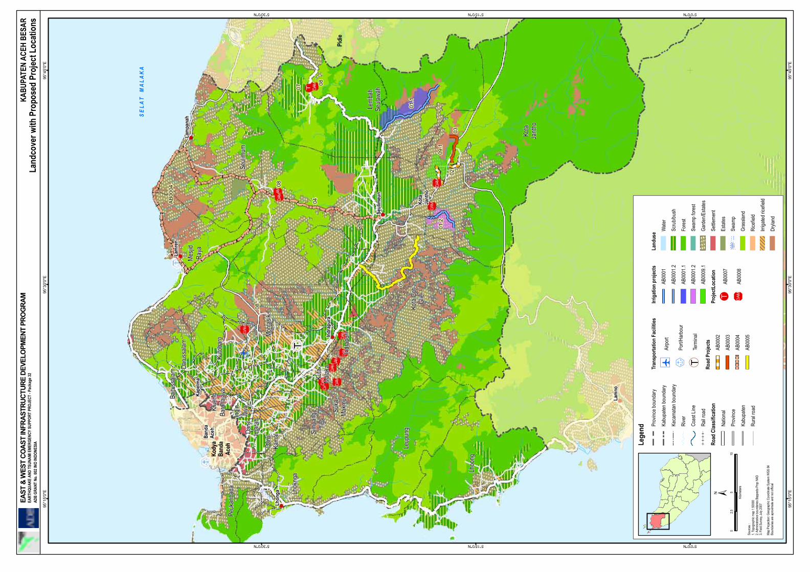
B4 land cover with proposed project locations
Projects shown in relation to agriculture, plantations, forests, with programme annotations.
figure
B5 Project Reviews Final Priority Classification Used Summary of appraisal of projects in 9 tabulated
summaries.
Figure
B6 Environmental and Social Assessments
Tabulated summary
figure
C Additional Priority Projects Information
C- Individual Project Appraisal Reports Maps, Photos , Environmental reports where they apply
More detailed mapping annotated to describe project; maps and photos AB0001.1 Irrigation Dearah Irrigation Panca AB0001.2 Irrigation dam and channel Daerah Teureubah AB0002 Upgrading of Roads Simpang Kampung Jantho to Kampung Jantho and Simpang Aweek Bueng AB0003 Upgrading of Simpang Aweek to Kampung Jalen AB0004 Study alternatives and FED for roads Jantho to Malahayati AB0005 Upgrading of Road Lampaku Jantho AB0006 Masterplan and FED for Central Development Centre for Livestock Research and Development AB0007 Construction of Bus Terminal Saree AB0008 Construction of check dam (15 units) AB0009.1 Masterplan and FED of Irrigation Dam, Jantho AB0009.2 Masterplan of Agriculture Area of Aceh Besar
Annexes
Annex 1 Land Sensitivity Map
a. maps based on an ADB study and b. Methodology
Annex 2 Land Cover base Map
Annex 3 Topography and roads
base map with road and river networks
Annex 4 GPS Points -Locator Data
Maps of GPS locator data to ensure transparency and ease of administration of project cycle summary maps, details go with separate project report
B.1 Planning Approach
B 1.1 Summary This report presents the individual strategies of the elected leaders of one of nine North and East Coast Local Governments. The strategies were originally expressed through comprehensive verbal discussions over several, often many hours. They were un-coached and unassisted expressions of insight and strategy from Leaders clearly intimately familiar with their area. They are strong, clear and evidently appropriate strategies that demonstrate the value of local determination within a more global outlook. It gives a very reassuring sense of the commitment and comprehensive insight of the Leaders. It is also reassuring that these insights address the issues highlighted by the Province’s Spatial planning processes expressed in the latest draft of RTRW and yet do so without prior reference to the RTRW.
B 1.2 Approach adopted The approach of the EWCIDP is to work in support of the counterpart members of governments at all levels, and their partners, in a dialogue, advising, and assisting manner, and not in a task mode, in terms of the planning process. To the extent local governments are motivated to participate in this in a leading and constructive manner, the approach strengthens both the appropriateness of outcomes and the capacity to build on and improve them as the process continues. The participants clearly ‘own the outcomes’. Just as important is the concept that that EWCIDP support counterparts in either their normal and required mode of work and or a mutually developed approach to improving the planning , budgeting and follow-on process. The strategy articulation, programming and appraisal processes that produced the results in these volumes A, B and C represent the latter case. Local Government elected leaders were approached. These were the Ketua DPRs and Deputy Ketua DPRs, the Bupati/Walikota and their elected Deputies. Leaders went on to hold coordination meetings with most or all Department heads to explain their support for the process below and chair a discussion for air strategies or programmes and often as far as determining what project level activities were the priority to move those programs forward in 2008.
B 1.3 Methodology Adopted The agreed methodology with Leaders has at least five key characteristics:
1. Strategy determines the direction of initiative. Programs are the means to apply those strategies and in the areas (geographic, sectors, institutions, partnerships) targeted by the strategies. Programmes are comprised of activities prioritised to most effectively deliver programme objectives within resources and time constraints. Projects are a subset of those activities and their priority is only determined from the programme
viewpoint. After that, constraints of resources, time and process determine in which order projects can be executed.
2. Strategies are the determining element of local government priorities, not the particular interests of an external provider of resources. Resources can be accessed in so far as they support strategies, although resource providers may also provide inspiration to improve strategies or to modify the programmatic method of delivering on those strategies.
3. Leaders should mange and direct the strategy and programming process, not be in a position of acquiescence. Leaders need therefore to become personally familiar with the key factors that pertain to strategy formation, be able to formulate, even if assisted and certainly able to express their strategies with the conviction that comes from real engagement and not formality.
4. Strategies should be seen form a geographic and social context in an holistic way, not merely from the viewpoint of one government’s, or even just a public sector stance.
5. Project formation outside of the strategy determines program, and program determines activity. Any changes from this logical structure should be strongly discouraged and subject to close scrutiny.
Although this was not formalised, it was explained to senior staff by elected and staff leaders as well as through the advisory support. It was followed and insisted upon. Bupati and Walikota only signed off on “Fast-track” project priorities that they attested met their requirements. These were countersigned by Heads of Bappeda and as far as practical within the time constraints set, signed also by the Ketua DPR.
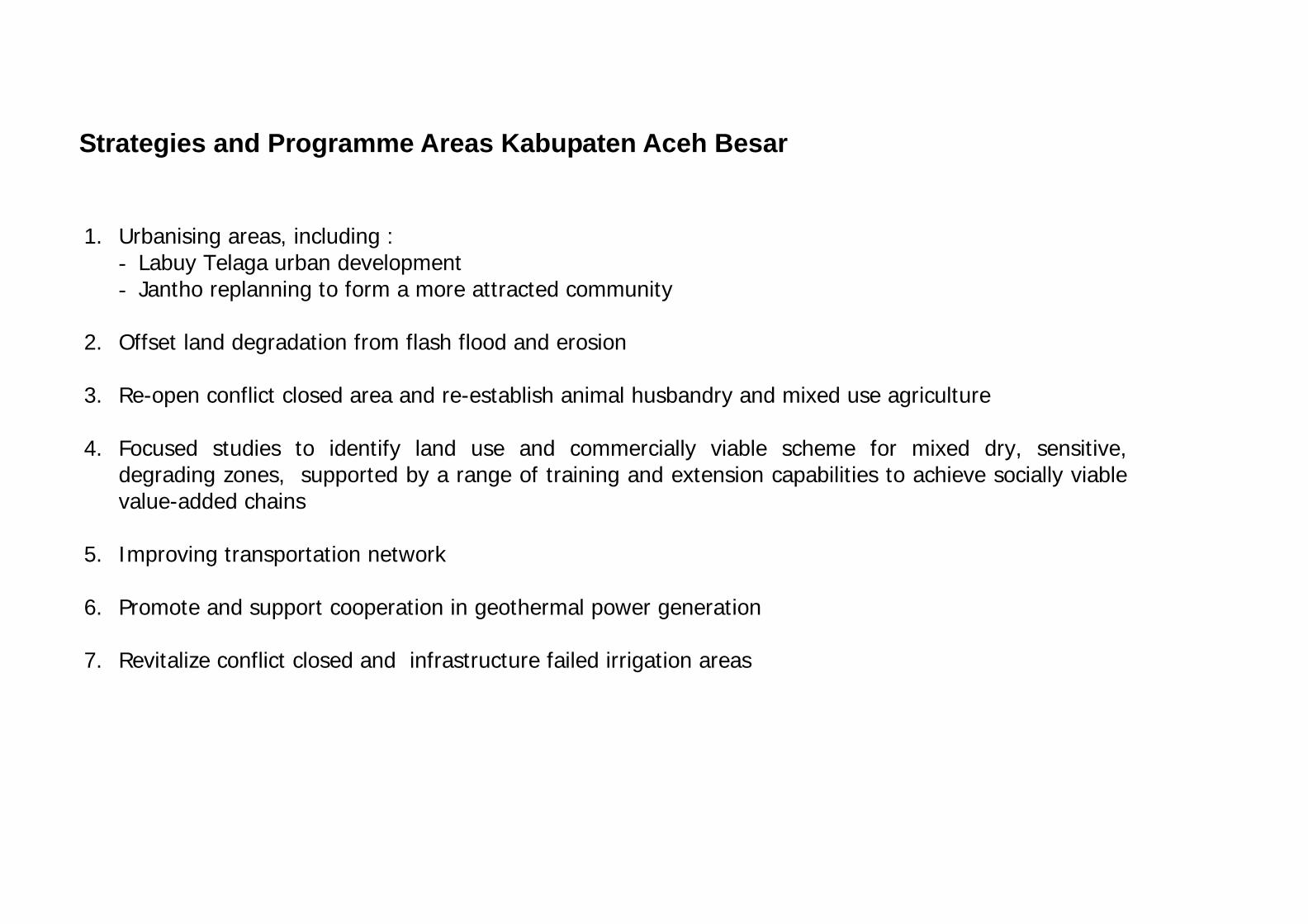
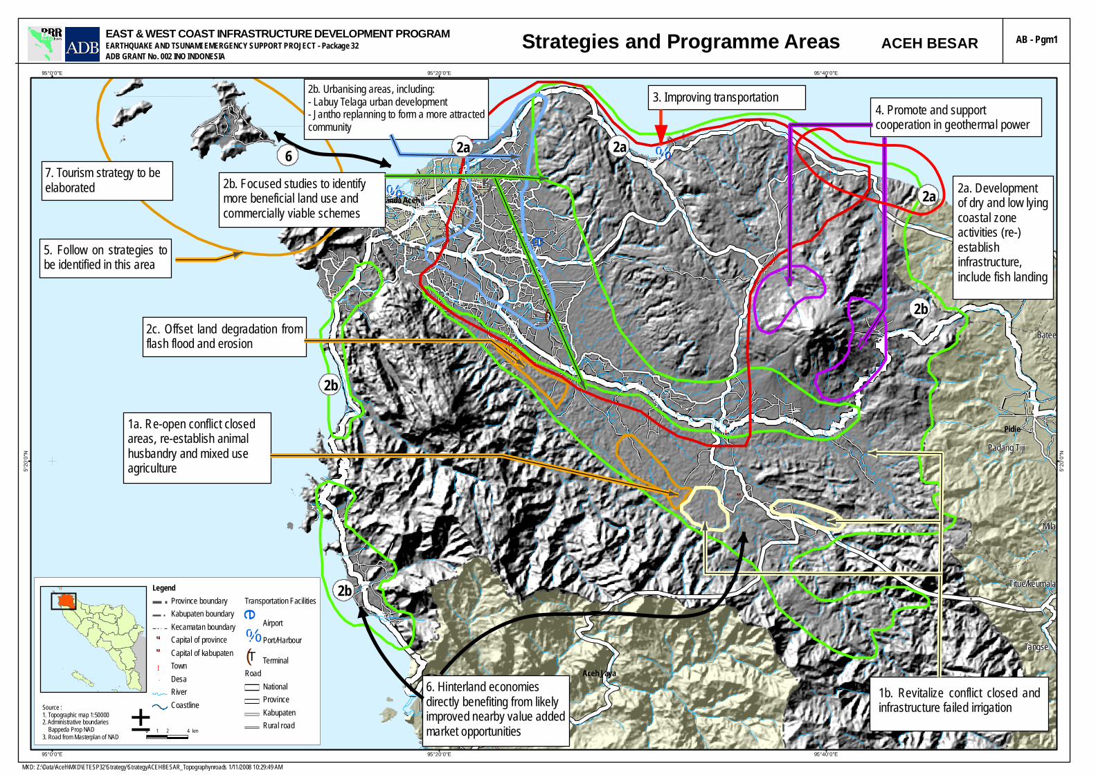
Strategies and Programme Areas Kabupaten Aceh Besar
1. Urbanising areas, including : - Labuy Telaga urban development - Jantho replanning to form a more attracted community
2. Offset land degradation from flash flood and erosion 3. Re-open conflict closed area and re-establish animal husbandry and mixed use agriculture 4. Focused studies to identify land use and commercially viable scheme for mixed dry, sensitive,
degrading zones, supported by a range of training and extension capabilities to achieve socially viable value-added chains
5. Improving transportation network 6. Promote and support cooperation in geothermal power generation 7. Revitalize conflict closed and infrastructure failed irrigation areas
!.
""
!.
!.
!.
!.
"""
!.
!.
!.
!.
%0
%0
e
(T
Padang Tiji
Muaratiga
Tangse
Titue/keumala
Mila
Batee
Pidie
Aceh Jaya
Kodya Banda AcehPidie
95°40'0"E
95°40'0"E
95°20'0"E
95°20'0"E
95°0'0"E
95°0'0"E
5°20'0
"N
5°20'0
"N
EAST & WEST COAST INFRASTRUCTURE DEVELOPMENT PROGRAMEARTHQUAKE AND TSUNAMI EMERGENCY SUPPORT PROJECT - Package 32ADB GRANT No. 002 INO INDONESIA
± 0 2 41 km
Source :1. Topographic map 1:500002. Administrative boundaries Bappeda Prop NAD3. Road from Masterplan of NAD
Legend Province boundaryKabupaten boundaryKecamatan boundary
""" Capital of province"" Capital of kabupaten!. Town"" Desa
RiverCoastline
Transportation Facilitiese
Airport%0 Port/Harbour(T TerminalRoad
NationalProvinceKabupatenRural road
ACEH BESARStrategies and Programme Areas
5. Follow on strategies tobe identified in this area
2b. Urbanising areas, including:- Labuy Telaga urban development- Jantho replanning to form a more attractedcommunity
2c. Offset land degradation fromflash flood and erosion
1a. Re-open conflict closedareas, re-establish animalhusbandry and mixed useagriculture
2b. Focused studies to identifymore beneficial land use andcommercially viable schemes
3. Improving transportation4. Promote and supportcooperation in geothermal power
1b. Revitalize conflict closed andinfrastructure failed irrigation
2a
2b
2a2a6
2b
6. Hinterland economiesdirectly benefiting from likelyimproved nearby value addedmarket opportunities
2b
7. Tourism strategy to beelaborated
MXD: Z:\Data\Aceh\MXD\ETESP32\Strategy\StrategyACEHBESAR_Topographynroads 1/11/2008 10:29:49 AM
AB - Pgm1
2a. Developmentof dry and low lyingcoastal zoneactivities (re-)establishinfrastructure,include fish landing


01.1
05
01.209.1
0302
08
07
08
08
08
04
AB0004
KodyaBandaAceh
Pidie
AcehJaya
Leupung
Kutobaro
Darussalam
PuloAceh
MesjidRaya
Baitussalam
SeulimumPeukanbada
Montasik
KruengBaronajayaInginJaya
Indrapuri
Lhoknga
DarulImarah
SukaMakmur
DarulKamal
SimpangTiga
LembahSeulawah
Kota CotGlie
KutaMalaka
Lhoong
KotaJantho
Lamno
Lamren
BandaAcehKapelma
Lampanah
Seulimeun
Indrapura
KotaJantho
Lhonga
95°45'0"E
95°45'0"E
95°30'0"E
95°30'0"E
95°15'0"E
95°15'0"E
95°0'0"E
95°0'0"E
5°30'0
"N
5°30'0
"N
5°15'0
"N
5°15'0
"N
KABUPATEN ACEH BESARProposed Project LocationsEAST & WEST COAST INFRASTRUCTURE DEVELOPMENT PROGRAMEARTHQUAKE AND TSUNAMI EMERGENCY SUPPORT PROJECT - Package 32ADB GRANT No. 002 INO INDONESIA
LegendProvince boundaryKabupaten boundaryKecamatan boundaryRiverCoast LineRail road
Road ClassificationNationalProvinceKabupatenRural road
Transportation Facilities)
e
Airport
,0 Port/Harbour
(T TerminalRoad Projects
AB0002AB0003AB0004AB0005
Irrigation projectsCanalsAB0001.1AB0001.2AB0009.1
Check Dam''DAM AB0008
Transport Terminal»T AB0007
Sources :1. Topographic map 1:500002. Administrative boundaries Bappeda Prop NAD3. Field Survey, July 2007
0 5 102.5
Kilometers
±
M A L A C C A S T R A I T
AB - Prj1
MXD: Z:\Data\Aceh\MXD\ETESP32\ProposedProjectLocation\B3 - Project Map (Aceh Besar) 1/14/2008 9:20:13 AM
INDIAN OCEAN
AB
0004
04
01.1
05
01.2
09.1
0302
08
07
08
08
08
Kody
aBa
nda
Aceh
Pidi
e
Aceh
Jaya
Leup
ung
Kutob
aro
Daru
ssala
mMe
sjid
Raya
Baitu
ssala
m
Seuli
mum
Peuk
anba
da
Monta
sik
Krue
ngBa
rona
jaya
Ingin
Jaya
Indra
puri
Lhok
nga
Daru
lIm
arah
Suka
Makm
ur
Daru
lKa
mal Si
mpan
gTig
a
Lemb
ahSe
ulawa
h
Kota
Cot
Glie
Kuta
Malak
a
Lhoo
ng
Kota
Janth
o
Lam
no Cuem
anpr
ong
Lam
ren
Band
aAc
eh
Kape
lma
Lam
pana
h
Seul
imeu
n
Indr
apur
a
Kota
Jant
ho
Lhon
ga
95°4
5'0"
E
95°4
5'0"
E
95°3
0'0"
E
95°3
0'0"
E
95°1
5'0"
E
95°1
5'0"
E
5°30'0"N
5°30'0"N
5°15'0"N
5°15'0"N
5°0'0"N
5°0'0"N
KABU
PATE
N AC
EH B
ESAR
Land
cove
r with
Pro
pose
d Pr
ojec
t Loc
atio
nsEA
ST &
WES
T CO
AST
INFR
ASTR
UCTU
RE D
EVEL
OPM
ENT
PRO
GRA
MEA
RTHQ
UAKE
AND
TSU
NAMI
EME
RGEN
CY S
UPPO
RT P
ROJE
CT -
Pack
age 3
2AD
B GR
ANT
No. 0
02 IN
O IN
DONE
SIA Le
gend Pr
ovinc
e bou
ndar
y
Kabu
paten
boun
dary
Keca
matan
boun
dary
Rive
r
Coas
t Line
Rail r
oad
Road
Clas
sifica
tion
Natio
nal
Prov
ince
Kabu
paten
Rura
l road
Tran
spor
tatio
n Fa
ciliti
es
)e
Airp
ort
,0Po
rt/Ha
rbou
r
(TTe
rmina
l
Road
Pro
jects
AB00
02
AB00
03
AB00
04
AB00
05
Irrig
atio
n pr
ojec
ts
AB00
01
AB00
01.2
AB00
01.1
AB00
01.2
AB00
09.1
Proj
ectL
ocat
ion
»TAB
0007
' 'DAM
AB00
08
Land
use W
ater
Scru
b/bus
h
Fore
st
Swam
p fo
rest
Gard
en/E
states
Settle
men
t
Esta
tes
Swam
p
Gras
sland
Rice
field
Irriga
ted r
icefie
ld
Dryla
nd
Sour
ces :
1. To
pogr
aphic
map
1:50
000
2. Ad
minis
trativ
e bou
ndar
ies B
appe
da P
rop
NAD
3. Fi
eld S
urve
y, Ju
ly 20
07
05
102.5
Kilom
eters
Map P
rojec
tion:
Geog
raph
ic Co
ordin
ate S
ystem
WGS
84Bo
unda
ries a
re ap
roxim
ate an
d no
t offic
ial
±
S E
L A T
M
A L A
K A
!.
""
!.
!.
!.
!.
"""
!.
!.
!.
!.
!.
%,0
")0$+0
®q
nB
Kabupaten proposal for roads feasilibility studies
Recent JICA ring road studyPlanned cement plant
Labuy Urban Development Plan proposal
Lamno
Lamren
Lhonga
KapelmaLampanah
Seulimeun
Indrapura
Banda Aceh
Kota Jantho
95°45'0"E
95°45'0"E
95°30'0"E
95°30'0"E
95°15'0"E
95°15'0"E
95°0'0"E
95°0'0"E
5°30'0
"N
5°30'0
"N
5°15'0
"N
5°15'0
"N
ACEH BESAR KABUPATENEAST & WEST COAST INFRASTRUCTURE DEVELOPMENT PROGRAMEARTHQUAKE AND TSUNAMI EMERGENCY SUPPORT PROJECT - Package 32ADB GRANT No. 002 INO INDONESIA
M A L A C C A S T R A I T
±0 2 4 61 km
Source :1. Topographic map 1:500002. Administrative boundaries Bappeda Prop NAD3. Sensitivity Map ADB 20064. Road from masterplan of NAD
LegendProvince boundaryKabupaten boundaryKecamatan boundaryRiverCoastline
""" Capital of province"" Capital of kabupaten!. Town
Transportation Facilities")0 International port
#*0 National port
$+0 Local port
%,0 Fery port
RoadNationalProvinceKabupatenRailway
Environmental Sensitivity01234
Recent JICA studyPrimary arteriMain localMain collector
MXD: Z:\Data\Aceh\MXD\ETESP32\Strategy\ACEHBESAR_PROPOSED EXTENSION ROADS.mxd 12/21/2007 3:18:23 AM
H I N D I A O C E A N
PROPOSED EXTENSION OF ROAD FEASIBILITY STUDYTO TRANSPORTATION NETWORK STUDY RELATIVE ENVIRONMENTAL SENSITIVITY
2) Studies that will substantially improve local government or community information base for self determination in sustainable and equitable development initiatives
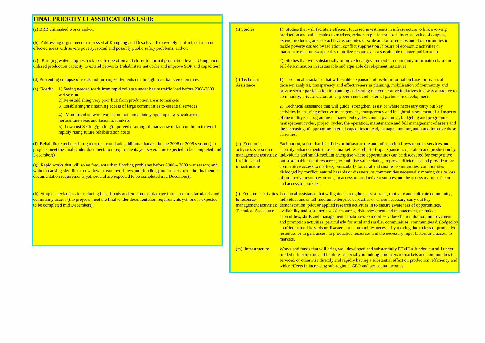
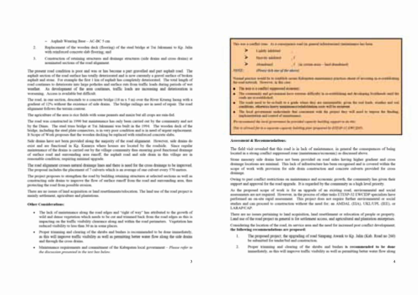
(e) Roads: 1) Saving needed roads from rapid collapse under heavy traffic load before 2008-2009 wet season.2) Re-establishing very poor link from production areas to markets3) Establishing/maintaining access of large communities to essential services
4) Minor road network extension that immediately open up new sawah areas, horticulture areas and kebun to markets5) Low cost Sealing/grading/improved draining of roads now in fair condition to avoid rapidly rising future rehabilitation costs
(l) Economic activities & resource management activities: Technical Assistance
Technical assistance that will guide, strengthen, assist train , motivate and cultivate community, individual and small-medium enterprise capacities or where necessary carry out key demonstration, pilot or applied research activities in to ensure awareness of opportunities, availability and sustained use of resources, risk assessment and management, technical capabilities, skills and management capabilities to mobilise value chain initiation, improvement and promotion activities, particularly for rural and smaller communities, communities dislodged by conflict, natural hazards or disasters, or communities necessarily moving due to loss of productive resources or to gain access to productive resources and the necessary input factors and access to markets.
(m) Infrastructure Works and funds that will bring well developed and substantially PEMDA funded but still under funded infrastructure and facilities especially in linking producers to markets and communities to services, or otherwise directly and rapidly having a substantial effect on production, efficiency and wider effects in increasing sub-regional GDP and per capita incomes.
2) Technical assistance that will guide, strengthen, assist or where necessary carry out key activities in ensuring effective management , transparency and insightful assessment of all aspects of the multiyear programme management cycles, annual planning , budgeting and programme management cycles, project cycles, the operation, maintenance and full management of assets and the increasing of appropriate internal capacities to lead, manage, monitor, audit and improve these activities.
(j) Technical Assistance
Facilitation, soft or hard facilities or infrastructure and information flows or other services and capacity enhancements to assist market research, start-up, expansion, operation and production by individuals and small-medium enterprise where opportunities can be discovered for competitive but sustainable use of resources, to mobilise value chains, improve efficiencies and provide more competitive access to markets, particularly for rural and smaller communities, communities dislodged by conflict, natural hazards or disasters, or communities necessarily moving due to loss of productive resources or to gain access to productive resources and the necessary input factors and access to markets.
(k) Economic activities & resource management activities: Facilities and infrastructure
1) Technical assistance that will enable expansion of useful information base for practical decision analysis, transparency and effectiveness in planning, mobilisation of community and private sector participation in planning and setting out cooperative initiatives in a way attractive to community, private sector, other government and external partners in development.
FINAL PRIORITY CLASSIFICATIONS USED:
1) Studies that will facilitate efficient focussed investments in infrastructure to link evolving production and value chains to markets, reduce in put factor costs, increase value of outputs, extend producing areas to achieve economies of scale and/or offer substantial opportunities to tackle poverty caused by isolation, conflict suppression /closure of economic activities or inadequate resources/capacities to utilize resources in a sustainable manner and broaden
(i) Studies(a) BRR unfinished works and/or:
(b) Addressing urgent needs expressed at Kampung and Desa level for severely conflict, or tsunami effected areas with severe poverty, social and possibly public safety problems; and/or:
(c) Bringing water supplies back to safe operation and closer to normal production levels. Using under utilized production capacity to extend networks (rehabilitate networks and improve SOP and capacities)
(d) Preventing collapse of roads and (urban) settlements due to high river bank erosion rates
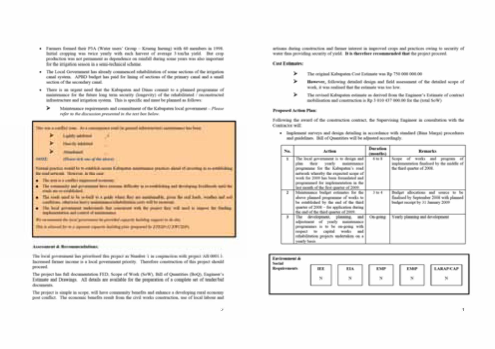
(f) Rehabilitate technical irrigation that could add additional harvest in late 2008 or 2009 season ((no projects meet the final tender documentation requirements yet, several are expected to be completed mid December)).
(g) Rapid works that will solve frequent urban flooding problems before 2008 – 2009 wet season; and without causing significant new downstream overflows and flooding ((no projects meet the final tender documentation requirements yet, several are expected to be completed mid December)).
(h) Simple check dams for reducing flash floods and erosion that damage infrastructure, farmlands and community access ((no projects meet the final tender documentation requirements yet, one is expected to be completed mid December)).
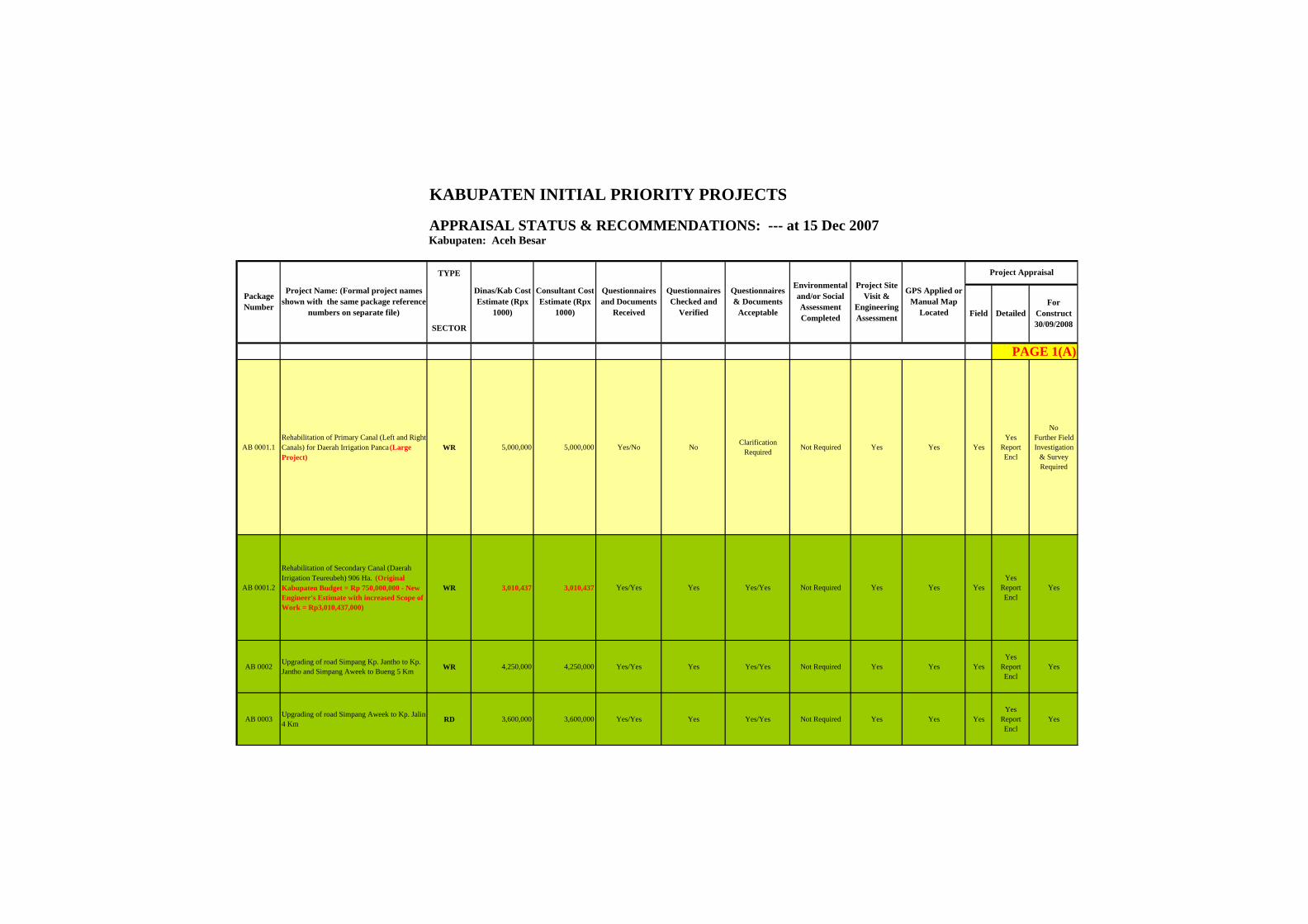
KABUPATEN INITIAL PRIORITY PROJECTS
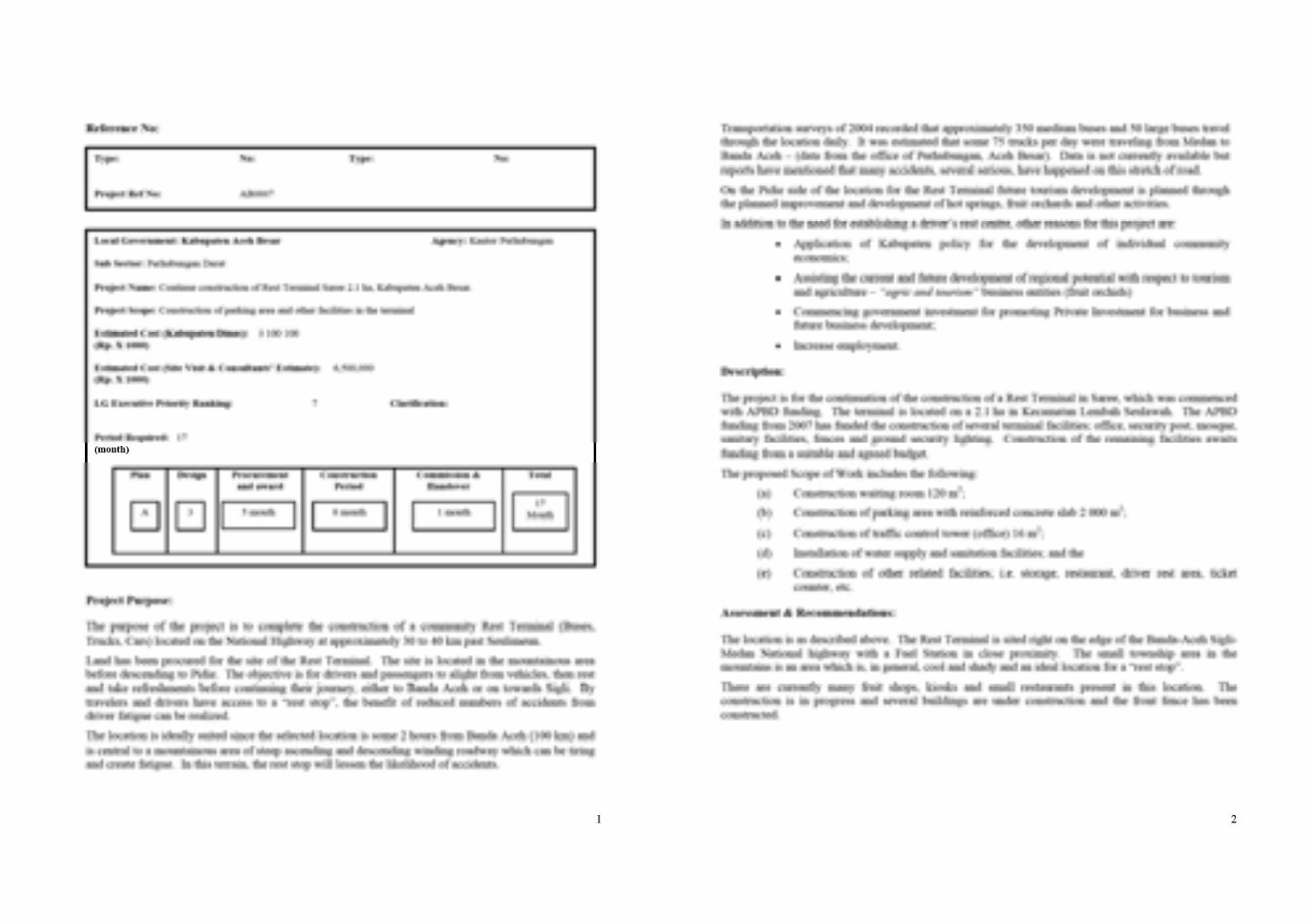
APPRAISAL STATUS & RECOMMENDATIONS: --- at 15 Dec 2007Kabupaten: Aceh Besar
TYPE
SECTOR
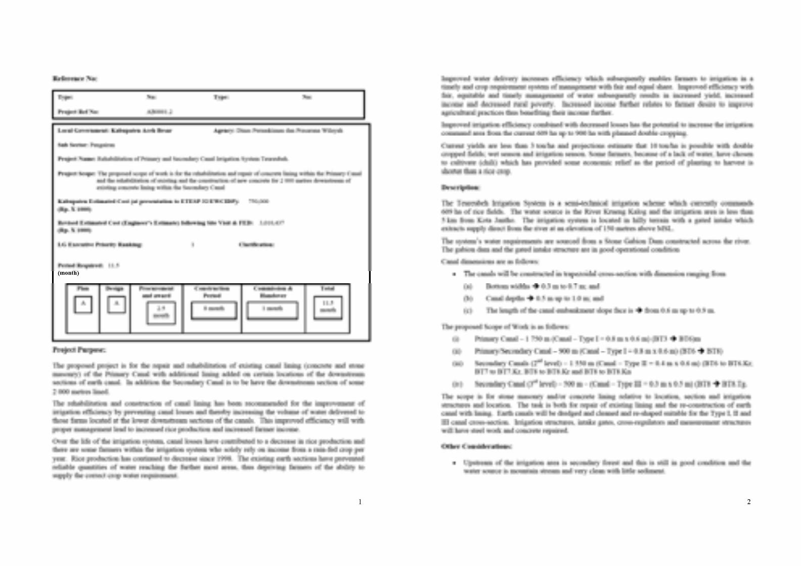
AB 0001.1Rehabilitation of Primary Canal (Left and Right Canals) for Daerah Irrigation Panca (Large Project)
WR 5,000,000 5,000,000 Yes/No No Clarification Required Not Required Yes Yes Yes
Yes Report Encl
No Further Field Investigation
& Survey Required
AB 0001.2
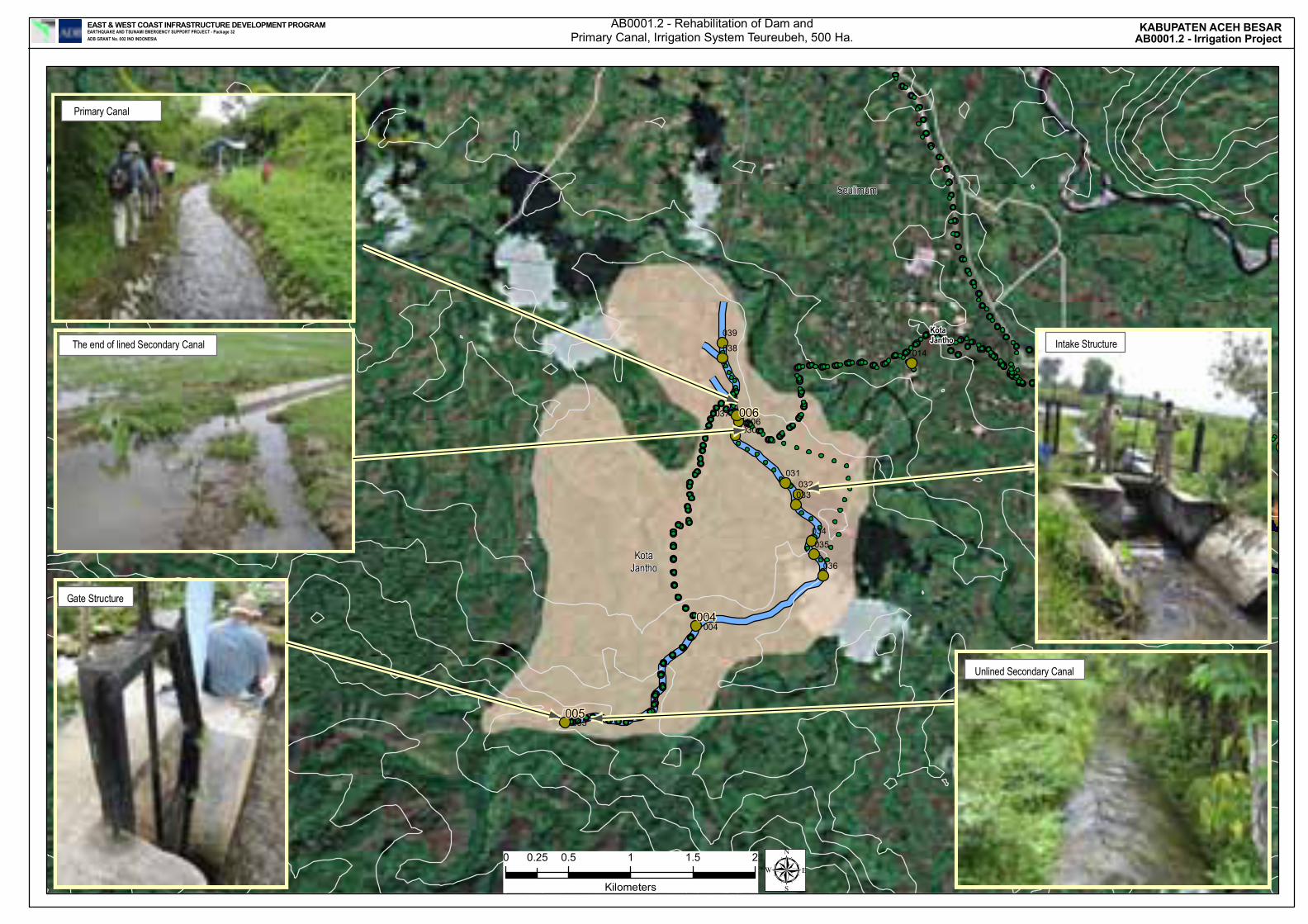
Rehabilitation of Secondary Canal (Daerah Irrigation Teureubeh) 906 Ha. (Original Kabupaten Budget = Rp 750,000,000 - New Engineer's Estimate with increased Scope of Work = Rp3,010,437,000)
WR 3,010,437 3,010,437 Yes/Yes Yes Yes/Yes Not Required Yes Yes YesYes
Report Encl
Yes
AB 0002 Upgrading of road Simpang Kp. Jantho to Kp. Jantho and Simpang Aweek to Bueng 5 Km WR 4,250,000 4,250,000 Yes/Yes Yes Yes/Yes Not Required Yes Yes Yes
Yes Report Encl
Yes
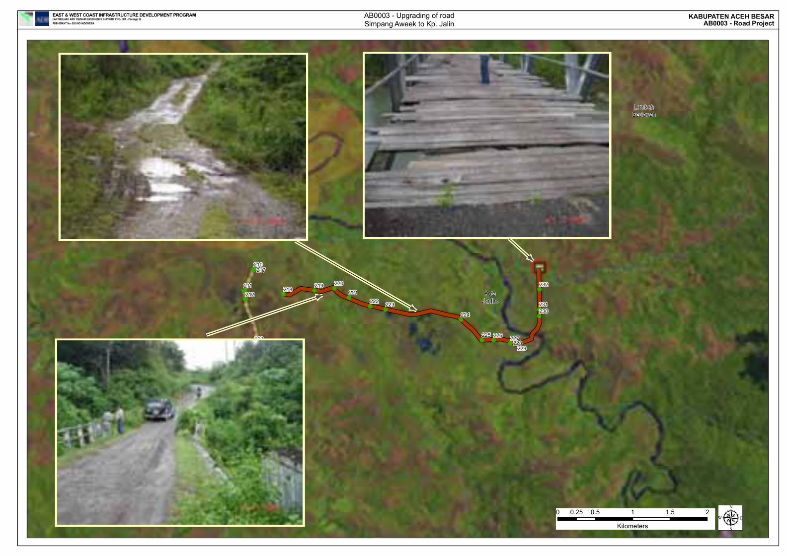
AB 0003 Upgrading of road Simpang Aweek to Kp. Jalin 4 Km RD 3,600,000 3,600,000 Yes/Yes Yes Yes/Yes Not Required Yes Yes Yes
Yes Report Encl
Yes
GPS Applied or Manual Map
Located
Project Site Visit &
Engineering Assessment Detailed
For Construct 30/09/2008
PAGE 1(A)
Project Appraisal
Field
Questionnaires and Documents
Received
Questionnaires Checked and
Verified
Questionnaires & Documents
Acceptable
Environmental and/or Social Assessment Completed
Package Number
Project Name: (Formal project names shown with the same package reference
numbers on separate file)
Dinas/Kab Cost Estimate (Rpx
1000)
Consultant Cost Estimate (Rpx
1000)
AB 0001.1Rehabilitation of Primary Canal (Left and Right Canals) for Daerah Irrigation Panca (Large Project)
AB 0001.2
Rehabilitation of Secondary Canal (Daerah Irrigation Teureubeh) 906 Ha. (Original Kabupaten Budget = Rp 750,000,000 - New Engineer's Estimate with increased Scope of Work = Rp3,010,437,000)
AB 0002 Upgrading of road Simpang Kp. Jantho to Kp. Jantho and Simpang Aweek to Bueng 5 Km
AB 0003 Upgrading of road Simpang Aweek to Kp. Jalin 4 Km
Package Number
Project Name: (Formal project names shown with the same package reference
numbers on separate file)
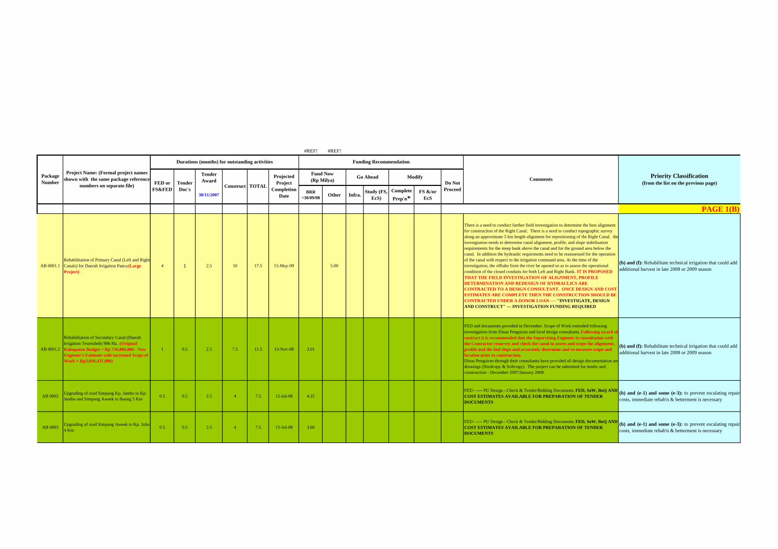
#REF! #REF!
Tender Award
30/11/2007 BRR <30/09/08 Other Infra. Study (FS,
EcS)Complete Prep'n*
FS &/or EcS
PAGE 1(B)
4 1 2.5 10 17.5 15-May-09 5.00
There is a need to conduct further field investigation to determine the best alignment for construciton of the Right Canal. There is a need to conduct topographic survey along an approximate 5 km length alignment for repositioning of the Right Canal. the investgiation needs to determine canal alignment, profile, and slope stabilisation requirements for the steep bank above the canal and for the ground area below the canal. In addition the hydraulic requirments need to be reasssessed for the operation of the canal with respect to the irrigation command area. At the time of the investigation, the offtake from the river be opened so as to assess the operational condition of the closed conduits for both Left and Right Bank. IT IS PROPOSED THAT THE FIELD INVESTIGATION OF ALIGNMENT, PROFILE DETERMINATION AND REDESIGN OF HYDRAULICS ARE CONTRACTED TO A DESIGN CONSULTANT. ONCE DESIGN AND COST ESTIMATES ARE COMPLETE THEN THE CONSTRUCTION SHOULD BE CONTRACTED UNDER A DONOR LOAN ---- "INVESTIGATE, DESIGN AND CONSTRUCT" --- INVESTIGATION FUNDING REQUIRED
(b) and (f): Rehabilitate technical irrigation that could add additional harvest in late 2008 or 2009 season
1 0.5 2.5 7.5 11.5 13-Nov-08 3.01
FED and documents provided in December. Scope of Work extended following investigation from Dinas Pengairan and local design consultants. Following award of contract it is recommended that the Supervising Engineer in consultation with the Contractor resurvey and check the canal to assess and scope the alignment, profile and the bed slope and accurately determine and re-measure scope and location prior to construction. Dinas Pengairan through their consultants have provided all design documentation anddrawings (Hardcopy & Softcopy). The project can be submitted for tender and construction - December 2007/January 2008.
(b) and (f): Rehabilitate technical irrigation that could add additional harvest in late 2008 or 2009 season
0.5 0.5 2.5 4 7.5 15-Jul-08 4.25FED - ---- PU Design - Check & Tender/Bidding Documents. FED, SoW, BoQ AND COST ESTIMATES AVAILABLE FOR PREPARATION OF TENDER DOCUMENTS
(b) and (e-1) and some (e-3): to prevent escalating repaircosts, immediate rehab'n & betterment is necessary
0.5 0.5 2.5 4 7.5 15-Jul-08 3.60FED - ---- PU Design - Check & Tender/Bidding Documents. FED, SoW, BoQ AND COST ESTIMATES AVAILABLE FOR PREPARATION OF TENDER DOCUMENTS
(b) and (e-1) and some (e-3): to prevent escalating repaircosts, immediate rehab'n & betterment is necessary
TOTALComments
Fund Now (Rp Milya) Go Ahead Modify
Funding Recommendation
Construct
Projected Project
Completion Date
Durations (months) for outstanding activities
Priority Classification (from the list on the previous page)FED or
FS&FED Tender Doc's
Do Not Proceed
AB 0001.1Rehabilitation of Primary Canal (Left and Right Canals) for Daerah Irrigation Panca (Large Project)
AB 0001.2
Rehabilitation of Secondary Canal (Daerah Irrigation Teureubeh) 906 Ha. (Original Kabupaten Budget = Rp 750,000,000 - New Engineer's Estimate with increased Scope of Work = Rp3,010,437,000)
AB 0002 Upgrading of road Simpang Kp. Jantho to Kp. Jantho and Simpang Aweek to Bueng 5 Km
AB 0003 Upgrading of road Simpang Aweek to Kp. Jalin 4 Km
Package Number
Project Name: (Formal project names shown with the same package reference
numbers on separate file)
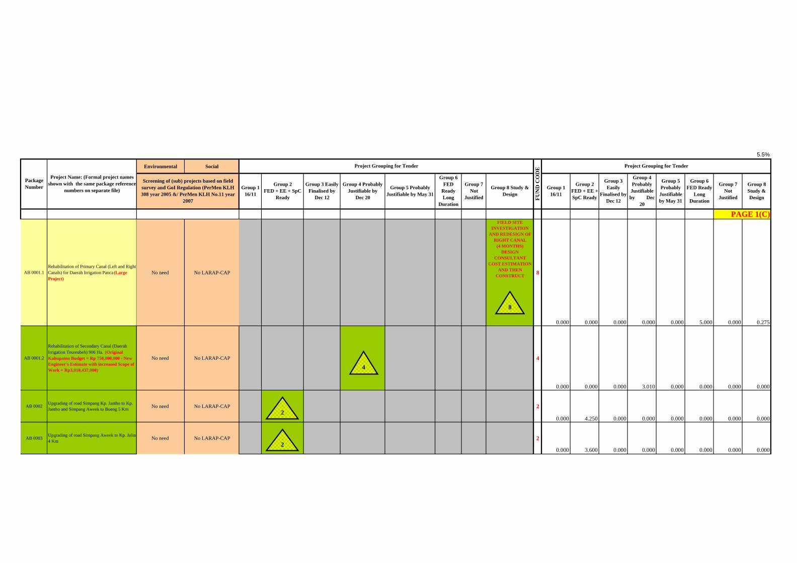
5.5%
Environmental Social
No need No LARAP-CAP
FIELD SITE INVESTIGATION
AND REDESIGN OF RIGHT CANAL
(4 MONTHS) DESIGN
CONSULTANT COST ESTIMATION
AND THEN CONSTRUCT 8
0.000 0.000 0.000 0.000 0.000 5.000 0.000 0.275
No need No LARAP-CAP 4
0.000 0.000 0.000 3.010 0.000 0.000 0.000 0.000
No need No LARAP-CAP : 2
0.000 4.250 0.000 0.000 0.000 0.000 0.000 0.000
No need No LARAP-CAP : 2
0.000 3.600 0.000 0.000 0.000 0.000 0.000 0.000
Group 7 Not
Justified
Group 3 Easily Finalised by
Dec 12
Project Grouping for Tender
Group 5 Probably Justifiable by May 31
Group 6 FED
Ready Long
Duration
PAGE 1(C)
Group 2 FED + EE + SpC
Ready
Group 1 16/11
Group 8 Study & Design
Group 3 Easily
Finalised by Dec 12
Group 4 Probably Justifiable by
Dec 20
Screening of (sub) projects based on field survey and GoI Regulation (PerMen KLH 308 year 2005 &/ PerMen KLH No.11 year
2007
Project Grouping for Tender
Group 1 16/11
Group 8 Study & Design
Group 6 FED Ready
Long DurationFU
ND
CO
DE
Group 2 FED + EE + SpC Ready
Group 4 Probably Justifiable by Dec
20
Group 7 Not
Justified
Group 5 Probably Justifiable by May 31
2
2
4
8
TYPE
SECTOR
GPS Applied or Manual Map
Located
Project Site Visit &
Engineering Assessment Detailed
For Construct 30/09/2008
Project Appraisal
Field
Questionnaires and Documents
Received
Questionnaires Checked and
Verified
Questionnaires & Documents
Acceptable
Environmental and/or Social Assessment Completed
Package Number
Project Name: (Formal project names shown with the same package reference
numbers on separate file)
Dinas/Kab Cost Estimate (Rpx
1000)
Consultant Cost Estimate (Rpx
1000)
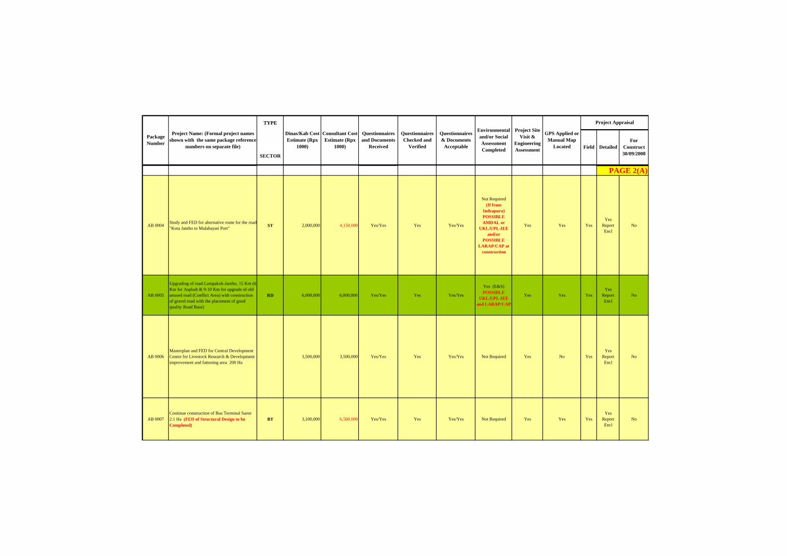
AB 0004 Study and FED for alternative route for the road "Kota Jantho to Malahayati Port" ST 2,000,000 4,150,000 Yes/Yes Yes Yes/Yes
Not Required (If from
Indrapura) POSSIBLE AMDAL or
UKL/UPL-IEE and/or
POSSIBLE LARAP/CAP at
construction
Yes Yes YesYes
Report Encl
No
AB 0005
Upgrading of road Lampakuk-Jantho, 15 Km (6 Km for Asphalt & 9-10 Km for upgrade of old unused road (Conflict Area) with construction of gravel road with the placement of good quality Road Base)
RD 6,000,000 6,000,000 Yes/Yes Yes Yes/Yes
Yes (E&S) POSSIBLE
UKL/UPL-IEE and LARAP/CAP
Yes Yes YesYes
Report Encl
No
AB 0006Masterplan and FED for Central Development Centre for Livestock Research & Development -improvement and fattening area 200 Ha
3,500,000 3,500,000 Yes/Yes Yes Yes/Yes Not Required Yes No YesYes
Report Encl
No
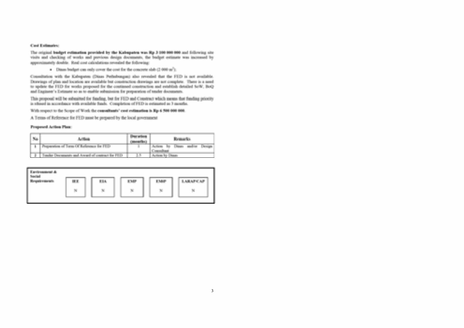
AB 0007Continue construction of Bus Terminal Saree 2.1 Ha (FED of Structural Design to be Completed)
BT 3,100,000 6,500,000 Yes/Yes Yes Yes/Yes Not Required Yes Yes YesYes
Report Encl
No
PAGE 2(A)
Package Number
Project Name: (Formal project names shown with the same package reference
numbers on separate file)
AB 0004 Study and FED for alternative route for the road "Kota Jantho to Malahayati Port"
AB 0005
Upgrading of road Lampakuk-Jantho, 15 Km (6 Km for Asphalt & 9-10 Km for upgrade of old unused road (Conflict Area) with construction of gravel road with the placement of good quality Road Base)
AB 0006Masterplan and FED for Central Development Centre for Livestock Research & Development -improvement and fattening area 200 Ha
AB 0007Continue construction of Bus Terminal Saree 2.1 Ha (FED of Structural Design to be Completed)
Tender Award
30/11/2007 BRR <30/09/08 Other Infra. Study (FS,
EcS)Complete Prep'n*
FS &/or EcS
TOTALComments
Fund Now (Rp Milya) Go Ahead Modify
Funding Recommendation
Construct
Projected Project
Completion Date
Durations (months) for outstanding activities
Priority Classification (from the list on the previous page)FED or
FS&FED Tender Doc's
Do Not Proceed
PAGE 2(B)
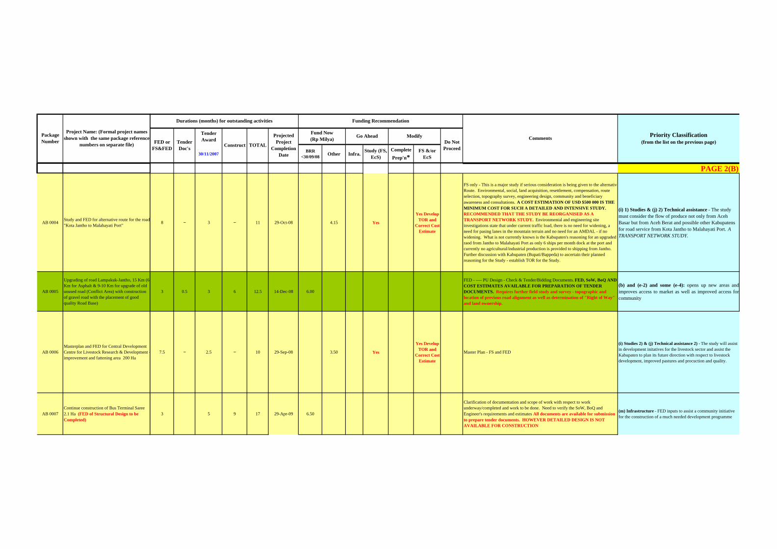
8 − 3 − 11 29-Oct-08 4.15 Yes
Yes Develop TOR and
Correct Cost Estimate
FS only - This is a major study if serious consideration is being given to the alternativeRoute. Environmental, social, land acquisition, resettlement, compensation, route selection, topography survey, engineering design, community and beneficiary awareness and consultations. A COST ESTIMATION OF USD $500 000 IS THE MINIMUM COST FOR SUCH A DETAILED AND INTENSIVE STUDY. RECOMMENDED THAT THE STUDY BE REORGANISED AS A TRANSPORT NETWORK STUDY. Environmental and engineering site investigations state that under current traffic load, there is no need for widening, a need for pasing lanes in the mountain terrain and no need for an AMDAL - if no widening. What is not currently known is the Kabupaten's reasoning for an upgraded raod from Jantho to Malahayati Port as only 6 ships per month dock at the port and currently no agricultural/industrial production is provided to shipping from Jantho. Further discussion with Kabupaten (Bupati/Bappeda) to ascertain their planned reasoning for the Study - establish TOR for the Study.
(i) 1) Studies & (j) 2) Technical assistance - The study must consider the flow of produce not only from Aceh Basar but from Aceh Berat and possible other Kabupatens for road service from Kota Jantho to Malahayati Port. A TRANSPORT NETWORK STUDY.
3 0.5 3 6 12.5 14-Dec-08 6.00
FED - ---- PU Design - Check & Tender/Bidding Documents. FED, SoW, BoQ AND COST ESTIMATES AVAILABLE FOR PREPARATION OF TENDER DOCUMENTS. Requires further field study and survey - topographic and location of previous road alignment as well as determination of "Right of Way" and land ownership.
(b) and (e-2) and some (e-4): opens up new areas andimproves access to market as well as improved access forcommunity
7.5 − 2.5 − 10 29-Sep-08 3.50 Yes
Yes Develop TOR and
Correct Cost Estimate
Master Plan - FS and FED
(i) Studies 2) & (j) Technical assistance 2) - The study will assist in development initatives for the livestock sector and assist the Kabupaten to plan its future direction with respect to livestock development, improved pastures and procuction and quality.
3 5 9 17 29-Apr-09 6.50
Clarification of documentation and scope of work with respect to work underway/completed and work to be done. Need to verify the SoW, BoQ and Engineer's requirements and estimates All documents are available for submission to prepare tender documents. HOWEVER DETAILED DESIGN IS NOT AVAILABLE FOR CONSTRUCTION
(m) Infrastructure - FED inputs to assist a community initiative for the construction of a much needed development programme
Package Number
Project Name: (Formal project names shown with the same package reference
numbers on separate file)
AB 0004 Study and FED for alternative route for the road "Kota Jantho to Malahayati Port"
AB 0005
Upgrading of road Lampakuk-Jantho, 15 Km (6 Km for Asphalt & 9-10 Km for upgrade of old unused road (Conflict Area) with construction of gravel road with the placement of good quality Road Base)
AB 0006Masterplan and FED for Central Development Centre for Livestock Research & Development -improvement and fattening area 200 Ha
AB 0007Continue construction of Bus Terminal Saree 2.1 Ha (FED of Structural Design to be Completed)
Environmental Social
Group 7 Not
Justified
Group 3 Easily Finalised by
Dec 12
Project Grouping for Tender
Group 5 Probably Justifiable by May 31
Group 6 FED
Ready Long
Duration
Group 2 FED + EE + SpC
Ready
Group 1 16/11
Group 8 Study & Design
Group 3 Easily
Finalised by Dec 12
Group 4 Probably Justifiable by
Dec 20
Screening of (sub) projects based on field survey and GoI Regulation (PerMen KLH 308 year 2005 &/ PerMen KLH No.11 year
2007
Project Grouping for Tender
Group 1 16/11
Group 8 Study & Design
Group 6 FED Ready
Long DurationFU
ND
CO
DE
Group 2 FED + EE + SpC Ready
Group 4 Probably Justifiable by Dec
20
Group 7 Not
Justified
Group 5 Probably Justifiable by May 31
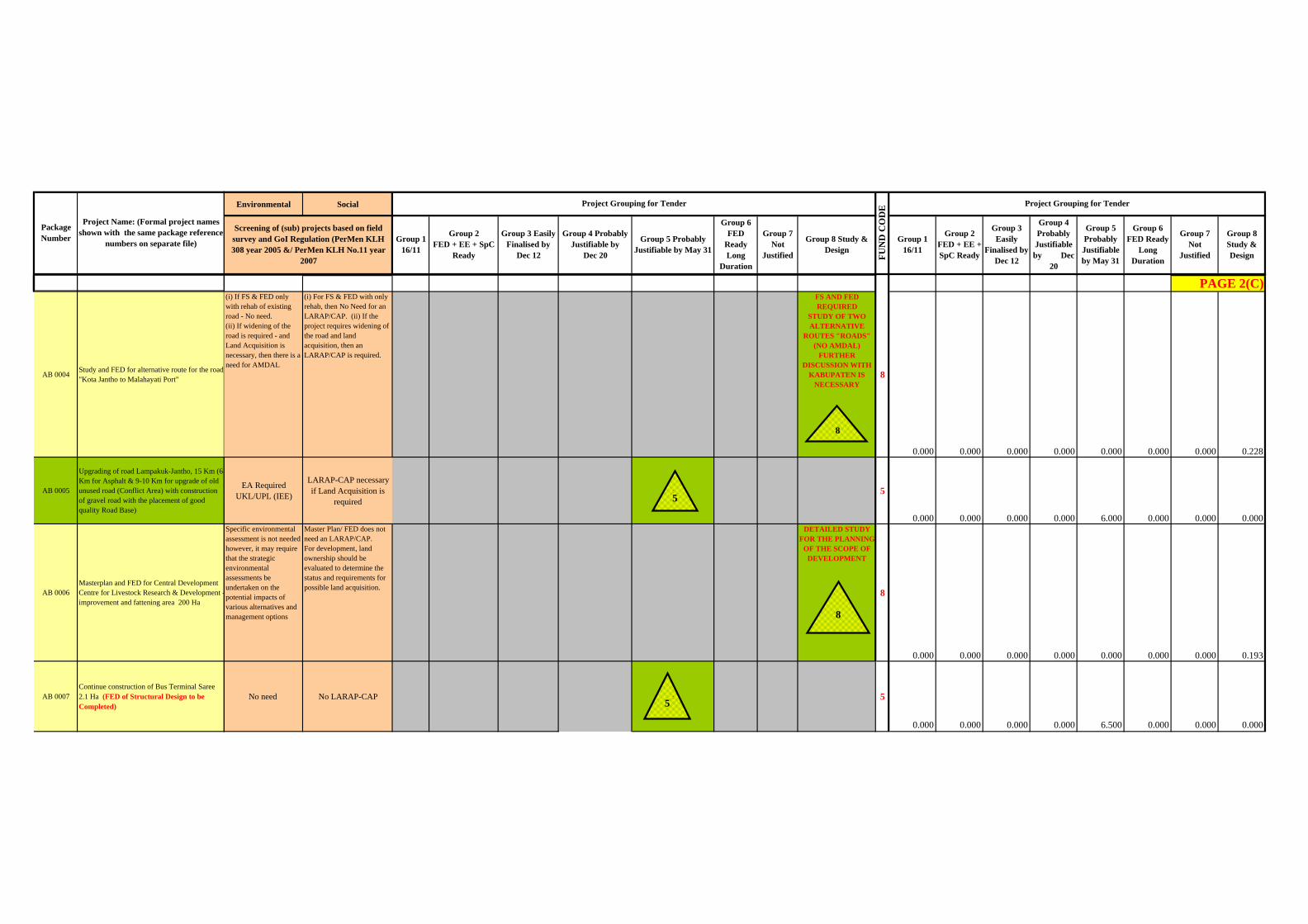
(i) If FS & FED only with rehab of existing road - No need. (ii) If widening of the road is required - and Land Acquisition is necessary, then there is a need for AMDAL
(i) For FS & FED with only rehab, then No Need for an LARAP/CAP. (ii) If the project requires widening of the road and land acquisition, then an LARAP/CAP is required.
FS AND FED REQUIRED
STUDY OF TWO ALTERNATIVE
ROUTES "ROADS" (NO AMDAL)
FURTHER DISCUSSION WITH
KABUPATEN IS NECESSARY
8
0.000 0.000 0.000 0.000 0.000 0.000 0.000 0.228
EA Required UKL/UPL (IEE)
LARAP-CAP necessary if Land Acquisition is
required: 5
0.000 0.000 0.000 0.000 6.000 0.000 0.000 0.000Specific environmental assessment is not needed however, it may require that the strategic environmental assessments be undertaken on the potential impacts of various alternatives and management options
Master Plan/ FED does not need an LARAP/CAP. For development, land ownership should be evaluated to determine the status and requirements for possible land acquisition.
DETAILED STUDY FOR THE PLANNING
OF THE SCOPE OF DEVELOPMENT
8
0.000 0.000 0.000 0.000 0.000 0.000 0.000 0.193
No need No LARAP-CAP : 5
0.000 0.000 0.000 0.000 6.500 0.000 0.000 0.000
PAGE 2(C)
8
8
5
5

TYPE
SECTOR
GPS Applied or Manual Map
Located
Project Site Visit &
Engineering Assessment Detailed
For Construct 30/09/2008
Project Appraisal
Field
Questionnaires and Documents
Received
Questionnaires Checked and
Verified
Questionnaires & Documents
Acceptable
Environmental and/or Social Assessment Completed
Package Number
Project Name: (Formal project names shown with the same package reference
numbers on separate file)
Dinas/Kab Cost Estimate (Rpx
1000)
Consultant Cost Estimate (Rpx
1000)
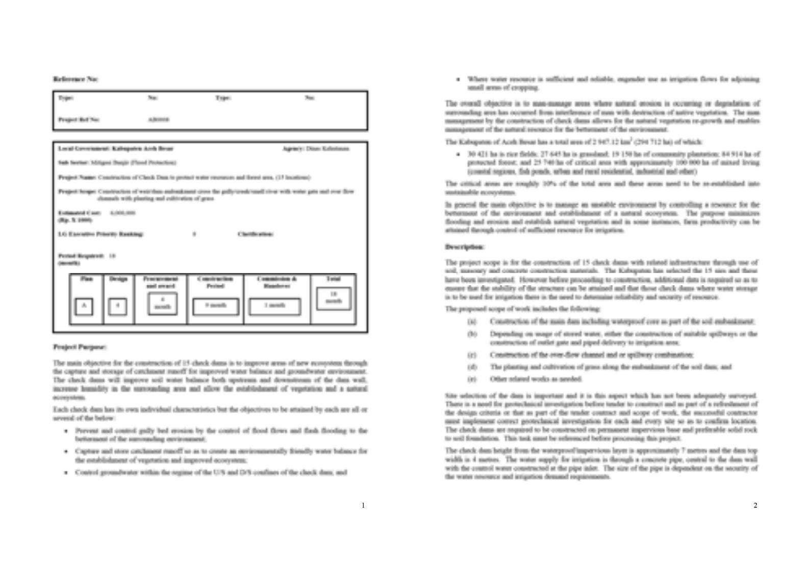
AB 0008 Construction of Check Dam to protect water resources and forest area, 15 unit WR 6,000,000 6,000,000 Yes/Yes Yes Yes/Yes
Yes (E&S) POSSIBLE
UKL/UPL-IEE some sites may
need LARAP/CAP
Yes Yes YesYes
Report Encl
No
AB 0009.1 Masterplan and FED of Irrigation Dam Jantho 250 Ha rice field ST 500,000 1,300,000 No/No No Clarification
Required
Not Required POSSIBLE
UKL/UPL-IEE and/or
POSSIBLE LARAP/CAP at
construction
Yes Yes YesYes
Report Encl
No
AB 0009.2 Masterplan of Agriculture Area Kabupaten Aceh Besar ST 500,000 4,150,000 Yes/Yes Yes Yes/Yes Not Required Yes No Yes
Yes Report Encl
No
TOTAL for Kabupaten Aceh Besar 37,460,437 47,460,437
No - Not Suitable Yes - Suitable
Summary of Projects for September 30 24,960,437
PAGE 3(A)
Package Number
Project Name: (Formal project names shown with the same package reference
numbers on separate file)
AB 0008 Construction of Check Dam to protect water resources and forest area, 15 unit
AB 0009.1 Masterplan and FED of Irrigation Dam Jantho 250 Ha rice field
AB 0009.2 Masterplan of Agriculture Area Kabupaten Aceh Besar
TOTAL for Kabupaten Aceh Besar
Summary of Projects for September 30
Tender Award
30/11/2007 BRR <30/09/08 Other Infra. Study (FS,
EcS)Complete Prep'n*
FS &/or EcS
TOTALComments
Fund Now (Rp Milya) Go Ahead Modify
Funding Recommendation
Construct
Projected Project
Completion Date
Durations (months) for outstanding activities
Priority Classification (from the list on the previous page)FED or
FS&FED Tender Doc's
Do Not Proceed
PAGE 3(B)
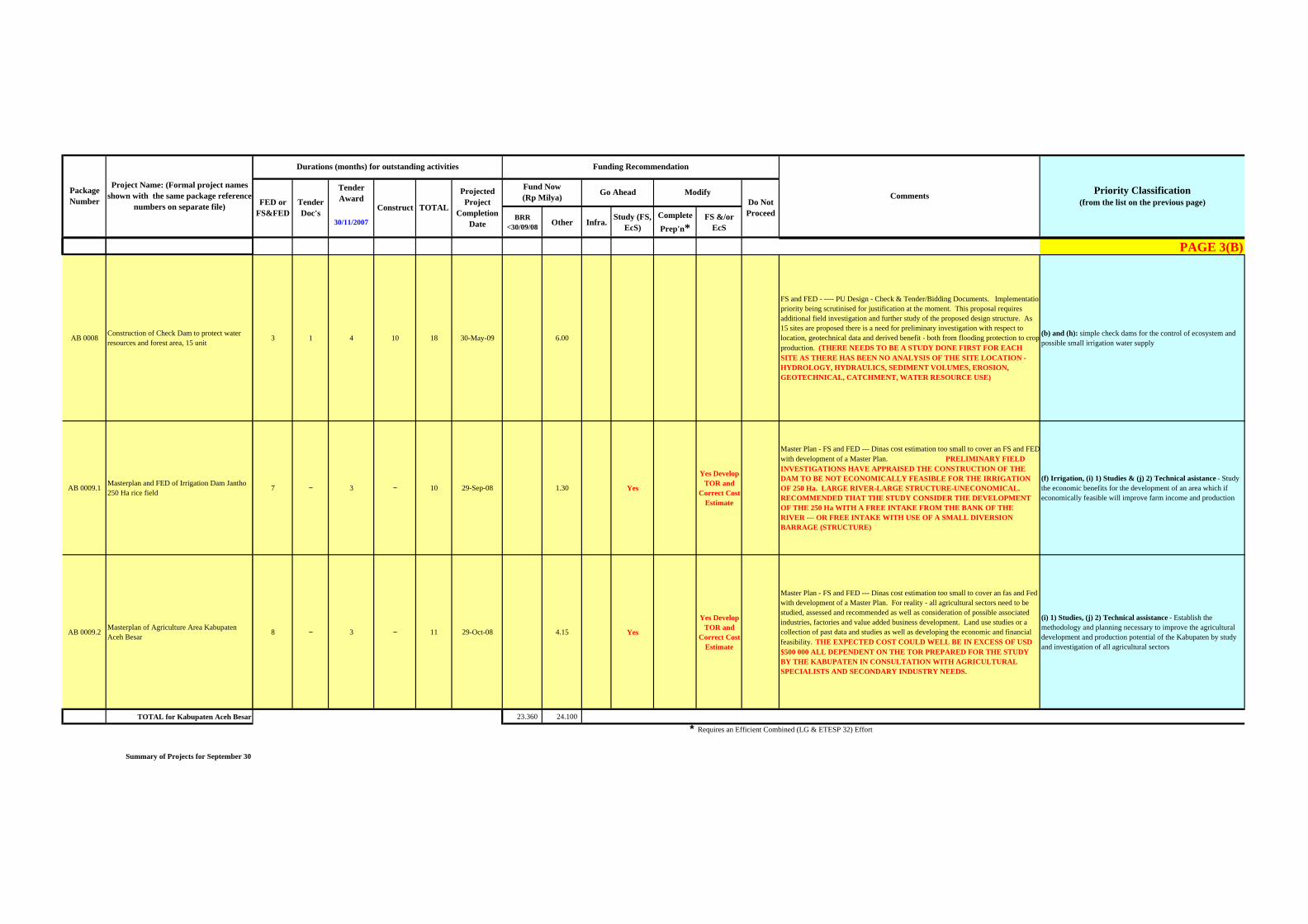
3 1 4 10 18 30-May-09 6.00
FS and FED - ---- PU Design - Check & Tender/Bidding Documents. Implementationpriority being scrutinised for justification at the moment. This proposal requires additional field investigation and further study of the proposed design structure. As 15 sites are proposed there is a need for preliminary investigation with respect to location, geotechnical data and derived benefit - both from flooding protection to crop production. (THERE NEEDS TO BE A STUDY DONE FIRST FOR EACH SITE AS THERE HAS BEEN NO ANALYSIS OF THE SITE LOCATION - HYDROLOGY, HYDRAULICS, SEDIMENT VOLUMES, EROSION, GEOTECHNICAL, CATCHMENT, WATER RESOURCE USE)
(b) and (h): simple check dams for the control of ecosystem and possible small irrigation water supply
7 − 3 − 10 29-Sep-08 1.30 Yes
Yes Develop TOR and
Correct Cost Estimate
Master Plan - FS and FED --- Dinas cost estimation too small to cover an FS and FED with development of a Master Plan. PRELIMINARY FIELD INVESTIGATIONS HAVE APPRAISED THE CONSTRUCTION OF THE DAM TO BE NOT ECONOMICALLY FEASIBLE FOR THE IRRIGATION OF 250 Ha. LARGE RIVER-LARGE STRUCTURE-UNECONOMICAL. RECOMMENDED THAT THE STUDY CONSIDER THE DEVELOPMENT OF THE 250 Ha WITH A FREE INTAKE FROM THE BANK OF THE RIVER --- OR FREE INTAKE WITH USE OF A SMALL DIVERSION BARRAGE (STRUCTURE)
(f) Irrigation, (i) 1) Studies & (j) 2) Technical asistance - Study the economic benefits for the development of an area which if economically feasible will improve farm income and production
8 − 3 − 11 29-Oct-08 4.15 Yes
Yes Develop TOR and
Correct Cost Estimate
Master Plan - FS and FED --- Dinas cost estimation too small to cover an fas and Fed with development of a Master Plan. For reality - all agricultural sectors need to be studied, assessed and recommended as well as consideration of possible associated industries, factories and value added business development. Land use studies or a collection of past data and studies as well as developing the economic and financial feasibility. THE EXPECTED COST COULD WELL BE IN EXCESS OF USD $500 000 ALL DEPENDENT ON THE TOR PREPARED FOR THE STUDY BY THE KABUPATEN IN CONSULTATION WITH AGRICULTURAL SPECIALISTS AND SECONDARY INDUSTRY NEEDS.
(i) 1) Studies, (j) 2) Technical assistance - Establish the methodology and planning necessary to improve the agricultural development and production potential of the Kabupaten by study and investigation of all agricultural sectors
23.360 24.100
* Requires an Efficient Combined (LG & ETESP 32) Effort
Package Number
Project Name: (Formal project names shown with the same package reference
numbers on separate file)
AB 0008 Construction of Check Dam to protect water resources and forest area, 15 unit
AB 0009.1 Masterplan and FED of Irrigation Dam Jantho 250 Ha rice field
AB 0009.2 Masterplan of Agriculture Area Kabupaten Aceh Besar
TOTAL for Kabupaten Aceh Besar
Summary of Projects for September 30
Environmental Social
Group 7 Not
Justified
Group 3 Easily Finalised by
Dec 12
Project Grouping for Tender
Group 5 Probably Justifiable by May 31
Group 6 FED
Ready Long
Duration
Group 2 FED + EE + SpC
Ready
Group 1 16/11
Group 8 Study & Design
Group 3 Easily
Finalised by Dec 12
Group 4 Probably Justifiable by
Dec 20
Screening of (sub) projects based on field survey and GoI Regulation (PerMen KLH 308 year 2005 &/ PerMen KLH No.11 year
2007
Project Grouping for Tender
Group 1 16/11
Group 8 Study & Design
Group 6 FED Ready
Long DurationFU
ND
CO
DE
Group 2 FED + EE + SpC Ready
Group 4 Probably Justifiable by Dec
20
Group 7 Not
Justified
Group 5 Probably Justifiable by May 31
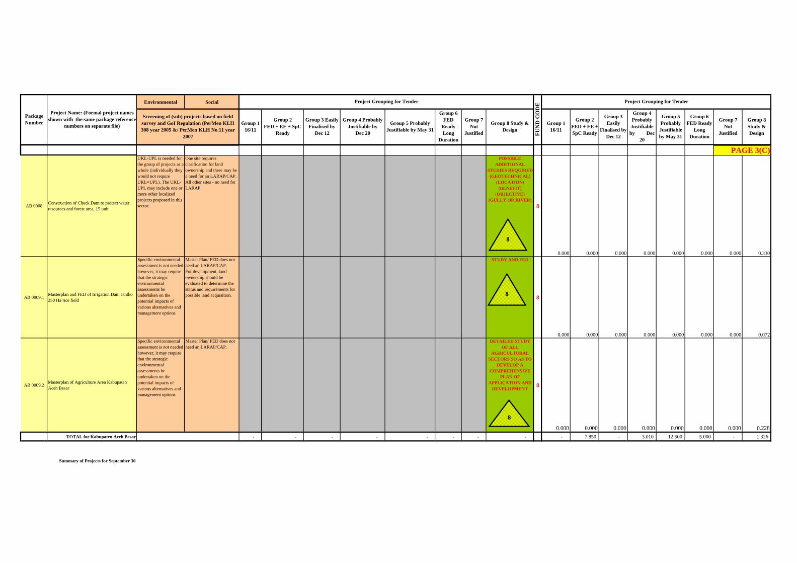
UKL-UPL is needed for the group of projects as a whole (individually they would not require UKL=UPL). The UKL-UPL may include one or more other localized projects proposed in this sector.
One site requires clarification for land ownership and there may be a need for an LARAP/CAP. All other sites - no need for LARAP.
POSSIBLE ADDITIONAL
STUDIES REQUIRED (GEOTECHNICAL)
(LOCATION) (BENEFIT)
(OBJECTIVE) (GULLY OR RIVER)
8
0.000 0.000 0.000 0.000 0.000 0.000 0.000 0.330Specific environmental assessment is not needed however, it may require that the strategic environmental assessments be undertaken on the potential impacts of various alternatives and management options
Master Plan/ FED does not need an LARAP/CAP. For development, land ownership should be evaluated to determine the status and requirements for possible land acquisition.
STUDY AND FED
8
0.000 0.000 0.000 0.000 0.000 0.000 0.000 0.072Specific environmental assessment is not needed however, it may require that the strategic environmental assessments be undertaken on the potential impacts of various alternatives and management options
Master Plan/ FED does not need an LARAP/CAP.
DETAILED STUDY OF ALL
AGRICULTURAL SECTORS SO AS TO
DEVELOP A COMPREHENSIVE
PLAN OF APPLICATION AND
DEVELOPMENT8
0.000 0.000 0.000 0.000 0.000 0.000 0.000 0.228- - - - - - - - - 7.850 - 3.010 12.500 5.000 - 1.326
PAGE 3(C)
8
8
8
Up dated 12/13/2007 1
Rapid Environmental – Socio Assessment ACEH BESAR No. Code Project Name Observation Result Consideration Environmental Requirement Social Requirement Remarks
1 AB 0001.1 Rehabilitation of Irrigation Dam and Primary Channel DI Panca (835 Ha) Source of irrigation water is taken from Krueng Panca and the water is still good condition
The upstream is in the secondary forest where the forest is still good condition. However, It is found the truck which loaded the log during the field trip
The Irrigation system is not operated since conflict The project will rehabilitate the dam and the primary
channel. In several section of primary channel has already damage and covered by bush
The rehabilitation work is not affected to environment significantly.
No Indigenous people founded This irrigation potential to increase the production of
paddy and plantation also, so increase farmer income & will be reduce poverty as well.
Regarding on the GoI regulation: PerMen KLH no 308 year 2005 and/or PerMen KLH no 11 year 2007
Based on the field survey and the plan & magnitude and type of impact, the project will affect to the environment insignificantly
Assessed onsite: No formal environmental assessment required
Does not need LARAP . The Irrigation built on September 1992, funded by ADB, and not operated since conflict 1998
Existing condition of Dam & Intake are good, but the channel are heavy damage Canal divide 2 direction line, 1 line through to village Panca (down stream) and the other line to Village Panca Kubu (Trans community) (up stream)
Potentially, DI Panca could be covered paddy field about 835 Ha, in 2 desas (Panca and Panca Kubu, Kecamatan Lembah Seulawah) however in fact only 350 Ha could irrigated
Most of inhabitants in desa Panca Kubu are ex transmigration from Banten (west Java) at 1980, however only 50 HH left since conflict happened.
Soil type in this area is rich humus, so it is very potential for paddy field the harvest can be done one times per year since irrigation system is not functioned, before that, harvest twice in a year, production approx. 10-12 ton/ha
Now many farmer change to be cultivation/plantation (chilli, corn, pinang) There are 2 group P3A (Persatuan Petani Pemakai Air) before conflict. P3A Panca & P3A Panca Jaya, member of each group 40 & 50 farmer.
Agriculture-Fisheries ADB-ETESP already involved in this area as well by provide the revolving program e.g. each HH received 7 goat (1 male and 6 female) including the cage.
Related to the ADB program, it is potential to develop a organic agriculture, so it is urgent to rehabilitate the irrigation system
Community is expected that they will involve in this work particularly for unskilled labour
Base on information from geuchik that at this time 60% of community are poor 2 AB 0001.2 Rehabilitation of Irrigation Dam and Primary Channel DI Teureubeh (500 Ha) Source of irrigation water is taken from Krueng Kalog
and the water is good condition The Kalog water spring located in secondary forest
and in good condition The dam is already exist and well operated and also
the primary channel, however some section is not concreted yet
The project is included the lining of secondary canal Rehabilitation of irrigation to reduce water losses to
irrigating paddy field area The rehabilitation work is not affected to environment
significantly
Regarding on the GoI regulation: PerMen KLH no 308 year 2005 and/or PerMen KLH no 11 year 2007
Based on the field survey and the plan & magnitude and type of impact, the project will affect to the environment insignificantly
Assessed onsite: No formal environmental assessment required
Does not need LARAP DI teureubeuh covered paddy field about 609 ha There are 3 P3A (Water user farmer group), number of each member group 20 farmers.
At this time, harvest twice in a year and production approx. 3 ton/ha Some of farmer choice planting cultivation (chilli) due to lack of water and harvest faster than paddy.
Land has already available
3 AB 0002 Upgrading of road simpang Kp. Jantho to Kp. Jantho and Simpang Aweek to Bueng (5 km) The project only rehabilitation & asphalting on the
existing road. The project will give impact particularly on construction stage, however insignificantly
Regarding on the GoI regulation: PerMen KLH no 308 year 2005 and/or PerMen KLH no 11 year 2007
Assessed onsite: No formal environmental assessment required
Does not need LARAP
4 AB 0003 Upgrading of road Simpang Aweek to Jalin (4 km) The project only rehabilitation & asphalting on the existing road. The project will give impact particularly on construction stage, however insignificantly
Regarding on the GoI regulation: PerMen KLH no 308 year 2005 and/or PerMen KLH no 11 year 2007
Assessed onsite: No formal environmental assessment required
Does not need LARAP
5 AB 0004 Study alternative and FED of road Kota Jantho to Malahayati Port Field report describe in separate sheet (Environmental & Social Perspective)
Regarding on the GoI regulation:
PerMen KLH no 308 year 2005 and/or PerMen KLH no 11 year 2007
Does not need environmental assessment if the project only study& FED or just rehabilitation existing road, however
ANDAL should be undertaken if the project will be built.
if the project only study& FED or just rehabilitation existing road : Does not need LARAP/CAP
For project widening road:
need LARAP & CAP
Base on Economic valuable, the alternative route from Seulimum to Lam Teubah is more feasible to improve the road, due to connecting mostly community in this area to the market in Seulimum and other activities.
6 AB 0005 Upgrading of road Lampakuk to Jantho (15 km) The road is passing trough 3 desas in 2 Kecamatans (Desa Lampakuk & siron, Kec. Cot Glie and Tempu Blang/cucum, Kec. Kota Jantho)
The project is upgrading on existing road (about 5 km) and some part is new construction road (about 10 km)
Some section of new road is with in free hold land/community land
Grassland is dominant ecosystem along the road,
Regarding on the GoI regulation: PerMen KLH no 308 year 2005 and/or PerMen KLH no 11 year 2007
Based on the field survey and the plan & magnitude and type of impact, the project will affect to the environment significantly
Environmental assessment is required, at least UKL-UPL (IEE) to be needed, and depend on the FS and design
Screening process to be confirmed through consultation with BAPEDALDA NAD and/or
Should be identified status of land first
If may require land acquisition, so the project have to completed LARAP
And CAP should be under taken also
This area is potential to develop as agriculture area especially for farming. The project will increase the market and transportation of the livestock The project proposed by community
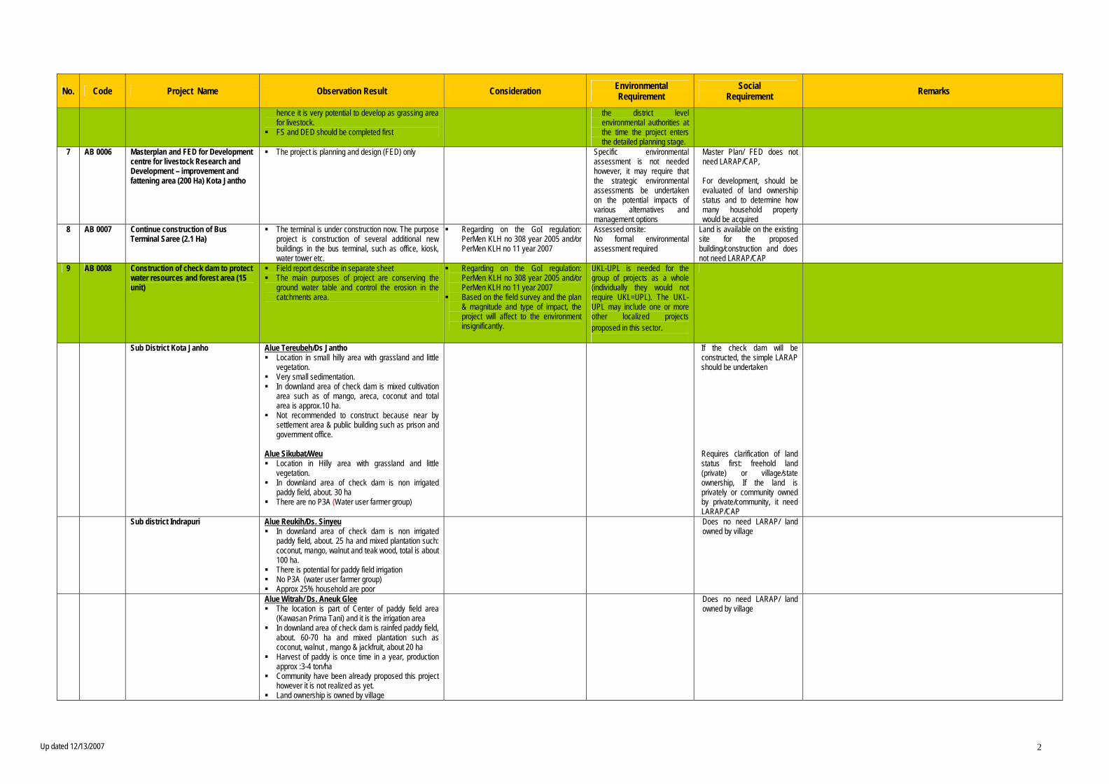
Up dated 12/13/2007 2
No. Code Project Name Observation Result Consideration Environmental Requirement Social Requirement Remarks hence it is very potential to develop as grassing area for livestock.
FS and DED should be completed first the district level environmental authorities at the time the project enters the detailed planning stage. 7 AB 0006 Masterplan and FED for Development centre for livestock Research and Development – improvement and fattening area (200 Ha) Kota Jantho
The project is planning and design (FED) only
Specific environmental assessment is not needed however, it may require that the strategic environmental assessments be undertaken on the potential impacts of various alternatives and management options
Master Plan/ FED does not need LARAP/CAP, For development, should be evaluated of land ownership status and to determine how many household property would be acquired
8 AB 0007 Continue construction of Bus Terminal Saree (2.1 Ha) The terminal is under construction now. The purpose project is construction of several additional new buildings in the bus terminal, such as office, kiosk, water tower etc.
Regarding on the GoI regulation: PerMen KLH no 308 year 2005 and/or PerMen KLH no 11 year 2007
Assessed onsite: No formal environmental assessment required
Land is available on the existing site for the proposed building/construction and does not need LARAP/CAP
9 AB 0008 Construction of check dam to protect water resources and forest area (15 unit) Field report describe in separate sheet The main purposes of project are conserving the
ground water table and control the erosion in the catchments area.
Regarding on the GoI regulation: PerMen KLH no 308 year 2005 and/or PerMen KLH no 11 year 2007
Based on the field survey and the plan & magnitude and type of impact, the project will affect to the environment insignificantly.
UKL-UPL is needed for the group of projects as a whole (individually they would not require UKL=UPL). The UKL-UPL may include one or more other localized projects proposed in this sector.
Sub District Kota Janho Alue Tereubeh/Ds Jantho Location in small hilly area with grassland and little
vegetation. Very small sedimentation. In downland area of check dam is mixed cultivation
area such as of mango, areca, coconut and total area is approx.10 ha.
Not recommended to construct because near by settlement area & public building such as prison and government office.
Alue Sikubat/Weu Location in Hilly area with grassland and little
vegetation. In downland area of check dam is non irrigated
paddy field, about. 30 ha There are no P3A (Water user farmer group)
If the check dam will be constructed, the simple LARAP should be undertaken Requires clarification of land status first: freehold land (private) or village/state ownership, If the land is privately or community owned by private/community, it need LARAP/CAP
Sub district Indrapuri Alue Reukih/Ds. Sinyeu In downland area of check dam is non irrigated
paddy field, about. 25 ha and mixed plantation such: coconut, mango, walnut and teak wood, total is about 100 ha.
There is potential for paddy field irrigation No P3A (water user farmer group) Approx 25% household are poor
Does no need LARAP/ land owned by village
Alue Witrah/ Ds. Aneuk Glee The location is part of Center of paddy field area
(Kawasan Prima Tani) and it is the irrigation area In downland area of check dam is rainfed paddy field,
about. 60-70 ha and mixed plantation such as coconut, walnut , mango & jackfruit, about 20 ha
Harvest of paddy is once time in a year, production approx :3-4 ton/ha
Community have been already proposed this project however it is not realized as yet.
Land ownership is owned by village
Does no need LARAP/ land owned by village
Up dated 12/13/2007 3
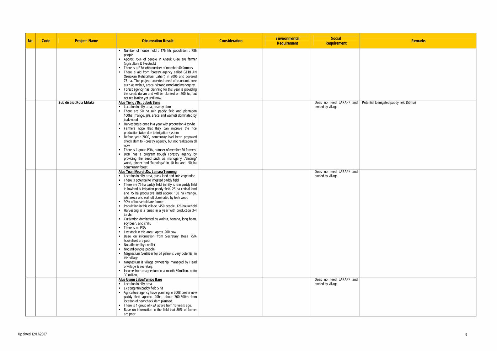
No. Code Project Name Observation Result Consideration Environmental Requirement Social Requirement Remarks Number of house hold : 176 hh, population : 786
people Approx 75% of people in Aneuk Glee are farmer
(agriculture & livestock) There is a P3A with number of member 40 farmers There is aid from forestry agency called GERHAN
(Gerakan Rehabilitasi Lahan) in 2006 and covered 75 ha. The project provided seed of economic tree such as walnut, areca, sintang wood and mahogany.
Forest agency has planning for this year is providing the seed: durian and will be planted on 200 ha, but not realization yet until now. Sub district Kota Malaka Alue Tieng / Ds. Lubuk Bune
Location in hilly area, near by dam There are 50 ha rain paddy field and plantation
100ha (mango, jati, areca and walnut) dominated by teak wood
Harvesting is once in a year with production 4 ton/ha Farmers hope that they can improve the rice
production twice due to irrigation system Before year 2000, community had been proposed
check dam to Forestry agency, but not realization till now.
There is 1 group P3A, number of member 50 farmers BRR has a program trough Forestry agency by
providing the seed such as mahogany ,”sintang” wood, ginger and “kapolaga” in 10 ha and 50 ha community forest
Does no need LARAP/ land owned by village
Potential to irrigated paddy field (50 ha)
Alue Tuan Meurah/Ds. Lamara Teunong Location in hilly area, grass land and little vegetation There is potential to irrigated paddy field There are 75 ha paddy field, in hilly is rain paddy field
in lowland is irrigation paddy field. 25 ha critical land and 75 ha productive land approx 150 ha (mango, jati, areca and walnut) dominated by teak wood
90% of household are farmer Population in this village : 450 people, 126 household Harvesting is 2 times in a year with production 3-4
ton/ha Cultivation dominated by walnut, banana, long bean,
soy bean, and chilli. There is no P3A Livestock in this area : aprox. 200 cow Base on information from Secretary Desa 75%
household are poor Not affected by conflict Not Indigenous people Magnesium (vertilizer for oil palm) is very potential in
this village Magnesium is village ownership, managed by Head
of viilage & secretary. Income from magnesium in a month 80million, netto
30 million,
Does no need LARAP/ land owned by village
Alue Uteun Labu/Tumbo Baro Location in hilly area Existing rain paddy field 5 ha Agriculture agency have planning in 2008 create new
paddy field approx. 20ha, about 300-500m from location of new check dam planned.
There is 1 group of P3A active from 15 years ago. Base on information in the field that 80% of farmer
are poor
Does no need LARAP/ land owned by village
Up dated 12/13/2007 4
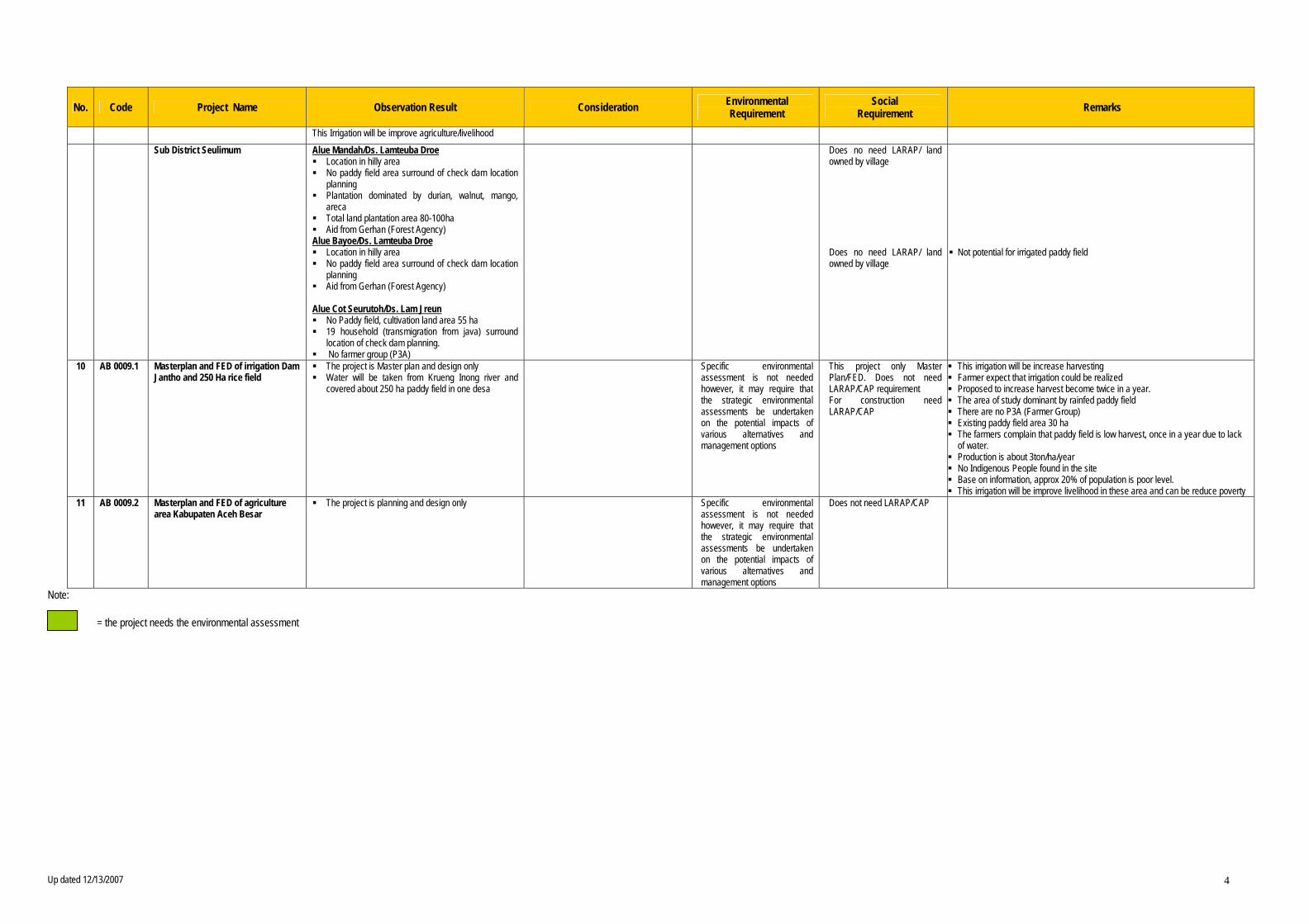
No. Code Project Name Observation Result Consideration Environmental Requirement Social Requirement Remarks This Irrigation will be improve agriculture/livelihood
Sub District Seulimum Alue Mandah/Ds. Lamteuba Droe Location in hilly area No paddy field area surround of check dam location
planning Plantation dominated by durian, walnut, mango,
areca Total land plantation area 80-100ha Aid from Gerhan (Forest Agency) Alue Bayoe/Ds. Lamteuba Droe Location in hilly area No paddy field area surround of check dam location
planning Aid from Gerhan (Forest Agency) Alue Cot Seurutoh/Ds. Lam Jreun No Paddy field, cultivation land area 55 ha 19 household (transmigration from java) surround
location of check dam planning. No farmer group (P3A)
Does no need LARAP/ land owned by village Does no need LARAP/ land owned by village
Not potential for irrigated paddy field
10 AB 0009.1 Masterplan and FED of irrigation Dam Jantho and 250 Ha rice field The project is Master plan and design only Water will be taken from Krueng Inong river and
covered about 250 ha paddy field in one desa
Specific environmental assessment is not needed however, it may require that the strategic environmental assessments be undertaken on the potential impacts of various alternatives and management options
This project only Master Plan/FED. Does not need LARAP/CAP requirement For construction need LARAP/CAP
This irrigation will be increase harvesting Farmer expect that irrigation could be realized Proposed to increase harvest become twice in a year. The area of study dominant by rainfed paddy field There are no P3A (Farmer Group) Existing paddy field area 30 ha The farmers complain that paddy field is low harvest, once in a year due to lack
of water. Production is about 3ton/ha/year No Indigenous People found in the site Base on information, approx 20% of population is poor level. This irrigation will be improve livelihood in these area and can be reduce poverty 11 AB 0009.2 Masterplan and FED of agriculture area Kabupaten Aceh Besar The project is planning and design only
Specific environmental assessment is not needed however, it may require that the strategic environmental assessments be undertaken on the potential impacts of various alternatives and management options
Does not need LARAP/CAP
Note: = the project needs the environmental assessment

AB0001.1 Rehabilitation of Dam and Primary Canal of Irrigation System Panca
(Daerah Irigasi Panca)


AB0009.1
AB0001.1
Pidie
Seulimum
LembahSeulawah
KotaJantho
012
011010 009
008
007
003
232
231 230
229228
227226
225
224223222
221220219218
217
216215
214213
212211
210
205204
203 202201 200
199 198197 196
195194
KABUPATEN ACEH BESARAB0001.1 - Irrigation Project
EAST & WEST COAST INFRASTRUCTURE DEVELOPMENT PROGRAMEARTHQUAKE AND TSUNAMI EMERGENCY SUPPORT PROJECT - Package 32ADB GRANT No. 002 INO INDONESIA
AB0001.1 - Rehabilitation of Dam and Primary CanalIrrigation System Panca (835 - 1400)ha
KruengPanca
Gate Structure
SpillwayGPS 008
Closed ConduitClosed Conduit
Open Lined CanalW=0.6; H=0.7
Open Lined CanalW=0.6; H=0.7
Inspection Road to Dam
Aqueduct
Aqueduct
GPS 009
GPS’005
Sketch DI Panca:
GPS’ = N 05° 18.152’E095° 43.458’El = 138Rig
ht Ca
nal
Left
Cana
l
KruengPanca
Gate Structure
SpillwayGPS 008
Closed ConduitClosed Conduit
Open Lined CanalW=0.6; H=0.7
Open Lined CanalW=0.6; H=0.7
Inspection Road to Dam
Aqueduct
Aqueduct
GPS 009
GPS’005
Sketch DI Panca:
GPS’ = N 05° 18.152’E095° 43.458’El = 138Rig
ht Ca
nal
Left
Cana
l
0 1 2 3 40.5
Kilometers
For 9 Years the Left Primary Canal not Used
For 9 Years the Right Primary Canal not Used
Damaged Aqueduct, Right Primary Canal
The Main Dam of Irrigation System Panca
μ
AB0001.2 Rehabilitation of Dam and Primary Canal of Irrigation System Panca
(Daerah Irigasi Panca)
Seulimum
Kota CotGlie
KotaJantho
039
038
037
036
035034
033032
031
030
014
006
005
004
001
335
208
006
005
004
001
335
208
KotaJantho
KABUPATEN ACEH BESARAB0001.2 - Irrigation Project
EAST & WEST COAST INFRASTRUCTURE DEVELOPMENT PROGRAMEARTHQUAKE AND TSUNAMI EMERGENCY SUPPORT PROJECT - Package 32ADB GRANT No. 002 INO INDONESIA
AB0001.2 - Rehabilitation of Dam andPrimary Canal, Irrigation System Teureubeh, 500 Ha.
0 0.5 1 1.5 20.25
Kilometers
The end of lined Secondary Canal
Gate Structure
Intake Structure
Unlined Secondary Canal
Primary Canal
μ
AB0002 Upgrading and Betterment of Road Simpang Kp. Jantho to Kp. Jantho
And Simpang Aweek to Bueng (5 km)

AB0003 Upgrading of Road Simpang Aweek to Kp. Jalin (Kab. Road no. 260)
!! !!!
!
!!!!!!!
!
!
!
!
!
!
!
! !!
!
!! !
!
!!
!
! !!! !
!!
!
LembahSeulawah
KotaJantho
232
231230
229228
227226225
224
223222
221
220219218
217
216215
214
213
212
211
210
209
208
207206 205
204203 202 201 200
199198 197 196
195194
KABUPATEN ACEH BESARAB0003 - Road Project
EAST & WEST COAST INFRASTRUCTURE DEVELOPMENT PROGRAMEARTHQUAKE AND TSUNAMI EMERGENCY SUPPORT PROJECT - Package 32ADB GRANT No. 002 INO INDONESIA
AB0003 - Upgrading of roadSimpang Aweek to Kp. Jalin
0 0.5 1 1.5 20.25
Kilometers μ
AB0004 Study Alternative and FED of Road Kota Jantho to Malahayati Port
AB0004
AB0005
AB0005salah
AB0001
AB0004
AB0001.1
AB0001.1
KodyaBandaAceh
Pidie
Leupung
Kutobaro
DarussalamMesjidRaya
Baitussalam
Seulimum
Montasik
KruengBaronajaya
InginJaya
IndrapuriLhoknga
SukaMakmur
DarulKamal
DarulImarah
SimpangTiga
LembahSeulawah
KotaCot Glie
KutaMalaka
Padangtiji
Lamren
Kapelma
Lampanah
Seulimeun
Indrapura
KABUPATEN ACEH BESARAB0004 - Road Project
EAST & WEST COAST INFRASTRUCTURE DEVELOPMENT PROGRAMEARTHQUAKE AND TSUNAMI EMERGENCY SUPPORT PROJECT - Package 32ADB GRANT No. 002 INO INDONESIA
AB0004 - Study Alternatif and FED of roadKota Jantho to Alahayati ports
0 2.5 5 7.5 101.25
Kilometers μ

AB0005 Upgrading and Betterment of Road of Lampakuk – Jantho (15 km)
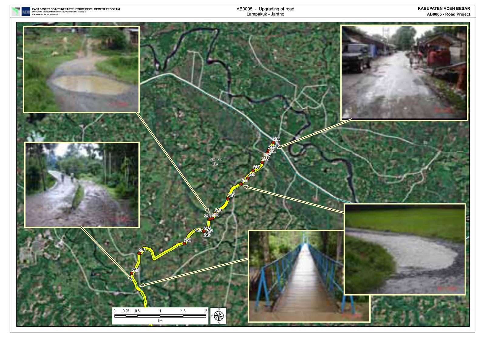
Seulimum
Indrapuri
Kota CotGlie
252
251
250249
248 247246
245 244243
242
241240
239
238237
236235
234
KABUPATEN ACEH BESARAB0005 - Road Project
EAST & WEST COAST INFRASTRUCTURE DEVELOPMENT PROGRAMEARTHQUAKE AND TSUNAMI EMERGENCY SUPPORT PROJECT - Package 32ADB GRANT No. 002 INO INDONESIA
0 0.5 1 1.5 20.25
km
AB0005 - Upgrading of roadLampakuk - Jantho
μ

Seulimum
Kota CotGlie
11-DEC-0717:25:31;AB0005,missing road
the catlegrassing onsavana, lam guda
11-DEC-0717:60:02;AB0005,intersection
11-DEC-0716:04:28;AB0005,krueng sikobe
The road locatedbehind the
farming area
11-DEC-0715:40:06;AB0005,Creeck at des
11-DEC-0715:06:32;AB0005,Hanging bridg
11-DEC-0714:08:45;AB0005,
krueng kemiri
11-DEC-0714:04:35;AB0005,road covered
11-DEC-0713:42:03;AB0005,road conditio
11-DEC-0713:28:14;AB0005,
the road alre
11-DEC-0713:24:40;AB0005,Starting poin
KABUPATEN ACEH BESARAB0005 - Road Project
EAST & WEST COAST INFRASTRUCTURE DEVELOPMENT PROGRAMEARTHQUAKE AND TSUNAMI EMERGENCY SUPPORT PROJECT - Package 32ADB GRANT No. 002 INO INDONESIA
0 0.5 1 1.5 20.25
Kilometers
AB0005 - Upgrading of roadLampakuk - Jantho
μ
An existing road alignment butdifficult to locate exact position
Road covered or destroyed oversome sections and requires re-discovery
Typical levels ofre-growth of road
Low level crossingin dry weather
Better section of road
AB0006 Masterplan and FED for Central Development Centre for
Livestock Research & Development – Improvement and Flattening – Kabupaten Aceh Besar

AB0007 Continue Construction of Rest Terminal Saree 2.1 Ha, Kabupaten Aceh Besar
»T
Pidie
LembahSeulawah
KABUPATEN ACEH BESARAB0007 - Transportation Project
EAST & WEST COAST INFRASTRUCTURE DEVELOPMENT PROGRAMEARTHQUAKE AND TSUNAMI EMERGENCY SUPPORT PROJECT - Package 32ADB GRANT No. 002 INO INDONESIA
AB0007 - Continue Construction ofTerminal Saree - Kabupaten Aceh Besar
To Medan To Banda Aceh
GPS 025
Gas Station
Bus Terminal Under construction
Mosque
Saree’sMarket
App. 1 Km
Sketch Bus Terminal (Saree) :
To Medan To Banda Aceh
GPS 025
Gas Station
Bus Terminal Under construction
Mosque
Saree’sMarket
App. 1 Km
Sketch Bus Terminal (Saree) :
0 0.5 1 1.5 20.25
Kilometers
Parking area - Under Construction
National Road Medan - Banda Aceh Entrance not sufficient for bus and truck
Rest Terminal Saree
μ

AB0008 Construction of Check Dam to Protect Water Resource (conserve the water table)
and Forest Area (15 Locations)


AB
0005
AB
0005
AB
0005
sala
hA
B00
05sa
lah
AB
0004
AB
0004
Kody
aBa
nda A
ceh
Aceh
Jaya
Leup
ung
Kutob
aro
Daru
ssala
m
Mesji
dRa
ya
Seuli
mum
Monta
sik
Krue
ngBa
rona
jaya
Ingin
Jaya
Indra
puri
Lhok
nga
Suka
Makm
ur
Daru
lKa
mal
Daru
lIm
arah
Simp
ang
Tiga
Kota
Cot G
lie
Kuta
Malak
a
Lhoo
ng
Kota
Janth
o
Band
aAc
eh
Kape
lma
Indr
apur
a
95°3
0'0"
E
95°3
0'0"
E
5°30'0"N
5°30'0"N
5°15'0"N
5°15'0"N
KA
BU
PATE
N A
CEH
BES
AR
AB
0008
- C
heck
Dam
sEA
ST &
WES
T CO
AST
INFR
ASTR
UCTU
RE D
EVEL
OPM
ENT
PRO
GRA
MEA
RTHQ
UAKE
AND
TSUN
AMI E
MERG
ENCY
SUP
PORT
PRO
JECT
- Pac
kage
32AD
B GR
ANT
No. 0
02 IN
O IN
DONE
SIA
Lege
nd Prov
ince b
ound
ary
Kabu
paten
boun
dary
Keca
matan
boun
dary
! .Ci
ties
Rive
r
Coas
t Line
Rail r
oad
Road
Clas
sifica
tion
Natio
nal
Prov
ince
Kabu
paten
Rura
l road
Tran
spor
tatio
n Fa
cilitie
s
)e
Airp
ort
,0Po
rt/Ha
rbou
r
(TTe
rmina
l
Pidie Jaya
Aceh
Besa
r
Aceh
Teng
gara
Kota
Saba
ng
Bire
unBe
ner
Meria
h
Naga
nRa
yaAceh
Teng
ah
Aceh
Besa
r
Pidie
Gayo
Lues
Aceh
Utar
aAc
ehTim
ur Aceh
Tami
ang
Aceh
Selat
an
Aceh
Jaya
Aceh
Bara
tDa
ya
Aceh
Bara
t
Sour
ces :
1. To
pogr
aphic
map
1:5
0000
2. Ad
mini
strat
ive b
ound
aries
Bap
peda
Pro
p NA
D3.
SPOT
Imag
eries
, Dec
200
43.
Field
Surv
ey, J
uly 2
007
Map
Proje
ction
: Geo
grap
hic C
oord
inate
Sys
tem
WGS
84
Boun
darie
s are
apr
oxim
ate
and
not o
fficial
AB00
08 -
Con
stru
ctio
n of
15 C
heck
Dam
s
02
46
81
Kilo
met
ers
μ
' 'DAM
' 'DAM
' 'DAM
' 'DAM
' 'DAM
' 'DAM
' 'DAM' 'DA
M
' 'DAM
' 'DAM
' 'DAM
' 'DAM
' 'DAM
Pidi
e
Aceh
Jaya
Leup
ung
Kutob
aro
Daru
ssala
m
Mesji
dRa
ya
Baitu
ssala
m
Seuli
mum
Monta
sik
Krue
ngBa
rona
jaya
Indra
puri
Suka
Makm
ur
Lemb
ahSe
ulawa
h
Kota
Cot
Glie
Kuta
Malak
a
Kota
Janth
o
Che
ckD
am 1
3
Che
ckD
am 7
Che
ckD
am 6
Che
ckD
am 5 C
heck
Dam
4C
heck
Dam
3
Che
ckD
am 2
Che
ckD
am 1
Che
ckD
am 2
Che
ckD
am 1
Che
ckD
am 1
0
Che
ckD
am 9
Che
ckD
am 8
Lam
ren
Lam
pana
h
Seul
imeu
n
Indr
apur
a
Kota
Jant
ho
95°3
0'0"
E
95°3
0'0"
E
5°30'0"N
5°30'0"N
5°15'0"N
5°15'0"N
KABU
PATE
N AC
EH B
ESAR
AB00
08 -
Chec
k Dam
s GPS
Poi
ntEA
ST &
WES
T CO
AST
INFR
ASTR
UCTU
RE D
EVEL
OPM
ENT
PRO
GRA
MEA
RTHQ
UAKE
AND
TSU
NAMI
EME
RGEN
CY S
UPPO
RT P
ROJE
CT -
Pack
age 3
2AD
B GR
ANT
No. 0
02 IN
O IN
DONE
SIA
Lege
nd Prov
ince b
ound
ary
Kabu
paten
boun
dary
Keca
matan
boun
dary
! .Ci
ties
Rive
r
Coas
t Line
Rail r
oad
Road
Clas
sific
atio
n
Natio
nal
Prov
ince
Kabu
pate
n
Rura
l road
Tran
spor
tatio
n Fa
ciliti
es
)e
Airp
ort
,0Po
rt/Ha
rbou
r
(TTe
rmina
l
Pidie Jaya
Aceh
Besa
r
Aceh
Teng
gara
Kota
Saba
ng
Kota
Lhok
Seum
awe
Bire
unBe
ner
Meria
h
Naga
nRa
yaAceh
Teng
ah
Aceh
Besa
r
Pidie
Gayo
Lues
Aceh
Uta
ra
Aceh
Timur Ac
ehTa
mian
g
Aceh
Selat
an
Aceh
Jaya
Aceh
Bara
tDa
ya
Aceh
Bara
t
Sour
ces :
1. To
pogr
aphic
map
1:50
000
2. Ad
minis
trativ
e bou
ndar
ies B
appe
da P
rop
NAD
3. SP
OT Im
ager
ies, D
ec 20
043.
Field
Sur
vey,
July
2007
02
41
km
Map P
rojec
tion:
Geog
raph
ic Co
ordin
ate S
ystem
WGS
84Bo
unda
ries a
re ap
roxim
ate an
d no
t offic
ial±
S E
L A T
M
A L A
K A

1
ENVIRONMENTAL FIELD REPORT Code : AB 0008 Project Name : Construction of Check Dam to Protect Water Resource (conserve the water table) and Forest Area Location : Aceh Besar Example extract No. Check Dam Location/ Position Site Existing Condition Downland Area Remarks 11 Existing Check
Dam Desa Reukih, Indrapuri 5 24.1392 N 95 25.9260 E
No.pic: P11-1 The check dam built on 1994
No.pic: P11-3 the land around the check dam already covered by tree, it
is shown that the check dam is well functioned In the long term, It will become a forest ecosystem
12 Check Dam X Desa Reukih, Indrapuri 5 24.2466 N 95 25.2732 E
No.pic: P12-1 Check dam location is a natural drainage channel and it
was dry during the field trip. The location covered bush and vegetation. It is found the sediment around the location
No.pic: P12-2 The location surround by hilly area with shrub
No.pic: P12-3
2
No. Check Dam Location/ Position Site Existing Condition Downland Area Remarks 13 Check Dam XI Desa Tambo,
Baru, Kuta Malaka 5 25.0398 N 95 24.1920 E
No.pic: P13-1 Check dam location is a natural drainage channel and it
was dry during the field trip. The location covered vegetation. Patches of sediment (to 10 cm thick) in stream bed indicate
silt laden stream during recent rainstorm.
No.pic: P13-2 The location surround by hilly area with shrub and
grassland. Soil structure is rocky sand.
No.pic: P13-3 In the downland found rainfed paddy field about 5 ha Agriculture agency have planning in 2008 which is create
new paddy field approx. 20ha, about 300-500m from location of site
There is 1 group of P3A active from 15 years ago.
Base on information in the field that 80% of farmer are poor
14 Check Dam XII Desa Kayee Kunyet, Montasek 5 31.1724 N 95 26.8632 E
No.pic: P14-1 Check dam location is stream because the upstream
catchment is small but has a water spring. The river water indicated the erosion happened
No.pic: P14-2 The location surrounded by hilly area and grown by
vegetation ex production forest e.g. Eucalyptus sp and Acacia sp.
Soil structure is rocky sand with poor top soil
No.pic: P14-3 In the downland still ex production forest.
AB0009.1 Masterplan and FED of Irrigation Dam Jantho 250 Ha Rice Field


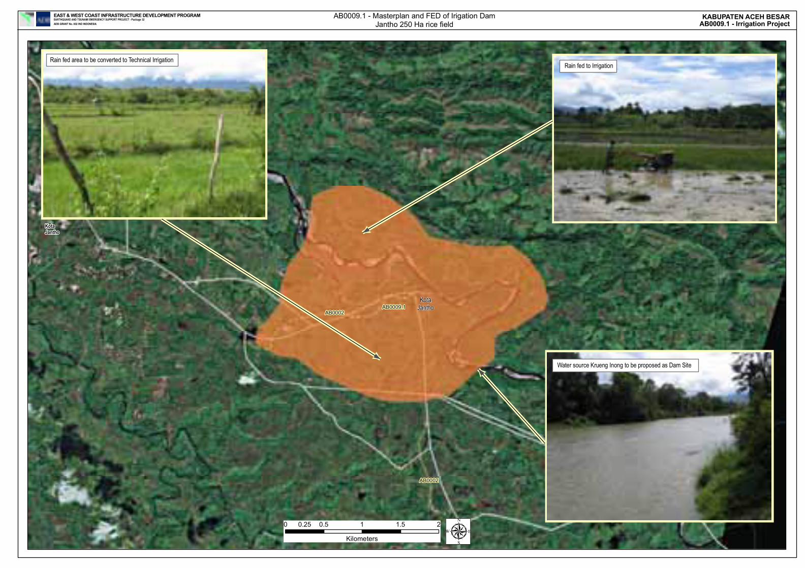
AB0003
AB0002
AB0002
AB0009.1
Seulimum
LembahSeulawah
KotaJantho
KotaJantho
KABUPATEN ACEH BESARAB0009.1 - Irrigation Project
EAST & WEST COAST INFRASTRUCTURE DEVELOPMENT PROGRAMEARTHQUAKE AND TSUNAMI EMERGENCY SUPPORT PROJECT - Package 32ADB GRANT No. 002 INO INDONESIA
AB0009.1 - Masterplan and FED of Irigation DamJantho 250 Ha rice field
0 0.5 1 1.5 20.25
Kilometers μ
Rain fed area to be converted to Technical IrrigationRain fed to Irrigation
Water source Krueng Inong to be proposed as Dam Site
AB0009.2 Masterplan for Agriculture Area for Kabupaten Aceh Besar


ANNEXES
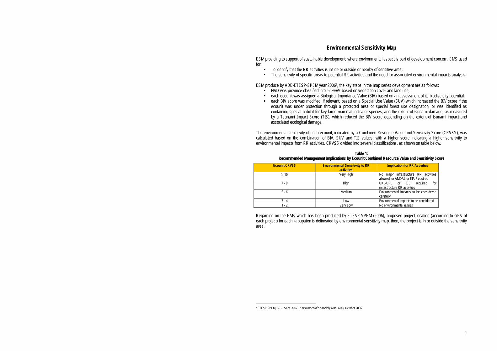
1
Environmental Sensitivity Map
ESM providing to support of sustainable development; where environmental aspect is part of development concern. EMS used for:
To identify that the RR activities is inside or outside or nearby of sensitive area; The sensitivity of specific areas to potential RR activities and the need for associated environmental impacts analysis.
ESM produce by ADB-ETESP-SPEM year 20061, the key steps in the map series development are as follows:
NAD was province classified into ecounits based on vegetation cover and land use; each ecounit was assigned a Biological Importance Value (BIV) based on an assessment of its biodiversity potential; each BIV score was modified, if relevant, based on a Special Use Value (SUV) which increased the BIV score if the
ecounit was under protection through a protected area or special forest use designation, or was identified as containing special habitat for key large mammal indicator species; and the extent of tsunami damage, as measured by a Tsunami Impact Score (TIS), which reduced the BIV score depending on the extent of tsunami impact and associated ecological damage.
The environmental sensitivity of each ecounit, indicated by a Combined Resource Value and Sensitivity Score (CRVSS), was calculated based on the combination of BIV, SUV and TIS values, with a higher score indicating a higher sensitivity to environmental impacts from RR activities. CRVSS divided into several classifications, as shown on table below.
Table 1: Recommended Management Implications by Ecounit Combined Resource Value and Sensitivity Score
Ecounit CRVSS Environmental Sensitivity to RR activities
Implication for RR Activities
≥ 10 Very High No major infrastructure RR activities allowed, or AMDAL or ElA Required
7 - 9 Hlgh UKL-UPL or IEE required for infrastructure RR activities
5 - 6 Medium Environmental impacts to be considered carefully
3 - 4 Low Environmental impacts to be considered 1 - 2 Very Low No environmental issues
Regarding on the EMS which has been produced by ETESP-SPEM (2006), proposed project location (according to GPS of each project) for each kabupaten is delineated by environmental sensitivity map, then, the project is in or outside the sensitivity area.
1 ETESP-SPEM, BRR, SKM, NAD - Environmental Sensitivity Map, ADB, October 2006
!.
""
!.
!.
!.
!.
"""
!.
!.
!.
!.
Kota Jantho
Seulimum
Kota Cot Glie
Indrapuri
Lhoong
Leupung
Lembah Seulawah
Montasik
Lhoknga
Mesjid Raya
Kutobaro
Darussalam
Peukanbada
Pulo Aceh
Suka MakmurSimpang Tiga
Baitussalam
Kuta Malaka
Darul Imarah
Darul Kamal
Krueng BaronajayaIngin Jaya
Pidie
Aceh Jaya
Kodya Banda Aceh Pidie
Lamno
Lamren
Lhonga
Kapelma
Lampanah
Seulimeun
Indrapura
Banda Aceh
Kota Jantho
95°45'0"E
95°45'0"E
95°30'0"E
95°30'0"E
95°15'0"E
95°15'0"E
95°0'0"E
95°0'0"E
5°30
'0"N
5°30
'0"N
5°15
'0"N
5°15
'0"N
ACEH BESARETESP32 - EAST COAST INFRASTRUCTURE DEVELOPMENT PROGRAMEARTHQUAKE AND TSUNAMI EMERGENCY SUPPORT PROJECTADB GRANT No. 002 INO INDONESIA
M A L A C C A S T R A I T
±0 5 102.5
KilometersSource :1. Topographic map 1:500002. Administrative boundaries Bappeda Prop NAD3. Irrrigation schemes from ETESP Irrigation Component4. RBI Landcover, 20025. Road from Masterplan of NAD
LegendProvince boundary
Kabupaten boundary
Kecamatan boundary
River
Coastline
""" Capital of province
"" Capital of kabupaten
!. Town
Road
National
Province
Kabupaten
National proposed
Province proposed
Unknown class
Landuse
Water
Scrub/bush
Forest
Swamp forest
Garden/Estates
Settlement
Estates
Swamp
Grassland
Ricefield
Irrigated ricefield
Dryland
H I N D I A O C E A N
LANDCOVER
Map Projection: Geographic Coordinate System WGS 84Boundaries are aproximate and not official
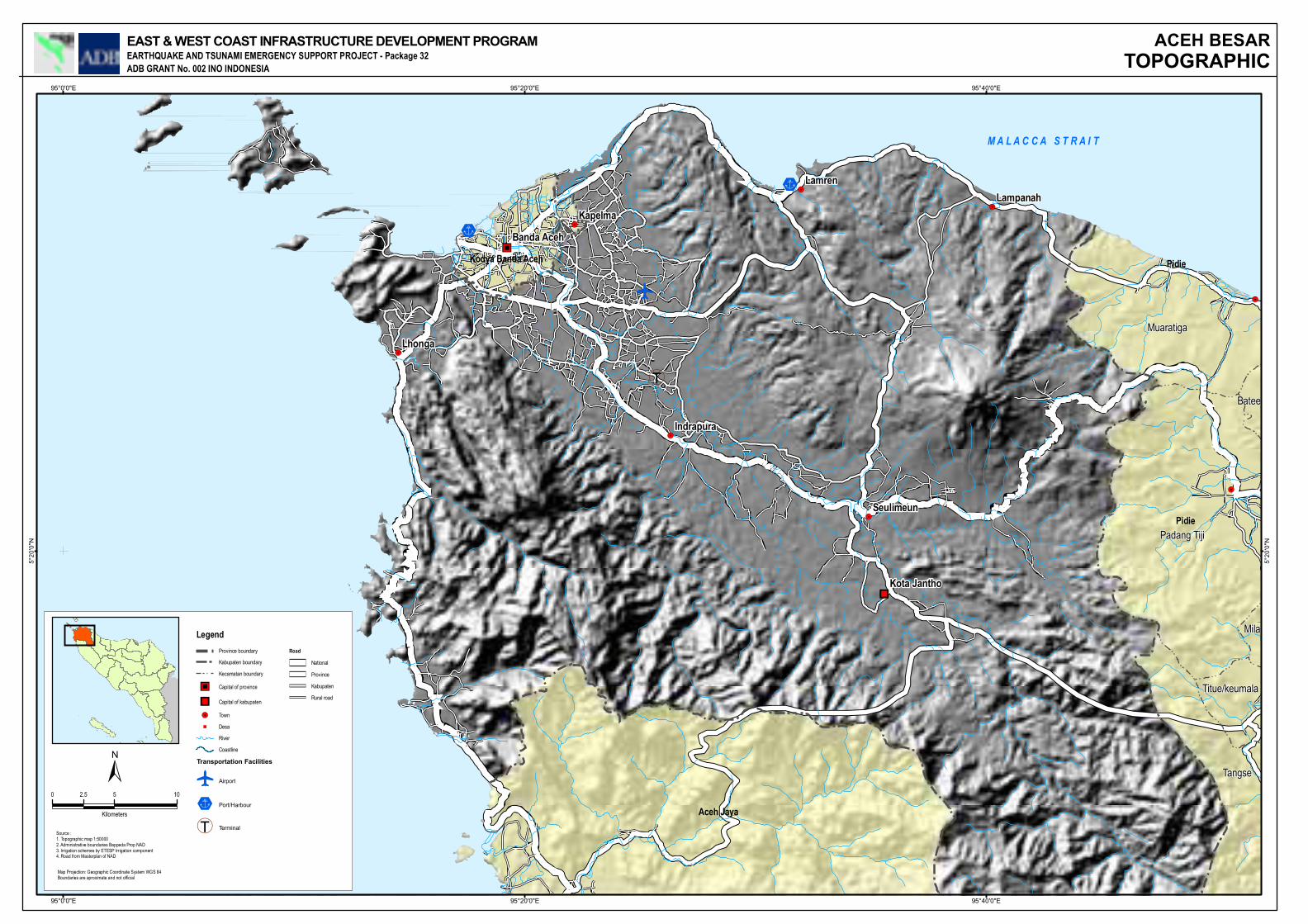
!.
""
!.
!.
!.
!.
"""
!.
!.
!.
%0
%0
e
(T
Padang Tiji
Muaratiga
Tangse
Titue/keumala
Mila
Batee
Pidie
Aceh Jaya
Kodya Banda Aceh Pidie
Lamren
Lhonga
KapelmaLampanah
Seulimeun
Indrapura
Banda Aceh
Kota Jantho
95°40'0"E
95°40'0"E
95°20'0"E
95°20'0"E
95°0'0"E
95°0'0"E
5°20
'0"N
5°20
'0"N
EAST & WEST COAST INFRASTRUCTURE DEVELOPMENT PROGRAMEARTHQUAKE AND TSUNAMI EMERGENCY SUPPORT PROJECT - Package 32ADB GRANT No. 002 INO INDONESIA
M A L A C C A S T R A I T
±0 5 102.5
Kilometers
Source :1. Topographic map 1:500002. Administrative boundaries Bappeda Prop NAD3. Irrigation schemes by ETESP Irrigation component4. Road from Masterplan of NAD
Legend Province boundary
Kabupaten boundary
Kecamatan boundary
""" Capital of province
"" Capital of kabupaten
!. Town
"" Desa
River
Coastline
Transportation Facilitiese
Airport
%0 Port/Harbour
(T Terminal
Road
National
Province
Kabupaten
Rural road
Map Projection: Geographic Coordinate System WGS 84Boundaries are aproximate and not official
ACEH BESARTOPOGRAPHIC

! ! !
!!
!
!
!!!!!
!!
!!
!!!!
!
! !!
!!
!
!
!!!!!!!
!!!
!!
!! !
!
!!
!!!
!!
!
!
!
!
!
!
!
!!
!!
!
!
!!
!!
!!
!
!!
!!
!!
!!!
!
!!!
!!
!!
!!!!
!!
! ! !
!!
!
!!!!!!!!!!!!!!!!
!
!!!!!!!!!!!!!!!!
!!!!!!!
!!!!!!! !!!!!!!!!
!
!!!!!!!!!!!!!!!!!!!
!!!!
!!!!!!!!!!!!!!!
!!!!
!!!!!
!!!!!!!!!!!
!!!!!!!!!!!!
!
!!!!!!!
!!
!!!
!!!
!!!!!
!
!!
!!! !!!!
!
!!
ACEH BESAR
PIDIE
KODYA BANDA ACEH
ACEH JAYA
Indrapuri
Padang Tiji
Leupung
Lembah Seulawah
Lhoong
Kota Jantho
Montasik
Mesjid Raya
Suka Makmur
Darussalam
Darul Imarah
Simpang Tiga
Tangse
Jaya
Baitussalam
Darul Kamal
Syiah Kuala
Kuta Malaka
Ingin Jaya
Jaya Baru
Baiturrahman
Mila
Batee
Batee
Batee
Pulo Aceh
039038037
036035034033
030
029
028027026
025024023
022
021020
016015
014013
012011010009
008
007
006005
004
003002
001
006
008
005
002
020
AB04-09AB04-08
AB04-07AB04-06
AB04-05AB04-04AB04-03
AB04-02AB04-01
AB08-007
AB08-006
AB08-001
AB08-012
AB08-010
AB07-004
AB08-009
AB08-008
AB04-019
AB04-018AB04-017
AB04-016AB04-015
AB04-014
AB04-013
AB04-012
AB04-011
AB04-010
AB01-1-06
AB01-1-04
AB01-1-03
AB01-2-014
AB09-1-011AB09-1-009 AB01-1-001
005
334333
332331330329328
327326
325324323322
321320
319318
317316315
314
313312 311310
309308
307306
305304
303302301
300
298291
288
286
282
280279
278275274
273272
271 270269
264262261
258257
256255
254253
252251
250
249248247
241240238
234
232231230
229228
227223
222219218
216
209
193
053
95°51'0"E
95°51'0"E
95°48'0"E
95°48'0"E
95°45'0"E
95°45'0"E
95°42'0"E
95°42'0"E
95°39'0"E
95°39'0"E
95°36'0"E
95°36'0"E
95°33'0"E
95°33'0"E
95°30'0"E
95°30'0"E
95°27'0"E
95°27'0"E
95°24'0"E
95°24'0"E
95°21'0"E
95°21'0"E
95°18'0"E
95°18'0"E
95°15'0"E
95°15'0"E
95°12'0"E
95°12'0"E
5°39
'0"N
5°39
'0"N
5°36
'0"N
5°36
'0"N
5°33
'0"N
5°33
'0"N
5°30
'0"N
5°30
'0"N
5°27
'0"N
5°27
'0"N
5°24
'0"N
5°24
'0"N
5°21
'0"N
5°21
'0"N
5°18
'0"N
5°18
'0"N
5°15
'0"N
5°15
'0"N
Legend! Watsan
! Road and bridge
! Irrigation and Drainage
! Environtment
Road
River
Kecamatan boundary
Kabupaten Boundary
GPS Waypoints and Tracks (Aceh Besar - All Projects)August - December 2008