Embed Size (px)
Citation preview
at SciVerse ScienceDirect
Quaternary Science Reviews 30 (2011) 3892e3907
Contents lists available
Quaternary Science Reviews
journal homepage: www.elsevier .com/locate/quascirev
New insights into Late Pleistocene glacial and postglacial history of northernmostUngava (Canada) from Pingualuit Crater Lake sediments
Hervé Guyard a,b,*, Guillaume St-Onge a,b, Reinhard Pienitz c, Pierre Francus b,d, Bernd Zolitschka e,Garry K.C. Clarke f, Sonja Hausmann g, Veli-Pekka Salonen h, Patrick Lajeunesse c, Grégoire Ledoux c,Michel Lamothe i
aCanada Research Chair in Marine Geology, Institut des sciences de la mer de Rimouski (ISMER), UQAR, Rimouski, CanadabGEOTOP Research Center, CanadacCentre d’études nordiques (CEN) & Département de Géographie, Université Laval, Québec, Canadad Institut National de la Recherche Scientifique e Centre Eau, Terre, Environnement, Québec, Canadae Institut für Geographie, University of Bremen, GermanyfDepartment of Earth and Ocean Sciences, University of British Columbia, CanadagDepartment of Geosciences, University of Arkansas, USAhDepartment of Geosciences and Geography, University of Helsinki, FinlandiDépartement des Sciences de la Terre et de l’Atmosphère, UQAM, Montréal, Canada
a r t i c l e i n f o
Article history:Received 8 April 2011Received in revised form6 October 2011Accepted 7 October 2011Available online 29 October 2011
Keywords:Lacustrine sedimentsStratigraphyMultiproxyLate PleistoceneUngavaCrater LakeSubglacial Lake
* Corresponding author. Institut des sciences de ladu Québec à Rimouski, 310 allée des Ursulines, RimouTel.: þ1 418 723 1986x1230; fax: þ1 418 724 1842.
E-mail address: [email protected] (H. Guya
0277-3791/$ e see front matter � 2011 Elsevier Ltd.doi:10.1016/j.quascirev.2011.10.002
a b s t r a c t
The Pingualuit Crater was formed by a meteoritic impact ca. 1.4 million years ago in northernmostUngava (Canada). Due to its geographical position near the center of successive North American icesheets and its favorable morphometry, the Pingualuit Crater Lake (water depth ¼ 246 m) promises toyield a unique continuous sedimentary sequence covering several glacial/interglacial cycles in theterrestrial Canadian Arctic. In this paper, we suggest the existence of a subglacial lake at least during theLast Glacial Maximum (LGM) by hydraulic potential modeling using LGM ice-surface elevation and bedtopography derived from a digital elevation model. These results support the hypothesis that the bottomsediments of the Crater Lake escaped glacial erosion and may contain a long-term continental sedi-mentary sequence. We also present the stratigraphy of a 9 m-long core retrieved from the deep basin ofthe lake as well as a multiproxy reconstruction of its deglacial and postglacial history. The base of thecore is formed by very dense diamicton reflecting basal melt-out environments marking the end ofsubglacial conditions at the coring site. The overlying finely laminated silt are related to the onset ofproglacial conditions characterized by extremely low lacustrine productivity. Infra Red StimulatedLuminescence and AMS 14C dating, as well as biostratigraphic data indicate sediment mixing betweenrecent (e.g. Holocene) and much older (pre- to mid-Wisconsinan) material reworked by glacier activity.This process prevents the precise dating of these sediments that we interpret as being deposited justbefore the final deglaciation of the lake. Two finer grained and organic-rich intervals reflect the inceptionof lacustrine productivity resulting from the cessation of glacial meltwater inputs and ice-free periods.The lower organic interval corresponds to the early postglacial period (6850e5750 cal BP) and marks thetransition between proglacial and postglacial conditions during the Holocene Thermal Maximum, whilethe uppermost organic-rich core section represents late Holocene sediments (w4200e600 cal BP). Theorganic intervals are separated by a basin-scale erosive slide occurring around 4200 cal BP and likelyrelated to 1) a seismic event due to the glacio-isostatic rebound following the last deglaciation or 2) slopeinstabilities associated with rapid discharge events of the lake.
� 2011 Elsevier Ltd. All rights reserved.
mer de Rimouski, Universitéski, Québec G5L 3A1, Canada.
rd).
All rights reserved.
1. Introduction
Current climatic changes are particularly intense and rapid inthe Arctic region (e.g. Overpeck et al., 1997, 2006; Comiso, 2003;Perren et al., 2003; ACIA, 2004; Otto-Bliesner et al., 2006; Axfordet al., 2009). In order to assess the environmental modifications in

H. Guyard et al. / Quaternary Science Reviews 30 (2011) 3892e3907 3893
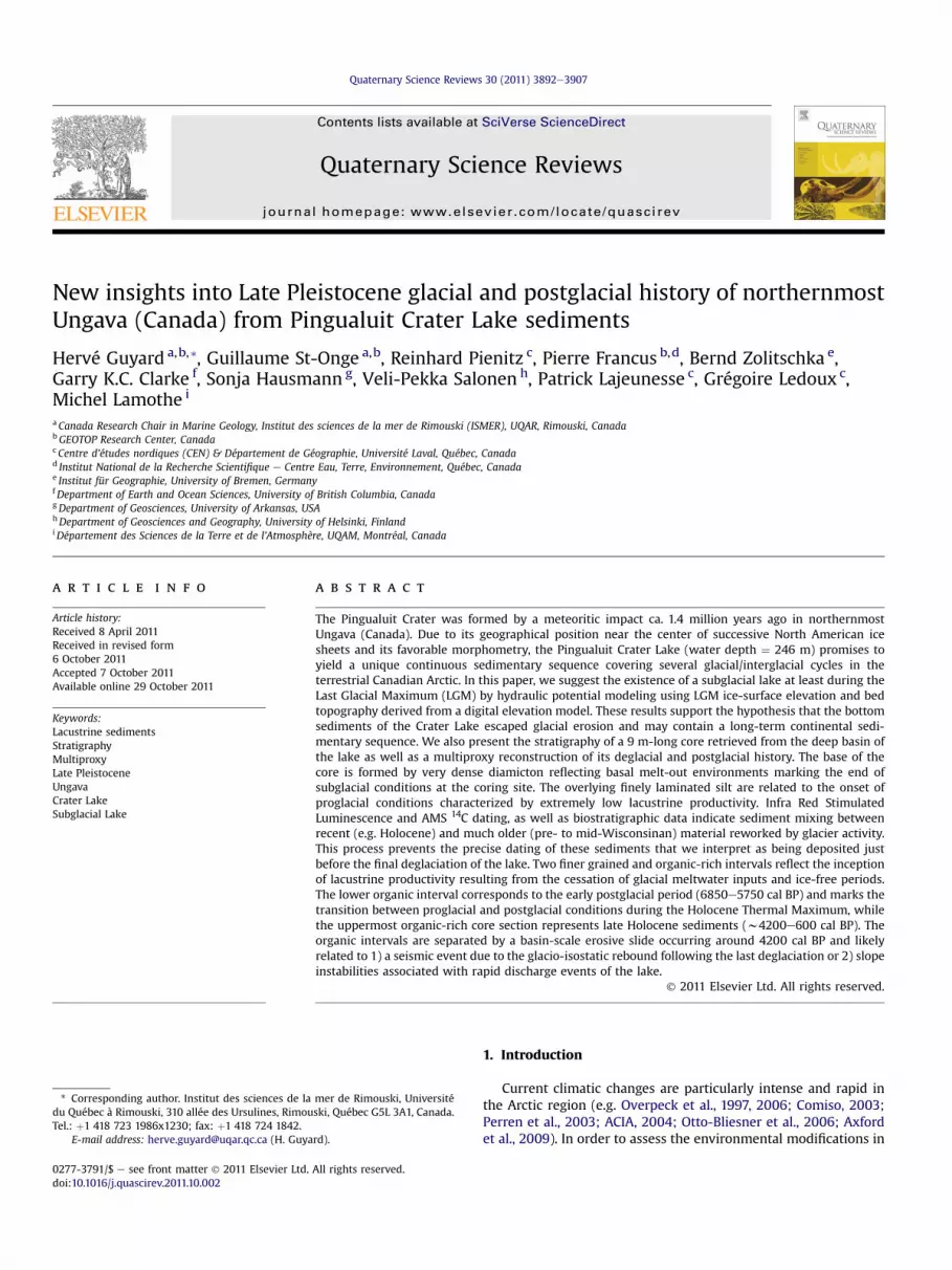
the Arctic over the last several decades, an understanding of thelong-term fluctuations is important and can be achieved by iden-tifying and studying terrestrial sites that preserved records oflong-term environmental and climatic changes. Lake sediments inhigh-latitude regions are natural archives of climate and environ-mental variability because they contain records of past physical andchemical conditions as well as important biological indicators(Cohen, 2003; Pienitz et al., 2004). If long-term marine sedimen-tary records or glacial archives from Greenland are relatively wellunderstood, there is almost no information available on climatedynamics in the terrestrial Arctic beyond the last deglaciation(e.g. ACIA, 2004; CAPE, 2006). Most of the lakes in the northernHemisphere are of glacial origin or the sediments in the preexistinglakes were eroded by ice-sheet flow during past glaciations (Pienitzet al., 2008). Due to its location in close proximity to former centersof successive North American ice-sheets, where ice thickness wasmaximal and ice movement was minimal, and due to its particularshape and depth, the Pingualuit Crater Lake (61�17 N, 73�40 W;Ungava; Figs. 1, 2 and 3) may potentially yield a unique continuouslong-term sedimentary sequence reflecting a succession of glacial/interglacial periods over the last 1.4 Ma in the terrestrial CanadianArctic (Bouchard, 1989a). Physical and hydrological argumentssuggested that the lake may have persisted under the flowing icesheet (Bouchard, 1989b), supporting the idea that a subglacial lakeexisted at the center of the Laurentide Ice Sheet (LIS).
In northern Québec, the onset of deglaciation and the timing ofthe Holocene Thermal Maximum lagged behind other regions ofthe northwestern and northeastern Canadian Arctic (e.g. Kaufmanet al., 2004; Kaplan and Wolfe, 2006). Due to the stagnant natureof the ice front on the rugged coastline, the LIS strongly influencedregional climate long after deglaciation was initiated around 12 kacal BP along the southern shore of Hudson Strait and persisted untilabout 7.4 ka cal BP in northern Québec and Labrador (Lauriol andGray, 1987; COHMAP, 1988; Saulnier-Talbot and Pienitz, 2009).According to Matthews (1963) and Lauriol and Gray (1987), thestationary nature of the ice front could be explained by local
Fig. 1. Topographic map of northern Ungava and location of the Pingualuit Crater Lake (redfrom accumulation and erosion forms (Bouchard and Marcotte, 1986; Daigneault and Boucha(dashed line). (For interpretation of the references to colour in this figure legend, the reade
climate, characterized by cold humid summers and abundantsnowfall inwinter, allowing stabilization of the glacial front beyond7.9 ka cal BP (Lauriol and Gray, 1987).
Until our study, only the upper 14 cm spanning the last5030 � 70 yr BP (5780 � 135 cal BP) were sampled in PingualuitCrater Lake (Bouchard et al., 1989a). Sediments are rich in pollen,diatoms and chironomids, thus promising for paleoenvironmentalreconstructions (Richard et al., 1989; Gronlund et al., 1990). Herewe present an AMS 14C-based stratigraphy and a multiproxy pale-oenvironmental reconstruction of a w9 m-long sediment coreretrieved in May 2007 from the deep basin of Pingualuit CraterLake.
2. Study area
2.1. Origin, characteristics and age of the Pingualuit Crater
The Pingualuit meteoritic crater is located in the UngavaPeninsula, south of Hudson Strait about 80 km WSW of Kangiqsu-juaq (Fig. 1), close to the area where the LIS reached its maximumthickness during the Wisconsinan glaciation (Bouchard andMarcotte, 1986; Marshall et al., 2000, 2002). Since deglaciation,this is also a climatologically sensitive location as the Hudson Straitconnects the waters of the Canadian Arctic and Subarctic to theNorth Atlantic Ocean via the Labrador Sea. The Pingualuit Craterwas formed ca. 1.4 million years ago, as determined by Ar/Ar datingof the impactites collected outside the crater (Grieve et al., 1991),and is classified as a simple crater (i.e. no central uplift and noinward collapse of the rim) (Bouchard and Marsan, 1989).
Today, the crater forms an almost perfect circular depression(Fig. 2) about 410 m deep and 3.4 km in diameter, hosting a uniquepurple-blue, clearwater ultraoligotrophic lake presently 246 mdeep and 2.8 km in diameter (Gantner et al., submitted forpublication). Pingualuit Crater Lake is one of the deepest andmost transparent lakes (Secchi disc transparency in August2011, ¼ 33 m) on the planet (Ouellet et al., 1989; Gantner et al.,
circle). Also illustrated are the main ice flow directions (Ungava and Payne) deducedrd, 2004) (arrows) and the ice divide line proposed by Daigneault and Bouchard (2004)r is referred to the web version of this article.)

Fig. 2. Photographs illustrating (A) the isolated Pingualuit Crater Lake (photo: Robert Fréchette), (B) the UWITEC coring system used on the frozen lake surface, (C and D) the steep internal slopes composed of large blocks and lackingvegetation and soils (southern part of the crater on C and eastern part on D), and (E) one V-shaped discharge valley (some are also visible in A) and the associated 544 m a.s.l. paleo-shoreline (black and white arrows, respectively).
H.G
uyardet
al./Quaternary
ScienceReview
s30
(2011)3892
e3907
3894

H. Guyard et al. / Quaternary Science Reviews 30 (2011) 3892e3907 3895
submitted for publication) and has an extremely limited littoralzone due to its steep basin walls (26e35�) and boulder-strewnslopes (Fig. 2). The lake has no surface connection to othersurrounding water bodies (Fig. 2) and is only fed with precipitation.Nevertheless, the existence of a cryptorheic drainage system(i.e. underground) between the Pingualuit Crater Lake and theneighboring Lake Laflamme (Fig. 3) is strongly suggested by d18Omeasurements of lake waters from both systems (Ouellet et al.,1989). The groundwater drainage probably occurs along a majorand NeS oriented fault plan linking both lakes (Currie, 1965) andwould explain the relatively stable level of the Crater Lake (at leastover the last decades) despite a positive hydrologic balance. Theresidence time of the waters in the Crater Lake is estimated ataround 330 years (Ouellet et al., 1989). The maximum altitude ofthe rim is 657 m a.s.l., which is one of the highest summits inUngava (Fig. 1). It rises to 163 m above the present lake surface(494 m a.s.l) and 120 m above the surrounding terrain (Fig. 3).
2.2. Geological context
The study area lies on Archean bedrock dominated by granitesand granitic gneisses (Currie, 1965). The exposed bedrock consistsof a mixture of plutonic rocks of generally granitoid compositioncut by occasional basic dykes. Low-grade hydrothermal minerali-zation and alteration is present on the inner wall of the crater and isbelieved to be related to the formation of the crater (Currie andDence, 1963; Currie, 1965). Rocks of the rim are mineralized withepidote and hematite, and are altered to sericite. Theseminerals arenot found in the same rock units outside the rim.
The landscape is covered with a 0e2 m-thick discontinuousveneer of till and boulders supporting very scarce tundra vegeta-tion (Gray and Lauriol, 1985; Bouchard et al., 1989b; Daigneault andBouchard, 2004). Mudboils, frost cracks, soil circles and stripes arethe main frost features frequently observed on the till-coveredsurfaces. Glacial landforms in the study area are mostly character-ized by large erratic and perched blocks, but eskers and drumlinsare also common (Bouchard et al., 1989b; Daigneault, 1997a,b).
2.3. Regional glacial history
The crater is situated at the center of successive QuaternaryNorth American glaciations where ice movements and erosionwere minimal (Dyke, 2004). Nevertheless, geomorphologicalfeatures in the area surrounding the crater show at least twodistinct regional glacial movements (Ungava and Payne flows;Figs. 1 and 3A) during the last glaciation (Gray and Lauriol, 1985;Bouchard and Marcotte, 1986; Lauriol and Gray, 1987; Bouchardet al., 1989b; Daigneault and Bouchard, 2004). Proterozoic erraticblocks derived from the North were recognized by Currie (1965)and thought to originate from the Ungava center, while all otherice flow indicators reveal that the subsequent flow was north-eastward, originating from the Payne center. The Ungava flow(oriented at the azimuth 110�; Fig. 3A) has preceded the Payne flow(oriented at the azimuth 45�; Fig. 3A), the latter being consideredthe main and sustained glacial flow of the last glaciation in thecrater area (Bouchard et al., 1989b and citations therein). This iceflow produced loosely defined dispersal trains northeastward.Analysis of the fine fraction (<0.063 mm) of surface till samples(depth: 30 cm) in the Ungava Peninsula by Daigneault (2008)revealed anomalously high uranium content in the crater area,suggesting a regional dispersal train of U-rich material.
If some ephemeral glacial lakes (i.e. directly linked to the LISretreat and blocked by the ice front) were formed during deglaci-ation in the Lake Nantais region (Taylor, 1982; Janssen, 2003), thewater levels of such ice-dammed lakes are much lower than the
minimum altitude of the crater (550 m). Because of the high alti-tude of the crater (representing the highest summit of the drainagebasin, Fig. 3), it is very unlikely that the Pingualuit Crater Lake basinwas invaded by any large regional glacial lakes (Bouchard andSaarnisto, 1989; Daigneault, 2008). The crater rim is also locatedtoo high to have allowed postglacial marine transgression in thelake, as the marine limit is estimated at 127 m a.s.l. near Kangiq-sujuaq (Gray and Lauriol, 1985).
However, a temporary surface hydrological connection withneighboring Lake Laflamme (Fig. 3) just after deglaciation wasproposed by Bouchard and Saarnisto (1989) to explain the presenceof the single fish population in the Crater Lake, Arctic Char (Salve-linus alpinus) (Martin, 1955; Delisle and Roy, 1989; Gantner et al.,submitted for publication). This hypothesis was based on theobservation of one paleochannel connecting both lakes. The deltasurface at the mouth of the channel indicates that the LakeLaflamme’s level was at least 15 m above its present level. Insummary,waters fromglacial lakes haveneverdrained in PingualuitCrater Lake, which has only drained out during and just afterdeglaciation phases.
2.4. Regional deglaciation
Geomorphological features in the crater area suggest glacialretreat from the Hudson Strait coast toward the interior (i.e. fromnortheast to southwest) (Gray and Lauriol, 1985; Bouchard andMarcotte, 1986; Lauriol and Gray, 1987; Bouchard et al., 1989b;Bruneau and Gray, 1997; Daigneault and Bouchard, 2004). Degla-ciation along the southern shore of Hudson Strait occurredbetween 12 ka cal BP and 7.8 ka cal BP (Gray and Lauriol, 1985;Lauriol and Gray, 1987; Gray, 2001; Saulnier-Talbot et al., 2009).Last remnants of the LIS persisted until ca. 7.4 ka cal BP innorthern Québec and until 5.7 ka cal BP on Baffin Island wheretwo ice caps remained (Dyke and Prest, 1987). Lauriol and Gray(1987) proposed that the ice sheet persisted on the Ungavaplateau until about 5.7 ka cal BP.
The transition between inorganic sedimentation and gyttjaaccumulation occurred between 7690 � 260 cal BP and 7310 �310 cal BP in the Quaqtaq region (Richard, 1981) about 200 km ESEof Pingualuit Crater Lake (Fig. 1). Several radiocarbon dates onsedimentary humic acids recently obtained suggest that the coastallandscape was ice-free by 8065 � 95 cal BP in the vicinity of Salluit(Fig. 1) and that the ice had started to retreat as early as9630 � 75 cal BP near Kangiqsujuaq (Saulnier-Talbot et al., 2009).Only a few studies have in fact dated lake sediment cores in thenorthern Ungava region (see review in Saulnier-Talbot et al., 2009).Bulk sediments of the base of the 14 cm-long grab sample previ-ously recovered from the Pingualuit Crater Lake were dated at5030 � 70 yr BP (Bouchard et al., 1989a), corresponding to a cali-brated age of 5780 � 135 cal BP. The facies along with the fossilmicroflora, microfauna and the pollen content of the sediments(Richard et al., 1989; Grönlund et al., 1990) suggest that the lakewasalready ice-free at this time. According to Richard et al. (1989),these sediments would represent the entire postglacial period,while AMS 14C dating of bulk sediments from Lake du Sud-Ouest(Richard et al., 1991), a small shallow lake located just outside thecrater rim (Fig. 3A), places the transition between slightly organicclayey silt and silty gyttja at 7770 � 160 cal BP.
Ten valleys, corresponding mostly to the faulting systemsaround the crater, can be observed at different altitudes crossingthe rim (Currie, 1965; Bouchard and Marsan, 1989) and several ofthem connect to paleo-drainage channels formed during the lastice-sheet retreat (Bouchard and Marsan, 1989; Bouchard andSaarnisto, 1989). The successive rapid drainage events of thelake related to the deglaciation are indicated by three paleo-
Fig. 3. (A) Bed topography (m) of the study area derived from a digital elevation model and main ice flow directions. Enlarged section on Pingualuit Crater Lake (right panel) andlocation of the coring site in the deep basin (244 mwater depth; white circle). The white line indicates the position of the acoustic transect. The scale denotes bed elevations (m) andaxes are in kilometers north and east. LSO: Lake du Sud-Ouest. (B) Acoustic profile at the coring site along a SeN direction obtained using a 3.5 kHz chirp during the August 2010expedition. Vertical scale is in seconds (two way travel time). IF: inverse fault; MWD: mass wasting deposit.
H. Guyard et al. / Quaternary Science Reviews 30 (2011) 3892e39073896
shorelines on the internal slopes of the crater reflecting succes-sive lake level drops (Bouchard and Saarnisto, 1989). The highestpaleo-shoreline (574 � 5 m) is only detected on the northern half,while the well-developed paleo-shoreline around 544 � 5 m(Fig. 2E) is visible all around the internal slopes of the crater.Finally, the lower paleo-shoreline (512 � 3 m) is poorly developedbut present all around the crater. The water drainage is alsoindicated by the washing of the till in the valleys and by theirincised shape (Fig. 2E). When the crater was totally ice-freearound 5780 � 135 cal BP according to Bouchard et al. (1989a)and Richard et al. (1989), the lake maintained a postglacialsurface connection with neighboring Lake Laflamme for anundetermined time. The connection may have persisted as long asthe Crater Lake level was at 550 m a.s.l. (Bouchard and Saarnisto,1989). Due to the significant depth of the lake, the possibility thatlake bottom sediments escaped the crater during these rapiddrainage events is negligible. The sediments that accumulated in
the Pingualuit Crater Lake basin since its formation thereforeremained in situ and intact (Bouchard, 1989a).
2.5. Sedimentation within the Pingualuit Crater Lake
Today, the crater acts as a large natural atmospheric precipita-tion collector and as a closed sedimentary basin (Fig. 2). This situ-ation has probably persisted during ice-free periods since 1.4 Ma.The basin is asymmetric with a plateau (situated in the south-southwestern part of the lake) and a deeper basin (situated in thenorthwestern part of the lake) (Fig. 3A). Currie (1965) initiallybelieved that the deep basin resulted from more intense glacialerosion, but seismic studies revealed that more sediment hasaccumulated on the plateau than in the deep basin (Moussawi andTessier, 1989). This asymmetry may be explained by an intensesedimentation episode during the last deglaciation (Bouchard,1989a). Most of the lake sediments contain blocks/boulders,

H. Guyard et al. / Quaternary Science Reviews 30 (2011) 3892e3907 3897
except for the upper 25 m in the deep basin where sediments arefiner in grain size (Moussawi and Tessier, 1989). According to theseauthors, the upper 25 m do not show any signs of diffractionindicating finer sediments, while the sequence below (between 25and 70 m) is characterized by chaotic seismic structures, revealingthe presence of larger clasts. A deeper reflector was detected ataround 90 m below the lake floor (blf). However there is noevidence that this reflector corresponds to the base of the sedi-mentary pile and the roof of the impact breccia. An accumulation ofa minimum of 90m of sediments is therefore likely in the deep partof the basin (Moussawi and Tessier, 1989). The main results ob-tained from Moussawi and Tessier (1989), together with detailedacoustic data recently collected will be discussed elsewhere.Whereas sediments covering the plateau (55e73 m thick) resultfrom the last deglaciation associated with subglacial melt-outdeposits, sediments in the deepest basin probably represent pro-longed cumulative subglacial sedimentation (Moussawi andTessier, 1989; Bouchard, 1989a). In other similar settings (e.g. LakeEl’gygytgyn; Niessen et al., 2007), turbidites triggered in the littoralzones or on the slopes of the lake travel over long distance, anddistal turbidites are clearly visible. Likewise, distal turbidites mayalso be visible in the deep basin of Pingualuit Crater Lake.
3. Materials and methods
3.1. Acoustic profiling and sediment coring
The Pingualuit Crater Lake is the most important feature of thePingualuit National Park and is managed as an extremely protectedarea (MDDEP, 2005). The coring site was selected according to theprevious seismic study of Moussawi and Tessier (1989) whichidentified a sediment accumulation of at least 90 m in the deepbasin using a boomer Geopulse 5813A (384 Hz) source and 12hydrophones. At the coring site in 2007 (61�N 16046.500; 73�W39044.700; 244 m water depth; Fig. 3), a hole for the coring system(equipped with basal plate and reentry cone) was cut through theice. Using both the UWITEC gravity and percussion piston coringsystems from the frozen surface of the lake (Fig. 2), the uppermostw9 m of sediments were recovered in May 2007 under harshweather conditions and subject to strict environmental regulations.As such, only one hole was allowed for the coring and thereforecore recovery between sections is incomplete (Figs. 4 and 5). Coringoperations were stopped around 8.5 m below the lake floor uponreaching a diamicton layer impermeable to the coring device. Allthe core sections were placed in specifically designed heated boxesto prevent them from freezing.
In August 2010, a more detailed acoustic survey using a 3.5 kHzsub-bottom profiler (Knudsen Chirp 3212) allowed the study of thesediment architecture and basin morphology (Ledoux et al., 2011).This acoustic survey was once again performed under the strictestpossible environmental regulations to avoid any contamination ofthe pristine lake waters by gasoline or external/exotic biota. Allequipment in contact with water was washed in the field and allscientific instruments were powered by electrical batteries thatwere recharged daily outside the crater rim. To compute a firstorder sediment depth scale from the acoustic travel times, weconservatively assumed the sound velocity in the water column tobe 1420 m s�1 (Moussawi and Tessier, 1989) and in the saturatedsediments to be 1500m s�1 (Fig. 3). The apparent weak penetrationof the signal (ca. 10 m; Fig. 3B) is due to the presence of coarse-grained sediments and to the type of device used, as a higherenergy seismic source was not allowed. As a consequence of thisweak penetration, the signal obtained does not represent the entiresedimentary sequence (see section 2.5).
3.2. Multiproxy analysis of the sediment cores
In the laboratory, the core sections were first run througha Multi Sensor Core Logger to measure volumetric magneticsusceptibility and wet bulk density by gamma ray attenuation at1 cm intervals calibrated according to a procedure described in St-Onge et al. (2007). The cores were then split, described and pho-tographed using a 500 d.p.i. resolution digital camera, and diffusespectral reflectance (sediment color) was measured at 1 cm inter-vals using a hand-held spectrophotometer. Data were convertedinto the CIE (Commission Internationale de l’Éclairage/Interna-tional Commission on Illumination) L* a* b* (L*: lightness; a*: fromgreen to red; b*: from blue to yellow) color space. Magneticsusceptibility was further refined with a point sensor on the splitcore sections at 0.5 cm intervals. These data are presented here.
U-channels were then sampled in the center of the short gravityand long piston cores for subsequent very high-resolution physicaland geochemical analyses (CAT-Scan and micro XRF core scanneranalyses) in undisturbed sediments. CAT-Scan (computerized axialtomography) analyses were carried out a first time on half sectionsat the Hôpital Régional Rimouski with a pixel resolution of 3 mm.Analyses were then refined on u-channels at INRS-ETE (QuébecCity) with a pixel resolution of 0.1 mm. This non-destructive toolallows quantification andmapping of X-ray attenuation coefficientsof the sediment cores on longitudinal images (topograms). Datawere processed with the Igor software according to St-Onge andLong (2009). The resulting images are displayed in greyscale withthe darker grey representing lower X-ray attenuation and lowerbulk density values (e.g. Guyard et al., 2007; St-Onge et al., 2007).
Micro-fluorescence-X (XRF) analyses were completed at INRS-ETE with an ITRAX core scanner (e.g. Croudace et al., 2006;Guyard et al., 2007; St-Onge et al., 2007) at a downcore resolu-tion of 200 mm for most of the sections, and at 100 mm for intervalsof special interest (i.e. organic intervals). The ITRAX core scanneruses an intense non-destructive micro X-ray beam that irradiatesthe sample (duration 30 s for the intervals of interest and 10 s forthe rest of the core) to collect positive X-radiograph images and todetect the energy of fluorescent radiation to provide high-resolution relative concentrations of elemental profiles (from Alto U) (e.g. Croudace et al., 2006; Francus et al., 2009). The ITRAXX-radiograph images are 2 cm wide with a pixel size of 0.1 mm,while XRF analyses are measured from a 4 mm-wide and 0.1 mm-thick area.
Total carbon (TC) was measured on 227 dried, crushed andhomogenized samples at variable intervals using a CNS elementalanalyser (EuroEA, Eurovector) at Bremen University. Thereafter,a subset of 10 pilot samples was treated successively with 3% and20% hydrochloric acid at 80 �C to remove the carbonates. By re-measuring these samples with the CNS elemental analyser, totalorganic carbon (TOC) was determined. Total inorganic carbon (TIC)was then calculated as the difference between TC and TOC. As theTIC record is very low (<0.1%; mean ¼ 0.013%, n ¼ 10) and more orless fluctuates around zero, these values are realistically not takeninto consideration for the interpretation. As such, the TC record isregarded and reported as being identical to TOC. This is also sup-ported by the fact that no carbonates are present in the watershed(Bruneau and Gray,1997; Daigneault and Bouchard, 2004). The d13Ccontent of the sedimentary organic matter were determined atGEOTOP on dried, ground and acidified aliquots using a MicromassIsoprime mass spectrophotometer. For the determination ofbiogenic silica (BSi), 20 selected samples were digested witha sodium hydroxide solution to dissolve the diatom frustules. TheBSi was then measured photometrically according to the methoddeveloped by Müller and Schneider (1993) using continuous-flow-analysis.
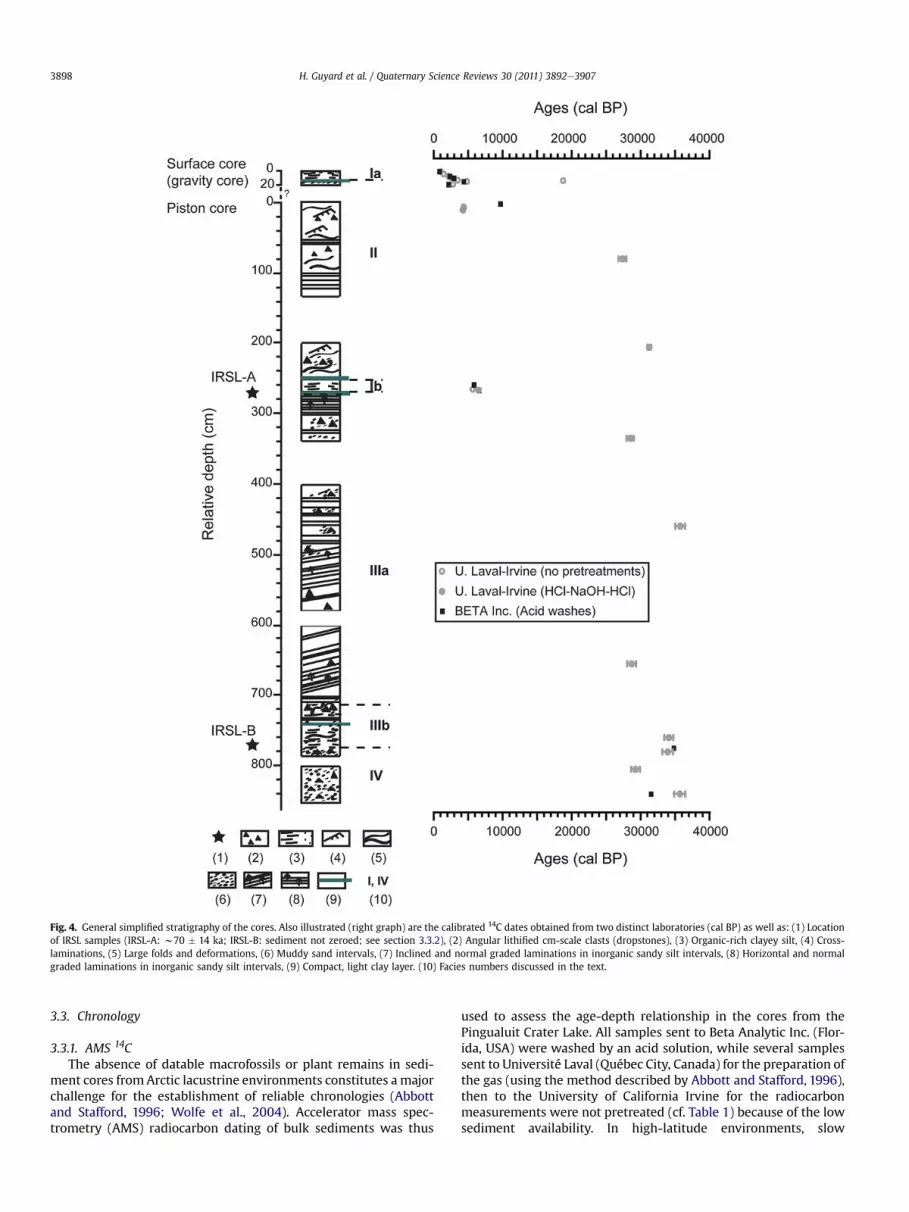
Fig. 4. General simplified stratigraphy of the cores. Also illustrated (right graph) are the calibrated 14C dates obtained from two distinct laboratories (cal BP) as well as: (1) Locationof IRSL samples (IRSL-A: w70 � 14 ka; IRSL-B: sediment not zeroed; see section 3.3.2), (2) Angular lithified cm-scale clasts (dropstones), (3) Organic-rich clayey silt, (4) Cross-laminations, (5) Large folds and deformations, (6) Muddy sand intervals, (7) Inclined and normal graded laminations in inorganic sandy silt intervals, (8) Horizontal and normalgraded laminations in inorganic sandy silt intervals, (9) Compact, light clay layer. (10) Facies numbers discussed in the text.
H. Guyard et al. / Quaternary Science Reviews 30 (2011) 3892e39073898
3.3. Chronology
3.3.1. AMS 14CThe absence of datable macrofossils or plant remains in sedi-
ment cores fromArctic lacustrine environments constitutes amajorchallenge for the establishment of reliable chronologies (Abbottand Stafford, 1996; Wolfe et al., 2004). Accelerator mass spec-trometry (AMS) radiocarbon dating of bulk sediments was thus
used to assess the age-depth relationship in the cores from thePingualuit Crater Lake. All samples sent to Beta Analytic Inc. (Flor-ida, USA) were washed by an acid solution, while several samplessent to Université Laval (Québec City, Canada) for the preparation ofthe gas (using the method described by Abbott and Stafford, 1996),then to the University of California Irvine for the radiocarbonmeasurements were not pretreated (cf. Table 1) because of the lowsediment availability. In high-latitude environments, slow
Table 114C and IRSL dating on bulk sediments from the surface and piston cores of the Pingualuit Crater Lake.
Facies # Lab no.(dating)
Lab no.(gas extraction)
Pretreatments Relativedepth (cm)
Conv. age(14C yr BP)d
� Calib. age (2s)(cal BP)
�
Surface coreIa Beta-256021a Acid washes 0e1 830 40 740 60Ia UCI-47806b ULA-620c None 0.4e0.7 1110 20 1010 45Ia Beta-256022 Acid washes 4e4.7 1510 40 1420 100Ia UCI-47807 ULA-621 None 4.2e4.5 1520 20 1430 80Ia Beta-256023 Acid washes 6.7e7.7 2310 40 2265 105Ia UCI-47803 ULA-617 None 7.4e7.7 2150 20 2180 120Ia Beta-256024 Acid washes 10.3e10.8 2920 40 3080 130Ia UCI-47808 ULA-622 None 10.4e10.7 2430 20 2520 160Ia UCI-47809 ULA-623 None 13.1e13.3 3255 20 3485 75II UCI-47810 ULA-624 None 13.6e13.9 15560 60 18750 140II Beta-256025 Acid washes 14.5e15.7 4320 40 4905 65II UCI-47811 ULA-625 None 14.6e14.9 4255 20 4840 14Ia? UCI-47812 ULA-626 None 17.3e17.6 1885 20 1810 70Ia? Beta-256026 Acid washes 18.3e19.3 2120 40 2150 160Ia? UCI-47813 ULA-627 None 18.8e19.1 2725 20 2820 44
Piston coreII Beta-256027 Acid washes 0e2 8680 50 9660 120II UCI-74434 ULA-1549 HCleNaOHeHCl 5 3885 15 4330 80II UCI-75730 ULA-1550 HCleNaOHeHCl 10 3825 15 4220 70II UCI-76678 ULA-1628 HCleNaOHeHCl 78.5e80 22660 130 27365 535II UCI76679 ULA-1629 HCleNaOHeHCl 204.5e205.5 26870 220 31265 245Ib Beta-256019 Acid washes 257.5e258.5 5080 40 5825 95Ib UCI-47802 ULA-616 None 264.8e265.2 4895 20 5625 28Ib Beta-256020 Acid washes 265.5e267.5 5800 40 6585 85Ib UCI-49080 ULA-655 HCleNaOHeHCl 266e267 5705 25 6485 75IIIa UCI-76680 ULA-1630 HCleNaOHeHCl 334e335 23730 150 28510 510IIIa UCI77051 ULA-1631 HCleNaOHeHCl 459e460 31200 320 35740 710IIIa UCI77054 ULA-1632 HCleNaOHeHCl 654.5e655.5 23870 250 28715 625IIIb UCI-75736 ULA-1551 HCleNaOHeHCl 760 29550 270 34085 655IIIb Beta-275124 Acid washes 775 30060 260 34785 365IIIb/IV UCI-75731 ULA-1552 HCleNaOHeHCl 780 29310 330 33915 750IV UCI-75737 ULA-1553 HCleNaOHeHCl 805 24570 170 29280 630IV Beta-275125 Acid washes 840 27760 210 31485 325IV UCI-75732 ULA-1554 HCleNaOHeHCl 840 31080 420 35670 810
IRSL datinge Age �Ib IRSL-A 268e272 70000 14000IIIb IRSL-B 762e764 NZ
a BETA ¼ Beta Analytic Inc.b UCI ¼ University of California Irvine.c ULA ¼ Université Laval.d Conventional age is the d13C-corrected AMS 14C measurement that is used for all subsequent calibrated ages.e IRSL-A: mean between estimated ages of coarse grained and fine-grained feldspars. NZ ¼ sediment not zeroed. See section 3.3.2.
H. Guyard et al. / Quaternary Science Reviews 30 (2011) 3892e3907 3899
catchment processes (e.g. limited plant decomposition and soildevelopment) can sequester organic matter for prolonged periodsof time before it becomes incorporated into the lake sedimentarchive (Wolfe et al., 2004; Saulnier-Talbot et al., 2009). However,because the Pingualuit Crater has no tributary and no soil on its rimor shelf (Fig. 2), no lag effect is expected in organic intervalsdeposited in ice-free conditions as the organic matter is believed toderive exclusively from lacustrine productivity. Because untreatedsamples generally yield younger ages than treated samples as theacid treatment removes the possible recent contamination, andbecause we obtained more treated dates, our interpretation ispreferentially based on the latter. Radiocarbon ages were correctedfor isotopic fractionation and reported at a d13C value of �25&.These conventional ages were then calibrated (Table 1) using theCALIB 6.0 software (Stuiver et al., 2010).
3.3.2. Infra Red Stimulated Luminescence (IRSL)Two samples were selected to be dated by Infra Red Stimulated
Luminescence (IRSL), one in the organic-rich sediment unit of thepiston core (IRSL-A: relative depth ¼ 268e272 cm) and one in thelower part of the core (IRSL-B: relative depth ¼ 762e764 cm) (seeFig. 4). The IRSL measurements follow the standard luminescenceprotocol applied to feldspar as developed in the Montréal labora-tory and described by Lamothe (2004).
The single aliquot regeneration (SAR)method applied to feldsparinvolves measurements of IRSL following a cut heat at 280 �C.A further and similar cut heat followed by a shine down of 60 s isinserted between the luminescence measurement following thenatural or laboratory regenerated dose (e.g. Ln and Lx) and theluminescence measurement of the test dose (Tn and Tx). Severalaliquots from different grain size fractions (e.g. 4e11 mm and62e88 mm) were measured for both samples. The fading measure-ment followed the routine described by Auclair et al. (2003). Theanomalous fading rate (termed g) value measurement for thesesamples is somewhat scattered but an average value of 7% can beassessed for both samples. The annual dose was estimated frominstrumental neutron activation analysis (INAA) and thick sourcealpha counting of several core samples. As the sediment analysisyielded significant levels of U and Th, several sediment sampleshave been reanalyzed and one sample was further investigated todetect eventual disequilibrium by alpha spectrometry. For theenvironmental dosage we used a U content of 9.3 (�0.9) ppm, a Thcontent of 28.1 (�1.7) ppm and a K content of 2.12 (�0.7) %. Cosmiccontribution was considered insignificant. A value of 12.5% ofinternal K was used for the dose rate to the coarser grain size. Theassessment of thewater contentwas based on in situ and laboratoryanalysis, as well as from the gamma density parameters. The watercontent was assumed to have been 75% for the whole geological

Fig. 5. High-resolution geochemical, physical and magnetic properties of the sediments. Facies numbers are also reported. Ph: Digital photographs of the cores; CT: topogramsobtained from CAT-Scan analysis; D: wet bulk density; MS: volumetric magnetic susceptibility; L* is lightness according to the CIE Lab color space; Fe/Ti as measured by the ITRAXcore scanner and smoothed over 100 points; TOC (%): total organic carbon; BSi (%): biogenic silica.
H. Guyard et al. / Quaternary Science Reviews 30 (2011) 3892e39073900
period. The annual dose obtained for the younger sample IRSL-A isaround 4.5 (�0.4) Gy-ka�1 for the coarser fraction and 5.7 (�0.6)Gy-ka�1 for the fine grains. The lower sample, albeit undatable, wasfound to be in excess of 7 Gy-ka�1.
The ages were calculated using the dose rate correction (DRC)method introduced by Lamothe et al. (2003). Therein, the equiva-lent dose measured is corrected for anomalous fading (AF) using anequation for which the most important parameters are the anom-alous fading rate and the ratio between the laboratory and theenvironmental dose rate. The corrected equivalent dose, termedpaleodose, divided by the annual dose yields the AF-corrected IRSLage. The AF-corrected natural luminescence of the lower sample,IRSL-B from 762 to 764 cm, suggests dose saturation, typical offeldspar grains that would have never been exposed to sunlight. Inthe case of the upper sample, IRSL-A from 268 to 272 cm, the IRSLproperties of the aliquots used for measurements suggest bleachingby sunlight prior to final deposition. The coarse grained feldsparsyielded a combined age of 74 ka (�9 ka) whereas the fine grainssuggest an age of 66 ka (�10 ka). When the ages obtained representoverestimations for the timing of the depositional events, theyshould be considered as apparent.
3.4. Hydraulic potential modeling
To assess the likelihood that the crater provided a site for asubglacial lakewe computed hydraulic potentials (e.g. Clarke, 2005,p252) at the base of the ice-sheet using Last Glacial Maximum(LGM) ice-surface elevation and bed topography derived froma digital elevation model (DEM) isostatically adjusted proportion-ately to the ice thickness (Marshall et al., 2000, 2002; Peltier, 2002).
Ice-surface in the region of interest was approximated by a planarsurface inclined in the direction of inferred ice flow. Basal ice wasassumed to be at the melting temperature so that the flow ofsubglacial water was not impeded by thermal barriers.
The potential energy of water depends on its elevation andpressure. The water pressure at the base of an ice sheet tends to bevery close to the ice flotation pressure. We assume both are equiv-alent so that the downward force associated with ice overburden isexactly matched by an upward force associated with lake waterpressure. Here we express hydraulic potential (Pa) in terms ofhydraulic head (m) so that results can be plotted on the same graphas those depicting topographic elevations.
We estimate the extent of the subglacial lake by making thereasonable assumptions that the ceiling ice is floating on the lakeand that hydraulic potential is exactly constant in the lake. Thehydraulic potential in the lake contains contribution from thegravitational potential energy owing to the elevation of water in thelake, from ice overburden pressure to water pressure in the lakeand from the added water pressure from the overlying water. Wedelineate the elevation of the lake ceiling by assuming that the lakeis brimful. For a subaerial lake this would imply that the basin of thelake was filled to the elevation of the lowest spillway determinedby the bed surface topography zb(x,y) where x and y are mapposition coordinates. For a subglacial lake the situation is analogousbut it is the topography of the hydraulic head h(x,y) that controlsthe location of spillways. Unlike subaerial lakes, the upperboundary of subglacial lakes need not be horizontal or flat.
To determine the brimful level of the basin we adopt a standardprocedure of DEM analysis termed pitfillingwhich, in effect, replacesthe void volumes contained within closed depressions by solid
H. Guyard et al. / Quaternary Science Reviews 30 (2011) 3892e3907 3901
material. The filling level is progressively increased until a topo-graphic spillway is encountered. The method is commonly used inconjunction with drainage routing algorithms in order to removewater-trapping “pits” from a DEM. By applying this method to theDEM of hydraulic head we establish the maximum filling level forthe subglacial lake. By assuming the lake is brimful, we implicitlyassume that the subglacial bed is wet and that water is free to enterand exit the lake by flowing along the bed. This contrasts with thesituation in subglacial Lake Vostok where the water level is largelycontrolled by thermal processes operating at the ice ceiling.
The source digital data of the Canadian Digital Elevation Data atthe scale of 1:50 000 was extracted from the hypsographic andhydrographic elements of the National Topographic Data Base,while bathymetric data were obtained from Bouchard and Marsan(1989). The model was implemented within the MATLAB�
programming environment using the DEM pit-filling algorithmdeveloped by Soille and Gratin (1994).
4. Coring site and general stratigraphy of the core
4.1. Acoustic profile at the coring site
Acoustic profiles along the S-N axis of the lake indicate verysteep slopes on both sides of the lakewith mass wasting deposits attheir foot, as reflected by chaotic and transparent reflections(Fig. 3B; Ledoux et al., 2011;). The steep slopes are also evident inthe field (Fig. 2C and D). These typical acoustic facies dominate thelake bottom. Some discontinuous high amplitude reflections areonly detected in the deep basin and indicate around 7.5 m ofacoustically-stratified sediments. The presence of an inverse faultthroughout the high amplitude reflections (Fig. 3B) suggests thatthese fine-grained sediments have been disturbed by post-depositional processes due to mass wasting probably originatingfrom the particularly steep northern slope of the crater (Fig. 3). Theupper part of the acoustic profile represents a 2e3-m thick trans-parent and low amplitude acoustic facies that covers the entiredeep basin and corresponds to the sedimentary facies II (Fig. 3B, seebelow).
4.2. Lithofacies and physical properties of the sediments
Most of the sediments retrieved in the deep basin consist ofrelatively dense light grey sandy silt containing several angularrock fragments, and are characterized by very low organic carbon(<0.3%; n ¼ 123) and biogenic silica (1.7%; n ¼ 13) contents (FaciesIV, III, II; Figs. 4 and 5). In these facies, d13C values show a morepronounced variability and reached values > �24& (Fig. 5). Twodecimeter-thick darker and finer intervals (Facies Ib and Ia) aresharply contrasting with these facies and are characterized byhigher organic carbon (>2%; n ¼ 57) and biogenic silica (6.8%;n ¼ 5) contents, and relatively lower density, magnetic suscepti-bility and d13C values (Figs. 4 and 5).
Facies IV (849e780 cm) is characterized by very dense and darksediments as recorded by the lower L* values (e.g. St-Onge et al.,2007). TOC (0.27%; n ¼ 7) and BSi (1.3%; n ¼ 1) contents andmagnetic susceptibility values are very low (Fig. 5). d13C values arerelatively high (>�25.9&; n ¼ 8). This heterogeneous unsortedsandy mud interval also contains several cm-scale angular rockfragments (Fig. 4).
Facies III (780e270 cm) is characterized by less dense andlighter sediments with higher magnetic susceptibility values. From780 to 710 cm (Facies IIIb), L*, Fe/Ti and magnetic susceptibilityvalues increase, while density decreases. Sediments are faintlylaminated, finer and soupy (Fig. 5). TOC (>0.33%; n ¼ 67) and BSi(>2.1%; n ¼ 6) contents are slightly higher and reach values up to
0.76% and 4%, respectively (Fig. 5). d13C values are slightly lower(<�26.7&; n ¼ 60). This deformed interval is intercalated betweentwo rock fragments as large as the inner diameter of the liner tube(6.4 cm) and embedded in a sandy mud matrix (Figs. 4 and 5).Sediments between 710 and 270 cm (Facies IIIa) generally consist offinely laminated (<1e2 mm) silt (rhythmites) containing a fewdropstones and/or sandy layers (Figs. 4 and 5). TOC (<0.25%;n¼ 48) and BSi (<1.4%; n¼ 4) contents are very low. d13C values arerelatively high (>�26&; n ¼ 49). Laminations are oblique at thebase and then become more horizontal upwards. The Fe/Ti ratioslightly increases up to 270 cm blf (Fig. 5).
Facies Ib (270e257 cm) consists of a decimeter-thick, organic-rich (1.8%; n ¼ 22) clayey silt interval characterized by much lowerdensity (also shown by CT-Scan and X-ray images), d13C (<�26.7&;n¼ 24) andmagnetic susceptibility values, and containingmore BSi(5.9%; n ¼ 3). Fe/Ti ratio values are much higher than in the rest ofthe core (Fig. 5). The transition between finely laminated silt (FaciesIIIa) and facies Ib is marked by a 3-cm thick blue compact clay layerbetween 273 and 270 cm (Figs. 4 and 5).
Facies II (257e0 cm blf) is found at the top of the piston coreand consists of deformed sediments yielding the same physicalproperties as facies IIIa (i.e. high density and magnetic suscepti-bility values, low TOC and BSi contents, relatively high d13C valuesand lower Fe/Ti values; Figs. 4 and 5). CT-Scan and X-ray images infacies II show folded structures, cross and horizontal laminations.Its base (257e255 cm blf), characterized by an erosive contact asrevealed by the CT-Scan images and sharp variations in thedifferent proxies, is associated with a thin compact blue clay layer(Figs. 4 and 5). Facies II can be identified in the seismic profile asa low amplitude and transparent facies (Fig. 3B) and is intercalatedbetween facies Ib and facies Ia, the latter being located in thesurface core.
No correlation was possible between the short gravity and thelong piston core using the different proxies, likely indicatinga small but undetermined sediment gap between both cores(Figs. 4 and 5). The last 3 cm of the surface core (17e20 cm) aredefined by disturbed organic sediments (Fig. 4 and Table 1).Between 17 and 14.5 cm, very dense and inorganic sediments withhigh values of Fe/Ti ratio are observed. A blue, compact, inorganicclay layer is observed between 14.5 and 13.5 cm. Facies Ia is anorganic-rich interval (13.5e0 cm) yielding similar characteristicsthan facies Ib (Fig. 5). BSi (8%; n ¼ 2) and TOC (>2.2%; n ¼ 35)values are slightly higher than in facies Ib. d13C values in facies Iaare the lowest (<�28.4&; n ¼ 35) measured throughout the core.Finally, a thin sand layer between 1.5 and 3 cm is observed in thesurface core and characterized by lower TOC and higher densityvalues.
5. Core chronology and paleoenvironmental history
5.1. Existence of a subglacial lake
Results of the hydraulic potential modeling (Fig. 6) at the base ofthe ice sheet confirm the possibility that the crater basin hosteda subglacial lake during the LGM. Subglacial meltwater flow isdriven by gradients of the hydraulic potential surface, and watershould pond to accumulate as a subglacial lake in locations of localminima in this surface. The high fluid pressures modeled at therock/ice interface around the basin combined with the depressionmorphometry thus suggest storage of subglacial water within thecrater. The water being incompressible, the ice penetration in thebasin was limited by the water evacuation throughout the crater’sinner walls. If the current cryptorheic drainage beneath the cratertoward Lake Laflamme had persisted during glacial periods, theunderground drainage system should have been more distal and

Fig. 6. Hydraulic potential modeling results for the Last Glacial Maximum (LGM; 20 ka) following the main ice flow direction (illustrated by arrows; Bouchard and Marcotte, 1986;Daigneault and Bouchard, 2004) and considering a 1700 m ice thickness (Dyke et al., 2002; Marshall et al., 2002) and a mean ice sheet slope of 0.1�. (A) Hydraulic head (m) for thePingualuit Crater. (B) Pingualuit subglacial lake depth (m). (C) Geometry along SW-NE profile (illustrated by dashed lines on Fig. 6A and B). Note that the lake surface slope is in theopposite direction from the ice-surface slope. LIS: Laurentide Ice Sheet.
H. Guyard et al. / Quaternary Science Reviews 30 (2011) 3892e39073902
much reduced as the Lake Laflamme basin was occupied by an icecap. Consequently, the entering rate of the ice in the basin wouldhave been strongly restricted. Geothermal melting of any enteringice during its downward vertical progression may also havecontributed to the persistence of the subglacial lake. The modelsimulations reveal that the geometry of the subglacial lake isindependent of the ice thickness but highly influenced by themagnitude and direction of the ice sheet surface slope (which alsocontrol the ice flow direction). These findings are consistent withthe fact that most subglacial lakes are lying close to ice divides andtherefore in areas of low surface slopes and high hydraulic fluidpotential (Siegert et al., 2007; Pattyn, 2008).
Water circulation along a sloping ice-water interface canproduce a glaciohydraulic heat flux that can activate melting andfreezing processes at the lake surface (Wuëst and Carmack, 2000)which balance the water influx and outflux of large subglacial lakesin Antarctica (Bell et al., 2002; Tikku et al., 2005). The relativelysmall size of the Pingualuit subglacial basin should have limited thedevelopment of necessary gradients to drive sufficient circulationwithin the reservoir. The subglacial crater is thus unlikely to beanalogous, for example, to the much larger (and not brimful) LakeVostok (Studinger et al., 2004). At its brimful level, the lake wouldhave most likely behaved as an open water system with waterinflows and outflows from the surrounding glacier bed. If notbrimful, the subglacial lake would have shrunk to a very small sizeby net freezing or would have collected meltwater by geothermalmelting, as the lake floor lies at a lower elevation than thesurrounding glacier bed. When the lake level reached the level ofa spillway and if the basal ice was not frozen at the vicinity of theconduit, an outburst flood would occur to release any excess water(e.g. Clarke et al., 2005).
By revealing that the Pingualuit Crater is a suitable subglacialbasin for the storage of subglacial water, the modeling findings alsosuggest that the sediments deposited in the lake may have beenpreserved from glacial erosion during glacial periods.
5.2. Ice sheet impact on sedimentation (Facies IV and III)
Facies IV and III present a range of 14C ages between 35 740 �710 and 28 510 � 510 cal BP (Fig. 4, Table 1). Within these facies,d13C values display more pronounced variability and higher valuesthan in organic-rich intervals. This is the result of external inputs oforganic particles from the catchment area or from the littoral zoneof the lake (Meyers, 1997; Meyers and Teranes, 2001). Because the
lake has no tributary and no soils has been developed on theinternal slopes of the crater (e.g. Fig. 2), glacial motion is the mostlikely transport agent for these organic particles. Furthermore, theexternal input of U-rich material in the Payne dispersal train(Daigneault, 2008) is also indicative of distally and glacially derivedmaterial in the Crater Lake basin. Several age reversals observed inboth facies, as well as the age range obtained (Fig. 4, Table 1)strongly suggest that AMS 14C dating does not adequately representthe depositional time of these organic-poor glacigenic sediments.The latter were more likely deposited just before the final degla-ciation of the lake (see section 5.4). The 14C ages in facies III and IVtherefore represent a “mixing age” between a recent (e.g. Holo-cene) and much older (early to mid-Wisconsinan) organic contri-bution. This reworking process is also apparent from the IRSLresults of sample IRSL-B (762e764 cm, Fig. 4), as the AF-correctednatural luminescence suggests dose saturation, typical of feldspargrains that would have never been exposed to sunlight. The satu-ration of IRSL is thus coherent with sediment being reworkedfrom till or waterlaid sediment that was buried without properbleaching.
Glacial till found outside the crater is known to be exception-ally rich in pollen because sediments situated at the center ofnorthern Ungava were protected from intense glacial erosionthroughout successive glaciations (Richard et al., 1991; Fréchetteet al., 1996). According to these authors, these basal till remain-ing after each glaciation would passively incorporate and preservepollen grains during warm periods. The material reworked duringglaciations would also include terrestrial organic particles (e.g.mosses) fromwarm periods (Fréchette et al., 1996). Pollen analysisin facies IV and III revealed a relatively high abundance of Piceaand Pinus sp. grains (Girard-Cloutier, 2010). The pollen of thesetwo species are found in the nearby tills (Richard et al., 1991) andtherefore reflect their remobilization and incorporation fromformer interglacial/interstadial periods at the base of the ice sheetand their deposition in the lake during later deglaciation.However, it is unlikely that the same till in the crater surroundingsacted as traps and preserved lacustrine diatoms from olderinterglacials in a similar manner, as neither diatoms nor any otherlacustrine sediment vestiges were reported in the regional till(Grönlund et al., 1990; Fréchette et al., 1996). Therefore, the dia-toms preserved in the Pingualuit Crater sedimentary sequencemore likely reflect the environmental conditions (e.g. ice cover)that occurred during their deposition, even if they are mixed withglacially derived material.
H. Guyard et al. / Quaternary Science Reviews 30 (2011) 3892e3907 3903
5.3. Deglacial history (Facies IV and III)
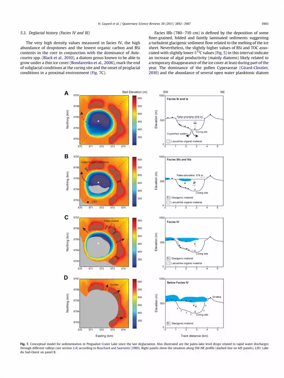
The very high density values measured in facies IV, the highabundance of dropstones and the lowest organic carbon and BSicontents in the core in conjunction with the dominance of Aula-coseira spp. (Black et al., 2010), a diatom genus known to be able togrow under a thin ice cover (Bondarenko et al., 2006), mark the endof subglacial conditions at the coring site and the onset of proglacialconditions in a proximal environment (Fig. 7C).
Fig. 7. Conceptual model for sedimentation in Pingualuit Crater Lake since the last deglacithrough different valleys (see section 2.4) according to Bouchard and Saarnisto (1989). Righdu Sud-Ouest on panel B.
Facies IIIb (780e710 cm) is defined by the deposition of somefiner-grained, folded and faintly laminated sediments suggestinga turbulent glacigenic sediment flow related to themelting of the icesheet. Nevertheless, the slightly higher values of BSi and TOC asso-ciated with slightly lower d13C values (Fig. 5) in this interval indicatean increase of algal productivity (mainly diatoms) likely related toa temporary disappearance of the ice cover at least during part of theyear. The dominance of the pollen Cyperaceae (Girard-Cloutier,2010) and the abundance of several open water planktonic diatom
ation. Also illustrated are the paleo-lake level drops related to rapid water dischargest panels show the situation along SW-NE profile (dashed line on left panels). LSO: Lake

Fig. 8. Age-depth relationship for the last 6850 cal BP. The composite depth wasconstructed by excluding mass wasting events and glacigenic sediments from theprofile (see text for details). SL: sandy layer in the surface core; MWD: erosive masswasting deposit (facies II).
H. Guyard et al. / Quaternary Science Reviews 30 (2011) 3892e39073904
species (e.g. Cyclotella sp.), as well as the decrease of Aulacoseira spp.(Black et al., 2010, in press) also points to temporarily ice-freeconditions preceding the final deglaciation of the area. Further-more, Fe is mobilized during redox-related diagenesis and elevatedFe is commonly observed in oxic or formerly oxic parts of the sedi-ments (Croudace et al., 2006). Higher values of Fe/Ti in facies IIIbmaythus indicate thedevelopmentof a redox front at the sediment/waterinterface associated with a better oxygenation of the bottom water.This is related to the mixing of the whole water column, which canonlyoccurduring ice-free periods in coldmonomictic lakes (Lewis Jr.,1983). The depositional transition observed around 780 cm likelymarks a major change in predominant depositional mechanismsfrom a proximal proglacial environment with permanent thin icecover to a more distal proglacial environment with temporarily ice-free conditions (Fig. 7B). The microfossils and 14C dates obtained infacies IIIb (w34 ka cal BP, Table 1) could reflect a short period ofregional ice-free conditions during themid-Wisconsinan latemarineisotopic stage 3 (MIS 3), since Kirby and Andrews (1999) andAndrews and MacLean (2003) suggested that Hudson Strait mayhave been at least partially deglaciated <34 ka. Recent studies alsoindicate ice-free conditions during MIS 3 in Fennoscandia (e.g.Helmens and Engels, 2010;Wohlfarth, 2010). However, since the 14Cages correspond to apparent ages and the IRSL age in this intervalreflects sediment buried without proper bleaching (see section 5.2),and because of the geographical position of the crater, this inter-pretation is very speculative at this stage.
The overlying finely laminated silty (rhythmites; <1e2 mm)melt-out deposits (Facies IIIa) are intercalated by massive sandlayers (Figs. 4 and 5) and are again characterized by radiocarbonages between 28 510 � 510 and 35 740 � 710 cal BP showingreversals (Fig. 4 and Table 1). This interval is also marked by thedecrease of Cyclotella sp. and the increase of Aulacoseira spp. (Blacket al., 2010), both indicative of the presence of a semi-permanentice cover on the lake. Low TOC and BSi values indicate a veryweak primary productivity. The presence of massive sand layersand dropstones, the inclination of the laminae, as well as the highdensity of these glacigenic sediments all point to high meltwaterand sediment discharges. The top of this unit includes more hori-zontal rhythmites reflecting a lower energetic depositional envi-ronment, associatedwith the decay of the remnant glacier andwithweaker influence of the ice sheet-derived detritic inputs (Fig. 7B).Moreover, the increasing trend of Fe/Ti indicates a slight evolutionof redox-related diagenetic conditions at the sediment/waterinterface, likely associated with a better oxygenation of the bottomwater and a higher mixing of the water column related to shorterice cover periods. Facies IV and IIIa thus reflect original glacigenicsediments deposited in a subglacial and lacustrine environment byice shedding from the disintegrating glacier above during the laststages of deglaciation (Fig. 7C and B).
5.4. Postglacial history (Facies I)
Without any major terrestrial vegetation in the catchment areaof this Canadian Arctic Crater Lake, the increase of TOC associatedwith the lower values of d13C of the organic matter in facies Ireflects an increase of the lacustrine (mainly algal) productivity.Similarly, the higher BSi concentrations reflect the lacustrineproductivity bloom of siliceous algae (Black et al., 2010) related toice-free conditions (Figs. 5 and 7A). Pollen analyses reveal thedevelopment of a shrub tundra (Girard-Cloutier, 2010) also indic-ative of a warmer climate. Furthermore, high values of Fe/Ti,associated with the development of a redox front, suggest venti-lation and strongly support the absence of a permanent ice cover.
The onset of organic sedimentation at 270 cm blf (Facies Ib)marks the cessation of glacial inputs as the result of the
disappearance of last remnants of the LIS and occurred ca.6000 � 40 yr BP (6844 � 100 cal BP) (Figs. 4 and 8). The top of theinterval is estimated at 5000 � 40 yr BP (5760 � 135 cal BP),assuming a constant sedimentation rate between treated ages(Fig. 8 and Table 1) of 12 cm/ka. The thin compact inorganic clayishlayer observed below the facies Ib likely corresponds to the depo-sition by settling of fine particles after the final melting of thevestigial lake ice pan, as also suggested by the IRSL apparent agesobtained for sample IRSL-A (Fig. 4). The IRSL properties of thealiquots used for measurements indicate bleaching by sunlightprior to final deposition, and the coarse grained feldspars yieldeda combined age of 74 ka (�9 ka) whereas the fine grains suggesta somewhat similar age of 66 ka (�10 ka). This IRSL age estimationlikely indicates that some grains were incorporated at the base ofthe ice sheet since the beginning of the last glaciation (Clark et al.,1993) and were never exposed to sunlight since that time. The IRSLapparent age thus once again reflects a mixed age, resulting fromthe incorporation of feldspar grains of various ages from theregional extra-crater surface. Due to the large size of the retentionbasin and the low regional glacial movements, these grains weredirectly introduced into the lake basin during deglaciation. The IRSLage of these grains thus reflects the time when they were buriedprior to the last glaciation and not the age of their deposition in thelake, whereas the age of the algal organic matter produced in thelake at that time rather reflects the onset of deglaciation. Thisfurther indicates that the area has not been deglaciated since theonset of the last glaciation. The onset of ice-free conditions alloweda productivity surge and the organic matter produced in the lakewas adsorbed onto the mineral particles dated by IRSL during theirdecantation.
The change from proglacial to postglacial conditions in thePingualuit Crater Lake basin indicates the final collapse of the LIS at6850 cal BP and confirms that it was one of the last sites to becomeice-free in this part of the eastern Canadian Arctic. This scenario isconsistent with themain thrust of data available for eastern Canadathat reveal cold temperatures during the early postglacial, followedby warming at 6850 cal BP (e.g. Andrews, 1972, 1973; Richard et al.,

H. Guyard et al. / Quaternary Science Reviews 30 (2011) 3892e3907 3905
1982; Williams et al., 1995; Levac and de Vernal, 1997; Andrewset al., 1995; Sawada et al., 1999; Kerwin et al., 1999, 2004; Kaplanet al., 2002; Saulnier-Talbot and Pienitz, 2009). This majorregional change could thus be linked to the final disappearance ofthe LIS.
5.5. Mass wasting deposit (Facies II) and age-depth modelsince the deglaciation
The sharp contact observed at 257 cm on CAT-Scan images andrecorded by both drastic geochemical and physical variationsmarksthe base of a Mass Wasting Deposit (MWD; facies II), characterizedon the seismic profile by a transparent acoustic facies (Fig. 3B).Some apparent radiocarbon ages measured in the sediments offacies II are also similar to the radiocarbon ages obtained in facies IVand III, which correspond to deglacial/proglacial sediments (seesection 5.3). Furthermore, the sharp decrease of Fe/Ti reflects therapid deposition of the MWD that prevented a redox front tomigrate upward at the base of the MWD. The thin compact claylayer present at the base of the deposit may indicate some fluid-ization related to the occurrence of this sedimentary event. TheMWD is mainly composed of folded and reworked glacigenicmaterial, as indicated by some 14C AMS dating and also by thesimilarity of its physical properties with facies IIIa (gamma density,magnetic susceptibility, Fe/Ti, TOC and d13C values; Fig. 5, Table 1).This MWD has affected the entire deep basin as shown on theseismic profile (Fig. 3B) by the extent of the transparent acousticfacies. CAT-Scan and X-ray images indicate that part of the internalsedimentary organization (fine laminations) has been preserved,suggesting a translational slide (Mulder and Cochonnat, 1996).
Based on the sedimentary physical and geochemical properties,the X-ray and CAT-Scan images and 14C ages, we place the upperboundary of the MWD at 13.5 cm in the surface core, associatedwith an age of 4200 cal BP (Fig. 8). A radiocarbon age obtainedimmediately below the lower contact of the MWD in the pistoncore confirms that this event was erosive and that a hiatus isobserved between 4200 and 5750 cal BP (Fig. 8). The thin inorganic,compact clayish layer immediately below the upper boundary ofthe MWD (14.5e13.5 cm) reflects the settling of the fine particlesfollowing the sedimentary event, while the dense sedimentsbetween 17 and 14.5 cm likely correspond to a former sediment/water interface, as indicated by the high Fe/Ti ratio. This furthersupports the hypothesis of a translational slide. The younger agesobtained on the last 3 cm at the disturbed base of the surface core(Table 1), already observed in other Ungava lake archives (e.g.Saulnier-Talbot and Pienitz, 2009) could reflect a coring artifact dueto core handling and capping.
The slide occurred around 4200 cal BP, when the surfaceconnection with Lake Laflamme (Bouchard and Saarnisto, 1989)was possibly still active (Fig. 7A). As the LIS decayed, its geometryevolved and the ice margin would have receded toward the site ofthe subglacial lake. As the distance to the ice margin decreased, theice-surface slope above the lake would have increased causing thelake volume to shrink. At the same time, the reduced ice thicknesswould reduce water pressure in the lake, whereas the pressure ofpore fluids in low permeability sediments would remain high andcould promote slope instability. The MWD could thus be related toslope instabilities associated with the rapid exorheic drainagethrough channels observed on the outer crater rim following thedeglaciation (see section 2.4).
Another trigger mechanism of the MWD could have been anearthquake, as the area is seismically active and was struck bya MS ¼ 6.3 earthquake in 1989 (Adams et al., 1991). The latteroccurred close to the surface around 120 km southwest of the crater(60.12�N; 73.60�W) and was the first reported intraplate
earthquake in eastern North America known to have producedsurface faulting (10 km long surface rupture; Adams et al., 1991).Moreover, as in Scandinavia (Mörner, 2005), increased seismicactivity associated with glacio-isostatic rebound following thedeglaciation could have occurred in Ungava. Postglacial landemergence in the Salluit region was characterized by a phase ofrapid initial glacio-isostatic rebound averaging about 8 m 100 a�1
until 5200 yr BP, followed by a period of much slower uplift withaverage rates <0.3 m 100 a�1 (Matthews, 1966, 1967; Gray et al.,1993). Unfortunately, no data are available for glacio-isostaticrebound in the Kangiqsujuaq region, but the crater area has anuplift rate of about 0.4 m 100 a�1 since 1 ka BP (Matthews, 1967).
By excluding this MWD and the small sand layer at the top of thesurface core, we calculate that about 25 cm of sediments have beendeposited since the final collapse of the LIS ca. 6850 cal BP (Fig. 8).The composite age-depth model indicates a higher mean sedi-mentation rate following deglaciation (w12 cm/ka) than during thelate Holocene (<3 cm/ka). This is probably directly linked to thedecreased influence of glacially derived meltwaters. The meansedimentation rate inferred for the late Holocene is comparablewith previous estimates based on one 14C date (5780 � 135 cal BP)at 14 cm depth (Bouchard et al., 1989a), indicating a mean sedi-mentation rate of ca. 2.4 cm/ka. These very low sedimentation ratesreflect the small and rocky catchment area and explain theexceptional clarity of the lake water, its high light penetration, aswell as its extremely low nutrient contents.
6. Conclusions
We present evidence that Pingualuit Crater Lake existed asa subglacial lake beneath the Laurentide Ice Sheet at least duringthe last glaciation and that its bottom sediments escaped glacialerosion and may archive a unique long-term continental paleo-record of the Canadian Arctic. Sediments retrieved mostly containa mixture of information extracted from the past interglacial andglacial periods and reworked by glacial activity. The inorganicdense grey and sandier sediments are interpreted as glacigenicmaterial related to the last deglaciation and reflect original depo-sitional conditions in a subglacial and lacustrine environment.Organic-rich intervals correspond to ice-free conditions associatedwith the postglacial period. If other study sites in such lowproductivity environments suffer from old carbon effects, this newsedimentary record from northernmost Ungava has produceda reliable new means of dating the disappearance of the lastremnants of the Laurentide Ice Sheet at 6850 cal BP, which coin-cides with a major climatic and environmental transitionthroughout the eastern Canadian Arctic. Nevertheless, the paleo-climatic reconstructions from the Pingualuit Crater Lake sedimen-tary sequence are complicated by the importance of mass wastingevents and glacigenic sediments as well as by the low sedimenta-tion rates during ice-free periods.
Acknowledgments
We acknowledge the Canadian Foundation for Climate andAtmospheric Sciences (CFCAS), the Natural Sciences and Engi-neering Research Council of Canada (NSERC), the InternationalAssociation of Sedimentologists (IAS), X-Strata Mine, the CanadianFoundation for Innovation (CFI), the Ministère de l’éducation, duloisir et du sport of Québec and the Geological Society of America(GSA) for their financial support. The authors are also grateful to theParc national des Pingualuit and the hamlet of Kangiqsujuaq.Thanks are especially due to Robert Fréchette, Nathalie Girard,Marie Pilurtuut, Yaaka Yaaka, Peter Kiatainaq, Markusi Qisiiq, TiviAlakufor, Elijah Ningiuruvi, Elijah Annahatack, Bobby Qamugaluk,
H. Guyard et al. / Quaternary Science Reviews 30 (2011) 3892e39073906
Audrey Jobin-Piché and Mireille Boulianne for their help andsupport before and during the fieldwork. We would like to thankRichard Niederreiter (UWITEC) for his help and dedication duringthe challenging coring expedition in May 2007. We are also gratefulto Geneviève Philibert and Bryan Sinkunas for their help andperseverance during the 2010 acoustic survey. Jacques Labrie andAgathe Lisé-Pronovost (ISMER), Jean-François Hélie (GEOTOP),Guillaume Labrecque (CEN), Jean-François Crémer (INRS-ETE) andSabine Stahl (University of Bremen) are acknowledged for theirhelp in the laboratory. We thank Serge Duchesneau for drawingFig. 1 and Alexandre Normandeau for producing the DEM. Thanksare also due to Jessica L. Black (University of Arkansas), Anne-MarieGirard-Cloutier (Université Laval) and Emmanuel Chapron (Uni-versité d’Orléans) for fruitful discussions, and to Michel A. Bou-chard (Université de Montréal) and Pierre J.H Richard (UQAM) forcomments on an earlier draft of the manuscript. Finally, we aregrateful to Julie Brigham-Grette for her constructive review.
References
Abbott, M.B., Stafford Jr., T.W., 1996. Radiocarbon geochemistry of modern andancient Arctic lake systems, Baffin Island, Canada. Quaternary Research 45,300e311.
Arctic Climate Impact Assessment (ACIA), 2004. Impacts of a Warming Arctic. ArcticClimate Impact Assessment. Cambridge University Press, 144 pp.
Adams, J., Wetmiller, R.J., Hasegawa, H.S., Drysdale, J., 1991. The first surface faultingfrom a historical intraplate earthquake in North America. Nature 352, 617e618.
Andrews, J.T., 1972. Recent and fossil growth rates of marine bivalves, CanadianArctic, and Late-Quaternary Arctic marine environments. Palaeogeography,Palaeoclimatology, Palaeoecology 11, 157e176.
Andrews, J.T., 1973. Late Quaternary variation in oxygen and carbon isotopiccompositions in Canadian Arctic marine bivalves. Palaeogeography, Palae-oclimatology, Palaeoecology 14, 187e192.
Andrews, J.T., MacLean, B., 2003. Hudson Strait ice streams: a review of stratig-raphy, chronology and links with North Atlantic Heinrich events. Boreas 32,4e17.
Andrews, J.T., MacLean, B., Kerwin, M., Manley, W., Jennings, A.E., Hall, F., 1995. Finalstages of the collapse of the Laurentide Ice Sheet, Hudson Strait, Canada, NWT:14C AMS dates, seismic stratigraphy, and magnetic susceptibility logs. Quater-nary Science Reviews 14, 983e1004.
Auclair, M., Lamothe, M., Huot, S., 2003. The measurement of anomalous fading forfeldspar IRSL using SAR. Radiation Measurements 37, 487e492.
Axford, Y., Briner, J.P., Cooke, C.A., Francis, D.R., Michelutti, N., Miller, G.H., Smol, J.P.,Thomas, E.K., Wilson, C.R., Wolfe, A.P., 2009. Recent changes in a remote Arcticlake are unique within the past 200,000 years. Proceedings of the NationalAcademy of Sciences 106, 18443e18446.
Bell, R.E., Studinger, M., Tikku, A.A., Clarke, G.K.C., Gutner, M.M., Meertens, C., 2002.Origin and fate of Lake Vostok water frozen to the base of the East Antarctic icesheet. Nature 416, 307e310.
Black, J.L., Hausmann, S., Pienitz, R., St-Onge, G., Guyard, H., Salonen, V.-P.,Lavoie, M., Girard-Cloutier, A.-M., Luoto, T., 2010. Reconstruction of Paleo-environmental Changes from Pingualuit Crater Lake Sediments during Glacial-interglacial Cycles MIS 1 to MIS 8: A Long-term Terrestrial Record from theCanadian Arctic. European Geophysical Union, Vienna, Austria.
Black, J.L., Edlund, M.B., Hausmann, S., Pienitz, R. Small freshwater thalassiosiroiddiatoms from Pingualuit Crater Lake, northern Québec and description ofCyclotella pingualuitii sp. nov. Diatom Research, in press.
Bondarenko, N.A., Timoshkin, O.A., Röpstorf, P., Melnik, N.G., 2006. The under-iceand bottom periods in the life cycle of Aulacoseira baicalensis (K. Meyer)Simonsen, a principal Lake Baikal alga. Hydrobiologia 568, 107e109.
Bouchard, M.A., 1989a. Stratigraphie et sédimentation sous- et pro-glaciaire au lacdu cratère du Nouveau-Québec. In: Bouchard, M.A. (Ed.), L’histoire naturelle duCratère du Nouveau-Québec. Collection Environnement et Géologie, vol. 7.Université de Montréal, pp. 225e235.
Bouchard, M.A., 1989b. Englaciation et glaciation du cratère du Nouveau-Québec, unmodèle théorique. In: Bouchard, M.A. (Ed.), L’histoire naturelle du Cratère duNouveau-Québec. Collection Environnement et Géologie, vol. 7. Université deMontréal, pp. 139e163.
Bouchard, M.A., Marcotte, C., 1986. Regional Glacial Dispersal Patterns in Ungava,Nouveau-Québec. Geological Survey of Canada. paper 86e1B, 295-304.
Bouchard, M.A., Marsan, B., 1989. Description générale du cratère du Nouveau-Québec. In: Bouchard, M.A. (Ed.), L’histoire naturelle du Cratère du Nouveau-Québec. Collection Environnement et Géologie, vol. 7. Université de Montréal,pp. 37e58.
Bouchard, M.A., Saarnisto, M., 1989. Déglaciation et paléo-drainages du cratère duNouveau du Québec. In: Bouchard, M.A. (Ed.), L’histoire naturelle du Cratère duNouveau-Québec. Collection Environnement et Géologie, vol. 7. Université deMontréal, pp. 165e189.
Bouchard, M.A., Péloquin, S., Fortin, G., 1989a. L’échantillonnage des sédiments aufond du lac du cratère e 1986. In: Bouchard, M.A. (Ed.), L’histoire naturelle duCratère du Nouveau-Québec. Collection Environnement et Géologie, vol. 7.Université de Montréal, pp. 191e198.
Bouchard, M.A., Marsan, B., Péloquin, S., Fortin, G., Saarnisto, M., Shilts, W.W.,David, P.P., Fliszár, A.,1989b. Géologie glaciaire du cratère du Nouveau-Québec. In:Bouchard, M.A. (Ed.), L’histoire naturelle du Cratère du Nouveau-Québec. Collec-tion Environnement et Géologie, vol. 7. Université de Montréal, pp. 101e138.
Bruneau, D., Gray, J.T., 1997. Ecoulements glaciaires et déglaciation hâtive (ca 11 kaBP) du nord-est de la péninsule d’Ungava, Québec, Canada. Canadian Journal ofEarth Sciences 34, 1089e1100.
CAPE Last Interglacial Project Members, 2006. Last Interglacial Arctic warmthconfirms polar amplification of climate change. Quaternary Science Reviews 25,1383e1400.
Clark, P.U., Clague, J.J., Curry, B.B., Dreimanis, A., Hicock, S.R., Miller, G.H.,Berger, G.W., Eyles, N., Lamothe, M., Miller, B.B., Mott, R.J., Oldale, R.N., Stea, R.R.,Szabo, J.P., Thorleifson, L.H., Vincent, J.S., 1993. Initiation and development ofthe Laurentide and Cordilleran ice sheets following the last interglaciation.Quaternary Science Reviews 12, 79e114.
Clarke, G.K.C., 2005. Subglacial processes. Annual Reviews of Earth and PlanetarySciences 33, 247e276.
Clarke, G.K.C., Leverington, D.W., Teller, J.T., Dyke, A.S., Marshall, S.J., 2005. Fresharguments against the Shaw megaflood hypothesis. Quaternary ScienceReviews 24, 1533e1541.
COHMAP members, 1988. Climatic changes of the last 18 000 years: observationsand model simulations. Science 241, 1043e1052.
Cohen, A.S., 2003. Paleolimnology: The History and Evolution of Lake Systems.Oxford University Press, New York, 500 pp.
Comiso, J.C., 2003. Warming trends in the Arctic from Clear-Sky Satellite observa-tions. Journal of Climatology 16, 3498e3510.
Croudace, I.W., Rindby, A., Rothwell, R.G., 2006. ITRAX: description and evaluationof a new multi-function X-ray core scanner. In: Rothwell, R.G. (Ed.), NewTechniques in Sediment Core Analysis. Geological Society, London, pp. 51e63.
Currie, K.L., 1965. The geology of the New Quebec crater. Canadian Journal of EarthSciences 2, 141e160.
Currie, K.L., Dence, M.R., 1963. Rock deformation in the rim of the New Quebeccrater, Canada. Nature 198, 80.
Daigneault, R-A., 1997a. Géologie du Quaternaire du Nord du Nunavik, Québec. PhDthesis, Montréal, Université de Montréal, 210 pp.
Daigneault, R.-A., 1997b. Géologie des formations en surface, région du cap deNouvelle-France, du cratère du Nouveau-Québec et de Kangiqsujuaq, Québec-Territoires du Nord-Ouest. Commission géologique du Canada. Carte 1863A,échelle 1/250 000.
Daigneault, R.-A., 2008. Géologie du Quaternaire du nord de la péninsule d’Ungava,Québec. Commission géologique du Canada, bulletin 533, 115.
Daigneault, R.-A., Bouchard, M.A., 2004. Les écoulements et le transport glaciairesdans la partie septentrionale du Nunavik (Québec). Canadian Journal of EarthSciences 41, 919e938.
Delisle, C.E., Roy, L., 1989. L’Omble chevalier (Salvelinus alpinus) du lac du cratère dunouveau Québec. In: Bouchard, M.A. (Ed.), L’histoire naturelle du Cratère duNouveau-Québec. Collection Environnement et Géologie, vol. 7. Université deMontréal, pp. 261e276.
Dyke, A.S., 2004. An outline of North American deglaciation with emphasis oncentral and northern Canada. In: Ehlers, J., Gibbard, P.L. (Eds.), QuaternaryGlaciation - Extent and Chronology, Part II. Developments in QuaternaryScience, vol. 26. Elsevier, Netherlands, pp. 373e424.
Dyke, A.S., Prest, V.K., 1987. Late Wisconsinan and Holocene history of the Lau-rentide ice sheet. Géographie Physique et Quaternaire 41, 237e263.
Dyke, A.S., Andrews, J.T., Clark, P.U., England, J.H., Miller, G.H., Shaw, J., Veillette, J.J.,2002. The Laurentide and Innuitian ice sheets during the last glacial maximum.Quaternary Science Reviews 21, 9e31.
Francus, P., Lamb, H., Nakagawa, T., Marshall, M., Brown, E., Suigetsu 2006 ProjectMembers, 2009. The potential of high-resolution X-ray fluorescence corescanning: applications in paleolimnology. PAGES News 17 (3), 93e95.
Fréchette, B., Bouchard, M.A., Richard, P.J.H., 1996. Le till pollinifère de la péninsuledu Nunavik, Québec septentrional. Géographie physique et Quaternaire 50 (3),331e340.
Gantner, N., Veillette, J., Michaud, W.K., Bajno, R., Muir, D., Vincent, W.F., Power, M.,Dixon, B., Reist, J.D., Pienitz, R., Hausmann, S. Physical andbiological factors affectingmercury and perfluorinated contaminants in Arctic char (Salvelinus alpinus) ofPingualuk Crater Lake (Nunavik, Canada). Arctic, submitted for publication.
Girard-Cloutier, A-M., 2010. Reconstitution paléobotanique et paléoclimatique enUngava: analyse pollinique des sédiments du Cratère des Pingualuit. M.Scthesis, Université Laval, Département de géographie, 68 pp.
Gray, J.T., 2001. Patterns of ice flow and deglaciation chronology for southern coastalmarginsofHudsonStraitandUngavaBay. In:MacLean,B.S. (Ed.),MarineGeologyofHudson Strait and Ungava Bay, Eastern Arctic Canada: Late Quaternary Sediments,Depositional Environments, and Late Glacialedeglacial History Derived fromMarine and Terrestrial Studies. Geological Survey of Canada Bulletin, pp. 31e55.
Gray, J.T., Lauriol, B., 1985. Dynamics of the late Wisconsin ice sheet in the UngavaPeninsula interpreted from geomorphological evidence. Arctic and AlpineResearch 17, 289e310.
Gray, J.T., Lauriol, B., Bruneau, D., Ricard, J., 1993. Postglacial emergence of UngavaPeninsula, and its relationship to glacial history. Canadian Journal of EarthSciences 30, 1676e1696.

H. Guyard et al. / Quaternary Science Reviews 30 (2011) 3892e3907 3907
Grieve, R.A.F., Bottomley, R.B., Bouchard, M.A., Robertson, P.B., Orth, C.J., Attrep,M.,1991.Impactmelt rocks fromNewQuebec crater, Quebec, Canada. Meteoritics 26, 31e39.
Grönlund, T., Lortie, G., Guilbault, J.-P., Bouchard, M.A., Saarnisto, M., 1990. Diatomsand arcellaceans from Lac du Cratère du Nouveau-Québec, Ungava, Québec,Canada. Canadian Journal of Botany 68, 1187e1200.
Guyard, H., Chapron, E., St-Onge, G., Anselmetti, F.S., Arnaud, F., Magand, O.,Francus, P., Mélières, M.-A., 2007. High-altitude varve records of abrupt envi-ronmental changes and mining activity over the last 4000 years in the WesternFrench Alps (Lake Bramant, Grandes Rousses Massif). Quaternary ScienceReviews 26, 2644e2660.
Helmens, K.F., Engels, S., 2010. Ice-free conditions in eastern Fennoscandia duringearly Marine Isotope Stage 3: lacustrine records. Boreas 39, 399e409.
Janssen, K.N., 2003. Early Holocene glacial lakes and ice marginal retreat pattern inLabrador/Ungava, Canada. Palaeogeography, Palaeoclimatology, Palaeoecology193, 473e501.
Kaplan, M.R., Wolfe, A.P., 2006. Spatial and temporal variability of Holocenetemperature in the North Atlantic region. Quaternary Research 65, 223e231.
Kaplan, M.R., Wolfe, A.P., Miller, G.H., 2002. Holocene environmental variability inSouthern Greenland inferred from lake sediments. Quaternary Research 58,149e159.
Kaufman, D.S., Ager, T.A., Anderson, N.J., Anderson, P.M., Andrews, J.T., Bartlein, P.J.,Brubaker, L.B., Coats, L.L., Cwynar, L.C., Duvall, M.L., Dyke, A.S., Edwards, M.E.,Eisner, W.R., Gajewski, K., Geirsdottir, A.F., Hu, S., Jennings, A.E., Kaplan, M.R.,Kerwin, M.W., Lozhkin, A.V., MacDonald, G.M., Miller, G.H., Mock, C.J.,Oswald, W.W., Otto-Bliesner, B.L., Porinchu, D.F., Ruhland, K., Smol, J.P.,Steig, E.J., Wolfe, B.B., 2004. Holocene thermal maximum in the western Arctic(0e180�W). Quaternary Science Reviews 23, 529e560.
Kerwin, M.W., Overpeck, J.T., Webb, R.S., de Vernal, A., Rind, D.H., Healy, R.J., 1999.The role of oceanic forcing in mid-Holocene Northern Hemisphere climaticchange. Paleoceanography 14 (2), 200e210.
Kerwin, M.W., Overpeck, J., Webb, R., Anderson, K.H., 2004. Pollen-based summertemperature reconstructions for the eastern Canadian Boreal Forest, sub-Arcticand Arctic. Quaternary Science Reviews 23, 1901e1924.
Kirby, M.E., Andrews, J.T., 1999. Mid-Wisconsin Laurentide ice sheet growth anddecay: implications for Heinrich events-3 and -4. Paleoceanography 14, 211e223.
Lamothe, M., 2004. Optical dating of pottery, burnt stones, and sediments fromselected Quebec archaeological sites. Canadian Journal of Earth Sciences 41,659e667.
Lamothe, M., Auclair, M., Hamzaoui, C., Huot, S., 2003. Towards a prediction of long-term anomalous fading of feldspar IRSL. Radiation Measurements 37, 493e498.
Lauriol, B., Gray, J.T., 1987. The decay and disappearance of the late Wisconsin icesheet in the Ungava Peninsula, northern Québec, Canada. Arctic and AlpineResearch 19, 109e126.
LedouxG., Lajeunesse P., PhilibertG., Sinkunas B., GuyardH., St-OngeG., HausmannS.,Pienitz R., 2011. Morpho-stratigraphy of Pingualuit Crater Lake, Ungava Penin-sula, Nunavik. 41th Arctic Workshop, Montréal, Canada, p. 179.
Levac, E., de Vernal, A., 1997. Postglacial changes of terrestrial and marine envi-ronments along the Labrador coast: palynological evidence from cores 91-045-005 and 91-045-006, Cartwright Saddle. Canadian Journal of Earth Sciences 34(10), 1358e1365.
Lewis Jr., W.M., 1983. A revised classification of lakes based on mixing. CanadianJournal of Fisheries and Aquatic Sciences 40, 1779e1787.
Marshall, S.J., Tarasov, L., Clarke, G.K.C., Peltier, W.R., 2000. Glaciological recon-struction of the Laurentide Ice Sheet: physical processes and modeling chal-lenges. Canadian Journal of Earth Sciences 37, 769e793.
Marshall, S.J., James, J.T.S., Clarke, G.K.C., 2002. North American ice sheet recon-structions at the last glacial maximum. Quaternary Science Reviews 21,175e192.
Martin, N.V., 1955. Limnological and biological observations in the region of theUngava or Chubb crater, province of Québec. Journal of the Fisheries ResearchBoard of Canada 12, 487e496.
Matthews, B., 1963. Glacial geomorphological investigations in northern Ungava,Québec, Canada. Ice 12, 9e10.
Matthews, B., 1966. Radiocarbon dated postglacial land uplift in Northern Ungava,Canada. Nature 211, 1164e1166.
Matthews, B., 1967. Late Quaternary land emergence in northern Ungava, Québec.Arctic 20, 176e202.
Ministère du Développement Durable, de l’Environnement et des Parcs (MDDEP),2005. Plan directeur, Parc national des Pingualuit, ISBN 2-550-45007-8 Envir-odoq ENV/2005/0173.
Meyers, P.A., 1997. Organic geochemical proxies of paleoceanographic, paleolimno-logic and paleoclimatic processes. Organic Geochemistry 27 (5e6), 213e250.
Meyers, P.A., Teranes, J.L., 2001. Sediment organic matter. Physical and geochemicalmethods. In: Last, W.M., Smol, J.P. (Eds.), Tracking Environmental Change UsingLake Sediments, vol. 2. Kluwer Academic Publishers, Dordrecht, pp. 239e269.
Mörner, N.-A., 2005. An interpretation and catalogue of paleoseismicity in Sweden.Tectonophysics 408, 265e307.
Moussawi, A., Tessier, G., 1989. L’épaisseur des sédiments au fond du Lac du Cratèredu Nouveau-Québec: relevés géophysiques. In: Bouchard, M.A. (Ed.), L’HistoireNaturelle du Cratère du Nouveau-Québec. Collection Environnement et Géo-logie, vol. 7. Université de Montréal, pp. 199e222.
Mulder, T., Cochonnat, P., 1996. Classification of offshore mass movements. Journalof Sedimentary Research 66, 43e57.
Müller, P.J., Schneider, R., 1993. An automated leaching method for the determi-nation of opal in sediments and particulate matter. Deep-Sea Research 40,425e444.
Niessen, F., Gebhardt, A.C., Kopsch, C., Wagner, B., 2007. Seismic investigation of theEl’gygytgyn impact Crater Lake (Central Chukotka, NE Siberia): preliminaryresults. Journal of Paleolimnology 37, 49e63.
Otto-Bliesner, B.L., Marshall, S.J., Overpeck, J.T., Miller, G.H., Hu, A., CAPE LastInterglacial Project members, 2006. Stimulating Arctic climate warmth andIcefield retreat in the last interglaciation. Science 311, 1751e1753.
Ouellet, M., Pagé, P., Bouchard, M.A., 1989. Quelques aspects limnologiques du lacdu cratère du Nouveau-Québec, Ungava. In: Bouchard, M.A. (Ed.), L’HistoireNaturelle du Cratère du Nouveau-Québec. Collection Environnement et Géo-logie, vol. 7. Université de Montréal, pp. 238e259.
Overpeck, J., Hughen, K., Hardy, D., Bradley, R., Case, R., Douglas, M., Finney, B.,Gajewski, K., Jacoby, G., Jennings, A., Lamoureux, S.K., Lasca, A., MacDonald, G.,Moore, J., Retelle, M., Smith, S., Wolfe, A., Zienlinski, G., 1997. Artic environ-mental change of the last four centuries. Science 278, 1251e1256.
Overpeck, J.T., Otto-Bliesner, B.L., Miller, G.H., Muhs, D.R., Alley, R.B., Kiehl, J.T., 2006.Paleoclimatic evidence for future ice-sheet instability and rapid sea-level rise.Science 331, 1747e1750.
Pattyn, F., 2008. Investigating the stability of subglacial lakes with a full Stokes ice-sheet model. Journal of Glaciology 54 (185), 353e361.
Peltier, W.R., 2002. Global glacial isostatic adjustment: Palaeogeodetic and space-geodetic testsof the ICE-4G(VM2)model. JournalofQuaternaryScience17,491e510.
Perren, B., Bradley, R.S., Francus, P., 2003. Rapid lacustrine response to recent highArctic warming: a diatom record from Sawtooth Lake, Ellesmere Island,Nunavut. Arctic, Antarctic, and Alpine Research 35, 271e278.
Pienitz, R., Douglas, M.S.V., Smol, J.P. (Eds.), 2004, Long-term Environmental Changein Arctic and Antarctic Lakes. Developments in Paleoenvironmental Research(DPER), vol. 8. Springer Publishers, Dordrecht, p. 562.
Pienitz, R., Doran, P., Lamoureux, S., 2008. Origin and geomorphology of lakes in thepolar regions. In: Vincent, W.F., Laybourn-Parry, J. (Eds.), Polar Lakes and Riv-erseLimnology of Arctic and Antarctic Aquatic Ecosystems. Oxford UniversityPress, Oxford, UK, pp. 25e41.
Richard, P.J.H., 1981. Paléophytogéographie postglaciaire en Ungava par l’analysepollinique. Collection Paléo-Québec 13, 153.
Richard, P.J.H., Larouche, A.C., Bouchard, M.A., 1982. Âge de la déglaciation finale ethistoire postglaciaire de la végétation dans la partie centrale du Nouveau-Québec. Géographie physique et Quaternaire 37, 63e90.
Richard, P.J.H., Larouche, A.C., Morasse, N., 1989. Études floristiques et paléo-phytogéographiques au Cratère du Nouveau-Québec. In: Bouchard, M.A. (Ed.),L’Histoire Naturelle du Cratère du Nouveau-Québec. Collection Environnementet Géologie, vol. 7. Université de Montréal, pp. 315e342.
Richard, P.J.H., Bouchard, M.A., Gangloff, P., 1991. The significance of pollen-richinorganic lake sediments in the Cratère du Nouveau-Québec area, Ungava,Canada. Boreas 20, 135e149.
Saulnier-Talbot, E., Pienitz, R., 2009. Postglacial chironomid assemblage successionin northernmost Ungava Peninsula, Canada. Journal of Quaternary Sciences 25(2), 203e213.
Saulnier-Talbot, E., Pienitz, R., Stafford Jr., T.W., 2009. Establishing Holocene sedi-ment core chronologies for northern Ungava lakes, Canada, using humic acids(AMS 14C) and 210Pb. Quaternary Geochronology 4, 278e287.
Sawada, M., Gajewski, K., de Vernal, A., Richard, P., 1999. Comparison of marine andterrestrial Holocene climatic reconstructions from northeastern North America.Holocene 9 (3), 267e277.
Siegert, M.J., Le Brock, A., Payne, A.J., 2007. Hydrological connections betweenAntarctic subglacial lakes and the flow of water beneath the East Antarctic IceSheet. In: Hambrey,M.J., Christoffersen, P., Glasser, N.F., Hubbard, B. (Eds.), GlacialSedimentary Processes and Products. Blackwell Publishing, Oxford, pp. 1e7.
Soille, P., Gratin, C., 1994. An efficent algorithm for drainage network extraction onDEM’S. Journal of Visual Communication and ImageRepresentation5 (2),181e189.
St-Onge, G., Long, B., 2009. CAT-scan analysis of sedimentary sequences: anultrahigh-resolution paleoclimatic tool. Engineering Geology 103, 127e133.
St-Onge, G., Mulder, T., Francus, P., Long, B., 2007. Continuous physical properties ofcored marine sediments. In: Hillaire-Marcel, C., de Vernal, A. (Eds.), Proxies inLate Cenozoic Paleoceanography. Elsevier, Netherlands, pp. 63e98.
Studinger, M., Bell, R.E., Tikku, A.A., 2004. Estimating the depth and shape ofsubglacial Lake Vostok’s water cavity from aerogravity data. GeophysicalResearch Letters 31, L12401. doi:10.1029/ 2004GL019801.
Stuiver, M., Reimer, P.J., Reimer, R.W., 2010. CALIB 6.0.1 [www Program and Docu-mentation]. 14CHRONO Centre, Queen’s University Belfast, Belfast. <http://www.calib.org> (accessed 29.11.10).
Taylor, F.C., 1982. Reconnaissance geology of a part of the Canadian Shield, northernQuebec and Northwest Territories. Geological Survey of CanadaMemoir 399, 32.
Tikku, A.A., Bell, R.E., Studinger, M., Clarke, G.K.C., Tabacco, I., Ferraccioli, F., 2005.Influx of meltwater to subglacial Lake Concordia, east Antarctica. Journal ofGlaciology 51 (172), 96e104.
Williams, K.M., Short, S.K., Andrews, J.T., Jennings, A.E., Mode, W.N., Syvitski, J.P.J.,1995. The eastern Canadian Arctic at ca. 6 ka BP: a time of transition. Géo-graphie Physique et Quaternaire 49, 13e27.
Wohlfarth, B., 2010. Ice-free conditions in Sweden during marine Isotope stage 3?Boreas 39 (2), 377e398.
Wolfe, A.P., Miller, G.H., Olsen, C.A., Forman, S.L., Doran, P.T., Holmgren, S.U., 2004.Geochronology of high latitude Lake sediments. In: Pienitz, R., Douglas, M.S.V.,Smol, J.P. (Eds.), Long-term Environmental Change in Arctic and Antarctic Lakes.Springer, Dordrecht, pp. 19e52.
Wuëst, A., Carmack, E., 2000. A priori estimates of mixing and circulation in thehard-to-reach water body of Lake Vostok. Ocean Modelling 2, 29e43.


![Regression of d'Iberville sea and paleolimnology of two lakes from Southern Central Ungava Bay [microforme]](https://img.dokumen.tips/doc/110x75/634fb50a2630aed50008934e/regression-of-diberville-sea-and-paleolimnology-of-two-lakes-from-southern-central.jpg)


