Embed Size (px)
Citation preview
Autho
r's
pers
onal
co
py
Quaternary International 162–163 (2007) 61–75
Forum
New insight into pedogenic processes in extremely arid environmentsand their paleoclimatic implications—the Negev Desert, Israel
Rivka Amita,�, Judith Lekachb, Avner Ayalona, Naomi Porata, Tamir Grodekb
aGeological Survey of Israel, 30 Malkhe Israel St., Jerusalem 95501, IsraelbDepartment of Geography, Hebrew University, Jerusalem 91905, Israel
Available online 1 February 2007
Abstract
Stratigraphic studies conducted on the alluvial fill of several ephemeral stream channels in the southern Arava Valley, Dead Sea Rift,
indicate the existence of a calcic ‘soil’ developed 50–100 cm beneath the channel surfaces. This anomalous calcic ‘soil’ does not fall within
the categories of any standard soil or paleosol definition and thus has been termed ‘‘Fluvial Pedogenic Unit’’ (FPU). The FPU occurs at
the lower limit of the contemporary scour-and-fill processes in the aerated zone and it defines the maximum scour-and-fill during floods.
The FPU is also found in late Pleistocene and Holocene terraces, termed paleo-FPU, indicating that the hydrological regime of past
floods was similar to the present one.
The formation of a calcic FPU in this unique environmental setting is associated with the cumulative influence of persistent differences
in water availability to various parts of the channel before and during flood events. The carbonate accumulation results from low
recurrence of flood events, relatively limited moisture amounts and almost no involvement of vegetation in its formation. The isotopic
analyses of calcic crusts in the FPU and in the paleo-FPU indicate that arid climatic conditions prevailed during their formation. This
indicates that the flood regime under arid climatic conditions characterized most of the Negev Desert during the late Pleistocene and the
Holocene. However, a clear difference in the d18O and the d13C values was detected between the active channels and the terraces. This
difference suggests a change in the rainwater composition, rather than changes of temperature or amounts of rainfall.
r 2006 Elsevier Ltd and INQUA. All rights reserved.
1. Introduction
One of the basic requirements for soil development islandscape stability. Soils cannot develop well in dynamicenvironments such as stream channels, active dunes andslopes associated with intensive mass movement (Jenny,1941; Birkeland, 1999; Kraus, 1999). The identification of asedimentary unit with distinctive pedogenic characteristicswithin the alluvial fill of several active channels (alsoreferred to as ‘‘Nahal’’) in the Negev Desert raises somedoubts concerning the validity of the above-noted premise,at least under extremely arid conditions. These units, whichwe defined as soils in this study, are developed at an
average depth of 50 cm below the active channel surface,and are clearly distinguished in the field by their reddishcolor, horizons, calcic nodules, and consolidation of theirupper part. Since these calcic ‘soils’ were detectedimmediately below active stream channels and are notrecognized formally as soils or paleosols in publishedconventional classifications, we defined them as a ‘‘FluvialPedogenic Unit’’, or FPU. Sediments above the FPU thatare transported during floods were termed ‘‘Fluvial ActiveUnit’’ or FAU (Lekach et al., 1998).We propose that the development of the FPU in
ephemeral stream channels of the study area is not simplythe result of rapid vertical percolation of floodwater intothe coarse alluvium of the channel bed. Instead wehypothesize that FPUs are the product of several processesthat are influenced by other important factors such as dustinfiltration, bedload transport, scour and fill, and changingmoisture regimes in the alluvial fill during and after floodevents. These processes are regarded as fundamentally
ARTICLE IN PRESS
1040-6182/$ - see front matter r 2006 Elsevier Ltd and INQUA. All rights reserved.
doi:10.1016/j.quaint.2006.10.032
�Corresponding author.
E-mail addresses: [email protected] (R. Amit),
[email protected] (J. Lekach), [email protected] (A. Ayalon),
[email protected] (N. Porat), [email protected]
(T. Grodek).
Autho
r's
pers
onal
co
py
pedogenic in nature, but they are not necessarily thoseprocesses responsible for the formation of the typical soilsassociated with the geomorphically stable landforms in thisregion (Amit et al., 1993). Recognition of the FPU mayhave far-reaching implications with respect to the overallunderstanding of the processes of arid soil formation aswell as for the paleoenvironmental interpretations of soilsthought to have formed on stable landforms in hyperaridclimate.
This study aims: (1) to examine the environmentalconditions under which FPUs might form; (2) to definetheir pedogenic properties; and (3) to examine theirapplication to climatic and paleoclimate interpretation.
2. Study site
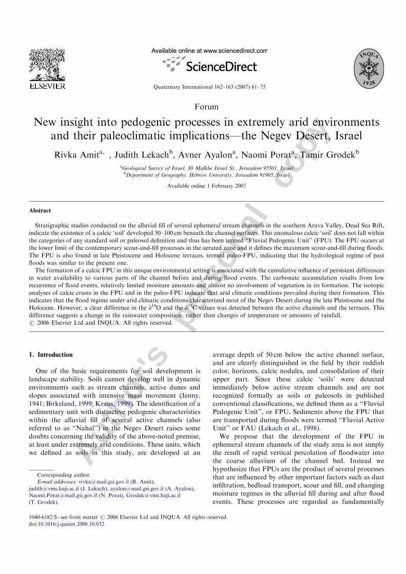
Several drainage basins were chosen for studying theFPU: Nahal Yael, Nahal Meqorot, Nahal Avrona, NahalNetafim, Nahal Roded and Nahal Neqarot (Fig. 1). FPUswere also found and analyzed in Pleistocene-age terraces inNahal Yael, Nahal Meqorot, and Nahal Shehoret and weretermed paleo-FPU.In the drainage basins studied, floods generally occur
only once in two years. Peak discharges and thus floodvolumes are directly related to catchment size. Forexample, Nahal Roded (42 km2) has discharges of approxi-mately 40m3 s�1, Nahal Shahmon (8 km2) of approxi-mately, 10m3 s�1, and Nahal Yael (0.5 km2) ofapproximately 3.7m3 s�1. The floods might last for lessthan an hour for small catchments and several hours forthe larger ones. At the northern part of the Arava, thelarger catchments have 2–4 floods per year because theirupper reaches are in the Negev mountains where the meanannual precipitation is 50–100mm. In the three largercatchment areas of the Negev (Nahal Nekarot, Nahal Zin,and Nahal Paran) the calculated discharge for the 50-yearfloods are 550, 800, and 1050m3 s�1, respectively (Green-baum, 1996). Table 1 shows several drainage basinparameters such as basin area, measured discharge,estimated paleoflood discharge, and the depth at whichthe FPUs were found.The present climatic conditions in this area are extremely
arid. Mean annual rainfall is 30mm that usually falls intwo events in the late fall or winter. Soil surfacetemperature may reach 50 1C at midday and drops to30 1C at night (Ashbel et al., 1965). Mean annualtemperature is 25 1C with a daily mean of 14 1C. Theannual evaporative potential is 2600mm. The mean annualhumidity is 40–45%. Summers are extremely hot andwinters are cold (Atlas of Israel, 1985). Vegetation is verysparse.
3. Methods
The field research area encompassed several catchmentareas in the southern Arava Valley (Fig. 1). Fieldworkincluded trenching active channels (along and acrossthe channel), several terraces, and an alluvial fan. Thestratigraphy and sedimentology of the exposures weredescribed. Several cross sections were measured in all thestudied catchments and studied to determine their hydro-metric parameters. The FAU and the FPU, were sampledfor laboratory analyses and dating. The laboratory analysisincluded grain-size distribution, geochemical analyses:iron-oxide measurements; major elements in soil solution;stable isotopes (d18O and d13C) of calcic crusts andmicromorphology. For dating the sediments from theFPU and FAU we used the infrared stimulated lumines-cence method (IRSL). Fine sand-size alkali feldspars wereselected for dating because this size fraction is too coarse toinfiltrate deep into the section after deposition during
ARTICLE IN PRESS
Fig. 1. A map of the Negev Desert showing the study sites and annual
rainfall.
R. Amit et al. / Quaternary International 162–163 (2007) 61–7562
Autho
r's
pers
onal
co
pysubsequent floods (Aitken, 1998; Porat et al., 1999). Severalcalcic crust were dated by the 14C method. Using ageographical information system (GIS), we compiledearlier data and our own soil data from the Negev into amap of soil associations (modified from Soil Map of Israel,1976) (Fig. 1). All methods are presented in Appendix 1.
4. Results
4.1. Field appearance of the FAU and FPU
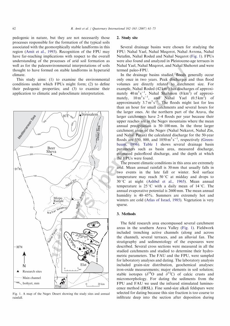
The FPU and the FAU are developed in braided streamchannels. The structure and texture of the FAU reflects abedload movement in pulses (Lekach, 1993). The FPU isfound in the active channels. Similar units were found inthe older the terraces and were termed paleo-FPUs (Fig. 2).The FPU is below the FAU, and the contact between thetwo units is clear, in contrast to the diffuse lower boundaryof the FPU. The FAU looks like active channel sediment,light in color (brownish gray to pale brown: 10YR6/2to 10YR 6/3) similar to washed sediment without in
situ weathering features. However, the FPU has typicalcalcic soil characteristics such as horizonation, fine grainaccumulation, calcium carbonate deposition, and oxida-tion. The FPU is about 60 cm thick and it is mostly red(reddish brown 5YR 5/4 to light reddish brown 5YR6/4).These colors lighten with depth to the color found in theupper FAU. In the upper part of the FPU there are calcicnodules and calcic crusts enveloping the gravel bottom.The amount of calcic nodules and calcic crusts decreasewith depth. At least three horizons are discernible withinthe FPU: (1) a silty A horizon; (2) a reddish B horizon withcalcic nodules and calcic crusts; and (3) a C horizon of theoriginal channel sediment. The horizons are characterizedby an increase in the amount of fines (mainly the siltfraction) at the top of the FPU, a gradual weakening of thered color with depth, and a decrease with depth of thesecondary calcium carbonate accumulation. Paleo-FAUsand paleo-FPUs are found in the terraces and in stablealluvial fan surfaces incorporated in the salic–gypsicReg soil that developed on the exposed surface afterits abandonment. In the paleo-PFU, only the calcium
ARTICLE IN PRESS
Table 1
The measured and paleo-discharge rates for the studied catchments
Catchment Area (km2) FPU depth (m) Paleodischarge (cms) Measured discharge (cms)
N. Yael 0.5 0.5 3.7 This research
N. Roded 42 0.85 40 Garti et al., 1994
N. Netafim 26 0.3 400 Greenbaum & Enzel, 1998
N. Shahmon 0.7 0.5 10 This research
N. Meqorot 0.85 0.2 10 This research
N. Neqarot 697 1.25 1400 640 Greenbaum & Enzel, 1998
N. Zin 1205 1.3 1500 550 Greenbaum, 1996
Fig. 2. A schematic section across a channel showing the location of the FPU, the paleo-FPU, and the sediment and soil profiles associated with each of
them. Notice that on the alluvial terrace, a gypsic–saline Reg soil developed and what remains of the FPU is mainly the coated gravel with calcic crust.
R. Amit et al. / Quaternary International 162–163 (2007) 61–75 63
Autho
r's
pers
onal
co
py
carbonate accumulation is discernible in the form of calciccrusts enveloping the gravel bottom (Fig. 2). The otherpedogenic features of the FPU are incorporated in the Regsoil. The FPU and paleo-PFU reach stage I of calcic soildevelopment (Gile et al., 1981). A Reg soil is a salic–gypsicsoil developed in alluvial material, devoid of secondarycalcium carbonate, typical of the hyperarid part of theNegev Desert (o80mm annual rainfall) and characteristicof all stable alluvial terraces and fan surfaces in the NegevDesert (Amit et al., 1993).
Trenches and pits dug along and across several activechannels confirm the presence of continuous FPUs at depthsbetween 20 and 100 cm. The FPU runs roughly parallel tothe surface and extends along the entire alluvial channel. Atcontact with bare rocky slopes, the unit deepens, whereas atthe foot of colluvial slopes it remains at a depth similar to itsmid-channel depth. The long-term aggradation–degradationbalance monitored by scour chains and by magnetic bedloadtracers in Nahal Yael shows that nowhere along the channelwas the FPU eroded by the scour, even during a 100-yearflood event (Lekach, 1993).
4.2. Grain-size distribution
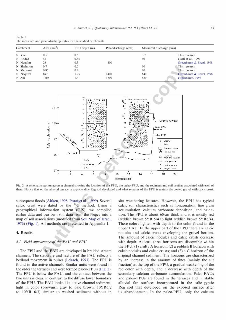
A slight increase in the silt content and in some cases theclay content is characteristic of the upper part of the FPUin the channels (Fig. 3). Medium and coarse silt accumulateat the top of the FPU forming a kind of A horizon which isnot associated with the original composition of the channeldeposits but as a result of illuviation from the overlyingFAU during floods. The source of the fines is airbornedust and dust stripped from the slopes that becomes thesuspended load of the desert floods. The infiltration ofthe fines downward into the alluvium is limited due tosediment transport in desert streams (Lekach, 1993).Therefore, it accumulates only in the upper part of theFPU, forming a silty, gravel-free, thin A horizon (Fig. 2).
4.3. Iron oxides
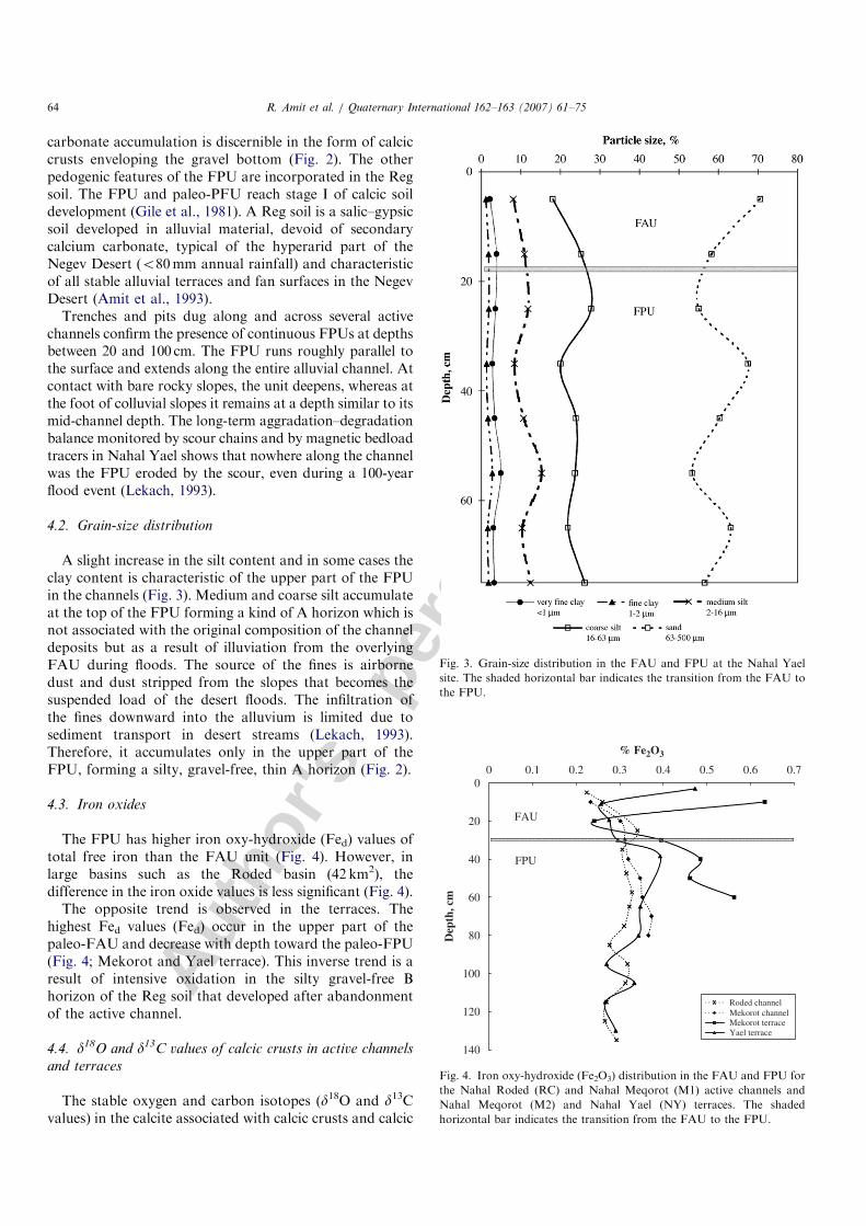
The FPU has higher iron oxy-hydroxide (Fed) values oftotal free iron than the FAU unit (Fig. 4). However, inlarge basins such as the Roded basin (42 km2), thedifference in the iron oxide values is less significant (Fig. 4).
The opposite trend is observed in the terraces. Thehighest Fed values (Fed) occur in the upper part of thepaleo-FAU and decrease with depth toward the paleo-FPU(Fig. 4; Mekorot and Yael terrace). This inverse trend is aresult of intensive oxidation in the silty gravel-free Bhorizon of the Reg soil that developed after abandonmentof the active channel.
4.4. d18O and d13C values of calcic crusts in active channels
and terraces
The stable oxygen and carbon isotopes (d18O and d13Cvalues) in the calcite associated with calcic crusts and calcic
ARTICLE IN PRESS
Fig. 3. Grain-size distribution in the FAU and FPU at the Nahal Yael
site. The shaded horizontal bar indicates the transition from the FAU to
the FPU.
0
20
40
60
80
100
120
140
0 0.1 0.2 0.3 0.4 0.5 0.6 0.7
% Fe2O3
Dep
th, c
m
Roded channelMekorot channelMekorot terraceYael terrace
FAU
FPU
Fig. 4. Iron oxy-hydroxide (Fe2O3) distribution in the FAU and FPU for
the Nahal Roded (RC) and Nahal Meqorot (M1) active channels and
Nahal Meqorot (M2) and Nahal Yael (NY) terraces. The shaded
horizontal bar indicates the transition from the FAU to the FPU.
R. Amit et al. / Quaternary International 162–163 (2007) 61–7564
Autho
r's
pers
onal
co
py
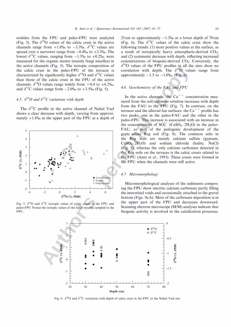
nodules from the FPU and paleo-FPU were analyzed(Fig. 5). The d18O values of the calcic crust in the activechannels range from þ1:8% to �3:3%. d13C values arespread over a narrower range from �0:4% to þ2:5%. Thelowest d13C values, ranging from �1:3% to þ0:2%, weremeasured for the organic matter (mainly fungi micelles) inthe active channels (Fig. 5). The isotopic composition ofthe calcic crust in the paleo-FPU of the terraces ischaracterized by significantly higher d18O and d13C valuesthan those of the calcic crust in the FPU of the activechannels. d18O values range widely from +0.4 to þ6:2%,and d13C values range from �2:0% to þ3:5% (Fig. 5).
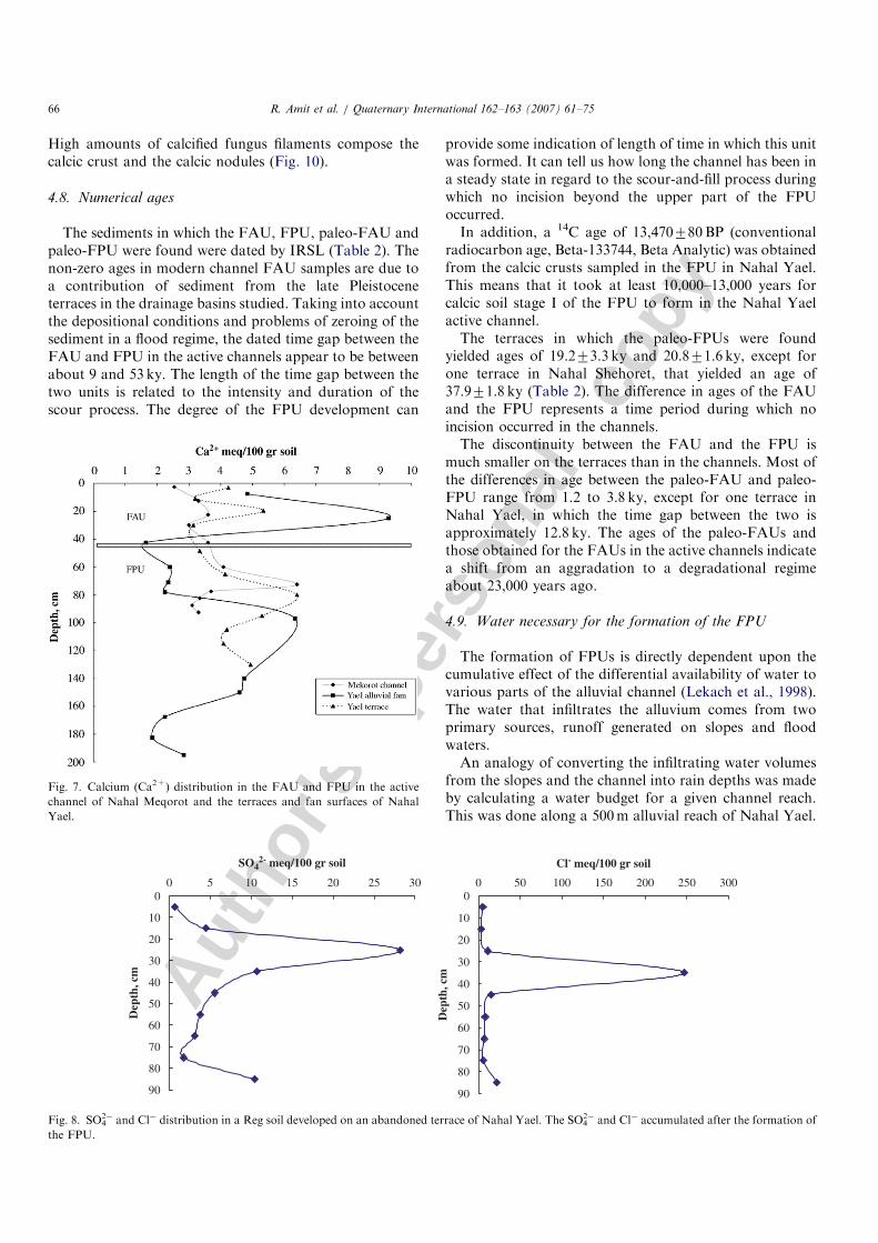
4.5. d18O and d13C variations with depth
The d13C profile in the active channel of Nahal Yaelshows a clear decrease with depth, varying from approxi-mately þ1:8% in the upper part of the FPU at a depth of
25 cm to approximately �1:3% at a lower depth of 70 cm(Fig. 6). The d13C values of the calcic crust show thefollowing trends: (1) more positive values at the surface, asa result of isotopically heavy atmospheric-derived CO2;and (2) systematic decrease with depth, reflecting increasedconcentrations of biogenic-derived CO2. Conversely, thed18O values of the FPU profiles in all the sites show nocorrelation with depth. The d18O values range fromapproximately �1.5 to �1:0%, (Fig. 6).
4.6. Geochemistry of the FAU and FPU
In the active channels, the Ca++ concentration mea-sured from the soil/sediment solution increases with depthfrom the FAU to the FPU (Fig. 7). In contrast, on theterraces and the alluvial fan surfaces, the Ca++ profile hastwo peaks, one in the paleo-FAU and the other in thepaleo-FPU. This increase is associated with an increase inthe concentrations of SO4
2� (CaSO4 � 2H2O) in the paleo-FAU, as part of the pedogenic development of thegypic–saline Reg soil (Fig. 8). The common salts inthe Reg soils are mainly calcium sulfate (gypsum,CaSO4 � 2H2O) and sodium chloride (halite, NaCl)(Fig. 8), whereas the only calcium carbonate detected inthe Reg soils on the terraces is the calcic crusts related tothe FPU (Amit et al., 1993). These crusts were formed inthe FPU when the channels were still active.
4.7. Micromorphology
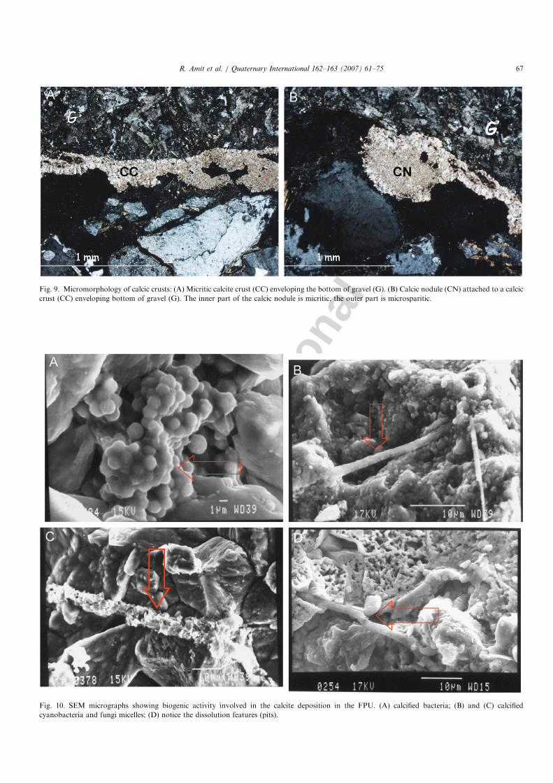
Micromorphological analyses of the sediments compos-ing the FPU show micritic calcium carbonate partly fillingthe interstitial voids and occasionally attached to the gravelbottom (Figs. 9a,b). Most of the carbonate deposition is inthe upper part of the FPU and decreases downward.Scanning electron microscope (SEM) analyses indicate thatbiogenic activity is involved in the calcification processes.
ARTICLE IN PRESS
-2
-1
0
1
2
3
4
5
-4 -2 0
δ13C
(‰
PD
B)
δ18O (‰ PDB)
Active channelsTerracesFungi mycelia
2 4 6
Fig. 5. d18O and d13C isotopic values of calcic crusts in the FPU and
paleo-FPU Notice the isotopic values of the fungi mycelia sampled in the
FPU.
-2
-1
0
1
2
3
-2
-1.5
-1
-0.5
0
20 30 40 50 60 70 80
δ13C
(‰
PD
B)
δ18O
(‰
PD
B)
Depth (cm)
δ18Oδ13C
Fig. 6. d18O and d13C variations with depth of calcic crust in the FPU at the Nahal Yael site.
R. Amit et al. / Quaternary International 162–163 (2007) 61–75 65
Autho
r's
pers
onal
co
py
High amounts of calcified fungus filaments compose thecalcic crust and the calcic nodules (Fig. 10).
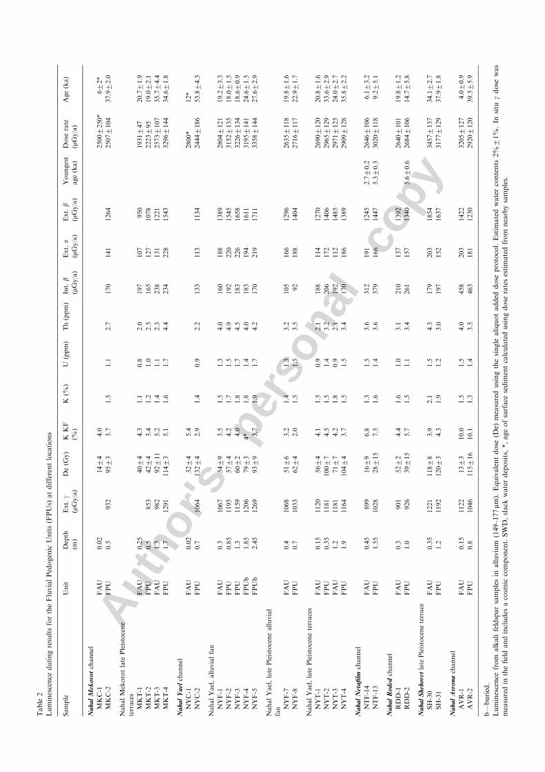
4.8. Numerical ages
The sediments in which the FAU, FPU, paleo-FAU andpaleo-FPU were found were dated by IRSL (Table 2). Thenon-zero ages in modern channel FAU samples are due toa contribution of sediment from the late Pleistoceneterraces in the drainage basins studied. Taking into accountthe depositional conditions and problems of zeroing of thesediment in a flood regime, the dated time gap between theFAU and FPU in the active channels appear to be betweenabout 9 and 53 ky. The length of the time gap between thetwo units is related to the intensity and duration of thescour process. The degree of the FPU development can
provide some indication of length of time in which this unitwas formed. It can tell us how long the channel has been ina steady state in regard to the scour-and-fill process duringwhich no incision beyond the upper part of the FPUoccurred.In addition, a 14C age of 13,470780BP (conventional
radiocarbon age, Beta-133744, Beta Analytic) was obtainedfrom the calcic crusts sampled in the FPU in Nahal Yael.This means that it took at least 10,000–13,000 years forcalcic soil stage I of the FPU to form in the Nahal Yaelactive channel.The terraces in which the paleo-FPUs were found
yielded ages of 19.273.3 ky and 20.871.6 ky, except forone terrace in Nahal Shehoret, that yielded an age of37.971.8 ky (Table 2). The difference in ages of the FAUand the FPU represents a time period during which noincision occurred in the channels.The discontinuity between the FAU and the FPU is
much smaller on the terraces than in the channels. Most ofthe differences in age between the paleo-FAU and paleo-FPU range from 1.2 to 3.8 ky, except for one terrace inNahal Yael, in which the time gap between the two isapproximately 12.8 ky. The ages of the paleo-FAUs andthose obtained for the FAUs in the active channels indicatea shift from an aggradation to a degradational regimeabout 23,000 years ago.
4.9. Water necessary for the formation of the FPU
The formation of FPUs is directly dependent upon thecumulative effect of the differential availability of water tovarious parts of the alluvial channel (Lekach et al., 1998).The water that infiltrates the alluvium comes from twoprimary sources, runoff generated on slopes and floodwaters.An analogy of converting the infiltrating water volumes
from the slopes and the channel into rain depths was madeby calculating a water budget for a given channel reach.This was done along a 500m alluvial reach of Nahal Yael.
ARTICLE IN PRESS
Fig. 7. Calcium (Ca2+) distribution in the FAU and FPU in the active
channel of Nahal Meqorot and the terraces and fan surfaces of Nahal
Yael.
0
10
20
30
40
50
60
70
80
90
0 5 10 15 20 25 30
SO42- meq/100 gr soil
Dep
th, c
m
0
10
20
30
40
50
60
70
80
90
0 50 100 150 200 250 300
Cl- meq/100 gr soil
Dep
th, c
m
Fig. 8. SO42� and Cl� distribution in a Reg soil developed on an abandoned terrace of Nahal Yael. The SO4
2� and Cl� accumulated after the formation of
the FPU.
R. Amit et al. / Quaternary International 162–163 (2007) 61–7566
Autho
r's
pers
onal
co
py
ARTICLE IN PRESS
Fig. 9. Micromorphology of calcic crusts: (A) Micritic calcite crust (CC) enveloping the bottom of gravel (G). (B) Calcic nodule (CN) attached to a calcic
crust (CC) enveloping bottom of gravel (G). The inner part of the calcic nodule is micritic, the outer part is microsparitic.
Fig. 10. SEM micrographs showing biogenic activity involved in the calcite deposition in the FPU. (A) calcified bacteria; (B) and (C) calcified
cyanobacteria and fungi micelles; (D) notice the dissolution features (pits).
R. Amit et al. / Quaternary International 162–163 (2007) 61–75 67
Autho
r's
pers
onal
co
py
ARTICLE IN PRESSTable
2
Luminescence
datingresultsfortheFluvialPedogenic
Units(FPUs)
atdifferentlocations
Sample
Unit
Depth
(m)
Ext.g
(mGy/a)
De(G
y)
KKF
(%)
K(%
)U
(ppm)
Th(ppm)
Int.b
(mGy/a)
Ext.a
(mGy/a)
Ext.b
(mGy/a)
Youngest
age(ka)
Dose
rate
(mGy/a)
Age(ka)
Na
ha
lM
eko
rotchannel
MKC-1
FAU
0.02
1474
4.0
25007250*
672*
MKC-2
FPU
0.5
932
9573
3.7
1.5
1.1
2.7
170
141
1264
25077104
37.972.0
NahalMekorotlate
Pleistocene
terraces
MKT-1
FAU
0.25
4074
4.3
1.1
0.8
2.0
197
107
950
1931747
20.771.9
MKT-2
FPU
0.5
853
4274
3.4
1.2
1.0
2.5
165
127
1078
2223795
19.072.1
MKT-3
FAU
1.3
982
92711
5.2
1.4
1.1
2.3
238
131
1221
25737107
35.774.4
MKT-4
FPU
1.7
1291
11473
5.1
1.6
1.7
4.4
234
228
1543
32967144
34.671.8
Na
ha
lY
ael
channel
NYC-1
FAU
0.02
3274
5.4
2800*
12*
NYC-2
FPU
0.7
1064
13274
2.9
1.4
0.9
2.2
133
113
1134
24447186
53.874.3
NahalYael,alluvialfan
NYF-1
FAU
0.3
1067
5479
3.5
1.5
1.3
4.0
160
188
1389
28047121
19.273.3
NYF-2
FPU
0.85
1195
5774
4.2
1.7
1.5
4.9
192
220
1545
31527135
18.071.5
NYF-3
FPU
1.3
1159
6072
4.0
1.8
1.7
4.5
183
226
1658
32267134
18.670.9
NYF-4
FPUb
1.85
1206
7973
4*
1.8
1.4
4.0
183
194
1611
31957141
24.671.5
NYF-5
FPUb
2.45
1269
9379
3.7
1.9
1.7
4.2
170
219
1711
33587144
27.672.9
NahalYael,late
Pleistocenealluvial
fan NYF-7
FAU
0.4
1068
5176
3.2
1.4
1.3
3.2
105
166
1296
26357118
19.871.6
NYF-8
FPU
0.7
1033
6274
2.0
1.5
1.5
3.5
92
188
1404
27167117
22.971.7
NahalYael,late
Pleistoceneterraces
NYT-1
FAU
0.15
1120
5674
4.1
1.5
0.9
2.1
188
114
1270
26907120
20.871.6
NYT-2
FPU
0.35
1181
10077
4.5
1.5
1.4
3.2
206
172
1406
29657129
33.672.9
NYT-3
FAU
1.2
1181
7177
4.2
1.8
0.9
2.1
192
112
1485
29717125
24.072.7
NYT-4
FPU
1.9
1164
10474
3.7
1.5
1.5
3.4
170
186
1389
29097128
35.872.2
Na
ha
lN
eta
film
channel
NTF-14
FAU
0.45
899
1679
6.8
1.3
1.5
3.6
312
191
1245
2.770.2
26467106
6.173.2
NTF-13
FPU
1.55
1028
28715
7.5
1.6
1.4
3.6
379
166
1447
5.370.3
30207118
9.275.1
Na
ha
lR
od
edchannel
RDD-1
FAU
0.3
901
5272
4.4
1.6
1.0
3.1
210
137
1392
26407101
19.871.2
RDD-2
FPU
1.0
926
39715
5.7
1.5
1.1
3.4
261
157
1340
5.670.6
26847106
14.775.8
Na
ha
lS
heh
ore
tlate
Pleistoceneterrace
SH-30
FAU
0.35
1221
11878
3.9
2.1
1.5
4.3
179
203
1854
34577137
34.172.7
SH-31
FPU
1.2
1192
12073
4.3
1.9
1.2
3.0
197
152
1637
31777129
37.971.8
Na
ha
lA
vro
nachannel
AVR-1
FAU
0.15
1122
1373
10.0
1.5
1.5
4.0
458
203
1422
32057127
4.070.9
AVR-2
FPU
0.8
1046
115716
10.1
1.3
1.4
3.5
463
181
1230
29207120
39.575.9
b—buried.
Luminescence
from
alkalifeldsparsamplesin
alluvium
(149–177mm
).Equivalentdose
(De)
measuredusingthesingle
aliquotadded
dose
protocol.Estim
atedwatercontents
2%71%.In
situ
gdose
was
measuredin
thefieldandincludes
acosm
iccomponent.SWD,slack
waterdeposits,*,ageofsurface
sedim
entcalculatedusingdose
ratesestimatedfrom
nearbysamples.
Autho
r's
pers
onal
co
py
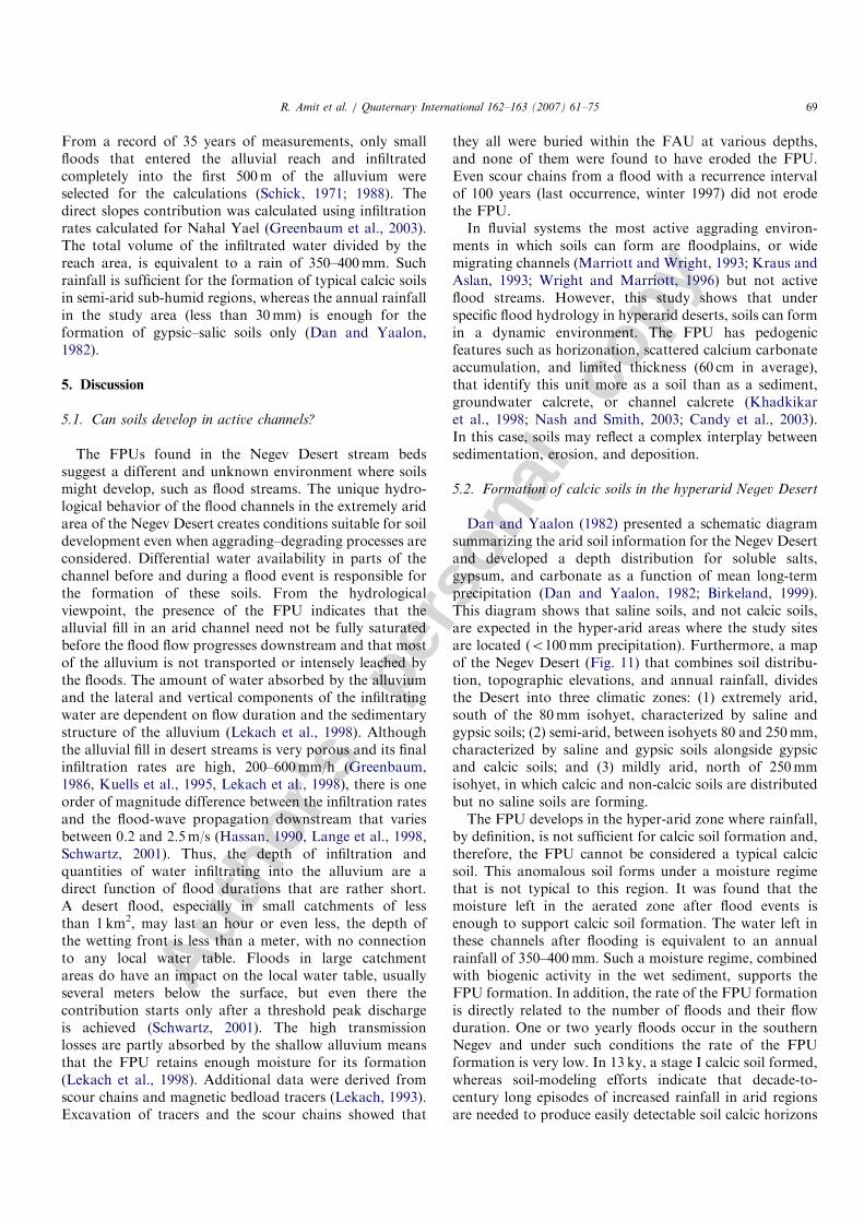
From a record of 35 years of measurements, only smallfloods that entered the alluvial reach and infiltratedcompletely into the first 500m of the alluvium wereselected for the calculations (Schick, 1971; 1988). Thedirect slopes contribution was calculated using infiltrationrates calculated for Nahal Yael (Greenbaum et al., 2003).The total volume of the infiltrated water divided by thereach area, is equivalent to a rain of 350–400mm. Suchrainfall is sufficient for the formation of typical calcic soilsin semi-arid sub-humid regions, whereas the annual rainfallin the study area (less than 30mm) is enough for theformation of gypsic–salic soils only (Dan and Yaalon,1982).
5. Discussion
5.1. Can soils develop in active channels?
The FPUs found in the Negev Desert stream bedssuggest a different and unknown environment where soilsmight develop, such as flood streams. The unique hydro-logical behavior of the flood channels in the extremely aridarea of the Negev Desert creates conditions suitable for soildevelopment even when aggrading–degrading processes areconsidered. Differential water availability in parts of thechannel before and during a flood event is responsible forthe formation of these soils. From the hydrologicalviewpoint, the presence of the FPU indicates that thealluvial fill in an arid channel need not be fully saturatedbefore the flood flow progresses downstream and that mostof the alluvium is not transported or intensely leached bythe floods. The amount of water absorbed by the alluviumand the lateral and vertical components of the infiltratingwater are dependent on flow duration and the sedimentarystructure of the alluvium (Lekach et al., 1998). Althoughthe alluvial fill in desert streams is very porous and its finalinfiltration rates are high, 200–600mm/h (Greenbaum,1986, Kuells et al., 1995, Lekach et al., 1998), there is oneorder of magnitude difference between the infiltration ratesand the flood-wave propagation downstream that variesbetween 0.2 and 2.5m/s (Hassan, 1990, Lange et al., 1998,Schwartz, 2001). Thus, the depth of infiltration andquantities of water infiltrating into the alluvium are adirect function of flood durations that are rather short.A desert flood, especially in small catchments of lessthan 1 km2, may last an hour or even less, the depth ofthe wetting front is less than a meter, with no connectionto any local water table. Floods in large catchmentareas do have an impact on the local water table, usuallyseveral meters below the surface, but even there thecontribution starts only after a threshold peak dischargeis achieved (Schwartz, 2001). The high transmissionlosses are partly absorbed by the shallow alluvium meansthat the FPU retains enough moisture for its formation(Lekach et al., 1998). Additional data were derived fromscour chains and magnetic bedload tracers (Lekach, 1993).Excavation of tracers and the scour chains showed that
they all were buried within the FAU at various depths,and none of them were found to have eroded the FPU.Even scour chains from a flood with a recurrence intervalof 100 years (last occurrence, winter 1997) did not erodethe FPU.In fluvial systems the most active aggrading environ-
ments in which soils can form are floodplains, or widemigrating channels (Marriott and Wright, 1993; Kraus andAslan, 1993; Wright and Marriott, 1996) but not activeflood streams. However, this study shows that underspecific flood hydrology in hyperarid deserts, soils can formin a dynamic environment. The FPU has pedogenicfeatures such as horizonation, scattered calcium carbonateaccumulation, and limited thickness (60 cm in average),that identify this unit more as a soil than as a sediment,groundwater calcrete, or channel calcrete (Khadkikaret al., 1998; Nash and Smith, 2003; Candy et al., 2003).In this case, soils may reflect a complex interplay betweensedimentation, erosion, and deposition.
5.2. Formation of calcic soils in the hyperarid Negev Desert
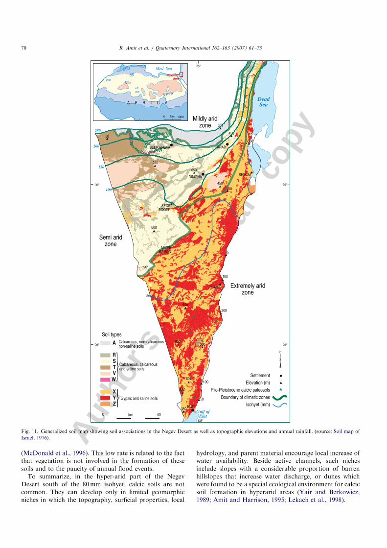
Dan and Yaalon (1982) presented a schematic diagramsummarizing the arid soil information for the Negev Desertand developed a depth distribution for soluble salts,gypsum, and carbonate as a function of mean long-termprecipitation (Dan and Yaalon, 1982; Birkeland, 1999).This diagram shows that saline soils, and not calcic soils,are expected in the hyper-arid areas where the study sitesare located (o100mm precipitation). Furthermore, a mapof the Negev Desert (Fig. 11) that combines soil distribu-tion, topographic elevations, and annual rainfall, dividesthe Desert into three climatic zones: (1) extremely arid,south of the 80mm isohyet, characterized by saline andgypsic soils; (2) semi-arid, between isohyets 80 and 250mm,characterized by saline and gypsic soils alongside gypsicand calcic soils; and (3) mildly arid, north of 250mmisohyet, in which calcic and non-calcic soils are distributedbut no saline soils are forming.The FPU develops in the hyper-arid zone where rainfall,
by definition, is not sufficient for calcic soil formation and,therefore, the FPU cannot be considered a typical calcicsoil. This anomalous soil forms under a moisture regimethat is not typical to this region. It was found that themoisture left in the aerated zone after flood events isenough to support calcic soil formation. The water left inthese channels after flooding is equivalent to an annualrainfall of 350–400mm. Such a moisture regime, combinedwith biogenic activity in the wet sediment, supports theFPU formation. In addition, the rate of the FPU formationis directly related to the number of floods and their flowduration. One or two yearly floods occur in the southernNegev and under such conditions the rate of the FPUformation is very low. In 13 ky, a stage I calcic soil formed,whereas soil-modeling efforts indicate that decade-to-century long episodes of increased rainfall in arid regionsare needed to produce easily detectable soil calcic horizons
ARTICLE IN PRESSR. Amit et al. / Quaternary International 162–163 (2007) 61–75 69
Autho
r's
pers
onal
co
py
(McDonald et al., 1996). This low rate is related to the factthat vegetation is not involved in the formation of thesesoils and to the paucity of annual flood events.
To summarize, in the hyper-arid part of the NegevDesert south of the 80mm isohyet, calcic soils are notcommon. They can develop only in limited geomorphicniches in which the topography, surficial properties, local
hydrology, and parent material encourage local increase ofwater availability. Beside active channels, such nichesinclude slopes with a considerable proportion of barrenhillslopes that increase water discharge, or dunes whichwere found to be a special ecological environment for calcicsoil formation in hyperarid areas (Yair and Berkowicz,1989; Amit and Harrison, 1995; Lekach et al., 1998).
ARTICLE IN PRESS
Fig. 11. Generalized soil map showing soil associations in the Negev Desert as well as topographic elevations and annual rainfall. (source: Soil map of
Israel, 1976).
R. Amit et al. / Quaternary International 162–163 (2007) 61–7570
Autho
r's
pers
onal
co
py
5.3. Paleoclimatic interpretation of the FPU
Paleosols have been used to interpret paleoclimaticregimes and to estimate mean annual precipitation andtemperature. Two of the most common soil characteristicsfor estimating paleo-precipitation are carbonate accumula-tion and the depth at which calcic horizons form (Jenny,1941; Arkely, 1963; Bockheim, 1980; Retallack, 1994;Birkeland, 1999). However, our studies of the hydrologicalaspects of the FPU have shown that the depth of the calcichorizon in the FPU is determined by the long-term scour-and-fill process and not solely by the amount of water(Lekach et al., 1998). The FPU as a soil is not typical of thehyper-arid part of the Negev Desert and nor can it easily beused as calcic soil for paleoclimate interpretation when it isfound in sedimentary sequences. The more common soil inthis area is the Reg soil, which is a cumulic gypsic–salic soildeveloped in gravelly parent material on stable Holoceneand Pleistocene alluvial surfaces (Dan and Yaalon, 1982;Gerson and Amit, 1987; Amit et al., 1993). These soilsshow no signs of long-term wetter conditions such ascarbonate deposition, argillic B horizons, or K horizons(Dan et al., 1982; Amit and Gerson, 1986; Gersonand Amit, 1987; Amit et al., 1993; Amit and Yaalon;1996). They represent extremely arid conditions and coveralmost 25% of the Negev Desert in areas with less than80mm annual rainfall (Fig. 11). In some cases the alluvialparent material for the Reg soil formation already includesthe FPU pedogenic features that are integrated with timeinto the gypsic–saline Reg soil on the alluvial surfaces(Figs. 7 and 8). The vast regional distribution of theReg soil, and the fact that the only moisture availablefor soil development is direct rainfall, suggests that soils ofthis type can be safely used for paleoclimate interpretationsof aridity.
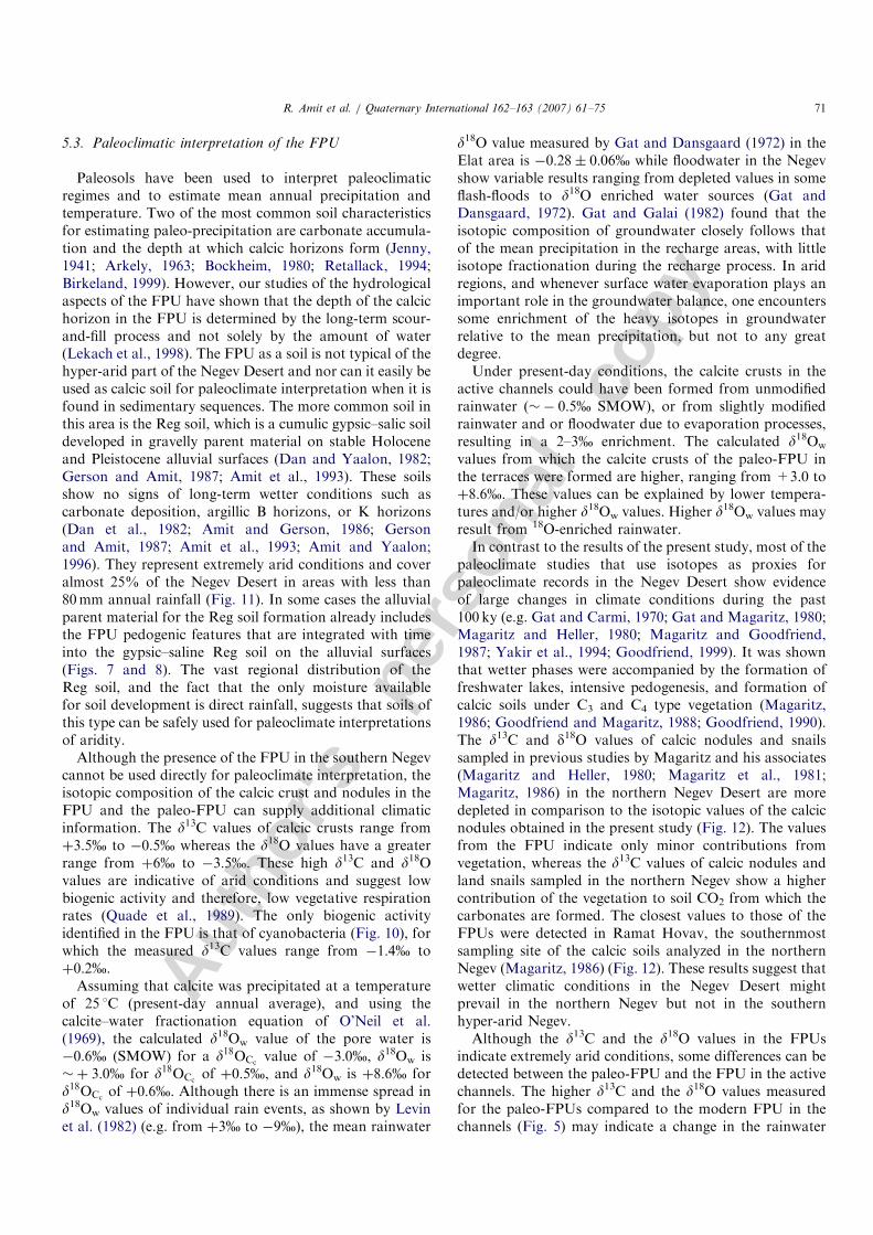
Although the presence of the FPU in the southern Negevcannot be used directly for paleoclimate interpretation, theisotopic composition of the calcic crust and nodules in theFPU and the paleo-FPU can supply additional climaticinformation. The d13C values of calcic crusts range fromþ3:5% to �0:5% whereas the d18O values have a greaterrange from þ6% to �3:5%. These high d13C and d18Ovalues are indicative of arid conditions and suggest lowbiogenic activity and therefore, low vegetative respirationrates (Quade et al., 1989). The only biogenic activityidentified in the FPU is that of cyanobacteria (Fig. 10), forwhich the measured d13C values range from �1:4% toþ0:2%.
Assuming that calcite was precipitated at a temperatureof 25 1C (present-day annual average), and using thecalcite–water fractionation equation of O’Neil et al.(1969), the calculated d18Ow value of the pore water is�0:6% (SMOW) for a d18OCc
value of �3:0%, d18Ow is�þ 3:0% for d18OCc
of þ0:5%, and d18Ow is þ8:6% ford18OCc
of þ0:6%. Although there is an immense spread ind18Ow values of individual rain events, as shown by Levinet al. (1982) (e.g. from þ3% to �9%), the mean rainwater
d18O value measured by Gat and Dansgaard (1972) in theElat area is �0:28� 0:06% while floodwater in the Negevshow variable results ranging from depleted values in someflash-floods to d18O enriched water sources (Gat andDansgaard, 1972). Gat and Galai (1982) found that theisotopic composition of groundwater closely follows thatof the mean precipitation in the recharge areas, with littleisotope fractionation during the recharge process. In aridregions, and whenever surface water evaporation plays animportant role in the groundwater balance, one encounterssome enrichment of the heavy isotopes in groundwaterrelative to the mean precipitation, but not to any greatdegree.Under present-day conditions, the calcite crusts in the
active channels could have been formed from unmodifiedrainwater (�� 0:5% SMOW), or from slightly modifiedrainwater and or floodwater due to evaporation processes,resulting in a 2–3% enrichment. The calculated d18Ow
values from which the calcite crusts of the paleo-FPU inthe terraces were formed are higher, ranging from +3.0 toþ8:6%. These values can be explained by lower tempera-tures and/or higher d18Ow values. Higher d18Ow values mayresult from 18O-enriched rainwater.In contrast to the results of the present study, most of the
paleoclimate studies that use isotopes as proxies forpaleoclimate records in the Negev Desert show evidenceof large changes in climate conditions during the past100 ky (e.g. Gat and Carmi, 1970; Gat and Magaritz, 1980;Magaritz and Heller, 1980; Magaritz and Goodfriend,1987; Yakir et al., 1994; Goodfriend, 1999). It was shownthat wetter phases were accompanied by the formation offreshwater lakes, intensive pedogenesis, and formation ofcalcic soils under C3 and C4 type vegetation (Magaritz,1986; Goodfriend and Magaritz, 1988; Goodfriend, 1990).The d13C and d18O values of calcic nodules and snailssampled in previous studies by Magaritz and his associates(Magaritz and Heller, 1980; Magaritz et al., 1981;Magaritz, 1986) in the northern Negev Desert are moredepleted in comparison to the isotopic values of the calcicnodules obtained in the present study (Fig. 12). The valuesfrom the FPU indicate only minor contributions fromvegetation, whereas the d13C values of calcic nodules andland snails sampled in the northern Negev show a highercontribution of the vegetation to soil CO2 from which thecarbonates are formed. The closest values to those of theFPUs were detected in Ramat Hovav, the southernmostsampling site of the calcic soils analyzed in the northernNegev (Magaritz, 1986) (Fig. 12). These results suggest thatwetter climatic conditions in the Negev Desert mightprevail in the northern Negev but not in the southernhyper-arid Negev.Although the d13C and the d18O values in the FPUs
indicate extremely arid conditions, some differences can bedetected between the paleo-FPU and the FPU in the activechannels. The higher d13C and the d18O values measuredfor the paleo-FPUs compared to the modern FPU in thechannels (Fig. 5) may indicate a change in the rainwater
ARTICLE IN PRESSR. Amit et al. / Quaternary International 162–163 (2007) 61–75 71
Autho
r's
pers
onal
co
py
composition rather than changes of temperature or rainfallamounts. In the late Pleistocene terraces (Table 2), the d13Cvalues of the FPUs are higher than those obtained for theHolocene surfaces ranging from þ1:5% to þ4:8%. Thelack of correlation between d18O and d13C values (Figs. 5and 6) indicates that evaporative processes were of minorimportance. The lack of a trend in d18O values with depthin the active channel of Nahal Yael indicates that theoriginal isotopic composition of the soil solution (and thefloodwater) was preserved and has not undergone anysignificant evaporation process. One should remember thatthe FPU develop at least 50 cm below the surface andunder such conditions, significant evaporation rarelyoccurs (Quade et al., 1989; Cerling and Quade, 1993).Thus, an increase in d18OCc
values and the lack of a trend ind18O values with depth (Fig. 6) reflects high d18Owater
values of the rainwater, as manifested in the isotopiccomposition of the soil water (Ayalon et al., 1998;Bar-Matthews et al., 1999).
The terrace ages that range from 37.971.8 ka to19.273.3 ka, and the existence of the paleo-FPUs indicatethat aggradation and terrace building took place underflood regimes during the late Pleistocene. The higher d13Cand d18O values measured in the terraces in compared tothose in the active channels may indicate a lowerrecurrence of flood events during the late Pleistocene.The transition to the Holocene period was followed byerosion and terrace formation. Such incision may beexplained by higher flood discharges during the Holoceneas indicated by paleo-floods during the last 2000 years(Greenbaum and Enzel, 1998; Greenbaum et al., 2001)or by major floods which can be a sign of exceptionalsynoptic scale or extreme climatic events as shown byKahana et al. (2002).
Regardless, one should keep in mind that during the latePleistocene and the Holocene, Reg soils are distributed onthe stable alluvial surfaces in this area with no indicationsof more rainfall. If there were changes from the latePleistocene to the Holocene period in the Negev Desert,they were negligible in terms of regional and spatial soilformation processes. This trend is supported by severalother studies which tried to track paleoclimate changes inthe Negev Desert. Avigour et al. (1992) studied thePleistocene paleoclimate as recorded in calcite depositsalong transverse faults and veins in the Negev Desert. Thed13C and d18O record of these calcite deposits showevidence of humid conditions only during periods priorto 350 ky. Additional supportive data derived fromspeleothems from the central Negev show that most ofthe cave deposits are older than 300 ky, with one exception,a speleothem from the central Negev dated 110 ky. There isno deposition of speleothems in the extremely arid areas ofNegev Desert after these ages (Vaks et al., 2003). More-over, Plio-Pleistocene calcic paleosols detected in theextremely arid areas of the southern Negev Desert indicatea regional climatic change from semi-arid climatic condi-tions in the Pliocene to extremely arid conditions in thePleistocene (Ginat et al., 2002).Our study results imply that the synoptic pattern in the
southern Negev at least during the upper Pleistocene andthe Holocene was similar to that of the present day.
6. Conclusions
In the hyper-arid zone of the Negev Desert, calcic soils(FPU) can develop only in limited geomorphic nichessuch as a channel of an ephemeral flood stream. In theseflood streams, the infiltration rate is lower than the rate ofthe flood-wave progression. The moisture left in thesediment is sufficient for calcium carbonate depositionand also enables the formation of weak calcic soil profiles.Carbonate accumulation results from low recurrence offlood events, relatively limited moisture amounts andalmost no involvement of vegetation in the formation ofthese anomalous calcic soils termed FPU. The existence ofnon-eroded FPUs beneath the active channels indicatesthat the alluvium in this unit is stable during floods. In fact,the presence of FPUs define the maximum scour-and-fillduring floods.Paleo-FPUs found in late Pleistocene and Holocene
terraces indicate that the hydrologic regime of past floodswas similar to the present one. The isotopic analyses ofcalcic crusts in the FPUs and the paleo-FPUs indicate alsothat arid climatic conditions prevailed during their forma-tion. This means that the flood regime under arid climaticconditions characterized most of the Negev Desert duringthe late Pleistocene and the Holocene. However, a cleardifference in the d18O and the d13C values was detectedbetween the active channels and the terraces. Thisdifference indicates a change in the rainwater compositionrather than changes of temperature or rainfall amounts.
ARTICLE IN PRESS
-10
-5
0
5
-8 -6 -4 -2 0
δ13C
(‰
PD
B)
δ18O (‰ PDB)
2 4 6
Fig. 12. d18O plotted against d13C values for calcic nodules in the Negev
Desert and the coastal plain area. Solid symbols mark the samples of the
present study (shaded area), active channels (solid circles) and terraces
(solid square). Northern Negev: Ramat Hovav (x) and Netivot (open
rhombohedron) (Magaritz, 1986); land snail shells (+) (Magaritz and
Heller, 1980); coastal plain (open circles) and inner coastal plain (open
squares) (Magaritz et al., 1981).
R. Amit et al. / Quaternary International 162–163 (2007) 61–7572
Autho
r's
pers
onal
co
py
The dated surfaces, the gypsic–saline Reg soil distribu-tion in the Negev, and conditions prevailing during theformation of the FPUs in ephemeral flood stream channelssuggest hyper-arid conditions throughout the southernNegev Desert at least during the late Pleistocene and theHolocene.
Acknowledgments
This paper is dedicated to the late Prof. Asher Schick.The research was supported by the Israeli NationalAcademy of Science (ISF) budget number 032-7852 andby the US Army Research Office (DAAD19-03-1-0159).The content of the information does not necessarily reflectthe position or the policy of the federal government, and noofficial endorsement should be inferred.
The authors particularly appreciate and thank Prof.Dan Yaalon for his contribution in defining the termFluvial Pedogenic Unit and are grateful to Y. Mizrahi,Y. Nahamias, M. Peri, and M. Dvorchek, whose contribu-tions to the study were invaluable. They also thankT. Sopher (Cartographic Laboratory, Hebrew University)and B. Cohen Cartographic and GIS Laboratory, Geolo-gical Survey of Israel) for drawing the figures, D. Shtiberand O. Ben Dov for the laboratory analyses, and B. Katzfor editorial assistance.
Appendix A. Methods
A.1. Fieldwork
The field area encompasses several catchments in thesouthern Arava Valley (Fig. 1). Three catchments ofsimilar lithology (magmatic and metamorphic rocks), butof different sizes were studied: Nahal Yael (0.5 km2), NahalMeqorot (1.2 km2) and Nahal Shahmon (8 km2). Fourcatchments of mixed lithology (sedimentary and magmaticrocks) were also studied: Nahal Shehoret, Nahal Avrona(5 km2), Nahal Roded (42 km2), and Nahal Netafim(26 km2). The fieldwork included trenching active channels,several terraces, and an alluvial fan (in one basin). Thestratigraphy and sedimentology of the exposures weredescribed. The fluvial active unit (FAU), non-activealluvium, (FPU), paleo-FAU and paleo-FPU weresampled for laboratory analyses and dating. Several crosssections were measured in all the studied catchments todetermine their hydrometric parameters. Work was alsodone in Nahal Neqarot (697 km2). The data used in thisstudy also included the use of long-term data recorded inthe Nahal Yael watershed (Schick, 1971, 1988).
A.2. Laboratory work
A.2.1. Grain size distribution
Samples were dry sieved too2mm. Wet sieving sepa-rated the sand from the silt and clay fractions. Thedistribution of fine material (o500 mm) was measured
using Malvern Mastersizer Micro-Plus. This equipmentuses a laser-scattering model to determine the distributionof a given sample fraction.
A.2.2. Isotopic analyses
Calcic crusts on the gravel and calcic nodules from theFPU and FAU were sampled. These crusts were eithercrushed with a porcelain mortar or detached using adiamond drill. The d13C and d18O values were analyzedusing a VG ISOCARB system attached to a SIRA-II mass-spectrometer following Shackelton (1974). In the ISO-CARB, the samples were reacted under vacuum conditionsin a reservoir of �100% orthophosphoric acid (H3PO4) at90 1C. The mass-spectrometer data were calibrated to theinternational NBS-19 standard after Coplen (1988).Instrument precision was better than �0:01% for bothd13C and d18O, and the external reproducibility waso0:05%, based on duplicate measurements of the refer-ence standard.
A.2.3. Geochemical analyses
Iron-oxide measurements were done by a wet-chemicalextraction technique for determining the oxide content ofthe sample. Measurements of total ferric iron present inoxy-hydroxides phases (such as hematite and goethite(Fe2O3�n H2O), were made using the Dithionite–Citrate–-Bicarbonate (Fed) procedure of Mehra and Jackson,(1960). Iron was analyzed using a VARIAN SPECTRAA-100 atomic absorption spectrometer.Major elements were measured for the soil–water
extract. Soil (o2mm size) samples were usually diluted indistilled water to at a 1:10 ratio, but gypsum-rich profileswere diluted at a ratio of up to 1:500. The anionconcentrations were measured with a DIONEX 4000IHPLC ion chromatograph that was calibrated with Merckstandards. The cation concentrations were measured with aPerkin Elmer Optima 3300 ICP AES, and 5mg/l scandiumwas added to the solution as an internal standard. Theconcentration of ions was analyzed in mg/l and calculatedas 100 g soil/l water. Electrical conductivity was measuredin the soil extracts (Black, 1965; Banin, 1986).
A.2.4. Micromorphology
Selected specimens were impregnated and then preparedas 30 mm thin sections. The sections were studied under apolarized microscope, and selected samples were alsoexamined with a SEM (JEOL 840).
A.2.5. Numerical dating
Sediments from the FPUs and FAUs sampled fromactive channels and terraces were dated using theluminescence methods (Aitken, 1998). Fine sand-size alkalifeldspars were extracted using routine laboratory proce-dures (Porat et al., 1999). This size fraction was selected asit is too coarse to infiltrate deep into the section afterdeposition during subsequent floods. Equivalent doses (De)were determined using the IRSL signal and the single
ARTICLE IN PRESSR. Amit et al. / Quaternary International 162–163 (2007) 61–75 73
Autho
r's
pers
onal
co
py
aliquot added dose protocol (Duller, 1994) and 6–8aliquots were measured for each sample. Dose rates wereevaluated both in the field and in the laboratory (Poratet al., 1999). Table 2 lists field and laboratory data.
References
Aitken, M.J., 1998. An Introduction to Optical dating of Quaternary
Sediments by the use of Photon-Stimulated Luminescence. Oxford
University Press, Oxford, UK.
Amit, R., Gerson, R., 1986. The evolution of Holocene Reg (gravelly) soils
in deserts—An example from the Dead Sea region. Catena 13, 59–79.
Amit, R., Harrison, J.B.J., 1995. Biogenic calcic horizon development
under extremely arid conditions—Nizzana sand dunes, Israel. Ad-
vances in Geoecology 28, 65–88.
Amit, R., Yaalon, D.H., 1996. Micromorphology of gypsum and halite in
Reg soils—The Negev Desert, Israel. Earth Surface Processes and
Landforms 21, 1127–1143.
Amit, R., Gerson, R., Yaalon, D.H., 1993. Stages and rate of the gravel
shattering process by salts in desert Reg soils. Geoderma 57, 295–324.
Arkely, R.J., 1963. Calculations of carbonate and water movement in soil
from climatic data. Soil Science 96, 239–248.
Ashbel, D., Eviatar, A., Doron, E., Ganor, E., Agmon, V., 1965. Soil
Temperature in Different Latitudes and Different Climates. The
Hebrew University of Jerusalem, 150pp.
Atlas of Israel, 1985. Survey of Israel, third edition, Tel Aviv.
Avigour, A., Magaritz, M., Issar, A., 1992. Pleistocene paleoclimate of the
arid region of Israel as recorded in calcite deposits along regional
transverse faults and in veins. Quaternary Research 37, 304–314.
Ayalon, A., Bar-Matthews, M., Sass, E., 1998. Rainfall–recharge relation-
ships within a karstic terrain in the eastern Mediterranean semi-arid
region, Israel- d18O and dD characteristics. Journal of Hydrology 207,
18–31.
Banin, A., 1986. Field and Laboratory Methods of Soil Analysis. Hebrew
University of Jerusalem, Jerusalem, 250pp.
Bar-Matthews, M., Ayalon, A., Kaufman, A., Wasserburg, G.J., 1999.
The eastern Mediterranean paleoclimate as a reflection of regional
events- Soreq cave, Israel. Earth and Planetary Science Letters 166,
85–95.
Birkeland, P.W., 1999. Soils and Geomorphology. Oxford University
Press, Oxford, 422pp.
Black, C.A., 1965. Methods of Soil Analysis. Madison, Wisconsin,
American Society of Agronomy, 1572pp.
Bockheim, J.G., 1980. Solution and use of chronofunctions in studying
soil development. Geoderma 24, 71–85.
Candy, I., Black, S., Sellwood, B.W., Rowan, J.S., 2003. Calcrete profile
development in quaternary alluvial sequences, southeast Spain:
implications for using calcretes as a basis for landform chronologies.
Earth Surface Processes and Landforms 28, 69–185.
Cerling, T.E., Quade, J., 1993. Stable carbon and oxygen isotopes in soil
carbonates. In: Swart, P.K., Lohmann, K.C., McKenzie, J., Savin,
S. (Eds.), Climate Change in Continental Isotopic Records. Geophy-
sical Monograph 78, 217–231.
Coplen, T.B., 1988. Normalization of oxygen and hydrogen isotope data.
Chemical Geology (Isotope Geoscience Section) 72, 293–297.
Dan, J., Yaalon, D.H., 1982. Automorphic saline soils in Israel. Catena
Supplement 1, 103–115.
Dan, J., Yaalon, D.H., Moshe, R., Nissim, S., 1982. Evolution of Reg
soils in southern Israel and Sinai. Geoderma 28, 173–202.
Duller, G.A.T., 1994. Luminescence dating of sediments using single
aliquots: new procedures. Quaternary Science Reviews 13, 149–156.
Gat, J.R., Carmi, I., 1970. Evolution of the isotopic composition of
atmospheric waters in the Mediterranean Sea area. Journal of
Geophysical Research 75, 3039–3078.
Gat, J.R., Dansgaard, W., 1972. Stable isotope survey of the freshwater
occurrences in Israel and the northern Jordan rift valley. Journal of
Hydrology 16, 117–212.
Gat, J.R., Galai, A., 1982. Groundwater of the Arava Valley: an isotopic
study of their origin and interrelationships. Israel Journal of Earth
Sciences 31, 25–38.
Gat, J.R., Magaritz, M., 1980. Climatic variations in the eastern
Mediterranean Sea area. Naturwissenschaften 67, 80–87.
Gerson, R., Amit, R., 1987. Rates and modes of dust accretion and
deposition in an arid region-the Negev, Israel. In: Frostick, L., Reid,
I. (Eds.), Desert Sediments: Ancient and Modern, Geological Society
of London Special Publication, vol. 35, pp. 157–169.
Gile, L.H., Hawley, J.W., Grossman, R.B., 1981. Soils and Geomorphol-
ogy in the Basin and Range area of Southern New Mexico—
Guidebook to the Desert Project: New Mexico Bureau of Mines and
Mineral Resources Memoir 39, 222pp.
Ginat, H., Zilberman, E., Amit, R., 2002. Red sedimentary units as
indicators of Early Pleistocene tectonic activity in the southern Negev
Desert, Israel. Geomorphology 45, 127–146.
Goodfriend, G.A., 1990. Rainfall in the Negev Desert during the middle
Holocene based on 13C of organic matter in land snail shells.
Quaternary Research 34, 186–197.
Goodfriend, G.A., 1999. Terrestrial stable isotope records of Late
Quaternary paleoclimates in the eastern Mediterranean region.
Quaternary Science Reviews 18, 501–513.
Goodfriend, G., Magaritz, M., 1988. Paleosols and late Pleistocene
rainfall fluctuations in the Negev Desert. Nature 332 (6160), 144–146.
Greenbaum, N., 1986. Infiltration and runoff on alluvial surfaces in an
extremely arid climate—infiltration tests and their hydrological and
pedological implications. M.Sc. Thesis, Department of Physical
Geography, Institute of Earth Sciences, The Hebrew University of
Jerusalem (in Hebrew with English summary).
Greenbaum, N., 1996. Paleofloods in the large ephemeral stream system of
the central Negev. Ph.D. Thesis, The Hebrew University of Jerusalem,
Israel, 163pp (in Hebrew with English summary).
Greenbaum, N., Enzel, Y., 1998. Estimation of the magnitude and
frequency of historical floods and paleofloods in the Arava drainage
area — Negev desert, Israel. Institute of Earth Sciences and
Department of Geography, The Hebrew University of Jerusalem, 73
pp. (in Hebrew).
Greenbaum, N., Enzel, Y., Schick, A.P., 2001. Magnitude and frequency
of paleofloods and historical floods in the Arava basin, Negev Desert,
Israel. Israel Journal of Earth Sciences 50, 159–187.
Greenbaum, N., Salmon, O., Schick, A.P., 2003. Geomorphological
implications and hydrological applications of infiltration tests in
hyperarid regions. In: Greenbaum, N, Lekach, J., Inbar, M., (Eds.),
Current Aspects of Rainfall–Runoff–Sediment Relations in
Israel, (Schick, A.P., Volume), pp. 44–69. (in Hebrew and English
abstract).
Hassan, M.A., 1990. Scour, fill and burial depth of coarse material in
gravel bed streams. Earthy Surface Processes and Landforms 15,
341–356.
Jenny, H., 1941. Factors of Soil Formation—A System of Quantitative
Pedology. McGraw-Hill, New York, 281p.
Kahana, R., Ziv, R., Enzel, Y., Dayan, U., 2002. Synoptic climatology of
major floods in the Negev Desert, Israel. International Journal of
Climatology 22, 867–882.
Khadkikar, A.S., Merh, S.S., Malik, J.N., Chamyal, L.S., 1998. Calcretes
in semi-arid alluvial systems:formative pathways and sinks. Sedimen-
tary Geology 116, 251–260.
Kraus, M.J., 1999. Paleosols in clastic sedimentary rocks—their geologic
applications. Earth Science Reviews 47, 41–70.
Kraus, M.J., Aslan, A., 1993. Eocene hydromorphic paleosols—signifi-
cance for interpreting ancient floodplain processes. Journal of
Sedimentology Petrology 63, 453–463.
Kuells, C., Leibundgut, Ch., Schwartz, U., Schick, A.P., 1995. Channel
infiltration study using dye tracers. IAHS Publication no. 232,
429–436.
Lange, J., Leibundgut, C., Grodek, T., Lekach, J., Schick, A.P., 1998.
Using artificial tracers to study water losses of ephemeral floods in
small arid streams. IAHS Publication no. 247, 31–40.
ARTICLE IN PRESSR. Amit et al. / Quaternary International 162–163 (2007) 61–7574
Autho
r's
pers
onal
co
py
Lekach, J., 1993. Bedload movement in a small mountain watershed in an
extremely arid environment. Ph.D. Thesis, The Hebrew University of
Jerusalem, Israel, 131pp (in Hebrew with English summary).
Lekach, J., Amit, R., Grodek, T., Schick, A.P., 1998. Fluvio-pedogenic
processes in an ephemeral stream channel, Nahal Yael, Southern
Negev, Israel. Geomorphology 23, 353–369.
Levin, M., Gat, J.R., Issar, A., 1982. Precipitation, flood- and ground-
waters of the Negev highlands: an isotopic study of desert hydrology.
IAEA-AG-158/1, 3–22.
Magaritz, M., 1986. Environmental changes recorded in the Upper
Pleistocene along the desert boundary, southern Israel. Paleogeogra-
phy, Paleoclimatology, Paleoecology 53, 213–229.
Magaritz, M., Goodfriend, G., 1987. Movement of the desert boundary in
the Levant from latest Pleistocene to Early Holocene. In: Berger,
W.H., Labeyrie, L.D., (Eds.), Abrupt Climatic Change, pp. 173–183.
Magaritz, M., Heller, J., 1980. A desert migration indicator—oxygen
isotopic composition of land snail shells. Paleogeography, Paleocli-
matology, Paleoecology 32, 153–162.
Magaritz, M., Kaufman, A., Yaalon, D.H., 1981. Calcium carbonate
nodules in soils—18O/16O and 13C/12C ratios and 14C contents.
Geoderma 25, 157–172.
Marriott, S.B., Wright, V.P., 1993. Paleosols as indicators of geomorphic
stability in two Old Red Sandstone alluvial suites, South Wales.
Journal of Geological Society of London 150, 1109–1120.
McDonald, E., Pierson, F.B., Flerchinger, G.N., McFadden, L.D., 1996.
Application of a soil–water balance model to evaluate the influence of
Holocene climate change on calcic soils, Mojave Desert, California,
USA. Geoderma 74, 167–192.
Mehra, O.P., Jackson, M.L., 1960. Iron oxides removal from soils and
clays by dithionite–citrate system buffered with sodium bicarbonate.
Seventh National Conference on Clays and Clay Minerals. Pergamon,
New York, pp. 317–327.
Nash, D.J., Smith, R.F., 2003. Properties and development of channel
calcretes in a mountain catchment, Tabernas Basin, southeast Spain.
Geomorphology 50, 227–250.
O’Neil, J.R., Clayton, R.N., Mayeda, T.K., 1969. Oxygen isotope
fractionation of divalent metal carbonates. Journal of Chemical
Physics 30, 5547–5558.
Porat, N., Zhou, L-P., Chazan, M., Noy, T., Horwitz, L.K., 1999. Dating
the lower Paleolithic open-air site of Holon, Israel by luminescence and
ESR techniques. Quaternary Research 51, 328–341.
Quade, J., Cerling, T.E., Bowman, J.R., 1989. Systematic variations in the
stable carbon and oxygen isotopic composition of pedogenic carbonate
along elevation transects in the southern Great Basin, USA.
Geological Society of America Bulletin 101, 464–475.
Retallack, G.J., 1994. The environmental factor approach to the
interpretation of paleosols. In: Amundson, R., et al. (Eds.), Factors
of Soil Formation—A Fiftieth Anniversary Retrospective. Soil Science
Society of America, Madison, WI, pp. 31–64.
Schick, A.P., 1971. Desert floods: interim results of observations in the
Nahal Yael research watershed, Southern Israel, 1965–1970. IASH, 96,
478–493, also Proceedings, International Symposium on the Results of
Research on Representative and Experimental Basins, Wellington,
1970.
Schick, A.P., 1988. Hydrologic aspects of floods in hyper-arid environ-
ments. In: Baker, V.R., Kochel, R.C., Patton, P.C. (Eds.), Flood
Geomorphology. Wiley, New York, pp. 189–203 (Chapter 12).
Schwartz, U., 2001. Surface and near surface responses to floods in a large
channel (Nahal Zin) in the context of an alluvial aquifer in a hyper arid
environment. Ph.D. Thesis, Hebrew University, Jerusalem, Israel,
129pp (in Hebrew with an English summary).
Shackelton, N.J., 1974. Attainment of isotopic equilibrium between ocean
water and the benthonic foraminifera genus Uvigerina—isotopic in the
ocean during the last glacial. CNRS, Coll. Internet 219, 203–209.
Soil map of Israel, 1976. Volcani Center, Bet Dagan, Israel (1:500,000).
Vaks, A., Bar-Matthews, M., Ayalon, A., Frumkin, A., Matthews, A.,
2003. The shift of the Saharo–Arabian boundary desert belt in the
Eastern Mediterranean region during the Pleistocene as evident from
the chronology of speleothems. Climate Changes: The Karst Record
III Third International Conference Montpellier, France, 11th–14th
May 2003, p. 170.
Wright, V.P., Marriott, S.B., 1996. A quantitative approach to soil
occurrence in alluvial deposits and its application to the Old Red
Sandstone of Britain. Journal of the Geological Society of London
153, 907–913.
Yair, A., Berkowicz, S.M., 1989. Climatic and non-climatic controls of
aridity—the case of the northern Negev of Israel. Catena Supplement
14, 145–158.
Yakir, D., Issar, A., Gat, J.R., Adar, E., Trimborn, P., Lipp, J., 1994. 13C
and 18O of wood from the Roman siege rampart in Masada, Israel
(AD70-73): evidence for a less arid climate for the region. Geochimica
et Cosmochimica Acta 58, 3535–3539.
ARTICLE IN PRESSR. Amit et al. / Quaternary International 162–163 (2007) 61–75 75