Embed Size (px)
Citation preview
Information Handbook 2009
MMOOHHAALLEE’’SS HHOOEEKKDDIISSTTRRIICCTT CCOOUUNNCCIILL
MOHALE’S HOEK DISTRICT COUNCIL
LOCAL GOVERNMENT DISTRICT INFORMATION HANDBOOK
June 2009
A COMPILATION OF CRUCIAL INFORMATION FOR THE DISTRICT(DISAGGREGATED COUNCIL-WISE)
Ministry of local Government and Chieftainship German Technical CooperationDepartment of PlanningKingdom of Lesotho
HHaannddbbooookk
1Information Handbook 2009
Prepared by: Department of Planning, Ministry of Local Government and Chieftainship
Supported by: GTZ Lesotho
The Ministry of Local Government and Chieftainship(MOLGC) through its Department of Planning, remains theowner of this handbook. However, there shall be no copy-
right restrictions over the use or replication of the wholeor parts of this handbook. This is an approach for utiliza-tion by the interested parties and is entirely in the public
domain. However, no changes shall be made to the handbook and reprinted thus without prior
permission of MOLGC.
Version dated: June 2009
Pictures provided by: The Age Multimedia Publishers
Design/Layout by: The Age Multimedia Publishers
Printed by:
Mohale’sHoekDistrict Council
2009
Publisher’s contact details, Maseru: Ministry of Local Government, P.O. Box 686, Maseru 100, Lesotho
Tel.: +266 22 325331 Fax: +266 22 311269
Contact details, Mohale’s Hoek:District Council, P.O. Box 32, Mohale’s Hoek, Lesotho
Tel.: +266 22 785 338/9
ccoonntteennttsshhaannddbbooookk
Mohale’s Hoek District Council 3Information Handbook 20092
Acronyms………………………………………………………………………………..............
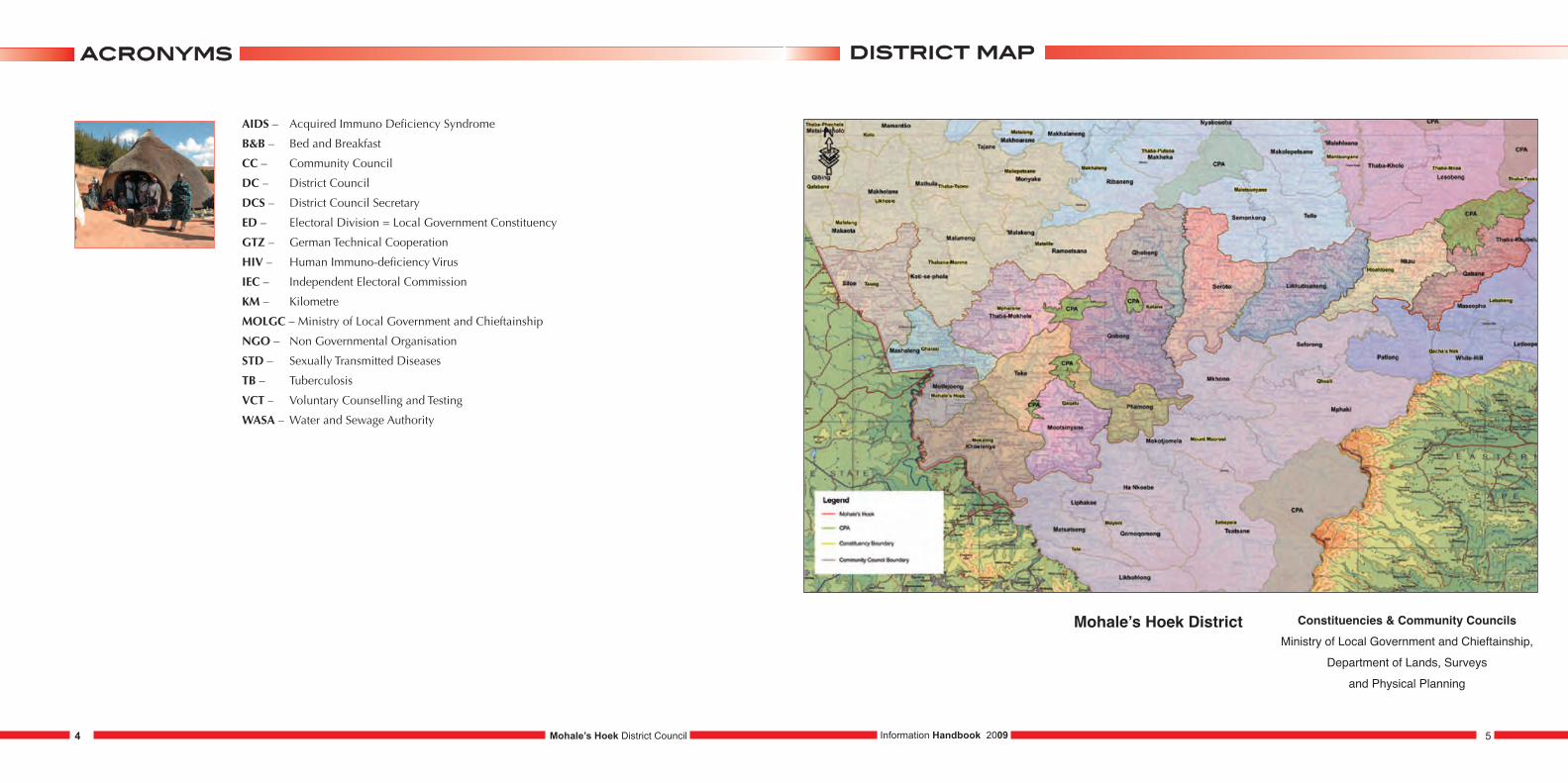
Mohale’s Hoek District Map……………………………………………………….................
Introduction………………………………………………………………………...........……..
Background to Local Government in Lesotho……………………………............………….
Methodology…………………………………………………………………...........………….
1. Profile of Community Councils……………………………………...………………
2. Social Indicators……………………………………………………...………………
3. Gender Aspects……………………………………………………....……………….
4. Agriculture………………………………………………………….…………………
5. Trade and Commerce…………………………………………………...……………
6. Health…………………………………………………………………….……………
7. HIV & AIDS……………………………………………………………..…………….
8. Education………………………………………………………………...……………
9. Water……………………………………………………………………..……………
10. Roads……………………………………………………………………...…………..
11. Energy……………………………………………………………………....………….
12. Communication………………………………………………………….……………
13. Security……………………………………………………………………...…………
14. Environment………………………………………………………………...…………
15. Community Council Fact Sheets………………………………………………….............
16. Community Council Administration Profile……………………………………...........…
17. List of District Council Members……......................................................................…
04
05
06
07
08
09
10
11
12
13
14
15
16
17
18
19
20
21
22
124 - 129
130
130
AIDS – Acquired Immuno Deficiency Syndrome
B&B – Bed and Breakfast
CC – Community Council
DC – District Council
DCS – District Council Secretary
ED – Electoral Division = Local Government Constituency
GTZ – German Technical Cooperation
HIV – Human Immuno-deficiency Virus
IEC – Independent Electoral Commission
KM – Kilometre
MOLGC – Ministry of Local Government and Chieftainship
NGO – Non Governmental Organisation
STD – Sexually Transmitted Diseases
TB – Tuberculosis
VCT – Voluntary Counselling and Testing
WASA – Water and Sewage Authority
ddiissttrriicctt mmaappaaccrroonnyymmss
Mohale’s Hoek District Council 5Information Handbook 20094
Mohale’s Hoek District Constituencies & Community CouncilsMinistry of Local Government and Chieftainship,
Department of Lands, Surveys and Physical Planning
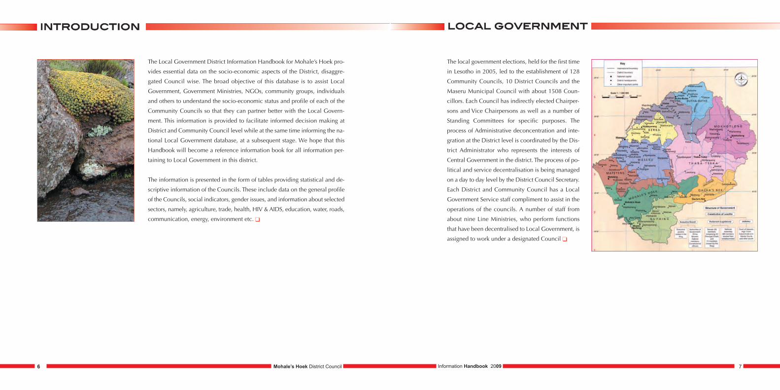
The Local Government District Information Handbook for Mohale’s Hoek pro-
vides essential data on the socio-economic aspects of the District, disaggre-
gated Council wise. The broad objective of this database is to assist Local
Government, Government Ministries, NGOs, community groups, individuals
and others to understand the socio-economic status and profile of each of the
Community Councils so that they can partner better with the Local Govern-
ment. This information is provided to facilitate informed decision making at
District and Community Council level while at the same time informing the na-
tional Local Government database, at a subsequent stage. We hope that this
Handbook will become a reference information book for all information per-
taining to Local Government in this district.
The information is presented in the form of tables providing statistical and de-
scriptive information of the Councils. These include data on the general profile
of the Councils, social indicators, gender issues, and information about selected
sectors, namely, agriculture, trade, health, HIV & AIDS, education, water, roads,
communication, energy, environment etc. �
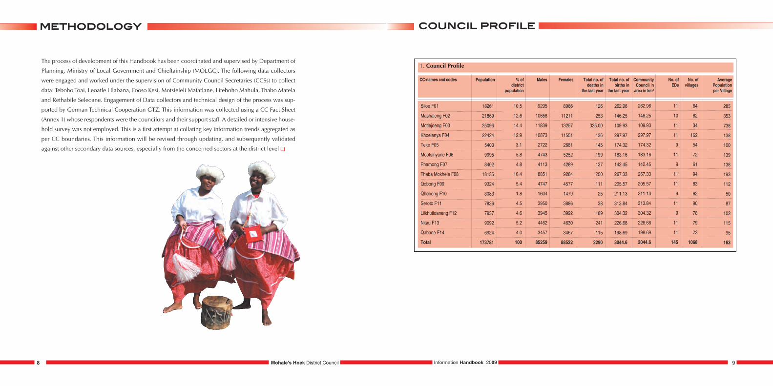
The local government elections, held for the first time
in Lesotho in 2005, led to the establishment of 128
Community Councils, 10 District Councils and the
Maseru Municipal Council with about 1508 Coun-
cillors. Each Council has indirectly elected Chairper-
sons and Vice Chairpersons as well as a number of
Standing Committees for specific purposes. The
process of Administrative deconcentration and inte-
gration at the District level is coordinated by the Dis-
trict Administrator who represents the interests of
Central Government in the district. The process of po-
litical and service decentralisation is being managed
on a day to day level by the District Council Secretary.
Each District and Community Council has a Local
Government Service staff compliment to assist in the
operations of the councils. A number of staff from
about nine Line Ministries, who perform functions
that have been decentralised to Local Government, is
assigned to work under a designated Council �
llooccaall ggoovveerrnnmmeenntt iinnttrroodduuccttiioonn
Mohale’s Hoek District Council 7Information Handbook 20096
8 Information Handbook 2009 9Mohale’s Hoek District Council
mmeetthhooddoollooggyy ccoouunncciill pprrooffiillee
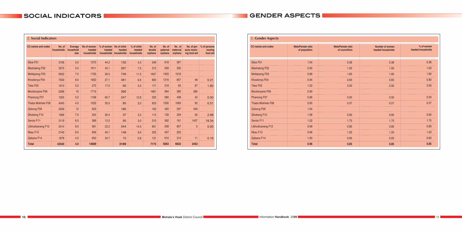
The process of development of this Handbook has been coordinated and supervised by Department of
Planning, Ministry of Local Government and Chieftainship (MOLGC). The following data collectors
were engaged and worked under the supervision of Community Council Secretaries (CCSs) to collect
data: Teboho Toai, Leoatle Hlabana, Fooso Kesi, Motsieleli Mafatlane, Liteboho Mahula, Thabo Matela
and Rethabile Seleoane. Engagement of Data collectors and technical design of the process was sup-
ported by German Technical Cooperation GTZ. This information was collected using a CC Fact Sheet
(Annex 1) whose respondents were the councilors and their support staff. A detailed or intensive house-
hold survey was not employed. This is a first attempt at collating key information trends aggregated as
per CC boundaries. This information will be revised through updating, and subsequently validated
against other secondary data sources, especially from the concerned sectors at the district level �
1. Council Profile
CC-names and codes Population % of district
population
Males Females Total no. ofdeaths in
the last year
Total no. ofbirths in
the last year
CommunityCouncil in area in km2
No. of EDs
No. ofvillages
Average Population per Village
Siloe F01
Mashaleng F02
Motlejoeng F03
Khoelenya F04
Teke F05
Mootsinyane F06
Phamong F07
Thaba Mokhele F08
Qobong F09
Qhobeng F10
Seroto F11
Lilkhutloaneng F12
Nkau F13
Qabane F14
Total
285
353
738
138
100
139
138
193
112
50
87
102
115
95
163
18261
21869
25096
22424
5403
9995
8402
18135
9324
3083
7836
7937
9092
6924
173781
10.5
12.6
14.4
12.9
3.1
5.8
4.8
10.4
5.4
1.8
4.5
4.6
5.2
4.0
100
9295
10658
11839
10873
2722
4743
4113
8851
4747
1604
3950
3945
4462
3457
85259
8966
11211
13257
11551
2681
5252
4289
9284
4577
1479
3886
3992
4630
3467
88522
126
253
325.00
136
145
199
137
250
111
25
38
189
241
115
2290
262.96
146.25
109.93
297.97
174.32
183.16
142.45
267.33
205.57
211.13
313.84
304.32
226.68
198.69
3044.6
262.96
146.25
109.93
297.97
174.32
183.16
142.45
267.33
205.57
211.13
313.84
304.32
226.68
198.69
3044.6
11
10
11
11
9
11
9
11
11
9
11
9
11
11
145
64
62
34
162
54
72
61
94
83
62
90
78
79
73
1068
2. Social Indicators
CC-names and codes No. ofhouseholds
Everagehousehold
size
No of womenheaded
households
% of womenheaded
households
No of child-headed
households
% of child-headed
households
No. of double
orphans
No. of paternal orphans
No . ofmaternalorphans
No. of per-sons receiv-ing food aid
% of personsreceing food aid
Siloe F01
Mashaleng F02
Motlejoeng F03
Khoelenya F04
Teke F05
Mootsinyane F06
Phamong F07
Thaba Mokhele F08
Qobong F09
Qhobeng F10
Seroto F11
Lilkhutloaneng F12
Nkau F13
Qabane F14
Total
0.21
1.80
0.50
0.51
2.98
18.34
0.00
0.16
3106
3575
6502
7030
1613
2268
1925
4345
2559
1066
3119
2414
2140
1878
43540
5.0
5.0
7.0
8.0
5.0
10
5.0
4.0
12
7.0
6.0
8.0
8.0
4.0
4.0
1373
1611
1720
1902
275
1710
1168
1522
623
324
389
561
859
652
14689
44.2
45.1
26.5
27.1
17.0
60.7
35.0
30.4
12.5
23.2
40.1
34.7
133
267
746
461
65
366
247
85
180
37
95
344
148
15
3189
4.3
7.5
11.5
6.6
4.0
12.8
2.0
3.5
3.0
14.3
6.9
0.8
346
215
1637
800
171
1681
250
623
193
113
210
601
203
131
7174
618
509
1393
1216
218
994
580
1330
420
128
582
258
407
610
9263
367
320
1018
857
65
385
408
1063
297
259
161
857
252
313
6622
48
97
285
42
92
349
92
1437
0
11
2453
3. Gender Aspects
CC-names and codes Male/Female ratioof population
Male/Female ratioof councillors
Siloe F01
Mashaleng F02
Motlejoeng F03
Khoelenya F04
Teke F05
Mootsinyane F06
Phamong F07
Thaba Mokhele F08
Qobong F09
Qhobeng F10
Seroto F11
Lilkhutloaneng F12
Nkau F13
Qabane F14
Total
1.04
0.95
0.89
0.94
1.02
0.90
0.96
0.95
1.04
1.08
1.02
0.99
0.96
1.00
0.96
0.38
1.00
1.60
0.83
2.00
0.50
0.57
0.60
1.75
0.80
1.20
0.83
0.85
Number of womenheaded households
0.38
1.00
1.60
0.83
2.00
0.50
0.57
0.60
1.75
0.80
1.20
0.83
0.85
% of womenheaded households
0.38
1.00
1.60
0.83
2.00
0.50
0.57
0.60
1.75
0.80
1.20
0.83
0.85
ggeennddeerr aassppeeccttssssoocciiaall iinnddiiccaattoorrss
Mohale’s Hoek District Council 11Information Handbook 200910
4. Agriculture
CC-names and codes No. of householdswith agriculture
plots
Average size ofthe agricultural
plots (ha)
Siloe F01
Mashaleng F02
Motlejoeng F03
Khoelenya F04
Teke F05
Mootsinyane F06
Phamong F07
Thaba Mokhele F08
Qobong F09
Qhobeng F10
Seroto F11
Lilkhutloaneng F12
Nkau F13
Qabane F14
1078
3575
2324
4039
3458
2461
3507
6288
1881
1806
2618
2019
1390
1699
2.25 acres
1.21
3
10
12
4.3
1.21
2.1 acres
Government service providers
Ministry of Agriculture & Food Security
and Ministry of Forestry & Land Reclamation
Ministry of Agriculture & Food Security and SANRemp
Ministry of Agriculture & Food Security
Ministry of Agriculture & Food Security
Ministry of Agriculture & Food Security and
Ministry of Forestry & Land Reclamation
Ministry of Agriculture & Food Security
Ministry of Agriculture & Food Security
and Ministry of Forestry & Land Reclamation
Ministry of Agriculture & Food Security and
Ministry of Forestry & Land Reclamation
Ministry of Agriculture and Food Security
Ministry of Agriculture & Food Security
and Ministry of Forestry & Land Reclamation
Ministry of Agriculture & Food Security
Ministry of Agriculture & Food Security and SANRemp
Ministry of Agriculture & Food Security
NGOs as serviceproviders
World Vision
World Vision, FAO and CRS
World Vision, TEBA, UNICEF
World Vision and SANReMP
World Vision
Serumula and Move
Serumula, Machobane, Rural Self-help
Development Association, Mimi
CARE, TEBA, UNICEF, Red Cross,
World Vision, Caritus
Serumula and MOVE
None
Serumula and MOVE
none
SMARDT,Serumula and MOVE
SMARDT
5.Water
CC-names and codes No. of householdswith access topiped water
No. ofwell/water
points
Siloe F01
Mashaleng F02
Motlejoeng F03
Khoelenya F04
Teke F05
Mootsinyane F06
Phamong F07
Thaba Mokhele F08
Qobong F09
Qhobeng F10
Seroto F11
Lilkhutloaneng F12
Nkau F13
Qabane F14
1165
805
2227
3507
515
360
1788
3730
347
73
1047
177
2141
118
132
77
210
148
76
60
60
96
138
13
99
13
67
238
Average time taken ordistance to the nearest
portable water point
15 min
1 hr
17min
1 hr
10 km
34 min
5 min
15 min
1 hr
15 km
1.5 hr
45 min
5 min
10 min
What kind of water supply projects are under implementation or planned? Where?
Installing new water taps and extending groundwater pipes
Building of water systems to assist in protection of available
sources of water in Liphiring F0208, connections of WASA taps in
Qalakheng F0210
Planned installlation of public stand pipes
Installing piped water systems
Provision and extension of clean water supply to the entire council
Piped Water Systems
Extension of water system in Phamong F 07/05
Repair of water pipes
Installation of water pipes at Nthamae and Tau villages
Installation of water pipes
Installation of piped water systems
Piped water supply
None
New water taps at Letumonyane,addition
of water taps in some villages
No. of villages with existing
water systems
24
44
31
57
4
56
190
80
62
5
10
5
79
43
wwaatteerraaggrriiccuullttuurree
Mohale’s Hoek District Council 13Information Handbook 200912
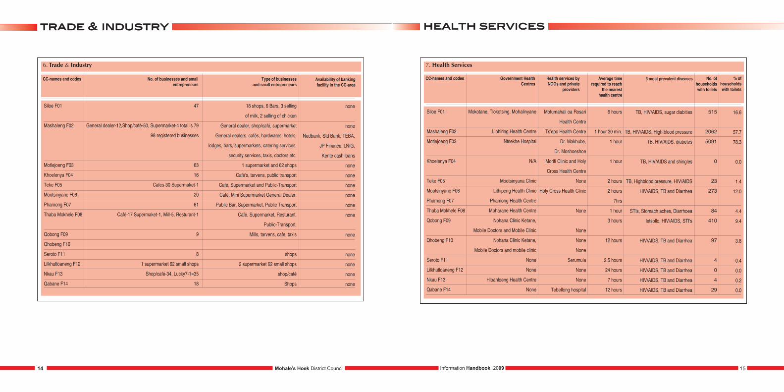
hheeaalltthh sseerrvviicceessttrraaddee && iinndduussttrryy
Mohale’s Hoek District Council 15Information Handbook 200914
7. Health Services
CC-names and codes Government Health Centres
Health services byNGOs and private
providers
Siloe F01
Mashaleng F02
Motlejoeng F03
Khoelenya F04
Teke F05
Mootsinyane F06
Phamong F07
Thaba Mokhele F08
Qobong F09
Qhobeng F10
Seroto F11
Lilkhutloaneng F12
Nkau F13
Qabane F14
Mokotane, Tlokotsing, Mohalinyane
Liphiring Health Centre
Ntsekhe Hospital
N/A
Mootsinyana Clinic
Lithipeng Health Clinic
Phamong Health Centre
Mpharane Health Centre
Nohana Clinic Ketane,
Mobile Doctors and Mobile Clinic
Nohana Clinic Ketane,
Mobile Doctors and mobile clinic
None
None
Hloahloeng Health Centre
None
Mofumahali oa Rosari
Health Centre
Ts'epo Health Centre
Dr. Makhube,
Dr. Moshoeshoe
Morifi Clinic and Holy
Cross Health Centre
None
Holy Cross Health Clinic
None
None
None
None
Serumula
None
None
Tebellong hospital
Average time required to reach
the nearest health centre
6 hours
1 hour 30 min.
1 hour
1 hour
2 hours
2 hours
7hrs
1 hour
3 hours
12 hours
2.5 hours
24 hours
7 hours
12 hours
3 most prevalent diseases
TB, HIV/AIDS, sugar diabities
TB, HIV/AIDS, High blood pressure
TB, HIV/AIDS, diabetes
TB, HIV/AIDS and shingles
TB, Highblood pressure, HIV/AIDS
HIV/AIDS, TB and Diarrhea
STIs, Stomach aches, Diarrhoea
letsollo, HIV/AIDS, STI's
HIV/AIDS, TB and Diarrhea
HIV/AIDS, TB and Diarrhea
HIV/AIDS, TB and Diarrhea
HIV/AIDS, TB and Diarrhea
HIV/AIDS, TB and Diarrhea
No. of householdswith toilets
515
2062
5091
0
23
273
84
410
97
4
0
4
29
% of householdswith toilets
16.6
57.7
78.3
0.0
1.4
12.0
4.4
9.4
3.8
0.4
0.0
0.2
0.0
6. Trade & Industry
CC-names and codes No. of businesses and small entrepreneurs
Siloe F01
Mashaleng F02
Motlejoeng F03
Khoelenya F04
Teke F05
Mootsinyane F06
Phamong F07
Thaba Mokhele F08
Qobong F09
Qhobeng F10
Seroto F11
Lilkhutloaneng F12
Nkau F13
Qabane F14
47
General dealer-12,Shop/café-50, Supermarket-4 total is 79
98 registered businesses
63
16
Cafes-30 Supermaket-1
20
61
Café-17 Supermaket-1, Mill-5, Resturant-1
9
8
1 supermarket 62 small shops
Shop/café-34, Lucky7-1=35
18
Type of businesses and small entrepreneurs
18 shops, 6 Bars, 3 selling
of milk, 2 selling of chicken
General dealer, shop/café, supermarket
General dealers, cafés, hardwares, hotels,
lodges, bars, supermarkets, catering services,
security services, taxis, doctors etc.
1 supermarket and 62 shops
Café's, tarvens, public transport
Café, Supermarket and Public-Transport
Café, Mini Supermarket General Dealer,
Public Bar, Supermarket, Public Transport
Café, Supermarket, Resturant,
Public-Transport,
Mills, tarvens, cafe, taxis
shops
2 supermarket 62 small shops
shop/café
Shops
Availability of banking facility in the CC-area
none
none
Nedbank, Std Bank, TEBA,
JP Finance, LNIG,
Kente cash loans
none
none
none
none
none
none
none
none
none
none
none
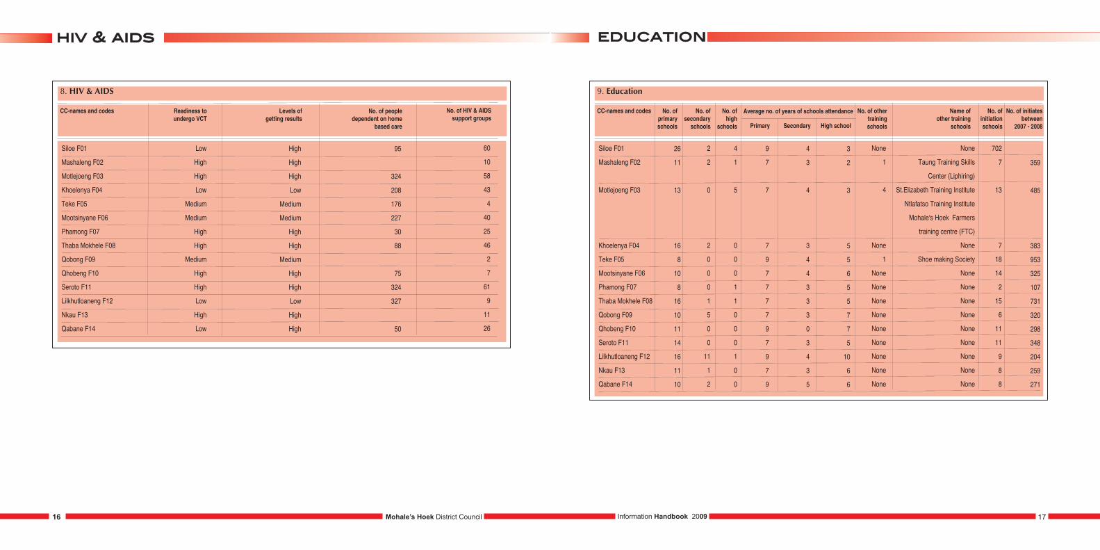
8. HIV & AIDS
CC-names and codes Readiness to undergo VCT
Levels of getting results
Siloe F01
Mashaleng F02
Motlejoeng F03
Khoelenya F04
Teke F05
Mootsinyane F06
Phamong F07
Thaba Mokhele F08
Qobong F09
Qhobeng F10
Seroto F11
Lilkhutloaneng F12
Nkau F13
Qabane F14
Low
High
High
Low
Medium
Medium
High
High
Medium
High
High
Low
High
Low
High
High
High
Low
Medium
Medium
High
High
Medium
High
High
Low
High
High
No. of people dependent on home
based care
95
324
208
176
227
30
88
75
324
327
50
No. of HIV & AIDSsupport groups
60
10
58
43
4
40
25
46
2
7
61
9
11
26
9. Education
CC-names and codes No. of primaryschools
No. of secondaryschools
No. of high
schools Primary Secondary High school
Average no. of years of schools attendance No. of othertrainingschools
Name ofother training
schools
No. of initiationschools
No. of initiatesbetween
2007 - 2008
Siloe F01
Mashaleng F02
Motlejoeng F03
Khoelenya F04
Teke F05
Mootsinyane F06
Phamong F07
Thaba Mokhele F08
Qobong F09
Qhobeng F10
Seroto F11
Lilkhutloaneng F12
Nkau F13
Qabane F14
359
485
383
953
325
107
731
320
298
348
204
259
271
26
11
13
16
8
10
8
16
10
11
14
16
11
10
2
2
0
2
0
0
0
1
5
0
0
11
1
2
4
1
5
0
0
0
1
1
0
0
0
1
0
0
9
7
7
7
9
7
7
7
7
9
7
9
7
9
4
3
4
3
4
4
3
3
3
0
3
4
3
5
3
2
3
5
5
6
5
5
7
7
5
10
6
6
None
1
4
None
1
None
None
None
None
None
None
None
None
None
None
Taung Training Skills
Center (Liphiring)
St.Elizabeth Training Institute
Ntlafatso Training Institute
Mohale's Hoek Farmers
training centre (FTC)
None
Shoe making Society
None
None
None
None
None
None
None
None
None
702
7
13
7
18
14
2
15
6
11
11
9
8
8
eedduuccaattiioonnhhiivv && aaiiddss
Mohale’s Hoek District Council 17Information Handbook 200916
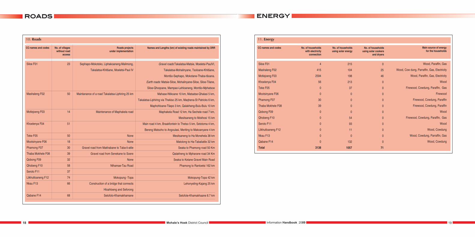
10. Roads
CC-names and codes No. of villageswithout road
access
Roads projects under implementation
Siloe F01
Mashaleng F02
Motlejoeng F03
Khoelenya F04
Teke F05
Mootsinyane F06
Phamong F07
Thaba Mokhele F08
Qobong F09
Qhobeng F10
Seroto F11
Lilkhutloaneng F12
Nkau F13
Qabane F14
23
50
14
51
50
18
30
39
32
58
37
74
66
68
Sephapo-Mokotoko, Liphakoaneng-Malimong,
Takalatsa-Khitšane, Moeletsi-Paul IV
Maintanance of a road Takalatsa-Liphiring 25 km
Maintenance of Maphakela road
None
None
Gravel road from Makhabane to Taba-li-atile
Gravel road from Senekane to Soere
None
Nthamae-Tau Road
Mokopung -Topa
Construction of a bridge that connects
Hloahloeng and Seforong
Setofolo-Khamakhamane
Names and Lengths (km) of existing roads maintained by DRR
Gravel roads:Takalatsa-Matsie, Moeletsi-PaulVI,
Takalatsa-Mohalinyane, Tsoloane-Khitšane,
Montšo-Sephapo, Mokotane-Thaba-tšoana.
Earth roads: Matsie-Siloe, Mohalinyane-Siloe, Siloe-Tilane,
Siloe-Qhoqoane, Mampao-Lehloaneng, Montšo-Mphatsoe
Mahase-Ntikoane 10 km, Matsatse-Qhalasi 5 km,
Takalatsa-Liphiring via Thekiso 25 km, Maqhena-St Patricks 6 km,
Maphohloane-Tšepo 3 km, Qalakheng-Bulu-Bulu 10 km
Maphakela Road 12 km, Ha Sechele road 7 km,
Mesitsaneng to Mokhosi 15 km
Main road 4 km, Braakfontein to Thetso 5 km, Setotoma 4 km,
Bereng Matsoho to Angoulasi, Meriting to Makoanyane 4 km
Mesitsaneng to Ha Monehela 38 km
Matolong to Ha-Tabaliatile 32 km
Seaka to Phamong road 50 Km
Qalakheng to Mpharane road 34 Km
Seaka to Ketane Gravel Main Road
Phamong to Rantoetsi 162 km
Mokopung-Topa 42 km
Lehonyeling-Kajang 25 km
Setofole-Khamakhaane 8.7 km
11. Energy
CC-names and codes No. of householdswith electricity
connection
No. of householdsusing solar energy
Siloe F01
Mashaleng F02
Motlejoeng F03
Khoelenya F04
Teke F05
Mootsinyane F06
Phamong F07
Thaba Mokhele F08
Qobong F09
Qhobeng F10
Seroto F11
Lilkhutloaneng F12
Nkau F13
Qabane F14
Total
4
415
2594
56
0
0
30
39
0
0
0
0
0
0
3138
215
104
198
213
37
0
0
0
0
54
93
11
0
132
1057
No. of householdsusing solar cookers
and dryers
0
25
46
0
0
0
0
0
0
0
0
0
0
0
71
Main source of energy for the households
Wood, Paraffin, Gas
Wood, Cow dung, Parraffin, Gas, Electricity
Wood, Paraffin, Gas, Electricity
Wood
Firewood, Cowdung, Paraffin, Gas
Firewood
Firewood, Cowdung, Paraffin
Firewood, Cowdung, Paraffin
Wood
Firewood, Cowdung, Paraffin, Gas
Wood
Wood, Cowdung
Wood, Cowdung, Parraffin, Gas
Wood, Cowdung
eenneerrggyyrrooaaddss
Mohale’s Hoek District Council 19Information Handbook 200918
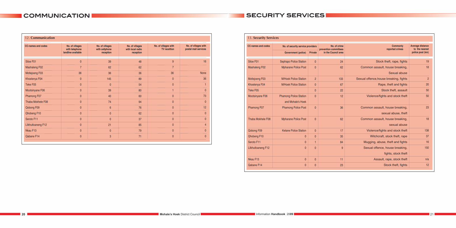
12. Communication
CC-names and codes No. of villageswith telephone
landline available
No. of villages with cellphone
reception
Siloe F01
Mashaleng F02
Motlejoeng F03
Khoelenya F04
Teke F05
Mootsinyane F06
Phamong F07
Thaba Mokhele F08
Qobong F09
Qhobeng F10
Seroto F11
Lilkhutloaneng F12
Nkau F13
Qabane F14
0
7
36
0
0
0
0
0
0
0
0
0
0
0
39
62
36
145
0
39
40
74
6
0
0
21
0
3
No. of villages with local radio
reception
48
62
36
89
54
80
60
94
76
62
37
85
79
71
No. of villages with postal mail services
16
None
36
1
0
73
0
12
0
0
4
0
0
No. of villages withTV receltion
9
7
36
0
0
1
0
0
0
0
0
0
0
0
13. Security Services
CC-names and codes
Siloe F01
Mashaleng F02
Motlejoeng F03
Khoelenya F04
Teke F05
Mootsinyane F06
Phamong F07
Thaba Mokhele F08
Qobong F09
Qhobeng F10
Seroto F11
Lilkhutloaneng F12
Nkau F13
Qabane F14
Sephapo Police Station
Mpharane Police Post
M/Hoek Police Station
M/Hoek Police Station
Phamong Police Station
and Mohale's Hoek
Phamong Police Post
Mpharane Police Post
Ketane Police Station
0
0
0
0
0
0
0
2
0
0
0
0
0
0
0
1
0
0
0
No. of crime prevention committees
in the Council area
24
62
133
67
22
12
36
62
17
35
84
9
11
23
Average distance to the nearest
police post (km)
19
18
2
20
50
50
23
18
138
37
16
150
n/a
12
Commonly reported crimes
Stock theft, rape, fights
Common assault, house breaking,
Sexual abuse
Sexual offence,house breaking, fights
Rape, theft and fights
Stock theft, assault
Violence/fights and stock theft
Common assault, house breaking,
sexual abuse, theft
Common assault, house breaking,
sexual abuse
Violence/fights and stock theft
Witchcraft, stock theft, rape
Mugging, abuse, theft and fights
Sexual offence, house breaking,
fights, stock theft
Assault, rape, stock theft
Stock theft, fights
No. of security service providers
Government (police) Private
sseeccuurriittyy sseerrvviicceessccoommmmuunniiccaattiioonn
Mohale’s Hoek District Council 21Information Handbook 200920

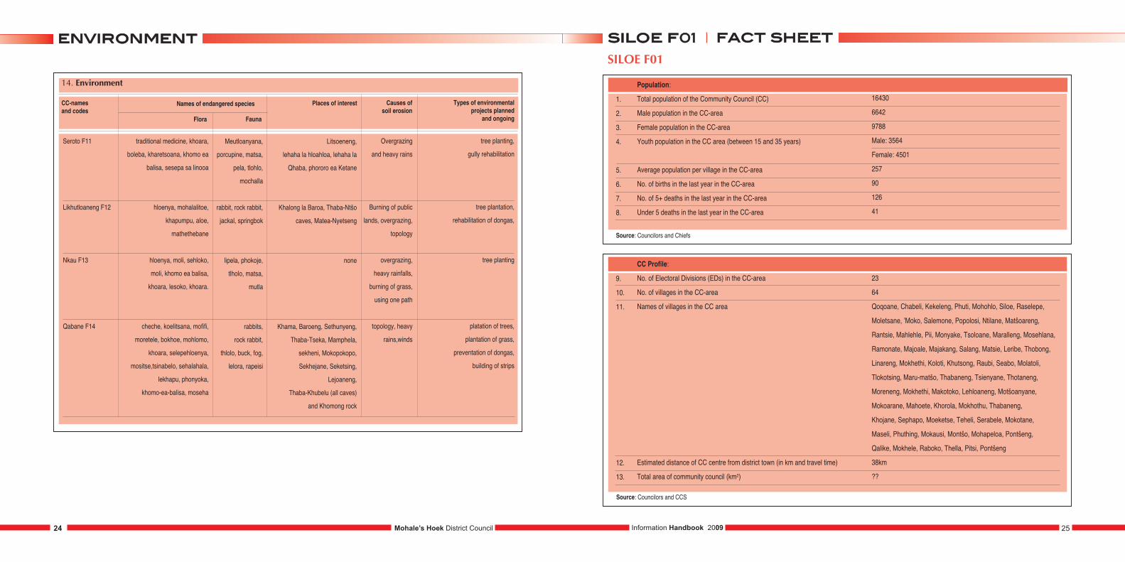
14. Environment
CC-names and codes
Siloe F01
Mashaleng F02
Motlejoeng F03
Khoelenya F04
Teke F05
cheche, koelitsana,
mofifi, moretele, bokhoe, mohlomo,
khoara, selepehloenya, mositse,
ts’inabelo, sehalahala, lekhapu,
phonyoka, khomo-ea-balisa, moseha
hloenya, khoara, poho-ts'ehla,
labatheke, mositsane, phonyoka,
phooa, ts'upane, khapumpu,
khomo ea balisa,
moretele o mofubelu
hloenya, mathethebane,
sehloko, phate ea ngaka
traditional medicine,
kharetsoana, mohlomo, qokoa,
mohloare, mofifi, poone ea tsoene,
khoara, mositsane, letapisa,
khomo ea balisa, setjoetlane
hloenya, khretsana, leshoma,
maleleka, khomo ea balisa, khoara,
poho ts'ehla, kuena
rabbits,
rock rabbit,
thlolo, buck
pela, letsa,
tlholo, m'utla,
kokolofitoe
rabbits,
rock daisse
rabbits, pela,
tlohlo, letsa,
jackal,
porcupine,
mochalla
lipela,
'mutlanyane,
ts'oene,
khatla, tlholo
Places of interest
Salang dam, Maphiri cave,
Letsoapong cave, Korolo cave,
Phatlane cave,
Tlokotsing cave, 'Makhosu
M'amatsoele, qalong ea khuiting,
cave of Ha Mahase, Letsatseng la
Likhutloaneng, Tsotsore, Boer cavesat
liphiring, cave of Seqhokeng, Bushmen
caves and graves, Boer graves
Motlejoeng (cave)
Morifi, Letsoapong la Ramoipone,
Letsoapong la sekolong, Ha Motoe
(Bushman pass)
Sankoase Lekhohlong
Types of environmentalprojects planned
and ongoing
platation of trees,
plantation of grass,
preventation of dongas,
building of dams
Ongoing: tree planting,
building of available
sources of water for
preservation purposes,
building of dongas to
combat soil erosion
tree plantation,
rehabilitation of
dongas, mantloane
tree planting,
gully rehabilitation
building dongas,
planting of trees,
gully rehabilitation
Causes of soil erosion
topology,
heavy rains,
winds, draught
over grazing,
heavy rain storms,
poor farming
techniques
burning of grass,
overgrazing, severe
rainfall, ploughing
in wrong direction
overgrazing and
heavy rains
burning of grass,
overgrazing, severe
rainfall, ploughing in
wrong direction, animals
using the same route
Names of endangered species
Flora Fauna
14. Environment
CC-names and codes
Mootsinyane F06
Phamong F07
Thaba Mokhele F08
Qobong F09
Qhobeng F10
hloenya, sehloko,
'moli, sefothafotha, poho-tsehla,
kuena, lekhala, khomo ea balisa
hloenya, moli, sehloko,
khomo-ea-balisa,
khampumpu, lesoko,
phonyoka, hlokoana-la-tsela
phefo, moli, hloenya,
poone-ea-litsoene, sehloko,
sehala-hala-sa-matlaka,
khomo-ea-balisa
hloenya, sehloko, 'moli,
Sefothafotha, poho-tsehla, kuena,
lekhala, khomo ea balisa
liremo, mohlomo,
qokoa, lekhala kharetsana
‘mutla, lipela,
lithlolo, litsoene,
linoha, matsa,
phokojoe.
springbok
none
mutla, matsa,
thlolo, lipela,
mochalla
matsa, lits'oene,
phokojoe, 'mutla
Places of interest
Bushmen rock art
and their caves
none
none
Bushmen art and
caves, Tsullung Ha Bosiu
Mokhoabo Khohlong Ha Letsie,
Lekhala kharetsana Ha Oetsi,
Lihlohong Waterfall Ha Nthamaha
Types of environmentalprojects planned
and ongoing
Tree Plantation,
rehabilitation of dongas,
tree plantation,
rehabilitation
of dongas,
tree planting and
grass plantation.
Existing: Tree Planting at
Khubetsoana Sekolong, Ha Masiba,
Ha Rampoti and Ha Sepolo.
Planned: Irrigation Project at
Ha Nthamaha, Kotsoana,
Ralekhoasa, Teleki and Khojane
and Joint crop growing
Tree planting, gully rehabilitation
tree plantation, rehabilitation
of dongas,
Causes of soil erosion
burning of
grazelands
overgrazing and
heavy rains.
overgrazing
and heavy rains
burning of public
lands, overgrazing,
topology
Names of endangered species
Flora Fauna
eennvviirroonnmmeenntteennvviirroonnmmeenntt
Mohale’s Hoek District Council 23Information Handbook 200922
14. Environment
CC-names and codes
Seroto F11
Likhutloaneng F12
Nkau F13
Qabane F14
traditional medicine, khoara,
boleba, kharetsoana, khomo ea
balisa, sesepa sa linooa
hloenya, mohalalitoe,
khapumpu, aloe,
mathethebane
hloenya, moli, sehloko,
moli, khomo ea balisa,
khoara, lesoko, khoara.
cheche, koelitsana, mofifi,
moretele, bokhoe, mohlomo,
khoara, selepehloenya,
mositse,tsinabelo, sehalahala,
lekhapu, phonyoka,
khomo-ea-balisa, moseha
Meutloanyana,
porcupine, matsa,
pela, tlohlo,
mochalla
rabbit, rock rabbit,
jackal, springbok
lipela, phokoje,
tlholo, matsa,
mutla
rabbits,
rock rabbit,
thlolo, buck, fog,
lelora, rapeisi
Places of interest
Litsoeneng,
lehaha la hloahloa, lehaha la
Qhaba, phororo ea Ketane
Khalong la Baroa, Thaba-Ntšo
caves, Matea-Nyetseng
none
Khama, Baroeng, Sethunyeng,
Thaba-Tseka, Mamphela,
sekheni, Mokopokopo,
Sekhejane, Seketsing,
Lejoaneng,
Thaba-Khubelu (all caves)
and Khomong rock
Types of environmentalprojects planned
and ongoing
tree planting,
gully rehabilitation
tree plantation,
rehabilitation of dongas,
tree planting
platation of trees,
plantation of grass,
preventation of dongas,
building of strips
Causes of soil erosion
Overgrazing
and heavy rains
Burning of public
lands, overgrazing,
topology
overgrazing,
heavy rainfalls,
burning of grass,
using one path
topology, heavy
rains,winds
Names of endangered species
Flora Fauna
SILOE F01
1.
2.
3.
4.
5.
6.
7.
8.
Population:
Total population of the Community Council (CC)
Male population in the CC-area
Female population in the CC-area
Youth population in the CC area (between 15 and 35 years)
Average population per village in the CC-area
No. of births in the last year in the CC-area
No. of 5+ deaths in the last year in the CC-area
Under 5 deaths in the last year in the CC-area
16430
6642
9788
Male: 3564
Female: 4501
257
90
126
41
9.
10.
11.
12.
13.
CC Profile:
No. of Electoral Divisions (EDs) in the CC-area
No. of villages in the CC-area
Names of villages in the CC area
Estimated distance of CC centre from district town (in km and travel time)
Total area of community council (km2)
23
64
Qoqoane, Chabeli, Kekeleng, Phuti, Mohohlo, Siloe, Raselepe,
Moletsane, ’Moko, Salemone, Popolosi, Ntilane, Matšoareng,
Rantsie, Mahlehle, Pii, Monyake, Tsoloane, Maralleng, Mosehlana,
Ramonate, Majoale, Majakang, Salang, Matsie, Leribe, Thobong,
Linareng, Mokhethi, Koloti, Khutsong, Raubi, Seabo, Molatoli,
Tlokotsing, Maru-matšo, Thabaneng, Tsienyane, Thotaneng,
Moreneng, Mokhethi, Makotoko, Lehloaneng, Motšoanyane,
Mokoarane, Mahoete, Khorola, Mokhothu, Thabaneng,
Khojane, Sephapo, Moeketse, Teheli, Serabele, Mokotane,
Maseli, Phuthing, Mokausi, Montšo, Mohapeloa, Pontšeng,
Qalike, Mokhele, Raboko, Thella, Pitsi, Pontšeng
38km
??
ffaacctt sshheeeetteennvviirroonnmmeenntt
Mohale’s Hoek District Council 25Information Handbook 200924
ssiillooee ff0011
Source: Councilors and Chiefs
Source: Councilors and CCS
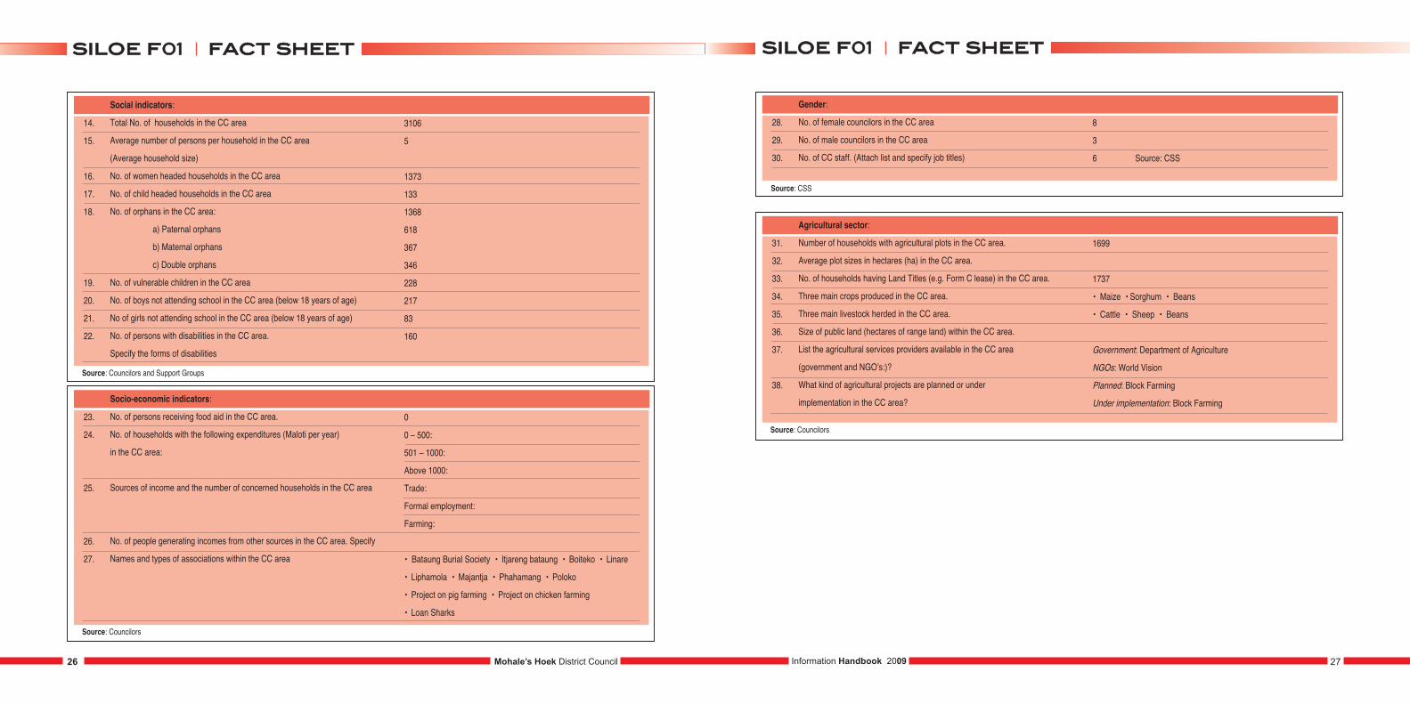
14.
15.
16.
17.
18.
19.
20.
21.
22.
Social indicators:
Total No. of households in the CC area
Average number of persons per household in the CC area
(Average household size)
No. of women headed households in the CC area
No. of child headed households in the CC area
No. of orphans in the CC area:
a) Paternal orphans
b) Maternal orphans
c) Double orphans
No. of vulnerable children in the CC area
No. of boys not attending school in the CC area (below 18 years of age)
No of girls not attending school in the CC area (below 18 years of age)
No. of persons with disabilities in the CC area.
Specify the forms of disabilities
3106
5
1373
133
1368
618
367
346
228
217
83
160
23.
24.
25.
26.
27.
Socio-economic indicators:
No. of persons receiving food aid in the CC area.
No. of households with the following expenditures (Maloti per year)
in the CC area:
Sources of income and the number of concerned households in the CC area
No. of people generating incomes from other sources in the CC area. Specify
Names and types of associations within the CC area
0
0 – 500:
501 – 1000:
Above 1000:
Trade:
Formal employment:
Farming:
• Bataung Burial Society • Itjareng bataung • Boiteko • Linare
• Liphamola • Majantja • Phahamang • Poloko
• Project on pig farming • Project on chicken farming
• Loan Sharks
28.
29.
30.
Gender:
No. of female councilors in the CC area
No. of male councilors in the CC area
No. of CC staff. (Attach list and specify job titles)
8
3
6 Source: CSS
31.
32.
33.
34.
35.
36.
37.
38.
Agricultural sector:
Number of households with agricultural plots in the CC area.
Average plot sizes in hectares (ha) in the CC area.
No. of households having Land Titles (e.g. Form C lease) in the CC area.
Three main crops produced in the CC area.
Three main livestock herded in the CC area.
Size of public land (hectares of range land) within the CC area.
List the agricultural services providers available in the CC area
(government and NGO’s:)?
What kind of agricultural projects are planned or under
implementation in the CC area?
1699
1737
• Maize • Sorghum • Beans
• Cattle • Sheep • Beans
Government: Department of Agriculture
NGOs: World Vision
Planned: Block Farming
Under implementation: Block Farming
Mohale’s Hoek District Council 27Information Handbook 200926
ffaacctt sshheeeettssiillooee ff0011ffaacctt sshheeeettssiillooee ff0011
Source: Councilors and Support Groups
Source: Councilors
Source: Councilors
Source: CSS
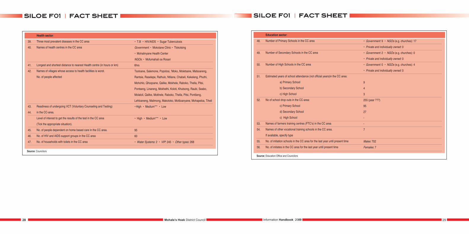
39.
40.
41.
42.
43.
44.
45.
46.
47.
Health sector:
Three most prevalent diseases in the CC area
Names of health centres in the CC area
Longest and shortest distance to nearest Health centre (in hours or km)
Names of villages whose access to health facilities is worst.
No. of people affected
Readiness of undergoing VCT (Voluntary Counseling and Testing)
in the CC-area.
Level of interest to get the results of the test in the CC area
(Tick the appropriate situation).
No. of people dependent on home based care in the CC area.
No. of HIV and AIDS support groups in the CC area
No. of households with toilets in the CC area
• T.B • HIV/AIDS • Sugar Tuberculosis
Government: • Mokotane Clinic • Tlokotsing
• Mohalinyane Health Center
NGOs: • Mofumahali oa Rosari
6hrs
Tsoloane, Salemone, Popolosi, ’Moko, Moletsane, Matsoareng,
Rantsie, Raselepe, Rathulo, Ntilane, Chabeli, Kekeleng, Phuthi,
Mohohlo, Qhoqoane, Qalike, Mokhele, Raboko, Thella, Pitsi,
Pontseng, Linareng, Mokhethi, Koloti, Khutsong, Raubi, Seabo,
Molatoli, Qalike, Mokhele, Raboko, Thella, Pitsi, Pontšeng,
Lehloaneng, Malimong, Makotoko, Motšoanyane, Mohapeloa, Tiheli
• High • Medium*** • Low
• High • Medium*** • Low
95
60
• Water Systems: 2 • VIP: 245 • Other types: 268
48.
49.
50.
51.
52.
53.
54.
55.
56.
Education sector:
Number of Primary Schools in the CC area
Number of Secondary Schools in the CC area
Number of High Schools in the CC area
Estimated years of school attendance (not official years)in the CC area:
a) Primary School
b) Secondary School
c) High School
No of school drop outs in the CC-area:
c) Primary School
d) Secondary School
c) High School
Names of farmers training centres (FTC’s) in the CC area
Names of other vocational training schools in the CC area.
If available, specify type
No. of initiation schools in the CC area for the last year until present time
No. of initiates in the CC area for the last year until present time
• Government: 9 • NGOs (e.g. churches): 17
• Private and individually owned: 0
• Government: 2 • NGOs (e.g. churches): 0
• Private and individually owned: 0
• Government: 0 • NGOs (e.g. churches): 4
• Private and individually owned: 0
9
4
3
255 (year ???)
95
27
-
-
7
Males: 702
Females: 7
Source: Education Office and Councilors
Mohale’s Hoek District Council 29Information Handbook 200928
ffaacctt sshheeeettssiillooee ff0011ffaacctt sshheeeettssiillooee ff0011
Source: Councilors
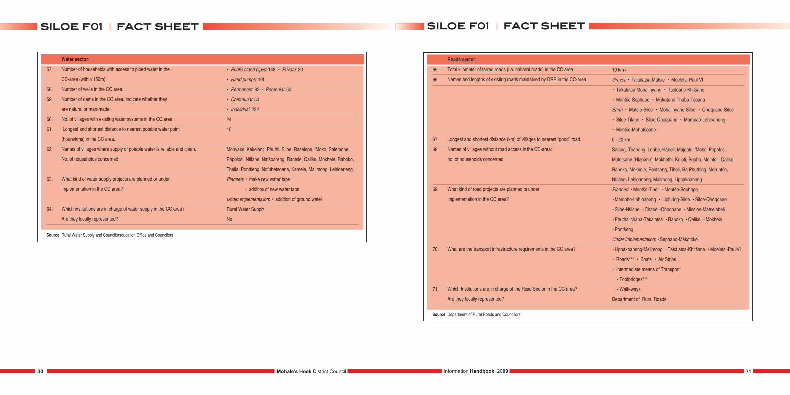
57.
58.
59.
60.
61.
62.
63.
64.
Water sector:
Number of households with access to piped water in the
CC-area (within 150m):
Number of wells in the CC area.
Number of dams in the CC area. Indicate whether they
are natural or man-made.
No. of villages with existing water systems in the CC area
Longest and shortest distance to nearest potable water point
(hours/kms) in the CC area.
Names of villages where supply of potable water is reliable and clean.
No. of households concerned
What kind of water supply projects are planned or under
implementation in the CC area?
Which institutions are in charge of water supply in the CC area?
Are they locally represented?
• Public stand pipes: 148 • Private: 20
• Hand pumps: 101
• Permanent: 82 • Perennial: 50
• Communal: 50
• Individual: 232
24
15
Monyake, Kekeleng, Phuthi, Siloe, Raselepe, ’Moko, Salemone,
Popolosi, Ntilane, Matšoareng, Rantsie, Qalike, Mokhele, Raboko,
Thella, Pontšeng, Mofubetsoana, Kamele, Malimong, Lehloaneng
Planned: • make new water taps
• addition of new water taps
Under implementation: • addition of ground water
Rural Water Supply
No
Source: Rural Water Supply and Councilorsducation Office and Councilors
65.
66.
67.
68.
69.
70.
71.
Roads sector:
Total kilometer of tarred roads (i.e. national roads) in the CC area
Names and lengths of existing roads maintained by DRR in the CC-area
Longest and shortest distance (km) of villages to nearest “good” road.
Names of villages without road access in the CC-area:
no. of households concerned
What kind of road projects are planned or under
implementation in the CC area?
What are the transport infrastructure requirements in the CC area?
Which Institutions are in charge of the Road Sector in the CC area?
Are they locally represented?
10 km+
Gravel: • Takalatsa-Matsie • Moeletsi-Paul VI
• Takalatsa-Mohalinyane • Tsoloane-Khitšane
• Montšo-Sephapo • Mokotane-Thaba-Tšoana
Earth: • Matsie-Siloe • Mohalinyane-Siloe • Qhoqoane-Siloe
• Siloe-Tilane • Siloe-Qhoqoane • Mampao-Lehloaneng
• Montšo-Mphatšoane
0 - 20 km
Salang, Thabong, Leribe, Habeli, Majoale, ’Moko, Popolosi,
Moletsane (Hlapane), Mokhethi, Koloti, Seabo, Molatoli, Qalike,
Raboko, Mokhele, Pontseng, Tiheli, Ra Phuthing, Moruntšo,
Ntilane, Lehloaneng, Malimong, Liphakoaneng
Planned: • Montšo-Tiheli • Montšo-Sephapo
• Mampho-Lehloaneng • Liphiring-Siloe • Siloe-Qhoqoane
• Siloe-Ntilane • Chabeli-Qhoqoane • Mission-Matselabeli
• Phuthalichaba-Takalatsa • Raboko • Qalike • Mokhele
• Pontšeng
Under implementation: • Sephapo-Makotoko
• Liphakoaneng-Malimong • Takalatsa-Khitšane • Moeletsi-PaulVI
• Roads*** • Boats • Air Strips
• Intermediate means of Transport:
- Footbridges***
- Walk-ways
Department of Rural Roads
Source: Department of Rural Roads and Councilors
Mohale’s Hoek District Council 31Information Handbook 200930
ffaacctt sshheeeettssiillooee ff0011ffaacctt sshheeeettssiillooee ff0011
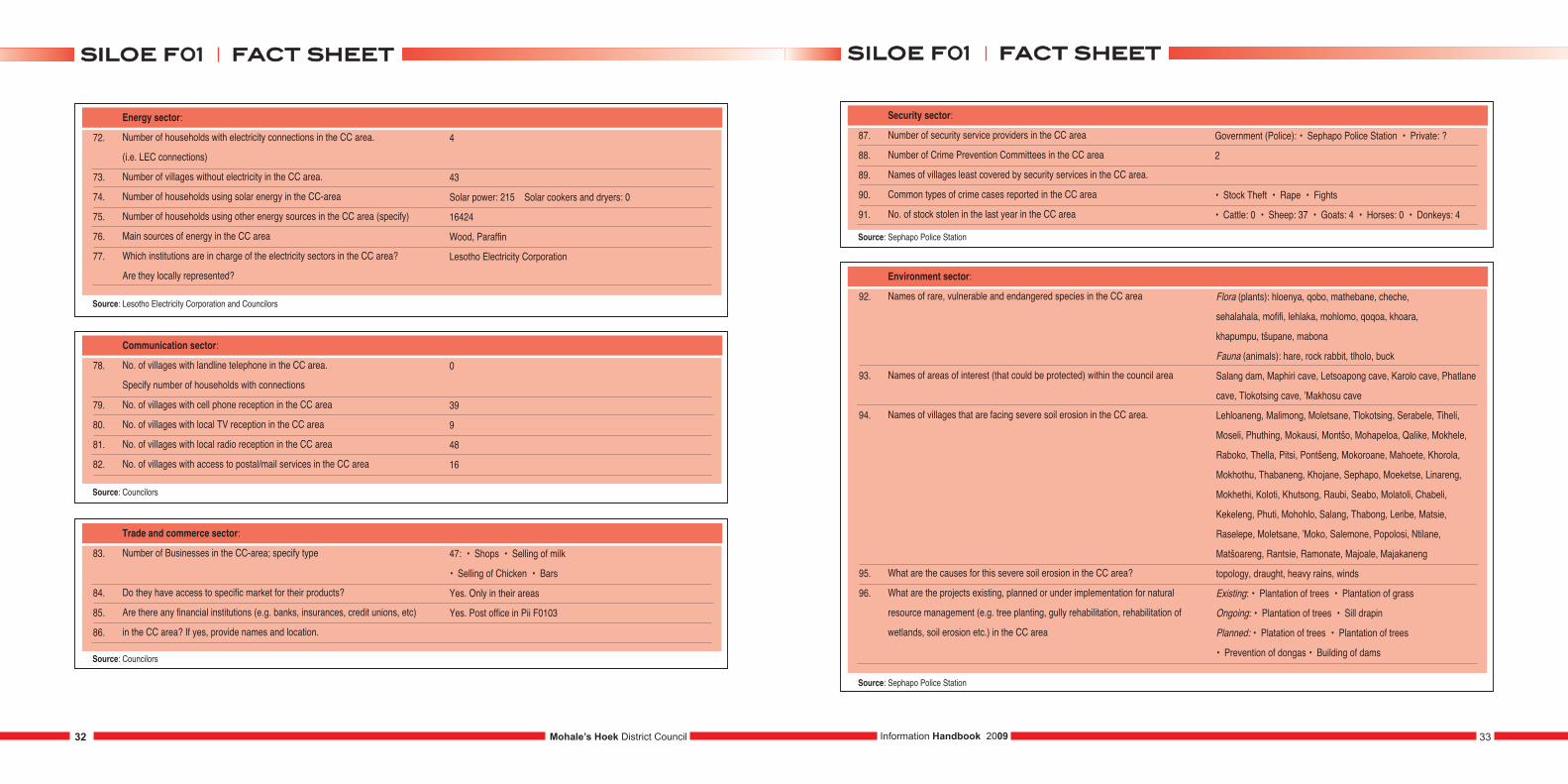
72.
73.
74.
75.
76.
77.
Energy sector:
Number of households with electricity connections in the CC area.
(i.e. LEC connections)
Number of villages without electricity in the CC area.
Number of households using solar energy in the CC-area
Number of households using other energy sources in the CC area (specify)
Main sources of energy in the CC area
Which institutions are in charge of the electricity sectors in the CC area?
Are they locally represented?
4
43
Solar power: 215 Solar cookers and dryers: 0
16424
Wood, Paraffin
Lesotho Electricity Corporation
Source: Lesotho Electricity Corporation and Councilors
78.
79.
80.
81.
82.
Communication sector:
No. of villages with landline telephone in the CC area.
Specify number of households with connections
No. of villages with cell phone reception in the CC area
No. of villages with local TV reception in the CC area
No. of villages with local radio reception in the CC area
No. of villages with access to postal/mail services in the CC area
0
39
9
48
16
Source: Councilors
83.
84.
85.
86.
Trade and commerce sector:
Number of Businesses in the CC-area; specify type
Do they have access to specific market for their products?
Are there any financial institutions (e.g. banks, insurances, credit unions, etc)
in the CC area? If yes, provide names and location.
47: • Shops • Selling of milk
• Selling of Chicken • Bars
Yes. Only in their areas
Yes. Post office in Pii F0103
Source: Councilors
87.
88.
89.
90.
91.
Security sector:
Number of security service providers in the CC area
Number of Crime Prevention Committees in the CC area
Names of villages least covered by security services in the CC area.
Common types of crime cases reported in the CC area
No. of stock stolen in the last year in the CC area
Government (Police): • Sephapo Police Station • Private: ?
2
• Stock Theft • Rape • Fights
• Cattle: 0 • Sheep: 37 • Goats: 4 • Horses: 0 • Donkeys: 4
Source: Sephapo Police Station
92.
93.
94.
95.
96.
Environment sector:
Names of rare, vulnerable and endangered species in the CC area
Names of areas of interest (that could be protected) within the council area
Names of villages that are facing severe soil erosion in the CC area.
What are the causes for this severe soil erosion in the CC area?
What are the projects existing, planned or under implementation for natural
resource management (e.g. tree planting, gully rehabilitation, rehabilitation of
wetlands, soil erosion etc.) in the CC area
Source: Sephapo Police Station
Flora (plants): hloenya, qobo, mathebane, cheche,
sehalahala, mofifi, lehlaka, mohlomo, qoqoa, khoara,
khapumpu, tšupane, mabona
Fauna (animals): hare, rock rabbit, tlholo, buck
Salang dam, Maphiri cave, Letsoapong cave, Karolo cave, Phatlane
cave, Tlokotsing cave, ’Makhosu cave
Lehloaneng, Malimong, Moletsane, Tlokotsing, Serabele, Tiheli,
Moseli, Phuthing, Mokausi, Montšo, Mohapeloa, Qalike, Mokhele,
Raboko, Thella, Pitsi, Pontšeng, Mokoroane, Mahoete, Khorola,
Mokhothu, Thabaneng, Khojane, Sephapo, Moeketse, Linareng,
Mokhethi, Koloti, Khutsong, Raubi, Seabo, Molatoli, Chabeli,
Kekeleng, Phuti, Mohohlo, Salang, Thabong, Leribe, Matsie,
Raselepe, Moletsane, ’Moko, Salemone, Popolosi, Ntilane,
Matšoareng, Rantsie, Ramonate, Majoale, Majakaneng
topology, draught, heavy rains, winds
Existing: • Plantation of trees • Plantation of grass
Ongoing: • Plantation of trees • Sill drapin
Planned: • Platation of trees • Plantation of trees
• Prevention of dongas • Building of dams
Mohale’s Hoek District Council 33Information Handbook 200932
ffaacctt sshheeeettssiillooee ff0011ffaacctt sshheeeettssiillooee ff0011
1.
2.
3.
4.
5.
6.
7.
8.
Population:
Total population of the CC
Male population in the CC area
Female population in the CC area
Youth population in the CC area (between 15 and 35 years)
Average population per village in the CC area
No. of births in the last year in the CC area
No. of 5+ deaths in the last year in the CC area
Under 5 deaths in the last year in the CC area
17490
Male: 7247
Female: 10243
298
170
221
32
9.
10.
11.
12.
13.
CC Profile:
No. of electoral divisions (EDs) in the CC area
No. of villages in the CC-area
Names of villages in the CC-area
Estimated distance of CC centre from district town (in km and travel time)
Total Area of Community council (km2)
10
62
Maqhena, Bolokoe, Mochekoane, Khasipe, Janki,Sefateng (Malebanye),
Matsatseng, Majakaneng, Makhapetla, Old Hoek, Manyeleng,
Hlokomelang, ‘Matebang, Thoriso, Lehluibi, Matlapa-Masoeu
(Ha Tšepo), Khitšane, Thabaneng, Ramoitoi, Lipeleng, Majapereng,
Boikano, Pontšeng, Mokhethi, Letsoaing, Matebeleng, Panta,
Maseteling, Mahase, Khohlong, Mopooane, Khohlong, motikoane,
Khutong, Mohlanapeng, Moreneng (Qhalasi), Nama-o-Lule, Matsatseng,
Phahameng, Makhate, Lihojeng, Raphiri, Likhutloaneng, Makhineng,
Lekhooe, Mokhesi, Mokhatla, Mabalane, Liphiring, Maphohloane,
Molomo, Nchoba, Matebeleng, Thuhlo (Lekhoaba), Tšolo, Bulu-Bulu,
Likueneng, Sekhutlong, Hapotsane, Qalakha 1, Qalakha 2
10 km (5 minutes)
146.25 km2
14.
15.
16.
17.
18.
19.
20.
21.
22.
Social indicators:
Total No. of households in the CC area
Average number of persons per household in the CC area
(Average household size)
No. of women headed households in the CC area
No. of child headed households in the CC area
No. of Orphans in the CC area:
a) Paternal orphans
b) Maternal orphans
c) Double orphans
No. of vulnerable children in the CC area
No. of boys not attending school in the CC area (below 18 years of age)
No of girls not attending school in the CC area (below 18 years of age)
No. of persons with disabilities in the CC area.
Specify the forms of disabilities
3575
5
1611
267
798
509
320
215
535
320
289
261
23.
24.
25.
26.
27.
Socio-economic indicators:
No. of persons receiving food aid in the CC area.
No. of households with the following expenditures (Maloti per year)
in the CC-area:
Sources of income and the number of concerned households in the CC area
No. of people generating incomes from other sources in the CC area. Specify.
Names and types of associations within the CC area
N/A
0 – 500:
501 – 1000: 45
Above 1000: 110
Trade: 79
Formal employment: no known
Farming: 11180
250
Support groups: Qhalasi Ratanang, Boitumelo, Falimehang, Sebetsang ka Lerato, Hekeng Malimo, Thusanang ka lerato, RatanangBasotho, Kopano ke matla, Ntja-peli-hae hloloe ke sebata, BolokanangLiponono, Malala-a-laotsoe, Thusanang ka lerato, Ikaheleng areka,‘Mamohau, Falimehang, Phuthanang Ma-five rand, Itekeng Basotho, Ikaheng, Thusanang, Thusanang Mahase, Tlou hae hloloe ke moroalo) Skills centres - Kopanyang matsoho Bataung) Orphanage or homes:‘Mantšase children’s home)
Mohale’s Hoek District Council34 35Information Handbook 2009
ffaacctt sshheeeettmmaasshhaalleenngg ff0022 ffaacctt sshheeeettmmaasshhaalleenngg ff0022MASHALENG F02
Source: CCS and Councilors
Source: Councilors, CCS and Dop
Source: CCS and Councilors
Source: Councilors
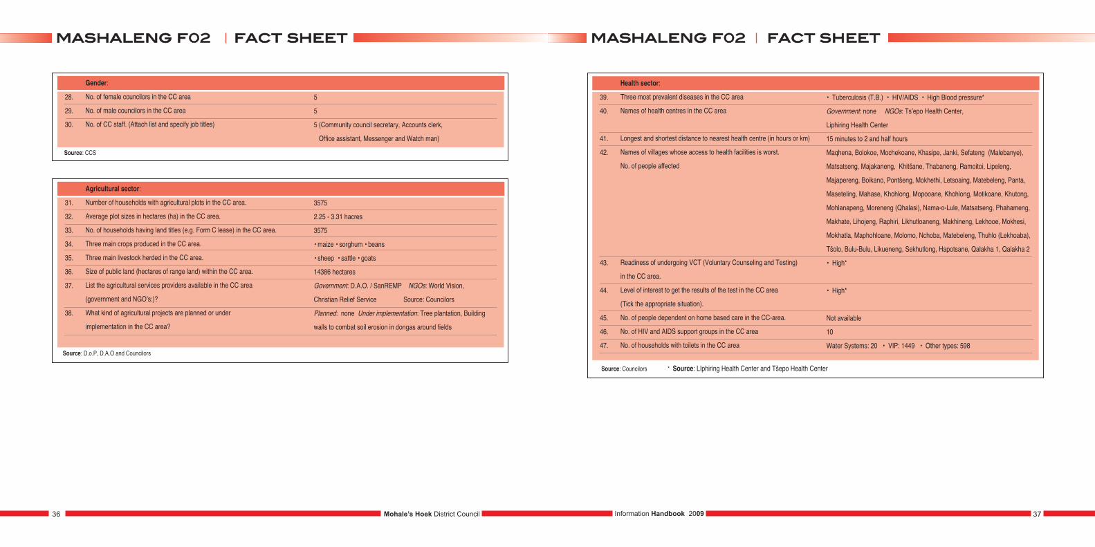
28.
29.
30.
Gender:
No. of female councilors in the CC area
No. of male councilors in the CC area
No. of CC staff. (Attach list and specify job titles)
5
5
5 (Community council secretary, Accounts clerk,
Office assistant, Messenger and Watch man)
31.
32.
33.
34.
35.
36.
37.
38.
Agricultural sector:
Number of households with agricultural plots in the CC area.
Average plot sizes in hectares (ha) in the CC area.
No. of households having land titles (e.g. Form C lease) in the CC area.
Three main crops produced in the CC area.
Three main livestock herded in the CC area.
Size of public land (hectares of range land) within the CC area.
List the agricultural services providers available in the CC area
(government and NGO’s:)?
What kind of agricultural projects are planned or under
implementation in the CC area?
3575
2.25 - 3.31 hacres
3575
• maize • sorghum • beans
• sheep • sattle • goats
14386 hectares
Government: D.A.O. / SanREMP NGOs: World Vision,
Christian Relief Service Source: Councilors
Planned: none Under implementation: Tree plantation, Building
walls to combat soil erosion in dongas around fields
39.
40.
41.
42.
43.
44.
45.
46.
47.
Health sector:
Three most prevalent diseases in the CC area
Names of health centres in the CC area
Longest and shortest distance to nearest health centre (in hours or km)
Names of villages whose access to health facilities is worst.
No. of people affected
Readiness of undergoing VCT (Voluntary Counseling and Testing)
in the CC area.
Level of interest to get the results of the test in the CC area
(Tick the appropriate situation).
No. of people dependent on home based care in the CC-area.
No. of HIV and AIDS support groups in the CC area
No. of households with toilets in the CC area
• Tuberculosis (T.B.) • HIV/AIDS • High Blood pressure*
Government: none NGOs: Ts’epo Health Center,
Liphiring Health Center
15 minutes to 2 and half hours
Maqhena, Bolokoe, Mochekoane, Khasipe, Janki, Sefateng (Malebanye),
Matsatseng, Majakaneng, Khitšane, Thabaneng, Ramoitoi, Lipeleng,
Majapereng, Boikano, Pontšeng, Mokhethi, Letsoaing, Matebeleng, Panta,
Maseteling, Mahase, Khohlong, Mopooane, Khohlong, Motikoane, Khutong,
Mohlanapeng, Moreneng (Qhalasi), Nama-o-Lule, Matsatseng, Phahameng,
Makhate, Lihojeng, Raphiri, Likhutloaneng, Makhineng, Lekhooe, Mokhesi,
Mokhatla, Maphohloane, Molomo, Nchoba, Matebeleng, Thuhlo (Lekhoaba),
Tšolo, Bulu-Bulu, Likueneng, Sekhutlong, Hapotsane, Qalakha 1, Qalakha 2
• High*
• High*
Not available
10
Water Systems: 20 • VIP: 1449 • Other types: 598
Source: Councilors * Source: LIphiring Health Center and Tšepo Health Center
Mohale’s Hoek District Council36 37Information Handbook 2009
ffaacctt sshheeeettmmaasshhaalleenngg ff0022 ffaacctt sshheeeettmmaasshhaalleenngg ff0022
Source: CCS
Source: D.o.P, D.A.O and Councilors
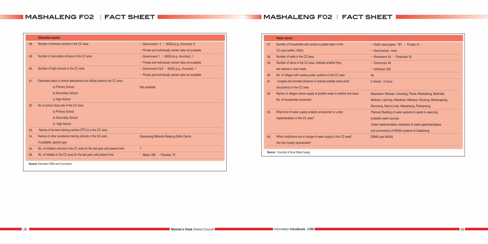
48.
49.
50.
51.
52.
53.
54.
55.
56.
Education sector:
Number of primary schools in the CC area
Number of secondary schools in the CC area
Number of high schools in the CC area
Estimated years of school attendance (not official years)in the CC area:
a) Primary School
b) Secondary School
c) High School
No of school drop outs in the CC area:
c) Primary School
d) Secondary School
c) High School
Names of farmers training centres (FTC’s) in the CC area
Names of other vocational training schools in the CC area.
If available, specify type.
No. of initiation schools in the CC area for the last year until present time
No. of initiates in the CC area for the last year until present time
• Government: 2 • NGOs (e.g. churches): 9
• Private and individually owned: data not available
• Government: 1 • NGOs (e.g. churches): 1
• Private and individually owned: data not available
• Government: N/A • NGOs (e.g. churches): 1
• Private and individually owned: data not available
Not available
Kopanyang Matsoho Bataung Skills Centre
7
• Males: 289 • Females: 70
Source: Education Office and Councilors
57.
58.
59.
60.
61.
62.
63.
64.
Water sector:
Number of households with access to piped water in the
CC-area (within 150m)
Number of wells in the CC area.
Number of dams in the CC area. Indicate whether they
are natural or man-made.
No. of villages with existing water systems in the CC area
Longest and shortest distance to nearest potable water point
(hours/kms) in the CC area.
Names of villages where supply of potable water is reliable and clean.
No. of households concerned
What kind of water supply projects are planned or under
implementation in the CC area?
Which institutions are in charge of water supply in the CC area?
Are they locally represented?
• Public stand pipes: 767 • Private: 41
• Hand pumps: none
• Permanent: 54 • Perennial: 23
• Communal: 48
• Individual: 222
46
5 minute - 2 hours
Mopooane, Mahase, Letsoaing, Panta, Matebeleng, Mokhatla,
Mokhesi, Liphiring, Mabalane, Ntikoane, Khutong, Mohlanapeng,
Moreneng, Nama-o-lule, Matsatseng, Phahameng
Planned: Building of water systems to assist in reserving
available water sources.
Under implementation: extension of water pipes/standpipes
and connections of WASA systems at Qalakheng
DRWS and WASA
Source: Councilor & Rural Water Supply
Mohale’s Hoek District Council38 39Information Handbook 2009
ffaacctt sshheeeettmmaasshhaalleenngg ff0022 ffaacctt sshheeeettmmaasshhaalleenngg ff0022
65.
66.
67.
68.
69.
70.
71.
Roads sector:
Total kilometer of Tarred roads (i.e. national roads) in the CC area
Names and lengths of existing roads maintained by DRR in the CC area
Longest and shortest distance (km) of villages to nearest “good” road.
Names of villages without road access in the CC area.
No. of households concerned
What kind of road projects are planned or under
implementation in the CC area?
What are the transport infrastructure requirements in the CC area?
Which Institutions are in charge of the Road Sector in the CC area?
Are they locally represented?
25 km
Gravel: • Mahase-Ntikoane 10 km • Matsatseng-Qhalasi 5 km
• Takalatsa-Liphiring via Thekiso 25 km • Maqhena-St. Patrick 6 km
• Maphohloane-Tšepo 33 km • Qalakheng-Bulu-Bulu 10 km
Earth: • none
50 m - 2 km
Liphiring, Bolokoe, Mochekoane, Janki, Lkhutloaneng, Ha lekhooe,
Ha Mokhatla, Ntikoane, Matsatseng, Letsoaing, Ha Tšomo
(Matlapa-masoeu), Liphiring, Hlokomelang
Planned: Maintanance of roads i.e. Takalatsa-Liphiring 25km
and others.
Under implementation: Maintanance of a road
Takalatsa-Liphiring and others.
• Roads* • Footbridges* • Walk-ways*
D.R.R.
Source: Department of Rural Roads and Councilors
72.
73.
74.
75.
76.
77.
Energy sector:
Number of households with electricity connections in the CC area.
(i.e. LEC connections)
Number of villages without electricity in the CC area.
Number of households using solar energy in the CC area
Number of households using other energy sources in the CC area (specify)
Main sources of energy in the CC area
Which institutions are in charge of the electricity sectors in the CC area? Are
they locally represented?
415
58
Solar power: 104 Solar cookers and dryers: 25
Generator: 26
• wood • coal • parraffin • cow dung • gas
L.E.C.
Source: Councilors
78.
79.
80.
81.
82.
Communication sector:
No. of villages with landline telephone in the CC area:
specify number of households with connections
No. of villages with cell phone reception in the CC area
No. of villages with local TV reception in the CC area
No. of villages with local radio reception in the CC area
No. of villages with access to postal/mail services in the CC area
4
62
62
62
N/A
Source: Councilors
83.
84.
85.
Trade and commerce sector:
Number of businesses in the CC-area; specify type
Do they have access to specific market for their products?
Are there any financial institutions (e.g. banks, insurances, credit unions, etc.)
in the CC area? If yes, provide names and location.
56 (shops, cafes, super markets, taxi businesss,
car washes, restaurants, egg centre)
N/A
N/A
Source: Councilors
Mohale’s Hoek District Council40 41Information Handbook 2009
ffaacctt sshheeeettmmaasshhaalleenngg ff0022 ffaacctt sshheeeettmmaasshhaalleenngg ff0022
86.
87.
88.
89.
90.
Security sector:
Number of security service providers in the CC area
Number of crime prevention committees in the CC area
Names of villages least covered by security services in the CC area.
Common types of crime cases reported in the CC area
No. of stock stolen in the last year in the CC area
• Government (Police): Liphiring police unit • Private: N/A
10
Maqhena, Bolokoe, Mochekoane, Khasipe, Janki, Sefateng
(Malebanye), Matsatseng, Majakaneng, Makhapetla, Old Hoek,
Manyeleng, Hlokomelang, M’atebang, Thoriso, Lehluibi,
Matlapa-Masoeu (Ha Tšepo), Khitšane, Thabaneng, Ramoitoi,
Lipeleng, Majapereng, Boikano, Pontšeng, Mokhethi, Letsoaing,
Matebeleng, Panta, Maseteling, Mahase, Khohlong, Mopooane,
Khohlong, Motikoane, Khutong, Mohlanapeng, Moreneng (Qhalasi),
Nama-o-Lule, Matsatseng, Phahameng, Makhate, Lihojeng, Raphiri,
Likhutloaneng, Makhineng, Lekhooe, Mokhesi, Mokhatla, Mabalane,
Liphiring, Maphohloane, Molomo, Nchoba, Matebeleng, Thuhlo
(Lekhoaba), Tšolo, Bulu-Bulu, Likueneng, Sekhutlong, Ha Potsane,
Qalakha 1, Qalakha 2
• Common assault • house breaking • sexual abuse
• grazing on preserved grazing land/ range
• Cattle: N/A • Sheep: N/A • Goats: N/A
• Horses: N/A • Donkeys: N/A
Source: Police & Counsellors
91.
92.
93.
94.
95.
Environment sector:
Names of rare, vulnerable and endangered species in the CC area
Names of areas of interest (that could be protected) within the council area
Names of villages that are facing severe soil erosion in the CC area.
What are the causes for this severe soil erosion in the CC area?
What are the projects existing, planned or under implementation for natural
resource management (e.g. tree planting, gully rehabilitation, rehabilitation of
wetlands, soil erosion etc.) in the CC area
Source: Counsellor
Flora (plants): hloenya, moli, sehloko, khomo-ea-balisa, khapumpu,
Lesoko, phonyoka, hlokoana-la-tsela, poho tšehla, tšupane, khoara,
labatheke, poone ea litšoene, moretele o mofubelu, phooa, mositsane.
Fauna (animals): matsa, lipela, lithlolo, mutla, kokolofitoe
Caves at Ha Tšepo, caves at Nkurutlane, M’amatsoele, Qalong ea
Khoiting, Letsatseng la Likhutloaneng, Tsoetsoere, caves of Seqhobong,
Boer caves at Liphiring, Bushman caves at Liphiring, Bushmen graves
at Liphiring and Boer graves a Liphiring.
Ntikoane, Nama o lule, Mohlanapeng, Moreneng Qhalasi,
Matsatseng, Phahameng, Ha Tšepo, Liphiring, Mabalane, Mochekoe,
Ha Lekhooe, Likhutloaneng, Mokhatla, Panta, Letsoaing, Makoiling,
Makhate, Lihojeng, Raphiri, Nchoba, Maphohloane and Matebeleng.
over grazing, burning of grass, walking on one path
and heavy rains and storms.
Existing: Tree plantation, Building dongas
Ongoing: tree plantation at Liphiring and road construcion
Planned: Tree plantation, water harvesting, construction of roads,
building of walls to comat soil erosion
Mohale’s Hoek District Council42 43Information Handbook 2009
ffaacctt sshheeeettmmaasshhaalleenngg ff0022 ffaacctt sshheeeettmmaasshhaalleenngg ff0022
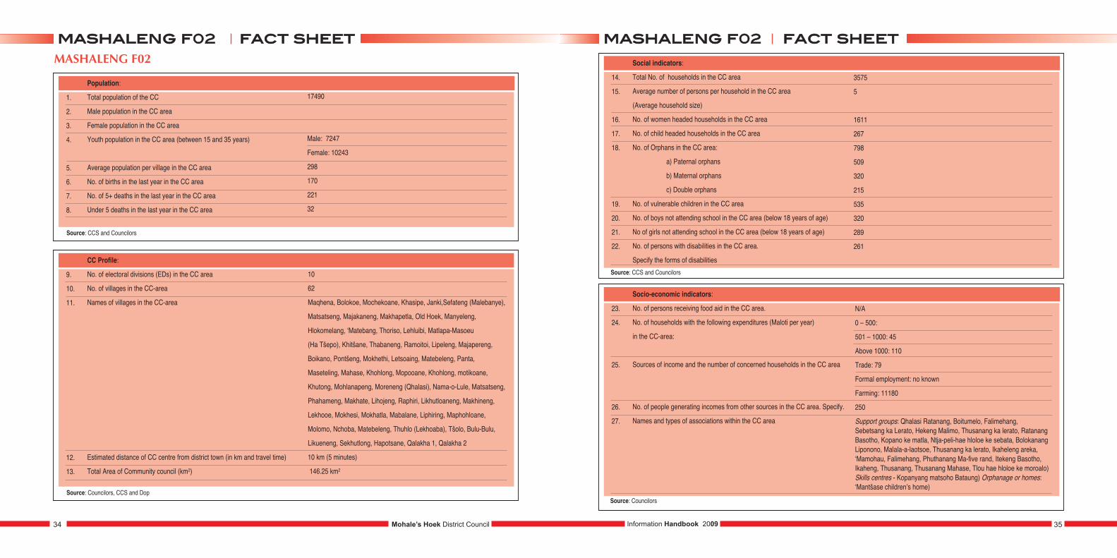
1.
2.
3.
4.
5.
6.
7.
8.
Population:
Total population of the community council (CC)
Male population in the CC area
Female population in the CC area
Youth population in the CC area (between 15 and 35 years)
Average population per village in the CC area (to be filled later)
No. of births in the last year in the CC area
No. of 5+ deaths in the last year in the CC area
Under 5 deaths in the last year in the CC area
24852
9975
14877
Male: 2739
Female: 3210
249
325
87
9.
10.
11.
12.
13.
CC Profile:
No. of electoral divisions (EDs) in the CC area
No. of villages in the CC area
Names of villages in the CC area
Estimated distance of CC centre from district town (in km and travel time)
Total area of community council (km2)
11
36
Kubake, Thoteng,Motse- Mocha, Mohlakeng, Likhutlong Bochabela,
Moeaneng, Likhutlong Bophirima. Ha Ramaromo, Ha Sechele,
Ha Sankatana, Ha Kobo-Tšoeu, Mesitsaneng, Ha Mapotsane,
Lekhalong , Sekoati, Thaba- Bosiu, Poulo, Senekal, Matsie,
Potsanyane, Khoaba Lea bua, Tomo, Majakaneng, Kantini,
Mateleng, Manganeng, Kholokoe, Braakfontain, Rantalenyana,
Rush, Ntili, Hokoane.
N/A
N/A
14.
15.
16.
17.
18.
19.
20.
21.
22.
Social indicators:
Total No. of households in the CC area
Average number of persons per household in the CC area
(Average household size)
No. of women headed households in the CC area
No. of child headed households in the CC area
No. of orphans in the CC area:
a) Paternal orphans
b) Maternal orphans
c) Double orphans
No. of vulnerable children in the CC area
No. of boys not attending school in the CC area (below 18 years of age)
No of girls not attending school in the CC area (below 18 years of age)
No. of persons with disabilities in the CC area.
Specify the forms of disabilities
6502
7
1720
746
1393
1018
1637
501
190
99
204
23.
24.
25.
26.
27.
Socio-economic indicators:
No. of persons receiving food aid in the CC area.
No. of households with the following expenditures (Maloti per year)
in the CC area:
Sources of income and the number of concerned households in the CC area
No. of people generating incomes from other sources in the CC area. Specify
Names and types of associations within the CC area
N/A
0 – 500: 156
501 – 1000: 836
Above 1000: 3345
Trade: 1530
Formal employment: 4312
Farming: 4460
418 (home brewed beer sellers, dress making )
Mpate sheleng, Ja o sa phela, Mokhatlo oa bacheki,
Mochaeellano, Tsoha o iketsetse, Stovel, Mokhatlo oa metsi
Mohale’s Hoek District Council44 45Information Handbook 2009
ffaacctt sshheeeettmmoottlleejjooeenngg ff0033 ffaacctt sshheeeettmmoottlleejjooeenngg ff0033MOTLEJOENG F03
Source: CC Office and Councilor
Source: Councilors and Chiefs
Source: Villagers and Councilors
Source: Councilors
1.
2.
3.
Gender:
No. of female councilors in the CC area
No. of male councilors in the CC area
No. of CC staff.
5
8
13
• Tefo Mofolo CCS - Community security
• Matsepang Molata - Clerical assistant
• Mapule Tšiloane - Accountant • Taitlo Thejane - Messanger
• Maseabata Ditz - Cleaner • Tholang Nkosi - Ranger
• Sebitlanane Futsoele - Ranger • Lebohang Comando- Power Master
• Bohloa Moleleki - Molisana oa likhutsoana
• Tsibisang Ramabili - Molisana oa likhomo
• Thabang Setefane - Mokuti • Mathe - Tractor driver
• Taelo Maqeba - Assistant Cleaner
1.
2.
3.
4.
5.
6.
7.
8.
Agricultural sector:
Number of households with agricultural plots in the CC area.
Average plot sizes in hectares (ha) in the CC area.
No. of households having Land Titles (e.g. Form C Lease) in the CC area.
Three main crops produced in the CC area.
Three main livestock herded in the CC area.
Size of public land (hectares of range land) within the CC area.
List the agricultural services providers available in the CC area
(government and NGO’s:)?
What kind of agricultural projects are planned or under
implementation in the CC area?
2324
3439
• Maize • Sorgum • Beans
• Cattle • Sheep • Goats
N/A
Government: Ministry of Agriculture
NGOs: World Vision, Teba, Unicef
Planned: block farming, winter gropping
Under implementation: mantloane, thuo ea likhutsoane
1.
2.
3.
4.
5.
6.
7.
8.
9.
Health sector:
Three most prevalent diseases in the CC area
Names of health centres in the CC area
Longest and shortest distance to nearest Health centre (in hours or km)
Names of villages whose access to health facilities is worst:
no. of people affected
Readiness of undergoing VCT (Voluntary Counseling and Testing)
in the CC area.
Level of interest to get the results of the test in the CC area
(Tick the appropriate situation).
No. of people dependent on home based care in the CC area.
No. of HIV and AIDS support groups in the CC area
No. of households with toilets in the CC area
• TB • HIV/AIDS • Diabetes
Government: Ntsekhe Hospital
NGOs: Dr. Makhube
Dr. Moshoeshoe
30 minutes shorts and 11/2 longer
Ha Joang, Thaba Putsoa, Maphakela, Majakaneng, Katinti Mateleng,
Manganeng, Sankatana, Kobo Tšoeu, Tlali, Mojoa, Ha Mokhesi
• High
• Medium
• Low
• High
• Medium
• Low
324
58
• Water Systems: 412 • VIP: 4679 • Other types: N/A
Source: Councillor & Councilors
Mohale’s Hoek District Council46 47Information Handbook 2009
ffaacctt sshheeeettmmoottlleejjooeenngg ff0033 ffaacctt sshheeeettmmoottlleejjooeenngg ff0033
Source: Councilors and Chiefs
Source: CC Office

1.
2.
3.
4.
5.
6.
7.
8.
9.
Education sector:
Number of Primary Schools in the CC area
Number of Secondary Schools in the CC area
Number of High Schools in the CC area
Estimated years of school attendance (not official years)in the CC area:
a) Primary School
b) Secondary School
c) High School
No of school drop outs in the CC area:
c) Primary School
d) Secondary School
c) High School
Names of Farmers Training Centres (FTC’s) in the CC area
Names of other vocational training schools in the CC area:
if available, specify type
No. of initiation schools in the CC area for the last year until present time
No. of initiates in the CC area for the last year until present time
Government: 5 NGOs (e.g. churches): 7
Private and individually owned: 1
Government: N/A NGOs (e.g. churches): N/A
Private and individually owned: N/A
Government: 1 NGOs (e.g. churches): 4
Private and individually owned: N/A
7
4
3
414
105
162
N+
• Ntlafatso Training Skills • St. Elizabeth Training Institute
13
• Male: 485 • Female: N/A
Source: Education Office and Councilors
1.
2.
3.
4.
5.
6.
7.
8.
Water sector:
Number of households with access to piped water in the
CC area (within 150 m):
Number of wells in the CC area.
Number of dams in the CC area. Indicate whether they
are natural or man-made.
No. of villages with existing water systems in the CC area
Longest and shortest distance to nearest potable water point
(hours/kms) in the CC area.
Names of villages where supply of potable water is reliable and clean.
No. of households concerned
What kind of water supply projects are planned or under
implementation in the CC area?
Which institutions are in charge of water supply in the CC area?
Are they locally represented?
• Public stand pipes: 2019
• Private: 185 • Hand pumps: 23
• Permanent: 185 • Perennial: 35
• Communal: 29
• Individual: 35
31
5 minutes shorts, 30 minutes longest
Planned: Public stand pipe
Under implementation: N/A
WASA, RVWS, RWS
Source: Councilor and Chiefs
Mohale’s Hoek District Council48 49Information Handbook 2009
ffaacctt sshheeeettmmoottlleejjooeenngg ff0033 ffaacctt sshheeeettmmoottlleejjooeenngg ff0033
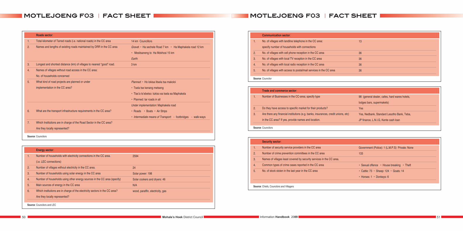
1.
2.
3.
4.
5.
6.
7.
Roads sector:
Total kilometer of Tarred roads (i.e. national roads) in the CC area
Names and lengths of existing roads maintained by DRR in the CC area
Longest and shortest distance (km) of villages to nearest “good” road.
Names of villages without road access in the CC area:
No. of households concerned
What kind of road projects are planned or under
implementation in the CC area?
What are the transport infrastructure requirements in the CC area?
Which Institutions are in charge of the Road Sector in the CC area?
Are they locally represented?
14 km Councillors
Gravel: • Ha sechele Road 7 km • Ha Maphakela road 12 km
• Mesitsaneng to Ha Mokhosi 15 km
Earth:
3 km
Planned: • Ho lokisa litsela tsa makoloi
• Tsela tse kenang metseng
• Tlas’a ts’ebetso: tukiso ea tsela ea Maphakela
• Planned: tar roads in all
Under implementation: Maphakela road
• Roads • Boats • Air Strips
• Intermediate means of Transport: - footbridges - walk-ways
Source: Councilors
1.
2.
3.
4.
5.
6.
Energy sector:
Number of households with electricity connections in the CC area.
(i.e. LEC connections)
Number of villages without electricity in the CC area.
Number of households using solar energy in the CC area
Number of households using other energy sources in the CC area (specify)
Main sources of energy in the CC area
Which institutions are in charge of the electricity sectors in the CC area?
Are they locally represented?
2594
24
Solar power: 198
Solar cookers and dryers: 46
N/A
wood, paraffin, electricity, gas
Source: Councilors and LEC
1.
2.
3.
4.
5.
Communication sector:
No. of villages with landline telephone in the CC area:
specify number of households with connections
No. of villages with cell phone reception in the CC area
No. of villages with local TV reception in the CC area
No. of villages with local radio reception in the CC area
No. of villages with access to postal/mail services in the CC area
13
36
36
36
36
Source: Councilor
1.
2.
3.
Trade and commerce sector:
Number of Businesses in the CC-area; specify type
Do they have access to specific market for their products?
Are there any financial institutions (e.g. banks, insurances, credit unions, etc)
in the CC area? If yes, provide names and location.
98 (general dealer, cafes, hard wares hotels,
lodges bars, supermakets)
Yes
Yes, Nedbank, Standard Lesotho Bank, Teba,
JP finance, L.N.I.G, Kente cash loan
Source: Councilors
1.
2.
3.
4.
5.
Security sector:
Number of security service providers in the CC area
Number of crime prevention committees in the CC area
Names of villages least covered by security services in the CC area.
Common types of crime cases reported in the CC area
No. of stock stolen in the last year in the CC area
Government (Police): 1 (L.M.P.S) Private: None
133
• Sexual offence • House breaking • Theft
• Cattle: 73 • Sheep: 124 • Goats: 14
• Horses: 1 • Donkeys: 6
Source: Chiefs, Councilors and Villagers
Mohale’s Hoek District Council50 51Information Handbook 2009
ffaacctt sshheeeettmmoottlleejjooeenngg ff0033 ffaacctt sshheeeettmmoottlleejjooeenngg ff0033
1.
2.
3.
4.
5.
Environment sector:
Names of rare, vulnerable and endangered species in the CC area
Names of areas of interest (that could be protected) within the council area
Names of villages that are facing severe soil erosion in the CC area.
What are the causes for this severe soil erosion in the CC area?
What are the projects existing, planned or under implementation for Natural
Resource Management (e.g., tree planting, gully rehabilitation, rehabilitation
of wetlands, soil erosion) in the CC area
Source: Councilors & Chiefs
Flora (plants): hloenya, phate ea ngaka, sehlooko, lengana
Fauna (animals): hare and rock dasse
Motlejoeng (carnibal caves)
Ha Tsie, Ha Moiketsi, Koung, Ha Khajoane, Motšoane, Ha Tota,
Molefane, Ha Molike, Ha Elia, Sefateng, Likhutloaneng, Topa,
Liphamoleng, Matholoane, Lepekola, Nkonyana, Ha Sello,
Ha Leranti, Moeling, Titimisi, Tsenekeng, Ha Ramofare, Ha Ntoana
Overgrazing heavy rains and topology
Existing: • building donga • mantloane
Ongoing: • tree planting
Planned: • tree planting • gully rehabilitation
KHOELENYA F04
1.
2.
3.
4.
5.
6.
7.
8.
Population:
Total population of the community council (CC)
Male population in the CC area
Female population in the CC area
Youth population in the CC area (between 15 and 35 years)
Average population per village in the CC area (to be filled later)
No. of births in the last year in the CC area
No. of 5+ deaths in the last year in the CC area
Under 5 deaths in the last year in the CC area
22 424
10873
11551
Male:
Female:
647
708
136
1.
2.
3.
4.
5.
CC Profile:
No. of electoral divisions (EDs) in the CC area
No. of villages in the CC area
Names of villages in the CC area (to be attached)
Estimated distance of CC centre from district town (in km and travel time)
Total area of community council (km2)
11
162
30 km
297.97 km2
Mohale’s Hoek District Council52 53Information Handbook 2009
ffaacctt sshheeeettmmoottlleejjooeenngg ff0033 ffaacctt sshheeeettkkhhooeelleennyyaa ff0044
Source: Councilor and Chief
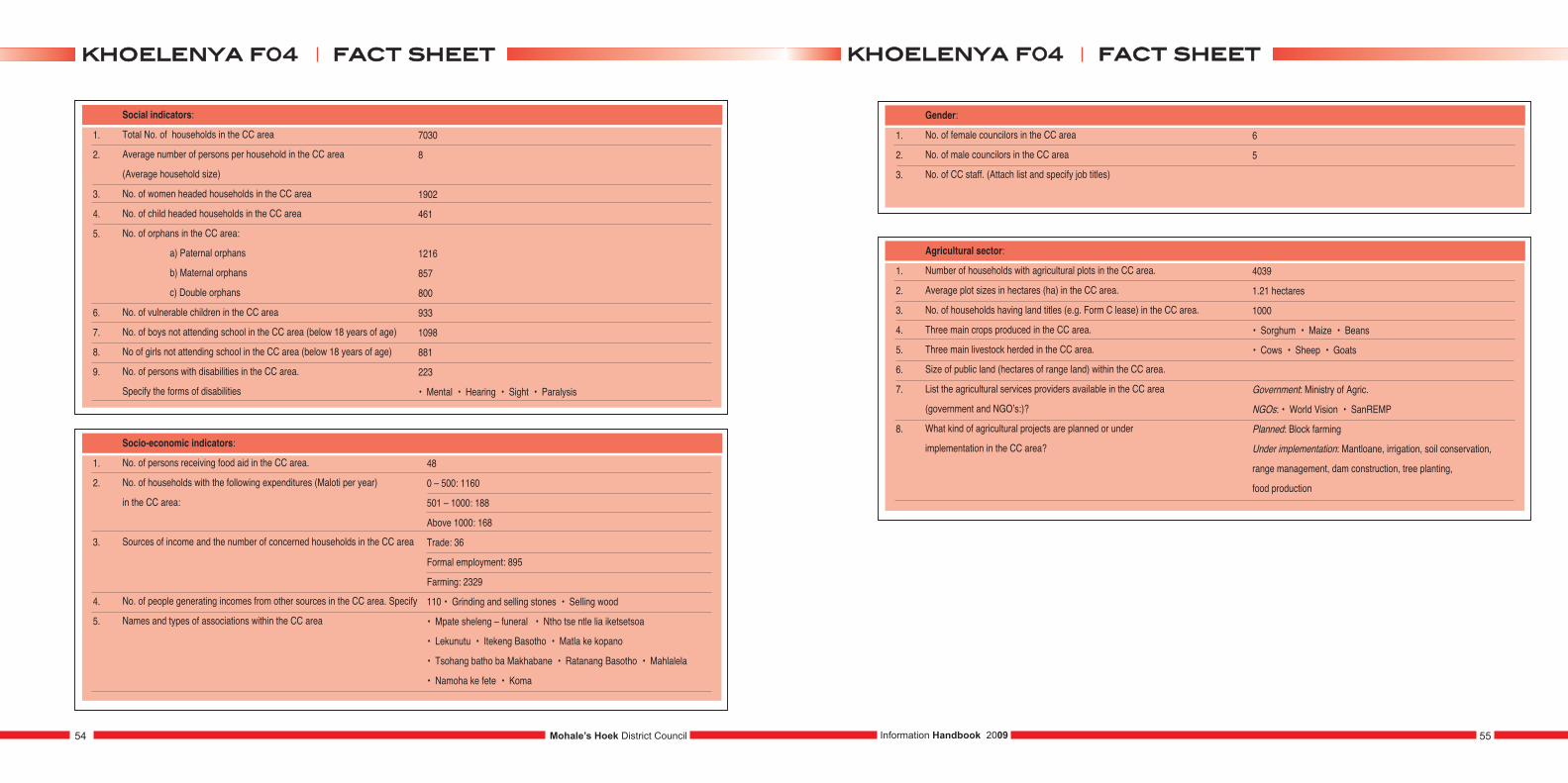
1.
2.
3.
4.
5.
6.
7.
8.
9.
Social indicators:
Total No. of households in the CC area
Average number of persons per household in the CC area
(Average household size)
No. of women headed households in the CC area
No. of child headed households in the CC area
No. of orphans in the CC area:
a) Paternal orphans
b) Maternal orphans
c) Double orphans
No. of vulnerable children in the CC area
No. of boys not attending school in the CC area (below 18 years of age)
No of girls not attending school in the CC area (below 18 years of age)
No. of persons with disabilities in the CC area.
Specify the forms of disabilities
7030
8
1902
461
1216
857
800
933
1098
881
223
• Mental • Hearing • Sight • Paralysis
1.
2.
3.
4.
5.
Socio-economic indicators:
No. of persons receiving food aid in the CC area.
No. of households with the following expenditures (Maloti per year)
in the CC area:
Sources of income and the number of concerned households in the CC area
No. of people generating incomes from other sources in the CC area. Specify
Names and types of associations within the CC area
48
0 – 500: 1160
501 – 1000: 188
Above 1000: 168
Trade: 36
Formal employment: 895
Farming: 2329
110 • Grinding and selling stones • Selling wood
• Mpate sheleng – funeral • Ntho tse ntle lia iketsetsoa
• Lekunutu • Itekeng Basotho • Matla ke kopano
• Tsohang batho ba Makhabane • Ratanang Basotho • Mahlalela
• Namoha ke fete • Koma
1.
2.
3.
Gender:
No. of female councilors in the CC area
No. of male councilors in the CC area
No. of CC staff. (Attach list and specify job titles)
6
5
1.
2.
3.
4.
5.
6.
7.
8.
Agricultural sector:
Number of households with agricultural plots in the CC area.
Average plot sizes in hectares (ha) in the CC area.
No. of households having land titles (e.g. Form C lease) in the CC area.
Three main crops produced in the CC area.
Three main livestock herded in the CC area.
Size of public land (hectares of range land) within the CC area.
List the agricultural services providers available in the CC area
(government and NGO’s:)?
What kind of agricultural projects are planned or under
implementation in the CC area?
4039
1.21 hectares
1000
• Sorghum • Maize • Beans
• Cows • Sheep • Goats
Government: Ministry of Agric.
NGOs: • World Vision • SanREMP
Planned: Block farming
Under implementation: Mantloane, irrigation, soil conservation,
range management, dam construction, tree planting,
food production
Mohale’s Hoek District Council54 55Information Handbook 2009
ffaacctt sshheeeettkkhhooeelleennyyaa ff0044 ffaacctt sshheeeettkkhhooeelleennyyaa ff0044

1.
2.
3.
4.
5.
6.
7.
8.
9.
Health sector:
Three most prevalent diseases in the CC area
Names of health centres in the CC area
Longest and shortest distance to nearest Health centre (in hours or km)
Names of villages whose access to health facilities is worst.
No. of people affected
Readiness of undergoing VCT (Voluntary Counseling and Testing)
in the CC area.
Level of interest to get the results of the test in the CC area
(Tick the appropriate situation).
No. of people dependent on home based care in the CC area.
No. of HIV and AIDS support groups in the CC area
No. of households with toilets in the CC area
• TB • HIV/AIDS • Lebanta
Government:
NGOs: • Morifi Health centre • Holy Cross health centre
1.5 km to 10km
• Low
• Low
208
43
Water Systems: • VIP: 720 • Other types: 452
Source: Councilor
1.
2.
3.
4.
5.
6.
7.
8.
9.
Education sector:
Number of primary schools in the CC-area
Number of secondary schools in the CC-area
Number of high schools in the CC-area
Estimated years of school attendance (not official years)in the CC-area:
a) Primary School
b) Secondary School
c) High School
No of school drop outs in the CC-area:
c) Primary School
d) Secondary School
c) High School
Names of farmers training centres (FTC’s) in the CC area
Names of other vocational training schools in the CC area.
If available, specify type
No. of initiation schools in the CC area for the last year until present time
No. of initiates in the CC area for the last year until present time
Government: 3 NGOs (e.g. churches): 13
Private and individually owned:
Government: N/A NGOs (e.g. churches): 2
Private and individually owned: N/A
Government: NGOs (e.g. churches):
Private and individually owned:
7
3
547
7
• Male: 383 • Female: N/A
Source: Education Office and Councilors
Mohale’s Hoek District Council56 57Information Handbook 2009
ffaacctt sshheeeettkkhhooeelleennyyaa ff0044 ffaacctt sshheeeettkkhhooeelleennyyaa ff0044
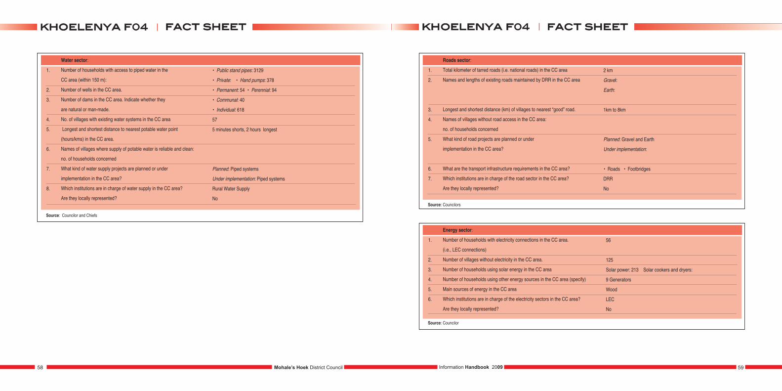
1.
2.
3.
4.
5.
6.
7.
8.
Water sector:
Number of households with access to piped water in the
CC area (within 150 m):
Number of wells in the CC area.
Number of dams in the CC area. Indicate whether they
are natural or man-made.
No. of villages with existing water systems in the CC area
Longest and shortest distance to nearest potable water point
(hours/kms) in the CC area.
Names of villages where supply of potable water is reliable and clean:
no. of households concerned
What kind of water supply projects are planned or under
implementation in the CC area?
Which institutions are in charge of water supply in the CC area?
Are they locally represented?
• Public stand pipes: 3129
• Private: • Hand pumps: 378
• Permanent: 54 • Perennial: 94
• Communal: 40
• Individual: 618
57
5 minutes shorts, 2 hours longest
Planned: Piped systems
Under implementation: Piped systems
Rural Water Supply
No
Source: Councilor and Chiefs
1.
2.
3.
4.
5.
6.
7.
Roads sector:
Total kilometer of tarred roads (i.e. national roads) in the CC area
Names and lengths of existing roads maintained by DRR in the CC area
Longest and shortest distance (km) of villages to nearest “good” road.
Names of villages without road access in the CC area:
no. of households concerned
What kind of road projects are planned or under
implementation in the CC area?
What are the transport infrastructure requirements in the CC area?
Which institutions are in charge of the road sector in the CC area?
Are they locally represented?
2 km
Gravel:
Earth:
1km to 8km
Planned: Gravel and Earth
Under implementation:
• Roads • Footbridges
DRR
No
Source: Councilors
1.
2.
3.
4.
5.
6.
Energy sector:
Number of households with electricity connections in the CC area.
(i.e., LEC connections)
Number of villages without electricity in the CC area.
Number of households using solar energy in the CC area
Number of households using other energy sources in the CC area (specify)
Main sources of energy in the CC area
Which institutions are in charge of the electricity sectors in the CC area?
Are they locally represented?
56
125
Solar power: 213 Solar cookers and dryers:
9 Generators
Wood
LEC
No
Source: Councilor
59Information Handbook 2009Mohale’s Hoek District Council58
ffaacctt sshheeeettkkhhooeelleennyyaa ff0044 ffaacctt sshheeeettkkhhooeelleennyyaa ff0044
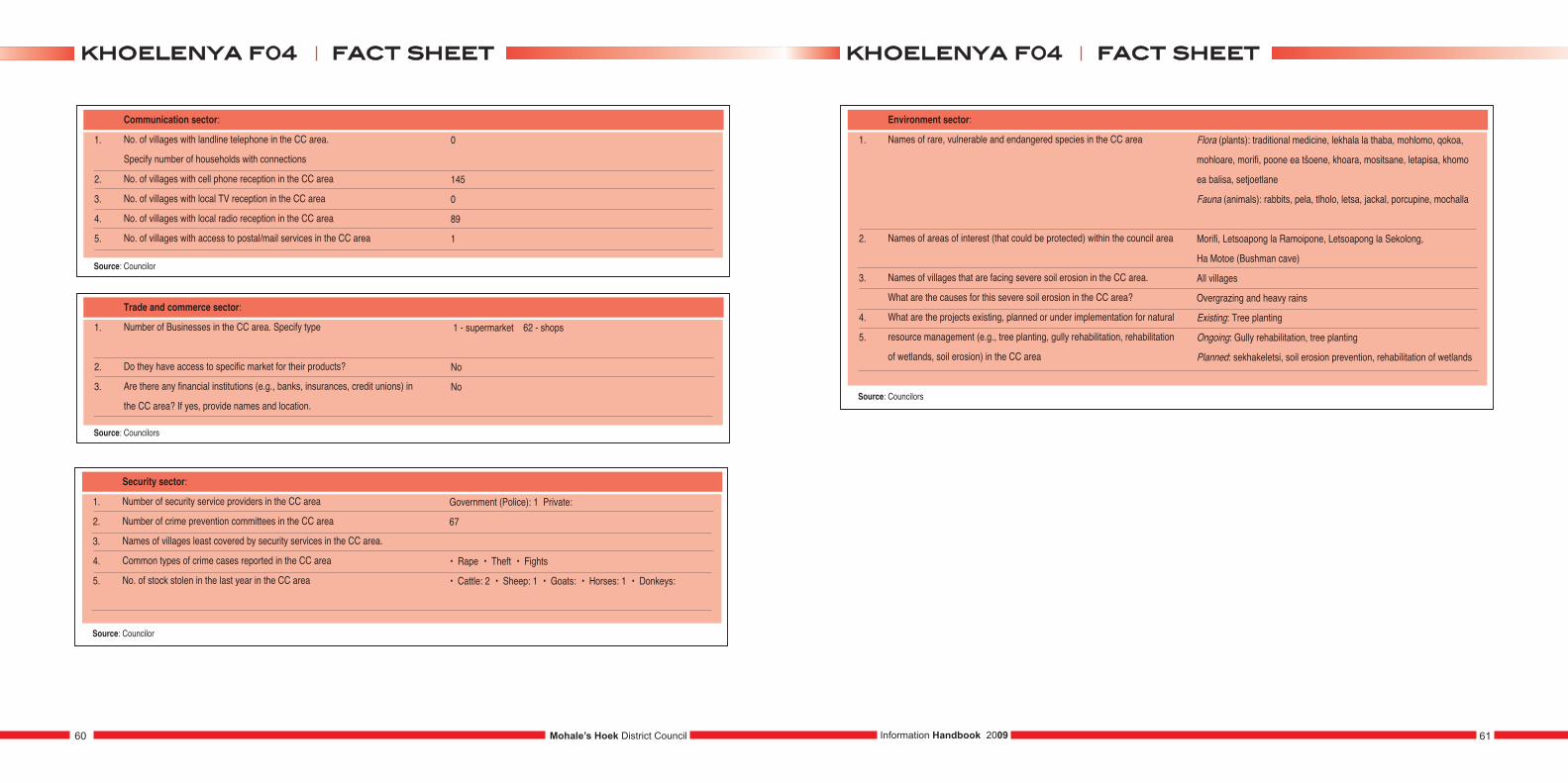
1.
2.
3.
4.
5.
Communication sector:
No. of villages with landline telephone in the CC area.
Specify number of households with connections
No. of villages with cell phone reception in the CC area
No. of villages with local TV reception in the CC area
No. of villages with local radio reception in the CC area
No. of villages with access to postal/mail services in the CC area
0
145
0
89
1
Source: Councilor
1.
2.
3.
Trade and commerce sector:
Number of Businesses in the CC area. Specify type
Do they have access to specific market for their products?
Are there any financial institutions (e.g., banks, insurances, credit unions) in
the CC area? If yes, provide names and location.
1 - supermarket 62 - shops
No
No
Source: Councilors
1.
2.
3.
4.
5.
Security sector:
Number of security service providers in the CC area
Number of crime prevention committees in the CC area
Names of villages least covered by security services in the CC area.
Common types of crime cases reported in the CC area
No. of stock stolen in the last year in the CC area
Government (Police): 1 Private:
67
• Rape • Theft • Fights
• Cattle: 2 • Sheep: 1 • Goats: • Horses: 1 • Donkeys:
Source: Councilor
1.
2.
3.
4.
5.
Environment sector:
Names of rare, vulnerable and endangered species in the CC area
Names of areas of interest (that could be protected) within the council area
Names of villages that are facing severe soil erosion in the CC area.
What are the causes for this severe soil erosion in the CC area?
What are the projects existing, planned or under implementation for natural
resource management (e.g., tree planting, gully rehabilitation, rehabilitation
of wetlands, soil erosion) in the CC area
Source: Councilors
Flora (plants): traditional medicine, lekhala la thaba, mohlomo, qokoa,
mohloare, morifi, poone ea tšoene, khoara, mositsane, letapisa, khomo
ea balisa, setjoetlane
Fauna (animals): rabbits, pela, tlholo, letsa, jackal, porcupine, mochalla
Morifi, Letsoapong la Ramoipone, Letsoapong la Sekolong,
Ha Motoe (Bushman cave)
All villages
Overgrazing and heavy rains
Existing: Tree planting
Ongoing: Gully rehabilitation, tree planting
Planned: sekhakeletsi, soil erosion prevention, rehabilitation of wetlands
Mohale’s Hoek District Council60 61Information Handbook 2009
ffaacctt sshheeeettkkhhooeelleennyyaa ff0044 ffaacctt sshheeeettkkhhooeelleennyyaa ff0044
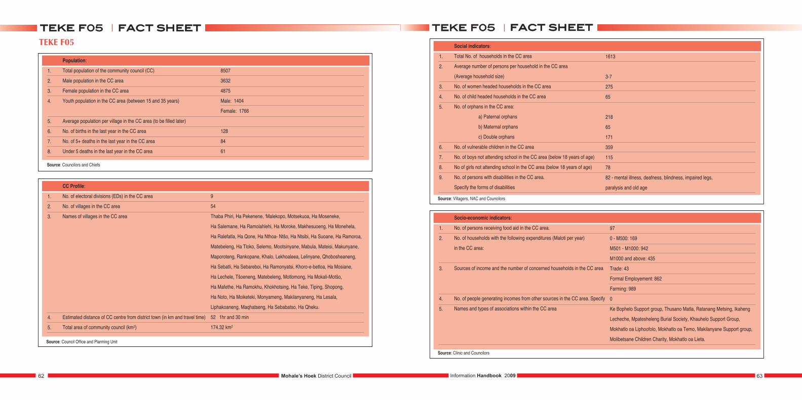
1.
2.
3.
4.
5.
6.
7.
8.
Population:
Total population of the community council (CC)
Male population in the CC area
Female population in the CC area
Youth population in the CC area (between 15 and 35 years)
Average population per village in the CC area (to be filled later)
No. of births in the last year in the CC area
No. of 5+ deaths in the last year in the CC area
Under 5 deaths in the last year in the CC area
8507
3632
4875
Male: 1404
Female: 1766
128
84
61
1.
2.
3.
4.
5.
CC Profile:
No. of electoral divisions (EDs) in the CC area
No. of villages in the CC area
Names of villages in the CC area
Estimated distance of CC centre from district town (in km and travel time)
Total area of community council (km2)
9
54
Thaba Phiri, Ha Pekenene, ‘Malekopo, Motsekuoa, Ha Moseneke,
Ha Salemane, Ha Ramolahlehi, Ha Moroke, Makhesuoeng, Ha Monehela,
Ha Ralefatla, Ha Qone, Ha Nthoa- Ntšo, Ha Ntsibi, Ha Suoane, Ha Ramoroa,
Matebeleng, Ha Tloko, Selemo, Mootsinyane, Mabula, Mateisi, Makunyane,
Maporoteng, Rankopane, Khalo, Lekhoaleea, Lelinyane, Qhobosheaneng,
Ha Sebatli, Ha Sebareboi, Ha Ramonyatsi, Khoro-e-betloa, Ha Mosiane,
Ha Lechele, Tšoeneng, Matebeleng, Motlomong, Ha Mokali-Motšo,
Ha Mafethe, Ha Ramokhu, Khokhotsing, Ha Teke, Tiping, Shopong,
Ha Noto, Ha Moiketeki, Monyameng, Makilanyaneng, Ha Lesala,
Liphakoaneng, Maqhatseng, Ha Sebabatso, Ha Qheku.
52 1hr and 30 min
174.32 km2
1.
2.
3.
4.
5.
6.
7.
8.
9.
Social indicators:
Total No. of households in the CC area
Average number of persons per household in the CC area
(Average household size)
No. of women headed households in the CC area
No. of child headed households in the CC area
No. of orphans in the CC area:
a) Paternal orphans
b) Maternal orphans
c) Double orphans
No. of vulnerable children in the CC area
No. of boys not attending school in the CC area (below 18 years of age)
No of girls not attending school in the CC area (below 18 years of age)
No. of persons with disabilities in the CC area.
Specify the forms of disabilities
1613
3-7
275
65
218
65
171
359
115
78
82 - mental illness, deafness, blindness, impaired legs,
paralysis and old age
1.
2.
3.
4.
5.
Socio-economic indicators:
No. of persons receiving food aid in the CC area.
No. of households with the following expenditures (Maloti per year)
in the CC area:
Sources of income and the number of concerned households in the CC area
No. of people generating incomes from other sources in the CC area. Specify
Names and types of associations within the CC area
97
0 - M500: 169
M501 - M1000: 942
M1000 and above: 435
Trade: 43
Formal Employement: 862
Farming: 989
0
Ke Bophelo Support group, Thusano Matla, Ratanang Metsing, Ikaheng
Lecheche, Mpatesheleng Burial Society, Khauhelo Support Group,
Mokhatlo oa Liphoofolo, Mokhatlo oa Temo, Makilanyane Support group,
Molibetsane Children Charity, Mokhatlo oa Lieta.
63Information Handbook 2009Mohale’s Hoek District Council62
ffaacctt sshheeeetttteekkee ff0055 ffaacctt sshheeeetttteekkee ff0055TEKE F05
Source: Villagers, NAC and Councilors
Source: Clinic and Councilors
Source: Council Office and Planning Unit
Source: Councilors and Chiefs
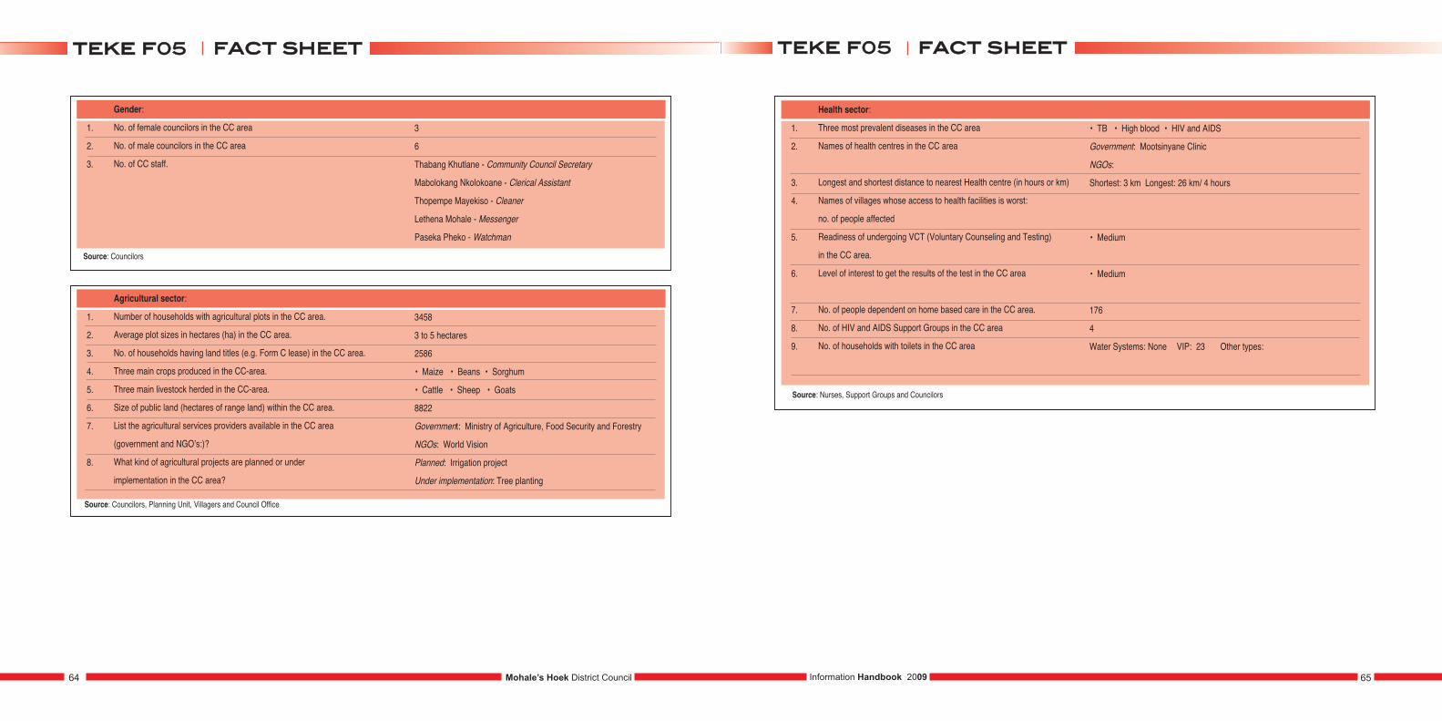
1.
2.
3.
Gender:
No. of female councilors in the CC area
No. of male councilors in the CC area
No. of CC staff.
3
6
Thabang Khutlane - Community Council Secretary
Mabolokang Nkolokoane - Clerical Assistant
Thopempe Mayekiso - Cleaner
Lethena Mohale - Messenger
Paseka Pheko - Watchman
1.
2.
3.
4.
5.
6.
7.
8.
Agricultural sector:
Number of households with agricultural plots in the CC area.
Average plot sizes in hectares (ha) in the CC area.
No. of households having land titles (e.g. Form C lease) in the CC area.
Three main crops produced in the CC-area.
Three main livestock herded in the CC-area.
Size of public land (hectares of range land) within the CC area.
List the agricultural services providers available in the CC area
(government and NGO’s:)?
What kind of agricultural projects are planned or under
implementation in the CC area?
3458
3 to 5 hectares
2586
• Maize • Beans • Sorghum
• Cattle • Sheep • Goats
8822
Government: Ministry of Agriculture, Food Security and Forestry
NGOs: World Vision
Planned: Irrigation project
Under implementation: Tree planting
1.
2.
3.
4.
5.
6.
7.
8.
9.
Health sector:
Three most prevalent diseases in the CC area
Names of health centres in the CC area
Longest and shortest distance to nearest Health centre (in hours or km)
Names of villages whose access to health facilities is worst:
no. of people affected
Readiness of undergoing VCT (Voluntary Counseling and Testing)
in the CC area.
Level of interest to get the results of the test in the CC area
No. of people dependent on home based care in the CC area.
No. of HIV and AIDS Support Groups in the CC area
No. of households with toilets in the CC area
• TB • High blood • HIV and AIDS
Government: Mootsinyane Clinic
NGOs:
Shortest: 3 km Longest: 26 km/ 4 hours
• Medium
• Medium
176
4
Water Systems: None VIP: 23 Other types:
Source: Nurses, Support Groups and Councilors
Mohale’s Hoek District Council64 65Information Handbook 2009
ffaacctt sshheeeetttteekkee ff0055 ffaacctt sshheeeetttteekkee ff0055
Source: Councilors, Planning Unit, Villagers and Council Office
Source: Councilors
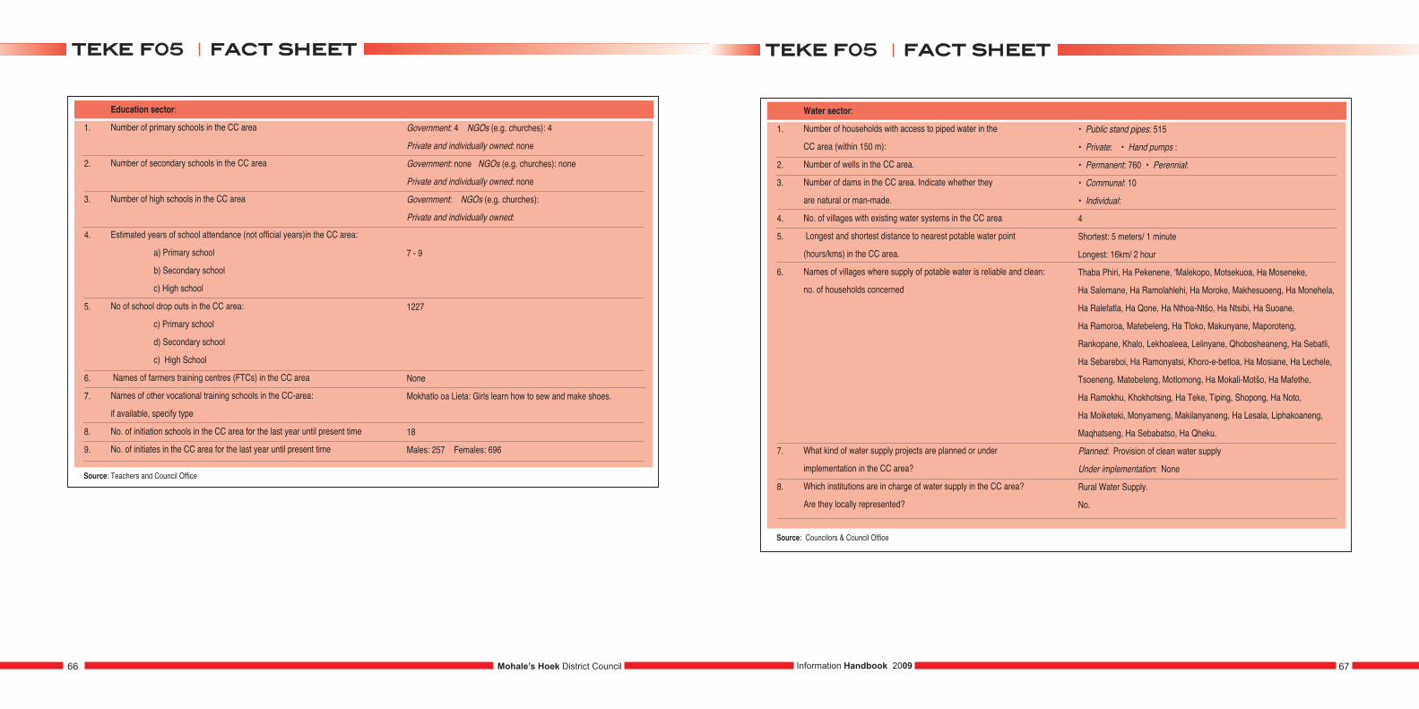
1.
2.
3.
4.
5.
6.
7.
8.
9.
Education sector:
Number of primary schools in the CC area
Number of secondary schools in the CC area
Number of high schools in the CC area
Estimated years of school attendance (not official years)in the CC area:
a) Primary school
b) Secondary school
c) High school
No of school drop outs in the CC area:
c) Primary school
d) Secondary school
c) High School
Names of farmers training centres (FTCs) in the CC area
Names of other vocational training schools in the CC-area:
if available, specify type
No. of initiation schools in the CC area for the last year until present time
No. of initiates in the CC area for the last year until present time
Government: 4 NGOs (e.g. churches): 4
Private and individually owned: none
Government: none NGOs (e.g. churches): none
Private and individually owned: none
Government: NGOs (e.g. churches):
Private and individually owned:
7 - 9
1227
None
Mokhatlo oa Lieta: Girls learn how to sew and make shoes.
18
Males: 257 Females: 696
Source: Teachers and Council Office
1.
2.
3.
4.
5.
6.
7.
8.
Water sector:
Number of households with access to piped water in the
CC area (within 150 m):
Number of wells in the CC area.
Number of dams in the CC area. Indicate whether they
are natural or man-made.
No. of villages with existing water systems in the CC area
Longest and shortest distance to nearest potable water point
(hours/kms) in the CC area.
Names of villages where supply of potable water is reliable and clean:
no. of households concerned
What kind of water supply projects are planned or under
implementation in the CC area?
Which institutions are in charge of water supply in the CC area?
Are they locally represented?
• Public stand pipes: 515
• Private: • Hand pumps :
• Permanent: 760 • Perennial:
• Communal: 10
• Individual:
4
Shortest: 5 meters/ 1 minute
Longest: 16km/ 2 hour
Thaba Phiri, Ha Pekenene, ‘Malekopo, Motsekuoa, Ha Moseneke,
Ha Salemane, Ha Ramolahlehi, Ha Moroke, Makhesuoeng, Ha Monehela,
Ha Ralefatla, Ha Qone, Ha Nthoa-Ntšo, Ha Ntsibi, Ha Suoane,
Ha Ramoroa, Matebeleng, Ha Tloko, Makunyane, Maporoteng,
Rankopane, Khalo, Lekhoaleea, Lelinyane, Qhobosheaneng, Ha Sebatli,
Ha Sebareboi, Ha Ramonyatsi, Khoro-e-betloa, Ha Mosiane, Ha Lechele,
Tsoeneng, Matebeleng, Motlomong, Ha Mokali-Motšo, Ha Mafethe,
Ha Ramokhu, Khokhotsing, Ha Teke, Tiping, Shopong, Ha Noto,
Ha Moiketeki, Monyameng, Makilanyaneng, Ha Lesala, Liphakoaneng,
Maqhatseng, Ha Sebabatso, Ha Qheku.
Planned: Provision of clean water supply
Under implementation: None
Rural Water Supply.
No.
Source: Councilors & Council Office
Mohale’s Hoek District Council66 67Information Handbook 2009
ffaacctt sshheeeetttteekkee ff0055 ffaacctt sshheeeetttteekkee ff0055
1.
2.
3.
4.
5.
6.
7.
Roads sector:
Total kilometer of Tarred roads (i.e. national roads) in the CC area
Names and lengths of existing roads maintained by DRR in the CC area
Longest and shortest distance (km) of villages to nearest “good” road.
Names of villages without road access in the CC area.
No. of households concerned
What kind of road projects are planned or under
implementation in the CC area?
What are the transport infrastructure requirements in the CC area?
Which Institutions are in charge of the Road Sector in the CC area?
Are they locally represented?
None
Gravel: Mesitsaneng to Monehela 38 km
Earth: none
Shortest: 2 meters Longest: 17 km
Thaba Phiri, Ha Pekenene, ‘Malekopo, Motsekuoa, Ha Moseneke,
Ha Salemane, Ha Ramolahlehi, Ha Moroke, Makhesuoeng,
Ha Monehela, Ha Ralefatla, Ha Qone, Ha Nthoa- Ntšo, Ha Ntsibi,
Ha Suoane, Ha Ramoroa, Matebeleng, Ha Tloko, Makunyane,
Maporoteng, Rankopane, Khalo, Lekhoaleea, Lelinyane,
Qhobosheaneng, Ha Sebatli, Ha Sebareboi, Ha Ramonyatsi,
Khoro-e-betloa, Ha Mosiane, Ha Lechele, Tsoeneng, Matebeleng,
Motlomong, Ha Mokali-Motšo, Ha Mafethe, Ha Ramokhu,
Khokhotsing, Ha Teke, Tiping, Shopong, Ha Noto, Ha Moiketeki,
Monyameng, Makilanyaneng, Ha Lesala, Liphakoaneng,
Maqhatseng, Ha Sebabatso, Ha Qheku.
Planned: • Reconstruction of Mesitsaneng to Monehela road
• Rebuilding of Mootsinyane and Maphutšeng Bridge
• Nthoa-Ntšo to Tiping road • Ralesholu to Thaba-Phiri road
• Rakontane to Teke road Under implementation:
• Roads • Air Strips
• Intermediate means of Transport:
– Footbridges – Walk-ways
Department of Rural Roads (DRR)
No.
Source: DDR & Council Office
1.
2.
3.
4.
5.
6.
Energy sector:
Number of households with electricity connections in the CC area.
(i.e. LEC connections)
Number of villages without electricity in the CC area.
Number of households using solar energy in the CC area
Number of households using other energy sources in the CC area (specify)
Main sources of energy in the CC area
Which institutions are in charge of the electricity sectors in the CC area?
Are they locally represented?
None
54
Solar power: 37 Solar cookers and dryers:
3 Generators
fire wood, cow dung, parrafin and gas
None
Source: Councilors & Villagers
1.
2.
3.
4.
5.
Communication sector:
No. of villages with landline telephone in the CC area:
specify number of households with connections
No. of villages with cell phone reception in the CC area
No. of villages with local TV reception in the CC area
No. of villages with local radio reception in the CC area
No. of villages with access to postal/mail services in the CC area
54 villages
1613 households
None
None
54
None
Source: Councilors
1.
2.
3.
Trade and commerce sector:
Number of Businesses in the CC area. Specify type
Do they have access to specific market for their products?
Are there any financial institutions (e.g., banks, insurances, and credit
unions) in the CC area? If yes, provide names and location.
• 10 cafes • 4 taverns • 2 taxis
No
No
Source: Councilors
Mohale’s Hoek District Council68 69Information Handbook 2009
ffaacctt sshheeeetttteekkee ff0055 ffaacctt sshheeeetttteekkee ff0055
1.
2.
3.
4.
5.
Security sector:
Number of security service providers in the CC area
Number of crime prevention committees in the CC area
Names of villages least covered by security services in the CC area.
Common types of crime cases reported in the CC area
No. of stock stolen in the last year in the CC area
Government (Police): None
Mohale’s Hoek Police Private: None
22
Thaba Phiri, Ha Pekenene, ‘Malekopo, Motsekuoa,
Ha Moseneke, Ha Salemane, Ha Ramolahlehi, Ha Moroke,
Makhesuoeng, Ha Monehela, Ha Ralefatla, Ha Qone,
Ha Nthoa-Ntšo, Ha Ntsibi, Ha Suoane, Ha Ramoroa, Matebeleng,
Ha Tloko, Selemo, Mootsinyane, Mabula, Mateisi, Makunyane,
Maporoteng, Rankopane, Khalo, Lekhoaleea, Lelinyane,
Qhobosheaneng, Ha Sebatli, Ha Sebareboi, Ha Ramonyatsi,
Khoro-e-betloa, Ha Mosiane, Ha Lechele, Tšoeneng, Matebeleng,
Motlomong, Ha Mokali-Motšo, Ha Mafethe, Ha Ramokhu,
Khokhotsing, Ha Teke, Tiping, Shopong, Ha Noto, Ha Moiketeki,
Monyameng, Makilanyaneng, Ha Lesala, Liphakoaneng,
Maqhatseng, Ha Sebabatso, Ha Qheku.
• Cattle: 3 • Sheep: 20 • Goats: 30
• Horses: 8 • Donkeys: None
Source: Counsellors
1.
2.
3.
4.
Environment sector:
Names of rare, vulnerable and endangered species in the CC area
Names of areas of interest (that could be protected) within the council area
Names of villages that are facing severe soil erosion in the CC area.
What are the causes for this severe soil erosion in the CC area?
What are the projects existing, planned or under implementation for natural
resource management (e.g., tree planting, gully rehabilitation, rehabilitation
of wetlands, and soil erosion.) in the CC area
Source: Counsellors & Council Office
Flora (plants): hloenya, kharetsane, leshoma, maleleka,
Khomo ea balisa, khoara, poho tšehla, kuena.
Fauna (animals): lipela, ‘mutlanyane, tšoene, khatla, tlholo
• Sankoase • Lekhohlong
Liphookoaneng, Makilanyane, Ha Lesala, Maqhatseng,
Mootsinyane, Pocheng, Phuleng, Tiping.
• Burning of grass • Overgrazing • Severe Rainfall
• Ploughing in wrong direction • Animals using the same route
Existing: Building of dongas
Ongoing: Planting of trees
Planned: Gully rehabilitation
Mohale’s Hoek District Council70 71Information Handbook 2009
ffaacctt sshheeeetttteekkee ff0055 ffaacctt sshheeeetttteekkee ff0055
MOOTSINYANE F06
1.
2.
3.
4.
5.
6.
7.
8.
Population:
Total population of the community council (CC)
Male population in the CC area
Female population in the CC area
Youth population in the CC area (between 15 and 35 years)
Average population per village in the CC area (to be filled later)
No. of births in the last year in the CC area
No. of 5+ deaths in the last year in the CC area
Under 5 deaths in the last year in the CC area
9995
4743
5252
Male: 1766
Female: 1824
170
199
30
1.
2.
3.
4.
5.
CC Profile:
No. of electoral divisions (EDs) in the CC area
No. of villages in the CC-area
Names of villages in the CC area
Estimated distance of CC centre from district town (in km and travel time)
Total area of community council (km2)
11
49
Beketsane, Ha Pholo, Ha Makoae, Ha Lesibo, Tlaling, Ha Lengau,
Mokhoele, Phasu Mokhoele, Qeneng, Ramothobi, Katiba, Tlokoeng,
Shalane, Ha Lesaoana, Sebataolong, Makilanyaneng, Khokhotsaneng,
Borakapane, Sekoaing, Seliane, Phuthing, Ha Mohapi, Sekhutloaneng,
Lekhalong, Anone, Marakong, Ha Mohlomi, Ha Malephane, Khohlong,
Phuthing 2, Raqoatha, Moeaneng, Matlapeng, Boritsa, Bochabela,
Tsekong, Ha Mocheko, Ha Beka, Matolong, Mohlakaneng, Ha Thabo,
Fika La Tsoene, Moreneng, Moeaneng, Ha Raisa, Tsola, Likotsi,
Thaba-Bosiu, Mok’hopha.
48 km 4 hours
183.16 km2
1.
2.
3.
4.
5.
6.
7.
8.
9.
Social indicators:
Total No. of households in the CC-area
Average number of persons per household in the CC-area
(Average household size)
No. of women headed households in the CC-area
No. of child headed households in the CC-area
No. of orphans in the CC-area:
a) Paternal orphans
b) Maternal orphans
c) Double orphans
No. of vulnerable children in the CC-area
No. of boys not attending school in the CC-area (below 18 years of age)
No of girls not attending school in the CC-area (below 18 years of age)
No. of persons with disabilities in the CC-area: specify the
forms of disabilities
2268
10
1710
366
1681
994
385
302
176
282
133
82 - botholo, bofofu, boritsa, mentally-ill, bomumu, masapo
1.
2.
3.
4.
5.
Socio-economic indicators:
No. of persons receiving food aid in the CC area.
No. of households with the following expenditures (Maloti per year)
in the CC area:
Sources of income and the number of concerned households in the CC area
No. of people generating incomes from other sources in the CC area. Specify
Names and types of associations within the CC area
285
0 –500: 1887
501 – 1000: 2122
Above 1000: 714
Trade: 57
Formal employment: 892
Farming: 4362
Mpate-sheleng, Kopanang Basotho, Kopanang-Basali (Grocery),
Miim, Rural Selfhelp Development Association, Lisheleng-Mpate,
Hareeng-Basotho, Kopano ke Matla (Grocery), Ubuntu Burial Society.
Mohale’s Hoek District Council72 73Information Handbook 2009
ffaacctt sshheeeettmmoooottssiinnyyaannee ff0066 ffaacctt sshheeeettmmoooottssiinnyyaannee ff0066
Source: Bureau of Statistics
Source: Councilors
Source: Councilors and Villagers
1.
2.
3.
Gender:
No. of female councilors in the CC area
No. of male councilors in the CC area
No. of CC staff. (Attach list and specify job titles)
3
8
Community Council Secretary -‘Malerato Clerk - Mavis
Watchman Cleaner
1.
2.
3.
4.
5.
6.
7.
8.
Agricultural sector:
Number of households with agricultural plots in the CC area.
Average plot sizes in hectares (ha) in the CC area.
No. of households having land titles (e.g. Form C lease) in the CC area.
Three main crops produced in the CC area.
Three main livestock herded in the CC area.
Size of public land (hectares of range land) within the CC area.
List the agricultural services providers available in the CC area
(government and NGO’s:)?
What kind of agricultural projects are planned or under
implementation in the CC area?
2461
10
2488
• Maize • Sorghum • Beans
• Cattle • Sheep • Beans
10 hectares
Government: Ministry of Agriculture
NGOs: • SANREMP • R.S.D.A.
Planned:
Under implementation: Block-farming
1.
2.
3.
4.
5.
6.
7.
8.
9.
Health sector:
Three most prevalent diseases in the CC area
Names of health centres in the CC area
Longest and shortest distance to nearest Health centre (in hours or km)
Names of villages whose access to health facilities is worst.
No. of people affected
Readiness of undergoing VCT (Voluntary Counseling and Testing)
in the CC area.
Level of interest to get the results of the test in the CC area
(Tick the appropriate situation).
No. of people dependent on home based care in the CC area.
No. of HIV and AIDS support groups in the CC area
No. of households with toilets in the CC area
• HIV/Aids • T.B • Diahorea
Government: Lithipeng Health Clinic
NGOs: Holy-Cross Clinic
Three hours
Ha Pholo, Beketsane, Ha Makoae, Ha Lesibo, Tlokoeng, Shalane,
Ha Lesaoana, Sebataolong, Makilanyaneng, Khokhotsaneng, Borakapane,
Sekoaing, Seliane, Phuthing, Mohapi, Mohlomi, Sekhutloaneng, Lekhalong,
Anone, Ha Malephane, Khohlong
• Medium
• Medium
227
40
• Water Systems: • VIP: 273 • Other types:
Source: Lithipeng Health Clinic and Councilor
Mohale’s Hoek District Council74 75Information Handbook 2009
ffaacctt sshheeeettmmoooottssiinnyyaannee ff0066 ffaacctt sshheeeettmmoooottssiinnyyaannee ff0066
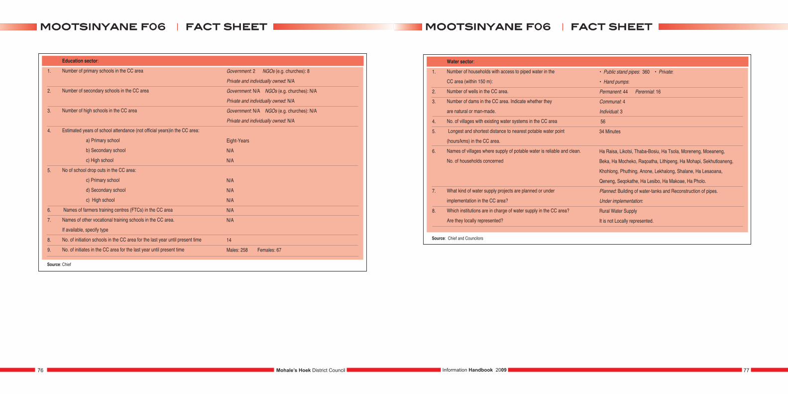
1.
2.
3.
4.
5.
6.
7.
8.
9.
Education sector:
Number of primary schools in the CC area
Number of secondary schools in the CC area
Number of high schools in the CC area
Estimated years of school attendance (not official years)in the CC area:
a) Primary school
b) Secondary school
c) High school
No of school drop outs in the CC area:
c) Primary school
d) Secondary school
c) High school
Names of farmers training centres (FTCs) in the CC area
Names of other vocational training schools in the CC area.
If available, specify type
No. of initiation schools in the CC area for the last year until present time
No. of initiates in the CC area for the last year until present time
Government: 2 NGOs (e.g. churches): 8
Private and individually owned: N/A
Government: N/A NGOs (e.g. churches): N/A
Private and individually owned: N/A
Government: N/A NGOs (e.g. churches): N/A
Private and individually owned: N/A
Eight-Years
N/A
N/A
N/A
N/A
N/A
N/A
N/A
14
Males: 258 Females: 67
Source: Chief
1.
2.
3.
4.
5.
6.
7.
8.
Water sector:
Number of households with access to piped water in the
CC area (within 150 m):
Number of wells in the CC area.
Number of dams in the CC area. Indicate whether they
are natural or man-made.
No. of villages with existing water systems in the CC area
Longest and shortest distance to nearest potable water point
(hours/kms) in the CC area.
Names of villages where supply of potable water is reliable and clean.
No. of households concerned
What kind of water supply projects are planned or under
implementation in the CC area?
Which institutions are in charge of water supply in the CC area?
Are they locally represented?
• Public stand pipes: 360 • Private:
• Hand pumps:
Permanent: 44 Perennial: 16
Communal: 4
Individual: 3
56
34 Minutes
Ha Raisa, Likotsi, Thaba-Bosiu, Ha Tsola, Moreneng, Moeaneng,
Beka, Ha Mocheko, Raqoatha, Lithipeng, Ha Mohapi, Sekhutloaneng,
Khohlong, Phuthing, Anone, Lekhalong, Shalane, Ha Lesaoana,
Qeneng, Seqokathe, Ha Lesibo, Ha Makoae, Ha Pholo.
Planned: Building of water-tanks and Reconstruction of pipes.
Under implementation:
Rural Water Supply
It is not Locally represented.
Source: Chief and Councilors
Mohale’s Hoek District Council76 77Information Handbook 2009
ffaacctt sshheeeettmmoooottssiinnyyaannee ff0066 ffaacctt sshheeeettmmoooottssiinnyyaannee ff0066
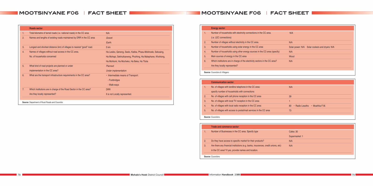
1.
2.
3.
4.
5.
6.
7.
Roads sector:
Total kilometre of tarred roads (i.e. national roads) in the CC area
Names and lengths of existing roads maintained by DRR in the CC area
Longest and shortest distance (km) of villages to nearest “good” road.
Names of villages without road access in the CC area.
No. of households concerned
What kind of road projects are planned or under
implementation in the CC area?
What are the transport infrastructure requirements in the CC area?
Which Institutions are in charge of the Road Sector in the CC area?
Are they locally represented?
N/A
Gravel:
Earth:
5 km
Ha Lesibo, Qeneng, Seelo, Katiba, Phasu-Mokhoele, Sekoaing,
Ha Mohapi, Sekhutloaneng, Phuthing, Ha Malephane, Khohlong,
Ha Mohlomi, Ha Mocheko, Ha Beka, Ha Tšola
Planned:
Under implementation:
• Intermediate means of Transport:
- Footbridges
- Walk-ways
DRR
It is not Locally represented.
Source: Department of Rural Roads and Councilor
1.
2.
3.
4.
5.
6.
Energy sector:
Number of households with electricity connections in the CC area.
(i.e. LEC connections)
Number of villages without electricity in the CC area.
Number of households using solar energy in the CC area
Number of households using other energy sources in the CC-area (specify)
Main sources of energy in the CC-area
Which institutions are in charge of the electricity sectors in the CC area?
Are they locally represented?
N/A
N/A
Solar power: N/A Solar cookers and dryers: N/A
N/A
Wood
N/A
Source: Councilors & Villagers
1.
2.
3.
4.
5.
Communication sector:
No. of villages with landline telephone in the CC area:
specify number of households with connections
No. of villages with cell phone reception in the CC area
No. of villages with local TV reception in the CC area
No. of villages with local radio reception in the CC area
No. of villages with access to postal/mail services in the CC area
N/A
39
1
80 • Radio Lesotho • Moafrika F.M.
73
Source: Councilors
1.
2.
3.
Trade and commerce sector:
Number of Businesses in the CC area. Specify type
Do they have access to specific market for their products?
Are there any financial institutions (e.g. banks, insurances, credit unions, etc)
in the CC area? If yes, provide names and location.
Cafes: 30
Supermarket: 1
N/A
N/A
Source: Councilors
Mohale’s Hoek District Council78 79Information Handbook 2009
ffaacctt sshheeeettmmoooottssiinnyyaannee ff0066 ffaacctt sshheeeettmmoooottssiinnyyaannee ff0066
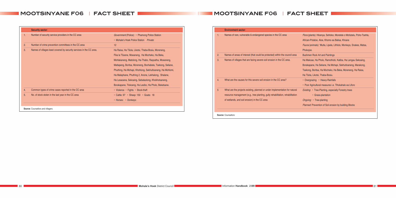
1.
2.
3.
4.
5.
Security sector:
Number of security service providers in the CC area
Number of crime prevention committees in the CC area
Names of villages least covered by security services in the CC area.
Common types of crime cases reported in the CC area
No. of stock stolen in the last year in the CC area
Government (Police): • Phamong Police Station
• Mohale’s Hoek Police Station Private:
12
Ha Raisa, Ha Tšola, Likotsi, Thaba-Bosiu, Moreneng,
Fika la Tšoene, Moeaneng, Ha Mocheko, Ha Beka,
Mohlakaneng, Matolong, Ha-Thabo, Raqoatha, Moeaneng,
Matlapeng, Boritsa, Moreneng, Bochabela, Tsekong, Seliane,
Phuthing, Ha Mohapi, Khohlong, Sekhutloaneng, Ha Mohlomi,
Ha Malephane, Phuthing 2, Anone, Lekhalong, Shalane,
Ha Lesaoana, Sekoaing, Sebataolong, Khokhotsaneng,
Borakapane, Tlokoeng, Ha Lesibo, Ha Pholo, Beketsane.
• Violence • Fights • Stock-theft
• Cattle: 97 • Sheep: 150 • Goats: 18
• Horses: • Donkeys:
Source: Counsellors and villagers
1.
2.
3.
4.
5
Environment sector:
Names of rare, vulnerable & endangered species in the CC area
Names of areas of interest (that could be protected) within the council area
Names of villages that are facing severe soil erosion in the CC area.
What are the causes for this severe soil erosion in the CC area?
What are the projects existing, planned or under implementation for natural
resource management (e.g., tree planting, gully rehabilitation, rehabilitation
of wetlands, and soil erosion) in the CC area
Source: Counsellors
Flora (plants): Hloenya, Sehloko, Moretele o Mofubelu, Poho-Tsehla,
African-Potatoe, Aloe, Khomo ea Balisa, Khoara
Fauna (animals): ‘Mutla, Lipela, Lithlolo, Monkeys, Snakes, Matsa,
Phokojoe.
Bushmen Rock Art and Paintings
Ha Makoae, Ha Pholo, Ramothobi, Katiba, Ha Lengau Sekoaing,
Borakapane, Ha Seliane, Ha Mohapi, Sekhutloaneng, Marakong,
Tsekong, Boritsa, Ha Mocheko, Ha Beka, Moreneng, Ha Raisa,
Ha Tšola, Likotsi, Thaba-Bosiu.
• Overgrazing • Heavy-Rainfalls
• Poor Agricultural measures i.e. Tlhokahalo ea Liforo
Existing: • Tree-Planting, especially Forestry trees
• Grass-plantation
Ongoing: • Tree-planting
Planned: Prevention of Soil erosion by building Blocks
Mohale’s Hoek District Council80 81Information Handbook 2009
ffaacctt sshheeeettmmoooottssiinnyyaannee ff0066 ffaacctt sshheeeettmmoooottssiinnyyaannee ff0066
PHAMONG F07
1.
2.
3.
4.
5.
6.
7.
8.
Population:
Total population of the community council (CC)
Male population in the CC area
Female population in the CC area
Youth population in the CC area (between 15 and 35 years)
Average population per village in the CC area (to be filled later)
No. of births in the last year in the CC area
No. of 5+ deaths in the last year in the CC area
Under 5 deaths in the last year in the CC area
10366
4797
5569
Male: 1734
Female: 1877
141
137
40
1.
2.
3.
4.
5.
CC Profile:
No. of electoral divisions (EDs) in the CC area
No. of villages in the CC area
Names of villages in the CC area (to be attached)
Estimated distance of CC centre from district town (in km and travel time)
Total area of community council (km2)
9
60
Ha Malephane, Janefeke, Liboti, Kheleli, Thoteng, Seteke, Likhohlong,
Mokoto, Motse-mocha, Phiring Moreng, Mphole, Mpobong, Phalana, Makausi,
Motse-mocha Ha Leloela, Sehoaba, Ralekhaola, Sealuma, Rachabana,
Qiqita, Lekhalong, Tlapa-Letšotso, Koti-sephola, Mahlalela, Lithakong,
Molemo, Saphau, Koethene, Tsoeneng, Hlalele, Thota-peli, Ntja-peli,
Lethena, Cobo, Makhabane, Tšepong, Hekeng, Sepotong, Ratšoane,
Makaung, Aupolase, Ramabutsoela, Topisi, Makara, Putsoane, Ntloane,
Thotaneng, Ntoi, Thepung, Lipeleng, Tlhakoaneng, Maqalikeng, Sekhutlong,
Seforong, Mafoseng, Tankele, Makhafoleng, Qacha, Matšeseng, Lipakela
93 Km
142 Km2
1.
2.
3.
4.
5.
6.
7.
8.
9.
Social indicators:
Total No. of households in the CC area
Average number of persons per household in the CC area
(Average household size)
No. of women headed households in the CC area
No. of child headed households in the CC area
No. of orphans in the CC area:
a) Paternal orphans
b) Maternal orphans
c) Double orphans
No. of vulnerable children in the CC area
No. of boys not attending school in the CC area (below 18 years of age)
No of girls not attending school in the CC area (below 18 years of age)
No. of persons with disabilities in the CC area.
Specify the forms of disabilities
1925
5
1168
247
1238
580
408
250
42
288
103
• blind - 12 • mentally retarded – 17
• deaf - 11
1.
2.
3.
4.
5.
Socio-economic indicators:
No. of persons receiving food aid in the CC area.
No. of households with the following expenditures (Maloti per year)
in the CC area:
Sources of income and the number of concerned households in the CC area
No. of people generating incomes from other sources in the CC area. Specify
Names and types of associations within the CC area
376
264
0 –500: 769
501 – 1000: 546
Above 1000: 6
Trade: 27
Formal employment: 2517
Farming: 3284
• 31- selling animals • 83 – sale of wool and mohair
• 13 – sale of farm products e.g milk • 11 – sale of vegetables.
Agriculture: • Ho Ipusa Moiphepi Funeral Schemes: • Mo-Africa,
Akofang, Ikopanyeng Village police: • Mahokela
Mohale’s Hoek District Council82 83Information Handbook 2009
ffaacctt sshheeeettpphhaammoonngg ff0077 ffaacctt sshheeeettpphhaammoonngg ff0077
Source: Councilor and DPU
Source: Councilor
Source: WFP and Councilor
Source: Councilor, Chief and Support Group
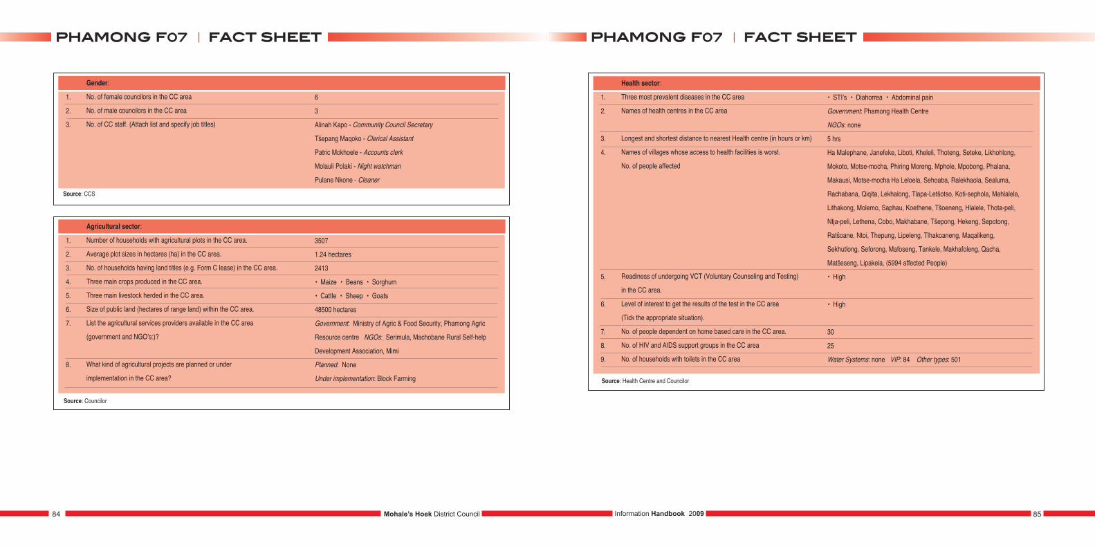
1.
2.
3.
Gender:
No. of female councilors in the CC area
No. of male councilors in the CC area
No. of CC staff. (Attach list and specify job titles)
6
3
Alinah Kapo - Community Council Secretary
Tšepang Maqoko - Clerical Assistant
Patric Mokhoele - Accounts clerk
Molauli Polaki - Night watchman
Pulane Nkone - Cleaner
1.
2.
3.
4.
5.
6.
7.
8.
Agricultural sector:
Number of households with agricultural plots in the CC area.
Average plot sizes in hectares (ha) in the CC area.
No. of households having land titles (e.g. Form C lease) in the CC area.
Three main crops produced in the CC area.
Three main livestock herded in the CC area.
Size of public land (hectares of range land) within the CC area.
List the agricultural services providers available in the CC area
(government and NGO’s:)?
What kind of agricultural projects are planned or under
implementation in the CC area?
3507
1.24 hectares
2413
• Maize • Beans • Sorghum
• Cattle • Sheep • Goats
48500 hectares
Government: Ministry of Agric & Food Security, Phamong Agric
Resource centre NGOs: Serimula, Machobane Rural Self-help
Development Association, Mimi
Planned: None
Under implementation: Block Farming
1.
2.
3.
4.
5.
6.
7.
8.
9.
Health sector:
Three most prevalent diseases in the CC area
Names of health centres in the CC area
Longest and shortest distance to nearest Health centre (in hours or km)
Names of villages whose access to health facilities is worst.
No. of people affected
Readiness of undergoing VCT (Voluntary Counseling and Testing)
in the CC area.
Level of interest to get the results of the test in the CC area
(Tick the appropriate situation).
No. of people dependent on home based care in the CC area.
No. of HIV and AIDS support groups in the CC area
No. of households with toilets in the CC area
• STI’s • Diahorrea • Abdominal pain
Government: Phamong Health Centre
NGOs: none
5 hrs
Ha Malephane, Janefeke, Liboti, Kheleli, Thoteng, Seteke, Likhohlong,
Mokoto, Motse-mocha, Phiring Moreng, Mphole, Mpobong, Phalana,
Makausi, Motse-mocha Ha Leloela, Sehoaba, Ralekhaola, Sealuma,
Rachabana, Qiqita, Lekhalong, Tlapa-Letšotso, Koti-sephola, Mahlalela,
Lithakong, Molemo, Saphau, Koethene, Tšoeneng, Hlalele, Thota-peli,
Ntja-peli, Lethena, Cobo, Makhabane, Tšepong, Hekeng, Sepotong,
Ratšoane, Ntoi, Thepung, Lipeleng, Tlhakoaneng, Maqalikeng,
Sekhutlong, Seforong, Mafoseng, Tankele, Makhafoleng, Qacha,
Matšeseng, Lipakela, (5994 affected People)
• High
• High
30
25
Water Systems: none VIP: 84 Other types: 501
Source: Health Centre and Councilor
Mohale’s Hoek District Council84 85Information Handbook 2009
ffaacctt sshheeeettpphhaammoonngg ff0077 ffaacctt sshheeeettpphhaammoonngg ff0077
Source: Councilor
Source: CCS
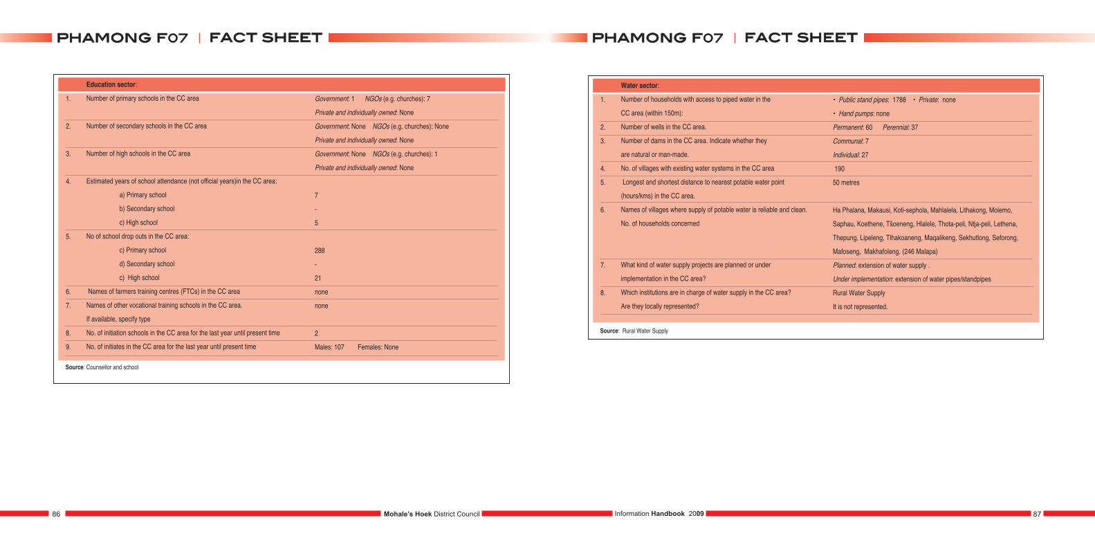
1.
2.
3.
4.
5.
6.
7.
8.
9.
Education sector:
Number of primary schools in the CC area
Number of secondary schools in the CC area
Number of high schools in the CC area
Estimated years of school attendance (not official years)in the CC area:
a) Primary school
b) Secondary school
c) High school
No of school drop outs in the CC area:
c) Primary school
d) Secondary school
c) High school
Names of farmers training centres (FTCs) in the CC area
Names of other vocational training schools in the CC area.
If available, specify type
No. of initiation schools in the CC area for the last year until present time
No. of initiates in the CC area for the last year until present time
Government: 1 NGOs (e.g. churches): 7
Private and individually owned: None
Government: None NGOs (e.g. churches): None
Private and individually owned: None
Government: None NGOs (e.g. churches): 1
Private and individually owned: None
7
-
5
288
-
21
none
none
2
Males: 107 Females: None
Source: Counsellor and school
1.
2.
3.
4.
5.
6.
7.
8.
Water sector:
Number of households with access to piped water in the
CC area (within 150m):
Number of wells in the CC area.
Number of dams in the CC area. Indicate whether they
are natural or man-made.
No. of villages with existing water systems in the CC area
Longest and shortest distance to nearest potable water point
(hours/kms) in the CC area.
Names of villages where supply of potable water is reliable and clean.
No. of households concerned
What kind of water supply projects are planned or under
implementation in the CC area?
Which institutions are in charge of water supply in the CC area?
Are they locally represented?
• Public stand pipes: 1788 • Private: none
• Hand pumps: none
Permanent: 60 Perennial: 37
Communal: 7
Individual: 27
190
50 metres
Ha Phalana, Makausi, Koti-sephola, Mahlalela, Lithakong, Molemo,
Saphau, Koethene, Tšoeneng, Hlalele, Thota-peli, Ntja-peli, Lethena,
Thepung, Lipeleng, Tlhakoaneng, Maqalikeng, Sekhutlong, Seforong,
Mafoseng, Makhafoleng. (246 Malapa)
Planned: extension of water supply .
Under implementation: extension of water pipes/standpipes
Rural Water Supply
It is not represented.
Source: Rural Water Supply
Mohale’s Hoek District Council86 87Information Handbook 2009
ffaacctt sshheeeettpphhaammoonngg ff0077 ffaacctt sshheeeettpphhaammoonngg ff0077
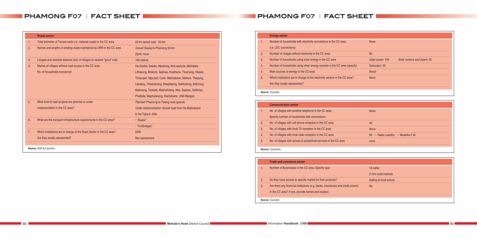
1.
2.
3.
4.
5.
6.
7.
Roads sector:
Total kilometer of Tarred roads (i.e. national roads) in the CC area
Names and lengths of existing roads maintained by DRR in the CC area
Longest and shortest distance (km) of villages to nearest “good” road.
Names of villages without road access in the CC area.
No. of households concerned
What kind of road projects are planned or under
implementation in the CC area?
What are the transport infrastructure requirements in the CC area?
Which Institutions are in charge of the Road Sector in the CC area?
Are they locally represented?
43 km tarred road 50 km
Gravel: Seaka to Phamong 50 km
Earth: none
100 metres
Ha Kheleli, Seteke, Mpobong, Koti-sephola, Mahlalela,
Lithakong, Molemo, Saphau, Koethene, Tšoeneng, Hlalele,
Thota-peli, Ntja-peli, Cobo, Makhabane, Makere, Thepung,
Lipeleng, Tlhakoaneng, Maqalikeng, Sekhutlong, Seforong,
Mafoseng, Tankele, Makhafoleng, Ntoi, Saphau, Sethinya,
Phatlalla, Mapholaneng, Rachabane. (356 Malapa)
Planned: Phamong to Teleng road (gravel)
Under implementation: Gravel road from Ha Makhabane
to Ha Taba-li- Atile
• Roads*
• Footbridges*
DRR
Not represented
Source: DDR & Councilor
1.
2.
3.
4.
5.
6.
Energy sector:
Number of households with electricity connections in the CC area.
(i.e. LEC connections)
Number of villages without electricity in the CC area.
Number of households using solar energy in the CC area
Number of households using other energy sources in the CC area (specify)
Main sources of energy in the CC-area
Which institutions are in charge of the electricity sectors in the CC area?
Are they locally represented?
Source: Councilor
1.
2.
3.
4.
5.
Communication sector:
No. of villages with landline telephone in the CC area.
Specify number of households with connections.
No. of villages with cell phone reception in the CC area
No. of villages with local TV reception in the CC area
No. of villages with local radio reception in the CC area
No. of villages with access to postal/mail services in the CC area
None
40
None
60 • Radio Lesotho • Moafrika F.M.
none
Source: Councilors
1.
2.
3.
Trade and commerce sector:
Number of Businesses in the CC area. Specify type
Do they have access to specific market for their products?
Are there any financial institutions (e.g. banks, insurances and credit unions)
in the CC area? If yes, provide names and location.
18 cafés
2 mini supermarkets
Selling at local school
No
Source: Councilor
None
60
Solar power: 104 Solar cookers and dryers: 25
Generator: 26
Wood
None
Mohale’s Hoek District Council88 89Information Handbook 2009
ffaacctt sshheeeettpphhaammoonngg ff0077 ffaacctt sshheeeettpphhaammoonngg ff0077
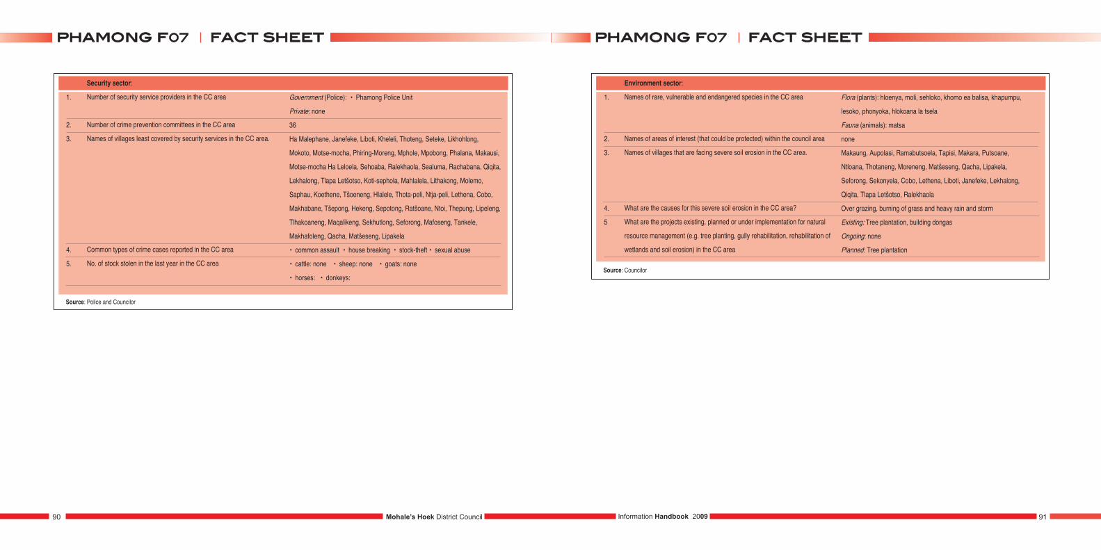
1.
2.
3.
4.
5.
Security sector:
Number of security service providers in the CC area
Number of crime prevention committees in the CC area
Names of villages least covered by security services in the CC area.
Common types of crime cases reported in the CC area
No. of stock stolen in the last year in the CC area
Government (Police): • Phamong Police Unit
Private: none
36
Ha Malephane, Janefeke, Liboti, Kheleli, Thoteng, Seteke, Likhohlong,
Mokoto, Motse-mocha, Phiring-Moreng, Mphole, Mpobong, Phalana, Makausi,
Motse-mocha Ha Leloela, Sehoaba, Ralekhaola, Sealuma, Rachabana, Qiqita,
Lekhalong, Tlapa Letšotso, Koti-sephola, Mahlalela, Lithakong, Molemo,
Saphau, Koethene, Tšoeneng, Hlalele, Thota-peli, Ntja-peli, Lethena, Cobo,
Makhabane, Tšepong, Hekeng, Sepotong, Ratšoane, Ntoi, Thepung, Lipeleng,
Tlhakoaneng, Maqalikeng, Sekhutlong, Seforong, Mafoseng, Tankele,
Makhafoleng, Qacha, Matšeseng, Lipakela
• common assault • house breaking • stock-theft • sexual abuse
• cattle: none • sheep: none • goats: none
• horses: • donkeys:
Source: Police and Councilor
1.
2.
3.
4.
5
Environment sector:
Names of rare, vulnerable and endangered species in the CC area
Names of areas of interest (that could be protected) within the council area
Names of villages that are facing severe soil erosion in the CC area.
What are the causes for this severe soil erosion in the CC area?
What are the projects existing, planned or under implementation for natural
resource management (e.g. tree planting, gully rehabilitation, rehabilitation of
wetlands and soil erosion) in the CC area
Source: Councilor
Flora (plants): hloenya, moli, sehloko, khomo ea balisa, khapumpu,
lesoko, phonyoka, hlokoana la tsela
Fauna (animals): matsa
none
Makaung, Aupolasi, Ramabutsoela, Tapisi, Makara, Putsoane,
Ntloana, Thotaneng, Moreneng, Matšeseng, Qacha, Lipakela,
Seforong, Sekonyela, Cobo, Lethena, Liboti, Janefeke, Lekhalong,
Qiqita, Tlapa Letšotso, Ralekhaola
Over grazing, burning of grass and heavy rain and storm
Existing: Tree plantation, building dongas
Ongoing: none
Planned: Tree plantation
Mohale’s Hoek District Council90 91Information Handbook 2009
ffaacctt sshheeeettpphhaammoonngg ff0077 ffaacctt sshheeeettpphhaammoonngg ff0077
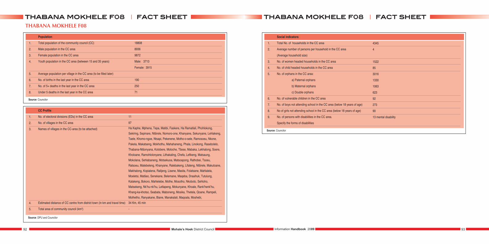
THABANA MOKHELE F08
1.
2.
3.
4.
5.
6.
7.
8.
Population:
Total population of the community council (CC)
Male population in the CC area
Female population in the CC area
Youth population in the CC area (between 15 and 35 years)
Average population per village in the CC area (to be filled later)
No. of births in the last year in the CC area
No. of 5+ deaths in the last year in the CC area
Under 5 deaths in the last year in the CC area
18808
8936
9872
Male: 3713
Female: 3915
190
250
71
1.
2.
3.
4.
5.
CC Profile:
No. of electoral divisions (EDs) in the CC area
No. of villages in the CC area
Names of villages in the CC-area (to be attached)
Estimated distance of CC centre from district town (in km and travel time)
Total area of community council (km2)
11
97
Ha Kaphe, Mphena, Tepa, Matibi, Faskere, Ha Ramatlali, Phohlokong,
Sekiring, Sepinare, Ntširele, Nomoro-one, Khanyane, Sekunyane, Lehlakeng,
Taele, Khomo-ngoe, Ntsapi, Pekenene, Motho-o-sele, Ramosoeu, Nkone,
Pakela, Makatseng, Mokhothu, Mahahaneng, Phala, Linokong, Rasebolelo,
Thabana-Ntšonyana, Kolobere, Moloche, Tšese, Mabaka, Lekhalong, Soere,
Kholoane, Ramohlolonyane, Lithakaling, Chefa, Lefikeng, Matsaung,
Mokolana, Sehlabaneng, Motsekuoa, Matsoapong, Rathobei, Tsoeu,
Ratsoeu, Matebeleng, Khanyane, Ralebakeng, Lifateng, Ntširele, Makutoane,
Makhalong, Kopialena, Ralijeng, Lisene, Masita, Folatsane, Mahlalela,
Moeletsi, Matšeo, Senekane, Belemane, Maqeba, Draaihuk, Tutulung,
Kalakeng, Bokoro, Mahlelebe, Mothe, Mosotho, Nkoboto, Sehloho,
Matsekeng, Nk’hu-nk’hu, Letlapeng, Mokunyane, Khoale, Rank’henk’hu,
Khang-ka-khotso, Seabata, Maboneng, Mosika, Thetela, Qoane, Rampeli,
Mothetho, Ranyakane, Biane, Manakalali, Maqoala, Moshebi,
34 Km, 45 min
-
1.
2.
3.
4.
5.
6.
7.
8.
9.
Social indicators:
Total No. of households in the CC area
Average number of persons per household in the CC area
(Average household size)
No. of women headed households in the CC area
No. of child headed households in the CC area
No. of orphans in the CC area:
a) Paternal orphans
b) Maternal orphans
c) Double orphans
No. of vulnerable children in the CC area
No. of boys not attending school in the CC area (below 18 years of age)
No of girls not attending school in the CC area (below 18 years of age)
No. of persons with disabilities in the CC area.
Specify the forms of disabilities
4345
4
1522
85
3016
1330
1063
623
92
273
90
13 mental disability
Mohale’s Hoek District Council92 93Information Handbook 2009
ffaacctt sshheeeetttthhaabbaannaa mmookkhheellee ff0088 ffaacctt sshheeeetttthhaabbaannaa mmookkhheellee ff0088
Source: Councilor
Source: DPU and Councilor
Source: Councilor
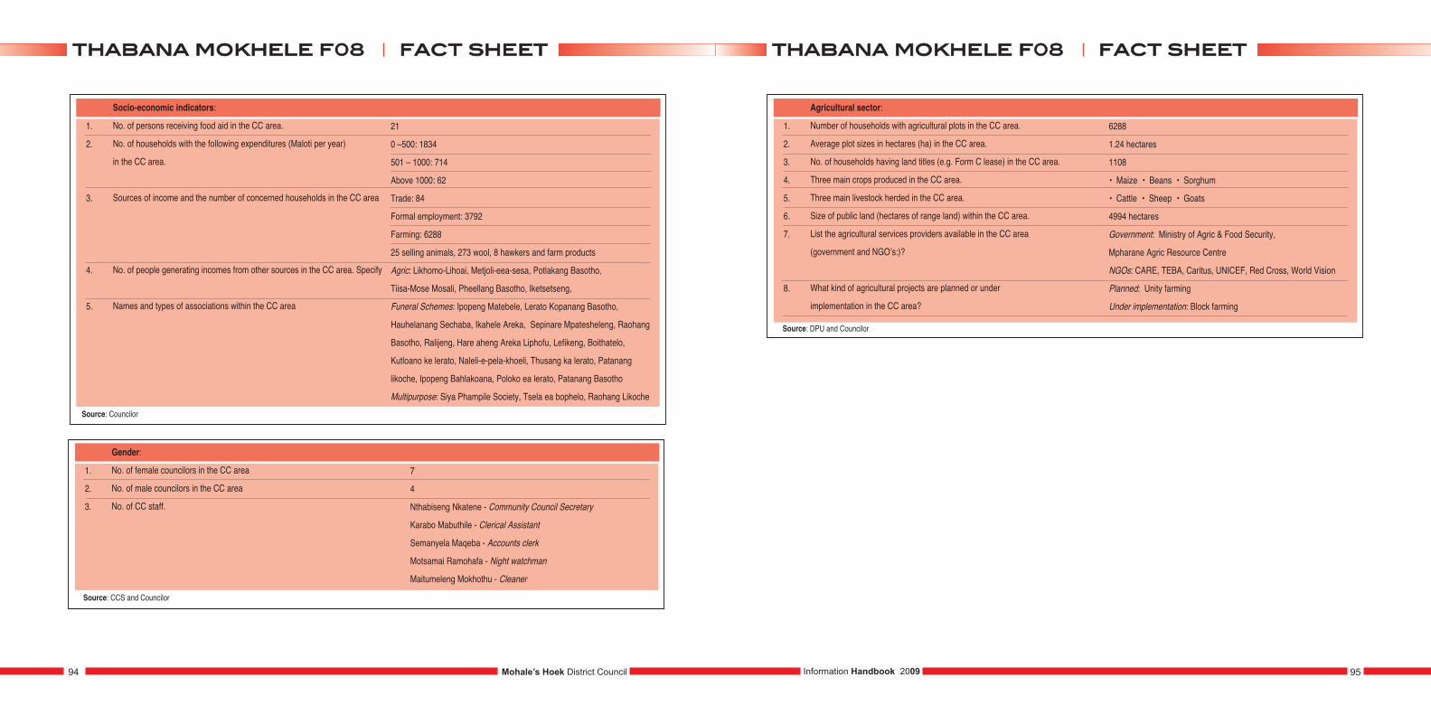
1.
2.
3.
4.
5.
Socio-economic indicators:
No. of persons receiving food aid in the CC area.
No. of households with the following expenditures (Maloti per year)
in the CC area.
Sources of income and the number of concerned households in the CC area
No. of people generating incomes from other sources in the CC area. Specify
Names and types of associations within the CC area
21
0 –500: 1834
501 – 1000: 714
Above 1000: 62
Trade: 84
Formal employment: 3792
Farming: 6288
25 selling animals, 273 wool, 8 hawkers and farm products
Agric: Likhomo-Lihoai, Metjoli-eea-sesa, Potlakang Basotho,
Tiisa-Mose Mosali, Pheellang Basotho, Iketsetseng,
Funeral Schemes: Ipopeng Matebele, Lerato Kopanang Basotho,
Hauhelanang Sechaba, Ikahele Areka, Sepinare Mpatesheleng, Raohang
Basotho, Ralijeng, Hare aheng Areka Liphofu, Lefikeng, Boithatelo,
Kutloano ke lerato, Naleli-e-pela-khoeli, Thusang ka lerato, Patanang
likoche, Ipopeng Bahlakoana, Poloko ea lerato, Patanang Basotho
Multipurpose: Siya Phampile Society, Tsela ea bophelo, Raohang Likoche
1.
2.
3.
Gender:
No. of female councilors in the CC area
No. of male councilors in the CC area
No. of CC staff.
7
4
Nthabiseng Nkatene - Community Council Secretary
Karabo Mabuthile - Clerical Assistant
Semanyela Maqeba - Accounts clerk
Motsamai Ramohafa - Night watchman
Maitumeleng Mokhothu - Cleaner
1.
2.
3.
4.
5.
6.
7.
8.
Agricultural sector:
Number of households with agricultural plots in the CC area.
Average plot sizes in hectares (ha) in the CC area.
No. of households having land titles (e.g. Form C lease) in the CC area.
Three main crops produced in the CC area.
Three main livestock herded in the CC area.
Size of public land (hectares of range land) within the CC area.
List the agricultural services providers available in the CC area
(government and NGO’s:)?
What kind of agricultural projects are planned or under
implementation in the CC area?
6288
1.24 hectares
1108
• Maize • Beans • Sorghum
• Cattle • Sheep • Goats
4994 hectares
Government: Ministry of Agric & Food Security,
Mpharane Agric Resource Centre
NGOs: CARE, TEBA, Caritus, UNICEF, Red Cross, World Vision
Planned: Unity farming
Under implementation: Block farming
Mohale’s Hoek District Council94 95Information Handbook 2009
ffaacctt sshheeeetttthhaabbaannaa mmookkhheellee ff0088 ffaacctt sshheeeetttthhaabbaannaa mmookkhheellee ff0088
Source: Councilor
Source: CCS and Councilor
Source: DPU and Councilor
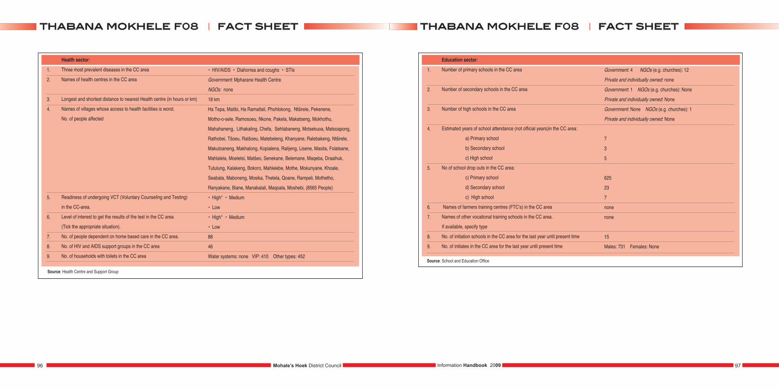
1.
2.
3.
4.
5.
6.
7.
8.
9.
Health sector:
Three most prevalent diseases in the CC area
Names of health centres in the CC area
Longest and shortest distance to nearest Health centre (in hours or km)
Names of villages whose access to health facilities is worst.
No. of people affected
Readiness of undergoing VCT (Voluntary Counseling and Testing)
in the CC-area.
Level of interest to get the results of the test in the CC area
(Tick the appropriate situation).
No. of people dependent on home based care in the CC area.
No. of HIV and AIDS support groups in the CC area
No. of households with toilets in the CC area
• HIV/AIDS • Diahorrea and coughs • STIs
Government: Mpharane Health Centre
NGOs: none
18 km
Ha Tepa, Matibi, Ha Ramatlali, Phohlokong, Ntširele, Pekenene,
Motho-o-sele, Ramosoeu, Nkone, Pakela, Makatseng, Mokhothu,
Mahahaneng, Lithakaling, Chefa, Sehlabaneng, Motsekuoa, Matsoapong,
Rathobei, Tšoeu, Ratšoeu, Matebeleng, Khanyane, Ralebakeng, Ntširele,
Makutoaneng, Makhalong, Kopialena, Ralijeng, Lisene, Masita, Folatsane,
Mahlalela, Moeletsi, Matšeo, Senekane, Belemane, Maqeba, Draaihuk,
Tutulung, Kalakeng, Bokoro, Mahlelebe, Mothe, Mokunyane, Khoale,
Seabata, Maboneng, Mosika, Thetela, Qoane, Rampeli, Mothetho,
Ranyakane, Biane, Manakalali, Maqoala, Moshebi, (8565 People)
• High* • Medium
• Low
• High* • Medium
• Low
88
46
Water systems: none VIP: 410 Other types: 452
Source: Health Centre and Support Group
1.
2.
3.
4.
5.
6.
7.
8.
9.
Education sector:
Number of primary schools in the CC area
Number of secondary schools in the CC area
Number of high schools in the CC area
Estimated years of school attendance (not official years)in the CC area:
a) Primary school
b) Secondary school
c) High school
No of school drop outs in the CC area:
c) Primary school
d) Secondary school
c) High school
Names of farmers training centres (FTC’s) in the CC area
Names of other vocational training schools in the CC area.
If available, specify type
No. of initiation schools in the CC area for the last year until present time
No. of initiates in the CC area for the last year until present time
Government: 4 NGOs (e.g. churches): 12
Private and individually owned: none
Government: 1 NGOs (e.g. churches): None
Private and individually owned: None
Government: None NGOs (e.g. churches): 1
Private and individually owned: None
7
3
5
625
23
7
none
none
15
Males: 731 Females: None
Source: School and Education Office
Mohale’s Hoek District Council96 97Information Handbook 2009
ffaacctt sshheeeetttthhaabbaannaa mmookkhheellee ff0088 ffaacctt sshheeeetttthhaabbaannaa mmookkhheellee ff0088
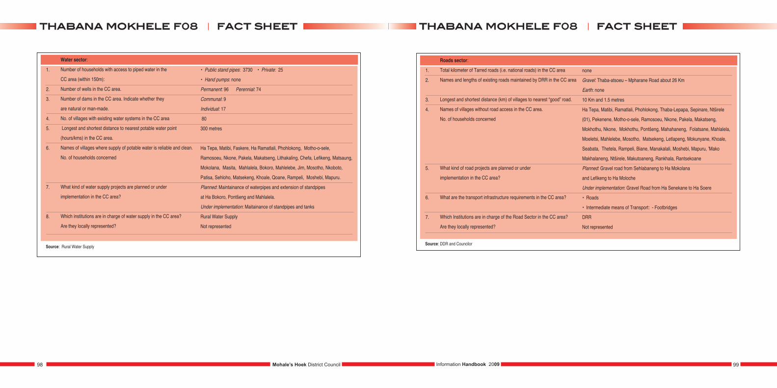
1.
2.
3.
4.
5.
6.
7.
8.
Water sector:
Number of households with access to piped water in the
CC area (within 150m):
Number of wells in the CC area.
Number of dams in the CC area. Indicate whether they
are natural or man-made.
No. of villages with existing water systems in the CC area
Longest and shortest distance to nearest potable water point
(hours/kms) in the CC area.
Names of villages where supply of potable water is reliable and clean.
No. of households concerned
What kind of water supply projects are planned or under
implementation in the CC area?
Which institutions are in charge of water supply in the CC area?
Are they locally represented?
• Public stand pipes: 3730 • Private: 25
• Hand pumps: none
Permanent: 96 Perennial: 74
Communal: 9
Individual: 17
80
300 metres
Ha Tepa, Matibi, Faskere, Ha Ramatlali, Phohlokong, Motho-o-sele,
Ramosoeu, Nkone, Pakela, Makatseng, Lithakaling, Chefa, Lefikeng, Matsaung,
Mokolana, Masita, Mahlalela, Bokoro, Mahlelebe, Jim, Mosotho, Nkoboto,
Patisa, Sehloho, Matsekeng, Khoale, Qoane, Rampeli, Moshebi, Mapuru.
Planned: Maintainance of waterpipes and extension of standpipes
at Ha Bokoro, Pontšeng and Mahlalela.
Under implementation: Maitainance of standpipes and tanks
Rural Water Supply
Not represented
Source: Rural Water Supply
1.
2.
3.
4.
5.
6.
7.
Roads sector:
Total kilometer of Tarred roads (i.e. national roads) in the CC area
Names and lengths of existing roads maintained by DRR in the CC area
Longest and shortest distance (km) of villages to nearest “good” road.
Names of villages without road access in the CC area.
No. of households concerned
What kind of road projects are planned or under
implementation in the CC area?
What are the transport infrastructure requirements in the CC area?
Which Institutions are in charge of the Road Sector in the CC area?
Are they locally represented?
none
Gravel: Thaba-atsoeu – Mpharane Road about 26 Km
Earth: none
10 Km and 1.5 metres
Ha Tepa, Matibi, Ramatlali, Phohlokong, Thaba-Lepapa, Sepinare, Ntširele
(01), Pekenene, Motho-o-sele, Ramosoeu, Nkone, Pakela, Makatseng,
Mokhothu, Nkone, Mokhothu, Pontšeng, Mahahaneng, Folatsane, Mahlalela,
Moeletsi, Mahlelebe, Mosotho, Matsekeng, Letlapeng, Mokunyane, Khoale,
Seabata, Thetela, Rampeli, Biane, Manakalali, Moshebi, Mapuru, ’Mako
Makhalaneng, Ntširele, Makutoaneng, Rankhala, Rantsekoane
Planned: Gravel road from Sehlabaneng to Ha Mokolana
and Lefikeng to Ha Moloche
Under implementation: Gravel Road from Ha Senekane to Ha Soere
• Roads
• Intermediate means of Transport: - Footbridges
DRR
Not represented
Source: DDR and Councilor
Mohale’s Hoek District Council98 99Information Handbook 2009
ffaacctt sshheeeetttthhaabbaannaa mmookkhheellee ff0088 ffaacctt sshheeeetttthhaabbaannaa mmookkhheellee ff0088
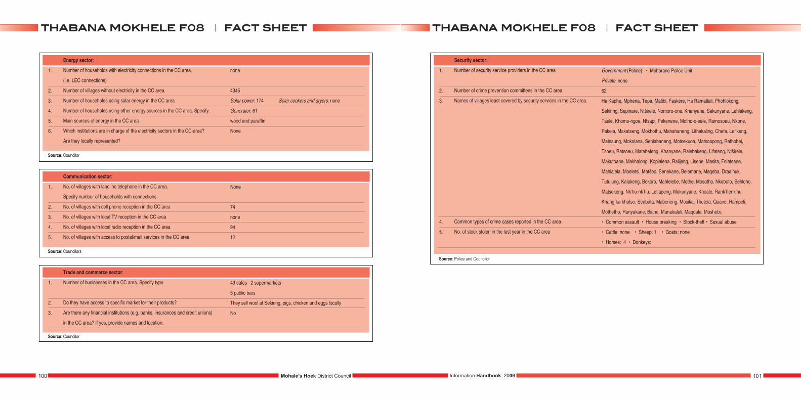
1.
2.
3.
4.
5.
6.
Energy sector:
Number of households with electricity connections in the CC area.
(i.e. LEC connections)
Number of villages without electricity in the CC area.
Number of households using solar energy in the CC area
Number of households using other energy sources in the CC area. Specify.
Main sources of energy in the CC area
Which institutions are in charge of the electricity sectors in the CC-area?
Are they locally represented?
Source: Councilor
1.
2.
3.
4.
5.
Communication sector:
No. of villages with landline telephone in the CC area.
Specify number of households with connections
No. of villages with cell phone reception in the CC area
No. of villages with local TV reception in the CC area
No. of villages with local radio reception in the CC area
No. of villages with access to postal/mail services in the CC area
None
74
none
94
12
Source: Councilors
1.
2.
3.
Trade and commerce sector:
Number of businesses in the CC area. Specify type
Do they have access to specific market for their products?
Are there any financial institutions (e.g. banks, insurances and credit unions)
in the CC area? If yes, provide names and location.
49 cafés 2 supermarkets
5 public bars
They sell wool at Sekiring, pigs, chicken and eggs locally
No
Source: Councilor
none
4345
Solar power: 174 Solar cookers and dryers: none
Generator: 61
wood and paraffin
None
1.
2.
3.
4.
5.
Security sector:
Number of security service providers in the CC area
Number of crime prevention committees in the CC area
Names of villages least covered by security services in the CC area.
Common types of crime cases reported in the CC area
No. of stock stolen in the last year in the CC area
Government (Police): • Mpharane Police Unit
Private: none
62
Ha Kaphe, Mphena, Tepa, Matibi, Faskere, Ha Ramatlali, Phohlokong,
Sekiring, Sepinare, Ntširele, Nomoro-one, Khanyane, Sekunyane, Lehlakeng,
Taele, Khomo-ngoe, Ntsapi, Pekenene, Motho-o-sele, Ramosoeu, Nkone,
Pakela, Makatseng, Mokhothu, Mahahaneng, Lithakaling, Chefa, Lefikeng,
Matsaung, Mokolana, Sehlabaneng, Motsekuoa, Matsoapong, Rathobei,
Tsoeu, Ratsoeu, Matebeleng, Khanyane, Ralebakeng, Lifateng, Ntširele,
Makutoane, Makhalong, Kopialena, Ralijeng, Lisene, Masita, Folatsane,
Mahlalela, Moeletsi, Matšeo, Senekane, Belemane, Maqeba, Draaihuk,
Tutulung, Kalakeng, Bokoro, Mahlelebe, Mothe, Mosotho, Nkoboto, Sehloho,
Matsekeng, Nk’hu-nk’hu, Letlapeng, Mokunyane, Khoale, Rank’henk’hu,
Khang-ka-khotso, Seabata, Maboneng, Mosika, Thetela, Qoane, Rampeli,
Mothetho, Ranyakane, Biane, Manakalali, Maqoala, Moshebi,
• Common assault • House breaking • Stock-theft • Sexual abuse
• Cattle: none • Sheep: 1 • Goats: none
• Horses: 4 • Donkeys:
Source: Police and Councilor
Mohale’s Hoek District Council100 101Information Handbook 2009
ffaacctt sshheeeetttthhaabbaannaa mmookkhheellee ff0088 ffaacctt sshheeeetttthhaabbaannaa mmookkhheellee ff0088
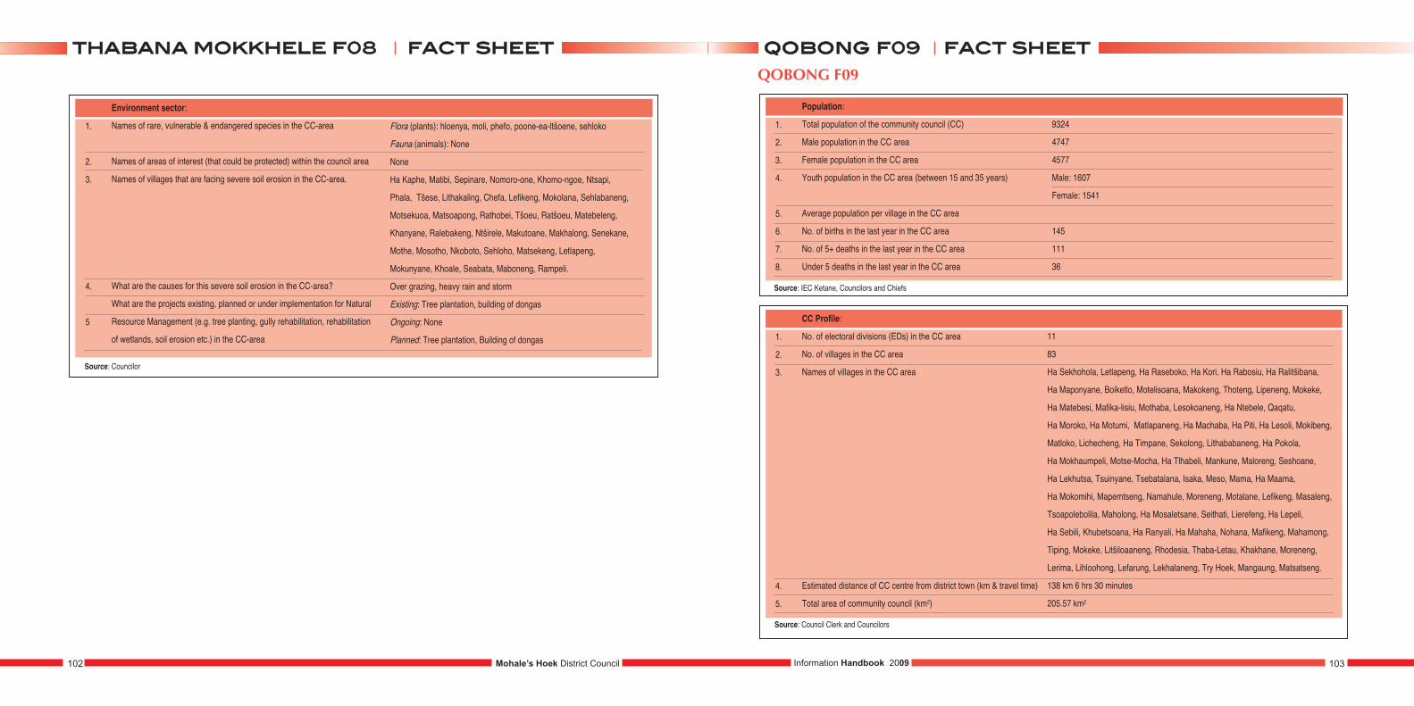
1.
2.
3.
4.
5
Environment sector:
Names of rare, vulnerable & endangered species in the CC-area
Names of areas of interest (that could be protected) within the council area
Names of villages that are facing severe soil erosion in the CC-area.
What are the causes for this severe soil erosion in the CC-area?
What are the projects existing, planned or under implementation for Natural
Resource Management (e.g. tree planting, gully rehabilitation, rehabilitation
of wetlands, soil erosion etc.) in the CC-area
Source: Councilor
Flora (plants): hloenya, moli, phefo, poone-ea-ltšoene, sehloko
Fauna (animals): None
None
Ha Kaphe, Matibi, Sepinare, Nomoro-one, Khomo-ngoe, Ntsapi,
Phala, Tšese, Lithakaling, Chefa, Lefikeng, Mokolana, Sehlabaneng,
Motsekuoa, Matsoapong, Rathobei, Tšoeu, Ratšoeu, Matebeleng,
Khanyane, Ralebakeng, Ntširele, Makutoane, Makhalong, Senekane,
Mothe, Mosotho, Nkoboto, Sehloho, Matsekeng, Letlapeng,
Mokunyane, Khoale, Seabata, Maboneng, Rampeli.
Over grazing, heavy rain and storm
Existing: Tree plantation, building of dongas
Ongoing: None
Planned: Tree plantation, Building of dongas
1.
2.
3.
4.
5.
6.
7.
8.
Population:
Total population of the community council (CC)
Male population in the CC area
Female population in the CC area
Youth population in the CC area (between 15 and 35 years)
Average population per village in the CC area
No. of births in the last year in the CC area
No. of 5+ deaths in the last year in the CC area
Under 5 deaths in the last year in the CC area
9324
4747
4577
Male: 1607
Female: 1541
145
111
36
1.
2.
3.
4.
5.
CC Profile:
No. of electoral divisions (EDs) in the CC area
No. of villages in the CC area
Names of villages in the CC area
Estimated distance of CC centre from district town (km & travel time)
Total area of community council (km2)
11
83
Ha Sekhohola, Letlapeng, Ha Raseboko, Ha Kori, Ha Rabosiu, Ha Ralitšibana,
Ha Maponyane, Boiketlo, Motelisoana, Makokeng, Thoteng, Lipeneng, Mokeke,
Ha Matebesi, Mafika-lisiu, Mothaba, Lesokoaneng, Ha Ntebele, Qaqatu,
Ha Moroko, Ha Motumi, Matlapaneng, Ha Machaba, Ha Piti, Ha Lesoli, Mokibeng,
Matloko, Lichecheng, Ha Timpane, Sekolong, Lithababaneng, Ha Pokola,
Ha Mokhaumpeli, Motse-Mocha, Ha Tlhabeli, Mankune, Maloreng, Seshoane,
Ha Lekhutsa, Tsuinyane, Tsebatalana, Isaka, Meso, Mama, Ha Maama,
Ha Mokomihi, Mapemtseng, Namahule, Moreneng, Motalane, Lefikeng, Masaleng,
Tsoapolebolila, Maholong, Ha Mosaletsane, Seithati, Lierefeng, Ha Lepeli,
Ha Sebili, Khubetsoana, Ha Ranyali, Ha Mahaha, Nohana, Mafikeng, Mahamong,
Tiping, Mokeke, Litšiloaaneng, Rhodesia, Thaba-Letau, Khakhane, Moreneng,
Lerima, Lihloohong, Lefarung, Lekhalaneng, Try Hoek, Mangaung, Matsatseng.
138 km 6 hrs 30 minutes
205.57 km2
Mohale’s Hoek District Council102 103Information Handbook 2009
ffaacctt sshheeeetttthhaabbaannaa mmookkkkhheellee ff0088 ffaacctt sshheeeettqqoobboonngg ff0099QOBONG F09
Source: Council Clerk and Councilors
Source: IEC Ketane, Councilors and Chiefs

1.
2.
3.
4.
5.
6.
7.
8.
9.
Social indicators:
Total No. of households in the CC area
Average number of persons per household in the CC area
(Average household size)
No. of women headed households in the CC area
No. of child headed households in the CC area
No. of orphans in the CC area:
a) Paternal orphans
b) Maternal orphans
c) Double orphans
No. of vulnerable children in the CC area
No. of boys not attending school in the CC area (below 18 years of age)
No of girls not attending school in the CC area (below 18 years of age)
No. of persons with disabilities in the CC area.
Specify the forms of disabilities
2559
12
623
180
244
420
297
193
257
147
244
124 blindness, deaf, cripple, mute, mental-illnesses, boqhoala
1.
2.
3.
4.
5.
Socio-economic indicators:
No. of persons receiving food aid in the CC area.
No. of households with the following expenditures (Maloti per year)
in the CC area.
Sources of income and the number of concerned households in the CC area
No. of people generating incomes from other sources in the CC area. Specify
Names and types of associations within the CC area
349
0 – 500: 3092
501 – 1000: 1454
Above 1000: 793
Trade: 42
Formal employment: 89
Farming: 2670
N/A
• Support Groups • Itjareng Basotho
• Ratanang Basotho • Nthuse Morena
• Thusanang Basotho (Grocery) • Mpate Sheleng
1.
2.
3.
Gender:
No. of female councilors in the CC area
No. of male councilors in the CC area
No. of CC staff. (Attach list and specify job titles)
4
7
‘Mamokete Mochochoko - Clerical Assistant
Sello Lerotholi - Messenger
Lehana - Accounts Clerk
Ntsaole Kotelo - Watchman
1.
2.
3.
4.
5.
6.
7.
8.
Agricultural sector:
Number of households with agricultural plots in the CC area.
Average plot sizes in hectares (ha) in the CC area.
No. of households having Land Titles (e.g. Form C lease) in the CC area.
Three main crops produced in the CC area.
Three main livestock herded in the CC area.
Size of public land (hectares of range land) within the CC area.
List the agricultural services providers available in the CC area
(government and NGOs:)?
What kind of agricultural projects are planned or under
implementation in the CC area?
1881
12 hectares
2586
• Maize • Sorghum • Beans
• Cattle • Horses • Goats
Government: Ministry of Agriculture
NGOs: SANREMP SERUMULA-MOVE
Planned:
Under implementation: Block farming
Mohale’s Hoek District Council104 105Information Handbook 2009
ffaacctt sshheeeettqqoobboonngg ff0099 ffaacctt sshheeeettqqoobboonngg ff0099QOBONG F09
Source: Councilors
Source: Councilors and D.A.O. Mohale’s Hoek
Source: Villagers, Councilors and Nohana Clinic
Source: Councilors
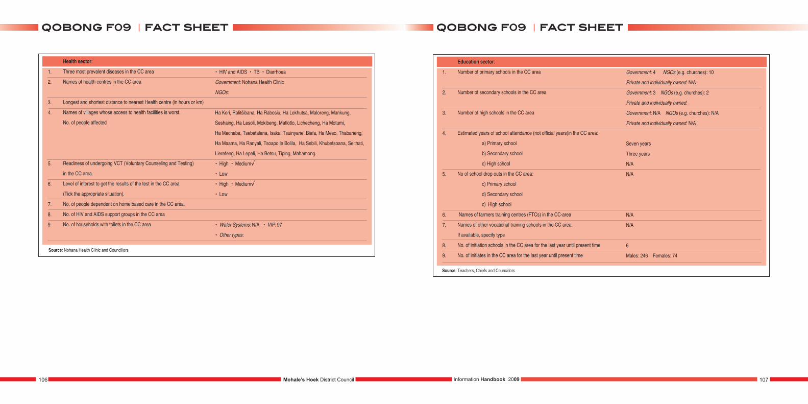
1.
2.
3.
4.
5.
6.
7.
8.
9.
Health sector:
Three most prevalent diseases in the CC area
Names of health centres in the CC area
Longest and shortest distance to nearest Health centre (in hours or km)
Names of villages whose access to health facilities is worst.
No. of people affected
Readiness of undergoing VCT (Voluntary Counseling and Testing)
in the CC area.
Level of interest to get the results of the test in the CC area
(Tick the appropriate situation).
No. of people dependent on home based care in the CC area.
No. of HIV and AIDS support groups in the CC area
No. of households with toilets in the CC area
• HIV and AIDS • TB • Diarrhoea
Government: Nohana Health Clinic
NGOs:
Ha Kori, Ralitšibana, Ha Rabosiu, Ha Lekhutsa, Maloreng, Mankung,
Seshaing, Ha Lesoli, Mokibeng, Matlotlo, Lichecheng, Ha Motumi,
Ha Machaba, Tsebatalana, Isaka, Tsuinyane, Biafa, Ha Meso, Thabaneng,
Ha Maama, Ha Ranyali, Tsoapo le Bolila, Ha Sebili, Khubetsoana, Seithati,
Lierefeng, Ha Lepeli, Ha Betsu, Tiping, Mahamong.
• High • Medium√
• Low
• High • Medium√
• Low
• Water Systems: N/A • VIP: 97
• Other types:
Source: Nohana Health Clinic and Councillors
1.
2.
3.
4.
5.
6.
7.
8.
9.
Education sector:
Number of primary schools in the CC area
Number of secondary schools in the CC area
Number of high schools in the CC area
Estimated years of school attendance (not official years)in the CC area:
a) Primary school
b) Secondary school
c) High school
No of school drop outs in the CC area:
c) Primary school
d) Secondary school
c) High school
Names of farmers training centres (FTCs) in the CC-area
Names of other vocational training schools in the CC area.
If available, specify type
No. of initiation schools in the CC area for the last year until present time
No. of initiates in the CC area for the last year until present time
Government: 4 NGOs (e.g. churches): 10
Private and individually owned: N/A
Government: 3 NGOs (e.g. churches): 2
Private and individually owned:
Government: N/A NGOs (e.g. churches): N/A
Private and individually owned: N/A
Seven years
Three years
N/A
N/A
N/A
N/A
6
Males: 246 Females: 74
Source: Teachers, Chiefs and Councillors
Mohale’s Hoek District Council106 107Information Handbook 2009
ffaacctt sshheeeettqqoobboonngg ff0099 ffaacctt sshheeeettqqoobboonngg ff0099
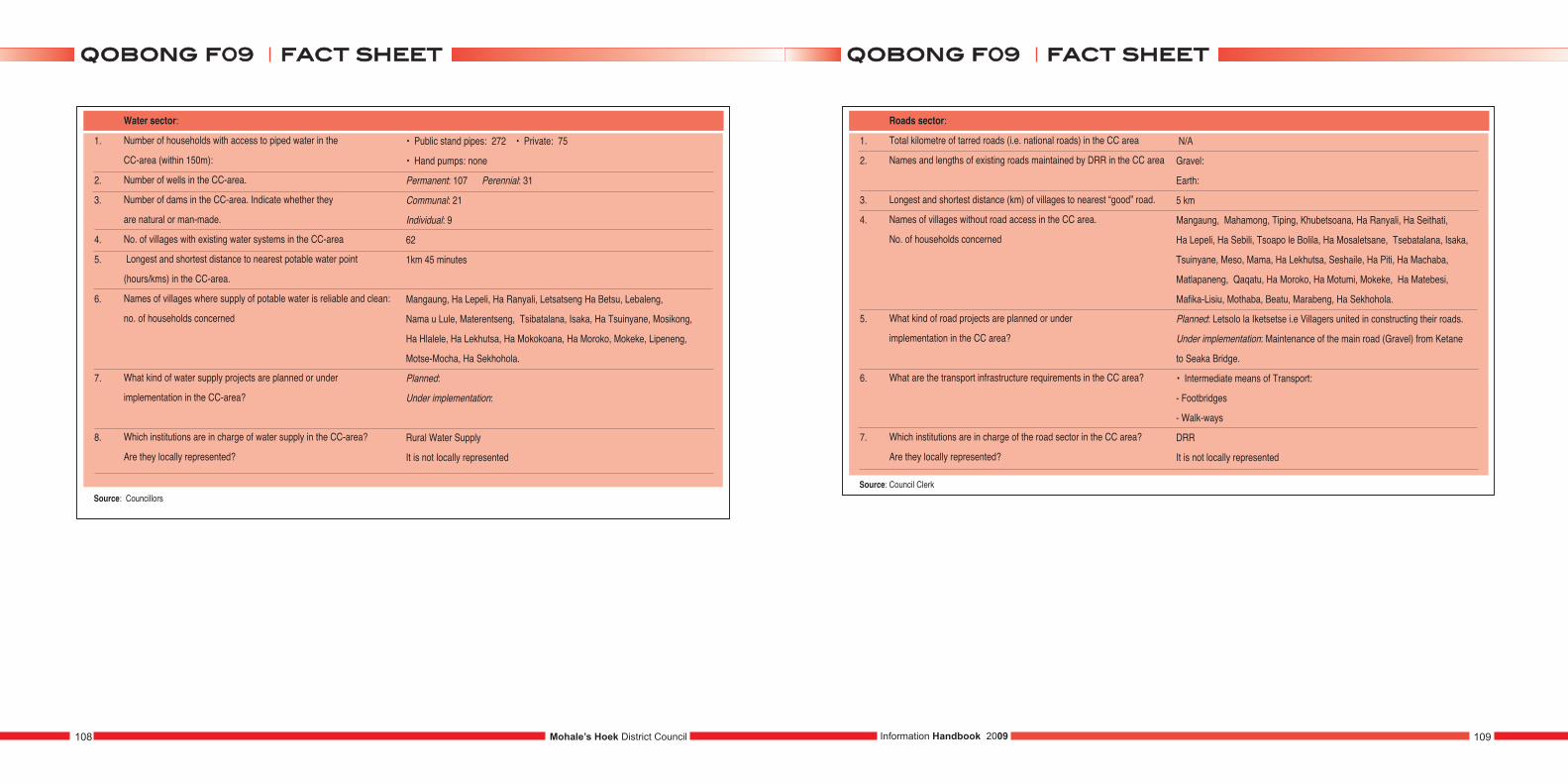
1.
2.
3.
4.
5.
6.
7.
8.
Water sector:
Number of households with access to piped water in the
CC-area (within 150m):
Number of wells in the CC-area.
Number of dams in the CC-area. Indicate whether they
are natural or man-made.
No. of villages with existing water systems in the CC-area
Longest and shortest distance to nearest potable water point
(hours/kms) in the CC-area.
Names of villages where supply of potable water is reliable and clean:
no. of households concerned
What kind of water supply projects are planned or under
implementation in the CC-area?
Which institutions are in charge of water supply in the CC-area?
Are they locally represented?
• Public stand pipes: 272 • Private: 75
• Hand pumps: none
Permanent: 107 Perennial: 31
Communal: 21
Individual: 9
62
1km 45 minutes
Mangaung, Ha Lepeli, Ha Ranyali, Letsatseng Ha Betsu, Lebaleng,
Nama u Lule, Materentseng, Tsibatalana, Isaka, Ha Tsuinyane, Mosikong,
Ha Hlalele, Ha Lekhutsa, Ha Mokokoana, Ha Moroko, Mokeke, Lipeneng,
Motse-Mocha, Ha Sekhohola.
Planned:
Under implementation:
Rural Water Supply
It is not locally represented
Source: Councillors
1.
2.
3.
4.
5.
6.
7.
Roads sector:
Total kilometre of tarred roads (i.e. national roads) in the CC area
Names and lengths of existing roads maintained by DRR in the CC area
Longest and shortest distance (km) of villages to nearest “good” road.
Names of villages without road access in the CC area.
No. of households concerned
What kind of road projects are planned or under
implementation in the CC area?
What are the transport infrastructure requirements in the CC area?
Which institutions are in charge of the road sector in the CC area?
Are they locally represented?
N/A
Gravel:
Earth:
5 km
Mangaung, Mahamong, Tiping, Khubetsoana, Ha Ranyali, Ha Seithati,
Ha Lepeli, Ha Sebili, Tsoapo le Bolila, Ha Mosaletsane, Tsebatalana, Isaka,
Tsuinyane, Meso, Mama, Ha Lekhutsa, Seshaile, Ha Piti, Ha Machaba,
Matlapaneng, Qaqatu, Ha Moroko, Ha Motumi, Mokeke, Ha Matebesi,
Mafika-Lisiu, Mothaba, Beatu, Marabeng, Ha Sekhohola.
Planned: Letsolo la Iketsetse i.e Villagers united in constructing their roads.
Under implementation: Maintenance of the main road (Gravel) from Ketane
to Seaka Bridge.
• Intermediate means of Transport:
- Footbridges
- Walk-ways
DRR
It is not locally represented
Source: Council Clerk
Mohale’s Hoek District Council108 109Information Handbook 2009
ffaacctt sshheeeettqqoobboonngg ff0099 ffaacctt sshheeeettqqoobboonngg ff0099
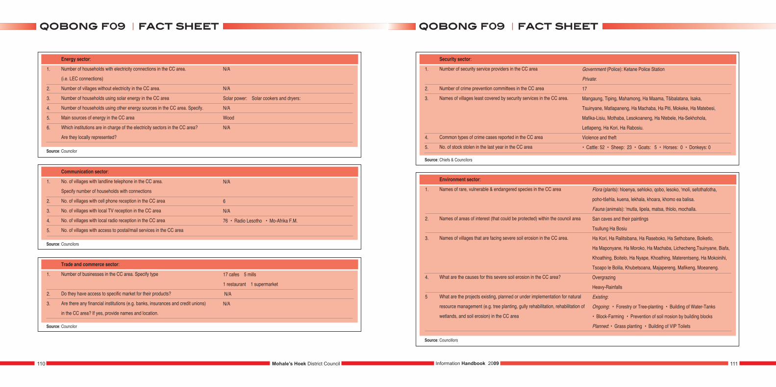
1.
2.
3.
4.
5.
6.
Energy sector:
Number of households with electricity connections in the CC area.
(i.e. LEC connections)
Number of villages without electricity in the CC area.
Number of households using solar energy in the CC area
Number of households using other energy sources in the CC area. Specify.
Main sources of energy in the CC area
Which institutions are in charge of the electricity sectors in the CC area?
Are they locally represented?
Source: Councilor
1.
2.
3.
4.
5.
Communication sector:
No. of villages with landline telephone in the CC area.
Specify number of households with connections
No. of villages with cell phone reception in the CC area
No. of villages with local TV reception in the CC area
No. of villages with local radio reception in the CC area
No. of villages with access to postal/mail services in the CC area
N/A
6
N/A
76 • Radio Lesotho • Mo-Afrika F.M.
Source: Councilors
1.
2.
3.
Trade and commerce sector:
Number of businesses in the CC area. Specify type
Do they have access to specific market for their products?
Are there any financial institutions (e.g. banks, insurances and credit unions)
in the CC area? If yes, provide names and location.
17 cafes 5 mills
1 restaurant 1 supermarket
N/A
N/A
Source: Councilor
N/A
N/A
Solar power: Solar cookers and dryers:
N/A
Wood
N/A
1.
2.
3.
4.
5.
Security sector:
Number of security service providers in the CC area
Number of crime prevention committees in the CC area
Names of villages least covered by security services in the CC area.
Common types of crime cases reported in the CC area
No. of stock stolen in the last year in the CC area
Government (Police): Ketane Police Station
Private:
17
Mangaung, Tiping, Mahamong, Ha Maama, Tšibalatana, Isaka,
Tsuinyane, Matlapaneng, Ha Machaba, Ha Piti, Mokeke, Ha Matebesi,
Mafika-Lisiu, Mothaba, Lesokoaneng, Ha Ntebele, Ha-Sekhohola,
Letlapeng, Ha Kori, Ha Rabosiu.
Violence and theft
• Cattle: 52 • Sheep: 23 • Goats: 5 • Horses: 0 • Donkeys: 0
Source: Chiefs & Councilors
1.
2.
3.
4.
5
Environment sector:
Names of rare, vulnerable & endangered species in the CC area
Names of areas of interest (that could be protected) within the council area
Names of villages that are facing severe soil erosion in the CC area.
What are the causes for this severe soil erosion in the CC area?
What are the projects existing, planned or under implementation for natural
resource management (e.g. tree planting, gully rehabilitation, rehabilitation of
wetlands, and soil erosion) in the CC area
Source: Councillors
Flora (plants): hloenya, sehloko, qobo, lesoko, ‘moli, sefothafotha,
poho-tšehla, kuena, lekhala, khoara, khomo ea balisa.
Fauna (animals): ‘mutla, lipela, matsa, thlolo, mochalla.
San caves and their paintings
Tsullung Ha Bosiu
Ha Kori, Ha Ralitsibana, Ha Raseboko, Ha Sethobane, Boiketlo,
Ha Maponyane, Ha Moroko, Ha Machaba, Lichecheng,Tsuinyane, Biafa,
Khoathing, Boitelo, Ha Nyape, Khoathing, Materentseng, Ha Mokoinihi,
Tsoapo le Bolila, Khubetsoana, Majapereng, Mafikeng, Moeaneng.
Overgrazing
Heavy-Rainfalls
Existing:
Ongoing: • Forestry or Tree-planting • Building of Water-Tanks
• Block-Farming • Prevention of soil rrosion by building blocks
Planned: • Grass planting • Building of VIP Toilets
Mohale’s Hoek District Council110 111Information Handbook 2009
ffaacctt sshheeeettqqoobboonngg ff0099 ffaacctt sshheeeettqqoobboonngg ff0099
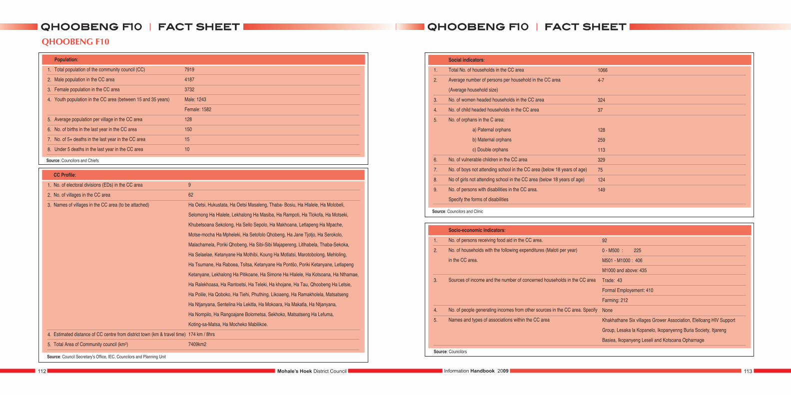
QHOOBENG F10
1.
2.
3.
4.
5.
6.
7.
8.
Population:
Total population of the community council (CC)
Male population in the CC area
Female population in the CC area
Youth population in the CC area (between 15 and 35 years)
Average population per village in the CC area
No. of births in the last year in the CC area
No. of 5+ deaths in the last year in the CC area
Under 5 deaths in the last year in the CC area
7919
4187
3732
Male: 1243
Female: 1582
128
150
15
10
1.
2.
3.
4.
5.
CC Profile:
No. of electoral divisions (EDs) in the CC area
No. of villages in the CC area
Names of villages in the CC area (to be attached)
Estimated distance of CC centre from district town (km & travel time)
Total Area of Community council (km2)
9
62
Ha Oetsi, Hukustata, Ha Oetsi Masaleng, Thaba- Bosiu, Ha Hlalele, Ha Molobeli,
Selomong Ha Hlalele, Lekhalong Ha Masiba, Ha Rampoti, Ha Tlokofa, Ha Motseki,
Khubetsoana Sekolong, Ha Sello Sepolo, Ha Makhoana, Letlapeng Ha Mpache,
Motse-mocha Ha Mpheleki, Ha Setofolo Qhobeng, Ha Jane Tjotjo, Ha Serokolo,
Malachamela, Poriki Qhobeng, Ha Sibi-Sibi Majapereng, Litlhabela, Thaba-Sekoka,
Ha Selaelae, Ketanyane Ha Mothibi, Koung Ha Motlatsi, Marotobolong, Mehloling,
Ha Tsumane, Ha Raboea, Tsitsa, Ketanyane Ha Pontšo, Poriki Ketanyane, Letlapeng
Ketanyane, Lekhalong Ha Pitikoane, Ha Simone Ha Hlalele, Ha Kotsoana, Ha Nthamae,
Ha Ralekhoasa, Ha Rantoetsi, Ha Teleki, Ha khojane, Ha Tau, Qhoobeng Ha Letsie,
Ha Polile, Ha Qoboko, Ha Tiehi, Phuthing, Likoaeng, Ha Ramakholela, Matsatseng
Ha Ntjanyana, Sentelina Ha Lekitla, Ha Mokoara, Ha Makatla, Ha Ntjanyana,
Ha Nompilo, Ha Rangoajane Bolometsa, Sekhoko, Matsatseng Ha Lefuma,
Koting-sa-Matsa, Ha Mocheko Mabilikoe.
174 km / 8hrs
7409km2
1.
2.
3.
4.
5.
6.
7.
8.
9.
Social indicators:
Total No. of households in the CC area
Average number of persons per household in the CC area
(Average household size)
No. of women headed households in the CC area
No. of child headed households in the CC area
No. of orphans in the C area:
a) Paternal orphans
b) Maternal orphans
c) Double orphans
No. of vulnerable children in the CC area
No. of boys not attending school in the CC area (below 18 years of age)
No of girls not attending school in the CC area (below 18 years of age)
No. of persons with disabilities in the CC area.
Specify the forms of disabilities
1066
4-7
324
37
128
259
113
329
75
124
149
1.
2.
3.
4.
5.
Socio-economic indicators:
No. of persons receiving food aid in the CC area.
No. of households with the following expenditures (Maloti per year)
in the CC area.
Sources of income and the number of concerned households in the CC area
No. of people generating incomes from other sources in the CC area. Specify
Names and types of associations within the CC area
92
0 - M500 : 225
M501 - M1000 : 406
M1000 and above: 435
Trade: 43
Formal Employement: 410
Farming: 212
None
Khakhathane Six villages Grower Association, Elelloang HIV Support
Group, Lesaka la Kopanelo, Ikopanyenng Buria Society, Itjareng
Basiea, Ikopanyeng Leseli and Kotsoana Opharnage
Mohale’s Hoek District Council112 113Information Handbook 2009
ffaacctt sshheeeettqqhhoooobbeenngg ff1100 ffaacctt sshheeeettqqhhoooobbeenngg ff1100
Source: Councilors and Clinic
Source: Councilors
Source: Councilors and Chiefs
Source: Council Secretary’s Office, IEC, Councilors and Planning Unit
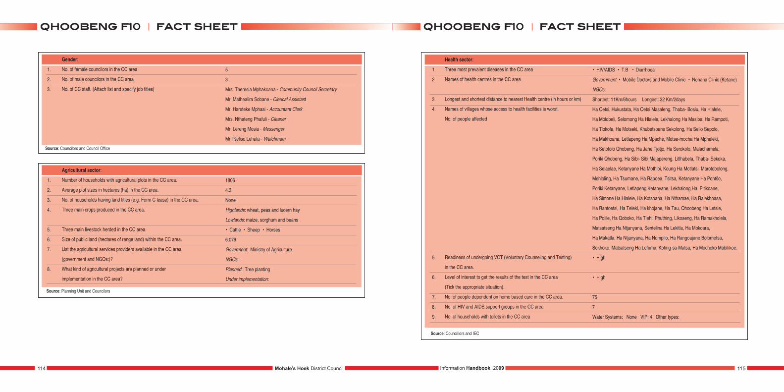
1.
2.
3.
Gender:
No. of female councilors in the CC area
No. of male councilors in the CC area
No. of CC staff. (Attach list and specify job titles)
5
3
Mrs. Theresia Mphakoana - Community Council Secretary
Mr. Mathealira Sobane - Clerical Assistant
Mr. Hareteke Mphasi - Accountant Clerk
Mrs. Nthateng Phafuli - Cleaner
Mr. Lereng Mosia - Messenger
Mr Tšeliso Lehata - Watchmam
1.
2.
3.
4.
5.
6.
7.
8.
Agricultural sector:
Number of households with agricultural plots in the CC area.
Average plot sizes in hectares (ha) in the CC area.
No. of households having land titles (e.g. Form C lease) in the CC area.
Three main crops produced in the CC area.
Three main livestock herded in the CC area.
Size of public land (hectares of range land) within the CC area.
List the agricultural services providers available in the CC area
(government and NGOs:)?
What kind of agricultural projects are planned or under
implementation in the CC area?
1806
4.3
None
Highlands: wheat, peas and lucern hay
Lowlands: maize, sorghum and beans
• Cattle • Sheep • Horses
6.079
Goverment: Ministry of Agriculture
NGOs:
Planned: Tree planting
Under implementation:
1.
2.
3.
4.
5.
6.
7.
8.
9.
Health sector:
Three most prevalent diseases in the CC area
Names of health centres in the CC area
Longest and shortest distance to nearest Health centre (in hours or km)
Names of villages whose access to health facilities is worst.
No. of people affected
Readiness of undergoing VCT (Voluntary Counseling and Testing)
in the CC area.
Level of interest to get the results of the test in the CC area
(Tick the appropriate situation).
No. of people dependent on home based care in the CC area.
No. of HIV and AIDS support groups in the CC area
No. of households with toilets in the CC area
• HIV/AIDS • T.B • Diarrhoea
Government: • Mobile Doctors and Mobile Clinic • Nohana Clinic (Ketane)
NGOs:
Shortest: 11Km/6hours Longest: 32 Km/2days
Ha Oetsi, Hukustata, Ha Oetsi Masaleng, Thaba- Bosiu, Ha Hlalele,
Ha Molobeli, Selomong Ha Hlalele, Lekhalong Ha Masiba, Ha Rampoti,
Ha Tlokofa, Ha Motseki, Khubetsoans Sekolong, Ha Sello Sepolo,
Ha Makhoana, Letlapeng Ha Mpache, Motse-mocha Ha Mpheleki,
Ha Setofolo Qhobeng, Ha Jane Tjotjo, Ha Serokolo, Malachamela,
Poriki Qhobeng, Ha Sibi- Sibi Majapereng, Litlhabela, Thaba- Sekoka,
Ha Selaelae, Ketanyane Ha Mothibi, Koung Ha Motlatsi, Marotobolong,
Mehloling, Ha Tsumane, Ha Raboea, Tsitsa, Ketanyane Ha Pontšo,
Poriki Ketanyane, Letlapeng Ketanyane, Lekhalong Ha Pitikoane,
Ha Simone Ha Hlalele, Ha Kotsoana, Ha Nthamae, Ha Ralekhoasa,
Ha Rantoetsi, Ha Teleki, Ha khojane, Ha Tau, Qhoobeng Ha Letsie,
Ha Polile, Ha Qoboko, Ha Tiehi, Phuthing, Likoaeng, Ha Ramakholela,
Matsatseng Ha Ntjanyana, Sentelina Ha Lekitla, Ha Mokoara,
Ha Makatla, Ha Ntjanyana, Ha Nompilo, Ha Rangoajane Bolometsa,
Sekhoko, Matsatseng Ha Lefuma, Koting-sa-Matsa, Ha Mocheko Mabilikoe.
• High
• High
75
7
Water Systems: None VIP: 4 Other types:
Source: Councillors and IEC
Mohale’s Hoek District Council114 115Information Handbook 2009
ffaacctt sshheeeettqqhhoooobbeenngg ff1100 ffaacctt sshheeeettqqhhoooobbeenngg ff1100
Source: Councilors and Council Office
Source: Planning Unit and Councilors
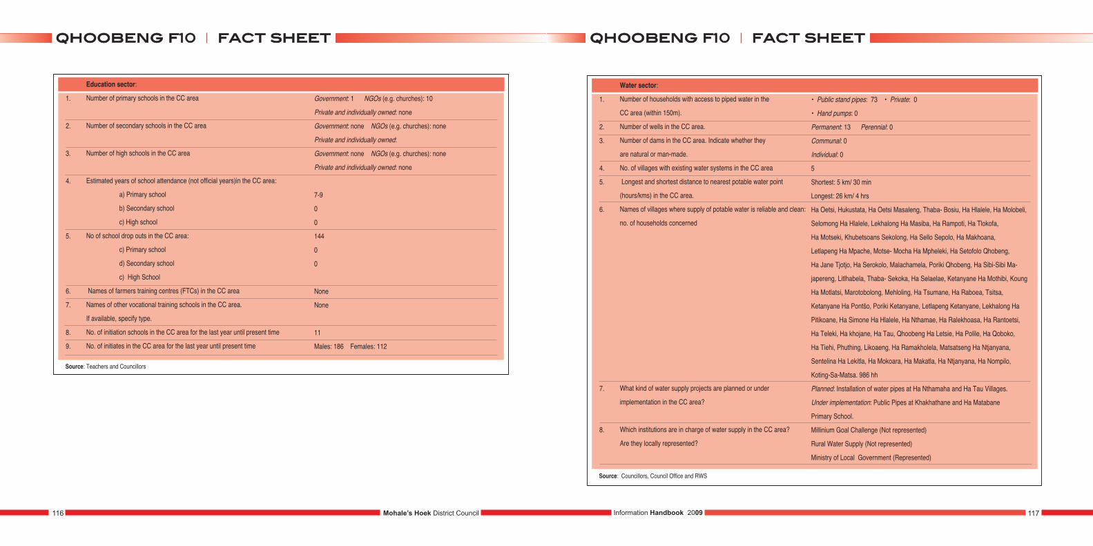
1.
2.
3.
4.
5.
6.
7.
8.
9.
Education sector:
Number of primary schools in the CC area
Number of secondary schools in the CC area
Number of high schools in the CC area
Estimated years of school attendance (not official years)in the CC area:
a) Primary school
b) Secondary school
c) High school
No of school drop outs in the CC area:
c) Primary school
d) Secondary school
c) High School
Names of farmers training centres (FTCs) in the CC area
Names of other vocational training schools in the CC area.
If available, specify type.
No. of initiation schools in the CC area for the last year until present time
No. of initiates in the CC area for the last year until present time
Government: 1 NGOs (e.g. churches): 10
Private and individually owned: none
Government: none NGOs (e.g. churches): none
Private and individually owned:
Government: none NGOs (e.g. churches): none
Private and individually owned: none
7-9
0
0
144
0
0
None
None
11
Males: 186 Females: 112
Source: Teachers and Councillors
1.
2.
3.
4.
5.
6.
7.
8.
Water sector:
Number of households with access to piped water in the
CC area (within 150m).
Number of wells in the CC area.
Number of dams in the CC area. Indicate whether they
are natural or man-made.
No. of villages with existing water systems in the CC area
Longest and shortest distance to nearest potable water point
(hours/kms) in the CC area.
Names of villages where supply of potable water is reliable and clean:
no. of households concerned
What kind of water supply projects are planned or under
implementation in the CC area?
Which institutions are in charge of water supply in the CC area?
Are they locally represented?
• Public stand pipes: 73 • Private: 0
• Hand pumps: 0
Permanent: 13 Perennial: 0
Communal: 0
Individual: 0
5
Shortest: 5 km/ 30 min
Longest: 26 km/ 4 hrs
Ha Oetsi, Hukustata, Ha Oetsi Masaleng, Thaba- Bosiu, Ha Hlalele, Ha Molobeli,
Selomong Ha Hlalele, Lekhalong Ha Masiba, Ha Rampoti, Ha Tlokofa,
Ha Motseki, Khubetsoans Sekolong, Ha Sello Sepolo, Ha Makhoana,
Letlapeng Ha Mpache, Motse- Mocha Ha Mpheleki, Ha Setofolo Qhobeng,
Ha Jane Tjotjo, Ha Serokolo, Malachamela, Poriki Qhobeng, Ha Sibi-Sibi Ma-
japereng, Litlhabela, Thaba- Sekoka, Ha Selaelae, Ketanyane Ha Mothibi, Koung
Ha Motlatsi, Marotobolong, Mehloling, Ha Tsumane, Ha Raboea, Tsitsa,
Ketanyane Ha Pontšo, Poriki Ketanyane, Letlapeng Ketanyane, Lekhalong Ha
Pitikoane, Ha Simone Ha Hlalele, Ha Nthamae, Ha Ralekhoasa, Ha Rantoetsi,
Ha Teleki, Ha khojane, Ha Tau, Qhoobeng Ha Letsie, Ha Polile, Ha Qoboko,
Ha Tiehi, Phuthing, Likoaeng, Ha Ramakholela, Matsatseng Ha Ntjanyana,
Sentelina Ha Lekitla, Ha Mokoara, Ha Makatla, Ha Ntjanyana, Ha Nompilo,
Koting-Sa-Matsa. 986 hh
Planned: Installation of water pipes at Ha Nthamaha and Ha Tau Villages.
Under implementation: Public Pipes at Khakhathane and Ha Matabane
Primary School.
Millinium Goal Challenge (Not represented)
Rural Water Supply (Not represented)
Ministry of Local Government (Represented)
Source: Councillors, Council Office and RWS
Mohale’s Hoek District Council116 117Information Handbook 2009
ffaacctt sshheeeettqqhhoooobbeenngg ff1100 ffaacctt sshheeeettqqhhoooobbeenngg ff1100
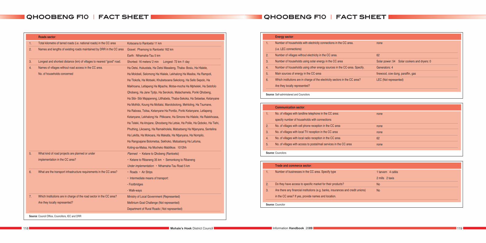
1.
2.
3.
4.
5.
6.
7.
Roads sector:
Total kilometre of tarred roads (i.e. national roads) in the CC area
Names and lengths of existing roads maintained by DRR in the CC area
Longest and shortest distance (km) of villages to nearest “good” road.
Names of villages without road access in the CC area.
No. of households concerned
What kind of road projects are planned or under
implementation in the CC area?
What are the transport infrastructure requirements in the CC area?
Which Institutions are in charge of the road sector in the CC area?
Are they locally represented?
Kotsoana to Rantoetsi 11 km
Gravel: Phamong to Rantoetsi 162 km
Earth: Nthamaha-Tau 5 km
Shortest: 16 meters/ 2 min Longest: 72 km /1 day
Ha Oetsi, Hukustata, Ha Oetsi Masaleng, Thaba- Bosiu, Ha Hlalele,
Ha Molobeli, Selomong Ha Hlalele, Lekhalong Ha Masiba, Ha Rampoti,
Ha Tlokofa, Ha Motseki, Khubetsoana Sekolong, Ha Sello Sepolo, Ha
Makhoana, Letlapeng Ha Mpache, Motse-mocha Ha Mpheleki, Ha Setofolo
Qhobeng, Ha Jane Tjotjo, Ha Serokolo, Malachamela, Poriki Qhobeng,
Ha Sibi- Sibi Majapereng, Litlhabela, Thaba-Sekoka, Ha Selaelae, Ketanyane
Ha Mothibi, Koung Ha Motlatsi, Marotobolong, Mehloling, Ha Tsumane,
Ha Raboea, Tsitsa, Ketanyane Ha Pontšo, Poriki Ketanyane, Letlapeng
Ketanyane, Lekhalong Ha Pitikoane, Ha Simone Ha Hlalele, Ha Ralekhoasa,
Ha Teleki, Ha khojane, Qhoobeng Ha Letsie, Ha Polile, Ha Qoboko, Ha Tiehi,
Phuthing, Likoaeng, Ha Ramakholela, Matsatseng Ha Ntjanyana, Sentelina
Ha Lekitla, Ha Mokoara, Ha Makatla, Ha Ntjanyana, Ha Nompilo,
Ha Rangoajane Bolometsa, Sekhoko, Matsatseng Ha Lefuma,
Koting-sa-Matsa, Ha Mocheko Mabilikoe. 1012hh
Planned: • Ketane to Qhobeng (Rantoetsi)
• Ketane to Ribaneng 35 km • Semonkong to Ribaneng
Under implementation: • Nthamaha-Tau Road 5 km
• Roads • Air Strips
• Intermediate means of transport:
- Footbridges
- Walk-ways
Ministry of Local Government (Represented)
Mellinium Goal Challenge (Not represented)
Department of Rural Roads ( Not represented)
Source: Council Office, Councillors, IEC and DRR
1.
2.
3.
4.
5.
6.
Energy sector:
Number of households with electricity connections in the CC area.
(i.e. LEC connections)
Number of villages without electricity in the CC area.
Number of households using solar energy in the CC area
Number of households using other energy sources in the CC-area. Specify.
Main sources of energy in the CC-area
Which institutions are in charge of the electricity sectors in the CC area?
Are they locally represented?
Source: Self-administered and Councilors
1.
2.
3.
4.
5.
Communication sector:
No. of villages with landline telephone in the CC area:
specify number of households with connections
No. of villages with cell phone reception in the CC area
No. of villages with local TV reception in the CC area
No. of villages with local radio reception in the CC area
No. of villages with access to postal/mail services in the CC area
none
none
none
62
none
Source: Councilors
1.
2.
3.
Trade and commerce sector:
Number of businesses in the CC area. Specify type
Do they have access to specific market for their products?
Are there any financial institutions (e.g. banks, insurances and credit unions)
in the CC area? If yes, provide names and location.
1 tarvern 4 cafés
2 mills 2 taxis
No
No
Source: Councilor
none
62
Solar power: 54 Solar cookers and dryers: 0
Generators: 4
firewood, cow dung, paraffin, gas
LEC (Not represented)
Mohale’s Hoek District Council118 119Information Handbook 2009
ffaacctt sshheeeettqqhhoooobbeenngg ff1100 ffaacctt sshheeeettqqhhoooobbeenngg ff1100
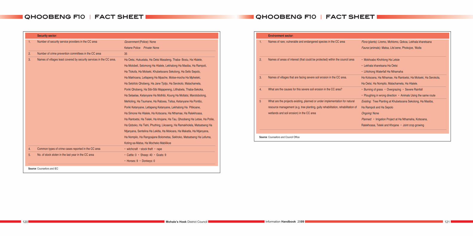
1.
2.
3.
4.
5.
Security sector:
Number of security service providers in the CC area
Number of crime prevention committees in the CC area
Names of villages least covered by security services in the CC area.
Common types of crime cases reported in the CC area
No. of stock stolen in the last year in the CC area
Government (Police): None
Ketane Police Private: None
35
Ha Oetsi, Hukustata, Ha Oetsi Masaleng, Thaba- Bosiu, Ha Hlalele,
Ha Molobeli, Selomong Ha Hlalele, Lekhalong Ha Masiba, Ha Rampoti,
Ha Tlokofa, Ha Motseki, Khubetsoans Sekolong, Ha Sello Sepolo,
Ha Makhoana, Letlapeng Ha Mpache, Motse-mocha Ha Mpheleki,
Ha Setofolo Qhobeng, Ha Jane Tjotjo, Ha Serokolo, Malachamela,
Poriki Qhobeng, Ha Sibi-Sibi Majapereng, Litlhabela, Thaba-Sekoka,
Ha Selaelae, Ketanyane Ha Mothibi, Koung Ha Motlatsi, Marotobolong,
Mehloling, Ha Tsumane, Ha Raboea, Tsitsa, Ketanyane Ha Pontšo,
Poriki Ketanyane, Letlapeng Ketanyane, Lekhalong Ha Pitikoane,
Ha Simone Ha Hlalele, Ha Kotsoana, Ha Nthamae, Ha Ralekhoasa,
Ha Rantoetsi, Ha Teleki, Ha khojane, Ha Tau, Qhoobeng Ha Letsie, Ha Polile,
Ha Qoboko, Ha Tiehi, Phuthing, Likoaeng, Ha Ramakholela, Matsatseng Ha
Ntjanyana, Sentelina Ha Lekitla, Ha Mokoara, Ha Makatla, Ha Ntjanyana,
Ha Nompilo, Ha Rangoajane Bolometsa, Sekhoko, Matsatseng Ha Lefuma,
Koting-sa-Matsa, Ha Mocheko Mabilikoe
• witchcraft • stock theft • rape
• Cattle: 0 • Sheep: 40 • Goats: 9
• Horses: 9 • Donkeys: 0
Source: Counsellors and IEC
1.
2.
3.
4.
5
Environment sector:
Names of rare, vulnerable and endangered species in the CC area
Names of areas of interest (that could be protected) within the council area
Names of villages that are facing severe soil erosion in the CC area.
What are the causes for this severe soil erosion in the CC area?
What are the projects existing, planned or under implementation for natural
resource management (e.g. tree planting, gully rehabilitation, rehabilitation of
wetlands and soil erosion) in the CC area
Source: Counsellors and Council Office
Flora (plants): Liremo, Mohlomo, Qokoa, Lekhala kharetsana
Fauna (animals): Matsa, Lits’oene, Phokojoe, ‘Mutla
• Mokhoabo Khohlong Ha Letsie
• Lekhala kharetsana Ha Oetsi
• Lihlohong Waterfall Ha Nthamaha
Ha Kotsoana, Ha Nthamae, Ha Rantoetsi, Ha Motseki, Ha Serokola,
Ha Oetsi, Ha Nompilo, Malachamela, Ha Hlalele.
• Burning of grass • Overgrazing • Severe Rainfall
• Ploughing in wrong direction • Animals Using the same route
Existing: Tree Planting at Khubetsoana Sekolong, Ha Masiba,
Ha Rampoti and Ha Sepolo
Ongoing: None
Planned: • Irrigation Project at Ha Nthamaha, Kotsoana,
Ralekhoasa, Teleki and Khojane • Joint crop growing
Mohale’s Hoek District Council120 121Information Handbook 2009
ffaacctt sshheeeettqqhhoooobbeenngg ff1100 ffaacctt sshheeeettqqhhoooobbeenngg ff1100
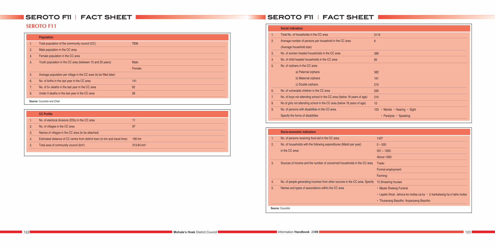
SEROTO F11
1.
2.
3.
4.
5.
6.
7.
8.
Population:
Total population of the community council (CC)
Male population in the CC area
Female population in the CC area
Youth population in the CC area (between 15 and 35 years)
Average population per village in the CC area (to be filled later)
No. of births in the last year in the CC area
No. of 5+ deaths in the last year in the CC area
Under 5 deaths in the last year in the CC area
7836
Male:
Female:
141
92
38
1.
2.
3.
4.
5.
CC Profile:
No. of electoral divisions (EDs) in the CC area
No. of villages in the CC area
Names of villages in the CC area (to be attached)
Estimated distance of CC centre from district town (in km and travel time)
Total area of community council (km2)
11
87
166 km
313.84 km2
1.
2.
3.
4.
5.
6.
7.
8.
9.
Social indicators:
Total No. of households in the CC area
Average number of persons per household in the CC area
(Average household size)
No. of women headed households in the CC area
No. of child headed households in the CC area
No. of orphans in the CC area:
a) Paternal orphans
b) Maternal orphans
c) Double orphans
No. of vulnerable children in the CC area
No. of boys not attending school in the CC area (below 18 years of age)
No of girls not attending school in the CC area (below 18 years of age)
No. of persons with disabilities in the CC-area.
Specify the forms of disabilities
3119
6
389
95
582
161
210
295
210
10
103 • Mental • Hearing • Sight
• Paralysis • Speaking
1.
2.
3.
4.
5.
Socio-economic indicators:
No. of persons receiving food aid in the CC area.
No. of households with the following expenditures (Maloti per year)
in the CC area:
Sources of income and the number of concerned households in the CC area
No. of people generating incomes from other sources in the CC area. Specify
Names and types of associations within the CC area
1437
0 – 500:
501 – 1000:
Above 1000:
Trade:
Formal employment:
Farming:
15 Smearing houses
• Mpate Sheleng Funeral
• Lepeto lihoai Jehova ke molisa oa ka • U kanketsang ha e hahe motse
• Thusanang Basotho Ikopanyeng Basotho
Mohale’s Hoek District Council122 123Information Handbook 2009
ffaacctt sshheeeettsseerroottoo ff1111 ffaacctt sshheeeettsseerroottoo ff1111
Source: Councilor and Chief
Source: Councilor
1.
2.
3.
Gender:
No. of female councilors in the CC area
No. of male councilors in the CC area
No. of CC staf. (Attach list and specify job titles)
4
7
1.
2.
3.
4.
5.
6.
7.
8.
Agricultural sector:
Number of households with agricultural plots in the CC area.
Average plot sizes in hectares (ha) in the CC area.
No. of households having land titles (e.g. Form C lease) in the CC area.
Three main crops produced in the CC area.
Three main livestock herded in the CC area.
Size of public land (hectares of range land) within the CC area.
List the agricultural services providers available in the CC area
(government and NGOs:)?
What kind of agricultural projects are planned or under
implementation in the CC area?
2618
1.21 hectares
408
• Sorghum • Maize
• Beans
• Cows • Sheep • Horses
Government: Ministry of Agric
NGOs: • Serumula • MOVE
Planned: • Block farming • Potato planting • Vegetable planting
Under implementation: • Mantloane
1.
2.
3.
4.
5.
6.
7.
8.
9.
Health sector:
Three most prevalent diseases in the CC area
Names of health centres in the CC area
Longest and shortest distance to nearest Health centre (in hours or km)
Names of villages whose access to health facilities is worst.
No. of people affected
Readiness of undergoing VCT (Voluntary Counseling and Testing)
in the CC area.
Level of interest to get the results of the test in the CC area
(Tick the appropriate situation).
No. of people dependent on home based care in the CC area.
No. of HIV and AIDS support groups in the CC area
No. of households with toilets in the CC area
• HIV/AIDS • T.B • Diarrhoea
Government: •
NGOs: Serumula
2 km to 21km
• High • Medium
• Low
• High • Medium
• Low
324
61
Water Systems: VIP: 140 Other types: 160
Source: Councillor
Mohale’s Hoek District Council124 125Information Handbook 2009
ffaacctt sshheeeettsseerroottoo ff1111 ffaacctt sshheeeettsseerroottoo ff1111
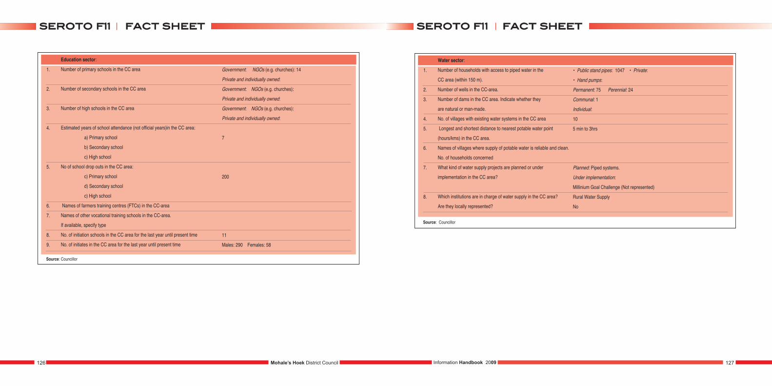
1.
2.
3.
4.
5.
6.
7.
8.
9.
Education sector:
Number of primary schools in the CC area
Number of secondary schools in the CC area
Number of high schools in the CC area
Estimated years of school attendance (not official years)in the CC area:
a) Primary school
b) Secondary school
c) High school
No of school drop outs in the CC area:
c) Primary school
d) Secondary school
c) High school
Names of farmers training centres (FTCs) in the CC-area
Names of other vocational training schools in the CC-area.
If available, specify type
No. of initiation schools in the CC area for the last year until present time
No. of initiates in the CC area for the last year until present time
Government: NGOs (e.g. churches): 14
Private and individually owned:
Government: NGOs (e.g. churches):
Private and individually owned:
Government: NGOs (e.g. churches):
Private and individually owned:
7
200
11
Males: 290 Females: 58
Source: Councillor
1.
2.
3.
4.
5.
6.
7.
8.
Water sector:
Number of households with access to piped water in the
CC area (within 150 m).
Number of wells in the CC-area.
Number of dams in the CC area. Indicate whether they
are natural or man-made.
No. of villages with existing water systems in the CC area
Longest and shortest distance to nearest potable water point
(hours/kms) in the CC area.
Names of villages where supply of potable water is reliable and clean.
No. of households concerned
What kind of water supply projects are planned or under
implementation in the CC area?
Which institutions are in charge of water supply in the CC area?
Are they locally represented?
• Public stand pipes: 1047 • Private:
• Hand pumps:
Permanent: 75 Perennial: 24
Communal: 1
Individual:
10
5 min to 3hrs
Planned: Piped systems.
Under implementation:
Millinium Goal Challenge (Not represented)
Rural Water Supply
No
Source: Councillor
Mohale’s Hoek District Council126 127Information Handbook 2009
ffaacctt sshheeeettsseerroottoo ff1111 ffaacctt sshheeeettsseerroottoo ff1111
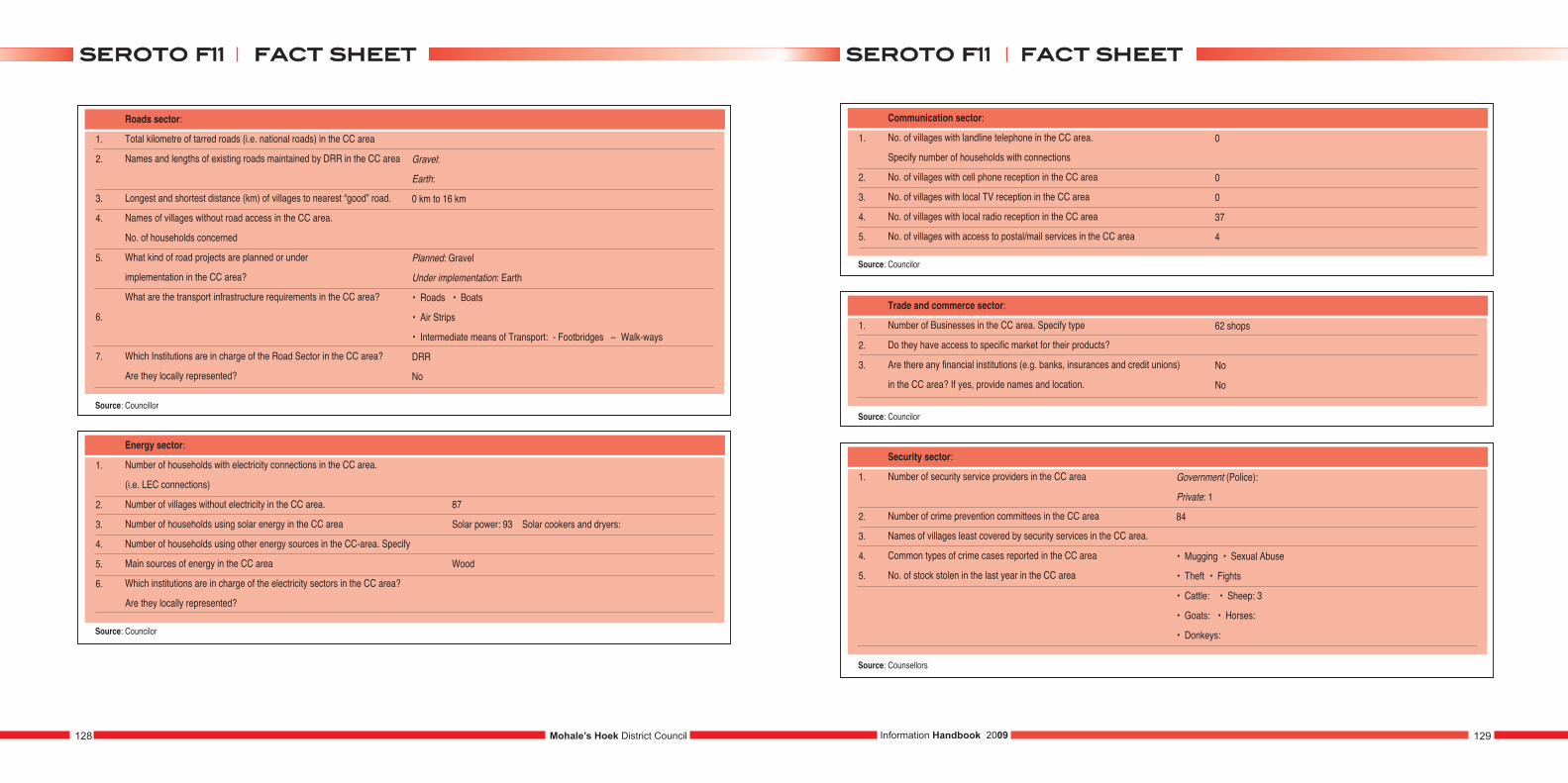
1.
2.
3.
4.
5.
6.
7.
Roads sector:
Total kilometre of tarred roads (i.e. national roads) in the CC area
Names and lengths of existing roads maintained by DRR in the CC area
Longest and shortest distance (km) of villages to nearest “good” road.
Names of villages without road access in the CC area.
No. of households concerned
What kind of road projects are planned or under
implementation in the CC area?
What are the transport infrastructure requirements in the CC area?
Which Institutions are in charge of the Road Sector in the CC area?
Are they locally represented?
Gravel:
Earth:
0 km to 16 km
Planned: Gravel
Under implementation: Earth
• Roads • Boats
• Air Strips
• Intermediate means of Transport: - Footbridges – Walk-ways
DRR
No
Source: Councillor
1.
2.
3.
4.
5.
6.
Energy sector:
Number of households with electricity connections in the CC area.
(i.e. LEC connections)
Number of villages without electricity in the CC area.
Number of households using solar energy in the CC area
Number of households using other energy sources in the CC-area. Specify
Main sources of energy in the CC area
Which institutions are in charge of the electricity sectors in the CC area?
Are they locally represented?
Source: Councilor
1.
2.
3.
4.
5.
Communication sector:
No. of villages with landline telephone in the CC area.
Specify number of households with connections
No. of villages with cell phone reception in the CC area
No. of villages with local TV reception in the CC area
No. of villages with local radio reception in the CC area
No. of villages with access to postal/mail services in the CC area
0
0
0
37
4
Source: Councilor
1.
2.
3.
Trade and commerce sector:
Number of Businesses in the CC area. Specify type
Do they have access to specific market for their products?
Are there any financial institutions (e.g. banks, insurances and credit unions)
in the CC area? If yes, provide names and location.
62 shops
No
No
Source: Councilor
87
Solar power: 93 Solar cookers and dryers:
Wood
1.
2.
3.
4.
5.
Security sector:
Number of security service providers in the CC area
Number of crime prevention committees in the CC area
Names of villages least covered by security services in the CC area.
Common types of crime cases reported in the CC area
No. of stock stolen in the last year in the CC area
Government (Police):
Private: 1
84
• Mugging • Sexual Abuse
• Theft • Fights
• Cattle: • Sheep: 3
• Goats: • Horses:
• Donkeys:
Source: Counsellors
Mohale’s Hoek District Council128 129Information Handbook 2009
ffaacctt sshheeeettsseerroottoo ff1111 ffaacctt sshheeeettsseerroottoo ff1111
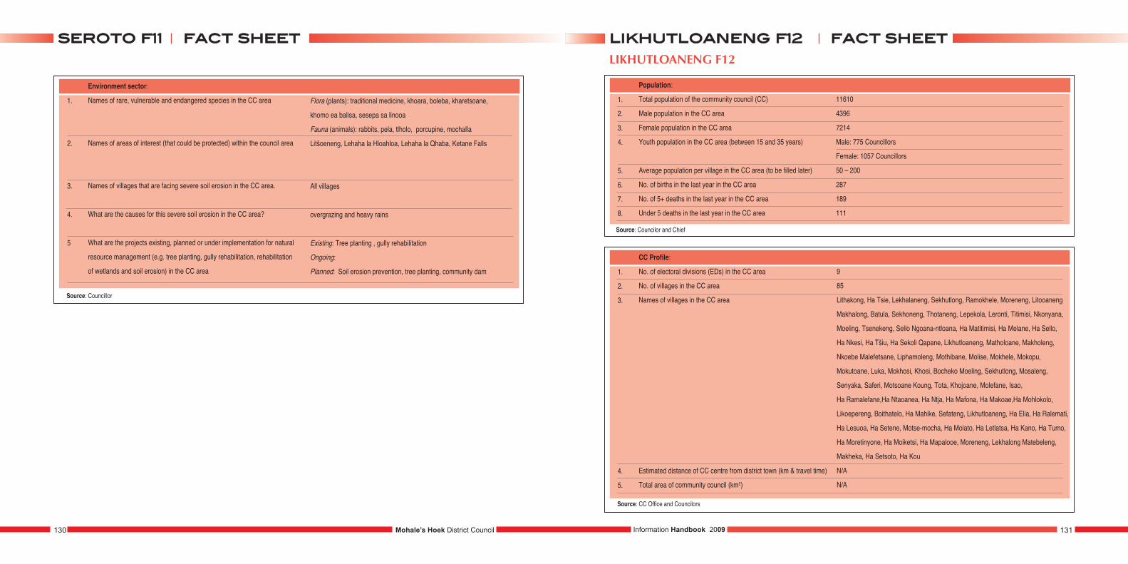
1.
2.
3.
4.
5
Environment sector:
Names of rare, vulnerable and endangered species in the CC area
Names of areas of interest (that could be protected) within the council area
Names of villages that are facing severe soil erosion in the CC area.
What are the causes for this severe soil erosion in the CC area?
What are the projects existing, planned or under implementation for natural
resource management (e.g. tree planting, gully rehabilitation, rehabilitation
of wetlands and soil erosion) in the CC area
Source: Councillor
Flora (plants): traditional medicine, khoara, boleba, kharetsoane,
khomo ea balisa, sesepa sa linooa
Fauna (animals): rabbits, pela, tlholo, porcupine, mochalla
Litšoeneng, Lehaha la Hloahloa, Lehaha la Qhaba, Ketane Falls
All villages
overgrazing and heavy rains
Existing: Tree planting , gully rehabilitation
Ongoing:
Planned: Soil erosion prevention, tree planting, community dam
LIKHUTLOANENG F12
1.
2.
3.
4.
5.
6.
7.
8.
Population:
Total population of the community council (CC)
Male population in the CC area
Female population in the CC area
Youth population in the CC area (between 15 and 35 years)
Average population per village in the CC area (to be filled later)
No. of births in the last year in the CC area
No. of 5+ deaths in the last year in the CC area
Under 5 deaths in the last year in the CC area
11610
4396
7214
Male: 775 Councillors
Female: 1057 Councillors
50 – 200
287
189
111
1.
2.
3.
4.
5.
CC Profile:
No. of electoral divisions (EDs) in the CC area
No. of villages in the CC area
Names of villages in the CC area
Estimated distance of CC centre from district town (km & travel time)
Total area of community council (km2)
9
85
Lithakong, Ha Tsie, Lekhalaneng, Sekhutlong, Ramokhele, Moreneng, Litooaneng
Makhalong, Batula, Sekhoneng, Thotaneng, Lepekola, Leronti, Titimisi, Nkonyana,
Moeling, Tsenekeng, Sello Ngoana-ntloana, Ha Matitimisi, Ha Melane, Ha Sello,
Ha Nkesi, Ha Tšiu, Ha Sekoli Qapane, Likhutloaneng, Matholoane, Makholeng,
Nkoebe Malefetsane, Liphamoleng, Mothibane, Molise, Mokhele, Mokopu,
Mokutoane, Luka, Mokhosi, Khosi, Bocheko Moeling, Sekhutlong, Mosaleng,
Senyaka, Saferi, Motsoane Koung, Tota, Khojoane, Molefane, Isao,
Ha Ramalefane,Ha Ntaoanea, Ha Ntja, Ha Mafona, Ha Makoae,Ha Mohlokolo,
Likoepereng, Boithatelo, Ha Mahike, Sefateng, Likhutloaneng, Ha Elia, Ha Ralemati,
Ha Lesuoa, Ha Setene, Motse-mocha, Ha Molato, Ha Letlatsa, Ha Kano, Ha Tumo,
Ha Moretinyone, Ha Moiketsi, Ha Mapalooe, Moreneng, Lekhalong Matebeleng,
Makheka, Ha Setsoto, Ha Kou
N/A
N/A
Mohale’s Hoek District Council130 131Information Handbook 2009
ffaacctt sshheeeettsseerroottoo ff1111 ffaacctt sshheeeettlliikkhhuuttllooaanneenngg ff1122
Source: Councilor and Chief
Source: CC Office and Councilors
1.
2.
3.
4.
5.
6.
7.
8.
9.
Social indicators:
Total No. of households in the CC area
Average number of persons per household in the CC area
(Average household size)
No. of women headed households in the CC area
No. of child headed households in the CC area
No. of orphans in the CC-area:
a) Paternal orphans
b) Maternal orphans
c) Double orphans
No. of vulnerable children in the CC area
No. of boys not attending school in the CC area (below 18 years of age)
No of girls not attending school in the CC area (below 18 years of age)
No. of persons with disabilities in the CC area.
Specify the forms of disabilities
2414
8-9
561
344
258
857
601
397
545
395
158 • Mental • Hearing
• Paralysis
1.
2.
3.
4.
5.
Socio-economic indicators:
No. of persons receiving food aid in the CC area.
No. of households with the following expenditures (Maloti per year)
in the CC area:
Sources of income and the number of concerned households in the CC area
No. of people generating incomes from other sources in the CC area. Specify
Names and types of associations within the CC area.
None
0 –500: 1272
501 – 1000: 682
Above 1000: 1826
Trade: 545
Formal employment:320
Farming: 1955
832 ( Home brewed beer sellers, Mohair sellers and grains sellers )
Burial Societies: Mpate sheleng, Hang hang
Farmers Associations: Lihoai tsa Hloahloeng, Thusanang Basotho,
Kopanang Basotho
Support Groups: Thusanang ka Lerato, Ikopanyeng, Ipopeng Basotho
Grocery: Hatooa mose Mosali, Litolobonya
1.
2.
3.
Gender:
No. of female councilors in the CC area
No. of male councilors in the CC area
No. of CC staff. (Attach list and specify job titles)
5 Source: CC Office
4 Source: CC Office
6 Selome Lephole - Motlatsi oa Mongoli
Mahlomola Leteba – Messanger
Lerato Leseoana – Molebeli
Mabokang Mabusetsa – Cleaner
Likhapha Lerotholi – Account Clerk
Francis Tlali – Mongoli
1.
2.
3.
4.
5.
6.
7.
8.
Agricultural sector:
Number of households with agricultural plots in the CC area.
Average plot sizes in hectares (ha) in the CC area.
No. of households having land titles (e.g. Form C lease) in the CC area.
Three main crops produced in the CC area.
Three main livestock herded in the CC area.
Size of public land (hectares of range land) within the CC area.
List the agricultural services providers available in the CC area
(government and NGOs:)?
What kind of agricultural projects are planned or under
implementation in the CC area?
2019
N/A
N/A
• Wheat • Maize
• Beans
• Cattle • Sheep • Goats
95 km² Somebody’s plot.
Government: none
NGOs: none
Planned: Block farming
Under implementation: none
Mohale’s Hoek District Council132 133Information Handbook 2009
ffaacctt sshheeeettlliikkhhuuttllooaanneenngg ff1122ffaacctt sshheeeettlliikkhhuuttllooaanneenngg ff1122
Source: CC Office
Source: Councilor and Chiefs
Source: Councilor and Villagers
Source: Councilors, Chief and Villagers
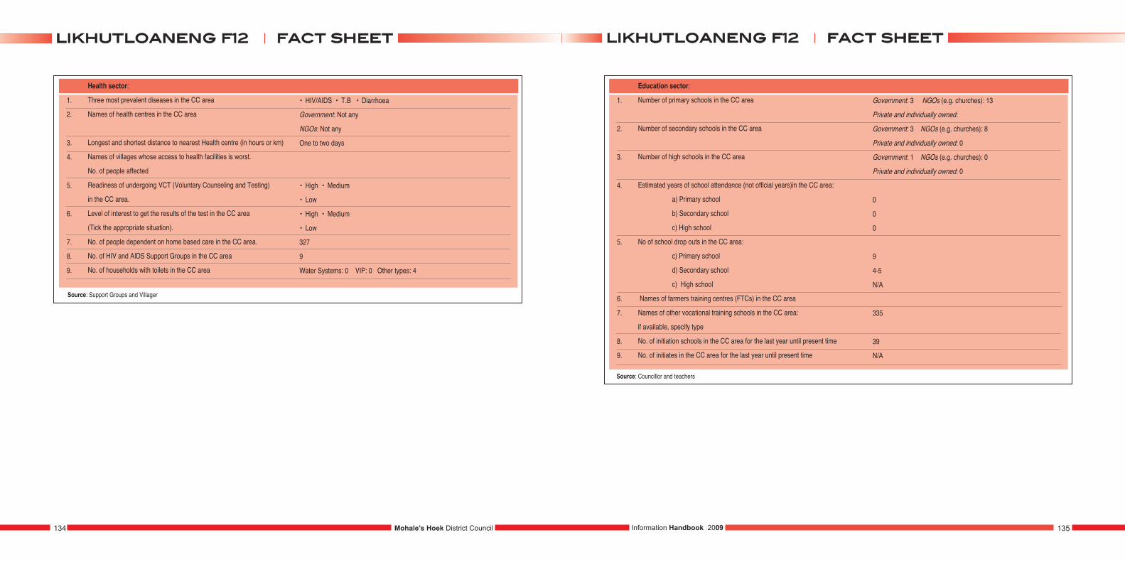
1.
2.
3.
4.
5.
6.
7.
8.
9.
Health sector:
Three most prevalent diseases in the CC area
Names of health centres in the CC area
Longest and shortest distance to nearest Health centre (in hours or km)
Names of villages whose access to health facilities is worst.
No. of people affected
Readiness of undergoing VCT (Voluntary Counseling and Testing)
in the CC area.
Level of interest to get the results of the test in the CC area
(Tick the appropriate situation).
No. of people dependent on home based care in the CC area.
No. of HIV and AIDS Support Groups in the CC area
No. of households with toilets in the CC area
• HIV/AIDS • T.B • Diarrhoea
Government: Not any
NGOs: Not any
One to two days
• High • Medium
• Low
• High • Medium
• Low
327
9
Water Systems: 0 VIP: 0 Other types: 4
Source: Support Groups and Villager
1.
2.
3.
4.
5.
6.
7.
8.
9.
Education sector:
Number of primary schools in the CC area
Number of secondary schools in the CC area
Number of high schools in the CC area
Estimated years of school attendance (not official years)in the CC area:
a) Primary school
b) Secondary school
c) High school
No of school drop outs in the CC area:
c) Primary school
d) Secondary school
c) High school
Names of farmers training centres (FTCs) in the CC area
Names of other vocational training schools in the CC area:
if available, specify type
No. of initiation schools in the CC area for the last year until present time
No. of initiates in the CC area for the last year until present time
Government: 3 NGOs (e.g. churches): 13
Private and individually owned:
Government: 3 NGOs (e.g. churches): 8
Private and individually owned: 0
Government: 1 NGOs (e.g. churches): 0
Private and individually owned: 0
0
0
0
9
4-5
N/A
335
39
N/A
Source: Councillor and teachers
Mohale’s Hoek District Council134 135Information Handbook 2009
ffaacctt sshheeeettlliikkhhuuttllooaanneenngg ff1122ffaacctt sshheeeettlliikkhhuuttllooaanneenngg ff1122
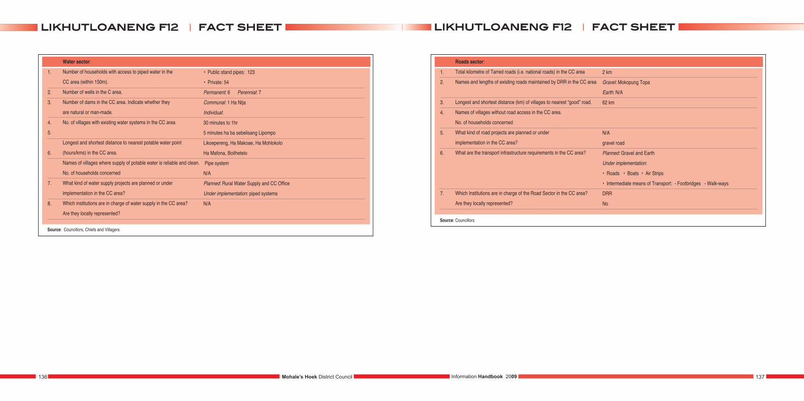
1.
2.
3.
4.
5.
6.
7.
8.
Water sector:
Number of households with access to piped water in the
CC area (within 150m).
Number of wells in the C area.
Number of dams in the CC area. Indicate whether they
are natural or man-made.
No. of villages with existing water systems in the CC area
Longest and shortest distance to nearest potable water point
(hours/kms) in the CC area.
Names of villages where supply of potable water is reliable and clean.
No. of households concerned
What kind of water supply projects are planned or under
implementation in the CC area?
Which institutions are in charge of water supply in the CC area?
Are they locally represented?
• Public stand pipes: 123
• Private: 54
Permanent: 6 Perennial: 7
Communal: 1 Ha Ntja
Individual:
30 minutes to 1hr
5 minutes ha ba sebelisang Lipompo
Likoepereng, Ha Makoae, Ha Mohlokolo
Ha Mafona, Boithetelo
Pipe system
N/A
Planned: Rural Water Supply and CC Office
Under implementation: piped systems
N/A
Source: Councillors, Chiefs and Villagers
1.
2.
3.
4.
5.
6.
7.
Roads sector:
Total kilometre of Tarred roads (i.e. national roads) in the CC area
Names and lengths of existing roads maintained by DRR in the CC area
Longest and shortest distance (km) of villages to nearest “good” road.
Names of villages without road access in the CC area.
No. of households concerned
What kind of road projects are planned or under
implementation in the CC area?
What are the transport infrastructure requirements in the CC area?
Which Institutions are in charge of the Road Sector in the CC area?
Are they locally represented?
2 km
Gravel: Mokopung Topa
Earth: N/A
62 km
N/A
gravel road
Planned: Gravel and Earth
Under implementation:
• Roads • Boats • Air Strips
• Intermediate means of Transport: - Footbridges - Walk-ways
DRR
No
Source: Councillors
Mohale’s Hoek District Council136 137Information Handbook 2009
ffaacctt sshheeeettlliikkhhuuttllooaanneenngg ff1122ffaacctt sshheeeettlliikkhhuuttllooaanneenngg ff1122
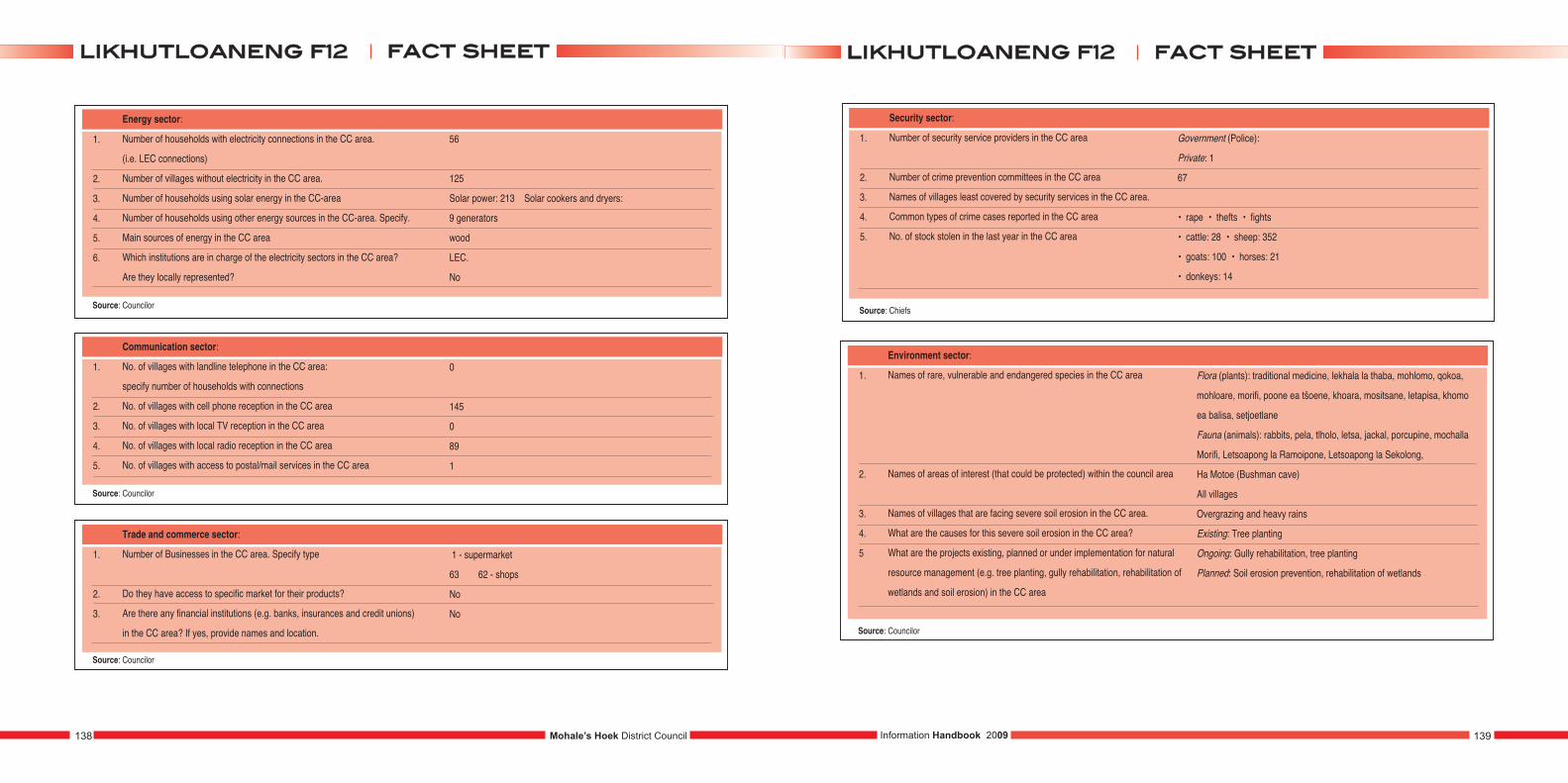
1.
2.
3.
4.
5.
6.
Energy sector:
Number of households with electricity connections in the CC area.
(i.e. LEC connections)
Number of villages without electricity in the CC area.
Number of households using solar energy in the CC-area
Number of households using other energy sources in the CC-area. Specify.
Main sources of energy in the CC area
Which institutions are in charge of the electricity sectors in the CC area?
Are they locally represented?
Source: Councilor
1.
2.
3.
4.
5.
Communication sector:
No. of villages with landline telephone in the CC area:
specify number of households with connections
No. of villages with cell phone reception in the CC area
No. of villages with local TV reception in the CC area
No. of villages with local radio reception in the CC area
No. of villages with access to postal/mail services in the CC area
0
145
0
89
1
Source: Councilor
1.
2.
3.
Trade and commerce sector:
Number of Businesses in the CC area. Specify type
Do they have access to specific market for their products?
Are there any financial institutions (e.g. banks, insurances and credit unions)
in the CC area? If yes, provide names and location.
1 - supermarket
63 62 - shops
No
No
Source: Councilor
56
125
Solar power: 213 Solar cookers and dryers:
9 generators
wood
LEC.
No
1.
2.
3.
4.
5.
Security sector:
Number of security service providers in the CC area
Number of crime prevention committees in the CC area
Names of villages least covered by security services in the CC area.
Common types of crime cases reported in the CC area
No. of stock stolen in the last year in the CC area
Government (Police):
Private: 1
67
• rape • thefts • fights
• cattle: 28 • sheep: 352
• goats: 100 • horses: 21
• donkeys: 14
Source: Chiefs
1.
2.
3.
4.
5
Environment sector:
Names of rare, vulnerable and endangered species in the CC area
Names of areas of interest (that could be protected) within the council area
Names of villages that are facing severe soil erosion in the CC area.
What are the causes for this severe soil erosion in the CC area?
What are the projects existing, planned or under implementation for natural
resource management (e.g. tree planting, gully rehabilitation, rehabilitation of
wetlands and soil erosion) in the CC area
Source: Councilor
Flora (plants): traditional medicine, lekhala la thaba, mohlomo, qokoa,
mohloare, morifi, poone ea tšoene, khoara, mositsane, letapisa, khomo
ea balisa, setjoetlane
Fauna (animals): rabbits, pela, tlholo, letsa, jackal, porcupine, mochalla
Morifi, Letsoapong la Ramoipone, Letsoapong la Sekolong,
Ha Motoe (Bushman cave)
All villages
Overgrazing and heavy rains
Existing: Tree planting
Ongoing: Gully rehabilitation, tree planting
Planned: Soil erosion prevention, rehabilitation of wetlands
Mohale’s Hoek District Council138 139Information Handbook 2009
ffaacctt sshheeeettlliikkhhuuttllooaanneenngg ff1122ffaacctt sshheeeettlliikkhhuuttllooaanneenngg ff1122
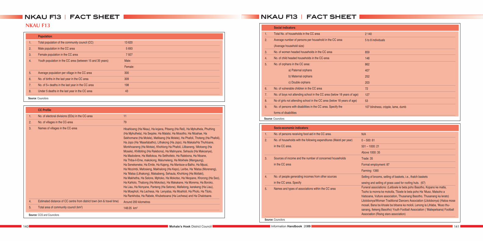
NKAU F13
1.
2.
3.
4.
5.
6.
7.
8.
Population:
Total population of the community council (CC)
Male population in the CC area
Female population in the CC area
Youth population in the CC area (between 15 and 35 years)
Average population per village in the CC area
No. of births in the last year in the CC area
No. of 5+ deaths in the last year in the CC area
Under 5 deaths in the last year in the CC area
13 620
5 693
7 927
Male:
Female:
300
309
198
43
1.
2.
3.
4.
5.
CC Profile:
No. of electoral divisions (EDs) in the CC-area
No. of villages in the CC-area
Names of villages in the CC-area
Estimated distance of CC centre from district town (km & travel time)
Total area of community council (km2)
11
79
Hloahloeng (Ha Nkau), Ha kojana, Pitseng (Ha Reli), Ha Mphuthela, Phuthing (Ha Mphuthela), Ha Seqoke, Ha Malatsi, Ha Mosotho, Ha Ntoahae, HaSekhomane (Ha Molele), Matliseng (Ha Molele), Ha Phafoli, Thoteng (Ha Phafoli),Ha Jopo (Ha ‘Masefabatho), Lithakong (Ha Jopo), Ha Makala/Ha Thuhloane,Monkhoaneng (Ha Motsie), Khohlong Ha Phafoli, Lilibaneng, \Motoeng (HaMosele), Khilibiting (Ha Ralebona), Ha Malinyane, Sehaula (Ha Makoanye), Ha Madodene, Ha Matlokoa, Ha Setlhotlelo, Ha Ralebona, Ha Ntoane, Ha Thiba-li-Eme, makokong, Malumeleng, Ha Mokhele (Mangaung), Ha Senekeneke, Ha Emile, Ha Kajeng, Ha Mantsoe-a-Batho, Ha Mpusi, Ha Ntozimbi, Mafosieng, Makhalong (Ha Kepo), Leribe, Ha ‘Matsa (Moreneng),Ha ‘Matsa (Lithakong), Matsabeng, Sehaula, Khohlong (Ha Motlaki), Ha Makhetha, Ha Selone, Mphoko, Ha Mokotso, Ha Nkopane, Khorong (Ha Seo),Ha Kahlolo, Thabong (Ha Mokotso), Ha Makakane, Ha Morema, Ha Boroko, Ha Liau, Ha Nonyane, Panteng (Ha Setone), Mafielong, kerekeng (Ha Liau), Ha Moepholi, Ha Lechesa, Ha Lenyatsa, Ha Moahloli, Ha Pholo, Ha Tšolo, Ha Rankhoba, Ha Rabele, Khubetsoana (Ha Lechesa) and Ha Chalotsane.
Around 200 kilometres
148.05 km2
1.
2.
3.
4.
5.
6.
7.
8.
9.
Social indicators:
Total No. of households in the CC area
Average number of persons per household in the CC area
(Average household size)
No. of women headed households in the CC area
No. of child headed households in the CC-area
No. of orphans in the CC area:
a) Paternal orphans
b) Maternal orphans
c) Double orphans
No. of vulnerable children in the CC area
No. of boys not attending school in the CC area (below 18 years of age)
No of girls not attending school in the CC area (below 18 years of age)
No. of persons with disabilities in the CC area. Specify the
forms of disabilities
2 140
5 to 8 individuals
859
148
862
407
252
203
72
127
53
107 blindness, cripple, lame, dumb
1.
2.
3.
4.
5.
Socio-economic indicators:
No. of persons receiving food aid in the CC area.
No. of households with the following expenditures (Maloti per year)
in the CC area.
Sources of income and the number of concerned households
in the CC area
No. of people generating incomes from other sources
in the CC area. Specify
Names and types of associations within the CC area
N/A
0 – 500: 61
501 – 1000: 21
Above 1000: 35
Trade: 35
Formal employment: 87
Farming: 1390
Selling of brooms, selling of baskets, i.e., thatch baskets
sewing and selling of grass used for roofing huts. (67)Funeral associations: (Letšoele le beta poho Basotho, Kopano ke matla, Tsoho la monna ke mokolla, Tšoele le beta poho Ha ‘Muso, Matsoho a hlatsoana, Vulture association, Thusanang Basotho, Thusanang ka lerato)Litolobonya/Woman Traditional Dancers Association (Litolobonya) (Hatoa mosemosali, Bana ba khoale ba bitsana ka mololi, Lenong la Lihlaba, ‘Muso thu-sanang, Itekeng Basotho) Youth Football Association ( ‘Maliepetsana) FootballAssociation (Rising stars association)
Mohale’s Hoek District Council140 141Information Handbook 2009
ffaacctt sshheeeettnnkkaauu ff1133ffaacctt sshheeeettnnkkaauu ff1133
Source: Councilors
Source: CCS and Councilors
Source: Councilors
Source: Councilors
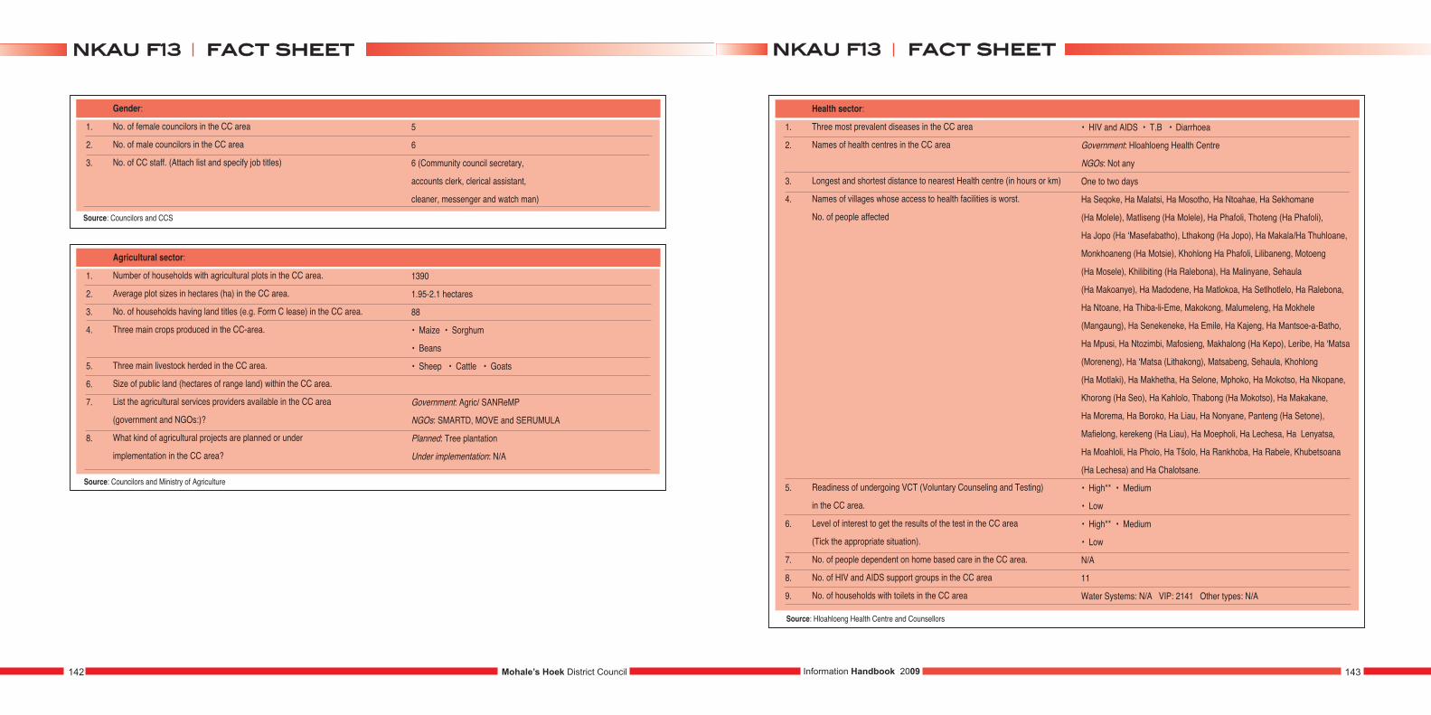
1.
2.
3.
Gender:
No. of female councilors in the CC area
No. of male councilors in the CC area
No. of CC staff. (Attach list and specify job titles)
5
6
6 (Community council secretary,
accounts clerk, clerical assistant,
cleaner, messenger and watch man)
1.
2.
3.
4.
5.
6.
7.
8.
Agricultural sector:
Number of households with agricultural plots in the CC area.
Average plot sizes in hectares (ha) in the CC area.
No. of households having land titles (e.g. Form C lease) in the CC area.
Three main crops produced in the CC-area.
Three main livestock herded in the CC area.
Size of public land (hectares of range land) within the CC area.
List the agricultural services providers available in the CC area
(government and NGOs:)?
What kind of agricultural projects are planned or under
implementation in the CC area?
1390
1.95-2.1 hectares
88
• Maize • Sorghum
• Beans
• Sheep • Cattle • Goats
Government: Agric/ SANReMP
NGOs: SMARTD, MOVE and SERUMULA
Planned: Tree plantation
Under implementation: N/A
1.
2.
3.
4.
5.
6.
7.
8.
9.
Health sector:
Three most prevalent diseases in the CC area
Names of health centres in the CC area
Longest and shortest distance to nearest Health centre (in hours or km)
Names of villages whose access to health facilities is worst.
No. of people affected
Readiness of undergoing VCT (Voluntary Counseling and Testing)
in the CC area.
Level of interest to get the results of the test in the CC area
(Tick the appropriate situation).
No. of people dependent on home based care in the CC area.
No. of HIV and AIDS support groups in the CC area
No. of households with toilets in the CC area
• HIV and AIDS • T.B • Diarrhoea
Government: Hloahloeng Health Centre
NGOs: Not any
One to two days
Ha Seqoke, Ha Malatsi, Ha Mosotho, Ha Ntoahae, Ha Sekhomane
(Ha Molele), Matliseng (Ha Molele), Ha Phafoli, Thoteng (Ha Phafoli),
Ha Jopo (Ha ‘Masefabatho), Lthakong (Ha Jopo), Ha Makala/Ha Thuhloane,
Monkhoaneng (Ha Motsie), Khohlong Ha Phafoli, Lilibaneng, Motoeng
(Ha Mosele), Khilibiting (Ha Ralebona), Ha Malinyane, Sehaula
(Ha Makoanye), Ha Madodene, Ha Matlokoa, Ha Setlhotlelo, Ha Ralebona,
Ha Ntoane, Ha Thiba-li-Eme, Makokong, Malumeleng, Ha Mokhele
(Mangaung), Ha Senekeneke, Ha Emile, Ha Kajeng, Ha Mantsoe-a-Batho,
Ha Mpusi, Ha Ntozimbi, Mafosieng, Makhalong (Ha Kepo), Leribe, Ha ‘Matsa
(Moreneng), Ha ‘Matsa (Lithakong), Matsabeng, Sehaula, Khohlong
(Ha Motlaki), Ha Makhetha, Ha Selone, Mphoko, Ha Mokotso, Ha Nkopane,
Khorong (Ha Seo), Ha Kahlolo, Thabong (Ha Mokotso), Ha Makakane,
Ha Morema, Ha Boroko, Ha Liau, Ha Nonyane, Panteng (Ha Setone),
Mafielong, kerekeng (Ha Liau), Ha Moepholi, Ha Lechesa, Ha Lenyatsa,
Ha Moahloli, Ha Pholo, Ha Tšolo, Ha Rankhoba, Ha Rabele, Khubetsoana
(Ha Lechesa) and Ha Chalotsane.
• High** • Medium
• Low
• High** • Medium
• Low
N/A
11
Water Systems: N/A VIP: 2141 Other types: N/A
Source: Hloahloeng Health Centre and Counsellors
Mohale’s Hoek District Council142 143Information Handbook 2009
ffaacctt sshheeeettnnkkaauu ff1133ffaacctt sshheeeettnnkkaauu ff1133
Source: Councilors and CCS
Source: Councilors and Ministry of Agriculture
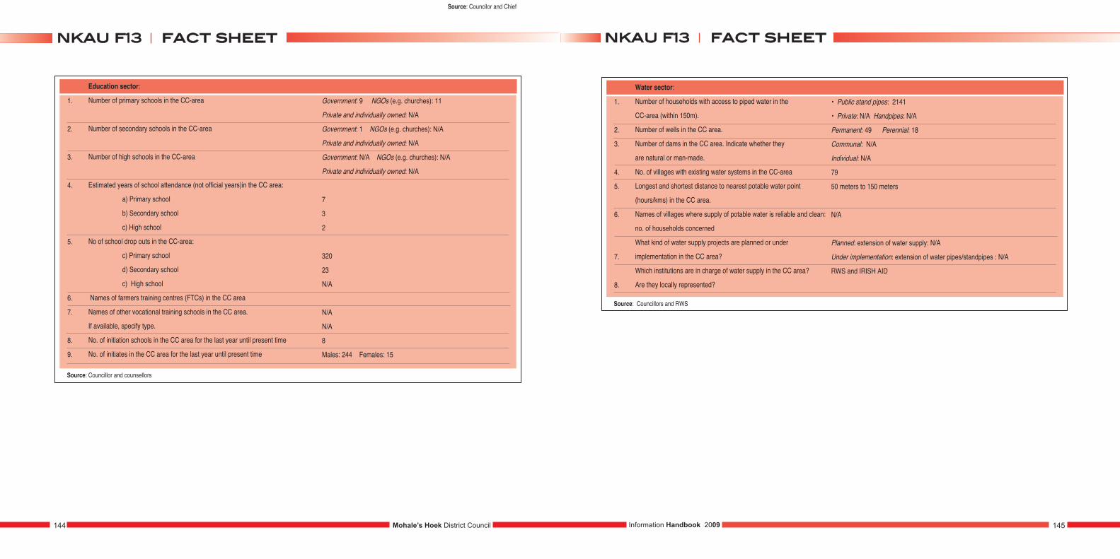
1.
2.
3.
4.
5.
6.
7.
8.
9.
Education sector:
Number of primary schools in the CC-area
Number of secondary schools in the CC-area
Number of high schools in the CC-area
Estimated years of school attendance (not official years)in the CC area:
a) Primary school
b) Secondary school
c) High school
No of school drop outs in the CC-area:
c) Primary school
d) Secondary school
c) High school
Names of farmers training centres (FTCs) in the CC area
Names of other vocational training schools in the CC area.
If available, specify type.
No. of initiation schools in the CC area for the last year until present time
No. of initiates in the CC area for the last year until present time
Government: 9 NGOs (e.g. churches): 11
Private and individually owned: N/A
Government: 1 NGOs (e.g. churches): N/A
Private and individually owned: N/A
Government: N/A NGOs (e.g. churches): N/A
Private and individually owned: N/A
7
3
2
320
23
N/A
N/A
N/A
8
Males: 244 Females: 15
Source: Councillor and counsellors
1.
2.
3.
4.
5.
6.
7.
8.
Water sector:
Number of households with access to piped water in the
CC-area (within 150m).
Number of wells in the CC area.
Number of dams in the CC area. Indicate whether they
are natural or man-made.
No. of villages with existing water systems in the CC-area
Longest and shortest distance to nearest potable water point
(hours/kms) in the CC area.
Names of villages where supply of potable water is reliable and clean:
no. of households concerned
What kind of water supply projects are planned or under
implementation in the CC area?
Which institutions are in charge of water supply in the CC area?
Are they locally represented?
• Public stand pipes: 2141
• Private: N/A Handpipes: N/A
Permanent: 49 Perennial: 18
Communal: N/A
Individual: N/A
79
50 meters to 150 meters
N/A
Planned: extension of water supply: N/A
Under implementation: extension of water pipes/standpipes : N/A
RWS and IRISH AID
Source: Councillors and RWS
Mohale’s Hoek District Council144 145Information Handbook 2009
ffaacctt sshheeeettnnkkaauu ff1133ffaacctt sshheeeettnnkkaauu ff1133
Source: Councilor and Chief
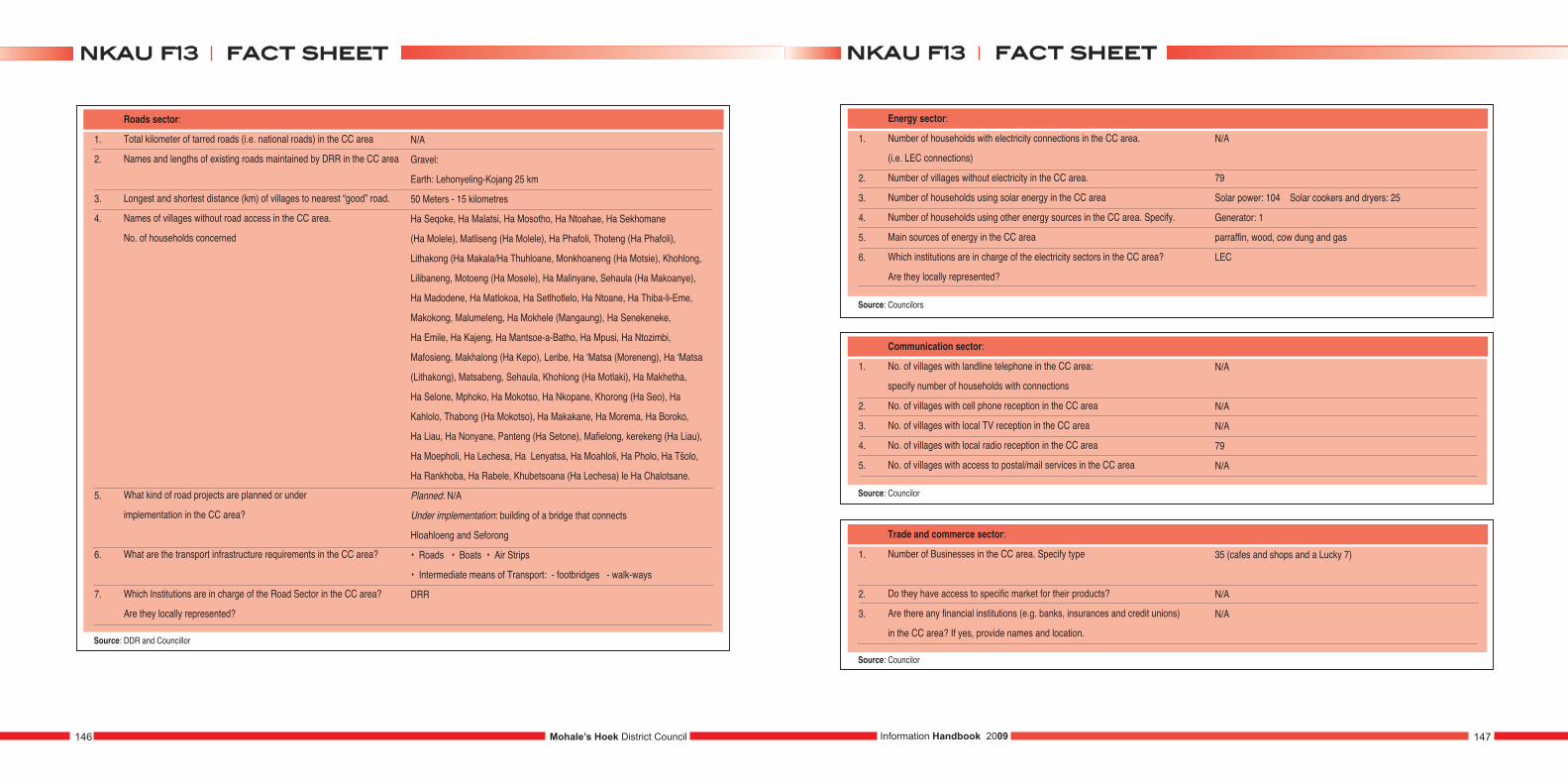
1.
2.
3.
4.
5.
6.
7.
Roads sector:
Total kilometer of tarred roads (i.e. national roads) in the CC area
Names and lengths of existing roads maintained by DRR in the CC area
Longest and shortest distance (km) of villages to nearest “good” road.
Names of villages without road access in the CC area.
No. of households concerned
What kind of road projects are planned or under
implementation in the CC area?
What are the transport infrastructure requirements in the CC area?
Which Institutions are in charge of the Road Sector in the CC area?
Are they locally represented?
N/A
Gravel:
Earth: Lehonyeling-Kojang 25 km
50 Meters - 15 kilometres
Ha Seqoke, Ha Malatsi, Ha Mosotho, Ha Ntoahae, Ha Sekhomane
(Ha Molele), Matliseng (Ha Molele), Ha Phafoli, Thoteng (Ha Phafoli),
Lithakong (Ha Makala/Ha Thuhloane, Monkhoaneng (Ha Motsie), Khohlong,
Lilibaneng, Motoeng (Ha Mosele), Ha Malinyane, Sehaula (Ha Makoanye),
Ha Madodene, Ha Matlokoa, Ha Setlhotlelo, Ha Ntoane, Ha Thiba-li-Eme,
Makokong, Malumeleng, Ha Mokhele (Mangaung), Ha Senekeneke,
Ha Emile, Ha Kajeng, Ha Mantsoe-a-Batho, Ha Mpusi, Ha Ntozimbi,
Mafosieng, Makhalong (Ha Kepo), Leribe, Ha ‘Matsa (Moreneng), Ha ‘Matsa
(Lithakong), Matsabeng, Sehaula, Khohlong (Ha Motlaki), Ha Makhetha,
Ha Selone, Mphoko, Ha Mokotso, Ha Nkopane, Khorong (Ha Seo), Ha
Kahlolo, Thabong (Ha Mokotso), Ha Makakane, Ha Morema, Ha Boroko,
Ha Liau, Ha Nonyane, Panteng (Ha Setone), Mafielong, kerekeng (Ha Liau),
Ha Moepholi, Ha Lechesa, Ha Lenyatsa, Ha Moahloli, Ha Pholo, Ha Tšolo,
Ha Rankhoba, Ha Rabele, Khubetsoana (Ha Lechesa) le Ha Chalotsane.
Planned: N/A
Under implementation: building of a bridge that connects
Hloahloeng and Seforong
• Roads • Boats • Air Strips
• Intermediate means of Transport: - footbridges - walk-ways
DRR
Source: DDR and Councillor
1.
2.
3.
4.
5.
6.
Energy sector:
Number of households with electricity connections in the CC area.
(i.e. LEC connections)
Number of villages without electricity in the CC area.
Number of households using solar energy in the CC area
Number of households using other energy sources in the CC area. Specify.
Main sources of energy in the CC area
Which institutions are in charge of the electricity sectors in the CC area?
Are they locally represented?
Source: Councilors
1.
2.
3.
4.
5.
Communication sector:
No. of villages with landline telephone in the CC area:
specify number of households with connections
No. of villages with cell phone reception in the CC area
No. of villages with local TV reception in the CC area
No. of villages with local radio reception in the CC area
No. of villages with access to postal/mail services in the CC area
N/A
N/A
N/A
79
N/A
Source: Councilor
1.
2.
3.
Trade and commerce sector:
Number of Businesses in the CC area. Specify type
Do they have access to specific market for their products?
Are there any financial institutions (e.g. banks, insurances and credit unions)
in the CC area? If yes, provide names and location.
35 (cafes and shops and a Lucky 7)
N/A
N/A
Source: Councilor
N/A
79
Solar power: 104 Solar cookers and dryers: 25
Generator: 1
parraffin, wood, cow dung and gas
LEC
Mohale’s Hoek District Council146 147Information Handbook 2009
ffaacctt sshheeeettnnkkaauu ff1133ffaacctt sshheeeettnnkkaauu ff1133
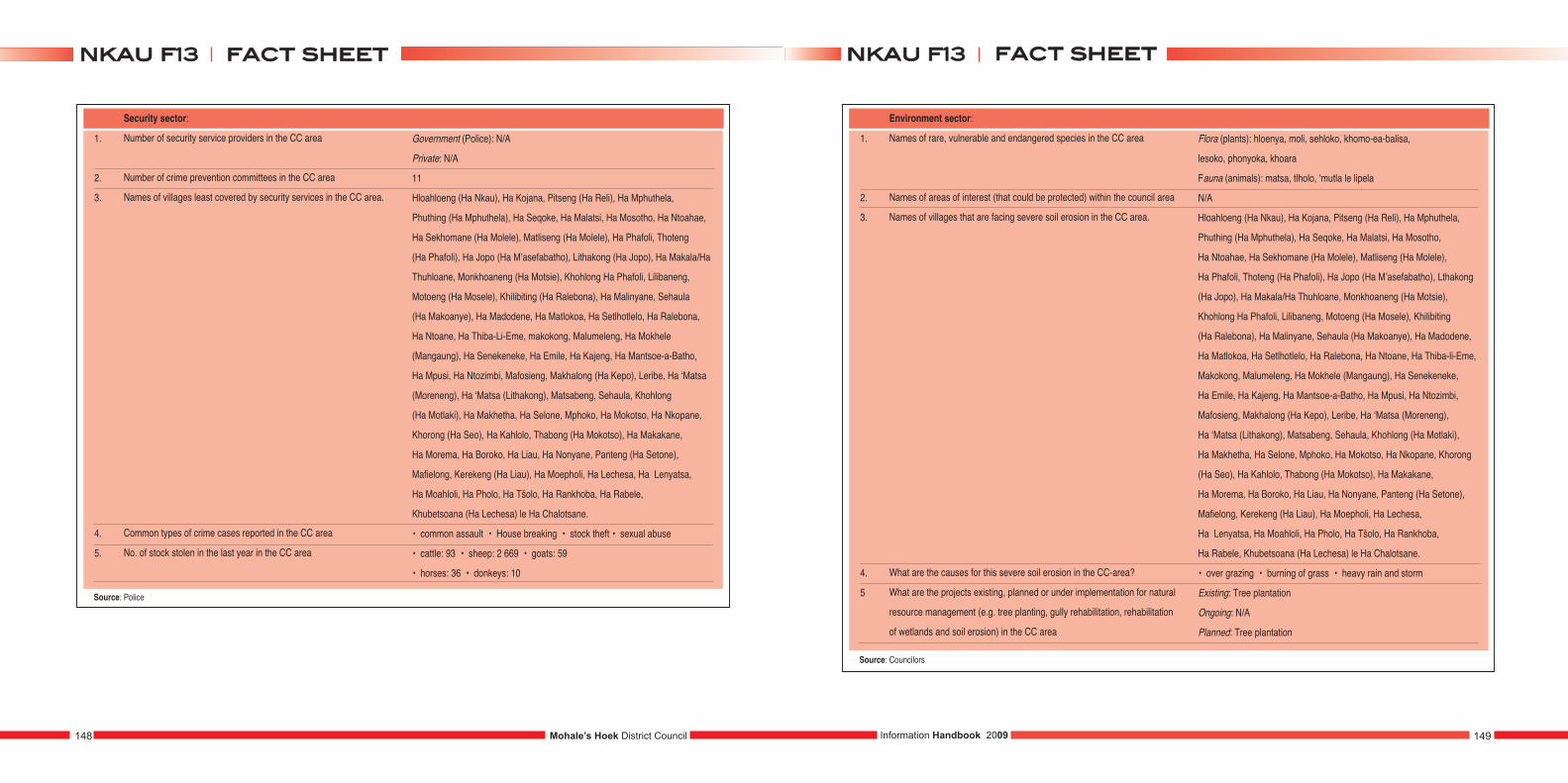
1.
2.
3.
4.
5.
Security sector:
Number of security service providers in the CC area
Number of crime prevention committees in the CC area
Names of villages least covered by security services in the CC area.
Common types of crime cases reported in the CC area
No. of stock stolen in the last year in the CC area
Government (Police): N/A
Private: N/A
11
Hloahloeng (Ha Nkau), Ha Kojana, Pitseng (Ha Reli), Ha Mphuthela,
Phuthing (Ha Mphuthela), Ha Seqoke, Ha Malatsi, Ha Mosotho, Ha Ntoahae,
Ha Sekhomane (Ha Molele), Matliseng (Ha Molele), Ha Phafoli, Thoteng
(Ha Phafoli), Ha Jopo (Ha M’asefabatho), Lithakong (Ha Jopo), Ha Makala/Ha
Thuhloane, Monkhoaneng (Ha Motsie), Khohlong Ha Phafoli, Lilibaneng,
Motoeng (Ha Mosele), Khilibiting (Ha Ralebona), Ha Malinyane, Sehaula
(Ha Makoanye), Ha Madodene, Ha Matlokoa, Ha Setlhotlelo, Ha Ralebona,
Ha Ntoane, Ha Thiba-Li-Eme, makokong, Malumeleng, Ha Mokhele
(Mangaung), Ha Senekeneke, Ha Emile, Ha Kajeng, Ha Mantsoe-a-Batho,
Ha Mpusi, Ha Ntozimbi, Mafosieng, Makhalong (Ha Kepo), Leribe, Ha ‘Matsa
(Moreneng), Ha ‘Matsa (Lithakong), Matsabeng, Sehaula, Khohlong
(Ha Motlaki), Ha Makhetha, Ha Selone, Mphoko, Ha Mokotso, Ha Nkopane,
Khorong (Ha Seo), Ha Kahlolo, Thabong (Ha Mokotso), Ha Makakane,
Ha Morema, Ha Boroko, Ha Liau, Ha Nonyane, Panteng (Ha Setone),
Mafielong, Kerekeng (Ha Liau), Ha Moepholi, Ha Lechesa, Ha Lenyatsa,
Ha Moahloli, Ha Pholo, Ha Tšolo, Ha Rankhoba, Ha Rabele,
Khubetsoana (Ha Lechesa) le Ha Chalotsane.
• common assault • House breaking • stock theft • sexual abuse
• cattle: 93 • sheep: 2 669 • goats: 59
• horses: 36 • donkeys: 10
Source: Police
1.
2.
3.
4.
5
Environment sector:
Names of rare, vulnerable and endangered species in the CC area
Names of areas of interest (that could be protected) within the council area
Names of villages that are facing severe soil erosion in the CC area.
What are the causes for this severe soil erosion in the CC-area?
What are the projects existing, planned or under implementation for natural
resource management (e.g. tree planting, gully rehabilitation, rehabilitation
of wetlands and soil erosion) in the CC area
Source: Councilors
Flora (plants): hloenya, moli, sehloko, khomo-ea-balisa,
lesoko, phonyoka, khoara
Fauna (animals): matsa, tlholo, ‘mutla le lipela
N/A
Hloahloeng (Ha Nkau), Ha Kojana, Pitseng (Ha Reli), Ha Mphuthela,
Phuthing (Ha Mphuthela), Ha Seqoke, Ha Malatsi, Ha Mosotho,
Ha Ntoahae, Ha Sekhomane (Ha Molele), Matliseng (Ha Molele),
Ha Phafoli, Thoteng (Ha Phafoli), Ha Jopo (Ha M’asefabatho), Lthakong
(Ha Jopo), Ha Makala/Ha Thuhloane, Monkhoaneng (Ha Motsie),
Khohlong Ha Phafoli, Lilibaneng, Motoeng (Ha Mosele), Khilibiting
(Ha Ralebona), Ha Malinyane, Sehaula (Ha Makoanye), Ha Madodene,
Ha Matlokoa, Ha Setlhotlelo, Ha Ralebona, Ha Ntoane, Ha Thiba-li-Eme,
Makokong, Malumeleng, Ha Mokhele (Mangaung), Ha Senekeneke,
Ha Emile, Ha Kajeng, Ha Mantsoe-a-Batho, Ha Mpusi, Ha Ntozimbi,
Mafosieng, Makhalong (Ha Kepo), Leribe, Ha ‘Matsa (Moreneng),
Ha ‘Matsa (Lithakong), Matsabeng, Sehaula, Khohlong (Ha Motlaki),
Ha Makhetha, Ha Selone, Mphoko, Ha Mokotso, Ha Nkopane, Khorong
(Ha Seo), Ha Kahlolo, Thabong (Ha Mokotso), Ha Makakane,
Ha Morema, Ha Boroko, Ha Liau, Ha Nonyane, Panteng (Ha Setone),
Mafielong, Kerekeng (Ha Liau), Ha Moepholi, Ha Lechesa,
Ha Lenyatsa, Ha Moahloli, Ha Pholo, Ha Tšolo, Ha Rankhoba,
Ha Rabele, Khubetsoana (Ha Lechesa) le Ha Chalotsane.
• over grazing • burning of grass • heavy rain and storm
Existing: Tree plantation
Ongoing: N/A
Planned: Tree plantation
Mohale’s Hoek District Council148 149Information Handbook 2009
ffaacctt sshheeeettnnkkaauu ff1133ffaacctt sshheeeettnnkkaauu ff1133
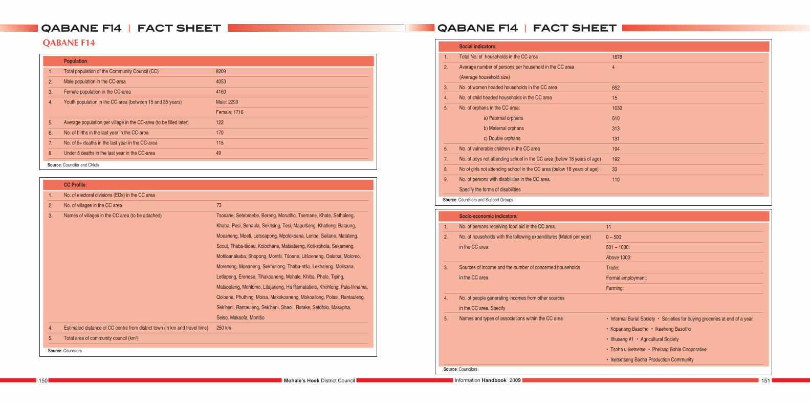
QABANE F14
1.
2.
3.
4.
5.
6.
7.
8.
Population:
Total population of the Community Council (CC)
Male population in the CC-area
Female population in the CC-area
Youth population in the CC area (between 15 and 35 years)
Average population per village in the CC-area (to be filled later)
No. of births in the last year in the CC-area
No. of 5+ deaths in the last year in the CC-area
Under 5 deaths in the last year in the CC-area
8209
4053
4160
Male: 2299
Female: 1716
122
170
115
49
1.
2.
3.
4.
5.
CC Profile:
No. of electoral divisions (EDs) in the CC area
No. of villages in the CC area
Names of villages in the CC area (to be attached)
Estimated distance of CC centre from district town (in km and travel time)
Total area of community council (km2)
73
Tsosane, Setebatebe, Bereng, Morutlho, Tsemane, Khate, Sethaleng,
Khaba, Pesi, Sehaula, Sekitsing, Tesi, Maputšeng, Khatleng, Bataung,
Moeaneng, Moeti, Letsoapong, Mpolokoana, Leribe, Seilane, Matateng,
Scout, Thaba-tšoeu, Kolochana, Matsatseng, Koti-sphola, Sekameng,
Motšoanakaba, Shopong, Montši, Tšoane, Litšoeneng, Oalatsa, Molomo,
Moreneng, Moeaneng, Sekhutlong, Thaba-ntšo, Lekhaleng, Molisana,
Letlapeng, Erenese, Tlhakoaneng, Mohale, Khiba, Phalo, Tiping,
Matsoeteng, Mohlomo, Litajaneng, Ha Ramatatiele, Khohlong, Pula-likhama,
Qoloane, Phuthing, Moisa, Makokoaneng, Mokoallong, Polasi, Rantauleng,
Sek’heni, Rantauleng, Sek’heni, Shaoli, Ratake, Setofolo, Masupha,
Seiso, Makaofa, Montšo
250 km
1.
2.
3.
4.
5.
6.
7.
8.
9.
Social indicators:
Total No. of households in the CC area
Average number of persons per household in the CC area
(Average household size)
No. of women headed households in the CC area
No. of child headed households in the CC area
No. of orphans in the CC area:
a) Paternal orphans
b) Maternal orphans
c) Double orphans
No. of vulnerable children in the CC area
No. of boys not attending school in the CC area (below 18 years of age)
No of girls not attending school in the CC area (below 18 years of age)
No. of persons with disabilities in the CC area.
Specify the forms of disabilities
1878
4
652
15
1030
610
313
131
194
192
33
110
1.
2.
3.
4.
5.
Socio-economic indicators:
No. of persons receiving food aid in the CC area.
No. of households with the following expenditures (Maloti per year)
in the CC area:
Sources of income and the number of concerned households
in the CC area
No. of people generating incomes from other sources
in the CC area. Specify
Names and types of associations within the CC area
11
0 – 500:
501 – 1000:
Above 1000:
Trade:
Formal employment:
Farming:
• Informal Burial Society • Societies for buying groceries at end of a year
• Kopanang Basotho • Ikaeheng Basotho
• Ithuseng #1 • Agricultural Society
• Tsoha u iketsetse • Phelang Bohle Cooporative
• Iketsetseng Bacha Production Community
Mohale’s Hoek District Council150 151Information Handbook 2009
ffaacctt sshheeeettqqaabbaannee ff1144ffaacctt sshheeeettqqaabbaannee ff1144
Source: Councilors
Source: Councilor and Chiefs
Source: Councilors
Source: Councilors and Support Groups
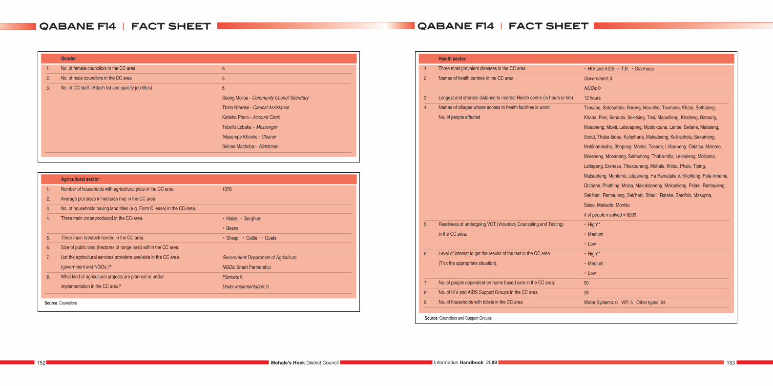
1.
2.
3.
Gender:
No. of female councilors in the CC area
No. of male councilors in the CC area
No. of CC staff. (Attach list and specify job titles)
6
5
6
Seeng Moiloa - Community Council Secretary
Thato Ntereke - Clerical Assistance
Katleho Pholo - Account Cleck
Tebello Lebaka – Messenger
‘Masempe Kheeke - Cleaner
Selone Machoba - Watchman
1.
2.
3.
4.
5.
6.
7.
8.
Agricultural sector:
Number of households with agricultural plots in the CC area.
Average plot sizes in hectares (ha) in the CC area.
No. of households having land titles (e.g. Form C lease) in the CC-area.
Three main crops produced in the CC-area.
Three main livestock herded in the CC area.
Size of public land (hectares of range land) within the CC area.
List the agricultural services providers available in the CC area
(government and NGOs:)?
What kind of agricultural projects are planned or under
implementation in the CC area?
1078
• Maize • Sorghum
• Beans
• Sheep • Cattle • Goats
Government: Department of Agriculture
NGOs: Smart Partnership
Planned: 0
Under implementation: 0
1.
2.
3.
4.
5.
6.
7.
8.
9.
Health sector:
Three most prevalent diseases in the CC area
Names of health centres in the CC area
Longest and shortest distance to nearest Health centre (in hours or km)
Names of villages whose access to health facilities is worst.
No. of people affected
Readiness of undergoing VCT (Voluntary Counseling and Testing)
in the CC area.
Level of interest to get the results of the test in the CC area
(Tick the appropriate situation).
No. of people dependent on home based care in the CC area.
No. of HIV and AIDS Support Groups in the CC area
No. of households with toilets in the CC area
• HIV and AIDS • T.B • Diarrhoea
Government: 0
NGOs: 0
12 hours
Tsosane, Setebatebe, Bereng, Morutlho, Tsemane, Khate, Sethaleng,
Khaba, Pesi, Sehaula, Sekitsing, Tesi, Maputšeng, Khatleng, Bataung,
Moeaneng, Moeti, Letsoapong, Mpolokoana, Leribe, Seilane, Matateng,
Scout, Thaba-tšoeu, Kolochana, Matsatseng, Koti-sphola, Sekameng,
Motšoanakaba, Shopong, Montsi, Tsoane, Litšoeneng, Oalatsa, Molomo,
Moreneng, Moeaneng, Sekhutlong, Thaba-ntšo, Lekhaleng, Molisana,
Letlapeng, Erenese, Tlhakoaneng, Mohale, Khiba, Phalo, Tiping,
Matsoeteng, Mohlomo, Litajaneng, Ha Ramatatiele, Khohlong, Pula-likhama,
Qoloane, Phuthing, Moisa, Makokoaneng, Mokoallong, Polasi, Rantauleng,
Sek’heni, Rantauleng, Sek’heni, Shaoli, Ratake, Setofolo, Masupha,
Seiso, Makaofa, Montšo
# of people involved = 8209
• High**
• Medium
• Low
• High**
• Medium
• Low
50
26
Water Systems: 0 VIP: 5 Other types: 24
Source: Councilors and Support Groups
Source: Councilors
Mohale’s Hoek District Council152 153Information Handbook 2009
ffaacctt sshheeeettqqaabbaannee ff1144ffaacctt sshheeeettqqaabbaannee ff1144
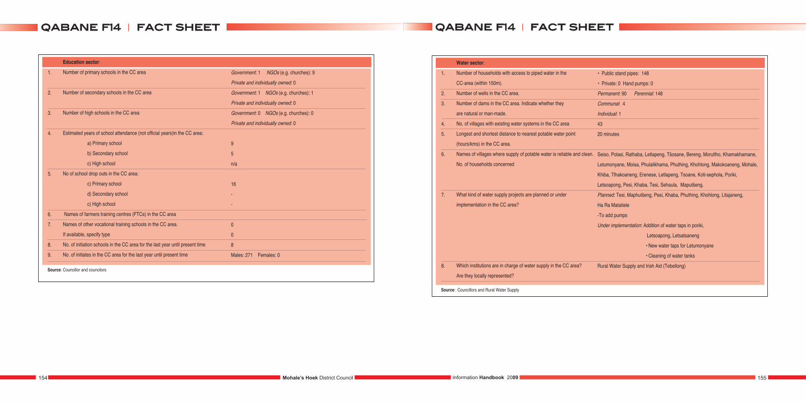
1.
2.
3.
4.
5.
6.
7.
8.
9.
Education sector:
Number of primary schools in the CC area
Number of secondary schools in the CC area
Number of high schools in the CC area
Estimated years of school attendance (not official years)in the CC area:
a) Primary school
b) Secondary school
c) High school
No of school drop outs in the CC area:
c) Primary school
d) Secondary school
c) High school
Names of farmers training centres (FTCs) in the CC area
Names of other vocational training schools in the CC area.
If available, specify type
No. of initiation schools in the CC area for the last year until present time
No. of initiates in the CC area for the last year until present time
Government: 1 NGOs (e.g. churches): 9
Private and individually owned: 0
Government: 1 NGOs (e.g. churches): 1
Private and individually owned: 0
Government: 0 NGOs (e.g. churches): 0
Private and individually owned: 0
9
5
n/a
16
-
-
0
0
8
Males: 271 Females: 0
Source: Councillor and councilors
1.
2.
3.
4.
5.
6.
7.
8.
Water sector:
Number of households with access to piped water in the
CC-area (within 150m).
Number of wells in the CC area.
Number of dams in the CC area. Indicate whether they
are natural or man-made.
No. of villages with existing water systems in the CC area
Longest and shortest distance to nearest potable water point
(hours/kms) in the CC area.
Names of villages where supply of potable water is reliable and clean.
No. of households concerned
What kind of water supply projects are planned or under
implementation in the CC area?
Which institutions are in charge of water supply in the CC area?
Are they locally represented?
• Public stand pipes: 148
• Private: 0 Hand pumps: 0
Permanent: 90 Perennial: 148
Communal: 4
Individual: 1
43
20 minutes
Seiso, Polasi, Rathaba, Letlapeng, Tšosane, Bereng, Morutlho, Khamakhamane,
Letumonyane, Moisa, Phulalikhama, Phuthing, Khohlong, Makokoaneng, Mohale,
Khiba, Tlhakoaneng, Erenese, Letlapeng, Tsoane, Koti-sephola, Poriki,
Letsoapong, Pesi, Khaba, Tesi, Sehaula, Maputšeng.
Planned: Tesi, Maphutšeng, Pesi, Khaba, Phuthing, Khohlong, Litajaneng,
Ha Ra Matatiele
-To add pumps
Under implementation: Addition of water taps in poriki,
Letsoapong, Letsatsaneng
• New water taps for Letumonyane
• Cleaning of water tanks
Rural Water Supply and Irish Aid (Tebellong)
Source: Councillors and Rural Water Supply
Mohale’s Hoek District Council154 155Information Handbook 2009
ffaacctt sshheeeettqqaabbaannee ff1144ffaacctt sshheeeettqqaabbaannee ff1144
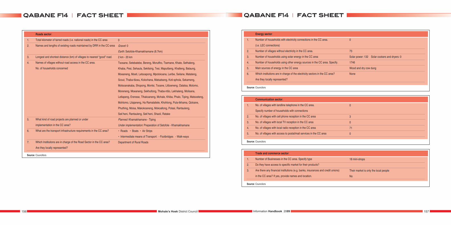
1.
2.
3.
4.
5.
6.
7.
Roads sector:
Total kilometer of tarred roads (i.e. national roads) in the CC area
Names and lengths of existing roads maintained by DRR in the CC-area
Longest and shortest distance (km) of villages to nearest “good” road.
Names of villages without road access in the CC area.
No. of households concerned
What kind of road projects are planned or under
implementation in the CC area?
What are the transport infrastructure requirements in the CC area?
Which Institutions are in charge of the Road Sector in the CC area?
Are they locally represented?
0
Gravel: 0
Earth: Setofole-Khamakhamane (8.7km)
2 km - 20 km
Tsosane, Setebatebe, Bereng, Morutlho, Tsemane, Khate, Sethaleng,
Khaba, Pesi, Sehaula, Sekitsing, Tesi, Maputšeng, Khatleng, Bataung,
Moeaneng, Moeti, Letsoapong, Mpolokoana, Leribe, Seilane, Matateng,
Scout, Thaba-tšoeu, Kolochana, Matsatseng, Koti-sphola, Sekameng,
Motsoanakaba, Shopong, Montsi, Tsoane, Litšoeneng, Oalatsa, Molomo,
Moreneng, Moeaneng, Sekhutlong, Thaba-ntšo, Lekhaleng, Molisana,
Letlapeng, Erenese, Tlhakoaneng, Mohale, Khiba, Phalo, Tiping, Matsoeteng,
Mohlomo, Litajaneng, Ha Ramatatiele, Khohlong, Pula-likhama, Qoloane,
Phuthing, Moisa, Makokoaneng, Mokoallong, Polasi, Rantauleng,
Sek’heni, Rantauleng, Sek’heni, Shaoli, Ratake
Planned: Khamakhamane - Tiping
Under implementation: Preparation of Setofole - Khamakhamane
• Roads • Boats • Air Strips
• Intermediate means of Transport: - Footbridges - Walk-ways
Department of Rural Roads
Source: Councillors
1.
2.
3.
4.
5.
6.
Energy sector:
Number of households with electricity connections in the CC area.
(i.e. LEC connections)
Number of villages without electricity in the CC area.
Number of households using solar energy in the CC area
Number of households using other energy sources in the CC area. Specify.
Main sources of energy in the CC area
Which institutions are in charge of the electricity sectors in the CC area?
Are they locally represented?
Source: Councilors
1.
2.
3.
4.
5.
Communication sector:
No. of villages with landline telephone in the CC area.
Specify number of households with connections
No. of villages with cell phone reception in the CC area
No. of villages with local TV reception in the CC area
No. of villages with local radio reception in the CC area
No. of villages with access to postal/mail services in the CC area
0
3
0
71
0
Source: Councilors
1.
2.
3.
Trade and commerce sector:
Number of Businesses in the CC area. Specify type
Do they have access to specific market for their products?
Are there any financial institutions (e.g. banks, insurances and credit unions)
in the CC area? If yes, provide names and location.
18 mini-shops
Their market is only the local people
No
Source: Councilors
0
73
Solar power: 132 Solar cookers and dryers: 0
1746
Wood and dry cow dung
None
Mohale’s Hoek District Council156 157Information Handbook 2009
ffaacctt sshheeeettqqaabbaannee ff1144ffaacctt sshheeeettqqaabbaannee ff1144
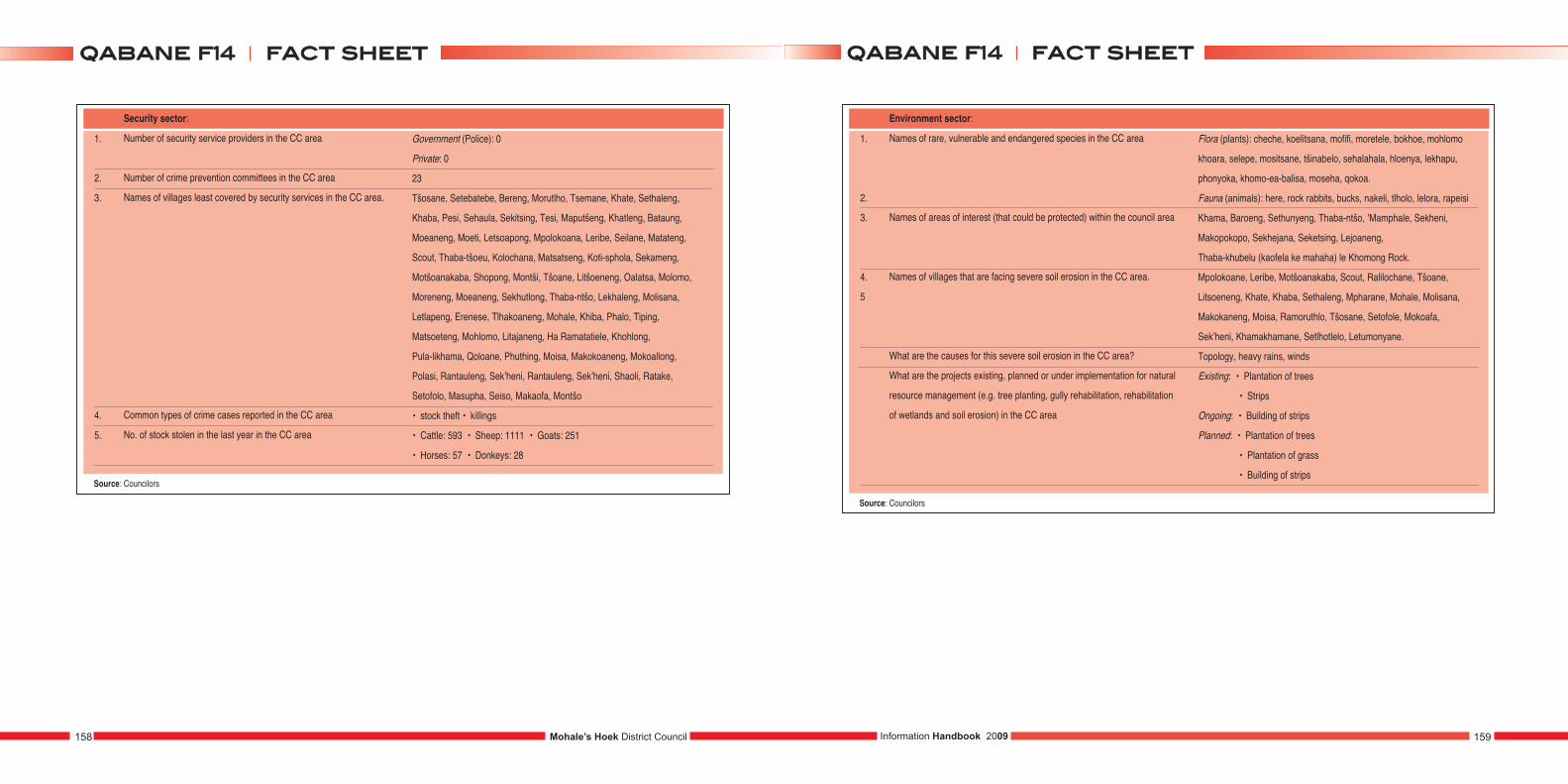
Mohale’s Hoek District Council158 159Information Handbook 2009
1.
2.
3.
4.
5.
Security sector:
Number of security service providers in the CC area
Number of crime prevention committees in the CC area
Names of villages least covered by security services in the CC area.
Common types of crime cases reported in the CC area
No. of stock stolen in the last year in the CC area
Government (Police): 0
Private: 0
23
Tšosane, Setebatebe, Bereng, Morutlho, Tsemane, Khate, Sethaleng,
Khaba, Pesi, Sehaula, Sekitsing, Tesi, Maputšeng, Khatleng, Bataung,
Moeaneng, Moeti, Letsoapong, Mpolokoana, Leribe, Seilane, Matateng,
Scout, Thaba-tšoeu, Kolochana, Matsatseng, Koti-sphola, Sekameng,
Motšoanakaba, Shopong, Montši, Tšoane, Litšoeneng, Oalatsa, Molomo,
Moreneng, Moeaneng, Sekhutlong, Thaba-ntšo, Lekhaleng, Molisana,
Letlapeng, Erenese, Tlhakoaneng, Mohale, Khiba, Phalo, Tiping,
Matsoeteng, Mohlomo, Litajaneng, Ha Ramatatiele, Khohlong,
Pula-likhama, Qoloane, Phuthing, Moisa, Makokoaneng, Mokoallong,
Polasi, Rantauleng, Sek’heni, Rantauleng, Sek’heni, Shaoli, Ratake,
Setofolo, Masupha, Seiso, Makaofa, Montšo
• stock theft • killings
• Cattle: 593 • Sheep: 1111 • Goats: 251
• Horses: 57 • Donkeys: 28
Source: Councilors
1.
2.
3.
4.
5
Environment sector:
Names of rare, vulnerable and endangered species in the CC area
Names of areas of interest (that could be protected) within the council area
Names of villages that are facing severe soil erosion in the CC area.
What are the causes for this severe soil erosion in the CC area?
What are the projects existing, planned or under implementation for natural
resource management (e.g. tree planting, gully rehabilitation, rehabilitation
of wetlands and soil erosion) in the CC area
Source: Councilors
Flora (plants): cheche, koelitsana, mofifi, moretele, bokhoe, mohlomo
khoara, selepe, mositsane, tšinabelo, sehalahala, hloenya, lekhapu,
phonyoka, khomo-ea-balisa, moseha, qokoa.
Fauna (animals): here, rock rabbits, bucks, nakeli, tlholo, lelora, rapeisi
Khama, Baroeng, Sethunyeng, Thaba-ntšo, ’Mamphale, Sekheni,
Makopokopo, Sekhejana, Seketsing, Lejoaneng,
Thaba-khubelu (kaofela ke mahaha) le Khomong Rock.
Mpolokoane, Leribe, Motšoanakaba, Scout, Ralilochane, Tšoane,
Litsoeneng, Khate, Khaba, Sethaleng, Mpharane, Mohale, Molisana,
Makokaneng, Moisa, Ramoruthlo, Tšosane, Setofole, Mokoafa,
Sek’heni, Khamakhamane, Setlhotlelo, Letumonyane.
Topology, heavy rains, winds
Existing: • Plantation of trees
• Strips
Ongoing: • Building of strips
Planned: • Plantation of trees
• Plantation of grass
• Building of strips
ffaacctt sshheeeettqqaabbaannee ff1144ffaacctt sshheeeettqqaabbaannee ff1144
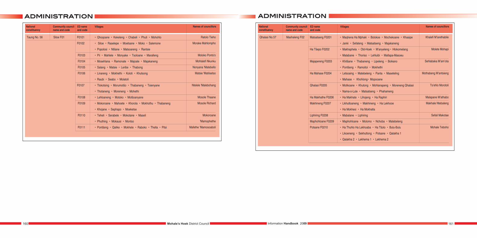
aaddmmiinniissttrraattiioonnaaddmmiinniissttrraattiioonn
Information Handbook 2009 161160 Mohale’s Hoek District Council
National constituency
Community councilname and code
ED name and code
Qhalasi No.57 Mashaleng F02 Matsatseng F0201
Ha Tšepo F0202
Majapereng F0203
Ha Mahase F0204
Qhalasi F0205
Ha Makhathe F0206
Makhineng F0207
Liphiring F0208
Maphohloane F0209
Potsane F0210
Villages
• Maqhena Ha Mphaki • Bolokoe • Mochekoane • Khasipe
• Janki • Sefateng • Matsatseng • Majakaneng
• Makhaphela • Old-Hoek • M’anyeleng • Hlokomelang
• Matabane • Thoriso • Lehluibi • Matlapa-Masoeu
• Khitšane • Thabaneng • Lipeleng • Boikano
• Pontšeng • Ramoitoi • Mokhethi
• Letsoaing • Matebeleng • Panta • Maseteling
• Mahase • Khohlong• Mopooane
• Motikoane • Khutong • Mohlanapeng • Moreneng Qhalasi
• Nama-o-Lule • Matsatseng • Phahameng
• Ha Makhate • Lihojeng • Ha Raphiri
• Likhutloaneng • Makhineng • Ha Lekhooe
• Ha Mokhesi • Ha Mokhatla
• Mabalane • Liphiring
• Maphohloane • Molomo • Nchoba • Matebeleng
• Ha Thuhlo Ha Lekhoaba • Ha Tšolo • Bulu-Bulu
• Likoeneng • Sekhutlong • Potsane • Qalakha 1
• Qalakha 2 • Lekhema 1 • Lekhema 2
Names of councillors
Khalefi M’arethabile
Molete Mohapi
Sehlabaka M’am’ota
Mothabeng M’antsieng
Ts’ehlo Morotoli
Malapane M’athabo
Makhale Ntebaleng
Sefali Makotae
Mohale Teboho
National constituency
Community councilname and code
ED name and code
Taung No. 56 Siloe F01 F0101
F0102
F0103
F0104
F0105
F0106
F0107
F0108
F0109
F0110
F0111
Villages
• Qhoqoane • Kekeleng • Chabeli • Phuti • Mohohlo
• Siloe • Raselepe • Moetsane • Moko • Salemone
• Popolosi • Ntilane • Matsoareng • Rantsie
• Pii • Mahlele • Monyake • Tsoloane • Maralleng
• Mosehlana • Ramonate • Majoale • Majakaneng
• Salang • Matsie • Leribe • Thabong
• Linareng • Mokhethi • Koloti • Khutsong
• Raubi • Seabo • Molatoli
• Tlokotsing • Morumotšo • Thabaneng • Tsienyane
• Thotaneng • Moreneng • Mohethi
• Lehloaneng • Motoko • Motšoanyane
• Mokoroane • Mahoete • Khorola • Mokhothu • Thabaneng
• Khojane • Sephapo • Moeketse
• Teheli • Serabele • Mokotane • Maseli
• Phuthing • Mokausi • Montso
• Pontšeng • Qalike • Mokhele • Raboko • Thella • Pitsi
Names of councillors
Ratolo Tieho
Morake Mahlompho
Moloko Ponts'o
Mohlalefi Nkunku
Nonyana 'Matebello
Matsie 'Matiisetso
Ntelele 'Malebohang
Mosole Thaane
Mosole Richard
Mokoroane
'Mamophethe
Mafethe ‘Mamosoaboli
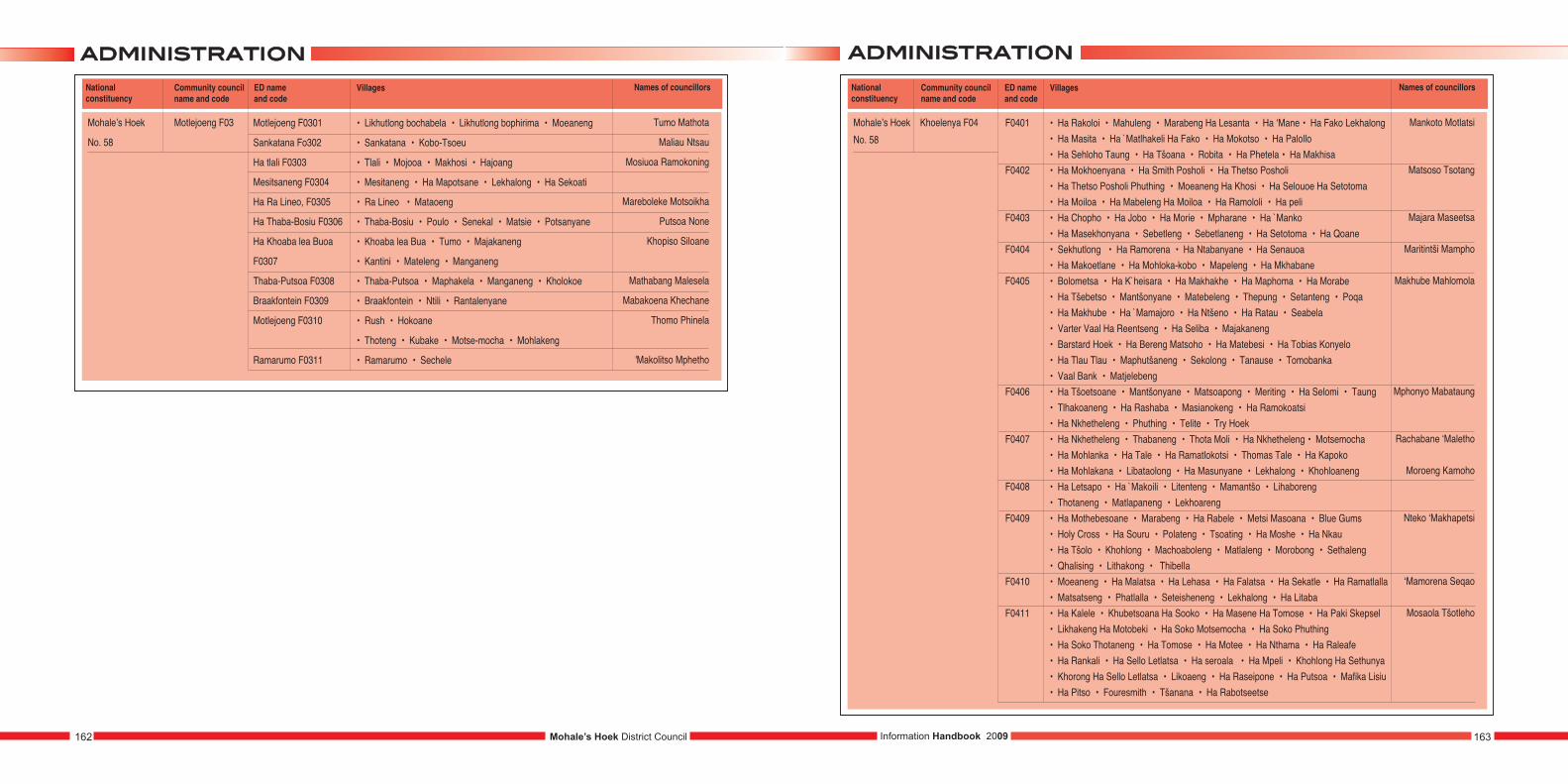
aaddmmiinniissttrraattiioonn aaddmmiinniissttrraattiioonn
Information Handbook 2009 163162 Mohale’s Hoek District Council
National constituency
Community councilname and code
ED name and code
Mohale’s Hoek
No. 58
Khoelenya F04 F0401
F0402
F0403
F0404
F0405
F0406
F0407
F0408
F0409
F0410
F0411
Villages
• Ha Rakoloi • Mahuleng • Marabeng Ha Lesanta • Ha ‘Mane • Ha Fako Lekhalong• Ha Masita • Ha `Matlhakeli Ha Fako • Ha Mokotso • Ha Palollo • Ha Sehloho Taung • Ha Tšoana • Robita • Ha Phetela • Ha Makhisa• Ha Mokhoenyana • Ha Smith Posholi • Ha Thetso Posholi • Ha Thetso Posholi Phuthing • Moeaneng Ha Khosi • Ha Selouoe Ha Setotoma• Ha Moiloa • Ha Mabeleng Ha Moiloa • Ha Ramololi • Ha peli• Ha Chopho • Ha Jobo • Ha Morie • Mpharane • Ha `Manko • Ha Masekhonyana • Sebetleng • Sebetlaneng • Ha Setotoma • Ha Qoane• Sekhutlong • Ha Ramorena • Ha Ntabanyane • Ha Senauoa• Ha Makoetlane • Ha Mohloka-kobo • Mapeleng • Ha Mkhabane• Bolometsa • Ha K`heisara • Ha Makhakhe • Ha Maphoma • Ha Morabe• Ha Tšebetso • Mantšonyane • Matebeleng • Thepung • Setanteng • Poqa• Ha Makhube • Ha `Mamajoro • Ha Ntšeno • Ha Ratau • Seabela• Varter Vaal Ha Reentseng • Ha Seliba • Majakaneng• Barstard Hoek • Ha Bereng Matsoho • Ha Matebesi • Ha Tobias Konyelo• Ha Tlau Tlau • Maphutšaneng • Sekolong • Tanause • Tomobanka• Vaal Bank • Matjelebeng• Ha Tšoetsoane • Mantšonyane • Matsoapong • Meriting • Ha Selomi • Taung• Tlhakoaneng • Ha Rashaba • Masianokeng • Ha Ramokoatsi • Ha Nkhetheleng • Phuthing • Telite • Try Hoek• Ha Nkhetheleng • Thabaneng • Thota Moli • Ha Nkhetheleng • Motsemocha• Ha Mohlanka • Ha Tale • Ha Ramatlokotsi • Thomas Tale • Ha Kapoko• Ha Mohlakana • Libataolong • Ha Masunyane • Lekhalong • Khohloaneng• Ha Letsapo • Ha `Makoili • Litenteng • Mamantšo • Lihaboreng• Thotaneng • Matlapaneng • Lekhoareng• Ha Mothebesoane • Marabeng • Ha Rabele • Metsi Masoana • Blue Gums• Holy Cross • Ha Souru • Polateng • Tsoating • Ha Moshe • Ha Nkau • Ha Tšolo • Khohlong • Machoaboleng • Matlaleng • Morobong • Sethaleng • Qhalising • Lithakong • Thibella• Moeaneng • Ha Malatsa • Ha Lehasa • Ha Falatsa • Ha Sekatle • Ha Ramatlalla• Matsatseng • Phatlalla • Seteisheneng • Lekhalong • Ha Litaba• Ha Kalele • Khubetsoana Ha Sooko • Ha Masene Ha Tomose • Ha Paki Skepsel• Likhakeng Ha Motobeki • Ha Soko Motsemocha • Ha Soko Phuthing• Ha Soko Thotaneng • Ha Tomose • Ha Motee • Ha Nthama • Ha Raleafe• Ha Rankali • Ha Sello Letlatsa • Ha seroala • Ha Mpeli • Khohlong Ha Sethunya• Khorong Ha Sello Letlatsa • Likoaeng • Ha Raseipone • Ha Putsoa • Mafika Lisiu• Ha Pitso • Fouresmith • Tšanana • Ha Rabotseetse
Names of councillors
Mankoto Motlatsi
Matsoso Tsotang
Majara Maseetsa
Maritintši Mampho
Makhube Mahlomola
Mphonyo Mabataung
Rachabane ‘Maletho
Moroeng Kamoho
Nteko ‘Makhapetsi
‘Mamorena Seqao
Mosaola Tšotleho
National constituency
Community councilname and code
ED name and code
Mohale’s Hoek
No. 58
Motlejoeng F03 Motlejoeng F0301
Sankatana Fo302
Ha tlali F0303
Mesitsaneng F0304
Ha Ra Lineo, F0305
Ha Thaba-Bosiu F0306
Ha Khoaba lea Buoa
F0307
Thaba-Putsoa F0308
Braakfontein F0309
Motlejoeng F0310
Ramarumo F0311
Villages
• Likhutlong bochabela • Likhutlong bophirima • Moeaneng
• Sankatana • Kobo-Tsoeu
• Tlali • Mojooa • Makhosi • Hajoang
• Mesitaneng • Ha Mapotsane • Lekhalong • Ha Sekoati
• Ra Lineo • Mataoeng
• Thaba-Bosiu • Poulo • Senekal • Matsie • Potsanyane
• Khoaba lea Bua • Tumo • Majakaneng
• Kantini • Mateleng • Manganeng
• Thaba-Putsoa • Maphakela • Manganeng • Kholokoe
• Braakfontein • Ntili • Rantalenyane
• Rush • Hokoane
• Thoteng • Kubake • Motse-mocha • Mohlakeng
• Ramarumo • Sechele
Names of councillors
Tumo Mathota
Maliau Ntsau
Mosiuoa Ramokoning
Mareboleke Motsoikha
Putsoa None
Khopiso Siloane
Mathabang Malesela
Mabakoena Khechane
Thomo Phinela
'Makolitso Mphetho
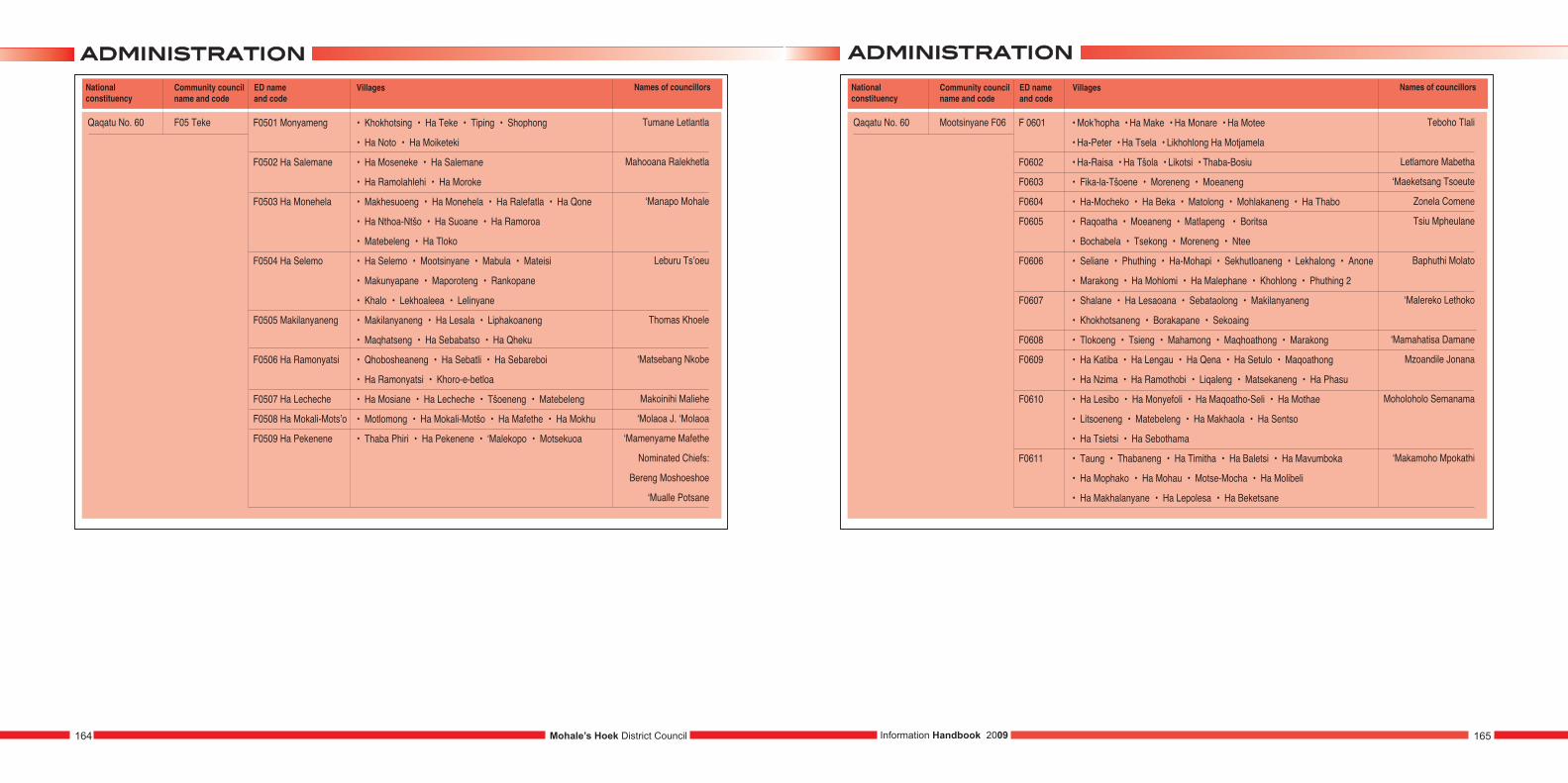
aaddmmiinniissttrraattiioonn aaddmmiinniissttrraattiioonn
Information Handbook 2009 165164 Mohale’s Hoek District Council
National constituency
Community councilname and code
ED name and code
Qaqatu No. 60 Mootsinyane F06 F 0601
F0602
F0603
F0604
F0605
F0606
F0607
F0608
F0609
F0610
F0611
Villages
• Mok’hopha • Ha Make • Ha Monare • Ha Motee
• Ha-Peter • Ha Tsela • Likhohlong Ha Motjamela
• Ha-Raisa • Ha Tšola • Likotsi • Thaba-Bosiu
• Fika-la-Tšoene • Moreneng • Moeaneng
• Ha-Mocheko • Ha Beka • Matolong • Mohlakaneng • Ha Thabo
• Raqoatha • Moeaneng • Matlapeng • Boritsa
• Bochabela • Tsekong • Moreneng • Ntee
• Seliane • Phuthing • Ha-Mohapi • Sekhutloaneng • Lekhalong • Anone
• Marakong • Ha Mohlomi • Ha Malephane • Khohlong • Phuthing 2
• Shalane • Ha Lesaoana • Sebataolong • Makilanyaneng
• Khokhotsaneng • Borakapane • Sekoaing
• Tlokoeng • Tsieng • Mahamong • Maqhoathong • Marakong
• Ha Katiba • Ha Lengau • Ha Qena • Ha Setulo • Maqoathong
• Ha Nzima • Ha Ramothobi • Liqaleng • Matsekaneng • Ha Phasu
• Ha Lesibo • Ha Monyefoli • Ha Maqoatho-Seli • Ha Mothae
• Litsoeneng • Matebeleng • Ha Makhaola • Ha Sentso
• Ha Tsietsi • Ha Sebothama
• Taung • Thabaneng • Ha Timitha • Ha Baletsi • Ha Mavumboka
• Ha Mophako • Ha Mohau • Motse-Mocha • Ha Molibeli
• Ha Makhalanyane • Ha Lepolesa • Ha Beketsane
Names of councillors
Teboho Tlali
Letlamore Mabetha
‘Maeketsang Tsoeute
Zonela Comene
Tsiu Mpheulane
Baphuthi Molato
‘Malereko Lethoko
‘Mamahatisa Damane
Mzoandile Jonana
Moholoholo Semanama
‘Makamoho Mpokathi
National constituency
Community councilname and code
ED name and code
Qaqatu No. 60 F05 Teke F0501 Monyameng
F0502 Ha Salemane
F0503 Ha Monehela
F0504 Ha Selemo
F0505 Makilanyaneng
F0506 Ha Ramonyatsi
F0507 Ha Lecheche
F0508 Ha Mokali-Mots’o
F0509 Ha Pekenene
Villages
• Khokhotsing • Ha Teke • Tiping • Shophong
• Ha Noto • Ha Moiketeki
• Ha Moseneke • Ha Salemane
• Ha Ramolahlehi • Ha Moroke
• Makhesuoeng • Ha Monehela • Ha Ralefatla • Ha Qone
• Ha Nthoa-Ntšo • Ha Suoane • Ha Ramoroa
• Matebeleng • Ha Tloko
• Ha Selemo • Mootsinyane • Mabula • Mateisi
• Makunyapane • Maporoteng • Rankopane
• Khalo • Lekhoaleea • Lelinyane
• Makilanyaneng • Ha Lesala • Liphakoaneng
• Maqhatseng • Ha Sebabatso • Ha Qheku
• Qhobosheaneng • Ha Sebatli • Ha Sebareboi
• Ha Ramonyatsi • Khoro-e-betloa
• Ha Mosiane • Ha Lecheche • Tšoeneng • Matebeleng
• Motlomong • Ha Mokali-Motšo • Ha Mafethe • Ha Mokhu
• Thaba Phiri • Ha Pekenene • ‘Malekopo • Motsekuoa
Names of councillors
Tumane Letlantla
Mahooana Ralekhetla
‘Manapo Mohale
Leburu Ts’oeu
Thomas Khoele
‘Matsebang Nkobe
Makoinihi Maliehe
‘Molaoa J. ‘Molaoa
‘Mamenyame Mafethe
Nominated Chiefs:
Bereng Moshoeshoe
‘Mualle Potsane
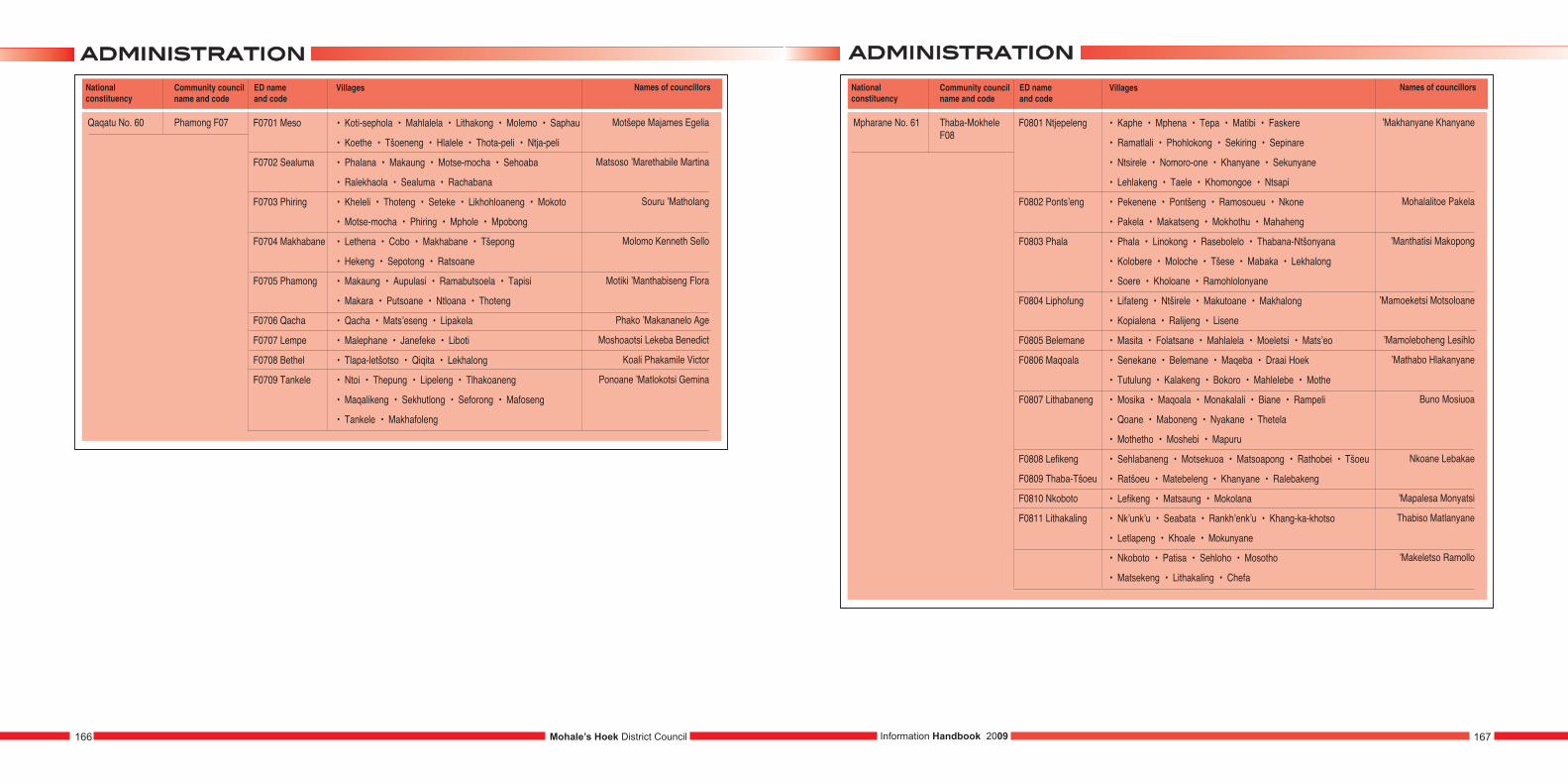
aaddmmiinniissttrraattiioonnaaddmmiinniissttrraattiioonn
Information Handbook 2009 167166 Mohale’s Hoek District Council
National constituency
Community councilname and code
ED name and code
Mpharane No. 61 Thaba-MokheleF08
F0801 Ntjepeleng
F0802 Ponts’eng
F0803 Phala
F0804 Liphofung
F0805 Belemane
F0806 Maqoala
F0807 Lithabaneng
F0808 Lefikeng
F0809 Thaba-Tšoeu
F0810 Nkoboto
F0811 Lithakaling
Villages
• Kaphe • Mphena • Tepa • Matibi • Faskere
• Ramatlali • Phohlokong • Sekiring • Sepinare
• Ntsirele • Nomoro-one • Khanyane • Sekunyane
• Lehlakeng • Taele • Khomongoe • Ntsapi
• Pekenene • Pontšeng • Ramosoueu • Nkone
• Pakela • Makatseng • Mokhothu • Mahaheng
• Phala • Linokong • Rasebolelo • Thabana-Ntšonyana
• Kolobere • Moloche • Tšese • Mabaka • Lekhalong
• Soere • Kholoane • Ramohlolonyane
• Lifateng • Ntširele • Makutoane • Makhalong
• Kopialena • Ralijeng • Lisene
• Masita • Folatsane • Mahlalela • Moeletsi • Mats’eo
• Senekane • Belemane • Maqeba • Draai Hoek
• Tutulung • Kalakeng • Bokoro • Mahlelebe • Mothe
• Mosika • Maqoala • Monakalali • Biane • Rampeli
• Qoane • Maboneng • Nyakane • Thetela
• Mothetho • Moshebi • Mapuru
• Sehlabaneng • Motsekuoa • Matsoapong • Rathobei • Tšoeu
• Ratšoeu • Matebeleng • Khanyane • Ralebakeng
• Lefikeng • Matsaung • Mokolana
• Nk’unk’u • Seabata • Rankh’enk’u • Khang-ka-khotso
• Letlapeng • Khoale • Mokunyane
• Nkoboto • Patisa • Sehloho • Mosotho
• Matsekeng • Lithakaling • Chefa
Names of councillors
’Makhanyane Khanyane
Mohalalitoe Pakela
’Manthatisi Makopong
’Mamoeketsi Motsoloane
’Mamoleboheng Lesihlo
’Mathabo Hlakanyane
Buno Mosiuoa
Nkoane Lebakae
’Mapalesa Monyatsi
Thabiso Matlanyane
’Makeletso Ramollo
National constituency
Community councilname and code
ED name and code
Qaqatu No. 60 Phamong F07 F0701 Meso
F0702 Sealuma
F0703 Phiring
F0704 Makhabane
F0705 Phamong
F0706 Qacha
F0707 Lempe
F0708 Bethel
F0709 Tankele
Villages
• Koti-sephola • Mahlalela • Lithakong • Molemo • Saphau
• Koethe • Tšoeneng • Hlalele • Thota-peli • Ntja-peli
• Phalana • Makaung • Motse-mocha • Sehoaba
• Ralekhaola • Sealuma • Rachabana
• Kheleli • Thoteng • Seteke • Likhohloaneng • Mokoto
• Motse-mocha • Phiring • Mphole • Mpobong
• Lethena • Cobo • Makhabane • Tšepong
• Hekeng • Sepotong • Ratsoane
• Makaung • Aupulasi • Ramabutsoela • Tapisi
• Makara • Putsoane • Ntloana • Thoteng
• Qacha • Mats’eseng • Lipakela
• Malephane • Janefeke • Liboti
• Tlapa-letšotso • Qiqita • Lekhalong
• Ntoi • Thepung • Lipeleng • Tlhakoaneng
• Maqalikeng • Sekhutlong • Seforong • Mafoseng
• Tankele • Makhafoleng
Names of councillors
Motšepe Majames Egelia
Matsoso ’Marethabile Martina
Souru ’Matholang
Molomo Kenneth Sello
Motiki ’Manthabiseng Flora
Phako ’Makananelo Age
Moshoaotsi Lekeba Benedict
Koali Phakamile Victor
Ponoane ’Matlokotsi Gemina
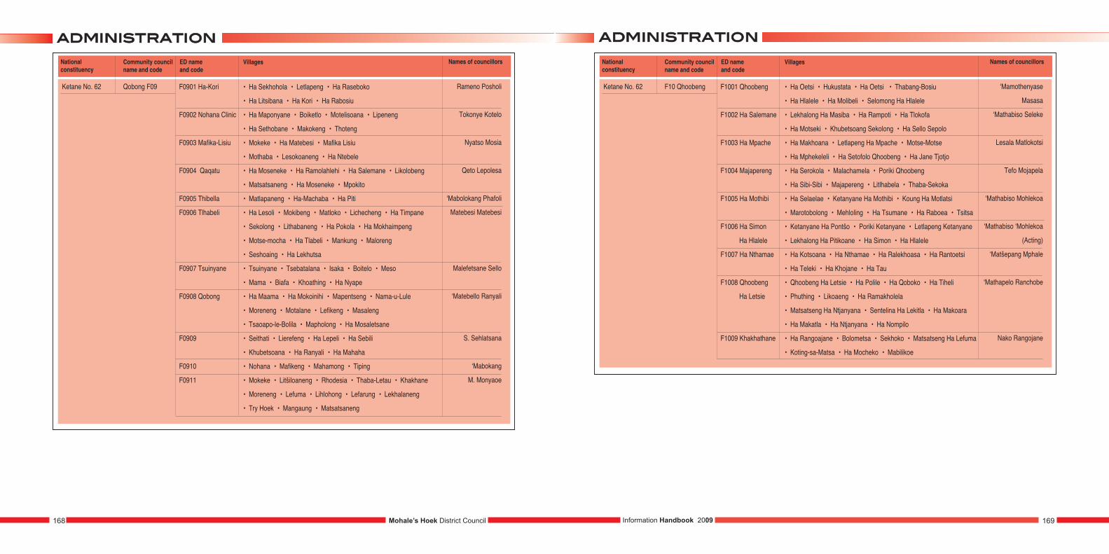
aaddmmiinniissttrraattiioonn aaddmmiinniissttrraattiioonn
Information Handbook 2009 169168 Mohale’s Hoek District Council
National constituency
Community councilname and code
ED name and code
Ketane No. 62 F10 Qhoobeng F1001 Qhoobeng
F1002 Ha Salemane
F1003 Ha Mpache
F1004 Majapereng
F1005 Ha Mothibi
F1006 Ha Simon
Ha Hlalele
F1007 Ha Nthamae
F1008 Qhoobeng
Ha Letsie
F1009 Khakhathane
Villages
• Ha Oetsi • Hukustata • Ha Oetsi • Thabang-Bosiu
• Ha Hlalele • Ha Molibeli • Selomong Ha Hlalele
• Lekhalong Ha Masiba • Ha Rampoti • Ha Tlokofa
• Ha Motseki • Khubetsoang Sekolong • Ha Sello Sepolo
• Ha Makhoana • Letlapeng Ha Mpache • Motse-Motse
• Ha Mphekeleli • Ha Setofolo Qhoobeng • Ha Jane Tjotjo
• Ha Serokola • Malachamela • Poriki Qhoobeng
• Ha Sibi-Sibi • Majapereng • Litlhabela • Thaba-Sekoka
• Ha Selaelae • Ketanyane Ha Mothibi • Koung Ha Motlatsi
• Marotobolong • Mehloling • Ha Tsumane • Ha Raboea • Tsitsa
• Ketanyane Ha Pontšo • Poriki Ketanyane • Letlapeng Ketanyane
• Lekhalong Ha Pitikoane • Ha Simon • Ha Hlalele
• Ha Kotsoana • Ha Nthamae • Ha Ralekhoasa • Ha Rantoetsi
• Ha Teleki • Ha Khojane • Ha Tau
• Qhoobeng Ha Letsie • Ha Polile • Ha Qoboko • Ha Tiheli
• Phuthing • Likoaeng • Ha Ramakholela
• Matsatseng Ha Ntjanyana • Sentelina Ha Lekitla • Ha Makoara
• Ha Makatla • Ha Ntjanyana • Ha Nompilo
• Ha Rangoajane • Bolometsa • Sekhoko • Matsatseng Ha Lefuma
• Koting-sa-Matsa • Ha Mocheko • Mabilikoe
Names of councillors
‘Mamothenyase
Masasa
‘Mathabiso Seleke
Lesala Matlokotsi
Tefo Mojapela
‘Mathabiso Mohlekoa
‘Mathabiso ‘Mohlekoa
(Acting)
‘Matšepang Mphale
‘Mathapelo Ranchobe
Nako Rangojane
National constituency
Community councilname and code
ED name and code
Ketane No. 62 Qobong F09 F0901 Ha-Kori
F0902 Nohana Clinic
F0903 Mafika-Lisiu
F0904 Qaqatu
F0905 Thibella
F0906 Tlhabeli
F0907 Tsuinyane
F0908 Qobong
F0909
F0910
F0911
Villages
• Ha Sekhohola • Letlapeng • Ha Raseboko
• Ha Litsibana • Ha Kori • Ha Rabosiu
• Ha Maponyane • Boiketlo • Motelisoana • Lipeneng
• Ha Sethobane • Makokeng • Thoteng
• Mokeke • Ha Matebesi • Mafika Lisiu
• Mothaba • Lesokoaneng • Ha Ntebele
• Ha Moseneke • Ha Ramolahlehi • Ha Salemane • Likolobeng
• Matsatsaneng • Ha Moseneke • Mpokito
• Matlapaneng • Ha-Machaba • Ha Piti
• Ha Lesoli • Mokibeng • Matloko • Lichecheng • Ha Timpane
• Sekolong • Lithabaneng • Ha Pokola • Ha Mokhaimpeng
• Motse-mocha • Ha Tlabeli • Mankung • Maloreng
• Seshoaing • Ha Lekhutsa
• Tsuinyane • Tsebatalana • Isaka • Boitelo • Meso
• Mama • Biafa • Khoathing • Ha Nyape
• Ha Maama • Ha Mokoinihi • Mapentseng • Nama-u-Lule
• Moreneng • Motalane • Lefikeng • Masaleng
• Tsaoapo-le-Bolila • Mapholong • Ha Mosaletsane
• Seithati • Lierefeng • Ha Lepeli • Ha Sebili
• Khubetsoana • Ha Ranyali • Ha Mahaha
• Nohana • Mafikeng • Mahamong • Tiping
• Mokeke • Litšiloaneng • Rhodesia • Thaba-Letau • Khakhane
• Moreneng • Lefuma • Lihlohong • Lefarung • Lekhalaneng
• Try Hoek • Mangaung • Matsatsaneng
Names of councillors
Rameno Posholi
Tokonye Kotelo
Nyatso Mosia
Qeto Lepolesa
‘Mabolokang Phafoli
Matebesi Matebesi
Malefetsane Sello
‘Matebello Ranyali
S. Sehlatsana
‘Mabokang
M. Monyaoe
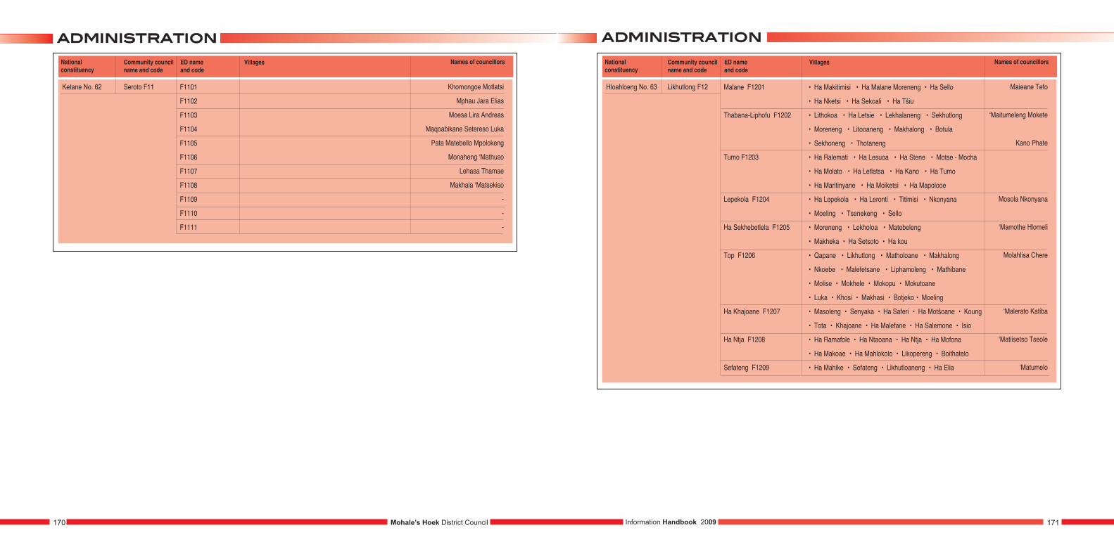
aaddmmiinniissttrraattiioonn aaddmmiinniissttrraattiioonn
Information Handbook 2009 171170 Mohale’s Hoek District Council
National constituency
Community councilname and code
ED name and code
Hloahloeng No. 63 Likhutlong F12 Malane F1201
Thabana-Liphofu F1202
Tumo F1203
Lepekola F1204
Ha Sekhebetlela F1205
Top F1206
Ha Khajoane F1207
Ha Ntja F1208
Sefateng F1209
Villages
• Ha Makitimisi • Ha Malane Moreneng • Ha Sello
• Ha Nketsi • Ha Sekoali • Ha Tšiu
• Lithokoa • Ha Letsie • Lekhalaneng • Sekhutlong
• Moreneng • Litooaneng • Makhalong • Botula
• Sekhoneng • Thotaneng
• Ha Ralemati • Ha Lesuoa • Ha Stene • Motse - Mocha
• Ha Molato • Ha Letlatsa • Ha Kano • Ha Tumo
• Ha Maritinyane • Ha Moiketsi • Ha Mapolooe
• Ha Lepekola • Ha Leronti • Titimisi • Nkonyana
• Moeling • Tsenekeng • Sello
• Moreneng • Lekholoa • Matebeleng
• Makheka • Ha Setsoto • Ha kou
• Qapane • Likhutlong • Matholoane • Makhalong
• Nkoebe • Malefetsane • Liphamoleng • Mathibane
• Molise • Mokhele • Mokopu • Mokutoane
• Luka • Khosi • Makhasi • Botjeko • Moeling
• Masoleng • Senyaka • Ha Saferi • Ha Motšoane • Koung
• Tota • Khajoane • Ha Malefane • Ha Salemone • Isio
• Ha Ramafole • Ha Ntaoana • Ha Ntja • Ha Mofona
• Ha Makoae • Ha Mahlokolo • Likopereng • Boithatelo
• Ha Mahike • Sefateng • Likhutloaneng • Ha Elia
Names of councillors
Maieane Tefo
‘Maitumeleng Mokete
Kano Phate
Mosola Nkonyana
‘Mamothe Hlomeli
Molahlisa Chere
‘Malerato Katiba
‘Matiisetso Tseole
‘Matumelo
National constituency
Community councilname and code
ED name and code
Ketane No. 62 Seroto F11 F1101
F1102
F1103
F1104
F1105
F1106
F1107
F1108
F1109
F1110
F1111
Villages Names of councillors
Khomongoe Motlatsi
Mphau Jara Elias
Moesa Lira Andreas
Maqoabikane Setereso Luka
Pata Matebello Mpolokeng
Monaheng ‘Mathuso
Lehasa Thamae
Makhala ‘Matsekiso
-
-
-
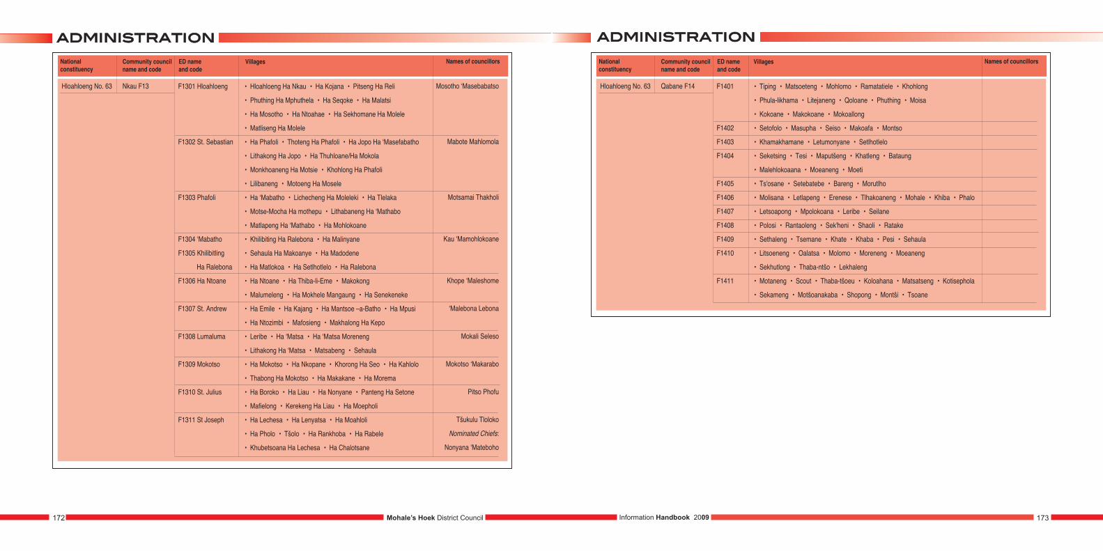
aaddmmiinniissttrraattiioonn aaddmmiinniissttrraattiioonn
Information Handbook 2009 173172 Mohale’s Hoek District Council
National constituency
Community councilname and code
ED name and code
Hloahloeng No. 63 Qabane F14 F1401
F1402
F1403
F1404
F1405
F1406
F1407
F1408
F1409
F1410
F1411
Villages
• Tiping • Matsoeteng • Mohlomo • Ramatatiele • Khohlong
• Phula-likhama • Litejaneng • Qoloane • Phuthing • Moisa
• Kokoane • Makokoane • Mokoallong
• Setofolo • Masupha • Seiso • Makoafa • Montso
• Khamakhamane • Letumonyane • Setlhotlelo
• Seketsing • Tesi • Maputšeng • Khatleng • Bataung
• Malehlokoaana • Moeaneng • Moeti
• Ts'osane • Setebatebe • Bareng • Morutlho
• Molisana • Letlapeng • Erenese • Tlhakoaneng • Mohale • Khiba • Phalo
• Letsoapong • Mpolokoana • Leribe • Seilane
• Polosi • Rantaoleng • Sek'heni • Shaoli • Ratake
• Sethaleng • Tsemane • Khate • Khaba • Pesi • Sehaula
• Litsoeneng • Oalatsa • Molomo • Moreneng • Moeaneng
• Sekhutlong • Thaba-ntšo • Lekhaleng
• Motaneng • Scout • Thaba-tšoeu • Koloahana • Matsatseng • Kotisephola
• Sekameng • Motšoanakaba • Shopong • Montši • Tsoane
Names of councillorsNational constituency
Community councilname and code
ED name and code
Hloahloeng No. 63 Nkau F13 F1301 Hloahloeng
F1302 St. Sebastian
F1303 Phafoli
F1304 ‘Mabatho
F1305 Khilibitling
Ha Ralebona
F1306 Ha Ntoane
F1307 St. Andrew
F1308 Lumaluma
F1309 Mokotso
F1310 St. Julius
F1311 St Joseph
Villages
• Hloahloeng Ha Nkau • Ha Kojana • Pitseng Ha Reli
• Phuthing Ha Mphuthela • Ha Seqoke • Ha Malatsi
• Ha Mosotho • Ha Ntoahae • Ha Sekhomane Ha Molele
• Matliseng Ha Molele
• Ha Phafoli • Thoteng Ha Phafoli • Ha Jopo Ha ‘Masefabatho
• Lithakong Ha Jopo • Ha Thuhloane/Ha Mokola
• Monkhoaneng Ha Motsie • Khohlong Ha Phafoli
• Lilibaneng • Motoeng Ha Mosele
• Ha ‘Mabatho • Lichecheng Ha Moleleki • Ha Tlelaka
• Motse-Mocha Ha mothepu • Lithabaneng Ha ‘Mathabo
• Matlapeng Ha ‘Mathabo • Ha Mohlokoane
• Khilibiting Ha Ralebona • Ha Malinyane
• Sehaula Ha Makoanye • Ha Madodene
• Ha Matlokoa • Ha Setlhotlelo • Ha Ralebona
• Ha Ntoane • Ha Thiba-li-Eme • Makokong
• Malumeleng • Ha Mokhele Mangaung • Ha Senekeneke
• Ha Emile • Ha Kajang • Ha Mantsoe –a-Batho • Ha Mpusi
• Ha Ntozimbi • Mafosieng • Makhalong Ha Kepo
• Leribe • Ha ‘Matsa • Ha ‘Matsa Moreneng
• Lithakong Ha ‘Matsa • Matsabeng • Sehaula
• Ha Mokotso • Ha Nkopane • Khorong Ha Seo • Ha Kahlolo
• Thabong Ha Mokotso • Ha Makakane • Ha Morema
• Ha Boroko • Ha Liau • Ha Nonyane • Panteng Ha Setone
• Mafielong • Kerekeng Ha Liau • Ha Moepholi
• Ha Lechesa • Ha Lenyatsa • Ha Moahloli
• Ha Pholo • Tšolo • Ha Rankhoba • Ha Rabele
• Khubetsoana Ha Lechesa • Ha Chalotsane
Names of councillors
Mosotho ‘Masebabatso
Mabote Mahlomola
Motsamai Thakholi
Kau ‘Mamohlokoane
Khope ‘Maleshome
‘Malebona Lebona
Mokali Seleso
Mokotso ‘Makarabo
Pitso Phofu
Tšukulu Tloloko
Nominated Chiefs:
Nonyana ‘Mateboho

BBCCIIccoouunncciill
174 Mohale’s Hoek District Council
District Council Committees and members
HIV & AIDS Committee
1. ‘Marefuoe ‘Muso
2. ‘Nyane Rakolobe
3. ‘Manthabeleng Motiki
4. Baphuthi Molato
Planning and Finance Committee
1. Khopiso Tšiloane
2. ‘Manthabeleng Motiki
3. ‘Nyane Rakolobe
Land administration
1. Tloloko Tšukulu
2. ‘Maletho Rachabane
3. Motlatsi Khomonngoe
Environment
1. Kenneth Molomo
2. ‘Manthatisi Makopong
3. Motlatsi Letsie
4. ‘Matiisetso Matsie
5. Seleso Mokali
6. ‘Mathabang Mathibeli
7. Leburu Tšoeu
District Council Mohale’s Hoek
1. Khopiso Tšiloane (Chairperson)
2. Nkoane Lebakae (Deputy)
3. Daniel Ratolo
4. ‘Matiisetso Matsie
5. ‘Nyane Rakolobe
6. ‘Mammota A. Sehlabaka
7. Phakiso E. Thamae
8. Joseph T. Mosaola
9. ‘Maletho Rachabane
10. Leburu M. Tšoeu
11. ‘Manapo Mohale
12. Tšiu Mpheulane
13. Baphuthi Molato
14. ‘Manthabeleng Motiki
15. Kenneth Molomo
16. ‘Manthatisi Makopong
17. ‘Marefuoe ‘Muso
18. Matebesi Matebesi
19. Nako B. Rangoajane
20. Tefo Mojapela
21. Motlatsi E. Khomonngoe
22. Potsanyane M. Sehloho
23. Kano P. Phate
24. Tšiu J. Moshoeshoe
25. Seleso A Mokali
26. Tloloko A. Tšukulu
27. ‘Mathabang J. Mathibeli
28. Paleo D. Diau
29. Malebanye Malebanye (Chief representative)
30. Motlatsi Letsie ( Chief representative)
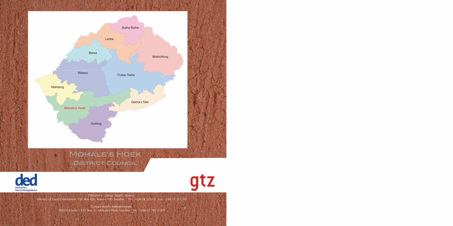
Mohale’s HoekDistrict Council
Publisher’s contact details, Maseru: Ministry of Local Government, P.O. Box 686, Maseru 100, Lesotho. Tel.: +266 22 325331 Fax: +266 22 311269
Contact details, Mohale’s Hoek:District Council, P.O. Box 32, Mohale’s Hoek, Lesotho. Tel.: +266 22 785 338/9
Quthing
Thaba-Tseka
Mokhotlong
Butha-Buthe
Qacha’s Nek
Leribe
Berea
Maseru
Mafeteng
Mohale’s Hoek


