Embed Size (px)
Citation preview
MINING PLAN FOR KUNNUR ROUGH STONE & GRAVEL QUARRY
LEASE IN OWN PATTA LAND
(Prepared under 41 & 42 Tamil Nadu Minor Mineral Concession Rules, 1959
And amended Minor Mineral Conservation and Development Rules, 2010)
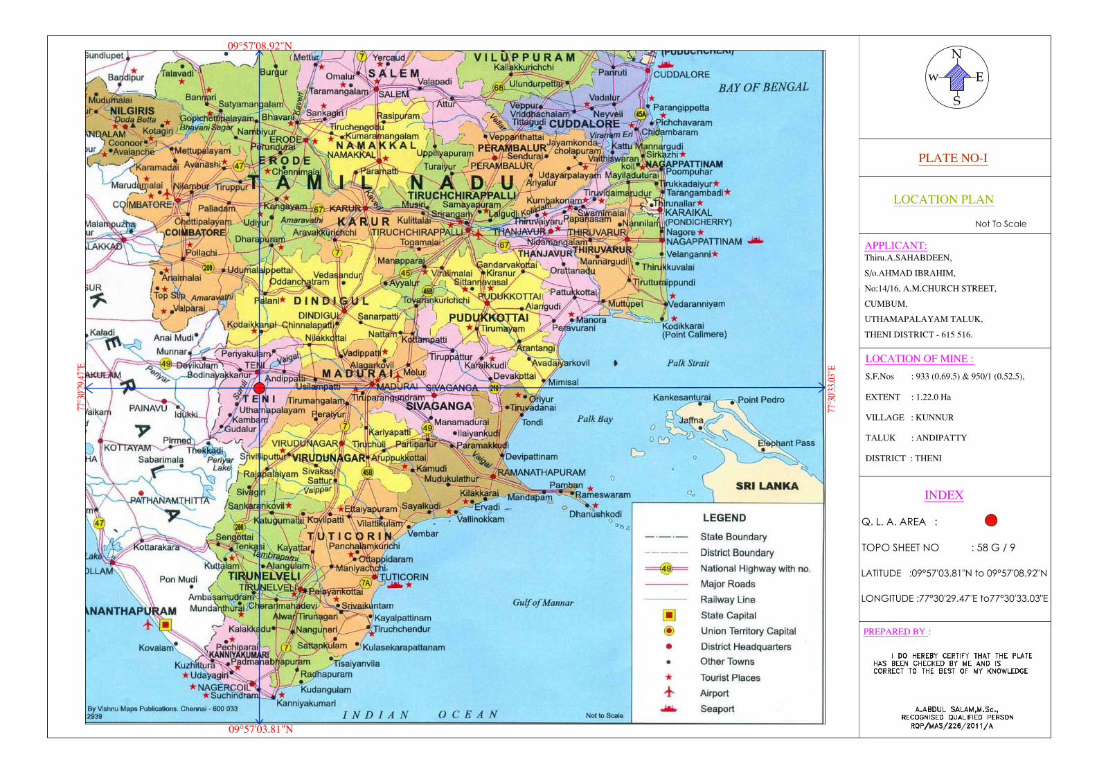
LOCATION OF THE QUARRY LEASE AREA
STATE : TAMIL NADU
DISTRICT : THENI
TALUK : ANDIPATTY
VILLAGE : KUNNUR
S.F.Nos : 933 (0.69.5) & 950/1 (0.52.5)
EXTENT : 1.22.0Ha
For
APPLICANT
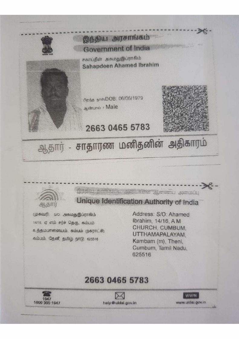
Thiru.A.Sahabdeen,
S/o.Ahmad Ibrahim,
No:14/16, A.M.Church Street,
Cumbum,
Uthamapalayam Taluk,
Theni District - 615 516.
PREPARED BY
A.ABDUL SALAM, M.Sc.,
Recognised Qualified Person Reg.No.RQP/MAS/226/2011/A
SAI RAM MINING & GEOLOGY CONSULTANCY
Regd.Office:4/193.A,Gokula Krishna Street,
Advaidha Ashramam Road , Alagapuram,
Salem-636004. Ph: 0427-4266767 | Cell- 9994466685
1
CONTENTS
Sl. No. Description Page No.
1.0 Introduction 7
2.0 Executive Summary 9
PART -A
3.0 General Information 11
4.0 Location 12
5.0 Geology and Mineral Reserves 13
6.0 Ecology and Biodiversity 16
70 Mining 17
8.0 Blasting 22
9.0 Mine Drainage 23
10.0 Other Permanent Structures 24
11.0 Employment Potentials & Welfare Measures 25
PART - B
12.0 Environment Management Plan 27
13.0 Mine Closure Plan 31
14.0 Any Other Details Intend to furnish by the Applicant 32
2
Annexure
Sl.
No. Description
Annexure
No.
1.0 Precise Area Communication letter issued by the
District Collector I
2.0 Copy of the FMB II
3.0 Copy of village map III
4.0 Copy of Patta, Adangal & A-Register IV
5.0 Copy of Identity Proof V
6.0 Copy of RQP Certificate VI
LIST OF PLATES
Sl. No. Description Plate No Scale
1 Location Plan I Not to scale
2 Key Plan II Not to scale
3 Topo Sketch of quarry lease area
for 10Km Radius.
III 1:100000
4 Satellite Imagery IV 1:10000
5 Environmental Management Plan V 1:10000
6 Quarry Lease and Surface Plan VI Plan-1:1000
7
Topography, Geological Plan &
Section Year wise Development, Production Plan & Sections
VII,
VII-A & VII-B
Plan-1:1000
SecHor1:1000;
Ver-1:500
8 Conceptual Plan and Sections VIII &
VIII-A
Plan-1:1000
Sec Hor-1:1000; Ver-1:500
3
Thiru.A.Sahabdeen,
S/o.Ahmad Ibrahim,
No:14/16, A.M.Church Street,
Cumbum,
Uthamapalayam Taluk,
Theni District - 615 516.
CONSENT LETTER FROM THE APPLICANT
The Mining Plan in respect of Rough stone & Gravel quarry over an
extent of 1.22.0hectares of Patta land in S.F.Nos. 933 (0.69.5) & 950/1 (0.52.5) of
Kunnur Village, Andipatty Taluk, Theni District, Tamilnadu State has been prepared
by A.Abdul Salam,M.Sc., Recognised Qualified Person, Registration Number
RQP/MAS/226/2011/A
I request the Assistant Director, Department of Geology and Mining, Theni
District to make further correspondence regarding the Mining Plan with the said
Recognised Qualified Person on this following address.
A.ABDUL SALAM, M.Sc.,
Recognised Qualified Person
Reg.No.RQP/MAS/226/2011/A
SAI RAM MINING & GEOLOGY CONSULTANCY
Regd.Office:4/193.A,Gokula Krishna Street,
Advaidha Ashramam Road,
Alagapuram, Salem-636004.
Ph: 0427-4266767 | Cell- 9994466685
Email:[email protected]
I hereby undertake that all so made in the Mining Plan by the Recognised
Qualified Person may be deemed to have been made with my knowledge and Consent
and shall be acceptable to me and building on me in all respects.
Signature of the Applicant
A.Sahabdeen
Place : Theni
Date :
4
Thiru.A.Sahabdeen,
S/o.Ahmad Ibrahim,
No:14/16, A.M.Church Street,
Cumbum,
Uthamapalayam Taluk,
Theni District - 615 516.
DECLARATION
The Mining Plan in respect of Rough stone & Gravel quarry over an extent of
1.22.0Ha of Patta land in S.F.Nos. 933 (0.69.5) & 950/1 (0.52.5) of Kunnur Village,
Andipatty Taluk, Theni District, Tamil Nadu State has been prepared with my
consultation and I have understood the contents and agree to implement the same in
accordance with the Mining Laws.
Signature of the Applicant
A.Sahabdeen,
Place: Theni
Date :
5
A.ABDUL SALAM, M.Sc.,
Recognised Qualified Person,
Reg.No.RQP/MAS/226/2011/A
SAI RAM MINING & GEOLOGY CONSULTANCY
Regd.Office:4/193.A, Gokula Krishna Street,
Advaidha Ashramam Road , Alagapuram,
Salem-636004.
CERTIFICATE
This is to certify that, the provisions of Minor Minerals Conservation and
Development Rules, 2010 (MMCDR) have been observed in the Mining Plan for the
grant of Rough stone & Gravel quarry lease over an extent of 1.22.0Ha of (Patta land)
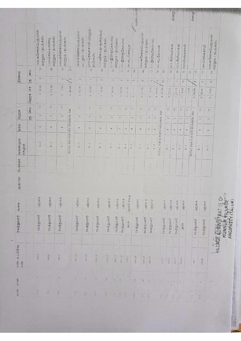
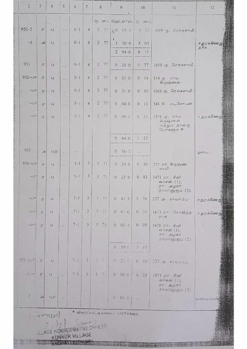
in S.F.Nos. 933 (0.69.5) & 950/1 (0.52.5).15.0), 304/25(0.15.0), 304/26(0.04.0),
304/27(0.17.5), 304/28(0.08.5), 304/29(0.08.0) & 304/30(0.08.0) of Kunnur Village,
Andipatty Taluk, Theni District, Tamil Nadu State applied by Thiru.A.Sahabdeen for
quarry lease.
Wherever specific permission / exemptions / relaxations or approvals are
required, the applicant will approach the concerned authorities of State and Central
Governments for granting such permissions etc.
Certified
Signature of Recognised Qualified Person
Place : Salem
Date :
6
A.ABDUL SALAM, M.Sc.,
Recognised Qualified Person,
Reg.No.RQP/MAS/226/2011/A
SAI RAM MINING & GEOLOGY CONSULTANCY
Regd.Office:4/193.A, Gokula Krishna Street,
Advaidha Ashramam Road , Alagapuram,
Salem-636004.
CERTIFICATE
Certified that, in preparation of Mining Plan for Rough stone & Gravel quarry
over an extent of 1.22.0Ha of Patta land in S.F.Nos. 933 (0.69.5) & 950/1 (0.52.5) of
Kunnur Village, Andipatty Taluk, Theni District Tamil Nadu State
Thiru.A.Sahabdeen covers all the provisions of Mines Act, Rules, and
Regulations etc., made there under and whenever specific permission are required, the
applicant will approach the Director General of Mines Safety, Chennai. The standards
prescribed by DGMS in respect of Mines Health will be strictly implemented.
Certified
Signature of Recognised Qualified Person
Place : Salem
Date :
7
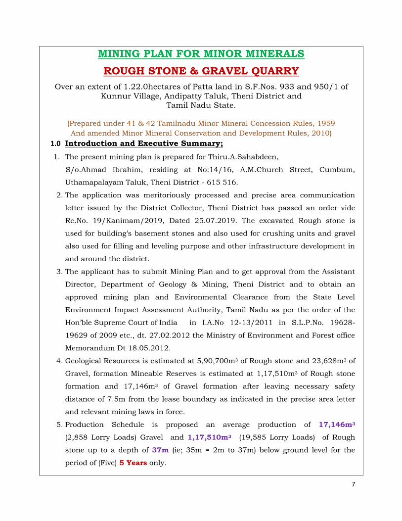
MINING PLAN FOR MINOR MINERALS
ROUGH STONE & GRAVEL QUARRY
Over an extent of 1.22.0hectares of Patta land in S.F.Nos. 933 and 950/1 of
Kunnur Village, Andipatty Taluk, Theni District and Tamil Nadu State.
(Prepared under 41 & 42 Tamilnadu Minor Mineral Concession Rules, 1959
And amended Minor Mineral Conservation and Development Rules, 2010)
1.0 Introduction and Executive Summary;
1. The present mining plan is prepared for Thiru.A.Sahabdeen,
S/o.Ahmad Ibrahim, residing at No:14/16, A.M.Church Street, Cumbum,
Uthamapalayam Taluk, Theni District - 615 516.
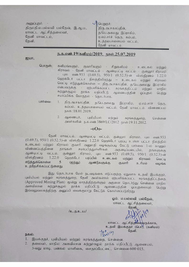
2. The application was meritoriously processed and precise area communication
letter issued by the District Collector, Theni District has passed an order vide
Rc.No. 19/Kanimam/2019, Dated 25.07.2019. The excavated Rough stone is
used for building’s basement stones and also used for crushing units and gravel
also used for filling and leveling purpose and other infrastructure development in
and around the district.
3. The applicant has to submit Mining Plan and to get approval from the Assistant
Director, Department of Geology & Mining, Theni District and to obtain an
approved mining plan and Environmental Clearance from the State Level
Environment Impact Assessment Authority, Tamil Nadu as per the order of the
Hon’ble Supreme Court of India in I.A.No 12-13/2011 in S.L.P.No. 19628-
19629 of 2009 etc., dt. 27.02.2012 the Ministry of Environment and Forest office
Memorandum Dt 18.05.2012.
4. Geological Resources is estimated at 5,90,700m3 of Rough stone and 23,628m3 of
Gravel, formation Mineable Reserves is estimated at 1,17,510m3 of Rough stone
formation and 17,146m3 of Gravel formation after leaving necessary safety
distance of 7.5m from the lease boundary as indicated in the precise area letter
and relevant mining laws in force.
5. Production Schedule is proposed an average production of 17,146m3
(2,858 Lorry Loads) Gravel and 1,17,510m3 (19,585 Lorry Loads) of Rough
stone up to a depth of 37m (ie; 35m = 2m to 37m) below ground level for the
period of (Five) 5 Years only.
8
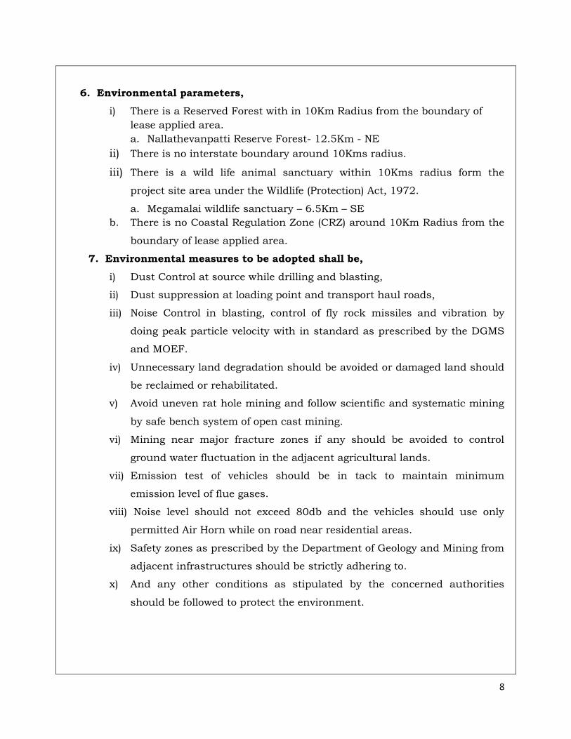
6. Environmental parameters,
i) There is a Reserved Forest with in 10Km Radius from the boundary of
lease applied area.
a. Nallathevanpatti Reserve Forest- 12.5Km - NE
ii) There is no interstate boundary around 10Kms radius.
iii) There is a wild life animal sanctuary within 10Kms radius form the
project site area under the Wildlife (Protection) Act, 1972.
a. Megamalai wildlife sanctuary – 6.5Km – SE
b. There is no Coastal Regulation Zone (CRZ) around 10Km Radius from the
boundary of lease applied area.
7. Environmental measures to be adopted shall be,
i) Dust Control at source while drilling and blasting,
ii) Dust suppression at loading point and transport haul roads,
iii) Noise Control in blasting, control of fly rock missiles and vibration by
doing peak particle velocity with in standard as prescribed by the DGMS
and MOEF.
iv) Unnecessary land degradation should be avoided or damaged land should
be reclaimed or rehabilitated.
v) Avoid uneven rat hole mining and follow scientific and systematic mining
by safe bench system of open cast mining.
vi) Mining near major fracture zones if any should be avoided to control
ground water fluctuation in the adjacent agricultural lands.
vii) Emission test of vehicles should be in tack to maintain minimum
emission level of flue gases.
viii) Noise level should not exceed 80db and the vehicles should use only
permitted Air Horn while on road near residential areas.
ix) Safety zones as prescribed by the Department of Geology and Mining from
adjacent infrastructures should be strictly adhering to.
x) And any other conditions as stipulated by the concerned authorities
should be followed to protect the environment.
9
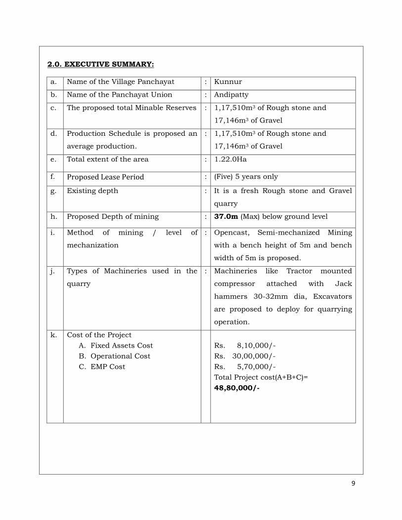
2.0. EXECUTIVE SUMMARY:
a. Name of the Village Panchayat : Kunnur
b. Name of the Panchayat Union : Andipatty
c. The proposed total Minable Reserves : 1,17,510m3 of Rough stone and
17,146m3 of Gravel
d. Production Schedule is proposed an
average production.
: 1,17,510m3 of Rough stone and
17,146m3 of Gravel
e. Total extent of the area : 1.22.0Ha
f. Proposed Lease Period : (Five) 5 years only
g. Existing depth : It is a fresh Rough stone and Gravel
quarry
h. Proposed Depth of mining : 37.0m (Max) below ground level
i. Method of mining / level of
mechanization
: Opencast, Semi-mechanized Mining
with a bench height of 5m and bench
width of 5m is proposed.
j. Types of Machineries used in the
quarry
: Machineries like Tractor mounted
compressor attached with Jack
hammers 30-32mm dia, Excavators
are proposed to deploy for quarrying
operation.
k. Cost of the Project
A. Fixed Assets Cost
B. Operational Cost
C. EMP Cost
Rs. 8,10,000/-
Rs. 30,00,000/-
Rs. 5,70,000/-
Total Project cost(A+B+C)=
48,80,000/-
10
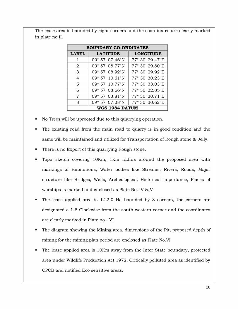
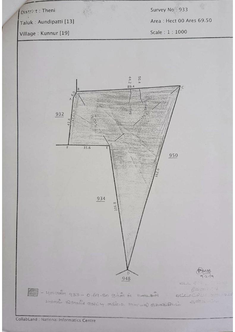
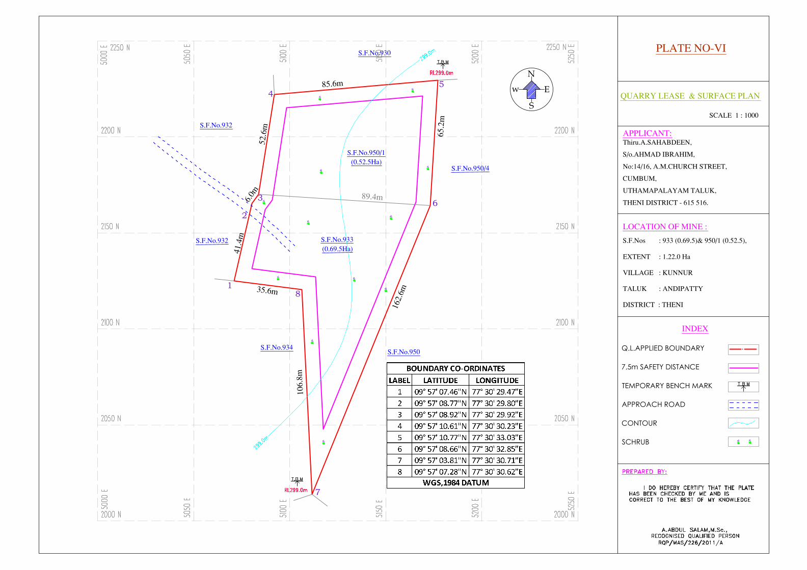
The lease area is bounded by eight corners and the coordinates are clearly marked
in plate no II.
BOUNDARY CO-ORDINATES
LABEL LATITUDE LONGITUDE
1 09° 57' 07.46"N 77° 30' 29.47"E
2 09° 57' 08.77"N 77° 30' 29.80"E
3 09° 57' 08.92"N 77° 30' 29.92"E
4 09° 57' 10.61"N 77° 30' 30.23"E
5 09° 57' 10.77"N 77° 30' 33.03"E
6 09° 57' 08.66"N 77° 30' 32.85"E
7 09° 57' 03.81"N 77° 30' 30.71"E
8 09° 57' 07.28"N 77° 30' 30.62"E
WGS,1984 DATUM
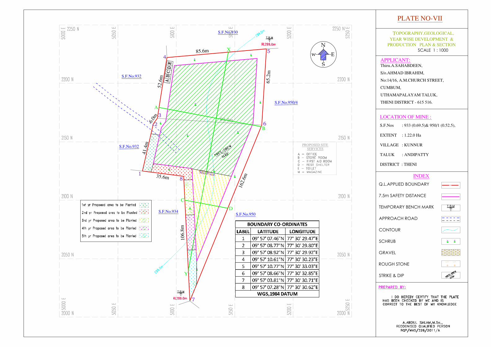
No Trees will be uprooted due to this quarrying operation.
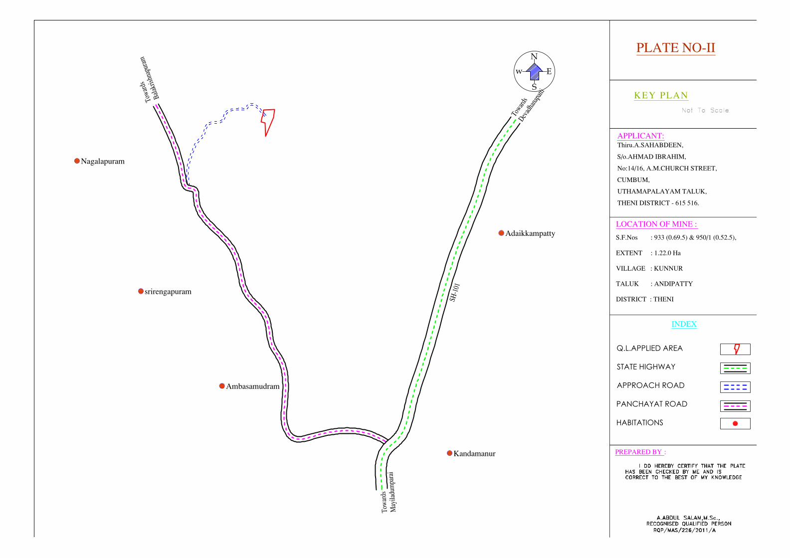
The existing road from the main road to quarry is in good condition and the
same will be maintained and utilized for Transportation of Rough stone & Jelly.
There is no Export of this quarrying Rough stone.
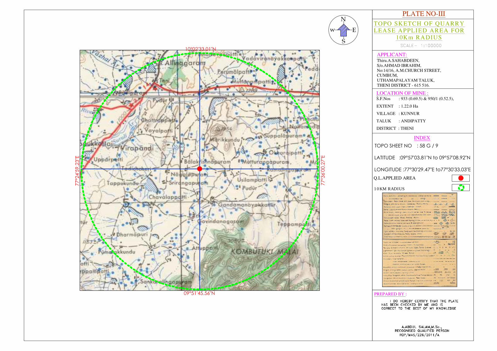
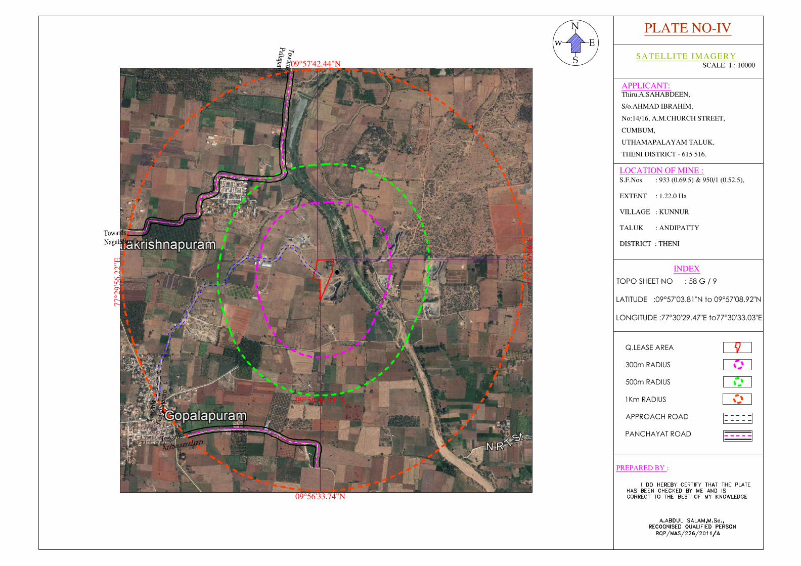
Topo sketch covering 10Km, 1Km radius around the proposed area with
markings of Habitations, Water bodies like Streams, Rivers, Roads, Major
structure like Bridges, Wells, Archeological, Historical importance, Places of
worships is marked and enclosed as Plate No. IV & V
The lease applied area is 1.22.0 Ha bounded by 8 corners, the corners are
designated a 1-8 Clockwise from the south western corner and the coordinates
are clearly marked in Plate no - VI
The diagram showing the Mining area, dimensions of the Pit, proposed depth of
mining for the mining plan period are enclosed as Plate No.VI
The lease applied area is 10Km away from the Inter State boundary, protected
area under Wildlife Production Act 1972, Critically polluted area as identified by
CPCB and notified Eco sensitive areas.
11
There are no wastages anticipated during this quarry operation, hence waste
dump is not proposed in this lease applied area.
Around 18 Employees are deploying in this quarrying operation.
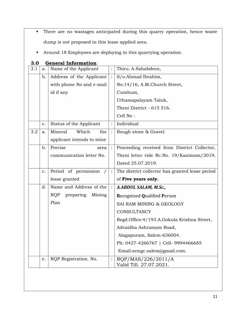
3.0 General Information: 3.1 a. Name of the Applicant : Thiru. A.Sahabdeen,
b. Address of the Applicant
with phone No and e-mail
id if any
: S/o.Ahmad Ibrahim,
No:14/16, A.M.Church Street,
Cumbum,
Uthamapalayam Taluk,
Theni District - 615 516.
Cell No :
c. Status of the Applicant : Individual
3.2 a. Mineral Which the
applicant intends to mine
: Rough stone & Gravel.
b. Precise area
communication letter No.
: Proceeding received from District Collector,
Theni letter vide Rc.No. 19/Kanimam/2019,
Dated 25.07.2019.
c. Period of permission /
lease granted
: The district collector has granted lease period
of Five years only.
d. Name and Address of the
RQP preparing Mining
Plan
: A.ABDUL SALAM, M.Sc.,
Recognised Qualified Person
SAI RAM MINING & GEOLOGY
CONSULTANCY
Regd.Office:4/193.A,Gokula Krishna Street,
Advaidha Ashramam Road,
Alagapuram, Salem-636004.
Ph: 0427-4266767 | Cell- 9994466685
Email:[email protected].
e. RQP Registration. No. : RQP/MAS/226/2011/A Valid Till. 27.07.2021.
12
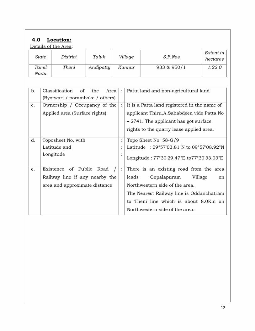
4.0 Location:
Details of the Area:
State District Taluk Village S.F.Nos Extent in
hectares
Tamil
Nadu
Theni Andipatty Kunnur 933 & 950/1 1.22.0
b. Classification of the Area
(Ryotwari / poramboke / others)
: Patta land and non-agricultural land
c. Ownership / Occupancy of the
Applied area (Surface rights)
: It is a Patta land registered in the name of
applicant Thiru.A.Sahabdeen vide Patta No
– 2741. The applicant has got surface
rights to the quarry lease applied area.
d. Toposheet No. with
Latitude and
Longitude
:
:
:
Topo Sheet No: 58-G/9
Latitude : 09°57'03.81"N to 09°57'08.92"N Longitude : 77°30'29.47"E to77°30'33.03"E
e. Existence of Public Road /
Railway line if any nearby the
area and approximate distance
: There is an existing road from the area
leads Gopalapuram Village on
Northwestern side of the area.
The Nearest Railway line is Oddanchatram
to Theni line which is about 8.0Km on
Northwestern side of the area.
13
PART - A
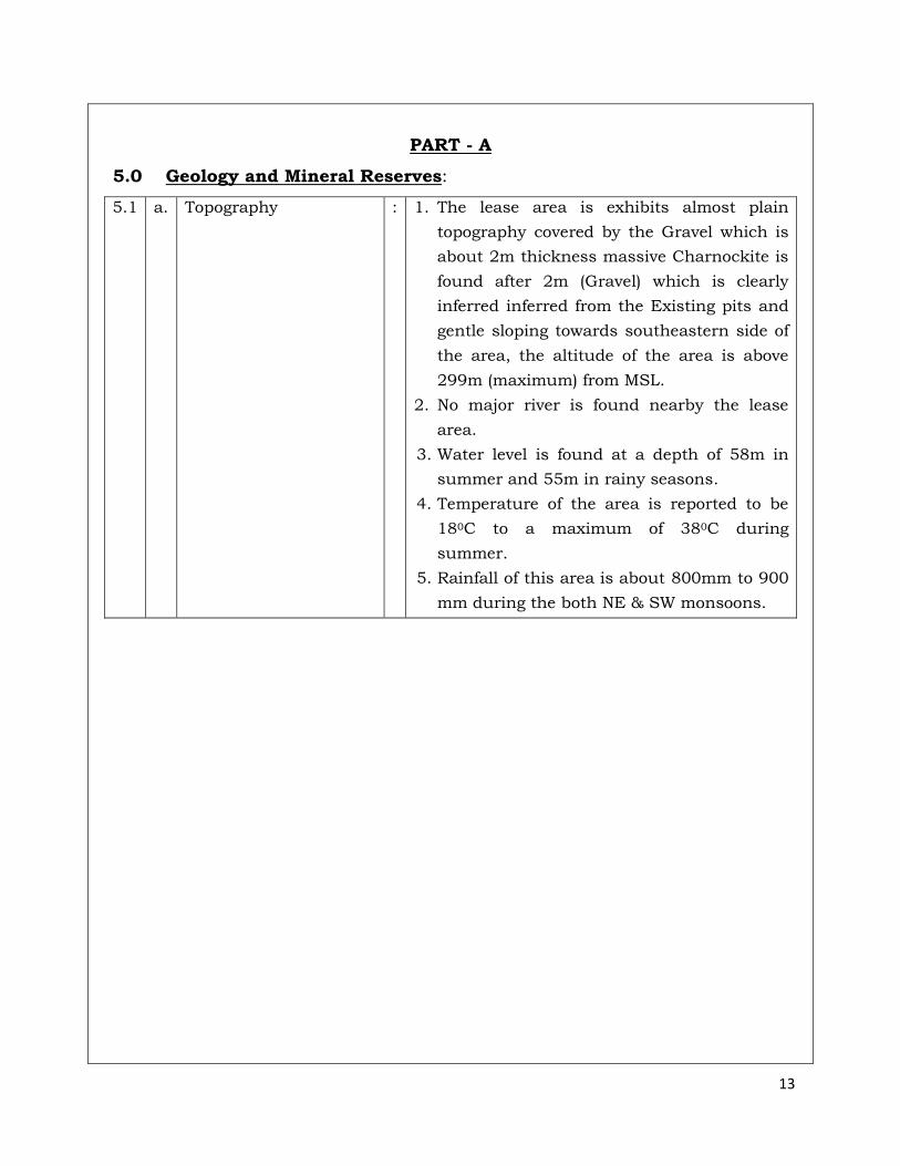
5.0 Geology and Mineral Reserves:
5.1 a. Topography : 1. The lease area is exhibits almost plain
topography covered by the Gravel which is
about 2m thickness massive Charnockite is
found after 2m (Gravel) which is clearly
inferred inferred from the Existing pits and
gentle sloping towards southeastern side of
the area, the altitude of the area is above
299m (maximum) from MSL.
2. No major river is found nearby the lease
area.
3. Water level is found at a depth of 58m in
summer and 55m in rainy seasons.
4. Temperature of the area is reported to be
180C to a maximum of 380C during
summer.
5. Rainfall of this area is about 800mm to 900
mm during the both NE & SW monsoons.
14
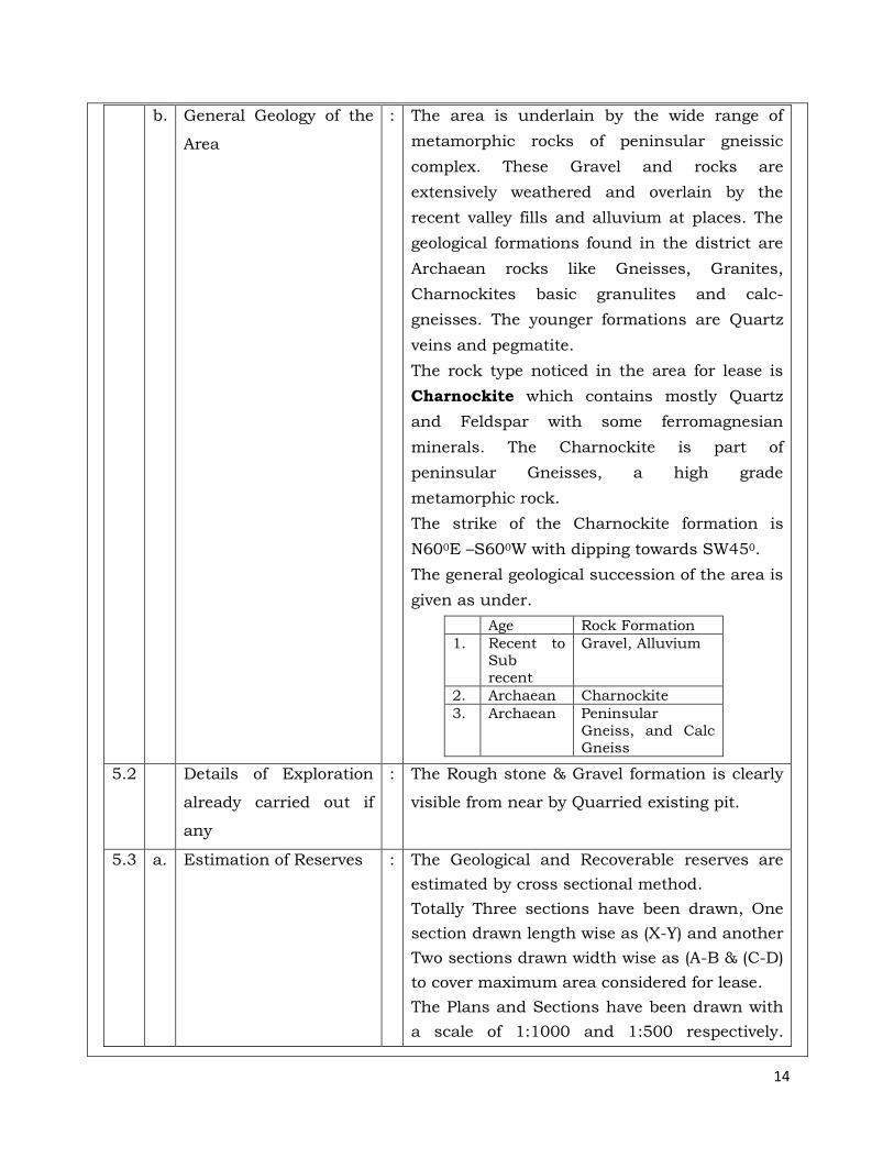
b. General Geology of the
Area
: The area is underlain by the wide range of
metamorphic rocks of peninsular gneissic
complex. These Gravel and rocks are
extensively weathered and overlain by the
recent valley fills and alluvium at places. The
geological formations found in the district are
Archaean rocks like Gneisses, Granites,
Charnockites basic granulites and calc-
gneisses. The younger formations are Quartz
veins and pegmatite.
The rock type noticed in the area for lease is
Charnockite which contains mostly Quartz
and Feldspar with some ferromagnesian
minerals. The Charnockite is part of
peninsular Gneisses, a high grade
metamorphic rock.
The strike of the Charnockite formation is
N600E –S600W with dipping towards SW450.
The general geological succession of the area is
given as under.
Age Rock Formation
1. Recent to Sub
recent
Gravel, Alluvium
2. Archaean Charnockite
3. Archaean Peninsular
Gneiss, and Calc
Gneiss
5.2 Details of Exploration
already carried out if
any
: The Rough stone & Gravel formation is clearly
visible from near by Quarried existing pit.
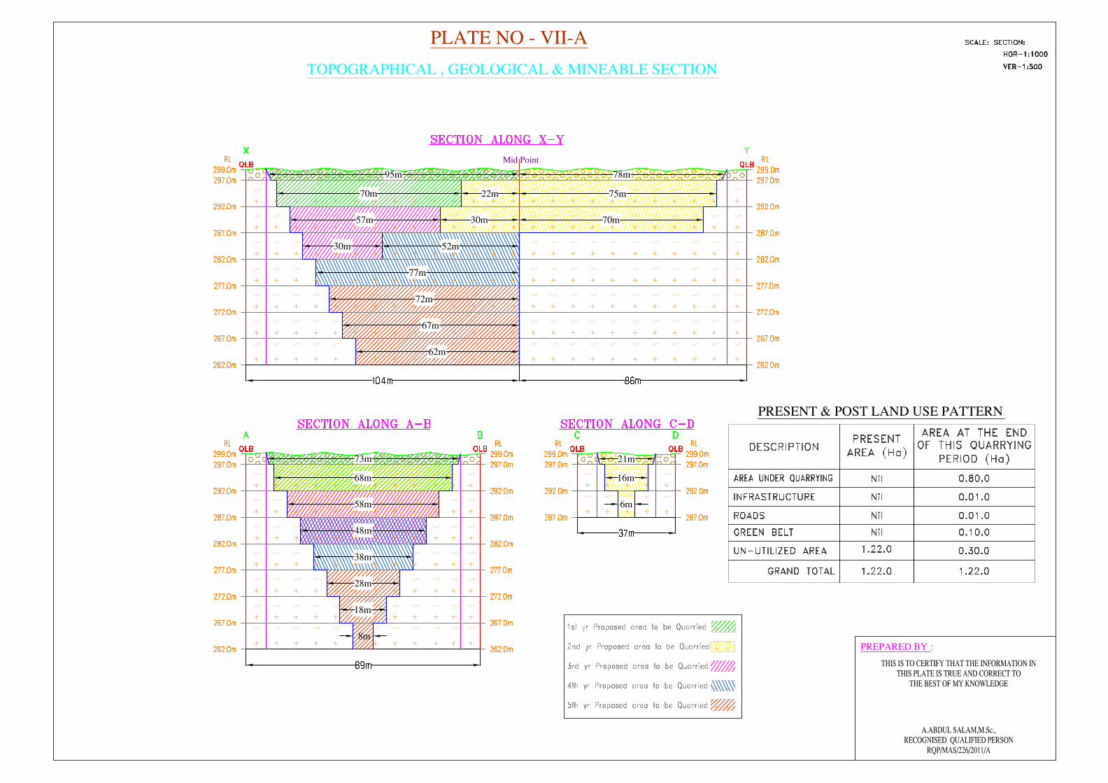
5.3 a. Estimation of Reserves : The Geological and Recoverable reserves are
estimated by cross sectional method.
Totally Three sections have been drawn, One
section drawn length wise as (X-Y) and another
Two sections drawn width wise as (A-B & (C-D)
to cover maximum area considered for lease.
The Plans and Sections have been drawn with
a scale of 1:1000 and 1:500 respectively.
15
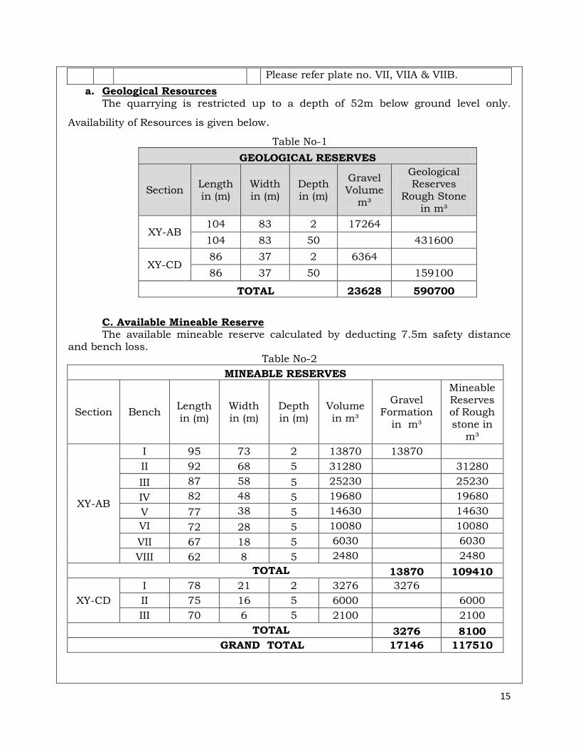
Please refer plate no. VII, VIIA & VIIB.
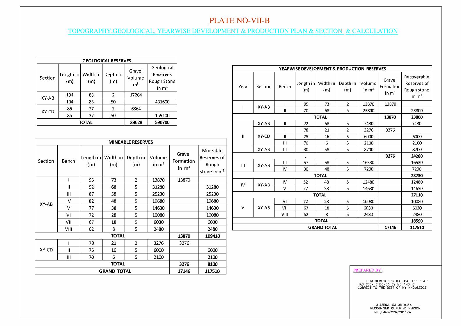
a. Geological Resources The quarrying is restricted up to a depth of 52m below ground level only.
Availability of Resources is given below.
Table No-1
GEOLOGICAL RESERVES
Section Length in (m)
Width in (m)
Depth in (m)
Gravel Volume
m³
Geological Reserves
Rough Stone in m³
XY-AB 104 83 2 17264
104 83 50 431600
XY-CD 86 37 2 6364
86 37 50 159100
TOTAL 23628 590700
C. Available Mineable Reserve The available mineable reserve calculated by deducting 7.5m safety distance and bench loss.
Table No-2
MINEABLE RESERVES
Section Bench Length in (m)
Width in (m)
Depth in (m)
Volume in m³
Gravel Formation
in m³
Mineable Reserves of Rough stone in
m³
XY-AB
I 95 73 2 13870 13870
II 92 68 5 31280 31280
III 87 58 5 25230 25230
IV 82 48 5 19680 19680
V 77 38 5 14630 14630
VI 72 28 5 10080 10080
VII 67 18 5 6030 6030
VIII 62 8 5 2480 2480
TOTAL 13870 109410
XY-CD
I 78 21 2 3276 3276
II 75 16 5 6000 6000
III 70 6 5 2100 2100
TOTAL 3276 8100
GRAND TOTAL 17146 117510
16
The available mineable reserve is computed as 1,17,510m3 of rough stone and
17,146m3 of Gravell formation at the rate of 100% recovery upto a depth of
37.0m(Max) below ground level.
6.0 ECOLOGY AND BIODIVERSITY
The green belt in the lease area be developed taking into consideration the
availability of area as the efficiency of green belt in pollution control
mainly depends on tree species, its width, distance from pollution
sources, side of the habitat from working place and tree height. The
proposed green belt should be designed to control PM10, gaseous
pollutants, noise, surface run off and soil erosion etc., While considering
the above aspects due care should be taken for selecting the suitable
characteristics plant species such as fast growing, locally suitable plant
species, resistant to specific pollutant and those which would maintain
the regional ecological balance, soil and hydrological conditions.
Flora as observed and identified in the field are covered by mostly Neem,
Erukku, Panai trees, Palmira tree and few Coconut trees are found more
on regional scale. The Applicant has developed trees like Neem, Pungam,
Teak, Caesarians and Eucalyptus, regional trees etc., with Proper nursery
garden and plantation on vacant land. The fauna species observed
around the 500m radius of the project site is given in the table
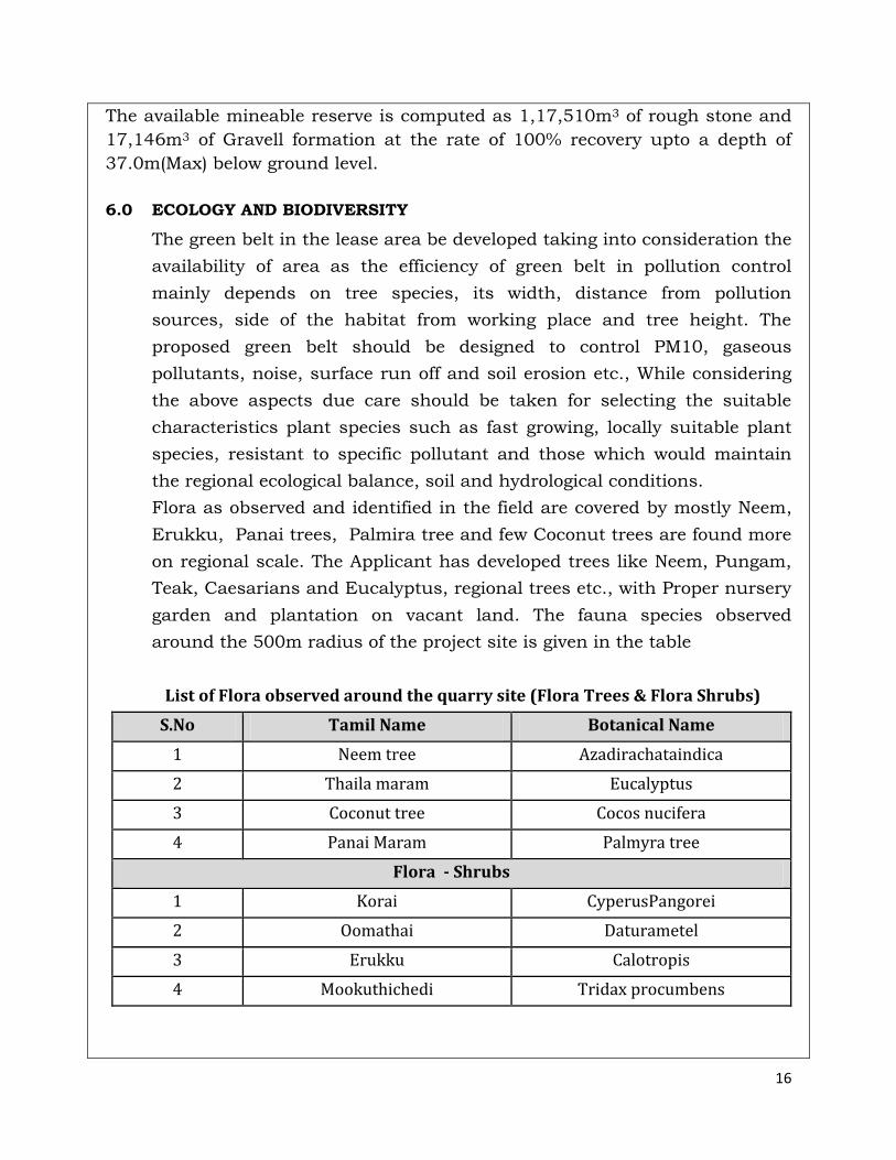
List of Flora observed around the quarry site (Flora Trees & Flora Shrubs)
S.No Tamil Name Botanical Name
1 Neem tree Azadirachataindica
2 Thaila maram Eucalyptus
3 Coconut tree Cocos nucifera
4 Panai Maram Palmyra tree
Flora - Shrubs
1 Korai CyperusPangorei
2 Oomathai Daturametel
3 Erukku Calotropis
4 Mookuthichedi Tridax procumbens
17
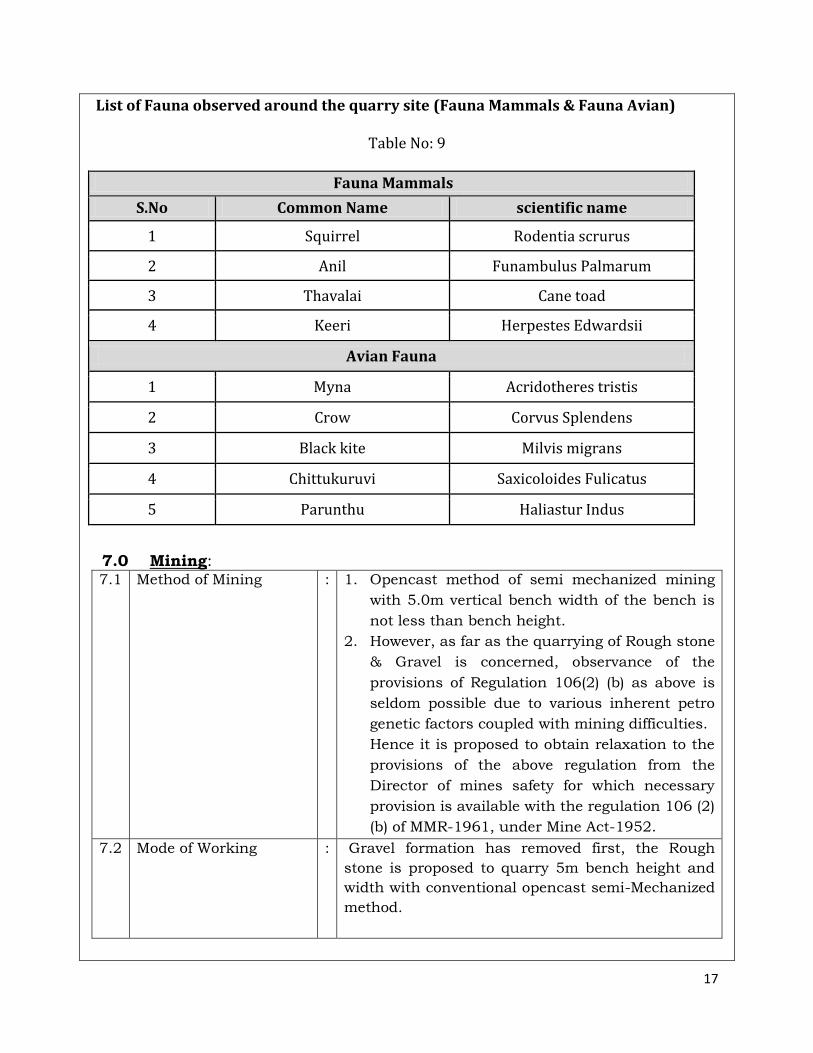
List of Fauna observed around the quarry site (Fauna Mammals & Fauna Avian)
Table No: 9
Fauna Mammals
S.No Common Name scientific name
1 Squirrel Rodentia scrurus
2 Anil Funambulus Palmarum
3 Thavalai Cane toad
4 Keeri Herpestes Edwardsii
Avian Fauna
1 Myna Acridotheres tristis
2 Crow Corvus Splendens
3 Black kite Milvis migrans
4 Chittukuruvi Saxicoloides Fulicatus
5 Parunthu Haliastur Indus
7.0 Mining: 7.1 Method of Mining : 1. Opencast method of semi mechanized mining
with 5.0m vertical bench width of the bench is
not less than bench height.
2. However, as far as the quarrying of Rough stone
& Gravel is concerned, observance of the
provisions of Regulation 106(2) (b) as above is
seldom possible due to various inherent petro
genetic factors coupled with mining difficulties.
Hence it is proposed to obtain relaxation to the
provisions of the above regulation from the
Director of mines safety for which necessary
provision is available with the regulation 106 (2)
(b) of MMR-1961, under Mine Act-1952.
7.2 Mode of Working : Gravel formation has removed first, the Rough
stone is proposed to quarry 5m bench height and
width with conventional opencast semi-Mechanized
method.
18
The quarry operation involves shallow jack hammer
drilling, slurry blasting, excavation, Loading and
transportation of Rough stone to the needy
crusher/other buyers. The production of Rough
stone in this quarry involves the following method
which is typical for Rough stone & Gravel
quarrying in contrast to other major mineral
mining.
Splitting of rock mass of considerable volume from
the parent rock mass by jackhammer drilling and
blasting, hydraulic excavators are used for loading
the Rough stone from pithead to the needy
crusher/other buyers. Occasionally hydraulic
excavators are attached with rock breakers for
fragmentation to avoid secondary blasting.
The primary boulders thus splitted are removed
from the pits by excavators and further made to
smaller sizes by rock breakers attached in
excavators. It is a conventional opencast semi
mechanized method of mining.
7.3 Proposed bench height
& Width
: Quarrying of Rough stone is proposed bench height
of 5m and bench width of 5m.
7.4 Details of Overburden /
Mineral Production
proposed for the first 5
years.
: The overburden in the form of Gravel formation
upto a depth of 2.0m below ground level is also
used for filling and leveling purpose other
infrastructure development in and around the
district.
The excavated Rough stone will be directly loaded
into Tippers to the needy crushers / customers.
The Composite plan, Development plan and section
indicating pit layout, Green belt development are
shown in Plate No. VII.
19
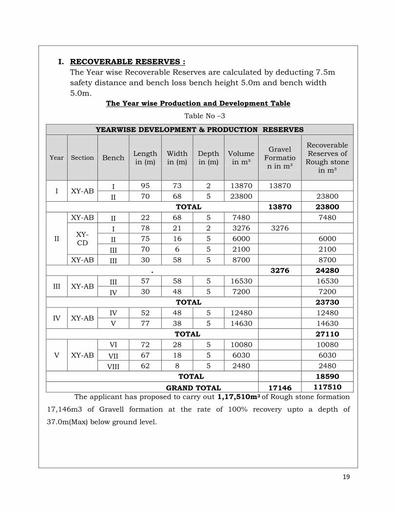
I. RECOVERABLE RESERVES :
The Year wise Recoverable Reserves are calculated by deducting 7.5m
safety distance and bench loss bench height 5.0m and bench width
5.0m.
The Year wise Production and Development Table
Table No –3
YEARWISE DEVELOPMENT & PRODUCTION RESERVES
Year Section Bench Length in (m)
Width in (m)
Depth in (m)
Volume in m³
Gravel Formation in m³
Recoverable Reserves of Rough stone
in m³
I XY-AB I 95 73 2 13870 13870
II 70 68 5 23800 23800
TOTAL 13870 23800
II
XY-AB II 22 68 5 7480 7480
XY-CD
I 78 21 2 3276 3276
II 75 16 5 6000 6000
III 70 6 5 2100 2100
XY-AB III 30 58 5 8700 8700
. 3276 24280
III XY-AB III 57 58 5 16530 16530
IV 30 48 5 7200 7200
TOTAL 23730
IV XY-AB IV 52 48 5 12480 12480
V 77 38 5 14630 14630
TOTAL 27110
V XY-AB
VI 72 28 5 10080 10080
VII 67 18 5 6030 6030
VIII 62 8 5 2480 2480
TOTAL 18590
GRAND TOTAL 17146 117510
The applicant has proposed to carry out 1,17,510m3 of Rough stone formation
17,146m3 of Gravell formation at the rate of 100% recovery upto a depth of
37.0m(Max) below ground level.
20
One Lorry Load = 6 m3 (approx.)
Total No of Working days = 260days per Year
Total quantity removed in this five years plan period = 1,17,510 m3
Hence total lorry loads for five year = 1,17,510 m3 /6 m3
Total = 19,585 Lorry Loads
7.5 Machineries to be used
a. Mining : It is proposed to use following machineries for
quarrying Rough stone
1) Tractor mounted compressor with jack
hammer
2) Excavator of 0.90m3 bucket capacity
(with Rock breaker attachment).
b. Loading
:
Excavator of 0.90m3 bucket capacity (with
Rock breaker attachment).
c. Transportation : Tipper 4Nos 5/10Ts capacity
1. Rough stone:
The Excavator will consume= 16 Litters / 1
hour
The Excavator will excavate = 20m3 of Rough
stone & Jelly
Rough stone & Jelly quantity = 1,17,510/20
= 5,876 hours
Diesel consume = 5,876 hours x 16 litters
Total diesel consumption = 94,016Litters of
HSD will be utilized for Rough stone
2. Gravel:
The Excavator will consume= 10 Litters / 1
hour
The Excavator will excavate = 60m3 of Gravel
Gravel Quantity = 17,146/ 60= 286hours
Diesel consume = 286 hours x 10 Litters
Total diesel consumption = 2,860 Litters of
21
HSD will be utilized for Gravel formation
Total consumption for Rough stone & Gravel is
around = 96,876 Litters of HSD for the entire
period of life of the quarry
7.6 Disposal of Overburden : There is no over burden or waste anticipated
during the entire Rough stone & Gravel
quarrying operation
7.7 Brief Note on
Conceptual Mining Plan
for the entire lease
period
: Conceptual Mining Plan is prepared with an
object for a lease period of (Five) 5 Years only
systematic development of bench lay outs,
selection of ultimate pit limit, depth of
quarrying, ultimate pit slope, selection of sites
for construction of infrastructures etc.
Ultimate pit size is designed based on
certain practical factors such as the
economical depth of mining, safety zones,
permissible areas etc.
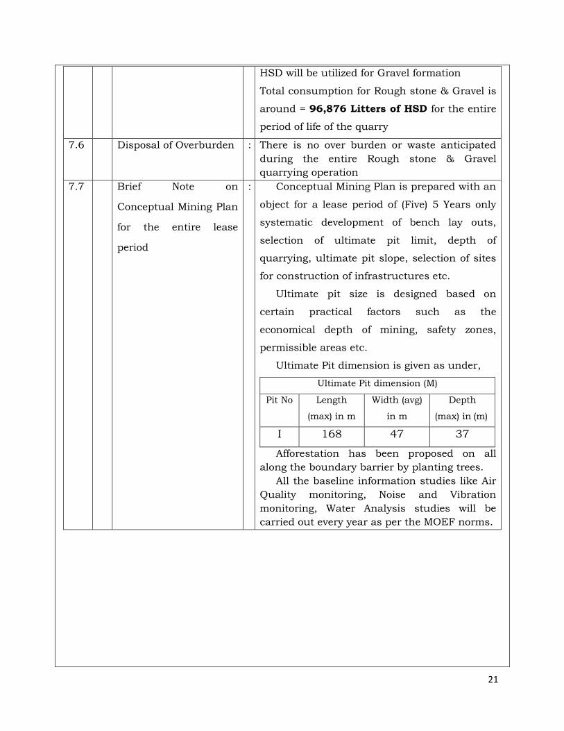
Ultimate Pit dimension is given as under,
Ultimate Pit dimension (M)
Pit No Length
(max) in m
Width (avg)
in m
Depth
(max) in (m)
I 168 47 37
Afforestation has been proposed on all
along the boundary barrier by planting trees.
All the baseline information studies like Air
Quality monitoring, Noise and Vibration
monitoring, Water Analysis studies will be
carried out every year as per the MOEF norms.
22
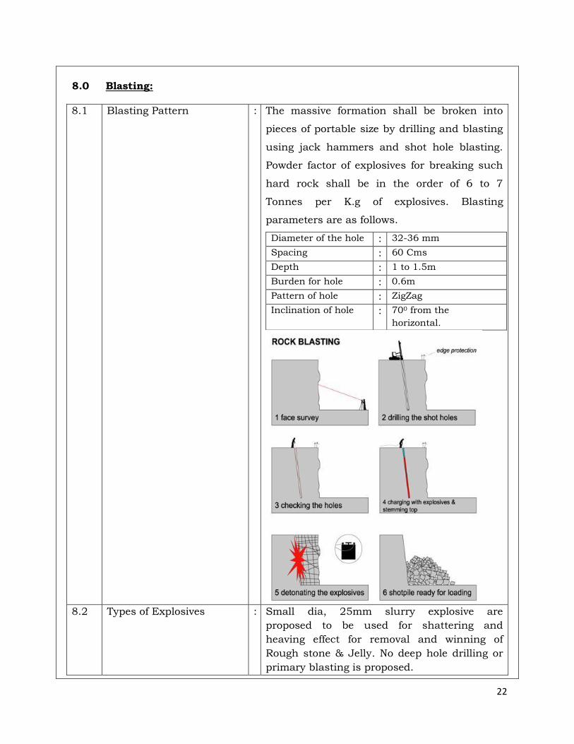
8.0 Blasting:
8.1 Blasting Pattern : The massive formation shall be broken into
pieces of portable size by drilling and blasting
using jack hammers and shot hole blasting.
Powder factor of explosives for breaking such
hard rock shall be in the order of 6 to 7
Tonnes per K.g of explosives. Blasting
parameters are as follows.
Diameter of the hole : 32-36 mm
Spacing : 60 Cms
Depth : 1 to 1.5m
Burden for hole : 0.6m
Pattern of hole : ZigZag
Inclination of hole : 700 from the
horizontal.
8.2 Types of Explosives : Small dia, 25mm slurry explosive are
proposed to be used for shattering and
heaving effect for removal and winning of
Rough stone & Jelly. No deep hole drilling or
primary blasting is proposed.
23
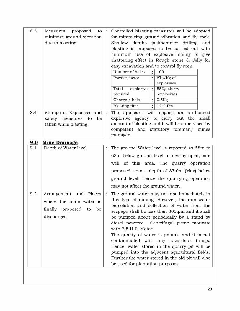
8.3 Measures proposed to
minimize ground vibration
due to blasting
: Controlled blasting measures will be adopted
for minimizing ground vibration and fly rock.
Shallow depths jackhammer drilling and
blasting is proposed to be carried out with
minimum use of explosive mainly to give
shattering effect in Rough stone & Jelly for
easy excavation and to control fly rock.
Number of holes : 109
Powder factor : 6Ts/Kg of
explosives
Total explosive
required
: 55Kg slurry
explosives
Charge / hole : 0.5Kg
Blasting time : 12-2 Pm
8.4 Storage of Explosives and
safety measures to be
taken while blasting.
: The applicant will engage an authorized
explosive agency to carry out the small
amount of blasting and it will be supervised by
competent and statutory foreman/ mines
manager.
9.0 Mine Drainage: 9.1 Depth of Water level : The ground Water level is reported as 58m to
63m below ground level in nearby open/bore
well of this area. The quarry operation
proposed upto a depth of 37.0m (Max) below
ground level. Hence the quarrying operation
may not affect the ground water.
9.2 Arrangement and Places
where the mine water is
finally proposed to be
discharged
: The ground water may not rise immediately in
this type of mining. However, the rain water
percolation and collection of water from the
seepage shall be less than 300lpm and it shall
be pumped about periodically by a stand by
diesel powered Centrifugal pump motivate
with 7.5 H.P. Motor.
The quality of water is potable and it is not
contaminated with any hazardous things.
Hence, water stored in the quarry pit will be
pumped into the adjacent agricultural fields.
Further the water stored in the old pit will also
be used for plantation purposes
24
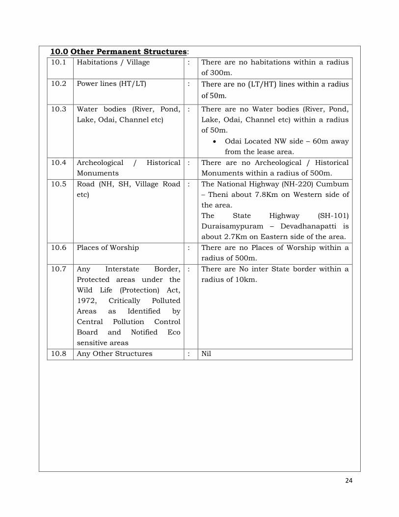
10.0 Other Permanent Structures:
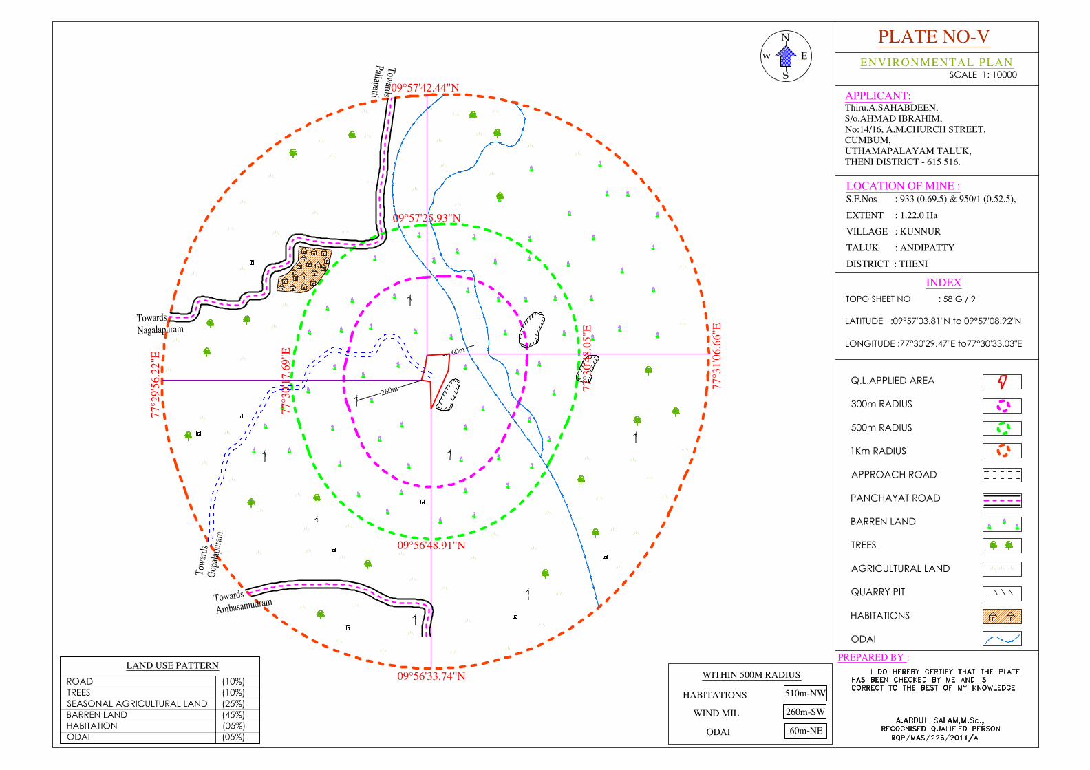
10.1 Habitations / Village : There are no habitations within a radius
of 300m.
10.2 Power lines (HT/LT) : There are no (LT/HT) lines within a radius
of 50m.
10.3 Water bodies (River, Pond,
Lake, Odai, Channel etc)
: There are no Water bodies (River, Pond,
Lake, Odai, Channel etc) within a radius
of 50m.
Odai Located NW side – 60m away
from the lease area.
10.4 Archeological / Historical
Monuments
: There are no Archeological / Historical
Monuments within a radius of 500m.
10.5 Road (NH, SH, Village Road
etc)
: The National Highway (NH-220) Cumbum
– Theni about 7.8Km on Western side of
the area.
The State Highway (SH-101)
Duraisamypuram – Devadhanapatti is
about 2.7Km on Eastern side of the area.
10.6 Places of Worship : There are no Places of Worship within a
radius of 500m.
10.7 Any Interstate Border,
Protected areas under the
Wild Life (Protection) Act,
1972, Critically Polluted
Areas as Identified by
Central Pollution Control
Board and Notified Eco
sensitive areas
: There are No inter State border within a
radius of 10km.
10.8 Any Other Structures : Nil
25
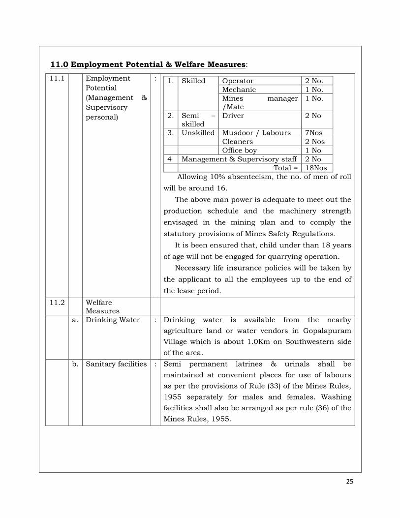
11.0 Employment Potential & Welfare Measures:
11.1 Employment
Potential
(Management &
Supervisory
personal)
:
1. Skilled Operator 2 No.
Mechanic 1 No.
Mines manager /Mate
1 No.
2. Semi – skilled
Driver 2 No
3. Unskilled Musdoor / Labours 7Nos
Cleaners 2 Nos
Office boy 1 No
4 Management & Supervisory staff 2 No
Total = 18Nos
Allowing 10% absenteeism, the no. of men of roll
will be around 16.
The above man power is adequate to meet out the
production schedule and the machinery strength
envisaged in the mining plan and to comply the
statutory provisions of Mines Safety Regulations.
It is been ensured that, child under than 18 years
of age will not be engaged for quarrying operation.
Necessary life insurance policies will be taken by
the applicant to all the employees up to the end of
the lease period.
11.2 Welfare Measures
a. Drinking Water : Drinking water is available from the nearby
agriculture land or water vendors in Gopalapuram
Village which is about 1.0Km on Southwestern side
of the area.
b. Sanitary facilities : Semi permanent latrines & urinals shall be
maintained at convenient places for use of labours
as per the provisions of Rule (33) of the Mines Rules,
1955 separately for males and females. Washing
facilities shall also be arranged as per rule (36) of the
Mines Rules, 1955.
26
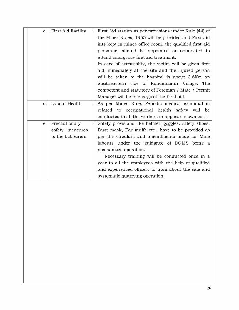
c. First Aid Facility : First Aid station as per provisions under Rule (44) of
the Mines Rules, 1955 will be provided and First aid
kits kept in mines office room, the qualified first aid
personnel should be appointed or nominated to
attend emergency first aid treatment.
In case of eventuality, the victim will be given first
aid immediately at the site and the injured person
will be taken to the hospital is about 3.6Km on
Southeastern side of Kandamanur Village. The
competent and statutory of Foreman / Mate / Permit
Manager will be in charge of the First aid.
d. Labour Health : As per Mines Rule, Periodic medical examination
related to occupational health safety will be
conducted to all the workers in applicants own cost.
e. Precautionary
safety measures
to the Labourers
: Safety provisions like helmet, goggles, safety shoes,
Dust mask, Ear muffs etc., have to be provided as
per the circulars and amendments made for Mine
labours under the guidance of DGMS being a
mechanized operation.
Necessary training will be conducted once in a
year to all the employees with the help of qualified
and experienced officers to train about the safe and
systematic quarrying operation.
27
PART – B
12.0 Environmental Management Plan:
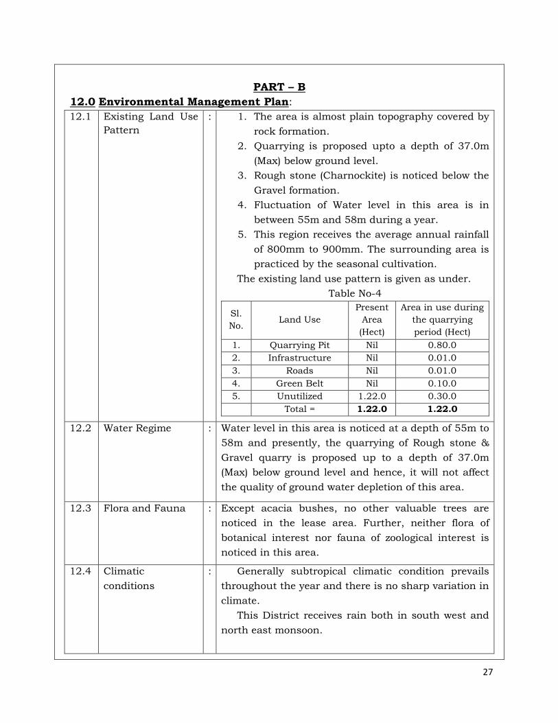
12.1 Existing Land Use
Pattern
: 1. The area is almost plain topography covered by
rock formation.
2. Quarrying is proposed upto a depth of 37.0m
(Max) below ground level.
3. Rough stone (Charnockite) is noticed below the
Gravel formation.
4. Fluctuation of Water level in this area is in
between 55m and 58m during a year.
5. This region receives the average annual rainfall
of 800mm to 900mm. The surrounding area is
practiced by the seasonal cultivation.
The existing land use pattern is given as under.
Table No-4
Sl.
No. Land Use
Present
Area
(Hect)
Area in use during
the quarrying
period (Hect)
1. Quarrying Pit Nil 0.80.0
2. Infrastructure Nil 0.01.0
3. Roads Nil 0.01.0
4. Green Belt Nil 0.10.0
5. Unutilized 1.22.0 0.30.0
Total = 1.22.0 1.22.0
12.2 Water Regime : Water level in this area is noticed at a depth of 55m to
58m and presently, the quarrying of Rough stone &
Gravel quarry is proposed up to a depth of 37.0m
(Max) below ground level and hence, it will not affect
the quality of ground water depletion of this area.
12.3 Flora and Fauna : Except acacia bushes, no other valuable trees are
noticed in the lease area. Further, neither flora of
botanical interest nor fauna of zoological interest is
noticed in this area.
12.4 Climatic
conditions
: Generally subtropical climatic condition prevails
throughout the year and there is no sharp variation in
climate.
This District receives rain both in south west and
north east monsoon.
28
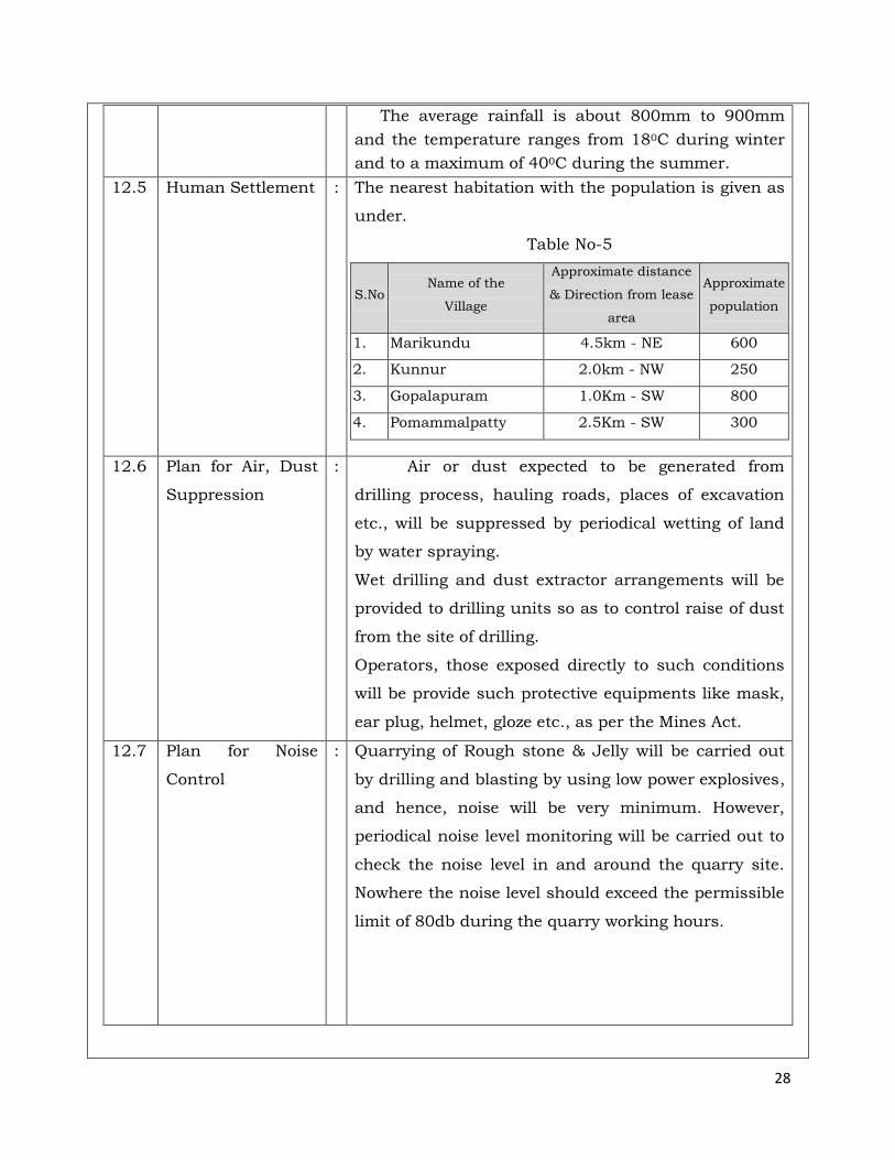
The average rainfall is about 800mm to 900mm
and the temperature ranges from 180C during winter
and to a maximum of 400C during the summer.
12.5
Human Settlement : The nearest habitation with the population is given as
under.
Table No-5
S.No Name of the
Village
Approximate distance
& Direction from lease
area
Approximate
population
1. Marikundu 4.5km - NE 600
2. Kunnur 2.0km - NW 250
3. Gopalapuram 1.0Km - SW 800
4. Pomammalpatty 2.5Km - SW 300
12.6 Plan for Air, Dust
Suppression
: Air or dust expected to be generated from
drilling process, hauling roads, places of excavation
etc., will be suppressed by periodical wetting of land
by water spraying.
Wet drilling and dust extractor arrangements will be
provided to drilling units so as to control raise of dust
from the site of drilling.
Operators, those exposed directly to such conditions
will be provide such protective equipments like mask,
ear plug, helmet, gloze etc., as per the Mines Act.
12.7 Plan for Noise
Control
: Quarrying of Rough stone & Jelly will be carried out
by drilling and blasting by using low power explosives,
and hence, noise will be very minimum. However,
periodical noise level monitoring will be carried out to
check the noise level in and around the quarry site.
Nowhere the noise level should exceed the permissible
limit of 80db during the quarry working hours.
29
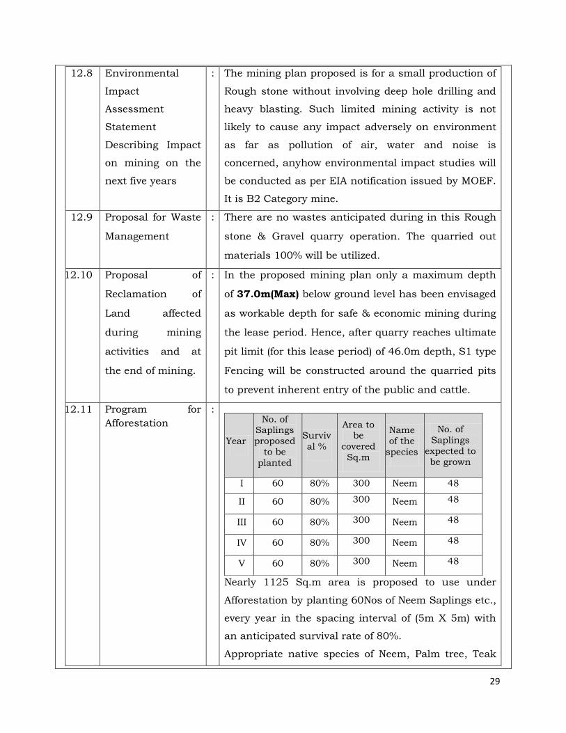
12.8 Environmental
Impact
Assessment
Statement
Describing Impact
on mining on the
next five years
: The mining plan proposed is for a small production of
Rough stone without involving deep hole drilling and
heavy blasting. Such limited mining activity is not
likely to cause any impact adversely on environment
as far as pollution of air, water and noise is
concerned, anyhow environmental impact studies will
be conducted as per EIA notification issued by MOEF.
It is B2 Category mine.
12.9 Proposal for Waste
Management
: There are no wastes anticipated during in this Rough
stone & Gravel quarry operation. The quarried out
materials 100% will be utilized.
12.10 Proposal of
Reclamation of
Land affected
during mining
activities and at
the end of mining.
: In the proposed mining plan only a maximum depth
of 37.0m(Max) below ground level has been envisaged
as workable depth for safe & economic mining during
the lease period. Hence, after quarry reaches ultimate
pit limit (for this lease period) of 46.0m depth, S1 type
Fencing will be constructed around the quarried pits
to prevent inherent entry of the public and cattle.
12.11 Program for
Afforestation
:
Nearly 1125 Sq.m area is proposed to use under
Afforestation by planting 60Nos of Neem Saplings etc.,
every year in the spacing interval of (5m X 5m) with
an anticipated survival rate of 80%.
Appropriate native species of Neem, Palm tree, Teak
Year
No. of Saplings
proposed
to be
planted
Surviv
al %
Area to be
covered
Sq.m
Name
of the
species
No. of
Saplings
expected to
be grown
I 60 80% 300 Neem 48
II 60 80% 300 Neem 48
III 60 80% 300 Neem 48
IV 60 80% 300 Neem 48
V 60 80% 300 Neem 48
30
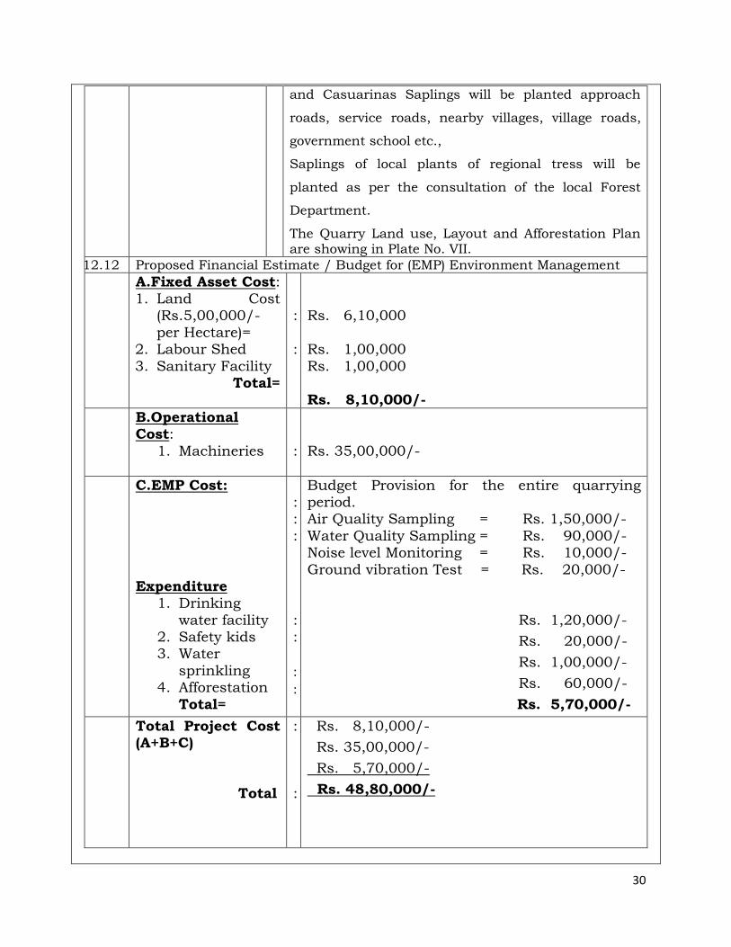
and Casuarinas Saplings will be planted approach
roads, service roads, nearby villages, village roads,
government school etc.,
Saplings of local plants of regional tress will be
planted as per the consultation of the local Forest
Department.
The Quarry Land use, Layout and Afforestation Plan are showing in Plate No. VII.
12.12 Proposed Financial Estimate / Budget for (EMP) Environment Management
A.Fixed Asset Cost: 1. Land Cost
(Rs.5,00,000/-
per Hectare)= 2. Labour Shed
3. Sanitary Facility Total=
:
:
Rs. 6,10,000
Rs. 1,00,000
Rs. 1,00,000 Rs. 8,10,000/-
B.Operational Cost:
1. Machineries
:
Rs. 35,00,000/-
C.EMP Cost:
Expenditure
1. Drinking
water facility 2. Safety kids 3. Water
sprinkling 4. Afforestation
Total=
: :
:
: :
: :
Budget Provision for the entire quarrying period. Air Quality Sampling = Rs. 1,50,000/-
Water Quality Sampling = Rs. 90,000/- Noise level Monitoring = Rs. 10,000/-
Ground vibration Test = Rs. 20,000/-
Rs. 1,20,000/-
Rs. 20,000/-
Rs. 1,00,000/-
Rs. 60,000/-
Rs. 5,70,000/-
Total Project Cost (A+B+C)
Total
:
:
Rs. 8,10,000/-
Rs. 35,00,000/-
Rs. 5,70,000/-
Rs. 48,80,000/-
31
12.12
Corporate Social
Responsibility (CSR)
The Applicant shall be distributed Note books,
Stationary items to nearby Govt Primary School
and to conduct the Medical camp, Environment
awareness program, etc to nearby villages from the
quarry area.
The Applicant shall ensure that a minimum of
2.5% from the Total project cost (Rs.1,22,000/-)
for the entire lease period will be utilized for the
CSR (Corporate Social Responsibilities) Activities.
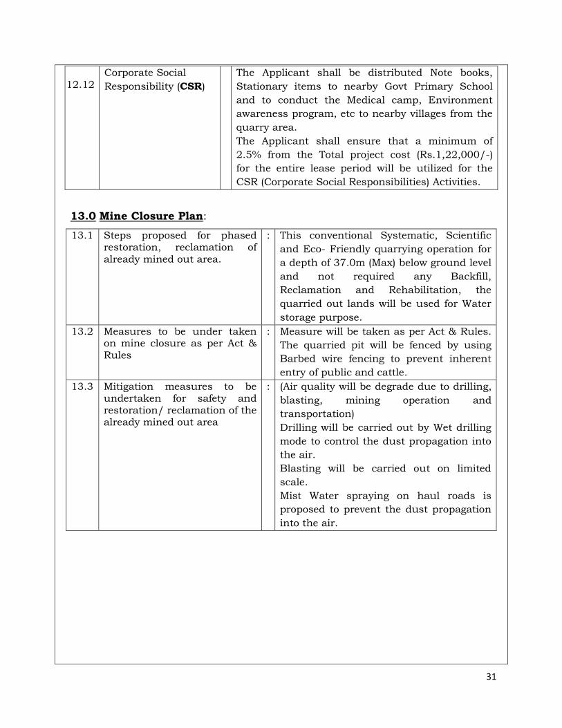
13.0 Mine Closure Plan:
13.1 Steps proposed for phased restoration, reclamation of already mined out area.
: This conventional Systematic, Scientific
and Eco- Friendly quarrying operation for
a depth of 37.0m (Max) below ground level
and not required any Backfill,
Reclamation and Rehabilitation, the
quarried out lands will be used for Water
storage purpose.
13.2 Measures to be under taken on mine closure as per Act & Rules
: Measure will be taken as per Act & Rules.
The quarried pit will be fenced by using
Barbed wire fencing to prevent inherent
entry of public and cattle.
13.3 Mitigation measures to be undertaken for safety and restoration/ reclamation of the already mined out area
: (Air quality will be degrade due to drilling,
blasting, mining operation and
transportation)
Drilling will be carried out by Wet drilling
mode to control the dust propagation into
the air.
Blasting will be carried out on limited
scale.
Mist Water spraying on haul roads is
proposed to prevent the dust propagation
into the air.
32
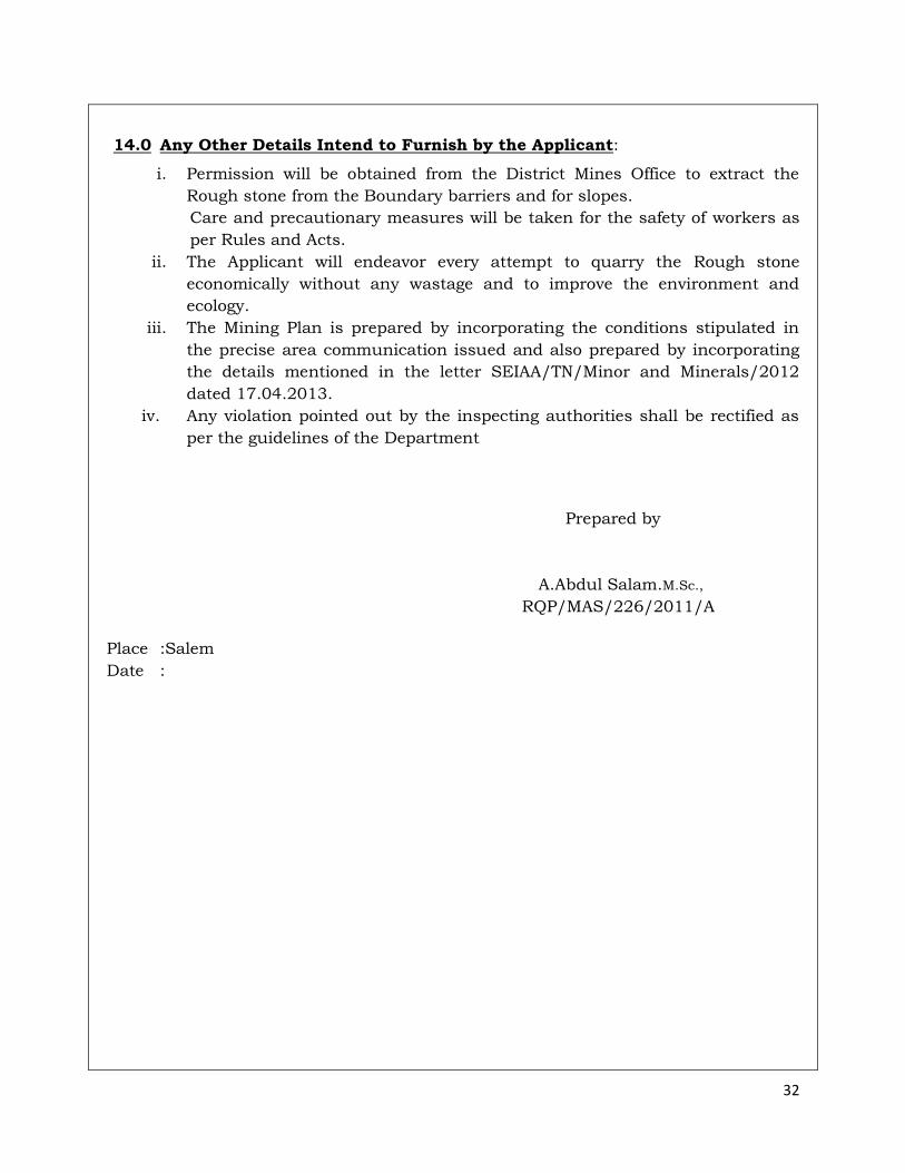
14.0 Any Other Details Intend to Furnish by the Applicant:
i. Permission will be obtained from the District Mines Office to extract the
Rough stone from the Boundary barriers and for slopes.
Care and precautionary measures will be taken for the safety of workers as
per Rules and Acts.
ii. The Applicant will endeavor every attempt to quarry the Rough stone
economically without any wastage and to improve the environment and
ecology.
iii. The Mining Plan is prepared by incorporating the conditions stipulated in
the precise area communication issued and also prepared by incorporating
the details mentioned in the letter SEIAA/TN/Minor and Minerals/2012
dated 17.04.2013.
iv. Any violation pointed out by the inspecting authorities shall be rectified as
per the guidelines of the Department
Prepared by
A.Abdul Salam.M.Sc.,
RQP/MAS/226/2011/A
Place :Salem
Date :
Q. L. A. AREA :
TOPO SHEET NO : 58 G / 9
LATITUDE :09°57'03.81"N to 09°57'08.92"N
LONGITUDE :77°30'29.47"E to77°30'33.03"E
Not To Scale
Ew
N
S
09°51'45.56"N
77°24'59.23"E
77°36'00.27"E
10°02'33.01"N
10KM RADIUS
TOPO SHEET NO : 58 G / 9
LATITUDE :09°57'03.81"N to 09°57'08.92"N
LONGITUDE :77°30'29.47"E to77°30'33.03"E
Ew
N
S
Q.L.APPLIED AREA
STATE HIGHWAY
APPROACH ROAD
PANCHAYAT ROAD
HABITATIONS
Ew
N
S
Q.LEASE AREA
300m RADIUS
500m RADIUS
1Km RADIUS
APPROACH ROAD
PANCHAYAT ROAD
TOPO SHEET NO : 58 G / 9
LATITUDE :09°57'03.81"N to 09°57'08.92"N
LONGITUDE :77°30'29.47"E to77°30'33.03"E
Ew
N
S
ee
e
e
e
e
e
e
e
e
e
ee
e e
ee
e
ee
e
ee
e
e
ee
e
e
e
e
e
e
e
e
e
e
ee
e
e
e
ee
ee
e
ee
e
e
e
e
e e
e
e
ee
e
ee
e
e
e
e
e
Q.L.APPLIED AREA
300m RADIUS
500m RADIUS
1Km RADIUS
APPROACH ROAD
PANCHAYAT ROAD
BARREN LAND
TREES
AGRICULTURAL LAND
QUARRY PIT
HABITATIONS
ODAI
TOPO SHEET NO : 58 G / 9
LATITUDE :09°57'03.81"N to 09°57'08.92"N
LONGITUDE :77°30'29.47"E to77°30'33.03"E
e e e
ROAD (10%)TREES (10%)SEASONAL AGRICULTURAL LAND (25%)BARREN LAND (45%)HABITATION (05%)ODAI (05%)
Ew
N
S
Q.L.APPLIED BOUNDARY
7.5m SAFETY DISTANCE
TEMPORARY BENCH MARK
APPROACH ROAD
CONTOUR
SCHRUB
1
2
3
45
6
7
8
Ew
N
S
Q.L.APPLIED BOUNDARY
7.5m SAFETY DISTANCE
TEMPORARY BENCH MARK
APPROACH ROAD
CONTOUR
SCHRUB
GRAVEL
ROUGH STONE
STRIKE & DIP
1
2
3
45
6
7
8
Ew
N
S
ccccc
c
c c
cc
cc
cc
c
+ +
SCALE 1 : 1000
+
+
+
+
+
+
+
+
+
+
+
+
+
+
+
+
+
+
+
+
+
+
+
+
+
+
+
+
+
+
+
+
+
+
+
+
+
+
+
+
+
+
+
+
+
+
+
+
+
+
+
+
+
+
+
+
+
+
+
+
+
+
+
+
+
+
+
+
+
+
+
+
+
+
+
+
+
+
+
+
+
+
+
+
+
+
+
+
+
+
+
+
+
+
+
+
+
+
+
+
+
+
+
+
+
+
+
+
+
+
+
+
+
+
+
+
+
+
+
+
+
+
+
+
+
+
+
+
+
+
+
+
+
+
+
+
+
+
+
+
+
+
+
+
+
+
+
+
+
+
+
+
+
+
+
+
+
+
+
+
+
+
+
+
+
+
+
+
+
+
+
+
+
+
+
+
+
+
+
+
+
+
+
+
+
+
+
+
+
+
+
+
+
+
+
+
+
+
+
+
+
+
+
+
+
+
+
+
+
+
+
+
+
+
+
+
+
+
+
+
+
+
+
+
+
+
+
+
+
+
+
+
+
+
+
+
+
+
+
+
+
+
+
+
+
+
+
+
+
+
+
+
+
+
+
+
+
+
+
+
+
+
+
+
+
+
+
+
+
+ +
+ +
+ +
+ +
+ +
Q.L.APPLIED BOUNDARY
7.5m SAFETY DISTANCE
TEMPORARY BENCH MARK
APPROACH ROAD
CONTOUR
SCHRUB
GRAVEL
ROUGH STONE
STRIKE & DIP
PROPOSED QUARRY PIT
1
2
3
45
6
7
8
Ew
N
S
ccccc
c
c c
cc
cc
cc
c
+ +
SCALE 1 : 1000
+
+
+
+
+
+
+
+
+
+
+
+
+
+
+
+
+
+
+
+
+
+
+
+
+
+ +
+
+
+
+
+
+
+
+
+
+
+
+
+
+
+
+
+
+
+
+
+
+
+
+
+
+
+
+
+
+
+
+
+
+
+
+
+
+
+
+
+
+
+
+
+
+
+
+
+
+
+
+
+
+
+
+
+
+
+
+
+
+
+
+
+
+
+
+
+
+
+
+
+
+
+
+
+
+
+
+
+
+ +
+
+
+
+
+
+
+
+
+
+
+
+
+
+
+
+
+
+
+
+
+
+
+
+
+
+
+ +
+
+
+