Embed Size (px)
Citation preview
MID SUSSEX DISTRICT COUNCIL
District Wide Committee
3 OCT 2019
RECOMMENDED FOR PERMISSION
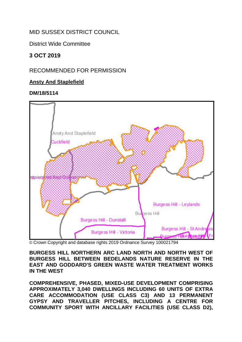
Ansty And Staplefield
DM/18/5114
© Crown Copyright and database rights 2019 Ordnance Survey 100021794
BURGESS HILL NORTHERN ARC LAND NORTH AND NORTH WEST OF BURGESS HILL BETWEEN BEDELANDS NATURE RESERVE IN THE EAST AND GODDARD'S GREEN WASTE WATER TREATMENT WORKS IN THE WEST COMPREHENSIVE, PHASED, MIXED-USE DEVELOPMENT COMPRISING APPROXIMATELY 3,040 DWELLINGS INCLUDING 60 UNITS OF EXTRA CARE ACCOMMODATION (USE CLASS C3) AND 13 PERMANENT GYPSY AND TRAVELLER PITCHES, INCLUDING A CENTRE FOR COMMUNITY SPORT WITH ANCILLARY FACILITIES (USE CLASS D2),
THREE LOCAL CENTRES (COMPRISING USE CLASSES A1-A5 AND B1, AND STAND-ALONE COMMUNITY FACILITIES WITHIN USE CLASS D1), HEALTHCARE FACILITIES (USE CLASS D1), AND EMPLOYMENT DEVELOPMENT COMPRISING A 4 HECTARE DEDICATED BUSINESS PARK (USE CLASSES B1 AND B2), TWO PRIMARY SCHOOL CAMPUSES AND A SECONDARY SCHOOL CAMPUS (USE CLASS D1), PUBLIC OPEN SPACE, RECREATION AREAS, PLAY AREAS, ASSOCIATED INFRASTRUCTURE INCLUDING PEDESTRIAN AND CYCLE ROUTES, MEANS OF ACCESS, ROADS, CAR PARKING, BRIDGES, LANDSCAPING, SURFACE WATER ATTENUATION, RECYCLING CENTRE AND WASTE COLLECTION INFRASTRUCTURE WITH ASSOCIATED DEMOLITION OF EXISTING BUILDINGS AND STRUCTURES, EARTHWORKS, TEMPORARY AND PERMANENT UTILITY INFRASTRUCTURE AND ASSOCIATED WORKS. (AMENDED DESCRIPTION AND AMENDED/FURTHER DOCUMENTS AND PLANS RECEIVED INCLUDING:
ENVIRONMENTAL STATEMENT ADDENDUM RECEIVED 12/8/19
TRANSPORT ASSESSMENT ADDENDUM RECEIVED 12/8/19
PLANNING STATEMENT ADDENDUM, INCLUDING RETAIL STATEMENT, MINERALS SAFEGUARDING AND SAFEGUARDING OF WASTE MANAGEMENT FACILITIES RECEIVED 12/8/19
REVISED DESIGN GUIDE RECEIVED 12/8/19
REVISED DEVELOPMENT SPECIFICATION AND FRAMEWORK RECEIVED 12/8/19
REVISED PARAMETER PLANS AND SUPPORTING DRAWINGS RECEIVED 12/8/19
REVISED LOCATION PLAN RECEIVED 12/8/19
ECONOMIC SUSTAINABILITY STRATEGY RECEIVED 8/7/19) HOMES ENGLAND
POLICY: Ancient Woodland / Areas of Special Control for Adverts / Brownfield
Land / Built Up Areas / Countryside Area of Dev. Restraint / Classified Roads - 20m buffer / Flood Map - Zones 2 and 3 / Informal Open Space / Informal Open Space / Land Compensation Act Notice / Local Nature Reserve / Methane Gas Safeguarding / Miscellaneous Charges / Planning Agreement / Planning Obligation / Aerodrome Safeguarding (CAA) / Sewer Line (Southern Water) / Site of Nature Conservation Importance / SWT Bat Survey / Tree Preservation Order / Tree Preservation Order Points / Archaeological Notification Area (WSCC) / Advance Payment Code (WSCC) / Highways Agreement (WSCC) / Highways and Planning Agreement (WSCC) /
ODPM CODE: Largescale Major Dwellings
13 WEEK DATE: 4th October 2019 WARD MEMBERS: Cllr Robert Salisbury / Cllr Pete Bradbury / CASE OFFICER: Stuart Malcolm PURPOSE OF REPORT To consider the recommendation of the Divisional Leader for Planning and Economy on the application for planning permission as detailed above. EXECUTIVE SUMMARY The application seeks outline planning permission with all matters reserved for a comprehensive, phased, mixed-use development comprising approximately 3,040 dwellings including 60 units of extra care accommodation (Use Class C3) and thirteen permanent gypsy and traveller pitches, including a Centre for Community Sport with ancillary facilities (Use Class D2), three local centres (comprising Use Classes A1-A5 and B1, and stand-alone community facilities within Use Class D1), healthcare facilities (Use Class D1), and employment development comprising a 4 hectare dedicated business park (Use Classes B1 and B2), two primary school campuses and a secondary school campus (Use Class D1), public open space, recreation areas, play areas, associated infrastructure including pedestrian and cycle routes, means of access, roads, car parking, bridges, landscaping, surface water attenuation, recycling centre and waste collection infrastructure with associated demolition of existing buildings and structures, earthworks, temporary and permanent utility infrastructure and associated works. The application forms an important part of the wider Burgess Hill Growth Programme and the Burgess Hill Town Wide Strategy (2011) which identified this site as a preferred location for housing development as a mixed use site for homes, with neighbourhood facilities, major education facilities (primary and secondary schools), a Centre for Community Sport, extension of the Green Circle network, and sustainable transport amongst other infrastructure requirements. Planning legislation requires the application to be determined in accordance with the development plan unless material considerations indicate otherwise. It is therefore necessary for the planning application to be assessed against the policies in the development plan and then to take account of other material planning considerations including the NPPF. The NPPF states that planning should be genuinely plan-led. The Council has a recently adopted District Plan and is able to demonstrate that it has a five year housing land supply. Planning decisions should therefore be in accordance with the development plan unless material considerations indicate otherwise. As the Council can demonstrate a 5 year supply of deliverable housing land the planning balance set out in the NPPF is an un-tilted one.
In terms of the principle, the site is located within the built-up area as defined by the Mid Sussex District Plan, with the boundary being formally extended upon the adoption of the District Plan in March 2018. As such the principle of the development is acceptable under the provisions of Policy DP6 of the Mid Sussex District Plan which states that development will be permitted within towns and villages with defined built-up area boundaries. In this case the site is also part of a strategic allocation in the District Plan. Policy DP9 is the relevant Policy in the District Plan which allocates the site. This supports in principle a strategic mixed-use development (which will need to conform to the general principles in Policy DP7) and accordingly allocates the land to the north and north-west of Burgess Hill, subject to meeting a number of criteria. DP7 of the Mid Sussex District Plan itself sets out general principles for strategic development at Burgess Hill. Furthermore, both the Northern Arc Masterplan and the Northern Arc Infrastructure Delivery Plan and Phasing Strategy have been approved (in September 2018) in accordance with Policy DP9 of the Mid Sussex District Plan. These documents are material planning considerations which support the principle of the proposal. As highlighted within this report, the proposal will have a number of benefits that need to be taken into consideration. The proposal will provide approximately 3040 new homes. 30 per cent of these will be affordable which equates to approximately 912 affordable dwellings. Up to 60 of the units will also be classed as extra care units whilst the proposal will also provide 13 permanent gypsy and traveller pitches. In addition to the dwellings being provided, there is also 4 hectares of employment land being provided that will allow a mixture of B1 and B2 uses in modern, high quality units. Whilst this provision of 4 hectares is a shortfall of 6 hectares against the overall policy requirement of 25 hectares in Policy DP9 (with 15 hectares being provided adjacent at The Hub), the overall provision of 4 hectares should be treated as a benefit to the scheme in the planning balance. This is because the shortfall has been accepted within the Masterplan (which is a material planning consideration), has partly been offset by windfall development since the District Plan was adopted, and will be met by new employment sites coming forward through the Sites Allocation Development Plan Document (although this currently has very little weight). The development will provide new and enhanced sports facilities, both at the Centre for Community Sport and at the existing Triangle Leisure Centre. Three local centres are being provided and these will provide a mixture of retail and commercial uses that will provide residents with the opportunities to meet some of their daily needs within local neighbourhoods. The development also allows for the provision of a new healthcare facility within one of these centres. Two new community buildings will be constructed which will provide space for future communities to meet and participate in events. Three parks and other areas of open
space, including an allotment and community garden hub, are being provided. The proposals will also include additional leisure uses such as 6 local equipped areas of play, 1 neighbourhood equipped area of play and 1 multi-use games area. In respect of education, three new schools are being provided on the site. This will include the provision of one new secondary school that will include provision for Special Educational Needs and Disability (SEND) and two new primary schools, one of which will include SEND provision. A financial contribution to additional sixth form provision in the district is also being provided. Cycling and pedestrian enhancements through the site are being provided as well as into Burgess Hill itself and this will include an extension to the Burgess Hill Green Circle. In addition the applicant is also seeking to achieve a biodiversity net gain on the site and has set out details, utilising baseline data and a long term landscaping strategy, of how this will be accomplished. A number of off-site highways infrastructure upgrades are also being made that will include junction improvements, traffic calming and improvement schemes, pedestrian and cycle access improvements and provision of mobility corridors into Burgess Hill. The committee report for this proposed development has however identified a number of adverse effects that need to be taken into consideration and weighed against the benefits. As identified within the heritage assessment of the report, the proposal will cause less than substantial harm to nearby heritage assets and great weight needs to be given to this. A condition to secure additional mitigation to minimise the impact on the heritage assets will however be used. The test set out at paragraph 196 of the NPPF is that this harm (less than substantial) should be weighed against the public benefits of the development. In this particular case there are clear, substantial, demonstrable and compelling public benefits outlined in this report which are considered to far outweigh the less than substantial harm to the settings of the listed buildings identified. The proposal will result in the loss of some trees and hedgerows but these will be limited to those that are necessary to make the scheme a viable development. Given the scale of the development and the rural character of the site, the loss of such natural features is practically inevitable and will be compensated for through the use of conditions securing replacement features. It is important to note however that the proposal will not result in the loss of any ancient woodland. Similarly, it is inevitable that the proposal will have adverse landscape effects during the demolition and construction phase. These will however be temporary in nature and mitigated for as best as possible through the use of conditions. In time, the establishment of the parkland and semi-natural greenspaces, in combination with the existing vegetation being in leaf, would reduce the perception of the proposed development and further integrate the development within the site.
The loss of agricultural land and access to a potential mineral resource can be classed as an adverse effect. However, it is considered that these particular adverse effects should only be given limited weight given that the site is allocated for development. The proposal has also been found to be acceptable in regard to a number of other planning issues where there will be a neutral impact such as residential amenity, highway safety, the effects on statutorily protected land including the High Weald AONB and the South Downs National Park where views of the site would be seen in the context of Burgess Hill, water resources and the Ashdown Forest. The residual effects arising from the proposed development are those effects that remain following the implementation of identified mitigation measures. The overall conclusion of the Environmental Statement is that "the proposed development will have both significant adverse and beneficial environmental effects and will enhance the Site, contribute to the development of the wider areas and secure the comprehensive development and ongoing management of both the site and surrounding area." Having had regard to the information contained within it, Planning Officers agree with the conclusions reached by the Environmental Statement. Whilst it is acknowledged that some significant adverse effects will be experienced during the demolition and construction phase, these impacts will be temporary in nature and controlled by on-site best practice measures in line with a Construction and Environmental Management Plan (CEMP). The Environmental Statement states that once the proposed development is complete and operational, there are a number of benefits of bringing the proposed development forward in addition to the identified significant adverse effects, which would be unavoidable in relation to altered setting and change of use of the site. In terms of benefits, the Environmental Statement references meeting the strategic allocation of the site by the Council and working towards satisfying Policy DP9 of the Mid Sussex District Plan which details how the development to the north and north-west of Burgess Hill is an essential part of the delivery of the overall housing numbers for the District Plan and infrastructure for Burgess Hill and the surrounding area. Mitigation measures, as outlined within the Environmental Statement, have been secured through the conditions as set out in Appendix A and through the legal agreement where appropriate. With such measures secured, the conclusions of the Environmental Statement are considered by Officers to be reasonable and accurate. Officers consider that the benefits of this development, as highlighted within this report, significantly outweigh the adverse impacts that will in any event be mitigated for as far as possible. The proposal would provide significant economic benefits from the provision of construction jobs, new high quality commercial floor space and an increased population likely to spend in the community. As such it is felt that the economic
objective of sustainable development as defined in the NPPF would be met by the scheme. The provision of approximately 3040 dwellings on this sustainable site will make a very important contribution to the district's housing supply. The development will also provide key infrastructure that will benefit future residents and existing residents of both Burgess Hill and the surrounding area. It is therefore considered that the development meets the social and environmental objectives of sustainable development as defined in the NPPF. In light of this the application is considered to constitute sustainable development and complies with the Mid Sussex District Plan when read as a whole and both the Burgess Hill and Hurstpierpoint & Sayers Common Neighbourhood Plans. The application is therefore in accordance with the Development Plan, and there are no other material planning considerations that reasonably indicate an alternative conclusion should be reached. The application is in accordance with the site wide allocation Policy DP9 with the exception of the employment land provision. For the reasons expressed above, this shortfall is considered accepted in planning terms. The application also complies with Policies DP1, DP4, DP6, DP7, DP13, DP16, DP17, DP18, DP20, DP21, DP22, DP23, DP24, DP25, DP26, DP27, DP28, DP29, DP30, DP31, DP33, DP34, DP35, DP37, DP38, DP39, DP41 and DP42 of the Mid Sussex District Plan, Policies LR3, G2 and G6 of the Burgess Hill Neighbourhood Plan, Policies HurstC3, HurstA3, HurstH1, HurstH5, HurstH6 and HurstH8 of the Hurstpierpoint & Sayers Common Neighbourhood Plan, the Northern Arc Masterplan (2018), the Northern Arc Infrastructure Delivery Plan and Phasing Strategy (2018), the NPPF, the Listed Building and Conservation Area (LBCA) Act 1990 and the Town and Country Planning (Environmental Impact Assessment) Regulations 2017. The application is therefore recommended for approval, subject to the conditions listed in Appendix A and to the completion of the legal agreement. RECOMMENDATION It is recommended that, subject to the completion of a satisfactory S106 planning obligation securing the necessary infrastructure and affordable housing, planning permission be granted subject to the conditions set out in Appendix A.
SUMMARY OF REPRESENTATIONS One letter has been received in support of the proposal, making the following comments:
Support the extension of Bedelands Traveller Park (Officer note: An extension to Bedelands Traveller Park is not proposed as part of this application)
Support park, schools, cycle parks - Burgess Hill lacks spaces and we need more schools, doctors and dentists

Cllr Paul Budgen has objected to the scheme: he states that the relevant District Plan policies seem to be clear that contributions towards off site provision can only be secured as an alternative to on site provision where "it can be demonstrated that a suitable, available and achievable site can be provided". It appears an off site location in respect of Freeks Farm was not identified at the time of the approval of that application. It would therefore seem appropriate and necessary to provide 3 further on site pitches (i.e. 16 in total) within the remainder of the Northern Arc strategic allocation unless an alternative site is identified which meets the criteria set out in the District Plan. 27 representations have been received objecting/commenting on the proposal, raising the following points (officer notes are used below to clarify any matters raised that contain factually inaccurate references, other comments are addressed within the relevant assessment sections of the report): Principle
No objection in principle Design and Character
Loss of green space/green fields
Will devastate and intrude into countryside
Who decided that the site no longer be designated Countryside
Scale of development will change Burgess Hill by transforming it from a relatively small Mid-Sussex town surrounded by beautiful countryside to a vast urban hub
High quality green fields location
Excessive size of development
Do not cram too many homes in, make the development somewhere people want to live.
Height of buildings to the west of the site, opposite St Pauls School would be out of character with neighbouring residential developments, they should be reduced to no more than 3 stories
Loss of gap between Burgess Hill & Haywards Heath Loss of Agriculture
Land used to grow food crops will be gone Infrastructure
Concern that infrastructure provided will not be enough
Caveats should require the related infrastructure to be built before people live there or in the early stages
Additional people will be using the railways and the developer should therefore contribute to the rail network
Lack of a sixth form college in the area and there should therefore be a requirement for a sixth form college
Significant demand for entertainment in the area for young adults and additional homes will compound this
Influx of new residents with associated pressure
What is there to protect current properties from an increase in council tax?
Increased water
Increased domestic waste
Local facilities already over-stretched
Police response officers will not be increased sufficiently to deal with the existing demand let alone any increase in criminal behaviour
Important that people have allotment space
Should be adequate educational facilities, social and health care and recreational provision
Improved Town Centre will be welcome if it materialises
Wivelsfield Station should be improved to improve its usability and help reduce cars on road
Transport
Additional vehicles needs to be supplemented with improved road networks
Local roads already at breaking point and will not be improved by proposed road layout changes
Concern for safety of users of access road at the north of Bridge Farm Cottage and Four Trees due to insufficient visibility and increased traffic could compromise safe access to these properties.
Traffic congestion
Insufficient public transport to get work for 9am starts
Will increase speeding and static traffic
Pedestrian accesses near The Saffrons,
Why are two accesses needed for The Saffrons when there is already an underpass to the Sports Centre? Is this related to the bus stop that already causes congestion.
Displaced wildlife will cause accidents
Existing roads were not future-proofed to cope with demand caused by this development
Due to increased traffic, cut through routes will be found to bypass obstructions thereby moving traffic loads on to other smaller and less capable roads potentially increasing risks to road users and residents - insufficient consideration has been given to the volume, direction of traffic flow, impact on accessing minor residential streets, potential 'rat run' development and overall safety of road users in particular Sussex Way
Promotion of walking, cycling and the use of public transport improves health and has an ecological benefit to the wider area and are hugely important to include in any proposed town expansion and should remain a primary focus.
No doubt there will be a problem with mud on the roads
Will result in a major increase in heavy traffic on the A2300
Given the emphasis on the role of the Super Green Highway for delivering sustainable transport clarity should be sought as to when it will be delivered. Essential infrastructure such as this would be in place early in the development to ensure that occupants can utilise this infrastructure. Sustainable transport options must be delivered prior to occupation to prevent unsustainable behaviours and in particular private car dependency, being adopted.
The transport and access proposals are insufficient to ensure the development is truly sustainable and fit for purpose in a low carbon future. In particular:
o All shared/cycle paths/tracks should have sealed surfaces to ensure maximum and inclusive usage, surface bonded gravel does not wear well and will deter use.
o All cycle facilities should be designed to IAN 195/16 (Design Manual for Roads and Bridges)
o Along the main routes and busier roads (i.e. with a speed limit of 30mph or more) there should be segregated cycle facilities on both sides of the road. Shared cycle/pedestrian facilities are not acceptable as they can put the two user groups in conflict as cyclists are forced to slow down and as a result drive cyclists onto the road.
o Minimum cycle parking standards are too low. For a 3 or 4 bedroom house where you could expect a family of 4 or more to live, 2 cycle parking spaces is totally inadequate
o The sustainable transport links into Burgess Hill need to be better designed and increased in number
o Cannot see how the layout achieves the Design Guide vision of 'a series of sustainable neighbourhoods linked by green cycle and footpaths and successfully integrated into its wider social, economic and environmental context'
o Design of the residential layout should allow for safe and attractive pedestrian and cycle permeability. If closes and cul-de-sacs are utilised, they must only stop motorised vehicles driving through, there should be access for pedestrians and cyclists to provide faster, more direct routes. The layout should make it harder to drive from one area to another within the development, but easy to walk, cycle or catch a bus between areas.
o The roads through the development should be designed to facilitate bus services i.e. kept clear of parked cars or wide enough for a bus not to be held up. Additionally, no bus stop should be further than 400m from any home, along the shortest route to the stop - not as the crow flies.
o The density of residential development should be high enough that it will support commercial bus services 18 hours a day, 7 days a week. Concerned that the high minimum parking levels will undermine the possibility for higher density living which will in term force people to use cars more.
No target for modal split to maximise sustainable transport and minimise car use, air pollution and carbon emissions
Design of development reinforces a car-centric approach. By making it harder to drive easily between places within the development it would make it more attractive and easier to travel sustainably and hence encourage more people to do so.
It is far from clear what good quality connections will be provided into Burgess Hill, particularly for pedestrians and cyclists. The existing 40mph A273 and its big roundabouts is a major obstacle, and there is a dearth of high quality cycling infrastructure and routes into Burgess Hill itself. Without significant improvements in this area, cycling levels will remain low.
Permeability between development parcels should be maximised for pedestrians and cyclists and prevented for cars.
The low density of the development will make it less attractive to walk and cycle as places will be spread out more, while securing commercially viable, comprehensive (18 hours a day, seven days a week) bus services will be much harder.
No bus stop should be further than 400m from any home (along the shortest route to the stop - not as the crow flies) and preferably closer and should feature shelters, seats and real time information.
Bus services and new walking and cycling links should be in place ahead of any people living at the development.
The majority of cycle infrastructure proposed is of poor quality in that it is on paths shared with pedestrians without delineation between the two. Such designs are known to have substantial negative impacts for visually impaired people and other protected groups, particularly in urban areas.
Along the main routes there should be segregated cycle facilities on both sides of the road and the cycle facilities should be designed so they will attract 95% of cyclists - not shared facilities which can put cyclists and pedestrians in conflict, especially if cyclists forced to slow down all the time or to negotiate young children and dogs.
Cycle facilities should be prioritised across side roads.
All cycle facilities should be designed to IAN 195/16 (part of the Design Manual for Roads and Bridges) and should be stipulated as part of the design approval.
All shared / cycle paths/tracks should have sealed surfaces (for equality reasons and maximising use) - surface bonded gravel will wear badly, is a more difficult surface for users to move along (requires more energy) and is not accessible for all users.
Minimum cycle parking standards are too low. Certainly, for a 3 or 4 bedroom house where you could easily expect a family of 4 or more to live, 2 cycle parking spaces is totally inadequate. The minimum standard should be 4 cycle parking spaces for a 3 or 4 bedroom house.
If garages are to be built then they should be wide enough to accommodate bicycles and to allow the bicycles to be taken out of the garage without having to move the car.
Cycle parking should be located closer than a 30m walk distance to the main entrance (Design Guide, page 169) for shops and other services
Design Guide calls for maximum on-street parking to maximise social interaction. If you want to encourage more social interaction with neighbours then you need to make walking and cycling more attractive. This would provide much more time when people would be in contact with each other, rather than a fleeting few seconds getting into a car.
The design of the A2300 Northern Arc roundabout needs revisiting to prioritise pedestrians and cyclists and with segregated and direct infrastructure.
Critical in this scheme that the infrastructure within the Northern Arc must tie in safely and appropriately with the existing road network
Have pulled many vehicles out of the hedge on Cuckfield Road to the north of the Northern Arc site
Access to the site by Bodle Bros will create a rat run rather than direct it onto the highway link spine and would encourage additional traffic on the B2036 towards Ansty and the A272 junction with the A23, this route harks back to a different era - this access should be removed from the scheme.
Pedestrians will have to travel on the B2036, over the River Adur bridge to reach bridleways to the north which is frequently flooded and becomes an ice skid pad and traffic regularly exceeds the speed limit.
Potential adverse impact on Theobalds Road which becomes Wivelsfield bridleway and leads to adjacent footpaths.
Development to the east of the railway would have poor connectivity with main roads (Officer note: there is no development to the east of the railway which is outside the application site)
Who would manage the new highways links
Junction improvements are insufficient and will cause hazards, standing traffic and pollution
Gypsy and Traveller Provision
Should be removed from the application
6 pitches does not make an adequate contribution to gypsy and traveller provision (Officer note, this comment was made on the application as originally submitted before the amendment to include 13 pitches on site)
It has not been demonstrated that suitable, available and achievable site (or sites) which can be made operational within an appropriate timescale are available in respect of which it would be appropriate to accept financial contributions for off-site gypsy and traveller provision as set out in Policy DP33 (Officer note, this comment was made on the application as originally submitted before the amendment to include 13 pitches on site)
Believe it is assumed DM/18/3525 will be approved, survive legal challenge and make provision for thirteen pitches on an alternative site - if this is not the case then it is not clear why only six pitches are proposed at the Northern Arc (Officer note, this comment was made on the application as originally submitted before the amendment to include 13 pitches on site)
Cannot rely on provision of pitches at Lower Hollow Copse (DM/18/3525) as it is being challenged
Location of gypsy and traveller pitches inappropriate due to significant amount of infrastructure which is required to be in place which will unnecessarily delay making sought after pitches available, would be better located on the periphery where it could be delivered immediately
A location on the periphery would enable the gypsy and traveller community to live in a less urban location and potentially allow for future expansion.
Proposed in a residential area labelled as predominantly 2-2.5 storeys (18m max height) with discrete elements of 4 storeys, and immediately to the north of a block labelled 3-5 storeys despite being single storey in nature
Access requirements of vehicles delivering mobile homes is an unnecessary constraint on detailed design of blocks
Would be more appropriate to locate provision on the periphery of the Northern Arc where the site would provide a stepping down of built form from 2/2.5 storey's to the rural surrounds, be capable of future expansion, provide ease of access for mobile home deliveries and be immediately deliverable
There is no provision for Gypsy and Traveller pitches at the other strategic site at Hassocks, therefore all 23 pitches to meet MSDC need should be provided on the Northern Arc.
Bedelands Nature Reserve
Lowlands Farm, to the east of Freeks Lane should be a buffer zone between the proposed development and Bedelands Nature Reserve
Ecology
Ancient woodlands, pastures and a vast array of wildlife would be lost and will not be compensated for by open space (officer note, no ancient woodland is being lost)
What will happen to the wildlife that has been displaced?
Insufficient information to ensure biodiversity can be protected in line with legislation, only a basic habitats survey has been conducted - application therefore flawed
Applicant tries to apply findings of a much smaller site (Freeks Farm) which may not be relevant, e.g. within the ancient woodland which is generally more diverse than agricultural land and may contain other protected species
Applicant should complete a field survey for protected species and species of local interest
If outline permission granted without the benefit of surveys, no adequate biodiversity baseline will have been established against which biodiversity net gain can be measured. Legally required mitigation could not be put in place
Could delay decision making and require new surveys at later stages and could lead to legal challenge
Permission should be refused or deferred until surveys required by law are submitted, a condition would not be effective as demonstrating compliance with legislation is a pre-condition to a grant of permission
Would also like to see the inclusion of supporting structures such as Swift brick boxes within the business park building structures and Hedge Hog freedom to roam support within housing developments to lessen the impact on local wildlife
Loss of habitat, particularly the removal of tress and arable land, will have a negative effect on birds and mammals
Design Guide commits to achieve a net gain in biodiversity but detail is limited. Given the emphasis on delivering Biodiversity Net Gains in the NPPF (2019) and in Mid Sussex policy (DP38 Biodiversity) a clear approach to measuring the allocations current biodiversity assets, alongside clear aims for the delivery of biodiversity net gains across the site should be secured. Mid Sussex District Council (MSDC) should ensure that the ecological information used to inform this application is up to date and in line with best practice guidance and of sufficient detail to enable an informed decision
It is important to ensure that there is sufficient information to ensure the mobility and connectivity of habitats and species will be enhanced and not compromised by the location of development and associated infrastructure. MSDC should request further information on the movement of protected species through the allocation site before a planning decision is made as per the requirements of the ODPM circular 06/05: Biodiversity and Geological Conservation - Statutory Obligations and their Impact within the Planning System and Policy DP38. Particularly concerned about the potential impact of new transport corridors as a barrier to species movements
Bridges will be built over the watercourse. Concerned about the potential impact on both terrestrial and aquatic ecology through: o damage and removal of riparian flora, o habitat fragmentation and obstruction, o pollution from the increased likelihood of pollutants entering the stream and
reducing water quality,
o pollution from lighting schemes and increased vehicle movements at night These risks should be evaluated as part of the planning application
Masterplan shows a tertiary road and the Super Green Highway will drop down between two areas of Ancient Woodland located in the Central Area. Given the need to provide a 15 meter buffer for the Ancient Woodland, alongside the minimum width for the Super Green Highway and the tertiary road, question whether there is sufficient width/space to deliver all these functions, given the sensitivities of the habitats
MSDC should ensure that the reserved matters for this application include sufficient detail to ensure that the phasing of the development does not compromise the early delivery of essential green infrastructure and measurable biodiversity net gains.
Meadow to rear of Paynes Place Farm should be retained as rich in wildlife Heritage
Loss of Lowlands Farm would result in a loss of Heritage Phasing
15 years to complete will result in misery to residents with inconvenience, noise, road closures, dust, dirt and huge numbers of heavy goods vehicles rumbling along the local roads and blighting their right to quiet enjoyment of their properties
Residential Amenity
Concern regarding close proximity of buildings to Four Trees and building heights being 3-4 storeys resulting in a loss of outlook,
Buildings should be located the minimum distance away to prevent a loss of privacy
Noise and Disturbance
Increased noise
Close proximity of access road to Bridge Farm Cottage and Four Trees could result in disturbance from headlights
Close proximity of access road to Bridge Farm Cottage and Four Trees could result in noise disturbance from construction vehicles
Increase in lighting
Crossing proposed on Sussex Way will cause increased light pollution and noise
A minimalist approach to lighting will be taken and include the use of Dark Sky approved lamp heads which greatly control light direction and spread and to support inclusion into the Council's existing timer, dimming and off light management
Air Quality
Will increase pollution
Increased traffic fumes
Crossing proposed on Sussex Way will cause increased air pollution which will result in increased health risks
Land Contamination
It would be fair to assume that large amounts of toxic waste and contamination have taken place
Flood Risk
Building over a naturally drained area, will cause massive run-off into the river system and will undoubtedly cause flooding in the area
Sustainability
Zero Carbon houses, incentives to use rainwater harvesting on a commercial level, improved Solar energy harvesting and storage, improved consciousness around waste production and recycling should be the minimum expectation and enforceable by a watchdog with teeth
Housing
Please build more 1 bedroom homes, not enough built which is cheaper/smaller
Need for housing in the south east Trees
Who decides on what is an important tree, all trees are important due to their impact on human health and the ecosystem
Object to encroachment into Ancient Woodland (Officer note, no ancient woodland is being lost)
If trees are replaced the capacity for absorbing C02 is much less in a younger tree than in a mature tree
On the A2300 near the DPD depot, developers have ripped out trees that were planted as part of the A2300 development (Officer note: this does not form part of this panning application and therefore is not a material planning consideration for this application).
Object to the proposed felling of mature trees and removal of existing screening along roads, developer should be forced to adjust their plans to compliment and improve the existing natural resources
Object to disturbance of Ancient Woodland(Officer note, no ancient woodland is being lost)
This development should allow for a buffer zone of at least 50 metres to avoid root damage and to allow for the effect of pollution from the development. The buffer should be planted before construction commences on site. A fence should also be put in place during construction to ensure that the buffer area does not suffer from encroachment of construction vehicles/stockpiles etc.
Welcomes the applicant's commitment to the protection of veteran trees as stated within the Arboricultural Report, which outlines root protection areas of 15x the diameter of the tree will be provided
Loss of significant trees Other Issues
Unclear of weight the Design Guide holds, unclear as to what parts of the guide are mandatory and which are recommendations - difficulty to have confidence in consistency of delivery across the site.
Little input and influence from the local people, making a mockery of localism.
Commenting is a futile exercise as planning permission a formality (Officer note: whilst this site has been allocated for development in the District Plan, all comments made in representations have been considered as part of the consultation on this application).
Green belt to the north of the town will be lost (Officer note: this area is not designated Green Belt)
Why are you building on flat protected area? (Officer note: this area is undulating and is not a protected area in planning terms).
What will happen to the re-routed River Adur? (Officer note: The River Adur is not being re-routed)
Will there be compensation for possible subsidence in the area.
Make sure the permission is enforced
Keep the webpage up to date so residents know what is happening
Military Low Flying Corridor over the building area (known as area 18). Building houses here would put people's lives at risk. (Officer note: All of the UK is available for low flying except for designated areas in which low flying does not normally take place and this is not a reason to prevent development. Furthermore, Ministry of Defence policy is to distribute low flying training as equitably as possible around all of the UK.)
Unacceptable encroachment into rural Wivelsfield Parish (Officer note: the site does not extend into Wivelsfield Parish)
Contrary to Wivelsfield Neighbourhood Plan (Officer note: the site does not fall within the area covered by the Wivelsfield Neighbourhood Plan)
The part in Mid Sussex District should be more than sufficient to meet housing needs in this area without the need for Lewes District part (Officer note: the site does not fall within the area covered by Lewes District Council)
Lewes District Council should not seek to fulfil its housing allocation by permitting development at the extremity of the District in a rural location (Officer note: the site does not fall within the area covered by Lewes District Council)
Lack of information on Lewes District Council website such that searching for documents reveals only "No documents are available" (Officer note: the site falls entirely within Mid Sussex District Council).
SUMMARY OF CONSULTEES
NATS (National Air Traffic Services) Safeguarding
No safeguarding objection.
Gatwick Airport Safeguarding
No objection, subject to a condition securing details of SuDS.
WSCC Fire and Rescue Service
No objection, subject to conditions requiring fire hydrants and a financial contribution towards fire and rescue infrastructure.
WSCC Education Primary: require the provision of two primary schools; • Primary school one – the provision of 2.17Ha of land plus the construction of a 2FE Primary School, to include early years provision of 50 places (two additional classrooms), plus SEND provision for 16 places (a
further two additional classrooms). • Primary school two – the provision of 2.14Ha of land plus the construction of a 2FE Primary School to include early years provision for 50 places (two additional classrooms). Secondary: require the provision of 9.7Ha of land, plus a financial contribution of £18 million towards the cost of constructing the new secondary school. Further Secondary: Require a financial contribution to be spent on a new sixth form for Haywards Heath and the surrounding area, or towards expansion at St Paul’s Catholic College Sixth Form should the new sixth form not progress.
WSCC Libraries No objection, subject to securing space for a library facility contribution. Used towards providing additional library infrastructure required within Burgess Hill which could include the provision of core library services (books for lending, public computers and Wifi space for group activities) in the Community Buildings.
Street Naming and Numbering Officer
No objection, subject to informative advising applicant of street naming and numbering requirements.
Forestry Commission Refer to Standing Advice
South Downs National Park Authority
No objection, however would encourage a sensitive approach to lighting to protect the International Dark Sky Reserve and take into consideration the biodiversity sensitivities of the site. Consideration should also be given to the creation of links between the development and the National Park to encourage public enjoyment and amenity of public rights of way where possible.
Natural England No significant adverse impacts on statutorily protected sites or landscapes. Green Infrastructure Development is within an area that could benefit from enhanced green infrastructure provision. Priority Habitat The consultation documents indicate that this development includes areas of priority habitat. Ancient Woodland The proposals as presented have the potential to adversely affect woodland. Refer to Standing Advice. (Officer note, this is a standard response and no ancient woodland is to be lost. The impact on ancient woodland is assessed in the report.)
Sites of Special Scientific Interest Impact Draws attention to SSSI Risk Zones (Officer note: the site is not within an SSSI risk zone, which has been confirmed with Natural England)
MSDC’s Archaeology Consultant
Unknown Heritage Assets No objection, subject to a condition securing a staged programme of investigation for each development phase with archaeological evaluation works followed by detailed mitigation if appropriate. The results should accompany any reserved matters application, to provide the opportunity to produce a suitable programme of mitigation work or influence the design and logistics of the detailed development proposal to accommodate any Archaeological Assets worthy of preservation in situ that may be revealed. Known Heritage Assets Pleased to note the commitment to retaining some historic landscape features which should be continued in reserved matters applications. Reserved matters should attempt to minimize impacts to the historic hedgerow and other historic boundaries, while also considering the need to minimize the inevitable long term on-going attrition associated with adjacent occupation. Pleased that an attempt has been made to avoid direct impact to the assumed Roman Road, by incorporating this area into the Green Infrastructure plan. However would like to see more formal recognition of the existence of this asset, and an attempt to retain the linear landscape feature for future enjoyment and appreciation of the local landscape as well as simply just reducing direct negative impacts. Within green space, types of land management should be considered in relation to protecting the historic features such as the Roman Road, as some types of planting of both trees and vegetation will also have long term negative effects which should be avoided. The planning authority could consider the use of S.106 agreements and/or article 4 directions to be applied as appropriate, to secure the protection of the historic boundary and ancient woodland (and to a lesser extent the Roman Road) during the development, and their long-term preservation and management following the completion of any works and the occupation of the site in the future.
West Sussex Lead Local Flood Authority
Flood Risk Majority of site at low risk from surface water flooding although locations across the site at higher risk which are generally associated with watercourses and low spots. Any existing surface water flow paths across the
site must be maintained or appropriate mitigation strategies proposed. The majority of the proposed development is shown to be at low risk from ground water flooding. No records of historic surface water flooding within the site. This should not be taken that this site has never suffered from flooding, only that it has never been reported to the LLFA. Current Ordnance Survey mapping shows various ordinary watercourses running across the site. Works affecting an ordinary watercourse will require ordinary watercourse consent. SuDS Sustainable drainage techniques would be used to control the surface water to Greenfield run-off rates. This method would, in principle, meet the requirements of the NPPF and associated guidance documents. Application should be reviewed by the District Council Drainage Engineer to identify site specific land use considerations that may affect surface water management and for a technical review of the drainage systems proposed. Development should not commence until finalised detailed surface water drainage designs and calculations for the site, based on sustainable drainage principles, for the development have been approved in writing by the Local Planning Authority. The drainage designs should demonstrate that the surface water runoff generated up to and including the 1 in 100 year, plus climate change, critical storm will not exceed the run-off from the current site following the corresponding rainfall event. Development shall not commence until full details of the maintenance and management of the SuDS system is set out in a site-specific maintenance manual and approved by the Local Planning Authority.
Office of Rail and Road (on behalf of the Department for Transport)
No comments but advise consultation with Network Rail.
Highways England No objection subject to conditions
West Sussex Highway Authority
No objection subject to conditions and legal agreement.
East Sussex County Council (Highway Authority)
No objection subject to conditions
Network Rail No objection
West Sussex Public Rights of Way
No objection
Ramblers Association Unwelcome urban encroachment
Potential adverse impact on Theobalds Road which becomes Wivelsfield bridleway 1a
Loss of visual amenity
Contrary to Wivelsfield Neighbourhood Plan (Officer note: the site is not covered by the area Wivelsfield Neighbourhood Plan relates to).
Reduction of strategic gap between Burgess Hill and Haywards Heath
Whilst development to the west of the railway would have good connectivity with main roads, any development to the east would not (Officer note: the application site is entirely located to the west of the railway line).
Development in Mid Sussex should be sufficient to meet the needs of the area without the need for the Lewis District part (Officer note: The development is entirely located within the administrative area of Mid Sussex District)
Lewis District Council should not seek to fulfil its housing allocation by permitting development at the extremity of the District in a rural location (Officer note: The development contributes to Mid Sussex’s housing need as the site is within the administrative boundary of Mid Sussex)
Lack of information on Lewes District Council website (Officer note: The documents are on the Mid Sussex District Council website, the only details on the Lewes website are details of the Mid Sussex’s consultation to them).
Open Spaces Society No comments received
Sussex Police Contribution of £492,752.83 requested to ensure the development makes adequate provision for the future policing needs that it will generate.
Sussex Police, Designing Out Crime
No detailed comment to make on the outline application. At the reserved matters stage appropriate measures should be designed into the scheme for crime prevention and community safety using the principles of Secured by Design.
West Sussex Minerals & Waste Planning Authority
Additional comments received 27/06/2019 following submission of a Mineral Safeguarding Note and a Waste Safeguarding Proposal (both dated May 2019):
Minerals
No objection provided the Local Authority considers that there is an ‘overriding’ need for the development, sufficient to outweigh safeguarding of the mineral or if prior extraction within the suitable “land parcels” is investigated prior to reserved matters for the redevelopment of the site.
Waste
No Objection to the outline proposal provided policy W2 and W10 (allocated sites) can be met. Consideration of Policies W2 and W10 will be required at the detailed planning application stage to ensure that development design and proposals would not prevent or prejudice operations of the waste facilities.
The decision maker should be satisfied that the proposals minimise waste generation, maximise opportunities for re-using and recycling waste, and where necessary include waste management facilities of an appropriate type and scale (Policy W23).
Original comments received 18/02/2019: Minerals
The applicant should provide a MRA (Mineral Resource Assessment) containing details of the type and quantity of the minerals on the site, a viability assessment that details the extent to which prior extraction would be possible, and consideration of the demand and proximity of local mineral operators.
Waste
The Local Planning Authority (LPA) must satisfy for themselves that the proposed development would not prevent or prejudice the use of both existing and future waste management sites or infrastructure in or around the application site.
The decision maker should be satisfied that the proposals minimise waste generation, maximise opportunities for re-using and recycling waste, and where necessary include waste management facilities of an appropriate type and scale (Policy W23).
Mid Sussex Leisure Team
Play Space
Full details of the layout design and equipment for the play areas and transfer should be secured through the legal agreement.
Formal Sport
9.86ha. of land for formal sport should be transferred
to the Council.
Financial contribution of £3,724,912 towards developing the Centre for Community Sport and improvements at the Triangle.
Community Buildings
Full details of the community buildings in each of the eastern and western neighbourhood centres should be agreed and transferred to the Council.
Public Open Space The following green infrastructure shall be delivered and transferred to the Council:
Eastern Park: 1.4 ha of public open space located in the eastern part of the site adjacent to the neighbourhood centre and primary school
Central Park: 2.32ha of public open space forming part of the central neighbourhood centre
Western Park: 8.73ha of public open space on the north east side of the A2300. 1.6ha of allotments and a community garden hub will be provided within the western parkland.
Approximately 60ha. of other open space including woodlands, grassland and semi natural green space including the development of Burgess Hill Green Circle Network and a Green Super Highway of new pedestrian and cycle routes.
All public open space sites are to be laid out to the Council's satisfaction and in accordance with approved plans prior to transfer. Commuted Sums Commuted sum to be paid to the Council for on-going management and maintenance of the strategic open spaces (including NEAPs and LEAPs, Open Space Parks, Green Circle) and the Centre for Community Sport as follows: £956,016.19 in respect of the Centre for Community Sport £2,411,385.29 in respect of the remainder of the Open Spaces.
MSDC Waste and Recycling
Contributions requested towards community recycling facility and recycling bins for each household.
Horsham & Mid Sussex Clinical Commissioning Group
Contribution requested of £1,809,233 for healthcare capital infrastructure fit out works towards a new Northern Arc healthcare facility or extension/improvements to The Meadows and Park View Surgeries.
Environment Agency Flood Risk All development will be kept out of the Flood Zone. There should be no land raising in Flood Zones without flood compensation. River crossings should be clear span and designed to allow for climate change, culverting should be avoided. Fisheries, Biodiversity and Geomorphology Brown trout, stone loach, bullhead, eel and migratory salmonids (sea trout) along with high priority species likely to be present, such as water vole and white-clawed crayfish have been considered. However, concerned that the construction and implementation of several vehicular and pedestrian bridges, as well as increased recreation along watercourses will pose an ecological threat greater than expected (currently minor), and while it is considered to be only local or district level importance, both the habitats and species are NERC listed. Further mitigation within the watercourse should be strongly considered to reduce the impacts of construction around the site in line with WFD aims to bring watercourses to good status. Vehicular and Pedestrian Bridges Design of any bridge will need to reduce the impact on ecology and mitigate for the associated impacts. Recreation Opening the river as a recreational resource will encourage its protection. Should be designed carefully in order to minimise disturbance to riparian ecology and include ‘wild spots’ where access is limited which would restrict footfall as to allow wildlife to remain undisturbed and undamaged. SuDS Attenuation ponds should be capable of dealing with the worst case of surface run-off to avoid significantly affecting water quality within the watercourses located on site and should be prioritised over detention basins and underwater storage to improve biodiversity. Recreation has been encouraged around SuDS ponds in the designs but there should exist ones with minimal footfall to avoid disturbance and damage to the related ecology. If possible, checked dams proposed in swales should use more natural looking materials. Swales will also need to be maintained due to the build-up of dropped sediment.
Surface Outfalls Should be limited as much as possible and should avoid sites where there is a high ecological value. If outfalls are installed, bio-retention systems are advised to be put in place before reaching the main stream to avoid reducing water quality. Further mitigation will also be necessary within the watercourse including downstream of the site to offset the impacts with pollutants entering the stream and river network.
Sport England Objection unless sports provision is adequately delivered through a signed legal agreement.
MSDC Ecology Consultant
No objection subject to conditions. Given the scale of the development, there is the potential for both direct impacts from habitat loss and indirect impacts from disturbance, lighting, pollution, traffic and pet predation on wildlife, needing careful attention at design stages, through to construction and long-term management of the retained habitat and green spaces. As well as potential impacts, there are also considerable opportunities to create new habitat and improve management of existing ones. The development should, in my view, be an exemplar project for the protection and enhancement of biodiversity fully implementing government policy of “minimising impacts on and providing net gains for biodiversity, including by establishing coherent ecological networks that are more resilient to current and future pressures” (policy 170, d of the NPPF) especially as the principle of net gain with new development is expected to become mandatory in future
Lewes District Council No objection, Mid Sussex to consider/determine the application in accordance with adopted policies and with due regard to comments from other statutory consultees.
South East Water No comments received
Southern Water No objection. Request conditions to protect the public sewer, phased development to align with any sewerage network reinforcement required, surface water, foul water and odour control. Water Mains & Sewers The exact position of the foul rising main, combined rising main, foul sewer and surface water sewer must be determined on site by the applicant before the layout of the proposed development is finalised. It might be possible to divert some of the public sewers, so long as this would result in no unacceptable loss of hydraulic capacity, and the work was carried out at the developer’s expense to the satisfaction of Southern Water under the relevant statutory provisions.
Alternatively, the applicant may wish to amend the site layout, or combine a diversion with amendment of the site layout. Foul Sewerage This initial desk study indicates that there is an increased risk of flooding unless any required network reinforcement is provided by Southern Water. Southern Water and the Developer will need to work together in order to review if the delivery of our network reinforcement aligns with the proposed occupation of the development, as it will take time to design and deliver any such reinforcement. Surface Water Condition required for means of surface water disposal in accordance with Part H3 Building regulations together with details of acceptable discharge points, rates and volumes. Alternatively, the developer can discharge surface water flow no greater than existing levels if proven to be connected and it is ensured that there is no overall increase in flows into the surface water system. Odour Due to the potential odour nuisance from Waste Water Treatment Works, no habitable development should be located within the 1.5 OdU odour contour of the WWTW. SuDS The applicant will need to ensure that arrangements exist for the long term maintenance of the SUDS facilities.
Thames Water No comments received
Southern Gas Networks No comments received
MSDC Environmental Health Officer
No objection subject to conditions relating to noise control, construction noise control, air quality, lighting and odour.
MSDC Contaminated Land Officer
The Environmental Statement recommends that a Phase 2 Site Investigation and Quantitative Risk Assessment be undertaken prior to demolition and construction taking place on site. This should be conditioned for submission prior to any on site works. A verification report should be conditioned prior to occupation. A discovery strategy should be attached, so that in the event contamination not already identified is found, works stop until a further assessment and remediation is approved.
MSDC Drainage Officer No objection subject to conditions and legal agreement
MSDC Urban Design No objection. This is an outline scheme, in which access,
Officer appearance, design, landscaping and scale are reserved matters. While my observations are initial comments awaiting the detailed design proposals, I would commend the approach that is illustrated in the Parameter Plans and through the Design Guide.
MSDC Housing Enabling & Development Officer
Expectation that there will be 30% affordable housing on each and every phase in accordance with section 2.14 of the Affordable Housing SPD.
The mix of affordable housing will meet a broad range of affordable housing needs and should provide the following dwelling types:
o 1 bed 2 person flats 30% o 2 bed 4 person flats 20% o 2 bed 4 person houses 37% o 3 bed 5 person houses 10% o 3 bed 6 person houses 2% o 4 bed 6 person houses 1%
Affordable Housing tenure split requirement of 75% rented and 25% shared ownership
The applicant is encouraged to start talks with an extra care affordable housing provider at an early stage with regard to the 60 bed extra care facility. The affordable extra care scheme is to be delivered in Phase 1 of the development (in close proximity to the main neighbourhood centre for that Phase) in order for it to meet a known need in the town and wider District at the earliest opportunity. The scheme must be designed to provide homes for life, as required by our Affordable Housing SPD. A number of the units will need to be fully wheelchair accessible from first occupation.
In accordance with DP28, 4% of the affordable dwellings shall be built to meet the requirements of Building Regulations – Approved Document M4(3) for wheelchair accessible dwellings. This equates to a total of 37 wheelchair accessible affordable dwellings over the course of this large phased development. The location, type and number will be determined at each reserved matters stage but is to include the provision of at least :
o 10 x wheelchair accessible general needs 1 bed flats with direct access to private outdoor space
o 5 x wheelchair accessible general needs 2 bed flats with direct access to private outdoor space
o 5 x wheelchair accessible general needs 2 bed houses
o 5 x wheelchair accessible general needs 3 bed houses
o 2 x wheelchair accessible general needs 4 bed houses
The affordable units must be well integrated and generally in clusters of no more than 10 units, with each cluster being distinctly separate from the next through the use of market units. The approach to materials and parking provision must also be tenure blind.
MSDC Arboriculturalist No objections.
MSDC Landscape Consultant
Recommend for approval in principle subject to the imposition of conditions. The Environmental Impact Assessment includes a Landscape and Visual Impact Assessment for the development. This assessment provides a thorough and accurate assessment of the baseline landscape and visual context of the site and surrounding area. Consideration needs to be given to the landscape treatment of the proposed roundabout with regard to potential tree planting or possible art installation to provide a statement entrance feature to the town. It is recommended that the development can be supported subject to satisfactory detailed design for the individual phases. The implementation of the GI framework should ensure that the proposed development could have an acceptable impact on local landscape character and views.
MSDC Conservation Officer
Considered that impact on nearby heritage assets will amount to less than substantial harm. However, concerned that Heritage Statement does not adequately consider the impact so mitigation will need to be considered.
Secretary of State (Planning Casework Unit)
No comments to make
MSDC Waste & Recycling
Contributions required for the following:
£338,743 towards a local (communal) recycling facility within the scheme (3040/3500 of the total cost of £390,000)
£91,200 to pay for the provision of a recycling bin for each household (3,040 x £30)
TOWN/PARISH COMMENTS
Burgess Hill Town Council
We welcome the holistic approach to this application, that includes job creation infrastructure, amenities with the housing and a clear indication of the intended timeline.
Ansty and Staplefield Parish Council
Do not object in principle but have the following concerns:
Heavy vehicles used during the construction phase should have a minimal impact on the surrounding villages and should be directed along main routes.
Wheel washing facilities should be in place during construction to prevent dangerous road conditions.
Whilst the Northern Arc Avenue is not part of the full planning permission, concerned that the Avenue will not provide an efficient route through and out of the development. The Avenue is being designed to create a “sense of place” which means that parking will be available along stretches of it and the Neighbourhood Centres are adjacent to it. Cars will stop to park or turn off to the shops and buses will also be stopping along the Avenue, with no separate bus lane. This will cause the traffic to stop and create congestion at busy times. An inefficient flow of traffic along this road will cause drivers to seek alternative routes through the surrounding villages. The flow of traffic must be a priority for this road.
S106 agreement should include contributions to Ansty and Staplefield Parish Council for items in the Infrastructure Delivery Plan.
Not clear when the Secondary school will be delivered.
Further comments following amendments: The Parish Council note that one of the primary routes for construction traffic is through Ansty. The Parish Council request that the construction traffic is routed west on the A2300 rather than through a small village. The Parish Council is concerned that there are potential contamination issues in the parish. S106 contributions should be made for parish projects since most of this site is in Ansty and Staplefield parish.
Hurstpierpoint and Sayers Common Parish Council
No comments received.
This application seeks outline planning permission on land north and north west of Burgess Hill, between Bedelands Nature Reserve in the east and Goddards Green Waste Water Treatment Works in the west.
The outline application, with all matters reserved for later determination, seeks permission for a comprehensive, phased, mixed-use development comprising the following:
Approximately 3,040 dwellings
Which includes 60 units of extra care accommodation (Use Class C3)
Thirteen permanent gypsy and traveller pitches
A Centre for Community Sport with ancillary facilities (Use Class D2)
Three local centres (comprising Use Classes A1-A5 and B1, and stand-alone community facilities within Use Class D1)
Healthcare facilities (Use Class D1)
Employment development comprising a 4 hectare dedicated business park (Use Classes B1 and B2)
Two primary school campuses and a secondary school campus (Use Class D1)
Public open space, recreation areas, play areas
Associated infrastructure including pedestrian and cycle routes, means of access, roads, car parking, bridges, landscaping, surface water attenuation, recycling centre and waste collection infrastructure.
Associated demolition of existing buildings and structures, earthworks, temporary and permanent utility infrastructure and associated works.
RELEVANT PLANNING HISTORY Relevant history on the application site
DM/18/3309 Display of 1 non illuminated advertisement panel on 76 mm posts for new strategic mixed use development
Approved 11/10/18
DM/18/3311 Display of 1 non illuminated advertisement panel on 76 mm posts for new strategic mixed use development
Approved 16/10/18
DM/19/3313 (Land East Of Isaacs Lane And Land West Of Freeks Lane)
Construction of a single carriageway link road from Isaacs Lane to Freeks Farm comprising a new all-movements junction on A273 Isaac's Lane, highway comprising 6.1 - 6.5m carriageway with separate 4.5m 'Green Superhighway' and 3m cycle/footway provision on the north side and 2m footway on the south side segregated from the carriageway by landscaped verges, including all-modes bridge across the River Adur, constructed to an adoptable standard, together with, earthworks, surface water and foul drainage infrastructure, utilities corridors, street lighting, landscaping and temporary fencing.
Pending Consideration at time of writing report
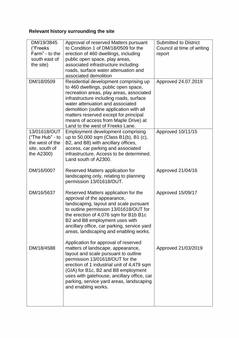
Relevant history surrounding the site
DM/19/3845 (“Freeks Farm” - to the south east of the site)
Approval of reserved Matters pursuant to Condition 1 of DM/18/0509 for the erection of 460 dwellings, including public open space, play areas, associated infrastructure including roads, surface water attenuation and associated demolition
Submitted to District Council at time of writing report
DM/18/0509
Residential development comprising up to 460 dwellings, public open space, recreation areas, play areas, associated infrastructure including roads, surface water attenuation and associated demolition (outline application with all matters reserved except for principal means of access from Maple Drive) at Land to the west of Freeks Lane.
Approved 24.07.2019
13/01618/OUT (“The Hub” - to the west of the site, south of the A2300) DM/16/0007 DM/16/5637 DM/18/4588
Employment development comprising up to 50,000 sqm (Class B1(b), B1 (c), B2, and B8) with ancillary offices, access, car parking and associated infrastructure. Access to be determined. Land south of A2300. Reserved Matters application for landscaping only, relating to planning permission 13/01618/OUT. Reserved Matters application for the approval of the appearance, landscaping, layout and scale pursuant to outline permission 13/01618/OUT for the erection of 4,076 sqm for B1b B1c B2 and B8 employment uses with ancillary office, car parking, service yard areas, landscaping and enabling works. Application for approval of reserved matters of landscape, appearance, layout and scale pursuant to outline permission 13/01618/OUT for the erection of 1 industrial unit of 4,479 sqm (GIA) for B1c, B2 and B8 employment uses with gatehouse, ancillary office, car parking, service yard areas, landscaping and enabling works.
Approved 10/11/15 Approved 21/04/16 Approved 15/09/17 Approved 21/03/2019
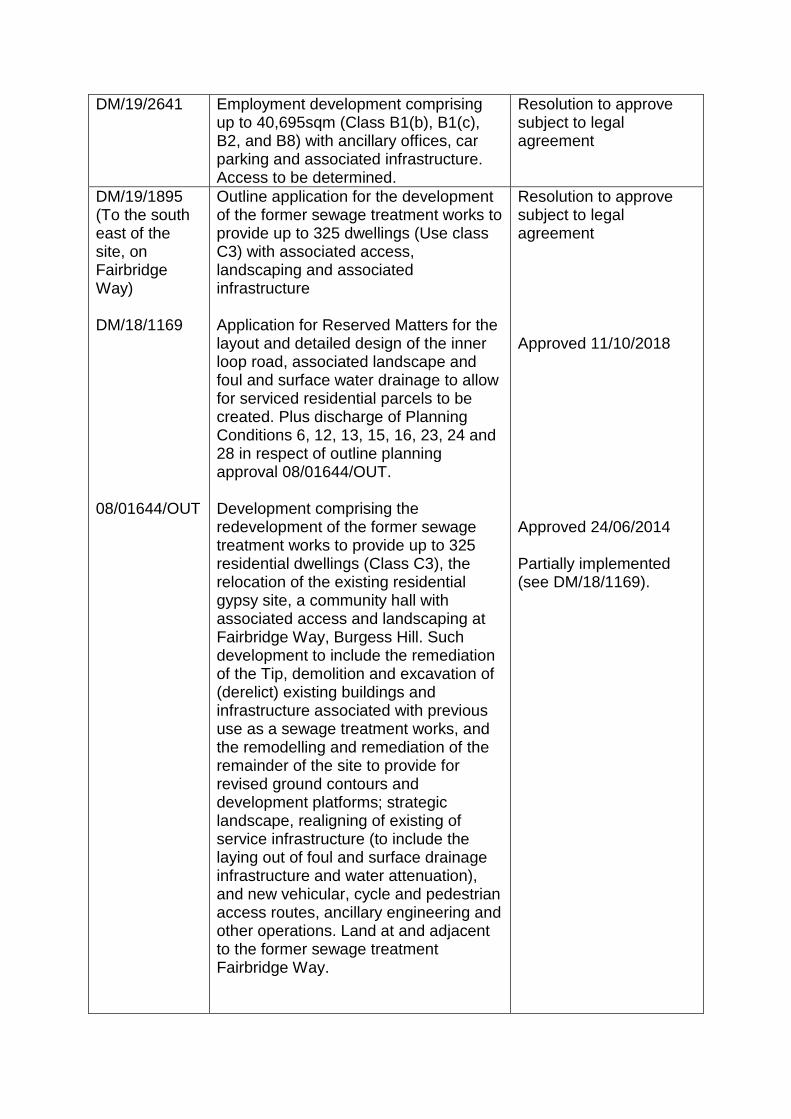
DM/19/2641 Employment development comprising up to 40,695sqm (Class B1(b), B1(c), B2, and B8) with ancillary offices, car parking and associated infrastructure. Access to be determined.
Resolution to approve subject to legal agreement
DM/19/1895 (To the south east of the site, on Fairbridge Way) DM/18/1169 08/01644/OUT
Outline application for the development of the former sewage treatment works to provide up to 325 dwellings (Use class C3) with associated access, landscaping and associated infrastructure Application for Reserved Matters for the layout and detailed design of the inner loop road, associated landscape and foul and surface water drainage to allow for serviced residential parcels to be created. Plus discharge of Planning Conditions 6, 12, 13, 15, 16, 23, 24 and 28 in respect of outline planning approval 08/01644/OUT. Development comprising the redevelopment of the former sewage treatment works to provide up to 325 residential dwellings (Class C3), the relocation of the existing residential gypsy site, a community hall with associated access and landscaping at Fairbridge Way, Burgess Hill. Such development to include the remediation of the Tip, demolition and excavation of (derelict) existing buildings and infrastructure associated with previous use as a sewage treatment works, and the remodelling and remediation of the remainder of the site to provide for revised ground contours and development platforms; strategic landscape, realigning of existing of service infrastructure (to include the laying out of foul and surface drainage infrastructure and water attenuation), and new vehicular, cycle and pedestrian access routes, ancillary engineering and other operations. Land at and adjacent to the former sewage treatment Fairbridge Way.
Resolution to approve subject to legal agreement Approved 11/10/2018 Approved 24/06/2014 Partially implemented (see DM/18/1169).
14/03959/REM
Reserved Matters application seeks the approval of details reserved by Condition 1 (Partial Discharge) and details pursuant to Condition 38 of planning permission 08/01644/OUT with regard to the relocation and provision of a gypsy site to accommodate 10 pitches.
Approved 19/12/2014
DM/18/3627 (Land North Of Maple Drive)
The erection of a new Church and Community Facility including all associated external works forming car, motor cycle and cycle parking and associated hard and soft landscaping.
Approved 01/03/2019
SITE AND SURROUNDINGS The site covers an area of approximately 184.40ha and is located to the north and north-west of Burgess Hill. The site is spread across the wards of Leylands (Burgess Hill), Dunstall (Burgess Hill), Hurstpierpoint and Downs, and Cuckfield, within the Town/Parishes of Burgess Hill, Ansty and Staplefield and Hurstpierpoint and Sayers Common. The existing use of the site is predominantly agricultural land. There are also some sporadic commercial uses spread across small areas of the site, including the Burgess Hill Golf Centre on Cuckfield Road, a polo stable at West End Farm on the A2300, Bodle Bros retail store on Cuckfield Road and a kennels at Lowlands Farm on Freeks Lane. The site predominantly consists of open fields and hedgerows and sporadic tree cover, woodland (including Ancient Woodland) and grassland. There are a small number of buildings, predominantly single/two storey, associated with agricultural uses and the commercial uses described above. To the south of the site is St Pauls College, woodland, a household waste recycling site and Jane Murray Way, with The Triangle Leisure Centre and residential properties in Burgess Hill to the south of this. To the south east of the site is Freeks Farm, where outline planning permission has recently been granted for 460 dwellings. Bedelands Nature Reserve is located to the east of the site. Agricultural fields lie to the north and west of the site, interspersed with woodland, hedgerows and sporadic residential and commercial properties. There are a number of residential and commercial properties in the centre of the site, excluded from the application site area. APPLICATION DETAILS This application is in outline form with all matters reserved for determination at a later date. The application seeks consent for the following elements:
Residential Approximately 3040 homes are proposed within the Strategic Allocation Area excluding the Freeks Farm site area. This will comprise 30% affordable housing (75% of which will be social or affordable rented homes and 25% of which will be shared ownership homes - unless there is evidence to support a different mix). Provision for thirteen permanent pitches for the gypsy and traveller community will also be made, with a site area of approximately 0.54 hectares. The layout of this facility, access arrangements and other details will be confirmed at Reserved Matters stage. Planning permission is sought for 60 units of extra care provision (as part of the total 3040). These units will be delivered within the affordable housing provision in one or more of the local centres. Education Permission is sought for up to 19,620m2 of educational development (Use Class D1: Non-residential Institutions), consisting of two 2FE primary school campuses with early years and special educational needs and disabilities (SEND) provision, and a secondary school campus also including SEND provision. A two form entry primary school campus comprising up to 3,150m2 primary school facilities including early years and SEND provision will be located in the eastern Neighbourhood Centre area. A two form entry primary school campus comprising 2,970m2 primary school facilities including early years provision will be located in the central Neighbourhood Centre area. The secondary school, comprising up to 13,500m2 secondary school facilities (allowing for up to 8 forms of entry including SEND provision) will be located to the north east boundary of the site, east of Isaacs Lane. Community Facilities 1,500m2 of stand-alone community facilities (Use Class D1: Non-residential Institutions) are proposed, consisting of two separate facilities. One facility is to be located with the eastern neighbourhood centre and one within the western neighbourhood centre. Healthcare Facilities A new healthcare facility is proposed in one of the neighbourhood centres and permission is sought for a facility of up to 1,600m2. While the Northern Arc scheme (including the Freeks Farm development) gives rise to a requirement for 838m2 of healthcare facility, the larger floorspace is intended to allow the Horsham and Mid Sussex Clinical Commissioning Group to deliver a bigger facility than is required to meet the healthcare requirements arising from just the Northern Arc development. The dental healthcare floorspace will be delivered in one or more of the Neighbourhood Centres. However if the CCG do not require an on-site facility, as suggested as a possibility within their consultation response, provision will be made in the legal agreement to secure a financial contribution towards off-site healthcare improvements in the locality.
Employment Development Permission is sought for up to 24,000m2 of employment development (Class B1 and B2) on a 4 hectare dedicated business park. Of this, no more than 2,500m2 of the employment floorspace will be Use Class B1(a). Additional office floorspace is permissible where ancillary to other B1(b), B1(c) or B2 Use Classes. For reference, these B Use Classes refer to:
B1(a): Offices (other than those that fall within A2).
B1(b): Research and development of products and processes.
B1(c): Light industry appropriate in a residential area.
B2: General Industrial Retail and Food/Drinks and Small-Scale Employment Permission is sought for up to 3,880m2 of retail and food/drinks (Use Class A1-A5) and small scale employment (Use Class B1) floorspace across the three local centres. The eastern neighbourhood centre could comprise a range of 1,400 - 1,850m2 of retail and food/drink floorspace (Use Class A1-A5) with up to 250m2 of small-scale employment (Use Class B1). The central neighbourhood centre could comprise a range of 230 - 280m2 of retail and food/drink (Use Class A1-A5) floorspace made up of a small neighbourhood parade. The western neighbourhood centre could comprise a range of 930 - 1,400m2 of retail and food/drink floorspace (Class A1-A5) with up to 250m2 of small-scale employment (Class B1). For reference, these A Use Classes refer to: A1: Shops A2: Professional and Financial Services A3: Restaurants and Cafes A4: Drinking Establishments A5: Hot Food Takeaways Retail units within all the neighbourhood centre areas will be made up of several units forming a parade with no single retail unit being more than 450m2 (315m2 net sales area). The existing retail warehouse at Bodle Bros, Southdown Store, Cuckfield Road, will be removed and replaced with residential development. Highways An all-modes highway connection will be provided between the A273 Jane Murray Way, A2300, and A273 Isaacs Lane. The section of the connection to the west/south of the A2300 will comprise 7.3 metre carriageway with separate cycle/footways either side. This section will not include any on-street parking. A new roundabout will be constructed on the A2300 as part of this highway link. The section between the A2300 and A273 Isaacs Lane will comprise a 6.75 metre carriageway with separate cycle/footway provision on at least one side. On-street car parking will feature in specific locations.
An all-mode highway connection will be provided between the A273 Isaacs Lane and eastern site boundary to connect with Freeks Farm. This connection will comprise a 6.75 metre carriageway with separate cycle/footway provision on at least one side. All bus stops will be provided on carriageway. A network of secondary, tertiary and shared private driveways will be provided to access the development. Car Parking Car parking will be provided in accordance with car parking standards as set out in the Council's Development Infrastructure and Contributions SPD. Employment parking provision will be confirmed at reserved matters stage and will depend on the final balance of B1(a), B1(b), B1(c) and B2 uses. Parking will be in accordance with the Council's Development Infrastructure and Contributions SPD. It is proposed that 30 public electric vehicle charging points will be located within the three mixed use local centres. It is also proposed that the development will include private electric vehicle charging points within the residential development plots (see sustainability below). Cycle Parking Residential cycle parking will accord to a standard higher than that set out in the Council's Development Infrastructure and Contributions SPD to assist in achieving the sustainable travel aspirations of the proposed development. The residential cycle parking standards that will apply are:
1 bed dwelling - two spaces
2 bed dwelling - two spaces
3 bed dwelling - three spaces
4+ bed dwelling - four spaces In accordance with this standard, up 8,451 residential (Use Class C3) cycle spaces will provided on the application site. All long-stay residential cycle parking will be provided in secure locations with electrical sockets provided to facilitate charging of e-bikes and e-scooters. Cycle parking to serve non-residential uses will be confirmed at reserved matters stage. Green Circle Approval is sought for a series of walking and cycling enhancements that will act as an extension to the Green Circle as defined in the Burgess Hill Town Wide Strategy. The Green Circle extension proposed through the site extends from the A2300 to the eastern boundary of the site providing connection to Wivelsfield Station and will comprise of off-road designated cycle/pedestrian routes and arboricultural/ecological corridors.
Bridges Six bridges are proposed including two all-mode bridges and four pedestrian/cycle bridges. The two all-modes bridges form part of the Northern Arc avenue (link road). One of these bridges is located in the north east of the site, at the border with the Freeks Farm application area, with the other on the western side of the site to the north of St Paul's Catholic College. Four pedestrian/cycle bridges are proposed to allow pedestrians/cyclists to pass in four locations; adjacent to Sussex Way, between central site and WSCC land, between western site and WSCC land, and between the central site and Freeks Farm site. Green infrastructure The development includes a total of 82.05 hectares of strategic green infrastructure, comprising:
14.54 hectares of ancient woodland (all ancient woodland retained on site);
9.86 hectares of formal sports pitches and ancillary facilities at the proposed Centre for Community Sport;
6.96 hectares of grassland
12.45 hectares of parks and gardens, which incorporates: o 1.6 hectares of allotments and community garden hub, located within the
western parkland o 0.18 hectares of equipped/designated play and other outdoor provision;
38.24 hectares of natural and semi-natural greenspace including ancient woodland buffers, unimproved grassland and other natural green spaces.
0.12 hectares of equipped/designated play provision. Given the whole site area is 184.40 hectares, the amount of strategic green infrastructure equates to 44.5 per cent of the site area. Six Local Equipped Areas of Play (LEAPS) are proposed with these spread across the site. In addition a Multi Use Games Area (MUGA) within the Eastern Neighbourhood Centre and a Neighbourhood Equipped Area of Play (NEAP) located in the central neighbourhood centre are also proposed. Three parklands will be located across the site. One is to be located in the eastern part of the site adjacent to the eastern neighbourhood centre and primary school and will provide approximately 1.4ha of public open space parallel to the River Adur. A second parkland is proposed in the central part of the site adjacent to the Northern Arc avenue and will provide approximately 2.3ha of public open space, forming part of the neighbourhood centre and opposite the second primary school. The third parkland will be located to the west of the site, adjacent to the A2300 and north of St Paul's Catholic College, and will provide 8.7ha of public open space and amenity space (including allotments). It is proposed to retain all existing ancient woodland throughout the application site, with a total 25m protection buffer comprising an inner 15m buffer of no development with habitat enhancement and outer 10m buffer of soft landscaping to perform as a multi-function space beyond the initial 15m buffer.
Sports Facilities A Centre for Community Sport (CFCS) is proposed on the western side of the site, to the west of the A273 Jane Murray Way and north of Gatehouse Lane. The 9.86 ha area allocated for the CFCS could accommodate pitches such as junior football pitches, mini football pitches, rugby pitches and ancillary facilities. A built facility (Use Class D2: Assembly and Leisure) of up to 400m2 will be provided. The CFCS is expected to include floodlighting on some outdoor pitches. Outdoor sports pitches will also be provided at the secondary school. Some of these pitches are expected to be floodlit. Community Garden Hub (Use Class D1) Permission is sought for a Community Garden Hub in the western parkland which will comprise up to 150m2 of D1 (Non-residential Institutions) floorspace including internal seating areas, storage, demonstration area, growing area for fruit and vegetables and associated parking, cycle storage and waste facilities. It is expected that the Community Garden Hub will also include ancillary buildings. Sustainability The applicant indicates that all development will, at reserved matters stage, demonstrate how buildings will be orientated and designed in order to maximise passive lighting and thermal performance. In addition to meeting the Fabric Energy Efficiency standard, all new development will achieve a 35% reduction in regulated CO2 emissions against Part L 2013 through onsite measures. The following electric vehicle charging points will be provided as part of the development:
all homes with off-street parking will have capability for trickle charging points (3.7kW);
20% of dwellings with off-street parking will have fast home charging points (7kW);
30 public car parking spaces will have rapid charging points (50kW) located within the three mixed use local centres; and
10% of commercial car parking spaces will have fast charging points (22kW). The applicant has indicated that site-wide runoff will be restricted to greenfield runoff rates for all design storm events up to the 1 in 100 year return period, plus 40% rainfall intensity allowance for climate change. A combination of SuDS measures will be used to cater for design events up to this standard. The applicant has also stated that all residential properties will meet the Homes Quality Mark and non-residential buildings will meet relevant BREEAM 'Excellent' published at the time of Reserved Matters.
Waste and Recycling Centre It is proposed that small-scale on-site recycling centres and waste collection infrastructure will be provided, with one of these to be provided at each of the local centres. Utilities The existing 132kv primary electricity substation to the west of Jane Murray Way (A273) will be extended by up to 3,020m2 to provide additional electrical capacity to serve the proposed development although it should be noted that this falls outside of the application site boundary and therefore this planning application itself. The existing 132kv overhead power lines to the north west of St Paul's Catholic College will be undergrounded. The development will be served by a network of utilities infrastructure, including surface water attenuation and common service trenches for utility and broadband networks. Earthworks, Excavation and Piling The development is expected to require some removal of spoil offsite which may be in the region of 100,000m3 of material. This has been considered in the transport modelling assessments that have been carried out. The employment floorspace may include full basements (maximum depth 3m) below approx. 50% of the built footprint. Semi Basements (maximum depth 1.5m of excavation) may also be proposed in apartment buildings. It is expected that ponds, swales, and geocellular storage will be required. It is assumed that a proportion of the pond storage volumes will be below ground and therefore requiring excavation. The total capacity of the surface water storage system is expected to be approximately 70,000m3. Piling depths are not expected to exceed 15m anywhere onsite with the exception of piling for highway bridges which may extend to 30m and piling for pedestrian/cycle bridges which may extend to 20m. Demolition A number of existing buildings on site will be demolished. These are mainly around West End Farm, Bodle Bros, to the rear of Bridge Farm House and at Lowlands Farm. Development Phasing The development phasing has been amended from the Infrastructure Delivery Plan & Phasing Strategy (IDP) approved by the Council as material planning consideration in order to accelerate delivery of the proposed development. Delivery has been front-loaded to Phase 1 between 1st April 2020 and 31st March 2025, reducing the amount of dwellings delivered in later Phases. This reduces the Phasing by two years to 2033 from 2035 as initially presented in the IDP although the principle
remains of having four main phases with sub-phases within. The general expected phasing is as follows: Phase One will commence in Financial Year 2020/21 with occupation by the end of Financial Year 2025/26
Will comprise approximately 851 new dwellings (Use Class C3) to be delivered in the eastern and western parts of the application site.
Will comprise up to 19,750m2 of Use Class D1 floorspace, of which up to 3,150m2 will be a 2FE primary education facility with early years and Special Educational Needs (SEND) provision delivered in the east of the site and up to 13,500m2 secondary education facilities with SEND provision delivered in the east of the site.
The 19,750 m2 D1 provision will also include up to 1,600m2 as a primary care facility, which could be delivered in one of the Neighbourhood Centre areas; and up to 500m2 multi-use community facility in the western Neighbourhood Centre area and up to 1,000m2 multi-use community facility in the eastern Neighbourhood Centre area.
Deliver up 1,850m2 of Use Class A1-A5 and B1 floorspace (retail and food/drinks and small-scale employment) in the eastern Neighbourhood Centre area. 250m2 of this floorspace is expected to comprise Use Class B1 small-scale employment use.
Deliver up to 1,400m2 of Class A1-A5 and B1 floorspace (retail and food/drinks and small-scale employment) in the western Neighbourhood Centre area. 250m2 of this floorspace is expected to comprise Use Class B1 small-scale employment use.
Deliver 8,000m2 of Use Class B1 and B2 floorspace in the dedicated business park on the western side of the application site.
Highways development will comprise an all-modes highway connection provided between the A273 Jane Murray Way, A2300 and A273 Isaacs Lane to form the Northern Arc avenue.
Deliver new roundabouts on the A2300 and A273 Jane Murray Way. Additionally, a new junction on A273 Isaacs Lane and two junctions on the B2036 to service the Northern Arc avenue will be provided.
Will include two all-mode bridges forming part of the Northern Arc avenue. One bridge will form a link from the A273 Isaacs Lane to the boundary of the Freeks Farm application site. The other bridge will be located at the western part of the site over the River Adur.
Will include four pedestrian/cycle bridges, three to the south of the site forming part of the Green Circle pedestrian/cycle route and adjacent to Sussex Way to provide connections into Burgess Hill and one bridge connecting land east of Isaacs Lane to the Freeks Farm Application site.
Will include new pedestrian/cycle routes to west from the Centre for Community Sport, through the Western Parkland to the western bridge and east of the site from the western bridge to the Freeks Farm site. Will also include the completion of the Green Circle sections that are located within the Northern Arc Strategic Allocation.
In terms of green infrastructure, this will comprise 1.4ha of parkland adjacent to the eastern Neighbourhood Centre area, 8.7ha of parkland to the west of the site
adjacent to the A2300, 9.8ha of outdoor grass and artificial pitches with up to 400 m2 of ancillary sports facilities and site wide retained ancient woodland and grassland with appropriate buffers.
Phase Two will commence in Financial Year 2025/26 with occupation by the end of Financial Year 2029/30
Will deliver approximately1,000 dwellings (Use Class C3) and six permanent gypsy and traveller pitches.
Will comprise up to 3,120 m2 of Use Class D1, of which 2,970 m2 will be a 2FE primary education facility with early years provisions in the central Neighbourhood Centre area and 150m2 of which will comprise the Community Garden Hub in the western parkland.
Deliver up to 280m2 of Use Class A1-A5 and B1 floorspace (retail and food/drinks and small-scale employment) in the central Neighbourhood Centre area.
Deliver 8,000m2 of Use Class B1 and B2 floorspace in the dedicated business park on the western side of the application site.
Will comprise 2.3ha of parkland to the south of the central Neighbourhood Centre.
A new access on the B2036 and a new junction to the north of the site on the A273 Isaacs Lane.
Phase Three will commence in Financial Year 2029/30 with occupation by the end of Financial Year 2032/33
Will deliver approximately 738 homes delivered in the central area of the site and seven permanent gypsy and traveller pitches (delivered before the end of 2031).
Deliver 8,000m2 of Use Class B1 and floorspace in the dedicated business park on the western side of the application site.
Phase Four will commence in Financial Year 2031/32 with occupation by the end of Financial Year 2033/34
Will deliver approximately 451 homes (Use Class C3) in the central area of the site.
All phases will include bus stop infrastructure and the provision of energy, water, drainage, telecommunications and broadband solutions in line with the build out of development plots.
Summary of changes made to application since first submitted A number of changes were made to the planning application in August 2019 with these being subject to a full re-consultation. The following changes were made to the Parameter Plans:
Planning Application Boundary Parameter Plan (001 Rev 01) Minor changes to the application site boundary that now includes land along Freeks Lane to allow for works to improve this public right of way as part of the proposed Green Circle pedestrian cycle route. The enlarged boundary also includes an enlarged 'nib' of land within the Freeks Farm site to allow for greater flexibility in the design of the pedestrian/cycle bridge connection over the watercourse linking the site with Freeks Farm. The boundary has also been amended to exclude a small piece of the land at the Oak Barn car park for provision of replacement car parking for the Oak Barn restaurant. The details of the replacement car parking will be within a separate planning application.
Land Use Parameter Plan (002 Rev 01) This plan is now showing flexibility for healthcare facility location, residential development on site of existing Bodle Bros retail warehouse and the removal sixth form provision at the secondary school as an off-site contribution is being requested by West Sussex County Council. The plan also shows the inclusion of thirteen pitches of permanent gypsy and traveller accommodation rather than six pitches as originally proposed.
Green Infrastructure Parameter Plan (003 Rev 02) A more accurate measurement of the specific areas of strategic green infrastructure results in a total of 82.05 hectares being provided.
Access and Movement Parameter Plan (004 Rev 01) This plan includes a new alignment of the Green Circle and additional pedestrian/cycle bridge (so six bridges in total rather than five as originally proposed). It also illustrates the withdrawal of detailed drawings submitted for approval regarding the A2300 roundabout and bridges so the planning application is solely in outline form. The following Parameter Plans have also been updated to reflect the changes referenced in the above Parameter Plans:
Density Parameter Plan (005 Rev 01)
Building Heights Parameter Plan (006 Rev 01)
Demolition and Retention Parameter Plan (007 Rev 01)
Phasing Parameter Plan (008 Rev 01)
The other changes made to the application since it was originally submitted are:
Cycle parking has been increased and will be to a higher standard than set out in the Council's Development Infrastructure and Contributions SPD
Car parking will be in accordance with the Council's Development Infrastructure and Contributions SPD
Provision of additional and revised information, in particular regarding further ecological survey information and further transport modelling work.
A Revised Design Guide has been submitted.
Refinement of phasing demonstrating an early delivery of infrastructure and dwellings as noted in the preceding section.
DEVELOPMENT PLAN Mid Sussex District Plan 2014-2031 (2018) (District Plan) The District Plan was adopted on 28th March 2018. The relevant policies are considered to be consistent with the NPPF 2019 and should be afforded full weight. The relevant Policies include:
DP1 Sustainable Economic Development
DP2 Town centre development
DP4 Housing
DP6 Settlement Hierarchy
DP7 General Principles for Strategic Development at Burgess Hill
DP9 Strategic allocation to the north and northwest of Burgess Hill
DP13 Preventing Coalescence
DP16 High Weald AONB
DP17 Ashdown Forest Special Protection Area (SPA) and Special Area of Conservation (SAC)
DP18 Setting of the South Downs National Park
DP20 Securing Infrastructure
DP21 Transport
DP22 Rights of Way and other Recreational Routes
DP23 Communication Infrastructure
DP24 Leisure & Cultural Facilities and Activities
DP25 Community Facilities and Local Services
DP26 Character and Design
DP27 Dwelling Space Standards
DP28 Accessibility
DP29 Noise, Air and Light Pollution
DP30 Housing Mix
DP31 Affordable Housing
DP33 Gypsies, Travellers and Travelling Showpeople
DP34 Listed Buildings and Other Heritage Assets
DP35 Conservation Areas
DP37 Trees, Woodland and Hedgerows
DP38 Biodiversity
DP39 Sustainable Design and Construction
DP41 Flood Risk and Drainage
DP42 Water Infrastructure & the Water Environment West Sussex Joint Minerals Local Plan (2018) The West Sussex Joint Minerals Local Plan was adopted in July 2018. The relevant policy is considered to be consistent with the NPPF 2019 and should be afforded full weight. The relevant Policy is:
M9 Safeguarding Minerals West Sussex Waste Local Plan (2014) The West Sussex Joint Minerals Local Plan was adopted in April 2014. The relevant policies are considered to be consistent with the NPPF 2019 and should be afforded full weight. The relevant Policies are:
W2 Safeguarding Waste Management Sites and Infrastructure
W10 Strategic Waste Allocations
W23 Waste Management within Development Burgess Hill Neighbourhood Plan 2015-2031 (2016) The Burgess Hill Neighbourhood Plan was made in January 2016. The relevant policies are considered to be consistent with the NPPF 2019 and should be afforded full weight. The foreword to the Burgess Hill Neighbourhood Plan states in part that: "The aims of the Plan are:
To deliver improved civic and community facilities;
To protect and enhance existing open spaces; and,
To improve the residential environment. The Neighbourhood Plan is a Vision for 16 years from 2015 - 2031. It is inextricably linked to the 20 year vision for the town set out in the Burgess Hill Town-wide Strategy 2011 produced by the Town Council and the Mid Sussex Local Plan 2004. The purpose of the Neighbourhood Plan is to focus on community development and to provide the framework to deliver benefits for residents, businesses and visitors. Funding for new community facilities and improvements is likely to come from new housing. The town's housing needs are contained within the strategic sites identified in the Town-wide Strategy." It should be noted that the Burgess Hill Neighbourhood Plan only covers a very small part of the application site, where there are two pedestrian and cycle accesses into
the site from Sussex Way. The policies therefore form part of the Development Plan for only a very small area of the application site. There are not considered to be any Policies in the Burgess Hill Neighbourhood Plan that are relevant to the very small areas covered by the Neighbourhood Plan. Notwithstanding this, the plan as a whole is considered to be a material consideration and in this respect the following policies are particularly relevant:
S3 Protect and Enhance Existing Community and Medical/Healthcare Facilities
LR1 Improved Recreational Facilities and new Community/Sports Hall at Leylands Park
LR3 Protect and Improve Existing Leisure and Recreational Facilities
G2 The Green Circle Network
G3 Nature Conservation and Biodiversity
G5 Allotment Sites
G6 Footpaths, Rights of Way and Cycle Links Hurstpierpoint & Sayers Common Neighbourhood Plan 2014-2031 (2015) The Hurstpierpoint & Sayers Common Neighbourhood Plan was made in February 2015. The relevant policies are considered to be consistent with the NPPF 2019 and should be afforded full weight. The relevant Policies include:
HurstC1 Conserving and enhancing character
HurstC3 Local Gaps and Preventing Coalescence
HurstA3 Northern Arc Outdoor Community Sports
HurstH1 Hurstpierpoint & Sayers Common New Housing Development
HurstH5 Development Principles
HurstH6 Housing sites infrastructure and environmental impact
HurstH8 Small Dwellings It should be noted that the Hurstpierpoint & Sayers Common Neighbourhood Plan only covers a small part of the application site. The above Policies only form part of the Development Plan for the following area. Whilst the Policies would not be part of the Development Plan outside the neighbourhood plan area, the plan as a whole is considered to be a material consideration. OTHER MATERIAL CONSIDERATIONS AND RELEVANT LEGISLATION National Planning Policy Framework (NPPF) (February 2019) The NPPF sets out the government's policy in order to ensure that the planning system contributes to the achievement of sustainable development. Paragraph 8 sets out the three objectives to sustainable development, such that the planning system needs to perform an economic role, a social role and an environmental role. This means ensuring sufficient land of the right type to support growth; providing a supply of housing and creating a high quality environment with accessible local
services; and using natural resources prudently. An overall aim of national policy is to 'boost significantly the supply of housing.' Paragraph 12 of the NPPF states that the NPPF does not change the statutory status of the development plan as the starting point for decision making. Proposed development that accords with an up-to-date Local Plan should be approved and proposed development that conflicts should be refused unless other material considerations indicate otherwise. It is highly desirable that local planning authorities should have an up-to-date plan in place. Paragraph 38 of the NPPF states that Local Planning Authorities should approach decisions on proposed development in a positive and creative way. They should use the full range of planning tools available, including brownfield registers and permission in principle, and work proactively with applicants to secure developments that will improve the economic, social and environmental conditions of the area. Decision-makers at every level should seek to approve applications for sustainable development where possible. With specific reference to decision-taking paragraph 47 states that planning decisions must be taken in accordance with the development plan unless material considerations indicate otherwise. National Planning Policy Guidance (NPPG) Northern Arc Masterplan (2018) The Northern Arc Masterplan (Masterplan) was approved at the Mid Sussex District Council Cabinet Meeting on 24th September 2018 as a material consideration for all forthcoming planning applications in relation to the Northern Arc. The Masterplan sets out a vision for the Northern Arc along with the following Strategic Development Principles:
SDP1 Access and Strategic Movement
SDP2 Northern Arc Avenue
SDP3 Strategic Green Connections
SDP4 Pedestrian and Cycle Links
SDP5 Centres and Walkable Neighbourhoods
SDP6 Housing Mix, Density and Capacity
SDP7 Place-making objectives
SDP8 Northern Arc Design Guide
SDP9 Built for Life
SDP10 Integration with Established Communities
SDP11 Education
SDP12 Mixed and Balanced Community
SDP13 Integrating Employment Opportunities
SDP14 Landscape and Green Infrastructure
SDP15 A rich variety of open space
SDP16 Ancient Woodland and Veteran Trees
SDP17 Sports Facilities
SDP18 Topography
SDP19 Visibility
SDP20 Existing Utility Infrastructure
SDP21 Climate resilient development
SDP22 Low carbon energy
SDP23 Integrated Water Management
SDP24 Construction and Material Use Northern Arc Infrastructure Delivery Plan and Phasing Strategy (2018) The Northern Arc Infrastructure Delivery Plan (IDP) was approved at the Mid Sussex District Council Cabinet Meeting on 24th September 2018 as a material consideration for all forthcoming planning applications in relation to the Northern Arc. The IDP identifies the infrastructure necessary to facilitate and support the development of Burgess Hill Northern Arc. Burgess Hill Town Wide Strategy (2011) The Burgess Hill Town Wide Strategy comprises the Town Council's proposed strategy for Burgess Hill for a 20 year period. The Strategy states that the Town Council was keen to develop a new but realistic and deliverable strategy in order to prevent the town from standing still and potentially going into decline. The Strategy states that: "A key part of the development of the strategy was to identify what local people wanted their town to be like. A number of consultation events, strategies and visions have been prepared over the last 6-7 years and each contained a common thread of Burgess Hill being:
a fully sustainable 21st century town focussed around a high quality, vibrant and accessible town centre;
a town that's existing and future population is supported by the necessary community facilities, employment opportunities and access to green open space; and
a town that functions efficiently and is underpinned by a state of the art transport network and modern supporting infrastructure.
To achieve the above vision, it was considered that the town needs:
a better town centre with a greater range of shops and a more attractive pedestrian environment;
improved public transport, walking and cycling links as well as better roads;
new and improved community and cultural facilities;
additional high quality and suitably located business park development; and,
new, improved and well-connected sports, recreation and open space in and around Burgess Hill."
To help meet this vision a number of projects are identified within the Strategy including:
"improvements to the town centre (to the main routes of Queen Elizabeth Avenue, Civic Way and Church Road/ Church Walk as well as improved buildings and a new public square);
improvements to transport (including enhancements to the key transport interchanges, Green Circle Network and road links)
new and improved community and green infrastructure (including a new Centre for Community Sport, management of Ditchling Common, new open space provision in the east of the town, a civic info centre and a new community/ arts centre); and,
improved and new employment development." The Strategy identifies that in order to deliver the desired projects, then additional housing developments would be required and subsequently identified the requirement of around 4000 homes, including 500 on land east of Kings Way and 3500 on land to the north and north west of the town. Burgess Hill Public Transport Strategy (2016) Ansty, Staplefield & Brook Street Neighbourhood Plan 2015-2031 (2017) Developer Infrastructure & Contributions SPD (2018) Affordable Housing SPD (2018) Development Viability SPD (2018) West Sussex Transport Plan 2011-2026 (2011) West Sussex Walking and Cycling Strategy 2016-2026 (2016) West Sussex County Council Guidance on Parking at Developments (May 2019) South Downs Partnership Management Plan 2014-2019 (2013) South Downs Local Plan 2014-2033 (2019) Town and Country Planning (safeguarded aerodromes, technical sites and military explosives storage areas) direction 2002 Ancient woodland, ancient trees and veteran trees: protecting them from development (Natural England and Forestry Commission Standing Advice) 2014 Technical Housing Standards Listed Building and Conservation Area (LBCA) Act 1990
The Town and Country Planning (Environmental Impact Assessment) Regulations 2017 ASSESSMENT It is considered that the main issues that need to be considered in the determination of this application are as follows:
Principle of development
Countryside
Landscape
South Downs National Park
High Weald AONB
Coalescence
Design
Heritage o Listed Buildings o Conservation Areas o Archaeology o Historic Landscape o Other built non-designated heritage assets
Employment
Retail & Impact on Burgess Hill Town Centre
Leisure and Open Space/Play
Community Facilities
Housing o Housing Delivery o Housing Mix o Gypsy and Traveller Provision o Extra Care Housing
Affordable Housing
Standard of Accommodation
Accessibility
Neighbour Amenity
Transport, Highways and Movement o Access Arrangements o Highway Capacity o Access for non-motorised road users o Rights of Way
Aviation
Air Quality
Odour
Noise & Vibration
Lighting
Trees
Ecology & Biodiversity
Ashdown Forest
Water Resources, Flood Risk & Drainage
Infrastructure o Proposed Infrastructure Demand o Impact on Existing Infrastructure Sites
Contaminated Land
Minerals
Sustainability
Viability
Socio-Economics
Effect Interactions
Other Issues
Planning Balance and Conclusion Principle of Development The site is located within the built up area as defined by the Mid Sussex District Plan, with the boundary being formally extended upon the adoption of the District Plan in March 2018. As such the starting point for the principle assessment is Policy DP6 (Settlement Hierarchy) of the District Plan. Policy DP6 states in part that: "Development will be permitted within towns and villages with defined built-up area boundaries. Any infilling and redevelopment will be required to demonstrate that it is of an appropriate nature and scale (with particular regard to DP26: Character and Design), and not cause harm to the character and function of the settlement. In this case the site is also part of a strategic allocation in the District Plan. Policy DP9 is the relevant Policy in the District Plan which allocates the site. This states: "Strategic mixed-use development (which will need to conform to the general principles in Policy DP7: General Principles for Strategic Development at Burgess Hill), as shown on the inset map, is allocated to the north and north-west of Burgess Hill for the phased development of:
Approximately 3,500 additional homes and associated new neighbourhood centres, including retail, education, health, employment, leisure, recreation and community uses, sufficient to meet the day to day needs of the whole of the development and located as far as possible so at least one new neighbourhood centre is within 10 minutes' walk of most new homes;
25 hectares of land for use as a high quality business park south of the A2300 and served by public transport;
Two new primary schools (including co-location of nursery provision and community use facilities as appropriate) and a new secondary school campus, in each case in locations well connected with residential development and neighbourhood centres;
A Centre for Community Sport in the vicinity of the Triangle Leisure Centre and St Paul's Catholic College;
Provision of permanent pitches for settled Gypsies and Travellers to contribute, towards the additional total identified need within the District commensurate with
the overall scale of residential development proposed by the strategic development; or the provision of an equivalent financial contribution towards off-site provision of pitches towards the additional total identified need within the District (or part thereof if some on-site provision is made) commensurable with the overall scale of residential development proposed by the strategic development, if it can be demonstrated that a suitable, available and achievable site (or sites) can be provided and made operational within an appropriate timescale; unless alternative requirements are confirmed within any Traveller Sites Allocations Development Plan Document or such other evidence base as is available at the time the allocation-wide masterplan is approved (as appropriate); and
A new Northern Link Road connecting through the Strategic Allocation Area from the A2300 to the A273 Isaacs Lane. New junctions will be provided on the A2300, B2036 Cuckfield Road and A273 Isaacs Lane. A road link across the river corridor will be required to facilitate a public transport route to Maple Drive."
The application provides all the aforementioned uses required by Policy DP9 with the exception of:
With regards to the housing, this application only covers part of the site allocation and seeks consent for approximately 3040 homes. A further part of the allocation known as "Freeks Farm" has recently gained planning permission for up to 460 homes. Together, the two applications meet the Policy requirement of approximately 3,500 homes.
On-site health facilities which, at the request of the Horsham and Mid Sussex Clinical Commissioning Group, may be provided on site or a commuted financial sum secured towards improving existing facilities in the locality. This issue is addressed in more detail in the Infrastructure section of this report.
The business park, of which only 4ha is proposed. The shortfall in employment land provided as a business park is assessed in the Employment section of this report.
Policy DP9 further states: "Strategic mixed-use development in this location will:
Progress in accordance with an allocation-wide masterplan, Infrastructure Delivery Strategy, Phasing Strategy and Financial Appraisal which will have been submitted to and approved by the local planning authority. Each planning application to be determined should accord with such approved documents unless otherwise agreed by the local planning authority."
An allocation wide Masterplan and Infrastructure Delivery Plan and Phasing Strategy was approved on the 24th September 2018 by Cabinet. These documents are therefore material considerations and accordance with these documents will be assessed in the relevant sections of this report.
Policy DP9 sets out the following phase specific further requirement: "To be acceptable, planning applications that cover a phase or part of the Strategic Allocation Area must be accompanied by:
An application-specific Masterplan and Delivery Statement for approval by the local planning authority that relates to the application site and sets out: 1. Site-specific infrastructure requirements and how these relate and adequately
contribute to the Allocation-wide Infrastructure Delivery Strategy; 2. Details of proposed development and its phasing, proposed triggers/
thresholds for the delivery of associated infrastructure and how in each case these relate and adequately contribute to the Allocation-wide Spatial Masterplan, Infrastructure Delivery Strategy and to the Phasing Strategy and conform with the general principles in Policy DP7: General Principles for Strategic Development at Burgess Hill; and
3. Details of how proposed publicly accessible space, routes and facilities would be managed and maintained."
Heads of Terms have been provided with the application and a phasing plan has been provided. These documents set out what infrastructure will be delivered and at what time, with these being secured through a completed legal agreement. Policy DP7 of the District Plan sets out general principles for strategic development at Burgess Hill. The Policy states: "Strategic development will:
Be designed in a way that integrates it into the existing town providing connectivity with all relevant services and facilities;
Provide additional, high quality employment opportunities including suitably located Business Park developments accessible by public transport;
Improve public transport, walking and cycling infrastructure and access to Burgess Hill and Wivelsfield railway stations and Burgess Hill Town Centre, including the provision of, or contributions to enhancing transport interchanges;
Provide necessary transport improvements that take account of the wider impact of the development on the surrounding area;
Provide highway improvements in and around Burgess Hill including addressing the limitations of the A2300 link road and its junction with the A23 and east-west traffic movements across Burgess Hill and, where necessary, improvements across the highway authority boundary in East Sussex;
Provide new and improved community, retail, cultural, educational, health, recreation, play and other facilities to create services and places that help to form strong local communities and encourage healthy lifestyles;
Provide new and/or improved and well connected sports, recreation and open space in and around Burgess Hill, including the continuation of the existing 'Green Circle' of linked areas of informal open space around the town along with its associated network of multi-functional paths, the Green Circle network, and links into the town centre;
Support the delivery of a multi-functional route between Burgess Hill and Haywards Heath;
Provide a Centre for Community Sport in the vicinity of the Triangle Leisure Centre;
Provide a range of housing including affordable housing, in accordance with policy DP31: Affordable Housing and housing for older people;
Identify and respond to environmental, landscape and ecological constraints and deliver opportunities to enhance local biodiversity and contribute to the delivery of green infrastructure in and around the town in accordance with policies elsewhere in the Plan including DP38: Biodiversity; Provide an effective telecommunications infrastructure, including provision for broadband; and
Wherever possible, incorporate on-site 'community energy systems', such as Combined Heat and Power or other appropriate low carbon technologies, to meet energy needs and create a sustainable development. The development shall also include appropriate carbon reduction, energy efficiency and water consumption reduction measures to demonstrate high levels of sustainability."
The compliance of the proposed development with these requirements are discussed in the relevant sections of the remainder of the report. Policy DP4 is also relevant to highlight under this 'principle' section. This states that: "The District's OAN is 14,892 dwellings over the Plan period. Provision is also made of 1,498 dwellings to ensure unmet need is addressed in the Northern West Sussex Housing Market Area. There is a minimum District housing requirement of 16,390 dwellings between 2014 - 2031. The Plan will deliver an average of 876 dwellings per annum (dpa) until 2023/24. Thereafter an average of 1,090 dpa will be delivered between 2024/25 and 2030/31, subject to there being no further harm to the integrity of European Habitat Sites in Ashdown Forest." DP4 identifies strategic development north and north-west of Burgess Hill' as providing 3,500 residential units to the District Plan minimum requirement of 16,390 residential units. Countryside A small part of the site on north western boundary is designated as an 'Area of Countryside Restraint' in the Hurstpierpoint & Sayers Common Neighbourhood Plan. Policy HurstC1 of the Hurstpierpoint & Sayers Common Neighbourhood Plan states that, "Development, including formal sports and recreation areas, will be permitted in the countryside, where:
It comprises an appropriate countryside use;
It maintains or where possible enhances the quality of the rural and landscape character of the Parish area;…"
This designation conflicts with the more up-to-date District Plan which designates the entire site as 'Built Up Area Boundary'. Countryside Policies in the District Plan do not apply to areas within the Built Up Area Boundary. Given this conflict, very limited weight is applied to Policy HurstC1. That is because under section 38(5) of the Planning and Compulsory Purchase Act 2004, if a policy contained in a development plan for an area conflicts with another policy in the development plan, the conflict
must be resolved in favour of the policy which is contained in the last document to be adopted, approved or published. Notwithstanding this, the Parameter Plans indicate that the area which is part of the Countryside designation is proposed to be the western parkland. The Hurstpierpoint & Sayers Common Neighbourhood Plan does not define 'appropriate countryside use' but a park would be an appropriate sport and recreation area that could be designed at reserved matters stage to maintain the rural and landscape character of the Parish area. As such, the proposal is considered to be in accordance with Policy HurstC1 of the Hurstpierpoint & Sayers Common Neighbourhood Plan. Landscape As previously referenced, DP7 of the District Plan requires strategic development at Burgess Hill to identify and respond to environmental, landscape and ecological constraints and deliver opportunities to enhance local biodiversity and contribute to the delivery of green infrastructure in and around the town in accordance with policies elsewhere in the Plan. DP9 requires land uses and infrastructure delivery to identify and take account of environmental, landscape and ecological constraints appropriately responding to the landscape setting including retention of woodland, hedgerows and other important natural features wherever possible. Policy DP26, referenced in more detail in the Design section of this report, states in part that development:
"creates a sense of place while addressing the character and scale of the surrounding buildings and landscape;
protects open spaces, trees and gardens that contribute to the character of the area"
Policy HurstH6 of the Hurstpierpoint & Sayers Common Neighbourhood Plan states, inter alia, "new housing developments which meet the policies of this plan and meet the criteria below will be supported: … d) the retention and protection of significant landscape features within the site and along the site's boundaries…" SDP14 in the Masterplan seeks to "preserve the established framework of woodland, trees and hedgerows as part of the commitment to create a high quality and distinctive place. Together with the meandering water courses these will define the character of the new community and frame its development." SDP15 of the Masterplan sets out that "the Northern Arc will provide a rich variety of attractive open spaces. These will support wider biodiversity objectives and promote climate change, pest and disease resilience, as well as meeting community needs for recreation and supporting health and well-being."
SDP16 of the Masterplan states that "the multiple designated ancient woodlands within the Northern Arc, which are an irreplaceable habitat, will be retained and protected through a sensitive design approach. Ancient woodlands will be incorporated into the frameworks of green spaces and protected by a buffer zone" SDP18 of the Masterplan sets out that "the development will work with the Northern Arc's undulating topography to respect and build on the existing sense of place, as well as reducing the amount of earthworks and levelling required." The IDP identifies that woodlands and open space as green infrastructure and states that the network of woodland and natural open space throughout the site is intended to create strong green corridors. Paragraph 170 of the NPPF states that planning decisions should contribute to and enhance the natural and local environment by, inter alia, "recognising the intrinsic character and beauty of the countryside." The site is located in a relatively low lying position, being lower than parts of Burgess Hill and the rising land form to the north and east of the site. The southern area is characterised by far more elevated land. The site forms part of a wooded area, with areas of dense woodland around settlements and across the landscape. The visibility of the site is reduced by the limited number of publically accessible locations in proximity to the site and the combination of intervening vegetation and undulating landform. In relation to long distance landscape views, vegetation patterns and undulating landform would screen some of the development and the development that would be seen would be viewed in the context of existing built form at Burgess Hill. The site is visually well enclosed in relation to the immediate landscape as a result of existing woodland and undulating landform. Notwithstanding this, the site is visible from points immediately surrounding the site and from elevated positions in Burgess Hill. The application site predominantly comprises undeveloped land, and the proposal will form an extension to the existing settlement of Burgess Hill. It is clear that with any greenfield development there will be some change at the local level from that of an undeveloped landscape to an urban development. In order to meet the housing needs of the District, there is inevitably a need to develop greenfield sites. This site has been allocated for development (as part of the wider Northern Arc site) in District Plan DP9 and as such, some change to the landscape has already been accepted in principle. Notwithstanding this, it is necessary to assess how the detail of the application impacts upon the landscape features of the site and its surroundings. Within the site itself, some woodland (although no ancient woodland) would be lost as a result of the Northern Arc avenue. Furthermore, there would be some localised removal from the field boundaries. There would be vegetation removal from the central part of the site, including at Burgess Hill Golf Centre, however the woodlands would be retained. The construction of the all modes bridges in the western and eastern parts of the site, and the formation of embankments to cross the River Adur
would also result in alteration to surface landform and localised loss of vegetation at the latter bridge. The proposed layout has however been based upon retaining the key vegetation structure across the site, including field boundaries, tree belts, river corridors and woodland. This includes the retention of all ancient woodland. This is reflected in the Green Infrastructure Parameter Plan (003 Rev 02) and will enable the proposed buildings and uses to be well integrated in the landscape. Furthermore, a 15m buffer is proposed adjacent to the ancient woodland within which no development is proposed, with a further 10m of limited development, restricted to landscaping, ecological mitigation and pedestrian routes. This would protect this landscape feature that is also of high biodiversity value and would be secured by condition as set out in Appendix A. The Building Heights Parameter Plan (006 Rev 01) demonstrates that the higher density development (predominantly 3-5 storeys) will be clustered around the Northern Arc avenue and the A2300, with building heights reducing towards the retained landscape features (predominantly 2-3 storeys) and reducing further along the northern and eastern edges, adjacent to existing open space (predominantly 2-2.5 storeys). Green infrastructure would be provided throughout the development and less dense uses, such as grassland, the secondary school, the western parkland and the Centre for Community Sport will be provided on the site edges. This will help create a transition between the new built up area and the open landscape beyond the site. The retention of vegetation around the perimeter of the site and the delineation of the sites northern edge ensures a defined edge to the development, ensuring the retention of the separation between Burgess Hill, Haywards Heath and Ansty and avoid any coalescence between these settlements. There will be visual landscape impacts from construction activity, particularly in the winter months when vegetation is not in leaf. However, provided appropriate protection is secured to ensure that the high quality trees and landscape features are protected during construction, secured through a condition, this will be a short term impact that will cease when construction activity is completed. The Council's Landscape Consultant has commented on the proposal with their comments set out in full within Appendix B. They have stated that: "The key factors with regard to the success of the green infrastructure (GI) strategy as mitigation for the development will be as follows: a) The retention and protection of all significant hedgerows and hedgerow trees and
the characteristic Wealden field pattern. b) The retention of appropriate natural corridors along both sides of the river and
stream valleys. c) The retention and protection of woodlands with associated buffer zones. d) A minimum width (15m) for GI corridors to ensure that they are of multifunctional
value as wildlife and recreational corridors. e) A Landscape and Ecological Management Plan to ensure the long term
monitoring and management of the GI network.
f) Consideration of the use of green bridges where the semi-natural green space extends across Sussex Way to ensure safe crossings for wildlife and people.
g) Adequate GI buffer zones for significant tree belts either side of the A2300 to ensure that a green corridor is retained and development is not dominant from the road."
These matters will be addressed through consideration of the reserved matters applications as well as adherence to the Parameter Plans that are being secured via condition and a detailed Landscape and Ecological Management Plan (LEMP) that is being secured through the legal agreement. The consultant has concluded that: "It is recommended that the development can be supported subject to satisfactory detailed design for the individual phases. The implementation of the GI framework should ensure that the proposed development could have an acceptable impact on local landscape character and views." Whilst there would be impacts on the landscape, this needs to be balanced against the benefits. The majority of the site is inaccessible at present, being privately owned agriculture land. There are some public rights of way through the site that would be retained and areas of publically accessible open space would be created. These areas include three parklands, an area of grassland adjacent to Bedelands Nature Reserve as well as green pedestrian and cycle links throughout the site. This would enable both future residents and the general public to use and enjoy the retained landscaped features and improve the recreational value of the site. The public open space would be secured by the legal agreement. As noted in the previous section, 44.5 per cent of the entire site area will retained as open space. An additional benefit would be the burial of some overhead pylons, those two to the north west of St Pauls Catholic College and their associated overhead wires, that currently detract from the value of the landscape. This would be secured by condition. A further assessment of the impact on the landscape features of the site and its surroundings will be assessed at the reserved matters stage when details of the appearance, landscaping, layout and scale are submitted, to ensure that the development is designed appropriately to the site and its context. A Design Guide has been submitted with the application to inform the assessment of reserved matters applications and will be secured by condition as stated in Appendix A. This sets out some general principles in relation to Landscape and Public Realm (Chapter 9) that should be applied to the development going forward. The Design Guide builds on the principles of the Masterplan approved as a material planning consideration. These include design principles for the pedestrian and cycle routes, river corridors, the sustainable drainage strategy, the neighbourhood parks, the open spaces, public spaces and the sports and leisure facilities. In addition the design guide also includes principles relating to managed habitats, woodland, trees, new planting. This is considered an acceptable approach.
Whilst a large amount of the development will be able to be designed in response to existing land levels on the site, it is acknowledged that some areas of development would require alterations to landforms, for example to facilitate bridges, the Northern Arc avenue, sports facilities and to create level access. Whilst there would be a landscape impact from alterations of this nature, it is considered that this can be resolved at reserved matters stage, in order to ensure that the landscape impacts of any land level changes are acceptable visually The development has been considered in combination with the outline permission at Freeks Farm (Ref: DM/18/0509 & Reserved Matters Ref: DM/19/3845) and the Hub Commercial Development (Outline Ref: 13/01618/OUT & Reserved Matters Refs DM/16/0007, DM/16/5637, DM/18/4588), both of which form part of the Northern Arc site allocation and the Fairbridge Way scheme on the sewage treatment works (DM/19/1895 - resolution to approve subject to legal agreement ). The development would result in cumulative landscape impacts with these developments, however the impacts would be localised and not significant over and above the landscape impacts already considered. There are no other developments that are considered to result in in-combination landscape impacts. It is acknowledged that there would be a change to the landscape from the development, however, this would only be of very local significance. No significant environmental effects of more than local significance would result from the proposal and it is not considered necessary to secure any wider mitigation. In forming this conclusion, regard has been given to the Environmental Statement submitted with the application ,which is considered to contain adequate information, as well as evidence held by the Council, representations and the consultation response from the Councils Landscape Consultant, who as noted above has not raised any objection to the proposal. Chapter 9 of the 2018 Environmental Statement concluded that during the construction phase, the proposed development would inevitably result in a range (moderate to major) of significant adverse landscape and visual effects due to the changes to surface landform and removal of vegetation within the site over the indicative 13 year demolition and construction period, in comparison to the agricultural and settled landscape character of the site and surrounding rural landscape. It was also concluded that upon completion of the development the changes in land use would inevitably result in significant (moderate to major) adverse landscape effects at a local and site specific level. By year 15, the establishment of the parkland and semi-natural greenspaces, in combination with the existing vegetation being in leaf, would reduce the perception of the proposed development and further integrate the Northern Arc avenue and buildings within the site. As set out in the ES Addendum (August 2019) the predicted effects of the proposed development in light of the proposed scheme changes and in respect of the effects during demolition and construction, and during operation, do not alter the conclusions of the 2018 ES that remain valid. A number of third party representations make reference to the harm to the character of the area as a result of the location and size of the proposed development. These
concerns have been addressed through the analysis set out above which demonstrates why the proposal is acceptable in respect to the impact on the character of the area. In light of the above assessment, the application accords with Policies DP7, DP9 and DP26 of the District Plan, Policy HurstH6 of the Neighbourhood Plan and the SDP14, SDP15, SDP16 and SDP18 principles contained within the Masterplan and the IDP. South Downs National Park Policy DP18 of the District Plan states that: "Development within land that contributes to the setting of the South Downs National Park will only be permitted where it does not detract from, or cause detriment to, the visual and special qualities (including dark skies), tranquillity and essential characteristics of the National Park, and in particular should not adversely affect transitional open green spaces between the site and the boundary of the South Downs National Park, and the views, outlook and aspect, into and out of the National Park by virtue of its location, scale, form or design. Development should be consistent with National Park purposes and must not significantly harm the National Park or its setting. Assessment of such development proposals will also have regard to the South Downs Partnership Management Plan and emerging National Park Local Plan and other adopted planning documents and strategies." Policy HurstC2 of the Hurstpierpoint & Sayers Common Neighbourhood Plan states that, "Development in the Parish that contributes to the setting of the South Downs National Park will only be permitted where it conserves or enhances and does not detract from the National Park's visual qualities and essential characteristics." SDP19 of the Masterplan seeks to minimise the visual impact effects of development on the South Downs National Park. The South Downs Partnership Management Plan sets out a number of aims including:
"Policy 1: Conserve and enhance the natural beauty and special qualities of the landscape and its setting, in ways that allow it to continue to evolve and become more resilient to the impacts of climate change and other pressures."
"Policy 3: Protect and enhance tranquillity and dark night skies."
"Policy 24: Support and promote river catchment management approaches that integrate sustainable land management, wildlife conservation, surface and groundwater quality and flood risk management."
Paragraph 172 of the NPPF states: "Great weight should be given to conserving and enhancing landscape and scenic beauty in National Parks…, which have the highest status of protection in relation to these issues. The conservation and enhancement of wildlife and cultural heritage are
also important considerations in these areas, and should be given great weight in National Parks and the Broads." The proposal is located approximately 3.5km from the South Downs National Park. The National Park is not readily visible from the site, however, the development would be visible from certain high points within the National Park itself. Those taller pieces of construction equipment required on a temporary basis, would also be visible. The ES states that in longer distance views from the National Park, the proposed development would be seen in the context of Burgess Hill's settlement pattern and form a subtle (not significant) change only. Whilst the area which is covered by development would increase, this would not unacceptably change long distance views from within the National Park. Within this context, the proposal would therefore not harm the setting or tranquillity of the National Park. The South Downs National Park Authority have not raised any objection to the application but have encouraged a sensitive approach to lighting to protect the International Dark Sky Reserve and take into consideration the biodiversity sensitivities of the site. The site is located to the north of Burgess Hill, the opposite side of the developed area from the National Park & the International Dark Sky Reserve. As such, any lighting is not likely to impact on dark skies over and above existing lighting within the developed area of Burgess Hill. A condition is however recommended in Appendix A to control details of external lighting in order to protect the biodiversity sensitivities of the site. The South Downs National Park Authority also commented that consideration should be given to the creation of links between the development and the National Park to encourage public enjoyment and amenity of public rights of way where possible. The proposal includes extensive pedestrian links throughout the site. Whilst these would not link into the National Park directly due to the significant distance between the boundary of the site and the National Park, it does improve accessibility in the wider area. The development has been considered in combination with the outline permission at Freeks Farm (Outline Ref: DM/18/0509 & Reserved Matters Ref: DM/19/3845) and the Hub Commercial Development (Outline Ref: 13/01618/OUT & Reserved Matters Refs DM/16/0007, DM/16/5637, DM/18/4588), both of which form part of the Northern Arc site allocation and the Fairbridge Way scheme on the former sewage treatment works (DM/19/1895 - resolution to approve subject to legal agreement). The development would not result in cumulative impacts on the South Downs National Park with these developments, over and above those already considered above. There are no other developments that are considered to result in in-combination impacts on the National Park. Issues in relation to water courses and biodiversity are considered in the Ecology & Biodiversity and Water Resources, Flood Risk & Drainage sections below. No significant environmental effects would result from the proposal and it is not considered necessary to secure any mitigation. In forming this conclusion regard has been given to the Environmental Statement and the Environmental Statement Addendum, submitted with the application which are considered to contain adequate
information, as well as evidence held by the Council, representations and the consultation response from the South Downs National Park Authority, who have not raised any objection to the proposal. As such, the proposal would comply with Policy DP18 of the District Plan, Paragraph 172 of the NPPF and principle SDP19 of the Masterplan in this regard. Furthermore it would not conflict with the aims of the South Downs Partnership Management Plan. High Weald Area of Outstanding Natural Beauty Policy DP16 of the District Plan states that: "Development on land that contributes to the setting of the AONB will only be permitted where it does not detract from the visual qualities and essential characteristics of the AONB and in particular should not adversely affect the views into and out of the AONB by virtue of its location and design." Paragraph 172 of the NPPF states: "Great weight should be given to conserving and enhancing landscape and scenic beauty in… Areas of Outstanding Natural Beauty, which have the highest status of protection in relation to these issues. The conservation and enhancement of wildlife and cultural heritage are also important considerations in these areas..." SDP19 of the Masterplan seeks to minimise the visual impact effects of development on the High Weald AONB. The proposal is located approximately 2.5km from the High Weald AONB. The AONB is not readily visible from the site, and owing to the surrounding topography, and presence of woodland, the site is not readily visible from within the AONB itself. As with the SDNP impact, those taller pieces of construction equipment required on a temporary basis, would be visible. The ES states that in longer distance views from the AONB, the proposed development would be seen in the context of Burgess Hill's settlement pattern and form a subtle (not significant) change only. The proposal would therefore not harm the setting or tranquillity of the AONB. The development has been considered in combination with the outline permission at Freeks Farm (Outline Ref: DM/18/0509 & Reserved Matters Ref: DM/19/3845) and the Hub Commercial Development (Outline Ref: 13/01618/OUT & Reserved Matters Refs DM/16/0007, DM/16/5637, DM/18/4588), both of which form part of the Northern Arc site allocation and the Fairbridge Way scheme on the former sewage treatment works (DM/19/1895 - resolution to approve subject to legal agreement). The development would not result in cumulative impacts on the High Weald AONB with these developments, over and above those already considered above. There are no other developments that are considered to result in in-combination coalescence impacts. No significant environmental effects would result from the proposal and it is not considered necessary to secure any mitigation. In forming this conclusion regard has been given to the Environmental Statement and the Environmental Statement
Addendum, submitted with the application which are considered to contain adequate information, as well as evidence held by the Council and representations. As such, the proposal would comply with Policy DP16 of the District Plan, Paragraph 172 of the NPPF and SDP19 of the Masterplan in this regard. Coalescence Policy DP13 of the District Plan states that, "development will be permitted if it does not result in the coalescence of settlements which harms the separate identity and amenity of settlements, and would not have an unacceptably urbanising effect on the area between settlements." HurstC3 of the Hurstpierpoint & Sayers Common Neighbourhood Plan states in part that; "Development will be permitted in the countryside provided that it does not individually or cumulatively result in coalescence and loss of separate identity of neighbouring settlements, and provided that it does not conflict with other Countryside policies in this Plan. Local Gaps between the following settlements define those areas covered by this policy: … Hurstpierpoint and Burgess Hill." The site would form an extension to the north and north west of Burgess Hill. The closest settlements to the site are Haywards Heath and Ansty to the north, and Hickstead to the west. Hurstpierpoint is located to the south west of Burgess Hill, well separated from the application site. The proposal is entirely located within the Built Up Area Boundary of Burgess Hill, which was extended alongside the site allocation in the District Plan. This extension to the settlement has therefore already been accepted in principle through the adoption of this plan. Furthermore, large swathes of countryside would be retained between the proposal and these settlements. The development has been considered in combination with the outline permission at Freeks Farm (Outline Ref: DM/18/0509 & Reserved Matters Ref: DM/19/3845) and the Hub Commercial Development (Outline Ref: 13/01618/OUT & Reserved Matters Refs DM/16/0007, DM/16/5637, DM/18/4588), both of which form part of the Northern Arc site allocation and the Fairbridge Way scheme on the former sewage treatment works (DM/19/1895 - resolution to approve subject to legal agreement ). The development would not result in cumulative coalescence impacts with these developments, over and above those already considered above. There are no other developments that are considered to result in in-combination coalescence impacts. No significant environmental effects would result from the proposal and it is not considered necessary to secure any mitigation. In forming this conclusion regard has been given to the Environmental Statement and the Environmental Statement Addendum, submitted with the application which are considered to contain adequate information, as well as evidence held by the Council and representations.
As such, the proposal would not lead to unacceptable coalescence and would comply with Policy DP13 of the District Plan and HurstC3 of the Hurstpierpoint & Sayers Common Neighbourhood Plan. Design Policy DP26 of the District Plan states: "All development and surrounding spaces, including alterations and extensions to existing buildings and replacement dwellings, will be well designed and reflect the distinctive character of the towns and villages while being sensitive to the countryside. All applicants will be required to demonstrate that development:
is of high quality design and layout and includes appropriate landscaping and greenspace;
contributes positively to, and clearly defines, public and private realms and should normally be designed with active building frontages facing streets and public open spaces to animate and provide natural surveillance;
creates a sense of place while addressing the character and scale of the surrounding buildings and landscape;
protects open spaces, trees and gardens that contribute to the character of the area;
protects valued townscapes and the separate identity and character of towns and villages;
does not cause significant harm to the amenities of existing nearby residents and future occupants of new dwellings, including taking account of the impact on privacy, outlook, daylight and sunlight, and noise, air and light pollution (see Policy DP29);
creates a pedestrian-friendly layout that is safe, well connected, legible and accessible;
incorporates well integrated parking that does not dominate the street environment, particularly where high density housing is proposed;
positively addresses sustainability considerations in the layout and the building design;
take the opportunity to encourage community interaction by creating layouts with a strong neighbourhood focus/centre; larger (300+ unit) schemes will also normally be expected to incorporate a mixed use element;
optimises the potential of the site to accommodate development." The Masterplan sets out the following at SDP2:
"The design and character of Northern Arc avenue will be developed to ensure that it strikes the optimum balance between its place-making role at the heart of the community, uniting the various character areas across the Northern Arc, and its role as a supporting through route."
The Masterplan sets out the following at SDP6:
"Higher density areas will be focused around the three neighbourhood centres and along the western and central sections of Northern Arc Avenue at a density of around 50 dwellings per hectare (dph). Medium densities of around 45 dph will
predominate across much of the rest of Northern Arc, with lower density areas of around 35 dph in more sensitive edge locations."
The Masterplan sets out the following place-making objectives at SDP7:
"Creating walkable neighbourhoods with vibrant centres that are accessible to all;
Co-locating schools, community centres and open spaces with the neighbourhood centres to support vitality and community identity;
Designing streets as places that encourage social interaction as well as walking, cycling and public transport;
Ensuring that streets, public realm and open spaces are well overlooked and designed to feel safe and secure;
Creating a place that is easy to find your way around with a clear hierarchy of streets and spaces, landmark features and views;
Setting development within an interconnected, easily accessible network of attractive streets, green infrastructure, green corridors and open spaces to act as wildlife corridors and sustainable transport links;
Incorporating trees, gardens and green spaces throughout the development to provide shade and cooling during extreme heat events and to increase its ability to adapt to climate change;
Supporting health and well-being through opportunities for active lifestyles and living in close contact with nature;
Providing a variety of different character areas which reflect variations in landscape and topography, as well as the role and function of different parts of the community;
Integrating business and employment uses to diversify day time activities;
Accommodating car parking and servicing in ways that are convenient and safe but also unobtrusive."
The Masterplan sets out the following at SDP8:
"Design proposals for the Northern Arc will be assessed against the place-making objectives set out in Design Guide (SDP 8) and Building for Life 12
Maximise integration with the existing communities of Burgess Hill and the established facilities and services of the town and the wider District."
SDP9 of the Masterplan states that design proposals will be assessed against the place-making objectives set out in the Design Guide (SDP8) and Building for Life 12. SDP21 of the Masterplan sets out that green infrastructure will be designed with species that are tolerant to the prevailing climatic conditions. Policy HurstH1 of the Hurstpierpoint & Sayers Common Neighbourhood Plan states, "To meet the future needs in the Neighbourhood Plan Area new housing development will be supported in areas which: a) Enhance the existing settlement pattern of the village; b) In Hurstpierpoint, can also provide significant areas of parkland adjacent to the
built zones, to be owned and managed by the local community; c) In Sayers Common, can enhance the flood and drainage management in the
village."
Policy HurstH5 of the Hurstpierpoint & Sayers Common Neighbourhood Plan states, "House designs and the layouts and densities shall respond to the village character of the area and shall follow the Village Design Statement (May 2004)." Paragraph 127 of the NPPF seeks high quality design in new developments. This application is outline only with all matters reserved. As such it is only the principle of development that is proposed to be determined at this stage. The design of the scheme will be assessed at reserved matters stage when details of the appearance, layout, scale and landscape are known. Notwithstanding this, the following Parameter Plans have been submitted with the application:
Planning application boundary (001 Rev 01)
Land Use (002 Rev 01)
Green Infrastructure (003 Rev 02)
Access and Movement (004 Rev 01)
Density (005 Rev 01)
Building Heights (006 Rev 01)
Demolition and Retention Plan (007 Rev 01)
Phasing Plan (008 Rev 01) These Parameter Plans establish the broad locations for the various proposed land uses on the site, including the provision of open space and retained landscape which will be interspersed between the development parcels. This shows important landscape features within the site such as ancient woodland, which is all being retained, and hedgerows. This approach is supported. The Access and Movement Parameter Plan indicates the broad location of the Northern Arc avenue and indicates broad locations for primary vehicular and pedestrian/cycle accesses. The exact road network would be determined at reserved matters stage, however, the provision of the access points indicated on the parameter plan will enable a permeable layout to be designed. The Density and Building Heights Parameter Plans establish that the tallest, most dense development would be located adjacent to the Northern Arc avenue with the lowest heights and densities being adjacent to the boundaries of the site that adjoin open countryside. This is considered to be an appropriate approach that will enable the detailed design to respond to its context. The Council's Urban Designer, whose response is set out in full within Appendix B, has commented on the approach within the Parameter Plans as follows: "The Green Infrastructure and Movement plans can be commended for both the large proportion of the site that has been dedicated to open space, and the integration of pedestrian and cycle routes that will benefit from these spaces and help encourage green travel habits. This includes both the "Green Circle" and the "Green Superhighway" with the former designed to have a more rural / recreational
character, and the latter providing a more direct east west route that links the neighbourhood centres with Wivelsfield Station. The main open spaces will incorporate existing landscape features and benefit from attractive backdrops (including the woodland around the Adur river valley in the east part of the site and the ancient woodland in the centre of the site) while being sufficiently large to accommodate a range of activities. They are also well positioned both in terms of their relationship with the three neighbourhood centres and by being overlooked by adjacent development. The proposed new schools are also sensibly positioned close to both open spaces and neighbourhood centres (NC's) which have been designed around urban squares that feature higher density housing around them that should together give each of the three main parts of the development a central focus while providing a sense of identity and critical mass of activity. The western neighbourhood centre will also feature commercial uses and benefit from the through flow of traffic from the A2300; its gateway location is proposed to be given special emphasis by formally grouping 5 storey buildings around the junction of the A2300 and Northern Arc avenue (NAA) spine road, which should give the street environment a sense of place that is missing in the ubiquitous-looking housing that turn their backs to some of the surrounding roads. The NAA spine road will also feature taller building frontages of 3-5 storeys. This is considered appropriate, to reinforce its principal role within the development and provide sufficient street enclosure, given that the street will be wider than the secondary and tertiary roads (as it will be accommodating a dedicated cycleway and more traffic and feature larger trees). The larger population around the NAA will help sustain public transport, the neighbourhood centres and is consistent with DP26 that seeks to optimise the development potential of new sites. A condition is recommended in Appendix A requiring reserved matters applications to be broadly in accordance with the submitted Parameter Plans. A Design Guide has been submitted with the application and sets out the key urban design public realm and place-making principles that should be applied across the site and is intended to be used as a guide for forthcoming reserved matters to support the delivery of the overall vision. The Design Guide establishes the broad parameters of the design of the development in relation to the following:
Place-making
Northern Arc Neighbourhoods and Centres
Residential Character Areas
Employment
Access, Movement and Street Layout Design
Car and Cycle Parking
Landscape and Public Realm
The Council's Urban Designer has commented on the Northern Arc Design Guide (NADG) as follows: "The key focus of the NADG is the design of the Neighbourhood Centres (NCs, chapter 4) and Northern Arc avenue (NAA, chapter 7) which reflects the importance of establishing a clear consistent vision for the most visible and visited parts of the site. Special emphasis has been directed to building enclosure, the need for pedestrian and cycle friendly environment with suitable soft landscaping, and the discreet accommodation of parking, as well as the logistics of vehicular and bus movements as the NAA needs to perform the function of both a living street and road corridor. Chapter 3 looks at the characteristics that help shape places, both in terms of layout and building design; however it does not look at this in detail as much of the principles will be covered by the Mid Sussex Design Guide, which is shortly to be subject to public consultation. The Neighbourhood and Residential Character Areas (chapters 4 and 5), helpfully illustrate the masterplan at a more detailed level, showing the relationship of streets, spaces and landscape features. The quality of landscaping is extensively covered in chapter 9, while chapter 8 sets out appropriate different parking strategies, and chapter 6 looks specifically at the design of the employment area." Conditions are recommended in Appendix A requiring reserved matters applications to be in accordance with the Design Guide and to be accompanied by a Design Principles Statement setting out how the principles in the design guide have been applied. Compliance with the document will be assessed at reserved matters stage. Subject to the application of this document, Officers are satisfied that an appropriate design can be achieved at reserved matters stage. A full assessment of the development will be made against Policies Hurst H1 and HurstH5 of the Hurstpierpoint & Sayers Common Neighbourhood Plan at reserved matters stage, when details of the layout, scale, appearance and landscaping are submitted. Notwithstanding this, it is considered that limited weight should be applied to these Policies due to the conflict with the more recently adopted District Plan. The principle of the development of this scale has been accepted following the site allocation in the District Plan and the level of development proposed is unlikely to respond to the village character and settlement pattern in Hurstpierpoint and Sayers Common, being more closely related to the settlement of Burgess Hill. Furthermore, the scale of development proposed would have its own character, informed by the design guide. Given the limited weight applied to these policies, any conflict would not be significant. The proposal is considered to be in accordance with Policies DP7, DP9 and DP26 of the District Plan, principles SDP2, SDP6, SDP7, SDP8, SDP9 and SDP21 of the Masterplan and paragraph 127 of the NPPF.
Heritage The LPA is under a duty by virtue of s.66 of the Listed Building and Conservation Area (LBCA) Act 1990 (General duty as respects listed buildings in exercise of planning functions): "In considering whether to grant planning permission for development which affects a listed building or its setting, the local planning authority or, as the case may be, the Secretary of State shall have special regard to the desirability of preserving the building or its setting or any features of special architectural or historic interest which it possesses". The LPA is also under a duty by virtue of s.72 of the Listed Building and Conservation Area (LBCA) Act 1990 (General duty as respects conservation areas in exercise of planning functions): "In the exercise, with respect to any buildings or other land in a conservation area ... special attention shall be paid to the desirability of preserving or enhancing the character or appearance of that area". Case law has stated that "As the Court of Appeal has made absolutely clear in its recent decision in Barnwell, the duties in sections 66 and 72 of the Listed Buildings Act do not allow a local planning authority to treat the desirability of preserving the settings of listed buildings and the character and appearance of conservation areas as mere material considerations to which it can simply attach such weight as it sees fit. If there was any doubt about this before the decision in Barnwell it has now been firmly dispelled. When an authority finds that a proposed development would harm the setting of a listed building or the character or appearance of a conservation area, it must give that harm considerable importance and weight." The Courts further stated on this point "This does not mean that an authority's assessment of likely harm to the setting of a listed building or to a conservation area is other than a matter for its own planning judgment. It does not mean that the weight the authority should give to harm which it considers would be limited or less than substantial must be the same as the weight it might give to harm which would be substantial. But it is to recognize, as the Court of Appeal emphasized in Barnwell, that a finding of harm to the setting of a listed building or to a conservation area gives rise to a strong presumption against planning permission being granted. The presumption is a statutory one. It is not irrebuttable. It can be outweighed by material considerations powerful enough to do so. But an authority can only properly strike the balance between harm to a heritage asset on the one hand and planning benefits on the other if it is conscious of the statutory presumption in favour of preservation and if it demonstrably applies that presumption to the proposal it is considering." Policy DP34 of the District Plan states in relation to Listed Buildings: "Development will be required to protect listed buildings and their settings. This will be achieved by ensuring that:
A thorough understanding of the significance of the listed building and its setting has been demonstrated. This will be proportionate to the importance of the building and potential impact of the proposal;
…
Special regard is given to protecting the setting of a listed building;"
Policy DP34 of the District Plan states in relation to other heritage assets: "The Council will seek to conserve heritage assets in a manner appropriate to their significance, so that they can be enjoyed for their contribution to the character and quality of life of the District. Significance can be defined as the special interest of a heritage asset, which may be archaeological, architectural, artistic or historic. Proposals affecting such heritage assets will be considered in accordance with the policies in the National Planning Policy Framework (NPPF) and current Government guidance." Policy DP35 of the District Plan states: "Development will … protect the setting of the conservation area and in particular views into and out of the area." The supporting text to principle SDP14 (Landscape and Green Infrastructure) in the Masterplan states that the Masterplan will preserve landscape features and wherever possible respect the landscape setting of nearby listed buildings and non-designated heritage assets. Paragraph 192 of the NPPF sets out that "in determining applications, local planning authorities should take account of: a) the desirability of sustaining and enhancing the significance of heritage assets
and putting them to viable uses consistent with their conservation; b) the positive contribution that conservation of heritage assets can make to
sustainable communities including their economic vitality; and c) the desirability of new development making a positive contribution to local
character and distinctiveness." Paragraph 193 of the NPPF is also particularly relevant with this stating that "When considering the impact of a proposed development on the significance of a designated heritage asset, great weight should be given to the asset's conservation (and the more important the asset, the greater the weight should be). This is irrespective of whether any potential harm amounts to substantial harm, total loss or less than substantial harm to its significance." Paragraph 196 of the NPF states that "Where a development proposal will lead to less than substantial harm to the significance of a designated heritage asset, this harm should be weighed against the public benefits of the proposal including, where appropriate, securing its optimum viable use." Listed Buildings No Listed Buildings are located within the site boundary, however there are 12 within 500m of the site. These all consist of grade II listed post-medieval farmhouses and barns. There is one grade II* listed building within 1km of the site. The Council's Conservation Officer comments are set out in full within Appendix B. The officer has raised concerns that the applicant's submitted Cultural Heritage Statement is inadequate (in not considering potentially affected assets at Lower
Ridges Farm and Barn) and flawed in its assessment of the level of impact on some of the assets which it does consider, including Hook House Farm, Firlands and Bridge Farm. The Conservation Officer has commented as follows: "The level of harmful impact on Hook House Farm, Firlands and Bridge Farm may be to an extent academic, as this is likely to always remain within the 'less than substantial' level of harm defined by the NPPF, so that the consideration set out in paragraph 196 will apply. In all cases also the 'great weight' referred to in paragraph 193 which should be given to an asset's conservation regardless of the level of harm caused by a proposed development would also apply. However, my concern is that in underplaying the level of less than substantial harm caused the Cultural Heritage Statement may lead to inadequate consideration being given to appropriate mitigation measures in the development of the detail of the relevant parts of the scheme. If the current application is to be approved on the basis of the submitted statement, it should be made very clear that appropriate mitigation measures will in all cases be required." "This will be particularly important in the case of Lower Ridges Farm and Barn which, as above, are not considered in the Cultural Heritage Statement and as such have not been identified as affected by the proposed development. My concern here is that there are views looking sse from the immediate settings of these assets across the ne corner of Six Acre Wood at the bend in Copyhold Gill, where (particularly in winter) the proposed development to the nw of Paddock Cottage will be visible. I am not sure at what time of year the applicant has visited these assets and I accept that visibility is likely to be reduced in summer when trees are in leaf. However even a seasonal impact on the setting of and views from these assets will adversely affect the manner in which their special interest as historic farm buildings within what presently remains an almost uninterrupted rural setting is appreciated. This requires due consideration in the detailed design of this part of the scheme." In response to the concerns raised by the Conservation Officer the applicant has stated that they consider the assessment is proportionate to the importance of the assets concerned and to an application for outline planning permission, in accordance with paragraph 189 of the NPPF. The applicant disagrees that the assessment that the magnitude of impact on Hook House Farmhouse as a result of the school development would be Medium: "For this to be the case there would need to be 'noticeably different change to setting affecting significance, resulting in erosion in our ability to understand and appreciate the asset', in accordance with the methodology set out within the ES. The proposed school buildings will be located over 400m from the asset and partially screened from it." With regard to Firlands and Bridge Farm the applicant considers that "for the impact on these to assets to be Moderate there would have to be 'noticeably different change to setting affecting significance, resulting in erosion in our ability to understand and appreciate the asset.' While there will be change to the setting it will result in a change in our ability to understand and appreciate the asset rather than

an erosion of that ability. For this reason we stand by our assessment that the magnitude of impact will be low resulting in a Minor adverse significance of effect." In respect of the impact on Bridge Farm, the applicant disagrees with the Conservation Officer's contention of a Moderate significance of effect for Bridge Farm being an understatement: "For the proposed development to result in a Major adverse significance of effect it would mean 'Comprehensive change to setting affecting significance, resulting in a serious loss in our ability to understand and appreciate the asset' which is demonstrably not the case." The applicant has stated that Lower Ridges and its Barn are "not assessed as we screened them out in the DBA (desk based assessment) because they are separated from the development by woodlands" and that viewpoints from this location and from Lye's Farm were not possible due to access issues on private land. It is important to draw specific attention to the concluding remarks of the Council's Conservation Officer who confirms that the harm will be less than substantial and has stated that: "In conclusion, if the application is approved on the basis of the current Cultural Heritage Statement, I would consider it very important that it is made clear that aspects of the Cultural Heritage Assessment are considered inadequate and that the Council would expect appropriate mitigation measures to be part of the detailed design of any subsequent detailed proposals in accordance with the 'great weight' that the NPPF requires should be given to less than substantial harm to all affected assets (not limited to those identified in the assessment). I would recommend that subsequent applicants are advised to contact the Council at an early stage to discuss what appropriate mitigation measures may be in the context of the affected built heritage assets identified above and elsewhere in my previous comments." It is clear from these concluding comments that, in order to ensure that 'great weight' is given to the 'less than substantial harm', then appropriate mitigation measures need to be secured. Planning officers consider that mitigation measures should be secured under this application, by condition, rather than being left to assessment under reserved matters. This will ensure that great weight is afforded to the less than substantial harm identified at this outline planning stage. Accordingly it is recommended that a planning condition be used that will mean those sub-phases in closest proximity to the heritage assets need to have appropriate mitigation measures submitted to and approved (under the relevant reserved matters application for that sub-phase) prior to development within that sub-phase commencing. The areas in question primarily relate to the secondary school site within Phase One and all of Phase Four, as these have boundaries along the northern border of the site, closest to the heritage assets. With such a condition in place securing mitigation measures, it can clearly be demonstrated that great weight is given to the less than substantial harm identified. Securing appropriate mitigation measures by condition will address the aspect of the Conservation Officer's concerns that relate to the lack of these measures in the current submission.
To conclude on this point, the differences of opinion on the degree of impact on the listed buildings which lie outside the application site between the Council's Conservation Officer and the applicant are noted. Planning Officers consider that there would be some limited impact on the setting of these listed buildings, Hook House Farm, Firlands and Bridge Farm in particular. This would fall within the less than substantial harm category. That being the case the test set out at paragraph 196 of the NPPF is that this harm should be weighed the public benefits of the development. In this particular case there are clear, substantial, demonstrable and compelling public benefits outlined in this report which are considered to far outweigh the less than substantial harm to the settings of the listed buildings identified above. Conservation Areas There are no Conservation Areas within the site. However the St John's Conservation Area and the Fairfield Conservation Area are located within 1km of the site. Whilst the scale of the proposed development is substantial, the nature of, and distance between, the application site and the nearest part of the conservation area boundary means that the proposal will have a neutral impact on this heritage asset. The separation gap, consisting of the built form of the existing town, is approximately 775 metres away. The effects of the development on the conservation area will therefore be negligible, resulting in a neutral impact. Archaeology Nine archaeological assets have been identified within the site Construction works have the potential to cause harm to archaeological heritage assets (both known and unknown). Basement excavations, foundations and the provision of services could result in the need to remove archaeological remains The majority of the trajectory of the Roman Road through the Site has been included in to the Green Infrastructure plan to minimise the impact of the Proposed Development on the Roman Road and any potentially associated Roman settlement evidence. The Council's Archaeological Consultant has raised no objection to the application. The consultant has concluded that to allow for the implementation of suitable mitigation measures appropriate to the archaeological significance of the Assets that may be present, any detailed reserved matters application(s) to follow for each phase should be accompanied by the results of such an appropriately scaled field evaluation. This will provide for the opportunity to produce a suitable programme of mitigation work or influence the design and logistics of the detailed development proposal to accommodate any Archaeological Assets worthy of preservation in situ that may be revealed.
An appropriate condition is therefore recommended securing the implementation of a programme of archaeological work following a written scheme of investigation. This condition will ensure that the significance of any heritage assets are appropriately considered. Historic Landscape The landscape within the Site can be characterised as primarily medieval fieldscape with pockets of ancient woodland. Features of the medieval landscape include sections of ancient woodlands as well as field boundaries associated with medieval division of land across the Site. In addition two areas of ridge and furrow have been identified with the site. These are of historic significance. The ancient woodland within the site is of historic significance and is also likely to protect a number of historic landscape features associated with the maintenance and management of the woodland. Both layout and landscaping are reserved matters, however, the indicative information suggests that all areas of ancient semi-natural woodland are proposed to be retained within the Proposed Development, with the implementation of a 15m buffer zone. This will ensure that the ancient woodland will not be physically impacted by the Proposed Development. The long term management and maintenance of all the open space, including the ancient woodland will be secured through the legal agreement. Other Built Non-Designated Heritage Assets One historic building has been identified as a non-designated heritage asset within the site, an 18th/19th century barn at Lowlands Farm. Layout and appearance are reserved matters, however the application documents indicate that this barn would be converted to residential use and retained as part of the development. The Council's Conservation Officer considers that this has the potential to be an acceptable approach that could help mitigate any harm caused to this non-designated heritage asset. As such, Officers are satisfied that an acceptable approach could be achieved at reserved matters stage where careful consideration of the proposed approach to this non-designated heritage asset would need to be given. 11 built non-designated heritage assets have been identified within 500m of the application site. Construction works have the potential to cause harm to the setting of these heritage assets through removal of trees, erection of hoarding and construction activities. However any harm would be short term during the construction of the development itself. The wider setting of these heritage assets have the potential to be affected however, as layout and appearance are reserved matters, officers are satisfied that an acceptable development could be achieved at reserved matters stage that could prevent harm to these heritage assets.
Combination No significant environmental effects would result from the proposal. In forming this conclusion, regard has been given to the Environmental Statement submitted with the application ,which is considered to contain adequate information, as well as evidence held by the Council and representations. The development has been considered in combination with the outline permission at Freeks Farm (Outline Ref: DM/18/0509 & Reserved Matters Ref: DM/19/3845) and the Hub Commercial Development (Outline Ref: 13/01618/OUT & Reserved Matters Refs DM/16/0007, DM/16/5637, DM/18/4588), both of which form part of the Northern Arc site allocation, and the Fairbridge Way scheme on the former sewage treatment works (DM/19/1895 - resolution to approve subject to legal agreement). Chapter 10 of the 2018 Environmental Statement concluded that the proposed development would not have a significant effect on any built heritage asset within the site or study area during either the demolition and construction or operation phases. As noted previously within this section, mitigation is however to be secured despite the 2018 ES suggesting that no mitigation is required. As set out in the ES Addendum (August 2019), this document concludes that the assessment included in the Addendum has demonstrated that the proposed scheme changes are not significant, and the significance of the impacts of the proposed development and conclusions presented in the 2018 ES remain unchanged. In light of the above analysis on heritage assets and securing appropriate mitigation, and subject to the balancing exercise in the conclusion section regarding the identified less than substantial harm, the development accords with Policies DP34 and DP35 of the District Plan, principle SDP14 of the Masterplan, the NPPF and the Listed Building and Conservation Area (LBCA) Act 1990. Employment Policy DP1 of the District Plan states: The total number of additional jobs required within the district over the plan period is estimated to be an average of 543 jobs per year. This will be achieved by:
Encouraging high quality development of land and premises to meet the needs of 21st century businesses;
Supporting existing businesses, and allowing them room to expand;
Encouraging inward investment, especially the location, promotion and expansion of clusters or networks of knowledge, creative or high technology industries; and
Seeking the provision of appropriate infrastructure to support business growth - in particular high speed broadband connections.
Provision for new employment land and premises will be made by:
Allocating 25 hectares of land as a high quality business park at Burgess Hill to the east of Cuckfield Road;
Allocating further sites within the Site Allocations DPD;
Incorporating employment provision within large scale housing development as part of a mixed use development where it is appropriate."
The Policy goes on to state: "Effective use of employment land and premises will be made by:
Protecting allocated and existing employment land and premises (including tourism) unless it can be demonstrated that there is no reasonable prospect of its use or continued use for employment or it can be demonstrated that the loss of employment provision is outweighed by the benefits or relative need for the proposed alternative use;
Permitting appropriate intensification, conversion, redevelopment and/ or extension for employment uses providing it is in accordance with other policies in the Plan;
Giving priority to the re-use or adaptation of rural buildings for business or tourism use and to the diversification of activities on existing farm units (in accordance with Development in the Countryside policies)."
SDP13 of the Masterplan sets out that the Northern Arc will include 4 hectares (ha) of employment land to the south of the A2300, which would be suitable for a range of B-Class uses (offices, research and development, and/or industry). The application proposes 4ha of employment space, with up to 24,000m2 of floorspace, to the western side of the site, south of the A2300. This would be to the east of The Hub development (Outline Ref: 13/01618/OUT & Reserved Matters Refs DM/16/0007, DM/16/5637 and DM/18/4588) which also forms part of the Northern Arc site allocation in Policy DP9 of the District Plan. The Hub development provides for 15ha of employment space. As such, the two proposals combined would provide a total of 19ha of employment land. This results in a shortfall of 6ha against District Plan Policy DP9 which requires 25ha of land for use as a high quality business park south of the A2300. Part of the area allocated for employment in Policy DP9 is proposed to be a Centre for Community Sport (also a requirement of the Policy). The adopted masterplan acknowledges this shortfall. In the Officer report to Cabinet it sets out that, "Officers consider that the 6ha shortfall can however be met by securing additional employment at the neighbourhood centres and through the allocation of additional land through the Site Allocations Development Plan Document (DPD)." As such, the principle of the shortfall has already been accepted. Nevertheless, the failure to comply with Policy DP9 in this respect needs to be weighed into the overall planning balance. Since the adoption of the Masterplan, the Site Allocations DPD has been considered by Scrutiny Committee at its meeting on the 11th September. At this Scrutiny Committee meeting it was resolved to recommend to full Council that the draft Site Allocations DPD be consulted upon for the purposes of the Regulation 18 Consultation. At the time of writing this report, the full papers for the full Council meeting of the 25th September have been published and the outcome of the will be reported verbally to Members of the District Planning Committee.
The Site Allocations DPD proposes to allocate 7 sites totalling 17.45 hectares of employment space and includes a further 7 hectares on land at Bolney Grange Business Park which is in close proximity to the site. Although very little weight can currently be afforded to this document, planning officers consider that the employment needs of the district can be met during the plan period from the alternative sites that will come forward through the DPD. Furthermore, other windfall development within the District will also offset the shortfall of 6 hectares. As confirmed in the 'Site Allocations Development Plan Document Site Selection Paper 4: Employment Sites:" "Analysis of permissions granted and sites completed since the District Plan was adopted has identified that this 6ha shortfall [on the Northern Arc site] has been met by two 'windfall' sites were not considered against the 25ha requirement, as they had not been permitted at the time: Site Area (ha) Former Handcross Garden Centre (A23), Handcross - 2.7 hectares Land West of Copthorne, Copthorne - 3.6 hectares TOTAL 6.3 hectares" The employment space to be provided would comprise flexible B1 and B2 space with no more than 2,500m2 B1(a) office floorspace (except where ancillary to the main uses proposed). These uses are considered suitable for this area and would be secured by conditions. In order to secure this employment floorspace in the long term, permitted development rights should also be withdrawn to prevent inappropriate changes of use occurring without the Council having control over them and a condition in Appendix A will achieve this. Furthermore, it is acknowledged that employment space in addition to that proposed as part of the business park, will be provided within the neighbourhood centres. The application sets out that up to 250m2 of B1 employment floorspace will be provided within both the eastern and western neighbourhood centres (a total of up to 500m2). This would help offset some of the employment space not provided within the proposed business park. This would be secured by condition and delivered as part of the reserved matters for each of these neighbourhood centres. As part of this application an Economic Sustainability Strategy has been submitted. This sets out the following three economic and employment roles for the Northern Arc:
"Securing the wider employment role of Burgess Hill
Contributing to the regeneration of Burgess Hill
Making provision for small scale enterprise and entrepreneurship from within the Northern Arc"
In order to achieve these aims the strategy sets out that appropriate facilities will be provided to meet these aims, developing the western neighbourhood centre to support the adjacent employment use and ensuring social spaces in the neighbourhood centres are good places for doing business, designing in high quality digital infrastructure and designing homes that can double up as places to work. The
details of the employment strategy, including the marketing strategy, will be secured by the legal agreement to ensure that the development is designed and marketed appropriately to meet the employment needs of the area and to ensure the long term success of the employment areas. The Economic Sustainability Strategy also sets out that the applicant is committed to enter into a 'Local Employment Agreement' which will set out measures to promote local employment associated with the scheme. This will also be secured by the legal agreement. In light of the above assessment, the proposal is not considered to be in complete accordance with Policy DP9 of the District Plan due to the shortfall in employment space. The proposal would, however, comply with Policy DP1 of the District Plan and SDP13 of the Masterplan. Retail & Burgess Hill Town Centre Policy DP2 of the District Plan states inter alia: "A sequential test must be applied to planning applications for main town centre uses that are not in an existing centre and are not in accordance with the District Plan and the relevant Neighbourhood Plan…Planning applications proposing the construction of 500m² or more gross floorspace for the sale of convenience or comparison goods outside a town centre must be accompanied by a Retail Impact Assessment in order to demonstrate that they would not have a significant adverse impact on a town centre, either on their own or cumulatively in the area." The proposal would result in the loss of the exiting retail warehouse, Bodle Bros, which is on Cuckfield Road at the northern tip of the site. Policy DP1 states in part that: "Effective use of employment land and premises will be made by: Protecting allocated and existing employment land and premises (including tourism) unless it can be demonstrated that there is no reasonable prospect of its use or continued use for employment or it can be demonstrated that the loss of employment provision is outweighed by the benefits or relative need for the proposed alternative use;…". Within the proposed Regulation 18 Site Allocations Development Plan consultation document referred to in the preceding section, a number of employment sites are listed for protection, intensification and redevelopment under Policy SA34. Although this document has very little weight, it is important to note that the Bodle Bros site is not one of those sites listed within Policy SA34. In this case it is considered that the loss of the existing premises will be outweighed by the various benefits of the proposal, chiefly the provision of approximately 3040 houses including 30% affordable, thereby ensuring the development complies with the DP1 requirement. Furthermore, the application also proposes up to 3,530m2 of new retail and food/drink floorspace (proposed to be provided as flexible uses within Use Classes A1 - A5). 1,400 - 1,850m2 would be provided within the eastern neighbourhood centre, 230 - 280m2 within the central neighbourhood centre and 930 - 1,400m2
within the western neighbourhood centre. The units will be provided as flexible A1 - A5 uses, as such, the exact quantum of retail (A1 uses) is not known at this stage, however it could be up to 3,530m2. Whilst main town centre uses are proposed on the site (and therefore outside of Burgess Hill Town Centre), a sequential test is not required by Policy DP2, as the provision of retail on the Northern Arc would be in accordance with the District Plan, specifically Policy DP9 which requires the redevelopment of the site to include inter alia "neighbourhood centres, including retail… sufficient to meet the day to day needs of the whole of the development." It is important to make clear that the purpose of the retail elements are to help create sustainable communities and this will be achieved through the provision of convenient facilities and to provide vibrant centres. In this respect the application accords with the principles within the Masterplan. SDP5 of the Masterplan refers to the 'Centres and Walkable Neighbourhoods' and states that the centres will be conveniently located so residents can walk to local facilities and services within 5 to 10 minutes of their home as well as being accessible by cycle, public transport and car. A mixture of uses will be important to meet the placemaking objectives set out with SDP 7 of the Masterplan namely in facilitating the creation of vibrant centres that are accessible to all. The application is accompanied by a Retail Statement which sets out an assessment of retail impact of the proposal. It does this by comparing anticipated expenditure with retail provision on the Northern Arc and without retail provision on the Northern Arc. The statement sets out that whilst there are some vacancies in the town centre, the centre is vital and viable. The report concludes that there would be some diversion of expenditure from the Town Centre as a result of the retail provision on the Northern Arc, particularly with regards to convenience expenditure. However, this is not considered significant and would not impact on the viability of the town centre. It is further acknowledged that the Retail Statement uses a comparison at the year 2024 with both scenarios including the population growth expected by that point in the plan period (including that associated with the Northern Arc). The population growth associated with the Northern Arc development would increase retail expenditure in Burgess Hill overall when compared to expenditure without the development. Furthermore, the principle of some proposed retail uses on the site has been established through the adoption of the Plan, and without these neighbourhood centres, the proposal would be in conflict with the strategic policy relating to this specific site. In addition to this, the application confirms that each individual unit will be no more than 450m2 gross (315m2 net). As such, the units will be small shops more suited to meeting the day to day needs of the occupiers of the development. This would be secured by condition to ensure the units are provided at or below this size and are not subsequently adapted to create larger units. Furthermore, a condition is also recommended to prevent the sale of a large quantum of comparison goods, which more typically draw people to visit Town Centres in order to prevent an impact on Burgess Hill Town Centre.
The provision of neighbourhood centres which contain retail within walking distance of the new homes will contribute to a sustainable community where people's day to day needs can easily be met without having to travel longer by car. As such, whilst a Retail Impact Assessment has not been provided, it is considered that the Retail Statement submitted is sufficient to demonstrate that the proposal would not have an unacceptable impact on the viability of Burgess Hill Town Centre, taking into consideration the circumstances of the proposal, outlined above. The proposal is therefore considered acceptable in relation to the aims of Policy DP2. In addition, and based on the above assessment, the application complies with the requirements of DP1, DP7 and DP9 in terms of the retail provision requirements. Leisure and Open Space/Play Policy DP24 of the District Plan states: "Development that provides new and/or enhanced leisure and cultural activities and facilities, including allotments, in accordance with the strategic aims of the Leisure and Cultural Strategy for Mid Sussex will be supported. The on-site provision of new leisure and cultural facilities, including the provision of play areas and equipment will be required for all new residential developments, where appropriate in scale and impact, including making land available for this purpose. Planning conditions and/or planning obligations will be used to secure such facilities. Details about the provision, including standards, of new leisure and cultural facilities will be set out in a Supplementary Planning Document." The Policy goes on to state: "Proposals that involve the loss of cultural facilities, open space, sports and recreational buildings and land, including playing fields, will not be supported unless:
an assessment has been undertaken which has clearly shown the cultural facility, open space, sports land or recreational building to be surplus to requirements; or
the loss resulting from the proposed development would be replaced by equivalent or better provision in terms of quantity and quality in a suitable location; or
the development is for alternative sports and recreational provision, the needs for which clearly outweigh the loss."
Policy HurstA3 of the Hurstpierpoint & Sayers Common Neighbourhood plan states "an area for Outdoor Community Sports shall be provided as part of the Burgess Hill 'Northern Arc' Development Plan, adjacent to the A2300. The land allocation shown on the Proposals Map at Burgess Hill Northern Arc is indicative." Policy HurstA3 of the Hurstpierpoint & Sayers Common Neighbourhood plan states, "New housing developments which meet the policies of this plan and meet the criteria below will be supported: … g) the provision of, or financial contributions towards, community facilities and the provision of public open space; h) the provision of parkland areas, to be owned and managed by the local community."
Policy G5 of the Burgess Hill Neighbourhood Plan refers specifically to allotments and states that proposals for new allotments will be supported. Policy LR3 of the Burgess Hill Neighbourhood Plan states in relation to leisure and recreational facilities that, inter alia, "Support will be given to… improving existing ones…The following have been identified as important by the local community… 3. The Triangle Leisure Centre, Dunstall ward." SDP7 sets out the place-making objectives within the Masterplan and this refers to supporting health and well-being through opportunities for active lifestyles and living in close contact with nature. This principle also states that the place-making objectives will include setting development within an interconnected, easily accessible network of attractive streets, green infrastructure, green corridors and open spaces to act as wildlife corridors and sustainable transport links. SDP14 states that the development of the Northern Arc will preserve and enhance the established framework of woodlands, trees and hedgerows as part of the commitment to creating a high quality and distinctive place. It also states that as well as creating character within the new community, the existing green infrastructure will help to integrate the development into the wider landscape and maintain important habitats. SDP15 states that the Northern Arc will provide a rich variety of attractive open spaces. These will support wider biodiversity objectives and promote change, pest and disease resilience, as well as meeting community needs for recreation and supporting health and wellbeing. SDP17 of the Masterplan sets out that "An area on the western edge of the Northern Arc (west of Jane Murray Way) will be a strategic location for the provision of sports facilities to serve the new and existing communities. This area would accommodate the Centre of Community Sports and include approximately 9ha of outdoor sports pitches, as well as supporting facilities, to complement existing and enhanced provision at the nearby Triangle Leisure Centre." The IDP sets out that three parks should be provided, located in the east, centre and west of the site, with allotments provided in the western park. It goes on to state that the woodlands and natural open space should be provided in the form of ancient woodland, buffer areas, streams and natural open spaces to provide green corridors. The IDP also sets out that a centre for community sport, providing 9 hectares of outdoor sports, as well as requiring community access to sports facilities on the secondary school site at the east of the site. This reflects Policy DP9 which requires "Centre for Community Sport in the vicinity of the Triangle Leisure Centre and St Paul's Catholic College". Appendix 2 of the Development Infrastructure and Contributions SPD sets out requirements for Outdoor playing space, including LEAPs and NEAPs. The design of the indicative layout has been informed by the open space that would be retained across the site. This includes an area of land to the west of Bedelands Nature Reserve and various green corridors along the edges of and through the site.
Three parks are proposed across the site. Allotments will be provided in the western park and the parks and open spaces would also contain some play areas with 6 LEAPS (locally equipped areas of play - for younger children), a NEAP (neighbourhood equipped area of play - for older children) and a MUGA (multi use games area) all being provided across the site. The exact extent of public access will be determined through reserved matters applications but it is considered that an appropriate level of open space will be provided. The application proposes to transfer the open spaces to Mid Sussex District Council and this will be secured by the legal agreement along with a commuted sum for maintaining the open space. The timescales for delivery of each of the areas of open space will also be secured by the legal agreement to ensure that the public open spaces are delivered alongside the residential development parcels to provide appropriate facilities for the new community as it is delivered. An area of land for a Centre for Community Sport is provided in the west of the site. This is proposed to be transferred to Mid Sussex District Council along with a contribution towards developing the site for sports facilities and a commuted sum for maintaining the land. This would be secured by the legal agreement. The exact details of the facility will be agreed at reserved matters stage to ensure it meets the sporting needs of the community. In addition a financial contribution will also be secured in the legal agreement towards the provision of a new hockey pitch at the Triangle Leisure Centre. These open spaces and sports facilities would provide appropriate leisure facilities in appropriate locations spread across the entire development to meet the needs of the community. No objection is raised by Sport England subject to the legal agreement securing the Centre for Community Sport and the financial contribution. Their comments are set out in full in Appendix B but Sport England has expressed some concerns about the scheme in respect of the fact they would rather see the exact details for the centre being secured now rather than wait for the reserved matters stage. Sport England is also keen to ensure that the financial contribution in the legal agreement is sufficient. In response to this, officers consider it would not be appropriate to secure the precise pitch details until the Council's Playing Pitch Strategy becomes adopted so it would be far more preferable to ensure that the development of this site responds to the needs identified in this document, reserving the details to be agreed at reserved matters stage. There will be clauses in the legal agreement requiring this site to be developed for community sport and at the time of the reserved matters, the playing pitch strategy will most likely be adopted and therefore will be a material consideration to be given significant weight. Therefore, the development of this site will respond to the needs identified in the Playing Pitch Strategy. Officers are content with the contributions secured in the legal agreement. The proposal would result in the loss of the exiting Burgess Hill Golf Centre, which is on Cuckfield Road in the southern part of the site. The loss of this facility was accepted in principle when the Masterplan was adopted. Furthermore, the open space and sports provision that would be delivered as part of the proposal would
offer a better leisure provision in terms of quantity and quality than what this private facility currently offers. It should also be noted that Policy LR3 of the Burgess Hill Neighbourhood Plan does not list the golf course as one of those specific sites that has 'been identified as important by the local community'. As such, the loss of this facility is considered acceptable. The proposal is therefore considered to be in accordance with Policy DP9 and DP24 of the District Plan, SDP7, SDP14, SDP15 and SDP17 of the Masterplan, the IDP, Policy HurstA3 of the Hurstpierpoint & Sayers Common Neighbourhood Plan and Policy G5 and LR3 of the Burgess Hill Neighbourhood Plan with regards to Leisure and Open Space/Play. Community Facilities Policy DP7 of the District Plan states, inter alia, that strategic development will: "Provide new and improved community… facilities to create services and places that help to form strong local communities and encourage healthy lifestyles." Policy DP9 states that the Northern Arc site is allocated for a phased development to include 'community facilities… Policy DP25 of the District Plan states: "The provision or improvement of community facilities and local services that contribute to creating sustainable communities will be supported." SDP5 of the Masterplan refers to the 'Centres and Walkable Neighbourhoods' and states that both the western and eastern centre will include a standalone community facility. SDP7 of the Masterplan refers to place-making objectives and suggests that to meet the development will include co-locating schools, community centres and open spaces with the neighbourhood centres to support vitality and community identity. The IDP identifies the requirement for two standalone community buildings within the Northern Arc development. The application proposes two community centres in the western and eastern neighbourhood centres. Once these buildings have been developed, they would be transferred to Mid Sussex District Council along with a commuted sum to maintain these facilities in the longer term. These provisions are secured by the legal agreement. It is also considered appropriate to secure a Community Engagement Worker Officer. The purpose of the Community Engagement Worker is to facilitate the development of a sustainable, inclusive and happy community at the Northern Arc of which residents are proud to be a part. This is secured as part of the legal agreement.
The community buildings will be delivered in Phase One, likely (sub-phases only shown illustratively at this outline stage) within sub-phases that when complete will have delivered approximately 267 and 831 homes (727 and 1291 homes in the Northern Arc as a whole, including Freeks Farm). Given the number of homes completed and the delivery times of these facilities and, in order to encourage the creation of a sustainable community, a temporary community facility will be secured by the legal agreement to provide a facility to enable community activity to take place from early in the project. In light of the above the proposal is considered to be in accordance with Policies DP7, DP9 and DP25 of the District Plan, principles SDP5 and SDP7 of the Masterplan and the IDP. Housing Policy DP4 of the District Plan sets out that: "There is a minimum District housing requirement of 16,390 dwellings between 2014 - 2031." Policy DP9 states that the Northern Arc site is allocated for a phased development to include, inter alia:
3500 additional homes … and …
Provision of permanent pitches for settled Gypsies and Travellers to contribute, towards the additional total identified need within the District commensurate with the overall scale of residential development proposed by the strategic development; or the provision of an equivalent financial contribution towards off-site provision of pitches towards the additional total identified need within the District (or part thereof if some on-site provision is made) commensurable with the overall scale of residential development proposed by the strategic development, if it can be demonstrated that a suitable, available and achievable site (or sites) can be provided and made operational within an appropriate timescale; unless alternative requirements are confirmed within any Traveller Sites Allocations Development Plan Document or such other evidence base as is available at the time the allocation-wide masterplan is approved (as appropriate);"
Policy DP30 of the District Plan states inter alia: "To support sustainable communities, housing development will:
provide a mix of dwelling types and sizes from new development (including affordable housing) that reflects current and future local housing needs;
meet the current and future needs of different groups in the community including older people, vulnerable groups and those wishing to build their own homes. This could include the provision of bungalows and other forms of suitable accommodation, and the provision of serviced self-build plots; and
on strategic sites, provide permanent pitches for Gypsies and Travellers and Travelling Showpeople, as evidenced by the Mid Sussex District Gypsy and Traveller and Travelling Showpeople Accommodation Assessment or such other evidence as is available at the time; or the provision of an equivalent financial contribution towards off-site provision (or part thereof if some on-site provision is
made) if it can be demonstrated that a suitable, available and achievable site (or sites) can be provided and made operational within an appropriate timescale, commensurable with the overall scale of residential development proposed by the strategic development; and serviced plots for self-build homes where a need for such accommodation is identified."
Policy DP33 of the District Plan states: "To ensure that a sufficient amount of permanent culturally suitable housing for settled Gypsies, Travellers and Travelling Showpeople is delivered to meet identified needs within an appropriate timescale, the Council makes provision for… the allocation of pitches within the strategic allocation to the north and north-west of Burgess Hill or the provision of an equivalent financial contribution towards the off-site provision of pitches if it can be demonstrated that a suitable, available and achievable site (or sites) can be provided and made operational within an appropriate timescale." This Policy goes on to state, "New Gypsy, Traveller and Travelling Showpeople sites, and extensions to existing sites, including transit sites, will be permitted provided:
The site or extension satisfies a clearly defined need, as evidenced by the Mid Sussex Gypsy and Traveller Accommodation Assessment or the best available evidence;
The site is reasonably accessible to schools, shops, health and other local services and community facilities;
The development is appropriately located and designed to/ or capable of being designed to ensure good quality living accommodation for residents and that the local environment noise and air quality) of the site would not have a detrimental impact on the health and well-being of the Travellers;
The sites are compatible with neighbouring land uses, and minimise impact on adjacent uses and built form and landscape character;
In rural and semi-rural areas sites should not dominate the nearest settled community;
Any site within the 7km zone of influence around Ashdown Forest will require an appropriate assessment under the Habitats Regulations to be undertaken and appropriate mitigation provided as required (Policy DP17: Ashdown Forest Special Protection Area (SPA) and Special Area of Conservation (SAC) refers); and
In the case of proposals within the High Weald AONB, Policy DP16: High Weald Area of Outstanding Natural Beauty will apply.
The determination of planning applications for new sites or extensions to sites providing accommodation for settled Gypsy and Traveller and Travelling Showpeople use will be considered under the relevant District Plan policies."
The Masterplan sets out the following at SDP6:
"The Northern Arc will provide a full range of housing opportunities, with different densities and typologies across the new community.
The mix of housing types and density will support the timely delivery and phasing of approximately 3,500 homes within the Northern Arc."
SDP12 of the Masterplan sets out that "the Northern Arc will provide a range of housing types to meet current and anticipated future local housing need, including extra care and elderly persons' housing." SDP24 of the Masterplan states that Homes England has an ambition to deliver at an accelerated pace through the use of modern methods of construction. The IDP sets out that, "The Northern Arc Development will contribute a commuted sum towards the local authority to support gypsy, traveller's and travelling showpeople site provision off-site to the scale of 16 pitches." The IDP also states that Homes England is committed to the delivery of affordable homes alongside market homes so, during the whole development period at least 30% of the total site-wide number of homes consented through reserved matters applications will be affordable homes. Housing Delivery The proposal would deliver approximately 3,040 homes, which together with the housing approved on the Freeks Farm site (Outline planning application: DM/18/0509 and reserved matters DM/19/3845) would meet the requirement in District Plan Policy DP9 for 3,500 homes on the Northern Arc site. The phasing plan indicates that some of these homes would be delivered outside of the plan period. Given the overall scale of the development and the quantum of dwellings proposed, this is considered reasonable, however the applicant suggests that 2,327 of the 3,040 homes could be delivered within the District Plan period. This would make a significant contribution to the overall requirement and the rate of housing delivery would be secured as part of the legal agreement. This is a benefit that weighs in favour of the proposal as it supports the Council in delivering the requirement in Policies DP4 and DP9 of the District Plan. The application is considered to be in accordance with SDP6 and SDP24 of the Masterplan. Housing Mix The Strategic Housing Market Assessment (2012) sets out the following recommendation for market housing:
35-45% of housing on urban extensions should have at least 3 bedrooms.
There are no recommendations for smaller 1 and 2 bedroom units.
The latest evidence for the mix of affordable housing required in the district is set out in the Affordable Housing Needs Model Update (2014). This sets out the following recommended mix for affordable units:
1 bed 2 bed 3 bed 4 bed
25% 50% 20% 5%
The market housing will be provided at the following mix, as per the applicant's Development and Specification framework:
1 bed 2 bed 3 bed 4 bed
11% 32% 36% 21%
This mix accords with that set out within the IDP which is a material planning consideration. The affordable housing that is provided as social/affordable rent will be provided at the following mix (75% of the affordable housing):
1 bed 2 bed 3 bed 4+ bed
33% 51.5% 14.5% 1%
The affordable housing that is provided as intermediate will be provided at the following mix (25% of the affordable housing):
1 bed 2 bed 3 bed 4+ bed
0% 65% 30% 5%
This affordable housing mix accords with that set out within the IDP which is a material planning consideration. This approximate mix of housing delivery is considered acceptable and would be secured through the legal agreement. The proposal would contribute to meeting the housing need, as set out in the Strategic Housing Market Assessment and the Affordable Housing Needs Model Update. The proposal is therefore considered to be in accordance with policy DP30 of the District Plan in this regard and would comply with SDP6 and SDP12 of the Masterplan as well as the IDP. Gypsy and Traveller Provision As set out above, Policy DP9 of the Mid Sussex District Plan states that the Northern Arc site is allocated for a phased development to include, inter alia: "Provision of permanent pitches for settled Gypsies and Travellers to contribute, towards the additional total identified need within the District commensurate with the overall scale of residential development proposed by the strategic development; or the provision of an equivalent financial contribution towards off-site provision of pitches towards the additional total identified need within the District (or part thereof if some on-site provision is made) commensurable with the overall scale of residential development proposed by the strategic development, if it can be
demonstrated that a suitable, available and achievable site (or sites) can be provided and made operational within an appropriate timescale; unless alternative requirements are confirmed within any Traveller Sites Allocations Development Plan Document or such other evidence base as is available at the time the allocation-wide masterplan is approved (as appropriate)." The Northern Arc site allocation generates a need for 16 gypsy and traveller pitches, which is commensurate with the 3500 dwellings proposed on the strategic development as a whole. This figure was confirmed in the adoption of the IDP. The Freeks Farm planning application (DM/18/0509) secured a financial contribution to provide 3 off site gypsy and traveller pitches. The residual requirement of 13 pitches for the remainder of the Northern Arc site allocation is commensurate with the scale of residential development proposed on the remainder of the site. The application proposes 13 on site pitches, shown on the Parameter Plans as being delivered within the centre of the site in Phase 2 and Phase 3. Phase 2 is proposed to deliver 6 pitches and Phase 3 is proposed to deliver 7 pitches. The Land Use Parameter Plan (002 Rev 01) shows 0.54 hectares of land for this facility. This area would provide space for 13 pitches each with supporting infrastructure. However, the Land Use Parameter Plan (002 Rev 01) also identifies a limit of deviation area of up to 0.63 hectares within which the facility could be delivered should it be deemed that a larger area is required when the pitches are designed at reserved matters stage. Any planning permission will not preclude this larger facility being delivered. The applicants have confirmed, in the Revised Development Specification and Framework, that the 7 pitches provided within Phase 3 would be delivered by the end of 2031. To ensure the entire gypsy and traveller provision would be delivered by the end of the plan period, the 13 pitches would need to be provided by March 2031 rather than by the end of 2031. This is in order to contribute to the clearly defined need in the District Plan of 23 pitches. The delivery of the 13 pitches by March 2031 will therefore be secured in the legal agreement. Representations have been made by third parties with concerns being expressed about the location of the pitches as shown on the Parameter Plans and their relationship with surrounding development as well as access arrangements. This however would be a matter for consideration at reserved matters stage when the details of the development would be determined. How the facility, and the surrounding development particularly in regard to densities and building heights, would be designed would be a matter for consideration at this detailed design stage. The Parameter Plans indicate that these pitches would be located to the south of an area of open space which would contain a LEAP. The pitches would be in close proximity to the eastern neighbourhood centre that would contain a mix of uses, including shops, community facilities, a primary school and would have close links with the secondary school to the north of the neighbourhood centre. Health facilities are available in Burgess Hill and this permission secures either an on-site health centre or a financial contribution towards local health facilities. The pitches would be compatible with the neighbouring land uses in these parcels which are for other residential development and open space and would not dominate the proposed surrounding settled community. Whilst there would be an impact on
the landscape character, the principle of this impact has been accepted as part of the overall site allocation. The broad location of the pitches is therefore considered acceptable. A further representation has been made stating that the gypsy and traveller provision should be removed from the application altogether. This would however conflict with the requirements of Policy DP9 that requires gypsy and traveller provision, as clearly set out at the beginning of this section of the report. A representation has also been made which states that the relevant District Plan policies seem to be clear that contributions towards off site provision can only be secured as an alternative to on site provision where "it can be demonstrated that a suitable, available and achievable site can be provided". The representation states that it appears an off site location in respect of Freeks Farm (DM/18/0509) was not identified at the time of the approval of that application. The representation also states that it would therefore seem appropriate and necessary to provide 3 further on site pitches (i.e. 16 in total) within the remainder of the Northern Arc strategic allocation unless an alternative site is identified which meets the criteria set out in the District Plan. However, the 13 pitches provided within the current application are commensurate with the level of housing proposed by this application. Viewed in isolation, the current application is therefore policy compliant. Beyond this, there is no policy requirement for all 16 pitches to be provided within the Northern Arc, and the Freeks Farm permission was not dependent upon the three pitches for which off-site funding was secured being provided within the remainder of the Northern Arc. The principle of provision outside the Northern Arc has therefore already been established. Officers remain satisfied that there are other suitable, available and achievable sites within the district, which could be delivered within an appropriate timescale and to which the Freeks Farm contribution could be applied. Accordingly, there is no requirement for all 16 pitches to be provided within the current application. In light of the above assessment, Officers consider that the proposal would provide an appropriate provision of gypsy and traveller pitches in a suitable location. In this regard the proposal is therefore considered to be in accordance with Policies DP9, DP30 and DP33 of the District Plan, as well as the provisions of the IDP and SDP12 of the Masterplan. Extra Care The application includes up to 60 units of extra care accommodation within one of the neighbourhood centres. This would be secured through the legal agreement and would meet the requirement in SDP12 for extra care accommodation. The IDP has also identified that the Northern Arc is expected to generate the need for between 50 and 60 units of extra care provision. In light of the above, the proposal is considered to be in accordance with Policies DP9, DP30, DP33 of the District Plan, SDP6, SDP12 and SDP24 of the Masterplan and the IDP.
Affordable Housing Policy DP31 states: The Council will seek: 1. the provision of a minimum of 30% on-site affordable housing for all residential
developments providing 11 dwellings or more, or a maximum combined gross floorspace of more than 1,000m2;
2. for residential developments in the High Weald Area of Outstanding Natural Beauty providing 6 - 10 dwellings, a commuted payment towards off-site provision, equivalent to providing 30% on-site affordable housing;
3. on sites where the most recent use has been affordable housing, as a minimum, the same number of affordable homes should be re-provided, in accordance with current mix and tenure requirements;
4. a mix of tenure of affordable housing, normally approximately 75% social or affordable rented homes, with the remaining 25% for intermediate homes, unless the best available evidence supports a different mix; and
5. free serviced land for the affordable housing. All affordable housing should be integrated with market housing and meet national technical standards for housing including "optional requirements" set out in this District Plan (Policies DP27: Dwelling Space Standards; DP28: Accessibility and DP42: Water Infrastructure and the Water Environment); or any other such standard which supersedes these. Proposals that do not meet these requirements will be refused unless significant clear evidence demonstrates to the Council's satisfaction that the site cannot support the required affordable housing from a viability and deliverability perspective. Viability should be set out in an independent viability assessment on terms agreed by the relevant parties, including the Council, and funded by the developer. This will involve an open book approach. The Council's approach to financial viability, alongside details on tenure mix." Policy HurstH7 of the Hurstpierpoint & Sayers Common Neighbourhood Plan states, "On housing developments of 4 or more dwellings, there will normally be a 30% 'affordable' homes content, for rent and assisted purchase schemes for local people and generally, not more than 25% of affordable homes being of shared ownership." SDP12 of the Masterplan and the IDP sets out that the development will provide 30% affordable housing of which 75% will be social or affordable rented and 25% will be intermediate. As part of this application 30% of the housing proposed would be provided as Affordable Housing (rounded up to the nearest whole number). Of this 30%, 75% would be provided as social or affordable rented and 25% would be provided as intermediate housing. These units would be delivered by the developer and transferred to a registered provider. These provisions will be secured through the legal agreement.
The legal agreement will also set out that for each Phase, unless otherwise agreed no more than 50% of the Market Housing Units are to be occupied until all of the Affordable Housing Units have been built and made ready for residential occupation and written notice of such has been received by the Responsible Officer for Housing. Additionally, no more than 50% of the market housing units shall be occupied until all of the Affordable Housing Land and Units have been transferred to the Registered Provider. These provisions will ensure that the affordable housing is delivered in advance/at the same time as the market housing. Whilst layout, scale and appearance are reserved matters, the applicant has confirmed that the design and specification of the affordable housing will be similar in design and specification to the market housing. This will be assessed at reserved matters stage. In addition the legal agreement will secure free serviced land as per the requirements of clause 5 of DP31. The proposal is therefore considered to be in accordance with the requirements of District Plan Policy DP31, Policy HurstH7 of the Hurstpierpoint & Sayers Common Neighbourhood Plan, SPD12 of the Masterplan and the aims of the IDP. Standard of Accommodation Policy DP27 of the District Plan states: "Minimum nationally described space standards for internal floor space and storage space will be applied to all new residential development. These standards are applicable to:
Open market dwellings and affordable housing;
The full range of dwelling types; and
Dwellings created through subdivision or conversion. All dwellings will be required to meet these standards, other than in exceptional circumstances, where clear evidence will need to be provided to show that the internal form or special features prevent some of the requirements being met." SDP24 of the Masterplan states that buildings will be designed for adaptability with a simple floor plate, good daylighting, generous floor to ceiling heights and adequate space for servicing. It is considered that the standard of accommodation and adaptability of the buildings and the aims of Policy DP27 of the District Plan and principle SDP24 of the Masterplan can be met at reserved matters stage when the layout scale and appearance are assessed. The requirement to meet the nationally described space standards for internal floor space and storage space will be secured by condition.
Accessibility Policy DP28 of the District Plan states: "All development will be required to meet and maintain high standards of accessibility so that all users can use them safely and easily. This will apply to all development, including changes of use, refurbishments and extensions, open spaces, the public realm and transport infrastructure, and will be demonstrated by the applicant. With regard to listed buildings, meeting standards of accessibility should ensure that the impact on the integrity of the building is minimised." In relation to accessible and adaptable dwellings, the Policy goes on to state: "Developments of 5 or more dwellings will be expected to make provision for 20% of dwellings to meet Category 2 - accessible and adaptable dwellings under Building Regulations - Approved Document M Requirement M4(2), with the following exceptions: 1) Where new dwellings are created by a change of use; 2) Where the scheme is for flatted residential buildings of fewer than 10 dwellings; 3) Where specific factors such as site topography make such standards
unachievable by practicable and/ or viable means; 4) Where a scheme is being proposed which is specifically intended for the needs of
particular" With regard to wheelchair use dwellings the Policy states: "Wheelchair-user dwellings under Building Regulations - Approved Document M Requirement M4(3) will be required for a reasonable proportion of affordable homes, generally 4%, dependent on the suitability of the site and the need at the time. The Requirement will also apply to private extra care, assisted living or other such schemes designed for frailer older people or others with disabilities and those in need of care or support services." Policy HurstH8 of the Hurstpierpoint & Sayers Common Neighbourhood Plan states, Housing development which meets the requirements of the Neighbourhood Plan and provides small homes with ground floor accommodation designed for people with access and movement difficulties will be supported.' It is considered that the acceptability of accessibility and the aims of Policy DP28 of the District Plan and Policy HurstH8 of the Hurstpierpoint & Sayers Common Neighbourhood Plan can met at reserved matters stage when the layout and scale are assessed. The requirement for M4(2) and M4(3) dwellings will be secured by condition.
Neighbour Amenity Policy DP26 of the District Plan states, "All development and surrounding spaces, including alterations and extensions to existing buildings and replacement dwellings, will be well designed and reflect the distinctive character of the towns and villages while being sensitive to the countryside. All applicants will be required to demonstrate that development…does not cause significant harm to the amenities of existing nearby residents and future occupants of new dwellings, including taking account of the impact on privacy, outlook, daylight and sunlight, and noise, air and light pollution." Paragraph 127 of the NPPF requires development to inter alia, "create places that are safe, inclusive and accessible and which promote health and well-being, with a high standard of amenity for existing and future users." The detail of development is not known at this outline stage. The impact of the proposal on nearby residential occupiers will therefore be assessed at reserved matters stage when details of the layout, scale and appearance is determined. Officers are satisfied that an appropriate development can be achieved at reserved matters stage that would have an acceptable impact on the residential amenities of existing nearby residents in relation to privacy, outlook, daylight and sunlight. Issues in relation to noise, air and light pollution are assessed in the relevant section below. There are a large number of residential properties that adjoin the site, including some that are in the middle of the site, excluded from the site area. A large number of these properties have views onto open Countryside and the proposal will significantly alter this with properties facing on to development instead. However, the preservation of existing views from residential properties is not a planning consideration and as officers are satisfied that impacts on outlook could be addressed at reserved matters stage, this relationship is considered acceptable. Furthermore, the principle of the development of this site has been accepted as a result of the allocation in the district plan. The concerns raised by neighbours during the consultation period would not warrant a refusal of this outline application as they would not amount to significant harm. The details to be submitted and assessed at reserved matters stage will ensure that the development does not have a significant impact on neighbouring residential amenity. It is acknowledged that there will be some degree of disruption during construction work but this would not merit a refusal of the application. The building works will in any event be mitigated as much as possible through the use of various construction conditions such as working hours restrictions and the Construction Environmental Management Plan. The proposal is therefore considered to be in accordance with Policy DP26 of the District Plan and Paragraph 127 of the NPPF.
Transport, Highways and Movement Policy DP21 of the District Plan states: "Development will be required to support the objectives of the West Sussex Transport Plan 2011-2026, which are:
A high quality transport network that promotes a competitive and prosperous economy;
A resilient transport network that complements the built and natural environment whilst reducing carbon emissions over time;
Access to services, employment and housing; and
A transport network that feels, and is, safer and healthier to use. To meet these objectives, decisions on development proposals will take account of whether:
The scheme is sustainably located to minimise the need for travel noting there might be circumstances where development needs to be located in the countryside, such as rural economic uses (see policy DP14: Sustainable Rural Development and the Rural Economy);
Appropriate opportunities to facilitate and promote the increased use of alternative means of transport to the private car, such as the provision of, and access to, safe and convenient routes for walking, cycling and public transport, including suitable facilities for secure and safe cycle parking, have been fully explored and taken up;
The scheme is designed to adoptable standards, or other standards as agreed by the Local Planning Authority, including road widths and size of garages;
The scheme provides adequate car parking for the proposed development taking into account the accessibility of the development, the type, mix and use of the development and the availability and opportunities for public transport; and with the relevant Neighbourhood Plan where applicable;
Development which generates significant amounts of movement is supported by a Transport Assessment/ Statement and a Travel Plan that is effective and demonstrably deliverable including setting out how schemes will be funded;
The scheme provides appropriate mitigation to support new development on the local and strategic road network, including the transport network outside of the district, secured where necessary through appropriate legal agreements;
The scheme avoids severe additional traffic congestion, individually or cumulatively, taking account of any proposed mitigation;
The scheme protects the safety of road users and pedestrians; and
The scheme does not harm the special qualities of the South Downs National Park or the High Weald Area of Outstanding Natural Beauty through its transport impacts.
Where practical and viable, developments should be located and designed to incorporate facilities for charging plug-in and other ultra-low emission vehicles."
Policy DP22 states: "Rights of way, Sustrans national cycle routes and recreational routes will be protected by ensuring development does not result in the loss of or does not adversely affect a right of way or other recreational routes unless a new route is provided which is of at least an equivalent value and which does not sever important routes. Access to the countryside will be encouraged by:
Ensuring that (where appropriate) development provides safe and convenient links to rights of way and other recreational routes;
Supporting the provision of additional routes within and between settlements that contribute to providing a joined up network of routes where possible;
Where appropriate, encouraging making new or existing rights of way multi-functional to allow for benefits for a range of users. (Note: 'multi-functional will generally mean able to be used by walkers, cyclists and horse-riders)."
Policy DP7 states that strategic development will, inter alia
"Improve public transport, walking and cycling infrastructure and access to Burgess Hill and Wivelsfield railway stations and Burgess Hill Town Centre, including the provision of, or contributions to enhancing transport interchanges;
Provide necessary transport improvements that take account of the wider impact of the development on the surrounding area;
Provide highway improvements in and around Burgess Hill including addressing the limitations of the A2300 link road and its junction with the A23 and east-west traffic movements across Burgess Hill and, where necessary, improvements across the highway authority boundary in East Sussex;.
Provide new and/or improved and well connected sports, recreation and open space in and around Burgess Hill, including the continuation of the existing 'Green Circle' of linked areas of informal open space around the town along with its associated network of multi-functional paths, the Green Circle network, and links into the town centre;
Support the delivery of a multi-functional route between Burgess Hill and Haywards Heath;…"
Site specifically Policy DP9 requires "A new Northern Link Road connecting through the Strategic Allocation Area from the A2300 to the A273 Isaacs Lane. New junctions will be provided on the A2300, B2036 Cuckfield Road and A273 Isaacs Lane. A road link across the river corridor will be required to facilitate a public transport route to Maple Drive." The Masterplan sets out the following at SDP1:
"Permeable layout that integrates with the surrounding highway network
Maximise sustainable patterns of movement
Highway design will direct traffic to the A2300 via the A273 and the Northern Arc avenue and minimise movement through the villages to the north of the site
Northern Arc avenue to provide a new through connection between A273 Jane Murray Way and A2300 in the west and A273 and Maple Drive in the east
Priority junctions and traffic signals favoured over roundabouts to support permeability for pedestrians and cyclists
Two strategic pedestrian and cycle links: enhancing the existing Green Circle; and a new Green Super Highway
Network of secondary pedestrian and cycle links will be provided throughout the Northern Arc linking the area to the wider town to provide attractive, convenient and safe routes to facilitate sustainable movement
Three neighbourhood centres, connected to each other by the Northern Arc avenue, located so people can walk to local facilities and services within 5 to 10 minutes of their home, as well as being accessible by cycle, public transport and car."
SDP 2 of the Masterplan refers to the Northern Arc avenue and states that: "In accordance with Local Plan policy, the development of the Northern Arc will include the provision of a link road between the A273 Isaac's Lane and the A2300 as described in SDP 1. This new link will be provided by the Northern Arc Avenue and will serve both as a through route (alongside the A273 Sussex Way/Jane Murray Way) and as a development access road." SDP3 of the Masterplan states that the Northern Arc will provide two strategic pedestrian and cycle links - an enhancement of the Green Circle and a Green Super Highway. SDP4 of the Masterplan requires that, alongside the strategic links of SDP3, a network of pedestrian and cycle links will be provided throughout the Northern Arc linking into the existing town. SDP10 of the Masterplan states that the Northern Arc will seek to maximise integration with the existing communities of Burgess Hill and the established facilities and services of the town and wider district. The approved IDP also sets out the intent of the applicant to deliver appropriate infrastructure within the Northern Arc that would include the following:
On Site Road Network
Road and Footbridges
Highway Access Point Works
Public Transport Projects
Sustainable Travel Projects
Walking and Cycling Projects
Active Mode Main Access Point Works
Off-site Highway Works Transport Aim 5 of the Hurstpierpoint & Sayers Common Neighbourhood Plan states, "support will be given for a traffic management scheme to be introduced to prevent additional traffic from the Burgess Hill Northern Arc development, and the proposed Business Park at Goddards Green on the A2300, from using Cuckfield Road and Malthouse Lane."
Policy HurstH6 of the Hurstpierpoint & Sayers Common Neighbourhood Plan states, inter alia, "new housing developments which meet the policies of this plan and meet the criteria below will be supported: a) the provision of a satisfactory access point or points to the site for motor vehicles,
cyclists and pedestrians; b) b) the preparation and submission of an up to date Transport Assessment and
Travel Plan to include the consideration of the cumulative impact of traffic and the provision of any necessary off-site transport improvements;
c) the provision of a comprehensive package of highway and footpath improvements, for vehicular, pedestrian and cycling uses, serving the local area…"
Policy G2 of the Burgess Hill Neighbourhood Plan states, inter alia, "Developers and landowners will be expected to work with the Town and District Councils to ensure the improvements, additions and continuation of the Green Circle Network and the spokes/links to key facilities' and in relation to footpaths, rights of way and cycle links, 'New development will be expected to provide links to the existing network where appropriate." Policy G6 of the Burgess Hill Neighbourhood Plan refers to footpath and cycle links and states that new development will be expected to provide links to the existing network where appropriate. Policy LR1 of the Burgess Hill Neighbourhood Plan states in part that "a public transport and cycle link will be supported between the proposed Northern Arc strategic development and Maple Drive running to the north of The Hawthorns, providing the existing play facilities are relocated to at least the existing standard at the satisfaction of the Council". It should be noted here that the Freeks Farm site is securing the appropriate play facilities in this location. The Burgess Hill Town Wide Strategy sets out a number of requirements including :
a town that functions efficiently and is underpinned by a state of the art transport network and modern supporting infrastructure.
improved public transport, walking and cycling links as well as better roads.
improvements to transport (including enhancements to the key transport interchanges, Green Circle Network and road links)
In respect of new housing to the north of the town, The Town Wide Strategy requires, amongst other matters:
sustainable transport measures and links into the town centre.
a northern link road taking traffic away from Sussex Way, thus creating a sustainable transport corridor;
an extension of the Green Crescent to form a Green Circle around the north of the town.
The NPPF states that: "108. In assessing sites that may be allocated for development in plans, or specific applications for development, it should be ensured that: a) appropriate opportunities to promote sustainable transport modes can be - or
have been - taken up, given the type of development and its location; b) safe and suitable access to the site can be achieved for all users; and c) any significant impacts from the development on the transport network (in terms
of capacity and congestion), or on highway safety, can be cost effectively mitigated to an acceptable degree.
109. Development should only be prevented or refused on highways grounds if there would be an unacceptable impact on highway safety, or the residual cumulative impacts on the road network would be severe." West Sussex County Council (WSCC) in their capacity as the local highways authority (LHA) has had extensive discussions on the merits of this proposal and further information was originally requested. The applicant's response to this request was submitted in August and as noted previously within this report has been subject to re-advertisement. WSCC has formulated their response following a review of the various highways related information including the Transport Assessment Addendum (TAA) submitted in August. Access Arrangements A key part of the Northern Arc application is the integration with the existing settlement and WSCC has commented on this aspect as follows: "Critical to the thinking underpinning the application access strategy has been the need to ensure that the Northern Arc development is integrated with Burgess Hill as detailed within the Burgess Hill Town Wide Strategy, the Burgess Hill District Plan and the Burgess Hill Public Transport Strategy, and not a separate development with poor access between Burgess Hill town centre and the new development. The access strategy therefore seeks to ensure that vehicle access is readily achievable within the existing highway network and that in addition, a substantial network of mobility corridors is implemented to supplement the highway improvements and provide an improved means of [access] to Burgess Hill by non-car modes of transport." It is important to note that given the application is in outline form meaning matters relating to the layout of on-site carriageways, mobility corridors, footways and parking areas will be subject to subsequent reserved matters applications. WSCC has however provided comments on the proposed high level approach proposed within the TAA and the Parameter Plans. It is proposed that a central spine road will run through the site and access the existing highway network at a number of locations including on the A273 (Jane Murray Way), the A2300 (which is subject to a separate dualling proposal up to the A23 junction), the B2036 (Cuckfield Road) and the A273 again (where it is known as Isaacs Lane). No objections are raised to these proposals. These will be subject to detailed design at reserved matters stage. Regarding the A2300 link, which will be a
roundabout, WSCC has stated that the proposals at this junction have been designed to tie into the A2300 dualling scheme utilising information provided by the A2300 project team. As part of this a letter of comfort has been sent by the WSCC project team manager that the design as put forward by the applicant is aligned with the requirements of the A2300 project team. Regarding Safety Audits and the need for Traffic Regulation Orders, WSCC has stated the following: "The initial Stage 1 Safety Audit was undertaken on the originally proposed designs submitted with the initial application. This generated comments from WSCC, and as such a number of the schemes were amended. At the time of writing this report updated safety audit comments are awaited and similarly, the design audit comments are also required. Comfort that the designs have been undertaken in accordance with both audit processes is evident due to the previous submission, however further confirmation will be required that any revised submissions meet the required standards. The applicant should also note that a number of Traffic Regulation Orders will be required. A consultation process will be required for any proposed speed limit or traffic management measures, traffic signals and signalised crossing points." Highway Capacity WSCC has confirmed that a multi stage process has been undertaken to determine the potential impact upon the highway network. In respect of Trip Generation and Mode Choice potential trip generation from the uses proposed have been derived through TRICS. TRICS is a database containing a large number of surveys of completed developments which can be refined to use sites reflective (in terms of class, scale and accessibility) of those proposed. The TRICS sites selected have been agreed with WSCC as part of the pre application discussions with the TRICS trip rates presented as person trip rates; this is trips generated by the proposed uses by all modes of transport. For the residential uses, trips will be undertaken for a number of different purposes (i.e. for employment, education, retail etc. Regarding the schools, the 'National Travel Survey (NTS) Travel to School Survey' has been used as a guide to determine likely mode share. WSCC states that "For the primary school sites trip rates are assumed to be internal and already counted as part of the trips associated with residential dwellings. A first principles approach has been undertaken to determine the secondary school trip generation. This utilises a temporal arrival and departure profile, TAA Table 19, applied to pupils, parent and staff trips which reflects the potential for pre and post school clubs. The LHA accept this although it is accepted that some primary school trips may travel off site or conversely to the site. Any such trips will be secondary to the main journey purpose (i.e travel to work) and will therefore likely to be already on the network." WSCC has stated the following regarding the residential trip rate: "Two separate scenarios are presented to determine the residential trip rate used to assess the
impact of residential trips associated with the proposed development. The first (Do something scenario 1) follows the same principles as that established within the planning application TA. The second (do something scenario 2) assumes a higher cycle mode share to reflect the sustainable travel aspirations of the new development. The LHA have agreed to this approach providing that sufficient infrastructure improvements could be established to justify the second approach." Adopting this scenario 2 position results in a greater percentage of mode share for cycle trips as follows:
Scenario 1: daily cycle trips arrivals:271, departures 254
Scenario 2; daily cycle trips arrivals, 982 departures 934 In respect of trip distribution WSCC considers that the use of Census (2011) travel to work data to determine origins and destinations of trips to and from the site for the residential and employment uses, is acceptable. WSCC accepts the use of the Burgess Hill Traffic Model (BHTM) for the accurate assignment of routes which sets out the number and routes of vehicle trips onto the highway network in Burgess Hill. Junction modelling utilising the BHTM has been amended from the initial TA to reflect changes made to the network as part of the Northern Arc proposals. WSCC states that "These changes have included measures agreed between the developer and the LHA to ensure that traffic utilises the most appropriate road for the nature of the trip purpose. To this end:
The B2036 between the northern site boundary and Ansty has been coded as a 40mph road to reflect measures proposed,
The Northern Arc Avenue east of Isaac's lane is coded as a 20mph link to restrict the traffic from using the route between Maple Drive and Isaac's Lane
The B2036 priority junctions proposed at the intersections of the Northern Arc avenue have been included
The A2300 east of the Northern Arc avenue roundabout at the Northern Arc avenue South has been coded at a 40mph link to accord with the A2300 dualling project
The residential roads serving residential plots off the Northern Arc avenue have been coded as 5mph routes to discourage model traffic from utilising these roads and reflecting the level of traffic calming proposed."
This modelling takes into account the outline approval at Freeks Farm (DM/18/0509) as well as other major committed sites as set out in the TAA and noted later in this section under the ES considerations. WSCC has confirmed that junction capacity assessments have been carried out using industry accepted modelling techniques.
Following this WSCC has highlighted the following impacts on the wider highway network (in respect of those maintained by WSCC): "A23/A2300 Eastern Junction This junction will be upgraded as part of the A2300 improvement scheme and therefore no additional mitigation measures are proposed. A23/A2300Western Junction This junction will be upgraded as part of the A2300 improvement scheme and therefore no additional mitigation measures are proposed. In the case that the improvement scheme for the A2300 does not come forward, then there remains a requirement to mitigate the impact of the development on the junction of the A23 and A2300. A273/B2036 / Hammonds Ridge The junction is predicted to operate at or above capacity in the 2025 and 2033 do nothing scenarios. The proposed development results in a very marginal increase in congestion with associated queuing. Given that the maximum predicted queue on the A273 would be 11 vehicles no mitigation is proposed. A273/B2036/ Marchants Way (Southern Junction) This junction is predicted to operate over capacity because of the proposed development, even with the incorporation of improvements associated with the consented development at Fairbridge Way included. Additional mitigation beyond this improvement has therefore been considered which includes an increase in the junction flare length on the A273 arm to 30m. This effectively widens the junction and ensures that 2 cars can approach the give way in adjoining lanes, thereby leading to an increase in capacity and reduced queueing. A273 / Sussex Way Increased junction widening is proposed to widen the approach to the junction and reduce congestion by removing any blocking occurring by turning vehicles. A273 / York Road Increased junction widening is proposed to widen the approach to the junction and reduce congestion by removing any blocking occurring by turning vehicles. A2300 / Cuckfield Road This junction will be upgraded as part of the A2300 improvement scheme and therefore no additional mitigation measures are proposed. Leylands Road /Leylands Park Improvements to the mini roundabout layout are proposed, in conjunction with a on street parking improvement on Leylands Park. A23 / A272 SB Slips This junction is anticipated to operate above capacity in the 2033 Do Nothing scenario. The proposed traffic calming and footway improvement scheme on the B2036 will help to deter traffic from using the B2036 and A272 to access the A23.
This is shown in the modelling which marginally increases the predicted queuing at the junction from 8 vehicles to 12. No mitigation is therefore proposed. A23 / London road The junction is proposed to be signalised to reduce the length of predicted queuing occurring on the London Road arm of the junction. A273 / Isaac's Lane / Traunstein Way Proposed improvements to the junction are proposed, including widening of the junction on the A272 (North), Isaac's Lane A273 West and the southern arm of the junction. A273 Coulstock Road Localised junction widening will be required to increase the junction flare on the northern arm." WSCC conclude their comments on the Highway Capacity Impacts as follows: "Revised junction modelling with the suggested improvements detailed previously has been undertaken. The summary of impacts is shown in table 85 within the TAA. The LHA fully acknowledge that the development will increase traffic flow on the adjoining road network. The TA and TAA comprehensively considers the impacts and where necessary, suitable mitigation is proposed that can be secured as part of the S106 agreement." The legal agreement contains the required mitigation works. Access for non-motorised road users The development is located to the north of the A273 and WSCC, as the LHA, "recognise that this road creates a significant barrier for non-motorised transport users travelling between Burgess Hill and the development site. Without appropriate infrastructure, there is a concern that future residents travelling to and from the site will experience severance issues. There is a significant concern expressed by the LHA that failure to address this issue of severance will result in both an increased potential for residents to use private cars for short journeys, as well as a reduction in extent to which residents of the new development would access the amenities and facilities in Burgess Hill. A combination of access corridors and at grade crossings are therefore proposed to reduce the impact of severance created by the A273. The at grade crossings over the A273 are located where a continuous link can be provided into Burgess Hill, linking the new development with the town centre and key destinations. A dedicated network of mobility corridors within the new development will link into the off-site access points and continued network throughout Burgess Hill." Controlled Toucan crossings are provided at the A273 Sussex Way at two separate locations; adjacent to the junction of the A273 and The Saffrons and east of the junction of the A273 and Sussex Way. Additional access points are to be located at Fairbridge Way northern roundabout to provide a crossing point linking into the
eastern side of the Northern Arc Development and another at the Gatehouse Lane junction with Jane Murray Way where access to the western end of the site will be achieved. WSCC also welcomes increased cycle provision set out in the TAA which now provides for a minimum of 2 spaces for a 1 bedroom property, 2 spaces for a 2 bedroom property, 3 spaces for a 3 bedroom property and 4 spaces for a 4 bedroom property. All 'spaces' will be secure, lockable and will feature electrical sockets to facilitate the charging of e-scooters and e-bike batteries. The LHA believes that this "will ensure that cycles will be positioned in the most convenient location for users and that the active travel mode will benefit substantially as a result." Off-site accessibility improvements will be needed to mitigate the impact of the development. As noted above the LHA has approved of the mode share trip generation case for Scenario 2 in the TAA, which will require the traffic modelling to be undertaken with an enhanced cycle mode share for internal trips and trips into Burgess Hill, where the journey distance is less than 5km. To achieve the mode share stated within Scenario 2, the LHA, in conjunction with MSDC, has supported the developer in identifying and developing core mobility corridors between the Northern Arc and Burgess Hill. WSCC has commented on the mobility corridors as follows: "The design specification of the Mobility Corridor is to achieve a safe, segregated route between residential areas and key destinations within Burgess Hill. The destinations include Burgess Hill Town centre and Railway Station, Wivelsfield railway Station and the employment hubs within Burgess Hill. The design and route specification has been undertaken to ensure that an unaccompanied cyclist under 12 years old can complete the routes safely. The routes are designated as Mobility Corridors as opposed to cycle routes as they are expected to also attract contemporary modes of transport including e-scooters, mobility scooters, micro scooters and other forms of micro mobility. (Ref: DfT Future of Mobility: Moving Britain Ahead, March 2019). Four individual Mobility Corridors have been proposed:
Mobility Corridor 1: which runs along the B2036 London road from Fairbridge way roundabout at the southern entrance to the site through to Burgess Hill train Station. The route is constructed using existing LHA land and easements over land belonging to MSDC. Localised widening of the verge and a formal controlled crossing point ensure that a 3.0m route can be provided in its entirety.
Mobility Corridor 2: extends from Gatehouse Lane at the western end of the Northern arc site through to Burgess Hill station. The route is constructed using existing LHA land and easements over land belonging to MSDC. Localised widening of the verge and a formal controlled crossing point ensure that a 3.0m route can be provided in its entirety.
Mobility Corridor 3: extends from the Sussex way entrance into the Northern Arc development to tie in with Mobility Corridor 2 and the link through to Burgess Hill Town Centre and Rail Station. The route is constructed using existing LHA land and easements over land belonging to MSDC. Localised widening of the verge and a formal controlled crossing point ensure that a 3.0m route can be provided in its entirety.
Mobility Corridor 4: extends from the 'Triangle Roundabout at the junction of the A273 and A2300 and links the Northern Arc with MC3 extending from Sussex Way. The route is constructed using existing LHA land and easements over land belonging to MSDC. Localised widening of the verge ensure that a 3.0m route can be provided in its entirety.
Furthermore a route will extend from the southern end of Freeks Farm (DM/18/0509) that will provide a shared cycle / footway between the Freeks Farm development, Wivelsfield railway station, Sheddingdean primary school and the town centre. The LHA consider that "between the improvements secured as part of the Freeks Farm planning consent and the revised mobility corridors, a comprehensive network of walking and cycling routes can be implemented to encourage active travel. MSDC and WSCC have secured £10.92M of funding from the Coast to Capital LEP as part of the Places and Connectivity programme. This funding is being used to deliver additional active travel improvements in Burgess Hill to further enhance the network of connected corridors. The Mobility corridors (1 - 4) will be delivered by The Northern Arc developer prior to the occupancy of each housing phase." There are also a range of public rights of way improvements being sought under this application. The County Public Rights of Way officer has provided separate comments referenced later within this section but the LHA states that: "the improvements sought include upgrades to connections between Freeks Lane and bridleways 87CR and 90CR, necessitating new paths, and a bridleway connection between bridleways 85CR and 73CR / 78CR. This will ensure that any pupils attending the proposed secondary school in the Northern Arc site and for whom the home location is in south western Hayward's Heath, have a safe means of accessing the school by active travel mode." A Public Transport Strategy (PTS) has been submitted to be considered in conjunction with the TA and TAA, in order to define the proposed level of public transport which will serve the Northern Arc development. WSCC has stated that "in 2016 the Burgess Hill Public Transport Strategy (BHPTS) was developed alongside the Burgess Hill Town Wide Strategy, the Burgess Hill District Plan and the West Sussex Transport Plan. BHPTS identified that the preferred approach in addressing public transport and mode share issues in Burgess Hill was to promote public transport alongside the implementation of demand management measures. The proposals put forward by the Northern Arc PTS are supportive of additional services and enhancements to public transport but do not include any initiatives to manage demand for parking within Burgess Hill to encourage mode shift towards Public Transport and sustainable modes. The LHA recommend that demand management measures be supported by the applicant but led by the joint MSDC / WSCC team delivering the Place and Connectivity programme." The layout of Northern Arc site as shown in the Parameter Plans has been designed to facilitate a main public transport route through the site enabling access to all parts via bus based public transport. WSCC has commented on this as follows:
"The primary route through the site will connect the A273 and A2300 in the west with the B2036 and A273 Isaac's Lane. It will then continue through to the Freeks Farm site and connect with Maple Drive. This corridor has been designed to accommodate bus services and will serve as the primary public transport corridor, connecting employment and sports facilities in the west with residential areas, the local centres and education facilities. The connection in the east to Maple Drive will be key for onward connections to the town centre. The design has also allowed for a connection west through to The Hub employment site. To tie in with existing commuting patterns and to meet likely desire lines from the development, a second north-south corridor will be required to provide a more strategic connection towards Crawley and Hayward's Heath in the north, Burgess Hill Town Centre, Tesco and the Victoria Business Park and Brighton in the South." The developer has been in discussions with Metrobus in order to fund the provision of bus services through the site. WSCC has stated that these services will be phased to align with housing delivery across the site but will initially include:
A 20-minute frequency service running between Freeks farm, Burgess Hill Town Centre and Burgess Hill Railway centre.
A 30-minute frequency service linking Freeks farm and the Western end of the development with Burgess Hill.
These will increase in frequency as more phases of development come forward. WSCC has also confirmed that the LHA will not wish to make any subsidy towards the provision of the bus services as the new services will need to be funded entirely by the applicant. This would be secured through adherence to the Public Transport Strategy conditions referenced later in this section. The applicant should also provide a commitment to provide high quality passenger infrastructure at key points through the development, including shelters and real time information. The exact details of this infrastructure would however be expected to be included as part of subsequent reserved matters applications. Works to be secured by condition or legal agreement The legal agreement will secure a number of off-site highways works that include junction improvements, traffic calming and improvement schemes, pedestrian and cycle access improvements and provision of mobility corridors into Burgess Hill. In addition the legal agreement will secure an A2300 dualling contribution and the implementation of a framework Travel Plan. Planning conditions will be used to secure a Construction Environmental Management Plan and a Public Transport Strategy on a phase by phase basis with a site wide strategy also being secured for the latter. The implementation of the development in accordance with the expected cycle and car parking standards is a matter to be assessed at each reserved matters stage when details of each phase are submitted to the LPA for consideration. The cycle and car parking standards are set out within the Design Guide and, as noted previously in the report a condition secures, future reserved matters applications to be broadly in accordance with the Design Guide.
WSCC conclude their comments by confirming that "this application has been the subject of extensive discussions involving the Local Highway Authority. There are detailed matters relating to certain aspects of the development that require further discussion and these are set out above. However, the LHA are in agreement that the development is in accordance with policy DP7 of the Mid Sussex District Plan." Other highways body responses East Sussex County Council (ESCC) has raised no objection to the proposal subject to the imposition of a condition. ESCC has stated that "the site lies to the west of East Sussex. Therefore the potential for greatest traffic impact in East Sussex is in and around the villages of Ditchling and Wivelsfield. Ditchling in particular is an historic village with a highway network with a number of constraints (narrow carriageways, lack of footways etc.) The key East Sussex junctions and links are: Green Road/Ditchling Road (Wivelsfield) Janes Lane/Ditchling Road Folders Lane/Ditchling Road and Ditchling crossroads The TAA does consider these junctions. They have been assessed using the BHTM and a select link analysis. It is clear that the majority of development trips will be in a westward direction with only small (imperceptible) increases at East Sussex junctions. I am satisfied that the development will not have a severe impact in East Sussex in terms of capacity and congestion. I note the sustainable transport infrastructure that is proposed at this site along with the Travel Plan(s). I expect the package to be delivered in line with occupations to ensure traffic impacts are minimised from the outset and to encourage residents/site users to opt for sustainable mode choices as they move in." The ESCC comments are concluded with a request for a Construction Management Plan condition. As noted above a Construction Environmental Management Plan condition is set out in Appendix A. Highways England had issued a holding response to the application but has subsequently confirmed in correspondence that they will not be objecting to the proposals subject to the imposition of conditions. At the time of writing this report, the final response from Highways England has not been submitted but will be reported in full to Members at the District Planning Committee. Rights of Way The Public Rights of Way team at West Sussex County Council has not raised any objection to the proposal. Their consultation response confirms the following points: "WSCC PROW welcome the focus within this application on the links between neighbourhoods, local centres, school and other amenities and providing a north

south connection to the east of this site to access the wider countryside utilising and upgrading Freeks Lane. We also welcome multimodal use on as many routes as possible, not only on PROW but as a general principle. The extension of the Green Circle through the southern part of the site is also welcomed to provide a further bridleway link around the town. Where these bridleways cross the roads throughout the development both WSCC Highways and Public Rights of Way should be consulted with the specifications for the crossings which should include suitable road furniture and signage to ensure the safety of those using the public right of way." Appropriate consultation would take place at the reserved matters stage when the detailed design of any such crossings is known. With regards to PROW's within the site, WSCC has stated that the application does recognise the existing PROW's which are being protected and upgraded to provide better links to the town and the surrounding countryside in part. In concluding their comments WSCC PROW has stated: "WSCC PROW feel that many of the [original] comments made have been recognised and incorporated within the site boundaries to provide safe off road use for the residents within the development and others passing through including the continuation of the Green Circle and the provision of the Green Super Highway. However the links to the wider countryside have not been fully addressed as requested within the [original] comments. The planners and developers should be required to use all reasonable endeavours to address the following issues:-
Upgrade, in entirety, footpaths 94CR and 96CR to Public Bridleway Status
Provide a link from the northern end of 94CR along the farm track to 90CR by Holmbush cottages.
Identify possible routes to link into the countryside, and the wider PROW network, from the western end of the site and the section in between Cuckfield Road and Isaacs Lane, and to try to deliver these with the agreement of the relevant landowners. These links are needed to mitigate the impact of this development."
These requests would improve links with the countryside to the north. However this planning application is not the mechanism to deliver them. The upgrading from footpath to bridleway status is a matter covered by other legislation so would not be secured via a planning condition. The latter two elements would involve land in private ownership so could not be secured under the parameters of this application. Consideration should however be given to these points and an informative will be used to bring this specifically to the attention of the developer. The applicant has commented on the PROW comments as follows: "A comprehensive network of pedestrian and cycle routes are proposed across the Northern Arc to facilitate active mode travel. Two links are proposed to the north to connect with existing PRoWs; namely Freeks Lane and the improvements proposed on the B2036. The plans attached (contained within the Transport Assessment
Addendum) outline the proposed footway that will be constructed on the B2036 to connect the site with PRoWs 102CR, 83CR, 84CR, 85CR. Additionally, the package of mobility corridors proposed include improved pedestrian and cycle connectivity to key destinations across Burgess Hill. Further enhancements are proposed as part of the Places and Connectivity Programme. Overall it is considered that the development proposals are very well integrated with both the existing pedestrian and cycle infrastructure within Burgess Hill and where possible to the existing network of Public Rights of Way." Overall there is no objection to the impact of the development on the local public rights of way. Other highways issues The car park which currently serves the Burgess Hill Golf Centre and the Oak Barn would be reduced as part of the proposal and the existing access from Cuckfield Road would be removed. The Land Use Parameter Plan indicates that this area would be replaced with residential development. There would no longer be a requirement for the level of parking that currently exists, due to the removal of the Burgess Hill Golf Centre. Whilst the retained car park would be sufficient to serve the Oak Barn, it would need a replacement entrance to access this. A condition is likely to necessitate work on land outside of the application site boundary but a condition is not necessary given that the works would require planning consent in their own right. The TA Addendum confirms: "A replacement car park will be provided for the Oak Barn Restaurant. The reconfiguration of the car park and revised access proposals will be the subject of a separate planning application in due course and are therefore not considered further within this TAA." The package of pedestrian and highways works on the western side of the site, including the Green Circle, Green Super Highway and cycle and pedestrian infrastructure on the A2300 and Jane Murray Way are secured in the legal agreement as being delivered prior to March 2021. The phasing plan indicates that this parcel (referred to as 'WBLR') will be the first Reserved Matters application to be submitted if this outline permission is granted, and one of the first parcels of land to be developed. Whilst these works are necessary for the development to be acceptable, it is not necessary for them to be delivered this early in the development programme as no development requiring access to these pieces of infrastructure would be delivered in this area of the site until later in the development programme. The phasing plan indicates that the first housing delivery on this side of the site would come forward in September 2022. Homes England have however chosen to bring forward this infrastructure early. As the early delivery of this infrastructure is not necessary for the development to be acceptable, the timing of this has not formed a material consideration in the Officer recommendation. The early delivery of this infrastructure should be given no weight by the Committee when weighing up the benefits and adverse impacts of the scheme and reaching a decision on the proposal. The development has been considered in combination with the outline permission at Freeks Farm (Outline Ref: DM/18/0509 & Reserved Matters Ref: DM/19/3845) and
The Hub Commercial Development (Outline Ref: 13/01618/OUT & Reserved Matters Refs DM/16/0007, DM/16/5637, DM/18/4588), both of which form part of the Northern Arc site allocation, and the Fairbridge Way scheme on the former sewage treatment works (DM/19/1895 - resolution to approve subject to legal agreement). The 2018 Environmental Statement in fact confirms that the cumulative assessment incorporates all residential and employment developments included within the District Plan. Each of the above schemes have been considered acceptable in relation to traffic and transport issues. The development would not result in cumulative traffic impacts with these developments, over and above those already considered above. There are no other developments that are considered to result in in-combination traffic and transport impacts. Chapter 11 of the 2018 Environmental Statement concluded the proposed development would have the following effects during the demolition and construction phase:
“Severance - Negligible for all receptors except for the A273 Jane Murray Way, between the junction with A2300 and the new roundabout at the western end of the Northern Arc avenue, where the significance is minor positive (Ref. Table 11-14 of the 2018 ES);
Driver delay - effects range from major negative to major positive (Ref. Table 11-15 of the 2018 ES);
Pedestrian delay/pedestrian & cycle amenity - Negligible for all receptors except for the A273 Jane Murray Way, between the junction with A2300 and the new roundabout at the western end of the Northern Arc avenue, where the effect is minor positive (Ref. Table 11-14 of the 2018 ES);
Fear and intimidation - effects range from moderate negative to moderate positive (Ref. Table 11-16 of the 2018 ES); and
Accidents and safety - effects range from moderate negative to minor positive (Ref. Table 11-17 of the 2018 ES)."
The 2018 ES concluded that once complete and operational, the residual effects after mitigation were considered to be as follows:
“Severance - Negligible for all receptors except for the A273 Jane Murray Way, between the junction with A2300 and the new roundabout at the western end of the Northern Arc avenue, where the effect is minor positive (Ref. Table 11-14 of the 2018 ES);
Driver delay - effects range from major negative to major positive (Ref. Table 11-22 and Table 11-23 of the 2018 ES);
Pedestrian delay/pedestrian & cycle amenity - Negligible for all receptors except for the A273 Jane Murray Way, between the junction with A2300 and the new roundabout at the western end of the Northern Arc avenue, where the effect is minor positive (ref. Table 11-14 of the 2018 ES);
Fear and intimidation - effects range from major negative to moderate positive (Ref. Table 11-16 of the 2018 ES); and
Accidents and safety - effects range from moderate negative to minor positive (Ref. Table 11-17 of the 2018 ES)."
As set out in the ES Addendum (August 2019) the changes to the traffic model have resulted in some changes in the pattern of traffic flows on the local highway network, but the assessment included in the ES Addendum has demonstrated that the changes are not significant, and the significance of the effects of the Proposed development are unchanged from the 2018 ES. As such the significance of the impacts of the proposed development and conclusions presented in the 2018 ES remain unchanged. It is noted that a number of the objections made to this application focus on highways matters. None of these objections would however warrant in a refusal of the application. A considerable amount of detailed information has been provided and assessed by WSCC as the LHA and no objections are raised. In the absence of any technical objections from WSCC or any other highways bodies such as Highways England or East Sussex County Council Highways, there are no sustainable reasons to object to the proposal on such grounds. It is also important to highlight that a number of concerns would be adequately addressed through the use of conditions such as the Construction Environmental Management Plan. It is evident from the above assessment that the application therefore complies with Policies DP7, DP9, DP21 and DP22 of the District Plan, SDP1, SDP2, SDP3, SDP4 and SDP10 of the Masterplan, the IDP, Policies LR1, G2 and G6 of the Burgess Hill Neighbourhood Plan, Policy Hurst H6 and Transport Aim 5 of the Hurstpierpoint & Sayers Common Neighbourhood Plan, the Burgess Hill Town Wide Strategy and the NPPF. Aviation The site is located approximately 18km from Gatwick Airport. Gatwick Airport is protected by the Town and Country Planning (safeguarded aerodromes, technical sites and military explosives storage areas) direction 2002. The circular states that, "certain civil aerodromes, selected on the basis of their importance to the national air transport system, are…officially safeguarded, in order to ensure that their operation and development are not inhibited by buildings, structures, erections or works which infringe protected surfaces, obscure runway approach lights or have the potential to impair the performance of aerodrome navigation aids, radio aids or telecommunication systems; by lighting which has the potential to distract pilots; or by developments which have the potential to increase the number of birds or the bird hazard risk." NATS safeguarding have raised no objection to the proposal. Furthermore, Gatwick Safeguarding have raised no objection, subject to a condition requiring details of the SuDS, including attenuation times, details of water bodies and associated planting. The detailed drainage conditions adequately address these requirements. This is to avoid endangering the safe movement of aircraft and the operation of Gatwick Airport through the attraction of Birds and an increase in the bird hazard risk. On this basis, the proposal is not considered to compromise the safe operation of Gatwick Airport.
Air Quality Policy DP26 of the Mid Sussex District Plan states that development will not cause significant harm to the amenities of existing nearby residents and future occupants of new dwellings, including taking account of the impact on privacy, outlook, daylight and sunlight, and noise, air and light pollution (see Policy DP29). Policy DP29 of the District Plan states in part that: "The environment… will be protected from unacceptable levels of noise… pollution by only permitting development where: …
It does not cause unacceptable levels of air pollution;
Development on land adjacent to an existing use which generates air pollution or odour would not cause any adverse effects on the proposed development or can be mitigated to reduce exposure to poor air quality to recognised and acceptable levels;
Development proposals (where appropriate) are consistent with Air Quality Management Plans."
Paragraph 170 of the NPPF states that Planning policies and decisions should contribute to and enhance the natural and local environment by, inter alia, "preventing new and existing development from contributing to, being put at unacceptable risk from, or being adversely affected by, unacceptable levels of…air…pollution…Development should, wherever possible, help to improve local environmental conditions such as air and water quality." Paragraph 181 of the NPPF states, "Planning policies and decisions should sustain and contribute towards compliance with relevant limit values or national objectives for pollutants, taking into account the presence of Air Quality Management Areas and Clean Air Zones, and the cumulative impacts from individual sites in local areas. Opportunities to improve air quality or mitigate impacts should be identified, such as through traffic and travel management, and green infrastructure provision and enhancement." A review of MSDC's Air Quality Annual Status Report along with a three month NO2 diffusion tube survey has been carried out to inform the baseline for Air Quality in and surrounding the site. An Air Quality study has been undertaken using dispersion modelling to predict the likely air-quality impacts from road traffic. In line with IAMQ guidance, the risk of impacts from demolition and construction will be low for any given receptor site beyond a distance of 200m from the Site boundary. Within 200m of the site, the majority of receptors are residential, farms and farmhouses, commercial properties and schools. To determine the potential impacts of the proposed development on air quality, the following matters have been considered in the assessment:
Fugitive emissions of particulate matter (dust) from the demolition and construction activities; and
Vehicle and plant emissions associated with the demolition and construction phases; and
Vehicle emissions from traffic generated by the operational phase. Construction activities will likely increase dust within and surrounding the site. A Dust Risk Assessment has been carried out. This outlines potential mitigation required which would be secured by condition requiring a Construction Environmental Management Plan (CEMP). Subject to this condition, there would be no significant impacts in respect of dust effects of the development. The demolition and construction phase would lead to an increase in the number of vehicles on the highway network and associated air pollution. The peak period of construction is anticipated to occur in the first half of 2025 when the final construction works of phase 1 will overlap with the first occupation of phase 1 and the demolition and construction work in phase 2. During this time there is the potential for approximately 58 two way HGV movements per day. Environmental Protection UK sets out criteria to establish the need for an air quality assessment for the construction phase as being large, long term construction sites that would generate HGV flows of more than 200 per day over a period of a year or more. As the proposed HGV movements would be less than this at the peak period, the proposal is not considered to have the potential to cause a significant effect on air quality from construction vehicle movements. Notwithstanding, that impacts are unlikely to be significant, best practice measures will be secured by a condition requiring a CEMP to ensure any effects are minimised. Non-road mobile machinery will be used on site, however there will be relatively few plant in any area on-site at one time. As such, these are unlikely to have a significant impact on air quality and will be controlled through best practice mitigation measures that would be secured through the CEMP. In relation to the long-term operation of the development, the area is not generally at risk of exceeding the air quality objectives based on existing and predicted NO2 concentrations. However, the Air Quality Assessment sets out a damage cost calculation of £1,953,553 (updated in the ES Addendum from £624,107 based on recently published guidance) to be spent on air quality mitigation measures within the development. To minimise the direct traffic impact of local roads in terms existing receptors, measures such as electric car charging points, improved pedestrian and cycle provisions and access to public transport should be considered. These measures will be secured by a number of conditions and within the legal agreement. There is an Air Quality Management Area at Stonepound Crossroads, 4.7km from the site. Given this distance, the impact on the Stonepound AQMA would be negligible. The Councils Environmental Protection Officer has assessed the proposal and is satisfied that the site is considered suitable for its intended use in relation to air quality.
The development has been considered in combination with the outline permission at Freeks Farm (Outline Ref: DM/18/0509 & Reserved Matters Ref: DM/19/3845) and the Hub Commercial Development (Outline Ref: 13/01618/OUT & Reserved Matters Refs DM/16/0007, DM/16/5637, DM/18/4588), both of which form part of the Northern Arc site allocation, and the Fairbridge Way scheme on the former sewage treatment works (DM/19/1895 - resolution to approve subject to legal agreement). In relation to cumulative effects, each individual construction site is assessed in relation to air quality as part of the planning decision. If necessary, each site will have to adopt controls to prevent significant transfer of airborne pollutants beyond their site boundaries and monitoring to confirm the effectiveness of these measures. Therefore, cumulative effects would be managed by each of the contractors to avoid the occurrence of significant cumulative effects. No significant environmental effects would result from the proposal and it is not considered necessary to secure any mitigation. In forming this conclusion, regard has been given to the Environmental Statement submitted with the application, which is considered to contain adequate information, as well as evidence held by the Council and representations. Chapter 13 of the 2018 Environmental Statement concluded that once complete and operational, it was considered that, with respect to annual mean NO2 concentrations, there would be an overall Minor Adverse (not significant) residual effect upon existing residential receptors within the study area as a whole. As set out in the ES Addendum (August 2019) the predicted effects of the Proposed Development in light of the Proposed Scheme Changes on all existing residential and cumulative receptors are deemed Negligible (Not Significant) meaning the conclusions of the original ES remain unchanged. In light of the above conclusions it is reasonable to conclude that the proposal will not have a significant impact on neighbouring residential amenity in respect of air quality. The proposal is considered to be in accordance with Policies DP26 and DP29 of the District Plan and Paragraphs 170 and 181 of the NPPF in relation to Air Quality. Odour Policy DP9 refers to consideration being given to the relationship between the Goddards Green Waste Water Treatment Works and the Strategic Allocation Area including appropriate measures to avoid or mitigate odour impacts from the Treatment Works including the appropriate location of sensitive land uses. Policy DP29 states in part that: "Development on land adjacent to an existing use which generates air pollution or odour would not cause any adverse effects on the proposed development or can be mitigated to reduce exposure to poor air quality to recognised and acceptable levels;..." SDP20 of the Masterplan states inter alia, "the Goddards Green Water Treatment Works creates a localised odour impact…The area within the odour contour will be
used as a public open space. More sensitive uses such as homes and schools will be located outside this odour contour." The site is located adjacent to the Goddards Green Water Treatment Works. This facility currently creates a localised odour impact surrounding the site. In order for sensitive development to be acceptable in relation to odour they will need to be located outside of the 3 ouE/m3 (odour unit) odour contour. At this level, complaints are unlikely to occur and exposure below this level is unlikely to constitute significant pollution or significant detriment to amenity unless the locality is highly sensitive or the odour highly unpleasant in nature. The existing situation is such that this odour contour extends within the application site boundary and into areas where sensitive residential uses are proposed on the Land Use Parameter Plan. An Odour Impact Assessment by Southern Water has been submitted with the application. This document sets out a number of scenarios at the Water Treatment Works to reduce the level of odour around the site. The report demonstrates that with the implementation of the works proposed in scenario 6a all sensitive uses proposed on the Land Use Parameter Plan would be outside of the 1.5 ouE/m3 odour contour. On this basis, the masterplan is considered acceptable in relation to odour provided appropriate works take place. The Council's Environmental Protection Officer has commented on this issue as follows: "Stantec UK Ltd have completed an odour impact assessment for Southern Water and have provided odour contour lines based on dispersion modelling for a number of scenarios assuming differing levels of odour abatement. Aecom have submitted a summary of this report along with comments from Southern Water confirming that they (SW) commit to scenarios 6 and 6A from the report which include use of a thermal hydrolysis plant (THP) for sludge treatment and the removal of the THP sludge cake from site. The mitigation measures included in scenarios 6 and 6A significantly reduce the size of the odour contours and result in no residential units from the Northern Arc development being within the 3 OUE/m3 contour (based on the land use Parameter Plan). On this basis we agree that future residential occupiers are not likely to be subjected to significant odour effects caused by activity at the Goddards Green treatment site and therefore no on site mitigation measures are required for the Northern Arc site." A condition is recommended in Appendix A preventing residential units within the current 3 ouE/m3 odour contour (as shown on Plan entitled 'Copy of Revised Land Use Parameter Plan with Existing and Mitigated Odour Contours' received 19/07/19) being occupied unless and until a verification report has been submitted to and approved by the Local Planning Authority demonstrating that works have been carried out to the waste water treatment works sufficient to reduce the odour contour
to 1.5 ouE/m3 or less where residential development or other sensitive uses would be located. Such a condition adequately addresses both the Southern Water and the Environmental Protection requirements so adequately ensures that residential development will not take place in particular areas until those areas benefit from the requisite reduced odour level. The proposed residential uses would be acceptably located in order to prevent an unacceptable impact on residential amenity by reason of odour. Furthermore, on this basis, the provision of residential development in the locations proposed on the Land Use Parameter Plan would not prejudice the continued use of the Goddards Green Water Treatment Works. In light of the above it can be concluded that the application accords with Policies DP9 and DP29 of the District Plan and SDP20 of the Masterplan. Noise & Vibration Policy DP26 of the Mid Sussex District Plan states that development will not cause significant harm to the amenities of existing nearby residents and future occupants of new dwellings, including taking account of the impact on privacy, outlook, daylight and sunlight, and noise, air and light pollution (see Policy DP29). Policy DP29 of the District Plan states in part that: "The environment… will be protected from unacceptable levels of noise… pollution by only permitting development where:
It is designed, located and controlled to minimise the impact of noise on health and quality of life, neighbouring properties and the surrounding area;
If it is likely to generate significant levels of noise it incorporates appropriate noise attenuation measures;
Noise sensitive development, such as residential, will not be permitted in close proximity to existing or proposed development generating high levels of noise unless adequate sound insulation measures, as supported by a noise assessment are incorporated within the development.
In appropriate circumstances, the applicant will be required to provide:
an assessment of the impact of noise generated by a proposed development; or
an assessment of the effect of noise by an existing noise source upon a proposed development;… The degree of the impact of noise… pollution from new development or change of use is likely to be greater in rural locations, especially where it is in or close to specially designated areas and sites."
Paragraph 170 of the NPPF states, "Planning policies and decisions should contribute to and enhance the natural and local environment by… preventing new and existing development from contributing to, being put at unacceptable risk from, or being adversely affected by, unacceptable levels of…noise pollution." Paragraph 180 of the NPPF states, "Planning policies and decisions should also ensure that new development is appropriate for its location taking into account the
likely effects (including cumulative effects) of pollution on health, living conditions and the natural environment, as well as the potential sensitivity of the site or the wider area to impacts that could arise from the development. In doing so they should: a) mitigate and reduce to a minimum potential adverse impacts resulting from noise
from new development - and avoid noise giving rise to significant adverse impacts on health and the quality of life."
Noise surveys have been undertaken to establish the baseline noise environment around the site. At present, the main sources of noise at the site is from road traffic. The construction for the proposed development will be phased, and there is therefore the potential for occupiers of those houses built to be affected by noise from construction activity, as well as the existing residential occupiers surrounding the site. Vibration is also likely to be experienced during piling activities. Construction by its very nature does have noisy phases and will inevitably be noticeable at various stages to various individuals throughout the build. Vibration from construction also has the potential to result in adverse impacts at nearby sensitive receptors. It is therefore sensible to put the onus onto the developers to consider proactive measures to minimise complaints, design their timetable with best practicable means in place, meet with residents and have complaint handling systems in place in order to minimise disruption. Therefore as laid out in the ES, it is recommended that a Construction Environmental Management Plan (CEMP) is required. Changes in road traffic flows are considered to have the biggest potential to affect noise at the site. The ES sets out that the design of the proposed development will include a noise mitigation strategy to ensure suitable glazing is selected so that desirable internal noise conditions are achieved. It also sets out that fixed plant may require mitigation to be incorporated into the design. Furthermore, the design of the layout of the scheme can ensure that best practicable noise conditions are provided by creating landscaped buffers between noise sensitive development and significant noise sources. As such, a condition is recommended, requiring details of measures to protect residents from noise at reserved matters stage when details of the layout and appearance are considered. It is not known at this stage what commercial uses are proposed within the employment site. As such, it is recommended that a condition be used securing the submission of a noise management plan to be submitted to and approved in writing by the local planning authority prior to the occupation of any individual units. Noise impacts of the various other uses proposed are likely to be insignificant as all the other proposed uses are considered to be compatible with each other and in relation to the existing residential uses.
The development has been considered in combination with the outline permission at Freeks Farm (Outline Ref: DM/18/0509 & Reserved Matters Ref: DM/19/3845) and the Hub Commercial Development (Outline Ref: 13/01618/OUT & Reserved Matters Refs DM/16/0007, DM/16/5637, DM/18/4588), both of which form part of the Northern Arc site allocation, and the Fairbridge Way scheme on the former sewage treatment works (DM/19/1895 - resolution to approve subject to legal agreement). Each of these schemes have been considered acceptable in relation to noise and vibration. The development would not result in cumulative noise and vibration impacts with these developments, over and above those already considered above. There are no other developments that are considered to result in in-combination noise and vibration impacts. The Council's Environmental Protection Officer has assessed the information and considers that no significant environmental effects would result from the proposal, subject to the conditions outlined above. In forming this conclusion, regard has been given to the Environmental Statement submitted with the application ,which is considered to contain adequate information, as well as evidence held by the Council and representations. Chapter 12 of the 2018 Environmental Statement concluded that during the construction phase, no significant effects are predicted from noise and vibration emissions and that, following completion of the Proposed Development, no significant noise and vibration effects are identified. As set out in the ES Addendum (August 2019) the predicted effects of the Proposed Development in light of the Proposed Scheme Changes and in respect of the effects during demolition and construction, and during operation, do not alter the conclusions of the 2018 ES that remain valid. In light of the above conclusions it is reasonable to conclude that the proposal will not have a significant impact on neighbouring residential amenity in respect of noise pollution and appropriate conditions, including those related to construction will ensure this. The proposal is considered to be in accordance with Policies DP26 and DP29 of the District Plan and Paragraphs 170 and 181 of the NPPF in relation to Noise and Vibration. Lighting Policy DP26 of the Mid Sussex District Plan states that development will not cause significant harm to the amenities of existing nearby residents and future occupants of new dwellings, including taking account of the impact on privacy, outlook, daylight and sunlight, and noise, air and light pollution (see Policy DP29). Policy DP29 of the District Plan states in part that: "The environment… will be protected from unacceptable levels of noise… pollution by only permitting development where: …
The impact on local amenity, intrinsically dark landscapes and nature conservation areas of artificial lighting proposals (including floodlighting) is minimised, in terms of intensity and number of fittings;
The applicant can demonstrate good design including fittings to restrict emissions from proposed lighting schemes;
The degree of the impact of light pollution from new development or change of use is likely to be greater in rural locations, especially where it is in or close to specially designated areas and sites." The site is bordered to the south by artificial lighting associated with the existing development in Burgess Hill. As such, it is considered to have low to medium brightness and is not considered to be an intrinsically dark landscape. Notwithstanding this, lighting has the potential to impact on surrounding residents & ecology. The Lighting Assessment, submitted with the application, sets out that construction schedule activities will be predominantly restricted to daylight hours which will limit the amount of lighting required. Any lighting required during construction will be controlled through the Construction Environmental Management Plan condition. The development will have a variety of lighting requirements, the details of which are not known at this early stage. The Lighting Assessment sets out that lighting should be aimed at its intended target, away from neighbouring residents, ecological habitat and be shielded from the sky. Lighting should limit output in the blue/ultraviolet range to avoid a change to insect behaviours. Lighting within the project should be designed to meet the benchmarks laid out in GN01: 2011 ILP Guidance Notes for the Reduction of Obtrusive Light. Full details of the lighting would be secured by condition to ensure impacts are appropriate. Subject to these conditions, the Councils Environmental Protection Officer is satisfied that the proposal would be acceptable in relation to proposed lighting and the impact on amenity including neighbouring residential amenity. The proposal would therefore be in accordance with Policies DP26 and DP29 in this regard. Trees Policy DP37 of the District Plan states: "The District Council will support the protection and enhancement of trees, woodland and hedgerows, and encourage new planting. In particular, ancient woodland and aged or veteran trees will be protected. Development that will damage or lead to the loss of trees, woodland or hedgerows that contribute, either individually or as part of a group, to the visual amenity value or character of an area, and/ or that have landscape, historic or wildlife importance, will not normally be permitted. Proposals for new trees, woodland and hedgerows should be of suitable species, usually native, and where required for visual, noise or light screening purposes, trees, woodland and hedgerows should be of a size and species that will achieve this
purpose. Trees, woodland and hedgerows will be protected and enhanced by ensuring development:
incorporates existing important trees, woodland and hedgerows into the design of new development and its landscape scheme; and
prevents damage to root systems and takes account of expected future growth; and
where possible, incorporates retained trees, woodland and hedgerows within public open space rather than private space to safeguard their long-term management; and
has appropriate protection measures throughout the development process; and
takes opportunities to plant new trees, woodland and hedgerows within the new development to enhance on-site green infrastructure and increase resilience to the effects of climate change; and
does not sever ecological corridors created by these assets. Proposals for works to trees will be considered taking into account:
the condition and health of the trees; and
the contribution of the trees to the character and visual amenity of the local area; and
the amenity and nature conservation value of the trees; and
the extent and impact of the works; and
any replanting proposals. The felling of protected trees will only be permitted if there is no appropriate alternative. Where a protected tree or group of trees is felled, a replacement tree or group of trees, on a minimum of a 1:1 basis and of an appropriate size and type, will normally be required. The replanting should take place as close to the felled tree or trees as possible having regard to the proximity of adjacent properties. Development should be positioned as far as possible from ancient woodland with a minimum buffer of 15 metres maintained between ancient woodland and the development boundary." SDP14 of the Masterplan relates to 'landscape and green infrastructure and states that: "The development of the Northern Arc will preserve and enhance the established framework of woodlands, trees and hedgerows as part of the commitment to creating a high quality and distinctive place." SDP16 refers specifically to ancient woodland and veteran trees and states that: "The multiple designated Ancient Woodlands within the Northern Arc, which are an irreplaceable habitat, will be retained and protected through a sensitive design approach. Ancient Woodlands will be incorporated into the framework of green spaces and protected by a buffer zone."
The IDP identifies that woodlands and open space as green infrastructure and states that the network of woodland and natural open space throughout the site is intended to create strong green corridors. The applicant's arboricultural submissions indicate the following with regards to tree removal: "93 individual trees, 42 full tree groups, one woodland group, part of 13 tree groups, 9 full hedges and part of 1 hedge are to be removed to facilitate the Proposed Development; this includes 3 individual trees, part of 1 tree group and part of 1 hedge classed as high quality (Category A), 62 individual trees, 7 tree groups, 1 woodland group, part of 6 tree groups and 5 hedges classed as moderate quality (Category B) and the remaining 28 individual trees, 35 tree groups, part of 6 tree groups and 4 hedges classified as low quality (Category C)." The Council's Tree Officer has been consulted on the merits of the application and raises no objection: "I have previously accepted and agreed the methodology for the tree survey and discussed with their tree consultant. The AIA / tree survey and report appear complete and accurate and the methodology for the retention and protection of areas of A W is appropriate. Full details of surfacing etc. will be required as part of the R M application and method statement. A full arboricultural method statement should be submitted as part of the R M application. 93 trees, 42 groups and 9 full hedgerows are proposed for removal, as well as other partial removals. Policy DP37 requires replacement of all of these features on a one for one basis. I also would expect to see predominantly native trees as replacements, also in line with our policy. The principle of development has been accepted on this site and I will not be objecting on the grounds of tree loss, however substantial mitigation will be required and advice now contained within the emerging Design Guide with input from myself and Julie Bolton should be followed." Whilst the tree loss needs to be given consideration in the planning balance, the removal has been kept to a minimum given the overall scale of the proposed development. Additional planting will also be secured. There is therefore no objection raised to the loss of trees or hedgerows. Full consideration will however need to be given to the landscape implications of the development at each reserved matters stage. As noted by the tree officer, these further submissions will need to be in accordance with the Design Guide, within which there is extensive reference to trees and landscaping requirements.
In addition, a condition will also be used requiring detailed landscaping proposals to be submitted as part of each reserved matters application as per the advice of the tree officer. This will be amalgamated with the landscaping condition requirements set out within the landscape section earlier in the report and is set out in Appendix A. A number of third party representations have been made and these have been addressed in the assessment above and will be further addressed through the use of detailed conditions and the assessment of the reserved matters applications when landscaping matters are submitted. The application therefore accords with Policy DP37 of the District Plan, principles SDP14 and SDP16 of the Masterplan and the IDP. Ecology & Biodiversity Policy DP7 states in part that strategic development will: "Identify and respond to environmental, landscape and ecological constraints and deliver opportunities to enhance local biodiversity and contribute to the delivery of green infrastructure in and around the town in accordance with policies elsewhere in the Plan including DP38: Biodiversity;…" Policy DP9 outlines that "the relevant land uses and infrastructure delivery for each phase: Identify and take account of environmental, landscape and ecological constraints including where possible avoiding or minimising harm to sensitive receptors and appropriately responding to the landscape setting including retention of woodland. hedgerows and other important natural features wherever possible and appropriate landscaping and safe design of balancing ponds and water/drainage features; and deliver opportunities and requirements as set out in Policy DP7: General Principles for Strategic Development at Burgess Hill and DP38: Biodiversity…" Policy DP38 of the District Plan states: "Biodiversity will be protected and enhanced by ensuring development:
Contributes and takes opportunities to improve, enhance, manage and restore biodiversity and green infrastructure, so that there is a net gain in biodiversity, including through creating new designated sites and locally relevant habitats, and incorporating biodiversity features within developments; and
Protects existing biodiversity, so that there is no net loss of biodiversity. Appropriate measures should be taken to avoid and reduce disturbance to sensitive habitats and species. Unavoidable damage to biodiversity must be offset through ecological enhancements and mitigation measures (or compensation measures in exceptional circumstances); and
Minimises habitat and species fragmentation and maximises opportunities to enhance and restore ecological corridors to connect natural habitats and increase coherence and resilience; and
Promotes the restoration, management and expansion of priority habitats in the District; and
Avoids damage to, protects and enhances the special characteristics of internationally designated Special Protection Areas, Special Areas of
Conservation; nationally designated Sites of Special Scientific Interest, Areas of Outstanding Natural Beauty; and locally designated Sites of Nature Conservation Importance, Local Nature Reserves and Ancient Woodland or to other areas identified as being of nature conservation or geological interest, including wildlife corridors, aged or veteran trees, Biodiversity Opportunity Areas, and Nature Improvement Areas.
Designated sites will be given protection and appropriate weight according to their importance and the contribution they make to wider ecological networks. Valued soils will be protected and enhanced, including the best and most versatile agricultural land, and development should not contribute to unacceptable levels of soil pollution. Geodiversity will be protected by ensuring development prevents harm to geological conservation interests, and where possible, enhances such interests. Geological conservation interests include Regionally Important Geological and Geomorphological Sites." DP9 makes clear that "the relevant land uses and infrastructure delivery for each phase: Identify and take account of environmental, landscape and ecological constraints including where possible avoiding or minimising harm to sensitive receptors and appropriately responding to the landscape setting including retention of woodland. hedgerows and other important natural features wherever possible and appropriate landscaping and safe design of balancing ponds and water/drainage features; and deliver opportunities and requirements as set out in Policy DP7: General Principles for Strategic Development at Burgess Hill and DP38: Biodiversity…" Policy HurstH6 of the Hurstpierpoint & Sayers Common Neighbourhood Plan states: "inter alia, new housing developments which meet the policies of this plan and meet the criteria below will be supported: … e) an ecological survey to be carried out and appropriate mitigation and enhancement measures to be undertaken;…" Policy G3 (Nature Conservation and Biodiversity) of the Burgess Hill Neighbourhood Plan states that the Town Council will seek appropriate improvements to the habitat network in development proposals wherever possible. SDP14 (Landscape and Green Infrastructure) of the Masterplan states that: "The Masterplan will preserve landscape features and wherever possible respect the landscape setting of nearby listed buildings and non-designated heritage assets. It will also deliver a net gain in biodiversity. This will be achieved by delivering ecological enhancements within the green infrastructure areas, such as ecologically valuable SuDS systems, private and shared garden and amenity space, and passive measures elsewhere such as green and brown roofs and the creation of new habitats through measures to support wildlife such as, for example, bat boxes. The development provides an opportunity to increase the diversity and resilience of tree cover, particularly in relation to climate change, pests and disease, as well as delivering a range of amenity benefits."
SDP15 of the Masterplan sets out that "the Northern Arc will provide a rich variety of attractive open spaces. These will support wider biodiversity objectives and promote climate change, pest and disease resilience, as well as meeting community needs for recreation and supporting health and well-being." SDP16 (Ancient Woodland and Veteran Trees) of the Masterplan sets out that, "the multiple designated Ancient Woodlands within the Northern Arc, which are an irreplaceable habitat, will be retained and protected through a sensitive design approach. Ancient Woodlands will be incorporated into the framework of green spaces and protected by a buffer zone." The IDP identifies that woodlands and open space as green infrastructure and states that the network of woodland and natural open space throughout the site is intended to create strong green corridors. At national level, the NPPF states in part at paragraph 170 that: "Planning policies and decisions should contribute to and enhance the natural and local environment by: a) protecting and enhancing valued landscapes, sites of biodiversity or geological value and soils (in a manner commensurate with their statutory status or identified quality in the development plan); b) recognising the intrinsic character and beauty of the countryside, and the wider benefits from natural capital and ecosystem services - including the economic and other benefits of the best and most versatile agricultural land, and of trees and woodland;… d) minimising impacts on and providing net gains for biodiversity, including by establishing coherent ecological networks that are more resilient to current and future pressures;…" Paragraph 175 is also relevant to the determination of planning applications with this stating that: "When determining planning applications, local planning authorities should apply the following principles: a) if significant harm to biodiversity resulting from a development cannot be avoided
(through locating on an alternative site with less harmful impacts), adequately mitigated, or, as a last resort, compensated for, then planning permission should be refused;
b) development on land within or outside a Site of Special Scientific Interest, and which is likely to have an adverse effect on it (either individually or in combination with other developments), should not normally be permitted. The only exception is where the benefits of the development in the location proposed clearly outweigh both its likely impact on the features of the site that make it of special scientific interest, and any broader impacts on the national network of Sites of Special Scientific Interest;
c) development resulting in the loss or deterioration of irreplaceable habitats (such as ancient woodland and ancient or veteran trees) should be refused, unless
there are wholly exceptional reasons and a suitable compensation strategy exists; and
d) development whose primary objective is to conserve or enhance biodiversity should be supported; while opportunities to incorporate biodiversity improvements in and around developments should be encouraged, especially where this can secure measurable net gains for biodiversity."
It is important to highlight that the proposal does not result in the loss of any ancient woodland. In support of the application, the applicant has submitted various ecological surveys that form part of the Environmental Statement Addendum. These submissions have been the subject to consultation with the Council's ecological advisor, Natural England and the Forestry Commission. The Council's ecological advisor has provided an overview of the ecological assets of the site as follows: "The site and surrounding landscape contain numerous habitats of high importance for wildlife, which are recognised as such by inclusion on the list of Habitats of Principal Importance in England under S 41 of the Natural Environment and Rural Communities Act 2006. These include semi-natural woodlands, many of which are ancient, water courses, ponds, hedgerows, and unimproved grassland. There are also various protected and notable species present, including rare Annex II bats, great crested newts, dormice, red and amber listed bird species, nationally rare and nationally scarce invertebrates." As noted by the Council's ecological advisor the size and scale of the proposals clearly has the potential to have an adverse impact on biodiversity but conversely there are also opportunities to have a positive impact: "Given the scale of the development, there is the potential for both direct impacts from habitat loss and indirect impacts from disturbance, lighting, pollution, traffic and pet predation on wildlife, needing careful attention at design stages, through to construction and long-term management of the retained habitat and green spaces. As well as potential impacts, there are also considerable opportunities to create new habitat and improve management of existing ones. The development should, in my view, be an exemplar project for the protection and enhancement of biodiversity fully implementing government policy of "minimising impacts on and providing net gains for biodiversity, including by establishing coherent ecological networks that are more resilient to current and future pressures" (policy 170, d of the NPPF) especially as the principle of net gain with new development is expected to become mandatory in future." As noted previously within this report, the applicant has committed to retaining all ancient woodland on the site and providing the minimum 15 metre buffer to the ancient woodland with a further 10 metres that would only include soft landscaping and possibly some multi-functional greenspace elements. These buffers are secured via planning conditions and are supported by the Council's ecological advisor who
has also recognised their importance given the presence of rare woodland bat species. The Council's ecological advisor has also commented on the following matters: "The submitted information indicates that the majority of other important habitat types will also be retained, but there will clearly be some hedgerow and pond loss, which will need to be fully compensated for if consent is granted. In terms of species, there will be some requirement for alternative habitat to be created (eg. great crested newts, dormice and reptiles) and to provide alternative connectivity where habitat links are severed through hedgerow severance as well as mitigation in respect of bats. In particular, further ecological work will need to be undertaken in respect of Annex II bat species to identify locations of roosts, especially maternity roosts and design and mitigation work will be required to ensure that these roosts are protected and habitats that form core foraging areas for any maternity colonies are not functionally isolated from these roosts." As well as securing the ancient woodland buffer zones via condition, the Council's ecological advisor has also requested conditions that secure, under each reserved matters area/application an ecological impact assessment report setting out the detailed proposals supported by up to date survey data and a construction environmental management plan. These are secured via conditions as set out in Appendix A. In addition, the ecological advisor has also recommended site-wide conditions for the following: "1. A scheme for monitoring any long-term impacts (positive and negative) on biodiversity, with the identification of indicators and baseline conditions to ensure that significant effects are being avoided, adequately mitigated or, as a last resort, compensated for, and that, overall, a significant net gain in the improvement of wildlife habitats and biodiversity is achieved. This must be linked to mechanisms to ensure that information from monitoring is fed back into the LEMP. 2. A Landscape and Ecological Management Plan setting out habitat compensation and enhancement measures and long-term management provisions to maintain future biodiversity, including aims and objectives, initial management prescriptions, provisions for monitoring to feed into the review and updating of management prescriptions, information on funding, and organisations responsible for implementation and updating of the management plan so that it becomes an evolving, working document." Given the strategic importance of these requirements across the site and the need for them to tie in with a monitoring scheme, planning officers consider these matters should be secured within the legal agreement. Natural England has commented on the proposals and has confirmed that, based on the plans submitted, it is considered that the proposed development will not have significant adverse impacts on statutorily protected nature conservation sites or landscapes. The standing advice from Natural England regarding protected species
has been followed with the recommendation that planning permission be granted subject to conditions. The Forestry Commission and Natural England has referred the Council to their standing advice. The Forestry Commission has prepared joint standing advice with Natural England on ancient woodland and veteran trees. Following this standing advice demonstrates that the developer has adequately avoided negative effects on ancient woodland or ancient and veteran trees and the buffer zones secured via condition will help to ensure this is the case. The development has been considered in combination with the outline permission at Freeks Farm (Outline Ref: DM/18/0509 & Reserved Matters Ref: DM/19/3845) and the Hub Commercial Development (Outline Ref: 13/01618/OUT & Reserved Matters Refs DM/16/0007, DM/16/5637, DM/18/4588), both of which form part of the Northern Arc site allocation, and the Fairbridge Way scheme on the former sewage treatment works (DM/19/1895 - resolution to approve subject to legal agreement). Each of these schemes have been considered acceptable in relation to ecology. The development would not result in cumulative ecological impacts with these developments, over and above those already considered above. There are no other developments that are considered to result in in-combination ecological impacts. In forming this conclusion, regard has been given to the Environmental Statement submitted with the application ,which is considered to contain adequate information, as well as evidence held by the Council and representations. Chapter 6 of the 2018 Environmental Statement concluded that a residual effect is predicted relating to loss of woodland habitat, although this makes clear that there is no loss of veteran trees or ancient woodland. As set out in the ES Addendum (August 2019) with mitigation in place, the overall conclusions regarding residual effects presented in Chapter 6: Ecology of the 2018 ES remain unchanged, whereby a residual effect is predicted relating to loss of woodland habitat. This effect will be mitigated in the long term by landscape planting, once established. However, new landscape planting inherent to the design will take at least 30 years to establish, and so a residual Moderate adverse effect on woodland habitat of County (Medium) value is predicted in the medium term (6-30 years from site clearance). In the long term, habitat creation measures as part of the landscaping of the scheme in line with the green infrastructure strategy will result in a Moderate beneficial effect. The concerns raised by third parties during the consultation period regarding the impact on biodiversity within the site are noted. Planning officers are satisfied however that, in light of the submissions and commitments from the applicant, coupled with the support subject to conditions provided by the Council's consultees, the proposal will be able to provide biodiversity net gains. The detailed conditions attached to this consent in Appendix A, coupled with the provisions of the legal agreement and the consideration of future reserved matters applications, will achieve this. It should also be noted that no concerns have been expressed by the Council's ecological consultant about the impact on Bedelands Nature reserve to the east of the site which is a Site of Nature Conservation Importance (SNCI). The primary
reason why the impact will be acceptable is because the nearest part of the site to Bedelands Nature reserve is a mixture of existing grassland and ancient woodland being retained in its current condition as identified on the Green Infrastructure Parameter Plan 003 Rev 02. The proposal is considered to be in accordance with Policies DP7, DP9 and DP38 of the District Plan, Policy HurstH6 of the Hurstpierpoint & Sayers Common Neighbourhood Plan, Policy G3 of the Burgess Hill Neighbourhood Plan, principles SDP14, SDP15 and SDP16 of the Masterplan, the IDP and the NPPF. Ashdown Forest Under the Conservation of Habitats and Species Regulations 2017 (as amended) (the 'Habitats Regulations'), the competent authority - in this case, Mid Sussex District Council - has a duty to ensure that any plans or projects that they regulate (including plan making and determining planning applications) will have no adverse effect on the integrity of a European site of nature conservation importance. The European site of focus is the Ashdown Forest Special Protection Area (SPA) and Special Area of Conservation (SAC). Policy DP17 of the District Plan states in part that: "In order to prevent adverse effects on the Ashdown Forest SPA and SAC, new development likely to have a significant effect, either alone or in combination with other development, will be required to demonstrate that adequate measures are put in place to avoid or mitigate any potential adverse effects… Large schemes proposed adjacent or close to the boundary of the 7km zone of influence may require mitigation for the SPA. Such proposals for development will be dealt with on a case-by-case basis. Where bespoke mitigation is provided, these measures will need to be in place before occupation of development and must be managed and maintained in perpetuity. The effectiveness of such mitigation will need to be demonstrated prior to approval of the development." The potential effects of development on Ashdown Forest were assessed during the Habitats Regulations Assessment process for the Mid Sussex District Plan. This process identified likely significant effects on the Ashdown Forest SPA from recreational disturbance and on the Ashdown Forest SAC from atmospheric pollution. Increased recreational activity arising from new residential development and related population growth is likely to disturb the protected near-ground and ground nesting birds on Ashdown Forest. In accordance with advice from Natural England, the HRA for the Mid Sussex District Plan, and as detailed in the District Plan Policy DP17, mitigation measures are necessary to counteract the effects of a potential increase in recreational pressure and are required for developments resulting in a net increase in dwellings within a 7km zone of influence around the Ashdown Forest SPA. A Suitable Alternative Natural Greenspace (SANG) and Strategic Access Management
and Monitoring (SAMM) mitigation approach has been developed. This mitigation approach has been agreed with Natural England. The proposed development is located 13km from Ashdown Forest SPA & SAC and is therefore outside the 7km zone of influence. As such, mitigation for recreational disturbance is not required. In addition, increased traffic emissions as a consequence of new development may result in atmospheric pollution on Ashdown Forest. The main pollutant effects of interest are acid deposition and eutrophication by nitrogen deposition. High levels of nitrogen may detrimentally affect the composition of an ecosystem and lead to loss of species. The proposed development has been assessed through the Mid Sussex Transport Study (Updated Transport Analysis) as development allocated through the District Plan, such that its potential effects are incorporated into the overall results of the transport model which indicates there would not be an overall impact on Ashdown Forest. Sufficient windfall capacity exists within the development area. This means that there is not considered to be a significant in combination effect on the Ashdown Forest SAC by this development proposal. The screening assessment concludes that there would be no likely significant effects, alone or in combination, on the Ashdown Forest SPA and SAC from the proposed development. A Habitats Regulations Assessment screening report has been undertaken for the proposed development. No mitigation is required in relation to the Ashdown Forest SPA or SAC. A full HRA (that is, the appropriate assessment stage that ascertains the effect on integrity of the European site) of the proposed development is not required. No significant environmental effects would result from the proposal and it is not considered necessary to secure any mitigation. In forming this conclusion, regard has been given to the Environmental Statement submitted with the application, which is considered to contain adequate information, as well as evidence held by the Council, representations and the consultation response from Natural England, who have not raised any objection to the proposal. As such, with regard to the Ashdown Forest SPA & SAC, the proposal would comply with Policy DP17 of the District Plan and would not conflict with the Conservation of Habitats and Species Regulations 2017 (as amended). Water Resources, Flood Risk & Drainage Policy DP9 requires the relevant land uses and infrastructure delivery for each phase, to, in part:
Take account of on-site flood plains and avoid areas of current and future flood risk through a sequential approach to site layout to comply with Policy DP41: Flood Risk and recommendations in the Strategic Flood Risk Assessment;
Identify, avoid, mitigate and manage the risks posed to water quality associated with the historic land uses and support the delivery of 'Good' ecological status of the River Adur and Copyhold Stream in accordance with DP42: Water Infrastructure and the Water Environment;…"
Policy DP41 of the District Plan states: "Proposals for development will need to follow a sequential risk-based approach, ensure development is safe across its lifetime and not increase the risk of flooding elsewhere. The District Council's Strategic Flood Risk Assessment (SFRA) should be used to identify areas at present and future flood risk from a range of sources including fluvial (rivers and streams), surface water (pluvial), groundwater, infrastructure and reservoirs. Particular attention will be paid to those areas of the District that have experienced flooding in the past and proposals for development should seek to reduce the risk of flooding by achieving a reduction from existing run-off rates. Sustainable Drainage Systems (SuDS) should be implemented in all new developments of 10 dwellings or more, or equivalent non-residential or mixed development unless demonstrated to be inappropriate, to avoid any increase in flood risk and protect surface and ground water quality. Arrangements for the long term maintenance and management of SuDS should also be identified. For the redevelopment of brownfield sites, any surface water draining to the foul sewer must be disconnected and managed through SuDS following the remediation of any previously contaminated land. SuDS should be sensitively designed and located to promote improved biodiversity, an enhanced landscape and good quality spaces that improve public amenities in the area, where possible. The preferred hierarchy of managing surface water drainage from any development is: 1. Infiltration Measures 2. Attenuation and discharge to watercourses; and if these cannot be met, 3. Discharge to surface water only sewers. Land that is considered to be required for current and future flood management will be safeguarded from development and proposals will have regard to relevant flood risk plans and strategies." Policy DP42 of the District Plan states: "New development proposals must be in accordance with the objectives of the Water Framework Directive, and accord with the findings of the Gatwick Sub Region Water Cycle Study with respect to water quality, water supply and wastewater treatment and consequently the optional requirement under Building Regulations - Part G
applies to all new residential development in the district. Development must meet the following water consumption standards:
Residential units should meet a water consumption standard of 110 litres per person per day (including external water use);
Non-residential buildings should meet the equivalent of a 'Good' standard, as a minimum, with regard to the BREEAM water consumption targets for the development type.
Development proposals which increase the demand for off-site service infrastructure will be permitted where the applicant can demonstrate;
that sufficient capacity already exists off-site for foul and surface water provision. Where capacity off-site is not available, plans must set out how appropriate infrastructure improvements approved by the statutory undertaker will be completed ahead of the development's occupation; and
that there is adequate water supply to serve the development. Planning conditions will be used to secure necessary infrastructure provision. Development should connect to a public sewage treatment works. If this is not feasible, proposals should be supported by sufficient information to understand the potential implications for the water environment. The development or expansion of water supply or sewerage/sewage treatment facilities will normally be permitted, either where needed to serve existing or proposed new development, or in the interests of long term water supply and waste water management, provided that the need for such facilities outweighs any adverse land use or environmental impacts and that any such adverse impact is minimised." Policy HurstH6 of the Hurstpierpoint & Sayers Common Neighbourhood Plan states, inter alia, "new housing developments which meet the policies of this plan and meet the criteria below will be supported: … f) the provision of adequate surface water and foul water drainage capacity…" SDP20 of the Masterplan states that green infrastructure will help to reduce flood risk and manage storm water through an extensive network of SuDS. SDP23 of the Masterplan states that the Northern Arc will identify opportunities to reduce potable water demand to below the 110 litres per day through the use of a non-potable water network. The IDP identifies that the Northern Arc will deliver potable water, surface water and foul water projects to the development. Flood Risk The development is located across areas of Flood Zone 1, 2 and 3 at low, medium and high risk of river flooding respectively. The applicant has provided various documents in support of their scheme including Chapters within the Environmental Statement and a Flood Risk Assessment.
The Council's drainage team has commented on the proposals as follows: "The applicant has modelled fluvial flood risk across the site for the 1 in 100 year flood event, taking into account climate change. Where possible the proposed development layout is located outside of the modelled fluvial flood extent. However, several aspects of the development, including roads, bridges and some footpaths are required to cross rivers and are, therefore, located within the modelled flood extent in these areas. The Northern Arc development is also affected by areas of high, medium and low surface water flood risk. Whilst some of these areas coincide with areas of fluvial flood plain there are locations where surface water flooding is the main risk of flooding. Development should be located outside of these surface water flood risk areas to ensure that the new properties will not be at risk of flooding." The Council's drainage team is satisfied that the application is acceptable in respect of likely flood risk and has summarised their comments as follows: "At this outline planning application stage the applicant has provided sufficient information and details to satisfy the Flood Risk & Drainage Team that the development can be achieved whilst minimising flood risk both on and off-site. "Further information and details will need to be provided throughout the planning process for the Northern Arc development. The specifics of the details required at each later stage shall be detailed by the Flood Risk & Drainage Team so pre-applications are advised. However, the principles of flood risk management set out at this outline application stage will need to be considered by each subsequent application." A number of flood risk conditions are suggested and these are contained within Appendix A. It is important to also take into account the comments of the Lead Local Flood Authority (WSCC). Regarding flood risk, WSCC has stated that: "The majority of the proposed site is at low risk from surface water flooding although there are locations across the site is shown to be at higher risk which are generally associated with watercourses and low spots. Any existing surface water flow paths across the site must be maintained or appropriate mitigation strategies proposed. The majority of the proposed development is shown to be at low risk from ground water flooding based on the current mapping." Drainage At this this outline planning application stage, information has been provided by the applicant regarding the regional drainage features and the number of discharge points into watercourses for the entire Northern Arc development. It also presents the principles of how the entire Northern Arc development shall manage surface water drainage.
The Council's drainage team has assessed the information provided. Regional drainage is proposed to manage the surface water runoff from the entire Northern Arc development and this includes features such as attenuation ponds / detentions basins, swales and water quality ponds (wet ponds containing reeds). The Council's drainage team has commented on the regional drainage as follows: "The principle of the regional drainage is to control the discharge of water from the Northern Arc development into watercourses. By managing surface water in this way the number of discharge points into watercourses is known at this early stage in the planning of the development. This also allows the rate of discharge into the watercourses to be managed both during and after the construction of the development, and thereafter maintained in accordance with the agreed overall Drainage Strategy for the entire Northern Arc development." The Council's drainage team has commented on the sub-phase drainage principles as follows: "Each sub-phase of development (development parcel) will be responsible for providing surface water drainage for its own site. However, the discharge location and rate of discharge into watercourses from each sub-phase will be controlled by the agreed overall drainage strategy for the Northern Arc. Each sub-phase has been allocated a regional drainage feature into which they can discharge surface water and the rate of allowable discharge into the regional feature has been agreed as part of this outline application." Surface water discharge rates from each sub-phase and each regional drainage feature have been provided and these runoff rates have been agreed with the Council's drainage team. All subsequent reserved matters applications will need to ensure compliance with these agreed rates. Precise details of surface water attenuation would be forthcoming at subsequent reserved matters stages but the Council's drainage team has confirmed that the principle of surface water attenuation for sub-phases has been established along with which regional drainage feature each sub-phase shall connect into. It is expected that subsequent reserved matters applications will have regard to the submitted Environmental Statement (Chapter 7) that provides a breakdown of the agreed runoff rates and required attenuation storage for all sub-phases of the development and within each regional drainage feature. The Council's drainage team has concluded their comments by confirming that "At this outline planning application stage the applicant has provided sufficient information and details to satisfy the Flood Risk & Drainage Team that the development can be achieved whilst providing adequate and appropriate surface water drainage. Further information and details will need to be provided throughout the planning process for the Northern Arc development. The specifics of the details required at each later stage shall be detailed by the Flood Risk & Drainage Team so pre-applications are advised. However, the principles of surface water management set out at this outline application stage will need to be considered by each subsequent application."
A number of surface water and foul water conditions are suggested and these are contained within Appendix A. On this issue WSCC has confirmed that the proposed use of sustainable drainage techniques (swales, ponds/ basins, permeable paving, oversized pipes and underground storage with a restricted discharge to the local watercourse/main river) to be used to control the surface water from this development to Greenfield run-off rates would, in principle, meet the requirements of the NPPF and associated guidance documents. As with the Council's drainage team, further conditions are recommended and these are secured in Appendix A as noted above. Water Quality Regarding water quality and the impact of the development on existing water infrastructure, the Council's Drainage team has assessed the ES, the FRA, the Design Guide as well as additional submissions and plans from the applicant. No objections are raised on this issue and it is stated that at this outline planning application stage the applicant has provided sufficient information and details to satisfy the Flood Risk & Drainage Team that the development can be achieved. However, the Council's drainage team conclude their comments by requesting two conditions in respect of water quality. Firstly a more detailed investigation of the baseline hydrology, geomorphology and physical habitat conditions of the watercourses and existing water bodies throughout the site and a CEMP. Both of these conditions are set out in Appendix A. Comments from other bodies Southern Water has been consulted on the merits of the application and their comments are set out in full within Appendix B. Regarding surface water, Southern Water has stated that a desk study of the impact of the proposed development on the existing public surface water network has been undertaken and this indicates that there is an increased risk of flooding if the proposed surface water run off rates are to be discharged at proposed connection points. It is requested, via a suggested condition, that construction of the development shall not commence until details are agreed of the proposed means of surface water run off disposal, in accordance with Part H3 of Building Regulations hierarchy, as well as acceptable discharge points, rates and volumes. Southern Water confirms that the developer can discharge surface water flow no greater than existing levels if proven to be connected and it is ensured that there is no overall increase in flows into the surface water system. Regarding foul water, Southern Water has stated that a desk study of the impact of the proposed development on the existing public sewer network indicates that there is an increased risk of flooding unless any required network reinforcement is provided by Southern Water. It is stated that any such network reinforcement will be part funded through the New Infrastructure Charge with the remainder funded through Southern Water's Capital Works programme.
Southern Water and the developer will need to work together in order to review if the delivery their network reinforcement aligns with the proposed occupation of the development. Southern Water therefore requests a condition on occupation to be phased and implemented to align with the delivery by Southern Water of any sewerage network reinforcement required to ensure that adequate waste water network capacity is available. To summarise, no objections have been raised by Southern Water subject to their requirements being secured by appropriate conditions. As set out in their response in Appendix B, the Environment Agency has no objection to the application subject to the imposition of an appropriate condition relating to mitigating flood risk. The condition requirements of both the Council's drainage team, WSCC, Southern Water and the Environment Agency have been amalgamated into a single set of drainage conditions as set out in Appendix A and referred to above. In addition, the legal agreement will secure a commuted sum for the maintenance of any drainage that is transferred to the Council as part of the Open Space. The development has been considered in combination with the outline permission at Freeks Farm (Outline Ref: DM/18/0509 & Reserved Matters Ref: DM/19/3845) and the Hub Commercial Development (Outline Ref: 13/01618/OUT & Reserved Matters Refs DM/16/0007, DM/16/5637, DM/18/4588), both of which form part of the Northern Arc site allocation, and the Fairbridge Way scheme on the former sewage treatment works (DM/19/1895 - resolution to approve subject to legal agreement). Each of these schemes has been considered acceptable in relation to flood risk and drainage matters. The development would not result in cumulative flood risk and drainage impacts with these developments, over and above those already considered above. There are no other developments that are considered to result in in-combination flood risk and drainage impacts. In forming this conclusion, regard has been given to the Environmental Statement submitted with the application, which is considered to contain adequate information, as well as evidence held by the Council and representations, including those consultees referenced above who have not raised any objections to the scheme. Chapter 7 of the 2018 Environmental Statement concluded that during construction phase potential effects such as leaks and spillages and disturbance of drainage systems will be reduced by following best practice measures, implemented within the CEMP as secured via condition. Once complete and operational, following the implementation of mitigation measures such as the provision of suitable Sustainable Drainage Systems (SuDS) throughout the site, it is anticipated that the identified operational effects of the proposed development will be reduced, and as such not be significant. In addition, additional water demand compared to the existing use of the site, coupled with increased requirements of other cumulative developments in the vicinity which may put pressure on water supply resources in the area (e.g. rivers, reservoirs and groundwater supplies). The 2018 ES confirms an assessment of the projected population growth within the area has been undertaken by the water
provider which confirms that adequate provision has been made to accommodate the projected growth of the proposed development. As set out in the ES Addendum (August 2019) concludes the proposed scheme changes are not significant, and the significance of the impacts of the proposed development and conclusions of the 2018 ES remain unchanged. The Addendum states that the proposed additional pedestrian/ cycle bridge will be designed as per the 2018 Scheme pedestrian/ cycle bridges, (i.e. a clear span structure, as presented in the Design Guide which accompanies the planning application), and as such, it is assessed that there will be no change to the overall assessed flood risk, as presented in the 2018 ES. In addition the Addendum states that the flood risk effects during operation will be mitigated via retention of flood compensation works (provided during construction phase) and provision of any measures to reduce bridge afflux with these to be considered at detailed design phase. In light of the above assessment the proposal is considered to be in accordance with Policies DP9, DP41 and DP42 of the District Plan, Policy HurstH6 of the Hurstpierpoint & Sayers Common Neighbourhood Plan, principles SDP20 and SDP23 of the Masterplan, the IDP and the NPPF. Infrastructure Proposed Infrastructure Demand At a site specific level, Policy DP9 refers to the need for the following, stating inter alia: "new neighbourhood centres, including retail, education, health, employment, leisure, recreation and community uses, sufficient to meet the day to day needs of the whole of the development…; Two new primary schools (including co-location of nursery provision and community use facilities as appropriate) and a new secondary school campus, in each case in locations well connected with residential development and neighbourhood centres;" DP9 also states in part that "Strategic mixed-use development in this location will progress in accordance with an allocation-wide masterplan, Infrastructure Delivery Strategy, Phasing Strategy and Financial Appraisal which will have been submitted to and approved by the local planning authority. Each planning application to be determined should accord with such approved documents unless otherwise agreed by the local planning authority." DP9 also requires that the development of the Strategic Allocation Area will deliver, in a timely manner, sufficient infrastructure to cater for the needs of the Strategic Allocation Area as a whole and also mitigate to an acceptable level the effects of the whole development upon the surrounding area and community.

Policy DP20 of the District Plan states: "The Council will expect developers to provide for, or contribute towards, the infrastructure and mitigation measures made necessary by their development proposals through:
appropriate on-site mitigation and infrastructure provision;
the use of planning obligations (s106 legal agreements and unilateral undertakings);
the Community Infrastructure Levy, when it is in place." The policy goes on to state, "Proposals by service providers for the delivery of utility infrastructure required to meet the needs generated by new development in the District and by existing communities will be encouraged and permitted, subject to accordance with other policies within the Plan." Policy DP23 of the District Plan states: "The Council will encourage the incorporation of digital infrastructure including fibre to premises, in major new housing, employment and retail development." The policy goes on to state, "The expansion of the electronic communication network to the towns and rural areas of the District will be supported. When considering proposals for new telecommunication equipment the following criteria will be taken into account:
The location and appearance of the proposed apparatus and associated structures should seek to minimise impact on the visual amenity, character or appearance of the surrounding area. On buildings, apparatus and associated structures should be located and designed in order to seek to minimise impact to the external appearance of the host building;
New telecommunication equipment should not have an unacceptable effect on sensitive areas, including areas of ecological interest, areas of landscape importance, Areas of Outstanding Natural Beauty, the South Downs National Park, archaeological sites, conservation areas or buildings of architectural or historic interest and should be sensitively designed and sited to avoid damage to the local landscape character;
Preference will be for use to be made of existing sites rather than the provision of new sites.
When considering applications for telecommunications development, regard will be given to the operational requirements of telecommunications networks and the technical limitations of the technology." Policy S3 of the Burgess Hill Neighbourhood Plan states in relation to Existing Community and Medical Facilities, "Support will be given to allocating new facilities or improving existing ones." SDP11 of the Masterplan sets out that the Northern Arc will include a new Secondary School and two Primary Schools in accessible and prominent locations, reflecting their civic role, and contribute to the vitality and character of the Central and Eastern Neighbourhood Centres.
The IDP, which has been approved as a material planning consideration and prepared in accordance with the requirements of Policy DP9, sets out the infrastructure requirements on the site. These can be summarised as follows: Transport, Movement and Access:
On Site Roads
Road and Footbridges
Highway Access Points
Public Transport
Sustainable Travel
Walking and Cycling
Active Mode Main Access Points
Off-site Highway Works Utilities, Flood risk and Waste
Energy
Potable Water
Foul Water
Surface Water
Telecommunications
Waste & Recycling Social Infrastructure
Education
Health and Social Care
Community and civic
Sports and Leisure Green Infrastructure
Parkland
Woodland
Natural Open Space The following infrastructure (which is not considered elsewhere in the report) is secured as part of the application:
Infrastructure Type Provision
Primary Education On site provision of two primary schools in accessible and prominent locations, one in each of the eastern and central neighbourhood centres, the details of which would be secured at reserved matters stage when the appearance and layout is considered. One with SEND provision for 16 places, both with early years provision of 50 places. This would be secured by the legal agreement and is in accordance with the IDP.
Secondary Education Transfer of land to West Sussex County Council for the delivery of a secondary school (land suitable for up to 8 form entry), close to the eastern neighbourhood centre along with a financial contribution for the delivery of a 4 form entry secondary school based on a formula dependant on the final housing mix. School will include SEND provision. This would be secured by the legal agreement and is in accordance with the IDP
Sixth Form Education Financial Contribution based on a formula dependant on the final housing mix towards either a new sixth form in Haywards Heath or an expansion at St Paul’s Catholic College. This would be secured by the legal agreement and is in accordance with the IDP.
Libraries A financial contribution is to be secured in the legal agreement that will preferably be spent on providing a library facility within one of the new community buildings to be built. If the provision within one of these community buildings cannot be secured the contribution will be spent elsewhere within the locality. This accords with the IDP
Fire & Rescue Financial Contribution based on a formula dependant on the final housing mix towards the re-development of Burgess Hill Fire Station. This would be secured by the legal agreement and accords with the IDP
Police Financial contribution of £492,752.83 requested towards Police improvements for the Northern Arc area including staff investment, premises and fleet improvements and ANPRS. This would be secured by the legal agreement and accords with the IDP.
Health Financial contribution of £1,809,233 requested towards a new Northern Arc healthcare facility or extension/improvements to The Meadows and Park View buildings which are less than a mile from the development.
Recycling/Waste A financial contribution of £338,743 towards the provision of three recycling and waste facilities close to each of the neighbourhood centres. In addition, a formula will be used to ensure that the cost of providing bins for each of the households across the development is met by the developer. These to be secured within the legal agreement and accords with the IDP.
Digital Infrastructure Full details of how this would be provided would be secured by condition.
Water It is possible that a sewer now deemed to be public could be crossing the above property. A condition is recommended requiring that a scheme to protect the public sewer from development be submitted and approved and the development carried out in accordance with that approval in order to protect existing sewers on the site.
In relation to foul sewerage flows, the initial study by Southern Water indicates that there is an increased risk of flooding unless any required network reinforcement is provided. A condition is therefore recommended requiring that occupation of each phase be in accordance with a scheme that has been submitted and approved in order to ensure that occupation aligns with waste water network capacity to ensure that the development is adequately drained at the time of occupation. In order to ensure that the proposed development has appropriate foul sewerage disposal, a condition is recommended requiring details of the foul sewerage disposal be agreed prior to construction of each phase.
Although the Masterplan and IDP envisage an on-site facility, as referenced above, it is not yet known whether or not a new healthcare facility will be provided on site or if a financial contribution will be paid to improve existing off site facilities. The reason for this is that the Horsham and Mid Sussex Clinical Commissioning Group (CCG) has requested this flexibility in their formal consultation response. The CCG has stated that: "The developers in their Northern Arc Allocation Planning Application (Development Specification and Framework) document confirm the requisite planning for a healthcare facility of up to 1,600 square metres which will be appropriate and give capacity for future growth. However, the CCG is mindful that NHS budgets at this time are significantly restricted and therefore we wish to seek a financial Section 106 developer contribution of £1,809,233 for healthcare capital infrastructure fit out works on a pro rata basis (This equates to an average of £645 per house dwelling and £419 for flats). This being either towards a new Northern Arc healthcare facility or extension/improvements to The Meadows and Park View buildings which are less than a mile from the development. This flexibility is incorporated into the legal agreement meaning that either an on-site facility will be provided a financial sum paid to secure improvements to an existing facility off site. In either case the development will mitigate its own impact on local health services and as such the proposal complies with Policies DP7, DP9 and DP20 of the District Plan. As set out above, Policy S3 of the Burgess Neighbourhood Plan sets out policy support in principle for the improvements of existing medical facilities as does Policy DP25 of the District Plan. The detail of the development associated with the above infrastructure will be assessed at reserved matters stage when details of the access, appearance, layout, scale and landscape are considered. However officers are satisfied that the
infrastructure can be provided in appropriate locations and with an appropriate design. The concerns raised in the third party representations about the effects of the development on local infrastructure are acknowledged. However, the above analysis demonstrates how the infrastructure being secured by this development is in accordance with the IDP and Masterplan as well as the District Plan. Officers are therefore satisfied that the infrastructure being secured will adequately mitigate the impact of the development. Subject to the signing of the legal agreement, the proposal would therefore be in accordance with Policies DP7, DP9, DP20, DP23 and DP25 of the District Plan, SDP11 of the Masterplan, the IDP and Policy S3 of the Burgess Hill Neighbourhood Plan. Impact on Existing Infrastructure Sites Policy W2 of the Waste Local Plan states: "Development that would prevent or prejudice the use of existing waste management sites or infrastructure that make an important contribution to the transfer of waste will not be permitted unless: a) the current use is temporary and the site or infrastructure is unsuitable for
continued waste use; b) continued use of the site or infrastructure for waste management purposes would
be unacceptable in terms of its impact on local communities and/or the environment;
c) redevelopment of the site or loss of the infrastructure would form part of a strategy or scheme that has wider social and/or economic benefits that clearly outweigh the retention of the site or the infrastructure for waste use; or
d) a suitable replacement site or infrastructure has been identified and permitted." Policy W10 of the Waste Local Plan states in part that: a) “The following sites are allocated to meet identified shortfalls in transfer, recycling
and recovery capacity…
Land west of Wastewater Treatment Works, Goddards Green (Policy Map 5). … d) The sites allocated…will be safeguarded from any development either on or adjoining the sites that would prevent or prejudice their development (in whole or in part) for the allocated waste management use or uses." SDP20 of the Masterplan states inter alia:
"If the 132kVoverhead powerline which crosses the western section of the Northern Arc remains, a 30m buffer zone will be provided.
The gas main which runs in a north-south direction through the centre of the site will either be retained or re-routed into publically accessible spaces and green verges, with a 3m easement zone.
The water main which runs from east to west will either be retained or re-routed into publically accessible spaces and green verges, with a 3m easement zone.
Waste sites The site is located 250m from the Fairbridge Way household waste recycling centre which makes an important contribution to the transfer of waste. Residential development has been granted between the Fairbridge Way application site and the household waste recycling centre (08/01644/OUT and DM/18/1169 with DM/19/1895 having a resolution to approve subject to legal agreement) and was considered not to prevent or prejudice the use of the existing waste management site. As a result of the separation distance, the development would not prevent or prejudice the use of Fairbridge Way household waste recycling centre. The site is located 300m from the Hurst Works Metal Recovery Facility. There are existing residential uses between this use and the application site. The separation distance is considered sufficient to ensure the proposal would not prevent or prejudice the use of this site. It is further acknowledged that the proposed uses closest to this site are the Centre for Community Sport and the Employment Land, uses which are less sensitive than residential dwellings. Issues in relation to odour and the impact of the proposal on the continued use of the Goddards Green Waste water Treatment Works are assessed in the odour section above. The site is located 350m from the allocated waste site, Land West of Wastewater Treatment Works Goddards Green. The Goddards Green Wastewater Treatment Works is located between the application site and the site allocation. The separation distance is considered sufficient to ensure the proposal would not prevent or prejudice the use of this site if it is developed in line with the allocation. It is further acknowledged that the proposed use closest to this site is for open space rather than any sensitive use. West Sussex County Waste Authority has been consulted on the application and does not raise any objection in relation to existing and safeguarded waste transfer sites. Further assessment will take place at reserved matters stage to ensure the proposals would not prevent or prejudice operations of the waste facilities Electricity In relation to the impact on the gas main which runs in a north-south direction through the centre of the site and the water main which runs from east to west; this will be assessed at reserved matters stage when the layout is assessed. Officers are satisfied that an appropriate layout could be achieved on the plots that are affected by this existing infrastructure. No planning objections are raised to the undergrounding of the existing 132kv overhead power lines to the north west of St Paul's Catholic College, the undergrounding/diversion of the existing 33kv overhead power lines running through the site by the existing golf centre or to the undergrounding/diversion of the existing 11kv overhead cable running across the River Adur and Freeks Lane.
Water and Sewerage There are foul rising mains, combined rising mains, foul sewer and surface water sewers within the site. Southern Water has stated that the exact position of these must be determined on site by the applicant before the layout of the proposed development is finalised. It might be possible to divert some of the public sewers, so long as this would result in no unacceptable loss of hydraulic capacity, and the work was carried out at the developer's expense to the satisfaction of Southern Water under the relevant statutory provisions. Alternatively, the applicant may wish to amend the site layout, or combine a diversion with amendment of the site layout. In order to protect drainage apparatus, Southern Water requests that if consent is granted, a condition is attached to the planning permission requiring the developer to agree with Southern Water, prior to commencement of the development, the measures to be undertaken to protect the public sewer. Subject to such a condition, Southern Water has raised no objection to the proposal. The applicant confirmed with the developer that "the Utilities Statement submitted with the outline planning application (December 2018) figure 60578790-ACM-UCP-003 identified locations where major diversions are anticipated to be necessary to enable the development. Elsewhere, existing sewers will either be respected (with necessary standoff distances), or will be subject to localised diversions, which will be confirmed at reserved matters stage. The proposed planning conditions are acceptable, provided they can be discharged on a phase, or sub-phase, or other basis agreed with the LPA." Planning officers consider that such a condition, to be phased, is appropriate and this is set out in Appendix A. In addition, Southern Water has stated that in order to protect this infrastructure, buffer zones with no development or tree roots must be maintained between these mains and sewers to protect them from damage and allow future access for maintenance. Details of these requirements will be relayed to the developer via an informative. The proposal is considered to be in accordance with Policies W2 and W10 of the Waste Local Plan and SDP20 of the Masterplan. Contaminated Land Paragraph 170 of the NPPF states in part that decisions should, "contribute to and enhance the natural and local environment by… e) preventing new and existing development from contributing to, being put at unacceptable risk from, or being adversely affected by, unacceptable levels of soil, air, water or noise pollution or land instability. Development should wherever possible, help to improve local environmental conditions such as air and water quality, taking into account relevant information such as river basin management plans; and
f) remediating and mitigating despoiled, degraded, derelict, contaminated and unstable land, where appropriate." Paragraph 178 of the NPPF states that decisions should, "ensure that: a) a site is suitable for its proposed use taking account of ground conditions and any
risks arising from land instability and contamination. This includes risks arising from natural hazards or former activities such as mining, and any proposals for mitigation including land remediation (as well as potential impacts on the natural environment arising from that remediation);
b) after remediation, as a minimum, land should not be capable of being determined as contaminated land under Part IIA of the Environmental Protection Act 1990; and
c) adequate site investigation information, prepared by a competent person, is available to inform these assessments."
Chapter 8 of the Environmental Statement assesses the likely significant effects on ground conditions. Historical mapping indicates that the vast majority of the site has been in agricultural use since the late 1870's, with contaminated sources limited to potential applications of pesticides and fertilizers for agricultural purposes. Other potential sources of contamination are the former and current electrical substations in the south-western extent of the site. Made ground may be present in the proximity of the farms and in the infilled historical pits. There is also potential for chemical impact to have migrated beneath the site in groundwater from the current water treatment works, current waste transfer / household waste site, former waste management facilities, former landfills, former sewage farm and sewage works, former hospitals, agricultural equipment depot, scrap depot and a refuse transfer station. The potential also exists for ground-gas to be present, associated alluvial deposits, and for vapours associated with general made ground and filled pits beneath the site and former landfills adjacent to the site. The proposed works therefore have the potential to expose construction workers, future occupants and neighbouring uses to contamination during the construction process. The potential for end users to be exposed to contamination once the proposed development is completed and occupied is low in areas of hardstanding, which will form an effective barrier to any residual contamination on the Site. However, where soft landscaping and gardens are proposed, there is the potential for end users to be affected by any residual contamination beneath the Site. Responses to the public consultation have also raised concern in relation to waste and contamination. A phase II Site Investigation and Risk Assessment, to include soil, groundwater and ground gas monitoring and geotechnical assessment will be carried out. This will inform necessary remediation and is secured via condition. Furthermore, a Construction Environmental Management Plan will be implemented to prevent contamination during construction and this is also secured via condition.
The Councils Contaminated Land and Environmental Protection Officer has assessed the application. It is recommended that the site investigation and remediation statement be conditioned for submission prior to on site works taking place, along with a verification report prior to occupation. Additionally, a discovery strategy should also be required so that in the event that contamination not already identified is found, works stop until such time that a further assessment has been made, and further remediation methods submitted and approved to the local planning authority. A further condition secures this. The development has been considered in combination with the outline permission at Freeks Farm (Outline Ref: DM/18/0509 & Reserved Matters Ref: DM/19/3845) and the Hub Commercial Development (Outline Ref: 13/01618/OUT & Reserved Matters Refs DM/16/0007, DM/16/5637, DM/18/4588), both of which form part of the Northern Arc site allocation, and the Fairbridge Way scheme on the former sewage treatment works (DM/19/1895 - resolution to approve subject to legal agreement). Each of these schemes has been considered acceptable in relation to land contamination matters. The development would not result in cumulative land contamination impacts with these developments, over and above those already considered above. There are no other developments that are considered to result in in-combination land contamination impacts. In forming this conclusion, regard has been given to the Environmental Statement submitted with the application, which is considered to contain adequate information to enable the Council to assess the impact of the proposal on ground conditions. The 2018 Environmental Statement concludes at Chapter 8 that subject to mitigation, there are no likely significant residual effects on ground conditions as a result of the demolition, construction and operation of the Proposed Development. As set out in the ES Addendum (August 2019), it is concluded that the changes to the scheme do not have the potential to have a significant impact upon the assessments undertaken as part of the 2018 and as such the conclusions from the 2018 ES remain unchanged. Subject to the suggested conditions, it is considered that the proposal would not result in significant environmental effects in relation to land contamination and would accord with the relevant paragraphs of the NPPF in this regard. Minerals Policy M9 of the West Sussex Joint Minerals Local Plan states: "Soft sand (including potential silica sand), sharp sand and gravel, brick-making clay, building stone resources and chalk reserves are safeguarded against sterilisation. Proposals for non-mineral development within the Minerals Safeguarded Areas (as shown on maps in Appendix E) will not be permitted unless:
i. Mineral sterilisation will not occur; or ii. it is appropriate and practicable to extract the mineral prior to the development
taking place, having regards to the other policies in this Plan; or
iii. the overriding need for the development outweighs the safeguarding of the mineral and it has been demonstrated that prior extraction is not practicable or environmentally feasible."
The site includes areas identified as both brick clay and building stone Mineral Safeguarding Areas. A Minerals Safeguarding Report accompanies the application. This refers to the West Sussex Joint Minerals Local Plan which sets out three brickworks in West Sussex that have landbanks of at least 25 years. In relation to building stone, the strategy in the plan is to meet projected demand for sandstone from existing permitted quarries. When considering the area covered by the planning application in which prior extraction could practically be undertaken, impacts on landscape features, designated habitats and/or species, archaeological remains, historic buildings or structures and existing sensitive development e.g. residential properties, need to be taken into account. Brick clay and building stone extraction could result in adverse effects on the above constraints. Furthermore, restoration to original ground levels would require import of over 1.4 million m3 of inert waste to replace the extracted materials in order to ensure the ground is suitable for development following extraction and there is a shortfall in inert recovery projects throughout the county. The quantum of clay that could be present on the site represents over 8 year's supply of clay at current consumption rates (extraction of Stone is only likely to occur as a bi-product of brick clay extraction). Prior extraction could therefore significantly delay the commencement, completion and marketability of the Proposed Development. West Sussex County Council Minerals Authority have commented on the planning application and conclude that the safeguarding of both the brick clay and the building stone resource in this particular instance is of reduced weight as a result of the allocation of the site for non-mineral development and the relative abundance of these two resources in the county. Regardless, the applicant should investigate the possibility of prior extraction on a site-by-site basis within the proposed "land parcels" and consider the potential use or export of minerals resulting from incidental excavations on site. However, it will be for the determining authority to establish whether there is an 'overriding' need for the development, sufficient to outweigh safeguarding of the mineral. This site has been allocated in the Mid Sussex District Plan for housing. The strategy for the Northern Arc is to deliver housing quickly and to complete the scheme by 2033. The phasing plan, the details of which would be secured by the section 106, indicates that the first housing would be delivered in 2022. This site is proposed to deliver a large proportion of the homes required during the plan period, as set out in Policy DP4 of the District Plan and referred to in both the principle and housing sections of this committee report. Furthermore, in terms of short-term requirements for housing, the Council relies on the delivery of 368 homes from this scheme in their current 5 year housing land supply calculation (based on annual position statement). Any delay in delivery to investigate and extract minerals
reserves could impact on the District's ability to meet housing delivery during the next five years and the plan period, as set out in Policy DP4 of the District Plan. It is acknowledged that the redevelopment of this site would result in the sterilisation of both brick clay and building stone on the site itself. The 2018 Environmental Statement also concluded that the cumulative effect on ground conditions will be 'major adverse' in respect of mineral resource. However, the site occupies only a very small proportion of the Minerals Safeguarding Area and it is not considered appropriate and practicable to extract the mineral prior to the development taking place, having regards to Policies DP4 and DP9 of the District Plan. Furthermore, the overriding need for the development given the need for housing during the plan period and the ability to demonstrate appropriate provision of brick clay and sandstone, is considered to outweigh the safeguarding of the mineral. As such, the proposal is considered to be in accordance with Policy M9 of the West Sussex Joint Minerals Local Plan. Sustainability Policy DP39 of the District Plan states: "All development proposals must seek to improve the sustainability of development and should where appropriate and feasible according to the type and size of development and location, incorporate the following measures:
Minimise energy use through the design and layout of the scheme including through the use of natural lighting and ventilation;
Explore opportunities for efficient energy supply through the use of communal heating networks where viable and feasible;
Use renewable sources of energy;
Maximise efficient use of resources, including minimising waste and maximising recycling/ re-use of materials through both construction and occupation;
Limit water use to 110 litres/person/day in accordance with Policy DP42: Water Infrastructure and the Water Environment;
Demonstrate how the risks associated with future climate change have been planned for as part of the layout of the scheme and design of its buildings to ensure its longer term resilience"
SDP21 (Climate Resilient Development) of the Masterplan states that: "Development within the Northern Arc will seek to make best possible use of passive design approaches to optimise the internal comfort of buildings. Coupled with extensive green infrastructure, these will in turn help to manage external comfort by managing air flows, temperature and shade. Green infrastructure will also help to reduce flood risk and manage storm water through an extensive network of biodiverse SuDS. Evidence of response to future climate projections (i.e. UKCP18) will be required for all future development. Green infrastructure will be designed with species that are tolerant to the prevailing climatic conditions of the south east, in order to respond to the hotter, drier summers and the colder winters. Additionally, a wide palette of species will be used to
enhance the existing species range on site in order to improve resilience to pests and diseases." SDP22 (Low Carbon Energy) of the Masterplan states that: "Development at the Northern Arc will promote low carbon energy technologies, meeting criterion 1 of Part L of Building Regulations through passive design and embracing the transition to electric vehicles. Buildings will be oriented for solar gain, alongside fabric efficiency measures. The development will also incorporate low carbon energy generation/distribution to ensure that energy performance delivers a meaningful reduction in carbon emissions from the baseline. This could include the use of emerging technologies, such as waste heat networks and local electricity storage and aggregation. All properties with off- street parking will include charging points. For properties with on-street parking, there will be sufficient charging points to be ahead of the emerging electric vehicle market. The development will also include rapid charging points for taxis and buses and will provide electric car clubs to help reduce congestion and overall vehicle movement." SDP23 (Integrated Water Management) of the Masterplan states that: "Responding to the challenge of water stress across the South East, the Northern Arc will identify opportunities to reduce potable water demand to below the 110 litres per day required by Part G of the Building Regulations. To deliver this, a non-potable water network will be required, building on the existing commitment to an extensive network of natural SuDS which, as well as mitigating flood risk, will provide an alternative source of water and allow for the potential reuse of waste water." SDP24 (Construction and Material Use) of the Masterplan states that: The development will take into consideration the whole life cost and embodied carbon of all building materials to encourage innovated and sustainable use of natural resources. This will include the principles of 'Long life/loose fit' - buildings designed for adaptability with a simple floor plate, good daylighting, generous floor to ceiling heights and adequate space for servicing that enables easy reconfiguration of internal space as well as design for disassembly. Homes England has an ambition to deliver homes at the Northern Arc at an accelerated pace, including through the use of Modern Methods of Construction (MMC). These comprise use of volumetric systems, panelised systems and systems which use pre-manufactured components." The IDP also sets out a number of Sustainable Travel Projects including walking and cycling projects and travel plans which have been referenced in the highways and access section of this report.
Policy W23 of the Waste Local Plan states: "Proposals for development will be permitted provided that: a) the waste generated during construction, demolition and excavation is minimised
and that opportunities for re-using and recycling of waste are maximised; and b) waste management facilities of an appropriate type and scale are an integral part
of the development." Paragraph 150 of the NPPF seeks to ensure new development helps, "to reduce greenhouse gas emissions, such as through its location, orientation and design." Paragraphs 153 expects new development to, "take account of landform, layout, building orientation, massing and landscaping to minimise energy consumption." Sustainability issues affected by the design and layout will be assessed at reserved matters stage. The Sustainability Statement and Energy Strategy submitted with the application set out a number of measures to ensure the development will be sustainable, including:
"Use orientation to make the best use of passive energy measures including in relation to managing overheating, ventilation and light;
Have high fabric efficiency;
Deliver low carbon and renewable energy sources, e.g. through gas boilers with carbon savings supplemented through the installation of PV and electrically driven air or ground source heat pumps, supplemented by PV
Achieve a 19% reduction in site wide regulated CO2 emissions compared with Building Regulations Part L 2013 requirements
Design buildings for long term adaptability.
Deliver electric car charging points
Provided space for kerbside recycling collection in order to minimising waste and maximising recycling."
The documents are very broad in order to allow flexibility in the sustainability approach in the development of the various development parcels. However, it is acknowledged that the approach to sustainability will be dependent on the layout and appearance. As such, this is considered an acceptable approach and a condition is recommended requiring a sustainability statement, secured in Appendix A, to accompany any reserved matters application so that a full assessment can be made at the time appearance, layout, scale and landscaping is assessed. Applying flexibility with the sustainability strategy will also enable the various parcels to take into consideration advances in sustainable technology, which are likely to move on during the period to 2033, when development is anticipated to be completed. A further condition is recommended requiring details of the electric vehicle charging points to be submitted and approved. As noted above there will be some flexibility in how some parcels of development will approach sustainability and it is reasonable to state that much of the consideration of the sustainable merits of the development will be made at the detailed design stage when reserved matters applications are submitted. In order to guide the development, as well as inform the assessment of the reserved matters applications in respect of sustainable credentials, the Design Guide will be a particularly useful tool. As highlighted earlier in the report, a condition will be used to ensure that future
reserved matters are broadly in accordance with the Design Guide. This is important because sustainability is a key theme running throughout the Design Guide. The Proposed Development commits to reducing potable water demand to below the 110 litres per person per day required by Part G of the Building Regulations, to respond to the challenge of water stress, though efficient fixtures and fittings. This will also be secured by condition. In relation to construction waste, the Sustainability Statement sets out that the proposed development will work with the sites undulating topography, reducing the amount of earthworks and levelling, cut material will be used as backfill for the road construction. An outline Construction Environmental Management Plan is included within the Environmental Statement, requires relevant contractors to investigate opportunities to minimise and reduce waste. The details of how waste during construction is dealt with will be considered at reserved matters stage as the layout and design will influence the quantum and type of waste associated with the development. A Waste and Recycling Management Strategy will therefore be secured by condition. The Energy Strategy sets out that the option for communal heating networks has been explored. However, the majority of the development comprises residential development of less than 50 dwellings per hectare. An industry standard rule of thumb technical assessment suggests that the relatively low housing densities proposed, combined with high fabric efficiency standards, would likely result in heat densities that are too low to support a commercially viable site wide district heating system. Furthermore, it is noted that the carbon savings offered by gas fired CHP systems (which require communal or district network systems to operate efficiently) or gas fired communal boiler systems are likely to decrease in the coming years. For these reasons the Energy Statement concludes a district heating system is not a viable or feasible approach. The Climate change section of the Environmental Statement concludes that there will be unavoidable greenhouse gas emissions resulting from both the demolition and construction stage and the operational phase from materials, energy and fuel use and transport. However, subject to the appropriate conditions recommended above, none of the impacts would be significant. Officers agree with this conclusion. The information in the application and the Environmental Statement is considered to be adequate to enable the Council to assess the impact of the proposal on sustainability and climate change. Subject to appropriate conditions to secure relevant details at reserved matters stage, the proposal would not result in significant environmental effects in relation to sustainability and is considered to be in accordance with Policy DP39 of the District Plan, Principles SDP22, SDP23, SDP24 and SDP25 of the Masterplan, the IDP, Policy W23 of the Waste Local Plan and paragraphs 150 and 153 of the NPPF.
Viability Policy DP9 of the District Plan states: "An Allocation-wide Financial Appraisal in a format to be agreed in advance with the local planning authority and in accordance with relevant guidance, reporting on financial viability issues associated with the development and its relationship and contribution to the Allocation-wide Financial Appraisal and justifying the form and content of the proposals applied for in respect of the relevant phase or part (including the amount and type of affordable housing and, if applicable, land reserved for custom or self-build homes) should be submitted to and approved by the local planning authority." The provisions of this aspect of Policy DP9 have been met. A financial appraisal has been provided with the application, the format of which was subject to agreement prior to submission. The application itself proposes a policy compliant level of affordable housing as well as the relevant infrastructure as referred to elsewhere in this report. As such the application complies with the provisions of Policy DP9 of the Mid Sussex District Plan. Socio-Economics Chapter 14 of the 2018 Environmental Statement concluded that the "proposed scheme would have the following impacts during the demolition and construction phase:
Moderate Beneficial effect on the Northern West Sussex Functional Economic Market Areas (FEMA) economy from the employment generation during the demolition and construction phase."
The 2018 ES also concluded that "once complete and operational, it was considered that there would be a:
Moderate Beneficial effect on the Northern West Sussex FEMA's economy from the employment generation during the operational phase;
Moderate Beneficial effect on the Northern West Sussex FEMA's economy from the additional local spending by new residents;
Major Beneficial effect on housing needs in Mid Sussex from the provision of housing within the Proposed Development;
Major Beneficial effect on affordable housing needs in Mid Sussex from the provision of affordable housing within the Proposed Development;
Moderate Beneficial effect on primary education within 2.7km of the Site from provision of two additional schools within the Proposed Development;
Moderate Beneficial effect on secondary education within 5.8km of the Site from the provision of a secondary school within the Proposed Development;
Moderate Beneficial effect on primary healthcare facilities within 1km of the Site from the provision of a health centre within the Proposed Development;
Moderate Beneficial effect on the provision of open space locally from the high level of accessible greenspace and open space on Site and the enhancement to the Green Circle Network; and
Negligible effect on the provision of play space within the local area.
The Environmental Statement Addendum considered that the conclusions in Chapter 14 of the 2018 Environmental Statement remain unchanged. Planning officers agree with the conclusions of the Environmental Statement. It should be noted however that weight should not be given to the 'Moderate Beneficial effect on primary healthcare facilities within 1km of the Site from the provision of a health centre within the proposed development' because, as explained in the infrastructure section of the report, it is not yet known whether an on-site facility will be forthcoming or not. As made clear in that section however, the impact of the development will be adequately mitigated against by virtue of the healthcare facility being provided on site or through a commuted sum to improve existing off-site facilities. Effect Interactions The 2018 Environmental Statement gives adequate consideration to the potential effect interactions. The ES states that the negligible effects identified within technical assessments do not have the potential to result in significant effect interactions. Where more than one residual effect (above the negligible effect category) has been identified on a particular receptor, the potential for effect interactions has been determined. If there is the potential for an effect interaction, consideration has been then given as to whether there is the potential for any resultant combined cumulative effects and whether mitigation is required. The Environmental Statement Addendum concluded there were no new effects resulting from the proposed changes to the scheme which have the potential to result in effect interactions beyond those effects presented in the 2018 Environmental Statement. Planning officers agree with the conclusions of the Environmental Statement in respect of the effect interactions with appropriate mitigation secured where required. Other Issues All the other issues raised during the consultation period have been taken into account and these other issues are either considered not to warrant a refusal of permission, are items that could be dealt with effectively by planning conditions or other legislation or are not even material planning considerations. It is acknowledged that the proposal will result in the loss of agricultural land. The 2018 ES concludes that the cumulative effect on ground conditions will be major adverse in respect the loss of agricultural land. However, the land is classified as being within the built up area of Burgess Hill as a result of the 2018 District Plan boundary changes and is allocated for development as per DP7 of the District Plan. It is considered however that in light of this policy position and given the overriding need for the housing within the development, the loss of the agricultural land is outweighed by the benefits.
Some concerns have been expressed about lack of consultation with local people but a comprehensive pre-application consultation took place before the outline planning application was submitted. Planning Balance and Conclusion Planning legislation requires the application to be determined in accordance with the development plan unless material considerations indicate otherwise. It is therefore necessary for the planning application to be assessed against the policies in the development plan and then to take account of other material planning considerations including the NPPF. The NPPF states that planning should be genuinely plan-led. The Council has a recently adopted District Plan and is able to demonstrate that it has a five year housing land supply. Planning decisions should therefore be in accordance with the development plan unless material considerations indicate otherwise. As the Council can demonstrate a 5 year supply of deliverable housing land the planning balance set out in the NPPF is an un-tilted one. In terms of the principle, the site is located within the built-up area as defined by the Mid Sussex District Plan, with the boundary being formally extended upon the adoption of the District Plan in March 2018. As such the principle of the development is acceptable under the provisions of Policy DP6 of the Mid Sussex District Plan which states that development will be permitted within towns and villages with defined built-up area boundaries. In this case the site is also part of a strategic allocation in the District Plan. Policy DP9 is the relevant Policy in the District Plan which allocates the site. This supports in principle a strategic mixed-use development (which will need to conform to the general principles in Policy DP7) and accordingly allocates the land to the north and north-west of Burgess Hill, subject to meeting a number of criteria. DP7 of the Mid Sussex District Plan itself sets out general principles for strategic development at Burgess Hill. Furthermore, both the Northern Arc Masterplan and the Northern Arc Infrastructure Delivery Plan and Phasing Strategy have been approved (in September 2018) in accordance with Policy DP9 of the Mid Sussex District Plan. These documents are material planning considerations which support the principle of the proposal. As highlighted within this report, the proposal will have a number of benefits that need to be taken into consideration. The proposal will provide approximately 3040 new homes. 30 per cent of these will be affordable which equates to approximately 912 affordable dwellings. Up to 60 of the units will also be classed as extra care units whilst the proposal will also provide 13 permanent gypsy and traveller pitches. In addition to the dwellings being provided, there is also 4 hectares of employment land being provided that will allow a mixture of B1 and B2 uses in modern, high quality units. Whilst this provision of 4 hectares is a shortfall of 6 hectares against the
overall policy requirement of 25 hectares in Policy DP9 (with 15 hectares being provided adjacent at The Hub), the overall provision of 4 hectares should be treated as a benefit to the scheme in the planning balance. This is because the shortfall has been accepted within the Masterplan (which is a material planning consideration), has partly been offset by windfall development since the District Plan was adopted, and will be met by new employment sites coming forward through the Sites Allocation Development Plan Document (although this currently has very little weight). The development will provide new and enhanced sports facilities, both at the Centre for Community Sport and at the existing Triangle Leisure Centre. Three local centres are being provided and these will provide a mixture of retail and commercial uses that will provide residents with the opportunities to meet some of their daily needs within local neighbourhoods. The development also allows for the provision of a new healthcare facility within one of these centres. Two new community buildings will be constructed which will provide space for future communities to meet and participate in events. Three parks and other areas of open space, including an allotment and community garden hub, are being provided. The proposals will also include additional leisure uses such as 6 local equipped areas of play, 1 neighbourhood equipped area of play and 1 multi-use games area. In respect of education, three new schools are being provided on the site. This will include the provision of one new secondary school that will include provision for Special Educational Needs and Disability (SEND) and two new primary schools, one of which will include SEND provision. A financial contribution to additional sixth form provision in the district is also being provided. Cycling and pedestrian enhancements through the site are being provided as well as into Burgess Hill itself and this will include an extension to the Burgess Hill Green Circle. In addition the applicant is also seeking to achieve a biodiversity net gain on the site and has set out details, utilising baseline data and a long term landscaping strategy, of how this will be accomplished. A number of off-site highways infrastructure upgrades are also being made that will include junction improvements, traffic calming and improvement schemes, pedestrian and cycle access improvements and provision of mobility corridors into Burgess Hill. The committee report for this proposed development has however identified a number of adverse effects that need to be taken into consideration and weighed against the benefits. As identified within the heritage assessment of the report, the proposal will cause less than substantial harm to nearby heritage assets and great weight needs to be given to this. A condition to secure additional mitigation to minimise the impact on the heritage assets will however be used. The test set out at paragraph 196 of the
NPPF is that this harm (less than substantial) should be weighed against the public benefits of the development. In this particular case there are clear, substantial, demonstrable and compelling public benefits outlined in this report which are considered to far outweigh the less than substantial harm to the settings of the listed buildings identified. The proposal will result in the loss of some trees and hedgerows but these will be limited to those that are necessary to make the scheme a viable development. Given the scale of the development and the rural character of the site, the loss of such natural features is practically inevitable and will be compensated for through the use of conditions securing replacement features. It is important to note however that the proposal will not result in the loss of any ancient woodland. Similarly, it is inevitable that the proposal will have adverse landscape effects during the demolition and construction phase. These will however be temporary in nature and mitigated for as best as possible through the use of conditions. In time, the establishment of the parkland and semi-natural greenspaces, in combination with the existing vegetation being in leaf, would reduce the perception of the proposed development and further integrate the development within the site. The loss of agricultural land and access to a potential mineral resource can be classed as an adverse effect. However, it is considered that these particular adverse effects should only be given limited weight given that the site is allocated for development. The proposal has also been found to be acceptable in regard to a number of other planning issues where there will be a neutral impact such as residential amenity, highway safety, the effects on statutorily protected land including the High Weald AONB and the South Downs National Park where views of the site would be seen in the context of Burgess Hill, water resources and the Ashdown Forest. The residual effects arising from the proposed development are those effects that remain following the implementation of identified mitigation measures. The overall conclusion of the Environmental Statement is that "the proposed development will have both significant adverse and beneficial environmental effects and will enhance the Site, contribute to the development of the wider areas and secure the comprehensive development and ongoing management of both the site and surrounding area." Having had regard to the information contained within it, Planning Officers agree with the conclusions reached by the Environmental Statement. Whilst it is acknowledged that some significant adverse effects will be experienced during the demolition and construction phase, these impacts will be temporary in nature and controlled by on-site best practice measures in line with a Construction and Environmental Management Plan (CEMP). The Environmental Statement states that once the proposed development is complete and operational, there are a number of benefits of bringing the proposed development forward in addition to the identified significant adverse effects, which would be unavoidable in relation to altered setting and change of use of the site.
In terms of benefits, the Environmental Statement references meeting the strategic allocation of the site by the Council and working towards satisfying Policy DP9 of the Mid Sussex District Plan which details how the development to the north and north-west of Burgess Hill is an essential part of the delivery of the overall housing numbers for the District Plan and infrastructure for Burgess Hill and the surrounding area. Mitigation measures, as outlined within the Environmental Statement, have been secured through the conditions as set out in Appendix A and through the legal agreement where appropriate. With such measures secured, the conclusions of the Environmental Statement are considered by Officers to be reasonable and accurate. Officers consider that the benefits of this development, as highlighted within this report, significantly outweigh the adverse impacts that will in any event be mitigated for as far as possible. The proposal would provide significant economic benefits from the provision of construction jobs, new high quality commercial floor space and an increased population likely to spend in the community. As such it is felt that the economic objective of sustainable development as defined in the NPPF would be met by the scheme. The provision of approximately 3040 dwellings on this sustainable site will make a very important contribution to the district's housing supply. The development will also provide key infrastructure that will benefit future residents and existing residents of both Burgess Hill and the surrounding area. It is therefore considered that the development meets the social and environmental objectives of sustainable development as defined in the NPPF. In light of this the application is considered to constitute sustainable development and complies with the Mid Sussex District Plan when read as a whole and both the Burgess Hill and Hurstpierpoint & Sayers Common Neighbourhood Plans. The application is therefore in accordance with the Development Plan, and there are no other material planning considerations that reasonably indicate an alternative conclusion should be reached. The application is in accordance with the site wide allocation Policy DP9 with the exception of the employment land provision. For the reasons expressed above, this shortfall is considered accepted in planning terms. The application also complies with Policies DP1, DP4, DP6, DP7, DP13, DP16, DP17, DP18, DP20, DP21, DP22, DP23, DP24, DP25, DP26, DP27, DP28, DP29, DP30, DP31, DP33, DP34, DP35, DP37, DP38, DP39, DP41 and DP42 of the Mid Sussex District Plan, Policies LR3, G2 and G6 of the Burgess Hill Neighbourhood Plan, Policies HurstC3, HurstA3, HurstH1, HurstH5, HurstH6 and HurstH8 of the Hurstpierpoint & Sayers Common Neighbourhood Plan, the Northern Arc Masterplan (2018), the Northern Arc Infrastructure Delivery Plan and Phasing Strategy (2018), the NPPF, the Listed Building and Conservation Area (LBCA) Act 1990 and the Town and Country Planning (Environmental Impact Assessment) Regulations 2017.
The application is therefore recommended for approval, subject to the conditions listed in Appendix A and to the completion of the legal agreement.
APPENDIX A – RECOMMENDED CONDITIONS
Time Limits
1. The development authorised by this permission shall be begun either before the
expiration of three years from the date of this permission, or before the expiration of two years from the date of the approval of the last of the reserved matters to be approved, whichever is the later.
Reason: To enable the Local Planning Authority to control the development in detail
and to comply with Section 92 of the Town and Country Planning Act 1990. 2. Approval of the details of the access, appearance, layout, scale and landscaping of
the site (hereinafter called the "reserved matters") shall be obtained from the Local Planning Authority, prior to the commencement of development of each Reserved Matters area (meaning the site area of each reserved matters application).
The first reserved matters application for Phase 1 of the development as indicated
on the phasing plan (parameter plan 008 rev 01) shall be made within 1 year from the date of this planning permission.
The first reserved matters application for Phase 2 of the development as indicated
on the phasing plan (parameter plan 008 rev 018) shall be made within 6 years from the date of this planning permission.
The first reserved matters application for Phase 3 of the development as indicated
on the phasing plan (parameter plan 008 rev 01) shall be made within 9 years from the date of this planning permission.
The first reserved matters application for Phase 4 of the development as indicated
on the phasing plan (parameter plan 008 rev 01) shall be made within 12 years from the date of this planning permission.
Development within each Reserved Matters Area shall be begun within 2 years of
the date of approval of the last Reserved Matters application for that Reserved Matters Area.
Reason: To enable the Local Planning Authority to control the development in detail
and to comply with Section 92 of the Town and Country Planning Act 1990. 3. Prior to the submission of the first application for approval of Reserved Matters for
any Phase, a Reserved Matters Areas Plan covering the entirety of that Phase and demarking the extent of the areas to come forward as individual applications for approval of Reserved Matters (hereafter referred to as Reserved Matters Areas) shall be submitted to and approved in writing by the Local Planning Authority. Thereafter the applications for approval of Reserved Matters shall be submitted broadly in accordance with the approved Reserved Matters Areas Plan or subsequent versions of the Reserved Matters Areas Plan approved by the local planning authority. For clarity, the entirety of any Phase shall mean including all
areas of open space and landscape buffers in addition to developable areas within that phase.
Reason: To enable the Local Planning Authority to control the development in detail
and to ensure the development accords with Policies DP7 and DP9 of the Mid Sussex District Plan.
Plans Condition 4. The development hereby permitted shall be carried out in accordance with the
following plans:
Title Reference Revision
Site Location Plan Figure 1 01 (received 12/08/19)
Reason: For the avoidance of doubt and in the interest of proper planning. 5. The detailed design of the development proposed through Reserved Matters
applications pursuant to this outline planning permission shall have regard to, and broadly accord with, the principles set out in the following parameter plans unless otherwise agreed by the local planning authority:
Title Reference Revision
Planning Application Boundary 001 01
Parameter Plan – Land Use 002 01
Parameter Plan – Green Infrastructure
003 02
Parameter Plan – Access and Movement
004 01
Parameter Plan –Density (Max/Min)
005 01
Parameter Plan – Building Heights (Max)
006 01
Parameter Plan – Demolition and Retention
007 01
Parameter Plan – Phasing 008 01
Reason: As the Local Planning Authority has had regard to these drawings in
determining whether the amount of development proposed can be accommodated within the site in an acceptable way in accordance with Policy DP9 of the Mid Sussex District Plan.
Documents Condition 6. The detailed design of the development proposed through Reserved Matters
applications pursuant to this outline planning permission shall have regard to, and broadly accord with, the principles and specifications set out in the following approved documents:
Title Date
Revised Development Specification and Framework
August 2019
Revised Design Guide August 2019
Reason: As the Local Planning Authority has had regard to these documents in determining whether the amount of development proposed can be accommodated within the site in an acceptable way in accordance with Policy DP9 of the Mid Sussex District Plan.
7. Each reserved matters application shall be accompanied by a Design Principles
Statement setting out how the design principles contained within the approved Design Guide have been applied within the reserved matters area to which the reserved matters application relates.
Reason: In order to ensure that the development complies with the agreed
principles in the Design Guide in order to achieve an exemplary new community and to accord with Policy DP9 of the Mid Sussex District Plan.
Pre-Commencement Conditions 8. Prior to the commencement of development within each reserved matters area, a
Construction Environmental Management Plan (CEMP) shall be submitted to and approved in writing by the Local Planning Authority in respect of development within that reserved matters area. The CEMP shall include amongst other matters details of:
The appropriate Mitigation Measures stated as being contained within the CEMP in Table 16-1 'Summary of Mitigation Measures from within the Technical ES Chapters', Chapter 16 Mitigation Register, of the Environmental Statement Volume 1 (December 2018).
setting out avoidance and mitigation measures in respect of wildlife and habitats;
a timetable for the commencement, construction, occupation and completion of the development;
the anticipated number, frequency and types of vehicles used during construction
the method of access and routing of vehicles during construction and directional signage for the purposes of such
the siting and layout of site compounds and welfare facilities for construction workers
the provision of parking of vehicles by site operatives and visitors
the provision for the loading and unloading of plant, materials and removal of waste
the provision for the storage of plant and materials used in construction of the development
the design, erection and maintenance of security hoardings and other measures related to site health and safety
hours of construction working;
details of construction lighting;
measures to monitor and control noise and vibration affecting nearby residents;
the provision of wheel washing facilities and other works required to mitigate the impact of construction upon the public highway, including the provision of temporary Traffic Regulation Orders;
dust control measures;
pollution incident control and site contact details in case of complaints;
a scheme for community liaison and public engagement during construction, including the provision of information to occupiers moving onto the site before the development is complete
contact details of site operations manager, contracts manager, and any other relevant personnel.
The construction works within that reserved matters area shall thereafter be carried
out at all times in accordance with the approved Construction Environmental Management Plan, unless any variations are otherwise first submitted to and approved in writing by the Local Planning Authority.
Reason: To protect the local landscape, biodiversity within the site, the local
environment and neighbouring residential amenity and to accord with Policies DP9, DP26 and DP38 of the Mid Sussex District Plan.
9. No development shall take place within each reserved matters area containing
residential units until a scheme has been submitted to and approved in writing by the local planning authority for protecting the residential and other noise sensitive units within the reserved matters area, from noise generated by road traffic or other external sources. The scheme shall include an Acoustic Design Statement in line with the recommendations of ProPG: Planning & Noise Professional Practice Guidance on Planning & Noise 2017. The scheme should also demonstrate how the design and layout of the reserved matters area has ensured that best practicable noise conditions are provided. All works that form part of the scheme shall be carried out in accordance with the agreed details. Unless otherwise agreed in writing, the submitted scheme shall demonstrate that the maximum internal noise levels in bedrooms and living rooms in residential properties post construction will be 30 dB LAeq T (where T is 23:00 - 07:00) and 35 dB LAeq T (where T is 07:00 - 23:00). Noise from individual external events typical to the area shall not exceed 45dB LAmax when measured in bedrooms and living rooms internally between 23:00 and 07:00, post construction. In the event that the required internal noise levels can only be achieved with windows closed, then the applicant shall submit details of an alternative means of ventilation with sufficient capacity to ensure the thermal comfort of the occupants with windows closed. Noise levels in gardens shall not exceed 55 dB LAeq 1 hour when measured at any period.
Reason: To safeguard the amenity of residents in respect of noise and to accord
with Policy DP26 of the Mid Sussex District Plan. 10. No works pursuant to this permission shall commence within each reserved matters
area unless and until there has been submitted to and approved in writing by the Local Planning Authority before development commences or within such extended period as may be agreed with the Local Planning Authority:
a) A site investigation report documenting the ground conditions of the reserved
matters area subject to the reserved matters application and incorporating chemical and gas analysis identified as appropriate by the desk study created in accordance with BS10175:2011+A1:2013 and BS 8576:2013 Guidance on investigations for ground gas. Permanent gases and Volatile Organic Compounds (VOCs); the laboratory analysis should be accredited by the Environment Agency's Monitoring Certification Scheme (MCERTS) where possible; the report shall refine the conceptual model of the site and state either that the site is currently suitable for the proposed end-use or that will be made so by remediation;
and, unless otherwise agreed in writing by the LPA, b) A remediation method statement detailing the remedial works and measures to
be undertaken to avoid risk from contaminants and/or gases when the reserved
matters area to which the reserved matters application relates is developed and proposals for future maintenance and monitoring. For risks related to bulk gases, this will require the production of a design report and an installation report for the gas as detailed in BS 8485:2015 - Code of practice for the design of protective measures for methane and carbon dioxide ground gases for new buildings. The scheme shall consider the sustainability of the proposed remedial approach. It shall include nomination of a competent person to oversee the implementation and completion of the works.
Reason: To ensure that the risks from land contamination to the future users of the
land are minimised, and to ensure that the development can be carried out safely without unacceptable risks to workers, neighbours and other offsite receptors.
11. No development shall take place within a reserved matters area until the applicant
has secured the implementation of a programme of archaeological work in accordance with a Written Scheme of Investigation for that reserved matters area, to be first submitted to and approved in writing by the Local Planning Authority.
Reason: To identify and to secure the appropriate level of work that is necessary
before commencement of the development in respect of protecting archaeological heritage assets , and also what may be required after commencement and in some cases after the development has been completed, and to accord with Policy DP34 of the Mid Sussex District Plan 2014 - 2031.
12. No development shall take place within each reserved matters area until details of
the finished ground and floor levels for that reserved matters area have been submitted to and approved in writing by the local planning authority. Development within that reserved matters area shall be carried out in accordance with the approved details.
Reason: For the avoidance of doubt and to ensure that the development does not
prejudice the appearance of the locality / amenities of adjacent residents and to accord with Policy DP26 of the District Plan 2014 - 2031.
13. No construction of buildings shall be carried out within each reserved matters area
unless and until samples/a schedule of materials and finishes to be used for external walls / roofs / fenestration of the proposed buildings within that reserved matters area have been submitted to and approved by the Local Planning Authority. The works within that reserved matters area shall be carried out in accordance with the approved details unless otherwise agreed with the Local Planning Authority in writing.
Reason: To achieve a development of visual quality and to accord with Policy DP26
of the Mid Sussex District Plan 2014 - 2031. 14. No construction of buildings shall be carried out within each reserved matters area
unless and until samples/a schedule of materials and finishes to be used for all external hard surfaces within that reserved matters, including any roads, pavements, pathways, shared surfaces and street furniture and a timetable for their implementation, have been submitted to and approved in writing by the Local Planning Authority. The works within that reserved matters area shall be carried out in accordance with the approved details unless otherwise agreed with the Local Planning Authority in writing.
Reason: To achieve a development of visual quality and to accord with Policy DP26 of the Mid Sussex District Plan 2014 - 2031.
15. Prior to the commencement of the development within each reserved matters area,
details showing the proposed locations of a number of fire hydrants or stored water supply (in accordance with the West Sussex Fire and Rescue Guidance Notes) within that reserved matters area shall be submitted to and approved in writing by the Local Planning Authority in consultation with West Sussex County Council's Fire and Rescue Services.
Reason: In the interests of amenity and in accordance with Policy DP26 of the Mid
Sussex District Plan and in accordance with The Fire and Rescue Service Act 2004. 16. No development shall proceed within each reserved matters area unless and until a
Sustainability Statement for that reserved matters area has been submitted to and approved in writing by the local planning authority. The development of that reserved matters area shall proceed in accordance with such approved details unless otherwise agreed in writing with the local planning authority.
Reason: In the interests of sustainability and to accord with Policy DP39 of the Mid
Sussex District Plan. 17. No development shall proceed within each reserved matters area unless and until a
Waste and Recycling Management Strategy for that reserved matters area has been submitted to and approved in writing by the local planning authority. Such strategies will be developed to set targets for the reuse, recyclability and environmental safety of building materials to be used across the reserved matters area. The development of that reserved matters area shall proceed in accordance with such approved details unless otherwise agreed in writing with the local planning authority.
Reason: In the interests of sustainability and to accord with Policy DP39 of the Mid
Sussex District Plan. 18. For each relevant reserved matters application (relevance to be determined in
accordance with confirmation sought from the local planning authority) no development within that reserved matters area shall take place until appropriate mitigation measures are submitted to and approved in writing, detailing how the impact of the development within that reserved matters area will mitigate the effects of the development on nearby heritage assets. No development within that reserved matters area shall be occupied until the mitigation measures have been carried out in accordance with the approved details.
Reason: In the interests of protecting nearby heritage assets and to accord with
Policy DP34 and the NPPF. 19. Prior to the commencement of construction of any dwelling or building within a
reserved matters area, full details of a soft landscaping scheme including all new planting for that reserved matters area shall be submitted to and approved in writing by the Local Planning Authority. These details shall include indications of all existing trees and hedgerows on the land, and details of those to be retained, together with measures for their protection in the course of development. These works shall be carried out as approved. The works shall be carried out in accordance with a programme agreed by the Local Planning Authority. Any trees or plants which, within a period of five years from the completion of development, die, are removed
or become seriously damaged or diseased, shall be replaced in the next planting season with others of similar size and species, unless the Local Planning Authority gives written consent to any variation.
Reason: In the interests of visual amenity and to accord with Policies DP9 and
DP26 of the Mid Sussex District Plan. 20. No development shall take place within each reserved matters area until the
following has been submitted to and approved in writing by the local planning authority:
- An ecological impact assessment report on the detailed proposals for that
reserved matters area to be prepared in accordance with current with Chartered Institute of Ecology and Environmental Management (CIEEM) guidelines and supported by up-to-date ecological survey data.
Development within that reserved matters area shall be carried out in accordance
with the approved details. Reason: To ensure that the proposals avoid adverse impacts on protected and
priority species and contribute to a net gain in biodiversity, in accordance with Policies DP37 and DP38 of the Mid Sussex District Plan and para 175 of the NPPF.
21. Prior to the commencement of any development a regional surface water drainage
masterplan, based on the principles agreed at outline application stage and as set out in the Drainage Strategy Calculations Summary Tables document produced by AECOM as Appendix C of their Outline Planning Application Environmental Statement Addendum Chapter 7: Water Resources, Flood Risk & Drainage 7.1 Water Resources Consultation, shall be submitted to and approved in writing by the LPA prior to any development commencing on site. The details shall include a timetable for the implementation of the regional drainage and a management plan for the lifetime of the development which shall include arrangements for adoption by any public authority or statutory undertaker and any other arrangements to secure the operation of the scheme throughout its lifetime.
Reason: To ensure an acceptable impact on the existing public sewer network as
well as to ensure the proposal is acceptable in relation to flood risk and to accord with Policy DP41 of the Mid Sussex District Plan.
22. Prior to the commencement of development within each reserved matters area, the
proposed method of surface water drainage and means of disposal for that reserved matters area shall be submitted to and agreed in writing by the LPA. The surface water drainage design for each reserved matters area should follow the principles agreed as part of the regional surface water drainage masterplan as approved by condition 21 and no dwelling or building in that reserved matters area shall be occupied until all drainage works have been carried out for that reserved matters area in accordance with the approved details. The details shall be based on sustainable drainage (SuDS) principles including source control and shall;
a) include a timetable for the implementation of the surface water drainage design
and a management and maintenance plan for the lifetime of the development which shall include arrangements for adoption by any public authority or statutory undertaker and any other arrangements to secure the operation of the scheme throughout its lifetime.
b) demonstrate that the surface water drainage system will be able to cater for a 1 in 100 year storm event + 40% climate change and that the discharge rates from that phase or phases meets the principles set out in the Drainage Strategy Calculations Summary Tables document produced by AECOM as Appendix C of their Outline Planning Application Environmental Statement Addendum Chapter 7: Water Resources, Flood Risk & Drainage 7.1 Water Resources Consultation;
c) include flood flow routing plans for that phase showing the effect of the development on fluvial (river) and pluvial (surface water and ordinary watercourse) flows and how that phase will deal with exceedance flows either generated on site and/or arriving from adjacent phases of the development;
d) provide plans, design specifications and calculations for all surface water drainage systems.
Reason: To ensure an acceptable impact on the existing public sewer network as
well as to ensure the proposal is acceptable in relation to flood risk and to accord with Policy DP41 of the Mid Sussex District Plan.
23. Prior to the commencement of development an overall foul water drainage
masterplan scheme shall be submitted to and agreed in writing by the LPA in conjunction with the relevant sewerage authority. This foul drainage masterplan should be designed as part of the regional drainage detailed design package and must ensure that the timings for delivery of the development coincide with the availability of sewerage infrastructure.
Reason: To ensure an acceptable impact on the existing public sewer network and
to accord with Policy DP41 of the Mid Sussex District Plan. 24. Prior to the commencement of development within each reserved matters area, the
proposed method of foul drainage and means of disposal for that reserved matters area shall be submitted to and agreed in writing by the LPA in conjunction with the relevant sewerage authority. The foul water drainage design for each reserved matters area should follow the principles agreed as part of the foul water masterplan scheme. No dwelling or building in that reserved matters area shall be occupied until all drainage works have been carried out for that reserved matters area in accordance with the approved details. The details shall include a timetable for its implementation and a management plan for the lifetime of the development which shall include arrangements for adoption by any public authority or statutory undertaker and any other arrangements to secure the operation of the scheme throughout its lifetime.
Reason: To ensure an acceptable impact on the existing public sewer network and
to accord with Policy DP41 of the Mid Sussex District Plan. 25. Prior to the commencement of the development the fluvial flood modelling must be
peer reviewed by the Environment Agency with details of this process to be submitted to and approved in writing by the local planning authority.
Reason: To ensure an acceptable impact on the existing public sewer network as
well as to ensure the proposal is acceptable in relation to flood risk and to accord with Policy DP41 of the Mid Sussex District Plan.
26. For each relevant reserved matters application (relevance to be determined in
accordance with confirmation sought from the local planning authority), detailed plans shall be submitted to and approved in writing by the LPA at the relevant
reserved matters stage showing the approved modelled fluvial + climate change flood extent (with any buffers) and surface water flood extent (with any buffers) in relation to the proposed development layout for that reserved matters area, including amenity space and drainage infrastructure that will be utilised by that reserved matters area. Such plans should demonstrate that buildings within the reserved matters area will not be at risk of flooding and that surface water flood flow routes will be maintained or accommodated within the layout of that reserved matters area. Historic flood extents should also be included within these details. The development of each reserved matters area subject to the requirements of this condition shall then proceed in accordance with the information submitted to and approved by the local planning authority.
Reason: To ensure an acceptable impact on the existing public sewer network as
well as to ensure the proposal is acceptable in relation to flood risk and to accord with Policy DP41 of the Mid Sussex District Plan.
27. Prior to the development of each reserved matters area, details of watercourses,
ponds and any other natural water bodies (existing and proposed) for that reserved matters area shall be submitted to and approved in writing by the LPA in conjunction with the Environment Agency. The submitted details shall include;
a minimum 8m buffer zone from top of the river bank for all Main Rivers and a minimum 5m buffer zone from top of the watercourse bank for Ordinary Watercourses;
information about any ponds that are to be removed from any reserved matters area and the consequences of removal of any pond in terms of flood risk;
evidence of how ordinary watercourses and natural ponds are to be preserved and details of any crossings that are necessary for the provision of infrastructure.
Reason: To ensure the proposal is acceptable in relation to flood risk and to accord
with Policy DP41 of the Mid Sussex District Plan. 28. No development shall commence in respect of the development subject to this
application until a confirmatory deed has been entered into which binds all legal and equitable interests in the land by the obligations covenants and undertakings secured under the Section 106 Agreement accompanying this application and to the satisfaction of the Local Planning Authority.
Reason: In the interests of site assembly and delivery and to ensure that the
entirety of the land is bound by the Section 106 Agreement prior to commencement of development.
29. Prior to commencement of development within each reserved matters area, details
of measures to protect the public sewers within that reserved matters area must be submitted to and approved in writing by the local planning authority in consultation with Southern Water. Development within that reserved matters shall only proceed in accordance with the approved details.
Reason: To ensure an acceptable impact on the existing public sewer network and
to accord with Policy DP41 of the Mid Sussex District Plan.
Construction Conditions 30. No works of construction or demolition, including the use of plant and machinery,
necessary for implementation of this consent shall be carried out outside of the following times:
Monday to Friday: 08:00 - 18:00 Hours
Saturday: 09:00 - 13:00 Hours
Sundays and Bank/Public Holidays: no work permitted Reason: To safeguard the amenity of residents and to accord with Policy DP26 of
the Mid Sussex District Plan. 31. No deliveries or collection of plant, equipment or materials for use during the
demolition/construction phase shall be carried out outside of the following times:
Monday to Friday: 08:00 - 18:00 hrs
Saturday: 09:00 - 13:00 hrs
Sundays and Bank/Public Holidays: None permitted Reason: To safeguard the amenity of residents and to accord with Policy DP26 of
the Mid Sussex District Plan. 32. No burning of demolition/construction waste materials shall take place on site. Reason: To protect the amenity of local residents from smoke, ash, odour and fume
and to accord with Policy DP26 of the Mid Sussex District Plan. 33. If during construction of a reserved matters area, contamination not previously
identified is found to be present at the site then no further development within that reserved matters area (unless otherwise agreed in writing by the LPA), shall be carried out until a method statement identifying, assessing the risk and proposing remediation measures, together with a programme, shall be submitted to and approved in writing by the LPA. The remediation measures shall be carried out as approved and in accordance with the approved programme. If no unexpected contamination is encountered during development works, on completion of works within that reserved matters area and prior to 90% occupation a letter confirming this should be submitted to the LPA. If unexpected contamination is encountered during development works, on completion of works within that reserved matters area and prior to 90% occupation, the agreed information, results of investigation and details of any remediation undertaken will be produced to the satisfaction of and approved in writing by the LPA
Reason: To ensure that the risks from land contamination to the future users of the
land are minimised, and to ensure that the development can be carried out safely without unacceptable risks to workers, neighbours and other offsite receptors.
34. All dwellings hereby permitted shall accord with the minimum nationally described
space standards for internal space and storage space unless otherwise agreed in writing by the local planning authority.
Reason: To secure a satisfactory standard of accommodation for future occupiers
and to accord with Policy DP27 of the Mid Sussex District Plan.
35. No development shall take place within 15 metres of any ancient woodland. Reason: In order to protect ancient woodland and to accord with Policy DP38 of the
Mid Sussex District Plan and the NPPF. 36. Unless where approved by reference to the approved parameter plans, no
development shall take place within 25 metres of any ancient woodland with the exception of soft landscaping, ecological mitigation, surface water attenuation, pedestrian and cycle routes, including low-level lighting.
Reason: In order to protect ancient woodland and to accord with Policy DP38 of the
Mid Sussex District Plan and the NPPF. 37. In the event that asbestos is found to be present on site prior to or during demolition
or construction works, the applicant shall provide evidence that the asbestos has been disposed of in an approved manner.
Reason: In the interest of the health of future residents and to comply with the
NPPF. Pre-occupation Conditions 38. Unless otherwise agreed in writing, noise associated with fixed plant and machinery
incorporated within the development shall be controlled such that the Rating Level, measured or calculated at 1-metre from the façade of the nearest existing noise sensitive premises, shall not exceed: 5dB below the existing LA90 background noise level. Rating Level and existing background noise levels to be determined as per the guidance provided in BS 4142:2014. Details of any mitigation measures required to achieve this shall be submitted to and approved in writing by the Local Planning Authority. The approved measures shall be implemented before the commercial operation concerned begins operating on site, and thereafter be maintained in accordance with the approved details.
Reason: To safeguard the amenity of residents and to accord with Policy DP26 of
the Mid Sussex District Plan. 39. Unless otherwise agreed in writing by the LPA, prior to the occupation of any of any
business or commercial premises conducting the cooking of food, measures shall be implemented in accordance with an Odour Control Scheme submitted to, and approved in writing by, the Local Planning Authority, to prevent odour from cooking at the premises significantly affecting neighbouring residential premises.
Reason: To prevent odour from cooking at the premises affecting neighbouring
residential premises and to accord with Policy DP26 of the Mid Sussex District Plan. 40. No external lighting within each reserved matters area shall be brought into use
until a lighting scheme for that reserved matters area has been submitted to and approved in writing by the Local Planning Authority. The lighting scheme installation shall comply with the recommendations of the Institution of Lighting Professionals (ILP) "Guidance Notes for the Reduction of Obtrusive Light" (GN01:2011) for zone E3. Thereafter the approved installation shall be maintained and operated in accordance with zone E3 requirements unless the Local Planning Authority gives its written consent to a variation.
Reason: To protect the amenity of local residents and to accord with Policy DP26 of the Mid Sussex District Plan.
41. Unless otherwise agreed in writing by the LPA, prior to the occupation of any unit to
operate as a commercial or business premises, a Noise Management Plan shall be submitted to and approved in writing by the Local Planning Authority. The Noise Management Plan shall assess the likely risks posed to residential amenity from the emission of noise from the intended use of that unit and shall include measures to protect residential amenity. The approved mitigation measures shall be implemented prior to the first use of the unit and thereafter maintained unless any variations are approved in writing by the Local Planning Authority
Reason: To safeguard the amenity of residents and to accord with Policy DP26 of
the Mid Sussex District Plan. 42. Each reserved matters area within the development hereby permitted shall not be
occupied/brought into use until there has been submitted to and approved in writing by the Local Planning Authority verification by the competent person approved under the provisions of condition 11(b) that any remediation scheme required and approved under the provisions of condition 11(b) has been implemented fully in accordance with the approved details (unless varied with the written agreement of the LPA in advance of implementation). Unless otherwise agreed in writing by the LPA such verification shall comprise a stand-alone report including (but not be limited to):
a) Description of remedial scheme b) as built drawings of the implemented scheme c) photographs of the remediation works in progress d) certificates demonstrating that imported and/or material left in-situ is free of
contamination, and records of amounts involved. Thereafter the scheme shall be monitored and maintained in accordance with the
scheme approved. Reason: To ensure that the risks from land contamination to the future users of the
land are minimised, and to ensure that the development can be carried out safely without unacceptable risks to workers, neighbours and other offsite receptors.
43. No residential dwelling shall be first occupied within each reserved matters area
until details of the digital infrastructure for the dwellings within that reserved matters area have been submitted to and approved in writing by the Local Planning Authority. Development within that reserved matters area shall be implemented in accordance with the approved details.
Reason: To ensure the appropriate provision of digital infrastructure and to comply
with policy DP23 of the District Plan 2014-2031. 44. No part of each reserved matters area shall be first occupied until details indicating
the position, design, materials, finish and type of all boundary treatments for that reserved matters area, and a timetable for implementation, have been submitted to and approved in writing by the local planning authority. Development within that reserved matters area shall be carried out in accordance with the approved details and timetable.
Reason: In the interests of visual amenity and of the environment of the development and to accord with Policy DP26 of the Mid Sussex District Plan 2014 - 2031.
45. Prior to the first occupation of any dwelling/unit within each reserved matters area,
the developer will install the fire hydrants (or in a phased programme to be agreed in writing with the local planning authority) in the approved location to BS 750 standards or stored water supply (as per the requirements of condition 15) and arrange for their connection to a water supply which is appropriate in terms of both pressure and volume for the purposes of firefighting.
Reason: In the interests of amenity and in accordance with Policy DP26 of the Mid
Sussex District Plan and in accordance with The Fire and Rescue Service Act 2004. 46. A minimum of 20 per cent of the dwellings shall be built to meet national standards
for accessibility and adaptability (Category M4(2) of the Building Regulations). These shall be identified in any subsequent reserved matters submissions containing residential units and be fully implemented prior to completion of that reserved matters area and thereafter be so maintained and retained. No dwelling shall be occupied within that reserved matters area until a verification report confirming compliance with category M4(2) has been submitted to and agreed with the Local Planning Authority, unless an exception is otherwise agreed in writing with the Local Planning Authority.
Reason: To ensure that the development provides a range of house types to meet
accessibility and adaptability needs to comply with Policy DP28 of the Mid Sussex District Plan.
47. The 132 Kv overhead power lines and 2 pylons north west of St Pauls Catholic
College, identified as being removed within the Revised Development Specification and Framework (para 3.40), shall be removed prior to the occupation of any dwelling within Phase Two of the development unless otherwise agreed in writing with the local planning authority.
Reason: To optimise the site to accommodate the development and to accord with
Policy DP26 of the Mid Sussex District Plan. 48. No residential units shall be occupied within the current 3 ouE/m3 odour contour (as
shown on Plan entitled 'Copy of Revised Land Use Parameter Plan with Existing and Mitigated Odour Contours' received 19/07/19' unless and until a verification report has been submitted to and approved in writing by the local planning authority demonstrating that works have been carried out to the waste water treatment works sufficient to reduce the odour contour to 1.5 ouE/m3 or less where residential development or other sensitive uses would be located.
Reason: To protect future residents from odour and to comply with Policies DP9
and DP29 of the Mid Sussex District Plan. 49. No residential unit within each of the reserved matters areas shall be occupied
unless and until it has been demonstrated that each dwelling within that reserved matters area will have incorporated measures to reduce potable water demand to below the 110 litres per person per day required by Part G of the Building Regulations.
Reason: In the interests of minimising water consumption and to comply with policy DP42 of the Mid Sussex District Plan.
50. No development should be occupied on the site until a Public Transport Strategy
has been submitted to and approved in writing by the Local Planning Authority. Reason: To ensure there are appropriate opportunities to facilitate and promote the
increased use of public transport and to accord with Policy DP21 of the Mid Sussex District Plan.
51. No development or residential unit or commercial unit within each reserved matters
area should be occupied until a Phase Public Transport Strategy for that reserved matters area has been submitted to and approved in writing by the Local Planning Authority. The Phase Public Transport Strategy shall be implemented upon first occupation of the reserved matters area to which it relates and in accordance with provisions and timescales set out within the Phase Public Transport Strategy.
Reason: To ensure that each phase of development accords with the overarching
Public Transport Strategy, to ensure there are appropriate opportunities to facilitate and promote the increased use of public transport and to accord with Policy DP21 of the Mid Sussex District Plan.
52. No other built development other than essential infrastructure (meaning roads and
bridges, pedestrian and cycle routes including the Cycle Superhighway and Green Circle, sealed or contained surface water drainage and utilities infrastructure) shall be located within the approved modelled 1 in 100 year with 105% climate change allowance flood extent (with appropriate buffer). If there is a loss of flood plain as a result of essential infrastructure being located within the aforementioned flood extent then adequate flood plain compensation up to the 1 in 100 year flood extent plus 105% climate change shall be provided. Details of the 'essential infrastructure' and any related flood plain compensation should be submitted to the LPA as part of any Reserved Matters applications covering the location of the essential infrastructure. Essential infrastructure and its associated flood plain compensation shall be constructed in accordance with the details as submitted to and approved by the LPA in conjunction with the Environment Agency and provided prior to occupation of any dwellings or buildings within that reserved matters area. All river crossings should be clear span bridges.
Reason: To ensure the proposal is acceptable in relation to flood risk and to accord
with Policy DP41 of the Mid Sussex District Plan. 53. Each reserved matters area shall demonstrate and include the following
Provision of at least 1 EV rapid charge point per 10 residential dwellings and / or 1000m2 of commercial floor space. Where on-site parking is provided for residential dwellings, EV charging points for each parking space should be made.
All gas-fired boilers to meet a minimum standard of <40 mgNOx/kWh These shall be operational before any part of the development within that reserved
matters area is occupied, or where the works relate to an individual residential unit before that residential unit is occupied, and shall thereafter be maintained in accordance with the approved details.
Reason: To preserve the amenity of local residents regarding air quality and emissions and to comply with Policy DP26 of the Mid Sussex District Plan.
Post-Occupation/Management Conditions 54. In the neighbourhood centres, no commercial goods or commercial waste shall be
loaded, unloaded, stored or otherwise handled, and no vehicles shall arrive or depart, outside the hours: 07:00 to 20:00, Monday to Friday and 08:00 to 18:00 on Saturdays and Sundays.
Reason: To safeguard the amenity of residents and to accord with Policy DP26 of
the Mid Sussex District Plan. 55. The proposed commercial / industrial units shall only be open to the public between
the hours of 07:00 to 22:00 unless otherwise agreed in writing by the LPA. Reason: To safeguard the amenity of residents and to accord with Policy DP26 of
the Mid Sussex District Plan. 56. No single retail unit within the Neighbourhood Centres shall exceed 450 m2 in gross
size or 315 m2 in respect of net sales area unless otherwise agreed in writing by the local planning authority.
Reason: In order to protect the vitality of Burgess Hill Town Centre and to accord
with Policy DP2 of the Mid Sussex District Plan. 57. No more than 20% of retail floorspace within each Neighbourhood Centre shall be
used for the sale of comparison goods unless otherwise agreed in writing by the local planning authority.
Reason: In order to protect the vitality of Burgess Hill Town Centre and to accord
with Policy DP2 of the Mid Sussex District Plan. 58. No more than 250 m2 of floorspace (gross) within each of the Neighbourhood
Centres shall be used for the purpose of Use Class B1 (business) unless otherwise agreed in writing by the local planning authority.
Reason: In order to maximise the vibrancy of each of the Neighbourhood Centres
and to accord with Policy DP9 of the Mid Sussex District Plan. 59. Within the dedicated 4 hectare employment land hereby permitted, no more than
2,500 m2 (gross) office floorspace under Part B Use Class B1 (a) of the Town and Country Planning (Use Classes) Order 1987 shall be provided (unless ancillary to other B1(b), B1(c) or B2 uses) unless otherwise agreed in writing by the local planning authority.
Reason: To ensure the provision of suitable employment space and to accord with
Policy DP1 of the Mid Sussex District Plan. 60. The commercial units within the dedicated 4 hectare employment land hereby
permitted, shall be used for purposes falling within Part B Use Class B1 and B2 of the Town and Country Planning (Use Classes) Order 1987 and for no other purpose (except for any other purpose in the same Use Class of the Schedule to the Town and Country Planning (Use Classes) Order 1987, or in any provision equivalent to
that Class in any statutory instrument revoking and re-enacting that Order with or without modification).
Reason: To ensure the retention of employment floorspace and to accord with
Policies DP1, DP7 and DP9 of the Mid Sussex District Plan. INFORMATIVES 1. The submitted Odour Control Scheme should include an odour "risk
assessment" and should be in line with current best practice. 2. As part of the Building Regulations 2004, adequate access for firefighting
vehicles and equipment from the public highway must be available and may require additional works on or off site, particularly in very large developments. (BS9999 or ADB Part B 5) for further information please contact the Fire and Rescue Service.
3. The proposed development will require formal address allocation. You are
advised to contact the Council's Street Naming and Numbering Officer before work starts on site. Details of fees and advice for developers can be found at www.midsussex.gov.uk/streetnaming or by phone on 01444 477175.
4. The Environmental Permitting (England and Wales) Regulations 2016 require
a flood risk activity permit to be obtained for any activities which will take place:
on or within 8 metres of a main river (16 metres if tidal)
on or within 8 metres of a flood defence structure or culvert (16 metres if tidal)
on or within 16 metres of a sea defence
involving quarrying or excavation within 16 metres of any main river, flood defence (including a remote defence) or culvert
in a floodplain more than 8 metres from the river bank, culvert or flood defence structure (16 metres if it's a tidal main river) and you don't already have planning permission.
For further guidance please visit https://www.gov.uk/guidance/flood-risk-
activities-environmental-permits or contact our National Customer Contact Centre on 03702 422 549. The applicant should not assume that a permit will automatically be forthcoming once planning permission has been granted, and we advise them to consult with us at the earliest opportunity.
5. Regarding the requirements of the Sustainability Statement condition, these
should make some reference to grid balancing for example using smart/energy storage systems or community-led energy schemes such as pv.
6. 1 - No development or new tree planting should be located within 3.5 metres
either side of the external edge of the 450 mm of the public sewer. 2 - No development or new tree planting should be located within 3.5 metres
either side of the external edge of the 500 mm public sewer. 3 - No development or new tree planting should be located within 3 metres
either side of the external edge of the 150 mm and 225 mm foul sewer 4 - No development or new tree planting should be located within 3 metres
either side of the external edge of the 200 mm rising main.
5 - No development or new tree planting should be located within 3.5 metres either side of the external edge of the 525 mm surface water sewer.
6 - No development or new tree planting should be located within 4 metres either side of the external edge of the 750 mm surface water sewer.
7 - No new soakaways should be located within 5m of a public sewer. All existing infrastructure should be protected during the course of construction works.
Alternatively, the applicant may wish to amend the site layout, or combine a
diversion with amendment of the site layout. If the applicant would prefer to advance these options, items (1) - (7) above also apply.
7. The applicant is advised to discuss the development further with Southern
Water, Sparrowgrove House, Sparrowgrove, Otterbourne, Hampshire SO21 2SW (Tel: 0330 303 0119) or www.southernwater.co.uk
8. The developers should be required to use all reasonable endeavours to
address the following issues:
Upgrade, in entirety, footpaths 94CR and 96CR to Public Bridleway Status
Provide a link from the northern end of 94CR along the farm track to 90CR by Holmbush cottages.
Identify possible routes to link into the countryside, and the wider PROW network, from the western end of the site and the section in between Cuckfield Road and Isaacs Lane, and to try to deliver these with the agreement of the relevant landowners.
9. Section 59 of the 1980 Highways Act - Extra-ordinary Traffic The applicant is advised to enter into a Section 59 Agreement under the 1980
Highways Act, to cover the increase in extraordinary traffic that would result from construction vehicles and to enable the recovery of costs of any potential damage that may result to the public highway as a direct consequence of the construction traffic. The Applicant is advised to contact the Highway Officer (01243 642105) in order to commence this process.
10. Works within the Highway - Implementation Team The applicant is required to obtain all appropriate consents from West Sussex
County Council, as Highway Authority, to cover the off-site highway works. The applicant is requested to contact The Implementation Team Leader (01243 642105) to commence this process. The applicant is advised that it is an offence to undertake any works within the highway prior to the agreement being in place.
11. Works within the Highway - Area Office Team The applicant is advised that in addition to obtaining planning permission that
they must also obtain formal approval from the highway authority to carry out the site access works on the public highway. The granting of planning permission does not guarantee that a vehicle crossover licence shall be granted. Additional information about the licence application process can be found at the following web page:
https://www.westsussex.gov.uk/roads-and-travel/highway-licences/dropped-kerbs-or-crossovers-for-driveways-licence/
Online applications can be made at the link below, alternatively please call
01243 642105. https://www.westsussex.gov.uk/roads-and-travel/highway-licences/dropped-
kerbs-or-crossovers-for-driveways-licence/vehicle-crossover-dropped-kerb-construction-application-form/
The applicant is advised that it is an offence to undertake any works within
the highway prior to the agreement being in place. 12. Provision of Adoptable Highway The applicant is advised to enter into a legal agreement with West Sussex
County Council, as Highway Authority, to cover the proposed adoptable on-site highway works. The applicant is requested to contact The Implementation Team Leader (01243 642105) to commence this process. The applicant is advised that any works commenced prior to the S38 agreement being in place are undertaken at their own risk.
13. Temporary Works Required During Construction The applicant is advised of the requirement to enter into early discussions
with and obtain the necessary licenses from the Highway Authority to cover any temporary construction related works that will obstruct or affect the normal operation of the public highway prior to any works commencing. These temporary works may include, the placing of skips or other materials within the highway, the temporary closure of on-street parking bays, the imposition of temporary parking restrictions requiring a Temporary Traffic Regulation Order, the erection of hoarding or scaffolding within the limits of the highway, the provision of cranes over-sailing the highway.
14. Traffic Regulation Order The applicant is advised to contact the WSCC Traffic Regulation Order team
(01243 642105) to obtain the necessary paperwork and commence the process associated with the proposed speed limit changes and parking amendments. The applicant would be responsible for meeting all costs associated with this process. The applicant should note that the outcome of this process cannot be guaranteed.
15. With regards to condition 27, it is recommended that the peer review by the
Environment Agency of the fluvial flood modelling should be undertaken prior to the submission of any Reserved Matters applications. Proposed layouts should only be finalised after the EA have confirmed acceptance of the modelled flood extents.
16. In accordance with Article 35 of the Town and Country Planning
(Development Management Procedure) (England) Order 2015, the Local Planning Authority has acted positively and proactively in determining this application by identifying matters of concern within the application (as originally submitted) and negotiating, with the Applicant, acceptable amendments to the proposal to address those concerns. As a result, the
Local Planning Authority has been able to grant planning permission for an acceptable proposal, in accordance with the presumption in favour of sustainable development, as set out within the National Planning Policy Framework.
17. Given the nature of the proposed development it is possible that a crane may
be required during its construction. We would, therefore, draw the applicant's attention to the requirement within the British Standard Code of Practice for the safe use of Cranes, for crane operators to consult the aerodrome before erecting a crane in close proximity to an aerodrome. Gatwick Airport requires a minimum of four weeks notice. For crane queries/applications please email [email protected] The crane process is explained further in Advice Note 4, 'Cranes and Other Construction Issues', (available from http://www.aoa.org.uk/policy-campaigns/operations-safety/)
Plans Referred to in Consideration of this Application The following plans and documents were considered when making the above decision: Plan Type Reference Version Submitted Date Existing Site Plan 007 24.12.2018 Proposed Site Plan 008 24.12.2018 Highways Plans 004 24.12.2018 Proposed Sections 009 24.12.2018 Proposed Sections 010 24.12.2018 Proposed Sections 011 24.12.2018 Proposed Sections 012 24.12.2018 Proposed Sections 013 24.12.2018 Proposed Site Plan 006 24.12.2018 Proposed Site Plan 005 24.12.2018 Proposed Site Plan 003 24.12.2018 Proposed Site Plan 002 24.12.2018 Location Plan 001 24.12.2018 Highways Plans 60578790-ACM-XX-XX-DR-CE-
000103 24.12.2018
Highways Plans 60578790-ACM-XX-XX-DR-CE-000104
24.12.2018
Location Plan FIGURE 1 24.12.2018 Block Plan 014 24.12.2018 Topographical Survey 60578790-ACM-XX-XX-SVY-0100 24.12.2018 Topographical Survey 60578790-ACM-XX-XX-SVY-0101 24.12.2018 Topographical Survey 60578790-ACM-XX-XX-SVY-0102 24.12.2018 Topographical Survey 60578790-ACM-XX-XX-SVY-0103 24.12.2018 Topographical Survey 60578790-ACM-XX-XX-SVY-0104 24.12.2018 Topographical Survey 60578790-ACM-XX-XX-SVY-0105 24.12.2018 Topographical Survey 60578790-ACM-XX-XX-SVY-0106 24.12.2018 Topographical Survey 60578790-ACM-XX-XX-SVY-0107 24.12.2018 Topographical Survey 60578790-ACM-XX-XX-SVY-0108 24.12.2018 Topographical Survey 60578790-ACM-XX-XX-SVY-0109 24.12.2018 Topographical Survey 60578790-ACM-XX-XX-SVY-0110 24.12.2018 Highways Plans 60578790-AD-SK06 24.12.2018 Location Plan 60578790-AD-SK02 24.12.2018
APPENDIX B – CONSULTATIONS Heritage Consultations - Surrey County Council The Heritage Conservation Team, Surrey County Council provides advice to Mid Sussex District Council in accordance with the Mid Sussex Local Plan and the National Planning Policy Framework. The district council is located within the County Council of West Sussex. Recommend Archaeological Condition The application is supported by an Environmental Statement which deals with archaeological matters within 'Chapter 10: Cultural Heritage' and a Cultural Heritage desk based assessment, appended in ES volume II: Appendix 10-1. Within these documents some known heritage assets are identified; most notably the assumed route of the London-Hassocks Roman Road, the site of a post-medieval fulling mill, and several other historic buildings and structures. It also considers the potential for the development to impact upon previously unknown below ground archaeological remains. Impact on previously Unknown Heritage Assets: Given the size of the site, and the lack of former archaeological investigation in the vicinity I would expect the potential for such previously unidentified remains to be high, however specifically the assessment identifies a moderate potential for; later prehistoric remains in the areas close to the River Adur, Roman remains in the vicinity of the Roman Road 'Archaeological Notification Area', medieval remains associated with the remnants of medieval field systems and industrial activity, and post medieval remains in the form of farmsteads and industrial sites. The assessment of the significance of the assets and the effects of the proposed development, detailed in 10.7 of the chapter was a useful exercise in identifying the construction impacts at each proposed development phase. However at this stage, our knowledge of the archaeological remains which may be present, is purely theoretical and therefore I would not advise much weight can be given to the conclusions drawn on the levels of adverse effect. I also have concerns regarding some works identified as having only a 'low' impact, such as the topsoil stripping. Any removal of soil horizons should be considered to have a potential negative impact on archaeological remains, and the use of plant on site should be carefully managed, particularly prior to any intrusive archaeological investigation to provide details of site stratigraphy, etc. Until further evaluation has taken place allowing a more accurate assessment of archaeological potential, all future development should be assumed to result in the potential destruction of below ground heritage assets. However in general the proposals for mitigating potential impact are appropriate; it is suggested a staged programme of investigation for each development phase with archaeological evaluation works followed by detailed mitigation if appropriate. In relation to the first phase, the Environmental Statement proposes geophysical survey in the first instance. Before I can agree to this, I will need to see the results of geophysical survey carried out previously on the Roman Road in order to determine whether this is an appropriate technique, and this will likely need to be undertaken in conjunction with a programme of trial trench evaluation in order to ground truth the results. Impact on Known Heritage Assets: I am pleased to note the commitment to retaining some historic landscape features. This includes the Ancient Woodland, where current proposals avoids any direct impact, and I would expect this consideration to be continued in any subsequent iterations of the proposal submitted as part of any reserved matters application. I would also expect more detailed
plans to attempt to minimize impacts to the historic hedgerow and other historic boundaries, while also considering the need to minimize the inevitable long term ongoing attrition associated with adjacent occupation. I am particularly pleased that an attempt has been made to avoid direct impact to the assumed Roman Road, by incorporating this area into the Green Infrastructure plan. However I would like to see more formal recognition of the existence of this asset, and an attempt to retain the linear landscape feature for future enjoyment and appreciation of the local landscape as well as simply just reducing direct negative impacts. The applicant should also note that within green space, types of land management should be considered in relation to protecting the historic features such as the Roman Road, as some types of planting of both trees and vegetation will also have long term negative effects which should be avoided. In the event of granting permission, the planning authority could consider the use of S.106 agreements and/or article 4 directions to be applied as appropriate, to secure the protection of the historic boundary and ancient woodland (and to a lesser extent the Roman Road) during the development, and their long-term preservation and management following the completion of any works and the occupation of the site in the future. Recommendations: To allow for the implementation of suitable mitigation measures appropriate to the archaeological significance of the Assets that may be present, I would recommend that any detailed reserved matters application(s) to follow for each phase be accompanied by the results of such an appropriately scaled field evaluation. This will provide for the opportunity to produce a suitable programme of mitigation work or influence the design and logistics of the detailed development proposal to accommodate any Archaeological Assets worthy of preservation in situ that may be revealed. To ensure the required archaeological work is secured satisfactorily, the following condition is appropriate and I would recommend that it be attached to any outline planning permission that may be granted: No development shall take place until the applicant has secured the implementation of a programme of archaeological work in accordance with a Written Scheme of Investigation which has been submitted by the applicant and approved by the Planning Authority. Please do not hesitate to contact the Heritage Conservation Team, Surrey County Council should you require further information. This response relates solely to archaeological issues, and the views of the relevant Conservation Officer should be sought regarding the potential impact on historic buildings, etc. Heritage Consultations - Surrey County Council (Further Comments) Having reviewed the updated and amended Cultural Heritage Chapter of the Environmental Statement produced by AECOM, I confirm I have no change to make to my previous comments on this application, dated 12/02/2019. MSDC Environmental Protection - Original Comments Main Comments: This application raises several potential concerns for Environmental Health with regards to noise, air quality, odour and light, most of which have been addressed within the Environmental Statement (ES). This has been assessed, and comments are separated into the sections below.
Noise As laid out in the EIA, the site is likely to be dominated by local traffic noise from the A273 Cuckfield Road, Paynes Place Farm/Lower Ridges Road, Isaacs Lane and Freek's Lane. This should be dealt with by soundproofing condition as Environmental Protection does not have any legislative powers to retrospectively deal with general high background noise levels. Environmental Protection accepts that a well-designed scheme can achieve satisfactory internal noise levels but it is likely that some residential accommodation will not meet accepted noise standards unless windows are kept closed. This being the case, there are two questions which the Planning officer may wish to consider: 1) How acceptable is it to have residents in this development living for long periods of time in a windows closed environment (to avoid excessive noise)? 2) If it is acceptable, what type of ventilation would be deemed appropriate for these residents? We would be happy to discuss the implications of this issue in more detail with the case officer and/or the developers as early as possible in the process. There is also potential for noise from the business park. While Environmental Health can investigate noise complaints about businesses, it is sensible to address issues at the design/planning stage where this is possible. Environmental Health uses professional standards and guidance (e.g. World Health Organisation Guidelines on Community Noise, BS8233, ProPG: Planning and Noise Professional Practice Guidance on Planning and Noise 2017) to assess whether noise levels are likely to be acceptable. NPPF recognises the need to protect future residents from potential noise pollution and this is shown in paragraphs 170 and 180. It also recognises the need to protect existing business from the potential impacts of complaints. Given the size and scope of the project it is understandable that at this stage it is not known precisely what business operations will form the business park, or what machinery or plant they may require. Conditions are therefore suggested, in order to ensure that times operated, deliveries and collections, and any plant installed does not impact on existing or proposed residents. It is recommended that when the proposed development is in its design phase it should be subject to a ProPG Stage 2: Element 2 assessment - seeking to achieve recommended noise levels inside noise sensitive rooms in the new residential development, as a part of a detailed acoustic design statement (ADS) setting out how the numbers and levels of individual noise events are to be controlled within sensitive premises. Acoustically critical issues such as site layout, building heights, etc. may be left for agreement at a later stage, by the ultimate developer. Any changes in acoustically critical issues following grant of outline consent should be fully assessed in an ADS for the final scheme. Construction Noise The construction for the proposed development will be phased due to the size of the project, and the ES therefore outlines concerns about how occupiers of those houses built will be affected by the continuing adjacent work.
Construction by its very nature does have noisy phases and will inevitably be noticeable at various stages to various individuals throughout the build. It is therefore sensible to put the onus onto the developers to consider proactive measures to minimise complaints, design their timetable with best practicable means in place, meet with residents and have complaint handling systems in place in order to minimise disruption. Therefore as laid out in the ES, it is recommended that a Construction Environmental Management Plan (CEMP) is required. Air Quality The submitted Air Quality Assessment is noted. It follows recognised methodology, does consider the impact on the AQMA at Stonepound Crossroads and does include a damage cost calculation - resulting in a sum of £624,107 to be spent on air quality mitigation measures within the development. A scheme of measures to this value can be conditioned to be agreed by the LPA. Our usual preferred measures are EV charge points, cycle storage, cycle paths, travel vouchers, low NOx boilers etc. for developments, but given the size of this project a more integrated approach to agreeing the measures, involving WSCC, Highways and MSDC Sustainability may be appropriate. Our concern regarding air quality is health based; it is the additional health damage we are seeking to address. There is now evidence from both WHO and COMEAP that NO2 can be harmful even at levels significantly below 40 ug/m3. There is also the issue of cumulative effect where each development only causes a relatively small increase in pollution levels but when looked at altogether a number of developments have a much greater effect. NOTE - Despite sections 13.7.26 and 13.7.27 (Damage Cost Calculation) giving the value of £624, 107 for air quality mitigation measures and stating that "it is expected that mitigation measures up to the value of this sum will be implemented", sections 13.8.2 and 13.8.5 (Mitigation once the Proposed development is Complete and Operational) state that "no additional mitigation measures are proposed" and "no additional mitigation is required". This may mean no additional mitigation further to the agreed sum, but it is slightly confusing and I suggest that we seek clarity from the developers on this matter. Light The Proposed Development is likely to have a variety of lighting requirements, the details of which are not known at this early stage. Lighting within the project should be designed to meet the benchmarks laid out in GN01: 2011 ILP Guidance Notes for the Reduction of Obtrusive Light. This should be conditioned. Odour The ES states that that an odour emission and dispersal model was undertaken in 2012 and that the masterplan development boundaries are based on this. The detail of this, including the odour threshold used, has not been provided. It is our understanding that some odour mitigation works are currently taking place at the Goddards Green wastewater treatment plant and it is not clear whether these works have been taken into account in the masterplan. It is therefore requested that an up to date odour assessment is submitted, incorporating the latest developments so that this issue can be fairly and transparently considered.
Additional odour comments Further to our original comments on the issue of odour from the Southern Water waste treatment facility at Goddards Green, requesting further information, this has now been forthcoming and we are able to comment accordingly. Stantec UK Ltd have completed an odour impact assessment for Southern Water and have provided odour contour lines based on dispersion modelling for a number of scenarios assuming differing levels of odour abatement. Aecom have submitted a summary of this report along with comments from Southern Water confirming that they (SW) commit to scenarios 6 and 6A from the report which include use of a thermal hydrolysis plant (THP) for sludge treatment and the removal of the THP sludge cake from site. The mitigation measures included in scenarios 6 and 6A significantly reduce the size of the odour contours and result in no residential units from the Northern Arc development being within the 3 OUE/m3 contour (based on the land use parameter plan). On this basis we agree that future residential occupiers are not likely to be subjected to significant odour effects caused by activity at the Goddards Green treatment site and therefore no on site mitigation measures are required for the Northern Arc site. Recommendation: Approve with Conditions 1. Soundproofing (Road Traffic): No development shall take place until a scheme for
protecting the residential and other noise sensitive units from noise generated by road traffic or other external sources, has been submitted to, and approved in writing by, the local planning authority. The scheme shall include an Acoustic Design Statement in line with the recommendations of ProPG: Planning and Noise Professional Practice Guidance on Planning and Noise 2017. All works that form part of the scheme shall be completed before any part of the noise sensitive development is occupied. Unless otherwise agreed in writing, the submitted scheme shall demonstrate that the maximum internal noise levels in bedrooms and living rooms in residential properties post construction will be 30 dB LAeq T (where T is 23:00 - 07:00) and 35 dB LAeq T (where T is 07:00 - 23:00). Noise from individual external events typical to the area shall not exceed 45dB LAmax when measured in bedrooms and living rooms internally between 23:00 and 07:00, post construction. In the event that the required internal noise levels can only be achieved with windows closed, then the applicant shall submit details of an alternative means of ventilation with sufficient capacity to ensure the thermal comfort of the occupants with windows closed. Noise levels in gardens and public open spaces shall not exceed 55 dB LAeq 1 hour when measured at any period.
Reason: To safeguard the amenity of residents.
2. Plant and Machinery: Unless otherwise agreed in writing, noise associated with fixed
plant and machinery incorporated within the development shall be controlled such that the Rating Level, measured or calculated at 1-metre from the façade of the nearest existing noise sensitive premises, shall not exceed: 5dB below the existing LA90 background noise level. Rating Level and existing background noise levels to be determined as per the guidance provided in BS 4142:2014. Details of any mitigation measures required to achieve this shall be submitted to and approved in writing by the Local Planning Authority. The approved measures shall be implemented before the commercial operation concerned begins operating on site, and thereafter be maintained in accordance with the approved details.
3. Deliveries and Collections (operational) - No commercial goods or commercial waste shall be loaded, unloaded, stored or otherwise handled, and no vehicles shall arrive or depart, within the application site outside the hours: 07:00 to 20:00, Monday to Friday and 08:00 to 18:00 on Saturdays and Sundays.
4. Hours of Use - The proposed commercial / industrial units shall only be open to the
public between the hours of 07:00 to 22:00 unless otherwise agreed in writing by the LPA.
5. Construction hours: Works of construction or demolition, including the use of plant and
machinery, necessary for implementation of this consent shall be limited to the following times:
Monday to Friday: 08:00 - 18:00 Hours
Saturday: 09:00 - 13:00 Hours
Sundays and Bank/Public Holidays: No work permitted
Reason: To protect the amenity of local residents. 6. Deliveries (construction): Deliveries or collection of plant, equipment or materials for use
during the demolition/construction phase shall be limited to the following times:
Monday to Friday: 08:00 - 18:00 hrs
Saturday: 09:00 - 13:00 hrs
Sundays and Bank/Public Holidays: None permitted
Reason: To protect the amenity of local residents 7. Construction Environmental Management Plan: Prior to the commencement of the
development a Construction Environmental Management Plan (CEMP) shall be submitted to and approved in writing by the Local Planning Authority. The Construction Environmental Management Plan shall include amongst other matters details of: hours of construction working; measures to monitor and control noise and vibration affecting nearby residents; wheel cleaning/chassis cleaning facilities; dust control measures; pollution incident control and site contact details in case of complaints. The construction works shall thereafter be carried out at all times in accordance with the approved Construction Environmental Management Plan, unless any variations are otherwise first submitted to and approved in writing by the Local Planning Authority.
Reason: To protect the amenity of local residents from noise and dust emissions during construction.
8. No burning materials: No burning of demolition/construction waste materials shall take
place on site.
Reason: To protect the amenity of local residents from smoke, ash, odour and fume. 9. Air Quality: Prior to the commencement of any residential part of the development
hereby permitted, the details of a scheme of mitigation measures to improve air quality relating to the development shall be submitted and approved in writing by the Local Planning Authority. All works which form part of the approved scheme shall be completed before any part of the development is occupied and shall thereafter be maintained in accordance with the approved details.
The scheme shall include, as a minimum:
Provision of at least 1 EV rapid charge point per 10 residential dwellings and / or 1000m2 of commercial floor space. Where on-site parking is provided for residential dwellings, EV charging points for each parking space should be made.
Provision of a detailed travel plan(with provision to measure its implementation and effect) which sets out measures to encourage sustainable means of transport (public transport, cycling and walking) via subsidised or free-ticketing, improved links to bus stops, improved infrastructure and layouts to improve accessibility and safety; All gas-fired boilers to meet a minimum standard of <40 mgNOx/kWh
Reason: To preserve the amenity of local residents regarding air quality and emissions.
10. Lighting: External lighting at the development hereby permitted shall not be brought into
use until a lighting scheme has been submitted and approved in writing by the Local Planning Authority. The lighting scheme installation shall comply with the recommendations of the Institution of Lighting Professionals (ILP) "Guidance Notes for the Reduction of Obtrusive Light" (GN01:2011) for zone E3. Thereafter the approved installation shall be maintained and operated in accordance with zone E3 requirements unless the Local Planning Authority gives its written consent to a variation.
Reason: To protect the amenity of local residents
11. Odour Control (Cooking): Unless otherwise agreed in writing by the LPA, prior to the use
of any business or commercial premises for the cooking of food, measures shall be implemented in accordance with an Odour Control Scheme submitted to, and approved in writing by, the Local Planning Authority, to prevent odour from cooking at the premises affecting neighbouring residential premises.
Informative: The submitted Odour Control Scheme should include an odour "risk assessment" and should be in line with current best practice.
12. Noise Control: Unless otherwise agreed in writing by the LPA, prior to the occupation of
any unit to operate as commercial or business premises, a Noise Management Plan shall be submitted to and approved in writing by the Local Planning Authority. The Noise Management Plan shall assess the likely risks posed to residential amenity from the emission of noise from the intended use and shall include measures to protect residential amenity. The approved mitigation measures shall be implemented prior to the first use of the unit and thereafter maintained unless any variations are approved in writing by the Local Planning Authority.
MSDC Environmental Protection - additional comments Odour Further to our original comments on the issue of odour from the Southern Water waste treatment facility at Goddards Green, requesting further information, this has now been forthcoming and we are able to comment accordingly. Stantec UK Ltd have completed an odour impact assessment for Southern Water and have provided odour contour lines based on dispersion modelling for a number of scenarios assuming differing levels of odour abatement.
Aecom have submitted a summary of this report along with comments from Southern Water confirming that they (SW) commit to scenarios 6 and 6A from the report which include use of a thermal hydrolysis plant (THP) for sludge treatment and the removal of the THP sludge cake from site. The mitigation measures included in scenarios 6 and 6A significantly reduce the size of the odour contours and result in no residential units from the Northern Arc development being within the 3 OUE/m3 contour (based on the land use parameter plan). On this basis we agree that future residential occupiers are not likely to be subjected to significant odour effects caused by activity at the Goddards Green treatment site and therefore no on site mitigation measures are required for the Northern Arc site. MSDC Conservation Officer - original comments Environmental Statement; Chapter 10: Cultural Heritage 10.3 Consultation Table 10-1 Comments raised in MSDC Scoping Opinion and further consideration. This table includes a response to comments made by the MSDC Conservation Officer at pre-application stage in relation to built heritage assets. I am concerned that the applicants have determined that the impact on the settings and views from the listed buildings to the north of the site does not require further consideration. This seems to be based on an assumption that the development will be substantially or fully screened from view from these buildings and their settings, an assumption apparently being made on the basis of a viewpoint produced next to the crossroads of the B2036, Lower Ridges Road and Paynes Place Farm Road. This viewpoint is at some distance from any of the heritage assets concerned and does not represent a meaningful assessment of the impact of the proposal on their immediate settings and views from them. From my own on site assessment I would conclude that although the development is likely to be relatively well screened by the existing topography and woodland/tree planting from Paynes Place Farm, Lyes Farmhouse and Lyes Farm Barn, it is less so in relation to the other assets to the north of the site:
From the immediate setting of Lower Ridges Farm and Lower Ridges Barn there are views looking south east across the valley towards Isaacs Lane which would take in the part of the site adjacent to Paddock Cottage. At this time of year, standing just in front of the farmhouse the traffic on Isaacs Lane is visible, which indicates to me that new housing between the two would be equally visible, having a significant impact on the current almost uninterrupted rural setting of this group of listed buildings.
From Hookhouse Farm, there are views looking south west towards this same part of the site, and south east across Isaacs Lane to the part of the site east and north east of Woodfield House including the proposed new secondary school. Again I consider that the impact on the existing character of the building's setting will be significant.
Further action is required on the basis of the applicants to properly assess the impact on each individual asset and to indicate how this impact should be mitigated in a detailed scheme. In particular, verified views should be produced from Lower Ridges Farm, Lower Ridges Barn and Hookhouse Farm, which would allow an accurate assessment of the potential impact of the scheme as currently shown, using the currently available level of
information such as building lines and suggested storey heights to the relevant parts of the development. It is noted that Lowlands Farm barn has been incorporated for retention - attention should also be given to how the setting of this non-designated heritage asset is to be treated. I note that this is mentioned at 6.146 of the Planning Statement. 10.7 Assessment of Effects and Significance. It follows from the above that the assessment of the level of harm caused during construction and operation of the development on these designated heritage assets (section 10.7) of the document requires reassessment - at present I consider that this is underplayed. This may then result in the need for appropriate redesign and/or mitigation measures in the current proposal and/or further detailed submissions. In respect of the designated built heritage assets which are within close proximity of the site (Bridge Hall and Firlands) I am concerned that section 10:7 of the document underplays the magnitude of the impact that the development will have long term on the setting of these assets and the manner in which their special interest is appreciated, which will be significant. I am concerned that this will result in a lack of proper weight being attached to mitigation measures in this application and any subsequent detailed submission. This assessment requires reconsideration, with greater weight being attached to the adverse impact of the development on the settings of these two assets. 10.9 Residual Effects and Conclusions Table 10-6 in this section also requires amendment. To state that the effect of the complete and occupied development on the setting of built heritage assets will be 'Minor adverse not significant' is in most cases not accurate as it underplays the level of harm which will be caused, and is likely to lead to a lack of proper weight being attached to detailed design and mitigation measures in relation to the settings of these assets. Planning Statement; Chapter 6: Planning Assessment Heritage 6.148 As above, I consider that the conclusion that the proposal will have no significant effects on built heritage assets is flawed and may lead to a lack of weight being attached to appropriate design and mitigation measures in this application and in subsequent more detailed applications. This requires re-assessment. (It should perhaps be noted that the development can have a significant effect without this being deemed substantial in terms of paragraph 195 of the NPPF.) Design Guide At pre-application stage I suggested a number of general principles which could be usefully established when considering the mitigation of the impact of the development on the special interest of the nearby heritage assets. Chapter 10 of the Environmental Statement, in response, states that these principles have been carefully considered within the Design Guide, however there is no indication that this is the case, or how these principles have been incorporated into the Guide. Within the body of the Design Guide, despite the comments made in Chapter 10 of the Environmental Statement, I can find no specific mention of built heritage in general or in relation to the impact on specific assets and how this should be mitigated. As per my earlier
comments at pre-application stage this should be an integral consideration of the design process. In particular, I would consider it appropriate to highlight the potential impact on nearby heritage assets in relation to the design, layout and landscaping of each relevant character area, yet this has been completely overlooked. The Bedelands Corner Character Area includes the non-designated heritage asset at Lowlands Farm Barn which elsewhere the application indicates it is intended to retain. It would be appropriate for this asset to be marked within the Character Area. This building and its setting merit careful consideration within the design and layout of this part of the development, and have the potential to enhance the quality of the finished scheme. The design and layout of the green spaces within the development, particularly semi-natural green space, hedgerows and trees, will be particularly important to the mitigation of the impact of the proposal on the setting of the adjacent heritage assets - an issue raised several times at pre-application stage. Again, there is no apparent consideration given in the Design Guide to how the green landscaping of the scheme should respond to the setting of nearby heritage assets. In summary, I consider that
Aspects of the manner in which the impact of the proposal on the setting of built heritage assets in the vicinity of the site has been assessed are flawed or inaccurate, notably in relation to the assets to the north of the site.
The impact of the proposal on the rural setting of the built heritage assets and the importance of the existing rural setting to the manner in which the special interest of these assets is appreciated is consistently underplayed in the submission documents.
This results in a result in a lack of appropriate weight being attached to design and mitigation measures in this application and subsequent detailed proposals.
The Design Guide fails to make any mention of built heritage or to indicate as appropriate how the design, layout and landscaping of relevant Character Areas should respond to this.
MSDC Conservation Officer - additional comments Whilst I accept that in making their assessment the applicant's heritage consultants may well have visited all of the relevant heritage assets this does not change the point that I was making which was that the wireframe which has been produced to date is taken from a viewpoint which is distant from any of these assets, and therefore not relevant in terms of our assessment of any impact on them. As I have previously suggested, we therefore require further information in order to be able to make fully informed comments in respect of the potential impact of the proposals on some of the assets to the north of the site, notably Lower Ridges Farm and Lower Ridges Barn, and Hookhouse Farm. I have discussed the potential impact of the proposal on the rural setting and significance of these assets in my previous comments and will not therefore reiterate those points here. Mr Service will no doubt be familiar with the requirements of the NPPF at paragraph 193, which states that: 'When considering the impact of a proposed development on a designated heritage asset, great weight should be given to the asset's conservation… This is irrespective of whether any potential harm amounts to substantial harm, total loss or less than substantial harm to its significance.'
Therefore however the applicant chooses to categorise the degree of any harm that is caused to these assets, and however we as the local authority view that categorisation, it remains that great weight must be given to that harm and, by extension, the mitigation of that harm must be given proper consideration in the development of the scheme. At present, I am not convinced firstly that the degree of harm has been properly assessed, and secondly, that that harm is being given due weight in the consideration of the design of the proposal. To address the first point, I would like to see verified views produced from the heritage assets identified above. These should be on the basis of photographic images agreed in advance with us. To address the second, and following on from our more detailed assessment which should result from the production of these views, the application should be amended in the manner discussed in my previous comments to ensure that the appropriate weight is attached to any harm caused and that due consideration is given to the mitigation of that harm in this and subsequent more detailed applications. This latter applies to all the affected designated and non-designated heritage assets including those immediately adjacent to or within the site. MSDC Conservation Officer - final comments Having read through the response from AECOM to my latest comments I see no reason to amend the response that I have previously given, or my assessment of the submitted Cultural Heritage Statement which in my view remains inadequate (in not considering potentially affected assets at Lower Ridges Farm and Barn) and flawed in its assessment of the level of impact on some of the assets which it does consider, including Hook House Farm, Firlands and Bridge Farm. The level of harmful impact on Hook House Farm, Firlands and Bridge Farm may be to an extent academic, as this is likely to always remain within the 'less than substantial' level of harm defined by the NPPF, so that the consideration set out in paragraph 196 will apply. In all cases also the 'great weight' referred to in paragraph 193 which should be given to an asset's conservation regardless of the level of harm caused by a proposed development would also apply. However, my concern is that in underplaying the level of less than substantial harm caused the Cultural Heritage Statement may lead to inadequate consideration being given to appropriate mitigation measures in the development of the detail of the relevant parts of the scheme. If the current application is to be approved on the basis of the submitted statement, it should be made very clear that appropriate mitigation measures will in all cases be required. This will be particularly important in the case of Lower Ridges Farm and Barn which, as above, are not considered in the Cultural Heritage Statement and as such have not been identified as affected by the proposed development. My concern here is that there are views looking sse from the immediate settings of these assets across the ne corner of Six Acre Wood at the bend in Copyhold Gill, where (particularly in winter) the proposed development to the nw of Paddock Cottage will be visible. I am not sure at what time of year the applicant has visited these assets and I accept that visibility is likely to be reduced in summer when trees are in leaf. However even a seasonal impact on the setting of and views from these assets will adversely affect the manner in which their special interest as historic farm buildings within what presently remains an almost uninterrupted rural setting is appreciated. This requires due consideration in the detailed design of this part of the scheme. Whilst the applicants have followed a structured approach to the assessment of the impact of the proposed development on the assets which they have identified as 'receptors' (excluding therefore Lower Ridges Farm and Barn), this does not appear to follow the best practice guidance set out in Historic England's Historic Environment Good Practice in
Planning Note 3 (The Setting of Heritage Assets), which identifies five steps which should apply proportionately to the complexity of the case: 'Step 1: Identify which heritage assets and their settings are affected Step 2: Assess the degree to which these settings make a contribution to the significance of the heritage asset(s) or allow significance to be appreciated Step 3: Assess the effects of the proposed development. Whether beneficial or harmful, on that significance or on the ability to appreciate it Step 4: Explore ways to maximise enhancement and avoid or minimise harm Step 5: Make and document the decision and monitor outcomes.' Step 1 has been attempted but in my opinion is incomplete in excluding Lower Ridges Farm and Barn. Step 2 has been almost entirely overlooked, Step 3, perhaps as a result, is as I have previously commented flawed in downplaying the impact of the proposal on the affected assets. Leading on from this Step 4 is represented by one sentence at 10.8.12 'No specific mitigation is proposed with regards to the effect on built heritage.' This is clearly an inadequate response even to the low level of less than substantial harm which is admitted by the assessment. As above, the NPPF requires that 'great weight' should be attached to any level of harm which is caused to a designated heritage asset. In conclusion, if the application is approved on the basis of the current Cultural Heritage Statement, I would consider it very important that it is made clear that aspects of the Cultural Heritage Assessment are considered inadequate and that the Council would expect appropriate mitigation measures to be part of the detailed design of any subsequent detailed proposals in accordance with the 'great weight' that the NPPF requires should be given to less than substantial harm to all affected assets (not limited to those identified in the assessment). I would recommend that subsequent applicants are advised to contact the Council at an early stage to discuss what appropriate mitigation measures may be in the context of the affected built heritage assets identified above and elsewhere in my previous comments. MSDC Contaminated Land Officer Main Comments: The application looks for outline permission for a comprehensive, phased, mixed-use development. The application includes an Environmental Statement, Chapter 8 of which deals with Ground Conditions, and contains within it a contaminated land desk top study for the site. The study identifies a number of historical uses (sewage farm and sewage works, hospitals, gas woks, agricultural equipment depot, scrap depot, a refuse transfer station, electrical substations, a number if former clay pits of unknown infill and licenced land fill to the South Eastern edge of the site) and current uses (agricultural land) that have the potential to have caused localised contamination. Given the above they have recommended that a Phase 2 Site Investigation and Quantitative Risk Assessment be undertaken prior to demolition and construction taking place on site, in order to further assess the risk to human health from contamination in areas of soft landscaping.
This assessment will allow for recommendations for remediation works, or the design of a suitable capping/break layer between any residual contaminated ground and the soft landscaping areas of the Proposed Development. It is recommended that the site investigation and remediation statement be conditioned for submission prior to on site works taking place. Additionally it is also recommended that a verification report should be conditioned for submission and approval prior to occupation. In order to allow works to proceed at each phase, these conditions may need to be attached to each phase so that they can be signed off for different areas of the development as works progress. Additionally, a discovery strategy should also be attached, so that in the event that contamination not already identified through the desktop study on intrusive investigation is found, that works stop until such time that a further assessment has been made, and further remediation methods submitted and approved to the local planning Authority. Recommendation: No works pursuant to this permission shall commence until there has been submitted to and approved in writing by the Local Planning Authority before development commences or within such extended period as may be agreed with the Local Planning Authority: A site investigation report documenting the ground conditions of the site and incorporating chemical and gas analysis identified as appropriate by the desk study created in accordance with BS10175:2011+A1:2013 and BS 8576:2013 Guidance on investigations for ground gas. Permanent gases and Volatile Organic Compounds (VOCs); the laboratory analysis should be accredited by the Environment Agency's Monitoring Certification Scheme (MCERTS) where possible; the report shall refine the conceptual model of the site and state either that the site is currently suitable for the proposed end-use or that will be made so by remediation; and, unless otherwise agreed in writing by the LPA, A remediation method statement detailing the remedial works and measures to be undertaken to avoid risk from contaminants and/or gases when the site is developed and proposals for future maintenance and monitoring. For risks related to bulk gases, this will require the production of a design report and an installation report for the gas as detailed in BS 8485:2015 - Code of practice for the design of protective measures for methane and carbon dioxide ground gases for new buildings. The scheme shall consider the sustainability of the proposed remedial approach. It shall include nomination of a competent person1 to oversee the implementation and completion of the works. The development hereby permitted shall not be occupied/brought into use until there has been submitted to and approved in writing by the Local Planning Authority verification by the competent person approved under the provisions of condition (1)b that any remediation scheme required and approved under the provisions of conditions (1)b has been implemented fully in accordance with the approved details (unless varied with the written agreement of the LPA in advance of implementation). Unless otherwise agreed in writing by the LPA such verification shall comprise a stand-alone report including (but not be limited to): a) Description of remedial scheme b) as built drawings of the implemented scheme
c) photographs of the remediation works in progress d) certificates demonstrating that imported and/or material left in-situ is free of contamination, and records of amounts involved. Thereafter the scheme shall be monitored and maintained in accordance with the scheme approved under conditions (i)c. Reason (common to all): To ensure that the risks from land contamination to the future users of the land are minimised, and to ensure that the development can be carried out safely without unacceptable risks to workers, neighbours and other offsite receptors. In addition, the following precautionary condition should be applied separately: If during construction, contamination not previously identified is found to be present at the site then no further development (unless otherwise agreed in writing by the LPA), shall be carried out until a method statement identifying, assessing the risk and proposing remediation measures, together with a programme, shall be submitted to and approved in writing by the LPA. The remediation measures shall be carried out as approved and in accordance with the approved programme. If no unexpected contamination is encountered during development works, on completion of works and prior to occupation a letter confirming this should be submitted to the LPA. If unexpected contamination is encountered during development works, on completion of works and prior to occupation, the agreed information, results of investigation and details of any remediation undertaken will be produced to the satisfaction of and approved in writing by the LPA. MSDC Flood Risk and Drainage Team Drainage INTRODUCTION To ensure responses are provided as quickly as possible separate consultation responses shall be provided by the Flood Risk and Drainage Team for the flood risk, water quality and drainage aspects of the outline application. We understand that the full planning aspect of this application associated with the new roundabout on the A2300 has been removed from the application and hence this application is an outline application only. An updated application was re-submitted by the applicant on 12th August 2019. This consultation response is in relation to this re-submission and the updated details regarding the drainage aspects of the application. SUMMARY OF SURFACE WATER DRAINAGE STRATEGY The surface water drainage strategy presented as part of the outline planning application provides an overview of how surface water drainage shall be managed for the Northern Arc development. It is proposed that the majority of the surface water drainage shall discharge to watercourses across the site. Surface water drainage is split into two facets; regional and sub-phase. A brief description of each facet is set out below.
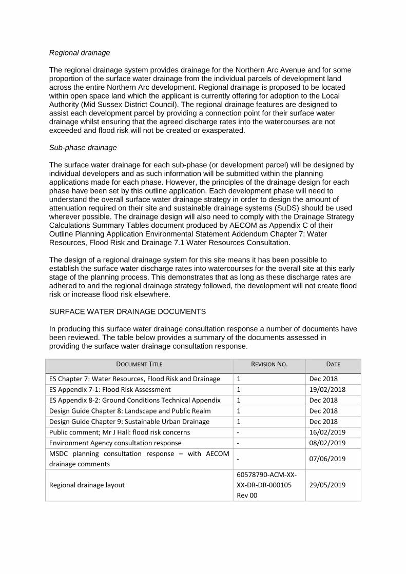
Regional drainage The regional drainage system provides drainage for the Northern Arc Avenue and for some proportion of the surface water drainage from the individual parcels of development land across the entire Northern Arc development. Regional drainage is proposed to be located within open space land which the applicant is currently offering for adoption to the Local Authority (Mid Sussex District Council). The regional drainage features are designed to assist each development parcel by providing a connection point for their surface water drainage whilst ensuring that the agreed discharge rates into the watercourses are not exceeded and flood risk will not be created or exasperated. Sub-phase drainage The surface water drainage for each sub-phase (or development parcel) will be designed by individual developers and as such information will be submitted within the planning applications made for each phase. However, the principles of the drainage design for each phase have been set by this outline application. Each development phase will need to understand the overall surface water drainage strategy in order to design the amount of attenuation required on their site and sustainable drainage systems (SuDS) should be used wherever possible. The drainage design will also need to comply with the Drainage Strategy Calculations Summary Tables document produced by AECOM as Appendix C of their Outline Planning Application Environmental Statement Addendum Chapter 7: Water Resources, Flood Risk and Drainage 7.1 Water Resources Consultation. The design of a regional drainage system for this site means it has been possible to establish the surface water discharge rates into watercourses for the overall site at this early stage of the planning process. This demonstrates that as long as these discharge rates are adhered to and the regional drainage strategy followed, the development will not create flood risk or increase flood risk elsewhere. SURFACE WATER DRAINAGE DOCUMENTS In producing this surface water drainage consultation response a number of documents have been reviewed. The table below provides a summary of the documents assessed in providing the surface water drainage consultation response.
DOCUMENT TITLE REVISION NO. DATE
ES Chapter 7: Water Resources, Flood Risk and Drainage 1 Dec 2018
ES Appendix 7-1: Flood Risk Assessment 1 19/02/2018
ES Appendix 8-2: Ground Conditions Technical Appendix 1 Dec 2018
Design Guide Chapter 8: Landscape and Public Realm 1 Dec 2018
Design Guide Chapter 9: Sustainable Urban Drainage 1 Dec 2018
Public comment; Mr J Hall: flood risk concerns - 16/02/2019
Environment Agency consultation response - 08/02/2019
MSDC planning consultation response – with AECOM
drainage comments - 07/06/2019
Regional drainage layout
60578790-ACM-XX-
XX-DR-DR-000105
Rev 00
29/05/2019
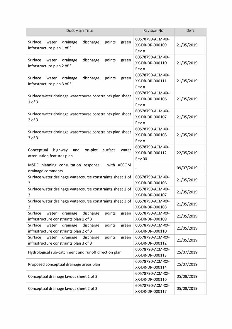
DOCUMENT TITLE REVISION NO. DATE
Surface water drainage discharge points green
infrastructure plan 1 of 3
60578790-ACM-XX-
XX-DR-DR-000109
Rev A
21/05/2019
Surface water drainage discharge points green
infrastructure plan 2 of 3
60578790-ACM-XX-
XX-DR-DR-000110
Rev A
21/05/2019
Surface water drainage discharge points green
infrastructure plan 3 of 3
60578790-ACM-XX-
XX-DR-DR-000111
Rev A
21/05/2019
Surface water drainage watercourse constraints plan sheet
1 of 3
60578790-ACM-XX-
XX-DR-DR-000106
Rev A
21/05/2019
Surface water drainage watercourse constraints plan sheet
2 of 3
60578790-ACM-XX-
XX-DR-DR-000107
Rev A
21/05/2019
Surface water drainage watercourse constraints plan sheet
3 of 3
60578790-ACM-XX-
XX-DR-DR-000108
Rev A
21/05/2019
Conceptual highway and on-plot surface water
attenuation features plan
60578790-ACM-XX-
XX-DR-DR-000112
Rev 00
22/05/2019
MSDC planning consultation response – with AECOM
drainage comments - 09/07/2019
Surface water drainage watercourse constraints sheet 1 of
3
60578790-ACM-XX-
XX-DR-DR-000106 21/05/2019
Surface water drainage watercourse constraints sheet 2 of
3
60578790-ACM-XX-
XX-DR-DR-000107 21/05/2019
Surface water drainage watercourse constraints sheet 3 of
3
60578790-ACM-XX-
XX-DR-DR-000108 21/05/2019
Surface water drainage discharge points green
infrastructure constraints plan 1 of 3
60578790-ACM-XX-
XX-DR-DR-000109 21/05/2019
Surface water drainage discharge points green
infrastructure constraints plan 2 of 3
60578790-ACM-XX-
XX-DR-DR-000110 21/05/2019
Surface water drainage discharge points green
infrastructure constraints plan 3 of 3
60578790-ACM-XX-
XX-DR-DR-000112 21/05/2019
Hydrological sub-catchment and runoff direction plan 60578790-ACM-XX-
XX-DR-DR-000113 25/07/2019
Proposed conceptual drainage areas plan 60578790-ACM-XX-
XX-DR-DR-000114 25/07/2019
Conceptual drainage layout sheet 1 of 3 60578790-ACM-XX-
XX-DR-DR-000116 05/08/2019
Conceptual drainage layout sheet 2 of 3 60578790-ACM-XX-
XX-DR-DR-000117 05/08/2019
DOCUMENT TITLE REVISION NO. DATE
Conceptual drainage layout sheet 3 of 3 60578790-ACM-XX-
XX-DR-DR-000118 05/08/2019
Appendix B Further correspondence - 09/08/2019
Appendix C Drainage strategy calculations summary tables - 08/08/2019 Table Error! No text of specified style in document.-1: Reviewed documents – drainage
SURFACE WATER DRAINAGE INFORMATION COMMENTS Table 4.1 presents the original additional information that was requested and the Flood Risk and Drainage Team’s final comments in relation to the additional information that was requested.
D ORIGINAL ADDITIONAL INFORMATION
REQUESTED FINAL COMMENTS
DR-1
Details and maps of the three
hydrological catchments
identified, including catchment
boundaries, locations, general
flow directions and any specific
discharge points into
watercourses.
The applicant has provided a “Hydrological sub-
catchment and runoff direction plan” (Ref 60578790-
ACM-XX-XX-DR-DR-000113). This plan addresses the
original additional information request and identifies
which watercourse runoff would naturally enter.
At this stage no further details are required.
DR-2
Details of why two FEH
catchments have been used
within the drainage strategy and
not the naturally occurring three
catchments.
Further explanation was provided into how catchments
were identified in relation to the catchment
characteristics and the resulting use of two FEH
catchments.
At this stage no further details are required.
DR-3 Source of non-residential urban
creep allowances.
Source provided and considered acceptable. No further
details are required.
D ORIGINAL ADDITIONAL INFORMATION
REQUESTED FINAL COMMENTS
DR-4
Details of when and with whom
the locations of surface water
attenuations feature were
agreed.
Applicant confirmed that these agreements had been
internal and no formal or third-party agreement had
been sought or obtained.
At this outline application stage the location of the
regional surface water attenuation features is
considered acceptable.
It is understood that sub-phase attenuation
requirements have been represented on the latest
conceptual drainage design plans (Ref 60578790-ACM-
XX-XX-DR-DR-000116, 60578790-ACM-XX-XX-DR-DR-
000117 and 60578790-ACM-XX-XX-DR-DR-000118).
However, these plans do not show proposed locations
for this attenuation but rather show a representation
of the attenuation volume required.
At this outline application stage this level of
information is considered acceptable and not further
information is required.
DR-5
Map(s) showing all attenuation
features will be located outside
of areas at risk of flooding from
any source and a minimum of 8m
of a watercourse
The applicant has provided plans which show the
regional surface water drainage features in relation to
the modelled river flood extents for the 1 in 100 with
climate change allowance (Ref 60578790-ACM-XX-XX-
DR-DR-000106, 60578790-ACM-XX-XX-DR-DR-000107
and 60578790-ACM-XX-XX-DR-DR-000108).
A number of these attenuation features P09, P11, P16,
P17 and P18 appear to be located in very close
proximity to the maximum 1 in 100 with 105% climate
change flood extent.
We would advise the applicant that all attenuation
features must be located outside of the peer reviewed
modelled fluvial flood extent and surface water
exceedance flow pathways. We would also advise that
attenuation features should be located a minimum of
5m from the maximum fluvial flood extent.
D ORIGINAL ADDITIONAL INFORMATION
REQUESTED FINAL COMMENTS
DR-6
Detailed design of the drainage
network of land which drains
onto the site. This would need to
include greenfield runoff rates
and volumes, flow routes and
potential flood risk and drainage
implications. The effect of
catchment decisions and changes
in natural flow should also be
considered.
The applicant has presented two options for managing
the surface water which enters the site. The preferred
option is to intercept flows at the boundary of the site.
We accept the principles of the two options identified
and would advise the applicant that details of how
offsite flows shall be managed will need to be provided
during any Reserve Matters application for the site.
DR-7
Demonstrate a commitment to
produce a surface water drainage
scheme where varying discharge
volumes and rates are used
based on the construction
phasing and the allowable
discharges from each catchment.
We acknowledge receipt of further commitment by the
applicant to utilise varied discharge volumes and rates
based on actual contributing areas and development
phases during construction.
At this outline application stage we do not require any
further information.
We would advise the applicant that detailed design for
any Reserve Matters application will need to include
varied discharge control to ensure that the overall
discharge rates are not exceeded for the whole site
during the construction phase.
DR-8
Details as to why approximately
10% of the Site area has been
removed from the surface water
drainage strategy and why the
existing development within the
redline boundary has not been
considered in relation to runoff
rates or volumes. Surface water
drainage should consider the
entire site.
The applicant has provided clarifications of how site
areas have been determined. We accept the principle
of this method and no further information is required
as part of the outline application.
D ORIGINAL ADDITIONAL INFORMATION
REQUESTED FINAL COMMENTS
DR-9
Evidence that the LLFA have
approved the discharge rate of
Qbar for all storms as this
exceeds the Q1 figure.
Following discussions an overall discharge rate was
agreed between MSDC and the applicant on
03/06/2019. This agreement states discharge rates up
to the 1 year event shall be restricted to the Q1 rate
and discharge rates for events greater than the 1 year
event shall be restricted to the QBAR rate.
Details of the proposed discharge rates from the
regional drainage and each sub-phase has been
determined and presented by the applicant in the
Drainage Strategy Calculations Summary Tables
(Appendix A).
The Flood Risk and Drainage Team are accepting of the
principle behind the runoff rates presented in the
summary table.
No further information is required at this stage.
DR-10
Evidence, including ground
investigations, relating to the
decision that meeting the
Volume Control S4 (infiltration)
requirements were not possible.
The applicant has provided further clarification into the
rationale behind why meeting the Volume Control S4
(infiltration) requirements is not possible.
Following clarification no further information is
required at this stage.
DR-11
Further clarification is required
into how discharge rates have
been determined. We would
expect discharge from each
catchment to remain separated
from each other.
Details of the proposed discharge rates from the
regional drainage and each sub-phase has been
determined and presented by the applicant in the
Drainage Strategy Calculations Summary Tables
(Appendix A).
The Flood Risk and Drainage Team are accepting of the
principle behind the runoff rates presented in the
summary table.
No further information is required at this stage.
DR-12
Map(s) showing the example
discharge location into the
watercourses.
The applicant has provided further additional
information which is acceptable and no further
information is required.
DR-13
Map(s) showing all watercourses
and their interactions with
Ancient Woodlands, ecologically
sensitive areas etc.
The applicant has provided further additional
information which is acceptable and no further
information is required.
D ORIGINAL ADDITIONAL INFORMATION
REQUESTED FINAL COMMENTS
DR-14
Definition of ‘necessary
performance’ in relation to
attenuation.
The applicant has clarified that necessary performance
is considered to mean;
“Any surface water flooding occurring in events greater
than 1 in 30 year return period, up to and including the
1 in 100 year return period + 40% climate change, shall
be contained and managed within the site. For
floodwater to be managed within the site, it shall not
be permitted to encroach upon buildings, evacuation
routes or other sensitive areas.”
The applicant has also confirmed that through the use
of regional attenuation features and attenuation on
each sub-phase and infrastructure corridors necessary
performance can be achieved.
Following these clarifications no further information is
required at this stage.
We would advise the applicant that no flooding to
internal structures or evacuation routes should occur
for up to the 1 in 100-year with 40% climate change
event. All surface water should be contained and
managed on site for events up to the 1 in 100-year
with 40% climate change allowance.
DR-15
Clarification into whether the
highways drainage shall be
separate from the surface water
drainage system and what the
stipulations of highway adoption
would be.
Further clarification has been provided by the
applicant to address this request. No further
information is required at this stage of the application.
D ORIGINAL ADDITIONAL INFORMATION
REQUESTED FINAL COMMENTS
DR-16
Needs to be shown that an
appropriate volume of
attenuation can be provided
across the Site without increasing
flood risk on or off-site.
The applicant has confirmed that the regional, sub-
phase and infrastructure corridors drainage shall work
in conjunction.
It has been confirmed that in some areas these
features shall act in series and in those instances a
complex flow control arrangement shall be provided to
balance the attenuation volumes between features in
the series.
Appropriate levels of information have been provided
for this outline planning application stage and not
further information is required at this time.
DR-17
Clarification into how
exceedance flows, and storage
shall be managed. This should
include information regarding
which storm events would result
in exceedance flows and maps
showing flow routes and storage
areas.
The applicant has confirmed that exceedance shall only
be permitted in events greater than the 30 year return
period. However the critical event that triggers the use
of exceedance flow routes and storage areas shall be
determined in the detailed design stage.
Attenuation volumes and runoff rates presented in the
Drainage Strategy Calculations Summary Tables
(Appendix A) assume no exceedance up to the 1 in 100
year with 40% climate change events.
The applicant has confirmed that surface water runoff
shall be managed on site up to the 1 in 100 year with
climate change storm event. The applicant has also
provided details of the attenuation volumes required
for each sub-phase with no exceedance storage
required.
At this stage of the application no further information
is required.
D ORIGINAL ADDITIONAL INFORMATION
REQUESTED FINAL COMMENTS
DR-18 Evidence of communication with
Local Education Authority.
The applicant had previously stated that exceedance
storage could be provided within the sports facilities
and playing fields of schools within the Northern Arc
development.
The applicant has provided evidence of communication
with West Sussex County Council (WSCC) Schools
Planning, WSCC Education Capital Programme
Manager and the Lead Local Flood Authority (LLFA).
This communication confirms that the use of SuDS and
the storing of exceedance volumes are acceptable in
principle as long as it did not impact the function of the
school.
At this outline application stage no further information
is required.
DR-19 Evidence of communication with
Highways Authority.
The requirement for evidence of communication with
the Highways Authority was based on the
understanding that exceedance flows would be
directed onto road surfaces. The applicant has
confirmed that neither exceedance routes nor storage
will be located on adopted roads. As such no further
information is required.
DR-20 Evidence of communication with
Southern Water about drainage.
The applicant has confirmed that construction phase
surface water drainage shall be developed for each
construction phase or sub-phase.
At this outline application stage it is agreed that no
further information is required, and further
communication with Southern Water is also not
required.
DR-21
Detailed drainage design for
roundabout (full planning
application)
It is understood that following the re-submission of the
application on 12th August 2019 there is no full
planning aspects of this application. No further
information is required at this time.
SURFACE WATER DRAINAGE PRINCIPLES This outline planning application presents information regarding the regional drainage features and the number of discharge points into watercourses for the entire Northern Arc development. It also presents the principles of how the entire Northern Arc development shall manage surface water drainage.
REGIONAL DRAINAGE PRINCIPLES At this outline application stage a total of 40 regional drainage features are proposed to manage the surface water runoff from the entire Northern Arc development. These regional drainage features incorporate attenuation ponds / detentions basins, swales and water quality ponds (wet ponds containing reeds). The principle of the regional drainage is to control the discharge of water from the Northern Arc development into watercourses. By managing surface water in this way the number of discharge points into watercourses is known at this early stage in the planning of the development. This also allows the rate of discharge into the watercourses to be managed both during and after the construction of the development, and thereafter maintained in accordance with the agreed overall Drainage Strategy for the entire Northern Arc development. SUB-PHASE DRAINAGE PRINCIPLES Each sub-phase of development (development parcel) will be responsible for providing surface water drainage for its own site. However, the discharge location and rate of discharge into watercourses from each sub-phase will be controlled by the agreed overall drainage strategy for the Northern Arc. Each sub-phase has been allocated a regional drainage feature into which they can discharge surface water and the rate of allowable discharge into the regional feature has been agreed as part of this outline application. Surface water discharge / runoff rates Surface water discharge rates from each sub-phase (development parcel) and each regional drainage feature have been presented and these runoff rates have been agreed. All subsequent applications for the Northern Arc development will need to ensure compliance with these agreed runoff rates. Surface water attenuation requirements Attenuation requirements for each sub-phase (development parcel) have been presented as part of this outline application. These attenuation requirements are based on percentage impermeability estimates for each sub-phase based on the proposed land use. Due to the uncertainty associated with the outline application it is acknowledged that these attenuation volumes will need to be reviewed in subsequent applications. At this outline application stage the principle of surface water attenuation for sub-phases has been established along with which regional drainage feature each sub-phase shall connect into. All subsequent applications for the Northern Arc development will need to ensure compliance with these agreed attenuation principles. AGREED PRINCIPLES The Drainage Strategy Calculations Summary Tables submitted to inform Chapter 7 of the Environmental Statement provides a breakdown of the agreed runoff rates and required attenuation storage for all sub-phases of the development and within each regional drainage feature. For ease of reference this summary table document is provided as Appendix A of this consultation response. All subsequent applications for the Northern Arc development will need to refer to this summary table and ensure the proposed surface water drainage meets with these principles.
CLOSING STATEMENT At this outline planning application stage the applicant has provided sufficient information and details to satisfy the Flood Risk and Drainage Team that the development can be achieved whilst providing adequate and appropriate surface water drainage. Further information and details will need to be provided throughout the planning process for the Northern Arc development. The specifics of the details required at each later stage shall be detailed by the Flood Risk and Drainage Team so pre-applications are advised. However, the principles of surface water management set out at this outline application stage will need to be considered by each subsequent application. The Flood Risk and Drainage Team have prepared a separate document giving further advice and detailing the type and level of information that will be required for future planning applications (both Reserved Matters and Condition Discharge). SUGGESTED SURFACE WATER DRAINAGE CONDITION Below is some suggested wording for Surface Water Drainage Conditions for the Northern Arc development. Prior to the commencement of any development a regional surface water drainage masterplan shall be designed based on the principles agreed at outline application stage and as set out in the Drainage Strategy Calculations Summary Tables document produced by AECOM as Appendix C of their Outline Planning Application Environmental Statement Addendum Chapter 7: Water Resources, Flood Risk and Drainage 7.1 Water Resources Consultation. Details of the regional drainage for the overall site shall be supplied and agreed in writing by the LPA prior to any development commencing on site. The details shall include a timetable for the implementation of the regional drainage and a management plan for the lifetime of the development which shall include arrangements for adoption by any public authority or statutory undertaker and any other arrangements to secure the operation of the scheme throughout its lifetime. The regional drainage shall then be maintained to ensure that it functions as designed for the lifetime of the development. Prior to the commencement of development of each phase of the site the proposed method of surface water drainage and means of disposal for that phase shall be submitted to and agreed in writing by the LPA. The surface water drainage design for each phase should follow the principles agreed as part of the regional surface water drainage masterplan and no dwelling in that phase shall be occupied until all drainage works have been carried out for that phase in accordance with the approved details. The details shall be based on sustainable drainage (SuDS) principles including source control and shall: a) include a timetable for the implementation of the surface water drainage design and a management and maintenance plan for the lifetime of the development which shall include arrangements for adoption by any public authority or statutory undertaker and any other arrangements to secure the operation of the scheme throughout its lifetime. The surface water drainage shall then be maintained to ensure that it functions as designed for the lifetime of the development; b) demonstrate that the surface water drainage system will be able to cater for a 1 in 100 year storm event + 105% climate change and that the discharge rates from that phase or phases meets the principles set out in the Drainage Strategy Calculations Summary Tables document produced by AECOM as Appendix C of their Outline Planning Application Environmental Statement Addendum Chapter 7: Water Resources, Flood Risk and Drainage 7.1 Water Resources Consultation;
c) include flood flow routing plans for that phase showing the effect of the development on fluvial (river) and pluvial (surface water and ordinary watercourse) flows and how that phase will deal with exceedance flows either generated on site and/or arriving from adjacent phases of the development; d) provide plans, design specifications and calculations for all surface water drainage systems. Following construction of the surface water drainage systems provide to the Local Planning Authority as constructed plans and independent evidence demonstrating that they have been constructed in accordance with the details submitted to and approved by the LPA. SUGGESTED FOUL WATER DRAINAGE CONDITION This consultation response has focused solely on the management of surface water drainage. However, the following foul water drainage condition is proposed. Prior to the commencement of development of the site an overall foul water drainage masterplan scheme shall be submitted to and agreed in writing by the LPA in conjunction with the relevant sewerage authority. This foul drainage masterplan should be designed as part of the regional drainage detailed design package and must ensure that the timings for delivery of the development coincide with the availability of sewerage infrastructure. Prior to the commencement of development of each phase of the site the proposed method of foul drainage and means of disposal for that phase shall be submitted to and agreed in writing by the LPA in conjunction with the relevant sewerage authority. The foul water drainage design for each phase should follow the principles agreed as part of the foul water masterplan scheme and no dwelling in that phase shall be occupied until all drainage works have been carried out for that phase in accordance with the approved details. The details shall include a timetable for its implementation and a management plan for the lifetime of the development which shall include arrangements for adoption by any public authority or statutory undertaker and any other arrangements to secure the operation of the scheme throughout its lifetime. APPENDIX A DRAINAGE STRATEGY CALCULATIONS SUMMARY TABLES Water Quality INTRODUCTION To ensure responses to the additional information are provided as quickly as possible separate consultation responses shall be provided by the Flood Risk and Drainage Team for the flood risk, water quality and drainage aspects of the outline application. We understand that the full planning aspect of this application associated with the new roundabout on the A2300 has been removed from the application, and hence this application is an outline application only. This consultation response covers the additional information provided for water quality only. WATER QUALITY CONSULTATION RESPONSE In producing the water quality consultation response, a number of documents have been reviewed.
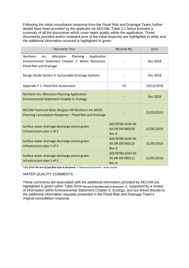
Following the initial consultation response from the Flood Risk and Drainage Team, further details have been provided by the applicant via AECOM. Table 2.1 below provides a summary of all the documents which cover water quality within the application. Those documents provided and/or reviewed prior to the initial response are highlighted in white and the additional information received is highlighted in green.
DOCUMENT TITLE REVISION NO. DATE
Northern Arc Allocation Planning Application
Environmental Statement Chapter 7: Water Resources,
Flood Risk and Drainage
- Dec 2018
Design Guide Section 9: Sustainable Drainage Systems - Dec 2018
Appendix 7-1: Flood Risk Assessment 01 19/12/2018
Northern Arc Allocation Planning Application
Environmental Statement Chapter 6: Ecology - Dec 2018
AECOM Technical Note: Burgess Hill Northern Arc MSDC
Planning Consultation Response – Flood Risk and Drainage - 21/05/2019
Surface water drainage discharge points green
infrastructure plan 1 of 3
60578790-ACM-XX-
XX-DR-DR-000109
Rev A
21/05/2019
Surface water drainage discharge points green
infrastructure plan 2 of 3
60578790-ACM-XX-
XX-DR-DR-000110
Rev A
21/05/2019
Surface water drainage discharge points green
infrastructure plan 3 of 3
60578790-ACM-XX-
XX-DR-DR-000111
Rev A
21/05/2019
Table Error! No text of specified style in document..2: Reviewed documents – water quality
WATER QUALITY COMMENTS These comments are associated with the additional information provided by AECOM (as highlighted in green within Table Error! No text of specified style in document.-1), supported by a review of information within Environmental Statement Chapter 6: Ecology, and are linked directly to the additional information requests presented in the Flood Risk and Drainage Team’s original consultation response.
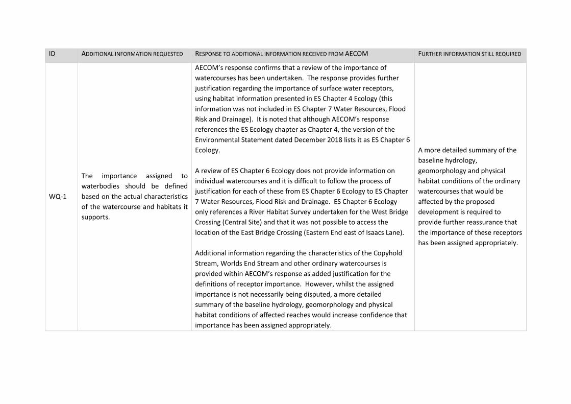
ID ADDITIONAL INFORMATION REQUESTED RESPONSE TO ADDITIONAL INFORMATION RECEIVED FROM AECOM FURTHER INFORMATION STILL REQUIRED
WQ-1
The importance assigned to
waterbodies should be defined
based on the actual characteristics
of the watercourse and habitats it
supports.
AECOM’s response confirms that a review of the importance of
watercourses has been undertaken. The response provides further
justification regarding the importance of surface water receptors,
using habitat information presented in ES Chapter 4 Ecology (this
information was not included in ES Chapter 7 Water Resources, Flood
Risk and Drainage). It is noted that although AECOM’s response
references the ES Ecology chapter as Chapter 4, the version of the
Environmental Statement dated December 2018 lists it as ES Chapter 6
Ecology.
A review of ES Chapter 6 Ecology does not provide information on
individual watercourses and it is difficult to follow the process of
justification for each of these from ES Chapter 6 Ecology to ES Chapter
7 Water Resources, Flood Risk and Drainage. ES Chapter 6 Ecology
only references a River Habitat Survey undertaken for the West Bridge
Crossing (Central Site) and that it was not possible to access the
location of the East Bridge Crossing (Eastern End east of Isaacs Lane).
Additional information regarding the characteristics of the Copyhold
Stream, Worlds End Stream and other ordinary watercourses is
provided within AECOM’s response as added justification for the
definitions of receptor importance. However, whilst the assigned
importance is not necessarily being disputed, a more detailed
summary of the baseline hydrology, geomorphology and physical
habitat conditions of affected reaches would increase confidence that
importance has been assigned appropriately.
A more detailed summary of the
baseline hydrology,
geomorphology and physical
habitat conditions of the ordinary
watercourses that would be
affected by the proposed
development is required to
provide further reassurance that
the importance of these receptors
has been assigned appropriately.
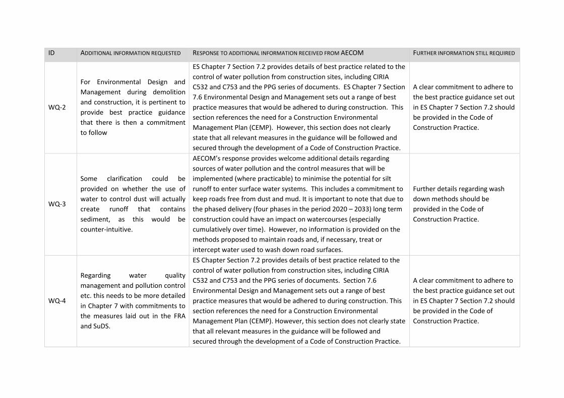
ID ADDITIONAL INFORMATION REQUESTED RESPONSE TO ADDITIONAL INFORMATION RECEIVED FROM AECOM FURTHER INFORMATION STILL REQUIRED
WQ-2
For Environmental Design and
Management during demolition
and construction, it is pertinent to
provide best practice guidance
that there is then a commitment
to follow
ES Chapter 7 Section 7.2 provides details of best practice related to the
control of water pollution from construction sites, including CIRIA
C532 and C753 and the PPG series of documents. ES Chapter 7 Section
7.6 Environmental Design and Management sets out a range of best
practice measures that would be adhered to during construction. This
section references the need for a Construction Environmental
Management Plan (CEMP). However, this section does not clearly
state that all relevant measures in the guidance will be followed and
secured through the development of a Code of Construction Practice.
A clear commitment to adhere to
the best practice guidance set out
in ES Chapter 7 Section 7.2 should
be provided in the Code of
Construction Practice.
WQ-3
Some clarification could be
provided on whether the use of
water to control dust will actually
create runoff that contains
sediment, as this would be
counter-intuitive.
AECOM’s response provides welcome additional details regarding
sources of water pollution and the control measures that will be
implemented (where practicable) to minimise the potential for silt
runoff to enter surface water systems. This includes a commitment to
keep roads free from dust and mud. It is important to note that due to
the phased delivery (four phases in the period 2020 – 2033) long term
construction could have an impact on watercourses (especially
cumulatively over time). However, no information is provided on the
methods proposed to maintain roads and, if necessary, treat or
intercept water used to wash down road surfaces.
Further details regarding wash
down methods should be
provided in the Code of
Construction Practice.
WQ-4
Regarding water quality
management and pollution control
etc. this needs to be more detailed
in Chapter 7 with commitments to
the measures laid out in the FRA
and SuDS.
ES Chapter Section 7.2 provides details of best practice related to the
control of water pollution from construction sites, including CIRIA
C532 and C753 and the PPG series of documents. Section 7.6
Environmental Design and Management sets out a range of best
practice measures that would be adhered to during construction. This
section references the need for a Construction Environmental
Management Plan (CEMP). However, this section does not clearly state
that all relevant measures in the guidance will be followed and
secured through the development of a Code of Construction Practice.
A clear commitment to adhere to
the best practice guidance set out
in ES Chapter 7 Section 7.2 should
be provided in the Code of
Construction Practice.
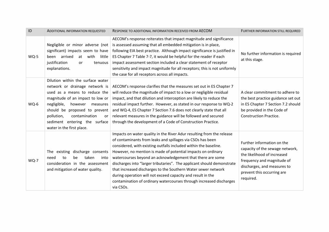
ID ADDITIONAL INFORMATION REQUESTED RESPONSE TO ADDITIONAL INFORMATION RECEIVED FROM AECOM FURTHER INFORMATION STILL REQUIRED
WQ-5
Negligible or minor adverse (not
significant) impacts seem to have
been arrived at with little
justification or tenuous
explanations.
AECOM’s response reiterates that impact magnitude and significance
is assessed assuming that all embedded mitigation is in place,
following EIA best practice. Although impact significance is justified in
ES Chapter 7 Table 7-7, it would be helpful for the reader if each
impact assessment section included a clear statement of receptor
sensitivity and impact magnitude for all receptors; this is not uniformly
the case for all receptors across all impacts.
No further information is required
at this stage.
WQ-6
Dilution within the surface water
network or drainage network is
used as a means to reduce the
magnitude of an impact to low or
negligible, however measures
should be proposed to prevent
pollution, contamination or
sediment entering the surface
water in the first place.
AECOM’s response clarifies that the measures set out in ES Chapter 7
will reduce the magnitude of impact to a low or negligible residual
impact, and that dilution and interception are likely to reduce the
residual impact further. However, as stated in our response to WQ-2
and WQ-4, ES Chapter 7 Section 7.6 does not clearly state that all
relevant measures in the guidance will be followed and secured
through the development of a Code of Construction Practice.
A clear commitment to adhere to
the best practice guidance set out
in ES Chapter 7 Section 7.2 should
be provided in the Code of
Construction Practice.
WQ-7
The existing discharge consents
need to be taken into
consideration in the assessment
and mitigation of water quality.
Impacts on water quality in the River Adur resulting from the release
of contaminants from leaks and spillages via CSOs has been
considered, with existing outfalls included within the baseline.
However, no mention is made of potential impacts on ordinary
watercourses beyond an acknowledgement that there are some
discharges into “larger tributaries”. The applicant should demonstrate
that increased discharges to the Southern Water sewer network
during operation will not exceed capacity and result in the
contamination of ordinary watercourses through increased discharges
via CSOs.
Further information on the
capacity of the sewage network,
the likelihood of increased
frequency and magnitude of
discharges, and measures to
prevent this occurring are
required.
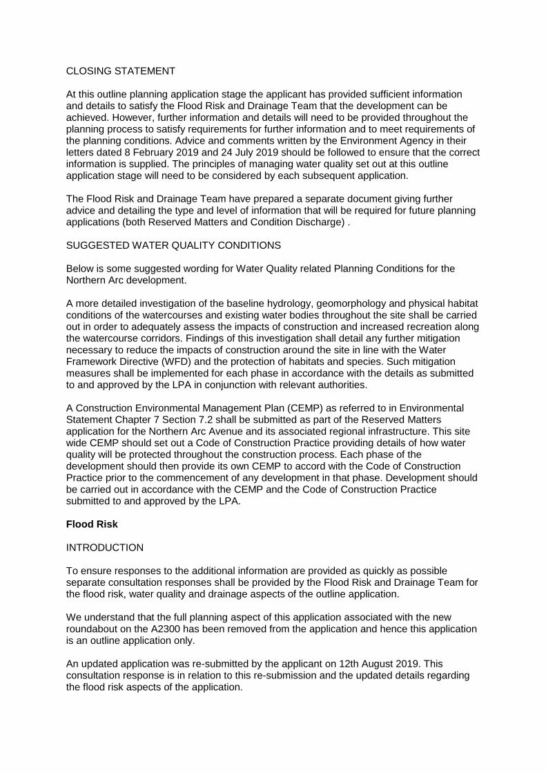
CLOSING STATEMENT At this outline planning application stage the applicant has provided sufficient information and details to satisfy the Flood Risk and Drainage Team that the development can be achieved. However, further information and details will need to be provided throughout the planning process to satisfy requirements for further information and to meet requirements of the planning conditions. Advice and comments written by the Environment Agency in their letters dated 8 February 2019 and 24 July 2019 should be followed to ensure that the correct information is supplied. The principles of managing water quality set out at this outline application stage will need to be considered by each subsequent application. The Flood Risk and Drainage Team have prepared a separate document giving further advice and detailing the type and level of information that will be required for future planning applications (both Reserved Matters and Condition Discharge) . SUGGESTED WATER QUALITY CONDITIONS Below is some suggested wording for Water Quality related Planning Conditions for the Northern Arc development. A more detailed investigation of the baseline hydrology, geomorphology and physical habitat conditions of the watercourses and existing water bodies throughout the site shall be carried out in order to adequately assess the impacts of construction and increased recreation along the watercourse corridors. Findings of this investigation shall detail any further mitigation necessary to reduce the impacts of construction around the site in line with the Water Framework Directive (WFD) and the protection of habitats and species. Such mitigation measures shall be implemented for each phase in accordance with the details as submitted to and approved by the LPA in conjunction with relevant authorities. A Construction Environmental Management Plan (CEMP) as referred to in Environmental Statement Chapter 7 Section 7.2 shall be submitted as part of the Reserved Matters application for the Northern Arc Avenue and its associated regional infrastructure. This site wide CEMP should set out a Code of Construction Practice providing details of how water quality will be protected throughout the construction process. Each phase of the development should then provide its own CEMP to accord with the Code of Construction Practice prior to the commencement of any development in that phase. Development should be carried out in accordance with the CEMP and the Code of Construction Practice submitted to and approved by the LPA. Flood Risk INTRODUCTION To ensure responses to the additional information are provided as quickly as possible separate consultation responses shall be provided by the Flood Risk and Drainage Team for the flood risk, water quality and drainage aspects of the outline application. We understand that the full planning aspect of this application associated with the new roundabout on the A2300 has been removed from the application and hence this application is an outline application only. An updated application was re-submitted by the applicant on 12th August 2019. This consultation response is in relation to this re-submission and the updated details regarding the flood risk aspects of the application.
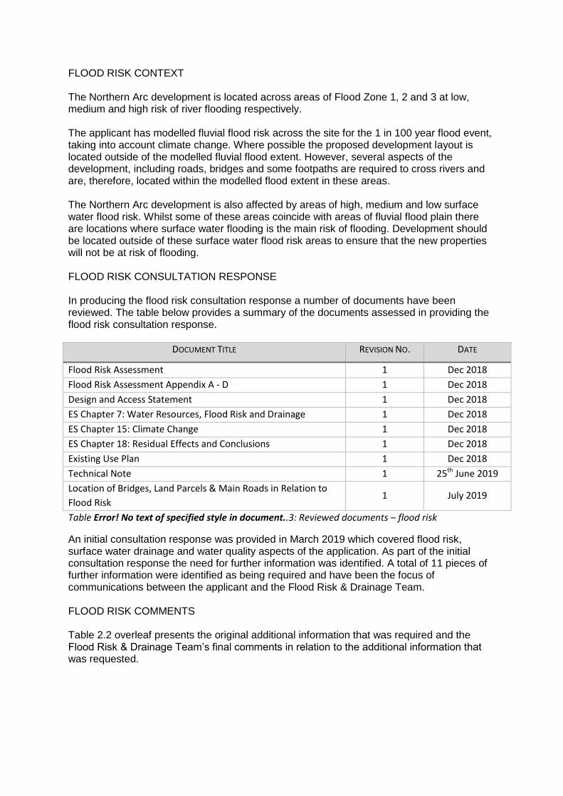
FLOOD RISK CONTEXT The Northern Arc development is located across areas of Flood Zone 1, 2 and 3 at low, medium and high risk of river flooding respectively. The applicant has modelled fluvial flood risk across the site for the 1 in 100 year flood event, taking into account climate change. Where possible the proposed development layout is located outside of the modelled fluvial flood extent. However, several aspects of the development, including roads, bridges and some footpaths are required to cross rivers and are, therefore, located within the modelled flood extent in these areas. The Northern Arc development is also affected by areas of high, medium and low surface water flood risk. Whilst some of these areas coincide with areas of fluvial flood plain there are locations where surface water flooding is the main risk of flooding. Development should be located outside of these surface water flood risk areas to ensure that the new properties will not be at risk of flooding. FLOOD RISK CONSULTATION RESPONSE In producing the flood risk consultation response a number of documents have been reviewed. The table below provides a summary of the documents assessed in providing the flood risk consultation response.
DOCUMENT TITLE REVISION NO. DATE
Flood Risk Assessment 1 Dec 2018
Flood Risk Assessment Appendix A - D 1 Dec 2018
Design and Access Statement 1 Dec 2018
ES Chapter 7: Water Resources, Flood Risk and Drainage 1 Dec 2018
ES Chapter 15: Climate Change 1 Dec 2018
ES Chapter 18: Residual Effects and Conclusions 1 Dec 2018
Existing Use Plan 1 Dec 2018
Technical Note 1 25th June 2019
Location of Bridges, Land Parcels & Main Roads in Relation to
Flood Risk 1 July 2019
Table Error! No text of specified style in document..3: Reviewed documents – flood risk
An initial consultation response was provided in March 2019 which covered flood risk, surface water drainage and water quality aspects of the application. As part of the initial consultation response the need for further information was identified. A total of 11 pieces of further information were identified as being required and have been the focus of communications between the applicant and the Flood Risk & Drainage Team. FLOOD RISK COMMENTS Table 2.2 overleaf presents the original additional information that was required and the Flood Risk & Drainage Team’s final comments in relation to the additional information that was requested.
ID ORIGINAL ADDITIONAL INFORMATION
REQUESTED FINAL COMMENTS
FR-1 Map(s) showing all watercourses and
ponds including any names.
Following the additional information request a Technical Note was provided by the applicant.
Appendix A of this technical note provided a “Location of existing water features” plan (Ref
60578790-ACM-XX-XX-DR-FL-000101).
This plan fully addressed the original additional information request and no further information is
required at this outline application stage.
FR-2
Map(s) showing location of bridges,
land parcels and main roads within the
Site in relation to flood risk
Additional information was provided by the applicant in the form of the plan “Location of
Bridges, Land Parcels & Main Roads in Relation to Flood Risk” (Ref 60578790-ACM-XX-XX-DR-FL-
000102).
This plan fully addressed the original additional information request and no further information is
required as part of this outline application.
We would advise the applicant that for completeness the flood extents on Appendix B’s map of
the Technical Note (Ref 60578790-ACM-XX-XX-DR-FL-000102) should be updated to reflect the
flood extents shown on the “Location of Bridges, Land Parcels & Main Roads in Relation to Flood
Risk” map.
ID ORIGINAL ADDITIONAL INFORMATION
REQUESTED FINAL COMMENTS
FR-3
Details of the essential infrastructure
to be located in Flood Zone 3 and how
the Exception Test has been
undertaken
Further information in relation to the development located within the modelled flood extent has
been provided by the applicant within the Technical Note and the plan “Location of Bridges, Land
Parcels & Main Roads in Relation to Flood Risk” (Ref 60578790-ACM-XX-XX-DR-FL-000102).
This information has confirmed the type and location of the highways which shall cross rivers,
and therefore be located within an area at risk of flooding. In addition information regarding
three footbridges over rivers has been provided.
The technical note also provides a high level exception test for these bridges and outline
information regarding floodplain compensation requirements.
No further information required to address is required at this outline application stage.
FR-4
Confirmation as to where basements
would be located within the
development relative to the Flood
Zones. This should include details of
the basement suitability based on the
‘Flood Risk Vulnerability Classification’
table.
Further information in relation to basements has been provided by the applicant within the
Technical Note.
The technical note identifies that basement dwellings are considered highly vulnerable and
would not be permitted in Flood Zone 3.
The technical note confirms that any basements within the development will be located only in
Flood Zone 1.
No further information required to address is required at this outline application stage.
FR-5
Map(s) showing surface water flood
risk, including hot spots and correct
redline boundary.
A plan showing the surface water flood risk has been provided by the applicant as Appendix C of
the technical note (Ref 60578790-ACM-XX-XX-DR-FL-000103). This plan is considered to address
the original additional information request and no further information is required to address at
this outline application stage.
ID ORIGINAL ADDITIONAL INFORMATION
REQUESTED FINAL COMMENTS
FR-6
Clarification into why different Flood
Zone maps were used in the Design
and Access Statement and the FRA.
The Technical Note confirms that the different flood maps within the Design and Access
Statement and the Flood Risk Assessment documents was an error on the application. it also
confirms that the maps used within the Flood Risk Assessment are the correct plans.
It is understood that following communications between the applicant and MSDC flood risk and
drainage was removed from the resubmitted Design and Access Statement to ensure the
technical details of flood risk were contained and referenced the Flood Risk Assessment only.
Following this clarification and the use of a singular location to provide flood risk information
within the application the original additional information request is considered to have been
answered. No further information to address this point is required.
FR-7
Clarification and clear mapping of
modelling (baseline, with
development and with Climate
Change).
The Technical Note confirms what modelling is presented on which plans within the FRA. The
note also states that the modelling undertaken by AECOM as part of this application has not
been peer reviewed by the Environment Agency.
At this outline application stage no further information is required in relation to fluvial modelling.
We would advise the applicant that the modelling approach and outputs will require approval
from the Environment Agency prior to the submission of any later applications for the Northern
Arc (for example Reserve Matters, Full and Discharge of Conditions applications).
ID ORIGINAL ADDITIONAL INFORMATION
REQUESTED FINAL COMMENTS
FR-8 Map(s) showing historic flood extents.
The Flood Risk and Drainage Team previously highlighted an area of historic flooding at the
existing B2036 highway bridge over the River Adur. The Technical Note provides further
comment on the historical flood extents by the applicant.
Mid Sussex District Council’s Strategic Flood Risk Assessment shows a general location of historic
flooding and not a confirmed flood extent. The note recognises that the extent of previous
flooding from this previous event is not clear.
The note states that due to topography it is unlikely that the historic flood extent was extensive
on the Northern Arc site. No further justification or detail has been provided regarding the
impact of previous flooding on the Northern Arc site.
The applicant has acknowledged that historic flooding has occurred at the B2036 highway bridge
and that it likely had some impact on the site in that area. This acknowledgement is considered
to be acceptable at this outline stage and no further information is required at this time.
We would advise the applicant that further details into the historic flooding and its impact on the
site should be included at a later stage in the planning process.
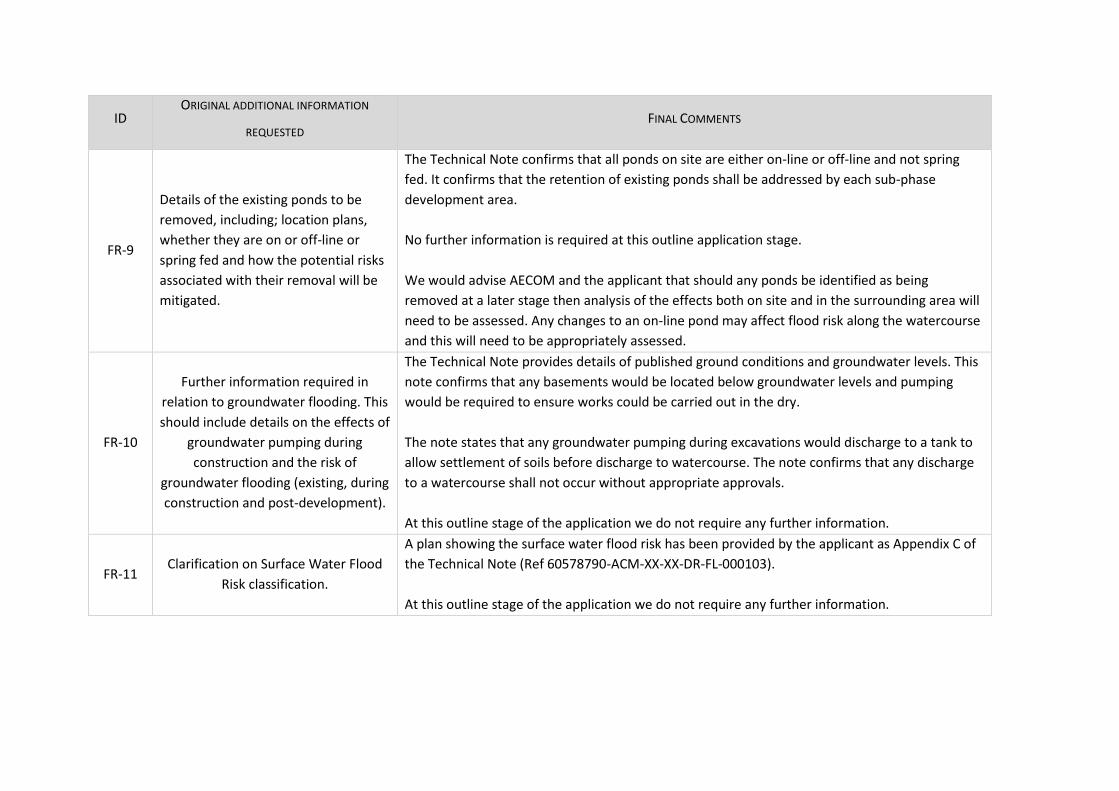
ID ORIGINAL ADDITIONAL INFORMATION
REQUESTED FINAL COMMENTS
FR-9
Details of the existing ponds to be
removed, including; location plans,
whether they are on or off-line or
spring fed and how the potential risks
associated with their removal will be
mitigated.
The Technical Note confirms that all ponds on site are either on-line or off-line and not spring
fed. It confirms that the retention of existing ponds shall be addressed by each sub-phase
development area.
No further information is required at this outline application stage.
We would advise AECOM and the applicant that should any ponds be identified as being
removed at a later stage then analysis of the effects both on site and in the surrounding area will
need to be assessed. Any changes to an on-line pond may affect flood risk along the watercourse
and this will need to be appropriately assessed.
FR-10
Further information required in
relation to groundwater flooding. This
should include details on the effects of
groundwater pumping during
construction and the risk of
groundwater flooding (existing, during
construction and post-development).
The Technical Note provides details of published ground conditions and groundwater levels. This
note confirms that any basements would be located below groundwater levels and pumping
would be required to ensure works could be carried out in the dry.
The note states that any groundwater pumping during excavations would discharge to a tank to
allow settlement of soils before discharge to watercourse. The note confirms that any discharge
to a watercourse shall not occur without appropriate approvals.
At this outline stage of the application we do not require any further information.
FR-11 Clarification on Surface Water Flood
Risk classification.
A plan showing the surface water flood risk has been provided by the applicant as Appendix C of
the Technical Note (Ref 60578790-ACM-XX-XX-DR-FL-000103).
At this outline stage of the application we do not require any further information.
CLOSING STATEMENT At this outline planning application stage the applicant has provided sufficient information and details to satisfy the Flood Risk & Drainage Team that the development can be achieved whilst minimising flood risk both on and off-site. Further information and details will need to be provided throughout the planning process for the Northern Arc development. The specifics of the details required at each later stage shall be detailed by the Flood Risk & Drainage Team so pre-applications are advised. However, the principles of flood risk management set out at this outline application stage will need to be considered by each subsequent application. The Flood Risk & Drainage Team have prepared a separate document giving further advice and detailing the type and level of information that will be required for future planning applications (both Reserved Matters and Condition Discharge). SUGGESTED FLOOD RISK CONDITIONS Below is some suggested wording for Flood Risk related Planning Conditions for the Northern Arc development. Prior to the submission of any Reserved Matters applications for the Northern Arc development the fluvial flood modelling must be peer reviewed by the Environment Agency (EA). Proposed layouts should only be finalised after the EA have confirmed acceptance of the modelled flood extents. No other built development other than essential infrastructure (roads and bridges) shall be located within the approved modelled 1 in 100 year with 105% climate change allowance flood extent (with appropriate buffer). If there is a loss of flood plain as a result of essential infrastructure being located within the aforementioned flood extent then adequate flood plain compensation up to the 1 in 100 year flood extent plus 105% climate change shall be provided. Details of the essential infrastructure such as bridges and roads and any related flood plain compensation should be submitted to the LPA as part of any Reserved Matters applications covering the location of the essential infrastructure. Essential infrastructure and its associated flood plain compensation shall be constructed in accordance with the details as submitted to and approved by the LPA in conjunction with the Environment Agency. All river crossings should be clear span bridges. Detailed plans shall be submitted to and approved in writing by the LPA at the Reserved Matters stage showing the approved modelled fluvial + climate change flood extent (with any buffers) and surface water flood extent (with any buffers) in relation to the proposed development layout for each phase, including amenity space and drainage infrastructure that will be utilised by that phase. Such plans should demonstrate that buildings within the development will not be at risk of flooding and that surface water flood flow routes will be maintained or accommodated within the layout of that phase. Historic flood extents should also be included within these details. The development of each phase shall then be in accordance with the information submitted and approved. Prior to the development of each phase details of watercourses, ponds and any other natural water bodies for that phase shall be submitted to and approved in writing by the LPA conjunction with the Environment Agency. The submitted details shall include;
a minimum 8m buffer zone from top of the river bank for all Main Rivers and a minimum 5m buffer zone from top of the watercourse bank for Ordinary Watercourses;
information about any ponds that are to be removed from any phase of the site and the consequences of removal of any pond in terms of flood risk;
evidence of how ordinary watercourses and natural ponds are to be preserved and details of any crossings that are necessary for the provision of infrastructure.
MSDC Housing The applicant is proposing a mixed-use development of approximately 3,040 dwellings to be delivered over a number of phases. In accordance with Policy DP31, the development will provide 30% affordable housing onsite and 30% affordable housing will be required on each and every phase (rounded up to the nearest whole number) in accordance with section 2.14 of the Affordable Housing SPD. The mix of affordable housing will meet a broad range of affordable housing needs and will provide the following dwelling types: 1 bed 2 person flats 30% 2 bed 4 person flats 20% 2 bed 4 person houses 37% 3 bed 5 person houses 10% 3 bed 6 person houses 2% 4 bed 6 person houses 1% In order to comply with policy, the affordable housing mix must reflect our tenure split requirement of 75% rented and 25% shared ownership. The development will also provide a 60 unit affordable extra care scheme onsite. The applicant is encouraged to start talks with an extra care affordable housing provider at an early stage and Housing Services are prepared to facilitate this. The extra care scheme is to be an integral part of the development and there may be some flexibility offered to a registered provider who may need to cross subsidise the delivery of the affordable units with a combination of private sale and shared equity units also. Any 2 bedroom affordable extra care units need only meet the size requirements for a 2 bed 3 person dwelling. The affordable extra care scheme is to be delivered in Phase 1 of the development (in close proximity to the main neighbourhood centre for that Phase). This is in order for it to meet a known need in the town and wider District at the earliest opportunity. The scheme and the flats within must be designed to provide homes for life, as required by our Affordable Housing SPD. A number of the units will need to be fully wheelchair accessible from first occupation. In accordance with DP28, 4% of the affordable dwellings in total and on each sub phase must be built to meet the requirements of Building Regulations - Approved Document M4(3) for wheelchair accessible dwellings. This equates to a total of 37 wheelchair accessible affordable dwellings over the course of this large phased development. The location, type and number will be determined at each reserved matters stage but is to include the provision of at least : 10 x wheelchair accessible general needs 1 bed flats with direct access to private outdoor space 5 x wheelchair accessible general needs 2 bed flats with direct access to private outdoor space 5 x wheelchair accessible general needs 2 bed houses 5 x wheelchair accessible general needs 3 bed houses 2 x wheelchair accessible general needs 4 bed houses

Social integration and the creation of a cohesive community is of paramount importance and at Reserved Matters stage the local authority will resist any attempts to marginalise the affordable housing. The affordable units must be well integrated and provided in clusters of no more than 10 units, with each cluster being distinctly separate from the next through the use of market units. The approach to materials and parking provision must also be tenure blind. MSDC Leisure - Original comments Thank you for the opportunity to comment on the plans for the development of 3,040 dwellings on Burgess Hill Northern Arc Land, North And North West Of Burgess Hill Between Bedelands Nature Reserve In The East And Goddard's Green Waste Water Treatment Works In The West on behalf of the Head of Corporate Resources. The following leisure contributions are required to enhance capacity and provision due to increased demand for facilities in accordance with the District Plan Policies DP24 (Leisure and Cultural Facilities and Activities), DP25 (Community Facilities and Local Services) and the Development Infrastructure and Contributions SPD Appendix 2 (Open Space, Leisure, Formal Sport Provision Contributions) and Appendix 3 (Social and Local Community Infrastructure). These contributions are based on the standards detailed in the Open Space Assessment which are sufficient to meet the Councils requirements. CHILDRENS PLAYING SPACE The developer has indicated that they intend to provide a Neighbourhood Equipped Area of Play (NEAP) and six Locally Equipped Areas of Play (LEAPs) as shown in the Green Infrastructure Parameters Plan 003 listed below NEAP, Central part of the Site LEAP 2, Western End South of A2300 LEAP 3, Western End North of A2300 LEAP 4, Central part of the Site LEAP 5, Eastern End West of Isaacs Lane LEAP 6, South Central Part of the Site LEAP 1, Eastern End East of Isaacs Lane Full details regarding the layout, design and equipment to be installed will need to be agreed by condition. This land will be transferred to the Council. FORMAL SPORT The developer has identified a 9.86 ha. site for outdoor sports pitches which is shown on the Green Infrastructure Parameters Plan. This land will be transferred to the Council plus a financial contribution of £3,724,912 to enable the Council to deliver of a Centre for Community Sport at this site and to make improvements to the Triangle Leisure Centre. Details of the playing pitches, training, ancillary and built facilities to be provided will be identified through the emerging Playing Pitch Strategy which is currently being produced by a specialist sports and leisure consultant, following Sport England guidance. COMMUNITY BUILDINGS The provision of community facilities is an essential part of the infrastructure required to service new developments to ensure that sustainable communities are created. The developer has indicated that they will provide one Community Centre (up to 1,000m2 GEA) within the Eastern District Centre and one Community Centre (up to 500m2) within the
Western Area Neighbourhood Centre. Details of the design and specification of these buildings will need to be approved by the Council to ensure they are fully functional and meet local needs. Both sites to be transferred to the District Council. OTHER PUBLIC OPEN SPACE The developer has also indicated they will provide the following green infrastructure to be transferred to the Council:
a Community Garden Hub (up to 150m2) within the Western Area adjacent to Neighbourhood Centre.
The following green infrastructure shall be delivered and transferred to the Council:
Eastern Park: 1.4 ha of public open space located in the eastern part of the site adjacent to the neighbourhood centre and primary school
Central Park: 2.32ha of public open space forming part of the central neighbourhood centre
Western Park: 8.73ha of public open space on the north east side of the A2300. 1.6ha of allotments and a community garden hub will be provided within the western parkland.
Approximately 60ha. of other open space including woodlands, grassland and semi natural green space including the development of Burgess Hill Green Circle Network and a Green Super Highway of new pedestrian and cycle routes.
All public open space sites are to be laid out to the Council's satisfaction and in accordance with approved plans prior to transfer. 1.53ha of allotments will be provided within the western parkland (Open Space Park 3) 63ha. of woodlands and natural open space including the development of Burgess Hill Green Circle Network and a Green Super Highway of new pedestrian and cycle routes All public open space sites are to be laid out to the Council's satisfaction and in accordance with approved plans prior to transfer. COMMUTED SUMS Commuted sum to be paid to the Council for on-going management and maintenance of the strategic open spaces (including NEAPs and LEAPs, Open Space Parks, Green Circle) and the Centre for Community Sport as follows: £956,016.19 in respect of the Centre for Community Sport £2,411,385.29 in respect of the remainder of the Open Spaces. In terms of the scale of contribution required, these figures are calculated on a per head formulae based upon the number of units proposed and average occupancy (as laid out in the Council's Development Infrastructure and Contributions SPD) and therefore is commensurate in scale to the development. The Council maintains that the contributions sought as set out are in full accordance with the requirements set out in Circular 05/2005 and in Regulation 122 of the Community Infrastructure Levy Regulations 2010. Thanks, Elaine
P.S. These comments are in relation to the 3,040 home Northern Arc development only (Ref: DM/18/5114). We are also expecting the following leisure contributions in relation to the 460 home development at Land To The West Of Freeks Lane (Ref: DM/18/0509); the on-site provision of a Multi-Use Games Area, a replacement/upgrade to the Maple Drive play area and public open space at Land to the West of Freeks Lane plus a financial contribution toward the initial capital set-up costs of the Centre for Community Sport of £563,638 and commuted sums of £311,226.97 and £147,983.30 for the ongoing maintenance of the Freeks Lane open space (including the Maple Drive play area) and the Centre for Community Sport respectively. MSDC Leisure - additional comments Please note that the drainage, road access, green circle route and location of the LEAP in the Centre for Community Sport area will all need to be agreed with the developer to ensure we can work together to deliver a masterplan for this site. The final draft of the Playing Pitch Strategy has identified a need for the following sports and ancillary facilities, subject to further consultation and feasibility:
3G Football Turf Pitch, four changing rooms, floodlighting and viewing stand;
Reg 22 World rugby compliant ATP, two changing rooms, floodlighting and viewing stand;
3 grass youth football pitches;
Compact athletics facility;
Clubhouse comprising four changing rooms, indoor leisure (cricket facility and futsal), social/ancillary facilities, general bar/kitchen/meeting room facility, car parking;
Plus a hockey compliant AGP and clubhouse facilities at The Triangle The developer has indicated that they intend to provide three public artworks within the development and I would ask that the Council be involved in developing and agreeing a brief for these works before they are commissioned. MSDC Tree Officer I have previously accepted and agreed the methodology for the tree survey and discussed with their tree consultant. The AIA / tree survey and report appear complete and accurate and the methodology for the retention and protection of areas of A W is appropriate, although I understand a small area of A W will be affected. Full details of surfacing etc. will be required as part of the Reserved Matters application and method statement. An full arboricultural method statement should be submitted as part of the Reserved Matters application. 93 trees, 42 groups and 9 full hedgerows are proposed for removal, as well as other partial removals. Policy DP37 requires replacement of all of these features on a one for one basis. I also would expect to see predominantly native trees as replacements, also in line with our policy. The principal of development has been accepted on this site and I will not be objecting on the grounds of tree loss, however substantial mitigation will be required and advice now contained within the emerging Design Guide with input from myself and Julie Bolton should be followed.
MSDC Urban Designer Summary and Overall Assessment This is an outline scheme, in which access, appearance, design, landscaping and scale are reserved matters. While my observations are initial comments awaiting the detailed design proposals, I would commend the approach that is illustrated in the parameter plans and through the Design Guide. Masterplan and Parameter Plans Because of the scheme's size, the masterplan layout has less detail than is typical for most outline schemes; however, unlike other schemes a dedicated Northern Arc Design Guide (NADG) provides the background information, details and standards that help inform the masterplan layout and guide the design of the scheme at the reserve matters stages. The complexity of the various considerations that the Masterplan has had to respond to also reflects the scheme's size and explains the level of iteration that underpins its evolution. The key considerations are captured in the parameter plans: The Green Infrastructure and Movement plans can be commended for both the large proportion of the site that has been dedicated to open space, and the integration of pedestrian and cycle routes that will benefit from these spaces and help encourage green travel habits. This includes both the "Green Circle" and the "Green Superhighway" with the former designed to have a more rural / recreational character, and the latter providing a more direct east west route that links the neighbourhood centres with Wivelsfield Station. Landownership boundaries have meant the southern red line boundary runs slightly north of the existing urban edge along Sussex Way / Jane Murray Way making radial links to the existing built up area more of a challenge; nevertheless additional pedestrian and cycle links have been identified. The main open spaces will incorporate existing landscape features and benefit from attractive backdrops (including the woodland around the Adur river valley in the east part of the site and the ancient woodland in the centre of the site) while being sufficiently large to accommodate a range of activities. They are also well positioned both in terms of their relationship with the three neighbourhood centres and by being overlooked by adjacent development. Furthermore there is an appropriate geographical spread with all the dwellings within a reasonable walking distance of an open space. The proposed new schools are also sensibly positioned close to both open spaces and neighbourhood centres (NC's) which have been designed around urban squares that feature higher density housing around them that should together give each of the three main parts of the development a central focus while providing a sense of identity and critical mass of activity. The western neighbourhood centre will also feature commercial uses and benefit from the through flow of traffic from the A2300; its gateway location is proposed to be given special emphasis by formally grouping 5 storey buildings around the junction of the A2300 and Northern Arc avenue (NAA) spine road, which should give the street environment a sense of place that is missing in the ubiquitous-looking housing that turn their backs to some of the surrounding roads. The NAA spine road will also feature taller building frontages of 3-5 storeys. This is considered appropriate, to reinforce its principal role within the development and provide sufficient street enclosure, given that the street will be wider than the secondary and tertiary roads (as it will be accommodating a dedicated cycleway and more traffic and feature larger trees). The larger population around the NAA will help sustain public transport, the
neighbourhood centres and is consistent with DP26 that seeks to optimise the development potential of new sites. As both the NAA and NC's are located some distance from the new rural edge / northern site boundary, the additional building height should not adversely impact upon the wider landscape. The rural edges by contrast will feature low density / predominantly 2 storey houses with soft planted edges to minimise the impact. The different densities and building height zones along with the varying landscape/topographical characteristics should ensure there is a diversity of development which is particularly important on such a large site. Northern Arc Design Guide The key focus of the NADG is the design of the NC's (chapter 4) and NAA (chapter 7) which reflects the importance of establishing a clear consistent vision for the most visible and visited parts of the site. Special emphasis has been directed to building enclosure, the need for pedestrian and cycle friendly environment with suitable soft landscaping, and the discreet accommodation of parking, as well as the logistics of vehicular and bus movements as the NAA needs to perform the function of both a living street and road corridor. Chapter 3 looks at the characteristics that help shape places, both in terms of layout and building design; however it does not look at this in detail as much of the principles will be covered by the Mid Sussex Design Guide, which is shortly to be subject to public consultation. The Neighbourhood and Residential Character Areas (chapters 4 and 5), helpfully illustrate the masterplan at a more detailed level, showing the relationship of streets, spaces and landscape features. The quality of landscaping is extensively covered in chapter 9, while chapter 8 sets out appropriate different parking strategies, and chapter 6 looks specifically at the design of the employment area. Street Name and Numbering Officer Mid Sussex District Council Street Naming and Numbering Officer Date 16th January 2018 Please can you ensure that the street naming and numbering informative is added to any decision notice granting approval in respect of the planning applications listed below as these applications will require address allocation if approved. Thank you. Informative (Info29) The proposed development will require formal address allocation. You are advised to contact the Council's Street Naming and Numbering Officer before work starts on site. Details of fees and advice for developers can be found at www.midsussex.gov.uk/streetnaming or by phone on 01444 477175. Planning applications requiring SNN informative DM/18/5114
MSDC Ecology Comments The site and surrounding landscape contain numerous habitats of high importance for wildlife, which are recognised as such by inclusion on the list of Habitats of Principal Importance in England under S 41 of the Natural Environment and Rural Communities Act 2006. These include semi-natural woodlands, many of which are ancient, water courses, ponds, hedgerows, and unimproved grassland. There are also various protected and notable species present, including rare Annex II bats, great crested newts, dormice, red and amber listed bird species, nationally rare and nationally scarce invertebrates. Given the scale of the development, there is the potential for both direct impacts from habitat loss and indirect impacts from disturbance, lighting, pollution, traffic and pet predation on wildlife, needing careful attention at design stages, through to construction and long-term management of the retained habitat and green spaces. As well as potential impacts, there are also considerable opportunities to create new habitat and improve management of existing ones. The development should, in my view, be an exemplar project for the protection and enhancement of biodiversity fully implementing government policy of "minimising impacts on and providing net gains for biodiversity, including by establishing coherent ecological networks that are more resilient to current and future pressures" (policy 170, d of the NPPF) especially as the principle of net gain with new development is expected to become mandatory in future1. Based on the submitted ecological information to date, the masterplan and the Outline Planning Application Interim Ecological Mitigation Strategy, it appears that the ancient woodlands can all be buffered in accordance with the minimum 15m strip required by DP37 plus an additional 10m outer band that would comprise soft landscaping but possibly some multi-functional greenspace elements. This additional buffering is considered appropriate given the scale of the development and presence of rare woodland bat species. The submitted information indicates that the majority of other important habitat types will also be retained, but there will clearly be some hedgerow and pond loss, which will need to be fully compensated for if consent is granted. In terms of species, there will be some requirement for alternative habitat to be created (e.g. great crested newts, dormice and reptiles) and to provide alternative connectivity where habitat links are severed through hedgerow severance as well as mitigation in respect of bats. In particular, further ecological work will need to be undertaken in respect of Annex II bat species to identify locations of roosts, especially maternity roosts and design and mitigation work will be required to ensure that these roosts are protected and habitats that form core foraging areas for any maternity colonies are not functionally isolated from these roosts. Recommended conditions if consent granted: The detailed planning submission for each phase of the development shall be supported by the following information: An ecological impact assessment report on the detailed proposals prepared in accordance with current with Chartered Institute of Ecology and Environmental Management (CIEEM) guidelines and supported by up-to-date ecological survey data; A construction environmental management plan setting out avoidance and mitigation measures in respect of wildlife and habitats;
In addition to the requirements to support detailed planning submissions for each phase of the development, I would recommend that for the scheme, as a whole, the following is required by condition: A scheme for monitoring any long-term impacts (positive and negative) on biodiversity, with the identification of indicators and baseline conditions to ensure that significant effects are being avoided, adequately mitigated or, as a last resort, compensated for, and that, overall, a significant net gain in the improvement of wildlife habitats and biodiversity is achieved. This must be linked to mechanisms to ensure that information from monitoring is fed back into the LEMP. The development, as a whole, should also be supported by comprehensive proposals to create new habitats and enhance and restore existing ones where current conditions are sub-optimal. Therefore, I recommend that a condition is imposed requiring, for the whole site: A Landscape and Ecological Management Plan setting out habitat compensation and enhancement measures and long-term management provisions to maintain future biodiversity, including aims and objectives, initial management prescriptions, provisions for monitoring to feed into the review and updating of management prescriptions, information on funding, and organisations responsible for implementation and updating of the management plan so that it becomes an evolving, working document. All submissions must conform to BS52020: 2013 Biodiversity - Code of Practice for Planning and Development and implemented in full unless otherwise agreed in writing with the local planning authority. Reason: To ensure that the proposals avoid adverse impacts on protected and priority species and contribute to a net gain in biodiversity, in accordance with DP37 and DP38 of the District Plan and 175 of the NPPF. https://deframedia.blog.gov.uk/2019/03/13/government-to-mandate-biodiversity-net-gain/
WSCC Minerals and Waste Planning West Sussex Joint Minerals Local Plan (July 2018) The application relates to the area of agricultural land to the north of the built up area boundary around Burgess Hill. This land is commonly referred to as 'the Northern Arc' and seeks outline permission for some 3040 homes over a space of 188 hectares. The site includes areas identified as both brick clay and building stone Mineral Safeguarding Areas. Policy M9 of the JMLP notes that proposals for non-mineral development within these areas will not be permitted unless: (i) "Mineral sterilisation will not occur; or (ii) It is appropriate and practicable to extract the mineral prior to the development taking place, having regards to the other policies in this Plan; or (iii) The overriding need for the development outweighs the safeguarding of the mineral and it has been demonstrated that prior extraction is not practicable or environmentally feasible." The development site is proposed within safeguarded areas known to contain brick clay and building stone. It is therefore considered that sterilisation of the mineral resource will likely occur in places as a result of the change of use of the land. The applicant has not confirmed whether the prior extraction of the mineral is appropriate, environmentally feasible, or practicable; or if not possible, whether there is an overriding need for the development. We would therefore ask that additional information is provided prior to the determination of the application. The applicant should provide a MRA (Mineral Resource Assessment) containing details of the type and quantity of the minerals on the site, a viability assessment that details the extent to which prior extraction would be possible, and consideration of the demand and proximity of local mineral operators. The applicant's attention is drawn to the Guidance available at this link. West Sussex Waste Local Plan (April 2014) It is essential that waste sites and facilities are safeguarded as they make an important contribution to the management of waste arising in West Sussex. In accordance with Policies W2 and W10 of the WLP, the Local Planning Authority (LPA) must satisfy for themselves that the proposed development would not prevent or prejudice the use of both existing and future waste management sites or infrastructure in or around the application site. Existing facilities within the locality include (but are not limited to) the metal recycling facility and waste water treatment plant at Goddards Green and the household waste recycling facilities to the north of Burgess Hill. Further details on WSCC's allocated sites can be found within our most recent Annual Monitoring Report which can be found here. With regard to potential future facilities, attention is drawn to 'Land west of Wastewater Treatment Works, Goddards Green' (Policy Map 5), a 5 hectare site allocated by Policy W10 of the WLP for a waste facility (or multiple facilities) to deliver up to 200,000tpa of waste management capacity.
At present, there is limited discussion or acknowledgement of the constraints arising from the proximity of the proposed development to the above facilities. These established waste sites and must be protected from inappropriate neighbouring development that could prejudice their continuing efficient operation. Accordingly, sensitive uses should not be located adjacent to these sites, and appropriate buffers established based on the sensitivity of the proposed use, and the likely impacts which may be experienced from existing operations (e.g. noise, traffic, dust, and odour). In this regard LPA is advised to directly consult the owner/operators of these sites to establish any key areas of concern (in particular Southern Water regarding the Goddards Green WWTW). The decision maker should be satisfied that the proposals minimise waste generation, maximise opportunities for re-using and recycling waste, and where necessary include waste management facilities of an appropriate type and scale (Policy W23). West Sussex County Council Infrastructure WEST SUSSEX COUNTY COUNCIL PLANNING SERVICES DIVISION: SECTION 106 CONSULTATION RESPONSE DATE: 11th September 2019 FROM: Eloise Short DISTRICT COUNCIL: Mid Sussex Application Number: DM/5114/18 The Provision of Service Infrastructure Related to: Burgess Hill Northern Arc Land North And North West Of Burgess Hill Between Bedelands Nature Reserve In The East And Goddard's Green Waste Water Treatment Works In The West Planning Application details: Outline application for a comprehensive, phased, mixed-use development comprising approximately 3,040 dwellings including 60 units of extra care accommodation (Use Class C3) and six permanent gypsy and traveller pitches, including a Centre for Community Sport with ancillary facilities (Use Class D2), three local centres (comprising Use Classes A1-A5 and A1-A5 and B1, and stand-alone community facilities within Use Class D1), healthcare facilities (Use Class D1), and employment development comprising a 4 hectare dedicated business park (Use Classes B1 and B2), two primary school campuses and a secondary school campus (Use Class D1), public open space, recreation areas, play areas, associated infrastructure including pedestrian and cycle routes, roads, car parking, bridges, landscaping, surface water attenuation, recycling centre and waste collection infrastructure with associated demolition of existing buildings and structures, earthworks, temporary and permanent utility infrastructure and associated works. All matters reserved except for access. Full planning permission is sought at this time for the following highway access works: new roundabout on the A2300. Without prejudice to the informal representations of the County Council in respect of the above planning proposal, I am writing to advise you as to the likely requirements for contributions towards the provision of additional County Council service infrastructure, other than highways and public transport that would arise in relation to the proposed development.
The proposal falls within the Mid Sussex District and the contributions comply with the provisions of Mid Sussex District Local Development Framework Supplementary Planning Document- Development Infrastructure and Contributions July 2018. The planning obligation formulae below are understood to accord with the Secretary of State's policy tests outlined by the in the National Planning Policy Framework, 2019. The advice is as follows: 1. School Infrastructure Mitigation 1.1 The Director for Children and Young People's Services advises that it appears that at present primary/secondary/further secondary schools within the catchment area of the proposal currently would not have spare capacity and would not be able to accommodate the children generated by the assumed potential residential development from this proposal. Accordingly, mitigation is required from the development, to include early years and Special Educational Needs and Disability (SEND) facilities. 1.2 Primary, Early Years and SEND We will require the provision of two primary schools;
Primary school one - the provision of 2.17Ha of land plus the construction of a 2FE Primary School, to include early years provision of 50 places (two additional classrooms), plus SEND provision for 16 places (a further two additional classrooms).
Primary school two - the provision of 2.14Ha of land plus the construction of a 2FE Primary School to include early years provision for 50 places (two additional classrooms).
1.3 Secondary Financial Contribution We will require the provision of 9.7Ha of land, plus a financial contribution of £18 million towards the cost of constructing the new secondary school. 1.4 Further Secondary Financial Contribution The further secondary financial contribution sought by the County Council would be based on: the estimated additional population that would be generated by the proposed development; the County Council's adopted floorspace standard for education provision; and the estimated costs of providing additional education floorspace. As the housing mix is not known at this stage, I propose the insertion of a formula into any legal Agreement in order that the further secondary infrastructure contribution may be calculated at a later date. The formula should read as follows: The Owner and the Developer covenant with the County Council that upon Commencement of Development the Owner and/or the Developer shall pay to the County Council the School Infrastructure Contribution as calculated by the County Council in accordance with the following formula:- DfE figure (Further Secondary) x ACP = Further Secondary Education Contribution where: Note: x = multiplied by. ACP (Additional Child Product) = The estimated additional number of school age children likely to be generated by the development calculated by reference to the total number of
Housing Units, less any allowance for Affordable Housing Units, as approved by a subsequent reserved matters planning application. The current occupancy rates are as follows:
Dwelling Size | Occupancy House Flat 1 bed = 1.5 1.3 2 bed = 1.9 1.9 3 bed = 2.5 2.4 4+ bed = 3.0 2.8 Using the latest published occupancy rates from the census statistics published by the Office for National Statistics to determine an overall population increase the following factors are applied. According to 2001 census data, there are 14 persons per 1000 population in each school year group for houses and 5 persons per 1000 population in each school year group for flats. There are 7 year groups for primary (years R to 6) and 5 for secondary (years 7 to 11). For Sixth Form, a factor of 0.54 is applied to the Child Product figure as this is the average percentage of year 11 school leavers who continue into Sixth Form colleges in West Sussex. DfE Figure = Department for Education (DfE) Secondary/Further Secondary school building costs per pupil place) as adjusted for the West Sussex area applicable at the date when the School Infrastructure Contribution is paid (which currently for the financial year 2019/2020 is £30,019 for Further Secondary, updated as necessary by the Royal Institute of Chartered Surveyors Building Cost Information Service All-In Tender Price Index. The further secondary contribution generated as a result of this development will be spent on a new sixth form for Haywards Heath and the surrounding area, or towards expansion at St Paul's Catholic College Sixth Form should the new sixth form not progress. 2. Library Infrastructure Contribution 2.1 The County Librarian advises that the proposed development would be within the area served by Burgess Hill Library and that the library would not currently be able to adequately serve the additional needs that the development would generate. To mitigate this impact on the library service, Tier 7 Library facilities within community buildings are to be provided on the site of the Burgess Hill Northern Arc allocation. The provision of suitable spaces and financial contributions are therefore requested to facilitate Tier 7 Libraries within the proposed community facilities and school buildings on site. 2.2 Financial Contribution The financial contribution sought by the County Council would be based on: the estimated additional population that would be generated by the proposed development; the County Council's adopted floorspace standard for library provision; and the estimated costs of providing additional library floorspace. As the housing mix is not known at this stage, I propose the insertion of a formula into any legal Agreement in order that the library contribution may be calculated at a later date. The formula should read as follows: The Owner and the Developer covenant with the County Council that upon Commencement of Development the Owner and/or the Developer shall pay to the County Council the Libraries Infrastructure Contribution as calculated by the County Council in accordance with the following formula:-
L x AP = Libraries Infrastructure Contribution where: Note: x = multiplied by. AP (Additional Persons) = The estimated number of additional persons generated by the development calculated by reference to the total number of Open Market Units and shared Ownership Affordable Housing Units as approved by a subsequent reserve matters planning application. Using the latest published occupancy rates from census statistics published by the Office for National Statistics with the current occupancy rates given as a guideline:
Dwelling Size | Occupancy House Flat 1 bed = 1.5 1.3 2 bed = 1.9 1.9 3 bed = 2.5 2.4 4+ bed = 3.0 2.8 L = Extra library space in sqm. per 1,000 population x the library cost multiplier (which currently for the financial year 2019/2020 are [30/35 sq.m] and £5,384 per sqm respectively). 2.3 The library contribution will be used towards providing additional library infrastructure required within Burgess Hill to accommodate the extra demands for library services that would be generated by the Development, which could include the provision of core library services (books for lending, public computers and Wifi space for group activities) in the Community Buildings. 3. Fire and Rescue Service Infrastructure 3.1 Fire Stations The County Fire Officer advises that a financial contribution from the proposed development towards the cost of fire and rescue infrastructure, principally fire stations and services serving the area within which the proposal stands, would be required. This is necessary due to proposed development in the Northern division and the resultant need to improve service provision across the area. The proposed development should proportionately contribute towards the cost of necessary infrastructure needed to support development. 3.2 Financial Contribution (excluding provision of fire hydrants) The financial contribution sought by the County Council would be based on: the estimated additional population that would be generated by the proposed development; the County Council's adopted standards of fire service cover provision; and the estimated costs of providing additional fire stations. As the housing mix is not known at this stage, I propose the insertion of a formula into any legal Agreement in order that the fire service contribution may be calculated at a later date. The formula should read as follows: The Owner and the Developer covenant with the County Council that upon Commencement of Development the Owner and/or the Developer shall pay to the County Council the Fire and Rescue Infrastructure Contribution as calculated by the County Council in accordance with the following formula:- Y x Z = Fire and Rescue Service Contribution where: Note: x = multiplied by.
Y = The estimated adjusted increase in population generated by the Development, calculated by reference to the total number of Housing Units, less any allowance for Affordable Housing Units as approved by a subsequent reserved matters approval. Using the latest published occupancy rates from census statistics published by the Office for National Statistics, with the current occupancy rates given as a guideline:
Dwelling Size | Occupancy House Flat 1 bed = 1.5 1.3 2 bed = 1.9 1.9 3 bed = 2.5 2.4 4+ bed = 3.0 2.8 Z = the estimated costs of providing additional Fire and Rescue Infrastructure per head in the Northern Service Division of West Sussex at the time of payment (which, for information, for 2018/19 is £57) 3.4 Fire and Rescue Service Contribution to be used towards the re-development of Burgess Hill Fire Station. General points Please ensure that the applicants and their agents are advised that any alteration to the housing mix, either size, nature or tenure, may generate a different population and require re-assessment of contributions. Such re-assessment should be sought as soon as the housing mix is known and not be left until signing of the section 106 Agreement is imminent. It should be noted that the figures quoted in this letter are based on current information and will be adhered to for 3 months. Thereafter, if they are not consolidated in a signed S106 agreement they will be subject to revision as necessary to reflect the latest information as to cost and need. Review of the contribution towards the provision of additional County Council services should be by reference to an appropriate index, preferably RICS BCIS All-In TPI. This figure is subject to annual review. Appropriate occupancy rates using the latest available Census data will be used. Should you require further general information or assistance in relation to the requirements for contributions towards the provision of County Council service infrastructure please contact, in the first instance, the Planning Applications Team officer, named above. Where the developer intends to keep some of the estate roads private we will require provisions in any s106 agreement to ensure that they are properly built, never offered for adoption and that a certificate from a suitably qualified professional is provided confirming their construction standard. Where land is to be transferred to the County Council as part of the development (e.g. a school site) that we will require the developer to provide CAD drawings of the site to aid design/layout and to ensure that there is no accidental encroachment by either the developer or WSCC.
WSCC Rights of Way - original comments The development as proposed is significant in many respects, not just for the potential to impact on existing public off-road access but also the opportunity it brings to enhance this access for the benefit of future residents and communities. Public Rights Of Way (PROW) deliver benefits for personal health and wellbeing; sustainable transport; reduction of air pollution and road congestion; are able to support local economies; and they connect communities. The land concerned has several existing PROW in the form of public footpaths - specifically, from west to east, nos. 98CR, 96CR, 94CR, 95CR. These footpaths are important and well used given the existing large residential population. Around Burgess Hill there are many other PROW, popular with users on foot, bicycle and horseback. The Burgess Hill Green Circle concept is a demonstration of this, presently providing for these three modes on various public bridleways to connect from the A273/ B2036 junction south of the town and runs west and north to Gatehouse Lane. Any development of the size proposed at 'Northern Arc' must consider the future access needs of both existing and future residents. The recently revised National Planning Policy Framework (NPPF) Open Space and Recreation, para 97b) states "the loss resulting from the proposed development would be replaced by equivalent or better provision in terms of quantity and quality in a suitable location." The NPPF para 98 also states "Planning policies and decisions should protect and enhance public rights of way and access, including taking opportunities to provide better facilities for users, for example by adding links to existing rights of way networks including National Trails." Given the above, West Sussex County Council's (WSCC) PROW service expects the applicant to provide for continuation of the Green Circle through the site, perhaps as part of a green corridor. This route should be seen as a spine route for off-road access (all three modes mentioned above) and various 'feeder' routes will be necessary to ensure permeability of the site. Within the site itself and for users seeking access to and from the town, demand will probably be for walkers and cyclists; considering access north and west into the local countryside, those modes plus horse riders must be considered. The focus of this application in terms of public access seems to be on movement within the development and towards the town; WSCC PROW service believes it is an oversight not to consider access to the countryside also and will expect the support of Mid Sussex District Council to the applicant revising its proposals in this regard during the planning process. Provision of new access routes connecting the Northern Arc development with existing PROW will most likely be needed, there being a paucity of existing provision immediately north of the site. Additionally, existing public footpaths can be up-graded in status to accommodate cycling and horse riding as necessary; further information on the processes is available from WSCC upon request. Freeks Lane offers, potentially, a good opportunity to up-grade and improve an existing public footpath given its connectivity into Burgess Hill town and towards existing bridleways north of the site and either side of Isaacs Lane (A273). WSCC PROW service has identified access within the site and further afield (as supported by NPPF para 98), so as to establish a suitable network for off-road access, to be provided as per the attached plan - new and up-grade routes are highlighted blue. Specifically on Freeks Lane, it is noted the agreed Masterplan shows highway access along the lane to Lowlands Farm, thereby providing road access to two residential areas east of the lane. Use of motorised vehicles along routes used by or in close proximity to non-motorised modes increases the risk of conflict with a potential for accident and/ or injury. For
this reason WSCC PROW expects the applicant to design and provide routes giving suitable regard for non-motorised users. Regarding the standards of provision for PROW and other off-road access, routes must take account of WSCC standards. Specification and quality standards within the actual development will be expected to be higher as this can reasonably be expected from future residents. It is likely, therefore, that these routes are designed with regard to WSCC road highway standards for surfacing, width, signage, junctions of any PROW and a vehicle route, and, potentially, lighting also. For routes outside of Northern Arc or taking users towards the countryside, likely these should be more informal and appropriate to the standards of the West Sussex PROW network. On all routes the applicant will be required to recognise the principle of 'least restrictive access', whereby the public user should have the most minimal inconvenience (if any) to their access whilst ensuring whatever actual issue is addressed so as not to be a hazard to those users. The detail of future status of each route, i.e. whether to be PROW or road highway or provided and maintained by party other than WSCC, will need to be determined. The above points must be agreed with WSCC as local highway authority as part of a future reserved matters application in due course. The above requirements, as well as supported by the NPPF, are supported by the Mid Sussex Local Plan 2014 - 2031. Policy DP9 specifically refers to this strategic allocation north and west of Burgess Hill and must conform to principles detailed in Policy DP7. Under DP7 points b, c and f, respectively require: b) the development to improve non-motorised access to the town centre; c) provide transport improvements accounting for the wider impact of development on the surrounding area, which will include the countryside; and, f) deliver new and/ or improved recreational access including continuation of the Green Circle. Policy DP9 further states the applicant will also be required to '… deliver … sufficient infrastructure to cater for the needs of the [site] and mitigate … effects … upon the surrounding area and community'. This specifically includes, but is not limited to, improved east - west connections across the site; a legible and permeable network and hierarchy of PROW; and streets and spaces that are attractive and pedestrian friendly. Given this policy WSCC PROW service will require delivery of infrastructure to provide a local bridleway network as shown on the attached plans; this will include (but not limited to) connection between Freeks Lane and bridleways 87CR and 90CR, necessitating new paths and a suitable crossing of the A273; a bridleway connection between bridleways 85CR and 73CR/ 78CR; and bridleway connection to Valebridge Road. Policy DP22 protects PROW to the extent of no loss or adverse affect unless a new route is provided which is of at least an equivalent value and which does not sever important routes. Access to the countryside will be encouraged by: Ensuring that (where appropriate) development provides safe and convenient links to rights of way and other recreational routes; Supporting the provision of additional routes within and between settlements that contribute to providing a joined up network of routes where possible; and Where appropriate, encouraging making new or existing rights of way multi-functional to allow for benefits for a range of users. (Note: 'multi-functional will generally mean able to be used by walkers, cyclists and horse-riders).
Policy DP28 requires development 'to meet and maintain high standards of accessibility so that all users can use them safely and easily. This will apply to all development, including changes of use, refurbishments and extensions, open spaces, the public realm and transport infrastructure, and will be demonstrated by the applicant.' This is supportive of the applicant needing to agree standard of provision with WSCC and to recognise the principle of 'least restrictive access'. Summary There is, therefore, through both the NPPF and the Mid Sussex Local Plan, considerable policy support to protect and enhance PROW and other local off-road access opportunities. To summarise the comments of WSCC PROW service at this time, the planning authority and applicant must carefully consider the following: Recognise the value for existing but particularly future residents and visitors of access from the site both into Burgess Hill town and into the surrounding countryside; The existing public footpaths are a limitation on public access - new footpaths and bridleways are needed to accommodate wider modal use; Provision of a 'green corridor' to include continuation of the locally popular and valued Green Circle/ Crescent; Each future off-road route must carefully consider the standards expected by future users for their journeys - surfacing, width, signage and lighting will be particular considerations; Recognise the principle of least restrictive access to deliver safe and convenient access for as many people as possible; The above is submitted at this time as general principles to be acknowledged and supported within this site proposal. A further more detailed response will be provided together with detailed comments from WSCC Highways. For avoidance of any future doubt, this opportunity is taken to advise that, in the event an existing PROW is to be affected by development such that the public could no longer continue safely to use the path, the applicant must apply separately to WSCC for and be granted a temporary path closure prior to works. A minimum of 8 weeks is needed to consider any application. WSCC Rights of Way - Final comments WSCC PROW welcome the focus within this application on the links between neighbourhoods, local centres, school and other amenities and providing a north south connection to the east of this site to access the wider countryside utilising and upgrading Freeks Lane. We also welcome multimodal use on as many routes as possible, not only on PROW but as a general principle. The extension of the Green Circle through the southern part of the site is also welcomed to provide a further bridleway link around the town. Where these bridleways cross the roads throughout the development both WSCC Highways and Public Rights of Way should be consulted with the specifications for the crossings which should include suitable road furniture and signage to ensure the safety of those using the public right of way. The technical specification for the public bridleway (Green Circle route) should also be agreed in advance with WSCC as Highways Authority, the details of which must include the proposed width (which should ideally be 4m) and the surface specification.

There should be no structures across the rights of way unless they are agreed with by WSCC in advance of them being adopted or dedicated as PROW's. The application does recognise the existing PROW's which are being protected and upgraded to provide better links to the town and the surrounding countryside in part. The northern section of the link heading north along Freeks Lane (currently footpath 96CR and footpath 94CR) is shown on the plans as 'Pedestrian and cycle routes'. It would be useful if the applicant could clarify if this legend is to describe a variety of links some being for pedestrians and some to include cycles or does this mean that every link shown as this will carry pedestrian and cycle rights. This needs clarification as this has an obvious impact of on the provision of suitable surfaces and widths of routes. The applicant should be required to dedicate this link to the north of the green superhighway as a Public Bridleway and upgrade the surface accordingly. In addition the applicant should be required to use all reasonable endeavours to try to deliver a bridleway link to 90CR through gaining the agreement of the landowner to also dedicate this link. No changes to the surface along this link would be needed as it is already a surfaced farm track. This development is going to put a huge pressure on the existing public rights of way heading north with the only access being along Freeks Lane. There are no other links proposed to the north of the site within this planning application. The application rightly identifies all the opportunities for multi user routes to link into the town and other local amenities but does not recognise the benefits to the future residents of wider countryside access nor does it provide for this need. I have snipped figure 18 from the Design and access Statement below and drawn 2 red arrows showing the direction where links are needed. As you can see there are plenty of 'Pedestrian and cycle links' shown within the site but no links up to footpath 83HU / 103CR in the west or 87CR in the central section (see plan above for PROWS ref numbers) . Freeks lane (96CR) does provide a link on the eastern side of the development but the majority of residents would need access from the west. I would refer back to the pre planning comments submitted on 01/02/2019 which stated that:- Provision of new access routes connecting the Northern Arc development with existing PROW will most likely be needed, there being a paucity of existing provision immediately north of the site. Additionally, existing public footpaths can be up-graded in status to accommodate cycling and horse riding as necessary; further information on the processes is available from WSCC upon request. Freeks Lane offers, potentially, a good opportunity to up-grade and improve an existing public footpath given its connectivity into Burgess Hill town and towards existing bridleways north of the site and either side of Isaacs Lane (A273). WSCC PROW service has identified access within the site and further afield (as supported by NPPF para 98), so as to establish a suitable network for off-road access, to be provided as per the attached plan - new and up-grade routes are highlighted blue. Specifically on Freeks Lane, it is noted the agreed Masterplan shows highway access along the lane to Lowlands Farm, thereby providing road access to two residential areas east of the lane. Use of motorised vehicles along routes used by or in close proximity to non-motorised modes increases the risk of conflict with a potential for accident and/ or injury. For this reason WSCC PROW expects the applicant to design and provide routes giving suitable regard for non-motorised users. Regarding the standards of provision for PROW and other off-road access, routes must take account of WSCC standards. Specification and quality standards within the actual
development will be expected to be higher as this can reasonably be expected from future residents. It is likely, therefore, that these routes are designed with regard to WSCC road highway standards for surfacing, width, signage, junctions of any PROW and a vehicle route, and, potentially, lighting also. For routes outside of Northern Arc or taking users towards the countryside, likely these should be more informal and appropriate to the standards of the West Sussex PROW network. On all routes the applicant will be required to recognise the principle of 'least restrictive access', whereby the public user should have the most minimal inconvenience (if any) to their access whilst ensuring whatever actual issue is addressed so as not to be a hazard to those users. The detail of future status of each route, i.e. whether to be PROW or road highway or provided and maintained by party other than WSCC, will need to be determined. The above points must be agreed with WSCC as local highway authority as part of a future reserved matters application in due course. The above requirements, as well as supported by the NPPF, are supported by the Mid Sussex Local Plan 2014 - 2031. Policy DP9 specifically refers to this strategic allocation north and west of Burgess Hill and must conform to principles detailed in Policy DP7. Under DP7 points b, c and f, respectively require: b) the development to improve non-motorised access to the town centre; c) provide transport improvements accounting for the wider impact of development on the surrounding area, which will include the countryside; and, f) deliver new and/ or improved recreational access including continuation of the Green Circle. Policy DP9 further states the applicant will also be required to '… deliver … sufficient infrastructure to cater for the needs of the [site] and mitigate … effects … upon the surrounding area and community'. This specifically includes, but is not limited to, improved east - west connections across the site; a legible and permeable network and hierarchy of PROW; and streets and spaces that are attractive and pedestrian friendly. Given this policy WSCC PROW service will require delivery of infrastructure to provide a local bridleway network as shown on the attached plans; this will include (but not limited to) connection between Freeks Lane and bridleways 87CR and 90CR, necessitating new paths and a suitable crossing of the A273; a bridleway connection between bridleways 85CR and 73CR/ 78CR; and bridleway connection to Valebridge Road. WSCC PROW feel that many of the comments made have been recognised and incorporated within the site boundaries to provide safe off road use for the residents within the development and others passing through including the continuation of the Green Circle and the provision of the Green Super Highway. However the links to the wider countryside have not been fully addressed as requested within the pre-planning advice. The planners and developers should be required to use all reasonable endeavours to address the following issues:-
Upgrade, in entirety, footpaths 94CR and 96CR to Public Bridleway Status
Provide a link from the northern end of 94CR along the farm track to 90CR by Holmbush cottages.
Identify possible routes to link into the countryside, and the wider PROW network, from the western end of the site and the section in between Cuckfield Road and Isaacs Lane, and to try to deliver these with the agreement of the relevant landowners. These links are needed to mitigate the impact of this development.
WSCC Flood Risk Management West Sussex County Council (WSCC), in its capacity as the Lead Local Flood Authority (LLFA), has been consulted on the above proposed development in respect of surface water drainage. The following is the comments of the LLFA relating to surface water drainage and flood risk for the proposed development and any associated observations and advice. Flood Risk Summary The majority of the proposed site is at low risk from surface water flooding although there are locations across the site is shown to be at higher risk which are generally associated with watercourses and low spots. Any existing surface water flow paths across the site must be maintained or appropriate mitigation strategies proposed. The majority of the proposed development is shown to be at low risk from ground water flooding based on the current mapping. We do not have any records of historic surface water flooding within the confines of the proposed site. This should not be taken that this site has never suffered from flooding, only that it has never been reported to the LLFA. Current Ordnance Survey mapping shows various ordinary watercourses running across the site. Works affecting an ordinary watercourse will require ordinary watercourse consent. Future development - Sustainable Drainage Systems (SuDS) The FRA for this application proposes that sustainable drainage techniques (swales, ponds/ basins, permeable paving, oversized pipes and underground storage with a restricted discharge to the local watercourse/main river) would be used to control the surface water from this development to Greenfield run-off rates. This method would, in principle, meet the requirements of the NPPF and associated guidance documents. It is recommended that this application be reviewed by the District Council Drainage Engineer to identify site specific land use considerations that may affect surface water management and for a technical review of the drainage systems proposed. Development should not commence until finalised detailed surface water drainage designs and calculations for the site, based on sustainable drainage principles, for the development have been submitted to and approved in writing by the Local Planning Authority. The drainage designs should demonstrate that the surface water runoff generated up to and including the 1 in 100 year, plus climate change, critical storm will not exceed the run-off from the current site following the corresponding rainfall event. Development shall not commence until full details of the maintenance and management of the SuDS system is set out in a site-specific maintenance manual and submitted to, and approved in writing, by the Local Planning Authority. The scheme shall subsequently be implemented in accordance with the approved designs. Please note that Schedule 3 of the Flood and Water Management Act 2010 has not yet been implemented and WSCC does not currently expect to act as the SuDS Approval Body (SAB) in this matter.
WSCC Highways - original comments WEST SUSSEX COUNTY COUNCIL CONSULTATION
TO: Mid Sussex District Council
FAO: Stuart Malcolm
FROM: WSCC - Highways Authority
DATE: 3 September 2019
LOCATION: Burgess Hill Northern Arc, Land north & northwest of
Burgess Hill, between Bedelands Nature Reserve in the
east, and wastewater treatment works in the west,
Goddards Green, Hassocks
SUBJECT: DM/18/5114
Comprehensive, phased, mixed-use development
comprising approximately 3,040 dwellings including 60
units of extra care accommodation (Use Class C3) and 13
permanent gypsy and traveller pitches, including a Centre
for Community Sport with ancillary facilities (Use Class D2),
three local centres (comprising Use Classes A1-A5 and B1,
and stand-alone community facilities within Use Class D1),
healthcare facilities (Use Class D1), and employment
development comprising a 4 hectare dedicated business
park (Use Classes B1 and B2), two primary school campuses
and a secondary school campus (Use Class D1), public open
space, recreation areas, play areas, associated
infrastructure including pedestrian and cycle routes, means
of access, roads, car parking, bridges, landscaping, surface
water attenuation, recycling centre and waste collection
infrastructure with associated demolition of existing
buildings and structures, earthworks, temporary and
permanent utility infrastructure and associated works.
(Amended description and amended/further documents
and plans received including:
DATE OF SITE VISIT: N/A
RECOMMENDATION: No objections subject to appropriate conditions and
relevant clauses within a S106 agreement
S106 CONTRIBUTION TOTAL: See below for breakdown.
West Sussex County Council, acting in its role as the Local Highway Authority, has previously issued comments on this proposal. These comments, dated 19th January 2019, provided an initial review of this application. This review identified the need for additional information to be submitted prior to the LHA making any formal recommendations relating to this proposal. Further information was submitted on 12th August in the form of a Transport Assessment Addendum (TAA). The following report therefore constitutes the LHA's formal position on all submitted information covering technical highways and transport aspects of this proposal. This response is prepared in association with the following information in support of the planning application: Transport Assessment Addendum (TA), Residential Travel Plan (RTP), Framework Travel Plan (FTP), Stage One Road Safety Audit (Currently awaited for schemes submitted as amended within the TAA), Environmental Statement (ES), Development Specification and Framework, and Design Guide. At the time of the planning permission the proposals for the Northern Arc Roundabout were submitted in detail. Full planning consent was sought for the roundabout to facilitate delivery of this junction as part of the A2300 dualling project being delivered by WSCC. Further developments have concluded that the roundabout will be delivered by Homes England as part of a wider package to deliver the Northern Arc avenue. The planning application has therefore been amended to make all matters reserved including access. Background As stated in the planning description above this application is for outline approval for up to 3,040 dwellings plus other uses associated with this strategic development site including two primary schools, one secondary school, neighbourhood centres with associated retail, community facilities and a business park. The site forms the majority of the area north and north-west of Burgess Hill which has been allocated for 3,500 new homes by policy DP9 of the Mid Sussex District Plan, 2014-2031 (2018). Further TA's and/or TS's will be required to support subsequent reserved matters applications for future phases of the Northern Arc development. These would be subject to further scoping discussions and subsequent agreement. Two planning applications have recently been submitted and approved for developments forming part of the DP9 policy allocation. These are: Outline application for up to 130 dwellings on land south of Freeks Lane (DM/16/3947); and Outline application for up to 330 residential units, public open space, recreation areas, associated infrastructure including roads on land south of Freeks Lane (DM/18/0509). The above applications also form part of the DP9 policy area for 3,500 homes and as such the 3,040 dwellings associated with this planning application form the remainder of development associated with this policy DP9. Proposed access arrangements The development of the Northern Arc Masterplan, including the means of access and on-site carriageway works has been guided by a series of working groups where WSCC Officers have been in close in attendance. This guidance has shaped the design of the application and ensured that expectations are met that accord with the policies of WSCC as well as NPPF requirements.
Critical to the thinking underpinning the application access strategy has been the need to ensure that the Northern Arc development is integrated with Burgess Hill as detailed within the Burgess Hill Town Wide Strategy, the Burgess Hill District Plan and the Burgess Hill Public Transport Strategy, and not a separate development with poor access between Burgess Hill town centre and the new development. The access strategy therefore seeks to ensure that vehicle access is readily achievable within the existing highway network and that in addition, a substantial network of mobility corridors is implemented to supplement the highway improvements and provide an improved means of access to Burgess Hill by non-car modes of transport. The application is in outline only with all matters including access reserved. Matters relating to the layout of on-site carriageways, cycleways, footways and parking areas will be subject to review when reserved matters applications are submitted. Notwithstanding this, comments are made in relation to the high-level approach proposed within the TAA and as defined within the Master Plan document. The site is served by a central spine road (the Northern Arc avenue (NAA)), which accesses the existing highway network at the following main locations: A new roundabout at the junction of the NAA and the A2300. The A2300 is subject to a current proposal to dual the section from the NAA through to the A23 junction. The proposed access will align with the intended A2300 works. A new roundabout access to the Northern Arc at the junction of the A273 Jane Murray Way. A signalised crossroads at the junction of the A273 Isaac's Lane junction with the NAA. The junction supports a controlled crossing point for both pedestrians and cyclists using the linked mobility corridors. A prioritised junction between the B2036 main access (North) with the Northern Arc, incorporating a change of priority such that the priority aligns with the Northern Arc. The re-alignment having been made to reduce the propensity of traffic to utilise the B2036 as opposed to the proposed dualled A2300. A prioritised junction between the B2036 main access (South) with the Northern Arc, incorporating a change of priority such that the priority aligns with the Northern Arc. The re-alignment having been made to reduce the propensity of traffic to utilise the B2036 as opposed to the proposed dualled A2300. A northern residential access at the junction of the A273 Isaac's Lane, creating a new prioritised junction. A southern residential access at the junction of the A273 Isaac's lane, creating a new prioritised junction. A northern residential access at the junction with the B2036, creating a new prioritised junction. A priority junction access to the new local commercial centre at the junction with the A2300 eastern section. The A2300 roundabout junction with the Northern Arc has been designed to DMRB standards by the applicant's consultants. It will be subject to a full reserved matters application subsequently. The design has been amended following initial comments raised by WSCC in the response on 19th January 2019. The design incorporates passive provision
of a toucan crossing point and shared use cycle way / footway on the western arm of the A2300 roundabout. The reason the provision is passive is that the A2300 dualling project seeks to deliver a speed limit of 70mph to the west of the junction. It is recommended that passive provision is provided such that a reduction in speed limit and crossing can be delivered as the development is built out as part of a package of measures to be secured by condition. The proposals at this junction have been designed to tie into the A2300 dualling scheme utilising information provided by the A2300 project team. A letter of comfort has been sent by the WSCC Project Team manager that the design as put forward by the applicant is aligned with the requirements of the A2300 project Team. As a general comment, most of the highway drawings have been revised since the Stage 1 Safety Audit was initially undertaken. The revised drawings should be submitted to the auditor to ensure that they have no further comments. A designer's response to these comments should then be provided. WSCC require that all highway schemes submitted as part of a planning application are subject to a Safety Audit and a Design Audit. The Design Audit ensures that the scheme is designed in accordance with the correct highway design standards, either the Design manual for Roads and Bridges (DMRB) or the Manual for Streets (MFS). Any departures from these standards will need to be recorded. The Safety Audit process is a three-stage process that requires an independent safety Auditor to review the schemes as submitted and undertake safety evaluation of the design. The initial Stage 1 safety audit was undertaken on the originally proposed designs submitted with the initial application. This generated comments from WSCC, and as such a number of the schemes were amended. At the time of writing this report the updated safety audit comments are awaited and similarly, the design audit comments are also required. Comfort that the designs have been undertaken in accordance with both audit processes is evident due to the previous submission, however further confirmation will be required that any revised submissions meet the required standards. The applicant should also note that a number of Traffic Regulation Orders will be required. A consultation process will be required for any proposed speed limit or traffic management measures, traffic signals and signalised crossing points. The need for highway lighting will be determined as part of the detailed design and have not been considered at this stage. Highway Capacity A multi stage process has been undertaken to determine the potential impact upon the highway network. In order to provide clarity and the acceptability of the approach applied within the TAA, comments are provided on each respective element. Trip Generation and Mode Choice Potential trip generation from the uses proposed have been derived through TRICS. TRICS is a database containing a large number of surveys of completed developments. The database can be refined so as to use sites reflective (in terms of class, scale and accessibility) of those proposed. The TRICS sites selected have been agreed with the LHA as part of the pre application discussions.
The TRICS trip rates have been presented as person trip rates; this is trips generated by the proposed uses by all modes of transport. For the residential uses, trips will be undertaken for a number of different purposes (i.e. for employment, education, retail etc.). The trip generation for the outline application original TA submission did not initial include the outline application for Freeks Farm. Additionally, it assumed a future year scenario of 2037, commensurate with the existing model forecast years within the Burgess Hill Town Centre Traffic model. This has now been consented and the modelling revised to the anticipated future year date of completion of the development (2033). For the two Primary schools and one Secondary school, the NTS Travel to school survey has been used as a guide to determine likely mode share. For the primary school sites trip rates are assumed to be internal and already counted as part of the trips associated with residential dwellings. A first principles approach has been undertaken to determine the secondary school trip generation. This utilises a temporal arrival and departure profile, TAA Table 19, applied to pupils, parent and staff trips which reflects the potential for pre and post school clubs. The LHA accept this although it is accepted that some primary school trips may travel off site or conversely to the site. Any such trips will be secondary to the main journey purpose (i.e. travel to work) and will therefore likely to be already on the network. Consideration is given in the TA to trips associated with both Primary and Secondary school staff as derived from 2011 Census data for journey to work. The multi modal trip generation for all site uses by mode during the network peak hours is set out within table 31 within the TAA. Two separate scenarios are presented to determine the residential trip rate used to assess the impact of residential trips associated with the proposed development. The first (Do something scenario 1) follows the same principles as that established within the planning application TA. The second (do something scenario 2) assumes a higher cycle mode share to reflect the sustainable travel aspirations of the new development. The LHA have agreed to this approach providing that sufficient infrastructure improvements could be established to justify the second approach. The completed development total trip generation is shown in table 54 of the TAA. The second scenario (Do Something scenario 2) has been prepared assuming an increased cycle mode share of 10%, applied to journeys up to 5km. Census data for Burgess Hill indicates that 47% of journey to work trips are less than 5km. The cycle mode share for journey to work as part of the original TA was 1.8% only. It has been assumed that for journeys up to 5km (approximately 47%) the mode share will increase to 10% and for those trips over 5km will remain at 1.8%. The overall combined trip rate for journey to work by cycles becomes 6%. This mode share has been used for the residential and employment elements of the proposed development. For school trips a 10% mode share has been assumed for all journeys, irrespective of length as the assumption is that the schools are within the residential catchment area. The trip generation for cycle mode share is set out in Table 56 and is deemed acceptable by the LHA. The completed development total trip generation is shown in table 74. The sum of the total trips remains the same between the 2 scenarios, however the percentage of mode share for cycle trips changes. The scale of changes in cycle mode trips between the 2 scenarios is as follows: Scenario 1: daily cycle trips arrivals:271, departures 254. Scenario 2; daily cycle trips arrivals, 982 departures 934.
Trip Distribution To determine origins and destinations of trips to and from the site, several different methods have been applied. For the residential and employment uses, Census (2011) travel to work data has been used. The TA acknowledges the limitations of this data given that's its being used for all residential trip purposes, whereas it was collected for travel to work purposes. The use of census data is still considered acceptable for its proposed use as contained within the TAA. This is because census data distributes trips to nearby settlements, which will also be destinations for non-work purposes, such as retail and leisure. The assessment also focuses primarily upon the impact of the development at network peak times. At these times, journey to work trips will be dominant. Assignment to Routes The Burgess Hill Traffic Model (BHTM) has been utilised to assign vehicle trips as determined previously onto the highway network in Burgess Hill. In summary the model is made up of a number of zones, which represent locations where trips generated by the development will be made from (e.g. trips to the proposed retail or employment uses) or be heading to (e.g. residents travelling to work). The model includes details of all existing available routes or links within the network. Trips to and from the site are then assigned by the model to the fastest possible route between the assigned origins and destinations. Junction Modelling scenarios and Study Area The modelling undertaken utilising the BHTM has been revised from the initial TA to reflect changes made to the network as part of the Northern Arc. These changes have included measures agreed between the developer and the LHA to ensure that traffic utilises the most appropriate road for the nature of the trip purpose. To this end: The B2036 between the northern site boundary and Ansty has been coded as a 40mph road to reflect measures proposed, The Northern Arc Avenue east of Isaac's lane is coded as a 20mph link to restrict the traffic from using the route between maple Drive and Isaac's Lane. The B2036 priority junctions proposed at the intersections of the Northern Arc avenue have been included The A2300 east of the Northern Arc avenue roundabout at the Northern Arc avenue South has been coded at a 40mph link to accord with the A2300 dualling project The residential roads serving residential plots off the Northern Arc avenue have been coded as 5mph routes to discourage model traffic from utilising these roads and reflecting the level of traffic calming proposed. At the time that the model was prepared for the outline planning application, the Freeks farm application (DM/18/0509) had not been consented and was not incorporated with the consented schemes. The modelling also assumed a model year of 2037 which was then commensurate with the existing model forecast years within the BHTM. The BHTM has been updated and outputs included within the TAA to reflect the Freeks farm consent. The model year outputs have also been updated to reflect the anticipated year of completion in 2033. This reduction was agreed on the proviso that sufficient sustainable infrastructure could be considered to provide a reasonable justification that the high cycle mode share was justified.
Alongside the residential development site at Freeks farm, the additional major committed development sites as listed in Table 78 of the TAA have been considered. Junction capacity assessments The impact of the additional development traffic has been assessed in the future year scenario at a number of junctions. This includes those new and proposed junctions proposed as part of the current application. The assessments have been carried out using industry accepted modelling techniques and are shown in Table 82 of the TAA. Impacts on Wider Network Unless otherwise stated the following comments are made specifically for the 2033 future year both with and without the proposed Northern Arc development. The scenarios tested for the 'Do something' option relate specifically scenario 1, non-enhanced cycle mode share and scenario 2, enhanced cycle mode share for the network peak hours (0800-0900 and 1700-1800). Comments are made only in connection with those roads and junctions maintained by West Sussex County Council. A23 / A2300 Eastern Junction This junction will be upgraded as part of the A2300 improvement scheme and therefore no additional mitigation measures are proposed. A23 / A2300 Western Junction This junction will be upgraded as part of the A2300 improvement scheme and therefore no additional mitigation measures are proposed. In the case that the improvement scheme for the A2300 does not come forward, then there remains a requirement to mitigate the impact of the development on the junction of the A23 and A2300. A273/B2036 / Hammonds Ridge The junction is predicted to operate at or above capacity in the 2025 and 2033 do nothing scenarios. The proposed development results in a very marginal increase in congestion with associated queuing. Given that the maximum predicted queue on the A273 would be 11 vehicles no mitigation is proposed. A273/B2036 / Marchants way (Southern Junction) This junction is predicted to operate over capacity because of the proposed development, even with the incorporation of improvements associated with the consented development at Fairbridge way included. Additional mitigation beyond this improvement has therefore been considered which includes an increase in the junction flare length on the A273 arm to 30m. this effectively widens the junction and ensures that 2 cars can approach the give way in adjoining lanes, thereby leading to an increase in capacity and reduced queueing. A273 / Sussex Way Increased junction widening is proposed to widen the approach to the junction and reduce congestion by removing any blocking occurring by turning vehicles.
A273 / York Road Increased junction widening is proposed to widen the approach to the junction and reduce congestion by removing any blocking occurring by turning vehicles. A2300 / Cuckfield Road This junction will be upgraded as part of the A2300 improvement scheme and therefore no additional mitigation measures are proposed. Leylands Road / Leylands Park Improvements to the mini roundabout layout are proposed, in conjunction with a on street parking improvement on Leylands Park. A23 / A272 SB Slips This junction is anticipated to operate above capacity in the 2033 Do Nothing scenario. The proposed traffic calming and footway improvement scheme on the B2036 will help to deter traffic from using the B2036 and A272 to access the A23. This is shown in the modelling which marginally increases the predicted queuing at the junction from 8 vehicles to 12. No mitigation is therefore proposed. A23 / London Road The junction is proposed to be signalised to reduce the length of predicted queuing occurring on the London Road arm of the junction. A273 / Isaac's Lane / Traunstein Way Proposed improvements to the junction are proposed, including widening of the junction on the A272 (North), Isaac's Lane A273 West and the southern arm of the junction. A273 Coulstock Road Localised junction widening will be required to increase the junction flare on the northern arm. Summary of Highway Capacity Impacts Revised junction modelling with the suggested improvements detailed previously has been undertaken. The summary of impacts is shown in table 85 within the TAA. The LHA fully acknowledge that the development will increase traffic flow on the adjoining road network. The TA and TAA comprehensively considers the impacts and where necessary, suitable mitigation is proposed that can be secured as part of the S106 agreement. Proposed access for non-motorised Road Users Overview The development is located to the north of the A273. The LHA recognise that this road creates a significant barrier for non-motorised transport users travelling between Burgess Hill and the development site. Without appropriate infrastructure, there is a concern that future residents travelling to and from the site will experience severance issues. There is a significant concern expressed by the LHA that failure to address this issue of severance will
result in both an increased potential for residents to use private cars for short journeys, as well as a reduction in extent to which residents of the new development would access the amenities and facilities in Burgess Hill. A combination of access corridors and at grade crossings are therefore proposed to reduce the impact of severance created by the A273. The at grade crossings over the A273 are located where a continuous link can be provided into Burgess Hill, linking the new development with the town centre and key destinations. A dedicated network of mobility corridors within the new development will link into the off-site access points and continued network throughout Burgess Hill. At grade, controlled Toucan crossings are provided at the A273 Sussex Way at two separate locations; adjacent to the junction of the A273 and The Saffrons and east of the junction of the A273 and Sussex Way. Additional access points are to be located at Fairbridge Way northern roundabout to provide a crossing point linking into the eastern side of the Northern Arc Development and another at the Gatehouse Lane junction with Jane Murray Way where access to the western end of the site will be achieved. The delivery of the respective access points for Non-motorised users (NMU) should be linked to the respective phases of the development. It would be unsafe to put in any access for the development prior to these crossings being in place therefore phasing needs to ensure that severance and safety issues do not result. The TAA provides an update from the TA regarding the provision of cycle parking associated with each dwelling. The update is welcomed in that it provides for an uplift of a minimum of 2 spaces for a 1 bedroom property, 2 spaces for a 2 bedroom property, 3 spaces for a 3 bedroom property and 4 spaces for a 4 bedroom property. All 'spaces' will be secure, lockable and will feature electrical sockets to facilitate the charging of e scooters and e bike batteries. The LHA believes that this will ensure that cycles will be positioned in the most convenient location for users and that the active travel mode will benefit substantially as a result. Off-site accessibility improvements The LHA have approved the mode share trip generation case for scenario 2, as stated within the TAA. This requires the traffic modelling to be undertaken with an enhanced cycle mode share for internal trips and trips into Burgess Hill, where the journey distance is less than 5km. To achieve the mode share stated within Scenario 2, the LHA, in conjunction with MSDC, has supported the developer in identifying and developing core mobility corridors between the Northern Arc and Burgess Hill. The design specification of the Mobility Corridor is to achieve a safe, segregated route between residential areas and key destinations within Burgess Hill. The destinations include Burgess Hill Town centre and Railway Station, Wivelsfield railway Station and the employment hubs within Burgess Hill. The design and route specification has been undertaken to ensure that an unaccompanied cyclist under 12 years old can complete the routes safely. The routes are designated as Mobility Corridors as opposed to cycle routes as they are expected to also attract contemporary modes of transport including e-scooters, mobility scooters, micro scooters and other forms of micro mobility. (Ref: DfT Future of Mobility: Moving Britain Ahead, March 2019). Four individual Mobility Corridors have been proposed: Mobility Corridor 1: which runs along the B2036 London road from Fairbridge way roundabout at the southern entrance to the site through to Burgess Hill train Station. The
route is constructed using existing LHA land and easements over land belonging to MSDC. Localised widening of the verge and a formal controlled crossing point ensure that a 3.0m route can be provided in its entirety. Mobility Corridor 2: extends from Gatehouse Lane at the western end of the Northern arc site through to Burgess Hill station. The route is constructed using existing LHA land and easements over land belonging to MSDC. Localised widening of the verge and a formal controlled crossing point ensure that a 3.0m route can be provided in its entirety. Mobility Corridor 3: extends from the Sussex way entrance into the Northern Arc development to tie in with Mobility Corridor 2 and the link through to Burgess Hill Town Centre and Rail Station. The route is constructed using existing LHA land and easements over land belonging to MSDC. Localised widening of the verge and a formal controlled crossing point ensure that a 3.0m route can be provided in its entirety. Mobility Corridor 4: extends from the 'Triangle Roundabout at the junction of the A273 and A2300 and links the Northern Arc with MC3 extending from Sussex way. The route is constructed using existing LHA land and easements over land belonging to MSDC. Localised widening of the verge ensure that a 3.0m route can be provided in its entirety. An additional route extends from the southern end of Freeks Farm (DM 18/059) which secures the following active mode improvement: A shared cycle / footway between the phase 1 development, Wivelsfield railway station, Sheddingdean primary school and the town centre. The LHA consider that between the improvements secured as part of the Freeks Farm planning consent and the revised mobility corridors, a comprehensive network of walking and cycling routes can be implemented to encourage active travel. MSDC and WSCC have secured £10.92M of funding from the Coast to Capital LEP as part of the Place and Connectivity programme. This funding is being used to deliver additional active travel improvements in Burgess Hill to further enhance the network of connected corridors. The Mobility corridors (1 - 4) will be delivered by The Northern Arc developer prior to the occupancy of each housing phase. Additional links to the north of the Northern Arc, linking the site towards Haywards Heath are proposed as part of a range of Public Rights of way improvements. A separate response to the application is provided by the PROW team to the application, however the improvements sought include upgrades to connections between Freeks Lane and bridleways 87CR and 90CR, necessitating new paths, and a bridleway connection between bridleways 85CR and 73CR / 78CR. This will ensure that any pupils attending the proposed secondary school in the Northern Arc site and for whom the home location is in south western Haywards Heath, have a safe means of accessing the school by active travel mode. Passenger Transport (Bus) A Public Transport Strategy (PTS) has been submitted to be considered in conjunction with the TA and TAA, and to define the proposed level of public transport which will serve the Northern Arc development. In 2016 the Burgess Hill Public Transport Strategy (BHPTS) was developed alongside the Burgess Hill Town Wide Strategy, the Burgess Hill District Plan and the West Sussex Transport Plan. BHPTS identified that the preferred approach in addressing public transport and mode share issues in Burgess Hill was to promote public transport alongside the implementation of demand management measures. The proposals put forward by the Northern Arc PTS are supportive of additional services and enhancements to public
transport but do not include any initiatives to manage demand for parking within Burgess Hill to encourage mode shift towards Public Transport and sustainable modes. The LHA recommend that demand management measures be supported by the applicant but led by the joint MSDC / WSCC team delivering the Place and Connectivity programme. The layout of the Northern Arc has been designed to facilitate a main public transport corridor which will help to ensure that all parts of the site have access to bus based public transport. The primary route through the site will connect the A273 and A2300 in the west with the B2036 and A273 Isaac's Lane. It will then continue through to the Freeks Farm site and connect with Maple Drive. This corridor has been designed to accommodate bus services and will serve as the primary public transport corridor, connecting employment and sports facilities in the west with residential areas, the local centres and education facilities. The connection in the east to Maple Drive will be key for onward connections to the town centre. The design has also allowed for a connection west through to the Hub employment site. To tie in with existing commuting patterns and to meet likely desire lines from the development, a second north-south corridor will be required to provide a more strategic connection towards Crawley and Haywards Heath in the north, Burgess Hill Town Centre, Tesco and the Victoria Business Park and Brighton in the South. The LHA support the intention for the applicant to fund the provision of bus services directly with Metrobus, the main operator in the area. These services will be phased to align with the proposed housing parcels and will include: A 20-minute frequency service running between Freeks farm, Burgess Hill Town Centre and Burgess Hill Railway centre. A 30-minute frequency service linking Freeks farm and the Western end of the development with Burgess Hill. Frequency of both services will increase as more build phases come forward. The LHA will not wish to take any subsidy towards the provision of the bus services; the new services will need to be funded entirely by the applicant and secured via the S106 agreement. The applicant should also provide a commitment to provide high quality passenger infrastructure a key points through the development, including shelters and real time information. The exact details of this infrastructure should be included as part of a Reserved matters application. Other matters Matters of construction traffic will need to be agreed as each respective stage of the development comes forward. Construction Management Plans covering each of the relevant phases will be required. S106 matters and triggers There are a number of matters which need to be included within the S106 agreement. All the matters below lie partly, or entirely, outside the application boundary of the development, or require ongoing monitoring. Those matters which lie solely within the red line boundary will otherwise be subject to a reserved matters application subsequently. Additional strategic requirements to facilitate the impact of the application will need to be secured by condition and are listed separately.
The TAA includes potential trigger points for the off-site highway works. These are based upon the completion of a given number of dwellings. The approach is accepted with exact trigger points included within the required within the S106 agreement. The delivery of improvements to be delivered by the applicant for; A23 / A2300 interchange improvements (if deemed necessary and should the A2300 dualling scheme not come forward) and in accordance with scheme drawing Prelim_GA_011 Rev C and improvements of the A23 / A2300 in accordance with ACM_XX_SK020 / SK0018 or the latest revision. Fairbridge way, (In accordance with drawing, SK0017 / G1/07251_011 or the latest revision.) Jane Murray Way / York Road (in accordance with drawing 60578790_ACM - 0140 or the latest revision) Jane Murray Way / Coulstock Road (in accordance with drawing number 60578790-ACM - DR - CE - 0141 or the latest revision) Sussex Way /Jane Murray Way (in accordance with drawing number 60578790/ACM - 00142 or the latest revision) Leylands Rd / Leylands park scheme (in accordance with drawing60578790/ACM_DR_CE_0145 or the latest revision) Cowfold Road junction improvement (in accordance with drawing from TAA SK00015 or the latest revision) Isaac's lane / Traunstein Way junction improvement (in accordance with drawing number SK00016 or the latest revision) Leylands park Parking Scheme In accordance with drawing number 605878790/DP_LPPC or the latest revision) B2036 Traffic calming and improvement scheme (in accordance with drawing numbers 60578790_ACM_00_XX_CE_001_A through to60578790_ACM_00_XX_CE_006_A , or the latest revisions) A2300 Toucan crossing and associated traffic calming works (in accordance with drawing number 60578790_ACM_00_XX_CE_00103 A272 Sussex way pedestrian and Cycle access point EAST in accordance withdrawing number 60578790_ACM_00_XX_CE_00119 or latest revision) A272 Sussex way pedestrian and Cycle access point WEST in accordance withdrawing number 60578790_ACM_00_XX_CE_00119 or latest revision) Fairbridge way pedestrian cycle access (in accordance with drawing number 60578790_ACM_00_XX_CE_00119 or latest revision) Gatehouse lane pedestrian cycle access (in accordance with drawing number 60578790_ACM_00_XX_CE_00139 or latest revision) Mobility Corridor improvements for mobility corridors 1,2,3 &4 as included within the TAA in drawings numbered OPA_60578790_MC_001 / 002 / 003. (NB_ Mobility Corridor 4 is shown on Plan 0003 inclusively)
Jane Murray Way footway improvements as included in drawing 60578790_ACM_XX_XXDR_CE 000146 - 147 or the latest revision. A2300 footway improvements as shown in drawing number 60578790_ACM_XX_XXDR_CE 000148 - 149 or the latest revision B2036 Footway Improvements as shown in drawing number 60578790_ACM_XX_XXDR_CE 000150 - 153 or the latest revision. A273 Isaac's lane footway improvements as shown in drawing number 60578790_ACM_XX_XXDR_CE 000154 or the latest revision. Fairbridge Way Temporary Pedestrian Cycle improvements (works to last a maximum of three years before removal or following completion of the Northern Arc avenue whichever is the sooner) as shown in drawing XX.(to be provided) Contributions towards improvements to be delivered by the LHA for: A2300 Dualling contribution. Separate schemes of monitoring covering; The implementation of the Framework Travel Plan approved by the LHA and phase specific travel plan including the provision of a Travel Plan Co-ordinator. The LHA accept that the development of the travel plan is an on-going requirement which must be co-ordinated with the phased delivery of the Northern Arc development. Conditions It is essential that certain infrastructure is in place prior to the first occupation of certain land uses or development phases. The wording of the conditions needs to link the respective land uses to the to the specific item of infrastructure. The following are suggested wording, the LHA accept that further discussion will be required on these. No development shall be occupied until a public transport strategy has been submitted to and approved in writing by the Local Planning Authority. No development or phase of development should be occupied until a phased public transport strategy for the phase of development upon which it relates has been submitted to and approved in writing by the Local Planning Authority. No development shall commence on the respective phase of development until a Construction management Plan covering that phase of the development has been submitted and approved by the Local Planning Authority Informatives Section 59 of the 1980 Highways Act - Extra-ordinary Traffic The applicant is advised to enter into a Section 59 Agreement under the 1980 Highways Act, to cover the increase in extraordinary traffic that would result from construction vehicles and to enable the recovery of costs of any potential damage that may result to the public highway as a direct consequence of the construction traffic. The Applicant is advised to contact the Highway Officer (01243 642105) in order to commence this process.
Works within the Highway - Implementation Team The applicant is required to obtain all appropriate consents from West Sussex County Council, as Highway Authority, to cover the off-site highway works. The applicant is requested to contact The Implementation Team Leader (01243 642105) to commence this process. The applicant is advised that it is an offence to undertake any works within the highway prior to the agreement being in place. Works within the Highway - Area Office Team The applicant is advised that in addition to obtaining planning permission that they must also obtain formal approval from the highway authority to carry out the site access works on the public highway. The granting of planning permission does not guarantee that a vehicle crossover licence shall be granted. Additional information about the licence application process can be found at the following web page: https://www.westsussex.gov.uk/roads-and-travel/highway-licences/dropped-kerbs-or-crossovers-for-driveways-licence/ Online applications can be made at the link below, alternatively please call 01243 642105. https://www.westsussex.gov.uk/roads-and-travel/highway-licences/dropped-kerbs-or-crossovers-for-driveways-licence/vehicle-crossover-dropped-kerb-construction-application-form/ The applicant is advised that it is an offence to undertake any works within the highway prior to the agreement being in place. Provision of Adoptable Highway The applicant is advised to enter into a legal agreement with West Sussex County Council, as Highway Authority, to cover the proposed adoptable on-site highway works. The applicant is requested to contact The Implementation Team Leader (01243 642105) to commence this process. The applicant is advised that any works commenced prior to the S38 agreement being in place are undertaken at their own risk. Temporary Works Required During Construction The applicant is advised of the requirement to enter into early discussions with and obtain the necessary licenses from the Highway Authority to cover any temporary construction related works that will obstruct or affect the normal operation of the public highway prior to any works commencing. These temporary works may include, the placing of skips or other materials within the highway, the temporary closure of on-street parking bays, the imposition of temporary parking restrictions requiring a Temporary Traffic Regulation Order, the erection of hoarding or scaffolding within the limits of the highway, the provision of cranes over-sailing the highway. Traffic Regulation Order The applicant is advised to contact the WSCC Traffic Regulation Order team (01243 642105) to obtain the necessary paperwork and commence the process associated with the proposed speed limit changes and parking amendments. The applicant would be responsible for meeting all costs associated with this process. The applicant should note that the outcome of this process cannot be guaranteed.
Conclusion This application has been the subject of extensive discussions involving the Local Highway Authority. There are detailed matters relating to certain aspects of the development that require further discussion and these are set out above. However, the LHA are in agreement that the development is in accordance with policy DP21, DP9 and DP 7 of the Mid Sussex District Plan. WSCC as Highway Authority has no objections to the application subject to the inclusion of the conditions referred to in these comments on any permission granted and that a Section 106 agreement is entered into for the specific mitigation. WSCC Highways - additional comments West Sussex County Council, acting in its role as the Local Highway Authority, has previously issued comments on this proposal. These comments, dated 19th January 2019, provided an initial review of this application. This review identified the need for additional information to be submitted prior to the LHA making any formal recommendations relating to this proposal. Further information was submitted on 12th August in the form of a Transport Assessment Addendum (TAA). The following report therefore constitutes the LHA's formal position on all submitted information covering technical highways and transport aspects of this proposal. This response is prepared in association with the following information in support of the planning application: Transport Assessment Addendum (TA), Residential Travel Plan (RTP), Framework Travel Plan (FTP), Stage One Road Safety Audit (Currently awaited for schemes submitted as amended within the TAA), Environmental Statement (ES), Development Specification and Framework, and Design Guide. At the time of the planning permission the proposals for the Northern Arc Roundabout were submitted in detail. Full planning consent was sought for the roundabout to facilitate delivery of this junction as part of the A2300 dualling project being delivered by WSCC. Further developments have concluded that the roundabout will be delivered by Homes England as part of a wider package to deliver the Northern Arc avenue. The planning application has therefore been amended to make all matters reserved including access. Background As stated in the planning description above this application is for outline approval for up to 3,040 dwellings plus other uses associated with this strategic development site including two primary schools, one secondary school, neighbourhood centres with associated retail, community facilities and a business park. The site forms the majority of the area north and north-west of Burgess Hill which has been allocated for 3,500 new homes by policy DP9 of the Mid Sussex District Plan, 2014-2031 (2018). Further TA's and/or TS's will be required to support subsequent reserved matters applications for future phases of the Northern Arc development. These would be subject to further scoping discussions and subsequent agreement. Two planning applications have recently been submitted and approved for developments forming part of the DP9 policy allocation. These are:
Outline application for up to 130 dwellings on land south of Freeks Lane (DM/16/3947); and
Outline application for up to 330 residential units, public open space, recreation areas, associated infrastructure including roads on land south of Freeks Lane (DM/18/0509).
The above applications also form part of the DP9 policy area for 3,500 homes and as such the 3,040 dwellings associated with this planning application form the remainder of development associated with this policy DP9. Proposed access arrangements The development of the Northern Arc Masterplan, including the means of access and on-site carriageway works has been guided by a series of working groups where WSCC Officers have been in close in attendance. This guidance has shaped the design of the application and ensured that expectations are met that accord with the policies of WSCC as well as NPPF requirements. Critical to the thinking underpinning the application access strategy has been the need to ensure that the Northern Arc development is integrated with Burgess Hill as detailed within the Burgess Hill Town Wide Strategy, the Burgess Hill District Plan and the Burgess Hill Public Transport Strategy, and not a separate development with poor access between Burgess Hill town centre and the new development. The access strategy therefore seeks to ensure that vehicle access is readily achievable within the existing highway network and that in addition, a substantial network of mobility corridors is implemented to supplement the highway improvements and provide an improved means of access to Burgess Hill by non-car modes of transport. The application is in outline only with all matters including access reserved. Matters relating to the layout of on-site carriageways, cycleways, footways and parking areas will be subject to review when reserved matters applications are submitted. Notwithstanding this, comments are made in relation to the high-level approach proposed within the TAA and as defined within the Master Plan document. The site is served by a central spine road (the Northern Arc avenue (NAA)), which accesses the existing highway network at the following main locations:
A new roundabout at the junction of the NAA and the A2300. The A2300 is subject to a current proposal to dual the section from the NAA through to the A23 junction. The proposed access will align with the intended A2300 works.
A new roundabout access to the Northern Arc at the junction of the A273 Jane Murray Way.
A signalised crossroads at the junction of the A273 Isaac's Lane junction with the NAA. The junction supports a controlled crossing point for both pedestrians and cyclists using the linked mobility corridors.
A prioritised junction between the B2036 main access (North) with the Northern Arc, incorporating a change of priority such that the priority aligns with the Northern Arc. The re-alignment having been made to reduce the propensity of traffic to utilise the B2036 as opposed to the proposed dualled A2300.
A prioritised junction between the B2036 main access (South) with the Northern Arc, incorporating a change of priority such that the priority aligns with the Northern Arc. The re-alignment having been made to reduce the propensity of traffic to utilise the B2036 as opposed to the proposed dualled A2300.
A northern residential access at the junction of the A273 Isaac's Lane, creating a new prioritised junction.
A southern residential access at the junction of the A273 Isaac's lane, creating a new prioritised junction.
A northern residential access at the junction with the B2036, creating a new prioritised junction.
A priority junction access to the new local commercial centre at the junction with the A2300 eastern section.
The A2300 roundabout junction with the Northern Arc has been designed to DMRB standards by the applicant's consultants. It will be subject to a full reserved matters application subsequently. The design has been amended following initial comments raised by WSCC in the response on 19th January 2019. The design incorporates passive provision of a toucan crossing point and shared use cycle way / footway on the western arm of the A2300 roundabout. The reason the provision is passive is that the A2300 dualling project seeks to deliver a speed limit of 70mph to the west of the junction. It is recommended that passive provision is provided such that a reduction in speed limit and crossing can be delivered as the development is built out as part of a package of measures to be secured by condition. The proposals at this junction have been designed to tie into the A2300 dualling scheme utilising information provided by the A2300 project team. A letter of comfort has been sent by the WSCC Project Team manager that the design as put forward by the applicant is aligned with the requirements of the A2300 project Team. As a general comment, most of the highway drawings have been revised since the Stage 1 Safety Audit was initially undertaken. The revised drawings should be submitted to the auditor to ensure that they have no further comments. A designer's response to these comments should then be provided. WSCC require that all highway schemes submitted as part of a planning application are subject to a Safety Audit and a Design Audit. The Design Audit ensures that the scheme is designed in accordance with the correct highway design standards, either the Design manual for Roads and Bridges (DMRB) or the Manual for Streets (MFS). Any departures from these standards will need to be recorded. The Safety Audit process is a three-stage process that requires an independent safety Auditor to review the schemes as submitted and undertake safety evaluation of the design. The initial Stage 1 safety audit was undertaken on the originally proposed designs submitted with the initial application. This generated comments from WSCC, and as such a number of the schemes were amended. At the time of writing this report the updated safety audit comments are awaited and similarly, the design audit comments are also required. Comfort that the designs have been undertaken in accordance with both audit processes is evident due to the previous submission, however further confirmation will be required that any revised submissions meet the required standards. The applicant should also note that a number of Traffic Regulation Orders will be required. A consultation process will be required for any proposed speed limit or traffic management measures, traffic signals and signalised crossing points. The need for highway lighting will be determined as part of the detailed design and have not been considered at this stage. Highway Capacity A multi stage process has been undertaken to determine the potential impact upon the highway network. In order to provide clarity and the acceptability of the approach applied within the TAA, comments are provided on each respective element. Trip Generation and Mode Choice Potential trip generation from the uses proposed have been derived through TRICS. TRICS is a database containing a large number of surveys of completed developments. The database can be refined so as to use sites reflective (in terms of class, scale and
accessibility) of those proposed. The TRICS sites selected have been agreed with the LHA as part of the pre application discussions. The TRICS trip rates have been presented as person trip rates; this is trips generated by the proposed uses by all modes of transport. For the residential uses, trips will be undertaken for a number of different purposes (i.e. for employment, education, retail etc). The trip generation for the outline application original TA submission did not initial include the outline application for Freeks Farm. Additionally, it assumed a future year scenario of 2037, commensurate with the existing model forecast years within the Burgess Hill Town Centre Traffic model. This has now been consented and the modelling revised to the anticipated future year date of completion of the development (2033). For the two Primary schools and one Secondary school, the NTS Travel to school survey has been used as a guide to determine likely mode share. For the primary school sites trip rates are assumed to be internal and already counted as part of the trips associated with residential dwellings. A first principles approach has been undertaken to determine the secondary school trip generation. This utilises a temporal arrival and departure profile, TAA Table 19, applied to pupils, parent and staff trips which reflects the potential for pre and post school clubs. The LHA accept this although it is accepted that some primary school trips may travel off site or conversely to the site. Any such trips will be secondary to the main journey purpose (i.e. travel to work) and will therefore likely to be already on the network. Consideration is given in the TA to trips associated with both Primary and Secondary school staff as derived from 2011 Census data for journey to work. The multi modal trip generation for all site uses by mode during the network peak hours is set out within table 31 within the TAA. Two separate scenarios are presented to determine the residential trip rate used to assess the impact of residential trips associated with the proposed development. The first (Do something scenario 1) follows the same principles as that established within the planning application TA. The second (do something scenario 2) assumes a higher cycle mode share to reflect the sustainable travel aspirations of the new development. The LHA have agreed to this approach providing that sufficient infrastructure improvements could be established to justify the second approach. The completed development total trip generation is shown in table 54 of the TAA. The second scenario (Do Something scenario 2) has been prepared assuming an increased cycle mode share of 10%, applied to journeys up to 5km. Census data for Burgess Hill indicates that 47% of journey to work trips are less than 5km. The cycle mode share for journey to work as part of the original TA was 1.8% only. It has been assumed that for journeys up to 5km (approximately 47%) the mode share will increase to 10% and for those trips over 5km will remain at 1.8%. The overall combined trip rate for journey to work by cycles becomes 6%. This mode share has been used for the residential and employment elements of the proposed development. For school trips a 10% mode share has been assumed for all journeys, irrespective of length as the assumption is that the schools are within the residential catchment area. The trip generation for cycle mode share is set out in Table 56 and is deemed acceptable by the LHA. The completed development total trip generation is shown in table 74. The sum of the total trips remains the same between the 2 scenarios, however the percentage of mode share for cycle trips changes. The scale of changes in cycle mode trips between the 2 scenarios is as follows:
Scenario 1: daily cycle trips arrivals:271, departures 254.
Scenario 2; daily cycle trips arrivals, 982 departures 934. Trip Distribution To determine origins and destinations of trips to and from the site, several different methods have been applied. For the residential and employment uses, Census (2011) travel to work data has been used. The TA acknowledges the limitations of this data given that's its being used for all residential trip purposes, whereas it was collected for travel to work purposes. The use of census data is still considered acceptable for its proposed use as contained within the TAA. This is because census data distributes trips to nearby settlements, which will also be destinations for non-work purposes, such as retail and leisure. The assessment also focuses primarily upon the impact of the development at network peak times. At these times, journey to work trips will be dominant. Assignment to Routes The Burgess Hill Traffic Model (BHTM) has been utilised to assign vehicle trips as determined previously onto the highway network in Burgess Hill. In summary the model is made up of a number of zones, which represent locations where trips generated by the development will be made from (e.g. trips to the proposed retail or employment uses) or be heading to (e.g. residents travelling to work). The model includes details of all existing available routes or links within the network. Trips to and from the site are then assigned by the model to the fastest possible route between the assigned origins and destinations. Junction Modelling scenarios and Study Area The modelling undertaken utilising the BHTM has been revised from the initial TA to reflect changes made to the network as part of the Northern Arc. These changes have included measures agreed between the developer and the LHA to ensure that traffic utilises the most appropriate road for the nature of the trip purpose. To this end:
the B2036 between the northern site boundary and Ansty has been coded as a 40mph road to reflect measures proposed,
The Northern Arc Avenue east of Isaac's lane is coded as a 20mph link to restrict the traffic from using the route between maple Drive and Isaac's Lane
The B2036 priority junctions proposed at the intersections of the Northern Arc avenue have been included
The A2300 east of the Northern Arc avenue roundabout at the Northern Arc avenue South has been coded at a 40mph link to accord with the A2300 dualling project
The residential roads serving residential plots off the Northern Arc avenue have been coded as 5mph routes to discourage model traffic from utilising these roads and reflecting the level of traffic calming proposed.
At the time that the model was prepared for the outline planning application, the Freeks farm application (DM/18/0509) had not been consented and was not incorporated with the consented schemes. The modelling also assumed a model year of 2037 which was then commensurate with the existing model forecast years within the BHTM. The BHTM has been updated and outputs included within the TAA to reflect the Freeks farm consent. The model year outputs have also been updated to reflect the anticipated year of completion in 2033. This reduction was agreed on the proviso that sufficient sustainable infrastructure could be considered to provide a reasonable justification that the high cycle mode share was justified. Alongside the residential development site at Freeks farm, the additional major committed development sites as listed in Table 78 of the TAA have been considered.
Junction capacity assessments The impact of the additional development traffic has been assessed in the future year scenario at a number of junctions. This includes those new and proposed junctions proposed as part of the current application. The assessments have been carried out using industry accepted modelling techniques and are shown in Table 82 of the TAA. Impacts on Wider Network Unless otherwise stated the following comments are made specifically for the 2033 future year both with and without the proposed Northern Arc development. The scenarios tested for the 'Do something' option relate specifically scenario 1, non-enhanced cycle mode share and scenario 2, enhanced cycle mode share for the network peak hours (0800-0900 and 1700-1800). Comments are made only in connection with those roads and junctions maintained by West Sussex County Council. A23/A2300 Eastern Junction This junction will be upgraded as part of the A2300 improvement scheme and therefore no additional mitigation measures are proposed. A23/A2300Western Junction This junction will be upgraded as part of the A2300 improvement scheme and therefore no additional mitigation measures are proposed. In the case that the improvement scheme for the A2300 does not come forward, then there remains a requirement to mitigate the impact of the development on the junction of the A23 and A2300. A273/B2036 / Hammonds Ridge The junction is predicted to operate at or above capacity in the 2025 and 2033 do nothing scenarios. The proposed development results in a very marginal increase in congestion with associated queuing. Given that the maximum predicted queue on the A273 would be 11 vehicles no mitigation is proposed. A273/B2036/ Marchants way (Southern Junction) This junction is predicted to operate over capacity because of the proposed development, even with the incorporation of improvements associated with the consented development at Fairbridge way included. Additional mitigation beyond this improvement has therefore been considered which includes an increase in the junction flare length on the A273 arm to 30m. this effectively widens the junction and ensures that 2 cars can approach the give way in adjoining lanes, thereby leading to an increase in capacity and reduced queueing. A273 / Sussex Way Increased junction widening is proposed to widen the approach to the junction and reduce congestion by removing any blocking occurring by turning vehicles. A273 / York Road Increased junction widening is proposed to widen the approach to the junction and reduce congestion by removing any blocking occurring by turning vehicles. A2300 / Cuckfield Road This junction will be upgraded as part of the A2300 improvement scheme and therefore no additional mitigation measures are proposed. Leylands Road /Leylands Park Improvements to the mini roundabout layout are proposed, in conjunction with a on street parking improvement on Leylands Park.
A23 / A272 SB Slips This junction is anticipated to operate above capacity in the 2033 Do Nothing scenario. The proposed traffic calming and footway improvement scheme on the B2036 will help to deter traffic from using the B2036 and A272 to access the A23. This is shown in the modelling which marginally increases the predicted queuing at the junction from 8 vehicles to 12. No mitigation is therefore proposed. A23 / London road The junction is proposed to be signalised to reduce the length of predicted queuing occurring on the London Road arm of the junction. A273 / Isaac's Lane / Traunstein Way Proposed improvements to the junction are proposed, including widening of the junction on the A272 (North), Isaac's Lane A273 West and the southern arm of the junction. A273 Coulstock Road Localised junction widening will be required to increase the junction flare on the northern arm. Summary of Highway Capacity Impacts Revised junction modelling with the suggested improvements detailed previously has been undertaken. The summary of impacts is shown in table 85 within the TAA. The LHA fully acknowledge that the development will increase traffic flow on the adjoining road network. The TA and TAA comprehensively considers the impacts and where necessary, suitable mitigation is proposed that can be secured as part of the S106 agreement. Proposed access for non-motorised Road Users Overview The development is located to the north of the A273. The LHA recognise that this road creates a significant barrier for non-motorised transport users travelling between Burgess Hill and the development site. Without appropriate infrastructure, there is a concern that future residents travelling to and from the site will experience severance issues. There is a significant concern expressed by the LHA that failure to address this issue of severance will result in both an increased potential for residents to use private cars for short journeys, as well as a reduction in extent to which residents of the new development would access the amenities and facilities in Burgess Hill. A combination of access corridors and at grade crossings are therefore proposed to reduce the impact of severance created by the A273. The at grade crossings over the A273 are located where a continuous link can be provided into Burgess Hill, linking the new development with the town centre and key destinations. A dedicated network of mobility corridors within the new development will link into the off-site access points and continued network throughout Burgess Hill. At grade, controlled Toucan crossings are provided at the A273 Sussex Way at two separate locations; adjacent to the junction of the A273 and The Saffrons and east of the junction of the A273 and Sussex Way. Additional access points are to be located at Fairbridge Way northern roundabout to provide a crossing point linking into the eastern side of the Northern Arc Development and another at the Gatehouse Lane junction with Jane Murray Way where access to the western end of the site will be achieved. The delivery of the respective access points for Non-motorised users (NMU) should be linked to the respective phases of the development. It would be unsafe to put in any access

for the development prior to these crossings being in place therefore phasing needs to ensure that severance and safety issues do not result. The TAA provides an update from the TA regarding the provision of cycle parking associated with each dwelling. The update is welcomed in that it provides for an uplift of a minimum of 2 spaces for a 1 bedroom property, 2 spaces for a 2 bedroom property, 3 spaces for a 3 bedroom property and 4 spaces for a 4 bedroom property. All 'spaces' will be secure, lockable and will feature electrical sockets to facilitate the charging of e scooters and e bike batteries. The LHA believes that this will ensure that cycles will be positioned in the most convenient location for users and that the active travel mode will benefit substantially as a result. Off-site accessibility improvements The LHA have approved the mode share trip generation case for scenario 2, as stated within the TAA. This requires the traffic modelling to be undertaken with an enhanced cycle mode share for internal trips and trips into Burgess Hill, where the journey distance is less than 5km. To achieve the mode share stated within Scenario 2, the LHA, in conjunction with MSDC, has supported the developer in identifying and developing core mobility corridors between the Northern Arc and Burgess Hill. The design specification of the Mobility Corridor is to achieve a safe, segregated route between residential areas and key destinations within Burgess Hill. The destinations include Burgess Hill Town centre and Railway Station, Wivelsfield railway Station and the employment hubs within Burgess Hill. The design and route specification has been undertaken to ensure that an unaccompanied cyclist under 12 years old can complete the routes safely. The routes are designated as Mobility Corridors as opposed to cycle routes as they are expected to also attract contemporary modes of transport including e-scooters, mobility scooters, micro scooters and other forms of micro mobility. (Ref: DfT Future of Mobility: Moving Britain Ahead, March 2019). Four individual Mobility Corridors have been proposed:
Mobility Corridor 1: which runs along the B2036 London road from Fairbridge way roundabout at the southern entrance to the site through to Burgess Hill train Station. The route is constructed using existing LHA land and easements over land belonging to MSDC. Localised widening of the verge and a formal controlled crossing point ensure that a 3.0m route can be provided in its entirety.
Mobility Corridor 2: extends from Gatehouse Lane at the western end of the Northern arc site through to Burgess Hill station. The route is constructed using existing LHA land and easements over land belonging to MSDC. Localised widening of the verge and a formal controlled crossing point ensure that a 3.0m route can be provided in its entirety.
Mobility Corridor 3: extends from the Sussex way entrance into the Northern Arc development to tie in with Mobility Corridor 2 and the link through to Burgess Hill Town Centre and Rail Station. The route is constructed using existing LHA land and easements over land belonging to MSDC. Localised widening of the verge and a formal controlled crossing point ensure that a 3.0m route can be provided in its entirety.
Mobility Corridor 4: extends from the 'Triangle Roundabout at the junction of the A273 and A2300 and links the Northern Arc with MC3 extending from Sussex way.
The route is constructed using existing LHA land and easements over land belonging to MSDC. Localised widening of the verge ensure that a 3.0m route can be provided in its entirety. An additional route extends from the southern end of Freeks Farm (DM 18/059) which secures the following active mode improvement: A shared cycle / footway between the
phase 1 development, Wivelsfield railway station, Sheddingdean primary school and the town centre. The LHA consider that between the improvements secured as part of the Freeks Farm planning consent and the revised mobility corridors, a comprehensive network of walking and cycling routes can be implemented to encourage active travel. MSDC and WSCC have secured £10.92M of funding from the Coast to Capital LEP as part of the Place and Connectivity programme. This funding is being used to deliver additional active travel improvements in Burgess Hill to further enhance the network of connected corridors. The Mobility corridors (1 - 4) will be delivered by The Northern Arc developer prior to the occupancy of each housing phase. Additional links to the north of the Northern Arc, linking the site towards Haywards Heath are proposed as part of a range of Public Rights of way improvements. A separate response to the application is provided by the PROW team to the application, however the improvements sought include upgrades to connections between Freeks Lane and bridleways 87CR and 90CR, necessitating new paths, and a bridleway connection between bridleways 85CR and 73CR / 78CR. This will ensure that any pupils attending the proposed secondary school in the Northern Arc site and for whom the home location is in south western Haywards Heath, have a safe means of accessing the school by active travel mode. Passenger Transport (Bus) A Public Transport Strategy (PTS) has been submitted to be considered in conjunction with the TA and TAA, and to define the proposed level of public transport which will serve the Northern Arc development. In 2016 the Burgess Hill Public Transport Strategy (BHPTS) was developed alongside the Burgess Hill Town Wide Strategy, the Burgess Hill District Plan and the West Sussex Transport Plan. BHPTS identified that the preferred approach in addressing public transport and mode share issues in Burgess Hill was to promote public transport alongside the implementation of demand management measures. The proposals put forward by the Northern Arc PTS are supportive of additional services and enhancements to public transport but do not include any initiatives to manage demand for parking within Burgess Hill to encourage mode shift towards Public Transport and sustainable modes. The LHA recommend that demand management measures be supported by the applicant but led by the joint MSDC / WSCC team delivering the Place and Connectivity programme. The layout of the Northern Arc has been designed to facilitate a main public transport corridor which will help to ensure that all parts of the site have access to bus based public transport. The primary route through the site will connect the A273 and A2300 in the west with the B2036 and A273 Isaac's Lane. It will then continue through to the Freeks Farm site and connect with Maple Drive. This corridor has been designed to accommodate bus services and will serve as the primary public transport corridor, connecting employment and sports facilities in the west with residential areas, the local centres and education facilities. The connection in the east to Maple Drive will be key for onward connections to the town centre. The design has also allowed for a connection west through to the Hub employment site. To tie in with existing commuting patterns and to meet likely desire lines from the development, a second north-south corridor will be required to provide a more strategic connection towards Crawley and Haywards Heath in the north, Burgess Hill Town Centre, Tesco and the Victoria Business Park and Brighton in the South. The LHA support the intention for the applicant to fund the provision of bus services directly with Metrobus, the main operator in the area. These services will be phased to align with the proposed housing parcels and will include:
A 20-minute frequency service running between Freeks farm, Burgess Hill Town Centre and Burgess Hill Railway centre.
A 30-minute frequency service linking Freeks farm and the Western end of the development with Burgess Hill.
Frequency of both services will increase as more build phases come forward. The LHA will not wish to take any subsidy towards the provision of the bus services; the new services will need to be funded entirely by the applicant and secured via the S106 agreement. The applicant should also provide a commitment to provide high quality passenger infrastructure a key points through the development, including shelters and real time information. The exact details of this infrastructure should be included as part of a Reserved matters application. Other matters Matters of construction traffic will need to be agreed as each respective stage of the development comes forward. Construction Management Plans covering each of the relevant phases will be required. S106 matters and triggers There are a number of matters which need to be included within the S106 agreement. All the matters below lie partly, or entirely, outside the application boundary of the development, or require ongoing monitoring. Those matters which lie solely within the red line boundary will otherwise be subject to a reserved matters application subsequently. Additional strategic requirements to facilitate the impact of the application will need to be secured by condition and are listed separately. The TAA includes potential trigger points for the off-site highway works. These are based upon the completion of a given number of dwellings. The approach is accepted with exact trigger points included within the required within the S106 agreement. The delivery of improvements to be delivered by the applicant for; a) A23 / A2300 interchange improvements (if deemed necessary and should the A2300
dualling scheme not come forward) and in accordance with scheme drawing Prelim_GA_011 Rev C and improvements of the A23 / A2300 in accordance with ACM_XX_SK020 / SK0018 or the latest revision.
b) Fairbridge way, (In accordance with drawing, SK0017 / G1/07251_011 or the latest revision.)
c) Jane Murray Way / York Road (in accordance with drawing 60578790_ACM - 0140 or the latest revision)
d) Jane Murray Way / Coulstock Road (in accordance with drawing number 60578790-ACM - DR - CE - 0141 or the latest revision)
e) Sussex Way /Jane Murray Way (in accordance with drawing number 60578790/ACM - 00142 or the latest revision)
f) Leylands Rd / Leylands park scheme (in accordance with drawing 60578790/ACM_DR_CE_0145 or the latest revision)
g) Cowfold Road junction improvement (in accordance with drawing from TAA SK00015 or the latest revision)
h) Isaac's lane / Traunstein Way junction improvement (in accordance with drawing number SK00016 or the latest revision)
i) Leylands park Parking Scheme In accordance with drawing number 605878790/DP_LPPC or the latest revision)
j) B2036 Traffic calming and improvement scheme (in accordance with drawing numbers 60578790_ACM_00_XX_CE_001_A through to 60578790_ACM_00_XX_CE_006_A , or the latest revisions)
k) A2300 Toucan crossing and associated traffic calming works (in accordance with drawing number 60578790_ACM_00_XX_CE_00103
l) A272 Sussex way pedestrian and Cycle access point EAST in accordance withdrawing number 60578790_ACM_00_XX_CE_00119 or latest revision)
m) A272 Sussex way pedestrian and Cycle access point WEST in accordance withdrawing number 60578790_ACM_00_XX_CE_00119 or latest revision)
n) Fairbridge way pedestrian cycle access (in accordance with drawing number 60578790_ACM_00_XX_CE_00119 or latest revision)
o) Gatehouse lane pedestrian cycle access (in accordance with drawing number 60578790_ACM_00_XX_CE_00139 or latest revision)
p) Mobility Corridor improvements for mobility corridors 1,2,3 &4 as included within the TAA in drawings numbered OPA_60578790_MC_001 / 002 / 003. (NB_ Mobility Corridor 4 is shown on Plan 0003 inclusively)
q) Jane Murray Way footway improvements as included in drawing 60578790_ACM_XX_XXDR_CE 000146 - 147 or the latest revision.
r) A2300 footway improvements as shown in drawing number 60578790_ACM_XX_XXDR_CE 000148 - 149 or the latest revision
s) B2036 Footway Improvements as shown in drawing number 60578790_ACM_XX_XXDR_CE 000150 - 153 or the latest revision.
t) A273 Isaac's lane footway improvements as shown in drawing number 60578790_ACM_XX_XXDR_CE 000154 or the latest revision.
u) Fairbridge Way Temporary Pedestrian Cycle improvements (works to last a maximum of three years before removal or following completion of the Northern Arc avenue whichever is the sooner) as shown in drawing XX.(to be provided)
Contributions towards improvements to be delivered by the LHA for: a) A2300 Dualling contribution. Separate schemes of monitoring covering; a) The implementation of the Framework Travel Plan approved by the LHA and phase specific travel plan including the provision of a Travel Plan Co-ordinator. The LHA accept that the development of the travel plan is an on-going requirement which must be co-ordinated with the phased delivery of the Northern Arc development. Conditions It is essential that certain infrastructure is in place prior to the first occupation of certain land uses or development phases. The wording of the conditions needs to link the respective land uses to the to the specific item of infrastructure. The following are suggested wording, the LHA accept that further discussion will be required on these. a) No development shall be occupied until a public transport strategy has been submitted to
and approved in writing by the Local Planning Authority b) No development or phase of development should be occupied until a phased public
transport strategy for the phase of development upon which it relates has been submitted to and approved in writing by the Local Planning Authority.
c) No development shall commence on the respective phase of development until a Construction management Plan covering that phase of the development has been submitted and approved by the Local Planning Authority
Informatives Section 59 of the 1980 Highways Act - Extra-ordinary Traffic The applicant is advised to enter into a Section 59 Agreement under the 1980 Highways Act, to cover the increase in extraordinary traffic that would result from construction vehicles and to enable the recovery of costs of any potential damage that may result to the public
highway as a direct consequence of the construction traffic. The Applicant is advised to contact the Highway Officer (01243 642105) in order to commence this process. Works within the Highway - Implementation Team The applicant is required to obtain all appropriate consents from West Sussex County Council, as Highway Authority, to cover the off-site highway works. The applicant is requested to contact The Implementation Team Leader (01243 642105) to commence this process. The applicant is advised that it is an offence to undertake any works within the highway prior to the agreement being in place. Works within the Highway - Area Office Team The applicant is advised that in addition to obtaining planning permission that they must also obtain formal approval from the highway authority to carry out the site access works on the public highway. The granting of planning permission does not guarantee that a vehicle crossover licence shall be granted. Additional information about the licence application process can be found at the following web page: https://www.westsussex.gov.uk/roads-and-travel/highway-licences/dropped-kerbs-or-crossov ers-for-driveways-licence/ Online applications can be made at the link below, alternatively please call 01243 642105. https://www.westsussex.gov.uk/roads-and-travel/highway-licences/dropped-kerbs-or-crossov ers-for-driveways-licence/vehicle-crossover-dropped-kerb-construction-application-form/ The applicant is advised that it is an offence to undertake any works within the highway prior to the agreement being in place. Provision of Adoptable Highway The applicant is advised to enter into a legal agreement with West Sussex County Council, as Highway Authority, to cover the proposed adoptable on-site highway works. The applicant is requested to contact The Implementation Team Leader (01243 642105) to commence this process. The applicant is advised that any works commenced prior to the S38 agreement being in place are undertaken at their own risk. Temporary Works Required During Construction The applicant is advised of the requirement to enter into early discussions with and obtain the necessary licenses from the Highway Authority to cover any temporary construction related works that will obstruct or affect the normal operation of the public highway prior to any works commencing. These temporary works may include, the placing of skips or other materials within the highway, the temporary closure of on-street parking bays, the imposition of temporary parking restrictions requiring a Temporary Traffic Regulation Order, the erection of hoarding or scaffolding within the limits of the highway, the provision of cranes over-sailing the highway. Traffic Regulation Order The applicant is advised to contact the WSCC Traffic Regulation Order team (01243 642105) to obtain the necessary paperwork and commence the process associated with the proposed speed limit changes and parking amendments. The applicant would be responsible for meeting all costs associated with this process. The applicant should note that the outcome of this process cannot be guaranteed. Conclusion This application has been the subject of extensive discussions involving the Local Highway Authority. There are detailed matters relating to certain aspects of the development that
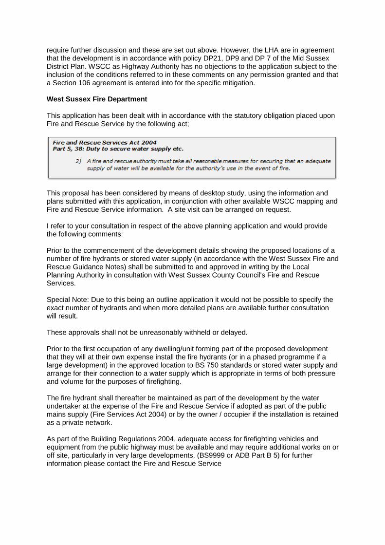
require further discussion and these are set out above. However, the LHA are in agreement that the development is in accordance with policy DP21, DP9 and DP 7 of the Mid Sussex District Plan. WSCC as Highway Authority has no objections to the application subject to the inclusion of the conditions referred to in these comments on any permission granted and that a Section 106 agreement is entered into for the specific mitigation. West Sussex Fire Department This application has been dealt with in accordance with the statutory obligation placed upon Fire and Rescue Service by the following act;
This proposal has been considered by means of desktop study, using the information and plans submitted with this application, in conjunction with other available WSCC mapping and Fire and Rescue Service information. A site visit can be arranged on request. I refer to your consultation in respect of the above planning application and would provide the following comments: Prior to the commencement of the development details showing the proposed locations of a number of fire hydrants or stored water supply (in accordance with the West Sussex Fire and Rescue Guidance Notes) shall be submitted to and approved in writing by the Local Planning Authority in consultation with West Sussex County Council's Fire and Rescue Services. Special Note: Due to this being an outline application it would not be possible to specify the exact number of hydrants and when more detailed plans are available further consultation will result. These approvals shall not be unreasonably withheld or delayed. Prior to the first occupation of any dwelling/unit forming part of the proposed development that they will at their own expense install the fire hydrants (or in a phased programme if a large development) in the approved location to BS 750 standards or stored water supply and arrange for their connection to a water supply which is appropriate in terms of both pressure and volume for the purposes of firefighting. The fire hydrant shall thereafter be maintained as part of the development by the water undertaker at the expense of the Fire and Rescue Service if adopted as part of the public mains supply (Fire Services Act 2004) or by the owner / occupier if the installation is retained as a private network. As part of the Building Regulations 2004, adequate access for firefighting vehicles and equipment from the public highway must be available and may require additional works on or off site, particularly in very large developments. (BS9999 or ADB Part B 5) for further information please contact the Fire and Rescue Service
If a requirement for additional water supply is identified by the Fire and Rescue Service and is subsequently not supplied, there is an increased risk for the Service to control a potential fire. It is therefore recommended that the hydrant condition is implemented. Reason: In the interests of amenity and in accordance with Mid Sussex District Plan (2014 - 2031) Key Polices DP18 and DP19 and in accordance with The F and RS Act 2004 Lewes District Council I have spoken to my colleagues in Policy and in view of the location of the development we are happy for Mid Sussex to consider/determine the application in accordance with adopted policies and with due regard to comments from other statutory consultees. Burgess Hill Town Council We welcome the holistic approach to this application, that includes job creation infrastructure, amenities with the housing and a clear indication of the intended timeline. Ansty and Staplefield Parish Council - original comments The Parish Council do not object in principle to the Northern Arc strategic development, but have the following concerns:
The Parish Council would like to ensure that the heavy vehicles used during the construction phase have a minimal impact on the surrounding villages and are directed along main routes.
Wheel washing facilities should be in place during construction to prevent dangerous conditions on local roads.
Whilst the Northern Arc Avenue is not part of the full planning permission the Parish Council is concerned that the Avenue will not provide an efficient route through and out of the development. The Avenue is being designed to create a "sense of place" which means that parking will be available along stretches of it and the Neighbourhood Centres are adjacent to it. Cars will stop to park or turn off to the shops and buses will also be stopping along the Avenue, with no separate bus lane. This will cause the traffic to stop and start creating congestion at busy times. An inefficient flow of traffic along this road will cause drivers to seek alternative routes through the surrounding villages. The Parish Council believe that the flow of traffic must be a priority for this road.
The s106 agreement should include contributions to Ansty and Staplefield Parish Council for items in our Infrastructure Delivery Plan.
It is not clear when the Secondary school will be delivered. Ansty and Staplefield Parish Council - additional comments The Parish Council note that one of the primary routes for construction traffic is through Ansty. The Parish Council request that the construction traffic is routed west on the A2300 rather than through a small village. The Parish Council is concerned that there are potential contamination issues in the parish. S106 contributions should be made for parish projects since most of this site is in Ansty and Staplefield parish.
Horsham and Mid Sussex Clinical Commissioning Group (NHS) Horsham and Mid Sussex CCG appreciate being consulted on this proposed important outline planning application. By way of background Horsham and Mid Sussex Clinical Commissioning Group (CCG) are the GP- led statutory NHS body responsible for planning, commissioning and monitoring the majority of local health services in the Mid Sussex area. (CCGs having been created following the Health and Social Care Act 2012 and replaced Primary Care Trusts on 1st April 2013). Horsham and Mid Sussex CCG therefore cover the entirety of Mid Sussex District Council's catchment area and the above planning application would be close to Park View Surgery (Sidney West) to the east and Meadows Surgery to the west of the development. The former building was designed to take new patients from the Northern Arc but recently discussions have taken place to consider a possible new build on the proposed Northern Arc development which would be dependent on NHS Capital and Revenue monies being available within the appropriate budget year. The Northern Arc would create a potential 7,000 new residents/patients with the situation being made more acute when considering the changes in the NHS with more services being delivered as part of local community NHS facilities alongside the traditional services offered by GPs (GPs being the gatekeeper of the wider NHS). The developers in their Northern Arc Allocation Planning Application (Development Specification and Framework) document confirm the requisite planning for a healthcare facility of up to 1,600 square metres which will be appropriate and give capacity for future growth. However, the CCG is mindful that NHS budgets at this time are significantly restricted and therefore we wish to seek a financial Section 106 developer contribution of £1,809,233 for healthcare capital infrastructure fit out works on a pro rata basis (This equates to an average of £645 per house dwelling and £419 for flats). This being either towards a new Northern Arc healthcare facility or extension/improvements to The Meadows and Park View buildings which are less than a mile from the development. In calculating our requirement, we use the available West Sussex average occupancy figures, agreed with West Sussex County Council and utilise the Senior District Valuer's approved formulas. Overall, all potential new residents will utilise some or all of the health services which the CCG commissions and put further pressure on medical services generally as a result, we wish to mollify the effects of new housing developments so that existing patients are not disadvantaged with a diluted level of service. ESCC Highways This response is issued on behalf of ESCC as neighbouring local Highway Authority. The following comments relate to on the submitted Transport Assessment and recently submitted Transport Assessment Addendum. (TAA) I do not object to this development
Response: On submission of the application, and an initial assessment of the planning documents and, in particular, the TA, I requested that further information and assessment be provided and completed to demonstrate the impacts on the East Sussex transport network. The site lies to the west of East Sussex. Therefore the potential for greatest traffic impact in East Sussex is in and around the villages of Ditchling and Wivelsfield. Ditchling in particular is an historic village with a highway network with a number of constraints (narrow carriageways, lack of footways etc.) The key East Sussex junctions and links are:
Green Road/Ditchling Road (Wivelsfield)
Janes Lane/Ditchling Road
Folders Lane/Ditchling Road and
Ditchling crossroads The TAA does consider these junctions. They have been assessed using the BHTM and a select link analysis. It is clear that the majority of development trips will be in a westward direction with only small (imperceptible) increases at East Sussex junctions. I am satisfied that the development will not have a severe impact in East Sussex in terms of capacity and congestion. I note the sustainable transport infrastructure that is proposed at this site along with the Travel Plan(s). I expect the package to be delivered in line with occupations to ensure traffic impacts are minimised from the outset and to encourage residents/site users to opt for sustainable mode choices as they move in. The TAA also assesses the crash history on this part of the East Sussex network. The analysis acknowledges the casualties on East Sussex routes, but given the level of traffic increase associated with this development I do not believe that road safety would be compromised as a result of this development. A Construction Traffic Management Plan has not been submitted as part of the application. A plan should be submitted and agreed for each phase. While this is likely to a requirement from WSCC and Highways England and I suspect the majority of traffic will route via the strategic network to the west I will expect traffic on East Sussex routes to be limited - to avoid village routes and take the strategic network routes If no CMTP is submitted for comment at this stage, a relevant condition or s106 obligation must be included in any grant of consent to ensure the relevant Highway Authorities can agree the routing, on site requirements etc. I recommend the following condition: 1. No development shall take place, including any ground works or works of demolition, until a Construction Management Plan has been submitted to and approved in writing by the Local Planning Authority. The plan shall include but not be restricted to the following matters:
vehicle routing so as to avoid the East Sussex highway network
the anticipated number, frequency and types of vehicles that may use East Sussex routes during construction
details of public engagement both prior to and during construction works.
Thereafter the approved Plan shall be implemented and adhered to in full throughout the entire construction period. The Plan shall provide details as appropriate for East Sussex. Reason: In the interests of highway safety and the amenities of the area. Heritage Conservation Team Surrey County Council The Heritage Conservation Team, Surrey County Council provides advice to Mid Sussex District Council in accordance with the Mid Sussex Local Plan and the National Planning Policy Framework. The district council is located within the County Council of West Sussex. Recommend Archaeological Condition The application is supported by an Environmental Statement which deals with archaeological matters within 'Chapter 10: Cultural Heritage' and a Cultural Heritage desk based assessment, appended in ES volume II: Appendix 10-1. Within these documents some known heritage assets are identified; most notably the assumed route of the London-Hassocks Roman Road, the site of a post-medieval fulling mill, and several other historic buildings and structures. It also considers the potential for the development to impact upon previously unknown below ground archaeological remains. Impact on previously Unknown Heritage Assets: Given the size of the site, and the lack of former archaeological investigation in the vicinity I would expect the potential for such previously unidentified remains to be high, however specifically the assessment identifies a moderate potential for; later prehistoric remains in the areas close to the River Adur, Roman remains in the vicinity of the Roman Road 'Archaeological Notification Area', medieval remains associated with the remnants of medieval field systems and industrial activity, and post medieval remains in the form of farmsteads and industrial sites. The assessment of the significance of the assets and the effects of the proposed development, detailed in 10.7 of the chapter was a useful exercise in identifying the construction impacts at each proposed development phase. However at this stage, our knowledge of the archaeological remains which may be present, is purely theoretical and therefore I would not advise much weight can be given to the conclusions drawn on the levels of adverse effect. I also have concerns regarding some works identified as having only a 'low' impact, such as the topsoil stripping. Any removal of soil horizons should be considered to have a potential negative impact on archaeological remains, and the use of plant on site should be carefully managed, particularly prior to any intrusive archaeological investigation to provide details of site stratigraphy, etc. Until further evaluation has taken place allowing a more accurate assessment of archaeological potential, all future development should be assumed to result in the potential destruction of below ground heritage assets. However in general the proposals for mitigating potential impact are appropriate; it is suggested a staged programme of investigation for each development phase with archaeological evaluation works followed by detailed mitigation if appropriate. In relation to the first phase, the Environmental Statement proposes geophysical survey in the first instance. Before I can agree to this, I will need to see the results of geophysical survey carried out previously on the Roman Road in order to determine whether this is an appropriate technique, and this will likely need to be undertaken in conjunction with a programme of trial trench evaluation in order to ground truth the results.
Impact on Known Heritage Assets: I am pleased to note the commitment to retaining some historic landscape features. This includes the Ancient Woodland, where current proposals avoids any direct impact, and I would expect this consideration to be continued in any subsequent iterations of the proposal submitted as part of any reserved matters application. I would also expect more detailed plans to attempt to minimize impacts to the historic hedgerow and other historic boundaries, while also considering the need to minimize the inevitable long term ongoing attrition associated with adjacent occupation. I am particularly pleased that an attempt has been made to avoid direct impact to the assumed Roman Road, by incorporating this area into the Green Infrastructure plan. However I would like to see more formal recognition of the existence of this asset, and an attempt to retain the linear landscape feature for future enjoyment and appreciation of the local landscape as well as simply just reducing direct negative impacts. The applicant should also note that within green space, types of land management should be considered in relation to protecting the historic features such as the Roman Road, as some types of planting of both trees and vegetation will also have long term negative effects which should be avoided. In the event of granting permission, the planning authority could consider the use of S.106 agreements and/or article 4 directions to be applied as appropriate, to secure the protection of the historic boundary and ancient woodland (and to a lesser extent the Roman Road) during the development, and their long-term preservation and management following the completion of any works and the occupation of the site in the future. Recommendations: To allow for the implementation of suitable mitigation measures appropriate to the archaeological significance of the Assets that may be present, I would recommend that any detailed reserved matters application(s) to follow for each phase be accompanied by the results of such an appropriately scaled field evaluation. This will provide for the opportunity to produce a suitable programme of mitigation work or influence the design and logistics of the detailed development proposal to accommodate any Archaeological Assets worthy of preservation in situ that may be revealed. To ensure the required archaeological work is secured satisfactorily, the following condition is appropriate and I would recommend that it be attached to any outline planning permission that may be granted: No development shall take place until the applicant has secured the implementation of a programme of archaeological work in accordance with a Written Scheme of Investigation which has been submitted by the applicant and approved by the Planning Authority. Please do not hesitate to contact the Heritage Conservation Team, Surrey County Council should you require further information. This response relates solely to archaeological issues, and the views of the relevant Conservation Officer should be sought regarding the potential impact on historic buildings, etc. East Sussex County Council Landscapes With reference to your email and request for comments on the above application; having had an opportunity to review the application submissions I have the following comments. This advice is provided to the Local Planning Authority by the County Landscape Architect in line with the Service Level Agreement and is not a statutory consultation response.
Summary Recommendation Recommend for approval in principle subject to the imposition of conditions The proposal could comply with NPPF Section 15 policies for conserving and enhancing the natural environment. This is with particular reference to Paragraph 170 which requires planning policies and decisions to contribute to and enhance the natural and local environment by: a) protecting and enhancing valued landscapes, sites of biodiversity or geological value and soils (in a manner commensurate with their statutory status or identified quality in the development plan). b) recognising the intrinsic character and beauty of the countryside, and the wider benefits from natural capital and ecosystem services - including the economic and other benefits of the best and most versatile agricultural land, and of trees and woodland; The proposal could comply with NPPF Section 12, Paragraph 130 requires that: Permission should be refused for development of poor design that fails to take the opportunities available for improving the character and quality of an area and the way it functions. 1. The Landscape section of the Environmental Impact Assessment has been updated to reflect changes to the overall submissions. It is noted and agreed that the changes would not affect the conclusions of the EIA in relation to landscape. 2. The conclusions with regard to the potential short and long term landscape and visual impacts of the outline plan are not disputed. The mitigation of impacts at year 15 will be dependent on the full implementation and long term management of the landscape masterplan and green infrastructure strategy. 3. The application is supported by a detailed Northern Arc Design Guide which has been developed in consultation with the local planning authority and other agencies. This provides a comprehensive guide for the future detailed planning applications. 4. It is recommended that the development can be supported subject to satisfactory detailed design for the individual phases. The implementation of the GI framework should ensure that the proposed development could have an acceptable impact on landscape character and views. Sussex Police Infrastructure I write on behalf of the Office for the Police and Crime Commissioner (PCC) for Sussex concerning the application DM/18/5114 seeking outline planning permission for 3,040 residential units on the land north west of Burgess Hill. Sussex and Surrey Police are an active member of the National Police Estates Group and now act as one on all infrastructure and town planning related matters across their combined geographical area. Our approach to Section 106 requests is in accordance with national best practice recommended by the National Police Chief's Council (NPCC). The approach now adopted has been tested at public inquiries nationally and found to be in accordance with the statutory CIL tests.
The large numbers of housing being developed across Sussex and more specifically the district of Mid Sussex will place a significant additional demand upon our police service. These impacts will be demonstrated in this submission and the necessity of investment in additional policing services is a key planning consideration in determination of this planning application. This development will place permanent, on-going demands on Sussex Police which cannot be fully shouldered by direct taxation. Like many other public services, policing is not fully funded via public taxation. This request outlines a number of the capital costs that will be incurred by Sussex Police to enable safe policing of this development. All of the infrastructure outlined in this funding request has been found compliant with regulation 122 of the Community Infrastructure Levy and are considered directly related to the development in scale and kind and necessary to make the development acceptable in planning terms. The application site is currently a largely greenfield site and when built upon will create an additional demand upon the police service that does not currently exist. The police will need to recruit additional staff and officers and equip them. The development will also require the services of a police vehicle. Staff and officers will also need to be accommodated in a premises that will enable them to serve the development. This request is proportionate to the size of the development and is intended to pay for the initial, additional costs resulting directly from the development for those areas where the police do not have existing capacity. The request also explains how the police service is funded, outlines National Planning Policy support for policing contributions and references numerous appeal decisions where police requests for developer contributions have been upheld. Police forces nationally, are not in a position to support major development of the scale now being proposed for many of the nation's town and cities without the support from the planning system. If we are obliged to do so using our own resources only, then it is reasonable to conclude that there will be a serious risk of service degradation as existing coverage is stretched to encompass the new development and associated population growth. This is already evident across Sussex due to the significant numbers of housing being developed and clearly shown by the increasing numbers of recorded crimes in Sussex over the last year. Our force must ensure that development growth is supported by the infrastructure necessary to guarantee the safety and security of the new communities. It is the responsibility of the PCC to ensure our Chief Constable has sufficient financial support to deliver a high level of policing to the residents of Sussex. Our office continues to actively seek financial contributions via Section 106 agreements and Community Infrastructure Levy funds to support our capital program. This will enable Sussex Police to deliver the highest possible service to ensure the protection of the communities that we serve. In line with many other police forces Sussex and Surrey Police have updated our methodology for infrastructure requests to ensure our representations are transparent and provide an up to date, accurate reflection of our current capacity in the districts. Our new methodology has been developed through a joint partnership with Leicestershire, Thames Valley, West Mercia, Warwickshire and other active members of the National Police Estates Group. This methodology was considered Community Infrastructure Levy REG122 compliant by Mr Justice Green in the case of Jelson v SoSCLG and Hinckley and Bosworth Council [2016] CO/2673/2016 (Appendix 1). In addition, there are a significant number of recent appeal decisions and High Court judgments supporting both the principle of Police contributions and our methodology (see attached appendices). The principle of developer contributions towards Surrey Police has recently been upheld by the Secretary of State in the called-in appeal decision concerning the development of 1800 homes at Dunsfold Park in Waverley (Appeal ref: APP/R3650/V/17/3171287 - Appendix 2).
I will go into further detail on the various items of infrastructure and provide evidence of their compliance with Regulation 122 tests. 1. Police Funding and Development Growth A primary issue for Sussex Police is to ensure that new development, like that proposed by application DM/18/5114, makes adequate provision for the future policing needs that it will generate. Like other public services, Sussex Police's primary funding is insufficient to be able to add capital infrastructures to support new development when and wherever this occurs. Furthermore there are no bespoke capital funding regimes e.g. the Health Lift to provide capital either. The police therefore fund capital infrastructure by borrowing. However in a service where most of the budget is staffing related, the Sussex Police capital programme can only be used to overcome pressing issues with existing facilities, or to re-provide essential facilities like vehicles once these can no longer be used. Sussex Police endeavour to use our existing funds as far as they stretch to meet the demands of an expanding population and overwhelmingly for revenue purposes. However, it is the limit of these funds which necessitates the need to seek additional contributions via Section 106 requests and the Community Infrastructure Levy (CIL). This situation also prevails in other public services seeking contributions and there is nothing different here as far as policing is concerned. What is different is that the police do not enjoy capital income from the usual taxation sources. This evidences that the police do not make requests where other funds are available to meet their needs. The reality of this financial situation is a major factor in our Forces planning and alignment with plans for growth in that whilst Sussex Police can plan using their revenue resources to meet their on-going, and to a limited extent, additional revenue costs these do not stretch to fund necessary additional investment in their infrastructures. Sussex Police will continue to engage with Local Planning Authorities to ensure crime prevention is referenced within new local plan documents and provide crime prevention design advice to minimise the opportunities for crime within new development. Ensuring new development takes full consideration of crime prevention and the provision of adequate infrastructure to support policing is clearly outlined within the NPPF and within Paragraph 156 of the NPPF which states "Local planning authorities should set out the strategic priorities for the area in the Local Plan. This should include strategic policies to deliver… the provision of health, security, community and cultural infrastructure and other local facilities". In the support of this request the following information is provided by Miranda Kadwell, Corporate Finance Manager at Sussex Police and is a detailed commentary on Sussex Police's budget, which underpins the above statements: National funding Sussex Police receives 61% of its funding from central government and 39% from local taxation. Central government funding comprises of the Home Office Core Funding Settlement, the Department for Communities and Local Government (DCLG) Formula Funding, (together these are referred to as central government grant or CGG for the proposes of this submission) and legacy Council Tax Grants (LCTG). LTCG are fixed and some elements of this are time limited, therefore, LCTG are not affected by variations in the funding formula. The distribution of central government grant is calculated by the Police Relative Needs Formula. This Police Funding Formula divides up how much money each police force
receives from the overall central government funds. It takes into account a number of factors to assess demand in each area. Whilst the funding formula is influenced through allocation of a basic amount per resident, this does not necessarily lead to an increase in Central Government Grant to Sussex Police. Putting aside the time delays between recognising population growth and this being fed in to the funding formula, the overall pot available to all forces the CGG is limited and in fact has declined over the last few years as part of the Government's fiscal policy. Therefore, changes in general population or the specific population do not increase the overall funding made available through CGG, rather they would affect the relative distribution of grant between forces. For the 2018/19 year there was no change to the CGG despite the occurrence of development growth in the county area compared to previous years. However it can be stated with certainty that even if there was an increase in central funding as a result of development growth, this funding would be fully utilised in contributing to additional salary, revenue and maintenance costs (i.e. not capital items and not what is claimed here). This funding, therefore, would not be available to fund the infrastructure costs that are essential to support the proposed development growth. During the last year, the Home Office and police partners engaged on potential changes to the police funding formula. However, in the context of changing demand, the Minister for Policing and the Fire Service Nick Hurd has said that providing funding certainty over the next two years to enable the police to plan in an efficient way is his priority. Therefore, proposed changes to the funding formula will be revisited at the next Spending Review. Due to the uncertainty and range of possible outcomes, we have made no assumptions regarding a change to the funding formula in our current financial forecasts. This adds to the level of uncertainty over future government funding. Local funding Sussex Police (precepting body) places a demand or precept on the district and borough councils in its area (billing authorities) for a sum of money to be raised through the council tax. The amount to be raised is divided by the Council Tax Base (CTB) or number of households to arrive at an average Band D council tax, from which all other bands of council tax are determined. The growth in the council tax or the amount each household pays is decided by the Police and Crime Commissioner (PCC), having regard to the DCLG rules concerning the need to hold a local referendum where the proposed spending increase in the precept is above a prescribed threshold, currently £12 per Band D property to maintain real terms funding. The cap on precept uplift was raised to £12 for all forces for the 2018/19 year. Following public consultation the Police and Crime Commissioner proposed an increase in the 2018/19 precept of £12. During 2017/18 Sussex Police received the 5th lowest precept of any PCC in England and Wales. Sussex Police also had the 7th lowest net revenue cost per head of population in 2017/18 and the 7th lowest total funding per head of population according to the 2017/18 HMICFRS Value for Money Profiles. There remains potential for the council tax yield to increase simply through a growth in the CTB. However, it should be noted that the CTB is reduced for discounts and exemptions provided under the Local Council Tax Benefit Scheme (LCTBS) and may also be affected by collection rates. Therefore, a growth in households might not lead to a growth in council tax yield where those households benefit under the LCTBS.
The additional funding generated by council tax in 2018/2019 will reduce the severity of the Forces previous savings target. The savings target represents a funding gap between our existing budget requirements and current funding sources. However the latest Medium Term Financial Strategy indicates the PCC will still require a further £17m to be drawn from our reserves to support revenue costs associated with our Local Policing Program over the period to April 2020. Most importantly, the higher council tax precept will allow our PCC to retain and invest in our workforce and continue supporting our Local Policing Program (LPP). Key considerations driving the precept increase decision included: Public demand on police services is increasing exponentially; Criminal investigations are becoming increasingly complicated, with huge amounts of digital material to identify, secure and analyse, against an exacting threshold for prosecution; The public want to see investment in more visible, local policing, focusing on crimes like burglary and anti-social behaviour and they rightly want to feel safe on the roads, in public spaces and at night-time; The public also want to see improvements in the force's approach to public contact and more support to the 101 service; HMICFRS (Her Majesty's Inspectorate of Constabulary, Fire and Rescue Services) has recently acknowledged the public's concerns about changes to neighbourhood policing, and stressed the importance of community intelligence; And, the PCC's consultations and correspondence with the public show that a majority of Sussex residents are prepared to support their police service through increased precept contributions. Savings Since 2010/11 we have seen reductions to the grant funding provided by the Government to Policing Bodies in England and Wales. Over the last eight years Sussex Police have worked hard to deliver savings and have made £88m of reductions and efficiencies to head towards balancing its books (source: Her Majesty's Inspectorate of Constabulary's (HMIC) Police Effectiveness, Efficiency and Legitimacy (PEEL) assessment and 2017/18 revenue budget). Despite increases in the Council tax yield the 'Sussex Police Medium Term Financial Strategy' (MTFS) identifies a net savings requirement in the region of £3m over the next four years. This is the "budget gap" i.e. the difference between funding and the cost of policing which will need to be met by savings. Savings of £3m in addition to using £17m of reserves will be required to meet the total in-year gaps over the life of the MTFS and it is anticipated the budget will be balanced at the end of the 2021/22 year. Capital Funding Central Government funding for investment in capital infrastructure takes the form of a Home Office Grant. This grant makes up a small part of the overall funding for the Capital Programme and was reduced from £1.766m to 0.906m for the 2017/18 financial year and will remain at this level for the forthcoming 2018/19 year. Our capital and investment program is funded firstly by our capital grant and capital receipts (building sales) and is then supported by reserves or revenue contributions. The latest MTFS capital and investment programme funding sources are shown on the table below:
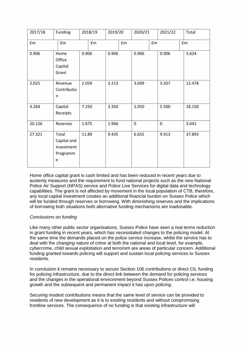
2017/18 Funding 2018/19 2019/20 2020/21 2021/22 Total
£m £m £m £m £m £m
0.906 Home
Office
Capital
Grant
0.906 0.906 0.906 0.906 3.624
2.025 Revenue
Contributio
n
2.059 3.213 3.699 3.507 12.478
4.264 Capital
Receipts
7.250 3.350 2.050 5.500 18.150
20.126 Reserves 1.675 1.966 0 0 3.641
27.321 Total
Capital and
Investment
Programm
e
11.89 9.435 6.655 9.913 37.893
Home office capital grant is cash limited and has been reduced in recent years due to austerity measures and the requirement to fund national projects such as the new National Police Air Support (NPAS) service and Police Live Services for digital data and technology capabilities. The grant is not affected by movement in the local population of CTB, therefore, any local capital investment creates an additional financial burden on Sussex Police which will be funded through reserves or borrowing. With diminishing reserves and the implications of borrowing both situations both alternative funding mechanisms are inadvisable. Conclusions on funding Like many other public sector organisations, Sussex Police have seen a real terms reduction in grant funding in recent years, which has necessitated changes to the policing model. At the same time the demands placed on the police service increase, whilst the service has to deal with the changing nature of crime at both the national and local level, for example, cybercrime, child sexual exploitation and terrorism are areas of particular concern. Additional funding granted towards policing will support and sustain local policing services to Sussex residents. In conclusion it remains necessary to secure Section 106 contributions or direct CIL funding for policing infrastructure, due to the direct link between the demand for policing services and the changes in the operational environment beyond Sussex Polices control i.e. housing growth and the subsequent and permanent impact it has upon policing. Securing modest contributions means that the same level of service can be provided to residents of new development as it is to existing residents and without compromising frontline services. The consequence of no funding is that existing infrastructure will
eventually become stretch to breaking point, and none of the communities we serve will received adequate policing. Whilst national and local funding must continue to cover salary and maintenance costs, there would be insufficient funding to provide the infrastructure required for officers to carry out their jobs effectively, Sussex Police consider that these infrastructure costs arising directly as a result of the development proposed and that funding for the police under S106 or CIL is both necessary and justified. 2. Assessment and Request Our office have undertaken an assessment of the implications of growth and the delivery of housing upon the policing of Mid Sussex and in particular the areas of these district where new development is being directed towards. We have established that in order to maintain the current level of policing, developer contributions towards the provision of capital infrastructure will be required. This information is disclosed to secure essential developer contributions and is a fundamental requirement to the sound planning of the districts. In the absence of developer contributions towards the provision of essential policing infrastructure the additional strain placed on our resources would have a negative impact on policing of both the development and forcewide policing implications within the district. This submission will provide the most recent annual statistics for crime/incidents in Mid Sussex which will be compared to the number of existing households. This provides an incident per existing household (or person) within Mid Sussex which can then be used as the background to the various items of infrastructure outlined in this funding request. Nationally, the Police Force ensure that we take regular legal advice and guidance from industry professionals on the applicability of NPPF tests relating to the application of Regulation 122 on our funding requests for S106 agreements and Infrastructure Development Plans. This included advice as to what is infrastructure which can be summarised as follows: The first point to note is that "infrastructure" is not a narrowly defined term. Section 216 of the Planning Act 2008 provides a list of "infrastructure" but is clear that that list is non-exhaustive. That fact is demonstrated by the use of the word "includes" prior to the list being set out. There is no difficulty in the proposition that contributions towards Police infrastructure can be within the definition of infrastructure for the purposes of the 2008 Act. In policy terms this is reinforced by the reference to security infrastructure in paragraph 156 of the National Planning Policy Framework. Infrastructure is not limited to buildings and could include equipment such as vehicles, communications technology, and surveillance infrastructure such as CCTV. The submission set out below is based on the same methodology previously found sound by Planning Inspectors, the Secretary of State and the High Court and has been found sound. The costs included in this submission are sites specific costs which are envisaged to be secured via a Section 106 agreement. The significant costs relating to revenue will be met by local and national taxation.
3. Current Policing requirements in the district of Mid Sussex Sussex Police's existing estate At present, Neighbourhood policing in Mid Sussex is delivered from Burgess Hill, Haywards Heath and East Grinstead Police stations. Burgess Hill and Haywards Heath are the main operational bases for Neighbourhood Policing Teams (NPT) and Neighbourhood Response Teams (NRT) in the District. East Grinstead police station is our new drop-in office within the Chequer Meads arts centre. Burgess Hill police station forms part of 'The Brow' area, which is due for redevelopment; part of which will include a new Police Station, to replace the existing. This station is likely to be built out within the next 24-36 months and will support existing teams working from Burgess Hill police station. As a key growth area providing a strong police presence within the town is a key priority for the Chief Constable. The Estates department have undertaken a full capacity analysis of our sites across Sussex and identified police stations where we have issues with existing capacity and would therefore be unable to support additional officers and staff required due to population growth. This study shows that Haywards Heath and Burgess Hill police station have a very limited capacity and could not support additional staff or NPT/NRT officers to mitigate against this development. These stations provide the principal base for front line policing and other neighbourhood policing roles which will be required to support this development. The Burgess Hill northern arc is currently policed by the Balcombe, Handcross, Pease Pottage, Ansty, Staplefield and Cuckfield neighbourhood policing team and the Hurstpierpoint and Sayers Common neighbourhood policing team. Sussex Police's current policing requirements and projections For the last year (2017/18) Sussex Police recorded 29,587 incidents in the district of Mid Sussex which accounted for 6% of the total number of incidents in the County (2017/18 incident records). There has also been a notable rise in recorded crimes from 6,494 crimes (2016/17) to 7,179 (2017/18) crimes. The 2011 census listed 57,400 households in the District of Mid Sussex and taking into account net completions since this has increased by 4,217 homes to the end of the 2016/17 financial year. MSDC housing completion records (Housing Land Supply - Completions 2017/18) indicate that 843 net completions were recorded for the 2017/18 year bringing the total number of homes in Mid Sussex to 62,460 homes. The 2011 census listed the population of Mid Sussex as 139,860 persons which represented an average household of 2.44 persons (139,860 / 57,400). At present 62,460 households / 152,402 (62,460*2.44) persons generates an annual total of 29,587 incidents that require a Police response. These are not necessarily all "crimes" but are calls to our contact centre which in turn all require a Police response/action, thereby placing a demand on our resources. It should be noted that the total number of crimes recorded in this period was 7,179 which is only 24% of all the recorded incidents Taking into account the number of recorded incidents and the recorded number of existing households this results in 0.47 incidents per household or 0.19 incidents per person that require a police response in Mid Sussex each year.
Sussex Police have a duty to respond to all incidents and many of these incidents are not recorded as crimes. Sussex Police deliver crime prevention and presence, attendance and service lead at emergencies e.g. RTA's or flooding, counter terrorism and community reassurance. We must also attend all incidents involving deaths, attend crowd and events policing, attend and input to community safety and crime partnerships, and provide referral responses when there are expressed concerns about the safety or children, the elderly and those with special needs. Sussex Police have a duty to respond to all incidents and many of these incidents are not recorded as crimes. We deliver crime prevention and presence, attendance and service lead at emergencies e.g. RTA's or flooding, counter terrorism and community reassurance. We must also attend all incidents involving deaths, attend crowd and events policing, attend and input to community safety and crime partnerships, and provide referral responses when there are expressed concerns about the safety or children, the elderly and those with special needs. 4. Breakdown of predicted incidents as a result of population increase in Mid Sussex The proposed development of 3,040 new homes would have a population of approximately 7,600 persons (at 2.5 persons per household). Applying the current ratio of "incidents" to population then the development would generate an additional 1,444 incidents per year for Sussex Police to attend (0.19 x 7,600). These incidents are likely to result in 347 (1,444 x 0.24) additional recorded crimes per year attributed to this development. 5. Current breakdown of policing delivered in Mid Sussex A full strategic review of staffing has been undertaken for the purposes of this representation and is considered accurate to date. Policing is Sussex is divided into three divisions; Brighton and Hove; West division (Adur and Worthing, Arun, Chichester, Crawley, Horsham and Mid Sussex); and East division (Eastbourne, Hastings, Lewes, Rother, Wealden). The SDNP is also covered by respective teams within each division that it overlaps. Sussex Police deliver policing to each 14 local authorities and departments can be categorised into Dedicated (District), Divisional or Forcewide policing roles. Current statistics show that Sussex Police employ 2622 officers in active duty delivering policing to the residents of Sussex. These roles can be categorized into dedicated policing teams delivering neighbourhood policing; divisional policing delivering specialist services such as response roles and investigations; and Forcewide policing teams delivering specialist policing services across the county such as Firearms, Major crime and counter terrorism. Only departments of over 5 officers have been included within Forcewide staff and officers which removes specialist officer roles which are not clearly directly tied to population growth (ex: Chief Inspectors, specialist management functions). All of these functions are essential to the success of Sussex Police and will all be utilised in some capacity to deliver policing to the City. Sussex Police also employ 2237 support staff in either dedicated, divisional or Forcewide roles. Staff (officer and support staff) delivering policing to the District of Mid Sussex are spread across the following functions. In total the Local Authority of Mid Sussex is served by; (all figures = FTE)
Police officers 88 dedicated uniformed Officers Neighbourhood Policing Team officers (NPT), Local Support Team, Response Policing Teams, Police Community Support Officers. 14 divisional officers The West Sussex division has 105 officers not including the dedicated officers listed as dedicated uniformed officers. These roles include Investigation teams, Special Investigations Unit (SUI), CIT (Crisis Intervention Team, Operational support teams. Recorded incidents in Mid Sussex account for 13.4% of the recorded incidents in West Sussex over the last year therefore it is reasonable to allocate 14 divisional officers to the Mid Sussex Districts. 49 Forcewide officers A large number of our officers deliver force wide policing in a variety of roles including Operations, Firearms, Major crime, Public protection, Specialist crime, Custody, Communications, Professional standards and Training roles. There are 821 officers Forcewide officers which deliver policing to the whole of Sussex and are vital to the operation of all types of policing including the functioning of neighbourhood policing. Taking into account into account that 6% of all incidents managed by Sussex Police occur in Mid Sussex, 52.5 officers are required for the policing of these districts. Police staff Sussex Police currently employs 2237 support staff delivering policing to the residents of Sussex. These roles can be categorized into dedicated support staff such as police enquiry officers and facilities assistants; Divisional staff teams (ie: East Sussex, West Sussex, and Brighton and Hove) delivering services such as crime prevention, operations, investigations, strategic support, corners office and other essential roles. Forcewide support staff roles such as public protection, joint transport services, crime justice and custody, communications departments and specialist crime command. Some specialist department roles have not been included, however all the above forcewide departments consist of 10 employees or larger. This precludes specialist support staff roles such as the office of the Police and Crime Commissioner which are not directly linked to population growth. 6 dedicated support staff Police Enquiry officers, Facilities officers, Facilities Assistants 14 divisional support Staff As with police officers roles divisional support staff is essential to support front line policing and drawn upon when required. Divisional support staff roles include Investigations teams, Crime Prevention, Licensing, Prosecution case workers, Coroners Office and other essential roles. There are 99 divisional support staff within these departments. Again utilising the ratio of incidents in West Sussex (13.8%), 13.6 support staff are required to support the existing population of Mid Sussex. 77 forcewide support staff The majority of our support staff functions are delivered in a forcewide capacity. Only departments with over 10 or more support staff members have been included within this field
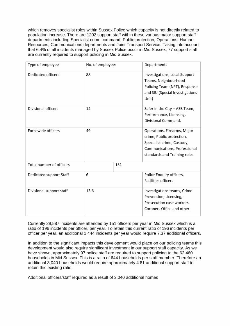
which removes specialist roles within Sussex Police which capacity is not directly related to population increase. There are 1202 support staff within these various major support staff departments including Specialist crime command, Public protection, Operations, Human Resources, Communications departments and Joint Transport Service. Taking into account that 6.4% of all incidents managed by Sussex Police occur in Mid Sussex, 77 support staff are currently required to support policing in Mid Sussex.
Type of employee No. of employees Departments
Dedicated officers 88 Investigations, Local Support
Teams, Neighbourhood
Policing Team (NPT), Response
and SIU (Special Investigations
Unit)
Divisional officers 14 Safer in the City – ASB Team,
Performance, Licensing,
Divisional Command.
Forcewide officers 49 Operations, Firearms, Major
crime, Public protection,
Specialist crime, Custody,
Communications, Professional
standards and Training roles
Total number of officers 151
Dedicated support Staff 6 Police Enquiry officers,
Facilities officers
Divisional support staff 13.6 Investigations teams, Crime
Prevention, Licensing,
Prosecution case workers,
Coroners Office and other
Currently 29,587 incidents are attended by 151 officers per year in Mid Sussex which is a ratio of 196 incidents per officer, per year. To retain this current ratio of 196 incidents per officer per year, an additional 1,444 incidents per year would require 7.37 additional officers. In addition to the significant impacts this development would place on our policing teams this development would also require significant investment in our support staff capacity. As we have shown, approximately 97 police staff are required to support policing to the 62,460 households in Mid Sussex. This is a ratio of 644 households per staff member. Therefore an additional 3,040 households would require approximately 4.81 additional support staff to retain this existing ratio. Additional officers/staff required as a result of 3,040 additional homes
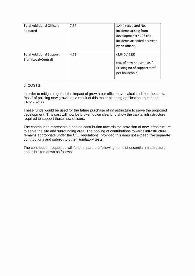
Total Additional Officers
Required
7.37 1,444 (expected No.
incidents arising from
development) / 196 (No.
incidents attended per year
by an officer)
Total Additional Support
Staff (Local/Central)
4.72 (3,040 / 635)
(no. of new households /
Existing no of support staff
per household)
6. COSTS In order to mitigate against the impact of growth our office have calculated that the capital "cost" of policing new growth as a result of this major planning application equates to £492,752.83. These funds would be used for the future purchase of infrastructure to serve the proposed development. This cost will now be broken down clearly to show the capital infrastructure required to support these new officers. The contribution represents a pooled contribution towards the provision of new infrastructure to serve the site and surrounding area. The pooling of contributions towards infrastructure remains appropriate under the CIL Regulations, provided this does not exceed five separate contributions and subject to other regulatory tests. The contribution requested will fund, in part, the following items of essential infrastructure and is broken down as follows;
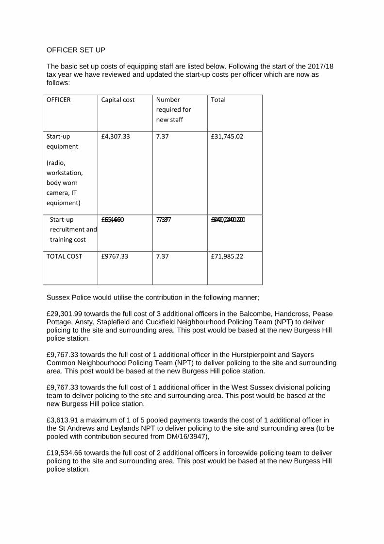
OFFICER SET UP The basic set up costs of equipping staff are listed below. Following the start of the 2017/18 tax year we have reviewed and updated the start-up costs per officer which are now as follows:
OFFICER Capital cost Number
required for
new staff
Total
Start-up
equipment
(radio,
workstation,
body worn
camera, IT
equipment)
£4,307.33 7.37 £31,745.02
Start-up
recruitment and
training cost
£5,460 7.37 £40,240.20
£5,460
7.37
£40,240.20
TOTAL COST
£9767.33
7.37
£71,985.22
Sussex Police would utilise the contribution in the following manner; £29,301.99 towards the full cost of 3 additional officers in the Balcombe, Handcross, Pease Pottage, Ansty, Staplefield and Cuckfield Neighbourhood Policing Team (NPT) to deliver policing to the site and surrounding area. This post would be based at the new Burgess Hill police station. £9,767.33 towards the full cost of 1 additional officer in the Hurstpierpoint and Sayers Common Neighbourhood Policing Team (NPT) to deliver policing to the site and surrounding area. This post would be based at the new Burgess Hill police station. £9,767.33 towards the full cost of 1 additional officer in the West Sussex divisional policing team to deliver policing to the site and surrounding area. This post would be based at the new Burgess Hill police station. £3,613.91 a maximum of 1 of 5 pooled payments towards the cost of 1 additional officer in the St Andrews and Leylands NPT to deliver policing to the site and surrounding area (to be pooled with contribution secured from DM/16/3947), £19,534.66 towards the full cost of 2 additional officers in forcewide policing team to deliver policing to the site and surrounding area. This post would be based at the new Burgess Hill police station.
£3,146 towards the full cost of recruiting and equipping one additional dedicated support staff member to be based at the re-provided Burgess Hill police station. £3,146 towards the full cost of recruiting and equipping one additional divisional support staff member to be based at the re-provided Burgess Hill police station. £6,292 towards the full cost of recruiting and equipping two additional forcewide support staff member to be based at the re-provided Burgess Hill police station. £2,265.12 as a maximum of 1 of 5 pooled payments towards the cost of one additional support staff member to be based at the re-provided Burgess Hill police station (to be pooled with contribution secured from DM/16/3947). We could not have officers attending this development with less than adequate equipment with unnecessary risk to themselves and occupiers served. PREMISES At present policing within the Leylands, Dunstall and Cuckfields wards is delivered from Burgess Hill Police station. Burgess Hill police station forms part of 'The Brow' area, which is due for redevelopment; part of which will include a new Police Station, to replace the existing. This project has currently been delayed due to the production of the emerging Sussex Police Estates strategy (2017-2022) and difficulties securing an alternative site, however is likely to be brought forward into the 2019-2020 or 2020-2021 financial year. There will be various Mid Sussex NPT / NRT teams, West Divisional support and forcewide policing teams planned to be stationed at this new facility in Burgess Hill and we are currently appraising various options for a new joint site with partners. Our policy is to provide an alternative facility in the area prior to any station being closed. We are currently investigating opportunities to collaborate with other blue light and public sector partners. This is considered to be more economical, and reflects the future workspace shared working environment we are trying to develop. It should be noted that the receipts from the sale of the existing station may only partially fund the replacement (re-provided) station, and will re-provided at the same scale as the existing premises, thus not taking account of the growth in space needed as a result of increased policing demands. These funds will not be utilised to fund other infrastructure needed as a result of this development The new Burgess Hill police station will accommodate our existing teams at a similar scale to the existing station. Sussex Police's capital budget does not have capacity to future proof our relocation projects and provide sufficient rooms to accommodate growth over the period of Mid Sussex's development plan. Funding equivalent to the scale of this development is therefore sought from this development to provide additional floorspace in the relocated Burgess Hill Police station. Sussex Police are required to maintain a high capacity of accommodation for staff and officers, with any additional capacity delivered via new works to provide floor space. Taking an average of the floor space provision over our sites in Sussex which deliver neighbourhood policing we have determined that each new officer/member of staff should be allocated approximately 7.93sqm of office floor space. We are also required to provide a
minimum of 1sqm for officers/staff for storage (locker room etc.). This brings the total space requirement to 8.93sqm. Sussex Police have previously used Saxon House in Newhaven as an example to estimate costings for a new build or extension/adaption of existing building. This facility is a new facility shared with East Sussex Fire and Rescue and Lewes District Council which replaced the old police station. For new buildings such as Saxon House [the cost was estimated to be between £2500-3000/sqm]. Following the start of the 2018/19 tax year, Sussex Police will use the up to date BCIS costings index for all future S106 requests. The 17/03/18 issue of the RICS BICS costs (Appendix 5) which lists the median cost for new police stations at £2,631 (Median) which would be considered the minimum cost appropriate to support the additional officers/staff and the new Burgess Hill police station. The cost of accommodating a minimum of 11 additional officers/staff (which are required to police this development) would be 8.93 x £2,631 x 12.09 = £284,052.49. VEHICLES A vital part of providing effective policing to the residents of Mid Sussex is maintaining the large fleet of vehicles. These vehicles range from General Response Vehicle (GRVs or patrol cars), unmarked general support vehicles, Public Service Unit vans and minibuses, scientific (e.g. Scene of Crime Officers) vehicles, pursuit vehicles - 4 x 4 and high speed, motorcycles. Current fleet deployment in Mid Sussex administrative area (serving 62,460 households) currently consists of 25 active divisional vehicles and 38 forcewide vehicles. Maintaining our forcewide fleet is essential to the success of Sussex Police and important to enable the force to efficiently combat cross border crime. There is currently no capacity to meet the additional policing needs this development will present, therefore investment towards increasing fleet capacity is sought from this development. In total there are 25 divisional vehicles and 38 forcewide vehicles delivering policing to the district of Mid Sussex.
Department Number of vehicles
Divisional Crime management, Local
command, Local
investigations,
Neighbourhood Policing
Teams, Neighbourhood
Response Teams, Response
investigations
25
Forcewide Crime support command, Dogs section,
Firearms, Intel, Licensing, Major
investigations, Public protection, Traffic,
Training.
The average capital cost of a new vehicle is £17,000 (not including fuel and maintenance). Our guideline for the majority of marked vehicles is to replace every four years or £125,000
miles. The condition of vehicles at the end of their police life varies however Sussex Police forecast that they will redeem, on average 5% of a vehicles value on disposal. The development will require fleet investment far exceeding 4 years therefore Sussex Police would require at least an 8 year life of provision. This contribution is justified because there is insufficient funding within the police's revenue income to take on the capital cost after just four years, without diverting money from elsewhere. Sussex Police estimate that the 4 year lifetime cost per vehicle is approximately £42,240 including running costs and capital charges. 63 vehicles at net value of £1,071,000 Existing number of households in Mid Sussex (62,460) = £17.15 per Household (1,071,000 / 62,460) x 3,040 Households x 2 = £104,272 to give 8-year life of provision. The same methodology has been used to calculate our fleet requirement as the Warwickshire police representation which has been supported in the most recent appeal decision concerned contributions towards policing (Appendix 6 - APP/R1845/W/17/3173741) issued on the 18th March 2018. Sussex Police consider this would be the most appropriate methodology to use in this and all future section 106 requests. It is vital to ensure fleet deployment in maintained in line with the existing population of Mid Sussex and therefore a financial contribution towards fleet capacity is essential to make this development acceptable in planning terms. Vehicles are fundamental capital policing infrastructure to deliver community safety and address crime especially at neighbourhood level. Fleet deployment is related to the known policing demands of comparable developments in the locality. The direct demand from the new development can be accurately forecast and delivering policing direct to this development will not be possible without additional vehicles to do so. Sussex Police would utilise the contribution in the following manner; £34,000 (x 2) towards the full cost of two additional vehicles in the Balcombe, Handcross, Pease Pottage, Ansty, Staplefield and Cuckfield Neighbourhood Policing Team (NPT) to deliver policing to the site and surrounding area. This would include replacement after 4 years at a cost of £17,000 per vehicle. £17,000 (x 2) towards the full cost of one additional vehicles in the Hurstpierpoint and Sayers Common Neighbourhood Policing Team (NPT) to deliver policing to the site and surrounding area. This would include replacement after 4 years at a cost of £17,000 per vehicle. £2,266 towards the full cost of one additional vehicles in the St Andrews and Leylands NPT to deliver policing to the site and surrounding area. This would be pooled with the contribution secured from application DM/16/3947. ANPR CAMERAS Sussex Police are currently promoting a roll out of Automatic Number Plate Recognition (ANPR) Cameras throughout Sussex. There is a limited budget for this at present but a requirement to roll out more cameras to ensure criminals can be identified quickly and efficiently. The number and location of cameras is driven by the scale and location of the proposed development and the road network in the area. Cross border crime is a growing
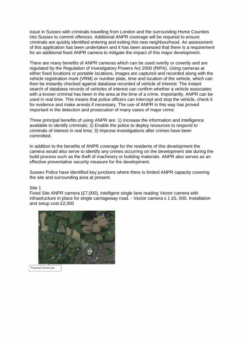
issue in Sussex with criminals travelling from London and the surrounding Home Counties into Sussex to commit offences. Additional ANPR coverage will be required to ensure criminals are quickly identified entering and exiting this new neighbourhood. An assessment of this application has been undertaken and it has been assessed that there is a requirement for an additional fixed ANPR camera to mitigate the impact of this major development. There are many benefits of ANPR cameras which can be used overtly or covertly and are regulated by the Regulation of Investigatory Powers Act 2000 (RIPA). Using cameras at either fixed locations or portable locations, images are captured and recorded along with the vehicle registration mark (VRM) or number plate, time and location of the vehicle, which can then be instantly checked against database recorded of vehicle of interest. The instant search of database records of vehicles of interest can confirm whether a vehicle associates with a known criminal has been in the area at the time of a crime. Importantly, ANPR can be used in real time. This means that police officers can intercept and stop the vehicle, check it for evidence and make arrests if necessary. The use of ANPR in this way has proved important in the detection and prosecution of many cases of major crime. Three principal benefits of using ANPR are: 1) Increase the information and intelligence available to identify criminals; 2) Enable the police to deploy resources to respond to criminals of interest in real time; 3) Improve investigations after crimes have been committed. In addition to the benefits of ANPR coverage for the residents of this development the camera would also serve to identify any crimes occurring on the development site during the build process such as the theft of machinery or building materials. ANPR also serves as an effective preventative security measure for the development. Sussex Police have identified key junctions where there is limited ANPR capacity covering the site and surrounding area at present. Site 1 Fixed Site ANPR camera (£7,000), intelligent single lane reading Vector camera with infrastructure in place for single carriageway road. - Vector camera x 1 £5, 000. Installation and setup cost £2,000
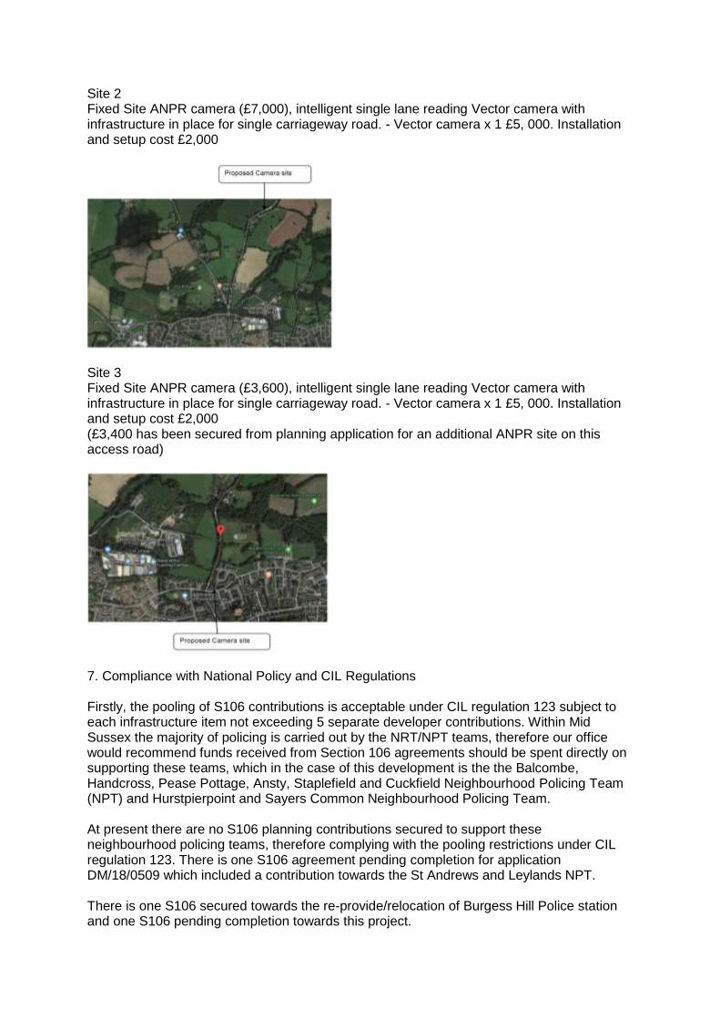
Site 2 Fixed Site ANPR camera (£7,000), intelligent single lane reading Vector camera with infrastructure in place for single carriageway road. - Vector camera x 1 £5, 000. Installation and setup cost £2,000
Site 3 Fixed Site ANPR camera (£3,600), intelligent single lane reading Vector camera with infrastructure in place for single carriageway road. - Vector camera x 1 £5, 000. Installation and setup cost £2,000 (£3,400 has been secured from planning application for an additional ANPR site on this access road)
7. Compliance with National Policy and CIL Regulations Firstly, the pooling of S106 contributions is acceptable under CIL regulation 123 subject to each infrastructure item not exceeding 5 separate developer contributions. Within Mid Sussex the majority of policing is carried out by the NRT/NPT teams, therefore our office would recommend funds received from Section 106 agreements should be spent directly on supporting these teams, which in the case of this development is the the Balcombe, Handcross, Pease Pottage, Ansty, Staplefield and Cuckfield Neighbourhood Policing Team (NPT) and Hurstpierpoint and Sayers Common Neighbourhood Policing Team. At present there are no S106 planning contributions secured to support these neighbourhood policing teams, therefore complying with the pooling restrictions under CIL regulation 123. There is one S106 agreement pending completion for application DM/18/0509 which included a contribution towards the St Andrews and Leylands NPT. There is one S106 secured towards the re-provide/relocation of Burgess Hill Police station and one S106 pending completion towards this project.
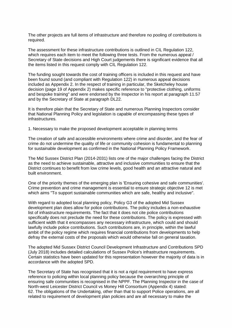
The other projects are full items of infrastructure and therefore no pooling of contributions is required. The assessment for these infrastructure contributions is outlined in CIL Regulation 122, which requires each item to meet the following three tests. From the numerous appeal / Secretary of State decisions and High Court judgements there is significant evidence that all the items listed in this request comply with CIL Regulation 122. The funding sought towards the cost of training officers is included in this request and have been found sound (and compliant with Regulation 122) in numerous appeal decisions included as Appendix 2. In the respect of training in particular, the Sketcheley house decision (page 19 of Appendix 2) makes specific reference to "protective clothing, uniforms and bespoke training" and were endorsed by the Inspector in his report at paragraph 11.57 and by the Secretary of State at paragraph DL22. It is therefore plain that the Secretary of State and numerous Planning Inspectors consider that National Planning Policy and legislation is capable of encompassing these types of infrastructures. 1. Necessary to make the proposed development acceptable in planning terms The creation of safe and accessible environments where crime and disorder, and the fear of crime do not undermine the quality of life or community cohesion is fundamental to planning for sustainable development as confirmed in the National Planning Policy Framework. The Mid Sussex District Plan (2014-2031) lists one of the major challenges facing the District as the need to achieve sustainable, attractive and inclusive communities to ensure that the District continues to benefit from low crime levels, good health and an attractive natural and built environment. One of the priority themes of the emerging plan is 'Ensuring cohesive and safe communities'. Crime prevention and crime management is essential to ensure strategic objective 12 is met which aims "To support sustainable communities which are safe, healthy and inclusive". With regard to adopted local planning policy, Policy G3 of the adopted Mid Sussex development plan does allow for police contributions. The policy includes a non-exhaustive list of infrastructure requirements. The fact that it does not cite police contributions specifically does not preclude the need for these contributions. The policy is expressed with sufficient width that it encompasses any necessary infrastructure, which could and should lawfully include police contributions. Such contributions are, in principle, within the lawful ambit of the policy regime which requires financial contributions from developments to help defray the external costs of the proposals which would otherwise fall on general taxation. The adopted Mid Sussex District Council Development Infrastructure and Contributions SPD (July 2018) includes detailed calculations of Sussex Police's infrastructure requirements. Certain statistics have been updated for this representation however the majority of data is in accordance with the adopted SPD. The Secretary of State has recognised that it is not a rigid requirement to have express reference to policing within local planning policy because the overarching principle of ensuring safe communities is recognised in the NPPF. The Planning Inspector in the case of North-west Leicester District Council vs Money Hill Consortium (Appendix 4) stated: 62. The obligations of the Undertaking, other than that to support Police operations, are all related to requirement of development plan policies and are all necessary to make the
development acceptable in planning terms. They are all furthermore, directly related to the development, are fairly and reasonably related in scale and kind to the development, and are in place to mitigate the effects of the development. The Legal Agreement, setting aside the Police contributions, therefore complies with Regulation 122 of the CIL Regulations 2010. Furthermore, taking into account the submissions of NWLDP, LCC and LP, the Agreement complies with Regulation 123 of the CIL Regulations 2010. 63. The contributions of £219,029 towards Police infrastructure is not related to requirement of development plan policies. The figure has been arrived at following a close and careful analysis of the current levels of policing demand and deployment in Ashby. The proposed development, in terms of population increase, would have a quantifiable and demonstrable effect on the ability of the Police to carry out their statutory duties in the town. LP has not sought any contribution to some aspects of policing, such as firearms and forensics, but only for those where there is no additional capacity. The contribution is necessary because the new housing that would be created would place a demonstrable additional demand on Police resources in Ashby. The financial contributions to Police operations thus satisfies Regulation 122 of the Community Infrastructure Levy Regulations 2010 and a provision of the Undertaking would ensure that the contribution also satisfies Regulation 123 of the Community Infrastructure levy Regulations 2010. The importance of policing contributions is importantly recognised in recent court judgments and considered an essential core principle of the NPPF. The judgment of Mr Justice Green 01/11/2016 (Appendix 1) with regard to the High Court challenge of Jelson Limited vs Secretary of State for Community and Local Government (1) Hinkley and Bosworth District Council stated: "The gist of the Inspectors reasons are adequately set out in paragraphs [44]-[47] (see above). She records that LP has adequately demonstrated that the sums would be spent on equipment and services which arose ".. Directly from the new households occupying the proposed development". Accordingly she concluded, in terms of causality, that there was a proper nexus between the expenditure and the new development. She also records that the proposed spending was properly attributed between individual projects and procurement such as property adaption and contributions towards a vehicle in order to prevent a need for pooling contributions". "Mr Lambert cited empirical data based upon existing crime patterns and policing demand and deployment from nearby residential areas which established the direct and additional impacts of the development upon local policing. That data established that there would be an incremental demand in relation to such matters as calls and responses per year via the police control centre; an increase in annual emergency events within the proposed development; additional local non-emergency events which trigger follow-up with the public; additional recorded crimes in the locality based upon beat crime and household data and a proportionate increase in anti-social behaviour incidents an increase in demand of patrol cover; and, an increase in the use of vehicles equating to 12% of an additional vehicle over a six year period." Moreover, the wider principles of sustainable development within the NPPF also require consideration of all necessary infrastructure requirements, as observed by Foskett J in R. (Police and Crime Commissioner for Leicestershire) v Blaby DC and others. This judgment stated: 11. It is obvious that a development of the nature described would place additional burdens on local health, education and other services including the police force. The focus in this case is upon the effect upon the local police force. If it sought to shoulder those additional and increased burdens without necessary equipment (including vehicles and radio
transmitters/receivers for emergency communications) and premises, it would plainly not be in the public interest and would not be consistent with a policy that encourages "sustainable development": see for example, paragraphs 17 of 79 of the National Planning Policy Framework (NPPF). It is that that leads to the Claimants interest in the matters". As shown in section 1, there is no dedicated Government funding to comprehensively cover the capital costs associated with policing new housing development. Unless contributions from new developments are secured then Sussex Police would be unable to maintain the current levels of policing with resources diverted and stretched, inevitably leading to increased incidents of crime and disorder within the local area. Sussex Police strive the reduce the level of crime in the County however due to the significant numbers of new housing being brought forward the need for more front line staff and associated infrastructure has never been more relevant as a fundamental planning policy consideration. Appeal decision APP/C3240/W/16/314445 (Appendix 2) issued on the 21st March 2017 provides further support for developer contributions towards the capital costs of additional policing infrastructure arising from new development. The Planning Inspector stated: 165: There is no doubt that the proposed development would generate a need for policing and that need would require additional resources which have been calculated on a pro-rata dwelling basis. The Framework identifies a need for safe and accessible environments where crime and disorder, and the fear of crime, do not undermine quality of life or community cohesion. In addition, an extensive array of appeal decision supports the principle of police contributions. Overall, the balance of the evidence before me points to the obligation (based on the underlying pro-rata calculation) being necessary and proportionate mitigation for the development. We would also bring to attention dicta from the High Court judgment by Mr Justice Foskett in Police and Crime Commissioner for Leicestershire vs Blaby Council. Paragraph 61 and 62 of the judgment state: 61. I do not, with respect, agree that the challenge mounted by the Claimant in this case can be characterised as a quibble of a minor factor. Those who, in due course, purchase properties on this development, who bring up children there and who wish to go about their daily life in a safe environment, will want to know that the police service can operate efficiently and effectively in the area. That would want to know that the police service can operate efficiently and effectively in the area. That would plainly be "consumer view" of the issue. The providers of the service (namely, the Claimant) have statutory responsibilities to carry out and, as the witness statement of the Chief Constable makes clear, that itself can be a difficult objective to achieve in these financially difficult times. Although the sums at stake for the police contributions will be small in comparison to the huge sums that will be required to complete the development, the sums are large from the point of view of the police. 62. I am inclined to the view that if a survey of local opinion was taken, concerns would be expressed if it were thought that the developers were not going to provide police with sufficient contribution to its funding requirements to meet the demands of policing the new area: lawlessness in one area can have effects in another nearby area. Miss Wigley, in my judgment, makes some entirely fair points about the actual terms of the section 106 Agreement so far as they affect the Claimant. Appeal decision APP/K2420/W/15/3004910 provides further evidence for developer contributions towards necessary policing infrastructure required to enable effective policing of new housing development. The Planning Inspector supported the methodology used for
this calculation and compliance with the specific capital infrastructure items detailed in our request. 44. Leicestershire Police (LP) have demonstrated adequately that the sums request would be spent on a variety of essential equipment and services, the need for which would arise directly from the new households occupying the proposed development. It would be necessary, there, in order to provide on-site and off-site infrastructure and facilities to serve the development commensurate with its scale and nature consistent with LP Policy IMP1. The planning contribution would also enable the proposed development to comply with the Framework's core planning principle of supporting local strategies to improve health, social and cultural wellbeing and delivering sufficient community facilities to meet local needs". In respect of the methodology used for this request the same Planning Inspector stated "47 - I consider this to be a no less realistic and robust method of demonstrating the criminal incidents likely to arise in a specific area than the analysis of population data which is normally used to calculate the future demand for school places. The evidence gives credence to the additional calls and demands on the police service predicted by LP". A financial contribution towards essential policing infrastructure is clearly essential to make new housing development acceptable in planning terms. The policing infrastructure items outlined in this request are essential to help support new officers required due to population growth and most importantly keep existing and future residents of Mid Sussex safe. 2. Directly related to the proposed development There is a functional link between new development and the contributions requested. Put simply without new development taking place and the subsequent population growth there would be no requirement for the additional infrastructure. The additional population growth will lead to an increase in incidents, which will require a Police response. The infrastructure outlined in this request has been specifically identified by the NPT/NRT teams policing the areas of Mid Sussex as necessary to deal with the likely form, scale and intensity of incidents this new housing development will generate. 3. Fairly and reasonably related in scale and kind to the proposed development. Securing proportionate developer contributions towards necessary capital expenditure is essential to help meet a proportionate increase in police infrastructure costs and to enable Sussex Police to maintain its current level of service in the District. This infrastructure has been identified by Sussex Police as necessary to provide an appropriate level of policing to serve the proposed development and maintain the existing high level of community safety. A clear numerical, evidence based approach has been demonstrated which is supported by case law and recent appeal decisions by the Planning Inspectorate. The various items of capital expenditure and infrastructure requested are considered CIL compliant and are necessary to enable new officers to undertake their role to meet the policing needs of the development and mitigate impacts to existing resources. A reasonable and proportionate approach has been adopted. We would also highlight two recent appeal decisions in Leicestershire (APP/F2415/A/12/2179844 and APP/X2410/A12/2173673, Appendix 2). In assessing the request from Leicestershire police for developer contributions towards infrastructure the Inspector commented at para 29 of decision 2179844; The written evidence submitted by Leicestershire Police detailed the impact the proposed development would have on policing, forecasting the number of potential incidents and the
anticipated effect this would have on staffing, accommodation, vehicles and equipment. In view of the requirement of national planning policy to create safe and accessible environments where crime and disorder, and the fear of crime, do not undermine quality of life, it is considered that, on the evidence before me, a contribution towards policing is necessary to make the development acceptable in planning terms. Furthermore with regard to appeal decision 2173673, the Inspector is unequivocal in highlighting the acceptability of police contributions being recipients of developer's contributions; Adequate policing is so fundamental to the concept of sustainable communities that I can see no reason, in principle, why it should be excluded from the purview of S106 financial contributions, subject to the relevant tests applicable to other public services. There is no reason, it seems to me why police equipment and other items of capital expenditure necessitated by additional development should not be so funded, alongside, for example, additional classrooms and stock and equipment for libraries. Para 292 These appeal decisions confirm that the approach of Sussex Police in assessing the impact of development, having regard to an assessment of the potential number of incidents generated by growth is appropriate, and fundamentally it confirms that police infrastructure should be subject to developer contributions as the provision of adequate policing is fundamental to the provision of sustainable development. Furthermore the requirement to ensure that crime and the fear of crime is addressed through the planning process runs through the revised NPPF (2018); Paragraph 20 (b) retains reference to 'security infrastructure' and advises that strategic policies should set out an overall strategy for the pattern, scale and quality of development, and make sufficient provision for: b) Infrastructure for transport, telecommunications, security, waste management, water supply, wastewater, flood risk and coastal change management, and the provision of minerals and energy (including heat). Paragraph 91 advises that planning policies should aim to achieve healthy, inclusive and safe places which: "are safe and accessible, so that crime and disorder, and the fear of crime, do not undermine the quality of life or community cohesion - for example through the use of clear and legible pedestrian routes, and high quality public space, which encourage the active and continual use of public areas. Paragraph 95 outlines the importance of engaging with the security services to inform planning policy decision and promote public safety and defence requirements. This will be achieved by: a) Anticipating and addressing possible malicious threats and natural hazards, especially in locations where large numbers of people are expected to congregate. Policies for relevant area (such as town centre and regeneration frameworks), and the layout and design of developments, should be informed by the most up-to-date information available from the police and other agencies about the nature of potential threats and their implications. This includes appropriate and proportionate steps that can be taken to reduce vulnerability, increase resilience and ensure public safety and security; and

b) Recognising and supporting development required for operational defence and security purposes, and ensuring that operational sites are not affected adversely by the impact of other development proposed in the area. The Glossary to the new NPPF includes an entry entitled 'Essential Local Worker'. It states 'these are public sector employees who provide frontline services in areas including health, education and community safety - such as NHS Staff, teachers, police, firefighters and military personnel, social care and childcare workers'. This recognises the emergency services as essential for the public, alongside education and health. I trust this sets out sufficiently our office's request for infrastructure contributions relating to this major development of 'The Northern Arc' in Burgess Hill. I am more than happy to discuss the content of this submission with yourselves and support with any further evidence if considered necessary.
(See over page for ‘Part A’ table)
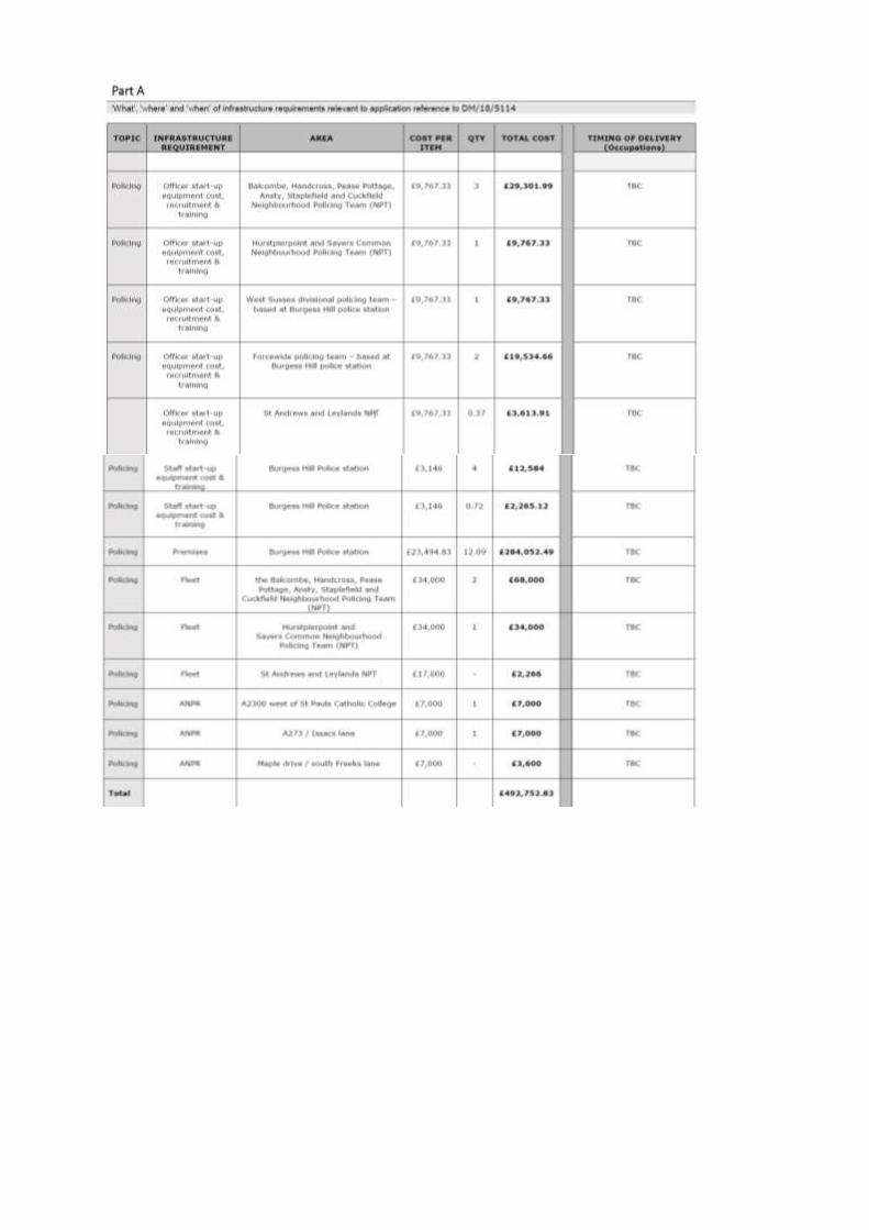

Sussex Police Crime Prevention Thank you for your correspondence of 15th January 2019, advising me of an outline planning application for a comprehensive, phased, mixed-use development comprising approximately 3,040 dwellings including 60 units of extra care accommodation (Use Class C3) and six permanent gypsy and traveller pitches, including a Centre for Community Sport with ancillary facilities (Use Class D2), three local centres (comprising Use Classes A1-A5 and A1-A5 and B1, and stand-alone community facilities within Use Class D1), healthcare facilities (Use Class D1), and employment development comprising a 4 hectare dedicated business park (Use Cl asses B1 and B2), two primary school campuses and a secondary school campus (Use Class D1), public open space, recreation areas, play areas, associated infrastructure including pedestrian and cycle routes, roads, car parking, bridges, landscaping, surface water attenuation, recycling centre and waste collection infrastructure with associated demolition of existing buildings and structures, earthworks, temporary and permanent utility infrastructure and associated works. All matters reserved except for access. Full planning permission is sought at this time for the following highway access works: new roundabout on the A2300 at the above location, for which you seek advice from a crime prevention viewpoint. I have had the opportunity to examine the detail within the application and in an attempt to reduce the opportunity for crime and the fear of crime I offer the following comments. The National Planning Policy Framework demonstrates the government's aim to achieve healthy, inclusive and safe places which are safe and accessible, so that crime and disorder, and the fear of crime, do not undermine the quality of life or community cohesion. With the level of crime and anti-social behaviour in Mid Sussex district being below average when compared with the rest of Sussex, I have no major concerns with the proposals, however, additional measures to mitigate against any identified local crime trends should be considered. Given that this outline application is only to determine the means of access and to seek approval in principle, I have no detailed comment to make at this stage. At the reserved matters stage I would encourage the applicant to update the Design and Access Statement to include appropriate measures for crime prevention and community safety using the principles of Secured by Design and the attributes of safe, sustainable places. These are;
Access and movement - places with well-defined routes, spaces and entrances that provide for convenient movement without compromising security.
Structure - places that are structured so that different uses do not cause conflict.
Surveillance - places where all publicly accessible spaces are overlooked.
Ownership - places that promote a sense of ownership, respect, territorial responsibility and community.
Physical protection - places that include necessary, well designed security features.
Activity - places where the level of human activity is appropriate to the location and creates a reduced risk of crime and a sense of safety at all times.
Management and maintenance - places that are designed with management and maintenance in mind, to discourage crime in the present and the future.
I ask that the applicant visit the Secured by Design (SBD) website at www.securedbydesign.com where in-depth crime prevention advice can be found for;
Residential developments
Commercial / Retail developments
Schools. I thank you for allowing me the opportunity to comment and look forward to providing more in-depth comments at the reserved matters stage. I would also ask you to note that Sussex Police is now exploring the impact of growth on the provision of policing infrastructure over the coming years and further comment on this application may be made by our Joint Commercial Planning Manager. The Crime and Disorder Act 1998 heightens the importance of taking crime prevention into account when planning decisions are made. Section 17 of the Act places a clear duty on both police and local authorities to exercise their various functions with due regard to the likely effect on the prevention of crime and disorder. You are asked to accord due weight to the advice offered in this letter which would demonstrate your authoritys’ commitment to work in partnership and comply with the spirit of The Crime and Disorder Act. South Downs National Park Thank you for consulting the South Downs National Park Authority (as a neighbouring authority) on the above outline application for a mixed use development of 3,040 dwellings. Although the application site is located outside of the National Park, the Council has a statutory duty to consider the Purposes of the National Park when making its determination. The statutory purposes and duty of the National Park are:
Purpose 1: To conserve and enhance the natural beauty, wildlife and cultural heritage of the area.
Purpose 2: To promote opportunities for the understanding and enjoyment of the special qualities of the National Park by the public.
Duty: To seek to foster the social and economic wellbeing of the local communities within the National Park in pursuit of our purposes.
The development is proposed to be sited to the north and northeast of Burgess Hill, and the National Park boundary lies some 2.5-3km to the south of the town. It is therefore considered that there would be minimal impact on the setting of the National Park. The SDNPA makes no comment on the principle of development, however would recommend that consideration be given to the International Dark Night Skies Reserve and dark night skies, which are a special quality of the National Park. The South Downs National Park is a designated International Dark Sky Reserve and dark skies and tranquillity are a special quality of the National Park which need to be protected. Paragraph 180(c) of the NPPF 2018 outlines that development should limit the impact of light pollution on intrinsically dark landscapes and nature conservation. Although the site is located some distance from the National Park boundary, the SDNPA would encourage a

sensitive approach to lighting which conforms the Institute of Lighting Professionals for lighting in environmental zones, and tries to achieve zero upwards light spill in all respects. Any lighting should also take into account the biodiversity sensitivities of the site and not disturb or harm wildlife. The Council's biodiversity officer should be able to advise further on this. Further information/advice on sensitive lighting can be found in the SDNPA's Dark Skies Technical Advice Note 2018 which is available at the following link (document TLL 10): https://www.southdowns.gov.uk/planning/national-park-local-plan/local-plan-examination/coredocument-library/ Consideration should also be given to the creation of links between the development and the National Park to encourage public enjoyment and amenity of public rights of way where possible. Natural England - Original comments Thank you for your consultation on the above, dated and received by Natural England on 15 January 2019. Natural England is a non-departmental public body. Our statutory purpose is to ensure that the natural environment is conserved, enhanced, and managed for the benefit of present and future generations, thereby contributing to sustainable development. SUMMARY OF NATURAL ENGLAND'S ADVICE NO OBJECTION Based on the plans submitted, Natural England considers that the proposed development will not have significant adverse impacts on statutorily protected sites or landscapes. Natural England's advice on other natural environment issues is set out below. Green Infrastructure The proposed development is within an area that Natural England considers could benefit from enhanced green infrastructure (GI) provision. Multi-functional green infrastructure can perform a range of functions including improved flood risk management, provision of accessible green space, climate change adaptation and biodiversity enhancement. Natural England would encourage the incorporation of GI into this development. Priority Habitat as identified on Section 41 list of the Natural Environmental and Rural Communities (NERC) Act 2006 The consultation documents indicate that this development includes areas of priority habitat, as listed on Section 41 of the Natural Environmental and Rural Communities (NERC) Act 2006.
Ancient Woodland Natural England advises that the proposals as presented have the potential to adversely affect woodland classified on the ancient Woodland Inventory. Natural England refers you to our Standing Advice on ancient woodland https://www.gov.uk/ancient-woodland-and-veteran-trees-protectionsurveys-licences. Sites of Special Scientific Interest Impact Risk Zones The Town and Country Planning (Development Management Procedure) (England) Order 2015 requires local planning authorities to consult Natural England on "Development in or likely to affect a Site of Special Scientific Interest" (Schedule 4, w). Our SSSI Impact Risk Zones are a GIS dataset designed to be used during the planning application validation process to help local planning authorities decide when to consult Natural England on developments likely to affect a SSSI. The dataset and user guidance can be accessed from the data.gov.uk website. Further general advice on the consideration of protected species and other natural environment issues is provided at Annex A. We would be happy to comment further should the need arise but if in the meantime you have any queries please do not hesitate to contact us. For any queries regarding this letter, for new consultations, or to provide further information on this consultation please send your correspondences to [email protected]. In addition to our letter ref. HA/2019/121046/01-L01 dated 08 February 2019, we have the following comments, in light of the additional information provided by AECOM. The following documents submitted with the planning application ref. DM/18/5114 were reviewed as part of this response:
Flood Risk Assessment (FRA) and Appendices dated December 2018 written by AECOM.
Location of bridges, land parcels and main roads in relation to flood risk ref. 60578790-ACM-XX-XX-DR-FL-000102 dated 25/06/2019
Technical Note dated 25 June 2019 written by AECOM We noted some inaccuracies in the latest information provided in the Technical Note dated 25 June 2019 written by AECOM. Appendix B 'Land parcels, roads and flood extents map' (ref. 60578790-ACM-XX-XX-DR-FL-000102 does not show the Copyhold Stream flood extents; the correct map is dated 25/06/2019. Appendix A 'Location of existing water features map' (ref. 0578790-ACM-XX-XX-DR-FL-000101) is incorrectly showing the Copyhold Stream as main river, it is an ordinary watercourse. The modelling undertaken by AECOM in relation to the new fluvial climate change allowances must be peer reviewed by the Environment Agency. This process can take up to 3-4 months, sometimes more. Please contact us as soon as possible on the details below with the model report and model files for review. In relation to the proposed 8 metre buffer zone around the watercourses clarification as to where the 8 meter starts needs to be provided. This should be from top of the river bank or from landward toe of any raised flood embankment.
We have no objection to the proposed development as submitted, subject to the inclusion of the following condition, in any permission granted. We consider that planning permission could be granted to the proposed development, as submitted, if the following planning condition is included as set out below. Without this condition, the proposed development on this site poses an unacceptable risk to the environment and we would object to the application. Condition All residential dwelling shall be located outside the 1% AEP flood extent plus 105% climate change allowance as shown in drawing reference 60578790-ACM-XX-XX-DR-FL-000102 dated 25/06/2019. All river crossings should be clear span bridges. Details of each river crossing shall be provided at the reserve matters application stage. The modelling undertaken by AECOM in relation to the new fluvial climate change allowances shall be peer reviewed by the Environment Agency before the approval of any reserved matters application. An 8 metre buffer zone from top of the river bank or from landward toe of any raised flood embankment should be provided around all main rivers (River Adur East Branch and Wolds End Stream). Adequate flood plain compensation up to the 1% AEP flood extent plus 105% climate change allowance, shall be provided at the reserve matters application stage if there is a loss of flood plain as a result of the essential infrastructures (roads and bridges) located within the aforementioned flood extent. Reasons To reduce the risk of flooding to the proposed development and future occupants To ensure the modelled climate change flood extents used in the FRA are appropriate To ensure access to the rivers for future maintenance/improvements works and preserve the structural integrity of the river banks thereby reducing the risk of flooding To prevent flooding elsewhere by ensuring that compensatory storage of flood water is provided Advice to Local Planning Authority/Applicant Flood Risk Activity Permit The Environmental Permitting (England and Wales) Regulations 2016 require a flood risk activity permit to be obtained for any activities which will take place:
on or within 8 metres of a main river (16 metres if tidal)
on or within 8 metres of a flood defence structure or culvert (16 metres if tidal)
on or within 16 metres of a sea defence
involving quarrying or excavation within 16 metres of any main river, flood defence (including a remote defence) or culvert
in a floodplain more than 8 metres from the river bank, culvert or flood defence structure (16 metres if it's a tidal main river) and you don't already have planning permission.
For further guidance please visit https://www.gov.uk/guidance/flood-risk-activities-environmental-permits or contact [email protected]. The applicant should not assume that a permit will automatically be forthcoming once planning permission has been granted, and we advise them to consult with us at the earliest opportunity. Natural England - Additional comments Natural England is a non-departmental public body. Our statutory purpose is to ensure that the natural environment is conserved, enhanced, and managed for the benefit of present and future generations, thereby contributing to sustainable development. SUMMARY OF NATURAL ENGLAND'S ADVICE NO OBJECTION Based on the plans submitted, Natural England considers that the proposed development will not have significant adverse impacts on statutorily protected nature conservation sites or landscapes. Natural England's generic advice on other natural environment issues is set out at Annex A. Sites of Special Scientific Interest Impact Risk Zones The Town and Country Planning (Development Management Procedure) (England) Order 2015 requires local planning authorities to consult Natural England on "Development in or likely to affect a Site of Special Scientific Interest" (Schedule 4, w). Our SSSI Impact Risk Zones are a GIS dataset designed to be used during the planning application validation process to help local planning authorities decide when to consult Natural England on developments likely to affect a SSSI. The dataset and user guidance can be accessed from the data.gov.uk website Further general advice on the consideration of protected species and other natural environment issues is provided at Annex A. We would be happy to comment further should the need arise but if in the meantime you have any queries please do not hesitate to contact us. For any queries regarding this letter, for new consultations, or to provide further information on this consultation please send your correspondences to [email protected]. Consultations Annex A - Additional advice Natural England offers the following additional advice: Landscape Paragraph 170 of the National Planning Policy Framework (NPPF) highlights the need to protect and enhance valued landscapes through the planning system. This application may present opportunities to protect and enhance locally valued landscapes, including any local
landscape designations. You may want to consider whether any local landscape features or characteristics (such as ponds, woodland or dry stone walls) could be incorporated into the development in order to respect and enhance local landscape character and distinctiveness, in line with any local landscape character assessments. Where the impacts of development are likely to be significant, a Landscape and Visual Impact Assessment should be provided with the proposal to inform decision making. We refer you to the Landscape Institute Guidelines for Landscape and Visual Impact Assessment for further guidance. Best and most versatile agricultural land and soils Local planning authorities are responsible for ensuring that they have sufficient detailed agricultural land classification (ALC) information to apply NPPF policies (Paragraphs 170 and 171). This is the case regardless of whether the proposed development is sufficiently large to consult Natural England. Further information is contained in GOV.UK guidance Agricultural Land Classification information is available on the Magic website on the Data.Gov.uk website. If you consider the proposal has significant implications for further loss of 'best and most versatile' agricultural land, we would be pleased to discuss the matter further. Guidance on soil protection is available in the Defra Construction Code of Practice for the Sustainable Use of Soils on Construction Sites, and we recommend its use in the design and construction of development, including any planning conditions. Should the development proceed, we advise that the developer uses an appropriately experienced soil specialist to advise on, and supervise soil handling, including identifying when soils are dry enough to be handled and how to make the best use of soils on site. Protected Species Natural England has produced standing advice1 to help planning authorities understand the impact of particular developments on protected species. We advise you to refer to this advice. Natural England will only provide bespoke advice on protected species where they form part of a SSSI or in exceptional circumstances. Local sites and priority habitats and species You should consider the impacts of the proposed development on any local wildlife or geodiversity sites, in line with paragraphs 171 and174 of the NPPF and any relevant development plan policy. There may also be opportunities to enhance local sites and improve their connectivity. Natural England does not hold locally specific information on local sites and recommends further information is obtained from appropriate bodies such as the local records centre, wildlife trust, geoconservation groups or recording societies. Priority habitats and Species are of particular importance for nature conservation and included in the England Biodiversity List published under section 41 of the Natural Environment and Rural Communities Act 2006. Most priority habitats will be mapped either as Sites of Special Scientific Interest, on the Magic website or as Local Wildlife Sites. List of priority habitats and species can be found here2. Natural England does not routinely hold species data, such data should be collected when impacts on priority habitats or species are considered likely. Consideration should also be given to the potential environmental value of brownfield sites, often found in urban areas and former industrial land, further information including links to the open mosaic habitats inventory can be found here. Ancient woodland, ancient and veteran trees You should consider any impacts on ancient woodland and ancient and veteran trees in line with paragraph 175 of the NPPF. Natural England maintains the Ancient Woodland Inventory which can help identify ancient woodland. Natural England and the Forestry Commission have produced standing advice for planning authorities in relation to ancient woodland and ancient and veteran trees. It should
be taken into account by planning authorities when determining relevant planning applications. Natural England will only provide bespoke advice on ancient woodland, ancient and veteran trees where they form part of a SSSI or in exceptional circumstances. Environmental enhancement Development provides opportunities to secure net gains for biodiversity and wider environmental gains, as outlined in the NPPF (paragraphs 8, 72, 102, 118, 170, 171, 174 and 175). We advise you to follow the mitigation hierarchy as set out in paragraph 175 of the NPPF and firstly consider what existing environmental features on and around the site can be retained or enhanced or what new features could be incorporated into the development proposal. Where onsite measures are not possible, you should consider off site measures. Opportunities for enhancement might include: Providing a new footpath through the new development to link into existing rights of way. Restoring a neglected hedgerow. Creating a new pond as an attractive feature on the site. Planting trees characteristic to the local area to make a positive contribution to the local landscape. Using native plants in landscaping schemes for better nectar and seed sources for bees and birds. Incorporating swift boxes or bat boxes into the design of new buildings. Designing lighting to encourage wildlife. Adding a green roof to new buildings. You could also consider how the proposed development can contribute to the wider environment and help implement elements of any Landscape, Green Infrastructure or Biodiversity Strategy in place in your area. For example: Links to existing greenspace and/or opportunities to enhance and improve access. Identifying opportunities for new greenspace and managing existing (and new) public spaces to be more wildlife friendly (e.g. by sowing wild flower strips) Planting additional street trees. Identifying any improvements to the existing public right of way network or using the opportunity of new development to extend the network to create missing links. Restoring neglected environmental features (e.g. coppicing a prominent hedge that is in poor condition or clearing away an eyesore). Access and Recreation Natural England encourages any proposal to incorporate measures to help improve people's access to the natural environment. Measures such as reinstating existing footpaths together with the creation of new footpaths and bridleways should be considered. Links to other green networks and, where appropriate, urban fringe areas should also be explored to help
promote the creation of wider green infrastructure. Relevant aspects of local authority green infrastructure strategies should be delivered where appropriate. Rights of Way, Access land, Coastal access and National Trails Paragraphs 98 and 170 of the NPPF highlights the important of public rights of way and access. Development should consider potential impacts on access land, common land, rights of way, coastal access routes and coastal margin in the vicinity of the development and the scope to mitigate any adverse impacts. Consideration should also be given to the potential impacts on any nearby National Trails, including the England Coast Path. The National Trails website www.nationaltrail.co.uk provides information including contact details for the National Trail Officer. Page 5 of 5 Biodiversity duty Your authority has a duty to have regard to conserving biodiversity as part of your decision making. Conserving biodiversity can also include restoration or enhancement to a population or habitat. Further information is available here. Ramblers Association On behalf of Ramblers (Sussex Area) I object to the part of this planning application applicable to Wivelsfield, East Sussex for the following reasons:
Unwelcome urban encroachment into rural Wivelsfield parish;
Potential adverse impact on Theobolds Road which becomes Wivelsfield bridleway and leading to adjacent footpaths;
Loss of greenfield site as a visual amenity, easily accessible to residents of Burgess Hill;
According to Wivelsfield Parish Council minutes (24/01/19), development on this part of the site is contrary to Wivelsfield Neighbourhood Plan;
Reduction of strategic gap between Burgess Hill and Haywards Heath which, with ongoing development south of the latter alongside new A272, could be reduced to less than 2km;
Whilst development to the west of railway would have good connectivity with main roads (A2300 and A273), any development to the east does not;
With such a large proposed development, the part in Mid Sussex District should be more than sufficient to meet housing needs in this area without the need for Lewes District part;
Lewes District Council should not seek to fulfil its housing allocation by permitting development at the extremity of the District in a rural location.
Lack of information on Lewes District Council website such that searching for documents reveals only "No documents are available".
Therefore I urge the Council(s) to refuse this part of the above Planning Application. Environment Agency - original comments Thank you for the consultation on the above application, please quote our reference on all correspondence. We have reviewed the information as submitted and have the following comments. Environment Agency Position
Flood Risk According to our Flood Map for Planning (Rivers and the Sea) most of the site is within Flood Zone 1 with some Flood Zone 2/3 areas within the narrow flood plains of the River Adur and the tributary within the site. The flood risk assessment (AECOM, December 2018) states that all built development will be kept outside of this area. There should also be no land raising in these areas, flood compensation would need to be provided, if this is proposed. All river crossings should be clear span bridges as we have a presumption against culverting of watercourses because of the adverse ecological, flood defence and other effects that are likely to arise. We would only approve an application to culvert a watercourse if there is no reasonably practicable alternative or if the detrimental effects of culverting would be so minor that they would not justify a more costly alternative. In all cases where it is appropriate to do so adequate mitigation must be provided for damage caused. Wherever practical we will seek to have culverted watercourses restored to open channels. We expect a range of climate change allowances (in particular 45% and 105% increase in river flow) to be assessed as part of the river crossing design, and the impact that the structure is going to have on flood risk upstream and downstream. The applicant will have to justify which allowance they decide to use for the final design. We advise to use a freeboard of at least 600mm on top of the climate change allowance level. Fisheries, Biodiversity and Geomorphology Brown trout, stone loach, bullhead, eel and migratory salmonids (sea trout) along with high priority species that are likely to be present on site, such as water vole and white-clawed crayfish have been considered into the environmental scope. Impacts on these species and habitats have been assessed and declared as minor after completion of the project. Our concern is that the construction and implementation of several vehicular bridges and pedestrian bridges, as well as the increased recreation along the watercourses will pose an ecological threat greater than expected (currently minor), and furthermore while it is considered to be only local or district level importance, both the habitats and species are NERC listed. We suggest that further mitigation within the watercourse should be strongly considered to reduce the impacts of construction around the site in line with WFD aims to bring watercourses to good status. Vehicular and Pedestrian Bridges The building of bridges over the watercourse will impact the ecology associated through damaging and removing riparian flora which fragments habitat and acts as an obstruction to terrestrial and aquatic animals. The construction of bridges will also alter the bed and bank of the river, change deposition, depth and velocity of the water which may result in a loss/ change of riparian flora, invertebrates and fish. It may also damage any natural features within the river which are already uncommon along this section. Furthermore, the introduction of bridges will also increase the likelihood of pollutants entering the stream, reducing the water quality and impacting the ecology. The design of any bridge will therefore need to reduce the impact on ecology and mitigate for the associated impacts. Bridges should therefore allow for the riparian corridor to remain intact and without obstruction and the river should not be deepened or widened. The design should fit in with the following considerations:
All bridges shall be clear spanning structures with the abutments set back from the watercourse on both banks to provide a bank width of a minimum of 2 metres beneath the bridge. Bridges shall be a minimum of 2 metres from the bank top of the watercourse to provide an unobstructed corridor to allow the movements of otters and other animals. Habitat should be created to compensate for the loss of habitat. This could include designing the bridge to encourage nesting/roosting bats and birds and all kinds of stream/ river enhancement techniques. Currently, listed within the design guide is vegetation management and stream enhancement, this will be set out in future designs, and we would suggest mitigation should focus on reducing sedimentation along the river, re-storing natural features, improve flow variation and to improve the longitudinal connectivity through the stream for migratory eel and salmonids. Bridges should also aim to restrict and minimise pollutants entering the stream, a sufficient surface water run off system should be designed so polluted water does not directly enter the stream and so that water can be filtered. Recreation The suggestion to open the river as a recreational resource will encourage its protection. This should be designed carefully in order to minimise disturbance to riparian ecology. Furthermore, it would be beneficial to design in 'wild spots' where access is limited which would restrict footfall as to allow wildlife to remain undisturbed and undamaged. SuDS The design of attenuation ponds should be capable of dealing with the worst case of surface run-off to avoid significantly affecting water quality within the watercourses located on site. They should be prioritised over detention basins and underwater storage to improve biodiversity gain and should hold sufficient levels of water throughout the year. Recreation has been encouraged around SuDS ponds in the designs but there should exist ones with minimal footfall to avoid disturbance and damage to the related ecology. If possible, checked dams proposed in swales should use more natural looking materials. Swales will also need to be maintained due to the build-up of dropped sediment overtime. Surface Outfalls From an ecological perspective, this should be limited as much as possible, as it is highly likely to affect ecology through altering water quality. It should avoid sites where there is a high ecological value. If outfalls were installed, we'd advise such methods as bio-retention systems to be put in place before reaching the main stream to avoid reducing water quality. Further mitigation will also be necessary within the watercourse including downstream of the site to offset the impacts with pollutants entering the stream and river network. Advice to Local Planning Authority/Applicant Flood Risk Activity Permit The Environmental Permitting (England and Wales) Regulations 2016 require a flood risk activity permit to be obtained for any activities which will take place:
on or within 8 metres of a main river (16 metres if tidal)
on or within 8 metres of a flood defence structure or culvert (16 metres if tidal)
on or within 16 metres of a sea defence
involving quarrying or excavation within 16 metres of any main river, flood defence (including a remote defence) or culvert
in a floodplain more than 8 metres from the river bank, culvert or flood defence structure (16 metres if it's a tidal main river) and you don't already have planning permission.
For further guidance please visit https://www.gov.uk/guidance/flood-risk-activities-environmental-permits or contact our National Customer Contact Centre on 03702 422 549. The applicant should not assume that a permit will automatically be forthcoming once planning permission has been granted, and we advise them to consult with us at the earliest opportunity. Should you have any further queries please do not hesitate to contact me. Environment Agency - further comments Thank you for consulting the Environment Agency on the above application. In addition to our comments in our previous response (reference HA/2019/121046/02 dated 24/07/19) we have the following comments. Environment Agency Position We have no objection to the proposed development as submitted, subject to the inclusion of the following condition, in any permission granted. We consider that planning permission could be granted to the proposed development, as submitted, if the following planning condition is included as set out below. Without this condition, the proposed development on this site poses an unacceptable risk to the environment and we would object to the application. Condition No development shall take place until mitigation/enhancement plans for the River Adur have been submitted to, and agreed in writing by, the local planning authority and implemented as approved. Thereafter, the development shall be implemented in accordance with the approved scheme. Reason The National Planning Policy Framework (paragraph 175) states that if significant harm resulting from a development cannot be avoided (through locating on an alternative site with less harmful impacts), adequately mitigated, or, as a last resort, compensated for, then planning permission should be refused. Should you have any further queries please do not hesitate to contact me. Aerodrome Safeguarding on behalf of Gatwick Airport Thank you for your email/letter dated 19 August 2019, notifying us of amended/additional plans. The proposed development has been examined from an aerodrome safeguarding perspective and could conflict with safeguarding criteria unless any planning permission granted is subject to the conditions detailed below:
Submission of SUDS Details Development shall not commence until details of the Sustainable Urban Drainage Schemes (SUDS) have been submitted to and approved in writing by the Local Planning Authority. The submitted Plan shall include details of:
Attenuation times
Profiles and dimensions of water bodies
Details of marginal planting No subsequent alterations to the approved SUDS scheme are to take place unless first submitted to and approved in writing by the Local Planning Authority. The scheme shall be implemented as approved. Reason: To avoid endangering the safe movement of aircraft and the operation of Gatwick Airport through the attraction of Birds and an increase in the bird hazard risk of the application site. Submission of Water Landscaping Scheme No development shall take place until full details of water landscaping works have been submitted to and approved in writing by the Local Planning Authority. These details shall include:
Enhancement to existing ponds/waterways
Creation of any new ponds/waterways
Creation of any wetlands No subsequent alterations to the approved scheme are to take place unless submitted to and approved in writing by the Local Planning Authority. The scheme shall be implemented as approved. Reason: To avoid endangering the safe movement of aircraft and the operation of Gatwick Airport through the attraction of birds and an increase in the bird hazard risk of the application site. We will need to object to these proposals unless the above mentioned conditions are applied to any planning permission. We would also like to make the following observation: Cranes Given the nature of the proposed development it is possible that a crane may be required during its construction. We would, therefore, draw the applicant's attention to the requirement within the British Standard Code of Practice for the safe use of Cranes, for crane operators to consult the aerodrome before erecting a crane in close proximity to an aerodrome. Gatwick Airport requires a minimum of four weeks notice. For crane queries/applications please email [email protected] The crane process is explained further in Advice Note 4, 'Cranes and Other Construction Issues', (available from http://www.aoa.org.uk/policy-campaigns/operations-safety/)
As the application is for outline approval, it is important that Gatwick Airport Limited is consulted on all Reserved Matters relating to siting and design, external appearance (including lighting) and landscaping. If you have any queries please do not hesitate to contact me. It is important that the conditions requested in this response are applied to a planning approval. Where a Local Planning Authority proposes to grant permission against the advice of Gatwick Airport Limited, or not to attach conditions which Gatwick Airport Limited has advised, it shall notify Gatwick Airport Limited, and the Civil Aviation Authority as specified in the Town and Country Planning (Safeguarded Aerodromes, Technical Sites and Military Explosive Storage Areas) Direction 2002. Highways England - Original Comments Thank you for your letter requesting consultation with regards to the planning application for the Burgess Hill Northern Arc development in Burgess Hill. Highways England has been appointed by the Secretary of State for Transport as strategic highway company under the provisions of the Infrastructure Act 2015 and is the highway authority, traffic authority and street authority for the Strategic Road Network (SRN). The SRN is a critical national asset and, as such, Highways England works to ensure that it operates and is managed in the public interest, both in respect of current activities and needs, as well as in providing effective stewardship of its long-term operation and integrity. We will therefore be concerned with proposals that have the potential to impact the safe and efficient operation of the SRN, in this case the A23 trunk road and its junction with the A2300. The proposed development is a substantial extension to the town of Burgess Hill, providing a total of 3,040 dwellings, 24,000sqm of employment space, a number of schools and other community facilities. The site is included within the Mid Sussex District Plan (2014-2031) that was adopted on 28th March 2018. It is also the main site that will provide a total of 5,697 homes in Burgess Hill during the plan period. The site is covered within policy DP7: General Principles for Strategic Development at Burgess Hill of the Mid Sussex District Plan, which makes specific mention to the impact on the junction of the A2300 with the A23, specifically: Provide highway improvements in and around Burgess Hill including addressing the limitations of the A2300 link road and its junction with the A23 and east-west traffic movements across Burgess Hill and, where necessary, improvements across the highway authority boundary in East Sussex A Transport Assessment in support of the development was produced by AECOM, and this forms the main evidence reviewed by Highways England. The focus of this review being the impact that the proposals will have on the Strategic Road Network, which in the vicinity of the site is the A23. The residential trip generation for the proposed development was calculated by first using the TRICS database to calculate person trips, then using the Department of Transport National Travel Survey to assign journey purposes during the peak hours, and finally using 2011 census data to assign trips to the various modes of travel covered for each journey purpose.
Commuting and business trips were based upon TRICS, with mode share based upon the 2011 census table QS701EW- Method of travel to work. The mode split percentages in the TA appear to be based upon the results for Mid Sussex, with working from home and unemployed removed from the statistics. These are trips that originate from the new residential properties, trips to the proposed employment sites are calculated separately. Education trips for pupils have been assumed to be generated within the proposed development, and therefore have no impact on the wider road network. However, school staff trips have been assigned to the wider road network as it is recognised that staff are less likely to be living within the development. This is considered to be a reasonable methodology. Employment trips have been calculated using TRICS, with mode splits coming from 2011 census table WP703EW for Mid Sussex with working from home removed. This is considered to be reasonable, and the same data has been used for school staff trips. The impact of the development traffic has been assessed using the Burgess Hill Transport Model, which is a SATURN model. The area modelled includes the majority of the A23 between the M23 and Brighton, the A27 also falls within the modelled area but is quite remote from the site. Two future assessment years have been used, these being 2025 (with Phase 1 only) and 2037 (with full build out). The model includes a number of future infrastructure improvements, the main one relevant to the development being the dualling of the A2300 between the site access and the A23. Although this dualling has been considered as committed within the TA, it is understood that it is still to receive final confirmation of its funding. It is recognised within the TA that this improvement is critical to being able to accommodate the additional traffic generated by the development. The output from the transport modelling identified a number of areas that required mitigation, including the A2300/A23 junction. A proposal for improving one of the roundabouts at this junction was proposed, however, this is different to the agreed scheme which has been proposed separately by WSP on their drawing No. PRELIM_GA_011 Rev C of October 2018. In addition, the Road Safety Audit that is included with the development package does not consider these improvements. Highways England believe that the proposals within the TA could potentially lead to safety concerns and that this solution should not be considered. The final agreed scheme will need an independent Road Safety Audit in accordance with DMRB Standard GG119 and will need a Walking, Cycling and Horse Riding Assessment and Review in accordance with DMRB standard HD 42/17 before a final response can be made. Another area that is raised as requiring mitigation is the A272/London Road (leading to A23/A272 NB slips). It is noted that this junction would be expected to exceed capacity in 2037 without the addition of the development traffic, and that the increase in traffic due to the development is "relatively low". However, there are no mitigation measures proposed other than to state that the applicant will work with West Sussex County Council and Mid Sussex District Council to develop a mitigation package. The mitigation strategy is to deter development traffic from using this route to the A23. Highways England would like to be kept informed of any proposals that would deter development traffic from using this route, as well as the means of assessment used to determine the effectiveness of any solution proposed. As the development proposals rely on delivery of the A2300 dualling and the junction improvements at the A23 / A2300 mentioned above it will be necessary for Highways England to apply a Grampian style condition to restrict the number of occupancies prior to the completion of the dualling scheme. No analysis has been provided to indicate that at
what point in the buildout and occupancy of the development the existing A2300 and A23/A2300 junction require the planned improvements. On the basis of the above assessment, Highways England is not currently able to support the development proposals until further details of the proposals to mitigate the impact on the SRN are provided. This includes confirmation of the status of the A2300 widening along with junction improvements at the A2300/A23 roundabouts, and the proposals to deter development traffic from using the A272/A23 junction. Accordingly, we formally request that the Planning authority refrains from determining this application, (other than a refusal) until such time as we have received and considered all the requested information. Once we are able to adequately assess the above and its potential impact on the SRN, and this has been agreed with the applicant, we will provide you with our final formal response. If, in the meantime, you wish to determine the application, please let us know and we will provide you with a formal response based on the information available at that time. Should you have any queries regarding this matter, please contact me. Highways England - Additional Comments Highways England has been appointed by the Secretary of State for Transport as strategic highway company under the provisions of the Infrastructure Act 2015 and is the highway authority, traffic authority and street authority for the strategic road network (SRN). The SRN is a critical national asset and as such Highways England works to ensure that it operates and is managed in the public interest, both in respect of current activities and needs as well as in providing effective stewardship of its long-term operation and integrity. Highways England will be concerned with proposals that have the potential to impact on the safe and efficient operation of the SRN. In the case of this proposal, our interest relates to potential impacts upon the A23. I am emailing to advise that following our original response as attached, we are continuing to work with the applicant's transport consultant to resolve the outstanding matters, but may not be in a position to provide our full and final response within the 30 days requested. Until we reach this position and Highways England has a clear view of the impacts of this proposed development on the SRN (the tests set out in DfT C2/13 para 10 and DCLG NPPF para 32), our informal advice is that you should not approve this application because of the potential for harm to the Strategic Road Network. This email does not constitute a formal recommendation from Highways England. We will provide a formal recommendation later when we can be confident that the application is in its final form. In the meantime, we would ask that the authority does not determine the application (other than a refusal), ahead of us resolving the outstanding matters with the applicant's transport consultant. In the event that the authority wishes to permit the application before this point, we would ask the authority to inform us so that we can provide substantive responses based the position as known at that time. Highways England - Further Comments I can advise that we will be lifting our holding objection and providing a conditional response (i.e. with recommended planning conditions) as soon as we can, which we anticipate will be within the next few days
National Air Traffic Services Safeguarding The proposed development has been examined from a technical safeguarding aspect and does not conflict with our safeguarding criteria. Accordingly, NATS (En Route) Public Limited Company ("NERL") has no safeguarding objection to the proposal. However, please be aware that this response applies specifically to the above consultation and only reflects the position of NATS (that is responsible for the management of en route air traffic) based on the information supplied at the time of this application. This letter does not provide any indication of the position of any other party, whether they be an airport, airspace user or otherwise. It remains your responsibility to ensure that all the appropriate consultees are properly consulted. If any changes are proposed to the information supplied to NATS in regard to this application which become the basis of a revised, amended or further application for approval, then as a statutory consultee NERL requires that it be further consulted on any such changes prior to any planning permission or any consent being granted. Network Rail NETWORK RAIL RESPONSE - DM/18/5114 I write to provide you with Network Rail's (NR) Consultation response in relation to the Northern Arc, Burgess Hill application. Proposed Development impact on the operational railway. Network Rail do not object to the Development in principle. There are concerns that the proposal will have an affect on the Level Crossings in the area and increase the footfall and the usage of the to the closest stations leading to further capacity issues. The two Stations affected by this would be Burgess Hill and Wivelsfield. The proposal will have an impact on the stations and increase existing capacity issues. Network Rail are currently working with Mid Sussex Council on a large scheme to redevelop the Wivelsfield station to mitigate the current issues at the station. They are also looking into the possible solutions for Burgess Hill. There currently are capacity issues at these stations that will be increased by further development in the area. This proposal will have an affect on the Keymer Level Crossing which is a CCTV crossing. However due to restrictions this cannot be closed or have a footpath/subway to divert the crossing. To help improve this crossing and reduce the impact Network Rail would require the developer to fund Red Light Safety Equipment (RLSE) and Red Man Standing at this crossing. Network Rail would require the developer to fund the improvements at the Keymer Level Crossing as mentioned in the paragraph above and to help reduce the capacity impact by contributing to the improvements at both stations that will be affected by this development. Network Rail would be grateful if the above could be carefully considered in relation to the proposed development. Network Rail would welcome further discussion with the Council in relation to the development.
If you have any questions or require more information in relation to the letter, please do not hesitate to contact me. Additional comments - Following on from the emails below including the information from the TAA and further internal research by Network Rail into the impact the application will have on the Keymer Level Crossing. Network Rail will no longer be requesting funding for the improvements due to the small additional risk that this development would create - 25 extra cars based on the developers TA. If you require anything further, please do not hesitate to contact me. Forestry Commission Planning application consultation - DM/18/5114 Burgess Hill Northern Arc Land North And North West Of Burgess Hill Between Bedelands Nature Reserve In The East And Goddard's Green Waste Water Development management and woodland. Ancient woodland is an irreplaceable habitat. National Planning Policy Framework paragraph 118 states: 'planning permission should be refused for development resulting in the loss or deterioration of irreplaceable habitats, including ancient woodland and the loss of aged or veteran trees found outside ancient woodland, unless the need for, and benefits of, the development in that location clearly outweigh the loss' The Forestry Commission is a non-statutory consultee on developments in or within 500m of ancient woodland - further details. The Forestry Commission has prepared joint standing advice with Natural England on ancient woodland and veteran trees which we refer you to in the first instance. This:
is provided in place of individual responses to planning consultations,
should be taken into account by planning authorities where relevant when determining planning applications,
will provide you with links to Natural England's Ancient Woodland Inventory, assessment guides and other tools to assist you in assessing potential impacts.
In the majority of cases this will provide the advice you need to help you make your decision about a development proposal. If you wish to consult further the Forestry Commission please contact your local Forestry Commission Area office. In the wider planning context the Forestry Commission encourages local authorities to consider the role of trees in delivering planning objectives. For instance through:
the inclusion of green infrastructure (including trees and woodland) in and around new development; and
the use of locally sourced wood in construction and as a sustainable, carbon lean fuel. Office of Rail and Road on behalf of the Department for Transport Thank you for the consultation on the above project. The Office of Rail and Road (ORR) has no comment on the proposals at present except to advise that you get engagement with Network Rail on this project. Southern Water Thank you for your letter of 05/04/2019. Please find attached a plan of the sewer records showing the approximate position of a foul rising main, combined rising main, foul sewer and surface water sewer within the site. The exact position of the foul rising main, combined rising main, foul sewer and surface water sewer must be determined on site by the applicant before the layout of the proposed development is finalised. It might be possible to divert some of the public sewers, so long as this would result in no unacceptable loss of hydraulic capacity, and the work was carried out at the developer's expense to the satisfaction of Southern Water under the relevant statutory provisions. Alternatively, the applicant may wish to amend the site layout, or combine a diversion with amendment of the site layout. Please note: 1 - No development or new tree planting should be located within 3.5 metres either side of the external edge of the 450 mm of the public sewer. 2 - No development or new tree planting should be located within 3.5 metres either side of the external edge of the 500 mm public sewer. 3 - No development or new tree planting should be located within 3 metres either side of the external edge of the 150 mm and 225 mm foul sewer 4 - No development or new tree planting should be located within 3 metres either side of the external edge of the 200 mm rising main. 5 - No development or new tree planting should be located within 3.5 metres either side of the external edge of the 525 mm surface water sewer. 6 - No development or new tree planting should be located within 4 metres either side of the external edge of the 750 mm surface water sewer. 7 - No new soakaways should be located within 5m of a public sewer. All existing infrastructure should be protected during the course of construction works. Alternatively, the applicant may wish to amend the site layout, or combine a diversion with amendment of the site layout. If the applicant would prefer to advance these options, items (1) - (7) above also apply.
Furthermore, due to changes in legislation that came in to force on 1st October 2011 regarding the future ownership of sewers it is possible that a sewer now deemed to be public could be crisscrossing the above property. Therefore, should any sewer be found during construction works, an investigation of the sewer will be required to ascertain its condition, the number of properties served, and potential means of access before any further works commence on site. In order to protect drainage apparatus, Southern Water requests that if consent is granted, a condition is attached to the planning permission For example: "The developer must agree with Southern Water, prior to commencement of the development, the measures to be undertaken to protect the public sewer." The applicant is advised to discuss the matter further with Southern Water, Sparrowgrove House, Sparrowgrove, Otterbourne, Hampshire SO21 2SW (Tel: 0330 303 0119) or www.southernwater.co.uk. Southern Water has undertaken a desk study of the impact that the additional foul sewerage flows from the proposed development will have on the existing public sewer network. This initial study indicates that there is an increased risk of flooding unless any required network reinforcement is provided by Southern Water. Any such network reinforcement will be part funded through the New Infrastructure Charge with the remainder funded through Southern Water's Capital Works programme. Southern Water and the Developer will need to work together in order to review if the delivery of our network reinforcement aligns with the proposed occupation of the development, as it will take time to design and deliver any such reinforcement. Southern Water hence requests the following condition to be applied: "Occupation of the development is to be phased and implemented to align with the delivery by Southern Water of any sewerage network reinforcement required to ensure that adequate waste water network capacity is available to adequately drain the development" It may be possible for some initial dwellings to connect pending network reinforcement. Southern Water will review and advise on this following consideration of the development program and the extent of network reinforcement required. Southern Water will carry out detailed network modelling as part of this review which may require existing flows to be monitored. This will enable us to establish the extent of works required (If any) and to design such works in the most economic manner to satisfy the needs of existing and future customers. Our assessment of the timescales needed to deliver network reinforcement will consider an allowance for the following: Initial feasibility, detail modelling and preliminary estimates. Flow monitoring (If required) Detail design, including land negotiations.
Construction The overall time required depends on the complexity of any scheme needed to provide network reinforcement. Southern Water will seek however to limit the timescales to a maximum of 24 months from a firm commitment by the developer to commence construction on site and provided that Planning approval has been granted. Southern Water has undertaken a desk study of the impact of the proposed development on the existing public surface water network. The results of this assessment indicate that with connection at the "practical point of connection" as defined in the New Connections Services implemented from 1st April 2018 that there is an increased risk of flooding if the proposed surface water run off rates are to be discharged at proposed connection points. We request that should this application receive planning approval, the following condition is attached to the consent: "Construction of the development shall not commence until details of the proposed means of surface water run off disposal in accordance with Part H3 of Building Regulations hierarchy as well as acceptable discharge points, rates and volumes have been agreed by the Lead Flood Authority, in consultation with Southern Water." It is the responsibility of the developer to make suitable provision for the disposal of surface water. Part H3 of the Building Regulations prioritises the means of surface water disposal in the order: a Adequate soakaway or infiltration system b Water course c Where neither of the above is practicable sewer Alternatively, the developer can discharge surface water flow no greater than existing levels if proven to be connected and it is ensured that there is no overall increase in flows into the surface water system. You will be required to provide a topographical site survey and/or a CCTV survey showing the existing connection points, pipe sizes, gradients and calculations confirming the proposed surface water flow will be no greater than the existing contributing flows. We request that should this application receive planning approval, the following condition is attached to the consent: "Construction of the development shall not commence until details of the proposed means of foul and surface water sewerage disposal have been submitted to, and approved in writing by, the Local Planning Authority in consultation with Southern Water." In determining the application we ask that the Planning Authority take into account the provisions of National Planning Policy Framework (NPPF), regarding the encroachment of development towards existing potentially polluting uses. The proposed development is located in the vicinity of Burgess Hill and Goddards Green Wastewater Treatment Works (WWTW). Due to the potential odour nuisance from Waste Water Treatment Works, no habitable development should be located within the 1.5 OdU odour contour of the WWTW. A precautionary buffer zone distance of 500 metres from the perimeter fence of the WWTW has been used for the purposes of this Planning consultation response.
We request that should this application receive planning approval, the following condition is attached to the consent: "An Odour survey must be carried out to a specification agreed with Southern Water to identify and agree the 1.5 OdU contour. No habitable development should be located within this contour". The planning application form makes reference to drainage using Sustainable Urban Drainage Systems (SUDS). Under current legislation and guidance SUDS rely upon facilities which are not adoptable by sewerage undertakers. Therefore, the applicant will need to ensure that arrangements exist for the long term maintenance of the SUDS facilities. It is critical that the effectiveness of these systems is maintained in perpetuity. Good management will avoid flooding from the proposed surface water system, which may result in the inundation of the foul sewerage system. Thus, where a SUDS scheme is to be implemented, the drainage details submitted to the Local Planning Authority should: Specify the responsibilities of each party for the implementation of the SUDS scheme Specify a timetable for implementation Provide a management and maintenance plan for the lifetime of the development. This should include the arrangements for adoption by any public authority or statutory undertaker and any other arrangements to secure the operation of the scheme throughout its lifetime. The application details for this development indicate that the proposed means of surface water drainage for the site is via a watercourse. The Council's technical staff and the relevant authority for land drainage consent should comment on the adequacy of the proposals to discharge surface water to the local watercourse. Land uses such as general hardstanding that may be subject to oil/petrol spillages should be drained by means of oil trap gullies or petrol/oil interceptors. The design of drainage should ensure that no land drainage or ground water is to enter public sewers network. We request that should this application receive planning approval, the following condition is attached to the consent: "Construction of the development shall not commence until details of the proposed means of foul and surface water sewerage disposal have been submitted to, and approved in writing by, the Local Planning Authority in consultation with Southern Water." This initial assessment does not prejudice any future assessment or commit to any adoption agreements under Section 104 of the Water Industry Act 1991. Please note that non - compliance with Sewers for Adoption standards will preclude future adoption of the foul and surface water sewerage network on site. The design of drainage should ensure that no groundwater or land drainage is to enter public sewers. Sports England - Original comments Sport England - Non Statutory Role and Policy The Government, within their Planning Practice Guidance (Open Space, Sports and Recreation Facilities Section) advises Local Planning Authorities to consult Sport England on
a wide range of applications. https://www.gov.uk/guidance/open-space-sports-and-recreation-facilities-public-rights-of-way-and-local-green-space#open-space-sports-and-recreation-facilities This application falls within the scope of the above guidance as it relates to a major new housing development plus the provision of new sports facilities. Sport England assesses this type of application in light of the National Planning Policy Framework (NPPF) and against its own planning objectives, which are Protect - To protect the right opportunities in the right places; Enhance - To enhance opportunities through better use of existing provision; Provide - To provide new opportunities to meet the needs of current and future generations. Further information on the objectives and Sport England's wider planning guidance can be found on its website: http://www.sportengland.org/planningforsport The occupiers of new development, especially residential, will generate demand for sporting provision. The existing provision within an area may not be able to accommodate this increased demand without exacerbating existing and/or predicted future deficiencies. Therefore, Sport England considers that new developments should contribute towards meeting the demand that they generate through the provision of on-site facilities and/or providing additional capacity off-site. The level and nature of any provision should be informed by a robust evidence base such as an up to date Sports Facilities Strategy, Playing Pitch Strategy or other relevant needs assessment. The Proposal and Assessment against Sport England's Objectives and the NPPF The population of the proposed development is estimated to be approximately 7600. This additional population will generate additional demand for sports facilities. If this demand is not adequately met then it may place additional pressure on existing sports facilities, thereby creating deficiencies in facility provision. In accordance with the NPPF, Sport England seeks to ensure that the development meets any new sports facility needs arising as a result of the development. You may be aware that Sport England's Sports Facilities Calculator (SFC) can help to provide an indication of the likely demand that will be generated by a development for certain facility types. The SFC indicates that a population of in this local authority area will generate a demand for £3431609.
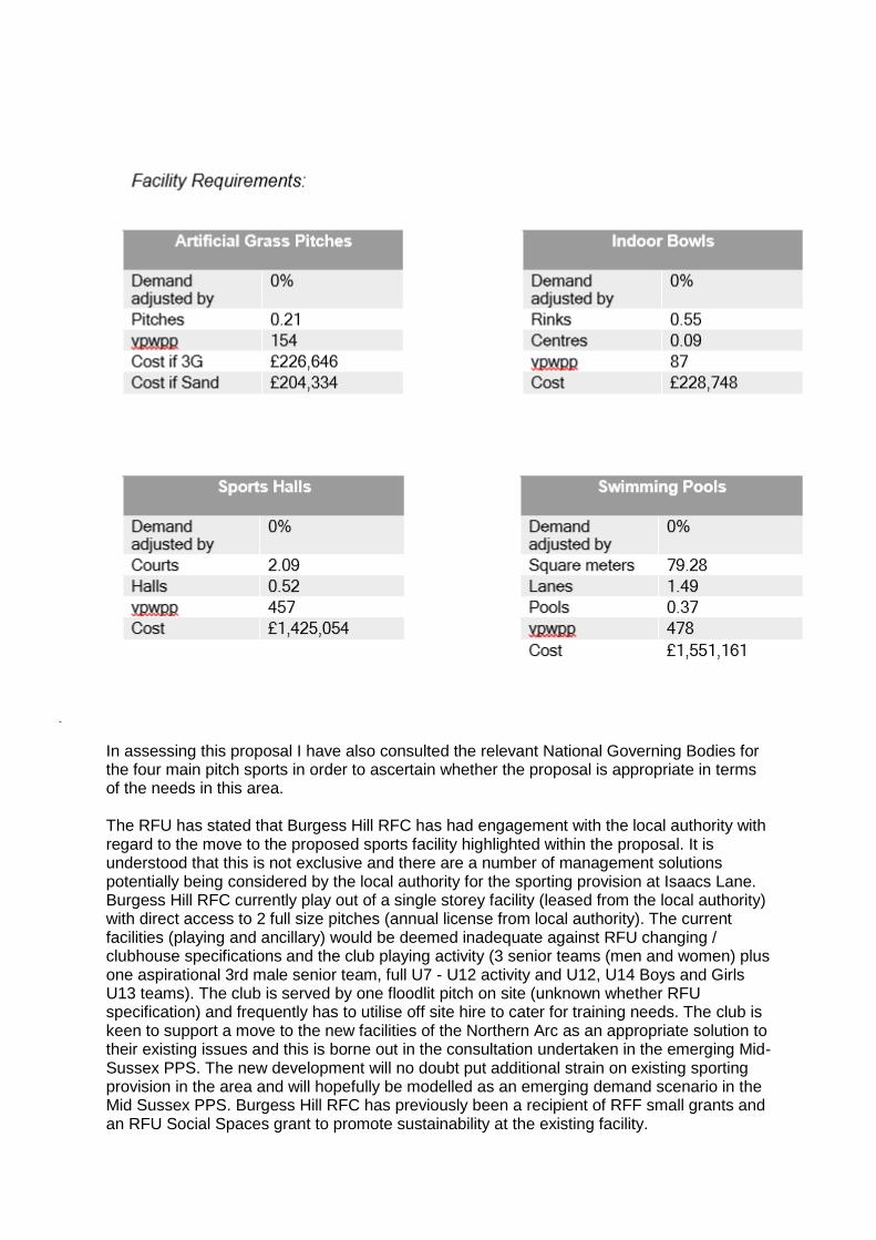
In assessing this proposal I have also consulted the relevant National Governing Bodies for the four main pitch sports in order to ascertain whether the proposal is appropriate in terms of the needs in this area. The RFU has stated that Burgess Hill RFC has had engagement with the local authority with regard to the move to the proposed sports facility highlighted within the proposal. It is understood that this is not exclusive and there are a number of management solutions potentially being considered by the local authority for the sporting provision at Isaacs Lane. Burgess Hill RFC currently play out of a single storey facility (leased from the local authority) with direct access to 2 full size pitches (annual license from local authority). The current facilities (playing and ancillary) would be deemed inadequate against RFU changing / clubhouse specifications and the club playing activity (3 senior teams (men and women) plus one aspirational 3rd male senior team, full U7 - U12 activity and U12, U14 Boys and Girls U13 teams). The club is served by one floodlit pitch on site (unknown whether RFU specification) and frequently has to utilise off site hire to cater for training needs. The club is keen to support a move to the new facilities of the Northern Arc as an appropriate solution to their existing issues and this is borne out in the consultation undertaken in the emerging Mid-Sussex PPS. The new development will no doubt put additional strain on existing sporting provision in the area and will hopefully be modelled as an emerging demand scenario in the Mid Sussex PPS. Burgess Hill RFC has previously been a recipient of RFF small grants and an RFU Social Spaces grant to promote sustainability at the existing facility.
The RFU has concerns that the area identified for sporting provision within the development is to be considered under reserved matters, in that it does not identify which sports are to be provided for and to what specification or scope this provision will be. The RFU would ask whether reference has been made to the emerging PPS as to strategic direction of the sporting provision at Isaacs Lane and would welcome the opportunity to discuss the needs of Burgess Hill RFC in this context. The Football Foundation on behalf of the FA have stated that a new Indoor Football Facility, a New Changing Pavilion, Natural grass pitch improvements and a new 11v11 Floodlit 3G Football Turf Pitch are required within this district. Therefore, it would wish to see provision for the above, which would provide opportunities for all formats of the game, including futsal. These would need to comply to the relevant technical standards. The ECB stated that Burgess Hill and the surrounding area is a thriving and vibrant area for cricket. Within a five mile radius (i.e. 15 minutes travel time) of the proposed development there are thirteen cricket clubs affiliated to the Sussex Cricket Foundation. The clubs have total of 44 senior teams playing league cricket and twelve of the clubs have junior sections and ten of them are All Stars centres (catering for 5 - 8 year olds). In addition, a number of the clubs also offer opportunities for women's and girls' cricket. The offering by the clubs is consistent with the recent strategy for 2020 to 2024 announced by the ECB of Inspiring Generations, where included in the key deliverables are making cricket more accessible, engaging with children, transforming women's and girls' cricket and making cricket gender neutral. Given the existing proliferation of cricket clubs in the area the ECB do not believe that creation of another new cricket club or ground is required (or would be supported) and that any additional players emanating from the new development could be incorporated by the existing clubs. The Playing Pitch Strategy for Mid Sussex is currently ongoing and we would expect the results of the supply and demand analysis, when completed, to support these views. The area has a number of schools who have indoor centres that cater can for the current demands of the local clubs for indoor training nets during the off season. In addition, there The Triangle and The Dolphin leisure centres who can also provide indoor net facilities. We note that the documentation mentions the possibility of additional investment into The Triangle which the ECB would support if it were to improve the availability of clubs to use the facility for training purposes. The ECB would support contributions being made into the current local clubs, several of whom would benefit from investment into their facilities. Notably: Hurstpierpoint CC (working on a new pavilion project), Burgess Hill CC (looking to build a pavilion extension), Haywards Heath CC (looking to undertake a pavilion refurbishment and would benefit from new nets), Ansty (CC working on a pavilion new project), and Lindfield CC (looking to build a pavilion extension) In addition, Bolney CC and Lindfield CC would benefit from the installation of non turf pitches.
Within the area, there a several community sites which (although no longer used) have been available in the past for cricket either formal or casual and could be rejuvenated and be used again by the local clubs if they experienced increases in players to the extent that they could field additional teams and may therefore require additional grounds to play. Such sites are Chailey, Wivelsfield Green, Albourne and Sayers Common and Hickmans Lane. If the new development was to have a community recreational space, the ECB would support the installation of a non turf pitch which would allow for casual cricket to be played by residents. It would, however, require to see an ECB approved system installed and adherence to our guidance on boundary sizes to be followed (and consideration given to potential ball strike and any necessary ball strike mitigation). The ECB recommends that a ball strike risk assessment be undertaken and any recommendations on ball strike mitigation are followed. There is currently one company who have proven to ECB that they have a detailed methodology to analyse ball trajectory and are able to indemnify liability, Labosport UK Ltd. The Open Space Report makes reference to the Mid-Sussex PPG17 Assessment of Open Space, Sport and Recreation (2006). We would like to see the full report and understand the methodology that was employed and the decision making process for any recommendations. As the report was produced in 2006 it is possible that its relevance may be outdated as, for example, cricket has changed considerably in the intervening period and the priorities of the ECB now will be substantially different to those in 2006. The following ECB documents are available on request: Pavilions and Clubhouses (compliance is a requirement for any clubs seeking ECB funding for a new pavilion, and also provides guidance for clubs wishing to undertake a pavilion refurbishment); ECB Approved Systems (nets and non turf pitch suppliers who have systems that are approved by the ECB); Guidance for the Provision and Installation of Non Turf Cricket Pitches and Net Cage Facilities; Guidance on Installing Non Turf Pitches England Hockey have advised that four hockey clubs are located within the boundary of Mid Sussex PPS (East Grinstead, Mid Sussex, St Francis and Burgess Hill Hockey Clubs) and all are competing for AGP provision to service current needs of their membership. 'The Triangle' AGP is heavily used by hockey servicing Burgess Hill, St Francis, and Mid Sussex HC, and on occasion East Grinstead HC. An additional hockey compliant sand based AGP in the area, whether it be at the new proposed secondary school or ideally on the adjacent site across from the existing 'Triangle' Leisure centre would be welcomed. East Grinstead Hockey Club while it sits to the north of the development, is currently looking to replace their existing floodlights. EGHC are a successful National League hockey club and require 500 Lux floodlights to fulfil their hockey requirement. Installing LED floodlights will also be a more cost-effective solution for the Sports Club, supporting an already hockey dominated AGP. England Hockey state that a S106 contribution towards the two above projects would be welcomed.

Sport England, in conjunction with Public Health England, has produced 'Active Design' (October 2015), a guide to planning new developments that create the right environment to help people get more active, more often in the interests of health and wellbeing. The guidance sets out ten key principles for ensuring new developments incorporate opportunities for people to take part in sport and physical activity. The Active Design principles are aimed at contributing towards the Government's desire for the planning system to promote healthy communities through good urban design. Sport England would commend the use of the guidance in the master planning process for new residential developments. The document can be downloaded via the following link: http://www.sportengland.org/activedesign Conclusion In light of the above, Sport England is unable to support this application until such time as the applicant makes further representations regarding the points made above. Sport England objects to these matters being left to reserved matters as its experience is that such issues should be dealt with at an early stage in order to ensure that the community is provided with the facilities it requires. Clarification is required as to the exact nature of the sporting provision being proposed on site as well as the proposed S106 contributions with regard to sport. We would be grateful if you would advise us of the outcome of the application by forwarding a copy of the decision notice. Sports England - Additional comments Thank you for the additional information which we received yesterday 19th August 2019. I have reviewed the documents, in particular paragraphs 3.20 to 3.28 in planning statement addendum which seeks to address some of my colleague Laura's objections email dated 5th February 2019. With reference to Laura's email, I think it is fair to suggest that leaving all the sporting elements to Reserved Matters is a high risk, and would urge the planning authority to at least provide a very detailed specification within the S106, to ensure that sport is not disadvantaged at a later date, usually by the lack for funds available to deliver what was expected. Sport England would be happy to advise on the wording of the sporting element of the S106. The issues raised regarding cricket and ball strike should be addressed, this can be done via a desktop assessment based on the proposed design of the cricket/adjacent buildings. Conclusion Sport England is aware that negotiations are progressing by way of a legal mechanism to resolve our concerns. However, Sport England maintains its objection to this application until a suitable Section 106 agreement, or other legal mechanism is delivered. Sport England can confirm that once a suitable section 106 agreement or other legal mechanism has been signed, we will withdraw our objection. Sport England would be pleased to discuss the contents of the section 106 agreement or other legal mechanism, with a view to withdrawing the current objection.

If this application is to be presented to a Planning Committee, we would like to be notified in advance of the publication of any committee agendas, report(s) and committee date(s). We would be grateful if you would advise us of the outcome of the application by sending us a copy of the decision notice. If you would like any further information or advice please contact me at the address below. Secretary of State Planning Casework Unit From the information supplied below, I can confirm that we have no comment to make on this environmental statement.


![Pragmatics and discourse analysis' [Review] - Sussex](https://img.dokumen.tips/doc/110x75/6319ef111a1adcf65a0eddf3/pragmatics-and-discourse-analysis-review-sussex-.jpg)