Embed Size (px)
Citation preview
Arab Centre for the Study of Arid Zones and Dry Lands
ACSADDamascus
FEDERAL REPUBLIC OF GERMANY Federal Institute for Geosciences
and Natural Resources BGR
Hannover
TECHNICAL COOPERATION
PROJECT NO.: 1996.2189.7
Management, Protection and Sustainable Use of Groundwater and Soil Resources in the Arab Region
Volume 5
Guideline for the Delineation ofGroundwater Protection Zones
Damascus
September 2003
ACSAD-BGR Technical Cooperation Project Management, Protection and Sustainable Use of Groundwater and Soil Resources in the Arab Region Volume 5 - Guideline for the Delineation of Groundwater Protection Zones
Vol-5_Guideline-Groundwater-Protection-Zones.doc Page I
Volume 5
Guideline for the Delineation ofGroundwater Protection Zones
Authors: Dr. Armin Margane (BGR) Commissioned by: Federal Ministry for Economic Cooperation and Development
(Bundesministerium für wirtschaftliche Zusammenarbeit und Entwicklung, BMZ)
Project: Management, Protection and Sustainable Use of Groundwater and Soil Resources in the Arab Region
BMZ-No.: 1996.2189.7 BGR-Archive No.: Date of issuance: September 2003 No. of pages: 329
ACSAD-BGR Technical Cooperation Project Management, Protection and Sustainable Use of Groundwater and Soil Resources in the Arab Region Volume 5 - Guideline for the Delineation of Groundwater Protection Zones
Vol-5_Guideline-Groundwater-Protection-Zones.doc Page II
ACSAD-BGR Technical Cooperation Project Management, Protection and Sustainable Use of Groundwater and Soil Resources in the Arab Region Volume 5 - Guideline for the Delineation of Groundwater Protection Zones
Vol-5_Guideline-Groundwater-Protection-Zones.doc Page III
Table of Contents
FOREWORD .......................................................................................................................................... 1
PART A REVIEW OF INTERNATIONAL GUIDELINES FOR THE DELINEATION OF GROUNDWATER PROTECTION ZONES ...................................................................... 3
1 GENERAL ASPECTS OF GROUNDWATER PROTECTION ZONE DELINEATION ..... 3
1.1 LEGISLATIVE REQUIREMENTS .............................................................................................. 31.2 SOCIO-ECONOMIC IMPLICATIONS ......................................................................................... 41.3 METHODOLOGICAL APPROACHES......................................................................................... 51.4 COSTS ............................................................................................................................... 5
2 GUIDELINES FOR THE DELINEATION OF GROUNDWATER PROTECTION ZONES OF SELECTED COUNTRIES .......................................................................................... 8
2.1 EUROPE ............................................................................................................................. 82.1.1 Germany ........................................................................................................................... 92.1.2 UK................................................................................................................................... 152.1.3 France............................................................................................................................. 182.1.4 Switzerland ..................................................................................................................... 212.1.5 Hungary .......................................................................................................................... 25
2.2 USA................................................................................................................................. 262.3 AUSTRALIA ....................................................................................................................... 302.4 OTHER COUNTRIES........................................................................................................... 342.5 COMPARISON OF GUIDELINES............................................................................................ 36
3 REQUIREMENTS FOR A NATIONAL GUIDELINE ....................................................... 37
3.1 CASE STUDY: THE PRESENT LEGAL SITUATION IN JORDAN ................................................. 383.1.1 Laws and Regulations concerning Water ....................................................................... 383.1.2 Laws and Regulations concerning Agricultural Land Uses ............................................ 403.1.3 Laws and Regulations concerning Waste Disposal ....................................................... 403.1.4 Laws and Regulations concerning Industrial Sites/Estates............................................ 413.1.5 Laws and Regulations concerning Waste Water............................................................ 413.1.6 Laws and Regulations concerning other Land uses....................................................... 42
3.2 CASE STUDY: LEGAL PROVISIONS FOR AN EFFECTIVE IMPLEMENTATION OF A NATIONAL GUIDELINE FOR THE DELINEATION OF GROUNDWATER PROTECTION ZONES IN JORDAN........ 43
4 RECOMMENDATIONS FOR THE ESTABLISHMENT OF A NATIONAL GUIDELINE FOR THE DELINEATION OF GROUNDWATER PROTECTION ZONES IN THE ARAB REGION.......................................................................................................................... 45
5 REFERENCES ................................................................................................................ 47
6 INTERNET LINKS ........................................................................................................... 51
ANNEX A-1: GERMAN CONCEPT FOR DELINEATION OF DRINKING WATER PROTECTION AREAS (SHORTENED VERSION OF DVGW CODE OF PRACTICE W 101) ............. 52
ANNEX A-2: ACCEPTABILITY MATRIXES FOR LAND USES IN ENGLAND AND WALES ........... 59
ANNEX A-3: RESTRICTIONS FOR PUBLIC DRINKING WATER AREAS IN WESTERN AUSTRALIA (WATER QUALITY PROTECTION NOTE).............................................. 65
ANNEX A-4: EPIK – PRACTICE GUIDE – GROUNDWATER VULNERABILITY MAPPING IN KARST REGIONS.......................................................................................................... 70
ACSAD-BGR Technical Cooperation Project Management, Protection and Sustainable Use of Groundwater and Soil Resources in the Arab Region Volume 5 - Guideline for the Delineation of Groundwater Protection Zones
Vol-5_Guideline-Groundwater-Protection-Zones.doc Page IV
PART B PROPOSAL FOR A NATIONAL GUIDELINE FOR THE DELINEATION OF GROUNDWATER PROTECTION ZONES .................................................................. 129
1 SIGNIFICANCE FOR GROUNDWATER PROTECTION MEASURES........................ 129
2 LEGAL BASIS AND ADMINISTRATIVE PROCEDURE.............................................. 130
3 CLASSIFICATION OF PROTECTIVE AREAS............................................................. 132
3.1 AQUIFERS WITH NEAR HOMOGENEOUS DISTRIBUTION OF GROUNDWATER FLOW VELOCITIES (UNCONSOLIDATED AQUIFERS AND FRACTURED ROCK AQUIFERS WITH NO PREFERENTIAL FLOW DIRECTIONS)......................................................................................................... 133
3.2 AQUIFERS WITH HETEROGENEOUS DISTRIBUTION OF GROUNDWATER FLOW VELOCITIES (KARST AQUIFERS AND FRACTURED ROCK AQUIFERS WITH PREFERENTIAL FLOW DIRECTIONSOF HIGH FLOW VELOCITY) ............................................................................................... 134
4 RESTRICTIONS FOR ACTIVITIES IN GROUNDWATER PROTECTION ZONES ..... 136
5 CONTINGENCY PLANS AND REMEDIAL ACTION PLANS ...................................... 146
6 IMPLEMENTATION OF THE GROUNDWATER PROTECTION ORDINANCE .......... 147
6.1 LAND RIGHTS AND MARKING OF THE BOUNDARIES OF PROTECTION ZONES ....................... 1476.2 SURVEILLANCE AND MONITORING OF COMPLIANCE WITH RESTRICTIONS............................ 1476.3 COMPENSATION FOR PREEXISTING RIGHTS ...................................................................... 1476.4 PENALTIES FOR NON-COMPLIANCE WITH RESTRICTIONS ................................................... 147
7 REQUIREMENTS FOR THE HYDROGEOLOGICAL STUDY AND THE ORDINANCE FOR THE DELINEATION OF A GROUNDWATER PROTECTION ZONE................. 148
ANNEX B-1: INVENTORY SHEET OF POTENTIALLY CONTAMINATING SITES – MAPPING OF HAZARDS TO GROUNDWATER................................................................................ 150
ANNEX B-2: INVENTORY OF HAZARDS TO GROUNDWATER – HAZARDS TO BE INVENTORIED AND INVENTORY OF GROUNDWATER SUPPLY FACILITIES ............................... 151
ANNEX B-3: INDEX OF POTENTIAL SOURCES OF DRINKING WATER CONTAMINATION ...... 153
ANNEX B-4: POTENTIAL DRINKING WATER CONTAMINANT INDEX ......................................... 159
ANNEX B-5: STANDARD OUTLINE FOR A HYDROGEOLOGICAL STUDY REPORT FOR THE DELINEATION OF A GROUNDWATER PROTECTION ZONE.................................. 172
ACSAD-BGR Technical Cooperation Project Management, Protection and Sustainable Use of Groundwater and Soil Resources in the Arab Region Volume 5 - Guideline for the Delineation of Groundwater Protection Zones
Vol-5_Guideline-Groundwater-Protection-Zones.doc Page V
PART C EXAMPLES FOR GROUNDWATER PROTECTION ZONE DELINEATION IN SELECTED ACSAD MEMBER COUNTRIES ............................................................. 175
1 GENERAL ASPECTS ................................................................................................... 176
2 GROUNDWATER PROTECTION ZONE DELINEATION IN MOROCCO ................... 180
3 GROUNDWATER PROTECTION ZONE DELINEATION IN TUNISIA ........................ 190
4 GROUNDWATER PROTECTION ZONE DELINEATION IN EGYPT .......................... 198
5 GROUNDWATER PROTECTION ZONE DELINEATION IN JORDAN ....................... 205
6 GROUNDWATER PROTECTION ZONE DELINEATION IN SYRIA............................ 213
7 GROUNDWATER PROTECTION ZONE DELINEATION IN YEMEN.......................... 225
8 REFERENCES AND RELATED LITERATURE ........................................................... 232
ANNEX C-1: INFORMATION REQUESTED FOR GUIDELINE ON GROUNDWATER PROTECTION ZONES.......................................................................................................................... 236
ANNEX C-2: EVALUATION OF THE CURRENT PRACTICE OF GROUNDWATER MONITORING AND PROTECTION IN EGYPT ................................................................................... 239
ANNEX C-3: EVALUATION OF THE CURRENT PRACTICE OF WATER PROTECTION IN TUNISIA...................................................................................................................................... 281
ANNEX C-4: GROUNDWATER MONITORING, PROTECTION AND SUSTAINABLE RESOURCES MANAGEMENT IN SYRIA........................................................................................... 310
ACSAD-BGR Technical Cooperation Project Management, Protection and Sustainable Use of Groundwater and Soil Resources in the Arab Region Volume 5 - Guideline for the Delineation of Groundwater Protection Zones
Vol-5_Guideline-Groundwater-Protection-Zones.doc Page VI
List of Figures
Figure A-1: German Zoning System ......................................................................... 10Figure A-2: Source Protection Zoning used in the UK ............................................. 16Figure A-3: Example of Public Drinking Water Source Areas in ............................... 32Western Australia (City of Cervantes) ...................................................................... 32Figure A-4: Types of Groundwater Protection Zones ............................................... 53
List of Tables
Table C-1: Water Resources Availability, Consumption and Sustainability in the Arab Region ............................................................................................................. 177
Table C-2: Water Resources Availability in the Arab Region.................................. 178Table C-3: Water Consumption and Efficiency in the Agricultural Sector of the Arab
Region ............................................................................................................. 179Table C-4: Water availability and water use in Egypt in 1993................................ 199Table C-5: Responsibilities in the Groundwater Sector in Egypt ............................ 200Table C-6: Main Problems Pertaining to the Water Sector in Egypt ....................... 201Table C-7: Groundwater Abstraction in Jordan in 1998.......................................... 206Table C-8: Renewable Water Resources of Syria .................................................. 215Table C-9: Non-Conventional Water Resources of Syria in 1997........................... 216Table C-10: Domestic Water Consumption in Syria in 1997................................... 216Table C-11: Agricultural Water Consumption in Syria in 1997................................ 217Table C-12: Water Uses and Availability in Syria in 1997....................................... 217
Enclosure: CD with relevant files for groundwater protection and files related to this report
ACSAD-BGR Technical Cooperation Project Management, Protection and Sustainable Use of Groundwater and Soil Resources in the Arab Region Volume 5 - Guideline for the Delineation of Groundwater Protection Zones
Vol-5_Guideline-Groundwater-Protection-Zones.doc Page VII
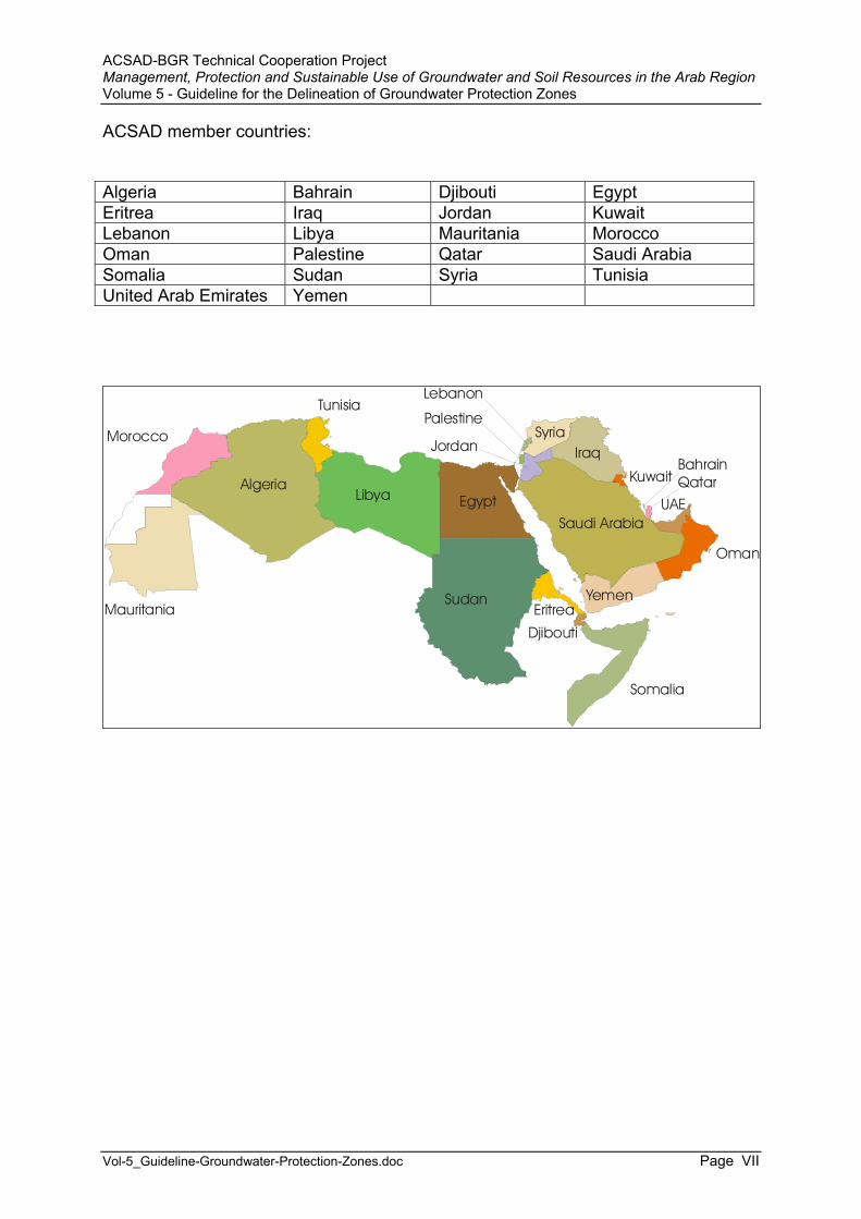
ACSAD member countries:
Algeria Bahrain Djibouti Egypt Eritrea Iraq Jordan Kuwait Lebanon Libya Mauritania Morocco Oman Palestine Qatar Saudi Arabia Somalia Sudan Syria Tunisia United Arab Emirates Yemen
Mauritania
Morocco
Algeria
Tunisia
Libya Egypt
Sudan
Somalia
Oman
Yemen
UAE
Kuwait
IraqSyria
Jordan
Lebanon
Palestine
Eritrea
Djibouti
QatarBahrain
Saudi Arabia
ACSAD-BGR Technical Cooperation Project Management, Protection and Sustainable Use of Groundwater and Soil Resources in the Arab Region Volume 5 - Guideline for the Delineation of Groundwater Protection Zones
Vol-5_Guideline-Groundwater-Protection-Zones.doc Page 1
Foreword
This report is part of a series of Technical Reports published by the Technical Cooperation Project “Management, Protection and Sustainable Use of Groundwater and Soil Resources in the Arab Region”, which is being implemented by the Federal Institute of Geosciences and Natural Resources (BGR), Germany, and the Arab Centre for the Studies of Arid Zones and Dry Lands (ACSAD). This project started in August 1997 and ends with its second phase in December 2003.
ACSAD was established in 1971 as an autonomous, intergovernmental organization, working within the framework of the Arab League.
Many Arab countries are facing major environmental challenges. Water scarcity and pollution in conjunction with the loss, degradation and contamination of land resources have become core problems affecting public health and the socio-economic development. Water and soil resources represent exhaustible and vulnerable resources. Thus, a sustainable development of the Arab region requires the implementation of guidelines concerning the protection and sustainable use of groundwater resources and soils. The formulation and dissemination of such guidelines is the main goal of the project.
The present report deals with the preparation of a National Guideline for the Delineation of Groundwater Protection Zones in ACSAD member countries.
Since the renewable water resources in many ACSAD member countries are very scarce the sustainable management of these resources with regard to quantity and quality is a task of prime importance.
The agricultural development in most of these countries started in the early 1970s and nowadays a large share of the renewable water resources is being used for irrigation. The increased agricultural land use brought about a deterioration of groundwater qualities in many areas through the application of fertilizers and pesticides. This is noticed chiefly by the increasing salinities caused by irrigation return flows, but also by continuous increases in the nitrate contents in groundwaters downstream of extensively cultivated areas.
Groundwater quality is also largely affected by other land uses, such as industrial sites, oil storage/filling facilities, sewage effluents (treated and untreated sewage), waste disposal sites (legal/illegal), etc. This is noticed especially in urban and heavily industrialized areas.
In order to protect and conserve the groundwater resources in the ACSAD member countries a National Policy on Groundwater Quality Conservation needs to be implemented. In a first step the sources for domestic water supply should be protected by establishing groundwater protection zones. The implementation of such protection zones can, however, only be successful, if a legally binding regulation or

ACSAD-BGR Technical Cooperation Project Management, Protection and Sustainable Use of Groundwater and Soil Resources in the Arab Region Volume 5 - Guideline for the Delineation of Groundwater Protection Zones
Vol-5_Guideline-Groundwater-Protection-Zones.doc Page 2
Guideline for the Delineation of Groundwater Protection Zones is adopted. This guideline may define zones in which certain activities and land uses are allowed or restricted.
Such guidelines are in place in most developed countries since several decades and have served to protect groundwater resources effectively from becoming polluted by point sources and diffuse pollution sources.
The aim of this report is to help the adoption of a National Guideline for Groundwater Protection Zones and to facilitate the discussion about long-term strategies and the required measures to avoid the pollution of groundwater resources.
To provide an effective protection of the groundwater resources, it is also important to convince the land use planning authorities to take the issue of groundwater protection into consideration when deciding about locations and conditions for the establishment of facilities and activities which are possibly hazardous to groundwater, such as waste disposal sites, sewage treatment plants and sewer mains, industrial and commercial estates, storage facilities for oil products and toxic hazardous substances, etc. By locating such sites in areas where a contamination of the groundwater resources cannot occur, a deterioration of the groundwater resources can be actively avoided.
Part A of this report gives an overview on the current practice concerning groundwater protection zone delineation in developed countries. Part B contains a proposal for a guideline on the delineation of groundwater protection zones. In part C the present status in selected ACSAD member countries is presented together with the institutional framework and legal basis.
ACSAD-BGR Technical Cooperation Project Management, Protection and Sustainable Use of Groundwater and Soil Resources in the Arab Region Volume 5 - Guideline for the Delineation of Groundwater Protection Zones
Vol-5_Guideline-Groundwater-Protection-Zones.doc Page 3
Part A Review of International Guidelines for the Delineation of Groundwater Protection Zones
1 General Aspects of Groundwater Protection Zone Delineation
A guideline for the delineation of groundwater protection zones aims to protect important water wells and springs from becoming polluted. For this purpose the ordinance of a groundwater protection zone usually sets out restrictions for land uses and human activities inside these zones. The establishment of groundwater protection zones does not prevent the contamination of groundwater resources in areas outside of these zones. Therefore other laws and regulations are required to prevent such contamination, such as regulations for the establishment and maintenance of waste disposal sites, industrial estates, sewage collection and treatment facilities, oil storage facilities, etc. In conjunction with all such regulations monitoring schemes with defined procedures have to be set up to provide that these regulations are correctly being implemented and followed.
In general the national legislation on water protection should be guided by the polluter-pays-principle, i.e. in case of a proven pollution the polluter has to be made responsible for covering the costs for a rehabilitation of the groundwater resources to their prior quality. Such clean-up operations may become extremely costly, time-consuming and difficult.
The protection of groundwater quality is a very complex issue. It concerns not only groundwater but also surface water resources, since there is a strong relationship between both of them. Groundwater may discharge into surface water (influent condition) and vice versa (effluent condition). Thus, the protection of groundwater and surface water is nowadays often implemented in so-called watershed management plans for surface water catchment areas, in order to protect the water quality not only at selected places, such as springs and water wells used for water supply, but in the entire catchment area.
The protection of the soil quality is as important for groundwater protection as the protection of the water itself, because the soil plays an important role for the chemical and biological processes which take place in the unsaturated zone and lead to a retardation, adsorption, or degradation of many substances hazardous to groundwater. Therefore, many countries have also adopted laws on soil protection in recent years.
1.1 Legislative Requirements
Depending on the importance and local requirements many countries have developed considerably different legislations. In some cases the issue of

ACSAD-BGR Technical Cooperation Project Management, Protection and Sustainable Use of Groundwater and Soil Resources in the Arab Region Volume 5 - Guideline for the Delineation of Groundwater Protection Zones
Vol-5_Guideline-Groundwater-Protection-Zones.doc Page 4
groundwater protection is dealt with at national level, whereas other countries use a more decentralized approach. Mostly there are federal laws, which define the main goals, whereas the details are laid down in by-laws or in laws of the provinces/states. Whichever way is chosen for the establishment of guidelines, it is recommended to attach the aspect of groundwater protection to an existing national water law as is the case in most countries.
The ordinance of a groundwater protection zone is commonly initiated by the public interest and requires legal certainty for all defined restrictions on land use and human activities, i.e. it must be based on legally binding laws and regulations. One has to keep in mind, however, that these restrictions have to be justified and appropriate for reaching the goal of groundwater protection. It has to be verifiable that the restrictions serve to protect the groundwater resources and cannot be reached by other, less costly, means. The terminology and formulations used have to be clear and concise. Depending on the locally binding legislative procedures, ordinances for protection zones usually require the participation of the public in the form of public hearings.
A further prerequisite is that the protection of groundwater resources by an ordinance has to be necessary and that there are no alternatives in doing so (in some cases it might be possible to relocate water abstraction facilities with much less costs than required for protection measures at the present site).
The boundaries of the protection zone usually follow administrative boundaries, i.e. the boundaries of land plots, topographic features, etc. They should be as close as possible to the boundaries defined by the hydrogeological study. The extent of both of these boundaries needs to be justified and should be kept as small as necessary.On the other hand they have to be large enough so that the protection of the groundwater resource is still guaranteed.
For the implementation of the restrictions and the monitoring of the implementation the administrative responsibilities of the involved authorities have to be clear. The responsibilities, tasks and time schedules should be laid down in a document.
1.2 Socio-Economic Implications
The definition of restrictions for land use and human activities in groundwater protection zones deeply affects the people living in protection zones. Land uses and activities, which were practiced since a long time, may not be allowed anymore after the issuance of the groundwater protection ordinance. Depending on the national legislation, the modification or withdrawal of preexisting rights, such as water rights, land cultivation rights, rights for industrial operations, etc., may not be easy. In such cases many countries have included the payment of compensations for abolishing pre-existing rights in their legislation.
The experience in many developed countries shows that public participation in the frame of the administrative procedure for the establishment of a groundwater protection ordinance is crucial to its acceptance. People usually are easy to convince
ACSAD-BGR Technical Cooperation Project Management, Protection and Sustainable Use of Groundwater and Soil Resources in the Arab Region Volume 5 - Guideline for the Delineation of Groundwater Protection Zones
Vol-5_Guideline-Groundwater-Protection-Zones.doc Page 5
if they have been actively involved in the process. They are even more aware of the requirements and necessary consequences if the protected water resources are used by themselves. However, in many cases the municipality using the water resources (downstream) is not identical with the municipality deteriorating the quality of the water resource to be protected.
Therefore, public awareness for the necessity of the establishment of a groundwater protection zone and for safeguarding the quality of (ground)water resources has to be created. Public awareness campaigns addressing all people, especially the young generation, are an important activity when introducing groundwater quality conservation measures.
1.3 Methodological Approaches
The advantage of groundwater against surface water is inherent in its character. Groundwater is usually stored in a medium of consolidated or unconsolidated rocks that allows only low flow velocities in contrast to surface water. The chemical and biological processes in the unsaturated zone, especially in the soil (FOSTER & HIRATA 1988, MORRIS & FOSTER 2000), lead to a natural protection of the groundwater resources against pollution. If, however, this protective cover is removed or contaminants reach the groundwater by other means (for instance through boreholes) and groundwater becomes contaminated, the clean-up of such contaminated groundwater is extremely difficult, time consuming and costly.
When delineating a groundwater protection zone, one has to keep in mind that this process underlies considerable uncertainties due to the fact that most of the required parameters are not known exactly and that these parameters have a high spatial variability.
Usually a hydrogeological study will be prepared by qualified consultants or governmental institutions. In order to guarantee that the same methods are being applied, a catalog with all required information and a guideline how to prepare such a study needs to be provided by the responsible authority. A proposal for a standard outline of a hydrogeological study report is attached as Annex B-5.
1.4 Costs
The regulations concerning the cost coverage are very different in the countries considered in this report. However, since the basis for the issuance of an ordinance for a groundwater protection zone is in the public interest, the costs are commonly covered by the government (at national, provincial or local level). In other models the costs are being covered by the water supply company, so that in the end the consumer is charged with these additional costs.
The costs involved encompass: The costs for the preparation of a hydrogeological study;

ACSAD-BGR Technical Cooperation Project Management, Protection and Sustainable Use of Groundwater and Soil Resources in the Arab Region Volume 5 - Guideline for the Delineation of Groundwater Protection Zones
Vol-5_Guideline-Groundwater-Protection-Zones.doc Page 6
The costs for the administrative procedure, including public awareness campaigns and public hearings;
The costs for implementation (e.g. costs for relocation of facilities hazardous to groundwater, compensation costs);
The costs for monitoring of compliance with the implementation (groundwater quality monitoring, monitoring of effluents from sewage treatment facilities, monitoring of compliance with best agricultural practices, etc.).
Extensive data have to be collected and analyzed for the hydrogeological study. In some cases there may not be enough existing data to delineate the groundwater protection zones so that it may become necessary for instance to drill new wells, conduct tracer tests, monitor spring discharge over a long enough time period, etc. Such measures may become quite expensive and are only justified for large water abstraction facilities or if there are many such installations in the same area. Based on the experience made in Germany, the completion of such hydrogeological studies usually takes more than one year. Most studies are based on existing data (it has to be mentioned, however, that data availability is much better there than in less developed countries). The costs for such studies may vary between a few ten thousand USD to more than 100,000 USD for a single water well or spring (prices for Germany, based on the assumption that the studies are prepared by consultants). If additional data have to be collected the costs may increase considerably (often hydrological data have to be collected over at least one year).
The costs of the administrative procedure are difficult to estimate and largely depend on the required input. Usually the hydrogeological study is being forwarded to a governmental institution which has to approve it. In order to reach a common understanding about what is required from a hydrogeological study, it is very important that the approving institution lays down its demands in a concept for the preparation of hydrogeological studies and discusses in advance with the consultant the necessary steps for preparing the study.
The costs for awareness campaigns and public hearings are usually not very high, especially if standard information material is available already. Such information material should be prepared by the involved institutions.
The costs for the implementation of a groundwater protection zone depend very much on the preexisting land uses. In areas where the institutions come to the conclusion that a relocation of certain land uses or a clean-up of an aquifer is required, the involved costs can easily reach several hundred thousand USD. If, however, it is only required to construct fences and sign posts stating where the boundaries of the groundwater protection zone are located, the costs would be low.
If modifications in the agricultural use or practice are required, such as the introduction of methods of best-agricultural-practice, it is recommended to give advice to the local farmers through the local agricultural extension service. In some cases it might be demanded not to use fertilizers or pesticides anymore or to keep the farm land fallow. Then it might be necessary to compensate the local farmers for doing so. Good experiences have been made in Germany with so-called cooperative agreements between the farmers and the water supply company. In this case the
ACSAD-BGR Technical Cooperation Project Management, Protection and Sustainable Use of Groundwater and Soil Resources in the Arab Region Volume 5 - Guideline for the Delineation of Groundwater Protection Zones
Vol-5_Guideline-Groundwater-Protection-Zones.doc Page 7
latter would pay for the compensation and/or the agricultural advice and/or for planting only certain crops.
The monitoring of compliance with the implementation needs to follow a well defined procedure. It needs to be monitored for instance whether the farmers apply the demanded restrictions concerning the use of fertilizers and pesticides. Also it needs to be monitored whether regulations concerning sewage water are being followed, and so on. It has to be clear which authority is responsible for the monitoring of the implementation and it has to be clear what is allowed and what is not.
ACSAD-BGR Technical Cooperation Project Management, Protection and Sustainable Use of Groundwater and Soil Resources in the Arab Region Volume 5 - Guideline for the Delineation of Groundwater Protection Zones
Vol-5_Guideline-Groundwater-Protection-Zones.doc Page 8
2 Guidelines for the Delineation of Groundwater Protection Zones of Selected Countries
The following subchapters describe how the delineation of groundwater protection is regulated in different countries of the world which look at a long history in doing so.
First the legal basis for groundwater protection zone delineation is mentioned. In many countries there exists a large number of laws, by-laws, regulations, ordinances, etc., all dealing with the issue of protecting the groundwater resources. Mostly they are all integrated into one single law defining the main goals. These laws are then supported by by-laws, regulations, ordinances, etc. Sometimes there are laws at the federal level as well as at the provincial or district level. In such cases, the federal usually supersede the provincial and the provincial the district laws, regulations, etc. Mostly the aim of such a structured legislation is to become more and more specific and detailed the lower the level gets, as far as restrictions and permissions for certain human activities are concerned. This is because mostly the responsibility for the implementation lies with the medium and lower level water or environment authorities.
Secondly the distribution of responsibilities and roles of the involved agencies is described, i.e. who is doing what and how costs are covered. Next the system of groundwater protection zoning is presented as well as the methods that are being used to define the boundaries of the zones. Finally the advantages and disadvantages of the delineation system are discussed and the country's supporting laws, by-laws, regulations, ordinances, etc. are listed.
2.1 Europe
The European Parliament has issued a number of Directives dealing with water protection issues, such as:
Directive 2000/60/EC: Establishing a Framework for Community Action in the Field of Water Policy (Water Framework Directive);
Directive 98/83/EC: The Drinking Water Directive; Directive 85/337/EEC: The Environmental Impact Assessment Directive; Directive 86/278/EEC: The Sewage Sludge Directive; Directive 91/271/EEC: The Urban Waste-water Treatment Directive; Directive 91/676/EEC: The Nitrates Directive; Directive 96/61/EC: The Integrated Pollution Prevention Control Directive; Directive 86/280/EEC: The Dangerous Substance Discharge Directive.
These Directives have to be adopted by and integrated into the legal framework of the member states within a specified time period.
ACSAD-BGR Technical Cooperation Project Management, Protection and Sustainable Use of Groundwater and Soil Resources in the Arab Region Volume 5 - Guideline for the Delineation of Groundwater Protection Zones
Vol-5_Guideline-Groundwater-Protection-Zones.doc Page 9
The Water Framework Directive aims to create a framework for the protection of inland surface waters, transitional waters, coastal waters and groundwaters in order to among others (1) prevent a further deterioration and to protect and enhance the status of aquatic systems, (2) promote the sustainable water use, and (3) ensure the progressive reduction of pollution of groundwaters as well as prevent its further pollution [article 1]. Concerning groundwaters the Directive states that the member states shall [article 4]:
Implement the measures necessary to prevent or limit the input of pollutants into groundwater and to prevent the deterioration of the status of all bodies of groundwater;
Enhance and restore all bodies of groundwater, ensure a balance between abstraction and recharge of groundwater with the aim of achieving good groundwater status at the latest 15 years after the date of entry into force of the Directive;
Implement the measures necessary to reverse any significant and sustained upward trend in the concentration of any pollutant resulting from the impact of human activity in order progressively to reduce pollution of groundwater.
The member states have to establish River Basin Management Plans for (1) surface waters, (2) groundwaters, and (3) protected areas by at the latest 9 years after the date of entry into force of the Directive and every 6 years thereafter.
According to article 24, member states have to bring into force laws, regulations and administrative provisions necessary to comply with the Directive by 22 December 2003. The member states presently put much effort into reaching this goal.
2.1.1 Germany
Legal Basis and Responsibilities
The establishment of groundwater protection zones was enacted in Germany already in 1957 in the frame of the German Water Act (§ 19 Wasserhaushaltsgesetz). Apart from this national law, every German state has commonly established its own more detailed water law. Regulations for groundwater protection have been issued by the DVGW (1959, 1975, and 1995) and by the individual states in different forms. The regulations adopted by the states follow in general the DVGW regulation W 101 but often set more specific and detailed restrictions. However, the methodology used for the delineation process and the definition of the zones is more or less the same in all states.
ACSAD-BGR Technical Cooperation Project Management, Protection and Sustainable Use of Groundwater and Soil Resources in the Arab Region Volume 5 - Guideline for the Delineation of Groundwater Protection Zones
Vol-5_Guideline-Groundwater-Protection-Zones.doc Page 10
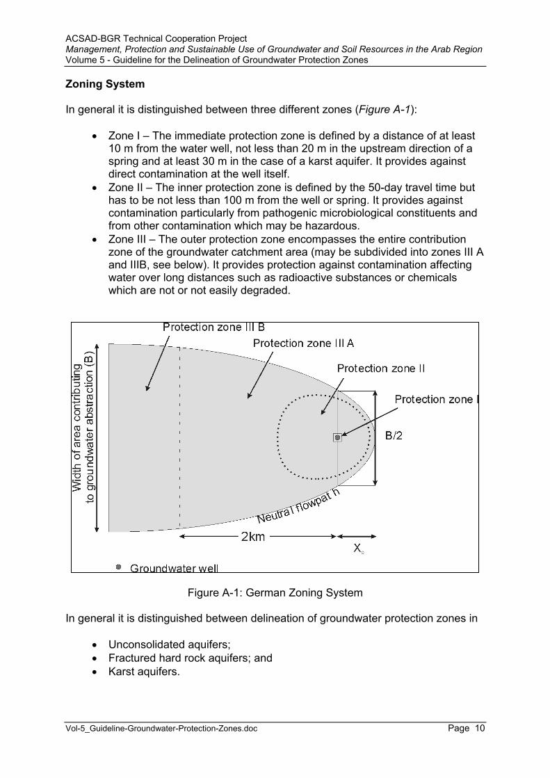
Zoning System
In general it is distinguished between three different zones (Figure A-1):
Zone I – The immediate protection zone is defined by a distance of at least 10 m from the water well, not less than 20 m in the upstream direction of a spring and at least 30 m in the case of a karst aquifer. It provides against direct contamination at the well itself.
Zone II – The inner protection zone is defined by the 50-day travel time but has to be not less than 100 m from the well or spring. It provides against contamination particularly from pathogenic microbiological constituents and from other contamination which may be hazardous.
Zone III – The outer protection zone encompasses the entire contribution zone of the groundwater catchment area (may be subdivided into zones III A and IIIB, see below). It provides protection against contamination affecting water over long distances such as radioactive substances or chemicals which are not or not easily degraded.
Figure A-1: German Zoning System
In general it is distinguished between delineation of groundwater protection zones in
Unconsolidated aquifers; Fractured hard rock aquifers; and Karst aquifers.
ACSAD-BGR Technical Cooperation Project Management, Protection and Sustainable Use of Groundwater and Soil Resources in the Arab Region Volume 5 - Guideline for the Delineation of Groundwater Protection Zones
Vol-5_Guideline-Groundwater-Protection-Zones.doc Page 11
The zoning system as well as the methods used for the delineation of boundaries is considerably different for these aquifers:
Zone III may be subdivided into sub-zones III A and III B. In case of porous rock aquifers with groundwater flow velocities of less than 10m/day, the boundary between zone III A and III B should be located approximately 2 km upstream of the well. Distance should be greater if flow velocities are higher.
In the case of uncovered karst and fissured rock aquifers with high flow velocities, zone III may not be subdivided, if the time required for groundwater from the entire catchment area to flow to the well is less than 50 days and the area would therefore have to be classified as zone II. A subdivision into zones III A and III B may only be made if the aquifer is covered by continuous, thick, low-permeability strata. If such strata exist, areas with a continuous undisturbed cover may be classified as zone III B, if the cover consists of at least 8 m clayey/silty strata or if the cover contains perched groundwater separated from the aquifer by an intact impervious layer of a thickness of at least 5 m.
For the delineation of the 50-day travel time (i.e. the outer boundary of zone II), the German guideline W 101 specifically names the use of hydraulic models as standard method. The determination of this boundary has to be based on the average daily discharge rate or the maximum daily discharge rate. Dispersion has to be taken into account only if groundwater table is low or if impervious strata overlying the aquifer are absent.
The extension of zone II upstream from the well should be in no case less than 100 m or 50 m in cases where circumstances warrant such a decision. If the depth of groundwater is very great, zone II may be shorter than provided for above, in the case that local geological conditions warrant. Zone II is not needed if the water is exclusively produced from deep horizons covered by impervious overlying strata and if all wells entering these horizons are sealed properly or if all water is covered by low-permeability layers of sufficient thickness between the well and the line from which the water takes 50 days or less to flow to the well.
For karst aquifers the guideline defines that, zone II may be narrower, if the narrow protection zone for a karst aquifer was to comprise the complete area from which water takes 50 days to flow to the well, but should in any case comprise all areas in which contamination may occur due to an increased hazard to the karst aquifer, such as
Slopes or dry valleys declining towards the catchment area; Deep karst basins, sinks, dolines and cockpit karsts and their immediate
surrounding, especially swallow holes; The surrounding of stream or brook intakes; Deep-cut dry valleys, draining partly or temporarily surface water or featuring
areas of infiltration; Areas in which karst aquifers have been excavated by mining; Areas featuring near-surface tunnels collecting groundwater; and Near surface shatter zones or outcropping fault areas.

ACSAD-BGR Technical Cooperation Project Management, Protection and Sustainable Use of Groundwater and Soil Resources in the Arab Region Volume 5 - Guideline for the Delineation of Groundwater Protection Zones
Vol-5_Guideline-Groundwater-Protection-Zones.doc Page 12
If deep karst aquifers are covered by thick strata of low permeability overlying the entire catchment area, zone II may not be necessary.
The boundaries of protection zones should, wherever possible, follow roads, tracks, property lines or landmarks, such as the edges of forests, embankments, or bodies of water and should not be located inside the boundaries determined by hydrogeological methods.
A detailed description about what is required from a hydrogeological study, which methods could be used and how the boundaries of the zones are practically obtained is laid down in ECKL et al. (1995).
The protection zone plan issued by the Groundwater Protection Zone Ordinance shows the boundaries of the zones I, II and III as they were determined by hydrogeological investigations (hydrogeological boundaries) and the actual administrative boundaries, following natural boundaries or boundaries of landownership.
The Jordanian-German Technical Cooperation Project 'Groundwater Resources of Northern Jordan' established a groundwater protection zone for the Pella spring (Tabaqat Fahel) based on the German guideline in 1999 (MARGANE et al.1999).
Restrictions
The listing of hazardous activities and sites as mentioned in the guideline W 101 suggests various limitations, restraints and exclusions of certain land uses, but provide reasonable flexibility. This is because most of them are described in more detail in the regulations of the individual German states.
As an example the regulations used in the State of Lower Saxony are listed in AnnexA-1.
Advantages
The guideline is easy to apply in all kind of aquifers. The zoning system is consistent with the main protection targets and does not specify unnecessary large protection zones. The restrictions are often very strict but not unjustified. Altogether, the German regulations have proven to be effective.
Disadvantages
With the implementation of the EC Directive on nitrate in groundwater (91/676/EEC; maximum allowable limit 50 mg/l) issued in 1991 and replacing the former drinking water standard of 90 mg/l many water works, especially those in areas of intensive agricultural use, faced problems. The German regulations do not include protection of important groundwater resources which may be exploited in the future. In many of

ACSAD-BGR Technical Cooperation Project Management, Protection and Sustainable Use of Groundwater and Soil Resources in the Arab Region Volume 5 - Guideline for the Delineation of Groundwater Protection Zones
Vol-5_Guideline-Groundwater-Protection-Zones.doc Page 13
the federal states so-called water priority areas (Wasservorranggebiete) have been defined. But until now the groundwater quality in these areas is not protected by law. Therefore the SRU (1998) demands the establishment of a legal basis for a more comprehensive groundwater protection in Germany. According to SRU the preparation of so-called groundwater vulnerability maps should be conducted for all of Germany following an accepted methodology. These should be supported by maps showing the hazards to groundwater, so that the identification of areas and places where measures to protect the groundwater resources is facilitated. SRU also suggests that for water resources management and protection a uniform system should be developed, instead of every State using its own system.
The regulation provides no sufficient guidance for the delineation of protection zones in karst aquifers. HÖTZL (1996) suggests that groundwater vulnerability maps, such as those proposed by the COST group (EUROPEAN COMMISSION 1995; compare EPIK method in Annex A-4) should form the basis for the delineation of protection zones in karst areas.
Furthermore a contingency plan or emergency response plan in case of accidental pollution or imminent health risk has not to be prepared. Even though most water supply companies have prepared their own such plans, the preparation of a contingency plan should be included in the laws and regulations.
The limited public participation and the complicated responsibilities and legal bases are often criticized (SRU 1998).
Other laws and regulations concerning groundwater protection issues
Accompanying laws and regulations in Germany are the:
Drinking Water Standards Ordinance (Trinkwasserverordnung, TVO 2000); Guideline on Protection Areas for Drinking Water Reservoirs (Richtlinie W
102 - Schutzgebiete für Trinkwassertalsperren, DVGW 2002); Guideline on Protection Areas for Lakes (Richtlinie W 103 - Schutzgebiete
für Seen, DVGW 1975); Guideline on the Treatment of Forests in Protection Areas for Drinking Water
Reservoirs (Richtlinie W 105 - Behandlung des Waldes in Schutzgebieten für Trinkwassertalsperren, DVGW 1981);
Guideline on Military Properties and Exercises in Water Protection Zones (Richtlinie W 106, Militärische Übungen und Liegenschaften der Streitkräfte in Wasserschutzgebieten, DVGW 1991);
Guideline on Protection Areas for Curative Springs (Richtlinie für Heilquellenschutzgebiete, LAWA 1998);
Best Agricultural Management Practices in Water Supply Areas (Gewässerschützende Landbewirtschaftung in Wassergewinnungsgebieten, LAWA 2001);
Guideline on Civil Engineering Measures concerning the Construction of Roads in Water Protection Areas (Richtlinien für bautechnische Maßnahmen

ACSAD-BGR Technical Cooperation Project Management, Protection and Sustainable Use of Groundwater and Soil Resources in the Arab Region Volume 5 - Guideline for the Delineation of Groundwater Protection Zones
Vol-5_Guideline-Groundwater-Protection-Zones.doc Page 14
an Straßen in Wassergewinnungsgebieten, RiStWaG, Forschungs-gesellschaft für Straßen-und Verkehrswesen 2002);
Groundwater Ordinance (Grundwasserverordnung, GrWV, 1997), Federal Soil Protection Act (Bundesbodenschutzgesetz, BBodSchG, 1998), Guideline for Sewer Canals and Sewer Trunk Lines in Water Abstraction
Areas (ATV-Regelwerk, Arbeitsblatt A 142, Abwasserkanäle und -leitungen in Wassergewinnungsgebieten 1992);
Groundwater Ordinance (Grundwasserverordnung, 1997); General Administrative Regulation on the Classification of Substances
Hazardous to Water into Hazard Classes (Verwaltungsvorschrift wassergefährdende Stoffe, VwVwS, 1999);
Ordinance on Hazardous Substances (Gefahrstoffverordnung, 1999); Waste Avoidance and Management Act (Kreislaufwirtschafts- und
Abfallgesetz, KrW/AbfG, 1994); Code of Practice Domestic Waste Disposal (Technische Anleitung
Siedlungsabfall, 1993); Ordinance on the Environmentally Safe Disposal of Domestic Waste
(Verordnung über die umweltverträgliche Ablagerung von Siedlungsabfällen, 2001);
Environmental Impact Assessment Act (Umweltverträglichkeitsgesetz, UVPG, 1990, 2001);
General Administrative Regulation on Environmental Impact Assessment (Allgemeine Verwaltungsvorschrift zur Ausführung des Gesetzes über die Umweltverträglichkeitsprüfung, UVPVwV, 1995);
Federal Nature Protection Act (Bundesnaturschutzgesetz, BNatSchG, 2002);
Federal Immissions Act (Bundes-Immissionsschutzgesetz, BImSchG, 1990); Federal Immissions Ordinance (Bundes-Immissionsschutzverordnungen,
BImSchV, 1997); ATV Code A 138 – Design and Construction of Facilities for the
Decentralized Infiltration of Uncontaminated Storm Water into the Ground (Bau und Bemessung von Anlagen zur dezentralen Versickerung von nicht schädlich verunreinigtem Niederschlagswasser, 1990);
Sewage Water Discharge Fees Act (Abwasserabgabengesetz, 1994); Ordinance on the Discharge of Sewage Water into Water Bodies
(Abwasserverordnung, 1999); ATV Code A 142 – Sewerage in Water Protection Zones (Abwasserkanäle
und Leitungen in Wassergewinnungsgebieten, 1992); Sewage Treatment Sludge Ordinance (Klärschlammverordnung, AbfKlärV,
1992); DIN 4261 – Small Sewage Treatment Plants (Kleinkläranlagen, 1990); Fertilizer Act (Düngemittelgesetz, 1977); Pesticide Act (Pflanzenschutzgesetz, 1996); Pesticide Application Ordinance (Pflanzenschutzanwendungsverordnung,
1987); Fertilizer Application Ordinance (Düngeverordnung, 1996); Regional Planning Act (Bundes-Raumordnungsgesetz, ROG, 1993);
ACSAD-BGR Technical Cooperation Project Management, Protection and Sustainable Use of Groundwater and Soil Resources in the Arab Region Volume 5 - Guideline for the Delineation of Groundwater Protection Zones
Vol-5_Guideline-Groundwater-Protection-Zones.doc Page 15
Federal Construction Act (Bundes-Baugesetz, BBG, 1886); As well as several laws and regulations of the individual German states.
2.1.2 UK
Like many other European countries, the United Kingdom has a long tradition in groundwater protection. The following chapter describes the situation in England and Wales. The institution responsible for delineating so-called 'Groundwater Source Protection Zones' (SPZ) is the Environment Agency, the successor of the National Rivers Authority (NRA). According to the Water Resources Act (1991) this agency is responsible for the protection of 'controlled waters' (including groundwater). Until now there are around 2000 major groundwater sources for which SPZ's have been delineated. Under the Groundwater Regulations (1998) and the Waste Management Licensing Regulations (1994) the Environment Agency has the specific duty to prevent groundwater pollution by certain dangerous substances. E.g. the discharge of substances in list 1 of the EC Groundwater Directive 80/68/EEC (1979) into groundwater is prohibited and discharges of substances in list 2 have to be minimized (valid for all European countries).
The Environment Agency has published the national policy on groundwater protection in its 'Policy and Practice for the Protection of Groundwater' (Environment Agency 1998). It states the use of a range of different approaches for groundwater protection, such as:
Policy statements; Groundwater vulnerability maps; and Groundwater source protection zones.
It has to be kept in mind, however, that neither of them has statutory status.
A similar approach is used in Scotland and South Africa.
ACSAD-BGR Technical Cooperation Project Management, Protection and Sustainable Use of Groundwater and Soil Resources in the Arab Region Volume 5 - Guideline for the Delineation of Groundwater Protection Zones
Vol-5_Guideline-Groundwater-Protection-Zones.doc Page 16
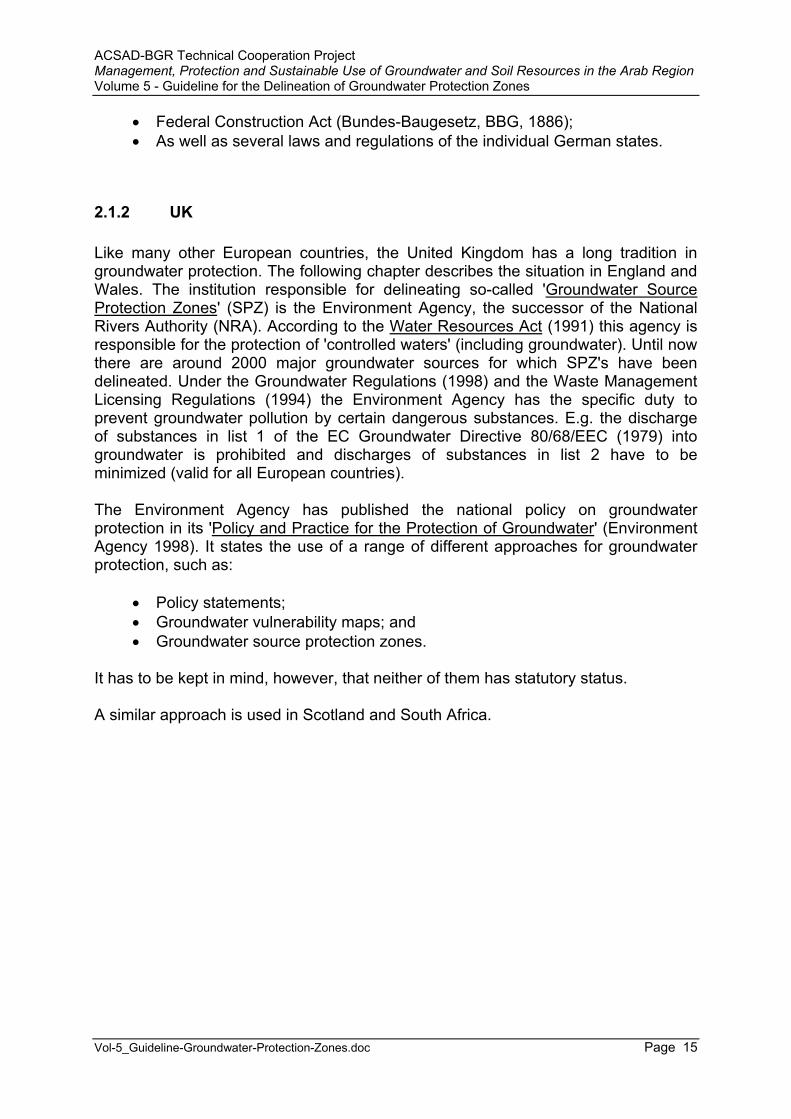
Figure A-2: Source Protection Zoning used in the UK (source: Environment Agency 2002, internet)
Zoning System
The 'Policy and Practice for the Protection of Groundwater' defines three zones for groundwater protection (compare Figure A-2):
Zone I, the inner zone, is defined by the 50-day travel time from any point below the water table to the source, being not less than 50 m. This boundary is based on biological decay criteria and the protection against toxic chemicals and air-borne diseases.
Zone II, the outer zone, is defined by the 400-day travel time or 25 percent of the source catchment area, whichever is larger. The minimum time to provide delay, dilution and attenuation of slowly degrading pollutants are the main criteria for this boundary.
Zone III is defined as the area needed to support the protected yield from long-term groundwater recharge.
The 'Guide to Groundwater Protection Zones in England and Wales' (NRA 1995a) is a practice guide elaborating on methods to be applied for the delineation process. The groundwater protection policy is supported by a countrywide assessment of the risks to groundwater in the form of groundwater vulnerability maps (NRA 1995b).
In practice groundwater protection zones have been delineated by regional staff of the Environment Agency in cooperation with the National Groundwater and Contaminated Land Centre. From the 1970s until the early 1990s, simple standard shapes, based on hydraulic equations, have been mainly used to delineate source protection zones. Nowadays, however, the delineation of protection zones is made using either a conceptual hydrogeological model or groundwater flow models. The choice of zone definition technique is based on: data quality and availability, the degree of understanding of the hydrogeological system and the operational importance of the water source.

ACSAD-BGR Technical Cooperation Project Management, Protection and Sustainable Use of Groundwater and Soil Resources in the Arab Region Volume 5 - Guideline for the Delineation of Groundwater Protection Zones
Vol-5_Guideline-Groundwater-Protection-Zones.doc Page 17
Restrictions
Restrictions are made in the form of groundwater protection policy statements (see Annex A-2, ENVIRONMENT AGENCY 1998). They have no statutory character but are mainly recommendations. However, the Environment Agency seeks to influence land use decisions which may have an impact on groundwater quality by actively participating in the decision making process and issuing so-called planning policy guidance notes.
Advantages
The UK guideline provides in principle four protection zones and therefore a much larger area and higher level of differentiation for preventive measures than in many other countries. This is because not only bacteriological pollution (50-day travel time) is used as delineation criterion, as in many other zoning systems, but also because the dilution, adsorption, or attenuation of hazardous substances (400-day travel time) are foremost aspects for achieving groundwater protection. By specifying longer travel times this can much easier be achieved.
Disadvantages
The actions in defined protection zones have the character of recommendations only. Reaching a comprehensive protection of the groundwaters therefore highly depends on the goodwill of the stakeholders.
Other laws and regulations concerning groundwater protection issues
The Environment Act (1995); Water Resources Act (1991); The Town and Country Planning Act (1990); The Planning and Compensation Act (1991); Environmental Protection Act (1990); Control of Pollution Act (1974); Control of Pollution Regulations; Waste Management Licensing Regulations (1994); Sludge (Use in Agriculture) Regulations (1989); Code of Good Agricultural Practice for the Protection of Water (Ministry of
Agriculture); Code of Practice for the Safe Use of Pesticides on Farms and Holdings; Hazardous Substances Act (1990).

ACSAD-BGR Technical Cooperation Project Management, Protection and Sustainable Use of Groundwater and Soil Resources in the Arab Region Volume 5 - Guideline for the Delineation of Groundwater Protection Zones
Vol-5_Guideline-Groundwater-Protection-Zones.doc Page 18
2.1.3 France
Legal Basis
In France the delineation of groundwater protection zones became obligatory for all water abstraction facilities with law 92-3 of January 3rd, 1992. In fact, the issuance of groundwater protection zones had been included already in the law of October 30th,1935, but never been applied. A new water law was proposed by the French Government under Lionel Jospin in September 2001, but was abandoned by the new government. Article 5 of law 92-3 defines that protection measures for surface water and groundwater have to be made in the framework of establishing so-called water improvement and management plans (SDAGE). The role and tasks of the SDAGE was defined in more detail by decree 92-1042.
The 1992 law left 5 years for all protection zones to be declared. However, this goal was not reached. Until January 4th, 1997, only 13.9 % of the surface water and 31.5 % of the groundwater abstraction facilities were protected by protection zones. In general protection zones are to be issued in the form of a declaration on a public utility (déclaration d’utilité publique – D.U.P.).
Water law enforcement is conducted by means of a water police (police de l’eau), which has true policing force.
The legal basis remains relatively week. The implementation is not strict enough due to the strong resistance of the farmers associations. Because of this the water quality in France is rather poor (MINISTRY OF HEALTH 1998). This fact was officially condemned by the European Union in March 2001 as contradicting EC-Directive 75/440.
Responsibilities
Due to the strong decentralization in France, the water issues are mostly dealt with at local level. Following the 1992 water law, so-called water improvement and management plans (schémas directeurs d’aménagement et de gestion des eaux - SDAGE) had to be established for each major water basin (law 92-3, article 3). The members of the SDAGE are: representatives from the Ministry of Land and Environment Management, the water agencies, the basin committees, the local government, the manufacturers and the farmers. The work of the six (according to the six hydrographic basins) SDAGE agencies (Agences de l’Eau) in France encompasses defining objectives for quality and quantity management of water resources, pollution prevention and protection measures, managing drinking water supply and public health and prevention of natural and man-made disasters. The main concern of the SDAGE plans is to reach a balanced management of the freshwater system. The present SDAGE plans had to be operational by 1997 and will be in place for a time period of 15 years. Many of them are, however, not yet approved. Mostly the SDAGE plans rely on local plans, called schémas d’aménagement et de gestion des eaux (SAGE). The basin committees of SDAGE annually make recommendations to the six public water agencies. The water

ACSAD-BGR Technical Cooperation Project Management, Protection and Sustainable Use of Groundwater and Soil Resources in the Arab Region Volume 5 - Guideline for the Delineation of Groundwater Protection Zones
Vol-5_Guideline-Groundwater-Protection-Zones.doc Page 19
agencies prepare five-year action plans which have to implement the recommendations of the basin committees. The water agencies collect so-called “extraction-charges” and “pollution charges” in order to finance the management of the water resources from a quantitative point of view and to improve the quality of the resource. Since the water agencies have no executive authority, a “water police” was introduced to enforce the legally required actions.
The cooperation with other ministries is carries out in the framework of inter-departmental water missions (MISEs), which under the supervision of the local prefects provide authorizations for water extractions or discharges and enforce the law from the administrative point of view.
Zoning System
According to article L.20 of the Public Health Code 3 zones are differentiated: the immediate protection zone (périmètres de protection immédiate) ; the proximity zone (périmètres de protection rapprochée) ; and the distant zone (périmètres de protection éloignée).
The immediate protection zone is obligatory and encompasses commonly several hundred square meters to a few hectares (mostly 30m * 30 m). Its function is to avoid direct contaminations at the abstraction facility. The land covered by this zone has to be owned by the Government (expropriation) and must be enfenced. The proximity zone is obligatory as well. The size and shape of this zone is determined by hydraulic criteria (article L.20 of the Public Health Code does not further specify this matter, however, commonly the 50-days line is used to delimit this zone). The distant zone is not obligatory. In both, proximity and distant zones, the owners of the land plots have to be compensated for any losses incurred due to the land use restrictions imposed.
The procedure for the delineation of groundwater protection zones generally consists of six phases:
1. decision of the municipality or utility to undertake protection; 2. hydrogeological study; 3. public hearing; 4. registration of the protection zones as a public utility; 5. registration of land use restrictions, expropriation of land in the immediate
protection zone; 6. conducting the technical measures to reduce the pollution risks.
The costs for the procedure are mostly below 23,000 Euro, and the costs for protection works usually less than 38,000 Euro.
The main costs for the establishment of groundwater protection zones are covered by the public water agencies, which pay 50% of the studies and administrative procedures and 40% of the compensation and (construction) work.
ACSAD-BGR Technical Cooperation Project Management, Protection and Sustainable Use of Groundwater and Soil Resources in the Arab Region Volume 5 - Guideline for the Delineation of Groundwater Protection Zones
Vol-5_Guideline-Groundwater-Protection-Zones.doc Page 20
Restrictions
There are no fixed rules for land use restrictions. However, in the proximity zone generally the following activities are banned:
boreholes and wells, other than for the abstraction and monitoring of the water from the water supply facility;
mineral exploitation by open-cast mining; disposal of waste; installation of sewer line and reservoirs or depots of used water of domestic or
industrial origin or chemical products; application or infiltration of used water of domestic or industrial origin.
Since it was recognized that it is often difficult to impose and implement restrictions for certain land use activities, especially those related to agriculture, other forms had to be found, such as:
Economic incentives, e.g. for applying ‘best management practices’ in agriculture. Although financially very attractive for the farmers, this is a measure which has to be conducted over a very long time and thus very expensive.
Soil appropriation: some municipalities and companies selling bottled water (e.g. Vittel) have started to buy land in sensitive areas, thereby reducing the pollution risk.
Pollution taxes: The former Government (Environment Minister Dominique Voynet) suggested a general tax on all pollution activities and certain products. This proposal however failed to be accepted in the senate. The water agencies, however, have the right to collect certain pollution taxes based on the polluter-pays-principle (see above). Even though it is difficult to assess which amounts of pollutants (e.g. nitrate) are discharged into the environment, the new water bills aim to include a ‘nitrate pollution tax’. A tax for the application of pesticides is already in place in France, ranging from zero to 1524 Euro per ton, depending on the toxicity of the substance PAVARD, 2001). Similar taxes could in principle be applied for all substances which have a negative impact on the water quality. In reality, however, this taxation is rarely implemented.
Advantages
(No sufficient information).
Disadvantages
The share of irrigated land has tripled since 1970, resulting in an increasingly high consumption of water in the agricultural sector. Groundwater accounts for about 65 % of total water abstractions in France. Many areas are heavily cultivated, such as the Bretagne and Normandy. Surface water and groundwater pollution resulting from agricultural activities has increased over the past decades (GODET et al, 1998).

ACSAD-BGR Technical Cooperation Project Management, Protection and Sustainable Use of Groundwater and Soil Resources in the Arab Region Volume 5 - Guideline for the Delineation of Groundwater Protection Zones
Vol-5_Guideline-Groundwater-Protection-Zones.doc Page 21
The groundwater protection measures, having been introduced only a decade ago, do not yet show a significant improvement of the water quality. The administrative procedure seems not to be effective, since a public utility decree has been declared for 11% of all water abstraction points only, whereas for 30% not even the first step of the protection procedure has begun. It can be expected to take another 10 to 20 years until all public water utilities are provided with protection zones.
A general guideline for the delineation of protection zones is lacking, so that the criteria for the delineation vary from place to place and sometimes depend on the interpretation and willingness of local politicians. Moreover, there are no general rules for land use restrictions and the supervision of the implementation. The enforcement of the implementation seems also to be very weak due to the weak position of the water policing authority.
Due to the very long time duration required for establishing protection zones and the involved costs, some municipalities have opted for abandoning their own water abstraction facilities in favor of obtaining their water from other producers.
The agricultural lobby in France is very strong and is putting up resistance against the implementation of more strict restrictions for land use. Water protection can, however, only be effective if the countermeasures are effective enough to prevent pollution.
Other laws and regulations concerning groundwater protection issues
A complete list of all laws and regulations related to water and environment is documented on the enclosed CD (information from www.legifrance.gouv.fr).
The law 92-3 states that water treatment installations must be in operation for all villages with more than 200 inhabitants by 2005.
The environment law was passed in 1995 (loi 95-101; “loi Barnier”).
2.1.4 Switzerland
Legal Basis
The delineation of groundwater protection zones as well as a number of other measures aiming at the protection of surface and groundwater resources are laid down in the Water Protection Act (Gewässerschutzgesetz, 1991) and the Water Protection Ordinance (Gewässerschutzverordnung, 1998). The Guidance for Groundwater Protection (Wegleitung Grundwasserschutz, BUWAL 2000) defines the process of protection zone delineation.
ACSAD-BGR Technical Cooperation Project Management, Protection and Sustainable Use of Groundwater and Soil Resources in the Arab Region Volume 5 - Guideline for the Delineation of Groundwater Protection Zones
Vol-5_Guideline-Groundwater-Protection-Zones.doc Page 22
Responsibilities
Whereas the federal government is responsible for the federal laws and regulations, the districts (Kantone) are responsible for the issuance of the ordinance and the implementation of restrictions and permissions. However, the owner (municipalities or companies) of the water supply facility is responsible for conducting the required hydrogeological study, for paying for the administrative procedure and for paying compensations, if any.
Zoning System
Protection measures and restrictions are defined by the Water Protection Ordinance itself in a very comprehensive manner. It is distinguished between protective measures achieved by using
Thorough land use and water quality conservation planning; Thorough engineering and construction methods; and Thorough handling and manufacturing methods.
In general the guidance distinguishes different levels of protection of groundwater by defining
Endangered areas where a protection is required for safeguarding exploitable groundwater resources (Gewässerschutzbereich Au, if of relevant extractable amount and fulfilling quality standards);
Endangered areas where Protection zones for groundwater quality restoration have to be established because water abstraction facilities are already affected by pollution (Zuströmbereich Zu);
Conservation areas (Grundwasserschutzareale) for the protection of important groundwater resources, which are presently not being used as drinking water resources but might be in the future;
Protection zones S1, S2 and S3 (Grundwasserschutzzonen) for the protection of existing water abstraction facilities used for domestic water supply;
Other areas with no or exploitable groundwater resources of little importance. Here few restrictions for human activities are required.
Three elements are necessary for the administrative procedure to issue a groundwater protection zone ordinance: a hydrogeological report, a protection zone plan and a protection zone rule. What is required from hydrogeological reports has to be justified by the level of potential pollution threat. The protection zone plan shows the boundaries of the zones S1, S2 and S3 as they were determined by hydrogeological investigations (hydrogeological boundaries) and the practical boundaries, following natural boundaries or boundaries of landownership.
The groundwater protection zones are (except for karst aquifers; see below): Zone S1 – The immediate protection zone is defined by a distance of at
least 10 m from the water well. In the case of spring captures using drainage

ACSAD-BGR Technical Cooperation Project Management, Protection and Sustainable Use of Groundwater and Soil Resources in the Arab Region Volume 5 - Guideline for the Delineation of Groundwater Protection Zones
Vol-5_Guideline-Groundwater-Protection-Zones.doc Page 23
tubes, a distance of 10 m should be maintained from the entire drainage tube. The area should be protected by a fence.
Zone S2 – The inner protection zone, defined by the 10-day travel time in the saturated zone of the aquifer.
Zone S3 – The outer protection zone, encompasses a zone where, in the case of unconsolidated rocks, the distance from the outer boundaries of zones S2 to S3 is at least as large as the distance from the outer boundaries of zones S1 to S2.
For the delineation of zone S2, travel times in the unsaturated zone are not taken into account. For the delineation of the extent of zone S2 the daily maximum allowable water abstraction (according to the abstraction license) and low water level conditions have to be used. The average flow velocity is considered as representative flow velocity for determining travel times. Dispersion effects are neglected. The distance from the outer boundary of zone S1 to the outer boundary of zone S2 has to be at least 100 m. Zone S2 could be smaller if proven that it is entirely covered by low permeable sediments (k < 1E-5 m/s) of at least 2 m thickness. Zone S2 may not need to be delineated if groundwater is abstracted from a deeper aquifer which is proven not to be in hydraulic contact with the shallow aquifer.
For karst aquifers the delineation of protection zones is not based on groundwater flow velocities but on the assessment of the so-called groundwater vulnerability. The assessment of groundwater vulnerability is made using the EPIK method (SAEFL 2000) and comprises the evaluation of several geological, geomorphologic and hydrogeological criteria. EPIK (Annex A-4) uses four criteria:
Development of Epikarst; Effectiveness of the Protective cover; Conditions of Infiltration; Development of Karst network.
Commonly a weighing coefficient is attributed to each of these criteria. The basic EPIK factors are obtained conducting a systematic mapping in a grid of 20 m grid line distance using geomorphologic studies, aerial photograph interpretation, tracer tests, drillings, excavations and geophysical investigations. In a next step the protection index (F) is calculated by using certain weighing coefficients. Finally the protection index is classified according to a defined system, corresponding to protection zones S1, S2, S3 and the remaining groundwater catchment area. The preparation of such a groundwater vulnerability map is usually done using a GIS system.
Restrictions
The guidance defines very specific restrictions on human activities in the above-mentioned groundwater protection zones in the form of matrixes for:
Construction sites; Constructions of buildings and facilities above the land surface and
construction changes thereof;
ACSAD-BGR Technical Cooperation Project Management, Protection and Sustainable Use of Groundwater and Soil Resources in the Arab Region Volume 5 - Guideline for the Delineation of Groundwater Protection Zones
Vol-5_Guideline-Groundwater-Protection-Zones.doc Page 24
Activities related to geothermal energy (such as drillings, injection facilities, etc.);
Waste water facilities; Infiltration facilities (of unpolluted waters); Railway facilities; Facilities related to transportation by automobiles (e.g. tunnels, petrol
stations, car parks, etc.; Airport facilities; Underground constructions; Cultivated land; Forestry; Recreational and sport facilities; Cemeteries; Waste disposals, storage facilities, temporary storage facilities and
pipelines; Nature restoration measures; Military sites and shooting ranges.
Advantages
The Swiss classification system uses a very intricate differentiation and also provides protection for areas which form important groundwater resources that might be of importance in the future. It has clear advantages in karst systems, such as those largely found in Jordan, Syria and Lebanon.
Disadvantages
For unconsolidated rocks, the Swiss guideline defines the boundary of zone S2 by a travel time of 10 days only. This is much lower than in many other countries (mostly around 50 days) and well above the persistence time of bacteria and viruses. The reason is that the Swiss guidance takes protection by the unsaturated zone into consideration. However, travel times in the unsaturated zone are highly variable, difficult to estimate and may often be low (< 40 days) so that an adequate protection from bacteria may not always be guaranteed.
Other laws and regulations concerning groundwater protection issues
Ordinance for the protection of water bodies against liquid substances hazardous to water (1998);
Ordinance on substances hazardous to the environment (1986), Technical ordinance on waste (1990); Ordinance on land reclamation of contaminated lands (1998).

ACSAD-BGR Technical Cooperation Project Management, Protection and Sustainable Use of Groundwater and Soil Resources in the Arab Region Volume 5 - Guideline for the Delineation of Groundwater Protection Zones
Vol-5_Guideline-Groundwater-Protection-Zones.doc Page 25
2.1.5 Hungary
Legal Basis and Responsibilities
The Hungarian Government passed a new water law which was enacted on 1st
January 1996 (HAVAS-SZILAGYI, 2002). It states that owners of water rights have the duty to keep the utilized water resources safe. A regulation was issued in September 1997 that describes tasks and responsibilities in well field protection. This regulation is binding only for well fields providing water to the public water supply system, for private wells it is optional. The law specifies a time span of 10 years for regulations to be enforced at well fields existing before 1996. At new well fields the regulation has to be issued simultaneously with establishment of the well field, at prospective well fields (areas which are of importance for future water supply) within 8 years.
Since 1991 water supply is in the hand of the municipalities. Because most well fields were missing protection schemes a National Well Field Protection Program was implemented. The total number of well fields is 643, with a total number of abstraction wells of 3640. The program consists of 3 phases: fact finding, implementation and safeguarding. The first phase is 100% financed by the Government and has the following tasks: determination of protection zones, inventory of pollution sources, design and implementation of a monitoring system, assessment and prognosis of possible pollution processes and water quality, proposals for the second phase, cost-benefit analysis for alternatives. During the second phase measurements for well protection are implemented: investments in wastewater collection and treatment, removal or reconstruction of pollution sources, clean-up operations, active protection measures. The work conducted in this phase is partly financed by the municipalities and partly by the Government (50-60%). The third phase of safeguarding is to be financed by the water works, i.e. from the water price. In this phase the monitoring system is operated to control a possible remaining pollution and measures are undertaken to avoid new pollution sources.
More than one third of the protection areas are located in karstic environments. For the selection of well fields to be investigated, the following selection criteria were used:
pollution already detected in an abstraction well; pollution detected in a monitoring well upstream of the abstraction well; total number of people supplied by the well field; lack of alternatives for constructing a new well field at another location nearby; preliminary protective measures have already been undertaken.
Zoning System
In total five different zones are being differentiated: Inner protection zone: 20 days of travel time; Outer protection zone: 6 months of travel time; Hydrogeological protection zone A: 5 years travel time;
ACSAD-BGR Technical Cooperation Project Management, Protection and Sustainable Use of Groundwater and Soil Resources in the Arab Region Volume 5 - Guideline for the Delineation of Groundwater Protection Zones
Vol-5_Guideline-Groundwater-Protection-Zones.doc Page 26
Hydrogeological protection zone B: 50 years travel time; Hydrogeological protection zone C: total recharge area.
Zones 2 to 4 should be delineated by hydraulic modeling.
Restrictions
Restrictions for pollution sources and polluting activities are defined within the protection zones differently from area to area, based on the principle of balanced decisions between protection demands and the consequences for individuals. The shorter the distance from the point of abstraction, the stronger are the restrictions. Concerning existing pollution sources or polluting activities the following alternatives are possible: they can be either banned or continued, depending on the results of an environmental impact assessment.
Advantages
(No sufficient information)
Disadvantages
(No sufficient information)
Other laws and regulations concerning groundwater protection issues
(No sufficient information)
2.2 USA
Legal Basis and Responsibilities
The responsibility for groundwater protection lies at State level. However, the 1986 Federal Safe Drinking Water Act Amendments (Section 1428, P.L. 93-523, 42 USC 300 et. seq.) direct all States to develop a Well Head Protection Program (WHPP)Plan for both public community (CWS) and public non-community (NCWS) water-supply wells. Following these amendments the States had to propose a WHPP Plan that had to be approved by the U.S. Environmental Protection Agency (EPA). The delineation of Well Head Protection Areas (WHPA's) is one component of the WHPP. Other components of the WHPP Plan include pollution-source inventories, development and implementation of best management practices to protect groundwater, integrated land use planning, and education to promote public awareness of each person’s role in protecting groundwater resources. The Safe
ACSAD-BGR Technical Cooperation Project Management, Protection and Sustainable Use of Groundwater and Soil Resources in the Arab Region Volume 5 - Guideline for the Delineation of Groundwater Protection Zones
Vol-5_Guideline-Groundwater-Protection-Zones.doc Page 27
Drinking Water Act Amendments of 1996 (P.L. 104-182) established the need for state Source Water Assessment Programs.
The Well Head Protection Program incorporates the following elements:
Duties of states, local agencies and water suppliers in implementing the program;
Determination of WHPA's for each public well or well field; Identification of all potential pollution sources within the protection area; A program containing: technical assistance, financial assistance,
implementation of control measures, education, training, and demonstration projects;
Contingency plans for alternative water supplies in case of contamination; Siting considerations for all new wells; Public participation.
Zoning System
The methodology to be used for the delineation of Well Head Protection Areas is laid down in the 'Guidelines for the Delineation of Wellhead Protection Areas' (EPA 1987). This guideline gives the States, i.e. the implementing authorities, flexibility to choose an appropriate approach for the delineation policy. The guideline proposes as operational goals:
To provide a remedial action zone (in order to protect the well from unexpected contaminant release);
To provide an attenuation zone (in order to bring the concentrations of specific contaminants down to desired levels by the time they would reach the wellhead; and
To provide a well field management zone.
As criteria for the delineation of groundwater protection zones the guideline uses: Distance; Drawdown; Travel time; Flow system boundaries; and The capacity of the aquifer to assimilate contaminants.
This criteria catalog is the main difference to many other systems, which are based on travel times only. Moreover, the EPA guideline does no propose the use of a certain zoning system, unlike in most other countries. It leaves this decision to the implementing authority. And in reality this procedure is applied in very different manners throughout the different states and even counties.
The guideline only specifies that for the delineation of protection zones 'appropriate thresholds' have to be chosen, representing the limits above or below which a criterion will cease to provide the desired level of protection.
ACSAD-BGR Technical Cooperation Project Management, Protection and Sustainable Use of Groundwater and Soil Resources in the Arab Region Volume 5 - Guideline for the Delineation of Groundwater Protection Zones
Vol-5_Guideline-Groundwater-Protection-Zones.doc Page 28
The guideline proposes using the following methods for the delineation process:
Arbitrary fixed radius method; Calculated fixed radius method; Simplified variable shapes; Analytical methods; Hydrogeologic mapping; and Numerical flow/transport models.
The guideline does not propose individual restrictions on land use and human activities as in guidelines of other countries. The responsibility for these definitions lies at State level.
For the delineation of protection zones EPA (1987) proposes the following approach towards the States:
1. Establishment of working groups or committees; 2. Conducting technical studies and institutional analyses; 3. Determination of WHPA criteria to be used; 4. Determination of WHPA delineation methods to be used; 5. Delineation of boundaries of protection zones for specific wells or well
fields;6. Conducting additional studies; 7. Refinement of delineation of boundaries, if required.
In the meantime a number of States have developed their own guidelines or guidances for delineating WHPA's, which are more specific than the EPA (1987) guideline and demand the preparation of a hydrogeologic study following a standard concept, such as for instance in Michigan (Michigan Department of Environmental Quality – WHPA Delineation Guidance, source: www.michigan.gov/deq internet site), Ohio (State EPA guidance document, source: www.epa.state.oh.us), Wyoming (Wyoming Department of Environmental Quality WHPP guidance document, source: www.wrds.uwyo.edu/wrds/deq/whp/contents.html), etc.
After the 1996 amendment of the Safe drinking water act EPA initiated the so-called Source Water Protection Program. This program requires the States to develop a Source Water Assessment Program (participation is voluntary) that:
Delineates the source water assessment area (Source Water Assessment Program, to be completed by 2003);
Conduct an inventory of potential sources of contamination in the delineated area (a list of potential sources is laid down in EPA's "Drinking Water Contaminant Source Index" (internet download);
Determine the susceptibility of the water supply to those contamination sources; and
Inform the public about the results.
ACSAD-BGR Technical Cooperation Project Management, Protection and Sustainable Use of Groundwater and Soil Resources in the Arab Region Volume 5 - Guideline for the Delineation of Groundwater Protection Zones
Vol-5_Guideline-Groundwater-Protection-Zones.doc Page 29
The goal is that by the year 2005, 60 percent of the population would receive water from public supply systems protected by source water protection programs. Funds for conducting these tasks and even for conservation easements were made available from the Drinking Water State Revolving Fund. Details of this program are documented in EPA (1997). The basis for this program however is weak, since it has no statutory mandate.
Restrictions
No information available (regulations differ from state to state, sometimes even from county to county).
Advantages
Leaving flexibility for using appropriate criteria and methods for the delineation process has the advantage that the implementing authority can decide for itself which is the appropriate criterion and method in each individual case. This can considerably reduce costs to the appropriate level depending on the balance of options relative to the goals, economy, legal defensibility, relevance of the protection goal, and long-term planning objectives.
The preparation of a contingency plan for the case of an imminent groundwater pollution endangering the domestic water supply by a well or well field is missing in the groundwater protection policy of many other countries. For countries and areas, where the water supply mains of larger, sparsely populated areas are not interconnected, it is, however, very important to implement such an emergency action or contingency plan. Such is the case also in many areas of the Arab region, where the water supply usually depends on a few wells and often is highly vulnerable to pollution. If there is an imminent risk of pollution for those wells, water supply has to be maintained by other wells or by water supply from other areas.
Furthermore, the preparation of a plan for the siting of new wells is a very valuable tool for water resources management because it avoids contamination in future areas of groundwater exploitation.
One of the focal points of the delineation procedure in the USA is public participation. This is for the benefit of all parties involved and may better avoid unnecessary or unjustified protection measures.
Disadvantages
The guideline leaves much room for arbitrary delineations of protection zones since no specific zoning system is defined. The reason is possibly that the conditions are too different from State to State so that a zoning system using very strict definitions may not be justified in a State where the potential threat of pollution is low due to few
ACSAD-BGR Technical Cooperation Project Management, Protection and Sustainable Use of Groundwater and Soil Resources in the Arab Region Volume 5 - Guideline for the Delineation of Groundwater Protection Zones
Vol-5_Guideline-Groundwater-Protection-Zones.doc Page 30
groundwater hazards, other than in densely populated states. This, however, makes decisions difficult to defend legally.
Other laws and regulations concerning groundwater protection issues
Clean Water Act (CWA, 1948, 1977, 1991); Comprehensive Environmental Response, Compensation , and Liability Act
(CERCLA > Superfund Program, 1980); Water Resources Planning Act (1965); Emergency Planning and Community Right-to-know Act (EPCRA, 1986); Federal Insecticide, Fungicide, and Rodenticide Act (FIFRA, 1947); National Environmental Policy Act (NEPA, 1969); Resource Conservation and Recovery Act (RCRA, 1976); Sole Source Aquifer Program (SSA, 1974) ; Comprehensive State Groundwater Protection Programs (CSGWPPs,
1990); Underground Injection Control Program (UIC, established 1981in sections
1421-26 of SDWA); Non-Point Source Program (NPS, 1987, section 319 of CWA); Toxic Release Inventory Program (TRI, established 1986 under CERCLA); Toxic Substances Control Act (TSCA, 1997); Environmental Pollution Prevention Project (EP3, 1993, funded by EPA and
USAID for addressing urban and industrial pollution and environmental quality in developing countries);
Pollution Prevention Act (1990).
2.3 Australia
Legal Basis and Responsibilities
The water legislations slightly differ in each of the States. As an example it is referred herein to those in place in Western Australia, because for this State the most extensive information was available. All water related matters are regulated by the Country Areas Water Supply Act (1947) and the Metropolitan Water Supply and Sewerage and Drainage Act (1909). The authority responsible for groundwater protection (as well as other water related tasks) is the Water and Rivers Commission. Besides policy making the commission has to establish so-called Water Source Protection Plans for Public Drinking Water Source Areas (PDWSAs). PDWSAs are proclaimed for Underground Water Pollution Control Areas (UWPCAs), Catchment Areas (CAs) and Water Reserves (WRs). The State Water Quality Management Strategy (2001) aims to provide new guidelines and regulations concerning the protection of the water resources, which are, however, not yet in place.
ACSAD-BGR Technical Cooperation Project Management, Protection and Sustainable Use of Groundwater and Soil Resources in the Arab Region Volume 5 - Guideline for the Delineation of Groundwater Protection Zones
Vol-5_Guideline-Groundwater-Protection-Zones.doc Page 31
Zoning System
The zoning system follows two main objectives: To protect drinking water sources in the interest of public health from
contamination by inappropriate activities and To protect the environmental values of water sources used for purposes
other than drinking supply.
The term 'environmental value' refers to The protection of aquatic systems (e.g. water supporting fauna and flora
habitats); Recreational water quality and aesthetics; Agricultural water use; and Industrial water quality.
The Australian zoning system is very much distinct from other countries' guidelines for groundwater protection zone delineation. Three priority classification areas have been defined in PDWSAs (compare Figure A-3):
Priority 1 (P1) Source Protection Area: ensures that there is no degradation of the water source. P1 areas are declared over areas where the provision of the highest quality public drinking water is the prime beneficial land use.
Priority 2 (P2) Source Protection Area: ensures that there is no increased risk of pollution to the water resources. P2 areas are declared over land where low intensity development (such as rural) already exists. Protection of public water supply sources is a high priority in these areas. P2 areas are managed in accordance with the principle of risk minimization and so conditional development is allowed.
Priority 3 (P3) Source Protection Areas are defined to manage the risk of pollution to the water source. P3 areas are declared over land where water supply sources need to co-exist with other land uses such as residential, commercial and light industrial developments. Protection of P3 areas is achieved through management guidelines for land use activities. If the water source does become contaminated, then water may need to be treated or an alternative water source found.
In addition to priority classifications, well-head protection zones and reservoir protection zones are defined to protect the water source from contamination in the immediate vicinity of production wells and reservoirs. Well-head protection zones are usually circular, with a radius of 500 meters in P1 areas and 300 meters in P2 and P3 areas. Reservoir protection zones usually consist of a 2 kilometer buffer area around the top water level of a reservoir and include the reservoir itself. These zones do not extend outside water reserves. Special conditions apply within these zones.
Priority is determined by land tenure, land use and water flow paths. Different management strategies apply in each priority area.
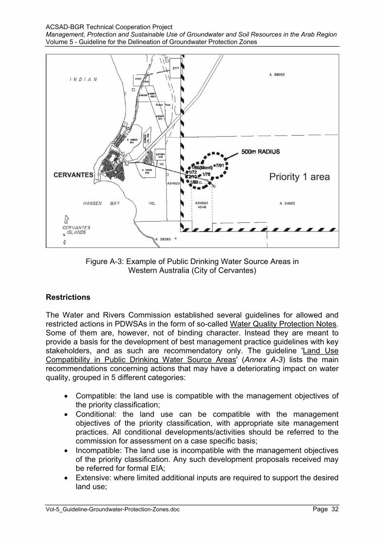
ACSAD-BGR Technical Cooperation Project Management, Protection and Sustainable Use of Groundwater and Soil Resources in the Arab Region Volume 5 - Guideline for the Delineation of Groundwater Protection Zones
Vol-5_Guideline-Groundwater-Protection-Zones.doc Page 32
Figure A-3: Example of Public Drinking Water Source Areas inWestern Australia (City of Cervantes)
Restrictions
The Water and Rivers Commission established several guidelines for allowed and restricted actions in PDWSAs in the form of so-called Water Quality Protection Notes.Some of them are, however, not of binding character. Instead they are meant to provide a basis for the development of best management practice guidelines with key stakeholders, and as such are recommendatory only. The guideline 'Land Use Compatibility in Public Drinking Water Source Areas' (Annex A-3) lists the main recommendations concerning actions that may have a deteriorating impact on water quality, grouped in 5 different categories:
Compatible: the land use is compatible with the management objectives of the priority classification;
Conditional: the land use can be compatible with the management objectives of the priority classification, with appropriate site management practices. All conditional developments/activities should be referred to the commission for assessment on a case specific basis;
Incompatible: The land use is incompatible with the management objectives of the priority classification. Any such development proposals received may be referred for formal EIA;
Extensive: where limited additional inputs are required to support the desired land use;
ACSAD-BGR Technical Cooperation Project Management, Protection and Sustainable Use of Groundwater and Soil Resources in the Arab Region Volume 5 - Guideline for the Delineation of Groundwater Protection Zones
Vol-5_Guideline-Groundwater-Protection-Zones.doc Page 33
Intensive: Where regular additional inputs are required to support the desired land use.
Advantages
The Water Quality Protection Notes, established for quite a number of activities and land uses provide a good guidance for decision makers concerning restrictions in the individual protection zones.
Disadvantages
The shape and extent of the protection zones is arbitrary and not based on hydrogeological criteria. Imposed restrictions are for the most part recommendations only and thus depend on the goodwill of the involved stakeholders.
Other laws and regulations concerning groundwater protection issues
• Country Areas Water Supply Act 1947; • Environmental Protection Act 1986; • Environmental Protection Regulation 1987; • Environment Protection and Biodiversity Conservation Act 1999
(Commonwealth);• Environmental Protection (Controlled Waste) Regulations 2001; • Environmental Protection (Liquid Waste) Regulations 1996; • Soil and Land Conservation Act 1945; • Conservation and Land Management Act 1984; • Dangerous Goods Regulations 1992; • Dangerous Goods (Transport) Act 1998; • Explosives and Dangerous Goods Act 1961; • Hazardous Waste (Regulation of Exports and Imports) Act 1989
(Commonwealth);• Pollution of Waters by Oil and Noxious Substances Act 1987; • Land Drainage Act 1925; • Mining Act 1978; • Mines Safety and Inspection Act 1994; • Mines Safety and Inspection Regulations 1995; • Rights in Water and Irrigation Act 1914; • Western Australian Marine (Sea Dumping) Act 1981.
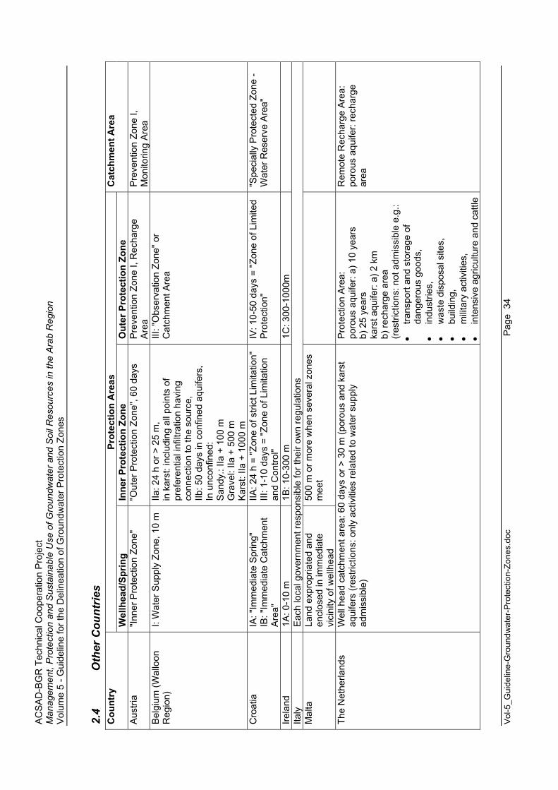
AC
SA
D-B
GR
Tec
hnic
al C
oope
ratio
n P
roje
ct
Man
agem
ent,
Pro
tect
ion
and
Sus
tain
able
Use
of G
roun
dwat
er a
nd S
oil R
esou
rces
in th
e A
rab
Reg
ion
Vol
ume
5 - G
uide
line
for t
he D
elin
eatio
n of
Gro
undw
ater
Pro
tect
ion
Zone
s
Vol
-5_G
uide
line-
Gro
undw
ater
-Pro
tect
ion-
Zone
s.do
c
Pag
e 3
4
2.4
Oth
er C
ount
ries
Prot
ectio
n A
reas
C
ount
ry
Wel
lhea
d/Sp
ring
Inne
r Pro
tect
ion
Zone
O
uter
Pro
tect
ion
Zone
C
atch
men
t Are
a
Aus
tria
"Inne
r Pro
tect
ion
Zone
" "O
uter
Pro
tect
ion
Zone
", 60
day
s P
reve
ntio
n Zo
ne I,
Rec
harg
e A
rea
Pre
vent
ion
Zone
I,
Mon
itorin
g A
rea
Bel
gium
(Wal
loon
R
egio
n)
I: W
ater
Sup
ply
Zone
, 10
m
IIa: 2
4 h
or >
25
m,
in k
arst
: inc
ludi
ng a
ll po
ints
of
pref
eren
tial i
nfilt
ratio
n ha
ving
co
nnec
tion
to th
e so
urce
, IIb
: 50
days
in c
onfin
ed a
quife
rs,
In u
ncon
fined
: S
andy
.: IIa
+ 1
00 m
G
rave
l: IIa
+ 5
00 m
K
arst
: IIa
+ 1
000
m
III: "
Obs
erva
tion
Zone
" or
Cat
chm
ent A
rea
Cro
atia
IA
: "Im
med
iate
Spr
ing"
IB
: "Im
med
iate
Cat
chm
ent
Are
a"
IIA: 2
4 h
= "Z
one
of s
trict
Lim
itatio
n"
III: 1
-10
days
= "Z
one
of L
imita
tion
and
Con
trol"
IV: 1
0-50
day
s =
"Zon
e of
Lim
ited
Pro
tect
ion"
"S
peci
ally
Pro
tect
ed Z
one
- W
ater
Res
erve
Are
a"
Irela
nd
1A: 0
-10
m
1B: 1
0-30
0 m
1C
: 300
-100
0m
Ita
ly
Eac
h lo
cal g
over
nmen
t res
pons
ible
for t
heir
own
regu
latio
ns
Mal
ta
Land
exp
ropr
iate
d an
d en
clos
ed in
imm
edia
te
vici
nity
of w
ellh
ead
500
m o
r mor
e w
hen
seve
ral z
ones
m
eet
The
Net
herla
nds
Wel
l hea
d ca
tchm
ent a
rea:
60
days
or >
30
m (p
orou
s an
d ka
rst
aqui
fers
(res
trict
ions
: onl
y ac
tiviti
es re
late
d to
wat
er s
uppl
y ad
mis
sibl
e)
Pro
tect
ion
Are
a:
poro
us a
quife
r: a)
10
year
s b)
25
year
s ka
rst a
quife
r: a)
2 k
m
b) re
char
ge a
rea
(res
trict
ions
: not
adm
issi
ble
e.g.
:
trans
port
and
stor
age
of
dang
erou
s go
ods,
indu
strie
s,
w
aste
dis
posa
l site
s,
bu
ildin
g,
m
ilitar
y ac
tiviti
es,
in
tens
ive
agric
ultu
re a
nd c
attle
Rem
ote
Rec
harg
e A
rea:
po
rous
aqu
ifer:
rech
arge
ar
ea
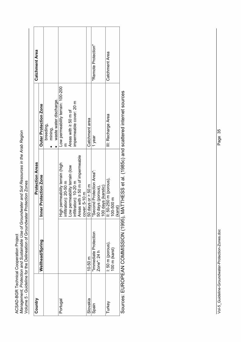
AC
SA
D-B
GR
Tec
hnic
al C
oope
ratio
n P
roje
ct
Man
agem
ent,
Pro
tect
ion
and
Sus
tain
able
Use
of G
roun
dwat
er a
nd S
oil R
esou
rces
in th
e A
rab
Reg
ion
Vol
ume
5 - G
uide
line
for t
he D
elin
eatio
n of
Gro
undw
ater
Pro
tect
ion
Zone
s
Vol
-5_G
uide
line-
Gro
undw
ater
-Pro
tect
ion-
Zone
s.do
c
Pag
e 3
5
Prot
ectio
n A
reas
C
ount
ry
Wel
lhea
d/Sp
ring
Inne
r Pro
tect
ion
Zone
O
uter
Pro
tect
ion
Zone
C
atch
men
t Are
a
bree
ding
,
min
ing,
was
te w
ater
dis
char
ge.
Por
tuga
l
Hig
h pe
rmea
bilit
y te
rrai
n (h
igh
infil
tratio
n): 2
0-50
m
Low
per
mea
bilit
y te
rrain
(low
in
filtra
tion)
: 10-
20 m
A
reas
with
5
0 m
of i
mpe
rmea
ble
cove
r: 5-
10 m
Low
per
mea
bilit
y te
rrai
n: 1
00-2
00
m Are
as w
ith
50
m o
f im
perm
eabl
e co
ver:
20 m
Slo
vaki
a 10
-50
m
50 d
ays
or >
50
m
Cat
chm
ent a
rea
S
pain
"Im
med
iate
Pro
tect
ion
Zone
": 24
h"S
econ
d P
rote
ctio
n A
rea"
: 50
day
s (p
orou
s),
100
days
(kar
stic
)
1 ye
ar
"Rem
ote
Pro
tect
ion"
Turk
ey
I: 50
m (p
orou
s),
100
m (k
arst
) II:
50-
250
m (p
orou
s),
100-
500
m(k
arst
)
III: R
echa
rge
Are
a C
atch
men
t Are
a
Sou
rces
: EU
RO
PE
AN
CO
MM
ISS
ION
(199
5), M
ATT
HE
SS
et a
l. (1
985c
) and
sca
ttere
d in
tern
et s
ourc
es
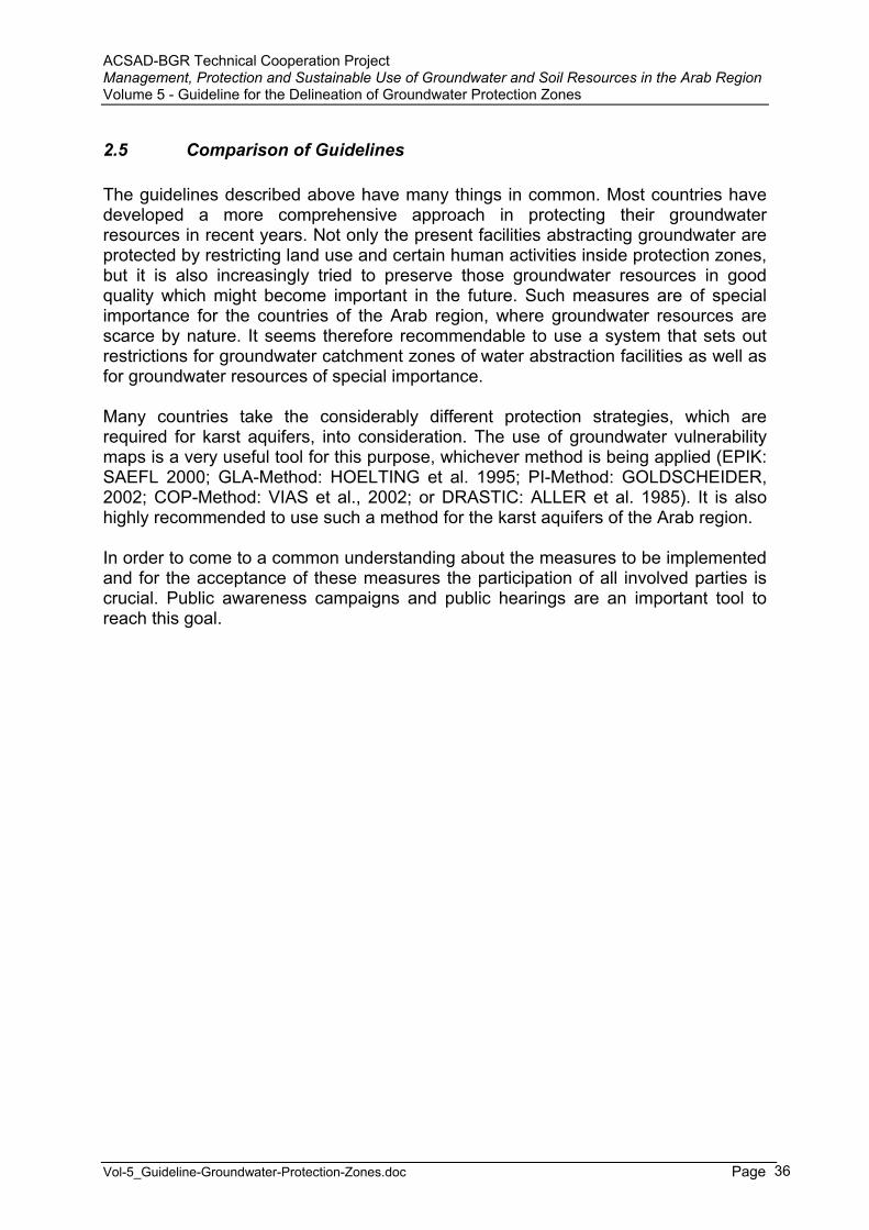
ACSAD-BGR Technical Cooperation Project Management, Protection and Sustainable Use of Groundwater and Soil Resources in the Arab Region Volume 5 - Guideline for the Delineation of Groundwater Protection Zones
Vol-5_Guideline-Groundwater-Protection-Zones.doc Page 36
2.5 Comparison of Guidelines
The guidelines described above have many things in common. Most countries have developed a more comprehensive approach in protecting their groundwater resources in recent years. Not only the present facilities abstracting groundwater are protected by restricting land use and certain human activities inside protection zones, but it is also increasingly tried to preserve those groundwater resources in good quality which might become important in the future. Such measures are of special importance for the countries of the Arab region, where groundwater resources are scarce by nature. It seems therefore recommendable to use a system that sets out restrictions for groundwater catchment zones of water abstraction facilities as well as for groundwater resources of special importance.
Many countries take the considerably different protection strategies, which are required for karst aquifers, into consideration. The use of groundwater vulnerability maps is a very useful tool for this purpose, whichever method is being applied (EPIK: SAEFL 2000; GLA-Method: HOELTING et al. 1995; PI-Method: GOLDSCHEIDER, 2002; COP-Method: VIAS et al., 2002; or DRASTIC: ALLER et al. 1985). It is also highly recommended to use such a method for the karst aquifers of the Arab region.
In order to come to a common understanding about the measures to be implemented and for the acceptance of these measures the participation of all involved parties is crucial. Public awareness campaigns and public hearings are an important tool to reach this goal.
ACSAD-BGR Technical Cooperation Project Management, Protection and Sustainable Use of Groundwater and Soil Resources in the Arab Region Volume 5 - Guideline for the Delineation of Groundwater Protection Zones
Vol-5_Guideline-Groundwater-Protection-Zones.doc Page 37
3 Requirements for a National Guideline
The optimal implementation of groundwater protection measures depends very much on the existing legal situation in a country. The issuance of ordinances for groundwater protection zones will only be accepted by the public if there is sufficient legal backing.
In most countries the issue of water protection relies on a water law or an environmental law. Such a law must include articles where the general task of water protection, the administrative responsibilities and the legal consequences in case of pollution are defined. Commonly the details of the establishment of groundwater protection zones are regulated by by-laws or decrees in reference to the respective law.
It is important to carefully analyze also all other laws dealing with issues that may have an influence on water quality, such as
laws and regulations defining the treatment and disposal of sewage water (including waste water standards);
laws and regulations defining the disposal of all kinds of waste; laws and regulations defining the control of agricultural activities; laws and regulations defining the control and countermeasures against public
health hazards (transport, storage, handling and processing of toxic substances).
The legal concept of each country is very different. Sometimes the above mentioned issues are dealt with directly in the form of a law dealing with an issue. This is the case for instance in Germany, US, UK, France, etc. Sometimes, however, the issues are dealt with in the form of a law concerning a ministry. As such the law more or less defines the tasks of the ministry itself. This is the case in most Arabic countries. This concept has the disadvantage that a legal reform is very difficult, in case the tasks are changed or transferred to another ministry. Also the acceptance of other ministry’s laws is generally low.
These issues should be taken into consideration, when setting up a national policy for groundwater protection.
As an example the legal situation in Jordan is presented in the following chapters. This analysis led to a proposal for a National Guideline for the Delineation of Groundwater Protection Zones (MARGANE & SUNNA, 2002).
ACSAD-BGR Technical Cooperation Project Management, Protection and Sustainable Use of Groundwater and Soil Resources in the Arab Region Volume 5 - Guideline for the Delineation of Groundwater Protection Zones
Vol-5_Guideline-Groundwater-Protection-Zones.doc Page 38
3.1 Case Study: The Present Legal Situation in Jordan
3.1.1 Laws and Regulations concerning Water
The Law No. 18 for the year 1988 (Water Authority Law), issued by the Government of Jordan, describes the tasks and duties of the Water Authority. The following tasks are assigned to WAJ:
to survey the water resources, conserve them, determine ways, means and priorities for their implementation and use, except the use for irrigation;
to set up plans and programs to implement approved water policies related to domestic and municipal waters and sanitation, to develop water resources in the Kingdom and to exploit them for domestic and municipal purposes, including digging of productive wells, development of springs, treatment and desalination of waters, and execute works to augment the potential of water resources and to improve and protect the quality thereof;
to regulate the licensing and drilling of public and private wells and investigate the water resources;
to study, design, construct, operate, maintain, and administer water and public wastewater projects including collecting, purifying, treating, disposing of water and wastewater, and the methods of dealing with water;
to draw terms, standards and special requirements in relation to the preservation of water and water basins, protect them from pollution, and ascertain the safety of water and wastewater structures, public and private distribution and disposal networks, and take the necessary action to ensure technical control and supervision, including, all necessary tests;
to carry out theoretical and applied research and studies regarding water and public wastewater to achieve the Authority's objectives including the preparation of approved water quality standards for different uses and technical specifications concerning materials and construction in order to apply the findings to the Authority's projects in coordination with other concerned departments; and publish the final findings and standards so as to generalize their application by all means available to the Authority.
According to Article 10 the Board of Water Authority is to set forth water policies, in order to develop and conserve the national water resources.
Article 30 states that the pollution of groundwater resources is a punishable act,leading to imprisonment or the imposture of a fine.
The "Instructions for the Commercial and Industrial Wastewater into Sewerage" (issued under the Water Authority Law (1988 with amendments) and in accordance with Article 23 of the Sewerage system regulation No. 66/1994) in Article 3 prohibit the disposal of wastewater that contains "any solids, liquids or gasses containing toxic materials that may … cause a health hazard on humans, animals or plants".
MWI's policy on 'Jordan's Water Strategy' (1997) defines the Ministry's role in the setting of health standards for municipal water supply. The Technical Regulation on
ACSAD-BGR Technical Cooperation Project Management, Protection and Sustainable Use of Groundwater and Soil Resources in the Arab Region Volume 5 - Guideline for the Delineation of Groundwater Protection Zones
Vol-5_Guideline-Groundwater-Protection-Zones.doc Page 39
Drinking Water (Standard No. 286, JISM 2001) was issued in cooperation between WAJ and JISM.
The Standard for Industrial Wastewater (JISM 1991, Standard No. 202/91). Paragraph 3.3 states that "industrial wastewater must not have a negative effect on the groundwater". According to paragraph 3.6 WHO guidelines are to be applied for wastewater reuse.
The By-Law on Groundwater Control, Law No. 86 for the year 2002, specifies that groundwater is a resource for the benefit of the country and this resource cannot be used unless a license has been issued by the Ministry of Water and Irrigation in accordance with this law. One of the Ministry's tasks is to monitor the abstraction and quality of all licensed wells. The Administration Council of WAJ defines a maximum abstraction in each basin. In cooperation with the Ministry of Agriculture the safe yield for each basin and the maximum size of land to be allowed for irrigation per farmer is defined. Article 10 states that the owner of an abstraction license shall not contaminate the groundwater and shall not use the resource excessively. Article 13 states that a water well can be taken over by the Administration Council of WAJ in case of emergency. Article 16 states that in case of water pollution or over-abstraction the Water Authority has the duty to stop the source of pollution or over-pumpage in order to reinstate the previous conditions. According to Article 25 the distance between wells shall not be less than 1,000 m.
An abstraction license is valid without time limit. According to Article 29 a maximum amount of withdrawal is set for each well. For abstraction from wells for touristic and industrial purposes the holder of the license has to pay 250 fils per m3 for every m3
abstracted. For abstraction from wells for irrigation purposes the holder of the license has to pay 250 fils per m3 if the amount abstracted exceeds the maximum allowable amount of 50,000 m3/year.
The Law No. 29, for the Year 1955 and its Amendments for the Year 1994 of the Ministry of Municipality, Rural Affairs and Environment specifies in Article 41 A – Water its tasks. It shall provide water and prevent water pollution, construct sewer network, and manage the land use and monitor it.
The Public Health Law (Law No. 54 of the year 2002, replacing the Public Health Law of 1971) defines its tasks concerning drinking water, health hazards, and waste water as follows:
Chapter8: Drinking Water Article 39: Monitoring of drinking water to ensure safety and compliance. Article 41A: Monitoring of water resources and networks to prevent their
pollution.Chapter 10: Health Hazards
Article 49: Definitions of health hazards, A-1-8: Define the places such as holes, canals, wells, etc. that can cause harm for public health. B-1: Define health hazards related to discharge or disposal of cesspits and incomplete treated wastewater.
Article 50: Enforcement: After the responsible officer of MoH issued a fine, the responsible polluter should within 7 days remove the health hazard or
ACSAD-BGR Technical Cooperation Project Management, Protection and Sustainable Use of Groundwater and Soil Resources in the Arab Region Volume 5 - Guideline for the Delineation of Groundwater Protection Zones
Vol-5_Guideline-Groundwater-Protection-Zones.doc Page 40
the ministry will take action to remove it by its own budget … or close the establishment.
Chapter 11: Waste water Article 53: A- Monitoring of waste water, sewer networks and in-house
connections and wastewater treatment plants, ensuring the public health requirements. B- The MoH shall take the necessary steps to prevent the impact of the above mentioned items on the public health.
Chapter 14: Penalties Article 61-A: The Minister of Health can close the place where the health
hazard has occurred and close water resources and networks and hold the machines and vehicles that caused the hazard for the period he find it convenient until the breach has been eliminated.
3.1.2 Laws and Regulations concerning Agricultural Land Uses
The Ministry of Agriculture is responsible for land use decisions related to agricultural uses. Law No. 44 for the year 2002 (Agriculture Law, replacing the Agriculture Law of 1973) sets out as tasks of the Ministry (among others) that it shall identify the agricultural land use pattern with the aim to protect the soil and prevent erosion (Article 12 A-1). Furthermore it shall manage the irrigation water demand and the provision thereof (Article 15 A). The Ministry is also responsible for the licensing of olive oil factories and for the setting of operational and technical requirements thereof (Article 16 A).
The Ministry's law does not regulate the application of fertilizers and pesticides.
3.1.3 Laws and Regulations concerning Waste Disposal
The authority responsible for the safe disposal of waste is the General Corporation for Environment Protection (GCEP). According to Law No. 12 for the year 1995 (Environment Law), Article 26, it is "impermissible to throw, dispose or accumulate any substances harmful to the environmental health, whether they are solid, liquid, gaseous, radioactive or thermal, in the water resources or store any of them in the vicinity of the water resources or within the distance determined by the Minister according to the General Manager recommendations.
Concerning the disposal of solid domestic waste, the municipalities requests from the Ministry of Municipal, Rural Affairs and Environment the naming of a disposal site. The Ministry then asks for a Committee meeting, involving representatives from the :
Ministry of Municipal, Rural Affairs and Environment; General Corporation for Environment Protection; Ministry of Water and Irrigation; Ministry of Health; Ministry of Agriculture; Ministry of Tourism; Department of Land and Survey; Ministry of Interior – Governorate.
ACSAD-BGR Technical Cooperation Project Management, Protection and Sustainable Use of Groundwater and Soil Resources in the Arab Region Volume 5 - Guideline for the Delineation of Groundwater Protection Zones
Vol-5_Guideline-Groundwater-Protection-Zones.doc Page 41
This committee decides upon the location and technical specifications of the site. However, there is presently no monitoring on how these specifications are actually being implemented.
Concerning the disposal of hazardous waste, this waste is presently being stored at each individual industrial site where it is being generated or at a temporary storage site, until a waste site that can accommodate hazardous waste is established. It is intended to dispose hazardous waste at Qasr Tuba, east of Siwaqa in approximately 2005. The site will be designed to accommodate hazardous waste and even low to medium radioactive waste from hospitals and medical practices until approximately 2025.
Medical waste is commonly being burned in incinerators at temperatures of up to 1200°C. These incinerators are located near the major hospitals.
3.1.4 Laws and Regulations concerning Industrial Sites/Estates
The location and technical requirements for the establishment of commercial and industrial sites is decided by the committee of the Ministry of Municipal, Rural Affairs and Environment, as mentioned above.
3.1.5 Laws and Regulations concerning Waste Water
The Water Authority is responsible for wastewater in Jordan. Article 2 of the Water Law (1988) states that: "It is prohibited to dispose of industrial and commercial wastewater whether polluted or non-polluted through the sewerage network before getting a written approval from the authority according to these instructions." Article 3 prohibits the disposal of wastewater containing toxic materials. The law also defines maximum allowable limits for heavy metals in wastewater (Article 3.14).
Treated domestic wastewater has to meet the quality standards defined by the JISM in Standard No. 893/95. Industrial wastewater has to meet the quality standards defined by the JISM in Standard No. 202/91. Article 3.1 states that "Industrialwastewater effluent must not have negative effects on the public environment in order to ensure safety and human health. In Addition, the discharge of industrial effluents must not have a negative effect on the social and economic development of the area or the water catchment (basin) that might become polluted." The standard sets limits for maximum allowable contents in a number of chemical substances and parameters for wastewater reuse for irrigation, artificial recharge, discharge to sea and discharge to rivers, wadis and catchment areas.
Concerning the disposal of liquid domestic waste each Governorate is supposed to have its own disposal site for sewage water which is not treated at STPs. Commonly the houses not connected to a sewage collection system dispose off the sewage
ACSAD-BGR Technical Cooperation Project Management, Protection and Sustainable Use of Groundwater and Soil Resources in the Arab Region Volume 5 - Guideline for the Delineation of Groundwater Protection Zones
Vol-5_Guideline-Groundwater-Protection-Zones.doc Page 42
water in either in cesspools with concrete walls or in open holes directly dug into the hard rocks without any liner. In the latter case water directly infiltrates into the groundwater. In the case of concrete cesspools the liquid sewage is commonly collected by tankers and then either fed into the sewage collection system or taken to a certain location. In many cases the municipalities decide by themselves where this sewage water will be disposed at. However, many villages have difficulties to find a suitable and affordable site for disposal. Many locations of liquid waste disposal are considered not to be safe and possibly lead to groundwater contamination.
3.1.6 Laws and Regulations concerning other Land uses
Military sites fall under the jurisdiction of the Ministry of Defense. No other Governmental authority has any rights on land owned by the Ministry of Defense.
Issues related to transportation are regulated by Law No. 14 for the year 1984 (Traffic Law).
The Natural Resources Law of the year 1968 regulates the exploitation of mineral resources and land reclamation. The operation of quarries is regulated by Law No. 21 for the year 1971 (Quarries Law).
The operation of facilities related to energy generation and conveyance is regulated by Law No. 10 of 1996 (Electricity Law).
Issues related to the establishment of commercial or industrial buildings are regulated in a number of laws:
Law No. 79 for the year 1966 (Organizing Cities, Villages and Buildings Law); Law No. 29 for the year 1955 (Municipalities Law); Law No. 16 for the year 1953 (Crafts and Industries Law); Law No. 59 for the year 1985 (Industrial Cities Corporation Law).
Concerning the establishment of storage tanks for hazardous substances, such as gas stations, etc., the drawings for a proposed storage tank is forwarded to GCEP. The committee mentioned in chapter 3.1.3 approves or modifies this proposal for the location and design of such a facility. The proposed design commonly does not contain provisions against groundwater protection.
ACSAD-BGR Technical Cooperation Project Management, Protection and Sustainable Use of Groundwater and Soil Resources in the Arab Region Volume 5 - Guideline for the Delineation of Groundwater Protection Zones
Vol-5_Guideline-Groundwater-Protection-Zones.doc Page 43
3.2 Case Study: Legal Provisions for an Effective Implementation of a National Guideline for the Delineation of Groundwater Protection Zones in Jordan
In order for the National Guideline for the Delineation of Groundwater Protection Zones to become effective, it is recommended to attach this regulation to the Water Authority Law. The articles that would presently support the establishment of groundwater protection zones is article 30 (see above; Water Authority Law 1988 with amendments) as well as article 16 of the By-Law (2002). However, these articles are rather general in their statements concerning groundwater protection.
In order to have more certainty about the validity of the existing legal basis for the establishment of groundwater protection zones, it is recommended that the legal department of the Ministry of Water and Irrigation evaluates the legal preconditions for establishing the National Guideline for the Delineation of Groundwater Protection Zones. If the existing law proves to be insufficient to support the establishment of the National Guideline for the Delineation of Groundwater Protection Zones, it is proposed to amend the Water Authority Law by adding an article which more substantially defines how the establishment of Groundwater Protection Zones is being implemented.
In this case the following amendment to the Water Authority Law or the drafting of a By-Law for Groundwater Protection is proposed:
Article XX: "The environment is to be treated in a manner that no negative impacts on the water resources are to be expected. Every citizen is obliged to act with such care that pollution of water or a negative impact on the quality of the water resources is avoided.
The Ministry of Water and Irrigation is responsible for defining groundwater protection zones for domestic water resources and delineation of these zones in the interest of the general public. In groundwater protection zones certain activities may be declared as prohibited or permitted with certain restrictions or certain obligations, such as technical modifications, monitoring activities, restriction of an activity during a certain time period, etc. may be imposed.
The Ministry of Water and Irrigation will coordinate with the Ministry of Municipalities, Rural Affairs and Environment to implement and manage the activities within the groundwater protection zones in the undeveloped areas and restrict new activities within the planned areas within the capabilities of the two Ministries as stated in the ordinance for groundwater protection zones. If a major polluting activity was found in the groundwater protection zone of a water resource the Ministry of Water and Irrigation will take actions to reduce the impact including land acquisition, if necessary, development of sound environmental management of the establishment, enhance agricultural management, etc.
The owners and persons entitled for utilization of properties are obliged to endure measures related to the protection of the water resources, such as, among others, the monitoring of water and soil quality.
ACSAD-BGR Technical Cooperation Project Management, Protection and Sustainable Use of Groundwater and Soil Resources in the Arab Region Volume 5 - Guideline for the Delineation of Groundwater Protection Zones
Vol-5_Guideline-Groundwater-Protection-Zones.doc Page 44
Water protection zones are issued in the form of a directive/ordinance, issued by the Ministry of Water and Irrigation. Further details about groundwater protection zones are laid down in the "Guideline for the Delineation of Groundwater Protection Zones".
ACSAD-BGR Technical Cooperation Project Management, Protection and Sustainable Use of Groundwater and Soil Resources in the Arab Region Volume 5 - Guideline for the Delineation of Groundwater Protection Zones
Vol-5_Guideline-Groundwater-Protection-Zones.doc Page 45
4 Recommendations for the Establishment of a National Guideline for the Delineation of Groundwater Protection Zones in the Arab Region
From the above the following conclusions can be drawn for a National Guideline for the Delineation of Groundwater Protection Zones in the Arab Region :
The legal basis has to be strong and the administrative responsibilities clear. The zoning system has to ensure an adequate protection of the groundwater
resources leaving enough time for possible mitigation or contingency measures in case of pollution.
The restrictions defined in the Guideline should encompass all activities which could possibly lead to a deterioration of the groundwater quality. On the other hand the guideline should leave enough space to adapt the restrictions to the local situation. To guarantee that farmers use fertilizers and pesticides only in amounts and in areas that do not lead to a long-term deterioration of groundwater quality Best Agricultural Management Practice Notes should be made available. To the same end cooperative agreementsbetween the farmers and the water supply company should be established in areas where it is very important to protect the groundwater resources and where agricultural development is high. In this case the water supplier would pay for the compensation and/or the agricultural advice and/or for planting only certain crops.
The Guideline has to take into consideration the specific situation of the country, especially the legal system, the planning procedures, the socio-economic environment and the hydrogeological set-up (mainly carbonatic rock aquifers with a highly variable degree of karstification).
The active participation of the public and all stakeholders is a crucial element for ensuring compliance with restrictions.
To ensure that land use planning takes into consideration the needs for groundwater protection in new land developments and to foster public awareness, the preparation of Groundwater Quality Protection Notes is recommended.
A technical guideline should be prepared that states in detail what a hydrogeological study should encompass to fulfill the legal requirements.
A model ordinance should be prepared to facilitate the preparation of ordinances and to avoid legal or other uncertainties.
An inventory of potential pollution hazards should be conducted, together with an inventory of all water abstraction facilities in the catchment area.
An analysis of the susceptibility of the water supply source to those contamination sources should be conducted.
The establishment of a contingency plan should be an integral part of any groundwater protection zone. This plan would define alternative sources for water supply in case the water source became polluted. In case of pollution which becomes evident before reaching the water source, such as accidental spills, etc., a remedial action plan should be established. This plan would define what needs to be done to avoid long-term damage to the water source (clean-up operation).
ACSAD-BGR Technical Cooperation Project Management, Protection and Sustainable Use of Groundwater and Soil Resources in the Arab Region Volume 5 - Guideline for the Delineation of Groundwater Protection Zones
Vol-5_Guideline-Groundwater-Protection-Zones.doc Page 46
The issues of cost coverage and compensation for preexisting rights need to be addressed in the Guideline.
Since the number of groundwater protection zones to be established is considerable, a ranking list for the establishment should be prepared based on the importance of the water supply (abstracted amount and local dependence on the water source).
ACSAD-BGR Technical Cooperation Project Management, Protection and Sustainable Use of Groundwater and Soil Resources in the Arab Region Volume 5 - Guideline for the Delineation of Groundwater Protection Zones
Vol-5_Guideline-Groundwater-Protection-Zones.doc Page 47
5 References
ALLER, L., BENNETT, T., LEHR, J.H., PETTY, R.J. (1985): DRASTIC: A Standardized System for Evaluating Groundwater Pollution Using Hydrogeologic Settings. - US EPA/Robert S. Kerr Environmental Research Laboratory, EPA/600/2-85/018, 163 p.; Ada (Oklahoma).
BOLSENKÖTTER, H., BUSSE, R., DIEDERICH, G., HÖLTING, B., HOHBERGER, K., REGENHARDT, H., SCHLOZ, W., VILLINGER, E. & WERNER, J. (1984): Hydrogeologische Kriterien bei der Bemessung von Waserschutzgebieten für Grundwasserfassungen [Hydrogeological Criteria for the Delineation of Water Protection Zones for Groundwater Abstraction Facilities]. – Geol.Jahrbuch, C 36, p. 3-34; Hannover. [in German]
BUWAL (2000): Grundwasserschutz – Bericht der Nationalen Arbeitsgruppe Wegleitung Grundwasserschutz 2000 [Groundwater Protection – Report of the National Working Group Guidance on Groundwater Protection 2000]. – Draft Report prepared by the Swiss Agency of Environment, Forests and Landscape (Bundesamt für Umwelt, Wald und Landschaft), Switzerland. [in German]
DEUTSCHE BODENKUNDLICHE GESELLSCHAFT (1992): Strategies to reduce groundwater contamination by nitrate attributable to local conditions and land use.
DVGW (2002): Code of Practice for Drinking Water Protection areas, Part 2: Protective Areas for Drinking Water Dams. - 12p.; Bonn (Wirtschafts- und Verlagsgesellschaft Gas und Wasser). [in German]
DVGW (1975): Code of Practice for Drinking Water Protection areas, Part 3: Protective Areas for Lakes. - 11p.; Bonn (Wirtschafts- und Verlagsgesellschaft Gas und Wasser). [in German]
DVGW (1993): The effect of land use and fertilizers used in water protection zones on groundwater contamination by nitrates. [in German]
DVGW (1995): Protective Areas – Part 1: Protective areas for groundwater. – Code of practice W 101, 23 pages, Bonn/Germany (Wirtschafts- und Verlagsgesellschaft Gas und Wasser). [in German]
ECKL, H., HAHN, L. & KOLDEHOFF, C. (1995): Empfehlungen für die Erstellung von hydrogeologischen Gutachten zur Bemessung und Gliederung von Trinkwasserschutzgebieten [Recommendations for the Preparation of a Hydrogeological Study for the Dimensioning and Subdivision of Groundwater Protection Zones]. – Geol.Jahrbuch, C 63, 25-65; Hannover/Germany. [in German]
ENVIRONMENT AGENCY (1998): Policy and Practice for the Protection of Groundwater. – 57 p; London (The Stationary Office).
ENVIRONMENT AGENCY (1996): Manual of Standard Zone Delineation Methodologies. - London (The Stationary Office).
EPA (1987): Guidelines for the delineation of wellhead protection areas. - Publication no. 440-6-87-010
EPA (1987): Guidance for applicants for state wellhead protection program assistance funds under the safe drinking water act. - Publication no. 440-6-87-011.
ACSAD-BGR Technical Cooperation Project Management, Protection and Sustainable Use of Groundwater and Soil Resources in the Arab Region Volume 5 - Guideline for the Delineation of Groundwater Protection Zones
Vol-5_Guideline-Groundwater-Protection-Zones.doc Page 48
EPA (1990): Citizen's guide to groundwater protection. - Publication no. 440/6-90-004.
EPA (1991): Delineation of Wellhead Protection Areas in Fractured Rocks. - Publication no. 570-9-91-009.
EPA (1993): Wellhead protection in confined, semi-confined, fractured and karst aquifer settings. - Publication no. 813-K-93-001
EPA (1993): Wellhead Protection – A Guide fro small Communities. - Publication no. 625-R-93-002, 144 p.
EPA (1995): Wellhead protection strategies for confined aquifer settings. - Publication no. 813-B-95-007EPA (1997): State source water assessment and protection guidance – Final guidance. Publication no. 816-R-97-009 (available as internet download on: www.epa.gov/safewater/protect/geninfo.html).
EPA (2001): Working with WhAEM 2000 - Source water assessment for a glacial outwash well field, Vincennes, Indiana. - Publication no. 600/R-00/022
EPA (2001): WhAEM 2000 – Wellhead analytical element model. - Internet download from: www.epa.gov/ceampubl/gwater/whaemb/index.html .
EPA & USAID (2002): Source Water Protection: A Training Manual for Communities in Nicaragua. – Report prepared by Horsley and Witten Inc. (Internet download from: www.epa.gov/safewater/swp/swpcases.pdf )
EUROPEAN COMMISSION (1995): COST Action 65 – Hydrogeological Aspects of Groundwater Protection in Karstic Areas – Final Report. – Report EUR 16547 EN, 446 p.; Brussels.
FORSCHUNGSGESELLSCHAFT FÜR STRASSENVERKEHRSWESEN (2002): Code for road works in water protection zones. [in German]
FOSTER, S. & HIRATA, R. (1988): Groundwater Pollution Risk Assessment - A Methodology Using Available Data. - Pan-American Center for Sanitary Engineering and Environmental Sciences (CEPIS) & Pan American Health Organization (PAHO), 73 p.; Lima/Peru.
GEOLOGISCHES LANDESAMT BADEN-WUERTTEMBERG (1991): Hydrogeological Criteria for the Delineation of Water Protection Zones in Baden-Wuerttemberg. - Informationen, 2, 5-21;Freiburg/Germany. [in German]
GODET, J.-L., MARCHAND, D. & TRICARD, D. (1998): Qualité des Eaux d’Alimentation. – Prepared for Ministry of Health, 65p. ; Paris/France.
GOLDSCHEIDER, N. (2002): Hydrogeology and Vulnerability of Karst Systems – Examples from the Northern Alps and Swabian Alp. – PhD thesis, University of Karlsruhe, 229 p.; Karlsruhe.
HOFMANN & LILLICH (1973): Problems arising during the assessment of the Inner Protection Zone in Porous Aquifers. - Zeitschrift deutsche geologische Gesellschaft, 124, 567-573; Hannover/Germany. [in German]
HOELTING, B., HAERTLÉ, T., HOHBERGER, K.-H., NACHTIGALL, K.H., VILLINGER, E., WEINZIERL, W. & WROBEL, J.-P. (1995): Konzept zur Ermittlung der Schutzfunktion der Grundwasserüberdeckung. – Geol.Jb., C, 63, p. 5-24; Hannover. - [translated into English by the Federal Institute for Geosciences and Natural Resources: Concept for the Determination of the Protective Effectiveness of the Cover above the Groundwater against Pollution. – Ad-hoc Working group on Hydrogeology, 28 p.; Hannover]
HOETZL, H. (1996): Grundwasserschutz in Karstgebieten [Groundwater protection in karst areas]. – Grundwasser, 1 (1996), 5-11 (Springer). [in German]
ACSAD-BGR Technical Cooperation Project Management, Protection and Sustainable Use of Groundwater and Soil Resources in the Arab Region Volume 5 - Guideline for the Delineation of Groundwater Protection Zones
Vol-5_Guideline-Groundwater-Protection-Zones.doc Page 49
LALLEMAND-BARRES A., ROUX J.C. (1989) : Guide Méthodologique d’Etablissement des périmètres de protection des captages d’eau souterraine destinée à la consommation humaine. - BRGM; Orleans.
LANDES, T. (1958): How to calculate the size of the Narrow Protection Zone of a Production Well which taps a sandy to gravelly Aquifer. - Bohrtechnik, Brunnenbau, Rohrleitungsbau, 9, 403-410. [in German]
MARGANE, A. (2003): Guideline for the Preparation of Groundwater Vulnerability Maps and Risk Assessment for the Susceptibility of Groundwater Resources to Pollution. – Unpublished report prepared by Federal Institute for Geosciences and Natural Resources (BGR) and ACSAD, Technical Cooperation Project ‘Management, Protection and Sustainable Use of Groundwater and Soil Resources in the Arab Region’, Technical Report No. 4, 177 p.; Damascus.
MARGANE, A., HOBLER, M. & SUBAH, A. (1999a): Mapping of Vulnerability and Hazards to Groundwater in the Irbid Area, N-Jordan. – ZeitschriftAngewandte Geologie, 45, 4: 175-187.
MARGANE, A., HOBLER, M., OURAN, S. & AL ZUHDY, A. (1999b) Groundwater Resources of Northern Jordan – Special Report No. 5: Hydrogeological Proposal for the Delineation of a Groundwater Protection Area for the Tabaqat Fahl (Pella) Spring. - Unpublished report prepared by Federal Institute for Geosciences and Natural Resources (BGR) and Water Authority of Jordan (WAJ), Technical Cooperation Project ‘Groundwater Resources of Northern Jordan’, BGR-archive no. 118708; Amman and Hannover.
MARGANE, A., HOBLER, M., ALMOMANI, M. & SUBAH, A. (2002): Contributions to the Hydrogeology of Northern and Central Jordan. – Geol. Jahrbuch, C 68, 52 p., 18 fig.; Hannover.
MATTHESS et al. (1985a): Lifetime of bacteria and viruses in aquifers. [in German] MATTHESS et al. (1985b): The solute transport in groundwater and the Code of
Practice W 101. - Umweltbundesamt, Berichte, 7/85, 181 p.; Berlin (Schmidt) [in German]
MATTHESS, G., FOSTER, S.S.D. & SKINNER, A.Ch. (1985c): Theoretical background, hydrogeology and practice of groundwater protection zones. - Int. Contrib. to Hydrogeology, 6, 204 p; Hannover/Germany (Heise Publ.).
MORRIS, B. & FOSTER, S. & (2000): Assessment of Groundwater Pollution Risk. – Internet download from: http://lnweb18.worldbank.org/essd/essd.nsf/GlobalView/C12_GWPR.pdf/$File/C12_GWPR.pdf
MULL, R. (1981): Ground-water protection zones. - GeoJournal, 5, 5, 473-481. NAHRGANG (1965): On the Delineation of Protection Zones for Groundwater Wells. -
Bohrtechnik, Brunnenbau, Rohrleitungsbau, 16, 102-107. [in German]NEIWPCC (2000): SWAP Technical Document – The Application of GIS Technology
and Data Management in States' Source Water Programs. – Report prepared by the New England Interstate Water Pollution Control Commission, 24 p; Lowell/USA.
NRA (1995a): Guide to Groundwater Protection Zones in England and Wales. – 35 p.; London (HMSO).
NRA (1995b): Guide to Groundwater Vulnerability Mapping in England and Wales. – 47 p.; London (HMSO).
ACSAD-BGR Technical Cooperation Project Management, Protection and Sustainable Use of Groundwater and Soil Resources in the Arab Region Volume 5 - Guideline for the Delineation of Groundwater Protection Zones
Vol-5_Guideline-Groundwater-Protection-Zones.doc Page 50
PLOETHNER, D. (1997): Advisory Services to ESCWA Member States in the Field of Water Resources, Report on Groundwater Quality Control and Conservation in the ESCWA Region. - Unpubl. Report, Techn. Cooperation BGR & ESCWA, 112 p.; Amman/Jordan.
SAEFL (2000): Practical Guide Groundwater Vulnerability Mapping in Karst Regions (EPIK). – Report prepared by the Swiss Agency of Environment, Forests and Landscape (Bundesamt für Umwelt, Wald und Landschaft), 57 p.; Bern/CH.
SPITZ et al. (1980): How to calculate the Size of the Narrow Protection Zone in porous Aquifers. - Wasserwirtschaft, 70, 365-369. [in German]
SRU (1998): Sondergutachten Flächendeckend wirksamer Grundwasserschutz [Special Study on a Comprehensive Groundwater Protection]. – Rat der Sachverständigen für Umweltfragen [German Council of Environmental Advisors]. (short version of report in English available on the internet)
VIAS, J.M., ANDREO, B., PERLES, M.J., CARRASCO, F., VADILLO, I. & JIMENEZ, P. (2002): Preliminary proposal of a method for contamination vulnerability mapping in carbonate aquifers. – In: CARASCO, F., DURAN, J.J. & ANDREO, B (Eds.): Karst and Environment, pp 75-83.
VRBA, J. & ZAPOROZEC, A. [Edts.] (1994): Guidebook on Mapping Groundwater Vulnerability. - IAH International Contributions to Hydrogeology, Vol. 16, 131 p.; Hannover/FRG (Heise Publ.).
WAEGENINGH, H.G. (1985): Overview of the Protection of Groundwater Quality. – In: MATTHESS et al., 1985c, pp. 159-166; Hannover (Heise Publ.).
WYSSLING (1979): A new Formula for calculating the Time of Travel of Groundwater towards a Groundwater Abstraction Scheme. - Eclogae geol. Helvetica, 72, 404-406. [in German]
Remark: some references and internet downloads relevant to this report are enclosed in the CD in the back pocket of the report
ACSAD-BGR Technical Cooperation Project Management, Protection and Sustainable Use of Groundwater and Soil Resources in the Arab Region Volume 5 - Guideline for the Delineation of Groundwater Protection Zones
Vol-5_Guideline-Groundwater-Protection-Zones.doc Page 51
6 Internet Links
EPA/US – Protection of Drinking Water Sources:www.epa.gov/safewater/protect.html
EPA/US/Office of Groundwater and Drinking Water (OGWDW) – Watershed Tools: http://www.epa.gov/owow/watershed/tools/
Wyoming Department of Environmental Quality – Water Quality Division: Wyoming's Wellhead Protection (WHP) Program - Guidance Document (1997):
http://www.wrds.uwyo.edu/wrds/deq/whp/contents.html
Environment Agency/UK – Groundwater Source Protection Zones: www.environment-agency.gov.uk/ > Water Resources > Groundwater > Groundwater Protection Zones (http://216.31.193.171/asp/spz_about.asp?language=English )
W-SAHaRA (Stochastic Analysis of Well-Head Protection and Risk Assessment): http://www.diiar.polimi.it/franz/EU-W-SAHaRA/deliverable_D2/D2_mail.html
CLARINET (Contaminated Land Rehabilitation Network): http://www.clarinet.at/
Water and Rivers Commission of Western Australia: http://www.wrc.wa.gov.au/(Water Quality Protection Notes: http://www.wrc.wa.gov.au/protect/policy/WQPN.htm)
Bundesamt für Umwelt, Wald und Landschaft (BUWAL, Swiss Agency for the Environment, Forests and Landscape)/CH – Wegleitung Grundwasserschutz 2000 (Guidance Groundwater Protection 2000):http://www.buwal.ch/d/pdf/d_wegleitung_grundwasser.pdf [in German]
European Commission – Water Framework Directive: http://europa.eu.int/comm/environment/water/water-framework/index_en.html
Umweltbundesamt (UBA, Federal Environment Agency)/Germany – Gewässerschutzrecht:http://www.umweltbundesamt.de/wasser/themen/gewschr/gewschr.htm
Sachverständigenrat für Umweltfragen (SRU, German Council of Environment Advisors)/Germany: http://www.umweltrat.de/
Swedish Environmental Protection Agency: http://www.internat.environ.se/(new guideline for groundwater protection to be released in 2002/2003)
Remark: This is only a small overview over some relevant sources of information on groundwater protection zones. Many more sources are to be found on the enclosed CD.
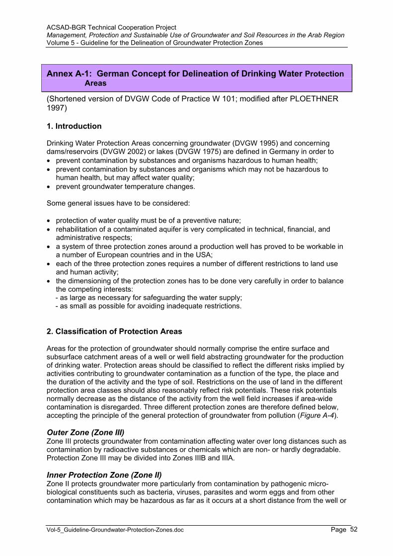
ACSAD-BGR Technical Cooperation Project Management, Protection and Sustainable Use of Groundwater and Soil Resources in the Arab Region Volume 5 - Guideline for the Delineation of Groundwater Protection Zones
Vol-5_Guideline-Groundwater-Protection-Zones.doc Page 52
Annex A-1: German Concept for Delineation of Drinking Water ProtectionAreas
(Shortened version of DVGW Code of Practice W 101; modified after PLOETHNER 1997)
1. Introduction
Drinking Water Protection Areas concerning groundwater (DVGW 1995) and concerning dams/reservoirs (DVGW 2002) or lakes (DVGW 1975) are defined in Germany in order to prevent contamination by substances and organisms hazardous to human health; prevent contamination by substances and organisms which may not be hazardous to
human health, but may affect water quality; prevent groundwater temperature changes.
Some general issues have to be considered:
protection of water quality must be of a preventive nature; rehabilitation of a contaminated aquifer is very complicated in technical, financial, and
administrative respects; a system of three protection zones around a production well has proved to be workable in
a number of European countries and in the USA; each of the three protection zones requires a number of different restrictions to land use
and human activity; the dimensioning of the protection zones has to be done very carefully in order to balance
the competing interests: - as large as necessary for safeguarding the water supply; - as small as possible for avoiding inadequate restrictions.
2. Classification of Protection Areas
Areas for the protection of groundwater should normally comprise the entire surface and subsurface catchment areas of a well or well field abstracting groundwater for the production of drinking water. Protection areas should be classified to reflect the different risks implied by activities contributing to groundwater contamination as a function of the type, the place and the duration of the activity and the type of soil. Restrictions on the use of land in the different protection area classes should also reasonably reflect risk potentials. These risk potentials normally decrease as the distance of the activity from the well field increases if area-wide contamination is disregarded. Three different protection zones are therefore defined below, accepting the principle of the general protection of groundwater from pollution (Figure A-4).
Outer Zone (Zone III) Zone III protects groundwater from contamination affecting water over long distances such as contamination by radioactive substances or chemicals which are non- or hardly degradable. Protection Zone III may be divided into Zones IIIB and IIIA.
Inner Protection Zone (Zone II) Zone II protects groundwater more particularly from contamination by pathogenic micro-biological constituents such as bacteria, viruses, parasites and worm eggs and from other contamination which may be hazardous as far as it occurs at a short distance from the well or
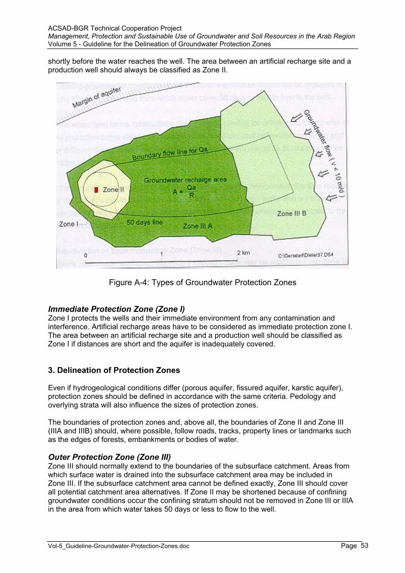
ACSAD-BGR Technical Cooperation Project Management, Protection and Sustainable Use of Groundwater and Soil Resources in the Arab Region Volume 5 - Guideline for the Delineation of Groundwater Protection Zones
Vol-5_Guideline-Groundwater-Protection-Zones.doc Page 53
shortly before the water reaches the well. The area between an artificial recharge site and a production well should always be classified as Zone II.
Figure A-4: Types of Groundwater Protection Zones
Immediate Protection Zone (Zone I) Zone I protects the wells and their immediate environment from any contamination and interference. Artificial recharge areas have to be considered as immediate protection zone I. The area between an artificial recharge site and a production well should be classified as Zone I if distances are short and the aquifer is inadequately covered.
3. Delineation of Protection Zones
Even if hydrogeological conditions differ (porous aquifer, fissured aquifer, karstic aquifer), protection zones should be defined in accordance with the same criteria. Pedology and overlying strata will also influence the sizes of protection zones.
The boundaries of protection zones and, above all, the boundaries of Zone II and Zone III (IIIA and IIIB) should, where possible, follow roads, tracks, property lines or landmarks such as the edges of forests, embankments or bodies of water.
Outer Protection Zone (Zone III) Zone III should normally extend to the boundaries of the subsurface catchment. Areas from which surface water is drained into the subsurface catchment area may be included in Zone III. If the subsurface catchment area cannot be defined exactly, Zone III should cover all potential catchment area alternatives. If Zone II may be shortened because of confining groundwater conditions occur the confining stratum should not be removed in Zone III or IIIA in the area from which water takes 50 days or less to flow to the well.
ACSAD-BGR Technical Cooperation Project Management, Protection and Sustainable Use of Groundwater and Soil Resources in the Arab Region Volume 5 - Guideline for the Delineation of Groundwater Protection Zones
Vol-5_Guideline-Groundwater-Protection-Zones.doc Page 54
If the water level varies substantially, then the data needed for defining the boundaries of the protection zones should be determined for low-water and high-water conditions and for different directions of flow. Protection zone boundaries should be fixed along the envelope of the different cones of depression.
If the groundwater flow velocity is high such as in a karstic environment, the time required by the groundwater to flow from the top of the catchment area to the well is frequently less than 50 days then water protection cannot become fully effective with respect to hygienic considerations.
Sub-division of Outer Protection Zone (Zones IIIA / IIIB) Where reasonably necessary, the Outer Protection Zone may be subdivided into Zone IIIA and Zone IIIB. Porous, fissured, and karstic aquifers are for the purpose of the sub-division of Zone III treated differently because of their different characteristics.
Porous aquifers and regularly and finely fissured aquifers For groundwater flow velocities of 10 m/d or less, the boundary between Zone IIIA and Zone IIIB should be located approximately 2 km upstream from the well. If the groundwater flow velocity is higher, the boundary between Zone IIIA and Zone IIIB should be located at greater distance from the well.
Areas in which the aquifer is covered by undisturbed, continuous low permeable strata of a thickness of at least 5 m or at least 8 m in the case of high groundwater flow velocities in excess of 10 m/d may be classified as Zone IIIB, but the distance from the boundary of Zone IIIB to the well should not be less than 1 km and the time required for groundwater to flow from Zone IIIB to the well should not be less than 50 days.
Coarsely fissured aquifers and karstic aquifers In the case of uncovered coarsely fissured and karstic aquifers with high groundwater flow velocities, Zone III may not be subdivided, if the time required for groundwater from the top of the catchment area to flow to the well is less than 50 days and the area would therefore have to be classified as Zone II.
A sub-division into Zone IIIA and Zone IIIB may only be made if the aquifer is covered by continuous, thick, low permeability strata. If such strata exist, areas with a continuous undisturbed cover may be classified as Zone IIIB areas, if the cover consists of at least 8 m clayey to silty strata, the cover contains perched groundwater separated from the aquifer by an intact low permeable layer being at least 5 m in thickness.
The minimum distance between Zone IIIB and the well should in this case also be 1 km. The low permeable layer should be reduced by any type of construction work to a thickness of less than 5 m.
Inner Protection Zone (Zone II) The Inner Protection Zone should comprise the zone between the well or the well field and a line from which the groundwater will flow at least 50 days until it reaches the production well. This minimum flow time will normally warrant that no pathogenic constituents will reach the production well.
The line from which groundwater takes 50 days to flow to the well may be determined by geohydraulic methods, e.g. numerical modelling. Additional tracer tests and evaluation of groundwater quality data may support the delineation of the 50 days line. Simple mathe-matical approximation methods have been established to estimate the extent of Zone II around a single well providing 50 days time of delay :
ACSAD-BGR Technical Cooperation Project Management, Protection and Sustainable Use of Groundwater and Soil Resources in the Arab Region Volume 5 - Guideline for the Delineation of Groundwater Protection Zones
Vol-5_Guideline-Groundwater-Protection-Zones.doc Page 55
LANDES (1958); NAHRGANG (1965); HOFMANN & LILLICH (1973); WYSSLING (1979); SPITZ et al. (1980).
Most of these methods are based on the Darcy Law and the Dupuit-Thiem steady radial flow equation for a well pumping within a uniform flow field. The HOFMANN & LILLICH method appears not applicable for a steep natural hydraulic gradient. This method applies the superimposition of the natural and the by abstraction induced hydraulic gradient. The WYSSLING method is suitable for steep hydraulic gradients. This method is based on the superimposition of the natural and the by abstraction induced groundwater flow velocity (refer also to ECKL et al., 1995).
To determine the 50 days line and the lower culmination (stagnation point), the average daily discharge or the maximum daily discharge should be considered depending on local conditions.
It has become standard practice to neglect dispersion when determining the 50 days line for the purpose of defining the boundary of Zone II. However, dispersion should be included under certain condition (e.g. where depth to groundwater is shallow or where a low permeable stratum above the aquifer is absent) to provide for a safety margin
Porous aquifers and regularly and finely fissured aquifers Zone II should cover the entire area from which water takes 50 days or less to flow to the production well. The extension of Zone II upstream from the production well should in no case be less than 100 m or 50 m in cases where circumstances warrant such a decision.
If the depth to groundwater is very great, the Inner Protection Zone (Zone II) may be shorter than given above, in the case that local geological conditions warrant. The top 6 m of the overlying stratum should not be considered for the purpose of the calculations because of their protective function.
No Inner Protection Zone (Zone II) is needed if the water is exclusively abstracted from deep horizons covered by low permeable overlying strata and if all production wells tapping these horizons are sealed properly or if the entire aquifer is covered by low permeable layers of sufficient thickness between the production well and the 50 days line. Such conditions will in particular exist in cases where artesian groundwater is produced.
Karstic aquifers and coarsely fissured aquifers If an Inner Protection Zone (Zone II) for a karstic aquifer was to comprise the complete area from which groundwater takes 50 days to flow to the production well, Zone II would often comprise the entire catchment area or most of it. Zone II may in such cases be narrower, but should in any case comprise all areas in which contamination may due to an increased hazard to the karstic aquifer, such as, above all :
slopes or dry valleys declining towards the catchment area (the upstream length of Zone II must in such cases be at least 300 m from the well or at least 1000 m in the cases of high discharge springs (in particular in the case of dry valleys);
deep karst basins, sinks, dolines and cockpit karsts and their immediate environment in particular if they are temporary or permanent swallow holes for large areas;
the environment of stream or brook intakes;

ACSAD-BGR Technical Cooperation Project Management, Protection and Sustainable Use of Groundwater and Soil Resources in the Arab Region Volume 5 - Guideline for the Delineation of Groundwater Protection Zones
Vol-5_Guideline-Groundwater-Protection-Zones.doc Page 56
deep-cut dry valleys, draining partly temporarily surface water or featuring areas of infiltration;
areas in which karstic aquifers have been excavated by mining; areas featuring near-surface tunnels collecting groundwater; near-surface shatter zones or outcropping fault areas.
If deep karstic aquifers are covered by thick strata of low permeability overlying the entire catchment area, Zone II may not be necessary as in the case of porous aquifers under conditions detailed above.
The above procedure proposed by DVGW (1995), to reduce Zone II in karstic environments which is normally delineated by the 50 days line as the crucial hazard criterion, is illogical and inconsistent and therefore may not be accepted (HÖTZL, 1996). For example, in Belgium the Zone II in karstic environments has to be enlarged by a factor of 10 from normally 100 m to 1000 m. HÖTZL (1996) suggests to apply the COST (EUROPEAN COMMISSION 1995) approach for the delineation of protection zones in karstic environments. The COST approach does not apply a single criterion such as the delay time but considers the whole of the aquifer characteristics in order to assess the karst aquifer vulnerability.
Immediate Protection Zone (Zone I) Zone I should extend over a distance of not less than 10 m around the production well. If the water is produced from a spring, Zone I should be not less than 20 m on the upstream side of the spring. The distance should be at least 30 m in the case of karstic aquifers.
4. Activities Contributing to Groundwater Contamination in Protection Zones Hazardous Activities in Zone IIIB industrial estates; construction or extension of facilities or plants for the production, treatment, use, pro-
cessing, and storage of substances which contaminate groundwater and are non- or hardly degradable and radioactive substances, such as substances from refineries, iron, and steel mills, non-ferrous metal works, chemical plants, facilities for the storage of chemicals and nuclear facilities (excepting facilities for medical applications as well as equipment for metering, testing and control);
thermal power plants, unless gas-fired; pipeline carrying fluids which may contaminate water; sewerage, including water sewerage, as well as sewage treatment plants, unless checked
for defects at regular intervals; release of waste water to the ground inclusive of sewage distribution fields other than
drainage of uncontaminated precipitation and waste water from waste water treatment plants serving individual homes;
plants for the treatment and disposal of solid waste (other than plants for the handling and storage of such wastes);
sites for the storage and processing of wrecked automobiles, scrap from automobiles and old tires;
sites for the storage of residue from thermal power stations and incinerators, blast-furnace slag and foundry sand;
sites for the disposal of contaminated and uncontaminated loose and solid rocks (such as tailings) if decomposition and leaching may affect groundwater;
use of fertilizers, unless in keeping with good agricultural practices as regards timing and quantities of fertilizer;
use of liquid or solid manure and silage seepage on waste land; disposal of sludge from sewage treatment plants or cesspools and disposal of compost;
ACSAD-BGR Technical Cooperation Project Management, Protection and Sustainable Use of Groundwater and Soil Resources in the Arab Region Volume 5 - Guideline for the Delineation of Groundwater Protection Zones
Vol-5_Guideline-Groundwater-Protection-Zones.doc Page 57
application of pesticides; use of pesticides employing air-borne vehicles; animal breeding if the number of animals implies a risk to the quality of groundwater
because of the limited area on which they are kept and/or the limited area available for the disposal of manure;
storage of liquid or solid manure or soluble fertilizer outside permanently sealed sites and silage production outside permanent silos excepting silage-making under plastic sheeting on tight base plates surrounded by retention basins;
deforestation, plowing of legume-grass meadows and fallow; spray irrigation in excess of field capacity; airports; use of materials from which contaminants may be washed or leached, such as use of
rubble, residues from incinerators, slag and mining residue for the construction of road, waterway, railroad and air transportation systems and facilities or structures built for noise control;
release of storm water from roads or other transportation systems to the ground except for embankment drainage and large distribution systems in ground with vegetation;
mining, oil and gas production; development of underground facilities for storage of substances contaminating water; storage or stockpiling of coal or mining residue; quarries, if groundwater cover is reduced substantially and above all, if groundwater is
uncovered permanently or high groundwater level periods or cleaning strata are un-covered and groundwater cannot be protected adequately;
production of geothermal energy, excepting plants featuring secondary circuits; military facilities and exercises; sites for trap shooting and new golf courses.
Hazardous Activities in Zone IIIA activities, facilities and sites mentioned above for Zone IIIB;
handling of substances contaminating water (except for minor quantities for residential use, storage of fuel oil for residential use and storage of diesel fuel for farming operations;
transformers and electricity lines holding cooling or insulating fluids contaminating water (except for above ground lines or installations and connections to frame) in particular, when abandoned;
sewerage (except for sewerage satisfying high tightness standards checked for tightness at reasonable intervals);
discharge of waste water (other than treated precipitation) into surface water flowing into Zone II;
plants for handling and storage solid waste; plants for residue recycling such as construction rubble recycling; monocultures and cultivation of special plants and crops; allotments; new development zones; transportation systems and buildings unless sewage and waste water other than un-
contaminated precipitation are completely and safely piped outside Zone IIIA; development and extension of graveyards; markets, trade fairs, festivals and other similar gatherings outside appropriate facilities; motor racing; gasoline stations; sites for the storage of building materials which may contaminate groundwater; penetration of strata overlying groundwater other than laying of buried utility lines and civil
engineering excavations;
ACSAD-BGR Technical Cooperation Project Management, Protection and Sustainable Use of Groundwater and Soil Resources in the Arab Region Volume 5 - Guideline for the Delineation of Groundwater Protection Zones
Vol-5_Guideline-Groundwater-Protection-Zones.doc Page 58
drilling operations; development and extension of artificial bodies of water such as fish ponds; penetration of the silt layers between surface water and groundwater; use of pesticides for vegetation control on unused land or road or railway areas, unless
groundwater is protected.
Hazardous Activities which are normally not accepted in Zone II activities, facilities and sites mentioned above for Zone III;
construction and extension of buildings such as for commercial and agricultural use and changes in the use of buildings and structures;
roads, railway lines and other similar facilities for transportation (except for trails); changes of facilities for transportation unless made to improve the protection of
groundwater; transportation of substances contaminating groundwater or radioactive substances, storage of fuel oil and diesel fuel; temporary works for construction; use of liquid or solid manure or silage seepage; livestock grazing; installation and extension of liquid manure containers, solid manure sites or silos; storage of chemical fertilizers and pesticides; transportation of sewage or waste water; installation or extension of drains; surface water carrying waste water; release of storm water (other than uncontaminated water from roofs) to the ground; transformers and electricity lines with cooling or insulating fluids contaminating water; swimming, camping and sports facilities; shooting and blasting operations.
Hazardous Activities which are not acceptable in Zone I activities, facilities and sites mentioned above for Zone III and Zone II;
any type of traffic (neither vehicle nor pedestrian); use for agriculture, horticulture or forestry; use of fertilizers and pesticides.
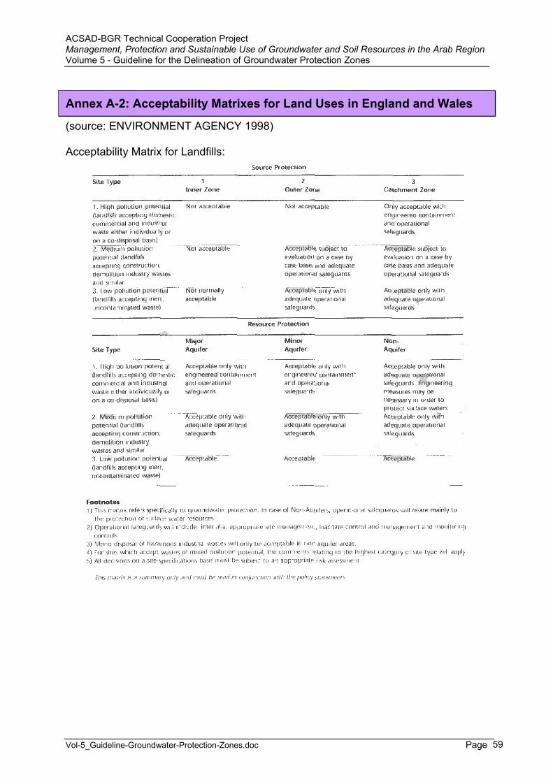
ACSAD-BGR Technical Cooperation Project Management, Protection and Sustainable Use of Groundwater and Soil Resources in the Arab Region Volume 5 - Guideline for the Delineation of Groundwater Protection Zones
Vol-5_Guideline-Groundwater-Protection-Zones.doc Page 59
Annex A-2: Acceptability Matrixes for Land Uses in England and Wales
(source: ENVIRONMENT AGENCY 1998)
Acceptability Matrix for Landfills:
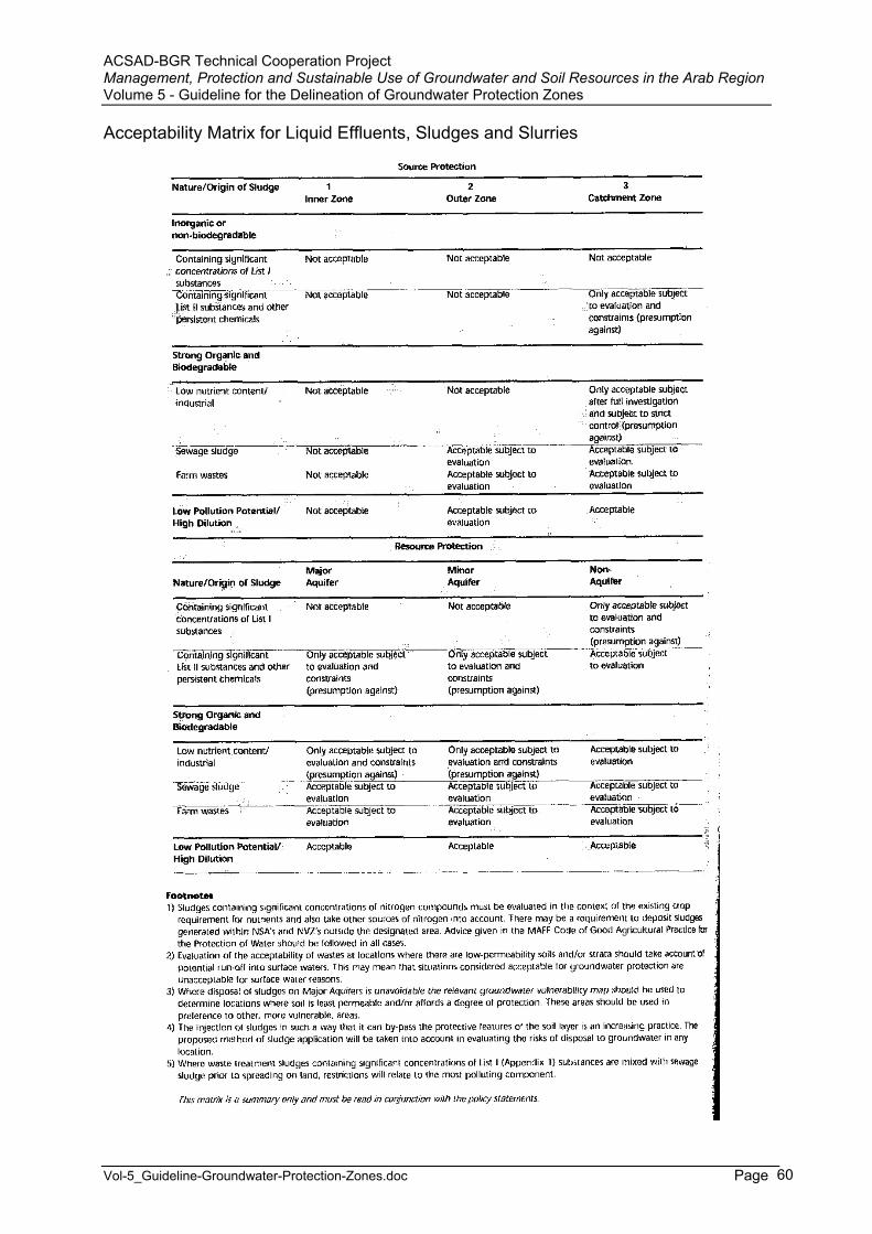
ACSAD-BGR Technical Cooperation Project Management, Protection and Sustainable Use of Groundwater and Soil Resources in the Arab Region Volume 5 - Guideline for the Delineation of Groundwater Protection Zones
Vol-5_Guideline-Groundwater-Protection-Zones.doc Page 60
Acceptability Matrix for Liquid Effluents, Sludges and Slurries
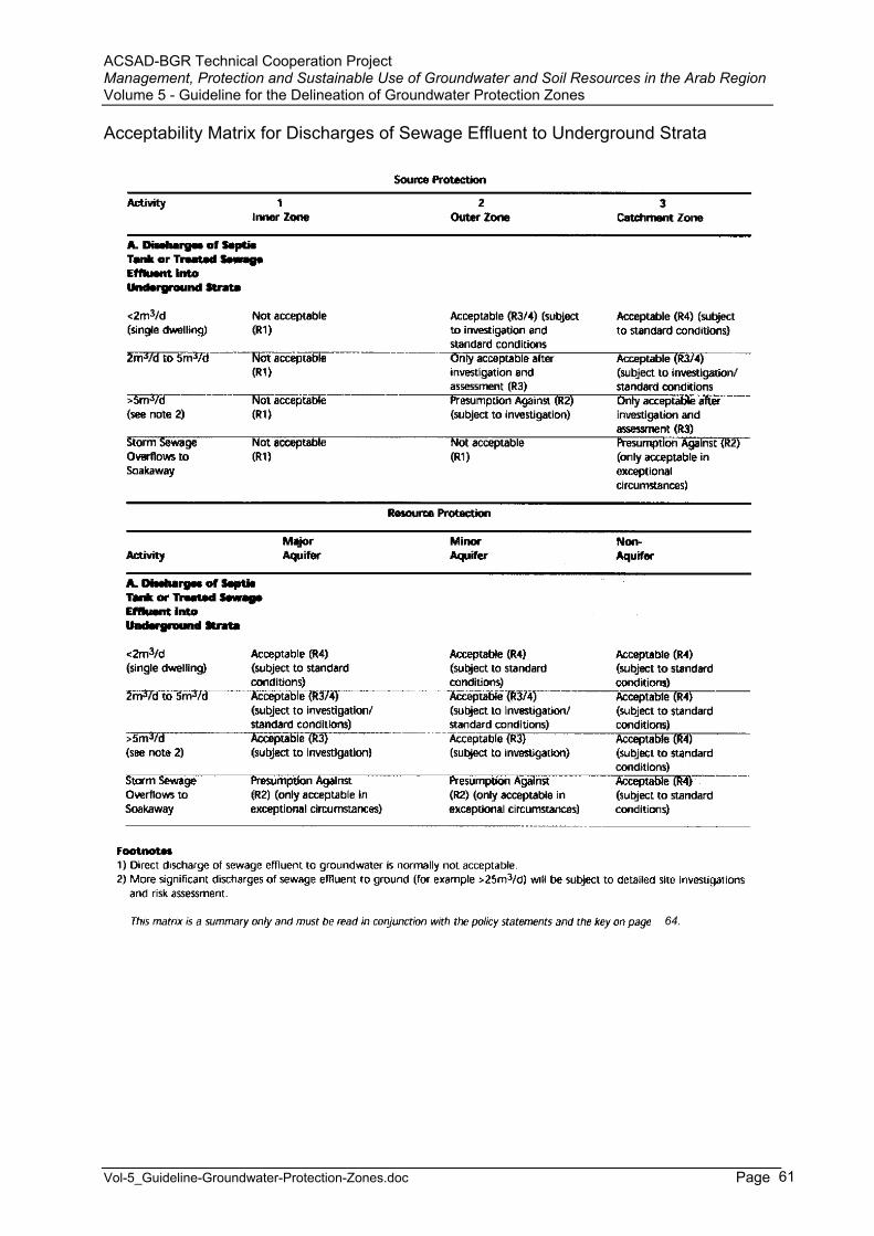
ACSAD-BGR Technical Cooperation Project Management, Protection and Sustainable Use of Groundwater and Soil Resources in the Arab Region Volume 5 - Guideline for the Delineation of Groundwater Protection Zones
Vol-5_Guideline-Groundwater-Protection-Zones.doc Page 61
Acceptability Matrix for Discharges of Sewage Effluent to Underground Strata
64.
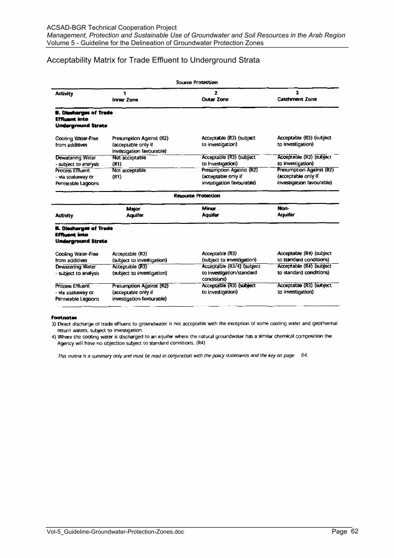
ACSAD-BGR Technical Cooperation Project Management, Protection and Sustainable Use of Groundwater and Soil Resources in the Arab Region Volume 5 - Guideline for the Delineation of Groundwater Protection Zones
Vol-5_Guideline-Groundwater-Protection-Zones.doc Page 62
Acceptability Matrix for Trade Effluent to Underground Strata
64.
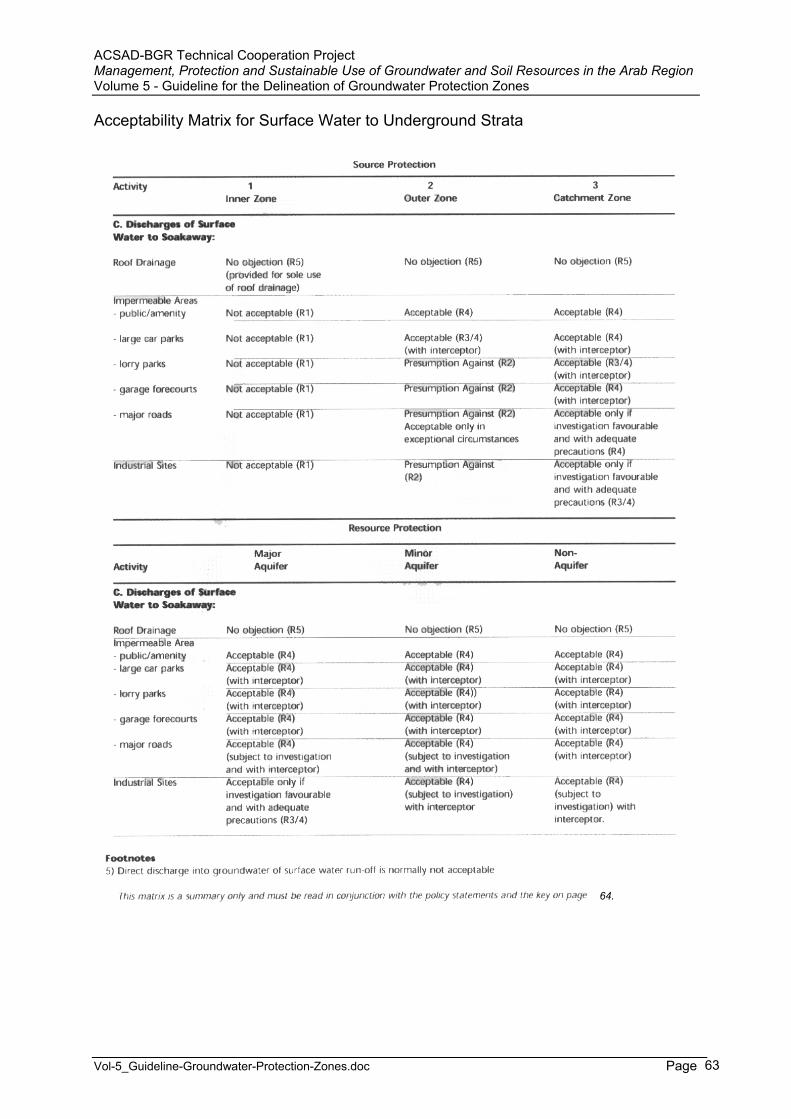
ACSAD-BGR Technical Cooperation Project Management, Protection and Sustainable Use of Groundwater and Soil Resources in the Arab Region Volume 5 - Guideline for the Delineation of Groundwater Protection Zones
Vol-5_Guideline-Groundwater-Protection-Zones.doc Page 63
Acceptability Matrix for Surface Water to Underground Strata
64.
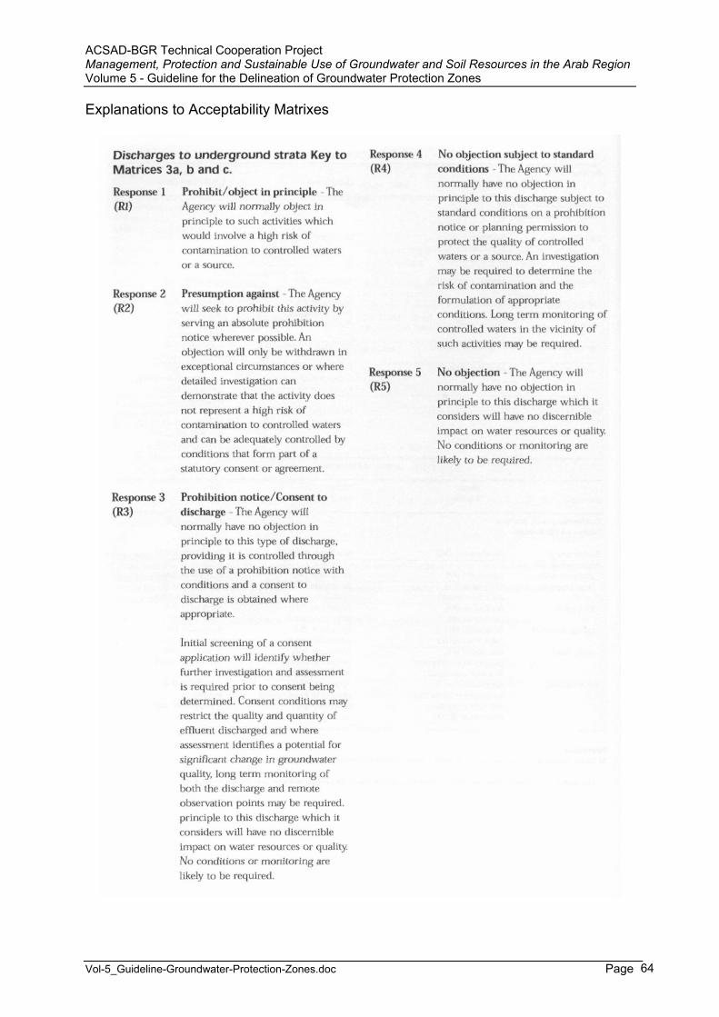
ACSAD-BGR Technical Cooperation Project Management, Protection and Sustainable Use of Groundwater and Soil Resources in the Arab Region Volume 5 - Guideline for the Delineation of Groundwater Protection Zones
Vol-5_Guideline-Groundwater-Protection-Zones.doc Page 64
Explanations to Acceptability Matrixes
ACSAD-BGR Technical Cooperation Project Management, Protection and Sustainable Use of Groundwater and Soil Resources in the Arab Region Volume 5 - Guideline for the Delineation of Groundwater Protection Zones
Vol-5_Guideline-Groundwater-Protection-Zones.doc Page 65
Annex A-3: Restrictions for Public Drinking Water Areas in Western Australia (Water Quality Protection Note)
LAND USE COMPATIBILITY IN PUBLIC DRINKING WATER SOURCE AREAS
PurposeThese notes provide the Commission’s views on practices and activities related to the quality of the State’s water resources. They are recommendations only, and may be varied at the discretion of the Commission.The notes provide a basis for developing formal guidelines in consultation with key stakeholders.
ScopeThese notes provide guidance on land use within Public Drinking Water Source Areas (PDWSAs). PDWSAs include Underground Water Pollution Control Areas, Water Reserves and Public Water Supply Catchment Areas declared under the Metropolitan Water Supply, Sewerage and Drainage Act 1909, and the Country Areas Water Supply Act 1947. The notes are not intended to override the statutory role and policy of other State or local government authorities. Project proponents will need to fulfill their legal responsibilities including those covering land use planning, environmental, health and building permit matters.
PDWSA Protection Framework The Water and Rivers Commission is responsible for managing and protecting Western Australia’s water resources. The Commission has policies for the protection of public drinking water source areas that include three levels of priority classification of lands within PDWSAs.
Priority 1 (P1) source protection areas are defined to ensure that there is no degradation of the water source. P1 areas are declared over land where the provision of the highest quality public drinking water is the prime beneficial land use. P1 areas would typically include land under Crown ownership. P1 areas are managed in accordance with the principle of risk avoidance and so land development is generally not permitted. Priority 2 (P2) source protection areas are defined to ensure that there is no increased risk of pollution to the water source. P2 areas are declared over land where low intensity development (such as rural) already exists. Protection of public water supply sources is a high priority in these areas. P2 areas are managed in accordance with the principle of risk minimization and so conditional development is allowed. Priority 3 (P3) source protection areas are defined to manage the risk of pollution to the water source. P3 areas are declared over land where water supply sources need to co-exist with other land uses such as residential, commercial and light industrial developments. Protection of P3 areas is achieved through management guidelines for land use activities. If the water source does become contaminated, then water may need to be treated or an alternative water source found.
In addition to priority classifications, well-head protection zones and reservoir protection zones are defined to protect the water source from contamination in the immediate vicinity of production wells and reservoirs. Well-head protection zones are usually circular, with a radius of 500 meters in P1 areas and 300 meters in P2 and P3 areas. Reservoir protection zones usually consist of a 2 kilometer buffer area around the top water level of a reservoir and include the reservoir itself. These zones do not extend outside water reserves. Special conditions apply within these zones.
Tables showing land use compatibility with the Commission’s PDWSA protection strategy These tables should be used as a guideline only. More detailed information on the Commission’s recommendations as activity guidelines or notes is available for some land uses. These can be found on the ‘Protecting Water’ web page on the Commission’s Internet site (www.wrc.wa.gov.au).Alternatively information relating to land use and development within PDWSAs including those not listed in the tables, can be obtained from the Commission’s Water Quality Protection Branch.
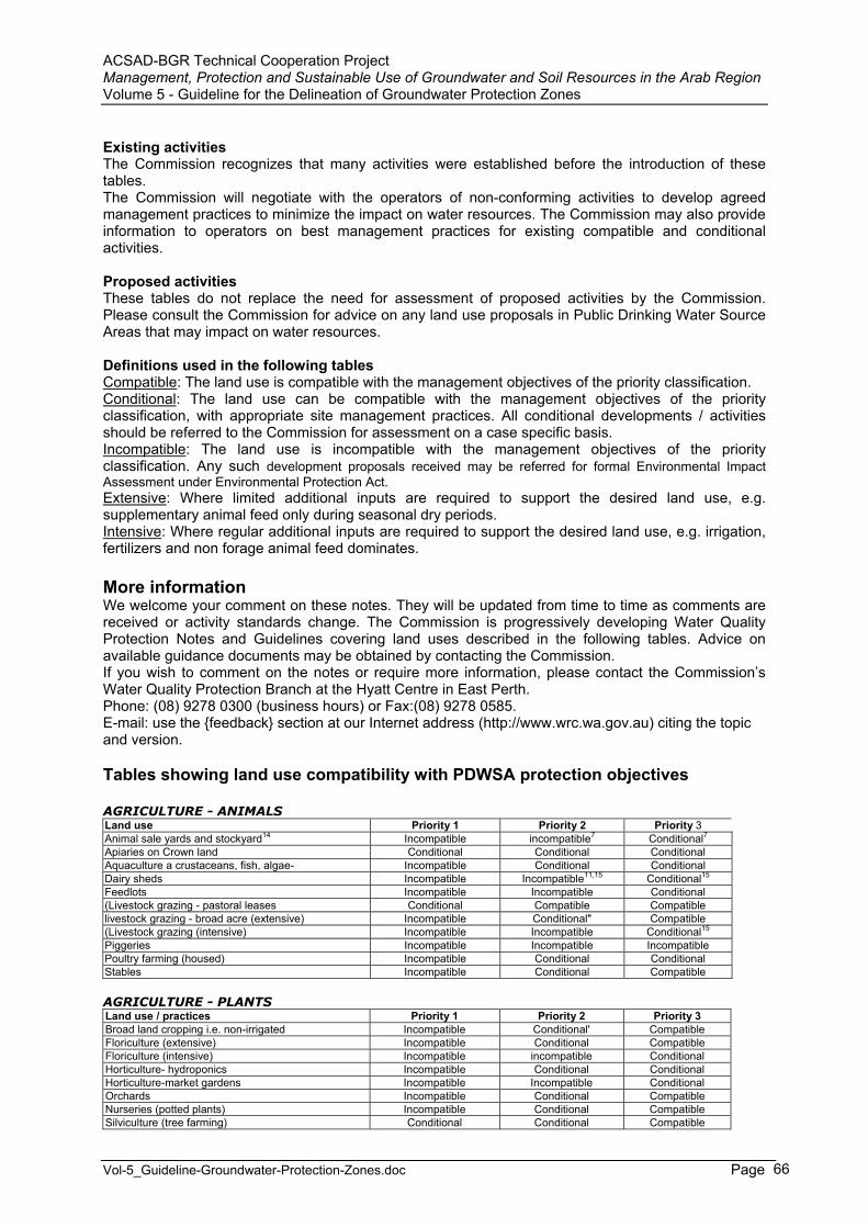
ACSAD-BGR Technical Cooperation Project Management, Protection and Sustainable Use of Groundwater and Soil Resources in the Arab Region Volume 5 - Guideline for the Delineation of Groundwater Protection Zones
Vol-5_Guideline-Groundwater-Protection-Zones.doc Page 66
Existing activities The Commission recognizes that many activities were established before the introduction of these tables.The Commission will negotiate with the operators of non-conforming activities to develop agreed management practices to minimize the impact on water resources. The Commission may also provide information to operators on best management practices for existing compatible and conditional activities.
Proposed activities These tables do not replace the need for assessment of proposed activities by the Commission. Please consult the Commission for advice on any land use proposals in Public Drinking Water Source Areas that may impact on water resources.
Definitions used in the following tables Compatible: The land use is compatible with the management objectives of the priority classification. Conditional: The land use can be compatible with the management objectives of the priority classification, with appropriate site management practices. All conditional developments / activities should be referred to the Commission for assessment on a case specific basis. Incompatible: The land use is incompatible with the management objectives of the priority classification. Any such development proposals received may be referred for formal Environmental Impact Assessment under Environmental Protection Act. Extensive: Where limited additional inputs are required to support the desired land use, e.g. supplementary animal feed only during seasonal dry periods. Intensive: Where regular additional inputs are required to support the desired land use, e.g. irrigation, fertilizers and non forage animal feed dominates.
More information We welcome your comment on these notes. They will be updated from time to time as comments are received or activity standards change. The Commission is progressively developing Water Quality Protection Notes and Guidelines covering land uses described in the following tables. Advice on available guidance documents may be obtained by contacting the Commission. If you wish to comment on the notes or require more information, please contact the Commission’s Water Quality Protection Branch at the Hyatt Centre in East Perth. Phone: (08) 9278 0300 (business hours) or Fax:(08) 9278 0585. E-mail: use the {feedback} section at our Internet address (http://www.wrc.wa.gov.au) citing the topic and version.
Tables showing land use compatibility with PDWSA protection objectives
AGRICULTURE - ANIMALS Land use Priority 1 Priority 2 Priority 3Animal sale yards and stockyard14 Incompatible incompatible7 Conditional7
Apiaries on Crown land Conditional Conditional Conditional Aquaculture a crustaceans, fish, algae- Incompatible Conditional Conditional Dairy sheds Incompatible Incompatible11,15 Conditional15
Feedlots Incompatible Incompatible Conditional (Livestock grazing - pastoral leases Conditional Compatible Compatible livestock grazing - broad acre (extensive) Incompatible Conditional" Compatible (Livestock grazing (intensive) Incompatible Incompatible Conditional15
Piggeries Incompatible Incompatible Incompatible Poultry farming (housed) Incompatible Conditional Conditional Stables Incompatible Conditional Compatible
AGRICULTURE - PLANTS Land use / practices Priority 1 Priority 2 Priority 3 Broad land cropping i.e. non-irrigated Incompatible Conditional' Compatible Floriculture (extensive) Incompatible Conditional Compatible Floriculture (intensive) Incompatible incompatible Conditional Horticulture- hydroponics Incompatible Conditional Conditional Horticulture-market gardens Incompatible Incompatible Conditional Orchards Incompatible Conditional Compatible Nurseries (potted plants) Incompatible Conditional Compatible Silviculture (tree farming) Conditional Conditional Compatible
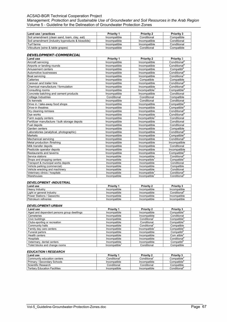
ACSAD-BGR Technical Cooperation Project Management, Protection and Sustainable Use of Groundwater and Soil Resources in the Arab Region Volume 5 - Guideline for the Delineation of Groundwater Protection Zones
Vol-5_Guideline-Groundwater-Protection-Zones.doc Page 67
Land use / practices Priority 1 Priority 2 Priority 3 Soil amendment (clean sand, loam, clay, eat) Incompatible Conditional Compatible Soil amendment (industry byproducts & biosolids) Incompatible Incompatible Conditional Turf farms Incompatible Incompatible Conditional Viticulture (wine & table grapes) Incompatible Conditional Compatible
DEVELOPMENT-COMMERCIAL Land use Priority 1 Priority 2 Priority 3Aircraft servicing Incompatible Incompatible Conditional6
Airports or landing rounds Incompatible Incompatible Conditional6
Amusement centers Incompatible Incompatible Compatibl6
Automotive businesses Incompatible Incompatible Conditional6
Boat servicing Incompatible Incompatible Conditiona6
Catteries Incompatible Compatible Compatible Caravan and trailer hire Incompatible Incompatible Conditional6
Chemical manufacture / formulation Incompatible Incompatible Conditional6
Consulting rooms Incompatible Incompatible7 Compatible6
Concrete batching and cement products Incompatible Incompatible Conditional Cottage Industries Conditional Conditional Compatible Do kennels Incompatible Conditional Conditional Drive in / take-away food shops Incompatible Incompatible Compatible6
Drive-in theatres Incompatible Incompatible Compatible6
Dry cleaning remises Incompatible Incompatible Conditional6
Dye works Incompatible Incompatible Conditional6
Farm supply centers Incompatible Incompatible7 Conditional Fertilizer manufacture / bulk storage depots Incompatible Incompatible Conditional Fuel depots Incompatible Incompatible Conditional Garden centers Incompatible Incompatible Compatible Laboratories (analytical, photographic) Incompatible Incompatible Conditional6
Markets Incompatible Incompatible Compatible6
Mechanical servicing Incompatible Incompatible Conditional6
Metal production /finishing Incompatible Incompatible Incompatible Milk transfer depots Incompatible Incompatible Conditional Pesticide operator depots Incompatible Incompatible Incompatible Restaurants and taverns Incompatible Incompatible Compatible6
Service stations Incompatible Incompatible Conditional6
Shops and shopping centers Incompatible Incompatible7 Compatible6
Transport & municipal works depots Incompatible Incompatible Conditional Vehicle parking (commercial) Incompatible Incompatible Compatible Vehicle wrecking and machinery Incompatible Incompatible Conditional Veterinary clinics / hospitals Incompatible Incompatible7 Conditional6
Warehouses Incompatible Incompatible7 Conditional6
DEVELOPMENT -INDUSTRIAL Land use Priority 1 Priority 2 Priority 3 Heavy Industry Incompatible Incompatible Incompatible Light or general Industry Incompatible Incompatible Conditional6
Power Stations / Gasworks Incompatible Incompatible Incompatible Petroleum refineries Incompatible Incompatible Incompatible
DEVELOPMENT-URBAN Land use Priority 1 Priority 2 Priority 3 Aged and dependent persons group dwellings Incompatible Incompatible Compatible6
Cemeteries Incompatible Incompatible Conditional Civic buildings Incompatible Conditional7 Compatible6
Clubs-sporting or recreation Incompatible Conditional Compatible6
Community halls Incompatible Conditional7 Compatible Family day care centers Incompatible Incompatible7 Compatible6
Funeral parlors Incompatible Incompatible Compatibl6
Health centers Incompatible Incompatible Com atible6
Hospitals Incompatible Incompatible Conditional6
Veterinary, dental centers Incompatible Incompatible Compatibl6
Toilet blocks and change rooms Incompatible7 Conditional Compatible
EDUCATION I RESEARCH Land use Priority 1 Priority 2 Priority 3Community education centers Conditional7 Conditional7 Compatible6
Primary / Secondary Schools Incompatible Incompatible Compatible6
Scientific Research Conditional Conditional Compatible Tertiary Education Facilities Incompatible Incompatible Conditional6
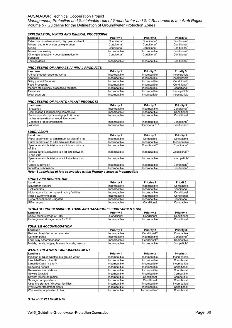
ACSAD-BGR Technical Cooperation Project Management, Protection and Sustainable Use of Groundwater and Soil Resources in the Arab Region Volume 5 - Guideline for the Delineation of Groundwater Protection Zones
Vol-5_Guideline-Groundwater-Protection-Zones.doc Page 68
EXPLORATION, MINING AND MINERAL PROCESSING Land use Priority 1 Priority 2 Priority 3 Extractive industries (sand, clay, peat and rock) Conditional2 Conditional2 Conditional4
Mineral and energy source exploration Conditional4 Conditional4 Conditional4
Mining Conditional4 Conditional4 Conditional4
Mineral processing Incompatible Incompatible Conditional4
Oil or gas extraction / decontamination for transport
Conditional4 Conditional4 Conditional4
Tailings dams Incompatible Incompatible Conditional4
PROCESSING OF ANIMALS / ANIMAL PRODUCTS Land use Priority 1 Priority 2 Priority 3 Animal product rendering works Incompatible Incompatible Incompatible Abattoirs Incompatible Incompatible Incompatible Dairy product factories Incompatible Incompatible Conditional6
Food Processing Incompatible Incompatible Conditional6
Manure stockpiling / processing facilities Incompatible Incompatible Conditional Tanneries Incompatible Incompatible Incompatible Wool-scourers Incompatible incompatible Incompatible
PROCESSING OF PLANTS / PLANT PRODUCTS Land use Priority 1 Priority 2 Priority 3 Breweries Incompatible Incompatible Conditional6
Composting I soil blending commercial Incompatible Incompatible Conditional Forestry product processing- pulp & paper, timber reservation, or wood fiber works
Incompatible Incompatible Conditional
Vegetable / food processing Incompatible Incompatible Conditional6
Wineries Incompatible Conditional15, 18 Conditiona15
SUBDIVISIONLand use Priority 1 Priority 2 Priority 3 Rural subdivision to a minimum lot size of 4 ha Incompatible Compatible Compatible Rural subdivision to a lot size less than 4 ha Incompatible Incompatible Incompatible Special rural subdivision to a minimum lot size of 2ha
Incompatible Conditional8,9 Conditional8
Special rural subdivision to a lot size between 1 and 2 ha
Incompatible Incompatible Conditional8,9
Special rural subdivision to a lot size less than 1 ha
Incompatible Incompatible Incompatible9
Urban subdivision Incompatible Incompatible Compatible6
Industrial subdivision Incompatible Incompatible Conditional6
Note: Subdivision of lots to any size within Priority 1 areas is incompatible
SPORT AND RECREATION Land use Priority 1 Priories 2 Priorit 3 Equestrian centers Incompatible Incompatible Compatible Golf courses Incompatible Incompatible Conditional1
Motor sports i.e. permanent racing facilities Incompatible Incompatible Conditional Public swimming pools Incompatible Incompatible Conditional Recreational parks -irrigated Incompatible Incompatible Conditional1
Rifle ranges Incompatible Conditional Compatible
STORAGE/ PROCESSING OF TOXIC AND HAZARDOUS SUBSTANCES (THS) Land use Priority 1 Priority 2 Priority 3 Above round storage of THS Conditional Conditional Conditional Underground storage tanks for THS Incompatible Incompatible Conditional
TOURISM ACCOMMODATIONLand use Priority 1 Priority 2 Priority 3 Bed and breakfast accommodation Incompatible Conditional16 Compatible Caravan parks Incompatible Incompatible Conditional6
Farm stay accommodation Incompatible Conditional16 Compatible Motels, hotels, lodging houses, hostels, resorts Incompatible Incompatible Compatible6
WASTE TREATMENT AND MANAGEMENT Land use Priority 1 Priority 2 Priority 3 Injection of liquid wastes into ground water Incompatible Incompatible Incompatible Landfills-Class I, II or III Incompatible Incompatible Conditional Landfills-Class IV and V Incompatible Incompatible Incompatible Recycling depots Incompatible Incompatible Conditional Refuse transfer stations Incompatible Incompatible Conditional Sewers (gravity) Incompatible Incompatible Compatible Sewers (pressure mains) Incompatible Conditional Compatible Sewage pump stations Incompatible Conditional Conditional Used tire storage / disposal facilities Incompatible Incompatible Incompatible Wastewater treatment plants Incompatible Incompatible Conditional Wastewater application to land Incompatible Incompatible17 Conditional
OTHER DEVELOPMENTS
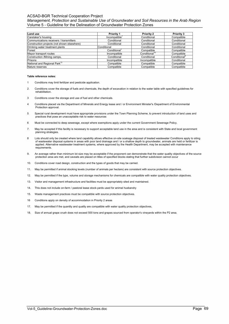
ACSAD-BGR Technical Cooperation Project Management, Protection and Sustainable Use of Groundwater and Soil Resources in the Arab Region Volume 5 - Guideline for the Delineation of Groundwater Protection Zones
Vol-5_Guideline-Groundwater-Protection-Zones.doc Page 69
Land use Priority 1 Priority 2 Priority 3 Caretaker's housing Incompatible7 Conditional Compatible Communications receivers / transmitters Conditional Conditional Conditional Construction projects (not shown elsewhere) Conditional Conditional Conditional Drinking water treatment plants Conditional Conditional Conditional Forest Conditional1 Compatible Compatible Mayor transport routes Incompatible Conditional10 Compatible Construction /Mining camps, Conditional Conditional Conditional6
Prisons Incompatible Incompatible Conditional National and Regional Park13 Compatible Compatible Compatible Nature reserves Compatible Compatible Compatible
Table reference notes:
1 Conditions may limit fertilizer and pesticide application.
2. Conditions cover the storage of fuels and chemicals, the depth of excavation in relation to the water table with specified guidelines for rehabilitation.
3 Conditions cover the storage and use of fuel and other chemicals.
4 Conditions placed via the Department of Minerals and Energy lease and / or Environment Minister's /Department of EnvironmentalProtection approval.
5 Special rural development must have appropriate provisions under the Town Planning Scheme, to prevent introduction of land uses and practices that pose an unacceptable risk to water resources
6 Must be connected to deep sewerage, except where exemptions apply under the current Government Sewerage Policy.
7. May be accepted if this facility is necessary to support acceptable land use in the area and is consistent with State and local government planning strategies.
8 Lots should only be created where land capability allows effective on-site soakage disposal of treated wastewater Conditions apply to siting of wastewater disposal systems in areas with poor land drainage and / or a shallow depth to groundwater, animals are held or fertilizer is applied. Alternative wastewater treatment systems, where approved by the Health Department, may be accepted with maintenance requirements.
9. An average rather than minimum lot size may be acceptable if the proponent can demonstrate that the water quality objectives of the source protection area are met, and caveats are placed on titles of specified blocks stating that further subdivision cannot occur
10. Conditions cover road design, construction and the types of goods that may be carried.
11. May be permitted if animal stocking levels (number of animals per hectare) are consistent with source protection objectives.
12. May be permitted if the type, volume and storage mechanisms for chemicals are compatible with water quality protection objectives.
13. Visitor and management infrastructure and facilities must be appropriately sited and maintained.
14. This does not include on-farm / pastoral lease stock-yards used for animal husbandry
15. Waste management practices must be compatible with source protection objectives.
16 Conditions apply on density of accommodation in Priority 2 areas
17. May be permitted if the quantity and quality are compatible with water quality protection objectives,
18. Size of annual grape crush does not exceed 500 tons and grapes sourced from operator's vineyards within the P2 area.
ACSAD-BGR Technical Cooperation Project Management, Protection and Sustainable Use of Groundwater and Soil Resources in the Arab Region Volume 5 - Guideline for the Delineation of Groundwater Protection Zones
Vol-5_Guideline-Groundwater-Protection-Zones.doc Page 70
Annex A-4: EPIK – Practice Guide – Groundwater Vulnerability Mapping in Karst Regions


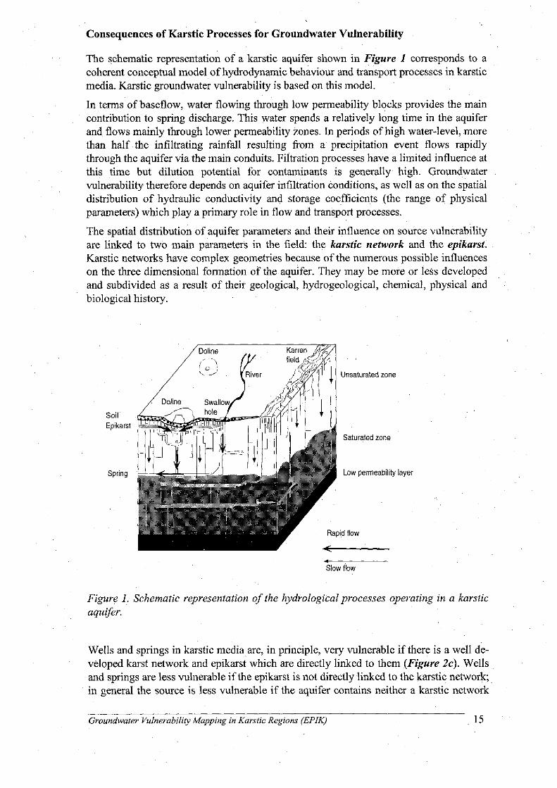
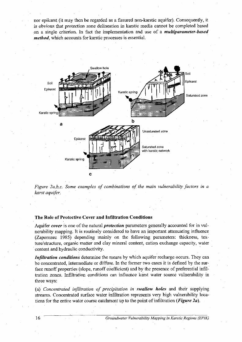
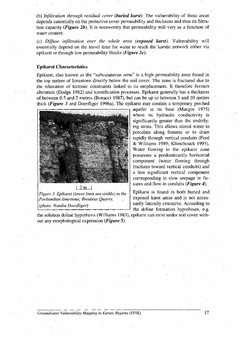
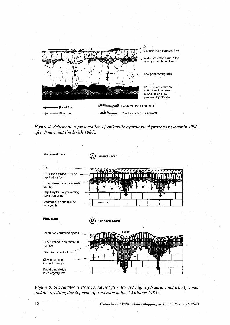
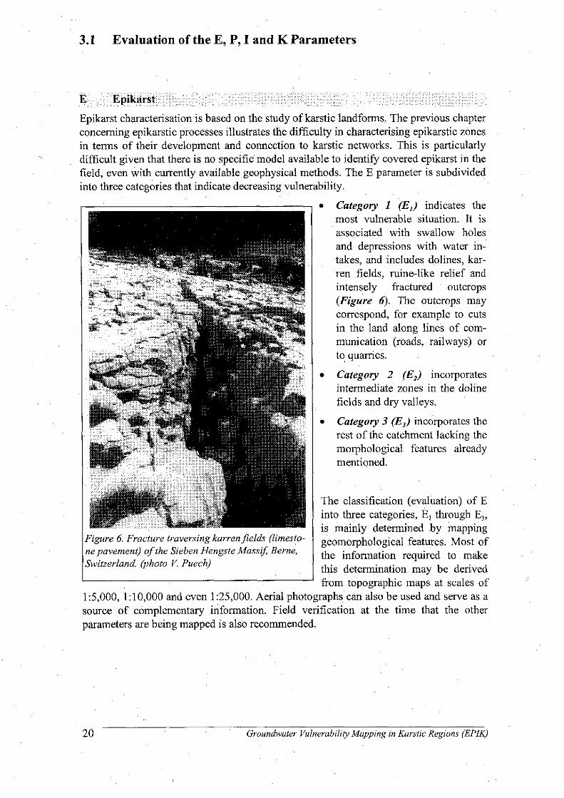
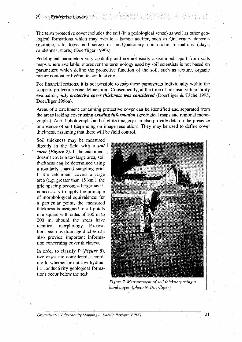
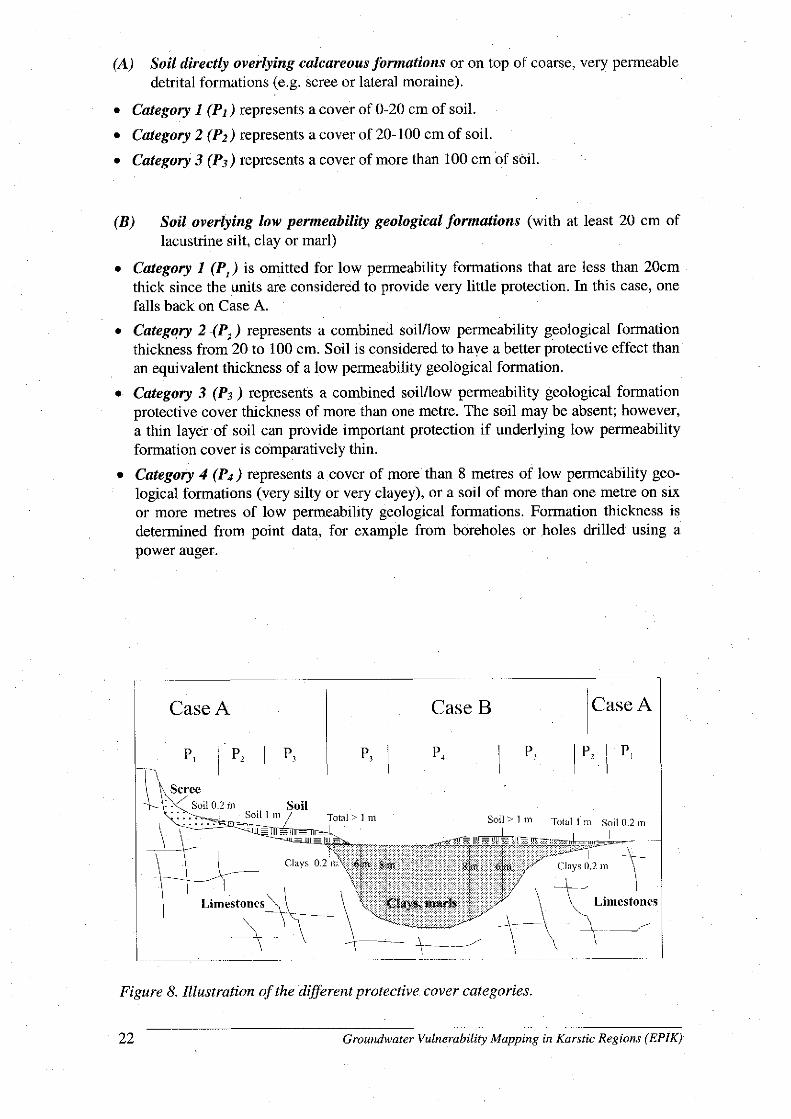
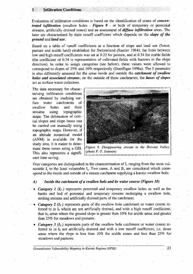
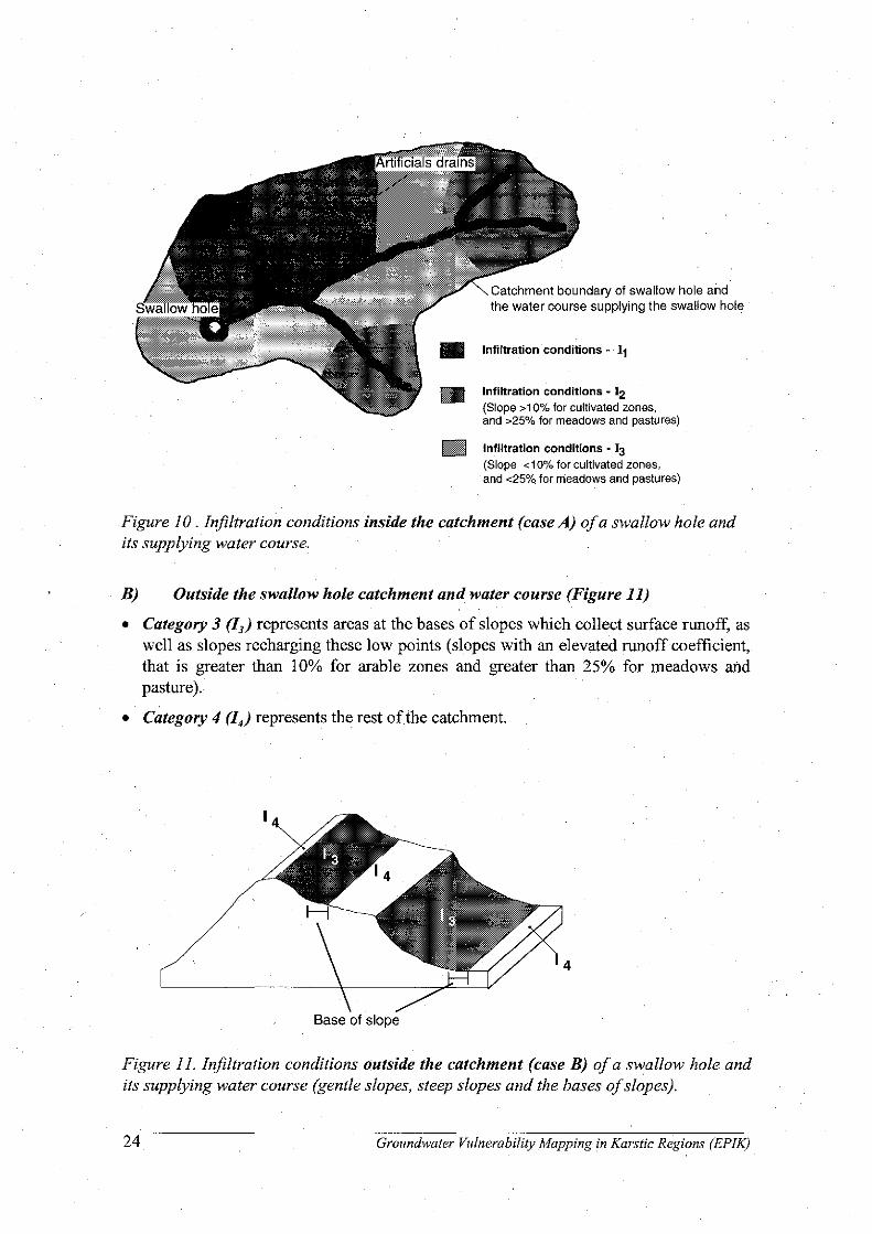

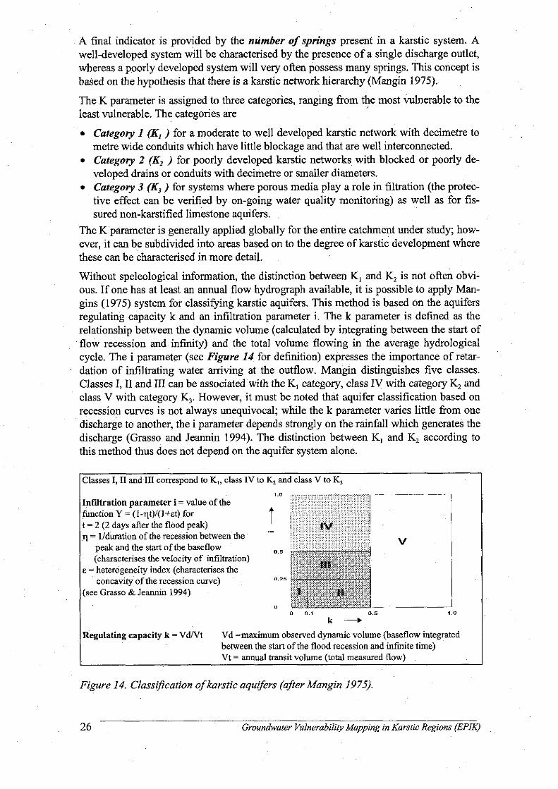
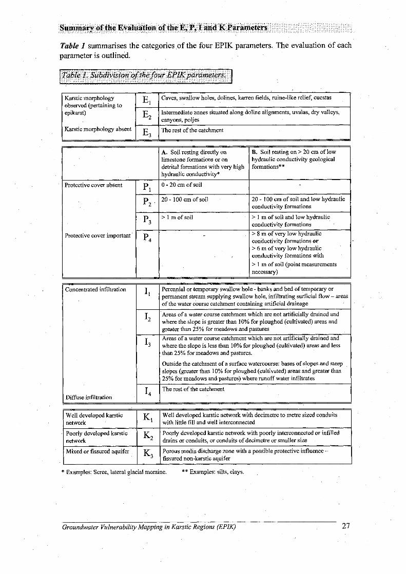
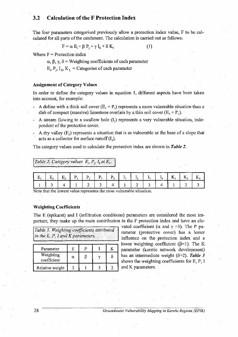

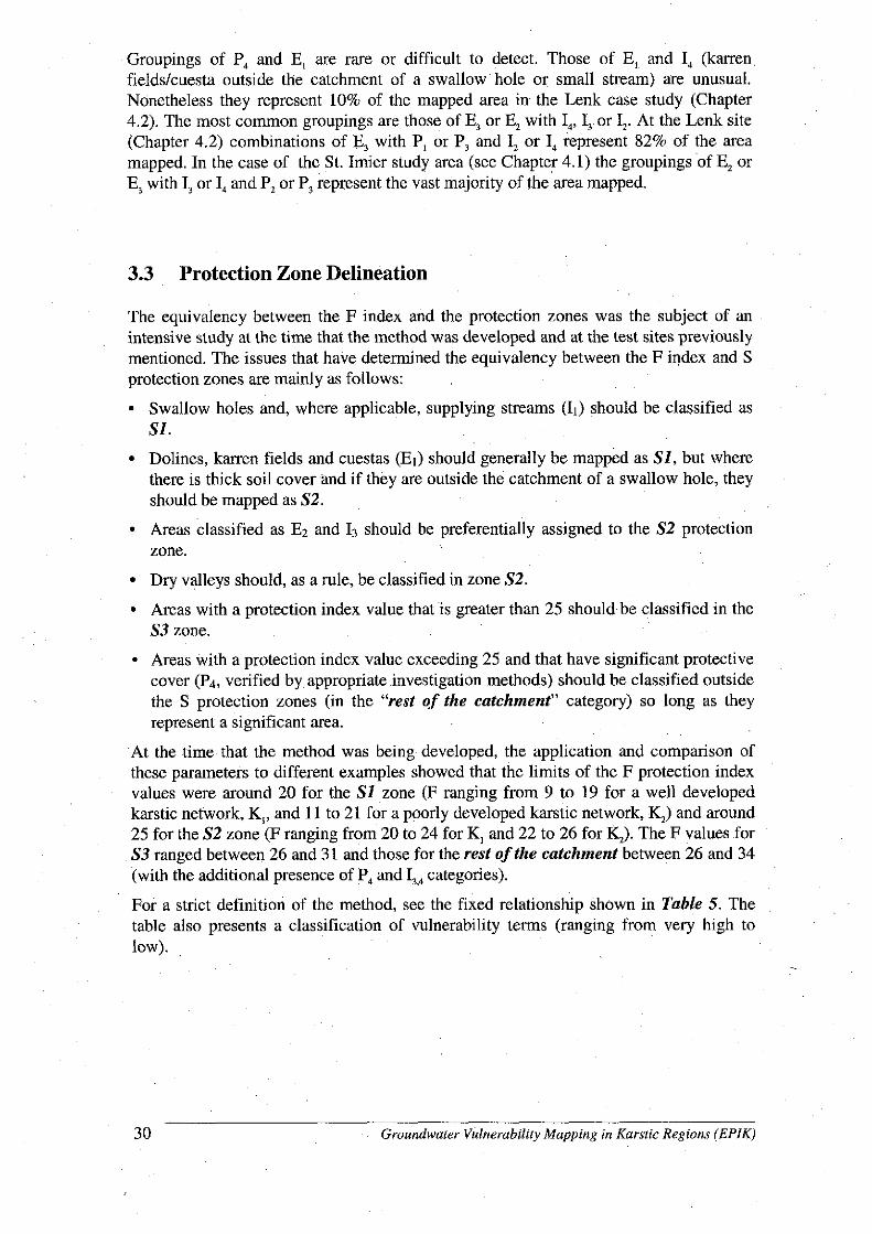

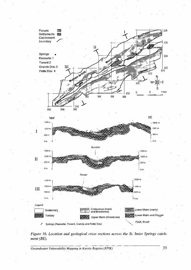
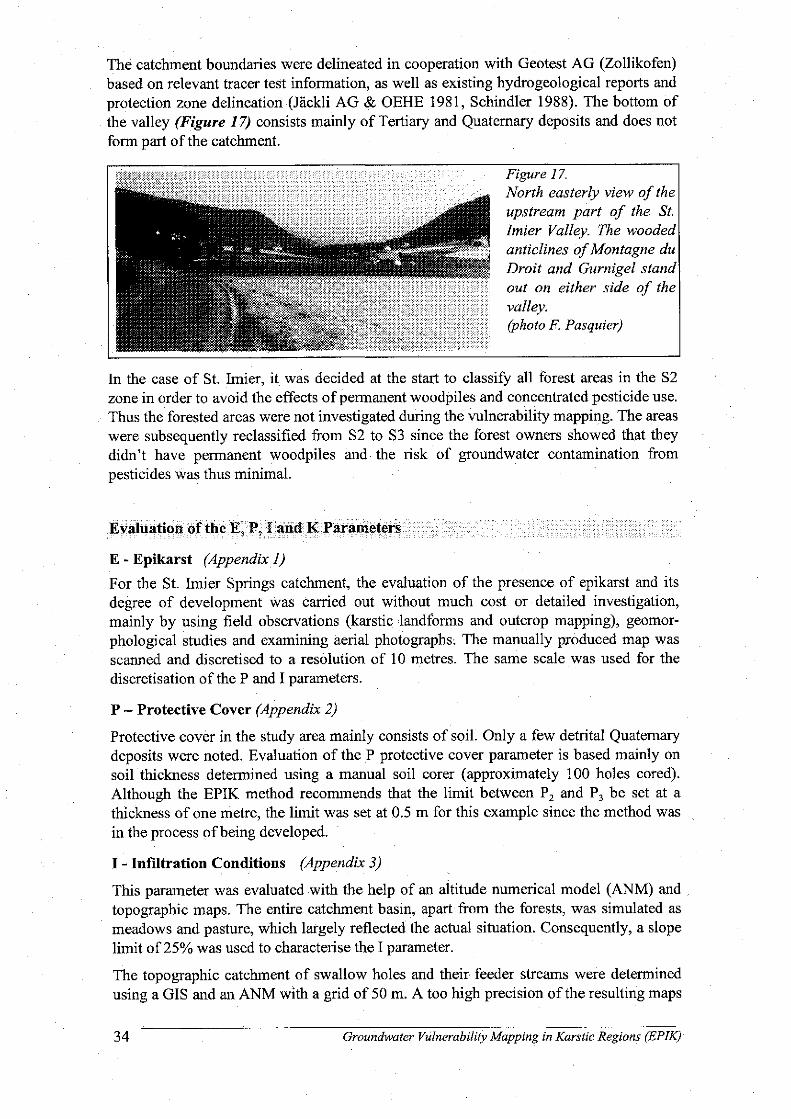
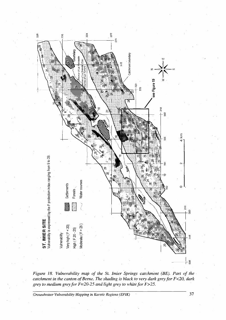

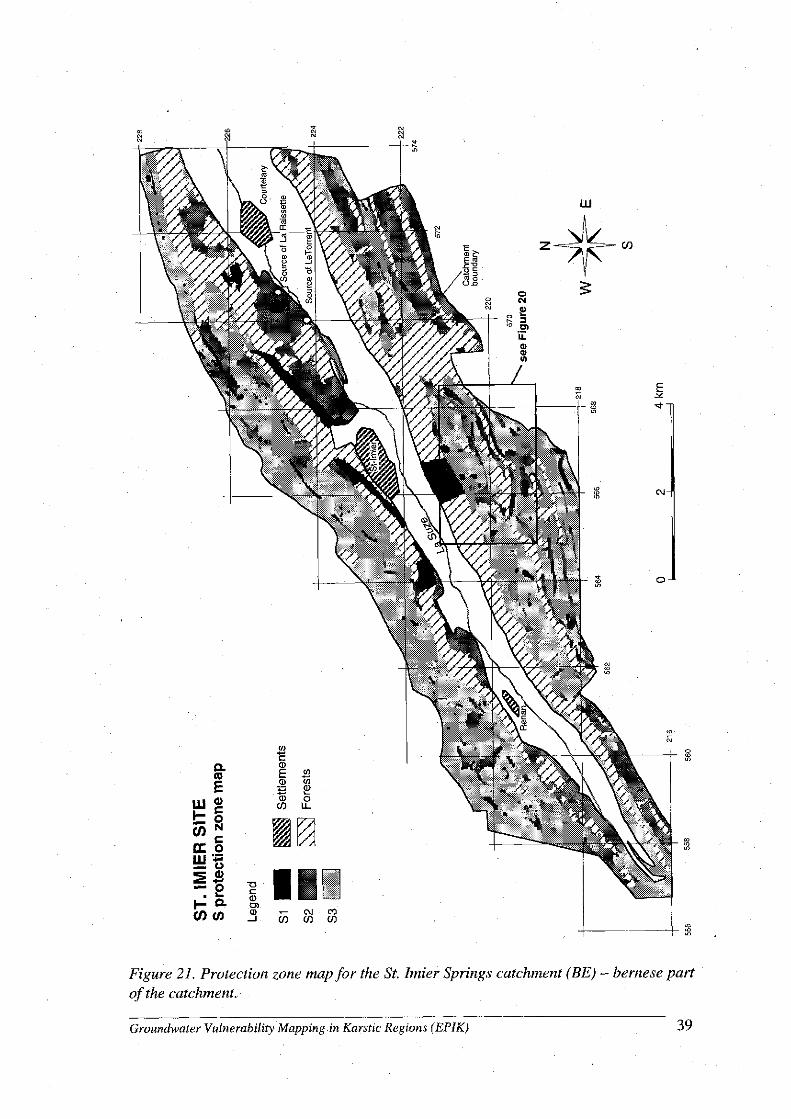
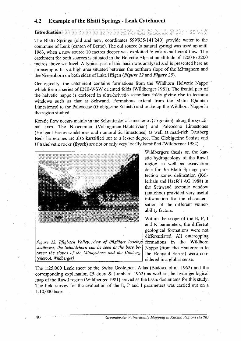

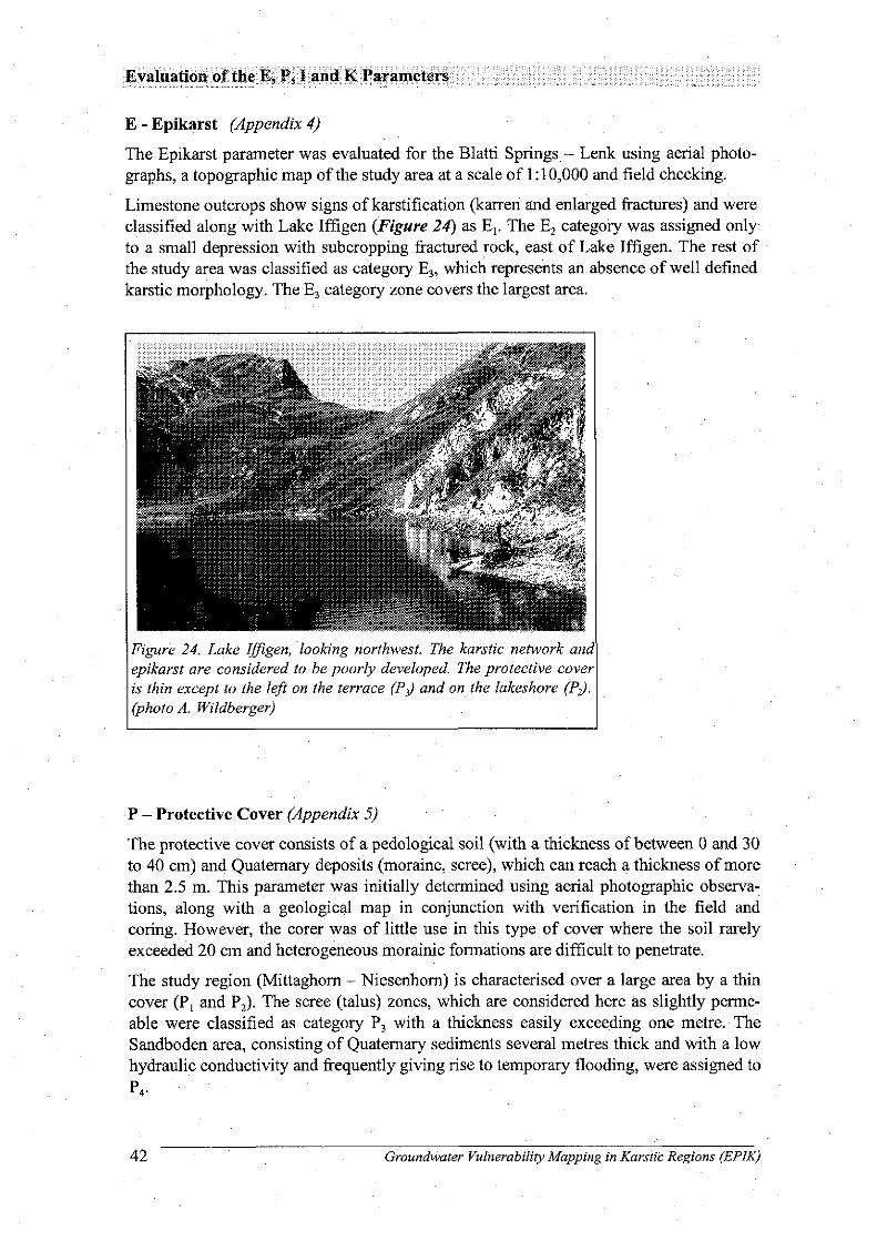

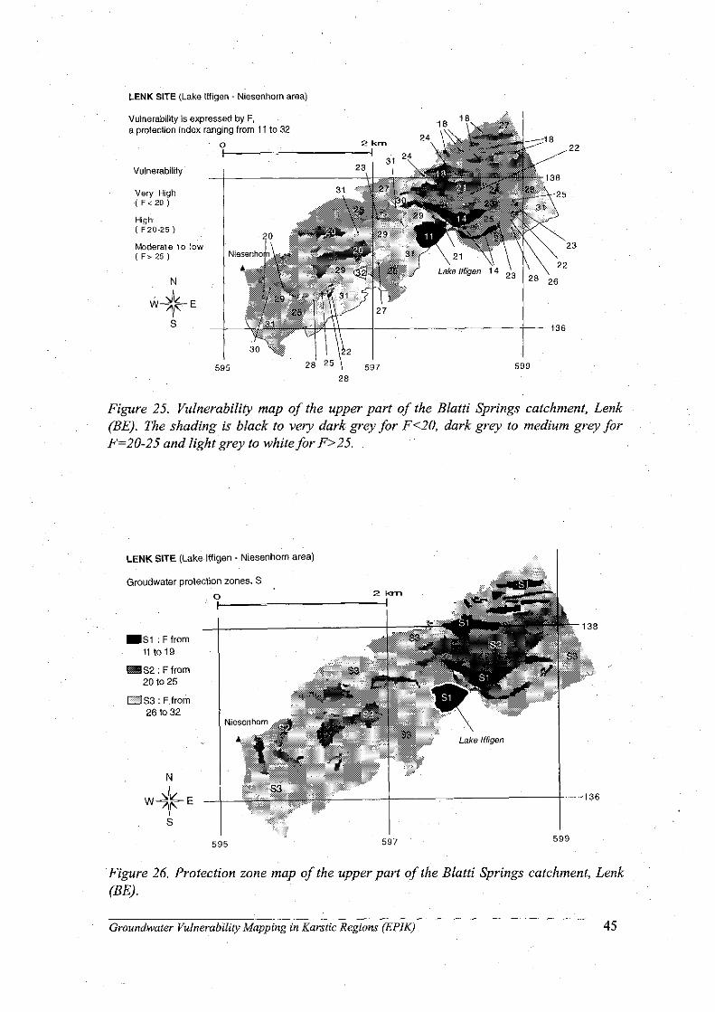
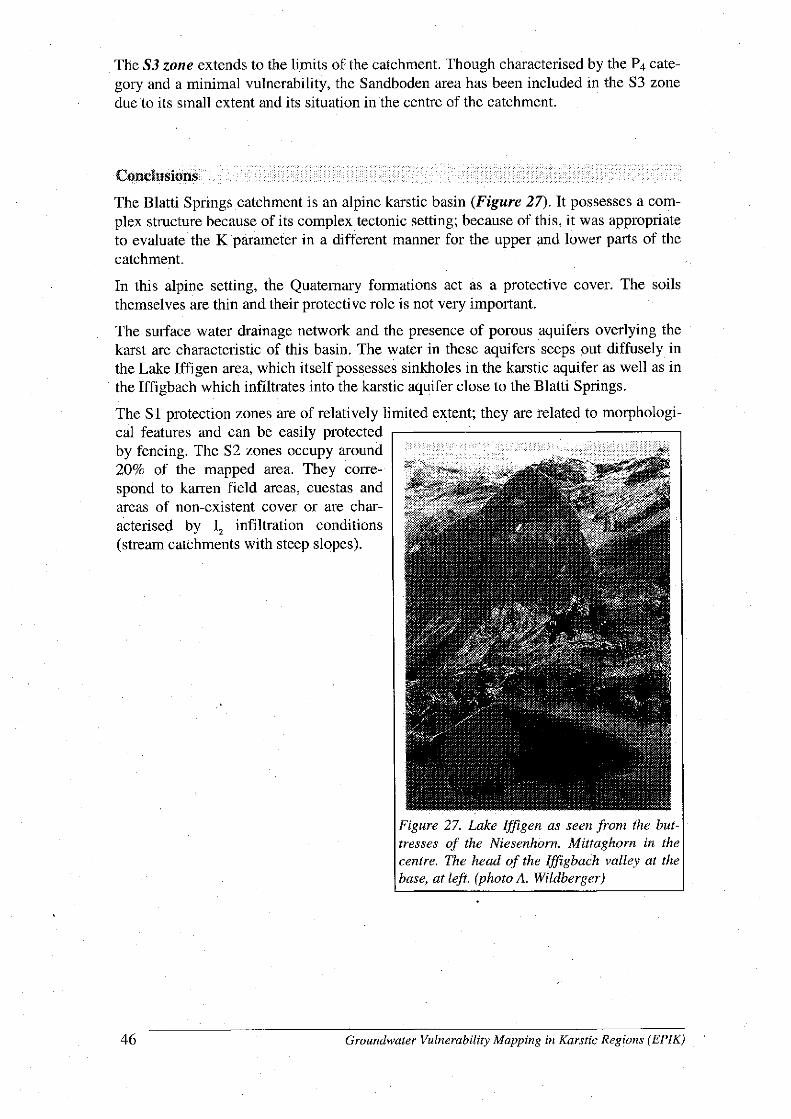
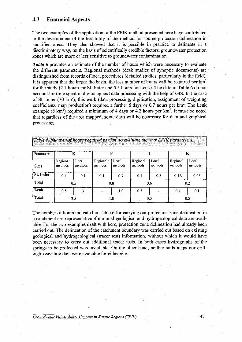

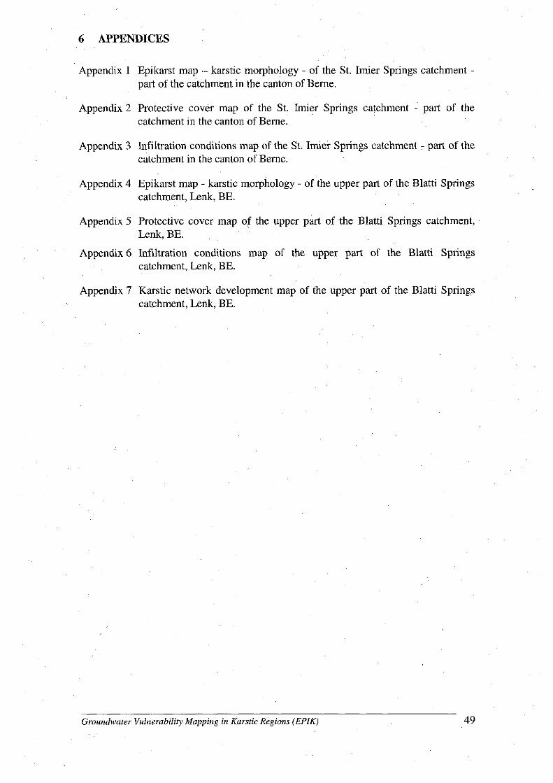
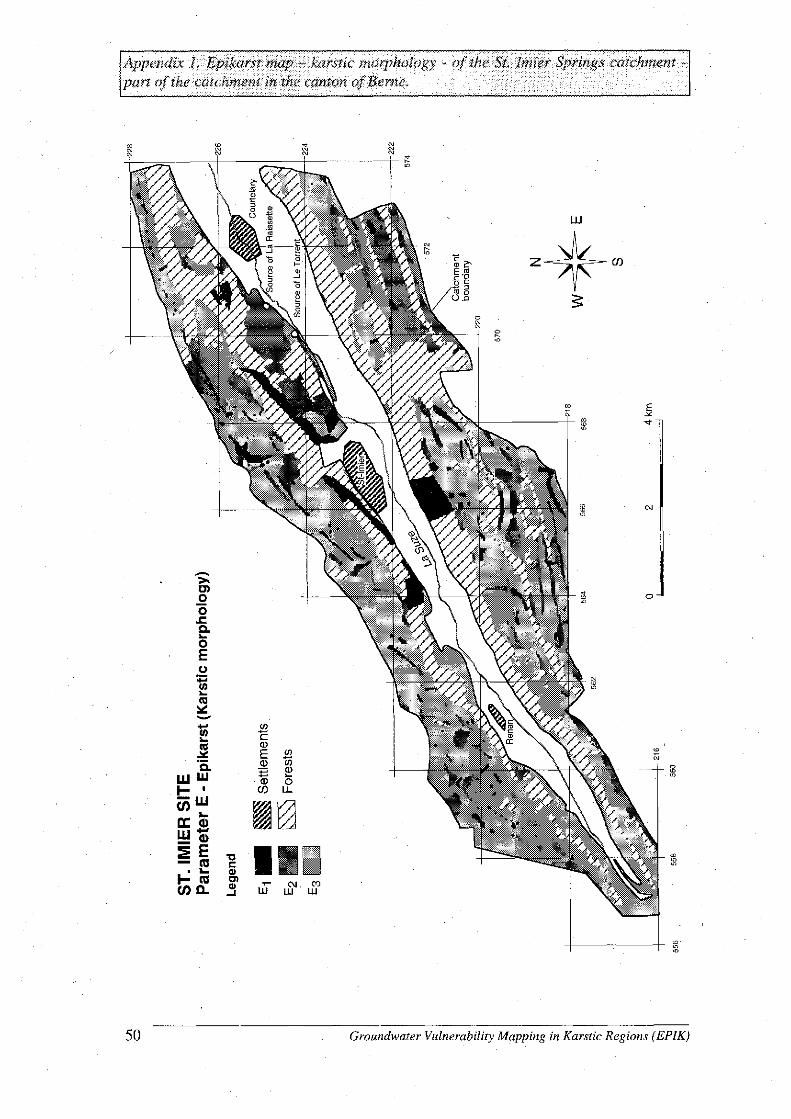
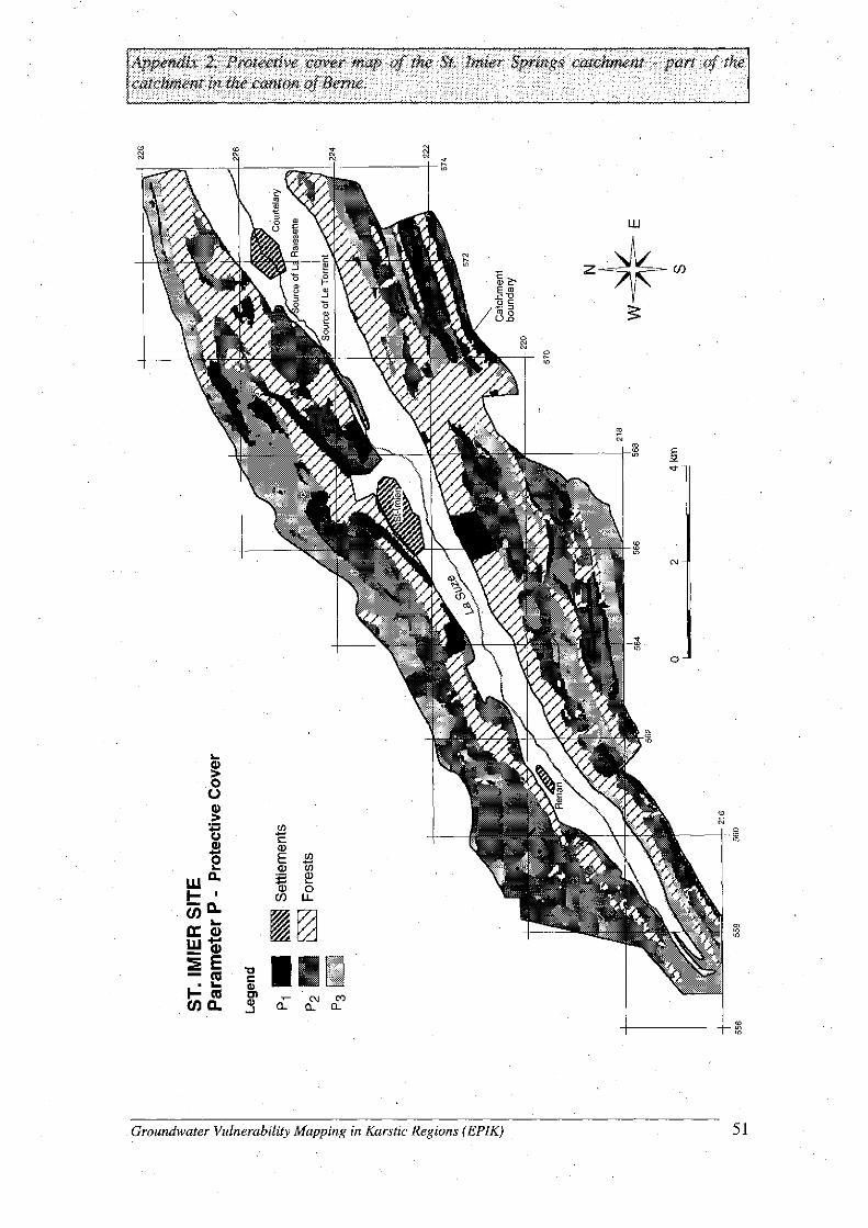

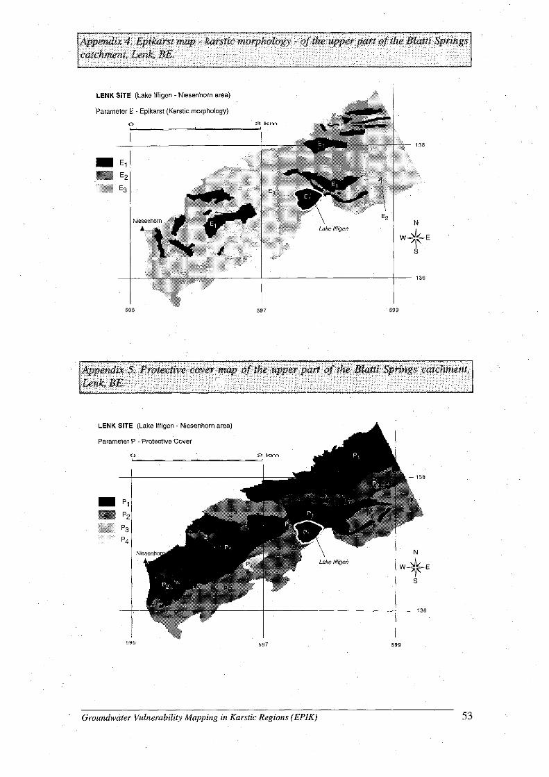
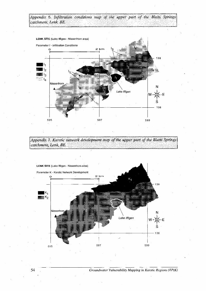

ACSAD-BGR Technical Cooperation Project Management, Protection and Sustainable Use of Groundwater and Soil Resources in the Arab Region Volume 5 - Guideline for the Delineation of Groundwater Protection Zones
Vol-5_Guideline-Groundwater-Protection-Zones.doc Page 129
Part B Proposal for a National Guideline for the Delineation of Groundwater Protection Zones
1 Significance for Groundwater Protection Measures
Clean drinking water plays a very important role in the health of a community. Community access to clean drinking water can be improved by protecting drinking water sources and managing them to avoid contamination. While groundwater is in general more protected by nature from contamination than surface water, ground-water resources can be extremely difficult to clean up once they become polluted. This makes the protection of groundwater resources from initial contamination extremely important. Groundwater has, under natural conditions, mostly no adverse effects on human health and is therefore preferable as drinking water from any other source. It is for this reason in the public interest to protect groundwater from contamination or other interference to minimize public health risks and to conserve this valuable natural resource.
Pathogenic microbiological constituents (such as bacteria, viruses, parasites and worm eggs which cause water-borne diseases) frequently occur in areas with insufficient sewage water treatment facilities in place. Water is monitored for such components on a regular basis to avoid adverse health effects of the population, and treatment facilities for pathogenic microbiological constituents nowadays are in place at most water sources. The effectiveness of water treatment for such components, however, highly depends on the presence of organic compounds and clay particles. The treatment of water for components such as nitrate, organic chemicals, metals, fertilizers, pesticides, etc. is very costly and also not always effective. Therefore the prevention of the occurrence of such pollutants in a source water area plays a key role in helping to protect the drinking water.
Groundwater protection zones are defined in order to prevent contamination by substances and organisms hazardous to human health.
Groundwater protection can, however, only be effective if land use development and land use planning take the needs for groundwater protection into consideration. Therefore appropriate actions must be considered in the early planning stages of groundwater development projects. For existing drinking water abstraction facilities restrictions for human activities have to be defined in order to minimize health risks. The allowance of activities in drinking water catchment areas has to be based on the principle of prevention of groundwater contamination and avoidance of adverse health effects.
ACSAD-BGR Technical Cooperation Project Management, Protection and Sustainable Use of Groundwater and Soil Resources in the Arab Region Volume 5 - Guideline for the Delineation of Groundwater Protection Zones
Vol-5_Guideline-Groundwater-Protection-Zones.doc Page 130
2 Legal Basis and Administrative Procedure
This guideline is based on the … Law (year).
The establishment of groundwater protection zones is initiated in the public interest. The costs for their establishment are covered by the Government (or the … fund, or the water agencies/companies).
The establishment of groundwater protection zones will be coordinated by the Ministry of … under the … Law (year). The ordinance for the establishment of a groundwater protection zone will be prepared by a Committee on Groundwater Protection Zone Delineation comprised of members of
The Ministry of Water (… representatives); The … Authority (… representatives, Central Laboratory, Sewage Water
Directorate, Licensing Directorate); The Ministry of Environment (… representatives, Water Protection
Directorate); The Ministry of Agriculture (… representatives, Directorate for … ), The Ministry of Municipal Affairs/Country Planning (… representatives,
Directorate for …); The Ministry of Health (… representatives, Directorate for …), The Office of the Governor of the Province (… representatives, Planning
Directorate); Stakeholder group for agriculture (… representatives); Stakeholder group for industry (… representatives); Stakeholder group of other relevant land uses (… representatives); …
The Ministry of … will establish a Program for the Delineation of Groundwater Protection Zones in coordination with other involved ministries and institutions. This program contains a ranking for the establishment based on the importance of the groundwater resources to be protected.
The Ordinance on the Delineation of a Groundwater Protection Zone for a groundwater well or spring consists of the following elements :
A statement about the legal basis for the issuance of the ordinance; The hydrogeological study, defining the hydrogeological boundaries of the
groundwater protection zone; The administrative boundaries of the groundwater protection zone, defined
by the Committee on Groundwater Protection Zone Delineation, and to be based on the hydrogeological study;
A list of restrictions for activities and land uses in the different groundwater protection zones, as defined by the Committee on Groundwater Protection Zone Delineation (see chapter 4);

ACSAD-BGR Technical Cooperation Project Management, Protection and Sustainable Use of Groundwater and Soil Resources in the Arab Region Volume 5 - Guideline for the Delineation of Groundwater Protection Zones
Vol-5_Guideline-Groundwater-Protection-Zones.doc Page 131
An inventory of all potential sources of contamination for the entire groundwater protection zone (Annexes B-1, B-2, B-3 and B-4), to be included in the hydrogeological study;
An analysis of the susceptibility of the water supply source to those contamination sources, to be included in the hydrogeological study, including an evaluation of the degree of threat arising from each potential pollution hazard;
A surveillance and monitoring scheme for compliance with defined restrictions;
A contingency plan that describes how water supply is planned to be maintained in case of groundwater contamination (see chapter 5); and
A remedial action plan that describes which measures are going to be implemented to avoid groundwater contamination in case of accidental contamination (see chapter 5).
The administrative procedure for the establishment of groundwater protection zones is as follows :
1. The Ministry of … will initiate the process of the delineation of groundwater protection zones.
2. The Ministry of … will prepare a hydrogeological study which defines the hydrogeological boundaries of the groundwater protection zones, yields information on the vulnerability of the aquifer system and the susceptibility to certain hazards.
3. A Committee on Groundwater Protection Zone Delineation will be established that elaborates the other elements of the groundwater protection zone ordinance, as mentioned above.
4. The draft groundwater protection zone ordinance will be made available to the public in the form of … (to be added by the Committee) for a time period of 4 weeks at … (to be added by the Committee). Objections by the public have to be forwarded to the Committee on Groundwater Protection Zone Delineation within … (suggestion: 6) weeks after having been made available to the public. All objections have to be formally answered by the Committee within … (suggestion: 4) weeks after receipt.
5. The Committee will make modifications, if required, to the groundwater protection ordinance and make the modified draft again available to the public for a time period of … (suggestion: 4) weeks.
6. A public hearing will be held where the objections and modifications to the draft groundwater protection ordinance are discussed.
7. The final groundwater protection ordinance will be published in the Official Government Newspaper.
The analysis of the susceptibility of the water supply source to contamination has to be conducted for all contamination sources listed in the inventory of potential sources of contamination. This may be done using groundwater vulnerability maps at a suitable scale.
A model scheme for the surveillance and monitoring of compliance with defined restrictions will be established by the Ministry of … .
ACSAD-BGR Technical Cooperation Project Management, Protection and Sustainable Use of Groundwater and Soil Resources in the Arab Region Volume 5 - Guideline for the Delineation of Groundwater Protection Zones
Vol-5_Guideline-Groundwater-Protection-Zones.doc Page 132
3 Classification of Protective Areas
Areas for the protection of groundwater should principally comprise the entire surface and subsurface catchment area that contributes to the production of an abstraction facility for drinking water. Protective areas should be classified into zones reflecting the different level of risk implied by activities contributing to groundwater contami-nation as a function of the type, the location and the duration of the activity and the vulnerability of the aquifer. The potential contamination risk normally decreases with the distance of the activity from the abstraction facility in case of homogeneous groundwater flow velocities (unconsolidated aquifers and fractured rock aquifers with no preferential flow directions). Therefore the travel time is the most prominent factor for the delineation of groundwater protection zones in such aquifers. In karst aquifers, however, the groundwater flow velocity can be locally very high so that groundwater protection zones would comprise very large areas of the surface and subsurface catchment area. In this case groundwater protection zones have to be established based on a different approach. Instead of groundwater flow velocities or travel times the vulnerability of the aquifer system upstream of the water abstraction facility should be used.
Taking into account the different character of hydrogeological systems, it is distinguished between
Aquifers with a near homogeneous distribution of groundwater flow velocities (unconsolidated aquifers and fractured rock aquifers with no preferential flow directions); and
Aquifers with a heterogeneous distribution of groundwater flow velocities (karst aquifers and fractured rock aquifers with preferential flow directions of high flow velocity)
In case of mixed aquifers all aquifers contributing to the production from the water abstraction facility have to be protected.
In case of interference effects between groundwater abstractions all abstractions have to be taken into account.
The geometry of a groundwater protection zone is dependent on the following hydrogeological factors :
Abstraction rate; Groundwater recharge; Hydraulic permeability (in x, y and z); Effective porosity; Aquifer thickness; Hydraulic gradient; and Direction of groundwater flow.
Other factors which influence the shape of a groundwater protection zone are : Interference effects between groundwater abstractions; Lateral and vertical hydraulic boundaries (lateral aquifer boundaries,
geologic windows, leakage, etc.);
ACSAD-BGR Technical Cooperation Project Management, Protection and Sustainable Use of Groundwater and Soil Resources in the Arab Region Volume 5 - Guideline for the Delineation of Groundwater Protection Zones
Vol-5_Guideline-Groundwater-Protection-Zones.doc Page 133
Groundwater/surface water interactions; Lateral and vertical variations in hydraulic properties.
The shape of groundwater protection areas reflects the conceptual hydrogeological model. The accuracy of such a model depends on the data availability.
3.1 Aquifers with Near Homogeneous Distribution of Groundwater Flow Velocities (Unconsolidated Aquifers and Fractured Rock Aquifers with no Preferential Flow Directions)
The groundwater protection area is divided into three zones : Zone I – The Immediate Protection Zone comprises an area with a radius of
at least 10 m from a water well and at least 20 m in the upstream direction of a spring. It provides against direct contamination at the well itself.
Zone II – The Inner Protection Zone comprises the area defined by the 50-days travel time, being not less than 100 m from a well or spring. It provides against contamination, particularly from pathogenic microbiological constituents and from other contaminants which may be hazardous.
Zone III – The outer protection zone encompasses the entire contribution zone of the groundwater catchment area. It may be subdivided into zones IIIA and IIIB (see below). It provides protection against contamination affecting water over long distances such as radioactive substances or chemicals which are not or not easily degraded.
Where reasonably necessary, groundwater protection zone III may be subdivided into zone IIIA and zone IIIB.
For aquifers with flow velocities of 10 m/day or less, the boundary between zone IIIA and zone IIIB should be located approximately 2 km upstream from the water abstraction facility. In case of higher flow rate this boundary should be located at an appropriately greater distance.
Areas in which the aquifer has a flow velocity of 10 m/day or less and which are covered by undisturbed, continuous low-permeability (k < 1E-7 m/s) strata of a thickness of at least 5 m may be classified as zone IIIB. In the case of flow velocities exceeding 10 m/day the cover of such low-permeability strata must be at least 8 m. The distance from the boundary of zone IIIB to the water abstraction facility should not be less than 1 km and the time required for water to flow over this distance may not be less than 50 days. Zone II may not be established in case the water is exclusively produced from deep horizons that are covered by low-permeable strata of sufficient thickness over the entire area between the water abstraction facility and the line of 50-days travel time.
For the determination of the 50-days travel time to the water abstraction facility and the lower culmination, the average daily discharge rate determined from the annual discharge rate or the maximum daily discharge should be used depending on the duration of maximum discharge and the local conditions.
ACSAD-BGR Technical Cooperation Project Management, Protection and Sustainable Use of Groundwater and Soil Resources in the Arab Region Volume 5 - Guideline for the Delineation of Groundwater Protection Zones
Vol-5_Guideline-Groundwater-Protection-Zones.doc Page 134
If the catchment area is very large, protection zone III may be limited to the cone of depression. The cone of depression should for this purpose be determined using the average annual discharge rate allowed by the water abstraction license. For a given discharge rate, the recharge area may be calculated using the known or estimated recharge rate. Following the calculation of the recharge area, the boundaries of the cone of depression are prolonged in the upstream direction until the enclosed area is equal to the calculated recharge area. Safety allowances should be added both in the upstream and the transverse direction. Such safety allowances should reflect
Uncertainties regarding the exact location of the calculated recharge area; Uncertainties regarding water discharge; Increases in the size of the cone of depression in the case of extended
water production at maximum permitted discharge rate; Changes in the groundwater level in dry years; Changes in the direction of groundwater flow to the water abstraction facility.
If no data allowing such an estimation are available, or if the direction of flow to the water abstraction facility varies, an allowance of a maximum of 50% in the main direction of flow and ± 5-10° in the transverse direction should be made, depending on local hydrogeological conditions, such as depth to groundwater and permeability of overlying strata.
Dispersion effects have only to be taken into consideration if they are relevant.
3.2 Aquifers with Heterogeneous Distribution of Groundwater Flow Velocities (Karst Aquifers and Fractured Rock Aquifers with Preferential Flow Directions of High Flow Velocity)
For the delineation of groundwater protection zones in karst aquifers the groundwater vulnerability is used. Groundwater vulnerability is defined as 'the tendency or likelihood for contaminants to reach the groundwater system after introduction at some location above the uppermost aquifer'. For the assessment of the vulnerability of the groundwater to contamination, the protective effectiveness of the cover of rocks and superficial deposits above the topmost aquifer is taken into consideration. This protective effectiveness or filtering effect of the rock and soil cover in the unsaturated zone depends on many different factors, mainly the compactness, mineralogical composition, porosity, content of organic matter, pH, and cation exchange capacity, the thickness of rock and soil cover, as well as the percolation rate and percolation velocity.
Based on the same criteria as listed for aquifer systems with a near homogeneous flow velocity distribution three groundwater protection zones are distinguished :
Zone I – The Immediate Protection Zone comprises the area with a radius of at least 10 m from a water well and at least 20 m in the upstream direction of a spring and the area of high groundwater vulnerability. It provides against direct contamination at the well itself.
Zone II – The Inner Protection Zone comprises the area with a medium groundwater vulnerability. It provides against contamination, particularly from pathogenic microbiological constituents and from other contamination which may be hazardous.
ACSAD-BGR Technical Cooperation Project Management, Protection and Sustainable Use of Groundwater and Soil Resources in the Arab Region Volume 5 - Guideline for the Delineation of Groundwater Protection Zones
Vol-5_Guideline-Groundwater-Protection-Zones.doc Page 135
Zone III – The outer protection zone encompasses the entire zone of contribution of the groundwater catchment area. It provides protection against contamination affecting water over long distances such as radioactive substances or chemicals which are not or not easily degraded.
Flow velocities in karst systems are very unevenly distributed. The baseflow of springs is usually provided from low permeability blocks in the aquifer system that provide for extended residence times of the groundwater. In periods of high water level, i.e. after groundwater recharge events, much of the infiltrating rainfall flows rapidly through the aquifer via the main conduits. Filtration processes have a limited influence at these times but dilution potential for contaminants is generally high. Groundwater vulnerability therefore depends on the aquifer infiltration conditions, as well as on the spatial distribution of the hydraulic parameters, such as hydraulic conductivity, storage coefficient and porosity, which control the flow and transport processes. Dispersion effects have only to be taken into consideration if they are relevant.
Wells and springs in karstic media are, in principle, very vulnerable if there is a well developed karst network and epikarst which are directly linked. Wells and springs are less vulnerable if the epikarst is not directly linked to the karst network. In general the source is less vulnerable if the aquifer contains neither a karstic network nor epikarst.
Groundwater vulnerability in karst aquifers should be based on factors such as: Development of epikarst; Effectiveness of the protective cover; Conditions of infiltration; and Development of karst network.
Groundwater protection zone I in karst areas should principally comprise Swallow holes, sinks, and supplying streams; Dolines, karren fields, cuestas, and their immediate surroundings which may
be draining towards them, if without soil cover and inside the receiving area of swallow holes.
Groundwater protection zone II in karst areas should principally comprise Dolines, karren fields, cuestas, and their immediate surroundings which may
be draining towards them, if covered with soil and outside the receiving area of swallow holes;
Slopes or dry valleys declining towards the water abstraction facility, Intermediate zones situated along doline alignments, uvalas, dry valleys,
canyons and poljes; Streams or brooks; Deep-cut dry valleys draining particularly or temporarily surface water or
featuring areas of infiltration; Areas in which karst aquifers have been excavated by mining; Areas featuring near-surface tunnels collecting groundwater; and Near-surface shatter zones or fault areas.
ACSAD-BGR Technical Cooperation Project Management, Protection and Sustainable Use of Groundwater and Soil Resources in the Arab Region Volume 5 - Guideline for the Delineation of Groundwater Protection Zones
Vol-5_Guideline-Groundwater-Protection-Zones.doc Page 136
4 Restrictions for Activities in Groundwater Protection Zones
The groundwater protection zone ordinance has to define restrictions and allowances for all activities which could possibly have an impact on groundwater quality. These restrictions and allowances have to be formulated as clear as possible so that there could not be any doubt about what is allowed and what is not.
The restrictions and allowances listed in the matrixes are compiled from the respective German, Swiss and Australian regulations and are meant as recommendations. The final decision depends on the local situation and therefore will be made by the Committee on Groundwater Protection Zone Delineation.
Commercial Land Uses
Land use/Activity Zone I Zone II Zone IIIA Zone IIIB Construction or extension of facilities or plants for the production, treatment, use, processing, and storage of substances which may possibly contaminate groundwater and are non- or hardly degradable and radioactive substances, such as substances from refineries, iron, and steel mills, non-ferrous metal works, chemical plants Facilities for the storage of chemicals and nuclear facilities (excepting facilities for medical applications as well as equipment for metering, testing and control)
incompatible incompatible incompatible incompatible
Handling of substances contaminating water
incompatible incompatible incompatible4 incompatible4
Use of materials from which contaminants may be washed or leached, such as use of rubble, residues from incinerators, slag and mining residue for the construction of road, waterway, railroad and air transportation systems and facilities or structures built for noise control
incompatible incompatible incompatible incompatible
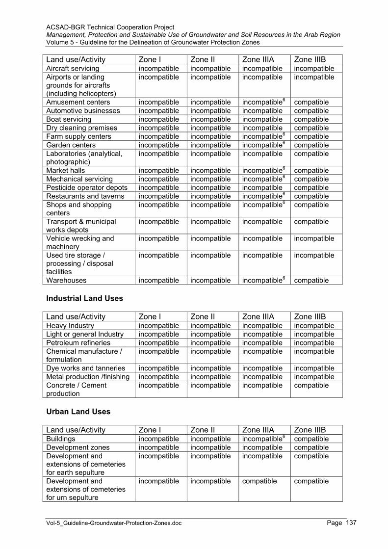
ACSAD-BGR Technical Cooperation Project Management, Protection and Sustainable Use of Groundwater and Soil Resources in the Arab Region Volume 5 - Guideline for the Delineation of Groundwater Protection Zones
Vol-5_Guideline-Groundwater-Protection-Zones.doc Page 137
Land use/Activity Zone I Zone II Zone IIIA Zone IIIB Aircraft servicing incompatible incompatible incompatible incompatible Airports or landing grounds for aircrafts (including helicopters)
incompatible incompatible incompatible incompatible
Amusement centers incompatible incompatible incompatible6 compatible Automotive businesses incompatible incompatible incompatible compatible Boat servicing incompatible incompatible incompatible compatible Dry cleaning premises incompatible incompatible incompatible compatible Farm supply centers incompatible incompatible incompatible6 compatible Garden centers incompatible incompatible incompatible6 compatible Laboratories (analytical, photographic)
incompatible incompatible incompatible compatible
Market halls incompatible incompatible incompatible6 compatible Mechanical servicing incompatible incompatible incompatible6 compatible Pesticide operator depots incompatible incompatible incompatible compatible Restaurants and taverns incompatible incompatible incompatible6 compatible Shops and shopping centers
incompatible incompatible incompatible6 compatible
Transport & municipal works depots
incompatible incompatible incompatible compatible
Vehicle wrecking and machinery
incompatible incompatible incompatible incompatible
Used tire storage / processing / disposal facilities
incompatible incompatible incompatible incompatible
Warehouses incompatible incompatible incompatible6 compatible
Industrial Land Uses
Land use/Activity Zone I Zone II Zone IIIA Zone IIIB Heavy Industry incompatible incompatible incompatible incompatibleLight or general Industry incompatible incompatible incompatible incompatiblePetroleum refineries incompatible incompatible incompatible incompatibleChemical manufacture / formulation
incompatible incompatible incompatible incompatible
Dye works and tanneries incompatible incompatible incompatible incompatibleMetal production /finishing incompatible incompatible incompatible incompatibleConcrete / Cement production
incompatible incompatible incompatible compatible
Urban Land Uses
Land use/Activity Zone I Zone II Zone IIIA Zone IIIB Buildings incompatible incompatible incompatible6 compatible Development zones incompatible incompatible incompatible compatible Development and extensions of cemeteries for earth sepulture
incompatible incompatible incompatible compatible
Development and extensions of cemeteries for urn sepulture
incompatible incompatible compatible compatible
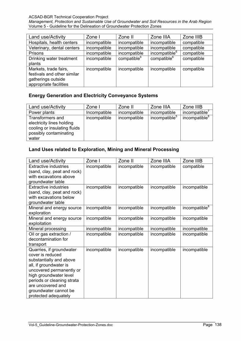
ACSAD-BGR Technical Cooperation Project Management, Protection and Sustainable Use of Groundwater and Soil Resources in the Arab Region Volume 5 - Guideline for the Delineation of Groundwater Protection Zones
Vol-5_Guideline-Groundwater-Protection-Zones.doc Page 138
Land use/Activity Zone I Zone II Zone IIIA Zone IIIB Hospitals, health centers incompatible incompatible incompatible compatible Veterinary, dental centers incompatible incompatible incompatible compatible Prisons incompatible incompatible incompatible6 compatible Drinking water treatment plants
incompatible compatible6 compatible6 compatible
Markets, trade fairs, festivals and other similar gatherings outside appropriate facilities
incompatible incompatible incompatible compatible
Energy Generation and Electricity Conveyance Systems
Land use/Activity Zone I Zone II Zone IIIA Zone IIIB Power plants Incompatible incompatible incompatible incompatible7
Transformers and electricity lines holding cooling or insulating fluids possibly contaminating water
incompatible incompatible incompatible5 incompatible8
Land Uses related to Exploration, Mining and Mineral Processing
Land use/Activity Zone I Zone II Zone IIIA Zone IIIB Extractive industries (sand, clay, peat and rock) with excavations above groundwater table
incompatible incompatible incompatible compatible
Extractive industries (sand, clay, peat and rock) with excavations below groundwater table
incompatible incompatible incompatible incompatible
Mineral and energy source exploration
incompatible incompatible incompatible incompatible8
Mineral and energy source exploitation
incompatible incompatible incompatible incompatible
Mineral processing incompatible incompatible incompatible incompatible Oil or gas extraction / decontamination for transport
incompatible incompatible incompatible incompatible
Quarries, if groundwater cover is reduced substantially and above all, if groundwater is uncovered permanently or high groundwater level periods or cleaning strata are uncovered and groundwater cannot be protected adequately
incompatible incompatible incompatible incompatible
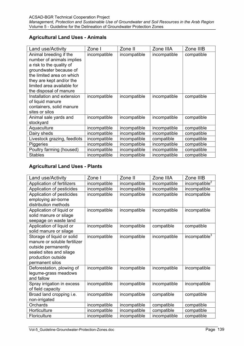
ACSAD-BGR Technical Cooperation Project Management, Protection and Sustainable Use of Groundwater and Soil Resources in the Arab Region Volume 5 - Guideline for the Delineation of Groundwater Protection Zones
Vol-5_Guideline-Groundwater-Protection-Zones.doc Page 139
Agricultural Land Uses - Animals
Land use/Activity Zone I Zone II Zone IIIA Zone IIIB Animal breeding if the number of animals implies a risk to the quality of groundwater because of the limited area on which they are kept and/or the limited area available for the disposal of manure
incompatible incompatible incompatible compatible
Installation and extension of liquid manure containers, solid manure sites or silos
incompatible incompatible incompatible compatible
Animal sale yards and stockyard
incompatible incompatible incompatible compatible
Aquaculture incompatible incompatible incompatible compatibleDairy sheds incompatible incompatible incompatible compatibleLivestock grazing, feedlots incompatible incompatible compatible compatiblePiggeries incompatible incompatible incompatible compatiblePoultry farming (housed) incompatible incompatible incompatible compatibleStables incompatible incompatible incompatible compatible
Agricultural Land Uses - Plants
Land use/Activity Zone I Zone II Zone IIIA Zone IIIB Application of fertilizers incompatible incompatible incompatible incompatible2
Application of pesticides incompatible incompatible incompatible incompatibleApplication of pesticides employing air-borne distribution methods
incompatible incompatible incompatible incompatible
Application of liquid or solid manure or silage seepage on waste land
incompatible incompatible incompatible incompatible
Application of liquid or solid manure or silage
incompatible incompatible compatible compatible
Storage of liquid or solid manure or soluble fertilizer outside permanently sealed sites and silage production outside permanent silos
incompatible incompatible incompatible incompatible3
Deforestation, plowing of legume-grass meadows and fallow
incompatible incompatible incompatible incompatible
Spray irrigation in excess of field capacity
incompatible incompatible incompatible incompatible
Broad land cropping i.e. non-irrigated
incompatible incompatible compatible compatible
Orchards incompatible incompatible compatible compatibleHorticulture incompatible incompatible compatible compatibleFloriculture incompatible incompatible incompatible compatible
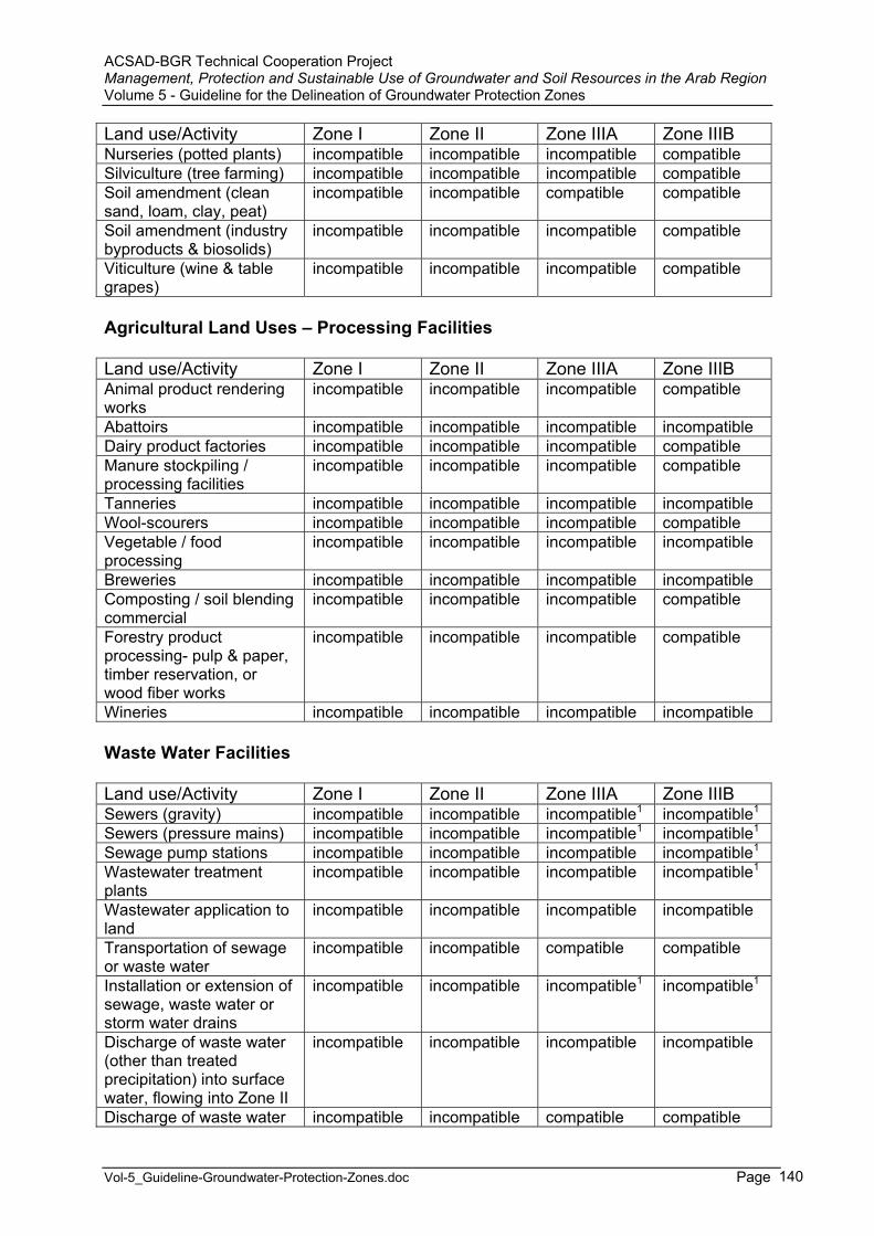
ACSAD-BGR Technical Cooperation Project Management, Protection and Sustainable Use of Groundwater and Soil Resources in the Arab Region Volume 5 - Guideline for the Delineation of Groundwater Protection Zones
Vol-5_Guideline-Groundwater-Protection-Zones.doc Page 140
Land use/Activity Zone I Zone II Zone IIIA Zone IIIB Nurseries (potted plants) incompatible incompatible incompatible compatibleSilviculture (tree farming) incompatible incompatible incompatible compatibleSoil amendment (clean sand, loam, clay, peat)
incompatible incompatible compatible compatible
Soil amendment (industry byproducts & biosolids)
incompatible incompatible incompatible compatible
Viticulture (wine & table grapes)
incompatible incompatible incompatible compatible
Agricultural Land Uses – Processing Facilities
Land use/Activity Zone I Zone II Zone IIIA Zone IIIB Animal product rendering works
incompatible incompatible incompatible compatible
Abattoirs incompatible incompatible incompatible incompatibleDairy product factories incompatible incompatible incompatible compatibleManure stockpiling / processing facilities
incompatible incompatible incompatible compatible
Tanneries incompatible incompatible incompatible incompatibleWool-scourers incompatible incompatible incompatible compatibleVegetable / food processing
incompatible incompatible incompatible incompatible
Breweries incompatible incompatible incompatible incompatibleComposting / soil blending commercial
incompatible incompatible incompatible compatible
Forestry product processing- pulp & paper, timber reservation, or wood fiber works
incompatible incompatible incompatible compatible
Wineries incompatible incompatible incompatible incompatible
Waste Water Facilities
Land use/Activity Zone I Zone II Zone IIIA Zone IIIB Sewers (gravity) incompatible incompatible incompatible1 incompatible1
Sewers (pressure mains) incompatible incompatible incompatible1 incompatible1
Sewage pump stations incompatible incompatible incompatible incompatible1
Wastewater treatment plants
incompatible incompatible incompatible incompatible1
Wastewater application to land
incompatible incompatible incompatible incompatible
Transportation of sewage or waste water
incompatible incompatible compatible compatible
Installation or extension of sewage, waste water or storm water drains
incompatible incompatible incompatible1 incompatible1
Discharge of waste water (other than treated precipitation) into surface water, flowing into Zone II
incompatible incompatible incompatible incompatible
Discharge of waste water incompatible incompatible compatible compatible

ACSAD-BGR Technical Cooperation Project Management, Protection and Sustainable Use of Groundwater and Soil Resources in the Arab Region Volume 5 - Guideline for the Delineation of Groundwater Protection Zones
Vol-5_Guideline-Groundwater-Protection-Zones.doc Page 141
Land use/Activity Zone I Zone II Zone IIIA Zone IIIB (other than treated precipitation) into surface water, not flowing into Zone II Release of waste water to the ground inclusive of sewage distribution fields other than drainage of uncontaminatedprecipitation and waste water from waste water treatment plants serving individual homes
incompatible incompatible incompatible incompatible
Release of storm water (other than uncontaminated water from roofs) to the ground
incompatible incompatible compatible compatible
Infiltration Facilities (of Unpolluted Waters)
Land use/Activity Zone I Zone II Zone IIIA Zone IIIB Infiltration of natural waters (with chemical composition uninfluenced by human activities) and facilities thereof
incompatible incompatible incompatible compatible
Infiltration of waste waters (with chemical composition influenced by human activities) and facilities thereof
incompatible incompatible incompatible incompatible
Waste Disposals, Storage Facilities, Temporary Storage Facilities and Pipelines
Land use/Activity Zone I Zone II Zone IIIA Zone IIIB Injection of liquid wastes into groundwater
incompatible incompatible incompatible incompatible
Plants for the treatment and disposal of solid waste (other than plants for the handling and storage of such wastes)
incompatible incompatible incompatible incompatible
Plants for handling and temporary storage of solid waste
incompatible incompatible incompatible compatible
Sites for the storage of residue from thermal power stations and incinerators, blast-furnace slag and foundry sand
incompatible incompatible incompatible incompatible
Sites for the disposal of contaminated and
incompatible incompatible incompatible incompatible
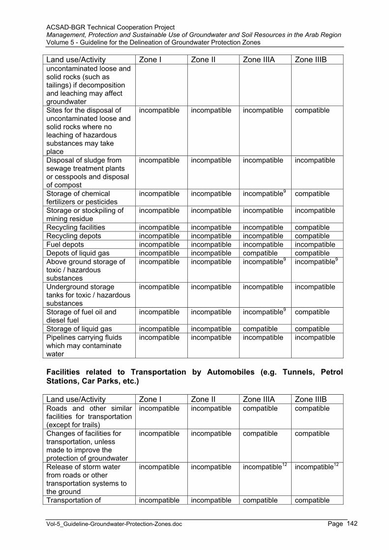
ACSAD-BGR Technical Cooperation Project Management, Protection and Sustainable Use of Groundwater and Soil Resources in the Arab Region Volume 5 - Guideline for the Delineation of Groundwater Protection Zones
Vol-5_Guideline-Groundwater-Protection-Zones.doc Page 142
Land use/Activity Zone I Zone II Zone IIIA Zone IIIB uncontaminated loose and solid rocks (such as tailings) if decomposition and leaching may affect groundwaterSites for the disposal of uncontaminated loose and solid rocks where no leaching of hazardous substances may take place
incompatible incompatible incompatible compatible
Disposal of sludge from sewage treatment plants or cesspools and disposal of compost
incompatible incompatible incompatible incompatible
Storage of chemical fertilizers or pesticides
incompatible incompatible incompatible9 compatible
Storage or stockpiling of mining residue
incompatible incompatible incompatible incompatible
Recycling facilities incompatible incompatible incompatible compatible Recycling depots incompatible incompatible incompatible compatible Fuel depots incompatible incompatible incompatible incompatibleDepots of liquid gas incompatible incompatible compatible compatibleAbove ground storage of toxic / hazardous substances
incompatible incompatible incompatible9 incompatible9
Underground storage tanks for toxic / hazardous substances
incompatible incompatible incompatible incompatible
Storage of fuel oil and diesel fuel
incompatible incompatible incompatible9 compatible
Storage of liquid gas incompatible incompatible compatible compatible Pipelines carrying fluids which may contaminate water
incompatible incompatible incompatible incompatible
Facilities related to Transportation by Automobiles (e.g. Tunnels, Petrol Stations, Car Parks, etc.)
Land use/Activity Zone I Zone II Zone IIIA Zone IIIB Roads and other similar facilities for transportation (except for trails)
incompatible incompatible compatible compatible
Changes of facilities for transportation, unless made to improve the protection of groundwater
incompatible incompatible compatible compatible
Release of storm water from roads or other transportation systems to the ground
incompatible incompatible incompatible12 incompatible12
Transportation of incompatible incompatible compatible compatible
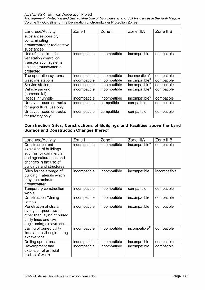
ACSAD-BGR Technical Cooperation Project Management, Protection and Sustainable Use of Groundwater and Soil Resources in the Arab Region Volume 5 - Guideline for the Delineation of Groundwater Protection Zones
Vol-5_Guideline-Groundwater-Protection-Zones.doc Page 143
Land use/Activity Zone I Zone II Zone IIIA Zone IIIB substances possibly contaminatinggroundwater or radioactive substances Use of pesticides for vegetation control on transportation systems, unless groundwater is protected
incompatible incompatible incompatible compatible
Transportation systems incompatible incompatible incompatible10 compatible Gasoline stations incompatible incompatible incompatible9 compatible Service stations incompatible incompatible incompatible8 compatible Vehicle parking (commercial)
incompatible incompatible incompatible6 compatible
Roads in tunnels incompatible incompatible incompatible6 compatible Unpaved roads or tracks for agricultural use only
incompatible compatible compatible compatible
Unpaved roads or tracks for forestry only
incompatible compatible compatible compatible
Construction Sites, Constructions of Buildings and Facilities above the Land Surface and Construction Changes thereof
Land use/Activity Zone I Zone II Zone IIIA Zone IIIB Construction and extension of buildings such as for commercial and agricultural use and changes in the use of buildings and structures
incompatible incompatible incompatible6 compatible
Sites for the storage of building materials which may contaminate groundwater
incompatible incompatible incompatible incompatible
Temporary construction works
incompatible incompatible compatible compatible
Construction /Mining camps
incompatible incompatible incompatible compatible
Penetration of strata overlying groundwater, other than laying of buried utility lines and civil engineering excavations
incompatible incompatible incompatible compatible
Laying of buried utility lines and civil engineering excavations
incompatible incompatible incompatible11 compatible
Drilling operations incompatible incompatible incompatible compatible Development and extension of artificial bodies of water
incompatible incompatible incompatible compatible

ACSAD-BGR Technical Cooperation Project Management, Protection and Sustainable Use of Groundwater and Soil Resources in the Arab Region Volume 5 - Guideline for the Delineation of Groundwater Protection Zones
Vol-5_Guideline-Groundwater-Protection-Zones.doc Page 144
Activities related to Geothermal Energy (such as Drillings, Injection Facilities, etc.)
Land use/Activity Zone I Zone II Zone IIIA Zone IIIB Production of geothermal energy
incompatible incompatible incompatible incompatible
Drilling of geothermal boreholes
incompatible incompatible incompatible incompatible
Groundwater use for heating or cooling purposes (with abstraction and injection facilities)
incompatible incompatible incompatible incompatible
Underground Constructions
Land use/Activity Zone I Zone II Zone IIIA Zone IIIB Development of underground facilities for storage of substances contaminating water
incompatible incompatible incompatible incompatible
Recreational and Sports Facilities, Tourism Facilities
Land use/Activity Zone I Zone II Zone IIIA Zone IIIB Equestrian centers incompatible incompatible incompatible compatible Golf courses incompatible incompatible incompatible incompatible Permanent motor racing facilities
incompatible incompatible incompatible incompatible
Motor racing incompatible incompatible incompatible compatible Swimming pools incompatible incompatible compatible compatible Recreational parks -irrigated
incompatible incompatible compatible compatible
Rifle ranges incompatible incompatible incompatible incompatible Caravan parks incompatible incompatible compatible compatible Motels, hotels, lodging houses, hostels, resorts
incompatible incompatible incompatible compatible
Clubs-sporting or recreation
incompatible incompatible compatible compatible
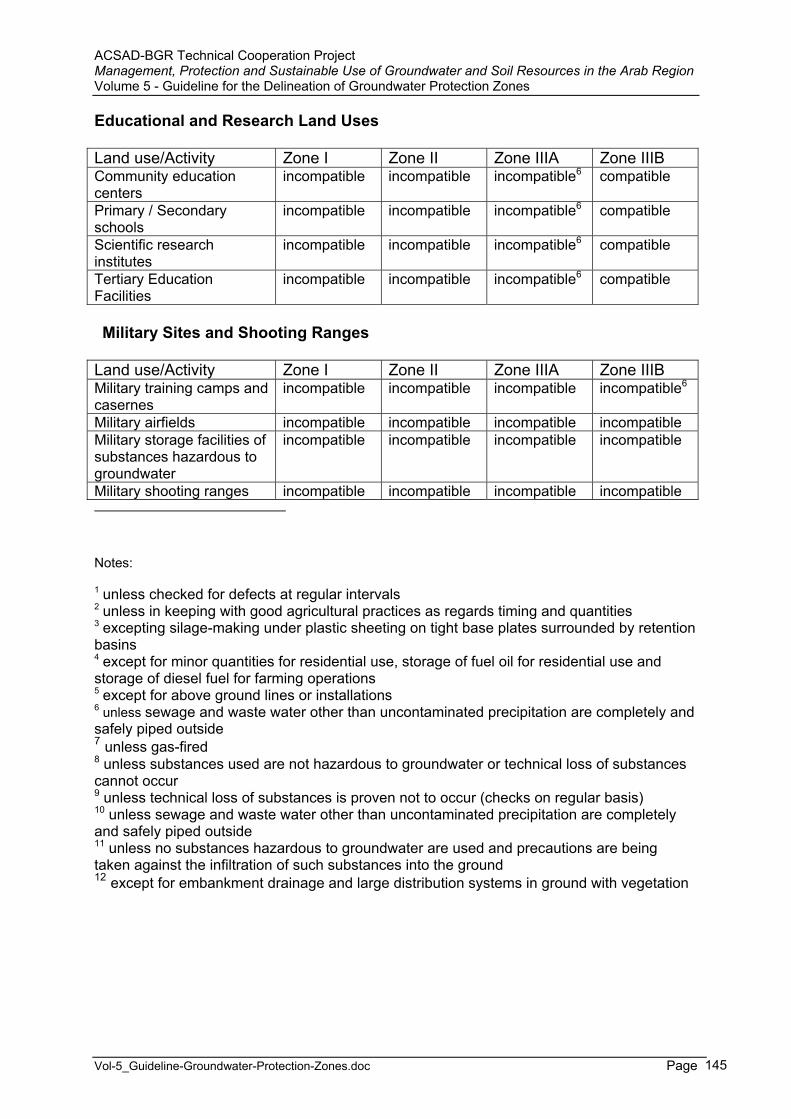
ACSAD-BGR Technical Cooperation Project Management, Protection and Sustainable Use of Groundwater and Soil Resources in the Arab Region Volume 5 - Guideline for the Delineation of Groundwater Protection Zones
Vol-5_Guideline-Groundwater-Protection-Zones.doc Page 145
Educational and Research Land Uses
Land use/Activity Zone I Zone II Zone IIIA Zone IIIB Community education centers
incompatible incompatible incompatible6 compatible
Primary / Secondary schools
incompatible incompatible incompatible6 compatible
Scientific research institutes
incompatible incompatible incompatible6 compatible
Tertiary Education Facilities
incompatible incompatible incompatible6 compatible
Military Sites and Shooting Ranges
Land use/Activity Zone I Zone II Zone IIIA Zone IIIB Military training camps and casernes
incompatible incompatible incompatible incompatible6
Military airfields incompatible incompatible incompatible incompatible Military storage facilities of substances hazardous to groundwater
incompatible incompatible incompatible incompatible
Military shooting ranges incompatible incompatible incompatible incompatible
Notes:
1 unless checked for defects at regular intervals2 unless in keeping with good agricultural practices as regards timing and quantities 3 excepting silage-making under plastic sheeting on tight base plates surrounded by retention basins4 except for minor quantities for residential use, storage of fuel oil for residential use and storage of diesel fuel for farming operations 5 except for above ground lines or installations6 unless sewage and waste water other than uncontaminated precipitation are completely and safely piped outside7 unless gas-fired8 unless substances used are not hazardous to groundwater or technical loss of substances cannot occur 9 unless technical loss of substances is proven not to occur (checks on regular basis) 10 unless sewage and waste water other than uncontaminated precipitation are completely and safely piped outside 11 unless no substances hazardous to groundwater are used and precautions are being taken against the infiltration of such substances into the ground 12 except for embankment drainage and large distribution systems in ground with vegetation
ACSAD-BGR Technical Cooperation Project Management, Protection and Sustainable Use of Groundwater and Soil Resources in the Arab Region Volume 5 - Guideline for the Delineation of Groundwater Protection Zones
Vol-5_Guideline-Groundwater-Protection-Zones.doc Page 146
5 Contingency Plans and Remedial Action Plans
Contingency Planning is the development and implementation of both long and short-term drinking water supply replacement strategies for supplying safe drinking water to the consumer in the event of contamination or physical disruption.
Such a plan needs to be included in the groundwater protection ordinance and must be updated on a regular basis. It has to mention what alternative water sources are to be used in case of disruption of water supply due to contamination. Such alternative water sources might constitute other wells or springs which are connected to the same supply network.
The Ministry of … will prepare a guideline for the preparation of such Contingency Plans.
A Remedial Action Plan describes what needs to be done and who is responsible for the individual actions in case the water source became polluted, for instance by an accidental spill.
The Ministry of … will prepare a guideline for the preparation of such Remedial Action Plans.
ACSAD-BGR Technical Cooperation Project Management, Protection and Sustainable Use of Groundwater and Soil Resources in the Arab Region Volume 5 - Guideline for the Delineation of Groundwater Protection Zones
Vol-5_Guideline-Groundwater-Protection-Zones.doc Page 147
6 Implementation of the Groundwater Protection Ordinance
6.1 Land Rights and Marking of the Boundaries of Protection Zones
The boundaries of groundwater protection zones should follow, where possible, roads, tracks, property lines or landmarks, such as the edges of forests and embankments of bodies of water. These administrative boundaries should be located outside the boundaries defined by the hydrogeological study.
The land of protection zone I must be owned by the water utility and the boundary of zone I has to be protected against unauthorized access by appropriate measures, for instance by a fence.
The boundaries of zones II and III have to be identified by appropriate standard marker posts to ensure an undoubtful identification of these boundaries.
6.2 Surveillance and Monitoring of Compliance with Restrictions
Regular surveillance and monitoring of the compliance with the requirements of the ordinance has to be conducted by … .
The water utility has to establish and conduct a regular surveillance program together with competent agencies.
The results of the surveillance and monitoring of the compliance with the requirements of the ordinance have to be documented in annual reports by the Committee on Groundwater Protection Zone Delineation.
6.3 Compensation for Preexisting Rights
(to be added by the Committee)
6.4 Penalties for Non-compliance with Restrictions
(to be added by the Committee)
ACSAD-BGR Technical Cooperation Project Management, Protection and Sustainable Use of Groundwater and Soil Resources in the Arab Region Volume 5 - Guideline for the Delineation of Groundwater Protection Zones
Vol-5_Guideline-Groundwater-Protection-Zones.doc Page 148
7 Requirements for the Hydrogeological Study and the Ordinance for the Delineation of a Groundwater Protection Zone
The hydrogeological study which forms the basis of the ordinance for the delineation of a groundwater protection zone will be prepared by the Ministry of … or on its behalf by a private consultant or institution (e.g. a university).
The hydrogeological study should yield the following information :
- All technical data of the water abstraction facility (x/y/z coordinates, technical design drawings, technical drawings of all water utility facilities, pumptest data and interpretation of pumptests, water level monitoring data);
- The details of all boreholes drilled and geophysical investigations carried out in the catchment area;
- All hydrochemical analyses carried out in the catchment area and their interpretation (especially with regard to trends showing groundwater quality deterioration; geogenic / anthropogenic effects);
- Piezometric maps of all relevant aquifers; - A copy of the water right including the maximum allowable abstraction
amounts as well as dates of issuance and expiry; - All abstraction data for the past 10 years, including annual abstractions,
average and maximum daily abstraction, duration of maximum abstraction; - Water demand prognosis for the next 10 years and peak demands; - A list of all existing water abstraction facilities (wells and springs) with their
abstraction data for the past 10 years; - A detailed description of the hydrogeological system (composition,
occurrence and thickness of lithological units, hydraulic parameters, etc.) including information about hydraulic interactions with surface water resources, the amounts of the different elements of the groundwater budget (precipitation, evapotranspiration, all inflows and outflows);
- An overview about the land uses in the catchment area (in text form and presented on a map of suitable scale);
- An overview about the soils and their character in the catchment area; - A description of the delineation method used as well as information about
the level of accuracy of the delineation; - The hydrogeological boundaries of the groundwater protection zone based
on scientifically approved methods (presented on maps of suitable scales); - A contamination source inventory of all potential pollution hazards; - Information about the susceptibility of the public water supplies to these
potential contamination sources (based on the vulnerability of the aquifer; vulnerability map to be presented on a map of suitable scale), including an evaluation of the degree of threat arising from each potential pollution hazard.
A guideline for the preparation of a hydrogeological study will be issued and continuously updated by the Ministry of … .
ACSAD-BGR Technical Cooperation Project Management, Protection and Sustainable Use of Groundwater and Soil Resources in the Arab Region Volume 5 - Guideline for the Delineation of Groundwater Protection Zones
Vol-5_Guideline-Groundwater-Protection-Zones.doc Page 149
The ordinance for the delineation of a groundwater protection zone has to supplement the following information :
- The administrative boundaries of the groundwater protection zone based on the results of the hydrogeological study (presented on maps of suitable scales);
- A list of restrictions for activities and land uses in the different groundwater protection zones;
- A surveillance and monitoring scheme for compliance with defined land use restrictions;
- A contingency plan that describes how water supply is planned to be maintained in case of groundwater contamination;
- A remedial action plan that describes which measures are going to be implemented to avoid groundwater contamination in case of accidental contamination.
A model ordinance with detailed information about the expected contents will be issued and continuously updated by the Ministry of … in order to ensure that ordinances follow a standard layout (a proposal is attached as Annex B-5).
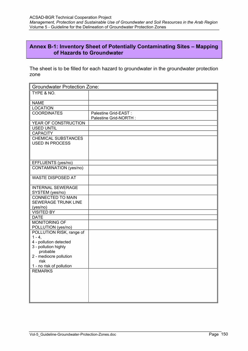
ACSAD-BGR Technical Cooperation Project Management, Protection and Sustainable Use of Groundwater and Soil Resources in the Arab Region Volume 5 - Guideline for the Delineation of Groundwater Protection Zones
Vol-5_Guideline-Groundwater-Protection-Zones.doc Page 150
Annex B-1: Inventory Sheet of Potentially Contaminating Sites – Mapping of Hazards to Groundwater
The sheet is to be filled for each hazard to groundwater in the groundwater protection zone
Groundwater Protection Zone:TYPE & NO.
NAME LOCATION COORDINATES Palestine Grid-EAST :
Palestine Grid-NORTH : YEAR OF CONSTRUCTION USED UNTIL CAPACITYCHEMICAL SUBSTANCES USED IN PROCESS
EFFLUENTS (yes/no) CONTAMINATION (yes/no)
WASTE DISPOSED AT
INTERNAL SEWERAGE SYSTEM (yes/no) CONNECTED TO MAIN SEWERAGE TRUNK LINE (yes/no) VISITED BY DATE MONITORING OF POLLUTION (yes/no) POLLUTION RISK, range of 1 - 4, 4 - pollution detected 3 - pollution highly probable 2 - mediocre pollution risk 1 - no risk of pollution REMARKS
ACSAD-BGR Technical Cooperation Project Management, Protection and Sustainable Use of Groundwater and Soil Resources in the Arab Region Volume 5 - Guideline for the Delineation of Groundwater Protection Zones
Vol-5_Guideline-Groundwater-Protection-Zones.doc Page 151
Annex B-2: Inventory of Hazards to Groundwater – Hazards to be inventoried and Inventory of Groundwater Supply Facilities
Both inventories are to be established in the form of a list and on maps of suitable scale
A. INVENTORY OF HAZARDS TO GROUNDWATER (potentially contaminating activities)
Municipal
1. wastewater treatment plants and sewer trunk lines
I - industrial wastewater treatment plant U - urban wastewater treatment plant
settlement with sewerage network
settlement without sewerage network
main sewer line
2. hospitals
3. cemeteries
Waste Disposal
4. waste disposals
source of waste MU - municipal waste SL - deposition of wastewater sludge IN - industrial waste
type of waste S - solid waste L - liquid waste H - hazardous or toxic waste N - non-hazardous/non-toxic waste
authorization LE - legal waste disposal site IL - illegal waste disposal site base sealing and monitoring
PE - waste disposal on permeable rocks without sufficient impermeable sealing of base IP - waste disposal on permeable rocks with sufficient impermeable sealing of base or
waste disposal on impermeable rocks MO(X) - monitoring wells for groundwater quality (X - number of wells)
Example : SL+MU /S+L N / H+N / LE / PE MO(2)
5. cesspools, septic tanks
ACSAD-BGR Technical Cooperation Project Management, Protection and Sustainable Use of Groundwater and Soil Resources in the Arab Region Volume 5 - Guideline for the Delineation of Groundwater Protection Zones
Vol-5_Guideline-Groundwater-Protection-Zones.doc Page 152
6. manure or livestock waste storages
7. landfills (potential illegal dumping sites)
8. quarries (potential illegal dumping sites)
Industrial
9. industries with effluent of organic biological or heavy metal loaded wastewater
10. chemical storage facilities
11. oil or fuel storages (garage, service station, etc.)
12. hazardous or toxic chemical/waste spills
13. thermoelectric power plants
14. pipelines
15. slaughterhouses
Agriculture and Livestock
16. animal husbandries
17. areas of intensive irrigation (frequent and abundant use of pesticides/fertilizers
Other
18. airfields
19. military installations
20. mines
B. INVENTORY OF GROUNDWATER SUPPLY FACILITES
1. wells used for domestic water supply
2. springs used for domestic water supply
3. wells used for irrigation
4. water supply mains
5. pumping stations
6. dams
7. areas of intensive groundwater exploitation

AC
SA
D-B
GR
Tec
hnic
al C
oope
ratio
n P
roje
ct
Man
agem
ent,
Pro
tect
ion
and
Sus
tain
able
Use
of G
roun
dwat
er a
nd S
oil R
esou
rces
in th
e A
rab
Reg
ion
Vol
ume
5 - G
uide
line
for t
he D
elin
eatio
n of
Gro
undw
ater
Pro
tect
ion
Zone
s
Vol
-5_G
uide
line-
Gro
undw
ater
-Pro
tect
ion-
Zone
s.do
c
Page
153
Ann
ex B
-3: I
ndex
of P
oten
tial S
ourc
es o
f Drin
king
Wat
er C
onta
min
atio
n
(Pot
entia
l Sou
rce
and
Pos
sibl
y A
ssoc
iate
d C
onta
min
ant)
POTE
NTI
AL
SOU
RC
E C
ON
TAM
INA
NT
Com
mer
cial
/ In
dust
rial
Abo
ve-g
roun
d st
orag
e ta
nks
Ars
enic
, Bar
ium
, Ben
zene
, Cad
miu
m, 1
,4-D
ichl
orob
enze
ne o
r P-D
ichl
orob
enze
ne, c
is 1
,2-D
ichl
oroe
thyl
ene,
tran
s 1,
2-D
ichl
oroe
thyl
ene,
Dic
hlor
omet
hane
or M
ethy
lene
Chl
orid
e, L
ead,
Tric
hlor
oeth
ylen
e (T
CE
), Te
trach
loro
ethy
lene
or P
erch
lore
thyl
ene
(Per
c)
Aut
omob
ile, B
ody
Sho
ps/R
epai
r S
hops
Ars
enic
, Bar
ium
, Ben
zene
, Cad
miu
m, C
hlor
oben
zene
, Cop
per,
cis
1,2-
Dic
hlor
oeth
ylen
e, tr
ans
1,2-
Dic
hlor
oeth
ylen
e, 1
,4-
Dic
hlor
oben
zene
or P
-Dic
hlor
oben
zene
, Lea
d, F
luor
ide,
1,1
,1-T
richl
oroe
than
e or
Met
hyl C
hlor
ofor
m, D
ichl
orom
etha
ne o
r Met
hyle
ne
Chl
orid
e, T
etra
chlo
roet
hyle
ne o
r Per
chlo
reth
ylen
e (P
erc)
, Tric
hlor
oeth
ylen
e (T
CE
), X
ylen
e (M
ixed
Isom
ers)
B
oat R
epai
r/Ref
inis
hing
/Mar
inas
B
enze
ne, C
adm
ium
, cis
1,2
-Dic
hlor
oeth
ylen
e, C
olifo
rm, C
rypt
ospo
ridiu
m, D
ichl
orom
etha
ne o
r Met
hyle
ne C
hlor
ide,
Gia
rdia
Lam
bia,
Lead
, Mer
cury
, Nitr
ate,
Nitr
ite, t
rans
1,2
-Dic
hlor
oeth
ylen
e, T
etra
chlo
roet
hyle
ne o
r Per
chlo
reth
ylen
e (P
erc)
, Tric
hlor
oeth
ylen
e (T
CE
), V
inyl
Chl
orid
e, V
iruse
s
Cem
ent/C
oncr
ete
Pla
nts
B
ariu
m, B
enze
ne, D
ichl
orom
etha
ne o
r Met
hyle
ne C
hlor
ide,
Eth
ylbe
nzen
e, L
ead,
Sty
rene
, Tet
rach
loro
ethy
lene
or P
erch
lore
thyl
ene
(Per
c), T
olue
ne, X
ylen
e (M
ixed
Isom
ers)
Che
mic
al/P
etro
leum
Pro
cess
ing
Acr
ylam
ide,
Ars
enic
, Atra
zine
, Ala
chlo
r, A
lum
inum
(Fum
e or
Dus
t), B
ariu
m, B
enze
ne, C
adm
ium
, Car
bofu
ran,
Car
bon
Tetra
chlo
ride,
C
hlor
oben
zene
, Cop
per,
Cya
nide
, 2,4
-D, 1
,2-D
ibro
moe
than
e or
Eth
ylen
e D
ibro
mid
e (E
DB
), 1,
2-D
ichl
orob
enze
ne o
r O-
Dic
hlor
oben
zene
, 1,4
-Dic
hlor
oben
zene
or P
-Dic
hlor
oben
zene
, 1,1
-Dic
hlor
oeth
ylen
e or
Vin
ylid
ene
Chl
orid
e, c
is 1
,2 D
ichl
oroe
thyl
ene,
Dic
hlor
omet
hane
or M
ethy
lene
Chl
orid
e, D
i(2-e
thyl
hexy
l) ad
ipat
e, D
i(2-e
thyl
hexy
l) ph
thla
te, 1
,2-D
ichl
oroe
than
e or
Eth
ylen
e D
ichl
orid
e,D
ioxi
n, E
ndrin
, Epi
chlo
rohy
drin
, Eth
ylbe
nzen
e, H
exac
hlor
oben
zene
, Hex
achl
oroc
yclo
pent
adie
ne, L
ead,
Mer
cury
, M
etho
xych
lor,P
olyc
hlor
inat
ed B
iphe
nyls
, Sel
eniu
m, S
tyre
ne, S
ulfa
te, T
etra
chlo
roet
hyle
ne o
r Per
chlo
reth
ylen
e (P
erc)
, Tol
uene
, 1,2
,4-
Tric
hlor
oben
zene
, 1,1
,1-T
richl
oroe
than
e or
Met
hyl C
hlor
ofor
m, T
richl
oroe
thyl
ene
(TC
E),
Vin
yl C
hlor
ide,
Xyl
ene
(Mix
ed Is
omer
s), Z
inc
(Fum
e or
Dus
t) C
onst
ruct
ion/
Dem
oliti
on
Ars
enic
, Asb
esto
s, B
enze
ne, C
adm
ium
, Chl
orid
e, C
oppe
r,Cya
nide
, cis
1,2
-Dic
hlor
oeth
ylen
e, tr
ans
1,2-
Dic
hlor
oeth
ylen
e,
Dic
hlor
omet
hane
or M
ethy
lene
Chl
orid
e, F
luor
ides
, Lea
d, S
elen
ium
, Tet
rach
loro
ethy
lene
or P
erch
lore
thyl
ene
(Per
c), 1
,1,1
-Tr
ichl
oroe
than
e or
Met
hyl C
hlor
ofor
m, T
richl
oroe
thyl
ene
(TC
E),
Turb
idity
, Xyl
ene
(Mix
ed Is
omer
s), Z
inc
(Fum
e or
Dus
t) D
ry C
lean
ers/
Dry
Cle
anin
g
Tetra
chlo
roet
hyle
ne o
r Per
chlo
reth
ylen
e (P
erc)
, 1,1
,1-T
richl
oroe
than
e or
Met
hyl C
hlor
ofor
m, 1
,1,2
-Tric
hlor
oeth
ane
Dry
Goo
ds M
anuf
actu
ring
Bar
ium
, Ben
zene
, Cad
miu
m, C
oppe
r, D
ichl
orom
etha
ne o
r Met
hyle
ne C
hlor
ide,
Di(2
-eth
ylhe
xyl)
phth
late
, Lea
d, 1
,1,1
-Tric
hlor
oeth
ane
or M
ethy
l Chl
orof
orm
, Pol
ychl
orin
ated
Bip
heny
ls, T
etra
chlo
roet
hyle
ne o
r Per
chlo
reth
ylen
e (P
erc)
, Tol
uene
, Tric
hlor
oeth
ylen
e (T
CE
), X
ylen
e (M
ixed
Isom
ers)
E
lect
rical
/Ele
ctro
nic
Man
ufac
turin
g A
lum
inum
(Fum
e or
Dus
t), A
ntim
ony,
Ars
enic
, Bar
ium
, Ben
zene
, Cad
miu
m, C
hlor
oben
zene
, Cop
per,
Cya
nide
, Car
bon
Tetra
chlo
ride,
1,
2-D
ichl
orob
enze
ne o
r O-D
ichl
orob
enze
ne, 1
,2-D
ichl
oroe
than
e or
Eth
ylen
e D
ichl
orid
e, c
is 1
,2-D
ichl
oroe
thyl
ene,
tran
s 1,
2-D
ichl
oroe
thyl
ene,
Dic
hlor
omet
hane
or M
ethy
lene
Chl
orid
e, D
i(2-e
thyl
hexy
l) ph
thla
te, E
thyl
benz
ene,
Lea
d, M
ercu
ry, P
olyc
hlor
inat
edB
iphe
nyls
, Sel
eniu
m, S
tyre
ne, S
ulfa
te, T
etra
chlo
roet
hyle
ne o
r Per
chlo
reth
ylen
e (P
erc)
, 1,1
,1-T
richl
oroe
than
e or
Met
hyl C
hlor
ofor
m,
1,1,
2-Tr
ichl
oroe
than
e, T
richl
oroe
thyl
ene
(TC
E),
Thal
lium
, Tol
uene
, Vin
yl C
hlor
ide,
Xyl
ene
(Mix
ed Is
omer
s), Z
inc
(Fum
e or
Dus
t)
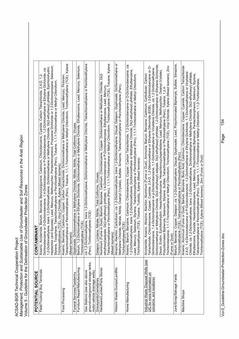
AC
SA
D-B
GR
Tec
hnic
al C
oope
ratio
n P
roje
ct
Man
agem
ent,
Pro
tect
ion
and
Sus
tain
able
Use
of G
roun
dwat
er a
nd S
oil R
esou
rces
in th
e A
rab
Reg
ion
Vol
ume
5 - G
uide
line
for t
he D
elin
eatio
n of
Gro
undw
ater
Pro
tect
ion
Zone
s
Vol
-5_G
uide
line-
Gro
undw
ater
-Pro
tect
ion-
Zone
s.do
c
Page
154
POTE
NTI
AL
SOU
RC
E C
ON
TAM
INA
NT
Flee
t/Tru
ckin
g/ B
us T
erm
inal
s A
rsen
ic, A
cryl
amid
e, B
ariu
m, B
enze
ne, B
enzo
(a)p
yren
e, C
adm
ium
, Chl
orob
enze
ne, C
yani
de, C
arbo
n Te
trach
lorid
e, 2
,4-D
, 1,2
-D
ichl
orob
enze
ne o
r O-D
ichl
orob
enze
ne, 1
,4-D
ichl
orob
enze
ne o
r P-D
ichl
orob
enze
ne, 1
,2-D
ichl
oroe
than
e or
Eth
ylen
e D
ichl
orid
e, c
is
1,2-
Dic
hlor
oeth
ylen
e, tr
ans
1,2-
Dic
hlor
oeth
ylen
e, D
ichl
orom
etha
ne o
r Met
hyle
ne C
hlor
ide,
Di(2
-eth
ylhe
xyl)
phth
late
, Epi
chlo
rohy
drin
,H
epta
chlo
r (an
d E
poxi
de),
Lead
, Mer
cury
, Met
hoxy
chlo
r, P
enta
chlo
roph
enol
, Pro
pyle
ne D
ichl
orid
e or
1,2
-Dic
hlor
opro
pane
, Sel
eniu
m,
Sty
rene
, Tox
aphe
ne, T
etra
chlo
roet
hyle
ne o
r Per
chlo
reth
ylen
e (P
erc)
, Tol
uene
, 1,1
,1-T
richl
oroe
than
e or
Met
hyl C
hlor
ofor
m,
Tric
hlor
oeth
ylen
e (T
CE
), V
inyl
Chl
orid
e, X
ylen
e (M
ixed
Isom
ers)
Fo
od P
roce
ssin
g A
rsen
ic, B
enze
ne, C
adm
ium
, Cop
per,
Car
bon
Tetra
chlo
ride,
Dic
hlor
omet
hane
or M
ethy
lene
Chl
orid
e, L
ead,
Mer
cury
, Pic
lora
m,
Tetra
chlo
roet
hyle
ne o
r Per
chlo
reth
ylen
e (P
erc)
, Tol
uene
, 1,1
,1-T
richl
oroe
than
e or
Met
hyl C
hlor
ofor
m, T
richl
oroe
thyl
ene
(TC
E),
Xyl
ene
(Mix
ed Is
omer
s)
Fune
ral S
ervi
ces/
Taxi
derm
y G
lyph
osat
e, D
ichl
orom
etha
ne o
r Met
hyle
ne C
hlor
ide,
Nitr
ate,
Nitr
ite, T
otal
Col
iform
s, V
iruse
s Fu
rnitu
re R
epai
r/Man
ufac
turin
g B
ariu
m, 1
,2-D
ichl
oroe
than
e or
Eth
ylen
e D
ichl
orid
e, D
ichl
orom
etha
ne o
r Met
hyle
ne C
hlor
ide,
Eth
ylbe
nzen
e, L
ead,
Mer
cury
, Sel
eniu
m,
Tric
hlor
oeth
ylen
e (T
CE
) G
as S
tatio
ns (s
ee a
lso
abov
e gr
ound
/und
ergr
ound
sto
rage
tank
s,
mot
or-v
ehic
le d
rain
age
wel
ls)
cis
1,2-
Dic
hlor
oeth
ylen
e, tr
ans
1,2-
Dic
hlor
oeth
ylen
e, D
ichl
orom
etha
ne o
r Met
hyle
ne C
hlor
ide,
Tet
rach
loro
ethy
lene
or P
erch
lore
thyl
ene
(Per
c), T
richl
oroe
thyl
ene
(TC
E)
Gra
veya
rds/
Cem
etar
ies
Dal
apon
, Lin
dane
, Nitr
ate,
Nitr
ite, T
otal
Col
iform
s, V
iruse
s.
Har
dwar
e/Lu
mbe
r/Par
ts S
tore
s A
lum
inum
(Fum
e or
Dus
t), B
ariu
m, B
enze
ne, C
adm
ium
, Chl
orob
enze
ne, C
oppe
r, D
ichl
orom
etha
ne o
r Met
hyle
ne C
hlor
ide,
Di(2
-et
hylh
exyl
)adi
pate
, Di(2
-eth
ylhe
xyl)
phth
late
, 1,4
-Dic
hlor
oben
zene
or P
-Dic
hlor
oben
zene
, Eth
ylbe
nzen
e, L
ead,
Mer
cury
, Te
trach
loro
ethy
lene
or P
erch
lore
thyl
ene
(Per
c), 1
,1,1
-Tric
hlor
oeth
ane
or M
ethy
l Chl
orof
orm
, Tric
hlor
oeth
ylen
e (T
CE
), To
luen
e, X
ylen
e (M
ixed
Isom
ers)
H
isto
ric W
aste
Dum
ps/L
andf
ills
Atra
zine
, Ala
chlo
r, C
arbo
fura
n, c
is 1
,2-D
ichl
oroe
thyl
ene,
tran
s 1,
2-D
ichl
oroe
thyl
ene,
Diq
uat,
Dal
apon
, Gly
phos
ate,
Dic
hlor
omet
hane
or
Met
hyle
ne C
hlor
ide,
Nitr
ate,
Nitr
ite, O
xam
yl (V
ydat
e), S
ulfa
te, S
imaz
ine,
Tet
rach
loro
ethy
lene
or P
erch
lore
thyl
ene
(Per
c),
Tric
hlor
oeth
ylen
e(TC
E)
Hom
e M
anuf
actu
ring
A
rsen
ic, B
ariu
m, B
enze
ne, C
adm
ium
, Chl
orob
enze
ne, C
oppe
r, C
arbo
n Te
trach
lorid
e, 1
,2-D
ichl
orob
enze
ne o
r O-D
ichl
orob
enze
ne, c
is
1,2-
Dic
hlor
oeth
ylen
e, tr
ans
1,2-
Dic
hlor
oeth
ylen
e, D
ichl
orom
etha
ne o
r Met
hyle
ne C
hlor
ide,
Di(2
-eth
ylhe
xyl)
phth
late
, Eth
ylbe
nzen
e,Le
ad, M
ercu
ry, S
elen
ium
, Sty
rene
, Tet
rach
loro
ethy
lene
or P
erch
lore
thyl
ene
(Per
c), 1
,1,1
-Tric
hlor
oeth
ane
or M
ethy
l Chl
orof
orm
, Tr
ichl
oroe
thyl
ene
(TC
E),
Tolu
ene,
Tur
bidi
ty, X
ylen
e (M
ixed
Isom
ers)
Indu
stria
l Was
te D
ispo
sal W
ells
(see
U
IC fo
r mor
e in
form
atio
n on
co
ncer
ns, a
nd lo
catio
ns)
Acr
ylam
ide,
Ars
enic
, Atra
zine
, Ala
chlo
r, A
lum
inum
(Fum
e or
Dus
t), A
mm
onia
, Bar
ium
, Ben
zene
, Cad
miu
m, C
arbo
fura
n, C
arbo
n Te
trach
lorid
e, C
hlor
oben
zene
, Cop
per,
Cya
nide
, 2,4
-D, 1
,2-D
ibro
moe
than
e or
Eth
ylen
e D
ibro
mid
e (E
DB
), 1,
2-D
ichl
orob
enze
ne o
r O-
Dic
hlor
oben
zene
, 1,4
-Dic
hlor
oben
zene
or p
-Dic
hlor
oben
zene
, 1,1
-Dic
hlor
oeth
ylen
e or
Vin
ylid
ene
Chl
orid
e, c
is 1
,2 D
ichl
oroe
thyl
ene,
Dic
hlor
omet
hane
or M
ethy
lene
Chl
orid
e, D
i(2-e
thyl
hexy
l) ad
ipat
e, D
i(2-e
thyl
hexy
l) ph
thla
te, 1
,2-D
ichl
oroe
than
e or
Eth
ylen
e D
ichl
orid
e,D
ioxi
n, E
ndrin
, Epi
chlo
rohy
drin
, Hex
achl
orob
enze
ne, H
exac
hlor
ocyc
lope
ntad
iene
, Lea
d, M
ercu
ry, M
etho
xych
lor,
Oxa
myl
(Vyd
ate)
, P
olyc
hlor
inat
ed B
iphe
nyls
, Sel
eniu
m, S
tyre
ne, S
ulfa
te, T
etra
chlo
roet
hyle
ne o
r Per
chlo
reth
ylen
e (P
erc)
, Tol
uene
, 1,2
,4-
Tric
hlor
oben
zene
, 1,1
,1-T
richl
oroe
than
e or
Met
hyl C
hlor
ofor
m, T
richl
oroe
thyl
ene
(TC
E),
Vin
yl C
hlor
ide,
Xyl
ene
(Mix
ed Is
omer
s), Z
inc
(Fum
e or
Dus
t) Ju
nk/S
crap
/Sal
vage
Yar
ds
Bar
ium
, Ben
zene
, Cop
per,
Dal
apon
, cis
1,2
-Dic
hlor
oeth
ylen
e, D
iqua
t, G
lyph
osat
e, L
ead,
Pol
ychl
orin
ated
Bip
heny
ls, S
ulfa
te, S
imaz
ine,
Tr
ichl
oroe
thyl
ene
(TC
E),
Tetra
chlo
roet
hyle
ne o
r Per
chlo
reth
ylen
e (P
erc)
M
achi
ne S
hops
A
rsen
ic, A
lum
inum
(Fum
e or
Dus
t), B
ariu
m, B
enze
ne, B
oric
Aci
d, C
adm
ium
, Chl
orob
enze
ne, C
oppe
r, C
yani
de, C
arbo
n Te
trach
lorid
e2,
4-D
, 1,4
-Dic
hlor
oben
zene
or P
-Dic
hlor
oben
zene
, 1,2
-Dic
hlor
oeth
ane
or E
thyl
ene
Dic
hlor
ide,
1,1
-Dic
hlor
oeth
ylen
e or
Vin
ylid
ene
Chl
orid
e, c
is 1
,2-D
ichl
oroe
thyl
ene,
tran
s 1,
2-D
ichl
oroe
thyl
ene,
Dic
hlor
omet
hane
or M
ethy
lene
Chl
orid
e, D
i(2-e
thyl
hexy
l) ph
thla
te,
Eth
ylbe
nzen
e, F
luor
ide,
Hex
achl
orob
enze
ne, L
ead,
Mer
cury
, Pol
ychl
orin
ated
Bip
heny
ls, P
enta
chlo
roph
enol
, Sel
eniu
m, S
tyre
ne,
Tetra
chlo
roet
hyle
ne o
r Per
chlo
reth
ylen
e (P
erc)
, Tol
uene
, 1,1
,1-T
richl
oroe
than
e or
Met
hyl C
hlor
ofor
m, 1
,1,2
-Tric
hlor
oeth
ane,
Tr
ichl
oroe
thyl
ene
(TC
E),
Xyl
ene
(Mix
ed Is
omer
s), Z
inc
(Fum
e or
Dus
t)
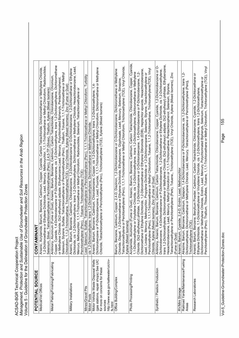
AC
SA
D-B
GR
Tec
hnic
al C
oope
ratio
n P
roje
ct
Man
agem
ent,
Pro
tect
ion
and
Sus
tain
able
Use
of G
roun
dwat
er a
nd S
oil R
esou
rces
in th
e A
rab
Reg
ion
Vol
ume
5 - G
uide
line
for t
he D
elin
eatio
n of
Gro
undw
ater
Pro
tect
ion
Zone
s
Vol
-5_G
uide
line-
Gro
undw
ater
-Pro
tect
ion-
Zone
s.do
c
Page
155
POTE
NTI
AL
SOU
RC
E C
ON
TAM
INA
NT
Med
ical
/Vet
Offi
ces
Ars
enic
, Acr
ylam
ide,
Bar
ium
, Ben
zene
, Cad
miu
m, C
oppe
r, C
yani
de, C
arbo
n Te
trach
lorid
e, D
ichl
orom
etha
ne o
r Met
hyle
ne C
hlor
ide,
1,
2-D
ichl
oroe
than
e or
Eth
ylen
e D
ichl
orid
e, L
ead,
Mer
cury
, Met
hoxy
chlo
r, 1,
1,1-
Tric
hlor
oeth
ane
or M
ethy
l Chl
orof
orm
, Rad
ionu
clid
es,
Sel
eniu
m, S
ilver
, Tet
rach
loro
ethy
lene
or P
erch
lore
thyl
ene
(Per
c), 2
,4,5
-TP
(Silv
ex),
Thal
lium
, Xyl
ene
(Mix
ed Is
omer
s)
Met
al P
latin
g/Fi
nish
ing/
Fabr
icat
ing
Ant
imon
y, A
lum
inum
(Fum
e or
Dus
t), A
rsen
ic, B
ariu
m, B
enze
ne, C
adm
ium
, Car
bon
Tetra
chlo
ride,
Chl
orob
enze
ne, C
hrom
ium
, C
oppe
r, C
yani
de, 1
,4-D
ichl
orob
enze
ne o
r P-D
ichl
orob
enze
ne, c
is 1
,2-D
ichl
oroe
thyl
ene,
tran
s 1,
2-D
ichl
oroe
thyl
ene,
Dic
hlor
omet
hane
or M
ethy
lene
Chl
orid
e, D
i(2-e
thyl
hexy
l) ad
ipat
e, E
thyl
benz
ene,
Lead
, Mer
cury
, Pol
ychl
orin
ated
Bip
heny
ls, P
enta
chlo
roph
enol
, S
elen
ium
, Sty
rene
, Sul
fate
, Tet
rach
loro
ethy
lene
or P
erch
lore
thyl
ene
(Per
c), ,
Tha
llium
, Tol
uene
, 1,1
,1-T
richl
oroe
than
e or
Met
hyl
Chl
orof
orm
, 1,1
,2-T
richl
oroe
than
e, T
richl
oroe
thyl
ene(
TCE
), V
inyl
Chl
orid
e, X
ylen
e (M
ixed
Isom
ers)
, Zin
c (F
ume
or D
ust)
M
ilita
ry In
stal
latio
ns
Ars
enic
, Bar
ium
, Ben
zene
, Cad
miu
m, C
hlor
oben
zene
, 1,2
-Dic
hlor
oben
zene
or O
-Dic
hlor
oben
zene
, 1,2
-Dic
hlor
oeth
ane
or E
thyl
ene
Dic
hlor
ide,
cis
1,2
-Dic
hlor
oeth
ylen
e, tr
ans
1,2-
Dic
hlor
oeth
ylen
e, D
ichl
orom
etha
ne o
r Met
hyle
ne C
hlor
ide,
Hex
achl
orob
enze
ne, L
ead,
Mer
cury
, Met
hoxy
chlo
r, 1,
1,1-
Tric
hlor
oeth
ane
or M
ethy
l Chl
orof
orm
, Rad
ionu
clid
es, S
elen
ium
, Tet
rach
loro
ethy
lene
or
Per
chlo
reth
ylen
e (P
erc)
, , T
olue
ne, T
richl
oroe
thyl
ene
(TC
E)
Min
es/G
rave
l Pits
Le
ad, S
elen
ium
, Sul
fate
, Tet
rach
loro
ethy
lene
or P
erch
lore
thyl
ene
(Per
c), 1
,1,1
-Tric
hlor
oeth
ane
or M
ethy
l Chl
orof
orm
, Tur
bidi
ty
Mot
or P
ools
ci
s 1,
2-D
ichl
oroe
thyl
ene,
tran
s 1,
2-D
ichl
oroe
thyl
ene,
Dic
hlor
omet
hane
or M
ethy
lene
Chl
orid
e,
Mot
or V
ehic
le W
aste
Dis
posa
l Wel
ls
(gas
sta
tions
, rep
air s
hops
) See
UIC
fo
r mor
e on
con
cern
s fo
r the
se
sour
ces
http
://w
ww
.epa
.gov
/saf
ewat
er/u
ic/c
v-fs
.htm
l
Ars
enic
, Bar
ium
, Ben
zene
, Cad
miu
m, C
hlor
oben
zene
, Cop
per,
cis
1,2-
Dic
hlor
oeth
ylen
e, tr
ans
1,2-
Dic
hlor
oeth
ylen
e, 1
,4-
Dic
hlor
oben
zene
or P
-Dic
hlor
oben
zene
, Lea
d, F
luor
ide,
1,1
,1-T
richl
oroe
than
e or
Met
hyl C
hlor
ofor
m, D
ichl
orom
etha
ne o
r Met
hyle
ne
Chl
orid
e, T
etra
chlo
roet
hyle
ne o
r Per
chlo
reth
ylen
e (P
erc)
, Tric
hlor
oeth
ylen
e (T
CE
), X
ylen
e (M
ixed
Isom
ers)
Offi
ce B
uild
ing/
Com
plex
B
ariu
m, B
enze
ne, C
adm
ium
, Cop
per,
2,4-
D, D
iazi
non,
1,2
-Dic
hlor
oben
zene
or O
-Dic
hlor
oben
zene
, Dic
hlor
omet
hane
or M
ethy
lene
C
hlor
ide,
Diq
uat,
1,2-
Dic
hlor
oeth
ane
or E
thyl
ene
Dic
hlor
ide,
Eth
ylbe
nzen
e, G
lyph
osat
e, L
ead,
Mer
cury
, Sel
eniu
m, S
imaz
ine,
Te
trach
loro
ethy
lene
or P
erch
lore
thyl
ene
(Per
c), 1
,1,1
-Tric
hlor
oeth
ane
or M
ethy
l Chl
orof
orm
, Tric
hlor
oeth
ylen
e (T
CE
), V
inyl
Chl
orid
e,X
ylen
e (M
ixed
Isom
ers)
Pho
to P
roce
ssin
g/P
rintin
g A
cryl
amid
e, A
lum
inum
(Fum
e or
Dus
t), A
rsen
ic, B
ariu
m, B
enze
ne, C
adm
ium
, Car
bon
Tetra
chlo
ride,
Chl
orob
enze
ne, C
oppe
r, C
yani
de,
1,1-
Dic
hlor
oeth
ylen
e or
Vin
ylid
ene
Chl
orid
e, c
is 1
,2-D
ichl
oroe
thyl
ene,
tran
s 1,
2-D
ichl
oroe
thyl
ene,
Dic
hlor
omet
hane
or M
ethy
lene
Chl
orid
e, D
i(2-e
thyl
hexy
l) ph
thla
te, 1
,2-D
ichl
orob
enze
ne o
r O-D
ichl
orob
enze
ne, 1
,4-D
ichl
orob
enze
ne o
r P-D
ichl
orob
enze
ne, 1
,2-
Dic
hlor
oeth
ane
or E
thyl
ene
Dic
hlor
ide,
1,2
-Dib
rom
oeth
ane
or E
thyl
ene
Dib
rom
ide
(ED
B),
Hep
tach
lor e
poxi
de, H
exac
hlor
oben
zene
, Le
ad, L
inda
ne, M
ercu
ry, M
etho
xych
lor,
Pro
pyle
ne D
ichl
orid
e or
1,2
-Dic
hlor
opro
pane
, Sel
eniu
m, S
tyre
ne, T
etra
chlo
roet
hyle
ne o
r P
erch
lore
thyl
ene
(Per
c), 1
,1,1
-Tric
hlor
oeth
ane
or M
ethy
l Chl
orof
orm
, Tol
uene
, 1,1
,2-T
richl
oroe
than
e, T
richl
oroe
thyl
ene(
TCE
), V
inyl
C
hlor
ide,
Xyl
ene
(Mix
ed Is
omer
s), Z
inc
(Fum
e or
Dus
t) S
ynth
etic
/ P
last
ics
Pro
duct
ion
Ant
imon
y, A
rsen
ic, B
ariu
m, B
enze
ne, C
adm
ium
, Car
bon
Tetra
chlo
ride,
Chl
orob
enze
ne, C
oppe
r, C
yani
de, 1
,2-D
ichl
orob
enze
ne o
r O-
Dic
hlor
oben
zene
, 1,4
-Dic
hlor
oben
zene
or P
-Dic
hlor
oben
zene
, 1,2
-Dic
hlor
oeth
ane
or E
thyl
ene
Dic
hlor
ide,
cis
1,2
-Dic
hlor
oeth
ylen
e,tra
ns 1
,2-D
ichl
oroe
thyl
ene,
Dic
hlor
omet
hane
or M
ethy
lene
Chl
orid
e, D
i(2-e
thyl
hexy
l) ad
ipat
e, D
i(2-e
thyl
hexy
l) ph
thla
te, E
thyl
benz
ene,
Hex
achl
orob
enze
ne, L
ead,
Mer
cury
, Met
hyl C
hlor
ofor
m o
r 1,1
,1-T
richl
oroe
than
e, P
enta
chlo
roph
enol
, Sel
eniu
m, S
tyre
ne,
Tetra
chlo
roet
hyle
ne o
r Per
chlo
reth
ylen
e (P
erk)
, Tol
uene
,, Tr
ichl
oroe
thyl
ene
(TC
E),
Vin
yl C
hlor
ide,
Xyl
ene
(Mix
ed Is
omer
s), Z
inc
(Fum
e or
Dus
t)
RV
/Min
i Sto
rage
A
rsen
ic, B
ariu
m, C
yani
de, 2
,4-D
, End
rin, L
ead,
Met
hoxy
chlo
r R
ailro
ad Y
ards
/Mai
nten
ance
/Fue
ling
Are
asA
trazi
ne, B
ariu
m, B
enze
ne, C
adm
ium
, Dal
apon
, 1,4
-Dic
hlor
oben
zene
or P
-Dic
hlor
oben
zene
, cis
1,2
-Dic
hlor
oeth
ylen
e, tr
ans
1,2-
Dic
hlor
oeth
ylen
e, D
ichl
orom
etha
ne o
r Met
hyle
ne C
hlor
ide,
Lea
d, M
ercu
ry, T
etra
chlo
roet
hyle
ne o
r Per
chlo
reth
ylen
e (P
erc)
,Tr
ichl
oroe
thyl
ene
(TC
E).
Res
earc
h La
bora
torie
s A
rsen
ic, B
ariu
m, B
enze
ne, B
eryl
lium
Pow
der,
Cad
miu
m, C
arbo
n Te
trach
lorid
e, C
hlor
oben
zene
, Cya
nide
, 1,2
-Dic
hlor
oeth
ane
or
Eth
ylen
e D
ichl
orid
e, 1
,1-D
ichl
oroe
thyl
ene
or V
inyl
iden
e C
hlor
ide,
cis
1,2
-Dic
hlor
oeth
ylen
e, tr
ans
1,2-
Dic
hlor
oeth
ylen
e,
Dic
hlor
omet
hane
or M
ethy
lene
Chl
orid
e, E
ndrin
, Lea
d, M
ercu
ry, P
olyc
hlor
inat
ed B
iphe
nyls
, Sel
eniu
m, T
etra
chlo
roet
hyle
ne o
r P
erch
lore
thyl
ene
(Per
c), T
halli
um, T
hios
ulfa
tes,
Tol
uene
, 1,1
,1-T
richl
oroe
than
e or
Met
hyl C
hlor
ofor
m, T
richl
oroe
thyl
ene
(TC
E),
Vin
yl
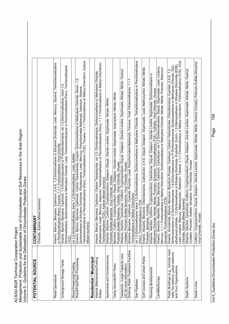
AC
SA
D-B
GR
Tec
hnic
al C
oope
ratio
n P
roje
ct
Man
agem
ent,
Pro
tect
ion
and
Sus
tain
able
Use
of G
roun
dwat
er a
nd S
oil R
esou
rces
in th
e A
rab
Reg
ion
Vol
ume
5 - G
uide
line
for t
he D
elin
eatio
n of
Gro
undw
ater
Pro
tect
ion
Zone
s
Vol
-5_G
uide
line-
Gro
undw
ater
-Pro
tect
ion-
Zone
s.do
c
Page
156
POTE
NTI
AL
SOU
RC
E C
ON
TAM
INA
NT
Chl
orid
e, X
ylen
e (M
ixed
Isom
ers)
Ret
ail O
pera
tions
A
rsen
ic, B
ariu
m, B
enze
ne, C
adm
ium
, 2,4
-D, 1
,2-D
ichl
oroe
than
e or
Eth
ylen
e D
ichl
orid
e, L
ead,
Mer
cury
, Sty
rene
, Tet
rach
loro
ethy
lene
or
Per
chlo
reth
ylen
e (P
erc)
, Tol
uene
, 1,1
,1-T
richl
oroe
than
e, V
inyl
Chl
orid
e U
nder
grou
nd S
tora
ge T
anks
A
rsen
ic, B
ariu
m, B
enze
ne, C
adm
ium
, 1,4
-Dic
hlor
oben
zene
or P
-Dic
hlor
oben
zene
, cis
1,2
-Dic
hlor
oeth
ylen
e, tr
ans
1,2-
Dic
hlor
oeth
ylen
e, D
ichl
orom
etha
ne o
r Met
hyle
ne C
hlor
ide,
Lea
d, T
etra
chlo
roet
hyle
ne o
r Per
chlo
reth
ylen
e (P
erc)
, Tric
hlor
oeth
ylen
e(T
CE
).W
ood
Pre
serv
ing/
Trea
ting
cis
1,2-
Dic
hlor
oeth
ylen
e, tr
ans
1,2-
Dic
hlor
oeth
ylen
e, L
ead,
Sul
fate
W
ood/
Pul
p/P
aper
Pro
cess
ing
Ars
enic
, Bar
ium
, Ben
zene
, Cad
miu
m, C
arbo
n Te
trach
lorid
e, C
oppe
r, D
ichl
orom
etha
ne o
r Met
hyle
ne C
hlor
ide,
Dio
xin,
1,2
-D
ichl
oroe
than
e or
Eth
ylen
e D
ichl
orid
e, E
thyl
benz
ene,
Lea
d, M
ercu
ry, P
olyc
hlor
inat
ed B
iphe
nyls
, Sel
eniu
m, S
tyre
ne,
Tetra
chlo
roet
hyle
ne o
r Per
chlo
reth
ylen
e (P
erc)
, Tric
hlor
oeth
ylen
e (T
CE
), To
luen
e, 1
,1,1
-Tric
hlor
oeth
ane
or M
ethy
l Chl
orof
orm
, Xyl
ene
(Mix
ed Is
omer
s)
Res
iden
tial /
Mun
icip
al
Airp
orts
(Mai
nten
ance
/Fue
ling
Are
as)
Ars
enic
, Bar
ium
, Ben
zene
, Cad
miu
m, C
arbo
n Te
trach
lorid
e, c
is 1
,2- D
ichl
oroe
thyl
ene,
Dic
hlor
omet
hane
or M
ethy
lene
Chl
orid
e,
Eth
ylbe
nzen
e, L
ead,
Mer
cury
, Sel
eniu
m, T
etra
chlo
roet
hyle
ne o
r Per
chlo
reth
ylen
e (P
erc)
, 1,1
,1-T
richl
oroe
than
e or
Met
hyl C
hlor
ofor
m,
Tric
hlor
oeth
ylen
e (T
CE
), X
ylen
e (M
ixed
Isom
ers)
A
partm
ents
and
Con
dom
iniu
ms
Atra
zine
, Ala
chlo
r, C
olifo
rm, C
rypt
ospo
ridiu
m, D
alap
on, D
iqua
t, G
iard
ia L
ambi
a, G
lyph
osat
e, N
itrat
e, N
itrite
, P
iclo
ram
,Sul
fate
,Sim
azin
e, V
inyl
Chl
orid
e, V
iruse
s C
amp
Gro
unds
/RV
Par
ks
Ben
omyl
, Col
iform
, Cry
ptos
porid
ium
, Diq
uat,
Dal
apon
, Gia
rdia
Lam
bia,
Gly
phos
ate,
Isop
ropa
nol,
Nitr
ate,
Nitr
ite,
Pic
lora
m,S
ulfa
te,S
imaz
ine,
Tur
bidi
ty, V
inyl
Chl
orid
e, V
iruse
s C
essp
ools
- La
rge
Cap
acity
(see
U
IC fo
r mor
e in
form
atio
n)
Atra
zine
, Ala
chlo
r, C
arbo
fura
n, C
olifo
rm, C
rypt
ospo
ridiu
m, D
iqua
t, D
alap
on, G
iard
ia L
ambi
a, G
lyph
osat
e, N
itrat
e, N
itrite
, Oxa
myl
(V
ydat
e), P
iclo
ram
,Sul
fate
,Sim
azin
e, V
inyl
Chl
orid
e, V
iruse
s D
rinki
ng W
ater
Tre
atm
ent F
acili
ties
Atra
zine
, Ben
zene
, Cad
miu
m, C
yani
de, F
luor
ide,
Lea
d, P
olyc
hlor
inat
ed B
iphe
nyls
, Tol
uene
, Tot
al T
rihal
omet
hane
s, 1
,1,1
-Tr
ichl
oroe
than
e or
Met
hyl C
hlor
ofor
m
Gas
Pip
elin
es
cis
1,2-
Dic
hlor
oeth
ylen
e, tr
ans
1,2-
Dic
hlor
oeth
ylen
e, D
ichl
orom
etha
ne o
r Met
hyle
ne C
hlor
ide,
Tet
rach
loro
ethy
lene
or P
erch
lore
thyl
ene
(Per
c), T
richl
oroe
thyl
ene
or T
CE
G
olf C
ours
es a
nd U
rban
Par
ks
Ars
enic
, Atra
zine
, Ben
zene
, Chl
orob
enze
ne, C
arbo
fura
n, 2
,4-D
, Diq
uat,
Dal
apon
, Gly
phos
ate,
Lea
d, M
etho
xych
lor,
Nitr
ate,
Nitr
ite,
Pic
lora
m, S
imaz
ine,
Tur
bidi
ty
Hou
sing
dev
elop
men
ts
Atra
zine
, Ala
chlo
r, C
olifo
rm, C
rypt
ospo
ridiu
m, C
arbo
fura
n, D
iqua
t, D
alap
on, G
iard
ia L
ambi
a, G
lyph
osat
e, D
ichl
orom
etha
ne o
r M
ethy
lene
Chl
orid
e, N
itrat
e, N
itrite
, Pic
lora
m, S
imaz
ine,
Tric
hlor
oeth
ylen
e (T
CE
), Tu
rbid
ity, V
inyl
Chl
orid
e, V
iruse
s La
ndfil
ls/D
umps
A
rsen
ic, A
trazi
ne, A
lach
lor,
Bar
ium
, Ben
zene
, Cad
miu
m, C
arbo
fura
n, c
is 1
,2 D
ichl
oroe
thyl
ene,
Diq
uat,
Gly
phos
ate,
Lea
d, L
inda
ne,
Mer
cury
, 1,1
,1-T
richl
oroe
than
e or
Met
hyl C
hlor
ofor
m, D
ichl
orom
etha
ne o
r Met
hyle
ne C
hlor
ide,
Nitr
ate,
Nitr
ite, P
iclo
ram
, Sel
eniu
m,
Sim
azin
e, T
richl
oroe
thyl
ene
(TC
E)
Pub
lic B
uild
ings
(e.g
., sc
hool
s, to
wn
halls
, fire
sta
tions
, pol
ice
stat
ions
) an
d C
ivic
Org
aniz
atio
ns
Ars
enic
, Acr
ylam
ide,
Bar
ium
, Ben
zene
, Ber
ylliu
m P
owde
r, C
adm
ium
, Car
bon
Tetra
chlo
ride,
Chl
orob
enze
ne, C
yani
de, 2
,4-D
, 1,2
-D
ichl
orob
enze
ne o
r O-D
ichl
orob
enze
ne, 1
,4-D
ichl
orob
enze
ne o
r P-D
ichl
orob
enze
ne, D
ichl
orom
etha
ne o
r Met
hyle
ne C
hlor
ide,
Di(2
-et
hylh
exyl
) pht
hlat
e, 1
,2-D
ichl
oroe
than
e or
Eth
ylen
e D
ichl
orid
e, E
ndot
hall,
End
rin, 1
,2-D
ibro
moe
than
e or
Eth
ylen
e D
ibro
mid
e (E
DB
), Le
ad, L
inda
ne, M
ercu
ry, M
etho
xych
lor,
Sel
eniu
m, T
olue
ne, 1
,1,1
-Tric
hlor
oeth
ane
or M
ethy
l Chl
orof
orm
, Tric
hlor
oeth
ylen
e (T
CE
), V
inyl
C
hlor
ide,
Xyl
ene
(Mix
ed Is
omer
s)
Sep
tic S
yste
ms
Atra
zine
, Ala
chlo
r, C
arbo
fura
n, C
olifo
rm, C
rypt
ospo
ridiu
m, D
iqua
t, D
alap
on, G
iard
ia L
ambi
a, G
lyph
osat
e, N
itrat
e, N
itrite
, Oxa
myl
(V
ydat
e), P
iclo
ram
, Sul
fate
, Sim
azin
e, V
inyl
Chl
orid
e, V
iruse
s
Sew
er L
ines
C
olifo
rm, C
rypt
ospo
ridiu
m, D
iqua
t, D
alap
on, G
iard
ia L
ambi
a, G
lyph
osat
e, N
itrat
e, N
itrite
, Oxa
myl
(Vyd
ate)
, Pic
lora
m,S
ulfa
te,S
imaz
ine,
V
inyl
Chl
orid
e, V
iruse
s
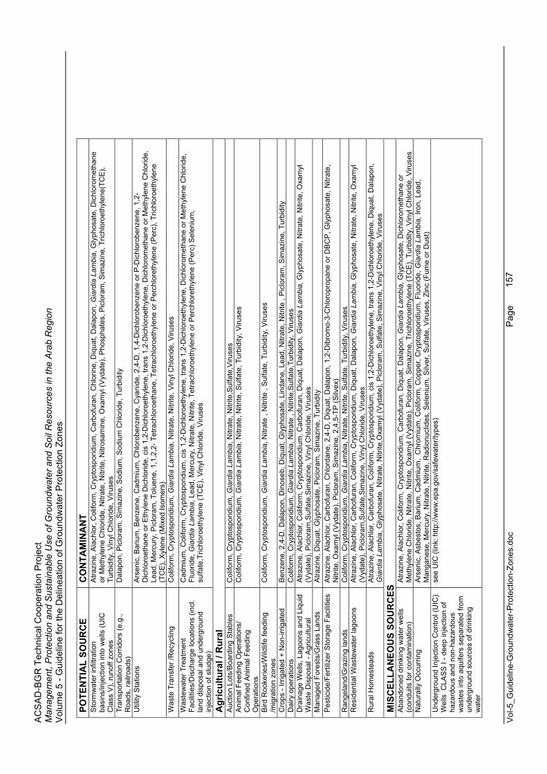
AC
SA
D-B
GR
Tec
hnic
al C
oope
ratio
n P
roje
ct
Man
agem
ent,
Pro
tect
ion
and
Sus
tain
able
Use
of G
roun
dwat
er a
nd S
oil R
esou
rces
in th
e A
rab
Reg
ion
Vol
ume
5 - G
uide
line
for t
he D
elin
eatio
n of
Gro
undw
ater
Pro
tect
ion
Zone
s
Vol
-5_G
uide
line-
Gro
undw
ater
-Pro
tect
ion-
Zone
s.do
c
Page
157
POTE
NTI
AL
SOU
RC
E C
ON
TAM
INA
NT
Sto
rmw
ater
infil
tratio
n ba
sins
/inje
ctio
n in
to w
ells
(UIC
C
lass
V),
runo
ff zo
nes
Atra
zine
, Ala
chlo
r, C
olifo
rm, C
rypt
ospo
ridiu
m, C
arbo
fura
n, C
hlor
ine,
Diq
uat,
Dal
apon
, Gia
rdia
Lam
bia,
Gly
phos
ate,
Dic
hlor
omet
hane
or
Met
hyle
ne C
hlor
ide,
Nitr
ate,
Nitr
ite, N
itros
amin
e, O
xam
yl (V
ydat
e), P
hosp
hate
s, P
iclo
ram
, Sim
azin
e, T
richl
oroe
thyl
ene(
TCE
), Tu
rbid
ity, V
inyl
Chl
orid
e, V
iruse
s Tr
ansp
orta
tion
Cor
ridor
s (e
.g.,
Roa
ds, r
ailro
ads)
D
alap
on, P
iclo
ram
, Sim
azin
e, S
odiu
m, S
odiu
m C
hlor
ide,
Tur
bidi
ty
Util
ity S
tatio
ns
Ars
enic
, Bar
ium
, Ben
zene
, Cad
miu
m, C
hlor
oben
zene
, Cya
nide
, 2,4
-D, 1
,4-D
ichl
orob
enze
ne o
r P-D
ichl
orob
enze
ne, 1
,2-
Dic
hlor
oeth
ane
or E
thyl
ene
Dic
hlor
ide,
cis
1,2
-Dic
hlor
oeth
ylen
e, tr
ans
1,2-
Dic
hlor
oeth
ylen
e, D
ichl
orom
etha
ne o
r Met
hyle
ne C
hlor
ide,
Lead
, Mer
cury
, Pic
lora
m, T
olue
ne, 1
,1,2
,2- T
etra
chlo
roet
hane
, Tet
rach
loro
ethy
lene
or P
erch
lore
thyl
ene
(Per
c), T
richl
oroe
thyl
ene
(TC
E),
Xyl
ene
(Mix
ed Is
omer
s)
Was
te T
rans
fer /
Rec
yclin
g C
olifo
rm, C
rypt
ospo
ridiu
m, G
iard
ia L
ambi
a, N
itrat
e, N
itrite
, Vin
yl C
hlor
ide,
Viru
ses
Was
tew
ater
Tre
atm
ent
Faci
litie
s/D
isch
arge
loca
tions
(inc
l. la
nd d
ispo
sal a
nd u
nder
grou
nd
inje
ctio
n of
slu
dge)
Cad
miu
m, C
olifo
rm, C
rypt
ospo
ridiu
m, c
is 1
,2-D
ichl
oroe
thyl
ene,
tran
s 1,
2-D
ichl
oroe
thyl
ene,
Dic
hlor
omet
hane
or M
ethy
lene
Chl
orid
e,Fl
uorid
e,G
iard
ia L
ambi
a, L
ead,
Mer
cury
, Nitr
ate,
Nitr
ite, T
etra
chlo
roet
hyle
ne o
r Per
chlo
reth
ylen
e (P
erc)
Sel
eniu
m,
sulfa
te,T
richl
oroe
thyl
ene
(TC
E),
Vin
yl C
hlor
ide,
Viru
ses
Agr
icul
tura
l / R
ural
A
uctio
n Lo
ts/B
oard
ing
Sta
bles
C
olifo
rm, C
rypt
ospo
ridiu
m, G
iard
ia L
ambi
a, N
itrat
e, N
itrite
,Sul
fate
,Viru
ses
Ani
mal
Fee
ding
Ope
ratio
ns/
Con
fined
Ani
mal
Fee
ding
O
pera
tions
Col
iform
, Cry
ptos
porid
ium
, Gia
rdia
Lam
bia,
Nitr
ate,
Nitr
ite, S
ulfa
te, T
urbi
dity
, Viru
ses
Bird
Roo
kerie
s/W
ildlif
e fe
edin
g /m
igra
tion
zone
s C
olifo
rm, C
rypt
ospo
ridiu
m, G
iard
ia L
ambi
a, N
itrat
e , N
itrite
, S
ulfa
te, T
urbi
dity
, Viru
ses
Cro
ps -
Irrig
ated
+ N
on-ir
rigat
ed
Ben
zene
, 2,4
-D, D
alap
on, D
inos
eb, D
iqua
t, G
lyph
osat
e, L
inda
ne, L
ead,
Nitr
ate,
Nitr
ite ,
Pic
lora
m, S
imaz
ine,
Tur
bidi
ty
Dai
ry o
pera
tions
C
olifo
rm, C
rypt
ospo
ridiu
m, G
iard
ia L
ambi
a, N
itrat
e , N
itrite
,Sul
fate
,Tur
bidi
ty, V
iruse
s D
rain
age
Wel
ls, L
agoo
ns a
nd L
iqui
d W
aste
Dis
posa
l - A
gric
ultu
ral
Atra
zine
, Ala
chlo
r, C
olifo
rm, C
rypt
ospo
ridiu
m, C
arbo
fura
n, D
iqua
t, D
alap
on, G
iard
ia L
ambi
a, G
lyph
osat
e, N
itrat
e, N
itrite
, Oxa
myl
(V
ydat
e), P
iclo
ram
,Sul
fate
,Sim
azin
e, V
inyl
Chl
orid
e, V
iruse
s
Man
aged
For
ests
/Gra
ss L
ands
A
trazi
ne, D
iqua
t, G
lyph
osat
e, P
iclo
ram
, Sim
azin
e, T
urbi
dity
P
estic
ide/
Ferti
lizer
Sto
rage
Fac
ilitie
s A
trazi
ne, A
lach
lor,
Car
bofu
ran,
Chl
orda
ne, 2
,4-D
, Diq
uat,
Dal
apon
, 1,2
-Dib
rom
o-3-
Chl
orop
ropa
ne o
r DB
CP
, Gly
phos
ate,
Nitr
ate,
N
itrite
, Oxa
myl
(Vyd
ate)
, Pic
lora
m, S
imaz
ine,
2,4
,5-T
P (S
ilvex
) R
ange
land
/Gra
zing
land
s
Col
iform
, Cry
ptos
porid
ium
, Gia
rdia
Lam
bia,
Nitr
ate,
Nitr
ite, S
ulfa
te, T
urbi
dity
, Viru
ses
Res
iden
tial W
aste
wat
er la
goon
s A
trazi
ne, A
lach
lor,
Car
bofu
ran,
Col
iform
, Cry
ptos
porid
ium
, Diq
uat,
Dal
apon
, Gia
rdia
Lam
bia,
Gly
phos
ate,
Nitr
ate,
Nitr
ite, O
xam
yl
(Vyd
ate)
, Pic
lora
m,S
ulfa
te,S
imaz
ine,
Vin
yl C
hlor
ide,
Viru
ses
Rur
al H
omes
tead
s
Atra
zine
, Ala
chlo
r, C
arbo
fura
n, C
olifo
rm, C
rypt
ospo
ridiu
m, c
is 1
,2-D
ichl
oroe
thyl
ene,
tran
s 1,
2-D
ichl
oroe
thyl
ene,
Diq
uat,
Dal
apon
, G
iard
ia L
ambi
a, G
lyph
osat
e, N
itrat
e, N
itrite
,Oxa
myl
(Vyd
ate)
, Pic
lora
m, S
ulfa
te, S
imaz
ine,
Vin
yl C
hlor
ide,
Viru
ses
MIS
CEL
LAN
EOU
S SO
UR
CES
A
band
oned
drin
king
wat
er w
ells
(c
ondu
its fo
r con
tam
inat
ion)
A
trazi
ne, A
lach
lor,
Col
iform
, Cry
ptos
porid
ium
, Car
bofu
ran,
Diq
uat,
Dal
apon
, Gia
rdia
Lam
bia,
Gly
phos
ate,
Dic
hlor
omet
hane
or
Met
hyle
ne C
hlor
ide,
Nitr
ate,
Nitr
ite, O
xam
yl (V
ydat
e), P
iclo
ram
, Sim
azin
e, T
richl
oroe
thyl
ene
(TC
E),
Turb
idity
, Vin
yl C
hlor
ide,
Viru
ses
Nat
ural
ly O
ccur
ring
Ars
enic
, Asb
esto
s, B
ariu
m, C
adm
ium
, C
hrom
ium
, Col
iform
, Cop
per,
Cry
ptos
porid
ium
, Flu
orid
e, G
iard
ia L
ambi
a, Ir
on, L
ead,
M
anga
nese
, Mer
cury
, Nitr
ate,
Nitr
ite, R
adio
nucl
ides
, Sel
eniu
m, S
ilver
, Sul
fate
, Viru
ses,
Zin
c (F
ume
or D
ust)
Und
ergr
ound
Inje
ctio
n C
ontro
l (U
IC)
Wel
ls C
LAS
S I
- dee
p in
ject
ion
of
haza
rdou
s an
d no
n-ha
zard
ous
was
tes
into
aqu
ifers
sep
arat
ed fr
om
unde
rgro
und
sour
ces
of d
rinki
ng
wat
er
see
UIC
(lin
k: h
ttp://
ww
w.e
pa.g
ov/s
afew
ater
/type
s)

AC
SA
D-B
GR
Tec
hnic
al C
oope
ratio
n P
roje
ct
Man
agem
ent,
Pro
tect
ion
and
Sus
tain
able
Use
of G
roun
dwat
er a
nd S
oil R
esou
rces
in th
e A
rab
Reg
ion
Vol
ume
5 - G
uide
line
for t
he D
elin
eatio
n of
Gro
undw
ater
Pro
tect
ion
Zone
s
Vol
-5_G
uide
line-
Gro
undw
ater
-Pro
tect
ion-
Zone
s.do
c
Page
158
POTE
NTI
AL
SOU
RC
E C
ON
TAM
INA
NT
UIC
Wel
ls C
LAS
S II
dee
p in
ject
ion
wel
ls o
f flu
ids
asso
ciat
ed w
ith o
il/ga
s pr
oduc
tion
(for m
ore
deta
iled
list o
f si
tes
clic
k he
re)
see
UIC
UIC
Wel
ls C
LAS
S II
I re-
inje
ctio
n of
w
ater
/ste
am in
to m
iner
al fo
rmat
ions
fo
r min
eral
ext
ract
ion
see
UIC
UIC
Wel
ls C
LAS
S IV
- of
ficia
lly
bann
ed. I
njec
t haz
ardo
us o
r ra
dioa
ctiv
e w
aste
into
or a
bove
un
derg
roun
d so
urce
s of
drin
king
w
ater
see
UIC
UIC
Wel
ls C
lass
V (S
HA
LLO
W
INJE
CTI
ON
WE
LLS
). C
lick
here
for
mor
e in
form
atio
n on
sou
rces
of U
IC
Cla
ss V
wel
ls
see
UIC
Sou
rce:
US
Env
ironm
enta
l Pro
tect
ion
Age
ncy
(http
://w
ww
.epa
.gov
/saf
ewat
er/s
wp/
sour
ces1
.htm
l)
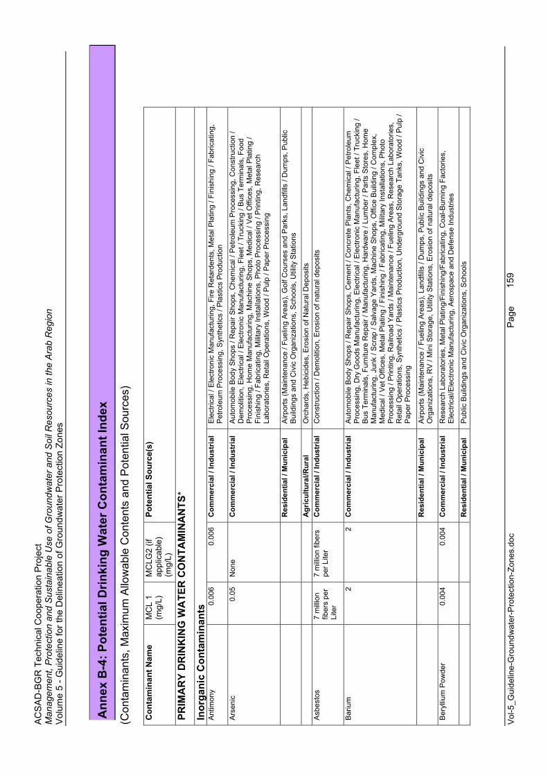
AC
SA
D-B
GR
Tec
hnic
al C
oope
ratio
n P
roje
ct
Man
agem
ent,
Pro
tect
ion
and
Sus
tain
able
Use
of G
roun
dwat
er a
nd S
oil R
esou
rces
in th
e A
rab
Reg
ion
Vol
ume
5 - G
uide
line
for t
he D
elin
eatio
n of
Gro
undw
ater
Pro
tect
ion
Zone
s
Vol
-5_G
uide
line-
Gro
undw
ater
-Pro
tect
ion-
Zone
s.do
c
Page
159
Ann
ex B
-4: P
oten
tial D
rinki
ng W
ater
Con
tam
inan
t Ind
ex
(Con
tam
inan
ts, M
axim
um A
llow
able
Con
tent
s an
d P
oten
tial S
ourc
es)
Con
tam
inan
t Nam
e M
CL
1 (m
g/L)
MC
LG2
(if
appl
icab
le)
(mg/
L)
Pote
ntia
l Sou
rce(
s)
PRIM
AR
Y D
RIN
KIN
G W
ATE
R C
ON
TAM
INA
NTS
*
Inor
gani
c C
onta
min
ants
A
ntim
ony
0.00
6 0.
006
Com
mer
cial
/ In
dust
rial
Ele
ctric
al /
Ele
ctro
nic
Man
ufac
turin
g, F
ire R
etar
dent
s, M
etal
Pla
ting
/ Fin
ishi
ng /
Fabr
icat
ing,
P
etro
leum
Pro
cess
ing,
Syn
thet
ics
/ Pla
stic
s P
rodu
ctio
n
Ars
enic
0.05
N
one
Com
mer
cial
/ In
dust
rial
Aut
omob
ile B
ody
Sho
ps /
Rep
air S
hops
, Che
mic
al /
Pet
role
um P
roce
ssin
g, C
onst
ruct
ion
/ D
emol
ition
, Ele
ctric
al /
Ele
ctro
nic
Man
ufac
turin
g, F
leet
/ Tr
ucki
ng /
Bus
Ter
min
als,
Foo
d P
roce
ssin
g, H
ome
Man
ufac
turin
g, M
achi
ne S
hops
, Med
ical
/ V
et O
ffice
s, M
etal
Pla
ting
/ Fi
nish
ing
/ Fab
ricat
ing,
Mili
tary
Inst
alla
tions
, Pho
to P
roce
ssin
g / P
rintin
g, R
esea
rch
Labo
rato
ries,
Ret
ail O
pera
tions
, Woo
d / P
ulp
/ Pap
er P
roce
ssin
g
R
esid
entia
l / M
unic
ipal
A
irpor
ts (M
aint
enan
ce /
Fuel
ing
Are
as),
Gol
f Cou
rses
and
Par
ks, L
andf
ills
/ Dum
ps, P
ublic
B
uild
ings
and
Civ
ic O
rgan
izat
ions
, Sch
ools
, Util
ity S
tatio
ns
A
gric
ultu
ral/R
ural
O
rcha
rds,
Heb
icid
es, E
rosi
on o
f Nat
ural
Dep
osits
A
sbes
tos
7 m
illio
n fib
ers
per
Lite
r
7 m
illio
n fib
ers
per L
iter
Com
mer
cial
/ In
dust
rial
Con
stru
ctio
n / D
emol
ition
, Ero
sion
of n
atur
al d
epos
its
Bar
ium
2 2
Com
mer
cial
/ In
dust
rial
Aut
omob
ile B
ody
Sho
ps /
Rep
air S
hops
, Cem
ent /
Con
cret
e P
lant
s, C
hem
ical
/ P
etro
leum
P
roce
ssin
g, D
ry G
oods
Man
ufac
turin
g, E
lect
rical
/ E
lect
roni
c M
anuf
actu
ring,
Fle
et /
Truc
king
/ B
us T
erm
inal
s, F
urni
ture
Rep
air /
Man
ufac
turin
g, H
ardw
are
/ Lum
ber /
Par
ts S
tore
s, H
ome
Man
ufac
turin
g, J
unk
/ Scr
ap /
Sal
vage
Yar
ds, M
achi
ne S
hops
, Offi
ce B
uild
ing
/ Com
plex
, M
edic
al /
Vet
Offi
ces,
Met
al P
latin
g / F
inis
hing
/ Fa
bric
atin
g, M
ilita
ry In
stal
latio
ns, P
hoto
P
roce
ssin
g / P
rintin
g, R
ailro
ad Y
ards
/ M
aint
enan
ce /
Fuel
ing
Are
as, R
esea
rch
Labo
rato
ries,
R
etai
l Ope
ratio
ns, S
ynth
etic
s / P
last
ics
Pro
duct
ion,
Und
ergr
ound
Sto
rage
Tan
ks, W
ood
/ Pul
p /
Pap
er P
roce
ssin
g
R
esid
entia
l / M
unic
ipal
A
irpor
ts (M
aint
enan
ce /
Fuel
ing
Are
as),
Land
fills
/ D
umps
, Pub
lic B
uild
ings
and
Civ
ic
Org
aniz
atio
ns, R
V /
Min
i Sto
rage
, Util
ity S
tatio
ns, E
rosi
on o
f nat
ural
dep
osits
Ber
ylliu
m P
owde
r0.
004
0.00
4 C
omm
erci
al /
Indu
stria
l R
esea
rch
Labo
rato
ries,
Met
al P
latin
g/Fi
nish
ing/
Fabr
icat
ing,
Coa
l-Bur
ning
Fac
torie
s,
Ele
ctric
al/E
lect
roni
c M
anuf
actu
ring,
Aer
ospa
ce a
nd D
efen
se In
dust
ries
R
esid
entia
l / M
unic
ipal
P
ublic
Bui
ldin
gs a
nd C
ivic
Org
aniz
atio
ns, S
choo
ls
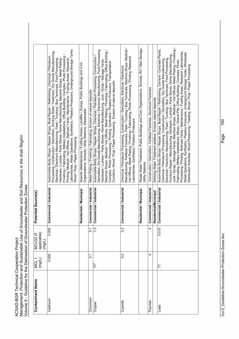
AC
SA
D-B
GR
Tec
hnic
al C
oope
ratio
n P
roje
ct
Man
agem
ent,
Pro
tect
ion
and
Sus
tain
able
Use
of G
roun
dwat
er a
nd S
oil R
esou
rces
in th
e A
rab
Reg
ion
Vol
ume
5 - G
uide
line
for t
he D
elin
eatio
n of
Gro
undw
ater
Pro
tect
ion
Zone
s
Vol
-5_G
uide
line-
Gro
undw
ater
-Pro
tect
ion-
Zone
s.do
c
Page
160
Con
tam
inan
t Nam
e M
CL
1 (m
g/L)
MC
LG2
(if
appl
icab
le)
(mg/
L)
Pote
ntia
l Sou
rce(
s)
Cad
miu
m0.
005
0.00
5 C
omm
erci
al /
Indu
stria
l A
utom
obile
Bod
y S
hops
/ R
epai
r Sho
ps, B
oat R
epai
r / R
efin
ishi
ng, C
hem
ical
/ P
etro
leum
P
roce
ssin
g, C
onst
ruct
ion
/ Dem
oliti
on, D
rinki
ng W
ater
Tre
atm
ent,
Dry
Goo
ds M
anuf
actu
ring,
E
lect
rical
/ E
lect
roni
c M
anuf
actu
ring,
Fle
et /
Truc
king
/ B
us T
erm
inal
s, F
ood
Pro
cess
ing,
H
ardw
are
/ Lum
ber /
Par
ts S
tore
s, H
ome
Man
ufac
turin
g, M
achi
ne S
hops
, Met
al P
latin
g /
Fini
shin
g / F
abric
atin
g, M
ilita
ry In
stal
latio
ns, O
ffice
Bui
ldin
g / C
ompl
ex, P
hoto
Pro
cess
ing
/ P
rintin
g, M
edic
al /
Vet
Offi
ces,
Rai
lroad
Yar
ds /
Mai
nten
ance
/ Fu
elin
g A
reas
, Res
earc
h La
bora
torie
s, R
etai
l Ope
ratio
ns, S
ynth
etic
s / P
last
ics
Pro
duce
rs, U
nder
grou
nd S
tora
ge T
anks
W
ood
/ Pul
p / P
aper
Pro
cess
ing
R
esid
entia
l / M
unic
ipal
A
irpor
ts (M
aint
enan
ce /
Fuel
ing
Are
as),
Land
fills
/ D
umps
, Pub
lic B
uild
ings
and
Civ
ic
Org
aniz
atio
ns, S
choo
ls, U
tility
Sta
tions
, Was
tew
ater
Chr
omiu
m0.
1 0.
1 C
omm
erci
al /
Indu
stria
l M
etal
Pla
ting
/ Fin
ishi
ng /
Fabr
icat
ing,
Ero
sion
of n
atur
al d
epos
its
Cop
per
TT3
1.3
Com
mer
cial
/ In
dust
rial
Aut
omob
ile B
ody
Sho
ps /
Rep
air S
hops
, Che
mic
al /
Pet
role
um P
roce
ssin
g, C
onst
ruct
ion
/ D
emol
ition
, Dry
Goo
ds M
anuf
actu
ring,
Ele
ctric
al /
Ele
ctro
nic
Man
ufac
turin
g, F
ood
Pro
cess
ing,
H
ardw
are
/ Lum
ber /
Par
ts S
tore
s, H
ome
Man
ufac
turin
g, J
unk
/ Scr
ap /
Sal
vage
Yar
ds,
Mac
hine
Sho
ps, M
edic
al /
Vet
Offi
ces,
Met
al P
latin
g / F
inis
hing
/ Fa
bric
atin
g, O
ffice
Bui
ldin
g /
Com
plex
, Pho
to P
roce
ssin
g / P
rintin
g, S
ynth
etic
s / P
last
ics
Pro
duce
rs, T
rans
porta
tion
Cor
ridor
s, W
ood
/ Pul
p / P
aper
Pro
cess
ing
, Ero
sion
of n
atur
al d
epos
its
Cya
nide
0.2
0.2
Com
mer
cial
/ In
dust
rial
Che
mic
al /
Pet
role
um P
roce
ssin
g, C
onst
ruct
ion
/ Dem
oliti
on, E
lect
rical
/ E
lect
roni
c M
anuf
actu
ring,
Fer
tiliz
er F
acto
ries,
Fle
et /
Truc
king
/ B
us T
erm
inal
s, M
achi
ne S
hops
, Med
ical
/ V
et O
ffice
s, M
etal
Pla
ting
/ Fin
ishi
ng /
Fabr
icat
ing,
Pho
to P
roce
ssin
g / P
rintin
g, R
esea
rch
Labo
rato
ries,
Syn
thet
ics
/ Pla
stic
s P
rodu
cers
R
esid
entia
l / M
unic
ipal
W
aste
Wat
er T
reat
men
t, P
ublic
Bui
ldin
gs a
nd C
ivic
Org
aniz
atio
ns, S
choo
ls, R
V /
Min
i Sto
rage
, U
tility
Sta
tions
Fluo
ride
4 4
Com
mer
cial
/ In
dust
rial
Con
stru
ctio
n / D
emol
ition
, Fer
tiliz
er F
acto
ries,
Alu
min
um F
acto
ries
Res
iden
tial/M
unic
ipal
D
rinki
ng W
ater
Tre
atm
ent a
dditi
ve, E
rosi
on n
atur
al d
epos
its
Lead
TT
0.01
5 C
omm
erci
al /
Indu
stria
l A
utom
obile
Bod
y S
hops
/ R
epai
r Sho
ps, B
oat R
epai
r / R
efin
ishi
ng, C
emen
t / C
oncr
ete
Pla
nts,
C
hem
ical
/ P
etro
leum
Pro
cess
ing,
Con
stru
ctio
n / D
emol
ition
, Dry
Goo
ds M
anuf
actu
ring,
E
lect
rical
/ E
lect
roni
c M
anuf
actu
ring,
Fle
et /
Truc
king
/ B
us T
erm
inal
s, F
ood
Pro
cess
ing,
Fu
rnitu
re R
epai
r / M
anuf
actu
ring,
Har
dwar
e / L
umbe
r / P
arts
Sto
res,
Hom
e M
anuf
actu
ring,
Ju
nk /
Scr
ap /
Sal
vage
Yar
ds, M
achi
ne S
hops
, Med
ical
/ V
et O
ffice
s, M
etal
Pla
ting
/ Fin
ishi
ng /
Fabr
icat
ing,
Mili
tary
Inst
alla
tions
, Min
es /
Gra
vel P
its, O
ffice
Bui
ldin
g / C
ompl
ex, P
hoto
P
roce
ssin
g / P
rintin
g, R
ailro
ad Y
ards
/ M
aint
enan
ce /
Fuel
ing
Are
as, R
esea
rch
Labo
rato
ries,
R
etai
l Ope
ratio
ns, S
ynth
etic
s / P
last
ics
Pro
duce
rs, U
nder
grou
nd S
tora
ge T
anks
, Who
lesa
le
Dis
tribu
tion
Act
iviti
es, W
ood
Pre
serv
ing
/ Tre
atin
g, W
ood
/ Pul
p / P
aper
Pro
cess
ing
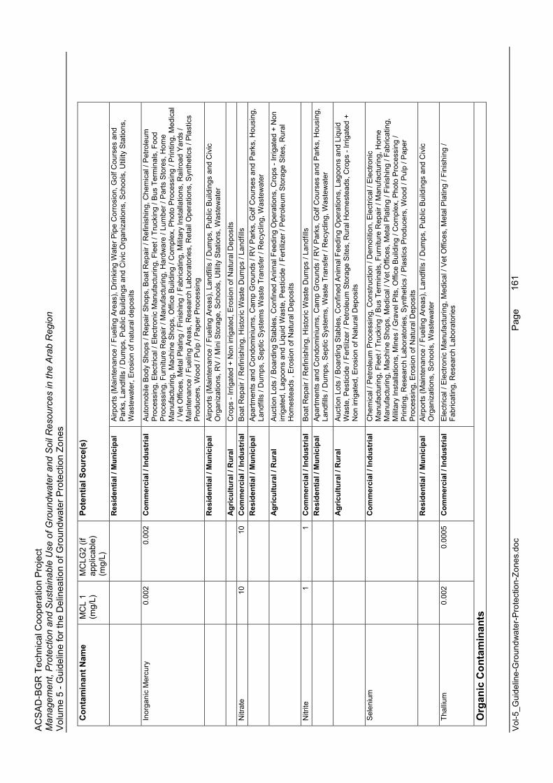
AC
SA
D-B
GR
Tec
hnic
al C
oope
ratio
n P
roje
ct
Man
agem
ent,
Pro
tect
ion
and
Sus
tain
able
Use
of G
roun
dwat
er a
nd S
oil R
esou
rces
in th
e A
rab
Reg
ion
Vol
ume
5 - G
uide
line
for t
he D
elin
eatio
n of
Gro
undw
ater
Pro
tect
ion
Zone
s
Vol
-5_G
uide
line-
Gro
undw
ater
-Pro
tect
ion-
Zone
s.do
c
Page
161
Con
tam
inan
t Nam
e M
CL
1 (m
g/L)
MC
LG2
(if
appl
icab
le)
(mg/
L)
Pote
ntia
l Sou
rce(
s)
R
esid
entia
l / M
unic
ipal
A
irpor
ts (M
aint
enan
ce /
Fuel
ing
Are
as),
Drin
king
Wat
er P
ipe
Cor
rosi
on, G
olf C
ours
es a
nd
Par
ks, L
andf
ills
/ Dum
ps, P
ublic
Bui
ldin
gs a
nd C
ivic
Org
aniz
atio
ns, S
choo
ls, U
tility
Sta
tions
, W
aste
wat
er, E
rosi
on o
f nat
ural
dep
osits
Inor
gani
c M
ercu
ry0.
002
0.00
2 C
omm
erci
al /
Indu
stria
l A
utom
obile
Bod
y S
hops
/ R
epai
r Sho
ps, B
oat R
epai
r / R
efin
ishi
ng, C
hem
ical
/ P
etro
leum
P
roce
ssin
g, E
lect
rical
/ E
lect
roni
c M
anuf
actu
ring,
Fle
et /
Truc
king
/ B
us T
erm
inal
s, F
ood
Pro
cess
ing,
Fur
nitu
re R
epai
r / M
anuf
actu
ring,
Har
dwar
e / L
umbe
r / P
arts
Sto
res,
Hom
e M
anuf
actu
ring,
Mac
hine
Sho
ps, O
ffice
Bui
ldin
g / C
ompl
ex, P
hoto
Pro
cess
ing
/ Prin
ting,
Med
ical
/ V
et O
ffice
s, M
etal
Pla
ting
/ Fin
ishi
ng /
Fabr
icat
ing,
Mili
tary
Inst
alla
tions
, Rai
lroad
Yar
ds /
Mai
nten
ance
/ Fu
elin
g A
reas
, Res
earc
h La
bora
torie
s, R
etai
l Ope
ratio
ns, S
ynth
etic
s / P
last
ics
Pro
duce
rs, W
ood
/ Pul
p / P
aper
Pro
cess
ing
R
esid
entia
l / M
unic
ipal
A
irpor
ts (M
aint
enan
ce /
Fuel
ing
Are
as),
Land
fills
/ D
umps
, Pub
lic B
uild
ings
and
Civ
ic
Org
aniz
atio
ns, R
V /
Min
i Sto
rage
, Sch
ools
, Util
ity S
tatio
ns, W
aste
wat
er
A
gric
ultu
ral /
Rur
al
Cro
ps -
Irrig
ated
+ N
on ir
rigat
ed, E
rosi
on o
f Nat
ural
Dep
osits
N
itrat
e10
10
C
omm
erci
al /
Indu
stria
l B
oat R
epai
r / R
efin
ishi
ng, H
isto
ric W
aste
Dum
ps /
Land
fills
Res
iden
tial /
Mun
icip
al
Apa
rtmen
ts a
nd C
ondo
min
ium
s, C
amp
Gro
unds
/ R
V P
arks
, Gol
f Cou
rses
and
Par
ks, H
ousi
ng,
Land
fills
/ D
umps
, Sep
tic S
yste
ms
Was
te T
rans
fer /
Rec
yclin
g, W
aste
wat
er
A
gric
ultu
ral /
Rur
al
Auc
tion
Lots
/ B
oard
ing
Sta
bles
, Con
fined
Ani
mal
Fee
ding
Ope
ratio
ns, C
rops
- Irr
igat
ed +
Non
irr
igat
ed, L
agoo
ns a
nd L
iqui
d W
aste
, Pes
ticid
e / F
ertil
izer
/ P
etro
leum
Sto
rage
Site
s, R
ural
H
omes
tead
s , E
rosi
on o
f Nat
ural
Dep
osits
Nitr
ite1
1 C
omm
erci
al /
Indu
stria
l B
oat R
epai
r / R
efin
ishi
ng, H
isto
ric W
aste
Dum
ps /
Land
fills
Res
iden
tial /
Mun
icip
al
Apa
rtmen
ts a
nd C
ondo
min
ium
s, C
amp
Gro
unds
/ R
V P
arks
, Gol
f Cou
rses
and
Par
ks, H
ousi
ng,
Land
fills
/ D
umps
, Sep
tic S
yste
ms,
Was
te T
rans
fer /
Rec
yclin
g, W
aste
wat
er
A
gric
ultu
ral /
Rur
al
Auc
tion
Lots
/ B
oard
ing
Sta
bles
, Con
fined
Ani
mal
Fee
ding
Ope
ratio
ns, L
agoo
ns a
nd L
iqui
d W
aste
, Pes
ticid
e / F
ertil
izer
/ P
etro
leum
Sto
rage
Site
s, R
ural
Hom
este
ads,
Cro
ps -
Irrig
ated
+
Non
irrig
ated
, Ero
sion
of N
atur
al D
epos
its
Sel
eniu
m
C
omm
erci
al /
Indu
stria
l C
hem
ical
/ P
etro
leum
Pro
cess
ing,
Con
stru
ctio
n / D
emol
ition
, Ele
ctric
al /
Ele
ctro
nic
Man
ufac
turin
g, F
leet
/ Tr
ucki
ng /
Bus
Ter
min
als,
Fur
nitu
re R
epai
r / M
anuf
actu
ring,
Hom
e M
anuf
actu
ring,
Mac
hine
Sho
ps, M
edic
al /
Vet
Offi
ces,
Met
al P
latin
g / F
inis
hing
/ Fa
bric
atin
g,
Mili
tary
Inst
alla
tions
, Min
es /
Gra
vel P
its, O
ffice
Bui
ldin
g / C
ompl
ex, P
hoto
Pro
cess
ing
/ P
rintin
g, R
esea
rch
Labo
rato
ries,
Syn
thet
ics
/ Pla
stic
s P
rodu
cers
, Woo
d / P
ulp
/ Pap
er
Pro
cess
ing,
Ero
sion
of N
atur
al D
epos
its
R
esid
entia
l / M
unic
ipal
A
irpor
ts (M
aint
enan
ce /
Fuel
ing
Are
as),
Land
fills
/ D
umps
, Pub
lic B
uild
ings
and
Civ
ic
Org
aniz
atio
ns, S
choo
ls, W
aste
wat
er
Thal
lium
0.00
2 0.
0005
C
omm
erci
al /
Indu
stria
l E
lect
rical
/ E
lect
roni
c M
anuf
actu
ring,
Med
ical
/ V
et O
ffice
s, M
etal
Pla
ting
/ Fin
ishi
ng /
Fabr
icat
ing,
Res
earc
h La
bora
torie
s
Org
anic
Con
tam
inan
ts
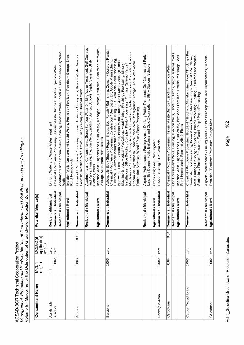
AC
SA
D-B
GR
Tec
hnic
al C
oope
ratio
n P
roje
ct
Man
agem
ent,
Pro
tect
ion
and
Sus
tain
able
Use
of G
roun
dwat
er a
nd S
oil R
esou
rces
in th
e A
rab
Reg
ion
Vol
ume
5 - G
uide
line
for t
he D
elin
eatio
n of
Gro
undw
ater
Pro
tect
ion
Zone
s
Vol
-5_G
uide
line-
Gro
undw
ater
-Pro
tect
ion-
Zone
s.do
c
Page
162
Con
tam
inan
t Nam
e M
CL
1 (m
g/L)
MC
LG2
(if
appl
icab
le)
(mg/
L)
Pote
ntia
l Sou
rce(
s)
Acr
ylam
ide
TT
zero
R
esid
entia
l/Mun
icip
al
Drin
king
Wat
er a
nd W
aste
Wat
er T
reat
men
t A
lach
lor
0.00
2 ze
ro
Com
mer
cial
/ In
dust
rial
Che
mic
al /
Pet
role
um P
roce
ssin
g, H
isto
ric W
aste
Dum
ps /
Land
fills
, Inj
ectio
n W
ells
Res
iden
tial /
Mun
icip
al
Apa
rtmen
ts a
nd C
ondo
min
ium
s, H
ousi
ng, I
njec
tion
Wel
ls, L
andf
ills
/ Dum
ps, S
eptic
Sys
tem
s W
ells
A
gric
ultu
ral /
Rur
al
Inje
ctio
n W
ells
, Lag
oons
and
Liq
uid
Was
te, P
estic
ide
/ Fer
tiliz
er /
Pet
role
um S
tora
ge S
ites,
R
ural
Hom
este
ads
Atra
zine
0.00
3 0.
003
Com
mer
cial
/ In
dust
rial
Che
mic
al /
Pet
role
um P
roce
ssin
g, F
uner
al S
ervi
ces
/ Gra
veya
rds,
His
toric
Was
te D
umps
/ La
ndfil
ls, I
njec
tion
Wel
ls, O
ffice
Bui
ldin
g / C
ompl
ex, R
ailro
ad Y
ards
R
esid
entia
l / M
unic
ipal
A
partm
ents
and
Con
dom
iniu
ms,
Som
e S
urfa
ce W
ater
Drin
king
Wat
er T
reat
men
t, G
olf C
ours
es
and
Par
ks, H
ousi
ng, I
njec
tion
Wel
ls, L
andf
ills
/ Dum
ps, S
choo
ls, S
eptic
Sys
tem
s, U
tility
S
tatio
ns, W
ells
Agr
icul
tura
l / R
ural
In
ject
ion
Wel
ls, L
agoo
ns a
nd L
iqui
d W
aste
, Man
aged
For
ests
, Pes
ticid
e / F
ertil
izer
/ P
etro
leum
S
tora
ge S
ites,
Rur
al H
omes
tead
s
Ben
zene
0.00
5 ze
ro
Com
mer
cial
/ In
dust
rial
Aut
omob
ile B
ody
Sho
ps /
Rep
air S
hops
, Boa
t Rep
air /
Ref
inis
hing
, Cem
ent /
Con
cret
e P
lant
s,
Che
mic
al /
Pet
role
um P
roce
ssin
g, C
onst
ruct
ion
/ Dem
oliti
on, D
ry G
oods
Man
ufac
turin
g,
Ele
ctric
al /
Ele
ctro
nic
Man
ufac
turin
g, F
leet
/ Tr
ucki
ng /
Bus
Ter
min
als,
Foo
d P
roce
ssin
g,
Har
dwar
e / L
umbe
r / P
arts
Sto
res,
Hom
e M
anuf
actu
ring,
Jun
k / S
crap
/ S
alva
ge Y
ards
, M
achi
ne S
hops
, Med
ical
/ V
et O
ffice
s, M
etal
Pla
ting
/ Fin
ishi
ng /
Fabr
icat
ing,
Mili
tary
In
stal
latio
ns, O
ffice
Bui
ldin
g / C
ompl
ex, P
hoto
Pro
cess
ing
/ Prin
ting,
Rai
lroad
Yar
ds /
Mai
nten
ance
/ Fu
elin
g A
reas
, Res
earc
h La
bora
torie
s, R
etai
l Ope
ratio
ns, S
ynth
etic
/ P
last
ics
Pro
duct
ion,
Syn
ethe
tics
/ Pla
stic
s P
rodu
cers
, Und
ergr
ound
Sto
rage
Tan
ks, W
hole
sale
D
istri
butio
n A
ctiv
ities
, Woo
d / P
ulp
/ Pap
er P
roce
ssin
g
R
esid
entia
l / M
unic
ipal
A
irpor
ts (M
aint
enan
ce /
Fuel
ing
Are
as),
Drin
king
Wat
er T
reat
men
t, G
olf C
ours
es a
nd P
arks
, La
ndfil
ls /
Dum
ps, P
ublic
Bui
ldin
gs a
nd C
ivic
Org
aniz
atio
ns, U
tility
Sta
tions
, Sch
ools
A
gric
ultu
ral /
Rur
al
Cro
ps -
Irrig
ated
+ N
on ir
rigat
ed
Ben
zo(a
)pyr
ene
0.00
02
zero
C
omm
erci
al /
Indu
stria
l Fl
eet /
Tru
ckin
g / B
us T
erm
inal
s
Car
bofu
ran
0.04
0.
04
Com
mer
cial
/ In
dust
rial
Che
mic
al /
Pet
role
um P
roce
ssin
g, H
isto
ric W
aste
Dum
ps /
Land
fills
, Inj
ectio
n W
ells
Res
iden
tial /
Mun
icip
al
Gol
f Cou
rses
and
Par
ks, H
ousi
ng, I
njec
tion
Wel
ls, L
andf
ills
/ Dum
ps, S
eptic
Sys
tem
s, W
ells
Agr
icul
tura
l / R
ural
In
ject
ion
Wel
ls, L
agoo
ns a
nd L
iqui
d W
aste
, Pes
ticid
e / F
ertil
izer
/ P
etro
leum
Sto
rage
Site
s,
Rur
al H
omes
tead
s, R
ice
and
Alfa
lfa F
ield
s
Car
bon
Tetra
chlo
ride
0.00
5 ze
ro
Com
mer
cial
/ In
dust
rial
Che
mic
al /
Pet
role
um P
roce
ssin
g, E
lect
rical
/ E
lect
roni
c M
anuf
actu
ring,
Fle
et /
Truc
king
/ B
us
Term
inal
s, F
ood
Pro
cess
ing,
Hom
e M
anuf
actu
ring,
Mac
hine
Sho
ps, M
edic
al /
Vet
Offi
ces,
M
etal
Pla
ting
/ Fin
ishi
ng /
Fabr
icat
ing,
Pho
to P
roce
ssin
g / P
rintin
g, R
esea
rch
Labo
rato
ries,
S
ynth
etic
s / P
last
ics
Pro
duce
rs, W
ood
/ Pul
p / P
aper
Pro
cess
ing
R
esid
entia
l / M
unic
ipal
A
irpor
ts (M
aint
enan
ce /
Fuel
ing
Are
as),
Pub
lic B
uild
ings
and
Civ
ic O
rgan
izat
ions
, Sch
ools
C
hlor
dane
0.00
2 ze
ro
Agr
icul
tura
l / R
ural
P
estic
ide
/ Fer
tiliz
er /
Pet
role
um S
tora
ge S
ites
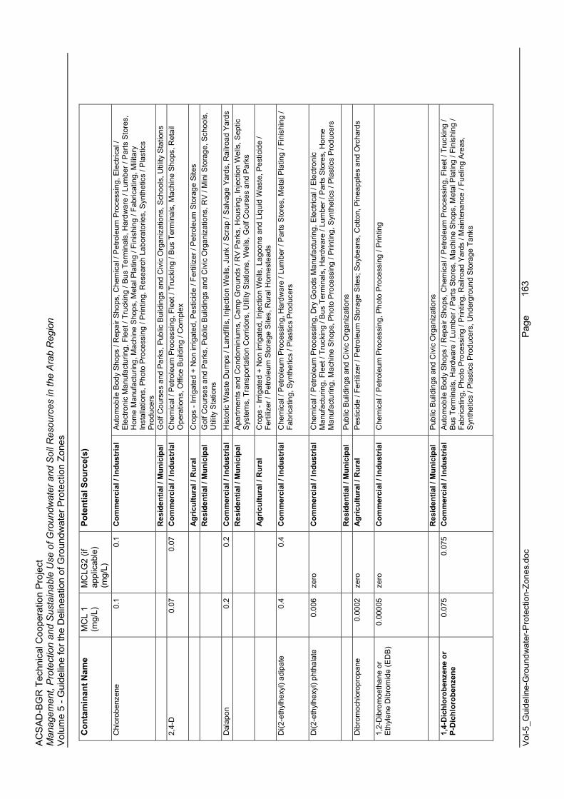
AC
SA
D-B
GR
Tec
hnic
al C
oope
ratio
n P
roje
ct
Man
agem
ent,
Pro
tect
ion
and
Sus
tain
able
Use
of G
roun
dwat
er a
nd S
oil R
esou
rces
in th
e A
rab
Reg
ion
Vol
ume
5 - G
uide
line
for t
he D
elin
eatio
n of
Gro
undw
ater
Pro
tect
ion
Zone
s
Vol
-5_G
uide
line-
Gro
undw
ater
-Pro
tect
ion-
Zone
s.do
c
Page
163
Con
tam
inan
t Nam
e M
CL
1 (m
g/L)
MC
LG2
(if
appl
icab
le)
(mg/
L)
Pote
ntia
l Sou
rce(
s)
Chl
orob
enze
ne0.
1 0.
1 C
omm
erci
al /
Indu
stria
l A
utom
obile
Bod
y S
hops
/ R
epai
r Sho
ps, C
hem
ical
/ P
etro
leum
Pro
cess
ing,
Ele
ctric
al /
Ele
ctro
nic
Man
ufac
turin
g, F
leet
/ Tr
ucki
ng /
Bus
Ter
min
als,
Har
dwar
e / L
umbe
r / P
arts
Sto
res,
H
ome
Man
ufac
turin
g, M
achi
ne S
hops
, Met
al P
latin
g / F
inis
hing
/ Fa
bric
atin
g, M
ilita
ry
Inst
alla
tions
, Pho
to P
roce
ssin
g / P
rintin
g, R
esea
rch
Labo
rato
ries,
Syn
thet
ics
/ Pla
stic
s P
rodu
cers
R
esid
entia
l / M
unic
ipal
G
olf C
ours
es a
nd P
arks
, Pub
lic B
uild
ings
and
Civ
ic O
rgan
izat
ions
, Sch
ools
, Util
ity S
tatio
ns
2,4-
D0.
07
0.07
C
omm
erci
al /
Indu
stria
l C
hem
ical
/ P
etro
leum
Pro
cess
ing,
Fle
et /
Truc
king
/ B
us T
erm
inal
s, M
achi
ne S
hops
, Ret
ail
Ope
ratio
ns, O
ffice
Bui
ldin
g / C
ompl
ex
A
gric
ultu
ral /
Rur
al
Cro
ps -
Irrig
ated
+ N
on ir
rigat
ed, P
estic
ide
/ Fer
tiliz
er /
Pet
role
um S
tora
ge S
ites
R
esid
entia
l / M
unic
ipal
G
olf C
ours
es a
nd P
arks
, Pub
lic B
uild
ings
and
Civ
ic O
rgan
izat
ions
, RV
/ M
ini S
tora
ge, S
choo
ls,
Util
ity S
tatio
ns
Dal
apon
0.2
0.2
Com
mer
cial
/ In
dust
rial
His
toric
Was
te D
umps
/ La
ndfil
ls, I
njec
tion
Wel
ls, J
unk
/ Scr
ap /
Sal
vage
Yar
ds, R
ailro
ad Y
ards
Res
iden
tial /
Mun
icip
al
Apa
rtmen
ts a
nd C
ondo
min
ium
s, C
amp
Gro
unds
/ R
V P
arks
, Hou
sing
, Inj
ectio
n W
ells
, Sep
tic
Sys
tem
s, T
rans
porta
tion
Cor
ridor
s, U
tility
Sta
tions
, Wel
ls, G
olf C
ours
es a
nd P
arks
A
gric
ultu
ral /
Rur
al
Cro
ps -
Irrig
ated
+ N
on ir
rigat
ed, I
njec
tion
Wel
ls, L
agoo
ns a
nd L
iqui
d W
aste
, Pes
ticid
e /
Ferti
lizer
/ P
etro
leum
Sto
rage
Site
s, R
ural
Hom
este
ads
Di(2
-eth
ylhe
xyl)
adip
ate
0.4
0.4
Com
mer
cial
/ In
dust
rial
Che
mic
al /
Pet
role
um P
roce
ssin
g, H
ardw
are
/ Lum
ber /
Par
ts S
tore
s, M
etal
Pla
ting
/ Fin
ishi
ng /
Fabr
icat
ing,
Syn
thet
ics
/ Pla
stic
s P
rodu
cers
Di(2
-eth
ylhe
xyl)
phth
alat
e0.
006
zero
C
omm
erci
al /
Indu
stria
l C
hem
ical
/ P
etro
leum
Pro
cess
ing,
Dry
Goo
ds M
anuf
actu
ring,
Ele
ctric
al /
Ele
ctro
nic
Man
ufac
turin
g, F
leet
/ Tr
ucki
ng /
Bus
Ter
min
als,
Har
dwar
e / L
umbe
r / P
arts
Sto
res,
Hom
e M
anuf
actu
ring,
Mac
hine
Sho
ps, P
hoto
Pro
cess
ing
/ Prin
ting,
Syn
thet
ics
/ Pla
stic
s P
rodu
cers
R
esid
entia
l / M
unic
ipal
P
ublic
Bui
ldin
gs a
nd C
ivic
Org
aniz
atio
ns
Dib
rom
ochl
orop
ropa
ne0.
0002
ze
ro
Agr
icul
tura
l / R
ural
P
estic
ide
/ Fer
tiliz
er /
Pet
role
um S
tora
ge S
ites;
Soy
bean
s, C
otto
n, P
inea
pple
s an
d O
rcha
rds
1,2-
Dib
rom
oeth
ane
or
Eth
ylen
e D
ibro
mid
e (E
DB
)0.
0000
5 ze
ro
Com
mer
cial
/ In
dust
rial
Che
mic
al /
Pet
role
um P
roce
ssin
g, P
hoto
Pro
cess
ing
/ Prin
ting
R
esid
entia
l / M
unic
ipal
P
ublic
Bui
ldin
gs a
nd C
ivic
Org
aniz
atio
ns
1,4-
Dic
hlor
oben
zene
or
P-D
ichl
orob
enze
ne
0.07
5 0.
075
Com
mer
cial
/ In
dust
rial
Aut
omob
ile B
ody
Sho
ps /
Rep
air S
hops
, Che
mic
al /
Pet
role
um P
roce
ssin
g, F
leet
/ Tr
ucki
ng /
Bus
Ter
min
als,
Har
dwar
e / L
umbe
r / P
arts
Sto
res,
Mac
hine
Sho
ps, M
etal
Pla
ting
/ Fin
ishi
ng /
Fabr
icat
ing,
Pho
to P
roce
ssin
g / P
rintin
g, R
ailro
ad Y
ards
/ M
aint
enan
ce /
Fuel
ing
Are
as,
Syn
thet
ics
/ Pla
stic
s P
rodu
cers
, Und
ergr
ound
Sto
rage
Tan
ks

AC
SA
D-B
GR
Tec
hnic
al C
oope
ratio
n P
roje
ct
Man
agem
ent,
Pro
tect
ion
and
Sus
tain
able
Use
of G
roun
dwat
er a
nd S
oil R
esou
rces
in th
e A
rab
Reg
ion
Vol
ume
5 - G
uide
line
for t
he D
elin
eatio
n of
Gro
undw
ater
Pro
tect
ion
Zone
s
Vol
-5_G
uide
line-
Gro
undw
ater
-Pro
tect
ion-
Zone
s.do
c
Page
164
Con
tam
inan
t Nam
e M
CL
1 (m
g/L)
MC
LG2
(if
appl
icab
le)
(mg/
L)
Pote
ntia
l Sou
rce(
s)
R
esid
entia
l / M
unic
ipal
P
ublic
Bui
ldin
gs a
nd C
ivic
Org
aniz
atio
ns, S
choo
ls U
tility
Sta
tions
1,
2-D
ichl
orob
enze
ne o
r O-
Dic
hlor
oben
zene
0.6
0.6
Com
mer
cial
/ In
dust
rial
Che
mic
al /
Pet
role
um P
roce
ssin
g, E
lect
rical
/ E
lect
roni
c M
anuf
actu
ring,
Fle
et /
Truc
king
/ B
us
Term
inal
s, H
ome
Man
ufac
turin
g, M
ilita
ry In
stal
latio
ns, P
hoto
Pro
cess
ing
/ Prin
ting,
Syn
thet
ic /
Pla
stic
s P
rodu
ctio
n, O
ffice
Bui
ldin
g / C
ompl
ex
1,2-
Dic
hlor
oeth
ane
or
Eth
ylen
e D
ichl
orid
e0.
005
zero
C
omm
erci
al /
Indu
stria
l C
hem
ical
/ P
etro
leum
Pro
cess
ing,
Ele
ctric
al /
Ele
ctro
nic
Man
ufac
turin
g, F
leet
/ Tr
ucki
ng /
Bus
Te
rmin
als,
Fur
nitu
re R
epai
r / M
anuf
actu
ring,
Mac
hine
Sho
ps, M
edic
al /
Vet
Offi
ces,
Mili
tary
In
stal
latio
ns, O
ffice
Bui
ldin
g / C
ompl
ex, P
hoto
Pro
cess
ing
/ Prin
ting,
Syn
thet
ic /
Pla
stic
s P
rodu
ctio
n, R
esea
rch
Labo
rato
ries,
Ret
ail O
pera
tions
R
esid
entia
l / M
unic
ipal
P
ublic
Bui
ldin
gs a
nd C
ivic
Org
aniz
atio
ns, S
choo
ls, W
ood
/ Pul
p / P
aper
Pro
cess
ing,
Util
ity
Sta
tions
R
esid
entia
l / M
unic
ipal
P
ublic
Bui
ldin
gs a
nd C
ivic
Org
aniz
atio
ns, S
choo
ls
Che
mic
al /
Pet
role
um P
roce
ssin
g, M
achi
ne S
hops
,1,
1-D
ichl
oroe
thyl
ene
or
Vin
ylid
ene
Chl
orid
e0.
007
0.00
7 C
omm
erci
al /
Indu
stria
l
Pho
to P
roce
ssin
g / P
rintin
g, R
esea
rch
Labo
rato
ries
cis
1,2
- Dic
hlor
oeth
ylen
e0.
07
0.07
C
omm
erci
al /
Indu
stria
l A
utom
obile
Bod
y S
hops
/ R
epai
r Sho
ps, C
hem
ical
/ P
etro
leum
Pro
cess
ing,
Con
stru
ctio
n /
Dem
oliti
on, E
lect
rical
/ E
lect
roni
c M
anuf
actu
ring,
Fle
et /
Truc
king
/ B
us T
erm
inal
s, G
as
Sta
tions
, His
toric
Was
te D
umps
/ La
ndfil
ls, H
ome
Man
ufac
turin
g, In
ject
ion
Wel
ls, J
unk
/ Scr
ap /
Sal
vage
Yar
ds, M
achi
ne S
hops
, Met
al P
latin
g / F
inis
hing
/ Fa
bric
atin
g, M
ilita
ry In
stal
latio
ns,
Mot
or P
ools
, Pho
to P
roce
ssin
g / P
rintin
g, S
ynth
etic
/ P
last
ics
Pro
duct
ion,
Rai
lroad
Yar
ds,
Res
earc
h La
bora
torie
s, W
ood
Pre
serv
ing
/ Tre
atin
g
R
esid
entia
l / M
unic
ipal
A
irpor
ts (M
aint
enan
ce /
Fuel
ing
Are
as),
Inje
ctio
n W
ells
, Lan
dfills
/ D
umps
, Util
ity S
tatio
ns,
Was
tew
ater
Agr
icul
tura
l / R
ural
In
ject
ion
Wel
ls, R
ural
Hom
este
ads
tran
s 1,
2 -
Dic
hlor
oeth
ylen
e
C
omm
erci
al /
Indu
stria
l A
utom
obile
Bod
y S
hops
/ R
epai
r Sho
ps, C
hem
ical
/ P
etro
leum
Pro
cess
ing,
Con
stru
ctio
n /
Dem
oliti
on, E
lect
rical
/ E
lect
roni
c M
anuf
actu
ring,
Fle
et /
Truc
king
/ B
us T
erm
inal
s, G
as
Sta
tions
, His
toric
Was
te D
umps
/ La
ndfil
ls, H
ome
Man
ufac
turin
g, In
ject
ion
Wel
ls, J
unk
/ Scr
ap /
Sal
vage
Yar
ds, M
achi
ne S
hops
, Met
al P
latin
g / F
inis
hing
/ Fa
bric
atin
g, M
ilita
ry In
stal
latio
ns,
Mot
or P
ools
, Pho
to P
roce
ssin
g / P
rintin
g, S
ynth
etic
/ P
last
ics
Pro
duct
ion,
Rai
lroad
Yar
ds,
Res
earc
h La
bora
torie
s, W
ood
Pre
serv
ing
/ Tre
atin
g
R
esid
entia
l / M
unic
ipal
A
irpor
ts (M
aint
enan
ce /
Fuel
ing
Are
as),
Inje
ctio
n W
ells
, Lan
dfills
/ D
umps
, Util
ity S
tatio
ns,
Was
tew
ater
Agr
icul
tura
l / R
ural
In
ject
ion
Wel
ls
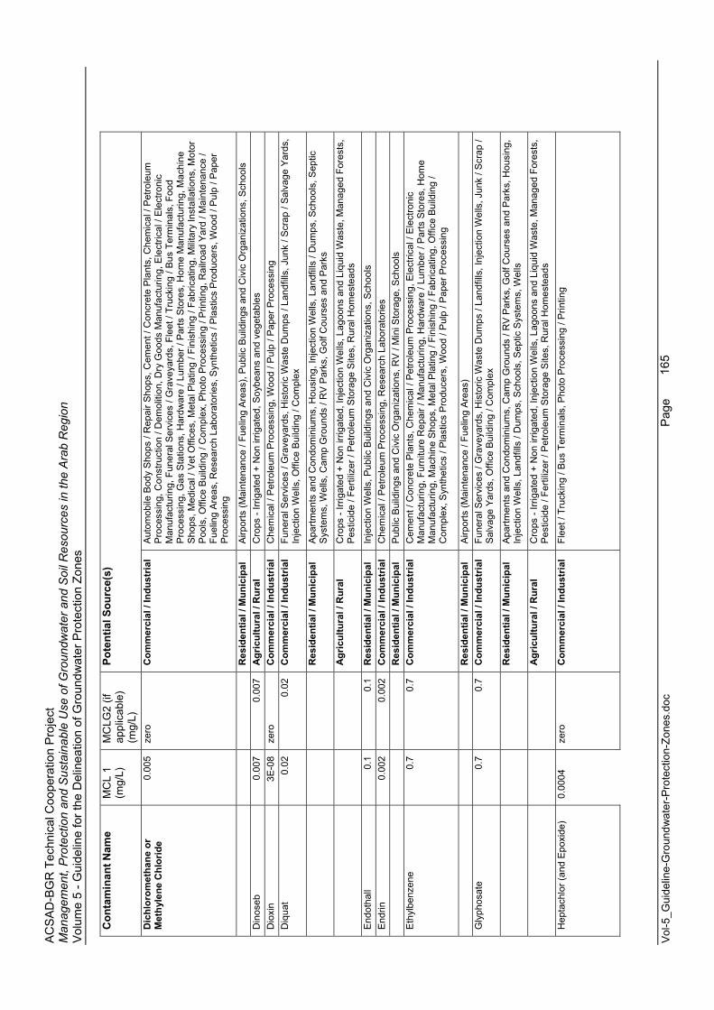
AC
SA
D-B
GR
Tec
hnic
al C
oope
ratio
n P
roje
ct
Man
agem
ent,
Pro
tect
ion
and
Sus
tain
able
Use
of G
roun
dwat
er a
nd S
oil R
esou
rces
in th
e A
rab
Reg
ion
Vol
ume
5 - G
uide
line
for t
he D
elin
eatio
n of
Gro
undw
ater
Pro
tect
ion
Zone
s
Vol
-5_G
uide
line-
Gro
undw
ater
-Pro
tect
ion-
Zone
s.do
c
Page
165
Con
tam
inan
t Nam
e M
CL
1 (m
g/L)
MC
LG2
(if
appl
icab
le)
(mg/
L)
Pote
ntia
l Sou
rce(
s)
Dic
hlor
omet
hane
or
Met
hyle
ne C
hlor
ide
0.00
5 ze
ro
Com
mer
cial
/ In
dust
rial
Aut
omob
ile B
ody
Sho
ps /
Rep
air S
hops
, Cem
ent /
Con
cret
e P
lant
s, C
hem
ical
/ P
etro
leum
P
roce
ssin
g, C
onst
ruct
ion
/ Dem
oliti
on, D
ry G
oods
Man
ufac
turin
g, E
lect
rical
/ E
lect
roni
c M
anuf
actu
ring,
Fun
eral
Ser
vice
s / G
rave
yard
s, F
leet
/ Tr
ucki
ng /
Bus
Ter
min
als,
Foo
d P
roce
ssin
g, G
as S
tatio
ns, H
ardw
are
/ Lum
ber /
Par
ts S
tore
s, H
ome
Man
ufac
turin
g, M
achi
ne
Sho
ps, M
edic
al /
Vet
Offi
ces,
Met
al P
latin
g / F
inis
hing
/ Fa
bric
atin
g, M
ilita
ry In
stal
latio
ns, M
otor
P
ools
, Offi
ce B
uild
ing
/ Com
plex
, Pho
to P
roce
ssin
g / P
rintin
g, R
ailro
ad Y
ard
/ Mai
nten
ance
/ Fu
elin
g A
reas
, Res
earc
h La
bora
torie
s, S
ynth
etic
s / P
last
ics
Pro
duce
rs, W
ood
/ Pul
p / P
aper
P
roce
ssin
g
R
esid
entia
l / M
unic
ipal
A
irpor
ts (M
aint
enan
ce /
Fuel
ing
Are
as),
Pub
lic B
uild
ings
and
Civ
ic O
rgan
izat
ions
, Sch
ools
D
inos
eb0.
007
0.00
7 A
gric
ultu
ral /
Rur
al
Cro
ps -
Irrig
ated
+ N
on ir
rigat
ed, S
oybe
ans
and
vege
tabl
es
Dio
xin
3E-0
8 ze
ro
Com
mer
cial
/ In
dust
rial
Che
mic
al /
Pet
role
um P
roce
ssin
g, W
ood
/ Pul
p / P
aper
Pro
cess
ing
Diq
uat
0.02
0.
02
Com
mer
cial
/ In
dust
rial
Fune
ral S
ervi
ces
/ Gra
veya
rds,
His
toric
Was
te D
umps
/ La
ndfil
ls, J
unk
/ Scr
ap /
Sal
vage
Yar
ds,
Inje
ctio
n W
ells
, Offi
ce B
uild
ing
/ Com
plex
R
esid
entia
l / M
unic
ipal
A
partm
ents
and
Con
dom
iniu
ms,
Hou
sing
, Inj
ectio
n W
ells
, Lan
dfill
s / D
umps
, Sch
ools
, Sep
tic
Sys
tem
s, W
ells
, Cam
p G
roun
ds /
RV
Par
ks, G
olf C
ours
es a
nd P
arks
A
gric
ultu
ral /
Rur
al
Cro
ps -
Irrig
ated
+ N
on ir
rigat
ed, I
njec
tion
Wel
ls, L
agoo
ns a
nd L
iqui
d W
aste
, Man
aged
For
ests
, P
estic
ide
/ Fer
tiliz
er /
Pet
role
um S
tora
ge S
ites,
Rur
al H
omes
tead
s
End
otha
ll0.
1 0.
1 R
esid
entia
l / M
unic
ipal
In
ject
ion
Wel
ls, P
ublic
Bui
ldin
gs a
nd C
ivic
Org
aniz
atio
ns, S
choo
ls
End
rin0.
002
0.00
2 C
omm
erci
al /
Indu
stria
l C
hem
ical
/ P
etro
leum
Pro
cess
ing,
Res
earc
h La
bora
torie
s
Res
iden
tial /
Mun
icip
al
Pub
lic B
uild
ings
and
Civ
ic O
rgan
izat
ions
, RV
/ M
ini S
tora
ge, S
choo
lsE
thyl
benz
ene
0.7
0.7
Com
mer
cial
/ In
dust
rial
Cem
ent /
Con
cret
e P
lant
s, C
hem
ical
/ P
etro
leum
Pro
cess
ing,
Ele
ctric
al /
Ele
ctro
nic
Man
ufac
turin
g, F
urni
ture
Rep
air /
Man
ufac
turin
g, H
ardw
are
/ Lum
ber /
Par
ts S
tore
s, H
ome
Man
ufac
turin
g, M
achi
ne S
hops
, Met
al P
latin
g / F
inis
hing
/ Fa
bric
atin
g, O
ffice
Bui
ldin
g /
Com
plex
, Syn
thet
ics
/ Pla
stic
s P
rodu
cers
, Woo
d / P
ulp
/ Pap
er P
roce
ssin
g
R
esid
entia
l / M
unic
ipal
A
irpor
ts (M
aint
enan
ce /
Fuel
ing
Are
as)
Gly
phos
ate
0.7
0.7
Com
mer
cial
/ In
dust
rial
Fune
ral S
ervi
ces
/ Gra
veya
rds,
His
toric
Was
te D
umps
/ La
ndfil
ls, I
njec
tion
Wel
ls, J
unk
/ Scr
ap /
Sal
vage
Yar
ds, O
ffice
Bui
ldin
g / C
ompl
ex
R
esid
entia
l / M
unic
ipal
A
partm
ents
and
Con
dom
iniu
ms,
Cam
p G
roun
ds /
RV
Par
ks, G
olf C
ours
es a
nd P
arks
, Hou
sing
, In
ject
ion
Wel
ls, L
andf
ills
/ Dum
ps, S
choo
ls, S
eptic
Sys
tem
s, W
ells
A
gric
ultu
ral /
Rur
al
Cro
ps -
Irrig
ated
+ N
on ir
rigat
ed, I
njec
tion
Wel
ls, L
agoo
ns a
nd L
iqui
d W
aste
, Man
aged
For
ests
, P
estic
ide
/ Fer
tiliz
er /
Pet
role
um S
tora
ge S
ites,
Rur
al H
omes
tead
s
Hep
tach
lor (
and
Epo
xide
) 0.
0004
ze
ro
Com
mer
cial
/ In
dust
rial
Flee
t / T
ruck
ing
/ Bus
Ter
min
als,
Pho
to P
roce
ssin
g / P
rintin
g
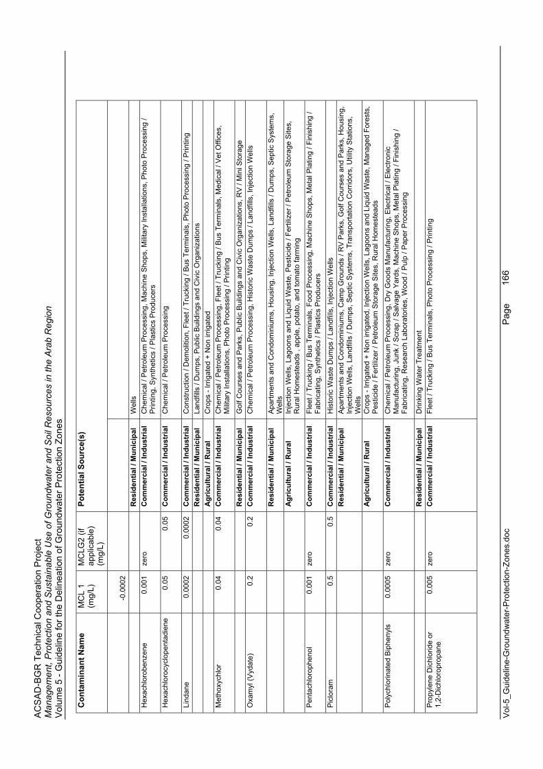
AC
SA
D-B
GR
Tec
hnic
al C
oope
ratio
n P
roje
ct
Man
agem
ent,
Pro
tect
ion
and
Sus
tain
able
Use
of G
roun
dwat
er a
nd S
oil R
esou
rces
in th
e A
rab
Reg
ion
Vol
ume
5 - G
uide
line
for t
he D
elin
eatio
n of
Gro
undw
ater
Pro
tect
ion
Zone
s
Vol
-5_G
uide
line-
Gro
undw
ater
-Pro
tect
ion-
Zone
s.do
c
Page
166
Con
tam
inan
t Nam
e M
CL
1 (m
g/L)
MC
LG2
(if
appl
icab
le)
(mg/
L)
Pote
ntia
l Sou
rce(
s)
-0.0
002
R
esid
entia
l / M
unic
ipal
W
ells
Hex
achl
orob
enze
ne0.
001
zero
C
omm
erci
al /
Indu
stria
l C
hem
ical
/ P
etro
leum
Pro
cess
ing,
Mac
hine
Sho
ps, M
ilita
ry In
stal
latio
ns, P
hoto
Pro
cess
ing
/ P
rintin
g, S
ynth
etic
s / P
last
ics
Pro
duce
rs
Hex
achl
oroc
yclo
pent
adie
ne0.
05
0.05
C
omm
erci
al /
Indu
stria
l C
hem
ical
/ P
etro
leum
Pro
cess
ing
Lind
ane
0.00
02
0.00
02
Com
mer
cial
/ In
dust
rial
Con
stru
ctio
n / D
emol
ition
, Fle
et /
Truc
king
/ B
us T
erm
inal
s, P
hoto
Pro
cess
ing
/ Prin
ting
R
esid
entia
l / M
unic
ipal
La
ndfil
ls /
Dum
ps, P
ublic
Bui
ldin
gs a
nd C
ivic
Org
aniz
atio
ns
A
gric
ultu
ral /
Rur
al
Cro
ps -
Irrig
ated
+ N
on ir
rigat
ed
Met
hoxy
chlo
r0.
04
0.04
C
omm
erci
al /
Indu
stria
l C
hem
ical
/ P
etro
leum
Pro
cess
ing,
Fle
et /
Truc
king
/ B
us T
erm
inal
s, M
edic
al /
Vet
Offi
ces,
M
ilita
ry In
stal
latio
ns, P
hoto
Pro
cess
ing
/ Prin
ting
R
esid
entia
l / M
unic
ipal
G
olf C
ours
es a
nd P
arks
, Pub
lic B
uild
ings
and
Civ
ic O
rgan
izat
ions
, RV
/ M
ini S
tora
ge
Oxa
myl
(Vyd
ate)
0.
2 0.
2 C
omm
erci
al /
Indu
stria
l C
hem
ical
/ P
etro
leum
Pro
cess
ing,
His
toric
Was
te D
umps
/ La
ndfil
ls, I
njec
tion
Wel
ls
R
esid
entia
l / M
unic
ipal
A
partm
ents
and
Con
dom
iniu
ms,
Hou
sing
, Inj
ectio
n W
ells
, Lan
dfill
s / D
umps
, Sep
tic S
yste
ms,
W
ells
A
gric
ultu
ral /
Rur
al
Inje
ctio
n W
ells
, Lag
oons
and
Liq
uid
Was
te, P
estic
ide
/ Fer
tiliz
er /
Pet
role
um S
tora
ge S
ites,
R
ural
Hom
este
ads
, app
le, p
otat
o, a
nd to
mat
o fa
rmin
g
Pen
tach
loro
phen
ol
0.00
1 ze
ro
Com
mer
cial
/ In
dust
rial
Flee
t / T
ruck
ing
/ Bus
Ter
min
als,
Foo
d P
roce
ssin
g, M
achi
ne S
hops
, Met
al P
latin
g / F
inis
hing
/ Fa
bric
atin
g, S
ynth
etic
s / P
last
ics
Pro
duce
rs
Pic
lora
m0.
5 0.
5 C
omm
erci
al /
Indu
stria
l H
isto
ric W
aste
Dum
ps /
Land
fills
, Inj
ectio
n W
ells
Res
iden
tial /
Mun
icip
al
Apa
rtmen
ts a
nd C
ondo
min
ium
s, C
amp
Gro
unds
/ R
V P
arks
, Gol
f Cou
rses
and
Par
ks, H
ousi
ng,
Inje
ctio
n W
ells
, Lan
dfill
s / D
umps
, Sep
tic S
yste
ms,
Tra
nspo
rtatio
n C
orrid
ors,
Util
ity S
tatio
ns,
Wel
ls
Agr
icul
tura
l / R
ural
C
rops
- Irr
igat
ed +
Non
irrig
ated
, Inj
ectio
n W
ells
, Lag
oons
and
Liq
uid
Was
te, M
anag
ed F
ores
ts,
Pes
ticid
e / F
ertil
izer
/ P
etro
leum
Sto
rage
Site
s, R
ural
Hom
este
ads
Pol
ychl
orin
ated
Bip
heny
ls0.
0005
ze
ro
Com
mer
cial
/ In
dust
rial
Che
mic
al /
Pet
role
um P
roce
ssin
g, D
ry G
oods
Man
ufac
turin
g, E
lect
rical
/ E
lect
roni
c M
anuf
actu
ring,
Jun
k / S
crap
/ S
alva
ge Y
ards
, Mac
hine
Sho
ps, M
etal
Pla
ting
/ Fin
ishi
ng /
Fabr
icat
ing,
Res
earc
h La
bora
torie
s, W
ood
/ Pul
p / P
aper
Pro
cess
ing
R
esid
entia
l / M
unic
ipal
D
rinki
ng W
ater
Tre
atm
ent
Pro
pyle
ne D
ichl
orid
e or
1,
2-D
ichl
orop
ropa
ne0.
005
zero
C
omm
erci
al /
Indu
stria
l Fl
eet /
Tru
ckin
g / B
us T
erm
inal
s, P
hoto
Pro
cess
ing
/ Prin
ting
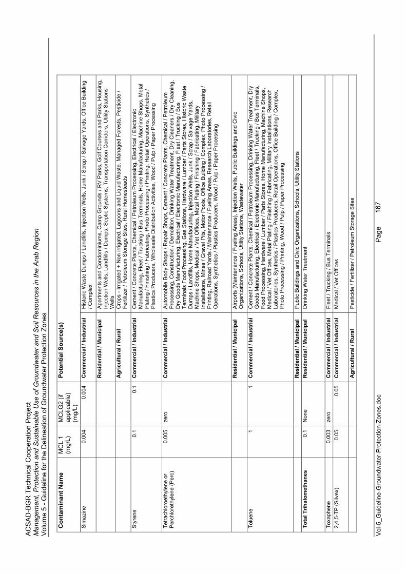
AC
SA
D-B
GR
Tec
hnic
al C
oope
ratio
n P
roje
ct
Man
agem
ent,
Pro
tect
ion
and
Sus
tain
able
Use
of G
roun
dwat
er a
nd S
oil R
esou
rces
in th
e A
rab
Reg
ion
Vol
ume
5 - G
uide
line
for t
he D
elin
eatio
n of
Gro
undw
ater
Pro
tect
ion
Zone
s
Vol
-5_G
uide
line-
Gro
undw
ater
-Pro
tect
ion-
Zone
s.do
c
Page
167
Con
tam
inan
t Nam
e M
CL
1 (m
g/L)
MC
LG2
(if
appl
icab
le)
(mg/
L)
Pote
ntia
l Sou
rce(
s)
Sim
azin
e0.
004
0.00
4 C
omm
erci
al /
Indu
stria
l H
isto
ric W
aste
Dum
ps /
Land
fills
, Inj
ectio
n W
ells
, Jun
k / S
crap
/ S
alva
ge Y
ards
, Offi
ce B
uild
ing
/ Com
plex
R
esid
entia
l / M
unic
ipal
A
partm
ents
and
Con
dom
iniu
ms,
Cam
p G
roun
ds /
RV
Par
ks, G
olf C
ours
es a
nd P
arks
, Hou
sing
, In
ject
ion
Wel
ls, L
andf
ills
/ Dum
ps, S
eptic
Sys
tem
s, T
rans
porta
tion
Cor
ridor
s, U
tility
Sta
tions
W
ells
A
gric
ultu
ral /
Rur
al
Cro
ps -
Irrig
ated
+ N
on ir
rigat
ed, L
agoo
ns a
nd L
iqui
d W
aste
, Man
aged
For
ests
, Pes
ticid
e /
Ferti
lizer
/ P
etro
leum
Sto
rage
Site
s, R
ural
Hom
este
ads
Sty
rene
0.
1 0.
1 C
omm
erci
al /
Indu
stria
l C
emen
t / C
oncr
ete
Pla
nts,
Che
mic
al /
Pet
role
um P
roce
ssin
g, E
lect
rical
/ E
lect
roni
c M
anuf
actu
ring,
Fle
et /
Truc
king
/ B
us T
erm
inal
s, H
ome
Man
ufac
turin
g, M
achi
ne S
hops
, Met
al
Pla
ting
/ Fin
ishi
ng /
Fabr
icat
ing,
Pho
to P
roce
ssin
g / P
rintin
g, R
etai
l Ope
ratio
ns, S
ynth
etic
s /
Pla
stic
s P
rodu
cers
, Who
lesa
le D
istri
butio
n A
ctiv
ities
, Woo
d / P
ulp
/ Pap
er P
roce
ssin
g
Tetra
chlo
roet
hyle
ne o
r P
erch
lore
thyl
ene
(Per
c)0.
005
zero
C
omm
erci
al /
Indu
stria
l A
utom
obile
Bod
y S
hops
/ R
epai
r Sho
ps, C
emen
t / C
oncr
ete
Pla
nts,
Che
mic
al /
Pet
role
um
Pro
cess
ing,
Con
stru
ctio
n / D
emol
ition
, Drin
king
Wat
er T
reat
men
t, D
ry C
lean
ers
/ Dry
Cle
anin
g,
Dry
Goo
ds M
anuf
actu
ring,
Ele
ctric
al /
Ele
ctro
nic
Man
ufac
turin
g, F
leet
/ Tr
ucki
ng /
Bus
Te
rmin
als
Food
Pro
cess
ing,
Gas
Sta
tions
, Har
dwar
e / L
umbe
r / P
arts
Sto
res,
His
toric
Was
te
Dum
ps /
Land
fills
, Hom
e M
anuf
actu
ring,
Inje
ctio
n W
ells
, Jun
k / S
crap
/ S
alva
ge Y
ards
, M
achi
ne S
hops
, Med
ical
/ V
et O
ffice
s, M
etal
Pla
ting
/ Fin
ishi
ng /
Fabr
icat
ing,
Mili
tary
In
stal
latio
ns, M
ines
/ G
rave
l Pits
, Mot
or P
ools
, Offi
ce B
uild
ing
/ Com
plex
, Pho
to P
roce
ssin
g /
Prin
ting,
Rai
lroad
Yar
ds /
Mai
nten
ance
/ Fu
elin
g A
reas
, Res
earc
h La
bora
torie
s, R
etai
l O
pera
tions
, Syn
thet
ics
/ Pla
stic
s P
rodu
cers
, Woo
d / P
ulp
/ Pap
er P
roce
ssin
g
R
esid
entia
l / M
unic
ipal
A
irpor
ts (M
aint
enan
ce /
Fuel
ing
Are
as),
Inje
ctio
n W
ells
, Pub
lic B
uild
ings
and
Civ
ic
Org
aniz
atio
ns, S
choo
ls, U
tility
Sta
tions
, Was
tew
ater
Tolu
ene
1 1
Com
mer
cial
/ In
dust
rial
Cem
ent /
Con
cret
e P
lant
s, C
hem
ical
/ P
etro
leum
Pro
cess
ing,
Drin
king
Wat
er T
reat
men
t, D
ry
Goo
ds M
anuf
actu
ring,
Ele
ctric
al /
Ele
ctro
nic
Man
ufac
turin
g, F
leet
/ Tr
ucki
ng /
Bus
Ter
min
als,
Fo
od P
roce
ssin
g, H
ardw
are
/ Lum
ber /
Par
ts S
tore
s, H
ome
Man
ufac
turin
g, M
achi
ne S
hops
, M
edic
al /
Vet
Offi
ces,
Met
al P
latin
g / F
inis
hing
/ Fa
bric
atin
g, M
ilita
ry In
stal
latio
ns, R
esea
rch
Labo
rato
ries,
Syn
thet
ics
/ Pla
stic
s P
rodu
cers
, Ret
ail O
pera
tions
, Offi
ce B
uild
ing
/ Com
plex
, P
hoto
Pro
cess
ing
/ Prin
ting,
Woo
d / P
ulp
/ Pap
er P
roce
ssin
g
R
esid
entia
l / M
unic
ipal
P
ublic
Bui
ldin
gs a
nd C
ivic
Org
aniz
atio
ns, S
choo
ls, U
tility
Sta
tions
To
tal T
rihal
omet
hane
s 0.
1 N
one
Res
iden
tial /
Mun
icip
al
Drin
king
Wat
er T
reat
men
t
Toxa
phen
e0.
003
zero
C
omm
erci
al /
Indu
stria
l Fl
eet /
Tru
ckin
g / B
us T
erm
inal
s 2,
4,5-
TP (S
ilvex
)0.
05
0.05
C
omm
erci
al /
Indu
stria
l M
edic
al /
Vet
Offi
ces
A
gric
ultu
ral /
Rur
al
Pes
ticid
e / F
ertil
izer
/ P
etro
leum
Sto
rage
Site
s
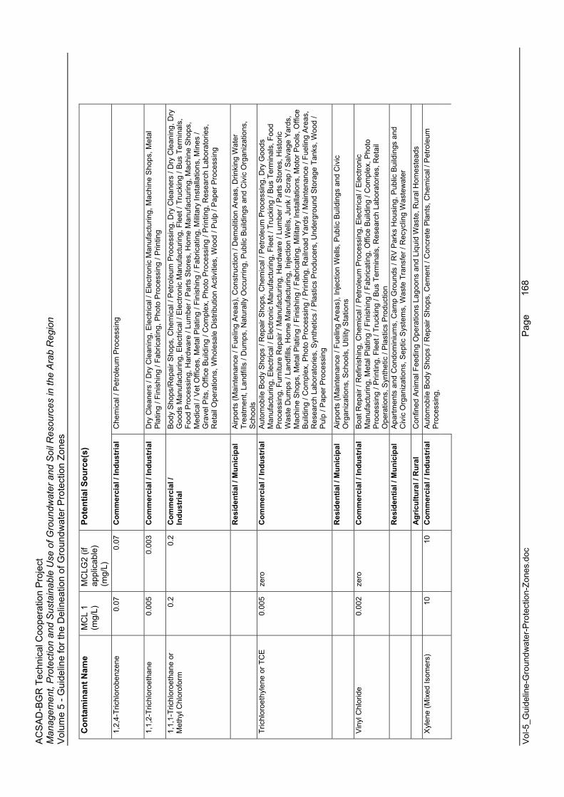
AC
SA
D-B
GR
Tec
hnic
al C
oope
ratio
n P
roje
ct
Man
agem
ent,
Pro
tect
ion
and
Sus
tain
able
Use
of G
roun
dwat
er a
nd S
oil R
esou
rces
in th
e A
rab
Reg
ion
Vol
ume
5 - G
uide
line
for t
he D
elin
eatio
n of
Gro
undw
ater
Pro
tect
ion
Zone
s
Vol
-5_G
uide
line-
Gro
undw
ater
-Pro
tect
ion-
Zone
s.do
c
Page
168
Con
tam
inan
t Nam
e M
CL
1 (m
g/L)
MC
LG2
(if
appl
icab
le)
(mg/
L)
Pote
ntia
l Sou
rce(
s)
1,2,
4-Tr
ichl
orob
enze
ne0.
07
0.07
C
omm
erci
al /
Indu
stria
l C
hem
ical
/ P
etro
leum
Pro
cess
ing
1,1,
2-Tr
ichl
oroe
than
e0.
005
0.00
3 C
omm
erci
al /
Indu
stria
l D
ry C
lean
ers
/ Dry
Cle
anin
g, E
lect
rical
/ E
lect
roni
c M
anuf
actu
ring,
Mac
hine
Sho
ps, M
etal
P
latin
g / F
inis
hing
/ Fa
bric
atin
g, P
hoto
Pro
cess
ing
/ Prin
ting
1,1,
1-Tr
ichl
oroe
than
e or
M
ethy
l Chl
orof
orm
0.2
0.2
Com
mer
cial
/ In
dust
rial
Bod
y S
hops
/Rep
air S
hops
, Che
mic
al /
Pet
role
um P
roce
ssin
g, D
ry C
lean
ers
/ Dry
Cle
anin
g, D
ry
Goo
ds M
anuf
actu
ring,
Ele
ctric
al /
Ele
ctro
nic
Man
ufac
turin
g, F
leet
/ Tr
ucki
ng /
Bus
Ter
min
als,
Fo
od P
roce
ssin
g, H
ardw
are
/ Lum
ber /
Par
ts S
tore
s, H
ome
Man
ufac
turin
g, M
achi
ne S
hops
, M
edic
al /
Vet
Offi
ces,
Met
al P
latin
g / F
inis
hing
/ Fa
bric
atin
g, M
ilita
ry In
stal
latio
ns, M
ines
/ G
rave
l Pits
, Offi
ce B
uild
ing
/ Com
plex
, Pho
to P
roce
ssin
g / P
rintin
g, R
esea
rch
Labo
rato
ries,
R
etai
l Ope
ratio
ns, W
hole
sale
Dis
tribu
tion
Act
iviti
es, W
ood
/ Pul
p / P
aper
Pro
cess
ing
R
esid
entia
l / M
unic
ipal
A
irpor
ts (M
aint
enan
ce /
Fuel
ing
Are
as),
Con
stru
ctio
n / D
emol
ition
Are
as, D
rinki
ng W
ater
Tr
eatm
ent,
Land
fills
/ D
umps
, Nat
ural
ly O
ccur
ring,
Pub
lic B
uild
ings
and
Civ
ic O
rgan
izat
ions
, S
choo
lsTr
ichl
oroe
thyl
ene
or T
CE
0.00
5 ze
ro
Com
mer
cial
/ In
dust
rial
Aut
omob
ile B
ody
Sho
ps /
Rep
air S
hops
, Che
mic
al /
Pet
role
um P
roce
ssin
g, D
ry G
oods
M
anuf
actu
ring,
Ele
ctric
al /
Ele
ctro
nic
Man
ufac
turin
g, F
leet
/ Tr
ucki
ng /
Bus
Ter
min
als,
Foo
d P
roce
ssin
g, F
urni
ture
Rep
air /
Man
ufac
turin
g, H
ardw
are
/ Lum
ber /
Par
ts S
tore
s, H
isto
ric
Was
te D
umps
/ La
ndfil
ls, H
ome
Man
ufac
turin
g, In
ject
ion
Wel
ls, J
unk
/ Scr
ap /
Sal
vage
Yar
ds,
Mac
hine
Sho
ps, M
etal
Pla
ting
/ Fin
ishi
ng /
Fabr
icat
ing,
Mili
tary
Inst
alla
tions
, Mot
or P
ools
, Offi
ce
Bui
ldin
g / C
ompl
ex, P
hoto
Pro
cess
ing
/ Prin
ting,
Rai
lroad
Yar
ds /
Mai
nten
ance
/ Fu
elin
g A
reas
, R
esea
rch
Labo
rato
ries,
Syn
thet
ics
/ Pla
stic
s P
rodu
cers
, Und
ergr
ound
Sto
rage
Tan
ks, W
ood
/ P
ulp
/ Pap
er P
roce
ssin
g
R
esid
entia
l / M
unic
ipal
A
irpor
ts (M
aint
enan
ce /
Fuel
ing
Are
as),
Inje
ctio
n W
ells
, Pub
lic B
uild
ings
and
Civ
ic
Org
aniz
atio
ns, S
choo
ls, U
tility
Sta
tions
Vin
yl C
hlor
ide
0.00
2 ze
ro
Com
mer
cial
/ In
dust
rial
Boa
t Rep
air /
Ref
inis
hing
, Che
mic
al /
Pet
role
um P
roce
ssin
g, E
lect
rical
/ E
lect
roni
c M
anuf
actu
ring,
Met
al P
latin
g / F
inis
hing
/ Fa
bric
atin
g, O
ffice
Bui
ldin
g / C
ompl
ex, P
hoto
P
roce
ssin
g / P
rintin
g, F
leet
/ Tr
ucki
ng /
Bus
Ter
min
als,
Res
earc
h La
bora
torie
s, R
etai
l O
pera
tions
, Syn
thet
ic /
Pla
stic
s P
rodu
ctio
n
Res
iden
tial /
Mun
icip
al
Apa
rtmen
ts a
nd C
ondo
min
ium
s, C
amp
Gro
unds
/ R
V P
arks
Hou
sing
, Pub
lic B
uild
ings
and
C
ivic
Org
aniz
atio
ns, S
eptic
Sys
tem
s, W
aste
Tra
nsfe
r / R
ecyc
ling
Was
tew
ater
A
gric
ultu
ral /
Rur
al
Con
fined
Ani
mal
Fee
ding
Ope
ratio
ns L
agoo
ns a
nd L
iqui
d W
aste
, Rur
al H
omes
tead
s A
utom
obile
Bod
y S
hops
/ R
epai
r Sho
ps, C
emen
t / C
oncr
ete
Pla
nts,
Che
mic
al /
Pet
role
um
Pro
cess
ing,
Xyl
ene
(Mix
ed Is
omer
s)10
10
C
omm
erci
al /
Indu
stria
l
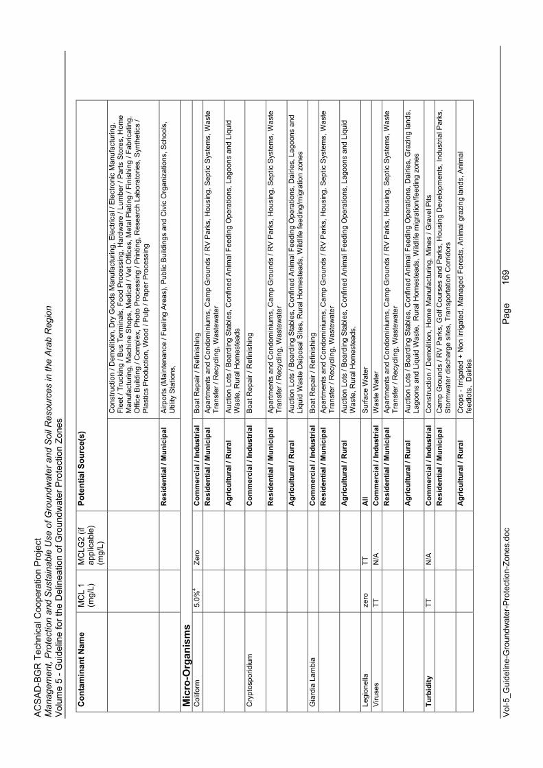
AC
SA
D-B
GR
Tec
hnic
al C
oope
ratio
n P
roje
ct
Man
agem
ent,
Pro
tect
ion
and
Sus
tain
able
Use
of G
roun
dwat
er a
nd S
oil R
esou
rces
in th
e A
rab
Reg
ion
Vol
ume
5 - G
uide
line
for t
he D
elin
eatio
n of
Gro
undw
ater
Pro
tect
ion
Zone
s
Vol
-5_G
uide
line-
Gro
undw
ater
-Pro
tect
ion-
Zone
s.do
c
Page
169
Con
tam
inan
t Nam
e M
CL
1 (m
g/L)
MC
LG2
(if
appl
icab
le)
(mg/
L)
Pote
ntia
l Sou
rce(
s)
Con
stru
ctio
n / D
emol
ition
, Dry
Goo
ds M
anuf
actu
ring,
Ele
ctric
al /
Ele
ctro
nic
Man
ufac
turin
g,
Flee
t / T
ruck
ing
/ Bus
Ter
min
als,
Foo
d P
roce
ssin
g, H
ardw
are
/ Lum
ber /
Par
ts S
tore
s, H
ome
Man
ufac
turin
g, M
achi
ne S
hops
, Med
ical
/ V
et O
ffice
s, M
etal
Pla
ting
/ Fin
ishi
ng /
Fabr
icat
ing,
O
ffice
Bui
ldin
g / C
ompl
ex, P
hoto
Pro
cess
ing
/ Prin
ting,
Res
earc
h La
bora
torie
s, S
ynth
etic
s /
Pla
stic
s P
rodu
ctio
n, W
ood
/ Pul
p / P
aper
Pro
cess
ing
R
esid
entia
l / M
unic
ipal
A
irpor
ts (M
aint
enan
ce /
Fuel
ing
Are
as),
Pub
lic B
uild
ings
and
Civ
ic O
rgan
izat
ions
, Sch
ools
, U
tility
Sta
tions
,
Mic
ro-O
rgan
ism
s C
olifo
rm5.
0%4
Zero
C
omm
erci
al /
Indu
stria
l B
oat R
epai
r / R
efin
ishi
ng
R
esid
entia
l / M
unic
ipal
A
partm
ents
and
Con
dom
iniu
ms,
Cam
p G
roun
ds /
RV
Par
ks, H
ousi
ng, S
eptic
Sys
tem
s, W
aste
Tr
ansf
er /
Rec
yclin
g, W
aste
wat
er
A
gric
ultu
ral /
Rur
al
Auc
tion
Lots
/ B
oard
ing
Sta
bles
, Con
fined
Ani
mal
Fee
ding
Ope
ratio
ns, L
agoo
ns a
nd L
iqui
d W
aste
, Rur
al H
omes
tead
s
Cry
ptos
porid
ium
C
omm
erci
al /
Indu
stria
l B
oat R
epai
r / R
efin
ishi
ng
R
esid
entia
l / M
unic
ipal
A
partm
ents
and
Con
dom
iniu
ms,
Cam
p G
roun
ds /
RV
Par
ks, H
ousi
ng, S
eptic
Sys
tem
s, W
aste
Tr
ansf
er /
Rec
yclin
g, W
aste
wat
er
A
gric
ultu
ral /
Rur
al
Auc
tion
Lots
/ B
oard
ing
Sta
bles
, Con
fined
Ani
mal
Fee
ding
Ope
ratio
ns, D
airie
s, L
agoo
ns a
nd
Liqu
id W
aste
Dsi
posa
l Site
s, R
ural
Hom
este
ads,
Wild
life
feed
ing/
mig
ratio
n zo
nes
Gia
rdia
Lam
bia
Com
mer
cial
/ In
dust
rial
Boa
t Rep
air /
Ref
inis
hing
Res
iden
tial /
Mun
icip
al
Apa
rtmen
ts a
nd C
ondo
min
ium
s, C
amp
Gro
unds
/ R
V P
arks
, Hou
sing
, Sep
tic S
yste
ms,
Was
te
Tran
sfer
/ R
ecyc
ling,
Was
tew
ater
A
gric
ultu
ral /
Rur
al
Auc
tion
Lots
/ B
oard
ing
Sta
bles
, Con
fined
Ani
mal
Fee
ding
Ope
ratio
ns, L
agoo
ns a
nd L
iqui
d W
aste
, Rur
al H
omes
tead
s,
Legi
onel
laze
ro
TT
All
Sur
face
Wat
er
Viru
ses
TT
N/A
C
omm
erci
al /
Indu
stria
l W
aste
Wat
er
R
esid
entia
l / M
unic
ipal
A
partm
ents
and
Con
dom
iniu
ms,
Cam
p G
roun
ds /
RV
Par
ks, H
ousi
ng, S
eptic
Sys
tem
s, W
aste
Tr
ansf
er /
Rec
yclin
g, W
aste
wat
er
A
gric
ultu
ral /
Rur
al
Auc
tion
Lots
/ B
oard
ing
Sta
bles
, Con
fined
Ani
mal
Fee
ding
Ope
ratio
ns, D
airie
s, G
razi
ng la
nds,
La
goon
s an
d Li
quid
Was
te,
Rur
al H
omes
tead
s, W
ildlif
e m
igra
tion/
feed
ing
zone
s
Turb
idity
TT
N
/A
Com
mer
cial
/ In
dust
rial
Con
stru
ctio
n / D
emol
ition
, Hom
e M
anuf
actu
ring,
Min
es /
Gra
vel P
its
Res
iden
tial /
Mun
icip
al
Cam
p G
roun
ds /
RV
Par
ks, G
olf C
ours
es a
nd P
arks
, Hou
sing
Dev
elop
men
ts, I
ndus
trial
Par
ks,
Sto
rmw
ater
dis
char
ge s
ites,
Tra
nspo
rtatio
n C
orrid
ors
A
gric
ultu
ral /
Rur
al
Cro
ps -
Irrig
ated
+ N
on ir
rigat
ed, M
anag
ed F
ores
ts, A
nim
al g
razi
ng la
nds,
Ani
mal
fe
edlo
ts,
Dai
ries
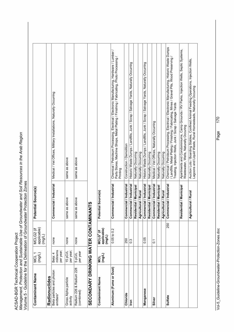
AC
SA
D-B
GR
Tec
hnic
al C
oope
ratio
n P
roje
ct
Man
agem
ent,
Pro
tect
ion
and
Sus
tain
able
Use
of G
roun
dwat
er a
nd S
oil R
esou
rces
in th
e A
rab
Reg
ion
Vol
ume
5 - G
uide
line
for t
he D
elin
eatio
n of
Gro
undw
ater
Pro
tect
ion
Zone
s
Vol
-5_G
uide
line-
Gro
undw
ater
-Pro
tect
ion-
Zone
s.do
c
Page
170
Con
tam
inan
t Nam
e M
CL
1 (m
g/L)
MC
LG2
(if
appl
icab
le)
(mg/
L)
Pote
ntia
l Sou
rce(
s)
Rad
ionu
clid
esB
eta
parti
cles
and
pho
ton
emitt
ers*
Bet
a: 4
m
illire
ms
per y
ear;
none
Com
mer
cial
/ In
dust
rial
Med
ical
/ V
et O
ffice
s, M
ilita
ry In
stal
latio
ns, N
atur
ally
Occ
urrin
g
Gro
ss A
lpha
par
ticle
ac
tivity
15 p
Ci/L
pe
r yea
r;
none
sa
me
as a
bove
sa
me
as a
bove
Rad
ium
226
& R
adiu
m 2
28
(com
bine
d)5
pCi/L
pe
r yea
r no
ne
sam
e as
abo
ve
sam
e as
abo
ve
SEC
ON
DA
RY
DR
INK
ING
WA
TER
CO
NTA
MIN
AN
TS
Con
tam
inan
t Nam
e M
CL
(mg/
L)
MC
LG2 (i
f ap
plic
able
)(m
g/L)
Pote
ntia
l Sou
rce(
s)
Alu
min
um (F
ume
or D
ust)
0
.05
to 0
.2
Com
mer
cial
/ In
dust
rial
Che
mic
al /
Pet
role
um P
roce
ssin
g, E
lect
rical
/ E
lect
roni
c M
anuf
actu
ring,
Har
dwar
e / L
umbe
r /
Par
ts S
tore
s, M
achi
ne S
hops
, Met
al P
latin
g / F
inis
hing
/ Fa
bric
atin
g, P
hoto
Pro
cess
ing
/ P
rintin
g
Chl
orid
e
250
C
omm
erci
al /
Indu
stria
l C
onst
ruct
ion
/ Dem
oliti
on
Iron
0
.3
Com
mer
cial
/ In
dust
rial
His
toric
Was
te D
umps
/ La
ndfil
ls, J
unk
/ Scr
ap /
Sal
vage
Yar
ds, N
atur
ally
Occ
urrin
g
Res
iden
tial /
Mun
icip
al
Nat
ural
ly O
ccur
ring
A
gric
ultu
ral /
Rur
al
Nat
ural
ly O
ccur
ring
Man
gane
se
0
.05
Com
mer
cial
/ In
dust
rial
His
toric
Was
te D
umps
/ La
ndfil
ls, J
unk
/ Scr
ap /
Sal
vage
Yar
ds, N
atur
ally
Occ
urrin
g
Res
iden
tial /
Mun
icip
al
Nat
ural
ly O
ccur
ring
Silv
er
0
.1
Com
mer
cial
/ In
dust
rial
Med
ical
/ V
et O
ffice
s, N
atur
ally
Occ
urrin
g
Res
iden
tial /
Mun
icip
al
Nat
ural
ly O
ccur
ring
A
gric
ultu
ral /
Rur
al
Nat
ural
ly O
ccur
ring
Sulfa
te
25
0 C
omm
erci
al /
Indu
stria
l C
hem
ical
/ P
etro
leum
Pro
cess
ing,
Ele
ctric
al /
Ele
ctro
nic
Man
ufac
turin
g, H
isto
ric W
aste
Dum
ps
/ Lan
dfill
s, M
etal
Pla
ting
/ Fin
ishi
ng /
Fabr
icat
ing,
Min
es /
Gra
vel P
its, W
ood
Pre
serv
ing
/ Tr
eatin
g, In
ject
ion
Wel
ls, J
unk
/ Scr
ap /
Sal
vage
Yar
ds
R
esid
entia
l / M
unic
ipal
A
partm
ents
and
Con
dom
iniu
ms,
Cam
p G
roun
ds /
RV
Par
ks, I
njec
tion
Wel
ls, S
eptic
Sys
tem
s,
Was
tew
ater
, Wel
ls, N
atur
ally
Occ
urin
g
A
gric
ultu
ral /
Rur
al
Auc
tion
Lots
/ B
oard
ing
Sta
bles
, Con
fined
Ani
mal
Fee
ding
Ope
ratio
ns, I
njec
tion
Wel
ls,
Lago
ons
and
Liqu
id W
aste
, Rur
al H
omes
tead
s, N
atur
ally
Occ
urin
g
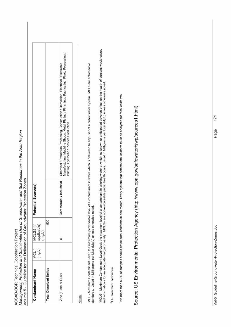
AC
SA
D-B
GR
Tec
hnic
al C
oope
ratio
n P
roje
ct
Man
agem
ent,
Pro
tect
ion
and
Sus
tain
able
Use
of G
roun
dwat
er a
nd S
oil R
esou
rces
in th
e A
rab
Reg
ion
Vol
ume
5 - G
uide
line
for t
he D
elin
eatio
n of
Gro
undw
ater
Pro
tect
ion
Zone
s
Vol
-5_G
uide
line-
Gro
undw
ater
-Pro
tect
ion-
Zone
s.do
c
Page
171
Con
tam
inan
t Nam
e M
CL
1 (m
g/L)
MC
LG2
(if
appl
icab
le)
(mg/
L)
Pote
ntia
l Sou
rce(
s)
Tota
l Dis
solv
ed S
olid
s
500
Zinc
(Fum
e or
Dus
t)
5
C
omm
erci
al /
Indu
stria
l C
hem
ical
/ P
etro
leum
Pro
cess
ing,
Con
stru
ctio
n / D
emol
ition
, Ele
ctric
al /
Ele
ctro
nic
Man
ufac
turin
g, M
achi
ne S
hops
, Met
al P
latin
g / F
inis
hing
/ Fa
bric
atin
g, P
hoto
Pro
cess
ing
/ P
rintin
g, S
ynth
etic
/ P
last
ics
Pro
duct
ion
Not
es:
1 MC
L - M
axim
um C
onta
min
ant L
evel
; the
max
imum
per
mis
sabl
e le
vel o
f a c
onta
min
ant i
n w
ater
whi
ch is
del
iver
ed to
any
use
r of a
pub
lic w
ater
sys
tem
. M
CLs
are
enf
orce
able
st
anda
rds.
Lis
ted
in M
illig
ram
s pe
r Lite
r (M
g/L)
unl
ess
othe
rwis
e no
ted.
2 MC
LG -
Max
imum
Con
tam
inan
t Lev
el G
oal;
the
max
imum
leve
l of a
con
tam
inan
t in
drin
king
wat
er a
t whi
ch n
o kn
own
or a
ntic
ipat
ed a
dver
se e
ffect
on
the
heal
th o
f per
sons
wou
ld o
ccur
, an
d w
hich
allo
ws
for a
n ad
equa
te m
argi
n of
saf
ety.
MC
LGs
are
non-
enfo
rcea
ble
publ
ic h
ealth
goa
ls.
List
ed in
Mill
igra
ms
per L
iter (
Mg/
L) u
nles
s ot
herw
ise
note
d.
3 TT- T
reat
men
t Tec
hniq
ue
4 No
mor
e th
an 5
.0%
of s
ampl
es s
houl
d de
tect
tota
l col
iform
s in
one
mon
th. E
very
sys
tem
that
det
ects
tota
l col
iform
mus
t be
anal
yzed
for f
ecal
col
iform
s.
Sou
rce:
US
Env
ironm
enta
l Pro
tect
ion
Age
ncy
(http
://w
ww
.epa
.gov
/saf
ewat
er/s
wp/
sour
ces1
.htm
l)
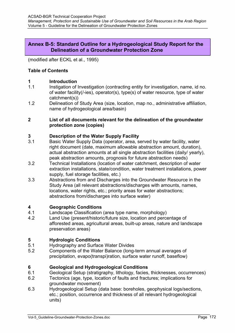
ACSAD-BGR Technical Cooperation Project Management, Protection and Sustainable Use of Groundwater and Soil Resources in the Arab Region Volume 5 - Guideline for the Delineation of Groundwater Protection Zones
Vol-5_Guideline-Groundwater-Protection-Zones.doc Page 172
Annex B-5: Standard Outline for a Hydrogeological Study Report for the Delineation of a Groundwater Protection Zone
(modified after ECKL et al., 1995)
Table of Contents
1 Introduction 1.1 Instigation of Investigation (contracting entity for investigation, name, id no.
of water facility(/-ies), operator(s), type(s) of water resource, type of water catchment(s))
1.2 Delineation of Study Area (size, location, map no., administrative affiliation, name of hydrogeological area/basin)
2 List of all documents relevant for the delineation of the groundwater protection zone (copies)
3 Description of the Water Supply Facility 3.1 Basic Water Supply Data (operator, area, served by water facility, water
right document (date, maximum allowable abstraction amount, duration), actual abstraction amounts at all single abstraction facilities (daily/ yearly), peak abstraction amounts, prognosis for future abstraction needs)
3.2 Technical Installations (location of water catchment, description of water extraction installations, state/condition, water treatment installations, power supply, fuel storage facilities, etc.)
3.3 Abstractions from and Discharges into the Groundwater Resource in the Study Area (all relevant abstractions/discharges with amounts, names, locations, water rights, etc.; priority areas for water abstractions; abstractions from/discharges into surface water)
4 Geographic Conditions 4.1 Landscape Classification (area type name, morphology) 4.2 Land Use (present/historic/future size, location and percentage of
afforested areas, agricultural areas, built-up areas, nature and landscape preservation areas)
5 Hydrologic Conditions 5.1 Hydrography and Surface Water Divides 5.2 Components of the Water Balance (long-term annual averages of
precipitation, evapo(transpi)ration, surface water runoff, baseflow)
6 Geological and Hydrogeological Conditions 6.1 Geological Setup (stratigraphy, lithology, facies, thicknesses, occurrences) 6.2 Tectonics (age, type, location of faults and fractures; implications for
groundwater movement) 6.3 Hydrogeological Setup (data base: boreholes, geophysical logs/sections,
etc.; position, occurrence and thickness of all relevant hydrogeological units)
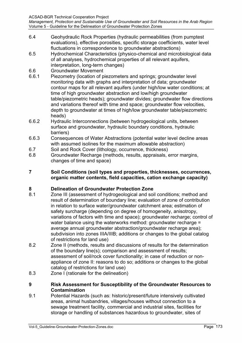
ACSAD-BGR Technical Cooperation Project Management, Protection and Sustainable Use of Groundwater and Soil Resources in the Arab Region Volume 5 - Guideline for the Delineation of Groundwater Protection Zones
Vol-5_Guideline-Groundwater-Protection-Zones.doc Page 173
6.4 Geohydraulic Rock Properties (hydraulic permeabilities (from pumptest evaluations), effective porosities, specific storage coefficients, water level fluctuations in correspondence to groundwater abstractions)
6.5 Hydrochemical Characteristics (physico-chemical and microbiological data of all analyses, hydrochemical properties of all relevant aquifers, interpretation, long-term changes)
6.6 Groundwater Movement 6.6.1 Piezometry (location of piezometers and springs; groundwater level
monitoring data with graphs and interpretation of data; groundwater contour maps for all relevant aquifers (under high/low water conditions; at time of high groundwater abstraction and low/high groundwater table/piezometric heads); groundwater divides; groundwater flow directions and variations thereof with time and space; groundwater flow velocities, depth to groundwater at times of high/low groundwater table/piezometricheads)
6.6.2 Hydraulic Interconnections (between hydrogeological units, between surface and groundwater, hydraulic boundary conditions, hydraulic barriers)
6.6.3 Consequences of Water Abstractions (potential water level decline areas with assumed isolines for the maximum allowable abstraction)
6.7 Soil and Rock Cover (lithology, occurrence, thickness)6.8 Groundwater Recharge (methods, results, appraisals, error margins,
changes of time and space)
7 Soil Conditions (soil types and properties, thicknesses, occurrences, organic matter contents, field capacities, cation exchange capacity)
8 Delineation of Groundwater Protection Zone 8.1 Zone III (assessment of hydrogeological and soil conditions; method and
result of determination of boundary line; evaluation of zone of contribution in relation to surface water/groundwater catchment area; estimation of safety surcharge (depending on degree of homogeneity, anisotropy, variations of factors with time and space); groundwater recharge; control of water balance using the waterworks method: groundwater recharge = average annual groundwater abstraction/groundwater recharge area); subdivision into zones IIIA/IIIB; additions or changes to the global catalog of restrictions for land use)
8.2 Zone II (methods, results and discussions of results for the determination of the boundary line(s); comparison and assessment of results; assessment of soil/rock cover functionality; in case of reduction or non-appliance of zone II: reasons to do so; additions or changes to the global catalog of restrictions for land use)
8.3 Zone I (rationale for the delineation)
9 Risk Assessment for Susceptibility of the Groundwater Resources to Contamination
9.1 Potential Hazards (such as: historic/present/future intensively cultivated areas, animal husbandries, villages/houses without connection to a sewage treatment facility, commercial and industrial sites, facilities for storage or handling of substances hazardous to groundwater, sites of

ACSAD-BGR Technical Cooperation Project Management, Protection and Sustainable Use of Groundwater and Soil Resources in the Arab Region Volume 5 - Guideline for the Delineation of Groundwater Protection Zones
Vol-5_Guideline-Groundwater-Protection-Zones.doc Page 174
mineral resource extraction, infrastructure, surface water bodies, waste disposals, sewage water collection/treatment facilities, contaminated sites, military installations, cemeteries, other areas with potential hazards to groundwater)
9.2 Risk Assessment for Identified Hazards (protective effectiveness of soil and rock cover = assessment of groundwater vulnerability)
10 Proposal for Additional Investigations
11 References
12 Annexes (for instance all relevant data)

ACSAD-BGR Technical Cooperation Project Management, Protection and Sustainable Use of Groundwater and Soil Resources in the Arab Region Volume 5 - Guideline for the Delineation of Groundwater Protection Zones
Vol-5_Guideline-Groundwater-Protection-Zones.doc Page 175
Part C Examples for Groundwater Protection Zone Delineation in Selected ACSAD Member Countries
A questionnaire (Annex C-1) was sent to competent and reliable persons in selected ACSAD member countries in order to document the present situation and the Government’s policy on the issue of groundwater protection. This documentation is by no means complete and only reflects the knowledge and opinion of the respective authors. Wherever possible and necessary, additions to the author’s texts were made. For many countries in the Arab region it is difficult to obtain sufficient and reliable information on laws, regulations, Government policy and the practice.
ACSAD-BGR Technical Cooperation Project Management, Protection and Sustainable Use of Groundwater and Soil Resources in the Arab Region Volume 5 - Guideline for the Delineation of Groundwater Protection Zones
Vol-5_Guideline-Groundwater-Protection-Zones.doc Page 176
1 General Aspects
In many countries of the Arab region water resources are very scarce, even though they are distributed fairly uneven. In some countries of the Maghreb region rainfall is relatively high in the northern part so that surface water resources are sufficient through the rainy season. However, it is difficult to store adequate amounts throughout the year. Also the climate is extremely variable so that these areas are often threatened both by flooding and droughts.
Syria and Iraq depend to a large extent on the transboundary water resources of the Euphrates and Tigris Rivers. Transboundary groundwater forms also the source for many countries depending on groundwater, such as most countries of the Maghreb, which receive inflows from the Saharan aquifer systems.

AC
SA
D-B
GR
Tec
hnic
al C
oope
ratio
n P
roje
ct
Man
agem
ent,
Pro
tect
ion
and
Sus
tain
able
Use
of G
roun
dwat
er a
nd S
oil R
esou
rces
in th
e A
rab
Reg
ion
Vol
ume
5 - G
uide
line
for t
he D
elin
eatio
n of
Gro
undw
ater
Pro
tect
ion
Zone
s
Vol
-5_G
uide
line-
Gro
undw
ater
-Pro
tect
ion-
Zone
s.do
c
Pag
e
17
7
Tabl
e C
-1: W
ater
Res
ourc
es A
vaila
bilit
y, C
onsu
mpt
ion
and
Sus
tain
abilit
y in
the
Ara
b R
egio
n
Cou
ntry
Ren
ewab
le
Wat
er
Res
ourc
es: G
roun
d-w
ater
(k
m³/y
r)
Ren
ewab
le
Wat
er
Res
ourc
es: S
urfa
ce
Wat
er
(km
³/yr)
Tota
l R
enew
able
W
ater
R
esou
rces
(k
m³/y
r)
Land
Are
a (k
m²)
Popu
latio
n in
200
0 (1
000)
Wat
er
Res
ourc
es
Ava
ilabi
lity
per C
apita
in
199
7 (m
³/ca/
yr)
Gro
und-
wat
er U
se
(km
³/yr)
Des
alin
a-tio
n(k
m³/y
r)
Was
te-
wat
er &
D
rain
age
reus
e(k
m³/y
r)
Wat
er
Con
sum
p-tio
n(k
m³/y
r)
Sust
aina
-bi
lity
Inde
x/U
tiliz
atio
n
(%)
Wat
er
Res
ourc
es
Con
sum
p-tio
n pe
r C
apita
(m
³/ca/
yr)
Alg
eria
13.0
0 2.
00
15.0
0 2,
381,
740
32,3
6246
4 7.
18
0.07
46
0.4
7.65
51
236
Bah
rain
0.
10
0.00
02
0.10
02
690
613
173
0.25
8 0.
2861
0.01
75
0.31
30
950
6D
jibou
ti0.
20
0.05
0.
25
23,1
8099
125
2 0.
52
0.00
015
0.
52
207
522
Egy
pt
4.10
55
.50
59.6
0 99
5,45
0 68
,523
92
5 4.
85
0.00
66
4.92
65
.76
102
960
Erit
rea
6.30
10
1,00
0 3,
659
1722
Iraq
2.00
70
.37
72.3
7 43
7,37
0 23
,280
29
63
0.51
3 0.
0074
1.
5 49
.1
7821
09Jo
rdan
0.
277
0.47
5 0.
752
88,9
30
5,00
3 16
8 0.
486
0.00
25
0.06
1 0.
76
121
152
Kuw
ait
0.16
0.
0001
0.
1601
17
,820
2,
165
89
0.40
5 0.
6031
0.02
51 0.
701
439
324
Leba
non
0.60
2.
50
3.10
10
,230
3,
281
995
0.24
0.
0017
0.
002
1.22
5 40
373
Liby
a 0.
40
0.65
1.
047
1,75
9,54
06,
562
160
7.18
0.
21
0.11
7.
50
716
1142
Mau
ritan
ia5.
80
1.50
7.
30
1,02
5,22
02,
327
3137
1.
03
0.00
17
0.06
76
1.10
15
471
Mor
occo
22
.50
7.50
30
.00
446,
300
28,7
8110
42
12.8
5 0.
0012
0.
35
13.2
0 44
459
Om
an
0.55
0.
918
1.46
8 21
2,46
0 2,
518
613
1.64
4 0.
051
>0.0
41 1.
721
117
683
Qat
ar
0.08
5 0.
0014
0.
0864
11
,000
57
9 98
0.
185
0.30
01 >0
.041
0.29
8 34
551
5S
audi
Ara
bia
3.85
2.
23
6.08
2,
149,
690
21,9
30
311
14.4
3 1.
9831
0.13
1 16
.3
268
743
Som
alia
3.30
8.
16
11.4
6 62
7,34
010
,916
1050
1.
95
0.00
01
1.
95
1717
8S
udan
1.00
26
.00
27.0
0 2,
376,
000
33,0
6481
7 22
.95
0.00
06
22
.95
8569
4S
yria
5.
10
16.3
75
21.4
75
183,
780
16,1
25
1438
3.
5 0.
002
1.44
7 9.
81
4660
8Tu
nisi
a2.
70
1.94
4.
64
155,
360
9,48
048
9 2.
91
0.00
87
0.00
6 2.
92
6330
8U
AE
0.
13
0.18
5 0.
315
83,6
00
2,44
1 13
7 0.
9 1.
8741
0.10
8 1.
223
388
501
Wes
t Ban
k &
Gaz
a 0.
185
0.03
0.
215
5,80
0 2,
859
262
0.2
0.00
05
0.00
2 0.
44
205
154
Yem
en
1.40
2.
25
3.65
52
7,97
0 18
,654
30
3 2.
2 0.
009
0.05
2 2.
9 77
915
5
sour
ce: A
SC
AD
(199
7); E
SCW
A (1
999)
; KH
OU
RI (
2000
);1 A
LSH
AR
HAN
et a
l. (2
001)

AC
SA
D-B
GR
Tec
hnic
al C
oope
ratio
n P
roje
ct
Man
agem
ent,
Pro
tect
ion
and
Sus
tain
able
Use
of G
roun
dwat
er a
nd S
oil R
esou
rces
in th
e A
rab
Reg
ion
Vol
ume
5 - G
uide
line
for t
he D
elin
eatio
n of
Gro
undw
ater
Pro
tect
ion
Zone
s
Vol
-5_G
uide
line-
Gro
undw
ater
-Pro
tect
ion-
Zone
s.do
c
Pag
e
17
8
Tabl
e C
-2: W
ater
Res
ourc
es A
vaila
bilit
y in
the
Ara
b R
egio
n
Cou
ntry
Tota
l Int
erna
l R
enew
able
W
ater
R
esou
rces
(k
m³/y
r)
Gro
undw
ater
: P
rodu
ced
Inte
rnal
ly
(km
³/yr)
Sur
face
Wat
er:
Pro
duce
dIn
tern
ally
(k
m³/y
r)
Ove
rlap:
Sur
face
–
Gro
undw
ater
(k
m³/y
r)
Tota
l R
enew
able
W
ater
R
esou
rces
(k
m³/y
r)
Land
Are
a (k
m²)
Pop
ulat
ion
in
2000
(100
0)
Wat
er
Res
ourc
es
Ava
ilabi
lity
per C
apita
(m
³/ca/
yr)
Alg
eria
13
.90
1.70
13
.20
1.00
14
.49
2,38
1,74
0 30
,291
47
8B
ahra
in
0.00
4 0.
00
0.00
4 0.
00
0.12
69
0 64
0 18
1D
jibou
ti 0.
30
0.02
0.
30
0.02
0.
30
23,1
80
632
475
Egy
pt
1.80
1.
30
0.50
0.
00
58.3
0 99
5,45
0 67
,884
85
9E
ritre
a 2.
80
101,
000
3,65
9 1,
722
Iran
128.
50
49.3
0 97
.30
18.1
0 13
7.51
1,
622,
000
70,3
30
1,95
5Ira
q 35
.20
1.20
34
.00
0.00
75
.42
437,
370
22,9
46
3,28
7Jo
rdan
0.
68
0.50
0.
40
0.22
0.
88
88,9
30
4,91
3 17
9K
uwai
t 0.
00
0.00
0.
00
0.00
0.
02
17,8
20
1,91
4 10
Leba
non
4.80
3.
20
4.10
2.
50
4.41
10
,230
3,
496
1,26
1Li
bya
0.60
0.
50
0.20
0.
10
0.60
1,
759,
540
5,29
0 11
3M
aurit
ania
0.
40
0.30
0.
10
0.00
11
.40
1,02
5,22
0 2,
665
4,27
8M
oroc
co
29.0
0 10
.00
22.0
0 3.
00
29.0
0 44
6,30
0 29
,878
97
1O
man
0.
99
0.96
0.
93
0.90
0.
99
212,
460
2,53
8 38
8Q
atar
0.
05
0.05
0.
001
0.00
0.
05
11,0
00
565
94S
audi
Ara
bia
2.40
2.
20
2.20
2.
00
2.40
2,
149,
690
20,3
46
118
Som
alia
6.
00
3.30
5.
70
3.00
13
.50
627,
340
8,77
8 1,
538
Sud
an
30.0
0 7.
00
28.0
0 5.
00
64.5
0 2,
376,
000
31,0
95
2,07
4S
yria
7.
00
4.20
4.
80
2.00
26
.26
183,
780
16,1
89
1,62
2Tu
nisi
a 4.
15
1.45
3.
10
0.40
4.
56
155,
360
9,45
9 48
2U
AE
0.
15
0.12
0.
15
0.12
0.
15
83,6
00
2,60
6 58
Wes
t Ban
k &
G
aza
0.75
0.
68
0.07
0.
00
0.75
5,
800
2,85
9 -
Yem
en
4.10
1.
50
4.00
1.
40
4.10
52
7,97
0 18
,349
22
3
so
urce
: UN
ES
CO
(200
3)
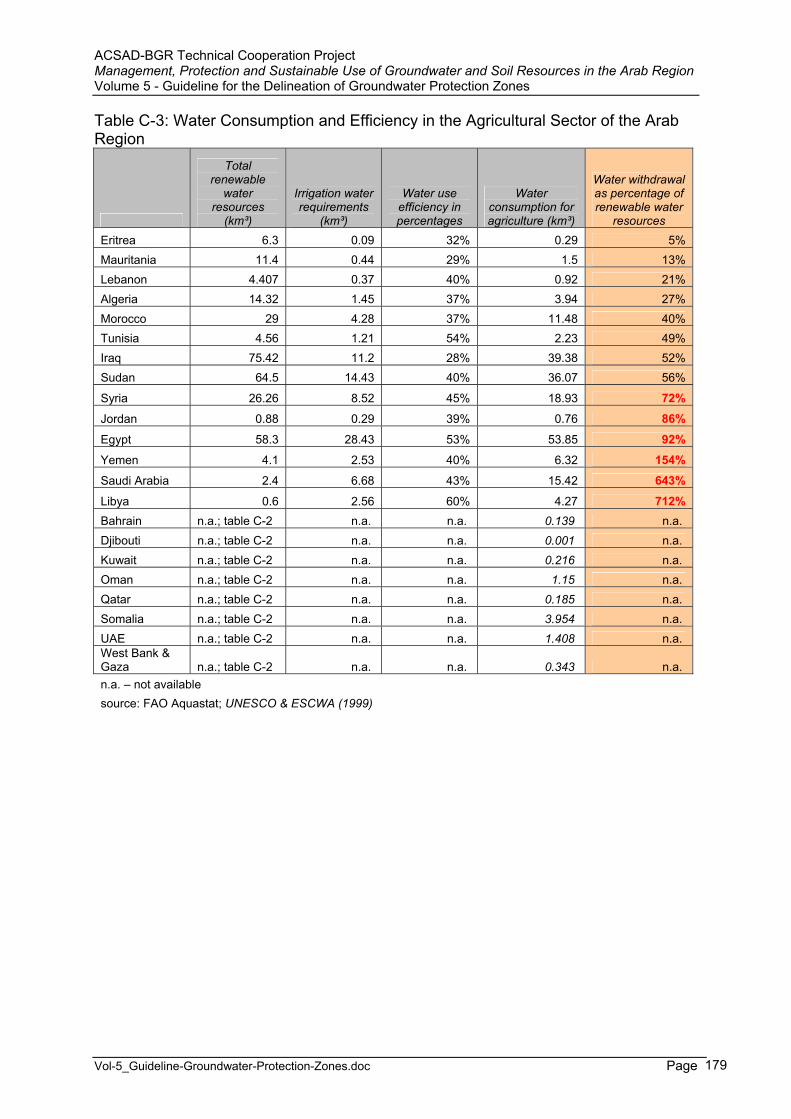
ACSAD-BGR Technical Cooperation Project Management, Protection and Sustainable Use of Groundwater and Soil Resources in the Arab Region Volume 5 - Guideline for the Delineation of Groundwater Protection Zones
Vol-5_Guideline-Groundwater-Protection-Zones.doc Page 179
Table C-3: Water Consumption and Efficiency in the Agricultural Sector of the Arab Region
Total renewable
water resources
(km³)
Irrigation water requirements
(km³)
Water use efficiency in percentages
Water consumption for agriculture (km³)
Water withdrawal as percentage of renewable water
resources Eritrea 6.3 0.09 32% 0.29 5%Mauritania 11.4 0.44 29% 1.5 13%Lebanon 4.407 0.37 40% 0.92 21%Algeria 14.32 1.45 37% 3.94 27%Morocco 29 4.28 37% 11.48 40%Tunisia 4.56 1.21 54% 2.23 49%Iraq 75.42 11.2 28% 39.38 52%Sudan 64.5 14.43 40% 36.07 56%
Syria 26.26 8.52 45% 18.93 72% Jordan 0.88 0.29 39% 0.76 86%
Egypt 58.3 28.43 53% 53.85 92% Yemen 4.1 2.53 40% 6.32 154% Saudi Arabia 2.4 6.68 43% 15.42 643%
Libya 0.6 2.56 60% 4.27 712% Bahrain n.a.; table C-2 n.a. n.a. 0.139 n.a.Djibouti n.a.; table C-2 n.a. n.a. 0.001 n.a.Kuwait n.a.; table C-2 n.a. n.a. 0.216 n.a.Oman n.a.; table C-2 n.a. n.a. 1.15 n.a.Qatar n.a.; table C-2 n.a. n.a. 0.185 n.a.Somalia n.a.; table C-2 n.a. n.a. 3.954 n.a.UAE n.a.; table C-2 n.a. n.a. 1.408 n.a.West Bank & Gaza n.a.; table C-2 n.a. n.a. 0.343 n.a.n.a. – not available source: FAO Aquastat; UNESCO & ESCWA (1999)
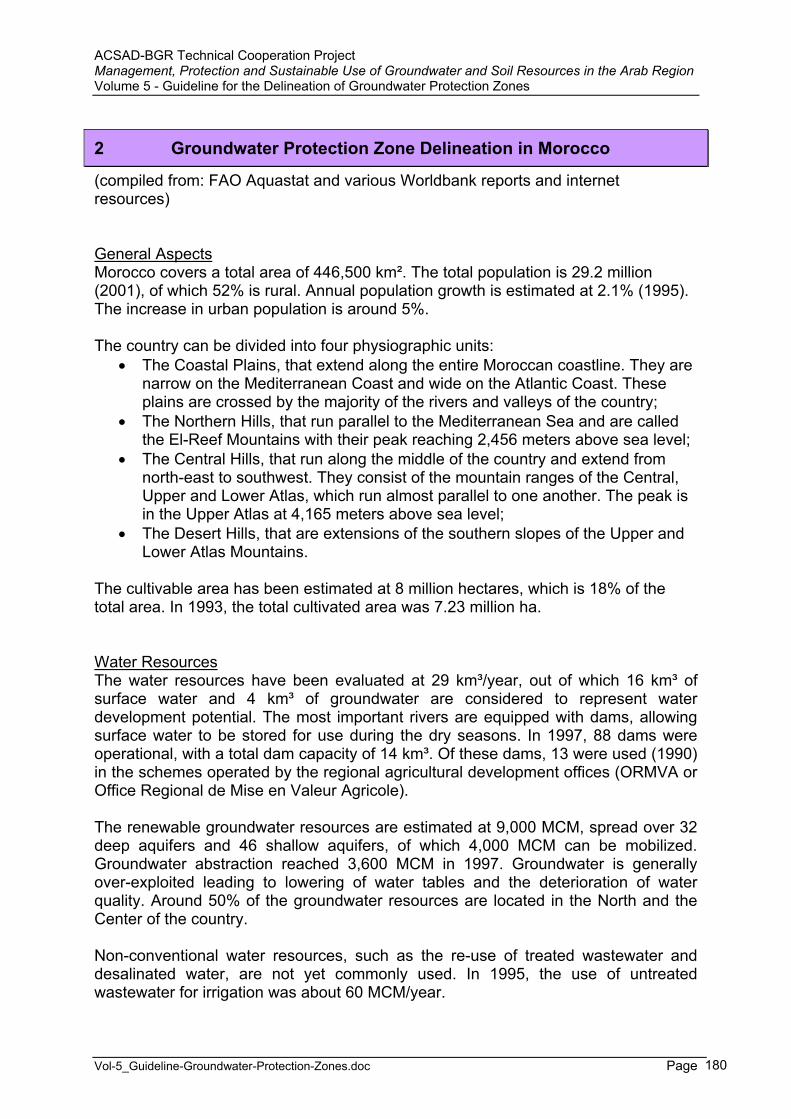
ACSAD-BGR Technical Cooperation Project Management, Protection and Sustainable Use of Groundwater and Soil Resources in the Arab Region Volume 5 - Guideline for the Delineation of Groundwater Protection Zones
Vol-5_Guideline-Groundwater-Protection-Zones.doc Page 180
2 Groundwater Protection Zone Delineation in Morocco
(compiled from: FAO Aquastat and various Worldbank reports and internet resources)
General AspectsMorocco covers a total area of 446,500 km². The total population is 29.2 million (2001), of which 52% is rural. Annual population growth is estimated at 2.1% (1995). The increase in urban population is around 5%.
The country can be divided into four physiographic units: The Coastal Plains, that extend along the entire Moroccan coastline. They are
narrow on the Mediterranean Coast and wide on the Atlantic Coast. These plains are crossed by the majority of the rivers and valleys of the country;
The Northern Hills, that run parallel to the Mediterranean Sea and are called the El-Reef Mountains with their peak reaching 2,456 meters above sea level;
The Central Hills, that run along the middle of the country and extend from north-east to southwest. They consist of the mountain ranges of the Central, Upper and Lower Atlas, which run almost parallel to one another. The peak is in the Upper Atlas at 4,165 meters above sea level;
The Desert Hills, that are extensions of the southern slopes of the Upper and Lower Atlas Mountains.
The cultivable area has been estimated at 8 million hectares, which is 18% of the total area. In 1993, the total cultivated area was 7.23 million ha.
Water ResourcesThe water resources have been evaluated at 29 km³/year, out of which 16 km³ of surface water and 4 km³ of groundwater are considered to represent water development potential. The most important rivers are equipped with dams, allowing surface water to be stored for use during the dry seasons. In 1997, 88 dams were operational, with a total dam capacity of 14 km³. Of these dams, 13 were used (1990) in the schemes operated by the regional agricultural development offices (ORMVA or Office Regional de Mise en Valeur Agricole).
The renewable groundwater resources are estimated at 9,000 MCM, spread over 32 deep aquifers and 46 shallow aquifers, of which 4,000 MCM can be mobilized. Groundwater abstraction reached 3,600 MCM in 1997. Groundwater is generally over-exploited leading to lowering of water tables and the deterioration of water quality. Around 50% of the groundwater resources are located in the North and the Center of the country.
Non-conventional water resources, such as the re-use of treated wastewater and desalinated water, are not yet commonly used. In 1995, the use of untreated wastewater for irrigation was about 60 MCM/year.
ACSAD-BGR Technical Cooperation Project Management, Protection and Sustainable Use of Groundwater and Soil Resources in the Arab Region Volume 5 - Guideline for the Delineation of Groundwater Protection Zones
Vol-5_Guideline-Groundwater-Protection-Zones.doc Page 181
In 1992, water withdrawal was estimated at about 11 km³, of which 92.2 % for agricultural purposes (4.9% is withdrawn for domestic use and 2.9% for industrial use). Of this total of 11 km³, 7.5 km³ was surface water and 3.5 km³ groundwater. In 1990, 236,000 water points were counted in the rural areas (91 % wells, 8% springs, 1% surface water points). A health survey showed that 84% of water points delivered non-potable water.
Irrigation is a strategic sector in Morocco. The water managed areas, in total about 1.26 million ha, represent only 17% of the cultivated area, but 76% of the irrigation potential area estimated at 1.65 million ha.
Since the 1960s emphasis has been put on the construction of dams and on the development of large schemes (referred to as 'grande hydraulique'). The schemes (with areas > 30,000 ha) are managed in a decentralized manner by the ORMVA. In total there were nine schemes over a total area of 496,000 ha in 1993.
The estimated volume of wastewater generated from the urban areas is around 546 MCM per year and is expected to reach 670 and 900 MCM in 2010 and 2020, respectively. Generated wastewater is mostly discharged without any treatment into natural water bodies. Around 43% are directly discharged into the ocean, and the rest are either discharged into the water resources (30%) or are spread on the soil (27%). Out of the 69 wastewater treatment facilities only 42% were functioning properly (2001).
With respect to industrial effluents, there are no laws forcing or requesting industries to treat their effluents prior to discharge. All industries discharge their untreated effluents into various natural water bodies. The report on the state of the environment that was completed in 1999 indicates that around 1,000 MCM of untreated industrial effluent are discharged per year. It is estimated that the majority of these effluents (98%) are discharged into the ocean and the sea, however, the remaining (2%) that are discharged into the inland water resources and the soil contain considerable pollution loads.
Municipal, industrial and hospital solid wastes (495 Million m³ in 2000) generated in the country are mainly discharged to uncontrolled sites, thus contributing to the degradation of the water quality and specially the groundwater resources. Survey studies conducted by the Direction Générale de l’Hydraulique in 1996 confirm the pollution of the groundwater resources in the vicinity of the solid wastes discharge sites.
Leaching practices and agricultural drainage are also a pollution source of water resources. Pollution is mainly due to the over-use of pesticides and fertilizers. Although agriculture pollution is not well controlled nor properly monitored, the available data on the utilization of pesticides and fertilizers give an idea about the expected pollution. On the average 720,000 tons of fertilizers are applied annually at the rate of 45 kg/ha. With respect to pesticides, around 7,500 tones are locally produced and used annually. In addition, around 1,000 tons of pesticides are imported annually. The available data on surface water quality reveal that important levels of fertilizers mainly nitrates and phosphorus are present. Pesticides residues were also detected in some surface waters and in some wells.
ACSAD-BGR Technical Cooperation Project Management, Protection and Sustainable Use of Groundwater and Soil Resources in the Arab Region Volume 5 - Guideline for the Delineation of Groundwater Protection Zones
Vol-5_Guideline-Groundwater-Protection-Zones.doc Page 182
Since 1992, a water quality monitoring program has been established for surface water and groundwater resources. Around 1000 stations have been established at important points.
Data collected by the DGH indicate that: An important percentage (above 30% !) of underground water sources is of
poor quality due to high salinity and nitrate concentrations; Several water streams have important concentrations of phosphorus,
ammonia, organic matters and high Coliforms counts mainly at the monitoring stations which are located downstream of the industrial and municipal wastewater discharges; Sebou basin that constitutes 29% of Morocco water resources is heavily polluted by untreated industrial and municipal discharges and by agricultural drainage.
Institutional AspectsThe Superior Council of Water and Climate (Conseil supérieur de l'eau et du climat) is the principal institution involved in the water resources management sub-sector. It has the mandate to coordinate the development of the water resources by examining the development policies of the sector, approving the regional master plans related to the development of the water resources (prepared by the Directorate of Rural Equipment), resolving conflicts over the allocation of the water resources and establishing policies for water quality conservation. The General Directorate for Hydraulics (DGH or Direction générale de l'hydraulique) of the Ministry for Infrastructure (Ministère de l’Equipement) is in charge of the secretariat of the Council and brings together the main services concerned in this sector, elected representatives, socio-professional organizations, local authorities and representa-tives of the different types of water users.
The main organizations involved in the drinking water supply sub-sector are: The Ministry of Infrastructure (Ministère de l’Equipement, MEq) with its
regional Directorates for Water Resources Management; The DGH, which is part of the Ministry of Public Works. It is in charge of water
supply at basin level and is responsible for research and the exploitation of the water resources;
The National Office for Drinking Water (ONEP or Office national de l'eau potable), which is placed under the Ministry of Public Works. It is in charge of water distribution control in urban areas and in some rural municipalities. It plans, builds and operates the installations for treatment and transport from the primary sources, i.e. reservoirs and primary canals;
16 autonomous, inter-communal state-owned water companies (Agence de Bassin Hydraulique, ABH), which are placed under the Ministry of Interior and supervised by the Directorate for state-owned companies and services conceded by this Ministry. They are in charge of water distribution in the municipalities;
The Ministry of Public Health (MSP or Ministère de la santé publique) which, together with ONEP, is in charge of quality control for water resources for drinking water supply networks in the towns and villages to which it provides water;
ACSAD-BGR Technical Cooperation Project Management, Protection and Sustainable Use of Groundwater and Soil Resources in the Arab Region Volume 5 - Guideline for the Delineation of Groundwater Protection Zones
Vol-5_Guideline-Groundwater-Protection-Zones.doc Page 183
The Ministry of Environment (Ministère de l’Aménagement du Territoire, de l’Habitat, de l’Urbanisme et de l’Environnement, MATHUE);
The Ministry of Agriculture, Rural Development and Waters and Forests: It is mainly in charge of elaborating and implementing the policy concerning the reuse of treated wastewaters in agriculture via the regional service (ORMVA and DPA) in addition to the management of these waters, the awareness and technical framing of Associations of Agricultural Waters Users (AUEA).
The main organizations involved in the irrigated agriculture sector are: The Ministry of Agriculture and Agricultural Development (MAMVA or Ministère
de l'agriculture et de la mise en valeur agricole), which is in charge of the supervision of new investments, in particular the extension, rehabilitation and maintenance of all the large and medium irrigation schemes;
The DGH, which is in charge of providing irrigation water for the large schemes. It constructs and maintains the large hydraulic structures like dams, river diversion structures and projects for the exploitation of groundwater;
The Agricultural Engineering Service (AGR or Administration du génie rural), which is responsible for the management of the irrigation schemes:
The ORMVA, which are public but financially autonomous entities placed under the MAMVA, and which are responsible for the planning and management of the water resources for agriculture and the design, construction and management of the large schemes. They are also responsible for the small and medium schemes within their geographical jurisdiction;
Outside the areas controlled by the ORMVA, the provincial Directorates for Agriculture are in charge of the promotion and management of the small and medium irrigation schemes, in reality mainly limited to extension activities.
On the 20 September 1995, a new Water Law became effective. In order to provide drinking water and to protect the water resources more effectively so-called Water Basin Agencies were created (Agences de Bassin Hydraulique – ABH). These agencies aim to establish a long-term balance for the water resources using an integrated approach in cooperation with the local authorities.The law 10/95 of 16th August 1995 forms the legal basis for water policy in Morocco. It aims to establish the legal instruments necessary for controlling the use of water resources and for their conservation.It provided the legal basis for the creation of basin agencies, for which the missions are extensive. These bodies, which have financial autonomy and a legal status, are in charge of:
royal type missions concerned with water law enforcement which are currently taken care of by State directorates (Directorate General for Water): the inventory of water rights and concessions; the monitoring of quality and quantity, both for ground and surface water; the issue of new permits and concessions for water withdrawals; the control of the use of resources;
new missions within the river basin context: the formulation and implementation of the water development plan which is
to be integrated into the national water plan;
ACSAD-BGR Technical Cooperation Project Management, Protection and Sustainable Use of Groundwater and Soil Resources in the Arab Region Volume 5 - Guideline for the Delineation of Groundwater Protection Zones
Vol-5_Guideline-Groundwater-Protection-Zones.doc Page 184
the levying of pollution and withdrawal fees which will be reinvested in pollution control;
providing contracting authorities with financial assistance and services for pollution control, improvement in water resources and flood management.
In 1995, Morocco developed the ‘Code des Eaux’ under law No. 10-95. This code includes several articles related to the protection and preservation of surface and groundwater, the disposal of wastewater, as well as water reuse for agricultural purposes.
The ‘Code des Eaux’ calls for the integration of water quality and quantity, the elaboration of national water plan and river basin plans, recovery of costs through charges for water abstraction, and a water pollution tax based on the polluter-pays principle. The law also provides for the establishment of basin agencies, the participation of water user’s association in decision-making as well as for sanctions, penalties and fines for water law violation.
According to the new water law water has become a public property. The newly established water basin agencies have to prepare water basin master plans. Also a mechanism for cost recovery is provided through the collection of an abstraction charge and a pollution charge, which is to be based on the polluter-pays-principle, similar to the system applied in France (compare Part A, Chapter 6).
The available quality standards are those prepared by ONEP, Ministry of Health and Ministry of Interior for water, including: - NM 03-7-001: Standards for Potable Water; - Decree 2-97-875: Standard the Use of Treated Water in Irrigation; - NM 03-7-002: Standards for the Monitoring of Water Supply Systems.
Trends in water resources managementThe surface water resources are limited and must be saved in order to be able to satisfy the water needs for drinking, industrial and agricultural purposes in the 21st
century. While in general the water demand is satisfied, certain regions already suffer from water scarcity, especially during dry years.
Since the 1960s Morocco’s water policy was dominated by the effort to construct large water reservoirs, for which about 15 % of the annual investment budget was spent. At present around 100 dams are in operation, managing about 70% of the renewable water resources. Agriculture consumes approximately 92% of the water resources. Water protection measures were neglected for a long time.
The increase of the number of dams is one way chosen to increase water availability. Siltation of dams, however, is a major problem. The capacity already lost in 1990 was estimated at 800 MCM, which is 7% of the total capacity. A program for the protection of dams against siltation has been set up. Another way chosen to increase water availability is increasing groundwater extraction. However the cost of groundwater extraction is very high and a number of aquifers are already over-exploited. Government policies are moving from supply towards demand management.

ACSAD-BGR Technical Cooperation Project Management, Protection and Sustainable Use of Groundwater and Soil Resources in the Arab Region Volume 5 - Guideline for the Delineation of Groundwater Protection Zones
Vol-5_Guideline-Groundwater-Protection-Zones.doc Page 185
A new strategy for integrated water management is being developed under the ongoing National Water Plan. This new strategy is based on management of supply, valorization, decentralization and integration. It will also address the need to use non-conventional water sources including the re-use of treated wastewater and desalinization. Action plans that are being prepared include:
National action plan for water; National action plan for water quality;
National action plan for the abatement of flooding.
In the wastewater sector, the Government is moving towards the privatization of wastewater treatment. The management of the wastewater of Casablanca, Rabat-Sale, Tangier and Tetouan has been lately given to private firms. A National Wastewater Master Plan was elaborated and enabled the Government to draw the guidelines for the development of the sector.
In the agriculture sector, the Ministry has developed a strategy and an action plan for the rationalization and the utilization of water for irrigation purposes. The identified actions will contribute to the protection of the environment through rationalizing the use of fertilizer and mastering irrigation practices.
A National Irrigation Program for the year 2000 (PNI 2000 or Programme National d'Irrigation en 2000) was adopted in 1992, with the following objectives:
to equip by the year 2000 the whole area controlled by existing dams and dams under construction with the appropriate water distribution infrastructure;
to improve the performances of the old irrigation schemes through modernization and/or rehabilitation of equipment.
Land ownership, which is characterized by very small properties (< 5 ha), land fragmentation, the absence of land ownership deeds and security, is being reviewed together with its implications for schemes and resources management.
The Moroccan water sector is facing serious problems, the reasons of which are complex. The Moroccan economy saw a rapid industrial and an increasingly export-oriented agricultural development over the past 2 decades. At the same time the population growth was very high. Due to these facts, water demand increased enormously. The water tariffs are not covering the costs, which has led to a wasting of resources. The investment budget has not kept pace with the increasing water demands, so that investments into maintenance were neglected, leading to a decayof the water infrastructure. Moreover, no sufficient investments were made in the wastewater sector.
The following 5 policies for water sector development have recently been adopted: Preparation of a National Water Master Plan, based on the principle of
integrated water resources management;
Development of a new institutional and legal framework promoting decentralized water resources management with increased stakeholder participation;
Introduction of economic incentives in water allocation decisions through rational water tariffs, based on the principle of cost recovery;
ACSAD-BGR Technical Cooperation Project Management, Protection and Sustainable Use of Groundwater and Soil Resources in the Arab Region Volume 5 - Guideline for the Delineation of Groundwater Protection Zones
Vol-5_Guideline-Groundwater-Protection-Zones.doc Page 186
Enhancement of institutional capacities;
Establishment of an effective system of monitoring and control of water quality to reduce environmental degradation.
Four big cities (Casablanca, Rabat, Tangier and Tetouan) are already under the management of private sector companies for water supply, sanitation and electricity. In Casablanca, LYDEC, consisting of a consortium of Suez Lyonnaise des Eaux (35%), ELYO (24%), EDF Int. (18%), ENDESA (18%) and AGBAR (5%), was awarded a 30-years delegated management contract in 1997. In 2001 a 25-years concession was given to AMENDIS, a consortium lead by the French company Vivendi Env. (51%).
>>>>>>>>>>>>>>><<<<<<<<<<<<<<<
1. Is there a law in place to allow for the delineation of groundwater protection zones ?
The water law of 1995 (loi no.10; loi sur l’eau) includes in article .
2. Have groundwater protection zones already been established (how many) ?
Within the Moroccan-German Technical Cooperation Project ‘Protection of Drinking Water Resources’ between the German Technical Cooperation Agency (GTZ) and DGH a number of groundwater protection zones have been established. In 1995 protection zones for the water abstraction points at Sidi Taibi were set up (ONEP & GTZ, 1995). The used system is similar to the French system (see chapter 2.1.3). Presently the GTZ is cooperating with the DGH and the ABH-Tensift in order to establish groundwater protection zones (project duration: 2002-2006).
To help the structures and human resources of the Ministry of Public Works adapt to this new policy, the Director for Water at the French Ministry for the Environment and the Moroccan General Director for Water signed a special co-operation agreement, on 19th April 1996. This agreement deals mainly with the creation of a first pilot basin agency for the Oum Er Rbia basin.IOW is the main operator for the French Authorities. This program, carried out between 1996 and 1998, with the assistance of specialists from the Adour-Garonne Water Agency, included:
awareness campaigns for users and communication actions among the population;assistance with fees and aid systems (institutional and financial aspects);training on floods (flood prevention, forecasting and warning);the restructuring of regional water analysis laboratories;the drawing up of the documents necessary for the effective implementation of the Oum Er Rbia pilot Basin Agency's financial services (procedures, control of tax bases, legal department, preparation of multi-annual programs);
ACSAD-BGR Technical Cooperation Project Management, Protection and Sustainable Use of Groundwater and Soil Resources in the Arab Region Volume 5 - Guideline for the Delineation of Groundwater Protection Zones
Vol-5_Guideline-Groundwater-Protection-Zones.doc Page 187
technical training courses for Moroccan executives leading to a "Higher Education Certificate in Engineering and Water Resources Management" with the assistance of the National School of State Public Works.
This action will be followed by a new 1999-2001 program based on three main actions:
the continuation of the assistance to the Oum Er Rbia Basin Agency with the formulation and drawing up of administrative and financial procedures linked to the first meeting of the Board of Directors;the setting-up of a basin information system to allow for quick access to information on the state of water resources;the development of an effective flood warning system in the Oum Er Rbia basin which is likely to be extended to the whole country.
The implementation and co-ordination of all these co-operation actions are carried out, on the French side, by a steering committee led by the Water Directorate of the Ministry for the Environment, including the Adour-Garonne Water Agency and IOW which provides the secretariat.
Further information is available at: International Institute for Water Administration Fax : +33 4 93 65 44 02 E-mail : [email protected]
3. Which restrictions are imposed on land use activities in the protection zones ?
No information.
4. How are the restrictions being enforced ?
No information.
5. Which methods are being used for the delineation of groundwater protection zones ?
No information.
6. What are the sizes of zones 1, 2 and 3 ?
No information.
ACSAD-BGR Technical Cooperation Project Management, Protection and Sustainable Use of Groundwater and Soil Resources in the Arab Region Volume 5 - Guideline for the Delineation of Groundwater Protection Zones
Vol-5_Guideline-Groundwater-Protection-Zones.doc Page 188
7. Which other measures are in place to protect the groundwater resources ?
No information.
8. Is a groundwater monitoring network for groundwater quality control established and functional ?
No information.
9. Have maps of groundwater vulnerability been prepared ?
No information.
10. Are guidelines/laws/by-laws in place to control the quality of emissions into surface and groundwater (sewage water/effluent standard) ?
The application Decree (N°2-97-875, dated February 4, 1998) referring to the water law 10-95 related to the use of wastewaters stipulates that no wastewater can be used if it has not been beforehand recognized as treated wastewater. The use of raw wastewaters is thus banished.
For the reuse of wastewater, Law 10-95 stipulates in its article 57, that the administration defines, in particular, the necessary conditions for wastewater reuse and to obtain the authorization for reuse. It also stipulates that every user of wastewater can benefit of the state's financial aid and of a technical aid from the Basin's Agency if the usage is in conformity with the conditions fixed by the administration and contribute to the saving of water and the preservation of water resources against pollution.
Law 10-95 stipulates in its article 84, that using wastewater for agricultural purposes is prohibited when the water does not respect the standards fixed by the law. These standards are currently being prepared at the national level by the Norms and Standards Committee (NSC).
Industrial discharges are not well regulated and industries are not requested to conduct self-monitoring and compliance.
The Law 10-95 in articles 52 and 54 prohibits the discharge of waste water or solid waste, or the spreading or hiding of any effluents likely to pollute underground water through infiltration or surface water through runoff, in a way that is likely to modify the physico-chemical or bacteriological characteristics without preliminary authorization, after investigation, by the Basin Agency. The Law also fixes a penalty fee.
ACSAD-BGR Technical Cooperation Project Management, Protection and Sustainable Use of Groundwater and Soil Resources in the Arab Region Volume 5 - Guideline for the Delineation of Groundwater Protection Zones
Vol-5_Guideline-Groundwater-Protection-Zones.doc Page 189
11. Is there a law/by-law/guideline for the design and monitoring/control of waste disposal sites ?
The Department of Environment has prepared a Solid waste management and disposal law.
12. Is there a law/by-law/guideline for the use of pesticides/fertilizers in agriculture ?
No information.
13. Is there a law/by-law/guideline for environmental protection/environmentalimpact assessment ?
The Department of Environment has prepared an Environment Law and an Environmental Impact Assessment law and decree, which have, however, not yet passed.
14. How are groundwater protection demands integrated into land use planning ?
No information.

ACSAD-BGR Technical Cooperation Project Management, Protection and Sustainable Use of Groundwater and Soil Resources in the Arab Region Volume 5 - Guideline for the Delineation of Groundwater Protection Zones
Vol-5_Guideline-Groundwater-Protection-Zones.doc Page 190
3 Groundwater Protection Zone Delineation in Tunisia
(modified after Djemili El Batti, Director-General of Water Resources, various World Bank reports and FAO Aquastat)
General AspectsTunisia has a total area of 193,610 km², of which 11,160 km², almost 7%, consist of lakes and shats (salty depressions). The country can be divided into four physiographic regions:
The North-western Mountains, which are located at the eastern end of the two mountain ranges, the Atlas El-Talli and the Desert Atlas, which extend from Morocco through Algeria and reach a peak at 1,500 metres in Tunisia. This area is crossed by permanent rivers;
The Southern Mountains, which slope towards the east to the Coastal Plains and towards the west to the Desert Plains and are covered by sand dunes;
The Coastal Plains which run close to the Mediterranean Sea as wide plains; Desert Plain. This plain forms the northern boundary of the Sahara Desert. A
number of shats exist in this plain, the largest one being the Shat El-Jarid with an area of 5,000 km² at a minimum elevation of 15 meters below sea level.
The cultivable area is estimated at 8.7 million ha, which is about half the total area of the country. In 1993, the cultivated area was estimated at 4.25 million ha.
The total population is 8.9 million (1995) with an annual growth rate of less than 2%. The importance of the agricultural sector in the economy decreased from 1960 to 1994: in 1960 it accounted for 24% of the country's GDP, while in 1994 this figure had fallen to 16%.
Water ResourcesThe hydrographic system is dense in the north where the Medjerda wadi is the most important water course. This is also the zone where the principal irrigation development and flood protection works have been carried out.
Surface water resources have been estimated at 2.91 km³/year, of which 2.31 km³ are produced internally. About 1.5 km³/year are exploitable at present through reservoirs. It will be possible in the future to exploit another 0.6 km³/year, but the remaining part could only be used by means of large water conservation works and groundwater recharge systems. At present, there are 18 large dams and 22 hillside dams. Presently 81% of the surface water resources are mobilized.
Internal renewable groundwater resources have been estimated at 1.21 km³/year. At present, there are 83,000 open wells and 1,830 tubewells. Two categories of groundwater resources can be distinguished in function of the depth:
when the water table is above 50 meters, groundwater is defined as phreatic and can be used for private exploitation (with some restrictions). The potential has been estimated at 669 million m³/year;
ACSAD-BGR Technical Cooperation Project Management, Protection and Sustainable Use of Groundwater and Soil Resources in the Arab Region Volume 5 - Guideline for the Delineation of Groundwater Protection Zones
Vol-5_Guideline-Groundwater-Protection-Zones.doc Page 191
below 50 meters of depth, the groundwater has been reserved for public exploitation. Potential has been estimated at 1,170 MCM/year, of which 630 MCM is fossil water.
Presently 88.5% of the renewable groundwater resources are exploited. For the past 20 years, reuse of treated wastewater has taken place. In 1993, 96 MCM was treated, of which 20 MCM was reused. It is planned to increase the treatment to 200 MCM/year by the year 2000.
In 1990, water withdrawal was estimated at about 3.1 km³/year, of which 88.7% for agricultural purposes (8.5% is withdrawn for domestic use and 2.8% for industrial use). However, the amount of water withdrawn depends to a large extent on the quantity and the distribution of the precipitation. In particular, irrigation water withdrawal varies in function of the rainfall and of the area actually irrigated within the public irrigation network. Of the total of 3.1 km³ of water used annually, only 1.9 km³ are estimated to be actually used.
In 1992, the rural population with access to good drinking water within a distance of 3 km was estimated at 65 %, while 91 % of the urban population was connected to the drinking water supply network.
The irrigation potential has been estimated at 563,000 ha, based on land and water resources. In 1991, the water managed area was estimated at 385,000 ha. The average annual growth of irrigation development is about 2 %, which means that at this rate full potential will have been achieved by the year 2010.
Large-scale public irrigation schemes are managed by the state while medium-scale public irrigation schemes are managed by users associations (AIC or Associations d'intérêt collectif). The services of the state or AIC are in charge of the operation and maintenance of the irrigation network as well as of the distribution of water to the farmers, applying a water charge according to volume. However irrigation water is still subsidized by the state for up to 20-30% of its real exploitation cost.
Irrigation water is quite saline (1.5-4.0 g/l), but the degree of salinization of the irrigated soils is not yet a serious problem due to the low intensification. A monitoring system has been set up for all the schemes with a high risk of salinization. Subsurface drainage is not very developed (162,000 ha) and is limited to soils with a high water table (schemes in the north).
Institutional AspectsThe Ministry of Agriculture, Environment and Water Resources (Ministère de l’Agriculture, de l’Environnement et des Ressources Hydrauliques; MAERH), founded in September 2002, is the main institution involved in the water sector. The main General Directorates in charge of water are:
The General Directorate of Water Resources (DGRE or Direction Générale des Ressources en Eau), which is in charge of the monitoring, evaluation and research of water resources in regarding their exploitation and protection;
The General Directorate of Rural Engineering (DGGREE or Direction Générale du Génie Rural et de l’Exploitation des Eaux), which is responsible
ACSAD-BGR Technical Cooperation Project Management, Protection and Sustainable Use of Groundwater and Soil Resources in the Arab Region Volume 5 - Guideline for the Delineation of Groundwater Protection Zones
Vol-5_Guideline-Groundwater-Protection-Zones.doc Page 192
for irrigation, rural equipment and for drinking water supply to the rural population;
The General Directorate of Dams an Large Hydraulic Works (DGBGTH or Direction Générale des Barrages et des Grands Travaux Hydrauliques), the main activity of which is conducting general hydraulics studies and studies concerning the use of surface water, the construction of dams, the development of large-scale water schemes and management of the dams;
The Regional Commissions for Agricultural Development (Commissariats Régionaux de Développement Agricole ; CRDA);
The National Society for Exploitation and Distribution of Water (Société Nationale d’Exploitation et de Distribution des Eaux; SONEDE) a semi-private agency for urban water supply, under the supervision of the MAERH. It also operates water desalination plants;
The Society for Canal Water Use in the North (Société d’Exploitation du Canal et des Adductions des Eaux du Nord; SECADENORD) which is another semi-private water agency operating the canals in the north;
The Water User Associations (Groupements de Développement d’Intérêt Collectif; GDIC) which are under the supervision of the regional authorities (Governor) and the MAERH;
The National Office of Sanitation (Office National de l’Assainissement; ONAS) which is in charge of waste water management;
The National Agency for Environmental Protection (Agence Nationale de Protection de l’Environnement; ANPE), created in 1988 and under the authority of the MAERH, is responsible for drafting the government policy related to all environmental issues, for proposing action plans for environmental protection, for preparing and conducting contingency plans in case of accidental pollution, for promoting environmental protection, for coordinating all national and international activities in the field of environmental protection and for the management of hazardous wastes.
Other ministries involved in water management and protection are: The Ministry of Equipment, Housing and Utilities (Ministère de l’Equipement,
de l’Habitat et de l’Aménagement du Territoire ; Direction de l’Hydraulique Urbaine : D.H.M., et l’Agence de Protection et de l’Aménagement du Littoral : APAL) ;
The Ministry of Public Health (Ministère de la Santé Publique ; Direction de l’Hygiène du Milieu et Protection de l’Environnement : DHMPE) ;
The Ministry of Interior and Development (Ministère de l’Intérieur et du Développement);
The Minstry of Tourism, Commerce and Handicraft (Ministère du Tourisme, du Commerce et de l’Artisanat; Office du Thermalisme) watches over the safety of bottled mineral waters and the protection of touristic zones.
The Ministry of Justice and Human Rights (Ministère de la Justice et des Droits de l’Homme) watch over the proper execution of legal matters by the water police.
The regional agricultural development offices (CDRA or Commissariat regional de développement agricole), linked to the Ministry of Agriculture, are the institutions

ACSAD-BGR Technical Cooperation Project Management, Protection and Sustainable Use of Groundwater and Soil Resources in the Arab Region Volume 5 - Guideline for the Delineation of Groundwater Protection Zones
Vol-5_Guideline-Groundwater-Protection-Zones.doc Page 193
responsible at regional level for the development of public irrigation schemes. The management of these schemes is shared between CDRA and AIC.
The water code (Code des Eaux; loi n° 75-16), promulgated in 1975, determines all interventions in the water sector.
Trends in Water Resources ManagementThe strategy for the future use of water, adopted in 1990, aims at the development of 90% of surface water resources and 100% of groundwater resources by the year 2010, by means of the construction of 21 dams, 235 hillside dams and 610 deep tube-wells.
This improvement in the control of water resources is associated with the agricultural development of the irrigation schemes. The objectives of the country are at present to encourage the adoption of water saving techniques, to favour the reuse of treated wastewater for irrigation, to expand the irrigated areas and to set up the related activities necessary for agricultural development and a better use of irrigation schemes.
>>>>>>>>>>>>>>><<<<<<<<<<<<<<<
1. Is there a law in place to allow for the delineation of groundwater protection zones ?
The Water Law of 1975 allows for the declaration of four different types of protection zones (see under 3). Article no. 1 of the Water Law allows for the declaration of public hydraulic domains (domaine public hydraulique).
2. Have groundwater protection zones already been established (how many) ?
No information.
3. Which restrictions are imposed on land use activities in the protection zones ?
The Water Law distinguishes between prohibition zones (périmètre d’interdiction; articles 12, 13, 14), safeguarding zones (périmètres de sauvegarde ; article 15), water supply zones (périmètres d’aménagement et d’utilisation des eaux ; article 16) and protection zones (périmètres de protection ; articles 120 -123).
Prohibition zones: are declared in areas where the quality and quantity of water is at risk and needs to be preserved. So far 9 prohibition zones have been declared.
The following restrictions may be imposed: all drillings of new water wells are prohibited; the replacement of existing wells or their rehabilitation needs approval from the MAERH; the extractable amounts may be adjusted for each well by the MAERH in order to attain a sustainable management of the resource; existing water utilities may partially or completely be removed;

ACSAD-BGR Technical Cooperation Project Management, Protection and Sustainable Use of Groundwater and Soil Resources in the Arab Region Volume 5 - Guideline for the Delineation of Groundwater Protection Zones
Vol-5_Guideline-Groundwater-Protection-Zones.doc Page 194
works conducted not in conformity with official prescriptions may be punished.
Safeguarding zones: may be declared by decree in areas where abstraction risks to endanger the conservation of the quantity and quality of the water resource, based upon decisions of the Public Water Domain Commission (Commission du Domaine Public Hydraulique). Until now, 16 such zones have been declared. All work related to the research and exploitation of the groundwater resource needs the approval of MAERH, except for work conducted at existing water abstraction facilities.
Prohibition and safeguarding zones have been declared in the highly overexploited aquifers of the coastal zone of Cap Bon, the Sahel and around the cities of Sousse and Sfax as well as for certain aquifers in the vicinity of Kairouan, Sidi Bouzid, Gabès and Kébili.
Water supply zones : may be declared upon recommendation by the National Water Council (Conseil National de l’Eau) in the form of an ordinance by the MAERH in such zones where the water resources are or risk to be insufficient for meeting the actual or projected needs. The ordinance needs to define the distribution of water resources in this zone and may define part or the entire zone as public utility (domaine d’utilité publique; DUP). Free access to these sites and the right to conduct any necessary work and monitoring must be granted to the authorities in such zones.
Protection zones: may be declared for water wells, reservoirs or dams. An ordinance for the protection of wells may be issued by the MAERH defining three different zone:
an immediate protection zone (périmètre de protection immédiat), which has to be acquired by the state and enfenced. If declared as public utility domain (DUP) the land of the immediate protection zone has to be appropriated by the state;a near protection zone (périmètre de protection rapprochée), where the disposal of wastes and all other activities possible leading directly or indirectly to the contamination of water resources are prohibited. The restrictions are specifically named in each ordinance issued jointly by the MAERH an the Ministry of Public Health; a distant protection zone (périmètre de protection éloignée), where the disposal of wastes and other activities may be prohibited.
In case the imposed restrictions in zones 1, 2 or 3 render the land unusable for the current owner, the owner may seek expropriation.
For dams and reservoirs destined at drinking water supply, the following protection zones may be declared:
An Immediate Protection Zone (périmètre de protection immédiate): encompassing all neighboring area less than 10 m from the high water line of the dam or reservoir. This land has to be appropriated by the state; A Service Zone (zone de servitude): encompassing all neighboring area less than 50 m from the high water line of the dam or reservoir. All activities possibly leading to the direct or indirect contamination of the water resource are prohibited.
ACSAD-BGR Technical Cooperation Project Management, Protection and Sustainable Use of Groundwater and Soil Resources in the Arab Region Volume 5 - Guideline for the Delineation of Groundwater Protection Zones
Vol-5_Guideline-Groundwater-Protection-Zones.doc Page 195
4. How are the restrictions being enforced ?
The National Agency for Environmental Protection (ANPE) is enforcing the Water Law. It can impose fined of up to 100,000 Dinars (1 Dollar US = 1,4 Tunisian Dinar) for any breaching of the law.
If applicable, the ANPE will apply the polluter-pays-principle. In other cases, the ANPE may use the fund for land reclamation (Fonds de Dépollution; FODEP) for clean-up operations. In this line, the ANPE has established a program for the provision of treatment plants for tanneries.
Any enforcement, however, rests at the responsibility of the water police, which is still insufficiently equipped.
5. Which methods are being used for the delineation of groundwater protection zones ?
No information.
6. What are the sizes of zones 1, 2 and 3 ?
Compare 3.
7. Which other measures are in place to protect the groundwater resources ?
The DGRE prepares so-called maps of potential pollution sources (carte des sources potentielles de pollution hydrique; first edition : 1978, third edition : 1996, scale: 1:50,000) which show all potential sources for chemical and bacteriological contamination. They also show all exploited water sources and water utilities and thus help to identify possible pollution sources and design countermeasures against pollution.
Articles 109 – 139 define modalities for the fight against contamination of water resources.
The MAERH has prepared a 5-year investment program (presently PISEAU 2001-2005). This program created a national system for the evaluation of the water resources (SINEAU), tries to upgrade the national water resources monitoring system, studies the possibilities of and puts into operation facilities for artificial groundwater recharge, especially in areas of over-exploitation and prepares plans for water management.
ACSAD-BGR Technical Cooperation Project Management, Protection and Sustainable Use of Groundwater and Soil Resources in the Arab Region Volume 5 - Guideline for the Delineation of Groundwater Protection Zones
Vol-5_Guideline-Groundwater-Protection-Zones.doc Page 196
8. Is a groundwater monitoring network for groundwater quality control established and functional ?
DGRE is in charge of a network of 2717 wells for water level monitoring in the shallow part of the aquifer (less than 50 m deep) and 557 well in the deeper part of the aquifer (exceeding 50 m depth) which are monitored twice a year (high water season: April/May and low water season: September/October). Monitoring started in the 1940s.
Water quality monitoring is conducted at 1200 station, of which 729 monitor the shallow part and 471 the deeper part of the aquifer at which mainly 2 parameters are recorded: TDS and nitrate content. Water samples are taken twice a year, during the same time periods mentioned above.
These data are compiled by the Commissariats Régionaux de Développement Agricole (CRDA). Based on these data, the DGRE prepares annual reports (annuaires) for precipitation (since 1969), surface water (since 1974), groundwater level monitoring (since 1992) and groundwater water quality (since 1997).
The DGRE also publishes annual reports for the exploitation of deep aquifers (since 1972; every 5 years since 1980) and for artificial groundwater recharge (since 1992).
9. Have maps of groundwater vulnerability been prepared ?
A groundwater vulnerability map for the northern part of the country was prepared in 1975 at a scale of 1:500,000. There are no vulnerability maps at larger scales for urban development centers.
10. Are guidelines/laws/by-laws in place to control the quality of emissions into surface and groundwater (sewage water/effluent standard) ?
In 1985 the Ministry of Economy issued a decree (décret n° 85-56) which defines standards for drinking water, wastewater and emissions to the sea.
11. Is there a law/by-law/guideline for the design and monitoring/control of waste disposal sites ?
No information.
12. Is there a law/by-law/guideline for the use of pesticides/fertilizers in agriculture ?
No information.
ACSAD-BGR Technical Cooperation Project Management, Protection and Sustainable Use of Groundwater and Soil Resources in the Arab Region Volume 5 - Guideline for the Delineation of Groundwater Protection Zones
Vol-5_Guideline-Groundwater-Protection-Zones.doc Page 197
13. Is there a law/by-law/guideline for environmental protection/environmentalimpact assessment ?
In 1991 a decree (décret n° 91-362) was issued to regulated the procedures for the application of environmental impact assessments for water, soil and air. Since then several large environmental impact assessments for water have been conducted, such as the
EIA for the impact of water abstractions from and around Ichkeul lake (1992-1996),EIA for the gypsum-phosphate mining tails of the chemical industry at Gabès (1997-2001),EIA for the phosphate washing processes at mining area of Gafsa (1999-2003).
14. How are groundwater protection demands integrated into land use planning ?
No information.
ACSAD-BGR Technical Cooperation Project Management, Protection and Sustainable Use of Groundwater and Soil Resources in the Arab Region Volume 5 - Guideline for the Delineation of Groundwater Protection Zones
Vol-5_Guideline-Groundwater-Protection-Zones.doc Page 198
4 Groundwater Protection Zone Delineation in Egypt
(modified after KHATER, 2003, NWRC homepage and FAO Aquastat)
General AspectsEgypt covers a total area of about 1 million km². Total population is about 64 million (1999), of which 55% is rural, with annual demographic growth estimated at 2.1 %. In 1993, the total cultivated land was estimated to be 3.24 million ha, or 3.2% of the total area.
Water ResourcesThe Nile River is the main source of water for Egypt. Under the 1959 Nile Waters Agreement between Egypt and Sudan, Egypt's share is 55.5 km³/year. The 1959 Agreement was based on the average flow of the Nile during the 1900-1959 period, which was 84 km³/year at Aswan.
The total groundwater volume in storage in the Nubian sandstone aquifer is estimated at 60,000 km³ (1 km³ = 1 BCM). The current total extraction amounts to about 0.5 km³/year. The volume of groundwater entering the country from Libya is estimated at 1 km³/year. Internal renewable groundwater resources are estimated at 1.3 km³/year. This brings the total renewable groundwater resources to 2.3 km³/year (ESCWA, 2003: 4.1 BCM). The main source of internal recharge is percolation from irrigation water, and its quality depends mainly on the quality of the irrigation water. In the northern part of the Delta, groundwater becomes brackish to saline due to sea water intrusion. About half of the Delta contains brackish to saline groundwater. The Nubian Sandstone aquifer, located under the Western Desert and extending to Libya, Sudan and Chad, contains important non-renewable fresh groundwater resources, already developed in the oasis of the New Valley. Large irrigation schemes pumping water from the Nubian aquifer are under development in the southwestern part of the country (Al Aweinat).
In 1994, the quantity of agricultural drainage water flowing back into the Nile River and becoming available again for withdrawal downstream was estimated at 4 km³/year.
In 1994, the treatment of domestic wastewater was estimated at 650 MCM/year and in 1993 about 200 MCM/year of treated wastewater was estimated to have been reused. The quantity of desalinated water was estimated at only 25 MCM in 1990.
The Table below shows the actual water availability and water use by the different sectors. Agricultural water withdrawal includes an annual estimated loss of 2 km³/year due to evaporation from 31,000 km of canals (1.000 km of main canals and 30,000 km of secondary canals).

ACSAD-BGR Technical Cooperation Project Management, Protection and Sustainable Use of Groundwater and Soil Resources in the Arab Region Volume 5 - Guideline for the Delineation of Groundwater Protection Zones
Vol-5_Guideline-Groundwater-Protection-Zones.doc Page 199
Table C-4: Water availability and water use in Egypt in 1993 Water Resources km³/year Water Use km³/year
Surface water resources 56.0 Agriculture (incl. evaporation) 47.4
Renewable groundwater resources 2.3 Domestic 3.1
Agricultural drainage water 4.0 Industry 4.6
Reused treated wastewater 0.2 Navigation/regulation 1.8
Total available water resources 62.5 Total water use 56.9
It is estimated that by the year 2000 the total water use will approach 70 km³/year, which is more than the actual water availability.
Almost all agriculture in Egypt is irrigated. The total water managed area is 3,246,000 ha, of which more than 90% is in the Nile Valley and Delta.
An extensive National Drainage Program has been carried out over the past 30 years to control water logging and salinity. The drainage system consists of open drains, subsurface drains and pumping stations. Of the total irrigated area, 2,931,000 ha (90%) are drained, of which 1,681,000 ha with subsurface drainage. The subsurface drained area represents nearly 52% of the total cultivated area and more than 74% of the cultivated land in the Valley and the Delta.
Institutional AspectsWith the establishment of the Water Research Center (WRC) in 1975 (Presidential Decree No. 83), the Groundwater Research Institute (GRI) became the Research Institute for Groundwater (RIGW), one of the eleven Research Institutes under the WRC. In 1994 the WRC was promoted to University status and renamed the National Water Research Center (NWRC; www.nwrc.gov.eg/nwrc/). The mission of the RIGW is to carry out research to support groundwater development and management plans, in the framework of the overall integrated water resources development/management, aiming at increasing the contribution of groundwater in the water and food security programs for growing population of Egypt:
1. Study, outline and propose long-term policies for managing water resources in Egypt.
2. Solve the technical and applied problems associated with general policies for irrigation, drainage and water resources.
3. Carry out investigations and research work connected with the extension of agricultural lands.
4. Find the means for utilizing the water resources of the country in the most efficient and cost-effective way.
5. Propose measures for environmentally sound development of the irrigation and drainage systems.
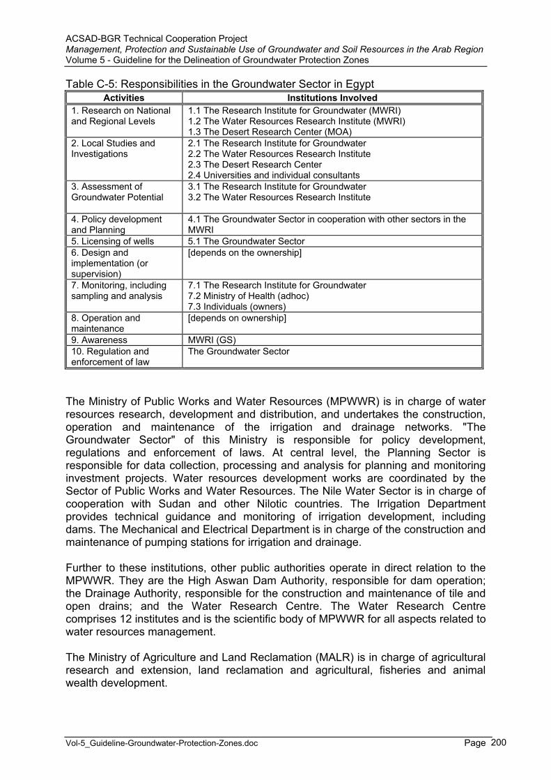
ACSAD-BGR Technical Cooperation Project Management, Protection and Sustainable Use of Groundwater and Soil Resources in the Arab Region Volume 5 - Guideline for the Delineation of Groundwater Protection Zones
Vol-5_Guideline-Groundwater-Protection-Zones.doc Page 200
Table C-5: Responsibilities in the Groundwater Sector in Egypt Activities Institutions Involved
1. Research on National and Regional Levels
1.1 The Research Institute for Groundwater (MWRI) 1.2 The Water Resources Research Institute (MWRI) 1.3 The Desert Research Center (MOA)
2. Local Studies and Investigations
2.1 The Research Institute for Groundwater 2.2 The Water Resources Research Institute 2.3 The Desert Research Center 2.4 Universities and individual consultants
3. Assessment of Groundwater Potential
3.1 The Research Institute for Groundwater 3.2 The Water Resources Research Institute
4. Policy development and Planning
4.1 The Groundwater Sector in cooperation with other sectors in the MWRI
5. Licensing of wells 5.1 The Groundwater Sector 6. Design and implementation (or supervision)
[depends on the ownership]
7. Monitoring, including sampling and analysis
7.1 The Research Institute for Groundwater 7.2 Ministry of Health (adhoc) 7.3 Individuals (owners)
8. Operation and maintenance
[depends on ownership]
9. Awareness MWRI (GS) 10. Regulation and enforcement of law
The Groundwater Sector
The Ministry of Public Works and Water Resources (MPWWR) is in charge of water resources research, development and distribution, and undertakes the construction, operation and maintenance of the irrigation and drainage networks. "The Groundwater Sector" of this Ministry is responsible for policy development, regulations and enforcement of laws. At central level, the Planning Sector is responsible for data collection, processing and analysis for planning and monitoring investment projects. Water resources development works are coordinated by the Sector of Public Works and Water Resources. The Nile Water Sector is in charge of cooperation with Sudan and other Nilotic countries. The Irrigation Department provides technical guidance and monitoring of irrigation development, including dams. The Mechanical and Electrical Department is in charge of the construction and maintenance of pumping stations for irrigation and drainage.
Further to these institutions, other public authorities operate in direct relation to the MPWWR. They are the High Aswan Dam Authority, responsible for dam operation; the Drainage Authority, responsible for the construction and maintenance of tile and open drains; and the Water Research Centre. The Water Research Centre comprises 12 institutes and is the scientific body of MPWWR for all aspects related to water resources management.
The Ministry of Agriculture and Land Reclamation (MALR) is in charge of agricultural research and extension, land reclamation and agricultural, fisheries and animal wealth development.
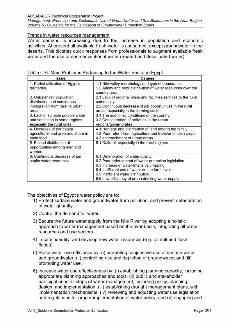
ACSAD-BGR Technical Cooperation Project Management, Protection and Sustainable Use of Groundwater and Soil Resources in the Arab Region Volume 5 - Guideline for the Delineation of Groundwater Protection Zones
Vol-5_Guideline-Groundwater-Protection-Zones.doc Page 201
Trends in water resources managementWater demand is increasing due to the increase in population and economic activities. At present all available fresh water is consumed, except groundwater in the deserts. This dictates quick responses from professionals to augment available fresh water and the use of non-conventional water (treated and desalinated water).
Table C-6: Main Problems Pertaining to the Water Sector in Egypt Issue Causes
1. Partial utilization of Egypt's territories.
1.1 Nile valley morphology and type of boundaries. 1.2 Aridity and poor distribution of water resources over the country area.
2. Unbalanced population distribution and continuous immigration from rural to urban areas.
2.1 Lack of regional plans and facilities/services to the rural community. 2.2 Continuous decrease of job opportunities in the rural areas, especially in the farming sector.
3. Lack of suitable potable water and sanitation in some regions, especially the rural ones.
3.1 The economic conditions of the country. 3.2 Concentration of activities in the urban regions/governorates
4. Decrease of per capita agricultural land area and share in main food.
4.1 Heritage and distribution of land among the family. 4.2 Poor return from agriculture and transfer to cash crops. 4.3 encroachment of urban areas.
5. Biased distribution of opportunities among men and women.
5.1 Cultural, especially in the rural regions.
6. Continuous decrease of per capita water resources.
6.1 Deterioration of water quality. 6.2 Poor enforcement of water protection legislation. 6.3 Increase of water-intensive cropping. 6.4 Inefficient use of water on the farm level. 6.5 Inefficient water distribution. 6.6 Low efficiency of urban drinking water supply.
The objectives of Egypt's water policy are to: 1) Protect surface water and groundwater from pollution, and prevent deterioration
of water quantity. 2) Control the demand for water. 3) Secure the future water supply from the Nile River by adopting a holistic
approach to water management based on the river basin, integrating all water resources and use sectors.
4) Locate, identify, and develop new water resources (e.g. rainfall and flash floods).
5) Raise water use efficiency by: (i) promoting conjunctive use of surface water and groundwater; (ii) controlling use and depletion of groundwater; and (iii) promoting water use.
6) Increase water use effectiveness by: (i) establishing planning capacity, including appropriate planning approaches and tools; (ii) public and stakeholder participation in all steps of water management, including policy, planning, design, and implementation; (iii) establishing drought management plans, with implementation mechanisms; (iv) reviewing and adjusting water use legislation and regulations for proper implementation of water policy; and (v) engaging and

ACSAD-BGR Technical Cooperation Project Management, Protection and Sustainable Use of Groundwater and Soil Resources in the Arab Region Volume 5 - Guideline for the Delineation of Groundwater Protection Zones
Vol-5_Guideline-Groundwater-Protection-Zones.doc Page 202
mobilizing women and building public awareness about water management by better communications, in particular, in rural areas.
One important characteristic of Egyptian agriculture is land distribution. More than 95% of the landowners hold less than 2 ha each. Only 3 % own 20 ha or more.
It was planned to develop an additional 920,000 ha for agriculture by 2000. This was to be achieved through further developing the country's surface water and groundwater resources, increasing drainage water and treated wastewater reuse, and improving irrigation efficiency.
Al Salam canal was planned for the reuse of drainage water from two main drains in the Eastern Delta. This water, added to water extracted from the Damietta branch of the Nile, will be used for the irrigation of a new area of 252,000 ha in the Eastern Delta and North Sinai. The total area planned to be developed for irrigation by different projects in the Sinai is estimated at 630,000 ha.
At present, Egypt and Sudan base their water development plans on the shares stipulated in the 1959 Nile water agreement between the two countries and on future conservation projects in the Sudd area in southern Sudan to increase the yield of the river. However, future developments in upstream countries will have to be taken into account from the point of view of present shares and any future increments that can become available from the conservation projects. In any case, the expansion of irrigation in the Nile basin in the years ahead will require basin-wide cooperation in the management of water resources to meet increasing demands and to face the associated environmental consequences.
>>>>>>>>>>>>>>><<<<<<<<<<<<<<<
1. Is there a law in place to allow for the delineation of groundwater protection zones ?
Throughout the past decade, more attention was given to the groundwater protection aspects in Egypt. The RIGW plays an essential and important role for developing the groundwater protection criteria that are suitable to apply within Egypt. The implementation of the National Groundwater Quality Monitoring Network as well as several local networks help a lot in detecting the main sources of groundwater pollution within these areas and in preparing groundwater vulnerability, pollution load and pollution risk maps. Based on the assessment of these maps the necessary protection actions (preventive, limiting or remedial) are proposed.
Several studies have been carried out to delineate groundwater protection zones around drinking water supply wells. These studies were carried out on the local scale in the new communities (Tenth of Ramadan and Sadat Cities), Cairo and Sharqia governorate (East Nile Delta Region). However, until now no groundwater protection zones have been implemented in Egypt.
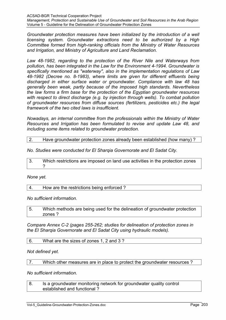
ACSAD-BGR Technical Cooperation Project Management, Protection and Sustainable Use of Groundwater and Soil Resources in the Arab Region Volume 5 - Guideline for the Delineation of Groundwater Protection Zones
Vol-5_Guideline-Groundwater-Protection-Zones.doc Page 203
Groundwater protection measures have been initialized by the introduction of a well licensing system. Groundwater extractions need to be authorized by a High Committee formed from high-ranking officials from the Ministry of Water Resources and Irrigation, and Ministry of Agriculture and Land Reclamation.
Law 48-1982, regarding to the protection of the River Nile and Waterways from pollution, has been integrated in the Law for the Environment 4-1994. Groundwater is specifically mentioned as "waterway", also in the implementation regulations of Law 48-1982 (Decree no. 8-1983), where limits are given for different effluents being discharged in either surface water or groundwater. Compliance with law 48 has generally been weak, partly because of the imposed high standards. Nevertheless the law forms a firm base for the protection of the Egyptian groundwater resources with respect to direct discharge (e.g. by injection through wells). To combat pollution of groundwater resources from diffuse sources (fertilizers, pesticides etc.) the legal framework of the two cited laws is insufficient.
Nowadays, an internal committee from the professionals within the Ministry of Water Resources and Irrigation has been formulated to revise and update Law 48, and including some items related to groundwater protection.
2. Have groundwater protection zones already been established (how many) ?
No. Studies were conducted for El Sharqia Governorate and El Sadat City.
3. Which restrictions are imposed on land use activities in the protection zones ?
None yet.
4. How are the restrictions being enforced ?
No sufficient information.
5. Which methods are being used for the delineation of groundwater protection zones ?
Compare Annex C-2 (pages 255-262; studies for delineation of protection zones in the El Sharqia Governorate and El Sadat City using hydraulic models).
6. What are the sizes of zones 1, 2 and 3 ?
Not defined yet.
7. Which other measures are in place to protect the groundwater resources ?
No sufficient information.
8. Is a groundwater monitoring network for groundwater quality control established and functional ?

ACSAD-BGR Technical Cooperation Project Management, Protection and Sustainable Use of Groundwater and Soil Resources in the Arab Region Volume 5 - Guideline for the Delineation of Groundwater Protection Zones
Vol-5_Guideline-Groundwater-Protection-Zones.doc Page 204
A national groundwater level network and a groundwater quality monitoring network (1998, 200 observation points, 60% in the Nile basin) were established in 1953 and 1998 respectively by RIGW. The monitoring network in the Nile Valley and Delta was established in 1953. For monitoring the piezometric heads and the groundwater table till 1987 the RIGW constructed more than 1200 deep and shallow observation wells. For quality monitoring four sampling rounds have been executed (1998, 1999, 2000 and 2001). In these sampling rounds all the monitoring points were sampled and analyzed for up to 50 parameters. High concentrations of sulphate and nitrate have been observed in monitoring points that were located in the reclaimed area in the fringes of the Nile basin. Salinity levels of the groundwater have increased under these areas. The salinity is partly caused by leaching of natural salts and partly by application of gypsum to the soil. This salinity front is moving towards the central parts of the Nile valley and Delta.
9. Have maps of groundwater vulnerability been prepared ?
In the last ten years, several intrinsic groundwater vulnerability maps were prepared by the RIGW for the Nile Valley and Nile Delta region on semi-regional (1:500,000) and detailed (1:100,000) scales (compare Annex C-2).
10. Are guidelines/laws/by-laws in place to control the quality of emissions into surface and groundwater (sewage water/effluent standard) ?
No information.
11. Is there a law/by-law/guideline for the design and monitoring/control of waste disposal sites ?
No information.
12. Is there a law/by-law/guideline for the use of pesticides/fertilizers in agriculture ?
No information.
13. Is there a law/by-law/guideline for environmental protection/environmentalimpact assessment ?
No information.
14. How are groundwater protection demands integrated into land use planning ?
No information.

ACSAD-BGR Technical Cooperation Project Management, Protection and Sustainable Use of Groundwater and Soil Resources in the Arab Region Volume 5 - Guideline for the Delineation of Groundwater Protection Zones
Vol-5_Guideline-Groundwater-Protection-Zones.doc Page 205
5 Groundwater Protection Zone Delineation in Jordan
(source: MARGANE et al, 2002 ; MARGANE & SUNNA, 2002 ; FAO Aquastat)
General AspectsJordan covers a total area of about 89,210 km² and is divided into eight governorates: Amman, Zarqa, Irbid, Mafraq, Balqa, Karak, Tafileh and Ma'an.
The country can be divided into four physiographic regions: the Ghors (lowlands) in the western part of the country, which consist of 3
zones: the Jordan Valley, the lowlands along the Dead Sea and the Wadi Araba which extends in a southerly direction to the northern shores of the Red Sea;
the highlands, which run from north to south at an altitude of between 600 and 1,600 m above sea level;
the plains, which extend from north to south along the western borders of the desert (Badiah);
the desert region (Badiah) in the east, which is an extension of the Arabian desert.
The total population is around 5.47 million (2003), of which 22% (1994) is rural (Department of Statistics (www.dos.gov.jo/sdb_pop/growth_2005_e.htm). The population growth is estimated at 2.7% (2003). The cultivable land was estimated at 381,740 ha in 1992, or 4.3% of the total area of the country. In 1991, the total cultivated area was estimated at 214,767 ha. Agriculture accounted for 6% of Jordan's GDP in 1992 and for 12% of its exports earnings.
Water ResourcesSurface water resources are unevenly distributed among 15 basins. The largest source of external surface water is the Yarmouk River, at the border with Syria. Originally, the annual flow of the Yarmouk river was estimated at about 400 MCM (of which about 100 MCM are withdrawn by Israel). Total flow is now much lower than 400 MCM as a result of the upstream Syrian development works which took place in the 1980's. The Yarmouk River accounts for 40% of the surface water resources of Jordan, including water contributed from the Syrian part of the Yarmouk basin. It is the main source of water for the King Abdullah Canal (KAC) and is thus considered to be the backbone of development in the Jordan Valley. Other major basins include Zarqa River, Jordan River side wadis, Wadi Mujib, the Dead Sea side wadis, Wadi Hasa and Wadi Araba. Internally generated surface water resources are estimated at 400 MCM/year.
Jordan's groundwater is distributed among 12 major so-called groundwater basins. Total internally produced renewable groundwater resources, the so-called safe yield, is estimated by the Ministry of Water and Irrigation (MWI) at 277 MCM/year. The baseflow of the rivers constitutes around 335 MCM, a large portion of which, however, is of fossil origin, recharged during more humid climatic periods, and thus
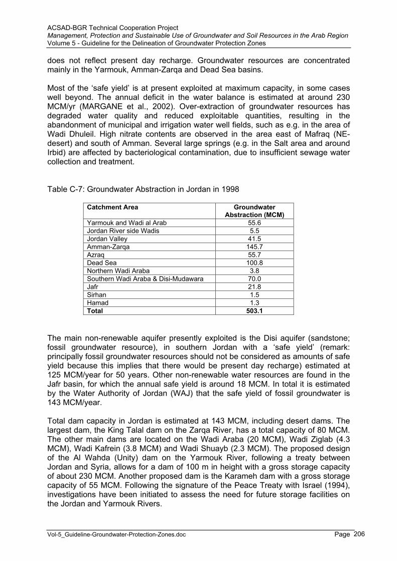
ACSAD-BGR Technical Cooperation Project Management, Protection and Sustainable Use of Groundwater and Soil Resources in the Arab Region Volume 5 - Guideline for the Delineation of Groundwater Protection Zones
Vol-5_Guideline-Groundwater-Protection-Zones.doc Page 206
does not reflect present day recharge. Groundwater resources are concentrated mainly in the Yarmouk, Amman-Zarqa and Dead Sea basins.
Most of the ‘safe yield’ is at present exploited at maximum capacity, in some cases well beyond. The annual deficit in the water balance is estimated at around 230 MCM/yr (MARGANE et al., 2002). Over-extraction of groundwater resources has degraded water quality and reduced exploitable quantities, resulting in the abandonment of municipal and irrigation water well fields, such as e.g. in the area of Wadi Dhuleil. High nitrate contents are observed in the area east of Mafraq (NE-desert) and south of Amman. Several large springs (e.g. in the Salt area and around Irbid) are affected by bacteriological contamination, due to insufficient sewage water collection and treatment.
Table C-7: Groundwater Abstraction in Jordan in 1998
Catchment Area Groundwater Abstraction (MCM)
Yarmouk and Wadi al Arab 55.6 Jordan River side Wadis 5.5 Jordan Valley 41.5 Amman-Zarqa 145.7 Azraq 55.7 Dead Sea 100.8 Northern Wadi Araba 3.8 Southern Wadi Araba & Disi-Mudawara 70.0 Jafr 21.8 Sirhan 1.5 Hamad 1.3 Total 503.1
The main non-renewable aquifer presently exploited is the Disi aquifer (sandstone; fossil groundwater resource), in southern Jordan with a ‘safe yield’ (remark: principally fossil groundwater resources should not be considered as amounts of safe yield because this implies that there would be present day recharge) estimated at 125 MCM/year for 50 years. Other non-renewable water resources are found in the Jafr basin, for which the annual safe yield is around 18 MCM. In total it is estimated by the Water Authority of Jordan (WAJ) that the safe yield of fossil groundwater is 143 MCM/year.
Total dam capacity in Jordan is estimated at 143 MCM, including desert dams. The largest dam, the King Talal dam on the Zarqa River, has a total capacity of 80 MCM. The other main dams are located on the Wadi Araba (20 MCM), Wadi Ziglab (4.3 MCM), Wadi Kafrein (3.8 MCM) and Wadi Shuayb (2.3 MCM). The proposed design of the Al Wahda (Unity) dam on the Yarmouk River, following a treaty between Jordan and Syria, allows for a dam of 100 m in height with a gross storage capacity of about 230 MCM. Another proposed dam is the Karameh dam with a gross storage capacity of 55 MCM. Following the signature of the Peace Treaty with Israel (1994), investigations have been initiated to assess the need for future storage facilities on the Jordan and Yarmouk Rivers.

ACSAD-BGR Technical Cooperation Project Management, Protection and Sustainable Use of Groundwater and Soil Resources in the Arab Region Volume 5 - Guideline for the Delineation of Groundwater Protection Zones
Vol-5_Guideline-Groundwater-Protection-Zones.doc Page 207
The produced wastewater was estimated at 232 MCM/year in 1993 and the quantity of reused treated wastewater reached 50 MCM, of which 48 MCM are used for irrigation and 2 MCM for industrial purposes. The reuse of treated wastewater in Jordan reaches one of the highest levels in the world. The treated wastewater flow in the country is returned to the Zarqa River and the King Tall dam, where it is mixed with surface water flow and used in the pressurized irrigation distribution system in the Jordan Valley. The importance of reused wastewater is an essential element of Jordan's water strategy.
In 1993, total annual water withdrawal was estimated at 984 MCM, up from 619 MCM in 1986. Agricultural water withdrawal accounted for 74.9 % of the total water withdrawal (73.9% for agriculture and 1% for lifestock, industrial and domestic use accounted for 3.4% and 21.7%, respectively) including the use of treated wastewater. Due to limited and widely scattered sources of water, the construction of important water conveyance facilities was undertaken between 1962 and 1987 in order to meet the demand of the population which is concentrated in some areas. Some shortages have been observed during recent years, but they are generally limited to less than 10% of the demand. However, during the dry year of 1990, the water shortage affected 17% of the water demand.
The level of the Dead Sea falls each year by 85 centimeters due to extensive water use in the Jordan basin. Irrigated soils along the Jordan Valley are showing signs of salinization since natural floods are no longer available to flush the irrigated land and leach salts.
The potential for irrigated cultivation is estimated at around 840,000 ha. However, taking into consideration potentially available water resources, the irrigation potential is only about 85,000 ha, including the area currently irrigated.
Although irrigation has been practiced in Jordan for a very long time, particularly in the Jordan Valley, intensive irrigation projects have been implemented since 1958 when the Government decided to divert part of the Yarmouk River water and constructed the East Ghor Canal (later named King Abdullah Canal). The canal reaches a total length of 110.5 km. Apart from in the Jordan Valley, irrigation is also practiced in the highlands, mainly dependent on groundwater resources.
In 1995, the total area equipped for irrigation was estimated at 72,850 ha. One of the main sources of water is the King Talal dam on the Zarqa River from which water is diverted into the King Abdullah Canal.
In 1992, it was estimated that about 55% of the area was irrigated from groundwater, 39% from surface water and 6 % from treated wastewater. The Disi irrigation project, one of the largest schemes in Jordan covering a total area of 3,000 ha, is supplied with fossil groundwater.
ACSAD-BGR Technical Cooperation Project Management, Protection and Sustainable Use of Groundwater and Soil Resources in the Arab Region Volume 5 - Guideline for the Delineation of Groundwater Protection Zones
Vol-5_Guideline-Groundwater-Protection-Zones.doc Page 208
Institutional AspectsThe following ministries/institutions are involved in the water sector in Jordan:
The Ministry of Water and Irrigation (MWI), with the Ministry of Water and Irrigation (as a separate entity), the Water Authority of Jordan (WAJ) and the Jordan Valley Authority (JVA) as its operational entities;
The Ministry of Agriculture; The Ministry of Municipal and Rural Affairs and the Environment (MMRAE).
The Ministry of Water and Irrigation is the body responsible in Jordan for the formulation and implementation of water and wastewater development programs. Water policies, covering all aspects of the water sector, were issued in 1998 (file Jordan Water Strategy & Policies.doc on CD.
Municipal water use was made more systematic with the creation of the Water Authority in 1985. Prior to that, many agencies and municipalities were responsible for the production and distribution of municipal water.
Trends in water resources managementJordan's past economic development plans reveal that surface water resources have been extensively developed by the Government, with priority given to the construction of dams and irrigation projects in the Jordan Valley in order to maximize the utilization of this resource before its drainage to the Dead Sea. Limited additional untapped surface water resources could be developed in the Jordan Valley side wadis and in the Mujib, Zarqa, Ma'an and Zara basins, subject to specific conditions.
Jordan, Israel and the West Bank are presently over-exploiting their water resources by between 10 and 20%. Water levels are dropping, groundwater resources are being mined, salinization and salt water intrusion are observed and the domestic water supply does not reach adequate standards. The following actions are envisaged to remedy this crisis:
reduction of water demand for irrigation; importation of water from water-rich countries like Turkey; desalinization of brackish water (in the southern Jordan Valley) and sea water
(Aqaba).
As part of the efforts towards joint management of water resources, the Jordanian-lsraeli Peace Treaty includes the following arrangements:
20 MCM of Yarmouk water will be stored by Israel in the winter and released to Jordan in the summer;
10 MCM will be released from the Tiberias Lake outside the summer season for Jordan until the construction of a desalinization plant;
construction of storage facilities on the Yarmouk and Jordan Rivers and groundwater potential in Wadi Araba are under investigation;
50 MCM of drinking water should be further allocated to Jordan through cooperation between both parties.
Although the potential for irrigation development in the highlands is great, a very small increase in irrigated agriculture is anticipated due to the unavailability of water resources. The average water consumption for irrigation in the Jordan Valley and
ACSAD-BGR Technical Cooperation Project Management, Protection and Sustainable Use of Groundwater and Soil Resources in the Arab Region Volume 5 - Guideline for the Delineation of Groundwater Protection Zones
Vol-5_Guideline-Groundwater-Protection-Zones.doc Page 209
southern Ghor is less than 10,000 m³/ha per year, which is much less than in the highlands where it reaches on average 16,000 m³/ha per year.
Some of the water resources which would be made available for irrigation purposes are recycled water from municipal wastewater treatment plants. The total quantity of reused treated wastewater is expected to grow from 50 MCM in 1993 to about 89 MCM in 2000 and 237 MCM in 2020.
Future projects include the construction of storage facilities on major rivers and side wadis (the Al Wahdah, Karameh, Walah, Tannur, Mujib and Yabis dams) to alleviate part of the water shortages for agricultural activities. The total yield of these dams for agricultural purposes will be about 200 MCM/year.
Water harvesting techniques are not yet widely practiced in Jordan. However, small research pilot projects are trying to see whether this technique would suit the country's characteristics.
>>>>>>>>>>>>>>><<<<<<<<<<<<<<<
1. Is there a law in place to allow for the delineation of groundwater protection zones ?
The present water law is insufficient to support the issuance of ordinances pertaining to groundwater protection zones. It was therefore proposed to amend the law by adding a by-law on water protection. A national guideline for the delineation of groundwater protection zones was proposed within the framework of the new Jordanian-German Technical Cooperation project ‘Groundwater Resources Management’ (MARGANE & SUNNA, 2002). A committee was formed upon order of the Prime Minister that will decide on further steps concerning groundwater protection zones. This committee comprises high-ranking officials from all major ministries involved in the issue.
2. Have groundwater protection zones already been established (how many) ?
Protection zones for the Pella spring were established in 2000, based on a report by MARGANE et al. (1999). Within the framework of the new Jordanian-German Technical Cooperation project ‘Groundwater Resources Management’, groundwater protection zones will be established for at least 2 more wells or springs.
3. Which restrictions are imposed on land use activities in the protection zones ?
Not yet decided (see proposal by MARGANE & SUNNA, 2002). Decision to be expected in late 2003.

ACSAD-BGR Technical Cooperation Project Management, Protection and Sustainable Use of Groundwater and Soil Resources in the Arab Region Volume 5 - Guideline for the Delineation of Groundwater Protection Zones
Vol-5_Guideline-Groundwater-Protection-Zones.doc Page 210
4. How are the restrictions being enforced ?
Concerning the groundwater protection zones for the Pella spring, a fence of irregular shape, keeping a minimum distance of 10 m from the spring pools, was erected in 2000, in order to keep out livestock, which previously was regularly watered at the spring. A waste disposal, established without license in protection zone 2, was removed completely in 2001.
5. Which methods are being used for the delineation of groundwater protection zones ?
Jordan is a country dominated by aquifers in carbonatic rocks. Karst phenomena play a significant role, especially in areas with high rainfall, i.e. in all of the highlands. Flow may reach very high velocities in such areas, which must be taken into consideration by any method used. It was proposed to use the EPIK method, commonly use for groundwater vulnerability mapping, for the delineation process of groundwater protection zones in case where karst phenomena are significant. In other hard rocks, where flow velocities are controlled by faults and fractures, a flow regime analysis must be based on a tectonic analysis. In unconsolidated rocks where groundwater flow is homogeneous, traditional methods could be used (compare MARGANE & SUNNA, 2002).
6. What are the sizes of zones 1, 2 and 3 ?
Not decided yet (compare proposal by MARGANE & SUNNA, 2002). Establishment in progress.
7. Which other measures are in place to protect the groundwater resources ?
Military sites fall under the jurisdiction of the Ministry of Defense. No other Governmental authority has any rights on land owned by the Ministry of Defense.
Issues related to transportation are regulated by Law No. 14 for the year 1984 (Traffic Law).
The Natural Resources Law of the year 1968 regulates the exploitation of mineral resources and land reclamation. The operation of quarries is regulated by Law No. 21 for the year 1971 (Quarries Law).
The operation of facilities related to energy generation and conveyance is regulated by Law No. 10 of 1996 (Electricity Law).
Issues related to the establishment of commercial or industrial buildings are regulated in a number of laws:
Law No. 79 for the year 1966 (Organizing Cities, Villages and Buildings Law); Law No. 29 for the year 1955 (Municipalities Law); Law No. 16 for the year 1953 (Crafts and Industries Law); Law No. 59 for the year 1985 (Industrial Cities Corporation Law).
ACSAD-BGR Technical Cooperation Project Management, Protection and Sustainable Use of Groundwater and Soil Resources in the Arab Region Volume 5 - Guideline for the Delineation of Groundwater Protection Zones
Vol-5_Guideline-Groundwater-Protection-Zones.doc Page 211
A committee involving members of all relevant government authorities regularly meets to discuss and decide about locations for future sites and land use activities with possibly contaminating effects. This committee is headed by the Ministry of Environment (formerly General Corporation for Environmental Protection).
8. Is a groundwater monitoring network for groundwater quality control established and functional ?
A countrywide monitoring network for water levels was established in the early 1970s (MARGANE, 1995; MARGANE & ALMOMANI, 2002). Approximately 177 observation wells are currently being monitored throughout the country. To another 60 wells monitoring data are available where observation has been discontinued. Monitoring is conducted by automatic recorders, pressure-transducers or manually (once a month).
Groundwater quality monitoring is conducted by different authorities and for different purposes: the Water Authority of Jordan (Central Laboratory), the Ministry of Water and Irrigation. Groundwater quality monitoring has been conducted routinely since 1970s and historical data are available in the MWI database. However, water sampling and analysis are not following a scheduled program and fixed procedures. The frequency of sampling within each year is also irregular. Consequently, for many important groundwater sources, water quality records are not continuous so that historical data can only be used to a limited extent. Presently regular (at least once or twice a year) monitoring is conducted at 278 wells and springs. The records show a strong increase in TDS and nitrate contents in many areas of Jordan.
9. Have maps of groundwater vulnerability been prepared ?
Until now two groundwater vulnerability maps of urban growth centers at a scale of 1:100,000 were prepared:
Groundwater vulnerability map and map of hazards to groundwater of the Irbid area (MARGANE et al., 1997); and Groundwater vulnerability map and map of hazards to groundwater of the South Amman area (HIJAZI et al., 1999).
Two more such maps will be prepared within the framework of the Jordanian-German Technical Cooperation project ‘Groundwater Resources Management’: for the area Kerak area and for the area around the corridor well field (east of Mafraq).
10. Are guidelines/laws/by-laws in place to control the quality of emissions into surface and groundwater (sewage water/effluent standard) ?
Water quality standards have been established by the Jordan Institute of Standards and Metrology (JISM):
The Technical Regulation on Drinking Water (Standard No. 286/2001, JISM 2001);The Standard for Industrial Wastewater (Standard No. 202/91, JISM 1991); The Standard for Treated Domestic Wastewater (Standard No. 893/95, JISM 1995).
ACSAD-BGR Technical Cooperation Project Management, Protection and Sustainable Use of Groundwater and Soil Resources in the Arab Region Volume 5 - Guideline for the Delineation of Groundwater Protection Zones
Vol-5_Guideline-Groundwater-Protection-Zones.doc Page 212
11. Is there a law/by-law/guideline for the design and monitoring/control of waste disposal sites ?
No.
12. Is there a law/by-law/guideline for the use of pesticides/fertilizers in agriculture ?
No.
13. Is there a law/by-law/guideline for environmental protection/environmental impact assessment ?
The Environment Law was finally passed in April 2003. A Ministry of Environment is presently being established.
14. How are groundwater protection demands integrated into land use planning ?
The integration of water protection demands into the land use planning process is insufficient until now. In some areas a ‘watershed committee’ was established comprising member of the local and regional authorities to facilitate an integration of this issue.
ACSAD-BGR Technical Cooperation Project Management, Protection and Sustainable Use of Groundwater and Soil Resources in the Arab Region Volume 5 - Guideline for the Delineation of Groundwater Protection Zones
Vol-5_Guideline-Groundwater-Protection-Zones.doc Page 213
6 Groundwater Protection Zone Delineation in Syria
(modified after MISKI, A.F. (retired water expert at ACSAD & DWSSA/Ministry of Housing and Utilities) & SHAWAF, S. (retired Director of Public Water Pollution Control Directorate, Ministry of Irrigation); KHOURI, 2000; and FAO Aquastat)
General AspectsSyria covers a total area of 185,180 km². The Syrian Arab Republic is divided into 14 administrative units (Governorates or Mohafazat): City of Damascus, Suburban Damascus, Homs, Hama, Aleppo, Latakia, Tartous, Idlib, Raqqa, Dair Es Zhor, Hasaqeh, Dera’a, Suwaida, Quanaitra.
The country can be divided into 4 physiographic regions: the coastal region between the mountains and the sea; the mountains and the highlands extending from north to south parallel to the
Mediterranean coast; the plains, or interior, located east of the highlands and including the plains of
Damascus, Homs, Hama, Aleppo, Al-Hassakeh and Dara'a; the Badiah and the desert plains in the south-eastern part of the country,
bordering Jordan and Iraq.
In 1993, the cultivable land was estimated at 5.94 million ha, or 32 % of the total area of the country. The cultivated land was estimated at 4.94 million ha (FAO Aquastat; WORLD BANK, 2001a: 5.5 million ha), which is 83% of the cultivable area.
The total population is 14.6 million (1995), of which 48% is rural. Actual population growth is 3.3%.
Syria is divided into 7 hydrological basins: Barada and Awaj, Yarmouk, Assi, Coastal, Tigris and Khabour, Euphrates, Badia.
The natural average surface runoff to Syria from international rivers is estimated at 28,730 MCM/year. The water resources generated inside the country are estimated at around 9,700 MCM per year as the long-term average. Groundwater recharge is about 4,200 MCM/year, of which about 2,000 MCM/year discharges into rivers as spring water. Total groundwater transboundary inflow has been estimated at 1,350 MCM/year, of which 1,200 MCM from Turkey and 150 MCM from Lebanon.
There are 160 dams in Syria with a total storage capacity of 18 BCM. The largest dam is the Al-Tabka dam on the Euphrates with a storage capacity of 14,160 MCM (WORLD BANK, 2001a).
Total annual water withdrawal in Syria in 1993 was estimated at 14.41 km³/year, of which agricultural use accounted for 94.4% (3.7% is withdrawn for domestic use and 1.9% for industrial use). The treatment of domestic wastewater is carried out mainly in the towns of Damascus, Aleppo, Homs and Salamieh. The total amount of treated

ACSAD-BGR Technical Cooperation Project Management, Protection and Sustainable Use of Groundwater and Soil Resources in the Arab Region Volume 5 - Guideline for the Delineation of Groundwater Protection Zones
Vol-5_Guideline-Groundwater-Protection-Zones.doc Page 214
wastewater was estimated at 0.37 km³/year in 1993, which represents 60% of the total produced volume of 0.61 km³/year. All treated wastewater is reused.In 1998, the total area equipped for irrigation was estimated at 1.2 million ha (WORLD BANK, 2001a). Irrigation is mainly developed in the north-eastern part of the country and more than one-third of the irrigated areas are located in the Al-Hassakeh governorate. In 1993 it was estimated that 60.2% of the area was irrigated from groundwater and 39.8 % from surface water. The use of groundwater for irrigation has been expanding rapidly in the past five years because irrigation from groundwater is cheaper than irrigation by gravity. Irrigation efficiency is still rather low, with sprinkler irrigation applied on around 80,000 ha and drip irrigation on 8,500 ha, only.
The cost of operation and maintenance of irrigation schemes by surface water is recovered from the farmers. Presently (1999) this charge is set to 3,500 SP/ha. Farmers irrigating with groundwater do not pay any charges. The absence of appropriate irrigation tariffs on a volumetric basis and subsidized energy costs do not support modernizing irrigation systems. Subsidizing certain agricultural products has also contributed to substantial irrigation water use in low-value crops like wheat and maize.
Institutional AspectsWater is considered as a public property, owned by the Government. The major player in the water sector is the Ministry of Irrigation (MI) that was established in 1982. In 1986 General Directorates of Irrigation were established for each of the seven hydrologic basins.
There are 4 other organizations involved in the water sector in Syria: the Ministry of Agriculture and Agrarian Reform, Directorate of Irrigation and
Water Uses; the Ministry of Housing and Public Services, Directorate of Water Supply and
Waste Water being responsible for water supply and sanitation; the State Planning Commission, Section: Irrigation and Agriculture Sector; the Ministry of Environment; the State Environmental Affairs Commission, Section: Water Environment
Safety Sector.
The Ministry of Irrigation is in charge of the study of water resources, their protection from depletion and pollution, of irrigation, dams, planning, research, operation and maintenance and pollution control. Allocation of water to agriculture is one of the main tasks of the ministry and it is thus responsible for the study and implementation of irrigation water structures and irrigation schemes. The Directorate of Irrigation is involved in water resources studies and surveys, water legislation and sharing international waters. There are three other departments under the responsibility of the Ministry of Irrigation: the Euphrates Basin Development Authority, the Euphrates Basin Land Reclamation Authority and the General Company of Major Water Resources Studies. Under the Ministry of Irrigation there are seven General Directorates, one for each of the seven hydrological basins.
ACSAD-BGR Technical Cooperation Project Management, Protection and Sustainable Use of Groundwater and Soil Resources in the Arab Region Volume 5 - Guideline for the Delineation of Groundwater Protection Zones
Vol-5_Guideline-Groundwater-Protection-Zones.doc Page 215
The Ministry of Irrigation also is in charge of groundwater monitoring and the issuing of licenses for groundwater well drilling. In some areas with a high concentration of wells, such as parts of the Aleppo and Salamieh areas, the water table is dropping. The Ministry is exploring means of increasing the recharge of the shallow aquifers.
The Ministry of Housing and Utilities (MHU) is responsible for setting the master plans for all cities, town and villages as well as for providing drinking water and sewerage facilities to them. Even though the MHU is principally responsible for water supply and sanitation, its power is limited due to the fact that planning, design, implementation and operation of water supply and sanitation schemes is in the hand of the relatively independent Governorate’s Water Supply and Sewerage Authorities (WSSA). The water resources are allocated to the MHU’s WSSAs by the MI’s General Directorates. There is some duplication of tasks between the MI and the MHU, e.g. in the field of groundwater monitoring.
The Ministry of Agriculture and Agrarian Reform, through its Directorate of Irrigation and Water Uses deals with issues of irrigation efficiency and the allocation of land to be irrigated/cultivated.
The role of the Ministry of Environment is defined by law no. 50 of the year 2002 (28.07.2002). It is concerned with the monitoring, control and protection of the air, water and soil quality.
At the local level, the city and town councils have competence over all works within its administrative responsibility under the supervision of the governorate council. They establish water supply services and are involved in the planning and implementation of agricultural and water project in cooperation with the agricultural cooperative associations.
Water ResourcesThe following numbers on water resources and uses are adopted from MARTIN (1999). According to this report, the renewable water resources are distributed as follows:
Table C-8: Renewable Water Resources of Syria
Basin Renewable Water Resources (MCM/yr) Euphrates Surface Water >5262
Groundwater 1424 Total 6686
Khabour Surface Water ? Groundwater ? Total >1800
Tigris Surface Water 2500 Groundwater 0 Total 2500
Steppe Surface Water 209 Groundwater 182 Total 391
Yarmouk Surface Water 195 Groundwater 265
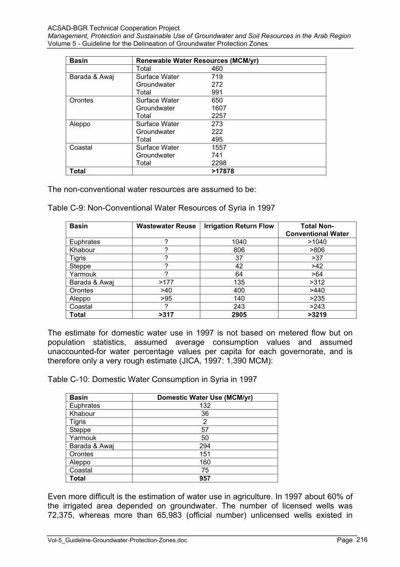
ACSAD-BGR Technical Cooperation Project Management, Protection and Sustainable Use of Groundwater and Soil Resources in the Arab Region Volume 5 - Guideline for the Delineation of Groundwater Protection Zones
Vol-5_Guideline-Groundwater-Protection-Zones.doc Page 216
Basin Renewable Water Resources (MCM/yr) Total 460
Barada & Awaj Surface Water 719 Groundwater 272 Total 991
Orontes Surface Water 650 Groundwater 1607 Total 2257
Aleppo Surface Water 273 Groundwater 222 Total 495
Coastal Surface Water 1557 Groundwater 741 Total 2298
Total >17878
The non-conventional water resources are assumed to be:
Table C-9: Non-Conventional Water Resources of Syria in 1997
Basin Wastewater Reuse Irrigation Return Flow Total Non-Conventional Water
Euphrates ? 1040 >1040 Khabour ? 806 >806 Tigris ? 37 >37 Steppe ? 42 >42 Yarmouk ? 64 >64 Barada & Awaj >177 135 >312 Orontes >40 400 >440 Aleppo >95 140 >235 Coastal ? 243 >243 Total >317 2905 >3219
The estimate for domestic water use in 1997 is not based on metered flow but on population statistics, assumed average consumption values and assumed unaccounted-for water percentage values per capita for each governorate, and is therefore only a very rough estimate (JICA, 1997: 1,390 MCM):
Table C-10: Domestic Water Consumption in Syria in 1997
Basin Domestic Water Use (MCM/yr) Euphrates 132 Khabour 36 Tigris 2 Steppe 57 Yarmouk 50 Barada & Awaj 294 Orontes 151 Aleppo 160 Coastal 75 Total 957
Even more difficult is the estimation of water use in agriculture. In 1997 about 60% of the irrigated area depended on groundwater. The number of licensed wells was 72,375, whereas more than 65,983 (official number) unlicensed wells existed in
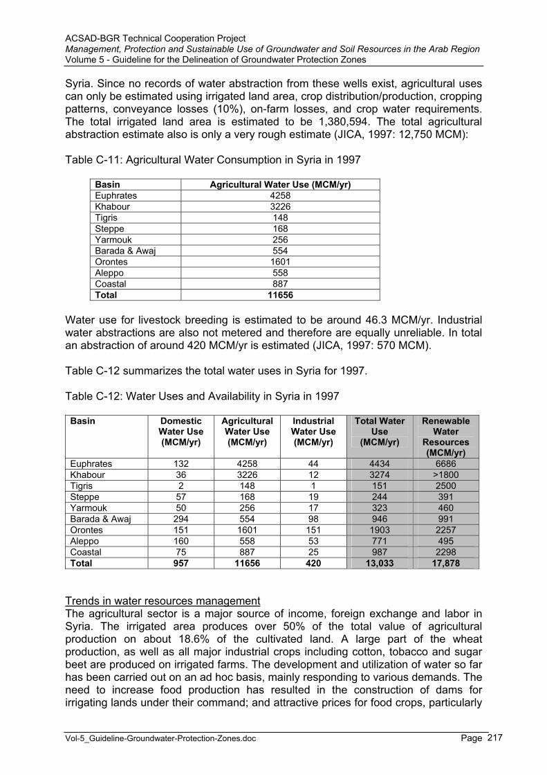
ACSAD-BGR Technical Cooperation Project Management, Protection and Sustainable Use of Groundwater and Soil Resources in the Arab Region Volume 5 - Guideline for the Delineation of Groundwater Protection Zones
Vol-5_Guideline-Groundwater-Protection-Zones.doc Page 217
Syria. Since no records of water abstraction from these wells exist, agricultural uses can only be estimated using irrigated land area, crop distribution/production, cropping patterns, conveyance losses (10%), on-farm losses, and crop water requirements. The total irrigated land area is estimated to be 1,380,594. The total agricultural abstraction estimate also is only a very rough estimate (JICA, 1997: 12,750 MCM):
Table C-11: Agricultural Water Consumption in Syria in 1997
Basin Agricultural Water Use (MCM/yr) Euphrates 4258 Khabour 3226 Tigris 148 Steppe 168 Yarmouk 256 Barada & Awaj 554 Orontes 1601 Aleppo 558 Coastal 887 Total 11656
Water use for livestock breeding is estimated to be around 46.3 MCM/yr. Industrial water abstractions are also not metered and therefore are equally unreliable. In total an abstraction of around 420 MCM/yr is estimated (JICA, 1997: 570 MCM).
Table C-12 summarizes the total water uses in Syria for 1997.
Table C-12: Water Uses and Availability in Syria in 1997
Basin Domestic Water Use (MCM/yr)
AgriculturalWater Use (MCM/yr)
IndustrialWater Use (MCM/yr)
Total Water Use
(MCM/yr)
Renewable Water
Resources (MCM/yr)
Euphrates 132 4258 44 4434 6686Khabour 36 3226 12 3274 >1800 Tigris 2 148 1 151 2500Steppe 57 168 19 244 391Yarmouk 50 256 17 323 460Barada & Awaj 294 554 98 946 991Orontes 151 1601 151 1903 2257Aleppo 160 558 53 771 495Coastal 75 887 25 987 2298Total 957 11656 420 13,033 17,878
Trends in water resources managementThe agricultural sector is a major source of income, foreign exchange and labor in Syria. The irrigated area produces over 50% of the total value of agricultural production on about 18.6% of the cultivated land. A large part of the wheat production, as well as all major industrial crops including cotton, tobacco and sugar beet are produced on irrigated farms. The development and utilization of water so far has been carried out on an ad hoc basis, mainly responding to various demands. The need to increase food production has resulted in the construction of dams for irrigating lands under their command; and attractive prices for food crops, particularly
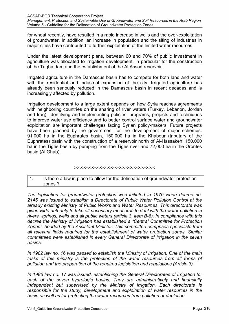
ACSAD-BGR Technical Cooperation Project Management, Protection and Sustainable Use of Groundwater and Soil Resources in the Arab Region Volume 5 - Guideline for the Delineation of Groundwater Protection Zones
Vol-5_Guideline-Groundwater-Protection-Zones.doc Page 218
for wheat recently, have resulted in a rapid increase in wells and the over-exploitation of groundwater. In addition, an increase in population and the siting of industries in major cities have contributed to further exploitation of the limited water resources.
Under the latest development plans, between 60 and 70% of public investment in agriculture was allocated to irrigation development, in particular for the construction of the Taqba dam and the establishment of the Al Assad reservoir.
Irrigated agriculture in the Damascus basin has to compete for both land and water with the residential and industrial expansion of the city. Irrigated agriculture has already been seriously reduced in the Damascus basin in recent decades and is increasingly affected by pollution.
Irrigation development to a large extent depends on how Syria reaches agreements with neighboring countries on the sharing of river waters (Turkey, Lebanon, Jordan and Iraq). Identifying and implementing policies, programs, projects and techniques to improve water use efficiency and to better control surface water and groundwater exploitation are important challenges facing Syrian policy-makers. Future projects have been planned by the government for the development of major schemes: 91,000 ha in the Euphrates basin, 150,000 ha in the Khabour (tributary of the Euphrates) basin with the construction of a reservoir north of Al-Hassakeh, 150,000 ha in the Tigris basin by pumping from the Tigris river and 72,000 ha in the Orontes basin (Al Ghab).
>>>>>>>>>>>>>>><<<<<<<<<<<<<<<
1. Is there a law in place to allow for the delineation of groundwater protection zones ?
The legislation for groundwater protection was initiated in 1970 when decree no. 2145 was issued to establish a Directorate of Public Water Pollution Control at the already existing Ministry of Public Works and Water Resources. This directorate was given wide authority to take all necessary measures to deal with the water pollution in rivers, springs, wells and all public waters (article 3, item B-8). In compliance with this decree the Ministry of Irrigation has established a “Central Committee for Protection Zones”, headed by the Assistant Minister. This committee comprises specialists from all relevant fields required for the establishment of water protection zones. Similar committees were established in every General Directorate of Irrigation in the seven basins.
In 1982 law no. 16 was passed to establish the Ministry of Irrigation. One of the main tasks of this ministry is the protection of the water resources from all forms of pollution and the preparation of the required legislation and regulations (Article 3).
In 1986 law no. 17 was issued, establishing the General Directorates of Irrigation for each of the seven hydrologic basins. They are administratively and financially independent but supervised by the Ministry of Irrigation. Each directorate is responsible for the study, development and exploitation of water resources in the basin as well as for protecting the water resources from pollution or depletion.
ACSAD-BGR Technical Cooperation Project Management, Protection and Sustainable Use of Groundwater and Soil Resources in the Arab Region Volume 5 - Guideline for the Delineation of Groundwater Protection Zones
Vol-5_Guideline-Groundwater-Protection-Zones.doc Page 219
Groundwater protection zones are established by form of ministerial decision of the Ministry of Irrigation. Only in case of the Figheh spring, one of the most important springs in Syria (water supply of Damascus), the protection zone was established by a presidential law (law no. 10, March 1989).
The most recent legislation concerning groundwater protection was issued on 18 January 2003 as decision no. 386, issued by the Prime Minister. It prohibits the drilling of wells for agricultural purposes in all hydrological basins of Syria. The decision defines regulations for well licensing for drinking water, industrial purposes and touristic purposes. According to this decision, even governmental bodies have to acquire a license before drilling a water well. The decision emphasizes on the delineation of protection zones for water wells, springs, foggharas and water courses. Violators of this decision are subject to severe punishments.
2. Have groundwater protection zones already been established (how many) ?
A groundwater protection zone has been established for the Fijeh spring in 1989 (see above). The law no. 10 was based on a profound study by SOGREAH (1980) of the hydrogeological and socio-economic conditions. Three zone have been distinguished: intensive, direct and peripheral protection zone. The peripheral zone includes the entire recharge zone of approx. 770 km².
As a result of the committees for protection zones, more than 45 ministerial decisions were passed for the establishment of protection zones. Out of these, 26 are related to wells and springs, the remaining to lakes, dams and foggharas.
In 1980, the Ministry of Public Works and Water Resources issued ministerial decision no. 393, which includes guidelines for the delineation of protection zones for water resources. The major parts of the guidelines were taken from the German regulations.
Each year the protection zone committees of the individual basins report to the “Central Committee for Protection Zones” and makes a proposal for the establishment of protection zones it deems necessary in its area. The Central Committee coordinates the received proposals giving priority to those resources aimed for drinking purposes and most vulnerable to pollution. The Central Committee issues an annual work plan for the delineation of protection zones, taking the technical and financial resources into consideration. In compliance with this plan, each basin committee implements the necessary hydrogeological and socio-economic investigations and prepares a draft ministerial decision. The draft is then discussed in the central committee for approval by the Minister of Irrigation. After its issuance, the General Directorate of Irrigation is responsible for its implementation.
ACSAD-BGR Technical Cooperation Project Management, Protection and Sustainable Use of Groundwater and Soil Resources in the Arab Region Volume 5 - Guideline for the Delineation of Groundwater Protection Zones
Vol-5_Guideline-Groundwater-Protection-Zones.doc Page 220
3. Which restrictions are imposed on land use activities in the protection zones ?
In zone I (Intensive Prohibition Zone) all activities are prohibited except the planting of trees.
Zone II (Direct Prohibition Zone) has to be protected from flooding, no construction of sewerage network is allowed. The coverage of bare rocks and the filling of holes by clean impermeable material, industries that produce dangerous wastes, first class roads, camps or training centers, sewage water treatment plants, and the application of hazardous fertilizers or pesticides are not allowed in this zone. The use of fertilizers and pesticides must be monitored and controlled.
The restrictions in zone III (Peripheral Protection Zone) are less strict. They aim at protecting the water resources from contamination by chemical, radioactive and other hazardous substances, such as petroleum derivates, poisons, and mining wastes.
4. How are the restrictions being enforced ?
Violations of the restrictions imposed by the ministerial decisions regarding protection zones are monitored by employees of the Ministry of Irrigation and the Ministry of Housing and Utilities who should inform the representatives of the Ministry of Local Administration and the police in order to prevent any violation. There are, however, a lot of problems with the local population when enforcing these restrictions.
As an example the measures imposed in the Fijeh spring protection zone are presented: In the Intensive Prohibition Zone 40 houses were appropriated by DAWSSA since 1976 with 34 of them being evacuated. However, the owners of 6 houses refused to leave until now. Another problem is the asphalt road between Fijeh and Dair Moukarren which passes immediately upstream of the spring through the Intensive Prohibition Zone. Even though traffic is in principle blocked for trucks, this regulation is difficult to enforce and is not accepted by the local population.
5. Which methods are being used for the delineation of groundwater protection zones ?
No information.
6. What are the sizes of zones 1, 2 and 3 ?
Three zones are being distinguished according to ministerial decree no. 393: Intensive Prohibition Zone (A): It has to be appropriated by the Ministry of Public Works and Water Resources or the General Establishment of Drinking Water that is exploiting the resource. In this zone all activities are prohibited except planting trees. The intention of delineating this zone is to prevent any direct pollution. Direct Prohibition Zone (B): It covers that part of the recharge area that is sufficient for self-purification of the groundwater. The extent of this zone

ACSAD-BGR Technical Cooperation Project Management, Protection and Sustainable Use of Groundwater and Soil Resources in the Arab Region Volume 5 - Guideline for the Delineation of Groundwater Protection Zones
Vol-5_Guideline-Groundwater-Protection-Zones.doc Page 221
depends on the environmental, geological, geographical and socio-economic conditions in the recharge area.Peripheral Protection Zone (C): It covers the rest of the recharge area. In case of large springs having an extended recharge area, the peripheral protection zone is divided into two zones: sub-zone A, covering an area within a 2 km radius from the abstraction facility, and sub-zone B, covering the remaining recharge area. For drinking water wells which are normally close to inhabited areas, only zones A and B are delineated.
In practice the sizes of zones A, B and C depend on many factors, such as among others the size of the recharge area, the hydrogeological and socio-economic conditions, the existing and planned land use activities, the amount of discharge/abstraction, the water use and the ability to enforce restrictions.
The size of zone A is usually a few hectares, that of zone BI some tens of hectares, while the size of zone III may range between some square kilometers and some hundred square kilometers. For example, the sizes of the protection zones for the Fijeh spring measure: zone A: 11 ha, zone B: 57 ha, zone C: 770 km². Those of the Barada spring measure: zone A: 1.5 ha, zone B: 10 ha, zone C: 46 km².
7. Which other measures are in place to protect the groundwater resources ?
The Ministry of Irrigation cooperates with the Ministry of Housing and Utilities during the study phase of master plans for villages and towns in order to exclude protection zones from urban development areas. In some cases even an already approved urban master plan was modified in order to avoid incursions into intensive or direct prohibition zones (e.g. Mzairib spring).
The Ministry of Irrigation cooperates with the Ministry of Petroleum to the effect that crude oil pipelines or pipelines for petroleum derivates are not constructed in water resources protection zones. When deemed impossible by the Ministry of Petroleum, technical provisions are being undertaken to avoid a pollution of the water resources (such as is the case for the Banyas spring in the coastal basin).
The Ministry of Irrigation coordinates with the Ministry of Environment in order to make the intensive protection zone an environmental reservation area, like in the case of the Sinn spring in the coastal basin.
The Ministry of Irrigation coordinates with the Ministry of Defense to the effect that the placement of military camps and installations is avoided in water resources protection zones.
The Central Committee for Protection Zones always tries its best in order to find suitable solutions for accidental pollutions. A good example is the pollution of Tannour spring in the Assi basin, where discharge considerably decreased and which became polluted by nitrates. The committee undertook measures to close wells in the recharge area and prohibited the use of fertilizers and pesticides as well as permanent irrigation in the direct prohibition zone.
ACSAD-BGR Technical Cooperation Project Management, Protection and Sustainable Use of Groundwater and Soil Resources in the Arab Region Volume 5 - Guideline for the Delineation of Groundwater Protection Zones
Vol-5_Guideline-Groundwater-Protection-Zones.doc Page 222
The Ministry of Irrigation coordinates with the Ministry of Agriculture and Agrarian Reform to guide farmers how to use treated sewage water in order to protect drinking water wells from pollution in the Damascus Ghouta.
The Ministry of Irrigation undertakes measures of capacity building for its staff in the various scientific, socio-economic and administrative fields required for the establishment of protection zones.
The Ministry of Irrigation monitors the quality of treated sewage water in order to ensure its bacteriological and hydrochemical safety.
The Ministry of Irrigation endeavors to upgrade its legislation concerning groundwater protection, whenever modifications are required or new methodologies become available.
8. Is a groundwater monitoring network for groundwater quality control established and functional ?
In every hydrologic basin of Syria there is a groundwater monitoring network where water levels are being recorded either monthly or every three months. Samples for water quality monitoring are taken every three months from selected wells of this network. Special attention is given to the monitoring of heavy metals. Samples are taken from important springs to monitor water quality. In the Barada and Awaj basin, there are 140 wells for monitoring water levels and 29 for water quality monitoring.
9. Have maps of groundwater vulnerability been prepared ?
No groundwater vulnerability maps have been prepared in Syria yet, with the exception of the map prepared by the ACSAD-BGR Technical Cooperation project for the Damascus Ghouta (HOBLER & RAJAB, 2002).
However, some studies concerning sea water intrusion have been conducted in the coastal area and appropriate countermeasures were implemented.
It is intended to prepare groundwater vulnerability maps in the future for selected pilot areas.
10. Are guidelines/laws/by-laws in place to control the quality of emissions into surface and groundwater (sewage water/effluent standard) ?
Standards for industrial effluents discharged into the Barada and Assi Rivers are already in place. Also there are standards for effluents discharged into the sewerage network aiming at ensuring the proper and efficient operation of the sewage water treatment plants. The Directorate of Public Water Pollution Control (DPWPC) has established guidelines for all effluents that are discharged into the sea, rivers, and other water bodies. There are ongoing discussions to issue standards based on these guidelines.
ACSAD-BGR Technical Cooperation Project Management, Protection and Sustainable Use of Groundwater and Soil Resources in the Arab Region Volume 5 - Guideline for the Delineation of Groundwater Protection Zones
Vol-5_Guideline-Groundwater-Protection-Zones.doc Page 223
11. Is there a law/by-law/guideline for the design and monitoring/control of waste disposal sites ?
The guideline for the design and control of waste disposal sites is included in decree 2145 of the year 1971, which gave the Directorate of Public Water Pollution Control the authority to monitor the pollution of all public waters. This directorate has established a water quality monitoring network along the courses of the main rivers in Syria, comprising: 27 stations along the Assi River, 36 stations along the Barada River, 13 stations along the Euphrates River, 6 stations along the Kabis Shamali River, 6 stations along the Yarmouk River. Monthly samples are taken from each station. The elements monitored are: discharge, BOD, TSS, ammonia, nitrates, pH, temperature and other relevant parameters. The time span with records varies between 10 and 25 years. The DPWPC also monitors the industrial waste water discharged from factories. The elements monitored depend on the type of industry. All samples are analyzed in the DPWPC labs and are reported to the relevant ministries who then may order a pollution source to undertake appropriate countermeasures.
12. Is there a law/by-law/guideline for the use of pesticides/fertilizers in agriculture ?
The Ministry of State for Environmental Affairs supervises the import of all pesticides. It defines which pesticides are allowed and which are prohibited to be used in Syria. Any import of pesticides needs the approval from this ministry and from the customs authority.
The use and import of fertilizers is guided by the Ministry of Agriculture and Agrarian Reform who guides farmers how to use fertilizers and pesticides in such a way that it does not cause any harm to humans, spoil the product or pollute the groundwater.
The Ministry of Irrigation upon preparing the decisions for protection zones states that the use of fertilizers and pesticides in zones II and III is subject to the supervision of the Directorates of Agriculture when agriculture is allowed in said zones.
13. Is there a law/by-law/guideline for environmental protection/environmentalimpact assessment ?
The Ministry of State for Environmental Affairs was created in 1991 by presidential decree no. 11. The task of this ministry is the preservation of the environment in Syria. The Supreme Council for Environmental Safety was established by the Cabinet, becoming responsible for the licensing of industries and installations possibly having polluting effects.
The Ministry of State for Environmental Affairs established a Directorate for Environmental Impact Assessment, becoming responsible for EIAs of every new industrial project and for setting the necessary precautions and measures that ought to be applied to protect the environment before issuing a license for any new project.
In 2002 law no. 50, the environment law, was passed by the Parliament. The main features of this law are:
ACSAD-BGR Technical Cooperation Project Management, Protection and Sustainable Use of Groundwater and Soil Resources in the Arab Region Volume 5 - Guideline for the Delineation of Groundwater Protection Zones
Vol-5_Guideline-Groundwater-Protection-Zones.doc Page 224
It enables the Ministry of State for Environmental Affairs to set environmental standards and specifications; It created a general organization for environmental affairs and defines its tasks;It created the Supreme Council for Environmental Safety and defines its functions;It created a fund for supporting and protecting the environment; It nominated environmental experts who may be appointed by the Minister to freely inspect sources of pollution; It considers man-made pollution as a criminal act and imposes sanctions ranging from financial penalties to 10 year imprisonment; It permitted already existing installations causing pollution a time span of one year to adapt their operation to the newly imposed restrictions and demands.
14. How are groundwater protection demands integrated into land use planning ?
Until now there is no national plan for land use in Syria. The Ministry of Housing and Utilities prepares master plans for urban and rural settlements. The Ministry of Irrigation and the Ministry of Agriculture and Agrarian Reform are involved in delineating the land to be reclaimed in compliance with soil classification and water availability. There are legislations and regulations on the governorate level classifying the land use as agricultural, industrial or urban. When studying master plans, the water resources protection zones demands listed in the relevant legislations are considered and respected.
ACSAD-BGR Technical Cooperation Project Management, Protection and Sustainable Use of Groundwater and Soil Resources in the Arab Region Volume 5 - Guideline for the Delineation of Groundwater Protection Zones
Vol-5_Guideline-Groundwater-Protection-Zones.doc Page 225
7 Groundwater Protection Zone Delineation in Yemen
(source: and FAO Aquastat)
General AspectsYemen covers a total area of 527,970 km². The country is divided into 17 governorates. The total population is 14.5 million (1995), of which 66 % is rural. The average demographic growth rate is estimated at 3.7%.
The cultivable land is estimated at about 3.62 million ha, which is 7% of the total area. In 1994, the total cultivated area was 1.05 million ha, or 29% of the cultivable area.
The many different landscapes of Yemen can be grouped into five main geographical/ climatological regions:
The Coastal Plains: The Plains are located in the west and south-west and are flat to slightly sloping with maximum elevations of only a few hundred meters above sea level. They have a hot climate with generally low to very low rainfall (< 50 mm/year). Nevertheless, the Plains contain important agricultural zones, due to the numerous wadis that drain the adjoining mountainous and hilly hinterland.
The Yemen Mountain Massif: This massif constitutes a high zone of very irregular and dissected topography, with elevations ranging from a few hundred meters to 3,760 m above sea level. Accordingly, the climate varies from hot at lower elevations to cool at the highest altitudes. The western and southern slopes are the steepest and enjoy moderate to rather high rainfall, on average 300-500 mm/year, but in some places even more than 1,000 mm/year. The eastern slopes show a comparatively smoother topography and average rainfall decreases rapidly from west to east.
The Eastern Plateau Region: This region covers the eastern half of the country. Elevations decrease from 1,200-1,800 m at the major watershed lines to 900 m on the northern desert border and to sea level on the coast. The climate in general is hot and dry, with average annual rainfall below 100 mm, except in the higher parts. Nevertheless, floods following rare rainfall may be devastating.
The Desert: Between the Yemen Mountain Massif and the Eastern Plateau lies the Ramlat as Sabatayn, a sand desert. Rainfall and vegetation are nearly absent, except along its margins where rivers bring water from adjacent mountain and upland zones. In the north lies the Rub Al Khali desert, which extends far into Saudi Arabia and is approximately 500,000 km² in area. This sand desert is one of the most desolate parts of the world.
The Islands: The most important of all the islands is Socotra, where more exuberant flora and fauna can be found than in any other region in Yemen.

ACSAD-BGR Technical Cooperation Project Management, Protection and Sustainable Use of Groundwater and Soil Resources in the Arab Region Volume 5 - Guideline for the Delineation of Groundwater Protection Zones
Vol-5_Guideline-Groundwater-Protection-Zones.doc Page 226
Water ResourcesYemen can be subdivided into four major drainage basins, regrouping numerous smaller wadis:
the Red Sea basin; the Gulf of Aden basin; the Arabian Sea basin; the Rub Al Khali interior basin.
The floods of the wadis in Yemen are generally characterized by abruptly rising peaks that rapidly recede. In between the irregular floods, the wadis are either dry or carry only minor base flows.
Surface water resources have been estimated at 2,000 MCM/year, but this quantity corresponds to the runoff from major rivers and does not include the runoff produced within the smaller catchments. Renewable groundwater resources have been estimated at 1,525 MCM/year, a large part probably coming from infiltration in the river beds. A major aquifer was recently discovered in the eastern part of the country with an estimated storage of 10 km³. This aquifer is still under study and it is not known whether the groundwater is rechargeable or whether it is entirely fossil water.
The surface runoff to the sea measured in some major wadis is estimated at 270 MCM/year, the groundwater outflow to the sea at 280 MCM/year. There might be some groundwater flowing into Saudi Arabia, but no data are available. The existence of surface drainage crossing into Saudi Arabia suggests that some sharing of surface flows could be possible, but details are not known.
The total dam capacity is estimated at 0.18 km³. In general, the dams are built for irrigation and domestic purposes, but at the same time they contribute to groundwater recharge. There are also many flood control dams which are not intended to store water, but to divert the spate floods immediately to the adjacent irrigation network (spate irrigation).
In 1990 total water withdrawal was estimated at 2,932 MCM/year, of which 92% for agricultural purposes (6.9% is withdrawn for domestic use and 1.1% for industrial use). Most of the water used was groundwater (from wells and springs), resulting in groundwater depletion as withdrawal exceeds the annual groundwater recharge. The rates of decline of the groundwater levels is alarmingly high in many zones, especially in the Yemen Highlands, where decline of between 2 and 6 m/year is commonly observed. In coastal zones this leads to the incidence of salt water intrusion. Spring-fed irrigation has reduced significantly as groundwater tables have dropped. The quantity of desalinated water was estimated at 10 MCM/year in 1989, contributing to the water supply of Aden.
In 1994, the total water managed area was estimated at 481,520 ha. A global figure for irrigation potential is not available. About 48,000 ha have been identified for further irrigation development, mostly in the coastal plains and in Wadi Hadramaut.
ACSAD-BGR Technical Cooperation Project Management, Protection and Sustainable Use of Groundwater and Soil Resources in the Arab Region Volume 5 - Guideline for the Delineation of Groundwater Protection Zones
Vol-5_Guideline-Groundwater-Protection-Zones.doc Page 227
Two main types of water management can be distinguished: Full/partial control irrigation: This concerns an area of 383,200 ha, all irrigated
from groundwater, of which 363 200 ha from tubewells and 20,000 ha from spring water. In general, new, deeper tubewells replace those which have gone out of production because of declining water tables.
Spate irrigation: This covers an area of 98,320 ha. Traditionally, farmers in the vicinity of wadis relied on simple earth built diversion systems and irrigation networks. With small to medium spates, these temporary embankments can be effective; with large spates, they are often swept away. In order to give better control of the spate flows, a series of public sector investments, involving the construction of permanent diversion weirs and canal distribution structures, have been made in the main wadis since the early 1970s. Most of these systems, however, have experienced maintenance and water distribution problems because scheme designs conflicted with traditional water rights.
On the remaining cultivated area of 571,266 ha, water harvesting is practiced, based on collecting and retaining overland flow in zones where soils permit agriculture. The receiving zone is always smaller than the zone where overland flow is produced, thus a multiplier effect is produced which permits agricultural production in low precipitation zones. The numerous constructed mountain terraces, also called 'the hanging gardens of Yemen', collect and retain rain and overland flow in a similar way.
Overall irrigation efficiency is low, between 35 and 45%, depending on field levelling and the water conveyance system used. Sprinkler irrigation and micro-irrigation are found on a limited number of farms and in pilot projects, using water from tubewells and springs. Almost all irrigation is surface irrigation. It is thought that efficiency could be increased to 60% by lining the canals and installing pipe distribution for surface irrigation, and to over 80% by adopting sprinkler irrigation and micro-irrigation techniques.
Farm size, including both rainfed and irrigated agriculture, is very small in general: 37% of the farms have less than 0.5 ha, 72% of the farms less than 2 ha, while only 4% of the farms have more than 10 ha.
According to the Constitution, flowing and underground water are defined as 'res communis'. However, a landowner has 'precedence' for water taken from a well on his land. In spring-irrigated areas water can be attached to land in the form of 'turns', which give rights to divert the canal into the field for a fixed period of time. The 'turn' can, however, be detached from the land and sold or rented separately. This landowner 'precedence' has permitted the private development of deep tubewell extraction, which is in some ways in conflict with Islamic principles. Islamic and customary law has no precedent for dealing with a new technology that allows landowners to extract (and sell) unlimited quantities of water from deep aquifers, and modern law has not yet regulated it either.
Since the 1970s the water supply situation in the Republic of Yemen has become critical. The main source, groundwater from wells, suffers from overstressed aquifers by large and uncontrolled abstraction and progressing groundwater pollution. Together with ill maintained distribution facilities this lead to serious shortfalls
ACSAD-BGR Technical Cooperation Project Management, Protection and Sustainable Use of Groundwater and Soil Resources in the Arab Region Volume 5 - Guideline for the Delineation of Groundwater Protection Zones
Vol-5_Guideline-Groundwater-Protection-Zones.doc Page 228
especially in the big towns, and to generally limited access of the population to safe drinking water.
As a consequence, there is high incidence of diarrhea, intestinal parasites and dysentery, which strongly indicates severe deficiencies in the water and sanitation sectors. In rural areas, where more than 70% of Yemen’s population lives, less than half of the households are supplied with hygienically unobjectionable drinking water.
At an average 3.7% growth of population, water demand increases rapidly. Agriculture consumes 92% of the available quantities. Overall annual water consumption is presently estimated at 3.4 billion m3. The still increasing depletion of water resources at a present annual rate of 900 MCM converts to a rapid declining of groundwater tables. Major population centers, such as Sana’a, Ta’iz and Sa’ada are in danger to run out of water from their traditional aquifers within the next 10 to 20 years. Decreasing resources are confronted with increasing contamination.
The institutional dimension of the water crisis refers to uncertainty about water rights and the weakness of supervising authorities for controlling the exploitation and protection of the resource. The Water Law legalizes the defined National Water Strategy and gives an outline of the administrative structure for its execution. However, the new Water Law needs to be complemented by the relevant policies, by-laws, executive procedures and guidelines in order to become workable and effective in practice.
Salinization due to irrigation exists in several regions, but no figures are available. No drainage systems are reported to exist.
Institutional AspectsIn view of the aggravating water crisis, the Government of the Republic of Yemen has declared the sustainable supply of the population with safe drinking water a top priority of economic and social development. The National Water Resources Authority (NWRA), established in 1995, has the prime task to develop and pursue a policy that leads to sustainable utilization of the decreasing water resources, and was given a central position to design, implement and control its components, as well as to take all appropriate steps to enhance public involvement and thus ensure social acceptance and viability of measures.
Solutions to the existing severe quantitative problems must be accompanied by quality protection measures, as the use of water resources is greatly restricted if they are polluted. The formulation of policies and of an action plan for Water Quality Control are presently under preparation in the framework of a Technical Cooperation project between NWRA and BGR (NWRA & BGR, 2003a/b/c).
The Ministry of Agriculture and Water Resources (MAWR) is responsible for formulating policies for water resources, for food security and for crops, livestock and forestry production, and for coordinating public investment and services in the sector. The General Directorate of Water Resources is located within the Ministry with four general departments: water resources; irrigation and maintenance of water installations; farm mechanization and land reclamation; irrigation studies. Most field
ACSAD-BGR Technical Cooperation Project Management, Protection and Sustainable Use of Groundwater and Soil Resources in the Arab Region Volume 5 - Guideline for the Delineation of Groundwater Protection Zones
Vol-5_Guideline-Groundwater-Protection-Zones.doc Page 229
services are provided to farmers through decentralized Regional Development Agencies (RDA), supported by technical services at national level. However, the division of responsibility between MAWR, the Agricultural Research and Extension Authority (AREA) and the RDAs with respect to water management is unclear.
Responsibility for coordinating rural water supplies lies within the Water Supply Department of the Ministry of Water and Electricity (MWE).
The General Department of Hydrology is located within the Ministry of Oil and Mineral Resources (MOMR).
Trends in water resources managementThe successful and sustainable exploitation of the water resources in Yemen is threatened. The most serious and obvious problem is the rapid depletion of groundwater resources. Almost all the important groundwater systems in Yemen are being over-exploited at an alarming rate. The socioeconomic consequences of groundwater resources depletion are dramatic since groundwater will become too expensive for use in agriculture and, as a result, regional agricultural economies based on groundwater irrigation are doomed to collapse if the water resources are not adequately controlled. The groundwater stocks may be further reduced by groundwater salinization (in coastal areas) and groundwater pollution (in urban areas and areas of intensive agriculture). Environmental degradation occurs, for example in areas where springs have dried up. The scarcity of water leads to ever-increasing competition which, if uncontrolled, might lead to socio-economic problems.
There is an increasing awareness in Yemen of groundwater depletion. The Government of Yemen has committed itself to a sustainable use of the water resources, which was reiterated in an official statement issued at the UN Conference on Environment and Development of 1992 in Rio de Janeiro.
Water resources management in the country suffers because there is no unified central decision-making organization. Several authorities are dealing with water related affairs with minimum integration and coordination. To solve this problem, a Presidential Decree for the establishment of the National Water Resources Authority (NWRA) was issued in October 1995, providing for the merger of the General Directorate of Water Resources of MAWR, the General Department of Hydrology of MOMR and the Technical Secretariat of the previously existing High Water Council. The main duties of the authority will be:
to prepare water resources policies and strategies; to formulate water legislation and regulations along with their enforcement; to undertake water resources studies, evaluation and planning; to carry out management at basin level, as traditional centralized management
has proved to be a failure.
Measures to be implemented at field level may include the introduction of water-saving techniques (improving irrigation efficiencies, imposing a water tariff, etc.), groundwater licensing and enforcement of pollution control regulations.
Strict water quality standards have been introduced in 2000 and 2001:
ACSAD-BGR Technical Cooperation Project Management, Protection and Sustainable Use of Groundwater and Soil Resources in the Arab Region Volume 5 - Guideline for the Delineation of Groundwater Protection Zones
Vol-5_Guideline-Groundwater-Protection-Zones.doc Page 230
Yemeni Quality Standards No. 100/2000: Bottled Drinking Water; Yemeni Quality Standards No. 109/2000: Drinking Water; Yemeni Quality Standards No. 150/2001: Irrigation Water; Yemeni Quality Standards No. 149/2001: Industrial and Commercial
Wastewater.
>>>>>>>>>>>>>>><<<<<<<<<<<<<<<
1. Is there a law in place to allow for the delineation of groundwater protection zones ?
The preparation of Water Zone Protection Plans was proposed by the Technical Cooperation project ‘’. A Guideline for Groundwater Protection Zone Delineation is intended to be prepared within the initial phase of this project. There is no law yet based on which protection zones could be established.
2. Have groundwater protection zones already been established (how many) ?
No.
3. Which restrictions are imposed on land use activities in the protection zones ?
None.
4. How are the restrictions being enforced ?
No information.
5. Which methods are being used for the delineation of groundwater protection zones ?
Not defined yet.
6. What are the sizes of zones 1, 2 and 3 ?
Not defined yet.
7. Which other measures are in place to protect the groundwater resources ?
No information.
ACSAD-BGR Technical Cooperation Project Management, Protection and Sustainable Use of Groundwater and Soil Resources in the Arab Region Volume 5 - Guideline for the Delineation of Groundwater Protection Zones
Vol-5_Guideline-Groundwater-Protection-Zones.doc Page 231
8. Is a groundwater monitoring network for groundwater quality control established and functional ?
No information.
9. Have maps of groundwater vulnerability been prepared ?
No information.
10. Are guidelines/laws/by-laws in place to control the quality of emissions into surface and groundwater (sewage water/effluent standard) ?
In 2000 and 2001 standards were introduced for bottled drinking water, drinking water, irrigation water and industrial and commercial wastewater.
11. Is there a law/by-law/guideline for the design and monitoring/control of waste disposal sites ?
No information.
12. Is there a law/by-law/guideline for the use of pesticides/fertilizers in agriculture ?
No information.
13. Is there a law/by-law/guideline for environmental protection/environmentalimpact assessment ?
No information.
14. How are groundwater protection demands integrated into land use planning ?
No information.
ACSAD-BGR Technical Cooperation Project Management, Protection and Sustainable Use of Groundwater and Soil Resources in the Arab Region Volume 5 - Guideline for the Delineation of Groundwater Protection Zones
Vol-5_Guideline-Groundwater-Protection-Zones.doc Page 232
8 References and Related Literature
ACSAD (1997): Water Resources and their Utilization in the Arab World. – 2nd
Symposium on Water Sources and their Uses in the Arab World, 8-10 March 1997; Kuwait.
ALSHARHAN, A.S., RIZK, Z.A., NAIRN, A.E.M., BAKHIT, D.W. & ALHAJARI, S.A. (2001): Hydrogeology of an Arid Region: The Arabian Gulf and Adjoining Areas.- 331 p.; Amsterdam (Elsevier).
AOMAR, J. & ABDELMAJID, K. (2002) : Wastewater Reuse in Morocco. – Report prepared by the Ministry of Agriculture, Rural Development and Waters and Forests for the Water Demand Management Forum, 30 p.; Rabat.
EL BATTI, D. (2003): Evaluation de la pratique actuelle du suivi et de la protection des ressources en eau en Tunisie. – Unpublished Report prepared for ACSAD, ACSAD-BGR Technical Cooperation Project ‘Management, Protection and Sustainable Use of Groundwater and Soil Resources in the Arab Region’ between BGR and ACSAD, 28 p.; Tunis/Tunisia, Damascus/Syria.
ESCWA, UNEP & IDB (1996): Assessment of Water Resources in the ESCWA Region Using Remote Sensing and GIS Techniques. – Report No. E/ESCWA/ENR/1996/7, 260 p.; Amman.
ESCWA (2000a): Guidelines for Groundwater Protection and Pollution Control in the GCC Countries. – Report No. ENR/2000/WG.3/12, 10 p.; Beirut/Lebanon.
ESCWA (2000b): Groundwater Pollution Control Measures in Lebanon. – Report No. ENR/2000/WG.3/11, 5 p.; Beirut/Lebanon.
ESCWA (2001): Implications of Groundwater Rehabilitation on Water Resources Protection and Conservation: Artificial Recharge and Water Quality Improvement in the ESCWA Region. – Report No. ENR/2001/12, 54 p.; Beirut/Lebanon.
ESCWA (2003): Updating the Assessment of Water Resources in the ESCWA Member Countries. – Report No. E/ESCWA/ENR/1999/13, 103 p.; Beirut.
HOBLER, M., MARGANE, A., ALMOMANI, M. & SUBAH, A. (2001): Groundwater Resources of Northern Jordan, Vol.4: Hydrogeological Features of Northern Jordan. - Unpublished report prepared by Technical Cooperation Project ’Advisory Services to the Water Authority of Jordan’ between BGR and WAJ, BGR archive no. 112708; Amman/Jordan.
KADI, M.A. (2002): Water Sector Development trough Effective Policies, Institutions and Investments: A Country Perspective (for Morocco). – [internet download from www.oieau.fr/ciedd/contributions/at3/contribution/aitkadi.html]
KHATER, A. R. (2003): Evaluation of the Current Practice of Groundwater Monitoring and Protection in Egypt. – Unpublished report prepared for ACSAD, 42 p.; Cairo/Egypt.
ACSAD-BGR Technical Cooperation Project Management, Protection and Sustainable Use of Groundwater and Soil Resources in the Arab Region Volume 5 - Guideline for the Delineation of Groundwater Protection Zones
Vol-5_Guideline-Groundwater-Protection-Zones.doc Page 233
KHOURI, J. (2000): The Development of Water Legislation in Arid and Semi-Arid Zones – A Case Study: Syria. – Report prepared by ACSAD for WHO, 17 p.; Damascus.
MACKSOUD, S.W. (2002): Towards a Sustainable Groundwater Development in Lebanon. – [internet download from www.oieau.fr/ciedd/contributions/at1/contribution/macksou.htm]
MARGANE, A. (1995): Groundwater Resources of Northern Jordan, Vol.2, Part 2: Monitoring of Groundwater Levels in Northern Jordan. - Unpublished report prepared by Technical Cooperation Project ’Advisory Services to the Water Authority of Jordan’ between BGR and WAJ, BGR archive no. 112708, 71 p., 3 app., 3 maps; Amman/Jordan.
MARGANE, A. (2002): Criteria for the Preparation of Groundwater Vulnerability Maps. - Technical Report No. 2, Unpublished report prepared by Technical Cooperation Project ‘Groundwater Resources Management’ between BGR and MWI, 118 p.; Amman/Jordan.
MARGANE, A. (2003a): Guideline for Groundwater Vulnerability Mapping and Risk Assessment for the Susceptibility of Groundwater Resources to Contamination. – Technical Reports Vol. 4, Unpublished report prepared by Technical Cooperation Project ‘Management, Protection and Sustainable Use of Groundwater and Soil Resources in the Arab Region’ between BGR and ACSAD, 177 p.; Damascus/Syria.
MARGANE, A. (2003b): Guideline for the Delineation of Groundwater Protection Zones. – Technical Report Vol. 5, prepared by ACSAD & BGR, Technical Cooperation Project ‘Management, Protection and Sustainable Use of Groundwater and Soil Resources in the Arab Region‘, 328 p.; Damascus.
MARGANE, A. & ALMOMANI, M. [Edts.] (2002): Preliminary Draft of National Water Master Plan, Vol. IV – Groundwater Resources. - Technical Report No. 3, Unpublished report prepared by Technical Cooperation Project ‘Groundwater Resources Management’ between BGR and MWI, 68 p.; Amman/Jordan.
MARGANE, A., HOBLER, M., OURAN, S. & AL ZUHDY, A. (1999) Groundwater Resources of Northern Jordan – Special Report No. 5: Hydrogeological Proposal for the Delineation of a Groundwater Protection Area for the Tabaqat Fahl (Pella) Spring. - Unpublished report prepared by Technical Cooperation Project ’Advisory Services to the Water Authority of Jordan’ between BGR and WAJ, BGR-archive no. 118708; Amman/Jordan and Hannover/Germany.
MARGANE, A., HOBLER, M. & SUBAH, A. (1997): Groundwater Resources of Northern Jordan, Special Report No. 3: Mapping of Groundwater Vulnerability and Hazards to Groundwater in the Irbid Area. - Unpublished report prepared by Technical Cooperation Project ’Advisory Services to the Water Authority of Jordan’ between BGR and WAJ, BGR archive no. 112708, 50 p., 10 app., 4 ann.; Amman/Jordan.
MARGANE, A., HOBLER, M. & SUBAH, A. (1999): Mapping of Vulnerability and Hazards to Groundwater in the Irbid Area, N-Jordan. – ZeitschriftAngewandte Geologie, 45, 4: 175-187.

ACSAD-BGR Technical Cooperation Project Management, Protection and Sustainable Use of Groundwater and Soil Resources in the Arab Region Volume 5 - Guideline for the Delineation of Groundwater Protection Zones
Vol-5_Guideline-Groundwater-Protection-Zones.doc Page 234
MARGANE, A., HOBLER, M., ALMOMANI, M. & SUBAH, A. (2002): Contributions to the Hydrogeology of Northern and Central Jordan. – Geol. Jahrbuch, C 68, 52 p., 18 fig.; Hannover.
MARGANE, A. & SUNNA, N. (2002): Proposal for a National Guideline for the Delineation of Groundwater Protection Zones. – Technical Report No. 1, Unpublished report prepared by Technical Cooperation Project ‘Groundwater Resources Management’ between BGR and MWI, 161 p.; Amman/Jordan.
MARTIN, N. (1999): Water Availability and Water Use in Syria. – Report prepared for WORLD BANK, 31 p.; Washington/DC/USA.
MELLOUL, A.J. & ZEITOUN, D.G. (1999): A Semi-Empirical Approach to Intrusion Monitoring in Israeli Coastal Aquifer. – In: BEAR, J. et al. (eds.): Seawater Intrusion in Coastal Aquifers – Concepts, Methods and Practices, 543-558; Dordrecht/The Netherlands (Kluver).
MERGUSIE (2001): La gestion de l’eau en Tunisie. – Report prepared for the project ‘Gestion intégrée de l’eau sur le bassin versant de Merguellil’, 10 p ; Tunis/Tunisia. [internet download]
MISKI, A.F. & SHAWAF, S. (2003): Aspects of Groundwater Resources Management, Protection and Monitoring in Syria. – Unpublished Report prepared for ACSAD, ACSAD-BGR Technical Cooperation Project ‘Management, Protection and Sustainable Use of Groundwater and Soil Resources in the Arab Region’ between BGR and ACSAD, 19 p.; Damascus/Syria.
NWRA & BGR (2003a): Sustainable Policy to Ensure National Water Quality Control. – Unpublished report prepared by BGR & GKW, Final report, Vol. 2A, Technical Cooperation Project ‘Support of the National Water Resources Authority (NWRA)’; Sana’ a/Yemen.
NWRA & BGR (2003b): Initial Action Plan for the Implementation of National Water Quality Control Policy . – Unpublished report prepared by BGR & GKW, Final report, Vol. 2B, Technical Cooperation Project ‘Support of the National Water Resources Authority (NWRA)’; Sana’ a/Yemen.
NWRA & BGR (2003c): Policy and Action Plan for Water Quality Control. – Unpublished report prepared by BGR & GKW, Final report, Vol. 2D, Technical Cooperation Project ‘Support of the National Water Resources Authority (NWRA)’; Sana’ a/Yemen.
ONEP & GTZ (1995) : Dossier technique relatif à la délimitation des zones de protection du champ de Sidi Taïbi (1995). – Unpublished report prepared by Moroccan-German Technical Cooperation Project ‘Protection of Drinking Water Resources’; Rabat/Morocco.
ONEP (2002): Protection des Captages: Cas du Champ Captant de Sidi Taibi. – [internet download from www.oieau.fr/ciedd/contributions/at1/contribution/onep1.htm]
TAHA, S. & BATAINEH, F. (2002): Valuation of Water for Domestic Use. – Prepared by Ministry of Water and Irrigation for Water Demand Management Forum, Beirut, June 2002, 23 p.; Amman.
ACSAD-BGR Technical Cooperation Project Management, Protection and Sustainable Use of Groundwater and Soil Resources in the Arab Region Volume 5 - Guideline for the Delineation of Groundwater Protection Zones
Vol-5_Guideline-Groundwater-Protection-Zones.doc Page 235
UNDP & WORLD BANK (2000): National Environmental Action Plan for Syrian Arab Republic – Draft. – 67 p., 5 ann.; Washington/DC/USA, New York/USA, Damascus/Syria.
UNESCO & ESCWA (1999): World Water Council – Arab Countries Vision Consultations. – Proceedings of a meeting held in Marseille on 4-5 August 1999, 41 p.; Cairo, Marseille, Beirut.
Van Der GUN, J.A.M. & ABDULAZIZ, A. (1995): The Water Resources of Yemen. – TNO & Ministry of Oil and Mineral Resources, Report No. WRAY-35; Sana’a.
VARELA-ORTEGA, C. & SAGARDOY, J.A. (2001): Analysis of Irrigation Water Policies in Syria: Current Developments and Future Options. Report prepared for FAO project ‘Utilization of Water Resources for Agriculture in Syria’, 22 p.; Rome/Italy.
WORLD COMMISSION ON DAMS (2001): Water, Institutions and Development in Syria: A Downstream Perspective from the Euphrates and Tigris. –Knowledge Base, Serial No. 108, 18 p. [internet download from: www.dams.org/kbase/submissions]
WORLD BANK (2001a): Syrian Arab Republic Irrigation Sector Report. - Report No. 22602-SYR, 95 p.; Washington/DC/USA.
WORLD BANK (2001b): Morocco Water Quality Management Country Report. – 11 p.; Washington/DC/USA.
WORLD BANK (2001) : Morocco Water Quality Management Country Report Country Report on Water Quality and Potential METAP Interventions. – 12 pages; New York/USA.
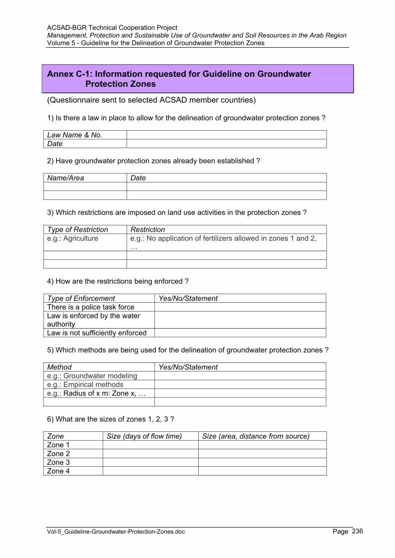
ACSAD-BGR Technical Cooperation Project Management, Protection and Sustainable Use of Groundwater and Soil Resources in the Arab Region Volume 5 - Guideline for the Delineation of Groundwater Protection Zones
Vol-5_Guideline-Groundwater-Protection-Zones.doc Page 236
Annex C-1: Information requested for Guideline on Groundwater Protection Zones
(Questionnaire sent to selected ACSAD member countries)
1) Is there a law in place to allow for the delineation of groundwater protection zones ?
Law Name & No. Date
2) Have groundwater protection zones already been established ?
Name/Area Date
3) Which restrictions are imposed on land use activities in the protection zones ?
Type of Restriction Restriction e.g.: Agriculture e.g.: No application of fertilizers allowed in zones 1 and 2,
…
4) How are the restrictions being enforced ?
Type of Enforcement Yes/No/Statement There is a police task force Law is enforced by the water authorityLaw is not sufficiently enforced
5) Which methods are being used for the delineation of groundwater protection zones ?
Method Yes/No/Statement e.g.: Groundwater modeling e.g.: Empirical methods e.g.: Radius of x m: Zone x, …
6) What are the sizes of zones 1, 2, 3 ?
Zone Size (days of flow time) Size (area, distance from source) Zone 1 Zone 2 Zone 3 Zone 4
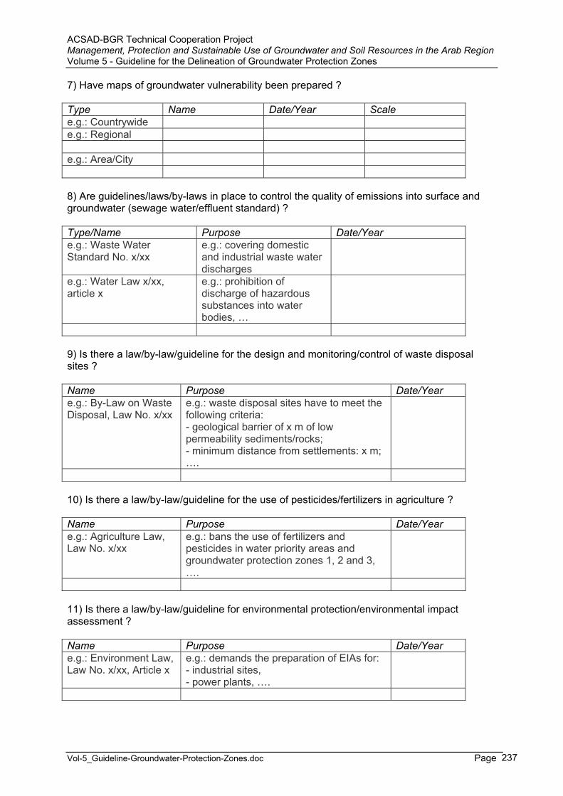
ACSAD-BGR Technical Cooperation Project Management, Protection and Sustainable Use of Groundwater and Soil Resources in the Arab Region Volume 5 - Guideline for the Delineation of Groundwater Protection Zones
Vol-5_Guideline-Groundwater-Protection-Zones.doc Page 237
7) Have maps of groundwater vulnerability been prepared ?
Type Name Date/Year Scale e.g.: Countrywide e.g.: Regional
e.g.: Area/City
8) Are guidelines/laws/by-laws in place to control the quality of emissions into surface and groundwater (sewage water/effluent standard) ?
Type/Name Purpose Date/Year e.g.: Waste Water Standard No. x/xx
e.g.: covering domestic and industrial waste water discharges
e.g.: Water Law x/xx, article x
e.g.: prohibition of discharge of hazardous substances into water bodies, …
9) Is there a law/by-law/guideline for the design and monitoring/control of waste disposal sites ?
Name Purpose Date/Year e.g.: By-Law on Waste Disposal, Law No. x/xx
e.g.: waste disposal sites have to meet the following criteria: - geological barrier of x m of low permeability sediments/rocks; - minimum distance from settlements: x m; ….
10) Is there a law/by-law/guideline for the use of pesticides/fertilizers in agriculture ?
Name Purpose Date/Year e.g.: Agriculture Law, Law No. x/xx
e.g.: bans the use of fertilizers and pesticides in water priority areas and groundwater protection zones 1, 2 and 3, ….
11) Is there a law/by-law/guideline for environmental protection/environmental impact assessment ?
Name Purpose Date/Year e.g.: Environment Law, Law No. x/xx, Article x
e.g.: demands the preparation of EIAs for: - industrial sites, - power plants, ….
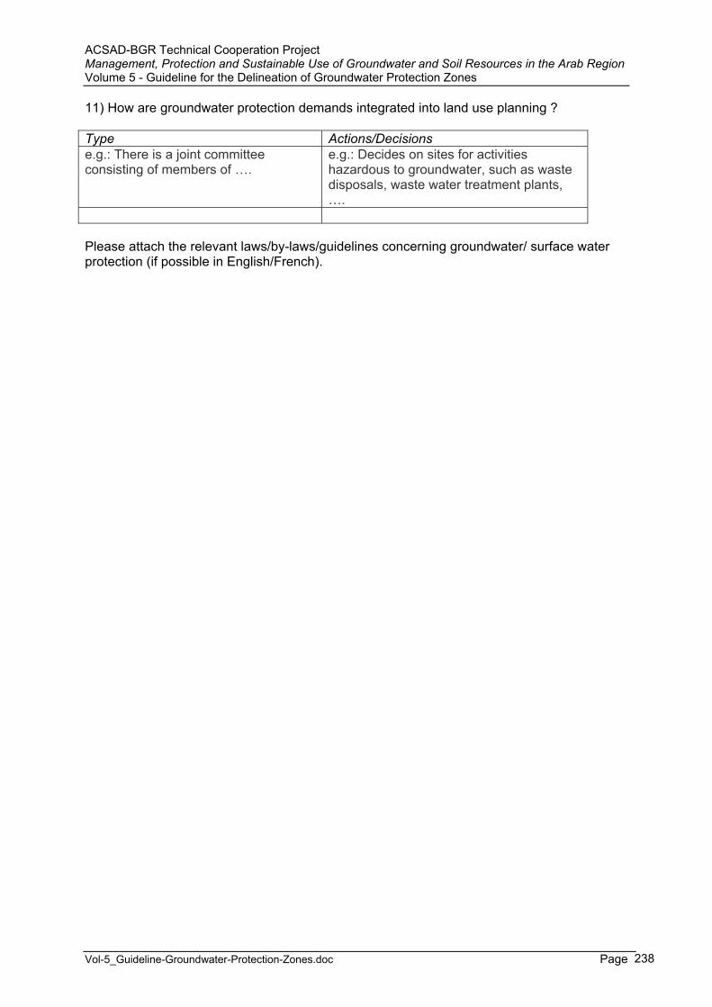
ACSAD-BGR Technical Cooperation Project Management, Protection and Sustainable Use of Groundwater and Soil Resources in the Arab Region Volume 5 - Guideline for the Delineation of Groundwater Protection Zones
Vol-5_Guideline-Groundwater-Protection-Zones.doc Page 238
11) How are groundwater protection demands integrated into land use planning ?
Type Actions/Decisions e.g.: There is a joint committee consisting of members of ….
e.g.: Decides on sites for activities hazardous to groundwater, such as waste disposals, waste water treatment plants, ….
Please attach the relevant laws/by-laws/guidelines concerning groundwater/ surface water protection (if possible in English/French).
ACSAD-BGR Technical Cooperation Project Management, Protection and Sustainable Use of Groundwater and Soil Resources in the Arab Region Volume 5 - Guideline for the Delineation of Groundwater Protection Zones
Vol-5_Guideline-Groundwater-Protection-Zones.doc Page 239
Annex C-2: Evaluation of the Current Practice of Groundwater Monitoring and Protection in Egypt
Document prepared by A. R. Khater

ACSAD-BGR Technical Cooperation Project Management, Protection and Sustainable Use of Groundwater and Soil Resources in the Arab RegionVolume 5 - Guideline for the Delineation of Groundwater Protection ZonesANNEX C-2 – Evaluation of the Current Practice of Groundwater Monitoring and Protection in Egypt
Page 240
Evaluation of the Current PracticeOf Groundwater Monitoring and Protection
in Egypt
Prepared By
Dr. Ahmed Rashad Khater
Director, Research Institute for Groundwater, National Water Research Center,
Ministry of Water Resources and Irrigation, Egypt E-mail: [email protected]
submitted to the Arab Centre for the Study of
Arid Zones and Dry Lands (ACSAD)
ACSAD-BGR Technical Cooperation Project Management, Protection and Sustainable Use of Groundwater and Soil Resources in the Arab RegionVolume 5 - Guideline for the Delineation of Groundwater Protection ZonesANNEX C-2 – Evaluation of the Current Practice of Groundwater Monitoring and Protection in Egypt
Page 241
December 2002
Contents
Page 1. General Characteristics of Egypt ………………………….………...…
1.1. Physical Setting ………...………………………………….….. 1.2 Hydrogeologic Environment ………………………………….. 1.3 Population and Development ……………………………….…. 1.4 Environmental Problems ………………………..………….…. 1.5 Water Resources …………………….………………………..... 1.6 Main Issues ………………………….………………………….
2. Institutional Aspects ..…………………………………………….
3 Defination and Delineation of Protection Zones..……...…….….……... 3.1 Curren Status…………………………………………………… 3.2 Practice of Delineating Protection Zones….…………..……….. 3.2.1 Delineation of Well Protection Zones in El
Sharqia Governorat…………………………………….. 3.2.2 Calculation of Groundwater Protection Zones Around
the Drinking Well Field in Sadat City. ………………….
4 Monitoring of Groundwater Levels and Groundwater Quality ………...4.1 The National Groundwater Level Network…………………..…. 4.2 The National Groundwater Quality Network…………..…..…...
5. Assessment of Groundwater Vulnerability and Hazard to Groundwater 5.1 Vulnerability of Groundwater to Pollution in the Nile Delta
5.2 Vulnerability of Groundwater to Pollution in the Middle, East and West Nile Delta Regions …………………….……………….
6. Legal Aspects………………………………………….………………… 7. Recommendations……………………………………………………….. 8. References………………..………………………………………………
244244245249250252
254
256257258
258
262
264264265
271271
272
278279280
ACSAD-BGR Technical Cooperation Project Management, Protection and Sustainable Use of Groundwater and Soil Resources in the Arab RegionVolume 5 - Guideline for the Delineation of Groundwater Protection ZonesANNEX C-2 – Evaluation of the Current Practice of Groundwater Monitoring and Protection in Egypt
Page 242
List of Tables
Page Table 1 Summary of Issues Pertaining to Integrated Water Management …. Table 2 Institutions Involved in Groundwater Management Activities in
Egypt ….……………………………………………………... Table 3 Factors Affecting the Groundwater Vulnerability in the Nile
Delta..…………………………………………………………
253
255
272
List of Figures
Page
Figure 1 Geography of Egypt ………………………………….……... Figure 2 Tectonic Map of Egypt ……………………………….…... Figure 3 The Hydrogeological Map of Egypt ………………….…... Figure 4 Groundwater in the Deserts …………………………….…… Figure 5 Groundwater in the Nile System ………………………..….. Figure 6 Illustrations of Well Protection Area …………..….. Figure 7 Zonation of Protection Area……………………….. Figure 8 Location of the StudyArea……………………...….… Figure 9 Finite Element Grid and Boundary Conditions for the Study Area…………………………………………………………….…….……Figure 10 Pollution Risk Map of Sadat City……………………………. Figure 11 Design of Groundwater Protection Zones in Sadat City ……. Figure 12 National Groundwater Level Monitoring Network……….…. Figure 13 The Type of Data Stored in the National Water Resources Data Base………………………………………………………………..………Figure 14 Types of the Output of the National Water Resources Data Base………………………………………………………………..………Figure 15 National Monitoring Network for Groundwater Quality….…. Figure 16 The Main Hydrochemical Process in the Reclamation Areas on the Fringes of the Nile Valley………………………………………..…. Figure 17 Nitrate Concentration in the Monitoring Wells………………. Figure 18 Manganese Concentration in the Monitoring Wells…………. Figure 19 Sulphate Concentration in the Monitoring Wells ………....…. Figure 20 Groundwater Vulnerability Map for the Nile Delta……….…. Figure 21 Vulnerability According to the Classical Approach…………. Figure 22 Vulnerability According to the Modified Approach………….
244246248250251256257260
261262263264
266
267268
269269270270273276277
ACSAD-BGR Technical Cooperation Project Management, Protection and Sustainable Use of Groundwater and Soil Resources in the Arab RegionVolume 5 - Guideline for the Delineation of Groundwater Protection ZonesANNEX C-2 – Evaluation of the Current Practice of Groundwater Monitoring and Protection in Egypt
Page 243
Preface
This report has been prepared upon the request of the Arab Center for the Studies of Arid Zones and Dry Lands (ACSAD), within the framework of their running project concerning "Management, Protection and sustainable Use for Groundwater and Soil Resources in the Arab Region".
The report presents an overview about the activities and achievements of Groundwater quality and quantity monitoring and protection in Egypt. The results of several pilot and important research and studies were also presented. A lot of experience can be exchanged in the Arab Region in the field of groundwater quality monitoring and groundwater protection. The "IHP- Network on Groundwater Protection in the Arab Region" can facilitate the exchange and transfer of such experience among the Arab Countries.
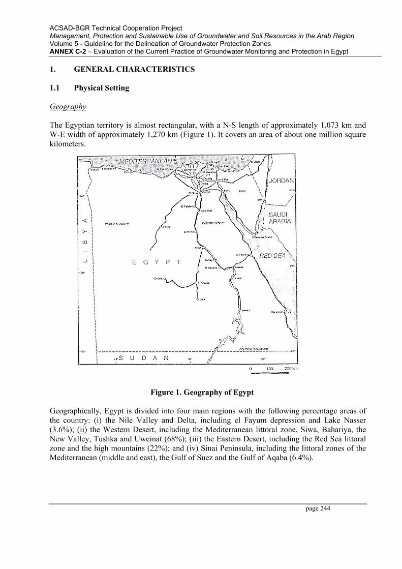
ACSAD-BGR Technical Cooperation Project Management, Protection and Sustainable Use of Groundwater and Soil Resources in the Arab RegionVolume 5 - Guideline for the Delineation of Groundwater Protection ZonesANNEX C-2 – Evaluation of the Current Practice of Groundwater Monitoring and Protection in Egypt
page 244
1. GENERAL CHARACTERISTICS
1.1 Physical Setting
Geography
The Egyptian territory is almost rectangular, with a N-S length of approximately 1,073 km and W-E width of approximately 1,270 km (Figure 1). It covers an area of about one million square kilometers.
Figure 1. Geography of Egypt
Geographically, Egypt is divided into four main regions with the following percentage areas of the country: (i) the Nile Valley and Delta, including el Fayum depression and Lake Nasser (3.6%); (ii) the Western Desert, including the Mediterranean littoral zone, Siwa, Bahariya, the New Valley, Tushka and Uweinat (68%); (iii) the Eastern Desert, including the Red Sea littoral zone and the high mountains (22%); and (iv) Sinai Peninsula, including the littoral zones of the Mediterranean (middle and east), the Gulf of Suez and the Gulf of Aqaba (6.4%).

ACSAD-BGR Technical Cooperation Project Management, Protection and Sustainable Use of Groundwater and Soil Resources in the Arab RegionVolume 5 - Guideline for the Delineation of Groundwater Protection ZonesANNEX C-2 – Evaluation of the Current Practice of Groundwater Monitoring and Protection in Egypt
page 245
Climate
The country lies for the most part within the temperate zone. The climate varies from arid to extremely arid. The air temperature frequently rises to over 400 C in daytime during summer, and seldom falls to zero in winter. The average rainfall over Egypt as a whole is only 10 mm/year. Along the Mediterranean, where most of the winter rain occurs, the annual average rainfall is about 150 mm/year, decreasing rapidly inland. The evaporation rates are high, being in excess of 3,000 mm/year.
1.2 Hydrogeologic Environment
Hydrography
The hydrography of Egypt comprises two systems: (i) a system related to the Nile; and (ii) a system related to the rainfall in the past geological times, particularly in the Late Tertiary and Quaternary.
The Nile system comprises the Valley and Delta regions which are morphologic depressions filled with Pliocene and Quaternary sediments. The Nile enters Egypt at Wadi Halfa, south of Aswan. This area is at present occupied by the Lake Nasser. From Aswan to Cairo, the river meanders until it reaches Cairo. At a distance of about 20 km north of Cairo, the river divides into two branches, each of which meanders separately through the Delta to the sea. In the Nile flood plain there are extensive man-made drainage systems, especially in the traditionally cultivated old land. Some extend to the areas reclaimed for agriculture on the desert fringes of the flood plain. The drainage systems discharge to the Nile itself or to the Northern Lakes and the Mediterranean Sea.
The other hydrographic system in Egypt is the complex network of dry streams (wadis); the formation of which dates back to past wet periods in the Tertiary and Quaternary. This system covers more than 90% of the surface area of Egypt in the Western Desert, the Eastern Desert, and Sinai. The main catchment areas drain towards to the Nile Valley and Delta, to the coastal zones, and to inland depressions.
Geomorphology
The landscape in Egypt can be broadly divided into the elevated structural plateau and the low plains (which include the fluviatile and coastal plains). These geomorphologic units play a significant role in determining the hydrogeological framework. The structural plateau constitutes the active and semi-active watershed areas. The low plains can contain productive aquifers and are also, in places, areas of groundwater discharge.
Geology
Geologically, Egypt is a portion of the northward overlap of the Nubian Arabian massif. In the southeast part of the country, the basement rocks are exposed and constitute portion of the
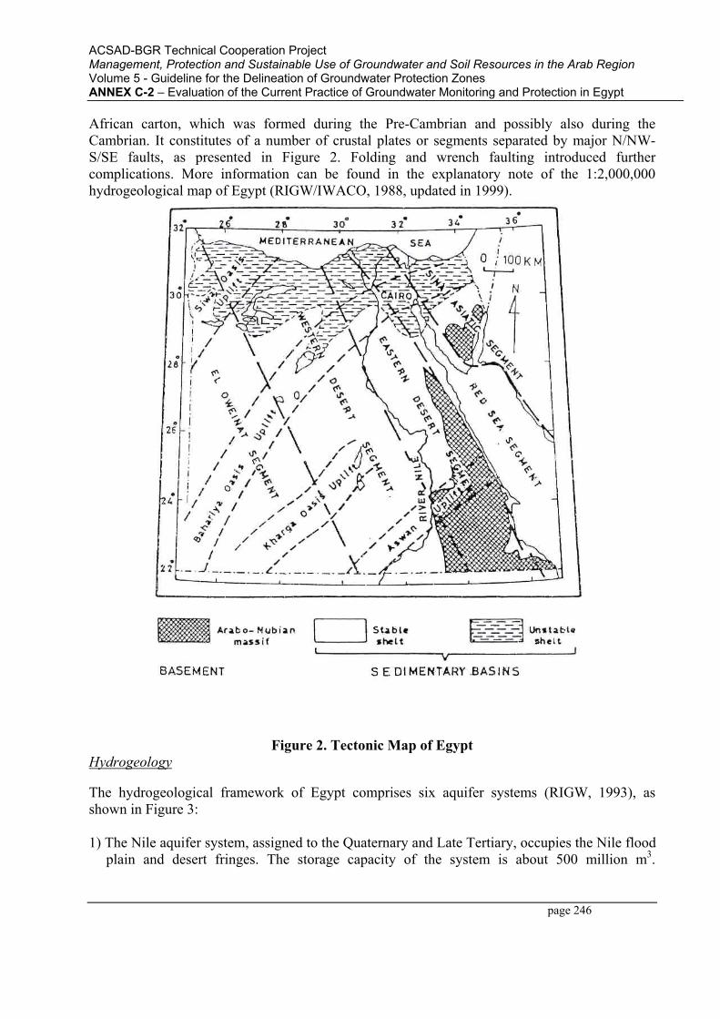
ACSAD-BGR Technical Cooperation Project Management, Protection and Sustainable Use of Groundwater and Soil Resources in the Arab RegionVolume 5 - Guideline for the Delineation of Groundwater Protection ZonesANNEX C-2 – Evaluation of the Current Practice of Groundwater Monitoring and Protection in Egypt
page 246
African carton, which was formed during the Pre-Cambrian and possibly also during the Cambrian. It constitutes of a number of crustal plates or segments separated by major N/NW-S/SE faults, as presented in Figure 2. Folding and wrench faulting introduced further complications. More information can be found in the explanatory note of the 1:2,000,000 hydrogeological map of Egypt (RIGW/IWACO, 1988, updated in 1999).
Figure 2. Tectonic Map of EgyptHydrogeology
The hydrogeological framework of Egypt comprises six aquifer systems (RIGW, 1993), as shown in Figure 3:
1) The Nile aquifer system, assigned to the Quaternary and Late Tertiary, occupies the Nile flood plain and desert fringes. The storage capacity of the system is about 500 million m3.

ACSAD-BGR Technical Cooperation Project Management, Protection and Sustainable Use of Groundwater and Soil Resources in the Arab RegionVolume 5 - Guideline for the Delineation of Groundwater Protection ZonesANNEX C-2 – Evaluation of the Current Practice of Groundwater Monitoring and Protection in Egypt
page 247
Groundwater is essentially replenished from activities originating from the Nile. Accordingly, it cannot represent a resource in itself; but the aquifer can be considered a storage and regulation reservoir.
2) The Nubian Sandstone aquifer system, assigned to the Paleozoic-Mesozoic, occupies a large area in the Western Desert, and parts of the Eastern Desert and Sinai. Its storage capacity is estimated at 60,000 Km3; but groundwater is almost non-renewable. Groundwater can be found at very shallow depths, where the water bearing formation (horizon) is exposed; or very large depths (up to 1,500 m), where the aquifer is semi confined. The deepest water bearing horizons are generally encountered in the north (Siwa), while the shallowest are encountered in the southern portion (East Uweinat and Kharga).
3) The Moghra aquifer system, assigned to the Lower Miocene, occupies mainly the western edge of the Delta. Groundwater recharge is limited to the portion adjacent to the flood plain through groundwater seepage.
4) The Coastal aquifer systems, assigned to the Quaternary and Late Tertiary, occupy the northern & eastern coasts. Groundwater is found in the form of thin lenses floating over saline water. The main recharge source is rainwater.
5) The karstified Carbonate aquifer system, assigned to the Eocene and to the Upper Cretaceous, predominates essentially in the north and middle parts of the Western Desert. It overlies the Nubian sandstone, and underlies the Nile aquifer system. It is essentially recharged through upward leakage from the Nubian sandstone.
6) The Fissured and Weathered hard rock aquifer system, assigned to the Pre-Cambrian, predominates in the Eastern Desert and Sinai. It is essentially recharged from its extension in Sudan, and, locally from rainfall (Sinai).
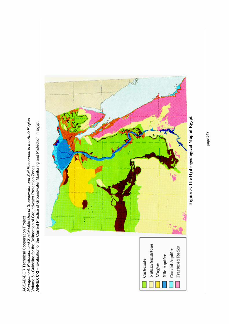
AC
SA
D-B
GR
Tec
hnic
al C
oope
ratio
n P
roje
ct
Man
agem
ent,
Pro
tect
ion
and
Sus
tain
able
Use
of G
roun
dwat
er a
nd S
oil R
esou
rces
in th
e A
rab
Reg
ion
Vol
ume
5 - G
uide
line
for t
he D
elin
eatio
n of
Gro
undw
ater
Pro
tect
ion
Zone
sA
NN
EX C
-2 –
Eva
luat
ion
of th
e C
urre
nt P
ract
ice
of G
roun
dwat
er M
onito
ring
and
Pro
tect
ion
in E
gypt
page
248
Figu
re 3
. The
Hyd
roge
olog
ical
Map
of E
gypt
ACSAD-BGR Technical Cooperation Project Management, Protection and Sustainable Use of Groundwater and Soil Resources in the Arab RegionVolume 5 - Guideline for the Delineation of Groundwater Protection ZonesANNEX C-2 – Evaluation of the Current Practice of Groundwater Monitoring and Protection in Egypt
page 249
1.3 Population and Development
Egypt's population is estimated at 64 million (1999). About 11.5% of the population is concentrated in Cairo, 7.1% in the coastal governorates, 43.5% in the Delta governorates, 36.5% in Upper Egypt governorates, and the rest distributed among the remaining area of the country. The population density varies from 15,000 to 0.4 person/Km2, in Cairo and the New Valley Governorates, respectively.
The percentages of the population served with water supply and sewerage connections are generally higher in the urban governorates than in the rural ones. In these communities with no access to water supply, the main source of fresh water is made available from shallow hand-dug wells that may be polluted due to poor protection means.
The continuous increase in population has resulted in urban encroachment on arable land leading to an annual loss of between 30,000 to 50,000 feddan of best agricultural land over the past 20 years. The total cultivated area at present is estimated at about 7.8 million acres, with a distribution among governorates that varies from 1-to 1,160-acres/1000 capita (Figure 8), with an average of about 0.13 acre/capita. The government policy is to reclaim an additional area of 3.4 million acres by the year 2017.
1.4 Environmental Problems
Provisions for the protection of the environment and natural resources have not been included in the country constitution. Rather, they are provided for under national laws, which in many instances were enacted to implement state sectoral policy. In this manner, a national policy, aiming at the protection of natural resources, has been enforced through a number of national laws, which regulate and control the exploitation of these resources. Similarly, measures to ensure compliance with public health standards and requirements were embodied in a number of laws.
Various environmental problems are encountered in the country due to the delay in providing environmental protection legislation and the poor enforcement of such legislation. The most important problems and their causes are summarized in the following paragraphs.
1. Air pollution due the emissions from factories and cars.
2. Pollution of surface water and northern lakes due to the disposal of primary or non-treated domestic and industrial effluent. Although the situation is not yet severe, it will soon become if no action is taken.
3. Pollution of the shallow groundwater for the same causes mentioned above, and poor solid waste disposal.
4. Increased drawdowns and salinity of groundwater on the desert fringes due to over-exploitation.
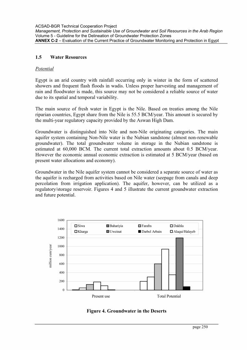
ACSAD-BGR Technical Cooperation Project Management, Protection and Sustainable Use of Groundwater and Soil Resources in the Arab RegionVolume 5 - Guideline for the Delineation of Groundwater Protection ZonesANNEX C-2 – Evaluation of the Current Practice of Groundwater Monitoring and Protection in Egypt
page 250
1.5 Water Resources
Potential
Egypt is an arid country with rainfall occurring only in winter in the form of scattered showers and frequent flash floods in wadis. Unless proper harvesting and management of rain and floodwater is made, this source may not be considered a reliable source of water due to its spatial and temporal variability.
The main source of fresh water in Egypt is the Nile. Based on treaties among the Nile riparian countries, Egypt share from the Nile is 55.5 BCM/year. This amount is secured by the multi-year regulatory capacity provided by the Aswan High Dam.
Groundwater is distinguished into Nile and non-Nile originating categories. The main aquifer system containing Non-Nile water is the Nubian sandstone (almost non-renewable groundwater). The total groundwater volume in storage in the Nubian sandstone is estimated at 60,000 BCM. The current total extraction amounts about 0.5 BCM/year. However the economic annual economic extraction is estimated at 5 BCM/year (based on present water allocations and economy).
Groundwater in the Nile aquifer system cannot be considered a separate source of water as the aquifer is recharged from activities based on Nile water (seepage from canals and deep percolation from irrigation application). The aquifer, however, can be utilized as a regulatory/storage reservoir. Figures 4 and 5 illustrate the current groundwater extraction and future potential.
0
200
400
600
800
1000
1200
1400
1600
Present use Total Potential
mill
ion
cum
/yea
r
Siwa Bahariyia Farafra DakhlaKharga Uweinat Darbel Arbain Alaqui/Halayeb
Figure 4. Groundwater in the Deserts
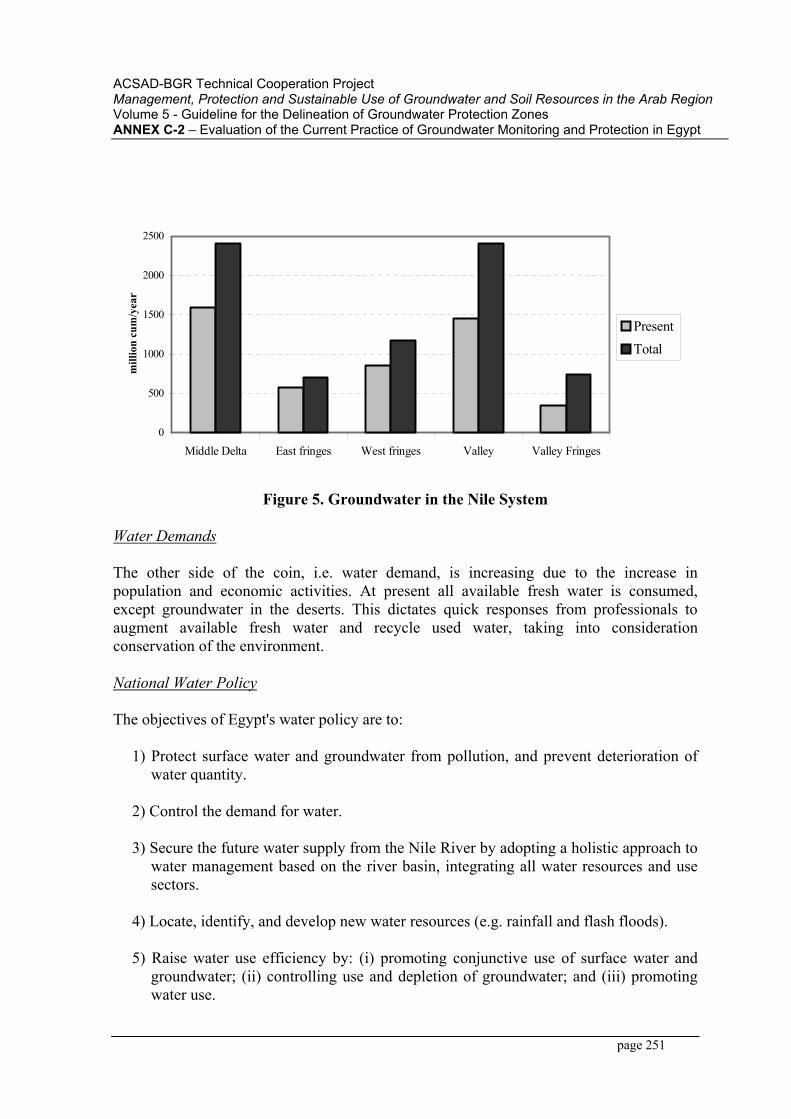
ACSAD-BGR Technical Cooperation Project Management, Protection and Sustainable Use of Groundwater and Soil Resources in the Arab RegionVolume 5 - Guideline for the Delineation of Groundwater Protection ZonesANNEX C-2 – Evaluation of the Current Practice of Groundwater Monitoring and Protection in Egypt
page 251
0
500
1000
1500
2000
2500
Middle Delta East fringes West fringes Valley Valley Fringes
mill
ion
cum
/yea
r
PresentTotal
Figure 5. Groundwater in the Nile System
Water Demands
The other side of the coin, i.e. water demand, is increasing due to the increase in population and economic activities. At present all available fresh water is consumed, except groundwater in the deserts. This dictates quick responses from professionals to augment available fresh water and recycle used water, taking into consideration conservation of the environment.
National Water Policy
The objectives of Egypt's water policy are to:
1) Protect surface water and groundwater from pollution, and prevent deterioration of water quantity.
2) Control the demand for water.
3) Secure the future water supply from the Nile River by adopting a holistic approach to water management based on the river basin, integrating all water resources and use sectors.
4) Locate, identify, and develop new water resources (e.g. rainfall and flash floods).
5) Raise water use efficiency by: (i) promoting conjunctive use of surface water and groundwater; (ii) controlling use and depletion of groundwater; and (iii) promoting water use.
ACSAD-BGR Technical Cooperation Project Management, Protection and Sustainable Use of Groundwater and Soil Resources in the Arab RegionVolume 5 - Guideline for the Delineation of Groundwater Protection ZonesANNEX C-2 – Evaluation of the Current Practice of Groundwater Monitoring and Protection in Egypt
page 252
6) Increase water use effectiveness by: (i) establishing planning capacity, including appropriate planning approaches and tools; (ii) public and stakeholder participation in all steps of water management, including policy, planning, design, and implementation; (iii) establishing drought management plans, with implementation mechanisms; (iv) reviewing and adjusting water use legislation and regulations for proper implementation of water policy; and (v) engaging and mobilizing women and building public awareness about water management by better communications, in particular, in rural areas.
1.6 Main Issues
The main issues facing Egypt's full development can be categorized as follows:
1. Geography and climate.
2. Population distribution and density.
3. Availability of facilities related to water and sanitation.
4. Style of agricultural land ownership and food production.
5. Degradation of water resources.
Based on the characteristics of the country and analysis of major issues, Table 1 has been prepared to summarize the main constraints facing water resources management. Although the present situation is not yet critical, however, if no immediate actions for integrated water management of the resources are implemented, Egypt will soon face a critical situation. To meet this real challenge of the future, a policy accompanied with specific strategies should be formulated. The first step in this policy is to clearly define critical issues and problems.

AC
SA
D-B
GR
Tec
hnic
al C
oope
ratio
n P
roje
ct
Man
agem
ent,
Pro
tect
ion
and
Sus
tain
able
Use
of G
roun
dwat
er a
nd S
oil R
esou
rces
in th
e A
rab
Reg
ion
Vol
ume
5 - G
uide
line
for t
he D
elin
eatio
n of
Gro
undw
ater
Pro
tect
ion
Zone
sA
NN
EX C
-2 –
Eva
luat
ion
of th
e C
urre
nt P
ract
ice
of G
roun
dwat
er M
onito
ring
and
Pro
tect
ion
in E
gypt
page
253
Tab
le 1
. Sum
mar
y of
Issu
es P
erta
inin
g to
Inte
grat
ed W
ater
Man
agem
ent
Issu
e C
ause
s
1. P
artia
l util
izat
ion
of E
gypt
's te
rrito
ries.
1.1
Nile
val
ley
mor
phol
ogy
and
type
of b
ound
arie
s. 1.
2 A
ridity
and
poo
r dis
tribu
tion
of w
ater
reso
urce
s ove
r the
cou
ntry
are
a.
2. U
nbal
ance
d po
pula
tion
dist
ribut
ion
and
cont
inuo
us
imm
igra
tion
from
rura
l to
urba
n ar
eas.
2.1
Lack
of r
egio
nal p
lans
and
faci
litie
s/se
rvic
es to
the
rura
l com
mun
ity.
2.2
Con
tinuo
us d
ecre
ase
of jo
b op
portu
nitie
s in
the
rura
l are
as, e
spec
ially
in
the
farm
ing
sect
or.
3. L
ack
of su
itabl
e po
tabl
e w
ater
and
sani
tatio
n in
som
e re
gion
s, es
peci
ally
the
rura
l one
s. 3.
1 Th
e ec
onom
ic c
ondi
tions
of t
he c
ount
ry.
3.2
Con
cent
ratio
n of
act
iviti
es in
the
urba
n re
gion
s/go
vern
orat
es
4. D
ecre
ase
of p
er c
apita
agr
icul
tura
l lan
d ar
ea a
nd sh
are
in
mai
n fo
od.
4.1
Her
itage
and
dis
tribu
tion
of la
nd a
mon
g th
e fa
mily
. 4.
2 Po
or re
turn
from
agr
icul
ture
and
tran
sfer
to c
ash
crop
s. 4.
3 en
croa
chm
ent o
f urb
an a
reas
.
5. B
iase
d di
strib
utio
n of
opp
ortu
nitie
s am
ong
men
and
w
omen
. 5.
1 C
ultu
ral,
espe
cial
ly in
the
rura
l reg
ions
.
6. C
ontin
uous
dec
reas
e of
per
cap
ita w
ater
reso
urce
s. 6.
1 D
eter
iora
tion
of w
ater
qua
lity.
6.
2 Po
or e
nfor
cem
ent o
f wat
er p
rote
ctio
n le
gisl
atio
n.
6.3
Incr
ease
of w
ater
-inte
nsiv
e cr
oppi
ng.
6.4
Inef
ficie
nt u
se o
f wat
er o
n th
e fa
rm le
vel.
6.5
Inef
ficie
nt w
ater
dis
tribu
tion.
6.
6 Lo
w e
ffic
ienc
y of
urb
an d
rinki
ng w
ater
supp
ly.
ACSAD-BGR Technical Cooperation Project Management, Protection and Sustainable Use of Groundwater and Soil Resources in the Arab RegionVolume 5 - Guideline for the Delineation of Groundwater Protection ZonesANNEX C-2 – Evaluation of the Current Practice of Groundwater Monitoring and Protection in Egypt
page 254
2. INSTITUTIONAL ASPECTS
Groundwater research in Egypt started in the traditionally cultivated areas in the Nile Valley and Delta in 1953, through the Bureau of Groundwater and Drainage. The groundwater activities were later on accommodated under a separate Groundwater Research inspectorate (GRI). One of the initial tasks was the establishment of a monitoring network of observation wells, aiming at a continuous (monthly) recording of the groundwater levels and (to a lesser extent) the groundwater quality. With the establishment of the Water Research Center in 1975 (Presidential Decree No. 83), the GRI became the Research Institute for Groundwater (RIGW) as one of the eleven Research Institutes under the WRC. In 1994 the WRC was promoted to University status and renamed the National Water Research Center (NWRC).
The mission of the RIGW is to carry out research to support groundwater development and management plans, in the framework of the overall integrated water resources development/management, aiming at increasing the contribution of groundwater in the water and food security programs for growing population of Egypt.
Due to the increasing importance of the groundwater resources in the national water policy, a new sector was established within the Ministry of the Water Resources named as "The Groundwater Sector". The groundwater sector is mainly responsible for policy development, regulations and enforcement of laws.
In addition to the above mentioed two main bodies responsible about groundwater in Egypt, some other institutions are envolved by a way or another in groundwater research. Table 2 presents the various activities related to groundwater management and involvement of main institutions.
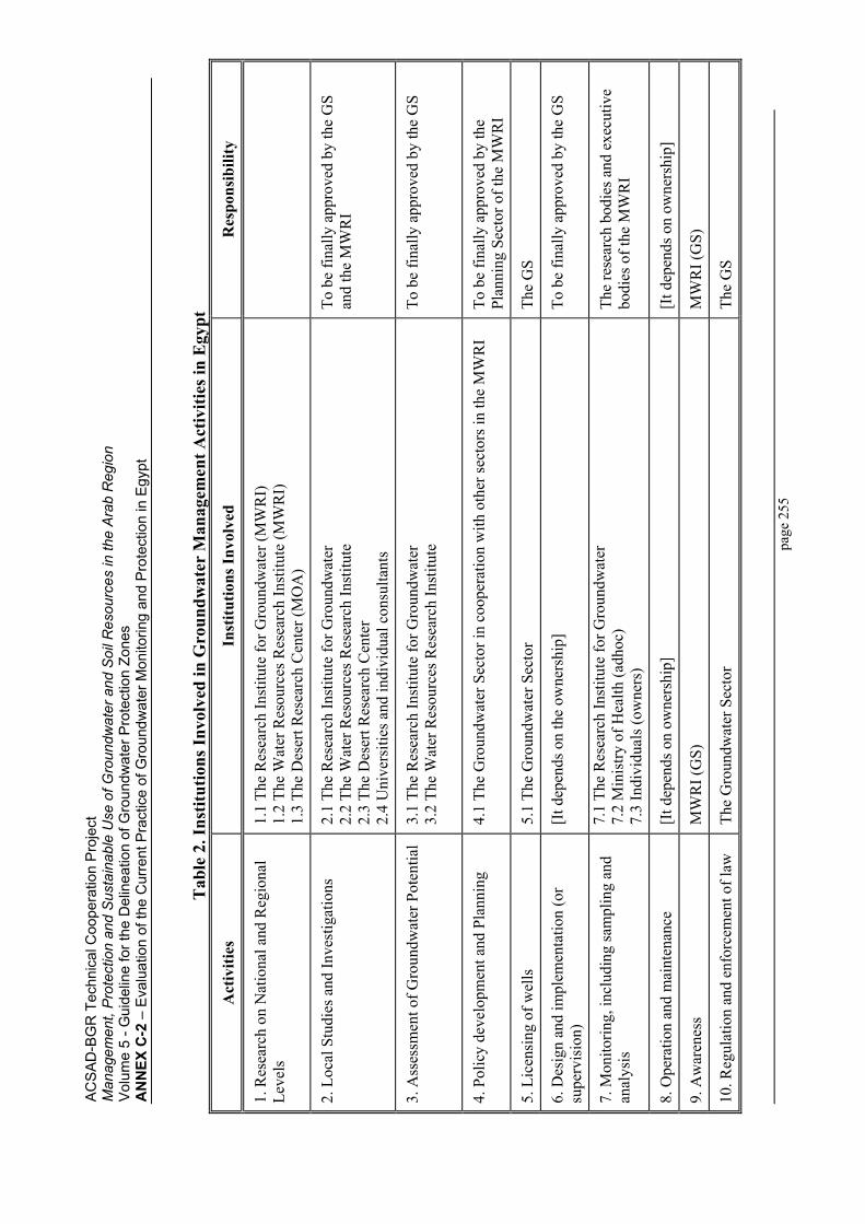
AC
SA
D-B
GR
Tec
hnic
al C
oope
ratio
n P
roje
ct
Man
agem
ent,
Pro
tect
ion
and
Sus
tain
able
Use
of G
roun
dwat
er a
nd S
oil R
esou
rces
in th
e A
rab
Reg
ion
Vol
ume
5 - G
uide
line
for t
he D
elin
eatio
n of
Gro
undw
ater
Pro
tect
ion
Zone
sA
NN
EX C
-2 –
Eva
luat
ion
of th
e C
urre
nt P
ract
ice
of G
roun
dwat
er M
onito
ring
and
Pro
tect
ion
in E
gypt
page
255
Tab
le 2
. Ins
titut
ions
Invo
lved
in G
roun
dwat
er M
anag
emen
t Act
iviti
es in
Egy
pt
Act
iviti
es
Inst
itutio
ns In
volv
ed
Res
pons
ibili
ty
1. R
esea
rch
on N
atio
nal a
nd R
egio
nal
Leve
ls1.
1 Th
e R
esea
rch
Inst
itute
for G
roun
dwat
er (M
WR
I)
1.2
The
Wat
er R
esou
rces
Res
earc
h In
stitu
te (M
WR
I)
1.3
The
Des
ert R
esea
rch
Cen
ter (
MO
A)
2. L
ocal
Stu
dies
and
Inve
stig
atio
ns
2.1
The
Res
earc
h In
stitu
te fo
r Gro
undw
ater
2.
2 Th
e W
ater
Res
ourc
es R
esea
rch
Inst
itute
2.
3 Th
e D
eser
t Res
earc
h C
ente
r 2.
4 U
nive
rsiti
es a
nd in
divi
dual
con
sulta
nts
To b
e fin
ally
app
rove
d by
the
GS
and
the
MW
RI
3. A
sses
smen
t of G
roun
dwat
er P
oten
tial
3.1
The
Res
earc
h In
stitu
te fo
r Gro
undw
ater
3.
2 Th
e W
ater
Res
ourc
es R
esea
rch
Inst
itute
To
be
final
ly a
ppro
ved
by th
e G
S
4. P
olic
y de
velo
pmen
t and
Pla
nnin
g 4.
1 Th
e G
roun
dwat
er S
ecto
r in
coop
erat
ion
with
oth
er se
ctor
s in
the
MW
RI
To b
e fin
ally
app
rove
d by
the
Plan
ning
Sec
tor o
f the
MW
RI
5. L
icen
sing
of w
ells
5.
1 Th
e G
roun
dwat
er S
ecto
r Th
e G
S
6. D
esig
n an
d im
plem
enta
tion
(or
supe
rvis
ion)
[It d
epen
ds o
n th
e ow
ners
hip]
To
be
final
ly a
ppro
ved
by th
e G
S
7. M
onito
ring,
incl
udin
g sa
mpl
ing
and
anal
ysis
7.
1 Th
e R
esea
rch
Inst
itute
for G
roun
dwat
er
7.2
Min
istry
of H
ealth
(adh
oc)
7.3
Indi
vidu
als (
owne
rs)
The
rese
arch
bod
ies a
nd e
xecu
tive
bodi
es o
f the
MW
RI
8. O
pera
tion
and
mai
nten
ance
[I
t dep
ends
on
owne
rshi
p]
[It d
epen
ds o
n ow
ners
hip]
9. A
war
enes
s M
WR
I (G
S)
MW
RI (
GS)
10. R
egul
atio
n an
d en
forc
emen
t of l
aw
The
Gro
undw
ater
Sec
tor
The
GS
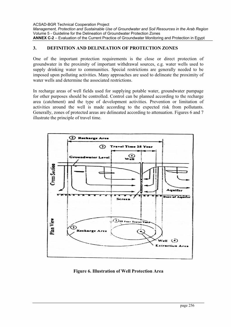
ACSAD-BGR Technical Cooperation Project Management, Protection and Sustainable Use of Groundwater and Soil Resources in the Arab RegionVolume 5 - Guideline for the Delineation of Groundwater Protection ZonesANNEX C-2 – Evaluation of the Current Practice of Groundwater Monitoring and Protection in Egypt
page 256
3. DEFINITION AND DELINEATION OF PROTECTION ZONES
One of the important protection requirements is the close or direct protection of groundwater in the proximity of important withdrawal sources, e.g. water wells used to supply drinking water to communities. Special restrictions are generally needed to be imposed upon polluting activities. Many approaches are used to delineate the proximity of water wells and determine the associated restrictions.
In recharge areas of well fields used for supplying potable water, groundwater pumpage for other purposes should be controlled. Control can be planned according to the recharge area (catchment) and the type of development activities. Prevention or limitation of activities around the well is made according to the expected risk from pollutants. Generally, zones of protected areas are delineated according to attenuation. Figures 6 and 7 illustrate the principle of travel time.
Figure 6. Illustration of Well Protection Area
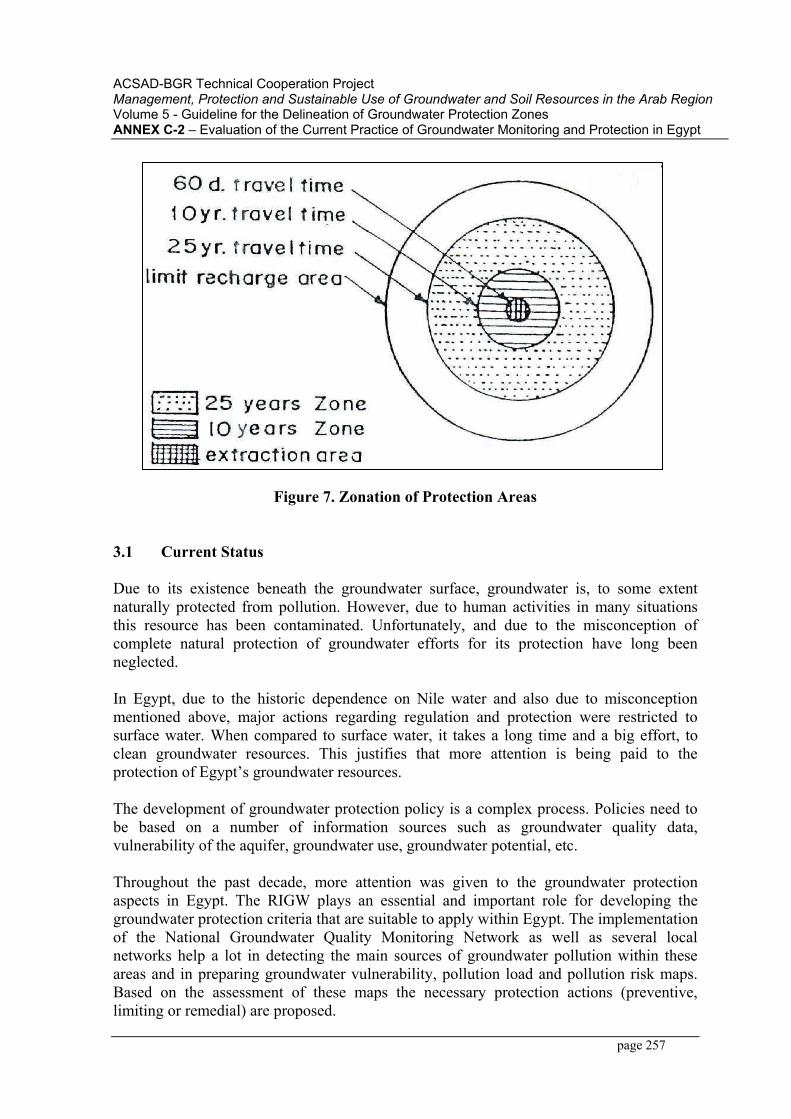
ACSAD-BGR Technical Cooperation Project Management, Protection and Sustainable Use of Groundwater and Soil Resources in the Arab RegionVolume 5 - Guideline for the Delineation of Groundwater Protection ZonesANNEX C-2 – Evaluation of the Current Practice of Groundwater Monitoring and Protection in Egypt
page 257
Figure 7. Zonation of Protection Areas
3.1 Current Status
Due to its existence beneath the groundwater surface, groundwater is, to some extent naturally protected from pollution. However, due to human activities in many situations this resource has been contaminated. Unfortunately, and due to the misconception of complete natural protection of groundwater efforts for its protection have long been neglected.
In Egypt, due to the historic dependence on Nile water and also due to misconception mentioned above, major actions regarding regulation and protection were restricted to surface water. When compared to surface water, it takes a long time and a big effort, to clean groundwater resources. This justifies that more attention is being paid to the protection of Egypt’s groundwater resources.
The development of groundwater protection policy is a complex process. Policies need to be based on a number of information sources such as groundwater quality data, vulnerability of the aquifer, groundwater use, groundwater potential, etc.
Throughout the past decade, more attention was given to the groundwater protection aspects in Egypt. The RIGW plays an essential and important role for developing the groundwater protection criteria that are suitable to apply within Egypt. The implementation of the National Groundwater Quality Monitoring Network as well as several local networks help a lot in detecting the main sources of groundwater pollution within these areas and in preparing groundwater vulnerability, pollution load and pollution risk maps. Based on the assessment of these maps the necessary protection actions (preventive, limiting or remedial) are proposed.
ACSAD-BGR Technical Cooperation Project Management, Protection and Sustainable Use of Groundwater and Soil Resources in the Arab RegionVolume 5 - Guideline for the Delineation of Groundwater Protection ZonesANNEX C-2 – Evaluation of the Current Practice of Groundwater Monitoring and Protection in Egypt
page 258
In addition to that, several studies have been carried out to delineate the groundwater protection zones around drinking water supply wells. These studies were carried out on the local scale in the new communities (Tenth of Ramadan and Sadat Cities), Cairo and Sharqia governorate (East Nile Delta Region).
Unfortunately, till now no groundwater protection zones have been implemented in Egypt. In the near future, it is expected to implement these protection zones in several locations, starting with the Sadat City area.
3.2 Practice of Delineating Protection Zones
Delineation of groundwater protection zones in El Sharqia Governorate and El Sadat City will be presented in the following, two case studies.
3.2.1 Delineation of well protection zones in El Sharqia Governorate
This study carried out by the Research Institute for Groundwater (RIGW) in the framework of the activities of the "IHP-Network on Groundwater Protection in the Arab Region". For the purpose of this study, two approaches were proposed. The first is to consider the recharge area of the well, as an area with special protection needs. The second is to delineate the proximity of the well based on travel time, i.e. from the surface to the well screen, which allows the decay of pollutants before reaching the screen. In order to test the applicability of these approaches, a numerical model covering the pilot area is used.
Hydrogeological Setting of the Pilot Area
The study area is shown in Figure 8. Two types of hydrogeological units are distinguished, the Nile flood plain and the fringes. Within the Nile flood plain, the aquifer is made up of graded sand and gravel with minor clay lenses, underlain by a virtually impervious material consisting of fine-grained Pliocene sediments. A semi-confining layer consisting of silt and clay tops the aquifer. On the fringes, is aquifer is unconfined and consists of graded sand and gravel. Towards the edges, the aquifer thickness decreases considerably and consists of gravel or may be bounded by faults.
The geometry of the aquifer system is determined from geophysical surveys and data from boreholes. The maximum thickness of the aquifer is about 800 m in the north; while the minimum thickness is about 250 m on the fringes. The average hydraulic conductivity of the aquifer material is about 100 m/day.
The main direction of groundwater flow is south north. The pattern is slightly influenced by groundwater flow from the reclaimed areas becoming, locally, east west. Another component of flow takes place vertically due to the head difference between the water table and the piezometric head.

ACSAD-BGR Technical Cooperation Project Management, Protection and Sustainable Use of Groundwater and Soil Resources in the Arab RegionVolume 5 - Guideline for the Delineation of Groundwater Protection ZonesANNEX C-2 – Evaluation of the Current Practice of Groundwater Monitoring and Protection in Egypt
page 259
The main sources of recharge to the aquifer are seepage from the irrigation distribution system and subsurface drainage in irrigated areas. The recharge rate varies from about 1.5 to 2 mm/day in areas having no drainage networks, and from 0.5 to 1 mm/day in areas with drainage systems. Discharge from the aquifer generally takes place as a result of pumping for various purposes. The total withdrawal amounts to about 185 million m3/year, of which about 21 million m3/year are withdrawn for domestic uses.
Numerical Simulation
The used package (TRIWACO) is a numerical simulation model for quasi three-dimensional saturated and unsaturated groundwater flow based on the finite element technique. The package can handle a variety of steady state and transient groundwater flow problems. The program also allows for the interaction of top and bottom systems (i.e. surface water and groundwater).
A triangular element grid is generated for the area. The grid consists of 1,475 nodes and 2,844 elements, covering an area of about 2,636 km2. Fine elements are used in the area surrounding open channels and wells to ensure accurate representation of path lines at the convergence zones. Figures 9 shows the finite element grid covering the study area.
The input data to the model are derived from the hydrogeological map (Zagazig) scale 1:100,000 and the database of the RIGW. Data include topography, aquifer thickness, clay thickness, water table levels, groundwater piezometric heads and withdrawals. Seepage from canals and drains is calculated using wetted perimeter, water table and the hydraulic resistance of the semi-pervious layer. The subsurface drainage rates and hydraulic conductivity of drains are obtained from available reports, including tests carried out by municipalities.
Delineation of the Protection Areas
Two approaches for the delineation of protection areas are examined. Both approaches are based on delineating a capture zone of the well. In the first approach, the capture zone is corresponding to a specific time length, i.e. between 40 and 100 days. In the second, the capture zone is made to correspond to the time needed to achieve steady-state conditions (recharge area). Both approaches are tested on the calibrated model.
The results obtained from the model when applying the first approach indicate the need for a protection zone of a diameter ranging between 70 and 120 m corresponding to a travel time of 100 days. This area is easy to maintain as it may correspond to the area occupied by the pumping station.
According to the second approach, the results indicate that about 65% of the study area is within the capture zone of one well or another. Results of such approach area not easy to apply as it implies the prohibition of all activities in 65% of the area.
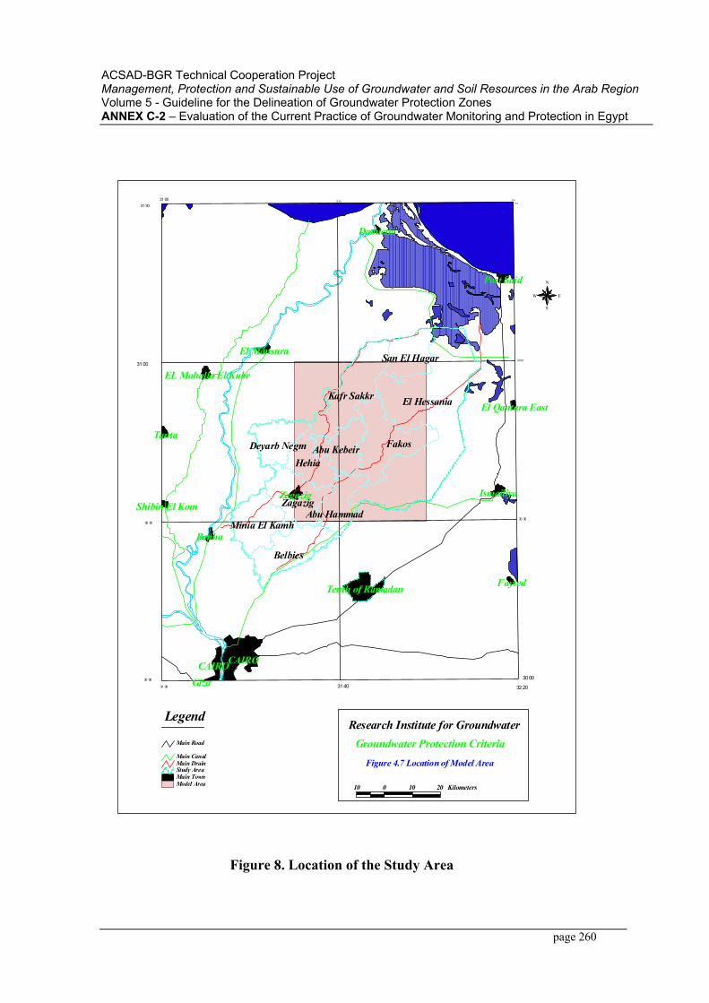
ACSAD-BGR Technical Cooperation Project Management, Protection and Sustainable Use of Groundwater and Soil Resources in the Arab RegionVolume 5 - Guideline for the Delineation of Groundwater Protection ZonesANNEX C-2 – Evaluation of the Current Practice of Groundwater Monitoring and Protection in Egypt
page 260
Legend
Groundwater Protection CriteriaResearch Institute for Groundwater
31 40
31 00 31 40
31 00
30 30
31 30
31 00
30 30
30 00
31 00 32 20
30 00
31 30
32 20
El Hessania
Fakos
Belbies
Kafr Sakkr
Zagazig
HehiaAbu Kebeir
Minia El Kamh
San El Hagar
Deyarb Negm
Abu Hammad
Damietta
Port Said
El Mansura
EL Mahalla El Kubr
El Qantara East
Tanta
IsmailiyaZagazig Shibin El Kom
Benha
Tenth of Ramadan Fayied
CAIROCAIROGiza
Figure 4.7 Location of Model Area
N
EW
S
10 0 10 20 KilometersModel AreaMain TownStudy Area
Main CanalMain Drain
Main Road
Figure 8. Location of the Study Area
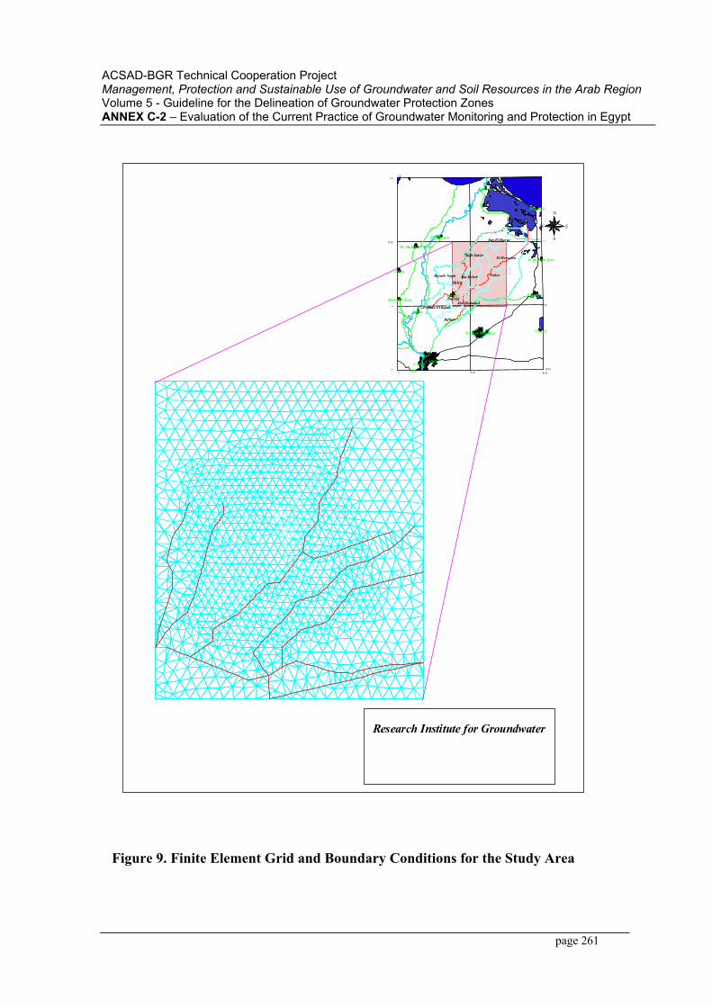
ACSAD-BGR Technical Cooperation Project Management, Protection and Sustainable Use of Groundwater and Soil Resources in the Arab RegionVolume 5 - Guideline for the Delineation of Groundwater Protection ZonesANNEX C-2 – Evaluation of the Current Practice of Groundwater Monitoring and Protection in Egypt
page 261
N
EW
S
Figure 4.8 Finite Element Grid and Boundary
31 40
31 00 31 40
31 00
30 30
31 30
31 00
30 30
30 00
31 00 32 20
30 00
31 30
32 20
El Hessania
Fakos
Belbies
Kafr Sakkr
Zagazig
HehiaAbu Kebeir
Minia El Kamh
San El Hagar
Deyarb Negm
Abu Hammad
Damietta
Port Said
El Mansura
EL Mahalla El Kubr
El Qantara East
Tanta
IsmailiyaZagazig Shibin El Kom
Benha
Tenth of Ramadan Fayied
CAIROCAIROGiza
Research Institute for GroundwaterGroundwater Protection Criteria
Condition for the Study Area
Figure 9. Finite Element Grid and Boundary Conditions for the Study Area
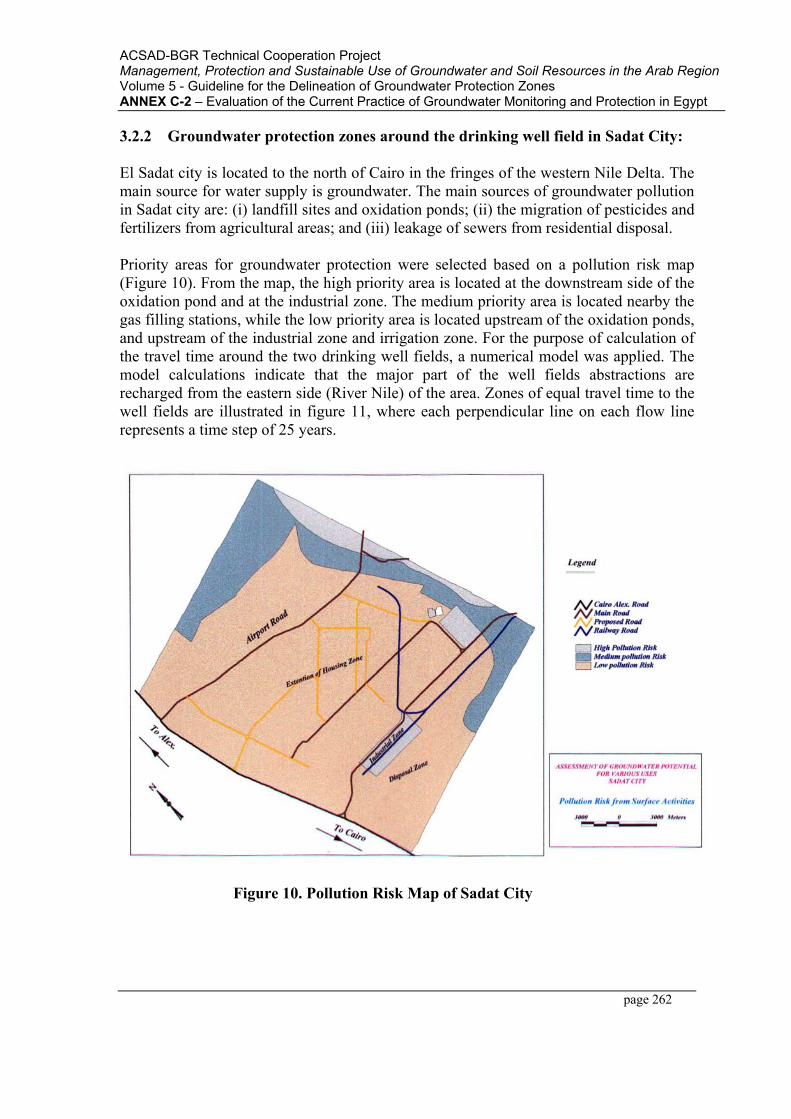
ACSAD-BGR Technical Cooperation Project Management, Protection and Sustainable Use of Groundwater and Soil Resources in the Arab RegionVolume 5 - Guideline for the Delineation of Groundwater Protection ZonesANNEX C-2 – Evaluation of the Current Practice of Groundwater Monitoring and Protection in Egypt
page 262
3.2.2 Groundwater protection zones around the drinking well field in Sadat City:
El Sadat city is located to the north of Cairo in the fringes of the western Nile Delta. The main source for water supply is groundwater. The main sources of groundwater pollution in Sadat city are: (i) landfill sites and oxidation ponds; (ii) the migration of pesticides and fertilizers from agricultural areas; and (iii) leakage of sewers from residential disposal.
Priority areas for groundwater protection were selected based on a pollution risk map (Figure 10). From the map, the high priority area is located at the downstream side of the oxidation pond and at the industrial zone. The medium priority area is located nearby the gas filling stations, while the low priority area is located upstream of the oxidation ponds, and upstream of the industrial zone and irrigation zone. For the purpose of calculation of the travel time around the two drinking well fields, a numerical model was applied. The model calculations indicate that the major part of the well fields abstractions are recharged from the eastern side (River Nile) of the area. Zones of equal travel time to the well fields are illustrated in figure 11, where each perpendicular line on each flow line represents a time step of 25 years.
Figure 10. Pollution Risk Map of Sadat City
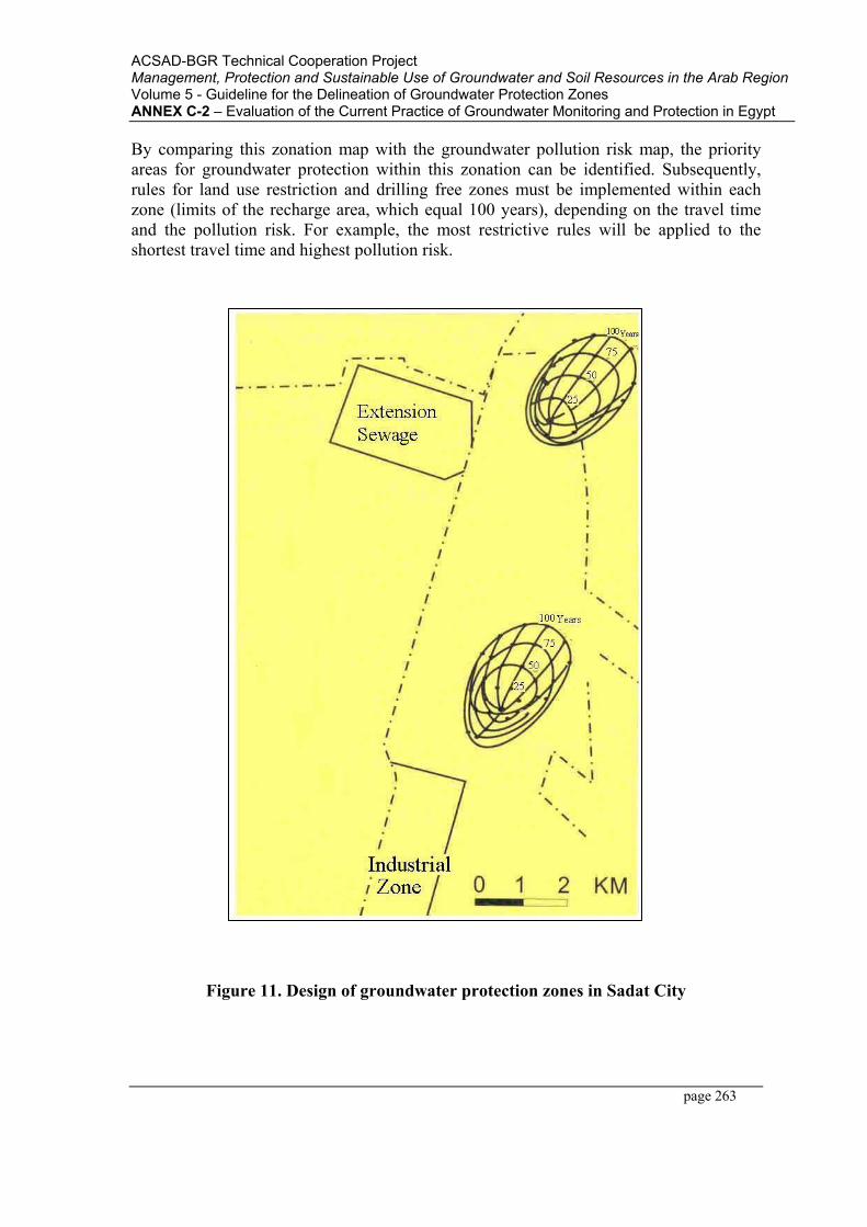
ACSAD-BGR Technical Cooperation Project Management, Protection and Sustainable Use of Groundwater and Soil Resources in the Arab RegionVolume 5 - Guideline for the Delineation of Groundwater Protection ZonesANNEX C-2 – Evaluation of the Current Practice of Groundwater Monitoring and Protection in Egypt
page 263
By comparing this zonation map with the groundwater pollution risk map, the priority areas for groundwater protection within this zonation can be identified. Subsequently, rules for land use restriction and drilling free zones must be implemented within each zone (limits of the recharge area, which equal 100 years), depending on the travel time and the pollution risk. For example, the most restrictive rules will be applied to the shortest travel time and highest pollution risk.
Figure 11. Design of groundwater protection zones in Sadat City
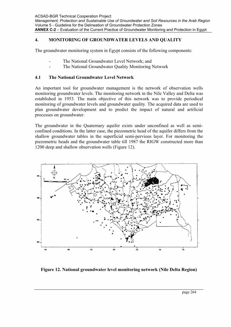
ACSAD-BGR Technical Cooperation Project Management, Protection and Sustainable Use of Groundwater and Soil Resources in the Arab RegionVolume 5 - Guideline for the Delineation of Groundwater Protection ZonesANNEX C-2 – Evaluation of the Current Practice of Groundwater Monitoring and Protection in Egypt
page 264
4. MONITORING OF GROUNDWATER LEVELS AND QUALITY
The groundwater monitoring system in Egypt consists of the following components:
- The National Groundwater Level Network; and - The National Groundwater Quality Monitoring Network
4.1 The National Groundwater Level Network
An important tool for groundwater management is the network of observation wells monitoring groundwater levels. The monitoring network in the Nile Valley and Delta was established in 1953. The main objective of this network was to provide periodical monitoring of groundwater levels and groundwater quality. The acquired data are used to plan groundwater development and to predict the impact of natural and artificial processes on groundwater.
The groundwater in the Quaternary aquifer exists under unconfined as well as semi-confined conditions. In the latter case, the piezometric head of the aquifer differs from the shallow groundwater tables in the superficial semi-pervious layer. For monitoring the piezometric heads and the groundwater table till 1987 the RIGW constructed more than 1200 deep and shallow observation wells (Figure 12).
Figure 12. National groundwater level monitoring network (Nile Delta Region)

ACSAD-BGR Technical Cooperation Project Management, Protection and Sustainable Use of Groundwater and Soil Resources in the Arab RegionVolume 5 - Guideline for the Delineation of Groundwater Protection ZonesANNEX C-2 – Evaluation of the Current Practice of Groundwater Monitoring and Protection in Egypt
page 265
These wells are distributed throughout the Nile Valley and Delta including their fringes. The deep observation wells are generally installed in the upper part of the Quaternary aquifer which is the major groundwater bearing formation in the Nile Valley and Delta. The screens of these wells are usually placed at a depth of 20-50m below the ground surface. The shallow observation wells are installed in the semi-pervious layer overlying the Quaternary aquifer. Their screens are placed at depth ranging from about 3 to 6 m below ground level. The peizometric head in the deep and the shallow observation wells are measured at least once per month. Water samples are collected once every two years for chemical analysis (mainly major cations and anions).
By the year 1983, more than 1.5 million water level measurements and more than 2000 chemical analysis records were kept in the archives of RIGW. However these data were not easily accessible for planners and researchers. Therefore, a computerized water resources database was established in 1984 (Figures 13 and 14). At present the database is populated with the data from more than 2000 wells.
4.2 The National Groundwater Quality Monitoring Network
The national groundwater quality-monitoring network in Egypt was established in 1998. The objective of the network is to quantify the long-term quality changes, either caused by polluting activities or by salt-water intrusion. A second purpose was to describe the overall current groundwater quality status on a national scale. It is the aim of the monitoring system to provide decision -makers with information about the present and future status of groundwater quality.
At present the national groundwater quality-monitoring network comprises 200 monitoring points (Figure 15). About 60% of the monitoring wells are located in the Nile Basin, the large number of wells in the Nile Basin is due to the fact that the aquifer in the Nile Basin is extensively used and that the priority areas in this region face a potential pollution risk.
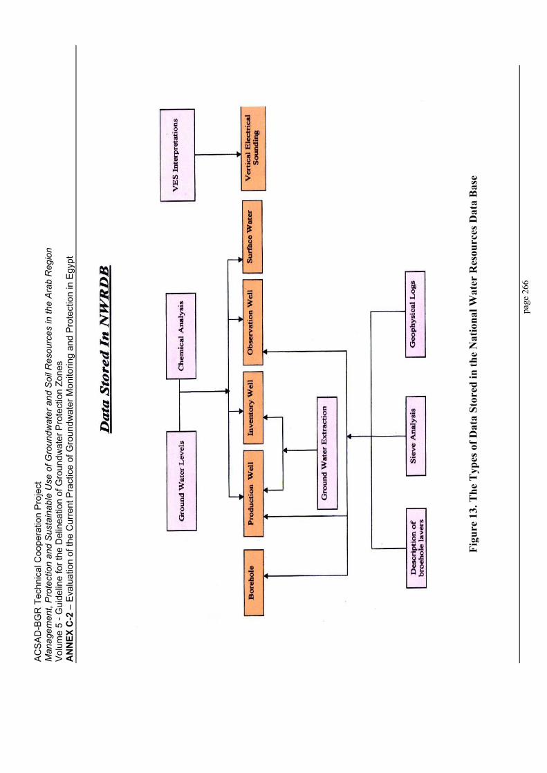
AC
SA
D-B
GR
Tec
hnic
al C
oope
ratio
n P
roje
ct
Man
agem
ent,
Pro
tect
ion
and
Sus
tain
able
Use
of G
roun
dwat
er a
nd S
oil R
esou
rces
in th
e A
rab
Reg
ion
Vol
ume
5 - G
uide
line
for t
he D
elin
eatio
n of
Gro
undw
ater
Pro
tect
ion
Zone
sA
NN
EX C
-2 –
Eva
luat
ion
of th
e C
urre
nt P
ract
ice
of G
roun
dwat
er M
onito
ring
and
Pro
tect
ion
in E
gypt
page
266
Figu
re 1
3. T
he T
ypes
of D
ata
Stor
ed in
the
Nat
iona
l Wat
er R
esou
rces
Dat
a B
ase
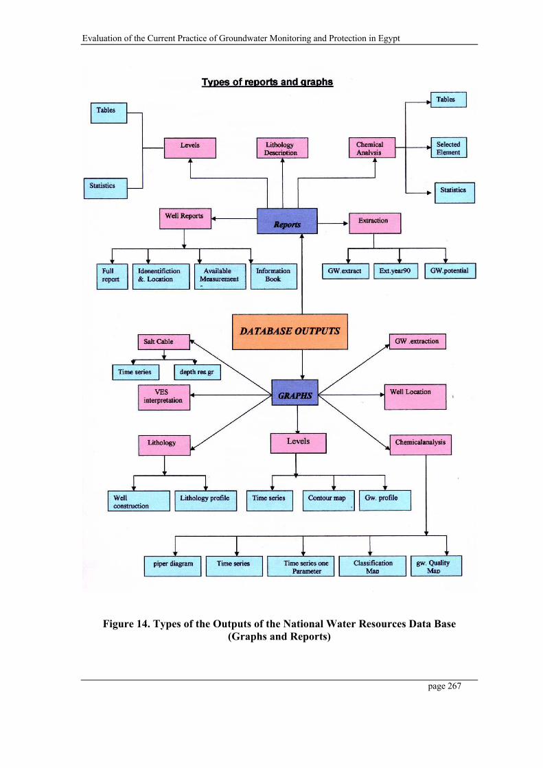
Evaluation of the Current Practice of Groundwater Monitoring and Protection in Egypt
page 267
Figure 14. Types of the Outputs of the National Water Resources Data Base (Graphs and Reports)
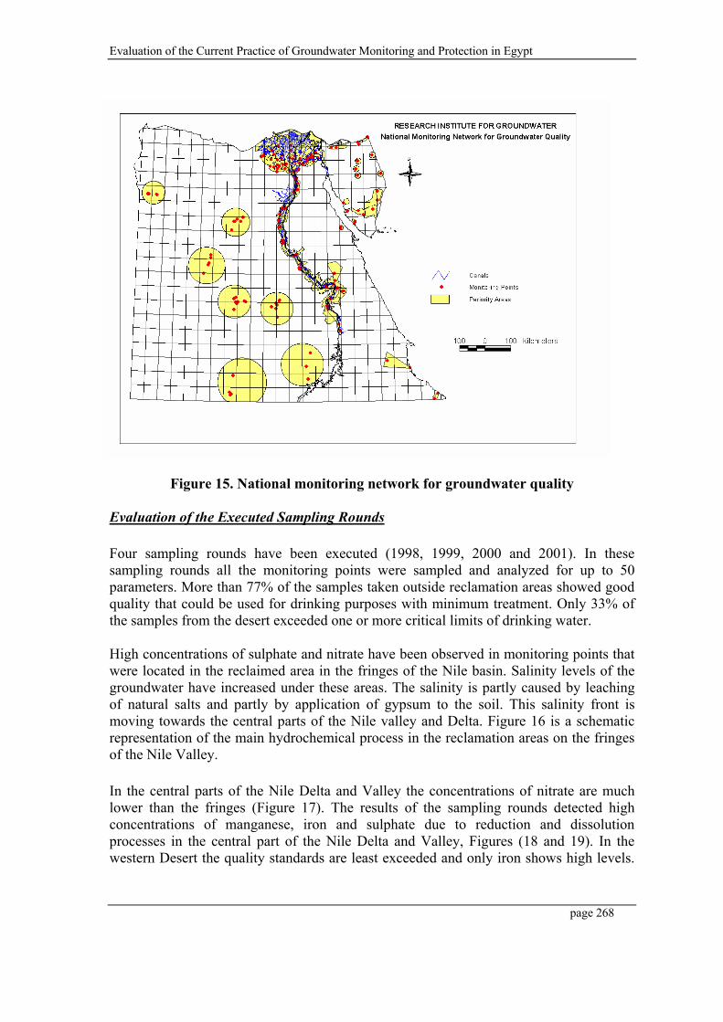
Evaluation of the Current Practice of Groundwater Monitoring and Protection in Egypt
page 268
Figure 15. National monitoring network for groundwater quality
Evaluation of the Executed Sampling Rounds
Four sampling rounds have been executed (1998, 1999, 2000 and 2001). In these sampling rounds all the monitoring points were sampled and analyzed for up to 50 parameters. More than 77% of the samples taken outside reclamation areas showed good quality that could be used for drinking purposes with minimum treatment. Only 33% of the samples from the desert exceeded one or more critical limits of drinking water.
High concentrations of sulphate and nitrate have been observed in monitoring points that were located in the reclaimed area in the fringes of the Nile basin. Salinity levels of the groundwater have increased under these areas. The salinity is partly caused by leaching of natural salts and partly by application of gypsum to the soil. This salinity front is moving towards the central parts of the Nile valley and Delta. Figure 16 is a schematic representation of the main hydrochemical process in the reclamation areas on the fringes of the Nile Valley.
In the central parts of the Nile Delta and Valley the concentrations of nitrate are much lower than the fringes (Figure 17). The results of the sampling rounds detected high concentrations of manganese, iron and sulphate due to reduction and dissolution processes in the central part of the Nile Delta and Valley, Figures (18 and 19). In the western Desert the quality standards are least exceeded and only iron shows high levels.
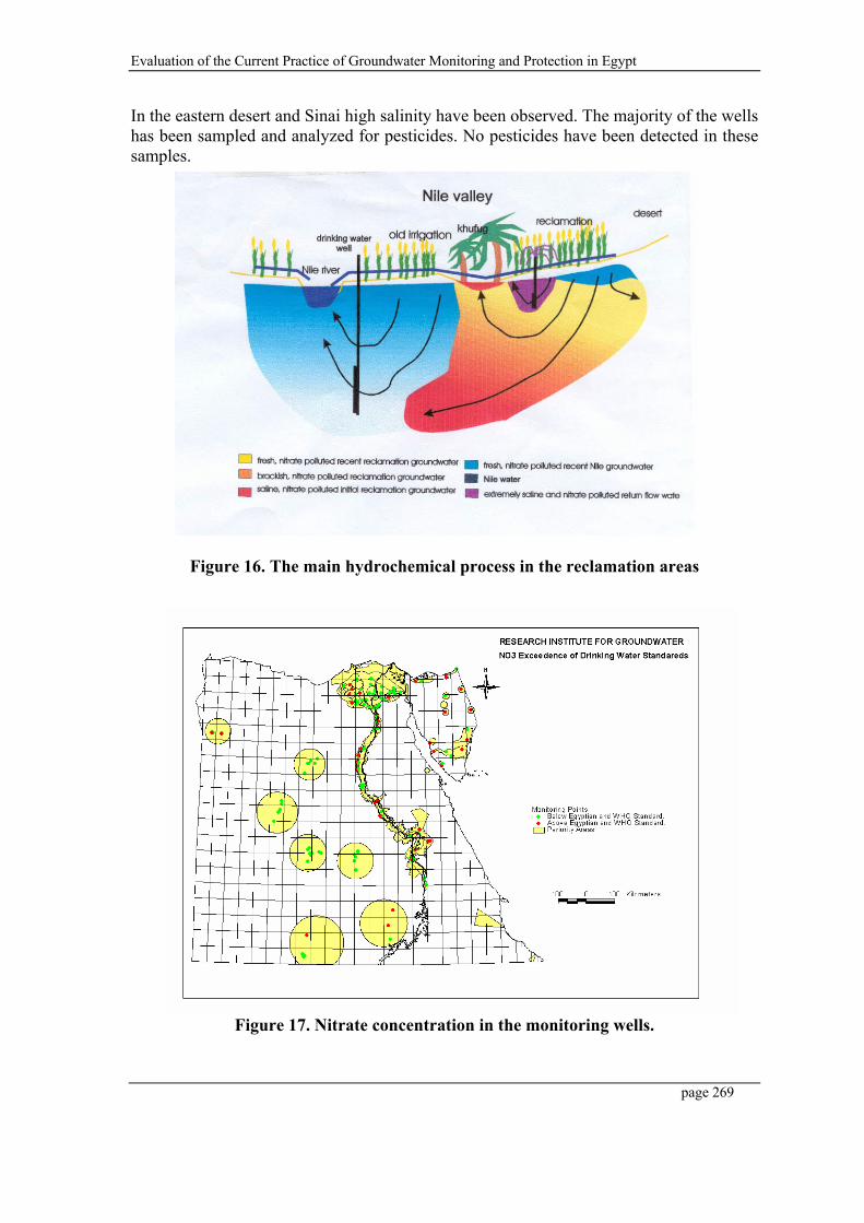
Evaluation of the Current Practice of Groundwater Monitoring and Protection in Egypt
page 269
In the eastern desert and Sinai high salinity have been observed. The majority of the wells has been sampled and analyzed for pesticides. No pesticides have been detected in these samples.
Figure 16. The main hydrochemical process in the reclamation areas
Figure 17. Nitrate concentration in the monitoring wells.

Evaluation of the Current Practice of Groundwater Monitoring and Protection in Egypt
page 270
Figure 18. Manganese concentration in the monitoring wells.
Figure 19. Sulphate concentration in the monitoring wells.

Evaluation of the Current Practice of Groundwater Monitoring and Protection in Egypt
page 271
5. ASSESSMENT OF GROUNDWATER VULNERABILITY AND HAZARD TO GROUNDWATER
Groundwater vulnerability to surface originating pollution is evident. As the aquifer’s vulnerability to surface originating pollution is dependent upon the intrinsic properties of the aquifer, high levels of spatial variability in the vulnerability of the aquifer is expected. In practicing groundwater quality management, mapping the vulnerability is an essential tool as many of the decisions are dependent on the spatial variability of the aquifer’s vulnerability. Methods being used for vulnerability mapping are numerous. The most common is the hydrologic setting, the parametric method and the analogical relations and numerical models methods. These methods have a very little range of complexity. The best method would depend on data availability, objectives and scale.
The DRASTIC (Depth, Recharge, Aquifer media, Soil, Topography, Impact of vadous zone, hydraulic Conductivity) method for mapping the groundwater vulnerability is an internationally well-recognized approach. However, it is developed as a global method that can envelope a wide range of variability in the hydrogeological conditions. This globalization can lead to unavoidable generalization in the parameters selection as well as their ratings and weights. Accordingly, applying the DRASTIC method should involve careful consideration of the local hydrogeological conditions.
Current Status
In the last ten years, Several internsic groundwater vulnerability maps were prepared by the RIGW for the Nile Valley and Nile Delta reion on semi regional (1:500,000) and detailed (1:100,000) scales.
In the following, Two examples will be presented:
The first, will be the groundwater regional vulnerability map of the Nile Delta which has been based on the hydrologic setting taking into cosideration some other important factors.
The second, will be the development of detailed vulnerability maps for the middle, east and west Nile Delta regions by conceptually modifying the DRASTIC method according to the local hydrogeological conditions.
5.1 Regional Vulnerability of Groundwater to Pollution in the Nile Delta
Within the nile Delta Region, the groundwater vulnerability to pollution is largely determined by the thickness of the clay layer, depth to groundwater, rate of recharge and direction of natural vertical groundwater flow (see table 3).
According to these pararmeters, the Nile Delta region can be distinguished into four categories (Figure 20):

Evaluation of the Current Practice of Groundwater Monitoring and Protection in Egypt
page 272
i. The reclaimed desert areas with moderate to high vulnerable groundwater, due to the presence of sandy formations with high infiltration and low adsorption capacities, although groundwater is relatively deep;
ii. The traditionally cultivated area with moderate to low or low vulnerable groundwater due to the presence of a clay cap;
iii. The transition zone between the old land and the reclaimed areas with highly vulnerable groundwater due to the presence of sandy soil and shallow groundwater table; and
iv. The northern part with very low vulnerable groundwater due to the presence of a top clay cap and upward groundwater flow.
Table 3. Factors Affecting the Groundwater Vulnerability in the Nile Delta Thicknessof clay cap
(m)
Vertical groundwater
flow
Rate of recharge mm/day
Depth to groundwater
from surface (m)
Groundwater vulnerability
Location
0 Downward - <5 High Transition zone between old and reclaimed land
0-2 Downward >1 5-15 High Transition zone 0 Downward <1 >15 Moderate- High Desert fringes
0-10 Downward <1 <5 Moderate- Low Floodplain and partially
transition zone >10 Downward 0.25-1 <5 Low Floodplain
0->10 Upward <25 <5 Low North Delta (Floodplain)
5.2 Vulnerability of Groundwater to Pollution in the Middle, East and West Nile Delta Regions
In this study, the DRASTIC method was conceptually modified according to the hydrogeological conditions of the Nile Delta aquifer, and then its ratings and weights of the vulnerability controlling parameters were calibrated according to statistical correlation with real-time pollution events. Thus, providing an adjusted tool to map the vulnerability of the Nile Delta aquifer.
The modified vulnerability approach was developed on pilot scale basis. Therefore, it was crucial to carefully select the study areas. The basic criterion that had to be fulfilled by the selected area are representing, as close as possible, the regional situation in the three regions of the Delta (i.e. Eastern, Middle and Western regions), in terms of physical conditions (i.e. aquifer type, overburden material, thickness, conductivity, etc.), and pollution threats. Other factors that were also found of importance include dependence on groundwater as a source of fresh water, groundwater quality and pollution threats. areas using the secondary criterion. Accordingly, the final selection was; Sharqia Governorate representing the Eastern Delta region, Menofia Governorate representing the Middle Delta region, and Behira Governorate representing the Western Delta region.
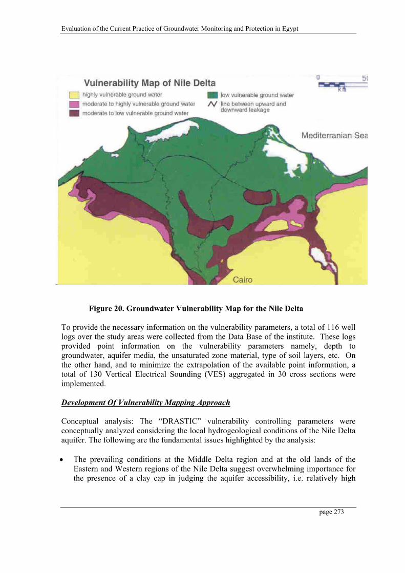
Evaluation of the Current Practice of Groundwater Monitoring and Protection in Egypt
page 273
Figure 20. Groundwater Vulnerability Map for the Nile Delta
To provide the necessary information on the vulnerability parameters, a total of 116 well logs over the study areas were collected from the Data Base of the institute. These logs provided point information on the vulnerability parameters namely, depth to groundwater, aquifer media, the unsaturated zone material, type of soil layers, etc. On the other hand, and to minimize the extrapolation of the available point information, a total of 130 Vertical Electrical Sounding (VES) aggregated in 30 cross sections were implemented.
Development Of Vulnerability Mapping Approach
Conceptual analysis: The “DRASTIC” vulnerability controlling parameters were conceptually analyzed considering the local hydrogeological conditions of the Nile Delta aquifer. The following are the fundamental issues highlighted by the analysis:
The prevailing conditions at the Middle Delta region and at the old lands of the Eastern and Western regions of the Nile Delta suggest overwhelming importance for the presence of a clay cap in judging the aquifer accessibility, i.e. relatively high

Evaluation of the Current Practice of Groundwater Monitoring and Protection in Egypt
page 274
water table with minimum spatial variability and significant clay cap thickness. Nevertheless, the conditions at the desert fringes and the reclaimed lands indicate that depth to groundwater plays an important role, if not the only role, in the aquifer accessibility as clay thins away while depth increases considerably. In conclusion, the inclusion of this parameter is crucial for vulnerability evaluation at the Nile Delta.
The recharge parameter considered by “DRASTIC” is the natural recharge. Natural recharge within the study areas applies only to rainwater. This type of recharge is insignificant compared to the main recharge mechanism of excess irrigation water in the Nile Delta aquifer. As the objective is to assess the intrinsic vulnerability of the aquifer, recharge from irrigation should not be considered, being a man-made attribute. Additionally, for this parameter to considered it should have significant spatial variability, and must be dealt with at a micro level. Such level of details is practically impossible to obtain. Moreover, and assuming this effort could be achieved, it must be updated, along with the whole map, each and every season as farmers change their crops seasonally and according to the economics of the market. Accordingly, the recharge of the aquifer is considered of no significant spatial variation and is discarded in the vulnerability analysis for its relative neutral effect.
The aquifer material, hydraulic conductivity as well as the soil material of the Nile Delta did not reflect any special conditions that require special treatment in applying the DRASTIC method, leading to including them in the vulnerability evaluation.
The topography is included in DRASTIC to involve the division of the rechargeable surface water into runoff and percolation waters. This division is particularly important in mountainous and steep landscapes. The Nile Delta is generally flat, which raised doubts about the importance of this parameter in this particular case. Additionally, and due to the very narrow rang of slopes within the delta, no spatial variability, in the vulnerability index, will be generated from this parameter.
The impact of the vadose zone is based on the type of material of the vadose zone, rather than its thickness. This parameter is of prime importance for evaluating the vulnerability of the aquifer. However, when applying the DRASTIC, limitations related to this parameter, are typically encountered when dealing with multi-layered vadose zone resulting in misleading results. On the other hand, careful examination of the well logs obtained from the study areas showed the dominance of the clay and sand as the practically only materials forming the vadose zone. This gave rise to the idea of representing the impact of the vadose zone as the clay thickness solely. This approach implies that any attenuation capacity provided by the sand is negligible compared to that given by the clay regardless of its thickness (very close to reality). It also allow for a fixed limited attenuation value for the case of sand only vadose zone, i.e. the value given to clay thickness equal to zero. This way, the above limitation is avoided, by considering the dominance of the attenuation capacity of the clay representing the vadose zone.
Evaluation of the Current Practice of Groundwater Monitoring and Protection in Egypt
page 275
Based on the above discussions, the parameters representing the vulnerability within the Nile Delta aquifer were narrowed down to; depth to groundwater, aquifer media, soil type, clay thickness, and hydraulic conductivity.
Statistical analysis: Following the identification of the set of effective parameters controlling the vulnerability of the Nile Delta aquifer, it was necessary to calibrate their importance weights in accordance with the local conditions. The basic idea/logic behind this calibration process is to consider field-detected pollution events as the ultimate evaluator of the vulnerability of the aquifer. Hence, statistical correlations among the groundwater quality status and the different vulnerability parameters were applied to adjust the weights of vulnerability parameters to the actual field conditions.
The effect of the different pollution-generating activities was taken into consideration in a number of ways. From the spatial point of view, the most dominant source of pollution in the entire Nile Delta, by overwhelming difference, is the agricultural activities. As the selection of the sampling points was based on spatial coverage solely without any consideration of the land use, statistically, the overwhelming majority of the samples should represent similar land use activity; that is, agriculture. Additionally, the careful selection of the pilot areas considered the presence of diverse pollution sources within each area. And finally, for the Sharqia Governorate, the biasness was expected due to the presence of two extreme pollution sources namely, the intensive reuse of significantly polluted drainage water and the industrial city of 10th of Ramadan. This biasness was filtered out through the presence of a wide range of vulnerability parameters under the influence of the first source and by discarding the samples from the 10th of Ramadan for the second source.
The approach that was followed is to correlate among the vulnerability parameters and the groundwater pollution events rather than groundwater quality. Accordingly, samples were divided as either polluted or non polluted. Samples were considered polluted if one or more chemical constituents exceeded the drinking water standards, leading to non-specific vulnerability evaluation. The correlation coefficients were calculated through regression analysis among the accumulative percentages of polluted samples and ranges of the different vulnerability parameters. The accumulative percentages were used instead of the actual percentages for each range due to the unequal distribution of the sampling points over the different ranges of the vulnerability parameters.
Application and comparisons: The overall comparison among the results of the two approaches indicates a significant change in the spatial distribution of vulnerability categories. The modified approach has resulted in a generally less vulnerability compared to the classical approach. The distribution of polluted samples among the different categories of vulnerability as defined by the classical and modified approaches was compared. The modified approach, for the three governorates, shows significantly better distribution of pollution events among the different vulnerability categories. Figures 21 and 22 illustrate the vulnerability maps for the Behira Governorate, representing the West Delta region, as per the classical and modified approaches, respectively.
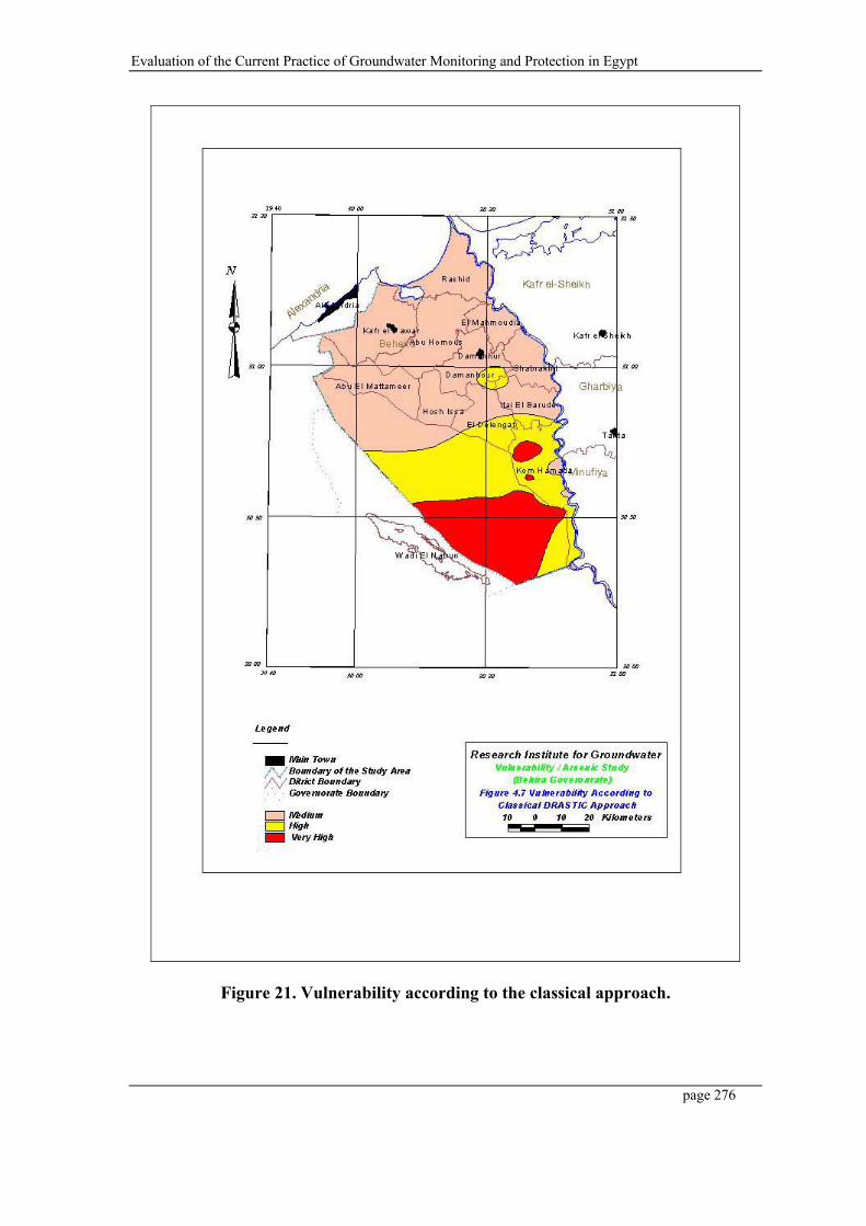
Evaluation of the Current Practice of Groundwater Monitoring and Protection in Egypt
page 276
Figure 21. Vulnerability according to the classical approach.
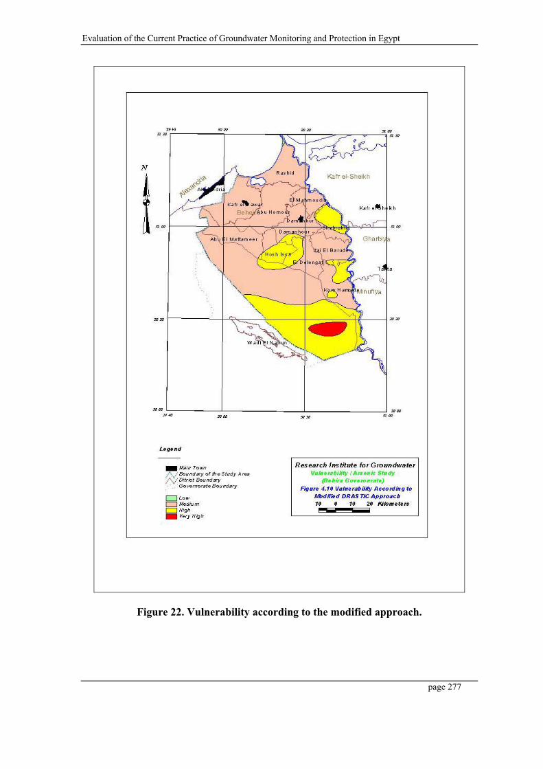
Evaluation of the Current Practice of Groundwater Monitoring and Protection in Egypt
page 277
Figure 22. Vulnerability according to the modified approach.

Evaluation of the Current Practice of Groundwater Monitoring and Protection in Egypt
page 278
6 LEGAL ASPECTS
Groundwater protection measures have been initialized by the introduction of a well licensing system. Groundwater extractions need to be authorized by a High Committee formed from high-ranking officials from the Ministry of Water Resources and Irrigation, and Ministry of Agriculture and Land Reclamation. The potentiality maps and the regular well inventories of the RIGW are crucial for the well-functioning of the licensing system, in addition to means for enforcement, which can still be improved.
Law 48-1982, regarding to the protection of the River Nile and Waterways from pollution, has been integrated in the Law for the Environment 4-1994. Groundwater is specifically mentioned as " waterway", also in the implementation regulations of Law 48-1982 (Decree no. 8-1983), where limits are given for different effluent being discharged in either surface water or groundwater. Compliance with law 48 has generally been weak, partly because of the imposed high standards. Nevertheless the law forms a firm base for the protection of the Egyptian groundwater resources with respect to direct discharge (e.g. by injection through wells). To combat pollution of groundwater resources from diffuse sources (fertilizers, pesticides etc.) the legal framework of the two cited laws seems to be insufficient.
Nowadays, an internal committee from the professionals within the Ministry of Water Resources and Irrigation has been formulated to revise and update Law 48, and including some items related to groundwater protection.
On the other hand, the existence of the RIGW, as a research agency and the establishment of the Groundwater Sector, as an implementing agency under the Ministry of Water Resources and Irrigation are an important step in the direction of establishing the institutional support needed for protecting the groundwater. The challenge that is being faced by both agencies is to implement groundwater protection in the Egyptian institutional setting.
Groundwater protection implies the coordination of water resources, land and water use and the environment. This dictates cooperation and coordination between the different involved agencies that are responsible for these aspects at different levels
Evaluation of the Current Practice of Groundwater Monitoring and Protection in Egypt
page 279
7 RECOMMENDATIONS
Groundwater protection means preventing or limiting deterioration of groundwater quality. Such process involves a series of actions, some being preventive while others more of a corrective nature. A unique framework for groundwater protection is generally not possible as the forms of deterioration are diversified. However, considerable protection could be achieved based on the fact that prevention is always simpler and less expensive than rehabilitation. The development of a groundwater protection policy is a complex process. Policies need to be based on number of information sources including groundwater quality data, groundwater potential and use, aquifers vulnerability to pollution and sources of pollution.
In Egypt most of elements for general groundwater protection are available or under development. Integration of the various components into a national groundwater protection plan, preferably as part of a wider national water resources management plan, is a component that needs urgent action. Based on the available studies and knowledge about protection zones around the drinking water wells, it important to implement these zones especially within the high pollution risk areas. The involvement of the public, local authorities and other concerned ministries is essential.
It is recommended to encourage and support the role of the "IHP-Network on Groundwater Protection in the Arab Region" in the field of technology transfer, dissemination and exchange of experience, research results and information on the state-of-the-art of groundwater protection in the Arab Countries.
Evaluation of the Current Practice of Groundwater Monitoring and Protection in Egypt
page 280
8 REFERENCES
Khater,A; Fadl, A; Fekry,A., 2003. "Statistically-Based Vulnerability Mapping Approach and Assessment of Specific Groundwater Quality Problems In the Nile Delta". NAWQAM Workshop, Alexandria, Egypt.
RIGW/IWACO, 1988. " Hydrogeological Map of Egypt, 1:2000,000". Cairo, Egypt.
UNESCO, 1996. " Proceedings of the UNESCO-NWRC-ACSAD workshop on Wadi Hydrology and Groundwater Protection". IHP-V, Technical Documents in Hydrology no.1. UNESCO Cairo Office, Egypt.
UNDP/ UNESCO/RIGW, 2002. "Development of Groundwater Protection Criteria". Technical Publications of the IHP-Network on Groundwater Protection in the Arab Region, Final Report. Cairo, Egypt.
UNESCO, 2002. "Status of Groundwater Protection in the Arab Region". Technical Publications of the IHP-Network on Groundwater Protection in the Arab Region. Cairo, Egypt.

ACSAD-BGR Technical Cooperation Project Management, Protection and Sustainable Use of Groundwater and Soil Resources in the Arab Region Volume 5 - Guideline for the Delineation of Groundwater Protection Zones
Vol-5_Guideline-Groundwater-Protection-Zones.doc Page 281
Annex C-3: Evaluation of the Current Practice of Water Protection in Tunisia
Document prepared by D. El Batti
ACSAD-BGR Technical Cooperation Project Management, Protection and Sustainable Use of Groundwater and Soil Resources in the Arab Region Volume 5 - Guideline for the Delineation of Groundwater Protection Zones ANNEX C-3 – Evaluation of the Current Practice of Water Protection in Tunisia
Page 282
THE ARAB CENTER FOR THE STUDIES OF ARID ZONES AND DRY LANDS
A C S A D
GESTION, PROTECTION ET UTILISATION DURABLE DES RESSOURCES EN EAU
ET EN SOL DANS LA REGION ARABE
EVALUATION DE LA PRATIQUE ACTUELLE
DU SUIVI ET DE LA PROTECTION
DES RESSOURCES EN EAU EN TUNISIE
***
Djemili EL BATTI Mars 2003 Directeur Général Des Ressources En Eau

ACSAD-BGR Technical Cooperation Project Management, Protection and Sustainable Use of Groundwater and Soil Resources in the Arab Region Volume 5 - Guideline for the Delineation of Groundwater Protection Zones ANNEX C-3 – Evaluation of the Current Practice of Water Protection in Tunisia
Page 283
INTRODUCTION :
Le Code des Eaux, promulgué par la loi n° 75-16 du 31 Mars 1975, a confié la gestion du D.P.H. (Domaine Public Hydraulique englobante aussi bien les eaux de surface que souterraines ainsi que les ouvrages qui servent à leur exploitation et utilisation cf. Art.1) au Ministre de l’Agriculture, de l’Environnement et des Ressources Hydrauliques) sauf dérogation prise par décret (Art. 4 du C.D.E : Code des Eaux).
Le Domaine Public Hydraulique est donc défini par ses différents éléments qui sont :
- Sebkhas et lacs jusqu’à la limite des hautes eaux ;
- Cours d’eau de toutes sortes et les terrains compris dans leurs franc-bords ;
- Les terrains et ouvrages servant à l’exploitation, des passages d’eau et les lacs destinés au service public ;
- Les sources de toutes natures , les nappes d’eaux souterraines de toutes sortes, les aqueducs et abreuvoirs à l’usage public ainsi que leurs dépendances, les canaux de navigation, d’irrigation ou d’assainissement exécutés dans un but d’utilité publique, les terrains qui sont compris dans leurs franc-bords et les autres dépendances de ces canaux.
1 – ASPECT INSTITUTIONNEL :
1–1- Institutions :
Avec l’intégration du département de l’Environnement au Ministère de l’Agriculture qui devient depuis Septembre 2002 le Ministère de l’Agriculture, de l’Environnement et des Ressources Hydrauliques est le Ministère en charge de l’évaluation, le suivi et la protection des ressources en eau.
Toutefois, d’autres ministères interviennent dans le D.P.H tels que :
a) Le Ministère de l’Equipement, de l’Habitat et de l’Aménagement du Territoire (Direction de l’Hydraulique Urbaine : D.H.M. et l’Agence de Protection et de l’Aménagement du Littoral : APAL intervenant dans la Protection de l’Environnement du D.P.H).
b) Le Ministère de la Santé Publique (Direction de l’Hygiène du Milieu et Protection de l’Environnement : DHMPE, qui a la charge du contrôle de la qualité notamment micro-biologique
ACSAD-BGR Technical Cooperation Project Management, Protection and Sustainable Use of Groundwater and Soil Resources in the Arab Region Volume 5 - Guideline for the Delineation of Groundwater Protection Zones ANNEX C-3 – Evaluation of the Current Practice of Water Protection in Tunisia
Page 284
des eaux de boisson du réseau public d’eau potable urbaine et rurale, des eaux embouteillées (eaux conditionnées) et des eaux thermales (Stations thermales),
c) Le Ministère de l’Intérieur et du Développement local qui veille sur le curage et la protection de l’Environnement des cours d’eau trans-communaux et les sebkhas situées dans les périmètres communaux,
d) Le Ministère du Tourisme, du Commerce et de l’Artisanat (Office du Thermalisme, Autorité de tutelle des Eaux thermo-minérales :Eaux embouteillées et stations thermales ainsi que l’Office du Tourisme qui veille à la protection de l’Environnement des zones touristiques notamment côtières et même oasiennes exploitant souvent des sources naturelles ou artificielles d’eaux souterraines et superficielles,
e) Le Ministère de la Justice et des Droits de l’Homme intervient par les tribunaux qui traitent les infractions relevées par les Agents de la Police des Eaux, aux dispositions du Code des Eaux (cf. Article 10).
1–2- Organisation et Attributions des Institutions :
Ce sont principalement les organismes publics du nouveau ministère de l’Agriculture, de l’Environnement et des Ressources Hydrauliques qui ont la charge de l’évolution, du suivi et de la Protection des Ressources en eau.
Nous passons en revue les différents organismes avec leurs principales attributions.
1–2–1– La Direction Générale des Ressources en Eau : D.G.R.E.
elle est chargée notamment de :
+ Mettre en place et gérer les réseaux de mesure et d’observationconcernant les différentes composantes des Ressources en eau du pays.
+ Elaborer les études de base et appliquées visant l’évaluation et l’établissement des bilans globaux des ressources en eau.
+ Promouvoir les activités de recherche et d’expérimentation concernant les différents aspects de développement des ressources en eau et leur protection.
Elle est composée de 3 Directions et d'un établissement public à caractère Administratif : la Direction des Eaux de surface, la Direction des Eaux
ACSAD-BGR Technical Cooperation Project Management, Protection and Sustainable Use of Groundwater and Soil Resources in the Arab Region Volume 5 - Guideline for the Delineation of Groundwater Protection Zones ANNEX C-3 – Evaluation of the Current Practice of Water Protection in Tunisia
Page 285
souterraines, la Direction de la Recharge Artificielle et des eaux non conventionnelles et le Bureau de l’Inventaire et des Recherches Hydrauliques (B.I.R.H).
Nous signalons ici les attributions du BIRH qui complètent celles de la D.G.R.E. à savoir :
- Le Suivi et le Contrôle de la qualité des Ressources en eau.
- Gestion de la base de données des points d’eau : Sources, puits de surface et forages.
- Gestion de l’exploitation du Domaine Public Hydraulique dans le cadre de sa protection contre tout empiètement (Article 10 du Code des eaux).
1–2–2– La Direction Générale du Génie Rural et de l’exploitation des Eaux : DG/ GREE
Elle est chargée notamment de :
+ Réaliser les études d’ordre stratégique, formuler les politiques et élaborer les plan relatifs au secteur du génie rural et de l’exploitation des eaux dans le secteur agricole
+ Suivre et évaluer les projets d’aménagement des périmètres irrigués et d’assainissement agricole
+ Rationnaliser l’utilisation des eaux, valoriser les eaux non conventionnelles en agriculture
+ Coordonner les programmes d’eau potable dans les milieu urbain et rural.
1–2–3– La Direction Générale des Barrages et des grands Travaux Hydrauliques : DG/BGTH
Elle est chargée notamment de :
+ Elaborer les études hydrauliques, les études de maîtrise des eaux de surface, les études de mobilisation des eaux,
+ Elaborer les études de grands ouvrages hydrauliques de mobilisation des eaux de surface (Grands barrages, ouvrages de transfert d’eau, barrages collinaires),
+ Elaborer les études des grands aménagements hydrauliques,

ACSAD-BGR Technical Cooperation Project Management, Protection and Sustainable Use of Groundwater and Soil Resources in the Arab Region Volume 5 - Guideline for the Delineation of Groundwater Protection Zones ANNEX C-3 – Evaluation of the Current Practice of Water Protection in Tunisia
Page 286
+ Réaliser les grands barrages, barrages collinaires et les grands aménagements hydrauliques,
+ Réaliser les ouvrages de protection des zones rurales et agricoles des crues des oueds,
1–2–4- La Direction Générale de l’Aménagement et de la Conservation des terres agricoles : DG/ACTA
Elle est chargée notamment de :
+ Elaborer les plans et les orientations pour la préservation des ressources naturelles en sols, végétation, eau et en terres agricoles,
+ Elaborer les études d’aménagement des bassins versants,
+ Etudier, contrôler et suivre l’exécution des projets de conservation des eaux et du sol.
1–2–5- Les Commissariats Régionaux de Développement Agricole :C.R.D.A.
Ce sont des Etablissements Publics à caractère Administratifs dotés de l’autonomie financière et placés sous la tutelle du Ministère de l’Agriculture de l’Environnement et des Ressources Hydrauliques. Chaque gouvernorat dispose d’un C.R.D.A. chargé notamment de :
+ Veiller sur l’application des procédures juridiques et la réglementation relatives à la protection des terres agricoles, des forêts, des eaux, de la santé animale et des végétaux,
+ Gérer, développer et protéger les ressources naturelles : eau, sol et forêts,
+ Gérer l’exploitation du Domaine Public Hydraulique,
+ Etudier et réaliser les projets d’équipement hydraulique : Barrages, Barrages collinaires, lacs collinaires, puits de surface et forages .....
+ Gérer les périmètres irrigués publics et leur fournir l’eau d’irrigation.
1–2–6– La Société Nationale d’Exploitation et de Distribution des Eaux : S.O.N.E.D.E.
C’est une Société Nationale à caractère Industriel et Commercial, dotée de la personnalité civile et de l’autonomie financière, placée sous tutelle du Ministère de l’Agriculture, de l’Environnement des Ressources Hydrauliques.
ACSAD-BGR Technical Cooperation Project Management, Protection and Sustainable Use of Groundwater and Soil Resources in the Arab Region Volume 5 - Guideline for the Delineation of Groundwater Protection Zones ANNEX C-3 – Evaluation of the Current Practice of Water Protection in Tunisia
Page 287
Elle est chargée d’alimenter en eau potable notamment les zones urbaines et certaines agglomérations rurales. Dans ce cadre elle étudie et réalise les projets d’eau potable à l’échelle nationale et assure la maintenance et la réhabilitation des ouvrages d’adduction ; de transport, de traitement et de distribution des eaux.
Elle dispose de directions et de services régionaux couvrant l’ensemble du territoire national.
Dans le cadre de ses attributions, la S.O.N.E.D.E. étudie et réalise :
+ Le projet national d’économie d’eau dans les secteurs d’eau potable, industrielle et touristique.
+ Les projets de dessalement des eaux saumâtres et des eaux de mer.
1–2–7– La Société d’Exploitation du Canal et des Adductions des Eaux du Nord : SECADENORD
C’est un établissement public à caractère commercial et industriel, dotée de la personnalité civile et de l’autonomie financière, placé sous tutelle du Ministère de l’Agriculture, de l’Environnement et ses Ressources Hydrauliques.
Elle est chargée notamment de :
+ La gestion, l’exploitation, la maintenance et la réhabilitation du Canal du Cap Bon – Medjerda et de ses dépendances comme les adductions et les conduites de transfert et de transport de l’eau des Barrages.
+ La fourniture de l’eau aux différents utilisateurs : C.R.D.A et SONEDE pour l’alimentation en eau des secteurs agricole, domestique, industriel et touristique.
1-2-8- Les Groupements de développement d’Intérêt Collectif : G.D.I.C.
Ce sont des Associations d’usagers de l’eau et peuvent être considérés comme des organismes non gouvernementaux (ONG), toutefois, elles sont placées sous la double tutelle des Autorités Régionales (Gouvernorat et Délégation) ainsi que le Ministère de l’Agriculture, de l’Environnement et des Ressources Hydrauliques.
Ces groupements de développement d’intérêt collectif (anciennement AIC) sont chargés :
+ soit de la distribution de l’eau potable rurale (y compris souvent la gestion de l’ouvrage d’approvisionnement en eau : le puits ou le forage).
ACSAD-BGR Technical Cooperation Project Management, Protection and Sustainable Use of Groundwater and Soil Resources in the Arab Region Volume 5 - Guideline for the Delineation of Groundwater Protection Zones ANNEX C-3 – Evaluation of the Current Practice of Water Protection in Tunisia
Page 288
+ soit de la distribution de l’eau d’irrigation dans les périmètres publics irrigués (y compris la gestion du puits de surface ou du forage).
+ soit de la distribution de l’eau potable et de l’eau d’irrigation (avec la gestion du puits ou du forage quand ils constituent la source d’eau).
Il existe plus de 2500 GDIC dont plus de 1600 GDIC d’eau potable.
1–2–9– Autres organismes :
Il s’agit essentiellement des organismes qui étaient rattachés à l’ancien Ministère de l’Environnement et de l’Aménagement du Territoire et affectés depuis Septembre 2002 soit au Ministère de l’Agriculture, de l’Environnement et des Ressources Hydrauliques tels que l’ONAS, l’ANPE et le CITET, soit au Ministère de l’Equipement , du Logement et de l’Aménagement du Territoire tel que l’APAL.
+ L’Office National de l’Assainissement : ONAS
C’est un Etablissement public à caractère commercial et industriel doté de la personnalité civile et de l’autonomie financière sous tutelle du Ministère de l’Agriculture, de l’Environnement et des Ressources Hydrauliques
Il est crée en 1974 et chargé notamment de :
- la collecte et du traitement des eaux usées en milieu urbain (eaux domestiques et industrielles),
- la lutte contre la pollution hydrique, en milieu urbain et notamment dans les zones industrielles,
- la gestion, l’exploitation, la maintenance et la réalisation des ouvrages de collecte et de traitement des eaux usées aussi bien domestiques qu’industrielles,
- la réalisation des Etudes et des travaux d’assainissement urbain et industriel, collectif et individuel,
- l’assistance des collectivités publiques et locales (notamment les communes) pour la collecte et le traitement des rejets de déchets domestiques et l’évacuation des eaux pluviales.
Il en résulte donc que l’O.N.A.S est un organisme essentiel dans la protection du Domaine Public Hydraulique avec ses composantes naturelles : oueds et nappes d’eaux souterraines et ses composantes artificielles : retenues des Barrages et canaux d’irrigation et d’assainissement.
ACSAD-BGR Technical Cooperation Project Management, Protection and Sustainable Use of Groundwater and Soil Resources in the Arab Region Volume 5 - Guideline for the Delineation of Groundwater Protection Zones ANNEX C-3 – Evaluation of the Current Practice of Water Protection in Tunisia
Page 289
+ L’Agence Nationale de Protection de l’Environnement : ANPE
Elle est créée en 1988, placée sous l’Autorité du Ministère de l’Agriculture, de l’Environnement et des Ressources Hydrauliques (depuis septembre 2002). C’est un Etablissement Public à caractère commercial et industriel doté de la personnalité civile et de l’autonomie financière. Elle est chargée notamment de :
- Contribuer à la préparation de la politique du Gouvernement pour la protection de l’Environnement et de son application dans le cadre du développement économique et social du pays.
- Proposer toute action visant à la protection de l’Environnement de toute pollution y compris le milieu hydrique (D.P.H).
- Préparer et mettre en place un plan d’intervention rapide en cas de pollution accidentelle mettant en péril l’équilibre du milieu naturel.
- Promouvoir la loi de protection de l’Environnement
- Appliquer les normes de rejets dans le milieu récepteur y compris le D.P.H.
- Approuver les investissements des projets de lutte contre la pollution et de la protection de l’Environnement.
- Coordonner les actions nationales et internationales dans le domaine de protection de l’Environnement.
- Contrôler et suivre les déchets polluants et les équipements destinés à leur traitement.
- Veiller sur l’application des obligations internationales dans le domaine du contrôle et de lutte contre la pollution.
D’autres attributions sont à la charge de l’ANPE pour lui permettre de s’acquitter au mieux de sa tâche dans le domaine de la protection de l’Environnement et de lutte et de contrôle de la pollution sous toutes ses formes dans tous les secteurs d’activités notamment industrielles et agricoles.
+ Le Centre International de Technologie de l’Environnement de Tunis : CITET
Il est crée en 1996, c’est un Etablissement Public à caractère commercial et industriel doté de la personnalité civile et de l’Autonomie financière, placé
ACSAD-BGR Technical Cooperation Project Management, Protection and Sustainable Use of Groundwater and Soil Resources in the Arab Region Volume 5 - Guideline for the Delineation of Groundwater Protection Zones ANNEX C-3 – Evaluation of the Current Practice of Water Protection in Tunisia
Page 290
sous la tutelle du Ministère de l’Agriculture, de l’Environnement et des Ressources Hydraulique.
Il est chargé notamment de :
- la formation, la recherche scientifique et adaptation des technologies de l’environnement à la Tunisie.
- L’acquisition, l’adaptation et le développement des technologies de l’environnement et du renforcement des capacités humaines dans le domaine de la protection de l’environnement et du contrôle et de la lutte contre la pollution dans le cadre d’un système de développement durable.
Le centre dispose de plusieurs laboratoires équipés pour mener à bien les analyses nécessaires pour le contrôle et le suivi de la pollution notamment hydrique qu’elle soit d’origine chimique ou biologique et bactériologique.
+ L’Agence de Protection et d’Aménagement du Littoral : APAL
Elle est créée en 1995, c’est un Etablissement public à caractère commercial et industriel, doté de la personnalité civile et de l’autonomie financière, placé sous tutelle du Ministère de l’Equipement, du Logement et de l’Aménagement du Territoire.
L’APAL est chargée principalement de l’aménagement de l’espace du littoral qui englobe des sebkhas faisant partie du Domaine Public Hydraulique. Elle assure le suivi de l’application des aménagements du territoire conformément à la réglementation en vigueur, notamment le Code de l’Urbanisme et de l’Aménagement du Territoire promulgué par la loi du 28 Novembre 1994.
+ La Direction de l’Hygiène du Milieu et de la Protection de l’Environnement : DHMPE
C’est une structure administrative du Ministère de la Santé Publique. Elle est chargée, dans le cadre de l’hygiène publique du :
- contrôle de l’hygiène et de la sensibilisation du public dans le domaine de la protection de l’environnement sanitaire,
- contrôle de la qualité chimique, biologique et microbiologique de l’eau potable urbaine et rurale,
- suivi et le contrôle des déchets dangereux notamment des établissement hospitaliers et de leur impact sur les cours d’eau et les nappes d’eau souterraines superficielles.
ACSAD-BGR Technical Cooperation Project Management, Protection and Sustainable Use of Groundwater and Soil Resources in the Arab Region Volume 5 - Guideline for the Delineation of Groundwater Protection Zones ANNEX C-3 – Evaluation of the Current Practice of Water Protection in Tunisia
Page 291
+ La Direction de l’Hydraulique Urbaine : DHU
C’est une structure administrative qui relève du Ministère de l’Equipement du Logement et de l’Aménagement du Territoire. Elle est chargée notamment de :
- La planification à moyen et long terme des études et des travaux de protection des agglomérations urbaines des inondations,
- L’entretien et la maintenance des ouvrages hydrauliques contre les inondations des villes,
- La conception et le suivi de la réalisation du Plan National d’Assainissement du milieu urbain et du Plan de contrôle de la pollution hydrique.
- L’élaboration des projets de textes réglementaires relatifs aux rejets des déchets dans le milieu récepteur et notamment dans les retenues des barrages.
1-3- Le Know-how (savoir-faire) Technique acquis :
Le profil technique du Personnel chargé du contrôle et du suivi de la pollution des ressources en eau provient de divers horizons et groupe des spécialistes dans plusieurs domaines tels que :
- La géologie, l’hydrogéologie, l’hydrologie de surface, la géochimie,
- La microbiologie, la biologie, la chimie, la physique, la géophysique,
- L’hydraulique, le génie civil (les aménagistes, les géomorphologues, les pédologues, les agronomes).
En fait, le domaine de la protection des ressources en eau nécessite des équipes pluridisciplinaires chaque fois que le besoin se fait sentir à l’occasion des grands projets d’aménagement tels que :
a) La réalisation des grands barrages ou l’apport principal vient des hydrauliciens, mais les autres spécialistes comme les hydrogéologues, les biologistes, les agronomes ou les géochimistes doivent intervenir pour apporter les ajustements nécessaires pour préserver l’environnement de tout impact négatif ou du moins l’atténuer.
b) L’aménagement urbain notamment dans les zones sensibles comme le littoral ou les sebkhas (dépression salée) côtiers
ACSAD-BGR Technical Cooperation Project Management, Protection and Sustainable Use of Groundwater and Soil Resources in the Arab Region Volume 5 - Guideline for the Delineation of Groundwater Protection Zones ANNEX C-3 – Evaluation of the Current Practice of Water Protection in Tunisia
Page 292
constituent des exutoires naturels des bassins versants d’oueds (cours d’eau temporaires) d’ou l’intervention des hydrologues et des hydrauliciens pour l’étude de l’évacuation des eaux pluviales et la protection contre les inondations.
c) La construction des stations d’Epuration qui demande l’intervention de tous les spécialistes concernés depuis :
+ l’implantation qui nécessite l’avis du géologue, de l’hydrogéologue pour éviter toute pollution des nappes d’eaux souterraines,
+ l’édification des bâtiments et des ouvrages où les Ingénieurs civils et les hydrauliciens ont leur savoir faire à faire valoir pour assurer le meilleur fonctionnement.
+ la mise en service des stations d’épuration qui nécessite la contribution de tous les techniciens spécialistes soit pour le fonctionnement des machines et des appareils de traitement, soit pour les analyses spécifiques à réaliser du flux des polluants à l’entrée et à la sortie des stations .
2– ASPECT TECHNIQUE :
2-1 Définition et Délimitation des zones de Protection :
Les zones de protection des ressources en eau peuvent être définies d’après le Code des eaux en :
2-1-1- Périmètre d’interdiction : (Article 12 du Code des eaux).
Ce sont des zones où la conservation ou la qualité des eaux sont mises en danger par le degré d’exploitation des ressources existantes
En Tunisie, nous comptons 9 périmètres d’interdiction instaurés sur des nappes d’eaux souterraines dont les ressources ont atteint un degré de dégradation aussi bien qualitative que quantitative.
Leur délimitation a été effectuée sur la base d’études hydrogéologiques comportant des cartes notamment piézométriques, de salinité, et de profondeurs du plan d’eau.
Ces périmètres d’interdiction sont créés par décret après avis de la Commission du Domaine Public Hydraulique.
L’article 13 du Code des eaux stipule que dans chaque périmètre d’interdiction :
ACSAD-BGR Technical Cooperation Project Management, Protection and Sustainable Use of Groundwater and Soil Resources in the Arab Region Volume 5 - Guideline for the Delineation of Groundwater Protection Zones ANNEX C-3 – Evaluation of the Current Practice of Water Protection in Tunisia
Page 293
- sont interdits : toute exécution de puits ou de forages, ou tout travail de transformation de puits ou de forages destiné à en augmenter le débit,
- sont soumis à autorisation préalable du Ministre de l’Agriculture, de l’environnement et des Ressources Hydrauliques, les travaux de remplacement ou de réaménagement de puits ou forages non destinés à augmenter le débit exploité par ces puits ou forages,
- est soumis à autorisation et prescription du Ministre de l’Agriculture, de l’Environnement et des Ressources Hydrauliques : l’exploitation des eaux souterraines ; ces prescriptions peuvent porter sur une limitation du débit maximum à exploiter par puits ou forages ou toute autre disposition propre à éviter les impacts nuisibles et à assurer la conservation des ressources existantes.
L’article 14 du Code des eaux précise par ailleurs que par décision du Ministre de l’Agriculture, de l’Environnement et des Ressources Hydrauliques :
- Les mesures conservatoires peuvent porter sur la démolition partielle ou totale des ouvrages ainsi que la remise des lieux en l’état.
- Les travaux de réaménagement non exécutés en conformité avec les prescriptions de l’Arrêté d’Autorisation, sont punis d’une amende pouvant atteindre le dixième du montant estimé des ouvrages exécutés.
2-1-2- Périmètres de sauvegarde : (Article 15 du Code des eaux) :
Les périmètres de sauvegarde peuvent être délimités par décret pris après avis de la Commission du Domaine Public Hydraulique dans les nappes pour lesquelles le taux et la cadence d’exploitation des ressources existantes risquent de mettre en danger la conservation quantitative et qualitative des eaux.
A l’intérieur de ces périmètres, les travaux de recherche ou d’exploitation des nappes souterraines, à l’exclusion des travaux de réfection ou d’exploitation des ouvrages existants, sont soumis à une autorisation du Ministre de l’Agriculture, de l’Environnement et des Ressources Hydrauliques.
Seize périmètres de sauvegarde des ressources en eau ont été instaurés sur des nappes d’eaux souterraines conformément aux dispositions du Code des eaux.
ACSAD-BGR Technical Cooperation Project Management, Protection and Sustainable Use of Groundwater and Soil Resources in the Arab Region Volume 5 - Guideline for the Delineation of Groundwater Protection Zones ANNEX C-3 – Evaluation of the Current Practice of Water Protection in Tunisia
Page 294
2-1-3- Périmètres d’aménagement et d’utilisation des eaux :(Article 16 du Code des eaux).
Des périmètres d’aménagement et d’utilisation des eaux peuvent être définis par décret après avis du Conseil National de l’Eau dans les zones où les ressources en eau sont ou risquent d’être insuffisantes par rapport aux besoins actuels ou prioritaires programmés.
À l’intérieur de ces périmètres, les plans de répartition des ressources hydrauliques du périmètre considéré, sont définis par arrêté du Ministre de l’Agriculture de l’Environnement et des Ressources Hydrauliques après enquête administrative auprès des personnes physiques ou morales susceptibles d’être concernées et avis du Conseil National de l’Eau, selon la nature et la localisation des besoins à satisfaire.
Le décret prévu à l’alinéa 1er du présent article peut le cas échéant mentionner les programmes de dérivation des eaux et les programmes des travaux destinés à permettre ou à assurer la mise en application du plan de répartition des eaux et déclarer d’utilité publique tout ou partie des programmes de dérivation ou des travaux ainsi définis.
L’article 17 du Code des eaux précise qu’à l’intérieur des périmètres d’interdiction et des périmètres de sauvegarde, l’Administration se réserve de droit d’effectuer sur les cours d’eau, puits et sondages existants toutes les observations et mesures destinées à suivre l’évolution des ressources en eau.
Le propriétaire ou l’exploitant de ces puits, sondages ou cours d’eau, doit en permettre l’accès aux agents qualifiés de l’Administration à l’effet d’obtenir tous renseignements sur les débits prélevés et les conditions de ce prélèvement.
De même l’article 19 du Code des eaux précise qu’à l’intérieur d’un périmètre d’aménagement des eaux tout propriétaire ou exploitant d’installation de dérivation, captage, puisage est tenu de déclarer ses installations.
Toutefois, certaines catégories d’ouvrage, dont l’influence sur le régime des eaux est négligeable, peuvent être dispensées de la déclaration visée ci-dessus par le décret créant le périmètre d’aménagement des eaux prévu à l’article 16 du Code des eaux.
2-1-4- Périmètres de Protection :
Ce sont des périmètres de protection des sources d’approvisionnement public en eau potable, contre toute atteinte à la qualité des eaux (Article 120 du Code des eaux).
ACSAD-BGR Technical Cooperation Project Management, Protection and Sustainable Use of Groundwater and Soil Resources in the Arab Region Volume 5 - Guideline for the Delineation of Groundwater Protection Zones ANNEX C-3 – Evaluation of the Current Practice of Water Protection in Tunisia
Page 295
Les articles 121, 122 et 123 définissent les périmètres de protection des forages, des puits, des bassins de stockage de l’eau et des retenues des barrages.
Pour les forages et les puits, l’article 121 stipule qu’un arrêté du Ministre de l’Agriculture, de l’Environnement et des Ressources Hydrauliques fixe dans chaque cas les limites de la zone de protection qui comprend :
un périmètre de protection immédiat dont les terrains sont à acquérir en pleine propriété clôturés par l’organisme chargé du prélèvement d’eau et de sa distribution pour l’alimentation en eau potable,
un périmètre de protection rapprochée, à l’intérieur duquel sont interdits les dépôts ou activités susceptibles de conduire directement ou indirectement à la pollution de la source et dont la nomenclature est définie par arrêté du Ministre de l’Agriculture, de l’Environnement et des Ressources Hydraulique et du Ministre de la Santé Publique,
le cas échéant, un périmètre de protection éloignée, à l’intérieur duquel peuvent être réglementés les dépôts ou activités visés ci-dessus.
Les périmètres de protection immédiate des aires de prélèvements d’eau potable peuvent faire l’objet d’expropriation pour cause d’utilité publique.
Dans le cas où ces interdictions figurant dans les 1 et 3 paragraphes du présent article entraîneraient en fait l’inutilisation de parcelles effectivement mises en valeur, le propriétaire a le droit d’exiger l’expropriation.
- L’article 122 du Code des eaux stipule qu’autour de tout ouvrage de traitement de programme ou de bassin de stockage de l’eau destinée à la consommation, il est institué un périmètre de protection dont les limites sont fixées par un arrêté du Ministre de l’Agriculture, de l’Environnement et des Ressources Hydrauliques, cette aire de protection qui est clôturée par l’organisme intéressé peut faire l’objet d’une expropriation pour cause d’utilité publique.
- Pour les barrages retenues destinés à l’alimentation en eau potable (Article 123 du Code des eaux) il est prévu :
un périmètre de protection immédiate composé des terrains riverains de la retenue aux plus hautes eaux sur une largeur de dix mètres à acquérir en toute propriété par l’organisme assurant l’exploitation du barrage,

ACSAD-BGR Technical Cooperation Project Management, Protection and Sustainable Use of Groundwater and Soil Resources in the Arab Region Volume 5 - Guideline for the Delineation of Groundwater Protection Zones ANNEX C-3 – Evaluation of the Current Practice of Water Protection in Tunisia
Page 296
une zone de servitude de 50 mètres de largeur au-delà de la bande riveraine dans lesquels sont interdits tous faits et activités de nature à conduire directement ou indirectement à la pollution de la retenue.
2-2- Réseaux de suivi des ressources en eau :
Le suivi de la ressource en eau qu’elle soit de surface ou souterraine est effectué en Tunisie par la Direction Générale des Ressources en eau à travers les réseaux d’observations et de mesures suivants :
2-2-1- Réseau Pluviométrique :
Il comporte 800 stations pluviométriques réparties à travers tout les pays dont 80 stations équipées de pluviographes.
Ces stations pluviométriques sont suivies par des observateurs pluviométriques qui effectuent une mesure par journée de 24 heures à une heure fixe (7 heure du matin de chaque journée durant toute l’année 365 sur 365 jours).
Pour assurer le service régulier de ces observateurs, l’Administration leur sert une indemnité mensuelle forfaitaire de 7 Dinars Tunisiens (5 dollars US) soit 84 Dinars Tunisiens annuellement et par observateur.
2-2-2- Réseau Hydrométrique :
Il comporte 120 stations installées sur les principaux cours d’eau (oueds) du pays, dont une cinquantaine de stations principales équipées de téléphérique permettant le jaugeage des crues d’une façon continue et régulière.
Les observateurs hydrométriques chargés du fonctionnement de ces stations principales et certaines stations secondaires perçoivent des indemnités mensuelles variant de 40 à 80 Dinars Tunisiens (30 à 60 Dollars US).
Le Budget annuel alloué à ces observateurs pluviométriques et hydrométriques est de l’ordre de 80 000 Dinars Tunisiens (soit 60 000 Dollars US).
Toutefois les stations hydrométriques sont équipées de :
- limnigraphes,
- pluviométres (pluviographes pour certaines d’entre elles),
- postes radio pour communiquer en temps réel les mesures observées notamment en cas de crues afin de servir à l’organisation du Service d’Annonce de crues. Ce service qui doit
ACSAD-BGR Technical Cooperation Project Management, Protection and Sustainable Use of Groundwater and Soil Resources in the Arab Region Volume 5 - Guideline for the Delineation of Groundwater Protection Zones ANNEX C-3 – Evaluation of the Current Practice of Water Protection in Tunisia
Page 297
alerter la population riveraine des cours d’eau ou bien à l’aval des barrages en cas de lâchures.
D’ailleurs, lors des fortes pluies qu’a connues la Tunisie dernièrement en Janvier – Février 2003, le réseau hydrométrique a montré son utilité et son efficacité durant la période de crues et de débordement du lit de la Medjerda, principal cours d’eau du pays. Ce qui a permis de limiter les dégâts aux infrastructures du pays et éviter les pertes humaines notamment.
2-2-3- Réseau piézométrique :
Il comporte 3274 piézomètres répartis entre 2252 puits de surface (dont la profondeur est inférieur à 50 mètres), 920 piézomètres équipés de limnigraphes et 102 forages non équipés.
Les nappes phréatiques (se trouvant à moins de 50 m de profondeur) sont suivis à partir de 2717 puits d’observation.
Quant aux nappes profondes elles sont suivies à partir de 557 piézomètres. Les piézomètres équipés de limnigraphes permettent le suivi continu de la piézométrie.
Les piézomètres non équipés sont visités 2 fois par an à savoir :
- à la fin de la période des hautes eaux (Avril – mai) - à la fin de la période des basses eaux (Septembre – octobre).
La conception de ce réseau piézométrique a débuté depuis quelques décennies pour certaines nappes, la D.G.R.E. dispose de suivi presque continu de leur piézométrie depuis les années 1940-50.
Mais le réseau dans sa forme actuelle s’est développé depuis les années 1970 quand la Direction Générale des Ressources en Eau a entrepris la réalisation de piézomètres réservés au réseau piezométrique et remplacer les puits de surface qui ne peuvent plus être utilisés comme piézomètres.
Actuellement, la Direction Générale des Ressources en Eau conduit un programme annuel de réalisation de piézomètres (30 piézomètre/an au cours du 10e plan 2000-2006).
L’équipement des piézomètres par limnigraphes et récemment par des unités d’acquisition automatique des données, se fait régulièrement depuis quelques années avec une cadence d’une cinquantaine d’équipements par an.
2-2-4- Réseau de suivi de la qualité de l’eau :
Ce réseau, sous sa forme actuelle, a été instauré en 1997 et porte sur le suivi de la qualité des eaux souterraines, à savoir :
ACSAD-BGR Technical Cooperation Project Management, Protection and Sustainable Use of Groundwater and Soil Resources in the Arab Region Volume 5 - Guideline for the Delineation of Groundwater Protection Zones ANNEX C-3 – Evaluation of the Current Practice of Water Protection in Tunisia
Page 298
- les nappes phréatiques dont la profondeur est inférieur à 50 m, - Les nappes profondes
Deux paramètres sont suivis, le résidu sec et les nitrates. Ce sont deux indicateurs sur l’évolution de la qualité des eaux souterraines exploitées notamment pour l’alimentation en eau potable rurale et urbaine et l’irrigation.
Les prélèvements se font à partir de 1200 points d’observation :
- 729 puits de surface, - 471 forages,
Quant aux périodes de prélèvement, elle intéressent les hautes eaux (vers Avril-Mai) et les basses eaux (vers septembre –octobre).
Les basses eaux sont caractérisées habituellement par les fortes teneurs de concentration du résidu sec et des nitrates.
2-2-5- Collecte et traitement des données :
La collecte des données des paramètres mesurés par les différents réseaux : pluviométrique, hydrométrique, piézométrique et qualité de l’eau se fait au niveau des Arrondissements Régionaux des Ressources en eau rattachés aux Commissariats Régionaux de Développement Agricole (CRDA).
Un premier traitement se fait par les Arrondissements des Ressources en eau et toutes les données ainsi collectées et traitées sont transmises avec un commentaire spécifique pour les données de chaque réseau aux services techniques de la Direction Générale des Ressources en eau qui procèdent alors au traitement complémentaire de ces données avant leur publication sous forme d’Annuaires.
Ainsi, la Direction Générale des Ressources en Eau publie régulièrement les Annuaires suivants :
- Annuaire Pluviométrique, (publié depuis 1969), - Annuaire Hydrologique (ou hydrométrique – 1974), - Annuaire Piézométrique (1992), - Annuaire de la Qualité de l’eau (1997).
Nous signalons aussi que la Direction Générale des Ressources en Eau publie par ailleurs d’autres Annuaires dans le cadre de suivi des ressources en eau comme :
- Annuaire de l’exploitation des nappes profondes (depuis 1972), - Situation de l’exploitation des nappes phréatiques (dont la
profondeur est inférieure à 50 m) publié périodiquement, une fois

ACSAD-BGR Technical Cooperation Project Management, Protection and Sustainable Use of Groundwater and Soil Resources in the Arab Region Volume 5 - Guideline for the Delineation of Groundwater Protection Zones ANNEX C-3 – Evaluation of the Current Practice of Water Protection in Tunisia
Page 299
tous les 5 ans depuis 1980. Nous avons par conséquent publié les situations de 1980, 1985, 1990, 1995 et 2000.
- Annuaire de la Recharge Artificielle des nappes (1992). C’est un annuaire qui collecte et traite les données des sites de recharge artificielle des nappes, réparties à travers toutes les région du pays et notamment dont les nappes sont affectées par une surexploitation de leurs ressources.
2-2-6- Conclusions générales :
L’ensemble des données collectées, traitées à partir des différents réseaux de suivi des ressources en eau et publiés sous forme d’annuaires sont à la disposition :
- des décideurs du secteur de l’eau en Tunisie, à savoir les Départements ministériels avec leurs Organismes intervenant dans le secteur,
- des chercheurs des Institutions de Recherche Scientifique et de l’Enseignement Supérieur,
- des Bureaux d’Etudes et d’Ingénieurs Conseils chargés des projets d’Etudes et d’Aménagements du secteur de l’eau tels que : Projets de construction de Barrages, d’aménagement de Périmètres irrigués, de construction de routes, Autoroutes, ouvrages de protection des villes contre les inondations, stations d’épuration des eaux domestiques et industrielles etc.
En résumé, le suivi de la ressource en eau à travers les différents réseaux existants permet aux Décideurs planificateurs d’arrêter de la façon la plus précise les différents projets de développement DURABLE que connaît la Tunisie durant les plans quinquennaux de développement socio-économique.
2-3- VULNERABILITE ET RISQUE DE DEGRADATION DE L’EAU SOUTERRAINE :
Avec un taux de 88,5 d’exploitation globale des eaux souterraines (soit 1900 Millions de m3/an d’exploitation sur 2145 Millions m3/an de ressources exploitables) et un taux de 81 % de mobilisation des eaux de surface (soit 1700 millions de m3/an mobilisés sur 2100 Millions de m3/an mobilisables), il devient impérieux de prêter une attention particulière à la sauvegarde et la conservation de nos ressources en eau, soumises de plus en plus aux risques de pollution.
2-3-1- Les risques de pollution hydrique :
ACSAD-BGR Technical Cooperation Project Management, Protection and Sustainable Use of Groundwater and Soil Resources in the Arab Region Volume 5 - Guideline for the Delineation of Groundwater Protection Zones ANNEX C-3 – Evaluation of the Current Practice of Water Protection in Tunisia
Page 300
La pollution des ressources en eau qui entraîne la dégradation de leur qualité naturelle, reste intimement liée aux différents secteurs d’activités de l’homme à savoir les secteurs domestique industriel, minier et agricole.
1) Les rejets domestiques et urbains :
Ce sont les rejets que l'on remarque le plus souvent à la périphérie des agglomérations urbaines (bien visibles pour les dépôts d'ordures ménagères) et même des agglomérations rurales érigées ou non en communes, où le lit des cours d'eau riverains (oueds souvent à sec) constitue le "lieu habituel ou préféré" de tous les rejets domestiques liquides et/ou solides.
Les déchets urbains solides comportent souvent plusieurs produits susceptibles de se fermenter pour être lessivés par la suite par les eaux pluviales entraînant la formation de filtrats à forte concentration en sulfates, chlorures et Ammoniac.
Les rejets urbains liquides (eaux usées) contiennent par contre, de fortes concentrations en alcalins et détergents produits par les lessives. Ces produits sont à l'origine du développement des concentrations élevées en bactéries.
2) Les rejets industriels :
Les rejets industriels renferment souvent des éléments extrêmement toxiques comme :
- les cyanures, sulfates et baryte provenant des industries minérales,
- les résidus riches en sulfates et en mercure provenant des industries du papier,
- les composés chloriques et phénoliques ainsi que des métaux lourds et des graisses provenant des industries pétrochimiques
La liste des éléments toxiques peut être plus exhaustive en fonction de la nature des différentes industries implantées sur tout le territoire notamment les grands centres industriels du pays tels que Tunis, Bizerte, Sfax, Kasserine et Gabès...
Les eaux de refroidissement constituent l’un des principaux résidus polluants industriels. Ces eaux contiennent souvent de fortes concentrations en sels dissous et sont à température plus élevée que celle du milieu ambiant, ce qui facilite la dissolution des sels du sol et entraîne le dépérissement et la mort de la faune et de la flore.
ACSAD-BGR Technical Cooperation Project Management, Protection and Sustainable Use of Groundwater and Soil Resources in the Arab Region Volume 5 - Guideline for the Delineation of Groundwater Protection Zones ANNEX C-3 – Evaluation of the Current Practice of Water Protection in Tunisia
Page 301
3) Les rejets miniers : Ce sont les centres miniers de phosphate, de fluobar, du complexe Zinc et Plomb qui contribuent par leurs rejets de stériles concentrés en éléments toxiques, à dégrader la qualité des ressources en eau ainsi que l'environnement en général avec ses composantes du sol, de la flore, de la faune et de l'air.
Les champs d'hydrocarbures (pétrole et gaz naturel) constituent aussi un important exemple de pollution chimique résultant du mode d'exploitation de ces produits qui est associée au rejet d'eau résiduelle fortement concentrée en saumures.
4) L'épandage des fertilisants et des pesticides :
C'est une pollution due essentiellement à l'activité agricole de l'homme provenant de l'utilisation des engrais chimiques pour améliorer la production du sol ainsi que de l'utilisation des insecticides, des pesticides et de l'irrigation. Cette pollution agricole peut être chimique ou bactériologique.
La pollution bactériologique des eaux résulte de la fermentation des composants organiques (résidus agricoles, engrais organiques ou minéraux). Elle se traduit par la prolifération dans l'eau, des bactéries et des virus.
Quant à la pollution chimique, elle résulte de l'emploi des produits chimiques ou organiques solubles dans l'eau et qui s'infiltrent jusqu'à la nappe souterraine à la suite des pluies et/ou de l'irrigation. Les nitrates constituent les polluants agricoles les plus répandus.
5) La surexploitation des nappes aquifères côtières :
Etant donné leur équilibre hydrodynamique fragile, l'exploitation des nappes phréatiques côtières doit être menée avec beaucoup de précaution. Sinon, la rupture de cet équilibre est inévitable en cas de surexploitation de leurs réserves. Ce qui engendre par conséquent, leur contamination par les eaux marines chargée en sels.
Cette contamination des nappes côtières aboutit souvent à leur invasion complète par les eaux salées, est irréversible. Cette invasion marine des nappes touche actuellement presque la totalité des nappes côtières du pays depuis le Cap Bon au Nord Est jusqu'à Djerba-Zarzis au Sud-Est en passant par le Sahel de Sousse et de Sfax au Centre-Est.
En plus des nappes côtières, la contamination par les eaux salées a atteint certaines nappes intérieures avoisinantes des sebkhas où l'intrusion des eaux salées à partir des sebkhas suit un processus similaire à celui affectant les nappes côtières.
ACSAD-BGR Technical Cooperation Project Management, Protection and Sustainable Use of Groundwater and Soil Resources in the Arab Region Volume 5 - Guideline for the Delineation of Groundwater Protection Zones ANNEX C-3 – Evaluation of the Current Practice of Water Protection in Tunisia
Page 302
2-3-2- Etat Actuel de la Pollution Hydrique :
C'est la carte des sources potentielles de pollution hydrique, établie par les Services de la Direction Générale des Ressources en Eau au Ministère de l'Agriculture, de l’Environnement et des Ressources Hydraulique qui donne un aperçu global sur la répartition spatiale des sources de pollution hydrique ainsi que leur nature à travers tout le pays.
Cette carte est à sa troisième édition. La première édition remonte à 1978 et elle a représenté essentiellement les pollutions d'origine chimique et bactériologique.
L'édition de 1988, représente une réactualisation de celle de 1978, toutefois les enquêtes de terrain ayant permis la collecte des données étaient plus exhaustives afin de mieux cerner l'origine de la pollution : affectant particulièrement le Domaine Public Hydraulique D.P.H. (c'est à dire le domaine des Ressources en eaux de surface et souterraines : sources, nappes et cours d'eau de toutes sortes et ses composantes artificielles comportant tous les ouvrages hydrauliques de toutes sortes : barrages, barrages collinaires et lacs collinaires).
Quant à l'édition actuelle (datant de 1996), elle constitue une réactualisation de celle de 1988. Elle montre une prédominance de la pollution urbaine (essentiellement domestique) et organique, concentrée sur les zones côtières du Nord- Est et du Centre-Est.
La réactualisation de 1996 a permis d'enrichir le fichier déjà établi en 1988 qui donne une description détaillée des divers points de rejets avec leur localisation sur des extrait de cartes topographiques à l'échelle 1/50.000e. Ce qui permet une analyse plus fine du phénomène de pollution du D.P.H. et conduit ainsi les décideurs à prendre les mesures nécessaires pour le préserver de toute dégradation. Parmi ces mesures nous signalons l'extension du réseau d'assainissement communal qui est pris en charge de plus en plus par l'Office National de l'Assainissement : ONAS.
3- LUTTE CONTRE LA POLLUTION HYDRIQUE : (Aspect Réglementaire)
L'accroissement de la mobilisation et de l'exploitation des ressources en eau entraîne leur dégradation aussi bien qualitative que quantitative. C'est pourquoi la Tunisie, pays aride à semi-aride qui connaît un développement important de la mobilisation et de l'exploitation de ses ressources en eau doit faire face à leur dégradation.
Pour faire face à la dégradation des ressources en eau les mesures à entreprendre peuvent être d'ordre :
ACSAD-BGR Technical Cooperation Project Management, Protection and Sustainable Use of Groundwater and Soil Resources in the Arab Region Volume 5 - Guideline for the Delineation of Groundwater Protection Zones ANNEX C-3 – Evaluation of the Current Practice of Water Protection in Tunisia
Page 303
- réglementaire, - préventif et technique, - dissuasif,
3.1. Les mesures réglementaires :
En Tunisie, nous disposons d'une bonne législation qui n'a cessé d'évoluer au cours des années 1990 afin de sauvegarder nos ressources en eau de toute dégradation, qu'elle soit qualitative ou quantitative.
Parmi les textes législatifs en vigueur nous citons :
a) Le Code des eaux : promulgué par la loi n° 75-16 du 31 Mars 1975 qui comporte pas moins d'une trentaine d'articles (cf. Art 109-139) fixant les modalités pratiques de la lutte contre la pollution hydrique.
b) Le décret n° 85-56 du 2.01.85 fixant les conditions de rejet dans le milieu récepteur, pris en application du Code des eaux. Ce décret a été complété par un arrêté du Ministre de l'Economie Nationale du 20.07.89 fixant les normes de rejet dans le milieu récepteur à savoir : Le Domaine Public Hydraulique, le Domaine Public Maritime et le réseau des canalisations d'Assainissement Public.
c) Le décret n° 91-362 du 13.03.91 réglementant les procéduresd'élaboration et d'application des études d'impact pour tout projet ayant un impact sur l'environnement, notamment sur l'eau, le sol et l'air. Depuis sa promulgation, ce décret a permis d'éviter les effets indésirables de projets polluants, soit par leur annulation pure et simple, soit par la prise des mesures nécessaires pour le traitement de leurs rejets polluants.
Parmi les grandes études d'impact réalisées, nous citons :
- l'Etude de l'impact des Aménagements Hydrauliques sur le lac Ichkeul (1992-1996),
- l'Etude d'impact de la mise en terril du phosphogypse des industries chimiques de Gabès (1997-2001),
- l'Etude d'impact des Laveries de phosphates du Bassin minier de Gafsa (1999-2003).
d) L'instauration de périmètres de sauvegarde et d'interdiction des ressources en eau, notamment au niveau des nappes côtières surexploitées du Cap Bon, du Sahel, de Sousse et de Sfax, ainsi que certaines nappes intérieures du Centre (Kairouan, Sidi Bouzid) et du Sud (Gabès et Kébili).
ACSAD-BGR Technical Cooperation Project Management, Protection and Sustainable Use of Groundwater and Soil Resources in the Arab Region Volume 5 - Guideline for the Delineation of Groundwater Protection Zones ANNEX C-3 – Evaluation of the Current Practice of Water Protection in Tunisia
Page 304
3.2. Les Mesures préventives et de traitement de la pollution :
En plus de la législation spécifique à la lutte contre la pollution hydrique et qui peut être considérée comme mesure préventive, nous citons ici les principales actions de traitement, de suivi et de contrôle de la pollution hydrique.
a) Traitement de la pollution hydrique :
c'est l'action de dépollution des ressources en eau, menée essentiellement par l'Office National de l'Assainissement (ONAS) : Organisme chargé de la collecte et du traitement des eaux usées surtout d'origine urbaine et domestique.
Depuis sa création en 1974, l'ONAS ne cesse de développer ses activités pour prendre en charge l'assainissement de plus en plus de Communes.
Parallèlement à la prise en charge de l’assainissement de plus en plus de communes, l’Office National d’Assainissement ne cesse d’étendre son réseau de stations d’épuration et de conduits de collectes d’eaux usées notamment domestiques mais aussi industrielles. Ce qui contribue largement à la préservation des ressources en eau de la Tunisie, d’autant plus que la principale source potentielle de leur pollution provient des eaux usées rejetées sans traitement dans le milieu récepteur représenté par le domaine public hydraulique : D.P.H.
Il en résulte donc que l’action de l’Office National de l’Assainissement doit être poursuivie afin de préserver de mieux en mieux nos ressources en eau.
Si l'action de l'ONAS en milieu urbain demeure bénéfique pour la conservation de nos ressources en eau, il n'est pas moins important de prévoir et même promouvoir un organisme similaire à l'ONAS qui s'occuperait de l'assainissement des agglomérations rurales. D'autant plus que la desserte en eau potable rurale, connaît des améliorations notables au cours des dernières années (le taux actuel de desserte en eau potable rurale est de 82 %). Il serait donc indiqué de donner la priorité aux agglomérations rurales desservies en eau potable par la SONEDE (Société Nationale d'Exploitation et de Distribution des Eaux) pour leur prise en charge par l'ONAS ou tout autre organisme semblable.
b) Le contrôle et le suivi de la pollution hydrique :
Le contrôle et le suivi de la pollution hydrique sont assurés conformément aux dispositions du code des eaux par :
ACSAD-BGR Technical Cooperation Project Management, Protection and Sustainable Use of Groundwater and Soil Resources in the Arab Region Volume 5 - Guideline for the Delineation of Groundwater Protection Zones ANNEX C-3 – Evaluation of the Current Practice of Water Protection in Tunisia
Page 305
- l'établissement de cartes spécifiques comme la Carte des sources potentielles de pollution hydrique déjà citée ainsi que la Carte de Vulnérabilité des ressources en eau à la Pollution. La Tunisie dispose déjà d'une carte de vulnérabilité établie depuis 1975 à l'échelle 1/500.000 couvrant le nord du pays,
- La mise en place de réseaux de mesures et d'observation des ressources en eau tels que les réseaux de suivi des Ressources en eau déjà cités (Réseaux : Pluviométrique, hydrométrique, piézométrique, exploitation des nappes et suivi et contrôle de la qualité des ressources en eau).
c) Les périmètres de sauvegarde et d'interdiction :
Ce sont les périmètres d'interdiction (9) et les périmètres de sauvegarde (16) qui ont été instaurés sur les nappes surexploitées particulièrement des zones côtières et certaines nappes intérieures du Centre et du Sud du pays.
L'ensemble des mesures préventives et de traitement de la pollution hydrique qui ont été prises par la mise en place des réseaux de mesures et d'observations, l'instauration des périmètres de sauvegarde et d'interdiction et la construction des stations d'épuration des eaux usées, permettra d'établir un Plan Directeur de la maîtrise de la pollution hydrique, outil indispensable pour la conservation des ressources en eau.
3-3- Les mesures dissuasives :
La création de l'Agence Nationale pour la Protection de l'Environnement : ANPE, créée en 1988 est venue renforcer l'application du Code des eaux.
En effet, les contrôleurs de l'ANPE ont plus de latitude à dresser des procès-verbaux à l'encontre des contrevenants aux dispositions du Code des eaux notamment en matière de pollution de l'environnement y compris les rejets polluants dans le Domaine Public Hydraulique.
Les amendes infligées aux contrevenants peuvent être lourdes et atteindre les 100 000 Dinars (1 Dollar US = 1,4 Dinar Tunisien).
Si l'ANPE est habilitée à jouer un rôle dissuasif à l'encontre des pollueurs en appliquant le principe du pollueur-payeur, il n'en reste pas moins qu'elle a la charge de la gestion du Fonds de Dépollution (FODEP) qui permet de venir en aide surtout aux industries polluantes, ainsi que tous les pollueurs potentiels, de se doter des moyens leurs permettant de traiter leur pollution.
C'est ainsi qu'un vaste programme de dépollution est entrepris par l'ANPE au niveau des industries polluantes comme les tanneries qui ont été invitées à se doter de stations d'épuration préliminaire de leurs eaux usées avant leur rejet
ACSAD-BGR Technical Cooperation Project Management, Protection and Sustainable Use of Groundwater and Soil Resources in the Arab Region Volume 5 - Guideline for the Delineation of Groundwater Protection Zones ANNEX C-3 – Evaluation of the Current Practice of Water Protection in Tunisia
Page 306
dans les canalisations publiques d'assainissement de l'ONAS, afin de respecter les normes de rejet instituées par l'Arrêté du 20.07.89.
3–4- Contraintes pour l’application de la réglementation :
Quelque soit le dispositif réglementaire dont dispose un pays pour le contrôle de la pollution hydrique, son application reste toujours tributaire de la volonté des Autorités (qu’elles soient politiques ou administratives) pour assister les différents services ayant à leur charge le suivi des ressources en eau quantitativement et qualitativement.
La lourde tâche revient aux services techniques de bien démontrer aux décideurs la validité de leurs arguments quant à la nécessité de sauvegarder les ressources en eau de toute dégradation de leur qualité.
Toutefois, nous signalons qu’en Tunisie, étant donné que ses ressources en eau sont limitées et sont à un stade très avancé d’exploitation et de mobilisation, les Autorités (politiques et administratives) sont très sensibles à la question de l’eau (notamment en période de pénurie comme la sécheresse qu’a connue au cours des dernières années 2000, 2001 et 2002).
Néanmoins, dans certaines régions sensibles du pays, les ressources en eau notamment souterraines connaissent une surexploitation parfois intensive sans que pour autant, les Autorités agissent pour aider les services chargés du suivi de l’exploitation de cette ressource à réduire cette surexploitation.
Mais comme le Code des eaux, date de 1975, l’application de ses dispositions n’a commencé qu’au cours des années 1980 pour instaurer les périmètres de sauvegarde et d’interdiction des ressources en eau. Et la création de l’Agence Nationale de Protection de l’Environnement en 1988 n’a fait que renforcer le dispositif réglementaire pour le suivi de la ressource en eau.
Néanmoins, le corps de la police des eaux reste encore limité et devait être renforcé en moyens matériels et humains.
Toutefois, il semble que les Autorités du secteur de l’eau en Tunisie préfèrent les méthodes douces plutôt que les méthodes dissuasives réglementaires (que permet le dispositif juridique existant).
Les méthodes douces sont surtout de sensibilisation et d’information du grand public sur les différents aspects de la ressource en eau.
De ce point de vue, la Tunisie reste un pays presque modèle pour la bonne gestion de ses ressources en eau, d’autant plus qu’il est l’un des pays les plus démunis en eau avec moins de 400 m3 d’eau par habitant. Alors que le seuil de pauvreté en eau est de 1000 m3 par habitant.

ACSAD-BGR Technical Cooperation Project Management, Protection and Sustainable Use of Groundwater and Soil Resources in the Arab Region Volume 5 - Guideline for the Delineation of Groundwater Protection Zones ANNEX C-3 – Evaluation of the Current Practice of Water Protection in Tunisia
Page 307
IV – CONCULSIONS ET RECOMMANDATIONS :
Etant donné le stade avancé de la mobilisation et surtout de l’exploitation des ressources en eau en Tunisie à savoir :
- 81 % des eaux de surface sont mobilisées ; - 88,5 % des eaux souterraines sont exploitées ;
leur conservation de toute altération qualitative et/ou quantitative devient impérative et même prioritaire par rapport à la recherche de nouvelles ressources souterraines et/ou la réalisation de nouveaux projets de mobilisation d’eau de surface. Sachant que les efforts déployés pour la reconnaissance et la recherche de nouveaux horizons aquifères et/ou la mobilisation des eaux de surface, des coûts de plus en plus onéreux pour des résultats obtenus souvent modestes.
Afin d’assurer une gestion durable de la ressources en eau il y a lieu :
1) de renforcer et poursuivre les différents réseaux de suivi et de contrôle de la ressource. C’est ainsi que la Tunisie a entrepris dans le cadre du PISEAU (Programme d’investissement du secteur de l’eau 2001-2005) de consolider les actions pilotes suivantes :
- Mise en place d’un Système National de suivi des ressources en eau : SINEAU,
- Optimisation des réseaux de suivi de la ressources en eau (Réseaux pluviométrique, hydrométrique, piézométrique, qualité de l’eau, exploitation des eaux souterraines),
- Développement de la Recharge Artificielle des nappes (affectées par la surexploitation) à partir des eaux excédentaires des barrages et des eaux usées traitées (produites par l’ONAS),
- Modèles de gestion des nappes d’eaux souterraines,
- Gestion participative des nappes d’eaux souterraines ;
2) de renforcer le dispositif réglementaire par des moyens appropriés notamment humains en les dotant de moyens matériels adéquats tels que le matériel roulant pour intervenir à temps sur les lieux de pollution de la ressource en eau par les rejets de toutes sortes qui pourraient survenir par tous les temps à travers tout le pays.
ACSAD-BGR Technical Cooperation Project Management, Protection and Sustainable Use of Groundwater and Soil Resources in the Arab Region Volume 5 - Guideline for the Delineation of Groundwater Protection Zones ANNEX C-3 – Evaluation of the Current Practice of Water Protection in Tunisia
Page 308
S O M M A I R E
INTRODUCTION
1 – ASPECT INSTITUTIONNEL 1-1 Institutions 1-2 Organisation et Attributions des Institutions : DG/RE, DG/GREE, DG/BGTH, DG/ACTA...1-3 Le Know-how (Savoir-faire) technique acquis.
2 – ASECT TECHNIQUE :2-1 Définition et délimitation des zones de protection :
Périmètre d’interdiction, périmètre de sauvegarde d’aménagement et d’utilisation des ressources en eau et des périmètres de protection des sources d’approvisionnements publie en eau potable.
2-2 Réseaux de suivi des ressources en eau : 2-2-1 Réseau pluviométrique,
2-2-2 Réseau hydrométrique, 2-2-3 Réseau piézométrique,
2-2-4 Réseau de Suivi de la qualité de l’eau, 2-2-5 Collecte et traitement des données, 2-2-6 Conclusions générales.
2-3 Vulnérabilité et Risque de dégradation de l’eau souterraine :
2-3-1 Les risques de pollution hydrique 2-3-2 Etat actuel de la pollution hydrique :
3- LUTTE CONTRE LA POLLUTION HYDRIQUE : (Aspect Réglementaire)
3-1 Les mesures réglementaires, 3-2 Les mesures préventives et de traitement de la
pollution, 3-3 Les mesures dissuasives, 3-4 Contraintes pour l’application de la réglementation.
4 – CONCLUSIONS ET RECOMMANDATIONS :
ACSAD-BGR Technical Cooperation Project Management, Protection and Sustainable Use of Groundwater and Soil Resources in the Arab Region Volume 5 - Guideline for the Delineation of Groundwater Protection Zones ANNEX C-3 – Evaluation of the Current Practice of Water Protection in Tunisia
Page 309
BIBLIOGRAPHIE SOMMAIRE
1 - Code des Eaux et textes pris pour son application,
2 - Annuaires de Suivi des ressources en Eau : (DGRE)
Pluviométrie, Hydrométrie, Piézométrie, Exploitation des Nappes
profondes, Situation de l’exploitation des nappes phréatiques, Qualité de
l’eau, Recharge Artificielle des nappes souterraines.
3 - Carte de la Vulnérabilité des Ressources en eau : 1975 -
D.G.R.E.
4 - Carte des Sources Potentielles de Pollution Hydrique :Editions : 1978, 1988 et 1996.
5 - Divers Rapports internes de l’Auteur : B.I.R.H – D.G.R.E
1990 – 2003.
6 - Protection des Ressources en Eau : ANPE 1996.
7 - Etat de l’Environnement de la Tunisie : de 1993 à 2002, publié
par le Ministère de l’Environnement et de l’Aménagement du Territoire
(intégré depuis Septembre 2002 aux : Ministère de l’Agriculture, de
l’Environnement et des Ressources Hydrauliques et le Ministère de
l’Equipement, du Logement et de l’Aménagement du Territoire).
ACSAD-BGR Technical Cooperation Project Management, Protection and Sustainable Use of Groundwater and Soil Resources in the Arab Region Volume 5 - Guideline for the Delineation of Groundwater Protection Zones
Vol-5_Guideline-Groundwater-Protection-Zones.doc Page 310
Annex C-4: Groundwater Monitoring, Protection and Sustainable Resources Management in Syria
Document prepared by A. F. Miski & S. Shawa

ACSAD-BGR Technical Cooperation Project Management, Protection and Sustainable Use of Groundwater and Soil Resources in the Arab Region Volume 5 – Guideline for the Delineation of Groundwater Protection Zones Annex C-4 – Groundwater Monitoring, Protection and Sustainable Resources Management in Syria
Page 311
Groundwater Monitoring, Protection and Sustainable Resources Management in Syria
prepared by
A. F. Miski & S. Shawaf
for
ACSAD-BGR Technical Cooperation Project
Management, Protection and Sustainable Use of Groundwater and Soil Resources in the Arab Region
Damascus July 2003
ACSAD-BGR Technical Cooperation Project Management, Protection and Sustainable Use of Groundwater and Soil Resources in the Arab Region Volume 5 – Guideline for the Delineation of Groundwater Protection Zones Annex C-4 – Groundwater Monitoring, Protection and Sustainable Resources Management in Syria
Page 312
Table of Contents
GROUNDWATER PROTECTION ZONES IN SYRIA ..........................................................3131. Introduction ...................................................................................................................3132. Institutional Environment...............................................................................................3153. Questionnaire................................................................................................................316SUSTAINABLE GROUNDWATER RESOURCES MANAGEMENT IN SYRIA....................322Questionnaire .......................................................................................................................322GROUNDWATER RESOURCES MONITORING IN SYRIA................................................327Questionnaire .......................................................................................................................327
This document was prepared by A. F. Miski & S. Shawaf upon request of the ACSAD-BGR Technical Cooperation Project ‘Management, Protection and Sustainable Use of Groundwater and Soil Resources in the Arab Region’.

ACSAD-BGR Technical Cooperation Project Management, Protection and Sustainable Use of Groundwater and Soil Resources in the Arab Region Volume 5 – Guideline for the Delineation of Groundwater Protection Zones Annex C-4 – Groundwater Monitoring, Protection and Sustainable Resources Management in Syria
Page 313
Part A
GROUNDWATER PROTECTION ZONES IN SYRIA
1. Introduction
The Syrian Arab Republic (Syria) is administratively divided into 14 Governorates (Mohafazat), namely:
1. Governorate of Damascus or Damascus City 2. Governorate of Damascus Countryside 3. Governorate of Homs 4. Governorate of Hama 5. Governorate of Aleppo 6. Governorate of Latakia 7. Governorate of Tartous 8. Governorate of Idlib 9. Governorate of Raqqa 10. Governorate of Dair Ezzor 11. Governorate of Hasakeh 12. Governorate of Deraa 13. Governorate of Sweaida 14. Governorate of Qunaitra
Syria is hydrologically divided into 7 principal basins:
1. Barada and Awaj Basin 2. Yarmouk Basin 3. Assi Basin 4. Coastal Basin 5. Tigris & Khabour Basin 6. Euphrates Basin 7. Badia Basin
Figure (1) shows the administrative boundaries in Syria, Figure (2) the limits of the hydrologic basins. The water resources originating in side the boundaries of the Syrian Arab Republic are estimated to be 9700 MCM per year on the average.
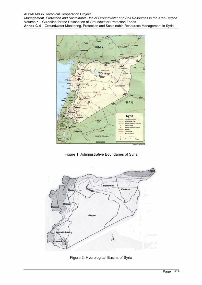
ACSAD-BGR Technical Cooperation Project Management, Protection and Sustainable Use of Groundwater and Soil Resources in the Arab Region Volume 5 – Guideline for the Delineation of Groundwater Protection Zones Annex C-4 – Groundwater Monitoring, Protection and Sustainable Resources Management in Syria
Page 314
Figure 1: Administrative Boundaries of Syria
Figure 2: Hydrological Basins of Syria
ACSAD-BGR Technical Cooperation Project Management, Protection and Sustainable Use of Groundwater and Soil Resources in the Arab Region Volume 5 – Guideline for the Delineation of Groundwater Protection Zones Annex C-4 – Groundwater Monitoring, Protection and Sustainable Resources Management in Syria
Page 315
2. Institutional Environment
Water is considered in Syria as a public property owned by the government. There are four Ministries dealing directly with the water issue in Syria, namely:
1- Ministry of Irrigation
2- Ministry of Housing and Utilities
3- Ministry of Agriculture and Agrarian Reform
4- State Ministry of Environment
The Ministry of Irrigation (MI) is responsible for the studies of water resources, their protection from depletion and pollution, and their allocation for different uses. It is responsible also for the study and implementation of all water structures and irrigation projects for agricultural purposes as well as their operation and maintenance.
The headquarters of MI is in Damascus, it comprises the following:
1- The Minister and four Minister Assistants, and few consultants. 2- Thirteen Central Directorates, namely: - D. of Training, research, and informatics - D. of Water resources - D. of Exploitation and maintenance - D. of Public water pollution control. - D. of Contracts. - D. of Legal affairs - D. of finance - D. of Studies - D. of Vehicles - D. of Planning - D. of Internal control - D. of Execution - D. of Administrative affairs
In addition to the above mentioned central directorates, there are seven general directorates belonging to MI, each one of them is responsible for a hydrologic basin, these seven general directorates are:
1- The General Directorate of Irrigation (GDI) for Barada and Awaj Basin, located in Damascus.
2- GDI for Badia basin, located in Homs. 3- GDI for Assi Basin, located in Hama. 4- GDI for Coastal Basin, located in Latakia. 5- GDI for Yarmouk Basin, located in Dara’a. 6- GDI for Tigris and Khabour Basin, located in Hasakeh. 7- GDI for Euphrates + Aleppo Basin, located in Thawra.
Each general directorate of irrigation is authorized to study and implement all water projects in the relevant basin, it comprises thirteen divisions similar in function to the thirteen central directorates in the Ministry but on basin scale. The role of the central directorates is to

ACSAD-BGR Technical Cooperation Project Management, Protection and Sustainable Use of Groundwater and Soil Resources in the Arab Region Volume 5 – Guideline for the Delineation of Groundwater Protection Zones Annex C-4 – Groundwater Monitoring, Protection and Sustainable Resources Management in Syria
Page 316
supervise and check the studies carried out in the general directorates of irrigation and to provide expertise and consultation whenever necessary.
The Ministry of Housing and Utilities (MHU) is responsible for setting the master plans for all cities, towns, and villages in Syria as well as providing drinking water and sewerage facilities for them. This ministry is responsible also for all mass housing projects. MHU takes care of drinking water and sewerage thru fourteen general establishments of drinking water and sewerage existing in the fourteen governorates of Syria. These establishments are responsible for exploiting the drinking water resources allocated by the Ministry of Irrigation and for the distribution of drinking water in their relevant governorate as well as for sewerage networks and water purification and treatment plants.
Drinking water cost and sewerage treatment fees are collected by the above mentioned general establishments and delivered to the Ministry of finance who allocates budgets for all ministries and general establishments. Water tariff is the same allover Syria.
The main role of the Ministry of Agriculture and Agrarian Reform in the water issue is the annual allocation of areas to be irrigated or planted in light of available surface water and groundwater resources.
The role of the Ministry of Environment in the water issue has been defined in law number 50 dated 28/7/2002. This law haws given the ministry wide authorities for monitoring water quality and for the protection of the water environment.
Each one of these two ministries is represented in each governorate of Syria by a local office called Directorate.
3. Questionnaire
1) Is there a law in place to allow for the delineation of groundwater protection zones ?
The Legislation for groundwater protection zones was initiated in Syria in 1970 when decree number 2145 was issued to establish the Directorate of Public Water Pollution Control as a new directorate belonging to the already existing Ministry o Public Works and Water Resources. Decree 2145 has given wide authority to the Directorate of Public Water Pollution Control to take all necessary measures to deal with water pollution in rivers, sea, springs, wells, and all public waters (Article 3, item B-8).
In 1982, law number 16 was issued to establish the Ministry of Irrigation. One of the main tasks of this ministry of the protection of the water resources from all forms of pollution and the preparation of the relevant legislations.
In 1986, law number 17 was issued. By this law a general directorate of irrigation was created in each one of the seven hydrologic basins of Syria. Each directorate is administratively and financially independent but supervised by the Ministry of Irrigation. Each directorate is responsible for the study, development and exploitation of the water resources in the relevant basin as well as for protecting these resources from depletion or pollution.
In 1989, law number 10 was issued for the protection of Figeh spring from pollution.
The most recent legislation for groundwater protection is the decision number 386 dated 18/1/2003 issued by the Prime Minister which prohibited the drilling of wells for agricultural
ACSAD-BGR Technical Cooperation Project Management, Protection and Sustainable Use of Groundwater and Soil Resources in the Arab Region Volume 5 – Guideline for the Delineation of Groundwater Protection Zones Annex C-4 – Groundwater Monitoring, Protection and Sustainable Resources Management in Syria
Page 317
purposes in all the hydrologic basins of Syria. This decision defined regulations for licensing wells for drinking, industrial, and touristic purposes only. Even governmental bodies must have a license before drilling any water well. This decision has emphasized on delineating protection zones for drinking water wells as well as for springs, foggharas, and water courses. Violators of this decision are subject to severe punishments.
2) Have groundwater protection zones already been established (how many) ?
In compliance with Decree number 2145 of 1970, the Ministry of irrigation has established a committee called “Central Committee for Protection Zones, headed by the Minister Assistant. This committee comprises all specialties necessary for studying water resources protection zones. A similar committee was formed in every general directorate of the seven hydrologic basins. As a result of the work of these committees, more than 45 ministerial decisions for establishing protection zones have been issued. Each decision is accompanied with a topographic map delineating the limits of the protection zones. Out of these decisions there are 26 concerning springs and wells, the others deal with dam lakes from which water is taken for drinking purposes and with foggharas.
3) Which restrictions are imposed on land use activities in the protection zones ?
In 1980, the Ministry of Public Works and Water Resources issued Ministerial Decision number 393 including guidelines for delineating protection zones for water resources. The major parts of the guidelines were taken from the German norms. These guidelines imposed three prohibition zones for springs: A – Intensive Prohibition zone, which must be appropriated in favor of the Ministry of Public
Works and Water Resources or the General Establishment of Drinking water that is exploiting the water resource for the protection zone is delineated. In this zone all activities are prohibited with the exception of forest trees. This zone is intended to prevent any direct pollution.
B – Direct Prohibition zone, which covers part of the recharge area that is sufficient for self purification of the groundwater. The extent of this zone depends on the environmental, geological, geographical, and socio-economical conditions in the recharge area. The restrictions that are imposed on land use activities aim at protecting the water quality and they include in general:
- Protection from flooding and construction of impermeable sewage network. - Coverage of base rock and filling of holes by clean impermeable materials. - Prohibition of industries that have dangerous wastes. - Prohibition of first class roads, camps, or training centers. - Monitoring and control of the use of fertilizers and pesticides, and prohibition of
hazardous types. - No sewage water treatment plants are allowed in this zone.
C – Peripheral Protection Zone, which covers the rest of the recharge area of the spring. In case large springs having an extended recharge area, the peripheral protection zone is divided into two sub zones:
Sub Zone A: Covering areas that are within 2 Km from the spring. Sub Zone B: Covering the rest of the recharge area. The restrictions on land use
inside the peripheral protection zone are less severe than those in the direct protection zone. They aim at protecting the groundwater from contamination
ACSAD-BGR Technical Cooperation Project Management, Protection and Sustainable Use of Groundwater and Soil Resources in the Arab Region Volume 5 – Guideline for the Delineation of Groundwater Protection Zones Annex C-4 – Groundwater Monitoring, Protection and Sustainable Resources Management in Syria
Page 318
with chemical and radioactive materials and other dangerous materials like petroleum fractions, poisons, and mining wastes.
The Legislations for groundwater protection zones are issued as ministerial decisions by the Minister of irrigation. Only in one case which is the case of Figeh spring, the protective zones were delineated by a law signed by the President of the Republic (law Number 10 dated March, 1989) after thorough discussions in the Parliament, this was due to the vital importance of Figeh spring which is the main drinking water source for Damascus city. The law was based on profound study of the hydrogeologic and socio-economic conditions of the recharge area of Figeh spring that was performed by a French firm (SOGREA) in 1980 and resulted in the proposal of 3 protection zones: Intensive protection zone, direct protection zone, and peripheral protection zone. The later zone includes the whole recharge area of the spring amounting to 770 Km2.
As for drinking water wells which are normally close to inhabited areas, only zones A and B are delineated.
4) How are the restrictions being enforced ?
Violations to the restrictions imposed by the ministerial decisions regarding protection zones (in case of Figeh spring law No. 10 of 1989) are monitored by employees of the Ministry of irrigation and the Ministry of Housing and Utilities who should inform the representatives of the Ministry of Local Administration and the police in order to prevent the violation. In case of serious violations, police transfer violators into court which judges in compliance with the civil Syrian law. There are a lot of problems with local inhabitants when enforcing the legislations concerning protection zones.
5) Which methods are being used for the delineation of groundwater protection zones ?
Each year, the protection zones committee in each one of the seven hydrologic basins reports to the central committee of protection zones in the Ministry of irrigation a proposal for establishing protection zones for the water resources it deems necessary to protect in the basin. The control committee coordinates the received proposals giving priorities to the water resources for drinking water and to the resources that are more vulnerable to pollution. This committee issues eventually an annual work plan for delineating protection zones taking the technical and financial possibilities into consideration. In compliance with this plan, each basin committee implements the necessary hydrogeologic and socio-economic investigations and prepares a draft ministerial decision delineating the protection zones for the relevant water resources. The draft is then discussed in the central committee for approval by the Minister of Irrigation. When the decision is issued, the general directorate of irrigation of the relevant basin becomes responsible for the implementation of the decision.
6) What are the sizes of zones 1, 2, 3 ?
The sizes of zones 1,2, and 3 depend on many factors. The discharge of the water source and the water use are the most important factors. The availability of enforcing the protection zones on the ground is another important factor. The extent of the recharge area and the hydrogeologic and socio-economic conditions as well as the existing and future important factors. In general, the size of zone 1 which must be appropriated is few hectares, the size of zone 2 is some tens of hectares, while the size of zone 3 ranges between some square kilometers to some hundred square kilometers. For example, in the case of Figeh Spring
ACSAD-BGR Technical Cooperation Project Management, Protection and Sustainable Use of Groundwater and Soil Resources in the Arab Region Volume 5 – Guideline for the Delineation of Groundwater Protection Zones Annex C-4 – Groundwater Monitoring, Protection and Sustainable Resources Management in Syria
Page 319
which is totally used for drinking water the sizes of zones 1,2, and 3 are 11 ha, 57 ha, and 770 km2 respectively. While in the case of Barada spring which is used for drinking water and irrigation, the sizes of zones 1,2, and 3 are 1.5 ha, 10 ha, and 46 km2 respectively.
7) Which other measures are in place to protect the groundwater resources ?
There are several other measures in place to protect the groundwater resources. The most important of which are: A- The Ministry of Irrigation cooperates with the Ministry of Housing and Utilities during the
study phase of master plans for villages and towns in order to exclude protection zones from urban extension. In some cases some already approved master plan were modified to avoid urban extension inside the intensive and direct protection zones (case of Mzairib spring).
B- The Ministry of Irrigation cooperates with the Ministry of Petroleum, so that the path of crude oil pipelines and the petroleum fractions pipelines avoid water resources protection zones. When it is deemed impossible, the pipeline is constructed inside a concrete canal with suitable slopes to drain any petroleum seepage outside the protection zone like in the case of Banias spring in the coastal basin.
C- The Ministry of Irrigation coordinates with the Ministry of Environment in order to make the intensive protection zone an environmental reservation like in the case of Sinn Spring in the Coastal Basin.
D- The Ministry of Irrigation cooperates with the Ministry of Defense so that the placement of military camps are far from the protection zones of wells and springs.
E- The Central Committee for Protection Zones always tries its best in order to find suitable solutions for accidental pollution problems. For example, when Tannour Spring in Assi Basin was polluted by nitrates and became vulnerable to be depleted, the committee took measures to close wells in the recharge area of the spring, and prohibited the use of fertilizers and pesticides and permanent irrigation in the direct protection zone.
F- The Ministry of Irrigation cooperates with the Ministry of Agriculture and Agrarian Reform to guide farmers how to use treated sewage water for irrigation. Farmers are guided to use less chemical fertilizers with treated sewage water in order to protect drinking water wells from pollution in Damascus Ghouta.
G- The Ministry of irrigation endeavors to upgrade the efficiency of personnel working in the study and implementation of protection zones by sending them to training courses.
H- The Ministry of Irrigation monitors the quality of treated sewage water to get sure of its disinfection.
I- The Ministry of Irrigation endeavors continuously to update the legislations concerning groundwater protection whenever new technologies are available.
8) Is a groundwater monitoring network for groundwater quality control established and functional ?
In every hydrologic basin in Syria, there is a groundwater monitoring network. The water level is monitored monthly or every three months in all wells of the network. Samples for water quality monitoring are taken every three months from some wells of the network. Special attention is given to monitoring heavy metals. Samples are taken from important springs to monitor water, quality. In Barada& Awaj Basin, there are 140 wells for monitoring water levels, 29 of them are used for water quality monitoring.
ACSAD-BGR Technical Cooperation Project Management, Protection and Sustainable Use of Groundwater and Soil Resources in the Arab Region Volume 5 – Guideline for the Delineation of Groundwater Protection Zones Annex C-4 – Groundwater Monitoring, Protection and Sustainable Resources Management in Syria
Page 320
9) Have maps of groundwater vulnerability been prepared ?
No groundwater vulnerability maps have been prepared yet in Syria. However, some studies for sea water encroachment towards fresh groundwater in the coastal basin have been conducted and appropriate measures based on these studies were taken. Vulnerability maps for some pilot areas will be prepared in the near future.
10) Are guidelines/laws/by-laws in place to control the quality of emissions into surface and groundwater (sewage water/effluent standard) ?
Specifications for industrial effluents into Barada River and Assi River are already in place. There are also Syrian specifications for effluents discharged into the sewage network aiming at ensuring the operation of the sewage water treatment plants with high efficiency. The Directorate of Public Water Pollution Control has established guidelines defining specification of all the effluents that are to be discharged into sea, rivers, and water courses. There are ongoing studies to issue standard specifications based on these guidelines.
11) Is there a law/by-law/guideline for the design and monitoring/control of waste disposal sites ?
The guideline for the design and control of waste disposal sites is included in Decree 2145 of the year 1971 which gave the Directorate of Public Water Pollution Control (DPWPC) the authority of monitor the pollution of all public waters. This directorate has established a water quality monitoring network along the courses of the main rivers in Syria. This net work comprises: 26 Stations on Assi River 36 Stations on Barada River 13 Stations on Euphrates River 6 Stations on Kabir Shamali River 6 Stations on Yarmouk River Monthly samples are taken from each station. The elements monitored are: Discharge, BOD, SS, Ammonia, Nitrates, PH, and temperature in addition to other pollution indicators depending on the discharged effluents. The length of record in the stations ranges between 10 to 25 years. DPWPC monitors also the industrial waste effluents upon discharging outside factory, the elements monitored depend on the type of industry. All samples are analyzed in DPWPC labs, the results are reported to the relevant ministries who order the pollution source to take the appropriate measures.
12) Is there a law/by-law/guideline for the use of pesticides/fertilizers in agriculture ?
The Ministry of State for Environmental Affair supervises the importation of all pesticides in Syria. This ministry defines the prohibited pesticides. Any importation of pesticides by public or private sector needs a license from the ministry and the customs.
The use and importation of fertilizers is guided by the Ministry of Agriculture and Agrarian Reform who guides farmers on the farm level how to use fertilizers and pesticides in a way that not causes pollution to the product or to groundwater.
The Ministry of Irrigation upon preparing the decisions for protection zones states that the use of fertilizers and pesticides in zones 2 and 3 is subject to the supervision of the directorates of agriculture when agriculture is permitted in said zones.
ACSAD-BGR Technical Cooperation Project Management, Protection and Sustainable Use of Groundwater and Soil Resources in the Arab Region Volume 5 – Guideline for the Delineation of Groundwater Protection Zones Annex C-4 – Groundwater Monitoring, Protection and Sustainable Resources Management in Syria
Page 321
13) Is there a law/by-law/guideline for environmental protection/environmental impact assessment ?
The Ministry of State for Environmental Affairs was created in 1991 by presidential decree number 11. The task of this ministry is the preservation of the environment in Syria. In 199x the supreme council for Environmental Safety was established in the Cabinet and became responsible for licensing industries and structures having polluting effluents.
In 199x the Ministry of State for Environmental Affairs established a directorate for environmental impact assessment. This directorate became responsible for studying the environmental impacts of every new industrial project and for setting the necessary precautions and measures that should be applied to protect the environmental elements before licensing any project.
In 2002 law number 50 was passed by the parliament which is called the Environmental Law. The main features of this law are: J- It enabled the Ministry of State for Environmental Affairs to set the environmental
standards and specifications. K- It created a general organization for environmental affairs and specified its tasks. L- It developed the supreme council for Environmental Safety and defined its functions. M- It created a fund for supporting and protecting the environment. N- It nominated environmental experts who may be appointed by the Minister to inspect
sources of pollution. O- It considered man caused pollution as a criminal act and imposed sanctions ranging
from financial penalty to ten years in jail. P- The law permitted the already existing structures causing pollution one year to adapt
with the imposed restrictions and demands.
14) How are groundwater protection demands integrated into land use planning ?
Till now, there is no national plan for land use in Syria. The Ministry of Housing and Utilities prepares master plans for urban and rural settlements. The Ministry of Irrigation and the Ministry of Agriculture and Agrarian Reform are involved in delineating the lands to be reclaimed in compliance with soil classification and water availability. There are legislations and regulations on the governorate level classifying the land use as agricultural, industrial, or urban. When studying master plans, the water resources protection zones demands listed in the relevant legislations are considered and respected.
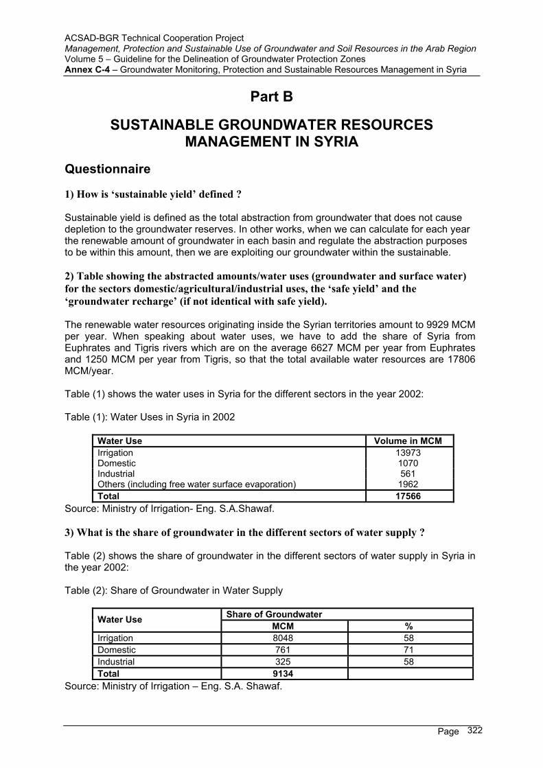
ACSAD-BGR Technical Cooperation Project Management, Protection and Sustainable Use of Groundwater and Soil Resources in the Arab Region Volume 5 – Guideline for the Delineation of Groundwater Protection Zones Annex C-4 – Groundwater Monitoring, Protection and Sustainable Resources Management in Syria
Page 322
Part B
SUSTAINABLE GROUNDWATER RESOURCES MANAGEMENT IN SYRIA
Questionnaire
1) How is ‘sustainable yield’ defined ?
Sustainable yield is defined as the total abstraction from groundwater that does not cause depletion to the groundwater reserves. In other works, when we can calculate for each year the renewable amount of groundwater in each basin and regulate the abstraction purposes to be within this amount, then we are exploiting our groundwater within the sustainable.
2) Table showing the abstracted amounts/water uses (groundwater and surface water) for the sectors domestic/agricultural/industrial uses, the ‘safe yield’ and the ‘groundwater recharge’ (if not identical with safe yield).
The renewable water resources originating inside the Syrian territories amount to 9929 MCM per year. When speaking about water uses, we have to add the share of Syria from Euphrates and Tigris rivers which are on the average 6627 MCM per year from Euphrates and 1250 MCM per year from Tigris, so that the total available water resources are 17806 MCM/year.
Table (1) shows the water uses in Syria for the different sectors in the year 2002:
Table (1): Water Uses in Syria in 2002
Water Use Volume in MCM Irrigation 13973 Domestic 1070 Industrial 561 Others (including free water surface evaporation) 1962 Total 17566
Source: Ministry of Irrigation- Eng. S.A.Shawaf.
3) What is the share of groundwater in the different sectors of water supply ?
Table (2) shows the share of groundwater in the different sectors of water supply in Syria in the year 2002:
Table (2): Share of Groundwater in Water Supply
Share of Groundwater Water Use MCM %
Irrigation 8048 58 Domestic 761 71 Industrial 325 58 Total 9134
Source: Ministry of Irrigation – Eng. S.A. Shawaf.
ACSAD-BGR Technical Cooperation Project Management, Protection and Sustainable Use of Groundwater and Soil Resources in the Arab Region Volume 5 – Guideline for the Delineation of Groundwater Protection Zones Annex C-4 – Groundwater Monitoring, Protection and Sustainable Resources Management in Syria
Page 323
4) What are the main factors influencing the groundwater resources management decisions (demand driven, economical considerations, sociological considerations, etc.) ?
The main factors influencing the groundwater resources management are: A. The availability of good quality groundwater in all the Syrian basins at reasonable
depths lead to rely on groundwater for drinking water supply in most rural areas. Individual farmers rely on groundwater as well in case of no adequate surface water irrigation network is available.
B. The annual agricultural plan set up by the Ministry of irrigation and the Ministry of Agriculture and Agrarian reform defines the areas to be irrigated each year on the basis of surface water availability. Due to economical factors, may farmers exceed the defined areas and rely on groundwater to get more water for irrigation.
C. In dry years, when the quantities of surface water impounded in dam lakes fail to cover the irrigation demands, more pumping of groundwater becomes the sole solution in spite of the drastic water levels drawdown.
5) What are the main problems in groundwater resources management ?
The main problems of groundwater resources management in Syria are: A. Inadequate coordination between the Ministry of Irrigation who license water wells,
and the Ministry of Interior (police) who should close illegal wells. This leads to the growth of illegal wells and to the depletion of groundwater.
B. Inadequate groundwater monitoring networks. C. The technicians who are in charge of groundwater management and monitoring
need continuous education and training. D. Pollution of groundwater by nitrates due to the use of nitrate fertilizers or treated
sewage water in irrigation. Some drinking water wells have shown high nitrate content in Dara’a and Idlib governorates, the Ministry of Housing and Utilities was obliged to abandon the wells and look for another drinking water resource.
E. Salination of groundwater caused by excessive irrigation and poor drainage as in Raqqa governorate.
F. Excessive pumping of groundwater in the coastal plains between Jableh and Banias has caused sea water encroachment and deteriorated groundwater quality.
G. Deep groundwater in Badia basin has high salinity in general, the water is not suitable for drinking or for irrigation. The Ministry of Housing and the Ministry of Irrigation will start in 2003 to build pilot desalination plants to treat the water and to introduce desalination technology to Syria.
H. The lack of convenient water legislation. The draft water law is still under discussion in the parliament, when it will be issued the Ministry of Irrigation will be able to set up standard specifications for all waters and to control all water uses.
6) Is domestic water supply in the hand of governmental institutions or privatized/semi-privatized ?
Domestic water supply is in the hand of governmental institutions. In each one of the fourteen governorates of Syria, there is a general establishment for drinking water and sewerage belonging to the Ministry of Housing and Utilities. This establishment is responsible for supplying drinking water for all houses, offices and commercial activities.
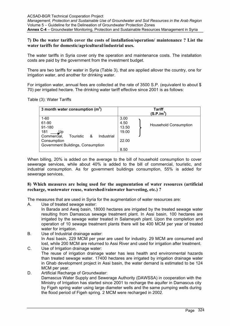
ACSAD-BGR Technical Cooperation Project Management, Protection and Sustainable Use of Groundwater and Soil Resources in the Arab Region Volume 5 – Guideline for the Delineation of Groundwater Protection Zones Annex C-4 – Groundwater Monitoring, Protection and Sustainable Resources Management in Syria
Page 324
7) Do the water tariffs cover the costs of installation/operation/ maintenance ? List the water tariffs for domestic/agricultural/industrial uses.
The water tariffs in Syria cover only the operation and maintenance costs. The installation costs are paid by the government from the investment budget.
There are two tariffs for water in Syria (Table 3), that are applied allover the country, one for irrigation water, and another for drinking water.
For irrigation water, annual fees are collected at the rate of 3500 S.P. (equivalent to about $ 70) per irrigated hectare. The drinking water tariff effective since 2001 is as follows:
Table (3): Water Tariffs
3 month water consumption (m3) Tariff (S.P./m3)
1-60 3.00 61-90 4.50 91-180 13.50 181 Up 19.00
Household Consumption
Commercial, Touristic & Industrial Consumption 22.00Government Buildings, Consumption
8.50
When billing, 20% is added on the average to the bill of household consumption to cover sewerage services, while about 40% is added to the bill of commercial, touristic, and industrial consumption. As for government buildings consumption, 55% is added for sewerage services.
8) Which measures are being used for the augmentation of water resources (artificial recharge, wastewater reuse, watershed/rainwater harvesting, etc.) ?
The measures that are used in Syria for the augmentation of water resources are: A. Use of treated sewage water: In Barada and Awaj basin, 18000 hectares are irrigated by the treated sewage water
resulting from Damascus sewage treatment plant. In Assi basin, 100 hectares are irrigated by the sewage water treated in Salameyeh plant. Upon the completion and operation of 10 sewage treatment plants there will be 400 MCM per year of treated water for irrigation.
B. Use of Industrial drainage water: In Assi basin, 229 MCM per year are used for industry. 29 MCM are consumed and
lost, while 200 MCM are returned to Assi River and used for irrigation after treatment. C. Use of Irrigation drainage water: The reuse of irrigation drainage water has less health and environmental hazards
than treated sewage water. 17400 hectares are irrigated by irrigation drainage water in Ghab development project in Assi basin, the water demand is estimated to be 124 MCM per year.
D. Artificial Recharge of Groundwater: Damascus Water Supply and Sewerage Authority (DAWSSA) in cooperation with the
Ministry of Irrigation has started since 2001 to recharge the aquifer in Damascus city by Figeh spring water using large diameter wells and the same pumping wells during the flood period of Figeh spring. 2 MCM were recharged in 2002.
ACSAD-BGR Technical Cooperation Project Management, Protection and Sustainable Use of Groundwater and Soil Resources in the Arab Region Volume 5 – Guideline for the Delineation of Groundwater Protection Zones Annex C-4 – Groundwater Monitoring, Protection and Sustainable Resources Management in Syria
Page 325
E. In Barada basin, hafirs have been used since 1995 for rainwater harvesting. By the year 2000 there was 34 hafirs with a total storage capacity of 2.9 MCM. Water spreading has been also practiced since 1993 in Badia basin to increase the soil humidity. 655 hectares were moistured by this way in 1997.
F. Cloud seeding: The Ministry of Agriculture started in 1992 a project for cloud seeding. Various methods have been used to assess the feasibility of the project.
9) What is the (approximate) share of groundwater rendered as not usable for domestic water supply due to poor groundwater quality either a) because of natural conditions or b) because of pollution ?
The share of groundwater rendered as not usable for domestic water supply differs from one basin to another in Syria. This share is considered low in general and is estimated to be between 10-15%.
A. The deep aquifers in Badia basin have high salinity rendering the groundwater undrinkable.
i. In the Coastal basin, excessive pumping of wells having originally acceptable salinity caused sea water intrusion to the aquifers and obliged the Ministry of Housing to rely on the water of Sinn spring to provide domestic water supply to all the cities and towns of the coastal strip, which were using local wells in the sixties for drinking.
ii. In Damascus city, some wells have penetrated gypsum lenses in Mezzeh area and were abandoned as water supply wells because the water taste is bitter.
B. The main pollutants for rendering groundwater wells not usable for domestic water supply are nitrates and ammonia resulting from excessive use of organic and chemical fertilizers.
iii. Some well sin the southern part of Damascus city have shown high nitrate content. They are either abandoned as domestic water supply resources, or the water pumped from these wells is mixed with Figeh spring water having very low nitrate content.
iv. Some wells in Yarmouk basin near Deraa city which has been used for drinking were abandoned upon showing high nitrate content after a new irrigation project was implemented.
v. The drinking water wells for Idlib city in Omk plain (Assi basin) were rendered unusable because the surrounding area which was a marsh has been dried up and became a permanent irrigation area where excessive fertilizers were used causing high nitrate content in groundwater. The Ministry of Housing provides now water supply for Idlib city from Ain Zarka spring in Assi valley.
10) Which water management policies (institutional, regulatory and resources management measures) have been implemented to achieve a status of sustainable groundwater resources management ?
The main water management policies that have been implemented to achieve a status of sustainable groundwater resources management are:
A. Water resources in Syria are considered as public properties owned by the Government. The Ministry of Irrigation has the right to license for government bodies, groups of people, or individuals to exploit water resources within legal regulations.
B. Water structures like dams, irrigation canals, drinking water distribution networks, or aqueducts are implemented owned by the Government who supervises their exploitation and maintenance.
ACSAD-BGR Technical Cooperation Project Management, Protection and Sustainable Use of Groundwater and Soil Resources in the Arab Region Volume 5 – Guideline for the Delineation of Groundwater Protection Zones Annex C-4 – Groundwater Monitoring, Protection and Sustainable Resources Management in Syria
Page 326
Water structures in the private sector or mainly groundwater wells which need licensing from the Ministry of Irrigation provided that aquifer conditions are adequate.
C. Water use is managed by the Ministry of Irrigation who is authorized to allocate water for all users giving priorities to drinking water supplies, then to industrial, touristic, and irrigations for rationalizing the water use for irrigation encouraging modern irrigation methods.
D. In each one of the seven hydrologic basins of Syria, the relevant general directorate of irrigation is responsible for conducting necessary studies for the development of water resources in that basin and for the implementation of land reclamation projects taking into account the reservation of the water environment and the aquatic life.
E. The Syrian government (Ministry of Irrigation and Ministry of Housing and Utilities) has implemented many projects to develop the main springs like Sinn, Figeh, Barada, Banias, Ain Tannour and to regulate their discharge.
F. The Ministry of Irrigation conducts studies for exploring deep groundwater aquifers. G. A draft water law has been prepared by the Ministry of Irrigation and under
discussion in the parliament. This law updates all existing water legislations and aims at providing practical basis for the sustainable use of groundwater and surface water resources.
H. Capacity building of personnel working in the groundwater domain takes place thru on job training and contacts with foreign experts as well as thru sending engineers and technicians for training abroad.
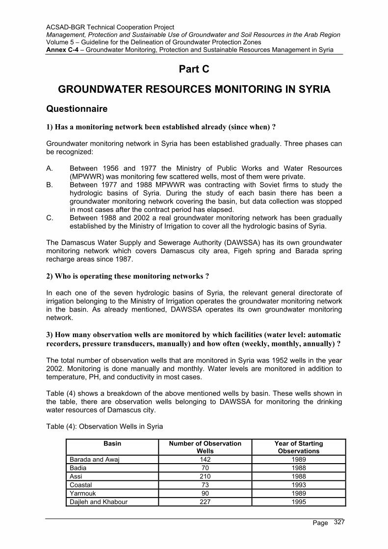
ACSAD-BGR Technical Cooperation Project Management, Protection and Sustainable Use of Groundwater and Soil Resources in the Arab Region Volume 5 – Guideline for the Delineation of Groundwater Protection Zones Annex C-4 – Groundwater Monitoring, Protection and Sustainable Resources Management in Syria
Page 327
Part C
GROUNDWATER RESOURCES MONITORING IN SYRIA
Questionnaire
1) Has a monitoring network been established already (since when) ?
Groundwater monitoring network in Syria has been established gradually. Three phases can be recognized:
A. Between 1956 and 1977 the Ministry of Public Works and Water Resources (MPWWR) was monitoring few scattered wells, most of them were private.
B. Between 1977 and 1988 MPWWR was contracting with Soviet firms to study the hydrologic basins of Syria. During the study of each basin there has been a groundwater monitoring network covering the basin, but data collection was stopped in most cases after the contract period has elapsed.
C. Between 1988 and 2002 a real groundwater monitoring network has been gradually established by the Ministry of Irrigation to cover all the hydrologic basins of Syria.
The Damascus Water Supply and Sewerage Authority (DAWSSA) has its own groundwater monitoring network which covers Damascus city area, Figeh spring and Barada spring recharge areas since 1987.
2) Who is operating these monitoring networks ?
In each one of the seven hydrologic basins of Syria, the relevant general directorate of irrigation belonging to the Ministry of Irrigation operates the groundwater monitoring network in the basin. As already mentioned, DAWSSA operates its own groundwater monitoring network.
3) How many observation wells are monitored by which facilities (water level: automatic recorders, pressure transducers, manually) and how often (weekly, monthly, annually) ?
The total number of observation wells that are monitored in Syria was 1952 wells in the year 2002. Monitoring is done manually and monthly. Water levels are monitored in addition to temperature, PH, and conductivity in most cases.
Table (4) shows a breakdown of the above mentioned wells by basin. These wells shown in the table, there are observation wells belonging to DAWSSA for monitoring the drinking water resources of Damascus city.
Table (4): Observation Wells in Syria
Basin Number of Observation Wells
Year of Starting Observations
Barada and Awaj 142 1989 Badia 70 1988 Assi 210 1988 Coastal 73 1993 Yarmouk 90 1989 Dajleh and Khabour 227 1995
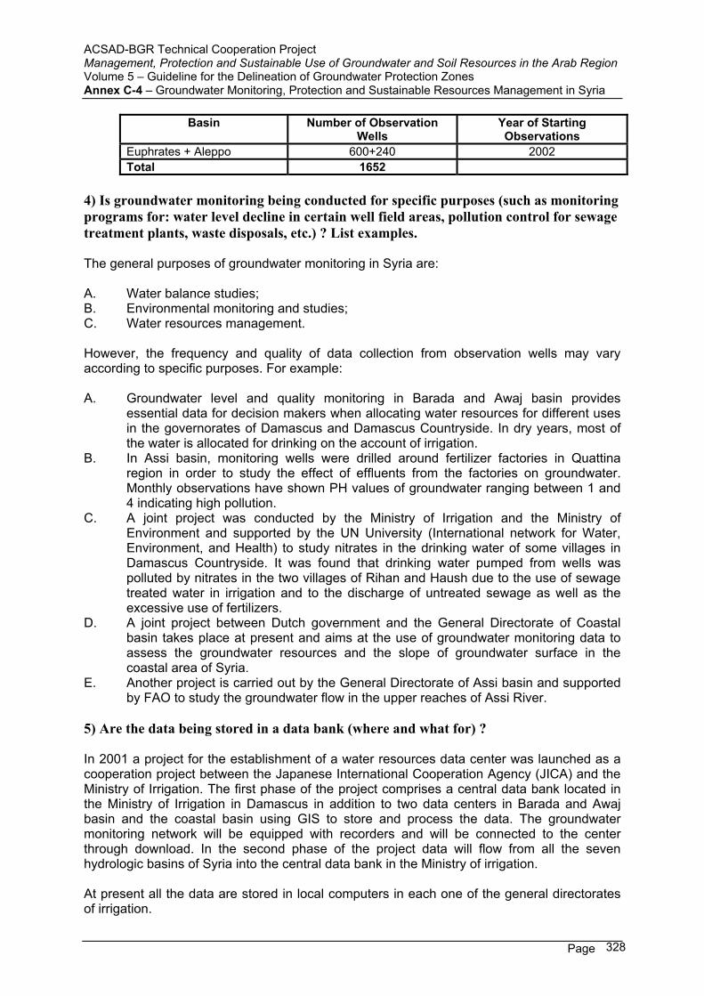
ACSAD-BGR Technical Cooperation Project Management, Protection and Sustainable Use of Groundwater and Soil Resources in the Arab Region Volume 5 – Guideline for the Delineation of Groundwater Protection Zones Annex C-4 – Groundwater Monitoring, Protection and Sustainable Resources Management in Syria
Page 328
Basin Number of Observation Wells
Year of Starting Observations
Euphrates + Aleppo 600+240 2002 Total 1652
4) Is groundwater monitoring being conducted for specific purposes (such as monitoring programs for: water level decline in certain well field areas, pollution control for sewage treatment plants, waste disposals, etc.) ? List examples.
The general purposes of groundwater monitoring in Syria are:
A. Water balance studies; B. Environmental monitoring and studies; C. Water resources management.
However, the frequency and quality of data collection from observation wells may vary according to specific purposes. For example:
A. Groundwater level and quality monitoring in Barada and Awaj basin provides essential data for decision makers when allocating water resources for different uses in the governorates of Damascus and Damascus Countryside. In dry years, most of the water is allocated for drinking on the account of irrigation.
B. In Assi basin, monitoring wells were drilled around fertilizer factories in Quattina region in order to study the effect of effluents from the factories on groundwater. Monthly observations have shown PH values of groundwater ranging between 1 and 4 indicating high pollution.
C. A joint project was conducted by the Ministry of Irrigation and the Ministry of Environment and supported by the UN University (International network for Water, Environment, and Health) to study nitrates in the drinking water of some villages in Damascus Countryside. It was found that drinking water pumped from wells was polluted by nitrates in the two villages of Rihan and Haush due to the use of sewage treated water in irrigation and to the discharge of untreated sewage as well as the excessive use of fertilizers.
D. A joint project between Dutch government and the General Directorate of Coastal basin takes place at present and aims at the use of groundwater monitoring data to assess the groundwater resources and the slope of groundwater surface in the coastal area of Syria.
E. Another project is carried out by the General Directorate of Assi basin and supported by FAO to study the groundwater flow in the upper reaches of Assi River.
5) Are the data being stored in a data bank (where and what for) ?
In 2001 a project for the establishment of a water resources data center was launched as a cooperation project between the Japanese International Cooperation Agency (JICA) and the Ministry of Irrigation. The first phase of the project comprises a central data bank located in the Ministry of Irrigation in Damascus in addition to two data centers in Barada and Awaj basin and the coastal basin using GIS to store and process the data. The groundwater monitoring network will be equipped with recorders and will be connected to the center through download. In the second phase of the project data will flow from all the seven hydrologic basins of Syria into the central data bank in the Ministry of irrigation.
At present all the data are stored in local computers in each one of the general directorates of irrigation.
ACSAD-BGR Technical Cooperation Project Management, Protection and Sustainable Use of Groundwater and Soil Resources in the Arab Region Volume 5 – Guideline for the Delineation of Groundwater Protection Zones Annex C-4 – Groundwater Monitoring, Protection and Sustainable Resources Management in Syria
Page 329
6) Are monitoring reports being prepared on a regular basis ?
The engineers and hydrogeologists in each general directorate of irrigation are responsible for the interpretation of the data in the relevant basin. The main aim is to estimate the groundwater resources that can be used each year without depleting the aquifers. The results are given to responsible in the Ministries of Agriculture and Irrigation who set up the annual agricultural plan and decide the areas that can be irrigated by groundwater.
In Damascus City Water Supply and Sewerage Authority (DAWSSA) the groundwater monitoring data is interpreted by a technical committee who decides in light of the data the policy of drinking water distribution in Damascus city during the drought period (June to November) each year.
7) Are the monitoring data being used for management decisions ? If so, please list examples.
Water management decision makers in Syria have realized the importance of water monitoring data. One of the targets of the project of water resources data center is to provide data on the quantity and quality of groundwater and establish water users associations who can select from the existing wells the most promising ones and construct an irrigation network that can serve all users in a better way than the already existing individual wells for farmers.


