Embed Size (px)
Citation preview

MINES ADVISORY GROUP PROJECT REPORT
2002
MAG Sri Lanka 37 A, Kaviratne Place
Kirillapone Colombo 05
Tel/Fax: +94 (0) 1 501 215
Sri Lankan Reg. No: FL.51116
Produced by MAG Sri Lanka, March 2003
All black and white photographs by Sean Sutton © MAG
MAG, 47 Newton Street, Manchester, M1 1FT, UK
Tel: +44 (0) 161 236 4311 Fax: +44 (0) 161 236 6244
Email: [email protected]
www.magclearsmines.org
Cover photo: Destroying landmines and Unexploded Ordnance in Vadamarachchi East.
PREFACE MAG has been supporting and undertaking mine action work in the LTTE controlled Vanni area of northern Sri Lanka since July 2002. This report details the work conducted to date. A second report presents the findings of on-going survey work being conducted by MAG in partnership with the Humanitarian Demining Unit and White Pigeon, agencies operating under the Tamils Rehabilitation Organisation (TRO).
As well as presenting the findings of this survey work, the second report is also designed to provide organisations working in the Vanni with a resource that they can draw upon in the planning and safe conduct of their own projects. At the beginning of the Survey Data section there is a page of advice on how to use this document and where to get further information in the field.
MAG’s survey process is not simply about identifying the location of minefields. It has a focus on providing ongoing assistance to communities in mine-affected areas who are already living with these problems. On this basis, MAG’s work has also emphasised mine risk education and the fencing of dangerous areas in close proximity to target communities.
A large number of the minefields in the Vanni area run for many kilometres. The work undertaken so far has focused on those areas where minefields intersect most acutely with the local population, particularly those areas anticipating or experiencing high levels of IDP return. Whilst survey data can provide a very valuable tool for the prioritisation of other mine action resources (such as minefield fencing or landmine clearance) the nature of the landmine threat in the Vanni also demands a prioritisation of this survey focus.
MAG is continuing to undertake survey and assessment work, minefield demarcation and explosive ordnance disposal in the Vanni area in 2003.
This work has been possible because of the strong commitment of the Government of Sri Lanka and the LTTE to see an eradication of the threat that landmines present to the civilian population. With the support of donors, the assistance of those mine action agencies already working in Sri Lanka, and the dedicated work of people across the north and east, this threat should be almost completely eradicated by the end of 2005.
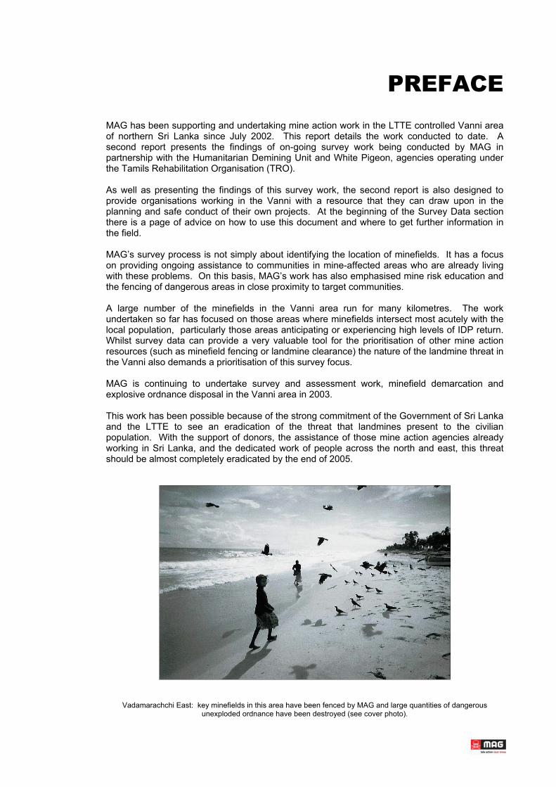
Vadamarachchi East: key minefields in this area have been fenced by MAG and large quantities of dangerous unexploded ordnance have been destroyed (see cover photo).

CONTENTS
1.0 INTRODUCTION
1.1 INTRODUCTION TO MAG1.2 BACKGROUND TO MAG IN SRI LANKA
2.0 PROGRAMME ACTIVITIES
2.1 SUMMARY OF STATISTICS 2.2 SUPPORT TO HDU 2.3 COMMUNITY LIAISON & MINE RISK EDUCATION 2.4 TECHNICAL SURVEY & DEMARCATION 2.5 EXPLOSIVE ORDNANCE DISPOSAL 2.6 OTHER ACTIVITIES
3.0 FUTURE OPERATIONS
3.1 BOZENA MECHANICAL SUPPORT TO LANDMINE CLEARANCE3.2 MINE RISK EDUCATION & LANDMINE CLEARANCE IN BATTICALOA
ANNEX A: SURVEY DATA - VANNI AREA, 2002
ANNEX B: A9 SURVEY DATA
INTRODUCTION
INTRODUCTION TO MAG _____1.1 BACKGROUND TO MAG IN SRI LANKA _____1.2
1.1 INTRODUCTION TO MAG Mines Advisory Group (MAG) is a British humanitarian agency specialising in landmine clearance, explosive ordnance disposal and mine risk education.
In 2002, MAG was working in Afghanistan, Angola, Cambodia, Lao PDR, Lebanon, northern Iraq, Uganda, south Sudan, Sri Lanka and Vietnam. MAG develops appropriate local capacities to address the problems caused by landmines and unexploded ordnance (UXO) to vulnerable civilian communities.
MAG was a founder member of the International Campaign to Ban Landmines and a co-laureate of the 1997 Nobel Peace Prize
1.2 BACKGROUND TO MAG IN SRI LANKA In February 2002, MAG was the first specialist international agency to deploy staff to Sri Lanka in an effort to address the outstanding problems of landmine and UXO contamination apparent in the wake of the ceasefire MoU between the Government of Sri Lanka and the LTTE.
MAG was greatly supported by the Sri Lankan Consortium of Humanitarian Agencies (CHA), an umbrella group assisting local and international NGO’s working on relief and development projects in Sri Lanka. MAG has been working in partnership with the CHA since they organised a Sri Lankan Symposium on Landmines in 2001.
In March 2002, MAG was requested by the Royal Norwegian Embassy to undertake an assessment of landmine contamination and ongoing mine action in the Vanni, an area of LTTE control in northern Sri Lanka. On the basis of this assessment MAG, in partnership with Norwegian People’s Aid (NPA) and the Tamils Rehabilitation Organisation (TRO) established plans for a comprehensive mine action operation in the Vanni. This plan was to build upon the existing capacity of the TRO’s Humanitarian Demining Unit (HDU) – bringing its work into line with International Mine Action Standards (IMAS) and facilitating a substantial expansion of its mine action resources.
These plans to develop the capacity of the Humanitarian Demining Unit were supported by the Government of Sri Lanka which was determined to see practical action to address the outstanding problems of landmine and UXO contamination. Since June, MAG NPA and the TRO have established and been undertaking these operations through the implementing agency of the Humanitarian Demining Unit.
At the request of the TRO, and based on an assessment in December, MAG has also begun Mine Risk Education operations in Batticaloa District of eastern Sri Lanka.
MAG’s work in Sri Lanka can be divided into a number of key sections:
• The initial process of support to the HDU. This provided equipment to the deminers already working the Vanni. MAG worked with NPA to implement further training for
1

these teams. Equipment for the HDU was funded by the Swedish Government through Sida and represented the first substantial international assistance to landmine clearance in this area.
• The establishment of MAG’s minefield survey and marking project. This project deployed 2 Community Liaison Teams and 4 Technical Survey and Minefield Marking Teams. The project has been gathering information on landmine impact in the Vanni, providing Mine Risk Education, identifying minefields and areas of UXO contamination and fencing minefield to protect local populations. Towards the end of 2002, teams from this project also conducted a substantial amount of explosive ordnance disposal work – destroying landmines and items of unexploded ordnance.
• Other activities. Outside the key project areas above, MAG has undertaken workshops, assessments and other activities in an effort to promote effective mine action in Sri Lanka. At the request of the TRO, and based on an assessment in December 2002, MAG has established a MRE Project in Batticaloa District.
With funding from ECHO and the Japanese Government, MAG will be continuing this work in 2003 with the addition of the following project components:
• Two Explosive Ordnance Disposal Teams. Funded by ECHO, these teams will continue the work of eradicating unexploded ordnance (UXO) such as mortars, rockets and grenades. Such items are extremely dangerous and are found in large quantities across the conflict areas (62% of communities visited during ongoing survey operations have reported a problem of UXO contamination).
• Bozena Mini-Flail. Funded by the Japanese Government this machine will provide support to the manual demining work of the HDU. The Bozena Flail will assist in the handing over of cleared minefields for safe use by the civilian population.
• Landmine clearance and MRE in Batticaloa. MAG has funding from Stichting Vluchteling for Mine Risk Education work in Batticaloa. MAG will also establish an HDU landmine clearance and EOD capacity in this area during 2003.
MAG’s work in Sri Lanka has been undertaken due to the generous support of the following donors:
• Swedish International Development Agency (Sida)
• European Community Humanitarian Office (ECHO)
• Doug Miller Foundation (UK)
• The Cooperative Bank (UK)
• Stichting Vluchteling (Netherlands)
• The Government of Japan
MAG’s initial deployment to Sri Lanka was funded by private donations from the British public.
MAG has been working in the Vanni in partnership with:
• Tamils Rehabilitation Organisation
• Humanitarian Demining Unit
• White Pigeon
• Norwegian People’s Aid
2

PROGRAMME ACTIVITES
SUMMARY OF STATISTICS _____ 2.1 EQUIPMENT & TRAINING TO SUPPORT HDU _____ 2.2
COMMUNITY LIAISON & MINE RISK EDUCATION _____ 2.3 TECHNICAL SURVEY & MINEFIELD DEMARCATION _____ 2.4
EXPLOSIVE ORDNANCE DISPOSAL _____ 2.5 OTHER ACTIVITIES _____ 2.6
2.1 SUMMARY OF STATISTICS
Area covered
Community areas surveyed 77
Breakdown by District: Jaffna 8 Kilinochchi 19 Mullaitivu 16 Vavuniya 23 Mannar 11
Dangerous areas identified 204 Minefields 156 UXO 48
Community liaison
Number of people involved in community mapping 1,603 and data gathering
Number of people who received Mine Risk Education 3,381 From MAG/White Pigeon Teams
Marking of minefields
Minefields fenced 27 Area fenced: 1,400,000 sq metres (approx) Metres fenced: 23,000
Explosive ordnance disposal
Anti personal mines 7,287∗
Anti-tank mines 3 UXO item 5,162
Total 12,452
∗ MAG undertook the demolition of a large quantity of anti-personnel mines cleared by the HDU working with NPA.
3
2.2 EQUIPMENT & TRAINING TO SUPPORT THE H.D.U.
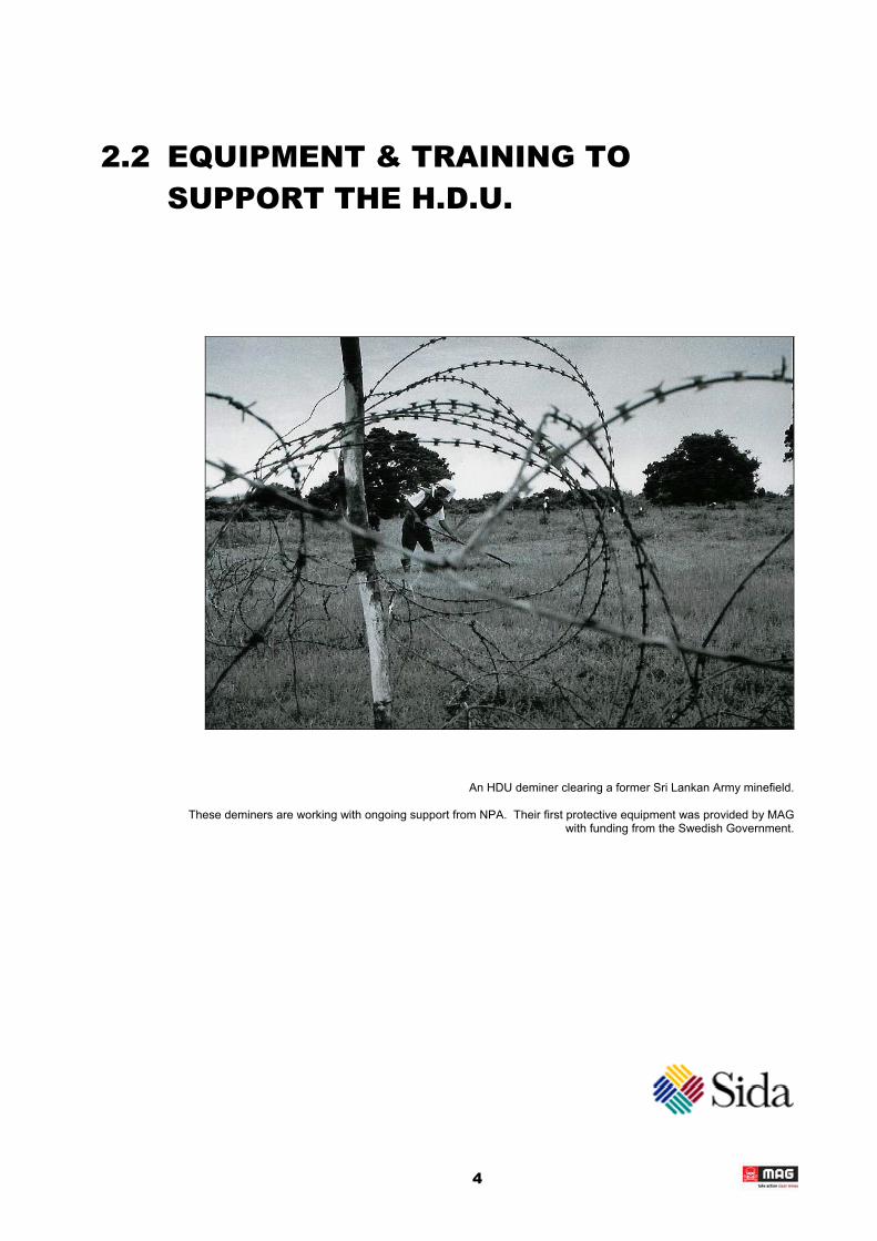
An HDU deminer clearing a former Sri Lankan Army minefield.
These deminers are working with ongoing support from NPA. Their first protective equipment was provided by MAG with funding from the Swedish Government.
4
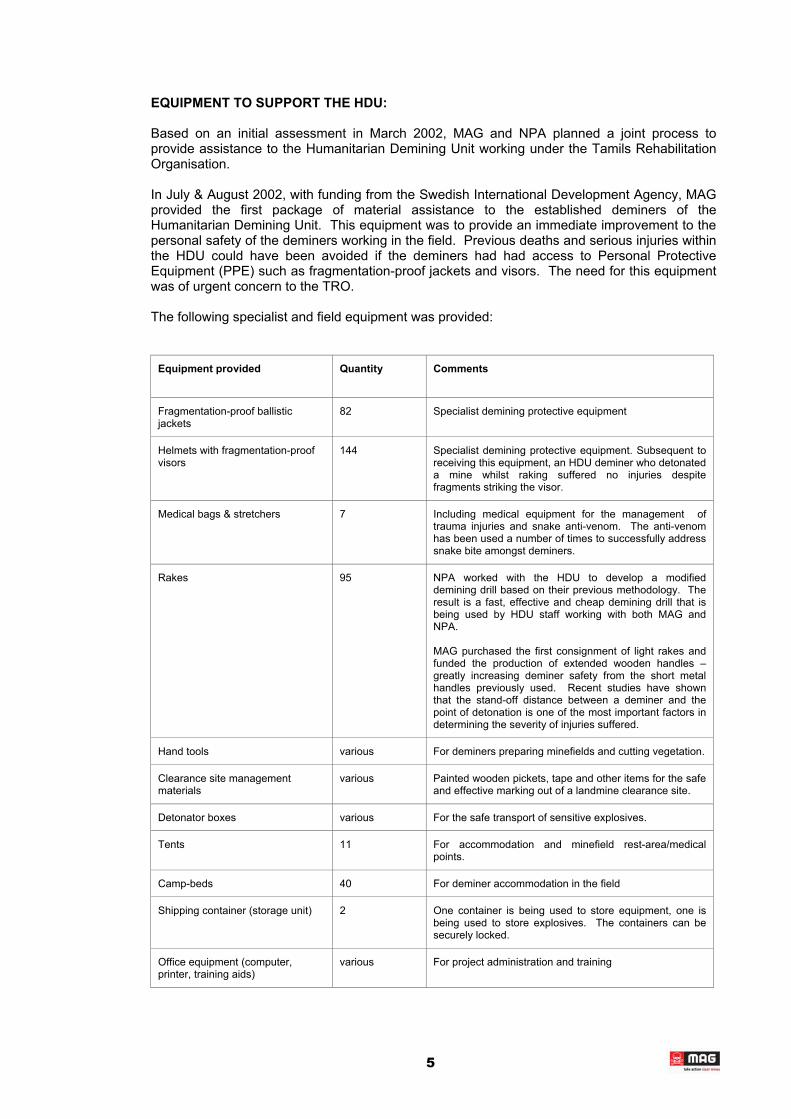
EQUIPMENT TO SUPPORT THE HDU:
Based on an initial assessment in March 2002, MAG and NPA planned a joint process to provide assistance to the Humanitarian Demining Unit working under the Tamils Rehabilitation Organisation.
In July & August 2002, with funding from the Swedish International Development Agency, MAG provided the first package of material assistance to the established deminers of the Humanitarian Demining Unit. This equipment was to provide an immediate improvement to the personal safety of the deminers working in the field. Previous deaths and serious injuries within the HDU could have been avoided if the deminers had had access to Personal Protective Equipment (PPE) such as fragmentation-proof jackets and visors. The need for this equipment was of urgent concern to the TRO.
The following specialist and field equipment was provided:
Equipment provided Quantity Comments
Fragmentation-proof ballistic jackets
82 Specialist demining protective equipment
Helmets with fragmentation-proof visors
144 Specialist demining protective equipment. Subsequent to receiving this equipment, an HDU deminer who detonated a mine whilst raking suffered no injuries despite fragments striking the visor.
Medical bags & stretchers 7 Including medical equipment for the management of trauma injuries and snake anti-venom. The anti-venom has been used a number of times to successfully address snake bite amongst deminers.
Rakes 95 NPA worked with the HDU to develop a modified demining drill based on their previous methodology. The result is a fast, effective and cheap demining drill that is being used by HDU staff working with both MAG and NPA.
MAG purchased the first consignment of light rakes and funded the production of extended wooden handles – greatly increasing deminer safety from the short metal handles previously used. Recent studies have shown that the stand-off distance between a deminer and the point of detonation is one of the most important factors in determining the severity of injuries suffered.
Hand tools various For deminers preparing minefields and cutting vegetation.
Clearance site management materials
various Painted wooden pickets, tape and other items for the safe and effective marking out of a landmine clearance site.
Detonator boxes various For the safe transport of sensitive explosives.
Tents 11 For accommodation and minefield rest-area/medical points.
Camp-beds 40 For deminer accommodation in the field
Shipping container (storage unit) 2 One container is being used to store equipment, one is being used to store explosives. The containers can be securely locked.
Office equipment (computer, printer, training aids)
various For project administration and training
5

TRAINING:
As well as providing equipment to support the safety of deminers and to improve working conditions in the field, MAG worked with NPA to implement training for the HDU supervisors and team leaders. These staff then undertook the training of the rest of the demining teams in the working methodology that had been developed.
NPA took the lead role in the formalisation of the demining drill and delivery of the training package. On this basis NPA continue to undertake the leading role in assistance to HDU’s manual demining work.
ASSISTING HDU EXPANSION IN 2003:
Through the Mine Action Resource Centre of the CHA, MAG drafted and submitted a proposal to the Ministry Assisting Vanni Rehabilitation. This proposal brought in additional equipment to support the HDU:
Equipment Quantity Comments
Light Rakes 2,000 These are key tools for the expansion of the HDU’s demining capacity in 2003.
4x4 Crew Cab Truck 1 Vehicles are a key part of increased safety within the HDU operation. Demining can only be conducted when there is a safety vehicle present to evacuate a casualty in the case of an accident.
Tents 10 Field accommodation for the expanded capacity
Camp-beds 40 As above
Mosquito Netting various As above
This equipment is supporting the expansion of HDU’s manual demining capacity in 2003 along-side the comprehensive package of assistance now being provided by NPA.
6
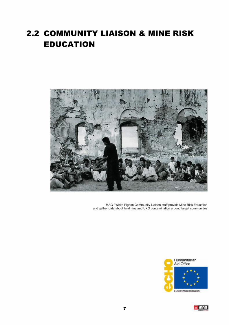
2.2 COMMUNITY LIAISON & MINE RISK EDUCATION
MAG / White Pigeon Community Liaison staff provide Mine Risk Education and gather data about landmine and UXO contamination around target communities
7
COMMUNITY LIAISON AND MINE RISK EDUCATION:
MAG deploys two Community Liaison (CL) Teams with staff drawn from the HDU’s partner organisation White Pigeon.
From late August 2002 to December, MAG’s Community Liaison Teams have worked in some 77 communities. During that period, over 3,300 people have been directly engaged with their work.
The key components of the Community Liaison Teams’ work are as follows:
• Community mapping to highlight dangerous areas • Mine/UXO impact data-gathering • Gathering information on communities • Mine Risk Education
These teams also gathered baseline data to build an understanding of pre-existing knowledge and attitudes within communities, and to assist in the development of MRE messages appropriate to the Vanni.
During the early months of operation, as knowledge about the problem developed, MAG prepared an MRE poster/leaflet appropriate to the local situation. This was field-tested at the end of 2002 and will be published in 2003. Production of this report has been slightly delayed whilst finalising artwork for the report.
As the minefield fencing teams completed tasks, the CL teams revisited communities to undertake post-fencing evaluation.
COMMUNITY MAPPING:
Activity Women Men Total
Community mapping & survey information gathering 664 939 1,603
The community liaison teams work with local communities to develop an understanding of the nature and location of the landmine and UXO threat in their immediate environment. The community and the teams work together to produce a map of the known and suspected dangerous areas in and around their village.
On arrival in a village the teams liaise with the village head to agree a suitable time for a community meeting. The MAG teams live in the field (either camping or staying with local people) and this enables meetings to be scheduled at any time that is compatible with people’s daily activities. The teams all contain both men and women so as to facilitate engagement with these separate groups. This is important because different groups of people have knowledge of different areas in the local environment based on their patterns of social and economic activity.
The map lays out roads and key features of the village and people contribute to this the location of suspect areas and items of UXO. The map is plotted from a reference point with a GPS location. For each dangerous area recorded on the map, the CL team completes a report form. This provides information on the type of suspected contamination and its impact on the community. Each area is allocated an HDU code which is used to track the ongoing mine
∗ action process .
∗ A single HDU code is allocated to UXO contamination around a community whereas each suspect minefield is allocated an individual code.
8

The mapping process has several key purposes. It allows MAG to gather information on landmine and UXO contamination across the region. It also provides each community with a forum in which to share their knowledge with each other. An A1-size copy of the map is left with the village leader or identified contact person for that location. This map can be used to brief IDPs resettling in the village. The process of mapping not only extracts information from the community but provides them with practical assistance to live with the landmine and UXO threat.
The illustration above shows the sketch-map for the village of Kanakarayankulam North in Vavuniya District. The suspected minefields are indicated in red and were a defensive barrier around a former Sri Lankan Army artillery camp - as indicated on the map.
The technical survey map of the first of these minefields (noted as number one on this sketch) can be seen in the next section of this report. This minefield is recorded by the Community Liaison Teams as blocking access to irrigated paddy land and pasture for cattle. Kanakaryankulam is also under pressure from returning IDPs.
9
COMMUNITY INFORMATION
As well as the mapping process the teams gather basic information about the community. This information is collected in accordance with adapted versions of UN IMSMA∗ forms appropriate to the local environment. This data includes contact names, brief background on local conflict and displacement, accident information, economic information, school and health facilities and previous mine action. The data also includes local people’s understanding of anticipated IDP return.
This process can also highlight other issues relating to landmines and UXO. In a number of communities MAG found people living inside minefields because they believed it was only by returning to their own lands that they were entitled to payments as part of a resettlement package. MAG is liaising with different local partners to find a solution to this problem. The Sri Lankan Government has provided clarification on the exact terms of this resettlement package and has engaged with the Government Agent in Kilinochchi through whose office this process is coordinated.
MINE RISK EDUCATION
Activity Women Men Total
Mine Risk Education 1,601 1,780 3,381
As well as gathering information, MAG’s teams also present Mine Risk Education messages to help communities to live more safely in a landmine and UXO contaminated environment.
After a short introduction describing landmines and UXO, the key emphasis of these presentations is on providing people with practical knowledge that empowers them to evaluate their environment and act in a safe way. The teams cover the following issues:
• Recognising warning clues e.g. barbed wire. • Recognising areas that are likely to be dangerous e.g. abandoned military camps. • Recognising the warning signs and fencing used to mark minefields. • The importance of respecting minefield fencing around the community. • What to do if you find a suspicious item. • What to do if you think you are inside a minefield.
Landmine contamination is not present everywhere, and armed with practical advice people can greatly reduce the risks that they take.
The presentations use a variety of techniques and resources to engage with the community about how these messages fit with their existing understanding and knowledge of the landmine and UXO threat.
• Photographs of real local landscapes. • Correctly sized and coloured images of mines and UXO - photographs and banners. • Role playing activities. • Question cards • Stories • Story boards • Games (for younger children)
∗ Information Management System for Mine Action
10

• Songs (for younger children)
The teams present the key messages with an understanding of the realistic context.
For almost all of the people involved this is the first practical Mine Risk Education that they have received.
BASELINE DATA
MAG gathered basic data on knowledge and attitudes towards landmines and UXO. This data presents the following key findings:
• The majority of people know what a landmine is (71%). • Significantly less people felt confident to describe an item of UXO (42%) and those who
did gave very similar answers suggesting a lack of appreciate of the range of different UXO items.
• Children had significantly less knowledge of UXO than of landmines (decrease of 55%) - yet they are in the highest risk group from UXO.
• All people were able to give an example of actions that could detonate a landmine or UXO item. Some people were able to suggest a number of actions. All of their answers were appropriate. “Stepping” was the most common answer specifically related to mines and “throwing” the most common answer related to UXO.
• People understood that where they are presented with a warning sign this means they should not go into that area. However, they could not distinguish between the different warning signs.
• There is minimal use of local warning signs in the Vanni (i.e. informal signs used by villagers to warn other people.) This may be linked to the fact that many minefields are quite clearly indicated by warning clues with which many people are familiar.
• Most people (94%) were able to suggest a type of area likely to contain mines. The highest ranking answers were military camp areas, bund areas, and areas containing barbed wire (64% of all responses). These same basic descriptions currently account for 64% of dangerous areas identified through the survey process.
• Most people (76%) were able to suggest one or two clues that an area might contain mines. Barbed wire was the most common response (34% of responses), followed by abandoned military equipment and ammunition boxes (27%). Although there were 15 different answers no individual named more than two clues.
• Most people (89%) presented a clearly safe response when asked what they would do if they saw an unexploded mortar to the side of a safe path on which they were walking.
• Nobody was able to present a clear and safe set of actions if they found they were inside a minefield. 81% said that they would “go back” or “follow their footsteps”. However, no people qualified this or suggested it might be difficult.
• 90% of people suggested reasons why they or others might go into a mined area. Of the answers, 64% were directly related to economic activities of herding cattle, cultivating land or gathering resources, 33% were directly related to resettlement activities such as visiting lands or rebuilding a house or community facility.
• Most respondents (75%) had never been taught about landmines or UXO before. 15% had received previous MRE from White Pigeon.
11
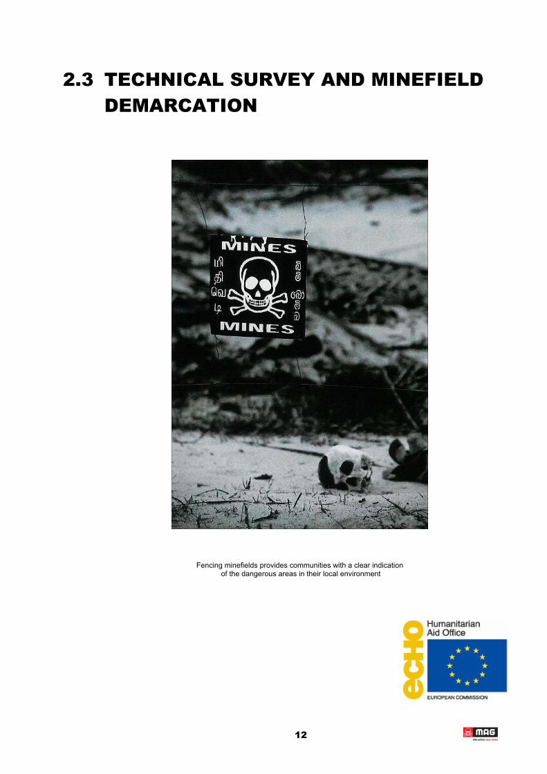
2.3 TECHNICAL SURVEY AND MINEFIELD DEMARCATION
Fencing minefields provides communities with a clear indication of the dangerous areas in their local environment
12
THE MINEFIELD DEMARCATION PROCESS:
MAG is undertaking minefield demarcation in accordance with International Mine Action Standards (IMAS). The minefields are marked with a fence and signs as follows:
Item Spacing Description
Fence posts 10 or 15m Metal or wood; painted red & white
Mine Warning Signs 20m Square corrugated plastic; white skull & cross-bones on a red field; “MINES” in English, Tamil & Sinhala.
Wire 2 or 3 strands Plain steel wire or barbed wire
Fencing is undertaken to provide increased safety to the target community and those peoplevisiting or working in the area. Many of the minefields in the Vanni are long barrier minefieldsrunning for a number of kilometres. In order to make best use of resources MAG liaises with the target community to determine the extent of the area for which fencing is appropriate. Otherwise, MAG’s teams would be committed to spending time and resources fencing off minefields away from areas of regular civilian use whilst communities elsewhere, living in close proximity to minefields, are not receiving support.
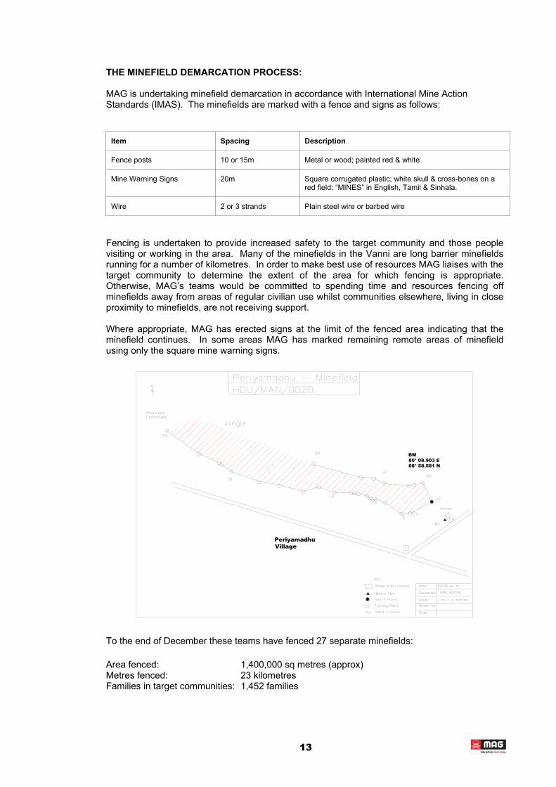
Where appropriate, MAG has erected signs at the limit of the fenced area indicating that the minefield continues. In some areas MAG has marked remaining remote areas of minefield using only the square mine warning signs.
Periyamadhu Village
BM 80° 08.903 E 08° 58.581 N
To the end of December these teams have fenced 27 separate minefields:
Area fenced: 1,400,000 sq metres (approx)Metres fenced: 23 kilometres Families in target communities: 1,452 families
13

In some communities, the number of families has increased significantly since fencing was undertaken.
MAG uses deminers to breach into suspect areas to determine the perimeter of the minefield. Similarly, where the minefield runs next to roads or paths, MAG deminers clear the area so as to ensure it is safe for civilians. MAG uses local labour to erect the fence after its position has been safely determined. The demarcation teams live with the local communities in the areas where they are working to ensure travel times are kept to a minimum.
Marked areas are mapped reported in accordance with the IMSMA Minefield Report Form, and this data is held centrally by UNDP.
It is generally understood within communities that landmine clearance is a slow process and that it may take some time for the resources of the HDU to be deployed in their area. In almost all communities where MAG has worked, local people have requested that fencing be put up around mined areas rather than indicated the areas with signs alone.
MAG has not suffered any significant problems from local people removing minefield fencing (as was commonly reported from previous minefield marking projects in Jaffna), However, cattle do damage fencing and this demands maintenance work from the teams. In some places it has been necessary to concrete posts into the ground in order to make them secure.
To enhance the safety of contractors working on a project to renovate the A9, MAG undertook rapid fencing of suspect areas close to the road. These fences were only erected as a temporary measure and have struggled to withstand the passage of cattle in these areas. During this process, MAG found mines within 1 metre of the edge of the road.
Much of the Vanni is covered in dense jungle. These areas are difficult to work in and present particular dangers to the minefield marking teams. Jungle areas more commonly contain trip-wire activated mines and mines reinforced with mortar bombs or other explosives.
Lat: 09°03.062 N Long: 080°30.888 E
A9Road
14

The illustration above shows the fenced area of one of the minefields from Kanakarayankulam North. It is one of four minefields that formed a defensive barrier around an Sri Lankan Army (SLA) artillery camp in this village.
The minefield below can be seen to be blocking access to an irrigation tank for people in Mukavil village.
Lat: 09°35.659N Long: 080°35.659E
T
In a number of cases, the survey teams have been able to confirm areas as being clear that had previously been considered suspect by the local community. In these cases the survey teams have put breaching lanes into the area but have not been able to locate any indication of mines. To date these have almost always been discreet areas which local people justifiably suspected on the basis that they had been sentry positions, mini-camps or building occupied by the military. In situations such as this the teams are able to reassure the community and effectively return land that was being denied due to the fear of mines.
A9 RECONSTRUCTION: SURVEY ASSISTANCE
The Asia Development Bank (ADB) has issued a contract for the renovation of the A9 highway, which is the main arterial route running north-south through the Vanni area.
MAG undertook a rapid survey of the A9 to provide on areas within the Vanni where landmine clearance or sub-surface UXO search should be undertaken in order to allow the renovation to be implemented safely.
A summary of data from this survey is presented at Annex A to the report.
15

2.4 EXPLOSIVE ORDNANCE DISPOSAL
HDU teams working with MAG prepare items of unexploded ordnance for a controlled demolition.
16
EXPLOSIVE ORDNANCE DISPOSAL
In 2002, MAG undertook a substantial amount of Explosive Ordnance Disposal (EOD) work. This capacity will be expanded in 2003 with two dedicated EOD teams, within the HDU, being funded by ECHO. A large part of this work has been the destruction of unexploded ordnance such as mortars, rockets and grenades. Such items have accounted for some 33% of all people killed and injured by mines or UXO in the Vanni area. The majority of children have been injured or killed as a result of UXO rather than mines. Almost all of the communities in which MAG has worked during 2002 presented a UXO problem in addition to any suspected landmine contamination.
In July 2002, MAG conducted the destruction of:
Item Destroyed Quantity Comments
Type 72 anti-personnel mines 1,000 (approx) MAG destroyed these items by incineration as an emergency task. The quantities destroyed were not verified.
P4 Mk 1 anti-personnel mines 2,500 (approx) As above
In November 2002, MAG conducted the bulk destruction of:
Item Destroyed Quantity Comments
Anti-personnel mines (Type 72 & P4 Mk 1)
3,738 The items were destroyed by MAG in partnership with the HDU. They had been cleared by the HDU working with Norwegian People’s Aid.
Anti-tank mines 3
UXO (rockets, shells, mortars, grenades)
1,548 These items were collected and destroyed by HDU working with MAG
Since November, MAG has destroyed the following:
Item Destroyed Quantity Comments
Anti-personnel mines (Type 72 & P4 Mk 1)
49 Cleared and destroyed as part of technical survey operations by MAG
Anti-tank mines 0
UXO (rockets, shells, mortars, grenades)
3,614 Found and destroyed as part of EOD operations by MAG.
The total number of dangerous items destroyed within the MAG project to date is:
Item Destroyed Quantity
Anti-personnel mines (Type 72 & P4 Mk 1) 7,287
Anti-tank mines 3
UXO (rockets, shells, mortars, grenades) 5,162
Total 12,452
17

2.5 OTHER ACTIVITIES
MRE FOR LOCAL NGOs AND GOVERNMENT WORKERS: ADDITIONAL MRE ACTIVITIES IN SUPPORT OF UNICEF
In 2002, MAG implemented MRE workshops in Vavuniya and Mannar. These workshops were organised by the Interfaith Fellowship for Peace and Development and funded by UNICEF:
Workshop Participants Comments
Vavuniya 30 (approx) Morning: MAG presented key issues in MRE – particularly the need to provide people with positive messages about how they can stay safe. Afternoon: UNICEF held an MRE planning session for Vavuniya.
Mannar (1) 25 (approx) Whole day: MAG MRE training for local NGO and government workers.
Mannar (2) 25 (approx) Whole day: MAG MRE training for local NGO and government workers.
MRE IN BATTICALOA
At the request of the TRO, MAG undertook an assessment of landmine and UXO contamination in LTTE held areas of Batticaloa in December 2002. On the basis of this assessment, MAG has deployed a Community Liaison/MRE Advisor to Batticaloa and a Mine Risk Education team is currently being trained. This team will star full time work in March. MAG has also confirmed a substantial number of sites where landmine clearance is required to address the needs of planned IDP return and to ensure the safety of populations already living in the area. MAG plans to establish a landmine clearance team and emergency response team to work in Batticaloa in 2003.
18
FUTURE OPERATIONS
MECHANICAL ASSISTANCE TO LANDMINE CLEARANCE _____ 3.1 LANDMINE CLEARANCE IN BATTICALOA _____ 3.2
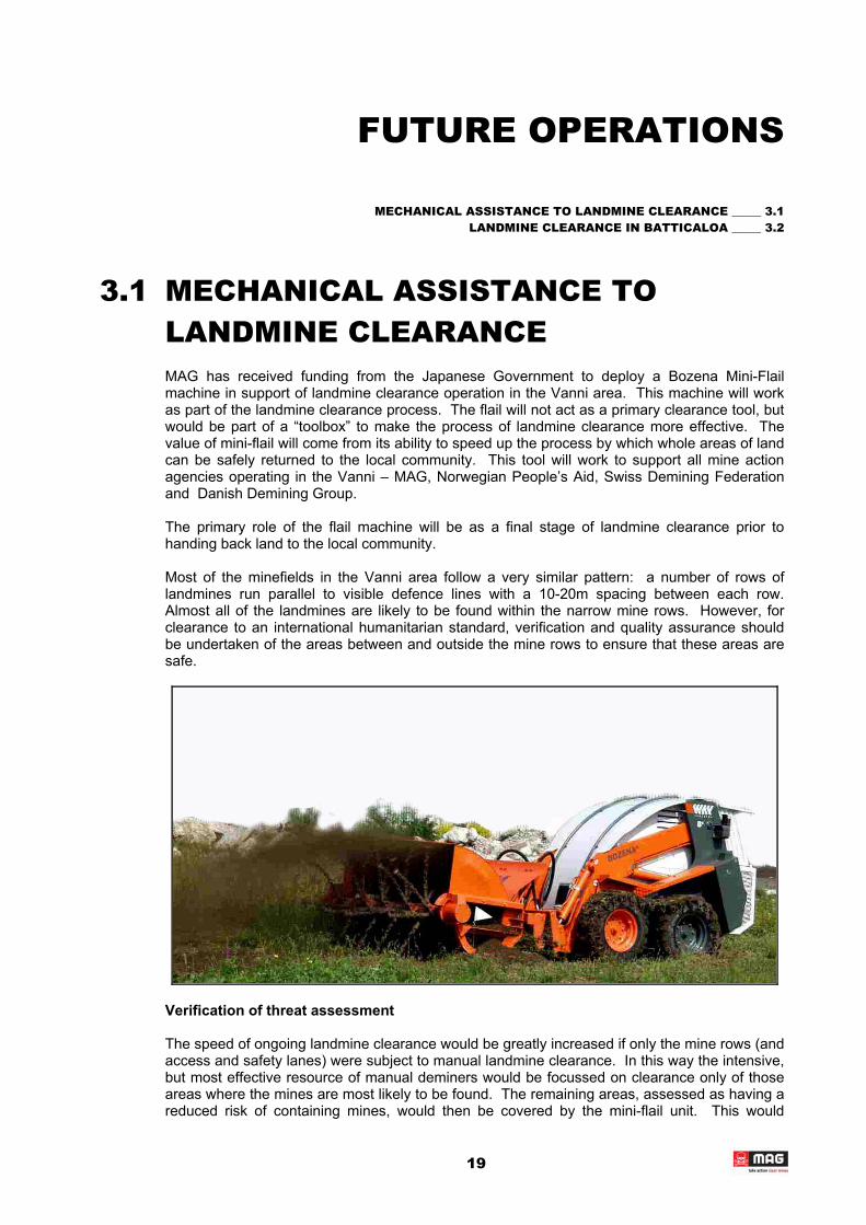
3.1 MECHANICAL ASSISTANCE TO LANDMINE CLEARANCE MAG has received funding from the Japanese Government to deploy a Bozena Mini-Flail machine in support of landmine clearance operation in the Vanni area. This machine will work as part of the landmine clearance process. The flail will not act as a primary clearance tool, but would be part of a “toolbox” to make the process of landmine clearance more effective. The value of mini-flail will come from its ability to speed up the process by which whole areas of land can be safely returned to the local community. This tool will work to support all mine action agencies operating in the Vanni – MAG, Norwegian People’s Aid, Swiss Demining Federation and Danish Demining Group.
The primary role of the flail machine will be as a final stage of landmine clearance prior to handing back land to the local community.
Most of the minefields in the Vanni area follow a very similar pattern: a number of rows of landmines run parallel to visible defence lines with a 10-20m spacing between each row. Almost all of the landmines are likely to be found within the narrow mine rows. However, for clearance to an international humanitarian standard, verification and quality assurance should be undertaken of the areas between and outside the mine rows to ensure that these areas are safe.
Verification of threat assessment
The speed of ongoing landmine clearance would be greatly increased if only the mine rows (and access and safety lanes) were subject to manual landmine clearance. In this way the intensive, but most effective resource of manual deminers would be focussed on clearance only of those areas where the mines are most likely to be found. The remaining areas, assessed as having a reduced risk of containing mines, would then be covered by the mini-flail unit. This would
19

provide verification that the areas that have been assessed as presenting minimal risk are indeed clear of mines. By working in such a manner, the speed of clearance could be greatly increased whilst land returned to the community would have been cleared to a rigorous standard. This process also allows for the threat assessment that these areas present minimal risk to be revised and amended on an ongoing basis.
Quality assurance of manual clearance
As part of this same process, the flail would also cover the mine rows cleared by the manual deminers. By going over these high risk areas again there is an additional level of verification and quality assurance that the work of the manual deminers is being done effectively.
It is in this role, as a final stage of the clearance process that the Bozena flail will primarily be used.
Other functions
There are other functions in which the Bozena may be used. These roles can be summarised as follows:
• Verification of previous work: The Humanitarian Demining Unit had cleared large numbers of landmines prior to their partnership with MAG and NPA. In the areas that they cleared up until this point, the HDU were clearing only the rows of mines (leaving the areas between un-verified). They were also working without international standards of clearance and minefield management. For these reasons it would be very valuable to use the mini-flail to go back over land that was previously cleared. This would provide rapid verification of the areas cleared and those areas within minefields that were previously assessed as safe.
• Area-reduction/mine-row identification: the flail is used to breach into minefields and locate the rows of landmines in advance of manual demining.
This machine will arrive in Sri Lanka in March 2003 and should begin operations in April.
3.2 LANDMINE CLEARANCE IN BATTICALOA Given appropriate donor support MAG will establish a technical capacity to respond to the problems of landmine and UXO contamination in Batticaloa District. MAG plans to field the following capacity in this District in 2003:
• 1 x Community Liaison / Mine Risk Education Team (3 people) • 1 x Emergency Response Team (8 people) • 1 x Site Clearance Team (46 people)
These teams will provide the basic capacity necessary to respond to outstanding problems in this District. The following case studies provide examples of the work required:
PULLUMALEI
Pullumalei is located on the A5 road which, after 7 years, has now been opened for public use. The area is mainly Tamil but borders on Sinhalese villages situated in the neighbouring district. The population of Pullumalei, estimated at 2,800 prior to the conflict, abandoned the area in early 1990s due to the intense fighting between LTTE and the Sri Lankan Army. Pullumalei had a hospital, school, sports centre, various shops, co-operatives and other facilities. All these have been destroyed together with all the private buildings in town. The area possesses very fertile land and one of the biggest water tanks in the district.
20

The army vacated its strategic Pullumalei camp in 1995 and since then the area has been under LTTE control. LTTE cardres currently stop people from going to Pullumalei due to the presence of landmines. Over 40 civilians were injured, and some lost their lives, during 1995 when returning to Pullumalei to check their lands. However, cattle herders are starting to bring their animals to the area once more.
The majority of Pullumalei’s displaced population have been living in nearby villages or in IDP camps in the district. Both the local authorities and LTTE are planning to resettle people back to Pullumalei as soon as possible. In addition, local NGOs are preparing to work in the area. Pullumalei IDPs urgently wish to return, as the living conditions in the refugee camps and nearby villages are difficult. They have no jobs, no appropriate housing and do not own the land to cultivate. The reason why they have not yet returned has been the fear of landmines.
KADDUMUNIVU
Kaddumunivu village is located in a LTTE controlled area, bordering Sinhalese villages in Ampara district. Fighting between the LTTE and the Sri Lankan army took place in early 1990s, and a large part of the population left during this time. The army held a camp in the village until 1995. The current population, estimated as 190 families, live in and around the vacated camp, and so far have collected over 150 UXOs and mines. Dozens of munitions were also found inside wells. People and cattle have been injured in the past. The villagers are not aware of the dangers associated with the handling of mines and UXO items. They have been burning items of unexploded ordnance and burying them in an effort to address this problem for themselves.
SANGARPURAM
Sangarpuram school is located inside an abandoned military camp in a area controlled by the Sri Lanka army. The school has been functioning since last year and provides an educational facility for 500 children. The area is suspected to contain mines, and there have been accidents with cattle in the past. Recently one boy was injured by a 40mm rifle grenade which he found and threw into a puddle. Local doctors were not able to remove all of the fragmentation from his head and he still suffers pain from it. This same boy had found another rifle grenade in a neighbours garden. He has not touched it, but there is currently no capacity in this area to safely destroy the item.
21