Embed Size (px)
Citation preview
MADHYA PRADESH
DISTRICT CENSUS HANDBOOK
CENSUS OF INDIA 2011
SERIES -24 PART XII-A
VILLAGE AND TOWN DIRECTORY
2011
DIRECTORATE OF CENSUS OPERATIONS MADHYA PRADESH
BHIND


CENSUS OF INDIA 2011
MADHYA PRADESH
SERIES - 24 PART XII-A
DISTRICT CENSUS HANDBOOK
BHIND
VILLAGE & TOWN DIRECTORY
DIRECTORATE OF CENSUS OPERATIONS
MADHYA PRADESH
ii
© Government of India copyright 2015
Some of the village boundaries and their locations are shown in C.D. Block
maps notionally. Physical features (R.F. etc.) shown in C.D. Block maps are
replication of 2001 census maps. Jurisdictional changes occurred during 2001-
11 have been updated on 2001 census maps. C.D. Block maps included in this
publication have been prepared, carving out the boundaries from tahsil maps.
iii
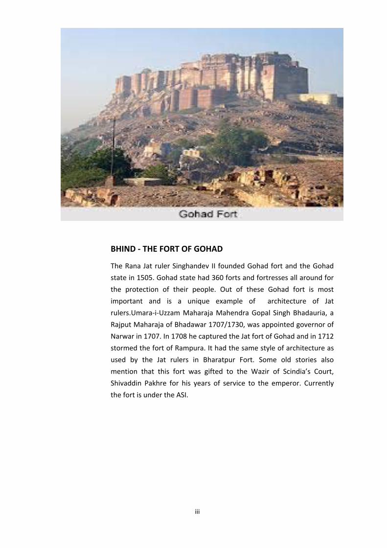
BHIND - THE FORT OF GOHAD
The Rana Jat ruler Singhandev II founded Gohad fort and the Gohad
state in 1505. Gohad state had 360 forts and fortresses all around for
the protection of their people. Out of these Gohad fort is most
important and is a unique example of architecture of Jat
rulers.Umara-i-Uzzam Maharaja Mahendra Gopal Singh Bhadauria, a
Rajput Maharaja of Bhadawar 1707/1730, was appointed governor of
Narwar in 1707. In 1708 he captured the Jat fort of Gohad and in 1712
stormed the fort of Rampura. It had the same style of architecture as
used by the Jat rulers in Bharatpur Fort. Some old stories also
mention that this fort was gifted to the Wazir of Scindia’s Court,
Shivaddin Pakhre for his years of service to the emperor. Currently
the fort is under the ASI.

iv
v
CONTENTS Pages
From to
Foreword vii - viii
Preface ix - x
Acknowledgements xi - xii
History and scope of the District Census Handbook xiii - xiv
Brief history of the district xv
Analytical Note 1 - 78
I Physical Features 3 - 5
II Census Concepts 6 - 15
III Non Census Concepts 16 - 29
IV 2011 Census findings 30 - 31
V Brief analysis of the PCA Data based on inset tables 1 to 35 32 - 58
VI Brief analysis of the Village Directory and Town Directory data based on inset
table 36 to 45. 58 - 67
VII Major social and cultural events, natural and administrative developments and
significant activities during the decade. 68
VIII Brief description of places of religious, historical or archaeological importance
in villages and places of tourist interest in the towns of the district. 68 - 69
IX Major characteristics of the district, contribution of the district in the form of
any historical figure associated with the district. 70
X Scope of the Village and Town Directory - column heading wise explanation
and coverage of data. 70 - 78
Village and Town Directory 79 - 532
Brief note on Village Directory 81 - 85
Section I - Village Directory 86 - 459
(a) List of Villages merged in Towns and Outgrowths at 2011 Census and List of villages merged in Other villages, Submerged and Declassified- 2011 Census 86
1 (b) Map of Ater CD Block showing tahsil boundary. 87
(c) Alphabetical list of Villages of Ater CD Block along with location code 2001 and 2011. 89 - 95
(d) Village Directory data of Ater CD Block in prescribed format. 96 - 159
2 (b) Map of Bhind Block showing tahsil boundary. 160
(c) Alphabetical list of Villages of Bhind CD Block along with location code 2001 and 2011. 163 - 167
(d) Village Directory data of Bhind CD Block in prescribed format. 168 - 199
vi
3 (b) Map of Mehgaon CD Block showing tahsil boundary. 200
(c) Alphabetical list of Villages of Mehgaon CD Block along with location code 2001 and 2011. 203 - 209
(d) Village Directory data of Mehgaon CD Block in prescribed format. 210 - 281
4 (b) Map of Gohad CD Block showing tahsil boundary. 282
(c) Alphabetical list of Villages of Gohad CD Block along with location code 2001 and 2011. 285 - 291
(d) Village Directory data of Gohad CD Block in prescribed format. 292 - 355
5 (b) Map of MihonaCD Block showing tahsil boundary. 356
(c) Alphabetical list of Villages of Mihona CD Block along with location code 2001 and 2011. 359 - 361
(d) Village Directory data of Mihona CD Block in prescribed format. 362 - 393
6 (b) Map of Lahar CD Block showing tahsil boundary. 394
(c) Alphabetical list of Villages of Lahar CD Block along with location code 2001 and 2011. 397 - 403
(d) Village Directory data of Lahar CD Block in prescribed format. 404 - 459
e) Appendices to Village Directory 461 - 505
Appendix-I Summary showing total number of villages having Educational, Medical and other amenities - C.D. block level 462 - 465
Appendix-I A Villages by Number of Primary Schools 466
Appendix-I B Villages by Primary, Middle and Secondary Schools 466
Appendix-I C Villages with different sources of drinking water facilities available
467
Appendix-II Villages with 5000 and above population which do not have one or more amenities available. 468
Appendix-III Land utilization data in respect of Census Towns. 469
Appendix-IV C.D. block wise list of inhabited villages where no amenity other than drinking water facility is available. 469
Appendix-V Summary showing number of villages not having Scheduled Castes population 470
Appendix-VI Summary showing number of villages not having Scheduled Tribes population 470
Appendix-VII A List of villages according to the proportion of the Scheduled Castes to the total population by ranges. 471 - 487
Appendix-VII B List of villages according to the proportion of the Scheduled Tribes to the total population by ranges.
488 - 505
Section II - Town Directory 507 - 532
Brief note on Town Directory 508 - 511
Statement I Status and Growth History 512 - 515
Statement II Physical aspects and location of towns,2009 516 - 517
Statement III Civic and other amenities, 2009 518 - 519
Statement IV Medical Facilities, 2009 520 - 521
Statement V Educational, Recreational and Cultural facilities, 2009 522 - 525
Statement VI Industry and Banking, 2009 526 - 527
Statement VII Civic and other amenities in slum, 2009 528 - 531
Appendix to town directory - towns showing their outgrowth with population 532
vii
FOREWORD
The District Census Handbook (DCHB) is an important publication of the Census Organization since
1951. It contains both Census and non Census data of urban and rural areas for each District. The
Census data provide information on demographic and socio-economic characteristics of population
at the lowest administrative unit i.e. of each Village and Town and ward of the District. The Primary
Census Abstract (PCA) part of this publication contains Census data including data on household
amenities collected during 1st phase of the Census i.e. House Listing and Housing Census. The non
Census data presented in the DCHB is in the form of Village Directory and Town Directory contain
information on various infrastructure facilities available in the village and town viz; education,
medical, drinking water, communication and transport, post and telegraph, electricity, banking, and
other miscellaneous facilities. Later on, the Telegraph Services were closed by the Government of
India on 15th July, 2013. The data of DCHB are of considerable importance in the context of
planning and development at the grass-root level.
2. In the 1961 Census, DCHB provided a descriptive account of the District, administrative
statistics, Census tables and Village and Town Directory including Primary Census Abstract. This
pattern was changed in 1971 Census and the DCHB was published in three parts: Part-A related to
Village and Town Directory, Part-B to Village and Town PCA and Part-C comprised analytical report,
administrative statistics, District Census tables and certain analytical tables based on PCA and
amenity data in respect of Villages. The 1981 Census DCHB was published in two parts: Part-A
contained Village and Town Directory and Part-B the PCA of Village and Town including the SCs and
STs PCA up to Tahsil/Town levels. New features along with restructuring of the formats of Village
and Town Directory were added. In Village Directory, all amenities except electricity were brought
together and if any amenity was not available in the referent Village, the distance in broad ranges
from the nearest place having such an amenity, was given.
3. The pattern of 1981 Census was followed by and large for the DCHB of 1991 Census except the
format of PCA. It was restructured. Nine-fold industrial classification of main workers was given
against the four-fold industrial classification presented in the 1981 Census. In addition, sex wise
population in 0-6 age group was included in the PCA for the first time with a view to enable the data
users to compile more realistic literacy rate as all children below 7 years of age had been treated as
illiterate at the time of 1991 Census. One of the important innovations in the 1991 Census was the
Community Development Block (CD Block) level presentation of Village Directory and PCA data
instead of the traditional Tahsil/Taluk/PS level presentation.
4. As regards DCHB of 2001 Census, the scope of Village Directory was improved by including
some other amenities like banking, recreational and cultural facilities, newspapers & magazines
and `most important commodity’ manufactured in a Village in addition to prescribed facilities of
earlier Censuses. In Town Directory, the statement on Slums was modified and its coverage was
enlarged by including details on all slums instead of ‘notified slums’.
5. The scope and coverage of Village Directory of 2011 DCHB has been widened by including a
number of new amenities in addition to those of 2001. These newly added amenities are: Pre-
Primary School, Engineering College, Medical College, Management Institute, Polytechnic, Non-
viii
formal Training Centre, Special School for Disabled, Community Health Centre, Veterinary
Hospital, Mobile Health Clinic, Medical Practitioner with MBBS Degree, Medical Practitioner with no
degree, Traditional Practitioner and faith Healer, Medicine Shop, Community Toilet, Rural Sanitary
Mart or Sanitary Hardware Outlet in the Village, Community Bio- gas, Sub Post Office, Village Pin
Code, Public Call Office, Mobile Phone Coverage, Internet Cafes/ Common Service Centre, Private
Courier Facility, Auto/Modified Autos, Taxis and Vans, Tractors, Cycle-pulled Rickshaws, Carts driven
by Animals, Village connected to National Highway, State Highway, Major District Road, and Other
District Road, Availability of Water Bounded Macadam Roads in Village, ATM, Self-Help Group,
Public Distribution System(PDS) Shop, Mandis/Regular Market, Weekly Haat, Agricultural Marketing
Society, Nutritional Centers (ICDS), Anganwadi Centre, ASHA (Accredited Social Health Activist),
Sports Field, Public Library, Public Reading Room, Assembly Polling station, Birth & Death
Registration Office. In the Town Directory, seven Statements containing the details and the data
of each Town have been presented viz.; (i) Status and Growth History of Towns,(ii) Physical Aspects
and Location of Towns, (iii) Civic and other Amenities, (iv) Medical Facilities, (v) Educational,
Recreational & Cultural Facilities, (vi) Industry & Banking, and (vii) Civic & other amenities in Slums
respectively. CD Block wise data of Village Directory and Village PCA have been presented in DCHB
of 2011 Census as presented in earlier Census.
6. The data of DCHB 2011 Census have been presented in two parts, Part-A contains Village and
Town Directory and Part-B contains Village and Town wise Primary Census Abstract. Both the Parts
have been published in separate volumes in 2011 Census.
7. The Village and Town level amenities data have been collected, compiled and computerized
under the supervision of Shri Sachin Sinha I.A.S.,Joint Secretary and Director of Census Operations
Madhya Pradesh Bhopal. The task of Planning, Designing and Co-ordination of this publication was
carried out by Dr. Pratibha Kumari, Assistant Registrar General (SS) under the guidance &
supervision of Dr. R.C.Sethi, Ex-Addl. RGI and Shri Deepak Rastogi present Addl.RGI. Shri A.P. Singh,
Deputy Registrar General, (Map) provided the technical guidance in the preparation of maps. Shri
A.K. Arora, Joint Director of Data Processing Division under the overall supervision of Shri
M.S.Thapa, Addl. Director (EDP) provided full cooperation in preparation of record structure for
digitization and validity checking of Village and Town Directory data and the programme for the
generation of Village Directory and Town Directory including various analytical inset tables as well
as Primary Census Abstract (PCA). The work of preparation of DCHB, 2011 Census has been
monitored in the Social Studies Division. I am thankful to all of them and others who have
contributed to bring out this publication in time.
(C.Chandramouli)
Registrar General &
New Delhi. Census Commissioner,India
Dated:- 16-06-2014
ix
PREFACE
The District Census Handbook (DCHB) compiled by the Census organization, Government of India
is one of the most valuable and useful product of the Census which is brought out for each
district in the State having micro level Census and Non Census data . It contains CD Block wise
Primary Census Abstract at village/ward level under Census data. The amenities data along with
additional information regarding area, population, civic status, land use etc. for every
village/town is covered under Non Census data. This publication started from the 1951 Census,
but prior to this, a similar publication was released in the earlier censuses. Those publications
contained only village statistics, village names and total population. The 1951 Census could,
therefore be said to represent a significant step forward, in the process of making detailed census
statistics available down to the village level. An important achievement, for the first time in 1991
Census, was that the village level data was presented Community Development Blockwise.
The scope of District Census Handbook has undergone considerable change since 1951. This is
basically due to the growing demand for more information. To make the basic statistics available
to the data users, as early as possible, the District Census Handbook of 1991 was brought out in a
single volume as against the earlier practice of bringing it out in two parts. The volume was
however divided in two parts viz. part A and part B. Part A contained the Village/Town Directory
while part B contained the Primary Census Data. Continuing the practice of 1991 Census, the 2001
series of the District Census Handbooks also comprised of two parts. However the present DCHB
is prepared in two separate volumes. Volume II contains the Primary Census Abstract and Volume
I contains the village/town directory of the District.
Volume II of the District Census Handbook contains Village and Town Primary Census Abstract.
This provides information on area, occupied residential houses, number of households, sex-wise
total population, child population in age-group 0-6, Scheduled Castes and Scheduled Tribes,
literates, workers, non-workers and classification of workers into four broad categories i.e.
cultivators, agricultural labourers, workers in household industries and other workers in respect
of each village and town of the district. Besides the brief history and other major characteristics of
the district, inset tables and appendixes based on Houselisting and PCA alongwith analysis in the
District Census Handbook provide glimpse of availability of amenities to villages relating to
housing, assets available with households and demographic profile of population at tahsil/ C.D
block level which are helpful for rural planning.
Volume I contains Village Directory which provides information on infrastructure amenities and
land use data at village level i.e. name and location of villages, area, population, number of
households, important civic amenities/facilities available in villages like educational, medical,
drinking water, drainage, post, telegraph, public call office, mobile coverage, internet cafe,
private courier service, commercial and co-operative banks, agricultural and non-agricultural
credit societies, recreational and cultural facilities, communications, approach to the village,
nearest town and its distance and power supply. Similarly, the comprehensive statements and
their analysis of Town Directory provide valuable information on growth, physical, economic, civic
and development aspects in respect of each town of the district. C.D. block being the lowest
x
administrative unit for developmental planning, it is assumed that the data provided at this level
would be extremely useful to the planners for formulating micro level development plans.
It may be noted that the village wise area figures presented in the PCA are based on village
information as furnished by the revenue authority and the “total area” given for the community
development blocks, is the sum total of the area figures of all villages coming under it. The “total
area” of tahsil is based on the information furnished by the Commissioner, Land Records
,Government of Madhya Pradesh, Gwalior. In some cases the total area shown against the tahsil,
may not tally with the total of the area figures of villages coming under it.
The design of 2011 District Census Handbook has been evolved centrally by the Census
Commissioner, India and accordingly these books have been prepared by my office. In earlier
censuses and until 1991, the cost of publication of these books were borne by the State
Government but since 2001 these are being printed centrally by the Census organization. In
accomplishing this task we have had the whole hearted cooperation of the staff at various levels
of different departments of the State Government. The data supplied by the field level officers
have been comparatively checked with 2001 DCHB information and have been cross checked with
the data obtained from various departments. An attempt had been made to reconcile the
discrepancies by external validation to make it more reliable. I am grateful to all heads of
departments of the State Government, officers and staff engaged in the conduct of 2011 Census
for their cooperation to accomplish this task.
The compilation of such a huge amount of varied data requires proper planning and close
monitoring. We had the honour of having enlightened guidance and encouragement of
Dr. C. Chandramouli, IAS, Registrar General and Census Commissioner of India.
The data presented in the District Census Handbook required a concerted team work of officers
and staff member of this Directorate who were involved with it at various stages of its planning,
supervision, field work, computerisation, preparation of manuscript, maps and printing. I express
my appreciation for the painstaking dedicated service rendered by all of them and also to the
officers and staff of Data Centre, Bhopal for their untiring cooperation in finalizing the 2011
Census Data.
I shall feel greatly rewarded if the book comes to the expectation of the data users.
Sachin Sinha
Joint Secretary & Director
Bhopal Directorate of Census Operations,
Dated: 31.03.2014 Madhya Pradesh
xi
ACKNOWLEDGEMENTS
SUPERVISION AND MONITORING
SHRI A. K. SAXENA JOINT DIRECTOR (JUNE 2016 ONWARD)
SHRI P. K. CHAUDHARY JOINT DIRECTOR (UP TO MAY 2016)
SHRI S. L. JAIN JOINT DIRECTOR (UP TO JUNE 2013)
DCHB/VILLAGE AND TOWN DIRECTORY
SHRI R. L. JAIN ASSTT. DIRECTOR (JAN. 2014 ONWARD)
SHRI JEROM KUJUR ASSTT. DIRECTOR (UP TO DEC. 2013)
SMT PREMA NAIR S.I. GR. I
SMT ANCY REJI S.I. GR. I
SHRI ABHIMANYU SINGH S.I. GR. I
SHRI JOGENDRA BHIMRAO TAMGADGE S.I. GR. I
SMT SUDHA SHRIVASVATA S.I. GR. I
SMT FARZANA YUSUF S.I. GR. II
SHRI RISHABH KUMAR JAIN S.I. GR. II
SMT REKHA PINDAWALA SR. COMPILER
SHRI RAM NARAYAN ASSTT. COMPILER
PREPARATION OF ANALYTICAL NOTE
SHRI V. SATISH IYAR DEPUTY DIRECTOR
DR. RAJENDRA KUMAR RESEARCH OFFICER
SHRI R .L. JAIN ASSTT. DIRECTOR
SHRI HARISH CHANDRA TRIPATHI S.I. GR. I
MAP
DR. RAJENDRA KUMAR RESEARCH OFFICER
SHRI VINOD KUMAR SINGH SENIOR DRAUGHTSMAN
SMT MEENA SHINDE SENIOR DRAUGHTSMAN
SHRI J. U. GODBOLE SENIOR DRAUGHTSMAN
SHRI RAJENDRA GUMDELWAR SENIOR DRAUGHTSMAN
SHRI MANOJ PRABHAKAR MANIK SENIOR DRAUGHTSMAN
SHRI JITENDRA SINGH VERMA DEO GR. B
xii
CENTRAL TABULATION UNIT
SHRI NAMIT YADAV ASSTT. DIRECTOR
SMT ANITA SHRIVASTAVA S.I. GR. I
SMT PRABHA SHRIVASTAVA S.I. GR. I
SMT RIZWANA KHAN SR. COMPILER
DESIGNING AND DEVELOPING
SHRI GUNWANT V. DHABALE DATA PROCESSING ASSISTANT GR. A
SHRI MILIND DESHPANDE DEO GR. B
SHRI MANOJ NATHANI DEO GR. B
COMPOSING
SHRI PRAVEEN KUMAR MODHE DEO GR. B
SHRI MILIND DESHPANDE DEO GR. B
SHRI MANOJ NATHANI DEO GR. B
SMT. VAISHALI PUROHIT DEO GR. B
SHRI JITENDRA BAKLIWAL DEO GR. B
ORGI DATA PROCESSING DIVISION
SHRI JASPAL SINGH LAMBA DD (EDP)
MS. USHA AD (EDP)
SHRI ANURAG GUPTA DPA GRADE ‘A’
SHRI MUKESH KUMAR MAHAWAR DPA GRADE ‘A’
MS. SHAGHUFTA N. BHAT DPA GRADE ‘A’
MS. KIRAN BALA SEXANA SR. SUPERVISOR
SHRI KHEM VERMA JADON SR. CONSULTANT
SHRI YASHWANT SINGH JR. CONSULTANT
xiii
HISTORY AND SCOPE OF THE DISTRICT CENSUS HANDBOOK
The need of data at the grass root level for the administrative and planning purposes at sub micro level as well as academic studies prompted the innovation of District Census Handbook. District Census Handbook is a unique publication from the Census organization which provides most authentic details of census and non-census information from village and town level to district level. The District Census Handbook was firstly introduced during the 1951 Census. It contains both census and non census data of urban as well as rural areas for each district. The census data contain several demographic and socio-economic characteristics of the lowest administrative unit i.e. of each village and town and ward of the district. The non census data comprise of data on availability of various civic amenities and infrastructural facilities etc. at the town and village level which constitute Village Directory and Town Directory part of the DCHB. The data of DCHB are of considerable importance in the context of planning and development at grass-root level.
In 1961 census DCHB provided a descriptive account of the district, administrative statistics, census tables and village and town directory including Primary Census Abstract. This pattern was changed in 1971 Census and the DCHB was published in three parts: Part-A related to village and town directory, Part-B to village and town PCA and Part-C comprised analytical report, administrative statistics, district census tables and certain analytical tables based on PCA and amenity data in respect of villages. The 1981 census DCHB was published in two parts: Part-A contained village and town directory and Part-B the PCA of village and town including the SCs and STs PCA up to tahsil/town levels. New features along with restructuring of the formats of village and town directory were added into it. In Village Directory, all amenities except electricity were brought together and if any amenity was not available in the referent village, the distance in broad ranges from the nearest place having such an amenity, was given.
The pattern of 1981 census was followed by and large for the DCHB of 1991 Census except the format of PCA. It was restructured. Nine-fold industrial classification of main workers was given against the four-fold industrial classification presented in the 1981 census. In addition, sex wise population in 0-6 age group was included in the PCA for the first time with a view to enable the data users to compile more realistic literacy rate as all children below 7 years of age had been treated as illiterate at the time of 1991 census. One of the important innovations in the 1991 census was the Community Development Block (CD Block) level presentation of village directory and PCA data instead of the traditional tahsil/taluk/PS level presentation.
As regards DCHB of 2001 Census, the scope of Village Directory was improved by including some other amenities like banking, recreational and cultural facilities, newspapers & magazines and `most important commodity’ manufactured in a village in addition to prescribed facilities of earlier censuses. In Town Directory, the statement on Slums was modified and its coverage was enlarged by including details on all slums instead of ‘notified slums’.
The scope and coverage of Village Directory of 2011 DCHB has been widened by including a number of new amenities in addition to those of 2001. In the Town Directory, seven Statements containing the details and the data of each town have been presented viz.; (i) Status and Growth History of towns, (ii) Physical Aspects and Location of Towns, (iii) Civic and other Amenities, (iv) Medical Facilities, (v) Educational, Recreational & Cultural Facilities,
xiv
(vi) Industry & Banking, and (vii) Civic & other amenities in Slums respectively. CD Block wise data of Village Directory and Village PCA have been presented in DCHB of 2011 census as presented in earlier census. The data of DCHB 2011 Census have been presented in two parts, Part-A contains Village and Town Directory and Part-B contains Village and Town wise Primary Census Abstract. Both the Parts have been published in separate volumes in 2011 Census.
xv
BRIEF HISTORY OF THE DISTRICT
In the beginning of the first century A.D., the Gwalior region (Of which Bhind was a part till the merger of states) was ruled by Swamin Sivanandi, a king of the earlier Naga dynasty. About 270 copper coins of various types belonging to Naga rulers collected from village Akoda of Bhind district firmly establish that the Nagas were the ruler of the district. According to Allahabad pillar inscription, Samudragupta could keep his hold on Nagas territory by marrying his son Chandragupta II with a Naga Princes Kubernaga.
Invasion of Huna leader Toramana tended the dissolution of Gupta empire during the reign of Bhanugupta (AD 495-510). Bhind was a part of the Huna empire during the reign of Mihirakula, son of Toramana. He was defeated by emperor Baladitya of Magadh and illustrious Yasodharman of Malwa.
This region passed under the occupation of the different dynasties of Sultans of Delhi like Ghori, Lodi, Sur and Mughal till the first quarter of eighteenth century. The present Bhind district was held by the Chuhan Rajputs of the Bhaduria clan for twenty two generations, even they were able to hold Gohad (founded by Jat family) from 1707 to 1739 which was restored back to Rana by Peshwa, Baji Rao.
In the battle of Panipat in 1761, Marathas lost their hold on Gwalior and Gohad. However, Lokendra Chhatrapati Singh, the succeeding Rana of Gohad managed to seize the strong hold of Gwalior and allied himself with the Mughal Emperor Shah Alam II, from whom he received a Sanad confirming him the possession of Gohad and granting him certain titles. Under the treaty in December 1799, Rana Lokendra Chhatrapati Singh of Gohad, combined with British forces drove the trouble shooters, Marathas easily.
The history of Bhind district coincides with that of Gwalior. Daulat Rao Scindia died in 1827 and his successor was Mugat Rao alias Jankoji Rao. Jankoji Scindia passed away in February, 1843 without a heir. He was succeeded by Jayaji Rao (a minor) on adoption. The tenure of Jayaji Rao (1843-1886) was the period of great turmoil. As Jayaji was a youngman of 23 years of age, he decided to remain loyal to his British allies but the revolt did not confine to Gwalior but soon spread to the outstations. The situation grew so worse within a year that Gwalior was attacked in June 1858 by the combined forces of Rani Laxmi Bai of Jhansi, Rao Saheb and Tatya Tope. The Maharaja and his Diwan Dinkar Rao fled to Agra and the Ranis of Mahraja Scindia took asylum in the fortress of Narwar.
The British then stormed the Gwalior fort and captured it on 18th June 1858. The fort was
handed over to the Scindia’s in March 1886. Jayaji Rao Scindia passed away in June 1886,
leaving behind his 10 years old son Madhav Rao to succeed him. Madhav Rao’s constructive
genius embraced every channel of state activity; economic, social, financial and education. He
built railway system for his state and started industries and gave incentive to private
enterprise and commerce within his state. The Gwalior narrow gauge railway from Gwalior to
Bhind was constructed in 1897 and was started in 1899.


Analytical note

2
ANALYTICAL NOTE
DISTRICTCENSUSHANDBOOK:BHIND3
I. PHYSICAL FEATURES:
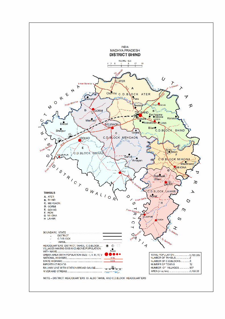
Lying between 25055’ and 26048’ north latitude and 78012’ and 79005’ east longitude, Bhind district is bounded by Morena and Gwalior districts in the south-west; Datia district in south; Jalaun, Etawah and Agra of Uttar Pradesh in the east, north and north-west respectively. The entire district lies in Chambal Valley, which forms the south – western part of the Ganga Valley. The hills are only small and isolated, mostly in the south-west. The district slopes gradually towards the north-east and the land is mostly undulating. It is only in Bhind tahsil that the rivers flow towards the east. The plain is formed of the alluvial deposits, with beds of fine soil alternating or mixed with boulders, coarse and sandy silt and occasional beds of clay and kankar. The physical feature of Bhind district is broadly divided into the Plains between the rivers and the River banks and deep ravines.
The widest plain of the district lies in the western part around Gohad, Mehgaon and Mau. The ravine land extends along both sides of the rivers and their tributaries with intense presence along the Chambal and the Asan in the north and the north-western part of the district. The second net-work of ravines lies across the eastern part of the district along the river Sind, Saon, Besuil and Kamain. The Pahuj river marks the axle of third ravine belt developed along with south–eastern boundary. These ravines are the ideal shelter and by-pass routes of dacoits but unsuitable for cultivation and settlement.
DRAINAGE
The district is crossed by number of rivers and streams. The Chambal and Sind are the main rivers of the district. The Chambal forms the northern boundary. As the two rivers are the tributaries of Yamuna, they form part of Ganga drainage system. The other important rivers of the district are Kunwari, Pahuj, Asan and Vaisali.
River Chambal, originating from the Janapao hill at Indore district, flows through Malwa plateau covering districts like Indore, Ujjain, Ratlam and Mandsaur districts. At a point where it crosses Madhya Pradesh a dam was built at Gandhi Sagar. In the later course, the Chambal flows to the south – east and having entered Etawah, joins the Yamuna.
Forming the western and northern boundaries of Lahar tahsil for about 64 kms, the Sind is one of the largest rivers of northern Madhya Pradesh originating from Nainwas near Sironj. Soon after crossing Bhind district, the Sindh is joined by the Pahuj on the right bank and Kunwari on the left bank further down. The combined stream flows to the east and joins the Yamuna near Jamanpur.
The Kunwari or Kuari is the northern most tributary of river Sind. The early course of Kunwari lies in Morena district and then approaching from the west it flows along the northern boundary of Gohad tahsil and cuts across Bhind tahsil. It joins the river Sind near Bithauli village, hardly 3 kms above the river Yamuna.
Rising from Morena district the river Asan forms the inter district boundary between Morena and Gwalior and then between Morena and Bhind.
4
Rising from the west of Kali Pahad at district Gwalior, the river Vaisali or Besuil enters the district Bhind from the south-west and flows through Gohad, Mehgaon and Bhind tahsils.
Rising from the Pichore tahsil of district Shivpuri, the river Pahuj flows through Jhansi [U.P], Datia, Gwalior and Bhind districts. It forms the inter-state boundary at several points marking Datia, Bhander tahsil of Gwalior and Lahar tahsil of Bhind on the west and Jhansi, Jalaun and Etawah district of Uttar Pradesh on the east. It joins the Sind near Jaiga village in Etawah.
Climate
The climate of the Bhind district is characterized by general dryness except during the south-west monsoon season. About 92% of the annual rainfall is received during the months of June to September, the rainiest months being July and August. The average annual rainfall of the district is around 840 mm. without much spatial variation.. The heat in summer is intense and dust–laden with mean daily maximum temperature of around 43° celsius. January is generally the coldest month with the mean daily minimum temperature of about 8° celsius.
Flora
The district is poor in forest wealth in respect of extent, density and value. The original flora of the district has disappeared and plains are occupied by agriculture fields and settlements. Forests cover 8905 hectares which is just 2% to total geographical area of 445204 hectares of the district. The forests are mainly confined to ravenous areas along the Chambal, Kunwari and Sindh rivers flowing through Bhind and Gohad tahsils and mainly consisting of dry deciduous ravine thorn type flora. The density and quality both are very poor, dominated by shrubs.
Fauna
Forest being scarce, its fauna is poor and wild life is scanty. Among the animals, Sambhar may still be found. Panther may occasionally be seen. Smaller animals like hare, rats, squirrels, hyena etc. may also be found just outside of any village. Snakes of all description including cobra and vipers are found. Scorpions and centipedes are among the poisonous insects. Alligators and crocodiles are found in Chambal, Sindh and Kunwari rivers. Tortoise, frogs, toads, shrimps, crabs, water snakes etc are important aquatic animals. Fishes are also the remarkable fauna of the district. However, for want of forest cover the avifauna of the forest is sparse.
Mining
None of the major minerals are found in the district. Among minor minerals the important occurrences are stone, murrum, sand and pharsi stone.
Agriculture and Land use
Paddy, Kodo, Kutki and maize are the crops of the district. Til, mustard and groundnut are the main oilseeds produced. The farmers have started the production of sunflowers and soybean in the central and southern part of the district. Paddy is the main crop grown in the central and southern part; while in
ANALYTICAL NOTE
DISTRICTCENSUSHANDBOOK:BHIND5
the northern part of the district wheat is the main crop grown. Rice was grown in 5616 hectares in the year 2010-11. Jowar was grown in7182 hectares in the year 2009-10.
Irrigation facility
The net sown area was 334700 hectares and the net irrigated area was 138100 hectares for the year 2009-10. The percentage of irrigated area to net sown area was 41.26 for the year 2009-10.
Source: Madhya Pradesh Sankhiyiki Sanshep 2012.
Animal Husbandry
The district has more of buffaloes than cows. Total number of cows in 2007 was 162700 and number of buffaloes was 256200 in the district. Among the other animals the goat were 156300 and the pigs were 20000 during the year 2007.
Industry
There are 9391 industrial units and 9391 registered units. The estimated average number of daily workers employed in small scale industry was 20212. The number of industrial areas in the district was 2.
Source : Brief industrial profile of Bhind district.
Transport
Bhind is well connected by train as well as by bus route. Road transport is the main mode of transportation in Bhind. Main link road of Bhind is Etawah Gwalior state highway which connects with M.P. and U.P. state.
The railway line connects Bhind with Gwalior. This line was constructed by the erstwhile Gwalior state and opened on 3rd December 1899. The Gwalior light railway was worked by the great Indian peninsula railway company upto 30th June 1913, after which was taken by the Gwalior Darbar. The line was integrated into central railway on 5th November 1951.
Electricity and Power
For the year ending March 2011 consumption for domestic units were 62300 K.W., commercial consumption was 16218 K.W., for water supply 7694 K.W. for irrigation 124814 K.W and for street light 1409 K.W. In the district, 889 villages were electrified which was 94.9% of the total villages.
Gram Panchayat
Under 73rd constitutional amendment, the Government of Madhya Pradesh passed the Panchayat Adhiniyam, 1993 providing three tier system of Panchayatiraj, viz., Gram panchayat at village level, Janpad panchayat at block level and Zilla panchayat at district level. Madhya Pradesh Gram Sabha Adhiniyam, 2001 recognized Grams Sabah as constitutional body and confers voting rights to all adults to elect Panch, Sarpanch, members of Janpad and Zilla Panchayat. The Gram Sabah has power to approve works under annual budget of the village. At all levels there are reservations for S.C, S.T. according to the population ratio. For women there is one-third reservation. At present there are 447 Gram Panchayats in Bhind district.
6
II. CENSUS CONCEPTS
BUILDING
A ‘Building’ is generally a single structure on the ground. Usually a structure will have four walls and a roof. Sometimes it is made up of more than one component units which are used or likely to be used as dwellings (residences) or establishments such as shops, business houses, offices, factories, workshops, work sheds, Schools, places of entertainment, places of worship, godowns, stores etc. It is also possible that building which have component units may be used for a combination of purposes such as shop-cum-residence,workshop-cum-residence,office-cum-residence,etc.
But in some areas the very nature of construction of houses is such that there may not be any wall. Such is the case of conical structures where entrance is also provided but they may not have any walls. Therefore, such of the conical structures are also treated as separate buildings.
PUCCA HOUSES
Houses, the walls and roof of which are made of permanent materials. The material of walls can be any one from the following, namely, stones (duly packed with lime or cement mortar), GI/metal/ asbestos sheets, burnt bricks, cement bricks, Concrete. Roof may be made of from any one of the following materials, namely, machine-made tiles, Cement tiles, burnt bricks, cement bricks, stones, slate, GI/metal/ asbestos sheets, concrete. Such houses are treated as Pucca House.
KUTCHA HOUSES
Houses in which both walls and roof are made of materials, which have to be replaced frequently. Walls may be made from any one of the following temporary materials, namely, grass, unburnt bricks, bamboos, mud, grass, reeds, thatch, plastic/ polythene, loosed packed stone, etc.. Such houses are treated as Kutcha House.
DWELLING ROOM
A room is treated as a dwelling room if it has walls with a doorway and a roof and should be wide and long enough for a person to sleep in, i.e. it should have a length of not less than 2 meters and a breadth of at least 1.5 meters and a height of 2 meters. A dwelling room would include living room, bedroom, dining room, drawing room, study room, servant’s room and other habitable rooms. Kitchen, bathroom, latrine, store room, passageway and verandah which are not normally usable for living are not considered as dwelling rooms. A room, used for multipurpose such as sleeping, sitting, dining, storing, cooking, etc., is regarded as a dwelling room. In a situation where a census houses is used as a shop or office., etc., and the household also stays in it then the room is not considered as a dwelling room. But if a garage or servant quarter is used by a servant and if she/ he also lives in it as a separate household then this has been considered as a dwelling room available to the servant’s household. Tent or conical shaped hut if used for living by any household is also considered as dwelling room.
ANALYTICAL NOTE
DISTRICTCENSUSHANDBOOK:BHIND7
A dwelling room, which is shared by more than one household, has not been counted for any of them. If two households have a dwelling room each but in addition also share a common dwelling room, then the common room has not been counted for either of the households.
CENSUS HOUSE
A ‘census house’ is a building or part of a building used or recognized as a separate unit because of having a separate main entrance from the road or common courtyard or staircase, etc. It may be occupied or vacant. It may be used for residential or non- residential purpose or both. If a building has a number of Flats or Blocks/Wings, which are independent of one another having separate entrances of their own from the road or a common staircase, or a common courtyard leading to a main gate, these are considered as a separate Census House.
VILLAGE
The basic unit for rural areas is the revenue village, which has definite surveyed boundaries. The revenue village may comprise of one or more hamlets but the entire village is treated as one unit for presentation of data. In unsurveyed areas, like villages within forest areas, each habitation area with locally recognized boundaries is treated as one village.
RURAL-URBAN AREA
The data in the Census are presented separately for rural and urban areas. The unit of classification in this regard is ‘town’ for urban areas and ‘village’ for rural areas. The Urban area comprises two types of towns viz; Statutory towns and Census towns. In the Census of India 2001, the definition of urban area adopted is as follows:
a) STATUTORY TOWNS
All places with a municipality, corporation, cantonment board or notified town area committee, etc are known as Statutory Towns.
b) CENSUS TOWNS
All other places satisfying the following three criteria simultaneously are treated as Census Towns.
i) A minimum population of 5,000 ;
ii) At least 75 per cent of male working population engaged in non-agricultural pursuits; and
iii) A density of population of at least 400 per sq. km.(1,000 per sq.mile)
For identification of places which would qualify to be classified as ‘urban’ all villages, which, as per the 2001 Census had a population of 4,000 and above, a population density of 400 persons per sq. km. and having at least 75 per cent of male working population engaged in non-agricultural activity were considered. To work out the proportion of male working population referred to above against b) (ii) the data relating to main workers were taken into account. In addition the
8
above stated towns, urban areas also constitutes of OGs which are the parts of UAs.
URBAN AGGLOMERATION :
An Urban Agglomeration is a continuous urban spread constituting a town and its adjoining urban outgrowths (OGs) or two or more physically contiguous towns together with or without urban outgrowths of such towns. In some cases, railway colonies, university campuses, port areas, military camps etc; may come up near a statutory town outside its statutory limits but within the revenue limits of a village or villages contiguous to the town. Each such individual area by itself may not satisfy the minimum population limit to qualify it to be treated as an independent urban unit but may qualify to be clubbed with the existing town as their continuous urban spread( i.e. an Out Growth). Each such town together with its Out Growth(s) is treated as an integrated Urban area and is designated as an “Urban Agglomeration”. For the purpose of delineation of Urban Agglomerations during Census of India 2011, following criteria has been adopted :
(a) The core town or at least one of the constituent towns of an urban agglo-meration should necessarily be a statutory town, and
(b) The total population of an Urban Agglomeration (i.e.all the constituents put together) should not be less than 20,000 as per the 2001 Census. In varying local conditions there were similar other combinations which have been treated as Urban Agglomerations satisfying the basic condition of contiguity.
OUT GROWTH (OG) :
The outgrowth is a viable unit such as a village or a hamlet or an enumeration block and clearly identifiable in terms of its boundaries and location. While determining the outgrowth of a town, it has been ensured that it possesses the urban features in terms of infrastructure and amenities such as pucca roads, electricity, taps, drainage system for disposal of waste water etc, educational institutions, post offices, medical facilities, banks etc and physically contiguous with the core town of the UA.
CITY :
Towns with population of 100,000 and above are called cities.
HOUSEHOLD :
A ‘household’ is usually a group of persons who normally live together and take their meals from a common kitchen unless the exigencies of work prevent any of them from doing so. Persons in a household may be related or unrelated or a mix of both. However, if a group of unrelated persons live in a census house but do not take their meals from the common kitchen, then they are not constituent of a common household. Each such person was to be treated as a separate household. The important link in finding out whether it was a household or not was a common kitchen/common cooking. There may be one member households, two member households or multi-member households.
ANALYTICAL NOTE
DISTRICTCENSUSHANDBOOK:BHIND9
INSTITUTIONAL HOUSEHOLD
A group of unrelated persons who live in an institution and take their meals from a common kitchen is called an Institutional Household. Examples of Institutional Households are boarding houses, messes, hostels, hotels, rescue homes, observation homes, beggars homes, jails, ashrams, old age homes, children homes, orphanages, etc. To make the definition more clearly perceptible to the enumerators at the Census 2011, it was specifically mentioned that this category or households would cover only those households where a group of unrelated persons live in an institution and share a common kitchen.
HOUSELESS HOUSEHOLD
Households who do not live in buildings or census houses but live in the open or roadside, pavements, in hume pipes, under fly-overs and staircases, or in the open in places of worship, mandaps, railway platforms, etc., are treated as Houseless Households.
SCHEDULED CASTE AND SCHEDULED TRIBE
The list of Scheduled Castes and Scheduled Tribes in the State is given hereunder:-
SCHEDULED CASTES :
1. Audhelia
2. Bagri, Bagdi (excluding Rajput, Thakur sub-castes among Bagri, Bagdi )
3. Bahna, Bahana
4. Balahi, Balai
5. Banchada
6. Barahar, Basod
7. Bargunda
8. Basor, Burud, Bansor, Bansodi, Bansphor, Basar
9. Bedia
10. Beldar, Sunkar
11. Bhangi, Mehtar, Balmik, Lalbegi, Dharkar
12. Bhanumati
13. Chadar
14. Chamar, Chamari, Bairwa, Bhambi, Jatav, Mochi, Regar, Nona, Rohidas, Ramnami, Satnami, Surjyabanshi, Surjyaramnami, Ahirwar, Chamar Mangan, Raidas
15. Chidar
16. Chikwa, Chikvi
17. Chitar
10
18. Dahait, Dahayat, Dahat
19. Dewar
20. Dhanuk
21. Dhed, Dher
22. Dhobi (in Bhopal, Raisen and Sehore districts)
23. Dohor
24. Dom, Dumar, Dome, Domar, Doris
25. Ganda, Gandi
26. Ghasi, Ghasia
27. Holiya
28. Kanjar
29. Katia, Patharia
30. Khatik
31. Koli, Kori
32. Kotwal (in Bhind, Dhar, Dewas, Guna, Gwalior, Indore, Jhabua, Khargone, Mandsaur, Morena, Rajgarh, Ratlam, Shajapur, Shivpuri, Ujjain and Vidisha districts)a
33. Khangar, Kanera, Mirdha
34. Kuchbandhia
35. Kumhar (in Chhatarpur, Datia, Panna, Rewa, Satna, Shahdol, Sidhi and Tikamgarh districts)b
36. Mahar, Mehra, Mehar, Mahara
37. Mang, Mang Garodi, Mang Garudi, Dankhni Mang, Mang Mahasi, Madari, Garudi, Radhe Mang
38. Meghwal
39. Moghia
40. Muskhan
41. Nat, Kalbelia, Sapera, Navdigar, Kubutar
42. Pardhi (in Bhind, Dhar, Dewas, Guna, Gwalior, Indore, Jhabua, Khargone, Mandsaur, Morena, Rajgarh, Ratlam, Shajapur, Shivpuri, Ujjain and Vidisha districts)a
43. Pasi
44. Rujjhar
45. Sansi, Sansia
46. Silawat
47. Zamral
48. Sargara
ANALYTICAL NOTE
DISTRICTCENSUSHANDBOOK:BHIND11
a. The entries are to be read as “in Bhind, Dhar,Dewas,Guna, Ashoknagar, Gwalior, Indore, Jhabua, Alirajpur, West Nimar(Khargone), Mandsaur, Morena, Rajgarh, Ratlam, Shajapur, Shivpuri, Ujjain and Vidisha districts”
b. The entries are to be read as ‘in Chhatarpur, Datia, Panna, Rewa, Satna, Shahdol, Annuppur, Sidhi, Singrauli and Tikamgarh Districts’.
2. Scheduled Tribes :
1. Agariya
2. Andh
3. Baiga
4. Bhaina
5. Bharia Bhumia, Bhuinhar Bhumia, Bhumiya, Bharia, Paliha, Pando
6. Bhattra
7. Bhil, Bhilala, Barela, Patelia
8. Bhil Mina
9. Bhunjia
10. Biar, Biyar
11. Binjhwar
12. Birhul, Birhor
13. Damor, Damaria
14. Dhanwar
15. Gadaba, Gadba
16. Gond, Arakh, Arrakh, Agaria, Asur, Badi Maria, Bada Maria, Bhatola, Bhimma, Bhuta, Koilabhuta, Koliabhuti, Bhar, Bisonhorn Maria, Chota Maria, Dandami Maria, Dhuru, Dhurwa, Dhoba, Dhulia, Dorla, Gaiki, Gatta, Gatti, Gaita, Gond Gowari, Hill Maria, Kandra, Kalanga, Khatola, Koitar, Koya, Khirwar, Khirwara, Kucha Maria, Kuchaki Maria, Madia, Maria, Mana, Mannewar, Moghya, Mogia, Monghya, Mudia, Muria, Nagarchi, Nagwanshi, Ojha, Raj, Sonjhari, Jhareka, Thatia, Thotya, Wade Maria, Vade Maria, Daroi
17. Halba, Halbi
18. Kamar
19. Karku
20. Kawar, Kanwar, Kaur, Cherwa, Rathia, Tanwar, Chattri
21. Khairwar, Kondar
22. Kharia
23. Kondh, Khond, Kandh
24. Kol
25. Kolam
26. Korku, Bopchi, Mouasi, Nihal, Nahul, Bondhi, Bondeya
12
27. Korwa, Kodaku
28. Majhi
29. Majhwar
30. Mawasi
31. Munda
32. Nagesia, Nagasia
33. Oraon, Dhanka, Dhangad
34. Panika [in (i) Chhatarpur, Panna, Rewa, Satna, Shahdol, Umaria, Sidhi and Tikamgarh districts, and (ii) Sevda and Datia tehsils of Datia district]a
35. Pao
36. Pardhan, Pathari, Saroti
37. Pardhi, Bahelia, Bahellia, Chita Pardhi, Langoli Pardhi, Phans Pardhi, Shikari, Takankar, Takia [in(i) Chhindwara, Mandla, Dindori and Seoni districts, (ii) Baihar tahsil of Balaghat district, (iii) Betul, Bhainsdehi and Shahpur tahsils of Betul district, (iv) Patan tahsil and Sihora and Majholi blocks of Jabalpur district, (v) Katni (Murwara) and Vijaya Raghogarh tahsils and Bahoriband and Dhemerkheda blocks of Katni district, (vi) Hoshangabad, Babai, Sohagpur, Pipariya and Bankhedi tahsils and Kesla block of Hoshangabad district, (vii) Narsinghpur district, and (viii) Harsud tahsil of Khandwa district.]b
38. Parja
39. Sahariya, Saharia, Seharia, Sehria, Sosia, Sor
40. Saonta, Saunta
41. Saur
42. Sawar, Sawara
43. Sonr
a. The entries are to be read as “[in (i) Chhatarpur, Panna, Rewa, Satna, Shahdol, Anuppur, Umaria, sidhi, Singrauli and Tikamgarh districts, and (ii) Sevda and Datia tahsils of Datia district)]”
b. The Entry is to be read as [in (i) Chhindwara, Mandla, Dindori and Seoni districts, (ii) in Baihar tahsil of Balaghat district, (iii) in Betul, chincholi, Ghodadongri, Bhainsdehi, Athner and Shahpur tahsils of Betul district (iv) in Patan, Shahpur, Sihora and Majholi tahsils ofJabalpur district, (v) in Katni (Murwara), Barhi, Rithi,Badwara and Vijaya Raghogarh tahsils and Bahoribandand Dhemerkheda blocks of Katni district, (vi) inHoshangabad, Dolaria, Babai, Sohagpur, Pipariya andBankhedi tahsils and Kesla block of Hoshangabaddistrict, (vii) in Narsinghpur district, and (viii) in Harsud,Khalwa & Punasa tahsils of East Nimar (Khandwa) district]
LANGUAGE AND MOTHER TONGUE :
As per the census concept, each language is a group of mother tongues. The census questionnaire collects information on the mother tongue of each person. Mother tongue is the language spoken in childhood by the person’s mother to
ANALYTICAL NOTE
DISTRICTCENSUSHANDBOOK:BHIND13
the person. If the mother died in infancy, the language mainly spoken in the person’s home in childhood will be the mother tongue. In the case of infants and deaf mutes, the language usually spoken by the mother is considered as mother tongue. It is not necessary that the language spoken as mother tongue should have a script. The mother tongues returned by the respondents in census are classified and grouped under appropriate languages according to their linguistic characteristics.
LITERATE :
A person aged 7 years and above who can both read and write with understanding in any language is taken as literate. A person who can only read but cannot write is not literate. It is not necessary that to be considered as literate, a person should have received any formal education or passed any minimum educational standard. Literacy could have been achieved through adult literacy classes or through any non-formal educational system. People who are blind and can read in Braille are treated as literates.
LITERACY RATE :
Literacy rate of the population is defined as the percentage of literates in the age-group seven years and above. For different age-groups the percentage of literates in that age-group gives the literacy rate.
EDUCATIONAL LEVEL :
The highest level of education a person has completed.
WORK :
Work is defined as participation in any economically productive activity with or without compensation, wages or profit. Such participation may be physical and/or mental in nature. Work involves not only actual work but also includes effective supervision and direction of work. It even includes part time help or unpaid work on farm, family enterprise or in any other economic activity. All persons engaged in ‘work’ as defined above are workers. The main point to note is that the activity should be economically productive. Reference period for determining a person as worker and non-worker is one year preceding the date of enumeration.
MAIN WORKER :
A person who has worked for major part of the reference period (i.e. six months or more during the last one year preceding the date of enumeration) in any economically productive activity is termed as ‘Main worker’.
MARGINAL WORKER :
A person who worked for 3 months or less but less than six months of the reference period (i.e. in the last one year preceding the date of enumeration) in any economic activity is termed as ‘Marginal worker’.
14
NON-WORKER :
A person who has not worked at all in any economically productive activity during the reference period (i.e. last one year preceding the date of enumeration) is termed as ‘Non worker’.
CULTIVATOR :
For purposes of the Census, a person is classified as cultivator if he or she is engaged in cultivation of land owned or from government or from private persons or institutions for payment in money, kind or share. Cultivation also includes effective supervision or direction in cultivation. Cultivation involves ploughing, sowing, harvesting and production of cereals and millet crops such as wheat, paddy, jowar, bajra, ragi, etc., and other crops such as sugarcane, tobacco, ground-nuts, tapioca, etc., and pulses, raw jute and kindred fiber crop, cotton, cinchona and other medicinal plants, fruit growing, vegetable growing or keeping orchards or groves, etc. Cultivation does not include the plantation crops like-tea, coffee, rubber, coconut and betel nuts (areca). The workers engaged in Plantation crops are recorded under “other workers”.
AGRICULTURAL LABOURER :
A person who works on another person’s land for wages in cash or kind or share is regarded as an agricultural labourer. She/he has no risk in the cultivation, but merely works on another person’s land for wages. An agricultural labourer has no right of lease or contract on land on which she/he works.
HOUSEHOLD INDUSTRY WORKER :
Household industry is defined as an industry conducted by one or more members of the household at home or within the village in rural areas and only within the precincts of the house where the household lives in urban areas. The larger proportion of workers in household industry should consist of members of the household. The industry should not be run on the scale of a registered factory which would qualify or has to be registered under the Indian Factories Act and should be engaged in manufacturing, processing, servicing and repairs of goods. The activity relate to production, processing, servicing, repairing or making and selling of goods. It does not include professions such as a pleader, Doctor, Musician, Dancer, Waterman, Astrologer, Dhobi, Barber, etc. or merely trade or business, even if such professions, trade or services are run at home by members of the household.
OTHER WORKER :
A person, who has been engaged in some economic activity during the last year of reference period but not as a cultivator or agricultural labourer or worker in Household Industry. The type of workers that come under this category include all government servants, municipal employees, teachers, factory workers, plantation workers, those engaged in trade, commerce, business, transport, banking, mining, construction, political or social work, priests, entertainment artists, etc. In fact, all those workers other than cultivators or agricultural labourers or household industry workers are ‘Other Workers’.
ANALYTICAL NOTE
DISTRICTCENSUSHANDBOOK:BHIND15
WORK PARTICIPATION RATE :
Percentage of Workers (Main + Marginal) to total population.
POPULATION DENSITY :
Population density is the number of persons inhabited per square kilometer of the area.
AGE :
Age is measured in terms of the completed number of years.
SEX RATIO
Number of females per 1,000 males in a population.
16
III. NON-CENSUS CONCEPTS
CONCEPTS USED IN VD AND TD OF DCHB
1. EDUCATIONAL AMENITIES :- The type of different educational facilities available in the village is given in numbers. Both Government and private educational facilities / institutions are considered for this-purpose. If there are composite schools like Middle schools with Primary classes, or Secondary schools with middle classes, these are included in the number of Primary and Middle schools respectively. For example, if in a village there are two Primary schools and one Middle school with primary classes, the number of Primary schools in the village are given as three and that of Middle school as one even though there may be only three educational institutions. So also in case of Secondary schools. For better understanding, the distinctiveness of different types of schools is depicted hereunder:
1.1 PRE-PRIMARY (PP) :
Now-a-days, the children are sent to schools at a very early stage. Lot of pre-primary schools, private schools in particular, have come up in villages and towns. These may or may not be recognized by the competent authorities. Even many Secondary schools have classes starting from preprimary level. Pre-primary classes include Nursery, K.G., Pre-basic, Play school, etc.
1.2 PRIMARY SCHOOL (P) :
Schools providing education from Standard I and upward up to and inclusive of Standard V are classified as Primary Schools.
1.3 MIDDLE SCHOOL (M) :
Schools providing education from Standard VI and upward up to and inclusive of Standard VIII are classified as Middle Schools. A School with Class I to VIII is treated as two units, i.e. one Primary School and one Middle School.
1.4 SECONDARY SCHOOL (S) :
Schools providing education from Standard IX and upwards up to and inclusive of Standard X are classified as Secondary Schools. A composite school with I to X standard is treated as three separate units and counted separately under the categories of Primary School, Middle School and Secondary School.
1.5 SENIOR SECONDARY SCHOOL (SS) :
Schools and colleges that provide education for Standards XI and XII and first and second year of the Pre-University Course fall under this category. There are Senior Secondary Schools with Standard I and upwards up to Standard XII.
1.6. DEGREE COLLEGE :
(I) ARTS/SCIENCE/COMMERCE :
These are all educational institutions that provide post-PUC level education leading to University degree/diploma in any subject or combination of subjects
ANALYTICAL NOTE
DISTRICTCENSUSHANDBOOK:BHIND17
and also post-graduate levels of education. The college offering courses in Arts, Science or Commerce either separately or in combination are covered under this category.
(II) ENGINEERING COLLEGE (E) :
It is a graduate/post-graduate degree college providing Bachelor of Engineering (BE) or Bachelor of Technology (B. Tech.) or post-graduate engineering degrees like M.Tech.
(III) MEDICAL COLLEGES :
These are graduate/post-graduate degree colleges providing MBBS or equivalent degree in alternative medicine like Ayurveda, Unani, Homeopathy etc. or post-graduate medical degrees like M.D or equivalent in the above branches of medicine.
1.7. MANAGEMENT COLLEGE/ INSTITUTE (MI) :
It offers courses like Diploma in Management, Post-Graduate Diploma in Management, Masters of Business Administration (MBA) and specializations in different disciplines of Management like Marketing, Human Resources Development (HRD) etc.
1.8. POLYTECHNIC (PT) :
An Institution providing certificate/diploma (not equivalent to degree) in any technical subject like engineering, vocational courses like embroidery, fashion designing etc. It may be both Government and Private.
1.9. VOCATIONAL SCHOOL/ITI :
It is a vocational training institute imparting trainings in specific fields acquiring necessary skill, which will make the trainees employable or create them opportunities of self-employment. Trainings offered by Industrial Training Institutes (ITI) fall under this category.
1.10. NON-FORMAL EDUCATION/TRAINING CENTRE (NFTC) :
Non-vocational education centers, established by the Central and State Governments provide educational facilities to the interested persons irrespective of educational qualification, and age. These education centers are open to all.
1.11. SPECIAL SCHOOL FOR DISABLED :
There are Government and Government recognized institutions/organizations engaged for providing education to different groups of disabled persons.
2. MEDICAL FACILITIES :
2.1 HOSPITAL-ALLOPATHIC AND HOSPITAL ALTERNATIVE MEDICINE :
A hospital is an Institution, where sick or injured are given medical or surgical care. Bed strength differs from hospital to hospital ranging from 31 to 500 depending upon whether these are sub-district, sub-divisional or district
18
hospitals. If there is hospitals providing facilities under different systems of medicines such as, Allopathy, Ayurveda, Unani and Homeopathy etc., these details are given separately.
(A) ALLOPATHY :
The system of medical practice, which treats disease by the use of remedies which produce effects different from those produced by the disease under treatment.
(B) AYURVEDA :
Ayurveda means ‘Science of life’. The philosophy of Ayurveda is based on the theory of Pancha Mahabhootas (Five elements) of which all the objects and living bodies are composed of. The combination of these five elements are represented in the form of Tridosha: Vata, Pitta and Kapha. These three ‘doshas’ are physiological entities of living beings. Ayurveda developed into eight distinct specialities, i.e., Internal Medicine, Pediatrics, Psychiatry, Eye and ENT, Surgery, Toxicology, Geriatrics and Science of virility. Two types of treatments, Preventive and Curative, are given in Ayurveda.
(C) UNANI :
Treatment of Unani consists of three components, namely, preventive, promotive and curative. Unani system of medicine has been found to be efficacious in conditions like Rheumatic Artharitis. Jaundice, Filarisis, Eczema, Sinusitis and Bronchial Asthma. For the prevention of the disease and promotion of health, the Unani System emphasizes six essentials: pure air, food and water, physical movement and rest, psychic movement and rest, sleep and wakefulness and retention of useful materials and evacuation of waste materials from the body.
(D) HOMOEOPATHY :
Treatment in Homoeopathy, which is holistic in nature, focuses on an individual’s response to a specific environment. Homoeopathic medicines are prepared mainly from natural substances such as plant products, minerals and animal sources. Homoeopathic medicines do not have any toxic, poisonous or side effects. Homoeopathic treatment is economical as well and has a very broad public acceptance.
2.2 COMMUNITY HEALTH CENTRE (CHC) :
Community Health Centres are designed to provide referral health care for cases from PHC and those in need of specialist health care approaching the CHC directly. 4 PHCs are included under each CHC thus catering approximately 80,000 populations in tribal/hilly areas and 1, 20,000 populations for plain areas. CHC is a 30- bedded hospital providing specialist care in Medicine, Obstetrics and Gynaecology, Surgery and Paediatrics.
ANALYTICAL NOTE
DISTRICTCENSUSHANDBOOK:BHIND19
2.3 PRIMARY HEALTH CENTRE (PHC) :
A Primary Health Centre is the first contact point between a village community and the Government medical officer. A PHC covers a population of 20,000 in hilly, tribal or difficult areas and 30,000 populations in plain areas with 4-6 indoor/observation beds. It acts as a referral unit for 6 sub-centres. It has a medical officer and para medical staff.
2.4 PRIMARY HEALTH SUB-CENTRE (PHS) :
A Primary Health Sub-centre is the first contact point between the primary health care system and the community. As per the population norms, one PHS is established for every 5,000 population in plain areas and 3,000 population in hilly/ tribal/ desert areas. Each PHS has a sanctioned strength of one male and one female heath worker.
2.5 MATERNITY AND CHILD WELFARE CENTRE (MCW) :
It provides pre-natal and post-natal services for both mother and child. The services include regular check-up of pregnant women, giving folic tablets, counseling, delivery, immunization of children with check-up etc.
2.6 TB CLINIC (TBC) :
The diagnosis and treatment of TB are functions of the general health services and hence it is a part and parcel of Primary Health Care. Specialized units such as the District Tuberculosis Centre (DTC) act as referral centres. TB clinics are established by the Government of India under the National Tuberculosis Control Programme and implemented through a network of DTC. The DTC is the nodal point for TB control activities in the district and it also functions as a specialized referral centre. The functions of sub-district level Tuberculosis Unit (TU) are implementation, monitoring and supervision of TB control activities in its designated geographical areas.
2.7 HEALTH CENTRE :
Clinic where medicine and medical supplies are dispensed. It has no in-patient facility. A clinic (or an outpatient clinic) is a small private or public health facility that is devoted to the care of outpatients, often in a community, in contrast to larger hospitals, which also treat inpatients.
2.8 DISPENSARY :
Place where patients are treated and medicines provided but with no in-patient facility. Immunizations, MCH Services and sometimes pathological tests are carried out here. It may be of allopathic or any alternative medicine.
2.9 VETERINARY HOSPITAL :
Mostly run by the State Government or local body for treatment and preventive measures against diseases of domestic animals like cows, buffaloes etc in rural areas.
20
2.10 MOBILE HEALTH CLINIC:
These are Mobile vans well equipped with a range of health services to villages located far away from the CHCs, PHCs or any public health sources. The vans visit villages on designated days to deliver the health care services. The services generally offered are OPD, ante-natal and post-natal, B.P. examination, X-ray, ECG, Immunization, First Aid etc.
2.11 FAMILY WELFARE CENTRE :
Check-up and counseling is provided to the pregnant and married women regarding small family norm and devices for having a small family. Temporary and permanent contraceptive devices are provided here.
2.12 NURSING HOME :
A nursing home is a long –term care facility licensed by the state that offers 24-hour room and board and health care services including basic and skilled nursing care, rehabilitation and a full range of other therapies., treatments and programs to old and sick people. The difference between a hospital and a nursing home is that a nursing home gives importance to convalescence from a disease while a hospital gives medical treatment for the disease.
2.13 MEDICINE SHOP :
A shop which sells drugs and medicines of any system of medicine viz. allopathic, homeopathic, ayurvedic or unani medicines, is considered as a medicine shop. Sometimes some shops and Paan shops also keep ordinary medicines, like Crocin, Burnol etc. These shops are not taken as medicine shops.
3. DRINKING WATER :
The following are the main source of drinking water facility (ies) available in the village.
3.1 TAP WATER-TREATED :
This source of drinking water refers to a source of drinking water which is provided to the villagers through pipes within their premises or to the villagers through common taps (public taps/community water points) by the Government departments, local bodies, panchayats, public or private estate agencies, etc. after treatment. Such a source is treated as ‘Tap water from treated source’.
3.2 TAP WATER-UN-TREATED :
If the villagers are drawing drinking water through pipes either directly from a well or bore well or after pumping the well or tube well water, or the water is supplied through pipes to the households of the village or through public taps without treatment. Such a source is treated as ‘Tap water from un-treated source’.
ANALYTICAL NOTE
DISTRICTCENSUSHANDBOOK:BHIND21
3.3 COVERED WELL (CW) :
A well that is (1) covered on sides from run-off water (i.e., excess water from rain, snowmelt or other sources flows over the land) through a wall lining or casting that is raised above ground level on a platform that diverts spilled water away from the well and (2) covered so that bird droppings and animals cannot fall down the hole. It is considered as covered well.
3.4 UN-COVERED WELL (UW) :
A well which is (1) un-covered on sides from runoff water, (2) un-covered from bird droppings and animals; or (3) both.
3.5 HAND PUMP (HP) :
Hand pump means where ground water is taken out manually by operating a hand pump.
3.6 TUBE WELL / BOREHOLE (TW) :
Tube well denotes the ground water source from where ground water is taken out through electrical or diesel pump. Spring, River/Canal, Tank/Pond/Lark are self explanatory.
4. COMMUNITY TOILET COMPLEX :
Community Toilet may be constructed and maintained by Gram Panchayats or Private NGOs like Sulabh Sauchalaya or likes.
5. RURAL SANITARY MART OR SANITARY HARDWAREOUTLET (RSM):
It is an outlet dealing with the materials, hardware and designs required for the construction of not only sanitary latrines but other sanitary facilities such as compost pit, washing platform and other sanitation and hygiene accessories required for individuals, households and the environment in the rural areas.
6. COMMUNITY BIO-GAS OR RECYCLE OF WASTE FOR PRODUCTIVE USE :
Many of the solid wastes having economic values but put for disposal can be recycled for reuse. For example, food, cow dung, leaves, vegetable, paper, wood, plastics, old cloth etc. However, some of the wastes are not recyclable. These are carbon paper, thermo coal etc. When recyclable solid wastes is subjected to decomposition, bio-gas could be produced under favourable conditions. These systems of recycling may be there at the village level organized by Gram Panchayats with technical support from Governments or non-government organizations.
22
7. COMMUNICATION AND TRANSPORT FACILITIES :
7.1 POST OFFICE (PO) :
Self-explanatory.
7.2 SUB-POST OFFICE (SPO) :
Sub-post office includes Extra Departmental Post Offices and those providing franchise postal services and also part time services in lieu of some honorarium. The limited postal services include sale of stamps, receipt of letters and money orders and also distribution of letters.
7.3 POST & TELEGRAPH OFFICE (PTO) :
Telegraph office is set up by the Government to enable people to send or receive telegrams. If the phonogram facility is available (though the Telegraph office may not be equipped with Morse Code Transmitters), the village is considered to be having telegraph facility.
7.4 TELEPHONES (LANDLINES) :
If the village is having the Public Call Office (PCO) either run by the Post Office or by individuals or by a private shop, then the village is considered to be having telephone facility.
7.5 PUBLIC CALL OFFICE (PCO)/MOBILE PCO :
Self explanatory.
7.6 MOBILE PHONE COVERAGE :
Mobile phones are now very common particularly in urban areas. Some villages by virtue of being in close proximity to the urban areas also enjoy the benefits of the mobile phone services. Even if a few villagers avail the services of mobile phones, then the village is considered to be having access to mobile phone.
7.7 INTERNET CAFES/COMMON SERVICE CENTRES (CSC) :
If the village is having the facility of Cyber Cafes or shops owned by private individuals providing the facility of surfing of the internet, then the village is considered to be having access to internet/cyber cafe facility. Government of India formulated the scheme of CSC with the vision of providing all government services in an integrated manner at the door step of the citizen at an affordable cost even in the remotest corners of the country through a combination of it based as well as non-IT based services.
7.8 NATIONAL HIGHWAY (NH) :
These are main highways running through the length and breadth of the country. Each NH is numbered like NH-1, NH-2 for easy identification.
ANALYTICAL NOTE
DISTRICTCENSUSHANDBOOK:BHIND23
7.9 STATE HIGHWAY (SH) :
These are roads of a state linking district headquarters and important cities within a State and connecting them with NHs or Highways of the neighboring States.
7.10 MAJOR DISTRICT ROADS (MDR) :
These are important roads within a district, serving areas of production and markets and connecting these with each other or with the main Highways.
7.11 OTHER DISTRICT ROADS (ODR) :
These are roads serving rural areas of production and providing them with outlet to market centres, taluka headquarters, block development head quarters or other main roads.
7.12 VILLAGE ROAD :
The approach to village refers to the state of road etc., leading to the village. This is to see whether the village is approachable both in fair and foul weather, and whether it is inaccessible only for some time in the year.
7.13. BLACK-TOPPED (PUCCA) ROAD (BTR) :
A road provided with a bituminous surfacing.
7.14 GRAVEL (KUCHHA) ROAD (GR) :
A road constructed using well compacted crushed rock or gravel material (coarse sand, small stones), which is fairly resilient and does not become slippery when wet.
7.15 WATER BOUND MACADAM (WBM) :
This is the road layer made of crushed or broken mixture of sand and rock fragments mechanically interlocked by rolling and voids filled with screening and binding material with the assistance of water.
7.16 FOOT PATH (FP) :
A trodden path for the use by pedestrians and in some cases bicycles. The Foot Paths are not suitable for vehicular traffic except bicycles in some cases. Most of the interior/forest villages are connected by Foot Paths.
8. BANKS AND CREDIT SOCIETIES :
Banking facility means a place where a person can operate a bank account.
8.1 COMMERCIAL BANK (CB):
These may be banks wholly owned by the Government of India. or by Indian or Foreign Companies.
8.2 COOPERATIVE BANKS (COOP. B):
A co-operative bank is a financial entity which belongs to its members, who are at the same time the owners and the customers of their bank. Cooperative banks
24
are often created by persons belonging to the some local or professional community or sharing a common interest. These banks are registered under the Cooperative Societies Act. The cooperative banks are regulated by RBI and are covered by the Banking Regulations Act, 1949.
8.3 AGRICULTURAL CREDIT SOCIETY (ACS):
Major objectives of the ACS are to supply agricultural credit to meet the requirements of funds for agricultural production, the distribution of essential consumer commodities, the provision of storage and marketing facilities and for light agricultural implements and machinery.
8.4 NON-AGRICULTURAL CREDIT SOCIETY (NCS):
These societies include consumer cooperative societies and also credit cooperative societies of certain categories of persons like teachers, health workers, etc.
9. MISCELLANEOUS FACILITIES :
9.1 SELF-HELP GROUP (SHG) :
Self-Help Groups are groups of between 10-25 women created by either NGOs or under the SGSY (Swarnjayanti Gram Swarozgar Yojana) for the purposes of meeting local credit needs. They are sometimes called Mahila Mandals in villages.
9. 2. PUBLIC DISTRIBUTION SYSTEM (PDS) SHOP :
The shops through which some essential commodities are sold by the government at subsidized rates. They may also be known as ration shops and control shops.
9.3. MANDIS/REGULAR MARKET :
These are those clusters of shops with or without fixed premises which are open on at least six days a week and opens at least from morning hours to dusk.
9.4. WEEKLY HAAT :
These are those clusters of shops with or without fixed premises which are open once a week.
9.5. AGRICULTURAL MARKETING SOCIETY :
It is a common platform to analyse the issues among all the individuals and institutions in the field of agricultural marketing.
9.6. NUTRITION CENTRE : INTEGRATED CHILD DEVELOPMENT SERVICES (ICDS) :
The Integrated Child Development Services (ICDS) Scheme set up by the Government of India with the objective of providing following package of services to the children under 6 years and pregnant and lactating mothers in villages such as; Immunization, Health Check-up, Referral Services, Pre-school Non-formal Education and Nutrition & Health Education.
ANALYTICAL NOTE
DISTRICTCENSUSHANDBOOK:BHIND25
9.7. ANGANWADI CENTRE :
Each centre under the ICDS scheme is run by an Anganwadi Worker. One Anganwadi worker is appointed for specified population of the village. They are basically local women. They are assisted by Anganwadi helper. They provide pre-school non-formal education at the Centre and provide food to the children.
9.8. ACCREDITED SOCIAL HEALTH ACTIVIST (ASHA) :
ASHA is a health activist in the community who will create awareness on health and its social determinants and mobilize the community towards local health planning and increased utilization and accountability of the existing health services. She would be a promoter of good health practices. She will also provide a minimum package of curative care as appropriate and feasible for that level and make timely referrals. She will act as a motivator of different types of health related activities. Unlike ANM, she will not be involved in any clinical activities like immunization.
9.9. SPORTS CLUB/RECREATION CENTRE :
Indoor and out-door games are arranged by the Club and activities like wrestling, Judo Karate etc. are also done there.
9.10. CINEMA/VIDEO HALL (CV) :
If regular cinema houses licensed by Government is available, then the town/village is considered to be having the facility of Cinema Hall. Video hall owners screen films in their own or hired premises.
9.11. PUBLIC LIBRARY :
Books are kept there which can be accessed by the public on loan basis. These may be sponsored by Government or Local Body or Panchayat or any influential person. Free service or nominal charges are made for using the facility.
9.12. PUBLIC READING ROOM :
Here the public may read newspapers and magazines. These may be sponsored by Government or Local Body or Panchayat or any influential person.
9.13. NEWSPAPER SUPPLY :
The availability of the Newspaper(s), both in English or vernacular, in the village is considered to having the said facility.
10. AVAILABILITY OF ELECTRICITY/POWER
If power is actually available, whatever may be the form of its use, it is indicated affirmative. If the village is having electricity for domestic purposes and the residents are using the same for domestic use, then it is considered that domestic power supply is available. If the electricity authority has not given domestic supply to the households on their request and people are using unauthorized electricity either by stealthily or misuse the supply meant for agricultural or industrial purposes, then it is not considered as availability of electricity for
26
domestic purposes. However, if the village goes out of power due to temporary technical problems such as, transformer failures, theft of electrical equipment, etc., it is considered that electricity is available. Supply of electricity is considered available even when there is a temporary ban on new domestic connections. Connections to residential houses, bungalows, clubs, hostels and hospitals run on non-commercial basis, charitable, educational and religious institutions are included in the domestic category.
10.1 POWER SUPPLY FOR DOMESTIC USE
This category includes electricity used only for domestic consumption.
10.2 POWER SUPPLY FOR AGRICULTURAL USE :
This category includes all electricity connections given to the farmers for conducting various agricultural activities including irrigation.
10.3 POWER SUPPLY FOR COMMERCIAL USE :
This category includes electricity connections given for workshops, industries etc. or for any commercial purposes.
10.4 POWER SUPPLY FOR ALL USES :
This category includes electricity connection is available for domestic use, agricultural use, and for any commercial purposes.
11. LAND USE PATTERN :
The land use area of the villages is given in hectares. The land use pattern in the Village Directory conform to the pattern of classification of land use as recommended by the Ministry of Agriculture, Government of India. The Ministry has recommended the maintenance of records of land use pattern under the 9 categories as indicated in the Village Directory.
12. SYSTEM OF DRAINAGE :
Generally, by drainage system, we mean the network of mains and branches of underground conduits for the conveyance of sewerage to the point of disposal. Sewers that carry only household and industrial wastage are called separate sewers; those that carry storm water from roofs, streets and other surfaces are known as storm water drains, while those carrying both sewage and storm water are called combined sewers. However, in towns, which are not provided with such underground sewerage system, it is mentioned whether it has open drainage system. There may be possibility of the town having both closed as well as open drainage systems.
13. TYPE OF LATRINES :
The data on various types of latrines both public and private together are collected. The three types of latrines considered here are, Pit Latrine, Flush/Pour Flush Latrine and Service Latrine.
ANALYTICAL NOTE
DISTRICTCENSUSHANDBOOK:BHIND27
(I) PIT SYSTEM :
The latrines are attached to the pit that is dug into the ground for the reception of night soil, are reckoned as pit latrine.
(II) FLUSH/POUR FLUSH :
A flush latrine uses a cistern or holding tank for flushing water and has a water seal, which is a U-shaped pipe, below the seat or squatting pan that prevents the passage of flies and odours. A pour flush latrine uses a water seal, but unlike a flush latrine, a pour flush latrine uses water poured by hand for flushing (no cistern is used).
(III) SERVICE :
Type of latrine from where night soil is removed manually by scavengers. All other types of latrines are covered under “Others” category.
14. PROTECTED WATER SUPPLY-SOURCE AND CAPACITY OF STORAGE SYSTEM: There are various sources of water supply and its storage system in the town.
14.1 SERVICE RESERVOIR :
A service reservoir is a water storage container that holds clean water after it has been treated in a water plant, and before it is piped to the end users. These containers are covered, and are designed to keep the water safe from contamination. Their main purpose is to provide a buffer within the water supply system so that water supplies can be maintained across periods of varying demand.
14.2 RIVER INFILTRATION GALLERY :
Infiltration Galleries are capable of supplying large quantities of water, and are used where wells are unable to supply water needs, i.e. where an impermeable rock barrier affects well efficiency, or where surface water sources are too shallow for intake screens. Infiltration galleries are one or more horizontal screens placed adjacent to (on-shore), or directly underneath (bed-mounted), a surface water source.
14.3 BORE WELL PUMPING SYSTEM :
A bore well is a well of 6” to 12” in diameter drilled into the earth for retrieving water. The depth of a bore well can vary from 50 feet to 3000 feet. Water is pumped out to surface through electricity/generator.
14.4 PRESSURE TANK :
Tank that is used to ensure consistent water pressure and for storage of water. Usually located in basement of house but sometimes (in older settings) located in well pit.
15. ROAD LIGHTING (POINTS) :
Road lighting means the number of street lights that are maintained in the town.
28
16. HOME ORPHANAGE :
Orphanage is the name to describe a residential institution devoted to the care of orphans – children whose parents are deceased or otherwise unable to care for them. Parents, and sometimes grandparents, are legally responsible for supporting children, but in the absence of these or other relatives willing to care for the children, they become a ward of the state, and orphanages are a way of providing for their care and housing.
17. WORKING WOMEN’S HOSTEL :
These may be recognised or non-recognised by any public authority. The data on number of working women’s hostels available in the town are collected with number of seats.
18. OLD AGE HOME :
There are two types of Old Age Homes in India. One is the “Free” type which cares for the destitute old people who have no one else to care for them. They are given shelter, food, clothing and medical care. The second type is the “Paid” home where care is provided for a fee. Nowadays, such “Retirement” homes have become very popular in India and they are well worth considering.
19. STADIUM :
A stadium is a place, or venue, for (mostly) outdoor sports, concerts or other events, consisting of a field or stage partly or completely surrounded by a structure designed to allow spectators to stand or sit and view the event.
20. AUDITORIUM/COMMUNITY HALL :
These are the places where meetings, social functions etc. are organised.
CIVIC STATUS OF URBAN UNITS :
Civic Status of a town/city is determined on the basis of Civic Administrative Authority of the town e.g., Municipal Corporation / Corporation, Municipal Committee / Municipal council, Municipality etc.
SIZE CLASS OF U.A./TOWN :
Size-class of U.A./Town is based on the population size of the U.A./City/Town.
U.A.s/Towns with 100,000 and above population are classified as Class I U.A.s/ Towns. Towns with 50,000 to 99,999 population are classified as Class II towns, 20,000 to 49,999 population are Class III towns, population with 10,000- 19,999 are Class IV towns, population with 5,000 and 9,999 are Class V towns and towns with less than 5,000 population are Class VI towns.
SLUM AREA :
The Slum Areas (Improvement and Clearance) Act, 1956, which was enacted by the Central Government defined slums as (a) Areas where buildings are in any respect unfit for human habitation; or (b) are by reasons of dilapidation, overcrowding, faulty arrangement and design of such buildings, narrowness or
ANALYTICAL NOTE
DISTRICTCENSUSHANDBOOK:BHIND29
faulty arrangement of streets, lack of ventilation, light or sanitation facilities, or any combination of these factors, are detrimental to safety, health or morals.
MEGA CITY :
The concept of ‘Mega city’ is a recent phenomenon in the Urban Sociology and is defined in term of metropolitan city in the form of large size, problem of management of civic amenities and capacity to absorb the relatively high growth of population. Indian Census in 1991 treated the population size of 5 million and above as the cutoff point to identify a place as the mega city. Whereas, for the purpose of inclusion in Centrally Sponsored Scheme for Infrastructure Development in Mega cities the Ministry of Urban Affairs and employment, Department of Urban Development adopted the criteria of 4 million and above population as per 1991 Census for Mega Cities. In 2001 Census, cities with 10 millions and above population have been treated as Mega cities and the same criteria of population has been adopted in 2011 census.
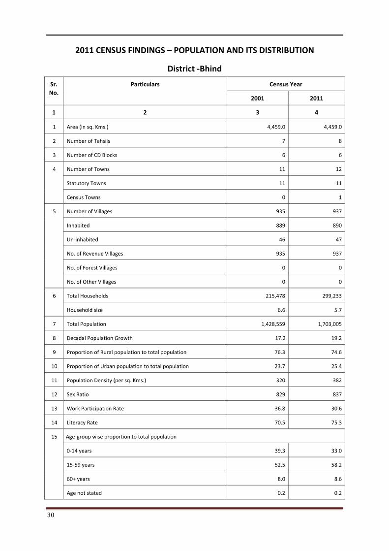
30
2011 CENSUS FINDINGS – POPULATION AND ITS DISTRIBUTION
District -Bhind
Sr. No.
Particulars Census Year
2001 2011
1 2 3 4
1 Area (in sq. Kms.) 4,459.0 4,459.0
2 Number of Tahsils 7 8
3 Number of CD Blocks 6 6
4 Number of Towns 11 12
Statutory Towns 11 11
Census Towns 0 1
5 Number of Villages 935 937
Inhabited 889 890
Un-inhabited 46 47
No. of Revenue Villages 935 937
No. of Forest Villages 0 0
No. of Other Villages 0 0
6 Total Households 215,478 299,233
Household size 6.6 5.7
7 Total Population 1,428,559 1,703,005
8 Decadal Population Growth 17.2 19.2
9 Proportion of Rural population to total population 76.3 74.6
10 Proportion of Urban population to total population 23.7 25.4
11 Population Density (per sq. Kms.) 320 382
12 Sex Ratio 829 837
13 Work Participation Rate 36.8 30.6
14 Literacy Rate 70.5 75.3
15 Age-group wise proportion to total population
0-14 years 39.3 33.0
15-59 years 52.5 58.2
60+ years 8.0 8.6
Age not stated 0.2 0.2
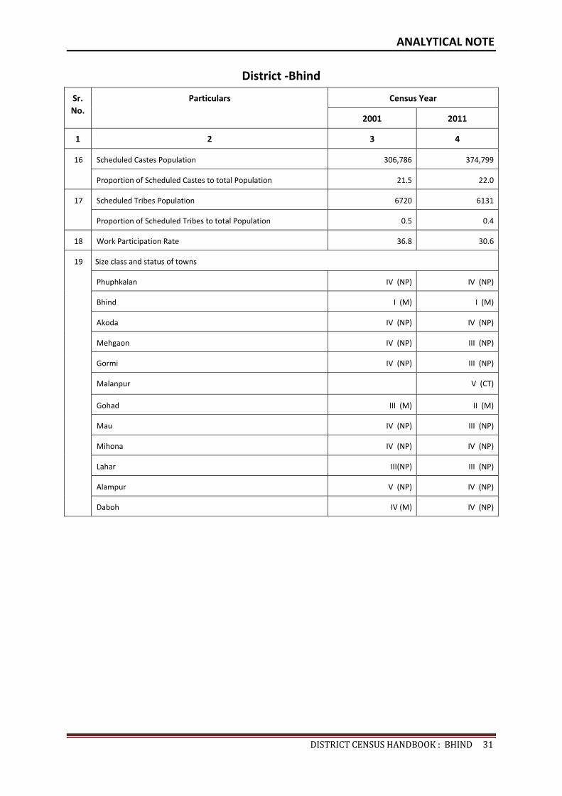
ANALYTICAL NOTE
DISTRICTCENSUSHANDBOOK:BHIND31
District -Bhind
Sr. No.
Particulars Census Year
2001 2011
1 2 3 4
16 Scheduled Castes Population 306,786 374,799
Proportion of Scheduled Castes to total Population 21.5 22.0
17 Scheduled Tribes Population 6720 6131
Proportion of Scheduled Tribes to total Population 0.5 0.4
18 Work Participation Rate 36.8 30.6
19 Size class and status of towns
Phuphkalan IV (NP) IV (NP)
Bhind I (M) I (M)
Akoda IV (NP) IV (NP)
Mehgaon IV (NP) III (NP)
Gormi IV (NP) III (NP)
Malanpur V (CT)
Gohad III (M) II (M)
Mau IV (NP) III (NP)
Mihona IV (NP) IV (NP)
Lahar III(NP) III (NP)
Alampur V (NP) IV (NP)
Daboh IV (M) IV (NP)

32
V. BRIEF ANALYSIS OF THE PCA DATA (TABLE 1-35)
Analysis of the PCA data based on Census 2011 is presented here in the form of tables from 1 to 35. Various demographic indicators such as density, literacy, sex-ratio and distribution of population in different economic activity by rural/urban, male/female and age classifications are presented in these tables. These analysis are presented for Tahsils and CD block levels separately.
TABLE 1: DECADAL CHANGE IN POPULATION OF TAHSILS BY RESIDENCE, 2001-2011
Sr. No.
Tahsil Population Percentage decadal variation
2001-2011
Percentage urban
population2001 2011
Total Rural Urban Total Rural Urban Total Rural Urban 2001 2011
1 2 3 4 5 6 7 8 9 10 11 12 13
1 03391- Ater
119,363 119,363 0 139,378 139,378 0 16.8 16.8 0.0 0.0 0.0
2 03392-Bhind
437,494 262,461 175,033 538,189 315,413 222,776 23.0 20.2 27.3 40.0 41.4
3 03393-Mehgaon
166,358 151,619 14,739 198,343 177,008 21,335 19.2 16.7 44.8 8.9 10.8
4 03394-Gormi
110,296 93,039 17,257 128,774 107,933 20,841 16.8 16.0 20.8 15.6 16.2
5 03395-Gohad
265,011 201,412 63,599 316,826 230,248 86,578 19.6 14.3 36.1 24.0 27.3
6 03396-Ron 66,688 66,688 0 78,005 78,005 0 17.0 17.0 0.0 0.0 0.0
7 03397-Mihona
78,192 63,387 14,805 89,442 72,507 16,935 14.4 14.4 14.4 18.9 18.9
8 03398-Lahar
185,157 131,657 53,500 214,048 149,591 64,457 15.6 13.6 20.5 28.9 30.1
District Total 1,428,559 1,089,626 338,933 1,703,005 1,270,083 432,922 19.2 16.6 27.7 23.7 25.4
This table indicates decadal change in population of the district at tahsil level for both rural and urban areas during 2001-2011. It is seen from the table that an overall 19.2 percent decadal growth has been recorded in the district. The growth rate of rural areas is 16.6 percent whereas in urban areas growth rate is 27.7 percent. Among the tahsil, Bhind has registered the highest decadal growth rate of 23.0 percent, and lowest 14.4 percent in Mihona Tahsil. The highest growth rate of rural area is highest 20.2 percent in Bhind and it is lowest 13.6 percent in Lahar tahsil, while in urban areas the highest 44.8 percent in Mehgaon tahsil.
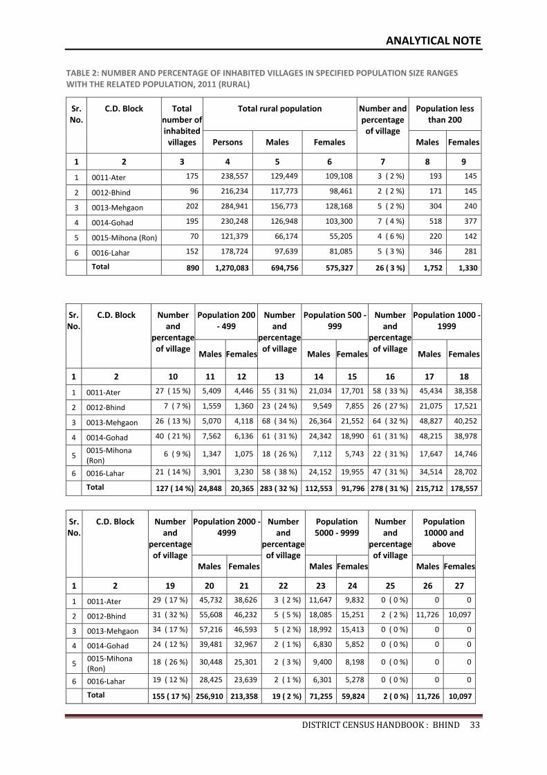
ANALYTICAL NOTE
DISTRICTCENSUSHANDBOOK:BHIND33
TABLE 2: NUMBER AND PERCENTAGE OF INHABITED VILLAGES IN SPECIFIED POPULATION SIZE RANGES WITH THE RELATED POPULATION, 2011 (RURAL)
Sr. No.
C.D. Block Total number of inhabited
villages
Total rural population Number and percentage
of village
Population less than 200
Persons Males Females Males Females
1 2 3 4 5 6 7 8 9
1 0011-Ater 175 238,557 129,449 109,108 3 ( 2 %) 193 145
2 0012-Bhind 96 216,234 117,773 98,461 2 ( 2 %) 171 145
3 0013-Mehgaon 202 284,941 156,773 128,168 5 ( 2 %) 304 240
4 0014-Gohad 195 230,248 126,948 103,300 7 ( 4 %) 518 377
5 0015-Mihona (Ron) 70 121,379 66,174 55,205 4 ( 6 %) 220 142
6 0016-Lahar 152 178,724 97,639 81,085 5 ( 3 %) 346 281
Total 890 1,270,083 694,756 575,327 26 ( 3 %) 1,752 1,330
Sr. No.
C.D. Block Number and
percentage of village
Population 200 - 499
Number and
percentage of village
Population 500 -999
Number and
percentage of village
Population 1000 -1999
Males Females Males Females Males Females
1 2 10 11 12 13 14 15 16 17 18
1 0011-Ater 27 ( 15 %) 5,409 4,446 55 ( 31 %) 21,034 17,701 58 ( 33 %) 45,434 38,358
2 0012-Bhind 7 ( 7 %) 1,559 1,360 23 ( 24 %) 9,549 7,855 26 ( 27 %) 21,075 17,521
3 0013-Mehgaon 26 ( 13 %) 5,070 4,118 68 ( 34 %) 26,364 21,552 64 ( 32 %) 48,827 40,252
4 0014-Gohad 40 ( 21 %) 7,562 6,136 61 ( 31 %) 24,342 18,990 61 ( 31 %) 48,215 38,978
5 0015-Mihona (Ron)
6 ( 9 %) 1,347 1,075 18 ( 26 %) 7,112 5,743 22 ( 31 %) 17,647 14,746
6 0016-Lahar 21 ( 14 %) 3,901 3,230 58 ( 38 %) 24,152 19,955 47 ( 31 %) 34,514 28,702
Total 127 ( 14 %) 24,848 20,365 283 ( 32 %) 112,553 91,796 278 ( 31 %) 215,712 178,557
Sr. No.
C.D. Block Number and
percentage of village
Population 2000 -4999
Number and
percentage of village
Population 5000 - 9999
Number and
percentage of village
Population 10000 and
above
Males Females Males Females Males Females
1 2 19 20 21 22 23 24 25 26 27
1 0011-Ater 29 ( 17 %) 45,732 38,626 3 ( 2 %) 11,647 9,832 0 ( 0 %) 0 0
2 0012-Bhind 31 ( 32 %) 55,608 46,232 5 ( 5 %) 18,085 15,251 2 ( 2 %) 11,726 10,097
3 0013-Mehgaon 34 ( 17 %) 57,216 46,593 5 ( 2 %) 18,992 15,413 0 ( 0 %) 0 0
4 0014-Gohad 24 ( 12 %) 39,481 32,967 2 ( 1 %) 6,830 5,852 0 ( 0 %) 0 0
5 0015-Mihona (Ron)
18 ( 26 %) 30,448 25,301 2 ( 3 %) 9,400 8,198 0 ( 0 %) 0 0
6 0016-Lahar 19 ( 12 %) 28,425 23,639 2 ( 1 %) 6,301 5,278 0 ( 0 %) 0 0
Total 155 ( 17 %) 256,910 213,358 19 ( 2 %) 71,255 59,824 2 ( 0 %) 11,726 10,097
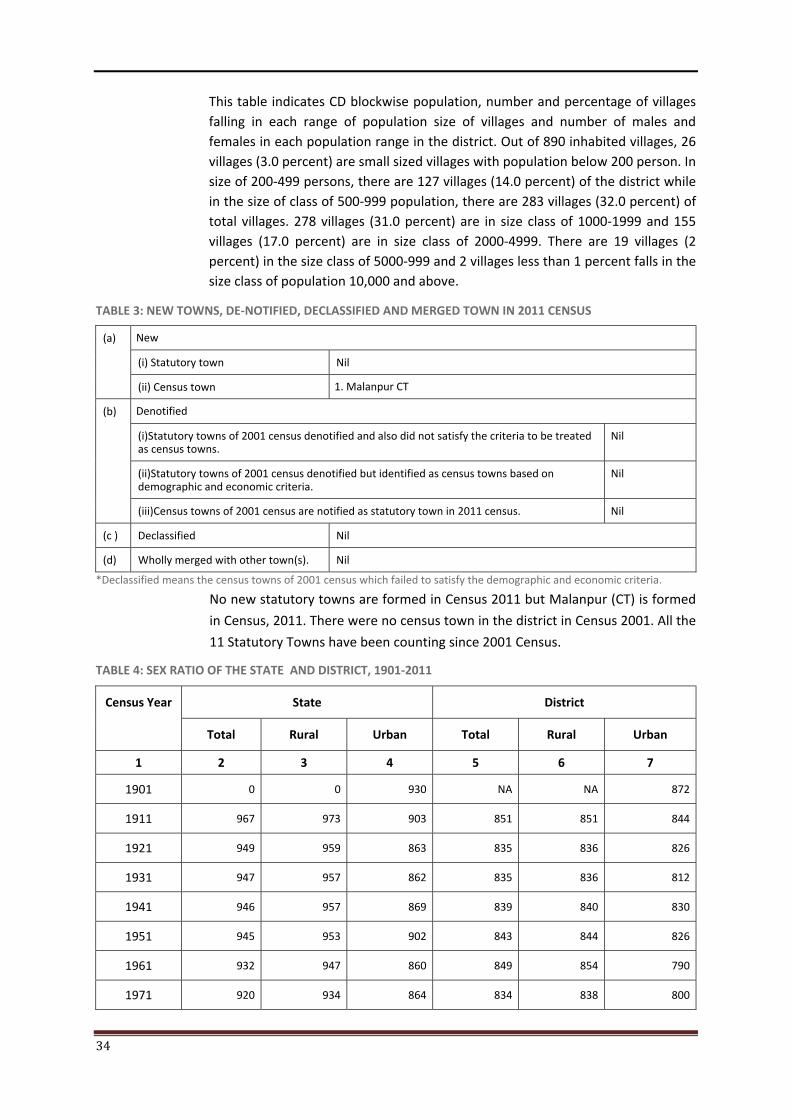
34
This table indicates CD blockwise population, number and percentage of villages falling in each range of population size of villages and number of males and females in each population range in the district. Out of 890 inhabited villages, 26 villages (3.0 percent) are small sized villages with population below 200 person. In size of 200-499 persons, there are 127 villages (14.0 percent) of the district while in the size of class of 500-999 population, there are 283 villages (32.0 percent) of total villages. 278 villages (31.0 percent) are in size class of 1000-1999 and 155 villages (17.0 percent) are in size class of 2000-4999. There are 19 villages (2 percent) in the size class of 5000-999 and 2 villages less than 1 percent falls in the size class of population 10,000 and above.
TABLE 3: NEW TOWNS, DE-NOTIFIED, DECLASSIFIED AND MERGED TOWN IN 2011 CENSUS
(a) New (i) Statutory town Nil
(ii) Census town 1. Malanpur CT
(b) Denotified (i)Statutory towns of 2001 census denotified and also did not satisfy the criteria to be treated as census towns.
Nil
(ii)Statutory towns of 2001 census denotified but identified as census towns based on demographic and economic criteria.
Nil
(iii)Census towns of 2001 census are notified as statutory town in 2011 census. Nil
(c ) Declassified Nil
(d) Wholly merged with other town(s). Nil
*Declassified means the census towns of 2001 census which failed to satisfy the demographic and economic criteria. No new statutory towns are formed in Census 2011 but Malanpur (CT) is formed
in Census, 2011. There were no census town in the district in Census 2001. All the
11 Statutory Towns have been counting since 2001 Census.
TABLE 4: SEX RATIO OF THE STATE AND DISTRICT, 1901-2011
Census Year State District
Total Rural Urban Total Rural Urban
1 2 3 4 5 6 7
1901 0 0 930 NA NA 872
1911 967 973 903 851 851 844
1921 949 959 863 835 836 826
1931 947 957 862 835 836 812
1941 946 957 869 839 840 830
1951 945 953 902 843 844 826
1961 932 947 860 849 854 790
1971 920 934 864 834 838 800

ANALYTICAL NOTE
DISTRICTCENSUSHANDBOOK:BHIND35
TABLE 4: SEX RATIO OF THE STATE AND DISTRICT, 1901-2011
Census Year State District
Total Rural Urban Total Rural Urban
1 2 3 4 5 6 7
1981 921 934 878 827 829 820
1991 912 921 887 816 813 827
2001 919 927 898 829 825 843
2011 931 936 918 837 828 865
Note :- Sex ratio has been defined here as the number of females per 1000 males
As per Census 2011, sex ratio of 837 females per 1000 males has been recorded in the district against the state average of 931. The district had been significantly lower in 1911 to 2011 over the state average figures. The lowest sex ratio of 816 females per 1000 males recorded in the district in Census 1991. In rural areas, it is 828 at district level against the state average of 936 in Census 2011 while it is 865 at the district level against state average of 918 in urban areas in Census 2011.
TABLE 5: SEX RATIO BY TAHSILS, 2011
Sr.No. Name of Tahsil Sex ratio
Total Rural Urban
1 2 3 4 5
1 03391-Ater 849 849 0
2 03392-Bhind 850 835 872
3 03393-Mehgaon 820 815 861
4 03394-Gormi 832 822 885
5 03395-Gohad 819 814 835
6 03396-Ron 840 840 0
7 03397-Mihona 834 825 874
8 03398-Lahar 845 831 877
District: 420-Bhind 837 828 865
In this table, the sex ratio of tahsilwise rural and urban population of Census 2011. It is observed that the sex ratio of the district is 837 females per 1000 males. Sex ratio for rural area works out to 828 whereas 865 in urban area. The sex ratio in rural area is highest 849 in tahsil Ater whereas in urban area, it is highest in Lahar tahsil with 877.
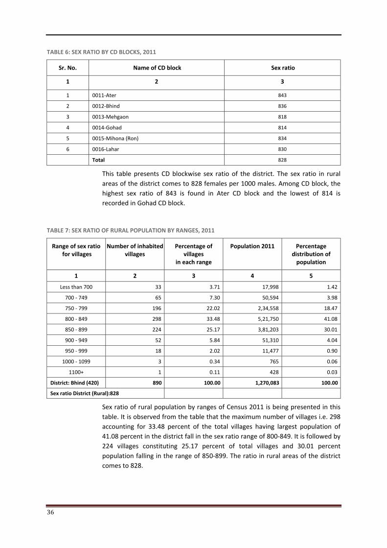
36
TABLE 6: SEX RATIO BY CD BLOCKS, 2011
Sr. No. Name of CD block Sex ratio
1 2 3
1 0011-Ater 843
2 0012-Bhind 836
3 0013-Mehgaon 818
4 0014-Gohad 814
5 0015-Mihona (Ron) 834
6 0016-Lahar 830
Total 828
This table presents CD blockwise sex ratio of the district. The sex ratio in rural areas of the district comes to 828 females per 1000 males. Among CD block, the highest sex ratio of 843 is found in Ater CD block and the lowest of 814 is recorded in Gohad CD block.
TABLE 7: SEX RATIO OF RURAL POPULATION BY RANGES, 2011
Range of sex ratio for villages
Number of inhabited villages
Percentage of villages
in each range
Population 2011 Percentage distribution of
population
1 2 3 4 5
Less than 700 33 3.71 17,998 1.42
700 - 749 65 7.30 50,594 3.98
750 - 799 196 22.02 2,34,558 18.47
800 - 849 298 33.48 5,21,750 41.08
850 - 899 224 25.17 3,81,203 30.01
900 - 949 52 5.84 51,310 4.04
950 - 999 18 2.02 11,477 0.90
1000 - 1099 3 0.34 765 0.06
1100+ 1 0.11 428 0.03
District: Bhind (420) 890 100.00 1,270,083 100.00
Sex ratio District (Rural):828
Sex ratio of rural population by ranges of Census 2011 is being presented in this table. It is observed from the table that the maximum number of villages i.e. 298 accounting for 33.48 percent of the total villages having largest population of 41.08 percent in the district fall in the sex ratio range of 800-849. It is followed by 224 villages constituting 25.17 percent of total villages and 30.01 percent population falling in the range of 850-899. The ratio in rural areas of the district comes to 828.
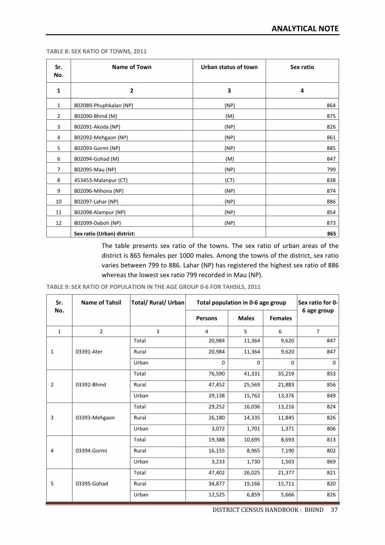
ANALYTICAL NOTE
DISTRICTCENSUSHANDBOOK:BHIND37
TABLE 8: SEX RATIO OF TOWNS, 2011
Sr. No.
Name of Town Urban status of town Sex ratio
1 2 3 4
1 802089-Phuphkalan (NP) (NP) 864
2 802090-Bhind (M) (M) 875
3 802091-Akoda (NP) (NP) 826
4 802092-Mehgaon (NP) (NP) 861
5 802093-Gormi (NP) (NP) 885
6 802094-Gohad (M) (M) 847
7 802095-Mau (NP) (NP) 799
8 453453-Malanpur (CT) (CT) 838
9 802096-Mihona (NP) (NP) 874
10 802097-Lahar (NP) (NP) 886
11 802098-Alampur (NP) (NP) 854
12 802099-Daboh (NP) (NP) 873
Sex ratio (Urban) district: 865
The table presents sex ratio of the towns. The sex ratio of urban areas of the district is 865 females per 1000 males. Among the towns of the district, sex ratio varies between 799 to 886. Lahar (NP) has registered the highest sex ratio of 886 whereas the lowest sex ratio 799 recorded in Mau (NP).
TABLE 9: SEX RATIO OF POPULATION IN THE AGE GROUP 0-6 FOR TAHSILS, 2011
Sr. No.
Name of Tahsil Total/ Rural/ Urban Total population in 0-6 age group Sex ratio for 0-6 age group
Persons Males Females
1 2 3 4 5 6 7
1 03391-Ater
Total 20,984 11,364 9,620 847
Rural 20,984 11,364 9,620 847
Urban 0 0 0 0
2 03392-Bhind
Total 76,590 41,331 35,259 853
Rural 47,452 25,569 21,883 856
Urban 29,138 15,762 13,376 849
3 03393-Mehgaon
Total 29,252 16,036 13,216 824
Rural 26,180 14,335 11,845 826
Urban 3,072 1,701 1,371 806
4 03394-Gormi
Total 19,388 10,695 8,693 813
Rural 16,155 8,965 7,190 802
Urban 3,233 1,730 1,503 869
5 03395-Gohad
Total 47,402 26,025 21,377 821
Rural 34,877 19,166 15,711 820
Urban 12,525 6,859 5,666 826
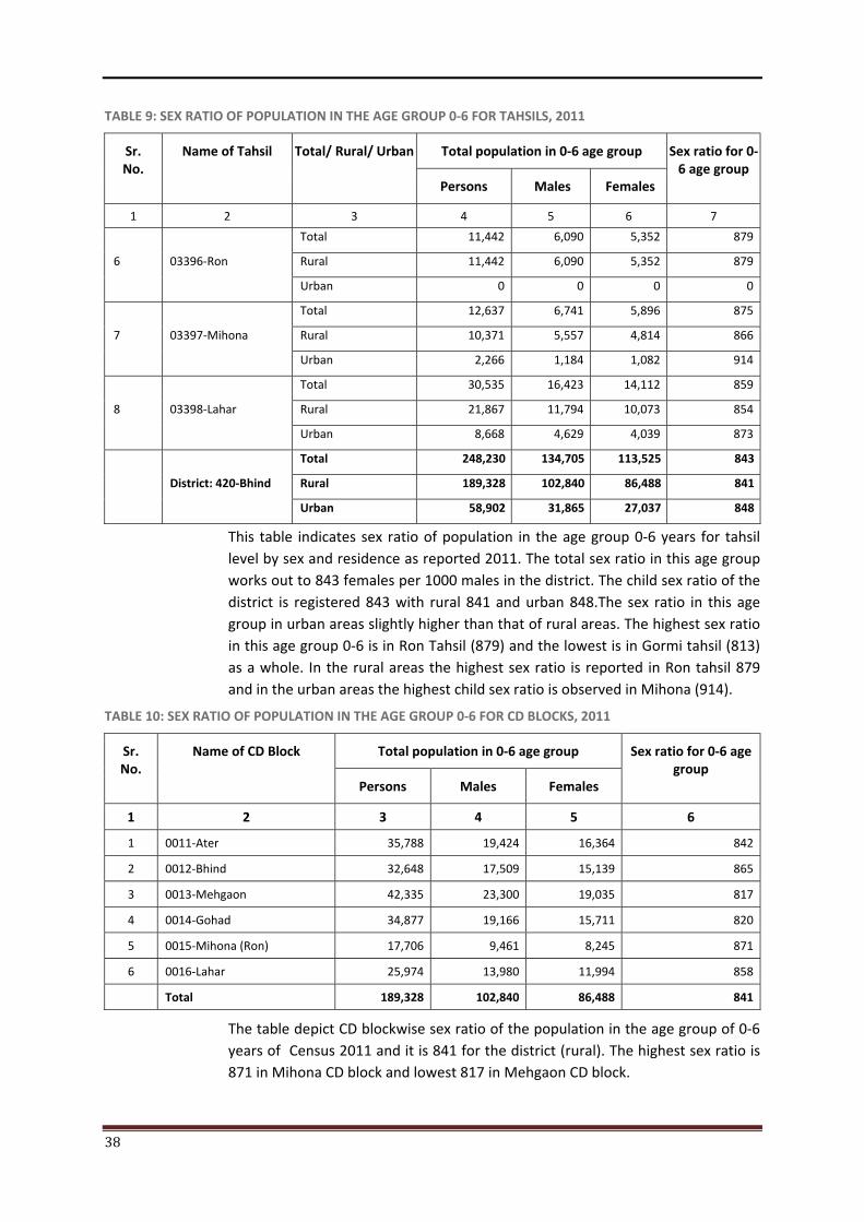
38
TABLE 9: SEX RATIO OF POPULATION IN THE AGE GROUP 0-6 FOR TAHSILS, 2011
Sr. No.
Name of Tahsil Total/ Rural/ Urban Total population in 0-6 age group Sex ratio for 0-6 age group
Persons Males Females
1 2 3 4 5 6 7
6 03396-Ron
Total 11,442 6,090 5,352 879
Rural 11,442 6,090 5,352 879
Urban 0 0 0 0
7 03397-Mihona
Total 12,637 6,741 5,896 875
Rural 10,371 5,557 4,814 866
Urban 2,266 1,184 1,082 914
8 03398-Lahar
Total 30,535 16,423 14,112 859
Rural 21,867 11,794 10,073 854
Urban 8,668 4,629 4,039 873
District: 420-Bhind
Total 248,230 134,705 113,525 843
Rural 189,328 102,840 86,488 841
Urban 58,902 31,865 27,037 848
This table indicates sex ratio of population in the age group 0-6 years for tahsil level by sex and residence as reported 2011. The total sex ratio in this age group works out to 843 females per 1000 males in the district. The child sex ratio of the district is registered 843 with rural 841 and urban 848.The sex ratio in this age group in urban areas slightly higher than that of rural areas. The highest sex ratio in this age group 0-6 is in Ron Tahsil (879) and the lowest is in Gormi tahsil (813) as a whole. In the rural areas the highest sex ratio is reported in Ron tahsil 879 and in the urban areas the highest child sex ratio is observed in Mihona (914).
TABLE 10: SEX RATIO OF POPULATION IN THE AGE GROUP 0-6 FOR CD BLOCKS, 2011
Sr. No.
Name of CD Block Total population in 0-6 age group Sex ratio for 0-6 age group
Persons Males Females
1 2 3 4 5 6
1 0011-Ater 35,788 19,424 16,364 842
2 0012-Bhind 32,648 17,509 15,139 865
3 0013-Mehgaon 42,335 23,300 19,035 817
4 0014-Gohad 34,877 19,166 15,711 820
5 0015-Mihona (Ron) 17,706 9,461 8,245 871
6 0016-Lahar 25,974 13,980 11,994 858
Total 189,328 102,840 86,488 841
The table depict CD blockwise sex ratio of the population in the age group of 0-6 years of Census 2011 and it is 841 for the district (rural). The highest sex ratio is 871 in Mihona CD block and lowest 817 in Mehgaon CD block.
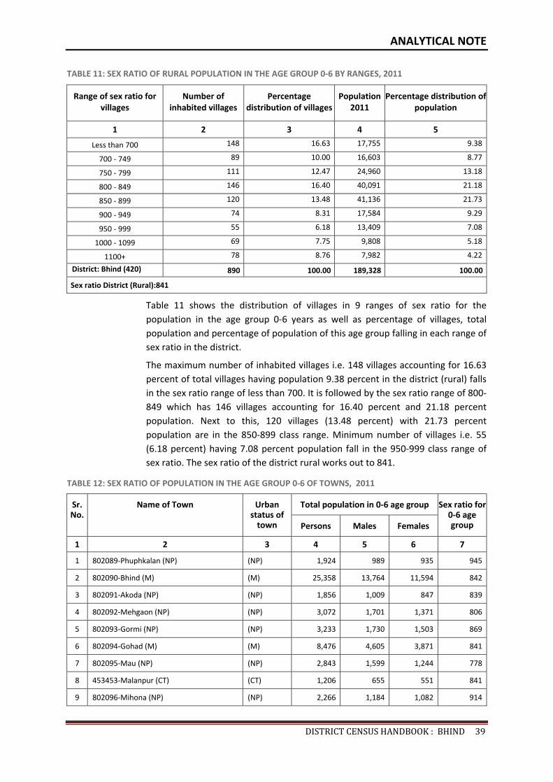
ANALYTICAL NOTE
DISTRICTCENSUSHANDBOOK:BHIND39
TABLE 11: SEX RATIO OF RURAL POPULATION IN THE AGE GROUP 0-6 BY RANGES, 2011
Range of sex ratio for villages
Number of inhabited villages
Percentage distribution of villages
Population 2011
Percentage distribution of population
1 2 3 4 5
Less than 700 148 16.63 17,755 9.38
700 - 749 89 10.00 16,603 8.77
750 - 799 111 12.47 24,960 13.18
800 - 849 146 16.40 40,091 21.18
850 - 899 120 13.48 41,136 21.73
900 - 949 74 8.31 17,584 9.29
950 - 999 55 6.18 13,409 7.08
1000 - 1099 69 7.75 9,808 5.18
1100+ 78 8.76 7,982 4.22
District: Bhind (420) 890 100.00 189,328 100.00
Sex ratio District (Rural):841
Table 11 shows the distribution of villages in 9 ranges of sex ratio for the population in the age group 0-6 years as well as percentage of villages, total population and percentage of population of this age group falling in each range of sex ratio in the district.
The maximum number of inhabited villages i.e. 148 villages accounting for 16.63 percent of total villages having population 9.38 percent in the district (rural) falls in the sex ratio range of less than 700. It is followed by the sex ratio range of 800-849 which has 146 villages accounting for 16.40 percent and 21.18 percent population. Next to this, 120 villages (13.48 percent) with 21.73 percent population are in the 850-899 class range. Minimum number of villages i.e. 55 (6.18 percent) having 7.08 percent population fall in the 950-999 class range of sex ratio. The sex ratio of the district rural works out to 841.
TABLE 12: SEX RATIO OF POPULATION IN THE AGE GROUP 0-6 OF TOWNS, 2011
Sr. No.
Name of Town Urban status of
town
Total population in 0-6 age group Sex ratio for 0-6 age group Persons Males Females
1 2 3 4 5 6 7
1 802089-Phuphkalan (NP) (NP) 1,924 989 935 945
2 802090-Bhind (M) (M) 25,358 13,764 11,594 842
3 802091-Akoda (NP) (NP) 1,856 1,009 847 839
4 802092-Mehgaon (NP) (NP) 3,072 1,701 1,371 806
5 802093-Gormi (NP) (NP) 3,233 1,730 1,503 869
6 802094-Gohad (M) (M) 8,476 4,605 3,871 841
7 802095-Mau (NP) (NP) 2,843 1,599 1,244 778
8 453453-Malanpur (CT) (CT) 1,206 655 551 841
9 802096-Mihona (NP) (NP) 2,266 1,184 1,082 914
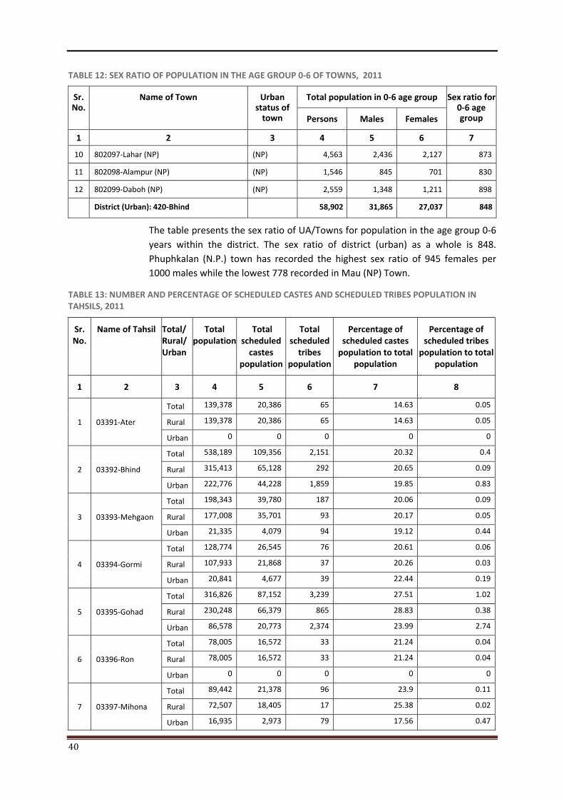
40
TABLE 12: SEX RATIO OF POPULATION IN THE AGE GROUP 0-6 OF TOWNS, 2011
Sr. No.
Name of Town Urban status of
town
Total population in 0-6 age group Sex ratio for 0-6 age group Persons Males Females
1 2 3 4 5 6 7
10 802097-Lahar (NP) (NP) 4,563 2,436 2,127 873
11 802098-Alampur (NP) (NP) 1,546 845 701 830
12 802099-Daboh (NP) (NP) 2,559 1,348 1,211 898
District (Urban): 420-Bhind 58,902 31,865 27,037 848
The table presents the sex ratio of UA/Towns for population in the age group 0-6 years within the district. The sex ratio of district (urban) as a whole is 848. Phuphkalan (N.P.) town has recorded the highest sex ratio of 945 females per 1000 males while the lowest 778 recorded in Mau (NP) Town.
TABLE 13: NUMBER AND PERCENTAGE OF SCHEDULED CASTES AND SCHEDULED TRIBES POPULATION IN TAHSILS, 2011
Sr. No.
Name of Tahsil Total/ Rural/ Urban
Total population
Total scheduled
castes population
Total scheduled
tribes population
Percentage of scheduled castes
population to total population
Percentage of scheduled tribes
population to total population
1 2 3 4 5 6 7 8
1 03391-Ater
Total 139,378 20,386 65 14.63 0.05
Rural 139,378 20,386 65 14.63 0.05
Urban 0 0 0 0 0
2 03392-Bhind
Total 538,189 109,356 2,151 20.32 0.4
Rural 315,413 65,128 292 20.65 0.09
Urban 222,776 44,228 1,859 19.85 0.83
3 03393-Mehgaon
Total 198,343 39,780 187 20.06 0.09
Rural 177,008 35,701 93 20.17 0.05
Urban 21,335 4,079 94 19.12 0.44
4 03394-Gormi
Total 128,774 26,545 76 20.61 0.06
Rural 107,933 21,868 37 20.26 0.03
Urban 20,841 4,677 39 22.44 0.19
5 03395-Gohad
Total 316,826 87,152 3,239 27.51 1.02
Rural 230,248 66,379 865 28.83 0.38
Urban 86,578 20,773 2,374 23.99 2.74
6 03396-Ron
Total 78,005 16,572 33 21.24 0.04
Rural 78,005 16,572 33 21.24 0.04
Urban 0 0 0 0 0
7 03397-Mihona
Total 89,442 21,378 96 23.9 0.11
Rural 72,507 18,405 17 25.38 0.02
Urban 16,935 2,973 79 17.56 0.47
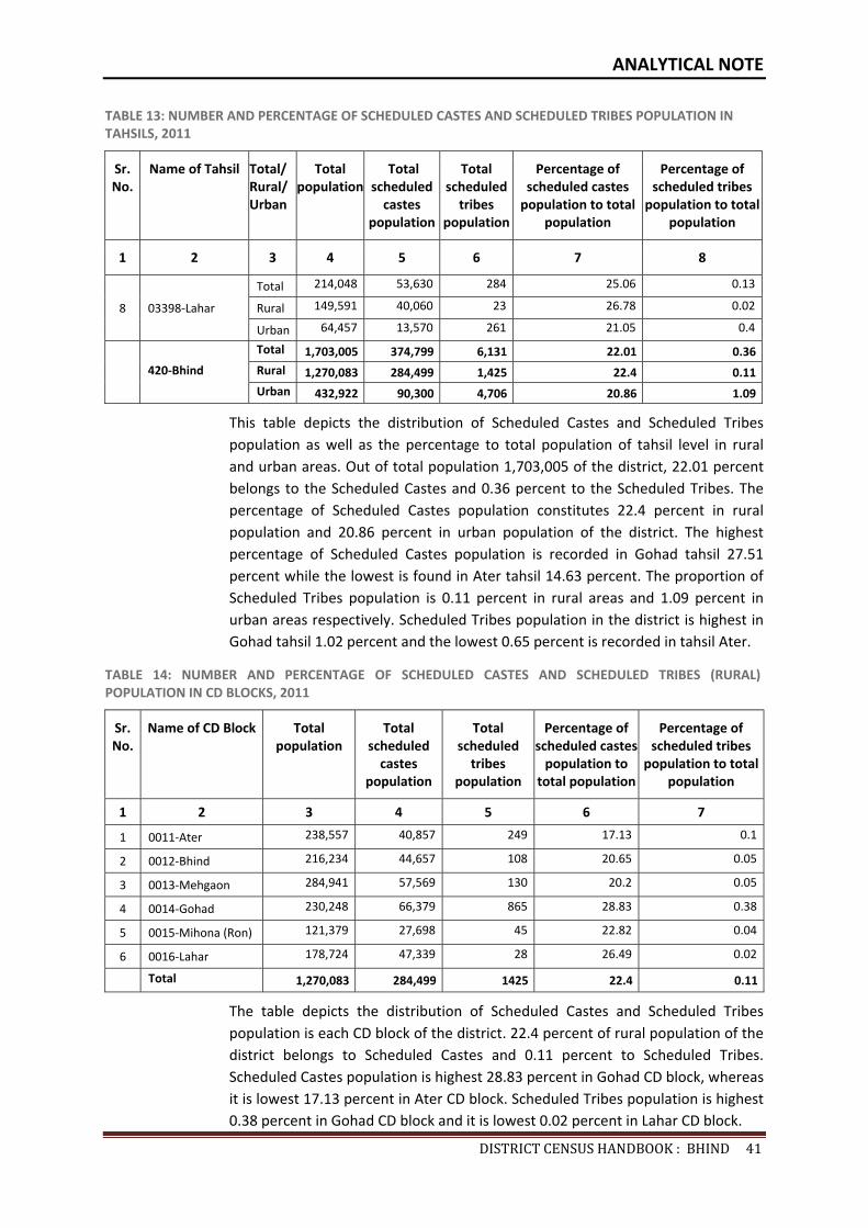
ANALYTICAL NOTE
DISTRICTCENSUSHANDBOOK:BHIND41
TABLE 13: NUMBER AND PERCENTAGE OF SCHEDULED CASTES AND SCHEDULED TRIBES POPULATION IN TAHSILS, 2011
Sr. No.
Name of Tahsil Total/ Rural/ Urban
Total population
Total scheduled
castes population
Total scheduled
tribes population
Percentage of scheduled castes
population to total population
Percentage of scheduled tribes
population to total population
1 2 3 4 5 6 7 8
8 03398-Lahar
Total 214,048 53,630 284 25.06 0.13
Rural 149,591 40,060 23 26.78 0.02
Urban 64,457 13,570 261 21.05 0.4
420-Bhind
Total 1,703,005 374,799 6,131 22.01 0.36Rural 1,270,083 284,499 1,425 22.4 0.11Urban 432,922 90,300 4,706 20.86 1.09
This table depicts the distribution of Scheduled Castes and Scheduled Tribes population as well as the percentage to total population of tahsil level in rural and urban areas. Out of total population 1,703,005 of the district, 22.01 percent belongs to the Scheduled Castes and 0.36 percent to the Scheduled Tribes. The percentage of Scheduled Castes population constitutes 22.4 percent in rural population and 20.86 percent in urban population of the district. The highest percentage of Scheduled Castes population is recorded in Gohad tahsil 27.51 percent while the lowest is found in Ater tahsil 14.63 percent. The proportion of Scheduled Tribes population is 0.11 percent in rural areas and 1.09 percent in urban areas respectively. Scheduled Tribes population in the district is highest in Gohad tahsil 1.02 percent and the lowest 0.65 percent is recorded in tahsil Ater.
TABLE 14: NUMBER AND PERCENTAGE OF SCHEDULED CASTES AND SCHEDULED TRIBES (RURAL) POPULATION IN CD BLOCKS, 2011
Sr. No.
Name of CD Block Total population
Total scheduled
castes population
Total scheduled
tribes population
Percentage of scheduled castes
population to total population
Percentage of scheduled tribes
population to total population
1 2 3 4 5 6 7
1 0011-Ater 238,557 40,857 249 17.13 0.1
2 0012-Bhind 216,234 44,657 108 20.65 0.05
3 0013-Mehgaon 284,941 57,569 130 20.2 0.05
4 0014-Gohad 230,248 66,379 865 28.83 0.38
5 0015-Mihona (Ron) 121,379 27,698 45 22.82 0.04
6 0016-Lahar 178,724 47,339 28 26.49 0.02
Total 1,270,083 284,499 1425 22.4 0.11
The table depicts the distribution of Scheduled Castes and Scheduled Tribes population is each CD block of the district. 22.4 percent of rural population of the district belongs to Scheduled Castes and 0.11 percent to Scheduled Tribes. Scheduled Castes population is highest 28.83 percent in Gohad CD block, whereas it is lowest 17.13 percent in Ater CD block. Scheduled Tribes population is highest 0.38 percent in Gohad CD block and it is lowest 0.02 percent in Lahar CD block.
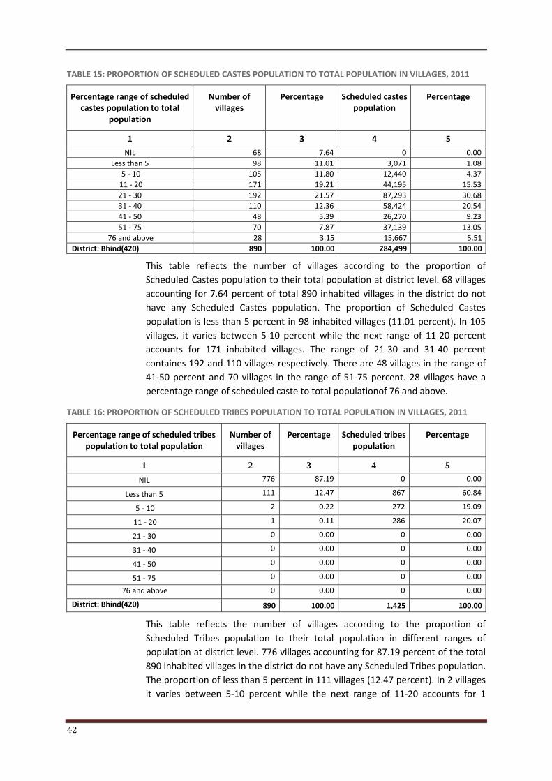
42
TABLE 15: PROPORTION OF SCHEDULED CASTES POPULATION TO TOTAL POPULATION IN VILLAGES, 2011
Percentage range of scheduled castes population to total
population
Number of villages
Percentage Scheduled castes population
Percentage
1 2 3 4 5
NIL 68 7.64 0 0.00Less than 5 98 11.01 3,071 1.08
5 - 10 105 11.80 12,440 4.37 11 - 20 171 19.21 44,195 15.5321 - 30 192 21.57 87,293 30.6831 - 40 110 12.36 58,424 20.5441 - 50 48 5.39 26,270 9.2351 - 75 70 7.87 37,139 13.05
76 and above 28 3.15 15,667 5.51District: Bhind(420) 890 100.00 284,499 100.00
This table reflects the number of villages according to the proportion of Scheduled Castes population to their total population at district level. 68 villages accounting for 7.64 percent of total 890 inhabited villages in the district do not have any Scheduled Castes population. The proportion of Scheduled Castes population is less than 5 percent in 98 inhabited villages (11.01 percent). In 105 villages, it varies between 5-10 percent while the next range of 11-20 percent accounts for 171 inhabited villages. The range of 21-30 and 31-40 percent containes 192 and 110 villages respectively. There are 48 villages in the range of 41-50 percent and 70 villages in the range of 51-75 percent. 28 villages have a percentage range of scheduled caste to total populationof 76 and above.
TABLE 16: PROPORTION OF SCHEDULED TRIBES POPULATION TO TOTAL POPULATION IN VILLAGES, 2011
Percentage range of scheduled tribes population to total population
Number of villages
Percentage Scheduled tribes population
Percentage
1 2 3 4 5 NIL 776 87.19 0 0.00
Less than 5 111 12.47 867 60.84
5 - 10 2 0.22 272 19.09
11 - 20 1 0.11 286 20.07
21 - 30 0 0.00 0 0.00
31 - 40 0 0.00 0 0.00
41 - 50 0 0.00 0 0.00
51 - 75 0 0.00 0 0.00
76 and above 0 0.00 0 0.00
District: Bhind(420) 890 100.00 1,425 100.00
This table reflects the number of villages according to the proportion of Scheduled Tribes population to their total population in different ranges of population at district level. 776 villages accounting for 87.19 percent of the total 890 inhabited villages in the district do not have any Scheduled Tribes population. The proportion of less than 5 percent in 111 villages (12.47 percent). In 2 villages it varies between 5-10 percent while the next range of 11-20 accounts for 1
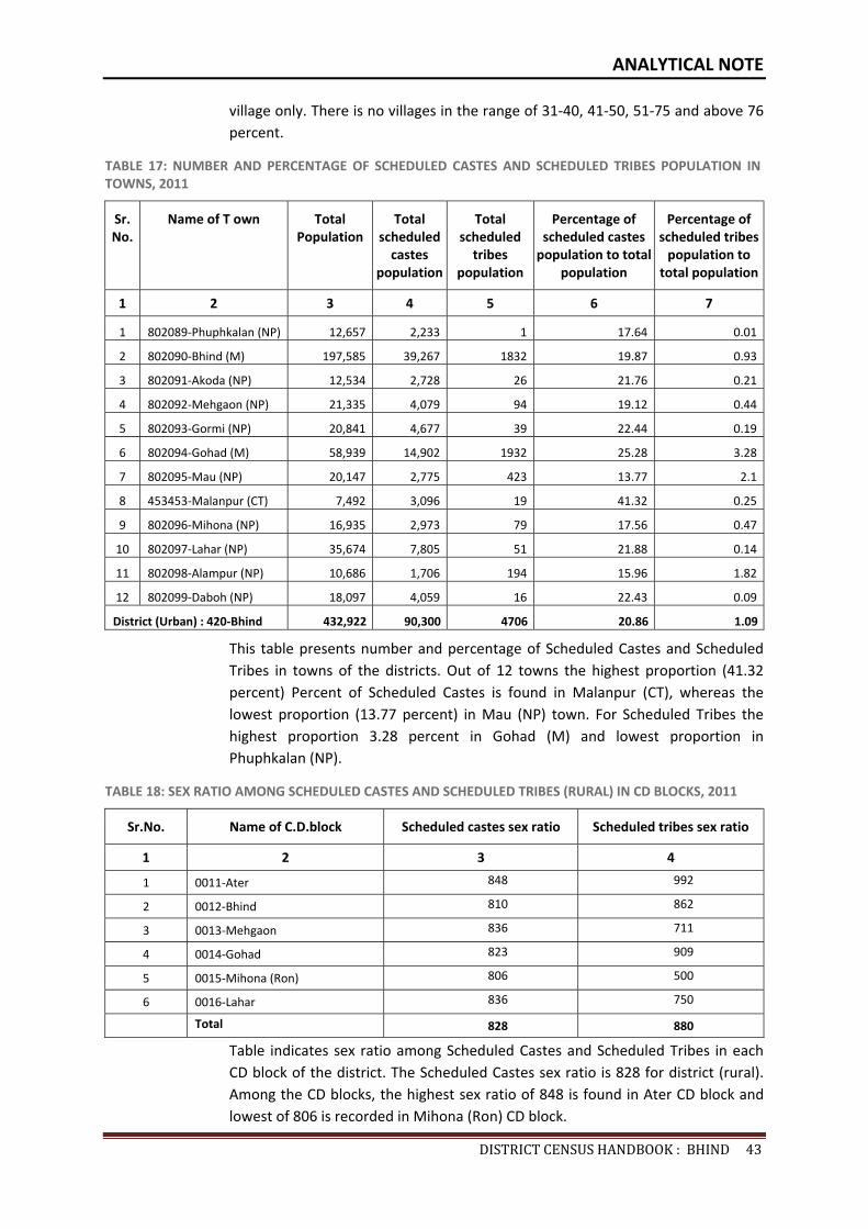
ANALYTICAL NOTE
DISTRICTCENSUSHANDBOOK:BHIND43
village only. There is no villages in the range of 31-40, 41-50, 51-75 and above 76 percent.
TABLE 17: NUMBER AND PERCENTAGE OF SCHEDULED CASTES AND SCHEDULED TRIBES POPULATION IN TOWNS, 2011
Sr. No.
Name of T own Total Population
Total scheduled
castes population
Total scheduled
tribes population
Percentage of scheduled castes
population to total population
Percentage of scheduled tribes
population to total population
1 2 3 4 5 6 7
1 802089-Phuphkalan (NP) 12,657 2,233 1 17.64 0.01
2 802090-Bhind (M) 197,585 39,267 1832 19.87 0.93
3 802091-Akoda (NP) 12,534 2,728 26 21.76 0.21
4 802092-Mehgaon (NP) 21,335 4,079 94 19.12 0.44
5 802093-Gormi (NP) 20,841 4,677 39 22.44 0.19
6 802094-Gohad (M) 58,939 14,902 1932 25.28 3.28
7 802095-Mau (NP) 20,147 2,775 423 13.77 2.1
8 453453-Malanpur (CT) 7,492 3,096 19 41.32 0.25
9 802096-Mihona (NP) 16,935 2,973 79 17.56 0.47
10 802097-Lahar (NP) 35,674 7,805 51 21.88 0.14
11 802098-Alampur (NP) 10,686 1,706 194 15.96 1.82
12 802099-Daboh (NP) 18,097 4,059 16 22.43 0.09
District (Urban) : 420-Bhind 432,922 90,300 4706 20.86 1.09
This table presents number and percentage of Scheduled Castes and Scheduled Tribes in towns of the districts. Out of 12 towns the highest proportion (41.32 percent) Percent of Scheduled Castes is found in Malanpur (CT), whereas the lowest proportion (13.77 percent) in Mau (NP) town. For Scheduled Tribes the highest proportion 3.28 percent in Gohad (M) and lowest proportion in Phuphkalan (NP).
TABLE 18: SEX RATIO AMONG SCHEDULED CASTES AND SCHEDULED TRIBES (RURAL) IN CD BLOCKS, 2011
Sr.No. Name of C.D.block Scheduled castes sex ratio Scheduled tribes sex ratio
1 2 3 4
1 0011-Ater 848 992
2 0012-Bhind 810 862
3 0013-Mehgaon 836 711
4 0014-Gohad 823 909
5 0015-Mihona (Ron) 806 500
6 0016-Lahar 836 750
Total 828 880
Table indicates sex ratio among Scheduled Castes and Scheduled Tribes in each CD block of the district. The Scheduled Castes sex ratio is 828 for district (rural). Among the CD blocks, the highest sex ratio of 848 is found in Ater CD block and lowest of 806 is recorded in Mihona (Ron) CD block.
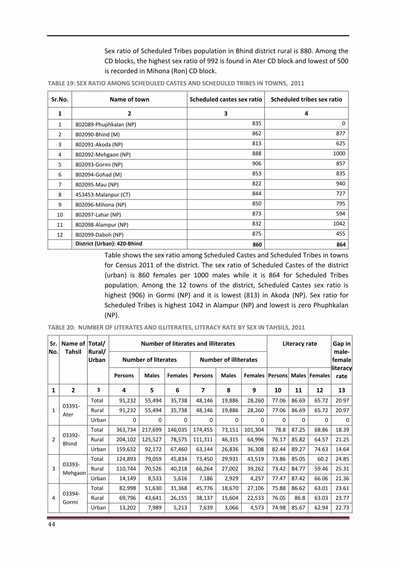
44
Sex ratio of Scheduled Tribes population in Bhind district rural is 880. Among the CD blocks, the highest sex ratio of 992 is found in Ater CD block and lowest of 500 is recorded in Mihona (Ron) CD block.
TABLE 19: SEX RATIO AMONG SCHEDULED CASTES AND SCHEDULED TRIBES IN TOWNS, 2011
Sr.No. Name of town Scheduled castes sex ratio Scheduled tribes sex ratio
1 2 3 4
1 802089-Phuphkalan (NP) 835 0
2 802090-Bhind (M) 862 877
3 802091-Akoda (NP) 813 625
4 802092-Mehgaon (NP) 888 1000
5 802093-Gormi (NP) 906 857
6 802094-Gohad (M) 853 835
7 802095-Mau (NP) 822 940
8 453453-Malanpur (CT) 844 727
9 802096-Mihona (NP) 850 795
10 802097-Lahar (NP) 873 594
11 802098-Alampur (NP) 832 1042
12 802099-Daboh (NP) 875 455
District (Urban): 420-Bhind 860 864
Table shows the sex ratio among Scheduled Castes and Scheduled Tribes in towns for Census 2011 of the district. The sex ratio of Scheduled Castes of the district (urban) is 860 females per 1000 males while it is 864 for Scheduled Tribes population. Among the 12 towns of the district, Scheduled Castes sex ratio is highest (906) in Gormi (NP) and it is lowest (813) in Akoda (NP). Sex ratio for Scheduled Tribes is highest 1042 in Alampur (NP) and lowest is zero Phuphkalan (NP).
TABLE 20: NUMBER OF LITERATES AND ILLITERATES, LITERACY RATE BY SEX IN TAHSILS, 2011
Sr. No.
Name of Tahsil
Total/ Rural/ Urban
Number of literates and illiterates Literacy rate Gap in male-
female literacy
rate
Number of literates Number of illiterates
Persons Males Females Persons Males Females Persons Males Females
1 2 3 4 5 6 7 8 9 10 11 12 13
1 03391-Ater
Total 91,232 55,494 35,738 48,146 19,886 28,260 77.06 86.69 65.72 20.97
Rural 91,232 55,494 35,738 48,146 19,886 28,260 77.06 86.69 65.72 20.97
Urban 0 0 0 0 0 0 0 0 0 0
2 03392-Bhind
Total 363,734 217,699 146,035 174,455 73,151 101,304 78.8 87.25 68.86 18.39
Rural 204,102 125,527 78,575 111,311 46,315 64,996 76.17 85.82 64.57 21.25
Urban 159,632 92,172 67,460 63,144 26,836 36,308 82.44 89.27 74.63 14.64
3 03393-Mehgaon
Total 124,893 79,059 45,834 73,450 29,931 43,519 73.86 85.05 60.2 24.85
Rural 110,744 70,526 40,218 66,264 27,002 39,262 73.42 84.77 59.46 25.31
Urban 14,149 8,533 5,616 7,186 2,929 4,257 77.47 87.42 66.06 21.36
4 03394-Gormi
Total 82,998 51,630 31,368 45,776 18,670 27,106 75.88 86.62 63.01 23.61
Rural 69,796 43,641 26,155 38,137 15,604 22,533 76.05 86.8 63.03 23.77
Urban 13,202 7,989 5,213 7,639 3,066 4,573 74.98 85.67 62.94 22.73
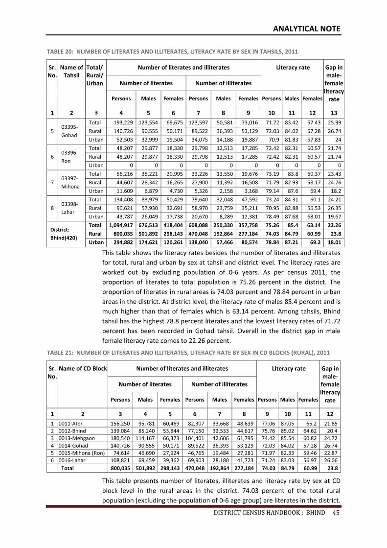
ANALYTICAL NOTE
DISTRICTCENSUSHANDBOOK:BHIND45
TABLE 20: NUMBER OF LITERATES AND ILLITERATES, LITERACY RATE BY SEX IN TAHSILS, 2011
Sr. No.
Name of Tahsil
Total/ Rural/ Urban
Number of literates and illiterates Literacy rate Gap in male-
female literacy
rate
Number of literates Number of illiterates
Persons Males Females Persons Males Females Persons Males Females
1 2 3 4 5 6 7 8 9 10 11 12 13
5 03395-Gohad
Total 193,229 123,554 69,675 123,597 50,581 73,016 71.72 83.42 57.43 25.99
Rural 140,726 90,555 50,171 89,522 36,393 53,129 72.03 84.02 57.28 26.74
Urban 52,503 32,999 19,504 34,075 14,188 19,887 70.9 81.83 57.83 24
6 03396-Ron
Total 48,207 29,877 18,330 29,798 12,513 17,285 72.42 82.31 60.57 21.74
Rural 48,207 29,877 18,330 29,798 12,513 17,285 72.42 82.31 60.57 21.74
Urban 0 0 0 0 0 0 0 0 0 0
7 03397-Mihona
Total 56,216 35,221 20,995 33,226 13,550 19,676 73.19 83.8 60.37 23.43
Rural 44,607 28,342 16,265 27,900 11,392 16,508 71.79 82.93 58.17 24.76
Urban 11,609 6,879 4,730 5,326 2,158 3,168 79.14 87.6 69.4 18.2
8 03398-Lahar
Total 134,408 83,979 50,429 79,640 32,048 47,592 73.24 84.31 60.1 24.21
Rural 90,621 57,930 32,691 58,970 23,759 35,211 70.95 82.88 56.53 26.35
Urban 43,787 26,049 17,738 20,670 8,289 12,381 78.49 87.68 68.01 19.67
District: Bhind(420)
Total 1,094,917 676,513 418,404 608,088 250,330 357,758 75.26 85.4 63.14 22.26
Rural 800,035 501,892 298,143 470,048 192,864 277,184 74.03 84.79 60.99 23.8
Urban 294,882 174,621 120,261 138,040 57,466 80,574 78.84 87.21 69.2 18.01
This table shows the literacy rates besides the number of literates and illiterates for total, rural and urban by sex at tahsil and district level. The literacy rates are worked out by excluding population of 0-6 years. As per census 2011, the proportion of literates to total population is 75.26 percent in the district. The proportion of literates in rural areas is 74.03 percent and 78.84 percent in urban areas in the district. At district level, the literacy rate of males 85.4 percent and is much higher than that of females which is 63.14 percent. Among tahsils, Bhind tahsil has the highest 78.8 percent literates and the lowest literacy rates of 71.72 percent has been recorded in Gohad tahsil. Overall in the district gap in male female literacy rate comes to 22.26 percent.
TABLE 21: NUMBER OF LITERATES AND ILLITERATES, LITERACY RATE BY SEX IN CD BLOCKS (RURAL), 2011
Sr. No.
Name of CD Block Number of literates and illiterates Literacy rate Gap in male-
female literacy
rate
Number of literates Number of illiterates
Persons Males Females Persons Males Females Persons Males Females
1 2 3 4 5 6 7 8 9 10 11 121 0011-Ater 156,250 95,781 60,469 82,307 33,668 48,639 77.06 87.05 65.2 21.852 0012-Bhind 139,084 85,240 53,844 77,150 32,533 44,617 75.76 85.02 64.62 20.43 0013-Mehgaon 180,540 114,167 66,373 104,401 42,606 61,795 74.42 85.54 60.82 24.724 0014-Gohad 140,726 90,555 50,171 89,522 36,393 53,129 72.03 84.02 57.28 26.745 0015-Mihona (Ron) 74,614 46,690 27,924 46,765 19,484 27,281 71.97 82.33 59.46 22.876 0016-Lahar 108,821 69,459 39,362 69,903 28,180 41,723 71.24 83.03 56.97 26.06 Total 800,035 501,892 298,143 470,048 192,864 277,184 74.03 84.79 60.99 23.8
This table presents number of literates, illiterates and literacy rate by sex at CD block level in the rural areas in the district. 74.03 percent of the total rural population (excluding the population of 0-6 age group) are literates in the district.
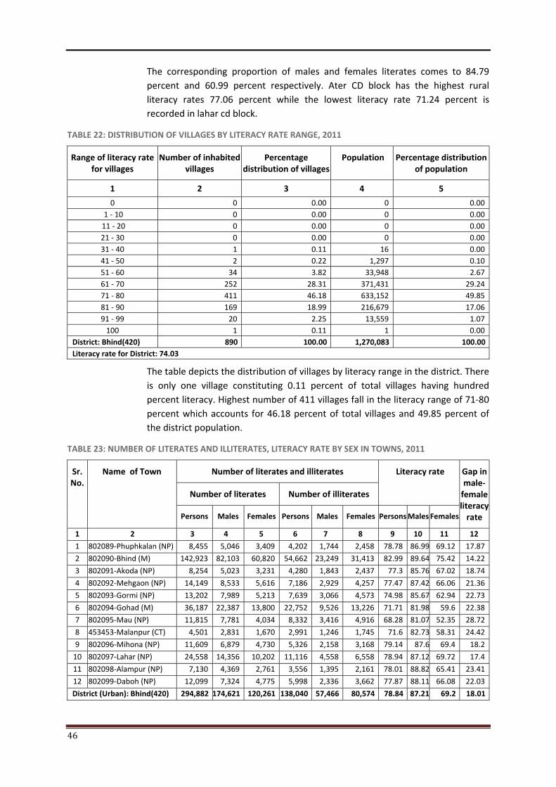
46
The corresponding proportion of males and females literates comes to 84.79 percent and 60.99 percent respectively. Ater CD block has the highest rural literacy rates 77.06 percent while the lowest literacy rate 71.24 percent is recorded in lahar cd block.
TABLE 22: DISTRIBUTION OF VILLAGES BY LITERACY RATE RANGE, 2011
Range of literacy rate for villages
Number of inhabited villages
Percentage distribution of villages
Population Percentage distribution of population
1 2 3 4 5
0 0 0.00 0 0.00 1 - 10 0 0.00 0 0.00
11 - 20 0 0.00 0 0.00 21 - 30 0 0.00 0 0.00 31 - 40 1 0.11 16 0.00 41 - 50 2 0.22 1,297 0.10 51 - 60 34 3.82 33,948 2.67 61 - 70 252 28.31 371,431 29.24 71 - 80 411 46.18 633,152 49.85 81 - 90 169 18.99 216,679 17.06 91 - 99 20 2.25 13,559 1.07
100 1 0.11 1 0.00 District: Bhind(420) 890 100.00 1,270,083 100.00Literacy rate for District: 74.03
The table depicts the distribution of villages by literacy range in the district. There is only one village constituting 0.11 percent of total villages having hundred percent literacy. Highest number of 411 villages fall in the literacy range of 71-80 percent which accounts for 46.18 percent of total villages and 49.85 percent of the district population.
TABLE 23: NUMBER OF LITERATES AND ILLITERATES, LITERACY RATE BY SEX IN TOWNS, 2011
Sr. No.
Name of Town Number of literates and illiterates Literacy rate Gap in male-
female literacy
rate
Number of literates Number of illiterates
Persons Males Females Persons Males Females Persons Males Females
1 2 3 4 5 6 7 8 9 10 11 12
1 802089-Phuphkalan (NP) 8,455 5,046 3,409 4,202 1,744 2,458 78.78 86.99 69.12 17.87
2 802090-Bhind (M) 142,923 82,103 60,820 54,662 23,249 31,413 82.99 89.64 75.42 14.22
3 802091-Akoda (NP) 8,254 5,023 3,231 4,280 1,843 2,437 77.3 85.76 67.02 18.74
4 802092-Mehgaon (NP) 14,149 8,533 5,616 7,186 2,929 4,257 77.47 87.42 66.06 21.36
5 802093-Gormi (NP) 13,202 7,989 5,213 7,639 3,066 4,573 74.98 85.67 62.94 22.73
6 802094-Gohad (M) 36,187 22,387 13,800 22,752 9,526 13,226 71.71 81.98 59.6 22.38
7 802095-Mau (NP) 11,815 7,781 4,034 8,332 3,416 4,916 68.28 81.07 52.35 28.72
8 453453-Malanpur (CT) 4,501 2,831 1,670 2,991 1,246 1,745 71.6 82.73 58.31 24.42
9 802096-Mihona (NP) 11,609 6,879 4,730 5,326 2,158 3,168 79.14 87.6 69.4 18.2
10 802097-Lahar (NP) 24,558 14,356 10,202 11,116 4,558 6,558 78.94 87.12 69.72 17.4
11 802098-Alampur (NP) 7,130 4,369 2,761 3,556 1,395 2,161 78.01 88.82 65.41 23.41
12 802099-Daboh (NP) 12,099 7,324 4,775 5,998 2,336 3,662 77.87 88.11 66.08 22.03
District (Urban): Bhind(420) 294,882 174,621 120,261 138,040 57,466 80,574 78.84 87.21 69.2 18.01
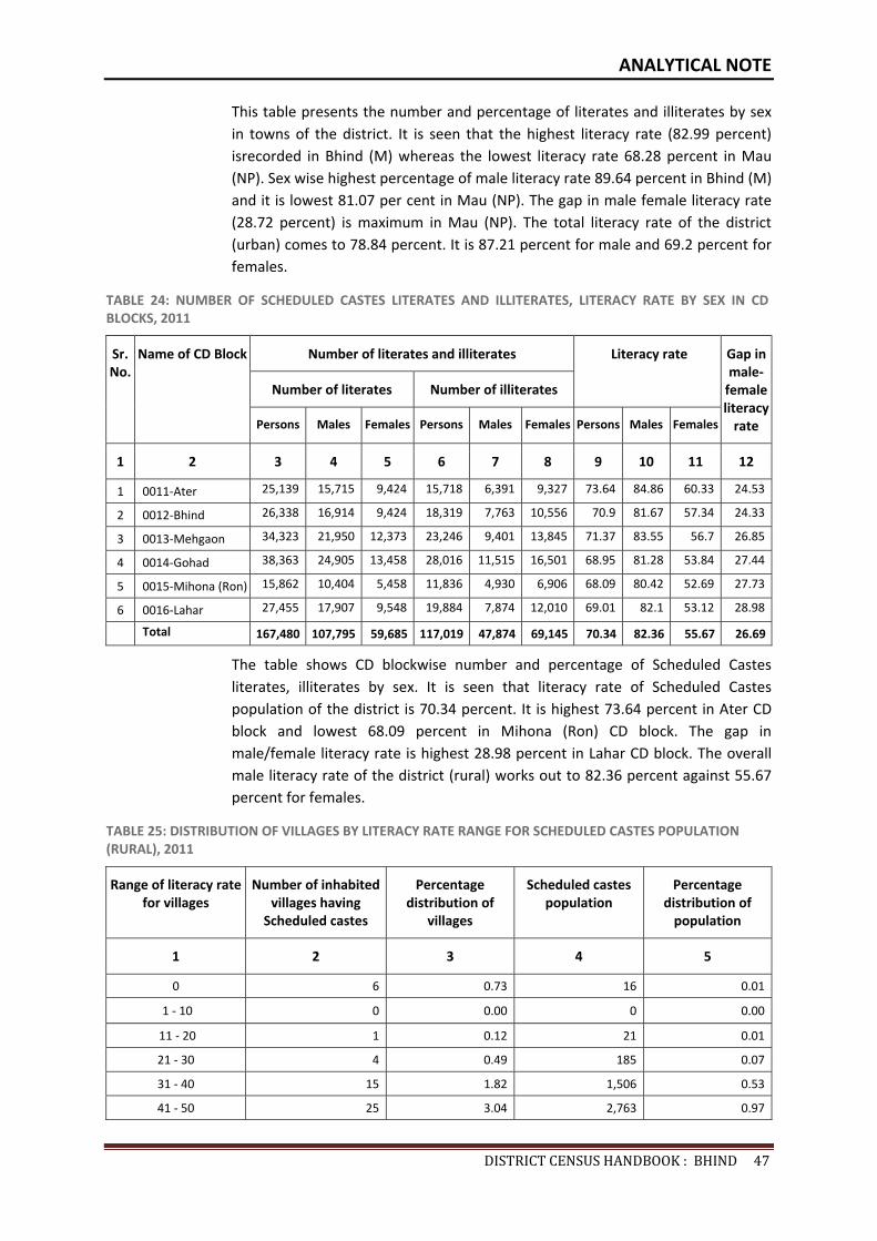
ANALYTICAL NOTE
DISTRICTCENSUSHANDBOOK:BHIND47
This table presents the number and percentage of literates and illiterates by sex in towns of the district. It is seen that the highest literacy rate (82.99 percent) isrecorded in Bhind (M) whereas the lowest literacy rate 68.28 percent in Mau (NP). Sex wise highest percentage of male literacy rate 89.64 percent in Bhind (M) and it is lowest 81.07 per cent in Mau (NP). The gap in male female literacy rate (28.72 percent) is maximum in Mau (NP). The total literacy rate of the district (urban) comes to 78.84 percent. It is 87.21 percent for male and 69.2 percent for females.
TABLE 24: NUMBER OF SCHEDULED CASTES LITERATES AND ILLITERATES, LITERACY RATE BY SEX IN CD BLOCKS, 2011
Sr. No.
Name of CD Block Number of literates and illiterates Literacy rate Gap in male-
female literacy
rate
Number of literates Number of illiterates
Persons Males Females Persons Males Females Persons Males Females
1 2 3 4 5 6 7 8 9 10 11 12
1 0011-Ater 25,139 15,715 9,424 15,718 6,391 9,327 73.64 84.86 60.33 24.53
2 0012-Bhind 26,338 16,914 9,424 18,319 7,763 10,556 70.9 81.67 57.34 24.33
3 0013-Mehgaon 34,323 21,950 12,373 23,246 9,401 13,845 71.37 83.55 56.7 26.85
4 0014-Gohad 38,363 24,905 13,458 28,016 11,515 16,501 68.95 81.28 53.84 27.44
5 0015-Mihona (Ron) 15,862 10,404 5,458 11,836 4,930 6,906 68.09 80.42 52.69 27.73
6 0016-Lahar 27,455 17,907 9,548 19,884 7,874 12,010 69.01 82.1 53.12 28.98
Total 167,480 107,795 59,685 117,019 47,874 69,145 70.34 82.36 55.67 26.69
The table shows CD blockwise number and percentage of Scheduled Castes literates, illiterates by sex. It is seen that literacy rate of Scheduled Castes population of the district is 70.34 percent. It is highest 73.64 percent in Ater CD block and lowest 68.09 percent in Mihona (Ron) CD block. The gap in male/female literacy rate is highest 28.98 percent in Lahar CD block. The overall male literacy rate of the district (rural) works out to 82.36 percent against 55.67 percent for females.
TABLE 25: DISTRIBUTION OF VILLAGES BY LITERACY RATE RANGE FOR SCHEDULED CASTES POPULATION (RURAL), 2011
Range of literacy rate for villages
Number of inhabited villages having
Scheduled castes
Percentage distribution of
villages
Scheduled castes population
Percentage distribution of
population
1 2 3 4 5
0 6 0.73 16 0.01
1 - 10 0 0.00 0 0.00
11 - 20 1 0.12 21 0.01
21 - 30 4 0.49 185 0.07
31 - 40 15 1.82 1,506 0.53
41 - 50 25 3.04 2,763 0.97
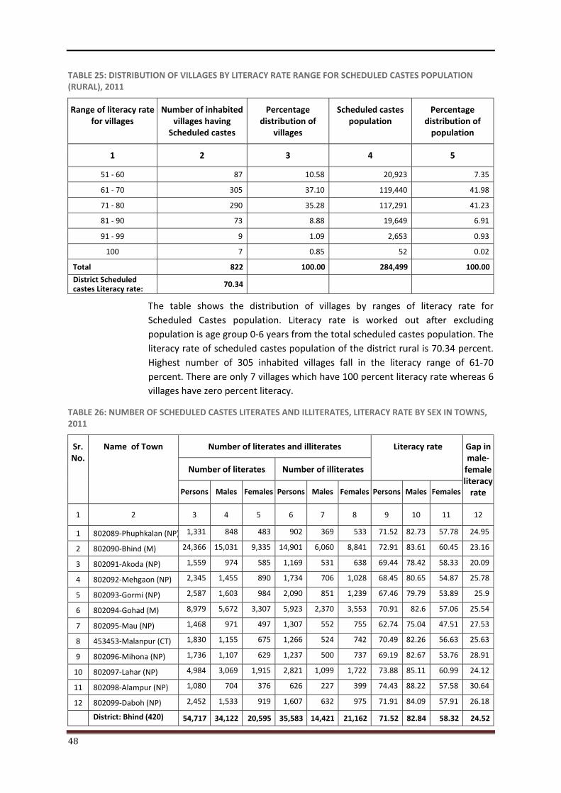
48
TABLE 25: DISTRIBUTION OF VILLAGES BY LITERACY RATE RANGE FOR SCHEDULED CASTES POPULATION (RURAL), 2011
Range of literacy rate for villages
Number of inhabited villages having
Scheduled castes
Percentage distribution of
villages
Scheduled castes population
Percentage distribution of
population
1 2 3 4 5
51 - 60 87 10.58 20,923 7.35
61 - 70 305 37.10 119,440 41.98
71 - 80 290 35.28 117,291 41.23
81 - 90 73 8.88 19,649 6.91
91 - 99 9 1.09 2,653 0.93
100 7 0.85 52 0.02
Total 822 100.00 284,499 100.00
District Scheduled castes Literacy rate: 70.34
The table shows the distribution of villages by ranges of literacy rate for Scheduled Castes population. Literacy rate is worked out after excluding population is age group 0-6 years from the total scheduled castes population. The literacy rate of scheduled castes population of the district rural is 70.34 percent. Highest number of 305 inhabited villages fall in the literacy range of 61-70 percent. There are only 7 villages which have 100 percent literacy rate whereas 6 villages have zero percent literacy.
TABLE 26: NUMBER OF SCHEDULED CASTES LITERATES AND ILLITERATES, LITERACY RATE BY SEX IN TOWNS, 2011
Sr. No.
Name of Town Number of literates and illiterates Literacy rate Gap in male-
female literacy
rate
Number of literates Number of illiterates
Persons Males Females Persons Males Females Persons Males Females
1 2 3 4 5 6 7 8 9 10 11 12
1 802089-Phuphkalan (NP) 1,331 848 483 902 369 533 71.52 82.73 57.78 24.95
2 802090-Bhind (M) 24,366 15,031 9,335 14,901 6,060 8,841 72.91 83.61 60.45 23.16
3 802091-Akoda (NP) 1,559 974 585 1,169 531 638 69.44 78.42 58.33 20.09
4 802092-Mehgaon (NP) 2,345 1,455 890 1,734 706 1,028 68.45 80.65 54.87 25.78
5 802093-Gormi (NP) 2,587 1,603 984 2,090 851 1,239 67.46 79.79 53.89 25.9
6 802094-Gohad (M) 8,979 5,672 3,307 5,923 2,370 3,553 70.91 82.6 57.06 25.54
7 802095-Mau (NP) 1,468 971 497 1,307 552 755 62.74 75.04 47.51 27.53
8 453453-Malanpur (CT) 1,830 1,155 675 1,266 524 742 70.49 82.26 56.63 25.63
9 802096-Mihona (NP) 1,736 1,107 629 1,237 500 737 69.19 82.67 53.76 28.91
10 802097-Lahar (NP) 4,984 3,069 1,915 2,821 1,099 1,722 73.88 85.11 60.99 24.12
11 802098-Alampur (NP) 1,080 704 376 626 227 399 74.43 88.22 57.58 30.64
12 802099-Daboh (NP) 2,452 1,533 919 1,607 632 975 71.91 84.09 57.91 26.18
District: Bhind (420) 54,717 34,122 20,595 35,583 14,421 21,162 71.52 82.84 58.32 24.52
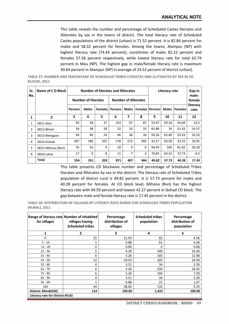
ANALYTICAL NOTE
DISTRICTCENSUSHANDBOOK:BHIND49
This table reveals the number and percentage of Scheduled Castes literates and illiterates by sex in the towns of district. The total literacy rate of Scheduled Castes populations of the district (urban) is 71.52 percent. It is 82.84 percent for males and 58.32 percent for females. Among the towns, Alampur (NP) with highest literacy rate (74.43 percent), constitutes of males 82.22 percent and females 57.58 percent respectively, while lowest literacy rate for total 62.74 percent in Mau (NP). The highest gap in male/female literacy rate is maximum 30.64 percent in Alampur (NP) in average of 24.52 percent of district (urban).
TABLE 27: NUMBER AND PERCENTAGE OF SCHEDULED TRIBES LITERATES AND ILLITERATES BY SEX IN CD BLOCKS, 2011
Sr. No.
Name of C D Block Number of literates and illiterates Literacy rate Gap in male-
female literacy
rate
Number of literates Number of illiterates
Persons Males Females Persons Males Females Persons Males Females
1 2 3 4 5 6 7 8 9 10 11 12
1 0011-Ater 95 58 37 154 67 87 53.07 59.18 45.68 13.5
2 0012-Bhind 56 38 18 52 20 32 65.88 76 51.43 24.57
3 0013-Mehgaon 64 40 24 66 36 30 59.26 63.49 53.33 10.16
4 0014-Gohad 287 180 107 578 273 305 42.27 50.28 33.33 16.95
5 0015-Mihona (Ron) 35 26 9 10 4 6 94.59 100 81.82 18.18
6 0016-Lahar 17 9 8 11 7 4 70.83 69.23 72.73 -3.5
Total 554 351 203 871 407 464 49.82 57.73 40.28 17.45
This table presents CD blockwise number and percentage of Scheduled Tribes literates and illiterates by sex in the district. The literacy rate of Scheduled Tribes population of district rural is 49.82 percent. It is 57.73 percent for males and 40.28 percent for females. At CD block level, Mihona (Ron) has the highest literacy rate with 94.59 percent and lowest 42.27 percent in Gohad CD block. The gap between male and female literacy rate is 17.45 percent in the district.
TABLE 28: DISTRIBUTION OF VILLAGES BY LITERACY RATE RANGE FOR SCHEDULED TRIBES POPULATION (RURAL), 2011
Range of literacy rate for villages
Number of inhabited villages having
Scheduled tribes
Percentage distribution of
villages
Scheduled tribes population
Percentage distribution of
population
1 2 3 4 5 0 25 21.93 65 4.56
1 - 10 1 0.88 61 4.28 11 - 20 0 0.00 0 0.0021 - 30 5 4.39 349 24.4931 - 40 6 5.26 185 12.9841 - 50 12 10.53 205 14.3951 - 60 4 3.51 34 2.3961 - 70 6 5.26 234 16.4271 - 80 6 5.26 104 7.3081 - 90 4 3.51 34 2.3991 - 99 1 0.88 21 1.47
100 44 38.60 133 9.33District: Bhind(420) 114 100.00 1,425 100.00Literacy rate for District:49.82
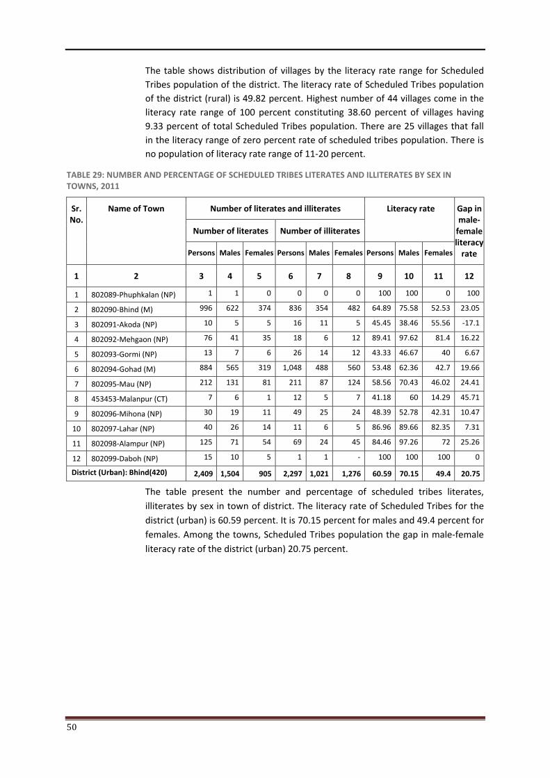
50
The table shows distribution of villages by the literacy rate range for Scheduled Tribes population of the district. The literacy rate of Scheduled Tribes population of the district (rural) is 49.82 percent. Highest number of 44 villages come in the literacy rate range of 100 percent constituting 38.60 percent of villages having 9.33 percent of total Scheduled Tribes population. There are 25 villages that fall in the literacy range of zero percent rate of scheduled tribes population. There is no population of literacy rate range of 11-20 percent.
TABLE 29: NUMBER AND PERCENTAGE OF SCHEDULED TRIBES LITERATES AND ILLITERATES BY SEX IN TOWNS, 2011
Sr. No.
Name of Town Number of literates and illiterates Literacy rate Gap in male-
female literacy
rate
Number of literates Number of illiterates
Persons Males Females Persons Males Females Persons Males Females
1 2 3 4 5 6 7 8 9 10 11 12
1 802089-Phuphkalan (NP) 1 1 0 0 0 0 100 100 0 100
2 802090-Bhind (M) 996 622 374 836 354 482 64.89 75.58 52.53 23.05
3 802091-Akoda (NP) 10 5 5 16 11 5 45.45 38.46 55.56 -17.1
4 802092-Mehgaon (NP) 76 41 35 18 6 12 89.41 97.62 81.4 16.22
5 802093-Gormi (NP) 13 7 6 26 14 12 43.33 46.67 40 6.67
6 802094-Gohad (M) 884 565 319 1,048 488 560 53.48 62.36 42.7 19.66
7 802095-Mau (NP) 212 131 81 211 87 124 58.56 70.43 46.02 24.41
8 453453-Malanpur (CT) 7 6 1 12 5 7 41.18 60 14.29 45.71
9 802096-Mihona (NP) 30 19 11 49 25 24 48.39 52.78 42.31 10.47
10 802097-Lahar (NP) 40 26 14 11 6 5 86.96 89.66 82.35 7.31
11 802098-Alampur (NP) 125 71 54 69 24 45 84.46 97.26 72 25.26
12 802099-Daboh (NP) 15 10 5 1 1 - 100 100 100 0
District (Urban): Bhind(420) 2,409 1,504 905 2,297 1,021 1,276 60.59 70.15 49.4 20.75
The table present the number and percentage of scheduled tribes literates, illiterates by sex in town of district. The literacy rate of Scheduled Tribes for the district (urban) is 60.59 percent. It is 70.15 percent for males and 49.4 percent for females. Among the towns, Scheduled Tribes population the gap in male-female literacy rate of the district (urban) 20.75 percent.
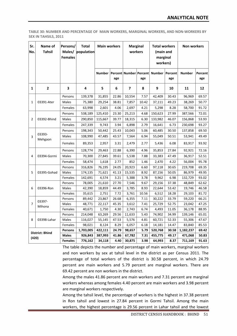
ANALYTICAL NOTE
DISTRICTCENSUSHANDBOOK:BHIND51
TABLE 30: NUMBER AND PERCENTAGE OF MAIN WORKERS, MARGINAL WORKERS, AND NON-WORKERS BY SEX IN TAHSILS, 2011
Sr. No.
Name of Tahsil
Persons/ Males/
Females
Total population
Main workers Marginal workers
Total workers (main and marginal workers)
Non workers
Number Percentage
Number Percentage
Number Percent age
Number Percentage
1 2 3 4 5 6 7 8 9 10 11 12
1 03391-Ater
Persons 139,378 31,855 22.86 10,554 7.57 42,409 30.43 96,969 69.57
Males 75,380 29,254 38.81 7,857 10.42 37,111 49.23 38,269 50.77
Females 63,998 2,601 4.06 2,697 4.21 5,298 8.28 58,700 91.72
2 03392-Bhind
Persons 538,189 125,410 23.30 25,213 4.68 150,623 27.99 387,566 72.01
Males 290,850 115,667 39.77 18,315 6.30 133,982 46.07 156,868 53.93
Females 247,339 9,743 3.94 6,898 2.79 16,641 6.73 230,698 93.27
3 03393-Mehgaon
Persons 198,343 50,442 25.43 10,043 5.06 60,485 30.50 137,858 69.50
Males 108,990 47,485 43.57 7,564 6.94 55,049 50.51 53,941 49.49
Females 89,353 2,957 3.31 2,479 2.77 5,436 6.08 83,917 93.92
4 03394-Gormi
Persons 128,774 29,463 22.88 6,390 4.96 35,853 27.84 92,921 72.16
Males 70,300 27,845 39.61 5,538 7.88 33,383 47.49 36,917 52.51
Females 58,474 1,618 2.77 852 1.46 2,470 4.22 56,004 95.78
5 03395-Gohad
Persons 316,826 76,195 24.05 20,923 6.60 97,118 30.65 219,708 69.35
Males 174,135 71,621 41.13 15,535 8.92 87,156 50.05 86,979 49.95
Females 142,691 4,574 3.21 5,388 3.78 9,962 6.98 132,729 93.02
6 03396-Ron
Persons 78,005 21,610 27.70 7,546 9.67 29,156 37.38 48,849 62.62
Males 42,390 18,859 44.49 3,785 8.93 22,644 53.42 19,746 46.58
Females 35,615 2,751 7.72 3,761 10.56 6,512 18.28 29,103 81.72
7 03397-Mihona
Persons 89,442 23,867 26.68 6,355 7.11 30,222 33.79 59,220 66.21
Males 48,771 22,117 45.35 3,612 7.41 25,729 52.75 23,042 47.25
Females 40,671 1,750 4.30 2,743 6.74 4,493 11.05 36,178 88.95
8 03398-Lahar
Persons 214,048 63,269 29.56 11,633 5.43 74,902 34.99 139,146 65.01
Males 116,027 55,145 47.53 5,576 4.81 60,721 52.33 55,306 47.67
Females 98,021 8,124 8.29 6,057 6.18 14,181 14.47 83,840 85.53
District: Bhind (420)
Persons 1,703,005 422,111 24.79 98,657 5.79 520,768 30.58 1,182,237 69.42
Males 926,843 387,993 41.86 67,782 7.31 455,775 49.17 471,068 50.83
Females 776,162 34,118 4.40 30,875 3.98 64,993 8.37 711,169 91.63
The table depicts the number and percentage of main workers, marginal workers and non workers by sex at tahsil level in the district as per Census 2011. The percentage of total workers of the district is 30.58 percent, in which 24.79 percent are main workers and 5.79 percent are marginal workers. There are 69.42 percent are non workers in the district. Among the males 41.86 percent are main workers and 7.31 percent are marginal workers whereas among females 4.40 percent are main workers and 3.98 percent are marginal workers respectively. Among the tahsil level, the percentage of workers is the highest in 37.38 percent in Ron tahsil and lowest in 27.84 percent in Gormi Tahsil. Among the main workers, the highest percentage is 29.56 percent in Lahar tahsil and the lowest
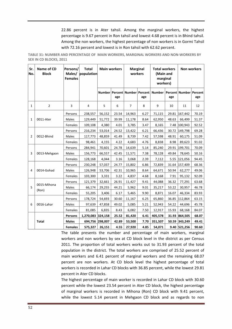
52
22.86 percent is in Ater tahsil. Among the marginal workers, the highest percentage is 9.67 percent in Ron tahsil and lowest 4.68 percent is in Bhind tahsil. Among the non workers, the highest percentage of non workers is in Gormi Tahsil with 72.16 percent and lowest is in Ron tahsil with 62.62 percent.
TABLE 31: NUMBER AND PERCENTAGE OF MAIN WORKERS, MARGINAL WORKERS AND NON-WORKERS BY SEX IN CD BLOCKS, 2011
Sr. No.
Name of CD Block
Persons/ Males/
Females
Total population
Main workers Marginal workers
Total workers (Main and marginal workers)
Non workers
Number Percentage
Number Percentage
Number Percent age
Number Percentage
1 2 3 4 5 6 7 8 9 10 11 12
1 0011-Ater
Persons 238,557 56,152 23.54 14,963 6.27 71,115 29.81 167,442 70.19
Males 129,449 51,772 39.99 11,178 8.64 62,950 48.63 66,499 51.37
Females 109,108 4,380 4.01 3,785 3.47 8,165 7.48 100,943 92.52
2 0012-Bhind
Persons 216,234 53,014 24.52 13,422 6.21 66,436 30.72 149,798 69.28
Males 117,773 48,859 41.49 8,739 7.42 57,598 48.91 60,175 51.09
Females 98,461 4,155 4.22 4,683 4.76 8,838 8.98 89,623 91.02
3 0013-Mehgaon
Persons 284,941 70,601 24.78 14,639 5.14 85,240 29.91 199,701 70.09
Males 156,773 66,557 42.45 11,571 7.38 78,128 49.84 78,645 50.16
Females 128,168 4,044 3.16 3,068 2.39 7,112 5.55 121,056 94.45
4 0014-Gohad
Persons 230,248 57,037 24.77 15,802 6.86 72,839 31.64 157,409 68.36
Males 126,948 53,706 42.31 10,965 8.64 64,671 50.94 62,277 49.06
Females 103,300 3,331 3.22 4,837 4.68 8,168 7.91 95,132 92.09
5 0015-Mihona
(Ron)
Persons 121,379 32,661 26.91 11,427 9.41 44,088 36.32 77,291 63.68
Males 66,174 29,255 44.21 5,962 9.01 35,217 53.22 30,957 46.78
Females 55,205 3,406 6.17 5,465 9.90 8,871 16.07 46,334 83.93
6 0016-Lahar
Persons 178,724 54,693 30.60 11,167 6.25 65,860 36.85 112,864 63.15
Males 97,639 47,858 49.02 5,085 5.21 52,943 54.22 44,696 45.78
Females 81,085 6,835 8.43 6,082 7.50 12,917 15.93 68,168 84.07
Total
Persons 1,270,083 324,158 25.52 81,420 6.41 405,578 31.93 864,505 68.07
Males 694,756 298,007 42.89 53,500 7.70 351,507 50.59 343,249 49.41
Females 575,327 26,151 4.55 27,920 4.85 54,071 9.40 521,256 90.60
The table presents the number and percentage of main workers, marginal workers and non workers by sex at CD block level in the district as per Census 2011. The proportion of total workers works out to 31.93 percent of the total population in the district. The total workers are comprised of 25.52 percent of main workers and 6.41 percent of marginal workers and the remaining 68.07 percent are non workers. At CD block level the highest percentage of total workers is recorded in Lahar CD blocks with 36.85 percent, while the lowest 29.81 percent in Ater CD blocks. The highest percentage of main worker is recorded in Lahar CD block with 30.60 percent while the lowest 23.54 percent in Ater CD block, the highest percentage of marginal workers is recorded in Mihona (Ron) CD block with 9.41 percent, while the lowest 5.14 percent in Mehgaon CD block and as regards to non
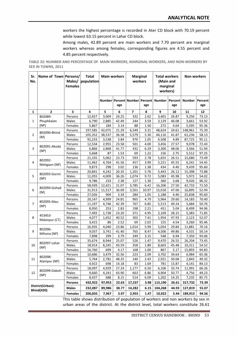
ANALYTICAL NOTE
DISTRICTCENSUSHANDBOOK:BHIND53
workers the highest percentage is recorded in Ater CD block with 70.19 percent while lowest 63.15 percent in Lahar CD block. Among males, 42.89 percent are main workers and 7.70 percent are marginal workers whereas among females, corresponding figures are 4.55 percent and 4.85 percent respectively.
TABLE 32: NUMBER AND PERCENTAGE OF MAIN WORKERS, MARGINAL WORKERS, AND NON-WORKERS BY SEX IN TOWNS, 2011
Sr. No.
Name of Town Persons/ Males/
Females
Total population
Main workers Marginal workers
Total workers (Main and marginal workers)
Non workers
Number Percentage
Number Percentage
Number Percent age
Number Percentage
1 2 3 4 5 6 7 8 9 10 11 12
1 802089-Phuphkalan (NP)
Persons 12,657 3,069 24.25 332 2.62 3,401 26.87 9,256 73.13Males 6,790 2,885 42.49 244 3.59 3,129 46.08 3,661 53.92Females 5,867 184 3.14 88 1.50 272 4.64 5,595 95.36
2 802090-Bhind (M)
Persons 197,585 42,075 21.29 6,549 3.31 48,624 24.61 148,961 75.39Males 105,352 38,537 36.58 5,579 5.30 44,116 41.87 61,236 58.13Females 92,233 3,538 3.84 970 1.05 4,508 4.89 87,725 95.11
3 802091-Akoda (NP)
Persons 12,534 2,955 23.58 501 4.00 3,456 27.57 9,078 72.43Males 6,866 2,868 41.77 432 6.29 3,300 48.06 3,566 51.94Females 5,668 87 1.53 69 1.22 156 2.75 5,512 97.25
4 802092-Mehgaon (NP)
Persons 21,335 5,062 23.73 593 2.78 5,655 26.51 15,680 73.49Males 11,462 4,764 41.56 457 3.99 5,221 45.55 6,241 54.45Females 9,873 298 3.02 136 1.38 434 4.40 9,439 95.60
5 802093-Gormi (NP)
Persons 20,841 4,242 20.35 1,201 5.76 5,443 26.12 15,398 73.88Males 11,055 4,009 36.26 1,074 9.72 5,083 45.98 5,972 54.02Females 9,786 233 2.38 127 1.30 360 3.68 9,426 96.32
6 802094-Gohad (M)
Persons 58,939 12,421 21.07 3,785 6.42 16,206 27.50 42,733 72.50Males 31,913 11,517 36.09 3,501 10.97 15,018 47.06 16,895 52.94Females 27,026 904 3.34 284 1.05 1,188 4.40 25,838 95.60
7 802095-Mau (NP)
Persons 20,147 4,999 24.81 965 4.79 5,964 29.60 14,183 70.40Males 11,197 4,746 42.39 767 6.85 5,513 49.24 5,684 50.76Females 8,950 253 2.83 198 2.21 451 5.04 8,499 94.96
8 453453-Malanpur (CT)
Persons 7,492 1,738 23.20 371 4.95 2,109 28.15 5,383 71.85Males 4,077 1,652 40.52 302 7.41 1,954 47.93 2,123 52.07Females 3,415 86 2.52 69 2.02 155 4.54 3,260 95.46
9 802096-Mihona (NP)
Persons 16,935 4,040 23.86 1,014 5.99 5,054 29.84 11,881 70.16Males 9,037 3,741 41.40 765 8.47 4,506 49.86 4,531 50.14Females 7,898 299 3.79 249 3.15 548 6.94 7,350 93.06
10 802097-Lahar (NP)
Persons 35,674 8,944 25.07 526 1.47 9,470 26.55 26,204 73.45Males 18,914 8,245 43.59 358 1.89 8,603 45.48 10,311 54.52Females 16,760 699 4.17 168 1.00 867 5.17 15,893 94.83
11 802098-Alampur (NP)
Persons 10,686 3,479 32.56 223 2.09 3,702 34.64 6,984 65.36Males 5,764 2,781 48.25 140 2.43 2,921 50.68 2,843 49.32Females 4,922 698 14.18 83 1.69 781 15.87 4,141 84.13
12 802099-Daboh (NP)
Persons 18,097 4,929 27.24 1,177 6.50 6,106 33.74 11,991 66.26Males 9,660 4,241 43.90 663 6.86 4,904 50.77 4,756 49.23Females 8,437 688 8.15 514 6.09 1,202 14.25 7,235 85.75
District(Urban): Bhind(420)
Persons 432,922 97,953 22.63 17,237 3.98 115,190 26.61 317,732 73.39
Males 232,087 89,986 38.77 14,282 6.15 104,268 44.93 127,819 55.07
Females 200,835 7,967 3.97 2,955 1.47 10,922 5.44 189,913 94.56
This table shows distribution of population of workers and non workers by sex in urban areas of the district. At the district level, total workers constitute 26.61
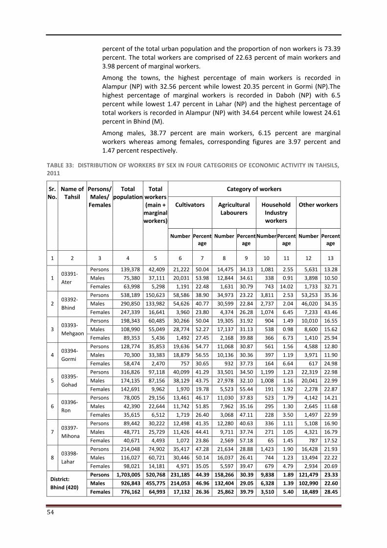
54
percent of the total urban population and the proportion of non workers is 73.39 percent. The total workers are comprised of 22.63 percent of main workers and 3.98 percent of marginal workers.
Among the towns, the highest percentage of main workers is recorded in Alampur (NP) with 32.56 percent while lowest 20.35 percent in Gormi (NP).The highest percentage of marginal workers is recorded in Daboh (NP) with 6.5 percent while lowest 1.47 percent in Lahar (NP) and the highest percentage of total workers is recorded in Alampur (NP) with 34.64 percent while lowest 24.61 percent in Bhind (M).
Among males, 38.77 percent are main workers, 6.15 percent are marginal workers whereas among females, corresponding figures are 3.97 percent and 1.47 percent respectively.
TABLE 33: DISTRIBUTION OF WORKERS BY SEX IN FOUR CATEGORIES OF ECONOMIC ACTIVITY IN TAHSILS,2011
Sr. No.
Name of Tahsil
Persons/ Males/
Females
Total population
Total workers (main +
marginal workers)
Category of workers
Cultivators
Agricultural Labourers
Household Industry workers
Other workers
Number Percentage
Number Percentage
Number Percent age
Number Percentage
1 2 3 4 5 6 7 8 9 10 11 12 13
1 03391-Ater
Persons 139,378 42,409 21,222 50.04 14,475 34.13 1,081 2.55 5,631 13.28
Males 75,380 37,111 20,031 53.98 12,844 34.61 338 0.91 3,898 10.50
Females 63,998 5,298 1,191 22.48 1,631 30.79 743 14.02 1,733 32.71
2 03392-Bhind
Persons 538,189 150,623 58,586 38.90 34,973 23.22 3,811 2.53 53,253 35.36
Males 290,850 133,982 54,626 40.77 30,599 22.84 2,737 2.04 46,020 34.35
Females 247,339 16,641 3,960 23.80 4,374 26.28 1,074 6.45 7,233 43.46
3 03393-Mehgaon
Persons 198,343 60,485 30,266 50.04 19,305 31.92 904 1.49 10,010 16.55
Males 108,990 55,049 28,774 52.27 17,137 31.13 538 0.98 8,600 15.62
Females 89,353 5,436 1,492 27.45 2,168 39.88 366 6.73 1,410 25.94
4 03394-Gormi
Persons 128,774 35,853 19,636 54.77 11,068 30.87 561 1.56 4,588 12.80
Males 70,300 33,383 18,879 56.55 10,136 30.36 397 1.19 3,971 11.90
Females 58,474 2,470 757 30.65 932 37.73 164 6.64 617 24.98
5 03395-Gohad
Persons 316,826 97,118 40,099 41.29 33,501 34.50 1,199 1.23 22,319 22.98
Males 174,135 87,156 38,129 43.75 27,978 32.10 1,008 1.16 20,041 22.99
Females 142,691 9,962 1,970 19.78 5,523 55.44 191 1.92 2,278 22.87
6 03396-Ron
Persons 78,005 29,156 13,461 46.17 11,030 37.83 523 1.79 4,142 14.21
Males 42,390 22,644 11,742 51.85 7,962 35.16 295 1.30 2,645 11.68
Females 35,615 6,512 1,719 26.40 3,068 47.11 228 3.50 1,497 22.99
7 03397-Mihona
Persons 89,442 30,222 12,498 41.35 12,280 40.63 336 1.11 5,108 16.90
Males 48,771 25,729 11,426 44.41 9,711 37.74 271 1.05 4,321 16.79
Females 40,671 4,493 1,072 23.86 2,569 57.18 65 1.45 787 17.52
8 03398-Lahar
Persons 214,048 74,902 35,417 47.28 21,634 28.88 1,423 1.90 16,428 21.93
Males 116,027 60,721 30,446 50.14 16,037 26.41 744 1.23 13,494 22.22
Females 98,021 14,181 4,971 35.05 5,597 39.47 679 4.79 2,934 20.69
District: Bhind (420)
Persons 1,703,005 520,768 231,185 44.39 158,266 30.39 9,838 1.89 121,479 23.33
Males 926,843 455,775 214,053 46.96 132,404 29.05 6,328 1.39 102,990 22.60
Females 776,162 64,993 17,132 26.36 25,862 39.79 3,510 5.40 18,489 28.45
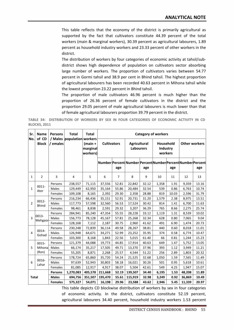
ANALYTICAL NOTE
DISTRICTCENSUSHANDBOOK:BHIND55
This table reflects that the economy of the district is primarily agricultural as supported by the fact that cultivators constitute 44.39 percent of the total workers (main & marginal workers), 30.39 percent as agricultural labourers, 1.89 percent as household industry workers and 23.33 percent of other workers in the district. The distribution of workers by four categories of economic activity at tahsil/sub-district shows high dependence of population on cultivators sector absorbing large number of workers. The proportion of cultivators varies between 54.77 percent in Gormi tahsil and 38.9 per cent in Bhind tahsil. The highest proportion of agricultural labourers has been recorded 40.63 percent in Mihona tahsil while the lowest proportion 23.22 percent in Bhind tahsil. The proportion of male cultivators 46.96 percent is much higher than the proportion of 26.36 percent of female cultivators in the district and the proportion 29.05 percent of male agricultural labourers is much lower than that of female agricultural labourers proportion 39.79 percent in the district.
TABLE 34: DISTRIBUTION OF WORKERS BY SEX IN FOUR CATEGORIES OF ECONOMIC ACTIVITY IN CD BLOCKS, 2011
Sr. No.
Name of CD Block
Persons / Males / emales
Total population
Total workers (main +
marginal workers)
Category of workers
Cultivators
Agricultural Labourers
Household Industry workers
Other workers
Number Percentage
Number Percentage
Number Percent age
Number Percentage
1 2 3 4 5 6 7 8 9 10 11 12 13
1 0011-Ater
Persons 238,557 71,115 37,556 52.81 22,842 32.12 1,358 1.91 9,359 13.16Males 129,449 62,950 35,164 55.86 20,484 32.54 539 0.86 6,763 10.74Females 109,108 8,165 2,392 29.30 2,358 28.88 819 10.03 2,596 31.79
2 0012-Bhind
Persons 216,234 66,436 35,151 52.91 20,731 31.20 1,579 2.38 8,975 13.51Males 117,773 57,598 32,560 56.53 17,524 30.42 814 1.41 6,700 11.63Females 98,461 8,838 2,591 29.32 3,207 36.29 765 8.66 2,275 25.74
3 0013-Mehgaon
Persons 284,941 85,240 47,354 55.55 28,228 33.12 1,119 1.31 8,539 10.02Males 156,773 78,128 45,167 57.81 25,268 32.34 628 0.80 7,065 9.04Females 128,168 7,112 2,187 30.75 2,960 41.62 491 6.90 1,474 20.73
4 0014-Gohad
Persons 230,248 72,839 36,114 49.58 28,267 38.81 440 0.60 8,018 11.01Males 126,948 64,671 34,271 52.99 23,252 35.95 374 0.58 6,774 10.47Females 103,300 8,168 1,843 22.56 5,015 61.40 66 0.81 1,244 15.23
5 0015-Mihona (Ron)
Persons 121,379 44,088 19,773 44.85 17,914 40.63 649 1.47 5,752 13.05Males 66,174 35,217 17,505 49.71 13,370 37.96 393 1.12 3,949 11.21Females 55,205 8,871 2,268 25.57 4,544 51.22 256 2.89 1,803 20.32
6 0016-Lahar
Persons 178,724 65,860 35,720 54.24 21,525 32.68 1,050 1.59 7,565 11.49Males 97,639 52,943 30,803 58.18 16,021 30.26 501 0.95 5,618 10.61Females 81,085 12,917 4,917 38.07 5,504 42.61 549 4.25 1,947 15.07
Total Persons 1,270,083 405,578 211,668 52.19 139,507 34.40 6,195 1.53 48,208 11.89Males 694,756 351,507 195,470 55.61 115,919 32.98 3,249 0.92 36,869 10.49Females 575,327 54,071 16,198 29.96 23,588 43.62 2,946 5.45 11,339 20.97
This table depicts CD blockwise distribution of workers by sex in four categories of economic activity. In the district, cultivators constitute 52.19 percent, agricultural labourers 34.40 percent, household industry workers 1.53 percent
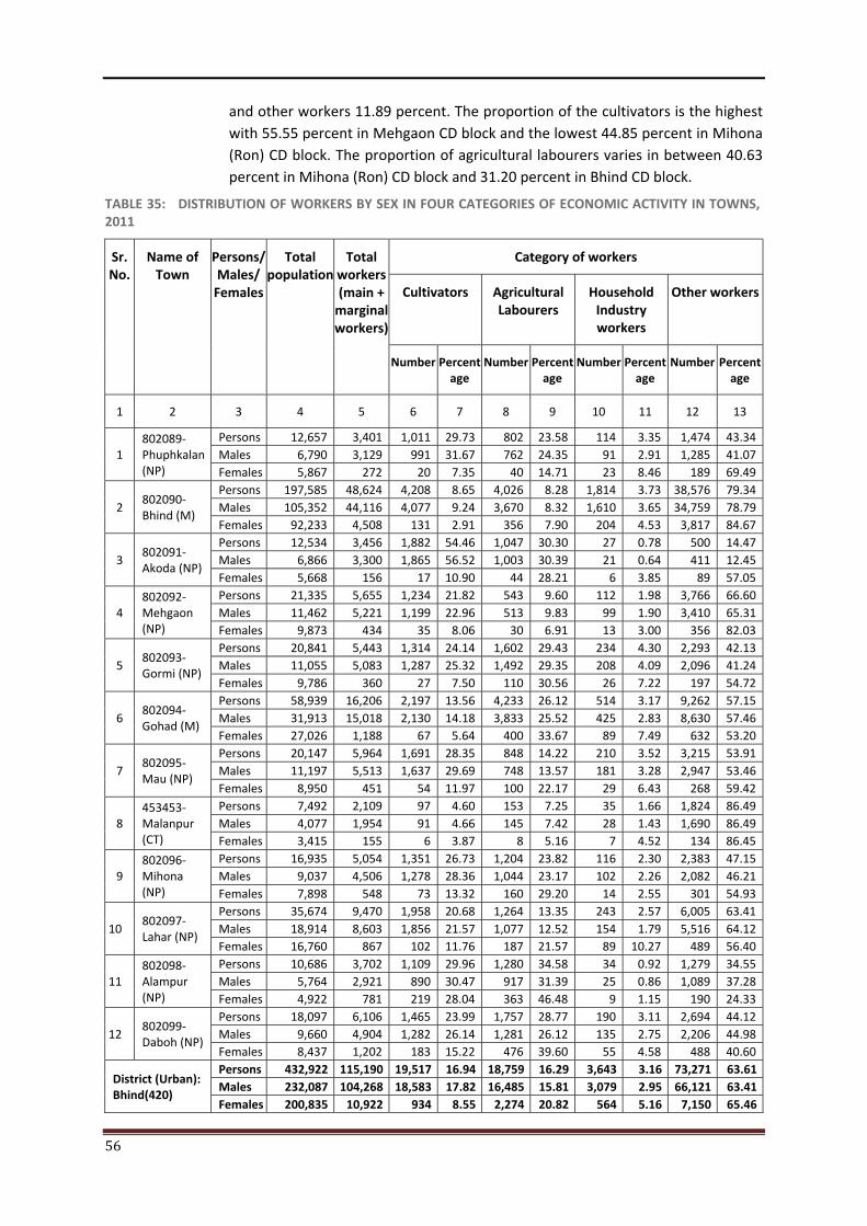
56
and other workers 11.89 percent. The proportion of the cultivators is the highest with 55.55 percent in Mehgaon CD block and the lowest 44.85 percent in Mihona (Ron) CD block. The proportion of agricultural labourers varies in between 40.63 percent in Mihona (Ron) CD block and 31.20 percent in Bhind CD block.
TABLE 35: DISTRIBUTION OF WORKERS BY SEX IN FOUR CATEGORIES OF ECONOMIC ACTIVITY IN TOWNS, 2011
Sr. No.
Name of Town
Persons/ Males/
Females
Total population
Total workers (main +
marginal workers)
Category of workers
Cultivators
Agricultural Labourers
Household Industry workers
Other workers
Number Percentage
Number Percentage
Number Percent age
Number Percentage
1 2 3 4 5 6 7 8 9 10 11 12 13
1 802089-Phuphkalan (NP)
Persons 12,657 3,401 1,011 29.73 802 23.58 114 3.35 1,474 43.34Males 6,790 3,129 991 31.67 762 24.35 91 2.91 1,285 41.07Females 5,867 272 20 7.35 40 14.71 23 8.46 189 69.49
2 802090-Bhind (M)
Persons 197,585 48,624 4,208 8.65 4,026 8.28 1,814 3.73 38,576 79.34Males 105,352 44,116 4,077 9.24 3,670 8.32 1,610 3.65 34,759 78.79Females 92,233 4,508 131 2.91 356 7.90 204 4.53 3,817 84.67
3 802091-Akoda (NP)
Persons 12,534 3,456 1,882 54.46 1,047 30.30 27 0.78 500 14.47Males 6,866 3,300 1,865 56.52 1,003 30.39 21 0.64 411 12.45Females 5,668 156 17 10.90 44 28.21 6 3.85 89 57.05
4 802092-Mehgaon (NP)
Persons 21,335 5,655 1,234 21.82 543 9.60 112 1.98 3,766 66.60Males 11,462 5,221 1,199 22.96 513 9.83 99 1.90 3,410 65.31Females 9,873 434 35 8.06 30 6.91 13 3.00 356 82.03
5 802093-Gormi (NP)
Persons 20,841 5,443 1,314 24.14 1,602 29.43 234 4.30 2,293 42.13Males 11,055 5,083 1,287 25.32 1,492 29.35 208 4.09 2,096 41.24Females 9,786 360 27 7.50 110 30.56 26 7.22 197 54.72
6 802094-Gohad (M)
Persons 58,939 16,206 2,197 13.56 4,233 26.12 514 3.17 9,262 57.15Males 31,913 15,018 2,130 14.18 3,833 25.52 425 2.83 8,630 57.46Females 27,026 1,188 67 5.64 400 33.67 89 7.49 632 53.20
7 802095-Mau (NP)
Persons 20,147 5,964 1,691 28.35 848 14.22 210 3.52 3,215 53.91Males 11,197 5,513 1,637 29.69 748 13.57 181 3.28 2,947 53.46Females 8,950 451 54 11.97 100 22.17 29 6.43 268 59.42
8 453453-Malanpur (CT)
Persons 7,492 2,109 97 4.60 153 7.25 35 1.66 1,824 86.49Males 4,077 1,954 91 4.66 145 7.42 28 1.43 1,690 86.49Females 3,415 155 6 3.87 8 5.16 7 4.52 134 86.45
9 802096-Mihona (NP)
Persons 16,935 5,054 1,351 26.73 1,204 23.82 116 2.30 2,383 47.15Males 9,037 4,506 1,278 28.36 1,044 23.17 102 2.26 2,082 46.21Females 7,898 548 73 13.32 160 29.20 14 2.55 301 54.93
10 802097-Lahar (NP)
Persons 35,674 9,470 1,958 20.68 1,264 13.35 243 2.57 6,005 63.41Males 18,914 8,603 1,856 21.57 1,077 12.52 154 1.79 5,516 64.12Females 16,760 867 102 11.76 187 21.57 89 10.27 489 56.40
11 802098-Alampur (NP)
Persons 10,686 3,702 1,109 29.96 1,280 34.58 34 0.92 1,279 34.55Males 5,764 2,921 890 30.47 917 31.39 25 0.86 1,089 37.28Females 4,922 781 219 28.04 363 46.48 9 1.15 190 24.33
12 802099-Daboh (NP)
Persons 18,097 6,106 1,465 23.99 1,757 28.77 190 3.11 2,694 44.12Males 9,660 4,904 1,282 26.14 1,281 26.12 135 2.75 2,206 44.98Females 8,437 1,202 183 15.22 476 39.60 55 4.58 488 40.60
District (Urban): Bhind(420)
Persons 432,922 115,190 19,517 16.94 18,759 16.29 3,643 3.16 73,271 63.61Males 232,087 104,268 18,583 17.82 16,485 15.81 3,079 2.95 66,121 63.41Females 200,835 10,922 934 8.55 2,274 20.82 564 5.16 7,150 65.46
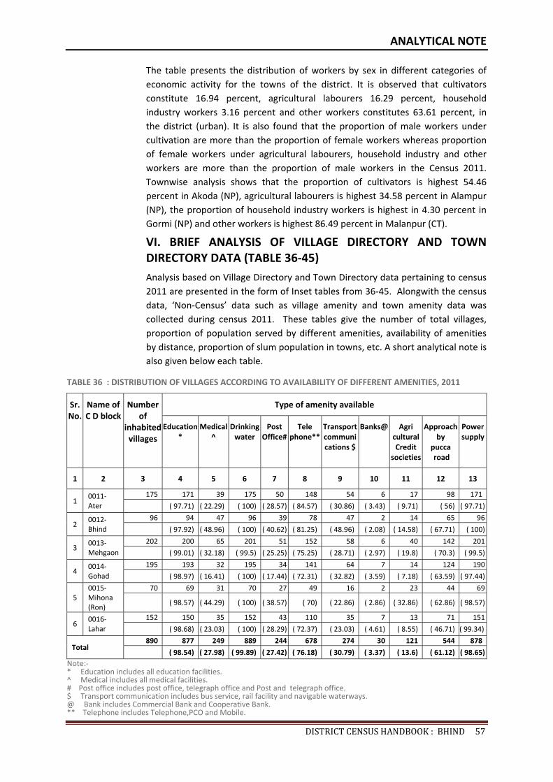
ANALYTICAL NOTE
DISTRICTCENSUSHANDBOOK:BHIND57
The table presents the distribution of workers by sex in different categories of economic activity for the towns of the district. It is observed that cultivators constitute 16.94 percent, agricultural labourers 16.29 percent, household industry workers 3.16 percent and other workers constitutes 63.61 percent, in the district (urban). It is also found that the proportion of male workers under cultivation are more than the proportion of female workers whereas proportion of female workers under agricultural labourers, household industry and other workers are more than the proportion of male workers in the Census 2011. Townwise analysis shows that the proportion of cultivators is highest 54.46 percent in Akoda (NP), agricultural labourers is highest 34.58 percent in Alampur (NP), the proportion of household industry workers is highest in 4.30 percent in Gormi (NP) and other workers is highest 86.49 percent in Malanpur (CT).
VI. BRIEF ANALYSIS OF VILLAGE DIRECTORY AND TOWN DIRECTORY DATA (TABLE 36-45)
Analysis based on Village Directory and Town Directory data pertaining to census 2011 are presented in the form of Inset tables from 36-45. Alongwith the census data, ‘Non-Census’ data such as village amenity and town amenity data was collected during census 2011. These tables give the number of total villages, proportion of population served by different amenities, availability of amenities by distance, proportion of slum population in towns, etc. A short analytical note is also given below each table.
TABLE 36 : DISTRIBUTION OF VILLAGES ACCORDING TO AVAILABILITY OF DIFFERENT AMENITIES, 2011
Sr. No.
Name of C D block
Number of
inhabited villages
Type of amenity available
Education *
Medical ^
Drinking water
Post Office#
Tele phone**
Transport communications $
Banks@ Agri cultural Credit
societies
Approach by
pucca road
Power supply
1 2 3 4 5 6 7 8 9 10 11 12 13
1 0011-Ater
175 171 39 175 50 148 54 6 17 98 171
( 97.71) ( 22.29) ( 100) ( 28.57) ( 84.57) ( 30.86) ( 3.43) ( 9.71) ( 56) ( 97.71)
2 0012-Bhind
96 94 47 96 39 78 47 2 14 65 96
( 97.92) ( 48.96) ( 100) ( 40.62) ( 81.25) ( 48.96) ( 2.08) ( 14.58) ( 67.71) ( 100)
3 0013-Mehgaon
202 200 65 201 51 152 58 6 40 142 201
( 99.01) ( 32.18) ( 99.5) ( 25.25) ( 75.25) ( 28.71) ( 2.97) ( 19.8) ( 70.3) ( 99.5)
4 0014-Gohad
195 193 32 195 34 141 64 7 14 124 190
( 98.97) ( 16.41) ( 100) ( 17.44) ( 72.31) ( 32.82) ( 3.59) ( 7.18) ( 63.59) ( 97.44)
5 0015-Mihona (Ron)
70 69 31 70 27 49 16 2 23 44 69
( 98.57) ( 44.29) ( 100) ( 38.57) ( 70) ( 22.86) ( 2.86) ( 32.86) ( 62.86) ( 98.57)
6 0016-Lahar
152 150 35 152 43 110 35 7 13 71 151
( 98.68) ( 23.03) ( 100) ( 28.29) ( 72.37) ( 23.03) ( 4.61) ( 8.55) ( 46.71) ( 99.34)
Total 890 877 249 889 244 678 274 30 121 544 878
( 98.54) ( 27.98) ( 99.89) ( 27.42) ( 76.18) ( 30.79) ( 3.37) ( 13.6) ( 61.12) ( 98.65)Note:- * Education includes all education facilities. ^ Medical includes all medical facilities. # Post office includes post office, telegraph office and Post and telegraph office. $ Transport communication includes bus service, rail facility and navigable waterways. @ Bank includes Commercial Bank and Cooperative Bank. ** Telephone includes Telephone,PCO and Mobile.
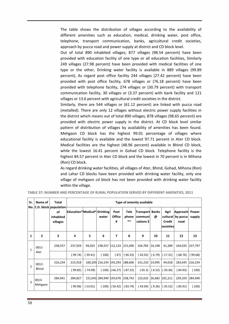
58
The table shows the distribution of villages according to the availability of different amenities such as education, medical, drinking water, post office, telephone, transport communication, banks, agricultural credit societies, approach by pucca road and power supply at district and CD block level. Out of total 890 inhabited villages; 877 villages (98.54 percent) have been provided with education facility of one type or all education facilities, Similarly 249 villages (27.98 percent) have been provided with medical facilities of one type or the other, Drinking water facility is available in 889 villages (99.89 percent), As regard post office facility 244 villages (27.42 percent) have been provided with post office facility, 678 villages or (76.18 percent) have been provided with telephone facility, 274 villages or (30.79 percent) with transport communication facility, 30 villages or (3.37 percent) with bank facility and 121 villages or 13.6 percent with agricultural credit societies in the district. Similarly, there are 544 villages or (61.12 percent) are linked with pucca road (metalled). There are only 12 villages without electric power supply facilities in the district which means out of total 890 villages, 878 villages (98.65 percent) are provided with electric power supply in the district. At CD block level similar pattern of distribution of villages by availability of amenities has been found. Mehgaon CD block has the highest 99.01 percentage of villages where educational facility is available and the lowest 97.71 percent in Ater CD block. Medical facilities are the highest (48.96 percent) available in Bhind CD block, while the lowest 16.41 percent in Gohad CD block. Telephone facility is the highest 84.57 percent in Ater CD block and the lowest in 70 percent is in Mihona (Ron) CD block. As regard drinking water facilities, all villages of Ater, Bhind, Gohad, Mihona (Ron) and Lahar CD blocks have been provided with drinking water facility, only one village of mehgaon cd block has not been provided with drinking water facility within the village.
TABLE 37: NUMBER AND PERCENTAGE OF RURAL POPULATION SERVED BY DIFFERENT AMENITIES, 2011
Sr. No.
Name of C.D. block
Total population
of inhabited
villages
Type of amenity available
Education*
Medical^
Drinking water
Post Office
#
Tele phone
**
Transport communi cations $
Banks@
Agri cultural Credit
societies
Approach by pucca
road
Power supply
1 2 3 4 5 6 7 8 9 10 11 12 13
1 0011-Ater
238,557 237,929 94,025 238,557 112,133 215,490 104,783 16,198 41,289 164,035 237,797
( 99.74) ( 39.41) ( 100) ( 47) ( 90.33) ( 43.92) ( 6.79) ( 17.31) ( 68.76) ( 99.68)
2 0012-Bhind
216,234 215,918 160,205 216,234 143,293 188,606 141,210 14,095 44,018 183,645 216,234
( 99.85) ( 74.09) ( 100) ( 66.27) ( 87.22) ( 65.3) ( 6.52) ( 20.36) ( 84.93) ( 100)
3 0013-Mehgaon
284,941 284,827 151,041 284,940 143,676 238,742 122,632 26,682 101,211 239,103 284,940
( 99.96) ( 53.01) ( 100) ( 50.42) ( 83.79) ( 43.04) ( 9.36) ( 35.52) ( 83.91) ( 100)

ANALYTICAL NOTE
DISTRICTCENSUSHANDBOOK:BHIND59
TABLE 37: NUMBER AND PERCENTAGE OF RURAL POPULATION SERVED BY DIFFERENT AMENITIES, 2011
Sr. No.
Name of C.D. block
Total population
of inhabited
villages
Type of amenity available
Education*
Medical^
Drinking water
Post Office
#
Tele phone
**
Transport communi cations $
Banks@
Agri cultural Credit
societies
Approach by pucca
road
Power supply
1 2 3 4 5 6 7 8 9 10 11 12 13
4 0014-Gohad
230,248 230,150 69,134 230,248 78,899 175,282 111,222 20,609 29,228 175,249 229,308
( 99.96) ( 30.03) ( 100) ( 34.27) ( 76.13) ( 48.31) ( 8.95) ( 12.69) ( 76.11) ( 99.59)
5 0015-Mihona (Ron)
121,379 121,344 79,266 121,379 74,520 97,347 54,906 17,598 42,566 90,638 121,303
( 99.97) ( 65.3) ( 100) ( 61.39) ( 80.2) ( 45.24) ( 14.5) ( 35.07) ( 74.67) ( 99.94)
6 0016-Lahar
178,724 178,522 70,541 178,724 82,058 143,500 56,722 15,083 29,355 108,660 178,483
( 99.89) ( 39.47) ( 100) ( 45.91) ( 80.29) ( 31.74) ( 8.44) ( 16.42) ( 60.8) ( 99.87)
Total 1,270,083 1,268,690 624,212 1,270,082 634,579 1,058,967 591,475 110,265 287,667 961,330 1,268,065
( 99.89) ( 49.15) ( 100) (49.96) ( 83.38) ( 46.57) ( 8.68) ( 22.65) ( 75.69) ( 99.84)
Note:- * Education includes all education facilities. ^ Medical includes all medical facilities. # Post office includes post office, telegraph office and Post and telegraph office. $ Transport communication includes bus service, rail facility and navigable waterways. @ Bank includes Commercial Bank and Cooperative Bank. ** Telephone includes Telephone,PCO and Mobile.
The table presents the number and proportion of rural population served by different amenities. Out of total rural population 12,70,083 persons in the district; 99.89 percent have educational facility of one or other type, similarly 49.15 percent population has medical facilities while 100 percent have improved drinking water facility, post office facilities are available to 49.96 percent population, telephone facility is available to 83.38 percent, transport communication facility is available to 46.57 percent, 8.68 percent have been provided with bank facility, 22.65 percent with agricultural credit societies, 75.69 percent with approach by pucca road, power supply is available to 99.84 percent rural population in the district. Similar pattern of availability of facilities is visible to the rural population in different CD blocks.
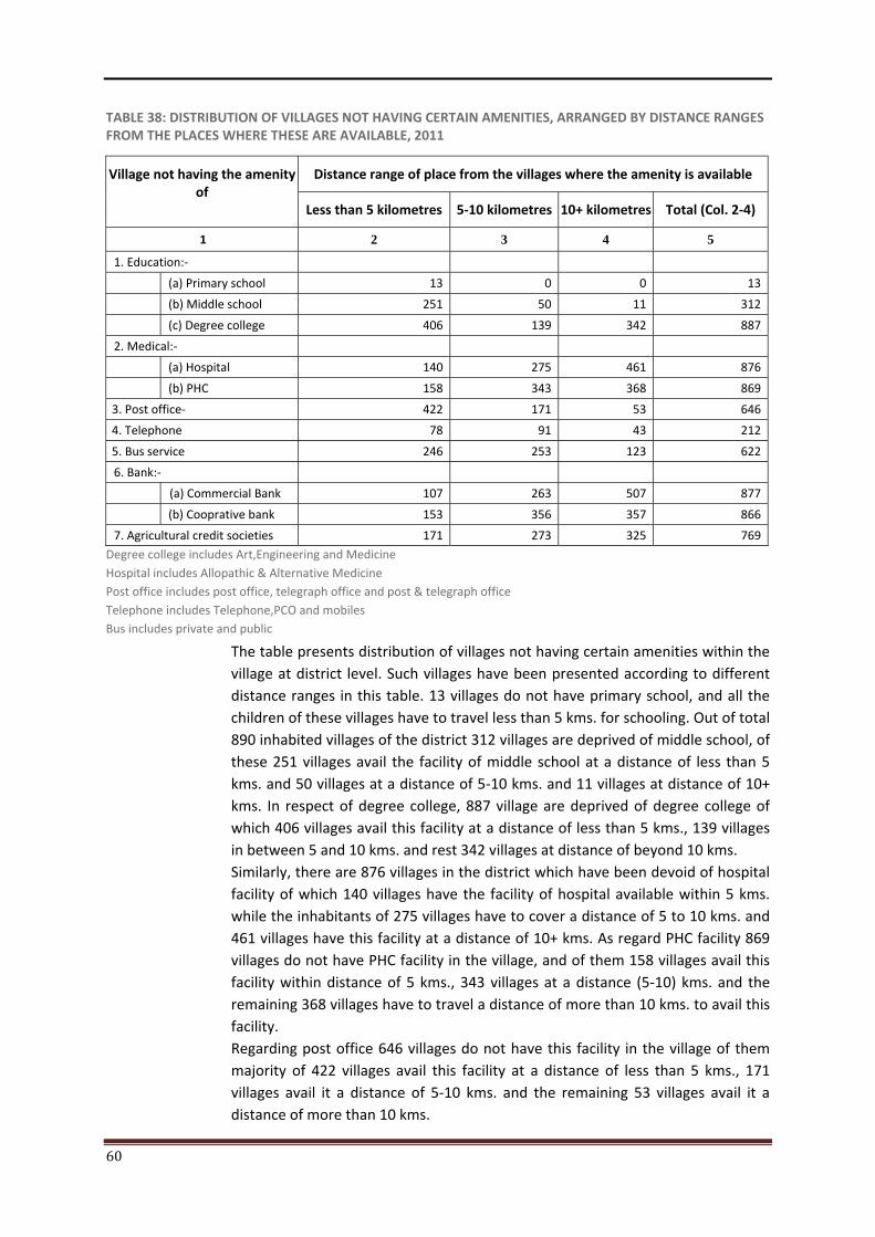
60
TABLE 38: DISTRIBUTION OF VILLAGES NOT HAVING CERTAIN AMENITIES, ARRANGED BY DISTANCE RANGES FROM THE PLACES WHERE THESE ARE AVAILABLE, 2011
Village not having the amenity of
Distance range of place from the villages where the amenity is available
Less than 5 kilometres 5-10 kilometres 10+ kilometres Total (Col. 2-4)
1 2 3 4 5
1. Education:- (a) Primary school 13 0 0 13
(b) Middle school 251 50 11 312
(c) Degree college 406 139 342 887
2. Medical:- (a) Hospital 140 275 461 876
(b) PHC 158 343 368 869
3. Post office- 422 171 53 646
4. Telephone 78 91 43 212
5. Bus service 246 253 123 622
6. Bank:- (a) Commercial Bank 107 263 507 877
(b) Cooprative bank 153 356 357 866
7. Agricultural credit societies 171 273 325 769
Degree college includes Art,Engineering and Medicine Hospital includes Allopathic & Alternative Medicine Post office includes post office, telegraph office and post & telegraph office Telephone includes Telephone,PCO and mobiles Bus includes private and public
The table presents distribution of villages not having certain amenities within the village at district level. Such villages have been presented according to different distance ranges in this table. 13 villages do not have primary school, and all the children of these villages have to travel less than 5 kms. for schooling. Out of total 890 inhabited villages of the district 312 villages are deprived of middle school, of these 251 villages avail the facility of middle school at a distance of less than 5 kms. and 50 villages at a distance of 5-10 kms. and 11 villages at distance of 10+ kms. In respect of degree college, 887 village are deprived of degree college of which 406 villages avail this facility at a distance of less than 5 kms., 139 villages in between 5 and 10 kms. and rest 342 villages at distance of beyond 10 kms. Similarly, there are 876 villages in the district which have been devoid of hospital facility of which 140 villages have the facility of hospital available within 5 kms. while the inhabitants of 275 villages have to cover a distance of 5 to 10 kms. and 461 villages have this facility at a distance of 10+ kms. As regard PHC facility 869 villages do not have PHC facility in the village, and of them 158 villages avail this facility within distance of 5 kms., 343 villages at a distance (5-10) kms. and the remaining 368 villages have to travel a distance of more than 10 kms. to avail this facility. Regarding post office 646 villages do not have this facility in the village of them majority of 422 villages avail this facility at a distance of less than 5 kms., 171 villages avail it a distance of 5-10 kms. and the remaining 53 villages avail it a distance of more than 10 kms.
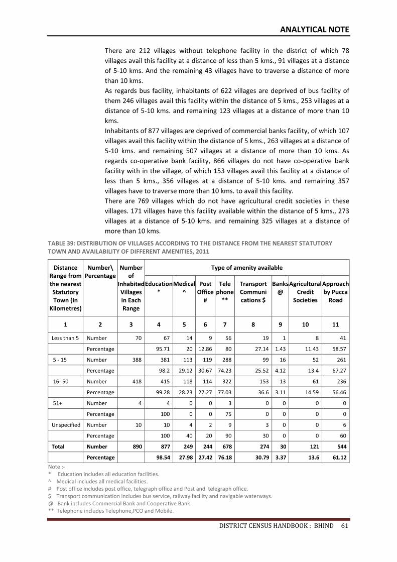
ANALYTICAL NOTE
DISTRICTCENSUSHANDBOOK:BHIND61
There are 212 villages without telephone facility in the district of which 78 villages avail this facility at a distance of less than 5 kms., 91 villages at a distance of 5-10 kms. And the remaining 43 villages have to traverse a distance of more than 10 kms. As regards bus facility, inhabitants of 622 villages are deprived of bus facility of them 246 villages avail this facility within the distance of 5 kms., 253 villages at a distance of 5-10 kms. and remaining 123 villages at a distance of more than 10 kms. Inhabitants of 877 villages are deprived of commercial banks facility, of which 107 villages avail this facility within the distance of 5 kms., 263 villages at a distance of 5-10 kms. and remaining 507 villages at a distance of more than 10 kms. As regards co-operative bank facility, 866 villages do not have co-operative bank facility with in the village, of which 153 villages avail this facility at a distance of less than 5 kms., 356 villages at a distance of 5-10 kms. and remaining 357 villages have to traverse more than 10 kms. to avail this facility. There are 769 villages which do not have agricultural credit societies in these villages. 171 villages have this facility available within the distance of 5 kms., 273 villages at a distance of 5-10 kms. and remaining 325 villages at a distance of more than 10 kms.
TABLE 39: DISTRIBUTION OF VILLAGES ACCORDING TO THE DISTANCE FROM THE NEAREST STATUTORY TOWN AND AVAILABILITY OF DIFFERENT AMENITIES, 2011
Distance Range from the nearest Statutory Town (In
Kilometres)
Number\ Percentage
Number of
Inhabited Villages in Each Range
Type of amenity available
Education*
Medical^
Post Office
#
Telephone
**
Transport Communications $
Banks @
Agricultural Credit
Societies
Approach by Pucca
Road
1 2 3 4 5 6 7 8 9 10 11
Less than 5 Number 70 67 14 9 56 19 1 8 41
Percentage 95.71 20 12.86 80 27.14 1.43 11.43 58.57
5 - 15 Number 388 381 113 119 288 99 16 52 261
Percentage 98.2 29.12 30.67 74.23 25.52 4.12 13.4 67.27
16- 50 Number 418 415 118 114 322 153 13 61 236
Percentage 99.28 28.23 27.27 77.03 36.6 3.11 14.59 56.46
51+ Number 4 4 0 0 3 0 0 0 0
Percentage 100 0 0 75 0 0 0 0
Unspecified Number 10 10 4 2 9 3 0 0 6
Percentage 100 40 20 90 30 0 0 60
Total Number 890 877 249 244 678 274 30 121 544
Percentage 98.54 27.98 27.42 76.18 30.79 3.37 13.6 61.12
Note :- * Education includes all education facilities. ^ Medical includes all medical facilities. # Post office includes post office, telegraph office and Post and telegraph office. $ Transport communication includes bus service, railway facility and navigable waterways. @ Bank includes Commercial Bank and Cooperative Bank. ** Telephone includes Telephone,PCO and Mobile.
62
The table deals with distribution of villages according to the distance from the nearest statutory towns and availability of different amenities within the village. Out of total 890 inhabited villages in the district, there are 70 villages which have nearest town upto a distance of less than 5 kms., of these 67 villages forming 95.71 percent of total villages, are having the educational facilities of atleast one type or the other type and 14 villages constituting 20 percent have the medical facilities within the range of 5 kms., 9 villages forming 12.86 percent have the facility of post office within the range of 5 kms., 56 villages 80 percent have the facility of telephone under the distance of 5 kms., 19 villages constituting 27.14 percent have been linked by transport service, one village forming 1.43 percent have been provided with agricultural credit societies and 41 villages 58.57 percent have been linked with pucca road (metalled) within the distance of 5 kms. There are 388 inhabited villages in the district which fall in the distance range of 5-15 kms. Under this distance range, 381 villages (98.2 percent) have been provided with education facilities, 113 villages (29.12 percent) are provided with medical facilities, 119 villages (30.67 percent) enjoy the post office facility, 288 villages (74.23 percent) have been provided with telephone facility. 99 villages (25.52 percent) have been linked with transport communication, 16 villages (4.12%) have bank facility. 52 villages (13.42 percent) are having agricultural credit societies while 261 villages or (67.27 percent) are approachable by pucca road. 418 inhabited villages come under the distance range of 16-50 kms. in the district. In this distance range 415 villages (99.28 percent) have education facility, 118 villages (28.23 percent) with medical, 114 villages (27.27 percent) with post office, 322 villages (77.03 percent) with telephone, 153 villages (36.6 percent) are linked with transport communication, 13 villages (3.11 percent) with banks, 61 villages (14.59 percent) are having agricultural credit societies and 236 villages (56.46 percent) are approachable by pucca road. There are only 4 villages in the district, which fall in the distance range of 51+ kms. All 4 villages (100 percent) under this distance range have been provided with education and 3 villages (75 percent) have been provided with telephone facility. There is no facilities of medical, post office, transport communication, banks and agricultural credit societies. None of these villages are approachable by pucca road.
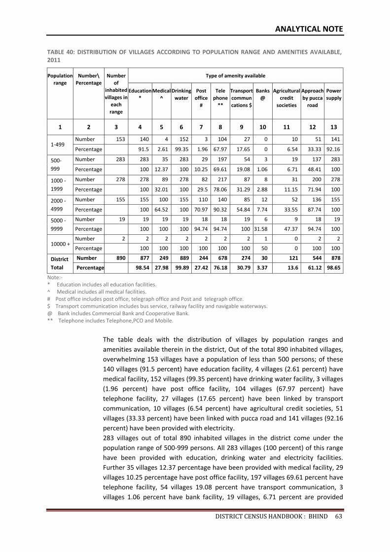
ANALYTICAL NOTE
DISTRICTCENSUSHANDBOOK:BHIND63
TABLE 40: DISTRIBUTION OF VILLAGES ACCORDING TO POPULATION RANGE AND AMENITIES AVAILABLE, 2011
Population range
Number\ Percentage
Number of
inhabited villages in
each range
Type of amenity available
Education *
Medical^
Drinking water
Post office
#
Telephone
**
Transportcommuncations $
Banks@
Agricultural credit
societies
Approach by pucca
road
Power supply
1 2 3 4 5 6 7 8 9 10 11 12 13
1-499 Number 153 140 4 152 3 104 27 0 10 51 141
Percentage 91.5 2.61 99.35 1.96 67.97 17.65 0 6.54 33.33 92.16
500-999
Number 283 283 35 283 29 197 54 3 19 137 283
Percentage 100 12.37 100 10.25 69.61 19.08 1.06 6.71 48.41 100
1000 - 1999
Number 278 278 89 278 82 217 87 8 31 200 278
Percentage 100 32.01 100 29.5 78.06 31.29 2.88 11.15 71.94 100
2000 - 4999
Number 155 155 100 155 110 140 85 12 52 136 155
Percentage 100 64.52 100 70.97 90.32 54.84 7.74 33.55 87.74 100
5000 - 9999
Number 19 19 19 19 18 18 19 6 9 18 19
Percentage 100 100 100 94.74 94.74 100 31.58 47.37 94.74 100
10000 + Number 2 2 2 2 2 2 2 1 0 2 2
Percentage 100 100 100 100 100 100 50 0 100 100
District Total
Number 890 877 249 889 244 678 274 30 121 544 878
Percentage 98.54 27.98 99.89 27.42 76.18 30.79 3.37 13.6 61.12 98.65
Note:- * Education includes all education facilities. ^ Medical includes all medical facilities. # Post office includes post office, telegraph office and Post and telegraph office. $ Transport communication includes bus service, railway facility and navigable waterways. @ Bank includes Commercial Bank and Cooperative Bank. ** Telephone includes Telephone,PCO and Mobile.
The table deals with the distribution of villages by population ranges and amenities available therein in the district, Out of the total 890 inhabited villages, overwhelming 153 villages have a population of less than 500 persons; of these 140 villages (91.5 percent) have education facility, 4 villages (2.61 percent) have medical facility, 152 villages (99.35 percent) have drinking water facility, 3 villages (1.96 percent) have post office facility, 104 villages (67.97 percent) have telephone facility, 27 villages (17.65 percent) have been linked by transport communication, 10 villages (6.54 percent) have agricultural credit societies, 51 villages (33.33 percent) have been linked with pucca road and 141 villages (92.16 percent) have been provided with electricity. 283 villages out of total 890 inhabited villages in the district come under the population range of 500-999 persons. All 283 villages (100 percent) of this range have been provided with education, drinking water and electricity facilities. Further 35 villages 12.37 percentage have been provided with medical facility, 29 villages 10.25 percentage have post office facility, 197 villages 69.61 percent have telephone facility, 54 villages 19.08 percent have transport communication, 3 villages 1.06 percent have bank facility, 19 villages, 6.71 percent are provided
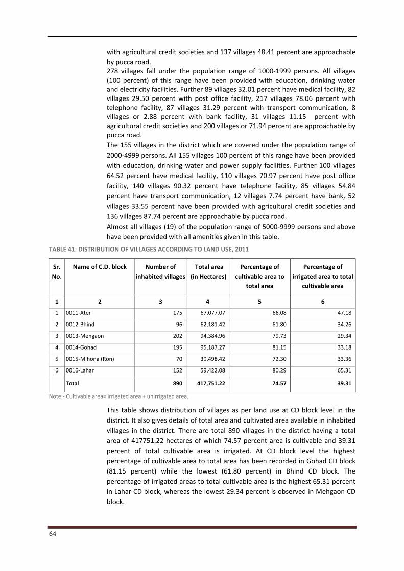
64
with agricultural credit societies and 137 villages 48.41 percent are approachable by pucca road. 278 villages fall under the population range of 1000-1999 persons. All villages (100 percent) of this range have been provided with education, drinking water and electricity facilities. Further 89 villages 32.01 percent have medical facility, 82 villages 29.50 percent with post office facility, 217 villages 78.06 percent with telephone facility, 87 villages 31.29 percent with transport communication, 8 villages or 2.88 percent with bank facility, 31 villages 11.15 percent with agricultural credit societies and 200 villages or 71.94 percent are approachable by pucca road. The 155 villages in the district which are covered under the population range of 2000-4999 persons. All 155 villages 100 percent of this range have been provided with education, drinking water and power supply facilities. Further 100 villages 64.52 percent have medical facility, 110 villages 70.97 percent have post office facility, 140 villages 90.32 percent have telephone facility, 85 villages 54.84 percent have transport communication, 12 villages 7.74 percent have bank, 52 villages 33.55 percent have been provided with agricultural credit societies and 136 villages 87.74 percent are approachable by pucca road. Almost all villages (19) of the population range of 5000-9999 persons and above have been provided with all amenities given in this table.
TABLE 41: DISTRIBUTION OF VILLAGES ACCORDING TO LAND USE, 2011
Sr. No.
Name of C.D. block Number of inhabited villages
Total area (in Hectares)
Percentage of cultivable area to
total area
Percentage of irrigated area to total
cultivable area
1 2 3 4 5 6
1 0011-Ater 175 67,077.07 66.08 47.18
2 0012-Bhind 96 62,181.42 61.80 34.26
3 0013-Mehgaon 202 94,384.96 79.73 29.34
4 0014-Gohad 195 95,187.27 81.15 33.18
5 0015-Mihona (Ron) 70 39,498.42 72.30 33.36
6 0016-Lahar 152 59,422.08 80.29 65.31
Total 890 417,751.22 74.57 39.31
Note:- Cultivable area= irrigated area + unirrigated area.
This table shows distribution of villages as per land use at CD block level in the district. It also gives details of total area and cultivated area available in inhabited villages in the district. There are total 890 villages in the district having a total area of 417751.22 hectares of which 74.57 percent area is cultivable and 39.31 percent of total cultivable area is irrigated. At CD block level the highest percentage of cultivable area to total area has been recorded in Gohad CD block (81.15 percent) while the lowest (61.80 percent) in Bhind CD block. The percentage of irrigated areas to total cultivable area is the highest 65.31 percent in Lahar CD block, whereas the lowest 29.34 percent is observed in Mehgaon CD block.
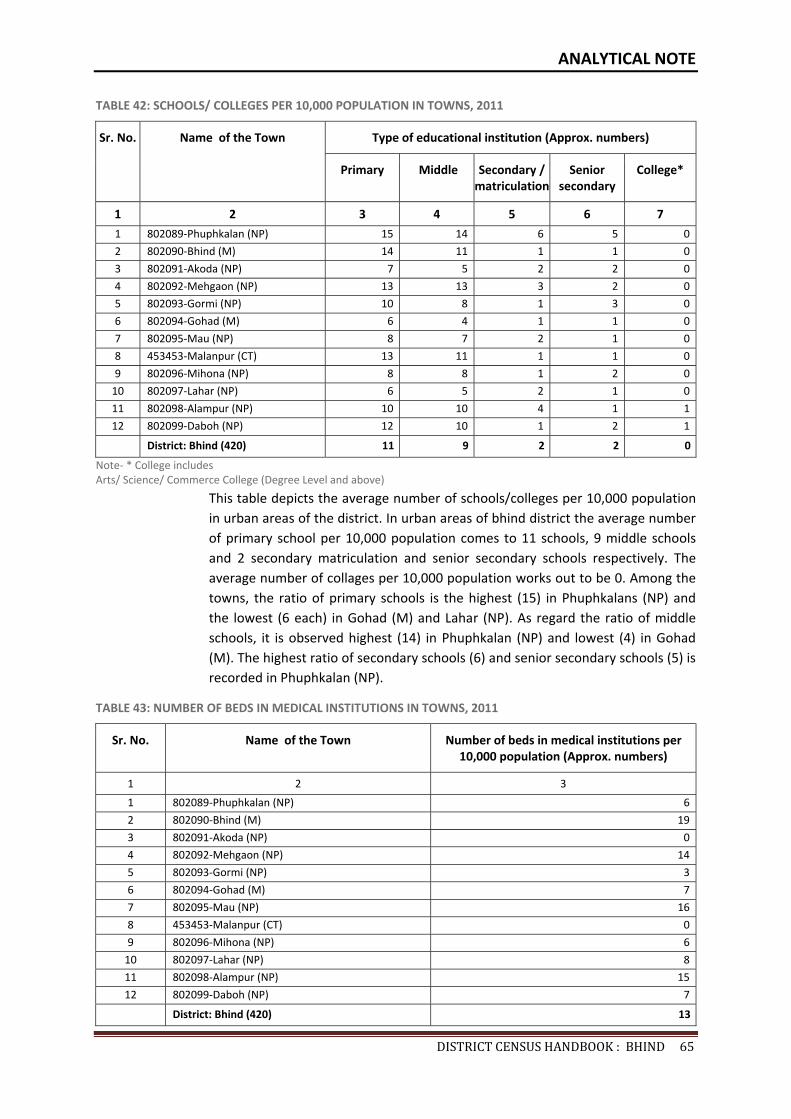
ANALYTICAL NOTE
DISTRICTCENSUSHANDBOOK:BHIND65
TABLE 42: SCHOOLS/ COLLEGES PER 10,000 POPULATION IN TOWNS, 2011
Sr. No. Name of the Town Type of educational institution (Approx. numbers)
Primary Middle Secondary / matriculation
Senior secondary
College*
1 2 3 4 5 6 7
1 802089-Phuphkalan (NP) 15 14 6 5 0
2 802090-Bhind (M) 14 11 1 1 0
3 802091-Akoda (NP) 7 5 2 2 0
4 802092-Mehgaon (NP) 13 13 3 2 0
5 802093-Gormi (NP) 10 8 1 3 0
6 802094-Gohad (M) 6 4 1 1 0
7 802095-Mau (NP) 8 7 2 1 0
8 453453-Malanpur (CT) 13 11 1 1 0
9 802096-Mihona (NP) 8 8 1 2 0
10 802097-Lahar (NP) 6 5 2 1 0
11 802098-Alampur (NP) 10 10 4 1 1
12 802099-Daboh (NP) 12 10 1 2 1
District: Bhind (420) 11 9 2 2 0
Note- * College includes Arts/ Science/ Commerce College (Degree Level and above)
This table depicts the average number of schools/colleges per 10,000 population in urban areas of the district. In urban areas of bhind district the average number of primary school per 10,000 population comes to 11 schools, 9 middle schools and 2 secondary matriculation and senior secondary schools respectively. The average number of collages per 10,000 population works out to be 0. Among the towns, the ratio of primary schools is the highest (15) in Phuphkalans (NP) and the lowest (6 each) in Gohad (M) and Lahar (NP). As regard the ratio of middle schools, it is observed highest (14) in Phuphkalan (NP) and lowest (4) in Gohad (M). The highest ratio of secondary schools (6) and senior secondary schools (5) is recorded in Phuphkalan (NP).
TABLE 43: NUMBER OF BEDS IN MEDICAL INSTITUTIONS IN TOWNS, 2011
Sr. No. Name of the Town Number of beds in medical institutions per 10,000 population (Approx. numbers)
1 2 3
1 802089-Phuphkalan (NP) 6
2 802090-Bhind (M) 19
3 802091-Akoda (NP) 0
4 802092-Mehgaon (NP) 14
5 802093-Gormi (NP) 3
6 802094-Gohad (M) 7
7 802095-Mau (NP) 16
8 453453-Malanpur (CT) 0
9 802096-Mihona (NP) 6
10 802097-Lahar (NP) 8
11 802098-Alampur (NP) 15
12 802099-Daboh (NP) 7
District: Bhind (420) 13
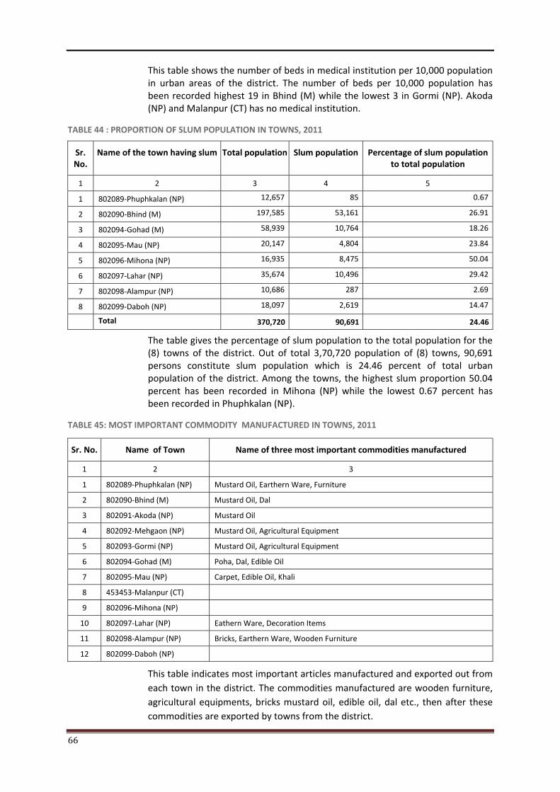
66
This table shows the number of beds in medical institution per 10,000 population in urban areas of the district. The number of beds per 10,000 population has been recorded highest 19 in Bhind (M) while the lowest 3 in Gormi (NP). Akoda (NP) and Malanpur (CT) has no medical institution.
TABLE 44 : PROPORTION OF SLUM POPULATION IN TOWNS, 2011
Sr. No.
Name of the town having slum
Total population Slum population Percentage of slum population to total population
1 2 3 4 5
1 802089-Phuphkalan (NP) 12,657 85 0.67
2 802090-Bhind (M) 197,585 53,161 26.91
3 802094-Gohad (M) 58,939 10,764 18.26
4 802095-Mau (NP) 20,147 4,804 23.84
5 802096-Mihona (NP) 16,935 8,475 50.04
6 802097-Lahar (NP) 35,674 10,496 29.42
7 802098-Alampur (NP) 10,686 287 2.69
8 802099-Daboh (NP) 18,097 2,619 14.47
Total 370,720 90,691 24.46
The table gives the percentage of slum population to the total population for the (8) towns of the district. Out of total 3,70,720 population of (8) towns, 90,691 persons constitute slum population which is 24.46 percent of total urban population of the district. Among the towns, the highest slum proportion 50.04 percent has been recorded in Mihona (NP) while the lowest 0.67 percent has been recorded in Phuphkalan (NP).
TABLE 45: MOST IMPORTANT COMMODITY MANUFACTURED IN TOWNS, 2011
Sr. No. Name of Town Name of three most important commodities manufactured
1 2 3
1 802089-Phuphkalan (NP) Mustard Oil, Earthern Ware, Furniture
2 802090-Bhind (M) Mustard Oil, Dal
3 802091-Akoda (NP) Mustard Oil
4 802092-Mehgaon (NP) Mustard Oil, Agricultural Equipment
5 802093-Gormi (NP) Mustard Oil, Agricultural Equipment
6 802094-Gohad (M) Poha, Dal, Edible Oil
7 802095-Mau (NP) Carpet, Edible Oil, Khali
8 453453-Malanpur (CT) 9 802096-Mihona (NP)
10 802097-Lahar (NP) Eathern Ware, Decoration Items
11 802098-Alampur (NP) Bricks, Earthern Ware, Wooden Furniture
12 802099-Daboh (NP)
This table indicates most important articles manufactured and exported out from each town in the district. The commodities manufactured are wooden furniture, agricultural equipments, bricks mustard oil, edible oil, dal etc., then after these commodities are exported by towns from the district.
ANALYTICAL NOTE
DISTRICTCENSUSHANDBOOK:BHIND67
VII. MAJOR SOCIAL AND CULTURAL EVENTS, NATURAL AND ADMINISTRATIVE DEVELOPMENTS AND SIGNIFICANT ACTIVITIES DURING THE DECADE.
Gormi tahsil was created from Mehgaon tahsil vide Madhya Pradesh Government Notification No. F-1-59-08-VII-Sec.-6 Dt. 16.09.2009.
VIII. BRIEF DESCRIPTION OF PLACES OF RELIGIOUS. HISTORICAL OR ARCHAEOLOGICAL IMPORTANCE AND PLACES OF TOURIST INTEREST IN VILLAGES AND TOWNS OF THE DISTRICT PLACES OF TOURISM
AMAHA
A village of Lahar tahsil, Amaha is situated about 3.2 km south east of Daboh on the southern side of the road to Kunch. According to local legand, the village along with the nearby fort of Sirsagarh or Sarsi on the Pating were owned by the famous Banaphar hero Malkhan. A step well said to be of his time still exist in the village. There is an old temple of goddess Renuka said to be of the time of Alha and Udal, the famous Banaphar generals of Paramardideva.
ATER
It is a large village of a tahsil headquarters of the same name located on the southern bank of Chambal and to the north-west of Bhind. An old fort exists near the village in the midst of rugged ravines over looking the Chambal. According to Tieffenthalar, who visited these areas in the third quarter of 18th century, it was inaccessible. Traces of another fortified enclosure outside the walls are also seen.
BARASO
A village of Mehgaon tahsil, Baraso is about 18 km. to the north of tahsil headquarters. The village is a Jain pilgrim centre and many devotees from outside congregate to worship at a big old Jain temple of this village.
BHIND
The headquarter town of district, Bhind is situated on the Gwalior – Etawah road at a distance of about 83 kms from Gwalior. A fort said to be of the time of Prithviraj Chauhan still exist. The town contains several old temples, one of which, enshrining Mahadeva and Hanuman is attributed to Bhind Rishi where he went into deep meditation. In the Nasiya area of the town, there is a famous Jain temple enshrining the first Jain Tirthankar Adinath.
BIRGAWAN SIMAR
A village of Mehgaon tahsil, Birgawan is situated about 21 km to the south-west of Bhind on the bank of Besli river known for its religious sanctity having an old temple of Kamaleshwar Mahadev, in whose honour an annual fair is held in the village during Shivratri.
68
DABOH
A large village of Lahar tahsil, Daboh is situated on the Bhind – Bhander road at a distance of about 24 km from its tahsil headquarters. Close to the village there is a tank known as Kardhen Talao with its masonry ghats built by the Bundelas. Not a single frog can be traced in it. There is also an old temple of Goddess, said to be belonging the period of Alha and Udal. Annual religious fair meets near the tank during February/March. An old Kolhu or stone sugar press, bearing the date samwat 1699 [A.D. 1642] still exists in the village.
GOHAD
Located at a distance of about 6 km from Bhind – Gwalior road and connected by a branch road, Gohad, a tahsil headqtarter of the same name was formerly included in the Tonwargarh district. The place is surrounded by three partial ruins of a fort buit by the Jat chief Rana Bhim Singh in A.D. 1739.The fort has some fine carvings and glass mural decorations in Rajput style.
INDRUKHI
A large and old village of Lahar tahsil, Indrukhi is 40 km from Bhind and 11 km from Bhind-Bhander road. There are about 12 ruined gates and a ruined temple of Goddess built by local ruling families. The village also contains the remains of a small fort with the citadel made of brick giving a picturesque sight.
JATIPURA MARI
A large village of Lahar tahsil, Jaitpura Mari lies about 13 km north of its tahasil headquarter. The village contains an old fort, old temple and two small tanks indicating their antiquity.
LAHAR
Formely a Pargana headquarters, Lahar, the headquarters town of the tahsil of the same name is situated on the Bhind – Bhander road at a distance of about 44.8 km. to the south of Bhind town. It was believed that once there was an old temple known as Dhokawala Mahal, of the time of Korkas which was set on fire and burnt. An annual Nawa – Durga mela is held in the village during the months of March/April for thirteen days in honour of Mangaladevi or Navadurga Goddess near the village.
PAWAJEE
A village of Bhind tahsil, Pawajee is located on the Bhind Pawai road, at a distance of about 20 km from district headquarters. The village contains an old temple dedicated to Goddess Pawai Devi. A large number of artistic old structures are also found.
SARSAI
Formerly a village of Bhander Pargana, an old village Sarsai of Bhind tahsil is situated on the bank of river Pahuj. The village contains a ruined irregular pentagonal brick fort, built in Maratha style. Within the fort there are a few
ANALYTICAL NOTE
DISTRICTCENSUSHANDBOOK:BHIND69
mounds, one of which contains the usual cloisters with Nicha and Mehrab of mosque. Some Hindu temples seem to have been existed there.
IX. MAJOR CHARACTERISTICS OF THE DISTRICT, CONTRIBUTION OF THE DISTRICT IN THE FORM OF ANY HISTORICAL FIGURES ASSOCIATED WITH THE DISTRICT
The district is basically an agriculture based area. The role of freedom fighters are important in all round development of the district. They are Shri Bateshwaridayal Sharma, Shri Ramchandra Chowdhry, Shri Lal Shrivastava, Shri Mangal Singh, Shri Phoolchand Lohiya, Shri Rambabu, Shri Prabhudayal, Shri Ramswaroop, Shri Brijendra Singh, Shri Kishan Chandra Shastri etc.
MAIN FAIRS
(1) An annual fair held for eight days at Nasiya area of Bhind in honour of Tirthankar Adinath in October-November is managed by the local municipal committee.
(2) A religious fair is held in Daboh near the tank during February-March.
(3) At Lahar, an annual Nava Durga Mela is held in March-April for thirteen days.
(4) Organized by Mehgaon Municipal committee, a big annual fair lasting for fifteen days during February-March in honour of Hanuman is held at Mehgaon.2
X. SCOPE OF VILLAGE AND TOWN DIRECTORY
Village Directory :
The Village Directory is one of the traditional compilations of the census organization and provides the consolidated picture of each village as revealed by the availability of existing amenities, land use pattern, composition of its population and other infrastructural details. This will be of immense help to identify the areas of surplus and deficit requiring the attention of planners and administrators for rescheduling the development process in appropriate direction. The format of village directory has 122 columns providing village-wise data of location, area, population, amenities like educational, medical, availability of drinking water, availability of toilet & others, communication and transport facilities, availability of electricity, land use pattern with land area irrigated by source etc.
The details of each column of village directory are explained as below :
Column-1 Serial number of the village is indicated in this column.
Column-2 gives the name of the village.
Column -3 In Census 2011, permanent location code number (PLCN) of 2001 has been replaced by MDDS. Permanent location code number (PLCN) assigned to each village in serpentine manner from north-west to south direction and is essential for identification of village. The concept of permanent location code number has been introduced first time in 2001 Census by assigning eight digit
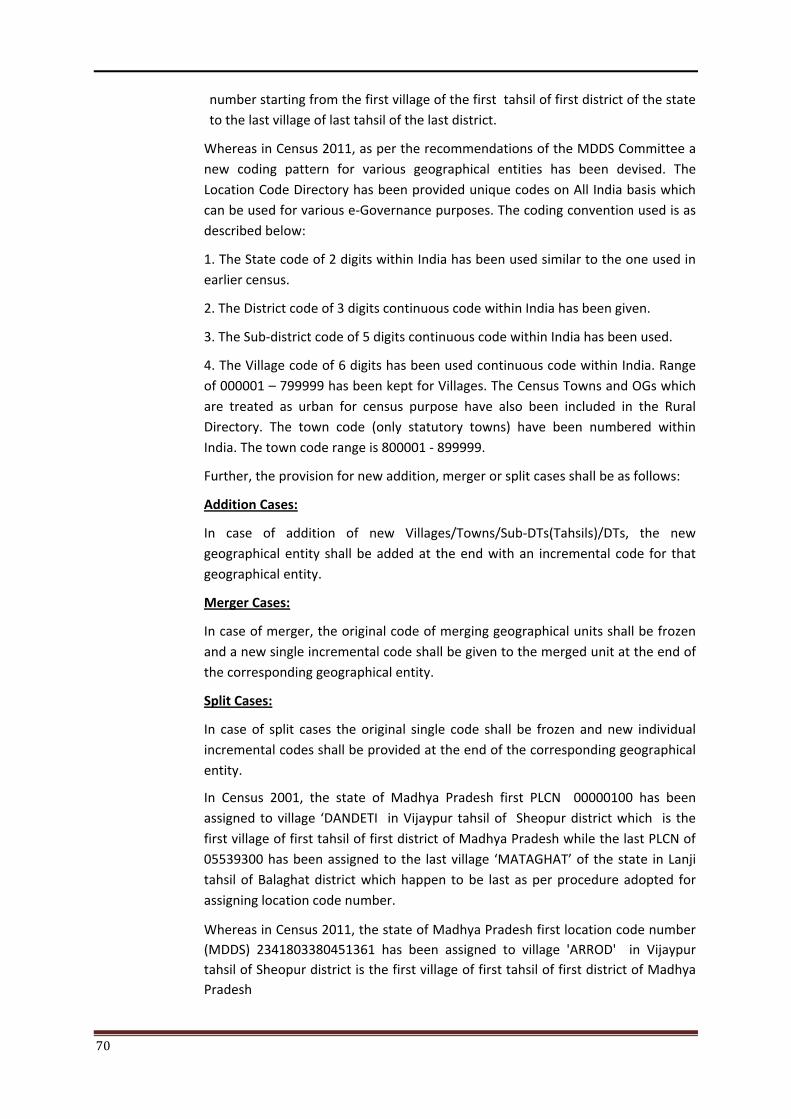
70
number starting from the first village of the first tahsil of first district of the state to the last village of last tahsil of the last district.
Whereas in Census 2011, as per the recommendations of the MDDS Committee a new coding pattern for various geographical entities has been devised. The Location Code Directory has been provided unique codes on All India basis which can be used for various e-Governance purposes. The coding convention used is as described below:
1. The State code of 2 digits within India has been used similar to the one used in earlier census.
2. The District code of 3 digits continuous code within India has been given.
3. The Sub-district code of 5 digits continuous code within India has been used.
4. The Village code of 6 digits has been used continuous code within India. Range of 000001 – 799999 has been kept for Villages. The Census Towns and OGs which are treated as urban for census purpose have also been included in the Rural Directory. The town code (only statutory towns) have been numbered within India. The town code range is 800001 - 899999.
Further, the provision for new addition, merger or split cases shall be as follows:
Addition Cases:
In case of addition of new Villages/Towns/Sub-DTs(Tahsils)/DTs, the new geographical entity shall be added at the end with an incremental code for that geographical entity.
Merger Cases:
In case of merger, the original code of merging geographical units shall be frozen and a new single incremental code shall be given to the merged unit at the end of the corresponding geographical entity.
Split Cases:
In case of split cases the original single code shall be frozen and new individual incremental codes shall be provided at the end of the corresponding geographical entity.
In Census 2001, the state of Madhya Pradesh first PLCN 00000100 has been assigned to village ‘DANDETI in Vijaypur tahsil of Sheopur district which is the first village of first tahsil of first district of Madhya Pradesh while the last PLCN of 05539300 has been assigned to the last village ‘MATAGHAT’ of the state in Lanji tahsil of Balaghat district which happen to be last as per procedure adopted for assigning location code number.
Whereas in Census 2011, the state of Madhya Pradesh first location code number (MDDS) 2341803380451361 has been assigned to village 'ARROD' in Vijaypur tahsil of Sheopur district is the first village of first tahsil of first district of Madhya Pradesh
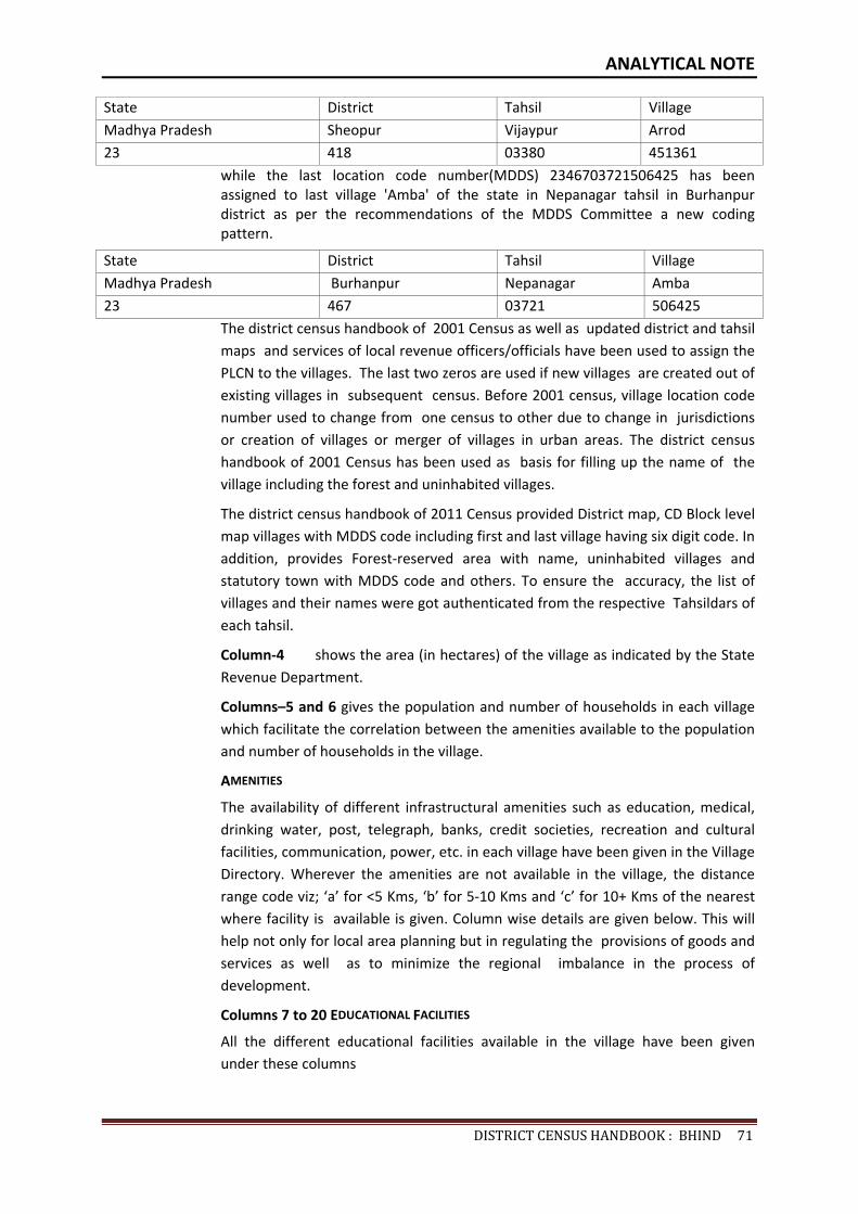
ANALYTICAL NOTE
DISTRICTCENSUSHANDBOOK:BHIND71
State District Tahsil Village Madhya Pradesh Sheopur Vijaypur Arrod 23 418 03380 451361
while the last location code number(MDDS) 2346703721506425 has been assigned to last village 'Amba' of the state in Nepanagar tahsil in Burhanpur district as per the recommendations of the MDDS Committee a new coding pattern.
State District Tahsil Village Madhya Pradesh Burhanpur Nepanagar Amba 23 467 03721 506425
The district census handbook of 2001 Census as well as updated district and tahsil maps and services of local revenue officers/officials have been used to assign the PLCN to the villages. The last two zeros are used if new villages are created out of existing villages in subsequent census. Before 2001 census, village location code number used to change from one census to other due to change in jurisdictions or creation of villages or merger of villages in urban areas. The district census handbook of 2001 Census has been used as basis for filling up the name of the village including the forest and uninhabited villages.
The district census handbook of 2011 Census provided District map, CD Block level map villages with MDDS code including first and last village having six digit code. In addition, provides Forest-reserved area with name, uninhabited villages and statutory town with MDDS code and others. To ensure the accuracy, the list of villages and their names were got authenticated from the respective Tahsildars of each tahsil.
Column-4 shows the area (in hectares) of the village as indicated by the State Revenue Department.
Columns–5 and 6 gives the population and number of households in each village which facilitate the correlation between the amenities available to the population and number of households in the village.
AMENITIES
The availability of different infrastructural amenities such as education, medical, drinking water, post, telegraph, banks, credit societies, recreation and cultural facilities, communication, power, etc. in each village have been given in the Village Directory. Wherever the amenities are not available in the village, the distance range code viz; ‘a’ for <5 Kms, ‘b’ for 5-10 Kms and ‘c’ for 10+ Kms of the nearest where facility is available is given. Column wise details are given below. This will help not only for local area planning but in regulating the provisions of goods and services as well as to minimize the regional imbalance in the process of development.
Columns 7 to 20 EDUCATIONAL FACILITIES
All the different educational facilities available in the village have been given under these columns
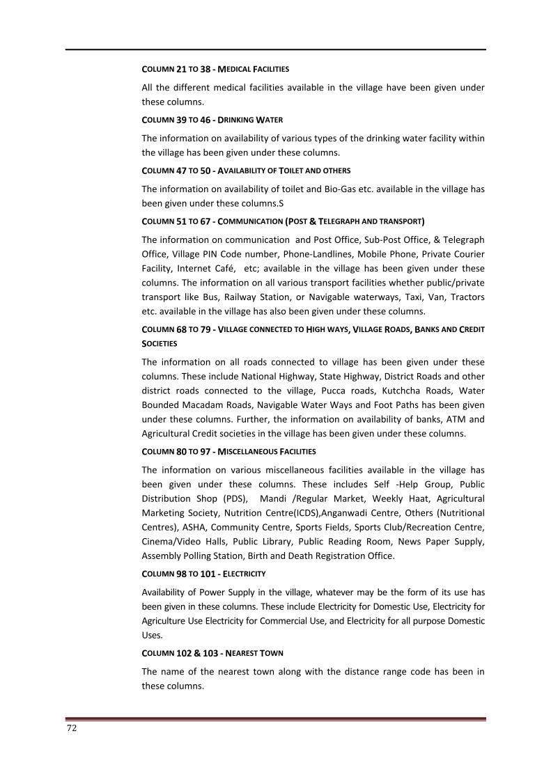
72
COLUMN 21 TO 38 - MEDICAL FACILITIES
All the different medical facilities available in the village have been given under these columns.
COLUMN 39 TO 46 - DRINKING WATER
The information on availability of various types of the drinking water facility within the village has been given under these columns.
COLUMN 47 TO 50 - AVAILABILITY OF TOILET AND OTHERS
The information on availability of toilet and Bio-Gas etc. available in the village has been given under these columns.S
COLUMN 51 TO 67 - COMMUNICATION (POST & TELEGRAPH AND TRANSPORT)
The information on communication and Post Office, Sub-Post Office, & Telegraph Office, Village PIN Code number, Phone-Landlines, Mobile Phone, Private Courier Facility, Internet Café, etc; available in the village has been given under these columns. The information on all various transport facilities whether public/private transport like Bus, Railway Station, or Navigable waterways, Taxi, Van, Tractors etc. available in the village has also been given under these columns.
COLUMN 68 TO 79 - VILLAGE CONNECTED TO HIGH WAYS, VILLAGE ROADS, BANKS AND CREDIT
SOCIETIES
The information on all roads connected to village has been given under these columns. These include National Highway, State Highway, District Roads and other district roads connected to the village, Pucca roads, Kutchcha Roads, Water Bounded Macadam Roads, Navigable Water Ways and Foot Paths has been given under these columns. Further, the information on availability of banks, ATM and Agricultural Credit societies in the village has been given under these columns.
COLUMN 80 TO 97 - MISCELLANEOUS FACILITIES
The information on various miscellaneous facilities available in the village has been given under these columns. These includes Self -Help Group, Public Distribution Shop (PDS), Mandi /Regular Market, Weekly Haat, Agricultural Marketing Society, Nutrition Centre(ICDS),Anganwadi Centre, Others (Nutritional Centres), ASHA, Community Centre, Sports Fields, Sports Club/Recreation Centre, Cinema/Video Halls, Public Library, Public Reading Room, News Paper Supply, Assembly Polling Station, Birth and Death Registration Office.
COLUMN 98 TO 101 - ELECTRICITY
Availability of Power Supply in the village, whatever may be the form of its use has been given in these columns. These include Electricity for Domestic Use, Electricity for Agriculture Use Electricity for Commercial Use, and Electricity for all purpose Domestic Uses.
COLUMN 102 & 103 - NEAREST TOWN
The name of the nearest town along with the distance range code has been in these columns.
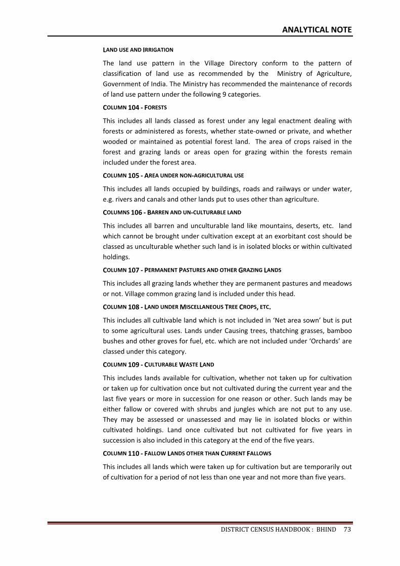
ANALYTICAL NOTE
DISTRICTCENSUSHANDBOOK:BHIND73
LAND USE AND IRRIGATION
The land use pattern in the Village Directory conform to the pattern of classification of land use as recommended by the Ministry of Agriculture, Government of India. The Ministry has recommended the maintenance of records of land use pattern under the following 9 categories.
COLUMN 104 - FORESTS
This includes all lands classed as forest under any legal enactment dealing with forests or administered as forests, whether state-owned or private, and whether wooded or maintained as potential forest land. The area of crops raised in the forest and grazing lands or areas open for grazing within the forests remain included under the forest area.
COLUMN 105 - AREA UNDER NON-AGRICULTURAL USE
This includes all lands occupied by buildings, roads and railways or under water, e.g. rivers and canals and other lands put to uses other than agriculture.
COLUMNS 106 - BARREN AND UN-CULTURABLE LAND
This includes all barren and unculturable land like mountains, deserts, etc. land which cannot be brought under cultivation except at an exorbitant cost should be classed as unculturable whether such land is in isolated blocks or within cultivated holdings.
COLUMN 107 - PERMANENT PASTURES AND OTHER GRAZING LANDS
This includes all grazing lands whether they are permanent pastures and meadows or not. Village common grazing land is included under this head.
COLUMN 108 - LAND UNDER MISCELLANEOUS TREE CROPS, ETC.
This includes all cultivable land which is not included in ‘Net area sown’ but is put to some agricultural uses. Lands under Causing trees, thatching grasses, bamboo bushes and other groves for fuel, etc. which are not included under ‘Orchards’ are classed under this category.
COLUMN 109 - CULTURABLE WASTE LAND
This includes lands available for cultivation, whether not taken up for cultivation or taken up for cultivation once but not cultivated during the current year and the last five years or more in succession for one reason or other. Such lands may be either fallow or covered with shrubs and jungles which are not put to any use. They may be assessed or unassessed and may lie in isolated blocks or within cultivated holdings. Land once cultivated but not cultivated for five years in succession is also included in this category at the end of the five years.
COLUMN 110 - FALLOW LANDS OTHER THAN CURRENT FALLOWS
This includes all lands which were taken up for cultivation but are temporarily out of cultivation for a period of not less than one year and not more than five years.
74
COLUMN 111 - CURRENT FALLOWS
This represents cropped area, which is kept fallow during the current year. For example, if any seeding area is not cropped against the same year it may be treated as current fallow.
COLUMN 112 - NET AREA SOWN
This represents the total area sown with crops and orchards. Area sown more than once; in the same year is counted only once.
COLUMN 113 - TOTAL IRRIGATED LAND AREA
It includes all land which is cultivable and irrigated by any source of irrigation. The
total irrigated area of the village has been given under this column.
COLUMN 114 - TOTAL UN-IRRIGATED LAND AREA
Un-Irrigated area includes all land which is cultivable but not irrigated by any
source of irrigation. The total un-irrigated land area of the village has been given
under this column.
COLUMN 115 TO 119 AREA IRRIGATED BY SOURCE
The area irrigated by various source of irrigation in the village have been given
under these columns. The different source of irrigation facilities available in the
village are as follows :
(i) Canals(C) - Govt. or Pvt., (ii) Wells/Tube-wells (W/TW), (iii) Tanks/Lake(T/L), (iv)
Waterfall (WF) and (v) Others(O).
COLUMN 120 TO 122 - THREE MOST IMPORTANT COMMODITIES MANUFACTURED
The names of three most important commodities manufactured in the village are
indicated in this column.
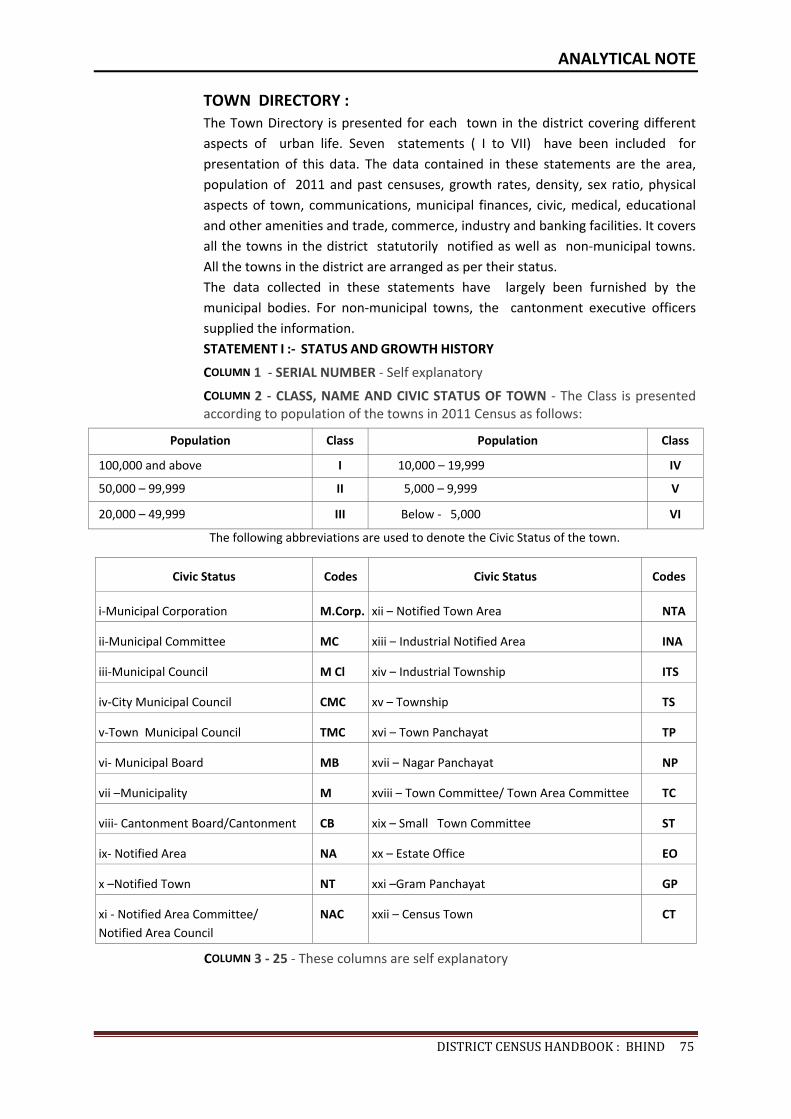
ANALYTICAL NOTE
DISTRICTCENSUSHANDBOOK:BHIND75
TOWN DIRECTORY : The Town Directory is presented for each town in the district covering different aspects of urban life. Seven statements ( I to VII) have been included for presentation of this data. The data contained in these statements are the area, population of 2011 and past censuses, growth rates, density, sex ratio, physical aspects of town, communications, municipal finances, civic, medical, educational and other amenities and trade, commerce, industry and banking facilities. It covers all the towns in the district statutorily notified as well as non-municipal towns. All the towns in the district are arranged as per their status. The data collected in these statements have largely been furnished by the municipal bodies. For non-municipal towns, the cantonment executive officers supplied the information. STATEMENT I :- STATUS AND GROWTH HISTORY
COLUMN 1 - SERIAL NUMBER - Self explanatory
COLUMN 2 - CLASS, NAME AND CIVIC STATUS OF TOWN - The Class is presented according to population of the towns in 2011 Census as follows:
Population Class Population Class
100,000 and above I 10,000 – 19,999 IV
50,000 – 99,999 II 5,000 – 9,999 V
20,000 – 49,999 III Below - 5,000 VI
The following abbreviations are used to denote the Civic Status of the town.
Civic Status Codes Civic Status Codes
i-Municipal Corporation M.Corp. xii – Notified Town Area NTA
ii-Municipal Committee MC xiii – Industrial Notified Area INA
iii-Municipal Council M Cl xiv – Industrial Township ITS
iv-City Municipal Council CMC xv – Township TS
v-Town Municipal Council TMC xvi – Town Panchayat TP
vi- Municipal Board MB xvii – Nagar Panchayat NP
vii –Municipality M xviii – Town Committee/ Town Area Committee TC
viii- Cantonment Board/Cantonment CB xix – Small Town Committee ST
ix- Notified Area NA xx – Estate Office EO
x –Notified Town NT xxi –Gram Panchayat GP
xi - Notified Area Committee/ Notified Area Council
NAC xxii – Census Town CT
COLUMN 3 - 25 - These columns are self explanatory
76
STATEMENT II: - PHYSICAL ASPECTS AND LOCATION OF TOWN, 2009.
COLUMN 1 - 2 SERIAL NUMBER AND NAME OF TOWN - Self explanatory
COLUMN 3 TO 5 - PHYSICAL ASPECTS - In these columns the Rainfall and Maximum
and Minimum Temperature of the town is recorded.
COLUMN 6 TO 12 - Name and road distance of the town (in kms.) from the State headquarters, District headquarters, Sub-divisional/Taluk/Tahsil/ Police station/Development Block/Island HQ., Nearest city with population of one lakh and more, Nearest city with population of five lakh and more, Railway station and Bus route is recorded in these columns respectively. If the names mentioned in these columns are the same as the referent town itself, the distance is recorded as (0) zero.
STATEMENT III – CIVIC AND OTHER AMENITIES, 2009 -
COLUMN 1 - 2 SERIAL NUMBER AND NAME OF TOWN - Self explanatory
COLUMN 3 - ROAD LENGTH (in km.) - The information about the road length (in km.) within the limit of the town is recorded in this column.
COLUMN 4 TO 7 - SYSTEM OF DRAINAGE - The system of drainage available in the town is indicated in these columns by the following codes:
System of drainage Codes
Open drains OD
Closed drains CD
Both drains BD
COLUMN 8 TO 11 - NUMBER OF LATRINES - The number of various types of latrines available in the town is indicated in these columns.
COLUMN NO. 12 & 13 - PROTECTED WATER SUPPLY - The information on source of water supply and system of water storage with capacity available in the town are given in these columns in the following codes:
COLUMN 12 (SOURCE OF WATER SUPPLY) -
Tap water T
Tube-well water TW
Tank Water TK
Well water W
COLUMN 13 (SYSTEM OF WATER STORAGE) -
Over Head Tank OHT
Service Reservoir SR
River Infiltration Gallery RIG
Bore Well Pumping System BWP
Pressure Tank PT
ANALYTICAL NOTE
DISTRICTCENSUSHANDBOOK:BHIND77
The information on 2 major source of water supply is given in column 12 and the system of water storage with capacity against each in kilo-litres (in bracket) is presented in column 13.
COLUMN 14 FIRE FIGHTING SERVICE - In case the fire fighting service is available in the referent town, `yes’ is recorded. If the facility is not available within the town, the name of the nearest place having this facility with its distance from the referent town has been recorded.
COLUMN 15 TO 19- ELECTRIFICATION (NUMBER OF CONNECTIONS) - Different types of electric onnections have been shown in these columns, i.e., Domestic, Industrial, Commercial, Road lighting (points) & others.
STATEMENT IV: MEDICAL FACILITIES, 2009 -
COLUMN 1 - 2 SERIAL NUMBER AND NAME OF TOWN - Self explanatory
COLUMN 3 TO 13 - The number of various medical institutions such as Hospitals, Dispensaries, Health Center, Family Welfare Center, Maternity and Child Welfare Center, Maternity Homes, T.B. Hospital/ clinic, Nursing Homes, Charitable Hospital/Nursing Home, Mobile Health Clinic and Others as available in the town, are indicated in these columns (along with number of beds in brackets).
If a medical facility is not available in the town, the name of the nearest place and its distance in kilometers from the town where the facility is available is mentioned.
COLUMN 14 - VETERINARY HOSPITAL - The Number of Veterinary Hospitals available in the town is given in this column.
COLUMN 15 - MEDICINE SHOP - The number of Medicine shops available in the town is given in this column.
STATEMENT V: EDUCATIONAL, RECREATIONAL AND CULTURAL FACILITIES, 2009 -
COLUMN 1 - 2 SERIAL NUMBER AND NAME OF TOWN - Self explanatory
COLUMN 3 TO 15 EDUCATIONAL FACILITIES - The information on number of Primary school, Middle school, Secondary school, Senior Secondary school, Arts/Science/ Commerce colleges (of degree level and above), Medical colleges, Engineering colleges, Management Institute/Colleges, Polytechnics, Recognized Shorthand, Typewriting and vocational training Institutions, Non-formal Education Center (Sarva Shiksha Abhiyan Center), Special School for disabled and Others available in the town, are indicated in these columns.
If an educational facility is not available in the town, the name of the nearest place and its distance in kilometers from the town where the facility is available is mentioned.
COLUMN 16 TO 23 – NUMBER OF SOCIAL, RECREATIONAL AND CULTURE FACILITIES - The information on No. of Home Orphanage, Working women’s hostels (with No. of seats in bracket), No. of Old Age Home, Stadium, Cinema Theatre, Auditorium/Community halls, Public libraries and Reading rooms available in the town are given under these column.
78
STATEMENT VI: INDUSTRY AND BANKING 2009 -
COLUMN 1 - 2 SERIAL NUMBER AND NAME OF TOWN - Self explanatory
COLUMN 3 TO 5 - NAMES OF THREE MOST IMPORTANT COMMODITIES MANUFACTURED - The names of three most important commodities manufactured in the town are given under these columns.
COLUMN 6 TO 8 - NUMBER OF BANKS - The number of banks available in the referent town both Commercial and Co-operative banks are recorded against these columns.
COLUMN 9 & 10 – NUMBER OF AGRICULTURAL AND NON AGRICULTURAL CREDIT SOCIETIES - The number of Agricultural and Non Agricultural Credit Societies available in the referent town are given in these columns.
STATEMENT VII: CIVIC AND OTHER AMENITIES IN SLUMS, 2009 -
This statement VII provides information on civic and other amenities in all slums whether notified or not and for all towns having statutory bodies, like Municipality, Municipal Corporation, Town area committee etc.
VILLAGE AND TOWN DIRECTORY

80
VILLAGE DIRECTORY
DISTRICT CENSUS HANDBOOK : BHIND 81
BRIEF NOTE ON VILLAGE DIRECTORY
VILLAGE DIRECTORY 2011 CENSUS
The Village Directory is being compiled for both inhabited and un-inhabited villages. In the village directory both private and government facilities/institutions have been given. In case of un-inhabited /depopulated villages, the location code number, name and area of the village is being given universally in Village Directory and Village PCA. The columns relating to the amenities and land use pattern, etc. being left blank and it will be noted against the name of the village that it is un-inhabited/depopulated. The Appendices to Village Directory and Inset Tables based on village Directory data are also prepared for inhabited villages.
In the Village Directory format for 2011 Census there are 122 columns and the details thereon are as follows :
COLUMN 1 - SERIAL NUMBER
Self explanatory. All the villages within the CD block are presented serially in the ascending order of their location code number.
COLUMN 2 - NAME OF VILLAGE
Self explanatory. The name of the villages are shown against this column. This also includes the forest and uninhabited villages.
COLUMN 3 - LOCATION CODE NUMBER OF VILLAGE
The location code number of the villages are shown against this column.
COLUMN 4 - AREA OF THE VILLAGE
The area of the villages has been given in hectares.
COLUMN 5 - TOTAL POPULATION
The total population of the village as per 2011 Census has been given against this column.
COLUMN 6 - NUMBER OF HOUSEHOLDS
The number of households as per 2011 Census have been given in this column.
AMENITIES
The availability of different infrastructural amenities such as education, medical, drinking water, post, telegraph, banks, credit societies, recreation and cultural facilities, communication, power, etc. in each village have been given in the Village Directory. Wherever the amenities are not available in the village, the distance range code viz; ‘a’ for <5 Kms, ‘b’ for 5-10 Kms and ‘c’ for 10+ Kms of the nearest where facility is available is given. Column wise details are given below :
82
COLUMN 7 TO 20 - EDUCATIONAL FACILITIES
All the different educational facilities available in the village have been given under these columns. Nursery/LKG//UKG classes are included in Pre-Primary Schools, Classes up to class V included in Primary School; Classes from VI to VIII are included in the Middle school. Classes from IX and X included in Secondary School. Classes from XI and XII are included in Senior Secondary School. In case of composite schools like middle school with primary school or secondary school with middle school, these are also included in the number of primary and middle schools, respectively. The information on the entire educational institutes is given under these columns.
COLUMN 21 TO 38 - MEDICAL FACILITIES
All the different medical facilities available in the village have been given under these columns.
COLUMN 39 TO 46 - DRINKING WATER
The information on availability of various types of the drinking water facility within the village has been given under these columns.
COLUMN 47 TO 50 - AVAILABILITY OF TOILET AND OTHERS
The information on availability of toilet and Bio-Gas etc. available in the village has been given under these columns.
COLUMN 51 TO 67 - COMMUNICATION (POST & TELEGRAPH AND
TRANSPORT)
The information on communication and Post Office, Sub-Post Office, & Telegraph Office, Village PIN Code number, Phone-Landlines, Mobile Phone, Private Courier Facility, Internet Café, etc; available in the village has been given under these columns. The information on all various transport facilities whether public/private transport like Bus, Railway Station, or Navigable waterways, Taxi, Van, Tractors etc. available in the village has also been given under these columns.
COLUMN 68 TO 79 - VILLAGE CONNECTED TO HIGH WAYS, VILLAGE
ROADS, BANKS AND CREDIT SOCIETIES
The information on all roads connected to village has been given under these columns. These include National Highway, State Highway, District Roads and other district roads connected to the village, Pucca roads, Kutchcha Roads, Water Bounded Macadam Roads, Navigable Water Ways and Foot Paths has been given under these columns. Further, the information on availability of banks, ATM and Agricultural Credit societies in the village has been given under these columns.
COLUMN 80 TO 97 - MISCELLANEOUS FACILITIES
The information on various miscellaneous facilities available in the village has been given under these columns. These includes Self -Help Group, Public Distribution Shop (PDS), Mandi /Regular Market, Weekly
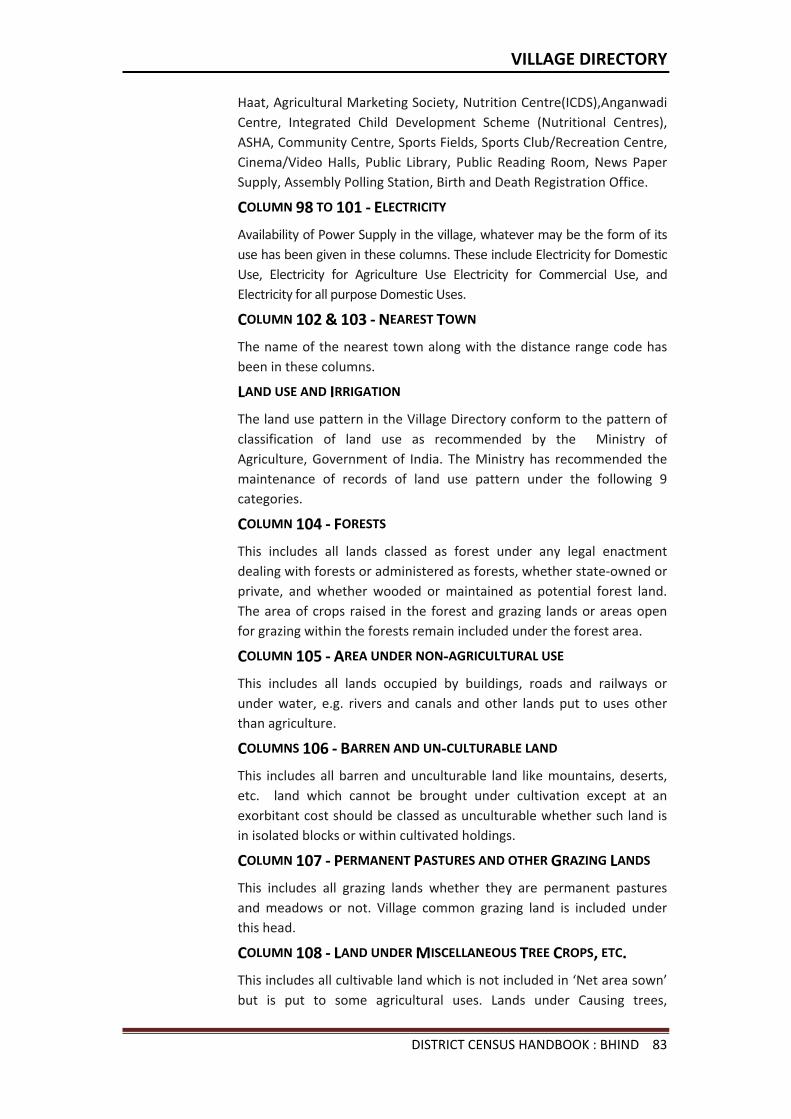
VILLAGE DIRECTORY
DISTRICT CENSUS HANDBOOK : BHIND 83
Haat, Agricultural Marketing Society, Nutrition Centre(ICDS),Anganwadi Centre, Integrated Child Development Scheme (Nutritional Centres), ASHA, Community Centre, Sports Fields, Sports Club/Recreation Centre, Cinema/Video Halls, Public Library, Public Reading Room, News Paper Supply, Assembly Polling Station, Birth and Death Registration Office.
COLUMN 98 TO 101 - ELECTRICITY
Availability of Power Supply in the village, whatever may be the form of its use has been given in these columns. These include Electricity for Domestic Use, Electricity for Agriculture Use Electricity for Commercial Use, and Electricity for all purpose Domestic Uses.
COLUMN 102 & 103 - NEAREST TOWN
The name of the nearest town along with the distance range code has been in these columns.
LAND USE AND IRRIGATION
The land use pattern in the Village Directory conform to the pattern of classification of land use as recommended by the Ministry of Agriculture, Government of India. The Ministry has recommended the maintenance of records of land use pattern under the following 9 categories.
COLUMN 104 - FORESTS
This includes all lands classed as forest under any legal enactment dealing with forests or administered as forests, whether state-owned or private, and whether wooded or maintained as potential forest land. The area of crops raised in the forest and grazing lands or areas open for grazing within the forests remain included under the forest area.
COLUMN 105 - AREA UNDER NON-AGRICULTURAL USE
This includes all lands occupied by buildings, roads and railways or under water, e.g. rivers and canals and other lands put to uses other than agriculture.
COLUMNS 106 - BARREN AND UN-CULTURABLE LAND
This includes all barren and unculturable land like mountains, deserts, etc. land which cannot be brought under cultivation except at an exorbitant cost should be classed as unculturable whether such land is in isolated blocks or within cultivated holdings.
COLUMN 107 - PERMANENT PASTURES AND OTHER GRAZING LANDS
This includes all grazing lands whether they are permanent pastures and meadows or not. Village common grazing land is included under this head.
COLUMN 108 - LAND UNDER MISCELLANEOUS TREE CROPS, ETC.
This includes all cultivable land which is not included in ‘Net area sown’ but is put to some agricultural uses. Lands under Causing trees,
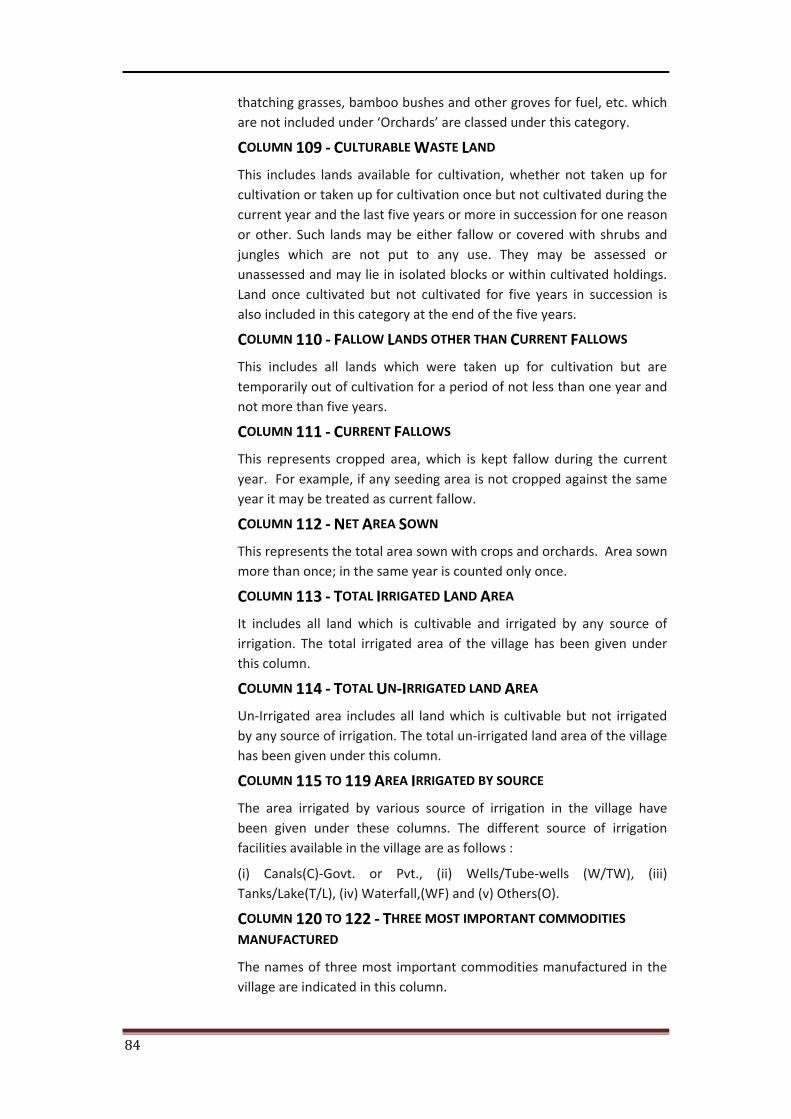
84
thatching grasses, bamboo bushes and other groves for fuel, etc. which are not included under ‘Orchards’ are classed under this category.
COLUMN 109 - CULTURABLE WASTE LAND
This includes lands available for cultivation, whether not taken up for cultivation or taken up for cultivation once but not cultivated during the current year and the last five years or more in succession for one reason or other. Such lands may be either fallow or covered with shrubs and jungles which are not put to any use. They may be assessed or unassessed and may lie in isolated blocks or within cultivated holdings. Land once cultivated but not cultivated for five years in succession is also included in this category at the end of the five years.
COLUMN 110 - FALLOW LANDS OTHER THAN CURRENT FALLOWS
This includes all lands which were taken up for cultivation but are temporarily out of cultivation for a period of not less than one year and not more than five years.
COLUMN 111 - CURRENT FALLOWS
This represents cropped area, which is kept fallow during the current year. For example, if any seeding area is not cropped against the same year it may be treated as current fallow.
COLUMN 112 - NET AREA SOWN
This represents the total area sown with crops and orchards. Area sown more than once; in the same year is counted only once.
COLUMN 113 - TOTAL IRRIGATED LAND AREA
It includes all land which is cultivable and irrigated by any source of irrigation. The total irrigated area of the village has been given under this column.
COLUMN 114 - TOTAL UN-IRRIGATED LAND AREA
Un-Irrigated area includes all land which is cultivable but not irrigated by any source of irrigation. The total un-irrigated land area of the village has been given under this column.
COLUMN 115 TO 119 AREA IRRIGATED BY SOURCE
The area irrigated by various source of irrigation in the village have been given under these columns. The different source of irrigation facilities available in the village are as follows :
(i) Canals(C)-Govt. or Pvt., (ii) Wells/Tube-wells (W/TW), (iii) Tanks/Lake(T/L), (iv) Waterfall,(WF) and (v) Others(O).
COLUMN 120 TO 122 - THREE MOST IMPORTANT COMMODITIES
MANUFACTURED
The names of three most important commodities manufactured in the village are indicated in this column.
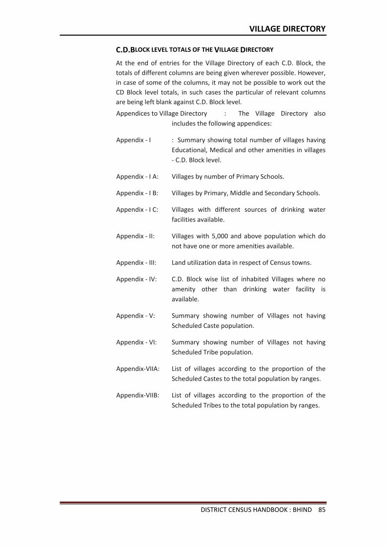
VILLAGE DIRECTORY
DISTRICT CENSUS HANDBOOK : BHIND 85
C.D.BLOCK LEVEL TOTALS OF THE VILLAGE DIRECTORY
At the end of entries for the Village Directory of each C.D. Block, the totals of different columns are being given wherever possible. However, in case of some of the columns, it may not be possible to work out the CD Block level totals, in such cases the particular of relevant columns are being left blank against C.D. Block level.
Appendices to Village Directory : The Village Directory also includes the following appendices:
Appendix - I : Summary showing total number of villages having Educational, Medical and other amenities in villages - C.D. Block level.
Appendix - I A: Villages by number of Primary Schools.
Appendix - I B: Villages by Primary, Middle and Secondary Schools.
Appendix - I C: Villages with different sources of drinking water facilities available.
Appendix - II: Villages with 5,000 and above population which do not have one or more amenities available.
Appendix - III: Land utilization data in respect of Census towns.
Appendix - IV: C.D. Block wise list of inhabited Villages where no amenity other than drinking water facility is available.
Appendix - V: Summary showing number of Villages not having Scheduled Caste population.
Appendix - VI: Summary showing number of Villages not having Scheduled Tribe population.
Appendix-VIIA: List of villages according to the proportion of the Scheduled Castes to the total population by ranges.
Appendix-VIIB: List of villages according to the proportion of the Scheduled Tribes to the total population by ranges.
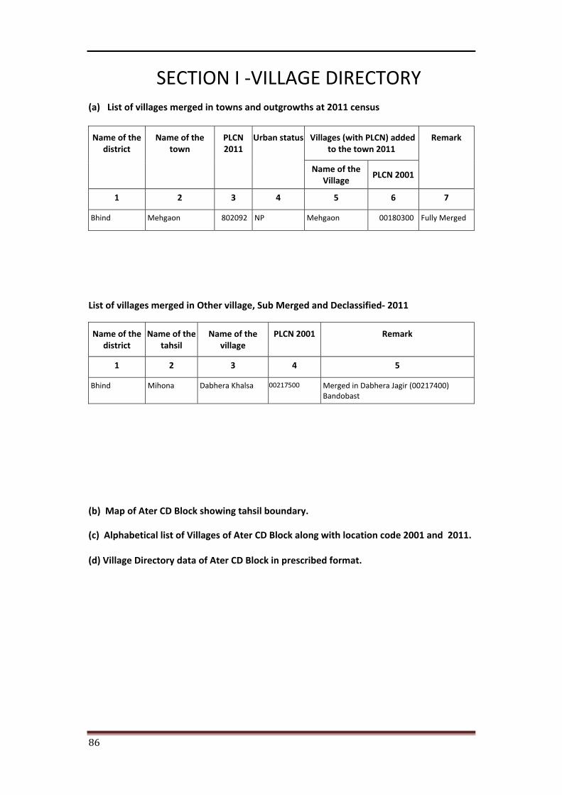
86
SECTION I -VILLAGE DIRECTORY (a) List of villages merged in towns and outgrowths at 2011 census
Name of the district
Name of the town
PLCN 2011
Urban status Villages (with PLCN) added to the town 2011
Remark
Name of the Village
PLCN 2001
1 2 3 4 5 6 7
Bhind Mehgaon 802092 NP Mehgaon 00180300 Fully Merged
List of villages merged in Other village, Sub Merged and Declassified- 2011
Name of the district
Name of the tahsil
Name of the village
PLCN 2001 Remark
1 2 3 4 5
Bhind Mihona Dabhera Khalsa 00217500 Merged in Dabhera Jagir (00217400) Bandobast
(b) Map of Ater CD Block showing tahsil boundary.
(c) Alphabetical list of Villages of Ater CD Block along with location code 2001 and 2011.
(d) Village Directory data of Ater CD Block in prescribed format.
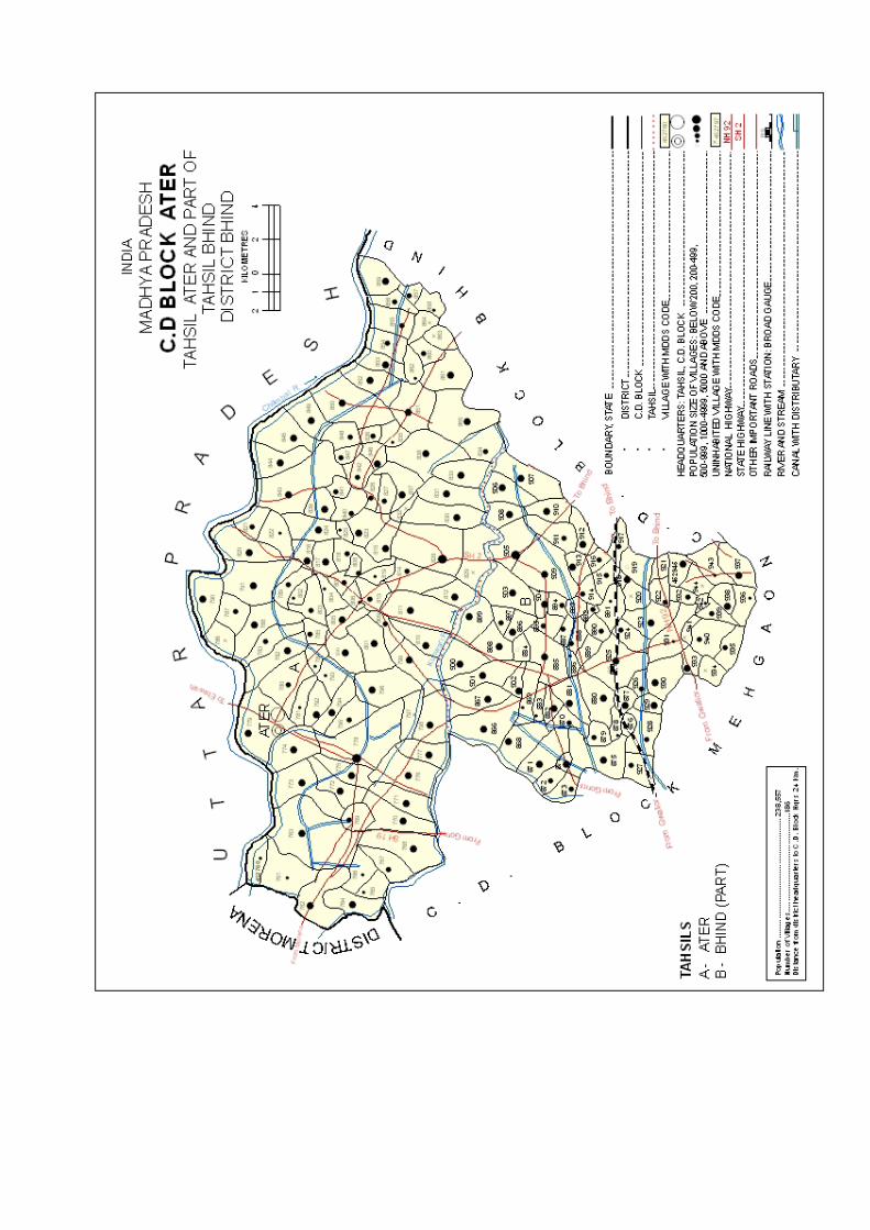

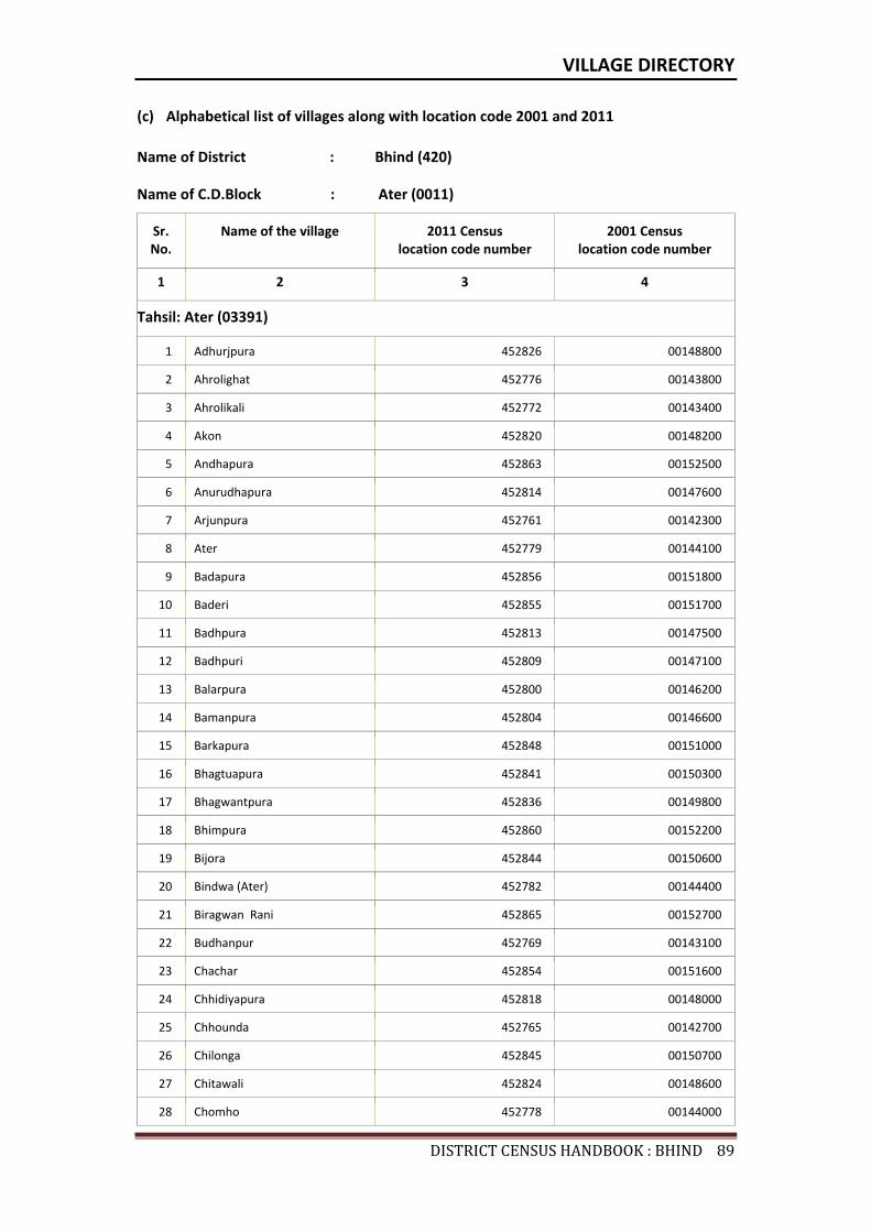
VILLAGE DIRECTORY
DISTRICTCENSUSHANDBOOK:BHIND89
(c) Alphabetical list of villages along with location code 2001 and 2011
Name of District : Bhind (420)
Name of C.D.Block : Ater (0011)
Sr. No.
Name of the village 2011 Census location code number
2001 Census location code number
1 2 3 4
Tahsil: Ater (03391)
1 Adhurjpura 452826 00148800
2 Ahrolighat 452776 00143800
3 Ahrolikali 452772 00143400
4 Akon 452820 00148200
5 Andhapura 452863 00152500
6 Anurudhapura 452814 00147600
7 Arjunpura 452761 00142300
8 Ater 452779 00144100
9 Badapura 452856 00151800
10 Baderi 452855 00151700
11 Badhpura 452813 00147500
12 Badhpuri 452809 00147100
13 Balarpura 452800 00146200
14 Bamanpura 452804 00146600
15 Barkapura 452848 00151000
16 Bhagtuapura 452841 00150300
17 Bhagwantpura 452836 00149800
18 Bhimpura 452860 00152200
19 Bijora 452844 00150600
20 Bindwa (Ater) 452782 00144400
21 Biragwan Rani 452865 00152700
22 Budhanpur 452769 00143100
23 Chachar 452854 00151600
24 Chhidiyapura 452818 00148000
25 Chhounda 452765 00142700
26 Chilonga 452845 00150700
27 Chitawali 452824 00148600
28 Chomho 452778 00144000
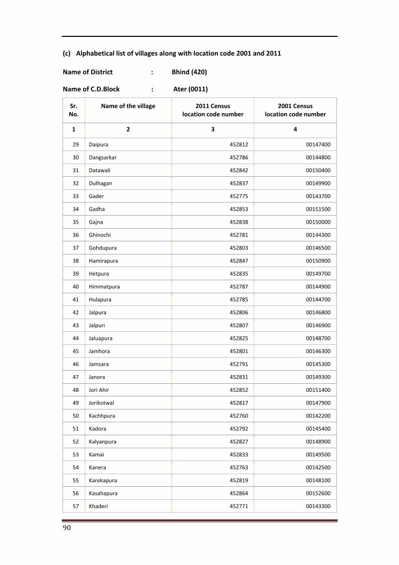
90
(c) Alphabetical list of villages along with location code 2001 and 2011
Name of District : Bhind (420)
Name of C.D.Block : Ater (0011)
Sr. No.
Name of the village 2011 Census location code number
2001 Census location code number
1 2 3 4
29 Daipura 452812 00147400
30 Dangsarkar 452786 00144800
31 Datawali 452842 00150400
32 Dulhagan 452837 00149900
33 Gader 452775 00143700
34 Gadha 452853 00151500
35 Gajna 452838 00150000
36 Ghinochi 452781 00144300
37 Gohdupura 452803 00146500
38 Hamirapura 452847 00150900
39 Hetpura 452835 00149700
40 Himmatpura 452787 00144900
41 Hulapura 452785 00144700
42 Jalpura 452806 00146800
43 Jalpuri 452807 00146900
44 Jaluapura 452825 00148700
45 Jamhora 452801 00146300
46 Jamsara 452791 00145300
47 Janora 452831 00149300
48 Jori Ahir 452852 00151400
49 Jorikotwal 452817 00147900
50 Kachhpura 452760 00142200
51 Kadora 452792 00145400
52 Kalyanpura 452827 00148900
53 Kamai 452833 00149500
54 Kanera 452763 00142500
55 Karekapura 452819 00148100
56 Kasahapura 452864 00152600
57 Khaderi 452771 00143300
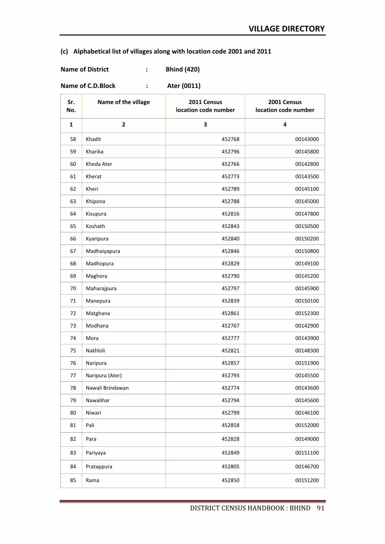
VILLAGE DIRECTORY
DISTRICTCENSUSHANDBOOK:BHIND91
(c) Alphabetical list of villages along with location code 2001 and 2011
Name of District : Bhind (420)
Name of C.D.Block : Ater (0011)
Sr. No.
Name of the village 2011 Census location code number
2001 Census location code number
1 2 3 4
58 Khadit 452768 00143000
59 Kharika 452796 00145800
60 Kheda Ater 452766 00142800
61 Kherat 452773 00143500
62 Kheri 452789 00145100
63 Khipona 452788 00145000
64 Kisupura 452816 00147800
65 Koshath 452843 00150500
66 Kyaripura 452840 00150200
67 Madhaiyapura 452846 00150800
68 Madhopura 452829 00149100
69 Maghora 452790 00145200
70 Maharajpura 452797 00145900
71 Manepura 452839 00150100
72 Matghana 452861 00152300
73 Modhana 452767 00142900
74 Mora 452777 00143900
75 Nakhloli 452821 00148300
76 Naripura 452857 00151900
77 Naripura (Ater) 452793 00145500
78 Nawali Brindawan 452774 00143600
79 Nawalihar 452794 00145600
80 Niwari 452799 00146100
81 Pali 452858 00152000
82 Para 452828 00149000
83 Pariyaya 452849 00151100
84 Pratappura 452805 00146700
85 Rama 452850 00151200
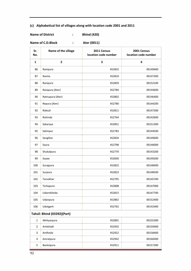
92
(c) Alphabetical list of villages along with location code 2001 and 2011
Name of District : Bhind (420)
Name of C.D.Block : Ater (0011)
Sr. No.
Name of the village 2011 Census location code number
2001 Census location code number
1 2 3 4
86 Rampura 452832 00149400
87 Ramta 452810 00147200
88 Ranipura 452859 00152100
89 Ranipura (Ater) 452784 00144600
90 Ratnupura (Ater) 452802 00146400
91 Repura (Ater) 452780 00144200
92 Ridouli 452811 00147300
93 Rohinda 452764 00142600
94 Sakaraya 452851 00151300
95 Salimpur 452783 00144500
96 Sanglitor 452834 00149600
97 Saura 452798 00146000
98 Shukalpura 452770 00143200
99 Soyee 452830 00149200
100 Surajpura 452822 00148400
101 Surpura 452823 00148500
102 Tarsokhar 452795 00145700
103 Torkapura 452808 00147000
104 Udannkheda 452815 00147700
105 Udanpura 452862 00152400
106 Udotgarh 452762 00142400
Tahsil: Bhind (03392)(Part)
1 Akhtyarpura 452891 00155300
2 Amlehadi 452932 00159400
3 Amlheda 452922 00158400
4 Amratpura 452942 00160400
5 Backsipura 452911 00157300
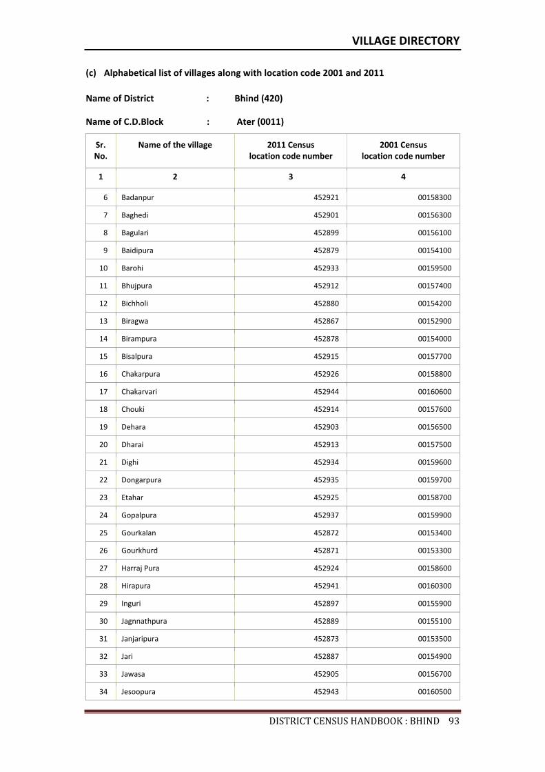
VILLAGE DIRECTORY
DISTRICTCENSUSHANDBOOK:BHIND93
(c) Alphabetical list of villages along with location code 2001 and 2011
Name of District : Bhind (420)
Name of C.D.Block : Ater (0011)
Sr. No.
Name of the village 2011 Census location code number
2001 Census location code number
1 2 3 4
6 Badanpur 452921 00158300
7 Baghedi 452901 00156300
8 Bagulari 452899 00156100
9 Baidipura 452879 00154100
10 Barohi 452933 00159500
11 Bhujpura 452912 00157400
12 Bichholi 452880 00154200
13 Biragwa 452867 00152900
14 Birampura 452878 00154000
15 Bisalpura 452915 00157700
16 Chakarpura 452926 00158800
17 Chakarvari 452944 00160600
18 Chouki 452914 00157600
19 Dehara 452903 00156500
20 Dharai 452913 00157500
21 Dighi 452934 00159600
22 Dongarpura 452935 00159700
23 Etahar 452925 00158700
24 Gopalpura 452937 00159900
25 Gourkalan 452872 00153400
26 Gourkhurd 452871 00153300
27 Harraj Pura 452924 00158600
28 Hirapura 452941 00160300
29 Inguri 452897 00155900
30 Jagnnathpura 452889 00155100
31 Janjaripura 452873 00153500
32 Jari 452887 00154900
33 Jawasa 452905 00156700
34 Jesoopura 452943 00160500
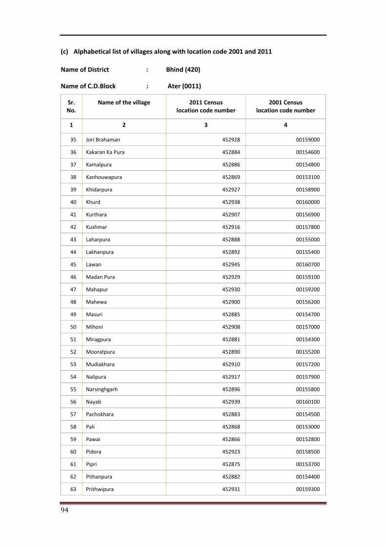
94
(c) Alphabetical list of villages along with location code 2001 and 2011
Name of District : Bhind (420)
Name of C.D.Block : Ater (0011)
Sr. No.
Name of the village 2011 Census location code number
2001 Census location code number
1 2 3 4
35 Jori Brahaman 452928 00159000
36 Kakaran Ka Pura 452884 00154600
37 Kamalpura 452886 00154800
38 Kanhouwapura 452869 00153100
39 Khidarpura 452927 00158900
40 Khurd 452938 00160000
41 Kurthara 452907 00156900
42 Kushmar 452916 00157800
43 Laharpura 452888 00155000
44 Lakhanpura 452892 00155400
45 Lawan 452945 00160700
46 Madan Pura 452929 00159100
47 Mahapur 452930 00159200
48 Mahewa 452900 00156200
49 Masuri 452885 00154700
50 Mihoni 452908 00157000
51 Miragpura 452881 00154300
52 Mooratpura 452890 00155200
53 Mudiakhara 452910 00157200
54 Nalipura 452917 00157900
55 Narsinghgarh 452896 00155800
56 Nayab 452939 00160100
57 Pachokhara 452883 00154500
58 Pali 452868 00153000
59 Pawai 452866 00152800
60 Pidora 452923 00158500
61 Pipri 452875 00153700
62 Pithanpura 452882 00154400
63 Prithwipura 452931 00159300
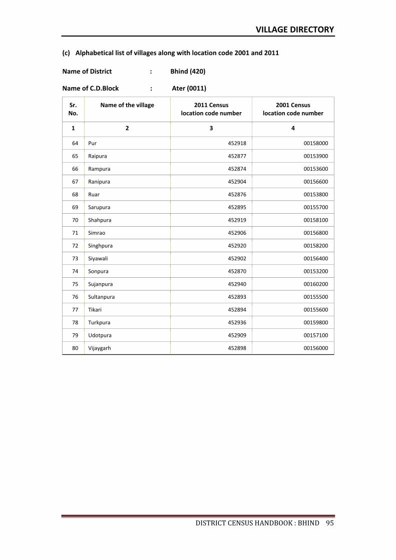
VILLAGE DIRECTORY
DISTRICTCENSUSHANDBOOK:BHIND95
(c) Alphabetical list of villages along with location code 2001 and 2011
Name of District : Bhind (420)
Name of C.D.Block : Ater (0011)
Sr. No.
Name of the village 2011 Census location code number
2001 Census location code number
1 2 3 4
64 Pur 452918 00158000
65 Raipura 452877 00153900
66 Rampura 452874 00153600
67 Ranipura 452904 00156600
68 Ruar 452876 00153800
69 Sarupura 452895 00155700
70 Shahpura 452919 00158100
71 Simrao 452906 00156800
72 Singhpura 452920 00158200
73 Siyawali 452902 00156400
74 Sonpura 452870 00153200
75 Sujanpura 452940 00160200
76 Sultanpura 452893 00155500
77 Tikari 452894 00155600
78 Turkpura 452936 00159800
79 Udotpura 452909 00157100
80 Vijaygarh 452898 00156000

Census of India 2011- Amenities and
Name of District : Bhind Location Code No : 420Name of CD Block : Ater Location Code No : 0011
Pre-
Prim
ary
scho
ol (P
P)
Prim
ary
scho
ol (P
)
Mid
dle
scho
ol (M
)
Seco
ndar
y Sc
hool
(S)
Seni
or S
econ
dary
sch
ool (
SS)
Deg
ree
colle
ge o
f art
s s
cien
ce &
com
mer
ce (
ASC
)
Engi
neer
ing
colle
ge(E
C)
Med
ical
col
lege
(MC)
Man
agem
ent i
nstit
ute
(MI)
Poly
tech
nic
(Pt)
Voca
tiona
l tra
inin
g sc
hool
/IT
I
Non
-for
mal
trai
ning
cen
tre
(NFT
C)
Spec
ial s
choo
l for
dis
able
d (S
SD)
Oth
ers
(spe
cify
)
1 2 3 4 5 6 7 8 9 10 11 12 13 14 15 16 17 18 19 20
1 Kachhpura 452760 282.2 362 52 b 1 1 b b b c c c c c c c c
2 Arjunpura 452761 347.4 459 79 b 1 1 a c c c c c c c c c c
3 Udotgarh 452762 699.3 2723 526 b 2 1 1 1 c c c c c c c c c
4 Kanera 452763 1800.5 4247 819 a 4 2 1 c c c c c c c c c c
5 Rohinda 452764 356.6 1011 193 b 1 1 a c c c c c c c c c c
6 Chhounda 452765 90.1 447 85 b 1 1 a c c c c c c c c c c
7 Kheda Ater 452766 246.2 410 56 b 1 c c c c c c c c c c c
8 Modhana 452767 293.6 623 113 b 1 a a c c c c c c c c c
9 Khadit 452768 718.5 2405 385 c 3 1 b c c c c c c c c c c
10 Budhanpur 452769 200.7 585 106 c 1 1 a c c c c c c c c c c
11 Shukalpura 452770 656 2117 362 c 3 1 1 c c c c
12 Khaderi 452771 351.8 1368 235 4 1 c c c c c c c c c c c
13 Ahrolikali 452772 462.1 1193 185 c 1 1 b c c c c c c c c c c
14 Kherat 452773 846.1 1059 199 b 1 1 b b b c c c c b b c c
15 Nawali Brindawan 452774 709.1 1387 300 a 1 1 a a a c c c c a c c
16 Gader 452775 374.7 1402 252 c 2 1 1 1 c c c c c c c c c
17 Ahrolighat 452776 622 1725 253 c 2 1 b c c c c c c c c c c
18 Mora 452777 415.1 1146 206 b 1 1 c c c c c c c c c c c
19 Chomho 452778 1127.5 5750 1260 c 3 1 1 1 c c c c c c c c c
20 Ater 452779 1057.3 4195 872 1 4 4 1 2 1 c c c c 1 c c
21 Repura (Ater) 452780 612.7 537 95 a 2 1 a a a c c c c a a c c
22 Ghinochi 452781 258.2 454 91 a 1 a a a a c c c c a a c c
23 Bindwa (Ater) 452782 629.5 1540 248 b 3 1 1 1 b c c c c b b c c
24 Salimpur 452783 317.7 637 118 2 a a a b c c c c b b c c
25 Ranipura (Ater) 452784 122.1 377 87 1 a a a b c c c c b b c c
Number of educational amenities available. (If not available within the village , the distance range
code viz; a for < 5 Kms, b for 5-10 Kms and c for 10+ kms of nearest place where facility is available is given).
Sr.N
o.
Nam
e of
vill
age
Loca
tion
code
no.
Tota
l are
a of
the
villa
ge (
in h
ecta
res
roun
ded
up to
one
dec
imal
pla
ce)
Tota
l pop
ulat
ion
( 201
1 ce
nsus
)
Num
ber
of h
ouse
hold
s (2
011
cens
us)
96

Village DirectoryLand use ( As in 2009 )Name of District : Bhind Location Code No : 420Name of CD Block : Ater Location Code No : 0011
Com
mun
ity h
ealth
cen
tre
(CH
C)Pr
imar
y he
alth
cen
tre
(PH
C)Pr
imar
y he
alth
sub
cen
tre
(PH
S)M
ater
nity
and
chi
ld w
elfa
re c
entr
e (M
CW)
T.B.
clin
ic (
TBC)
Hos
pita
l-allo
path
ic (H
A)
Hos
pita
l-alte
rnat
ive
med
icin
e (H
O)
Dis
pens
ary
(D)
Vete
rina
ry h
ospi
tal (
VH)
Mob
ile h
ealth
clin
ic (M
HC)
Fam
ily w
elfa
re c
entr
e (F
WC)
Char
itabl
e no
n G
ovt.
hos
pita
l/N
ursi
ng h
ome.
Med
ical
pra
ctiti
oner
with
MBB
S D
egre
eM
edic
al p
ract
ition
er w
ith o
ther
deg
ree
Med
ical
pra
ctiti
oner
with
no
degr
eeTr
aditi
onal
pra
ctiti
oner
and
faith
hea
ler
.M
edic
ine
Shop
Oth
ers
Tap
wat
er (T
reat
ed/U
ntre
ated
)
Wel
l w
ater
(C
over
ed /
Unc
over
ed w
ell)
Han
d Pu
mp
Tube
wel
ls /
Bor
e w
ell
Spri
ng
Rive
r /
Cana
l
Tank
/ P
ond
/ L
ake
Oth
ers
21 22 23 24 25 26 27 28 29 30 31 32 33 34 35 36 37 38 39 40 41 42 43 44 45 46 2 1
c c a c c c c a a c c 0 0 0 0 0 0 0 No Yes Yes Yes No Yes No No Kachhpura 1
c c c c c c c a a c c 0 0 0 0 0 0 0 No Yes Yes Yes No No No No Arjunpura 2
c c a c c c c a a c c 0 0 1 0 1 0 0 No Yes Yes Yes No Yes No No Udotgarh 3
c 1 c c c c 1 1 c c 0 0 0 0 0 0 0 No Yes Yes Yes No Yes No No Kanera 4
c c b c c c c b b c c 0 0 0 0 0 0 0 No Yes Yes Yes No Yes No No Rohinda 5
c c a c c c c a a c c 0 0 0 0 0 0 0 No Yes Yes Yes No Yes No No Chhounda 6
c c a c c c c a a c c 0 0 0 0 0 0 0 No Yes Yes Yes No Yes No No Kheda Ater 7
c c a c c c c a a c c 0 0 0 0 0 0 0 No Yes Yes No No No No No Modhana 8
c c 1 c c c c c c c c 0 0 0 0 0 0 0 No Yes Yes Yes No No No No Khadit 9
c c c c c c c c c c c 0 0 0 0 0 0 0 No Yes Yes Yes No No No No Budhanpur 10
c c 1 c c c c b 0 0 0 0 0 0 0 No Yes Yes Yes No No No No Shukalpura 11
c c c c c c c c c c c 0 0 0 0 0 0 0 No Yes Yes Yes No Yes No No Khaderi 12
c c c c c c c c c c c 0 0 0 0 0 0 0 No Yes Yes Yes No No No No Ahrolikali 13
c b b b b b b c b c b 0 0 0 0 0 0 0 No Yes Yes Yes No No No No Kherat 14
c a a a a a a c a c a 0 0 0 0 0 0 0 No Yes Yes Yes No No No No Nawali Brindawan 15
c c c c c c c c c c c 0 0 0 0 0 0 0 No Yes Yes Yes No No No No Gader 16
c c c c c c c c c c c 0 0 0 0 0 0 0 No Yes Yes Yes No Yes No No Ahrolighat 17
c c c c c c c c c c c 0 0 0 0 0 0 0 No Yes Yes Yes No Yes No No Mora 18
c c 1 c c c c c c c c 0 0 1 0 0 0 0 No Yes Yes Yes No No No No Chomho 19
1 1 1 1 c 1 1 0 0 2 0 1 1 0 Yes No Yes Yes No Yes No No Ater 20
c a a a a a a c a c a 0 0 0 2 0 0 0 No Yes Yes Yes No No No No Repura (Ater) 21
c a a a a a a c a c a 0 0 0 0 0 0 0 No Yes Yes Yes No No No No Ghinochi 22
c b b b b b b 1 b c b 0 0 0 2 1 0 0 Yes Yes Yes Yes No No No No Bindwa (Ater) 23
c b b b b b b c b c b 0 0 0 0 0 0 0 No Yes Yes Yes No No No No Salimpur 24
c b b b b b b c b c b 0 0 0 0 0 0 0 No Yes Yes Yes No No No No Ranipura (Ater) 25
Number of Medical Amenities available. (If not available within the
village , the distance range code viz; a for < 5 Kms, b for 5-10 Kms and c for
10+ kms of nearest place where facility is available is given).
Number of Non-Government
Medical Amenities available.
Availability of drinking water - Yes / No
Nam
e of
vill
age
Sr.N
o.
97

Census of India 2011- Amenities and
Name of District : Bhind Location Code No : 420Name of CD Block : Ater Location Code No : 0011
Com
mun
ity to
ilet i
nclu
ding
bat
h.
Com
mun
ity to
ilet e
xclu
ding
bat
h.
Rura
l sa
nita
ry m
art o
r sa
nita
ry h
ardw
are
outle
t av
aila
ble
near
the
villa
ge.
Com
mun
ity b
io- g
as o
r re
cycl
e of
was
te fo
r pr
oduc
tive
use.
Post
off
ice(
PO)
Sub
post
off
ice
(SPO
)
Post
& T
eleg
raph
off
ice
(P&
TO)
Villa
ge P
in C
ode
Tele
phon
es
(L
and
lines
)
Publ
ic c
all o
ffic
e (P
CO)
Mob
ile p
hone
cov
erag
e
Inte
rnet
caf
es/
Com
mon
ser
vice
cen
tre
(CSC
)
Priv
ate
cour
ier
faci
lity
Bus
serv
ice
(Pub
lic &
Pri
vate
)
Railw
ay s
tatio
ns
Aut
o/M
odifi
ed A
utos
Taxi
s an
d Va
ns
1 2 3 47 48 49 50 51 52 53 54 55 56 57 58 59 60 61 62 63
1 Kachhpura 452760 No No No No c a c c c a b c Yes c c c
2 Arjunpura 452761 No No No No c a c c c a c c Yes c c c
3 Udotgarh 452762 No No No No c Yes c c c Yes c c Yes c c c
4 Kanera 452763 No No No No c Yes c 477111 c c Yes c c Yes c c c
5 Rohinda 452764 No No No No c a c c c a c c Yes c c c
6 Chhounda 452765 No No No No c a c c c a c c Yes c c c
7 Kheda Ater 452766 No No No No c a c c c a c c Yes c c c
8 Modhana 452767 No No No No c Yes c c c a c c Yes c c c
9 Khadit 452768 No No No No c Yes c 477111 c c Yes c c Yes c c c
10 Budhanpur 452769 No No No No c a c c c Yes c c a c c c
11 Shukalpura 452770 No No No Yes Yes c Yes c Yes Yes c c
12 Khaderi 452771 No No No No c a c c c Yes c c b c c c
13 Ahrolikali 452772 No No No No c Yes c c c Yes c c Yes c c c
14 Kherat 452773 No No No No c a c b b Yes c c b c c c
15 Nawali Brindawan 452774 No No No No c a c a a Yes c c b c c c
16 Gader 452775 No No No No c a c c c Yes c c a c c c
17 Ahrolighat 452776 No No No No c Yes c 477111 c c Yes c b b c c c
18 Mora 452777 No No No No c b c c c c c c Yes c c c
19 Chomho 452778 No No No No c Yes c 477111 c c Yes c c Yes c c c
20 Ater 452779 No No No No c Yes c 477111 Yes Yes Yes c c Yes c c c
21 Repura (Ater) 452780 No No No No a a c a a Yes c c Yes c c c
22 Ghinochi 452781 No No No No a a c a a Yes c c a c c c
23 Bindwa (Ater) 452782 No No No No b Yes c 477111 b b Yes c c Yes c c c
24 Salimpur 452783 No No No No b a c b b Yes c c a c c c
25 Ranipura (Ater) 452784 No No No No b a c b b Yes c c a c c c
Sr.N
o.
Nam
e of
vill
age
Loca
tion
code
no.
Availability of toilet & others Yes / No
Communication and transport facilities (If amenities available code -Yes is given except for Village Pin Code ,If not available within the village , the distance range code
viz; a for < 5 Kms, b for 5-10 Kms and c for 10+ kms of nearest place where facility is available is given).
98
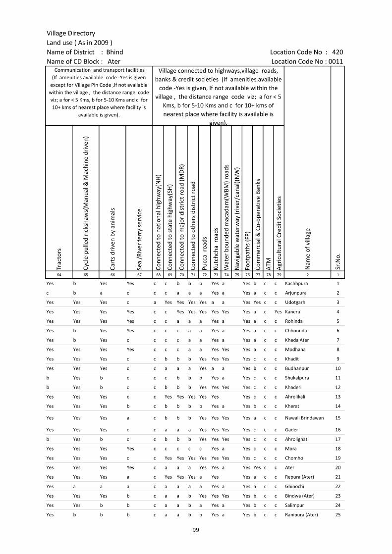
Village DirectoryLand use ( As in 2009 )Name of District : Bhind Location Code No : 420Name of CD Block : Ater Location Code No : 0011
Trac
tors
Cycl
e-pu
lled
rick
shaw
s(M
anua
l & M
achi
ne d
rive
n)
Cart
s dr
iven
by
anim
als
Sea
/Riv
er fe
rry
serv
ice
Conn
ecte
d to
nat
iona
l hig
hway
(NH
)
Conn
ecte
d to
sta
te h
ighw
ay(S
H)
Conn
ecte
d to
maj
or d
istr
ict r
oad
(MD
R)
Conn
ecte
d to
oth
ers
dist
rict
roa
d
Pucc
a r
oads
Kutc
hcha
roa
ds
Wat
er b
ound
ed m
acad
am(W
BM) r
oads
Nav
igab
le w
ater
way
(riv
er/c
anal
)(N
W)
Foot
path
s (F
P)
Com
mer
cial
& C
o-op
erat
ive
Bank
s
ATM
Agr
icul
tura
l Cre
dit S
ocie
ties
64 65 66 67 68 69 70 71 72 73 74 75 76 77 78 79 2 1
Yes b Yes Yes c c b b b Yes a Yes b c c Kachhpura 1
c b a c c c a a a Yes a Yes a c c Arjunpura 2
Yes Yes Yes c a Yes Yes Yes Yes a a Yes Yes c c Udotgarh 3
Yes Yes Yes Yes c c Yes Yes Yes Yes Yes Yes a c Yes Kanera 4
Yes Yes Yes Yes c c a a a Yes a Yes a c c Rohinda 5
Yes b Yes Yes c c c a a Yes a Yes a c c Chhounda 6
Yes b Yes c c c c a a Yes a Yes a c c Kheda Ater 7
Yes Yes Yes Yes c c c a a Yes Yes Yes a c c Modhana 8
Yes Yes Yes c c b b b Yes Yes Yes Yes c c c Khadit 9
Yes Yes Yes c c a a a Yes a a Yes b c c Budhanpur 10
b Yes b c c c b b b Yes a Yes c c c Shukalpura 11
b Yes b c c b b b Yes Yes Yes Yes c c c Khaderi 12
Yes Yes Yes c c Yes Yes Yes Yes Yes Yes c c c Ahrolikali 13
Yes Yes Yes b c b b b b Yes a Yes b c c Kherat 14
Yes Yes Yes a c b b b Yes Yes Yes Yes a c c Nawali Brindawan 15
Yes Yes Yes c c a a a Yes Yes Yes Yes c c c Gader 16
b Yes b c c b b b Yes Yes Yes Yes c c c Ahrolighat 17
Yes Yes Yes Yes c c c c c Yes a Yes c c c Mora 18
Yes Yes Yes c c Yes Yes Yes Yes Yes Yes Yes c c c Chomho 19
Yes Yes Yes Yes c a a a Yes Yes a Yes Yes c c Ater 20
Yes Yes Yes a c Yes Yes Yes a Yes Yes a c c Repura (Ater) 21
Yes a a a c a a a a Yes a Yes a c c Ghinochi 22
Yes Yes Yes b c a a b Yes Yes Yes Yes b c c Bindwa (Ater) 23
Yes Yes b b c a a b a Yes a Yes b c c Salimpur 24
Yes b b b c a a b b Yes a Yes b c c Ranipura (Ater) 25
Communication and transport facilities (If amenities available code -Yes is given
except for Village Pin Code ,If not available within the village , the distance range code viz; a for < 5 Kms, b for 5-10 Kms and c for 10+ kms of nearest place where facility is
available is given).
Village connected to highways,village roads, banks & credit societies (If amenities available
code -Yes is given, If not available within the village , the distance range code viz; a for < 5
Kms, b for 5-10 Kms and c for 10+ kms of nearest place where facility is available is
given).
Nam
e of
vill
age
Sr.N
o.
99
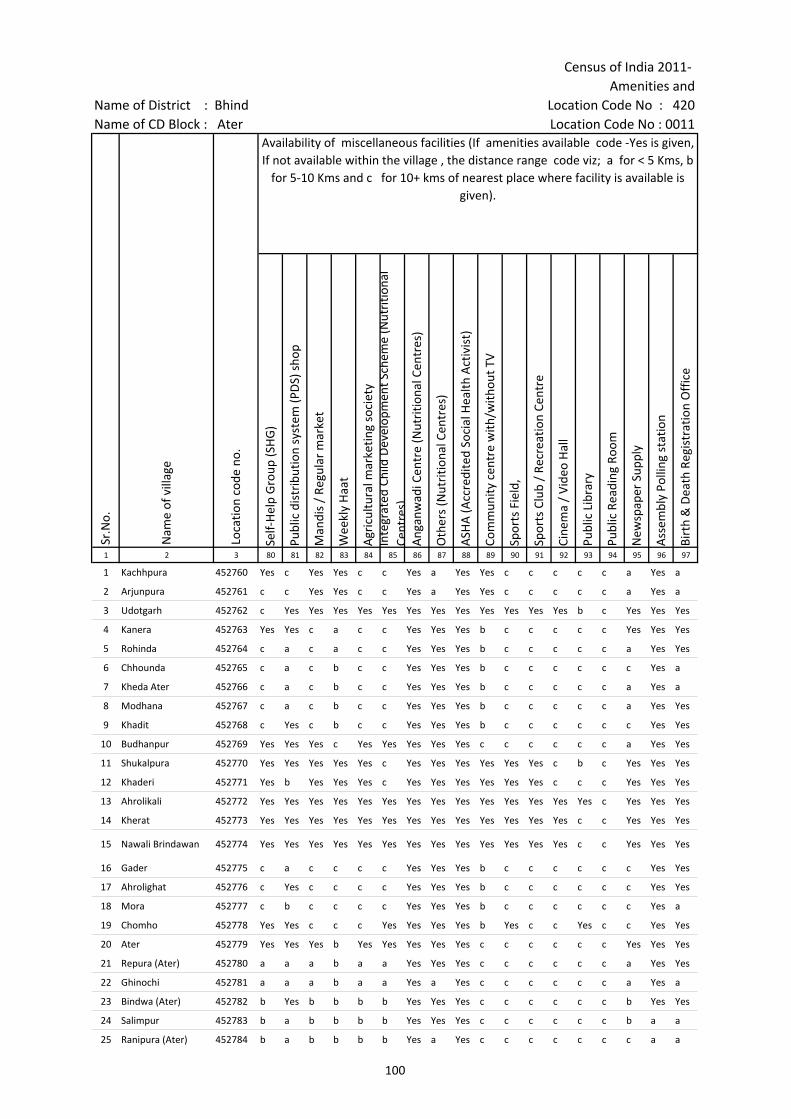
Census of India 2011- Amenities and
Name of District : Bhind Location Code No : 420Name of CD Block : Ater Location Code No : 0011
Self-
Hel
p G
roup
(SH
G)
Publ
ic d
istr
ibut
ion
syst
em (P
DS)
sho
p
Man
dis
/ Re
gula
r m
arke
t
Wee
kly
Haa
t
Agr
icul
tura
l mar
ketin
g so
ciet
yIn
tegr
ated
Chi
ld D
evel
opm
ent S
chem
e (N
utri
tiona
l Ce
ntre
s)A
ngan
wad
i Cen
tre
(Nut
ritio
nal C
entr
es)
Oth
ers
(Nut
ritio
nal C
entr
es)
ASH
A (A
ccre
dite
d So
cial
Hea
lth A
ctiv
ist)
Com
mun
ity c
entr
e w
ith/w
ithou
t TV
Spor
ts F
ield
,
Spor
ts C
lub
/ Re
crea
tion
Cent
re
Cine
ma
/ Vi
deo
Hal
l
Publ
ic L
ibra
ry
Publ
ic R
eadi
ng R
oom
New
spap
er S
uppl
y
Ass
embl
y Po
lling
sta
tion
Birt
h &
Dea
th R
egis
trat
ion
Off
ice
1 2 3 80 81 82 83 84 85 86 87 88 89 90 91 92 93 94 95 96 97
1 Kachhpura 452760 Yes c Yes Yes c c Yes a Yes Yes c c c c c a Yes a
2 Arjunpura 452761 c c Yes Yes c c Yes a Yes Yes c c c c c a Yes a
3 Udotgarh 452762 c Yes Yes Yes Yes Yes Yes Yes Yes Yes Yes Yes Yes b c Yes Yes Yes
4 Kanera 452763 Yes Yes c a c c Yes Yes Yes b c c c c c Yes Yes Yes
5 Rohinda 452764 c a c a c c Yes Yes Yes b c c c c c a Yes Yes
6 Chhounda 452765 c a c b c c Yes Yes Yes b c c c c c c Yes a
7 Kheda Ater 452766 c a c b c c Yes Yes Yes b c c c c c a Yes a
8 Modhana 452767 c a c b c c Yes Yes Yes b c c c c c a Yes Yes
9 Khadit 452768 c Yes c b c c Yes Yes Yes b c c c c c c Yes Yes
10 Budhanpur 452769 Yes Yes Yes c Yes Yes Yes Yes Yes c c c c c c a Yes Yes
11 Shukalpura 452770 Yes Yes Yes Yes Yes c Yes Yes Yes Yes Yes Yes c b c Yes Yes Yes
12 Khaderi 452771 Yes b Yes Yes Yes c Yes Yes Yes Yes Yes Yes c c c Yes Yes Yes
13 Ahrolikali 452772 Yes Yes Yes Yes Yes Yes Yes Yes Yes Yes Yes Yes Yes Yes c Yes Yes Yes
14 Kherat 452773 Yes Yes Yes Yes Yes Yes Yes Yes Yes Yes Yes Yes Yes c c Yes Yes Yes
15 Nawali Brindawan 452774 Yes Yes Yes Yes Yes Yes Yes Yes Yes Yes Yes Yes Yes c c Yes Yes Yes
16 Gader 452775 c a c c c c Yes Yes Yes b c c c c c c Yes Yes
17 Ahrolighat 452776 c Yes c c c c Yes Yes Yes b c c c c c c Yes Yes
18 Mora 452777 c b c c c c Yes Yes Yes b c c c c c c Yes a
19 Chomho 452778 Yes Yes c c c Yes Yes Yes Yes b Yes c c Yes c c Yes Yes
20 Ater 452779 Yes Yes Yes b Yes Yes Yes Yes Yes c c c c c c Yes Yes Yes
21 Repura (Ater) 452780 a a a b a a Yes Yes Yes c c c c c c a Yes Yes
22 Ghinochi 452781 a a a b a a Yes a Yes c c c c c c a Yes a
23 Bindwa (Ater) 452782 b Yes b b b b Yes Yes Yes c c c c c c b Yes Yes
24 Salimpur 452783 b a b b b b Yes Yes Yes c c c c c c b a a
25 Ranipura (Ater) 452784 b a b b b b Yes a Yes c c c c c c c a a
Sr.N
o.
Nam
e of
vill
age
Loca
tion
code
no.
Availability of miscellaneous facilities (If amenities available code -Yes is given, If not available within the village , the distance range code viz; a for < 5 Kms, b
for 5-10 Kms and c for 10+ kms of nearest place where facility is available is given).
100

Village DirectoryLand use ( As in 2009 )Name of District : Bhind Location Code No : 420Name of CD Block : Ater Location Code No : 0011
Pow
er S
uppl
y fo
r D
omes
tic U
se (E
D)
Pow
er S
uppl
y fo
r A
gric
ultu
ral U
se (E
AG
)
Pow
er S
uppl
y fo
r Co
mm
erci
al U
se (E
C)
Pow
er S
uppl
y fo
r A
ll U
ses
(EA
)
Nam
e
Dis
tanc
e ra
nge
code
i.e
. a
for
< 5
Kms,
b f
or 5
-10
Kms
and
c f
or 1
0+ k
ms
.98 99 100 101 102 103 2 1
Yes Yes No No BHIND c Kachhpura 1
Yes Yes No No BHIND c Arjunpura 2
Yes No No No BHIND c Udotgarh 3
Yes Yes No No BHIND c Kanera 4
Yes Yes No No BHIND c Rohinda 5
Yes Yes No No BHIND c Chhounda 6
Yes Yes No No BHIND c Kheda Ater 7
Yes Yes No No BHIND c Modhana 8
Yes Yes No No BHIND c Khadit 9
Yes Yes Yes Yes BHIND c Budhanpur 10
Yes No No No BHIND c Shukalpura 11
Yes Yes No No BHIND c Khaderi 12
Yes Yes No No BHIND c Ahrolikali 13
Yes Yes No No BHIND c Kherat 14
Yes Yes No No BHIND c Nawali Brindawan 15
Yes Yes No No BHIND c Gader 16
Yes Yes No No BHIND c Ahrolighat 17
Yes Yes No No BHIND c Mora 18
Yes Yes No No BHIND c Chomho 19
Yes Yes No No BHIND c Ater 20
Yes Yes No No BHIND c Repura (Ater) 21
Yes Yes No No BHIND c Ghinochi 22
Yes Yes No No BHIND c Bindwa (Ater) 23
Yes Yes No No BHIND c Salimpur 24
Yes Yes No No BHIND c Ranipura (Ater) 25
Availability of electricity (Yes/No) Nearest Town
Nam
e of
vill
age
Sr.N
o.
101
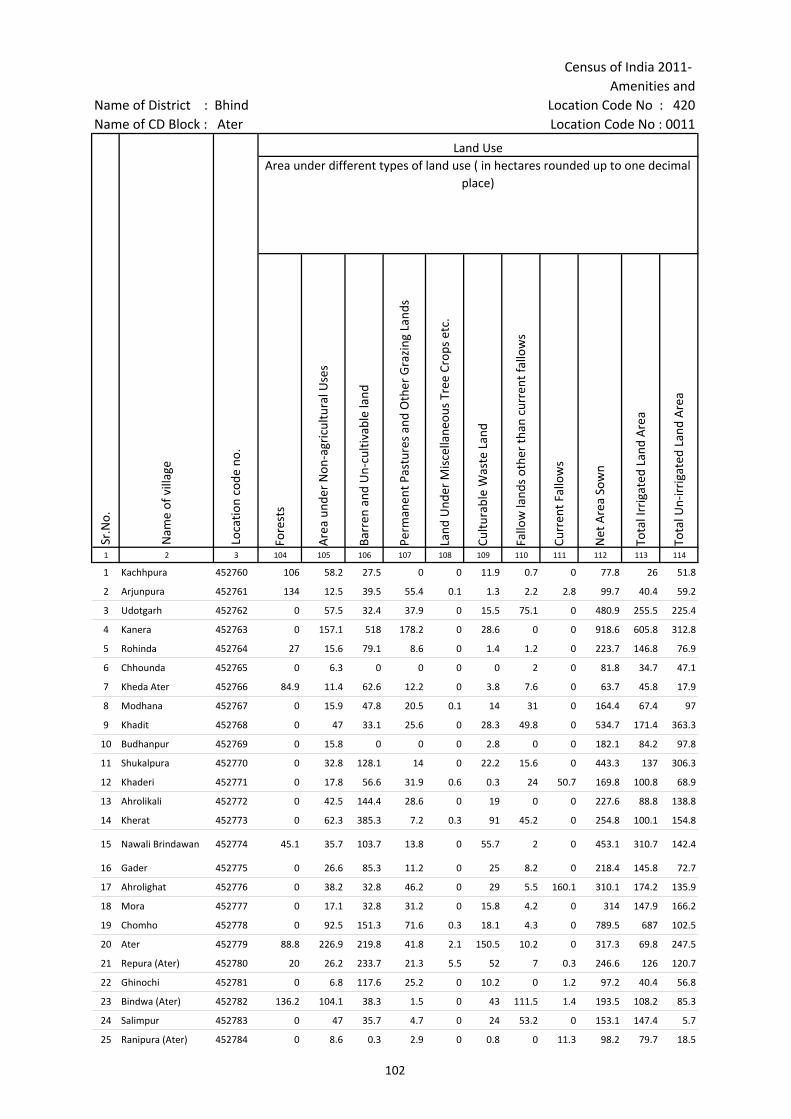
Census of India 2011- Amenities and
Name of District : Bhind Location Code No : 420Name of CD Block : Ater Location Code No : 0011
Fore
sts
Are
a un
der
Non
-agr
icul
tura
l Use
s
Barr
en a
nd U
n-cu
ltiva
ble
land
Perm
anen
t Pas
ture
s an
d O
ther
Gra
zing
Lan
ds
Land
Und
er M
isce
llane
ous
Tree
Cro
ps e
tc.
Cultu
rabl
e W
aste
Lan
d
Fallo
w la
nds
othe
r th
an c
urre
nt fa
llow
s
Curr
ent F
allo
ws
Net
Are
a So
wn
Tota
l Irr
igat
ed L
and
Are
a
Tota
l Un-
irri
gate
d La
nd A
rea
1 2 3 104 105 106 107 108 109 110 111 112 113 114
1 Kachhpura 452760 106 58.2 27.5 0 0 11.9 0.7 0 77.8 26 51.8
2 Arjunpura 452761 134 12.5 39.5 55.4 0.1 1.3 2.2 2.8 99.7 40.4 59.2
3 Udotgarh 452762 0 57.5 32.4 37.9 0 15.5 75.1 0 480.9 255.5 225.4
4 Kanera 452763 0 157.1 518 178.2 0 28.6 0 0 918.6 605.8 312.8
5 Rohinda 452764 27 15.6 79.1 8.6 0 1.4 1.2 0 223.7 146.8 76.9
6 Chhounda 452765 0 6.3 0 0 0 0 2 0 81.8 34.7 47.1
7 Kheda Ater 452766 84.9 11.4 62.6 12.2 0 3.8 7.6 0 63.7 45.8 17.9
8 Modhana 452767 0 15.9 47.8 20.5 0.1 14 31 0 164.4 67.4 97
9 Khadit 452768 0 47 33.1 25.6 0 28.3 49.8 0 534.7 171.4 363.3
10 Budhanpur 452769 0 15.8 0 0 0 2.8 0 0 182.1 84.2 97.8
11 Shukalpura 452770 0 32.8 128.1 14 0 22.2 15.6 0 443.3 137 306.3
12 Khaderi 452771 0 17.8 56.6 31.9 0.6 0.3 24 50.7 169.8 100.8 68.9
13 Ahrolikali 452772 0 42.5 144.4 28.6 0 19 0 0 227.6 88.8 138.8
14 Kherat 452773 0 62.3 385.3 7.2 0.3 91 45.2 0 254.8 100.1 154.8
15 Nawali Brindawan 452774 45.1 35.7 103.7 13.8 0 55.7 2 0 453.1 310.7 142.4
16 Gader 452775 0 26.6 85.3 11.2 0 25 8.2 0 218.4 145.8 72.7
17 Ahrolighat 452776 0 38.2 32.8 46.2 0 29 5.5 160.1 310.1 174.2 135.9
18 Mora 452777 0 17.1 32.8 31.2 0 15.8 4.2 0 314 147.9 166.2
19 Chomho 452778 0 92.5 151.3 71.6 0.3 18.1 4.3 0 789.5 687 102.5
20 Ater 452779 88.8 226.9 219.8 41.8 2.1 150.5 10.2 0 317.3 69.8 247.5
21 Repura (Ater) 452780 20 26.2 233.7 21.3 5.5 52 7 0.3 246.6 126 120.7
22 Ghinochi 452781 0 6.8 117.6 25.2 0 10.2 0 1.2 97.2 40.4 56.8
23 Bindwa (Ater) 452782 136.2 104.1 38.3 1.5 0 43 111.5 1.4 193.5 108.2 85.3
24 Salimpur 452783 0 47 35.7 4.7 0 24 53.2 0 153.1 147.4 5.7
25 Ranipura (Ater) 452784 0 8.6 0.3 2.9 0 0.8 0 11.3 98.2 79.7 18.5
Sr.N
o.
Nam
e of
vill
age
Loca
tion
code
no.
Land UseArea under different types of land use ( in hectares rounded up to one decimal
place)
102
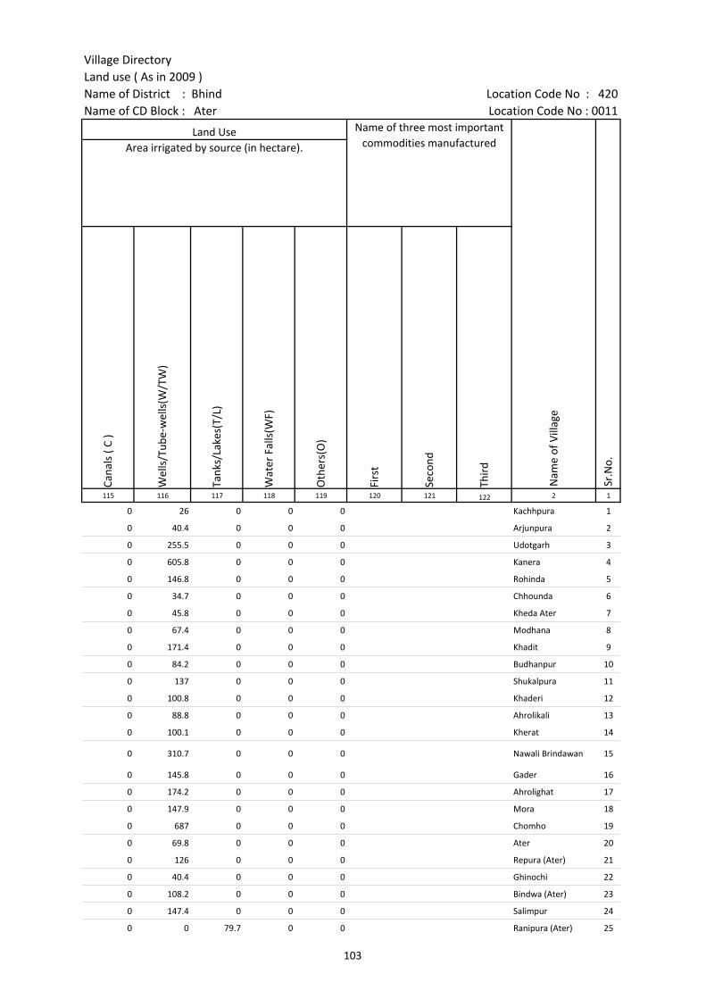
Village DirectoryLand use ( As in 2009 )Name of District : Bhind Location Code No : 420Name of CD Block : Ater Location Code No : 0011
Cana
ls (
C )
Wel
ls/T
ube-
wel
ls(W
/TW
)
Tank
s/La
kes(
T/L)
Wat
er F
alls
(WF)
Oth
ers(
O)
Firs
t
Seco
nd
Thir
d 115 116 117 118 119 120 121 122 2 1
0 26 0 0 0 Kachhpura 1
0 40.4 0 0 0 Arjunpura 2
0 255.5 0 0 0 Udotgarh 3
0 605.8 0 0 0 Kanera 4
0 146.8 0 0 0 Rohinda 5
0 34.7 0 0 0 Chhounda 6
0 45.8 0 0 0 Kheda Ater 7
0 67.4 0 0 0 Modhana 8
0 171.4 0 0 0 Khadit 9
0 84.2 0 0 0 Budhanpur 10
0 137 0 0 0 Shukalpura 11
0 100.8 0 0 0 Khaderi 12
0 88.8 0 0 0 Ahrolikali 13
0 100.1 0 0 0 Kherat 14
0 310.7 0 0 0 Nawali Brindawan 15
0 145.8 0 0 0 Gader 16
0 174.2 0 0 0 Ahrolighat 17
0 147.9 0 0 0 Mora 18
0 687 0 0 0 Chomho 19
0 69.8 0 0 0 Ater 20
0 126 0 0 0 Repura (Ater) 21
0 40.4 0 0 0 Ghinochi 22
0 108.2 0 0 0 Bindwa (Ater) 23
0 147.4 0 0 0 Salimpur 24
0 0 79.7 0 0 Ranipura (Ater) 25
Land Use Name of three most important commodities manufactured
Nam
e of
Vill
age
Sr.N
o.
Area irrigated by source (in hectare).
103

Census of India 2011- Amenities and
Name of District : Bhind Location Code No : 420Name of CD Block : Ater Location Code No : 0011
Pre-
Prim
ary
scho
ol (P
P)
Prim
ary
scho
ol (P
)
Mid
dle
scho
ol (M
)
Seco
ndar
y Sc
hool
(S)
Seni
or S
econ
dary
sch
ool (
SS)
Deg
ree
colle
ge o
f art
s s
cien
ce &
com
mer
ce (
ASC
)
Engi
neer
ing
colle
ge(E
C)
Med
ical
col
lege
(MC)
Man
agem
ent i
nstit
ute
(MI)
Poly
tech
nic
(Pt)
Voca
tiona
l tra
inin
g sc
hool
/IT
I
Non
-for
mal
trai
ning
cen
tre
(NFT
C)
Spec
ial s
choo
l for
dis
able
d (S
SD)
Oth
ers
(spe
cify
)
1 2 3 4 5 6 7 8 9 10 11 12 13 14 15 16 17 18 19 20
Number of educational amenities available. (If not available within the village , the distance range
code viz; a for < 5 Kms, b for 5-10 Kms and c for 10+ kms of nearest place where facility is available is given).
Sr.N
o.
Nam
e of
vill
age
Loca
tion
code
no.
Tota
l are
a of
the
villa
ge (
in h
ecta
res
roun
ded
up to
one
dec
imal
pla
ce)
Tota
l pop
ulat
ion
( 201
1 ce
nsus
)
Num
ber
of h
ouse
hold
s (2
011
cens
us)
26 Hulapura 452785 134.6 578 111 b 1 1 a a b c c c c b b c
27 Dangsarkar 452786 219.6 0 0 --------------Un-inhabited--------------
28 Himmatpura 452787 288.1 630 124 c 2 2 1 1 c c c c c c c
29 Khipona 452788 554.1 2006 323 1 4 1 b b c c c c c c c
30 Kheri 452789 225.5 882 197 2 3 b c c c c c c c c
31 Maghora 452790 756.4 1292 182 c 2 1 b c c c c c c c c c c
32 Jamsara 452791 887.4 1833 342 1 2 1 1 1 c c c c
33 Kadora 452792 510.2 1668 295 b 1 1 b b b c c c c b b c c
34 Naripura (Ater) 452793 104.8 303 66 a 1 a a a a c c c c a a c c
35 Nawalihar 452794 243.3 1026 201 b 2 1 b b c c c c b b c c
36 Tarsokhar 452795 391.5 634 103 c 1 1 c c c c c c c c c c
37 Kharika 452796 710.8 2369 450 c 1 1 1 c c c c c c c c c c
38 Maharajpura 452797 199.1 0 0 --------------Un-inhabited--------------
39 Saura 452798 390.3 1978 316 c 2 1 c c c c c c c c c c c
40 Niwari 452799 662.8 1462 303 b 2 1 1 b b c c c c b b c c
41 Balarpura 452800 404.2 2348 437 b 3 1 b b b c c c c b c c c
42 Jamhora 452801 701.5 1926 323 c 2 1 a c c c c c c c c c c
43 Ratnupura (Ater) 452802 45.8 458 110 1 b b b c c c c c
44 Gohdupura 452803 277.4 588 86 b 2 a a 1 b c c c c b b c c
45 Bamanpura 452804 39.5 360 84 b 1 1 a a b c c c b b b c b
46 Pratappura 452805 329.2 1798 308 b 3 2 2 1 b c c b c c
47 Jalpura 452806 132.6 402 74 c 1 a 1 1 c c c c c c c c
48 Jalpuri 452807 28.8 501 99 c 1 1 1 c c c c c c c c c
49 Torkapura 452808 74 670 119 a 1 a a b b c c c b c c
50 Badhpuri 452809 47.4 507 112 a 2 1 a c c c c c c c c c
51 Ramta 452810 372.5 1263 233 b 2 1 b c c c c c c c c c c
104

Village DirectoryLand use ( As in 2009 )Name of District : Bhind Location Code No : 420Name of CD Block : Ater Location Code No : 0011
Com
mun
ity h
ealth
cen
tre
(CH
C)Pr
imar
y he
alth
cen
tre
(PH
C)Pr
imar
y he
alth
sub
cen
tre
(PH
S)M
ater
nity
and
chi
ld w
elfa
re c
entr
e (M
CW)
T.B.
clin
ic (
TBC)
Hos
pita
l-allo
path
ic (H
A)
Hos
pita
l-alte
rnat
ive
med
icin
e (H
O)
Dis
pens
ary
(D)
Vete
rina
ry h
ospi
tal (
VH)
Mob
ile h
ealth
clin
ic (M
HC)
Fam
ily w
elfa
re c
entr
e (F
WC)
Char
itabl
e no
n G
ovt.
hos
pita
l/N
ursi
ng h
ome.
Med
ical
pra
ctiti
oner
with
MBB
S D
egre
eM
edic
al p
ract
ition
er w
ith o
ther
deg
ree
Med
ical
pra
ctiti
oner
with
no
degr
eeTr
aditi
onal
pra
ctiti
oner
and
faith
hea
ler
.M
edic
ine
Shop
Oth
ers
Tap
wat
er (T
reat
ed/U
ntre
ated
)
Wel
l w
ater
(C
over
ed /
Unc
over
ed w
ell)
Han
d Pu
mp
Tube
wel
ls /
Bor
e w
ell
Spri
ng
Rive
r /
Cana
l
Tank
/ P
ond
/ L
ake
Oth
ers
21 22 23 24 25 26 27 28 29 30 31 32 33 34 35 36 37 38 39 40 41 42 43 44 45 46 2 1
Number of Medical Amenities available. (If not available within the
village , the distance range code viz; a for < 5 Kms, b for 5-10 Kms and c for
10+ kms of nearest place where facility is available is given).
Number of Non-Government
Medical Amenities available.
Availability of drinking water - Yes / No
Nam
e of
vill
age
Sr.N
o.
c b a b b b b c b c b 0 0 0 2 0 0 0 No Yes Yes Yes No No No No Hulapura 26
--------------Un-inhabited-------------- Dangsarkar 27
c c c c c c c c c c 0 0 0 0 0 0 0 No Yes Yes Yes No Yes No No Himmatpura 28
c c b b c c c c c c b 0 0 0 0 0 0 0 No Yes Yes No No No No No Khipona 29
c c c c c c c c c c c 0 0 0 0 0 0 0 No Yes Yes No No No No No Kheri 30
c c c c c c c c c c c 0 0 2 0 0 0 0 No Yes Yes No No Yes No No Maghora 31
c c c c c 1 1 c c 0 0 0 0 0 0 0 No Yes Yes Yes No No No No Jamsara 32
c b b b b b b c b c b 0 0 0 0 0 0 0 No Yes Yes Yes No No No No Kadora 33
c a a a a a a c a c a 0 0 0 0 0 0 0 No Yes Yes Yes No No No No Naripura (Ater) 34
c b b b b b b c b c b 0 0 0 0 0 0 0 No Yes Yes Yes No No No No Nawalihar 35
c c c c c c c c c c c 0 0 0 0 0 0 0 No Yes Yes Yes No No Yes No Tarsokhar 36
c c c c c c c c c c c 0 0 0 0 0 0 0 No Yes Yes Yes No Yes No No Kharika 37
--------------Un-inhabited-------------- Maharajpura 38
c c c c c c c c c c c 0 0 0 0 0 0 0 No Yes Yes Yes No Yes No No Saura 39
c b b b b b b c b c b 0 0 0 0 0 0 0 No Yes Yes Yes No No No No Niwari 40
c b b b b b b c b c b 0 0 0 3 0 0 0 Yes Yes Yes Yes No No No No Balarpura 41
c c c c c c c c c c c 0 0 0 0 0 0 0 No Yes Yes Yes No No No No Jamhora 42
c c c c c c c c c c c 0 0 0 0 0 0 0 No Yes Yes No No No No No Ratnupura (Ater) 43
c b b b b b b c b c b 0 0 0 0 0 0 0 No Yes Yes Yes No No No No Gohdupura 44
c b b b b b b c b c b 0 0 0 0 0 0 0 No Yes Yes Yes No No No No Bamanpura 45
c b 1 b b b c 1 b c b 0 0 0 2 0 1 0 Yes Yes Yes Yes No No Yes No Pratappura 46
c c c c c c c c c c c 0 0 0 0 0 0 0 No Yes Yes Yes No No Yes No Jalpura 47
c c c c c c c c c c c 0 0 0 0 0 0 0 No Yes Yes Yes No No No No Jalpuri 48
b b b b b c c c b b c 0 0 0 0 0 0 0 No Yes Yes Yes No No Yes No Torkapura 49
c c c c c c c c c c 0 0 0 0 0 0 0 No Yes Yes Yes No No Yes No Badhpuri 50
c c c c c c c b b c c 0 0 0 0 0 0 0 No Yes Yes Yes No Yes No No Ramta 51
105
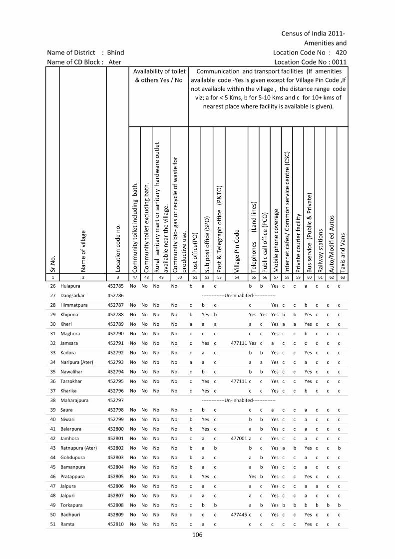
Census of India 2011- Amenities and
Name of District : Bhind Location Code No : 420Name of CD Block : Ater Location Code No : 0011
Com
mun
ity to
ilet i
nclu
ding
bat
h.
Com
mun
ity to
ilet e
xclu
ding
bat
h.
Rura
l sa
nita
ry m
art o
r sa
nita
ry h
ardw
are
outle
t av
aila
ble
near
the
villa
ge.
Com
mun
ity b
io- g
as o
r re
cycl
e of
was
te fo
r pr
oduc
tive
use.
Post
off
ice(
PO)
Sub
post
off
ice
(SPO
)
Post
& T
eleg
raph
off
ice
(P&
TO)
Villa
ge P
in C
ode
Tele
phon
es
(L
and
lines
)
Publ
ic c
all o
ffic
e (P
CO)
Mob
ile p
hone
cov
erag
e
Inte
rnet
caf
es/
Com
mon
ser
vice
cen
tre
(CSC
)
Priv
ate
cour
ier
faci
lity
Bus
serv
ice
(Pub
lic &
Pri
vate
)
Railw
ay s
tatio
ns
Aut
o/M
odifi
ed A
utos
Taxi
s an
d Va
ns
1 2 3 47 48 49 50 51 52 53 54 55 56 57 58 59 60 61 62 63
Sr.N
o.
Nam
e of
vill
age
Loca
tion
code
no.
Availability of toilet & others Yes / No
Communication and transport facilities (If amenities available code -Yes is given except for Village Pin Code ,If not available within the village , the distance range code
viz; a for < 5 Kms, b for 5-10 Kms and c for 10+ kms of nearest place where facility is available is given).
26 Hulapura 452785 No No No No b a c b b Yes c c a c c c
27 Dangsarkar 452786 --------------Un-inhabited--------------
28 Himmatpura 452787 No No No No c b c c Yes c c b c c c
29 Khipona 452788 No No No No b Yes b Yes Yes Yes b b Yes c c c
30 Kheri 452789 No No No No a a a a c Yes a a Yes c c c
31 Maghora 452790 No No No No c c c c c Yes c c b c c c
32 Jamsara 452791 No No No No c Yes c 477111 Yes c a c c c c c c
33 Kadora 452792 No No No No c a c b b Yes c c Yes c c c
34 Naripura (Ater) 452793 No No No No a a c a a Yes c c a c c c
35 Nawalihar 452794 No No No No c b c b b Yes c c Yes c c c
36 Tarsokhar 452795 No No No No c Yes c 477111 c c Yes c c Yes c c c
37 Kharika 452796 No No No No c Yes c c c Yes c c b c c c
38 Maharajpura 452797 --------------Un-inhabited--------------
39 Saura 452798 No No No No c b c c c a c c a c c c
40 Niwari 452799 No No No No b Yes c b b Yes c c a c c c
41 Balarpura 452800 No No No No b Yes c a b Yes c c a c c c
42 Jamhora 452801 No No No No c a c 477001 a c Yes c c a c c c
43 Ratnupura (Ater) 452802 No No No No b a b b c Yes a b Yes c c b
44 Gohdupura 452803 No No No No b a c a b Yes c c a c c c
45 Bamanpura 452804 No No No No b a c a b Yes c c a c c c
46 Pratappura 452805 No No No No b Yes c Yes b Yes c c Yes c c c
47 Jalpura 452806 No No No No c a c a c Yes c c a a c c
48 Jalpuri 452807 No No No No c a c a c Yes c c a c c c
49 Torkapura 452808 No No No No c b b a b Yes b b b b b b
50 Badhpuri 452809 No No No No c c c 477445 c c Yes c c Yes c c c
51 Ramta 452810 No No No No c a c c c c c c Yes c c c
106
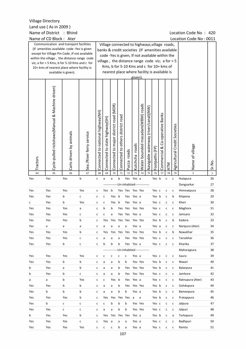
Village DirectoryLand use ( As in 2009 )Name of District : Bhind Location Code No : 420Name of CD Block : Ater Location Code No : 0011
Trac
tors
Cycl
e-pu
lled
rick
shaw
s(M
anua
l & M
achi
ne d
rive
n)
Cart
s dr
iven
by
anim
als
Sea
/Riv
er fe
rry
serv
ice
Conn
ecte
d to
nat
iona
l hig
hway
(NH
)
Conn
ecte
d to
sta
te h
ighw
ay(S
H)
Conn
ecte
d to
maj
or d
istr
ict r
oad
(MD
R)
Conn
ecte
d to
oth
ers
dist
rict
roa
d
Pucc
a r
oads
Kutc
hcha
roa
ds
Wat
er b
ound
ed m
acad
am(W
BM) r
oads
Nav
igab
le w
ater
way
(riv
er/c
anal
)(N
W)
Foot
path
s (F
P)
Com
mer
cial
& C
o-op
erat
ive
Bank
s
ATM
Agr
icul
tura
l Cre
dit S
ocie
ties
64 65 66 67 68 69 70 71 72 73 74 75 76 77 78 79 2 1
Communication and transport facilities (If amenities available code -Yes is given
except for Village Pin Code ,If not available within the village , the distance range code viz; a for < 5 Kms, b for 5-10 Kms and c for 10+ kms of nearest place where facility is
available is given).
Village connected to highways,village roads, banks & credit societies (If amenities available
code -Yes is given, If not available within the village , the distance range code viz; a for < 5
Kms, b for 5-10 Kms and c for 10+ kms of nearest place where facility is available is
given).
Nam
e of
vill
age
Sr.N
o.
Yes Yes Yes b c a a b Yes Yes a Yes b c c Hulapura 26
--------------Un-inhabited-------------- Dangsarkar 27
Yes Yes Yes Yes c Yes b Yes Yes Yes Yes Yes c c c Himmatpura 28
Yes Yes b c c c Yes b Yes Yes a Yes b c b Khipona 29
c Yes b Yes c c Yes b Yes Yes a Yes c c c Kheri 30
Yes Yes Yes a c b b Yes Yes Yes Yes Yes c c c Maghora 31
Yes Yes Yes c c c a Yes Yes Yes a Yes c c c Jamsara 32
Yes Yes Yes b c Yes Yes Yes Yes Yes Yes Yes b c b Kadora 33
Yes a a a c a a a a Yes a Yes a c c Naripura (Ater) 34
Yes Yes Yes b c Yes Yes Yes Yes Yes Yes Yes b c b Nawalihar 35
Yes Yes Yes c c a a a Yes Yes Yes Yes c c c Tarsokhar 36
Yes Yes b c c b b b Yes Yes a Yes c c c Kharika 37
--------------Un-inhabited-------------- Maharajpura 38
Yes Yes Yes Yes c c c c c Yes a Yes c c c Saura 39
Yes Yes b b c a a b b Yes Yes Yes b c c Niwari 40
b Yes a b c a a b Yes Yes Yes Yes b c c Balarpura 41
b Yes b c c a a b Yes Yes Yes Yes c c c Jamhora 42
a a b Yes c c Yes b Yes Yes a Yes c c c Ratnupura (Ater) 43
Yes Yes b b c a a b Yes Yes Yes Yes b c c Gohdupura 44
Yes b b b c a a b b Yes a Yes b c c Bamanpura 45
Yes Yes Yes b c Yes Yes Yes Yes a a Yes b c c Pratappura 46
Yes b c c c c b b b Yes Yes Yes c c c Jalpura 47
Yes Yes c c c a a b b Yes Yes Yes c c c Jalpuri 48
b Yes Yes b c Yes Yes Yes Yes Yes a Yes b c a Torkapura 49
Yes Yes Yes c c Yes a a a Yes a Yes c c c Badhpuri 50
Yes Yes Yes Yes c c c b a Yes a Yes c c c Ramta 51
107
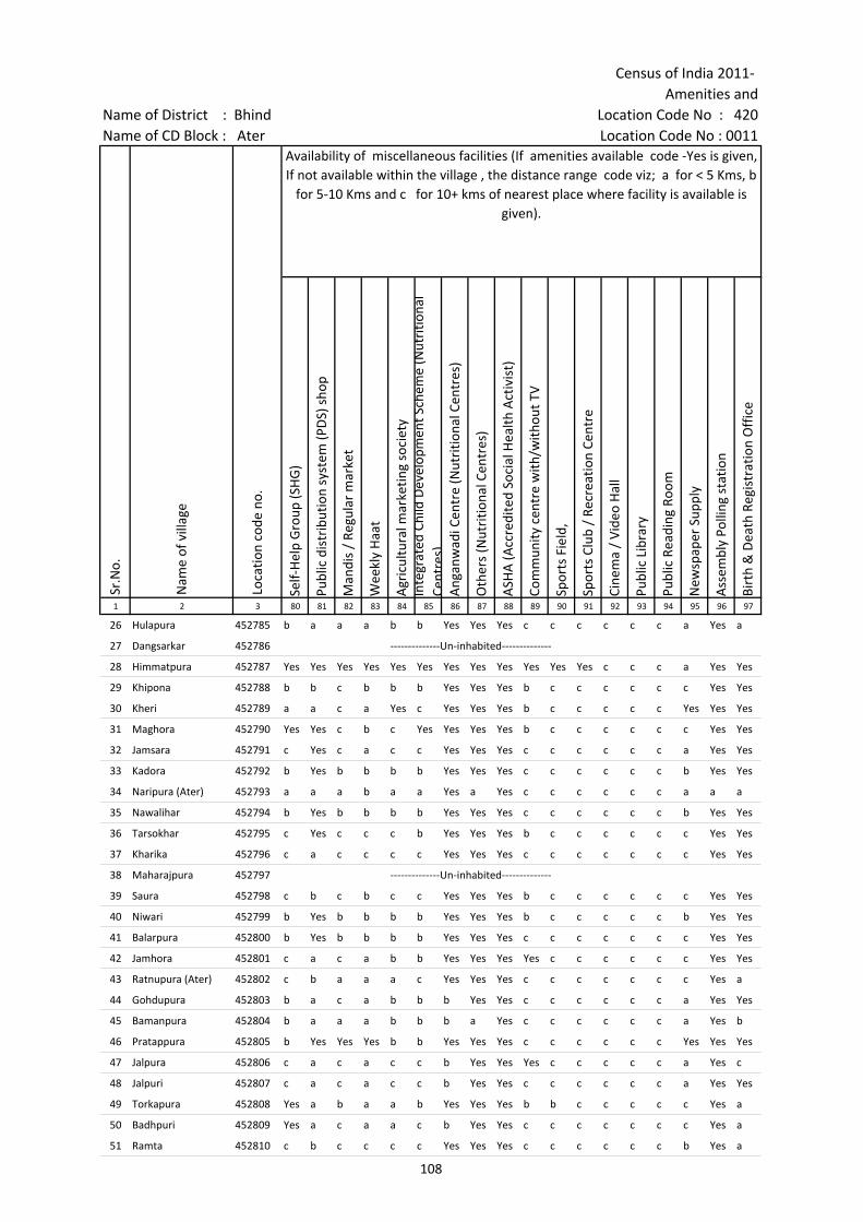
Census of India 2011- Amenities and
Name of District : Bhind Location Code No : 420Name of CD Block : Ater Location Code No : 0011
Self-
Hel
p G
roup
(SH
G)
Publ
ic d
istr
ibut
ion
syst
em (P
DS)
sho
p
Man
dis
/ Re
gula
r m
arke
t
Wee
kly
Haa
t
Agr
icul
tura
l mar
ketin
g so
ciet
yIn
tegr
ated
Chi
ld D
evel
opm
ent S
chem
e (N
utri
tiona
l Ce
ntre
s)A
ngan
wad
i Cen
tre
(Nut
ritio
nal C
entr
es)
Oth
ers
(Nut
ritio
nal C
entr
es)
ASH
A (A
ccre
dite
d So
cial
Hea
lth A
ctiv
ist)
Com
mun
ity c
entr
e w
ith/w
ithou
t TV
Spor
ts F
ield
,
Spor
ts C
lub
/ Re
crea
tion
Cent
re
Cine
ma
/ Vi
deo
Hal
l
Publ
ic L
ibra
ry
Publ
ic R
eadi
ng R
oom
New
spap
er S
uppl
y
Ass
embl
y Po
lling
sta
tion
Birt
h &
Dea
th R
egis
trat
ion
Off
ice
1 2 3 80 81 82 83 84 85 86 87 88 89 90 91 92 93 94 95 96 97
Sr.N
o.
Nam
e of
vill
age
Loca
tion
code
no.
Availability of miscellaneous facilities (If amenities available code -Yes is given, If not available within the village , the distance range code viz; a for < 5 Kms, b
for 5-10 Kms and c for 10+ kms of nearest place where facility is available is given).
26 Hulapura 452785 b a a a b b Yes Yes Yes c c c c c c a Yes a
27 Dangsarkar 452786 --------------Un-inhabited--------------
28 Himmatpura 452787 Yes Yes Yes Yes Yes Yes Yes Yes Yes Yes Yes Yes c c c a Yes Yes
29 Khipona 452788 b b c b b b Yes Yes Yes b c c c c c c Yes Yes
30 Kheri 452789 a a c a Yes c Yes Yes Yes b c c c c c Yes Yes Yes
31 Maghora 452790 Yes Yes c b c Yes Yes Yes Yes b c c c c c c Yes Yes
32 Jamsara 452791 c Yes c a c c Yes Yes Yes c c c c c c a Yes Yes
33 Kadora 452792 b Yes b b b b Yes Yes Yes c c c c c c b Yes Yes
34 Naripura (Ater) 452793 a a a b a a Yes a Yes c c c c c c a a a
35 Nawalihar 452794 b Yes b b b b Yes Yes Yes c c c c c c b Yes Yes
36 Tarsokhar 452795 c Yes c c c b Yes Yes Yes b c c c c c c Yes Yes
37 Kharika 452796 c a c c c c Yes Yes Yes c c c c c c c Yes Yes
38 Maharajpura 452797 --------------Un-inhabited--------------
39 Saura 452798 c b c b c c Yes Yes Yes b c c c c c c Yes Yes
40 Niwari 452799 b Yes b b b b Yes Yes Yes b c c c c c b Yes Yes
41 Balarpura 452800 b Yes b b b b Yes Yes Yes c c c c c c c Yes Yes
42 Jamhora 452801 c a c a b b Yes Yes Yes Yes c c c c c c Yes Yes
43 Ratnupura (Ater) 452802 c b a a a c Yes Yes Yes c c c c c c c Yes a
44 Gohdupura 452803 b a c a b b b Yes Yes c c c c c c a Yes Yes
45 Bamanpura 452804 b a a a b b b a Yes c c c c c c a Yes b
46 Pratappura 452805 b Yes Yes Yes b b Yes Yes Yes c c c c c c Yes Yes Yes
47 Jalpura 452806 c a c a c c b Yes Yes Yes c c c c c a Yes c
48 Jalpuri 452807 c a c a c c b Yes Yes c c c c c c a Yes Yes
49 Torkapura 452808 Yes a b a a b Yes Yes Yes b b c c c c c Yes a
50 Badhpuri 452809 Yes a c a a c b Yes Yes c c c c c c c Yes a
51 Ramta 452810 c b c c c c Yes Yes Yes c c c c c c b Yes a
108
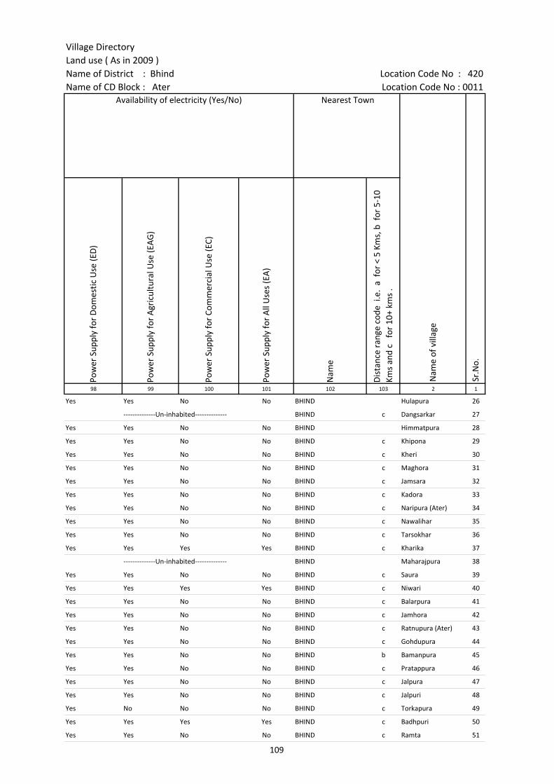
Village DirectoryLand use ( As in 2009 )Name of District : Bhind Location Code No : 420Name of CD Block : Ater Location Code No : 0011
Pow
er S
uppl
y fo
r D
omes
tic U
se (E
D)
Pow
er S
uppl
y fo
r A
gric
ultu
ral U
se (E
AG
)
Pow
er S
uppl
y fo
r Co
mm
erci
al U
se (E
C)
Pow
er S
uppl
y fo
r A
ll U
ses
(EA
)
Nam
e
Dis
tanc
e ra
nge
code
i.e
. a
for
< 5
Kms,
b f
or 5
-10
Kms
and
c f
or 1
0+ k
ms
.98 99 100 101 102 103 2 1
Availability of electricity (Yes/No) Nearest Town
Nam
e of
vill
age
Sr.N
o.
Yes Yes No No BHIND Hulapura 26
--------------Un-inhabited-------------- BHIND c Dangsarkar 27
Yes Yes No No BHIND Himmatpura 28
Yes Yes No No BHIND c Khipona 29
Yes Yes No No BHIND c Kheri 30
Yes Yes No No BHIND c Maghora 31
Yes Yes No No BHIND c Jamsara 32
Yes Yes No No BHIND c Kadora 33
Yes Yes No No BHIND c Naripura (Ater) 34
Yes Yes No No BHIND c Nawalihar 35
Yes Yes No No BHIND c Tarsokhar 36
Yes Yes Yes Yes BHIND c Kharika 37
--------------Un-inhabited-------------- BHIND Maharajpura 38
Yes Yes No No BHIND c Saura 39
Yes Yes Yes Yes BHIND c Niwari 40
Yes Yes No No BHIND c Balarpura 41
Yes Yes No No BHIND c Jamhora 42
Yes Yes No No BHIND c Ratnupura (Ater) 43
Yes Yes No No BHIND c Gohdupura 44
Yes Yes No No BHIND b Bamanpura 45
Yes Yes No No BHIND c Pratappura 46
Yes Yes No No BHIND c Jalpura 47
Yes Yes No No BHIND c Jalpuri 48
Yes No No No BHIND c Torkapura 49
Yes Yes Yes Yes BHIND c Badhpuri 50
Yes Yes No No BHIND c Ramta 51
109
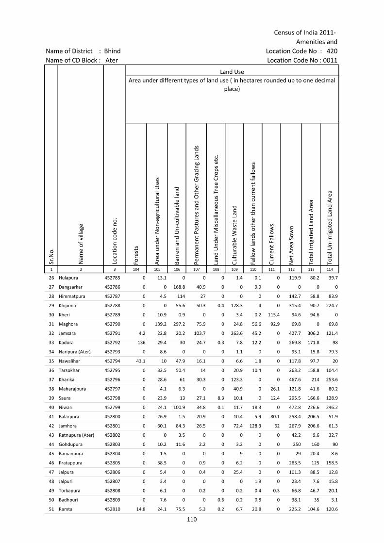
Census of India 2011- Amenities and
Name of District : Bhind Location Code No : 420Name of CD Block : Ater Location Code No : 0011
Fore
sts
Are
a un
der
Non
-agr
icul
tura
l Use
s
Barr
en a
nd U
n-cu
ltiva
ble
land
Perm
anen
t Pas
ture
s an
d O
ther
Gra
zing
Lan
ds
Land
Und
er M
isce
llane
ous
Tree
Cro
ps e
tc.
Cultu
rabl
e W
aste
Lan
d
Fallo
w la
nds
othe
r th
an c
urre
nt fa
llow
s
Curr
ent F
allo
ws
Net
Are
a So
wn
Tota
l Irr
igat
ed L
and
Are
a
Tota
l Un-
irri
gate
d La
nd A
rea
1 2 3 104 105 106 107 108 109 110 111 112 113 114
Sr.N
o.
Nam
e of
vill
age
Loca
tion
code
no.
Land UseArea under different types of land use ( in hectares rounded up to one decimal
place)
26 Hulapura 452785 0 13.1 0 0 0 1.4 0.1 0 119.9 80.2 39.7
27 Dangsarkar 452786 0 0 168.8 40.9 0 0 9.9 0 0 0 0
28 Himmatpura 452787 0 4.5 114 27 0 0 0 0 142.7 58.8 83.9
29 Khipona 452788 0 0 55.6 50.3 0.4 128.3 4 0 315.4 90.7 224.7
30 Kheri 452789 0 10.9 0.9 0 0 3.4 0.2 115.4 94.6 94.6 0
31 Maghora 452790 0 139.2 297.2 75.9 0 24.8 56.6 92.9 69.8 0 69.8
32 Jamsara 452791 4.2 22.8 20.2 103.7 0 263.6 45.2 0 427.7 306.2 121.4
33 Kadora 452792 136 29.4 30 24.7 0.3 7.8 12.2 0 269.8 171.8 98
34 Naripura (Ater) 452793 0 8.6 0 0 0 1.1 0 0 95.1 15.8 79.3
35 Nawalihar 452794 43.1 10 47.9 16.1 0 6.6 1.8 0 117.8 97.7 20
36 Tarsokhar 452795 0 32.5 50.4 14 0 20.9 10.4 0 263.2 158.8 104.4
37 Kharika 452796 0 28.6 61 30.3 0 123.3 0 0 467.6 214 253.6
38 Maharajpura 452797 0 4.1 6.3 0 0 40.9 0 26.1 121.8 41.6 80.2
39 Saura 452798 0 23.9 13 27.1 8.3 10.1 0 12.4 295.5 166.6 128.9
40 Niwari 452799 0 24.1 100.9 34.8 0.1 11.7 18.3 0 472.8 226.6 246.2
41 Balarpura 452800 0 26.9 1.5 20.9 0 10.4 5.9 80.1 258.4 206.5 51.9
42 Jamhora 452801 0 60.1 84.3 26.5 0 72.4 128.3 62 267.9 206.6 61.3
43 Ratnupura (Ater) 452802 0 0 3.5 0 0 0 0 0 42.2 9.6 32.7
44 Gohdupura 452803 0 10.2 11.6 2.2 0 3.2 0 0 250 160 90
45 Bamanpura 452804 0 1.5 0 0 0 9 0 0 29 20.4 8.6
46 Pratappura 452805 0 38.5 0 0.9 0 6.2 0 0 283.5 125 158.5
47 Jalpura 452806 0 5.4 0 0.4 0 25.4 0 0 101.3 88.5 12.8
48 Jalpuri 452807 0 3.4 0 0 0 0 1.9 0 23.4 7.6 15.8
49 Torkapura 452808 0 6.1 0 0.2 0 0.2 0.4 0.3 66.8 46.7 20.1
50 Badhpuri 452809 0 7.6 0 0 0.6 0.2 0.8 0 38.1 35 3.1
51 Ramta 452810 14.8 24.1 75.5 5.3 0.2 6.7 20.8 0 225.2 104.6 120.6
110
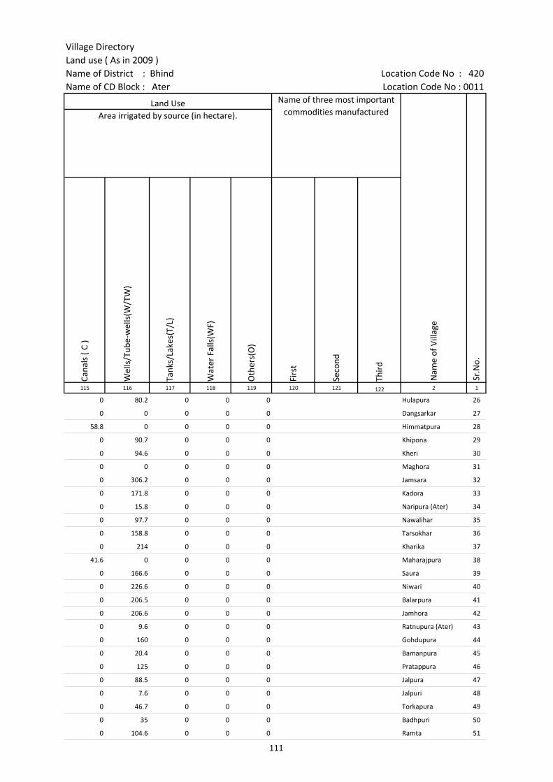
Village DirectoryLand use ( As in 2009 )Name of District : Bhind Location Code No : 420Name of CD Block : Ater Location Code No : 0011
Cana
ls (
C )
Wel
ls/T
ube-
wel
ls(W
/TW
)
Tank
s/La
kes(
T/L)
Wat
er F
alls
(WF)
Oth
ers(
O)
Firs
t
Seco
nd
Thir
d 115 116 117 118 119 120 121 122 2 1
Land Use Name of three most important commodities manufactured
Nam
e of
Vill
age
Sr.N
o.
Area irrigated by source (in hectare).
0 80.2 0 0 0 Hulapura 26
0 0 0 0 0 Dangsarkar 27
58.8 0 0 0 0 Himmatpura 28
0 90.7 0 0 0 Khipona 29
0 94.6 0 0 0 Kheri 30
0 0 0 0 0 Maghora 31
0 306.2 0 0 0 Jamsara 32
0 171.8 0 0 0 Kadora 33
0 15.8 0 0 0 Naripura (Ater) 34
0 97.7 0 0 0 Nawalihar 35
0 158.8 0 0 0 Tarsokhar 36
0 214 0 0 0 Kharika 37
41.6 0 0 0 0 Maharajpura 38
0 166.6 0 0 0 Saura 39
0 226.6 0 0 0 Niwari 40
0 206.5 0 0 0 Balarpura 41
0 206.6 0 0 0 Jamhora 42
0 9.6 0 0 0 Ratnupura (Ater) 43
0 160 0 0 0 Gohdupura 44
0 20.4 0 0 0 Bamanpura 45
0 125 0 0 0 Pratappura 46
0 88.5 0 0 0 Jalpura 47
0 7.6 0 0 0 Jalpuri 48
0 46.7 0 0 0 Torkapura 49
0 35 0 0 0 Badhpuri 50
0 104.6 0 0 0 Ramta 51
111

Census of India 2011- Amenities and
Name of District : Bhind Location Code No : 420Name of CD Block : Ater Location Code No : 0011
Pre-
Prim
ary
scho
ol (P
P)
Prim
ary
scho
ol (P
)
Mid
dle
scho
ol (M
)
Seco
ndar
y Sc
hool
(S)
Seni
or S
econ
dary
sch
ool (
SS)
Deg
ree
colle
ge o
f art
s s
cien
ce &
com
mer
ce (
ASC
)
Engi
neer
ing
colle
ge(E
C)
Med
ical
col
lege
(MC)
Man
agem
ent i
nstit
ute
(MI)
Poly
tech
nic
(Pt)
Voca
tiona
l tra
inin
g sc
hool
/IT
I
Non
-for
mal
trai
ning
cen
tre
(NFT
C)
Spec
ial s
choo
l for
dis
able
d (S
SD)
Oth
ers
(spe
cify
)
1 2 3 4 5 6 7 8 9 10 11 12 13 14 15 16 17 18 19 20
Number of educational amenities available. (If not available within the village , the distance range
code viz; a for < 5 Kms, b for 5-10 Kms and c for 10+ kms of nearest place where facility is available is given).
Sr.N
o.
Nam
e of
vill
age
Loca
tion
code
no.
Tota
l are
a of
the
villa
ge (
in h
ecta
res
roun
ded
up to
one
dec
imal
pla
ce)
Tota
l pop
ulat
ion
( 201
1 ce
nsus
)
Num
ber
of h
ouse
hold
s (2
011
cens
us)
52 Ridouli 452811 681.4 3123 531 a 3 1 1 c c c c c c c c c c
53 Daipura 452812 691.7 2055 384 b 4 1 b b c c c c c c c c c
54 Badhpura 452813 139.2 680 138 a 1 a a c c c c c c c c c
55 Anurudhapura 452814 170.9 565 113 b 1 1 b b b c c c c c c c c
56 Udannkheda 452815 212.9 1053 160 b 1 1 b b b c c c c c c c c
57 Kisupura 452816 251.1 2922 543 1 2 2 1 1 c c c c
58 Jorikotwal 452817 407 1499 306 a 2 2 1 1 1 c c c c
59 Chhidiyapura 452818 134.9 697 111 a 1 a a a a c c c c c c c c
60 Karekapura 452819 75 336 79 c 1 a b a c c c c c c c c
61 Akon 452820 850.3 1901 336 1 1 c c c c
62 Nakhloli 452821 612.3 938 139 1 1 1 c c c c
63 Surajpura 452822 66 370 65 1 c c c c
64 Surpura 452823 307.7 1842 334 1 3 2 1 1 a c c c c c c c c
65 Chitawali 452824 418.6 1482 201 1 1 1 a a c c c c
66 Jaluapura 452825 77 317 54 a 1 a a a c c c c c c c c
67 Adhurjpura 452826 37.7 542 93 a 1 a a a a c c c c c c c c
68 Kalyanpura 452827 88.1 743 113 a 1 1 a a a c c c c c c c c
69 Para 452828 1424.4 7224 1289 1 5 2 2 1 b c c c b b b c b
70 Madhopura 452829 12.7 0 0 --------------Un-inhabited--------------
71 Soyee 452830 616.2 1681 275 a 1 a a b c c c c c c c c
72 Janora 452831 508.5 1103 173 b 1 1 b c c c c c c c c c c
73 Rampura 452832 110 0 0 --------------Un-inhabited--------------
74 Kamai 452833 563 1475 199 b 1 1 a a c c c c c c c c c
75 Sanglitor 452834 201.8 505 80 c 1 1 c c c c c c c c c c
76 Hetpura 452835 96.6 259 48 a 1 1 b b b c c c c c c c c
77 Bhagwantpura 452836 101.9 606 109 1 a a a b c c c c c c c
112

Village DirectoryLand use ( As in 2009 )Name of District : Bhind Location Code No : 420Name of CD Block : Ater Location Code No : 0011
Com
mun
ity h
ealth
cen
tre
(CH
C)Pr
imar
y he
alth
cen
tre
(PH
C)Pr
imar
y he
alth
sub
cen
tre
(PH
S)M
ater
nity
and
chi
ld w
elfa
re c
entr
e (M
CW)
T.B.
clin
ic (
TBC)
Hos
pita
l-allo
path
ic (H
A)
Hos
pita
l-alte
rnat
ive
med
icin
e (H
O)
Dis
pens
ary
(D)
Vete
rina
ry h
ospi
tal (
VH)
Mob
ile h
ealth
clin
ic (M
HC)
Fam
ily w
elfa
re c
entr
e (F
WC)
Char
itabl
e no
n G
ovt.
hos
pita
l/N
ursi
ng h
ome.
Med
ical
pra
ctiti
oner
with
MBB
S D
egre
eM
edic
al p
ract
ition
er w
ith o
ther
deg
ree
Med
ical
pra
ctiti
oner
with
no
degr
eeTr
aditi
onal
pra
ctiti
oner
and
faith
hea
ler
.M
edic
ine
Shop
Oth
ers
Tap
wat
er (T
reat
ed/U
ntre
ated
)
Wel
l w
ater
(C
over
ed /
Unc
over
ed w
ell)
Han
d Pu
mp
Tube
wel
ls /
Bor
e w
ell
Spri
ng
Rive
r /
Cana
l
Tank
/ P
ond
/ L
ake
Oth
ers
21 22 23 24 25 26 27 28 29 30 31 32 33 34 35 36 37 38 39 40 41 42 43 44 45 46 2 1
Number of Medical Amenities available. (If not available within the
village , the distance range code viz; a for < 5 Kms, b for 5-10 Kms and c for
10+ kms of nearest place where facility is available is given).
Number of Non-Government
Medical Amenities available.
Availability of drinking water - Yes / No
Nam
e of
vill
age
Sr.N
o.
c c c c c c c a a c c 0 0 0 0 0 0 0 No Yes Yes Yes No Yes No No Ridouli 52
c c c c c c c b c c c 0 0 0 0 0 0 0 No Yes Yes Yes No Yes No No Daipura 53
c c c c c c c c c c 0 0 0 0 0 0 0 No Yes Yes Yes No No Yes No Badhpura 54
c c c c c b b b b b b 0 0 0 0 0 0 0 No Yes Yes Yes No No Yes No Anurudhapura 55
c b b b b b b b b c b 0 0 0 0 0 0 0 No Yes Yes Yes No No No Yes Udannkheda 56
c c b b c c c c c c c 0 0 0 0 0 0 0 No Yes Yes Yes No No No No Kisupura 57
c a a a a a a a a c a 0 0 0 0 0 0 0 Yes Yes Yes No No No No No Jorikotwal 58
c a a a a a c a b c a 0 0 0 0 0 0 0 No Yes Yes Yes No No No No Chhidiyapura 59
c c c c c c c c c c c 0 0 0 0 0 0 0 No Yes Yes Yes No No No No Karekapura 60
c b b c b c c c c c c 0 0 0 0 0 0 0 No Yes Yes Yes No No No No Akon 61
c c b b c c c c c c c 0 0 0 0 0 0 0 No Yes Yes Yes No No No No Nakhloli 62
c b b c b c c c c c c 0 0 0 0 0 0 0 No Yes Yes Yes No No No No Surajpura 63
c 1 1 1 c b a c 1 0 0 2 2 1 2 0 No Yes Yes Yes No No No No Surpura 64
c c b b c c c c c c c 0 0 0 0 0 0 0 No Yes Yes Yes No No No No Chitawali 65
c a a a a a a b a c a 0 0 0 0 0 0 0 No Yes Yes Yes No No Yes No Jaluapura 66
c a a a a a c b a c a 0 0 0 0 0 0 0 No Yes Yes Yes No No No No Adhurjpura 67
c a a a a a c b a c a 0 0 0 0 0 0 0 No Yes Yes Yes No No No No Kalyanpura 68
b b 1 b b b b 1 1 b b 0 0 0 0 0 0 0 Yes Yes Yes Yes No Yes No No Para 69
--------------Un-inhabited-------------- Madhopura 70
c b a b b b a a c c c 0 0 0 0 0 0 0 No Yes Yes Yes No Yes No No Soyee 71
c b b b b b b b c c c 0 0 0 0 0 0 0 No Yes Yes Yes No No No No Janora 72
--------------Un-inhabited-------------- Rampura 73
c c a c c c c c a c c 0 0 0 0 0 0 0 No Yes Yes Yes No Yes No No Kamai 74
c c c c c c c c c c c 0 0 0 0 0 0 0 No Yes Yes Yes No Yes No No Sanglitor 75
c b b b b b b b a c c 0 0 0 0 0 0 0 No Yes Yes Yes No No Yes No Hetpura 76
c a a a a a a a a c a 0 0 0 0 0 0 0 No Yes Yes Yes No Yes Yes No Bhagwantpura 77
113

Census of India 2011- Amenities and
Name of District : Bhind Location Code No : 420Name of CD Block : Ater Location Code No : 0011
Com
mun
ity to
ilet i
nclu
ding
bat
h.
Com
mun
ity to
ilet e
xclu
ding
bat
h.
Rura
l sa
nita
ry m
art o
r sa
nita
ry h
ardw
are
outle
t av
aila
ble
near
the
villa
ge.
Com
mun
ity b
io- g
as o
r re
cycl
e of
was
te fo
r pr
oduc
tive
use.
Post
off
ice(
PO)
Sub
post
off
ice
(SPO
)
Post
& T
eleg
raph
off
ice
(P&
TO)
Villa
ge P
in C
ode
Tele
phon
es
(L
and
lines
)
Publ
ic c
all o
ffic
e (P
CO)
Mob
ile p
hone
cov
erag
e
Inte
rnet
caf
es/
Com
mon
ser
vice
cen
tre
(CSC
)
Priv
ate
cour
ier
faci
lity
Bus
serv
ice
(Pub
lic &
Pri
vate
)
Railw
ay s
tatio
ns
Aut
o/M
odifi
ed A
utos
Taxi
s an
d Va
ns
1 2 3 47 48 49 50 51 52 53 54 55 56 57 58 59 60 61 62 63
Sr.N
o.
Nam
e of
vill
age
Loca
tion
code
no.
Availability of toilet & others Yes / No
Communication and transport facilities (If amenities available code -Yes is given except for Village Pin Code ,If not available within the village , the distance range code
viz; a for < 5 Kms, b for 5-10 Kms and c for 10+ kms of nearest place where facility is available is given).
52 Ridouli 452811 No No No No c Yes c 477111 c c c c c Yes c c c
53 Daipura 452812 No No No No c b c b c Yes c c b c c a
54 Badhpura 452813 No No No No c b c c c c c c Yes c c
55 Anurudhapura 452814 No No No No c b c c c Yes c c Yes c c c
56 Udannkheda 452815 No No No No c c c c c Yes c c b c c c
57 Kisupura 452816 No No No No c Yes Yes c Yes c c Yes c c c
58 Jorikotwal 452817 No No No No c Yes c 477557 Yes c Yes c c Yes c c c
59 Chhidiyapura 452818 No No No No c a a c c Yes a c a c c c
60 Karekapura 452819 No No No No c a c a c Yes c c a c c c
61 Akon 452820 No No No No c Yes Yes c b c c c c c c
62 Nakhloli 452821 No No No No c c Yes c b c c c c c c
63 Surajpura 452822 No No No No c c c c b c c c c c c
64 Surpura 452823 No No No No c Yes Yes 477555 Yes c Yes Yes c Yes c c c
65 Chitawali 452824 No No No No c c Yes c b c c c c c c
66 Jaluapura 452825 No No No No c a a a c Yes a c a c a a
67 Adhurjpura 452826 No No No No c a a c c Yes c c a c c c
68 Kalyanpura 452827 No No No No c a a a c Yes a c a c c c
69 Para 452828 No No No No b Yes b Yes Yes Yes b b Yes b b b
70 Madhopura 452829 --------------Un-inhabited--------------
71 Soyee 452830 No No No No c a a a c Yes c c a c c c
72 Janora 452831 No No No No c Yes b b c Yes c c b c c c
73 Rampura 452832 --------------Un-inhabited--------------
74 Kamai 452833 No No No No c b b b c Yes c c b c c c
75 Sanglitor 452834 No No No No c a c a c Yes c c b c c c
76 Hetpura 452835 No No No No c c c c c Yes c c Yes c c c
77 Bhagwantpura 452836 No No No No c b c c c Yes c c Yes c c c
114
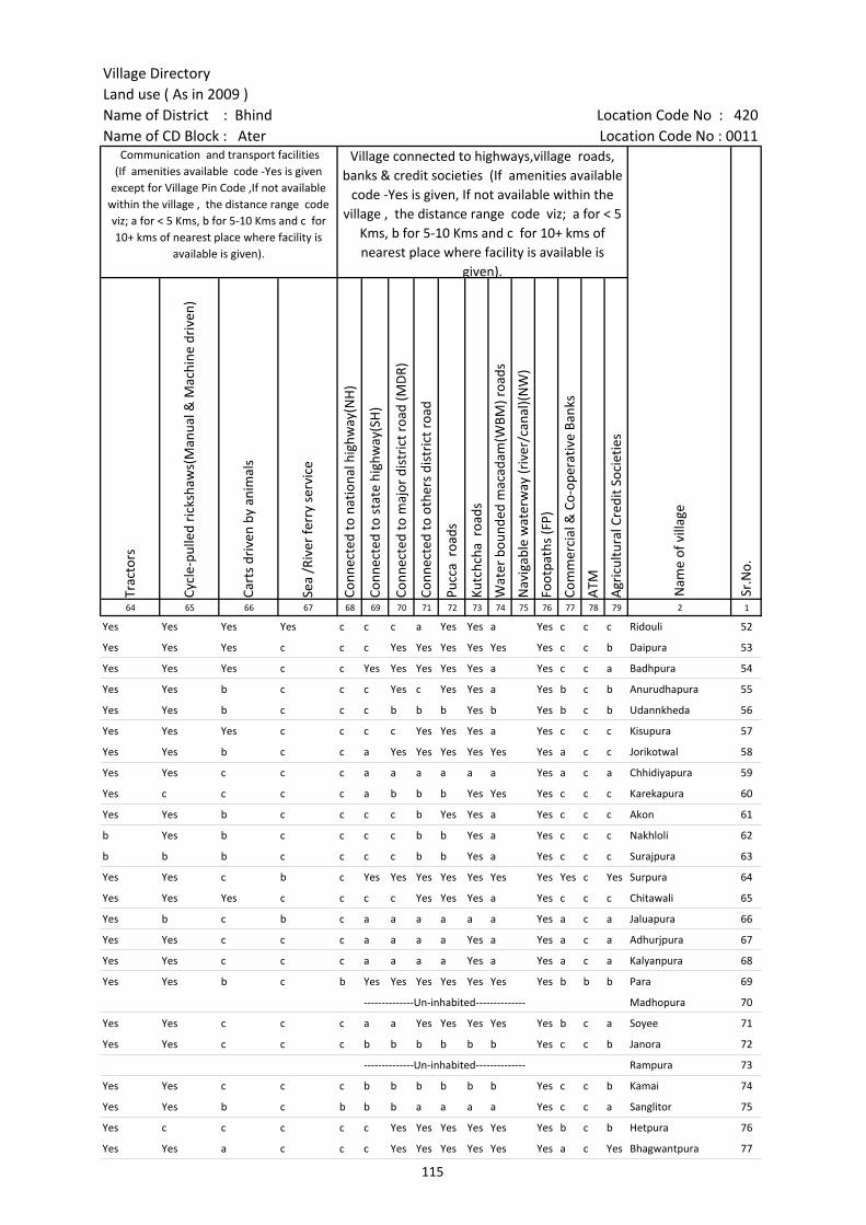
Village DirectoryLand use ( As in 2009 )Name of District : Bhind Location Code No : 420Name of CD Block : Ater Location Code No : 0011
Trac
tors
Cycl
e-pu
lled
rick
shaw
s(M
anua
l & M
achi
ne d
rive
n)
Cart
s dr
iven
by
anim
als
Sea
/Riv
er fe
rry
serv
ice
Conn
ecte
d to
nat
iona
l hig
hway
(NH
)
Conn
ecte
d to
sta
te h
ighw
ay(S
H)
Conn
ecte
d to
maj
or d
istr
ict r
oad
(MD
R)
Conn
ecte
d to
oth
ers
dist
rict
roa
d
Pucc
a r
oads
Kutc
hcha
roa
ds
Wat
er b
ound
ed m
acad
am(W
BM) r
oads
Nav
igab
le w
ater
way
(riv
er/c
anal
)(N
W)
Foot
path
s (F
P)
Com
mer
cial
& C
o-op
erat
ive
Bank
s
ATM
Agr
icul
tura
l Cre
dit S
ocie
ties
64 65 66 67 68 69 70 71 72 73 74 75 76 77 78 79 2 1
Communication and transport facilities (If amenities available code -Yes is given
except for Village Pin Code ,If not available within the village , the distance range code viz; a for < 5 Kms, b for 5-10 Kms and c for 10+ kms of nearest place where facility is
available is given).
Village connected to highways,village roads, banks & credit societies (If amenities available
code -Yes is given, If not available within the village , the distance range code viz; a for < 5
Kms, b for 5-10 Kms and c for 10+ kms of nearest place where facility is available is
given).
Nam
e of
vill
age
Sr.N
o.
Yes Yes Yes Yes c c c a Yes Yes a Yes c c c Ridouli 52
Yes Yes Yes c c c Yes Yes Yes Yes Yes Yes c c b Daipura 53
Yes Yes Yes c c Yes Yes Yes Yes Yes a Yes c c a Badhpura 54
Yes Yes b c c c Yes c Yes Yes a Yes b c b Anurudhapura 55
Yes Yes b c c c b b b Yes b Yes b c b Udannkheda 56
Yes Yes Yes c c c c Yes Yes Yes a Yes c c c Kisupura 57
Yes Yes b c c a Yes Yes Yes Yes Yes Yes a c c Jorikotwal 58
Yes Yes c c c a a a a a a Yes a c a Chhidiyapura 59
Yes c c c c a b b b Yes Yes Yes c c c Karekapura 60
Yes Yes b c c c c b Yes Yes a Yes c c c Akon 61
b Yes b c c c c b b Yes a Yes c c c Nakhloli 62
b b b c c c c b b Yes a Yes c c c Surajpura 63
Yes Yes c b c Yes Yes Yes Yes Yes Yes Yes Yes c Yes Surpura 64
Yes Yes Yes c c c c Yes Yes Yes a Yes c c c Chitawali 65
Yes b c b c a a a a a a Yes a c a Jaluapura 66
Yes Yes c c c a a a a Yes a Yes a c a Adhurjpura 67
Yes Yes c c c a a a a Yes a Yes a c a Kalyanpura 68
Yes Yes b c b Yes Yes Yes Yes Yes Yes Yes b b b Para 69
--------------Un-inhabited-------------- Madhopura 70
Yes Yes c c c a a Yes Yes Yes Yes Yes b c a Soyee 71
Yes Yes c c c b b b b b b Yes c c b Janora 72
--------------Un-inhabited-------------- Rampura 73
Yes Yes c c c b b b b b b Yes c c b Kamai 74
Yes Yes b c b b b a a a a Yes c c a Sanglitor 75
Yes c c c c c Yes Yes Yes Yes Yes Yes b c b Hetpura 76
Yes Yes a c c c Yes Yes Yes Yes Yes Yes a c Yes Bhagwantpura 77
115

Census of India 2011- Amenities and
Name of District : Bhind Location Code No : 420Name of CD Block : Ater Location Code No : 0011
Self-
Hel
p G
roup
(SH
G)
Publ
ic d
istr
ibut
ion
syst
em (P
DS)
sho
p
Man
dis
/ Re
gula
r m
arke
t
Wee
kly
Haa
t
Agr
icul
tura
l mar
ketin
g so
ciet
yIn
tegr
ated
Chi
ld D
evel
opm
ent S
chem
e (N
utri
tiona
l Ce
ntre
s)A
ngan
wad
i Cen
tre
(Nut
ritio
nal C
entr
es)
Oth
ers
(Nut
ritio
nal C
entr
es)
ASH
A (A
ccre
dite
d So
cial
Hea
lth A
ctiv
ist)
Com
mun
ity c
entr
e w
ith/w
ithou
t TV
Spor
ts F
ield
,
Spor
ts C
lub
/ Re
crea
tion
Cent
re
Cine
ma
/ Vi
deo
Hal
l
Publ
ic L
ibra
ry
Publ
ic R
eadi
ng R
oom
New
spap
er S
uppl
y
Ass
embl
y Po
lling
sta
tion
Birt
h &
Dea
th R
egis
trat
ion
Off
ice
1 2 3 80 81 82 83 84 85 86 87 88 89 90 91 92 93 94 95 96 97
Sr.N
o.
Nam
e of
vill
age
Loca
tion
code
no.
Availability of miscellaneous facilities (If amenities available code -Yes is given, If not available within the village , the distance range code viz; a for < 5 Kms, b
for 5-10 Kms and c for 10+ kms of nearest place where facility is available is given).
52 Ridouli 452811 c a c c c c Yes Yes Yes c c c c c c a Yes Yes
53 Daipura 452812 Yes b c c b c Yes Yes Yes Yes c c c c c c Yes Yes
54 Badhpura 452813 Yes a c c a c Yes Yes Yes c c c c c c c Yes Yes
55 Anurudhapura 452814 c b b b b c Yes Yes Yes c c c c c c c Yes b
56 Udannkheda 452815 c Yes b b b c Yes Yes Yes c c c c c c c Yes b
57 Kisupura 452816 Yes Yes c Yes c Yes Yes Yes Yes b c c c c c c Yes Yes
58 Jorikotwal 452817 Yes a c a c c Yes Yes Yes c c c c c c c Yes Yes
59 Chhidiyapura 452818 Yes a c a a Yes Yes Yes Yes c c c c c c a Yes a
60 Karekapura 452819 c a c a c c Yes a Yes c c c c c c a a b
61 Akon 452820 Yes b Yes Yes c c Yes Yes Yes b c c c c c c Yes Yes
62 Nakhloli 452821 Yes Yes c Yes Yes c Yes Yes Yes b c c c c c c Yes Yes
63 Surajpura 452822 Yes c c c c c Yes a Yes b c c c c c c a a
64 Surpura 452823 Yes Yes c b c Yes Yes Yes Yes c c c c c c Yes Yes Yes
65 Chitawali 452824 Yes a c a c Yes Yes Yes Yes b c c c c c c Yes a
66 Jaluapura 452825 Yes a c b c Yes Yes a Yes c c c c c Yes a a a
67 Adhurjpura 452826 Yes a c b Yes Yes Yes Yes Yes c c c c c c a a a
68 Kalyanpura 452827 Yes a c b c Yes Yes Yes Yes c c c c c c a Yes a
69 Para 452828 Yes Yes b b b b Yes Yes Yes b Yes b b Yes b b Yes Yes
70 Madhopura 452829 --------------Un-inhabited--------------
71 Soyee 452830 Yes Yes Yes Yes Yes Yes Yes Yes Yes Yes Yes Yes Yes Yes Yes Yes Yes Yes
72 Janora 452831 Yes Yes Yes Yes Yes Yes Yes Yes Yes Yes Yes Yes Yes c c Yes Yes Yes
73 Rampura 452832 --------------Un-inhabited--------------
74 Kamai 452833 Yes Yes Yes Yes Yes Yes Yes a Yes Yes Yes Yes Yes Yes Yes Yes Yes Yes
75 Sanglitor 452834 Yes Yes Yes Yes Yes Yes Yes Yes Yes Yes Yes Yes c Yes Yes Yes Yes Yes
76 Hetpura 452835 Yes a c c c c a a Yes c c c c c c c a a
77 Bhagwantpura 452836 Yes Yes c b c c Yes Yes Yes c c c c c c c Yes a
116
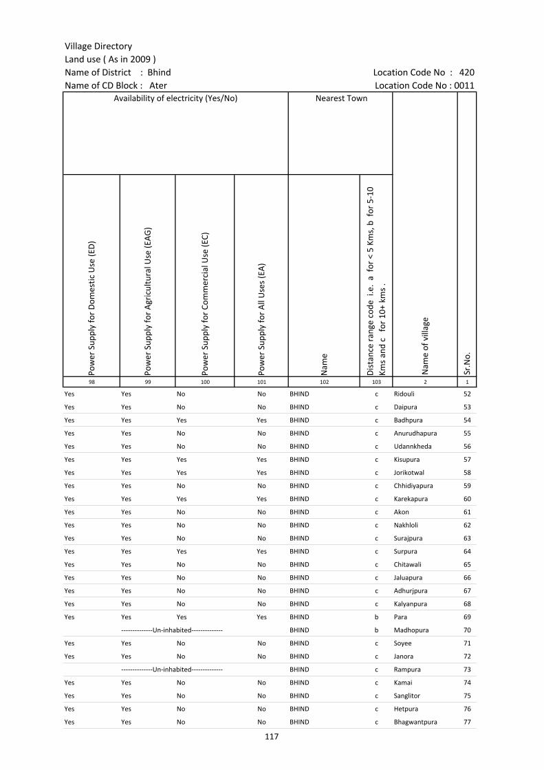
Village DirectoryLand use ( As in 2009 )Name of District : Bhind Location Code No : 420Name of CD Block : Ater Location Code No : 0011
Pow
er S
uppl
y fo
r D
omes
tic U
se (E
D)
Pow
er S
uppl
y fo
r A
gric
ultu
ral U
se (E
AG
)
Pow
er S
uppl
y fo
r Co
mm
erci
al U
se (E
C)
Pow
er S
uppl
y fo
r A
ll U
ses
(EA
)
Nam
e
Dis
tanc
e ra
nge
code
i.e
. a
for
< 5
Kms,
b f
or 5
-10
Kms
and
c f
or 1
0+ k
ms
.98 99 100 101 102 103 2 1
Availability of electricity (Yes/No) Nearest Town
Nam
e of
vill
age
Sr.N
o.
Yes Yes No No BHIND c Ridouli 52
Yes Yes No No BHIND c Daipura 53
Yes Yes Yes Yes BHIND c Badhpura 54
Yes Yes No No BHIND c Anurudhapura 55
Yes Yes No No BHIND c Udannkheda 56
Yes Yes Yes Yes BHIND c Kisupura 57
Yes Yes Yes Yes BHIND c Jorikotwal 58
Yes Yes No No BHIND c Chhidiyapura 59
Yes Yes Yes Yes BHIND c Karekapura 60
Yes Yes No No BHIND c Akon 61
Yes Yes No No BHIND c Nakhloli 62
Yes Yes No No BHIND c Surajpura 63
Yes Yes Yes Yes BHIND c Surpura 64
Yes Yes No No BHIND c Chitawali 65
Yes Yes No No BHIND c Jaluapura 66
Yes Yes No No BHIND c Adhurjpura 67
Yes Yes No No BHIND c Kalyanpura 68
Yes Yes Yes Yes BHIND b Para 69
--------------Un-inhabited-------------- BHIND b Madhopura 70
Yes Yes No No BHIND c Soyee 71
Yes Yes No No BHIND c Janora 72
--------------Un-inhabited-------------- BHIND c Rampura 73
Yes Yes No No BHIND c Kamai 74
Yes Yes No No BHIND c Sanglitor 75
Yes Yes No No BHIND c Hetpura 76
Yes Yes No No BHIND c Bhagwantpura 77
117
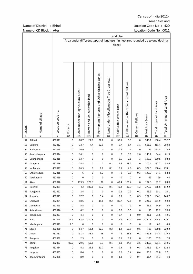
Census of India 2011- Amenities and
Name of District : Bhind Location Code No : 420Name of CD Block : Ater Location Code No : 0011
Fore
sts
Are
a un
der
Non
-agr
icul
tura
l Use
s
Barr
en a
nd U
n-cu
ltiva
ble
land
Perm
anen
t Pas
ture
s an
d O
ther
Gra
zing
Lan
ds
Land
Und
er M
isce
llane
ous
Tree
Cro
ps e
tc.
Cultu
rabl
e W
aste
Lan
d
Fallo
w la
nds
othe
r th
an c
urre
nt fa
llow
s
Curr
ent F
allo
ws
Net
Are
a So
wn
Tota
l Irr
igat
ed L
and
Are
a
Tota
l Un-
irri
gate
d La
nd A
rea
1 2 3 104 105 106 107 108 109 110 111 112 113 114
Sr.N
o.
Nam
e of
vill
age
Loca
tion
code
no.
Land UseArea under different types of land use ( in hectares rounded up to one decimal
place)
52 Ridouli 452811 0 28.7 21.6 52.7 0 30.1 5.3 0 543.1 190.4 352.7
53 Daipura 452812 0 32.7 7.7 22.9 0 5.7 8.4 3.1 611.2 311.4 299.8
54 Badhpura 452813 0 10.9 0 0 0 0.1 1 0 127 112.5 14.5
55 Anurudhapura 452814 0 14.1 0 0 0 2 5.9 2.6 146.2 84.4 61.9
56 Udannkheda 452815 0 13.7 0 0 0 0.5 2.1 3 193.6 100.8 92.8
57 Kisupura 452816 0 25.8 0 2 0.1 4.6 18.2 0 200.4 167.7 32.6
58 Jorikotwal 452817 0 26.3 0 0.7 0.1 0.1 4.8 0.5 374.5 100.4 274.1
59 Chhidiyapura 452818 0 6 0 5.2 0 0 0.5 0.3 122.9 54.1 68.8
60 Karekapura 452819 0 0 0 0 0 0 0 6 69 29 40
61 Akon 452820 0 119.3 378.6 26 0 43.4 100.4 0 182.5 92.7 89.8
62 Nakhloli 452821 0 52 185.1 23.2 0.1 49.2 30.9 1.2 270.7 158.6 112.2
63 Surajpura 452822 0 2.4 0 0 0 0.1 0.2 0.2 63.2 53.1 10.1
64 Surpura 452823 0 17.7 0 3.4 0 0.3 8 0.5 277.8 134.1 143.7
65 Chitawali 452824 0 18.6 0 19.6 0.2 85.7 72.8 0 221.7 161.9 59.8
66 Jaluapura 452825 0 5.5 0 0 0 0 2 0 69.5 64.9 4.6
67 Adhurjpura 452826 0 4.2 0 0 0 0.2 0.3 0 33 12.2 20.8
68 Kalyanpura 452827 0 4.4 0 0 0 0.7 1 0.9 81.1 31.6 49.5
69 Para 452828 11.4 67.5 130.8 0 0 2.1 52.2 9.9 1150.5 324.4 826.1
70 Madhopura 452829 1.6 0 0 0 0 0 0 0 11 6.2 4.8
71 Soyee 452830 0 64.7 53.4 32.7 0.2 1.2 50.5 0.6 413 190.8 222.2
72 Janora 452831 0 31.3 33.9 46 0 1 26.6 0.1 369.5 143.3 226.2
73 Rampura 452832 0 2.3 0 0 0 0.5 1.2 0 106 67.9 38
74 Kamai 452833 95.5 29.6 59.8 7.3 0.1 2.9 24.5 2.6 340.8 121.1 219.6
75 Sanglitor 452834 0 4.2 25.2 11.7 0 0.3 5 0.3 155.1 32.4 122.8
76 Hetpura 452835 0 8.4 0 0 0 0.6 0.4 0.4 86.9 59.8 27.1
77 Bhagwantpura 452836 0 8.9 0 0 0 1.3 0 0.4 91.4 81.3 10
118
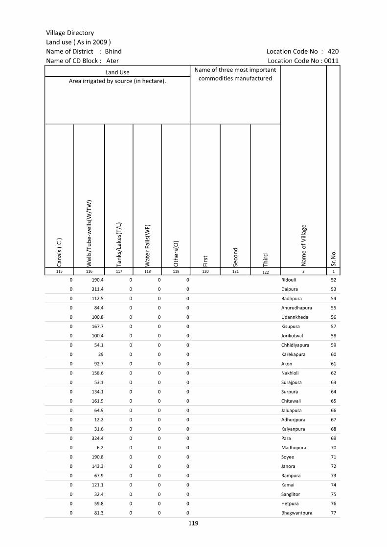
Village DirectoryLand use ( As in 2009 )Name of District : Bhind Location Code No : 420Name of CD Block : Ater Location Code No : 0011
Cana
ls (
C )
Wel
ls/T
ube-
wel
ls(W
/TW
)
Tank
s/La
kes(
T/L)
Wat
er F
alls
(WF)
Oth
ers(
O)
Firs
t
Seco
nd
Thir
d 115 116 117 118 119 120 121 122 2 1
Land Use Name of three most important commodities manufactured
Nam
e of
Vill
age
Sr.N
o.
Area irrigated by source (in hectare).
0 190.4 0 0 0 Ridouli 52
0 311.4 0 0 0 Daipura 53
0 112.5 0 0 0 Badhpura 54
0 84.4 0 0 0 Anurudhapura 55
0 100.8 0 0 0 Udannkheda 56
0 167.7 0 0 0 Kisupura 57
0 100.4 0 0 0 Jorikotwal 58
0 54.1 0 0 0 Chhidiyapura 59
0 29 0 0 0 Karekapura 60
0 92.7 0 0 0 Akon 61
0 158.6 0 0 0 Nakhloli 62
0 53.1 0 0 0 Surajpura 63
0 134.1 0 0 0 Surpura 64
0 161.9 0 0 0 Chitawali 65
0 64.9 0 0 0 Jaluapura 66
0 12.2 0 0 0 Adhurjpura 67
0 31.6 0 0 0 Kalyanpura 68
0 324.4 0 0 0 Para 69
0 6.2 0 0 0 Madhopura 70
0 190.8 0 0 0 Soyee 71
0 143.3 0 0 0 Janora 72
0 67.9 0 0 0 Rampura 73
0 121.1 0 0 0 Kamai 74
0 32.4 0 0 0 Sanglitor 75
0 59.8 0 0 0 Hetpura 76
0 81.3 0 0 0 Bhagwantpura 77
119

Census of India 2011- Amenities and
Name of District : Bhind Location Code No : 420Name of CD Block : Ater Location Code No : 0011
Pre-
Prim
ary
scho
ol (P
P)
Prim
ary
scho
ol (P
)
Mid
dle
scho
ol (M
)
Seco
ndar
y Sc
hool
(S)
Seni
or S
econ
dary
sch
ool (
SS)
Deg
ree
colle
ge o
f art
s s
cien
ce &
com
mer
ce (
ASC
)
Engi
neer
ing
colle
ge(E
C)
Med
ical
col
lege
(MC)
Man
agem
ent i
nstit
ute
(MI)
Poly
tech
nic
(Pt)
Voca
tiona
l tra
inin
g sc
hool
/IT
I
Non
-for
mal
trai
ning
cen
tre
(NFT
C)
Spec
ial s
choo
l for
dis
able
d (S
SD)
Oth
ers
(spe
cify
)
1 2 3 4 5 6 7 8 9 10 11 12 13 14 15 16 17 18 19 20
Number of educational amenities available. (If not available within the village , the distance range
code viz; a for < 5 Kms, b for 5-10 Kms and c for 10+ kms of nearest place where facility is available is given).
Sr.N
o.
Nam
e of
vill
age
Loca
tion
code
no.
Tota
l are
a of
the
villa
ge (
in h
ecta
res
roun
ded
up to
one
dec
imal
pla
ce)
Tota
l pop
ulat
ion
( 201
1 ce
nsus
)
Num
ber
of h
ouse
hold
s (2
011
cens
us)
78 Dulhagan 452837 857.4 3152 497 b 3 2 2 1 b c c c c
79 Gajna 452838 791.2 1858 231 c 2 2 a c c c c c c c c c c
80 Manepura 452839 254.3 1134 209 a 2 1 1 1 c c c c c c c c
81 Kyaripura 452840 239 942 176 a 1 1 1 a a c c c c c c c c
82 Bhagtuapura 452841 83.3 661 112 b 1 a a a c c c c c c c c
83 Datawali 452842 156.1 582 119 a 1 a a a b c c c c c c c c
84 Koshath 452843 1438.9 3489 556 6 10 2 a a c c c c c c c
85 Bijora 452844 641.2 1443 247 c 1 1 a a c c c c c c c c c
86 Chilonga 452845 841.4 1163 200 c 1 1 b b c c c c c c c c c
87 Madhaiyapura 452846 193.8 1216 204 a 1 1 a a c c c c
88 Hamirapura 452847 118.5 814 124 b 1 a b b c c c c c c
89 Barkapura 452848 310.9 723 102 b 2 a a a c c c c c c c
90 Pariyaya 452849 637.9 1675 244 1 2 2 b b c c c c
91 Rama 452850 1230.1 3536 513 1 5 1 1 1 c c c c
92 Sakaraya 452851 666.9 3254 553 1 2 2 b b c c c c c c c c c
93 Jori Ahir 452852 690.5 1799 229 b 1 1 b b c c c c c c c c c
94 Gadha 452853 437.2 1236 160 b 1 1 b b c c c c c c c c c
95 Chachar 452854 379.9 904 143 b 1 1 b b c c c c c c c c c
96 Baderi 452855 326.9 803 113 a 1 1 a a c c c c c c c c c
97 Badapura 452856 194.2 936 156 a 1 1 1 a c c c c c c c c
98 Naripura 452857 110.5 997 186 a 1 a a a c c c c c c c c c
99 Pali 452858 159.5 444 78 a 1 1 a c c c c c c c c c c
100 Ranipura 452859 434 1597 313 b 1 1 b b c c c c c c c c c
101 Bhimpura 452860 201.6 865 155 a 1 1 a 1 c c c c c c c
102 Matghana 452861 480.6 1427 226 a 2 1 a a c c c c c c c
103 Udanpura 452862 122.8 244 32 b 1 b b b c c c c c c c c c
120

Village DirectoryLand use ( As in 2009 )Name of District : Bhind Location Code No : 420Name of CD Block : Ater Location Code No : 0011
Com
mun
ity h
ealth
cen
tre
(CH
C)Pr
imar
y he
alth
cen
tre
(PH
C)Pr
imar
y he
alth
sub
cen
tre
(PH
S)M
ater
nity
and
chi
ld w
elfa
re c
entr
e (M
CW)
T.B.
clin
ic (
TBC)
Hos
pita
l-allo
path
ic (H
A)
Hos
pita
l-alte
rnat
ive
med
icin
e (H
O)
Dis
pens
ary
(D)
Vete
rina
ry h
ospi
tal (
VH)
Mob
ile h
ealth
clin
ic (M
HC)
Fam
ily w
elfa
re c
entr
e (F
WC)
Char
itabl
e no
n G
ovt.
hos
pita
l/N
ursi
ng h
ome.
Med
ical
pra
ctiti
oner
with
MBB
S D
egre
eM
edic
al p
ract
ition
er w
ith o
ther
deg
ree
Med
ical
pra
ctiti
oner
with
no
degr
eeTr
aditi
onal
pra
ctiti
oner
and
faith
hea
ler
.M
edic
ine
Shop
Oth
ers
Tap
wat
er (T
reat
ed/U
ntre
ated
)
Wel
l w
ater
(C
over
ed /
Unc
over
ed w
ell)
Han
d Pu
mp
Tube
wel
ls /
Bor
e w
ell
Spri
ng
Rive
r /
Cana
l
Tank
/ P
ond
/ L
ake
Oth
ers
21 22 23 24 25 26 27 28 29 30 31 32 33 34 35 36 37 38 39 40 41 42 43 44 45 46 2 1
Number of Medical Amenities available. (If not available within the
village , the distance range code viz; a for < 5 Kms, b for 5-10 Kms and c for
10+ kms of nearest place where facility is available is given).
Number of Non-Government
Medical Amenities available.
Availability of drinking water - Yes / No
Nam
e of
vill
age
Sr.N
o.
c b a a b b b 1 b c b 0 0 0 2 0 0 0 Yes Yes Yes Yes No No Yes No Dulhagan 78
c b 1 b b b c a b c b 0 0 0 0 0 0 0 No Yes Yes Yes No No Yes No Gajna 79
c a a a a a c b 1 c a 0 0 0 0 0 0 0 Yes Yes Yes Yes No No No No Manepura 80
c a 1 a a a c b a c a 0 0 0 0 0 0 0 No Yes Yes Yes No No Yes No Kyaripura 81
c b b b b b c b a c b 0 0 0 0 0 0 0 Yes No Yes Yes No No Yes No Bhagtuapura 82
c a a a a a c b b c a 0 0 0 0 0 0 0 No Yes Yes Yes No No Yes No Datawali 83
a a a a a c a a a a a 0 0 0 0 0 0 0 No Yes Yes Yes No Yes Yes No Koshath 84
c b 1 b b a b c a c c 0 0 0 1 0 0 0 Yes Yes Yes Yes No No No No Bijora 85
c b a b b c b c b c c 0 0 0 3 0 0 0 Yes Yes Yes Yes No No No No Chilonga 86
c a a a a a a a b c c 0 0 0 2 0 1 0 No Yes Yes No No Yes Yes No Madhaiyapura 87
b c b b c b c b b b b 0 0 0 0 0 0 0 No Yes Yes No No No No No Hamirapura 88
b b a b b b c a a b b 0 0 0 0 0 0 0 No Yes Yes No No No No No Barkapura 89
c 1 1 1 1 1 1 0 0 0 0 0 0 0 No Yes Yes No No Yes No Yes Pariyaya 90
c c 1 c c c c b 0 0 0 0 0 0 0 No Yes Yes No No No No No Rama 91
c b b b b c b b b c c 0 0 0 0 0 0 0 Yes Yes Yes Yes No No No No Sakaraya 92
c b b b b c b b b c c 0 0 0 0 0 0 0 No Yes Yes Yes No Yes No No Jori Ahir 93
c b b b b b b c b c c 0 0 0 0 0 0 0 Yes Yes Yes Yes No No No No Gadha 94
c b b b b b b c b c c 0 0 0 1 0 0 0 Yes Yes Yes Yes No No No No Chachar 95
c a a a a c a a c c c 0 0 0 0 0 1 0 Yes No Yes Yes No No No No Baderi 96
c a a c a a a c c c c 0 0 0 0 0 0 0 Yes Yes Yes Yes No No No No Badapura 97
c a a c a a a c a c c 0 0 0 0 0 0 0 Yes Yes Yes Yes No No No No Naripura 98
c a a c a a a c a c c 0 0 0 1 0 0 0 Yes Yes No Yes Yes No No No Pali 99
c b b b b b b c b c c 0 0 0 1 0 0 0 Yes Yes Yes Yes No No No No Ranipura 100
c a a a a c a a a c c 0 0 0 0 0 0 0 No No Yes No No No No No Bhimpura 101
c a a a a c a a a c c 0 0 0 0 0 0 0 Yes Yes Yes No No No No No Matghana 102
c b b c b b b c b c c 0 0 0 0 0 0 0 Yes No Yes Yes No No No No Udanpura 103
121

Census of India 2011- Amenities and
Name of District : Bhind Location Code No : 420Name of CD Block : Ater Location Code No : 0011
Com
mun
ity to
ilet i
nclu
ding
bat
h.
Com
mun
ity to
ilet e
xclu
ding
bat
h.
Rura
l sa
nita
ry m
art o
r sa
nita
ry h
ardw
are
outle
t av
aila
ble
near
the
villa
ge.
Com
mun
ity b
io- g
as o
r re
cycl
e of
was
te fo
r pr
oduc
tive
use.
Post
off
ice(
PO)
Sub
post
off
ice
(SPO
)
Post
& T
eleg
raph
off
ice
(P&
TO)
Villa
ge P
in C
ode
Tele
phon
es
(L
and
lines
)
Publ
ic c
all o
ffic
e (P
CO)
Mob
ile p
hone
cov
erag
e
Inte
rnet
caf
es/
Com
mon
ser
vice
cen
tre
(CSC
)
Priv
ate
cour
ier
faci
lity
Bus
serv
ice
(Pub
lic &
Pri
vate
)
Railw
ay s
tatio
ns
Aut
o/M
odifi
ed A
utos
Taxi
s an
d Va
ns
1 2 3 47 48 49 50 51 52 53 54 55 56 57 58 59 60 61 62 63
Sr.N
o.
Nam
e of
vill
age
Loca
tion
code
no.
Availability of toilet & others Yes / No
Communication and transport facilities (If amenities available code -Yes is given except for Village Pin Code ,If not available within the village , the distance range code
viz; a for < 5 Kms, b for 5-10 Kms and c for 10+ kms of nearest place where facility is available is given).
78 Dulhagan 452837 No No No No c Yes c 477555 Yes c Yes Yes c a c c c
79 Gajna 452838 No No No No c c a c c Yes c c c c c c
80 Manepura 452839 No No No No c a a Yes c Yes a c a c c c
81 Kyaripura 452840 No No No No c a a Yes c Yes c c a c c c
82 Bhagtuapura 452841 No No No No c b b a c Yes b c b c c c
83 Datawali 452842 No No No No c a a c c a c a c b c c
84 Koshath 452843 No No No No c Yes Yes a c Yes c c Yes c Yes Yes
85 Bijora 452844 No No No No c Yes c 477555 b c Yes c c b c c c
86 Chilonga 452845 No No No No c a c b c Yes c c b c c c
87 Madhaiyapura 452846 No No No No c c c Yes b Yes c c Yes c c c
88 Hamirapura 452847 No No No No b Yes b Yes c b b c a c c c
89 Barkapura 452848 No No No Yes b a b Yes c a c c a c c c
90 Pariyaya 452849 No No No No c b c 477447 b c b c c b c c c
91 Rama 452850 No No No Yes b Yes b 477555 Yes c Yes b c Yes c c c
92 Sakaraya 452851 No No No No c Yes Yes 477555 Yes Yes Yes b c b c c c
93 Jori Ahir 452852 No No No No c a b b Yes b c b c c c
94 Gadha 452853 No No No No b b c b c Yes c c b c c c
95 Chachar 452854 No No No No b Yes c 477555 b c Yes c c b c c c
96 Baderi 452855 No No No No a a c a c Yes c c a c c Yes
97 Badapura 452856 No No No No a Yes c 477566 a c Yes c c a c c c
98 Naripura 452857 No No No No c a c c b c c c c c
99 Pali 452858 No No No No c c c 477660 a c Yes c c a c c c
100 Ranipura 452859 No No No No b b c 477555 b c Yes c c b c c c
101 Bhimpura 452860 No No No No c a a Yes c Yes a c a c c c
102 Matghana 452861 No No No No c a a Yes c a Yes a a a c c
103 Udanpura 452862 No No No No b b c b c b c c b b c c
122
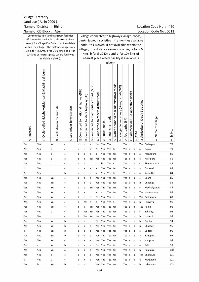
Village DirectoryLand use ( As in 2009 )Name of District : Bhind Location Code No : 420Name of CD Block : Ater Location Code No : 0011
Trac
tors
Cycl
e-pu
lled
rick
shaw
s(M
anua
l & M
achi
ne d
rive
n)
Cart
s dr
iven
by
anim
als
Sea
/Riv
er fe
rry
serv
ice
Conn
ecte
d to
nat
iona
l hig
hway
(NH
)
Conn
ecte
d to
sta
te h
ighw
ay(S
H)
Conn
ecte
d to
maj
or d
istr
ict r
oad
(MD
R)
Conn
ecte
d to
oth
ers
dist
rict
roa
d
Pucc
a r
oads
Kutc
hcha
roa
ds
Wat
er b
ound
ed m
acad
am(W
BM) r
oads
Nav
igab
le w
ater
way
(riv
er/c
anal
)(N
W)
Foot
path
s (F
P)
Com
mer
cial
& C
o-op
erat
ive
Bank
s
ATM
Agr
icul
tura
l Cre
dit S
ocie
ties
64 65 66 67 68 69 70 71 72 73 74 75 76 77 78 79 2 1
Communication and transport facilities (If amenities available code -Yes is given
except for Village Pin Code ,If not available within the village , the distance range code viz; a for < 5 Kms, b for 5-10 Kms and c for 10+ kms of nearest place where facility is
available is given).
Village connected to highways,village roads, banks & credit societies (If amenities available
code -Yes is given, If not available within the village , the distance range code viz; a for < 5
Kms, b for 5-10 Kms and c for 10+ kms of nearest place where facility is available is
given).
Nam
e of
vill
age
Sr.N
o.
Yes Yes Yes c c b a Yes Yes Yes Yes b c Yes Dulhagan 78
Yes Yes a c c c a Yes Yes Yes Yes Yes a c a Gajna 79
Yes Yes b c c a a a Yes Yes Yes Yes a c a Manepura 80
Yes Yes c a c a Yes Yes Yes Yes Yes Yes a c a Kyaripura 81
Yes Yes b c c b b b b Yes a Yes b c c Bhagtuapura 82
c Yes c c c a a a Yes Yes Yes Yes a c a Datawali 83
Yes Yes c b c c a a Yes Yes Yes Yes a c a Koshath 84
Yes Yes Yes c c b b Yes Yes Yes Yes Yes c c c Bijora 85
Yes Yes Yes c c b b Yes Yes Yes Yes Yes b c b Chilonga 86
Yes Yes Yes c c b Yes Yes Yes Yes Yes Yes a c c Madhaiyapura 87
Yes Yes Yes c b a b a a Yes Yes Yes c c Yes Hamirapura 88
Yes Yes Yes c b c c Yes Yes Yes c Yes c c Yes Barkapura 89
Yes Yes Yes c c Yes c b Yes Yes b Yes b c b Pariyaya 90
Yes Yes Yes c b c Yes Yes Yes Yes Yes Yes b c Yes Rama 91
Yes Yes c c b Yes Yes Yes Yes Yes Yes Yes c c c Sakaraya 92
Yes Yes c c b Yes Yes Yes Yes Yes Yes Yes c c b Jori Ahir 93
Yes Yes Yes b c b b Yes Yes Yes Yes Yes b c b Gadha 94
Yes Yes Yes b c b b Yes Yes Yes Yes Yes b c b Chachar 95
c Yes Yes b c a a Yes Yes Yes Yes Yes a a a Baderi 96
Yes Yes Yes b c a a Yes Yes Yes Yes Yes a c a Badapura 97
Yes Yes Yes c c a a Yes Yes Yes Yes Yes a c a Naripura 98
Yes c Yes b c a a Yes Yes Yes Yes Yes a c a Pali 99
Yes Yes Yes a c b b Yes Yes Yes Yes Yes b c b Ranipura 100
Yes Yes c c a a a Yes Yes Yes Yes Yes a c Yes Bhimpura 101
c Yes c c c a a Yes Yes Yes Yes Yes a c a Matghana 102
Yes b Yes b c b b Yes Yes Yes Yes Yes b c b Udanpura 103
123
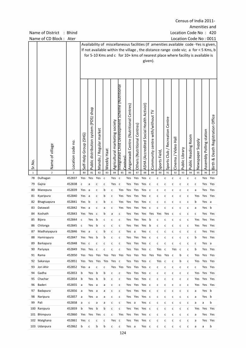
Census of India 2011- Amenities and
Name of District : Bhind Location Code No : 420Name of CD Block : Ater Location Code No : 0011
Self-
Hel
p G
roup
(SH
G)
Publ
ic d
istr
ibut
ion
syst
em (P
DS)
sho
p
Man
dis
/ Re
gula
r m
arke
t
Wee
kly
Haa
t
Agr
icul
tura
l mar
ketin
g so
ciet
yIn
tegr
ated
Chi
ld D
evel
opm
ent S
chem
e (N
utri
tiona
l Ce
ntre
s)A
ngan
wad
i Cen
tre
(Nut
ritio
nal C
entr
es)
Oth
ers
(Nut
ritio
nal C
entr
es)
ASH
A (A
ccre
dite
d So
cial
Hea
lth A
ctiv
ist)
Com
mun
ity c
entr
e w
ith/w
ithou
t TV
Spor
ts F
ield
,
Spor
ts C
lub
/ Re
crea
tion
Cent
re
Cine
ma
/ Vi
deo
Hal
l
Publ
ic L
ibra
ry
Publ
ic R
eadi
ng R
oom
New
spap
er S
uppl
y
Ass
embl
y Po
lling
sta
tion
Birt
h &
Dea
th R
egis
trat
ion
Off
ice
1 2 3 80 81 82 83 84 85 86 87 88 89 90 91 92 93 94 95 96 97
Sr.N
o.
Nam
e of
vill
age
Loca
tion
code
no.
Availability of miscellaneous facilities (If amenities available code -Yes is given, If not available within the village , the distance range code viz; a for < 5 Kms, b
for 5-10 Kms and c for 10+ kms of nearest place where facility is available is given).
78 Dulhagan 452837 Yes Yes Yes c Yes c Yes Yes Yes c c c c c c c Yes Yes
79 Gajna 452838 c a c c Yes c Yes Yes Yes c c c c c c c Yes Yes
80 Manepura 452839 Yes a c b c Yes Yes Yes Yes c c c c c c a Yes Yes
81 Kyaripura 452840 Yes a c b c Yes Yes Yes Yes c c c c c c Yes Yes Yes
82 Bhagtuapura 452841 Yes b c b c Yes Yes Yes Yes c c c c c c b Yes a
83 Datawali 452842 Yes a c a c Yes Yes Yes Yes c c c c c c a Yes b
84 Koshath 452843 Yes Yes c b a c Yes Yes Yes Yes Yes Yes c c c c Yes Yes
85 Bijora 452844 c Yes b c c c Yes Yes Yes b c c c c c Yes Yes Yes
86 Chilonga 452845 c Yes b c c c Yes Yes Yes b c c c c c Yes Yes Yes
87 Madhaiyapura 452846 Yes a c b c c Yes a Yes c c c c c c c Yes Yes
88 Hamirapura 452847 Yes Yes b b c c Yes Yes Yes c c c c c c b Yes Yes
89 Barkapura 452848 Yes c c c c c Yes Yes Yes c c c c c c c Yes a
90 Pariyaya 452849 Yes Yes c c c c Yes Yes Yes c Yes c Yes c c b Yes Yes
91 Rama 452850 Yes Yes Yes Yes Yes Yes Yes Yes Yes Yes Yes Yes c b c Yes Yes Yes
92 Sakaraya 452851 Yes Yes Yes Yes Yes c Yes Yes Yes c Yes c c b c Yes Yes Yes
93 Jori Ahir 452852 Yes a c c Yes Yes Yes Yes Yes c c c c c c c Yes Yes
94 Gadha 452853 b Yes b b c c Yes Yes Yes c c c c c c Yes Yes Yes
95 Chachar 452854 b Yes b b c c Yes Yes Yes c c c c c c Yes Yes Yes
96 Baderi 452855 a Yes a a c c Yes Yes Yes c c c c c c Yes Yes Yes
97 Badapura 452856 a Yes a a c c Yes Yes Yes c c c c c c a Yes b
98 Naripura 452857 a Yes a a c c Yes Yes Yes c c c c c c a Yes b
99 Pali 452858 a c a a c c Yes a Yes c c c c c c a a b
100 Ranipura 452859 b Yes b b c c Yes Yes Yes c c c c c c Yes Yes Yes
101 Bhimpura 452860 Yes Yes Yes c c Yes Yes Yes Yes c c c c c c a Yes Yes
102 Matghana 452861 Yes c c c Yes c Yes Yes Yes c c c c c c a Yes Yes
103 Udanpura 452862 b c b b c c Yes a Yes c c c c c c a a b
124
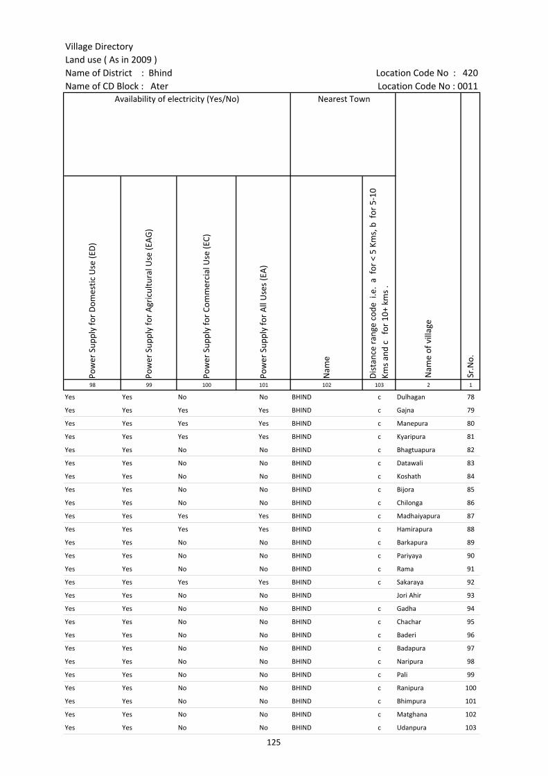
Village DirectoryLand use ( As in 2009 )Name of District : Bhind Location Code No : 420Name of CD Block : Ater Location Code No : 0011
Pow
er S
uppl
y fo
r D
omes
tic U
se (E
D)
Pow
er S
uppl
y fo
r A
gric
ultu
ral U
se (E
AG
)
Pow
er S
uppl
y fo
r Co
mm
erci
al U
se (E
C)
Pow
er S
uppl
y fo
r A
ll U
ses
(EA
)
Nam
e
Dis
tanc
e ra
nge
code
i.e
. a
for
< 5
Kms,
b f
or 5
-10
Kms
and
c f
or 1
0+ k
ms
.98 99 100 101 102 103 2 1
Availability of electricity (Yes/No) Nearest Town
Nam
e of
vill
age
Sr.N
o.
Yes Yes No No BHIND c Dulhagan 78
Yes Yes Yes Yes BHIND c Gajna 79
Yes Yes Yes Yes BHIND c Manepura 80
Yes Yes Yes Yes BHIND c Kyaripura 81
Yes Yes No No BHIND c Bhagtuapura 82
Yes Yes No No BHIND c Datawali 83
Yes Yes No No BHIND c Koshath 84
Yes Yes No No BHIND c Bijora 85
Yes Yes No No BHIND c Chilonga 86
Yes Yes Yes Yes BHIND c Madhaiyapura 87
Yes Yes Yes Yes BHIND c Hamirapura 88
Yes Yes No No BHIND c Barkapura 89
Yes Yes No No BHIND c Pariyaya 90
Yes Yes No No BHIND c Rama 91
Yes Yes Yes Yes BHIND c Sakaraya 92
Yes Yes No No BHIND Jori Ahir 93
Yes Yes No No BHIND c Gadha 94
Yes Yes No No BHIND c Chachar 95
Yes Yes No No BHIND c Baderi 96
Yes Yes No No BHIND c Badapura 97
Yes Yes No No BHIND c Naripura 98
Yes Yes No No BHIND c Pali 99
Yes Yes No No BHIND c Ranipura 100
Yes Yes No No BHIND c Bhimpura 101
Yes Yes No No BHIND c Matghana 102
Yes Yes No No BHIND c Udanpura 103
125
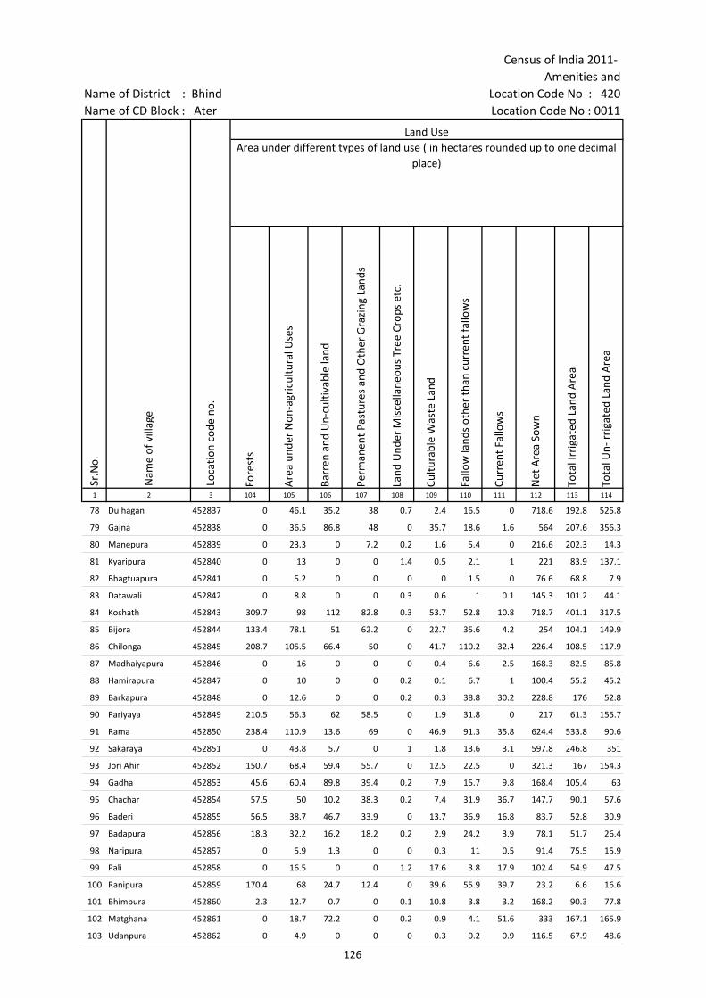
Census of India 2011- Amenities and
Name of District : Bhind Location Code No : 420Name of CD Block : Ater Location Code No : 0011
Fore
sts
Are
a un
der
Non
-agr
icul
tura
l Use
s
Barr
en a
nd U
n-cu
ltiva
ble
land
Perm
anen
t Pas
ture
s an
d O
ther
Gra
zing
Lan
ds
Land
Und
er M
isce
llane
ous
Tree
Cro
ps e
tc.
Cultu
rabl
e W
aste
Lan
d
Fallo
w la
nds
othe
r th
an c
urre
nt fa
llow
s
Curr
ent F
allo
ws
Net
Are
a So
wn
Tota
l Irr
igat
ed L
and
Are
a
Tota
l Un-
irri
gate
d La
nd A
rea
1 2 3 104 105 106 107 108 109 110 111 112 113 114
Sr.N
o.
Nam
e of
vill
age
Loca
tion
code
no.
Land UseArea under different types of land use ( in hectares rounded up to one decimal
place)
78 Dulhagan 452837 0 46.1 35.2 38 0.7 2.4 16.5 0 718.6 192.8 525.8
79 Gajna 452838 0 36.5 86.8 48 0 35.7 18.6 1.6 564 207.6 356.3
80 Manepura 452839 0 23.3 0 7.2 0.2 1.6 5.4 0 216.6 202.3 14.3
81 Kyaripura 452840 0 13 0 0 1.4 0.5 2.1 1 221 83.9 137.1
82 Bhagtuapura 452841 0 5.2 0 0 0 0 1.5 0 76.6 68.8 7.9
83 Datawali 452842 0 8.8 0 0 0.3 0.6 1 0.1 145.3 101.2 44.1
84 Koshath 452843 309.7 98 112 82.8 0.3 53.7 52.8 10.8 718.7 401.1 317.5
85 Bijora 452844 133.4 78.1 51 62.2 0 22.7 35.6 4.2 254 104.1 149.9
86 Chilonga 452845 208.7 105.5 66.4 50 0 41.7 110.2 32.4 226.4 108.5 117.9
87 Madhaiyapura 452846 0 16 0 0 0 0.4 6.6 2.5 168.3 82.5 85.8
88 Hamirapura 452847 0 10 0 0 0.2 0.1 6.7 1 100.4 55.2 45.2
89 Barkapura 452848 0 12.6 0 0 0.2 0.3 38.8 30.2 228.8 176 52.8
90 Pariyaya 452849 210.5 56.3 62 58.5 0 1.9 31.8 0 217 61.3 155.7
91 Rama 452850 238.4 110.9 13.6 69 0 46.9 91.3 35.8 624.4 533.8 90.6
92 Sakaraya 452851 0 43.8 5.7 0 1 1.8 13.6 3.1 597.8 246.8 351
93 Jori Ahir 452852 150.7 68.4 59.4 55.7 0 12.5 22.5 0 321.3 167 154.3
94 Gadha 452853 45.6 60.4 89.8 39.4 0.2 7.9 15.7 9.8 168.4 105.4 63
95 Chachar 452854 57.5 50 10.2 38.3 0.2 7.4 31.9 36.7 147.7 90.1 57.6
96 Baderi 452855 56.5 38.7 46.7 33.9 0 13.7 36.9 16.8 83.7 52.8 30.9
97 Badapura 452856 18.3 32.2 16.2 18.2 0.2 2.9 24.2 3.9 78.1 51.7 26.4
98 Naripura 452857 0 5.9 1.3 0 0 0.3 11 0.5 91.4 75.5 15.9
99 Pali 452858 0 16.5 0 0 1.2 17.6 3.8 17.9 102.4 54.9 47.5
100 Ranipura 452859 170.4 68 24.7 12.4 0 39.6 55.9 39.7 23.2 6.6 16.6
101 Bhimpura 452860 2.3 12.7 0.7 0 0.1 10.8 3.8 3.2 168.2 90.3 77.8
102 Matghana 452861 0 18.7 72.2 0 0.2 0.9 4.1 51.6 333 167.1 165.9
103 Udanpura 452862 0 4.9 0 0 0 0.3 0.2 0.9 116.5 67.9 48.6
126
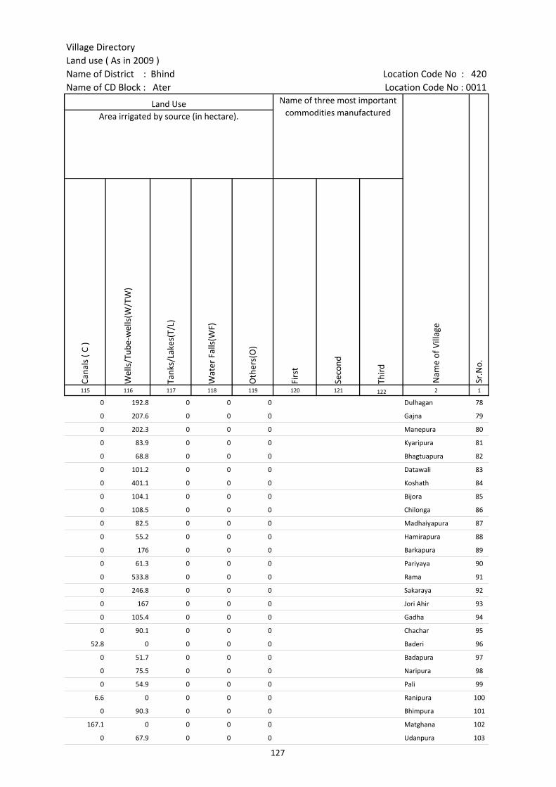
Village DirectoryLand use ( As in 2009 )Name of District : Bhind Location Code No : 420Name of CD Block : Ater Location Code No : 0011
Cana
ls (
C )
Wel
ls/T
ube-
wel
ls(W
/TW
)
Tank
s/La
kes(
T/L)
Wat
er F
alls
(WF)
Oth
ers(
O)
Firs
t
Seco
nd
Thir
d 115 116 117 118 119 120 121 122 2 1
Land Use Name of three most important commodities manufactured
Nam
e of
Vill
age
Sr.N
o.
Area irrigated by source (in hectare).
0 192.8 0 0 0 Dulhagan 78
0 207.6 0 0 0 Gajna 79
0 202.3 0 0 0 Manepura 80
0 83.9 0 0 0 Kyaripura 81
0 68.8 0 0 0 Bhagtuapura 82
0 101.2 0 0 0 Datawali 83
0 401.1 0 0 0 Koshath 84
0 104.1 0 0 0 Bijora 85
0 108.5 0 0 0 Chilonga 86
0 82.5 0 0 0 Madhaiyapura 87
0 55.2 0 0 0 Hamirapura 88
0 176 0 0 0 Barkapura 89
0 61.3 0 0 0 Pariyaya 90
0 533.8 0 0 0 Rama 91
0 246.8 0 0 0 Sakaraya 92
0 167 0 0 0 Jori Ahir 93
0 105.4 0 0 0 Gadha 94
0 90.1 0 0 0 Chachar 95
52.8 0 0 0 0 Baderi 96
0 51.7 0 0 0 Badapura 97
0 75.5 0 0 0 Naripura 98
0 54.9 0 0 0 Pali 99
6.6 0 0 0 0 Ranipura 100
0 90.3 0 0 0 Bhimpura 101
167.1 0 0 0 0 Matghana 102
0 67.9 0 0 0 Udanpura 103
127

Census of India 2011- Amenities and
Name of District : Bhind Location Code No : 420Name of CD Block : Ater Location Code No : 0011
Pre-
Prim
ary
scho
ol (P
P)
Prim
ary
scho
ol (P
)
Mid
dle
scho
ol (M
)
Seco
ndar
y Sc
hool
(S)
Seni
or S
econ
dary
sch
ool (
SS)
Deg
ree
colle
ge o
f art
s s
cien
ce &
com
mer
ce (
ASC
)
Engi
neer
ing
colle
ge(E
C)
Med
ical
col
lege
(MC)
Man
agem
ent i
nstit
ute
(MI)
Poly
tech
nic
(Pt)
Voca
tiona
l tra
inin
g sc
hool
/IT
I
Non
-for
mal
trai
ning
cen
tre
(NFT
C)
Spec
ial s
choo
l for
dis
able
d (S
SD)
Oth
ers
(spe
cify
)
1 2 3 4 5 6 7 8 9 10 11 12 13 14 15 16 17 18 19 20
Number of educational amenities available. (If not available within the village , the distance range
code viz; a for < 5 Kms, b for 5-10 Kms and c for 10+ kms of nearest place where facility is available is given).
Sr.N
o.
Nam
e of
vill
age
Loca
tion
code
no.
Tota
l are
a of
the
villa
ge (
in h
ecta
res
roun
ded
up to
one
dec
imal
pla
ce)
Tota
l pop
ulat
ion
( 201
1 ce
nsus
)
Num
ber
of h
ouse
hold
s (2
011
cens
us)
104 Andhapura 452863 203.6 0 0 --------------Un-inhabited--------------
105 Kasahapura 452864 49.8 0 0 --------------Un-inhabited--------------
106 Biragwan Rani 452865 1240.5 2925 442 b 5 1 b b c c c c c c c
107 Pawai 452866 1035 3809 658 c 6 1 1 b c c c c c c c c c
108 Biragwa 452867 506.6 1946 340 4 1 a c c c c c c c
109 Pali 452868 630.2 2774 510 c 6 1 b b c c c c c c
110 Kanhouwapura 452869 84.9 397 60 1 a b b c c c c c c c c
111 Sonpura 452870 154.2 534 79 a 1 a b c c c c c c c c c
112 Gourkhurd 452871 588 1792 285 3 4 1 c 1 c c c c c c c
113 Gourkalan 452872 196.8 865 132 b 1 1 b 1 c c c c c c c c c
114 Janjaripura 452873 306.9 574 101 a 1 a b c c c c c c c c
115 Raura 452874 192.1 1093 174 b 1 1 a c c c c c c c c c c
116 Pipri 452875 564.3 2553 542 c 3 1 1 c c c c c c c c
117 Ruar 452876 162.1 442 66 1 a a c c c c c c c c c
118 Raipura 452877 224.4 1058 208 c 1 1 a c c c c c c c c c
119 Biraura 452878 100.3 299 52 c 1 a a b c c c c c c c c
120 Baidipura 452879 168.6 932 215 c 1 1 a 1 c c c c c c c c
121 Bichholi 452880 576.3 1617 337 c 1 1 a b c c c c c c c c c
122 Miragpura 452881 300.7 2122 325 2 1 a a c c c c c c
123 Pithanpura 452882 289.5 1726 327 5 5 a c c c c c c
124 Pachokhara 452883 190.2 446 72 1 a b b c c c c c c
125 Kakaran Ka Pura 452884 102.7 176 32 1 a a a c c c c c c c
126 Masuri 452885 682.3 3029 565 4 2 1 1 c c c c c c
127 Kamalpura 452886 143 486 91 c 1 a b b c c c c c c c
128 Jari 452887 228.9 972 175 c 1 1 b c c c c c c c c c c
129 Laharpura 452888 139.9 540 97 c 1 a b 1 c c c c c c c c c
128
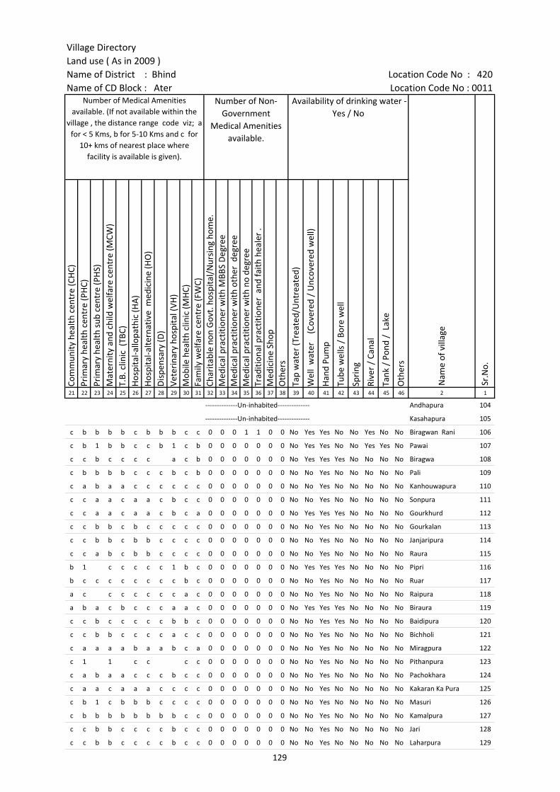
Village DirectoryLand use ( As in 2009 )Name of District : Bhind Location Code No : 420Name of CD Block : Ater Location Code No : 0011
Com
mun
ity h
ealth
cen
tre
(CH
C)Pr
imar
y he
alth
cen
tre
(PH
C)Pr
imar
y he
alth
sub
cen
tre
(PH
S)M
ater
nity
and
chi
ld w
elfa
re c
entr
e (M
CW)
T.B.
clin
ic (
TBC)
Hos
pita
l-allo
path
ic (H
A)
Hos
pita
l-alte
rnat
ive
med
icin
e (H
O)
Dis
pens
ary
(D)
Vete
rina
ry h
ospi
tal (
VH)
Mob
ile h
ealth
clin
ic (M
HC)
Fam
ily w
elfa
re c
entr
e (F
WC)
Char
itabl
e no
n G
ovt.
hos
pita
l/N
ursi
ng h
ome.
Med
ical
pra
ctiti
oner
with
MBB
S D
egre
eM
edic
al p
ract
ition
er w
ith o
ther
deg
ree
Med
ical
pra
ctiti
oner
with
no
degr
eeTr
aditi
onal
pra
ctiti
oner
and
faith
hea
ler
.M
edic
ine
Shop
Oth
ers
Tap
wat
er (T
reat
ed/U
ntre
ated
)
Wel
l w
ater
(C
over
ed /
Unc
over
ed w
ell)
Han
d Pu
mp
Tube
wel
ls /
Bor
e w
ell
Spri
ng
Rive
r /
Cana
l
Tank
/ P
ond
/ L
ake
Oth
ers
21 22 23 24 25 26 27 28 29 30 31 32 33 34 35 36 37 38 39 40 41 42 43 44 45 46 2 1
Number of Medical Amenities available. (If not available within the
village , the distance range code viz; a for < 5 Kms, b for 5-10 Kms and c for
10+ kms of nearest place where facility is available is given).
Number of Non-Government
Medical Amenities available.
Availability of drinking water - Yes / No
Nam
e of
vill
age
Sr.N
o.
--------------Un-inhabited-------------- Andhapura 104
--------------Un-inhabited-------------- Kasahapura 105
c b b b b c b b b c c 0 0 0 1 1 0 0 No Yes Yes No No Yes No No Biragwan Rani 106
c b 1 b b c c b 1 c b 0 0 0 0 0 0 0 No Yes Yes No No Yes Yes No Pawai 107
c c b c c c c a c b 0 0 0 0 0 0 0 No Yes Yes Yes No No No No Biragwa 108
c b b b b c c c b c b 0 0 0 0 0 0 0 No No Yes No No No No No Pali 109
c a b a a c c c c c c 0 0 0 0 0 0 0 No No Yes No No No No No Kanhouwapura 110
c c a a c a a c b c c 0 0 0 0 0 0 0 No No Yes No No No No No Sonpura 111
c c a a c a a c b c a 0 0 0 0 0 0 0 No Yes Yes Yes No No No No Gourkhurd 112
c c b b c b c c c c c 0 0 0 0 0 0 0 No No Yes No No No No No Gourkalan 113
c c b b c b b c c c c 0 0 0 0 0 0 0 No No Yes No No No No No Janjaripura 114
c c a b c b b c c c c 0 0 0 0 0 0 0 No No Yes No No No No No Raura 115
b 1 c c c c c 1 b c 0 0 0 0 0 0 0 No Yes Yes Yes No No No No Pipri 116
b c c c c c c c c b c 0 0 0 0 0 0 0 No No Yes No No No No No Ruar 117
a c c c c c c c a c 0 0 0 0 0 0 0 No No Yes No No No No No Raipura 118
a b a c b c c c a a c 0 0 0 0 0 0 0 No Yes Yes Yes No No No No Biraura 119
c c b c c c c c b b c 0 0 0 0 0 0 0 No No Yes Yes No No No No Baidipura 120
c c b b c c c c a c c 0 0 0 0 0 0 0 No No Yes No No No No No Bichholi 121
c a a a a b a a b c a 0 0 0 0 0 0 0 No No Yes No No No No No Miragpura 122
c 1 1 c c c c 0 0 0 0 0 0 0 No No Yes No No No No No Pithanpura 123
c a b a a c c c b c c 0 0 0 0 0 0 0 No No Yes No No No No No Pachokhara 124
c a a c a a a c c c c 0 0 0 0 0 0 0 No No Yes No No No No No Kakaran Ka Pura 125
c b 1 c b b b c c c c 0 0 0 0 0 0 0 No No Yes No No No No No Masuri 126
c b b b b b b b b c c 0 0 0 0 0 0 0 No No Yes No No No No No Kamalpura 127
c c b b c c c c b c c 0 0 0 0 0 0 0 No No Yes No No No No No Jari 128
c c b b c c c c b c c 0 0 0 0 0 0 0 No No Yes No No No No No Laharpura 129
129

Census of India 2011- Amenities and
Name of District : Bhind Location Code No : 420Name of CD Block : Ater Location Code No : 0011
Com
mun
ity to
ilet i
nclu
ding
bat
h.
Com
mun
ity to
ilet e
xclu
ding
bat
h.
Rura
l sa
nita
ry m
art o
r sa
nita
ry h
ardw
are
outle
t av
aila
ble
near
the
villa
ge.
Com
mun
ity b
io- g
as o
r re
cycl
e of
was
te fo
r pr
oduc
tive
use.
Post
off
ice(
PO)
Sub
post
off
ice
(SPO
)
Post
& T
eleg
raph
off
ice
(P&
TO)
Villa
ge P
in C
ode
Tele
phon
es
(L
and
lines
)
Publ
ic c
all o
ffic
e (P
CO)
Mob
ile p
hone
cov
erag
e
Inte
rnet
caf
es/
Com
mon
ser
vice
cen
tre
(CSC
)
Priv
ate
cour
ier
faci
lity
Bus
serv
ice
(Pub
lic &
Pri
vate
)
Railw
ay s
tatio
ns
Aut
o/M
odifi
ed A
utos
Taxi
s an
d Va
ns
1 2 3 47 48 49 50 51 52 53 54 55 56 57 58 59 60 61 62 63
Sr.N
o.
Nam
e of
vill
age
Loca
tion
code
no.
Availability of toilet & others Yes / No
Communication and transport facilities (If amenities available code -Yes is given except for Village Pin Code ,If not available within the village , the distance range code
viz; a for < 5 Kms, b for 5-10 Kms and c for 10+ kms of nearest place where facility is available is given).
104 Andhapura 452863 --------------Un-inhabited--------------
105 Kasahapura 452864 --------------Un-inhabited--------------
106 Biragwan Rani 452865 Yes No No No c Yes c b c Yes c c b c b c
107 Pawai 452866 No No No No c Yes c c c Yes c c Yes c c c
108 Biragwa 452867 No No No No a Yes c Yes c c a c c Yes
109 Pali 452868 No No No No c Yes c 477116 b c Yes c c Yes c c c
110 Kanhouwapura 452869 No No Yes No a b a c Yes c c Yes b c c
111 Sonpura 452870 No No No No a a c b c Yes c c a c a a
112 Gourkhurd 452871 No No Yes No c Yes c c c Yes c c a b a a
113 Gourkalan 452872 No No No No c a c c c Yes c c a b c a
114 Janjaripura 452873 No No No No c a c c c Yes c c a b b b
115 Raura 452874 No No No No c Yes c c c Yes c c Yes b c c
116 Pipri 452875 No No No No c Yes c c c Yes c c c a c c
117 Ruar 452876 No No No No c a a c c Yes c c c c c
118 Raipura 452877 No No No No c c a Yes c b c c c a c c
119 Biraura 452878 No No No No c a c 477557 c c Yes c c c c c a
120 Baidipura 452879 No No No No c c c c c Yes c c c c c c
121 Bichholi 452880 No No No No c a a c c Yes c c b a c c
122 Miragpura 452881 No No No No a a a c Yes c c Yes b c c
123 Pithanpura 452882 No No Yes No a Yes c Yes c Yes c c Yes a c c
124 Pachokhara 452883 No No Yes No c b 477441 a c Yes c c a b c c
125 Kakaran Ka Pura 452884 No No No No a c c c c a c c a c c c
126 Masuri 452885 No No Yes No Yes c 477105 c c Yes c c Yes c c c
127 Kamalpura 452886 No No No No b b b b c Yes c c b b c c
128 Jari 452887 No No No No c Yes Yes 477105 c c Yes c c b c c c
129 Laharpura 452888 No No No No c a a c c Yes c c b b c c
130
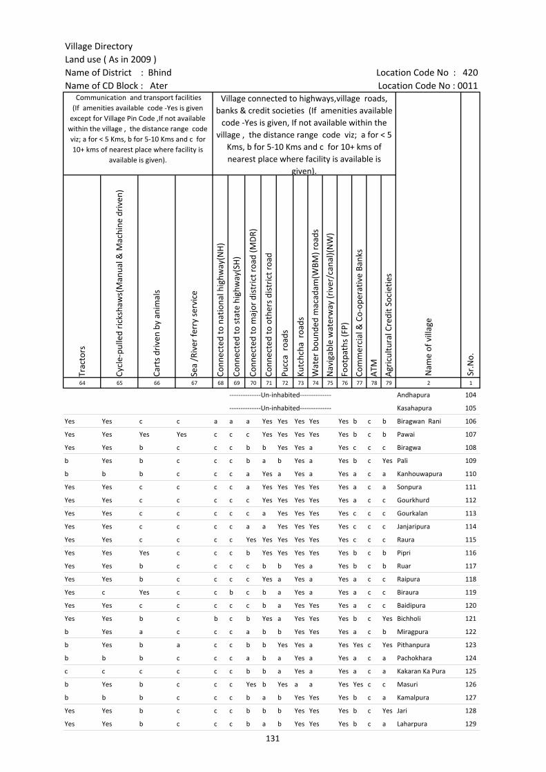
Village DirectoryLand use ( As in 2009 )Name of District : Bhind Location Code No : 420Name of CD Block : Ater Location Code No : 0011
Trac
tors
Cycl
e-pu
lled
rick
shaw
s(M
anua
l & M
achi
ne d
rive
n)
Cart
s dr
iven
by
anim
als
Sea
/Riv
er fe
rry
serv
ice
Conn
ecte
d to
nat
iona
l hig
hway
(NH
)
Conn
ecte
d to
sta
te h
ighw
ay(S
H)
Conn
ecte
d to
maj
or d
istr
ict r
oad
(MD
R)
Conn
ecte
d to
oth
ers
dist
rict
roa
d
Pucc
a r
oads
Kutc
hcha
roa
ds
Wat
er b
ound
ed m
acad
am(W
BM) r
oads
Nav
igab
le w
ater
way
(riv
er/c
anal
)(N
W)
Foot
path
s (F
P)
Com
mer
cial
& C
o-op
erat
ive
Bank
s
ATM
Agr
icul
tura
l Cre
dit S
ocie
ties
64 65 66 67 68 69 70 71 72 73 74 75 76 77 78 79 2 1
Communication and transport facilities (If amenities available code -Yes is given
except for Village Pin Code ,If not available within the village , the distance range code viz; a for < 5 Kms, b for 5-10 Kms and c for 10+ kms of nearest place where facility is
available is given).
Village connected to highways,village roads, banks & credit societies (If amenities available
code -Yes is given, If not available within the village , the distance range code viz; a for < 5
Kms, b for 5-10 Kms and c for 10+ kms of nearest place where facility is available is
given).
Nam
e of
vill
age
Sr.N
o.
--------------Un-inhabited-------------- Andhapura 104
--------------Un-inhabited-------------- Kasahapura 105
Yes Yes c c a a a Yes Yes Yes Yes Yes b c b Biragwan Rani 106
Yes Yes Yes Yes c c c Yes Yes Yes Yes Yes b c b Pawai 107
Yes Yes b c c c b b Yes Yes a Yes c c c Biragwa 108
b Yes b c c c b a b Yes a Yes b c Yes Pali 109
b b b c c c a Yes a Yes a Yes a c a Kanhouwapura 110
Yes Yes c c c c a Yes Yes Yes Yes Yes a c a Sonpura 111
Yes Yes c c c c c Yes Yes Yes Yes Yes a c c Gourkhurd 112
Yes Yes c c c c c a Yes Yes Yes Yes c c c Gourkalan 113
Yes Yes c c c c a a Yes Yes Yes Yes c c c Janjaripura 114
Yes Yes c c c c Yes Yes Yes Yes Yes Yes c c c Raura 115
Yes Yes Yes c c c b Yes Yes Yes Yes Yes b c b Pipri 116
Yes Yes b c c c c b b Yes a Yes b c b Ruar 117
Yes Yes b c c c c Yes a Yes a Yes a c c Raipura 118
Yes c Yes c c b c b a Yes a Yes a c c Biraura 119
Yes Yes c c c c c b a Yes Yes Yes a c c Baidipura 120
Yes Yes b c b c b Yes a Yes Yes Yes b c Yes Bichholi 121
b Yes a c c c a b b Yes Yes Yes a c b Miragpura 122
b Yes b a c c b b Yes Yes a Yes Yes c Yes Pithanpura 123
b b b c c c a b a Yes a Yes a c a Pachokhara 124
c c c c c c b b a Yes a Yes a c a Kakaran Ka Pura 125
b Yes b c c c Yes b Yes a a Yes Yes c c Masuri 126
b b b c c c b a b Yes Yes Yes b c a Kamalpura 127
Yes Yes b c c c b b b Yes Yes Yes b c Yes Jari 128
Yes Yes b c c c b a b Yes Yes Yes b c a Laharpura 129
131

Census of India 2011- Amenities and
Name of District : Bhind Location Code No : 420Name of CD Block : Ater Location Code No : 0011
Self-
Hel
p G
roup
(SH
G)
Publ
ic d
istr
ibut
ion
syst
em (P
DS)
sho
p
Man
dis
/ Re
gula
r m
arke
t
Wee
kly
Haa
t
Agr
icul
tura
l mar
ketin
g so
ciet
yIn
tegr
ated
Chi
ld D
evel
opm
ent S
chem
e (N
utri
tiona
l Ce
ntre
s)A
ngan
wad
i Cen
tre
(Nut
ritio
nal C
entr
es)
Oth
ers
(Nut
ritio
nal C
entr
es)
ASH
A (A
ccre
dite
d So
cial
Hea
lth A
ctiv
ist)
Com
mun
ity c
entr
e w
ith/w
ithou
t TV
Spor
ts F
ield
,
Spor
ts C
lub
/ Re
crea
tion
Cent
re
Cine
ma
/ Vi
deo
Hal
l
Publ
ic L
ibra
ry
Publ
ic R
eadi
ng R
oom
New
spap
er S
uppl
y
Ass
embl
y Po
lling
sta
tion
Birt
h &
Dea
th R
egis
trat
ion
Off
ice
1 2 3 80 81 82 83 84 85 86 87 88 89 90 91 92 93 94 95 96 97
Sr.N
o.
Nam
e of
vill
age
Loca
tion
code
no.
Availability of miscellaneous facilities (If amenities available code -Yes is given, If not available within the village , the distance range code viz; a for < 5 Kms, b
for 5-10 Kms and c for 10+ kms of nearest place where facility is available is given).
104 Andhapura 452863 --------------Un-inhabited--------------
105 Kasahapura 452864 --------------Un-inhabited--------------
106 Biragwan Rani 452865 Yes Yes c c c Yes Yes Yes Yes c c c c c c b Yes Yes
107 Pawai 452866 c Yes c b c c Yes Yes Yes c c c c c c a Yes Yes
108 Biragwa 452867 Yes a c Yes Yes c Yes Yes Yes Yes c c c c c Yes Yes Yes
109 Pali 452868 Yes Yes c b c c Yes Yes Yes c c c c c c b Yes Yes
110 Kanhouwapura 452869 Yes a c a a c Yes a a c c c c c c a a a
111 Sonpura 452870 Yes a c c c c Yes c c c c c c c c c a a
112 Gourkhurd 452871 Yes Yes c c Yes c Yes Yes Yes Yes Yes c c c c c Yes Yes
113 Gourkalan 452872 Yes a c b c c Yes Yes Yes c c c c c c b Yes Yes
114 Janjaripura 452873 c a c c c c a Yes Yes c c c c c c c Yes Yes
115 Raura 452874 Yes a c b c c Yes Yes Yes c c c c c c c Yes a
116 Pipri 452875 Yes Yes Yes Yes Yes Yes Yes Yes Yes Yes Yes Yes Yes b c Yes Yes Yes
117 Ruar 452876 a c c c c c Yes a Yes c c c c c c a a b
118 Raipura 452877 Yes Yes c Yes c c Yes Yes Yes c c c c c c Yes Yes Yes
119 Biraura 452878 a a c c a Yes Yes a Yes c c c c c c b a a
120 Baidipura 452879 c a c b c Yes Yes Yes Yes c Yes c c c c c Yes a
121 Bichholi 452880 Yes Yes c c c c Yes Yes Yes Yes c c c c c b Yes Yes
122 Miragpura 452881 Yes b c a c c Yes Yes Yes c c c c c c a Yes Yes
123 Pithanpura 452882 Yes Yes Yes Yes Yes Yes Yes a Yes Yes Yes Yes Yes c c Yes Yes Yes
124 Pachokhara 452883 Yes c Yes Yes c c Yes a Yes Yes c c c c c a Yes a
125 Kakaran Ka Pura 452884 Yes c Yes Yes c c a a Yes Yes c c c c c a a a
126 Masuri 452885 Yes Yes Yes Yes Yes Yes Yes Yes Yes Yes Yes Yes Yes b c Yes Yes Yes
127 Kamalpura 452886 Yes a c b c c Yes a Yes c c c c c c b a a
128 Jari 452887 Yes Yes Yes Yes Yes Yes Yes Yes Yes Yes Yes Yes c c c a Yes Yes
129 Laharpura 452888 Yes a c c c c Yes Yes Yes c c c c c c c Yes a
132
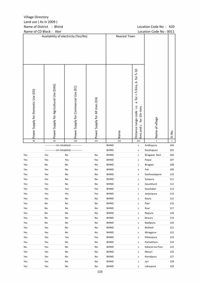
Village DirectoryLand use ( As in 2009 )Name of District : Bhind Location Code No : 420Name of CD Block : Ater Location Code No : 0011
Pow
er S
uppl
y fo
r D
omes
tic U
se (E
D)
Pow
er S
uppl
y fo
r A
gric
ultu
ral U
se (E
AG
)
Pow
er S
uppl
y fo
r Co
mm
erci
al U
se (E
C)
Pow
er S
uppl
y fo
r A
ll U
ses
(EA
)
Nam
e
Dis
tanc
e ra
nge
code
i.e
. a
for
< 5
Kms,
b f
or 5
-10
Kms
and
c f
or 1
0+ k
ms
.98 99 100 101 102 103 2 1
Availability of electricity (Yes/No) Nearest Town
Nam
e of
vill
age
Sr.N
o.
--------------Un-inhabited-------------- BHIND c Andhapura 104
--------------Un-inhabited-------------- BHIND c Kasahapura 105
Yes Yes No No BHIND c Biragwan Rani 106
Yes Yes Yes Yes BHIND c Pawai 107
Yes No No No BHIND c Biragwa 108
Yes Yes No No BHIND c Pali 109
Yes Yes No No BHIND c Kanhouwapura 110
Yes Yes No No BHIND c Sonpura 111
Yes Yes No No BHIND c Gourkhurd 112
Yes Yes Yes Yes BHIND c Gourkalan 113
Yes Yes Yes Yes BHIND c Janjaripura 114
Yes Yes No No BHIND c Raura 115
Yes No No No BHIND c Pipri 116
Yes No No No BHIND c Ruar 117
Yes No No No BHIND c Raipura 118
Yes No No No BHIND c Biraura 119
Yes No No No BHIND c Baidipura 120
Yes Yes No No BHIND c Bichholi 121
Yes Yes No No BHIND c Miragpura 122
Yes Yes Yes Yes BHIND c Pithanpura 123
Yes Yes No No BHIND c Pachokhara 124
No Yes No No BHIND c Kakaran Ka Pura 125
Yes Yes No No BHIND c Masuri 126
Yes Yes No No BHIND c Kamalpura 127
Yes Yes No No BHIND c Jari 128
Yes Yes No No BHIND c Laharpura 129
133
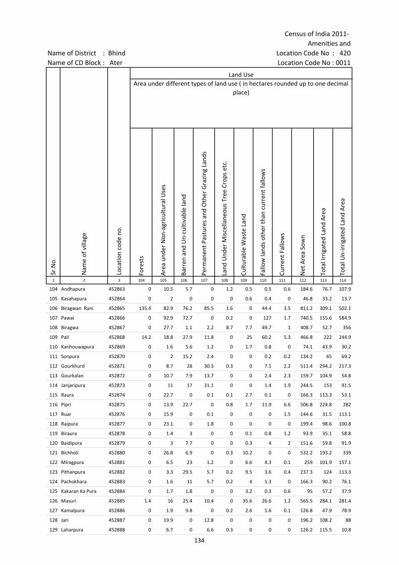
Census of India 2011- Amenities and
Name of District : Bhind Location Code No : 420Name of CD Block : Ater Location Code No : 0011
Fore
sts
Are
a un
der
Non
-agr
icul
tura
l Use
s
Barr
en a
nd U
n-cu
ltiva
ble
land
Perm
anen
t Pas
ture
s an
d O
ther
Gra
zing
Lan
ds
Land
Und
er M
isce
llane
ous
Tree
Cro
ps e
tc.
Cultu
rabl
e W
aste
Lan
d
Fallo
w la
nds
othe
r th
an c
urre
nt fa
llow
s
Curr
ent F
allo
ws
Net
Are
a So
wn
Tota
l Irr
igat
ed L
and
Are
a
Tota
l Un-
irri
gate
d La
nd A
rea
1 2 3 104 105 106 107 108 109 110 111 112 113 114
Sr.N
o.
Nam
e of
vill
age
Loca
tion
code
no.
Land UseArea under different types of land use ( in hectares rounded up to one decimal
place)
104 Andhapura 452863 0 10.5 5.7 0 1.2 0.5 0.5 0.6 184.6 76.7 107.9
105 Kasahapura 452864 0 2 0 0 0 0.6 0.4 0 46.8 33.2 13.7
106 Biragwan Rani 452865 135.4 82.9 76.2 85.5 1.6 0 44.4 3.5 811.2 309.1 502.1
107 Pawai 452866 0 92.9 72.7 0 0.2 0 127 1.7 740.5 155.6 584.9
108 Biragwa 452867 0 27.7 1.1 2.2 8.7 7.7 49.7 1 408.7 52.7 356
109 Pali 452868 14.2 18.8 27.9 11.8 0 25 60.2 5.3 466.8 222 244.9
110 Kanhouwapura 452869 0 1.6 5.6 1.2 0 1.7 0.8 0 74.1 43.9 30.2
111 Sonpura 452870 0 2 15.2 2.4 0 0 0.2 0.2 134.2 65 69.2
112 Gourkhurd 452871 0 8.7 28 30.3 0.3 0 7.1 2.2 511.4 294.2 217.3
113 Gourkalan 452872 0 10.7 7.9 13.7 0 0 2.4 2.3 159.7 104.9 54.8
114 Janjaripura 452873 0 11 17 31.1 0 0 1.4 1.9 244.5 153 91.5
115 Raura 452874 0 22.7 0 0.1 0.1 2.7 0.1 0 166.3 113.3 53.1
116 Pipri 452875 0 13.9 22.7 0 0.8 1.7 11.9 6.6 506.8 224.8 282
117 Ruar 452876 0 15.9 0 0.1 0 0 0 1.5 144.6 31.5 113.1
118 Raipura 452877 0 23.1 0 1.8 0 0 0 0 199.4 98.6 100.8
119 Biraura 452878 0 1.4 3 0 0 0.1 0.8 1.2 93.9 35.1 58.8
120 Baidipura 452879 0 3 7.7 0 0 0.3 4 2 151.6 59.8 91.9
121 Bichholi 452880 0 26.8 6.9 0 0.3 10.2 0 0 532.2 193.2 339
122 Miragpura 452881 0 6.5 23 1.2 0 6.6 4.3 0.1 259 101.9 157.1
123 Pithanpura 452882 0 3.3 29.5 5.7 0.2 9.5 3.6 0.4 237.3 124 113.3
124 Pachokhara 452883 0 1.6 11 5.7 0.2 4 1.3 0 166.3 90.2 76.1
125 Kakaran Ka Pura 452884 0 1.7 1.8 0 0 3.2 0.3 0.6 95 57.2 37.9
126 Masuri 452885 1.4 16 25.4 10.4 0 35.6 26.6 1.2 565.5 284.1 281.4
127 Kamalpura 452886 0 1.9 9.8 0 0.2 2.6 1.6 0.1 126.8 47.9 78.9
128 Jari 452887 0 19.9 0 12.8 0 0 0 0 196.2 108.2 88
129 Laharpura 452888 0 6.7 0 6.6 0.3 0 0 0 126.2 115.5 10.8
134
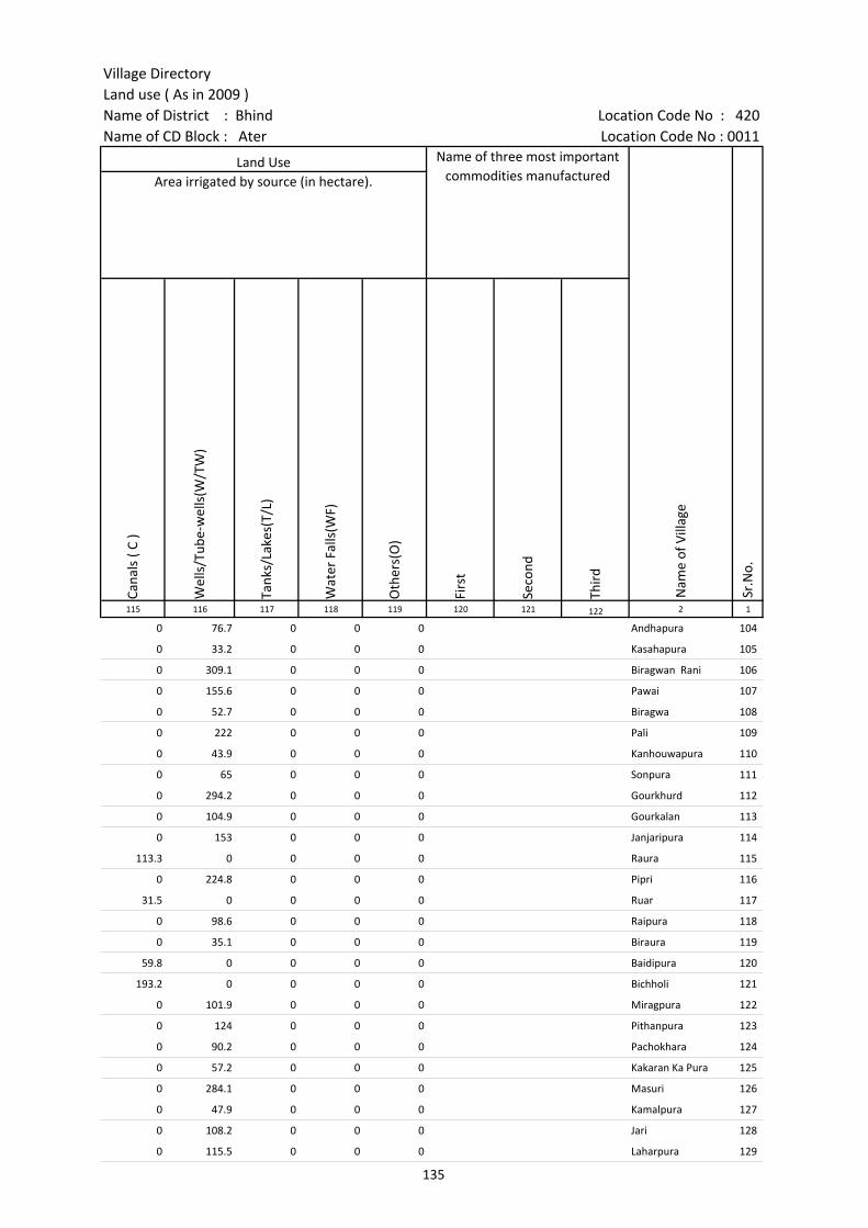
Village DirectoryLand use ( As in 2009 )Name of District : Bhind Location Code No : 420Name of CD Block : Ater Location Code No : 0011
Cana
ls (
C )
Wel
ls/T
ube-
wel
ls(W
/TW
)
Tank
s/La
kes(
T/L)
Wat
er F
alls
(WF)
Oth
ers(
O)
Firs
t
Seco
nd
Thir
d 115 116 117 118 119 120 121 122 2 1
Land Use Name of three most important commodities manufactured
Nam
e of
Vill
age
Sr.N
o.
Area irrigated by source (in hectare).
0 76.7 0 0 0 Andhapura 104
0 33.2 0 0 0 Kasahapura 105
0 309.1 0 0 0 Biragwan Rani 106
0 155.6 0 0 0 Pawai 107
0 52.7 0 0 0 Biragwa 108
0 222 0 0 0 Pali 109
0 43.9 0 0 0 Kanhouwapura 110
0 65 0 0 0 Sonpura 111
0 294.2 0 0 0 Gourkhurd 112
0 104.9 0 0 0 Gourkalan 113
0 153 0 0 0 Janjaripura 114
113.3 0 0 0 0 Raura 115
0 224.8 0 0 0 Pipri 116
31.5 0 0 0 0 Ruar 117
0 98.6 0 0 0 Raipura 118
0 35.1 0 0 0 Biraura 119
59.8 0 0 0 0 Baidipura 120
193.2 0 0 0 0 Bichholi 121
0 101.9 0 0 0 Miragpura 122
0 124 0 0 0 Pithanpura 123
0 90.2 0 0 0 Pachokhara 124
0 57.2 0 0 0 Kakaran Ka Pura 125
0 284.1 0 0 0 Masuri 126
0 47.9 0 0 0 Kamalpura 127
0 108.2 0 0 0 Jari 128
0 115.5 0 0 0 Laharpura 129
135

Census of India 2011- Amenities and
Name of District : Bhind Location Code No : 420Name of CD Block : Ater Location Code No : 0011
Pre-
Prim
ary
scho
ol (P
P)
Prim
ary
scho
ol (P
)
Mid
dle
scho
ol (M
)
Seco
ndar
y Sc
hool
(S)
Seni
or S
econ
dary
sch
ool (
SS)
Deg
ree
colle
ge o
f art
s s
cien
ce &
com
mer
ce (
ASC
)
Engi
neer
ing
colle
ge(E
C)
Med
ical
col
lege
(MC)
Man
agem
ent i
nstit
ute
(MI)
Poly
tech
nic
(Pt)
Voca
tiona
l tra
inin
g sc
hool
/IT
I
Non
-for
mal
trai
ning
cen
tre
(NFT
C)
Spec
ial s
choo
l for
dis
able
d (S
SD)
Oth
ers
(spe
cify
)
1 2 3 4 5 6 7 8 9 10 11 12 13 14 15 16 17 18 19 20
Number of educational amenities available. (If not available within the village , the distance range
code viz; a for < 5 Kms, b for 5-10 Kms and c for 10+ kms of nearest place where facility is available is given).
Sr.N
o.
Nam
e of
vill
age
Loca
tion
code
no.
Tota
l are
a of
the
villa
ge (
in h
ecta
res
roun
ded
up to
one
dec
imal
pla
ce)
Tota
l pop
ulat
ion
( 201
1 ce
nsus
)
Num
ber
of h
ouse
hold
s (2
011
cens
us)
130 Jagnnathpura 452889 90.2 117 25 a a a c c c c c c c c c
131 Mooratpura 452890 73.9 652 136 1 1 a c c c c c c c c c c
132 Akhtyarpura 452891 105.4 364 66 1 c c c c c c c
133 Lakhanpura 452892 111.8 717 159 1 a b c c c c c c c c c
134 Sultanpura 452893 59 0 0 --------------Un-inhabited--------------
135 Tikari 452894 130.1 803 122 1 a a b c c c c c c
136 Sarupura 452895 143.4 669 125 c 1 a b c c c c c c c c c c
137 Narsinghgarh 452896 335.4 1391 224 c 1 1 a a c c c c c c c c c
138 Inguri 452897 269.1 698 128 c 1 1 b b c c c c c c c c c
139 Vijaygarh 452898 425.5 1337 244 c 1 1 a a c c c c c c c c c
140 Bagulari 452899 483.7 1326 197 c 1 c b b c c c c c c c c c
141 Mahewa 452900 345.9 1158 222 1 1 1 1 1 1 1 c c c c
142 Baghedi 452901 319.6 1350 330 1 1 1 a a c c c c c c c c
143 Siyawali 452902 193.5 1272 250 1 1 1 1 c c c c c c c c
144 Dehara 452903 449.7 1252 208 1 1 1 1 b c c c c c c c c
145 Ranipura 452904 144 1304 217 1 1 b b b c c c c c c c c
146 Jawasa 452905 1645.1 8505 1257 11 6 3 3 c c c c c c c c c
147 Simrao 452906 662.4 2327 420 1 1 b b b c c b b b b
148 Kurthara 452907 466.9 1649 286 b 1 a b b b c c b b b b
149 Mihoni 452908 348.4 1289 196 1 1 b 1 b c c c b b b c b
150 Udotpura 452909 285.7 2463 354 b 1 1 b b b c c c b b b c b
151 Mudiakhara 452910 270.8 3380 634 4 6 5 3 2 a c c b a a b
152 Backsipura 452911 183.1 512 85 a 1 a a a b c c b b b b
153 Bhujpura 452912 178.9 2461 386 b 1 1 a a b c c c b b b c b
154 Dharai 452913 307.9 1867 328 b 2 1 b b b c c c b b b b
155 Chouki 452914 158.8 777 138 b 1 1 b b b c c c b b b b
136
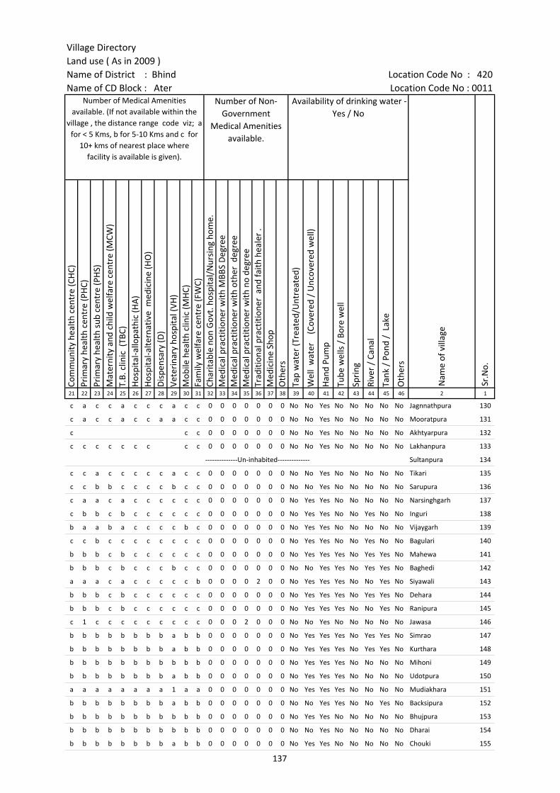
Village DirectoryLand use ( As in 2009 )Name of District : Bhind Location Code No : 420Name of CD Block : Ater Location Code No : 0011
Com
mun
ity h
ealth
cen
tre
(CH
C)Pr
imar
y he
alth
cen
tre
(PH
C)Pr
imar
y he
alth
sub
cen
tre
(PH
S)M
ater
nity
and
chi
ld w
elfa
re c
entr
e (M
CW)
T.B.
clin
ic (
TBC)
Hos
pita
l-allo
path
ic (H
A)
Hos
pita
l-alte
rnat
ive
med
icin
e (H
O)
Dis
pens
ary
(D)
Vete
rina
ry h
ospi
tal (
VH)
Mob
ile h
ealth
clin
ic (M
HC)
Fam
ily w
elfa
re c
entr
e (F
WC)
Char
itabl
e no
n G
ovt.
hos
pita
l/N
ursi
ng h
ome.
Med
ical
pra
ctiti
oner
with
MBB
S D
egre
eM
edic
al p
ract
ition
er w
ith o
ther
deg
ree
Med
ical
pra
ctiti
oner
with
no
degr
eeTr
aditi
onal
pra
ctiti
oner
and
faith
hea
ler
.M
edic
ine
Shop
Oth
ers
Tap
wat
er (T
reat
ed/U
ntre
ated
)
Wel
l w
ater
(C
over
ed /
Unc
over
ed w
ell)
Han
d Pu
mp
Tube
wel
ls /
Bor
e w
ell
Spri
ng
Rive
r /
Cana
l
Tank
/ P
ond
/ L
ake
Oth
ers
21 22 23 24 25 26 27 28 29 30 31 32 33 34 35 36 37 38 39 40 41 42 43 44 45 46 2 1
Number of Medical Amenities available. (If not available within the
village , the distance range code viz; a for < 5 Kms, b for 5-10 Kms and c for
10+ kms of nearest place where facility is available is given).
Number of Non-Government
Medical Amenities available.
Availability of drinking water - Yes / No
Nam
e of
vill
age
Sr.N
o.
c a c c a c c c a c c 0 0 0 0 0 0 0 No No Yes No No No No No Jagnnathpura 130
c a c c a c c a a c c 0 0 0 0 0 0 0 No No Yes No No No No No Mooratpura 131
c c c 0 0 0 0 0 0 0 No No Yes No No No No No Akhtyarpura 132
c c c c c c c c c 0 0 0 0 0 0 0 No No Yes No No No No No Lakhanpura 133
--------------Un-inhabited-------------- Sultanpura 134
c c a c c c c c a c c 0 0 0 0 0 0 0 No No Yes No No No No No Tikari 135
c c b b c c c c b c c 0 0 0 0 0 0 0 No No Yes No No No No No Sarupura 136
c a a c a c c c c c c 0 0 0 0 0 0 0 No Yes Yes No No No No No Narsinghgarh 137
c b b c b c c c c c c 0 0 0 0 0 0 0 No Yes Yes No No Yes No No Inguri 138
b a a b a c c c c b c 0 0 0 0 0 0 0 No Yes Yes No No No No No Vijaygarh 139
c c b c c c c c c c c 0 0 0 0 0 0 0 No Yes Yes No No Yes No No Bagulari 140
b b b c b c c c c c c 0 0 0 0 0 0 0 No Yes Yes Yes No Yes Yes No Mahewa 141
b b b c b c c c b c c 0 0 0 0 0 0 0 No No Yes Yes No Yes Yes No Baghedi 142
a a a c a c c c c c b 0 0 0 0 2 0 0 No Yes Yes Yes No No Yes No Siyawali 143
b b b c b c c c c c c 0 0 0 0 0 0 0 No Yes Yes Yes No Yes Yes No Dehara 144
b b b c b c c c c c c 0 0 0 0 0 0 0 No Yes Yes Yes No No Yes No Ranipura 145
c 1 c c c c c c c c c 0 0 0 2 0 0 0 No No Yes No No No No No Jawasa 146
b b b b b b b b a b b 0 0 0 0 0 0 0 No Yes Yes Yes No Yes Yes No Simrao 147
b b b b b b b b a b b 0 0 0 0 0 0 0 No Yes Yes Yes No Yes Yes No Kurthara 148
b b b b b b b b b b b 0 0 0 0 0 0 0 No Yes Yes Yes No No No No Mihoni 149
b b b b b b b b a b b 0 0 0 0 0 0 0 No Yes Yes Yes No No No No Udotpura 150
a a a a a a a a 1 a a 0 0 0 0 0 0 0 No Yes Yes Yes No No No No Mudiakhara 151
b b b b b b b b a b b 0 0 0 0 0 0 0 No No Yes Yes No No Yes No Backsipura 152
b b b b b b b b b b b 0 0 0 0 0 0 0 No Yes Yes No No No No No Bhujpura 153
b b b b b b b b b b b 0 0 0 0 0 0 0 No No Yes No No No No No Dharai 154
b b b b b b b b a b b 0 0 0 0 0 0 0 No Yes Yes No No No No No Chouki 155
137

Census of India 2011- Amenities and
Name of District : Bhind Location Code No : 420Name of CD Block : Ater Location Code No : 0011
Com
mun
ity to
ilet i
nclu
ding
bat
h.
Com
mun
ity to
ilet e
xclu
ding
bat
h.
Rura
l sa
nita
ry m
art o
r sa
nita
ry h
ardw
are
outle
t av
aila
ble
near
the
villa
ge.
Com
mun
ity b
io- g
as o
r re
cycl
e of
was
te fo
r pr
oduc
tive
use.
Post
off
ice(
PO)
Sub
post
off
ice
(SPO
)
Post
& T
eleg
raph
off
ice
(P&
TO)
Villa
ge P
in C
ode
Tele
phon
es
(L
and
lines
)
Publ
ic c
all o
ffic
e (P
CO)
Mob
ile p
hone
cov
erag
e
Inte
rnet
caf
es/
Com
mon
ser
vice
cen
tre
(CSC
)
Priv
ate
cour
ier
faci
lity
Bus
serv
ice
(Pub
lic &
Pri
vate
)
Railw
ay s
tatio
ns
Aut
o/M
odifi
ed A
utos
Taxi
s an
d Va
ns
1 2 3 47 48 49 50 51 52 53 54 55 56 57 58 59 60 61 62 63
Sr.N
o.
Nam
e of
vill
age
Loca
tion
code
no.
Availability of toilet & others Yes / No
Communication and transport facilities (If amenities available code -Yes is given except for Village Pin Code ,If not available within the village , the distance range code
viz; a for < 5 Kms, b for 5-10 Kms and c for 10+ kms of nearest place where facility is available is given).
130 Jagnnathpura 452889 No No No No c a c c c c c c c b c a
131 Mooratpura 452890 No No No No c a c c c Yes c c a a c a
132 Akhtyarpura 452891 No No No No c a c c c Yes c c c b b c
133 Lakhanpura 452892 No No No No c a c c c c c c c b b b
134 Sultanpura 452893 --------------Un-inhabited--------------
135 Tikari 452894 No No No No c a c c c Yes c a a a a a
136 Sarupura 452895 No No No No c b a c c Yes c c b c c c
137 Narsinghgarh 452896 No No No No c a c c c Yes c c c c c c
138 Inguri 452897 No No No No c a c c c Yes c c a c c c
139 Vijaygarh 452898 No No No No c b c c c Yes c c c c c c
140 Bagulari 452899 No No No No c Yes c 477105 c c Yes c c b c c c
141 Mahewa 452900 No No No No b b b b c Yes c c c c c c
142 Baghedi 452901 No No No No a a c a c Yes c c Yes c c c
143 Siyawali 452902 No No No No a Yes Yes 477105 Yes c Yes c c b c c c
144 Dehara 452903 No No No No b b b b Yes c c a b c c
145 Ranipura 452904 No No No Yes b b c b c Yes c c c c c c
146 Jawasa 452905 No No No No c c c 477105 c c Yes c c Yes b b b
147 Simrao 452906 No No No No Yes b b 477105 b b Yes b b b b b b
148 Kurthara 452907 No No No No Yes b b b a b b b b b b
149 Mihoni 452908 No No No No b b b 477447 b b Yes b b b b b b
150 Udotpura 452909 No No No No Yes b b 477222 b b Yes b b b a b b
151 Mudiakhara 452910 No No No No a a a 477447 a Yes Yes a a Yes Yes Yes Yes
152 Backsipura 452911 No No No No b a b b b a b b a a a a
153 Bhujpura 452912 No No Yes No b b b b b Yes b b a a Yes Yes
154 Dharai 452913 No No No No b b Yes 477001 b b Yes b b b b b b
155 Chouki 452914 No No No No b b Yes b Yes b b a b b b
138
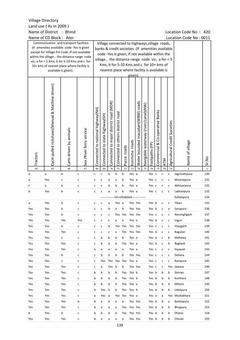
Village DirectoryLand use ( As in 2009 )Name of District : Bhind Location Code No : 420Name of CD Block : Ater Location Code No : 0011
Trac
tors
Cycl
e-pu
lled
rick
shaw
s(M
anua
l & M
achi
ne d
rive
n)
Cart
s dr
iven
by
anim
als
Sea
/Riv
er fe
rry
serv
ice
Conn
ecte
d to
nat
iona
l hig
hway
(NH
)
Conn
ecte
d to
sta
te h
ighw
ay(S
H)
Conn
ecte
d to
maj
or d
istr
ict r
oad
(MD
R)
Conn
ecte
d to
oth
ers
dist
rict
roa
d
Pucc
a r
oads
Kutc
hcha
roa
ds
Wat
er b
ound
ed m
acad
am(W
BM) r
oads
Nav
igab
le w
ater
way
(riv
er/c
anal
)(N
W)
Foot
path
s (F
P)
Com
mer
cial
& C
o-op
erat
ive
Bank
s
ATM
Agr
icul
tura
l Cre
dit S
ocie
ties
64 65 66 67 68 69 70 71 72 73 74 75 76 77 78 79 2 1
Communication and transport facilities (If amenities available code -Yes is given
except for Village Pin Code ,If not available within the village , the distance range code viz; a for < 5 Kms, b for 5-10 Kms and c for 10+ kms of nearest place where facility is
available is given).
Village connected to highways,village roads, banks & credit societies (If amenities available
code -Yes is given, If not available within the village , the distance range code viz; a for < 5
Kms, b for 5-10 Kms and c for 10+ kms of nearest place where facility is available is
given).
Nam
e of
vill
age
Sr.N
o.
a a b c c c b b b Yes a Yes c c c Jagnnathpura 130
a Yes c c c c a a b Yes a Yes c c c Mooratpura 131
c a b c c c b b b Yes a Yes c c c Akhtyarpura 132
b Yes b c c c a a b Yes a Yes c c c Lakhanpura 133
--------------Un-inhabited-------------- Sultanpura 134
a Yes b c c c a Yes a Yes Yes Yes b c c Tikari 135
Yes Yes b c c c b a b Yes Yes Yes b c a Sarupura 136
Yes Yes b c c c c Yes Yes Yes Yes Yes c c c Narsinghgarh 137
Yes Yes Yes Yes c c c a a Yes a Yes b c c Inguri 138
Yes Yes b c c c b Yes Yes Yes Yes Yes c c c Vijaygarh 139
Yes Yes Yes c c c c a Yes Yes Yes Yes b c c Bagulari 140
Yes Yes c c c b b b b Yes a Yes b c b Mahewa 141
Yes Yes Yes c c b b b Yes Yes a Yes b c b Baghedi 142
Yes Yes Yes c a a a a a Yes a Yes c c c Siyawali 143
Yes Yes b c c b b b b Yes Yes Yes c c c Dehara 144
Yes Yes c c c Yes Yes Yes Yes Yes a Yes c c c Ranipura 145
Yes Yes Yes c c a Yes b b Yes Yes Yes c c Yes Jawasa 146
Yes Yes Yes c b b b b Yes Yes b Yes b b b Simrao 147
Yes Yes Yes c b b b b Yes Yes b Yes b b b Kurthara 148
Yes Yes Yes c b b b b Yes Yes a Yes b b b Mihoni 149
Yes Yes Yes c b Yes b b Yes Yes b Yes b b b Udotpura 150
Yes Yes Yes c a Yes a Yes Yes Yes a Yes a a Yes Mudiakhara 151
Yes Yes Yes b b a b a a Yes Yes Yes b b a Backsipura 152
Yes Yes Yes c b a a a Yes Yes Yes Yes b b b Bhujpura 153
b Yes b c b b b b Yes Yes Yes Yes b b b Dharai 154
Yes Yes Yes c b a a a a Yes Yes Yes b b b Chouki 155
139
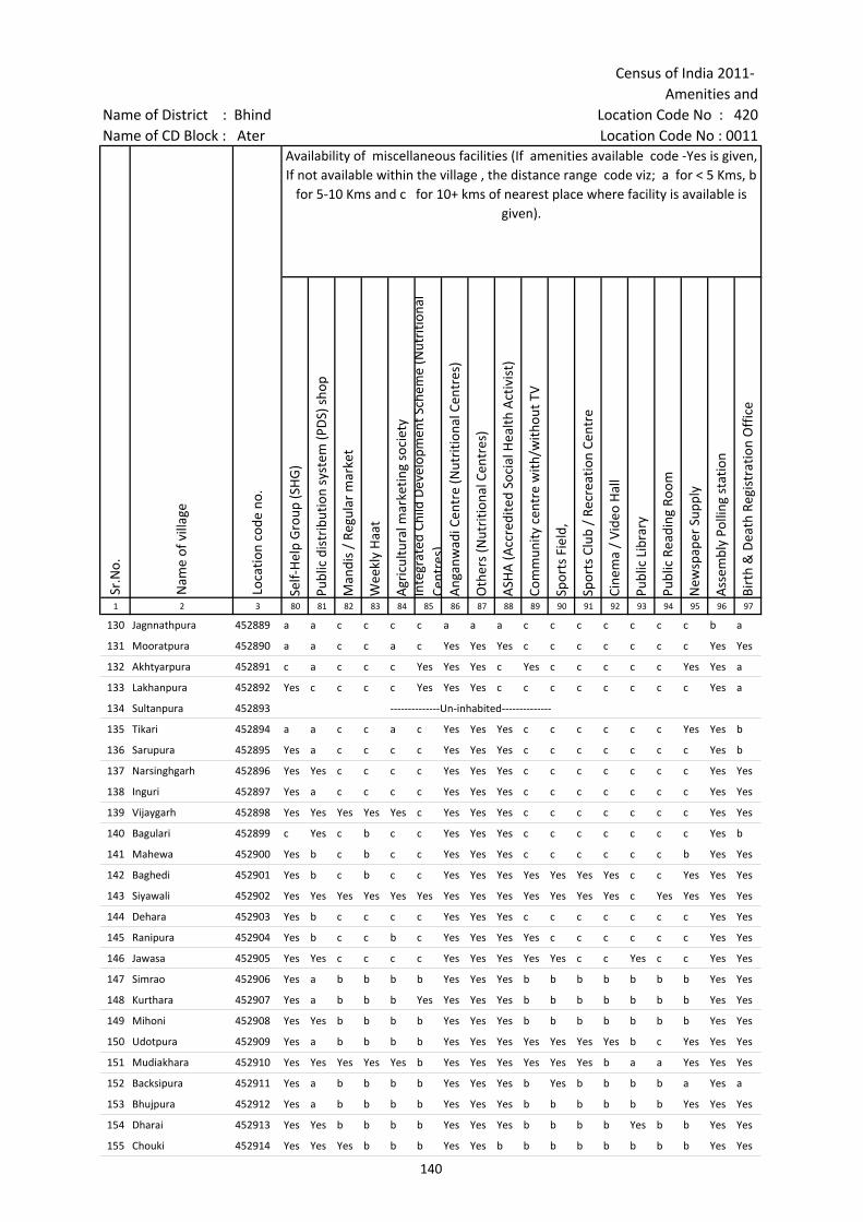
Census of India 2011- Amenities and
Name of District : Bhind Location Code No : 420Name of CD Block : Ater Location Code No : 0011
Self-
Hel
p G
roup
(SH
G)
Publ
ic d
istr
ibut
ion
syst
em (P
DS)
sho
p
Man
dis
/ Re
gula
r m
arke
t
Wee
kly
Haa
t
Agr
icul
tura
l mar
ketin
g so
ciet
yIn
tegr
ated
Chi
ld D
evel
opm
ent S
chem
e (N
utri
tiona
l Ce
ntre
s)A
ngan
wad
i Cen
tre
(Nut
ritio
nal C
entr
es)
Oth
ers
(Nut
ritio
nal C
entr
es)
ASH
A (A
ccre
dite
d So
cial
Hea
lth A
ctiv
ist)
Com
mun
ity c
entr
e w
ith/w
ithou
t TV
Spor
ts F
ield
,
Spor
ts C
lub
/ Re
crea
tion
Cent
re
Cine
ma
/ Vi
deo
Hal
l
Publ
ic L
ibra
ry
Publ
ic R
eadi
ng R
oom
New
spap
er S
uppl
y
Ass
embl
y Po
lling
sta
tion
Birt
h &
Dea
th R
egis
trat
ion
Off
ice
1 2 3 80 81 82 83 84 85 86 87 88 89 90 91 92 93 94 95 96 97
Sr.N
o.
Nam
e of
vill
age
Loca
tion
code
no.
Availability of miscellaneous facilities (If amenities available code -Yes is given, If not available within the village , the distance range code viz; a for < 5 Kms, b
for 5-10 Kms and c for 10+ kms of nearest place where facility is available is given).
130 Jagnnathpura 452889 a a c c c c a a a c c c c c c c b a
131 Mooratpura 452890 a a c c a c Yes Yes Yes c c c c c c c Yes Yes
132 Akhtyarpura 452891 c a c c c Yes Yes Yes c Yes c c c c c Yes Yes a
133 Lakhanpura 452892 Yes c c c c Yes Yes Yes c c c c c c c c Yes a
134 Sultanpura 452893 --------------Un-inhabited--------------
135 Tikari 452894 a a c c a c Yes Yes Yes c c c c c c Yes Yes b
136 Sarupura 452895 Yes a c c c c Yes Yes Yes c c c c c c c Yes b
137 Narsinghgarh 452896 Yes Yes c c c c Yes Yes Yes c c c c c c c Yes Yes
138 Inguri 452897 Yes a c c c c Yes Yes Yes c c c c c c c Yes Yes
139 Vijaygarh 452898 Yes Yes Yes Yes Yes c Yes Yes Yes c c c c c c c Yes Yes
140 Bagulari 452899 c Yes c b c c Yes Yes Yes c c c c c c c Yes b
141 Mahewa 452900 Yes b c b c c Yes Yes Yes c c c c c c b Yes Yes
142 Baghedi 452901 Yes b c b c c Yes Yes Yes Yes Yes Yes Yes c c Yes Yes Yes
143 Siyawali 452902 Yes Yes Yes Yes Yes Yes Yes Yes Yes Yes Yes Yes Yes c Yes Yes Yes Yes
144 Dehara 452903 Yes b c c c c Yes Yes Yes c c c c c c c Yes Yes
145 Ranipura 452904 Yes b c c b c Yes Yes Yes Yes c c c c c c Yes Yes
146 Jawasa 452905 Yes Yes c c c c Yes Yes Yes Yes Yes c c Yes c c Yes Yes
147 Simrao 452906 Yes a b b b b Yes Yes Yes b b b b b b b Yes Yes
148 Kurthara 452907 Yes a b b b Yes Yes Yes Yes b b b b b b b Yes Yes
149 Mihoni 452908 Yes Yes b b b b Yes Yes Yes b b b b b b b Yes Yes
150 Udotpura 452909 Yes a b b b b Yes Yes Yes Yes Yes Yes Yes b c Yes Yes Yes
151 Mudiakhara 452910 Yes Yes Yes Yes Yes b Yes Yes Yes Yes Yes Yes b a a Yes Yes Yes
152 Backsipura 452911 Yes a b b b b Yes Yes Yes b Yes b b b b a Yes a
153 Bhujpura 452912 Yes a b b b b Yes Yes Yes b b b b b b Yes Yes Yes
154 Dharai 452913 Yes Yes b b b b Yes Yes Yes b b b b Yes b b Yes Yes
155 Chouki 452914 Yes Yes Yes b b b Yes Yes b b b b b b b b Yes Yes
140
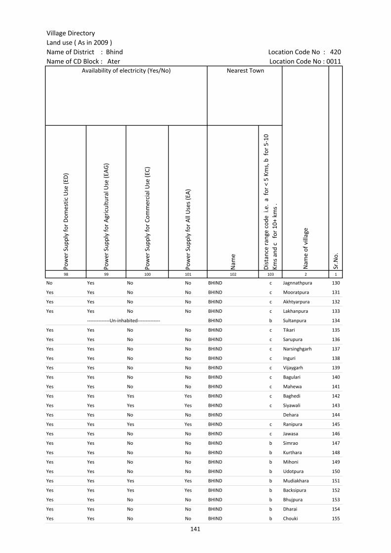
Village DirectoryLand use ( As in 2009 )Name of District : Bhind Location Code No : 420Name of CD Block : Ater Location Code No : 0011
Pow
er S
uppl
y fo
r D
omes
tic U
se (E
D)
Pow
er S
uppl
y fo
r A
gric
ultu
ral U
se (E
AG
)
Pow
er S
uppl
y fo
r Co
mm
erci
al U
se (E
C)
Pow
er S
uppl
y fo
r A
ll U
ses
(EA
)
Nam
e
Dis
tanc
e ra
nge
code
i.e
. a
for
< 5
Kms,
b f
or 5
-10
Kms
and
c f
or 1
0+ k
ms
.98 99 100 101 102 103 2 1
Availability of electricity (Yes/No) Nearest Town
Nam
e of
vill
age
Sr.N
o.
No Yes No No BHIND c Jagnnathpura 130
Yes Yes No No BHIND c Mooratpura 131
Yes Yes No No BHIND c Akhtyarpura 132
Yes Yes No No BHIND c Lakhanpura 133
--------------Un-inhabited-------------- BHIND b Sultanpura 134
Yes Yes No No BHIND c Tikari 135
Yes Yes No No BHIND c Sarupura 136
Yes Yes No No BHIND c Narsinghgarh 137
Yes Yes No No BHIND c Inguri 138
Yes Yes No No BHIND c Vijaygarh 139
Yes Yes No No BHIND c Bagulari 140
Yes Yes No No BHIND c Mahewa 141
Yes Yes Yes Yes BHIND c Baghedi 142
Yes Yes Yes Yes BHIND c Siyawali 143
Yes Yes No No BHIND Dehara 144
Yes Yes Yes Yes BHIND c Ranipura 145
Yes Yes No No BHIND c Jawasa 146
Yes Yes No No BHIND b Simrao 147
Yes Yes No No BHIND b Kurthara 148
Yes Yes No No BHIND b Mihoni 149
Yes Yes No No BHIND b Udotpura 150
Yes Yes Yes Yes BHIND b Mudiakhara 151
Yes Yes Yes Yes BHIND b Backsipura 152
Yes Yes No No BHIND b Bhujpura 153
Yes Yes No No BHIND b Dharai 154
Yes Yes No No BHIND b Chouki 155
141
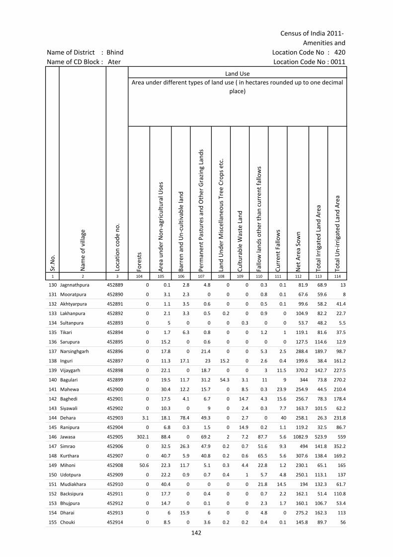
Census of India 2011- Amenities and
Name of District : Bhind Location Code No : 420Name of CD Block : Ater Location Code No : 0011
Fore
sts
Are
a un
der
Non
-agr
icul
tura
l Use
s
Barr
en a
nd U
n-cu
ltiva
ble
land
Perm
anen
t Pas
ture
s an
d O
ther
Gra
zing
Lan
ds
Land
Und
er M
isce
llane
ous
Tree
Cro
ps e
tc.
Cultu
rabl
e W
aste
Lan
d
Fallo
w la
nds
othe
r th
an c
urre
nt fa
llow
s
Curr
ent F
allo
ws
Net
Are
a So
wn
Tota
l Irr
igat
ed L
and
Are
a
Tota
l Un-
irri
gate
d La
nd A
rea
1 2 3 104 105 106 107 108 109 110 111 112 113 114
Sr.N
o.
Nam
e of
vill
age
Loca
tion
code
no.
Land UseArea under different types of land use ( in hectares rounded up to one decimal
place)
130 Jagnnathpura 452889 0 0.1 2.8 4.8 0 0 0.3 0.1 81.9 68.9 13
131 Mooratpura 452890 0 3.1 2.3 0 0 0 0.8 0.1 67.6 59.6 8
132 Akhtyarpura 452891 0 1.1 3.5 0.6 0 0 0.5 0.1 99.6 58.2 41.4
133 Lakhanpura 452892 0 2.1 3.3 0.5 0.2 0 0.9 0 104.9 82.2 22.7
134 Sultanpura 452893 0 5 0 0 0 0.3 0 0 53.7 48.2 5.5
135 Tikari 452894 0 1.7 6.3 0.8 0 0 1.2 1 119.1 81.6 37.5
136 Sarupura 452895 0 15.2 0 0.6 0 0 0 0 127.5 114.6 12.9
137 Narsinghgarh 452896 0 17.8 0 21.4 0 0 5.3 2.5 288.4 189.7 98.7
138 Inguri 452897 0 11.3 17.1 23 15.2 0 2.6 0.4 199.6 38.4 161.2
139 Vijaygarh 452898 0 22.1 0 18.7 0 0 3 11.5 370.2 142.7 227.5
140 Bagulari 452899 0 19.5 11.7 31.2 54.3 3.1 11 9 344 73.8 270.2
141 Mahewa 452900 0 30.4 12.2 15.7 0 8.5 0.3 23.9 254.9 44.5 210.4
142 Baghedi 452901 0 17.5 4.1 6.7 0 14.7 4.3 15.6 256.7 78.3 178.4
143 Siyawali 452902 0 10.3 0 9 0 2.4 0.3 7.7 163.7 101.5 62.2
144 Dehara 452903 3.1 18.1 78.4 49.3 0 2.7 0 40 258.1 26.3 231.8
145 Ranipura 452904 0 6.8 0.3 1.5 0 14.9 0.2 1.1 119.2 32.5 86.7
146 Jawasa 452905 302.1 88.4 0 69.2 2 7.2 87.7 5.6 1082.9 523.9 559
147 Simrao 452906 0 32.5 26.3 47.9 0.2 0.7 51.6 9.3 494 141.8 352.2
148 Kurthara 452907 0 40.7 5.9 40.8 0.2 0.6 65.5 5.6 307.6 138.4 169.2
149 Mihoni 452908 50.6 22.3 11.7 5.1 0.3 4.4 22.8 1.2 230.1 65.1 165
150 Udotpura 452909 0 22.2 0.9 0.7 0.4 1 5.7 4.8 250.1 113.1 137
151 Mudiakhara 452910 0 40.4 0 0 0 0 21.8 14.5 194 132.3 61.7
152 Backsipura 452911 0 17.7 0 0.4 0 0 0.7 2.2 162.1 51.4 110.8
153 Bhujpura 452912 0 14.7 0 0.1 0 0 2.3 1.7 160.1 106.7 53.4
154 Dharai 452913 0 6 15.9 6 0 0 4.8 0 275.2 162.3 113
155 Chouki 452914 0 8.5 0 3.6 0.2 0.2 0.4 0.1 145.8 89.7 56
142
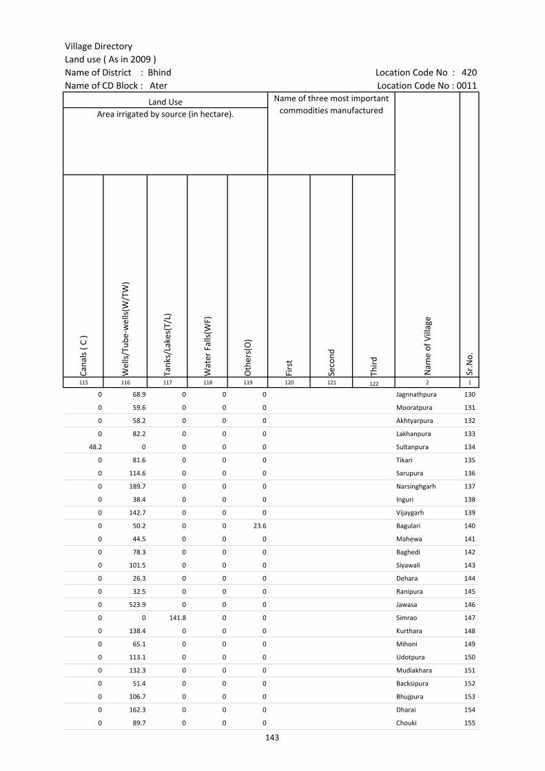
Village DirectoryLand use ( As in 2009 )Name of District : Bhind Location Code No : 420Name of CD Block : Ater Location Code No : 0011
Cana
ls (
C )
Wel
ls/T
ube-
wel
ls(W
/TW
)
Tank
s/La
kes(
T/L)
Wat
er F
alls
(WF)
Oth
ers(
O)
Firs
t
Seco
nd
Thir
d 115 116 117 118 119 120 121 122 2 1
Land Use Name of three most important commodities manufactured
Nam
e of
Vill
age
Sr.N
o.
Area irrigated by source (in hectare).
0 68.9 0 0 0 Jagnnathpura 130
0 59.6 0 0 0 Mooratpura 131
0 58.2 0 0 0 Akhtyarpura 132
0 82.2 0 0 0 Lakhanpura 133
48.2 0 0 0 0 Sultanpura 134
0 81.6 0 0 0 Tikari 135
0 114.6 0 0 0 Sarupura 136
0 189.7 0 0 0 Narsinghgarh 137
0 38.4 0 0 0 Inguri 138
0 142.7 0 0 0 Vijaygarh 139
0 50.2 0 0 23.6 Bagulari 140
0 44.5 0 0 0 Mahewa 141
0 78.3 0 0 0 Baghedi 142
0 101.5 0 0 0 Siyawali 143
0 26.3 0 0 0 Dehara 144
0 32.5 0 0 0 Ranipura 145
0 523.9 0 0 0 Jawasa 146
0 0 141.8 0 0 Simrao 147
0 138.4 0 0 0 Kurthara 148
0 65.1 0 0 0 Mihoni 149
0 113.1 0 0 0 Udotpura 150
0 132.3 0 0 0 Mudiakhara 151
0 51.4 0 0 0 Backsipura 152
0 106.7 0 0 0 Bhujpura 153
0 162.3 0 0 0 Dharai 154
0 89.7 0 0 0 Chouki 155
143

Census of India 2011- Amenities and
Name of District : Bhind Location Code No : 420Name of CD Block : Ater Location Code No : 0011
Pre-
Prim
ary
scho
ol (P
P)
Prim
ary
scho
ol (P
)
Mid
dle
scho
ol (M
)
Seco
ndar
y Sc
hool
(S)
Seni
or S
econ
dary
sch
ool (
SS)
Deg
ree
colle
ge o
f art
s s
cien
ce &
com
mer
ce (
ASC
)
Engi
neer
ing
colle
ge(E
C)
Med
ical
col
lege
(MC)
Man
agem
ent i
nstit
ute
(MI)
Poly
tech
nic
(Pt)
Voca
tiona
l tra
inin
g sc
hool
/IT
I
Non
-for
mal
trai
ning
cen
tre
(NFT
C)
Spec
ial s
choo
l for
dis
able
d (S
SD)
Oth
ers
(spe
cify
)
1 2 3 4 5 6 7 8 9 10 11 12 13 14 15 16 17 18 19 20
Number of educational amenities available. (If not available within the village , the distance range
code viz; a for < 5 Kms, b for 5-10 Kms and c for 10+ kms of nearest place where facility is available is given).
Sr.N
o.
Nam
e of
vill
age
Loca
tion
code
no.
Tota
l are
a of
the
villa
ge (
in h
ecta
res
roun
ded
up to
one
dec
imal
pla
ce)
Tota
l pop
ulat
ion
( 201
1 ce
nsus
)
Num
ber
of h
ouse
hold
s (2
011
cens
us)
156 Bisalpura 452915 168 615 110 b 1 a b b b c c c b b b b
157 Kushmar 452916 278.9 878 135 b 1 a b b b c c c b b b b
158 Nalipura 452917 115.7 566 86 1 1 b b c b b b b
159 Pur 452918 860.6 4030 760 1 4 3 1 b b b b b
160 Shahpura 452919 180.4 209 36 a a a a a a
161 Singhpura 452920 78.1 0 0 --------------Un-inhabited--------------
162 Badanpur 452921 347.1 45 10 a a b b c b c b b
163 Amlheda 452922 253.6 892 160 1 1 b b b b b b b
164 Pidora 452923 405.1 2035 370 c 2 1 1 1 c c c c c c
165 Harraj Pura 452924 187.5 559 113 c 1 c c c c c c c
166 Etahar 452925 648 2683 448 c 1 1 1 c c c c c c
167 Chakarpura 452926 203.9 659 115 c 1 a 1 c c c c c c c c
168 Khidarpura 452927 153 834 161 c 1 a a c c c c c c c c c c
169 Jori Brahaman 452928 398.4 777 155 b 2 1 b c c c c c c c c c c
170 Madan Pura 452929 182 1151 172 b 1 1 b c c c c c c c c c c
171 Mahapur 452930 302.7 1594 277 c 1 1 b c c c c c c c c c c
172 Prithwipura 452931 310.8 334 46 a 1 a a c c c c c c c c c c
173 Amlehadi 452932 170.1 689 146 1 1 b b b b c c c b b b b
174 Barohi 452933 253.7 1812 368 1 3 2 1 c c c c c c c c c c
175 Dighi 452934 125 0 0 --------------Un-inhabited--------------
176 Dongarpura 452935 302.8 571 88 c 1 a a c c c c c c c c c c
177 Turkpura 452936 102.2 249 44 c 1 a a c c c c c c c c c c
178 Gopalpura 452937 333.5 1068 186 c 1 1 1 c c c c c c c c c c
179 Khurd 452938 151.7 1079 175 c 2 1 a c c c c c c c c c c
180 Nayab 452939 349.4 985 243 c 2 1 a c c c c c c c c c c
181 Sujanpura 452940 99.1 590 144 a 1 a a c c c c c c c c c c
144

Village DirectoryLand use ( As in 2009 )Name of District : Bhind Location Code No : 420Name of CD Block : Ater Location Code No : 0011
Com
mun
ity h
ealth
cen
tre
(CH
C)Pr
imar
y he
alth
cen
tre
(PH
C)Pr
imar
y he
alth
sub
cen
tre
(PH
S)M
ater
nity
and
chi
ld w
elfa
re c
entr
e (M
CW)
T.B.
clin
ic (
TBC)
Hos
pita
l-allo
path
ic (H
A)
Hos
pita
l-alte
rnat
ive
med
icin
e (H
O)
Dis
pens
ary
(D)
Vete
rina
ry h
ospi
tal (
VH)
Mob
ile h
ealth
clin
ic (M
HC)
Fam
ily w
elfa
re c
entr
e (F
WC)
Char
itabl
e no
n G
ovt.
hos
pita
l/N
ursi
ng h
ome.
Med
ical
pra
ctiti
oner
with
MBB
S D
egre
eM
edic
al p
ract
ition
er w
ith o
ther
deg
ree
Med
ical
pra
ctiti
oner
with
no
degr
eeTr
aditi
onal
pra
ctiti
oner
and
faith
hea
ler
.M
edic
ine
Shop
Oth
ers
Tap
wat
er (T
reat
ed/U
ntre
ated
)
Wel
l w
ater
(C
over
ed /
Unc
over
ed w
ell)
Han
d Pu
mp
Tube
wel
ls /
Bor
e w
ell
Spri
ng
Rive
r /
Cana
l
Tank
/ P
ond
/ L
ake
Oth
ers
21 22 23 24 25 26 27 28 29 30 31 32 33 34 35 36 37 38 39 40 41 42 43 44 45 46 2 1
Number of Medical Amenities available. (If not available within the
village , the distance range code viz; a for < 5 Kms, b for 5-10 Kms and c for
10+ kms of nearest place where facility is available is given).
Number of Non-Government
Medical Amenities available.
Availability of drinking water - Yes / No
Nam
e of
vill
age
Sr.N
o.
b b b b b b b b b b 0 0 0 0 0 0 0 No Yes Yes No No No No No Bisalpura 156
b b b b b b b b b b b 0 0 0 0 0 0 0 No Yes Yes No No No No No Kushmar 157
b b b b b b b b b b b 0 0 0 0 0 0 0 No No Yes No No No No No Nalipura 158
b b b b b b b b b b b 0 0 0 0 0 0 0 No No Yes Yes No No Yes No Pur 159
a a a a a a a a a a a 0 0 0 0 0 0 0 No No Yes No No No No No Shahpura 160
--------------Un-inhabited-------------- Singhpura 161
a a a b a b b b b b b 0 0 0 0 0 0 0 No No Yes Yes No No No No Badanpur 162
b b b b b b b b b b b 0 0 0 0 0 0 0 No No Yes No No No No No Amlheda 163
c c c c c c c 1 c c c 0 0 0 0 0 0 0 Yes Yes Yes Yes No Yes Yes No Pidora 164
c c c c c c c c c c c 0 0 0 0 0 0 0 No No Yes No No No No No Harraj Pura 165
c 1 c c c c 1 1 c 1 0 0 0 0 0 0 0 No Yes Yes No No No No No Etahar 166
c c a c c c c c a c a 0 0 0 0 0 0 0 No Yes Yes No No No No No Chakarpura 167
a c b c c c c c c b c 0 0 0 0 0 0 0 No No Yes No No No No No Khidarpura 168
c c c c c c c c c c c 0 0 0 0 0 0 0 No Yes Yes No No Yes Yes No Jori Brahaman 169
c c c c c c c c c c c 0 0 0 0 0 0 0 No Yes Yes No No Yes Yes No Madan Pura 170
c c b c c c c c b c b 0 0 0 0 0 0 0 No No Yes No No No No No Mahapur 171
c c c c c c c a c c c 0 0 0 0 0 0 0 No Yes Yes No No No Yes No Prithwipura 172
b b b b b b b b b b 0 0 0 0 0 0 0 No Yes Yes Yes No No No No Amlehadi 173
c c c c c c c c 1 c c 0 0 0 0 0 0 0 No Yes Yes No No No No No Barohi 174
--------------Un-inhabited-------------- Dighi 175
c c c c c c c c c c c 0 0 0 0 0 0 0 No Yes Yes No No No No No Dongarpura 176
c c c c c c c c a c c 0 0 0 0 0 0 0 No Yes Yes No No No No No Turkpura 177
c c c c c c c c c c c 0 0 0 0 0 0 0 No Yes Yes No No No No No Gopalpura 178
c c c c c c c c c c c 0 0 0 0 0 0 0 No Yes No No No No No No Khurd 179
c c c c c c c c a c c 0 0 0 0 0 0 0 No Yes Yes No No No Yes No Nayab 180
c c c c c c c c a c c 0 0 0 0 0 0 0 No Yes Yes No No No No No Sujanpura 181
145
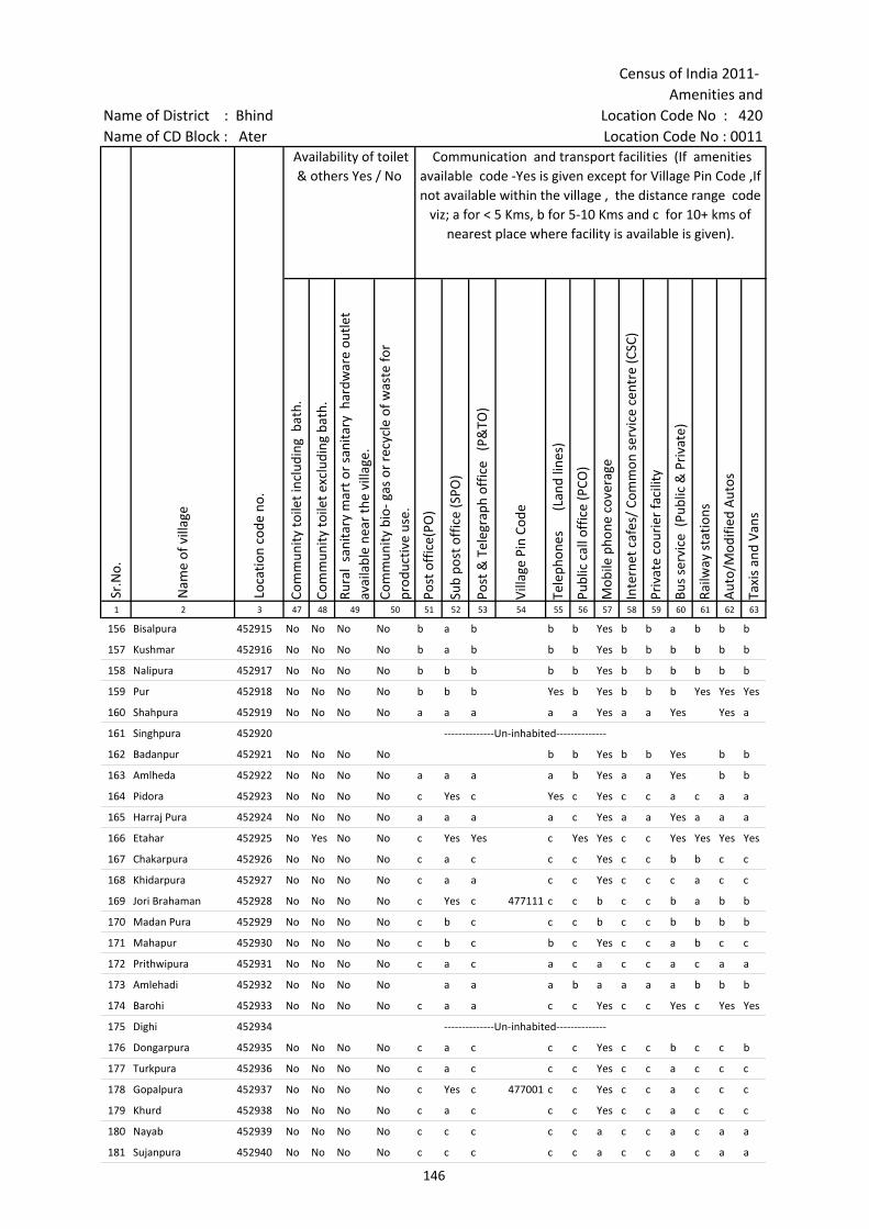
Census of India 2011- Amenities and
Name of District : Bhind Location Code No : 420Name of CD Block : Ater Location Code No : 0011
Com
mun
ity to
ilet i
nclu
ding
bat
h.
Com
mun
ity to
ilet e
xclu
ding
bat
h.
Rura
l sa
nita
ry m
art o
r sa
nita
ry h
ardw
are
outle
t av
aila
ble
near
the
villa
ge.
Com
mun
ity b
io- g
as o
r re
cycl
e of
was
te fo
r pr
oduc
tive
use.
Post
off
ice(
PO)
Sub
post
off
ice
(SPO
)
Post
& T
eleg
raph
off
ice
(P&
TO)
Villa
ge P
in C
ode
Tele
phon
es
(L
and
lines
)
Publ
ic c
all o
ffic
e (P
CO)
Mob
ile p
hone
cov
erag
e
Inte
rnet
caf
es/
Com
mon
ser
vice
cen
tre
(CSC
)
Priv
ate
cour
ier
faci
lity
Bus
serv
ice
(Pub
lic &
Pri
vate
)
Railw
ay s
tatio
ns
Aut
o/M
odifi
ed A
utos
Taxi
s an
d Va
ns
1 2 3 47 48 49 50 51 52 53 54 55 56 57 58 59 60 61 62 63
Sr.N
o.
Nam
e of
vill
age
Loca
tion
code
no.
Availability of toilet & others Yes / No
Communication and transport facilities (If amenities available code -Yes is given except for Village Pin Code ,If not available within the village , the distance range code
viz; a for < 5 Kms, b for 5-10 Kms and c for 10+ kms of nearest place where facility is available is given).
156 Bisalpura 452915 No No No No b a b b b Yes b b a b b b
157 Kushmar 452916 No No No No b a b b b Yes b b b b b b
158 Nalipura 452917 No No No No b b b b b Yes b b b b b b
159 Pur 452918 No No No No b b b Yes b Yes b b b Yes Yes Yes
160 Shahpura 452919 No No No No a a a a a Yes a a Yes Yes a
161 Singhpura 452920 --------------Un-inhabited--------------
162 Badanpur 452921 No No No No b b Yes b b Yes b b
163 Amlheda 452922 No No No No a a a a b Yes a a Yes b b
164 Pidora 452923 No No No No c Yes c Yes c Yes c c a c a a
165 Harraj Pura 452924 No No No No a a a a c Yes a a Yes a a a
166 Etahar 452925 No Yes No No c Yes Yes c Yes Yes c c Yes Yes Yes Yes
167 Chakarpura 452926 No No No No c a c c c Yes c c b b c c
168 Khidarpura 452927 No No No No c a a c c Yes c c c a c c
169 Jori Brahaman 452928 No No No No c Yes c 477111 c c b c c b a b b
170 Madan Pura 452929 No No No No c b c c c b c c b b b b
171 Mahapur 452930 No No No No c b c b c Yes c c a b c c
172 Prithwipura 452931 No No No No c a c a c a c c a c a a
173 Amlehadi 452932 No No No No a a a b a a a a b b b
174 Barohi 452933 No No No No c a a c c Yes c c Yes c Yes Yes
175 Dighi 452934 --------------Un-inhabited--------------
176 Dongarpura 452935 No No No No c a c c c Yes c c b c c b
177 Turkpura 452936 No No No No c a c c c Yes c c a c c c
178 Gopalpura 452937 No No No No c Yes c 477001 c c Yes c c a c c c
179 Khurd 452938 No No No No c a c c c Yes c c a c c c
180 Nayab 452939 No No No No c c c c c a c c a c a a
181 Sujanpura 452940 No No No No c c c c c a c c a c a a
146
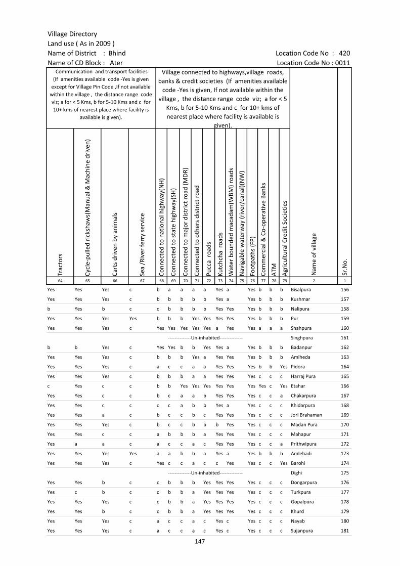
Village DirectoryLand use ( As in 2009 )Name of District : Bhind Location Code No : 420Name of CD Block : Ater Location Code No : 0011
Trac
tors
Cycl
e-pu
lled
rick
shaw
s(M
anua
l & M
achi
ne d
rive
n)
Cart
s dr
iven
by
anim
als
Sea
/Riv
er fe
rry
serv
ice
Conn
ecte
d to
nat
iona
l hig
hway
(NH
)
Conn
ecte
d to
sta
te h
ighw
ay(S
H)
Conn
ecte
d to
maj
or d
istr
ict r
oad
(MD
R)
Conn
ecte
d to
oth
ers
dist
rict
roa
d
Pucc
a r
oads
Kutc
hcha
roa
ds
Wat
er b
ound
ed m
acad
am(W
BM) r
oads
Nav
igab
le w
ater
way
(riv
er/c
anal
)(N
W)
Foot
path
s (F
P)
Com
mer
cial
& C
o-op
erat
ive
Bank
s
ATM
Agr
icul
tura
l Cre
dit S
ocie
ties
64 65 66 67 68 69 70 71 72 73 74 75 76 77 78 79 2 1
Communication and transport facilities (If amenities available code -Yes is given
except for Village Pin Code ,If not available within the village , the distance range code viz; a for < 5 Kms, b for 5-10 Kms and c for 10+ kms of nearest place where facility is
available is given).
Village connected to highways,village roads, banks & credit societies (If amenities available
code -Yes is given, If not available within the village , the distance range code viz; a for < 5
Kms, b for 5-10 Kms and c for 10+ kms of nearest place where facility is available is
given).
Nam
e of
vill
age
Sr.N
o.
Yes Yes Yes c b a a a a Yes a Yes b b b Bisalpura 156
Yes Yes Yes c b b b b b Yes a Yes b b b Kushmar 157
b Yes b c c b b b b Yes Yes Yes b b b Nalipura 158
Yes Yes Yes Yes b b b Yes Yes Yes Yes Yes b b b Pur 159
Yes Yes Yes c Yes Yes Yes Yes Yes a Yes Yes a a a Shahpura 160
--------------Un-inhabited-------------- Singhpura 161
b b Yes c Yes Yes b b Yes Yes a Yes b b b Badanpur 162
Yes Yes Yes c b b b Yes a Yes Yes Yes b b b Amlheda 163
Yes Yes Yes c a c c a a Yes Yes Yes b b Yes Pidora 164
Yes Yes Yes c b b b a a Yes Yes Yes c c c Harraj Pura 165
c Yes c c b b Yes Yes Yes Yes Yes Yes Yes c Yes Etahar 166
Yes Yes c c b c a a b Yes Yes Yes c c a Chakarpura 167
Yes Yes c c c c a b b Yes a Yes c c c Khidarpura 168
Yes Yes a c b c c b c Yes Yes Yes c c c Jori Brahaman 169
Yes Yes Yes c b c c b b b Yes Yes c c c Madan Pura 170
Yes Yes c c a b b b a Yes Yes Yes c c c Mahapur 171
Yes a a c a c c a c Yes Yes Yes c c a Prithwipura 172
Yes Yes Yes Yes a a b b a Yes a Yes b b b Amlehadi 173
Yes Yes Yes c Yes c c a c c Yes Yes c c Yes Barohi 174
--------------Un-inhabited-------------- Dighi 175
Yes Yes b c c b b b Yes Yes Yes Yes c c c Dongarpura 176
Yes c b c c b b a Yes Yes Yes Yes c c c Turkpura 177
Yes Yes Yes c c b b a Yes Yes Yes Yes c c c Gopalpura 178
Yes Yes b c c b b a Yes Yes Yes Yes c c c Khurd 179
Yes Yes Yes c a c c a c Yes c Yes c c c Nayab 180
Yes Yes Yes c a c c a c Yes c Yes c c c Sujanpura 181
147
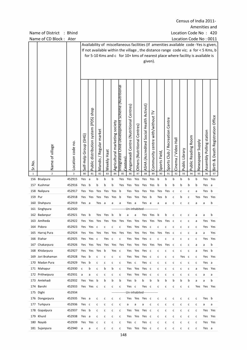
Census of India 2011- Amenities and
Name of District : Bhind Location Code No : 420Name of CD Block : Ater Location Code No : 0011
Self-
Hel
p G
roup
(SH
G)
Publ
ic d
istr
ibut
ion
syst
em (P
DS)
sho
p
Man
dis
/ Re
gula
r m
arke
t
Wee
kly
Haa
t
Agr
icul
tura
l mar
ketin
g so
ciet
yIn
tegr
ated
Chi
ld D
evel
opm
ent S
chem
e (N
utri
tiona
l Ce
ntre
s)A
ngan
wad
i Cen
tre
(Nut
ritio
nal C
entr
es)
Oth
ers
(Nut
ritio
nal C
entr
es)
ASH
A (A
ccre
dite
d So
cial
Hea
lth A
ctiv
ist)
Com
mun
ity c
entr
e w
ith/w
ithou
t TV
Spor
ts F
ield
,
Spor
ts C
lub
/ Re
crea
tion
Cent
re
Cine
ma
/ Vi
deo
Hal
l
Publ
ic L
ibra
ry
Publ
ic R
eadi
ng R
oom
New
spap
er S
uppl
y
Ass
embl
y Po
lling
sta
tion
Birt
h &
Dea
th R
egis
trat
ion
Off
ice
1 2 3 80 81 82 83 84 85 86 87 88 89 90 91 92 93 94 95 96 97
Sr.N
o.
Nam
e of
vill
age
Loca
tion
code
no.
Availability of miscellaneous facilities (If amenities available code -Yes is given, If not available within the village , the distance range code viz; a for < 5 Kms, b
for 5-10 Kms and c for 10+ kms of nearest place where facility is available is given).
156 Bisalpura 452915 Yes a b b b Yes Yes Yes Yes Yes b b b b b b Yes Yes
157 Kushmar 452916 Yes b b b b Yes Yes Yes Yes Yes b b b b b b Yes a
158 Nalipura 452917 Yes Yes Yes Yes Yes b Yes Yes Yes Yes Yes Yes c c c a Yes b
159 Pur 452918 Yes Yes Yes Yes Yes b Yes Yes Yes b Yes b c b c Yes Yes Yes
160 Shahpura 452919 Yes a Yes a a a Yes a Yes a a a c c c a a b
161 Singhpura 452920 --------------Un-inhabited--------------
162 Badanpur 452921 Yes b Yes Yes b b a a Yes Yes b b c c c a a b
163 Amlheda 452922 Yes Yes Yes Yes Yes Yes Yes Yes Yes Yes Yes Yes c c c a Yes Yes
164 Pidora 452923 Yes Yes c c c c Yes Yes Yes c c c c c c c Yes Yes
165 Harraj Pura 452924 Yes Yes Yes Yes Yes Yes Yes Yes Yes Yes Yes Yes c c c a a Yes
166 Etahar 452925 Yes Yes c Yes c c Yes Yes Yes c c c c c c c Yes Yes
167 Chakarpura 452926 Yes Yes Yes Yes Yes Yes Yes Yes Yes Yes Yes Yes c c c a a b
168 Khidarpura 452927 Yes Yes Yes b Yes c Yes Yes Yes c c c c c c a Yes b
169 Jori Brahaman 452928 Yes b c c c c Yes Yes Yes c c c c Yes c c Yes Yes
170 Madan Pura 452929 Yes b c c c c Yes c Yes c c c c c c c Yes a
171 Mahapur 452930 c b c b b c Yes Yes Yes c c c c c c a Yes Yes
172 Prithwipura 452931 a a c c c c Yes Yes Yes c c c c c c c a a
173 Amlehadi 452932 Yes Yes b b b b Yes b b b b b b b b a a b
174 Barohi 452933 Yes Yes c c c c Yes c Yes c c c c c c Yes Yes Yes
175 Dighi 452934 --------------Un-inhabited--------------
176 Dongarpura 452935 Yes a c c c c Yes Yes Yes c c c c c c c Yes b
177 Turkpura 452936 Yes c c c c c a a a c c c c c c c a a
178 Gopalpura 452937 Yes b c c c c Yes Yes Yes c c c c c c c Yes Yes
179 Khurd 452938 Yes a c c c c Yes Yes Yes c c c c c c c Yes Yes
180 Nayab 452939 Yes Yes c c c c Yes c Yes c c c c c c c Yes Yes
181 Sujanpura 452940 a a c c c c Yes Yes Yes c c c c c c c Yes a
148
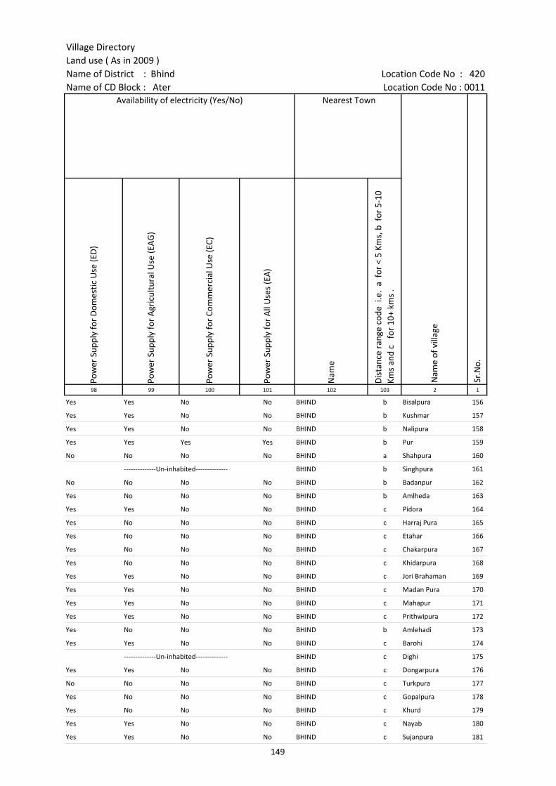
Village DirectoryLand use ( As in 2009 )Name of District : Bhind Location Code No : 420Name of CD Block : Ater Location Code No : 0011
Pow
er S
uppl
y fo
r D
omes
tic U
se (E
D)
Pow
er S
uppl
y fo
r A
gric
ultu
ral U
se (E
AG
)
Pow
er S
uppl
y fo
r Co
mm
erci
al U
se (E
C)
Pow
er S
uppl
y fo
r A
ll U
ses
(EA
)
Nam
e
Dis
tanc
e ra
nge
code
i.e
. a
for
< 5
Kms,
b f
or 5
-10
Kms
and
c f
or 1
0+ k
ms
.98 99 100 101 102 103 2 1
Availability of electricity (Yes/No) Nearest Town
Nam
e of
vill
age
Sr.N
o.
Yes Yes No No BHIND b Bisalpura 156
Yes Yes No No BHIND b Kushmar 157
Yes Yes No No BHIND b Nalipura 158
Yes Yes Yes Yes BHIND b Pur 159
No No No No BHIND a Shahpura 160
--------------Un-inhabited-------------- BHIND b Singhpura 161
No No No No BHIND b Badanpur 162
Yes No No No BHIND b Amlheda 163
Yes Yes No No BHIND c Pidora 164
Yes No No No BHIND c Harraj Pura 165
Yes No No No BHIND c Etahar 166
Yes No No No BHIND c Chakarpura 167
Yes No No No BHIND c Khidarpura 168
Yes Yes No No BHIND c Jori Brahaman 169
Yes Yes No No BHIND c Madan Pura 170
Yes Yes No No BHIND c Mahapur 171
Yes Yes No No BHIND c Prithwipura 172
Yes No No No BHIND b Amlehadi 173
Yes Yes No No BHIND c Barohi 174
--------------Un-inhabited-------------- BHIND c Dighi 175
Yes Yes No No BHIND c Dongarpura 176
No No No No BHIND c Turkpura 177
Yes No No No BHIND c Gopalpura 178
Yes No No No BHIND c Khurd 179
Yes Yes No No BHIND c Nayab 180
Yes Yes No No BHIND c Sujanpura 181
149
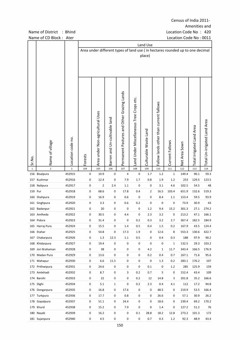
Census of India 2011- Amenities and
Name of District : Bhind Location Code No : 420Name of CD Block : Ater Location Code No : 0011
Fore
sts
Are
a un
der
Non
-agr
icul
tura
l Use
s
Barr
en a
nd U
n-cu
ltiva
ble
land
Perm
anen
t Pas
ture
s an
d O
ther
Gra
zing
Lan
ds
Land
Und
er M
isce
llane
ous
Tree
Cro
ps e
tc.
Cultu
rabl
e W
aste
Lan
d
Fallo
w la
nds
othe
r th
an c
urre
nt fa
llow
s
Curr
ent F
allo
ws
Net
Are
a So
wn
Tota
l Irr
igat
ed L
and
Are
a
Tota
l Un-
irri
gate
d La
nd A
rea
1 2 3 104 105 106 107 108 109 110 111 112 113 114
Sr.N
o.
Nam
e of
vill
age
Loca
tion
code
no.
Land UseArea under different types of land use ( in hectares rounded up to one decimal
place)
156 Bisalpura 452915 0 10.9 0 4 0 1.7 1.2 1 149.4 90.1 59.3
157 Kushmar 452916 0 12.4 0 7.9 1.7 0.8 1.9 1.2 253 129.5 123.5
158 Nalipura 452917 0 2 2.4 1.1 0 0 3.1 4.6 102.5 54.5 48
159 Pur 452918 0 68.6 0 17.8 0.4 2 16.5 103.4 651.9 132.6 519.3
160 Shahpura 452919 0 16.9 0 0.6 0 0 8.4 1.1 153.4 59.5 93.9
161 Singhpura 452920 0 3.3 0 0.6 0.2 0 0 0 73.9 30.9 43
162 Badanpur 452921 0 20 0 0 0 1.2 9.4 15.2 301.3 27.1 274.2
163 Amlheda 452922 0 30.5 0 4.4 0 2.3 3.2 0 213.2 47.1 166.1
164 Pidora 452923 0 31.4 0 0 0.2 0.3 3.2 2.7 367.4 182.5 184.9
165 Harraj Pura 452924 0 15.5 0 1.4 0.5 0.4 1.5 0.2 167.9 43.5 124.4
166 Etahar 452925 0 54.8 0 17.3 1.9 0 12.6 8 553.3 130.6 422.7
167 Chakarpura 452926 0 1.3 12.3 1.1 0.5 0 0.4 0.3 188 97.9 90.2
168 Khidarpura 452927 0 19.4 0 0 0 0 0 1 132.5 29.3 103.2
169 Jori Brahaman 452928 0 38 0 0 0 4.2 1 11.7 343.4 166.5 176.9
170 Madan Pura 452929 0 13.6 0 0 0 0.2 0.4 0.7 167.1 71.6 95.6
171 Mahapur 452930 0 6.6 11.5 0 0 0 1.3 0.2 283.1 176.2 107
172 Prithwipura 452931 0 24.6 0 0 0 0.1 0 1.2 285 125.9 159
173 Amlehadi 452932 0 8.7 0 3 0.2 0.7 5 0 152.4 43.4 109
174 Barohi 452933 0 22 0 0 0.2 12 14.8 3 201.8 35.2 166.6
175 Dighi 452934 0 5.1 1 0 0.2 2.3 0.4 4.1 112 17.2 94.8
176 Dongarpura 452935 0 16.8 0 17.6 0 0 48.5 0 219.9 53.5 166.4
177 Turkpura 452936 0 17.7 0 0.8 0 0 26.6 0 57.1 30.9 26.2
178 Gopalpura 452937 0 51.1 0 24.4 0 0 18.6 0 239.4 69.2 170.2
179 Khurd 452938 0 15.2 0 7.9 0 0 1.4 0 127.2 51.2 76
180 Nayab 452939 0 16.2 0 0 0.1 28.8 18.2 12.8 273.2 101.3 172
181 Sujanpura 452940 0 4.5 0 0 0 0.7 0.3 1.2 92.3 48.9 43.4
150
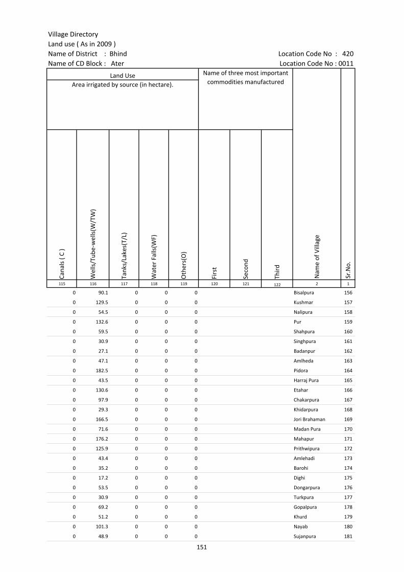
Village DirectoryLand use ( As in 2009 )Name of District : Bhind Location Code No : 420Name of CD Block : Ater Location Code No : 0011
Cana
ls (
C )
Wel
ls/T
ube-
wel
ls(W
/TW
)
Tank
s/La
kes(
T/L)
Wat
er F
alls
(WF)
Oth
ers(
O)
Firs
t
Seco
nd
Thir
d 115 116 117 118 119 120 121 122 2 1
Land Use Name of three most important commodities manufactured
Nam
e of
Vill
age
Sr.N
o.
Area irrigated by source (in hectare).
0 90.1 0 0 0 Bisalpura 156
0 129.5 0 0 0 Kushmar 157
0 54.5 0 0 0 Nalipura 158
0 132.6 0 0 0 Pur 159
0 59.5 0 0 0 Shahpura 160
0 30.9 0 0 0 Singhpura 161
0 27.1 0 0 0 Badanpur 162
0 47.1 0 0 0 Amlheda 163
0 182.5 0 0 0 Pidora 164
0 43.5 0 0 0 Harraj Pura 165
0 130.6 0 0 0 Etahar 166
0 97.9 0 0 0 Chakarpura 167
0 29.3 0 0 0 Khidarpura 168
0 166.5 0 0 0 Jori Brahaman 169
0 71.6 0 0 0 Madan Pura 170
0 176.2 0 0 0 Mahapur 171
0 125.9 0 0 0 Prithwipura 172
0 43.4 0 0 0 Amlehadi 173
0 35.2 0 0 0 Barohi 174
0 17.2 0 0 0 Dighi 175
0 53.5 0 0 0 Dongarpura 176
0 30.9 0 0 0 Turkpura 177
0 69.2 0 0 0 Gopalpura 178
0 51.2 0 0 0 Khurd 179
0 101.3 0 0 0 Nayab 180
0 48.9 0 0 0 Sujanpura 181
151
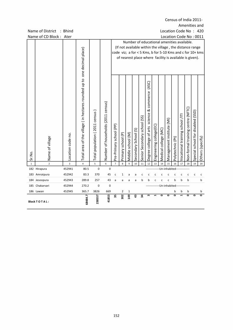
Census of India 2011- Amenities and
Name of District : Bhind Location Code No : 420Name of CD Block : Ater Location Code No : 0011
Pre-
Prim
ary
scho
ol (P
P)
Prim
ary
scho
ol (P
)
Mid
dle
scho
ol (M
)
Seco
ndar
y Sc
hool
(S)
Seni
or S
econ
dary
sch
ool (
SS)
Deg
ree
colle
ge o
f art
s s
cien
ce &
com
mer
ce (
ASC
)
Engi
neer
ing
colle
ge(E
C)
Med
ical
col
lege
(MC)
Man
agem
ent i
nstit
ute
(MI)
Poly
tech
nic
(Pt)
Voca
tiona
l tra
inin
g sc
hool
/IT
I
Non
-for
mal
trai
ning
cen
tre
(NFT
C)
Spec
ial s
choo
l for
dis
able
d (S
SD)
Oth
ers
(spe
cify
)
1 2 3 4 5 6 7 8 9 10 11 12 13 14 15 16 17 18 19 20
Number of educational amenities available. (If not available within the village , the distance range
code viz; a for < 5 Kms, b for 5-10 Kms and c for 10+ kms of nearest place where facility is available is given).
Sr.N
o.
Nam
e of
vill
age
Loca
tion
code
no.
Tota
l are
a of
the
villa
ge (
in h
ecta
res
roun
ded
up to
one
dec
imal
pla
ce)
Tota
l pop
ulat
ion
( 201
1 ce
nsus
)
Num
ber
of h
ouse
hold
s (2
011
cens
us)
182 Hirapura 452941 80.5 0 0 --------------Un-inhabited--------------
183 Amratpura 452942 83.3 370 45 c 1 a a c c c c c c c c c c
184 Jesoopura 452943 289.8 257 43 a a a a b b c c c b b b b
185 Chakarvari 452944 270.2 0 0 --------------Un-inhabited--------------
186 Lawan 452945 365.7 3826 669 2 1 b b b b
Block T O T A L :
6848
4.7
2385
57
4185
3 35 302
149 43 34 3 1 0 0 0 1 0 0 0
152
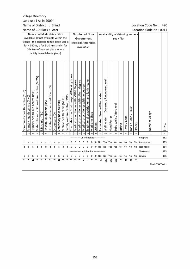
Village DirectoryLand use ( As in 2009 )Name of District : Bhind Location Code No : 420Name of CD Block : Ater Location Code No : 0011
Com
mun
ity h
ealth
cen
tre
(CH
C)Pr
imar
y he
alth
cen
tre
(PH
C)Pr
imar
y he
alth
sub
cen
tre
(PH
S)M
ater
nity
and
chi
ld w
elfa
re c
entr
e (M
CW)
T.B.
clin
ic (
TBC)
Hos
pita
l-allo
path
ic (H
A)
Hos
pita
l-alte
rnat
ive
med
icin
e (H
O)
Dis
pens
ary
(D)
Vete
rina
ry h
ospi
tal (
VH)
Mob
ile h
ealth
clin
ic (M
HC)
Fam
ily w
elfa
re c
entr
e (F
WC)
Char
itabl
e no
n G
ovt.
hos
pita
l/N
ursi
ng h
ome.
Med
ical
pra
ctiti
oner
with
MBB
S D
egre
eM
edic
al p
ract
ition
er w
ith o
ther
deg
ree
Med
ical
pra
ctiti
oner
with
no
degr
eeTr
aditi
onal
pra
ctiti
oner
and
faith
hea
ler
.M
edic
ine
Shop
Oth
ers
Tap
wat
er (T
reat
ed/U
ntre
ated
)
Wel
l w
ater
(C
over
ed /
Unc
over
ed w
ell)
Han
d Pu
mp
Tube
wel
ls /
Bor
e w
ell
Spri
ng
Rive
r /
Cana
l
Tank
/ P
ond
/ L
ake
Oth
ers
21 22 23 24 25 26 27 28 29 30 31 32 33 34 35 36 37 38 39 40 41 42 43 44 45 46 2 1
Number of Medical Amenities available. (If not available within the
village , the distance range code viz; a for < 5 Kms, b for 5-10 Kms and c for
10+ kms of nearest place where facility is available is given).
Number of Non-Government
Medical Amenities available.
Availability of drinking water - Yes / No
Nam
e of
vill
age
Sr.N
o.
--------------Un-inhabited-------------- Hirapura 182
c c c c c c c c a c c 0 0 0 0 0 0 0 No Yes Yes No No No No No Amratpura 183
b b a b b b b b a b b 0 0 0 0 0 0 0 No No Yes Yes No No No No Jesoopura 184
--------------Un-inhabited-------------- Chakarvari 185
b b b b b b b b b b b 0 0 0 0 0 0 0 No No Yes No No No No No Lawan 186
1 6 12 4 0 4 1 9 10 0 4 0 0 8 27 7 6 0 22 132
173
107 1 38 32 2
Block T O T A L :
153
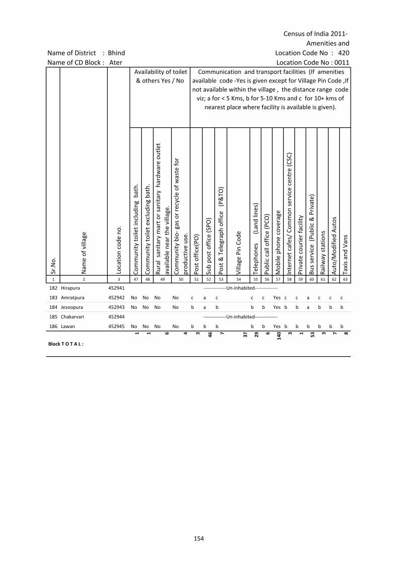
Census of India 2011- Amenities and
Name of District : Bhind Location Code No : 420Name of CD Block : Ater Location Code No : 0011
Com
mun
ity to
ilet i
nclu
ding
bat
h.
Com
mun
ity to
ilet e
xclu
ding
bat
h.
Rura
l sa
nita
ry m
art o
r sa
nita
ry h
ardw
are
outle
t av
aila
ble
near
the
villa
ge.
Com
mun
ity b
io- g
as o
r re
cycl
e of
was
te fo
r pr
oduc
tive
use.
Post
off
ice(
PO)
Sub
post
off
ice
(SPO
)
Post
& T
eleg
raph
off
ice
(P&
TO)
Villa
ge P
in C
ode
Tele
phon
es
(L
and
lines
)
Publ
ic c
all o
ffic
e (P
CO)
Mob
ile p
hone
cov
erag
e
Inte
rnet
caf
es/
Com
mon
ser
vice
cen
tre
(CSC
)
Priv
ate
cour
ier
faci
lity
Bus
serv
ice
(Pub
lic &
Pri
vate
)
Railw
ay s
tatio
ns
Aut
o/M
odifi
ed A
utos
Taxi
s an
d Va
ns
1 2 3 47 48 49 50 51 52 53 54 55 56 57 58 59 60 61 62 63
Sr.N
o.
Nam
e of
vill
age
Loca
tion
code
no.
Availability of toilet & others Yes / No
Communication and transport facilities (If amenities available code -Yes is given except for Village Pin Code ,If not available within the village , the distance range code
viz; a for < 5 Kms, b for 5-10 Kms and c for 10+ kms of nearest place where facility is available is given).
182 Hirapura 452941 --------------Un-inhabited--------------
183 Amratpura 452942 No No No No c a c c c Yes c c a c c c
184 Jesoopura 452943 No No No No b a b b b Yes b b a b b b
185 Chakarvari 452944 --------------Un-inhabited--------------
186 Lawan 452945 No No No No b b b b b Yes b b b b b b
Block T O T A L :
1 1 6 4 3 46 7 37 29 6
140 3 1 53 3 7 8
154
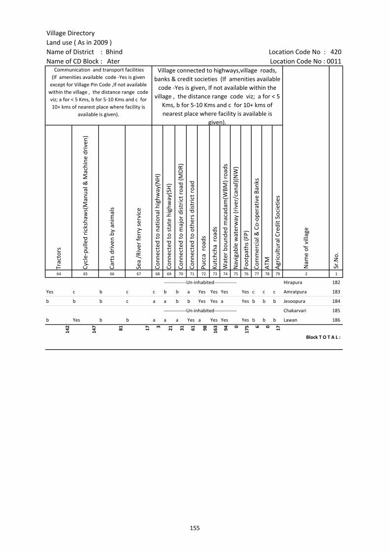
Village DirectoryLand use ( As in 2009 )Name of District : Bhind Location Code No : 420Name of CD Block : Ater Location Code No : 0011
Trac
tors
Cycl
e-pu
lled
rick
shaw
s(M
anua
l & M
achi
ne d
rive
n)
Cart
s dr
iven
by
anim
als
Sea
/Riv
er fe
rry
serv
ice
Conn
ecte
d to
nat
iona
l hig
hway
(NH
)
Conn
ecte
d to
sta
te h
ighw
ay(S
H)
Conn
ecte
d to
maj
or d
istr
ict r
oad
(MD
R)
Conn
ecte
d to
oth
ers
dist
rict
roa
d
Pucc
a r
oads
Kutc
hcha
roa
ds
Wat
er b
ound
ed m
acad
am(W
BM) r
oads
Nav
igab
le w
ater
way
(riv
er/c
anal
)(N
W)
Foot
path
s (F
P)
Com
mer
cial
& C
o-op
erat
ive
Bank
s
ATM
Agr
icul
tura
l Cre
dit S
ocie
ties
64 65 66 67 68 69 70 71 72 73 74 75 76 77 78 79 2 1
Communication and transport facilities (If amenities available code -Yes is given
except for Village Pin Code ,If not available within the village , the distance range code viz; a for < 5 Kms, b for 5-10 Kms and c for 10+ kms of nearest place where facility is
available is given).
Village connected to highways,village roads, banks & credit societies (If amenities available
code -Yes is given, If not available within the village , the distance range code viz; a for < 5
Kms, b for 5-10 Kms and c for 10+ kms of nearest place where facility is available is
given).
Nam
e of
vill
age
Sr.N
o.
--------------Un-inhabited-------------- Hirapura 182
Yes c b c c b b a Yes Yes Yes Yes c c c Amratpura 183
b b b c a a b b Yes Yes a Yes b b b Jesoopura 184
--------------Un-inhabited-------------- Chakarvari 185
b Yes b b a a a Yes a Yes Yes Yes b b b Lawan 186
142
147 81 17 3 21 31 61 98 163 94 0
175 6 0 17
Block T O T A L :
155
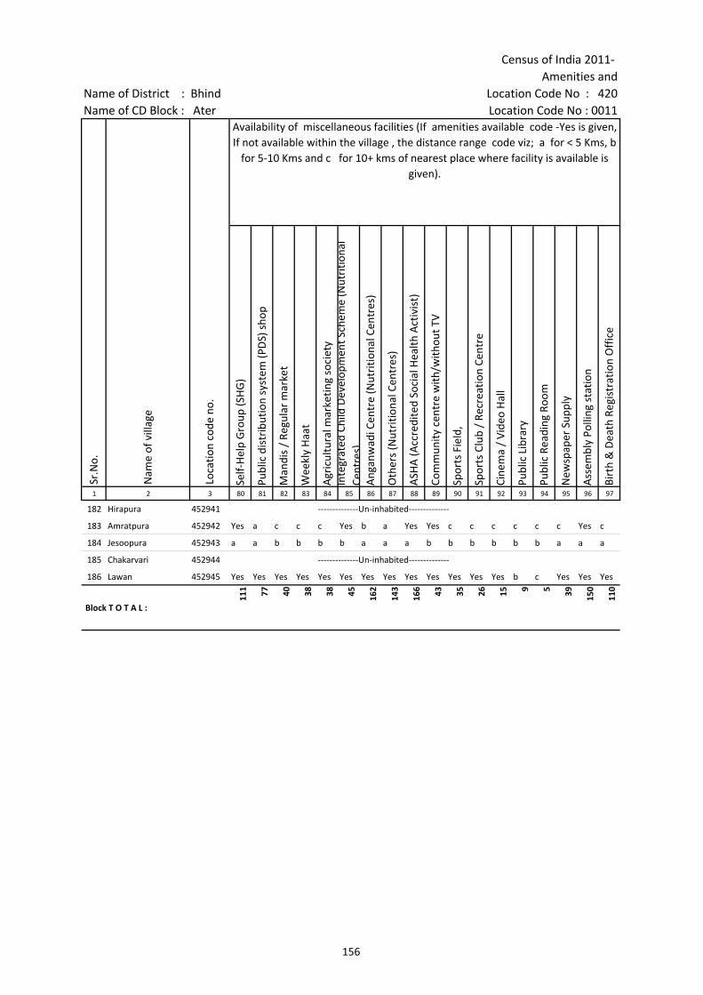
Census of India 2011- Amenities and
Name of District : Bhind Location Code No : 420Name of CD Block : Ater Location Code No : 0011
Self-
Hel
p G
roup
(SH
G)
Publ
ic d
istr
ibut
ion
syst
em (P
DS)
sho
p
Man
dis
/ Re
gula
r m
arke
t
Wee
kly
Haa
t
Agr
icul
tura
l mar
ketin
g so
ciet
yIn
tegr
ated
Chi
ld D
evel
opm
ent S
chem
e (N
utri
tiona
l Ce
ntre
s)A
ngan
wad
i Cen
tre
(Nut
ritio
nal C
entr
es)
Oth
ers
(Nut
ritio
nal C
entr
es)
ASH
A (A
ccre
dite
d So
cial
Hea
lth A
ctiv
ist)
Com
mun
ity c
entr
e w
ith/w
ithou
t TV
Spor
ts F
ield
,
Spor
ts C
lub
/ Re
crea
tion
Cent
re
Cine
ma
/ Vi
deo
Hal
l
Publ
ic L
ibra
ry
Publ
ic R
eadi
ng R
oom
New
spap
er S
uppl
y
Ass
embl
y Po
lling
sta
tion
Birt
h &
Dea
th R
egis
trat
ion
Off
ice
1 2 3 80 81 82 83 84 85 86 87 88 89 90 91 92 93 94 95 96 97
Sr.N
o.
Nam
e of
vill
age
Loca
tion
code
no.
Availability of miscellaneous facilities (If amenities available code -Yes is given, If not available within the village , the distance range code viz; a for < 5 Kms, b
for 5-10 Kms and c for 10+ kms of nearest place where facility is available is given).
182 Hirapura 452941 --------------Un-inhabited--------------
183 Amratpura 452942 Yes a c c c Yes b a Yes Yes c c c c c c Yes c
184 Jesoopura 452943 a a b b b b a a a b b b b b b a a a
185 Chakarvari 452944 --------------Un-inhabited--------------
186 Lawan 452945 Yes Yes Yes Yes Yes Yes Yes Yes Yes Yes Yes Yes Yes b c Yes Yes Yes
Block T O T A L :
111 77 40 38 38 45 162
143
166 43 35 26 15 9 5 39 150
110
156
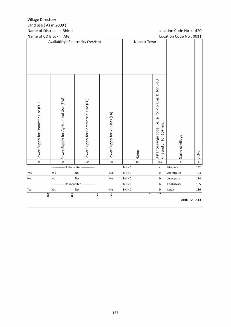
Village DirectoryLand use ( As in 2009 )Name of District : Bhind Location Code No : 420Name of CD Block : Ater Location Code No : 0011
Pow
er S
uppl
y fo
r D
omes
tic U
se (E
D)
Pow
er S
uppl
y fo
r A
gric
ultu
ral U
se (E
AG
)
Pow
er S
uppl
y fo
r Co
mm
erci
al U
se (E
C)
Pow
er S
uppl
y fo
r A
ll U
ses
(EA
)
Nam
e
Dis
tanc
e ra
nge
code
i.e
. a
for
< 5
Kms,
b f
or 5
-10
Kms
and
c f
or 1
0+ k
ms
.98 99 100 101 102 103 2 1
Availability of electricity (Yes/No) Nearest Town
Nam
e of
vill
age
Sr.N
o.
--------------Un-inhabited-------------- BHIND c Hirapura 182
Yes Yes No No BHIND c Amratpura 183
No No No No BHIND b Jesoopura 184
--------------Un-inhabited-------------- BHIND b Chakarvari 185
Yes Yes No No BHIND b Lawan 186
169
154 26 26 0 0
Block T O T A L :
157

Census of India 2011- Amenities and
Name of District : Bhind Location Code No : 420Name of CD Block : Ater Location Code No : 0011
Fore
sts
Are
a un
der
Non
-agr
icul
tura
l Use
s
Barr
en a
nd U
n-cu
ltiva
ble
land
Perm
anen
t Pas
ture
s an
d O
ther
Gra
zing
Lan
ds
Land
Und
er M
isce
llane
ous
Tree
Cro
ps e
tc.
Cultu
rabl
e W
aste
Lan
d
Fallo
w la
nds
othe
r th
an c
urre
nt fa
llow
s
Curr
ent F
allo
ws
Net
Are
a So
wn
Tota
l Irr
igat
ed L
and
Are
a
Tota
l Un-
irri
gate
d La
nd A
rea
1 2 3 104 105 106 107 108 109 110 111 112 113 114
Sr.N
o.
Nam
e of
vill
age
Loca
tion
code
no.
Land UseArea under different types of land use ( in hectares rounded up to one decimal
place)
182 Hirapura 452941 0 3.8 0 0 0 3.5 2.1 0.7 70.4 8.2 62.1
183 Amratpura 452942 0 4.5 0 0.5 0 0 0.4 0 78 31.5 46.5
184 Jesoopura 452943 0 10.7 4.6 14.7 0 24.5 1 0 234.3 33.6 200.8
185 Chakarvari 452944 0 14.9 1.1 6.1 0 1.8 0.9 0.4 245 26.9 218.1
186 Lawan 452945 0 23.3 0.3 5.3 0 4.6 20.5 8.2 303.5 43.5 260
Block T O T A L : 3057
.4
4850
.6
6032
.3
2776
.4
119.
3
2263
.4
2707
.4
1326
.6
4535
0.2
2126
9
2408
2
158
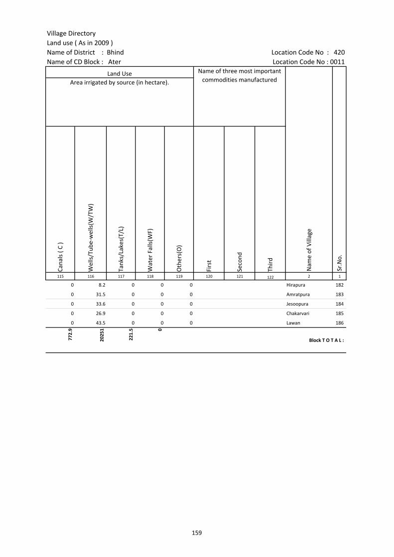
Village DirectoryLand use ( As in 2009 )Name of District : Bhind Location Code No : 420Name of CD Block : Ater Location Code No : 0011
Cana
ls (
C )
Wel
ls/T
ube-
wel
ls(W
/TW
)
Tank
s/La
kes(
T/L)
Wat
er F
alls
(WF)
Oth
ers(
O)
Firs
t
Seco
nd
Thir
d 115 116 117 118 119 120 121 122 2 1
Land Use Name of three most important commodities manufactured
Nam
e of
Vill
age
Sr.N
o.
Area irrigated by source (in hectare).
0 8.2 0 0 0 Hirapura 182
0 31.5 0 0 0 Amratpura 183
0 33.6 0 0 0 Jesoopura 184
0 26.9 0 0 0 Chakarvari 185
0 43.5 0 0 0 Lawan 186
772.
9
2025
1
221.
5 0
Block T O T A L :
159
160
(b) Map of Bhind CD Block showing tahsil boundary.
(c) Alphabetical list of Villages of Bhind CD Block along with location code 2001 and 2011.
(d) Village Directory data of Bhind CD Block in prescribed format.
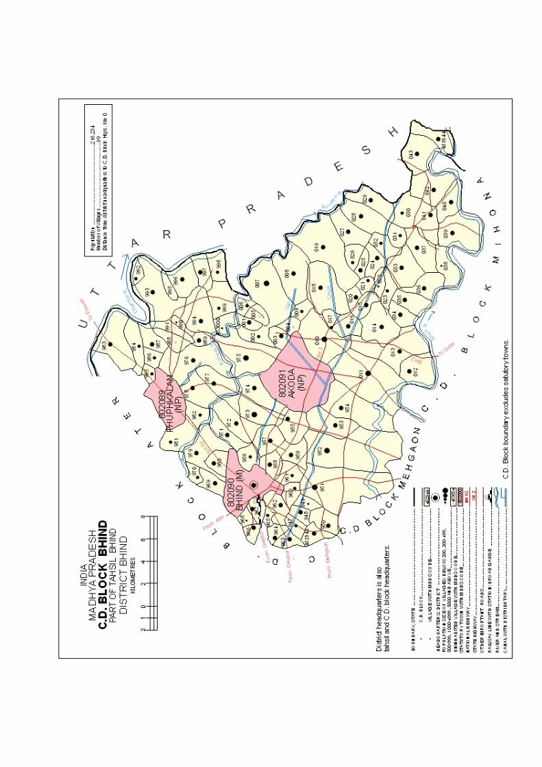

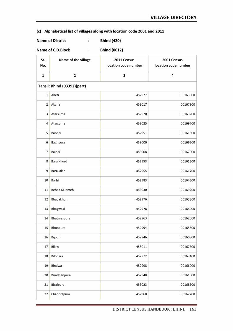
VILLAGE DIRECTORY
DISTRICTCENSUSHANDBOOK:BHIND163
(c) Alphabetical list of villages along with location code 2001 and 2011
Name of District : Bhind (420)
Name of C.D.Block : Bhind (0012)
Sr. No.
Name of the village 2011 Census location code number
2001 Census location code number
1 2 3 4
Tahsil: Bhind (03392)(part)
1 Aheti 452977 00163900
2 Akaha 453017 00167900
3 Atarsuma 452970 00163200
4 Atarsuma 453035 00169700
5 Babedi 452951 00161300
6 Baghpura 453000 00166200
7 Bajhai 453008 00167000
8 Bara Khurd 452953 00161500
9 Barakalan 452955 00161700
10 Barhi 452983 00164500
11 Behad Ki Jameh 453030 00169200
12 Bhadakhur 452976 00163800
13 Bhagwasi 452978 00164000
14 Bhatmaspura 452963 00162500
15 Bhonpura 452994 00165600
16 Bijpuri 452946 00160800
17 Bilaw 453011 00167300
18 Bilohara 452972 00163400
19 Bindwa 452998 00166000
20 Biradhanpura 452948 00161000
21 Bisalpura 453023 00168500
22 Chandrapura 452960 00162200
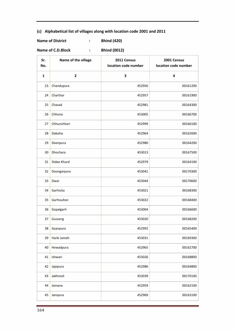
164
(c) Alphabetical list of villages along with location code 2001 and 2011
Name of District : Bhind (420)
Name of C.D.Block : Bhind (0012)
Sr. No.
Name of the village 2011 Census location code number
2001 Census location code number
1 2 3 4
23 Chandupura 452950 00161200
24 Charthar 452957 00161900
25 Chasad 452981 00164300
26 Chhona 453005 00166700
27 Chhunchhari 452999 00166100
28 Daboha 452964 00162600
29 Deenpura 452980 00164200
30 Dhochara 453013 00167500
31 Didee Khurd 452979 00164100
32 Doongarpura 453041 00170300
33 Dwar 453044 00170600
34 Garhisita 453021 00168300
35 Garhisultan 453022 00168400
36 Gopalgarh 453004 00166600
37 Gusseng 453020 00168200
38 Gyanpura 452992 00165400
39 Harki Jameh 453031 00169300
40 Hewadpura 452965 00162700
41 Ishwari 453026 00168800
42 Jajepura 452986 00164800
43 Jakhmoli 453039 00170100
44 Jamana 452959 00162100
45 Jampura 452969 00163100
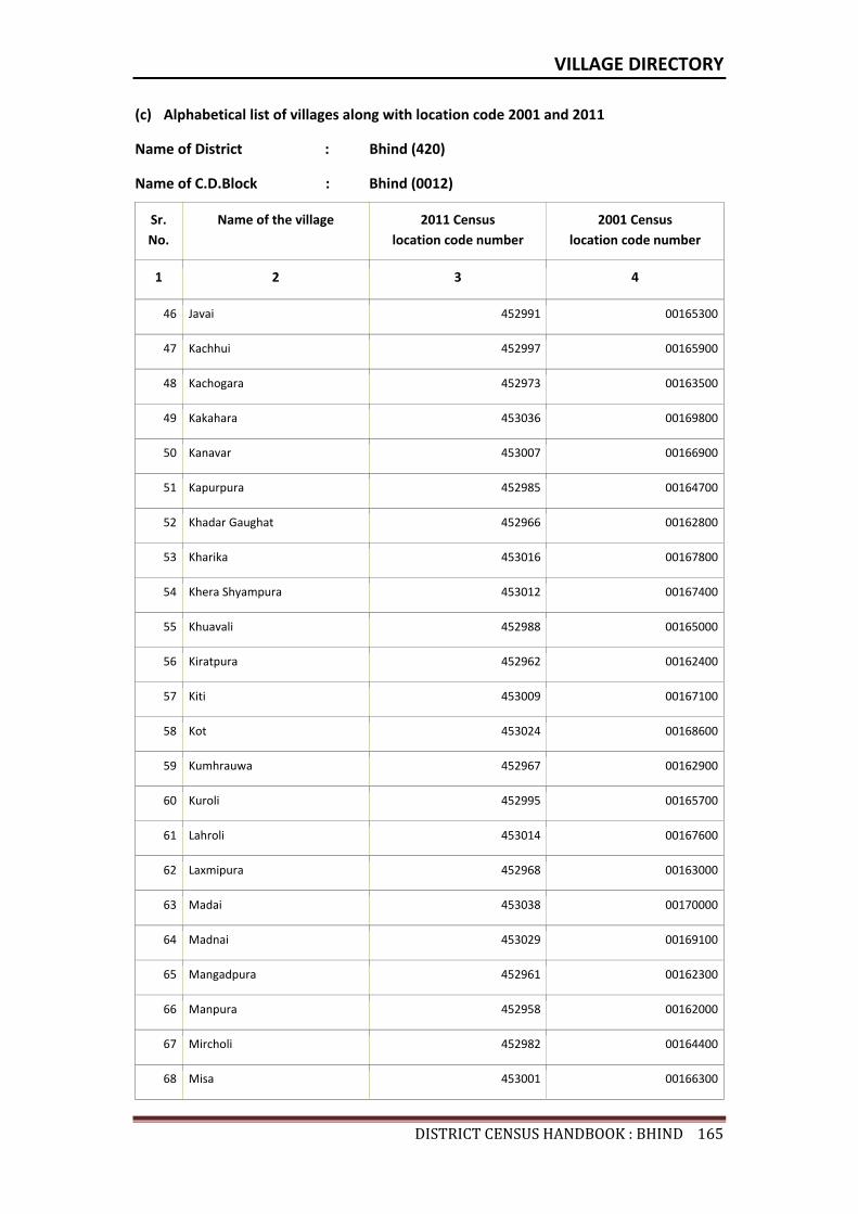
VILLAGE DIRECTORY
DISTRICTCENSUSHANDBOOK:BHIND165
(c) Alphabetical list of villages along with location code 2001 and 2011
Name of District : Bhind (420)
Name of C.D.Block : Bhind (0012)
Sr. No.
Name of the village 2011 Census location code number
2001 Census location code number
1 2 3 4
46 Javai 452991 00165300
47 Kachhui 452997 00165900
48 Kachogara 452973 00163500
49 Kakahara 453036 00169800
50 Kanavar 453007 00166900
51 Kapurpura 452985 00164700
52 Khadar Gaughat 452966 00162800
53 Kharika 453016 00167800
54 Khera Shyampura 453012 00167400
55 Khuavali 452988 00165000
56 Kiratpura 452962 00162400
57 Kiti 453009 00167100
58 Kot 453024 00168600
59 Kumhrauwa 452967 00162900
60 Kuroli 452995 00165700
61 Lahroli 453014 00167600
62 Laxmipura 452968 00163000
63 Madai 453038 00170000
64 Madnai 453029 00169100
65 Mangadpura 452961 00162300
66 Manpura 452958 00162000
67 Mircholi 452982 00164400
68 Misa 453001 00166300
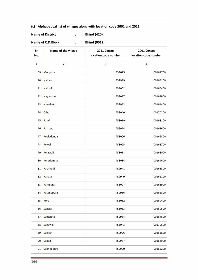
166
(c) Alphabetical list of villages along with location code 2001 and 2011
Name of District : Bhind (420)
Name of C.D.Block : Bhind (0012)
Sr. No.
Name of the village 2011 Census location code number
2001 Census location code number
1 2 3 4
69 Motipura 453015 00167700
70 Nahara 452989 00165100
71 Nahtoli 453002 00166400
72 Nayagaon 453037 00169900
73 Nunahata 452952 00161400
74 Ojha 453040 00170200
75 Pandri 453019 00168100
76 Parsona 452974 00163600
77 Peeladanda 453006 00166800
78 Pewali 453025 00168700
79 Pulawali 453018 00168000
80 Puradumna 453034 00169600
81 Rachhedi 452971 00163300
82 Rahala 452949 00161100
83 Rampura 453027 00168900
84 Ratanupura 452956 00161800
85 Rora 453032 00169400
86 Sagara 453033 00169500
87 Samanna 452984 00164600
88 Sanawai 453043 00170500
89 Sankari 452996 00165800
90 Sapad 452987 00164900
91 Saphedpura 452990 00165200
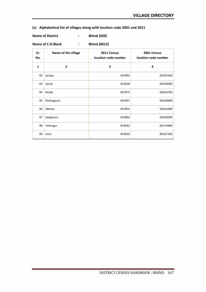
VILLAGE DIRECTORY
DISTRICTCENSUSHANDBOOK:BHIND167
(c) Alphabetical list of villages along with location code 2001 and 2011
Name of District : Bhind (420)
Name of C.D.Block : Bhind (0012)
Sr. No.
Name of the village 2011 Census location code number
2001 Census location code number
1 2 3 4
92 Saraya 452993 00165500
93 Sarsai 453028 00169000
94 Seoda 452975 00163700
95 Shalingpura 452947 00160900
96 Sikhata 452954 00161600
97 Singhpura 453003 00166500
98 Tehangur 453042 00170400
99 Umri 453010 00167200

Census of India 2011- Amenities and
Name of District : Bhind Location Code No : 420Name of CD Block : Bhind Location Code No : 0012
Pre-
Prim
ary
scho
ol (P
P)
Prim
ary
scho
ol (P
)
Mid
dle
scho
ol (M
)
Seco
ndar
y Sc
hool
(S)
Seni
or S
econ
dary
sch
ool (
SS)
Deg
ree
colle
ge o
f art
s s
cien
ce &
com
mer
ce (
ASC
)
Engi
neer
ing
colle
ge(E
C)
Med
ical
col
lege
(MC)
Man
agem
ent i
nstit
ute
(MI)
Poly
tech
nic
(Pt)
Voca
tiona
l tra
inin
g sc
hool
/IT
I
Non
-for
mal
trai
ning
cen
tre
(NFT
C)
Spec
ial s
choo
l for
dis
able
d (S
SD)
Oth
ers
(spe
cify
)
1 2 3 4 5 6 7 8 9 10 11 12 13 14 15 16 17 18 19 20
187 Bijpuri 452946 334.4 2354 464 1 2 1 b b c c c c c c c c c
188 Shalingpura 452947 240.9 669 151 b 1 a b b b c c b b b b
189 Biradhanpura 452948 309.5 1961 331 1 1 b b c c c c b b b c b
190 Rahala 452949 188 434 78 1 b b b c c c c b b b c
191 Chandupura 452950 441.7 2036 319 2 2 1 1 1 b c c c b b b c b
192 Babedi 452951 2572.5 7287 1380 4 13 9 2 1 b c b 1 1 b
193 Nunahata 452952 2787.4 6669 1033 b 7 6 2 1 c c c b c b c b
194 Bara Khurd 452953 659.4 3962 648 c 7 5 1 c c c c c c c c c c
195 Sikhata 452954 1327.6 3458 595 5 5 1 a a c c c c c c c c
196 Barakalan 452955 698.6 3145 538 b 5 2 1 b b c c c b b b c b
197 Ratanupura 452956 360.6 978 151 a 2 1 a a a c c c b a a b
198 Charthar 452957 691.4 3577 628 b 5 2 b b b c c c b b b b b
199 Manpura 452958 387.6 3395 567 a 1 1 a a a c c c a a a c a
200 Jamana 452959 782.5 2947 468 a 1 1 1 a a c c c a a a c a
201 Chandrapura 452960 108.7 541 77 a 1 1 a a a c a a a a
202 Mangadpura 452961 126.2 507 102 a 2 a a a a a
203 Kiratpura 452962 242 3897 658 2 3 3 2 a a a a
204 Bhatmaspura 452963 207.9 1026 163 b 1 1 b b b c c b b b b
205 Daboha 452964 337.1 3156 621 6 8 3 1 1 b c c c b b b b
206 Hewadpura 452965 114.8 808 129 a 2 2 a a a a c a a a a
207 Khadar Gaughat 452966 162.4 1108 213 a 2 a a a a c c a a a a
208 Kumhrauwa 452967 94.7 1729 255 1 1 a a a c a a a a
209 Laxmipura 452968 88.6 472 70 a 1 a a a a c c a a a a
210 Jaura 452969 334.1 1313 259 b 2 2 b c c c b b b c b
211 Atarsuma 452970 358.5 673 142 b 1 b b b b c c c b b b c b
212 Rachhedi 452971 657.7 2851 482 c 6 3 2 b b c c c b b b b
Sr.N
o.
Nam
e of
vill
age
Loca
tion
code
no.
Tota
l are
a of
the
villa
ge (
in h
ecta
res
roun
ded
up to
one
dec
imal
pla
ce)
Tota
l pop
ulat
ion
( 201
1 ce
nsus
)
Num
ber
of h
ouse
hold
s (2
011
cens
us)
Number of educational amenities available. (If not available within the village , the distance range
code viz; a for < 5 Kms, b for 5-10 Kms and c for 10+ kms of nearest place where facility is available is given).
168

Village DirectoryLand use ( As in 2009 )Name of District : Bhind Location Code No : 420Name of CD Block : Bhind Location Code No : 0012
Com
mun
ity h
ealth
cen
tre
(CH
C)Pr
imar
y he
alth
cen
tre
(PH
C)Pr
imar
y he
alth
sub
cen
tre
(PH
S)M
ater
nity
and
chi
ld w
elfa
re c
entr
e (M
CW)
T.B.
clin
ic (
TBC)
Hos
pita
l-allo
path
ic (H
A)
Hos
pita
l-alte
rnat
ive
med
icin
e (H
O)
Dis
pens
ary
(D)
Vete
rina
ry h
ospi
tal (
VH)
Mob
ile h
ealth
clin
ic (M
HC)
Fam
ily w
elfa
re c
entr
e (F
WC)
Char
itabl
e no
n G
ovt.
hos
pita
l/N
ursi
ng h
ome.
Med
ical
pra
ctiti
oner
with
MBB
S D
egre
eM
edic
al p
ract
ition
er w
ith o
ther
deg
ree
Med
ical
pra
ctiti
oner
with
no
degr
eeTr
aditi
onal
pra
ctiti
oner
and
faith
hea
ler
.M
edic
ine
Shop
Oth
ers
Tap
wat
er (T
reat
ed/U
ntre
ated
)
Wel
l w
ater
(C
over
ed /
Unc
over
ed w
ell)
Han
d Pu
mp
Tube
wel
ls /
Bor
e w
ell
Spri
ng
Rive
r /
Cana
l
Tank
/ P
ond
/ L
ake
Oth
ers
21 22 23 24 25 26 27 28 29 30 31 32 33 34 35 36 37 38 39 40 41 42 43 44 45 46 2 1
c c b b c c b b b c b 0 0 0 0 1 0 0 No No Yes No No No Yes No Bijpuri 187
b b b b b b b b b b b 0 0 0 0 0 0 0 No No Yes No No No No No Shalingpura 188
b b 1 b b b b b a b b 0 0 0 0 0 0 0 No No Yes No No No No No Biradhanpura 189
b b b b b b b b b b b 0 0 0 0 0 0 0 No No Yes No No No No No Rahala 190
c c a b c b b b c b 0 0 0 1 1 0 0 No No Yes Yes No No No No Chandupura 191
b 1 b b b b b b b b b 0 0 2 0 0 0 0 Yes Yes Yes Yes No Yes Yes No Babedi 192
b b 1 b b b b b b b b 0 0 0 0 0 0 0 No Yes Yes Yes No Yes Yes No Nunahata 193
c c c c c c c c c c c 0 0 0 1 0 0 0 Yes Yes Yes No No Yes Yes No Bara Khurd 194
c b c c b c c c b c c 0 0 0 1 0 0 0 No No Yes No No No Yes No Sikhata 195
b b 1 b b b b b 1 b b 0 0 0 2 0 0 0 No Yes Yes Yes No Yes Yes No Barakalan 196
b a a a a a a a a a a 0 0 0 0 0 0 0 No No Yes Yes No No No No Ratanupura 197
b b a a b a a a a a a 0 0 0 2 0 0 0 No No Yes Yes No No Yes No Charthar 198
a a a a a a a a a a a 0 0 0 0 0 0 0 No No Yes No No No No No Manpura 199
a a 1 a a a a a a a 0 0 0 0 0 0 0 No No Yes No No No No No Jamana 200
a a a a a a a a a a a 0 0 0 0 0 0 0 No No Yes No No No No No Chandrapura 201
a a a a a a a a a a a 0 0 0 0 0 0 0 No No Yes No No No No No Mangadpura 202
a a a a a a a a a a a 0 0 0 0 0 0 0 No No Yes No No No No No Kiratpura 203
b b b b b b b b b b b 0 0 0 0 0 0 0 No No Yes No No No No No Bhatmaspura 204
b b b b b b b b 1 b 1 0 0 0 0 0 0 0 No Yes Yes No No No No No Daboha 205
a a a a a a a a a a a 0 0 0 0 0 0 0 No No Yes No No No No No Hewadpura 206
a a a a a a a a a a a 0 0 0 0 0 0 0 No No Yes No No No No No Khadar Gaughat 207
a a a a a a a a a a a 0 0 0 0 0 0 0 No Yes Yes No No No No No Kumhrauwa 208
a a a a a a a a a a a 0 0 0 0 0 0 0 No No Yes No No No No No Laxmipura 209
b b b b b b b b b b b 0 0 0 0 0 0 0 No No Yes Yes No No No No Jaura 210
b b b b b b b b b b b 0 0 0 0 0 0 0 No No Yes Yes No No No No Atarsuma 211
c c c c c c c c 1 c c 0 0 0 0 0 0 0 No Yes Yes Yes No Yes Yes No Rachhedi 212
Number of Non-Government
Medical Amenities available.
Availability of drinking water - Yes / No
Nam
e of
vill
age
Sr.N
o.
Number of Medical Amenities available. (If not available within the
village , the distance range code viz; a for < 5 Kms, b for 5-10 Kms and c for
10+ kms of nearest place where facility is available is given).
169
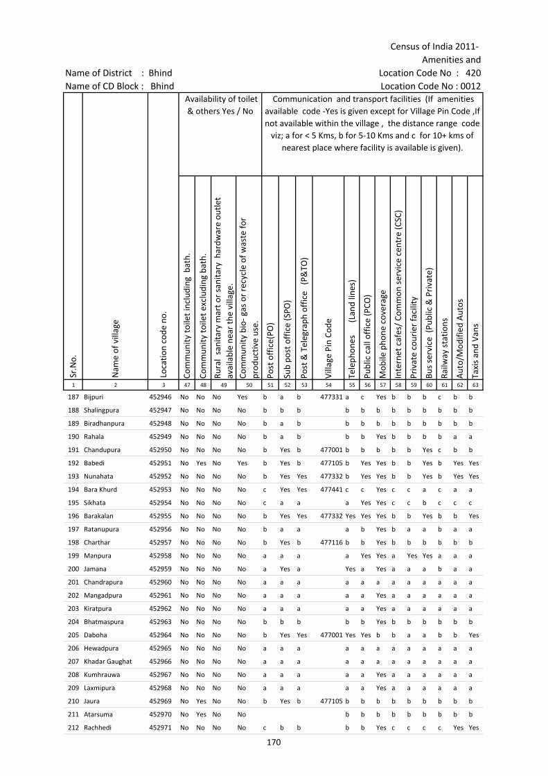
Census of India 2011- Amenities and
Name of District : Bhind Location Code No : 420Name of CD Block : Bhind Location Code No : 0012
Com
mun
ity to
ilet i
nclu
ding
bat
h.
Com
mun
ity to
ilet e
xclu
ding
bat
h.
Rura
l sa
nita
ry m
art o
r sa
nita
ry h
ardw
are
outle
t av
aila
ble
near
the
villa
ge.
Com
mun
ity b
io- g
as o
r re
cycl
e of
was
te fo
r pr
oduc
tive
use.
Post
off
ice(
PO)
Sub
post
off
ice
(SPO
)
Post
& T
eleg
raph
off
ice
(P&
TO)
Villa
ge P
in C
ode
Tele
phon
es
(L
and
lines
)
Publ
ic c
all o
ffic
e (P
CO)
Mob
ile p
hone
cov
erag
e
Inte
rnet
caf
es/
Com
mon
ser
vice
cen
tre
(CSC
)
Priv
ate
cour
ier
faci
lity
Bus
serv
ice
(Pub
lic &
Pri
vate
)
Railw
ay s
tatio
ns
Aut
o/M
odifi
ed A
utos
Taxi
s an
d Va
ns
1 2 3 47 48 49 50 51 52 53 54 55 56 57 58 59 60 61 62 63
187 Bijpuri 452946 No No No Yes b a b 477331 a c Yes b b b c b b
188 Shalingpura 452947 No No No No b b b b b b b b b b b b
189 Biradhanpura 452948 No No No No b a b b b b b b b b b b
190 Rahala 452949 No No No No b a b b b Yes b b b b a a
191 Chandupura 452950 No No No No b Yes b 477001 b b b b b Yes c b b
192 Babedi 452951 No Yes No Yes b Yes b 477105 b Yes Yes b b Yes b Yes Yes
193 Nunahata 452952 No No No No b Yes Yes 477332 b Yes Yes b b Yes b Yes Yes
194 Bara Khurd 452953 No No No No c Yes Yes 477441 c c Yes c c a c a a
195 Sikhata 452954 No No No No c a a a Yes Yes c c b c c c
196 Barakalan 452955 No No No No b Yes Yes 477332 Yes Yes Yes b b Yes b b Yes
197 Ratanupura 452956 No No No No b a a a b Yes b a a b a a
198 Charthar 452957 No No No No b Yes b 477116 b b Yes b b b b b b
199 Manpura 452958 No No No No a a a a Yes Yes a Yes Yes a a a
200 Jamana 452959 No No No No a Yes a Yes a Yes a a a b a a
201 Chandrapura 452960 No No No No a a a a a a a a a a a a
202 Mangadpura 452961 No No No No a a a a a Yes a a a a a a
203 Kiratpura 452962 No No No No a a a a a Yes a a a a a a
204 Bhatmaspura 452963 No No No No b b b b b Yes b b b b b b
205 Daboha 452964 No No No No b Yes Yes 477001 Yes Yes b b a a b b Yes
206 Hewadpura 452965 No No No No a a a a a a a a a a a a
207 Khadar Gaughat 452966 No No No No a a a a a a a a a a a a
208 Kumhrauwa 452967 No No No No a a a a a Yes a a a a a a
209 Laxmipura 452968 No No No No a a a a a Yes a a a a a a
210 Jaura 452969 No Yes No No b Yes b 477105 b b b b b b b b b
211 Atarsuma 452970 No Yes No No b b b b b b b b b
212 Rachhedi 452971 No No No No c b b b b Yes c c c c Yes Yes
Loca
tion
code
no.
Availability of toilet & others Yes / No
Communication and transport facilities (If amenities available code -Yes is given except for Village Pin Code ,If not available within the village , the distance range code
viz; a for < 5 Kms, b for 5-10 Kms and c for 10+ kms of nearest place where facility is available is given).
Sr.N
o.
Nam
e of
vill
age
170
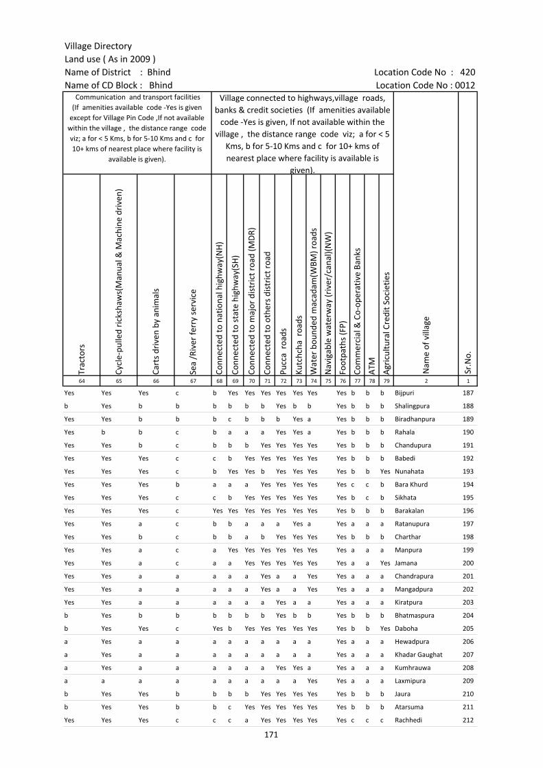
Village DirectoryLand use ( As in 2009 )Name of District : Bhind Location Code No : 420Name of CD Block : Bhind Location Code No : 0012
Trac
tors
Cycl
e-pu
lled
rick
shaw
s(M
anua
l & M
achi
ne d
rive
n)
Cart
s dr
iven
by
anim
als
Sea
/Riv
er fe
rry
serv
ice
Conn
ecte
d to
nat
iona
l hig
hway
(NH
)
Conn
ecte
d to
sta
te h
ighw
ay(S
H)
Conn
ecte
d to
maj
or d
istr
ict r
oad
(MD
R)
Conn
ecte
d to
oth
ers
dist
rict
roa
d
Pucc
a r
oads
Kutc
hcha
roa
ds
Wat
er b
ound
ed m
acad
am(W
BM) r
oads
Nav
igab
le w
ater
way
(riv
er/c
anal
)(N
W)
Foot
path
s (F
P)
Com
mer
cial
& C
o-op
erat
ive
Bank
s
ATM
Agr
icul
tura
l Cre
dit S
ocie
ties
64 65 66 67 68 69 70 71 72 73 74 75 76 77 78 79 2 1
Yes Yes Yes c b Yes Yes Yes Yes Yes Yes Yes b b b Bijpuri 187
b Yes b b b b b b Yes b b Yes b b b Shalingpura 188
Yes Yes b b b c b b b Yes a Yes b b b Biradhanpura 189
Yes b b c b a a a Yes Yes a Yes b b b Rahala 190
Yes Yes b c b b b Yes Yes Yes Yes Yes b b b Chandupura 191
Yes Yes Yes c c b Yes Yes Yes Yes Yes Yes b b b Babedi 192
Yes Yes Yes c b Yes Yes b Yes Yes Yes Yes b b Yes Nunahata 193
Yes Yes Yes b a a a Yes Yes Yes Yes Yes c c b Bara Khurd 194
Yes Yes Yes c c b Yes Yes Yes Yes Yes Yes b c b Sikhata 195
Yes Yes Yes c Yes Yes Yes Yes Yes Yes Yes Yes b b b Barakalan 196
Yes Yes a c b b a a a Yes a Yes a a a Ratanupura 197
Yes Yes b c b b a b Yes Yes Yes Yes b b b Charthar 198
Yes Yes a c a Yes Yes Yes Yes Yes Yes Yes a a a Manpura 199
Yes Yes a c a a Yes Yes Yes Yes Yes Yes a a Yes Jamana 200
Yes Yes a a a a a Yes a a Yes Yes a a a Chandrapura 201
Yes Yes a a a a a Yes a a Yes Yes a a a Mangadpura 202
Yes Yes a a a a a a Yes a a Yes a a a Kiratpura 203
b Yes b b b b b b Yes b b Yes b b b Bhatmaspura 204
b Yes Yes c Yes b Yes Yes Yes Yes Yes Yes b b Yes Daboha 205
a Yes a a a a a a a a a Yes a a a Hewadpura 206
a Yes a a a a a a a a a Yes a a a Khadar Gaughat 207
a Yes a a a a a a Yes Yes a Yes a a a Kumhrauwa 208
a a a a a a a a a a Yes Yes a a a Laxmipura 209
b Yes Yes b b b b Yes Yes Yes Yes Yes b b b Jaura 210
b Yes Yes b b c Yes Yes Yes Yes Yes Yes b b b Atarsuma 211
Yes Yes Yes c c c a Yes Yes Yes Yes Yes c c c Rachhedi 212
Sr.N
o.
Communication and transport facilities (If amenities available code -Yes is given
except for Village Pin Code ,If not available within the village , the distance range code viz; a for < 5 Kms, b for 5-10 Kms and c for 10+ kms of nearest place where facility is
available is given).
Village connected to highways,village roads, banks & credit societies (If amenities available
code -Yes is given, If not available within the village , the distance range code viz; a for < 5
Kms, b for 5-10 Kms and c for 10+ kms of nearest place where facility is available is
given).
Nam
e of
vill
age
171

Census of India 2011- Amenities and
Name of District : Bhind Location Code No : 420Name of CD Block : Bhind Location Code No : 0012
Self-
Hel
p G
roup
(SH
G)
Publ
ic d
istr
ibut
ion
syst
em (P
DS)
sho
p
Man
dis
/ Re
gula
r m
arke
t
Wee
kly
Haa
t
Agr
icul
tura
l mar
ketin
g so
ciet
yIn
tegr
ated
Chi
ld D
evel
opm
ent S
chem
e (N
utri
tiona
l Ce
ntre
s)A
ngan
wad
i Cen
tre
(Nut
ritio
nal C
entr
es)
Oth
ers
(Nut
ritio
nal C
entr
es)
ASH
A (A
ccre
dite
d So
cial
Hea
lth A
ctiv
ist)
Com
mun
ity c
entr
e w
ith/w
ithou
t TV
Spor
ts F
ield
,
Spor
ts C
lub
/ Re
crea
tion
Cent
re
Cine
ma
/ Vi
deo
Hal
l
Publ
ic L
ibra
ry
Publ
ic R
eadi
ng R
oom
New
spap
er S
uppl
y
Ass
embl
y Po
lling
sta
tion
Birt
h &
Dea
th R
egis
trat
ion
Off
ice
1 2 3 80 81 82 83 84 85 86 87 88 89 90 91 92 93 94 95 96 97
187 Bijpuri 452946 Yes b b b b c Yes Yes Yes c b b b b b b Yes Yes
188 Shalingpura 452947 Yes a b b b b Yes Yes Yes b b b b b b b Yes Yes
189 Biradhanpura 452948 b Yes b b b b Yes Yes Yes b b b b b b b Yes Yes
190 Rahala 452949 Yes b b b b b Yes a Yes b b b c c c a a b
191 Chandupura 452950 Yes b b b b b Yes Yes Yes c b b b b b b Yes Yes
192 Babedi 452951 Yes Yes b b b b Yes Yes Yes b Yes Yes b Yes b Yes Yes Yes
193 Nunahata 452952 b Yes b b b b Yes Yes Yes b Yes b b Yes b b Yes Yes
194 Bara Khurd 452953 c Yes c c c c Yes Yes Yes c Yes c c c c c Yes Yes
195 Sikhata 452954 Yes Yes c c c c Yes Yes Yes c c c c c c c Yes Yes
196 Barakalan 452955 b Yes b b b b Yes Yes Yes b Yes b b b b Yes Yes Yes
197 Ratanupura 452956 a a a a a a Yes Yes Yes a a a b a a Yes Yes a
198 Charthar 452957 b Yes b b b b Yes Yes Yes b Yes b b b Yes Yes Yes Yes
199 Manpura 452958 Yes Yes Yes Yes Yes a Yes Yes Yes a Yes a c b c Yes Yes Yes
200 Jamana 452959 Yes Yes Yes Yes Yes a Yes Yes Yes a a a c b c Yes Yes Yes
201 Chandrapura 452960 Yes Yes Yes a Yes a Yes a a a a a a a a a Yes b
202 Mangadpura 452961 Yes Yes Yes Yes Yes a Yes Yes Yes Yes Yes Yes c c c a Yes b
203 Kiratpura 452962 Yes Yes Yes Yes Yes Yes Yes Yes Yes Yes Yes Yes Yes b c Yes Yes Yes
204 Bhatmaspura 452963 a b b b b b Yes Yes Yes b b b b b b b Yes Yes
205 Daboha 452964 Yes Yes b b b b Yes Yes Yes b Yes b b b b b Yes Yes
206 Hewadpura 452965 a a a a a a Yes Yes Yes a a a a a a a Yes a
207 Khadar Gaughat 452966 a b a a a a Yes Yes Yes Yes a a a a a a Yes Yes
208 Kumhrauwa 452967 a b a a a a Yes Yes Yes a a a a a a a Yes Yes
209 Laxmipura 452968 Yes b b b b a a a Yes a a a a a a a a a
210 Jaura 452969 Yes Yes b b b Yes Yes Yes Yes b b b c c c Yes Yes Yes
211 Atarsuma 452970 Yes Yes b b b Yes Yes Yes Yes b b b b b b b b b
212 Rachhedi 452971 Yes Yes Yes c c c Yes Yes Yes c b b Yes c c c Yes Yes
Sr.N
o.
Nam
e of
vill
age
Loca
tion
code
no.
Availability of miscellaneous facilities (If amenities available code -Yes is given, If not available within the village , the distance range code viz; a for < 5 Kms, b
for 5-10 Kms and c for 10+ kms of nearest place where facility is available is given).
172
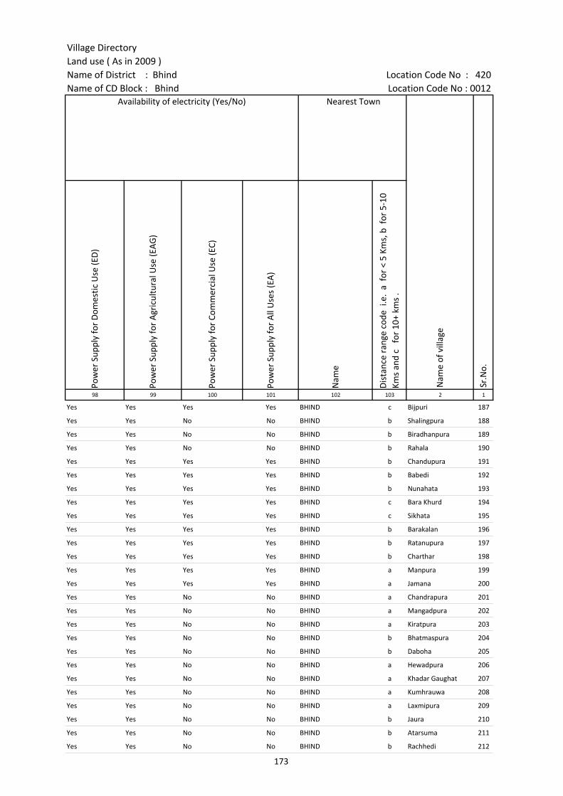
Village DirectoryLand use ( As in 2009 )Name of District : Bhind Location Code No : 420Name of CD Block : Bhind Location Code No : 0012
Pow
er S
uppl
y fo
r D
omes
tic U
se (E
D)
Pow
er S
uppl
y fo
r A
gric
ultu
ral U
se (E
AG
)
Pow
er S
uppl
y fo
r Co
mm
erci
al U
se (E
C)
Pow
er S
uppl
y fo
r A
ll U
ses
(EA
)
Nam
e
Dis
tanc
e ra
nge
code
i.e
. a
for
< 5
Kms,
b f
or 5
-10
Kms
and
c f
or 1
0+ k
ms
.98 99 100 101 102 103 2 1
Yes Yes Yes Yes BHIND c Bijpuri 187
Yes Yes No No BHIND b Shalingpura 188
Yes Yes No No BHIND b Biradhanpura 189
Yes Yes No No BHIND b Rahala 190
Yes Yes Yes Yes BHIND b Chandupura 191
Yes Yes Yes Yes BHIND b Babedi 192
Yes Yes Yes Yes BHIND b Nunahata 193
Yes Yes Yes Yes BHIND c Bara Khurd 194
Yes Yes Yes Yes BHIND c Sikhata 195
Yes Yes Yes Yes BHIND b Barakalan 196
Yes Yes Yes Yes BHIND b Ratanupura 197
Yes Yes Yes Yes BHIND b Charthar 198
Yes Yes Yes Yes BHIND a Manpura 199
Yes Yes Yes Yes BHIND a Jamana 200
Yes Yes No No BHIND a Chandrapura 201
Yes Yes No No BHIND a Mangadpura 202
Yes Yes No No BHIND a Kiratpura 203
Yes Yes No No BHIND b Bhatmaspura 204
Yes Yes No No BHIND b Daboha 205
Yes Yes No No BHIND a Hewadpura 206
Yes Yes No No BHIND a Khadar Gaughat 207
Yes Yes No No BHIND a Kumhrauwa 208
Yes Yes No No BHIND a Laxmipura 209
Yes Yes No No BHIND b Jaura 210
Yes Yes No No BHIND b Atarsuma 211
Yes Yes No No BHIND b Rachhedi 212
Nearest Town
Nam
e of
vill
age
Sr.N
o.
Availability of electricity (Yes/No)
173
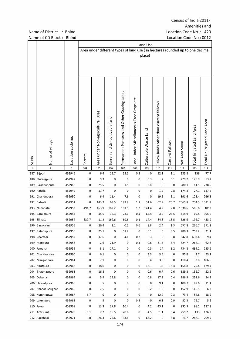
Census of India 2011- Amenities and
Name of District : Bhind Location Code No : 420Name of CD Block : Bhind Location Code No : 0012
Fore
sts
Are
a un
der
Non
-agr
icul
tura
l Use
s
Barr
en a
nd U
n-cu
ltiva
ble
land
Perm
anen
t Pas
ture
s an
d O
ther
Gra
zing
Lan
ds
Land
Und
er M
isce
llane
ous
Tree
Cro
ps e
tc.
Cultu
rabl
e W
aste
Lan
d
Fallo
w la
nds
othe
r th
an c
urre
nt fa
llow
s
Curr
ent F
allo
ws
Net
Are
a So
wn
Tota
l Irr
igat
ed L
and
Are
a
Tota
l Un-
irri
gate
d La
nd A
rea
1 2 3 104 105 106 107 108 109 110 111 112 113 114
187 Bijpuri 452946 0 6.4 15.7 23.1 0.3 0 52.1 1.1 235.8 158 77.7
188 Shalingpura 452947 0 9.3 0 0 0 0.3 2 0.1 229.2 175.9 53.2
189 Biradhanpura 452948 0 25.5 0 1.5 0 2.4 0 0 280.1 41.5 238.5
190 Rahala 452949 0 11.7 0 0 0 0 1.2 0.8 174.3 27.1 147.2
191 Chandupura 452950 0 6.4 11.4 7.6 0 0 19.5 5.1 391.6 125.4 266.3
192 Babedi 452951 0 143.2 63.5 183.8 1.1 31.6 62.9 20.7 2065.8 734.5 1331.3
193 Nunahata 452952 491.7 163.9 162.2 181.5 1.2 141.4 4.2 2.8 1638.6 586.6 1052
194 Bara Khurd 452953 0 44.6 32.3 73.1 0.4 65.4 3.2 25.5 414.9 19.4 395.6
195 Sikhata 452954 339.7 11.2 162.6 69.6 0.1 14.4 84.8 18.5 626.5 192.7 433.9
196 Barakalan 452955 0 26.4 1.1 0.2 0.6 8.8 2.4 1.3 657.8 266.7 391.1
197 Ratanupura 452956 0 25.1 0 51.7 0 0.1 0 3.5 280.3 259.2 21.1
198 Charthar 452957 0 37.6 0 4.1 0.2 3 0 3.8 642.8 633.4 9.4
199 Manpura 452958 0 2.6 21.9 0 0.1 0.6 31.5 6.4 324.7 262.1 62.6
200 Jamana 452959 0 8.1 17.1 0 0 0.3 14 8.2 734.8 499.2 235.6
201 Chandrapura 452960 0 6.1 0 0 0 3.3 3.5 0 95.8 2.7 93.1
202 Mangadpura 452961 0 7.1 0 0 0 5.4 3.3 0 110.4 3.8 106.6
203 Kiratpura 452962 0 18.6 0 0 0 18.1 35 15.4 154.8 25.4 129.4
204 Bhatmaspura 452963 0 16.8 0 0 0 0.6 0.7 0.6 189.3 136.7 52.6
205 Daboha 452964 0 5.9 25.8 0 0 0.8 17.3 0.4 286.9 252.6 34.3
206 Hewadpura 452965 0 5 0 0 0 0 9.1 0 100.7 89.6 11.1
207 Khadar Gaughat 452966 0 7.5 0 0 0 0.2 1.9 0 152.9 146.5 6.3
208 Kumhrauwa 452967 6.7 0 0 0 0 0 12.2 2.3 73.4 54.6 18.9
209 Laxmipura 452968 0 5 0 0 0.3 0 0.1 0.9 82.3 76.7 5.6
210 Jaura 452969 0 13.3 27.8 10.4 0 4.2 43.1 0 235.3 98.1 137.2
211 Atarsuma 452970 0.1 7.2 15.5 20.6 0 4.5 51.1 0.4 259.2 133 126.2
212 Rachhedi 452971 0 26.3 25.6 33.8 0 66.2 0 8.8 497 287.1 209.9
Land UseArea under different types of land use ( in hectares rounded up to one decimal
place)
Sr.N
o.
Nam
e of
vill
age
Loca
tion
code
no.
174
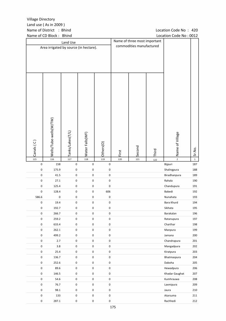
Village DirectoryLand use ( As in 2009 )Name of District : Bhind Location Code No : 420Name of CD Block : Bhind Location Code No : 0012
Cana
ls (
C )
Wel
ls/T
ube-
wel
ls(W
/TW
)
Tank
s/La
kes(
T/L)
Wat
er F
alls
(WF)
Oth
ers(
O)
Firs
t
Seco
nd
Thir
d 115 116 117 118 119 120 121 122 2 1
0 158 0 0 0 Bijpuri 187
0 175.9 0 0 0 Shalingpura 188
0 41.5 0 0 0 Biradhanpura 189
0 27.1 0 0 0 Rahala 190
0 125.4 0 0 0 Chandupura 191
0 128.4 0 0 606 Babedi 192
586.6 0 0 0 0 Nunahata 193
0 19.4 0 0 0 Bara Khurd 194
0 192.7 0 0 0 Sikhata 195
0 266.7 0 0 0 Barakalan 196
0 259.2 0 0 0 Ratanupura 197
0 633.4 0 0 0 Charthar 198
0 262.1 0 0 0 Manpura 199
0 499.2 0 0 0 Jamana 200
0 2.7 0 0 0 Chandrapura 201
0 3.8 0 0 0 Mangadpura 202
0 25.4 0 0 0 Kiratpura 203
0 136.7 0 0 0 Bhatmaspura 204
0 252.6 0 0 0 Daboha 205
0 89.6 0 0 0 Hewadpura 206
0 146.5 0 0 0 Khadar Gaughat 207
0 54.6 0 0 0 Kumhrauwa 208
0 76.7 0 0 0 Laxmipura 209
0 98.1 0 0 0 Jaura 210
0 133 0 0 0 Atarsuma 211
0 287.1 0 0 0 Rachhedi 212
Land Use Name of three most important commodities manufactured
Nam
e of
Vill
age
Sr.N
o.
Area irrigated by source (in hectare).
175

Census of India 2011- Amenities and
Name of District : Bhind Location Code No : 420Name of CD Block : Bhind Location Code No : 0012
Pre-
Prim
ary
scho
ol (P
P)
Prim
ary
scho
ol (P
)
Mid
dle
scho
ol (M
)
Seco
ndar
y Sc
hool
(S)
Seni
or S
econ
dary
sch
ool (
SS)
Deg
ree
colle
ge o
f art
s s
cien
ce &
com
mer
ce (
ASC
)
Engi
neer
ing
colle
ge(E
C)
Med
ical
col
lege
(MC)
Man
agem
ent i
nstit
ute
(MI)
Poly
tech
nic
(Pt)
Voca
tiona
l tra
inin
g sc
hool
/IT
I
Non
-for
mal
trai
ning
cen
tre
(NFT
C)
Spec
ial s
choo
l for
dis
able
d (S
SD)
Oth
ers
(spe
cify
)
1 2 3 4 5 6 7 8 9 10 11 12 13 14 15 16 17 18 19 20
Sr.N
o.
Nam
e of
vill
age
Loca
tion
code
no.
Tota
l are
a of
the
villa
ge (
in h
ecta
res
roun
ded
up to
one
dec
imal
pla
ce)
Tota
l pop
ulat
ion
( 201
1 ce
nsus
)
Num
ber
of h
ouse
hold
s (2
011
cens
us)
Number of educational amenities available. (If not available within the village , the distance range
code viz; a for < 5 Kms, b for 5-10 Kms and c for 10+ kms of nearest place where facility is available is given).
213 Bilohara 452972 673.6 2355 365 c 5 2 c c c c c c b c b c b
214 Kachogara 452973 823.1 6569 963 1 1 3 2 1 c c c c c c c c c
215 Parsona 452974 715 1734 281 c 3 2 c c c c c c c c c c c
216 Seoda 452975 1708.7 5180 896 5 2 2 1 c c c c c c c c
217 Bhadakhur 452976 1387.1 4653 789 7 1 b b c c c c c c c c c
218 Aheti 452977 701.4 1361 185 1 1 c c c c c c c c c
219 Bhagwasi 452978 784.1 1914 337 2 1 1 c c c c c c c c
220 Didee Khurd 452979 1663.2 4280 688 1 8 4 2 b b c c c b b b b
221 Deenpura 452980 354.5 2478 369 2 1 a c c c a a a a
222 Chasad 452981 401 909 140 1 1 b c c c c c c c c c
223 Mircholi 452982 354.6 519 92 1 1 a a a a a
224 Barhi 452983 1281.6 4098 731 1 8 4 c c c c c c c c c
225 Samanna 452984 418.6 859 153 b 2 a b b c c c c c c c c c
226 Kapurpura 452985 60.5 530 107 a 1 1 a a c c c c c c c c
227 Jajepura 452986 83.4 874 148 a 1 a a a c c c c c c c
228 Sapad 452987 659.5 1349 227 b 3 1 b b c c c c c c c
229 Khuavali 452988 316.1 0 0 --------------Un-inhabited--------------
230 Nahara 452989 285.8 1732 273 b 1 1 b c c c c c c c c
231 Saphedpura 452990 35.6 321 58 b 1 b b c c c c c c c c c
232 Javai 452991 172.1 197 36 b a a a b c c c c c c c
233 Gyanpura 452992 227.1 549 134 1 1 1 1 b c c c c c c c c c
234 Saraya 452993 1605.1 2733 422 6 6 4 a a c c c c c c c c c
235 Bhonpura 452994 1087 3980 579 2 2 1 1 c c c c c c c c c c
236 Kuroli 452995 135.7 119 21 a a a a a c c c c c c c c
237 Sankari 452996 637.5 1485 245 c 2 1 c c c c c c c c c
238 Kachhui 452997 449.8 1102 154 c 1 a b b c c c c c c c c
176

Village DirectoryLand use ( As in 2009 )Name of District : Bhind Location Code No : 420Name of CD Block : Bhind Location Code No : 0012
Com
mun
ity h
ealth
cen
tre
(CH
C)Pr
imar
y he
alth
cen
tre
(PH
C)Pr
imar
y he
alth
sub
cen
tre
(PH
S)M
ater
nity
and
chi
ld w
elfa
re c
entr
e (M
CW)
T.B.
clin
ic (
TBC)
Hos
pita
l-allo
path
ic (H
A)
Hos
pita
l-alte
rnat
ive
med
icin
e (H
O)
Dis
pens
ary
(D)
Vete
rina
ry h
ospi
tal (
VH)
Mob
ile h
ealth
clin
ic (M
HC)
Fam
ily w
elfa
re c
entr
e (F
WC)
Char
itabl
e no
n G
ovt.
hos
pita
l/N
ursi
ng h
ome.
Med
ical
pra
ctiti
oner
with
MBB
S D
egre
eM
edic
al p
ract
ition
er w
ith o
ther
deg
ree
Med
ical
pra
ctiti
oner
with
no
degr
eeTr
aditi
onal
pra
ctiti
oner
and
faith
hea
ler
.M
edic
ine
Shop
Oth
ers
Tap
wat
er (T
reat
ed/U
ntre
ated
)
Wel
l w
ater
(C
over
ed /
Unc
over
ed w
ell)
Han
d Pu
mp
Tube
wel
ls /
Bor
e w
ell
Spri
ng
Rive
r /
Cana
l
Tank
/ P
ond
/ L
ake
Oth
ers
21 22 23 24 25 26 27 28 29 30 31 32 33 34 35 36 37 38 39 40 41 42 43 44 45 46 2 1
Number of Non-Government
Medical Amenities available.
Availability of drinking water - Yes / No
Nam
e of
vill
age
Sr.N
o.
Number of Medical Amenities available. (If not available within the
village , the distance range code viz; a for < 5 Kms, b for 5-10 Kms and c for
10+ kms of nearest place where facility is available is given).
c c c c c c c c c c c 0 0 0 0 0 0 0 No Yes Yes Yes No Yes Yes No Bilohara 213
c 1 a c c c c a a c b 0 0 0 1 1 0 0 No No Yes No No No Yes No Kachogara 214
c c c c c c c b 0 0 0 0 0 0 0 No Yes Yes No No No No No Parsona 215
c 1 b b b c c c 1 c c 0 0 0 2 2 0 0 No Yes Yes No No Yes No No Seoda 216
a a a a a a a a a a a 0 0 3 0 1 0 0 No Yes Yes Yes No No Yes No Bhadakhur 217
c b c b c c b b c c 0 0 0 0 0 0 0 No Yes Yes Yes No No No No Aheti 218
c b c b c c b b c c 0 0 0 0 0 0 0 Yes Yes Yes Yes No No No No Bhagwasi 219
b b b b b b b b 1 b b 0 0 0 0 2 0 0 Yes Yes Yes No No Yes Yes No Didee Khurd 220
a a a a a a a a a a a 0 0 0 1 0 0 0 No Yes Yes No No No No No Deenpura 221
b b b b b b b b b b b 0 0 0 0 1 0 0 No Yes Yes No No No Yes No Chasad 222
a a b b a b b b b b b 0 0 0 0 0 0 0 No Yes Yes No No Yes No No Mircholi 223
c b 1 c b c c 1 b c c 0 0 0 0 1 0 1 No Yes Yes Yes No Yes No No Barhi 224
c b b b b c c b b c b 0 0 0 0 0 0 0 No No Yes No No No No No Samanna 225
c a a a a c c a a a 0 0 0 0 0 0 0 No No Yes No No No No No Kapurpura 226
c a a a a c c a a a 0 0 0 0 0 0 0 No No Yes No No No No No Jajepura 227
c b b b b c c b b b 0 0 0 0 0 0 0 No No Yes No No No No No Sapad 228
--------------Un-inhabited-------------- Khuavali 229
c c b c c c c c b c c 0 0 0 0 0 0 0 No Yes Yes Yes No No No No Nahara 230
b c c b c c c b b b c 0 0 0 0 0 0 0 No Yes Yes Yes No No No No Saphedpura 231
b c c b c c c b b c c 0 0 0 0 0 0 0 No No Yes Yes No No No No Javai 232
c c c c c c c c c c c 0 0 1 0 0 0 0 No Yes Yes Yes No Yes No No Gyanpura 233
a a a c a c c c a c c 0 0 0 1 0 0 0 No Yes Yes Yes No Yes Yes No Saraya 234
c b 1 b b b b 1 1 c b 0 0 0 2 1 0 0 No Yes Yes No No No Yes No Bhonpura 235
a a c c a c c c c c c 0 0 0 0 0 0 0 No Yes Yes Yes Yes Yes Yes No Kuroli 236
c c b c c c c b b c 0 0 0 0 0 0 0 No No Yes No No No No No Sankari 237
c c b c c c c c c c c 0 0 0 0 0 0 0 No No Yes No No No No No Kachhui 238
177
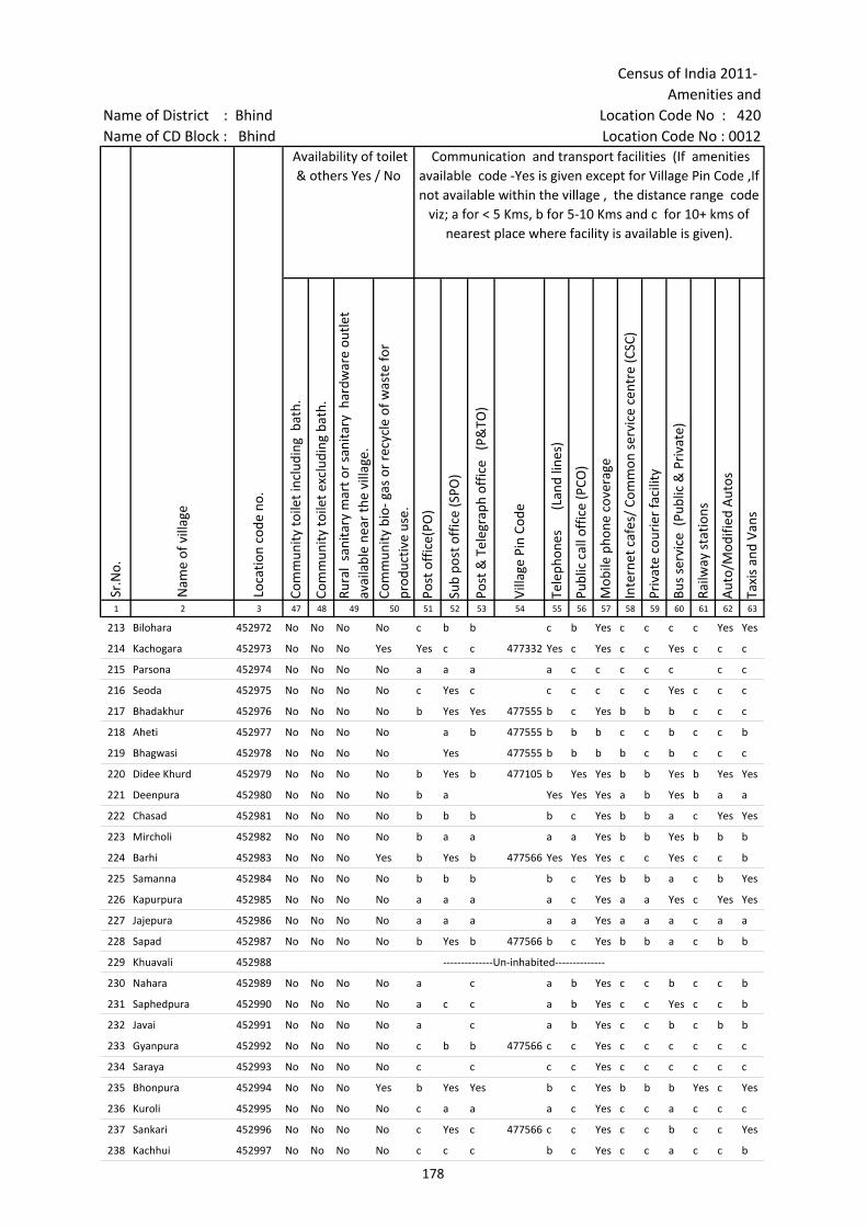
Census of India 2011- Amenities and
Name of District : Bhind Location Code No : 420Name of CD Block : Bhind Location Code No : 0012
Com
mun
ity to
ilet i
nclu
ding
bat
h.
Com
mun
ity to
ilet e
xclu
ding
bat
h.
Rura
l sa
nita
ry m
art o
r sa
nita
ry h
ardw
are
outle
t av
aila
ble
near
the
villa
ge.
Com
mun
ity b
io- g
as o
r re
cycl
e of
was
te fo
r pr
oduc
tive
use.
Post
off
ice(
PO)
Sub
post
off
ice
(SPO
)
Post
& T
eleg
raph
off
ice
(P&
TO)
Villa
ge P
in C
ode
Tele
phon
es
(L
and
lines
)
Publ
ic c
all o
ffic
e (P
CO)
Mob
ile p
hone
cov
erag
e
Inte
rnet
caf
es/
Com
mon
ser
vice
cen
tre
(CSC
)
Priv
ate
cour
ier
faci
lity
Bus
serv
ice
(Pub
lic &
Pri
vate
)
Railw
ay s
tatio
ns
Aut
o/M
odifi
ed A
utos
Taxi
s an
d Va
ns
1 2 3 47 48 49 50 51 52 53 54 55 56 57 58 59 60 61 62 63
Loca
tion
code
no.
Availability of toilet & others Yes / No
Communication and transport facilities (If amenities available code -Yes is given except for Village Pin Code ,If not available within the village , the distance range code
viz; a for < 5 Kms, b for 5-10 Kms and c for 10+ kms of nearest place where facility is available is given).
Sr.N
o.
Nam
e of
vill
age
213 Bilohara 452972 No No No No c b b c b Yes c c c c Yes Yes
214 Kachogara 452973 No No No Yes Yes c c 477332 Yes c Yes c c Yes c c c
215 Parsona 452974 No No No No a a a a c c c c c c c
216 Seoda 452975 No No No No c Yes c c c c c c Yes c c c
217 Bhadakhur 452976 No No No No b Yes Yes 477555 b c Yes b b b c c c
218 Aheti 452977 No No No No a b 477555 b b b c c b c c b
219 Bhagwasi 452978 No No No No Yes 477555 b b b b c b c c c
220 Didee Khurd 452979 No No No No b Yes b 477105 b Yes Yes b b Yes b Yes Yes
221 Deenpura 452980 No No No No b a Yes Yes Yes a b Yes b a a
222 Chasad 452981 No No No No b b b b c Yes b b a c Yes Yes
223 Mircholi 452982 No No No No b a a a a Yes b b Yes b b b
224 Barhi 452983 No No No Yes b Yes b 477566 Yes Yes Yes c c Yes c c b
225 Samanna 452984 No No No No b b b b c Yes b b a c b Yes
226 Kapurpura 452985 No No No No a a a a c Yes a a Yes c Yes Yes
227 Jajepura 452986 No No No No a a a a a Yes a a a c a a
228 Sapad 452987 No No No No b Yes b 477566 b c Yes b b a c b b
229 Khuavali 452988 --------------Un-inhabited--------------
230 Nahara 452989 No No No No a c a b Yes c c b c c b
231 Saphedpura 452990 No No No No a c c a b Yes c c Yes c c b
232 Javai 452991 No No No No a c a b Yes c c b c b b
233 Gyanpura 452992 No No No No c b b 477566 c c Yes c c c c c c
234 Saraya 452993 No No No No c c c c Yes c c c c c c
235 Bhonpura 452994 No No No Yes b Yes Yes b c Yes b b b Yes c Yes
236 Kuroli 452995 No No No No c a a a c Yes c c a c c c
237 Sankari 452996 No No No No c Yes c 477566 c c Yes c c b c c Yes
238 Kachhui 452997 No No No No c c c b c Yes c c a c c b
178
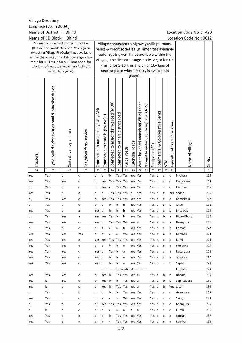
Village DirectoryLand use ( As in 2009 )Name of District : Bhind Location Code No : 420Name of CD Block : Bhind Location Code No : 0012
Trac
tors
Cycl
e-pu
lled
rick
shaw
s(M
anua
l & M
achi
ne d
rive
n)
Cart
s dr
iven
by
anim
als
Sea
/Riv
er fe
rry
serv
ice
Conn
ecte
d to
nat
iona
l hig
hway
(NH
)
Conn
ecte
d to
sta
te h
ighw
ay(S
H)
Conn
ecte
d to
maj
or d
istr
ict r
oad
(MD
R)
Conn
ecte
d to
oth
ers
dist
rict
roa
d
Pucc
a r
oads
Kutc
hcha
roa
ds
Wat
er b
ound
ed m
acad
am(W
BM) r
oads
Nav
igab
le w
ater
way
(riv
er/c
anal
)(N
W)
Foot
path
s (F
P)
Com
mer
cial
& C
o-op
erat
ive
Bank
s
ATM
Agr
icul
tura
l Cre
dit S
ocie
ties
64 65 66 67 68 69 70 71 72 73 74 75 76 77 78 79 2 1
Sr.N
o.
Communication and transport facilities (If amenities available code -Yes is given
except for Village Pin Code ,If not available within the village , the distance range code viz; a for < 5 Kms, b for 5-10 Kms and c for 10+ kms of nearest place where facility is
available is given).
Village connected to highways,village roads, banks & credit societies (If amenities available
code -Yes is given, If not available within the village , the distance range code viz; a for < 5
Kms, b for 5-10 Kms and c for 10+ kms of nearest place where facility is available is
given).
Nam
e of
vill
age
Yes Yes c c c c b Yes Yes Yes Yes Yes c c c Bilohara 213
Yes Yes Yes c c Yes Yes Yes Yes Yes Yes Yes c c c Kachogara 214
b Yes b c c Yes c Yes Yes Yes Yes Yes c c c Parsona 215
Yes Yes c c c b Yes Yes Yes a Yes Yes b c Yes Seoda 216
b Yes Yes c b Yes Yes Yes Yes Yes Yes Yes b c c Bhadakhur 217
c Yes b c b b b b b Yes Yes Yes b c b Aheti 218
Yes Yes b a Yes b b b b Yes Yes Yes b c b Bhagwasi 219
b Yes Yes a Yes Yes Yes b b Yes Yes Yes b b a Didee Khurd 220
Yes Yes Yes c Yes c Yes Yes Yes Yes a Yes a a a Deenpura 221
b Yes b c a a a a b Yes Yes Yes b c b Chasad 222
Yes Yes Yes Yes a b a a Yes Yes Yes Yes b b b Mircholi 223
Yes Yes Yes c Yes Yes Yes Yes Yes Yes Yes Yes b c b Barhi 224
Yes Yes Yes c a c b b a Yes Yes Yes c c c Samanna 225
Yes Yes Yes c Yes c Yes b a Yes Yes Yes a c a Kapurpura 226
Yes Yes Yes c Yes c b b a Yes Yes Yes a c a Jajepura 227
Yes Yes Yes c Yes c b b a Yes Yes Yes b c b Sapad 228
--------------Un-inhabited-------------- Khuavali 229
Yes Yes Yes c b Yes b Yes Yes Yes a Yes b b b Nahara 230
Yes b Yes c b Yes b b Yes Yes a Yes b b b Saphedpura 231
Yes b b c b Yes b Yes Yes Yes a Yes b b Yes Javai 232
c Yes c b c b b b Yes Yes Yes Yes c c c Gyanpura 233
Yes Yes b c c a c a Yes Yes Yes Yes c c c Saraya 234
b Yes b c b Yes Yes Yes Yes Yes Yes Yes b c c Bhonpura 235
b b b c c c a a a a a Yes c c c Kuroli 236
Yes Yes b c c b b Yes Yes Yes Yes Yes c c c Sankari 237
Yes Yes b c c a a Yes Yes Yes Yes Yes c c c Kachhui 238
179

Census of India 2011- Amenities and
Name of District : Bhind Location Code No : 420Name of CD Block : Bhind Location Code No : 0012
Self-
Hel
p G
roup
(SH
G)
Publ
ic d
istr
ibut
ion
syst
em (P
DS)
sho
p
Man
dis
/ Re
gula
r m
arke
t
Wee
kly
Haa
t
Agr
icul
tura
l mar
ketin
g so
ciet
yIn
tegr
ated
Chi
ld D
evel
opm
ent S
chem
e (N
utri
tiona
l Ce
ntre
s)A
ngan
wad
i Cen
tre
(Nut
ritio
nal C
entr
es)
Oth
ers
(Nut
ritio
nal C
entr
es)
ASH
A (A
ccre
dite
d So
cial
Hea
lth A
ctiv
ist)
Com
mun
ity c
entr
e w
ith/w
ithou
t TV
Spor
ts F
ield
,
Spor
ts C
lub
/ Re
crea
tion
Cent
re
Cine
ma
/ Vi
deo
Hal
l
Publ
ic L
ibra
ry
Publ
ic R
eadi
ng R
oom
New
spap
er S
uppl
y
Ass
embl
y Po
lling
sta
tion
Birt
h &
Dea
th R
egis
trat
ion
Off
ice
1 2 3 80 81 82 83 84 85 86 87 88 89 90 91 92 93 94 95 96 97
Sr.N
o.
Nam
e of
vill
age
Loca
tion
code
no.
Availability of miscellaneous facilities (If amenities available code -Yes is given, If not available within the village , the distance range code viz; a for < 5 Kms, b
for 5-10 Kms and c for 10+ kms of nearest place where facility is available is given).
213 Bilohara 452972 Yes a c c c c Yes Yes Yes c b Yes c c c c Yes Yes
214 Kachogara 452973 Yes Yes c c c c Yes Yes Yes c Yes c c Yes c c Yes Yes
215 Parsona 452974 c c c c c c Yes Yes Yes c c c c c c c Yes Yes
216 Seoda 452975 b Yes c c c c Yes Yes Yes Yes Yes c c Yes c Yes Yes Yes
217 Bhadakhur 452976 Yes Yes b b b c Yes b Yes b Yes b b b b b Yes Yes
218 Aheti 452977 Yes c c c c c Yes Yes Yes c c c c c c Yes Yes Yes
219 Bhagwasi 452978 Yes Yes c c c c Yes Yes Yes c c c c c c Yes Yes Yes
220 Didee Khurd 452979 Yes Yes b b b b Yes Yes Yes b b b b b b Yes Yes Yes
221 Deenpura 452980 a Yes a a Yes a Yes Yes Yes a a a b a a Yes Yes Yes
222 Chasad 452981 Yes b b b c c Yes Yes Yes c c c c b b b Yes a
223 Mircholi 452982 Yes a Yes a b a Yes Yes Yes b b b b b b b Yes Yes
224 Barhi 452983 Yes Yes c c c c Yes Yes Yes b c c c c c Yes Yes Yes
225 Samanna 452984 b a b b b c Yes Yes Yes c c c c Yes c Yes Yes b
226 Kapurpura 452985 a a a a a c Yes Yes a a a c c Yes c Yes a a
227 Jajepura 452986 a a a a a a Yes Yes a a a c c c c a Yes a
228 Sapad 452987 Yes Yes b b b Yes Yes Yes Yes b b c c Yes Yes b Yes Yes
229 Khuavali 452988 --------------Un-inhabited--------------
230 Nahara 452989 a b b c c c Yes Yes Yes c Yes c c c c b Yes Yes
231 Saphedpura 452990 Yes a b b c c Yes a Yes c b c c c c b Yes a
232 Javai 452991 Yes b Yes Yes b b a a Yes Yes b b c c c a a b
233 Gyanpura 452992 Yes Yes Yes Yes Yes Yes Yes Yes Yes Yes Yes Yes c c c a Yes Yes
234 Saraya 452993 c Yes c c c c Yes Yes Yes c c c c c c c Yes Yes
235 Bhonpura 452994 Yes Yes Yes Yes Yes c Yes Yes Yes Yes Yes c c c c c Yes Yes
236 Kuroli 452995 c a c c c c a a a c c c c c c c a a
237 Sankari 452996 c a c c c b Yes Yes Yes c c c c c c b Yes Yes
238 Kachhui 452997 Yes a c c c a Yes Yes Yes c c c c Yes c b Yes a
180
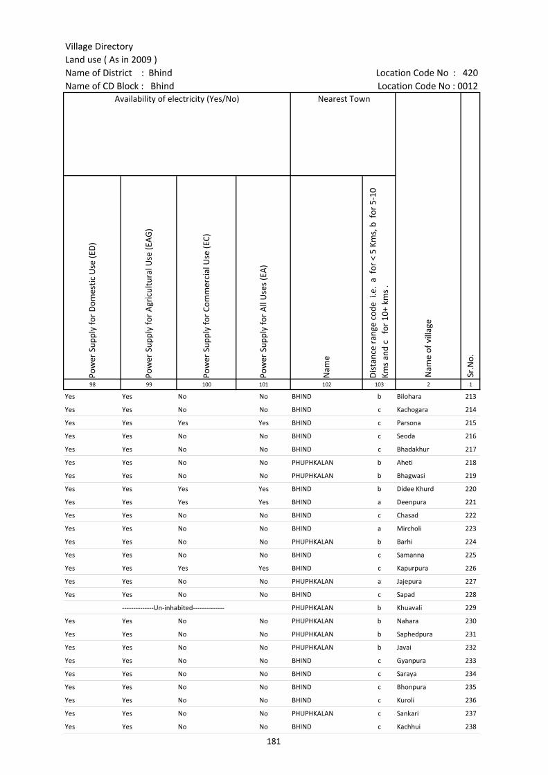
Village DirectoryLand use ( As in 2009 )Name of District : Bhind Location Code No : 420Name of CD Block : Bhind Location Code No : 0012
Pow
er S
uppl
y fo
r D
omes
tic U
se (E
D)
Pow
er S
uppl
y fo
r A
gric
ultu
ral U
se (E
AG
)
Pow
er S
uppl
y fo
r Co
mm
erci
al U
se (E
C)
Pow
er S
uppl
y fo
r A
ll U
ses
(EA
)
Nam
e
Dis
tanc
e ra
nge
code
i.e
. a
for
< 5
Kms,
b f
or 5
-10
Kms
and
c f
or 1
0+ k
ms
.98 99 100 101 102 103 2 1
Nearest Town
Nam
e of
vill
age
Sr.N
o.
Availability of electricity (Yes/No)
Yes Yes No No BHIND b Bilohara 213
Yes Yes No No BHIND c Kachogara 214
Yes Yes Yes Yes BHIND c Parsona 215
Yes Yes No No BHIND c Seoda 216
Yes Yes No No BHIND c Bhadakhur 217
Yes Yes No No PHUPHKALAN b Aheti 218
Yes Yes No No PHUPHKALAN b Bhagwasi 219
Yes Yes Yes Yes BHIND b Didee Khurd 220
Yes Yes Yes Yes BHIND a Deenpura 221
Yes Yes No No BHIND c Chasad 222
Yes Yes No No BHIND a Mircholi 223
Yes Yes No No PHUPHKALAN b Barhi 224
Yes Yes No No BHIND c Samanna 225
Yes Yes Yes Yes BHIND c Kapurpura 226
Yes Yes No No PHUPHKALAN a Jajepura 227
Yes Yes No No BHIND c Sapad 228
--------------Un-inhabited-------------- PHUPHKALAN b Khuavali 229
Yes Yes No No PHUPHKALAN b Nahara 230
Yes Yes No No PHUPHKALAN b Saphedpura 231
Yes Yes No No PHUPHKALAN b Javai 232
Yes Yes No No BHIND c Gyanpura 233
Yes Yes No No BHIND c Saraya 234
Yes Yes No No BHIND c Bhonpura 235
Yes Yes No No BHIND c Kuroli 236
Yes Yes No No PHUPHKALAN c Sankari 237
Yes Yes No No BHIND c Kachhui 238
181
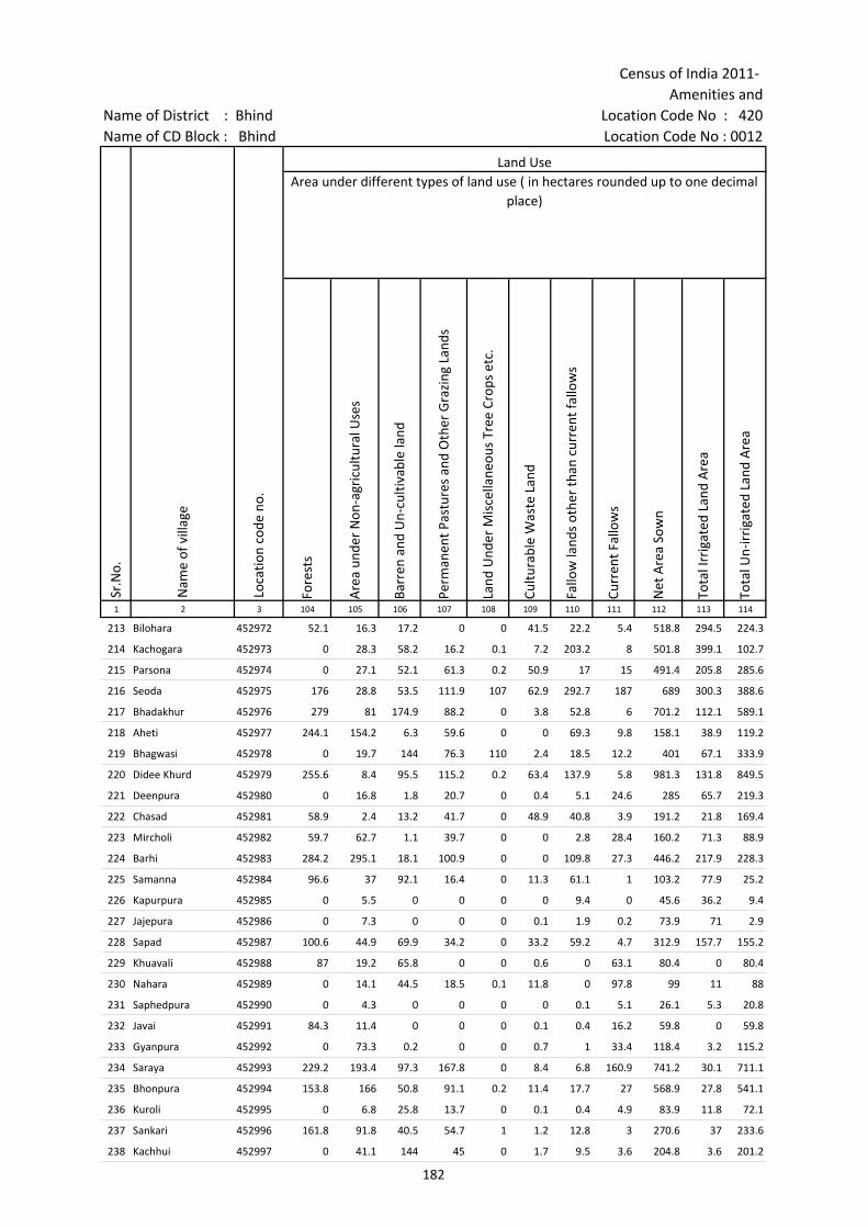
Census of India 2011- Amenities and
Name of District : Bhind Location Code No : 420Name of CD Block : Bhind Location Code No : 0012
Fore
sts
Are
a un
der
Non
-agr
icul
tura
l Use
s
Barr
en a
nd U
n-cu
ltiva
ble
land
Perm
anen
t Pas
ture
s an
d O
ther
Gra
zing
Lan
ds
Land
Und
er M
isce
llane
ous
Tree
Cro
ps e
tc.
Cultu
rabl
e W
aste
Lan
d
Fallo
w la
nds
othe
r th
an c
urre
nt fa
llow
s
Curr
ent F
allo
ws
Net
Are
a So
wn
Tota
l Irr
igat
ed L
and
Are
a
Tota
l Un-
irri
gate
d La
nd A
rea
1 2 3 104 105 106 107 108 109 110 111 112 113 114
Land UseArea under different types of land use ( in hectares rounded up to one decimal
place)
Sr.N
o.
Nam
e of
vill
age
Loca
tion
code
no.
213 Bilohara 452972 52.1 16.3 17.2 0 0 41.5 22.2 5.4 518.8 294.5 224.3
214 Kachogara 452973 0 28.3 58.2 16.2 0.1 7.2 203.2 8 501.8 399.1 102.7
215 Parsona 452974 0 27.1 52.1 61.3 0.2 50.9 17 15 491.4 205.8 285.6
216 Seoda 452975 176 28.8 53.5 111.9 107 62.9 292.7 187 689 300.3 388.6
217 Bhadakhur 452976 279 81 174.9 88.2 0 3.8 52.8 6 701.2 112.1 589.1
218 Aheti 452977 244.1 154.2 6.3 59.6 0 0 69.3 9.8 158.1 38.9 119.2
219 Bhagwasi 452978 0 19.7 144 76.3 110 2.4 18.5 12.2 401 67.1 333.9
220 Didee Khurd 452979 255.6 8.4 95.5 115.2 0.2 63.4 137.9 5.8 981.3 131.8 849.5
221 Deenpura 452980 0 16.8 1.8 20.7 0 0.4 5.1 24.6 285 65.7 219.3
222 Chasad 452981 58.9 2.4 13.2 41.7 0 48.9 40.8 3.9 191.2 21.8 169.4
223 Mircholi 452982 59.7 62.7 1.1 39.7 0 0 2.8 28.4 160.2 71.3 88.9
224 Barhi 452983 284.2 295.1 18.1 100.9 0 0 109.8 27.3 446.2 217.9 228.3
225 Samanna 452984 96.6 37 92.1 16.4 0 11.3 61.1 1 103.2 77.9 25.2
226 Kapurpura 452985 0 5.5 0 0 0 0 9.4 0 45.6 36.2 9.4
227 Jajepura 452986 0 7.3 0 0 0 0.1 1.9 0.2 73.9 71 2.9
228 Sapad 452987 100.6 44.9 69.9 34.2 0 33.2 59.2 4.7 312.9 157.7 155.2
229 Khuavali 452988 87 19.2 65.8 0 0 0.6 0 63.1 80.4 0 80.4
230 Nahara 452989 0 14.1 44.5 18.5 0.1 11.8 0 97.8 99 11 88
231 Saphedpura 452990 0 4.3 0 0 0 0 0.1 5.1 26.1 5.3 20.8
232 Javai 452991 84.3 11.4 0 0 0 0.1 0.4 16.2 59.8 0 59.8
233 Gyanpura 452992 0 73.3 0.2 0 0 0.7 1 33.4 118.4 3.2 115.2
234 Saraya 452993 229.2 193.4 97.3 167.8 0 8.4 6.8 160.9 741.2 30.1 711.1
235 Bhonpura 452994 153.8 166 50.8 91.1 0.2 11.4 17.7 27 568.9 27.8 541.1
236 Kuroli 452995 0 6.8 25.8 13.7 0 0.1 0.4 4.9 83.9 11.8 72.1
237 Sankari 452996 161.8 91.8 40.5 54.7 1 1.2 12.8 3 270.6 37 233.6
238 Kachhui 452997 0 41.1 144 45 0 1.7 9.5 3.6 204.8 3.6 201.2
182
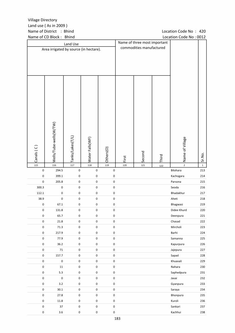
Village DirectoryLand use ( As in 2009 )Name of District : Bhind Location Code No : 420Name of CD Block : Bhind Location Code No : 0012
Cana
ls (
C )
Wel
ls/T
ube-
wel
ls(W
/TW
)
Tank
s/La
kes(
T/L)
Wat
er F
alls
(WF)
Oth
ers(
O)
Firs
t
Seco
nd
Thir
d 115 116 117 118 119 120 121 122 2 1
Land Use Name of three most important commodities manufactured
Nam
e of
Vill
age
Sr.N
o.
Area irrigated by source (in hectare).
0 294.5 0 0 0 Bilohara 213
0 399.1 0 0 0 Kachogara 214
0 205.8 0 0 0 Parsona 215
300.3 0 0 0 0 Seoda 216
112.1 0 0 0 0 Bhadakhur 217
38.9 0 0 0 0 Aheti 218
0 67.1 0 0 0 Bhagwasi 219
0 131.8 0 0 0 Didee Khurd 220
0 65.7 0 0 0 Deenpura 221
0 21.8 0 0 0 Chasad 222
0 71.3 0 0 0 Mircholi 223
0 217.9 0 0 0 Barhi 224
0 77.9 0 0 0 Samanna 225
0 36.2 0 0 0 Kapurpura 226
0 71 0 0 0 Jajepura 227
0 157.7 0 0 0 Sapad 228
0 0 0 0 0 Khuavali 229
0 11 0 0 0 Nahara 230
0 5.3 0 0 0 Saphedpura 231
0 0 0 0 0 Javai 232
0 3.2 0 0 0 Gyanpura 233
0 30.1 0 0 0 Saraya 234
0 27.8 0 0 0 Bhonpura 235
0 11.8 0 0 0 Kuroli 236
0 37 0 0 0 Sankari 237
0 3.6 0 0 0 Kachhui 238
183

Census of India 2011- Amenities and
Name of District : Bhind Location Code No : 420Name of CD Block : Bhind Location Code No : 0012
Pre-
Prim
ary
scho
ol (P
P)
Prim
ary
scho
ol (P
)
Mid
dle
scho
ol (M
)
Seco
ndar
y Sc
hool
(S)
Seni
or S
econ
dary
sch
ool (
SS)
Deg
ree
colle
ge o
f art
s s
cien
ce &
com
mer
ce (
ASC
)
Engi
neer
ing
colle
ge(E
C)
Med
ical
col
lege
(MC)
Man
agem
ent i
nstit
ute
(MI)
Poly
tech
nic
(Pt)
Voca
tiona
l tra
inin
g sc
hool
/IT
I
Non
-for
mal
trai
ning
cen
tre
(NFT
C)
Spec
ial s
choo
l for
dis
able
d (S
SD)
Oth
ers
(spe
cify
)
1 2 3 4 5 6 7 8 9 10 11 12 13 14 15 16 17 18 19 20
Sr.N
o.
Nam
e of
vill
age
Loca
tion
code
no.
Tota
l are
a of
the
villa
ge (
in h
ecta
res
roun
ded
up to
one
dec
imal
pla
ce)
Tota
l pop
ulat
ion
( 201
1 ce
nsus
)
Num
ber
of h
ouse
hold
s (2
011
cens
us)
Number of educational amenities available. (If not available within the village , the distance range
code viz; a for < 5 Kms, b for 5-10 Kms and c for 10+ kms of nearest place where facility is available is given).
239 Bindwa 452998 305.1 428 95 c 1 1 b b c c c c c c
240 Chhunchhari 452999 969.2 861 100 c 2 b b c c c c c c c c c
241 Baghpura 453000 284 362 54 c 1 b b b c c c c c c c
242 Misa 453001 370.8 1185 207 2 1 a a c c c c c c c
243 Nahtoli 453002 436.4 739 143 2 1 a a c c c c c c c c
244 Singhpura 453003 204.5 1072 198 1 2 1 a a c c c c c c
245 Gopalgarh 453004 62.3 0 0 --------------Un-inhabited--------------
246 Chhona 453005 66.4 0 0 --------------Un-inhabited--------------
247 Peeladanda 453006 314.1 856 173 a 1 a a a c c c c c c c c
248 Kanavar 453007 2341.2 10427 1518 1 9 5 2 1 c c c c c 1 c c c
249 Bajhai 453008 1336.9 2736 447 c 5 4 2 b c c c c c c c c c
250 Kiti 453009 30.1 851 127 a 1 a a c c c c c c c c c
251 Umri 453010 1495 11396 1662 3 9 10 5 1 c c c c c c c c
252 Bilaw 453011 2814.9 7631 1158 b 5 3 1 1 c c c c c c c c
253 Khera Shyaura 453012 929 2015 322 b 2 1 b b c c c c c c c c
254 Dhochara 453013 1169.3 3702 628 4 4 2 c c c c c c c c
255 Lahroli 453014 983 4660 706 2 5 2 1 1 c c c c c c c c c
256 Motipura 453015 255.2 1091 169 c 1 1 a a c c c c c c c c c
257 Kharika 453016 363.2 2070 363 b 1 2 1 b c c c c c c c c
258 Akaha 453017 188.4 898 176 1 2 2 2 2 c c c c c c c c c
259 Pulawali 453018 1273.9 4636 705 b 7 3 1 c c c c c c c c c
260 Pandri 453019 1234.2 3797 599 c 5 2 1 b c c c c c c c
261 Gusseng 453020 458 1386 213 c 2 1 1 c c c c c c c c c c
262 Garhisita 453021 162 545 101 a 1 1 a a c c c c c c c c c
263 Garhisultan 453022 112.2 456 69 c 1 b c c c c c c c c c c c
264 Bisalpura 453023 167.9 681 133 1 1 2 2 c c c c c c c c
184

Village DirectoryLand use ( As in 2009 )Name of District : Bhind Location Code No : 420Name of CD Block : Bhind Location Code No : 0012
Com
mun
ity h
ealth
cen
tre
(CH
C)Pr
imar
y he
alth
cen
tre
(PH
C)Pr
imar
y he
alth
sub
cen
tre
(PH
S)M
ater
nity
and
chi
ld w
elfa
re c
entr
e (M
CW)
T.B.
clin
ic (
TBC)
Hos
pita
l-allo
path
ic (H
A)
Hos
pita
l-alte
rnat
ive
med
icin
e (H
O)
Dis
pens
ary
(D)
Vete
rina
ry h
ospi
tal (
VH)
Mob
ile h
ealth
clin
ic (M
HC)
Fam
ily w
elfa
re c
entr
e (F
WC)
Char
itabl
e no
n G
ovt.
hos
pita
l/N
ursi
ng h
ome.
Med
ical
pra
ctiti
oner
with
MBB
S D
egre
eM
edic
al p
ract
ition
er w
ith o
ther
deg
ree
Med
ical
pra
ctiti
oner
with
no
degr
eeTr
aditi
onal
pra
ctiti
oner
and
faith
hea
ler
.M
edic
ine
Shop
Oth
ers
Tap
wat
er (T
reat
ed/U
ntre
ated
)
Wel
l w
ater
(C
over
ed /
Unc
over
ed w
ell)
Han
d Pu
mp
Tube
wel
ls /
Bor
e w
ell
Spri
ng
Rive
r /
Cana
l
Tank
/ P
ond
/ L
ake
Oth
ers
21 22 23 24 25 26 27 28 29 30 31 32 33 34 35 36 37 38 39 40 41 42 43 44 45 46 2 1
Number of Non-Government
Medical Amenities available.
Availability of drinking water - Yes / No
Nam
e of
vill
age
Sr.N
o.
Number of Medical Amenities available. (If not available within the
village , the distance range code viz; a for < 5 Kms, b for 5-10 Kms and c for
10+ kms of nearest place where facility is available is given).
c c c c c c c c c c c 0 0 0 0 0 0 0 No Yes Yes No No No No No Bindwa 239
c c c c c c c c c c c 0 0 0 0 0 0 0 No No Yes No No No No No Chhunchhari 240
c c c c c c c b c c c 0 0 0 0 0 0 0 No No Yes No No No No No Baghpura 241
a a a a a c c c a a a 0 0 0 1 0 0 0 No Yes Yes No No No No No Misa 242
c c a c c c c c a c c 0 0 0 0 0 0 0 No Yes Yes Yes No No No No Nahtoli 243
a a a a a c c c b c c 0 0 0 1 0 0 0 No Yes Yes No No No No No Singhpura 244
--------------Un-inhabited-------------- Gopalgarh 245
--------------Un-inhabited-------------- Chhona 246
b b b b b c c c c c c 0 0 0 0 0 0 0 No Yes Yes No No No No No Peeladanda 247
c b 1 b b c c c 1 c c 0 0 4 0 0 0 0 No Yes Yes Yes No Yes No No Kanavar 248
c c a c c c c c c c c 0 0 0 1 0 0 0 No Yes Yes Yes No Yes No No Bajhai 249
c a a a a a a a a c a 0 0 0 0 0 0 0 No Yes Yes Yes No No No No Kiti 250
c 1 1 c c 1 c c 0 0 5 0 0 2 0 Yes Yes Yes Yes No No Yes No Umri 251
c 1 b b b b c 1 1 c b 0 0 0 3 0 0 0 Yes Yes Yes Yes No Yes Yes No Bilaw 252
c b b b b b c 1 1 c b 0 0 0 0 0 0 0 No Yes Yes Yes No Yes Yes No Khera Shyaura 253
c b a c b c c b a c c 0 0 0 0 1 0 0 No No Yes Yes No No Yes No Dhochara 254
c b 1 c b c c 1 1 c b 0 0 1 2 0 0 0 No Yes Yes No No No Yes No Lahroli 255
c b a c b c c b c c c 0 0 0 0 1 0 0 No No Yes No No No Yes No Motipura 256
c b b b b b b b c b 0 0 0 2 1 0 0 No No Yes Yes No No Yes No Kharika 257
c a a a a a a a a c a 0 0 0 0 0 0 0 No Yes Yes Yes No No No No Akaha 258
c b 1 c b c c c c c c 0 0 0 0 0 0 0 Yes Yes Yes Yes No No Yes No Pulawali 259
c c 1 1 c c c c c b 0 0 0 0 0 0 0 Yes Yes Yes Yes No Yes No No Pandri 260
c c c c c c c c c c c 0 0 0 0 0 0 0 No Yes Yes Yes No No Yes No Gusseng 261
c b b b b c c b b c c 0 0 0 1 0 0 0 No No Yes No No No Yes No Garhisita 262
c c c c c c c c c c c 0 0 0 0 0 0 0 No Yes Yes Yes No No Yes No Garhisultan 263
c b a c b c c a b c c 0 0 0 0 1 0 0 No Yes Yes No No No Yes No Bisalpura 264
185
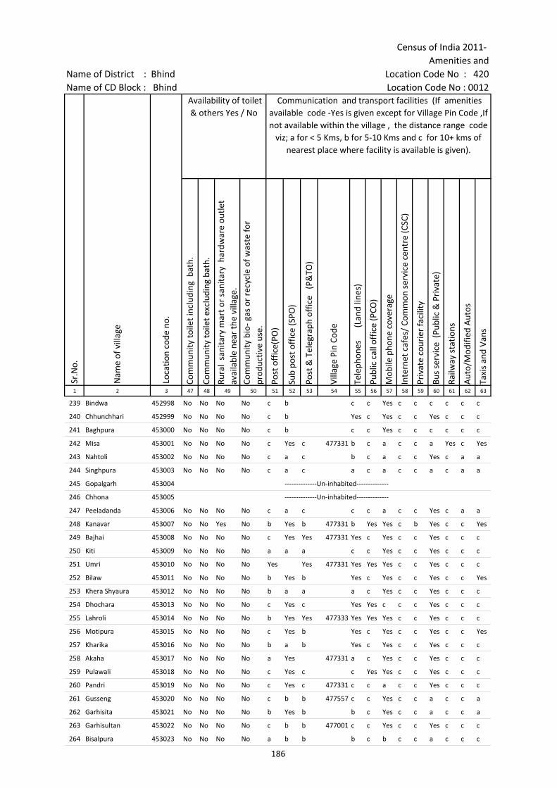
Census of India 2011- Amenities and
Name of District : Bhind Location Code No : 420Name of CD Block : Bhind Location Code No : 0012
Com
mun
ity to
ilet i
nclu
ding
bat
h.
Com
mun
ity to
ilet e
xclu
ding
bat
h.
Rura
l sa
nita
ry m
art o
r sa
nita
ry h
ardw
are
outle
t av
aila
ble
near
the
villa
ge.
Com
mun
ity b
io- g
as o
r re
cycl
e of
was
te fo
r pr
oduc
tive
use.
Post
off
ice(
PO)
Sub
post
off
ice
(SPO
)
Post
& T
eleg
raph
off
ice
(P&
TO)
Villa
ge P
in C
ode
Tele
phon
es
(L
and
lines
)
Publ
ic c
all o
ffic
e (P
CO)
Mob
ile p
hone
cov
erag
e
Inte
rnet
caf
es/
Com
mon
ser
vice
cen
tre
(CSC
)
Priv
ate
cour
ier
faci
lity
Bus
serv
ice
(Pub
lic &
Pri
vate
)
Railw
ay s
tatio
ns
Aut
o/M
odifi
ed A
utos
Taxi
s an
d Va
ns
1 2 3 47 48 49 50 51 52 53 54 55 56 57 58 59 60 61 62 63
Loca
tion
code
no.
Availability of toilet & others Yes / No
Communication and transport facilities (If amenities available code -Yes is given except for Village Pin Code ,If not available within the village , the distance range code
viz; a for < 5 Kms, b for 5-10 Kms and c for 10+ kms of nearest place where facility is available is given).
Sr.N
o.
Nam
e of
vill
age
239 Bindwa 452998 No No No No c b c c Yes c c c c c c
240 Chhunchhari 452999 No No No No c b Yes c Yes c c Yes c c c
241 Baghpura 453000 No No No No c b c c Yes c c c c c c
242 Misa 453001 No No No No c Yes c 477331 b c a c c a Yes c Yes
243 Nahtoli 453002 No No No No c a c b c a c c Yes c a a
244 Singhpura 453003 No No No No c a c a c a c c a c a a
245 Gopalgarh 453004 --------------Un-inhabited--------------
246 Chhona 453005 --------------Un-inhabited--------------
247 Peeladanda 453006 No No No No c a c c c a c c Yes c a a
248 Kanavar 453007 No No Yes No b Yes b 477331 b Yes Yes c b Yes c c Yes
249 Bajhai 453008 No No No No c Yes Yes 477331 Yes c Yes c c Yes c c c
250 Kiti 453009 No No No No a a a c c Yes c c Yes c c c
251 Umri 453010 No No No No Yes Yes 477331 Yes Yes Yes c c Yes c c c
252 Bilaw 453011 No No No No b Yes b Yes c Yes c c Yes c c Yes
253 Khera Shyaura 453012 No No No No b a a a c Yes c c Yes c c c
254 Dhochara 453013 No No No No c Yes c Yes Yes c c c Yes c c c
255 Lahroli 453014 No No No No b Yes Yes 477333 Yes Yes Yes c c Yes c c c
256 Motipura 453015 No No No No c Yes b Yes c Yes c c Yes c c Yes
257 Kharika 453016 No No No No b a b Yes c Yes c c Yes c c c
258 Akaha 453017 No No No No a Yes 477331 a c Yes c c Yes c c c
259 Pulawali 453018 No No No No c Yes c c Yes Yes c c Yes c c c
260 Pandri 453019 No No No No c Yes c 477331 c c a c c Yes c c c
261 Gusseng 453020 No No No No c b b 477557 c c Yes c c a c c a
262 Garhisita 453021 No No No No b Yes b b c Yes c c a c c a
263 Garhisultan 453022 No No No No c b b 477001 c c Yes c c Yes c c c
264 Bisalpura 453023 No No No No a b b b c b c c a c c c
186

Village DirectoryLand use ( As in 2009 )Name of District : Bhind Location Code No : 420Name of CD Block : Bhind Location Code No : 0012
Trac
tors
Cycl
e-pu
lled
rick
shaw
s(M
anua
l & M
achi
ne d
rive
n)
Cart
s dr
iven
by
anim
als
Sea
/Riv
er fe
rry
serv
ice
Conn
ecte
d to
nat
iona
l hig
hway
(NH
)
Conn
ecte
d to
sta
te h
ighw
ay(S
H)
Conn
ecte
d to
maj
or d
istr
ict r
oad
(MD
R)
Conn
ecte
d to
oth
ers
dist
rict
roa
d
Pucc
a r
oads
Kutc
hcha
roa
ds
Wat
er b
ound
ed m
acad
am(W
BM) r
oads
Nav
igab
le w
ater
way
(riv
er/c
anal
)(N
W)
Foot
path
s (F
P)
Com
mer
cial
& C
o-op
erat
ive
Bank
s
ATM
Agr
icul
tura
l Cre
dit S
ocie
ties
64 65 66 67 68 69 70 71 72 73 74 75 76 77 78 79 2 1
Sr.N
o.
Communication and transport facilities (If amenities available code -Yes is given
except for Village Pin Code ,If not available within the village , the distance range code viz; a for < 5 Kms, b for 5-10 Kms and c for 10+ kms of nearest place where facility is
available is given).
Village connected to highways,village roads, banks & credit societies (If amenities available
code -Yes is given, If not available within the village , the distance range code viz; a for < 5
Kms, b for 5-10 Kms and c for 10+ kms of nearest place where facility is available is
given).
Nam
e of
vill
age
Yes b b c c c c Yes a Yes Yes Yes c c c Bindwa 239
Yes Yes b c c c c c Yes Yes Yes Yes c c c Chhunchhari 240
Yes b b c c c c c b Yes b Yes c c c Baghpura 241
b Yes b c c b a Yes Yes Yes Yes Yes c c Yes Misa 242
Yes Yes Yes a c b b Yes Yes Yes Yes Yes c c c Nahtoli 243
Yes Yes Yes c c b a a a Yes Yes Yes a c Yes Singhpura 244
--------------Un-inhabited-------------- Gopalgarh 245
--------------Un-inhabited-------------- Chhona 246
Yes Yes Yes c c c a Yes a Yes Yes Yes c c c Peeladanda 247
Yes Yes Yes Yes c b b Yes Yes Yes Yes Yes b c b Kanavar 248
Yes Yes Yes c c c c Yes Yes Yes Yes Yes c c Yes Bajhai 249
Yes Yes Yes c c a Yes Yes Yes Yes a Yes a c a Kiti 250
Yes Yes Yes c c Yes Yes Yes Yes Yes Yes Yes Yes c c Umri 251
Yes Yes Yes c c a a Yes Yes Yes Yes Yes b c Yes Bilaw 252
Yes Yes Yes c c Yes Yes Yes Yes Yes Yes Yes b c Yes Khera Shyaura 253
Yes Yes a c c Yes Yes Yes Yes Yes Yes Yes b c b Dhochara 254
Yes Yes Yes b c b Yes Yes Yes Yes Yes Yes b c c Lahroli 255
Yes Yes Yes c c b Yes Yes a Yes Yes Yes b c b Motipura 256
Yes Yes Yes c c Yes a Yes Yes Yes a Yes b c b Kharika 257
Yes Yes b c c a a Yes Yes Yes Yes Yes a c a Akaha 258
Yes Yes Yes c c b Yes Yes Yes Yes Yes Yes c c c Pulawali 259
Yes Yes Yes c c c Yes Yes Yes Yes Yes Yes c c c Pandri 260
b Yes b c c c a a a Yes a Yes c c c Gusseng 261
Yes Yes Yes c c b a a a Yes Yes Yes b c c Garhisita 262
b b b c c c Yes Yes Yes Yes Yes Yes c c c Garhisultan 263
Yes Yes c a c b a Yes a a Yes Yes b c b Bisalpura 264
187
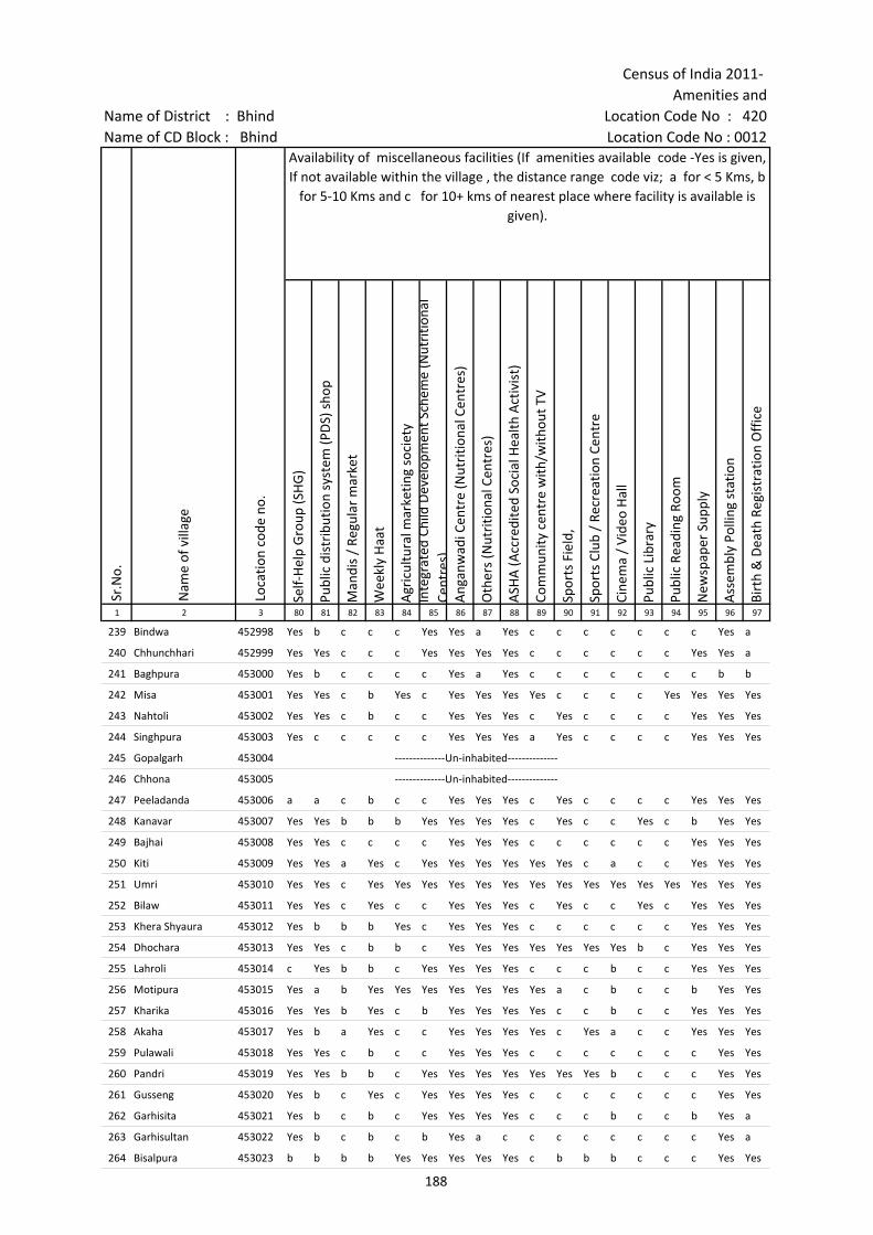
Census of India 2011- Amenities and
Name of District : Bhind Location Code No : 420Name of CD Block : Bhind Location Code No : 0012
Self-
Hel
p G
roup
(SH
G)
Publ
ic d
istr
ibut
ion
syst
em (P
DS)
sho
p
Man
dis
/ Re
gula
r m
arke
t
Wee
kly
Haa
t
Agr
icul
tura
l mar
ketin
g so
ciet
yIn
tegr
ated
Chi
ld D
evel
opm
ent S
chem
e (N
utri
tiona
l Ce
ntre
s)A
ngan
wad
i Cen
tre
(Nut
ritio
nal C
entr
es)
Oth
ers
(Nut
ritio
nal C
entr
es)
ASH
A (A
ccre
dite
d So
cial
Hea
lth A
ctiv
ist)
Com
mun
ity c
entr
e w
ith/w
ithou
t TV
Spor
ts F
ield
,
Spor
ts C
lub
/ Re
crea
tion
Cent
re
Cine
ma
/ Vi
deo
Hal
l
Publ
ic L
ibra
ry
Publ
ic R
eadi
ng R
oom
New
spap
er S
uppl
y
Ass
embl
y Po
lling
sta
tion
Birt
h &
Dea
th R
egis
trat
ion
Off
ice
1 2 3 80 81 82 83 84 85 86 87 88 89 90 91 92 93 94 95 96 97
Sr.N
o.
Nam
e of
vill
age
Loca
tion
code
no.
Availability of miscellaneous facilities (If amenities available code -Yes is given, If not available within the village , the distance range code viz; a for < 5 Kms, b
for 5-10 Kms and c for 10+ kms of nearest place where facility is available is given).
239 Bindwa 452998 Yes b c c c Yes Yes a Yes c c c c c c c Yes a
240 Chhunchhari 452999 Yes Yes c c c Yes Yes Yes Yes c c c c c c Yes Yes a
241 Baghpura 453000 Yes b c c c c Yes a Yes c c c c c c c b b
242 Misa 453001 Yes Yes c b Yes c Yes Yes Yes Yes c c c c Yes Yes Yes Yes
243 Nahtoli 453002 Yes Yes c b c c Yes Yes Yes c Yes c c c c Yes Yes Yes
244 Singhpura 453003 Yes c c c c c Yes Yes Yes a Yes c c c c Yes Yes Yes
245 Gopalgarh 453004 --------------Un-inhabited--------------
246 Chhona 453005 --------------Un-inhabited--------------
247 Peeladanda 453006 a a c b c c Yes Yes Yes c Yes c c c c Yes Yes Yes
248 Kanavar 453007 Yes Yes b b b Yes Yes Yes Yes c Yes c c Yes c b Yes Yes
249 Bajhai 453008 Yes Yes c c c c Yes Yes Yes c c c c c c Yes Yes Yes
250 Kiti 453009 Yes Yes a Yes c Yes Yes Yes Yes Yes Yes c a c c Yes Yes Yes
251 Umri 453010 Yes Yes c Yes Yes Yes Yes Yes Yes Yes Yes Yes Yes Yes Yes Yes Yes Yes
252 Bilaw 453011 Yes Yes c Yes c c Yes Yes Yes c Yes c c Yes c Yes Yes Yes
253 Khera Shyaura 453012 Yes b b b Yes c Yes Yes Yes c c c c c c Yes Yes Yes
254 Dhochara 453013 Yes Yes c b b c Yes Yes Yes Yes Yes Yes Yes b c Yes Yes Yes
255 Lahroli 453014 c Yes b b c Yes Yes Yes Yes c c c b c c Yes Yes Yes
256 Motipura 453015 Yes a b Yes Yes Yes Yes Yes Yes Yes a c b c c b Yes Yes
257 Kharika 453016 Yes Yes b Yes c b Yes Yes Yes Yes c c b c c Yes Yes Yes
258 Akaha 453017 Yes b a Yes c c Yes Yes Yes Yes c Yes a c c Yes Yes Yes
259 Pulawali 453018 Yes Yes c b c c Yes Yes Yes c c c c c c c Yes Yes
260 Pandri 453019 Yes Yes b b c Yes Yes Yes Yes Yes Yes Yes b c c c Yes Yes
261 Gusseng 453020 Yes b c Yes c Yes Yes Yes Yes c c c c c c c Yes Yes
262 Garhisita 453021 Yes b c b c Yes Yes Yes Yes c c c b c c b Yes a
263 Garhisultan 453022 Yes b c b c b Yes a c c c c c c c c Yes a
264 Bisalpura 453023 b b b b Yes Yes Yes Yes Yes c b b b c c c Yes Yes
188
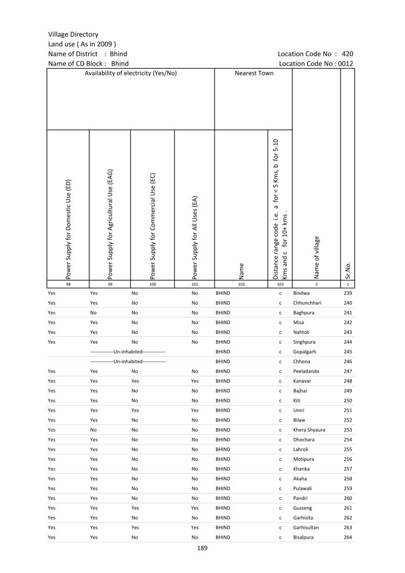
Village DirectoryLand use ( As in 2009 )Name of District : Bhind Location Code No : 420Name of CD Block : Bhind Location Code No : 0012
Pow
er S
uppl
y fo
r D
omes
tic U
se (E
D)
Pow
er S
uppl
y fo
r A
gric
ultu
ral U
se (E
AG
)
Pow
er S
uppl
y fo
r Co
mm
erci
al U
se (E
C)
Pow
er S
uppl
y fo
r A
ll U
ses
(EA
)
Nam
e
Dis
tanc
e ra
nge
code
i.e
. a
for
< 5
Kms,
b f
or 5
-10
Kms
and
c f
or 1
0+ k
ms
.98 99 100 101 102 103 2 1
Nearest Town
Nam
e of
vill
age
Sr.N
o.
Availability of electricity (Yes/No)
Yes Yes No No BHIND c Bindwa 239
Yes Yes No No BHIND c Chhunchhari 240
Yes No No No BHIND c Baghpura 241
Yes Yes No No BHIND c Misa 242
Yes Yes No No BHIND c Nahtoli 243
Yes Yes No No BHIND c Singhpura 244
--------------Un-inhabited-------------- BHIND c Gopalgarh 245
--------------Un-inhabited-------------- BHIND c Chhona 246
Yes Yes No No BHIND c Peeladanda 247
Yes Yes Yes Yes BHIND c Kanavar 248
Yes Yes No No BHIND c Bajhai 249
Yes Yes No No BHIND c Kiti 250
Yes Yes Yes Yes BHIND c Umri 251
Yes Yes No No BHIND c Bilaw 252
Yes No No No BHIND c Khera Shyaura 253
Yes Yes No No BHIND c Dhochara 254
Yes Yes No No BHIND c Lahroli 255
Yes Yes No No BHIND c Motipura 256
Yes Yes No No BHIND c Kharika 257
Yes Yes No No BHIND c Akaha 258
Yes Yes No No BHIND c Pulawali 259
Yes Yes No No BHIND c Pandri 260
Yes Yes Yes Yes BHIND c Gusseng 261
Yes Yes No No BHIND c Garhisita 262
Yes Yes Yes Yes BHIND c Garhisultan 263
Yes Yes No No BHIND c Bisalpura 264
189
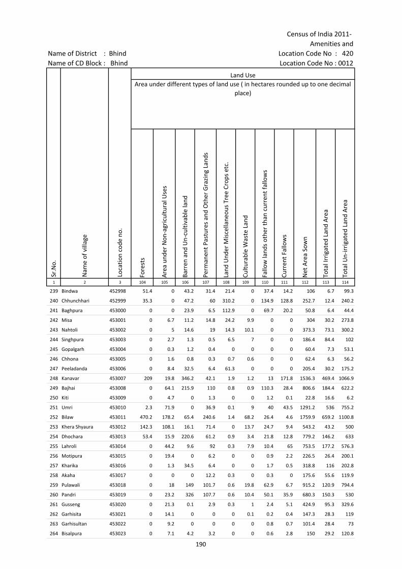
Census of India 2011- Amenities and
Name of District : Bhind Location Code No : 420Name of CD Block : Bhind Location Code No : 0012
Fore
sts
Are
a un
der
Non
-agr
icul
tura
l Use
s
Barr
en a
nd U
n-cu
ltiva
ble
land
Perm
anen
t Pas
ture
s an
d O
ther
Gra
zing
Lan
ds
Land
Und
er M
isce
llane
ous
Tree
Cro
ps e
tc.
Cultu
rabl
e W
aste
Lan
d
Fallo
w la
nds
othe
r th
an c
urre
nt fa
llow
s
Curr
ent F
allo
ws
Net
Are
a So
wn
Tota
l Irr
igat
ed L
and
Are
a
Tota
l Un-
irri
gate
d La
nd A
rea
1 2 3 104 105 106 107 108 109 110 111 112 113 114
Land UseArea under different types of land use ( in hectares rounded up to one decimal
place)
Sr.N
o.
Nam
e of
vill
age
Loca
tion
code
no.
239 Bindwa 452998 51.4 0 43.2 31.4 21.4 0 37.4 14.2 106 6.7 99.3
240 Chhunchhari 452999 35.3 0 47.2 60 310.2 0 134.9 128.8 252.7 12.4 240.2
241 Baghpura 453000 0 0 23.9 6.5 112.9 0 69.7 20.2 50.8 6.4 44.4
242 Misa 453001 0 6.7 11.2 14.8 24.2 9.9 0 0 304 30.2 273.8
243 Nahtoli 453002 0 5 14.6 19 14.3 10.1 0 0 373.3 73.1 300.2
244 Singhpura 453003 0 2.7 1.3 0.5 6.5 7 0 0 186.4 84.4 102
245 Gopalgarh 453004 0 0.3 1.2 0.4 0 0 0 0 60.4 7.3 53.1
246 Chhona 453005 0 1.6 0.8 0.3 0.7 0.6 0 0 62.4 6.3 56.2
247 Peeladanda 453006 0 8.4 32.5 6.4 61.3 0 0 0 205.4 30.2 175.2
248 Kanavar 453007 209 19.8 346.2 42.1 1.9 1.2 13 171.8 1536.3 469.4 1066.9
249 Bajhai 453008 0 64.1 215.9 110 0.8 0.9 110.3 28.4 806.6 184.4 622.2
250 Kiti 453009 0 4.7 0 1.3 0 0 1.2 0.1 22.8 16.6 6.2
251 Umri 453010 2.3 71.9 0 36.9 0.1 9 40 43.5 1291.2 536 755.2
252 Bilaw 453011 470.2 178.2 65.4 240.6 1.4 68.2 26.4 4.6 1759.9 659.2 1100.8
253 Khera Shyaura 453012 142.3 108.1 16.1 71.4 0 13.7 24.7 9.4 543.2 43.2 500
254 Dhochara 453013 53.4 15.9 220.6 61.2 0.9 3.4 21.8 12.8 779.2 146.2 633
255 Lahroli 453014 0 44.2 9.6 92 0.3 7.9 10.4 65 753.5 177.2 576.3
256 Motipura 453015 0 19.4 0 6.2 0 0 0.9 2.2 226.5 26.4 200.1
257 Kharika 453016 0 1.3 34.5 6.4 0 0 1.7 0.5 318.8 116 202.8
258 Akaha 453017 0 0 0 12.2 0.3 0 0.3 0 175.6 55.6 119.9
259 Pulawali 453018 0 18 149 101.7 0.6 19.8 62.9 6.7 915.2 120.9 794.4
260 Pandri 453019 0 23.2 326 107.7 0.6 10.4 50.1 35.9 680.3 150.3 530
261 Gusseng 453020 0 21.3 0.1 2.9 0.3 1 2.4 5.1 424.9 95.3 329.6
262 Garhisita 453021 0 14.1 0 0 0 0.1 0.2 0.4 147.3 28.3 119
263 Garhisultan 453022 0 9.2 0 0 0 0 0.8 0.7 101.4 28.4 73
264 Bisalpura 453023 0 7.1 4.2 3.2 0 0 0.6 2.8 150 29.2 120.8
190

Village DirectoryLand use ( As in 2009 )Name of District : Bhind Location Code No : 420Name of CD Block : Bhind Location Code No : 0012
Cana
ls (
C )
Wel
ls/T
ube-
wel
ls(W
/TW
)
Tank
s/La
kes(
T/L)
Wat
er F
alls
(WF)
Oth
ers(
O)
Firs
t
Seco
nd
Thir
d 115 116 117 118 119 120 121 122 2 1
Land Use Name of three most important commodities manufactured
Nam
e of
Vill
age
Sr.N
o.
Area irrigated by source (in hectare).
0 6.7 0 0 0 Bindwa 239
0 12.4 0 0 0 Chhunchhari 240
0 6.4 0 0 0 Baghpura 241
0 30.2 0 0 0 Misa 242
0 0 73.1 0 0 Nahtoli 243
0 84.4 0 0 0 Singhpura 244
0 7.3 0 0 0 Gopalgarh 245
0 6.3 0 0 0 Chhona 246
0 30.2 0 0 0 Peeladanda 247
0 469.4 0 0 0 Kanavar 248
0 184.4 0 0 0 Bajhai 249
0 0 16.6 0 0 Kiti 250
0 536 0 0 0 Umri 251
0 659.2 0 0 0 Bilaw 252
0 43.2 0 0 0 Khera Shyaura 253
0 146.2 0 0 0 Dhochara 254
0 177.2 0 0 0 Lahroli 255
0 0 26.4 0 0 Motipura 256
0 116 0 0 0 Kharika 257
0 55.6 0 0 0 Akaha 258
0 120.9 0 0 0 Pulawali 259
0 150.3 0 0 0 Pandri 260
0 95.3 0 0 0 Gusseng 261
0 28.3 0 0 0 Garhisita 262
0 28.4 0 0 0 Garhisultan 263
0 29.2 0 0 0 Bisalpura 264
191

Census of India 2011- Amenities and
Name of District : Bhind Location Code No : 420Name of CD Block : Bhind Location Code No : 0012
Pre-
Prim
ary
scho
ol (P
P)
Prim
ary
scho
ol (P
)
Mid
dle
scho
ol (M
)
Seco
ndar
y Sc
hool
(S)
Seni
or S
econ
dary
sch
ool (
SS)
Deg
ree
colle
ge o
f art
s s
cien
ce &
com
mer
ce (
ASC
)
Engi
neer
ing
colle
ge(E
C)
Med
ical
col
lege
(MC)
Man
agem
ent i
nstit
ute
(MI)
Poly
tech
nic
(Pt)
Voca
tiona
l tra
inin
g sc
hool
/IT
I
Non
-for
mal
trai
ning
cen
tre
(NFT
C)
Spec
ial s
choo
l for
dis
able
d (S
SD)
Oth
ers
(spe
cify
)
1 2 3 4 5 6 7 8 9 10 11 12 13 14 15 16 17 18 19 20
Sr.N
o.
Nam
e of
vill
age
Loca
tion
code
no.
Tota
l are
a of
the
villa
ge (
in h
ecta
res
roun
ded
up to
one
dec
imal
pla
ce)
Tota
l pop
ulat
ion
( 201
1 ce
nsus
)
Num
ber
of h
ouse
hold
s (2
011
cens
us)
Number of educational amenities available. (If not available within the village , the distance range
code viz; a for < 5 Kms, b for 5-10 Kms and c for 10+ kms of nearest place where facility is available is given).
265 Kot 453024 492.2 2359 401 b 3 2 1 b c c c c c c c c c
266 Pewali 453025 225.2 1783 270 c 2 1 b b c c c c c c c c
267 Ishwari 453026 268.8 847 183 1 1 a a c c c c c c c c c
268 Raura 453027 879.4 1986 344 2 1 1 a c c c c c c c c c
269 Sarsai 453028 493 2017 399 c 4 1 1 b c c c c c c c
270 Madnai 453029 551.3 1599 227 c 3 a a c c c c c c c c c
271 Behad Ki Jameh 453030 482.7 792 104 b 2 a b b c c c c c c c c
272 Harki Jameh 453031 259.2 999 213 a 2 1 a c c c c c c c c
273 Rora 453032 376 919 155 b 2 1 b b c c c c c c c c c
274 Sagara 453033 882.5 4298 820 c 2 2 a a c c c c c c c c
275 Puradumna 453034 478.9 1465 267 1 1 a c c c c c c c c c
276 Atarsuma 453035 598.4 1585 334 c 1 1 a a c c c c c c c c
277 Kakahara 453036 954.8 1854 259 a 1 1 a a c c c c c c c c c
278 Nayagaon 453037 791.6 4706 784 2 4 4 2 2 c c c c c c c c
279 Madai 453038 267.5 446 39 a 1 1 a a c c c c c c c c c
280 Jakhmoli 453039 1338.8 2699 510 c 1 2 1 c c c c c c c c c c
281 Ojha 453040 589.2 1741 280 b 3 2 b b c c c c c c c c c
282 Doongarpura 453041 492.5 1500 204 a 2 1 a a c c c c c c c c
283 Tehangur 453042 827.6 2790 490 b 4 1 1 b c c c c c c c c c
284 Sanawai 453043 836.9 1138 176 2 2 1 1 c c c c c c c c c c
285 Dwar 453044 575.7 1397 275 1 3 1 c c c c c c c c c c c
Block T O T A L :
6262
5.9
2162
34
3571
5 51 265
150 48 16 0 0 0 0 0 2 1 0 0
192

Village DirectoryLand use ( As in 2009 )Name of District : Bhind Location Code No : 420Name of CD Block : Bhind Location Code No : 0012
Com
mun
ity h
ealth
cen
tre
(CH
C)Pr
imar
y he
alth
cen
tre
(PH
C)Pr
imar
y he
alth
sub
cen
tre
(PH
S)M
ater
nity
and
chi
ld w
elfa
re c
entr
e (M
CW)
T.B.
clin
ic (
TBC)
Hos
pita
l-allo
path
ic (H
A)
Hos
pita
l-alte
rnat
ive
med
icin
e (H
O)
Dis
pens
ary
(D)
Vete
rina
ry h
ospi
tal (
VH)
Mob
ile h
ealth
clin
ic (M
HC)
Fam
ily w
elfa
re c
entr
e (F
WC)
Char
itabl
e no
n G
ovt.
hos
pita
l/N
ursi
ng h
ome.
Med
ical
pra
ctiti
oner
with
MBB
S D
egre
eM
edic
al p
ract
ition
er w
ith o
ther
deg
ree
Med
ical
pra
ctiti
oner
with
no
degr
eeTr
aditi
onal
pra
ctiti
oner
and
faith
hea
ler
.M
edic
ine
Shop
Oth
ers
Tap
wat
er (T
reat
ed/U
ntre
ated
)
Wel
l w
ater
(C
over
ed /
Unc
over
ed w
ell)
Han
d Pu
mp
Tube
wel
ls /
Bor
e w
ell
Spri
ng
Rive
r /
Cana
l
Tank
/ P
ond
/ L
ake
Oth
ers
21 22 23 24 25 26 27 28 29 30 31 32 33 34 35 36 37 38 39 40 41 42 43 44 45 46 2 1
Number of Non-Government
Medical Amenities available.
Availability of drinking water - Yes / No
Nam
e of
vill
age
Sr.N
o.
Number of Medical Amenities available. (If not available within the
village , the distance range code viz; a for < 5 Kms, b for 5-10 Kms and c for
10+ kms of nearest place where facility is available is given).
c b 1 b b b c b a c b 0 0 0 0 0 0 0 No No Yes Yes No No Yes No Kot 265
c c a c c c c b b c c 0 0 0 2 0 0 0 No Yes Yes Yes No No No No Pewali 266
c c c c c c c c c c 0 0 0 0 0 0 0 Yes Yes Yes Yes No No Yes No Ishwari 267
c c c c c c c c c a c 0 0 0 0 0 0 0 No Yes Yes Yes No No Yes No Raura 268
c c 1 c c c c c c c 0 0 0 0 0 0 0 Yes Yes Yes Yes No No Yes No Sarsai 269
c c b c c c c c b c c 0 0 0 0 0 0 0 Yes Yes Yes Yes No Yes Yes No Madnai 270
c c a c c a a a a c c 0 0 0 0 0 0 0 No Yes Yes Yes No No No No Behad Ki Jameh 271
c c a a c c c c c c c 0 0 0 0 0 0 0 No Yes Yes Yes No No Yes No Harki Jameh 272
c c b b c c c c c c c 0 0 0 0 0 0 0 No Yes Yes Yes No No Yes No Rora 273
c c 1 c c c c b a c c 0 0 0 3 0 0 0 No Yes Yes Yes No No No No Sagara 274
c c a c c c c c c c c 0 0 0 0 0 0 0 No Yes Yes No No No Yes No Puradumna 275
c c a c c c c c c c c 0 0 0 0 0 0 0 No Yes Yes No No No Yes No Atarsuma 276
c a a a a c c a a c c 0 0 0 0 0 0 0 No Yes Yes Yes No No Yes No Kakahara 277
c c 1 c c c c c 1 c c 0 0 0 0 0 2 2 No No No Yes Yes No Yes No Nayagaon 278
c a a a a c c a a c c 0 0 0 0 0 0 0 No Yes Yes Yes No No No No Madai 279
c c c c c c c c b c c 0 0 0 0 0 0 0 No Yes Yes No No Yes No No Jakhmoli 280
c c c c c c b c b 0 0 1 0 0 0 0 No Yes Yes No No Yes Yes No Ojha 281
c c a c c a a a a c c 0 0 0 0 1 0 0 No Yes Yes Yes No No No No Doongarpura 282
c c 1 c c c c 1 b c c 0 0 0 1 0 0 0 Yes Yes Yes Yes No Yes No No Tehangur 283
c c c c c c c c c c c 0 1 0 1 1 0 0 No No Yes No No No Yes No Sanawai 284
c c c c c c c c c b 0 1 0 1 1 0 0 No No Yes No No No Yes No Dwar 285
0 5 15 2 0 0 0 7 11 0 1 0 2 17 33 18 4 3 12 59 95 49 2 22 42 0
Block T O T A L :
193

Census of India 2011- Amenities and
Name of District : Bhind Location Code No : 420Name of CD Block : Bhind Location Code No : 0012
Com
mun
ity to
ilet i
nclu
ding
bat
h.
Com
mun
ity to
ilet e
xclu
ding
bat
h.
Rura
l sa
nita
ry m
art o
r sa
nita
ry h
ardw
are
outle
t av
aila
ble
near
the
villa
ge.
Com
mun
ity b
io- g
as o
r re
cycl
e of
was
te fo
r pr
oduc
tive
use.
Post
off
ice(
PO)
Sub
post
off
ice
(SPO
)
Post
& T
eleg
raph
off
ice
(P&
TO)
Villa
ge P
in C
ode
Tele
phon
es
(L
and
lines
)
Publ
ic c
all o
ffic
e (P
CO)
Mob
ile p
hone
cov
erag
e
Inte
rnet
caf
es/
Com
mon
ser
vice
cen
tre
(CSC
)
Priv
ate
cour
ier
faci
lity
Bus
serv
ice
(Pub
lic &
Pri
vate
)
Railw
ay s
tatio
ns
Aut
o/M
odifi
ed A
utos
Taxi
s an
d Va
ns
1 2 3 47 48 49 50 51 52 53 54 55 56 57 58 59 60 61 62 63
Loca
tion
code
no.
Availability of toilet & others Yes / No
Communication and transport facilities (If amenities available code -Yes is given except for Village Pin Code ,If not available within the village , the distance range code
viz; a for < 5 Kms, b for 5-10 Kms and c for 10+ kms of nearest place where facility is available is given).
Sr.N
o.
Nam
e of
vill
age
265 Kot 453024 No No No No a Yes Yes 477333 a Yes Yes c c Yes c c c
266 Pewali 453025 No No No No c a a 477660 a c Yes c c Yes c c c
267 Ishwari 453026 No No Yes No a c a c Yes c c a c c c
268 Raura 453027 No No No No c a a c c Yes c c a c c c
269 Sarsai 453028 No No No No c Yes c 477333 b c Yes c c Yes c c c
270 Madnai 453029 No No No No c a c Yes c a c c a c c c
271 Behad Ki Jameh 453030 No No No No c a c b c Yes c c Yes c c Yes
272 Harki Jameh 453031 No No No No c a a a c Yes c c a c c a
273 Rora 453032 No No No No c b b b c Yes c c a c c a
274 Sagara 453033 No No No No c Yes Yes 477333 Yes c Yes c c Yes c c c
275 Puradumna 453034 No No No No c c c c c Yes c c Yes c c c
276 Atarsuma 453035 No No No No c Yes c 477333 c c Yes c c Yes c c c
277 Kakahara 453036 No No No No c a a 477333 a c Yes c c a c a a
278 Nayagaon 453037 No No No No a Yes Yes 477333 Yes Yes Yes c c Yes c c c
279 Madai 453038 No No No No c a a a c Yes c c Yes c c a
280 Jakhmoli 453039 No No No No c Yes c 477333 b c Yes c c Yes c c c
281 Ojha 453040 No No No No Yes c Yes c c Yes c c c
282 Doongarpura 453041 No No No No c a c a c Yes c c Yes c c c
283 Tehangur 453042 No No No No c Yes c 477333 c Yes Yes c c Yes c c c
284 Sanawai 453043 No No No No c Yes c c c Yes c c Yes c c c
285 Dwar 453044 No No No No c Yes c c c Yes c c Yes c c c
Block T O T A L :
0 3 2 5 2 37 12 36 18 17 75 0 1 45 2 7 17
194
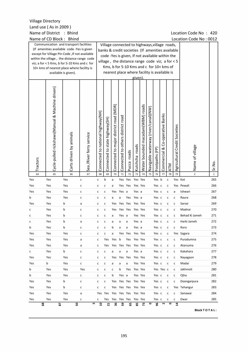
Village DirectoryLand use ( As in 2009 )Name of District : Bhind Location Code No : 420Name of CD Block : Bhind Location Code No : 0012
Trac
tors
Cycl
e-pu
lled
rick
shaw
s(M
anua
l & M
achi
ne d
rive
n)
Cart
s dr
iven
by
anim
als
Sea
/Riv
er fe
rry
serv
ice
Conn
ecte
d to
nat
iona
l hig
hway
(NH
)
Conn
ecte
d to
sta
te h
ighw
ay(S
H)
Conn
ecte
d to
maj
or d
istr
ict r
oad
(MD
R)
Conn
ecte
d to
oth
ers
dist
rict
roa
d
Pucc
a r
oads
Kutc
hcha
roa
ds
Wat
er b
ound
ed m
acad
am(W
BM) r
oads
Nav
igab
le w
ater
way
(riv
er/c
anal
)(N
W)
Foot
path
s (F
P)
Com
mer
cial
& C
o-op
erat
ive
Bank
s
ATM
Agr
icul
tura
l Cre
dit S
ocie
ties
64 65 66 67 68 69 70 71 72 73 74 75 76 77 78 79 2 1
Sr.N
o.
Communication and transport facilities (If amenities available code -Yes is given
except for Village Pin Code ,If not available within the village , the distance range code viz; a for < 5 Kms, b for 5-10 Kms and c for 10+ kms of nearest place where facility is
available is given).
Village connected to highways,village roads, banks & credit societies (If amenities available
code -Yes is given, If not available within the village , the distance range code viz; a for < 5
Kms, b for 5-10 Kms and c for 10+ kms of nearest place where facility is available is
given).
Nam
e of
vill
age
Yes Yes Yes c c b a Yes Yes Yes Yes Yes b c Yes Kot 265
Yes Yes Yes c c c a Yes Yes Yes Yes Yes c c Yes Pewali 266
Yes Yes Yes c c c Yes Yes a Yes a Yes c c a Ishwari 267
b Yes Yes c c c a a Yes Yes a Yes c c c Raura 268
Yes Yes b a c c Yes Yes Yes Yes Yes Yes c c c Sarsai 269
c Yes b c c c Yes Yes Yes Yes Yes Yes c c c Madnai 270
c Yes b c c c a Yes a Yes Yes Yes c c c Behad Ki Jameh 271
c Yes b a c c a a a Yes a Yes c c c Harki Jameh 272
b Yes b c c c b a a Yes a Yes c c c Rora 273
Yes Yes Yes c c c a Yes Yes Yes Yes Yes c c Yes Sagara 274
Yes Yes Yes a c Yes Yes b Yes Yes Yes Yes c c c Puradumna 275
Yes Yes Yes a c Yes Yes Yes Yes Yes Yes Yes c c c Atarsuma 276
c Yes b c c c a a a Yes a Yes c c c Kakahara 277
Yes Yes Yes c c c Yes Yes Yes Yes Yes Yes c c c Nayagaon 278
Yes b Yes c c c a a a Yes Yes Yes c c c Madai 279
b Yes Yes Yes c c c b Yes Yes Yes Yes Yes c c Jakhmoli 280
b Yes Yes c c c b Yes a Yes Yes Yes c c c Ojha 281
Yes Yes b c c c Yes Yes Yes Yes Yes Yes c c c Doongarpura 282
Yes Yes b c c c Yes Yes Yes Yes Yes Yes c c Yes Tehangur 283
Yes Yes Yes a Yes Yes Yes Yes Yes Yes Yes Yes c c c Sanawai 284
Yes Yes Yes c c Yes Yes Yes Yes Yes Yes Yes c c c Dwar 285
68 87 50 3 10 21 36 59 65 85 73 0 96 2 0 14
Block T O T A L :
195
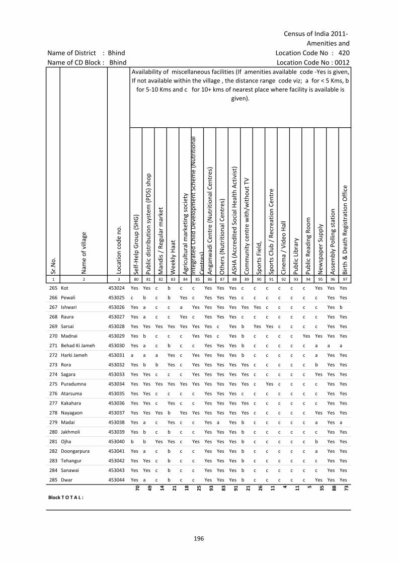
Census of India 2011- Amenities and
Name of District : Bhind Location Code No : 420Name of CD Block : Bhind Location Code No : 0012
Self-
Hel
p G
roup
(SH
G)
Publ
ic d
istr
ibut
ion
syst
em (P
DS)
sho
p
Man
dis
/ Re
gula
r m
arke
t
Wee
kly
Haa
t
Agr
icul
tura
l mar
ketin
g so
ciet
yIn
tegr
ated
Chi
ld D
evel
opm
ent S
chem
e (N
utri
tiona
l Ce
ntre
s)A
ngan
wad
i Cen
tre
(Nut
ritio
nal C
entr
es)
Oth
ers
(Nut
ritio
nal C
entr
es)
ASH
A (A
ccre
dite
d So
cial
Hea
lth A
ctiv
ist)
Com
mun
ity c
entr
e w
ith/w
ithou
t TV
Spor
ts F
ield
,
Spor
ts C
lub
/ Re
crea
tion
Cent
re
Cine
ma
/ Vi
deo
Hal
l
Publ
ic L
ibra
ry
Publ
ic R
eadi
ng R
oom
New
spap
er S
uppl
y
Ass
embl
y Po
lling
sta
tion
Birt
h &
Dea
th R
egis
trat
ion
Off
ice
1 2 3 80 81 82 83 84 85 86 87 88 89 90 91 92 93 94 95 96 97
Sr.N
o.
Nam
e of
vill
age
Loca
tion
code
no.
Availability of miscellaneous facilities (If amenities available code -Yes is given, If not available within the village , the distance range code viz; a for < 5 Kms, b
for 5-10 Kms and c for 10+ kms of nearest place where facility is available is given).
265 Kot 453024 Yes Yes c b c c Yes Yes Yes c c c c c c Yes Yes Yes
266 Pewali 453025 c b c b Yes c Yes Yes Yes c c c c c c c Yes Yes
267 Ishwari 453026 Yes a c c a Yes Yes Yes Yes Yes Yes c c c c c Yes b
268 Raura 453027 Yes a c c Yes c Yes Yes Yes c c c c c c c Yes Yes
269 Sarsai 453028 Yes Yes Yes Yes Yes Yes Yes c Yes b Yes Yes c c c c Yes Yes
270 Madnai 453029 Yes b c c c Yes Yes c Yes b c c c c Yes Yes Yes Yes
271 Behad Ki Jameh 453030 Yes a c b c c Yes Yes Yes b c c c c c a a a
272 Harki Jameh 453031 a a a Yes c Yes Yes Yes Yes b c c c c c a Yes Yes
273 Rora 453032 Yes b b Yes c Yes Yes Yes Yes Yes c c c c c b Yes Yes
274 Sagara 453033 Yes Yes c c c Yes Yes Yes Yes Yes c c c c c Yes Yes Yes
275 Puradumna 453034 Yes Yes Yes Yes Yes Yes Yes Yes Yes Yes c Yes c c c c Yes Yes
276 Atarsuma 453035 Yes Yes c c c c Yes Yes Yes c c c c c c c Yes Yes
277 Kakahara 453036 Yes Yes c Yes c c Yes Yes Yes Yes c c c c c c Yes Yes
278 Nayagaon 453037 Yes Yes Yes b Yes Yes Yes Yes Yes Yes c c c c c Yes Yes Yes
279 Madai 453038 Yes a c Yes c c Yes a Yes b c c c c c a Yes a
280 Jakhmoli 453039 Yes b c b c c Yes Yes Yes b c c c c c c Yes Yes
281 Ojha 453040 b b Yes Yes c Yes Yes Yes Yes b c c c c c b Yes Yes
282 Doongarpura 453041 Yes a c b c c Yes Yes Yes b c c c c c a Yes Yes
283 Tehangur 453042 Yes Yes c b c c Yes Yes Yes b c c c c c c Yes Yes
284 Sanawai 453043 Yes Yes c b c c Yes Yes Yes b c c c c c c Yes Yes
285 Dwar 453044 Yes a c b c c Yes Yes Yes b c c c c c Yes Yes Yes
Block T O T A L :
70 49 14 21 18 25 93 83 91 21 26 11 4 11 5 35 88 73
196
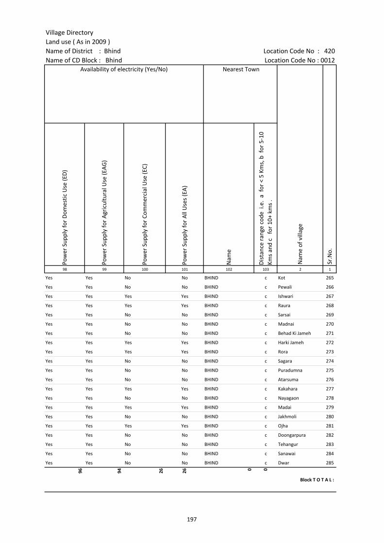
Village DirectoryLand use ( As in 2009 )Name of District : Bhind Location Code No : 420Name of CD Block : Bhind Location Code No : 0012
Pow
er S
uppl
y fo
r D
omes
tic U
se (E
D)
Pow
er S
uppl
y fo
r A
gric
ultu
ral U
se (E
AG
)
Pow
er S
uppl
y fo
r Co
mm
erci
al U
se (E
C)
Pow
er S
uppl
y fo
r A
ll U
ses
(EA
)
Nam
e
Dis
tanc
e ra
nge
code
i.e
. a
for
< 5
Kms,
b f
or 5
-10
Kms
and
c f
or 1
0+ k
ms
.98 99 100 101 102 103 2 1
Nearest Town
Nam
e of
vill
age
Sr.N
o.
Availability of electricity (Yes/No)
Yes Yes No No BHIND c Kot 265
Yes Yes No No BHIND c Pewali 266
Yes Yes Yes Yes BHIND c Ishwari 267
Yes Yes Yes Yes BHIND c Raura 268
Yes Yes No No BHIND c Sarsai 269
Yes Yes No No BHIND c Madnai 270
Yes Yes No No BHIND c Behad Ki Jameh 271
Yes Yes Yes Yes BHIND c Harki Jameh 272
Yes Yes Yes Yes BHIND c Rora 273
Yes Yes No No BHIND c Sagara 274
Yes Yes No No BHIND c Puradumna 275
Yes Yes No No BHIND c Atarsuma 276
Yes Yes Yes Yes BHIND c Kakahara 277
Yes Yes No No BHIND c Nayagaon 278
Yes Yes Yes Yes BHIND c Madai 279
Yes Yes No No BHIND c Jakhmoli 280
Yes Yes Yes Yes BHIND c Ojha 281
Yes Yes No No BHIND c Doongarpura 282
Yes Yes No No BHIND c Tehangur 283
Yes Yes No No BHIND c Sanawai 284
Yes Yes No No BHIND c Dwar 285
96 94 26 26 0 0
Block T O T A L :
197
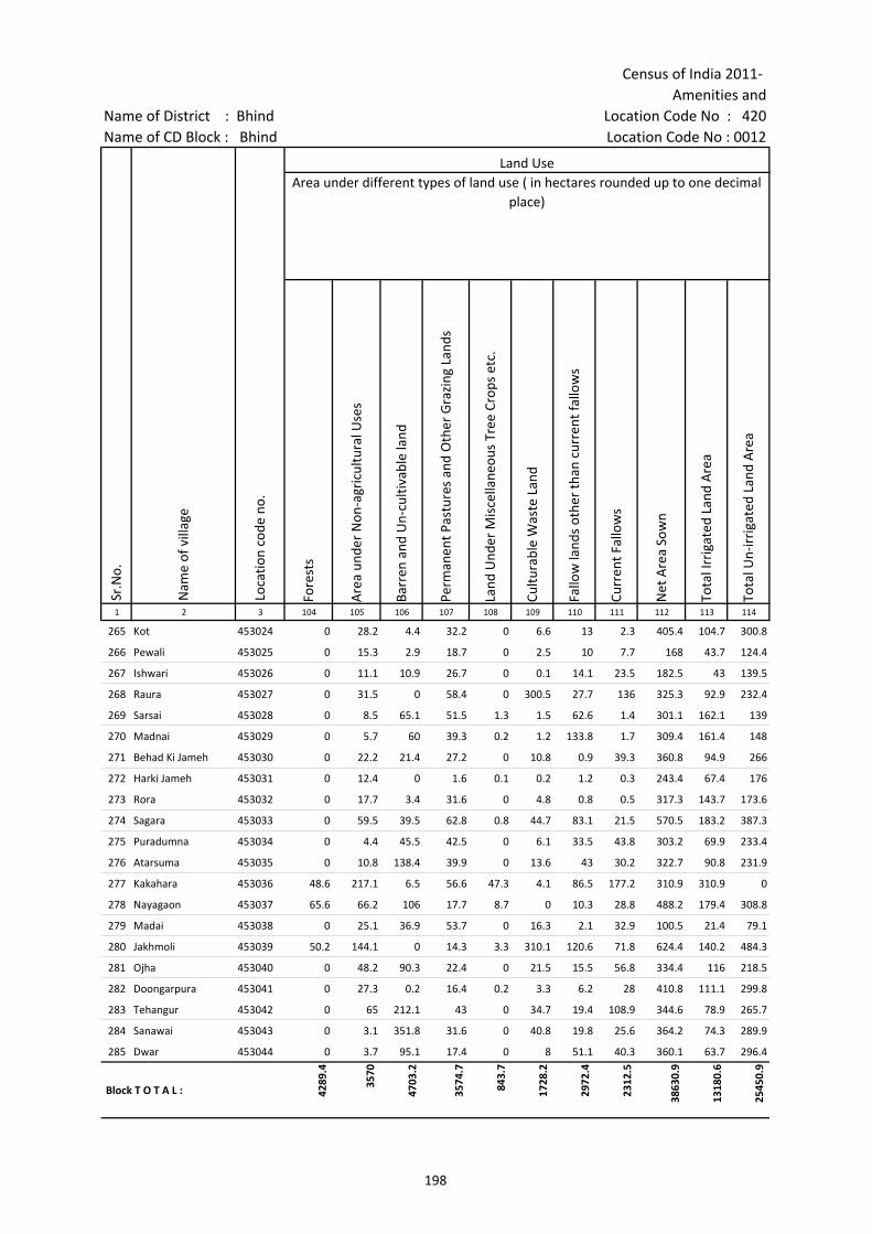
Census of India 2011- Amenities and
Name of District : Bhind Location Code No : 420Name of CD Block : Bhind Location Code No : 0012
Fore
sts
Are
a un
der
Non
-agr
icul
tura
l Use
s
Barr
en a
nd U
n-cu
ltiva
ble
land
Perm
anen
t Pas
ture
s an
d O
ther
Gra
zing
Lan
ds
Land
Und
er M
isce
llane
ous
Tree
Cro
ps e
tc.
Cultu
rabl
e W
aste
Lan
d
Fallo
w la
nds
othe
r th
an c
urre
nt fa
llow
s
Curr
ent F
allo
ws
Net
Are
a So
wn
Tota
l Irr
igat
ed L
and
Are
a
Tota
l Un-
irri
gate
d La
nd A
rea
1 2 3 104 105 106 107 108 109 110 111 112 113 114
Land UseArea under different types of land use ( in hectares rounded up to one decimal
place)
Sr.N
o.
Nam
e of
vill
age
Loca
tion
code
no.
265 Kot 453024 0 28.2 4.4 32.2 0 6.6 13 2.3 405.4 104.7 300.8
266 Pewali 453025 0 15.3 2.9 18.7 0 2.5 10 7.7 168 43.7 124.4
267 Ishwari 453026 0 11.1 10.9 26.7 0 0.1 14.1 23.5 182.5 43 139.5
268 Raura 453027 0 31.5 0 58.4 0 300.5 27.7 136 325.3 92.9 232.4
269 Sarsai 453028 0 8.5 65.1 51.5 1.3 1.5 62.6 1.4 301.1 162.1 139
270 Madnai 453029 0 5.7 60 39.3 0.2 1.2 133.8 1.7 309.4 161.4 148
271 Behad Ki Jameh 453030 0 22.2 21.4 27.2 0 10.8 0.9 39.3 360.8 94.9 266
272 Harki Jameh 453031 0 12.4 0 1.6 0.1 0.2 1.2 0.3 243.4 67.4 176
273 Rora 453032 0 17.7 3.4 31.6 0 4.8 0.8 0.5 317.3 143.7 173.6
274 Sagara 453033 0 59.5 39.5 62.8 0.8 44.7 83.1 21.5 570.5 183.2 387.3
275 Puradumna 453034 0 4.4 45.5 42.5 0 6.1 33.5 43.8 303.2 69.9 233.4
276 Atarsuma 453035 0 10.8 138.4 39.9 0 13.6 43 30.2 322.7 90.8 231.9
277 Kakahara 453036 48.6 217.1 6.5 56.6 47.3 4.1 86.5 177.2 310.9 310.9 0
278 Nayagaon 453037 65.6 66.2 106 17.7 8.7 0 10.3 28.8 488.2 179.4 308.8
279 Madai 453038 0 25.1 36.9 53.7 0 16.3 2.1 32.9 100.5 21.4 79.1
280 Jakhmoli 453039 50.2 144.1 0 14.3 3.3 310.1 120.6 71.8 624.4 140.2 484.3
281 Ojha 453040 0 48.2 90.3 22.4 0 21.5 15.5 56.8 334.4 116 218.5
282 Doongarpura 453041 0 27.3 0.2 16.4 0.2 3.3 6.2 28 410.8 111.1 299.8
283 Tehangur 453042 0 65 212.1 43 0 34.7 19.4 108.9 344.6 78.9 265.7
284 Sanawai 453043 0 3.1 351.8 31.6 0 40.8 19.8 25.6 364.2 74.3 289.9
285 Dwar 453044 0 3.7 95.1 17.4 0 8 51.1 40.3 360.1 63.7 296.4
Block T O T A L : 4289
.4
3570
4703
.2
3574
.7
843.
7
1728
.2
2972
.4
2312
.5
3863
0.9
1318
0.6
2545
0.9
198

Village DirectoryLand use ( As in 2009 )Name of District : Bhind Location Code No : 420Name of CD Block : Bhind Location Code No : 0012
Cana
ls (
C )
Wel
ls/T
ube-
wel
ls(W
/TW
)
Tank
s/La
kes(
T/L)
Wat
er F
alls
(WF)
Oth
ers(
O)
Firs
t
Seco
nd
Thir
d 115 116 117 118 119 120 121 122 2 1
Land Use Name of three most important commodities manufactured
Nam
e of
Vill
age
Sr.N
o.
Area irrigated by source (in hectare).
0 104.7 0 0 0 Kot 265
0 43.7 0 0 0 Pewali 266
0 43 0 0 0 Ishwari 267
0 92.9 0 0 0 Raura 268
0 162.1 0 0 0 Sarsai 269
161.4 0 0 0 0 Madnai 270
0 94.9 0 0 0 Behad Ki Jameh 271
0 67.4 0 0 0 Harki Jameh 272
0 143.7 0 0 0 Rora 273
0 183.2 0 0 0 Sagara 274
0 69.9 0 0 0 Puradumna 275
0 90.8 0 0 0 Atarsuma 276
310.9 0 0 0 0 Kakahara 277
0 179.4 0 0 0 Nayagaon 278
0 21.4 0 0 0 Madai 279
0 140.2 0 0 0 Jakhmoli 280
0 116 0 0 0 Ojha 281
0 111.1 0 0 0 Doongarpura 282
0 78.9 0 0 0 Tehangur 283
0 74.3 0 0 0 Sanawai 284
0 63.7 0 0 0 Dwar 285
1510
.2
1094
8.2
116.
1 0
Block T O T A L :
199
200
(b) Map of Mehgaon CD Block showing tahsil boundary.
(c) Alphabetical list of Villages of Mehgaon CD Block along with location code 2001 and 2011.
(d) Village Directory data of Mehgaon CD Block in prescribed format.
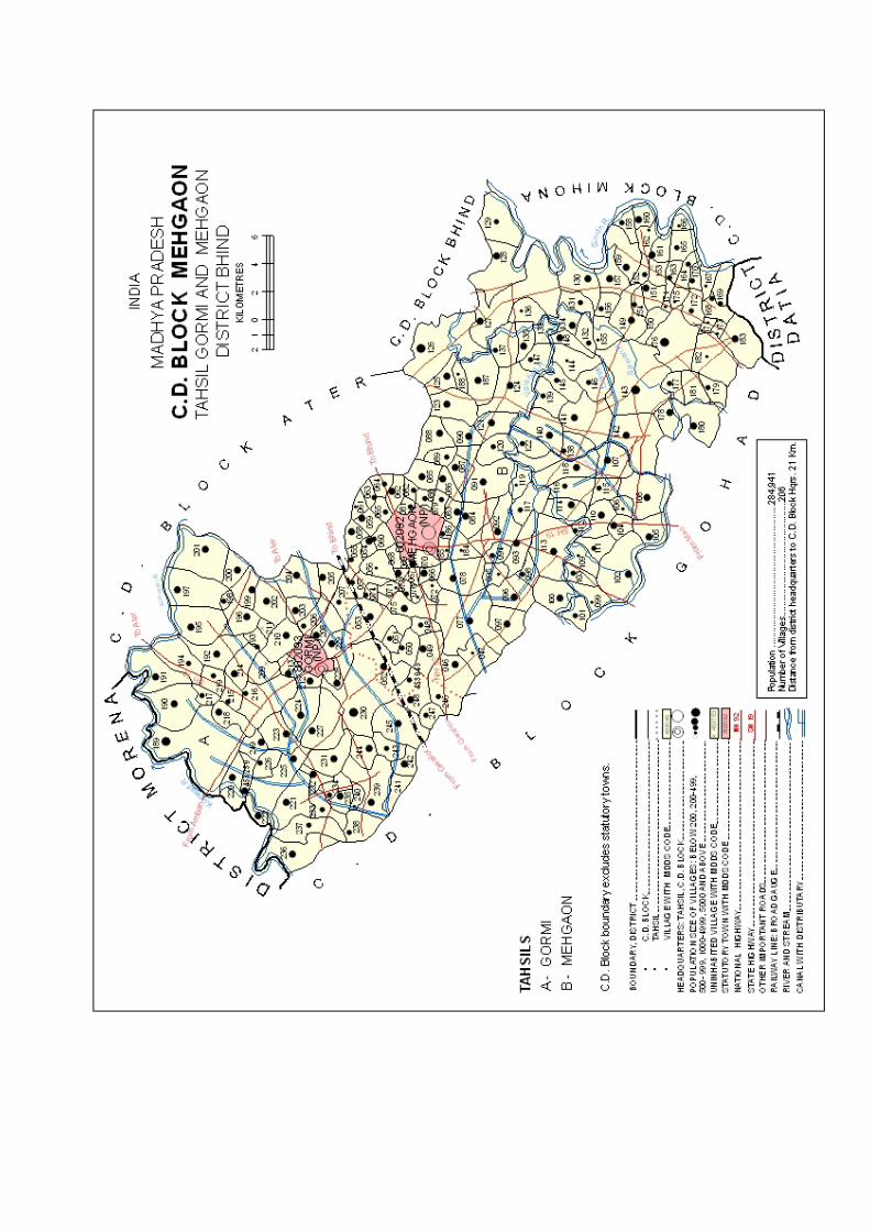

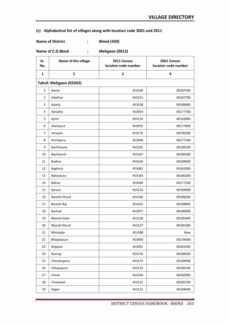
VILLAGE DIRECTORY
DISTRICTCENSUSHANDBOOK:BHIND203
(c) Alphabetical list of villages along with location code 2001 and 2011
Name of District : Bhind (420)
Name of C.D.Block : Mehgaon (0013)
Sr. No.
Name of the village 2011 Census location code number
2001 Census location code number
1 2 3 4
Tahsil: Mehgaon (03393)
1 Aanto 453149 00187500
2 Adokhar 453151 00187700
3 Ajeeta 453158 00188400
4 Ajnodha 453054 00177700
5 Ajnol 453114 00183900
6 Alampura 453055 00177800
7 Amayan 453176 00190200
8 Amritpura 453048 00177100
9 Bachhareta 453165 00189100
10 Bachharoli 453167 00189300
11 Badera 453164 00189000
12 Baghora 453085 00181000
13 Baharpura 453184 00180200
14 Bahua 453049 00177200
15 Baraso 453124 00184900
16 Barethi Khurd 453166 00189200
17 Barethi Raj 453162 00188800
18 Barhad 453077 00180000
19 Bharoli Kalan 453128 00185400
20 Bharoli Khurd 453127 00185300
21 Bhindada 453188 New
22 Bhopatpura 453060 00178300
23 Birgwan 453091 00181600
24 Buzurg 453156 00188200
25 Chandrapura 453173 00189900
26 Chhajupura 453135 00186100
27 Chirol 453104 00182900
28 Chutawali 453131 00185700
29 Dagar 453121 00184600
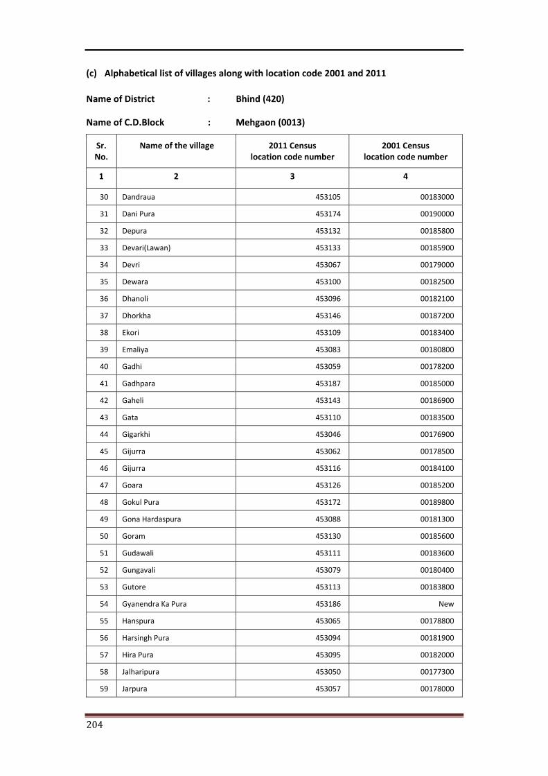
204
(c) Alphabetical list of villages along with location code 2001 and 2011
Name of District : Bhind (420)
Name of C.D.Block : Mehgaon (0013)
Sr. No.
Name of the village 2011 Census location code number
2001 Census location code number
1 2 3 4
30 Dandraua 453105 00183000
31 Dani Pura 453174 00190000
32 Depura 453132 00185800
33 Devari(Lawan) 453133 00185900
34 Devri 453067 00179000
35 Dewara 453100 00182500
36 Dhanoli 453096 00182100
37 Dhorkha 453146 00187200
38 Ekori 453109 00183400
39 Emaliya 453083 00180800
40 Gadhi 453059 00178200
41 Gadhpara 453187 00185000
42 Gaheli 453143 00186900
43 Gata 453110 00183500
44 Gigarkhi 453046 00176900
45 Gijurra 453062 00178500
46 Gijurra 453116 00184100
47 Goara 453126 00185200
48 Gokul Pura 453172 00189800
49 Gona Hardaspura 453088 00181300
50 Goram 453130 00185600
51 Gudawali 453111 00183600
52 Gungavali 453079 00180400
53 Gutore 453113 00183800
54 Gyanendra Ka Pura 453186 New
55 Hanspura 453065 00178800
56 Harsingh Pura 453094 00181900
57 Hira Pura 453095 00182000
58 Jalharipura 453050 00177300
59 Jarpura 453057 00178000
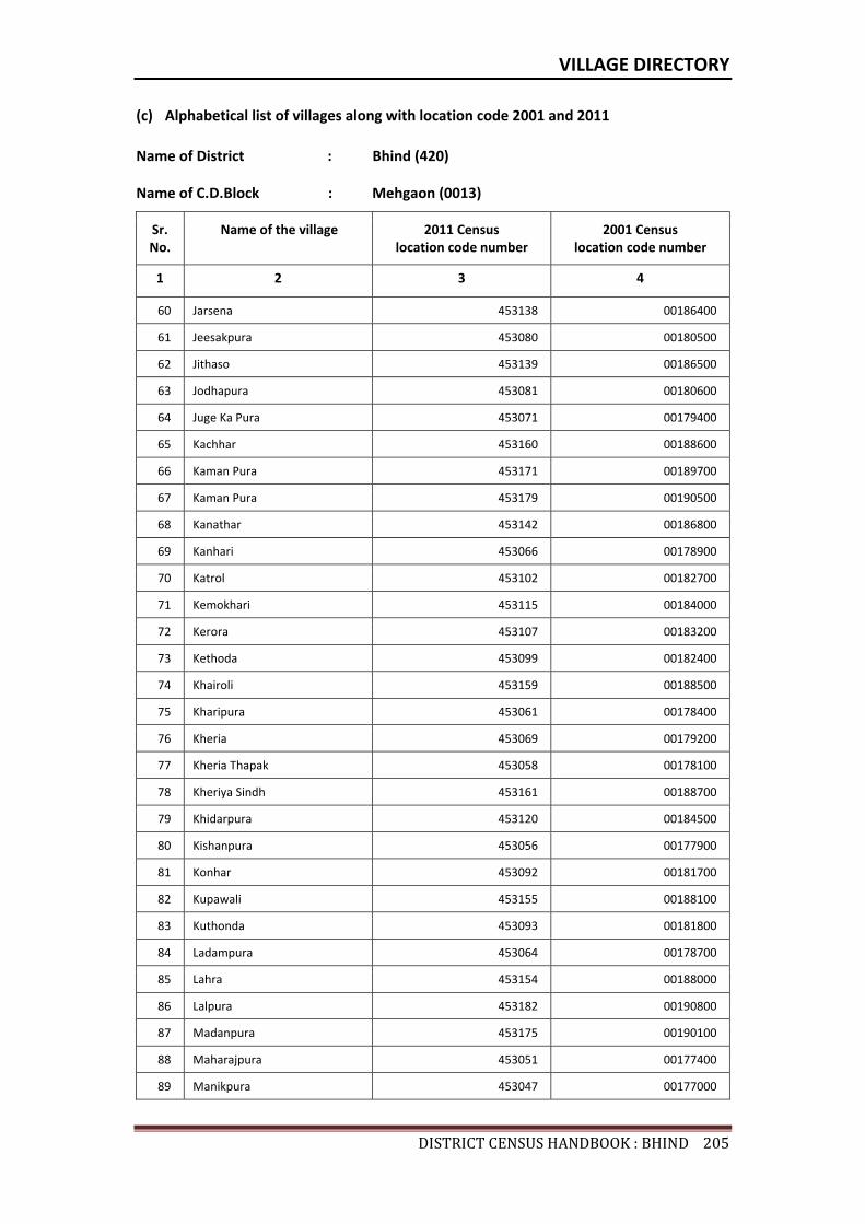
VILLAGE DIRECTORY
DISTRICTCENSUSHANDBOOK:BHIND205
(c) Alphabetical list of villages along with location code 2001 and 2011
Name of District : Bhind (420)
Name of C.D.Block : Mehgaon (0013)
Sr. No.
Name of the village 2011 Census location code number
2001 Census location code number
1 2 3 4
60 Jarsena 453138 00186400
61 Jeesakpura 453080 00180500
62 Jithaso 453139 00186500
63 Jodhapura 453081 00180600
64 Juge Ka Pura 453071 00179400
65 Kachhar 453160 00188600
66 Kaman Pura 453171 00189700
67 Kaman Pura 453179 00190500
68 Kanathar 453142 00186800
69 Kanhari 453066 00178900
70 Katrol 453102 00182700
71 Kemokhari 453115 00184000
72 Kerora 453107 00183200
73 Kethoda 453099 00182400
74 Khairoli 453159 00188500
75 Kharipura 453061 00178400
76 Kheria 453069 00179200
77 Kheria Thapak 453058 00178100
78 Kheriya Sindh 453161 00188700
79 Khidarpura 453120 00184500
80 Kishanpura 453056 00177900
81 Konhar 453092 00181700
82 Kupawali 453155 00188100
83 Kuthonda 453093 00181800
84 Ladampura 453064 00178700
85 Lahra 453154 00188000
86 Lalpura 453182 00190800
87 Madanpura 453175 00190100
88 Maharajpura 453051 00177400
89 Manikpura 453047 00177000

206
(c) Alphabetical list of villages along with location code 2001 and 2011
Name of District : Bhind (420)
Name of C.D.Block : Mehgaon (0013)
Sr. No.
Name of the village 2011 Census location code number
2001 Census location code number
1 2 3 4
90 Manikpura 453103 00182800
91 Meghpura 453074 00179700
92 Mehra 453183 00190900
93 Moroli 453075 00179800
94 Musawali 453129 00185500
95 Mustra 453087 00181200
96 Mustri 453086 00181100
97 Narayan Pura 453072 00179500
98 Neemgaon 453123 00184800
99 Norasai 453136 00186200
100 Pachera 453078 00180100
101 Padkoli 453108 00183300
102 Pamarpura 453112 00183700
103 Panauwa 453045 00176800
104 Parghana 453180 00190600
105 Parrawan 453097 00182200
106 Patlokhari 453137 00186300
107 Piparoa 453177 00190300
108 Piproli 453084 00180900
109 Piproli 453181 00190700
110 Pratap Pura 453073 00179600
111 Pura 453163 00188900
112 Rabia Pura 453098 00182300
113 Raipura 453089 00181400
114 Rajpura 453101 00182600
115 Rampura 453076 00179900
116 Ranupura 453140 00186600
117 Rasaldar Ka Pura 453185 New
118 Renka 453082 00180700
119 Sadha 453157 00188300
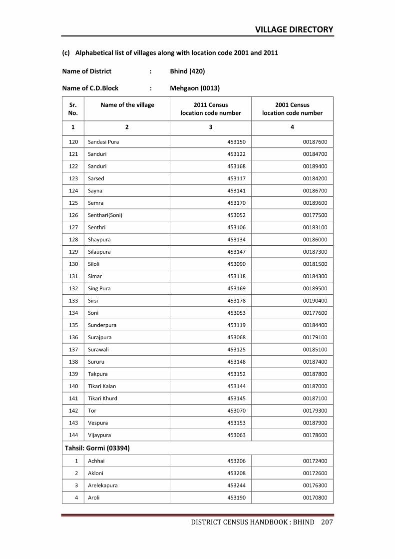
VILLAGE DIRECTORY
DISTRICTCENSUSHANDBOOK:BHIND207
(c) Alphabetical list of villages along with location code 2001 and 2011
Name of District : Bhind (420)
Name of C.D.Block : Mehgaon (0013)
Sr. No.
Name of the village 2011 Census location code number
2001 Census location code number
1 2 3 4
120 Sandasi Pura 453150 00187600
121 Sanduri 453122 00184700
122 Sanduri 453168 00189400
123 Sarsed 453117 00184200
124 Sayna 453141 00186700
125 Semra 453170 00189600
126 Senthari(Soni) 453052 00177500
127 Senthri 453106 00183100
128 Shaypura 453134 00186000
129 Silaupura 453147 00187300
130 Siloli 453090 00181500
131 Simar 453118 00184300
132 Sing Pura 453169 00189500
133 Sirsi 453178 00190400
134 Soni 453053 00177600
135 Sunderpura 453119 00184400
136 Surajpura 453068 00179100
137 Surawali 453125 00185100
138 Sururu 453148 00187400
139 Takpura 453152 00187800
140 Tikari Kalan 453144 00187000
141 Tikari Khurd 453145 00187100
142 Tor 453070 00179300
143 Vespura 453153 00187900
144 Vijaypura 453063 00178600
Tahsil: Gormi (03394)
1 Achhai 453206 00172400
2 Akloni 453208 00172600
3 Arelekapura 453244 00176300
4 Aroli 453190 00170800
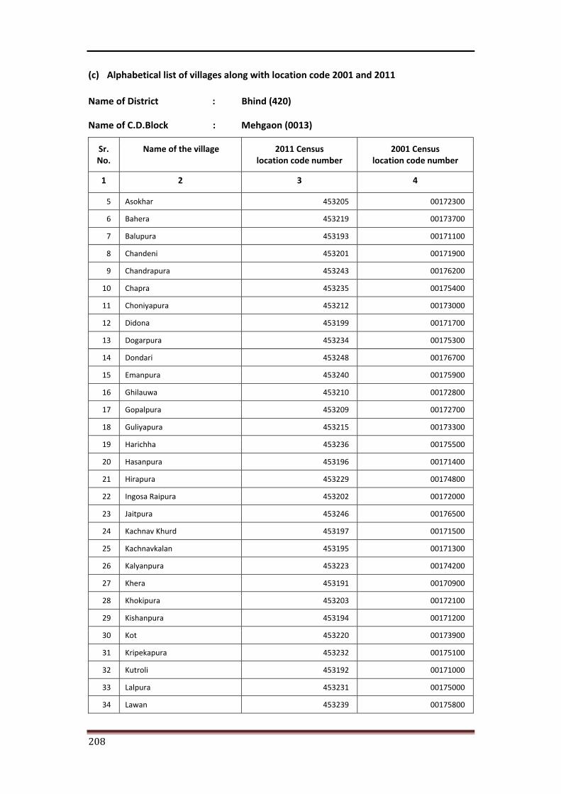
208
(c) Alphabetical list of villages along with location code 2001 and 2011
Name of District : Bhind (420)
Name of C.D.Block : Mehgaon (0013)
Sr. No.
Name of the village 2011 Census location code number
2001 Census location code number
1 2 3 4
5 Asokhar 453205 00172300
6 Bahera 453219 00173700
7 Balupura 453193 00171100
8 Chandeni 453201 00171900
9 Chandrapura 453243 00176200
10 Chapra 453235 00175400
11 Choniyapura 453212 00173000
12 Didona 453199 00171700
13 Dogarpura 453234 00175300
14 Dondari 453248 00176700
15 Emanpura 453240 00175900
16 Ghilauwa 453210 00172800
17 Gopalpura 453209 00172700
18 Guliyapura 453215 00173300
19 Harichha 453236 00175500
20 Hasanpura 453196 00171400
21 Hirapura 453229 00174800
22 Ingosa Raipura 453202 00172000
23 Jaitpura 453246 00176500
24 Kachnav Khurd 453197 00171500
25 Kachnavkalan 453195 00171300
26 Kalyanpura 453223 00174200
27 Khera 453191 00170900
28 Khokipura 453203 00172100
29 Kishanpura 453194 00171200
30 Kot 453220 00173900
31 Kripekapura 453232 00175100
32 Kutroli 453192 00171000
33 Lalpura 453231 00175000
34 Lawan 453239 00175800
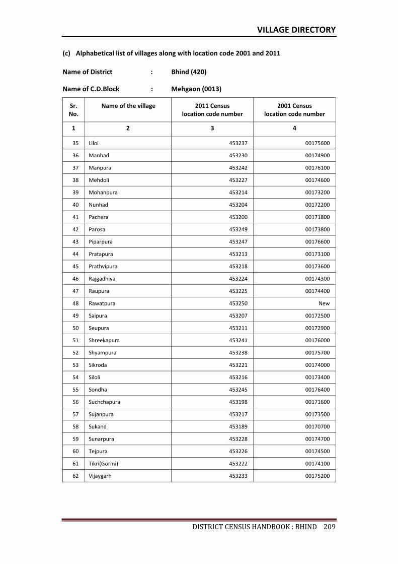
VILLAGE DIRECTORY
DISTRICTCENSUSHANDBOOK:BHIND209
(c) Alphabetical list of villages along with location code 2001 and 2011
Name of District : Bhind (420)
Name of C.D.Block : Mehgaon (0013)
Sr. No.
Name of the village 2011 Census location code number
2001 Census location code number
1 2 3 4
35 Liloi 453237 00175600
36 Manhad 453230 00174900
37 Manpura 453242 00176100
38 Mehdoli 453227 00174600
39 Mohanpura 453214 00173200
40 Nunhad 453204 00172200
41 Pachera 453200 00171800
42 Parosa 453249 00173800
43 Piparpura 453247 00176600
44 Pratapura 453213 00173100
45 Prathvipura 453218 00173600
46 Rajgadhiya 453224 00174300
47 Raupura 453225 00174400
48 Rawatpura 453250 New
49 Saipura 453207 00172500
50 Seupura 453211 00172900
51 Shreekapura 453241 00176000
52 Shyampura 453238 00175700
53 Sikroda 453221 00174000
54 Siloli 453216 00173400
55 Sondha 453245 00176400
56 Suchchapura 453198 00171600
57 Sujanpura 453217 00173500
58 Sukand 453189 00170700
59 Sunarpura 453228 00174700
60 Tejpura 453226 00174500
61 Tikri(Gormi) 453222 00174100
62 Vijaygarh 453233 00175200

Census of India 2011- Amenities and
Name of District : Bhind Location Code No : 420Name of CD Block : Mehgaon Location Code No : 0013
Pre-
Prim
ary
scho
ol (P
P)
Prim
ary
scho
ol (P
)
Mid
dle
scho
ol (M
)
Seco
ndar
y Sc
hool
(S)
Seni
or S
econ
dary
sch
ool (
SS)
Deg
ree
colle
ge o
f art
s s
cien
ce &
com
mer
ce (
ASC
)
Engi
neer
ing
colle
ge(E
C)
Med
ical
col
lege
(MC)
Man
agem
ent i
nstit
ute
(MI)
Poly
tech
nic
(Pt)
Voca
tiona
l tra
inin
g sc
hool
/IT
I
Non
-for
mal
trai
ning
cen
tre
(NFT
C)
Spec
ial s
choo
l for
dis
able
d (S
SD)
Oth
ers
(spe
cify
)
1 2 3 4 5 6 7 8 9 10 11 12 13 14 15 16 17 18 19 20
286 Panauwa 453045 157.9 651 100 c 1 a a c c c c c c c c c c
287 Gigarkhi 453046 418.2 1623 293 2 2 1 1 1 c c c c c
288 Manikpura 453047 234.2 313 39 a 1 a a a c c c c c c c c c
289 Amritpura 453048 172.8 781 119 b 1 a a b b c c c c c c c c
290 Bahua 453049 533 1454 235 b 1 2 a b b c c c c c c c c
291 Jalharipura 453050 161.2 547 93 b 2 1 b b b c c c c c c c c
292 Maharajpura 453051 206.7 564 115 b 1 a a b b c c c c c c c c
293 Senthari(Soni) 453052 612.5 1757 308 b 3 1 b b c c c c c c c
294 Soni 453053 1325.3 4441 859 1 5 3 1 1 b c c c c c c
295 Ajnodha 453054 498.8 2240 429 2 1 1 b b c c c c c c c
296 Alampura 453055 187.2 564 90 b 3 b 1 1 c c c c c c
297 Kishanpura 453056 117.8 294 60 2 a b b b c c c c c c c c
298 Jarpura 453057 110.2 932 191 1 1 1 a c c c c
299 Kheria Thapak 453058 205.3 1063 166 b 1 b b b b c c c c c c c
300 Gadhi 453059 545.3 1654 300 a 2 2 a a a c c c c c c c
301 Bhopatpura 453060 122.4 539 107 a 1 a a a a c c c c c c c
302 Kharipura 453061 125.3 423 94 2 1 b b b c c c c c c c
303 Gijurra 453062 254.7 1226 205 1 2 1 1 1 b c c c c c c
304 Vijaypura 453063 192.4 894 145 1 a b b b c c c c c c
305 Ladampura 453064 139.6 599 113 b 2 1 1 1 b c c c c c c c
306 Hanspura 453065 144.4 721 137 1 a b b b c c c c c c c
307 Kanhari 453066 363.5 2288 386 a 2 1 a a a c c c c
308 Devri 453067 298.7 2279 470 a 1 1 1 a a c c c a c a a
309 Surajpura 453068 63.9 178 38 a 1 a a a a c c c c c c c
310 Kheria 453069 145 3763 658 2 4 3 2 1 a c c c c c c c
311 Tor 453070 61.7 0 0 --------------Un-inhabited--------------
Sr.N
o.
Nam
e of
vill
age
Loca
tion
code
no.
Tota
l are
a of
the
villa
ge (
in h
ecta
res
roun
ded
up to
one
dec
imal
pla
ce)
Tota
l pop
ulat
ion
( 201
1 ce
nsus
)
Num
ber
of h
ouse
hold
s (2
011
cens
us)
Number of educational amenities available. (If not available within the village , the distance range
code viz; a for < 5 Kms, b for 5-10 Kms and c for 10+ kms of nearest place where facility is available is given).
210

Village DirectoryLand use ( As in 2009 )Name of District : Bhind Location Code No : 420Name of CD Block : Mehgaon Location Code No : 0013
Com
mun
ity h
ealth
cen
tre
(CH
C)Pr
imar
y he
alth
cen
tre
(PH
C)Pr
imar
y he
alth
sub
cen
tre
(PH
S)M
ater
nity
and
chi
ld w
elfa
re c
entr
e (M
CW)
T.B.
clin
ic (
TBC)
Hos
pita
l-allo
path
ic (H
A)
Hos
pita
l-alte
rnat
ive
med
icin
e (H
O)
Dis
pens
ary
(D)
Vete
rina
ry h
ospi
tal (
VH)
Mob
ile h
ealth
clin
ic (M
HC)
Fam
ily w
elfa
re c
entr
e (F
WC)
Char
itabl
e no
n G
ovt.
hos
pita
l/N
ursi
ng h
ome.
Med
ical
pra
ctiti
oner
with
MBB
S D
egre
eM
edic
al p
ract
ition
er w
ith o
ther
deg
ree
Med
ical
pra
ctiti
oner
with
no
degr
eeTr
aditi
onal
pra
ctiti
oner
and
faith
hea
ler
.M
edic
ine
Shop
Oth
ers
Tap
wat
er (T
reat
ed/U
ntre
ated
)
Wel
l w
ater
(C
over
ed /
Unc
over
ed w
ell)
Han
d Pu
mp
Tube
wel
ls /
Bor
e w
ell
Spri
ng
Rive
r /
Cana
l
Tank
/ P
ond
/ L
ake
Oth
ers
21 22 23 24 25 26 27 28 29 30 31 32 33 34 35 36 37 38 39 40 41 42 43 44 45 46 2 1
c c a c c c c a b c c 0 0 0 0 1 0 0 No Yes Yes Yes No No Yes No Panauwa 286
c c a c c c c c c c a 0 0 0 0 0 0 0 No Yes Yes No No Yes No No Gigarkhi 287
c c b c c c c c a c c 0 0 0 0 0 0 0 No Yes Yes Yes No Yes Yes No Manikpura 288
b b a b b b b b a b b 0 0 0 0 1 0 0 No Yes Yes Yes Yes No No Yes Amritpura 289
b b 1 b b b b b a b b 0 0 0 2 2 0 0 No Yes Yes Yes No Yes Yes No Bahua 290
b b a b b b b b a b b 0 0 0 0 1 0 0 No Yes Yes Yes No No Yes No Jalharipura 291
b b b b b b b b a b b 0 0 0 0 1 0 0 No Yes Yes Yes No No No No Maharajpura 292
b b a b b b b b a c b 0 0 0 1 0 0 0 No Yes Yes Yes No No Yes No Senthari(Soni) 293
b b 1 b b b b b 1 b b 0 0 1 3 1 0 0 Yes Yes Yes Yes No Yes No No Soni 294
b b 1 b b b b c b b b 0 0 0 0 0 0 0 No Yes Yes No No Yes No No Ajnodha 295
b b b c b b b b b b b 0 0 0 0 0 0 0 No Yes Yes No No Yes Yes No Alampura 296
b b b b b b c b b b b 0 0 0 0 0 0 0 No Yes Yes No No Yes No No Kishanpura 297
b b b b b b b b 0 0 0 0 0 0 0 No No Yes No No Yes Yes No Jarpura 298
b b b b b b c b b c b 0 0 0 0 0 0 0 No No Yes No No No No No Kheria Thapak 299
a a a a a a a a a a a 0 0 0 0 0 0 0 No Yes Yes Yes No Yes No No Gadhi 300
a a a a a a c a a c a 0 0 0 0 0 0 0 No No Yes No No No No No Bhopatpura 301
c b a b b b b a b b 0 0 0 0 0 0 0 No Yes Yes No No No No No Kharipura 302
b b b b b b b b 1 b b 0 0 0 0 0 0 0 No Yes Yes Yes No Yes No No Gijurra 303
c b a b b b b a b b 0 0 0 1 0 0 0 No Yes Yes No No No No No Vijaypura 304
b b b b b b b b b b b 0 0 0 0 0 0 0 No Yes Yes Yes No No No No Ladampura 305
c b a b b b b b b b 0 0 0 0 0 0 0 No Yes Yes No No No No No Hanspura 306
a a a a a a a a a a a 0 0 0 0 0 0 0 No Yes Yes No No No No No Kanhari 307
a a a a a a a a a a a 0 0 0 0 0 0 0 No Yes Yes Yes No No No No Devri 308
a a a a a c c c a a c 0 0 0 0 0 0 0 No Yes Yes Yes No Yes No No Surajpura 309
a a a a a a a a a a a 0 0 0 0 0 0 0 No Yes Yes No No No No No Kheria 310
--------------Un-inhabited-------------- Tor 311
Number of Non-Government
Medical Amenities available.
Availability of drinking water - Yes / No
Nam
e of
vill
age
Sr.N
o.
Number of Medical Amenities available. (If not available within the
village , the distance range code viz; a for < 5 Kms, b for 5-10 Kms and c for
10+ kms of nearest place where facility is available is given).
211

Census of India 2011- Amenities and
Name of District : Bhind Location Code No : 420Name of CD Block : Mehgaon Location Code No : 0013
Com
mun
ity to
ilet i
nclu
ding
bat
h.
Com
mun
ity to
ilet e
xclu
ding
bat
h.
Rura
l sa
nita
ry m
art o
r sa
nita
ry h
ardw
are
outle
t av
aila
ble
near
the
villa
ge.
Com
mun
ity b
io- g
as o
r re
cycl
e of
was
te fo
r pr
oduc
tive
use.
Post
off
ice(
PO)
Sub
post
off
ice
(SPO
)
Post
& T
eleg
raph
off
ice
(P&
TO)
Villa
ge P
in C
ode
Tele
phon
es
(L
and
lines
)
Publ
ic c
all o
ffic
e (P
CO)
Mob
ile p
hone
cov
erag
e
Inte
rnet
caf
es/
Com
mon
ser
vice
cen
tre
(CSC
)
Priv
ate
cour
ier
faci
lity
Bus
serv
ice
(Pub
lic &
Pri
vate
)
Railw
ay s
tatio
ns
Aut
o/M
odifi
ed A
utos
Taxi
s an
d Va
ns
1 2 3 47 48 49 50 51 52 53 54 55 56 57 58 59 60 61 62 63
286 Panauwa 453045 No No No No c a c c c Yes c c a a c c
287 Gigarkhi 453046 No No No No Yes Yes c c Yes c c Yes c c c
288 Manikpura 453047 No No No No c a c c c Yes c c a b c c
289 Amritpura 453048 No No No No b a b a b Yes b b Yes b b b
290 Bahua 453049 No No No No a a b b b Yes b b Yes b b b
291 Jalharipura 453050 No No No No b a b b b Yes b b a a b b
292 Maharajpura 453051 No No No No a a b a b Yes b b a a b b
293 Senthari(Soni) 453052 No No No No c Yes b 477557 a b Yes b b a a a Yes
294 Soni 453053 No No No No b Yes b 477557 Yes Yes Yes b b Yes Yes Yes Yes
295 Ajnodha 453054 No No No No b b b 477557 b b Yes b b b b b b
296 Alampura 453055 No No No No b b b b b Yes b b b a b b
297 Kishanpura 453056 No No No No b b b b a Yes b b a b a a
298 Jarpura 453057 No No No No b a Yes b a b b b a b b
299 Kheria Thapak 453058 No No No No a Yes b Yes b b a a b b
300 Gadhi 453059 No No No No a a a a a Yes a a a a a a
301 Bhopatpura 453060 No No No No a a a a Yes a a a b a a
302 Kharipura 453061 No No No No b a a 477111 a b Yes b b a c b b
303 Gijurra 453062 No No No No Yes Yes b b b b b c c b
304 Vijaypura 453063 No No No No b a a a b Yes b b a a b b
305 Ladampura 453064 No No No No b a a b b Yes b b b a b b
306 Hanspura 453065 No No No No b a b a b Yes b b a c b b
307 Kanhari 453066 No No Yes No a a a Yes Yes Yes a a a a a Yes
308 Devri 453067 No No No No a a a Yes a Yes a a Yes a Yes Yes
309 Surajpura 453068 No No No No a a a a a a a a a a b a
310 Kheria 453069 No No No No a a a 477227 Yes a Yes a a Yes a Yes Yes
311 Tor 453070 --------------Un-inhabited--------------
Loca
tion
code
no.
Availability of toilet & others Yes / No
Communication and transport facilities (If amenities available code -Yes is given except for Village Pin Code ,If not available within the village , the distance range code
viz; a for < 5 Kms, b for 5-10 Kms and c for 10+ kms of nearest place where facility is available is given).
Sr.N
o.
Nam
e of
vill
age
212
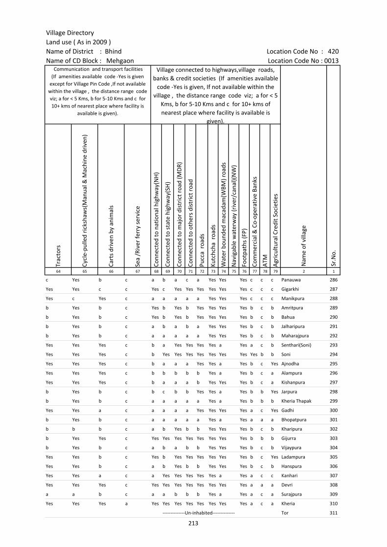
Village DirectoryLand use ( As in 2009 )Name of District : Bhind Location Code No : 420Name of CD Block : Mehgaon Location Code No : 0013
Trac
tors
Cycl
e-pu
lled
rick
shaw
s(M
anua
l & M
achi
ne d
rive
n)
Cart
s dr
iven
by
anim
als
Sea
/Riv
er fe
rry
serv
ice
Conn
ecte
d to
nat
iona
l hig
hway
(NH
)
Conn
ecte
d to
sta
te h
ighw
ay(S
H)
Conn
ecte
d to
maj
or d
istr
ict r
oad
(MD
R)
Conn
ecte
d to
oth
ers
dist
rict
roa
d
Pucc
a r
oads
Kutc
hcha
roa
ds
Wat
er b
ound
ed m
acad
am(W
BM) r
oads
Nav
igab
le w
ater
way
(riv
er/c
anal
)(N
W)
Foot
path
s (F
P)
Com
mer
cial
& C
o-op
erat
ive
Bank
s
ATM
Agr
icul
tura
l Cre
dit S
ocie
ties
64 65 66 67 68 69 70 71 72 73 74 75 76 77 78 79 2 1
c Yes b c a b a c a Yes Yes Yes c c c Panauwa 286
Yes Yes c c Yes c Yes Yes Yes Yes Yes Yes c c c Gigarkhi 287
Yes c Yes c a a a a a Yes Yes Yes c c c Manikpura 288
b Yes b c Yes b Yes b Yes Yes Yes Yes b c b Amritpura 289
b Yes b c Yes b Yes b Yes Yes Yes Yes b c b Bahua 290
b Yes b c a b a b a Yes Yes Yes b c b Jalharipura 291
b Yes b c a a a a a Yes Yes Yes b c b Maharajpura 292
Yes Yes Yes c b a Yes Yes Yes Yes a Yes a c b Senthari(Soni) 293
Yes Yes Yes c b Yes Yes Yes Yes Yes Yes Yes Yes b b Soni 294
Yes Yes Yes c b a a a Yes Yes a Yes b c Yes Ajnodha 295
Yes Yes Yes c b b b b b Yes a Yes b c a Alampura 296
Yes Yes Yes c b a a a b Yes Yes Yes b c a Kishanpura 297
b Yes b c b c b b Yes Yes a Yes b b Yes Jarpura 298
b Yes b c a a a a a Yes a Yes b b b Kheria Thapak 299
Yes Yes a c a a a a Yes Yes Yes Yes a c Yes Gadhi 300
b Yes b c a a a a a Yes a Yes a a a Bhopatpura 301
b b b c a b Yes b b Yes Yes Yes b c b Kharipura 302
b Yes Yes c Yes Yes Yes Yes Yes Yes Yes Yes b b b Gijurra 303
b Yes b c a b a b b Yes Yes Yes b c b Vijaypura 304
Yes Yes b c Yes b Yes Yes Yes Yes Yes Yes b c Yes Ladampura 305
Yes Yes b c a b Yes b b Yes Yes Yes b c b Hanspura 306
Yes Yes a c a Yes Yes Yes Yes Yes a Yes a c c Kanhari 307
Yes Yes Yes c Yes Yes Yes Yes Yes Yes Yes Yes a a a Devri 308
a a b c a a b b b Yes a Yes a c a Surajpura 309
Yes Yes Yes a Yes Yes Yes Yes Yes Yes Yes Yes a c a Kheria 310
--------------Un-inhabited-------------- Tor 311
Sr.N
o.
Communication and transport facilities (If amenities available code -Yes is given
except for Village Pin Code ,If not available within the village , the distance range code viz; a for < 5 Kms, b for 5-10 Kms and c for 10+ kms of nearest place where facility is
available is given).
Village connected to highways,village roads, banks & credit societies (If amenities available
code -Yes is given, If not available within the village , the distance range code viz; a for < 5
Kms, b for 5-10 Kms and c for 10+ kms of nearest place where facility is available is
given).
Nam
e of
vill
age
213
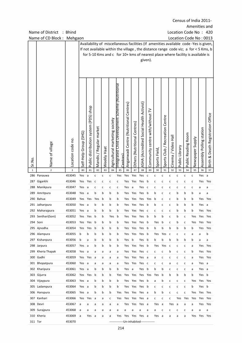
Census of India 2011- Amenities and
Name of District : Bhind Location Code No : 420Name of CD Block : Mehgaon Location Code No : 0013
Self-
Hel
p G
roup
(SH
G)
Publ
ic d
istr
ibut
ion
syst
em (P
DS)
sho
p
Man
dis
/ Re
gula
r m
arke
t
Wee
kly
Haa
t
Agr
icul
tura
l mar
ketin
g so
ciet
yIn
tegr
ated
Chi
ld D
evel
opm
ent S
chem
e (N
utri
tiona
l Ce
ntre
s)A
ngan
wad
i Cen
tre
(Nut
ritio
nal C
entr
es)
Oth
ers
(Nut
ritio
nal C
entr
es)
ASH
A (A
ccre
dite
d So
cial
Hea
lth A
ctiv
ist)
Com
mun
ity c
entr
e w
ith/w
ithou
t TV
Spor
ts F
ield
,
Spor
ts C
lub
/ Re
crea
tion
Cent
re
Cine
ma
/ Vi
deo
Hal
l
Publ
ic L
ibra
ry
Publ
ic R
eadi
ng R
oom
New
spap
er S
uppl
y
Ass
embl
y Po
lling
sta
tion
Birt
h &
Dea
th R
egis
trat
ion
Off
ice
1 2 3 80 81 82 83 84 85 86 87 88 89 90 91 92 93 94 95 96 97
286 Panauwa 453045 Yes a c c c Yes Yes Yes Yes c c c c c c c Yes a
287 Gigarkhi 453046 Yes Yes c c c c Yes Yes Yes b c c c c c c Yes Yes
288 Manikpura 453047 Yes a c c c c Yes a Yes c c c c c c c a a
289 Amritpura 453048 Yes a b b b b Yes Yes Yes b b c c b b b a a
290 Bahua 453049 Yes Yes Yes b b b Yes Yes Yes Yes b c c b b b Yes Yes
291 Jalharipura 453050 Yes a b b b b Yes Yes Yes b b c c b b b Yes a
292 Maharajpura 453051 Yes a b b b b Yes Yes Yes c c c c b b b Yes Yes
293 Senthari(Soni) 453052 Yes Yes b b Yes b Yes Yes Yes b b b c b c Yes Yes Yes
294 Soni 453053 Yes Yes b b b b Yes Yes Yes b Yes b c b c Yes Yes Yes
295 Ajnodha 453054 Yes Yes b b b b Yes Yes Yes b b b b b b b Yes Yes
296 Alampura 453055 b b b b b b Yes Yes Yes b Yes Yes c c c a a b
297 Kishanpura 453056 b a b b b b Yes b Yes b b b b b b b a a
298 Jarpura 453057 Yes a b b b b Yes Yes Yes b Yes Yes c c c a Yes Yes
299 Kheria Thapak 453058 Yes a a a a a Yes Yes Yes c c c b c c b Yes Yes
300 Gadhi 453059 Yes Yes a a a a Yes Yes Yes a a c c c c a Yes Yes
301 Bhopatpura 453060 Yes a a a a a Yes Yes Yes c c c a c c a Yes a
302 Kharipura 453061 Yes a b b b b Yes a Yes b b b c c c a Yes a
303 Gijurra 453062 Yes Yes b b b Yes Yes Yes Yes Yes Yes b b b b b Yes b
304 Vijaypura 453063 Yes a b b b b Yes Yes Yes b a b c c c Yes Yes Yes
305 Ladampura 453064 Yes a b b b b Yes Yes Yes b c c c c c b Yes b
306 Hanspura 453065 Yes a b b b Yes Yes Yes Yes a b b c c c Yes Yes Yes
307 Kanhari 453066 Yes Yes a a c Yes Yes Yes Yes a c c c Yes Yes Yes Yes Yes
308 Devri 453067 a a a a a a Yes Yes Yes a Yes a Yes a a a Yes Yes
309 Surajpura 453068 a a a a a a a a a a a c c c c a a a
310 Kheria 453069 a Yes a a a Yes Yes Yes Yes a Yes a a a a Yes Yes Yes
311 Tor 453070 --------------Un-inhabited--------------
Sr.N
o.
Nam
e of
vill
age
Loca
tion
code
no.
Availability of miscellaneous facilities (If amenities available code -Yes is given, If not available within the village , the distance range code viz; a for < 5 Kms, b
for 5-10 Kms and c for 10+ kms of nearest place where facility is available is given).
214
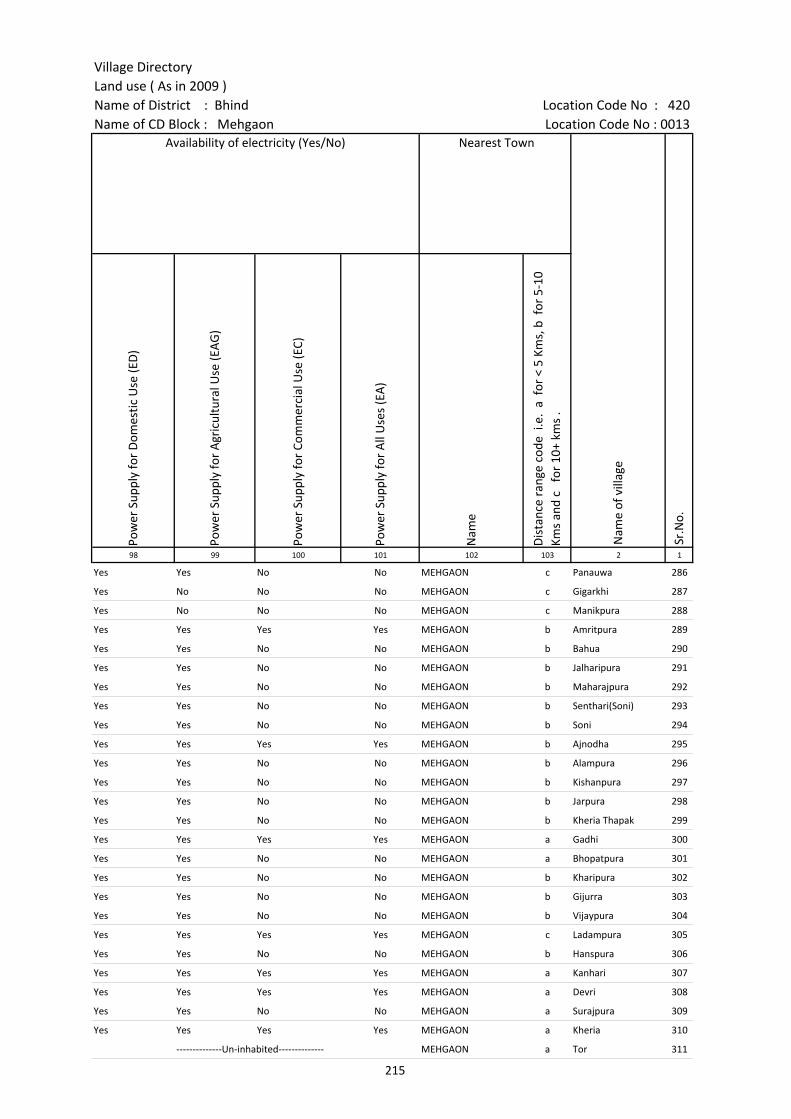
Village DirectoryLand use ( As in 2009 )Name of District : Bhind Location Code No : 420Name of CD Block : Mehgaon Location Code No : 0013
Pow
er S
uppl
y fo
r D
omes
tic U
se (E
D)
Pow
er S
uppl
y fo
r A
gric
ultu
ral U
se (E
AG
)
Pow
er S
uppl
y fo
r Co
mm
erci
al U
se (E
C)
Pow
er S
uppl
y fo
r A
ll U
ses
(EA
)
Nam
e
Dis
tanc
e ra
nge
code
i.e
. a
for
< 5
Kms,
b f
or 5
-10
Kms
and
c f
or 1
0+ k
ms
.98 99 100 101 102 103 2 1
Yes Yes No No MEHGAON c Panauwa 286
Yes No No No MEHGAON c Gigarkhi 287
Yes No No No MEHGAON c Manikpura 288
Yes Yes Yes Yes MEHGAON b Amritpura 289
Yes Yes No No MEHGAON b Bahua 290
Yes Yes No No MEHGAON b Jalharipura 291
Yes Yes No No MEHGAON b Maharajpura 292
Yes Yes No No MEHGAON b Senthari(Soni) 293
Yes Yes No No MEHGAON b Soni 294
Yes Yes Yes Yes MEHGAON b Ajnodha 295
Yes Yes No No MEHGAON b Alampura 296
Yes Yes No No MEHGAON b Kishanpura 297
Yes Yes No No MEHGAON b Jarpura 298
Yes Yes No No MEHGAON b Kheria Thapak 299
Yes Yes Yes Yes MEHGAON a Gadhi 300
Yes Yes No No MEHGAON a Bhopatpura 301
Yes Yes No No MEHGAON b Kharipura 302
Yes Yes No No MEHGAON b Gijurra 303
Yes Yes No No MEHGAON b Vijaypura 304
Yes Yes Yes Yes MEHGAON c Ladampura 305
Yes Yes No No MEHGAON b Hanspura 306
Yes Yes Yes Yes MEHGAON a Kanhari 307
Yes Yes Yes Yes MEHGAON a Devri 308
Yes Yes No No MEHGAON a Surajpura 309
Yes Yes Yes Yes MEHGAON a Kheria 310
--------------Un-inhabited-------------- MEHGAON a Tor 311
Nearest Town
Nam
e of
vill
age
Sr.N
o.
Availability of electricity (Yes/No)
215
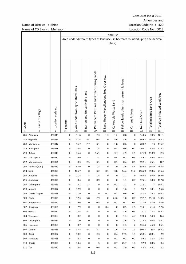
Census of India 2011- Amenities and
Name of District : Bhind Location Code No : 420Name of CD Block : Mehgaon Location Code No : 0013
Fore
sts
Are
a un
der
Non
-agr
icul
tura
l Use
s
Barr
en a
nd U
n-cu
ltiva
ble
land
Perm
anen
t Pas
ture
s an
d O
ther
Gra
zing
Lan
ds
Land
Und
er M
isce
llane
ous
Tree
Cro
ps e
tc.
Cultu
rabl
e W
aste
Lan
d
Fallo
w la
nds
othe
r th
an c
urre
nt fa
llow
s
Curr
ent F
allo
ws
Net
Are
a So
wn
Tota
l Irr
igat
ed L
and
Are
a
Tota
l Un-
irri
gate
d La
nd A
rea
1 2 3 104 105 106 107 108 109 110 111 112 113 114
286 Panauwa 453045 0 11.6 0 2.3 1.3 1.2 0.8 0 140.6 39.5 101.1
287 Gigarkhi 453046 0 31.4 5.4 0.4 0 5.6 5.6 0 369.8 107.6 262.2
288 Manikpura 453047 0 16.7 2.7 3.1 0 1.8 0.6 0 209.2 33 176.2
289 Amritpura 453048 0 10.4 0 1.4 0 0.3 0.6 0.2 160.1 44.4 115.7
290 Bahua 453049 0 36.4 0 16.1 0 3.7 2.9 2.1 471.9 118.9 353
291 Jalharipura 453050 0 6.9 1.2 2.3 0 0.4 0.2 0.5 149.7 46.4 103.3
292 Maharajpura 453051 0 8.3 2.5 3.1 0 0.1 0.4 0.1 192.1 25.1 167
293 Senthari(Soni) 453052 0 47.9 0 1.3 0 0 2.6 4.4 556.4 107.9 448.5
294 Soni 453053 0 126.7 0 3.2 0.1 3.8 14.4 11.2 1165.9 390.6 775.4
295 Ajnodha 453054 0 21.8 8 1.4 0 0 2.1 0 465.4 95.9 369.6
296 Alampura 453055 0 8.4 0 0.9 0 0 1.1 0.7 176.1 38.3 137.8
297 Kishanpura 453056 0 3.1 1.3 0 0 0.2 1.2 0 112.1 7 105.1
298 Jarpura 453057 0 12.9 0 0 0 0 1.6 1 94.7 38.1 56.6
299 Kheria Thapak 453058 0 21.9 0 0 0.1 0.7 0.6 0.7 181.4 76.2 105.2
300 Gadhi 453059 0 17.3 5.8 2.9 0 24.6 1.8 0.7 492.2 151.8 340.5
301 Bhopatpura 453060 0 9.6 0 0.5 0 0.1 0.2 0.4 111.6 57.9 53.6
302 Kharipura 453061 0 7.9 0 0 0.4 0 0.5 2.5 114.1 21.4 92.6
303 Gijurra 453062 0 18.4 4.3 0 0 0.1 3.6 0.3 228 72.3 155.7
304 Vijaypura 453063 0 8.2 0 0 0 0 1.3 4.7 178.3 54.3 124
305 Ladampura 453064 0 10 0 0 0 0 2.6 1.5 125.5 40.4 85.1
306 Hanspura 453065 0 8.7 0 0 0 0 2.3 2 131.4 46.3 85.1
307 Kanhari 453066 0 37.8 4.4 8.7 0 1.6 8.4 2.3 300.3 135 165.2
308 Devri 453067 0 18.2 0 2.3 0 0.4 17.5 1.1 259.1 200.1 59
309 Surajpura 453068 0 4.3 0 0 0 0.1 0.2 0.2 59.2 32.3 26.8
310 Kheria 453069 0 14.4 0 5 0 0.7 25.7 1.3 97.9 88.5 9.4
311 Tor 453070 0 8.4 0 0.6 0 0.2 3.9 0.3 48.3 46.1 2.2
Land UseArea under different types of land use ( in hectares rounded up to one decimal
place)
Sr.N
o.
Nam
e of
vill
age
Loca
tion
code
no.
216
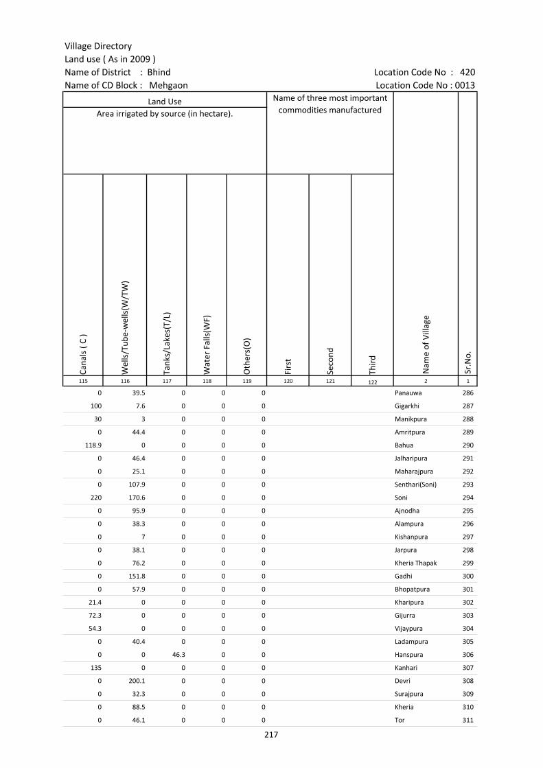
Village DirectoryLand use ( As in 2009 )Name of District : Bhind Location Code No : 420Name of CD Block : Mehgaon Location Code No : 0013
Cana
ls (
C )
Wel
ls/T
ube-
wel
ls(W
/TW
)
Tank
s/La
kes(
T/L)
Wat
er F
alls
(WF)
Oth
ers(
O)
Firs
t
Seco
nd
Thir
d 115 116 117 118 119 120 121 122 2 1
0 39.5 0 0 0 Panauwa 286
100 7.6 0 0 0 Gigarkhi 287
30 3 0 0 0 Manikpura 288
0 44.4 0 0 0 Amritpura 289
118.9 0 0 0 0 Bahua 290
0 46.4 0 0 0 Jalharipura 291
0 25.1 0 0 0 Maharajpura 292
0 107.9 0 0 0 Senthari(Soni) 293
220 170.6 0 0 0 Soni 294
0 95.9 0 0 0 Ajnodha 295
0 38.3 0 0 0 Alampura 296
0 7 0 0 0 Kishanpura 297
0 38.1 0 0 0 Jarpura 298
0 76.2 0 0 0 Kheria Thapak 299
0 151.8 0 0 0 Gadhi 300
0 57.9 0 0 0 Bhopatpura 301
21.4 0 0 0 0 Kharipura 302
72.3 0 0 0 0 Gijurra 303
54.3 0 0 0 0 Vijaypura 304
0 40.4 0 0 0 Ladampura 305
0 0 46.3 0 0 Hanspura 306
135 0 0 0 0 Kanhari 307
0 200.1 0 0 0 Devri 308
0 32.3 0 0 0 Surajpura 309
0 88.5 0 0 0 Kheria 310
0 46.1 0 0 0 Tor 311
Land Use Name of three most important commodities manufactured
Nam
e of
Vill
age
Sr.N
o.
Area irrigated by source (in hectare).
217

Census of India 2011- Amenities and
Name of District : Bhind Location Code No : 420Name of CD Block : Mehgaon Location Code No : 0013
Pre-
Prim
ary
scho
ol (P
P)
Prim
ary
scho
ol (P
)
Mid
dle
scho
ol (M
)
Seco
ndar
y Sc
hool
(S)
Seni
or S
econ
dary
sch
ool (
SS)
Deg
ree
colle
ge o
f art
s s
cien
ce &
com
mer
ce (
ASC
)
Engi
neer
ing
colle
ge(E
C)
Med
ical
col
lege
(MC)
Man
agem
ent i
nstit
ute
(MI)
Poly
tech
nic
(Pt)
Voca
tiona
l tra
inin
g sc
hool
/IT
I
Non
-for
mal
trai
ning
cen
tre
(NFT
C)
Spec
ial s
choo
l for
dis
able
d (S
SD)
Oth
ers
(spe
cify
)
1 2 3 4 5 6 7 8 9 10 11 12 13 14 15 16 17 18 19 20
Sr.N
o.
Nam
e of
vill
age
Loca
tion
code
no.
Tota
l are
a of
the
villa
ge (
in h
ecta
res
roun
ded
up to
one
dec
imal
pla
ce)
Tota
l pop
ulat
ion
( 201
1 ce
nsus
)
Num
ber
of h
ouse
hold
s (2
011
cens
us)
Number of educational amenities available. (If not available within the village , the distance range
code viz; a for < 5 Kms, b for 5-10 Kms and c for 10+ kms of nearest place where facility is available is given).
312 Juge Ka Pura 453071 122.3 222 37 1 a a a c c c c c c
313 Narayan Pura 453072 143 377 65 a 1 a a a a c c c c c c c
314 Pratap Pura 453073 156 580 85 a 1 a a a a c c c c c c c
315 Meghpura 453074 158.6 610 115 1 1 1 b b c c c c c c
316 Moroli 453075 274.7 1289 215 b 1 1 b b b c c c c c c c c
317 Rampura 453076 218.2 262 42 b 1 1 b b b c c c c c c c c
318 Barhad 453077 1643.2 4509 729 1 3 2 2 1 b c c c c c c c c
319 Pachera 453078 923.5 2841 553 b 2 1 1 b b c c c c c c c c
320 Gungavali 453079 304.1 779 149 a 1 a a a a c c c c c c c c
321 Jeesakpura 453080 171.5 810 144 b 1 a b b b c c c c c c c
322 Jodhapura 453081 197.3 570 114 b 1 a b b b c c c c c c c
323 Renka 453082 266.8 670 100 a 2 a a a c c c c c c c c
324 Emaliya 453083 266.8 1100 165 a 1 1 a a a c c c c c c c c
325 Piproli 453084 600.2 1162 194 b 2 1 b b b c c c c c c c
326 Baghora 453085 389 1408 274 b 5 1 b b b c c c c c c c c
327 Mustri 453086 277.2 1310 228 b 2 a b b b c c c c c c c c
328 Mustra 453087 266.2 1001 187 b 2 1 b b b c c c c c c c c
329 Gona Hardaspura 453088 682.6 1983 289 c 3 1 c c c c c c c c c c
330 Raipura 453089 261 526 100 1 1 c c c c c c c c c c c
331 Siloli 453090 403.2 1372 215 1 1 1 c c c c c c c c c c
332 Birgwan 453091 1541.5 3372 757 c 4 1 c c c c c c c a a
333 Konhar 453092 927.2 2731 508 b 3 2 1 1 b c c c c c c c c
334 Kuthonda 453093 389.6 1651 275 b 1 1 b b b c c c c c c c
335 Harsingh Pura 453094 217.8 556 129 1 1 a b b c c c c c c c c
336 Hira Pura 453095 244 284 47 b 1 a b b b c c c c c c c c
218
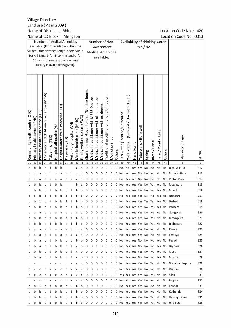
Village DirectoryLand use ( As in 2009 )Name of District : Bhind Location Code No : 420Name of CD Block : Mehgaon Location Code No : 0013
Com
mun
ity h
ealth
cen
tre
(CH
C)Pr
imar
y he
alth
cen
tre
(PH
C)Pr
imar
y he
alth
sub
cen
tre
(PH
S)M
ater
nity
and
chi
ld w
elfa
re c
entr
e (M
CW)
T.B.
clin
ic (
TBC)
Hos
pita
l-allo
path
ic (H
A)
Hos
pita
l-alte
rnat
ive
med
icin
e (H
O)
Dis
pens
ary
(D)
Vete
rina
ry h
ospi
tal (
VH)
Mob
ile h
ealth
clin
ic (M
HC)
Fam
ily w
elfa
re c
entr
e (F
WC)
Char
itabl
e no
n G
ovt.
hos
pita
l/N
ursi
ng h
ome.
Med
ical
pra
ctiti
oner
with
MBB
S D
egre
eM
edic
al p
ract
ition
er w
ith o
ther
deg
ree
Med
ical
pra
ctiti
oner
with
no
degr
eeTr
aditi
onal
pra
ctiti
oner
and
faith
hea
ler
.M
edic
ine
Shop
Oth
ers
Tap
wat
er (T
reat
ed/U
ntre
ated
)
Wel
l w
ater
(C
over
ed /
Unc
over
ed w
ell)
Han
d Pu
mp
Tube
wel
ls /
Bor
e w
ell
Spri
ng
Rive
r /
Cana
l
Tank
/ P
ond
/ L
ake
Oth
ers
21 22 23 24 25 26 27 28 29 30 31 32 33 34 35 36 37 38 39 40 41 42 43 44 45 46 2 1
Number of Non-Government
Medical Amenities available.
Availability of drinking water - Yes / No
Nam
e of
vill
age
Sr.N
o.
Number of Medical Amenities available. (If not available within the
village , the distance range code viz; a for < 5 Kms, b for 5-10 Kms and c for
10+ kms of nearest place where facility is available is given).
a b b b b b b a a 0 0 0 0 0 0 0 No No Yes Yes No No No No Juge Ka Pura 312
a a a a a a a a a a a 0 0 0 0 0 0 0 No Yes Yes No No No No No Narayan Pura 313
a a a a a a a a a a a 0 0 0 0 0 0 0 No Yes Yes No No No No No Pratap Pura 314
c b b b b b b b c 0 0 0 0 0 0 0 No Yes Yes Yes No Yes Yes No Meghpura 315
b b b b b b b b b b b 0 0 0 0 0 0 0 No Yes Yes Yes No No Yes No Moroli 316
b b b b b b b b b b b 0 0 0 0 0 0 0 No Yes Yes Yes No No Yes No Rampura 317
b b 1 b b b b 1 b b b 0 0 0 0 0 0 0 No Yes Yes Yes Yes Yes Yes No Barhad 318
b b b b b b b b b b b 0 0 0 0 0 0 0 No Yes Yes Yes No Yes Yes No Pachera 319
a a a a a a a a a a a 0 0 0 0 0 0 0 No Yes Yes Yes No No No No Gungavali 320
b b b b b b b a b b b 0 0 0 0 0 0 0 No Yes Yes Yes No Yes No No Jeesakpura 321
b b b b b b b b b b b 0 0 0 0 0 0 0 No Yes Yes Yes No Yes No No Jodhapura 322
a a a a a a a a a a a 0 0 0 0 0 0 0 No Yes Yes Yes No No No No Renka 323
a a a a a a a a a a a 0 0 0 0 0 0 0 No Yes Yes Yes No No No No Emaliya 324
b b a b b b b b a b b 0 0 0 0 0 0 0 No Yes Yes No No No Yes No Piproli 325
b b a b b b b c b c b 0 0 1 0 0 0 0 No Yes Yes No No No Yes No Baghora 326
b b b b b b b c b c b 0 0 0 0 0 0 0 No Yes Yes Yes No No Yes No Mustri 327
b b a b b b b c b c b 0 0 0 0 0 0 0 No Yes Yes No No No Yes No Mustra 328
c c c c c c c c c c 0 0 0 0 0 0 0 No Yes Yes Yes No Yes No No Gona Hardaspura 329
c c c c c c c c c c c 0 0 0 0 0 0 0 No Yes Yes Yes No No No No Raipura 330
c c c c c c c c c c c 0 0 0 0 0 0 0 Yes Yes Yes Yes No Yes No No Siloli 331
c c c c c c c c c c c 0 0 0 0 0 0 0 No No Yes Yes No No No No Birgwan 332
b b 1 b b b b b 1 b b 0 0 0 0 0 0 0 No Yes Yes Yes No No No No Konhar 333
b b b b b b b b b b b 0 0 0 0 0 0 0 No Yes Yes Yes No No No No Kuthonda 334
b b b b b b b b b b b 0 0 0 0 0 0 0 No Yes Yes Yes No Yes No No Harsingh Pura 335
b b b b b b b b b b b 0 0 0 0 0 0 0 No Yes Yes Yes No Yes No No Hira Pura 336
219

Census of India 2011- Amenities and
Name of District : Bhind Location Code No : 420Name of CD Block : Mehgaon Location Code No : 0013
Com
mun
ity to
ilet i
nclu
ding
bat
h.
Com
mun
ity to
ilet e
xclu
ding
bat
h.
Rura
l sa
nita
ry m
art o
r sa
nita
ry h
ardw
are
outle
t av
aila
ble
near
the
villa
ge.
Com
mun
ity b
io- g
as o
r re
cycl
e of
was
te fo
r pr
oduc
tive
use.
Post
off
ice(
PO)
Sub
post
off
ice
(SPO
)
Post
& T
eleg
raph
off
ice
(P&
TO)
Villa
ge P
in C
ode
Tele
phon
es
(L
and
lines
)
Publ
ic c
all o
ffic
e (P
CO)
Mob
ile p
hone
cov
erag
e
Inte
rnet
caf
es/
Com
mon
ser
vice
cen
tre
(CSC
)
Priv
ate
cour
ier
faci
lity
Bus
serv
ice
(Pub
lic &
Pri
vate
)
Railw
ay s
tatio
ns
Aut
o/M
odifi
ed A
utos
Taxi
s an
d Va
ns
1 2 3 47 48 49 50 51 52 53 54 55 56 57 58 59 60 61 62 63
Loca
tion
code
no.
Availability of toilet & others Yes / No
Communication and transport facilities (If amenities available code -Yes is given except for Village Pin Code ,If not available within the village , the distance range code
viz; a for < 5 Kms, b for 5-10 Kms and c for 10+ kms of nearest place where facility is available is given).
Sr.N
o.
Nam
e of
vill
age
312 Juge Ka Pura 453071 No No No No a b b Yes b b b a b b
313 Narayan Pura 453072 No No No No a a a a a Yes a a Yes b Yes a
314 Pratap Pura 453073 No No No No a a a a a Yes a a Yes a Yes Yes
315 Meghpura 453074 No No No No a b b Yes b b Yes a b b
316 Moroli 453075 No No No No b a b b b Yes b b b a b b
317 Rampura 453076 No No No No b c b b b Yes b b b b b a
318 Barhad 453077 No No No No b Yes Yes Yes Yes Yes b b b b Yes Yes
319 Pachera 453078 No No No No b Yes b b b Yes b b b c b b
320 Gungavali 453079 No No No No a a c a a Yes a a a b a Yes
321 Jeesakpura 453080 No No No No b b b b b b b b b c b b
322 Jodhapura 453081 No No No No a a b b b b b b b c b b
323 Renka 453082 No No No No a a c a a Yes a a a a a Yes
324 Emaliya 453083 No No No No a a c a a Yes a a a c a Yes
325 Piproli 453084 No No No No c b a Yes b Yes b b a b b b
326 Baghora 453085 No No No No Yes c b b Yes b b b b b b
327 Mustri 453086 No No No No a b c b b Yes b b b c Yes Yes
328 Mustra 453087 No No No No a b c b b Yes b b b c Yes Yes
329 Gona Hardaspura 453088 No No No No Yes Yes 477557 c c Yes c c c c Yes Yes
330 Raipura 453089 No No No No c c c 477441 c b c c c c c c Yes
331 Siloli 453090 No No No No c c c c c c c c c c c c
332 Birgwan 453091 No No No No c Yes Yes Yes a Yes a a Yes c c c
333 Konhar 453092 No No No No c Yes Yes 477557 Yes b Yes b b Yes c b b
334 Kuthonda 453093 No No No No b Yes Yes Yes b Yes b b Yes b b b
335 Harsingh Pura 453094 No No No No b a b b b Yes b b b c b b
336 Hira Pura 453095 No No No No b b b b b Yes b b b c b b
220

Village DirectoryLand use ( As in 2009 )Name of District : Bhind Location Code No : 420Name of CD Block : Mehgaon Location Code No : 0013
Trac
tors
Cycl
e-pu
lled
rick
shaw
s(M
anua
l & M
achi
ne d
rive
n)
Cart
s dr
iven
by
anim
als
Sea
/Riv
er fe
rry
serv
ice
Conn
ecte
d to
nat
iona
l hig
hway
(NH
)
Conn
ecte
d to
sta
te h
ighw
ay(S
H)
Conn
ecte
d to
maj
or d
istr
ict r
oad
(MD
R)
Conn
ecte
d to
oth
ers
dist
rict
roa
d
Pucc
a r
oads
Kutc
hcha
roa
ds
Wat
er b
ound
ed m
acad
am(W
BM) r
oads
Nav
igab
le w
ater
way
(riv
er/c
anal
)(N
W)
Foot
path
s (F
P)
Com
mer
cial
& C
o-op
erat
ive
Bank
s
ATM
Agr
icul
tura
l Cre
dit S
ocie
ties
64 65 66 67 68 69 70 71 72 73 74 75 76 77 78 79 2 1
Sr.N
o.
Communication and transport facilities (If amenities available code -Yes is given
except for Village Pin Code ,If not available within the village , the distance range code viz; a for < 5 Kms, b for 5-10 Kms and c for 10+ kms of nearest place where facility is
available is given).
Village connected to highways,village roads, banks & credit societies (If amenities available
code -Yes is given, If not available within the village , the distance range code viz; a for < 5
Kms, b for 5-10 Kms and c for 10+ kms of nearest place where facility is available is
given).
Nam
e of
vill
age
Yes b b c a Yes Yes b b Yes Yes Yes a c b Juge Ka Pura 312
Yes a Yes c Yes Yes Yes Yes Yes Yes Yes Yes a c a Narayan Pura 313
Yes Yes Yes c a Yes Yes Yes Yes Yes Yes Yes a c a Pratap Pura 314
b Yes b c Yes Yes Yes a Yes Yes a Yes b b b Meghpura 315
Yes Yes Yes c b a b a a Yes Yes Yes b c b Moroli 316
Yes Yes Yes c Yes Yes Yes Yes a Yes Yes Yes b c b Rampura 317
Yes Yes Yes c a a a a Yes Yes Yes Yes b c b Barhad 318
Yes Yes Yes c b b b b b Yes Yes Yes b c Yes Pachera 319
Yes Yes Yes c a a Yes Yes Yes Yes a Yes a c a Gungavali 320
Yes Yes Yes a Yes Yes Yes Yes Yes Yes Yes Yes b b b Jeesakpura 321
Yes Yes Yes c a Yes Yes Yes Yes Yes Yes Yes b b b Jodhapura 322
Yes Yes Yes c a a Yes Yes Yes Yes Yes Yes a c a Renka 323
Yes Yes Yes c a a Yes Yes Yes Yes a Yes a c a Emaliya 324
Yes Yes b c b a a Yes Yes Yes a Yes b c b Piproli 325
Yes Yes Yes c b b Yes a Yes Yes Yes Yes b c a Baghora 326
Yes Yes Yes c b b a Yes Yes Yes a Yes b c a Mustri 327
Yes Yes Yes c b b a Yes Yes Yes a Yes b c a Mustra 328
Yes Yes b c c c Yes Yes a Yes a Yes c c a Gona Hardaspura 329
Yes Yes Yes c c b b b Yes Yes Yes Yes c c c Raipura 330
Yes Yes Yes c c Yes Yes Yes Yes Yes Yes Yes c c c Siloli 331
Yes Yes Yes c c b c c Yes Yes Yes Yes c c c Birgwan 332
b Yes Yes c b a Yes Yes Yes Yes a Yes b c b Konhar 333
Yes Yes Yes b b Yes Yes Yes Yes Yes Yes Yes b b b Kuthonda 334
b Yes b c a a a b Yes Yes Yes Yes b c a Harsingh Pura 335
b b b c a a a b Yes Yes a Yes b c a Hira Pura 336
221

Census of India 2011- Amenities and
Name of District : Bhind Location Code No : 420Name of CD Block : Mehgaon Location Code No : 0013
Self-
Hel
p G
roup
(SH
G)
Publ
ic d
istr
ibut
ion
syst
em (P
DS)
sho
p
Man
dis
/ Re
gula
r m
arke
t
Wee
kly
Haa
t
Agr
icul
tura
l mar
ketin
g so
ciet
yIn
tegr
ated
Chi
ld D
evel
opm
ent S
chem
e (N
utri
tiona
l Ce
ntre
s)A
ngan
wad
i Cen
tre
(Nut
ritio
nal C
entr
es)
Oth
ers
(Nut
ritio
nal C
entr
es)
ASH
A (A
ccre
dite
d So
cial
Hea
lth A
ctiv
ist)
Com
mun
ity c
entr
e w
ith/w
ithou
t TV
Spor
ts F
ield
,
Spor
ts C
lub
/ Re
crea
tion
Cent
re
Cine
ma
/ Vi
deo
Hal
l
Publ
ic L
ibra
ry
Publ
ic R
eadi
ng R
oom
New
spap
er S
uppl
y
Ass
embl
y Po
lling
sta
tion
Birt
h &
Dea
th R
egis
trat
ion
Off
ice
1 2 3 80 81 82 83 84 85 86 87 88 89 90 91 92 93 94 95 96 97
Sr.N
o.
Nam
e of
vill
age
Loca
tion
code
no.
Availability of miscellaneous facilities (If amenities available code -Yes is given, If not available within the village , the distance range code viz; a for < 5 Kms, b
for 5-10 Kms and c for 10+ kms of nearest place where facility is available is given).
312 Juge Ka Pura 453071 Yes a a a a b a a Yes Yes b b c c c a a a
313 Narayan Pura 453072 a a a a a a a a Yes a a a a a a Yes a a
314 Pratap Pura 453073 a a a a a a a Yes Yes a a a a a a Yes a a
315 Meghpura 453074 Yes Yes Yes Yes b b Yes Yes Yes Yes Yes Yes c c c a Yes Yes
316 Moroli 453075 Yes a b b b b Yes Yes Yes b b b b b b Yes Yes Yes
317 Rampura 453076 Yes b b b b b a a Yes b b b b b b Yes Yes a
318 Barhad 453077 Yes Yes b Yes b b Yes Yes Yes b Yes b b b b Yes Yes Yes
319 Pachera 453078 Yes Yes b b b b Yes Yes Yes b b b b b b b Yes Yes
320 Gungavali 453079 Yes a a a a a Yes Yes Yes c a a a a a a Yes a
321 Jeesakpura 453080 Yes Yes Yes Yes Yes Yes Yes Yes Yes b b b b b b b Yes b
322 Jodhapura 453081 Yes a b b b Yes Yes Yes Yes a a b b b b b Yes b
323 Renka 453082 Yes a a a a a Yes Yes Yes c a a a a a a Yes a
324 Emaliya 453083 Yes a a a a a Yes Yes Yes c a a a a a a Yes a
325 Piproli 453084 Yes Yes b b b Yes Yes Yes Yes Yes b b b b b Yes Yes Yes
326 Baghora 453085 Yes Yes b b b b Yes Yes Yes b Yes b b c c b Yes Yes
327 Mustri 453086 Yes a b b b b Yes Yes Yes b Yes b b c c b Yes Yes
328 Mustra 453087 Yes a b b b b Yes Yes Yes b Yes b b c c b Yes a
329 Gona Hardaspura 453088 Yes a c c c c Yes Yes Yes c c c c c c c Yes Yes
330 Raipura 453089 Yes a c c c Yes Yes a Yes Yes Yes c c c c c a c
331 Siloli 453090 Yes Yes Yes Yes Yes Yes Yes Yes Yes Yes Yes Yes Yes c c Yes Yes b
332 Birgwan 453091 Yes Yes c c Yes a Yes Yes Yes Yes Yes Yes Yes b c Yes Yes Yes
333 Konhar 453092 Yes Yes b b b Yes Yes Yes Yes b b b b b b Yes Yes Yes
334 Kuthonda 453093 Yes Yes b Yes Yes b Yes Yes Yes b b b c c c Yes Yes Yes
335 Harsingh Pura 453094 Yes a b b b b Yes Yes Yes b b b b b b b Yes a
336 Hira Pura 453095 Yes a b b b b a a Yes b b b b b b b a a
222
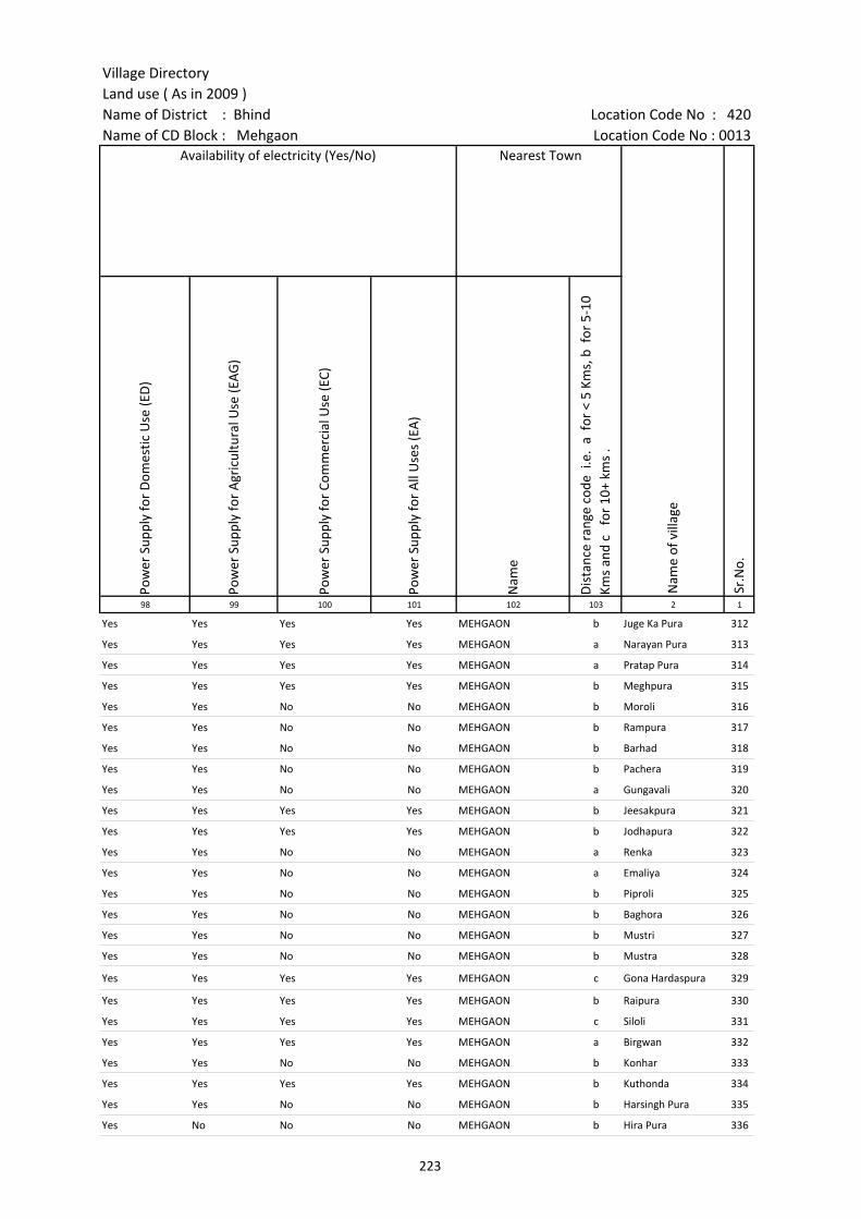
Village DirectoryLand use ( As in 2009 )Name of District : Bhind Location Code No : 420Name of CD Block : Mehgaon Location Code No : 0013
Pow
er S
uppl
y fo
r D
omes
tic U
se (E
D)
Pow
er S
uppl
y fo
r A
gric
ultu
ral U
se (E
AG
)
Pow
er S
uppl
y fo
r Co
mm
erci
al U
se (E
C)
Pow
er S
uppl
y fo
r A
ll U
ses
(EA
)
Nam
e
Dis
tanc
e ra
nge
code
i.e
. a
for
< 5
Kms,
b f
or 5
-10
Kms
and
c f
or 1
0+ k
ms
.98 99 100 101 102 103 2 1
Nearest Town
Nam
e of
vill
age
Sr.N
o.
Availability of electricity (Yes/No)
Yes Yes Yes Yes MEHGAON b Juge Ka Pura 312
Yes Yes Yes Yes MEHGAON a Narayan Pura 313
Yes Yes Yes Yes MEHGAON a Pratap Pura 314
Yes Yes Yes Yes MEHGAON b Meghpura 315
Yes Yes No No MEHGAON b Moroli 316
Yes Yes No No MEHGAON b Rampura 317
Yes Yes No No MEHGAON b Barhad 318
Yes Yes No No MEHGAON b Pachera 319
Yes Yes No No MEHGAON a Gungavali 320
Yes Yes Yes Yes MEHGAON b Jeesakpura 321
Yes Yes Yes Yes MEHGAON b Jodhapura 322
Yes Yes No No MEHGAON a Renka 323
Yes Yes No No MEHGAON a Emaliya 324
Yes Yes No No MEHGAON b Piproli 325
Yes Yes No No MEHGAON b Baghora 326
Yes Yes No No MEHGAON b Mustri 327
Yes Yes No No MEHGAON b Mustra 328
Yes Yes Yes Yes MEHGAON c Gona Hardaspura 329
Yes Yes Yes Yes MEHGAON b Raipura 330
Yes Yes Yes Yes MEHGAON c Siloli 331
Yes Yes Yes Yes MEHGAON a Birgwan 332
Yes Yes No No MEHGAON b Konhar 333
Yes Yes Yes Yes MEHGAON b Kuthonda 334
Yes Yes No No MEHGAON b Harsingh Pura 335
Yes No No No MEHGAON b Hira Pura 336
223
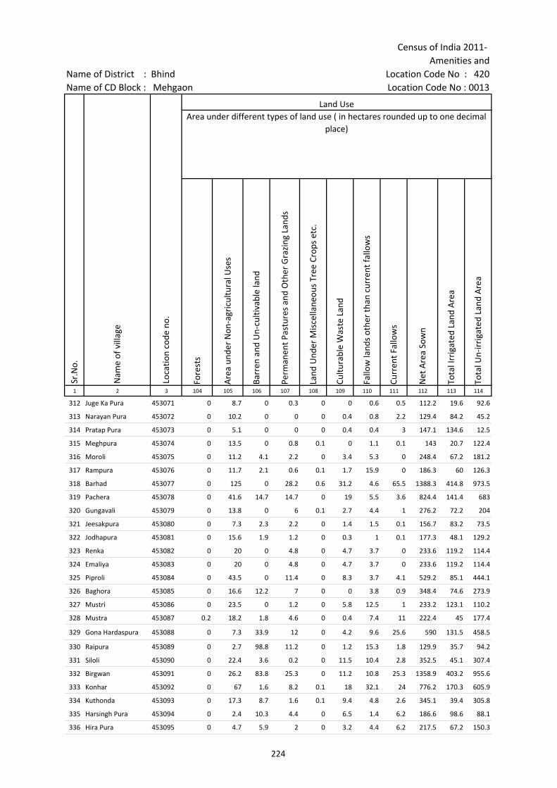
Census of India 2011- Amenities and
Name of District : Bhind Location Code No : 420Name of CD Block : Mehgaon Location Code No : 0013
Fore
sts
Are
a un
der
Non
-agr
icul
tura
l Use
s
Barr
en a
nd U
n-cu
ltiva
ble
land
Perm
anen
t Pas
ture
s an
d O
ther
Gra
zing
Lan
ds
Land
Und
er M
isce
llane
ous
Tree
Cro
ps e
tc.
Cultu
rabl
e W
aste
Lan
d
Fallo
w la
nds
othe
r th
an c
urre
nt fa
llow
s
Curr
ent F
allo
ws
Net
Are
a So
wn
Tota
l Irr
igat
ed L
and
Are
a
Tota
l Un-
irri
gate
d La
nd A
rea
1 2 3 104 105 106 107 108 109 110 111 112 113 114
Land UseArea under different types of land use ( in hectares rounded up to one decimal
place)
Sr.N
o.
Nam
e of
vill
age
Loca
tion
code
no.
312 Juge Ka Pura 453071 0 8.7 0 0.3 0 0 0.6 0.5 112.2 19.6 92.6
313 Narayan Pura 453072 0 10.2 0 0 0 0.4 0.8 2.2 129.4 84.2 45.2
314 Pratap Pura 453073 0 5.1 0 0 0 0.4 0.4 3 147.1 134.6 12.5
315 Meghpura 453074 0 13.5 0 0.8 0.1 0 1.1 0.1 143 20.7 122.4
316 Moroli 453075 0 11.2 4.1 2.2 0 3.4 5.3 0 248.4 67.2 181.2
317 Rampura 453076 0 11.7 2.1 0.6 0.1 1.7 15.9 0 186.3 60 126.3
318 Barhad 453077 0 125 0 28.2 0.6 31.2 4.6 65.5 1388.3 414.8 973.5
319 Pachera 453078 0 41.6 14.7 14.7 0 19 5.5 3.6 824.4 141.4 683
320 Gungavali 453079 0 13.8 0 6 0.1 2.7 4.4 1 276.2 72.2 204
321 Jeesakpura 453080 0 7.3 2.3 2.2 0 1.4 1.5 0.1 156.7 83.2 73.5
322 Jodhapura 453081 0 15.6 1.9 1.2 0 0.3 1 0.1 177.3 48.1 129.2
323 Renka 453082 0 20 0 4.8 0 4.7 3.7 0 233.6 119.2 114.4
324 Emaliya 453083 0 20 0 4.8 0 4.7 3.7 0 233.6 119.2 114.4
325 Piproli 453084 0 43.5 0 11.4 0 8.3 3.7 4.1 529.2 85.1 444.1
326 Baghora 453085 0 16.6 12.2 7 0 0 3.8 0.9 348.4 74.6 273.9
327 Mustri 453086 0 23.5 0 1.2 0 5.8 12.5 1 233.2 123.1 110.2
328 Mustra 453087 0.2 18.2 1.8 4.6 0 0.4 7.4 11 222.4 45 177.4
329 Gona Hardaspura 453088 0 7.3 33.9 12 0 4.2 9.6 25.6 590 131.5 458.5
330 Raipura 453089 0 2.7 98.8 11.2 0 1.2 15.3 1.8 129.9 35.7 94.2
331 Siloli 453090 0 22.4 3.6 0.2 0 11.5 10.4 2.8 352.5 45.1 307.4
332 Birgwan 453091 0 26.2 83.8 25.3 0 11.2 10.8 25.3 1358.9 403.2 955.6
333 Konhar 453092 0 67 1.6 8.2 0.1 18 32.1 24 776.2 170.3 605.9
334 Kuthonda 453093 0 17.3 8.7 1.6 0.1 9.4 4.8 2.6 345.1 39.4 305.8
335 Harsingh Pura 453094 0 2.4 10.3 4.4 0 6.5 1.4 6.2 186.6 98.6 88.1
336 Hira Pura 453095 0 4.7 5.9 2 0 3.2 4.4 6.2 217.5 67.2 150.3
224

Village DirectoryLand use ( As in 2009 )Name of District : Bhind Location Code No : 420Name of CD Block : Mehgaon Location Code No : 0013
Cana
ls (
C )
Wel
ls/T
ube-
wel
ls(W
/TW
)
Tank
s/La
kes(
T/L)
Wat
er F
alls
(WF)
Oth
ers(
O)
Firs
t
Seco
nd
Thir
d 115 116 117 118 119 120 121 122 2 1
Land Use Name of three most important commodities manufactured
Nam
e of
Vill
age
Sr.N
o.
Area irrigated by source (in hectare).
0 19.6 0 0 0 Juge Ka Pura 312
0 84.2 0 0 0 Narayan Pura 313
0 134.6 0 0 0 Pratap Pura 314
0 20.7 0 0 0 Meghpura 315
0 67.2 0 0 0 Moroli 316
0 60 0 0 0 Rampura 317
0 414.8 0 0 0 Barhad 318
0 141.4 0 0 0 Pachera 319
0 72.2 0 0 0 Gungavali 320
0 83.2 0 0 0 Jeesakpura 321
0 48.1 0 0 0 Jodhapura 322
0 119.2 0 0 0 Renka 323
0 119.2 0 0 0 Emaliya 324
0 85.1 0 0 0 Piproli 325
0 74.6 0 0 0 Baghora 326
0 123.1 0 0 0 Mustri 327
0 45 0 0 0 Mustra 328
0 131.5 0 0 0 Gona Hardaspura 329
0 35.7 0 0 0 Raipura 330
0 45.1 0 0 0 Siloli 331
0 403.2 0 0 0 Birgwan 332
0 170.3 0 0 0 Konhar 333
0 39.4 0 0 0 Kuthonda 334
0 98.6 0 0 0 Harsingh Pura 335
0 67.2 0 0 0 Hira Pura 336
225

Census of India 2011- Amenities and
Name of District : Bhind Location Code No : 420Name of CD Block : Mehgaon Location Code No : 0013
Pre-
Prim
ary
scho
ol (P
P)
Prim
ary
scho
ol (P
)
Mid
dle
scho
ol (M
)
Seco
ndar
y Sc
hool
(S)
Seni
or S
econ
dary
sch
ool (
SS)
Deg
ree
colle
ge o
f art
s s
cien
ce &
com
mer
ce (
ASC
)
Engi
neer
ing
colle
ge(E
C)
Med
ical
col
lege
(MC)
Man
agem
ent i
nstit
ute
(MI)
Poly
tech
nic
(Pt)
Voca
tiona
l tra
inin
g sc
hool
/IT
I
Non
-for
mal
trai
ning
cen
tre
(NFT
C)
Spec
ial s
choo
l for
dis
able
d (S
SD)
Oth
ers
(spe
cify
)
1 2 3 4 5 6 7 8 9 10 11 12 13 14 15 16 17 18 19 20
Sr.N
o.
Nam
e of
vill
age
Loca
tion
code
no.
Tota
l are
a of
the
villa
ge (
in h
ecta
res
roun
ded
up to
one
dec
imal
pla
ce)
Tota
l pop
ulat
ion
( 201
1 ce
nsus
)
Num
ber
of h
ouse
hold
s (2
011
cens
us)
Number of educational amenities available. (If not available within the village , the distance range
code viz; a for < 5 Kms, b for 5-10 Kms and c for 10+ kms of nearest place where facility is available is given).
337 Dhanoli 453096 569.6 1097 184 b 2 1 b b b c c c c c c c c
338 Parrawan 453097 424.1 1729 276 c 2 a a a c c c c c c c c c
339 Rabia Pura 453098 201.3 741 148 b 1 b b b c c c c c c c c
340 Kethoda 453099 364.2 429 78 c 1 a b c c c c c c c c c
341 Dewara 453100 500.6 1242 182 2 1 1 c c c c
342 Rajpura 453101 359.4 886 125 1 a a c c c c c c c c
343 Katrol 453102 1326.6 2671 602 c 3 1 a a c c c c c c c c
344 Manikpura 453103 126 580 86 b 1 b b c c c c c c c c c
345 Chirol 453104 309.6 1196 183 2 1 a c c c c c c c c c c
346 Dandraua 453105 355.3 1016 155 b 1 2 1 1 1 c c c c c c c c
347 Senthri 453106 208.4 396 99 c 1 a a b c c c c c c c c c
348 Kerora 453107 547.8 1074 211 c 1 1 b b c c c c c c c c
349 Padkoli 453108 810.9 1415 254 1 1 b c c c c c c
350 Ekori 453109 271.8 426 53 a 1 a a c c c c c c c c c
351 Gata 453110 497.2 1319 197 c 2 1 1 1 c c c c c c c c c
352 Gudawali 453111 321.1 781 158 c 1 a c c c c c c c c
353 Pamarpura 453112 240.4 601 122 c 1 a a a c c c c c c c c c
354 Gutore 453113 1446.1 3391 591 c 4 1 c c c c c c c c c c c
355 Ajnol 453114 560.9 1196 251 c 1 a c c c c c c c
356 Kemokhari 453115 253.8 697 99 c 1 a b c c c c c c c c c
357 Gijurra 453116 239.3 702 131 c 1 a 1 c c c c c c c c c
358 Sarsed 453117 624.8 704 159 c 1 1 c c c c c c c c c c
359 Simar 453118 769.2 1649 340 c 2 1 a c c c c c c c c c c
360 Sunderpura 453119 253.1 427 76 c 1 b b c c c c c c c c c
361 Khidarpura 453120 419.3 829 168 a 1 a b c c c c c c c c c
362 Dagar 453121 495.6 1656 309 a 3 1 b c c c c c c c c
226

Village DirectoryLand use ( As in 2009 )Name of District : Bhind Location Code No : 420Name of CD Block : Mehgaon Location Code No : 0013
Com
mun
ity h
ealth
cen
tre
(CH
C)Pr
imar
y he
alth
cen
tre
(PH
C)Pr
imar
y he
alth
sub
cen
tre
(PH
S)M
ater
nity
and
chi
ld w
elfa
re c
entr
e (M
CW)
T.B.
clin
ic (
TBC)
Hos
pita
l-allo
path
ic (H
A)
Hos
pita
l-alte
rnat
ive
med
icin
e (H
O)
Dis
pens
ary
(D)
Vete
rina
ry h
ospi
tal (
VH)
Mob
ile h
ealth
clin
ic (M
HC)
Fam
ily w
elfa
re c
entr
e (F
WC)
Char
itabl
e no
n G
ovt.
hos
pita
l/N
ursi
ng h
ome.
Med
ical
pra
ctiti
oner
with
MBB
S D
egre
eM
edic
al p
ract
ition
er w
ith o
ther
deg
ree
Med
ical
pra
ctiti
oner
with
no
degr
eeTr
aditi
onal
pra
ctiti
oner
and
faith
hea
ler
.M
edic
ine
Shop
Oth
ers
Tap
wat
er (T
reat
ed/U
ntre
ated
)
Wel
l w
ater
(C
over
ed /
Unc
over
ed w
ell)
Han
d Pu
mp
Tube
wel
ls /
Bor
e w
ell
Spri
ng
Rive
r /
Cana
l
Tank
/ P
ond
/ L
ake
Oth
ers
21 22 23 24 25 26 27 28 29 30 31 32 33 34 35 36 37 38 39 40 41 42 43 44 45 46 2 1
Number of Non-Government
Medical Amenities available.
Availability of drinking water - Yes / No
Nam
e of
vill
age
Sr.N
o.
Number of Medical Amenities available. (If not available within the
village , the distance range code viz; a for < 5 Kms, b for 5-10 Kms and c for
10+ kms of nearest place where facility is available is given).
b b b c b c c c b c b 0 0 0 0 0 0 0 No Yes Yes Yes No No No No Dhanoli 337
c c c c c c c c c c c 0 0 0 0 0 0 0 No Yes Yes Yes No No No No Parrawan 338
b b b b b b b b b b b 0 0 0 0 0 0 0 No Yes Yes Yes No Yes Yes No Rabia Pura 339
c a a c a a c a c c c 0 0 0 0 0 1 0 No Yes Yes Yes No No Yes No Kethoda 340
c c c c c c c c c c c 0 0 0 0 2 1 0 No Yes Yes Yes No Yes Yes No Dewara 341
c c c c c c c c c c c 0 0 0 0 1 1 0 No Yes Yes No No Yes Yes No Rajpura 342
c 1 c c 1 c c c c c 0 0 0 0 0 0 0 No Yes Yes Yes No Yes No No Katrol 343
c b b c b c c c c c c 0 0 0 1 0 0 0 No Yes Yes No No Yes No No Manikpura 344
c c a c c c c a c c 0 0 0 0 0 0 0 No Yes Yes Yes No Yes No No Chirol 345
c a a c a c c c c c c 0 0 0 0 0 0 0 No Yes Yes Yes No No No No Dandraua 346
c b a c b b b c c c b 0 0 0 0 0 0 0 No Yes Yes Yes No Yes No No Senthri 347
c c b c c b c c c b c 0 0 0 0 0 0 0 No Yes Yes No No Yes No Yes Kerora 348
c c 1 c c c c 1 c c 0 0 0 1 0 0 0 No Yes Yes Yes No No Yes No Padkoli 349
c b b b b c b c c c 0 0 0 0 0 0 0 No Yes Yes Yes No Yes No No Ekori 350
c c 1 c c c c c 1 c c 0 0 0 2 1 0 0 Yes Yes Yes Yes No Yes Yes No Gata 351
c a c c a c c c a c c 0 0 0 1 0 0 0 No No Yes No No Yes Yes No Gudawali 352
c b a c b b b c c c b 0 0 0 0 0 0 0 No Yes Yes Yes No No No No Pamarpura 353
c c b c c c c c 1 c c 0 0 0 2 1 0 0 No Yes Yes Yes No Yes No No Gutore 354
c c b c c c c c a c c 0 0 2 0 0 0 0 Yes Yes Yes Yes No Yes No No Ajnol 355
c c b c c b c c c b c 0 0 0 0 0 0 0 Yes Yes Yes Yes No No No No Kemokhari 356
c c b c c b c c c b c 0 0 0 0 0 0 0 No Yes Yes No No No Yes No Gijurra 357
c c c c c c c c c c c 0 0 0 0 0 0 0 No Yes Yes Yes No No No No Sarsed 358
c c b c c b c c c b c 0 0 0 0 0 0 0 No Yes Yes Yes No Yes Yes No Simar 359
c c c c c c c a b c c 0 0 0 0 0 0 0 No Yes Yes No No Yes No No Sunderpura 360
c c a c c c c c c c c 0 0 0 0 2 0 0 No Yes Yes No Yes Yes Yes No Khidarpura 361
c c a c c c c c c c c 0 0 0 0 3 0 0 No Yes Yes No No Yes Yes No Dagar 362
227

Census of India 2011- Amenities and
Name of District : Bhind Location Code No : 420Name of CD Block : Mehgaon Location Code No : 0013
Com
mun
ity to
ilet i
nclu
ding
bat
h.
Com
mun
ity to
ilet e
xclu
ding
bat
h.
Rura
l sa
nita
ry m
art o
r sa
nita
ry h
ardw
are
outle
t av
aila
ble
near
the
villa
ge.
Com
mun
ity b
io- g
as o
r re
cycl
e of
was
te fo
r pr
oduc
tive
use.
Post
off
ice(
PO)
Sub
post
off
ice
(SPO
)
Post
& T
eleg
raph
off
ice
(P&
TO)
Villa
ge P
in C
ode
Tele
phon
es
(L
and
lines
)
Publ
ic c
all o
ffic
e (P
CO)
Mob
ile p
hone
cov
erag
e
Inte
rnet
caf
es/
Com
mon
ser
vice
cen
tre
(CSC
)
Priv
ate
cour
ier
faci
lity
Bus
serv
ice
(Pub
lic &
Pri
vate
)
Railw
ay s
tatio
ns
Aut
o/M
odifi
ed A
utos
Taxi
s an
d Va
ns
1 2 3 47 48 49 50 51 52 53 54 55 56 57 58 59 60 61 62 63
Loca
tion
code
no.
Availability of toilet & others Yes / No
Communication and transport facilities (If amenities available code -Yes is given except for Village Pin Code ,If not available within the village , the distance range code
viz; a for < 5 Kms, b for 5-10 Kms and c for 10+ kms of nearest place where facility is available is given).
Sr.N
o.
Nam
e of
vill
age
337 Dhanoli 453096 No No No No b b b b b b b c b c b b
338 Parrawan 453097 No No No No c b b c c c c c c c c c
339 Rabia Pura 453098 No No No No b b b b b b b b a c b b
340 Kethoda 453099 No No No No c b b c c b c c b c c c
341 Dewara 453100 No No No No c Yes b c c c c c b c c c
342 Rajpura 453101 No No No No c b b 477116 c c b c c b c c c
343 Katrol 453102 No No No No c Yes Yes 477557 c c Yes c c a c c c
344 Manikpura 453103 No No No No c b b 477557 b c a c c b c c c
345 Chirol 453104 No No Yes No a a Yes c c c c Yes c c c
346 Dandraua 453105 No Yes No No c a a b c Yes b b Yes c c c
347 Senthri 453106 No No No No a a a a c Yes c c a c a a
348 Kerora 453107 No No No No b b b c b c c b c c c
349 Padkoli 453108 No No Yes No c c a Yes c Yes c c a c c c
350 Ekori 453109 No No No No c a a c c Yes c c a c c c
351 Gata 453110 No No No No Yes c Yes c Yes c c Yes c c Yes
352 Gudawali 453111 No No No No a c c a c Yes c c Yes c c a
353 Pamarpura 453112 No No No No a a a a c Yes c c a c a a
354 Gutore 453113 No No No No Yes c c c Yes c c a c c a
355 Ajnol 453114 No No No No a c c c c Yes c c a c c a
356 Kemokhari 453115 No No No No c b b b c b c c b c c c
357 Gijurra 453116 No No No No a a 477557 b c b c c b c c c
358 Sarsed 453117 No No No No b a c c c c c c c c c c
359 Simar 453118 No No No No c Yes Yes 477557 c c Yes c c Yes c c c
360 Sunderpura 453119 No No No No b c c b c Yes c c b c c c
361 Khidarpura 453120 No No No No c a c a c Yes c c c c c c
362 Dagar 453121 No No No No c b c c c Yes c c Yes c c c
228
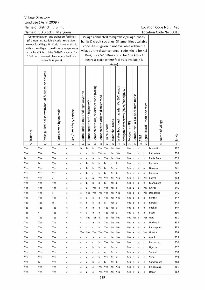
Village DirectoryLand use ( As in 2009 )Name of District : Bhind Location Code No : 420Name of CD Block : Mehgaon Location Code No : 0013
Trac
tors
Cycl
e-pu
lled
rick
shaw
s(M
anua
l & M
achi
ne d
rive
n)
Cart
s dr
iven
by
anim
als
Sea
/Riv
er fe
rry
serv
ice
Conn
ecte
d to
nat
iona
l hig
hway
(NH
)
Conn
ecte
d to
sta
te h
ighw
ay(S
H)
Conn
ecte
d to
maj
or d
istr
ict r
oad
(MD
R)
Conn
ecte
d to
oth
ers
dist
rict
roa
d
Pucc
a r
oads
Kutc
hcha
roa
ds
Wat
er b
ound
ed m
acad
am(W
BM) r
oads
Nav
igab
le w
ater
way
(riv
er/c
anal
)(N
W)
Foot
path
s (F
P)
Com
mer
cial
& C
o-op
erat
ive
Bank
s
ATM
Agr
icul
tura
l Cre
dit S
ocie
ties
64 65 66 67 68 69 70 71 72 73 74 75 76 77 78 79 2 1
Sr.N
o.
Communication and transport facilities (If amenities available code -Yes is given
except for Village Pin Code ,If not available within the village , the distance range code viz; a for < 5 Kms, b for 5-10 Kms and c for 10+ kms of nearest place where facility is
available is given).
Village connected to highways,village roads, banks & credit societies (If amenities available
code -Yes is given, If not available within the village , the distance range code viz; a for < 5
Kms, b for 5-10 Kms and c for 10+ kms of nearest place where facility is available is
given).
Nam
e of
vill
age
Yes Yes Yes c b b b Yes Yes Yes Yes Yes b c b Dhanoli 337
Yes Yes Yes c c c b Yes a Yes Yes Yes c c c Parrawan 338
b Yes Yes c a a a b Yes Yes Yes Yes b c b Rabia Pura 339
Yes b Yes c c b b b b b b Yes c c b Kethoda 340
Yes Yes Yes c c b b Yes b Yes a Yes b c a Dewara 341
Yes Yes Yes c c b c b b Yes b Yes b c a Rajpura 342
Yes Yes c c c a a Yes Yes Yes Yes Yes c c Yes Katrol 343
Yes Yes Yes c c b b b b Yes b Yes c c b Manikpura 344
Yes Yes Yes c c c Yes b Yes Yes a Yes a c Yes Chirol 345
Yes Yes c c c Yes Yes Yes Yes Yes Yes Yes b c Yes Dandraua 346
Yes Yes Yes c c a c b Yes Yes Yes Yes a c a Senthri 347
Yes Yes b c c c c b a Yes a Yes b c c Kerora 348
Yes Yes Yes c c c a b Yes Yes a Yes b c a Padkoli 349
Yes c Yes a c a a a Yes Yes a Yes c c a Ekori 350
Yes Yes Yes c c Yes Yes b Yes Yes Yes Yes Yes c Yes Gata 351
Yes Yes Yes c c a a b Yes Yes Yes Yes a c a Gudawali 352
Yes Yes Yes c c a c b Yes Yes Yes Yes a c a Pamarpura 353
Yes Yes Yes c Yes Yes Yes Yes Yes Yes Yes Yes a c Yes Gutore 354
Yes Yes Yes c c a a a a Yes Yes Yes a c a Ajnol 355
Yes Yes Yes c c c c b Yes Yes Yes Yes c c c Kemokhari 356
Yes Yes Yes c c c b b a Yes a Yes b c c Gijurra 357
Yes Yes Yes c c a c c a Yes a Yes a a c Sarsed 358
Yes Yes Yes c c c c b Yes Yes a Yes c c c Simar 359
Yes b Yes c c c b c b Yes b Yes c c c Sunderpura 360
Yes Yes Yes c c c c Yes Yes Yes Yes Yes c c c Khidarpura 361
Yes Yes Yes c c c c Yes Yes Yes Yes Yes c c c Dagar 362
229
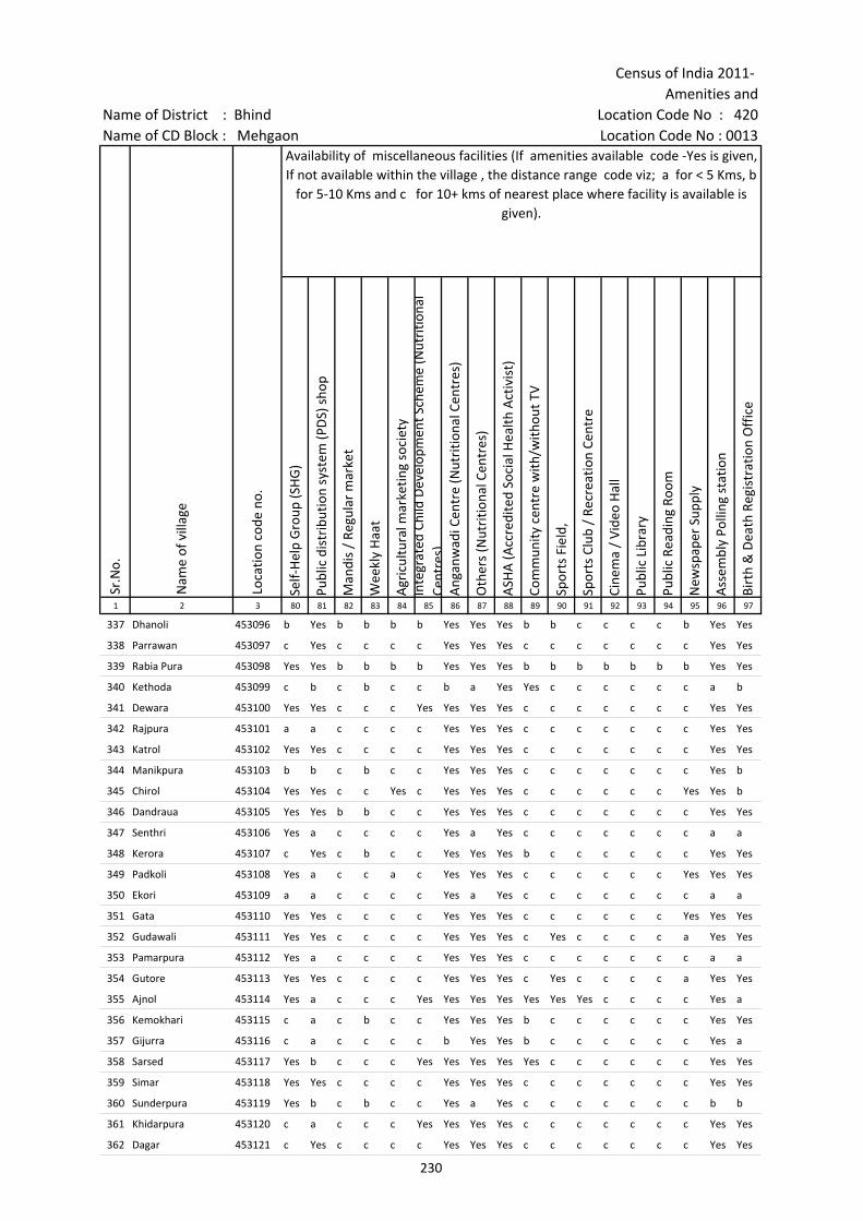
Census of India 2011- Amenities and
Name of District : Bhind Location Code No : 420Name of CD Block : Mehgaon Location Code No : 0013
Self-
Hel
p G
roup
(SH
G)
Publ
ic d
istr
ibut
ion
syst
em (P
DS)
sho
p
Man
dis
/ Re
gula
r m
arke
t
Wee
kly
Haa
t
Agr
icul
tura
l mar
ketin
g so
ciet
yIn
tegr
ated
Chi
ld D
evel
opm
ent S
chem
e (N
utri
tiona
l Ce
ntre
s)A
ngan
wad
i Cen
tre
(Nut
ritio
nal C
entr
es)
Oth
ers
(Nut
ritio
nal C
entr
es)
ASH
A (A
ccre
dite
d So
cial
Hea
lth A
ctiv
ist)
Com
mun
ity c
entr
e w
ith/w
ithou
t TV
Spor
ts F
ield
,
Spor
ts C
lub
/ Re
crea
tion
Cent
re
Cine
ma
/ Vi
deo
Hal
l
Publ
ic L
ibra
ry
Publ
ic R
eadi
ng R
oom
New
spap
er S
uppl
y
Ass
embl
y Po
lling
sta
tion
Birt
h &
Dea
th R
egis
trat
ion
Off
ice
1 2 3 80 81 82 83 84 85 86 87 88 89 90 91 92 93 94 95 96 97
Sr.N
o.
Nam
e of
vill
age
Loca
tion
code
no.
Availability of miscellaneous facilities (If amenities available code -Yes is given, If not available within the village , the distance range code viz; a for < 5 Kms, b
for 5-10 Kms and c for 10+ kms of nearest place where facility is available is given).
337 Dhanoli 453096 b Yes b b b b Yes Yes Yes b b c c c c b Yes Yes
338 Parrawan 453097 c Yes c c c c Yes Yes Yes c c c c c c c Yes Yes
339 Rabia Pura 453098 Yes Yes b b b b Yes Yes Yes b b b b b b b Yes Yes
340 Kethoda 453099 c b c b c c b a Yes Yes c c c c c c a b
341 Dewara 453100 Yes Yes c c c Yes Yes Yes Yes c c c c c c c Yes Yes
342 Rajpura 453101 a a c c c c Yes Yes Yes c c c c c c c Yes Yes
343 Katrol 453102 Yes Yes c c c c Yes Yes Yes c c c c c c c Yes Yes
344 Manikpura 453103 b b c b c c Yes Yes Yes c c c c c c c Yes b
345 Chirol 453104 Yes Yes c c Yes c Yes Yes Yes c c c c c c Yes Yes b
346 Dandraua 453105 Yes Yes b b c c Yes Yes Yes c c c c c c c Yes Yes
347 Senthri 453106 Yes a c c c c Yes a Yes c c c c c c c a a
348 Kerora 453107 c Yes c b c c Yes Yes Yes b c c c c c c Yes Yes
349 Padkoli 453108 Yes a c c a c Yes Yes Yes c c c c c c Yes Yes Yes
350 Ekori 453109 a a c c c c Yes a Yes c c c c c c c a a
351 Gata 453110 Yes Yes c c c c Yes Yes Yes c c c c c c Yes Yes Yes
352 Gudawali 453111 Yes Yes c c c c Yes Yes Yes c Yes c c c c a Yes Yes
353 Pamarpura 453112 Yes a c c c c Yes Yes Yes c c c c c c c a a
354 Gutore 453113 Yes Yes c c c c Yes Yes Yes c Yes c c c c a Yes Yes
355 Ajnol 453114 Yes a c c c Yes Yes Yes Yes Yes Yes Yes c c c c Yes a
356 Kemokhari 453115 c a c b c c Yes Yes Yes b c c c c c c Yes Yes
357 Gijurra 453116 c a c c c c b Yes Yes b c c c c c c Yes a
358 Sarsed 453117 Yes b c c c Yes Yes Yes Yes Yes c c c c c c Yes Yes
359 Simar 453118 Yes Yes c c c c Yes Yes Yes c c c c c c c Yes Yes
360 Sunderpura 453119 Yes b c b c c Yes a Yes c c c c c c c b b
361 Khidarpura 453120 c a c c c Yes Yes Yes Yes c c c c c c c Yes Yes
362 Dagar 453121 c Yes c c c c Yes Yes Yes c c c c c c c Yes Yes
230
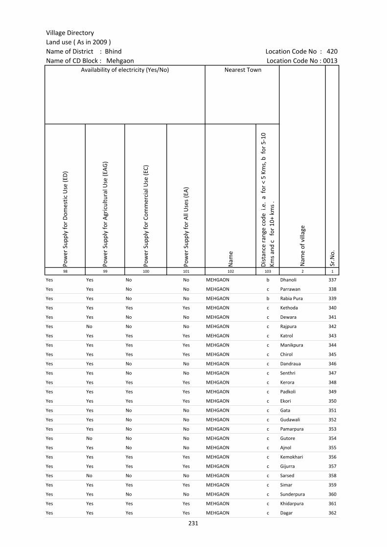
Village DirectoryLand use ( As in 2009 )Name of District : Bhind Location Code No : 420Name of CD Block : Mehgaon Location Code No : 0013
Pow
er S
uppl
y fo
r D
omes
tic U
se (E
D)
Pow
er S
uppl
y fo
r A
gric
ultu
ral U
se (E
AG
)
Pow
er S
uppl
y fo
r Co
mm
erci
al U
se (E
C)
Pow
er S
uppl
y fo
r A
ll U
ses
(EA
)
Nam
e
Dis
tanc
e ra
nge
code
i.e
. a
for
< 5
Kms,
b f
or 5
-10
Kms
and
c f
or 1
0+ k
ms
.98 99 100 101 102 103 2 1
Nearest Town
Nam
e of
vill
age
Sr.N
o.
Availability of electricity (Yes/No)
Yes Yes No No MEHGAON b Dhanoli 337
Yes Yes No No MEHGAON c Parrawan 338
Yes Yes No No MEHGAON b Rabia Pura 339
Yes Yes Yes Yes MEHGAON c Kethoda 340
Yes Yes No No MEHGAON c Dewara 341
Yes No No No MEHGAON c Rajpura 342
Yes Yes Yes Yes MEHGAON c Katrol 343
Yes Yes Yes Yes MEHGAON c Manikpura 344
Yes Yes Yes Yes MEHGAON c Chirol 345
Yes Yes No No MEHGAON c Dandraua 346
Yes Yes No No MEHGAON c Senthri 347
Yes Yes Yes Yes MEHGAON c Kerora 348
Yes Yes Yes Yes MEHGAON c Padkoli 349
Yes Yes Yes Yes MEHGAON c Ekori 350
Yes Yes No No MEHGAON c Gata 351
Yes Yes No No MEHGAON c Gudawali 352
Yes Yes No No MEHGAON c Pamarpura 353
Yes No No No MEHGAON c Gutore 354
Yes Yes No No MEHGAON c Ajnol 355
Yes Yes Yes Yes MEHGAON c Kemokhari 356
Yes Yes Yes Yes MEHGAON c Gijurra 357
Yes No No No MEHGAON c Sarsed 358
Yes Yes Yes Yes MEHGAON c Simar 359
Yes Yes No No MEHGAON c Sunderpura 360
Yes Yes Yes Yes MEHGAON c Khidarpura 361
Yes Yes Yes Yes MEHGAON c Dagar 362
231
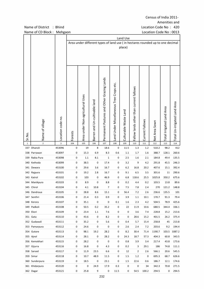
Census of India 2011- Amenities and
Name of District : Bhind Location Code No : 420Name of CD Block : Mehgaon Location Code No : 0013
Fore
sts
Are
a un
der
Non
-agr
icul
tura
l Use
s
Barr
en a
nd U
n-cu
ltiva
ble
land
Perm
anen
t Pas
ture
s an
d O
ther
Gra
zing
Lan
ds
Land
Und
er M
isce
llane
ous
Tree
Cro
ps e
tc.
Cultu
rabl
e W
aste
Lan
d
Fallo
w la
nds
othe
r th
an c
urre
nt fa
llow
s
Curr
ent F
allo
ws
Net
Are
a So
wn
Tota
l Irr
igat
ed L
and
Are
a
Tota
l Un-
irri
gate
d La
nd A
rea
1 2 3 104 105 106 107 108 109 110 111 112 113 114
Land UseArea under different types of land use ( in hectares rounded up to one decimal
place)
Sr.N
o.
Nam
e of
vill
age
Loca
tion
code
no.
337 Dhanoli 453096 0 19 8 18.6 0 11.5 1.3 1.2 510.2 98.2 412
338 Parrawan 453097 0 15.3 6.9 8.3 0.6 1.1 1.7 1.6 388.7 128.1 260.6
339 Rabia Pura 453098 0 1.1 8.1 1 0 2.5 1.6 2.1 184.8 49.4 135.5
340 Kethoda 453099 0 38.5 0 17.4 0 3.2 9 4.2 291.8 45.5 246.3
341 Dewara 453100 0 29.6 3.6 16.7 0 6.2 16.8 20.2 407.6 15.1 392.4
342 Rajpura 453101 0 19.2 2.8 16.7 0 9.1 6.5 3.5 301.6 11 290.6
343 Katrol 453102 0 103 0 46.9 0 6.8 118.6 25.5 1025.8 350.2 675.6
344 Manikpura 453103 0 8.9 0 8.8 0 0.2 4.4 0.2 103.5 13.8 89.6
345 Chirol 453104 0 4.1 10.8 7 0 7.5 7.8 2.4 270 121.2 148.8
346 Dandraua 453105 0 28.8 8.6 15.1 0 56.4 7.2 2.6 236.6 135.5 101
347 Senthri 453106 0 21.4 0.3 0.9 0 3.9 1.1 10.1 170.7 91.3 79.4
348 Kerora 453107 0 35.1 0 0 0.1 1.6 2.3 4.2 504.5 78.9 425.6
349 Padkoli 453108 0 50.5 0.2 35.2 0 22 11.9 10.6 680.5 344.4 336.1
350 Ekori 453109 0 23.4 1.1 7.6 0 0 3.6 7.4 228.8 15.2 213.6
351 Gata 453110 0 43.6 0 8.2 0 0 28.6 15.2 401.5 26.2 375.4
352 Gudawali 453111 0 35.2 0 5.6 0 0.4 5.7 15.4 258.8 45 213.8
353 Pamarpura 453112 0 24.6 0 0 0 2.6 2.4 7.2 203.6 9.2 194.4
354 Gutore 453113 0 98.1 19.2 28.2 0 8.2 30.4 71.4 1190.7 103.5 1087.2
355 Ajnol 453114 0 28.1 0 28.2 0 24.3 18.7 57.3 404.3 60.8 343.5
356 Kemokhari 453115 0 28.2 0 0 0 0.8 3.9 3.4 217.4 43.8 173.6
357 Gijurra 453116 0 16.8 0 4.3 0 0.2 3 29.1 186 74.8 111.1
358 Sarsed 453117 0 11.9 23.5 6.6 0 12 2 2.6 566.1 20.6 545.5
359 Simar 453118 0 10.7 48.9 11.5 0 1.5 1.2 0 695.3 68.7 626.6
360 Sunderpura 453119 0 18.5 0 23.1 0 1.5 22.6 0.6 186.7 12.1 174.6
361 Khidarpura 453120 0 0 24.9 17.9 0.3 0 0 34 342.3 70.8 271.5
362 Dagar 453121 0 25.8 9 0 11.5 0 54.5 100.2 294.5 0 294.5
232

Village DirectoryLand use ( As in 2009 )Name of District : Bhind Location Code No : 420Name of CD Block : Mehgaon Location Code No : 0013
Cana
ls (
C )
Wel
ls/T
ube-
wel
ls(W
/TW
)
Tank
s/La
kes(
T/L)
Wat
er F
alls
(WF)
Oth
ers(
O)
Firs
t
Seco
nd
Thir
d 115 116 117 118 119 120 121 122 2 1
Land Use Name of three most important commodities manufactured
Nam
e of
Vill
age
Sr.N
o.
Area irrigated by source (in hectare).
0 98.2 0 0 0 Dhanoli 337
0 128.1 0 0 0 Parrawan 338
0 49.4 0 0 0 Rabia Pura 339
0 45.5 0 0 0 Kethoda 340
0 15.1 0 0 0 Dewara 341
0 11 0 0 0 Rajpura 342
0 350.2 0 0 0 Katrol 343
0 13.8 0 0 0 Manikpura 344
0 121.2 0 0 0 Chirol 345
0 135.5 0 0 0 Dandraua 346
0 91.3 0 0 0 Senthri 347
0 78.9 0 0 0 Kerora 348
0 344.4 0 0 0 Padkoli 349
0 15.2 0 0 0 Ekori 350
0 26.2 0 0 0 Gata 351
0 45 0 0 0 Gudawali 352
0 9.2 0 0 0 Pamarpura 353
0 103.5 0 0 0 Gutore 354
0 60.8 0 0 0 Ajnol 355
0 43.8 0 0 0 Kemokhari 356
0 74.8 0 0 0 Gijurra 357
0 20.6 0 0 0 Sarsed 358
0 68.7 0 0 0 Simar 359
0 12.1 0 0 0 Sunderpura 360
0 70.8 0 0 0 Khidarpura 361
0 0 0 0 0 Dagar 362
233

Census of India 2011- Amenities and
Name of District : Bhind Location Code No : 420Name of CD Block : Mehgaon Location Code No : 0013
Pre-
Prim
ary
scho
ol (P
P)
Prim
ary
scho
ol (P
)
Mid
dle
scho
ol (M
)
Seco
ndar
y Sc
hool
(S)
Seni
or S
econ
dary
sch
ool (
SS)
Deg
ree
colle
ge o
f art
s s
cien
ce &
com
mer
ce (
ASC
)
Engi
neer
ing
colle
ge(E
C)
Med
ical
col
lege
(MC)
Man
agem
ent i
nstit
ute
(MI)
Poly
tech
nic
(Pt)
Voca
tiona
l tra
inin
g sc
hool
/IT
I
Non
-for
mal
trai
ning
cen
tre
(NFT
C)
Spec
ial s
choo
l for
dis
able
d (S
SD)
Oth
ers
(spe
cify
)
1 2 3 4 5 6 7 8 9 10 11 12 13 14 15 16 17 18 19 20
Sr.N
o.
Nam
e of
vill
age
Loca
tion
code
no.
Tota
l are
a of
the
villa
ge (
in h
ecta
res
roun
ded
up to
one
dec
imal
pla
ce)
Tota
l pop
ulat
ion
( 201
1 ce
nsus
)
Num
ber
of h
ouse
hold
s (2
011
cens
us)
Number of educational amenities available. (If not available within the village , the distance range
code viz; a for < 5 Kms, b for 5-10 Kms and c for 10+ kms of nearest place where facility is available is given).
363 Sanduri 453122 300.4 575 108 c 1 b b c c c c c c c c c
364 Neemgaon 453123 550.5 1706 264 c 2 1 a c c c c c c c c
365 Baraso 453124 1001.4 2348 403 b 3 1 1 b c c c c a c c c
366 Surawali 453125 467.2 2108 406 c 2 1 a c c c c c c c c c
367 Goara 453126 1936.1 5549 1174 b 7 1 b 1 c c c b b b b
368 Bharoli Khurd 453127 1894 3521 520 c 1 1 a c c c c c c c
369 Bharoli Kalan 453128 1200.4 3817 511 c 4 1 1 1 c c c c c c c c
370 Musawali 453129 769.3 774 107 c 1 1 b c c c c c c c c c
371 Goram 453130 995.1 2155 298 b 1 1 b 1 c c c c c c c c
372 Chutawali 453131 253.7 506 81 1 1 1 b b c c c c c c c c
373 Depura 453132 335.2 531 87 b 1 a a a c c c c c c c c
374 Devari(Lawan) 453133 133.4 87 14 c 1 a 1 c c c c c c c c
375 Shaypura 453134 539.3 1076 187 b 1 1 a a c c c c c c c c
376 Chhajupura 453135 363.6 1053 216 c 2 1 c c c c c c c c c
377 Norasai 453136 180.2 384 63 c 1 a a c c c c c c c c c
378 Patlokhari 453137 509.8 862 187 c 1 1 c c c c c c c c c
379 Jarsena 453138 204.7 754 141 c 1 1 1 c c c c c c c c c c
380 Jithaso 453139 398.3 987 166 c 1 1 b c c c c c c c c c
381 Ranupura 453140 799.8 1403 277 c 1 a a c c c c c c c c c
382 Sayna 453141 1056.4 3033 617 1 3 1 a c c c c c c c c c
383 Kanathar 453142 1262 3725 631 b 2 1 1 b c c c c c c c c
384 Gaheli 453143 2082.2 6148 1006 a 5 1 1 1 c c c c c c c c
385 Tikari Kalan 453144 356.4 417 57 1 a b c c c c c c c
386 Tikari Khurd 453145 424.3 819 134 2 1 1 c c c c c c c c c
387 Dhorkha 453146 532.2 971 160 1 1 1 b b c c c c c c c
388 Silaupura 453147 336.1 521 105 c 1 a b c c c c c c c c
234

Village DirectoryLand use ( As in 2009 )Name of District : Bhind Location Code No : 420Name of CD Block : Mehgaon Location Code No : 0013
Com
mun
ity h
ealth
cen
tre
(CH
C)Pr
imar
y he
alth
cen
tre
(PH
C)Pr
imar
y he
alth
sub
cen
tre
(PH
S)M
ater
nity
and
chi
ld w
elfa
re c
entr
e (M
CW)
T.B.
clin
ic (
TBC)
Hos
pita
l-allo
path
ic (H
A)
Hos
pita
l-alte
rnat
ive
med
icin
e (H
O)
Dis
pens
ary
(D)
Vete
rina
ry h
ospi
tal (
VH)
Mob
ile h
ealth
clin
ic (M
HC)
Fam
ily w
elfa
re c
entr
e (F
WC)
Char
itabl
e no
n G
ovt.
hos
pita
l/N
ursi
ng h
ome.
Med
ical
pra
ctiti
oner
with
MBB
S D
egre
eM
edic
al p
ract
ition
er w
ith o
ther
deg
ree
Med
ical
pra
ctiti
oner
with
no
degr
eeTr
aditi
onal
pra
ctiti
oner
and
faith
hea
ler
.M
edic
ine
Shop
Oth
ers
Tap
wat
er (T
reat
ed/U
ntre
ated
)
Wel
l w
ater
(C
over
ed /
Unc
over
ed w
ell)
Han
d Pu
mp
Tube
wel
ls /
Bor
e w
ell
Spri
ng
Rive
r /
Cana
l
Tank
/ P
ond
/ L
ake
Oth
ers
21 22 23 24 25 26 27 28 29 30 31 32 33 34 35 36 37 38 39 40 41 42 43 44 45 46 2 1
Number of Non-Government
Medical Amenities available.
Availability of drinking water - Yes / No
Nam
e of
vill
age
Sr.N
o.
Number of Medical Amenities available. (If not available within the
village , the distance range code viz; a for < 5 Kms, b for 5-10 Kms and c for
10+ kms of nearest place where facility is available is given).
c c b c c b c c c b c 0 0 0 0 0 0 0 No Yes Yes No Yes Yes Yes No Sanduri 363
c c a c c c c c c c c 0 0 0 2 0 0 0 No Yes Yes Yes No Yes Yes No Neemgaon 364
c c 1 c c c c 1 c c c 0 0 1 0 0 0 0 No Yes Yes Yes No Yes No No Baraso 365
c c a c c c c c c c c 0 0 0 0 0 0 0 No Yes Yes Yes Yes Yes Yes No Surawali 366
c c 1 b c b b b b c b 0 0 0 0 0 0 0 No Yes Yes Yes No Yes Yes Yes Goara 367
c 1 1 c c 1 1 c 1 0 0 0 0 0 0 0 Yes Yes Yes No No Yes Yes No Bharoli Khurd 368
c c c c c c c c a c 0 0 0 0 0 0 0 No Yes Yes Yes No Yes No No Bharoli Kalan 369
c b b c b c c c a c c 0 0 0 0 0 0 0 No Yes Yes Yes No Yes No No Musawali 370
c b 1 b b c c c b c c 0 0 0 0 0 0 0 Yes Yes Yes Yes No Yes Yes Yes Goram 371
c b b c b c c b c c 0 0 0 0 0 0 0 No Yes No No No No No No Chutawali 372
c c b c c c c c b c c 0 0 0 0 0 0 0 No Yes Yes No No Yes No No Depura 373
c c c c c c c c c c c 0 0 0 0 0 0 0 No No Yes Yes No No No No Devari(Lawan) 374
c c b c c c b c b c c 0 0 0 0 0 0 0 No Yes Yes No No No No No Shaypura 375
c c c c c c c c c c c 0 0 0 0 0 0 0 No Yes Yes No No No Yes No Chhajupura 376
c a a c a c c c a c c 0 0 0 0 0 0 0 No Yes Yes No No Yes No No Norasai 377
c c c c c c c c c c c 0 0 0 0 0 0 0 No Yes Yes No No Yes Yes No Patlokhari 378
c c c c c c c a a c c 0 0 0 0 0 0 0 No Yes Yes Yes No No No No Jarsena 379
c c c c c c c a a c c 0 0 0 0 0 0 0 No Yes Yes Yes No Yes No No Jithaso 380
c c c c c c c a a c c 0 0 0 0 0 0 0 No Yes Yes Yes No No No No Ranupura 381
c c b c c c c 1 c c c 0 0 1 0 0 0 0 No Yes Yes No No No Yes No Sayna 382
c c 1 b c b b 1 b c b 0 0 0 0 0 0 0 No Yes Yes No No No No No Kanathar 383
c a 1 a a a a 1 a c a 0 0 0 0 0 0 0 No Yes Yes Yes No Yes No No Gaheli 384
c c c c c c c c c c 0 0 0 0 0 0 0 No Yes Yes Yes No No No No Tikari Kalan 385
c c c c c c c c c c 0 0 0 0 0 0 0 No Yes Yes Yes No Yes No No Tikari Khurd 386
c c c c c c c c c c 0 0 1 0 0 0 0 No Yes Yes Yes No No No No Dhorkha 387
b c b c c c c b b c c 0 0 0 0 0 0 0 No Yes Yes No No Yes No No Silaupura 388
235

Census of India 2011- Amenities and
Name of District : Bhind Location Code No : 420Name of CD Block : Mehgaon Location Code No : 0013
Com
mun
ity to
ilet i
nclu
ding
bat
h.
Com
mun
ity to
ilet e
xclu
ding
bat
h.
Rura
l sa
nita
ry m
art o
r sa
nita
ry h
ardw
are
outle
t av
aila
ble
near
the
villa
ge.
Com
mun
ity b
io- g
as o
r re
cycl
e of
was
te fo
r pr
oduc
tive
use.
Post
off
ice(
PO)
Sub
post
off
ice
(SPO
)
Post
& T
eleg
raph
off
ice
(P&
TO)
Villa
ge P
in C
ode
Tele
phon
es
(L
and
lines
)
Publ
ic c
all o
ffic
e (P
CO)
Mob
ile p
hone
cov
erag
e
Inte
rnet
caf
es/
Com
mon
ser
vice
cen
tre
(CSC
)
Priv
ate
cour
ier
faci
lity
Bus
serv
ice
(Pub
lic &
Pri
vate
)
Railw
ay s
tatio
ns
Aut
o/M
odifi
ed A
utos
Taxi
s an
d Va
ns
1 2 3 47 48 49 50 51 52 53 54 55 56 57 58 59 60 61 62 63
Loca
tion
code
no.
Availability of toilet & others Yes / No
Communication and transport facilities (If amenities available code -Yes is given except for Village Pin Code ,If not available within the village , the distance range code
viz; a for < 5 Kms, b for 5-10 Kms and c for 10+ kms of nearest place where facility is available is given).
Sr.N
o.
Nam
e of
vill
age
363 Sanduri 453122 No No No No c c b c c Yes c c b c c c
364 Neemgaon 453123 No Yes No Yes a a a c c Yes c c Yes c c c
365 Baraso 453124 No No No No Yes c Yes 477557 Yes c Yes c c Yes c c c
366 Surawali 453125 No No No No a a c c Yes c c c c Yes a
367 Goara 453126 No No No No b b Yes 477001 b b Yes b b Yes b b b
368 Bharoli Khurd 453127 No No No No c Yes c c Yes Yes c c Yes c c c
369 Bharoli Kalan 453128 No No No No c Yes c 477332 c Yes Yes c c Yes c c c
370 Musawali 453129 No No No No c b c b c Yes c c b c c c
371 Goram 453130 No No No No b c c 477660 b c Yes b b Yes c b b
372 Chutawali 453131 No No No No c c c b c Yes c c Yes c c c
373 Depura 453132 No No No No c c b b c Yes c c b c c c
374 Devari(Lawan) 453133 No No No No c c c c c c c a c c c
375 Shaypura 453134 No No No No c b b b c Yes c c b c b b
376 Chhajupura 453135 No No No No c c Yes c c c c a c c c
377 Norasai 453136 No No No No c a c a c Yes c c a c c c
378 Patlokhari 453137 No No No No b Yes c c c c c c Yes c c c
379 Jarsena 453138 No No No No Yes a c 477557 c c Yes c c a c c c
380 Jithaso 453139 No No No No c a c a c Yes c c a c c c
381 Ranupura 453140 No No No No a c c c c Yes c c a c c c
382 Sayna 453141 Yes No No No Yes c c 477557 b c a c c c c c c
383 Kanathar 453142 No No No No c Yes c 477227 Yes c Yes c c Yes c c b
384 Gaheli 453143 No No No No c Yes c 477227 Yes c Yes c c Yes c c a
385 Tikari Kalan 453144 No No No No b b c c Yes c c Yes c c c
386 Tikari Khurd 453145 No No No No b b Yes c Yes c c Yes c c c
387 Dhorkha 453146 No No No No a b Yes c Yes c c Yes c c c
388 Silaupura 453147 No No No No b c c c b c c Yes c c c
236
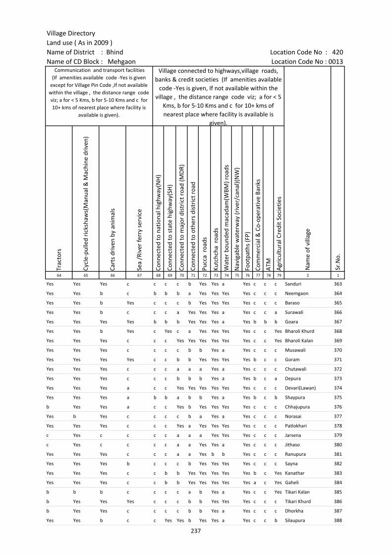
Village DirectoryLand use ( As in 2009 )Name of District : Bhind Location Code No : 420Name of CD Block : Mehgaon Location Code No : 0013
Trac
tors
Cycl
e-pu
lled
rick
shaw
s(M
anua
l & M
achi
ne d
rive
n)
Cart
s dr
iven
by
anim
als
Sea
/Riv
er fe
rry
serv
ice
Conn
ecte
d to
nat
iona
l hig
hway
(NH
)
Conn
ecte
d to
sta
te h
ighw
ay(S
H)
Conn
ecte
d to
maj
or d
istr
ict r
oad
(MD
R)
Conn
ecte
d to
oth
ers
dist
rict
roa
d
Pucc
a r
oads
Kutc
hcha
roa
ds
Wat
er b
ound
ed m
acad
am(W
BM) r
oads
Nav
igab
le w
ater
way
(riv
er/c
anal
)(N
W)
Foot
path
s (F
P)
Com
mer
cial
& C
o-op
erat
ive
Bank
s
ATM
Agr
icul
tura
l Cre
dit S
ocie
ties
64 65 66 67 68 69 70 71 72 73 74 75 76 77 78 79 2 1
Sr.N
o.
Communication and transport facilities (If amenities available code -Yes is given
except for Village Pin Code ,If not available within the village , the distance range code viz; a for < 5 Kms, b for 5-10 Kms and c for 10+ kms of nearest place where facility is
available is given).
Village connected to highways,village roads, banks & credit societies (If amenities available
code -Yes is given, If not available within the village , the distance range code viz; a for < 5
Kms, b for 5-10 Kms and c for 10+ kms of nearest place where facility is available is
given).
Nam
e of
vill
age
Yes Yes Yes c c c c b Yes Yes a Yes c c c Sanduri 363
Yes Yes b c b b b a Yes Yes Yes Yes c c c Neemgaon 364
Yes Yes b Yes c c c b Yes Yes Yes Yes c c c Baraso 365
Yes Yes b c c c a Yes Yes Yes a Yes c c a Surawali 366
Yes Yes Yes Yes b b b Yes Yes Yes a Yes b b b Goara 367
Yes Yes b Yes c Yes c a Yes Yes Yes Yes c c Yes Bharoli Khurd 368
Yes Yes Yes c c c Yes Yes Yes Yes Yes Yes c c Yes Bharoli Kalan 369
Yes Yes Yes c c c c b b Yes a Yes c c c Musawali 370
Yes Yes Yes Yes c c b b Yes Yes Yes Yes b c c Goram 371
Yes Yes Yes c c c a a a Yes a Yes c c c Chutawali 372
Yes Yes Yes c c c b b b Yes a Yes b c a Depura 373
Yes Yes Yes a c c Yes Yes Yes Yes Yes Yes c c c Devari(Lawan) 374
Yes Yes Yes a b b a b b Yes a Yes b c b Shaypura 375
b Yes Yes a c c Yes b Yes Yes Yes Yes c c c Chhajupura 376
Yes b Yes c c c c b a Yes a Yes c c c Norasai 377
Yes Yes Yes c c c Yes a Yes Yes Yes Yes c c c Patlokhari 378
c Yes c c c c a a a Yes Yes Yes c c c Jarsena 379
c Yes c c c c a a Yes Yes a Yes c c c Jithaso 380
Yes Yes Yes c c c a a Yes b b Yes c c c Ranupura 381
Yes Yes Yes b c c c b Yes Yes Yes Yes c c c Sayna 382
Yes Yes Yes c c b b Yes Yes Yes Yes Yes b c Yes Kanathar 383
Yes Yes Yes c c b b Yes Yes Yes Yes Yes a c Yes Gaheli 384
b b b c c c c a b Yes a Yes c c Yes Tikari Kalan 385
b Yes Yes Yes c c c b b Yes Yes Yes c c c Tikari Khurd 386
b Yes Yes c c c c b b Yes a Yes c c c Dhorkha 387
Yes Yes b c c Yes Yes b Yes Yes a Yes c c b Silaupura 388
237
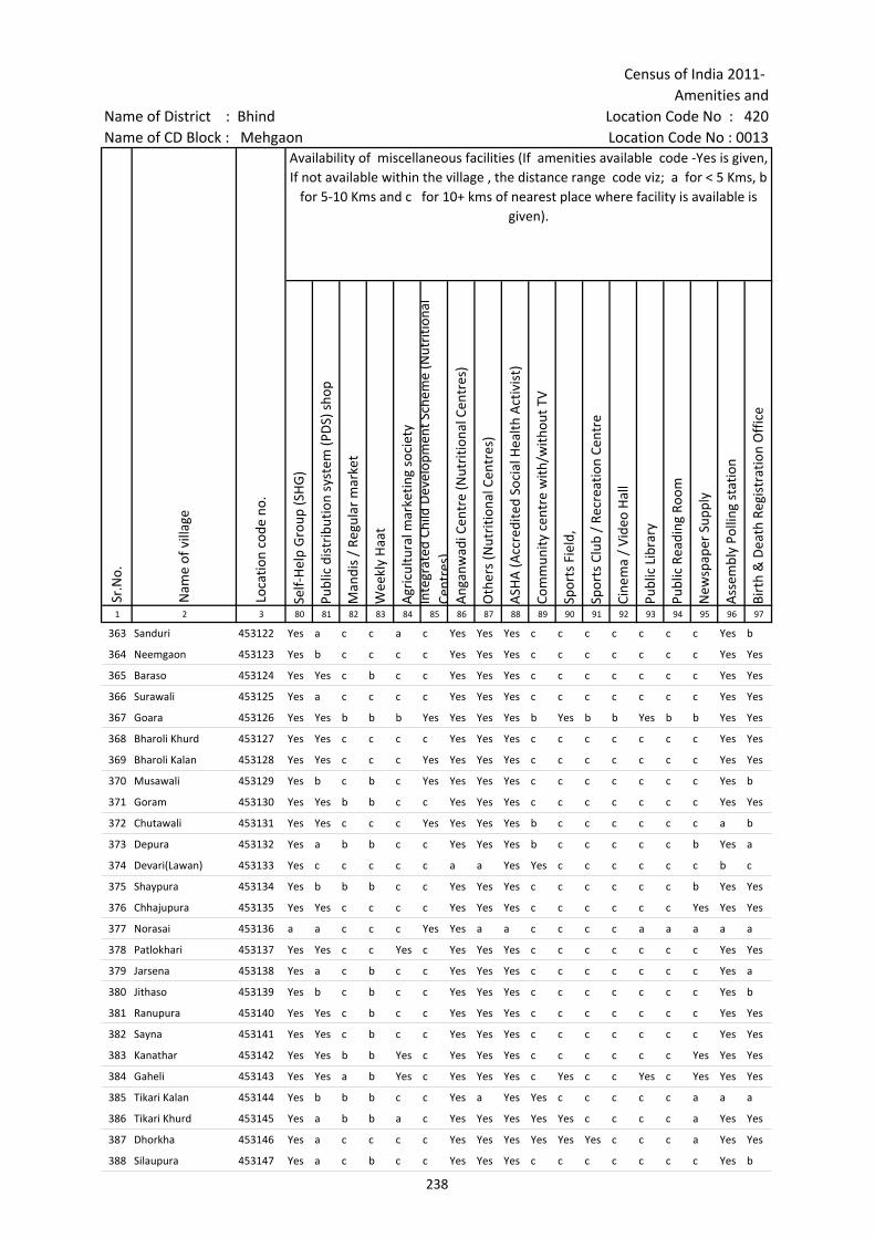
Census of India 2011- Amenities and
Name of District : Bhind Location Code No : 420Name of CD Block : Mehgaon Location Code No : 0013
Self-
Hel
p G
roup
(SH
G)
Publ
ic d
istr
ibut
ion
syst
em (P
DS)
sho
p
Man
dis
/ Re
gula
r m
arke
t
Wee
kly
Haa
t
Agr
icul
tura
l mar
ketin
g so
ciet
yIn
tegr
ated
Chi
ld D
evel
opm
ent S
chem
e (N
utri
tiona
l Ce
ntre
s)A
ngan
wad
i Cen
tre
(Nut
ritio
nal C
entr
es)
Oth
ers
(Nut
ritio
nal C
entr
es)
ASH
A (A
ccre
dite
d So
cial
Hea
lth A
ctiv
ist)
Com
mun
ity c
entr
e w
ith/w
ithou
t TV
Spor
ts F
ield
,
Spor
ts C
lub
/ Re
crea
tion
Cent
re
Cine
ma
/ Vi
deo
Hal
l
Publ
ic L
ibra
ry
Publ
ic R
eadi
ng R
oom
New
spap
er S
uppl
y
Ass
embl
y Po
lling
sta
tion
Birt
h &
Dea
th R
egis
trat
ion
Off
ice
1 2 3 80 81 82 83 84 85 86 87 88 89 90 91 92 93 94 95 96 97
Sr.N
o.
Nam
e of
vill
age
Loca
tion
code
no.
Availability of miscellaneous facilities (If amenities available code -Yes is given, If not available within the village , the distance range code viz; a for < 5 Kms, b
for 5-10 Kms and c for 10+ kms of nearest place where facility is available is given).
363 Sanduri 453122 Yes a c c a c Yes Yes Yes c c c c c c c Yes b
364 Neemgaon 453123 Yes b c c c c Yes Yes Yes c c c c c c c Yes Yes
365 Baraso 453124 Yes Yes c b c c Yes Yes Yes c c c c c c c Yes Yes
366 Surawali 453125 Yes a c c c c Yes Yes Yes c c c c c c c Yes Yes
367 Goara 453126 Yes Yes b b b Yes Yes Yes Yes b Yes b b Yes b b Yes Yes
368 Bharoli Khurd 453127 Yes Yes c c c c Yes Yes Yes c c c c c c c Yes Yes
369 Bharoli Kalan 453128 Yes Yes c c c Yes Yes Yes Yes c c c c c c c Yes Yes
370 Musawali 453129 Yes b c b c Yes Yes Yes Yes c c c c c c c Yes b
371 Goram 453130 Yes Yes b b c c Yes Yes Yes c c c c c c c Yes Yes
372 Chutawali 453131 Yes Yes c c c Yes Yes Yes Yes b c c c c c c a b
373 Depura 453132 Yes a b b c c Yes Yes Yes b c c c c c b Yes a
374 Devari(Lawan) 453133 Yes c c c c c a a Yes Yes c c c c c c b c
375 Shaypura 453134 Yes b b b c c Yes Yes Yes c c c c c c b Yes Yes
376 Chhajupura 453135 Yes Yes c c c c Yes Yes Yes c c c c c c Yes Yes Yes
377 Norasai 453136 a a c c c Yes Yes a a c c c c a a a a a
378 Patlokhari 453137 Yes Yes c c Yes c Yes Yes Yes c c c c c c c Yes Yes
379 Jarsena 453138 Yes a c b c c Yes Yes Yes c c c c c c c Yes a
380 Jithaso 453139 Yes b c b c c Yes Yes Yes c c c c c c c Yes b
381 Ranupura 453140 Yes Yes c b c c Yes Yes Yes c c c c c c c Yes Yes
382 Sayna 453141 Yes Yes c b c c Yes Yes Yes c c c c c c c Yes Yes
383 Kanathar 453142 Yes Yes b b Yes c Yes Yes Yes c c c c c c Yes Yes Yes
384 Gaheli 453143 Yes Yes a b Yes c Yes Yes Yes c Yes c c Yes c Yes Yes Yes
385 Tikari Kalan 453144 Yes b b b c c Yes a Yes Yes c c c c c a a a
386 Tikari Khurd 453145 Yes a b b a c Yes Yes Yes Yes Yes c c c c a Yes Yes
387 Dhorkha 453146 Yes a c c c c Yes Yes Yes Yes Yes Yes c c c a Yes Yes
388 Silaupura 453147 Yes a c b c c Yes Yes Yes c c c c c c c Yes b
238
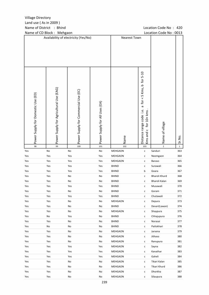
Village DirectoryLand use ( As in 2009 )Name of District : Bhind Location Code No : 420Name of CD Block : Mehgaon Location Code No : 0013
Pow
er S
uppl
y fo
r D
omes
tic U
se (E
D)
Pow
er S
uppl
y fo
r A
gric
ultu
ral U
se (E
AG
)
Pow
er S
uppl
y fo
r Co
mm
erci
al U
se (E
C)
Pow
er S
uppl
y fo
r A
ll U
ses
(EA
)
Nam
e
Dis
tanc
e ra
nge
code
i.e
. a
for
< 5
Kms,
b f
or 5
-10
Kms
and
c f
or 1
0+ k
ms
.98 99 100 101 102 103 2 1
Nearest Town
Nam
e of
vill
age
Sr.N
o.
Availability of electricity (Yes/No)
Yes No No No MEHGAON c Sanduri 363
Yes Yes Yes Yes MEHGAON c Neemgaon 364
Yes Yes Yes Yes MEHGAON c Baraso 365
Yes Yes Yes Yes BHIND c Surawali 366
Yes Yes Yes Yes BHIND b Goara 367
Yes Yes No No BHIND c Bharoli Khurd 368
Yes Yes No No BHIND c Bharoli Kalan 369
Yes Yes Yes Yes BHIND c Musawali 370
Yes Yes No No BHIND c Goram 371
Yes Yes Yes Yes BHIND c Chutawali 372
Yes Yes No No MEHGAON c Depura 373
Yes Yes No No BHIND c Devari(Lawan) 374
Yes Yes No No MEHGAON c Shaypura 375
Yes No Yes No BHIND c Chhajupura 376
Yes Yes No No BHIND c Norasai 377
Yes No No No BHIND c Patlokhari 378
Yes Yes No No MEHGAON c Jarsena 379
Yes Yes No No MEHGAON c Jithaso 380
Yes Yes No No MEHGAON c Ranupura 381
Yes Yes Yes Yes MEHGAON c Sayna 382
Yes Yes Yes Yes MEHGAON c Kanathar 383
Yes Yes Yes Yes MEHGAON c Gaheli 384
Yes Yes No No MEHGAON c Tikari Kalan 385
Yes Yes No No MEHGAON c Tikari Khurd 386
Yes Yes No No MEHGAON c Dhorkha 387
Yes Yes No No MEHGAON c Silaupura 388
239
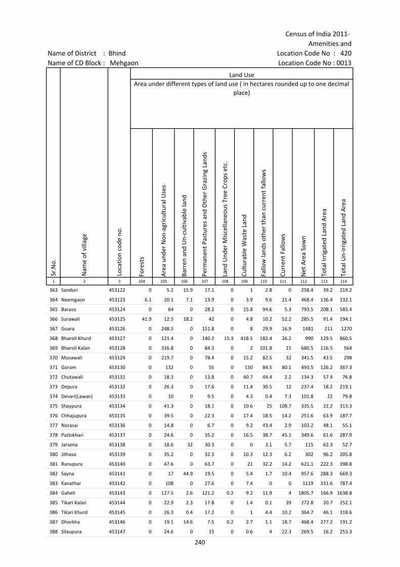
Census of India 2011- Amenities and
Name of District : Bhind Location Code No : 420Name of CD Block : Mehgaon Location Code No : 0013
Fore
sts
Are
a un
der
Non
-agr
icul
tura
l Use
s
Barr
en a
nd U
n-cu
ltiva
ble
land
Perm
anen
t Pas
ture
s an
d O
ther
Gra
zing
Lan
ds
Land
Und
er M
isce
llane
ous
Tree
Cro
ps e
tc.
Cultu
rabl
e W
aste
Lan
d
Fallo
w la
nds
othe
r th
an c
urre
nt fa
llow
s
Curr
ent F
allo
ws
Net
Are
a So
wn
Tota
l Irr
igat
ed L
and
Are
a
Tota
l Un-
irri
gate
d La
nd A
rea
1 2 3 104 105 106 107 108 109 110 111 112 113 114
Land UseArea under different types of land use ( in hectares rounded up to one decimal
place)
Sr.N
o.
Nam
e of
vill
age
Loca
tion
code
no.
363 Sanduri 453122 0 5.2 15.9 17.1 0 1 2.8 0 258.4 39.2 219.2
364 Neemgaon 453123 6.1 20.1 7.1 13.9 0 3.9 9.6 21.4 468.4 136.4 332.1
365 Baraso 453124 0 64 0 28.2 0 15.8 94.6 5.3 793.5 208.1 585.4
366 Surawali 453125 41.9 12.5 18.2 42 0 4.8 10.2 52.2 285.5 91.4 194.1
367 Goara 453126 0 248.5 0 151.8 0 8 29.9 16.9 1481 211 1270
368 Bharoli Khurd 453127 0 121.4 0 140.2 15.3 418.5 182.4 26.2 990 129.5 860.5
369 Bharoli Kalan 453128 0 316.8 0 84.3 0 2 101.8 15 680.5 116.5 564
370 Musawali 453129 0 219.7 0 78.4 0 15.2 82.5 32 341.5 43.5 298
371 Goram 453130 0 132 0 55 0 150 84.5 80.1 493.5 126.2 367.3
372 Chutawali 453131 0 18.3 0 13.8 0 40.7 44.4 2.2 134.3 57.4 76.8
373 Depura 453132 0 26.3 0 17.6 0 11.4 30.5 12 237.4 18.2 219.1
374 Devari(Lawan) 453133 0 10 0 9.5 0 4.3 0.4 7.3 101.8 22 79.8
375 Shaypura 453134 0 41.3 0 18.1 0 10.6 25 108.7 335.5 22.2 313.3
376 Chhajupura 453135 0 39.5 0 22.3 0 17.4 18.5 14.2 251.6 63.9 187.7
377 Norasai 453136 0 14.8 0 6.7 0 9.2 43.4 2.9 103.2 48.1 55.1
378 Patlokhari 453137 0 24.6 0 35.2 0 16.5 38.7 45.1 349.6 61.6 287.9
379 Jarsena 453138 0 18.6 32 30.3 0 0 3.1 5.7 115 62.3 52.7
380 Jithaso 453139 0 35.2 0 32.3 0 10.3 12.3 6.2 302 96.2 205.8
381 Ranupura 453140 0 47.6 0 63.7 0 21 32.2 14.2 621.1 222.3 398.8
382 Sayna 453141 0 17 44.9 19.5 0 5.4 1.7 10.4 957.6 288.3 669.3
383 Kanathar 453142 0 108 0 27.6 0 7.4 0 0 1119 331.6 787.4
384 Gaheli 453143 0 127.5 2.6 121.2 0.2 9.2 11.9 4 1805.7 166.9 1638.8
385 Tikari Kalan 453144 0 22.9 2.3 17.8 0 1.4 0.1 39 272.8 20.7 252.1
386 Tikari Khurd 453145 0 26.3 0.4 17.2 0 1 4.4 10.2 364.7 46.1 318.6
387 Dhorkha 453146 0 19.1 14.6 7.5 0.2 2.7 1.1 18.7 468.4 277.2 191.2
388 Silaupura 453147 0 24.6 0 15 0 0.6 4 22.3 269.5 16.2 253.3
240
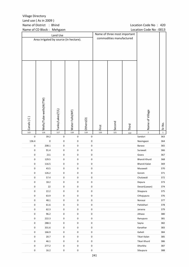
Village DirectoryLand use ( As in 2009 )Name of District : Bhind Location Code No : 420Name of CD Block : Mehgaon Location Code No : 0013
Cana
ls (
C )
Wel
ls/T
ube-
wel
ls(W
/TW
)
Tank
s/La
kes(
T/L)
Wat
er F
alls
(WF)
Oth
ers(
O)
Firs
t
Seco
nd
Thir
d 115 116 117 118 119 120 121 122 2 1
Land Use Name of three most important commodities manufactured
Nam
e of
Vill
age
Sr.N
o.
Area irrigated by source (in hectare).
0 39.2 0 0 0 Sanduri 363
136.4 0 0 0 0 Neemgaon 364
0 208.1 0 0 0 Baraso 365
0 91.4 0 0 0 Surawali 366
0 211 0 0 0 Goara 367
0 129.5 0 0 0 Bharoli Khurd 368
0 116.5 0 0 0 Bharoli Kalan 369
0 43.5 0 0 0 Musawali 370
0 126.2 0 0 0 Goram 371
0 57.4 0 0 0 Chutawali 372
0 18.2 0 0 0 Depura 373
0 22 0 0 0 Devari(Lawan) 374
0 22.2 0 0 0 Shaypura 375
0 63.9 0 0 0 Chhajupura 376
0 48.1 0 0 0 Norasai 377
0 61.6 0 0 0 Patlokhari 378
0 62.3 0 0 0 Jarsena 379
0 96.2 0 0 0 Jithaso 380
0 222.3 0 0 0 Ranupura 381
0 288.3 0 0 0 Sayna 382
0 331.6 0 0 0 Kanathar 383
0 166.9 0 0 0 Gaheli 384
0 20.7 0 0 0 Tikari Kalan 385
0 46.1 0 0 0 Tikari Khurd 386
0 277.2 0 0 0 Dhorkha 387
0 16.2 0 0 0 Silaupura 388
241

Census of India 2011- Amenities and
Name of District : Bhind Location Code No : 420Name of CD Block : Mehgaon Location Code No : 0013
Pre-
Prim
ary
scho
ol (P
P)
Prim
ary
scho
ol (P
)
Mid
dle
scho
ol (M
)
Seco
ndar
y Sc
hool
(S)
Seni
or S
econ
dary
sch
ool (
SS)
Deg
ree
colle
ge o
f art
s s
cien
ce &
com
mer
ce (
ASC
)
Engi
neer
ing
colle
ge(E
C)
Med
ical
col
lege
(MC)
Man
agem
ent i
nstit
ute
(MI)
Poly
tech
nic
(Pt)
Voca
tiona
l tra
inin
g sc
hool
/IT
I
Non
-for
mal
trai
ning
cen
tre
(NFT
C)
Spec
ial s
choo
l for
dis
able
d (S
SD)
Oth
ers
(spe
cify
)
1 2 3 4 5 6 7 8 9 10 11 12 13 14 15 16 17 18 19 20
Sr.N
o.
Nam
e of
vill
age
Loca
tion
code
no.
Tota
l are
a of
the
villa
ge (
in h
ecta
res
roun
ded
up to
one
dec
imal
pla
ce)
Tota
l pop
ulat
ion
( 201
1 ce
nsus
)
Num
ber
of h
ouse
hold
s (2
011
cens
us)
Number of educational amenities available. (If not available within the village , the distance range
code viz; a for < 5 Kms, b for 5-10 Kms and c for 10+ kms of nearest place where facility is available is given).
389 Sururu 453148 178.5 1045 230 b 2 1 b b c c c c c c c
390 Aanto 453149 805.1 1285 252 b 1 a b b c c c c c c c c
391 Sandasi Pura 453150 198 1 1 c c c c
392 Adokhar 453151 226.1 1143 211 b 1 2 1 1 c c c c c c c c
393 Takpura 453152 172.5 779 152 a 1 a a a c c c c c c c
394 Vespura 453153 92.3 0 0 --------------Un-inhabited--------------
395 Lahra 453154 198.5 941 188 a 1 a a a c c c c c c c
396 Kupawali 453155 379.7 426 72 b 1 a a a c c c c c c c
397 Buzurg 453156 200.8 691 100 b 1 a b b c c c c c c c c
398 Sadha 453157 481.1 1549 231 a 1 a a a c c c c c c c c
399 Ajeeta 453158 325.7 695 147 b 1 a a b c c c c c c c c
400 Khairoli 453159 958.3 1291 257 b 1 b 1 b c c c c c c c c
401 Kachhar 453160 164 1056 177 b 1 b b b c c c c c c c c
402 Kheriya Sindh 453161 598.3 1149 199 a 4 1 b b c c c c c c c c
403 Barethi Raj 453162 249 271 44 a 1 a b c c c c c c c c
404 Pura 453163 215.6 563 91 a 1 a a a c c c c c c c c
405 Badera 453164 310.6 563 90 a 1 a a a c c c c c c c c
406 Bachhareta 453165 315.7 549 82 b 1 a a b c c c c c c c
407 Barethi Khurd 453166 283.8 328 61 b 1 a b b c c c c c c c c
408 Bachharoli 453167 259.4 343 58 1 b b c c c c c c c c
409 Sanduri 453168 309.6 704 129 b 2 b b c c c c c c c
410 Sing Pura 453169 243.6 846 165 c 2 a a a c c c c c c c
411 Semra 453170 197.2 708 122 b 1 b b b c c c c c c c c
412 Kaman Pura 453171 106.4 281 66 c 1 a a a b b c c c c
413 Gokul Pura 453172 234 579 126 1 1 b b b c c c c c c c
414 Chandrapura 453173 108.3 245 41 1 a b c c c c
242

Village DirectoryLand use ( As in 2009 )Name of District : Bhind Location Code No : 420Name of CD Block : Mehgaon Location Code No : 0013
Com
mun
ity h
ealth
cen
tre
(CH
C)Pr
imar
y he
alth
cen
tre
(PH
C)Pr
imar
y he
alth
sub
cen
tre
(PH
S)M
ater
nity
and
chi
ld w
elfa
re c
entr
e (M
CW)
T.B.
clin
ic (
TBC)
Hos
pita
l-allo
path
ic (H
A)
Hos
pita
l-alte
rnat
ive
med
icin
e (H
O)
Dis
pens
ary
(D)
Vete
rina
ry h
ospi
tal (
VH)
Mob
ile h
ealth
clin
ic (M
HC)
Fam
ily w
elfa
re c
entr
e (F
WC)
Char
itabl
e no
n G
ovt.
hos
pita
l/N
ursi
ng h
ome.
Med
ical
pra
ctiti
oner
with
MBB
S D
egre
eM
edic
al p
ract
ition
er w
ith o
ther
deg
ree
Med
ical
pra
ctiti
oner
with
no
degr
eeTr
aditi
onal
pra
ctiti
oner
and
faith
hea
ler
.M
edic
ine
Shop
Oth
ers
Tap
wat
er (T
reat
ed/U
ntre
ated
)
Wel
l w
ater
(C
over
ed /
Unc
over
ed w
ell)
Han
d Pu
mp
Tube
wel
ls /
Bor
e w
ell
Spri
ng
Rive
r /
Cana
l
Tank
/ P
ond
/ L
ake
Oth
ers
21 22 23 24 25 26 27 28 29 30 31 32 33 34 35 36 37 38 39 40 41 42 43 44 45 46 2 1
Number of Non-Government
Medical Amenities available.
Availability of drinking water - Yes / No
Nam
e of
vill
age
Sr.N
o.
Number of Medical Amenities available. (If not available within the
village , the distance range code viz; a for < 5 Kms, b for 5-10 Kms and c for
10+ kms of nearest place where facility is available is given).
c c b c c c c b b c c 0 0 0 0 0 0 0 No Yes Yes No No Yes No No Sururu 389
a c a a c a a a a c a 0 0 0 0 0 0 0 No Yes Yes No No No Yes No Aanto 390
c c c c c c c c 0 0 0 0 0 0 0 No No No No No No No No Sandasi Pura 391
c c b b c c b 1 b c c 0 0 0 0 0 0 0 No Yes Yes No No No No No Adokhar 392
b b a b b c c a c b b 0 0 0 0 0 0 0 No Yes Yes No No No No No Takpura 393
--------------Un-inhabited-------------- Vespura 394
b b a b b c c a c b b 0 0 0 0 0 0 0 No Yes Yes No No No No No Lahra 395
c c b c c c b c b c c 0 0 0 0 0 0 0 No Yes Yes No No No No No Kupawali 396
b c b b c b b b b b c 0 0 0 0 0 0 0 No Yes Yes No No No Yes No Buzurg 397
c b a b b b b b b b b 0 0 0 0 0 0 0 No Yes Yes Yes No Yes No No Sadha 398
c c a c c c b c c a 0 0 0 0 0 0 0 No Yes Yes Yes No Yes No No Ajeeta 399
c c 1 c c c c c c c c 0 0 0 0 0 0 0 No Yes Yes Yes No Yes No No Khairoli 400
c c b c c c b b c c b 0 0 0 0 0 0 0 No Yes Yes No No Yes No No Kachhar 401
c c a b c c c b c c c 0 0 0 0 0 0 0 No Yes Yes No No No Yes No Kheriya Sindh 402
c b b b b b c b b b b 0 0 0 0 0 0 0 No Yes Yes Yes No No No No Barethi Raj 403
a b a b b c c a b a b 0 0 0 0 0 0 0 No Yes Yes Yes No No No No Pura 404
a c a c c c c a c a c 0 0 0 0 0 0 0 No Yes Yes Yes No No No No Badera 405
c c b c c c c b c c c 0 0 0 0 0 0 0 No Yes Yes Yes No Yes No No Bachhareta 406
b c b c c c c b c b c 0 0 0 0 0 0 0 No Yes Yes Yes No Yes No No Barethi Khurd 407
b b b b b c c b b b 0 0 0 0 0 0 0 No Yes Yes No No No No No Bachharoli 408
c b b b b c c b b c b 0 0 0 0 0 0 0 No Yes Yes No No Yes No No Sanduri 409
b c b b c b c c c c b 0 0 0 0 0 0 0 No Yes Yes Yes No No No No Sing Pura 410
b b b b b c c b c b b 0 0 0 0 0 0 0 No Yes Yes No No No No No Semra 411
c c c c c c c c c c c 0 0 0 0 0 0 0 No Yes Yes Yes No No Yes No Kaman Pura 412
b b b b b c c b b b b 0 0 0 0 0 0 0 No Yes Yes No No No No No Gokul Pura 413
b b c c b c c b b b 0 0 0 0 0 0 0 No Yes Yes Yes No No No No Chandrapura 414
243
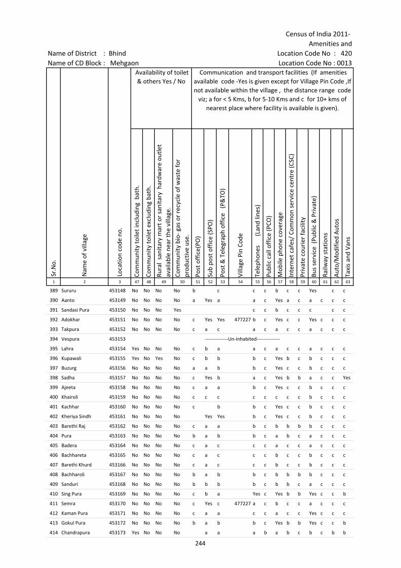
Census of India 2011- Amenities and
Name of District : Bhind Location Code No : 420Name of CD Block : Mehgaon Location Code No : 0013
Com
mun
ity to
ilet i
nclu
ding
bat
h.
Com
mun
ity to
ilet e
xclu
ding
bat
h.
Rura
l sa
nita
ry m
art o
r sa
nita
ry h
ardw
are
outle
t av
aila
ble
near
the
villa
ge.
Com
mun
ity b
io- g
as o
r re
cycl
e of
was
te fo
r pr
oduc
tive
use.
Post
off
ice(
PO)
Sub
post
off
ice
(SPO
)
Post
& T
eleg
raph
off
ice
(P&
TO)
Villa
ge P
in C
ode
Tele
phon
es
(L
and
lines
)
Publ
ic c
all o
ffic
e (P
CO)
Mob
ile p
hone
cov
erag
e
Inte
rnet
caf
es/
Com
mon
ser
vice
cen
tre
(CSC
)
Priv
ate
cour
ier
faci
lity
Bus
serv
ice
(Pub
lic &
Pri
vate
)
Railw
ay s
tatio
ns
Aut
o/M
odifi
ed A
utos
Taxi
s an
d Va
ns
1 2 3 47 48 49 50 51 52 53 54 55 56 57 58 59 60 61 62 63
Loca
tion
code
no.
Availability of toilet & others Yes / No
Communication and transport facilities (If amenities available code -Yes is given except for Village Pin Code ,If not available within the village , the distance range code
viz; a for < 5 Kms, b for 5-10 Kms and c for 10+ kms of nearest place where facility is available is given).
Sr.N
o.
Nam
e of
vill
age
389 Sururu 453148 No No No No b c c c b c c Yes c c
390 Aanto 453149 No No No No a Yes a a c Yes a c a c c c
391 Sandasi Pura 453150 No No No Yes c c b c c c c c
392 Adokhar 453151 No No No No c Yes Yes 477227 b c Yes c c Yes c c c
393 Takpura 453152 No No No No c a c a c a c c a c c c
394 Vespura 453153 --------------Un-inhabited--------------
395 Lahra 453154 Yes No No No c b a a c a c c a c c c
396 Kupawali 453155 Yes No Yes No c b b b c Yes b c b c c c
397 Buzurg 453156 No No No No a a b b c Yes c c b c c c
398 Sadha 453157 No No No No c Yes b a c Yes b b a c c Yes
399 Ajeeta 453158 No No No No c a a b c Yes c c b c c c
400 Khairoli 453159 No No No No c c c c c c c c b c c c
401 Kachhar 453160 No No No No c b b c Yes c c b c c c
402 Kheriya Sindh 453161 No No No No Yes Yes b c Yes c c b c c c
403 Barethi Raj 453162 No No No No c a a b c b b b b c c c
404 Pura 453163 No No No No b a b b c a b c a c c c
405 Badera 453164 No No No No c a c c c a c c a c c c
406 Bachhareta 453165 No No No No c a c c c b c c b c c c
407 Barethi Khurd 453166 No No No No c a c c c b c c b c c c
408 Bachharoli 453167 No No No No b a b b c b b b b c c c
409 Sanduri 453168 No No No No b b b b c b b c a c c c
410 Sing Pura 453169 No No No No c b a Yes c Yes b b Yes c c b
411 Semra 453170 No No No No c Yes c 477227 a c b c c a c c c
412 Kaman Pura 453171 No No No No c a a c c a c c Yes c c c
413 Gokul Pura 453172 No No No No b a b b c Yes b b Yes c c b
414 Chandrapura 453173 Yes No No No a a a b a b c b c b b
244
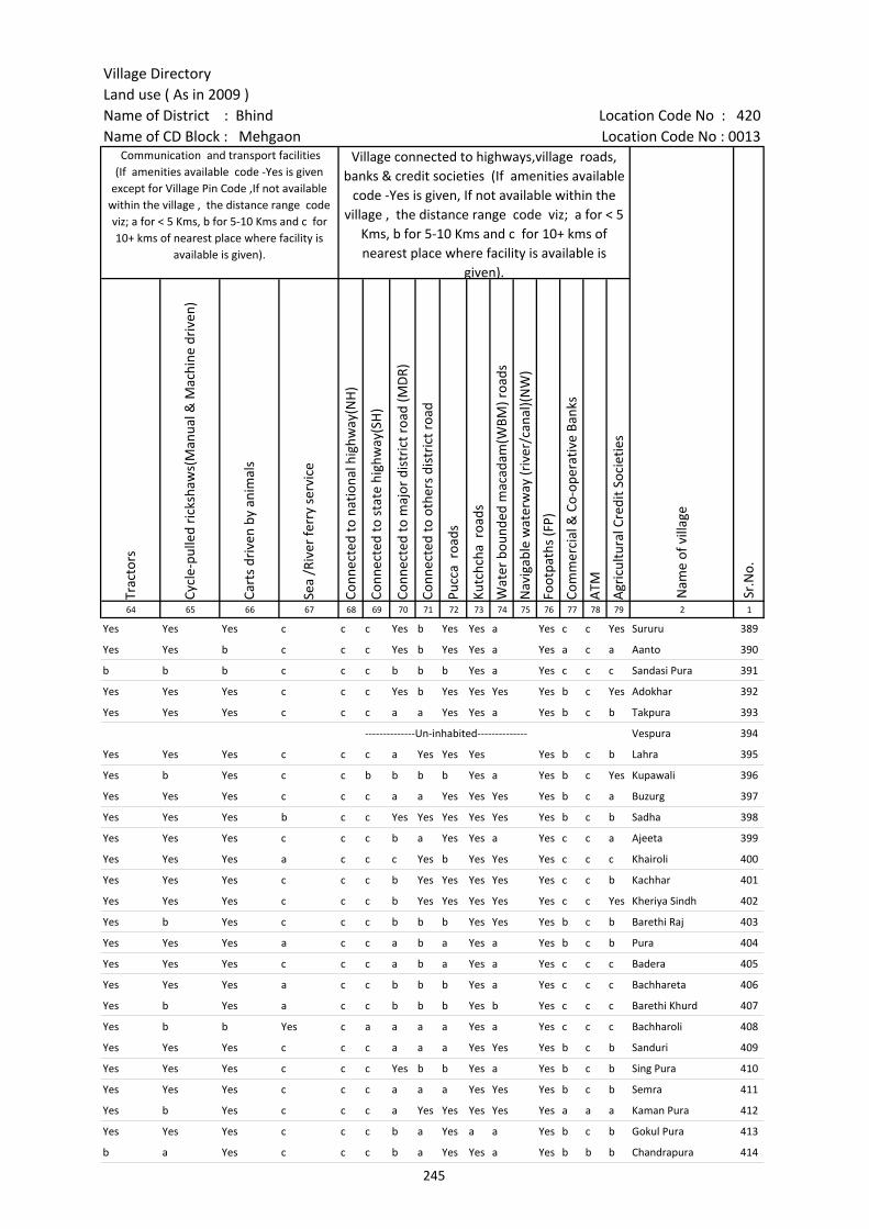
Village DirectoryLand use ( As in 2009 )Name of District : Bhind Location Code No : 420Name of CD Block : Mehgaon Location Code No : 0013
Trac
tors
Cycl
e-pu
lled
rick
shaw
s(M
anua
l & M
achi
ne d
rive
n)
Cart
s dr
iven
by
anim
als
Sea
/Riv
er fe
rry
serv
ice
Conn
ecte
d to
nat
iona
l hig
hway
(NH
)
Conn
ecte
d to
sta
te h
ighw
ay(S
H)
Conn
ecte
d to
maj
or d
istr
ict r
oad
(MD
R)
Conn
ecte
d to
oth
ers
dist
rict
roa
d
Pucc
a r
oads
Kutc
hcha
roa
ds
Wat
er b
ound
ed m
acad
am(W
BM) r
oads
Nav
igab
le w
ater
way
(riv
er/c
anal
)(N
W)
Foot
path
s (F
P)
Com
mer
cial
& C
o-op
erat
ive
Bank
s
ATM
Agr
icul
tura
l Cre
dit S
ocie
ties
64 65 66 67 68 69 70 71 72 73 74 75 76 77 78 79 2 1
Sr.N
o.
Communication and transport facilities (If amenities available code -Yes is given
except for Village Pin Code ,If not available within the village , the distance range code viz; a for < 5 Kms, b for 5-10 Kms and c for 10+ kms of nearest place where facility is
available is given).
Village connected to highways,village roads, banks & credit societies (If amenities available
code -Yes is given, If not available within the village , the distance range code viz; a for < 5
Kms, b for 5-10 Kms and c for 10+ kms of nearest place where facility is available is
given).
Nam
e of
vill
age
Yes Yes Yes c c c Yes b Yes Yes a Yes c c Yes Sururu 389
Yes Yes b c c c Yes b Yes Yes a Yes a c a Aanto 390
b b b c c c b b b Yes a Yes c c c Sandasi Pura 391
Yes Yes Yes c c c Yes b Yes Yes Yes Yes b c Yes Adokhar 392
Yes Yes Yes c c c a a Yes Yes a Yes b c b Takpura 393
--------------Un-inhabited-------------- Vespura 394
Yes Yes Yes c c c a Yes Yes Yes Yes b c b Lahra 395
Yes b Yes c c b b b b Yes a Yes b c Yes Kupawali 396
Yes Yes Yes c c c a a Yes Yes Yes Yes b c a Buzurg 397
Yes Yes Yes b c c Yes Yes Yes Yes Yes Yes b c b Sadha 398
Yes Yes Yes c c c b a Yes Yes a Yes c c a Ajeeta 399
Yes Yes Yes a c c c Yes b Yes Yes Yes c c c Khairoli 400
Yes Yes Yes c c c b Yes Yes Yes Yes Yes c c b Kachhar 401
Yes Yes Yes c c c b Yes Yes Yes Yes Yes c c Yes Kheriya Sindh 402
Yes b Yes c c c b b b Yes Yes Yes b c b Barethi Raj 403
Yes Yes Yes a c c a b a Yes a Yes b c b Pura 404
Yes Yes Yes c c c a b a Yes a Yes c c c Badera 405
Yes Yes Yes a c c b b b Yes a Yes c c c Bachhareta 406
Yes b Yes a c c b b b Yes b Yes c c c Barethi Khurd 407
Yes b b Yes c a a a a Yes a Yes c c c Bachharoli 408
Yes Yes Yes c c c a a a Yes Yes Yes b c b Sanduri 409
Yes Yes Yes c c c Yes b b Yes a Yes b c b Sing Pura 410
Yes Yes Yes c c c a a a Yes Yes Yes b c b Semra 411
Yes b Yes c c c a Yes Yes Yes Yes Yes a a a Kaman Pura 412
Yes Yes Yes c c c b a Yes a a Yes b c b Gokul Pura 413
b a Yes c c c b a Yes Yes a Yes b b b Chandrapura 414
245
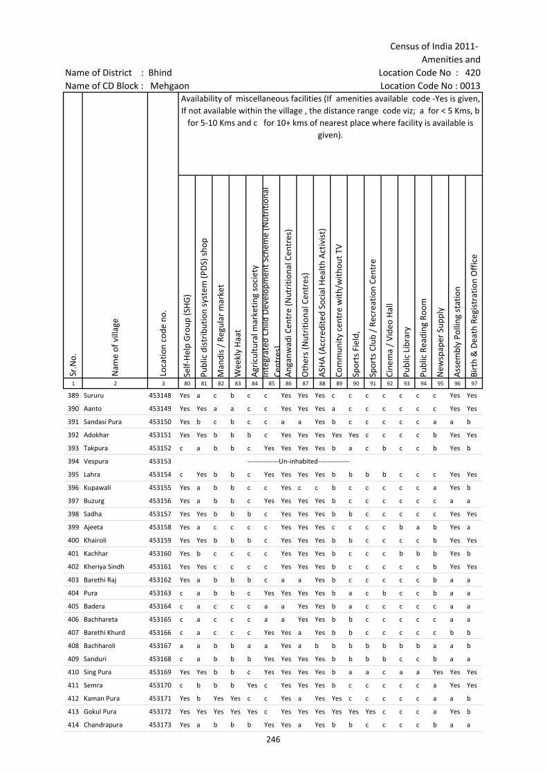
Census of India 2011- Amenities and
Name of District : Bhind Location Code No : 420Name of CD Block : Mehgaon Location Code No : 0013
Self-
Hel
p G
roup
(SH
G)
Publ
ic d
istr
ibut
ion
syst
em (P
DS)
sho
p
Man
dis
/ Re
gula
r m
arke
t
Wee
kly
Haa
t
Agr
icul
tura
l mar
ketin
g so
ciet
yIn
tegr
ated
Chi
ld D
evel
opm
ent S
chem
e (N
utri
tiona
l Ce
ntre
s)A
ngan
wad
i Cen
tre
(Nut
ritio
nal C
entr
es)
Oth
ers
(Nut
ritio
nal C
entr
es)
ASH
A (A
ccre
dite
d So
cial
Hea
lth A
ctiv
ist)
Com
mun
ity c
entr
e w
ith/w
ithou
t TV
Spor
ts F
ield
,
Spor
ts C
lub
/ Re
crea
tion
Cent
re
Cine
ma
/ Vi
deo
Hal
l
Publ
ic L
ibra
ry
Publ
ic R
eadi
ng R
oom
New
spap
er S
uppl
y
Ass
embl
y Po
lling
sta
tion
Birt
h &
Dea
th R
egis
trat
ion
Off
ice
1 2 3 80 81 82 83 84 85 86 87 88 89 90 91 92 93 94 95 96 97
Sr.N
o.
Nam
e of
vill
age
Loca
tion
code
no.
Availability of miscellaneous facilities (If amenities available code -Yes is given, If not available within the village , the distance range code viz; a for < 5 Kms, b
for 5-10 Kms and c for 10+ kms of nearest place where facility is available is given).
389 Sururu 453148 Yes a c b c c Yes Yes Yes c c c c c c c Yes Yes
390 Aanto 453149 Yes Yes a a c c Yes Yes Yes a c c c c c c Yes Yes
391 Sandasi Pura 453150 Yes b c b c c a a Yes b c c c c c a a b
392 Adokhar 453151 Yes Yes b b b c Yes Yes Yes Yes Yes c c c c b Yes Yes
393 Takpura 453152 c a b b c Yes Yes Yes Yes b a c b c c b Yes b
394 Vespura 453153 --------------Un-inhabited--------------
395 Lahra 453154 c Yes b b c Yes Yes Yes Yes b b b b c c c Yes Yes
396 Kupawali 453155 Yes a b b c c Yes c c b c c c c c a Yes b
397 Buzurg 453156 Yes a b b c Yes Yes Yes Yes b c c c c c c a a
398 Sadha 453157 Yes Yes b b b c Yes Yes Yes b b c c c c c Yes Yes
399 Ajeeta 453158 Yes a c c c c Yes Yes Yes c c c c b a b Yes a
400 Khairoli 453159 Yes Yes b b b c Yes Yes Yes b b c c c c b Yes Yes
401 Kachhar 453160 Yes b c c c c Yes Yes Yes b c c c b b b Yes b
402 Kheriya Sindh 453161 Yes Yes c c c c Yes Yes Yes b c c c c c b Yes Yes
403 Barethi Raj 453162 Yes a b b b c a a Yes b c c c c c b a a
404 Pura 453163 c a b b c Yes Yes Yes Yes b a c b c c b a a
405 Badera 453164 c a c c c a a Yes Yes b a c c c c c a a
406 Bachhareta 453165 c a c c c a a Yes Yes b b c c c c c a a
407 Barethi Khurd 453166 c a c c c Yes Yes a Yes b b c c c c c b b
408 Bachharoli 453167 a a b b a a Yes a b b b b b b b a a b
409 Sanduri 453168 c a b b b Yes Yes Yes Yes b b b b c c b a a
410 Sing Pura 453169 Yes Yes b b c Yes Yes Yes Yes b a a c a a Yes Yes Yes
411 Semra 453170 c b b b Yes c Yes Yes Yes b c c c c c a Yes Yes
412 Kaman Pura 453171 Yes b Yes Yes c c Yes a Yes Yes c c c c c a a b
413 Gokul Pura 453172 Yes Yes Yes Yes Yes c Yes Yes Yes Yes Yes Yes c c c a Yes b
414 Chandrapura 453173 Yes a b b b Yes Yes a Yes b b c c c c b a a
246
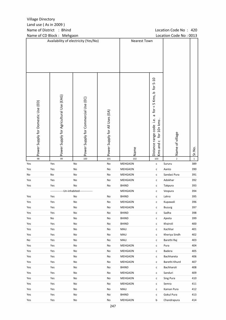
Village DirectoryLand use ( As in 2009 )Name of District : Bhind Location Code No : 420Name of CD Block : Mehgaon Location Code No : 0013
Pow
er S
uppl
y fo
r D
omes
tic U
se (E
D)
Pow
er S
uppl
y fo
r A
gric
ultu
ral U
se (E
AG
)
Pow
er S
uppl
y fo
r Co
mm
erci
al U
se (E
C)
Pow
er S
uppl
y fo
r A
ll U
ses
(EA
)
Nam
e
Dis
tanc
e ra
nge
code
i.e
. a
for
< 5
Kms,
b f
or 5
-10
Kms
and
c f
or 1
0+ k
ms
.98 99 100 101 102 103 2 1
Nearest Town
Nam
e of
vill
age
Sr.N
o.
Availability of electricity (Yes/No)
Yes Yes No No MEHGAON c Sururu 389
Yes Yes No No MEHGAON c Aanto 390
No No No No MEHGAON c Sandasi Pura 391
Yes Yes No No MEHGAON c Adokhar 392
Yes Yes No No BHIND c Takpura 393
--------------Un-inhabited-------------- MEHGAON c Vespura 394
Yes Yes No No BHIND c Lahra 395
Yes Yes No No MEHGAON c Kupawali 396
Yes Yes No No MEHGAON c Buzurg 397
Yes Yes No No BHIND c Sadha 398
Yes No No No BHIND c Ajeeta 399
Yes Yes No No BHIND c Khairoli 400
Yes Yes No No MAU c Kachhar 401
Yes Yes No No MAU c Kheriya Sindh 402
No Yes No No MAU c Barethi Raj 403
Yes Yes No No MEHGAON c Pura 404
Yes Yes No No MEHGAON c Badera 405
Yes Yes No No MEHGAON c Bachhareta 406
Yes Yes No No MEHGAON c Barethi Khurd 407
Yes Yes No No BHIND c Bachharoli 408
Yes Yes No No MEHGAON c Sanduri 409
Yes Yes No No MEHGAON c Sing Pura 410
Yes Yes No No MEHGAON c Semra 411
Yes Yes No No MAU c Kaman Pura 412
Yes Yes No No BHIND c Gokul Pura 413
Yes Yes No No MEHGAON b Chandrapura 414
247
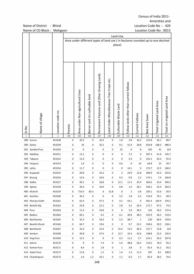
Census of India 2011- Amenities and
Name of District : Bhind Location Code No : 420Name of CD Block : Mehgaon Location Code No : 0013
Fore
sts
Are
a un
der
Non
-agr
icul
tura
l Use
s
Barr
en a
nd U
n-cu
ltiva
ble
land
Perm
anen
t Pas
ture
s an
d O
ther
Gra
zing
Lan
ds
Land
Und
er M
isce
llane
ous
Tree
Cro
ps e
tc.
Cultu
rabl
e W
aste
Lan
d
Fallo
w la
nds
othe
r th
an c
urre
nt fa
llow
s
Curr
ent F
allo
ws
Net
Are
a So
wn
Tota
l Irr
igat
ed L
and
Are
a
Tota
l Un-
irri
gate
d La
nd A
rea
1 2 3 104 105 106 107 108 109 110 111 112 113 114
Land UseArea under different types of land use ( in hectares rounded up to one decimal
place)
Sr.N
o.
Nam
e of
vill
age
Loca
tion
code
no.
389 Sururu 453148 0 20.2 0 10.5 0 1.8 3.8 16.3 125.8 36.1 89.7
390 Aanto 453149 0 35 0 35.5 0 9.1 41.9 28.8 654.8 168.3 486.4
391 Sandasi Pura 453150 0 0 0 0 0 25 0 8 165 41 124
392 Adokhar 453151 0 11.5 0 0 0 0 7.2 0 207.3 61.6 145.7
393 Takpura 453152 0 11.9 0 0 0 0 5.4 0 155.1 63.2 91.9
394 Vespura 453153 0 1.9 0 0 0 0.6 0 25 64.8 25 39.7
395 Lahra 453154 0 11.7 0 0 0 0 14.1 0 172.7 12.5 160.2
396 Kupawali 453155 0 20.8 0 33.3 0 3 24.9 12.8 284.9 42.3 242.6
397 Buzurg 453156 0 12.6 0 10.6 0 0.3 0.9 2.2 174.1 7.4 166.8
398 Sadha 453157 0 49.1 0 18.8 0 12.1 11.5 25.9 363.6 23.4 340.2
399 Ajeeta 453158 0 39.4 0 18.9 0 0.8 1.9 28.1 236.5 32.4 204.2
400 Khairoli 453159 0 714.3 83.3 0 51.8 0 2 3.8 103.1 52.6 50.5
401 Kachhar 453160 0 34.2 0 0 0 3.2 1.8 5.3 119.4 70.1 49.3
402 Kheriya Sindh 453161 0 62.4 0 47.3 0 4.2 43.1 0 441.4 164.9 276.5
403 Barethi Raj 453162 0 23.8 0 21.2 0 2.8 3.2 26.4 171.7 97.5 74.2
404 Pura 453163 0 11.4 0 19.8 0 0 5.9 36.5 142 26.5 115.4
405 Badera 453164 0 60.1 0 9.2 0 0.1 36.8 48.5 155.9 36.5 119.4
406 Bachhareta 453165 0 32.4 0 18.3 0 5.3 38.7 1 220 60.4 159.6
407 Barethi Khurd 453166 0 64.7 0 19.6 0 9 9.7 22.2 158.6 30.5 128.1
408 Bachharoli 453167 0 31.9 0 15.4 0 15.4 12.5 46.4 137.7 13.8 124
409 Sanduri 453168 0 45.8 0 27.4 0 12.7 32.4 42.6 148.8 22.3 126.5
410 Sing Pura 453169 0 15.5 0 0 0 0.2 11.2 2.7 214.1 26.3 187.8
411 Semra 453170 0 9 0 7.4 0 5.4 38.8 26.2 110.5 18.3 92.2
412 Kaman Pura 453171 0 8.4 0 1.8 0 1 3.8 0 91.4 41.2 50.2
413 Gokul Pura 453172 0 11.8 0 1.2 0 1.4 1.3 11.3 207 8.1 198.9
414 Chandrapura 453173 0 1.6 1.2 10.1 0 1.1 0.2 1.7 92.4 18.2 74.2
248
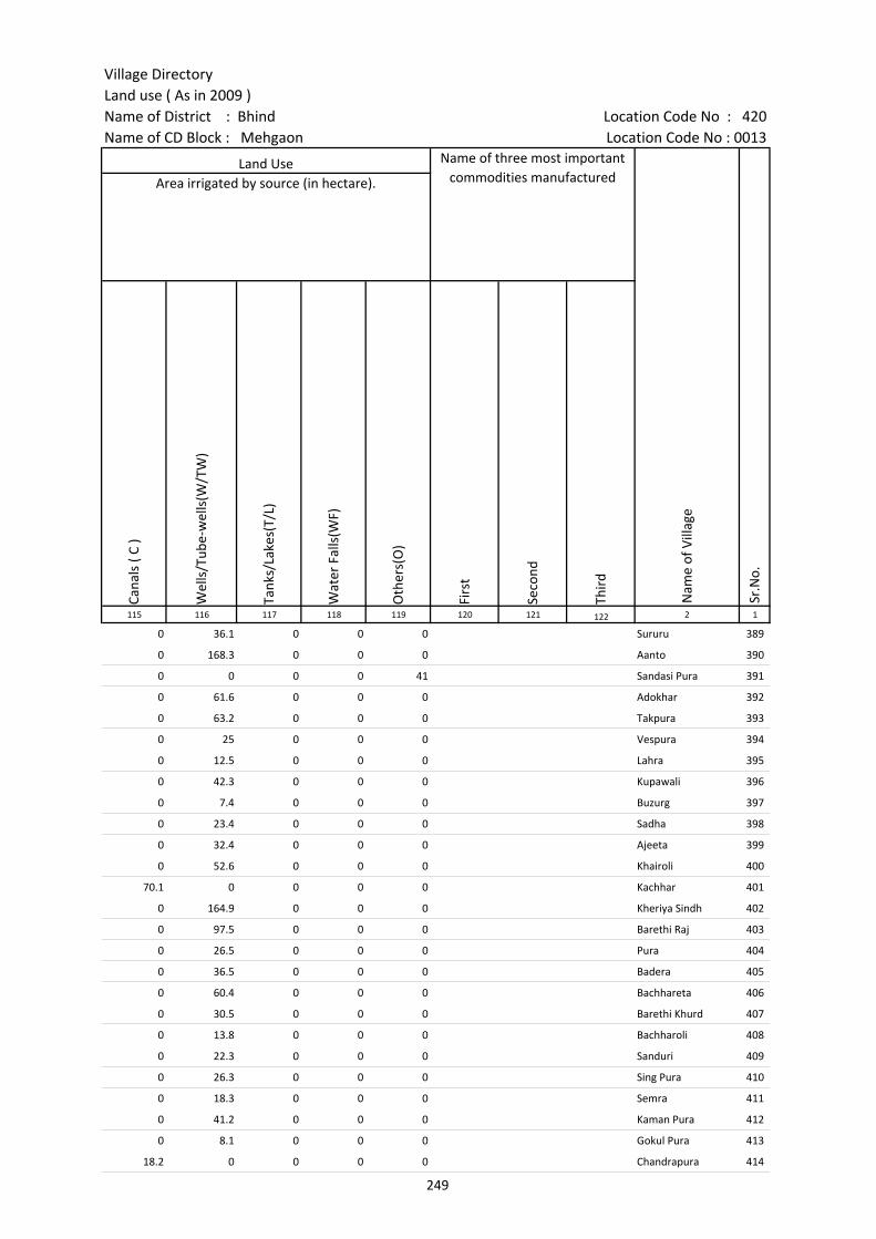
Village DirectoryLand use ( As in 2009 )Name of District : Bhind Location Code No : 420Name of CD Block : Mehgaon Location Code No : 0013
Cana
ls (
C )
Wel
ls/T
ube-
wel
ls(W
/TW
)
Tank
s/La
kes(
T/L)
Wat
er F
alls
(WF)
Oth
ers(
O)
Firs
t
Seco
nd
Thir
d 115 116 117 118 119 120 121 122 2 1
Land Use Name of three most important commodities manufactured
Nam
e of
Vill
age
Sr.N
o.
Area irrigated by source (in hectare).
0 36.1 0 0 0 Sururu 389
0 168.3 0 0 0 Aanto 390
0 0 0 0 41 Sandasi Pura 391
0 61.6 0 0 0 Adokhar 392
0 63.2 0 0 0 Takpura 393
0 25 0 0 0 Vespura 394
0 12.5 0 0 0 Lahra 395
0 42.3 0 0 0 Kupawali 396
0 7.4 0 0 0 Buzurg 397
0 23.4 0 0 0 Sadha 398
0 32.4 0 0 0 Ajeeta 399
0 52.6 0 0 0 Khairoli 400
70.1 0 0 0 0 Kachhar 401
0 164.9 0 0 0 Kheriya Sindh 402
0 97.5 0 0 0 Barethi Raj 403
0 26.5 0 0 0 Pura 404
0 36.5 0 0 0 Badera 405
0 60.4 0 0 0 Bachhareta 406
0 30.5 0 0 0 Barethi Khurd 407
0 13.8 0 0 0 Bachharoli 408
0 22.3 0 0 0 Sanduri 409
0 26.3 0 0 0 Sing Pura 410
0 18.3 0 0 0 Semra 411
0 41.2 0 0 0 Kaman Pura 412
0 8.1 0 0 0 Gokul Pura 413
18.2 0 0 0 0 Chandrapura 414
249
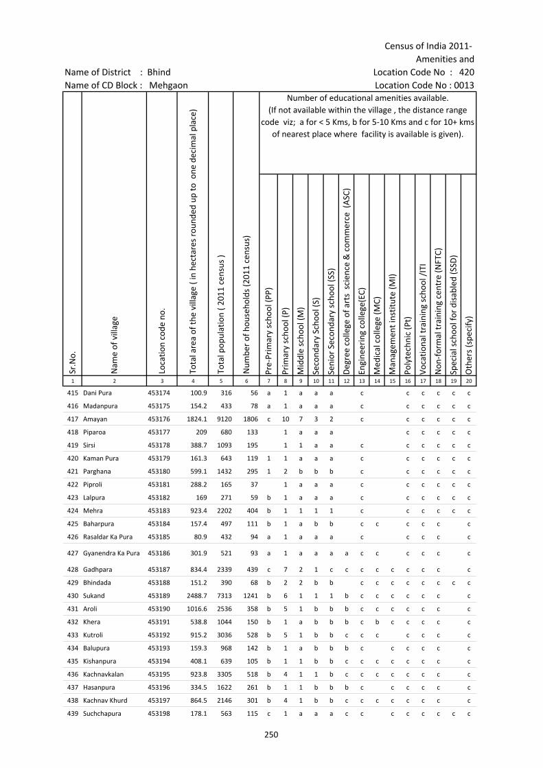
Census of India 2011- Amenities and
Name of District : Bhind Location Code No : 420Name of CD Block : Mehgaon Location Code No : 0013
Pre-
Prim
ary
scho
ol (P
P)
Prim
ary
scho
ol (P
)
Mid
dle
scho
ol (M
)
Seco
ndar
y Sc
hool
(S)
Seni
or S
econ
dary
sch
ool (
SS)
Deg
ree
colle
ge o
f art
s s
cien
ce &
com
mer
ce (
ASC
)
Engi
neer
ing
colle
ge(E
C)
Med
ical
col
lege
(MC)
Man
agem
ent i
nstit
ute
(MI)
Poly
tech
nic
(Pt)
Voca
tiona
l tra
inin
g sc
hool
/IT
I
Non
-for
mal
trai
ning
cen
tre
(NFT
C)
Spec
ial s
choo
l for
dis
able
d (S
SD)
Oth
ers
(spe
cify
)
1 2 3 4 5 6 7 8 9 10 11 12 13 14 15 16 17 18 19 20
Sr.N
o.
Nam
e of
vill
age
Loca
tion
code
no.
Tota
l are
a of
the
villa
ge (
in h
ecta
res
roun
ded
up to
one
dec
imal
pla
ce)
Tota
l pop
ulat
ion
( 201
1 ce
nsus
)
Num
ber
of h
ouse
hold
s (2
011
cens
us)
Number of educational amenities available. (If not available within the village , the distance range
code viz; a for < 5 Kms, b for 5-10 Kms and c for 10+ kms of nearest place where facility is available is given).
415 Dani Pura 453174 100.9 316 56 a 1 a a a c c c c c c
416 Madanpura 453175 154.2 433 78 a 1 a a a c c c c c c
417 Amayan 453176 1824.1 9120 1806 c 10 7 3 2 c c c c c c
418 Piparoa 453177 209 680 133 1 a a a c c c c c
419 Sirsi 453178 388.7 1093 195 1 1 a a c c c c c c
420 Kaman Pura 453179 161.3 643 119 1 1 a a a c c c c c c
421 Parghana 453180 599.1 1432 295 1 2 b b b c c c c c c
422 Piproli 453181 288.2 165 37 1 a a a c c c c c c
423 Lalpura 453182 169 271 59 b 1 a a a c c c c c c
424 Mehra 453183 923.4 2202 404 b 1 1 1 1 c c c c c c
425 Baharpura 453184 157.4 497 111 b 1 a b b c c c c c c
426 Rasaldar Ka Pura 453185 80.9 432 94 a 1 a a a c c c c c
427 Gyanendra Ka Pura 453186 301.9 521 93 a 1 a a a a c c c c c c
428 Gadhpara 453187 834.4 2339 439 c 7 2 1 c c c c c c c c c
429 Bhindada 453188 151.2 390 68 b 2 2 b b c c c c c c c c
430 Sukand 453189 2488.7 7313 1241 b 6 1 1 1 b c c c c c c c
431 Aroli 453190 1016.6 2536 358 b 5 1 b b b c c c c c c c
432 Khera 453191 538.8 1044 150 b 1 a b b b c b c c c c c
433 Kutroli 453192 915.2 3036 528 b 5 1 b b c c c c c c c
434 Balupura 453193 159.3 968 142 b 1 a b b b c c c c c c
435 Kishanpura 453194 408.1 639 105 b 1 1 b b c c c c c c c c
436 Kachnavkalan 453195 923.8 3305 518 b 4 1 1 b c c c c c c c c
437 Hasanpura 453196 334.5 1622 261 b 1 1 b b b c c c c c c
438 Kachnav Khurd 453197 864.5 2146 301 b 4 1 b b c c c c c c c c
439 Suchchapura 453198 178.1 563 115 c 1 a a a c c c c c c c c
250

Village DirectoryLand use ( As in 2009 )Name of District : Bhind Location Code No : 420Name of CD Block : Mehgaon Location Code No : 0013
Com
mun
ity h
ealth
cen
tre
(CH
C)Pr
imar
y he
alth
cen
tre
(PH
C)Pr
imar
y he
alth
sub
cen
tre
(PH
S)M
ater
nity
and
chi
ld w
elfa
re c
entr
e (M
CW)
T.B.
clin
ic (
TBC)
Hos
pita
l-allo
path
ic (H
A)
Hos
pita
l-alte
rnat
ive
med
icin
e (H
O)
Dis
pens
ary
(D)
Vete
rina
ry h
ospi
tal (
VH)
Mob
ile h
ealth
clin
ic (M
HC)
Fam
ily w
elfa
re c
entr
e (F
WC)
Char
itabl
e no
n G
ovt.
hos
pita
l/N
ursi
ng h
ome.
Med
ical
pra
ctiti
oner
with
MBB
S D
egre
eM
edic
al p
ract
ition
er w
ith o
ther
deg
ree
Med
ical
pra
ctiti
oner
with
no
degr
eeTr
aditi
onal
pra
ctiti
oner
and
faith
hea
ler
.M
edic
ine
Shop
Oth
ers
Tap
wat
er (T
reat
ed/U
ntre
ated
)
Wel
l w
ater
(C
over
ed /
Unc
over
ed w
ell)
Han
d Pu
mp
Tube
wel
ls /
Bor
e w
ell
Spri
ng
Rive
r /
Cana
l
Tank
/ P
ond
/ L
ake
Oth
ers
21 22 23 24 25 26 27 28 29 30 31 32 33 34 35 36 37 38 39 40 41 42 43 44 45 46 2 1
Number of Non-Government
Medical Amenities available.
Availability of drinking water - Yes / No
Nam
e of
vill
age
Sr.N
o.
Number of Medical Amenities available. (If not available within the
village , the distance range code viz; a for < 5 Kms, b for 5-10 Kms and c for
10+ kms of nearest place where facility is available is given).
c a a a a c c b a c a 0 0 0 0 0 0 0 No Yes Yes No No No Yes No Dani Pura 415
b b a b b c c a c b b 0 0 0 0 0 0 0 No Yes Yes No No No No No Madanpura 416
1 1 1 1 1 c c c c b 0 0 2 0 0 5 0 Yes Yes Yes Yes No No Yes No Amayan 417
a a a c a c c c a a c 0 0 0 0 0 0 0 No Yes Yes Yes No No No No Piparoa 418
a a a c a c c c a a c 0 0 0 0 0 0 0 No Yes Yes Yes No No No No Sirsi 419
a a a c a c c a a a 0 0 0 0 0 0 0 No Yes Yes No No Yes No No Kaman Pura 420
b b b c b c c c b b c 0 0 0 0 0 0 0 No Yes Yes Yes No No No No Parghana 421
c a c c a c c a c a 0 0 0 0 0 0 0 No Yes Yes No No No No No Piproli 422
a a a a a a a a a c a 0 0 0 0 0 0 0 No Yes Yes Yes No No No No Lalpura 423
c b 1 b b c 1 b b c b 0 0 0 0 0 0 0 Yes Yes Yes Yes No No No No Mehra 424
b b b b b b b b b b b 0 0 0 0 0 0 0 No Yes Yes No No No No No Baharpura 425
a a a a a a a a a a a 0 0 0 0 0 0 0 No Yes Yes Yes No Yes No No Rasaldar Ka Pura 426
a a a a a c c c a a c 0 0 0 0 0 0 0 No Yes Yes No No No No No Gyanendra Ka Pura 427
c c 1 c c c c c c c c 0 0 0 0 0 0 0 No Yes Yes Yes No Yes Yes No Gadhpara 428
c a a b a c c c b c c 0 0 0 0 0 0 0 No Yes Yes Yes No Yes No No Bhindada 429
c 1 b b b b 1 1 b c b 0 0 0 0 0 0 0 No Yes Yes Yes No Yes Yes No Sukand 430
c b b b b b b 1 c b 0 0 0 0 0 0 0 No Yes Yes Yes No Yes No No Aroli 431
b b b b b b b b b c b 0 0 0 0 0 0 0 No Yes Yes Yes No No No No Khera 432
c b b b b b b b b c b 0 0 0 0 0 0 0 No Yes Yes No No No Yes No Kutroli 433
c b b b b b b b a c b 0 0 0 0 0 0 0 No Yes Yes No No No No No Balupura 434
c b b b b b b b a c b 0 0 0 0 0 0 0 No Yes Yes No No Yes Yes No Kishanpura 435
c b 1 b b b b b c c b 0 0 0 0 0 0 0 No Yes Yes Yes No Yes No No Kachnavkalan 436
c b b b b b b b b c b 0 0 0 0 0 0 0 No Yes Yes No No No No No Hasanpura 437
c b a b b b b b c c b 0 0 0 0 0 0 0 No Yes Yes Yes No Yes No No Kachnav Khurd 438
c c a c c c c c c c c 0 0 0 0 0 0 0 No Yes Yes Yes No No Yes No Suchchapura 439
251

Census of India 2011- Amenities and
Name of District : Bhind Location Code No : 420Name of CD Block : Mehgaon Location Code No : 0013
Com
mun
ity to
ilet i
nclu
ding
bat
h.
Com
mun
ity to
ilet e
xclu
ding
bat
h.
Rura
l sa
nita
ry m
art o
r sa
nita
ry h
ardw
are
outle
t av
aila
ble
near
the
villa
ge.
Com
mun
ity b
io- g
as o
r re
cycl
e of
was
te fo
r pr
oduc
tive
use.
Post
off
ice(
PO)
Sub
post
off
ice
(SPO
)
Post
& T
eleg
raph
off
ice
(P&
TO)
Villa
ge P
in C
ode
Tele
phon
es
(L
and
lines
)
Publ
ic c
all o
ffic
e (P
CO)
Mob
ile p
hone
cov
erag
e
Inte
rnet
caf
es/
Com
mon
ser
vice
cen
tre
(CSC
)
Priv
ate
cour
ier
faci
lity
Bus
serv
ice
(Pub
lic &
Pri
vate
)
Railw
ay s
tatio
ns
Aut
o/M
odifi
ed A
utos
Taxi
s an
d Va
ns
1 2 3 47 48 49 50 51 52 53 54 55 56 57 58 59 60 61 62 63
Loca
tion
code
no.
Availability of toilet & others Yes / No
Communication and transport facilities (If amenities available code -Yes is given except for Village Pin Code ,If not available within the village , the distance range code
viz; a for < 5 Kms, b for 5-10 Kms and c for 10+ kms of nearest place where facility is available is given).
Sr.N
o.
Nam
e of
vill
age
415 Dani Pura 453174 No No No No a a a c c a a c Yes c c c
416 Madanpura 453175 No No No No c a c c c a c c Yes c c c
417 Amayan 453176 No No Yes No c Yes Yes Yes Yes Yes Yes Yes Yes c c Yes
418 Piparoa 453177 No No No No a a a a c Yes c c a c c Yes
419 Sirsi 453178 No No No No a a a c Yes c c a c c a
420 Kaman Pura 453179 No No No No a a a a c a a c a c c a
421 Parghana 453180 No No No No b Yes b 477227 Yes c Yes c c b c c c
422 Piproli 453181 No No No Yes b b b b c b c b b c c c
423 Lalpura 453182 No No No No a a a c c Yes c c a c c c
424 Mehra 453183 No No No No b Yes Yes 477227 Yes b Yes c c Yes c c c
425 Baharpura 453184 No Yes No No b b b 477445 b b Yes b b a a Yes b
426 Rasaldar Ka Pura 453185 No No No No a a a a a Yes a a a a a a
427 Gyanendra Ka Pura 453186 No No No No a a a a a a a a Yes b a a
428 Gadhpara 453187 No No No No c Yes Yes c c Yes c c a c c a
429 Bhindada 453188 No No No No b c c c c Yes c c b c b b
430 Sukand 453189 No No No No c Yes Yes 477660 Yes Yes Yes b b Yes c b b
431 Aroli 453190 No No No No c Yes Yes 477660 b b Yes b b b c b b
432 Khera 453191 No No No No a a b b b Yes b b b c b b
433 Kutroli 453192 No No No No b b b b b b b b b c b b
434 Balupura 453193 No No No No c b c b b Yes b b b b b b
435 Kishanpura 453194 No No No No b a b b b b b b b b b b
436 Kachnavkalan 453195 No No No No c Yes Yes 477660 b b b b b b c b Yes
437 Hasanpura 453196 Yes No No No c b a 477445 b b Yes b b b c b b
438 Kachnav Khurd 453197 No No No No c c a b b c b b b c b Yes
439 Suchchapura 453198 No No No No c c a a c Yes c c a c c c
252

Village DirectoryLand use ( As in 2009 )Name of District : Bhind Location Code No : 420Name of CD Block : Mehgaon Location Code No : 0013
Trac
tors
Cycl
e-pu
lled
rick
shaw
s(M
anua
l & M
achi
ne d
rive
n)
Cart
s dr
iven
by
anim
als
Sea
/Riv
er fe
rry
serv
ice
Conn
ecte
d to
nat
iona
l hig
hway
(NH
)
Conn
ecte
d to
sta
te h
ighw
ay(S
H)
Conn
ecte
d to
maj
or d
istr
ict r
oad
(MD
R)
Conn
ecte
d to
oth
ers
dist
rict
roa
d
Pucc
a r
oads
Kutc
hcha
roa
ds
Wat
er b
ound
ed m
acad
am(W
BM) r
oads
Nav
igab
le w
ater
way
(riv
er/c
anal
)(N
W)
Foot
path
s (F
P)
Com
mer
cial
& C
o-op
erat
ive
Bank
s
ATM
Agr
icul
tura
l Cre
dit S
ocie
ties
64 65 66 67 68 69 70 71 72 73 74 75 76 77 78 79 2 1
Sr.N
o.
Communication and transport facilities (If amenities available code -Yes is given
except for Village Pin Code ,If not available within the village , the distance range code viz; a for < 5 Kms, b for 5-10 Kms and c for 10+ kms of nearest place where facility is
available is given).
Village connected to highways,village roads, banks & credit societies (If amenities available
code -Yes is given, If not available within the village , the distance range code viz; a for < 5
Kms, b for 5-10 Kms and c for 10+ kms of nearest place where facility is available is
given).
Nam
e of
vill
age
Yes b Yes c c c Yes a Yes Yes a Yes a c a Dani Pura 415
Yes b Yes c c c Yes Yes Yes Yes a Yes b c b Madanpura 416
Yes Yes Yes c c b Yes Yes Yes Yes a Yes Yes c Yes Amayan 417
Yes Yes Yes c c c a a Yes Yes Yes Yes a c c Piparoa 418
Yes Yes Yes c c b a a a Yes Yes Yes a c c Sirsi 419
Yes Yes Yes c c c c a a Yes a Yes a c c Kaman Pura 420
Yes Yes Yes c c c Yes Yes Yes Yes Yes Yes b c b Parghana 421
b b b c c c b b Yes Yes a Yes b c c Piproli 422
Yes b a c c Yes Yes Yes a Yes a Yes a c Yes Lalpura 423
Yes Yes b c c Yes Yes Yes Yes Yes Yes Yes b c Yes Mehra 424
Yes Yes Yes b a b b a Yes Yes a Yes b b b Baharpura 425
a a a a a a a a Yes Yes Yes Yes a c a Rasaldar Ka Pura 426
a Yes Yes a Yes a Yes b Yes Yes a Yes a c a Gyanendra Ka Pura 427
Yes Yes Yes Yes c c a Yes Yes Yes a Yes c c c Gadhpara 428
Yes Yes Yes a Yes c b b Yes Yes Yes Yes c c c Bhindada 429
Yes Yes Yes c c a a Yes Yes Yes Yes Yes b b Yes Sukand 430
Yes Yes Yes c Yes Yes Yes Yes a Yes Yes b b Yes Aroli 431
Yes Yes b c c b b b Yes Yes Yes Yes b b b Khera 432
Yes Yes Yes b c b Yes Yes Yes Yes Yes b b c Kutroli 433
Yes Yes Yes c c c b b a Yes Yes Yes b b b Balupura 434
Yes Yes Yes a c b Yes Yes Yes Yes Yes Yes b b c Kishanpura 435
Yes Yes b c c c b b Yes Yes Yes Yes b b Yes Kachnavkalan 436
Yes Yes b c c b b b Yes Yes Yes Yes b b Yes Hasanpura 437
Yes Yes Yes c c b b b Yes Yes Yes Yes b b Yes Kachnav Khurd 438
Yes Yes a c c c c a Yes Yes Yes Yes c c c Suchchapura 439
253
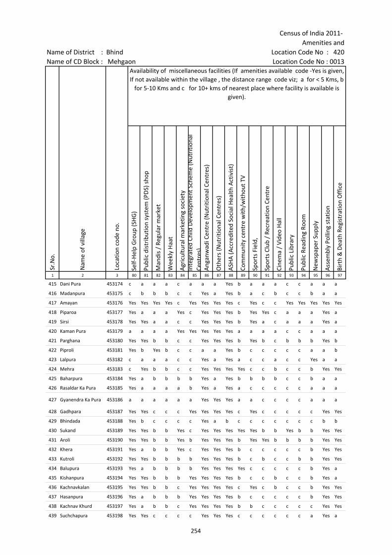
Census of India 2011- Amenities and
Name of District : Bhind Location Code No : 420Name of CD Block : Mehgaon Location Code No : 0013
Self-
Hel
p G
roup
(SH
G)
Publ
ic d
istr
ibut
ion
syst
em (P
DS)
sho
p
Man
dis
/ Re
gula
r m
arke
t
Wee
kly
Haa
t
Agr
icul
tura
l mar
ketin
g so
ciet
yIn
tegr
ated
Chi
ld D
evel
opm
ent S
chem
e (N
utri
tiona
l Ce
ntre
s)A
ngan
wad
i Cen
tre
(Nut
ritio
nal C
entr
es)
Oth
ers
(Nut
ritio
nal C
entr
es)
ASH
A (A
ccre
dite
d So
cial
Hea
lth A
ctiv
ist)
Com
mun
ity c
entr
e w
ith/w
ithou
t TV
Spor
ts F
ield
,
Spor
ts C
lub
/ Re
crea
tion
Cent
re
Cine
ma
/ Vi
deo
Hal
l
Publ
ic L
ibra
ry
Publ
ic R
eadi
ng R
oom
New
spap
er S
uppl
y
Ass
embl
y Po
lling
sta
tion
Birt
h &
Dea
th R
egis
trat
ion
Off
ice
1 2 3 80 81 82 83 84 85 86 87 88 89 90 91 92 93 94 95 96 97
Sr.N
o.
Nam
e of
vill
age
Loca
tion
code
no.
Availability of miscellaneous facilities (If amenities available code -Yes is given, If not available within the village , the distance range code viz; a for < 5 Kms, b
for 5-10 Kms and c for 10+ kms of nearest place where facility is available is given).
415 Dani Pura 453174 c a a a c a a a Yes b a a a c c a a a
416 Madanpura 453175 c b b b c c Yes a Yes b a c b c c b a a
417 Amayan 453176 Yes Yes Yes Yes c Yes Yes Yes Yes c Yes c c Yes Yes Yes Yes Yes
418 Piparoa 453177 Yes a a a Yes c Yes Yes Yes b Yes Yes c a a a Yes a
419 Sirsi 453178 Yes Yes a a c c Yes Yes Yes b Yes a c a a a Yes a
420 Kaman Pura 453179 a a a a Yes Yes Yes Yes Yes a a a a c c a a a
421 Parghana 453180 Yes Yes b b c c Yes Yes Yes b Yes b c b b b Yes b
422 Piproli 453181 Yes b Yes b c c a a Yes b c c c c c a a b
423 Lalpura 453182 c a a a c c Yes a Yes a c c a c c Yes a a
424 Mehra 453183 c Yes b b c c Yes Yes Yes Yes c c b c c b Yes Yes
425 Baharpura 453184 Yes a b b b b Yes a Yes b b b b c c b a a
426 Rasaldar Ka Pura 453185 Yes a a a a b Yes a Yes a c c c c c a a a
427 Gyanendra Ka Pura 453186 a a a a a a Yes Yes Yes a a c c c c a a a
428 Gadhpara 453187 Yes Yes c c c Yes Yes Yes Yes c Yes c c c c c Yes Yes
429 Bhindada 453188 Yes b c c c c Yes a b c c c c c c c b b
430 Sukand 453189 Yes Yes b b Yes c Yes Yes Yes Yes Yes b b Yes b b Yes Yes
431 Aroli 453190 Yes Yes b b Yes b Yes Yes Yes b Yes Yes b b b b Yes Yes
432 Khera 453191 Yes a b b Yes c Yes Yes Yes b c c c c c b Yes Yes
433 Kutroli 453192 Yes Yes b b b b Yes Yes Yes b c b c c b b Yes Yes
434 Balupura 453193 Yes a b b b b Yes Yes Yes Yes c c c c c b Yes a
435 Kishanpura 453194 Yes Yes b b b Yes Yes Yes Yes b c c b c c b Yes a
436 Kachnavkalan 453195 Yes Yes b b c Yes Yes Yes Yes c Yes c b c c b Yes Yes
437 Hasanpura 453196 Yes a b b b Yes Yes Yes Yes b c c c c c b Yes Yes
438 Kachnav Khurd 453197 Yes a b b c Yes Yes Yes Yes b b c c c c c Yes Yes
439 Suchchapura 453198 Yes Yes c c c c Yes Yes Yes c c c c c c a Yes a
254
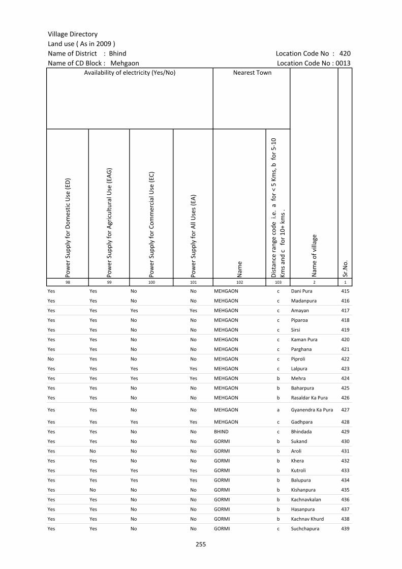
Village DirectoryLand use ( As in 2009 )Name of District : Bhind Location Code No : 420Name of CD Block : Mehgaon Location Code No : 0013
Pow
er S
uppl
y fo
r D
omes
tic U
se (E
D)
Pow
er S
uppl
y fo
r A
gric
ultu
ral U
se (E
AG
)
Pow
er S
uppl
y fo
r Co
mm
erci
al U
se (E
C)
Pow
er S
uppl
y fo
r A
ll U
ses
(EA
)
Nam
e
Dis
tanc
e ra
nge
code
i.e
. a
for
< 5
Kms,
b f
or 5
-10
Kms
and
c f
or 1
0+ k
ms
.98 99 100 101 102 103 2 1
Nearest Town
Nam
e of
vill
age
Sr.N
o.
Availability of electricity (Yes/No)
Yes Yes No No MEHGAON c Dani Pura 415
Yes Yes No No MEHGAON c Madanpura 416
Yes Yes Yes Yes MEHGAON c Amayan 417
Yes Yes No No MEHGAON c Piparoa 418
Yes Yes No No MEHGAON c Sirsi 419
Yes Yes No No MEHGAON c Kaman Pura 420
Yes Yes No No MEHGAON c Parghana 421
No Yes No No MEHGAON c Piproli 422
Yes Yes Yes Yes MEHGAON c Lalpura 423
Yes Yes Yes Yes MEHGAON b Mehra 424
Yes Yes No No MEHGAON b Baharpura 425
Yes Yes No No MEHGAON b Rasaldar Ka Pura 426
Yes Yes No No MEHGAON a Gyanendra Ka Pura 427
Yes Yes Yes Yes MEHGAON c Gadhpara 428
Yes Yes No No BHIND c Bhindada 429
Yes Yes No No GORMI b Sukand 430
Yes No No No GORMI b Aroli 431
Yes Yes No No GORMI b Khera 432
Yes Yes Yes Yes GORMI b Kutroli 433
Yes Yes Yes Yes GORMI b Balupura 434
Yes No No No GORMI b Kishanpura 435
Yes Yes No No GORMI b Kachnavkalan 436
Yes Yes No No GORMI b Hasanpura 437
Yes Yes No No GORMI b Kachnav Khurd 438
Yes Yes No No GORMI c Suchchapura 439
255
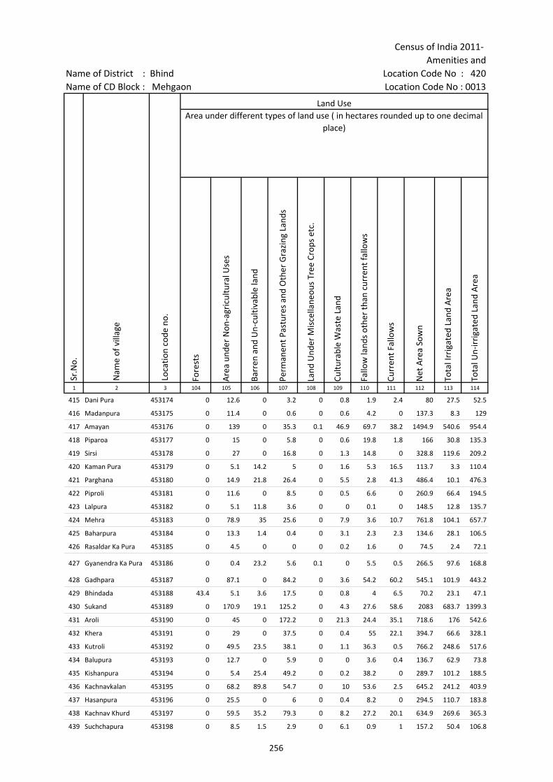
Census of India 2011- Amenities and
Name of District : Bhind Location Code No : 420Name of CD Block : Mehgaon Location Code No : 0013
Fore
sts
Are
a un
der
Non
-agr
icul
tura
l Use
s
Barr
en a
nd U
n-cu
ltiva
ble
land
Perm
anen
t Pas
ture
s an
d O
ther
Gra
zing
Lan
ds
Land
Und
er M
isce
llane
ous
Tree
Cro
ps e
tc.
Cultu
rabl
e W
aste
Lan
d
Fallo
w la
nds
othe
r th
an c
urre
nt fa
llow
s
Curr
ent F
allo
ws
Net
Are
a So
wn
Tota
l Irr
igat
ed L
and
Are
a
Tota
l Un-
irri
gate
d La
nd A
rea
1 2 3 104 105 106 107 108 109 110 111 112 113 114
Land UseArea under different types of land use ( in hectares rounded up to one decimal
place)
Sr.N
o.
Nam
e of
vill
age
Loca
tion
code
no.
415 Dani Pura 453174 0 12.6 0 3.2 0 0.8 1.9 2.4 80 27.5 52.5
416 Madanpura 453175 0 11.4 0 0.6 0 0.6 4.2 0 137.3 8.3 129
417 Amayan 453176 0 139 0 35.3 0.1 46.9 69.7 38.2 1494.9 540.6 954.4
418 Piparoa 453177 0 15 0 5.8 0 0.6 19.8 1.8 166 30.8 135.3
419 Sirsi 453178 0 27 0 16.8 0 1.3 14.8 0 328.8 119.6 209.2
420 Kaman Pura 453179 0 5.1 14.2 5 0 1.6 5.3 16.5 113.7 3.3 110.4
421 Parghana 453180 0 14.9 21.8 26.4 0 5.5 2.8 41.3 486.4 10.1 476.3
422 Piproli 453181 0 11.6 0 8.5 0 0.5 6.6 0 260.9 66.4 194.5
423 Lalpura 453182 0 5.1 11.8 3.6 0 0 0.1 0 148.5 12.8 135.7
424 Mehra 453183 0 78.9 35 25.6 0 7.9 3.6 10.7 761.8 104.1 657.7
425 Baharpura 453184 0 13.3 1.4 0.4 0 3.1 2.3 2.3 134.6 28.1 106.5
426 Rasaldar Ka Pura 453185 0 4.5 0 0 0 0.2 1.6 0 74.5 2.4 72.1
427 Gyanendra Ka Pura 453186 0 0.4 23.2 5.6 0.1 0 5.5 0.5 266.5 97.6 168.8
428 Gadhpara 453187 0 87.1 0 84.2 0 3.6 54.2 60.2 545.1 101.9 443.2
429 Bhindada 453188 43.4 5.1 3.6 17.5 0 0.8 4 6.5 70.2 23.1 47.1
430 Sukand 453189 0 170.9 19.1 125.2 0 4.3 27.6 58.6 2083 683.7 1399.3
431 Aroli 453190 0 45 0 172.2 0 21.3 24.4 35.1 718.6 176 542.6
432 Khera 453191 0 29 0 37.5 0 0.4 55 22.1 394.7 66.6 328.1
433 Kutroli 453192 0 49.5 23.5 38.1 0 1.1 36.3 0.5 766.2 248.6 517.6
434 Balupura 453193 0 12.7 0 5.9 0 0 3.6 0.4 136.7 62.9 73.8
435 Kishanpura 453194 0 5.4 25.4 49.2 0 0.2 38.2 0 289.7 101.2 188.5
436 Kachnavkalan 453195 0 68.2 89.8 54.7 0 10 53.6 2.5 645.2 241.2 403.9
437 Hasanpura 453196 0 25.5 0 6 0 0.4 8.2 0 294.5 110.7 183.8
438 Kachnav Khurd 453197 0 59.5 35.2 79.3 0 8.2 27.2 20.1 634.9 269.6 365.3
439 Suchchapura 453198 0 8.5 1.5 2.9 0 6.1 0.9 1 157.2 50.4 106.8
256

Village DirectoryLand use ( As in 2009 )Name of District : Bhind Location Code No : 420Name of CD Block : Mehgaon Location Code No : 0013
Cana
ls (
C )
Wel
ls/T
ube-
wel
ls(W
/TW
)
Tank
s/La
kes(
T/L)
Wat
er F
alls
(WF)
Oth
ers(
O)
Firs
t
Seco
nd
Thir
d 115 116 117 118 119 120 121 122 2 1
Land Use Name of three most important commodities manufactured
Nam
e of
Vill
age
Sr.N
o.
Area irrigated by source (in hectare).
0 27.5 0 0 0 Dani Pura 415
0 8.3 0 0 0 Madanpura 416
0 540.6 0 0 0 Amayan 417
0 30.8 0 0 0 Piparoa 418
0 119.6 0 0 0 Sirsi 419
0 3.3 0 0 0 Kaman Pura 420
0 10.1 0 0 0 Parghana 421
0 66.4 0 0 0 Piproli 422
0 12.8 0 0 0 Lalpura 423
0 104.1 0 0 0 Mehra 424
0 28.1 0 0 0 Baharpura 425
0 2.4 0 0 0 Rasaldar Ka Pura 426
0 97.6 0 0 0 Gyanendra Ka Pura 427
0 101.9 0 0 0 Gadhpara 428
0 23.1 0 0 0 Bhindada 429
0 683.7 0 0 0 Sukand 430
0 0 176 0 0 Aroli 431
0 66.6 0 0 0 Khera 432
0 248.6 0 0 0 Kutroli 433
17.3 45.6 0 0 0 Balupura 434
0 101.2 0 0 0 Kishanpura 435
0 241.2 0 0 0 Kachnavkalan 436
0 110.7 0 0 0 Hasanpura 437
0 269.6 0 0 0 Kachnav Khurd 438
0 50.4 0 0 0 Suchchapura 439
257

Census of India 2011- Amenities and
Name of District : Bhind Location Code No : 420Name of CD Block : Mehgaon Location Code No : 0013
Pre-
Prim
ary
scho
ol (P
P)
Prim
ary
scho
ol (P
)
Mid
dle
scho
ol (M
)
Seco
ndar
y Sc
hool
(S)
Seni
or S
econ
dary
sch
ool (
SS)
Deg
ree
colle
ge o
f art
s s
cien
ce &
com
mer
ce (
ASC
)
Engi
neer
ing
colle
ge(E
C)
Med
ical
col
lege
(MC)
Man
agem
ent i
nstit
ute
(MI)
Poly
tech
nic
(Pt)
Voca
tiona
l tra
inin
g sc
hool
/IT
I
Non
-for
mal
trai
ning
cen
tre
(NFT
C)
Spec
ial s
choo
l for
dis
able
d (S
SD)
Oth
ers
(spe
cify
)
1 2 3 4 5 6 7 8 9 10 11 12 13 14 15 16 17 18 19 20
Sr.N
o.
Nam
e of
vill
age
Loca
tion
code
no.
Tota
l are
a of
the
villa
ge (
in h
ecta
res
roun
ded
up to
one
dec
imal
pla
ce)
Tota
l pop
ulat
ion
( 201
1 ce
nsus
)
Num
ber
of h
ouse
hold
s (2
011
cens
us)
Number of educational amenities available. (If not available within the village , the distance range
code viz; a for < 5 Kms, b for 5-10 Kms and c for 10+ kms of nearest place where facility is available is given).
440 Didona 453199 505 1459 295 c 2 1 1 b c c c c c c c c
441 Pachera 453200 484 2896 450 c 2 1 1 c c c c c c c c c
442 Chandeni 453201 374.9 1092 148 c 2 1 a a c c c c c c c c
443 Ingosa Raipura 453202 489.3 1964 291 c 2 1 a a c c c c c c c c
444 Khokipura 453203 390.2 1547 342 b 1 1 a b b c c c c c c c
445 Nunhad 453204 738 3186 500 b 2 1 2 1 b c c c c c c c
446 Asokhar 453205 301.1 1558 306 1 3 1 a b b c c c c c c c
447 Achhai 453206 315.3 737 124 b 1 a 1 b b c c c c c c c
448 Saipura 453207 276.6 858 164 a 2 1 a b b c c c c c c c
449 Akloni 453208 825.7 3850 699 b 4 1 1 1 b c c c c c c c 1
450 Gopalpura 453209 131.4 0 0 --------------Un-inhabited--------------
451 Ghilauwa 453210 566.4 1213 221 b 1 1 b b b c c c c c c c c
452 Seupura 453211 65.6 0 0 --------------Un-inhabited--------------
453 Choniyapura 453212 527.7 2058 358 2 1 a a c c c c c c c
454 Pratapura 453213 212.1 1514 270 2 a a a a c c c c c
455 Mohanpura 453214 359.2 1072 172 a 2 1 a a a c c c c c c
456 Guliyapura 453215 182.3 775 144 b 2 a b b b c c c c c c
457 Siloli 453216 61.6 760 164 a 1 1 a a a c c c c c c
458 Sujanpura 453217 153.5 622 96 b 1 a b b b c c c c c c
459 Prathvipura 453218 264 1970 315 b 4 1 b b b c c c c c c
460 Bahera 453219 304.9 706 100 b 1 a b b b c c c c c c
461 Kot 453220 413 1695 273 b 4 1 a a b c c c c c c c
462 Sikroda 453221 957.8 3292 553 b 4 1 b b b c c c c c c c
463 Tikri(Gormi) 453222 793.2 1906 313 b 1 b b b b c c c c c c c
258
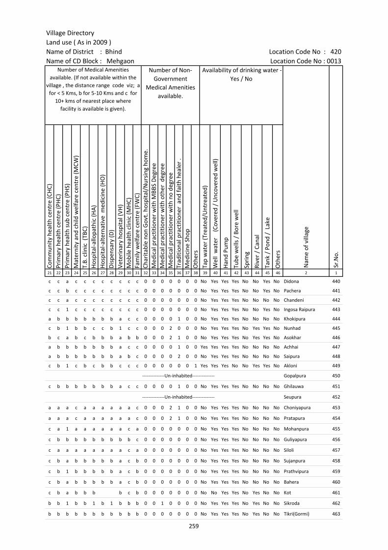
Village DirectoryLand use ( As in 2009 )Name of District : Bhind Location Code No : 420Name of CD Block : Mehgaon Location Code No : 0013
Com
mun
ity h
ealth
cen
tre
(CH
C)Pr
imar
y he
alth
cen
tre
(PH
C)Pr
imar
y he
alth
sub
cen
tre
(PH
S)M
ater
nity
and
chi
ld w
elfa
re c
entr
e (M
CW)
T.B.
clin
ic (
TBC)
Hos
pita
l-allo
path
ic (H
A)
Hos
pita
l-alte
rnat
ive
med
icin
e (H
O)
Dis
pens
ary
(D)
Vete
rina
ry h
ospi
tal (
VH)
Mob
ile h
ealth
clin
ic (M
HC)
Fam
ily w
elfa
re c
entr
e (F
WC)
Char
itabl
e no
n G
ovt.
hos
pita
l/N
ursi
ng h
ome.
Med
ical
pra
ctiti
oner
with
MBB
S D
egre
eM
edic
al p
ract
ition
er w
ith o
ther
deg
ree
Med
ical
pra
ctiti
oner
with
no
degr
eeTr
aditi
onal
pra
ctiti
oner
and
faith
hea
ler
.M
edic
ine
Shop
Oth
ers
Tap
wat
er (T
reat
ed/U
ntre
ated
)
Wel
l w
ater
(C
over
ed /
Unc
over
ed w
ell)
Han
d Pu
mp
Tube
wel
ls /
Bor
e w
ell
Spri
ng
Rive
r /
Cana
l
Tank
/ P
ond
/ L
ake
Oth
ers
21 22 23 24 25 26 27 28 29 30 31 32 33 34 35 36 37 38 39 40 41 42 43 44 45 46 2 1
Number of Non-Government
Medical Amenities available.
Availability of drinking water - Yes / No
Nam
e of
vill
age
Sr.N
o.
Number of Medical Amenities available. (If not available within the
village , the distance range code viz; a for < 5 Kms, b for 5-10 Kms and c for
10+ kms of nearest place where facility is available is given).
c c a c c c c c c c c 0 0 0 0 0 0 0 No Yes Yes Yes No No Yes No Didona 440
c c b c c c c c c c c 0 0 0 0 0 0 0 No Yes Yes Yes No No Yes No Pachera 441
c c a c c c c c c c c 0 0 0 0 0 0 0 No Yes Yes Yes No No No No Chandeni 442
c c 1 c c c c c c c c 0 0 0 0 0 0 0 No Yes Yes Yes No No Yes No Ingosa Raipura 443
a b b b b b b b a c c 0 0 0 0 1 0 0 No Yes Yes Yes No No No No Khokipura 444
c b 1 b b c c b 1 c c 0 0 0 2 0 0 0 No Yes Yes Yes No Yes Yes No Nunhad 445
b c a b c b b b a b b 0 0 0 2 1 0 0 No Yes Yes Yes No Yes Yes No Asokhar 446
a b b b b b b b a c c 0 0 0 0 1 0 0 Yes Yes Yes Yes No No No No Achhai 447
a b b b b b b b a b c 0 0 0 0 2 0 0 No Yes Yes Yes No No No No Saipura 448
c b 1 c b c b b c c c 0 0 0 0 0 0 1 Yes Yes Yes No No Yes Yes No Akloni 449
--------------Un-inhabited-------------- Gopalpura 450
c b b b b b b b a c c 0 0 0 0 1 0 0 No Yes Yes Yes No No No No Ghilauwa 451
--------------Un-inhabited-------------- Seupura 452
a a a c a a a a a a c 0 0 0 2 1 0 0 No Yes Yes Yes No No No No Choniyapura 453
a a a c a a a a a a c 0 0 0 2 1 0 0 No Yes Yes Yes No No No No Pratapura 454
c a 1 a a a a a a c a 0 0 0 0 0 0 0 No Yes Yes Yes No No No No Mohanpura 455
c b b b b b b b b b c 0 0 0 0 0 0 0 No Yes Yes Yes No No No No Guliyapura 456
c a a a a a a a a c a 0 0 0 0 0 0 0 No Yes Yes Yes No No No No Siloli 457
c b a b b b b b a c b 0 0 0 0 0 0 0 No Yes Yes Yes No No No No Sujanpura 458
c b 1 b b b b b a c b 0 0 0 0 0 0 0 No Yes Yes Yes No No No No Prathvipura 459
c b a b b b b b a c b 0 0 0 0 0 0 0 No Yes Yes Yes No No No No Bahera 460
c b a b b b b c b 0 0 0 0 0 0 0 No No Yes Yes No Yes No No Kot 461
b b 1 b b 1 b 1 b b b 0 0 1 0 0 0 0 No Yes Yes Yes No Yes No No Sikroda 462
b b b b b b b b b b b 0 0 0 0 0 0 0 No Yes Yes Yes No Yes No No Tikri(Gormi) 463
259
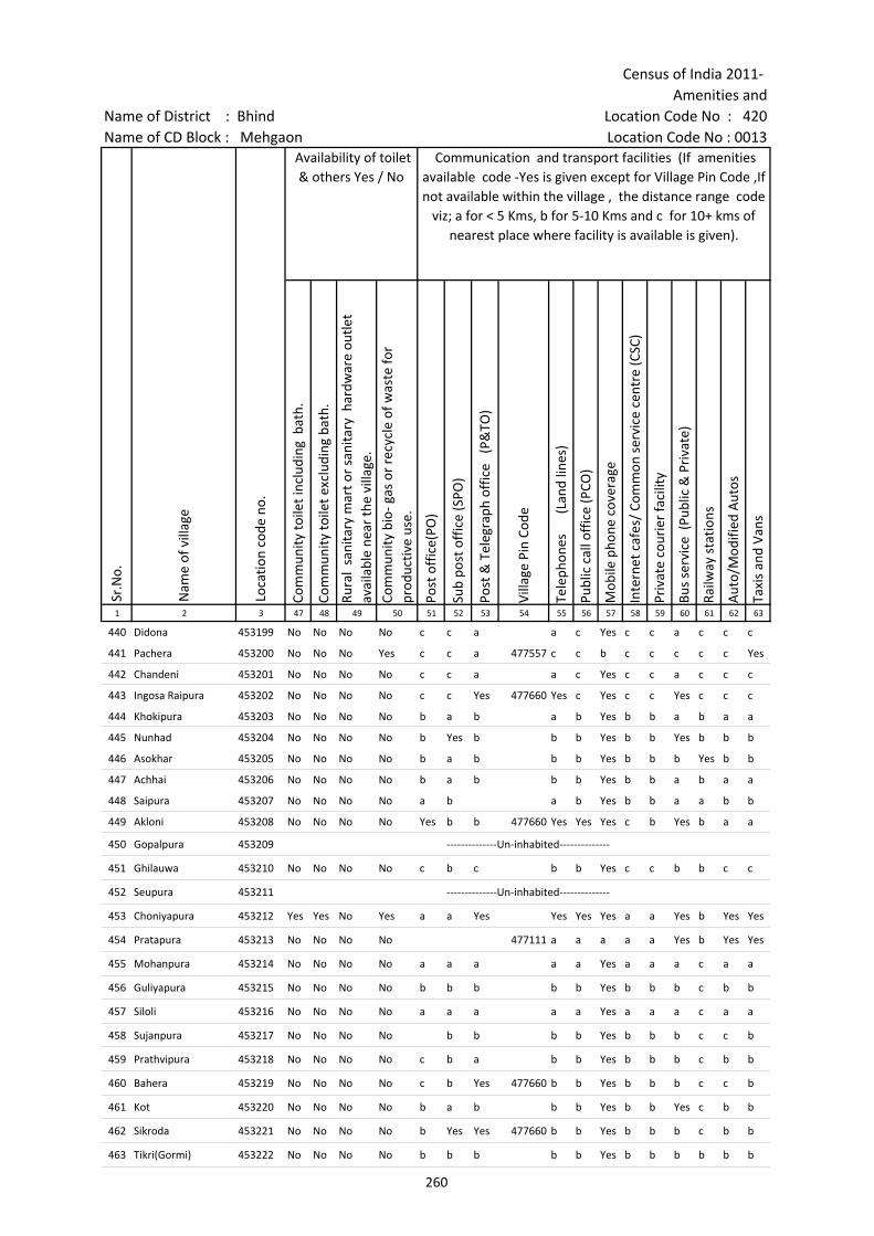
Census of India 2011- Amenities and
Name of District : Bhind Location Code No : 420Name of CD Block : Mehgaon Location Code No : 0013
Com
mun
ity to
ilet i
nclu
ding
bat
h.
Com
mun
ity to
ilet e
xclu
ding
bat
h.
Rura
l sa
nita
ry m
art o
r sa
nita
ry h
ardw
are
outle
t av
aila
ble
near
the
villa
ge.
Com
mun
ity b
io- g
as o
r re
cycl
e of
was
te fo
r pr
oduc
tive
use.
Post
off
ice(
PO)
Sub
post
off
ice
(SPO
)
Post
& T
eleg
raph
off
ice
(P&
TO)
Villa
ge P
in C
ode
Tele
phon
es
(L
and
lines
)
Publ
ic c
all o
ffic
e (P
CO)
Mob
ile p
hone
cov
erag
e
Inte
rnet
caf
es/
Com
mon
ser
vice
cen
tre
(CSC
)
Priv
ate
cour
ier
faci
lity
Bus
serv
ice
(Pub
lic &
Pri
vate
)
Railw
ay s
tatio
ns
Aut
o/M
odifi
ed A
utos
Taxi
s an
d Va
ns
1 2 3 47 48 49 50 51 52 53 54 55 56 57 58 59 60 61 62 63
Loca
tion
code
no.
Availability of toilet & others Yes / No
Communication and transport facilities (If amenities available code -Yes is given except for Village Pin Code ,If not available within the village , the distance range code
viz; a for < 5 Kms, b for 5-10 Kms and c for 10+ kms of nearest place where facility is available is given).
Sr.N
o.
Nam
e of
vill
age
440 Didona 453199 No No No No c c a a c Yes c c a c c c
441 Pachera 453200 No No No Yes c c a 477557 c c b c c c c c Yes
442 Chandeni 453201 No No No No c c a a c Yes c c a c c c
443 Ingosa Raipura 453202 No No No No c c Yes 477660 Yes c Yes c c Yes c c c
444 Khokipura 453203 No No No No b a b a b Yes b b a b a a
445 Nunhad 453204 No No No No b Yes b b b Yes b b Yes b b b
446 Asokhar 453205 No No No No b a b b b Yes b b b Yes b b
447 Achhai 453206 No No No No b a b b b Yes b b a b a a
448 Saipura 453207 No No No No a b a b Yes b b a a b b
449 Akloni 453208 No No No No Yes b b 477660 Yes Yes Yes c b Yes b a a
450 Gopalpura 453209 --------------Un-inhabited--------------
451 Ghilauwa 453210 No No No No c b c b b Yes c c b b c c
452 Seupura 453211 --------------Un-inhabited--------------
453 Choniyapura 453212 Yes Yes No Yes a a Yes Yes Yes Yes a a Yes b Yes Yes
454 Pratapura 453213 No No No No 477111 a a a a a Yes b Yes Yes
455 Mohanpura 453214 No No No No a a a a a Yes a a a c a a
456 Guliyapura 453215 No No No No b b b b b Yes b b b c b b
457 Siloli 453216 No No No No a a a a a Yes a a a c a a
458 Sujanpura 453217 No No No No b b b b Yes b b b c c b
459 Prathvipura 453218 No No No No c b a b b Yes b b b c b b
460 Bahera 453219 No No No No c b Yes 477660 b b Yes b b b c c b
461 Kot 453220 No No No No b a b b b Yes b b Yes c b b
462 Sikroda 453221 No No No No b Yes Yes 477660 b b Yes b b b c b b
463 Tikri(Gormi) 453222 No No No No b b b b b Yes b b b b b b
260
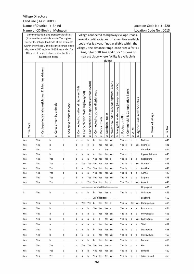
Village DirectoryLand use ( As in 2009 )Name of District : Bhind Location Code No : 420Name of CD Block : Mehgaon Location Code No : 0013
Trac
tors
Cycl
e-pu
lled
rick
shaw
s(M
anua
l & M
achi
ne d
rive
n)
Cart
s dr
iven
by
anim
als
Sea
/Riv
er fe
rry
serv
ice
Conn
ecte
d to
nat
iona
l hig
hway
(NH
)
Conn
ecte
d to
sta
te h
ighw
ay(S
H)
Conn
ecte
d to
maj
or d
istr
ict r
oad
(MD
R)
Conn
ecte
d to
oth
ers
dist
rict
roa
d
Pucc
a r
oads
Kutc
hcha
roa
ds
Wat
er b
ound
ed m
acad
am(W
BM) r
oads
Nav
igab
le w
ater
way
(riv
er/c
anal
)(N
W)
Foot
path
s (F
P)
Com
mer
cial
& C
o-op
erat
ive
Bank
s
ATM
Agr
icul
tura
l Cre
dit S
ocie
ties
64 65 66 67 68 69 70 71 72 73 74 75 76 77 78 79 2 1
Sr.N
o.
Communication and transport facilities (If amenities available code -Yes is given
except for Village Pin Code ,If not available within the village , the distance range code viz; a for < 5 Kms, b for 5-10 Kms and c for 10+ kms of nearest place where facility is
available is given).
Village connected to highways,village roads, banks & credit societies (If amenities available
code -Yes is given, If not available within the village , the distance range code viz; a for < 5
Kms, b for 5-10 Kms and c for 10+ kms of nearest place where facility is available is
given).
Nam
e of
vill
age
Yes Yes b c c c b b Yes Yes Yes Yes c c c Didona 440
Yes Yes b c c c c c Yes Yes Yes Yes c c Yes Pachera 441
Yes Yes b c c c c c a Yes a Yes c c c Chandeni 442
Yes Yes b c c b a a Yes Yes Yes Yes c c c Ingosa Raipura 443
Yes Yes Yes c c a a Yes Yes Yes a Yes b b a Khokipura 444
Yes Yes Yes c c Yes Yes Yes Yes Yes Yes Yes b b Yes Nunhad 445
Yes Yes Yes c b a Yes Yes Yes Yes Yes Yes b c a Asokhar 446
Yes Yes Yes c c a a Yes Yes Yes Yes Yes b b a Achhai 447
Yes Yes Yes c b a Yes Yes Yes Yes Yes Yes a b a Saipura 448
Yes Yes Yes c c c Yes Yes Yes Yes a Yes Yes b Yes Akloni 449
--------------Un-inhabited-------------- Gopalpura 450
b Yes b c c c b b Yes Yes a Yes b c b Ghilauwa 451
--------------Un-inhabited-------------- Seupura 452
Yes Yes b c c Yes Yes b Yes Yes a Yes a Yes Yes Choniyapura 453
Yes Yes b c c a b Yes Yes Yes a Yes a a a Pratapura 454
Yes Yes a c c a a a Yes Yes Yes Yes a a a Mohanpura 455
Yes Yes b c c a a a b Yes Yes Yes b b Yes Guliyapura 456
Yes Yes a c c a a a Yes Yes Yes Yes a a a Siloli 457
Yes Yes b c c b b b Yes Yes Yes Yes b b a Sujanpura 458
Yes Yes b c c a a a Yes Yes Yes Yes b b b Prathvipura 459
Yes Yes b c c b b b Yes Yes Yes Yes b b b Bahera 460
Yes Yes Yes c c Yes Yes Yes Yes Yes a Yes b b a Kot 461
Yes Yes Yes c c b b Yes Yes Yes Yes Yes b b b Sikroda 462
Yes Yes Yes c c b b Yes Yes Yes Yes Yes b b b Tikri(Gormi) 463
261

Census of India 2011- Amenities and
Name of District : Bhind Location Code No : 420Name of CD Block : Mehgaon Location Code No : 0013
Self-
Hel
p G
roup
(SH
G)
Publ
ic d
istr
ibut
ion
syst
em (P
DS)
sho
p
Man
dis
/ Re
gula
r m
arke
t
Wee
kly
Haa
t
Agr
icul
tura
l mar
ketin
g so
ciet
yIn
tegr
ated
Chi
ld D
evel
opm
ent S
chem
e (N
utri
tiona
l Ce
ntre
s)A
ngan
wad
i Cen
tre
(Nut
ritio
nal C
entr
es)
Oth
ers
(Nut
ritio
nal C
entr
es)
ASH
A (A
ccre
dite
d So
cial
Hea
lth A
ctiv
ist)
Com
mun
ity c
entr
e w
ith/w
ithou
t TV
Spor
ts F
ield
,
Spor
ts C
lub
/ Re
crea
tion
Cent
re
Cine
ma
/ Vi
deo
Hal
l
Publ
ic L
ibra
ry
Publ
ic R
eadi
ng R
oom
New
spap
er S
uppl
y
Ass
embl
y Po
lling
sta
tion
Birt
h &
Dea
th R
egis
trat
ion
Off
ice
1 2 3 80 81 82 83 84 85 86 87 88 89 90 91 92 93 94 95 96 97
Sr.N
o.
Nam
e of
vill
age
Loca
tion
code
no.
Availability of miscellaneous facilities (If amenities available code -Yes is given, If not available within the village , the distance range code viz; a for < 5 Kms, b
for 5-10 Kms and c for 10+ kms of nearest place where facility is available is given).
440 Didona 453199 Yes a c c c c Yes Yes Yes c c c c c c a Yes Yes
441 Pachera 453200 Yes Yes c c c c Yes Yes Yes c c c c c c c Yes Yes
442 Chandeni 453201 Yes a c c c c Yes Yes Yes c c c c c c b Yes Yes
443 Ingosa Raipura 453202 Yes Yes c c c c Yes Yes Yes c c c c c c Yes Yes Yes
444 Khokipura 453203 Yes Yes b b c b Yes Yes Yes b b b b b b b Yes Yes
445 Nunhad 453204 c Yes b b c c Yes Yes Yes c c c c c b Yes Yes Yes
446 Asokhar 453205 c Yes b b b b Yes Yes Yes b c c c c b Yes Yes Yes
447 Achhai 453206 Yes a b b c b Yes Yes Yes b b b b b b b Yes a
448 Saipura 453207 Yes a b b b b Yes Yes Yes b b b b b b b Yes a
449 Akloni 453208 Yes Yes b b Yes c Yes Yes Yes c c c b c c Yes Yes Yes
450 Gopalpura 453209 --------------Un-inhabited--------------
451 Ghilauwa 453210 Yes Yes b b b b Yes Yes Yes c c c c b b b Yes Yes
452 Seupura 453211 --------------Un-inhabited--------------
453 Choniyapura 453212 Yes Yes a Yes c c Yes Yes Yes c a a a a a Yes Yes Yes
454 Pratapura 453213 Yes a a a c c Yes Yes Yes a a a a a a a Yes Yes
455 Mohanpura 453214 Yes Yes a a a c Yes Yes Yes b c c c c c a Yes Yes
456 Guliyapura 453215 Yes a b b b c a Yes Yes b c c c c c b a a
457 Siloli 453216 Yes Yes a a a c Yes Yes Yes a c c c c c a Yes Yes
458 Sujanpura 453217 Yes a c b b c Yes Yes Yes b c c c c c b Yes Yes
459 Prathvipura 453218 Yes Yes c Yes b c Yes Yes Yes b c c c c c b Yes Yes
460 Bahera 453219 Yes a c b b c Yes Yes Yes b c c c c c b Yes a
461 Kot 453220 Yes a b b c c Yes Yes Yes Yes Yes Yes c c c Yes Yes Yes
462 Sikroda 453221 Yes Yes b b b c Yes Yes Yes b b b b b b Yes Yes Yes
463 Tikri(Gormi) 453222 Yes Yes b b b c Yes Yes Yes b b b b b b Yes Yes Yes
262
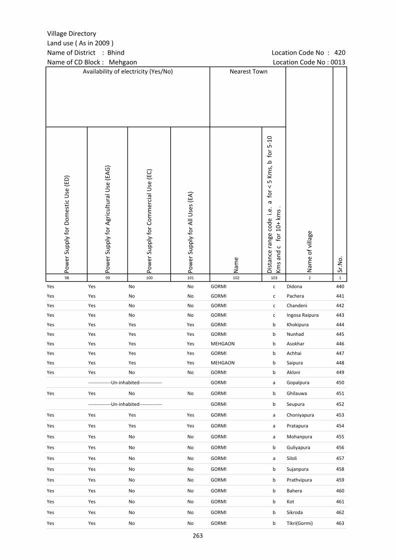
Village DirectoryLand use ( As in 2009 )Name of District : Bhind Location Code No : 420Name of CD Block : Mehgaon Location Code No : 0013
Pow
er S
uppl
y fo
r D
omes
tic U
se (E
D)
Pow
er S
uppl
y fo
r A
gric
ultu
ral U
se (E
AG
)
Pow
er S
uppl
y fo
r Co
mm
erci
al U
se (E
C)
Pow
er S
uppl
y fo
r A
ll U
ses
(EA
)
Nam
e
Dis
tanc
e ra
nge
code
i.e
. a
for
< 5
Kms,
b f
or 5
-10
Kms
and
c f
or 1
0+ k
ms
.98 99 100 101 102 103 2 1
Nearest Town
Nam
e of
vill
age
Sr.N
o.
Availability of electricity (Yes/No)
Yes Yes No No GORMI c Didona 440
Yes Yes No No GORMI c Pachera 441
Yes Yes No No GORMI c Chandeni 442
Yes Yes No No GORMI c Ingosa Raipura 443
Yes Yes Yes Yes GORMI b Khokipura 444
Yes Yes Yes Yes GORMI b Nunhad 445
Yes Yes Yes Yes MEHGAON b Asokhar 446
Yes Yes Yes Yes GORMI b Achhai 447
Yes Yes Yes Yes MEHGAON b Saipura 448
Yes Yes No No GORMI b Akloni 449
--------------Un-inhabited-------------- GORMI a Gopalpura 450
Yes Yes No No GORMI b Ghilauwa 451
--------------Un-inhabited-------------- GORMI b Seupura 452
Yes Yes Yes Yes GORMI a Choniyapura 453
Yes Yes Yes Yes GORMI a Pratapura 454
Yes Yes No No GORMI a Mohanpura 455
Yes Yes No No GORMI b Guliyapura 456
Yes Yes No No GORMI a Siloli 457
Yes Yes No No GORMI b Sujanpura 458
Yes Yes No No GORMI b Prathvipura 459
Yes Yes No No GORMI b Bahera 460
Yes Yes No No GORMI b Kot 461
Yes Yes No No GORMI b Sikroda 462
Yes Yes No No GORMI b Tikri(Gormi) 463
263
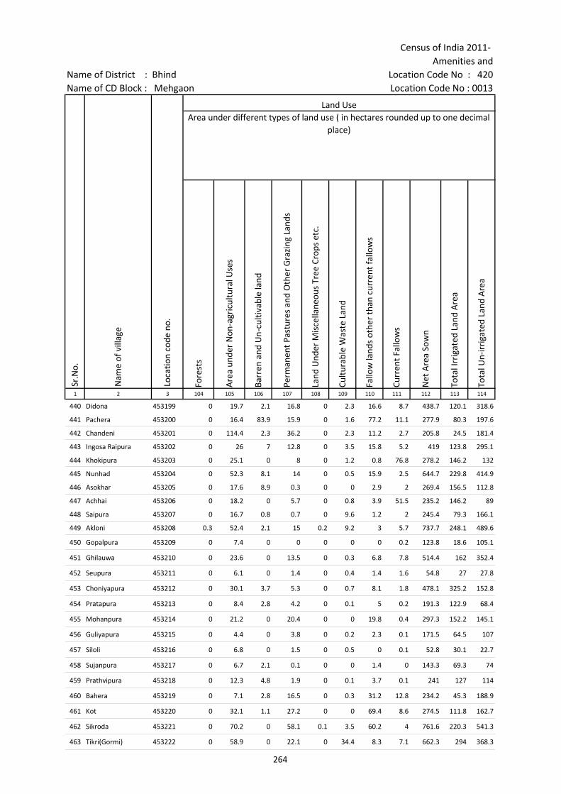
Census of India 2011- Amenities and
Name of District : Bhind Location Code No : 420Name of CD Block : Mehgaon Location Code No : 0013
Fore
sts
Are
a un
der
Non
-agr
icul
tura
l Use
s
Barr
en a
nd U
n-cu
ltiva
ble
land
Perm
anen
t Pas
ture
s an
d O
ther
Gra
zing
Lan
ds
Land
Und
er M
isce
llane
ous
Tree
Cro
ps e
tc.
Cultu
rabl
e W
aste
Lan
d
Fallo
w la
nds
othe
r th
an c
urre
nt fa
llow
s
Curr
ent F
allo
ws
Net
Are
a So
wn
Tota
l Irr
igat
ed L
and
Are
a
Tota
l Un-
irri
gate
d La
nd A
rea
1 2 3 104 105 106 107 108 109 110 111 112 113 114
Land UseArea under different types of land use ( in hectares rounded up to one decimal
place)
Sr.N
o.
Nam
e of
vill
age
Loca
tion
code
no.
440 Didona 453199 0 19.7 2.1 16.8 0 2.3 16.6 8.7 438.7 120.1 318.6
441 Pachera 453200 0 16.4 83.9 15.9 0 1.6 77.2 11.1 277.9 80.3 197.6
442 Chandeni 453201 0 114.4 2.3 36.2 0 2.3 11.2 2.7 205.8 24.5 181.4
443 Ingosa Raipura 453202 0 26 7 12.8 0 3.5 15.8 5.2 419 123.8 295.1
444 Khokipura 453203 0 25.1 0 8 0 1.2 0.8 76.8 278.2 146.2 132
445 Nunhad 453204 0 52.3 8.1 14 0 0.5 15.9 2.5 644.7 229.8 414.9
446 Asokhar 453205 0 17.6 8.9 0.3 0 0 2.9 2 269.4 156.5 112.8
447 Achhai 453206 0 18.2 0 5.7 0 0.8 3.9 51.5 235.2 146.2 89
448 Saipura 453207 0 16.7 0.8 0.7 0 9.6 1.2 2 245.4 79.3 166.1
449 Akloni 453208 0.3 52.4 2.1 15 0.2 9.2 3 5.7 737.7 248.1 489.6
450 Gopalpura 453209 0 7.4 0 0 0 0 0 0.2 123.8 18.6 105.1
451 Ghilauwa 453210 0 23.6 0 13.5 0 0.3 6.8 7.8 514.4 162 352.4
452 Seupura 453211 0 6.1 0 1.4 0 0.4 1.4 1.6 54.8 27 27.8
453 Choniyapura 453212 0 30.1 3.7 5.3 0 0.7 8.1 1.8 478.1 325.2 152.8
454 Pratapura 453213 0 8.4 2.8 4.2 0 0.1 5 0.2 191.3 122.9 68.4
455 Mohanpura 453214 0 21.2 0 20.4 0 0 19.8 0.4 297.3 152.2 145.1
456 Guliyapura 453215 0 4.4 0 3.8 0 0.2 2.3 0.1 171.5 64.5 107
457 Siloli 453216 0 6.8 0 1.5 0 0.5 0 0.1 52.8 30.1 22.7
458 Sujanpura 453217 0 6.7 2.1 0.1 0 0 1.4 0 143.3 69.3 74
459 Prathvipura 453218 0 12.3 4.8 1.9 0 0.1 3.7 0.1 241 127 114
460 Bahera 453219 0 7.1 2.8 16.5 0 0.3 31.2 12.8 234.2 45.3 188.9
461 Kot 453220 0 32.1 1.1 27.2 0 0 69.4 8.6 274.5 111.8 162.7
462 Sikroda 453221 0 70.2 0 58.1 0.1 3.5 60.2 4 761.6 220.3 541.3
463 Tikri(Gormi) 453222 0 58.9 0 22.1 0 34.4 8.3 7.1 662.3 294 368.3
264

Village DirectoryLand use ( As in 2009 )Name of District : Bhind Location Code No : 420Name of CD Block : Mehgaon Location Code No : 0013
Cana
ls (
C )
Wel
ls/T
ube-
wel
ls(W
/TW
)
Tank
s/La
kes(
T/L)
Wat
er F
alls
(WF)
Oth
ers(
O)
Firs
t
Seco
nd
Thir
d 115 116 117 118 119 120 121 122 2 1
Land Use Name of three most important commodities manufactured
Nam
e of
Vill
age
Sr.N
o.
Area irrigated by source (in hectare).
0 120.1 0 0 0 Didona 440
0 80.3 0 0 0 Pachera 441
0 24.5 0 0 0 Chandeni 442
0 123.8 0 0 0 Ingosa Raipura 443
0 146.2 0 0 0 Khokipura 444
40 189.8 0 0 0 Nunhad 445
0 156.5 0 0 0 Asokhar 446
0 146.2 0 0 0 Achhai 447
0 79.3 0 0 0 Saipura 448
0 248.1 0 0 0 Akloni 449
0 18.6 0 0 0 Gopalpura 450
0 162 0 0 0 Ghilauwa 451
27 0 0 0 0 Seupura 452
0 325.2 0 0 0 Choniyapura 453
0 122.9 0 0 0 Pratapura 454
0 152.2 0 0 0 Mohanpura 455
0 64.5 0 0 0 Guliyapura 456
0 30.1 0 0 0 Siloli 457
0 69.3 0 0 0 Sujanpura 458
0 127 0 0 0 Prathvipura 459
0 45.3 0 0 0 Bahera 460
0 111.8 0 0 0 Kot 461
104.2 76.1 0 0 40 Sikroda 462
148.5 90.1 0 0 55.4 Tikri(Gormi) 463
265

Census of India 2011- Amenities and
Name of District : Bhind Location Code No : 420Name of CD Block : Mehgaon Location Code No : 0013
Pre-
Prim
ary
scho
ol (P
P)
Prim
ary
scho
ol (P
)
Mid
dle
scho
ol (M
)
Seco
ndar
y Sc
hool
(S)
Seni
or S
econ
dary
sch
ool (
SS)
Deg
ree
colle
ge o
f art
s s
cien
ce &
com
mer
ce (
ASC
)
Engi
neer
ing
colle
ge(E
C)
Med
ical
col
lege
(MC)
Man
agem
ent i
nstit
ute
(MI)
Poly
tech
nic
(Pt)
Voca
tiona
l tra
inin
g sc
hool
/IT
I
Non
-for
mal
trai
ning
cen
tre
(NFT
C)
Spec
ial s
choo
l for
dis
able
d (S
SD)
Oth
ers
(spe
cify
)
1 2 3 4 5 6 7 8 9 10 11 12 13 14 15 16 17 18 19 20
Sr.N
o.
Nam
e of
vill
age
Loca
tion
code
no.
Tota
l are
a of
the
villa
ge (
in h
ecta
res
roun
ded
up to
one
dec
imal
pla
ce)
Tota
l pop
ulat
ion
( 201
1 ce
nsus
)
Num
ber
of h
ouse
hold
s (2
011
cens
us)
Number of educational amenities available. (If not available within the village , the distance range
code viz; a for < 5 Kms, b for 5-10 Kms and c for 10+ kms of nearest place where facility is available is given).
464 Kalyanpura 453223 343.6 1379 231 a 2 1 a a c c c c c c c c c
465 Rajgadhiya 453224 260 1017 177 2 1 a a a c c c c c c c
466 Raupura 453225 230.7 1903 325 a 1 1 a a c c c c c c c c
467 Tejpura 453226 199 629 160 b 1 1 b b b c c c c c c c
468 Mehdoli 453227 1074.5 3545 544 a 3 2 1 1 a c c c c c c
469 Sunarpura 453228 278.2 1677 305 b 3 1 a a b c c c c c c c b
470 Hirapura 453229 366.4 1321 257 b 1 1 b b b c c c c c c c c
471 Manhad 453230 1501.2 6275 1081 1 4 2 1 1 c c c c c c c c
472 Lalpura 453231 542.3 1255 225 1 a b b 1 c c c c c c
473 Kripekapura 453232 297.9 1286 271 b 3 3 b b b c c c c c c
474 Vijaygarh 453233 272.9 780 149 b 1 a b b b c c c c c c
475 Dogarpura 453234 256.4 955 192 c 1 1 c c c c c c c c c
476 Chapra 453235 357.1 1665 324 1 1 1 a b c c c c c
477 Harichha 453236 966 3029 462 c 4 2 1 1 c c c c c c c
478 Liloi 453237 820.4 768 159 c 1 1 b c c c c c c c
479 Shyampura 453238 340 912 221 1 c c c c
480 Lawan 453239 1105.7 4552 949 b 2 1 1 b c c c c c c c c c
481 Emanpura 453240 151.6 301 63 1 a a c c c c c
482 Shreekapura 453241 123.7 113 14 b a a a b c c c c c c c c c
483 Manpura 453242 363.3 1021 194 1 1 a a c c c c c
484 Chandrapura 453243 257.4 671 130 1 b b c c c c c c c c
485 Arelekapura 453244 307.9 1379 236 1 1 b b c c c c c
486 Sondha 453245 999.4 3752 710 6 1 1 b b c c c c
266

Village DirectoryLand use ( As in 2009 )Name of District : Bhind Location Code No : 420Name of CD Block : Mehgaon Location Code No : 0013
Com
mun
ity h
ealth
cen
tre
(CH
C)Pr
imar
y he
alth
cen
tre
(PH
C)Pr
imar
y he
alth
sub
cen
tre
(PH
S)M
ater
nity
and
chi
ld w
elfa
re c
entr
e (M
CW)
T.B.
clin
ic (
TBC)
Hos
pita
l-allo
path
ic (H
A)
Hos
pita
l-alte
rnat
ive
med
icin
e (H
O)
Dis
pens
ary
(D)
Vete
rina
ry h
ospi
tal (
VH)
Mob
ile h
ealth
clin
ic (M
HC)
Fam
ily w
elfa
re c
entr
e (F
WC)
Char
itabl
e no
n G
ovt.
hos
pita
l/N
ursi
ng h
ome.
Med
ical
pra
ctiti
oner
with
MBB
S D
egre
eM
edic
al p
ract
ition
er w
ith o
ther
deg
ree
Med
ical
pra
ctiti
oner
with
no
degr
eeTr
aditi
onal
pra
ctiti
oner
and
faith
hea
ler
.M
edic
ine
Shop
Oth
ers
Tap
wat
er (T
reat
ed/U
ntre
ated
)
Wel
l w
ater
(C
over
ed /
Unc
over
ed w
ell)
Han
d Pu
mp
Tube
wel
ls /
Bor
e w
ell
Spri
ng
Rive
r /
Cana
l
Tank
/ P
ond
/ L
ake
Oth
ers
21 22 23 24 25 26 27 28 29 30 31 32 33 34 35 36 37 38 39 40 41 42 43 44 45 46 2 1
Number of Non-Government
Medical Amenities available.
Availability of drinking water - Yes / No
Nam
e of
vill
age
Sr.N
o.
Number of Medical Amenities available. (If not available within the
village , the distance range code viz; a for < 5 Kms, b for 5-10 Kms and c for
10+ kms of nearest place where facility is available is given).
c a a c a c c c a c c 0 0 0 1 0 0 0 No Yes Yes Yes No No Yes No Kalyanpura 464
a a c a a a a a a a 0 0 0 0 0 0 0 No No Yes No No No No No Rajgadhiya 465
c a a c a c c c c c c 0 0 0 2 0 0 0 No Yes Yes No No No No No Raupura 466
c b b b b b b b b c c 0 0 0 0 0 0 0 No Yes Yes Yes No Yes No No Tejpura 467
b a 1 a a a c a b c a 0 0 0 0 0 0 0 No Yes Yes Yes No Yes Yes No Mehdoli 468
b b b b b c b a b b b 0 0 0 0 0 0 0 No Yes Yes No No Yes No No Sunarpura 469
b b b b b b b b a b b 0 0 0 0 1 0 0 No Yes Yes Yes No No No No Hirapura 470
c 1 c c c 1 1 c c 0 0 0 2 1 1 0 Yes Yes Yes Yes No Yes Yes No Manhad 471
b b 1 b b b b c b b b 0 0 0 0 0 0 0 No Yes Yes Yes No No Yes No Lalpura 472
c b b b b b b b b c b 0 0 0 0 0 0 0 No Yes Yes Yes No Yes Yes No Kripekapura 473
c b b b b b b b b c b 0 0 0 0 0 0 0 No Yes Yes Yes No No Yes No Vijaygarh 474
c c b c c c c c b c c 0 0 0 0 0 0 0 No Yes Yes Yes No Yes Yes No Dogarpura 475
b b b b b b b c c b b 0 0 0 0 0 0 0 No Yes Yes Yes No Yes No No Chapra 476
c c 1 c c c c c c c 0 0 0 0 0 0 0 No Yes Yes Yes No Yes No No Harichha 477
c c b c c c c c b c c 0 0 0 0 0 0 0 No Yes Yes Yes No No No No Liloi 478
c c c c c c c c c c c 0 0 0 0 0 0 0 No Yes Yes Yes No Yes No No Shyampura 479
c c 1 c c c c c 1 c 1 0 0 0 0 0 0 0 No Yes Yes Yes No Yes Yes No Lawan 480
c c b c c c c c c c c 0 0 0 0 0 0 0 No Yes Yes Yes No Yes Yes No Emanpura 481
c c a c c c c c a c c 0 0 0 0 0 0 0 No Yes Yes No No Yes No No Shreekapura 482
c c c c c c c c c c c 0 0 0 0 0 0 0 No Yes Yes Yes No Yes Yes No Manpura 483
c c c c c c c c c c c 0 0 0 0 0 0 0 No Yes Yes Yes No No No No Chandrapura 484
c c c c c c c c c c c 0 0 0 0 0 0 0 No Yes Yes Yes No No No No Arelekapura 485
b a c a c c c c c c 0 0 0 0 0 0 0 No Yes Yes No No Yes Yes No Sondha 486
267

Census of India 2011- Amenities and
Name of District : Bhind Location Code No : 420Name of CD Block : Mehgaon Location Code No : 0013
Com
mun
ity to
ilet i
nclu
ding
bat
h.
Com
mun
ity to
ilet e
xclu
ding
bat
h.
Rura
l sa
nita
ry m
art o
r sa
nita
ry h
ardw
are
outle
t av
aila
ble
near
the
villa
ge.
Com
mun
ity b
io- g
as o
r re
cycl
e of
was
te fo
r pr
oduc
tive
use.
Post
off
ice(
PO)
Sub
post
off
ice
(SPO
)
Post
& T
eleg
raph
off
ice
(P&
TO)
Villa
ge P
in C
ode
Tele
phon
es
(L
and
lines
)
Publ
ic c
all o
ffic
e (P
CO)
Mob
ile p
hone
cov
erag
e
Inte
rnet
caf
es/
Com
mon
ser
vice
cen
tre
(CSC
)
Priv
ate
cour
ier
faci
lity
Bus
serv
ice
(Pub
lic &
Pri
vate
)
Railw
ay s
tatio
ns
Aut
o/M
odifi
ed A
utos
Taxi
s an
d Va
ns
1 2 3 47 48 49 50 51 52 53 54 55 56 57 58 59 60 61 62 63
Loca
tion
code
no.
Availability of toilet & others Yes / No
Communication and transport facilities (If amenities available code -Yes is given except for Village Pin Code ,If not available within the village , the distance range code
viz; a for < 5 Kms, b for 5-10 Kms and c for 10+ kms of nearest place where facility is available is given).
Sr.N
o.
Nam
e of
vill
age
464 Kalyanpura 453223 No No Yes No a a a a a Yes a a a c c c
465 Rajgadhiya 453224 No No No No a a Yes a Yes a a Yes c c c
466 Raupura 453225 No No Yes No a a a a a Yes a a a c c c
467 Tejpura 453226 No No No No c b b b b Yes b b b b b b
468 Mehdoli 453227 Yes No No No c Yes a 477660 a a Yes a a a c c a
469 Sunarpura 453228 No No No No Yes b b 477660 Yes b Yes c b Yes b Yes Yes
470 Hirapura 453229 No No No No b a b b b Yes b b a b b b
471 Manhad 453230 Yes Yes No No b Yes b Yes Yes Yes b b Yes b b Yes
472 Lalpura 453231 No No No No a a a b b b b b Yes c b b
473 Kripekapura 453232 No No No No b Yes b 477660 b b Yes b b b c b b
474 Vijaygarh 453233 No No No No c b b b b Yes b b b c b b
475 Dogarpura 453234 No No No No c a c c c Yes c c c c c c
476 Chapra 453235 No No No No a a a b b b b b c b b
477 Harichha 453236 No No No No c Yes c 477660 c c Yes c c Yes c c c
478 Liloi 453237 No No No No c a c c c Yes a a Yes c c c
479 Shyampura 453238 No No No No a a c c c c c c c c c c
480 Lawan 453239 No No No No c Yes c 477001 b Yes Yes b c b b b b
481 Emanpura 453240 No No No No a a c c c c c c c c c c
482 Shreekapura 453241 No No No No c a c b c Yes b b b a b b
483 Manpura 453242 No No No No a a a b c Yes c c b a b c
484 Chandrapura 453243 No No No No a a c c c Yes c c b a b b
485 Arelekapura 453244 No No No No a a c c c Yes c c b c c c
486 Sondha 453245 No No No No a Yes Yes 477116 Yes c Yes c c c Yes c c
268
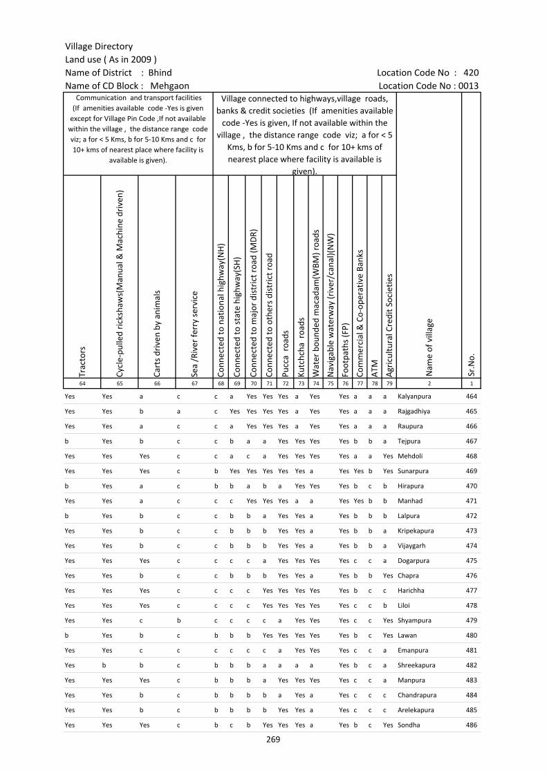
Village DirectoryLand use ( As in 2009 )Name of District : Bhind Location Code No : 420Name of CD Block : Mehgaon Location Code No : 0013
Trac
tors
Cycl
e-pu
lled
rick
shaw
s(M
anua
l & M
achi
ne d
rive
n)
Cart
s dr
iven
by
anim
als
Sea
/Riv
er fe
rry
serv
ice
Conn
ecte
d to
nat
iona
l hig
hway
(NH
)
Conn
ecte
d to
sta
te h
ighw
ay(S
H)
Conn
ecte
d to
maj
or d
istr
ict r
oad
(MD
R)
Conn
ecte
d to
oth
ers
dist
rict
roa
d
Pucc
a r
oads
Kutc
hcha
roa
ds
Wat
er b
ound
ed m
acad
am(W
BM) r
oads
Nav
igab
le w
ater
way
(riv
er/c
anal
)(N
W)
Foot
path
s (F
P)
Com
mer
cial
& C
o-op
erat
ive
Bank
s
ATM
Agr
icul
tura
l Cre
dit S
ocie
ties
64 65 66 67 68 69 70 71 72 73 74 75 76 77 78 79 2 1
Sr.N
o.
Communication and transport facilities (If amenities available code -Yes is given
except for Village Pin Code ,If not available within the village , the distance range code viz; a for < 5 Kms, b for 5-10 Kms and c for 10+ kms of nearest place where facility is
available is given).
Village connected to highways,village roads, banks & credit societies (If amenities available
code -Yes is given, If not available within the village , the distance range code viz; a for < 5
Kms, b for 5-10 Kms and c for 10+ kms of nearest place where facility is available is
given).
Nam
e of
vill
age
Yes Yes a c c a Yes Yes Yes a Yes Yes a a a Kalyanpura 464
Yes Yes b a c Yes Yes Yes Yes a Yes Yes a a a Rajgadhiya 465
Yes Yes a c c a Yes Yes Yes a Yes Yes a a a Raupura 466
b Yes b c c b a a Yes Yes Yes Yes b b a Tejpura 467
Yes Yes Yes c c a c a Yes Yes Yes Yes a a Yes Mehdoli 468
Yes Yes Yes c b Yes Yes Yes Yes Yes a Yes Yes b Yes Sunarpura 469
b Yes a c b b a b a Yes Yes Yes b c b Hirapura 470
Yes Yes a c c c Yes Yes Yes a a Yes Yes b b Manhad 471
b Yes b c c b b a Yes Yes a Yes b b b Lalpura 472
Yes Yes b c c b b b Yes Yes a Yes b b a Kripekapura 473
Yes Yes b c c b b b Yes Yes a Yes b b a Vijaygarh 474
Yes Yes Yes c c c c a Yes Yes Yes Yes c c a Dogarpura 475
Yes Yes b c c b b b Yes Yes a Yes b b Yes Chapra 476
Yes Yes Yes c c c c Yes Yes Yes Yes Yes b c c Harichha 477
Yes Yes Yes c c c c Yes Yes Yes Yes Yes c c b Liloi 478
Yes Yes c b c c c c a Yes Yes Yes c c Yes Shyampura 479
b Yes b c b b b Yes Yes Yes Yes Yes b c Yes Lawan 480
Yes Yes c c c c c c a Yes Yes Yes c c a Emanpura 481
Yes b b c b b b a a a a Yes b c a Shreekapura 482
Yes Yes Yes c b b b a Yes Yes Yes Yes c c a Manpura 483
Yes Yes b c b b b b a Yes a Yes c c c Chandrapura 484
Yes Yes b c b b b b Yes Yes a Yes c c c Arelekapura 485
Yes Yes Yes c b c b Yes Yes Yes a Yes b c Yes Sondha 486
269
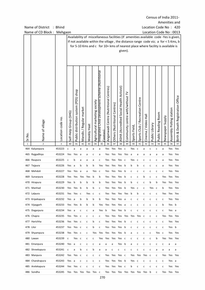
Census of India 2011- Amenities and
Name of District : Bhind Location Code No : 420Name of CD Block : Mehgaon Location Code No : 0013
Self-
Hel
p G
roup
(SH
G)
Publ
ic d
istr
ibut
ion
syst
em (P
DS)
sho
p
Man
dis
/ Re
gula
r m
arke
t
Wee
kly
Haa
t
Agr
icul
tura
l mar
ketin
g so
ciet
yIn
tegr
ated
Chi
ld D
evel
opm
ent S
chem
e (N
utri
tiona
l Ce
ntre
s)A
ngan
wad
i Cen
tre
(Nut
ritio
nal C
entr
es)
Oth
ers
(Nut
ritio
nal C
entr
es)
ASH
A (A
ccre
dite
d So
cial
Hea
lth A
ctiv
ist)
Com
mun
ity c
entr
e w
ith/w
ithou
t TV
Spor
ts F
ield
,
Spor
ts C
lub
/ Re
crea
tion
Cent
re
Cine
ma
/ Vi
deo
Hal
l
Publ
ic L
ibra
ry
Publ
ic R
eadi
ng R
oom
New
spap
er S
uppl
y
Ass
embl
y Po
lling
sta
tion
Birt
h &
Dea
th R
egis
trat
ion
Off
ice
1 2 3 80 81 82 83 84 85 86 87 88 89 90 91 92 93 94 95 96 97
Sr.N
o.
Nam
e of
vill
age
Loca
tion
code
no.
Availability of miscellaneous facilities (If amenities available code -Yes is given, If not available within the village , the distance range code viz; a for < 5 Kms, b
for 5-10 Kms and c for 10+ kms of nearest place where facility is available is given).
464 Kalyanpura 453223 c a a a a a Yes Yes Yes c Yes c a c c a Yes Yes
465 Rajgadhiya 453224 Yes Yes a a c a Yes Yes Yes Yes a a a a a a Yes Yes
466 Raupura 453225 c b a a a c Yes Yes Yes c Yes c c c c a Yes Yes
467 Tejpura 453226 Yes a b b b Yes Yes Yes Yes b b b c c c a Yes Yes
468 Mehdoli 453227 Yes Yes a a Yes c Yes Yes Yes b c c c c c c Yes Yes
469 Sunarpura 453228 Yes Yes Yes Yes b b Yes Yes Yes b c c b c c Yes Yes Yes
470 Hirapura 453229 Yes b b b b b Yes Yes Yes b b c c b b Yes Yes Yes
471 Manhad 453230 Yes Yes b b b c Yes Yes Yes b Yes c c Yes c b Yes Yes
472 Lalpura 453231 Yes Yes c Yes c c Yes Yes Yes Yes b b c c c Yes Yes Yes
473 Kripekapura 453232 Yes a b b b b Yes Yes Yes a c c c c c c Yes Yes
474 Vijaygarh 453233 Yes Yes b b b Yes Yes Yes Yes a c c c c c b Yes b
475 Dogarpura 453234 Yes a c c a Yes b Yes Yes b c c c c c c Yes a
476 Chapra 453235 Yes Yes c c c c Yes Yes Yes Yes Yes Yes c c c Yes Yes Yes
477 Harichha 453236 Yes Yes c c b c Yes Yes Yes b c c c c c c Yes Yes
478 Liloi 453237 Yes Yes c c b c Yes Yes Yes b c c c c c c Yes b
479 Shyampura 453238 Yes Yes c c Yes Yes Yes Yes Yes b a c c c Yes c Yes Yes
480 Lawan 453239 c Yes c c c Yes Yes Yes Yes c c c c c b Yes Yes Yes
481 Emanpura 453240 Yes a c c c a a a Yes b a c c c c c a a
482 Shreekapura 453241 c a b c b a a c c c c c c c a a a a
483 Manpura 453242 Yes Yes c c c c Yes Yes Yes c Yes Yes Yes c c Yes Yes Yes
484 Chandrapura 453243 Yes a c c c c Yes Yes Yes b Yes c c c c c Yes a
485 Arelekapura 453244 Yes Yes c c c c Yes Yes Yes c b c c c c c Yes Yes
486 Sondha 453245 Yes Yes Yes Yes Yes c Yes Yes Yes Yes Yes Yes Yes b c Yes Yes Yes
270
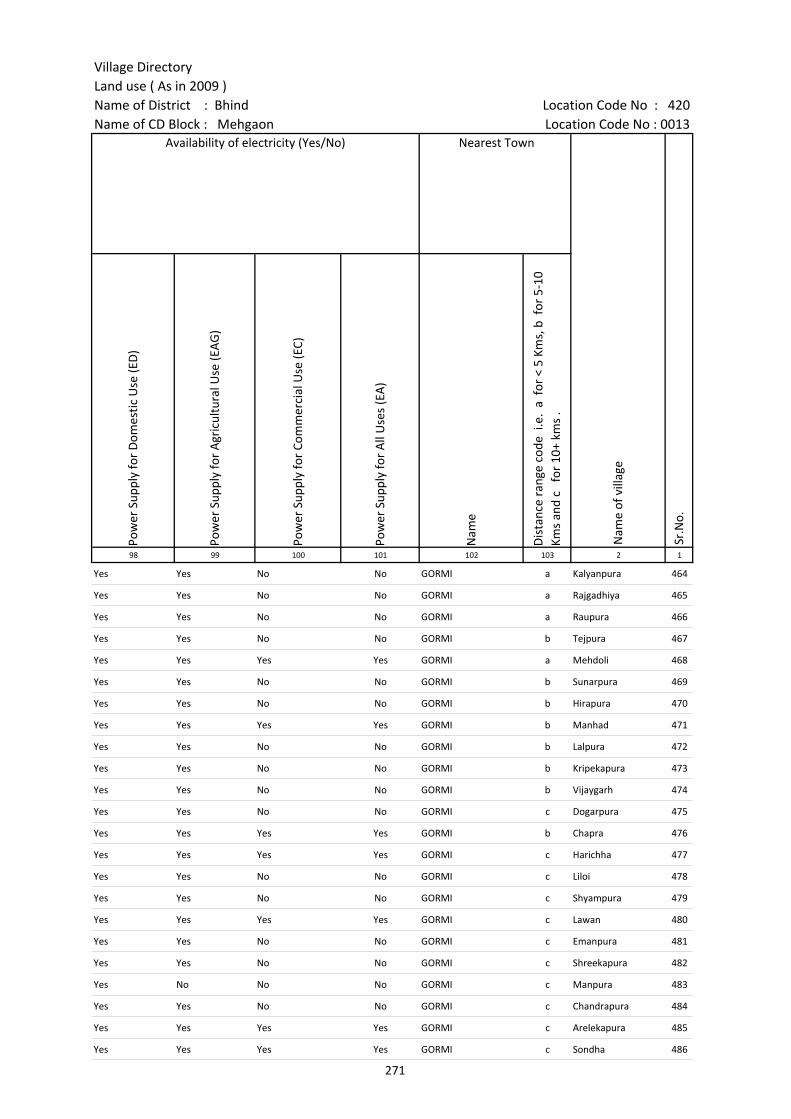
Village DirectoryLand use ( As in 2009 )Name of District : Bhind Location Code No : 420Name of CD Block : Mehgaon Location Code No : 0013
Pow
er S
uppl
y fo
r D
omes
tic U
se (E
D)
Pow
er S
uppl
y fo
r A
gric
ultu
ral U
se (E
AG
)
Pow
er S
uppl
y fo
r Co
mm
erci
al U
se (E
C)
Pow
er S
uppl
y fo
r A
ll U
ses
(EA
)
Nam
e
Dis
tanc
e ra
nge
code
i.e
. a
for
< 5
Kms,
b f
or 5
-10
Kms
and
c f
or 1
0+ k
ms
.98 99 100 101 102 103 2 1
Nearest Town
Nam
e of
vill
age
Sr.N
o.
Availability of electricity (Yes/No)
Yes Yes No No GORMI a Kalyanpura 464
Yes Yes No No GORMI a Rajgadhiya 465
Yes Yes No No GORMI a Raupura 466
Yes Yes No No GORMI b Tejpura 467
Yes Yes Yes Yes GORMI a Mehdoli 468
Yes Yes No No GORMI b Sunarpura 469
Yes Yes No No GORMI b Hirapura 470
Yes Yes Yes Yes GORMI b Manhad 471
Yes Yes No No GORMI b Lalpura 472
Yes Yes No No GORMI b Kripekapura 473
Yes Yes No No GORMI b Vijaygarh 474
Yes Yes No No GORMI c Dogarpura 475
Yes Yes Yes Yes GORMI b Chapra 476
Yes Yes Yes Yes GORMI c Harichha 477
Yes Yes No No GORMI c Liloi 478
Yes Yes No No GORMI c Shyampura 479
Yes Yes Yes Yes GORMI c Lawan 480
Yes Yes No No GORMI c Emanpura 481
Yes Yes No No GORMI c Shreekapura 482
Yes No No No GORMI c Manpura 483
Yes Yes No No GORMI c Chandrapura 484
Yes Yes Yes Yes GORMI c Arelekapura 485
Yes Yes Yes Yes GORMI c Sondha 486
271
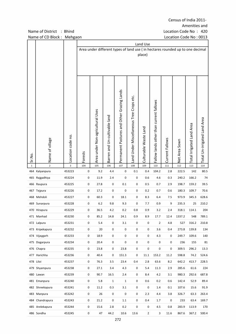
Census of India 2011- Amenities and
Name of District : Bhind Location Code No : 420Name of CD Block : Mehgaon Location Code No : 0013
Fore
sts
Are
a un
der
Non
-agr
icul
tura
l Use
s
Barr
en a
nd U
n-cu
ltiva
ble
land
Perm
anen
t Pas
ture
s an
d O
ther
Gra
zing
Lan
ds
Land
Und
er M
isce
llane
ous
Tree
Cro
ps e
tc.
Cultu
rabl
e W
aste
Lan
d
Fallo
w la
nds
othe
r th
an c
urre
nt fa
llow
s
Curr
ent F
allo
ws
Net
Are
a So
wn
Tota
l Irr
igat
ed L
and
Are
a
Tota
l Un-
irri
gate
d La
nd A
rea
1 2 3 104 105 106 107 108 109 110 111 112 113 114
Land UseArea under different types of land use ( in hectares rounded up to one decimal
place)
Sr.N
o.
Nam
e of
vill
age
Loca
tion
code
no.
464 Kalyanpura 453223 0 9.2 4.4 0 0.1 0.4 104.2 2.8 222.5 142 80.5
465 Rajgadhiya 453224 0 11.9 2.4 0 0 0.6 4.6 0.3 240.2 166.2 74
466 Raupura 453225 0 27.8 0 0.1 0 0.5 0.7 2.9 198.7 159.2 39.5
467 Tejpura 453226 0 17.2 0 0 0 0.2 0.7 0.6 180.3 109.7 70.6
468 Mehdoli 453227 0 60.3 0 18.1 0 8.3 6.4 7.5 973.9 345.3 628.6
469 Sunarpura 453228 0 6.2 9.8 9.3 0 7.7 0.9 9 235.3 25 210.2
470 Hirapura 453229 0 36.5 4.2 0.2 0.8 0.9 3.2 2.4 318.1 114.1 204
471 Manhad 453230 0 85.2 14.8 24.1 0.9 8.9 17.7 12.4 1337.2 548 789.1
472 Lalpura 453231 0 5.4 0 3.1 0 0 2 4.8 527 316.2 210.8
473 Kripekapura 453232 0 20 0 0 0 0 3.6 0.4 273.8 139.8 134
474 Vijaygarh 453233 0 18.9 0 0 0 0 4.3 0 249.7 109.6 140
475 Dogarpura 453234 0 20.4 0 0 0 0 0 0 236 155 81
476 Chapra 453235 0 23.8 0 23.8 0 0 0 0 309.5 296.2 13.3
477 Harichha 453236 0 40.4 0 151.3 0 11.1 153.2 11.2 598.8 74.2 524.6
478 Liloi 453237 0 76.3 3.5 23.4 0.4 2.8 63.6 8.2 642.2 413.7 228.5
479 Shyampura 453238 0 27.1 3.4 4.3 0 5.4 11.3 2.9 285.6 61.6 224
480 Lawan 453239 0 90.7 16.5 2.4 0 8.4 4.2 3.1 980.3 292.6 687.8
481 Emanpura 453240 0 5.8 1 1 0 0.6 0.2 0.6 142.4 52.9 89.4
482 Shreekapura 453241 0 11.2 0.3 3.1 0 0 1.4 0.1 107.6 15.6 91.9
483 Manpura 453242 0 26 0 0 0 2.3 4.4 3.8 326.7 63.3 263.4
484 Chandrapura 453243 0 21.2 0 1.1 0 0.4 1.7 0 233 63.4 169.7
485 Arelekapura 453244 0 15.6 2.8 0.2 0 0 4.5 0.8 283.9 113.9 170
486 Sondha 453245 0 47 44.2 10.6 13.6 2 3 11.6 867.6 367.2 500.4
272
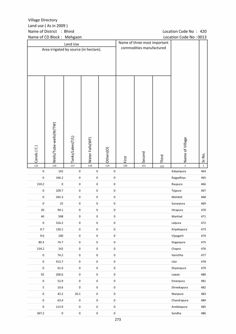
Village DirectoryLand use ( As in 2009 )Name of District : Bhind Location Code No : 420Name of CD Block : Mehgaon Location Code No : 0013
Cana
ls (
C )
Wel
ls/T
ube-
wel
ls(W
/TW
)
Tank
s/La
kes(
T/L)
Wat
er F
alls
(WF)
Oth
ers(
O)
Firs
t
Seco
nd
Thir
d 115 116 117 118 119 120 121 122 2 1
Land Use Name of three most important commodities manufactured
Nam
e of
Vill
age
Sr.N
o.
Area irrigated by source (in hectare).
0 142 0 0 0 Kalyanpura 464
0 166.2 0 0 0 Rajgadhiya 465
159.2 0 0 0 0 Raupura 466
0 109.7 0 0 0 Tejpura 467
0 345.3 0 0 0 Mehdoli 468
0 25 0 0 0 Sunarpura 469
20 94.1 0 0 0 Hirapura 470
40 508 0 0 0 Manhad 471
0 316.2 0 0 0 Lalpura 472
9.7 130.1 0 0 0 Kripekapura 473
9.6 100 0 0 0 Vijaygarh 474
80.3 74.7 0 0 0 Dogarpura 475
154.2 142 0 0 0 Chapra 476
0 74.2 0 0 0 Harichha 477
0 413.7 0 0 0 Liloi 478
0 61.6 0 0 0 Shyampura 479
92 200.6 0 0 0 Lawan 480
0 52.9 0 0 0 Emanpura 481
5 10.6 0 0 0 Shreekapura 482
0 43.2 20.1 0 0 Manpura 483
0 63.4 0 0 0 Chandrapura 484
0 113.9 0 0 0 Arelekapura 485
367.2 0 0 0 0 Sondha 486
273
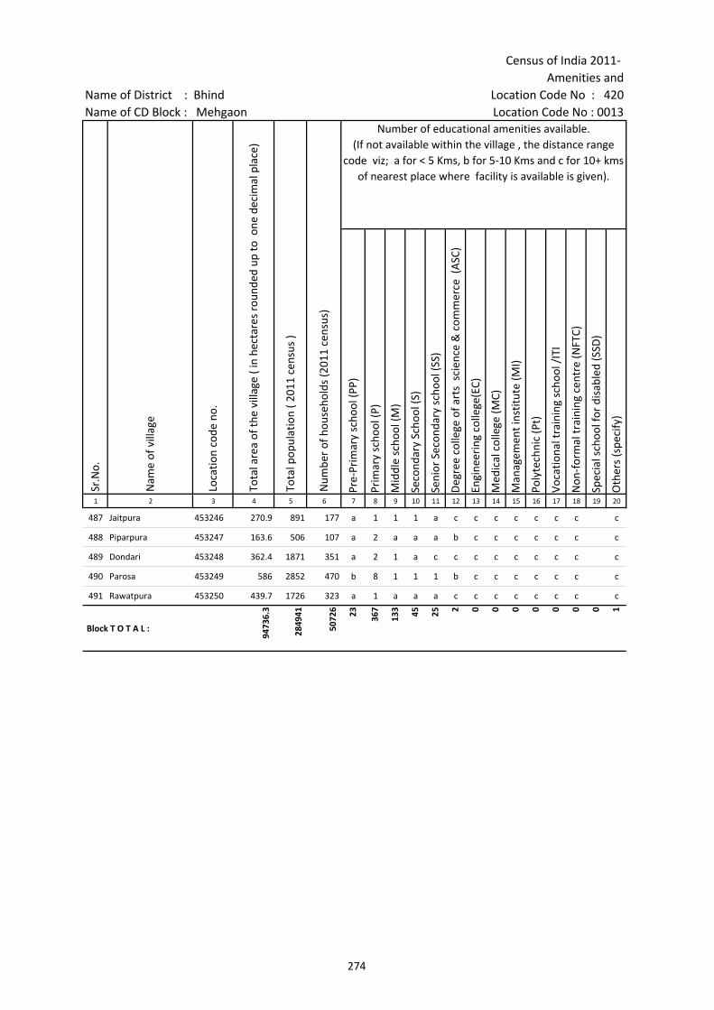
Census of India 2011- Amenities and
Name of District : Bhind Location Code No : 420Name of CD Block : Mehgaon Location Code No : 0013
Pre-
Prim
ary
scho
ol (P
P)
Prim
ary
scho
ol (P
)
Mid
dle
scho
ol (M
)
Seco
ndar
y Sc
hool
(S)
Seni
or S
econ
dary
sch
ool (
SS)
Deg
ree
colle
ge o
f art
s s
cien
ce &
com
mer
ce (
ASC
)
Engi
neer
ing
colle
ge(E
C)
Med
ical
col
lege
(MC)
Man
agem
ent i
nstit
ute
(MI)
Poly
tech
nic
(Pt)
Voca
tiona
l tra
inin
g sc
hool
/IT
I
Non
-for
mal
trai
ning
cen
tre
(NFT
C)
Spec
ial s
choo
l for
dis
able
d (S
SD)
Oth
ers
(spe
cify
)
1 2 3 4 5 6 7 8 9 10 11 12 13 14 15 16 17 18 19 20
Sr.N
o.
Nam
e of
vill
age
Loca
tion
code
no.
Tota
l are
a of
the
villa
ge (
in h
ecta
res
roun
ded
up to
one
dec
imal
pla
ce)
Tota
l pop
ulat
ion
( 201
1 ce
nsus
)
Num
ber
of h
ouse
hold
s (2
011
cens
us)
Number of educational amenities available. (If not available within the village , the distance range
code viz; a for < 5 Kms, b for 5-10 Kms and c for 10+ kms of nearest place where facility is available is given).
487 Jaitpura 453246 270.9 891 177 a 1 1 1 a c c c c c c c c
488 Piparpura 453247 163.6 506 107 a 2 a a a b c c c c c c c
489 Dondari 453248 362.4 1871 351 a 2 1 a c c c c c c c c c
490 Parosa 453249 586 2852 470 b 8 1 1 1 b c c c c c c c
491 Rawatpura 453250 439.7 1726 323 a 1 a a a c c c c c c c c
Block T O T A L :
9473
6.3
2849
41
5072
6 23 367
133 45 25 2 0 0 0 0 0 0 0 1
274
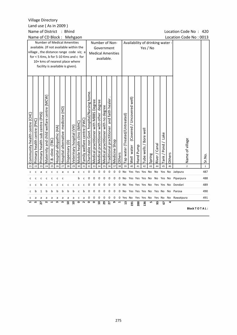
Village DirectoryLand use ( As in 2009 )Name of District : Bhind Location Code No : 420Name of CD Block : Mehgaon Location Code No : 0013
Com
mun
ity h
ealth
cen
tre
(CH
C)Pr
imar
y he
alth
cen
tre
(PH
C)Pr
imar
y he
alth
sub
cen
tre
(PH
S)M
ater
nity
and
chi
ld w
elfa
re c
entr
e (M
CW)
T.B.
clin
ic (
TBC)
Hos
pita
l-allo
path
ic (H
A)
Hos
pita
l-alte
rnat
ive
med
icin
e (H
O)
Dis
pens
ary
(D)
Vete
rina
ry h
ospi
tal (
VH)
Mob
ile h
ealth
clin
ic (M
HC)
Fam
ily w
elfa
re c
entr
e (F
WC)
Char
itabl
e no
n G
ovt.
hos
pita
l/N
ursi
ng h
ome.
Med
ical
pra
ctiti
oner
with
MBB
S D
egre
eM
edic
al p
ract
ition
er w
ith o
ther
deg
ree
Med
ical
pra
ctiti
oner
with
no
degr
eeTr
aditi
onal
pra
ctiti
oner
and
faith
hea
ler
.M
edic
ine
Shop
Oth
ers
Tap
wat
er (T
reat
ed/U
ntre
ated
)
Wel
l w
ater
(C
over
ed /
Unc
over
ed w
ell)
Han
d Pu
mp
Tube
wel
ls /
Bor
e w
ell
Spri
ng
Rive
r /
Cana
l
Tank
/ P
ond
/ L
ake
Oth
ers
21 22 23 24 25 26 27 28 29 30 31 32 33 34 35 36 37 38 39 40 41 42 43 44 45 46 2 1
Number of Non-Government
Medical Amenities available.
Availability of drinking water - Yes / No
Nam
e of
vill
age
Sr.N
o.
Number of Medical Amenities available. (If not available within the
village , the distance range code viz; a for < 5 Kms, b for 5-10 Kms and c for
10+ kms of nearest place where facility is available is given).
c c a c c c a c a c c 0 0 0 0 0 0 0 No Yes Yes Yes No No Yes No Jaitpura 487
c c c c c c c b c 0 0 0 0 0 0 0 No Yes Yes Yes No No Yes No Piparpura 488
c c b c c c c c c c c 0 0 0 0 0 0 0 No Yes Yes Yes No Yes Yes No Dondari 489
c b 1 b b b b b b c b 0 0 0 0 0 0 0 No Yes Yes Yes No Yes No No Parosa 490
c a a a a a a a a c a 0 0 0 0 0 0 0 Yes No Yes Yes No Yes No No Rawatpura 491
1 5 27 2 1 3 3 10 10 0 2 0 0 10 29 27 9 1 13 191
200
136 5 93 67 4
Block T O T A L :
275

Census of India 2011- Amenities and
Name of District : Bhind Location Code No : 420Name of CD Block : Mehgaon Location Code No : 0013
Com
mun
ity to
ilet i
nclu
ding
bat
h.
Com
mun
ity to
ilet e
xclu
ding
bat
h.
Rura
l sa
nita
ry m
art o
r sa
nita
ry h
ardw
are
outle
t av
aila
ble
near
the
villa
ge.
Com
mun
ity b
io- g
as o
r re
cycl
e of
was
te fo
r pr
oduc
tive
use.
Post
off
ice(
PO)
Sub
post
off
ice
(SPO
)
Post
& T
eleg
raph
off
ice
(P&
TO)
Villa
ge P
in C
ode
Tele
phon
es
(L
and
lines
)
Publ
ic c
all o
ffic
e (P
CO)
Mob
ile p
hone
cov
erag
e
Inte
rnet
caf
es/
Com
mon
ser
vice
cen
tre
(CSC
)
Priv
ate
cour
ier
faci
lity
Bus
serv
ice
(Pub
lic &
Pri
vate
)
Railw
ay s
tatio
ns
Aut
o/M
odifi
ed A
utos
Taxi
s an
d Va
ns
1 2 3 47 48 49 50 51 52 53 54 55 56 57 58 59 60 61 62 63
Loca
tion
code
no.
Availability of toilet & others Yes / No
Communication and transport facilities (If amenities available code -Yes is given except for Village Pin Code ,If not available within the village , the distance range code
viz; a for < 5 Kms, b for 5-10 Kms and c for 10+ kms of nearest place where facility is available is given).
Sr.N
o.
Nam
e of
vill
age
487 Jaitpura 453246 No No No No c a c Yes c Yes c c Yes b c c
488 Piparpura 453247 No No No No a c c Yes c b a a c c
489 Dondari 453248 No No No No c b c c c Yes c c a b c c
490 Parosa 453249 No No No No b Yes b 477660 b b Yes b b a c b b
491 Rawatpura 453250 No No No No a a a a a Yes a a a c a a
Block T O T A L :
8 5 7 5 6 41 23 43 34 11 148 1 1 56 3 14 25
276
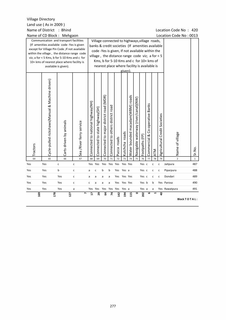
Village DirectoryLand use ( As in 2009 )Name of District : Bhind Location Code No : 420Name of CD Block : Mehgaon Location Code No : 0013
Trac
tors
Cycl
e-pu
lled
rick
shaw
s(M
anua
l & M
achi
ne d
rive
n)
Cart
s dr
iven
by
anim
als
Sea
/Riv
er fe
rry
serv
ice
Conn
ecte
d to
nat
iona
l hig
hway
(NH
)
Conn
ecte
d to
sta
te h
ighw
ay(S
H)
Conn
ecte
d to
maj
or d
istr
ict r
oad
(MD
R)
Conn
ecte
d to
oth
ers
dist
rict
roa
d
Pucc
a r
oads
Kutc
hcha
roa
ds
Wat
er b
ound
ed m
acad
am(W
BM) r
oads
Nav
igab
le w
ater
way
(riv
er/c
anal
)(N
W)
Foot
path
s (F
P)
Com
mer
cial
& C
o-op
erat
ive
Bank
s
ATM
Agr
icul
tura
l Cre
dit S
ocie
ties
64 65 66 67 68 69 70 71 72 73 74 75 76 77 78 79 2 1
Sr.N
o.
Communication and transport facilities (If amenities available code -Yes is given
except for Village Pin Code ,If not available within the village , the distance range code viz; a for < 5 Kms, b for 5-10 Kms and c for 10+ kms of nearest place where facility is
available is given).
Village connected to highways,village roads, banks & credit societies (If amenities available
code -Yes is given, If not available within the village , the distance range code viz; a for < 5
Kms, b for 5-10 Kms and c for 10+ kms of nearest place where facility is available is
given).
Nam
e of
vill
age
Yes Yes c c Yes Yes Yes Yes Yes Yes Yes Yes c c c Jaitpura 487
Yes Yes b c a c b b Yes Yes a Yes c c c Piparpura 488
Yes Yes Yes c a a a a Yes Yes Yes Yes c c c Dondari 489
Yes Yes Yes c c a a a Yes Yes Yes Yes b b Yes Parosa 490
Yes Yes Yes a Yes Yes Yes Yes Yes Yes a Yes a a Yes Rawatpura 491
169
178
127 7 17 29 64 74 142
194
115 0
202 6 1 40
Block T O T A L :
277
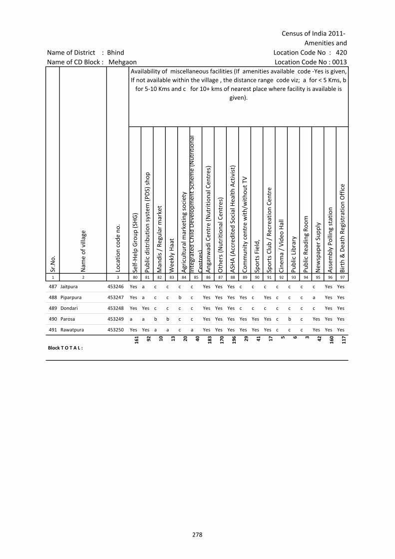
Census of India 2011- Amenities and
Name of District : Bhind Location Code No : 420Name of CD Block : Mehgaon Location Code No : 0013
Self-
Hel
p G
roup
(SH
G)
Publ
ic d
istr
ibut
ion
syst
em (P
DS)
sho
p
Man
dis
/ Re
gula
r m
arke
t
Wee
kly
Haa
t
Agr
icul
tura
l mar
ketin
g so
ciet
yIn
tegr
ated
Chi
ld D
evel
opm
ent S
chem
e (N
utri
tiona
l Ce
ntre
s)A
ngan
wad
i Cen
tre
(Nut
ritio
nal C
entr
es)
Oth
ers
(Nut
ritio
nal C
entr
es)
ASH
A (A
ccre
dite
d So
cial
Hea
lth A
ctiv
ist)
Com
mun
ity c
entr
e w
ith/w
ithou
t TV
Spor
ts F
ield
,
Spor
ts C
lub
/ Re
crea
tion
Cent
re
Cine
ma
/ Vi
deo
Hal
l
Publ
ic L
ibra
ry
Publ
ic R
eadi
ng R
oom
New
spap
er S
uppl
y
Ass
embl
y Po
lling
sta
tion
Birt
h &
Dea
th R
egis
trat
ion
Off
ice
1 2 3 80 81 82 83 84 85 86 87 88 89 90 91 92 93 94 95 96 97
Sr.N
o.
Nam
e of
vill
age
Loca
tion
code
no.
Availability of miscellaneous facilities (If amenities available code -Yes is given, If not available within the village , the distance range code viz; a for < 5 Kms, b
for 5-10 Kms and c for 10+ kms of nearest place where facility is available is given).
487 Jaitpura 453246 Yes a c c c c Yes Yes Yes c c c c c c c Yes Yes
488 Piparpura 453247 Yes a c c b c Yes Yes Yes Yes c Yes c c c a Yes Yes
489 Dondari 453248 Yes Yes c c c c Yes Yes Yes c c c c c c c Yes Yes
490 Parosa 453249 a a b b c c Yes Yes Yes Yes Yes Yes c b c Yes Yes Yes
491 Rawatpura 453250 Yes Yes a a c a Yes Yes Yes Yes Yes Yes c c c Yes Yes Yes
Block T O T A L :
161 92 10 13 20 40 183
170
196 29 41 17 5 6 3 42 160
117
278
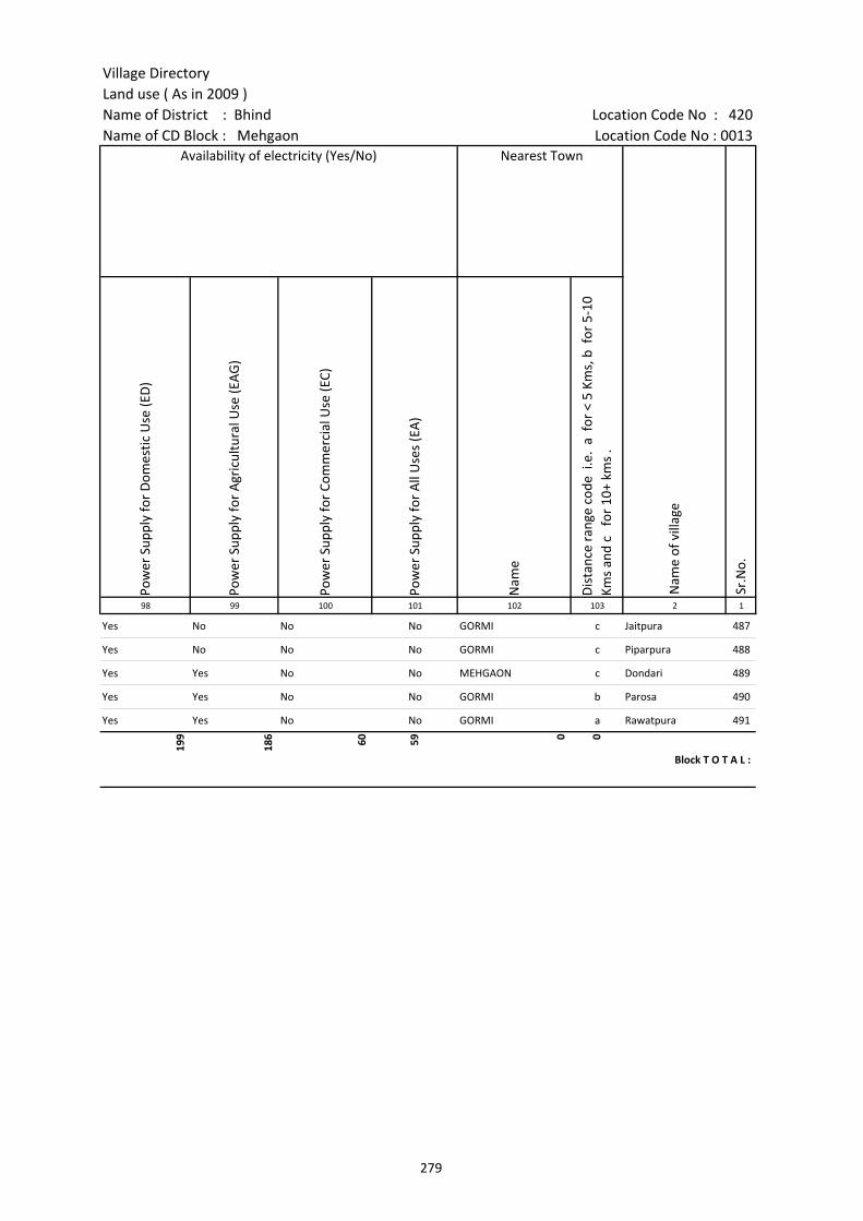
Village DirectoryLand use ( As in 2009 )Name of District : Bhind Location Code No : 420Name of CD Block : Mehgaon Location Code No : 0013
Pow
er S
uppl
y fo
r D
omes
tic U
se (E
D)
Pow
er S
uppl
y fo
r A
gric
ultu
ral U
se (E
AG
)
Pow
er S
uppl
y fo
r Co
mm
erci
al U
se (E
C)
Pow
er S
uppl
y fo
r A
ll U
ses
(EA
)
Nam
e
Dis
tanc
e ra
nge
code
i.e
. a
for
< 5
Kms,
b f
or 5
-10
Kms
and
c f
or 1
0+ k
ms
.98 99 100 101 102 103 2 1
Nearest Town
Nam
e of
vill
age
Sr.N
o.
Availability of electricity (Yes/No)
Yes No No No GORMI c Jaitpura 487
Yes No No No GORMI c Piparpura 488
Yes Yes No No MEHGAON c Dondari 489
Yes Yes No No GORMI b Parosa 490
Yes Yes No No GORMI a Rawatpura 491
199
186 60 59 0 0
Block T O T A L :
279
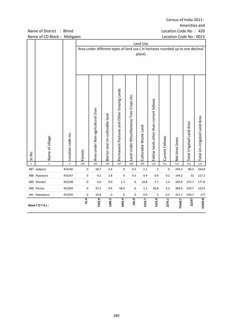
Census of India 2011- Amenities and
Name of District : Bhind Location Code No : 420Name of CD Block : Mehgaon Location Code No : 0013
Fore
sts
Are
a un
der
Non
-agr
icul
tura
l Use
s
Barr
en a
nd U
n-cu
ltiva
ble
land
Perm
anen
t Pas
ture
s an
d O
ther
Gra
zing
Lan
ds
Land
Und
er M
isce
llane
ous
Tree
Cro
ps e
tc.
Cultu
rabl
e W
aste
Lan
d
Fallo
w la
nds
othe
r th
an c
urre
nt fa
llow
s
Curr
ent F
allo
ws
Net
Are
a So
wn
Tota
l Irr
igat
ed L
and
Are
a
Tota
l Un-
irri
gate
d La
nd A
rea
1 2 3 104 105 106 107 108 109 110 111 112 113 114
Land UseArea under different types of land use ( in hectares rounded up to one decimal
place)
Sr.N
o.
Nam
e of
vill
age
Loca
tion
code
no.
487 Jaitpura 453246 0 18.7 2.4 0 0.3 1.1 3 0 245.4 80.5 164.8
488 Piparpura 453247 0 9.2 2.8 0 0.3 0.9 0.9 0.2 149.2 32 117.2
489 Dondari 453248 0 4.9 6.9 1.1 0 10.8 1.7 1.4 335.6 157.7 177.8
490 Parosa 453249 0 97.2 9.4 58.6 6 1.1 26.8 3.3 383.6 259.7 123.9
491 Rawatpura 453250 0 23.8 0 0 0 0.9 3 0.2 411.7 234.7 177
Block T O T A L :
91.9
7342
.9
1286
.5
3403
.4
105.
9
1553
.7
3125
.9
2276
.1
7554
8.7
2219
7
5335
0.8
280
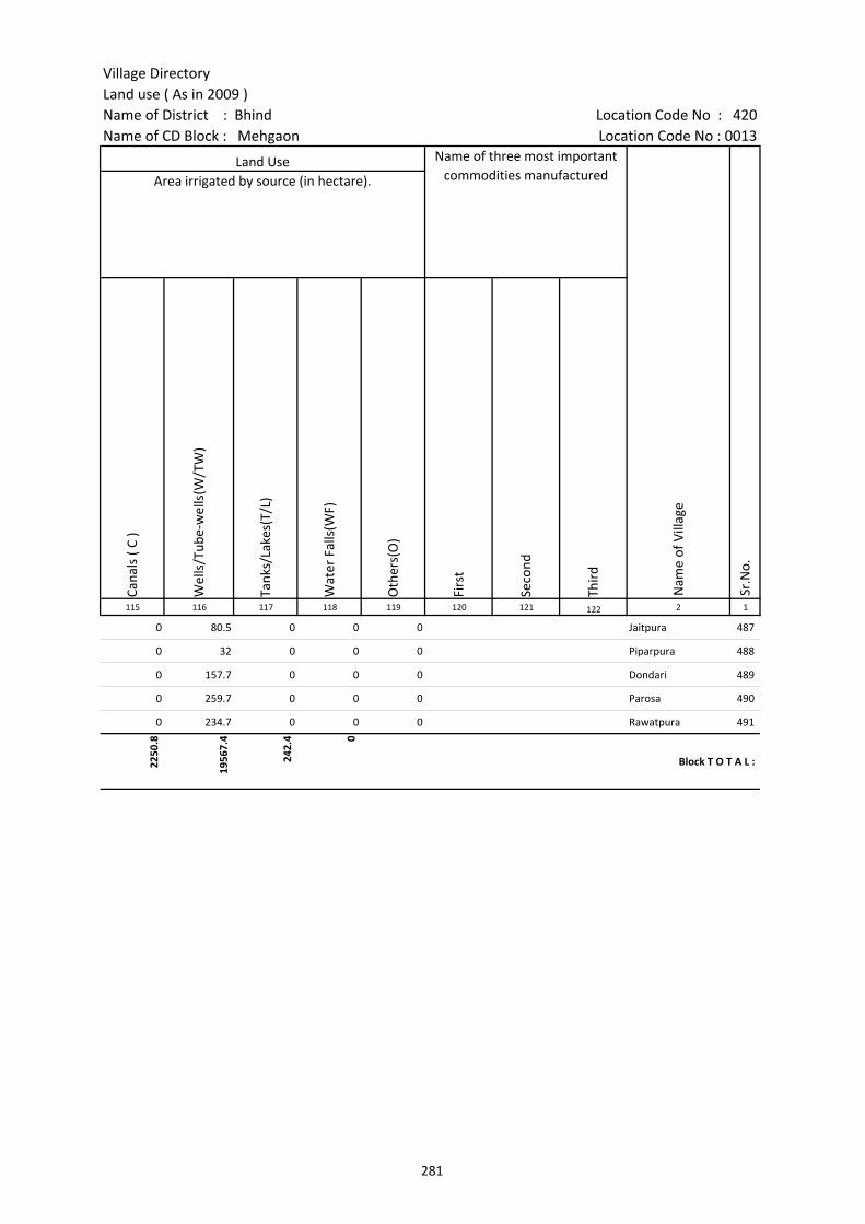
Village DirectoryLand use ( As in 2009 )Name of District : Bhind Location Code No : 420Name of CD Block : Mehgaon Location Code No : 0013
Cana
ls (
C )
Wel
ls/T
ube-
wel
ls(W
/TW
)
Tank
s/La
kes(
T/L)
Wat
er F
alls
(WF)
Oth
ers(
O)
Firs
t
Seco
nd
Thir
d 115 116 117 118 119 120 121 122 2 1
Land Use Name of three most important commodities manufactured
Nam
e of
Vill
age
Sr.N
o.
Area irrigated by source (in hectare).
0 80.5 0 0 0 Jaitpura 487
0 32 0 0 0 Piparpura 488
0 157.7 0 0 0 Dondari 489
0 259.7 0 0 0 Parosa 490
0 234.7 0 0 0 Rawatpura 491
2250
.8
1956
7.4
242.
4 0
Block T O T A L :
281
282
(b) Map of Gohad CD Block showing tahsil boundary.
(c) Alphabetical list of Villages of Gohad CD Block along with location code 2001 and 2011.
(d) Village Directory data of Gohad CD Block in prescribed format.
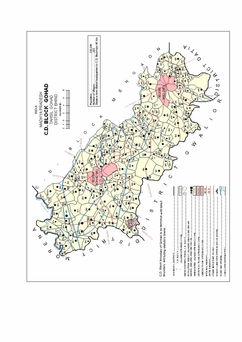

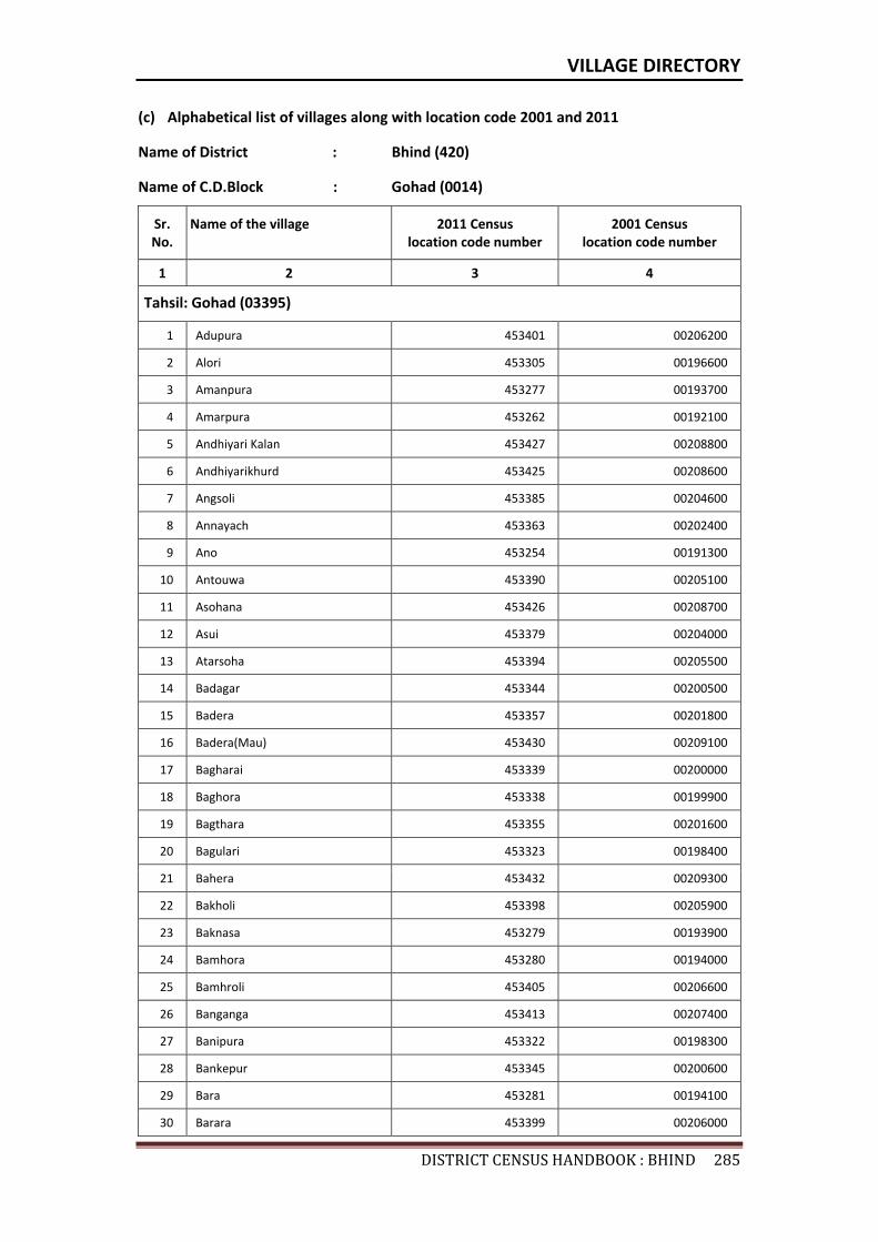
VILLAGE DIRECTORY
DISTRICTCENSUSHANDBOOK:BHIND285
(c) Alphabetical list of villages along with location code 2001 and 2011
Name of District : Bhind (420)
Name of C.D.Block : Gohad (0014)
Sr. No.
Name of the village 2011 Census location code number
2001 Census location code number
1 2 3 4
Tahsil: Gohad (03395)
1 Adupura 453401 00206200
2 Alori 453305 00196600
3 Amanpura 453277 00193700
4 Amarpura 453262 00192100
5 Andhiyari Kalan 453427 00208800
6 Andhiyarikhurd 453425 00208600
7 Angsoli 453385 00204600
8 Annayach 453363 00202400
9 Ano 453254 00191300
10 Antouwa 453390 00205100
11 Asohana 453426 00208700
12 Asui 453379 00204000
13 Atarsoha 453394 00205500
14 Badagar 453344 00200500
15 Badera 453357 00201800
16 Badera(Mau) 453430 00209100
17 Bagharai 453339 00200000
18 Baghora 453338 00199900
19 Bagthara 453355 00201600
20 Bagulari 453323 00198400
21 Bahera 453432 00209300
22 Bakholi 453398 00205900
23 Baknasa 453279 00193900
24 Bamhora 453280 00194000
25 Bamhroli 453405 00206600
26 Banganga 453413 00207400
27 Banipura 453322 00198300
28 Bankepur 453345 00200600
29 Bara 453281 00194100
30 Barara 453399 00206000
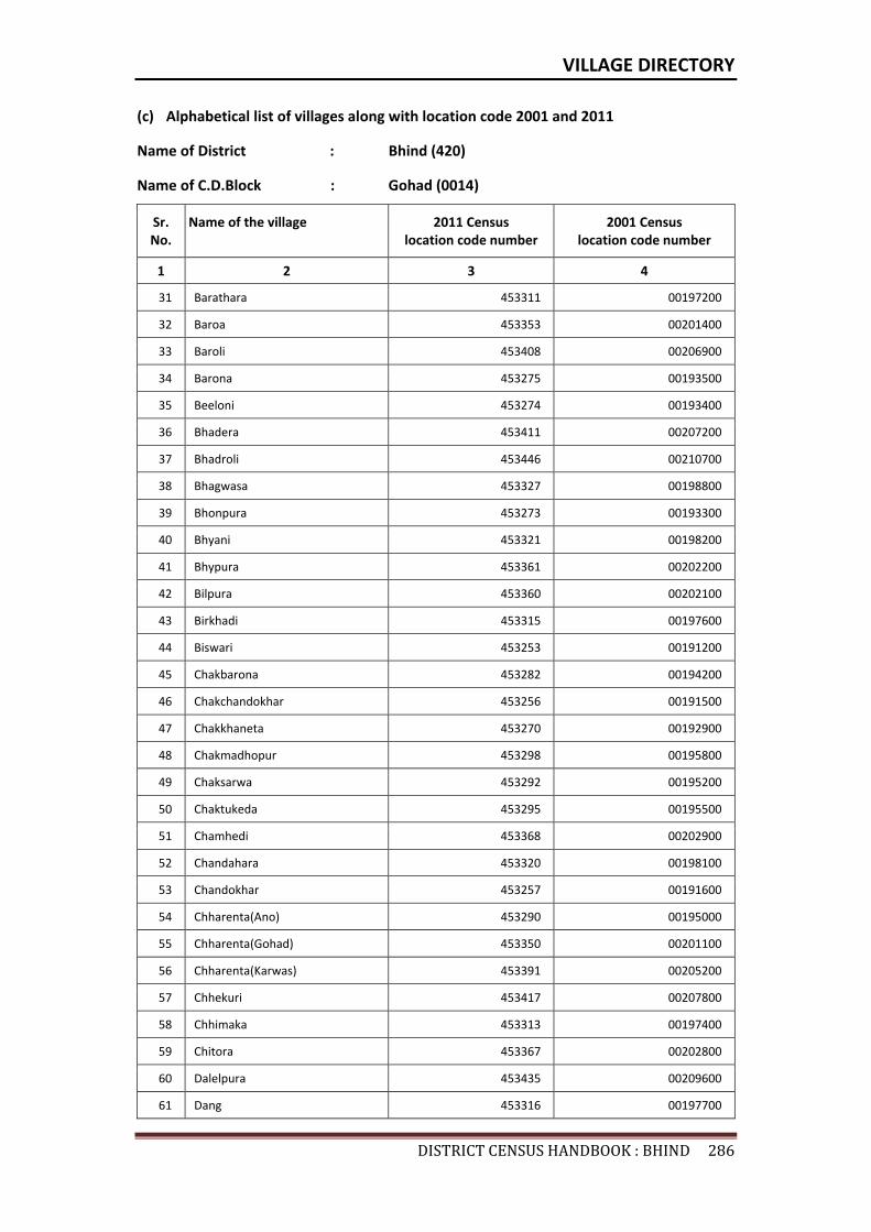
VILLAGE DIRECTORY
DISTRICTCENSUSHANDBOOK:BHIND286
(c) Alphabetical list of villages along with location code 2001 and 2011
Name of District : Bhind (420)
Name of C.D.Block : Gohad (0014)
Sr. No.
Name of the village 2011 Census location code number
2001 Census location code number
1 2 3 4
31 Barathara 453311 00197200
32 Baroa 453353 00201400
33 Baroli 453408 00206900
34 Barona 453275 00193500
35 Beeloni 453274 00193400
36 Bhadera 453411 00207200
37 Bhadroli 453446 00210700
38 Bhagwasa 453327 00198800
39 Bhonpura 453273 00193300
40 Bhyani 453321 00198200
41 Bhypura 453361 00202200
42 Bilpura 453360 00202100
43 Birkhadi 453315 00197600
44 Biswari 453253 00191200
45 Chakbarona 453282 00194200
46 Chakchandokhar 453256 00191500
47 Chakkhaneta 453270 00192900
48 Chakmadhopur 453298 00195800
49 Chaksarwa 453292 00195200
50 Chaktukeda 453295 00195500
51 Chamhedi 453368 00202900
52 Chandahara 453320 00198100
53 Chandokhar 453257 00191600
54 Chharenta(Ano) 453290 00195000
55 Chharenta(Gohad) 453350 00201100
56 Chharenta(Karwas) 453391 00205200
57 Chhekuri 453417 00207800
58 Chhimaka 453313 00197400
59 Chitora 453367 00202800
60 Dalelpura 453435 00209600
61 Dang 453316 00197700
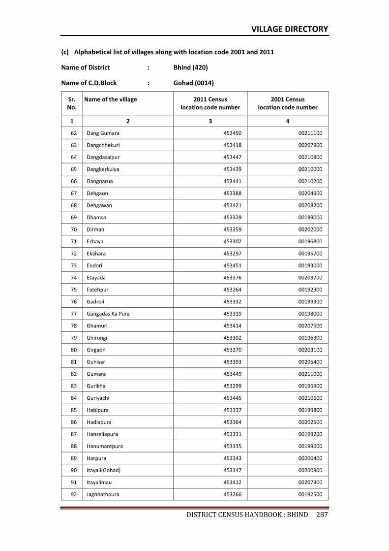
VILLAGE DIRECTORY
DISTRICTCENSUSHANDBOOK:BHIND287
(c) Alphabetical list of villages along with location code 2001 and 2011
Name of District : Bhind (420)
Name of C.D.Block : Gohad (0014)
Sr. No.
Name of the village 2011 Census location code number
2001 Census location code number
1 2 3 4
62 Dang Gumara 453450 00211100
63 Dangchhekuri 453418 00207900
64 Dangdasalpur 453447 00210800
65 Dangkerkuiya 453439 00210000
66 Dangnarua 453441 00210200
67 Dehgaon 453388 00204900
68 Dehgawan 453421 00208200
69 Dhamsa 453329 00199000
70 Dirman 453359 00202000
71 Echaya 453307 00196800
72 Ekahara 453297 00195700
73 Endori 453451 00193000
74 Etayada 453376 00203700
75 Fatehpur 453264 00192300
76 Gadroli 453332 00199300
77 Gangadas Ka Pura 453319 00198000
78 Ghamuri 453414 00207500
79 Ghirongi 453302 00196300
80 Girgaon 453370 00203100
81 Guhisar 453393 00205400
82 Gumara 453449 00211000
83 Gurikha 453299 00195900
84 Guriyachi 453445 00210600
85 Habipura 453337 00199800
86 Hadiapura 453364 00202500
87 Hanseliapura 453331 00199200
88 Hanumantpura 453335 00199600
89 Harpura 453343 00200400
90 Itayali(Gohad) 453347 00200800
91 Itayalimau 453412 00207300
92 Jagnnathpura 453266 00192500
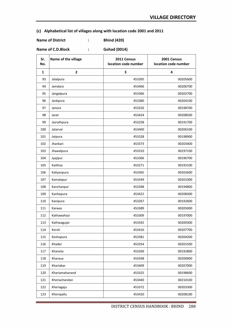
VILLAGE DIRECTORY
DISTRICTCENSUSHANDBOOK:BHIND288
(c) Alphabetical list of villages along with location code 2001 and 2011
Name of District : Bhind (420)
Name of C.D.Block : Gohad (0014)
Sr. No.
Name of the village 2011 Census location code number
2001 Census location code number
1 2 3 4
93 Jalalpura 453395 00205600
94 Jamdara 453406 00206700
95 Jangalpura 453366 00202700
96 Jankpura 453380 00204100
97 Janora 453326 00198700
98 Jaret 453424 00208500
99 Jasrathpura 453258 00191700
100 Jatarvai 453400 00206100
101 Jatpura 453328 00198900
102 Jhankari 453373 00203400
103 Jhawalpura 453310 00197100
104 Jyajipur 453306 00196700
105 Kaithoa 453271 00193100
106 Kaliyanpura 453365 00202600
107 Kamalapur 453349 00201000
108 Kanchanpur 453288 00194800
109 Kanhepura 453422 00208300
110 Kanipura 453267 00192600
111 Karwas 453389 00205000
112 Kathawahazi 453309 00197000
113 Kathwagujar 453342 00200300
114 Keroli 453416 00207700
115 Keshopura 453381 00204200
116 Khader 453354 00201500
117 Khaneta 453269 00192800
118 Kharaua 453348 00200900
119 Khariabar 453409 00207000
120 Khariamahanand 453325 00198600
121 Kheriachandan 453440 00210100
122 Kheriagaju 453372 00203300
123 Kheriajallu 453420 00208100
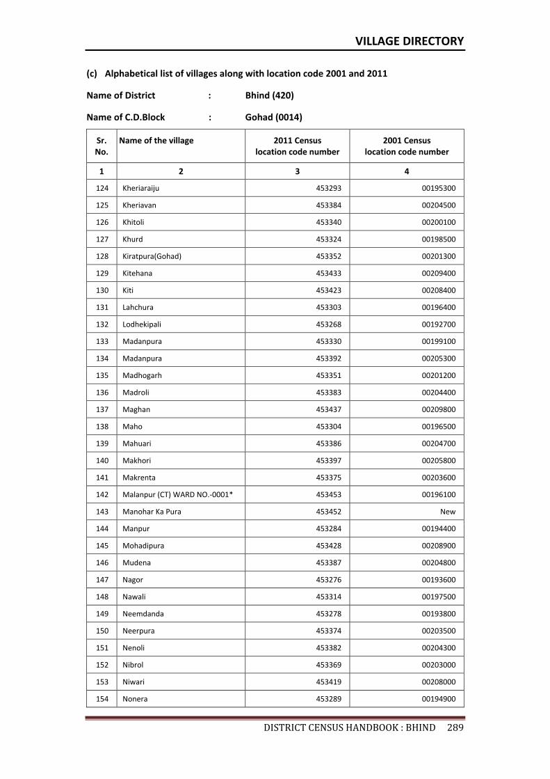
VILLAGE DIRECTORY
DISTRICTCENSUSHANDBOOK:BHIND289
(c) Alphabetical list of villages along with location code 2001 and 2011
Name of District : Bhind (420)
Name of C.D.Block : Gohad (0014)
Sr. No.
Name of the village 2011 Census location code number
2001 Census location code number
1 2 3 4
124 Kheriaraiju 453293 00195300
125 Kheriavan 453384 00204500
126 Khitoli 453340 00200100
127 Khurd 453324 00198500
128 Kiratpura(Gohad) 453352 00201300
129 Kitehana 453433 00209400
130 Kiti 453423 00208400
131 Lahchura 453303 00196400
132 Lodhekipali 453268 00192700
133 Madanpura 453330 00199100
134 Madanpura 453392 00205300
135 Madhogarh 453351 00201200
136 Madroli 453383 00204400
137 Maghan 453437 00209800
138 Maho 453304 00196500
139 Mahuari 453386 00204700
140 Makhori 453397 00205800
141 Makrenta 453375 00203600
142 Malanpur (CT) WARD NO.-0001* 453453 00196100
143 Manohar Ka Pura 453452 New
144 Manpur 453284 00194400
145 Mohadipura 453428 00208900
146 Mudena 453387 00204800
147 Nagor 453276 00193600
148 Nawali 453314 00197500
149 Neemdanda 453278 00193800
150 Neerpura 453374 00203500
151 Nenoli 453382 00204300
152 Nibrol 453369 00203000
153 Niwari 453419 00208000
154 Nonera 453289 00194900
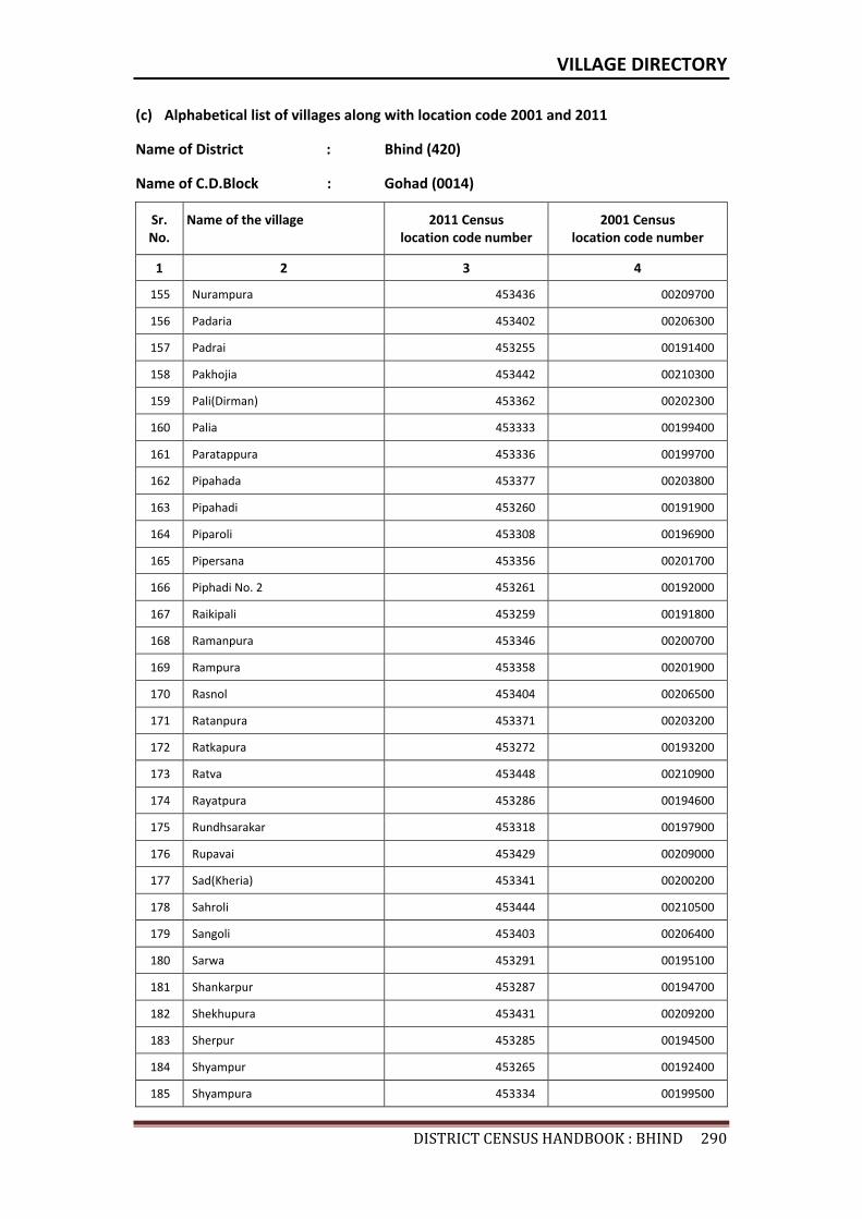
VILLAGE DIRECTORY
DISTRICTCENSUSHANDBOOK:BHIND290
(c) Alphabetical list of villages along with location code 2001 and 2011
Name of District : Bhind (420)
Name of C.D.Block : Gohad (0014)
Sr. No.
Name of the village 2011 Census location code number
2001 Census location code number
1 2 3 4
155 Nurampura 453436 00209700
156 Padaria 453402 00206300
157 Padrai 453255 00191400
158 Pakhojia 453442 00210300
159 Pali(Dirman) 453362 00202300
160 Palia 453333 00199400
161 Paratappura 453336 00199700
162 Pipahada 453377 00203800
163 Pipahadi 453260 00191900
164 Piparoli 453308 00196900
165 Pipersana 453356 00201700
166 Piphadi No. 2 453261 00192000
167 Raikipali 453259 00191800
168 Ramanpura 453346 00200700
169 Rampura 453358 00201900
170 Rasnol 453404 00206500
171 Ratanpura 453371 00203200
172 Ratkapura 453272 00193200
173 Ratva 453448 00210900
174 Rayatpura 453286 00194600
175 Rundhsarakar 453318 00197900
176 Rupavai 453429 00209000
177 Sad(Kheria) 453341 00200200
178 Sahroli 453444 00210500
179 Sangoli 453403 00206400
180 Sarwa 453291 00195100
181 Shankarpur 453287 00194700
182 Shekhupura 453431 00209200
183 Sherpur 453285 00194500
184 Shyampur 453265 00192400
185 Shyampura 453334 00199500
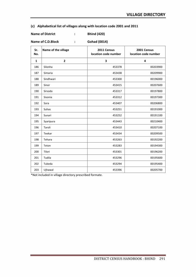
VILLAGE DIRECTORY
DISTRICTCENSUSHANDBOOK:BHIND291
(c) Alphabetical list of villages along with location code 2001 and 2011
Name of District : Bhind (420)
Name of C.D.Block : Gohad (0014)
Sr. No.
Name of the village 2011 Census location code number
2001 Census location code number
1 2 3 4
186 Silonha 453378 00203900
187 Simaria 453438 00209900
188 Sindhwari 453300 00196000
189 Sinor 453415 00207600
190 Sirsoda 453317 00197800
191 Sisonia 453312 00197300
192 Sora 453407 00206800
193 Suhas 453251 00191000
194 Sunari 453252 00191100
195 Syaripura 453443 00210400
196 Taroli 453410 00207100
197 Teekar 453434 00209500
198 Tehara 453263 00192200
199 Teton 453283 00194300
200 Tilori 453301 00196200
201 Tudila 453296 00195600
202 Tukeda 453294 00195400
203 Ujhawal 453396 00205700
*Not included in village directory prescribed formate.

Census of India 2011- Amenities and
Name of District : Bhind Location Code No : 420Name of CD Block : Gohad Location Code No : 0014
Pre-
Prim
ary
scho
ol (P
P)
Prim
ary
scho
ol (P
)
Mid
dle
scho
ol (M
)
Seco
ndar
y Sc
hool
(S)
Seni
or S
econ
dary
sch
ool (
SS)
Deg
ree
colle
ge o
f art
s s
cien
ce &
com
mer
ce (
ASC
)
Engi
neer
ing
colle
ge(E
C)
Med
ical
col
lege
(MC)
Man
agem
ent i
nstit
ute
(MI)
Poly
tech
nic
(Pt)
Voca
tiona
l tra
inin
g sc
hool
/IT
I
Non
-for
mal
trai
ning
cen
tre
(NFT
C)
Spec
ial s
choo
l for
dis
able
d (S
SD)
Oth
ers
(spe
cify
)
1 2 3 4 5 6 7 8 9 10 11 12 13 14 15 16 17 18 19 20
492 Suhas 453251 614.5 1795 359 1 1 1 b c c c c c c
493 Sunari 453252 256.3 297 66 a 1 a b c c c c c c c
494 Biswari 453253 441.3 350 77 a 1 a b b c c c c c c
495 Ano 453254 994.8 3450 708 5 2 2 1 c c c c c c c c c c
496 Padrai 453255 432.3 1102 228 c 3 b c c c c c c c c c
497 Chakchandokhar 453256 202.8 675 122 1 a c c c c c c c
498 Chandokhar 453257 1215.6 3433 673 1 1 1 1 1 b c c c c c c c
499 Jasrathpura 453258 469.7 1453 259 c 2 1 1 c c c c c c c
500 Raikipali 453259 476.6 1158 187 c 2 1 b c c c c c c c c c c
501 Pipahadi 453260 401.1 1547 332 c 2 1 b c c c c c c c c c
502 Piphadi No. 2 453261 175.8 845 190 c 2 a c c c c c c c c c c c
503 Amarpura 453262 280.7 208 41 c 1 a c c c c c c c c c c c
504 Tehara 453263 304.2 470 92 2 1 1 b c c c c c c c c c
505 Fatehpur 453264 251.7 520 108 1 1 1 1 b c c c c c c c c
506 Shyampur 453265 456.8 417 90 2 a b c c c c c c c c c c
507 Jagnnathpura 453266 237.8 715 163 b 1 b 1 b c c c c c c c c c
508 Kanipura 453267 437.4 1662 304 b 1 a b b b c c c c c c c c
509 Lodhekipali 453268 577 1599 353 1 1 1 c c c c
510 Khaneta 453269 1640.9 3977 688 1 1 1 1 c c c c c
511 Chakkhaneta 453270 420.4 606 123 1 1 1 c c c c c c c c
512 Kaithoa 453271 521.2 686 107 1 1 1 a c c c c
513 Ratkapura 453272 644.3 1457 239 c 3 1 a c c c c c c c c c
514 Bhonpura 453273 1349.7 3403 592 c 7 2 b c c c c c c c
515 Beeloni 453274 573 715 148 c 3 1 b c c c c c c c c c
516 Barona 453275 405.6 1888 314 1 1 1 1 c c c c c
517 Nagor 453276 297.9 1306 196 1 2 2 a c c
Sr.N
o.
Nam
e of
vill
age
Loca
tion
code
no.
Tota
l are
a of
the
villa
ge (
in h
ecta
res
roun
ded
up to
one
dec
imal
pla
ce)
Tota
l pop
ulat
ion
( 201
1 ce
nsus
)
Num
ber
of h
ouse
hold
s (2
011
cens
us)
Number of educational amenities available. (If not available within the village , the distance range
code viz; a for < 5 Kms, b for 5-10 Kms and c for 10+ kms of nearest place where facility is available is given).
292
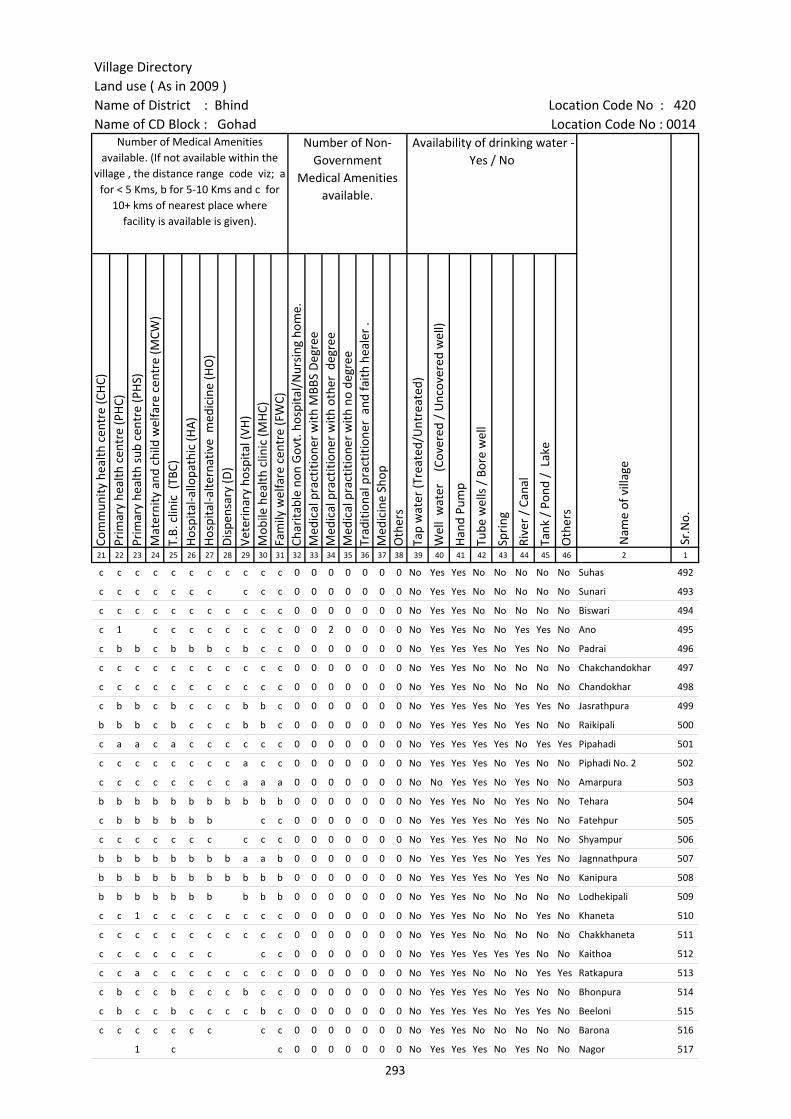
Village DirectoryLand use ( As in 2009 )Name of District : Bhind Location Code No : 420Name of CD Block : Gohad Location Code No : 0014
Com
mun
ity h
ealth
cen
tre
(CH
C)Pr
imar
y he
alth
cen
tre
(PH
C)Pr
imar
y he
alth
sub
cen
tre
(PH
S)M
ater
nity
and
chi
ld w
elfa
re c
entr
e (M
CW)
T.B.
clin
ic (
TBC)
Hos
pita
l-allo
path
ic (H
A)
Hos
pita
l-alte
rnat
ive
med
icin
e (H
O)
Dis
pens
ary
(D)
Vete
rina
ry h
ospi
tal (
VH)
Mob
ile h
ealth
clin
ic (M
HC)
Fam
ily w
elfa
re c
entr
e (F
WC)
Char
itabl
e no
n G
ovt.
hos
pita
l/N
ursi
ng h
ome.
Med
ical
pra
ctiti
oner
with
MBB
S D
egre
eM
edic
al p
ract
ition
er w
ith o
ther
deg
ree
Med
ical
pra
ctiti
oner
with
no
degr
eeTr
aditi
onal
pra
ctiti
oner
and
faith
hea
ler
.M
edic
ine
Shop
Oth
ers
Tap
wat
er (T
reat
ed/U
ntre
ated
)
Wel
l w
ater
(C
over
ed /
Unc
over
ed w
ell)
Han
d Pu
mp
Tube
wel
ls /
Bor
e w
ell
Spri
ng
Rive
r /
Cana
l
Tank
/ P
ond
/ L
ake
Oth
ers
21 22 23 24 25 26 27 28 29 30 31 32 33 34 35 36 37 38 39 40 41 42 43 44 45 46 2 1
c c c c c c c c c c c 0 0 0 0 0 0 0 No Yes Yes No No No No No Suhas 492
c c c c c c c c c c 0 0 0 0 0 0 0 No Yes Yes No No No No No Sunari 493
c c c c c c c c c c c 0 0 0 0 0 0 0 No Yes Yes No No No No No Biswari 494
c 1 c c c c c c c c 0 0 2 0 0 0 0 No Yes Yes No No Yes Yes No Ano 495
c b b c b b b c b c c 0 0 0 0 0 0 0 No Yes Yes Yes No Yes No No Padrai 496
c c c c c c c c c c c 0 0 0 0 0 0 0 No Yes Yes No No No No No Chakchandokhar 497
c c c c c c c c c c c 0 0 0 0 0 0 0 No Yes Yes No No No No No Chandokhar 498
c b b c b c c c b b c 0 0 0 0 0 0 0 No Yes Yes Yes No Yes Yes No Jasrathpura 499
b b b c b c c c b b c 0 0 0 0 0 0 0 No Yes Yes Yes No Yes No No Raikipali 500
c a a c a c c c c c c 0 0 0 0 0 0 0 No Yes Yes Yes Yes No Yes Yes Pipahadi 501
c c c c c c c c a c c 0 0 0 0 0 0 0 No Yes Yes Yes No Yes No No Piphadi No. 2 502
c c c c c c c c a a a 0 0 0 0 0 0 0 No No Yes Yes No Yes No No Amarpura 503
b b b b b b b b b b b 0 0 0 0 0 0 0 No Yes Yes No No Yes No No Tehara 504
c b b b b b b c c 0 0 0 0 0 0 0 No Yes Yes Yes No Yes No No Fatehpur 505
c c c c c c c c c c 0 0 0 0 0 0 0 No Yes Yes Yes No No No No Shyampur 506
b b b b b b b b a a b 0 0 0 0 0 0 0 No Yes Yes Yes No Yes Yes No Jagnnathpura 507
b b b b b b b b b b b 0 0 0 0 0 0 0 No Yes Yes Yes No Yes No No Kanipura 508
b b b b b b b b b b 0 0 0 0 0 0 0 No Yes Yes No No No No No Lodhekipali 509
c c 1 c c c c c c c c 0 0 0 0 0 0 0 No Yes Yes No No No Yes No Khaneta 510
c c c c c c c c c c c 0 0 0 0 0 0 0 No Yes Yes No No No No No Chakkhaneta 511
c c c c c c c c c 0 0 0 0 0 0 0 No Yes Yes Yes Yes Yes No No Kaithoa 512
c c a c c c c c c c c 0 0 0 0 0 0 0 No Yes Yes No No No Yes Yes Ratkapura 513
c b c c b c c c b c c 0 0 0 0 0 0 0 No Yes Yes Yes No Yes No No Bhonpura 514
c b c c b c c c c b c 0 0 0 0 0 0 0 No Yes Yes Yes No Yes Yes No Beeloni 515
c c c c c c c c c 0 0 0 0 0 0 0 No Yes Yes No No No No No Barona 516
1 c c 0 0 0 0 0 0 0 No Yes Yes Yes No Yes No No Nagor 517
Number of Medical Amenities available. (If not available within the
village , the distance range code viz; a for < 5 Kms, b for 5-10 Kms and c for
10+ kms of nearest place where facility is available is given).
Number of Non-Government
Medical Amenities available.
Availability of drinking water - Yes / No
Nam
e of
vill
age
Sr.N
o.
293
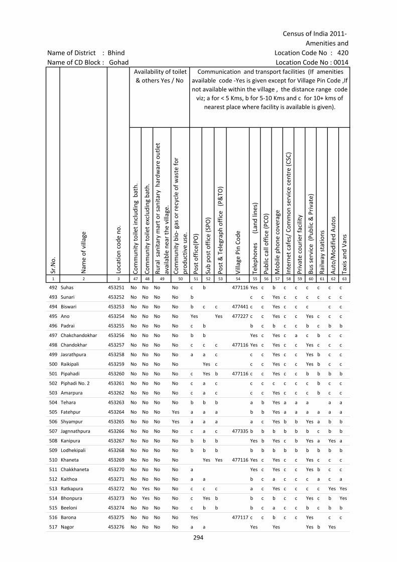
Census of India 2011- Amenities and
Name of District : Bhind Location Code No : 420Name of CD Block : Gohad Location Code No : 0014
Com
mun
ity to
ilet i
nclu
ding
bat
h.
Com
mun
ity to
ilet e
xclu
ding
bat
h.
Rura
l sa
nita
ry m
art o
r sa
nita
ry h
ardw
are
outle
t av
aila
ble
near
the
villa
ge.
Com
mun
ity b
io- g
as o
r re
cycl
e of
was
te fo
r pr
oduc
tive
use.
Post
off
ice(
PO)
Sub
post
off
ice
(SPO
)
Post
& T
eleg
raph
off
ice
(P&
TO)
Villa
ge P
in C
ode
Tele
phon
es
(L
and
lines
)
Publ
ic c
all o
ffic
e (P
CO)
Mob
ile p
hone
cov
erag
e
Inte
rnet
caf
es/
Com
mon
ser
vice
cen
tre
(CSC
)
Priv
ate
cour
ier
faci
lity
Bus
serv
ice
(Pub
lic &
Pri
vate
)
Railw
ay s
tatio
ns
Aut
o/M
odifi
ed A
utos
Taxi
s an
d Va
ns
1 2 3 47 48 49 50 51 52 53 54 55 56 57 58 59 60 61 62 63
492 Suhas 453251 No No No No c b 477116 Yes c b c c c c c c
493 Sunari 453252 No No No No b c c Yes c c c c c c
494 Biswari 453253 No No No No b c c 477441 c c Yes c c c c c
495 Ano 453254 No No No No Yes Yes 477227 c c Yes c c Yes c c c
496 Padrai 453255 No No No No c b b c b c c b c b b
497 Chakchandokhar 453256 No No No No b b Yes c Yes c a c b c c
498 Chandokhar 453257 No No No No c c c 477116 Yes c Yes c c Yes c c c
499 Jasrathpura 453258 No No No No a a c c c Yes c c Yes b c c
500 Raikipali 453259 No No No No Yes c c c Yes c c Yes b c c
501 Pipahadi 453260 No No No No c Yes b 477116 c c Yes c c b b b b
502 Piphadi No. 2 453261 No No No No c a c c c c c c c b c c
503 Amarpura 453262 No No No No c a c c c Yes c c c b c c
504 Tehara 453263 No No No No b b b a b Yes a a a a a
505 Fatehpur 453264 No No No Yes a a a b b Yes a a a a a a
506 Shyampur 453265 No No No Yes a a a a c Yes b b Yes a b b
507 Jagnnathpura 453266 No No No No c a c 477335 b b b b b b c b b
508 Kanipura 453267 No No No No b b b Yes b Yes c b Yes a Yes a
509 Lodhekipali 453268 No No No No b b b b b b b b b b b b
510 Khaneta 453269 No No No No Yes Yes 477116 Yes c Yes c c Yes c c c
511 Chakkhaneta 453270 No No No No a Yes c Yes c c Yes b c c
512 Kaithoa 453271 No No No No a a b c a c c c a c a
513 Ratkapura 453272 No Yes No No c c c a c Yes c c c c Yes Yes
514 Bhonpura 453273 No Yes No No c Yes b b c b c c Yes c b Yes
515 Beeloni 453274 No No No No c b b b c a c c b c b b
516 Barona 453275 No No No No Yes 477117 c c b c c Yes c c
517 Nagor 453276 No No No No a a Yes Yes Yes b Yes
Sr.N
o.
Nam
e of
vill
age
Loca
tion
code
no.
Availability of toilet & others Yes / No
Communication and transport facilities (If amenities available code -Yes is given except for Village Pin Code ,If not available within the village , the distance range code
viz; a for < 5 Kms, b for 5-10 Kms and c for 10+ kms of nearest place where facility is available is given).
294
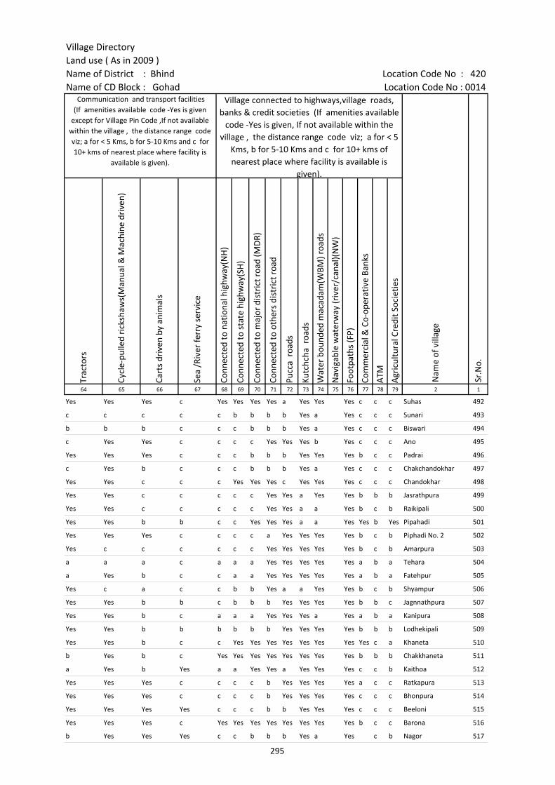
Village DirectoryLand use ( As in 2009 )Name of District : Bhind Location Code No : 420Name of CD Block : Gohad Location Code No : 0014
Trac
tors
Cycl
e-pu
lled
rick
shaw
s(M
anua
l & M
achi
ne d
rive
n)
Cart
s dr
iven
by
anim
als
Sea
/Riv
er fe
rry
serv
ice
Conn
ecte
d to
nat
iona
l hig
hway
(NH
)
Conn
ecte
d to
sta
te h
ighw
ay(S
H)
Conn
ecte
d to
maj
or d
istr
ict r
oad
(MD
R)
Conn
ecte
d to
oth
ers
dist
rict
roa
d
Pucc
a r
oads
Kutc
hcha
roa
ds
Wat
er b
ound
ed m
acad
am(W
BM) r
oads
Nav
igab
le w
ater
way
(riv
er/c
anal
)(N
W)
Foot
path
s (F
P)
Com
mer
cial
& C
o-op
erat
ive
Bank
s
ATM
Agr
icul
tura
l Cre
dit S
ocie
ties
64 65 66 67 68 69 70 71 72 73 74 75 76 77 78 79 2 1
Yes Yes Yes c Yes Yes Yes Yes a Yes Yes Yes c c c Suhas 492
c c c c c b b b b Yes a Yes c c c Sunari 493
b b b c c c b b b Yes a Yes c c c Biswari 494
c Yes Yes c c c c Yes Yes Yes b Yes c c c Ano 495
Yes Yes Yes c c c b b b Yes Yes Yes b c c Padrai 496
c Yes b c c c b b b Yes a Yes c c c Chakchandokhar 497
Yes Yes c c c Yes Yes Yes c Yes Yes Yes c c c Chandokhar 498
Yes Yes c c c c c Yes Yes a Yes Yes b b b Jasrathpura 499
Yes Yes c c c c c Yes Yes a a Yes b c b Raikipali 500
Yes Yes b b c c Yes Yes Yes a a Yes Yes b Yes Pipahadi 501
Yes Yes Yes c c c c a Yes Yes Yes Yes b c b Piphadi No. 2 502
Yes c c c c c c Yes Yes Yes Yes Yes b c b Amarpura 503
a a a c a a a Yes Yes Yes Yes Yes a b a Tehara 504
a Yes b c c a a Yes Yes Yes Yes Yes a b a Fatehpur 505
Yes c a c c b b Yes a a Yes Yes b c b Shyampur 506
Yes Yes b b c b b b Yes Yes Yes Yes b b c Jagnnathpura 507
Yes Yes b c a a a Yes Yes Yes a Yes a b a Kanipura 508
Yes Yes b b b b b b Yes Yes Yes Yes b b b Lodhekipali 509
Yes Yes b c c Yes Yes Yes Yes Yes Yes Yes Yes c a Khaneta 510
b Yes b c Yes Yes Yes Yes Yes Yes Yes Yes b b b Chakkhaneta 511
a Yes b Yes a a Yes Yes a Yes Yes Yes c c b Kaithoa 512
Yes Yes Yes c c c c b Yes Yes Yes Yes a c c Ratkapura 513
Yes Yes Yes c c c c b Yes Yes Yes Yes c c c Bhonpura 514
Yes Yes Yes Yes c c c b b Yes Yes Yes c c c Beeloni 515
Yes Yes Yes c Yes Yes Yes Yes Yes Yes Yes Yes b c c Barona 516
b Yes Yes Yes c c b b b Yes a Yes c b Nagor 517
Sr.N
o.
Communication and transport facilities (If amenities available code -Yes is given
except for Village Pin Code ,If not available within the village , the distance range code viz; a for < 5 Kms, b for 5-10 Kms and c for 10+ kms of nearest place where facility is
available is given).
Village connected to highways,village roads, banks & credit societies (If amenities available
code -Yes is given, If not available within the village , the distance range code viz; a for < 5
Kms, b for 5-10 Kms and c for 10+ kms of nearest place where facility is available is
given).
Nam
e of
vill
age
295
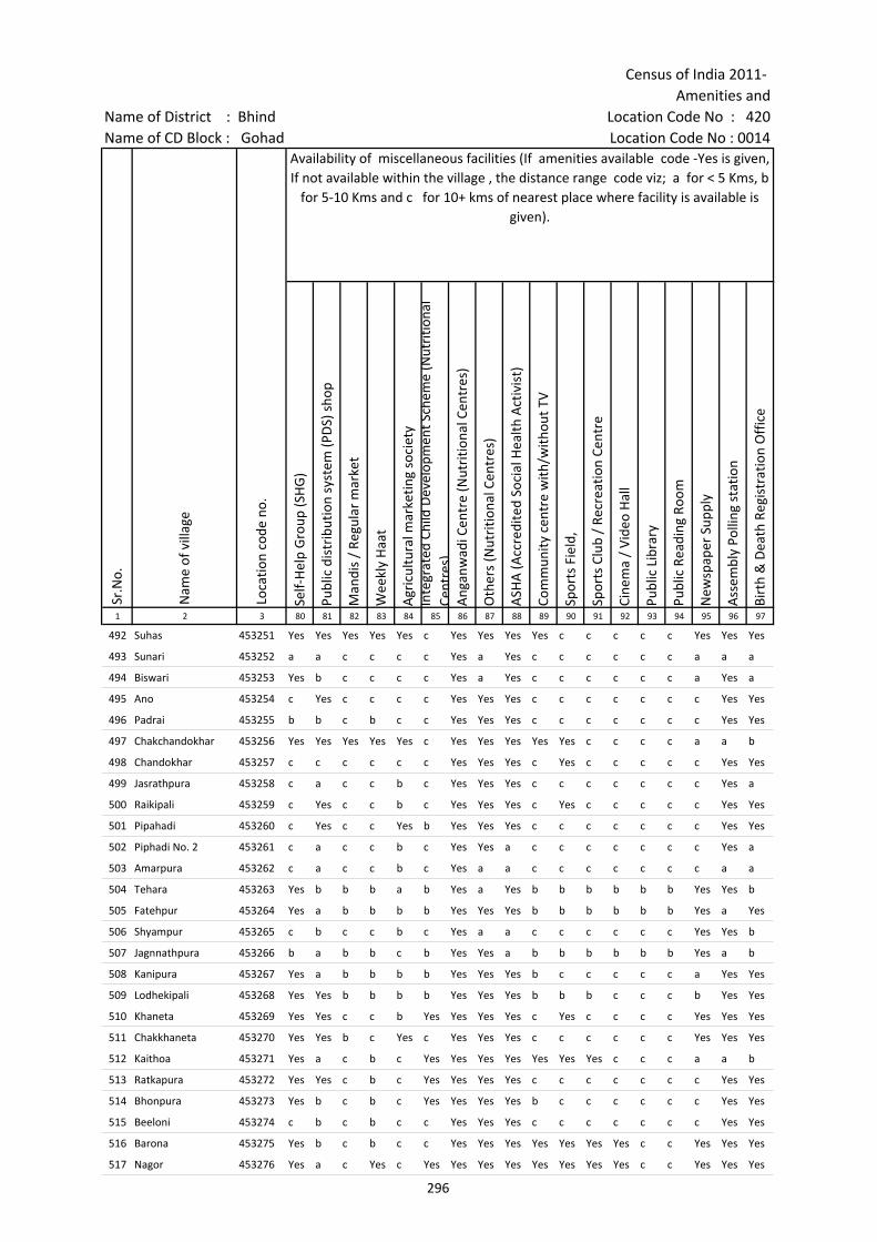
Census of India 2011- Amenities and
Name of District : Bhind Location Code No : 420Name of CD Block : Gohad Location Code No : 0014
Self-
Hel
p G
roup
(SH
G)
Publ
ic d
istr
ibut
ion
syst
em (P
DS)
sho
p
Man
dis
/ Re
gula
r m
arke
t
Wee
kly
Haa
t
Agr
icul
tura
l mar
ketin
g so
ciet
yIn
tegr
ated
Chi
ld D
evel
opm
ent S
chem
e (N
utri
tiona
l Ce
ntre
s)A
ngan
wad
i Cen
tre
(Nut
ritio
nal C
entr
es)
Oth
ers
(Nut
ritio
nal C
entr
es)
ASH
A (A
ccre
dite
d So
cial
Hea
lth A
ctiv
ist)
Com
mun
ity c
entr
e w
ith/w
ithou
t TV
Spor
ts F
ield
,
Spor
ts C
lub
/ Re
crea
tion
Cent
re
Cine
ma
/ Vi
deo
Hal
l
Publ
ic L
ibra
ry
Publ
ic R
eadi
ng R
oom
New
spap
er S
uppl
y
Ass
embl
y Po
lling
sta
tion
Birt
h &
Dea
th R
egis
trat
ion
Off
ice
1 2 3 80 81 82 83 84 85 86 87 88 89 90 91 92 93 94 95 96 97
492 Suhas 453251 Yes Yes Yes Yes Yes c Yes Yes Yes Yes c c c c c Yes Yes Yes
493 Sunari 453252 a a c c c c Yes a Yes c c c c c c a a a
494 Biswari 453253 Yes b c c c c Yes a Yes c c c c c c a Yes a
495 Ano 453254 c Yes c c c c Yes Yes Yes c c c c c c c Yes Yes
496 Padrai 453255 b b c b c c Yes Yes Yes c c c c c c c Yes Yes
497 Chakchandokhar 453256 Yes Yes Yes Yes Yes c Yes Yes Yes Yes Yes c c c c a a b
498 Chandokhar 453257 c c c c c c Yes Yes Yes c Yes c c c c c Yes Yes
499 Jasrathpura 453258 c a c c b c Yes Yes Yes c c c c c c c Yes a
500 Raikipali 453259 c Yes c c b c Yes Yes Yes c Yes c c c c c Yes Yes
501 Pipahadi 453260 c Yes c c Yes b Yes Yes Yes c c c c c c c Yes Yes
502 Piphadi No. 2 453261 c a c c b c Yes Yes a c c c c c c c Yes a
503 Amarpura 453262 c a c c b c Yes a a c c c c c c c a a
504 Tehara 453263 Yes b b b a b Yes a Yes b b b b b b Yes Yes b
505 Fatehpur 453264 Yes a b b b b Yes Yes Yes b b b b b b Yes a Yes
506 Shyampur 453265 c b c c b c Yes a a c c c c c c Yes Yes b
507 Jagnnathpura 453266 b a b b c b Yes Yes a b b b b b b Yes a b
508 Kanipura 453267 Yes a b b b b Yes Yes Yes b c c c c c a Yes Yes
509 Lodhekipali 453268 Yes Yes b b b b Yes Yes Yes b b b c c c b Yes Yes
510 Khaneta 453269 Yes Yes c c b Yes Yes Yes Yes c Yes c c c c Yes Yes Yes
511 Chakkhaneta 453270 Yes Yes b c Yes c Yes Yes Yes c c c c c c Yes Yes Yes
512 Kaithoa 453271 Yes a c b c Yes Yes Yes Yes Yes Yes Yes c c c a a b
513 Ratkapura 453272 Yes Yes c b c Yes Yes Yes Yes c c c c c c c Yes Yes
514 Bhonpura 453273 Yes b c b c Yes Yes Yes Yes b c c c c c c Yes Yes
515 Beeloni 453274 c b c b c c Yes Yes Yes c c c c c c c Yes Yes
516 Barona 453275 Yes b c b c c Yes Yes Yes Yes Yes Yes Yes c c Yes Yes Yes
517 Nagor 453276 Yes a c Yes c Yes Yes Yes Yes Yes Yes Yes Yes c c Yes Yes Yes
Sr.N
o.
Nam
e of
vill
age
Loca
tion
code
no.
Availability of miscellaneous facilities (If amenities available code -Yes is given, If not available within the village , the distance range code viz; a for < 5 Kms, b
for 5-10 Kms and c for 10+ kms of nearest place where facility is available is given).
296
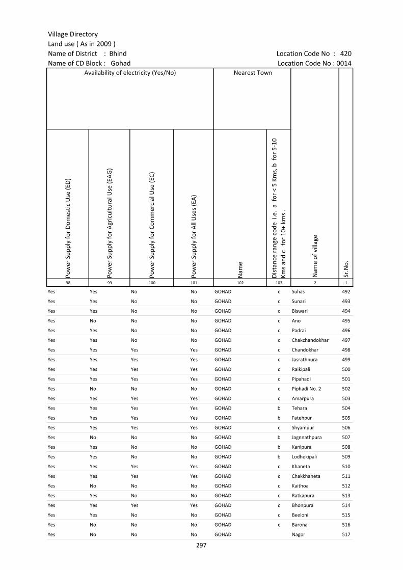
Village DirectoryLand use ( As in 2009 )Name of District : Bhind Location Code No : 420Name of CD Block : Gohad Location Code No : 0014
Pow
er S
uppl
y fo
r D
omes
tic U
se (E
D)
Pow
er S
uppl
y fo
r A
gric
ultu
ral U
se (E
AG
)
Pow
er S
uppl
y fo
r Co
mm
erci
al U
se (E
C)
Pow
er S
uppl
y fo
r A
ll U
ses
(EA
)
Nam
e
Dis
tanc
e ra
nge
code
i.e
. a
for
< 5
Kms,
b f
or 5
-10
Kms
and
c f
or 1
0+ k
ms
.98 99 100 101 102 103 2 1
Yes Yes No No GOHAD c Suhas 492
Yes Yes No No GOHAD c Sunari 493
Yes Yes No No GOHAD c Biswari 494
Yes No No No GOHAD c Ano 495
Yes Yes No No GOHAD c Padrai 496
Yes Yes No No GOHAD c Chakchandokhar 497
Yes Yes Yes Yes GOHAD c Chandokhar 498
Yes Yes Yes Yes GOHAD c Jasrathpura 499
Yes Yes Yes Yes GOHAD c Raikipali 500
Yes Yes Yes Yes GOHAD c Pipahadi 501
Yes No No No GOHAD c Piphadi No. 2 502
Yes Yes Yes Yes GOHAD c Amarpura 503
Yes Yes Yes Yes GOHAD b Tehara 504
Yes Yes Yes Yes GOHAD b Fatehpur 505
Yes Yes Yes Yes GOHAD c Shyampur 506
Yes No No No GOHAD b Jagnnathpura 507
Yes Yes No No GOHAD b Kanipura 508
Yes Yes No No GOHAD b Lodhekipali 509
Yes Yes Yes Yes GOHAD c Khaneta 510
Yes Yes Yes Yes GOHAD c Chakkhaneta 511
Yes No No No GOHAD c Kaithoa 512
Yes Yes No No GOHAD c Ratkapura 513
Yes Yes Yes Yes GOHAD c Bhonpura 514
Yes Yes No No GOHAD c Beeloni 515
Yes No No No GOHAD c Barona 516
Yes No No No GOHAD Nagor 517
Nearest Town
Nam
e of
vill
age
Sr.N
o.
Availability of electricity (Yes/No)
297
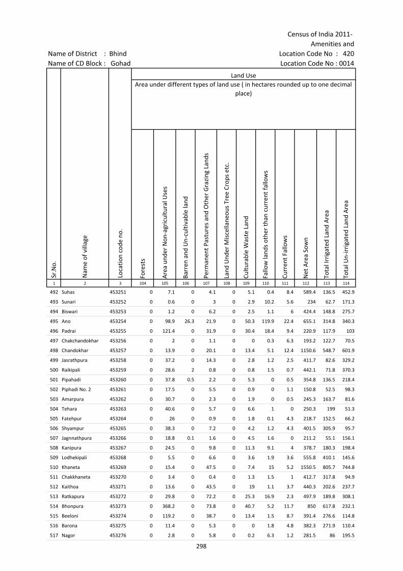
Census of India 2011- Amenities and
Name of District : Bhind Location Code No : 420Name of CD Block : Gohad Location Code No : 0014
Fore
sts
Are
a un
der
Non
-agr
icul
tura
l Use
s
Barr
en a
nd U
n-cu
ltiva
ble
land
Perm
anen
t Pas
ture
s an
d O
ther
Gra
zing
Lan
ds
Land
Und
er M
isce
llane
ous
Tree
Cro
ps e
tc.
Cultu
rabl
e W
aste
Lan
d
Fallo
w la
nds
othe
r th
an c
urre
nt fa
llow
s
Curr
ent F
allo
ws
Net
Are
a So
wn
Tota
l Irr
igat
ed L
and
Are
a
Tota
l Un-
irri
gate
d La
nd A
rea
1 2 3 104 105 106 107 108 109 110 111 112 113 114
492 Suhas 453251 0 7.1 0 4.1 0 5.1 0.4 8.4 589.4 136.5 452.9
493 Sunari 453252 0 0.6 0 3 0 2.9 10.2 5.6 234 62.7 171.3
494 Biswari 453253 0 1.2 0 6.2 0 2.5 1.1 6 424.4 148.8 275.7
495 Ano 453254 0 98.9 26.3 21.9 0 50.3 119.9 22.4 655.1 314.8 340.3
496 Padrai 453255 0 121.4 0 31.9 0 30.4 18.4 9.4 220.9 117.9 103
497 Chakchandokhar 453256 0 2 0 1.1 0 0 0.3 6.3 193.2 122.7 70.5
498 Chandokhar 453257 0 13.9 0 20.1 0 13.4 5.1 12.4 1150.6 548.7 601.9
499 Jasrathpura 453258 0 37.2 0 14.3 0 2.8 1.2 2.5 411.7 82.6 329.2
500 Raikipali 453259 0 28.6 2 0.8 0 0.8 1.5 0.7 442.1 71.8 370.3
501 Pipahadi 453260 0 37.8 0.5 2.2 0 5.3 0 0.5 354.8 136.5 218.4
502 Piphadi No. 2 453261 0 17.5 0 5.5 0 0.9 0 1.1 150.8 52.5 98.3
503 Amarpura 453262 0 30.7 0 2.3 0 1.9 0 0.5 245.3 163.7 81.6
504 Tehara 453263 0 40.6 0 5.7 0 6.6 1 0 250.3 199 51.3
505 Fatehpur 453264 0 26 0 0.9 0 1.8 0.1 4.3 218.7 152.5 66.2
506 Shyampur 453265 0 38.3 0 7.2 0 4.2 1.2 4.3 401.5 305.9 95.7
507 Jagnnathpura 453266 0 18.8 0.1 1.6 0 4.5 1.6 0 211.2 55.1 156.1
508 Kanipura 453267 0 24.5 0 9.8 0 11.3 9.1 4 378.7 180.3 198.4
509 Lodhekipali 453268 0 5.5 0 6.6 0 3.6 1.9 3.6 555.8 410.1 145.6
510 Khaneta 453269 0 15.4 0 47.5 0 7.4 15 5.2 1550.5 805.7 744.8
511 Chakkhaneta 453270 0 3.4 0 0.4 0 1.3 1.5 1 412.7 317.8 94.9
512 Kaithoa 453271 0 13.6 0 43.5 0 19 1.1 3.7 440.3 202.6 237.7
513 Ratkapura 453272 0 29.8 0 72.2 0 25.3 16.9 2.3 497.9 189.8 308.1
514 Bhonpura 453273 0 368.2 0 73.8 0 40.7 5.2 11.7 850 617.8 232.1
515 Beeloni 453274 0 119.2 0 38.7 0 13.4 1.5 8.7 391.4 276.6 114.8
516 Barona 453275 0 11.4 0 5.3 0 0 1.8 4.8 382.3 271.9 110.4
517 Nagor 453276 0 2.8 0 5.8 0 0.2 6.3 1.2 281.5 86 195.5
Land UseArea under different types of land use ( in hectares rounded up to one decimal
place)
Sr.N
o.
Nam
e of
vill
age
Loca
tion
code
no.
298
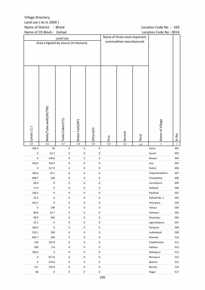
Village DirectoryLand use ( As in 2009 )Name of District : Bhind Location Code No : 420Name of CD Block : Gohad Location Code No : 0014
Cana
ls (
C )
Wel
ls/T
ube-
wel
ls(W
/TW
)
Tank
s/La
kes(
T/L)
Wat
er F
alls
(WF)
Oth
ers(
O)
Firs
t
Seco
nd
Thir
d 115 116 117 118 119 120 121 122 2 1
106.5 30 0 0 0 Suhas 492
0 62.7 0 0 0 Sunari 493
0 148.8 0 0 0 Biswari 494
150.4 164.4 0 0 0 Ano 495
0 117.9 0 0 0 Padrai 496
106.6 16.1 0 0 0 Chakchandokhar 497
408.7 140 0 0 0 Chandokhar 498
82.6 0 0 0 0 Jasrathpura 499
71.8 0 0 0 0 Raikipali 500
136.5 0 0 0 0 Pipahadi 501
52.5 0 0 0 0 Piphadi No. 2 502
163.7 0 0 0 0 Amarpura 503
0 199 0 0 0 Tehara 504
89.8 62.7 0 0 0 Fatehpur 505
99.9 206 0 0 0 Shyampur 506
55.1 0 0 0 0 Jagnnathpura 507
180.3 0 0 0 0 Kanipura 508
210.1 200 0 0 0 Lodhekipali 509
605.7 200 0 0 0 Khaneta 510
150 167.8 0 0 0 Chakkhaneta 511
200 2.6 0 0 0 Kaithoa 512
189.8 0 0 0 0 Ratkapura 513
0 617.8 0 0 0 Bhonpura 514
0 276.6 0 0 0 Beeloni 515
121 150.9 0 0 0 Barona 516
86 0 0 0 0 Nagor 517
Land Use Name of three most important commodities manufactured
Nam
e of
Vill
age
Sr.N
o.
Area irrigated by source (in hectare).
299

Census of India 2011- Amenities and
Name of District : Bhind Location Code No : 420Name of CD Block : Gohad Location Code No : 0014
Pre-
Prim
ary
scho
ol (P
P)
Prim
ary
scho
ol (P
)
Mid
dle
scho
ol (M
)
Seco
ndar
y Sc
hool
(S)
Seni
or S
econ
dary
sch
ool (
SS)
Deg
ree
colle
ge o
f art
s s
cien
ce &
com
mer
ce (
ASC
)
Engi
neer
ing
colle
ge(E
C)
Med
ical
col
lege
(MC)
Man
agem
ent i
nstit
ute
(MI)
Poly
tech
nic
(Pt)
Voca
tiona
l tra
inin
g sc
hool
/IT
I
Non
-for
mal
trai
ning
cen
tre
(NFT
C)
Spec
ial s
choo
l for
dis
able
d (S
SD)
Oth
ers
(spe
cify
)
1 2 3 4 5 6 7 8 9 10 11 12 13 14 15 16 17 18 19 20
Sr.N
o.
Nam
e of
vill
age
Loca
tion
code
no.
Tota
l are
a of
the
villa
ge (
in h
ecta
res
roun
ded
up to
one
dec
imal
pla
ce)
Tota
l pop
ulat
ion
( 201
1 ce
nsus
)
Num
ber
of h
ouse
hold
s (2
011
cens
us)
Number of educational amenities available. (If not available within the village , the distance range
code viz; a for < 5 Kms, b for 5-10 Kms and c for 10+ kms of nearest place where facility is available is given).
518 Amanpura 453277 201.9 257 39 1 c c
519 Neemdanda 453278 226.3 295 41 2 a c c c c c
520 Baknasa 453279 635.7 1971 369 c 3 2 1 c c c c c c c c c c
521 Bamhora 453280 599 566 127 c 1 a a c c c c c c c c c c
522 Bara 453281 832.1 1866 354 a 3 1 1 1 c c c c c c c c c
523 Chakbarona 453282 391.4 548 112 c 2 1 c c c c c c c c c c c
524 Teton 453283 672.2 1600 289 2 2 b c c c c c c c c c c
525 Manpur 453284 309.2 588 85 c 2 1 c c c c c c c c c c
526 Sherpur 453285 1509.4 5984 1140 2 1 1 1 c c c c c c c
527 Rayatpura 453286 359.8 1001 195 1 6 2 1 c c c c c c c c c
528 Shankarpur 453287 469.2 561 111 a 2 a a c c c c c c c c c c
529 Kanchanpur 453288 791.1 1952 309 1 2 2 2 b c c c c c c
530 Nonera 453289 1456.2 2382 424 c 3 1 c c c c c c c c c
531 Chharenta(Ano) 453290 1062.1 3241 665 b 2 2 c c c c c c c
532 Sarwa 453291 1206.4 3097 586 1 2 2 2 b b c c c c c c c
533 Chaksarwa 453292 243.8 726 136 b 2 2 1 a b c c c c c c
534 Kheriaraiju 453293 143.6 581 106 b 2 a a b b c c c c c c
535 Tukeda 453294 919.4 2516 525 1 3 b b c c c c c c c c c
536 Chaktukeda 453295 295.3 606 115 a 3 a a a c c c c c c c c
537 Tudila 453296 697.9 1799 345 b 1 1 1 c c c c c c c c
538 Ekahara 453297 506.4 1322 217 a 3 1 2 a c c c c c c c
539 Chakmadhopur 453298 390 1020 201 b 1 1 b c c c c c c c c
540 Gurikha 453299 1009.6 3122 626 b 4 1 b c c c c c c c c
541 Sindhwari 453300 378.4 1206 255 a 1 1 a a c c c c c c c c c
542 Tilori 453301 313.6 1234 230 a 2 a a a c c c c c c c c c
543 Ghirongi 453302 336 750 110 a 1 a a a c c c c c c c c c
300

Village DirectoryLand use ( As in 2009 )Name of District : Bhind Location Code No : 420Name of CD Block : Gohad Location Code No : 0014
Com
mun
ity h
ealth
cen
tre
(CH
C)Pr
imar
y he
alth
cen
tre
(PH
C)Pr
imar
y he
alth
sub
cen
tre
(PH
S)M
ater
nity
and
chi
ld w
elfa
re c
entr
e (M
CW)
T.B.
clin
ic (
TBC)
Hos
pita
l-allo
path
ic (H
A)
Hos
pita
l-alte
rnat
ive
med
icin
e (H
O)
Dis
pens
ary
(D)
Vete
rina
ry h
ospi
tal (
VH)
Mob
ile h
ealth
clin
ic (M
HC)
Fam
ily w
elfa
re c
entr
e (F
WC)
Char
itabl
e no
n G
ovt.
hos
pita
l/N
ursi
ng h
ome.
Med
ical
pra
ctiti
oner
with
MBB
S D
egre
eM
edic
al p
ract
ition
er w
ith o
ther
deg
ree
Med
ical
pra
ctiti
oner
with
no
degr
eeTr
aditi
onal
pra
ctiti
oner
and
faith
hea
ler
.M
edic
ine
Shop
Oth
ers
Tap
wat
er (T
reat
ed/U
ntre
ated
)
Wel
l w
ater
(C
over
ed /
Unc
over
ed w
ell)
Han
d Pu
mp
Tube
wel
ls /
Bor
e w
ell
Spri
ng
Rive
r /
Cana
l
Tank
/ P
ond
/ L
ake
Oth
ers
21 22 23 24 25 26 27 28 29 30 31 32 33 34 35 36 37 38 39 40 41 42 43 44 45 46 2 1
Number of Medical Amenities available. (If not available within the
village , the distance range code viz; a for < 5 Kms, b for 5-10 Kms and c for
10+ kms of nearest place where facility is available is given).
Number of Non-Government
Medical Amenities available.
Availability of drinking water - Yes / No
Nam
e of
vill
age
Sr.N
o.
c c 0 0 0 0 0 0 0 No Yes Yes Yes No Yes No No Amanpura 518
c c c c c c c c c 0 0 0 0 0 0 0 No Yes Yes Yes No Yes No No Neemdanda 519
c c b c c c c c c c c 0 0 0 0 0 0 0 No Yes Yes No No Yes No No Baknasa 520
c c b c c c c c c c c 0 0 0 1 0 0 0 No Yes Yes Yes No Yes No No Bamhora 521
c c 1 c c c c c c c c 0 0 0 0 0 0 0 No Yes Yes No No Yes No No Bara 522
c c c c c c c c c c c 0 0 0 0 0 0 0 No Yes Yes Yes No Yes No No Chakbarona 523
c c c c c c c c c c b 0 0 0 0 0 0 0 No Yes Yes No No Yes Yes Yes Teton 524
c c c c c c c c c c c 0 0 0 1 0 0 0 No Yes Yes Yes No No No No Manpur 525
c 1 c c c c c c b c c 0 0 0 0 0 0 0 No Yes Yes No Yes Yes No No Sherpur 526
c c a c c c c c b c c 0 0 1 0 2 0 0 No Yes Yes Yes No No No No Rayatpura 527
c c a c c c c c b c c 0 0 0 0 1 0 0 No Yes Yes Yes No No No No Shankarpur 528
c c c c c c c c c c c 0 0 0 0 0 0 0 No Yes Yes Yes No Yes No No Kanchanpur 529
c c c c c c c c c 0 0 0 0 0 0 0 No No Yes No No Yes Yes No Nonera 530
c c c c c c c c c c 0 0 0 0 0 0 0 No Yes Yes Yes No No No No Chharenta(Ano) 531
b b 1 1 b b b 1 b b b 0 0 0 0 0 0 0 No Yes Yes Yes No Yes No No Sarwa 532
b b b b b b b b b b b 0 0 0 0 0 0 0 No No Yes No No No No No Chaksarwa 533
b b a b b b b b b b b 0 0 0 0 0 0 0 No Yes Yes No No Yes Yes No Kheriaraiju 534
c c c c c c c c c c c 0 0 0 2 0 0 0 No Yes Yes Yes Yes No No No Tukeda 535
c c a a c c c a a a a 0 0 0 0 0 0 0 No Yes Yes No No No No No Chaktukeda 536
c c b c c c c c b c c 0 0 0 2 0 0 0 No Yes Yes Yes No Yes No No Tudila 537
c c a a c c c a a a a 0 0 0 0 0 0 0 No Yes Yes No No No No No Ekahara 538
c c b c c c c c b c c 0 0 0 2 0 0 0 No Yes Yes No No Yes Yes No Chakmadhopur 539
c b c b c c b c c 0 0 0 0 0 0 0 No Yes Yes No No Yes Yes No Gurikha 540
c c a c c c c c a c c 0 1 0 0 0 0 0 No Yes Yes No No No Yes No Sindhwari 541
c c a c c c c c a c c 0 0 0 0 0 0 0 Yes Yes Yes No No No Yes No Tilori 542
c c a c c c c c a c c 0 0 0 0 0 0 0 No Yes Yes Yes No No Yes No Ghirongi 543
301
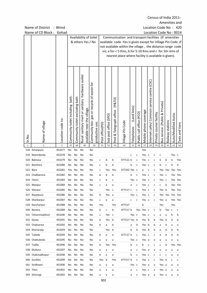
Census of India 2011- Amenities and
Name of District : Bhind Location Code No : 420Name of CD Block : Gohad Location Code No : 0014
Com
mun
ity to
ilet i
nclu
ding
bat
h.
Com
mun
ity to
ilet e
xclu
ding
bat
h.
Rura
l sa
nita
ry m
art o
r sa
nita
ry h
ardw
are
outle
t av
aila
ble
near
the
villa
ge.
Com
mun
ity b
io- g
as o
r re
cycl
e of
was
te fo
r pr
oduc
tive
use.
Post
off
ice(
PO)
Sub
post
off
ice
(SPO
)
Post
& T
eleg
raph
off
ice
(P&
TO)
Villa
ge P
in C
ode
Tele
phon
es
(L
and
lines
)
Publ
ic c
all o
ffic
e (P
CO)
Mob
ile p
hone
cov
erag
e
Inte
rnet
caf
es/
Com
mon
ser
vice
cen
tre
(CSC
)
Priv
ate
cour
ier
faci
lity
Bus
serv
ice
(Pub
lic &
Pri
vate
)
Railw
ay s
tatio
ns
Aut
o/M
odifi
ed A
utos
Taxi
s an
d Va
ns
1 2 3 47 48 49 50 51 52 53 54 55 56 57 58 59 60 61 62 63
Sr.N
o.
Nam
e of
vill
age
Loca
tion
code
no.
Availability of toilet & others Yes / No
Communication and transport facilities (If amenities available code -Yes is given except for Village Pin Code ,If not available within the village , the distance range code
viz; a for < 5 Kms, b for 5-10 Kms and c for 10+ kms of nearest place where facility is available is given).
518 Amanpura 453277 No No No No Yes
519 Neemdanda 453278 No No No No c c Yes c c c Yes c
520 Baknasa 453279 No No No No c b b 477111 b c Yes c c b b b Yes
521 Bamhora 453280 No No No No c b b b c Yes c c b c b b
522 Bara 453281 Yes No No No c Yes Yes 477332 Yes c a c c Yes Yes Yes Yes
523 Chakbarona 453282 No No No No b b b b c Yes c c Yes c Yes Yes
524 Teton 453283 No No No No c b c Yes c Yes c c Yes c Yes Yes
525 Manpur 453284 No No No No c a a a c Yes c c c b Yes Yes
526 Sherpur 453285 No No No No Yes c 477117 c c Yes c c Yes b Yes Yes
527 Rayatpura 453286 No No No No b Yes a Yes c Yes c c Yes Yes Yes Yes
528 Shankarpur 453287 No No No No c a a c c Yes c c Yes a Yes Yes
529 Kanchanpur 453288 No No No No Yes Yes 477117 b Yes Yes
530 Nonera 453289 No No No No b c b 477117 b Yes Yes c c b Yes c c
531 Chharenta(Ano) 453290 No No No No c Yes c Yes c Yes c c a a b b
532 Sarwa 453291 No No No No b Yes b 477117 Yes b Yes b b Yes b b b
533 Chaksarwa 453292 No No No No b a b a b Yes b b a b a a
534 Kheriaraiju 453293 No No No No Yes b b b Yes b b a b b b
535 Tukeda 453294 No No No No b a a 477117 b c Yes c c a b b b
536 Chaktukeda 453295 No No No No a a a Yes c Yes a a a a a a
537 Tudila 453296 No No No No b Yes Yes b c b c c c b Yes Yes
538 Ekahara 453297 No No No No a a a a c Yes a a a a a a
539 Chakmadhopur 453298 No No No No b a a b c Yes c c c c a a
540 Gurikha 453299 No No No No Yes b Yes 477117 b c Yes c c Yes b c c
541 Sindhwari 453300 No No No No a a a Yes c Yes a a Yes a a a
542 Tilori 453301 No No No No a a a a c Yes c a Yes a a a
543 Ghirongi 453302 No No No No a a a a c Yes a a Yes a a a
302
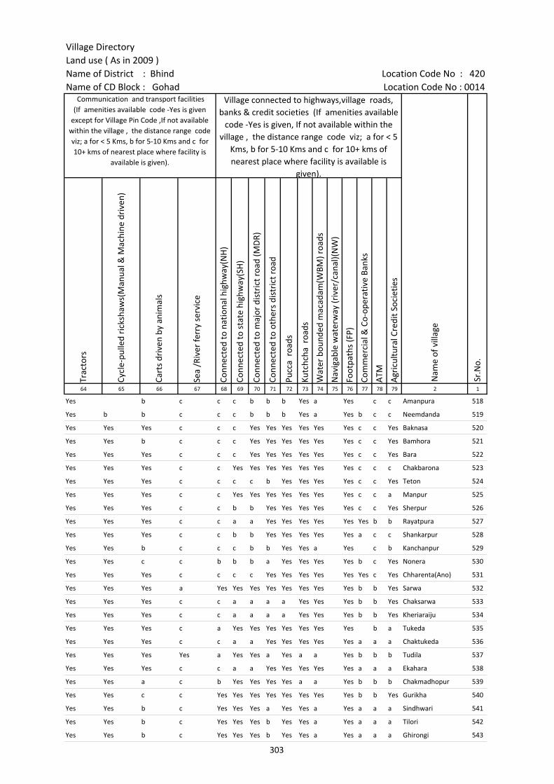
Village DirectoryLand use ( As in 2009 )Name of District : Bhind Location Code No : 420Name of CD Block : Gohad Location Code No : 0014
Trac
tors
Cycl
e-pu
lled
rick
shaw
s(M
anua
l & M
achi
ne d
rive
n)
Cart
s dr
iven
by
anim
als
Sea
/Riv
er fe
rry
serv
ice
Conn
ecte
d to
nat
iona
l hig
hway
(NH
)
Conn
ecte
d to
sta
te h
ighw
ay(S
H)
Conn
ecte
d to
maj
or d
istr
ict r
oad
(MD
R)
Conn
ecte
d to
oth
ers
dist
rict
roa
d
Pucc
a r
oads
Kutc
hcha
roa
ds
Wat
er b
ound
ed m
acad
am(W
BM) r
oads
Nav
igab
le w
ater
way
(riv
er/c
anal
)(N
W)
Foot
path
s (F
P)
Com
mer
cial
& C
o-op
erat
ive
Bank
s
ATM
Agr
icul
tura
l Cre
dit S
ocie
ties
64 65 66 67 68 69 70 71 72 73 74 75 76 77 78 79 2 1
Sr.N
o.
Communication and transport facilities (If amenities available code -Yes is given
except for Village Pin Code ,If not available within the village , the distance range code viz; a for < 5 Kms, b for 5-10 Kms and c for 10+ kms of nearest place where facility is
available is given).
Village connected to highways,village roads, banks & credit societies (If amenities available
code -Yes is given, If not available within the village , the distance range code viz; a for < 5
Kms, b for 5-10 Kms and c for 10+ kms of nearest place where facility is available is
given).
Nam
e of
vill
age
Yes b c c c b b b Yes a Yes c c Amanpura 518
Yes b b c c c b b b Yes a Yes b c c Neemdanda 519
Yes Yes Yes c c c Yes Yes Yes Yes Yes Yes c c Yes Baknasa 520
Yes Yes b c c c Yes Yes Yes Yes Yes Yes c c Yes Bamhora 521
Yes Yes Yes c c c Yes Yes Yes Yes Yes Yes c c Yes Bara 522
Yes Yes Yes c c Yes Yes Yes Yes Yes Yes Yes c c c Chakbarona 523
Yes Yes Yes c c c c b Yes Yes Yes Yes c c Yes Teton 524
Yes Yes Yes c c Yes Yes Yes Yes Yes Yes Yes c c a Manpur 525
Yes Yes Yes c c b b Yes Yes Yes Yes Yes c c Yes Sherpur 526
Yes Yes Yes c c a a Yes Yes Yes Yes Yes Yes b b Rayatpura 527
Yes Yes Yes c c b b Yes Yes Yes Yes Yes a c c Shankarpur 528
Yes Yes b c c c b b Yes Yes a Yes c b Kanchanpur 529
Yes Yes c c b b b a Yes Yes Yes Yes b c Yes Nonera 530
Yes Yes Yes c c c c Yes Yes Yes Yes Yes Yes c Yes Chharenta(Ano) 531
Yes Yes Yes a Yes Yes Yes Yes Yes Yes Yes Yes b b Yes Sarwa 532
Yes Yes Yes c c a a a a Yes Yes Yes b b Yes Chaksarwa 533
Yes Yes Yes c c a a a a Yes Yes Yes b b Yes Kheriaraiju 534
Yes Yes Yes c a Yes Yes Yes Yes Yes Yes Yes b a Tukeda 535
Yes Yes Yes c c a a Yes Yes Yes Yes Yes a a a Chaktukeda 536
Yes Yes Yes Yes a Yes Yes a Yes a a Yes b b b Tudila 537
Yes Yes Yes c c a a Yes Yes Yes Yes Yes a a a Ekahara 538
Yes Yes a c b Yes Yes Yes Yes a a Yes b b b Chakmadhopur 539
Yes Yes c c Yes Yes Yes Yes Yes Yes Yes Yes b b Yes Gurikha 540
Yes Yes b c Yes Yes Yes a Yes Yes a Yes a a a Sindhwari 541
Yes Yes b c Yes Yes Yes b Yes Yes a Yes a a a Tilori 542
Yes Yes b c Yes Yes Yes b Yes Yes a Yes a a a Ghirongi 543
303

Census of India 2011- Amenities and
Name of District : Bhind Location Code No : 420Name of CD Block : Gohad Location Code No : 0014
Self-
Hel
p G
roup
(SH
G)
Publ
ic d
istr
ibut
ion
syst
em (P
DS)
sho
p
Man
dis
/ Re
gula
r m
arke
t
Wee
kly
Haa
t
Agr
icul
tura
l mar
ketin
g so
ciet
yIn
tegr
ated
Chi
ld D
evel
opm
ent S
chem
e (N
utri
tiona
l Ce
ntre
s)A
ngan
wad
i Cen
tre
(Nut
ritio
nal C
entr
es)
Oth
ers
(Nut
ritio
nal C
entr
es)
ASH
A (A
ccre
dite
d So
cial
Hea
lth A
ctiv
ist)
Com
mun
ity c
entr
e w
ith/w
ithou
t TV
Spor
ts F
ield
,
Spor
ts C
lub
/ Re
crea
tion
Cent
re
Cine
ma
/ Vi
deo
Hal
l
Publ
ic L
ibra
ry
Publ
ic R
eadi
ng R
oom
New
spap
er S
uppl
y
Ass
embl
y Po
lling
sta
tion
Birt
h &
Dea
th R
egis
trat
ion
Off
ice
1 2 3 80 81 82 83 84 85 86 87 88 89 90 91 92 93 94 95 96 97
Sr.N
o.
Nam
e of
vill
age
Loca
tion
code
no.
Availability of miscellaneous facilities (If amenities available code -Yes is given, If not available within the village , the distance range code viz; a for < 5 Kms, b
for 5-10 Kms and c for 10+ kms of nearest place where facility is available is given).
518 Amanpura 453277 Yes a c b c c Yes a Yes Yes Yes Yes c c c a a b
519 Neemdanda 453278 Yes a c b c c Yes a Yes b c c c c c a a b
520 Baknasa 453279 Yes a c b c c Yes Yes Yes Yes c c c c c Yes Yes Yes
521 Bamhora 453280 Yes b c b c c Yes Yes Yes b c c c c c a Yes Yes
522 Bara 453281 Yes Yes c b c c Yes Yes Yes b c c c c c Yes Yes Yes
523 Chakbarona 453282 Yes a c b c c Yes Yes Yes c c c c c c Yes a b
524 Teton 453283 Yes Yes c b c c Yes Yes Yes Yes Yes c Yes Yes c c Yes Yes
525 Manpur 453284 Yes a c b c c Yes Yes Yes b c c c c c c Yes Yes
526 Sherpur 453285 Yes Yes c b Yes Yes Yes Yes Yes c Yes c c Yes c Yes Yes Yes
527 Rayatpura 453286 Yes Yes c c a c Yes Yes Yes c c c c c c Yes Yes b
528 Shankarpur 453287 Yes a c b b c Yes Yes Yes c c c c c c a Yes a
529 Kanchanpur 453288 Yes Yes c b c Yes Yes Yes Yes Yes Yes Yes Yes c c Yes Yes Yes
530 Nonera 453289 Yes Yes c Yes Yes c Yes Yes Yes c c c c c c Yes Yes Yes
531 Chharenta(Ano) 453290 Yes Yes c c c Yes Yes Yes Yes c c c c c c c Yes Yes
532 Sarwa 453291 Yes Yes b b Yes Yes Yes Yes Yes b Yes b b b b Yes Yes Yes
533 Chaksarwa 453292 Yes Yes b b b b Yes Yes Yes b Yes b b b b a Yes Yes
534 Kheriaraiju 453293 Yes a b b b Yes Yes Yes b Yes b b b b Yes a a b
535 Tukeda 453294 Yes Yes c c c Yes Yes Yes Yes c c c c c c c Yes Yes
536 Chaktukeda 453295 Yes Yes a a a c Yes Yes Yes a c a a c c a Yes Yes
537 Tudila 453296 Yes Yes b b c c Yes Yes Yes Yes c c b c c b Yes Yes
538 Ekahara 453297 Yes Yes a a a c Yes Yes Yes a c a a c c a Yes Yes
539 Chakmadhopur 453298 a a b b c c Yes Yes Yes a c c b c c b Yes Yes
540 Gurikha 453299 Yes Yes b Yes Yes c Yes Yes Yes c Yes c b c c b Yes Yes
541 Sindhwari 453300 Yes Yes c c c Yes Yes Yes Yes c c c a c c Yes Yes Yes
542 Tilori 453301 Yes a c b Yes Yes Yes Yes Yes c c c a c c Yes Yes a
543 Ghirongi 453302 Yes a c b c Yes Yes Yes a c c c a c c Yes Yes a
304

Village DirectoryLand use ( As in 2009 )Name of District : Bhind Location Code No : 420Name of CD Block : Gohad Location Code No : 0014
Pow
er S
uppl
y fo
r D
omes
tic U
se (E
D)
Pow
er S
uppl
y fo
r A
gric
ultu
ral U
se (E
AG
)
Pow
er S
uppl
y fo
r Co
mm
erci
al U
se (E
C)
Pow
er S
uppl
y fo
r A
ll U
ses
(EA
)
Nam
e
Dis
tanc
e ra
nge
code
i.e
. a
for
< 5
Kms,
b f
or 5
-10
Kms
and
c f
or 1
0+ k
ms
.98 99 100 101 102 103 2 1
Nearest Town
Nam
e of
vill
age
Sr.N
o.
Availability of electricity (Yes/No)
No No No No GOHAD Amanpura 518
Yes No No No GOHAD c Neemdanda 519
Yes No No No GOHAD c Baknasa 520
Yes Yes Yes Yes GOHAD c Bamhora 521
Yes Yes Yes Yes GOHAD c Bara 522
Yes Yes Yes Yes GOHAD c Chakbarona 523
Yes Yes Yes Yes GOHAD c Teton 524
Yes Yes Yes Yes GOHAD c Manpur 525
Yes Yes Yes Yes GOHAD c Sherpur 526
Yes Yes Yes Yes GOHAD c Rayatpura 527
Yes Yes Yes Yes GOHAD c Shankarpur 528
Yes No No No GOHAD Kanchanpur 529
Yes Yes Yes Yes GOHAD c Nonera 530
Yes Yes Yes Yes GOHAD c Chharenta(Ano) 531
Yes Yes Yes Yes GOHAD b Sarwa 532
Yes Yes Yes Yes GOHAD b Chaksarwa 533
Yes Yes Yes Yes GOHAD b Kheriaraiju 534
Yes Yes Yes Yes GOHAD Tukeda 535
Yes Yes Yes Yes GOHAD c Chaktukeda 536
Yes Yes Yes Yes GOHAD c Tudila 537
Yes Yes Yes Yes GOHAD c Ekahara 538
Yes No No No GOHAD c Chakmadhopur 539
Yes Yes Yes Yes GOHAD c Gurikha 540
Yes Yes Yes Yes GOHAD c Sindhwari 541
Yes Yes Yes Yes GOHAD c Tilori 542
Yes No Yes No GOHAD c Ghirongi 543
305
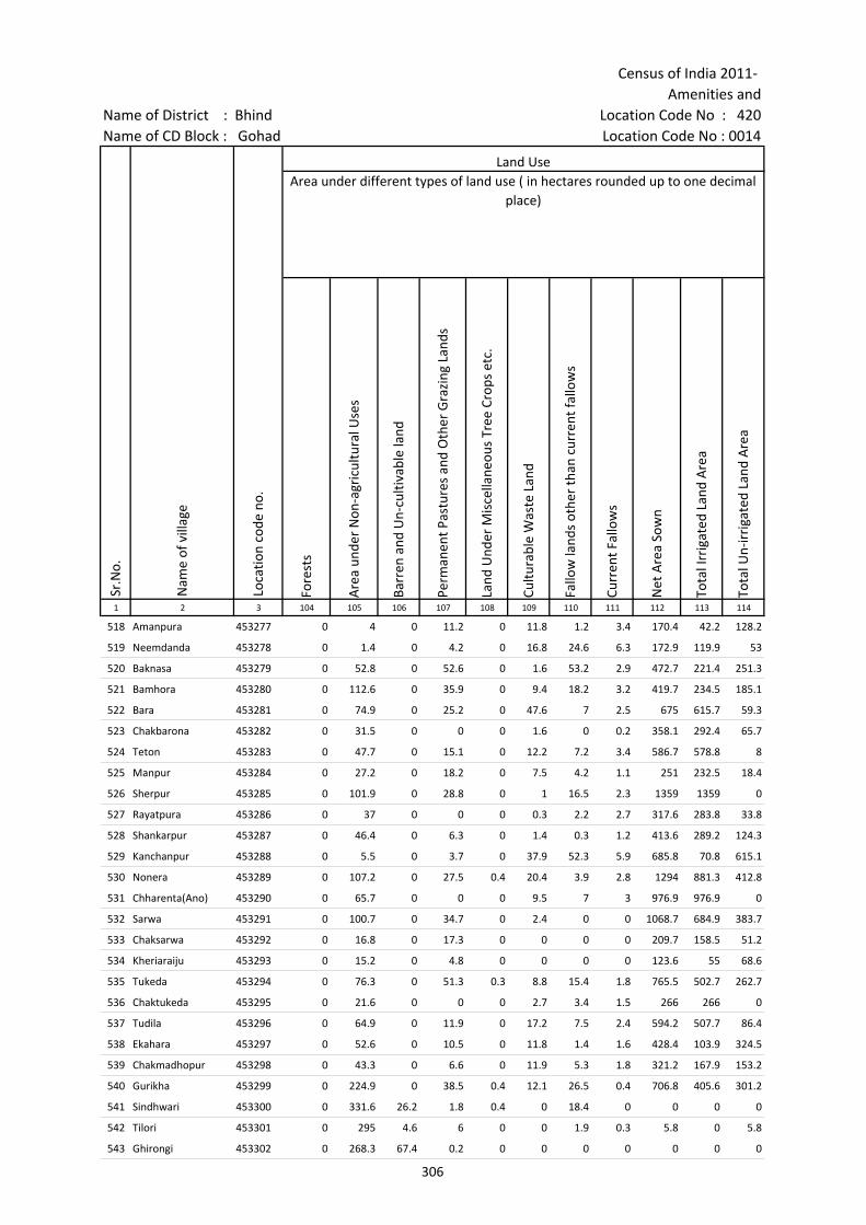
Census of India 2011- Amenities and
Name of District : Bhind Location Code No : 420Name of CD Block : Gohad Location Code No : 0014
Fore
sts
Are
a un
der
Non
-agr
icul
tura
l Use
s
Barr
en a
nd U
n-cu
ltiva
ble
land
Perm
anen
t Pas
ture
s an
d O
ther
Gra
zing
Lan
ds
Land
Und
er M
isce
llane
ous
Tree
Cro
ps e
tc.
Cultu
rabl
e W
aste
Lan
d
Fallo
w la
nds
othe
r th
an c
urre
nt fa
llow
s
Curr
ent F
allo
ws
Net
Are
a So
wn
Tota
l Irr
igat
ed L
and
Are
a
Tota
l Un-
irri
gate
d La
nd A
rea
1 2 3 104 105 106 107 108 109 110 111 112 113 114
Land UseArea under different types of land use ( in hectares rounded up to one decimal
place)
Sr.N
o.
Nam
e of
vill
age
Loca
tion
code
no.
518 Amanpura 453277 0 4 0 11.2 0 11.8 1.2 3.4 170.4 42.2 128.2
519 Neemdanda 453278 0 1.4 0 4.2 0 16.8 24.6 6.3 172.9 119.9 53
520 Baknasa 453279 0 52.8 0 52.6 0 1.6 53.2 2.9 472.7 221.4 251.3
521 Bamhora 453280 0 112.6 0 35.9 0 9.4 18.2 3.2 419.7 234.5 185.1
522 Bara 453281 0 74.9 0 25.2 0 47.6 7 2.5 675 615.7 59.3
523 Chakbarona 453282 0 31.5 0 0 0 1.6 0 0.2 358.1 292.4 65.7
524 Teton 453283 0 47.7 0 15.1 0 12.2 7.2 3.4 586.7 578.8 8
525 Manpur 453284 0 27.2 0 18.2 0 7.5 4.2 1.1 251 232.5 18.4
526 Sherpur 453285 0 101.9 0 28.8 0 1 16.5 2.3 1359 1359 0
527 Rayatpura 453286 0 37 0 0 0 0.3 2.2 2.7 317.6 283.8 33.8
528 Shankarpur 453287 0 46.4 0 6.3 0 1.4 0.3 1.2 413.6 289.2 124.3
529 Kanchanpur 453288 0 5.5 0 3.7 0 37.9 52.3 5.9 685.8 70.8 615.1
530 Nonera 453289 0 107.2 0 27.5 0.4 20.4 3.9 2.8 1294 881.3 412.8
531 Chharenta(Ano) 453290 0 65.7 0 0 0 9.5 7 3 976.9 976.9 0
532 Sarwa 453291 0 100.7 0 34.7 0 2.4 0 0 1068.7 684.9 383.7
533 Chaksarwa 453292 0 16.8 0 17.3 0 0 0 0 209.7 158.5 51.2
534 Kheriaraiju 453293 0 15.2 0 4.8 0 0 0 0 123.6 55 68.6
535 Tukeda 453294 0 76.3 0 51.3 0.3 8.8 15.4 1.8 765.5 502.7 262.7
536 Chaktukeda 453295 0 21.6 0 0 0 2.7 3.4 1.5 266 266 0
537 Tudila 453296 0 64.9 0 11.9 0 17.2 7.5 2.4 594.2 507.7 86.4
538 Ekahara 453297 0 52.6 0 10.5 0 11.8 1.4 1.6 428.4 103.9 324.5
539 Chakmadhopur 453298 0 43.3 0 6.6 0 11.9 5.3 1.8 321.2 167.9 153.2
540 Gurikha 453299 0 224.9 0 38.5 0.4 12.1 26.5 0.4 706.8 405.6 301.2
541 Sindhwari 453300 0 331.6 26.2 1.8 0.4 0 18.4 0 0 0 0
542 Tilori 453301 0 295 4.6 6 0 0 1.9 0.3 5.8 0 5.8
543 Ghirongi 453302 0 268.3 67.4 0.2 0 0 0 0 0 0 0
306
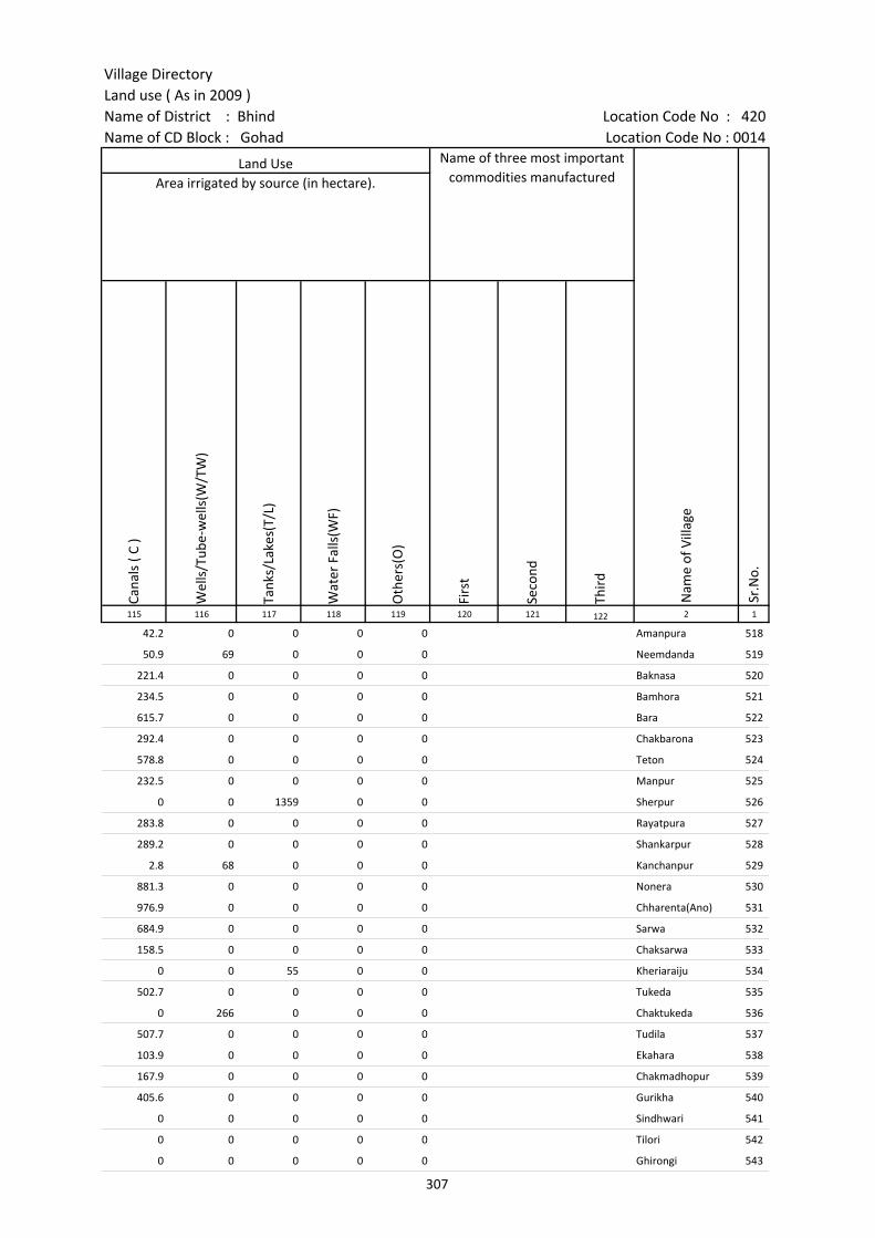
Village DirectoryLand use ( As in 2009 )Name of District : Bhind Location Code No : 420Name of CD Block : Gohad Location Code No : 0014
Cana
ls (
C )
Wel
ls/T
ube-
wel
ls(W
/TW
)
Tank
s/La
kes(
T/L)
Wat
er F
alls
(WF)
Oth
ers(
O)
Firs
t
Seco
nd
Thir
d 115 116 117 118 119 120 121 122 2 1
Land Use Name of three most important commodities manufactured
Nam
e of
Vill
age
Sr.N
o.
Area irrigated by source (in hectare).
42.2 0 0 0 0 Amanpura 518
50.9 69 0 0 0 Neemdanda 519
221.4 0 0 0 0 Baknasa 520
234.5 0 0 0 0 Bamhora 521
615.7 0 0 0 0 Bara 522
292.4 0 0 0 0 Chakbarona 523
578.8 0 0 0 0 Teton 524
232.5 0 0 0 0 Manpur 525
0 0 1359 0 0 Sherpur 526
283.8 0 0 0 0 Rayatpura 527
289.2 0 0 0 0 Shankarpur 528
2.8 68 0 0 0 Kanchanpur 529
881.3 0 0 0 0 Nonera 530
976.9 0 0 0 0 Chharenta(Ano) 531
684.9 0 0 0 0 Sarwa 532
158.5 0 0 0 0 Chaksarwa 533
0 0 55 0 0 Kheriaraiju 534
502.7 0 0 0 0 Tukeda 535
0 266 0 0 0 Chaktukeda 536
507.7 0 0 0 0 Tudila 537
103.9 0 0 0 0 Ekahara 538
167.9 0 0 0 0 Chakmadhopur 539
405.6 0 0 0 0 Gurikha 540
0 0 0 0 0 Sindhwari 541
0 0 0 0 0 Tilori 542
0 0 0 0 0 Ghirongi 543
307

Census of India 2011- Amenities and
Name of District : Bhind Location Code No : 420Name of CD Block : Gohad Location Code No : 0014
Pre-
Prim
ary
scho
ol (P
P)
Prim
ary
scho
ol (P
)
Mid
dle
scho
ol (M
)
Seco
ndar
y Sc
hool
(S)
Seni
or S
econ
dary
sch
ool (
SS)
Deg
ree
colle
ge o
f art
s s
cien
ce &
com
mer
ce (
ASC
)
Engi
neer
ing
colle
ge(E
C)
Med
ical
col
lege
(MC)
Man
agem
ent i
nstit
ute
(MI)
Poly
tech
nic
(Pt)
Voca
tiona
l tra
inin
g sc
hool
/IT
I
Non
-for
mal
trai
ning
cen
tre
(NFT
C)
Spec
ial s
choo
l for
dis
able
d (S
SD)
Oth
ers
(spe
cify
)
1 2 3 4 5 6 7 8 9 10 11 12 13 14 15 16 17 18 19 20
Sr.N
o.
Nam
e of
vill
age
Loca
tion
code
no.
Tota
l are
a of
the
villa
ge (
in h
ecta
res
roun
ded
up to
one
dec
imal
pla
ce)
Tota
l pop
ulat
ion
( 201
1 ce
nsus
)
Num
ber
of h
ouse
hold
s (2
011
cens
us)
Number of educational amenities available. (If not available within the village , the distance range
code viz; a for < 5 Kms, b for 5-10 Kms and c for 10+ kms of nearest place where facility is available is given).
544 Lahchura 453303 787.8 3033 518 2 2 2 b c c c c c c c c
545 Maho 453304 456.8 1159 238 1 a b b c c c c c c
546 Alori 453305 1322.2 1165 220 2 2 1 c c c c c c c c c c c
547 Jyajipur 453306 135.5 604 94 c 1 1 c c c c c c c c c c
548 Echaya 453307 771.4 1667 313 b 2 1 1 b b c c c c c c c c
549 Piparoli 453308 642.4 1709 309 4 1 a c c c c c c c c c c
550 Kathawahazi 453309 901.5 2563 482 b 4 2 b b b c c c c c c c
551 Jhawalpura 453310 238.1 377 56 c 1 a c c c c c c c c c
552 Barathara 453311 795 2669 515 a 2 1 a a c c c c c c c c c
553 Sisonia 453312 361.1 301 57 b 1 b 1 b c c c c c c c c c
554 Chhimaka 453313 962 2838 517 b 4 1 a a c c c c
555 Nawali 453314 231.3 1141 189 b 1 b b c c c c
556 Birkhadi 453315 1325.6 4728 920 2 2 2 2 1 c c c c c c c c
557 Dang 453316 727.5 2327 444 b 3 1 b b b c c c c c c c c
558 Sirsoda 453317 367.8 1397 278 b 1 b b b c c c c c c c c c
559 Rundhsarakar 453318 243.4 1142 253 1 1 a b c c c c c c c c c
560 Gangadas Ka Pura 453319 188 493 77 a 1 a a c c c c c c c c c
561 Chandahara 453320 614 1622 354 1 1 1 b b c c c c c c c c c
562 Bhyani 453321 374.1 1043 179 b 1 a b b c c c c c c c c c
563 Banipura 453322 519.3 1554 295 b 2 b b b c c c c c c c c c
564 Bagulari 453323 95.3 348 68 1 c c c c
565 Khurd 453324 261.5 1064 223 3 1 1 2 c c c c
566 Khariamahanand 453325 197.3 653 119 1 1 c c c c
567 Janora 453326 212 414 69 1 1 c c c c
568 Bhagwasa 453327 737.9 2057 426 1 3 2 1 c c c c c c c c c c
308

Village DirectoryLand use ( As in 2009 )Name of District : Bhind Location Code No : 420Name of CD Block : Gohad Location Code No : 0014
Com
mun
ity h
ealth
cen
tre
(CH
C)Pr
imar
y he
alth
cen
tre
(PH
C)Pr
imar
y he
alth
sub
cen
tre
(PH
S)M
ater
nity
and
chi
ld w
elfa
re c
entr
e (M
CW)
T.B.
clin
ic (
TBC)
Hos
pita
l-allo
path
ic (H
A)
Hos
pita
l-alte
rnat
ive
med
icin
e (H
O)
Dis
pens
ary
(D)
Vete
rina
ry h
ospi
tal (
VH)
Mob
ile h
ealth
clin
ic (M
HC)
Fam
ily w
elfa
re c
entr
e (F
WC)
Char
itabl
e no
n G
ovt.
hos
pita
l/N
ursi
ng h
ome.
Med
ical
pra
ctiti
oner
with
MBB
S D
egre
eM
edic
al p
ract
ition
er w
ith o
ther
deg
ree
Med
ical
pra
ctiti
oner
with
no
degr
eeTr
aditi
onal
pra
ctiti
oner
and
faith
hea
ler
.M
edic
ine
Shop
Oth
ers
Tap
wat
er (T
reat
ed/U
ntre
ated
)
Wel
l w
ater
(C
over
ed /
Unc
over
ed w
ell)
Han
d Pu
mp
Tube
wel
ls /
Bor
e w
ell
Spri
ng
Rive
r /
Cana
l
Tank
/ P
ond
/ L
ake
Oth
ers
21 22 23 24 25 26 27 28 29 30 31 32 33 34 35 36 37 38 39 40 41 42 43 44 45 46 2 1
Number of Medical Amenities available. (If not available within the
village , the distance range code viz; a for < 5 Kms, b for 5-10 Kms and c for
10+ kms of nearest place where facility is available is given).
Number of Non-Government
Medical Amenities available.
Availability of drinking water - Yes / No
Nam
e of
vill
age
Sr.N
o.
c b b c b c c c c c 0 0 0 0 0 0 0 No Yes Yes No No Yes No No Lahchura 544
b b b c b c c b b c 0 0 0 0 0 0 0 No Yes Yes No No No No No Maho 545
c 1 c c 0 0 0 0 0 0 0 No Yes Yes No No Yes Yes No Alori 546
c c c 0 0 0 0 0 0 0 No Yes Yes No No No Yes No Jyajipur 547
b b b b b b b b b b b 0 0 0 0 0 0 0 No Yes Yes No No Yes No No Echaya 548
c c c c c c c c c c c 0 0 0 0 0 0 0 No Yes Yes No No Yes No No Piparoli 549
b b 1 b b b b b b b b 0 0 0 0 0 0 0 No Yes Yes Yes No Yes No No Kathawahazi 550
c c c c c c c c c c c 0 0 0 0 0 0 0 No Yes Yes Yes No Yes No No Jhawalpura 551
a a a a a a a a a a 0 0 0 0 0 0 0 Yes Yes Yes No No Yes Yes No Barathara 552
b b b b b b b b b b 0 0 0 0 0 0 0 No Yes Yes No No No No No Sisonia 553
b b b b b b b b b 0 0 0 0 0 0 0 No Yes Yes No No Yes No No Chhimaka 554
b b b b b b b b b b 0 0 0 0 0 0 0 No Yes Yes No No Yes No No Nawali 555
c c 1 c c c c 1 c c 0 0 3 0 0 0 0 No Yes Yes No No Yes No No Birkhadi 556
b b b b b b b b b b b 0 0 0 0 0 0 0 No Yes Yes No No No No No Dang 557
b b 1 b b b b b b b 0 0 0 0 0 0 0 No Yes Yes No No Yes No No Sirsoda 558
b b 1 b b b b a b c 0 0 0 0 0 0 0 No Yes Yes No No No No No Rundhsarakar 559
a a a a a a a a a a 0 0 0 0 0 0 0 No Yes Yes No No Yes No No Gangadas Ka Pura 560
b b 1 b b b b b b 0 0 0 0 0 0 0 No Yes Yes No No Yes No No Chandahara 561
b b b b b b b b b 0 0 0 0 0 0 0 No Yes Yes No No Yes No No Bhyani 562
b b b b b b b b b b 0 0 0 0 0 0 0 No Yes Yes No No No No No Banipura 563
c c c c c c c c c 0 0 0 0 0 0 0 No Yes Yes No No No No No Bagulari 564
c c c c c c c c c 0 0 0 0 0 0 0 No Yes Yes No No No No No Khurd 565
b b b b b b b b b 0 0 0 0 0 0 0 No Yes Yes No No No No No Khariamahanand 566
c c c c c c c c c 0 0 0 0 0 0 0 No Yes Yes No No No No No Janora 567
c c c c c c c c c c c 0 0 0 0 0 0 0 No Yes Yes No No Yes No No Bhagwasa 568
309

Census of India 2011- Amenities and
Name of District : Bhind Location Code No : 420Name of CD Block : Gohad Location Code No : 0014
Com
mun
ity to
ilet i
nclu
ding
bat
h.
Com
mun
ity to
ilet e
xclu
ding
bat
h.
Rura
l sa
nita
ry m
art o
r sa
nita
ry h
ardw
are
outle
t av
aila
ble
near
the
villa
ge.
Com
mun
ity b
io- g
as o
r re
cycl
e of
was
te fo
r pr
oduc
tive
use.
Post
off
ice(
PO)
Sub
post
off
ice
(SPO
)
Post
& T
eleg
raph
off
ice
(P&
TO)
Villa
ge P
in C
ode
Tele
phon
es
(L
and
lines
)
Publ
ic c
all o
ffic
e (P
CO)
Mob
ile p
hone
cov
erag
e
Inte
rnet
caf
es/
Com
mon
ser
vice
cen
tre
(CSC
)
Priv
ate
cour
ier
faci
lity
Bus
serv
ice
(Pub
lic &
Pri
vate
)
Railw
ay s
tatio
ns
Aut
o/M
odifi
ed A
utos
Taxi
s an
d Va
ns
1 2 3 47 48 49 50 51 52 53 54 55 56 57 58 59 60 61 62 63
Sr.N
o.
Nam
e of
vill
age
Loca
tion
code
no.
Availability of toilet & others Yes / No
Communication and transport facilities (If amenities available code -Yes is given except for Village Pin Code ,If not available within the village , the distance range code
viz; a for < 5 Kms, b for 5-10 Kms and c for 10+ kms of nearest place where facility is available is given).
544 Lahchura 453303 No No No No c b Yes Yes Yes c c b c c c
545 Maho 453304 No No No No b b b Yes c b b b b c c c
546 Alori 453305 No No No No c c c c c Yes c c Yes c c Yes
547 Jyajipur 453306 No No No No c c c c c c c c c c c c
548 Echaya 453307 No No No No a a b b b b b b b c b b
549 Piparoli 453308 No No No No c c c c c c c c c c Yes c
550 Kathawahazi 453309 No No No No b Yes b 477116 b b b b b b b b b
551 Jhawalpura 453310 No No No No c c c c c Yes c c c c c c
552 Barathara 453311 No No No No a a a a a Yes a a a b a a
553 Sisonia 453312 No No No No b b b 477116 b b b b b b b b b
554 Chhimaka 453313 No No No No a a a b b b b b Yes b a a
555 Nawali 453314 No No No No a a a b b b b b Yes b b b
556 Birkhadi 453315 No No No No c Yes Yes Yes Yes Yes Yes Yes Yes b Yes Yes
557 Dang 453316 No No No No b b b b b Yes b b Yes b b b
558 Sirsoda 453317 No No No No b b b b b b b b b c b b
559 Rundhsarakar 453318 No No No No b b b b b b b b b c b b
560 Gangadas Ka Pura 453319 No No No No a a a a a a a a a b a a
561 Chandahara 453320 No No No No a b b b b b b b c b b
562 Bhyani 453321 No No No No b b b b b b b b b b b b
563 Banipura 453322 No No No No b b b b b b b b b c b b
564 Bagulari 453323 No No No Yes c c c c c c c c c c c
565 Khurd 453324 No No No No c c c c c b c c c c c
566 Khariamahanand 453325 No No No No b b b b b b b b b b b b
567 Janora 453326 No No No No c c c 477555 c c c c c c c c
568 Bhagwasa 453327 No No No No Yes c c 477116 c c Yes c c Yes c c c
310
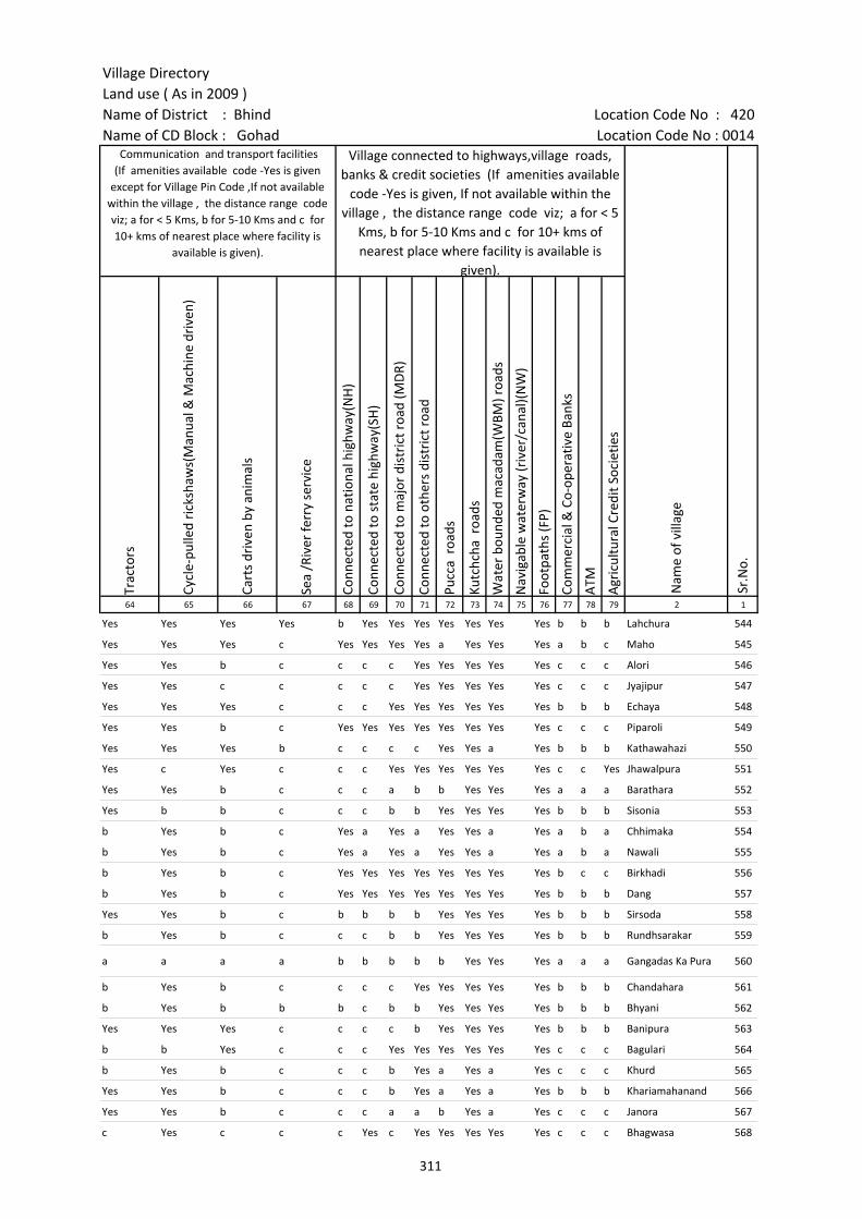
Village DirectoryLand use ( As in 2009 )Name of District : Bhind Location Code No : 420Name of CD Block : Gohad Location Code No : 0014
Trac
tors
Cycl
e-pu
lled
rick
shaw
s(M
anua
l & M
achi
ne d
rive
n)
Cart
s dr
iven
by
anim
als
Sea
/Riv
er fe
rry
serv
ice
Conn
ecte
d to
nat
iona
l hig
hway
(NH
)
Conn
ecte
d to
sta
te h
ighw
ay(S
H)
Conn
ecte
d to
maj
or d
istr
ict r
oad
(MD
R)
Conn
ecte
d to
oth
ers
dist
rict
roa
d
Pucc
a r
oads
Kutc
hcha
roa
ds
Wat
er b
ound
ed m
acad
am(W
BM) r
oads
Nav
igab
le w
ater
way
(riv
er/c
anal
)(N
W)
Foot
path
s (F
P)
Com
mer
cial
& C
o-op
erat
ive
Bank
s
ATM
Agr
icul
tura
l Cre
dit S
ocie
ties
64 65 66 67 68 69 70 71 72 73 74 75 76 77 78 79 2 1
Sr.N
o.
Communication and transport facilities (If amenities available code -Yes is given
except for Village Pin Code ,If not available within the village , the distance range code viz; a for < 5 Kms, b for 5-10 Kms and c for 10+ kms of nearest place where facility is
available is given).
Village connected to highways,village roads, banks & credit societies (If amenities available
code -Yes is given, If not available within the village , the distance range code viz; a for < 5
Kms, b for 5-10 Kms and c for 10+ kms of nearest place where facility is available is
given).
Nam
e of
vill
age
Yes Yes Yes Yes b Yes Yes Yes Yes Yes Yes Yes b b b Lahchura 544
Yes Yes Yes c Yes Yes Yes Yes a Yes Yes Yes a b c Maho 545
Yes Yes b c c c c Yes Yes Yes Yes Yes c c c Alori 546
Yes Yes c c c c c Yes Yes Yes Yes Yes c c c Jyajipur 547
Yes Yes Yes c c c Yes Yes Yes Yes Yes Yes b b b Echaya 548
Yes Yes b c Yes Yes Yes Yes Yes Yes Yes Yes c c c Piparoli 549
Yes Yes Yes b c c c c Yes Yes a Yes b b b Kathawahazi 550
Yes c Yes c c c Yes Yes Yes Yes Yes Yes c c Yes Jhawalpura 551
Yes Yes b c c c a b b Yes Yes Yes a a a Barathara 552
Yes b b c c c b b Yes Yes Yes Yes b b b Sisonia 553
b Yes b c Yes a Yes a Yes Yes a Yes a b a Chhimaka 554
b Yes b c Yes a Yes a Yes Yes a Yes a b a Nawali 555
b Yes b c Yes Yes Yes Yes Yes Yes Yes Yes b c c Birkhadi 556
b Yes b c Yes Yes Yes Yes Yes Yes Yes Yes b b b Dang 557
Yes Yes b c b b b b Yes Yes Yes Yes b b b Sirsoda 558
b Yes b c c c b b Yes Yes Yes Yes b b b Rundhsarakar 559
a a a a b b b b b Yes Yes Yes a a a Gangadas Ka Pura 560
b Yes b c c c c Yes Yes Yes Yes Yes b b b Chandahara 561
b Yes b b b c b b Yes Yes Yes Yes b b b Bhyani 562
Yes Yes Yes c c c c b Yes Yes Yes Yes b b b Banipura 563
b b Yes c c c Yes Yes Yes Yes Yes Yes c c c Bagulari 564
b Yes b c c c b Yes a Yes a Yes c c c Khurd 565
Yes Yes b c c c b Yes a Yes a Yes b b b Khariamahanand 566
Yes Yes b c c c a a b Yes a Yes c c c Janora 567
c Yes c c c Yes c Yes Yes Yes Yes Yes c c c Bhagwasa 568
311
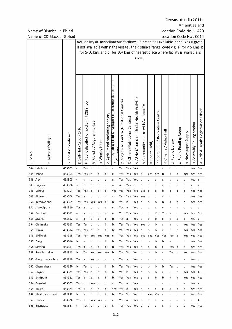
Census of India 2011- Amenities and
Name of District : Bhind Location Code No : 420Name of CD Block : Gohad Location Code No : 0014
Self-
Hel
p G
roup
(SH
G)
Publ
ic d
istr
ibut
ion
syst
em (P
DS)
sho
p
Man
dis
/ Re
gula
r m
arke
t
Wee
kly
Haa
t
Agr
icul
tura
l mar
ketin
g so
ciet
yIn
tegr
ated
Chi
ld D
evel
opm
ent S
chem
e (N
utri
tiona
l Ce
ntre
s)A
ngan
wad
i Cen
tre
(Nut
ritio
nal C
entr
es)
Oth
ers
(Nut
ritio
nal C
entr
es)
ASH
A (A
ccre
dite
d So
cial
Hea
lth A
ctiv
ist)
Com
mun
ity c
entr
e w
ith/w
ithou
t TV
Spor
ts F
ield
,
Spor
ts C
lub
/ Re
crea
tion
Cent
re
Cine
ma
/ Vi
deo
Hal
l
Publ
ic L
ibra
ry
Publ
ic R
eadi
ng R
oom
New
spap
er S
uppl
y
Ass
embl
y Po
lling
sta
tion
Birt
h &
Dea
th R
egis
trat
ion
Off
ice
1 2 3 80 81 82 83 84 85 86 87 88 89 90 91 92 93 94 95 96 97
Sr.N
o.
Nam
e of
vill
age
Loca
tion
code
no.
Availability of miscellaneous facilities (If amenities available code -Yes is given, If not available within the village , the distance range code viz; a for < 5 Kms, b
for 5-10 Kms and c for 10+ kms of nearest place where facility is available is given).
544 Lahchura 453303 c Yes c b c c Yes Yes Yes c c c c c c c Yes Yes
545 Maho 453304 Yes Yes c b c c Yes Yes Yes c Yes Yes b c c Yes Yes Yes
546 Alori 453305 c c c c c c Yes Yes Yes c c c c c c c Yes c
547 Jyajipur 453306 a c c c c a a Yes c c c c c c c c a c
548 Echaya 453307 Yes Yes b b b Yes Yes Yes Yes Yes b b b b b b Yes Yes
549 Piparoli 453308 Yes a c c c c Yes Yes Yes Yes c c c c c c Yes Yes
550 Kathawahazi 453309 Yes Yes Yes Yes b b Yes b Yes b b b b b b b Yes Yes
551 Jhawalpura 453310 Yes a c c c c Yes a Yes c c c c c c c a a
552 Barathara 453311 a a a a a a Yes Yes Yes a a Yes Yes b c Yes Yes Yes
553 Sisonia 453312 a b b b b b Yes a Yes b b b c c c a Yes a
554 Chhimaka 453313 Yes Yes b b b b Yes Yes Yes Yes b b c b c Yes Yes Yes
555 Nawali 453314 Yes Yes b b b b Yes Yes Yes b b b c c c Yes Yes Yes
556 Birkhadi 453315 Yes Yes Yes Yes Yes c Yes Yes Yes Yes Yes Yes Yes Yes c Yes Yes Yes
557 Dang 453316 b b b b b b Yes Yes Yes b b b b b b b Yes Yes
558 Sirsoda 453317 Yes b b b b b Yes Yes Yes b b b c Yes b b Yes Yes
559 Rundhsarakar 453318 b Yes Yes Yes Yes b Yes Yes Yes b b b c Yes c Yes Yes Yes
560 Gangadas Ka Pura 453319 Yes a Yes a a a Yes a Yes a a a c c c a Yes a
561 Chandahara 453320 b Yes b b b b Yes Yes Yes b b b b Yes b b Yes Yes
562 Bhyani 453321 Yes Yes b b b b Yes b Yes b b b c c c Yes Yes b
563 Banipura 453322 Yes a b b b b Yes Yes Yes b b b b c c Yes Yes Yes
564 Bagulari 453323 Yes c Yes c c c Yes a Yes c c c c c c a Yes a
565 Khurd 453324 Yes c c c c Yes Yes c Yes c c c c c c c Yes Yes
566 Khariamahanand 453325 b b b b b b Yes Yes Yes b Yes Yes c c c a Yes Yes
567 Janora 453326 Yes c Yes Yes c c Yes a Yes c c c c c c a a b
568 Bhagwasa 453327 c Yes c c c c Yes Yes Yes c c c c c c c Yes Yes
312
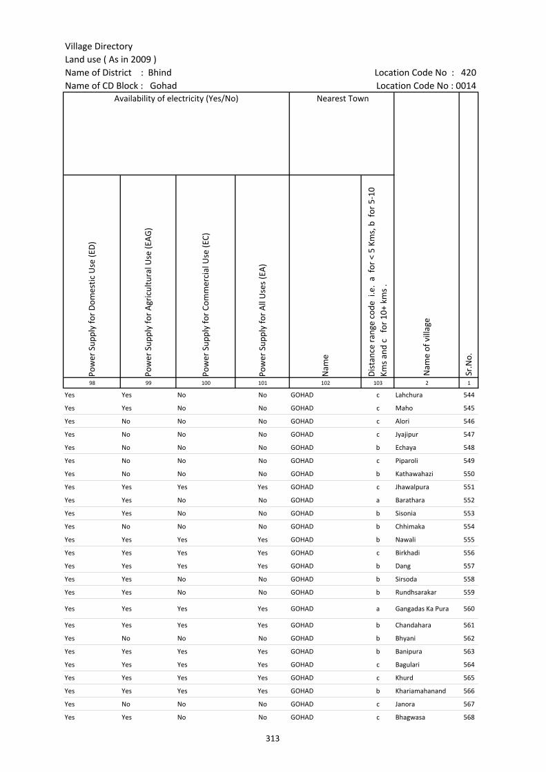
Village DirectoryLand use ( As in 2009 )Name of District : Bhind Location Code No : 420Name of CD Block : Gohad Location Code No : 0014
Pow
er S
uppl
y fo
r D
omes
tic U
se (E
D)
Pow
er S
uppl
y fo
r A
gric
ultu
ral U
se (E
AG
)
Pow
er S
uppl
y fo
r Co
mm
erci
al U
se (E
C)
Pow
er S
uppl
y fo
r A
ll U
ses
(EA
)
Nam
e
Dis
tanc
e ra
nge
code
i.e
. a
for
< 5
Kms,
b f
or 5
-10
Kms
and
c f
or 1
0+ k
ms
.98 99 100 101 102 103 2 1
Nearest Town
Nam
e of
vill
age
Sr.N
o.
Availability of electricity (Yes/No)
Yes Yes No No GOHAD c Lahchura 544
Yes Yes No No GOHAD c Maho 545
Yes No No No GOHAD c Alori 546
Yes No No No GOHAD c Jyajipur 547
Yes No No No GOHAD b Echaya 548
Yes No No No GOHAD c Piparoli 549
Yes No No No GOHAD b Kathawahazi 550
Yes Yes Yes Yes GOHAD c Jhawalpura 551
Yes Yes No No GOHAD a Barathara 552
Yes Yes No No GOHAD b Sisonia 553
Yes No No No GOHAD b Chhimaka 554
Yes Yes Yes Yes GOHAD b Nawali 555
Yes Yes Yes Yes GOHAD c Birkhadi 556
Yes Yes Yes Yes GOHAD b Dang 557
Yes Yes No No GOHAD b Sirsoda 558
Yes Yes No No GOHAD b Rundhsarakar 559
Yes Yes Yes Yes GOHAD a Gangadas Ka Pura 560
Yes Yes Yes Yes GOHAD b Chandahara 561
Yes No No No GOHAD b Bhyani 562
Yes Yes Yes Yes GOHAD b Banipura 563
Yes Yes Yes Yes GOHAD c Bagulari 564
Yes Yes Yes Yes GOHAD c Khurd 565
Yes Yes Yes Yes GOHAD b Khariamahanand 566
Yes No No No GOHAD c Janora 567
Yes Yes No No GOHAD c Bhagwasa 568
313
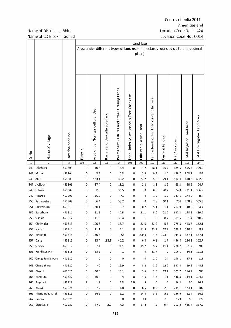
Census of India 2011- Amenities and
Name of District : Bhind Location Code No : 420Name of CD Block : Gohad Location Code No : 0014
Fore
sts
Are
a un
der
Non
-agr
icul
tura
l Use
s
Barr
en a
nd U
n-cu
ltiva
ble
land
Perm
anen
t Pas
ture
s an
d O
ther
Gra
zing
Lan
ds
Land
Und
er M
isce
llane
ous
Tree
Cro
ps e
tc.
Cultu
rabl
e W
aste
Lan
d
Fallo
w la
nds
othe
r th
an c
urre
nt fa
llow
s
Curr
ent F
allo
ws
Net
Are
a So
wn
Tota
l Irr
igat
ed L
and
Are
a
Tota
l Un-
irri
gate
d La
nd A
rea
1 2 3 104 105 106 107 108 109 110 111 112 113 114
Land UseArea under different types of land use ( in hectares rounded up to one decimal
place)
Sr.N
o.
Nam
e of
vill
age
Loca
tion
code
no.
544 Lahchura 453303 0 10.8 0 16.4 0 1.2 58.1 15.7 685.5 455.7 229.9
545 Maho 453304 0 3.6 0 0.3 0 2.5 9.2 1.4 439.7 303.7 136
546 Alori 453305 0 123.1 0 38.2 0 24.2 5.3 29.1 1102.4 410.2 692.2
547 Jyajipur 453306 0 27.4 0 18.2 0 2.2 1.1 1.2 85.3 60.6 24.7
548 Echaya 453307 0 116 0 36.5 0 0 0.6 20.2 598 291.1 306.9
549 Piparoli 453308 0 36.8 0 71 0 0 1.5 1.5 531.6 174.6 357
550 Kathawahazi 453309 0 66.4 0 53.2 0 0 7.8 10.1 764 208.8 555.3
551 Jhawalpura 453310 0 20.1 0 8.7 0 0.2 5.1 1.1 202.9 148.5 54.4
552 Barathara 453311 0 61.6 0 47.5 0 21.1 5.9 21.2 637.8 148.6 489.2
553 Sisonia 453312 0 11.5 0 38.4 0 1 0 8.7 301.6 61.4 240.2
554 Chhimaka 453313 0 100.6 0 25.7 0 22.5 32.2 5.3 775.8 413.7 362.1
555 Nawali 453314 0 21.1 0 6.1 0 11.9 45.7 17.7 128.8 120.6 8.2
556 Birkhadi 453315 0 130.8 0 22 0 100.9 4.3 123.4 944.3 387.1 557.1
557 Dang 453316 0 33.4 188.1 40.2 0 6.4 0.8 1.7 456.8 134.1 322.7
558 Sirsoda 453317 0 14 0 21.1 0 15.7 5.7 41.1 270.2 61.2 209
559 Rundhsarakar 453318 0 13.6 0 1 0 0 22.7 0 206.1 84.8 121.3
560 Gangadas Ka Pura 453319 0 0 0 0 0 0 2.9 27 158.1 47.1 111
561 Chandahara 453320 0 40 0 13.9 0 8.2 2.2 12.2 537.4 89.3 448.1
562 Bhyani 453321 0 20.9 0 10.1 0 3.5 2.5 13.4 323.7 114.7 209
563 Banipura 453322 0 46.4 0 4 0 4.6 4.5 11 448.8 144.1 304.7
564 Bagulari 453323 9 1.9 0 7.3 1.9 9 0 0 66.3 30 36.3
565 Khurd 453324 0 17 0 1.8 0 8.5 0.9 2.2 231.1 124.1 107
566 Khariamahanand 453325 0 14.6 0 1.2 0 14.4 5.2 5.2 156.6 62.4 94.2
567 Janora 453326 0 0 0 0 0 18 0 15 179 50 129
568 Bhagwasa 453327 0 47.2 3.9 4.3 0 17.2 3 9.4 652.8 435.4 217.5
314
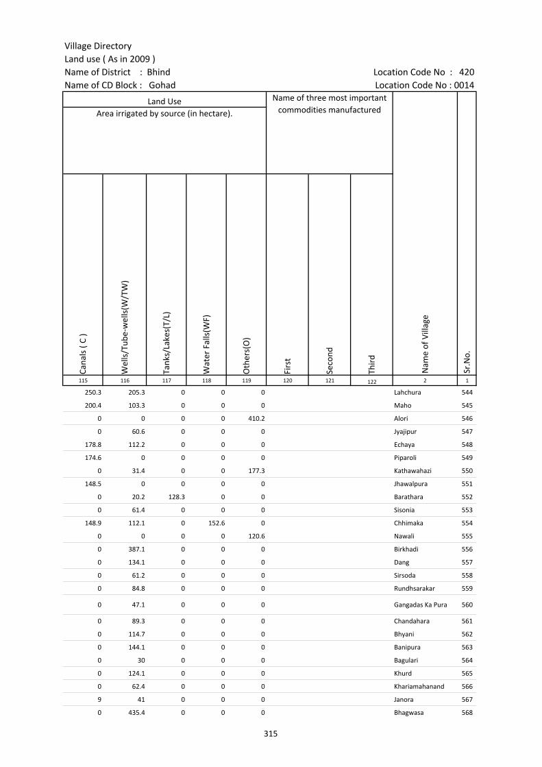
Village DirectoryLand use ( As in 2009 )Name of District : Bhind Location Code No : 420Name of CD Block : Gohad Location Code No : 0014
Cana
ls (
C )
Wel
ls/T
ube-
wel
ls(W
/TW
)
Tank
s/La
kes(
T/L)
Wat
er F
alls
(WF)
Oth
ers(
O)
Firs
t
Seco
nd
Thir
d 115 116 117 118 119 120 121 122 2 1
Land Use Name of three most important commodities manufactured
Nam
e of
Vill
age
Sr.N
o.
Area irrigated by source (in hectare).
250.3 205.3 0 0 0 Lahchura 544
200.4 103.3 0 0 0 Maho 545
0 0 0 0 410.2 Alori 546
0 60.6 0 0 0 Jyajipur 547
178.8 112.2 0 0 0 Echaya 548
174.6 0 0 0 0 Piparoli 549
0 31.4 0 0 177.3 Kathawahazi 550
148.5 0 0 0 0 Jhawalpura 551
0 20.2 128.3 0 0 Barathara 552
0 61.4 0 0 0 Sisonia 553
148.9 112.1 0 152.6 0 Chhimaka 554
0 0 0 0 120.6 Nawali 555
0 387.1 0 0 0 Birkhadi 556
0 134.1 0 0 0 Dang 557
0 61.2 0 0 0 Sirsoda 558
0 84.8 0 0 0 Rundhsarakar 559
0 47.1 0 0 0 Gangadas Ka Pura 560
0 89.3 0 0 0 Chandahara 561
0 114.7 0 0 0 Bhyani 562
0 144.1 0 0 0 Banipura 563
0 30 0 0 0 Bagulari 564
0 124.1 0 0 0 Khurd 565
0 62.4 0 0 0 Khariamahanand 566
9 41 0 0 0 Janora 567
0 435.4 0 0 0 Bhagwasa 568
315

Census of India 2011- Amenities and
Name of District : Bhind Location Code No : 420Name of CD Block : Gohad Location Code No : 0014
Pre-
Prim
ary
scho
ol (P
P)
Prim
ary
scho
ol (P
)
Mid
dle
scho
ol (M
)
Seco
ndar
y Sc
hool
(S)
Seni
or S
econ
dary
sch
ool (
SS)
Deg
ree
colle
ge o
f art
s s
cien
ce &
com
mer
ce (
ASC
)
Engi
neer
ing
colle
ge(E
C)
Med
ical
col
lege
(MC)
Man
agem
ent i
nstit
ute
(MI)
Poly
tech
nic
(Pt)
Voca
tiona
l tra
inin
g sc
hool
/IT
I
Non
-for
mal
trai
ning
cen
tre
(NFT
C)
Spec
ial s
choo
l for
dis
able
d (S
SD)
Oth
ers
(spe
cify
)
1 2 3 4 5 6 7 8 9 10 11 12 13 14 15 16 17 18 19 20
Sr.N
o.
Nam
e of
vill
age
Loca
tion
code
no.
Tota
l are
a of
the
villa
ge (
in h
ecta
res
roun
ded
up to
one
dec
imal
pla
ce)
Tota
l pop
ulat
ion
( 201
1 ce
nsus
)
Num
ber
of h
ouse
hold
s (2
011
cens
us)
Number of educational amenities available. (If not available within the village , the distance range
code viz; a for < 5 Kms, b for 5-10 Kms and c for 10+ kms of nearest place where facility is available is given).
569 Jatpura 453328 276.5 502 80 c 1 c c c c
570 Dhamsa 453329 534.9 1364 248 c 2 1 c c c c
571 Madanpura 453330 206.9 875 167 1 1 b c c c c c c c c c c c
572 Hanseliapura 453331 211.8 232 45 1 b b c c c c
573 Gadroli 453332 428.8 1323 312 c 1 c c c c c c c c c c c c
574 Palia 453333 126.4 277 69 1 b b c c c c c c c c c
575 Shyampura 453334 167 293 45 a 1 b c c c b b b c c c c
576 Hanumantpura 453335 179.1 734 149 c 1 c c c c c c c c c c c c
577 Paratappura 453336 197.5 328 56 c 1 c 1 c c c c c c c c c c
578 Habipura 453337 537.9 2033 360 c 2 1 c c c c c c
579 Baghora 453338 195.7 451 72 1 c c c c c c c c c c c
580 Bagharai 453339 429.8 653 134 1 1 c c c c c c c c c c c
581 Khitoli 453340 718.2 2588 420 c 2 2 1 c c c c c c c c c c
582 Sad(Kheria) 453341 511.7 1254 235 b 1 b b c c c c c c c c
583 Kathwagujar 453342 791.4 1443 300 1 3 2 b b b c c c c c c c c
584 Harpura 453343 183.8 574 105 a 1 a c c c c c c c c c c c
585 Badagar 453344 344.9 709 92 a 1 a a a b c c c c c c c c
586 Bankepur 453345 304.1 668 70 a 1 1 a a c c c c c c c c c
587 Ramanpura 453346 176.5 45 8 a a a a a c c c c c c c c
588 Itayali(Gohad) 453347 183.1 53 6 b a a b b c c c c c c c c
589 Kharaua 453348 954.3 1551 226 2 2 b b b c c c c c c c c
590 Kamalapur 453349 376.1 588 93 c 1 c c c c c c c c c c c c
591 Chharenta (Gohad) 453350 620 547 89 1 b b b c c c c c c c c c
592 Madhogarh 453351 192.6 679 138 1 c c c c
593 Kiratpura(Gohad) 453352 129.7 116 25 c 1 c c
316
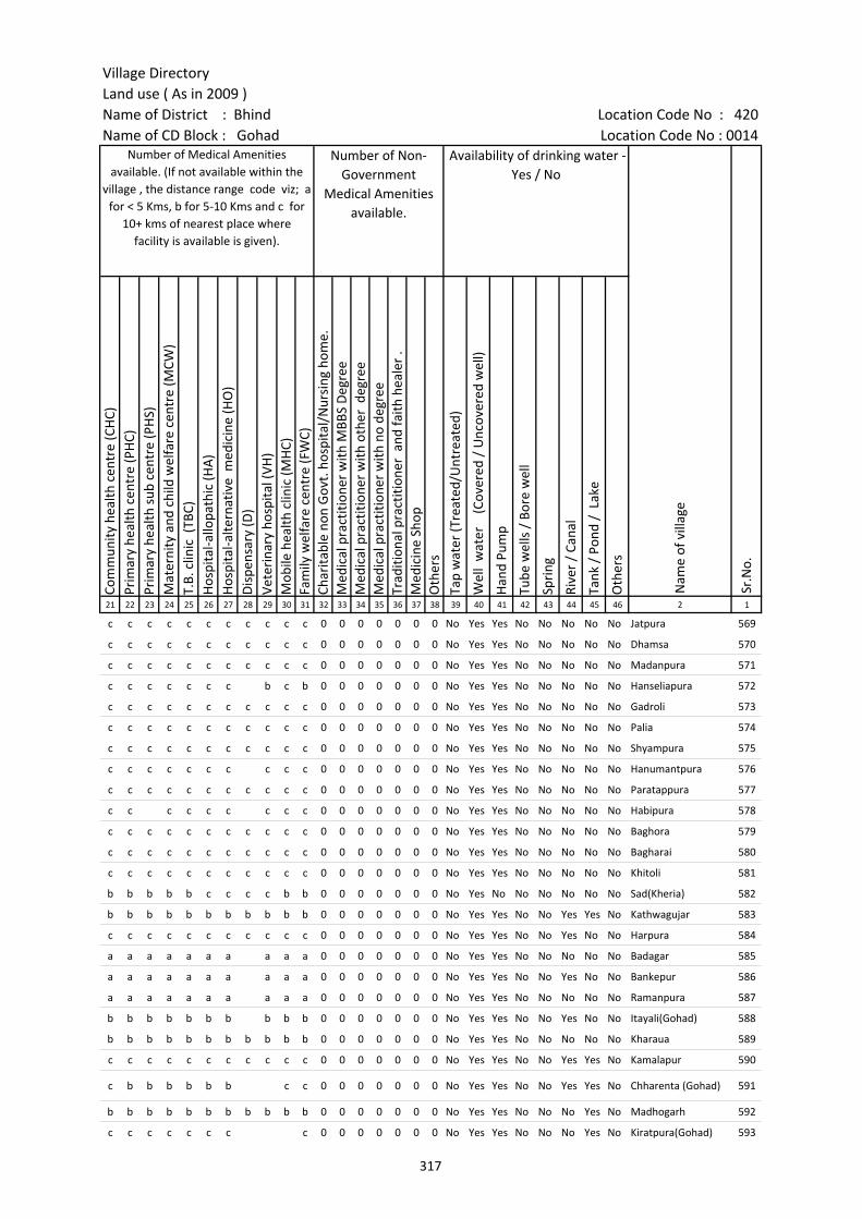
Village DirectoryLand use ( As in 2009 )Name of District : Bhind Location Code No : 420Name of CD Block : Gohad Location Code No : 0014
Com
mun
ity h
ealth
cen
tre
(CH
C)Pr
imar
y he
alth
cen
tre
(PH
C)Pr
imar
y he
alth
sub
cen
tre
(PH
S)M
ater
nity
and
chi
ld w
elfa
re c
entr
e (M
CW)
T.B.
clin
ic (
TBC)
Hos
pita
l-allo
path
ic (H
A)
Hos
pita
l-alte
rnat
ive
med
icin
e (H
O)
Dis
pens
ary
(D)
Vete
rina
ry h
ospi
tal (
VH)
Mob
ile h
ealth
clin
ic (M
HC)
Fam
ily w
elfa
re c
entr
e (F
WC)
Char
itabl
e no
n G
ovt.
hos
pita
l/N
ursi
ng h
ome.
Med
ical
pra
ctiti
oner
with
MBB
S D
egre
eM
edic
al p
ract
ition
er w
ith o
ther
deg
ree
Med
ical
pra
ctiti
oner
with
no
degr
eeTr
aditi
onal
pra
ctiti
oner
and
faith
hea
ler
.M
edic
ine
Shop
Oth
ers
Tap
wat
er (T
reat
ed/U
ntre
ated
)
Wel
l w
ater
(C
over
ed /
Unc
over
ed w
ell)
Han
d Pu
mp
Tube
wel
ls /
Bor
e w
ell
Spri
ng
Rive
r /
Cana
l
Tank
/ P
ond
/ L
ake
Oth
ers
21 22 23 24 25 26 27 28 29 30 31 32 33 34 35 36 37 38 39 40 41 42 43 44 45 46 2 1
Number of Medical Amenities available. (If not available within the
village , the distance range code viz; a for < 5 Kms, b for 5-10 Kms and c for
10+ kms of nearest place where facility is available is given).
Number of Non-Government
Medical Amenities available.
Availability of drinking water - Yes / No
Nam
e of
vill
age
Sr.N
o.
c c c c c c c c c c c 0 0 0 0 0 0 0 No Yes Yes No No No No No Jatpura 569
c c c c c c c c c c c 0 0 0 0 0 0 0 No Yes Yes No No No No No Dhamsa 570
c c c c c c c c c c c 0 0 0 0 0 0 0 No Yes Yes No No No No No Madanpura 571
c c c c c c c b c b 0 0 0 0 0 0 0 No Yes Yes No No No No No Hanseliapura 572
c c c c c c c c c c c 0 0 0 0 0 0 0 No Yes Yes No No No No No Gadroli 573
c c c c c c c c c c c 0 0 0 0 0 0 0 No Yes Yes No No No No No Palia 574
c c c c c c c c c c c 0 0 0 0 0 0 0 No Yes Yes No No No No No Shyampura 575
c c c c c c c c c c 0 0 0 0 0 0 0 No Yes Yes No No No No No Hanumantpura 576
c c c c c c c c c c c 0 0 0 0 0 0 0 No Yes Yes No No No No No Paratappura 577
c c c c c c c c c 0 0 0 0 0 0 0 No Yes Yes No No No No No Habipura 578
c c c c c c c c c c c 0 0 0 0 0 0 0 No Yes Yes No No No No No Baghora 579
c c c c c c c c c c c 0 0 0 0 0 0 0 No Yes Yes No No No No No Bagharai 580
c c c c c c c c c c c 0 0 0 0 0 0 0 No Yes Yes No No No No No Khitoli 581
b b b b b c c c c b b 0 0 0 0 0 0 0 No Yes No No No No No No Sad(Kheria) 582
b b b b b b b b b b b 0 0 0 0 0 0 0 No Yes Yes No No Yes Yes No Kathwagujar 583
c c c c c c c c c c c 0 0 0 0 0 0 0 No Yes Yes No No Yes No No Harpura 584
a a a a a a a a a a 0 0 0 0 0 0 0 No Yes Yes No No No No No Badagar 585
a a a a a a a a a a 0 0 0 0 0 0 0 No Yes Yes No No Yes No No Bankepur 586
a a a a a a a a a a 0 0 0 0 0 0 0 No Yes Yes No No No No No Ramanpura 587
b b b b b b b b b b 0 0 0 0 0 0 0 No Yes Yes No No Yes No No Itayali(Gohad) 588
b b b b b b b b b b b 0 0 0 0 0 0 0 No Yes Yes No No No No No Kharaua 589
c c c c c c c c c c c 0 0 0 0 0 0 0 No Yes Yes No No Yes Yes No Kamalapur 590
c b b b b b b c c 0 0 0 0 0 0 0 No Yes Yes No No Yes Yes No Chharenta (Gohad) 591
b b b b b b b b b b b 0 0 0 0 0 0 0 No Yes Yes No No No Yes No Madhogarh 592
c c c c c c c c 0 0 0 0 0 0 0 No Yes Yes No No No Yes No Kiratpura(Gohad) 593
317
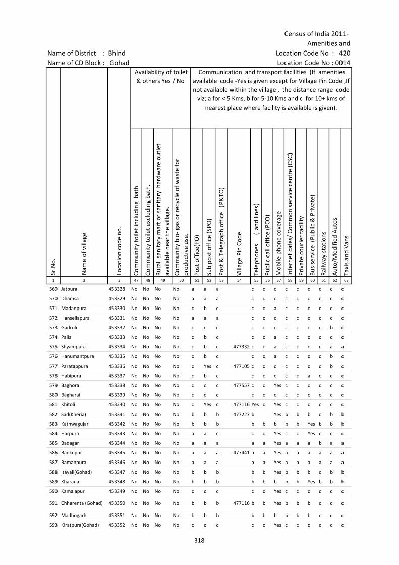
Census of India 2011- Amenities and
Name of District : Bhind Location Code No : 420Name of CD Block : Gohad Location Code No : 0014
Com
mun
ity to
ilet i
nclu
ding
bat
h.
Com
mun
ity to
ilet e
xclu
ding
bat
h.
Rura
l sa
nita
ry m
art o
r sa
nita
ry h
ardw
are
outle
t av
aila
ble
near
the
villa
ge.
Com
mun
ity b
io- g
as o
r re
cycl
e of
was
te fo
r pr
oduc
tive
use.
Post
off
ice(
PO)
Sub
post
off
ice
(SPO
)
Post
& T
eleg
raph
off
ice
(P&
TO)
Villa
ge P
in C
ode
Tele
phon
es
(L
and
lines
)
Publ
ic c
all o
ffic
e (P
CO)
Mob
ile p
hone
cov
erag
e
Inte
rnet
caf
es/
Com
mon
ser
vice
cen
tre
(CSC
)
Priv
ate
cour
ier
faci
lity
Bus
serv
ice
(Pub
lic &
Pri
vate
)
Railw
ay s
tatio
ns
Aut
o/M
odifi
ed A
utos
Taxi
s an
d Va
ns
1 2 3 47 48 49 50 51 52 53 54 55 56 57 58 59 60 61 62 63
Sr.N
o.
Nam
e of
vill
age
Loca
tion
code
no.
Availability of toilet & others Yes / No
Communication and transport facilities (If amenities available code -Yes is given except for Village Pin Code ,If not available within the village , the distance range code
viz; a for < 5 Kms, b for 5-10 Kms and c for 10+ kms of nearest place where facility is available is given).
569 Jatpura 453328 No No No No a a a c c c c c c c c c
570 Dhamsa 453329 No No No No a a a c c c c c c c c c
571 Madanpura 453330 No No No No c b c c c a c c c c c c
572 Hanseliapura 453331 No No No No a a a c c c c c c c c c
573 Gadroli 453332 No No No No c c c c c c c c c c b c
574 Palia 453333 No No No No c b c c c a c c c c c c
575 Shyampura 453334 No No No No c b c 477332 c c a c c c c a a
576 Hanumantpura 453335 No No No No c b c c c a c c c c b c
577 Paratappura 453336 No No No No c Yes c 477105 c c c c c c c b c
578 Habipura 453337 No No No No c b c c c c c c a c c c
579 Baghora 453338 No No No No c c c 477557 c c Yes c c c c c c
580 Bagharai 453339 No No No No c c c c c c c c c c c c
581 Khitoli 453340 No No No No c Yes c 477116 Yes c Yes c c c c c c
582 Sad(Kheria) 453341 No No No No b b b 477227 b Yes b b b c b b
583 Kathwagujar 453342 No No No No b b b b b b b b Yes b b b
584 Harpura 453343 No No No No a a c c c Yes c c Yes c c c
585 Badagar 453344 No No No No a a a a a Yes a a a b a a
586 Bankepur 453345 No No No No a a a 477441 a a Yes a a a a a a
587 Ramanpura 453346 No No No No a a a a a Yes a a a a a a
588 Itayali(Gohad) 453347 No No No No b b b b b Yes b b b c b b
589 Kharaua 453348 No No No No b b b b b b b b Yes b b b
590 Kamalapur 453349 No No No No c c c c c Yes c c c c c c
591 Chharenta (Gohad) 453350 No No No No b b b 477116 b b Yes b b b c c c
592 Madhogarh 453351 No No No No b b b b b b b b b c c c
593 Kiratpura(Gohad) 453352 No No No No c c c c c Yes c c c c c c
318
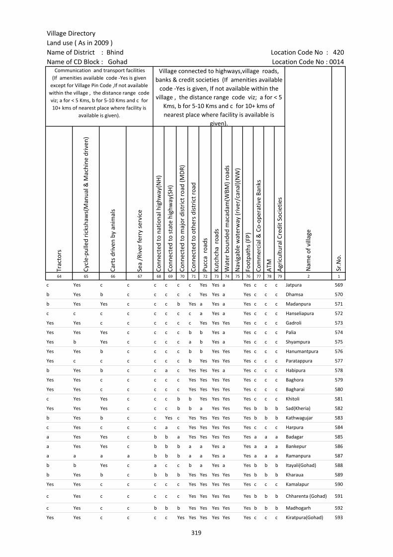
Village DirectoryLand use ( As in 2009 )Name of District : Bhind Location Code No : 420Name of CD Block : Gohad Location Code No : 0014
Trac
tors
Cycl
e-pu
lled
rick
shaw
s(M
anua
l & M
achi
ne d
rive
n)
Cart
s dr
iven
by
anim
als
Sea
/Riv
er fe
rry
serv
ice
Conn
ecte
d to
nat
iona
l hig
hway
(NH
)
Conn
ecte
d to
sta
te h
ighw
ay(S
H)
Conn
ecte
d to
maj
or d
istr
ict r
oad
(MD
R)
Conn
ecte
d to
oth
ers
dist
rict
roa
d
Pucc
a r
oads
Kutc
hcha
roa
ds
Wat
er b
ound
ed m
acad
am(W
BM) r
oads
Nav
igab
le w
ater
way
(riv
er/c
anal
)(N
W)
Foot
path
s (F
P)
Com
mer
cial
& C
o-op
erat
ive
Bank
s
ATM
Agr
icul
tura
l Cre
dit S
ocie
ties
64 65 66 67 68 69 70 71 72 73 74 75 76 77 78 79 2 1
Sr.N
o.
Communication and transport facilities (If amenities available code -Yes is given
except for Village Pin Code ,If not available within the village , the distance range code viz; a for < 5 Kms, b for 5-10 Kms and c for 10+ kms of nearest place where facility is
available is given).
Village connected to highways,village roads, banks & credit societies (If amenities available
code -Yes is given, If not available within the village , the distance range code viz; a for < 5
Kms, b for 5-10 Kms and c for 10+ kms of nearest place where facility is available is
given).
Nam
e of
vill
age
c Yes c c c c c c Yes Yes a Yes c c c Jatpura 569
b Yes b c c c c c Yes Yes a Yes c c c Dhamsa 570
b Yes Yes c c c b Yes a Yes a Yes c c c Madanpura 571
c c c c c c c c a Yes a Yes c c c Hanseliapura 572
Yes Yes c c c c c c Yes Yes Yes Yes c c c Gadroli 573
Yes Yes Yes c c c c b b Yes a Yes c c c Palia 574
Yes b Yes c c c c a b Yes a Yes c c c Shyampura 575
Yes Yes b c c c c b b Yes Yes Yes c c c Hanumantpura 576
Yes c c c c c c b Yes Yes Yes Yes c c c Paratappura 577
b Yes b c c a c Yes Yes Yes a Yes c c c Habipura 578
Yes Yes c c c c c Yes Yes Yes Yes Yes c c c Baghora 579
Yes Yes c c c c c Yes Yes Yes Yes Yes c c c Bagharai 580
c Yes Yes c c c b b Yes Yes Yes Yes c c c Khitoli 581
Yes Yes Yes c c c b b a Yes Yes Yes b b b Sad(Kheria) 582
b Yes b c c Yes c Yes Yes Yes Yes Yes b b b Kathwagujar 583
c Yes c c c a c Yes Yes Yes Yes Yes c c c Harpura 584
a Yes Yes c b b a Yes Yes Yes Yes Yes a a a Badagar 585
a Yes Yes c b b b a a Yes a Yes a a a Bankepur 586
a a a a b b b a a Yes a Yes a a a Ramanpura 587
b b Yes c a c c b a Yes a Yes b b b Itayali(Gohad) 588
b Yes b c b b b Yes Yes Yes Yes Yes b b b Kharaua 589
Yes Yes c c c c c Yes Yes Yes Yes Yes c c c Kamalapur 590
c Yes c c c c c Yes Yes Yes Yes Yes b b b Chharenta (Gohad) 591
c Yes c c b b b Yes Yes Yes Yes Yes b b b Madhogarh 592
Yes Yes c c c c Yes Yes Yes Yes Yes Yes c c c Kiratpura(Gohad) 593
319
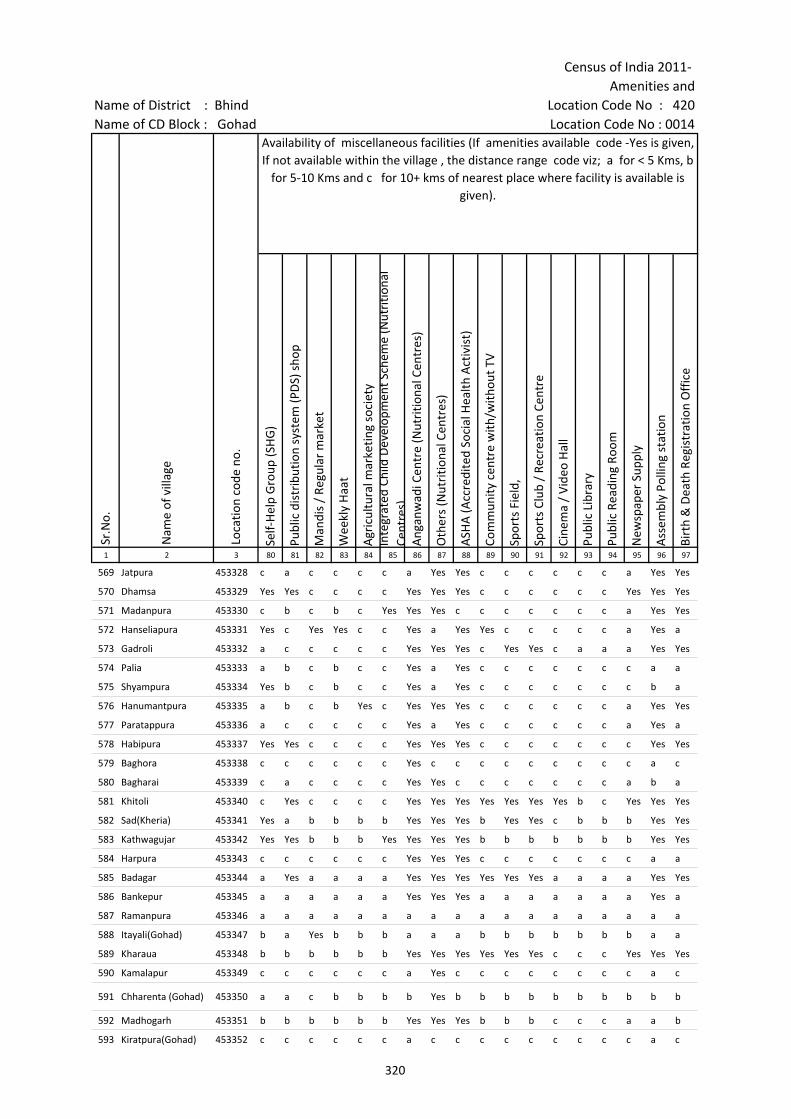
Census of India 2011- Amenities and
Name of District : Bhind Location Code No : 420Name of CD Block : Gohad Location Code No : 0014
Self-
Hel
p G
roup
(SH
G)
Publ
ic d
istr
ibut
ion
syst
em (P
DS)
sho
p
Man
dis
/ Re
gula
r m
arke
t
Wee
kly
Haa
t
Agr
icul
tura
l mar
ketin
g so
ciet
yIn
tegr
ated
Chi
ld D
evel
opm
ent S
chem
e (N
utri
tiona
l Ce
ntre
s)A
ngan
wad
i Cen
tre
(Nut
ritio
nal C
entr
es)
Oth
ers
(Nut
ritio
nal C
entr
es)
ASH
A (A
ccre
dite
d So
cial
Hea
lth A
ctiv
ist)
Com
mun
ity c
entr
e w
ith/w
ithou
t TV
Spor
ts F
ield
,
Spor
ts C
lub
/ Re
crea
tion
Cent
re
Cine
ma
/ Vi
deo
Hal
l
Publ
ic L
ibra
ry
Publ
ic R
eadi
ng R
oom
New
spap
er S
uppl
y
Ass
embl
y Po
lling
sta
tion
Birt
h &
Dea
th R
egis
trat
ion
Off
ice
1 2 3 80 81 82 83 84 85 86 87 88 89 90 91 92 93 94 95 96 97
Sr.N
o.
Nam
e of
vill
age
Loca
tion
code
no.
Availability of miscellaneous facilities (If amenities available code -Yes is given, If not available within the village , the distance range code viz; a for < 5 Kms, b
for 5-10 Kms and c for 10+ kms of nearest place where facility is available is given).
569 Jatpura 453328 c a c c c c a Yes Yes c c c c c c a Yes Yes
570 Dhamsa 453329 Yes Yes c c c c Yes Yes Yes c c c c c c Yes Yes Yes
571 Madanpura 453330 c b c b c Yes Yes Yes c c c c c c c a Yes Yes
572 Hanseliapura 453331 Yes c Yes Yes c c Yes a Yes Yes c c c c c a Yes a
573 Gadroli 453332 a c c c c c Yes Yes Yes c Yes Yes c a a a Yes Yes
574 Palia 453333 a b c b c c Yes a Yes c c c c c c c a a
575 Shyampura 453334 Yes b c b c c Yes a Yes c c c c c c c b a
576 Hanumantpura 453335 a b c b Yes c Yes Yes Yes c c c c c c a Yes Yes
577 Paratappura 453336 a c c c c c Yes a Yes c c c c c c a Yes a
578 Habipura 453337 Yes Yes c c c c Yes Yes Yes c c c c c c c Yes Yes
579 Baghora 453338 c c c c c c Yes c c c c c c c c c a c
580 Bagharai 453339 c a c c c c Yes Yes c c c c c c c a b a
581 Khitoli 453340 c Yes c c c c Yes Yes Yes Yes Yes Yes Yes b c Yes Yes Yes
582 Sad(Kheria) 453341 Yes a b b b b Yes Yes Yes b Yes Yes c b b b Yes Yes
583 Kathwagujar 453342 Yes Yes b b b Yes Yes Yes Yes b b b b b b b Yes Yes
584 Harpura 453343 c c c c c c Yes Yes Yes c c c c c c c a a
585 Badagar 453344 a Yes a a a a Yes Yes Yes Yes Yes Yes a a a a Yes Yes
586 Bankepur 453345 a a a a a a Yes Yes Yes a a a a a a a Yes a
587 Ramanpura 453346 a a a a a a a a a a a a a a a a a a
588 Itayali(Gohad) 453347 b a Yes b b b a a a b b b b b b b a a
589 Kharaua 453348 b b b b b b Yes Yes Yes Yes Yes Yes c c c Yes Yes Yes
590 Kamalapur 453349 c c c c c c a Yes c c c c c c c c a c
591 Chharenta (Gohad) 453350 a a c b b b b Yes b b b b b b b b b b
592 Madhogarh 453351 b b b b b b Yes Yes Yes b b b c c c a a b
593 Kiratpura(Gohad) 453352 c c c c c c a c c c c c c c c c a c
320
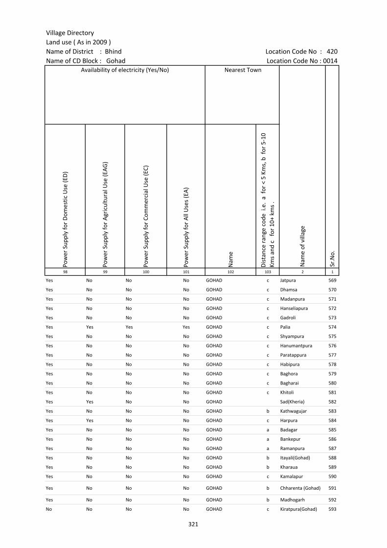
Village DirectoryLand use ( As in 2009 )Name of District : Bhind Location Code No : 420Name of CD Block : Gohad Location Code No : 0014
Pow
er S
uppl
y fo
r D
omes
tic U
se (E
D)
Pow
er S
uppl
y fo
r A
gric
ultu
ral U
se (E
AG
)
Pow
er S
uppl
y fo
r Co
mm
erci
al U
se (E
C)
Pow
er S
uppl
y fo
r A
ll U
ses
(EA
)
Nam
e
Dis
tanc
e ra
nge
code
i.e
. a
for
< 5
Kms,
b f
or 5
-10
Kms
and
c f
or 1
0+ k
ms
.98 99 100 101 102 103 2 1
Nearest Town
Nam
e of
vill
age
Sr.N
o.
Availability of electricity (Yes/No)
Yes No No No GOHAD c Jatpura 569
Yes No No No GOHAD c Dhamsa 570
Yes No No No GOHAD c Madanpura 571
Yes No No No GOHAD c Hanseliapura 572
Yes No No No GOHAD c Gadroli 573
Yes Yes Yes Yes GOHAD c Palia 574
Yes No No No GOHAD c Shyampura 575
Yes No No No GOHAD c Hanumantpura 576
Yes No No No GOHAD c Paratappura 577
Yes No No No GOHAD c Habipura 578
Yes No No No GOHAD c Baghora 579
Yes No No No GOHAD c Bagharai 580
Yes No No No GOHAD c Khitoli 581
Yes Yes No No GOHAD Sad(Kheria) 582
Yes No No No GOHAD b Kathwagujar 583
Yes Yes No No GOHAD c Harpura 584
Yes No No No GOHAD a Badagar 585
Yes No No No GOHAD a Bankepur 586
Yes No No No GOHAD a Ramanpura 587
Yes No No No GOHAD b Itayali(Gohad) 588
Yes No No No GOHAD b Kharaua 589
Yes No No No GOHAD c Kamalapur 590
Yes No No No GOHAD b Chharenta (Gohad) 591
Yes No No No GOHAD b Madhogarh 592
No No No No GOHAD c Kiratpura(Gohad) 593
321
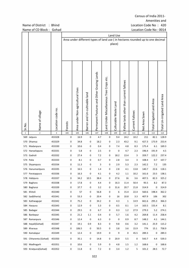
Census of India 2011- Amenities and
Name of District : Bhind Location Code No : 420Name of CD Block : Gohad Location Code No : 0014
Fore
sts
Are
a un
der
Non
-agr
icul
tura
l Use
s
Barr
en a
nd U
n-cu
ltiva
ble
land
Perm
anen
t Pas
ture
s an
d O
ther
Gra
zing
Lan
ds
Land
Und
er M
isce
llane
ous
Tree
Cro
ps e
tc.
Cultu
rabl
e W
aste
Lan
d
Fallo
w la
nds
othe
r th
an c
urre
nt fa
llow
s
Curr
ent F
allo
ws
Net
Are
a So
wn
Tota
l Irr
igat
ed L
and
Are
a
Tota
l Un-
irri
gate
d La
nd A
rea
1 2 3 104 105 106 107 108 109 110 111 112 113 114
Land UseArea under different types of land use ( in hectares rounded up to one decimal
place)
Sr.N
o.
Nam
e of
vill
age
Loca
tion
code
no.
569 Jatpura 453328 0 16.9 0 4.7 0 9.4 24.2 10.2 211 82.1 128.9
570 Dhamsa 453329 0 34.8 0 18.2 0 2.3 43.2 9.1 427.3 173.9 253.4
571 Madanpura 453330 0 10.6 0 0.4 0 7.4 4.8 8.3 175.4 6.1 169.3
572 Hanseliapura 453331 0 5.8 0 2.5 0 0 4.7 2.3 196.4 191.9 4.5
573 Gadroli 453332 0 27.4 0 7.2 0 18.2 13.4 3 359.7 122.2 237.4
574 Palia 453333 0 8.1 0 0.7 0 2.8 3.4 3 108.4 0.7 107.7
575 Shyampura 453334 0 11.3 0 3 0 2.9 5.3 2.3 142.2 7.2 135
576 Hanumantpura 453335 0 16.5 0 1.4 0 2.8 4.1 13.8 140.7 22.6 118.1
577 Paratappura 453336 0 16.3 0 4.1 0 4.2 1.1 10.2 161.6 23.5 138.1
578 Habipura 453337 0 34.2 10.5 38.4 0 27.6 16 3.6 407.5 82.3 325.2
579 Baghora 453338 0 17.8 0 4.4 0 16.3 11.4 50.4 95.5 8.2 87.3
580 Bagharai 453339 0 37.7 0 3.2 0 31.6 20.7 21.8 314.9 0 314.9
581 Khitoli 453340 0 57 0 56.8 0 6 15.4 22.4 560.6 198.4 362.2
582 Sad(Kheria) 453341 0 53.3 0 20.4 0 16 10.8 3.3 407.9 106 302
583 Kathwagujar 453342 0 75.2 0 34.2 0 4.3 1 14.9 661.6 295.3 366.3
584 Harpura 453343 0 12.9 0 5.3 0 0.5 0.1 1.4 163.5 155.4 8.1
585 Badagar 453344 0 29.5 0 6.7 0 0.3 1.2 27.9 279.3 5.2 274.1
586 Bankepur 453345 0 21.2 1.1 0.4 0 5.7 1.6 4.2 269.8 11.4 258.4
587 Ramanpura 453346 0 12.4 0 6.3 0 0 0.9 8.7 148.2 4.1 144.1
588 Itayali(Gohad) 453347 0 19.1 0.9 8.3 0 9.8 0.6 3.2 141.1 25.9 115.2
589 Kharaua 453348 0 106.5 0 50.5 0 3.8 3.6 15.9 774 15.1 758.9
590 Kamalapur 453349 0 12.4 0 19.9 0 9 0 45.5 289.3 0 289.3
591 Chharenta (Gohad) 453350 0 35.1 0 14.8 0 20.9 5.5 0 543.7 4.4 539.3
592 Madhogarh 453351 0 10.6 0 5.9 0 4.8 1.5 1.2 168.6 0 168.6
593 Kiratpura(Gohad) 453352 0 11.8 0 7.2 0 3.4 1.2 5 101.2 28.5 72.7
322
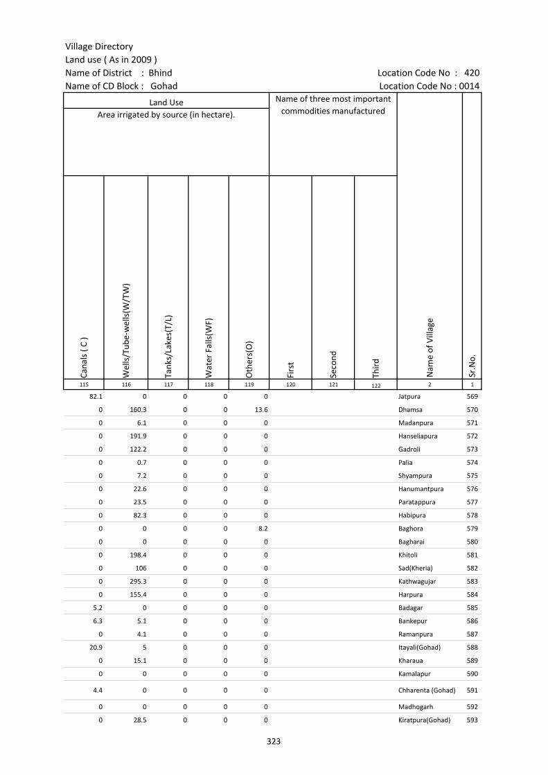
Village DirectoryLand use ( As in 2009 )Name of District : Bhind Location Code No : 420Name of CD Block : Gohad Location Code No : 0014
Cana
ls (
C )
Wel
ls/T
ube-
wel
ls(W
/TW
)
Tank
s/La
kes(
T/L)
Wat
er F
alls
(WF)
Oth
ers(
O)
Firs
t
Seco
nd
Thir
d 115 116 117 118 119 120 121 122 2 1
Land Use Name of three most important commodities manufactured
Nam
e of
Vill
age
Sr.N
o.
Area irrigated by source (in hectare).
82.1 0 0 0 0 Jatpura 569
0 160.3 0 0 13.6 Dhamsa 570
0 6.1 0 0 0 Madanpura 571
0 191.9 0 0 0 Hanseliapura 572
0 122.2 0 0 0 Gadroli 573
0 0.7 0 0 0 Palia 574
0 7.2 0 0 0 Shyampura 575
0 22.6 0 0 0 Hanumantpura 576
0 23.5 0 0 0 Paratappura 577
0 82.3 0 0 0 Habipura 578
0 0 0 0 8.2 Baghora 579
0 0 0 0 0 Bagharai 580
0 198.4 0 0 0 Khitoli 581
0 106 0 0 0 Sad(Kheria) 582
0 295.3 0 0 0 Kathwagujar 583
0 155.4 0 0 0 Harpura 584
5.2 0 0 0 0 Badagar 585
6.3 5.1 0 0 0 Bankepur 586
0 4.1 0 0 0 Ramanpura 587
20.9 5 0 0 0 Itayali(Gohad) 588
0 15.1 0 0 0 Kharaua 589
0 0 0 0 0 Kamalapur 590
4.4 0 0 0 0 Chharenta (Gohad) 591
0 0 0 0 0 Madhogarh 592
0 28.5 0 0 0 Kiratpura(Gohad) 593
323

Census of India 2011- Amenities and
Name of District : Bhind Location Code No : 420Name of CD Block : Gohad Location Code No : 0014
Pre-
Prim
ary
scho
ol (P
P)
Prim
ary
scho
ol (P
)
Mid
dle
scho
ol (M
)
Seco
ndar
y Sc
hool
(S)
Seni
or S
econ
dary
sch
ool (
SS)
Deg
ree
colle
ge o
f art
s s
cien
ce &
com
mer
ce (
ASC
)
Engi
neer
ing
colle
ge(E
C)
Med
ical
col
lege
(MC)
Man
agem
ent i
nstit
ute
(MI)
Poly
tech
nic
(Pt)
Voca
tiona
l tra
inin
g sc
hool
/IT
I
Non
-for
mal
trai
ning
cen
tre
(NFT
C)
Spec
ial s
choo
l for
dis
able
d (S
SD)
Oth
ers
(spe
cify
)
1 2 3 4 5 6 7 8 9 10 11 12 13 14 15 16 17 18 19 20
Sr.N
o.
Nam
e of
vill
age
Loca
tion
code
no.
Tota
l are
a of
the
villa
ge (
in h
ecta
res
roun
ded
up to
one
dec
imal
pla
ce)
Tota
l pop
ulat
ion
( 201
1 ce
nsus
)
Num
ber
of h
ouse
hold
s (2
011
cens
us)
Number of educational amenities available. (If not available within the village , the distance range
code viz; a for < 5 Kms, b for 5-10 Kms and c for 10+ kms of nearest place where facility is available is given).
594 Baroa 453353 126.4 220 36 1 1 a c c c c c c c c c
595 Khader 453354 683.8 1161 171 1 1 b b c c c c c c c c c
596 Bagthara 453355 490 975 184 1 2 a b b c c c c c c c c c
597 Pipersana 453356 2239.6 3214 561 1 4 1 c c c c c c c c c c c
598 Badera 453357 410.2 1634 229 c 1 1 b b c c c c c c c c
599 Rampura 453358 539.2 1139 182 b 1 b c c c c c c c c c c
600 Dirman 453359 554.1 899 191 1 1 b c c c c c c c c c c c
601 Bilpura 453360 175.5 445 99 2 1 b c c c c c c c c c c
602 Bhypura 453361 175.5 256 69 1 a b c c c c c c c c c c
603 Pali(Dirman) 453362 1199.7 3050 652 4 1 c c c c c c c c
604 Annayach 453363 233.1 531 120 2 b b c c c c c c c c c c
605 Hadiapura 453364 118.7 388 87 2 b b c c c c c c c c c
606 Kaliyanpura 453365 196.2 668 160 1 b b c c c c c c c c c c
607 Jangalpura 453366 147.7 377 87 2 b b c c c c
608 Chitora 453367 781.2 2168 411 5 4 1 c c c c c c c c c
609 Chamhedi 453368 912.3 1655 397 3 1 c c c c c c c c c c
610 Nibrol 453369 852.1 1875 323 1 2 c c c c c c c c c c c
611 Girgaon 453370 350.2 1241 190 1 1 1 b b c c c c c c c c
612 Ratanpura 453371 160.8 338 76 c 1 a b b c c c c c c c c
613 Kheriagaju 453372 186.5 136 33 c 1 a b b c c c c c c c c
614 Jhankari 453373 500.8 1296 250 1 1 2 c c c c c c c c c
615 Neerpura 453374 336.5 1020 180 1 a a c c c c c c c c c
616 Makrenta 453375 315.1 789 141 1 c c c c c c c c c c c
617 Etayada 453376 777.2 1611 230 2 1 1 a c c c c c c c
618 Pipahada 453377 455.8 954 222 c 1 1 b b c c c c c c c
619 Silonha 453378 438 803 157 1 1 a a c c c c c c c
324

Village DirectoryLand use ( As in 2009 )Name of District : Bhind Location Code No : 420Name of CD Block : Gohad Location Code No : 0014
Com
mun
ity h
ealth
cen
tre
(CH
C)Pr
imar
y he
alth
cen
tre
(PH
C)Pr
imar
y he
alth
sub
cen
tre
(PH
S)M
ater
nity
and
chi
ld w
elfa
re c
entr
e (M
CW)
T.B.
clin
ic (
TBC)
Hos
pita
l-allo
path
ic (H
A)
Hos
pita
l-alte
rnat
ive
med
icin
e (H
O)
Dis
pens
ary
(D)
Vete
rina
ry h
ospi
tal (
VH)
Mob
ile h
ealth
clin
ic (M
HC)
Fam
ily w
elfa
re c
entr
e (F
WC)
Char
itabl
e no
n G
ovt.
hos
pita
l/N
ursi
ng h
ome.
Med
ical
pra
ctiti
oner
with
MBB
S D
egre
eM
edic
al p
ract
ition
er w
ith o
ther
deg
ree
Med
ical
pra
ctiti
oner
with
no
degr
eeTr
aditi
onal
pra
ctiti
oner
and
faith
hea
ler
.M
edic
ine
Shop
Oth
ers
Tap
wat
er (T
reat
ed/U
ntre
ated
)
Wel
l w
ater
(C
over
ed /
Unc
over
ed w
ell)
Han
d Pu
mp
Tube
wel
ls /
Bor
e w
ell
Spri
ng
Rive
r /
Cana
l
Tank
/ P
ond
/ L
ake
Oth
ers
21 22 23 24 25 26 27 28 29 30 31 32 33 34 35 36 37 38 39 40 41 42 43 44 45 46 2 1
Number of Medical Amenities available. (If not available within the
village , the distance range code viz; a for < 5 Kms, b for 5-10 Kms and c for
10+ kms of nearest place where facility is available is given).
Number of Non-Government
Medical Amenities available.
Availability of drinking water - Yes / No
Nam
e of
vill
age
Sr.N
o.
c a a a a a a c c 0 0 0 0 0 0 0 No Yes Yes No No No No No Baroa 594
c c c 0 0 0 0 0 0 0 No Yes Yes No No No Yes No Khader 595
c b b b b b c c 0 0 0 0 0 0 0 No Yes Yes No No No No No Bagthara 596
c c c c c c 1 c c c 0 0 0 0 0 0 0 Yes Yes Yes Yes No No No No Pipersana 597
c c c c c c c c c c c 0 0 0 0 0 0 0 No Yes Yes No No No No No Badera 598
c c c c c c c c c c c 0 0 0 0 0 0 0 No Yes Yes No No No No No Rampura 599
c b c b c c c b 0 0 0 0 0 0 0 No Yes Yes No No No No No Dirman 600
c b c c b c c c b 0 0 0 0 0 0 0 No Yes Yes No No No No No Bilpura 601
c b c c b c c c b 0 0 0 0 0 0 0 No Yes Yes No No No No No Bhypura 602
c b c b c c c c b 0 0 0 0 0 0 0 No Yes Yes Yes No No No No Pali(Dirman) 603
c c c 0 0 0 0 0 0 0 No Yes Yes No No No No No Annayach 604
c c c c c c c c c c c 0 0 0 0 0 0 0 No Yes Yes No No No No No Hadiapura 605
c c c c c c c c c 0 0 0 0 0 0 0 No Yes Yes No No No No No Kaliyanpura 606
c c c c c c c c c c c 0 0 0 0 0 0 0 No Yes Yes No No No No No Jangalpura 607
c b b b b c c 1 c c c 0 0 0 0 3 0 0 No Yes Yes Yes No Yes No No Chitora 608
c c c c c c c c c c c 0 0 0 0 0 0 0 No Yes Yes No No No No No Chamhedi 609
c c b 0 0 0 0 0 0 0 No Yes Yes No No No No No Nibrol 610
c c b c c c c c c c 0 0 0 0 0 0 0 No Yes Yes Yes No No No No Girgaon 611
c c c c c c c c c c 0 0 0 0 0 0 0 No Yes Yes Yes No No No No Ratanpura 612
c c c c c c c c c c 0 0 0 0 0 0 0 No Yes Yes Yes No No No No Kheriagaju 613
c c c c c c c c c c c 0 0 0 0 0 0 0 No Yes Yes No No No No No Jhankari 614
c c c c c c c c c c 0 0 0 0 0 0 0 No Yes Yes No No No No No Neerpura 615
c c c c c c c c c c c 0 0 0 0 0 0 0 No Yes Yes No No No No No Makrenta 616
c c b c c c c c c 0 0 0 0 0 0 0 No Yes Yes Yes No No No No Etayada 617
c c b c c c c c c 0 0 0 0 0 0 0 No Yes Yes Yes No No No No Pipahada 618
c c b c c c c c c 0 0 0 0 0 0 0 No Yes Yes Yes No No No No Silonha 619
325

Census of India 2011- Amenities and
Name of District : Bhind Location Code No : 420Name of CD Block : Gohad Location Code No : 0014
Com
mun
ity to
ilet i
nclu
ding
bat
h.
Com
mun
ity to
ilet e
xclu
ding
bat
h.
Rura
l sa
nita
ry m
art o
r sa
nita
ry h
ardw
are
outle
t av
aila
ble
near
the
villa
ge.
Com
mun
ity b
io- g
as o
r re
cycl
e of
was
te fo
r pr
oduc
tive
use.
Post
off
ice(
PO)
Sub
post
off
ice
(SPO
)
Post
& T
eleg
raph
off
ice
(P&
TO)
Villa
ge P
in C
ode
Tele
phon
es
(L
and
lines
)
Publ
ic c
all o
ffic
e (P
CO)
Mob
ile p
hone
cov
erag
e
Inte
rnet
caf
es/
Com
mon
ser
vice
cen
tre
(CSC
)
Priv
ate
cour
ier
faci
lity
Bus
serv
ice
(Pub
lic &
Pri
vate
)
Railw
ay s
tatio
ns
Aut
o/M
odifi
ed A
utos
Taxi
s an
d Va
ns
1 2 3 47 48 49 50 51 52 53 54 55 56 57 58 59 60 61 62 63
Sr.N
o.
Nam
e of
vill
age
Loca
tion
code
no.
Availability of toilet & others Yes / No
Communication and transport facilities (If amenities available code -Yes is given except for Village Pin Code ,If not available within the village , the distance range code
viz; a for < 5 Kms, b for 5-10 Kms and c for 10+ kms of nearest place where facility is available is given).
594 Baroa 453353 No No No No a a a a a a a a a b a a
595 Khader 453354 No No No No b b b b b Yes b b Yes Yes b b
596 Bagthara 453355 No No No No b a b b b Yes b b Yes c c c
597 Pipersana 453356 No No No No Yes c Yes 477116 b Yes Yes c c Yes c c c
598 Badera 453357 No No No No c c c c c Yes c c c c c c
599 Rampura 453358 No No No No c c c c c Yes c c c c c c
600 Dirman 453359 No No No No a c c c c Yes c c Yes c c c
601 Bilpura 453360 No No No No a c c c c a c c Yes c c c
602 Bhypura 453361 No No No No a c c c c Yes c c Yes c c c
603 Pali(Dirman) 453362 No No No No c Yes Yes c Yes c c Yes c c c
604 Annayach 453363 No No No No a b c c c Yes c c c c c
605 Hadiapura 453364 No No No No a b c a c Yes c c c c c
606 Kaliyanpura 453365 No No No No a b c Yes c Yes c c c c c
607 Jangalpura 453366 No No No No b b c a c Yes c c c c c
608 Chitora 453367 No No No No c Yes Yes 477116 Yes Yes Yes c c Yes c Yes Yes
609 Chamhedi 453368 No No No No c a c a c c c c c c c c
610 Nibrol 453369 No No No No c c 477335 Yes c a c a c c c c
611 Girgaon 453370 No No No No c b b 477117 Yes c Yes c c c c c c
612 Ratanpura 453371 No No No No c b b a c Yes c c a c c c
613 Kheriagaju 453372 No No No No c b b a c Yes c c a c c c
614 Jhankari 453373 No No No No c Yes c 477116 Yes c Yes c c Yes c c c
615 Neerpura 453374 No No No No c a a Yes c Yes c c c c c c
616 Makrenta 453375 No No No No c a c 477117 Yes c b c c c c c a
617 Etayada 453376 No No No No c a a 477001 Yes c Yes c c Yes c c c
618 Pipahada 453377 No No No No c b b 477660 Yes c Yes c a a c c c
619 Silonha 453378 No No No No c a a Yes c a c c a c c c
326
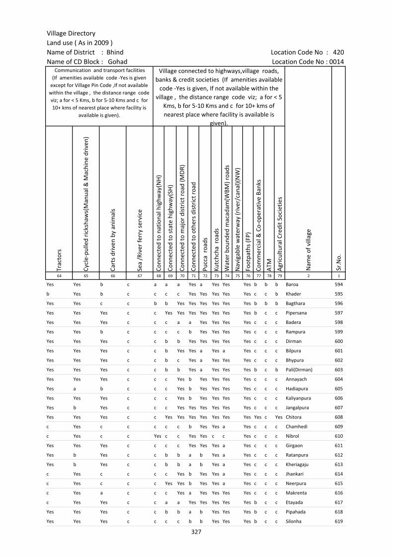
Village DirectoryLand use ( As in 2009 )Name of District : Bhind Location Code No : 420Name of CD Block : Gohad Location Code No : 0014
Trac
tors
Cycl
e-pu
lled
rick
shaw
s(M
anua
l & M
achi
ne d
rive
n)
Cart
s dr
iven
by
anim
als
Sea
/Riv
er fe
rry
serv
ice
Conn
ecte
d to
nat
iona
l hig
hway
(NH
)
Conn
ecte
d to
sta
te h
ighw
ay(S
H)
Conn
ecte
d to
maj
or d
istr
ict r
oad
(MD
R)
Conn
ecte
d to
oth
ers
dist
rict
roa
d
Pucc
a r
oads
Kutc
hcha
roa
ds
Wat
er b
ound
ed m
acad
am(W
BM) r
oads
Nav
igab
le w
ater
way
(riv
er/c
anal
)(N
W)
Foot
path
s (F
P)
Com
mer
cial
& C
o-op
erat
ive
Bank
s
ATM
Agr
icul
tura
l Cre
dit S
ocie
ties
64 65 66 67 68 69 70 71 72 73 74 75 76 77 78 79 2 1
Sr.N
o.
Communication and transport facilities (If amenities available code -Yes is given
except for Village Pin Code ,If not available within the village , the distance range code viz; a for < 5 Kms, b for 5-10 Kms and c for 10+ kms of nearest place where facility is
available is given).
Village connected to highways,village roads, banks & credit societies (If amenities available
code -Yes is given, If not available within the village , the distance range code viz; a for < 5
Kms, b for 5-10 Kms and c for 10+ kms of nearest place where facility is available is
given).
Nam
e of
vill
age
Yes Yes b c a a a Yes a Yes Yes Yes b b b Baroa 594
b Yes b c c c c Yes Yes Yes Yes Yes c c b Khader 595
Yes Yes c c b b Yes Yes Yes Yes Yes Yes b b b Bagthara 596
Yes Yes Yes c c Yes Yes Yes Yes Yes Yes Yes b c c Pipersana 597
Yes Yes Yes c c c a a Yes Yes Yes Yes c c c Badera 598
Yes Yes b c c c c b Yes Yes Yes Yes c c c Rampura 599
Yes Yes Yes c c b b Yes Yes Yes Yes Yes c c c Dirman 600
Yes Yes Yes c c b Yes Yes a Yes a Yes c c c Bilpura 601
Yes Yes Yes c c b c Yes a Yes Yes Yes c c c Bhypura 602
Yes Yes Yes c c b b Yes a Yes Yes Yes b c b Pali(Dirman) 603
Yes Yes Yes c c c Yes b Yes Yes Yes Yes c c c Annayach 604
Yes a b c c c Yes b Yes Yes Yes Yes c c c Hadiapura 605
Yes Yes Yes c c c Yes b Yes Yes Yes Yes c c c Kaliyanpura 606
Yes b Yes c c c Yes Yes Yes Yes Yes Yes c c c Jangalpura 607
Yes Yes Yes c c Yes Yes Yes Yes Yes Yes Yes Yes c Yes Chitora 608
c Yes c c c c c b Yes Yes a Yes c c c Chamhedi 609
c Yes c c Yes c c Yes Yes c c Yes c c c Nibrol 610
Yes Yes Yes c c c c Yes Yes Yes a Yes c c c Girgaon 611
Yes b Yes c c b b a b Yes a Yes c c c Ratanpura 612
Yes b Yes c c b b a b Yes a Yes c c c Kheriagaju 613
c Yes c c c c Yes b Yes Yes a Yes c c c Jhankari 614
c Yes c c c Yes Yes b Yes Yes a Yes c c c Neerpura 615
c Yes a c c c Yes a Yes Yes Yes Yes c c c Makrenta 616
c Yes Yes c c a a Yes Yes Yes Yes Yes b c c Etayada 617
Yes Yes Yes c c b b a b Yes Yes Yes b c c Pipahada 618
Yes Yes Yes c c c c b b Yes Yes Yes b c c Silonha 619
327
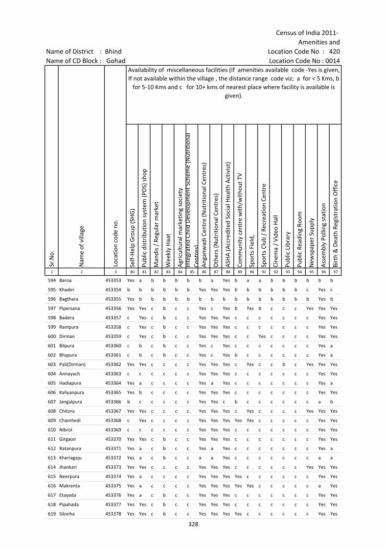
Census of India 2011- Amenities and
Name of District : Bhind Location Code No : 420Name of CD Block : Gohad Location Code No : 0014
Self-
Hel
p G
roup
(SH
G)
Publ
ic d
istr
ibut
ion
syst
em (P
DS)
sho
p
Man
dis
/ Re
gula
r m
arke
t
Wee
kly
Haa
t
Agr
icul
tura
l mar
ketin
g so
ciet
yIn
tegr
ated
Chi
ld D
evel
opm
ent S
chem
e (N
utri
tiona
l Ce
ntre
s)A
ngan
wad
i Cen
tre
(Nut
ritio
nal C
entr
es)
Oth
ers
(Nut
ritio
nal C
entr
es)
ASH
A (A
ccre
dite
d So
cial
Hea
lth A
ctiv
ist)
Com
mun
ity c
entr
e w
ith/w
ithou
t TV
Spor
ts F
ield
,
Spor
ts C
lub
/ Re
crea
tion
Cent
re
Cine
ma
/ Vi
deo
Hal
l
Publ
ic L
ibra
ry
Publ
ic R
eadi
ng R
oom
New
spap
er S
uppl
y
Ass
embl
y Po
lling
sta
tion
Birt
h &
Dea
th R
egis
trat
ion
Off
ice
1 2 3 80 81 82 83 84 85 86 87 88 89 90 91 92 93 94 95 96 97
Sr.N
o.
Nam
e of
vill
age
Loca
tion
code
no.
Availability of miscellaneous facilities (If amenities available code -Yes is given, If not available within the village , the distance range code viz; a for < 5 Kms, b
for 5-10 Kms and c for 10+ kms of nearest place where facility is available is given).
594 Baroa 453353 Yes a b b b b b a Yes b a a b b b b b b
595 Khader 453354 b b b b b b Yes Yes Yes b b b b b b c Yes c
596 Bagthara 453355 Yes b b b b b b b b b b b b b b b Yes b
597 Pipersana 453356 Yes Yes c b c c Yes c Yes b Yes b c c c Yes Yes Yes
598 Badera 453357 c Yes c b c c Yes Yes Yes c c c c c c c Yes Yes
599 Rampura 453358 c Yes c b c c Yes Yes Yes c c c c c c c Yes Yes
600 Dirman 453359 c Yes c b c c Yes Yes Yes c c Yes c c c c Yes Yes
601 Bilpura 453360 c b c b c c Yes c Yes c c c c c c c Yes a
602 Bhypura 453361 c b c b c c Yes c Yes b c c c c c c Yes a
603 Pali(Dirman) 453362 Yes Yes c c c c Yes Yes Yes c Yes c c b c Yes Yes Yes
604 Annayach 453363 c c c c c c Yes Yes Yes c c c c c c c Yes Yes
605 Hadiapura 453364 Yes a c c c c Yes a Yes c c c c c c c Yes a
606 Kaliyanpura 453365 Yes b c c c c Yes Yes Yes c c c c c c c Yes Yes
607 Jangalpura 453366 b c c c c c Yes Yes c b c c c c c c a b
608 Chitora 453367 Yes Yes c c c c Yes Yes Yes c Yes c c c c Yes Yes Yes
609 Chamhedi 453368 c Yes c c c c Yes Yes Yes Yes Yes c c c c c Yes Yes
610 Nibrol 453369 c c c c c c Yes Yes Yes c c c c c c c Yes Yes
611 Girgaon 453370 Yes Yes c b c c Yes Yes Yes c c c c c c c Yes Yes
612 Ratanpura 453371 Yes a c b c c Yes a Yes c c c c c c c Yes a
613 Kheriagaju 453372 Yes a c b c c a a Yes c c c c c c c a a
614 Jhankari 453373 Yes Yes c c c c Yes Yes Yes c c c c c c Yes Yes Yes
615 Neerpura 453374 Yes a c c c c Yes Yes Yes Yes c c c c c c Yes Yes
616 Makrenta 453375 Yes a c c c c Yes Yes Yes Yes Yes c c c c c a Yes
617 Etayada 453376 Yes a c b c c Yes Yes Yes c c c c c c c Yes Yes
618 Pipahada 453377 Yes Yes c b c c Yes Yes Yes c c c c c c c Yes Yes
619 Silonha 453378 Yes Yes c b c c Yes Yes Yes Yes c c c c c c Yes Yes
328
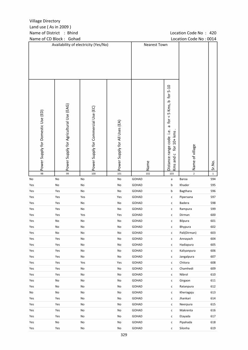
Village DirectoryLand use ( As in 2009 )Name of District : Bhind Location Code No : 420Name of CD Block : Gohad Location Code No : 0014
Pow
er S
uppl
y fo
r D
omes
tic U
se (E
D)
Pow
er S
uppl
y fo
r A
gric
ultu
ral U
se (E
AG
)
Pow
er S
uppl
y fo
r Co
mm
erci
al U
se (E
C)
Pow
er S
uppl
y fo
r A
ll U
ses
(EA
)
Nam
e
Dis
tanc
e ra
nge
code
i.e
. a
for
< 5
Kms,
b f
or 5
-10
Kms
and
c f
or 1
0+ k
ms
.98 99 100 101 102 103 2 1
Nearest Town
Nam
e of
vill
age
Sr.N
o.
Availability of electricity (Yes/No)
No No No No GOHAD a Baroa 594
Yes No No No GOHAD b Khader 595
Yes Yes No No GOHAD b Bagthara 596
Yes Yes Yes Yes GOHAD c Pipersana 597
Yes Yes No No GOHAD c Badera 598
Yes Yes No No GOHAD c Rampura 599
Yes Yes Yes Yes GOHAD c Dirman 600
Yes No No No GOHAD c Bilpura 601
Yes No No No GOHAD c Bhypura 602
Yes No No No GOHAD c Pali(Dirman) 603
Yes Yes No No GOHAD c Annayach 604
Yes Yes No No GOHAD c Hadiapura 605
Yes Yes No No GOHAD c Kaliyanpura 606
Yes Yes No No GOHAD c Jangalpura 607
Yes Yes Yes Yes GOHAD c Chitora 608
Yes Yes No No GOHAD c Chamhedi 609
Yes Yes No No GOHAD c Nibrol 610
Yes No No No GOHAD c Girgaon 611
Yes No No No GOHAD c Ratanpura 612
No No No No GOHAD c Kheriagaju 613
Yes Yes No No GOHAD c Jhankari 614
Yes Yes No No GOHAD c Neerpura 615
Yes Yes No No GOHAD c Makrenta 616
Yes Yes No No GOHAD c Etayada 617
Yes No No No GOHAD c Pipahada 618
Yes Yes No No GOHAD c Silonha 619
329
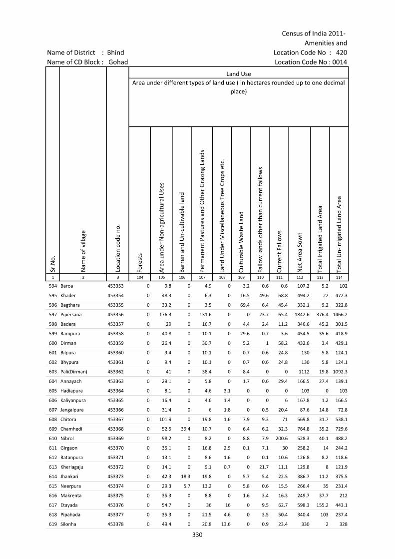
Census of India 2011- Amenities and
Name of District : Bhind Location Code No : 420Name of CD Block : Gohad Location Code No : 0014
Fore
sts
Are
a un
der
Non
-agr
icul
tura
l Use
s
Barr
en a
nd U
n-cu
ltiva
ble
land
Perm
anen
t Pas
ture
s an
d O
ther
Gra
zing
Lan
ds
Land
Und
er M
isce
llane
ous
Tree
Cro
ps e
tc.
Cultu
rabl
e W
aste
Lan
d
Fallo
w la
nds
othe
r th
an c
urre
nt fa
llow
s
Curr
ent F
allo
ws
Net
Are
a So
wn
Tota
l Irr
igat
ed L
and
Are
a
Tota
l Un-
irri
gate
d La
nd A
rea
1 2 3 104 105 106 107 108 109 110 111 112 113 114
Land UseArea under different types of land use ( in hectares rounded up to one decimal
place)
Sr.N
o.
Nam
e of
vill
age
Loca
tion
code
no.
594 Baroa 453353 0 9.8 0 4.9 0 3.2 0.6 0.6 107.2 5.2 102
595 Khader 453354 0 48.3 0 6.3 0 16.5 49.6 68.8 494.2 22 472.3
596 Bagthara 453355 0 33.2 0 3.5 0 69.4 6.4 45.4 332.1 9.2 322.8
597 Pipersana 453356 0 176.3 0 131.6 0 0 23.7 65.4 1842.6 376.4 1466.2
598 Badera 453357 0 29 0 16.7 0 4.4 2.4 11.2 346.6 45.2 301.5
599 Rampura 453358 0 40.8 0 10.1 0 29.6 0.7 3.6 454.5 35.6 418.9
600 Dirman 453359 0 26.4 0 30.7 0 5.2 1 58.2 432.6 3.4 429.1
601 Bilpura 453360 0 9.4 0 10.1 0 0.7 0.6 24.8 130 5.8 124.1
602 Bhypura 453361 0 9.4 0 10.1 0 0.7 0.6 24.8 130 5.8 124.1
603 Pali(Dirman) 453362 0 41 0 38.4 0 8.4 0 0 1112 19.8 1092.3
604 Annayach 453363 0 29.1 0 5.8 0 1.7 0.6 29.4 166.5 27.4 139.1
605 Hadiapura 453364 0 8.1 0 4.6 3.1 0 0 0 103 0 103
606 Kaliyanpura 453365 0 16.4 0 4.6 1.4 0 0 6 167.8 1.2 166.5
607 Jangalpura 453366 0 31.4 0 6 1.8 0 0.5 20.4 87.6 14.8 72.8
608 Chitora 453367 0 101.9 0 19.8 1.6 7.9 9.3 71 569.8 31.7 538.1
609 Chamhedi 453368 0 52.5 39.4 10.7 0 6.4 6.2 32.3 764.8 35.2 729.6
610 Nibrol 453369 0 98.2 0 8.2 0 8.8 7.9 200.6 528.3 40.1 488.2
611 Girgaon 453370 0 35.1 0 16.8 2.9 0.1 7.1 30 258.2 14 244.2
612 Ratanpura 453371 0 13.1 0 8.6 1.6 0 0.1 10.6 126.8 8.2 118.6
613 Kheriagaju 453372 0 14.1 0 9.1 0.7 0 21.7 11.1 129.8 8 121.9
614 Jhankari 453373 0 42.3 18.3 19.8 0 5.7 5.4 22.5 386.7 11.2 375.5
615 Neerpura 453374 0 29.3 5.7 13.2 0 5.8 0.6 15.5 266.4 35 231.4
616 Makrenta 453375 0 35.3 0 8.8 0 1.6 3.4 16.3 249.7 37.7 212
617 Etayada 453376 0 54.7 0 36 16 0 9.5 62.7 598.3 155.2 443.1
618 Pipahada 453377 0 35.3 0 21.5 4.6 0 3.5 50.4 340.4 103 237.4
619 Silonha 453378 0 49.4 0 20.8 13.6 0 0.9 23.4 330 2 328
330
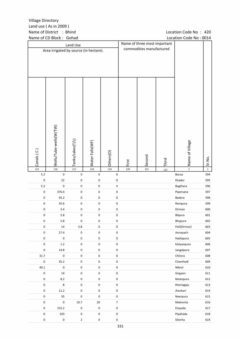
Village DirectoryLand use ( As in 2009 )Name of District : Bhind Location Code No : 420Name of CD Block : Gohad Location Code No : 0014
Cana
ls (
C )
Wel
ls/T
ube-
wel
ls(W
/TW
)
Tank
s/La
kes(
T/L)
Wat
er F
alls
(WF)
Oth
ers(
O)
Firs
t
Seco
nd
Thir
d 115 116 117 118 119 120 121 122 2 1
Land Use Name of three most important commodities manufactured
Nam
e of
Vill
age
Sr.N
o.
Area irrigated by source (in hectare).
5.2 0 0 0 0 Baroa 594
0 22 0 0 0 Khader 595
5.2 0 0 0 4 Bagthara 596
0 376.4 0 0 0 Pipersana 597
0 45.2 0 0 0 Badera 598
0 35.6 0 0 0 Rampura 599
0 3.4 0 0 0 Dirman 600
0 5.8 0 0 0 Bilpura 601
0 5.8 0 0 0 Bhypura 602
0 14 5.8 0 0 Pali(Dirman) 603
0 27.4 0 0 0 Annayach 604
0 0 0 0 0 Hadiapura 605
0 1.2 0 0 0 Kaliyanpura 606
0 14.8 0 0 0 Jangalpura 607
31.7 0 0 0 0 Chitora 608
0 35.2 0 0 0 Chamhedi 609
40.1 0 0 0 0 Nibrol 610
0 14 0 0 0 Girgaon 611
0 8.2 0 0 0 Ratanpura 612
0 8 0 0 0 Kheriagaju 613
0 11.2 0 0 0 Jhankari 614
0 35 0 0 0 Neerpura 615
0 0 10.7 20 7 Makrenta 616
0 155.2 0 0 0 Etayada 617
0 103 0 0 0 Pipahada 618
0 0 2 0 0 Silonha 619
331
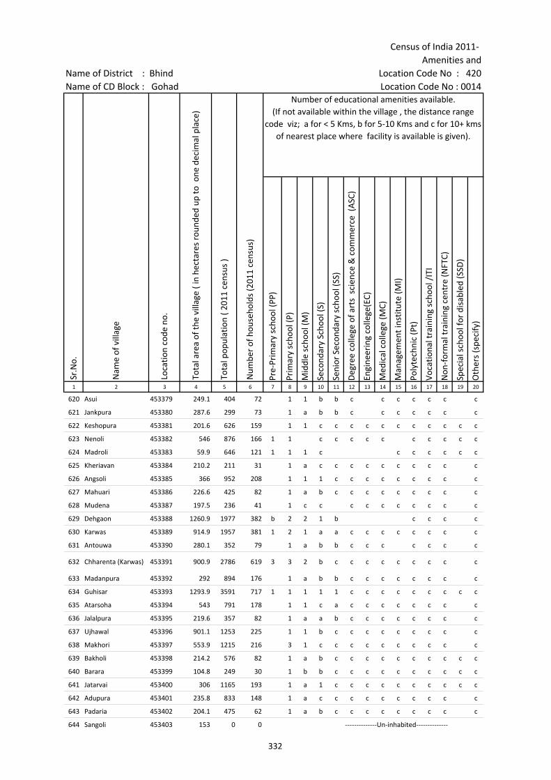
Census of India 2011- Amenities and
Name of District : Bhind Location Code No : 420Name of CD Block : Gohad Location Code No : 0014
Pre-
Prim
ary
scho
ol (P
P)
Prim
ary
scho
ol (P
)
Mid
dle
scho
ol (M
)
Seco
ndar
y Sc
hool
(S)
Seni
or S
econ
dary
sch
ool (
SS)
Deg
ree
colle
ge o
f art
s s
cien
ce &
com
mer
ce (
ASC
)
Engi
neer
ing
colle
ge(E
C)
Med
ical
col
lege
(MC)
Man
agem
ent i
nstit
ute
(MI)
Poly
tech
nic
(Pt)
Voca
tiona
l tra
inin
g sc
hool
/IT
I
Non
-for
mal
trai
ning
cen
tre
(NFT
C)
Spec
ial s
choo
l for
dis
able
d (S
SD)
Oth
ers
(spe
cify
)
1 2 3 4 5 6 7 8 9 10 11 12 13 14 15 16 17 18 19 20
Sr.N
o.
Nam
e of
vill
age
Loca
tion
code
no.
Tota
l are
a of
the
villa
ge (
in h
ecta
res
roun
ded
up to
one
dec
imal
pla
ce)
Tota
l pop
ulat
ion
( 201
1 ce
nsus
)
Num
ber
of h
ouse
hold
s (2
011
cens
us)
Number of educational amenities available. (If not available within the village , the distance range
code viz; a for < 5 Kms, b for 5-10 Kms and c for 10+ kms of nearest place where facility is available is given).
620 Asui 453379 249.1 404 72 1 1 b b c c c c c c c
621 Jankpura 453380 287.6 299 73 1 a b b c c c c c c c
622 Keshopura 453381 201.6 626 159 1 1 c c c c c c c c c c c
623 Nenoli 453382 546 876 166 1 1 c c c c c c c c c c
624 Madroli 453383 59.9 646 121 1 1 1 c c c c c c c
625 Kheriavan 453384 210.2 211 31 1 a c c c c c c c c c c
626 Angsoli 453385 366 952 208 1 1 1 c c c c c c c c c
627 Mahuari 453386 226.6 425 82 1 a b c c c c c c c c c
628 Mudena 453387 197.5 236 41 1 c c c c c c c c c c
629 Dehgaon 453388 1260.9 1977 382 b 2 2 1 b c c c c
630 Karwas 453389 914.9 1957 381 1 2 1 a a c c c c c c c c
631 Antouwa 453390 280.1 352 79 1 a b b c c c c c c c
632 Chharenta (Karwas) 453391 900.9 2786 619 3 3 2 b c c c c c c c c c
633 Madanpura 453392 292 894 176 1 a b b c c c c c c c c
634 Guhisar 453393 1293.9 3591 717 1 1 1 1 1 c c c c c c c c c
635 Atarsoha 453394 543 791 178 1 1 c a c c c c c c c c
636 Jalalpura 453395 219.6 357 82 1 a a b c c c c c c c c
637 Ujhawal 453396 901.1 1253 225 1 1 b c c c c c c c c c
638 Makhori 453397 553.9 1215 216 3 1 c c c c c c c c c c
639 Bakholi 453398 214.2 576 82 1 a b c c c c c c c c c c
640 Barara 453399 104.8 249 30 1 b b c c c c c c c c c c
641 Jatarvai 453400 306 1165 193 1 a 1 c c c c c c c c c c
642 Adupura 453401 235.8 833 148 1 a c c c c c c c c c c
643 Padaria 453402 204.1 475 62 1 a b c c c c c c c c c
644 Sangoli 453403 153 0 0 --------------Un-inhabited--------------
332

Village DirectoryLand use ( As in 2009 )Name of District : Bhind Location Code No : 420Name of CD Block : Gohad Location Code No : 0014
Com
mun
ity h
ealth
cen
tre
(CH
C)Pr
imar
y he
alth
cen
tre
(PH
C)Pr
imar
y he
alth
sub
cen
tre
(PH
S)M
ater
nity
and
chi
ld w
elfa
re c
entr
e (M
CW)
T.B.
clin
ic (
TBC)
Hos
pita
l-allo
path
ic (H
A)
Hos
pita
l-alte
rnat
ive
med
icin
e (H
O)
Dis
pens
ary
(D)
Vete
rina
ry h
ospi
tal (
VH)
Mob
ile h
ealth
clin
ic (M
HC)
Fam
ily w
elfa
re c
entr
e (F
WC)
Char
itabl
e no
n G
ovt.
hos
pita
l/N
ursi
ng h
ome.
Med
ical
pra
ctiti
oner
with
MBB
S D
egre
eM
edic
al p
ract
ition
er w
ith o
ther
deg
ree
Med
ical
pra
ctiti
oner
with
no
degr
eeTr
aditi
onal
pra
ctiti
oner
and
faith
hea
ler
.M
edic
ine
Shop
Oth
ers
Tap
wat
er (T
reat
ed/U
ntre
ated
)
Wel
l w
ater
(C
over
ed /
Unc
over
ed w
ell)
Han
d Pu
mp
Tube
wel
ls /
Bor
e w
ell
Spri
ng
Rive
r /
Cana
l
Tank
/ P
ond
/ L
ake
Oth
ers
21 22 23 24 25 26 27 28 29 30 31 32 33 34 35 36 37 38 39 40 41 42 43 44 45 46 2 1
Number of Medical Amenities available. (If not available within the
village , the distance range code viz; a for < 5 Kms, b for 5-10 Kms and c for
10+ kms of nearest place where facility is available is given).
Number of Non-Government
Medical Amenities available.
Availability of drinking water - Yes / No
Nam
e of
vill
age
Sr.N
o.
c c b c c c c c c 0 0 0 0 0 0 0 No Yes Yes Yes No No No No Asui 620
c c c c c c c c c 0 0 0 0 0 0 0 No Yes Yes Yes No No No No Jankpura 621
c c c c c c c c c c c 0 0 0 0 0 0 0 No Yes Yes No No No No No Keshopura 622
c c c c c c c c b c c 0 0 0 0 0 1 0 No Yes Yes No No Yes No No Nenoli 623
c c c c c c c b b b b 0 0 0 0 0 0 0 No Yes Yes Yes No Yes Yes No Madroli 624
c c c c c c c c c 0 0 0 0 0 0 0 No Yes Yes No No No No No Kheriavan 625
b b b b b c c c b b c 0 0 0 0 0 0 0 No Yes Yes No No No No No Angsoli 626
b b b b b c c c b c b 0 0 0 0 0 0 0 No Yes Yes No No No No No Mahuari 627
c c c c c c c c c c c 0 0 0 0 0 0 0 No Yes Yes No No No No No Mudena 628
b b b 1 b c c b b 0 0 0 0 0 0 0 No Yes Yes Yes No No Yes No Dehgaon 629
c b b c b c c c c b 0 0 0 0 0 0 0 No Yes Yes Yes No No No No Karwas 630
c b c c b c c c b 0 0 0 0 0 0 0 No Yes Yes No No No No No Antouwa 631
c b b c b c c c c b 0 0 0 0 0 0 0 No Yes Yes Yes No No No No Chharenta (Karwas) 632
c c c c c c c c c c 0 0 0 0 0 0 0 No Yes Yes Yes No No No No Madanpura 633
c 1 c c c c c c 0 0 0 0 0 0 0 Yes Yes Yes No No No No No Guhisar 634
c c c c c c c c c 0 0 0 0 0 0 0 No Yes Yes No No No No No Atarsoha 635
c b c c b c c c b 0 0 0 0 0 0 0 No Yes Yes No No No No No Jalalpura 636
c a a c a c c c c a 2 1 2 2 2 2 2 No Yes Yes No No No No No Ujhawal 637
c c a c c c c c c c c 0 0 0 0 0 0 0 No Yes Yes No No No No No Makhori 638
b b b b b b b b b 0 0 0 0 0 0 0 No Yes Yes No No No No No Bakholi 639
b c c c c c c c c c c 0 0 0 0 0 0 0 No Yes Yes No No No No No Barara 640
b c c c c c c c c c c 0 0 0 0 0 0 0 No Yes Yes No No No No No Jatarvai 641
c c a a c c c c c c c 0 0 0 0 0 0 0 No Yes Yes No No No No No Adupura 642
c c a a c c c c c c c 0 0 0 0 0 0 0 No Yes Yes No No No No No Padaria 643
--------------Un-inhabited-------------- Sangoli 644
333

Census of India 2011- Amenities and
Name of District : Bhind Location Code No : 420Name of CD Block : Gohad Location Code No : 0014
Com
mun
ity to
ilet i
nclu
ding
bat
h.
Com
mun
ity to
ilet e
xclu
ding
bat
h.
Rura
l sa
nita
ry m
art o
r sa
nita
ry h
ardw
are
outle
t av
aila
ble
near
the
villa
ge.
Com
mun
ity b
io- g
as o
r re
cycl
e of
was
te fo
r pr
oduc
tive
use.
Post
off
ice(
PO)
Sub
post
off
ice
(SPO
)
Post
& T
eleg
raph
off
ice
(P&
TO)
Villa
ge P
in C
ode
Tele
phon
es
(L
and
lines
)
Publ
ic c
all o
ffic
e (P
CO)
Mob
ile p
hone
cov
erag
e
Inte
rnet
caf
es/
Com
mon
ser
vice
cen
tre
(CSC
)
Priv
ate
cour
ier
faci
lity
Bus
serv
ice
(Pub
lic &
Pri
vate
)
Railw
ay s
tatio
ns
Aut
o/M
odifi
ed A
utos
Taxi
s an
d Va
ns
1 2 3 47 48 49 50 51 52 53 54 55 56 57 58 59 60 61 62 63
Sr.N
o.
Nam
e of
vill
age
Loca
tion
code
no.
Availability of toilet & others Yes / No
Communication and transport facilities (If amenities available code -Yes is given except for Village Pin Code ,If not available within the village , the distance range code
viz; a for < 5 Kms, b for 5-10 Kms and c for 10+ kms of nearest place where facility is available is given).
620 Asui 453379 No No No No c b b c c a c c b c c c
621 Jankpura 453380 No No No No c b b c c Yes c c b c c c
622 Keshopura 453381 No No No No c a c Yes c b c c c c c c
623 Nenoli 453382 No No No No b b b Yes c c c c c c Yes
624 Madroli 453383 No No No No b b c c b c c Yes c c c
625 Kheriavan 453384 No No No No b b c c c a c c c c c c
626 Angsoli 453385 No No No No b a b b c b b b b c b c
627 Mahuari 453386 No No No No b a b b c Yes c c b c c c
628 Mudena 453387 No No No No c a c c c Yes c c c c c c
629 Dehgaon 453388 No No No No Yes Yes 477222 Yes c Yes c c Yes c c c
630 Karwas 453389 No No No No c a a Yes c Yes c c Yes c c c
631 Antouwa 453390 No No No No a c c c c Yes c c a c c c
632 Chharenta (Karwas) 453391 No No No No c b b Yes c Yes c c Yes c c c
633 Madanpura 453392 No No No No c b b Yes c Yes c c Yes c c c
634 Guhisar 453393 No No No Yes b Yes Yes 477222 Yes c Yes c c Yes c c c
635 Atarsoha 453394 No No No No a a c c c Yes c c a c c c
636 Jalalpura 453395 No No No No a c c c c Yes c c c c c c
637 Ujhawal 453396 No No No No c a b Yes c b b b b c b b
638 Makhori 453397 No No No No c c Yes c Yes c c c c c c
639 Bakholi 453398 No No No No b a b b b Yes c c c c c c
640 Barara 453399 No No No No b a b c c Yes c c c c c c
641 Jatarvai 453400 No No No No b a b Yes c Yes c c c c c c
642 Adupura 453401 No No No No c a c Yes c b c c c c c c
643 Padaria 453402 No No No No c a b c c c c c c c c c
644 Sangoli 453403 --------------Un-inhabited--------------
334
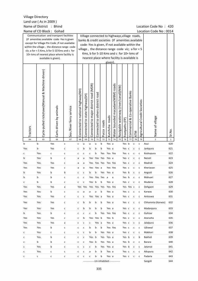
Village DirectoryLand use ( As in 2009 )Name of District : Bhind Location Code No : 420Name of CD Block : Gohad Location Code No : 0014
Trac
tors
Cycl
e-pu
lled
rick
shaw
s(M
anua
l & M
achi
ne d
rive
n)
Cart
s dr
iven
by
anim
als
Sea
/Riv
er fe
rry
serv
ice
Conn
ecte
d to
nat
iona
l hig
hway
(NH
)
Conn
ecte
d to
sta
te h
ighw
ay(S
H)
Conn
ecte
d to
maj
or d
istr
ict r
oad
(MD
R)
Conn
ecte
d to
oth
ers
dist
rict
roa
d
Pucc
a r
oads
Kutc
hcha
roa
ds
Wat
er b
ound
ed m
acad
am(W
BM) r
oads
Nav
igab
le w
ater
way
(riv
er/c
anal
)(N
W)
Foot
path
s (F
P)
Com
mer
cial
& C
o-op
erat
ive
Bank
s
ATM
Agr
icul
tura
l Cre
dit S
ocie
ties
64 65 66 67 68 69 70 71 72 73 74 75 76 77 78 79 2 1
Sr.N
o.
Communication and transport facilities (If amenities available code -Yes is given
except for Village Pin Code ,If not available within the village , the distance range code viz; a for < 5 Kms, b for 5-10 Kms and c for 10+ kms of nearest place where facility is
available is given).
Village connected to highways,village roads, banks & credit societies (If amenities available
code -Yes is given, If not available within the village , the distance range code viz; a for < 5
Kms, b for 5-10 Kms and c for 10+ kms of nearest place where facility is available is
given).
Nam
e of
vill
age
b b Yes c c a a a b Yes a Yes b c c Asui 620
Yes b Yes c c b b b b Yes a Yes c c c Jankpura 621
c Yes c c c c c b Yes Yes Yes Yes c c c Keshopura 622
b Yes b c a a Yes Yes Yes Yes a Yes c c c Nenoli 623
Yes Yes Yes c a a Yes Yes Yes Yes Yes Yes c c c Madroli 624
Yes Yes Yes c a a Yes Yes a Yes Yes Yes c c c Kheriavan 625
b Yes b b c c b b Yes Yes a Yes b c c Angsoli 626
b b b c c c Yes Yes Yes a a Yes b c c Mahuari 627
c b b c c c Yes b b Yes a Yes c c c Mudena 628
Yes Yes Yes a Yes Yes Yes Yes Yes Yes Yes Yes Yes c c Dehgaon 629
Yes Yes b c c a a a b Yes a Yes c c c Karwas 630
Yes Yes Yes c c c Yes Yes a Yes a Yes c c c Antouwa 631
Yes Yes Yes c c b b b b Yes a Yes c c c Chharenta (Karwas) 632
Yes Yes Yes c c b b b b Yes a Yes c c c Madanpura 633
b Yes b c c c c b Yes Yes Yes Yes c c c Guhisar 634
Yes Yes Yes c c b Yes Yes b Yes b Yes c c c Atarsoha 635
Yes Yes Yes a c c c Yes a Yes a Yes c c c Jalalpura 636
Yes Yes b c c c b b b Yes Yes Yes c c c Ujhawal 637
c Yes c c c c b b Yes Yes a Yes c c c Makhori 638
c Yes b c c c Yes b Yes Yes a Yes b c b Bakholi 639
c b b c c c Yes b Yes Yes a Yes b c c Barara 640
c Yes b c c c c b Yes Yes a Yes b c c Jatarvai 641
c Yes c c c c a b b Yes a Yes c c c Adupura 642
c c c c c c c b b Yes a Yes c c c Padaria 643
--------------Un-inhabited-------------- Sangoli 644
335
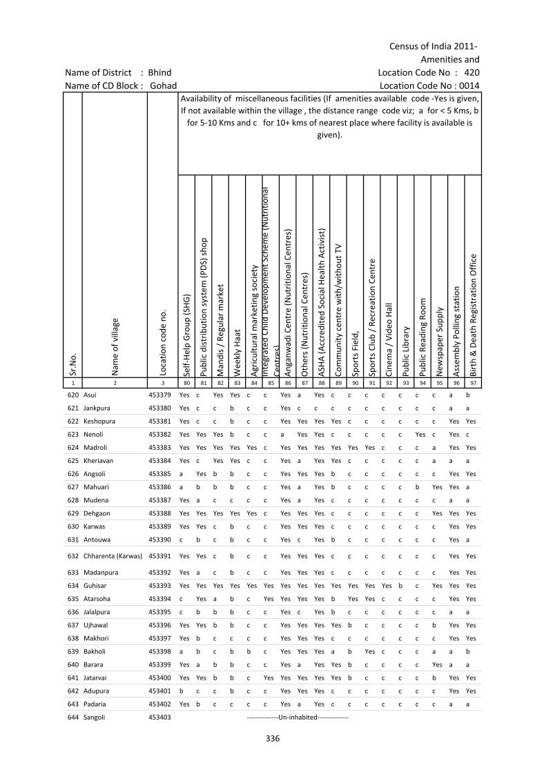
Census of India 2011- Amenities and
Name of District : Bhind Location Code No : 420Name of CD Block : Gohad Location Code No : 0014
Self-
Hel
p G
roup
(SH
G)
Publ
ic d
istr
ibut
ion
syst
em (P
DS)
sho
p
Man
dis
/ Re
gula
r m
arke
t
Wee
kly
Haa
t
Agr
icul
tura
l mar
ketin
g so
ciet
yIn
tegr
ated
Chi
ld D
evel
opm
ent S
chem
e (N
utri
tiona
l Ce
ntre
s)A
ngan
wad
i Cen
tre
(Nut
ritio
nal C
entr
es)
Oth
ers
(Nut
ritio
nal C
entr
es)
ASH
A (A
ccre
dite
d So
cial
Hea
lth A
ctiv
ist)
Com
mun
ity c
entr
e w
ith/w
ithou
t TV
Spor
ts F
ield
,
Spor
ts C
lub
/ Re
crea
tion
Cent
re
Cine
ma
/ Vi
deo
Hal
l
Publ
ic L
ibra
ry
Publ
ic R
eadi
ng R
oom
New
spap
er S
uppl
y
Ass
embl
y Po
lling
sta
tion
Birt
h &
Dea
th R
egis
trat
ion
Off
ice
1 2 3 80 81 82 83 84 85 86 87 88 89 90 91 92 93 94 95 96 97
Sr.N
o.
Nam
e of
vill
age
Loca
tion
code
no.
Availability of miscellaneous facilities (If amenities available code -Yes is given, If not available within the village , the distance range code viz; a for < 5 Kms, b
for 5-10 Kms and c for 10+ kms of nearest place where facility is available is given).
620 Asui 453379 Yes c Yes Yes c c Yes a Yes c c c c c c c a b
621 Jankpura 453380 Yes c c b c c Yes c c c c c c c c c a a
622 Keshopura 453381 Yes c c b c c Yes Yes Yes Yes c c c c c c Yes Yes
623 Nenoli 453382 Yes Yes Yes b c c a Yes Yes c c c c c Yes c Yes c
624 Madroli 453383 Yes Yes Yes Yes Yes c Yes Yes Yes Yes Yes Yes c c c a Yes Yes
625 Kheriavan 453384 Yes c Yes Yes c c Yes a Yes Yes c c c c c a a a
626 Angsoli 453385 a Yes b b c c Yes Yes Yes b c c c c c c Yes Yes
627 Mahuari 453386 a b b b c c Yes a Yes b c c c c b Yes Yes a
628 Mudena 453387 Yes a c c c c Yes a Yes c c c c c c c a a
629 Dehgaon 453388 Yes Yes Yes Yes Yes c Yes Yes Yes c c c c c c Yes Yes Yes
630 Karwas 453389 Yes Yes c b c c Yes Yes Yes c c c c c c c Yes Yes
631 Antouwa 453390 c b c b c c Yes c Yes b c c c c c c Yes a
632 Chharenta (Karwas) 453391 Yes Yes c b c c Yes Yes Yes c c c c c c c Yes Yes
633 Madanpura 453392 Yes a c b c c Yes Yes Yes c c c c c c c Yes Yes
634 Guhisar 453393 Yes Yes Yes Yes Yes Yes Yes Yes Yes Yes Yes Yes Yes b c Yes Yes Yes
635 Atarsoha 453394 c Yes a b c Yes Yes Yes Yes b Yes Yes c c c c Yes Yes
636 Jalalpura 453395 c b b b c c Yes c Yes b c c c c c c a a
637 Ujhawal 453396 Yes Yes b b c c Yes Yes Yes Yes b c c c c b Yes Yes
638 Makhori 453397 Yes b c c c c Yes Yes Yes c c c c c c c Yes Yes
639 Bakholi 453398 a b c b b c Yes Yes Yes a b Yes c c c a a b
640 Barara 453399 Yes a b b c c Yes a Yes Yes b c c c c Yes a a
641 Jatarvai 453400 Yes Yes b b c Yes Yes Yes Yes Yes b c c c c b Yes Yes
642 Adupura 453401 b c c b c c Yes Yes Yes c c c c c c c Yes Yes
643 Padaria 453402 Yes b c c c c Yes a Yes c c c c c c c a a
644 Sangoli 453403 --------------Un-inhabited--------------
336
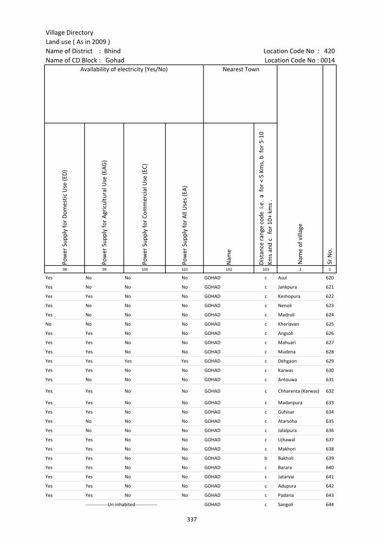
Village DirectoryLand use ( As in 2009 )Name of District : Bhind Location Code No : 420Name of CD Block : Gohad Location Code No : 0014
Pow
er S
uppl
y fo
r D
omes
tic U
se (E
D)
Pow
er S
uppl
y fo
r A
gric
ultu
ral U
se (E
AG
)
Pow
er S
uppl
y fo
r Co
mm
erci
al U
se (E
C)
Pow
er S
uppl
y fo
r A
ll U
ses
(EA
)
Nam
e
Dis
tanc
e ra
nge
code
i.e
. a
for
< 5
Kms,
b f
or 5
-10
Kms
and
c f
or 1
0+ k
ms
.98 99 100 101 102 103 2 1
Nearest Town
Nam
e of
vill
age
Sr.N
o.
Availability of electricity (Yes/No)
Yes No No No GOHAD c Asui 620
Yes No No No GOHAD c Jankpura 621
Yes Yes No No GOHAD c Keshopura 622
Yes No No No GOHAD c Nenoli 623
Yes No No No GOHAD c Madroli 624
No No No No GOHAD c Kheriavan 625
Yes Yes No No GOHAD c Angsoli 626
Yes Yes No No GOHAD c Mahuari 627
Yes Yes No No GOHAD c Mudena 628
Yes Yes Yes Yes GOHAD c Dehgaon 629
Yes Yes No No GOHAD c Karwas 630
Yes No No No GOHAD c Antouwa 631
Yes Yes No No GOHAD c Chharenta (Karwas) 632
Yes Yes No No GOHAD c Madanpura 633
Yes Yes No No GOHAD c Guhisar 634
Yes No No No GOHAD c Atarsoha 635
Yes No No No GOHAD c Jalalpura 636
Yes Yes No No GOHAD c Ujhawal 637
Yes Yes No No GOHAD c Makhori 638
Yes Yes No No GOHAD b Bakholi 639
Yes Yes No No GOHAD c Barara 640
Yes Yes No No GOHAD c Jatarvai 641
Yes Yes No No GOHAD c Adupura 642
Yes Yes No No GOHAD c Padaria 643
--------------Un-inhabited-------------- GOHAD c Sangoli 644
337
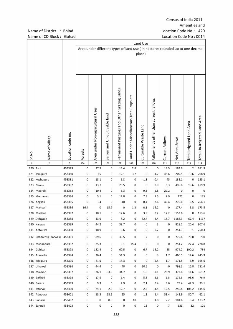
Census of India 2011- Amenities and
Name of District : Bhind Location Code No : 420Name of CD Block : Gohad Location Code No : 0014
Fore
sts
Are
a un
der
Non
-agr
icul
tura
l Use
s
Barr
en a
nd U
n-cu
ltiva
ble
land
Perm
anen
t Pas
ture
s an
d O
ther
Gra
zing
Lan
ds
Land
Und
er M
isce
llane
ous
Tree
Cro
ps e
tc.
Cultu
rabl
e W
aste
Lan
d
Fallo
w la
nds
othe
r th
an c
urre
nt fa
llow
s
Curr
ent F
allo
ws
Net
Are
a So
wn
Tota
l Irr
igat
ed L
and
Are
a
Tota
l Un-
irri
gate
d La
nd A
rea
1 2 3 104 105 106 107 108 109 110 111 112 113 114
Land UseArea under different types of land use ( in hectares rounded up to one decimal
place)
Sr.N
o.
Nam
e of
vill
age
Loca
tion
code
no.
620 Asui 453379 0 27.5 0 15.4 2.8 0 0 19.5 183.9 2 181.9
621 Jankpura 453380 0 15 0 12.1 3.7 0 1.7 45.6 209.5 0.6 208.9
622 Keshopura 453381 0 13.1 0 6.8 0 1.3 0.4 45 135.1 0 135.1
623 Nenoli 453382 0 13.7 0 26.5 0 0 0.9 6.3 498.6 18.6 479.9
624 Madroli 453383 0 10.4 0 8.3 0 9.3 2.8 29.2 0 0 0
625 Kheriavan 453384 0 5.1 0 12.8 0 7.9 1.5 7.9 175 0 175
626 Angsoli 453385 0 34 0 10 0 8.4 2.6 40.4 270.6 6.5 264.1
627 Mahuari 453386 16.4 0 15.2 0 1.3 0.1 16.2 0 177.4 3.8 173.5
628 Mudena 453387 0 10.1 0 12.6 0 3.9 0.2 17.2 153.6 0 153.6
629 Dehgaon 453388 0 13.9 0 5.2 0 32.4 8.4 16.7 1184.3 67.4 1117
630 Karwas 453389 0 44.2 0 39.7 0 0 3 0 828.1 20.4 807.6
631 Antouwa 453390 0 18.9 0 9.6 0 0 0.2 0 251.3 1 250.3
632 Chharenta (Karwas) 453391 0 89.6 0 33.5 0 2 0 0 775.8 75.8 700
633 Madanpura 453392 0 25.3 0 0.1 15.4 0 0 0 251.2 22.4 228.8
634 Guhisar 453393 0 182.4 0 60.5 0 6.7 15.2 55 974.2 190.2 784
635 Atarsoha 453394 0 26.4 0 51.3 0 0 3 1.7 460.5 14.6 445.9
636 Jalalpura 453395 0 21.6 0 18.3 0 0 6.5 1.7 171.5 5.9 165.6
637 Ujhawal 453396 0 44.4 0 48 0 10.5 0 0 798.3 16.8 781.4
638 Makhori 453397 0 26.1 83.5 34.7 0 1.8 9.1 25.9 372.8 11.6 361.2
639 Bakholi 453398 0 17.5 0 6.4 0 5.8 3.5 5.5 175.5 98.6 76.9
640 Barara 453399 0 9.3 0 7.9 0 2.1 0.4 9.6 75.4 42.3 33.1
641 Jatarvai 453400 0 24.1 2.2 12.7 0 2.2 1.5 12.5 250.8 105.2 145.6
642 Adupura 453401 0 13.3 18.5 25 0 1.3 1.4 33.4 142.8 80.7 62.1
643 Padaria 453402 0 0 8.5 0 10 0 1.8 2.2 181.6 8.4 173.2
644 Sangoli 453403 0 0 0 0 0 13 0 7 133 32 101
338

Village DirectoryLand use ( As in 2009 )Name of District : Bhind Location Code No : 420Name of CD Block : Gohad Location Code No : 0014
Cana
ls (
C )
Wel
ls/T
ube-
wel
ls(W
/TW
)
Tank
s/La
kes(
T/L)
Wat
er F
alls
(WF)
Oth
ers(
O)
Firs
t
Seco
nd
Thir
d 115 116 117 118 119 120 121 122 2 1
Land Use Name of three most important commodities manufactured
Nam
e of
Vill
age
Sr.N
o.
Area irrigated by source (in hectare).
0 2 0 0 0 Asui 620
0.6 0 0 0 0 Jankpura 621
0 0 0 0 0 Keshopura 622
0 0 18.6 0 0 Nenoli 623
0 0 0 0 0 Madroli 624
0 0 0 0 0 Kheriavan 625
0 0 6.5 0 0 Angsoli 626
0 3.8 0 0 0 Mahuari 627
0 0 0 0 0 Mudena 628
0 67.4 0 0 0 Dehgaon 629
0 16.4 4 0 0 Karwas 630
0 1 0 0 0 Antouwa 631
0 55.4 20.4 0 0 Chharenta (Karwas) 632
0 22.4 0 0 0 Madanpura 633
0 0 0 0 190.2 Guhisar 634
0 14.6 0 0 0 Atarsoha 635
0 5.9 0 0 0 Jalalpura 636
0 16.8 0 0 0 Ujhawal 637
0 11.6 0 0 0 Makhori 638
0 98.6 0 0 0 Bakholi 639
0 0 42.3 0 0 Barara 640
0 105.2 0 0 0 Jatarvai 641
0 80.7 0 0 0 Adupura 642
0 8.4 0 0 0 Padaria 643
0 32 0 0 0 Sangoli 644
339

Census of India 2011- Amenities and
Name of District : Bhind Location Code No : 420Name of CD Block : Gohad Location Code No : 0014
Pre-
Prim
ary
scho
ol (P
P)
Prim
ary
scho
ol (P
)
Mid
dle
scho
ol (M
)
Seco
ndar
y Sc
hool
(S)
Seni
or S
econ
dary
sch
ool (
SS)
Deg
ree
colle
ge o
f art
s s
cien
ce &
com
mer
ce (
ASC
)
Engi
neer
ing
colle
ge(E
C)
Med
ical
col
lege
(MC)
Man
agem
ent i
nstit
ute
(MI)
Poly
tech
nic
(Pt)
Voca
tiona
l tra
inin
g sc
hool
/IT
I
Non
-for
mal
trai
ning
cen
tre
(NFT
C)
Spec
ial s
choo
l for
dis
able
d (S
SD)
Oth
ers
(spe
cify
)
1 2 3 4 5 6 7 8 9 10 11 12 13 14 15 16 17 18 19 20
Sr.N
o.
Nam
e of
vill
age
Loca
tion
code
no.
Tota
l are
a of
the
villa
ge (
in h
ecta
res
roun
ded
up to
one
dec
imal
pla
ce)
Tota
l pop
ulat
ion
( 201
1 ce
nsus
)
Num
ber
of h
ouse
hold
s (2
011
cens
us)
Number of educational amenities available. (If not available within the village , the distance range
code viz; a for < 5 Kms, b for 5-10 Kms and c for 10+ kms of nearest place where facility is available is given).
645 Rasnol 453404 754.1 1404 295 2 1 b c c c c c c c c c c
646 Bamhroli 453405 404.2 578 108 1 a b c c c c c c c c c
647 Jamdara 453406 776.3 1545 299 b 1 1 c c c c c
648 Sora 453407 409.5 616 118 b 1 b b b c c c c c
649 Baroli 453408 829.3 1376 256 1 1 1 b c c c c c
650 Khariabar 453409 230.6 596 98 b 1 b b b c c c c c c
651 Taroli 453410 480.6 411 69 1 a a a c c c c c
652 Bhadera 453411 703.5 692 149 b 1 c c c c c
653 Itayalimau 453412 804.6 1516 280 b 1 1 b b c c c c c
654 Banganga 453413 62.1 270 49 b 1 1 b b c c c c c
655 Ghamuri 453414 991.8 1518 327 1 1 1 b b c c c c c
656 Sinor 453415 272.4 589 113 b 1 b c c c c c
657 Keroli 453416 227.7 341 58 1 1 b c c c c
658 Chhekuri 453417 970 1615 277 1 1 b b c c c c c
659 Dangchhekuri 453418 506.2 958 165 1 1 a c c c c
660 Niwari 453419 139.3 300 50 1 a a c c c c
661 Kheriajallu 453420 501.1 1417 268 a 1 a a a a c c c c c
662 Dehgawan 453421 444.3 833 137 b 1 1 c c c c c c c c c c
663 Kanhepura 453422 379 0 0 --------------Un-inhabited--------------
664 Kiti 453423 273.8 841 158 1 1 b b b c c c c c c c c
665 Jaret 453424 302.5 684 121 b 1 1 a b b c c c c c c c c
666 Andhiyarikhurd 453425 332.8 846 163 c 1 1 1 c c c c c c c c c
667 Asohana 453426 498.8 1401 236 b 1 a b b b c c c c c c c c
668 Andhiyari Kalan 453427 397.9 1204 204 1 1 a b b c c c c c c c c
669 Mohadipura 453428 109.3 188 40 1 a b b b c c c c c c c c
670 Rupavai 453429 275.5 682 114 1 a b b c c c c c c c c
340
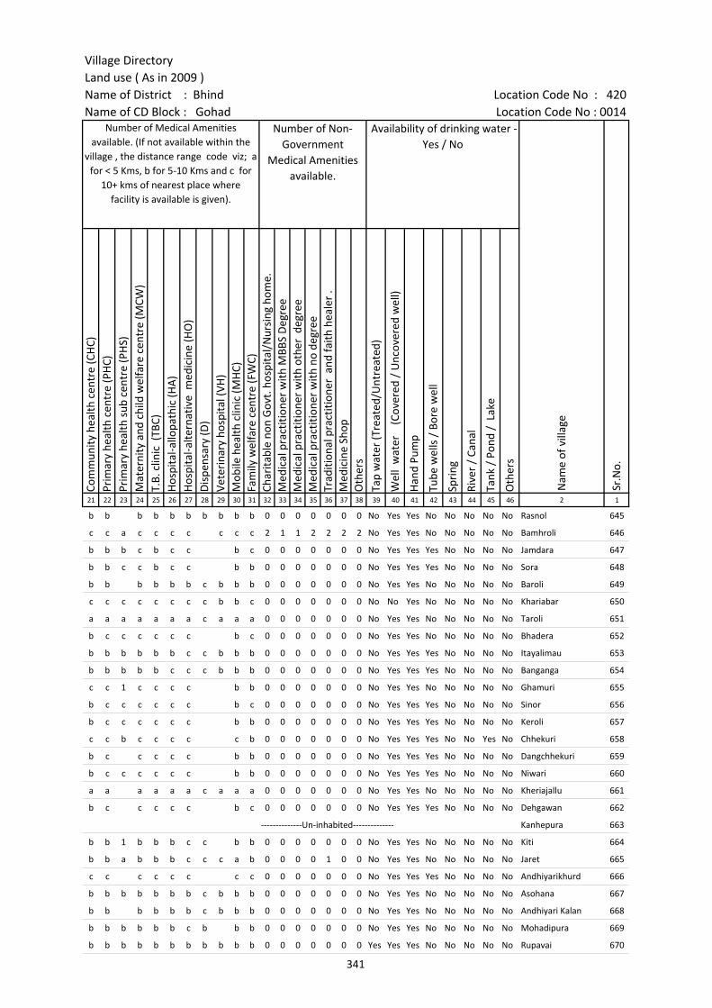
Village DirectoryLand use ( As in 2009 )Name of District : Bhind Location Code No : 420Name of CD Block : Gohad Location Code No : 0014
Com
mun
ity h
ealth
cen
tre
(CH
C)Pr
imar
y he
alth
cen
tre
(PH
C)Pr
imar
y he
alth
sub
cen
tre
(PH
S)M
ater
nity
and
chi
ld w
elfa
re c
entr
e (M
CW)
T.B.
clin
ic (
TBC)
Hos
pita
l-allo
path
ic (H
A)
Hos
pita
l-alte
rnat
ive
med
icin
e (H
O)
Dis
pens
ary
(D)
Vete
rina
ry h
ospi
tal (
VH)
Mob
ile h
ealth
clin
ic (M
HC)
Fam
ily w
elfa
re c
entr
e (F
WC)
Char
itabl
e no
n G
ovt.
hos
pita
l/N
ursi
ng h
ome.
Med
ical
pra
ctiti
oner
with
MBB
S D
egre
eM
edic
al p
ract
ition
er w
ith o
ther
deg
ree
Med
ical
pra
ctiti
oner
with
no
degr
eeTr
aditi
onal
pra
ctiti
oner
and
faith
hea
ler
.M
edic
ine
Shop
Oth
ers
Tap
wat
er (T
reat
ed/U
ntre
ated
)
Wel
l w
ater
(C
over
ed /
Unc
over
ed w
ell)
Han
d Pu
mp
Tube
wel
ls /
Bor
e w
ell
Spri
ng
Rive
r /
Cana
l
Tank
/ P
ond
/ L
ake
Oth
ers
21 22 23 24 25 26 27 28 29 30 31 32 33 34 35 36 37 38 39 40 41 42 43 44 45 46 2 1
Number of Medical Amenities available. (If not available within the
village , the distance range code viz; a for < 5 Kms, b for 5-10 Kms and c for
10+ kms of nearest place where facility is available is given).
Number of Non-Government
Medical Amenities available.
Availability of drinking water - Yes / No
Nam
e of
vill
age
Sr.N
o.
b b b b b b b b b b 0 0 0 0 0 0 0 No Yes Yes No No No No No Rasnol 645
c c a c c c c c c c 2 1 1 2 2 2 2 No Yes Yes No No No No No Bamhroli 646
b b b c b c c b c 0 0 0 0 0 0 0 No Yes Yes Yes No No No No Jamdara 647
b b c c b c c b b 0 0 0 0 0 0 0 No Yes Yes Yes No No No No Sora 648
b b b b b b c b b b 0 0 0 0 0 0 0 No Yes Yes No No No No No Baroli 649
c c c c c c c c b b c 0 0 0 0 0 0 0 No No Yes No No No No No Khariabar 650
a a a a a a a c a a a 0 0 0 0 0 0 0 No Yes Yes No No No No No Taroli 651
b c c c c c c b c 0 0 0 0 0 0 0 No Yes Yes No No No No No Bhadera 652
b b b b b b c c b b b 0 0 0 0 0 0 0 No Yes Yes Yes No No No No Itayalimau 653
b b b b b c c c b b b 0 0 0 0 0 0 0 No Yes Yes Yes No No No No Banganga 654
c c 1 c c c c b b 0 0 0 0 0 0 0 No Yes Yes No No No No No Ghamuri 655
b c c c c c c b c 0 0 0 0 0 0 0 No Yes Yes Yes No No No No Sinor 656
b c c c c c c b b 0 0 0 0 0 0 0 No Yes Yes Yes No No No No Keroli 657
c c b c c c c c b 0 0 0 0 0 0 0 No Yes Yes Yes No No Yes No Chhekuri 658
b c c c c c b b 0 0 0 0 0 0 0 No Yes Yes Yes No No No No Dangchhekuri 659
b c c c c c c b b 0 0 0 0 0 0 0 No Yes Yes Yes No No No No Niwari 660
a a a a a a c a a a 0 0 0 0 0 0 0 No Yes Yes No No No No No Kheriajallu 661
b c c c c c b c 0 0 0 0 0 0 0 No Yes Yes Yes No No No No Dehgawan 662
--------------Un-inhabited-------------- Kanhepura 663
b b 1 b b b c c b b 0 0 0 0 0 0 0 No Yes Yes No No No No No Kiti 664
b b a b b b c c c a b 0 0 0 0 1 0 0 No Yes Yes No No No No No Jaret 665
c c c c c c c c 0 0 0 0 0 0 0 No Yes Yes Yes No No No No Andhiyarikhurd 666
b b b b b b b c b b b 0 0 0 0 0 0 0 No Yes Yes No No No No No Asohana 667
b b b b b b c b b b 0 0 0 0 0 0 0 No Yes Yes No No No No No Andhiyari Kalan 668
b b b b b b c b b b 0 0 0 0 0 0 0 No Yes Yes No No No No No Mohadipura 669
b b b b b b b b b b b 0 0 0 0 0 0 0 Yes Yes Yes No No No No No Rupavai 670
341
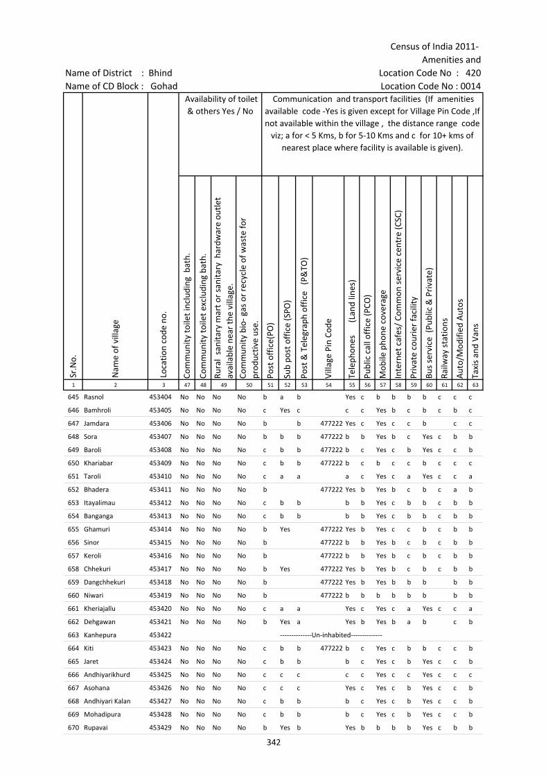
Census of India 2011- Amenities and
Name of District : Bhind Location Code No : 420Name of CD Block : Gohad Location Code No : 0014
Com
mun
ity to
ilet i
nclu
ding
bat
h.
Com
mun
ity to
ilet e
xclu
ding
bat
h.
Rura
l sa
nita
ry m
art o
r sa
nita
ry h
ardw
are
outle
t av
aila
ble
near
the
villa
ge.
Com
mun
ity b
io- g
as o
r re
cycl
e of
was
te fo
r pr
oduc
tive
use.
Post
off
ice(
PO)
Sub
post
off
ice
(SPO
)
Post
& T
eleg
raph
off
ice
(P&
TO)
Villa
ge P
in C
ode
Tele
phon
es
(L
and
lines
)
Publ
ic c
all o
ffic
e (P
CO)
Mob
ile p
hone
cov
erag
e
Inte
rnet
caf
es/
Com
mon
ser
vice
cen
tre
(CSC
)
Priv
ate
cour
ier
faci
lity
Bus
serv
ice
(Pub
lic &
Pri
vate
)
Railw
ay s
tatio
ns
Aut
o/M
odifi
ed A
utos
Taxi
s an
d Va
ns
1 2 3 47 48 49 50 51 52 53 54 55 56 57 58 59 60 61 62 63
Sr.N
o.
Nam
e of
vill
age
Loca
tion
code
no.
Availability of toilet & others Yes / No
Communication and transport facilities (If amenities available code -Yes is given except for Village Pin Code ,If not available within the village , the distance range code
viz; a for < 5 Kms, b for 5-10 Kms and c for 10+ kms of nearest place where facility is available is given).
645 Rasnol 453404 No No No No b a b Yes c b b b b c c c
646 Bamhroli 453405 No No No No c Yes c c c Yes b c b c b c
647 Jamdara 453406 No No No No b b 477222 Yes c Yes c c b c c
648 Sora 453407 No No No No b b b 477222 b b Yes b c Yes c b b
649 Baroli 453408 No No No No c b b 477222 b c Yes c b Yes c c b
650 Khariabar 453409 No No No No c b b 477222 b c b c c b c c c
651 Taroli 453410 No No No No c a a a c Yes c a Yes c c a
652 Bhadera 453411 No No No No b 477222 Yes b Yes b c b c a b
653 Itayalimau 453412 No No No No c b b b b Yes c b b c b b
654 Banganga 453413 No No No No c b b b b Yes c b b c b b
655 Ghamuri 453414 No No No No b Yes 477222 Yes b Yes c c b c b b
656 Sinor 453415 No No No No b 477222 b b Yes b c b c b b
657 Keroli 453416 No No No No b 477222 b b Yes b c b c b b
658 Chhekuri 453417 No No No No b Yes 477222 Yes b Yes b c b c b b
659 Dangchhekuri 453418 No No No No b 477222 Yes b Yes b b b b b
660 Niwari 453419 No No No No b 477222 b b b b b b b b
661 Kheriajallu 453420 No No No No c a a Yes c Yes c a Yes c c a
662 Dehgawan 453421 No No No No b Yes a Yes b Yes b a b c b
663 Kanhepura 453422 --------------Un-inhabited--------------
664 Kiti 453423 No No No No c b b 477222 b c Yes c b b c c b
665 Jaret 453424 No No No No c b b b c Yes c b Yes c c b
666 Andhiyarikhurd 453425 No No No No c c c c c Yes c c Yes c c c
667 Asohana 453426 No No No No c c c Yes c Yes c b Yes c c b
668 Andhiyari Kalan 453427 No No No No c b b b c Yes c b Yes c c b
669 Mohadipura 453428 No No No No c b b b c Yes c b Yes c c b
670 Rupavai 453429 No No No No b Yes b Yes b b b b Yes c b b
342
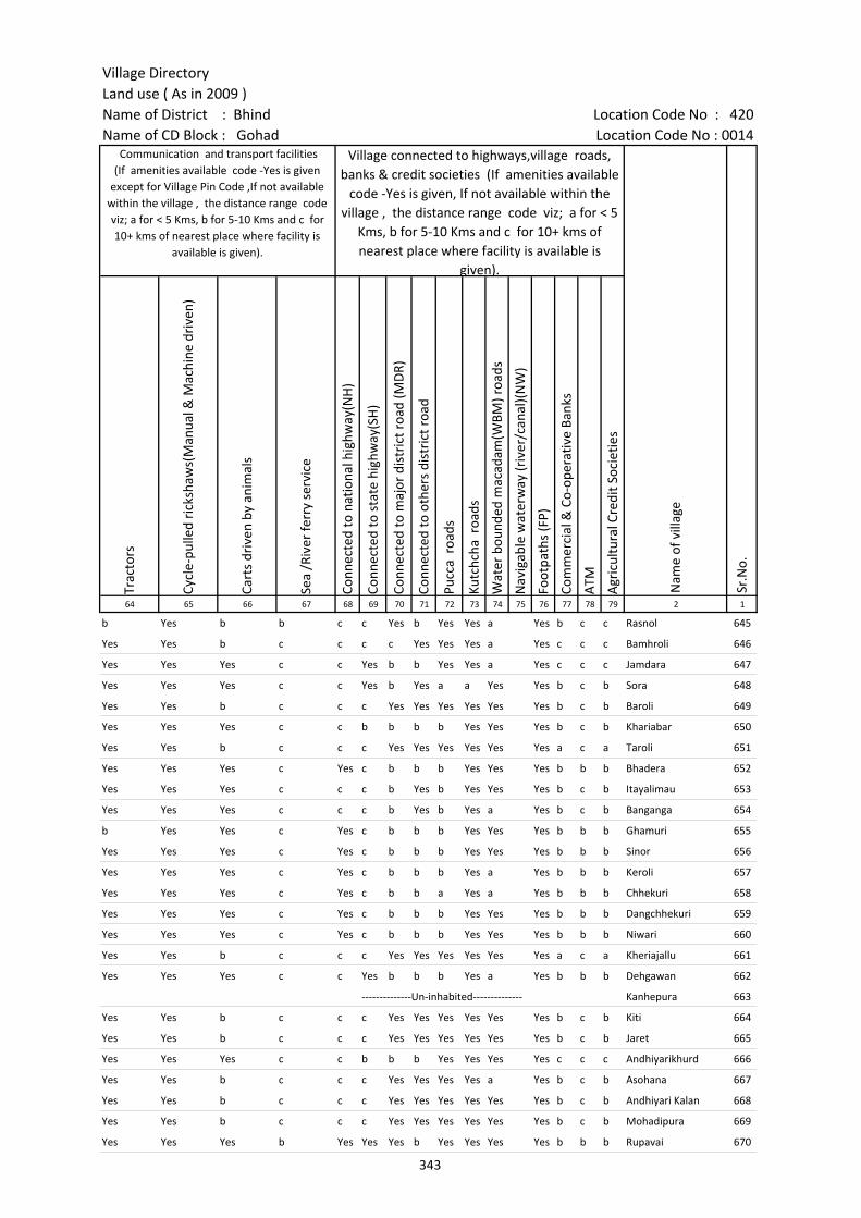
Village DirectoryLand use ( As in 2009 )Name of District : Bhind Location Code No : 420Name of CD Block : Gohad Location Code No : 0014
Trac
tors
Cycl
e-pu
lled
rick
shaw
s(M
anua
l & M
achi
ne d
rive
n)
Cart
s dr
iven
by
anim
als
Sea
/Riv
er fe
rry
serv
ice
Conn
ecte
d to
nat
iona
l hig
hway
(NH
)
Conn
ecte
d to
sta
te h
ighw
ay(S
H)
Conn
ecte
d to
maj
or d
istr
ict r
oad
(MD
R)
Conn
ecte
d to
oth
ers
dist
rict
roa
d
Pucc
a r
oads
Kutc
hcha
roa
ds
Wat
er b
ound
ed m
acad
am(W
BM) r
oads
Nav
igab
le w
ater
way
(riv
er/c
anal
)(N
W)
Foot
path
s (F
P)
Com
mer
cial
& C
o-op
erat
ive
Bank
s
ATM
Agr
icul
tura
l Cre
dit S
ocie
ties
64 65 66 67 68 69 70 71 72 73 74 75 76 77 78 79 2 1
Sr.N
o.
Communication and transport facilities (If amenities available code -Yes is given
except for Village Pin Code ,If not available within the village , the distance range code viz; a for < 5 Kms, b for 5-10 Kms and c for 10+ kms of nearest place where facility is
available is given).
Village connected to highways,village roads, banks & credit societies (If amenities available
code -Yes is given, If not available within the village , the distance range code viz; a for < 5
Kms, b for 5-10 Kms and c for 10+ kms of nearest place where facility is available is
given).
Nam
e of
vill
age
b Yes b b c c Yes b Yes Yes a Yes b c c Rasnol 645
Yes Yes b c c c c Yes Yes Yes a Yes c c c Bamhroli 646
Yes Yes Yes c c Yes b b Yes Yes a Yes c c c Jamdara 647
Yes Yes Yes c c Yes b Yes a a Yes Yes b c b Sora 648
Yes Yes b c c c Yes Yes Yes Yes Yes Yes b c b Baroli 649
Yes Yes Yes c c b b b b Yes Yes Yes b c b Khariabar 650
Yes Yes b c c c Yes Yes Yes Yes Yes Yes a c a Taroli 651
Yes Yes Yes c Yes c b b b Yes Yes Yes b b b Bhadera 652
Yes Yes Yes c c c b Yes b Yes Yes Yes b c b Itayalimau 653
Yes Yes Yes c c c b Yes b Yes a Yes b c b Banganga 654
b Yes Yes c Yes c b b b Yes Yes Yes b b b Ghamuri 655
Yes Yes Yes c Yes c b b b Yes Yes Yes b b b Sinor 656
Yes Yes Yes c Yes c b b b Yes a Yes b b b Keroli 657
Yes Yes Yes c Yes c b b a Yes a Yes b b b Chhekuri 658
Yes Yes Yes c Yes c b b b Yes Yes Yes b b b Dangchhekuri 659
Yes Yes Yes c Yes c b b b Yes Yes Yes b b b Niwari 660
Yes Yes b c c c Yes Yes Yes Yes Yes Yes a c a Kheriajallu 661
Yes Yes Yes c c Yes b b b Yes a Yes b b b Dehgawan 662
--------------Un-inhabited-------------- Kanhepura 663
Yes Yes b c c c Yes Yes Yes Yes Yes Yes b c b Kiti 664
Yes Yes b c c c Yes Yes Yes Yes Yes Yes b c b Jaret 665
Yes Yes Yes c c b b b Yes Yes Yes Yes c c c Andhiyarikhurd 666
Yes Yes b c c c Yes Yes Yes Yes a Yes b c b Asohana 667
Yes Yes b c c c Yes Yes Yes Yes Yes Yes b c b Andhiyari Kalan 668
Yes Yes b c c c Yes Yes Yes Yes Yes Yes b c b Mohadipura 669
Yes Yes Yes b Yes Yes Yes b Yes Yes Yes Yes b b b Rupavai 670
343
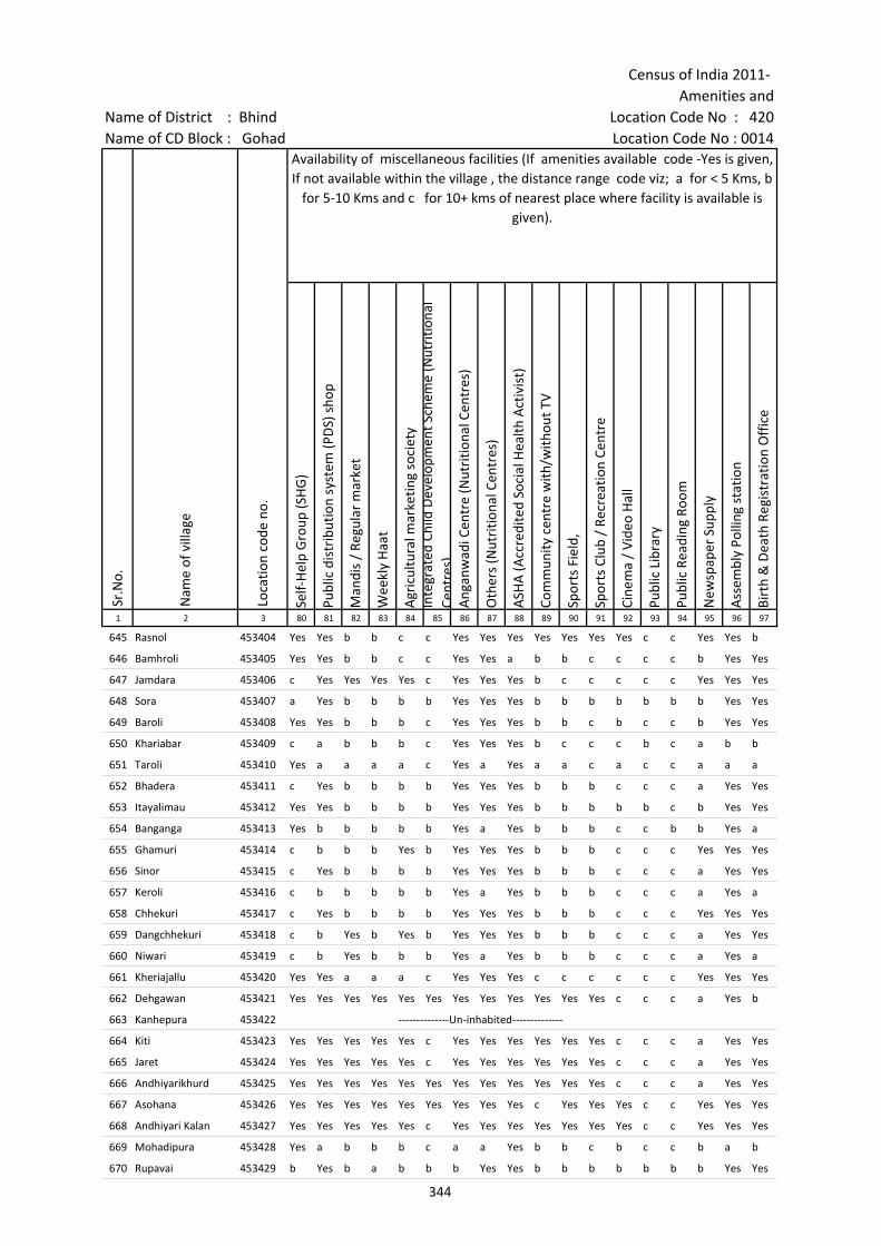
Census of India 2011- Amenities and
Name of District : Bhind Location Code No : 420Name of CD Block : Gohad Location Code No : 0014
Self-
Hel
p G
roup
(SH
G)
Publ
ic d
istr
ibut
ion
syst
em (P
DS)
sho
p
Man
dis
/ Re
gula
r m
arke
t
Wee
kly
Haa
t
Agr
icul
tura
l mar
ketin
g so
ciet
yIn
tegr
ated
Chi
ld D
evel
opm
ent S
chem
e (N
utri
tiona
l Ce
ntre
s)A
ngan
wad
i Cen
tre
(Nut
ritio
nal C
entr
es)
Oth
ers
(Nut
ritio
nal C
entr
es)
ASH
A (A
ccre
dite
d So
cial
Hea
lth A
ctiv
ist)
Com
mun
ity c
entr
e w
ith/w
ithou
t TV
Spor
ts F
ield
,
Spor
ts C
lub
/ Re
crea
tion
Cent
re
Cine
ma
/ Vi
deo
Hal
l
Publ
ic L
ibra
ry
Publ
ic R
eadi
ng R
oom
New
spap
er S
uppl
y
Ass
embl
y Po
lling
sta
tion
Birt
h &
Dea
th R
egis
trat
ion
Off
ice
1 2 3 80 81 82 83 84 85 86 87 88 89 90 91 92 93 94 95 96 97
Sr.N
o.
Nam
e of
vill
age
Loca
tion
code
no.
Availability of miscellaneous facilities (If amenities available code -Yes is given, If not available within the village , the distance range code viz; a for < 5 Kms, b
for 5-10 Kms and c for 10+ kms of nearest place where facility is available is given).
645 Rasnol 453404 Yes Yes b b c c Yes Yes Yes Yes Yes Yes Yes c c Yes Yes b
646 Bamhroli 453405 Yes Yes b b c c Yes Yes a b b c c c c b Yes Yes
647 Jamdara 453406 c Yes Yes Yes Yes c Yes Yes Yes b c c c c c Yes Yes Yes
648 Sora 453407 a Yes b b b b Yes Yes Yes b b b b b b b Yes Yes
649 Baroli 453408 Yes Yes b b b c Yes Yes Yes b b c b c c b Yes Yes
650 Khariabar 453409 c a b b b c Yes Yes Yes b c c c b c a b b
651 Taroli 453410 Yes a a a a c Yes a Yes a a c a c c a a a
652 Bhadera 453411 c Yes b b b b Yes Yes Yes b b b c c c a Yes Yes
653 Itayalimau 453412 Yes Yes b b b b Yes Yes Yes b b b b b c b Yes Yes
654 Banganga 453413 Yes b b b b b Yes a Yes b b b c c b b Yes a
655 Ghamuri 453414 c b b b Yes b Yes Yes Yes b b b c c c Yes Yes Yes
656 Sinor 453415 c Yes b b b b Yes Yes Yes b b b c c c a Yes Yes
657 Keroli 453416 c b b b b b Yes a Yes b b b c c c a Yes a
658 Chhekuri 453417 c Yes b b b b Yes Yes Yes b b b c c c Yes Yes Yes
659 Dangchhekuri 453418 c b Yes b Yes b Yes Yes Yes b b b c c c a Yes Yes
660 Niwari 453419 c b Yes b b b Yes a Yes b b b c c c a Yes a
661 Kheriajallu 453420 Yes Yes a a a c Yes Yes Yes c c c c c c Yes Yes Yes
662 Dehgawan 453421 Yes Yes Yes Yes Yes Yes Yes Yes Yes Yes Yes Yes c c c a Yes b
663 Kanhepura 453422 --------------Un-inhabited--------------
664 Kiti 453423 Yes Yes Yes Yes Yes c Yes Yes Yes Yes Yes Yes c c c a Yes Yes
665 Jaret 453424 Yes Yes Yes Yes Yes c Yes Yes Yes Yes Yes Yes c c c a Yes Yes
666 Andhiyarikhurd 453425 Yes Yes Yes Yes Yes Yes Yes Yes Yes Yes Yes Yes c c c a Yes Yes
667 Asohana 453426 Yes Yes Yes Yes Yes Yes Yes Yes Yes c Yes Yes Yes c c Yes Yes Yes
668 Andhiyari Kalan 453427 Yes Yes Yes Yes Yes c Yes Yes Yes Yes Yes Yes Yes c c Yes Yes Yes
669 Mohadipura 453428 Yes a b b b c a a Yes b b c b c c b a b
670 Rupavai 453429 b Yes b a b b b Yes Yes b b b b b b b Yes Yes
344
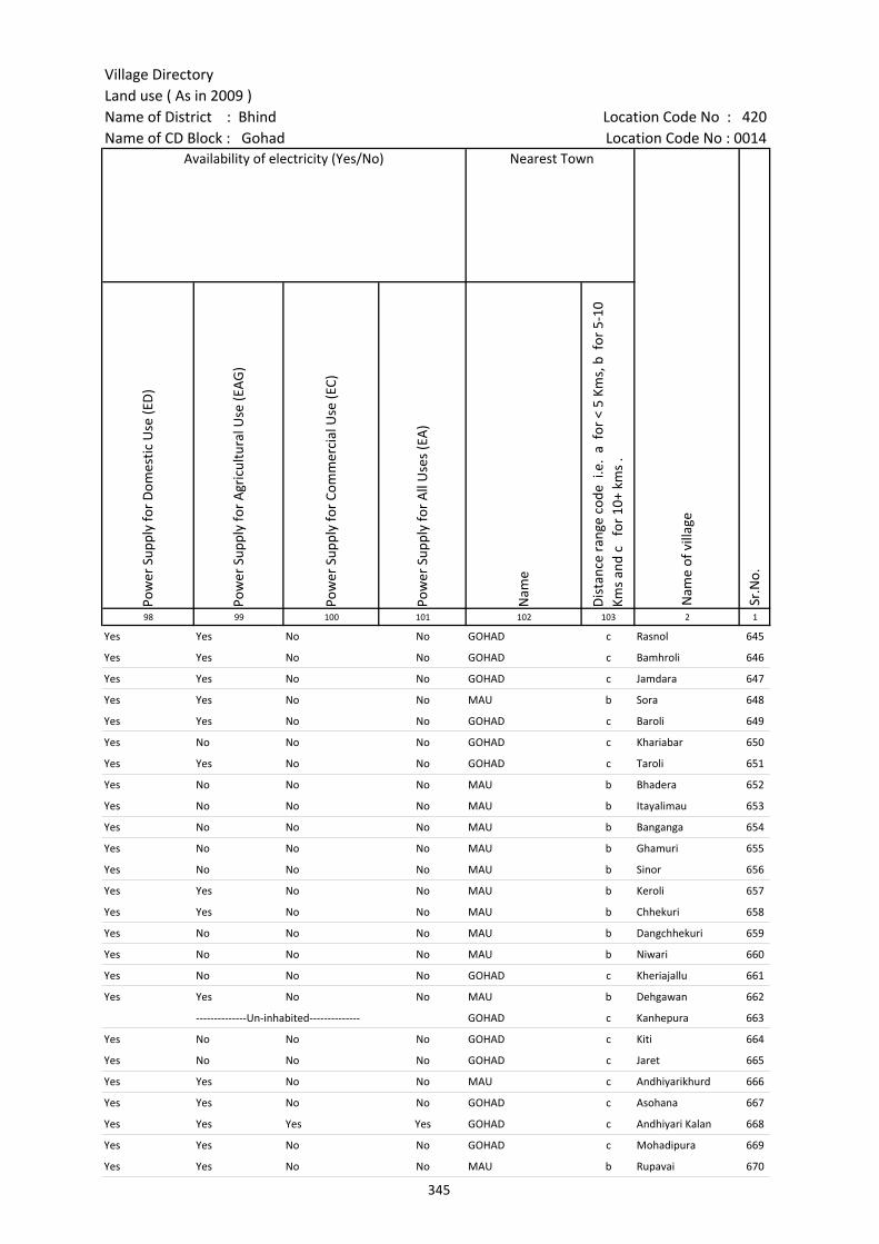
Village DirectoryLand use ( As in 2009 )Name of District : Bhind Location Code No : 420Name of CD Block : Gohad Location Code No : 0014
Pow
er S
uppl
y fo
r D
omes
tic U
se (E
D)
Pow
er S
uppl
y fo
r A
gric
ultu
ral U
se (E
AG
)
Pow
er S
uppl
y fo
r Co
mm
erci
al U
se (E
C)
Pow
er S
uppl
y fo
r A
ll U
ses
(EA
)
Nam
e
Dis
tanc
e ra
nge
code
i.e
. a
for
< 5
Kms,
b f
or 5
-10
Kms
and
c f
or 1
0+ k
ms
.98 99 100 101 102 103 2 1
Nearest Town
Nam
e of
vill
age
Sr.N
o.
Availability of electricity (Yes/No)
Yes Yes No No GOHAD c Rasnol 645
Yes Yes No No GOHAD c Bamhroli 646
Yes Yes No No GOHAD c Jamdara 647
Yes Yes No No MAU b Sora 648
Yes Yes No No GOHAD c Baroli 649
Yes No No No GOHAD c Khariabar 650
Yes Yes No No GOHAD c Taroli 651
Yes No No No MAU b Bhadera 652
Yes No No No MAU b Itayalimau 653
Yes No No No MAU b Banganga 654
Yes No No No MAU b Ghamuri 655
Yes No No No MAU b Sinor 656
Yes Yes No No MAU b Keroli 657
Yes Yes No No MAU b Chhekuri 658
Yes No No No MAU b Dangchhekuri 659
Yes No No No MAU b Niwari 660
Yes No No No GOHAD c Kheriajallu 661
Yes Yes No No MAU b Dehgawan 662
--------------Un-inhabited-------------- GOHAD c Kanhepura 663
Yes No No No GOHAD c Kiti 664
Yes No No No GOHAD c Jaret 665
Yes Yes No No MAU c Andhiyarikhurd 666
Yes Yes No No GOHAD c Asohana 667
Yes Yes Yes Yes GOHAD c Andhiyari Kalan 668
Yes Yes No No GOHAD c Mohadipura 669
Yes Yes No No MAU b Rupavai 670
345
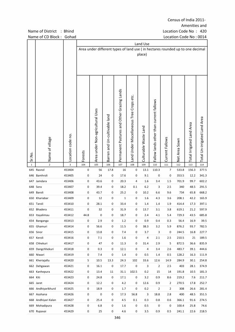
Census of India 2011- Amenities and
Name of District : Bhind Location Code No : 420Name of CD Block : Gohad Location Code No : 0014
Fore
sts
Are
a un
der
Non
-agr
icul
tura
l Use
s
Barr
en a
nd U
n-cu
ltiva
ble
land
Perm
anen
t Pas
ture
s an
d O
ther
Gra
zing
Lan
ds
Land
Und
er M
isce
llane
ous
Tree
Cro
ps e
tc.
Cultu
rabl
e W
aste
Lan
d
Fallo
w la
nds
othe
r th
an c
urre
nt fa
llow
s
Curr
ent F
allo
ws
Net
Are
a So
wn
Tota
l Irr
igat
ed L
and
Are
a
Tota
l Un-
irri
gate
d La
nd A
rea
1 2 3 104 105 106 107 108 109 110 111 112 113 114
Land UseArea under different types of land use ( in hectares rounded up to one decimal
place)
Sr.N
o.
Nam
e of
vill
age
Loca
tion
code
no.
645 Rasnol 453404 0 56 17.8 16 0 13.1 110.3 7 533.8 156.3 377.5
646 Bamhroli 453405 0 24 0 17.6 0 9.1 0 0 353.5 12.2 341.3
647 Jamdara 453406 0 43.6 0 20.3 4 1.6 3.4 1.5 701.9 99.7 602.2
648 Sora 453407 0 39.4 0 18.2 0.1 6.2 3 2.5 340 48.5 291.5
649 Baroli 453408 0 43.7 0 25.2 0 10.2 6.6 9.6 734 65.8 668.2
650 Khariabar 453409 0 12 0 1 0 1.6 4.3 3.6 208.1 42.2 165.9
651 Taroli 453410 0 28.1 0 33.4 0 1.4 1.4 1.9 414.4 17.3 397.1
652 Bhadera 453411 0 32 0 31.9 0 13.7 3.1 3.8 619.1 21.2 597.9
653 Itayalimau 453412 44.8 0 0 18.7 0 2.4 4.1 5.4 729.3 43.5 685.8
654 Banganga 453413 0 2.9 0 1.2 0 0.9 0.4 0.3 56.4 16.9 39.5
655 Ghamuri 453414 0 56.6 0 11.5 0 38.3 3.2 5.9 876.2 93.7 782.5
656 Sinor 453415 0 13.8 0 7.4 0 3.7 3 0 244.5 16.8 227.7
657 Keroli 453416 0 7.1 0 1.6 0 4 2.1 2.5 210.5 21 189.5
658 Chhekuri 453417 0 47 0 11.3 0 31.4 2.9 5 872.5 36.6 835.9
659 Dangchhekuri 453418 0 0.3 0 12.1 0 4 3.4 2.6 483.7 39.1 444.6
660 Niwari 453419 0 7.4 0 1.4 0 0.5 1.4 0.5 128.2 16.3 111.9
661 Kheriajallu 453420 5 10.5 13.3 24.3 102 33.6 12.6 14.9 284.9 30.1 254.8
662 Dehgawan 453421 0 16.1 0 17.7 0 3 2 2.5 403 28.1 374.9
663 Kanhepura 453422 0 13.4 11 31.1 102.5 0.2 15 14 191.8 10.5 181.3
664 Kiti 453423 0 24.8 0 17.1 0 3.2 0.9 8.6 219.2 7.6 211.7
665 Jaret 453424 0 12.2 0 4.2 0 12.6 0.9 2 270.5 17.8 252.7
666 Andhiyarikhurd 453425 0 18.9 0 1.7 0 0.2 2 2 308 26.6 281.4
667 Asohana 453426 0 0 0 17.3 56.8 3 18.8 2.8 400 48.5 351.5
668 Andhiyari Kalan 453427 0 25.4 0 4.5 0.1 0.3 0.8 0.6 366.1 91.6 274.5
669 Mohadipura 453428 0 6.8 0 1.6 0 0.5 0 0 100.4 25.8 74.6
670 Rupavai 453429 0 25 0 4.6 0 3.5 0.9 0.5 241.1 22.6 218.5
346
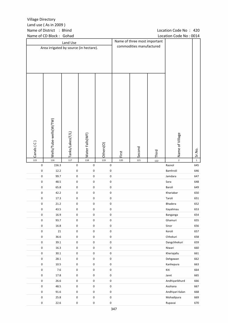
Village DirectoryLand use ( As in 2009 )Name of District : Bhind Location Code No : 420Name of CD Block : Gohad Location Code No : 0014
Cana
ls (
C )
Wel
ls/T
ube-
wel
ls(W
/TW
)
Tank
s/La
kes(
T/L)
Wat
er F
alls
(WF)
Oth
ers(
O)
Firs
t
Seco
nd
Thir
d 115 116 117 118 119 120 121 122 2 1
Land Use Name of three most important commodities manufactured
Nam
e of
Vill
age
Sr.N
o.
Area irrigated by source (in hectare).
0 156.3 0 0 0 Rasnol 645
0 12.2 0 0 0 Bamhroli 646
0 99.7 0 0 0 Jamdara 647
0 48.5 0 0 0 Sora 648
0 65.8 0 0 0 Baroli 649
0 42.2 0 0 0 Khariabar 650
0 17.3 0 0 0 Taroli 651
0 21.2 0 0 0 Bhadera 652
0 43.5 0 0 0 Itayalimau 653
0 16.9 0 0 0 Banganga 654
0 93.7 0 0 0 Ghamuri 655
0 16.8 0 0 0 Sinor 656
0 21 0 0 0 Keroli 657
0 36.6 0 0 0 Chhekuri 658
0 39.1 0 0 0 Dangchhekuri 659
0 16.3 0 0 0 Niwari 660
0 30.1 0 0 0 Kheriajallu 661
0 28.1 0 0 0 Dehgawan 662
0 10.5 0 0 0 Kanhepura 663
0 7.6 0 0 0 Kiti 664
0 17.8 0 0 0 Jaret 665
0 26.6 0 0 0 Andhiyarikhurd 666
0 48.5 0 0 0 Asohana 667
0 91.6 0 0 0 Andhiyari Kalan 668
0 25.8 0 0 0 Mohadipura 669
0 22.6 0 0 0 Rupavai 670
347
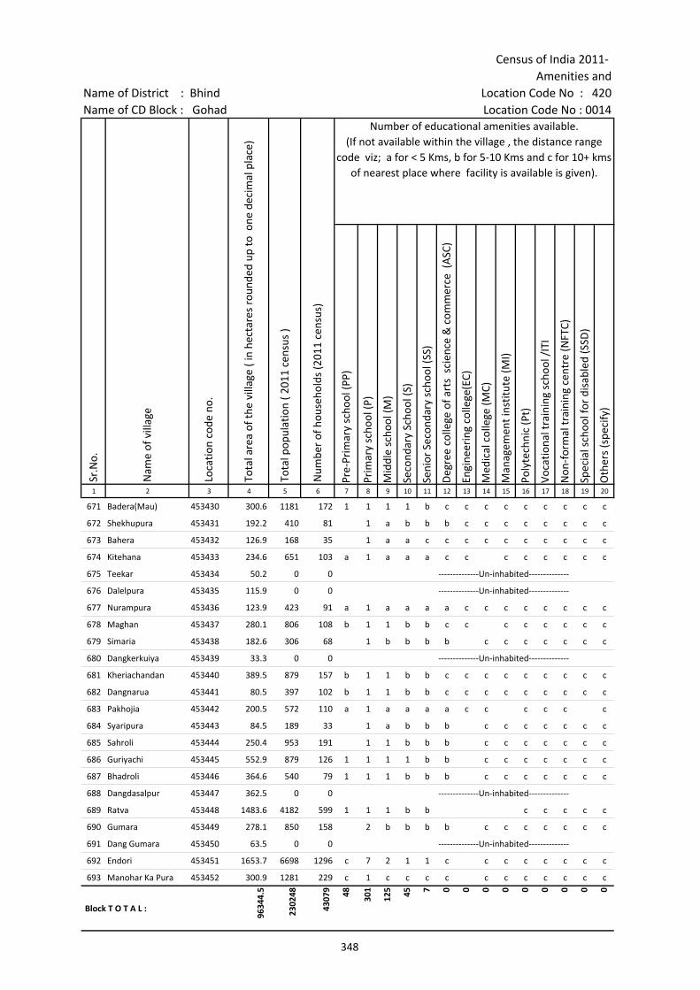
Census of India 2011- Amenities and
Name of District : Bhind Location Code No : 420Name of CD Block : Gohad Location Code No : 0014
Pre-
Prim
ary
scho
ol (P
P)
Prim
ary
scho
ol (P
)
Mid
dle
scho
ol (M
)
Seco
ndar
y Sc
hool
(S)
Seni
or S
econ
dary
sch
ool (
SS)
Deg
ree
colle
ge o
f art
s s
cien
ce &
com
mer
ce (
ASC
)
Engi
neer
ing
colle
ge(E
C)
Med
ical
col
lege
(MC)
Man
agem
ent i
nstit
ute
(MI)
Poly
tech
nic
(Pt)
Voca
tiona
l tra
inin
g sc
hool
/IT
I
Non
-for
mal
trai
ning
cen
tre
(NFT
C)
Spec
ial s
choo
l for
dis
able
d (S
SD)
Oth
ers
(spe
cify
)
1 2 3 4 5 6 7 8 9 10 11 12 13 14 15 16 17 18 19 20
Sr.N
o.
Nam
e of
vill
age
Loca
tion
code
no.
Tota
l are
a of
the
villa
ge (
in h
ecta
res
roun
ded
up to
one
dec
imal
pla
ce)
Tota
l pop
ulat
ion
( 201
1 ce
nsus
)
Num
ber
of h
ouse
hold
s (2
011
cens
us)
Number of educational amenities available. (If not available within the village , the distance range
code viz; a for < 5 Kms, b for 5-10 Kms and c for 10+ kms of nearest place where facility is available is given).
671 Badera(Mau) 453430 300.6 1181 172 1 1 1 1 b c c c c c c c c c
672 Shekhupura 453431 192.2 410 81 1 a b b b c c c c c c c c
673 Bahera 453432 126.9 168 35 1 a a c c c c c c c c c c
674 Kitehana 453433 234.6 651 103 a 1 a a a c c c c c c c c
675 Teekar 453434 50.2 0 0 --------------Un-inhabited--------------
676 Dalelpura 453435 115.9 0 0 --------------Un-inhabited--------------
677 Nurampura 453436 123.9 423 91 a 1 a a a a c c c c c c c c
678 Maghan 453437 280.1 806 108 b 1 1 b b c c c c c c c c
679 Simaria 453438 182.6 306 68 1 b b b b c c c c c c c
680 Dangkerkuiya 453439 33.3 0 0 --------------Un-inhabited--------------
681 Kheriachandan 453440 389.5 879 157 b 1 1 b b c c c c c c c c c
682 Dangnarua 453441 80.5 397 102 b 1 1 b b c c c c c c c c c
683 Pakhojia 453442 200.5 572 110 a 1 a a a a c c c c c c
684 Syaripura 453443 84.5 189 33 1 a b b b c c c c c c c
685 Sahroli 453444 250.4 953 191 1 1 b b b c c c c c c c
686 Guriyachi 453445 552.9 879 126 1 1 1 1 b b c c c c c c c
687 Bhadroli 453446 364.6 540 79 1 1 1 b b b c c c c c c c
688 Dangdasalpur 453447 362.5 0 0 --------------Un-inhabited--------------
689 Ratva 453448 1483.6 4182 599 1 1 1 b b c c c c c
690 Gumara 453449 278.1 850 158 2 b b b b c c c c c c c
691 Dang Gumara 453450 63.5 0 0 --------------Un-inhabited--------------
692 Endori 453451 1653.7 6698 1296 c 7 2 1 1 c c c c c c c c
693 Manohar Ka Pura 453452 300.9 1281 229 c 1 c c c c c c c c c c c
Block T O T A L :
9634
4.5
2302
48
4307
9 48 301
125 45 7 0 0 0 0 0 0 0 0 0
348

Village DirectoryLand use ( As in 2009 )Name of District : Bhind Location Code No : 420Name of CD Block : Gohad Location Code No : 0014
Com
mun
ity h
ealth
cen
tre
(CH
C)Pr
imar
y he
alth
cen
tre
(PH
C)Pr
imar
y he
alth
sub
cen
tre
(PH
S)M
ater
nity
and
chi
ld w
elfa
re c
entr
e (M
CW)
T.B.
clin
ic (
TBC)
Hos
pita
l-allo
path
ic (H
A)
Hos
pita
l-alte
rnat
ive
med
icin
e (H
O)
Dis
pens
ary
(D)
Vete
rina
ry h
ospi
tal (
VH)
Mob
ile h
ealth
clin
ic (M
HC)
Fam
ily w
elfa
re c
entr
e (F
WC)
Char
itabl
e no
n G
ovt.
hos
pita
l/N
ursi
ng h
ome.
Med
ical
pra
ctiti
oner
with
MBB
S D
egre
eM
edic
al p
ract
ition
er w
ith o
ther
deg
ree
Med
ical
pra
ctiti
oner
with
no
degr
eeTr
aditi
onal
pra
ctiti
oner
and
faith
hea
ler
.M
edic
ine
Shop
Oth
ers
Tap
wat
er (T
reat
ed/U
ntre
ated
)
Wel
l w
ater
(C
over
ed /
Unc
over
ed w
ell)
Han
d Pu
mp
Tube
wel
ls /
Bor
e w
ell
Spri
ng
Rive
r /
Cana
l
Tank
/ P
ond
/ L
ake
Oth
ers
21 22 23 24 25 26 27 28 29 30 31 32 33 34 35 36 37 38 39 40 41 42 43 44 45 46 2 1
Number of Medical Amenities available. (If not available within the
village , the distance range code viz; a for < 5 Kms, b for 5-10 Kms and c for
10+ kms of nearest place where facility is available is given).
Number of Non-Government
Medical Amenities available.
Availability of drinking water - Yes / No
Nam
e of
vill
age
Sr.N
o.
b b b b b b b b b b b 0 0 0 0 0 0 0 No Yes Yes No No No No No Badera(Mau) 671
b b b b b b b c b b b 0 0 0 0 0 0 0 No Yes Yes No No No No No Shekhupura 672
b b b b b b b b b b b 0 0 0 0 0 0 0 Yes Yes Yes No No No No No Bahera 673
a a a a a a c c a a a 0 0 0 0 0 0 0 No Yes Yes Yes No No No No Kitehana 674
--------------Un-inhabited-------------- Teekar 675
--------------Un-inhabited-------------- Dalelpura 676
a a a a a a a c a a a 0 0 0 0 0 0 0 No Yes Yes No No No No No Nurampura 677
b b b b b b c c b b b 0 0 0 0 0 0 0 No Yes Yes Yes No No No No Maghan 678
b b b c b b b c b b b 0 0 0 0 0 0 0 No Yes Yes No No No No No Simaria 679
--------------Un-inhabited-------------- Dangkerkuiya 680
c c c c c c c c b b c 0 0 0 0 0 0 0 No Yes Yes Yes No No No No Kheriachandan 681
b c c c c c c c b b c 0 0 0 0 0 0 0 No No Yes No No No No No Dangnarua 682
a a a a a a c c a a a 0 0 0 0 0 0 0 No Yes Yes Yes No No No No Pakhojia 683
b b b b b b b c b b b 0 0 0 0 0 0 0 No Yes Yes No No No No No Syaripura 684
b b b b b b b c b b b 0 0 0 0 0 0 0 No Yes Yes No No No No No Sahroli 685
b b b b b b c b b b 0 0 0 0 0 0 0 No Yes Yes No No No No No Guriyachi 686
b b b b b b b c b b b 0 0 0 0 0 0 0 No Yes Yes No No No No No Bhadroli 687
--------------Un-inhabited-------------- Dangdasalpur 688
b b 1 b b b c c b b b 0 0 0 0 0 0 0 No Yes Yes Yes No No No No Ratva 689
b b b b b b b c b b b 0 0 0 0 0 0 0 No Yes Yes No No No No No Gumara 690
--------------Un-inhabited-------------- Dang Gumara 691
c c 1 c c c c 1 c c c 0 0 0 0 0 0 0 No Yes Yes No No Yes Yes No Endori 692
c c a c c c c c c c c 0 0 0 0 0 0 0 No Yes Yes No No Yes Yes No Manohar Ka Pura 693
0 3 14 2 0 0 0 4 1 0 0 4 3 9 12 11 5 4 6
190
194 61 4 55 29 3
Block T O T A L :
349
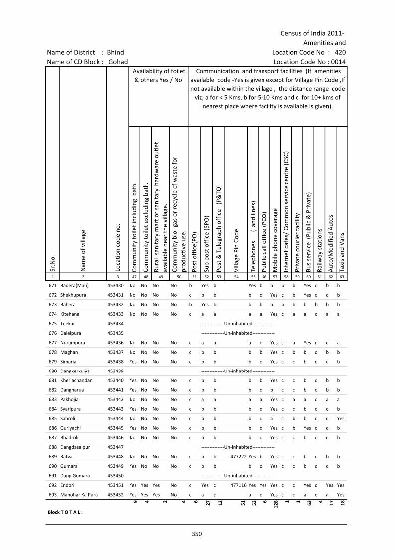
Census of India 2011- Amenities and
Name of District : Bhind Location Code No : 420Name of CD Block : Gohad Location Code No : 0014
Com
mun
ity to
ilet i
nclu
ding
bat
h.
Com
mun
ity to
ilet e
xclu
ding
bat
h.
Rura
l sa
nita
ry m
art o
r sa
nita
ry h
ardw
are
outle
t av
aila
ble
near
the
villa
ge.
Com
mun
ity b
io- g
as o
r re
cycl
e of
was
te fo
r pr
oduc
tive
use.
Post
off
ice(
PO)
Sub
post
off
ice
(SPO
)
Post
& T
eleg
raph
off
ice
(P&
TO)
Villa
ge P
in C
ode
Tele
phon
es
(L
and
lines
)
Publ
ic c
all o
ffic
e (P
CO)
Mob
ile p
hone
cov
erag
e
Inte
rnet
caf
es/
Com
mon
ser
vice
cen
tre
(CSC
)
Priv
ate
cour
ier
faci
lity
Bus
serv
ice
(Pub
lic &
Pri
vate
)
Railw
ay s
tatio
ns
Aut
o/M
odifi
ed A
utos
Taxi
s an
d Va
ns
1 2 3 47 48 49 50 51 52 53 54 55 56 57 58 59 60 61 62 63
Sr.N
o.
Nam
e of
vill
age
Loca
tion
code
no.
Availability of toilet & others Yes / No
Communication and transport facilities (If amenities available code -Yes is given except for Village Pin Code ,If not available within the village , the distance range code
viz; a for < 5 Kms, b for 5-10 Kms and c for 10+ kms of nearest place where facility is available is given).
671 Badera(Mau) 453430 No No No No b Yes b Yes b b b b Yes c b b
672 Shekhupura 453431 No No No No c b b b c Yes c b Yes c c b
673 Bahera 453432 No No No No b Yes b b b b b b b b b b
674 Kitehana 453433 No No No No c a a a a Yes c a a c a a
675 Teekar 453434 --------------Un-inhabited--------------
676 Dalelpura 453435 --------------Un-inhabited--------------
677 Nurampura 453436 No No No No c a a a c Yes c a Yes c c a
678 Maghan 453437 No No No No c b b b b Yes c b b c b b
679 Simaria 453438 Yes No No No c b b b c Yes c c b c c b
680 Dangkerkuiya 453439 --------------Un-inhabited--------------
681 Kheriachandan 453440 Yes No No No c b b b b Yes c c b c b b
682 Dangnarua 453441 Yes No No No c b b b c b c c b c b b
683 Pakhojia 453442 No No No No c a a a a Yes c a a c a a
684 Syaripura 453443 Yes No No No c b b b c Yes c c b c c b
685 Sahroli 453444 No No No No c b b b c a c b b c c Yes
686 Guriyachi 453445 Yes No No No c b b b c Yes c b Yes c c b
687 Bhadroli 453446 No No No No c b b b c Yes c c b c c b
688 Dangdasalpur 453447 --------------Un-inhabited--------------
689 Ratva 453448 No No No No c b b 477222 Yes b Yes c c b c b b
690 Gumara 453449 Yes No No No c b b b c Yes c c b c c b
691 Dang Gumara 453450 --------------Un-inhabited--------------
692 Endori 453451 Yes Yes Yes No c Yes c 477116 Yes Yes Yes c c Yes c Yes Yes
693 Manohar Ka Pura 453452 Yes Yes Yes No c a c a c Yes c c a c a Yes
Block T O T A L :
9 4 2 4 6 27 12 51 53 6
128 1 1 63 4 17 18
350
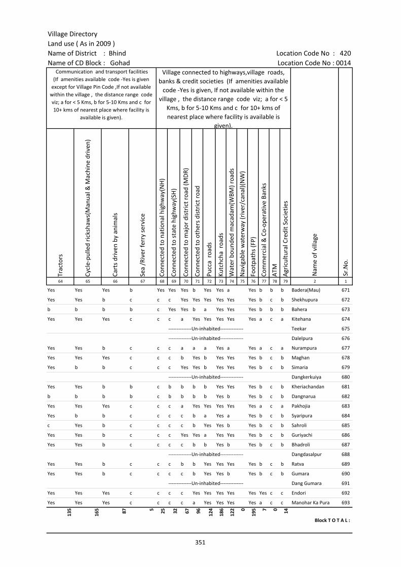
Village DirectoryLand use ( As in 2009 )Name of District : Bhind Location Code No : 420Name of CD Block : Gohad Location Code No : 0014
Trac
tors
Cycl
e-pu
lled
rick
shaw
s(M
anua
l & M
achi
ne d
rive
n)
Cart
s dr
iven
by
anim
als
Sea
/Riv
er fe
rry
serv
ice
Conn
ecte
d to
nat
iona
l hig
hway
(NH
)
Conn
ecte
d to
sta
te h
ighw
ay(S
H)
Conn
ecte
d to
maj
or d
istr
ict r
oad
(MD
R)
Conn
ecte
d to
oth
ers
dist
rict
roa
d
Pucc
a r
oads
Kutc
hcha
roa
ds
Wat
er b
ound
ed m
acad
am(W
BM) r
oads
Nav
igab
le w
ater
way
(riv
er/c
anal
)(N
W)
Foot
path
s (F
P)
Com
mer
cial
& C
o-op
erat
ive
Bank
s
ATM
Agr
icul
tura
l Cre
dit S
ocie
ties
64 65 66 67 68 69 70 71 72 73 74 75 76 77 78 79 2 1
Sr.N
o.
Communication and transport facilities (If amenities available code -Yes is given
except for Village Pin Code ,If not available within the village , the distance range code viz; a for < 5 Kms, b for 5-10 Kms and c for 10+ kms of nearest place where facility is
available is given).
Village connected to highways,village roads, banks & credit societies (If amenities available
code -Yes is given, If not available within the village , the distance range code viz; a for < 5
Kms, b for 5-10 Kms and c for 10+ kms of nearest place where facility is available is
given).
Nam
e of
vill
age
Yes Yes Yes b Yes Yes Yes b Yes Yes a Yes b b b Badera(Mau) 671
Yes Yes b c c c Yes Yes Yes Yes Yes Yes b c b Shekhupura 672
b b b b c Yes Yes b a Yes Yes Yes b b b Bahera 673
Yes Yes Yes c c c a Yes Yes Yes Yes Yes a c a Kitehana 674
--------------Un-inhabited-------------- Teekar 675
--------------Un-inhabited-------------- Dalelpura 676
Yes Yes b c c c a a a Yes a Yes a c a Nurampura 677
Yes Yes Yes c c c b Yes b Yes Yes Yes b c b Maghan 678
Yes b b c c c Yes Yes b Yes Yes Yes b c b Simaria 679
--------------Un-inhabited-------------- Dangkerkuiya 680
Yes Yes b b c b b b b Yes Yes Yes b c b Kheriachandan 681
b b b b c b b b b Yes b Yes b c b Dangnarua 682
Yes Yes Yes c c c a Yes Yes Yes Yes Yes a c a Pakhojia 683
Yes b b c c c c b a Yes a Yes b c b Syaripura 684
c Yes b c c c c b Yes Yes b Yes b c b Sahroli 685
Yes Yes b c c c Yes Yes a Yes Yes Yes b c b Guriyachi 686
Yes Yes b c c c c b b Yes b Yes b c b Bhadroli 687
--------------Un-inhabited-------------- Dangdasalpur 688
Yes Yes b c c c b b Yes Yes Yes Yes b c b Ratva 689
Yes Yes b c c c c b Yes Yes b Yes b c b Gumara 690
--------------Un-inhabited-------------- Dang Gumara 691
Yes Yes Yes c c c c Yes Yes Yes Yes Yes Yes c c Endori 692
Yes Yes Yes c c c c a Yes Yes Yes Yes a c c Manohar Ka Pura 693
135
165 87 5 25 32 67 96 124
186
122 0
195 7 0 14
Block T O T A L :
351
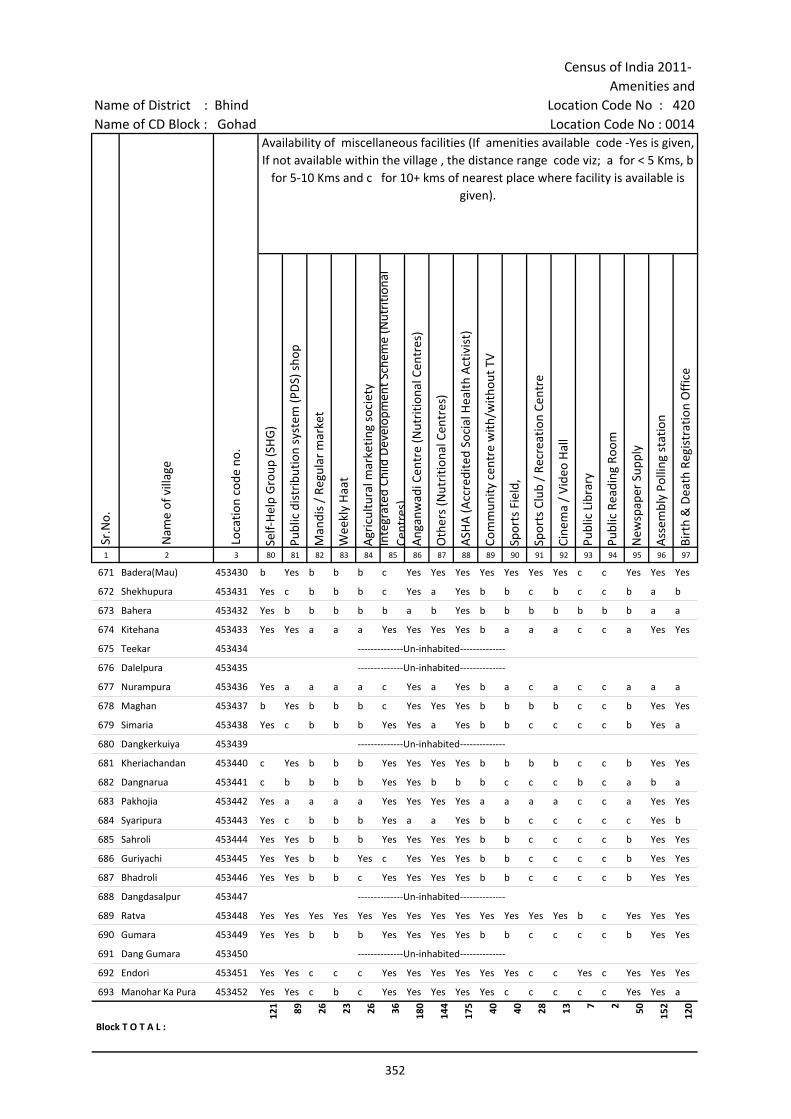
Census of India 2011- Amenities and
Name of District : Bhind Location Code No : 420Name of CD Block : Gohad Location Code No : 0014
Self-
Hel
p G
roup
(SH
G)
Publ
ic d
istr
ibut
ion
syst
em (P
DS)
sho
p
Man
dis
/ Re
gula
r m
arke
t
Wee
kly
Haa
t
Agr
icul
tura
l mar
ketin
g so
ciet
yIn
tegr
ated
Chi
ld D
evel
opm
ent S
chem
e (N
utri
tiona
l Ce
ntre
s)A
ngan
wad
i Cen
tre
(Nut
ritio
nal C
entr
es)
Oth
ers
(Nut
ritio
nal C
entr
es)
ASH
A (A
ccre
dite
d So
cial
Hea
lth A
ctiv
ist)
Com
mun
ity c
entr
e w
ith/w
ithou
t TV
Spor
ts F
ield
,
Spor
ts C
lub
/ Re
crea
tion
Cent
re
Cine
ma
/ Vi
deo
Hal
l
Publ
ic L
ibra
ry
Publ
ic R
eadi
ng R
oom
New
spap
er S
uppl
y
Ass
embl
y Po
lling
sta
tion
Birt
h &
Dea
th R
egis
trat
ion
Off
ice
1 2 3 80 81 82 83 84 85 86 87 88 89 90 91 92 93 94 95 96 97
Sr.N
o.
Nam
e of
vill
age
Loca
tion
code
no.
Availability of miscellaneous facilities (If amenities available code -Yes is given, If not available within the village , the distance range code viz; a for < 5 Kms, b
for 5-10 Kms and c for 10+ kms of nearest place where facility is available is given).
671 Badera(Mau) 453430 b Yes b b b c Yes Yes Yes Yes Yes Yes Yes c c Yes Yes Yes
672 Shekhupura 453431 Yes c b b b c Yes a Yes b b c b c c b a b
673 Bahera 453432 Yes b b b b b a b Yes b b b b b b b a a
674 Kitehana 453433 Yes Yes a a a Yes Yes Yes Yes b a a a c c a Yes Yes
675 Teekar 453434 --------------Un-inhabited--------------
676 Dalelpura 453435 --------------Un-inhabited--------------
677 Nurampura 453436 Yes a a a a c Yes a Yes b a c a c c a a a
678 Maghan 453437 b Yes b b b c Yes Yes Yes b b b b c c b Yes Yes
679 Simaria 453438 Yes c b b b Yes Yes a Yes b b c c c c b Yes a
680 Dangkerkuiya 453439 --------------Un-inhabited--------------
681 Kheriachandan 453440 c Yes b b b Yes Yes Yes Yes b b b b c c b Yes Yes
682 Dangnarua 453441 c b b b b Yes Yes b b b c c c b c a b a
683 Pakhojia 453442 Yes a a a a Yes Yes Yes Yes a a a a c c a Yes Yes
684 Syaripura 453443 Yes c b b b Yes a a Yes b b c c c c c Yes b
685 Sahroli 453444 Yes Yes b b b Yes Yes Yes Yes b b c c c c b Yes Yes
686 Guriyachi 453445 Yes Yes b b Yes c Yes Yes Yes b b c c c c b Yes Yes
687 Bhadroli 453446 Yes Yes b b c Yes Yes Yes Yes b b c c c c b Yes Yes
688 Dangdasalpur 453447 --------------Un-inhabited--------------
689 Ratva 453448 Yes Yes Yes Yes Yes Yes Yes Yes Yes Yes Yes Yes Yes b c Yes Yes Yes
690 Gumara 453449 Yes Yes b b b Yes Yes Yes Yes b b c c c c b Yes Yes
691 Dang Gumara 453450 --------------Un-inhabited--------------
692 Endori 453451 Yes Yes c c c Yes Yes Yes Yes Yes Yes c c Yes c Yes Yes Yes
693 Manohar Ka Pura 453452 Yes Yes c b c Yes Yes Yes Yes Yes c c c c c Yes Yes a
Block T O T A L :
121 89 26 23 26 36 180
144
175 40 40 28 13 7 2 50 152
120
352
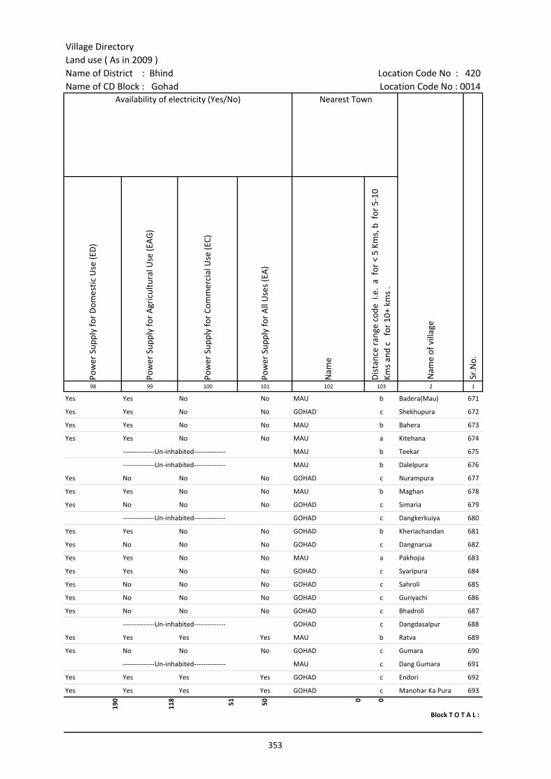
Village DirectoryLand use ( As in 2009 )Name of District : Bhind Location Code No : 420Name of CD Block : Gohad Location Code No : 0014
Pow
er S
uppl
y fo
r D
omes
tic U
se (E
D)
Pow
er S
uppl
y fo
r A
gric
ultu
ral U
se (E
AG
)
Pow
er S
uppl
y fo
r Co
mm
erci
al U
se (E
C)
Pow
er S
uppl
y fo
r A
ll U
ses
(EA
)
Nam
e
Dis
tanc
e ra
nge
code
i.e
. a
for
< 5
Kms,
b f
or 5
-10
Kms
and
c f
or 1
0+ k
ms
.98 99 100 101 102 103 2 1
Nearest Town
Nam
e of
vill
age
Sr.N
o.
Availability of electricity (Yes/No)
Yes Yes No No MAU b Badera(Mau) 671
Yes Yes No No GOHAD c Shekhupura 672
Yes Yes No No MAU b Bahera 673
Yes Yes No No MAU a Kitehana 674
--------------Un-inhabited-------------- MAU b Teekar 675
--------------Un-inhabited-------------- MAU b Dalelpura 676
Yes No No No GOHAD c Nurampura 677
Yes Yes No No MAU b Maghan 678
Yes No No No GOHAD c Simaria 679
--------------Un-inhabited-------------- GOHAD c Dangkerkuiya 680
Yes Yes No No GOHAD b Kheriachandan 681
Yes No No No GOHAD c Dangnarua 682
Yes Yes No No MAU a Pakhojia 683
Yes Yes No No GOHAD c Syaripura 684
Yes No No No GOHAD c Sahroli 685
Yes No No No GOHAD c Guriyachi 686
Yes No No No GOHAD c Bhadroli 687
--------------Un-inhabited-------------- GOHAD c Dangdasalpur 688
Yes Yes Yes Yes MAU b Ratva 689
Yes No No No GOHAD c Gumara 690
--------------Un-inhabited-------------- MAU c Dang Gumara 691
Yes Yes Yes Yes GOHAD c Endori 692
Yes Yes Yes Yes GOHAD c Manohar Ka Pura 693
190
118 51 50 0 0
Block T O T A L :
353
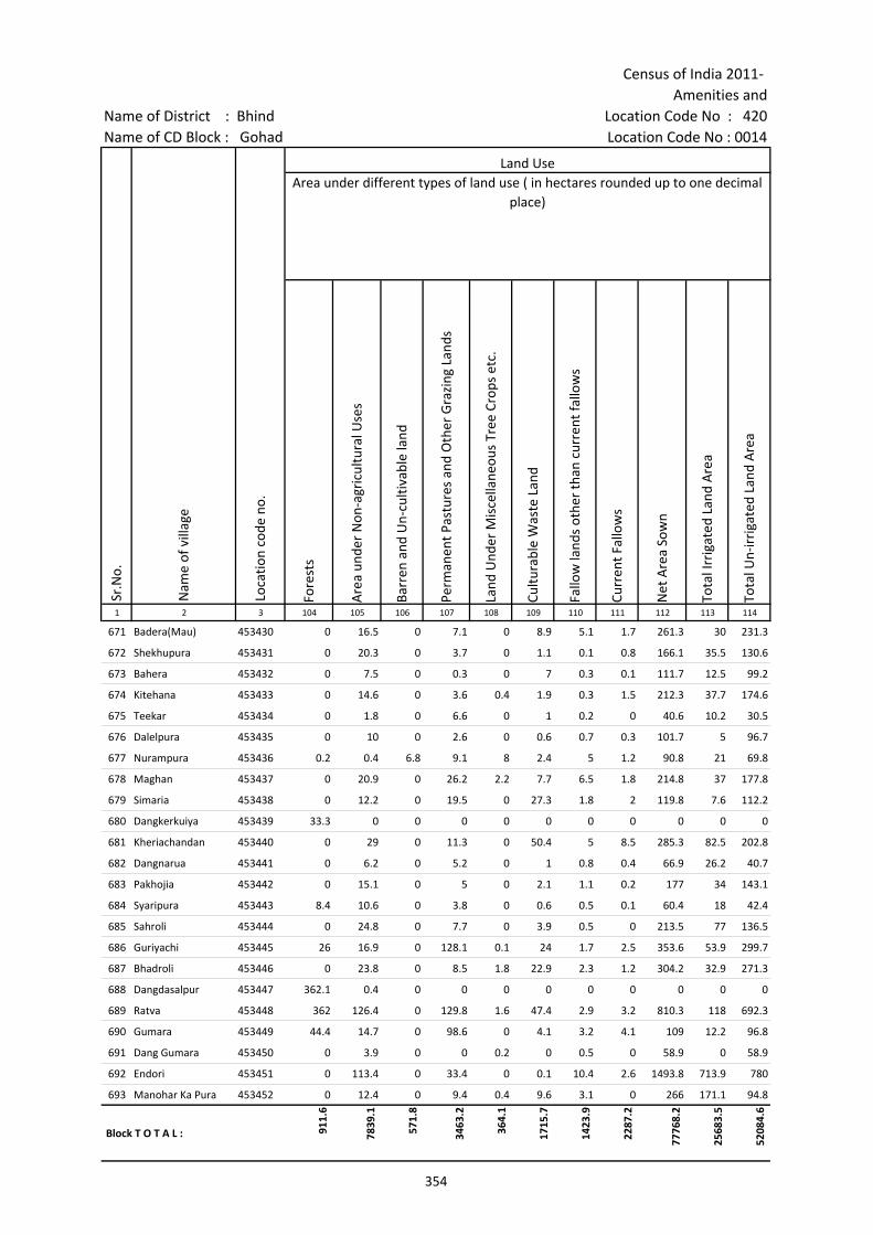
Census of India 2011- Amenities and
Name of District : Bhind Location Code No : 420Name of CD Block : Gohad Location Code No : 0014
Fore
sts
Are
a un
der
Non
-agr
icul
tura
l Use
s
Barr
en a
nd U
n-cu
ltiva
ble
land
Perm
anen
t Pas
ture
s an
d O
ther
Gra
zing
Lan
ds
Land
Und
er M
isce
llane
ous
Tree
Cro
ps e
tc.
Cultu
rabl
e W
aste
Lan
d
Fallo
w la
nds
othe
r th
an c
urre
nt fa
llow
s
Curr
ent F
allo
ws
Net
Are
a So
wn
Tota
l Irr
igat
ed L
and
Are
a
Tota
l Un-
irri
gate
d La
nd A
rea
1 2 3 104 105 106 107 108 109 110 111 112 113 114
Land UseArea under different types of land use ( in hectares rounded up to one decimal
place)
Sr.N
o.
Nam
e of
vill
age
Loca
tion
code
no.
671 Badera(Mau) 453430 0 16.5 0 7.1 0 8.9 5.1 1.7 261.3 30 231.3
672 Shekhupura 453431 0 20.3 0 3.7 0 1.1 0.1 0.8 166.1 35.5 130.6
673 Bahera 453432 0 7.5 0 0.3 0 7 0.3 0.1 111.7 12.5 99.2
674 Kitehana 453433 0 14.6 0 3.6 0.4 1.9 0.3 1.5 212.3 37.7 174.6
675 Teekar 453434 0 1.8 0 6.6 0 1 0.2 0 40.6 10.2 30.5
676 Dalelpura 453435 0 10 0 2.6 0 0.6 0.7 0.3 101.7 5 96.7
677 Nurampura 453436 0.2 0.4 6.8 9.1 8 2.4 5 1.2 90.8 21 69.8
678 Maghan 453437 0 20.9 0 26.2 2.2 7.7 6.5 1.8 214.8 37 177.8
679 Simaria 453438 0 12.2 0 19.5 0 27.3 1.8 2 119.8 7.6 112.2
680 Dangkerkuiya 453439 33.3 0 0 0 0 0 0 0 0 0 0
681 Kheriachandan 453440 0 29 0 11.3 0 50.4 5 8.5 285.3 82.5 202.8
682 Dangnarua 453441 0 6.2 0 5.2 0 1 0.8 0.4 66.9 26.2 40.7
683 Pakhojia 453442 0 15.1 0 5 0 2.1 1.1 0.2 177 34 143.1
684 Syaripura 453443 8.4 10.6 0 3.8 0 0.6 0.5 0.1 60.4 18 42.4
685 Sahroli 453444 0 24.8 0 7.7 0 3.9 0.5 0 213.5 77 136.5
686 Guriyachi 453445 26 16.9 0 128.1 0.1 24 1.7 2.5 353.6 53.9 299.7
687 Bhadroli 453446 0 23.8 0 8.5 1.8 22.9 2.3 1.2 304.2 32.9 271.3
688 Dangdasalpur 453447 362.1 0.4 0 0 0 0 0 0 0 0 0
689 Ratva 453448 362 126.4 0 129.8 1.6 47.4 2.9 3.2 810.3 118 692.3
690 Gumara 453449 44.4 14.7 0 98.6 0 4.1 3.2 4.1 109 12.2 96.8
691 Dang Gumara 453450 0 3.9 0 0 0.2 0 0.5 0 58.9 0 58.9
692 Endori 453451 0 113.4 0 33.4 0 0.1 10.4 2.6 1493.8 713.9 780
693 Manohar Ka Pura 453452 0 12.4 0 9.4 0.4 9.6 3.1 0 266 171.1 94.8
Block T O T A L : 911.
6
7839
.1
571.
8
3463
.2
364.
1
1715
.7
1423
.9
2287
.2
7776
8.2
2568
3.5
5208
4.6
354
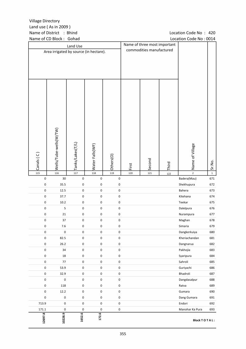
Village DirectoryLand use ( As in 2009 )Name of District : Bhind Location Code No : 420Name of CD Block : Gohad Location Code No : 0014
Cana
ls (
C )
Wel
ls/T
ube-
wel
ls(W
/TW
)
Tank
s/La
kes(
T/L)
Wat
er F
alls
(WF)
Oth
ers(
O)
Firs
t
Seco
nd
Thir
d 115 116 117 118 119 120 121 122 2 1
Land Use Name of three most important commodities manufactured
Nam
e of
Vill
age
Sr.N
o.
Area irrigated by source (in hectare).
0 30 0 0 0 Badera(Mau) 671
0 35.5 0 0 0 Shekhupura 672
0 12.5 0 0 0 Bahera 673
0 37.7 0 0 0 Kitehana 674
0 10.2 0 0 0 Teekar 675
0 5 0 0 0 Dalelpura 676
0 21 0 0 0 Nurampura 677
0 37 0 0 0 Maghan 678
0 7.6 0 0 0 Simaria 679
0 0 0 0 0 Dangkerkuiya 680
0 82.5 0 0 0 Kheriachandan 681
0 26.2 0 0 0 Dangnarua 682
0 34 0 0 0 Pakhojia 683
0 18 0 0 0 Syaripura 684
0 77 0 0 0 Sahroli 685
0 53.9 0 0 0 Guriyachi 686
0 32.9 0 0 0 Bhadroli 687
0 0 0 0 0 Dangdasalpur 688
0 118 0 0 0 Ratva 689
0 12.2 0 0 0 Gumara 690
0 0 0 0 0 Dang Gumara 691
713.9 0 0 0 0 Endori 692
171.1 0 0 0 0 Manohar Ka Pura 693
1269
7.8
1022
8.9
1652
.6
172.
6
Block T O T A L :
355

356
(b) Map of Mihona CD Block showing tahsil boundary.
(c) Alphabetical list of Villages of Mihona CD Block along with location code 2001 and 2011.
(d) Village Directory data of Mihona CD Block in prescribed format.
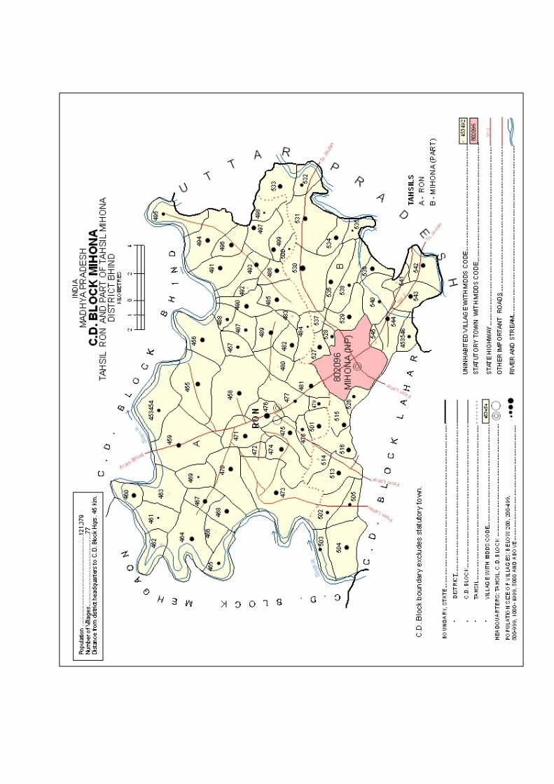

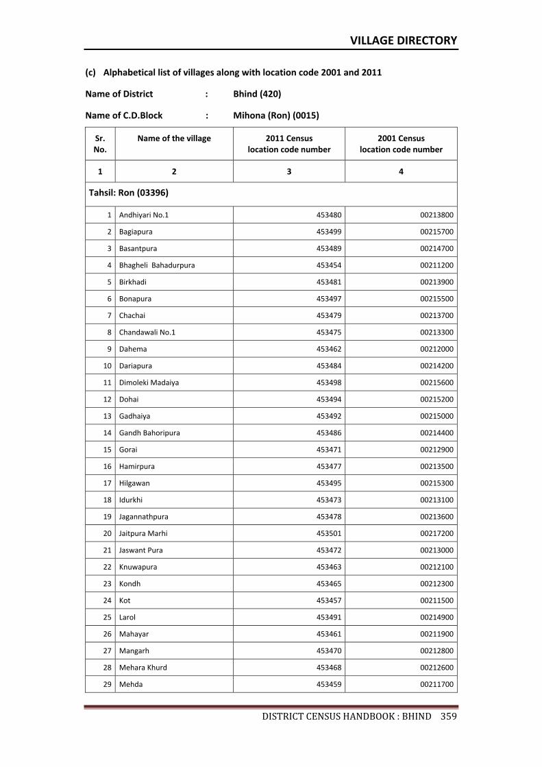
VILLAGE DIRECTORY
DISTRICTCENSUSHANDBOOK:BHIND359
(c) Alphabetical list of villages along with location code 2001 and 2011
Name of District : Bhind (420)
Name of C.D.Block : Mihona (Ron) (0015)
Sr. No.
Name of the village 2011 Census location code number
2001 Census location code number
1 2 3 4
Tahsil: Ron (03396)
1 Andhiyari No.1 453480 00213800
2 Bagiapura 453499 00215700
3 Basantpura 453489 00214700
4 Bhagheli Bahadurpura 453454 00211200
5 Birkhadi 453481 00213900
6 Bonapura 453497 00215500
7 Chachai 453479 00213700
8 Chandawali No.1 453475 00213300
9 Dahema 453462 00212000
10 Dariapura 453484 00214200
11 Dimoleki Madaiya 453498 00215600
12 Dohai 453494 00215200
13 Gadhaiya 453492 00215000
14 Gandh Bahoripura 453486 00214400
15 Gorai 453471 00212900
16 Hamirpura 453477 00213500
17 Hilgawan 453495 00215300
18 Idurkhi 453473 00213100
19 Jagannathpura 453478 00213600
20 Jaitpura Marhi 453501 00217200
21 Jaswant Pura 453472 00213000
22 Knuwapura 453463 00212100
23 Kondh 453465 00212300
24 Kot 453457 00211500
25 Larol 453491 00214900
26 Mahayar 453461 00211900
27 Mangarh 453470 00212800
28 Mehara Khurd 453468 00212600
29 Mehda 453459 00211700
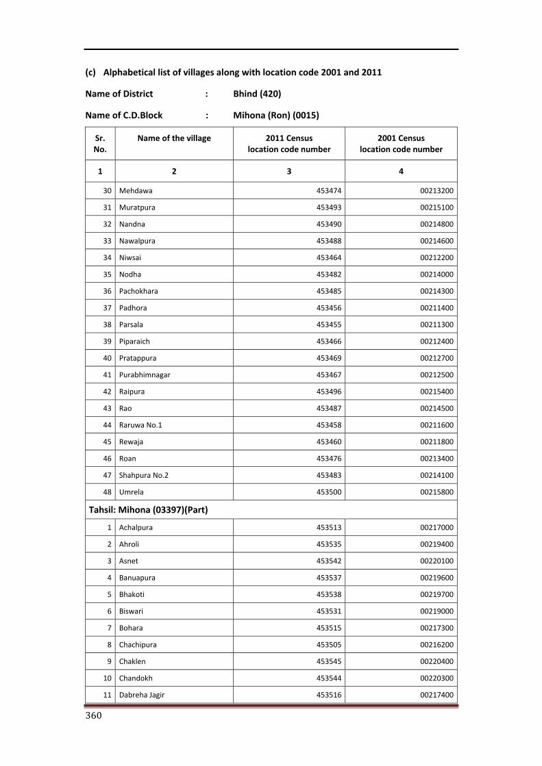
360
(c) Alphabetical list of villages along with location code 2001 and 2011
Name of District : Bhind (420)
Name of C.D.Block : Mihona (Ron) (0015)
Sr. No.
Name of the village 2011 Census location code number
2001 Census location code number
1 2 3 4
30 Mehdawa 453474 00213200
31 Muratpura 453493 00215100
32 Nandna 453490 00214800
33 Nawalpura 453488 00214600
34 Niwsai 453464 00212200
35 Nodha 453482 00214000
36 Pachokhara 453485 00214300
37 Padhora 453456 00211400
38 Parsala 453455 00211300
39 Piparaich 453466 00212400
40 Pratappura 453469 00212700
41 Purabhimnagar 453467 00212500
42 Raipura 453496 00215400
43 Rao 453487 00214500
44 Raruwa No.1 453458 00211600
45 Rewaja 453460 00211800
46 Roan 453476 00213400
47 Shahpura No.2 453483 00214100
48 Umrela 453500 00215800
Tahsil: Mihona (03397)(Part)
1 Achalpura 453513 00217000
2 Ahroli 453535 00219400
3 Asnet 453542 00220100
4 Banuapura 453537 00219600
5 Bhakoti 453538 00219700
6 Biswari 453531 00219000
7 Bohara 453515 00217300
8 Chachipura 453505 00216200
9 Chaklen 453545 00220400
10 Chandokh 453544 00220300
11 Dabreha Jagir 453516 00217400
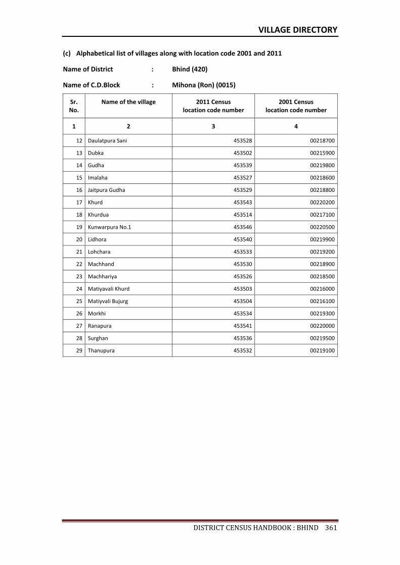
VILLAGE DIRECTORY
DISTRICTCENSUSHANDBOOK:BHIND361
(c) Alphabetical list of villages along with location code 2001 and 2011
Name of District : Bhind (420)
Name of C.D.Block : Mihona (Ron) (0015)
Sr. No.
Name of the village 2011 Census location code number
2001 Census location code number
1 2 3 4
12 Daulatpura Sani 453528 00218700
13 Dubka 453502 00215900
14 Gudha 453539 00219800
15 Imalaha 453527 00218600
16 Jaitpura Gudha 453529 00218800
17 Khurd 453543 00220200
18 Khurdua 453514 00217100
19 Kunwarpura No.1 453546 00220500
20 Lidhora 453540 00219900
21 Lohchara 453533 00219200
22 Machhand 453530 00218900
23 Machhariya 453526 00218500
24 Matiyavali Khurd 453503 00216000
25 Matiyvali Bujurg 453504 00216100
26 Morkhi 453534 00219300
27 Ranapura 453541 00220000
28 Surghan 453536 00219500
29 Thanupura 453532 00219100

Census of India 2011- Amenities and
Name of District : Bhind Location Code No : 420Name of CD Block : Mihona(Ron) Location Code No : 0015
Pre-
Prim
ary
scho
ol (P
P)
Prim
ary
scho
ol (P
)
Mid
dle
scho
ol (M
)
Seco
ndar
y Sc
hool
(S)
Seni
or S
econ
dary
sch
ool (
SS)
Deg
ree
colle
ge o
f art
s s
cien
ce &
com
mer
ce (
ASC
)
Engi
neer
ing
colle
ge(E
C)
Med
ical
col
lege
(MC)
Man
agem
ent i
nstit
ute
(MI)
Poly
tech
nic
(Pt)
Voca
tiona
l tra
inin
g sc
hool
/IT
I
Non
-for
mal
trai
ning
cen
tre
(NFT
C)
Spec
ial s
choo
l for
dis
able
d (S
SD)
Oth
ers
(spe
cify
)
1 2 3 4 5 6 7 8 9 10 11 12 13 14 15 16 17 18 19 20
694Bhagheli Bahadurpura
453454 877 593 83 2 1 1 c c c c
695 Parsala 453455 783.3 3836 630 5 2 1 c c c c
696 Padhora 453456 447.7 1346 277 c 2 1 c c c c c c c c c c
697 Kot 453457 390.9 721 118 b 1 1 1 b b b c c c c c c c
698 Raruwa No.1 453458 1925.7 3094 518 2 1 c c c c
699 Mehda 453459 1768.1 4607 765 b 2 2 b b c c c c c c c c c
700 Rewaja 453460 347.7 1827 319 c 1 1 c c c c c c c c c c c
701 Mahayar 453461 562.8 467 86 c 1 a c c c c c c c c c c c
702 Dahema 453462 226.8 0 0 --------------Un-inhabited--------------
703 Knuwapura 453463 602.4 76 12 1 a c c c c c c c c c c c
704 Niwsai 453464 1294.7 3071 627 8 4 2 1 c c c c
705 Kondh 453465 208 746 127 c 1 a c c c c c c c c c c c
706 Piparaich 453466 91.9 35 7 c a a c c c c c c c c c c c
707 Purabhimnagar 453467 421.2 1125 195 c 2 1 c c c c c c c c c c c
708 Mehara Khurd 453468 575 1108 202 c 1 1 c c c c c c c c c c c
709 Pratappura 453469 349 486 60 c 1 b c c c c c c c c c c c
710 Mangarh 453470 991 3121 576 b 2 1 1 b c c c c c c c c c
711 Gorai 453471 457.8 2504 425 a 2 2 1 a c c c c c c c c c
712 Jaswant Pura 453472 191.2 139 28 b 1 a a b c c c c c c c c c
713 Idurkhi 453473 1909.8 3648 743 1 5 1 1 c c c c c c c c c
714 Mehdawa 453474 691.4 2420 464 b 3 1 1 b c c c c c c c c c
715 Chandawali No.1 453475 353 1444 299 1 1 1 c c c c
716 Roan 453476 1032.4 8505 1337 8 8 3 1 c c c c
717 Hamirpura 453477 209.8 561 88 a 1 1 a a b c c c c c c c c
718 Jagannathpura 453478 158.6 876 141 b 1 1 a b c c c c c c c c c
Number of educational amenities available. (If not available within the village , the distance range
code viz; a for < 5 Kms, b for 5-10 Kms and c for 10+ kms of nearest place where facility is available is given).
Sr.N
o.
Nam
e of
vill
age
Loca
tion
code
no.
Tota
l are
a of
the
villa
ge (
in h
ecta
res
roun
ded
up to
one
dec
imal
pla
ce)
Tota
l pop
ulat
ion
( 201
1 ce
nsus
)
Num
ber
of h
ouse
hold
s (2
011
cens
us)
362
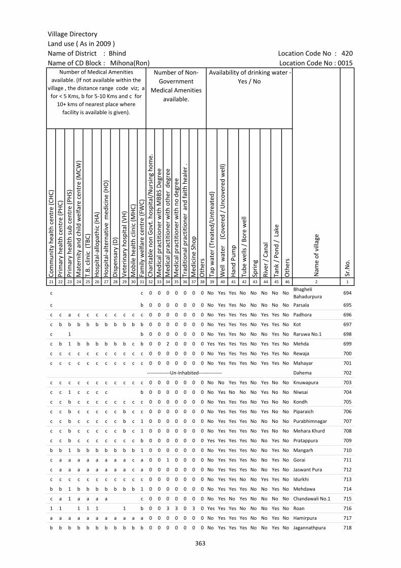
Village DirectoryLand use ( As in 2009 )Name of District : Bhind Location Code No : 420Name of CD Block : Mihona(Ron) Location Code No : 0015
Com
mun
ity h
ealth
cen
tre
(CH
C)Pr
imar
y he
alth
cen
tre
(PH
C)Pr
imar
y he
alth
sub
cen
tre
(PH
S)M
ater
nity
and
chi
ld w
elfa
re c
entr
e (M
CW)
T.B.
clin
ic (
TBC)
Hos
pita
l-allo
path
ic (H
A)
Hos
pita
l-alte
rnat
ive
med
icin
e (H
O)
Dis
pens
ary
(D)
Vete
rina
ry h
ospi
tal (
VH)
Mob
ile h
ealth
clin
ic (M
HC)
Fam
ily w
elfa
re c
entr
e (F
WC)
Char
itabl
e no
n G
ovt.
hos
pita
l/N
ursi
ng h
ome.
Med
ical
pra
ctiti
oner
with
MBB
S D
egre
eM
edic
al p
ract
ition
er w
ith o
ther
deg
ree
Med
ical
pra
ctiti
oner
with
no
degr
eeTr
aditi
onal
pra
ctiti
oner
and
faith
hea
ler
.M
edic
ine
Shop
Oth
ers
Tap
wat
er (T
reat
ed/U
ntre
ated
)
Wel
l w
ater
(C
over
ed /
Unc
over
ed w
ell)
Han
d Pu
mp
Tube
wel
ls /
Bor
e w
ell
Spri
ng
Rive
r /
Cana
l
Tank
/ P
ond
/ L
ake
Oth
ers
21 22 23 24 25 26 27 28 29 30 31 32 33 34 35 36 37 38 39 40 41 42 43 44 45 46 2 1
c c 0 0 0 0 0 0 0 No Yes Yes No No No No NoBhagheli Bahadurpura
694
c b 0 0 0 0 0 0 0 No Yes Yes No No No No No Parsala 695
c c a c c c c c c c c 0 0 0 0 0 0 0 No Yes Yes Yes No Yes Yes No Padhora 696
c b b b b b b b b b b 0 0 0 0 0 0 0 No Yes Yes Yes No Yes Yes No Kot 697
c 1 b 0 0 0 0 0 0 0 No Yes Yes No No No Yes No Raruwa No.1 698
c b 1 b b b b b b c b 0 0 2 0 0 0 0 Yes Yes Yes Yes No Yes Yes No Mehda 699
c c c c c c c c c c c 0 0 0 0 0 0 0 No Yes Yes Yes No Yes Yes No Rewaja 700
c c c c c c c c c c c 0 0 0 0 0 0 0 No Yes Yes Yes No Yes Yes No Mahayar 701
--------------Un-inhabited-------------- Dahema 702
c c c c c c c c c c c 0 0 0 0 0 0 0 No No Yes Yes No Yes No No Knuwapura 703
c c 1 c c c c b 0 0 0 0 0 0 0 No Yes No No No Yes No No Niwsai 704
c c b c c c c c c c c 0 0 0 0 0 0 0 No Yes Yes Yes No Yes No No Kondh 705
c c b c c c c c b c c 0 0 0 0 0 0 0 No Yes Yes Yes No Yes No No Piparaich 706
c c b c c c c c b c 1 0 0 0 0 0 0 0 No Yes Yes Yes No No No No Purabhimnagar 707
c c b c c c c c b c 1 0 0 0 0 0 0 0 No Yes Yes Yes No Yes No No Mehara Khurd 708
c c b c c c c c c c b 0 0 0 0 0 0 0 Yes Yes Yes Yes No No Yes No Pratappura 709
b b 1 b b b b b b b 1 0 0 0 0 0 0 0 No Yes Yes Yes No No Yes No Mangarh 710
c a a a a a a a a c a 0 0 1 0 0 0 0 No Yes Yes Yes No No Yes No Gorai 711
c a a a a a a a a c a 0 0 0 0 0 0 0 No Yes Yes Yes No No Yes No Jaswant Pura 712
c c c c c c c c c c c 0 0 0 0 0 0 0 No Yes Yes No No Yes Yes No Idurkhi 713
b b 1 b b b b b b b 1 0 0 0 0 0 0 0 No Yes Yes Yes No No Yes No Mehdawa 714
c a 1 a a a a c 0 0 0 0 0 0 0 No Yes No Yes No No No No Chandawali No.1 715
1 1 1 1 1 1 b 0 0 3 3 0 3 0 Yes Yes Yes No No No Yes No Roan 716
a a a a a a a a a a a 0 0 0 0 0 0 0 No Yes Yes Yes No No Yes No Hamirpura 717
b b b b b b b b b b b 0 0 0 0 0 0 0 No Yes Yes Yes No No Yes No Jagannathpura 718
Number of Medical Amenities available. (If not available within the
village , the distance range code viz; a for < 5 Kms, b for 5-10 Kms and c for
10+ kms of nearest place where facility is available is given).
Number of Non-Government
Medical Amenities available.
Availability of drinking water - Yes / No
Nam
e of
vill
age
Sr.N
o.
363
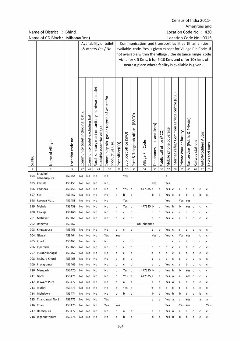
Census of India 2011- Amenities and
Name of District : Bhind Location Code No : 420Name of CD Block : Mihona(Ron) Location Code No : 0015
Com
mun
ity to
ilet i
nclu
ding
bat
h.
Com
mun
ity to
ilet e
xclu
ding
bat
h.
Rura
l sa
nita
ry m
art o
r sa
nita
ry h
ardw
are
outle
t av
aila
ble
near
the
villa
ge.
Com
mun
ity b
io- g
as o
r re
cycl
e of
was
te fo
r pr
oduc
tive
use.
Post
off
ice(
PO)
Sub
post
off
ice
(SPO
)
Post
& T
eleg
raph
off
ice
(P&
TO)
Villa
ge P
in C
ode
Tele
phon
es
(L
and
lines
)
Publ
ic c
all o
ffic
e (P
CO)
Mob
ile p
hone
cov
erag
e
Inte
rnet
caf
es/
Com
mon
ser
vice
cen
tre
(CSC
)
Priv
ate
cour
ier
faci
lity
Bus
serv
ice
(Pub
lic &
Pri
vate
)
Railw
ay s
tatio
ns
Aut
o/M
odifi
ed A
utos
Taxi
s an
d Va
ns
1 2 3 47 48 49 50 51 52 53 54 55 56 57 58 59 60 61 62 63
694Bhagheli Bahadurpura
453454 No No No No Yes b
695 Parsala 453455 No No No No Yes Yes
696 Padhora 453456 No No No No c Yes c 477335 c c Yes c c c c c c
697 Kot 453457 No No No No c b b b b Yes c c b c b c
698 Raruwa No.1 453458 No No No No Yes Yes Yes Yes
699 Mehda 453459 No No No No c Yes b 477335 b b Yes b b Yes c c c
700 Rewaja 453460 No No No No c c c c c Yes c c c c c c
701 Mahayar 453461 No No No No c c c c c Yes c c c c c c
702 Dahema 453462 --------------Un-inhabited--------------
703 Knuwapura 453463 No No No No c c c c c Yes c c c c c c
704 Niwsai 453464 No No No Yes Yes Yes c Yes c Yes Yes c c
705 Kondh 453465 No No No No c c c c c b c c b c c c
706 Piparaich 453466 No No No No c c c c c b c c b c c c
707 Purabhimnagar 453467 No No No No c c c c c b c c a c c c
708 Mehara Khurd 453468 No No No No c c c c c b c c a c c c
709 Pratappura 453469 No No No No c c c c c Yes c c b c c c
710 Mangarh 453470 No No No No c Yes b 477335 b b Yes b b Yes c c c
711 Gorai 453471 No No No No c Yes a 477335 a a Yes a a Yes c c c
712 Jaswant Pura 453472 No No No No c a a a b Yes a a a c c c
713 Idurkhi 453473 No No No No b Yes c c c c c c c c c c
714 Mehdawa 453474 No No No No c b b b b Yes b b b c b c
715 Chandawali No.1 453475 No No No Yes a a Yes a a Yes a a
716 Roan 453476 No No No Yes Yes Yes Yes Yes Yes
717 Hamirpura 453477 No No No No c a a a a Yes a a a c c c
718 Jagannathpura 453478 No No No No c b b b b Yes b b b c c c
Sr.N
o.
Nam
e of
vill
age
Loca
tion
code
no.
Availability of toilet & others Yes / No
Communication and transport facilities (If amenities available code -Yes is given except for Village Pin Code ,If not available within the village , the distance range code
viz; a for < 5 Kms, b for 5-10 Kms and c for 10+ kms of nearest place where facility is available is given).
364
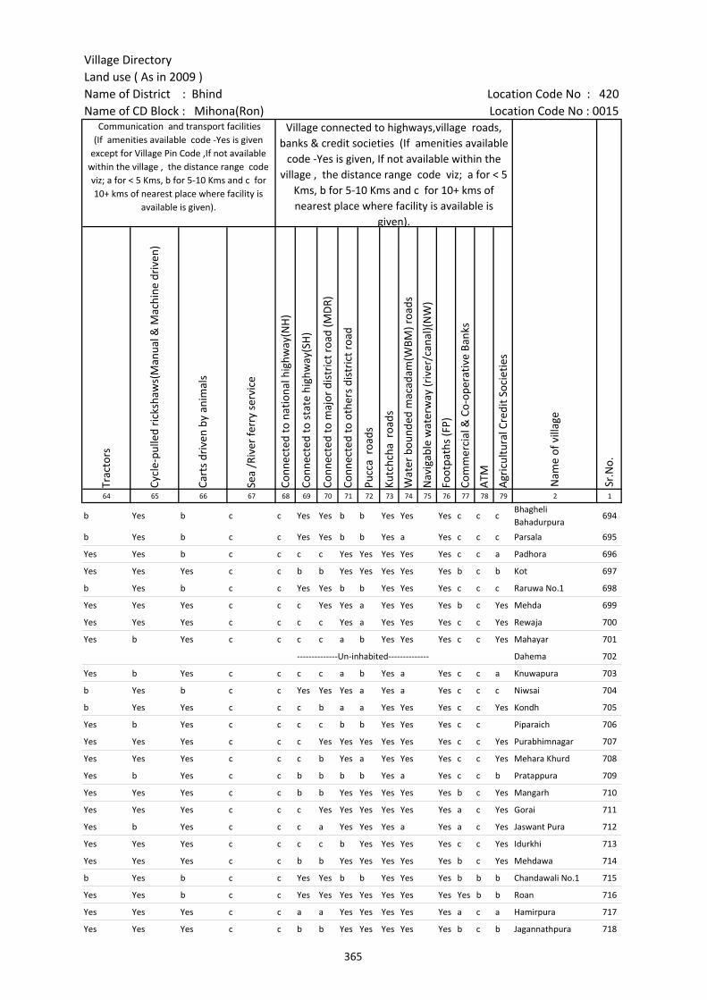
Village DirectoryLand use ( As in 2009 )Name of District : Bhind Location Code No : 420Name of CD Block : Mihona(Ron) Location Code No : 0015
Trac
tors
Cycl
e-pu
lled
rick
shaw
s(M
anua
l & M
achi
ne d
rive
n)
Cart
s dr
iven
by
anim
als
Sea
/Riv
er fe
rry
serv
ice
Conn
ecte
d to
nat
iona
l hig
hway
(NH
)
Conn
ecte
d to
sta
te h
ighw
ay(S
H)
Conn
ecte
d to
maj
or d
istr
ict r
oad
(MD
R)
Conn
ecte
d to
oth
ers
dist
rict
roa
d
Pucc
a r
oads
Kutc
hcha
roa
ds
Wat
er b
ound
ed m
acad
am(W
BM) r
oads
Nav
igab
le w
ater
way
(riv
er/c
anal
)(N
W)
Foot
path
s (F
P)
Com
mer
cial
& C
o-op
erat
ive
Bank
s
ATM
Agr
icul
tura
l Cre
dit S
ocie
ties
64 65 66 67 68 69 70 71 72 73 74 75 76 77 78 79 2 1
b Yes b c c Yes Yes b b Yes Yes Yes c c cBhagheli Bahadurpura
694
b Yes b c c Yes Yes b b Yes a Yes c c c Parsala 695
Yes Yes b c c c c Yes Yes Yes Yes Yes c c a Padhora 696
Yes Yes Yes c c b b Yes Yes Yes Yes Yes b c b Kot 697
b Yes b c c Yes Yes b b Yes Yes Yes c c c Raruwa No.1 698
Yes Yes Yes c c c Yes Yes a Yes Yes Yes b c Yes Mehda 699
Yes Yes Yes c c c c Yes a Yes Yes Yes c c Yes Rewaja 700
Yes b Yes c c c c a b Yes Yes Yes c c Yes Mahayar 701
--------------Un-inhabited-------------- Dahema 702
Yes b Yes c c c c a b Yes a Yes c c a Knuwapura 703
b Yes b c c Yes Yes Yes a Yes a Yes c c c Niwsai 704
b Yes Yes c c c b a a Yes Yes Yes c c Yes Kondh 705
Yes b Yes c c c c b b Yes Yes Yes c c Piparaich 706
Yes Yes Yes c c c Yes Yes Yes Yes Yes Yes c c Yes Purabhimnagar 707
Yes Yes Yes c c c b Yes a Yes Yes Yes c c Yes Mehara Khurd 708
Yes b Yes c c b b b b Yes a Yes c c b Pratappura 709
Yes Yes Yes c c b b Yes Yes Yes Yes Yes b c Yes Mangarh 710
Yes Yes Yes c c c Yes Yes Yes Yes Yes Yes a c Yes Gorai 711
Yes b Yes c c c a Yes Yes Yes a Yes a c Yes Jaswant Pura 712
Yes Yes Yes c c c c b Yes Yes Yes Yes c c Yes Idurkhi 713
Yes Yes Yes c c b b Yes Yes Yes Yes Yes b c Yes Mehdawa 714
b Yes b c c Yes Yes b b Yes Yes Yes b b b Chandawali No.1 715
Yes Yes b c c Yes Yes Yes Yes Yes Yes Yes Yes b b Roan 716
Yes Yes Yes c c a a Yes Yes Yes Yes Yes a c a Hamirpura 717
Yes Yes Yes c c b b Yes Yes Yes Yes Yes b c b Jagannathpura 718
Village connected to highways,village roads, banks & credit societies (If amenities available
code -Yes is given, If not available within the village , the distance range code viz; a for < 5
Kms, b for 5-10 Kms and c for 10+ kms of nearest place where facility is available is
given).
Nam
e of
vill
age
Sr.N
o.
Communication and transport facilities (If amenities available code -Yes is given
except for Village Pin Code ,If not available within the village , the distance range code viz; a for < 5 Kms, b for 5-10 Kms and c for 10+ kms of nearest place where facility is
available is given).
365

Census of India 2011- Amenities and
Name of District : Bhind Location Code No : 420Name of CD Block : Mihona(Ron) Location Code No : 0015
Self-
Hel
p G
roup
(SH
G)
Publ
ic d
istr
ibut
ion
syst
em (P
DS)
sho
p
Man
dis
/ Re
gula
r m
arke
t
Wee
kly
Haa
t
Agr
icul
tura
l mar
ketin
g so
ciet
yIn
tegr
ated
Chi
ld D
evel
opm
ent S
chem
e (N
utri
tiona
l Ce
ntre
s)A
ngan
wad
i Cen
tre
(Nut
ritio
nal C
entr
es)
Oth
ers
(Nut
ritio
nal C
entr
es)
ASH
A (A
ccre
dite
d So
cial
Hea
lth A
ctiv
ist)
Com
mun
ity c
entr
e w
ith/w
ithou
t TV
Spor
ts F
ield
,
Spor
ts C
lub
/ Re
crea
tion
Cent
re
Cine
ma
/ Vi
deo
Hal
l
Publ
ic L
ibra
ry
Publ
ic R
eadi
ng R
oom
New
spap
er S
uppl
y
Ass
embl
y Po
lling
sta
tion
Birt
h &
Dea
th R
egis
trat
ion
Off
ice
1 2 3 80 81 82 83 84 85 86 87 88 89 90 91 92 93 94 95 96 97
694Bhagheli Bahadurpura
453454 Yes Yes Yes Yes Yes Yes Yes Yes Yes Yes Yes Yes c c c a Yes Yes
695 Parsala 453455 Yes Yes Yes Yes Yes c Yes Yes Yes b Yes Yes c b c Yes Yes Yes
696 Padhora 453456 Yes Yes b b Yes Yes Yes Yes Yes c c c c c c c Yes Yes
697 Kot 453457 Yes a b b a Yes Yes Yes Yes b c c c c c Yes Yes Yes
698 Raruwa No.1 453458 Yes Yes Yes Yes Yes c Yes Yes Yes Yes Yes Yes c b c Yes Yes Yes
699 Mehda 453459 Yes Yes b b b Yes Yes Yes Yes c c c c c c Yes Yes Yes
700 Rewaja 453460 Yes a c c c Yes Yes Yes Yes b c c c c c c Yes Yes
701 Mahayar 453461 Yes b c b c Yes Yes a Yes b c c c c c a Yes a
702 Dahema 453462 --------------Un-inhabited--------------
703 Knuwapura 453463 Yes b c b c Yes a a Yes b c c c c c a a a
704 Niwsai 453464 Yes Yes Yes Yes Yes c Yes Yes Yes c Yes c c b c Yes Yes Yes
705 Kondh 453465 Yes b c c Yes Yes Yes Yes Yes c c c c c c a Yes Yes
706 Piparaich 453466 Yes b c c c Yes a a Yes b c c c c c c a a
707 Purabhimnagar 453467 Yes b c c c Yes Yes Yes Yes b c c c c c c Yes Yes
708 Mehara Khurd 453468 Yes b c c Yes Yes Yes Yes Yes b c c c c c c Yes Yes
709 Pratappura 453469 Yes b c c c Yes Yes a Yes c c c c c c b a b
710 Mangarh 453470 Yes Yes b b Yes Yes Yes Yes Yes b c c c c c Yes Yes Yes
711 Gorai 453471 Yes Yes a a a Yes Yes Yes Yes b c c c c c Yes Yes Yes
712 Jaswant Pura 453472 Yes c Yes Yes c c a a Yes b c c c c c c a b
713 Idurkhi 453473 Yes Yes c b c Yes Yes Yes Yes b c c c c c Yes Yes Yes
714 Mehdawa 453474 Yes Yes c b Yes b Yes Yes Yes b c c c c c Yes Yes Yes
715 Chandawali No.1 453475 Yes Yes Yes Yes Yes b Yes Yes Yes Yes a Yes c c c Yes Yes b
716 Roan 453476 Yes Yes Yes Yes Yes b Yes Yes Yes Yes Yes Yes Yes Yes Yes Yes Yes Yes
717 Hamirpura 453477 Yes a b a a a Yes Yes Yes b c c c c c a Yes a
718 Jagannathpura 453478 Yes a c b b b Yes Yes Yes b c c c c b b Yes a
Availability of miscellaneous facilities (If amenities available code -Yes is given, If not available within the village , the distance range code viz; a for < 5 Kms, b
for 5-10 Kms and c for 10+ kms of nearest place where facility is available is given).
Sr.N
o.
Nam
e of
vill
age
Loca
tion
code
no.
366
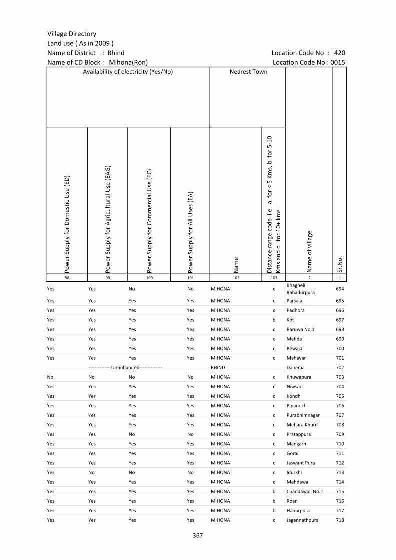
Village DirectoryLand use ( As in 2009 )Name of District : Bhind Location Code No : 420Name of CD Block : Mihona(Ron) Location Code No : 0015
Pow
er S
uppl
y fo
r D
omes
tic U
se (E
D)
Pow
er S
uppl
y fo
r A
gric
ultu
ral U
se (E
AG
)
Pow
er S
uppl
y fo
r Co
mm
erci
al U
se (E
C)
Pow
er S
uppl
y fo
r A
ll U
ses
(EA
)
Nam
e
Dis
tanc
e ra
nge
code
i.e
. a
for
< 5
Kms,
b f
or 5
-10
Kms
and
c f
or 1
0+ k
ms
.98 99 100 101 102 103 2 1
Yes Yes No No MIHONA cBhagheli Bahadurpura
694
Yes Yes Yes Yes MIHONA c Parsala 695
Yes Yes Yes Yes MIHONA c Padhora 696
Yes Yes Yes Yes MIHONA b Kot 697
Yes Yes Yes Yes MIHONA c Raruwa No.1 698
Yes Yes Yes Yes MIHONA c Mehda 699
Yes Yes Yes Yes MIHONA c Rewaja 700
Yes Yes Yes Yes MIHONA c Mahayar 701
--------------Un-inhabited-------------- BHIND Dahema 702
No No No No MIHONA c Knuwapura 703
Yes Yes Yes Yes MIHONA c Niwsai 704
Yes Yes Yes Yes MIHONA c Kondh 705
Yes Yes Yes Yes MIHONA c Piparaich 706
Yes Yes Yes Yes MIHONA c Purabhimnagar 707
Yes Yes Yes Yes MIHONA c Mehara Khurd 708
Yes Yes No No MIHONA c Pratappura 709
Yes Yes Yes Yes MIHONA c Mangarh 710
Yes Yes Yes Yes MIHONA c Gorai 711
Yes Yes Yes Yes MIHONA c Jaswant Pura 712
Yes No No No MIHONA c Idurkhi 713
Yes Yes Yes Yes MIHONA c Mehdawa 714
Yes Yes Yes Yes MIHONA b Chandawali No.1 715
Yes Yes Yes Yes MIHONA b Roan 716
Yes Yes Yes Yes MIHONA b Hamirpura 717
Yes Yes Yes Yes MIHONA c Jagannathpura 718
Availability of electricity (Yes/No) Nearest Town
Nam
e of
vill
age
Sr.N
o.
367
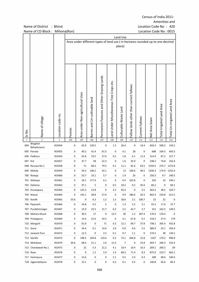
Census of India 2011- Amenities and
Name of District : Bhind Location Code No : 420Name of CD Block : Mihona(Ron) Location Code No : 0015
Fore
sts
Are
a un
der
Non
-agr
icul
tura
l Use
s
Barr
en a
nd U
n-cu
ltiva
ble
land
Perm
anen
t Pas
ture
s an
d O
ther
Gra
zing
Lan
ds
Land
Und
er M
isce
llane
ous
Tree
Cro
ps e
tc.
Cultu
rabl
e W
aste
Lan
d
Fallo
w la
nds
othe
r th
an c
urre
nt fa
llow
s
Curr
ent F
allo
ws
Net
Are
a So
wn
Tota
l Irr
igat
ed L
and
Are
a
Tota
l Un-
irri
gate
d La
nd A
rea
1 2 3 104 105 106 107 108 109 110 111 112 113 114
694Bhagheli Bahadurpura
453454 0 63.9 120.5 0 1.5 26.4 0 14.4 650.3 500.2 150.2
695 Parsala 453455 0 40.2 41.4 61.5 0 4.1 28 0 608 164.5 443.5
696 Padhora 453456 0 65.8 19.5 27.6 0.2 1.8 6.1 11.9 314.9 87.2 227.7
697 Kot 453457 0 37.7 58 22.3 0 1.6 32.9 0 238.2 74.8 163.4
698 Raruwa No.1 453458 0 71 68.3 79.5 0.1 11.1 81.6 63.5 1550.5 274.7 1275.8
699 Mehda 453459 0 59.3 100.2 24.1 0 13 100.6 40.5 1430.3 174.9 1255.4
700 Rewaja 453460 0 53.7 10.1 5.7 0 1.9 26 0 250.3 9.7 240.5
701 Mahayar 453461 0 26.1 177.4 6.1 0 0.4 102.8 0 250 10 240.1
702 Dahema 453462 0 97.1 5 0 0.5 18.2 0.2 45.6 60.2 0 60.1
703 Knuwapura 453463 0 125.3 13.8 0 3.2 93.4 0 3.5 363.2 38.5 324.7
704 Niwsai 453464 0 145.1 38.8 57.6 0 9.9 180.6 20.3 842.4 229.8 612.5
705 Kondh 453465 55.6 0 6.3 1.2 1.5 18.6 2.1 100.7 22 22 0
706 Piparaich 453466 0 24.8 0.2 5 0 1.3 2.2 3.1 55.3 17.6 37.7
707 Purabhimnagar 453467 0 15.9 23.5 21.7 0.2 2.5 42.7 2.7 312 162.5 149.5
708 Mehara Khurd 453468 0 30.5 17 0 12.5 36 1.2 307.4 170.4 170.4 0
709 Pratappura 453469 0 13.4 22.6 24.5 0 4.1 67.8 0.1 216.5 37.4 179
710 Mangarh 453470 0 61.9 0 71 0.3 12.1 69.7 37.8 738.1 305.4 432.8
711 Gorai 453471 0 34.4 0.1 14.6 2.6 0.9 9.6 5.5 389.9 33.1 356.9
712 Jaswant Pura 453472 0 12.3 0 2.5 0.1 0.7 1.1 0 174.5 38 136.5
713 Idurkhi 453473 0 148.5 104.8 133.6 0.2 73.1 266.8 15.8 1167 170.2 996.8
714 Mehdawa 453474 30.6 68.4 51.1 2.6 12.4 7 0 25.8 493.7 260.3 233.4
715 Chandawali No.1 453475 0 22 5.3 21.2 4.1 10.4 10.4 10.3 269.2 200.2 69
716 Roan 453476 0 0 1.2 5.9 1.4 68.3 71.4 8.3 875.9 210.7 665.1
717 Hamirpura 453477 0 15.6 0 0 2.1 0.3 2.4 0.3 189 48.6 140.4
718 Jagannathpura 453478 0 13.1 0 0 0.2 0.1 4.5 0 140.8 56.6 84.2
Area under different types of land use ( in hectares rounded up to one decimal place)
Nam
e of
vill
age
Loca
tion
code
no.
Land Use
Sr.N
o.
368

Village DirectoryLand use ( As in 2009 )Name of District : Bhind Location Code No : 420Name of CD Block : Mihona(Ron) Location Code No : 0015
Cana
ls (
C )
Wel
ls/T
ube-
wel
ls(W
/TW
)
Tank
s/La
kes(
T/L)
Wat
er F
alls
(WF)
Oth
ers(
O)
Firs
t
Seco
nd
Thir
d 115 116 117 118 119 120 121 122 2 1
0 500.2 0 0 0Bhagheli Bahadurpura
694
0 164.5 0 0 0 Parsala 695
0 87.2 0 0 0 Padhora 696
0 74.8 0 0 0 Kot 697
0 274.7 0 0 0 Raruwa No.1 698
0 174.9 0 0 0 Mehda 699
0 9.7 0 0 0 Rewaja 700
0 10 0 0 0 Mahayar 701
0 0 0 0 0 Dahema 702
0 38.5 0 0 0 Knuwapura 703
0 229.8 0 0 0 Niwsai 704
0 22 0 0 0 Kondh 705
0 17.6 0 0 0 Piparaich 706
0 162.5 0 0 0 Purabhimnagar 707
0 170.4 0 0 0 Mehara Khurd 708
0 37.4 0 0 0 Pratappura 709
0 305.4 0 0 0 Mangarh 710
0 33.1 0 0 0 Gorai 711
0 38 0 0 0 Jaswant Pura 712
0 170.2 0 0 0 Idurkhi 713
0 260.3 0 0 0 Mehdawa 714
0 200.2 0 0 0 Chandawali No.1 715
0 210.7 0 0 0 Roan 716
0 48.6 0 0 0 Hamirpura 717
0 56.6 0 0 0 Jagannathpura 718
Sr.N
o.
Area irrigated by source (in hectare).Land Use Name of three most important
commodities manufactured
Nam
e of
Vill
age
369

Census of India 2011- Amenities and
Name of District : Bhind Location Code No : 420Name of CD Block : Mihona(Ron) Location Code No : 0015
Pre-
Prim
ary
scho
ol (P
P)
Prim
ary
scho
ol (P
)
Mid
dle
scho
ol (M
)
Seco
ndar
y Sc
hool
(S)
Seni
or S
econ
dary
sch
ool (
SS)
Deg
ree
colle
ge o
f art
s s
cien
ce &
com
mer
ce (
ASC
)
Engi
neer
ing
colle
ge(E
C)
Med
ical
col
lege
(MC)
Man
agem
ent i
nstit
ute
(MI)
Poly
tech
nic
(Pt)
Voca
tiona
l tra
inin
g sc
hool
/IT
I
Non
-for
mal
trai
ning
cen
tre
(NFT
C)
Spec
ial s
choo
l for
dis
able
d (S
SD)
Oth
ers
(spe
cify
)
1 2 3 4 5 6 7 8 9 10 11 12 13 14 15 16 17 18 19 20
Number of educational amenities available. (If not available within the village , the distance range
code viz; a for < 5 Kms, b for 5-10 Kms and c for 10+ kms of nearest place where facility is available is given).
Sr.N
o.
Nam
e of
vill
age
Loca
tion
code
no.
Tota
l are
a of
the
villa
ge (
in h
ecta
res
roun
ded
up to
one
dec
imal
pla
ce)
Tota
l pop
ulat
ion
( 201
1 ce
nsus
)
Num
ber
of h
ouse
hold
s (2
011
cens
us)
719 Chachai 453479 229.8 700 135 b 1 1 a b b c c c c c c c c
720 Andhiyari No.1 453480 345.8 112 26 b 1 a b b b c c c c c c c c
721 Birkhadi 453481 916.4 3612 594 a 2 2 1 1 b c c c c c c c c
722 Nodha 453482 701.1 3164 521 b 2 1 b 1 b c c c c c c c c
723 Shahpura No.2 453483 101.6 0 0 --------------Un-inhabited--------------
724 Dariapura 453484 63 240 41 c 1 a c c c c c c c c c c c
725 Pachokhara 453485 787.7 2870 556 c 4 2 1 c c c c c c c c c c
726 Gandh Bahoripura 453486 279.9 1081 199 c 2 1 b c c c c c c c c c c
727 Rao 453487 545.4 760 121 b 1 1 b b b c c c c c c c c
728 Nawalpura 453488 249.9 618 104 b 1 a a b b c c c c c c c c
729 Basantpura 453489 661.6 2359 414 b 2 2 b b c c c c c c c c
730 Nandna 453490 296.6 1740 329 c 2 1 1 c c c c c c c c c c
731 Larol 453491 845.4 1390 255 b 2 1 a a c c c c c c c c c
732 Gadhaiya 453492 160.5 0 0 --------------Un-inhabited--------------
733 Muratpura 453493 534.3 1769 318 1 1 a c c c c c c c c c c
734 Dohai 453494 523.2 1265 205 c 3 1 c c c c c c c c
735 Hilgawan 453495 375.1 504 87 2 3 1 c c c c c c c c
736 Raipura 453496 454 2159 404 c 3 2 1 1 c c c c c c c c c
737 Bonapura 453497 453.6 1419 192 c 2 1 1 c c c c c c c c c c
738 Dimoleki Madaiya 453498 256.3 482 75 c 1 a a c c c c c c c c c c
739 Bagiapura 453499 336.4 1271 273 b 1 1 a b b c c c c c c c c
740 Umrela 453500 92.2 309 62 b 1 1 a b b c c c c c c c c
741 Jaitpura Marhi 453501 497.5 3825 717 b 4 3 1 b c c c c c c c c c
742 Dubka 453502 656.9 716 131 1 a c c c c c c c c c c
370
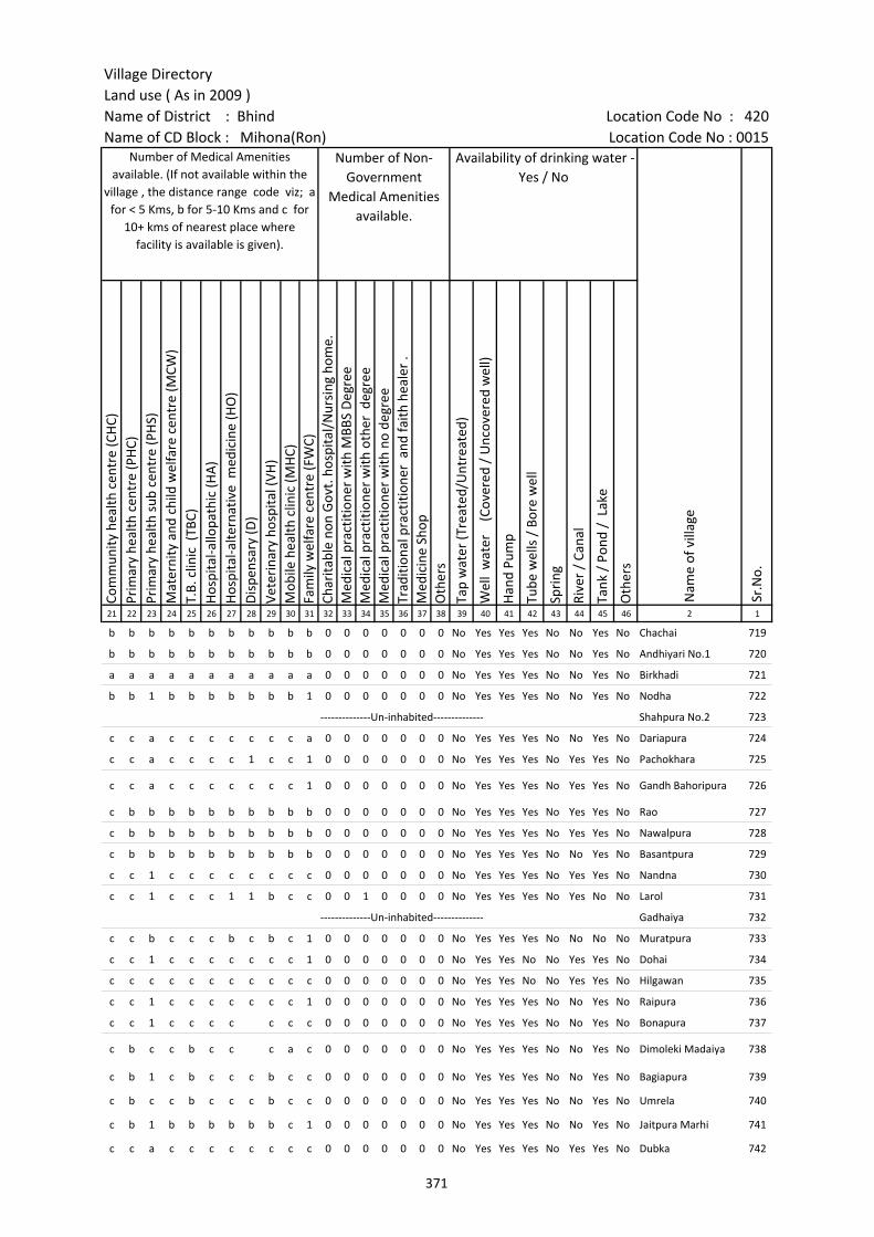
Village DirectoryLand use ( As in 2009 )Name of District : Bhind Location Code No : 420Name of CD Block : Mihona(Ron) Location Code No : 0015
Com
mun
ity h
ealth
cen
tre
(CH
C)Pr
imar
y he
alth
cen
tre
(PH
C)Pr
imar
y he
alth
sub
cen
tre
(PH
S)M
ater
nity
and
chi
ld w
elfa
re c
entr
e (M
CW)
T.B.
clin
ic (
TBC)
Hos
pita
l-allo
path
ic (H
A)
Hos
pita
l-alte
rnat
ive
med
icin
e (H
O)
Dis
pens
ary
(D)
Vete
rina
ry h
ospi
tal (
VH)
Mob
ile h
ealth
clin
ic (M
HC)
Fam
ily w
elfa
re c
entr
e (F
WC)
Char
itabl
e no
n G
ovt.
hos
pita
l/N
ursi
ng h
ome.
Med
ical
pra
ctiti
oner
with
MBB
S D
egre
eM
edic
al p
ract
ition
er w
ith o
ther
deg
ree
Med
ical
pra
ctiti
oner
with
no
degr
eeTr
aditi
onal
pra
ctiti
oner
and
faith
hea
ler
.M
edic
ine
Shop
Oth
ers
Tap
wat
er (T
reat
ed/U
ntre
ated
)
Wel
l w
ater
(C
over
ed /
Unc
over
ed w
ell)
Han
d Pu
mp
Tube
wel
ls /
Bor
e w
ell
Spri
ng
Rive
r /
Cana
l
Tank
/ P
ond
/ L
ake
Oth
ers
21 22 23 24 25 26 27 28 29 30 31 32 33 34 35 36 37 38 39 40 41 42 43 44 45 46 2 1
Number of Medical Amenities available. (If not available within the
village , the distance range code viz; a for < 5 Kms, b for 5-10 Kms and c for
10+ kms of nearest place where facility is available is given).
Number of Non-Government
Medical Amenities available.
Availability of drinking water - Yes / No
Nam
e of
vill
age
Sr.N
o.
b b b b b b b b b b b 0 0 0 0 0 0 0 No Yes Yes Yes No No Yes No Chachai 719
b b b b b b b b b b b 0 0 0 0 0 0 0 No Yes Yes Yes No No Yes No Andhiyari No.1 720
a a a a a a a a a a a 0 0 0 0 0 0 0 No Yes Yes Yes No No Yes No Birkhadi 721
b b 1 b b b b b b b 1 0 0 0 0 0 0 0 No Yes Yes Yes No No Yes No Nodha 722
--------------Un-inhabited-------------- Shahpura No.2 723
c c a c c c c c c c a 0 0 0 0 0 0 0 No Yes Yes Yes No No Yes No Dariapura 724
c c a c c c c 1 c c 1 0 0 0 0 0 0 0 No Yes Yes Yes No Yes Yes No Pachokhara 725
c c a c c c c c c c 1 0 0 0 0 0 0 0 No Yes Yes Yes No Yes Yes No Gandh Bahoripura 726
c b b b b b b b b b b 0 0 0 0 0 0 0 No Yes Yes Yes No Yes Yes No Rao 727
c b b b b b b b b b b 0 0 0 0 0 0 0 No Yes Yes Yes No Yes Yes No Nawalpura 728
c b b b b b b b b b b 0 0 0 0 0 0 0 No Yes Yes Yes No No Yes No Basantpura 729
c c 1 c c c c c c c c 0 0 0 0 0 0 0 No Yes Yes Yes No Yes Yes No Nandna 730
c c 1 c c c 1 1 b c c 0 0 1 0 0 0 0 No Yes Yes Yes No Yes No No Larol 731
--------------Un-inhabited-------------- Gadhaiya 732
c c b c c c b c b c 1 0 0 0 0 0 0 0 No Yes Yes Yes No No No No Muratpura 733
c c 1 c c c c c c c 1 0 0 0 0 0 0 0 No Yes Yes No No Yes Yes No Dohai 734
c c c c c c c c c c c 0 0 0 0 0 0 0 No Yes Yes No No Yes Yes No Hilgawan 735
c c 1 c c c c c c c 1 0 0 0 0 0 0 0 No Yes Yes Yes No No Yes No Raipura 736
c c 1 c c c c c c c 0 0 0 0 0 0 0 No Yes Yes Yes No No Yes No Bonapura 737
c b c c b c c c a c 0 0 0 0 0 0 0 No Yes Yes Yes No No Yes No Dimoleki Madaiya 738
c b 1 c b c c c b c c 0 0 0 0 0 0 0 No Yes Yes Yes No No Yes No Bagiapura 739
c b c c b c c c b c c 0 0 0 0 0 0 0 No Yes Yes Yes No No Yes No Umrela 740
c b 1 b b b b b b c 1 0 0 0 0 0 0 0 No Yes Yes Yes No No Yes No Jaitpura Marhi 741
c c a c c c c c c c c 0 0 0 0 0 0 0 No Yes Yes Yes No Yes Yes No Dubka 742
371

Census of India 2011- Amenities and
Name of District : Bhind Location Code No : 420Name of CD Block : Mihona(Ron) Location Code No : 0015
Com
mun
ity to
ilet i
nclu
ding
bat
h.
Com
mun
ity to
ilet e
xclu
ding
bat
h.
Rura
l sa
nita
ry m
art o
r sa
nita
ry h
ardw
are
outle
t av
aila
ble
near
the
villa
ge.
Com
mun
ity b
io- g
as o
r re
cycl
e of
was
te fo
r pr
oduc
tive
use.
Post
off
ice(
PO)
Sub
post
off
ice
(SPO
)
Post
& T
eleg
raph
off
ice
(P&
TO)
Villa
ge P
in C
ode
Tele
phon
es
(L
and
lines
)
Publ
ic c
all o
ffic
e (P
CO)
Mob
ile p
hone
cov
erag
e
Inte
rnet
caf
es/
Com
mon
ser
vice
cen
tre
(CSC
)
Priv
ate
cour
ier
faci
lity
Bus
serv
ice
(Pub
lic &
Pri
vate
)
Railw
ay s
tatio
ns
Aut
o/M
odifi
ed A
utos
Taxi
s an
d Va
ns
1 2 3 47 48 49 50 51 52 53 54 55 56 57 58 59 60 61 62 63
Sr.N
o.
Nam
e of
vill
age
Loca
tion
code
no.
Availability of toilet & others Yes / No
Communication and transport facilities (If amenities available code -Yes is given except for Village Pin Code ,If not available within the village , the distance range code
viz; a for < 5 Kms, b for 5-10 Kms and c for 10+ kms of nearest place where facility is available is given).
719 Chachai 453479 No No No No c b b b b Yes b b a c c c
720 Andhiyari No.1 453480 No No No No c b b b b Yes b b b c c c
721 Birkhadi 453481 No No No No c a a 477335 a Yes Yes a a Yes c c c
722 Nodha 453482 No No No No c b b b b Yes b b b c b c
723 Shahpura No.2 453483 --------------Un-inhabited--------------
724 Dariapura 453484 No No No No c c c c c Yes c c c c c c
725 Pachokhara 453485 No No No No c Yes c c c Yes c c c c c c
726 Gandh Bahoripura 453486 No No No No c a c c c Yes c c c c c c
727 Rao 453487 No No No No c b b b b Yes c b b c b c
728 Nawalpura 453488 No No No No c b b b b Yes c b b c b c
729 Basantpura 453489 No No No No c b b b b Yes c b b c b c
730 Nandna 453490 No No No No c Yes c 477335 c c Yes c c c c c c
731 Larol 453491 No No No No c Yes c 477441 b b a c b a c b b
732 Gadhaiya 453492 --------------Un-inhabited--------------
733 Muratpura 453493 No No No No c Yes c 477441 b c a c c c c c c
734 Dohai 453494 No No No No c a c Yes c c c c c c c c
735 Hilgawan 453495 No No No No c b c c c a c c c c c c
736 Raipura 453496 No No No No c Yes Yes 477117 Yes c b c c Yes c c c
737 Bonapura 453497 No No No No c c 477441 c c Yes c c b c c c
738 Dimoleki Madaiya 453498 No No No No c c c c c Yes c c a c c c
739 Bagiapura 453499 No No No No c b b b b Yes b b a c b c
740 Umrela 453500 No No No No c b b b b Yes b b a c b b
741 Jaitpura Marhi 453501 No No No No c Yes b b b Yes c b b c c c
742 Dubka 453502 No No No No a a c c c a c c c c c c
372
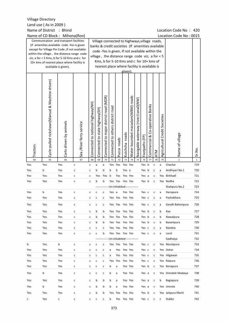
Village DirectoryLand use ( As in 2009 )Name of District : Bhind Location Code No : 420Name of CD Block : Mihona(Ron) Location Code No : 0015
Trac
tors
Cycl
e-pu
lled
rick
shaw
s(M
anua
l & M
achi
ne d
rive
n)
Cart
s dr
iven
by
anim
als
Sea
/Riv
er fe
rry
serv
ice
Conn
ecte
d to
nat
iona
l hig
hway
(NH
)
Conn
ecte
d to
sta
te h
ighw
ay(S
H)
Conn
ecte
d to
maj
or d
istr
ict r
oad
(MD
R)
Conn
ecte
d to
oth
ers
dist
rict
roa
d
Pucc
a r
oads
Kutc
hcha
roa
ds
Wat
er b
ound
ed m
acad
am(W
BM) r
oads
Nav
igab
le w
ater
way
(riv
er/c
anal
)(N
W)
Foot
path
s (F
P)
Com
mer
cial
& C
o-op
erat
ive
Bank
s
ATM
Agr
icul
tura
l Cre
dit S
ocie
ties
64 65 66 67 68 69 70 71 72 73 74 75 76 77 78 79 2 1
Village connected to highways,village roads, banks & credit societies (If amenities available
code -Yes is given, If not available within the village , the distance range code viz; a for < 5
Kms, b for 5-10 Kms and c for 10+ kms of nearest place where facility is available is
given).
Nam
e of
vill
age
Sr.N
o.
Communication and transport facilities (If amenities available code -Yes is given
except for Village Pin Code ,If not available within the village , the distance range code viz; a for < 5 Kms, b for 5-10 Kms and c for 10+ kms of nearest place where facility is
available is given).
Yes Yes Yes c c a a Yes Yes Yes Yes Yes b c a Chachai 719
Yes b Yes c c b b b b Yes a Yes b c a Andhiyari No.1 720
Yes Yes Yes c c Yes Yes b Yes Yes Yes Yes a c Yes Birkhadi 721
Yes Yes Yes c c b b Yes Yes Yes Yes Yes b c Yes Nodha 722
--------------Un-inhabited-------------- Shahpura No.2 723
Yes b Yes c c c c Yes a Yes Yes Yes c c a Dariapura 724
Yes Yes Yes c c c c Yes Yes Yes Yes Yes c c a Pachokhara 725
Yes Yes Yes c c c c Yes Yes Yes Yes Yes c c a Gandh Bahoripura 726
Yes Yes Yes c c b b Yes Yes Yes Yes Yes b c b Rao 727
Yes Yes Yes c c b b Yes Yes Yes Yes Yes b c b Nawalpura 728
Yes Yes Yes c c b b Yes Yes Yes Yes Yes b c b Basantpura 729
Yes Yes Yes c c c c Yes Yes Yes Yes Yes c c a Nandna 730
Yes Yes Yes c c c b Yes Yes Yes Yes Yes c c a Larol 731
--------------Un-inhabited-------------- Gadhaiya 732
b Yes b c c c c Yes Yes Yes Yes Yes c c Yes Muratpura 733
Yes Yes Yes c c c c a Yes Yes Yes Yes c c Yes Dohai 734
Yes Yes Yes c c c c a Yes Yes Yes Yes c c Yes Hilgawan 735
Yes Yes Yes c c c c Yes Yes Yes Yes Yes c c Yes Raipura 736
Yes Yes Yes c c c c b a Yes Yes Yes b c Yes Bonapura 737
Yes b Yes c c c c b a Yes Yes Yes a c Yes Dimoleki Madaiya 738
Yes Yes Yes c c b b b a Yes Yes Yes a c b Bagiapura 739
Yes b Yes c c b b b a Yes Yes Yes a c Yes Umrela 740
Yes Yes Yes c c b b Yes Yes Yes Yes Yes b c Yes Jaitpura Marhi 741
c Yes c c c c c b Yes Yes Yes Yes c c c Dubka 742
373
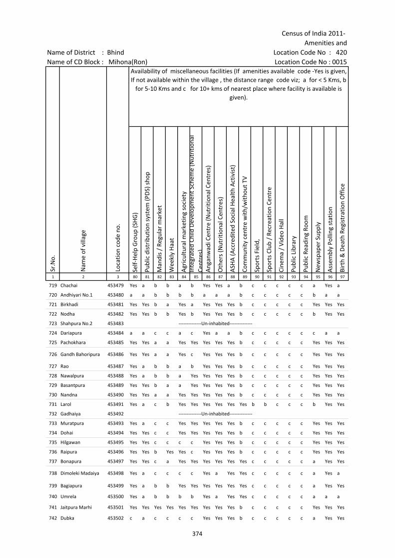
Census of India 2011- Amenities and
Name of District : Bhind Location Code No : 420Name of CD Block : Mihona(Ron) Location Code No : 0015
Self-
Hel
p G
roup
(SH
G)
Publ
ic d
istr
ibut
ion
syst
em (P
DS)
sho
p
Man
dis
/ Re
gula
r m
arke
t
Wee
kly
Haa
t
Agr
icul
tura
l mar
ketin
g so
ciet
yIn
tegr
ated
Chi
ld D
evel
opm
ent S
chem
e (N
utri
tiona
l Ce
ntre
s)A
ngan
wad
i Cen
tre
(Nut
ritio
nal C
entr
es)
Oth
ers
(Nut
ritio
nal C
entr
es)
ASH
A (A
ccre
dite
d So
cial
Hea
lth A
ctiv
ist)
Com
mun
ity c
entr
e w
ith/w
ithou
t TV
Spor
ts F
ield
,
Spor
ts C
lub
/ Re
crea
tion
Cent
re
Cine
ma
/ Vi
deo
Hal
l
Publ
ic L
ibra
ry
Publ
ic R
eadi
ng R
oom
New
spap
er S
uppl
y
Ass
embl
y Po
lling
sta
tion
Birt
h &
Dea
th R
egis
trat
ion
Off
ice
1 2 3 80 81 82 83 84 85 86 87 88 89 90 91 92 93 94 95 96 97
Availability of miscellaneous facilities (If amenities available code -Yes is given, If not available within the village , the distance range code viz; a for < 5 Kms, b
for 5-10 Kms and c for 10+ kms of nearest place where facility is available is given).
Sr.N
o.
Nam
e of
vill
age
Loca
tion
code
no.
719 Chachai 453479 Yes a b b a b Yes Yes a b c c c c c a Yes a
720 Andhiyari No.1 453480 a a b b b b a a a b c c c c c b a a
721 Birkhadi 453481 Yes Yes b a Yes a Yes Yes Yes b c c c c c Yes Yes Yes
722 Nodha 453482 Yes Yes b b Yes b Yes Yes Yes b c c c c c b Yes Yes
723 Shahpura No.2 453483 --------------Un-inhabited--------------
724 Dariapura 453484 a a c c a c Yes a a b c c c c c c a a
725 Pachokhara 453485 Yes Yes a a Yes Yes Yes Yes Yes b c c c c c Yes Yes Yes
726 Gandh Bahoripura 453486 Yes Yes a a Yes c Yes Yes Yes b c c c c c Yes Yes Yes
727 Rao 453487 Yes a b b a b Yes Yes Yes b c c c c c Yes Yes Yes
728 Nawalpura 453488 Yes a b b a Yes Yes Yes Yes b c c c c c Yes Yes Yes
729 Basantpura 453489 Yes Yes b a a Yes Yes Yes Yes b c c c c c Yes Yes Yes
730 Nandna 453490 Yes Yes a a Yes Yes Yes Yes Yes b c c c c c Yes Yes Yes
731 Larol 453491 Yes a c b Yes Yes Yes Yes Yes Yes b b c c c b Yes Yes
732 Gadhaiya 453492 --------------Un-inhabited--------------
733 Muratpura 453493 Yes a c c Yes Yes Yes Yes Yes b c c c c c Yes Yes Yes
734 Dohai 453494 Yes Yes c c Yes Yes Yes Yes Yes b c c c c c Yes Yes Yes
735 Hilgawan 453495 Yes Yes c c c c Yes Yes Yes b c c c c c Yes Yes Yes
736 Raipura 453496 Yes Yes b Yes Yes c Yes Yes Yes b c c c c c Yes Yes Yes
737 Bonapura 453497 Yes Yes c a Yes Yes Yes Yes Yes Yes c c c c c a Yes Yes
738 Dimoleki Madaiya 453498 Yes a c c c c Yes a Yes Yes c c c c c a Yes a
739 Bagiapura 453499 Yes a b b Yes Yes Yes Yes Yes Yes c c c c c a Yes Yes
740 Umrela 453500 Yes a b b b b Yes a Yes Yes c c c c c a a a
741 Jaitpura Marhi 453501 Yes Yes Yes Yes Yes Yes Yes Yes Yes b c c c c c Yes Yes Yes
742 Dubka 453502 c a c c c c Yes Yes Yes b c c c c c a Yes Yes
374
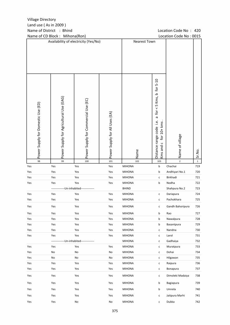
Village DirectoryLand use ( As in 2009 )Name of District : Bhind Location Code No : 420Name of CD Block : Mihona(Ron) Location Code No : 0015
Pow
er S
uppl
y fo
r D
omes
tic U
se (E
D)
Pow
er S
uppl
y fo
r A
gric
ultu
ral U
se (E
AG
)
Pow
er S
uppl
y fo
r Co
mm
erci
al U
se (E
C)
Pow
er S
uppl
y fo
r A
ll U
ses
(EA
)
Nam
e
Dis
tanc
e ra
nge
code
i.e
. a
for
< 5
Kms,
b f
or 5
-10
Kms
and
c f
or 1
0+ k
ms
.98 99 100 101 102 103 2 1
Availability of electricity (Yes/No) Nearest Town
Nam
e of
vill
age
Sr.N
o.
Yes Yes Yes Yes MIHONA b Chachai 719
Yes Yes Yes Yes MIHONA b Andhiyari No.1 720
Yes Yes Yes Yes MIHONA c Birkhadi 721
Yes Yes Yes Yes MIHONA b Nodha 722
--------------Un-inhabited-------------- BHIND Shahpura No.2 723
Yes Yes Yes Yes MIHONA c Dariapura 724
Yes Yes Yes Yes MIHONA c Pachokhara 725
Yes Yes Yes Yes MIHONA c Gandh Bahoripura 726
Yes Yes Yes Yes MIHONA b Rao 727
Yes Yes Yes Yes MIHONA b Nawalpura 728
Yes Yes Yes Yes MIHONA b Basantpura 729
Yes Yes Yes Yes MIHONA c Nandna 730
Yes Yes Yes Yes MIHONA c Larol 731
--------------Un-inhabited-------------- MIHONA c Gadhaiya 732
Yes Yes Yes Yes MIHONA c Muratpura 733
Yes No No No MIHONA c Dohai 734
Yes No No No MIHONA c Hilgawan 735
Yes Yes Yes Yes MIHONA c Raipura 736
Yes Yes Yes Yes MIHONA c Bonapura 737
Yes Yes Yes Yes MIHONA c Dimoleki Madaiya 738
Yes Yes Yes Yes MIHONA b Bagiapura 739
Yes Yes Yes Yes MIHONA b Umrela 740
Yes Yes Yes Yes MIHONA c Jaitpura Marhi 741
Yes Yes No No MIHONA c Dubka 742
375
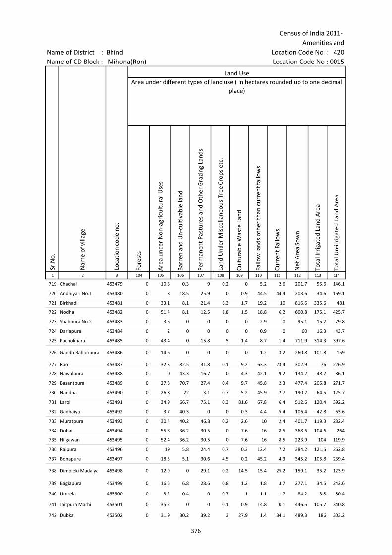
Census of India 2011- Amenities and
Name of District : Bhind Location Code No : 420Name of CD Block : Mihona(Ron) Location Code No : 0015
Fore
sts
Are
a un
der
Non
-agr
icul
tura
l Use
s
Barr
en a
nd U
n-cu
ltiva
ble
land
Perm
anen
t Pas
ture
s an
d O
ther
Gra
zing
Lan
ds
Land
Und
er M
isce
llane
ous
Tree
Cro
ps e
tc.
Cultu
rabl
e W
aste
Lan
d
Fallo
w la
nds
othe
r th
an c
urre
nt fa
llow
s
Curr
ent F
allo
ws
Net
Are
a So
wn
Tota
l Irr
igat
ed L
and
Are
a
Tota
l Un-
irri
gate
d La
nd A
rea
1 2 3 104 105 106 107 108 109 110 111 112 113 114
Area under different types of land use ( in hectares rounded up to one decimal place)
Nam
e of
vill
age
Loca
tion
code
no.
Land Use
Sr.N
o.
719 Chachai 453479 0 10.8 0.3 9 0.2 0 5.2 2.6 201.7 55.6 146.1
720 Andhiyari No.1 453480 0 8 18.5 25.9 0 0.9 44.5 44.4 203.6 34.6 169.1
721 Birkhadi 453481 0 33.1 8.1 21.4 6.3 1.7 19.2 10 816.6 335.6 481
722 Nodha 453482 0 51.4 8.1 12.5 1.8 1.5 18.8 6.2 600.8 175.1 425.7
723 Shahpura No.2 453483 0 3.6 0 0 0 0 2.9 0 95.1 15.2 79.8
724 Dariapura 453484 0 2 0 0 0 0 0.9 0 60 16.3 43.7
725 Pachokhara 453485 0 43.4 0 15.8 5 1.4 8.7 1.4 711.9 314.3 397.6
726 Gandh Bahoripura 453486 0 14.6 0 0 0 0 1.2 3.2 260.8 101.8 159
727 Rao 453487 0 32.3 82.5 31.8 0.1 9.2 63.3 23.4 302.9 76 226.9
728 Nawalpura 453488 0 0 43.3 16.7 0 4.3 42.1 9.2 134.2 48.2 86.1
729 Basantpura 453489 0 27.8 70.7 27.4 0.4 9.7 45.8 2.3 477.4 205.8 271.7
730 Nandna 453490 0 26.8 22 3.1 0.7 5.2 45.9 2.7 190.2 64.5 125.7
731 Larol 453491 0 34.9 66.7 75.1 0.3 81.6 67.8 6.4 512.6 120.4 392.2
732 Gadhaiya 453492 0 3.7 40.3 0 0 0.3 4.4 5.4 106.4 42.8 63.6
733 Muratpura 453493 0 30.4 40.2 46.8 0.2 2.6 10 2.4 401.7 119.3 282.4
734 Dohai 453494 0 55.8 36.2 30.5 0 7.6 16 8.5 368.6 104.6 264
735 Hilgawan 453495 0 52.4 36.2 30.5 0 7.6 16 8.5 223.9 104 119.9
736 Raipura 453496 0 19 5.8 24.4 0.7 0.3 12.4 7.2 384.2 121.5 262.8
737 Bonapura 453497 0 18.5 5.1 30.6 4.5 0.2 45.2 4.3 345.2 105.8 239.4
738 Dimoleki Madaiya 453498 0 12.9 0 29.1 0.2 14.5 15.4 25.2 159.1 35.2 123.9
739 Bagiapura 453499 0 16.5 6.8 28.6 0.8 1.2 1.8 3.7 277.1 34.5 242.6
740 Umrela 453500 0 3.2 0.4 0 0.7 1 1.1 1.7 84.2 3.8 80.4
741 Jaitpura Marhi 453501 0 35.2 0 0 0.1 0.9 14.8 0.1 446.5 105.7 340.8
742 Dubka 453502 0 31.9 30.2 39.2 3 27.9 1.4 34.1 489.3 186 303.2
376
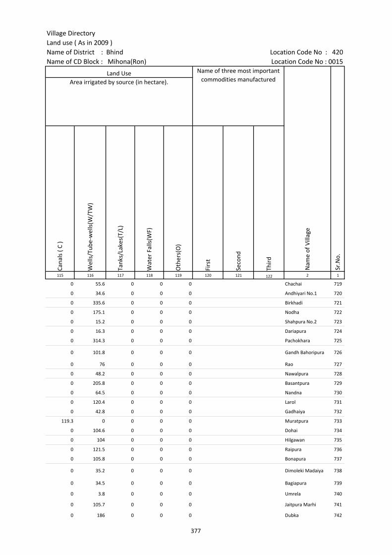
Village DirectoryLand use ( As in 2009 )Name of District : Bhind Location Code No : 420Name of CD Block : Mihona(Ron) Location Code No : 0015
Cana
ls (
C )
Wel
ls/T
ube-
wel
ls(W
/TW
)
Tank
s/La
kes(
T/L)
Wat
er F
alls
(WF)
Oth
ers(
O)
Firs
t
Seco
nd
Thir
d 115 116 117 118 119 120 121 122 2 1
Sr.N
o.
Area irrigated by source (in hectare).Land Use Name of three most important
commodities manufactured
Nam
e of
Vill
age
0 55.6 0 0 0 Chachai 719
0 34.6 0 0 0 Andhiyari No.1 720
0 335.6 0 0 0 Birkhadi 721
0 175.1 0 0 0 Nodha 722
0 15.2 0 0 0 Shahpura No.2 723
0 16.3 0 0 0 Dariapura 724
0 314.3 0 0 0 Pachokhara 725
0 101.8 0 0 0 Gandh Bahoripura 726
0 76 0 0 0 Rao 727
0 48.2 0 0 0 Nawalpura 728
0 205.8 0 0 0 Basantpura 729
0 64.5 0 0 0 Nandna 730
0 120.4 0 0 0 Larol 731
0 42.8 0 0 0 Gadhaiya 732
119.3 0 0 0 0 Muratpura 733
0 104.6 0 0 0 Dohai 734
0 104 0 0 0 Hilgawan 735
0 121.5 0 0 0 Raipura 736
0 105.8 0 0 0 Bonapura 737
0 35.2 0 0 0 Dimoleki Madaiya 738
0 34.5 0 0 0 Bagiapura 739
0 3.8 0 0 0 Umrela 740
0 105.7 0 0 0 Jaitpura Marhi 741
0 186 0 0 0 Dubka 742
377
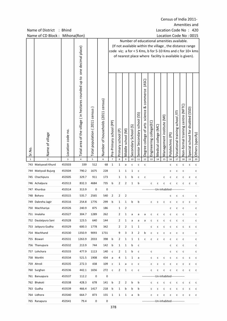
Census of India 2011- Amenities and
Name of District : Bhind Location Code No : 420Name of CD Block : Mihona(Ron) Location Code No : 0015
Pre-
Prim
ary
scho
ol (P
P)
Prim
ary
scho
ol (P
)
Mid
dle
scho
ol (M
)
Seco
ndar
y Sc
hool
(S)
Seni
or S
econ
dary
sch
ool (
SS)
Deg
ree
colle
ge o
f art
s s
cien
ce &
com
mer
ce (
ASC
)
Engi
neer
ing
colle
ge(E
C)
Med
ical
col
lege
(MC)
Man
agem
ent i
nstit
ute
(MI)
Poly
tech
nic
(Pt)
Voca
tiona
l tra
inin
g sc
hool
/IT
I
Non
-for
mal
trai
ning
cen
tre
(NFT
C)
Spec
ial s
choo
l for
dis
able
d (S
SD)
Oth
ers
(spe
cify
)
1 2 3 4 5 6 7 8 9 10 11 12 13 14 15 16 17 18 19 20
Number of educational amenities available. (If not available within the village , the distance range
code viz; a for < 5 Kms, b for 5-10 Kms and c for 10+ kms of nearest place where facility is available is given).
Sr.N
o.
Nam
e of
vill
age
Loca
tion
code
no.
Tota
l are
a of
the
villa
ge (
in h
ecta
res
roun
ded
up to
one
dec
imal
pla
ce)
Tota
l pop
ulat
ion
( 201
1 ce
nsus
)
Num
ber
of h
ouse
hold
s (2
011
cens
us)
743 Matiyavali Khurd 453503 339 512 68 1 1 a c c c c c c c c
744 Matiyvali Bujurg 453504 790.2 1675 228 1 1 1 c c c c c
745 Chachipura 453505 329.7 911 173 1 1 b c c c c c c c c
746 Achalpura 453513 832.3 4684 735 b 2 2 1 b c c c c c c c c
747 Khurdua 453514 313.9 0 0 --------------Un-inhabited--------------
748 Bohara 453515 535.7 2565 540 2 2 2 c c c c
749 Dabreha Jagir 453516 254.8 1776 299 b 1 1 b b c c c c c c c c
750 Machhariya 453526 240.9 875 186 1 2 c c c c
751 Imalaha 453527 304.7 1289 262 2 1 a a a c c c c c c c
752 Daulatpura Sani 453528 123.5 640 144 2 1 a a a c c c c c c c
753 Jaitpura Gudha 453529 600.3 1778 342 2 2 1 1 c c c c c c c c
754 Machhand 453530 1350.9 9093 1731 9 3 3 2 b c c c c c c c
755 Biswari 453531 1263.9 2033 398 b 2 1 1 1 c c c c c c c c
756 Thanupura 453532 213.9 744 142 b 1 1 b c c c c c
757 Lohchara 453533 477.9 1113 140 c 2 1 b c c c c c c
758 Morkhi 453534 521.5 1908 434 a 4 1 1 a c c c c c c c c
759 Ahroli 453535 272.3 438 109 c 1 a c c c c c c c c c c
760 Surghan 453536 442.1 1656 272 c 2 1 c c c c c c c c c c
761 Banuapura 453537 112.2 0 0 --------------Un-inhabited--------------
762 Bhakoti 453538 428.3 678 141 b 2 2 b b c c c c c c c c
763 Gudha 453539 466.4 1417 218 b 1 b b b c c c c c c c c
764 Lidhora 453540 664.7 873 155 1 1 1 a b c c c c c c c c
765 Ranapura 453541 79.4 0 0 --------------Un-inhabited--------------
378
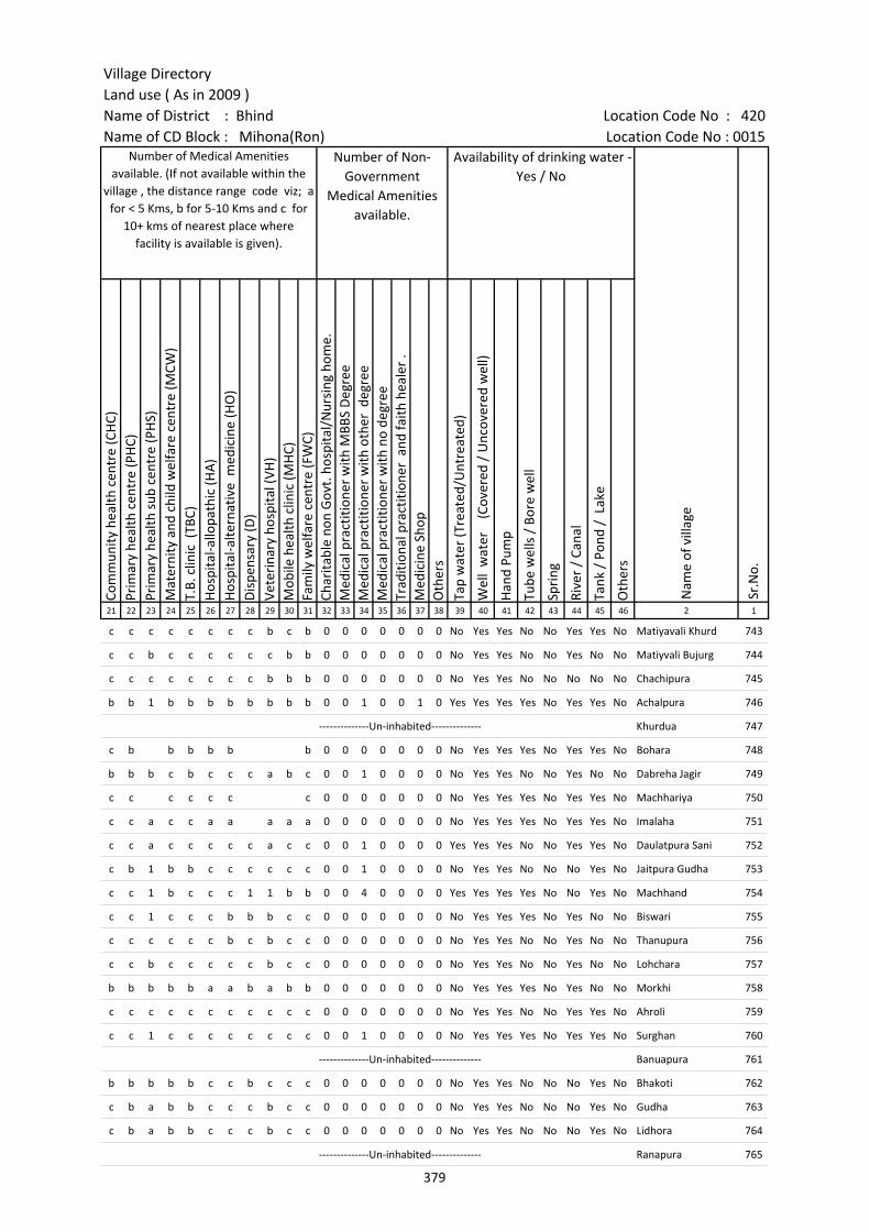
Village DirectoryLand use ( As in 2009 )Name of District : Bhind Location Code No : 420Name of CD Block : Mihona(Ron) Location Code No : 0015
Com
mun
ity h
ealth
cen
tre
(CH
C)Pr
imar
y he
alth
cen
tre
(PH
C)Pr
imar
y he
alth
sub
cen
tre
(PH
S)M
ater
nity
and
chi
ld w
elfa
re c
entr
e (M
CW)
T.B.
clin
ic (
TBC)
Hos
pita
l-allo
path
ic (H
A)
Hos
pita
l-alte
rnat
ive
med
icin
e (H
O)
Dis
pens
ary
(D)
Vete
rina
ry h
ospi
tal (
VH)
Mob
ile h
ealth
clin
ic (M
HC)
Fam
ily w
elfa
re c
entr
e (F
WC)
Char
itabl
e no
n G
ovt.
hos
pita
l/N
ursi
ng h
ome.
Med
ical
pra
ctiti
oner
with
MBB
S D
egre
eM
edic
al p
ract
ition
er w
ith o
ther
deg
ree
Med
ical
pra
ctiti
oner
with
no
degr
eeTr
aditi
onal
pra
ctiti
oner
and
faith
hea
ler
.M
edic
ine
Shop
Oth
ers
Tap
wat
er (T
reat
ed/U
ntre
ated
)
Wel
l w
ater
(C
over
ed /
Unc
over
ed w
ell)
Han
d Pu
mp
Tube
wel
ls /
Bor
e w
ell
Spri
ng
Rive
r /
Cana
l
Tank
/ P
ond
/ L
ake
Oth
ers
21 22 23 24 25 26 27 28 29 30 31 32 33 34 35 36 37 38 39 40 41 42 43 44 45 46 2 1
Number of Medical Amenities available. (If not available within the
village , the distance range code viz; a for < 5 Kms, b for 5-10 Kms and c for
10+ kms of nearest place where facility is available is given).
Number of Non-Government
Medical Amenities available.
Availability of drinking water - Yes / No
Nam
e of
vill
age
Sr.N
o.
c c c c c c c c b c b 0 0 0 0 0 0 0 No Yes Yes No No Yes Yes No Matiyavali Khurd 743
c c b c c c c c c b b 0 0 0 0 0 0 0 No Yes Yes No No Yes No No Matiyvali Bujurg 744
c c c c c c c c b b b 0 0 0 0 0 0 0 No Yes Yes No No No No No Chachipura 745
b b 1 b b b b b b b b 0 0 1 0 0 1 0 Yes Yes Yes Yes No Yes Yes No Achalpura 746
--------------Un-inhabited-------------- Khurdua 747
c b b b b b b 0 0 0 0 0 0 0 No Yes Yes Yes No Yes Yes No Bohara 748
b b b c b c c c a b c 0 0 1 0 0 0 0 No Yes Yes No No Yes No No Dabreha Jagir 749
c c c c c c c 0 0 0 0 0 0 0 No Yes Yes Yes No Yes Yes No Machhariya 750
c c a c c a a a a a 0 0 0 0 0 0 0 No Yes Yes Yes No Yes Yes No Imalaha 751
c c a c c c c c a c c 0 0 1 0 0 0 0 Yes Yes Yes No No Yes Yes No Daulatpura Sani 752
c b 1 b b c c c c c c 0 0 1 0 0 0 0 No Yes Yes No No No Yes No Jaitpura Gudha 753
c c 1 b c c c 1 1 b b 0 0 4 0 0 0 0 Yes Yes Yes Yes No No Yes No Machhand 754
c c 1 c c c b b b c c 0 0 0 0 0 0 0 No Yes Yes Yes No Yes No No Biswari 755
c c c c c c b c b c c 0 0 0 0 0 0 0 No Yes Yes No No Yes No No Thanupura 756
c c b c c c c c b c c 0 0 0 0 0 0 0 No Yes Yes No No Yes No No Lohchara 757
b b b b b a a b a b b 0 0 0 0 0 0 0 No Yes Yes Yes No Yes No No Morkhi 758
c c c c c c c c c c c 0 0 0 0 0 0 0 No Yes Yes No No Yes Yes No Ahroli 759
c c 1 c c c c c c c c 0 0 1 0 0 0 0 No Yes Yes Yes No Yes Yes No Surghan 760
--------------Un-inhabited-------------- Banuapura 761
b b b b b c c b c c c 0 0 0 0 0 0 0 No Yes Yes No No No Yes No Bhakoti 762
c b a b b c c c b c c 0 0 0 0 0 0 0 No Yes Yes No No No Yes No Gudha 763
c b a b b c c c b c c 0 0 0 0 0 0 0 No Yes Yes No No No Yes No Lidhora 764
--------------Un-inhabited-------------- Ranapura 765
379
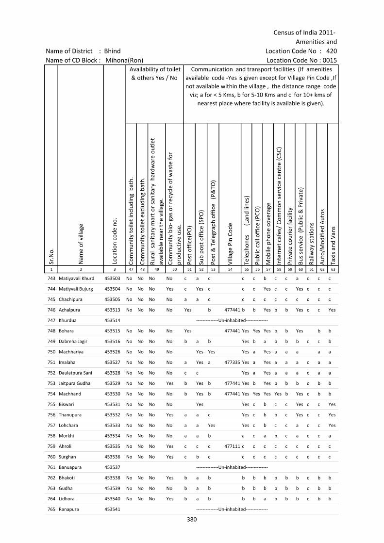
Census of India 2011- Amenities and
Name of District : Bhind Location Code No : 420Name of CD Block : Mihona(Ron) Location Code No : 0015
Com
mun
ity to
ilet i
nclu
ding
bat
h.
Com
mun
ity to
ilet e
xclu
ding
bat
h.
Rura
l sa
nita
ry m
art o
r sa
nita
ry h
ardw
are
outle
t av
aila
ble
near
the
villa
ge.
Com
mun
ity b
io- g
as o
r re
cycl
e of
was
te fo
r pr
oduc
tive
use.
Post
off
ice(
PO)
Sub
post
off
ice
(SPO
)
Post
& T
eleg
raph
off
ice
(P&
TO)
Villa
ge P
in C
ode
Tele
phon
es
(L
and
lines
)
Publ
ic c
all o
ffic
e (P
CO)
Mob
ile p
hone
cov
erag
e
Inte
rnet
caf
es/
Com
mon
ser
vice
cen
tre
(CSC
)
Priv
ate
cour
ier
faci
lity
Bus
serv
ice
(Pub
lic &
Pri
vate
)
Railw
ay s
tatio
ns
Aut
o/M
odifi
ed A
utos
Taxi
s an
d Va
ns
1 2 3 47 48 49 50 51 52 53 54 55 56 57 58 59 60 61 62 63
Sr.N
o.
Nam
e of
vill
age
Loca
tion
code
no.
Availability of toilet & others Yes / No
Communication and transport facilities (If amenities available code -Yes is given except for Village Pin Code ,If not available within the village , the distance range code
viz; a for < 5 Kms, b for 5-10 Kms and c for 10+ kms of nearest place where facility is available is given).
743 Matiyavali Khurd 453503 No No No No c a c c c b c c a c c c
744 Matiyvali Bujurg 453504 No No No Yes c Yes c c c Yes c c Yes c c c
745 Chachipura 453505 No No No No a a c c c c c c c c c c
746 Achalpura 453513 No No No No Yes b 477441 b b Yes b b Yes c c Yes
747 Khurdua 453514 --------------Un-inhabited--------------
748 Bohara 453515 No No No No Yes 477441 Yes Yes Yes b b Yes b b
749 Dabreha Jagir 453516 No No No No b a b Yes b a b b b c c b
750 Machhariya 453526 No No No No Yes Yes Yes a Yes a a a a a
751 Imalaha 453527 No No No No a Yes a 477335 Yes a Yes a a a c a a
752 Daulatpura Sani 453528 No No No No c c Yes a Yes a a a c a a
753 Jaitpura Gudha 453529 No No No Yes b Yes b 477441 Yes b Yes b b b c b b
754 Machhand 453530 No No No No b Yes b 477441 Yes Yes Yes Yes b Yes c b b
755 Biswari 453531 No No No No Yes Yes c b c c Yes c c Yes
756 Thanupura 453532 No No No Yes a a c Yes c b b c Yes c c Yes
757 Lohchara 453533 No No No No a a Yes Yes c b c c a c c Yes
758 Morkhi 453534 No No No No a a b a c a b c a c c a
759 Ahroli 453535 No No No Yes c c c 477111 c c c c c c c c c
760 Surghan 453536 No No No Yes c b c c c c c c c c c c
761 Banuapura 453537 --------------Un-inhabited--------------
762 Bhakoti 453538 No No No Yes b a b b b b b b b c b b
763 Gudha 453539 No No No No b a b b b b b b b c b b
764 Lidhora 453540 No No No Yes b a b b b a b b b c b b
765 Ranapura 453541 --------------Un-inhabited--------------
380
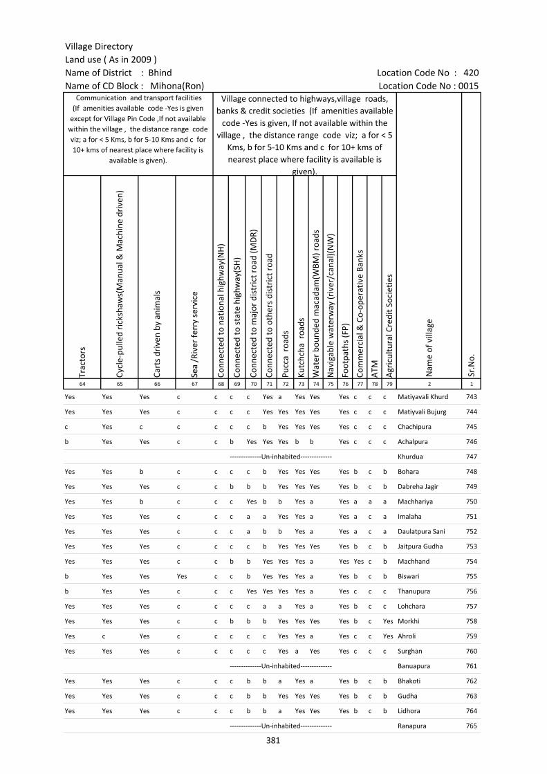
Village DirectoryLand use ( As in 2009 )Name of District : Bhind Location Code No : 420Name of CD Block : Mihona(Ron) Location Code No : 0015
Trac
tors
Cycl
e-pu
lled
rick
shaw
s(M
anua
l & M
achi
ne d
rive
n)
Cart
s dr
iven
by
anim
als
Sea
/Riv
er fe
rry
serv
ice
Conn
ecte
d to
nat
iona
l hig
hway
(NH
)
Conn
ecte
d to
sta
te h
ighw
ay(S
H)
Conn
ecte
d to
maj
or d
istr
ict r
oad
(MD
R)
Conn
ecte
d to
oth
ers
dist
rict
roa
d
Pucc
a r
oads
Kutc
hcha
roa
ds
Wat
er b
ound
ed m
acad
am(W
BM) r
oads
Nav
igab
le w
ater
way
(riv
er/c
anal
)(N
W)
Foot
path
s (F
P)
Com
mer
cial
& C
o-op
erat
ive
Bank
s
ATM
Agr
icul
tura
l Cre
dit S
ocie
ties
64 65 66 67 68 69 70 71 72 73 74 75 76 77 78 79 2 1
Village connected to highways,village roads, banks & credit societies (If amenities available
code -Yes is given, If not available within the village , the distance range code viz; a for < 5
Kms, b for 5-10 Kms and c for 10+ kms of nearest place where facility is available is
given).
Nam
e of
vill
age
Sr.N
o.
Communication and transport facilities (If amenities available code -Yes is given
except for Village Pin Code ,If not available within the village , the distance range code viz; a for < 5 Kms, b for 5-10 Kms and c for 10+ kms of nearest place where facility is
available is given).
Yes Yes Yes c c c c Yes a Yes Yes Yes c c c Matiyavali Khurd 743
Yes Yes Yes c c c c Yes Yes Yes Yes Yes c c c Matiyvali Bujurg 744
c Yes c c c c c b Yes Yes Yes Yes c c c Chachipura 745
b Yes Yes c c b Yes Yes Yes b b Yes c c c Achalpura 746
--------------Un-inhabited-------------- Khurdua 747
Yes Yes b c c c c b Yes Yes Yes Yes b c b Bohara 748
Yes Yes Yes c c b b b Yes Yes Yes Yes b c b Dabreha Jagir 749
Yes Yes b c c c Yes b b Yes a Yes a a a Machhariya 750
Yes Yes Yes c c c a a Yes Yes a Yes a c a Imalaha 751
Yes Yes Yes c c c a b b Yes a Yes a c a Daulatpura Sani 752
Yes Yes Yes c c c c b Yes Yes Yes Yes b c b Jaitpura Gudha 753
Yes Yes Yes c c b b Yes Yes Yes a Yes Yes c b Machhand 754
b Yes Yes Yes c c b Yes Yes Yes a Yes b c b Biswari 755
b Yes Yes c c c Yes Yes Yes Yes a Yes c c c Thanupura 756
Yes Yes Yes c c c c a a Yes a Yes b c c Lohchara 757
Yes Yes Yes c c b b b Yes Yes Yes Yes b c Yes Morkhi 758
Yes c Yes c c c c c Yes Yes a Yes c c Yes Ahroli 759
Yes Yes Yes c c c c c Yes a Yes Yes c c c Surghan 760
--------------Un-inhabited-------------- Banuapura 761
Yes Yes Yes c c c b b a Yes a Yes b c b Bhakoti 762
Yes Yes Yes c c c b b Yes Yes Yes Yes b c b Gudha 763
Yes Yes Yes c c c b b a Yes Yes Yes b c b Lidhora 764
--------------Un-inhabited-------------- Ranapura 765
381

Census of India 2011- Amenities and
Name of District : Bhind Location Code No : 420Name of CD Block : Mihona(Ron) Location Code No : 0015
Self-
Hel
p G
roup
(SH
G)
Publ
ic d
istr
ibut
ion
syst
em (P
DS)
sho
p
Man
dis
/ Re
gula
r m
arke
t
Wee
kly
Haa
t
Agr
icul
tura
l mar
ketin
g so
ciet
yIn
tegr
ated
Chi
ld D
evel
opm
ent S
chem
e (N
utri
tiona
l Ce
ntre
s)A
ngan
wad
i Cen
tre
(Nut
ritio
nal C
entr
es)
Oth
ers
(Nut
ritio
nal C
entr
es)
ASH
A (A
ccre
dite
d So
cial
Hea
lth A
ctiv
ist)
Com
mun
ity c
entr
e w
ith/w
ithou
t TV
Spor
ts F
ield
,
Spor
ts C
lub
/ Re
crea
tion
Cent
re
Cine
ma
/ Vi
deo
Hal
l
Publ
ic L
ibra
ry
Publ
ic R
eadi
ng R
oom
New
spap
er S
uppl
y
Ass
embl
y Po
lling
sta
tion
Birt
h &
Dea
th R
egis
trat
ion
Off
ice
1 2 3 80 81 82 83 84 85 86 87 88 89 90 91 92 93 94 95 96 97
Availability of miscellaneous facilities (If amenities available code -Yes is given, If not available within the village , the distance range code viz; a for < 5 Kms, b
for 5-10 Kms and c for 10+ kms of nearest place where facility is available is given).
Sr.N
o.
Nam
e of
vill
age
Loca
tion
code
no.
743 Matiyavali Khurd 453503 c b c c c c Yes Yes Yes c c c c c c c a b
744 Matiyvali Bujurg 453504 Yes Yes c c c c Yes Yes Yes c c c c c c c Yes Yes
745 Chachipura 453505 c c c c c c a Yes Yes c c c c c c c Yes Yes
746 Achalpura 453513 Yes Yes c Yes c c Yes Yes Yes b Yes b c c c Yes Yes Yes
747 Khurdua 453514 --------------Un-inhabited--------------
748 Bohara 453515 b Yes Yes Yes Yes b Yes Yes Yes b Yes b c b c Yes Yes Yes
749 Dabreha Jagir 453516 Yes a a a b b Yes Yes Yes b b b c b b Yes Yes Yes
750 Machhariya 453526 a Yes a a Yes a Yes Yes Yes Yes Yes Yes c c c Yes Yes Yes
751 Imalaha 453527 Yes Yes a a a a Yes c Yes b c c c c a Yes Yes Yes
752 Daulatpura Sani 453528 Yes Yes a a a a Yes Yes Yes b c c c a a Yes a Yes
753 Jaitpura Gudha 453529 b Yes b c c b Yes Yes Yes b b b c c c Yes Yes Yes
754 Machhand 453530 Yes Yes Yes Yes b b Yes Yes Yes b Yes b c Yes b Yes Yes Yes
755 Biswari 453531 Yes Yes b b c c Yes Yes Yes b Yes b c c c Yes Yes Yes
756 Thanupura 453532 Yes a b b b c Yes Yes Yes b Yes b c c c b Yes Yes
757 Lohchara 453533 Yes a b b Yes c Yes Yes Yes b Yes c c c c b Yes Yes
758 Morkhi 453534 Yes Yes Yes Yes b c Yes Yes Yes Yes Yes a a c a Yes Yes Yes
759 Ahroli 453535 Yes a c c c c Yes a Yes b c c c c c Yes a b
760 Surghan 453536 Yes Yes Yes Yes Yes c Yes Yes Yes b c c c c c Yes Yes Yes
761 Banuapura 453537 --------------Un-inhabited--------------
762 Bhakoti 453538 b Yes Yes b b b Yes Yes Yes b b b c c c a Yes a
763 Gudha 453539 Yes Yes b b b c Yes Yes Yes b b b c c c Yes Yes Yes
764 Lidhora 453540 b b b c c b Yes Yes Yes b b b c c c a Yes a
765 Ranapura 453541 --------------Un-inhabited--------------
382
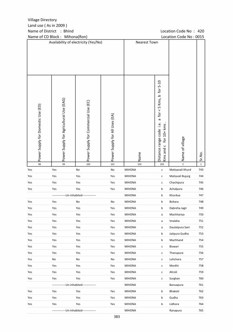
Village DirectoryLand use ( As in 2009 )Name of District : Bhind Location Code No : 420Name of CD Block : Mihona(Ron) Location Code No : 0015
Pow
er S
uppl
y fo
r D
omes
tic U
se (E
D)
Pow
er S
uppl
y fo
r A
gric
ultu
ral U
se (E
AG
)
Pow
er S
uppl
y fo
r Co
mm
erci
al U
se (E
C)
Pow
er S
uppl
y fo
r A
ll U
ses
(EA
)
Nam
e
Dis
tanc
e ra
nge
code
i.e
. a
for
< 5
Kms,
b f
or 5
-10
Kms
and
c f
or 1
0+ k
ms
.98 99 100 101 102 103 2 1
Availability of electricity (Yes/No) Nearest Town
Nam
e of
vill
age
Sr.N
o.
Yes Yes No No MIHONA c Matiyavali Khurd 743
Yes Yes Yes Yes MIHONA c Matiyvali Bujurg 744
Yes Yes Yes Yes MIHONA c Chachipura 745
Yes Yes Yes Yes MIHONA b Achalpura 746
--------------Un-inhabited-------------- MIHONA b Khurdua 747
Yes Yes No No MIHONA b Bohara 748
Yes Yes Yes Yes MIHONA b Dabreha Jagir 749
Yes Yes Yes Yes MIHONA a Machhariya 750
Yes Yes Yes Yes MIHONA a Imalaha 751
Yes Yes Yes Yes MIHONA a Daulatpura Sani 752
Yes Yes Yes Yes MIHONA b Jaitpura Gudha 753
Yes Yes Yes Yes MIHONA b Machhand 754
Yes Yes Yes Yes MIHONA c Biswari 755
Yes Yes Yes Yes MIHONA c Thanupura 756
Yes No No No MIHONA c Lohchara 757
Yes Yes Yes Yes MIHONA c Morkhi 758
Yes Yes Yes Yes MIHONA c Ahroli 759
Yes Yes Yes Yes MIHONA c Surghan 760
--------------Un-inhabited-------------- MIHONA Banuapura 761
Yes Yes Yes Yes MIHONA b Bhakoti 762
Yes Yes Yes Yes MIHONA b Gudha 763
Yes Yes Yes Yes MIHONA b Lidhora 764
--------------Un-inhabited-------------- MIHONA Ranapura 765
383
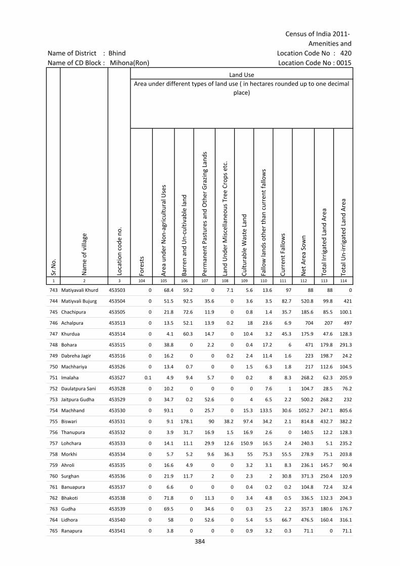
Census of India 2011- Amenities and
Name of District : Bhind Location Code No : 420Name of CD Block : Mihona(Ron) Location Code No : 0015
Fore
sts
Are
a un
der
Non
-agr
icul
tura
l Use
s
Barr
en a
nd U
n-cu
ltiva
ble
land
Perm
anen
t Pas
ture
s an
d O
ther
Gra
zing
Lan
ds
Land
Und
er M
isce
llane
ous
Tree
Cro
ps e
tc.
Cultu
rabl
e W
aste
Lan
d
Fallo
w la
nds
othe
r th
an c
urre
nt fa
llow
s
Curr
ent F
allo
ws
Net
Are
a So
wn
Tota
l Irr
igat
ed L
and
Are
a
Tota
l Un-
irri
gate
d La
nd A
rea
1 2 3 104 105 106 107 108 109 110 111 112 113 114
Area under different types of land use ( in hectares rounded up to one decimal place)
Nam
e of
vill
age
Loca
tion
code
no.
Land Use
Sr.N
o.
743 Matiyavali Khurd 453503 0 68.4 59.2 0 7.1 5.6 13.6 97 88 88 0
744 Matiyvali Bujurg 453504 0 51.5 92.5 35.6 0 3.6 3.5 82.7 520.8 99.8 421
745 Chachipura 453505 0 21.8 72.6 11.9 0 0.8 1.4 35.7 185.6 85.5 100.1
746 Achalpura 453513 0 13.5 52.1 13.9 0.2 18 23.6 6.9 704 207 497
747 Khurdua 453514 0 4.1 60.3 14.7 0 10.4 3.2 45.3 175.9 47.6 128.3
748 Bohara 453515 0 38.8 0 2.2 0 0.4 17.2 6 471 179.8 291.3
749 Dabreha Jagir 453516 0 16.2 0 0 0.2 2.4 11.4 1.6 223 198.7 24.2
750 Machhariya 453526 0 13.4 0.7 0 0 1.5 6.3 1.8 217 112.6 104.5
751 Imalaha 453527 0.1 4.9 9.4 5.7 0 0.2 8 8.3 268.2 62.3 205.9
752 Daulatpura Sani 453528 0 10.2 0 0 0 0 7.6 1 104.7 28.5 76.2
753 Jaitpura Gudha 453529 0 34.7 0.2 52.6 0 4 6.5 2.2 500.2 268.2 232
754 Machhand 453530 0 93.1 0 25.7 0 15.3 133.5 30.6 1052.7 247.1 805.6
755 Biswari 453531 0 9.1 178.1 90 38.2 97.4 34.2 2.1 814.8 432.7 382.2
756 Thanupura 453532 0 3.9 31.7 16.9 1.5 16.9 2.6 0 140.5 12.2 128.3
757 Lohchara 453533 0 14.1 11.1 29.9 12.6 150.9 16.5 2.4 240.3 5.1 235.2
758 Morkhi 453534 0 5.7 5.2 9.6 36.3 55 75.3 55.5 278.9 75.1 203.8
759 Ahroli 453535 0 16.6 4.9 0 0 3.2 3.1 8.3 236.1 145.7 90.4
760 Surghan 453536 0 21.9 11.7 2 0 2.3 2 30.8 371.3 250.4 120.9
761 Banuapura 453537 0 6.6 0 0 0 0.4 0.2 0.2 104.8 72.4 32.4
762 Bhakoti 453538 0 71.8 0 11.3 0 3.4 4.8 0.5 336.5 132.3 204.3
763 Gudha 453539 0 69.5 0 34.6 0 0.3 2.5 2.2 357.3 180.6 176.7
764 Lidhora 453540 0 58 0 52.6 0 5.4 5.5 66.7 476.5 160.4 316.1
765 Ranapura 453541 0 3.8 0 0 0 0.9 3.2 0.3 71.1 0 71.1
384
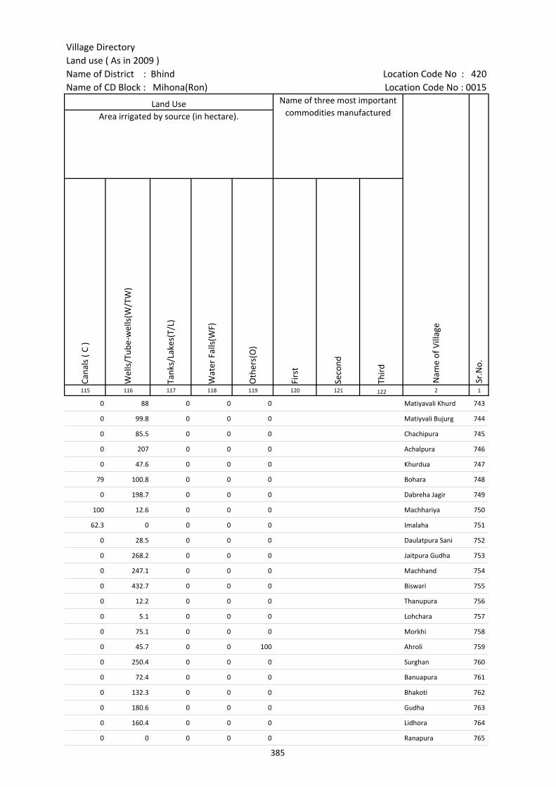
Village DirectoryLand use ( As in 2009 )Name of District : Bhind Location Code No : 420Name of CD Block : Mihona(Ron) Location Code No : 0015
Cana
ls (
C )
Wel
ls/T
ube-
wel
ls(W
/TW
)
Tank
s/La
kes(
T/L)
Wat
er F
alls
(WF)
Oth
ers(
O)
Firs
t
Seco
nd
Thir
d 115 116 117 118 119 120 121 122 2 1
Sr.N
o.
Area irrigated by source (in hectare).Land Use Name of three most important
commodities manufactured
Nam
e of
Vill
age
0 88 0 0 0 Matiyavali Khurd 743
0 99.8 0 0 0 Matiyvali Bujurg 744
0 85.5 0 0 0 Chachipura 745
0 207 0 0 0 Achalpura 746
0 47.6 0 0 0 Khurdua 747
79 100.8 0 0 0 Bohara 748
0 198.7 0 0 0 Dabreha Jagir 749
100 12.6 0 0 0 Machhariya 750
62.3 0 0 0 0 Imalaha 751
0 28.5 0 0 0 Daulatpura Sani 752
0 268.2 0 0 0 Jaitpura Gudha 753
0 247.1 0 0 0 Machhand 754
0 432.7 0 0 0 Biswari 755
0 12.2 0 0 0 Thanupura 756
0 5.1 0 0 0 Lohchara 757
0 75.1 0 0 0 Morkhi 758
0 45.7 0 0 100 Ahroli 759
0 250.4 0 0 0 Surghan 760
0 72.4 0 0 0 Banuapura 761
0 132.3 0 0 0 Bhakoti 762
0 180.6 0 0 0 Gudha 763
0 160.4 0 0 0 Lidhora 764
0 0 0 0 0 Ranapura 765
385
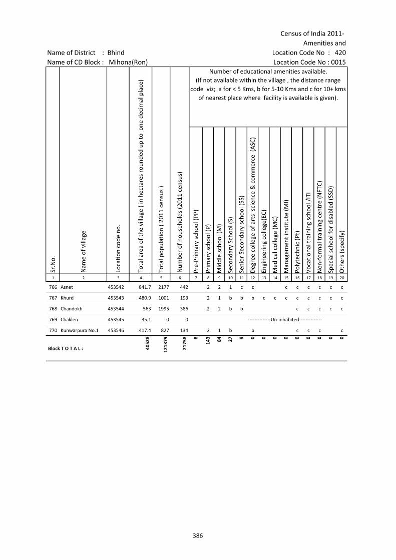
Census of India 2011- Amenities and
Name of District : Bhind Location Code No : 420Name of CD Block : Mihona(Ron) Location Code No : 0015
Pre-
Prim
ary
scho
ol (P
P)
Prim
ary
scho
ol (P
)
Mid
dle
scho
ol (M
)
Seco
ndar
y Sc
hool
(S)
Seni
or S
econ
dary
sch
ool (
SS)
Deg
ree
colle
ge o
f art
s s
cien
ce &
com
mer
ce (
ASC
)
Engi
neer
ing
colle
ge(E
C)
Med
ical
col
lege
(MC)
Man
agem
ent i
nstit
ute
(MI)
Poly
tech
nic
(Pt)
Voca
tiona
l tra
inin
g sc
hool
/IT
I
Non
-for
mal
trai
ning
cen
tre
(NFT
C)
Spec
ial s
choo
l for
dis
able
d (S
SD)
Oth
ers
(spe
cify
)
1 2 3 4 5 6 7 8 9 10 11 12 13 14 15 16 17 18 19 20
Number of educational amenities available. (If not available within the village , the distance range
code viz; a for < 5 Kms, b for 5-10 Kms and c for 10+ kms of nearest place where facility is available is given).
Sr.N
o.
Nam
e of
vill
age
Loca
tion
code
no.
Tota
l are
a of
the
villa
ge (
in h
ecta
res
roun
ded
up to
one
dec
imal
pla
ce)
Tota
l pop
ulat
ion
( 201
1 ce
nsus
)
Num
ber
of h
ouse
hold
s (2
011
cens
us)
766 Asnet 453542 841.7 2177 442 2 2 1 c c c c c c c c
767 Khurd 453543 480.9 1001 193 2 1 b b b c c c c c c c c
768 Chandokh 453544 563 1995 386 2 2 b b c c c c c
769 Chaklen 453545 35.1 0 0 --------------Un-inhabited--------------
770 Kunwarpura No.1 453546 417.4 827 134 2 1 b b c c c c
Block T O T A L : 4052
8
1213
79
2175
8 8
143 84 27 9 0 0 0 0 0 0 0 0 0
386

Village DirectoryLand use ( As in 2009 )Name of District : Bhind Location Code No : 420Name of CD Block : Mihona(Ron) Location Code No : 0015
Com
mun
ity h
ealth
cen
tre
(CH
C)Pr
imar
y he
alth
cen
tre
(PH
C)Pr
imar
y he
alth
sub
cen
tre
(PH
S)M
ater
nity
and
chi
ld w
elfa
re c
entr
e (M
CW)
T.B.
clin
ic (
TBC)
Hos
pita
l-allo
path
ic (H
A)
Hos
pita
l-alte
rnat
ive
med
icin
e (H
O)
Dis
pens
ary
(D)
Vete
rina
ry h
ospi
tal (
VH)
Mob
ile h
ealth
clin
ic (M
HC)
Fam
ily w
elfa
re c
entr
e (F
WC)
Char
itabl
e no
n G
ovt.
hos
pita
l/N
ursi
ng h
ome.
Med
ical
pra
ctiti
oner
with
MBB
S D
egre
eM
edic
al p
ract
ition
er w
ith o
ther
deg
ree
Med
ical
pra
ctiti
oner
with
no
degr
eeTr
aditi
onal
pra
ctiti
oner
and
faith
hea
ler
.M
edic
ine
Shop
Oth
ers
Tap
wat
er (T
reat
ed/U
ntre
ated
)
Wel
l w
ater
(C
over
ed /
Unc
over
ed w
ell)
Han
d Pu
mp
Tube
wel
ls /
Bor
e w
ell
Spri
ng
Rive
r /
Cana
l
Tank
/ P
ond
/ L
ake
Oth
ers
21 22 23 24 25 26 27 28 29 30 31 32 33 34 35 36 37 38 39 40 41 42 43 44 45 46 2 1
Number of Medical Amenities available. (If not available within the
village , the distance range code viz; a for < 5 Kms, b for 5-10 Kms and c for
10+ kms of nearest place where facility is available is given).
Number of Non-Government
Medical Amenities available.
Availability of drinking water - Yes / No
Nam
e of
vill
age
Sr.N
o.
c c 1 c c c c c c c c 0 0 0 0 0 0 0 Yes Yes Yes No No Yes No No Asnet 766
b b b b b b b b b b b 0 0 0 0 0 0 0 No Yes Yes No No No No No Khurd 767
c b 1 c b b c b 0 0 0 0 0 0 0 No Yes Yes Yes No No No No Chandokh 768
--------------Un-inhabited-------------- Chaklen 769
c b b c b c c b c c 0 0 0 0 0 0 0 No Yes Yes No No No No No Kunwarpura No.1 770
1 1 21 1 1 1 1 3 2 0 11 0 0 16 3 0 4 0 7 69 68 47 0 35 48 0
Block T O T A L :
387
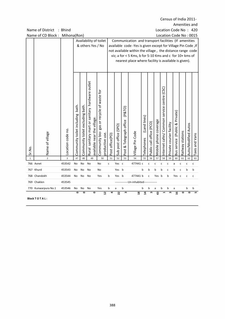
Census of India 2011- Amenities and
Name of District : Bhind Location Code No : 420Name of CD Block : Mihona(Ron) Location Code No : 0015
Com
mun
ity to
ilet i
nclu
ding
bat
h.
Com
mun
ity to
ilet e
xclu
ding
bat
h.
Rura
l sa
nita
ry m
art o
r sa
nita
ry h
ardw
are
outle
t av
aila
ble
near
the
villa
ge.
Com
mun
ity b
io- g
as o
r re
cycl
e of
was
te fo
r pr
oduc
tive
use.
Post
off
ice(
PO)
Sub
post
off
ice
(SPO
)
Post
& T
eleg
raph
off
ice
(P&
TO)
Villa
ge P
in C
ode
Tele
phon
es
(L
and
lines
)
Publ
ic c
all o
ffic
e (P
CO)
Mob
ile p
hone
cov
erag
e
Inte
rnet
caf
es/
Com
mon
ser
vice
cen
tre
(CSC
)
Priv
ate
cour
ier
faci
lity
Bus
serv
ice
(Pub
lic &
Pri
vate
)
Railw
ay s
tatio
ns
Aut
o/M
odifi
ed A
utos
Taxi
s an
d Va
ns
1 2 3 47 48 49 50 51 52 53 54 55 56 57 58 59 60 61 62 63
Sr.N
o.
Nam
e of
vill
age
Loca
tion
code
no.
Availability of toilet & others Yes / No
Communication and transport facilities (If amenities available code -Yes is given except for Village Pin Code ,If not available within the village , the distance range code
viz; a for < 5 Kms, b for 5-10 Kms and c for 10+ kms of nearest place where facility is available is given).
766 Asnet 453542 No No No No c Yes c 477441 c c c c c a c c c
767 Khurd 453543 No No No No Yes b b b b b c b c b b
768 Chandokh 453544 No No No Yes b Yes b 477441 b c Yes b b Yes c c c
769 Chaklen 453545 --------------Un-inhabited--------------
770 Kunwarpura No.1 453546 No No No Yes b a b b b a b b a b b
Block T O T A L :
0 0 0 12 4 22 3 18 14 3 43 1 3 16 0 0 5
388

Village DirectoryLand use ( As in 2009 )Name of District : Bhind Location Code No : 420Name of CD Block : Mihona(Ron) Location Code No : 0015
Trac
tors
Cycl
e-pu
lled
rick
shaw
s(M
anua
l & M
achi
ne d
rive
n)
Cart
s dr
iven
by
anim
als
Sea
/Riv
er fe
rry
serv
ice
Conn
ecte
d to
nat
iona
l hig
hway
(NH
)
Conn
ecte
d to
sta
te h
ighw
ay(S
H)
Conn
ecte
d to
maj
or d
istr
ict r
oad
(MD
R)
Conn
ecte
d to
oth
ers
dist
rict
roa
d
Pucc
a r
oads
Kutc
hcha
roa
ds
Wat
er b
ound
ed m
acad
am(W
BM) r
oads
Nav
igab
le w
ater
way
(riv
er/c
anal
)(N
W)
Foot
path
s (F
P)
Com
mer
cial
& C
o-op
erat
ive
Bank
s
ATM
Agr
icul
tura
l Cre
dit S
ocie
ties
64 65 66 67 68 69 70 71 72 73 74 75 76 77 78 79 2 1
Village connected to highways,village roads, banks & credit societies (If amenities available
code -Yes is given, If not available within the village , the distance range code viz; a for < 5
Kms, b for 5-10 Kms and c for 10+ kms of nearest place where facility is available is
given).
Nam
e of
vill
age
Sr.N
o.
Communication and transport facilities (If amenities available code -Yes is given
except for Village Pin Code ,If not available within the village , the distance range code viz; a for < 5 Kms, b for 5-10 Kms and c for 10+ kms of nearest place where facility is
available is given).
Yes Yes Yes a c c a a Yes Yes a Yes c c c Asnet 766
c Yes b c c c Yes Yes Yes Yes Yes Yes c c c Khurd 767
Yes Yes Yes c c c Yes Yes Yes Yes a Yes b c b Chandokh 768
--------------Un-inhabited-------------- Chaklen 769
b Yes b c c c b b b Yes a Yes b c b Kunwarpura No.1 770
56 60 56 1 0 7 15 35 44 68 51 0 70 2 0 23
Block T O T A L :
389
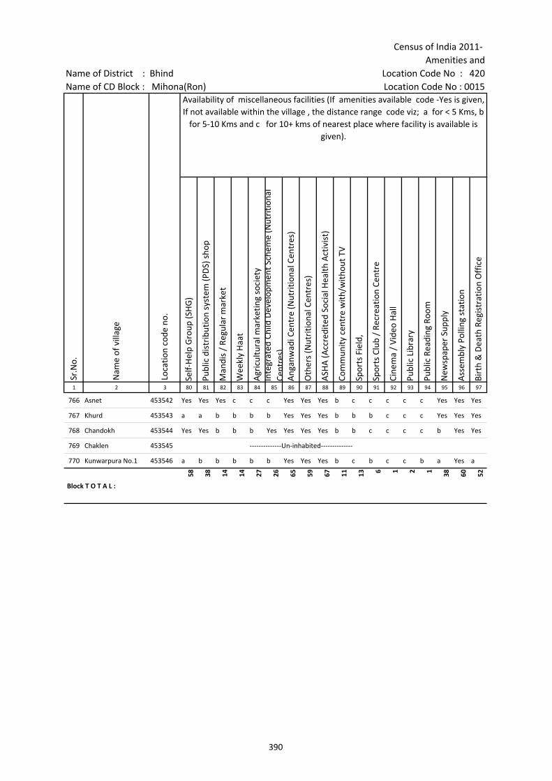
Census of India 2011- Amenities and
Name of District : Bhind Location Code No : 420Name of CD Block : Mihona(Ron) Location Code No : 0015
Self-
Hel
p G
roup
(SH
G)
Publ
ic d
istr
ibut
ion
syst
em (P
DS)
sho
p
Man
dis
/ Re
gula
r m
arke
t
Wee
kly
Haa
t
Agr
icul
tura
l mar
ketin
g so
ciet
yIn
tegr
ated
Chi
ld D
evel
opm
ent S
chem
e (N
utri
tiona
l Ce
ntre
s)A
ngan
wad
i Cen
tre
(Nut
ritio
nal C
entr
es)
Oth
ers
(Nut
ritio
nal C
entr
es)
ASH
A (A
ccre
dite
d So
cial
Hea
lth A
ctiv
ist)
Com
mun
ity c
entr
e w
ith/w
ithou
t TV
Spor
ts F
ield
,
Spor
ts C
lub
/ Re
crea
tion
Cent
re
Cine
ma
/ Vi
deo
Hal
l
Publ
ic L
ibra
ry
Publ
ic R
eadi
ng R
oom
New
spap
er S
uppl
y
Ass
embl
y Po
lling
sta
tion
Birt
h &
Dea
th R
egis
trat
ion
Off
ice
1 2 3 80 81 82 83 84 85 86 87 88 89 90 91 92 93 94 95 96 97
Availability of miscellaneous facilities (If amenities available code -Yes is given, If not available within the village , the distance range code viz; a for < 5 Kms, b
for 5-10 Kms and c for 10+ kms of nearest place where facility is available is given).
Sr.N
o.
Nam
e of
vill
age
Loca
tion
code
no.
766 Asnet 453542 Yes Yes Yes c c c Yes Yes Yes b c c c c c Yes Yes Yes
767 Khurd 453543 a a b b b b Yes Yes Yes b b b c c c Yes Yes Yes
768 Chandokh 453544 Yes Yes b b b Yes Yes Yes Yes b b c c c c b Yes Yes
769 Chaklen 453545 --------------Un-inhabited--------------
770 Kunwarpura No.1 453546 a b b b b b Yes Yes Yes b c b c c b a Yes a
Block T O T A L :
58 38 14 14 27 26 65 59 67 11 13 6 1 2 1 38 60 52
390
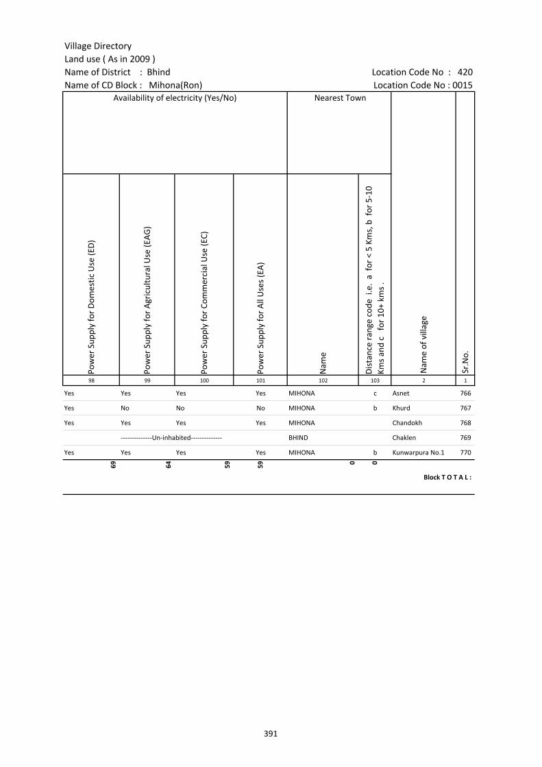
Village DirectoryLand use ( As in 2009 )Name of District : Bhind Location Code No : 420Name of CD Block : Mihona(Ron) Location Code No : 0015
Pow
er S
uppl
y fo
r D
omes
tic U
se (E
D)
Pow
er S
uppl
y fo
r A
gric
ultu
ral U
se (E
AG
)
Pow
er S
uppl
y fo
r Co
mm
erci
al U
se (E
C)
Pow
er S
uppl
y fo
r A
ll U
ses
(EA
)
Nam
e
Dis
tanc
e ra
nge
code
i.e
. a
for
< 5
Kms,
b f
or 5
-10
Kms
and
c f
or 1
0+ k
ms
.98 99 100 101 102 103 2 1
Availability of electricity (Yes/No) Nearest Town
Nam
e of
vill
age
Sr.N
o.
Yes Yes Yes Yes MIHONA c Asnet 766
Yes No No No MIHONA b Khurd 767
Yes Yes Yes Yes MIHONA Chandokh 768
--------------Un-inhabited-------------- BHIND Chaklen 769
Yes Yes Yes Yes MIHONA b Kunwarpura No.1 770
69 64 59 59 0 0
Block T O T A L :
391

Census of India 2011- Amenities and
Name of District : Bhind Location Code No : 420Name of CD Block : Mihona(Ron) Location Code No : 0015
Fore
sts
Are
a un
der
Non
-agr
icul
tura
l Use
s
Barr
en a
nd U
n-cu
ltiva
ble
land
Perm
anen
t Pas
ture
s an
d O
ther
Gra
zing
Lan
ds
Land
Und
er M
isce
llane
ous
Tree
Cro
ps e
tc.
Cultu
rabl
e W
aste
Lan
d
Fallo
w la
nds
othe
r th
an c
urre
nt fa
llow
s
Curr
ent F
allo
ws
Net
Are
a So
wn
Tota
l Irr
igat
ed L
and
Are
a
Tota
l Un-
irri
gate
d La
nd A
rea
1 2 3 104 105 106 107 108 109 110 111 112 113 114
Area under different types of land use ( in hectares rounded up to one decimal place)
Nam
e of
vill
age
Loca
tion
code
no.
Land Use
Sr.N
o.
766 Asnet 453542 0 29.9 142.5 59.3 0 17.4 80.3 30.5 481.7 266.2 215.5
767 Khurd 453543 0 20.9 34 13.9 0.2 5.8 51.5 60.9 293.7 81.1 212.5
768 Chandokh 453544 0 33.6 0.9 12.2 0 0.7 8.1 18.1 489.3 269.5 219.8
769 Chaklen 453545 0 1.9 0 0 0 0 0 0.3 32.9 24.7 8.2
770 Kunwarpura No.1 453546 0 15.3 1.1 12 0.9 0.9 13.8 34.3 339.2 172.7 166.4
Block T O T A L :
86.3
2567
.4
2174
.7
1593
.2
165.
3
1019
.9
2154
.9
1562
.6
2920
2.6
9730
.1
1947
2.7
392
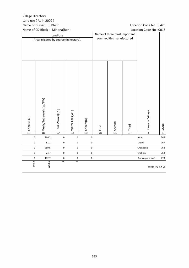
Village DirectoryLand use ( As in 2009 )Name of District : Bhind Location Code No : 420Name of CD Block : Mihona(Ron) Location Code No : 0015
Cana
ls (
C )
Wel
ls/T
ube-
wel
ls(W
/TW
)
Tank
s/La
kes(
T/L)
Wat
er F
alls
(WF)
Oth
ers(
O)
Firs
t
Seco
nd
Thir
d 115 116 117 118 119 120 121 122 2 1
Sr.N
o.
Area irrigated by source (in hectare).Land Use Name of three most important
commodities manufactured
Nam
e of
Vill
age
0 266.2 0 0 0 Asnet 766
0 81.1 0 0 0 Khurd 767
0 269.5 0 0 0 Chandokh 768
0 24.7 0 0 0 Chaklen 769
0 172.7 0 0 0 Kunwarpura No.1 770
360.
6
9269
.5 0 0
Block T O T A L :
393
394
(b) Map of Lahar CD Block showing tahsil boundary.
(c) Alphabetical list of Villages of Lahar CD Block along with location code 2001 and 2011.
(d) Village Directory data of Lahar CD Block in prescribed format.
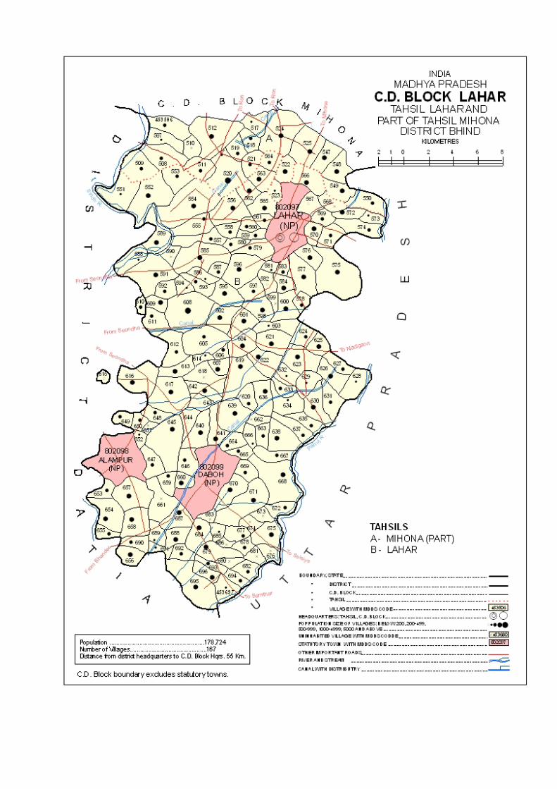

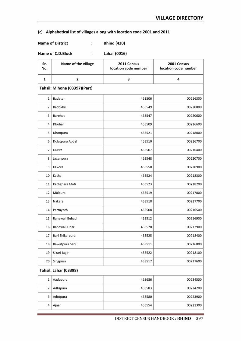
VILLAGE DIRECTORY
DISTRICTCENSUSHANDBOOK:BHIND397
(c) Alphabetical list of villages along with location code 2001 and 2011
Name of District : Bhind (420)
Name of C.D.Block : Lahar (0016)
Sr. No.
Name of the village 2011 Census location code number
2001 Census location code number
1 2 3 4
Tahsil: Mihona (03397)(Part)
1 Badetar 453506 00216300
2 Badokhri 453549 00220800
3 Barehat 453547 00220600
4 Dhohar 453509 00216600
5 Dhonpura 453521 00218000
6 Dolatpura Abbal 453510 00216700
7 Gurira 453507 00216400
8 Jaganpura 453548 00220700
9 Kakora 453550 00220900
10 Katha 453524 00218300
11 Kathghara Mafi 453523 00218200
12 Malpura 453519 00217800
13 Nakara 453518 00217700
14 Parrayach 453508 00216500
15 Rahawali Behad 453512 00216900
16 Rahawali Ubari 453520 00217900
17 Rari Shikarpura 453525 00218400
18 Rawatpura Sani 453511 00216800
19 Sikari Jagir 453522 00218100
20 Singpura 453517 00217600
Tahsil: Lahar (03398)
1 Aadupura 453686 00234500
2 Adlispura 453583 00224200
3 Adotpura 453580 00223900
4 Ajnar 453554 00221300
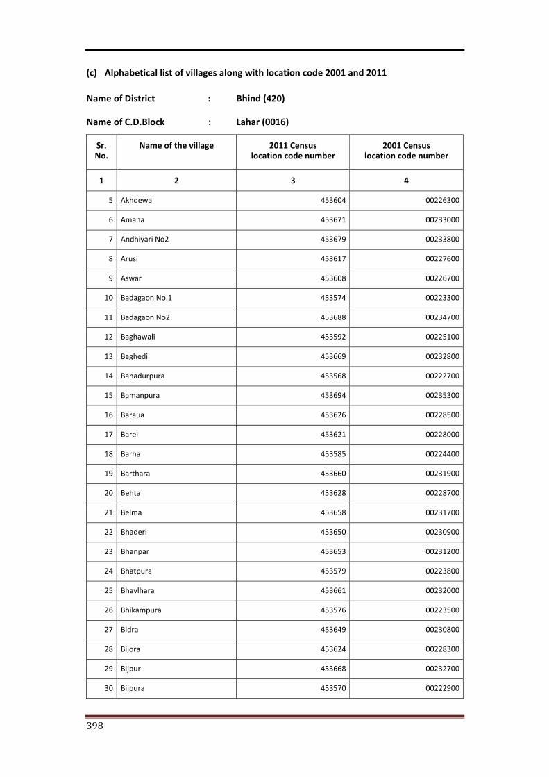
398
(c) Alphabetical list of villages along with location code 2001 and 2011
Name of District : Bhind (420)
Name of C.D.Block : Lahar (0016)
Sr. No.
Name of the village 2011 Census location code number
2001 Census location code number
1 2 3 4
5 Akhdewa 453604 00226300
6 Amaha 453671 00233000
7 Andhiyari No2 453679 00233800
8 Arusi 453617 00227600
9 Aswar 453608 00226700
10 Badagaon No.1 453574 00223300
11 Badagaon No2 453688 00234700
12 Baghawali 453592 00225100
13 Baghedi 453669 00232800
14 Bahadurpura 453568 00222700
15 Bamanpura 453694 00235300
16 Baraua 453626 00228500
17 Barei 453621 00228000
18 Barha 453585 00224400
19 Barthara 453660 00231900
20 Behta 453628 00228700
21 Belma 453658 00231700
22 Bhaderi 453650 00230900
23 Bhanpar 453653 00231200
24 Bhatpura 453579 00223800
25 Bhavlhara 453661 00232000
26 Bhikampura 453576 00223500
27 Bidra 453649 00230800
28 Bijora 453624 00228300
29 Bijpur 453668 00232700
30 Bijpura 453570 00222900
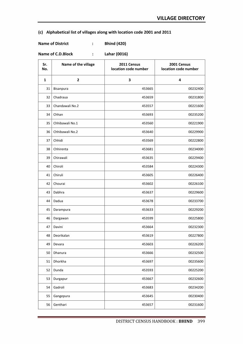
VILLAGE DIRECTORY
DISTRICTCENSUSHANDBOOK:BHIND399
(c) Alphabetical list of villages along with location code 2001 and 2011
Name of District : Bhind (420)
Name of C.D.Block : Lahar (0016)
Sr. No.
Name of the village 2011 Census location code number
2001 Census location code number
1 2 3 4
31 Bisanpura 453665 00232400
32 Chadraua 453659 00231800
33 Chandawali No.2 453557 00221600
34 Chhan 453693 00235200
35 Chhibawali No.1 453560 00221900
36 Chhibawali No.2 453640 00229900
37 Chhidi 453569 00222800
38 Chhirenta 453681 00234000
39 Chirawali 453635 00229400
40 Chiroli 453584 00224300
41 Chiruli 453605 00226400
42 Chourai 453602 00226100
43 Dabhra 453637 00229600
44 Dadua 453678 00233700
45 Darampura 453633 00229200
46 Dargawan 453599 00225800
47 Davini 453664 00232300
48 Deorikalan 453619 00227800
49 Devara 453603 00226200
50 Dhanura 453666 00232500
51 Dhorkha 453697 00235600
52 Dunda 453593 00225200
53 Durgapur 453667 00232600
54 Gadroli 453683 00234200
55 Gangepura 453645 00230400
56 Genthari 453657 00231600
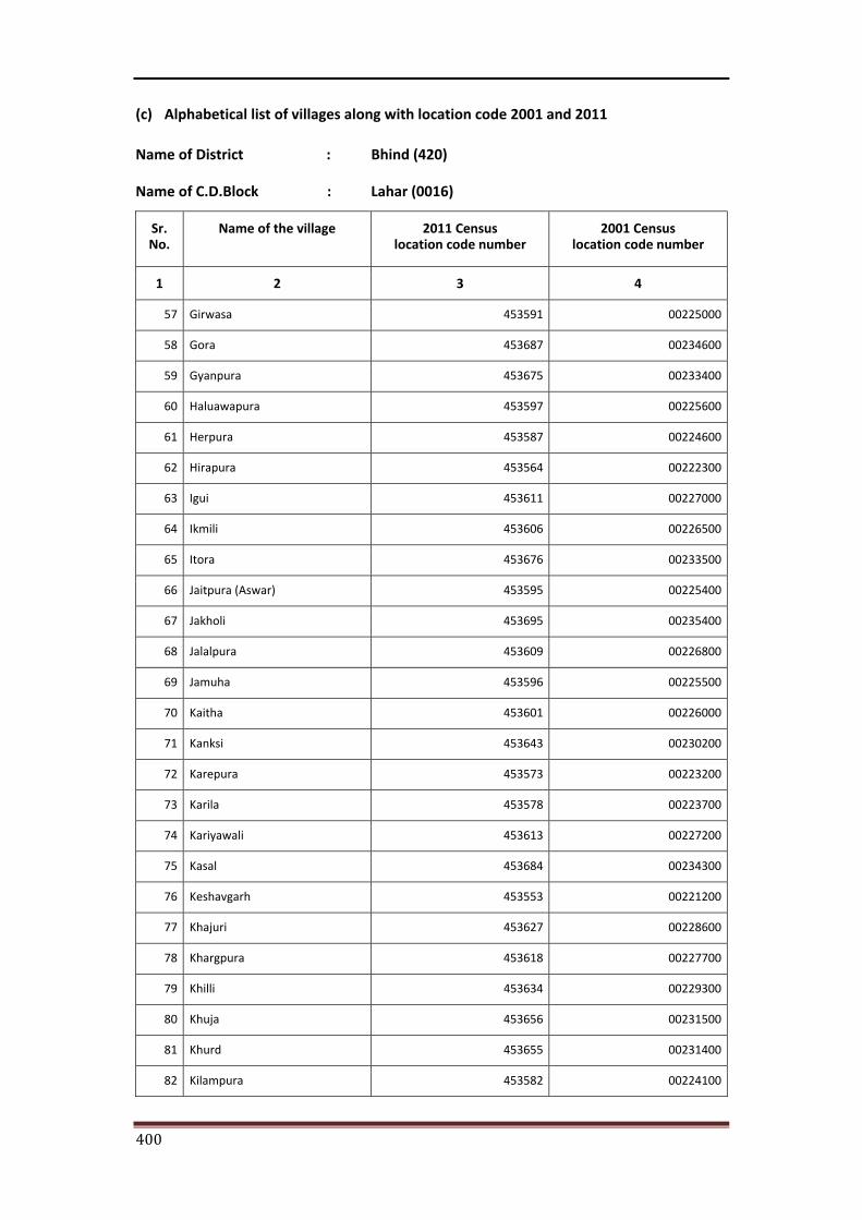
400
(c) Alphabetical list of villages along with location code 2001 and 2011
Name of District : Bhind (420)
Name of C.D.Block : Lahar (0016)
Sr. No.
Name of the village 2011 Census location code number
2001 Census location code number
1 2 3 4
57 Girwasa 453591 00225000
58 Gora 453687 00234600
59 Gyanpura 453675 00233400
60 Haluawapura 453597 00225600
61 Herpura 453587 00224600
62 Hirapura 453564 00222300
63 Igui 453611 00227000
64 Ikmili 453606 00226500
65 Itora 453676 00233500
66 Jaitpura (Aswar) 453595 00225400
67 Jakholi 453695 00235400
68 Jalalpura 453609 00226800
69 Jamuha 453596 00225500
70 Kaitha 453601 00226000
71 Kanksi 453643 00230200
72 Karepura 453573 00223200
73 Karila 453578 00223700
74 Kariyawali 453613 00227200
75 Kasal 453684 00234300
76 Keshavgarh 453553 00221200
77 Khajuri 453627 00228600
78 Khargpura 453618 00227700
79 Khilli 453634 00229300
80 Khuja 453656 00231500
81 Khurd 453655 00231400
82 Kilampura 453582 00224100
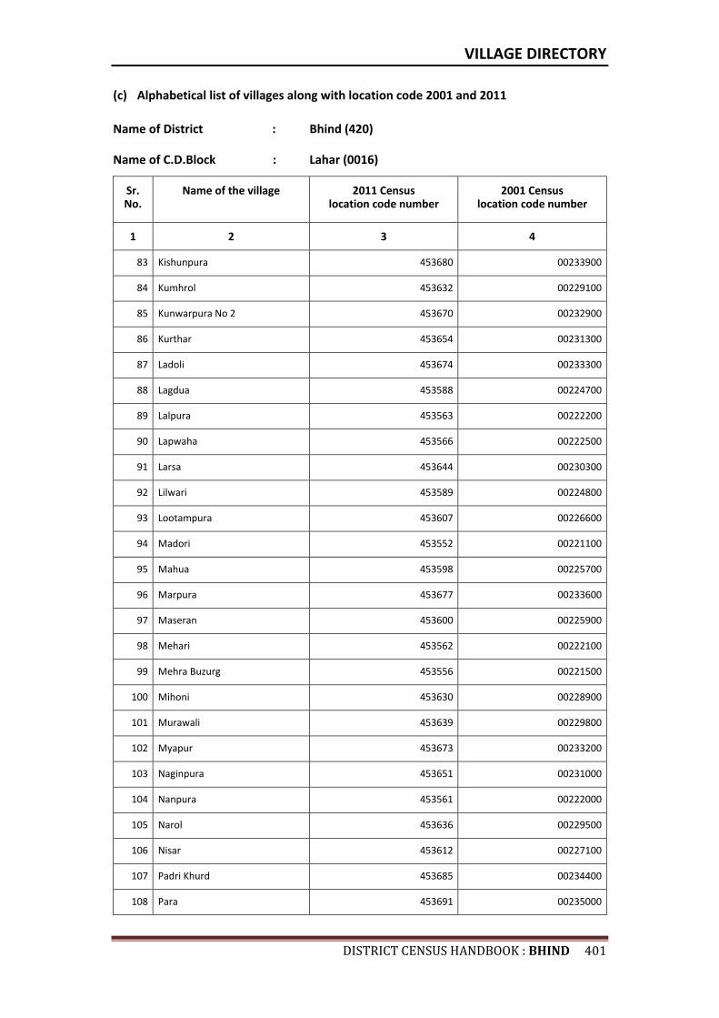
VILLAGE DIRECTORY
DISTRICTCENSUSHANDBOOK:BHIND401
(c) Alphabetical list of villages along with location code 2001 and 2011
Name of District : Bhind (420)
Name of C.D.Block : Lahar (0016)
Sr. No.
Name of the village 2011 Census location code number
2001 Census location code number
1 2 3 4
83 Kishunpura 453680 00233900
84 Kumhrol 453632 00229100
85 Kunwarpura No 2 453670 00232900
86 Kurthar 453654 00231300
87 Ladoli 453674 00233300
88 Lagdua 453588 00224700
89 Lalpura 453563 00222200
90 Lapwaha 453566 00222500
91 Larsa 453644 00230300
92 Lilwari 453589 00224800
93 Lootampura 453607 00226600
94 Madori 453552 00221100
95 Mahua 453598 00225700
96 Marpura 453677 00233600
97 Maseran 453600 00225900
98 Mehari 453562 00222100
99 Mehra Buzurg 453556 00221500
100 Mihoni 453630 00228900
101 Murawali 453639 00229800
102 Myapur 453673 00233200
103 Naginpura 453651 00231000
104 Nanpura 453561 00222000
105 Narol 453636 00229500
106 Nisar 453612 00227100
107 Padri Khurd 453685 00234400
108 Para 453691 00235000
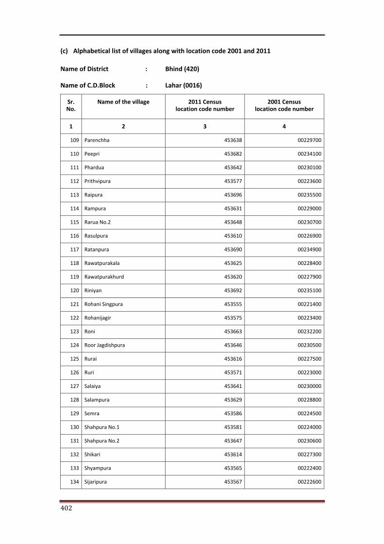
402
(c) Alphabetical list of villages along with location code 2001 and 2011
Name of District : Bhind (420)
Name of C.D.Block : Lahar (0016)
Sr. No.
Name of the village 2011 Census location code number
2001 Census location code number
1 2 3 4
109 Parenchha 453638 00229700
110 Peepri 453682 00234100
111 Phardua 453642 00230100
112 Prithvipura 453577 00223600
113 Raipura 453696 00235500
114 Rampura 453631 00229000
115 Rarua No.2 453648 00230700
116 Rasulpura 453610 00226900
117 Ratanpura 453690 00234900
118 Rawatpurakala 453625 00228400
119 Rawatpurakhurd 453620 00227900
120 Riniyan 453692 00235100
121 Rohani Singpura 453555 00221400
122 Rohanijagir 453575 00223400
123 Roni 453663 00232200
124 Roor Jagdishpura 453646 00230500
125 Rurai 453616 00227500
126 Ruri 453571 00223000
127 Salaiya 453641 00230000
128 Salampura 453629 00228800
129 Semra 453586 00224500
130 Shahpura No.1 453581 00224000
131 Shahpura No.2 453647 00230600
132 Shikari 453614 00227300
133 Shyampura 453565 00222400
134 Sijaripura 453567 00222600
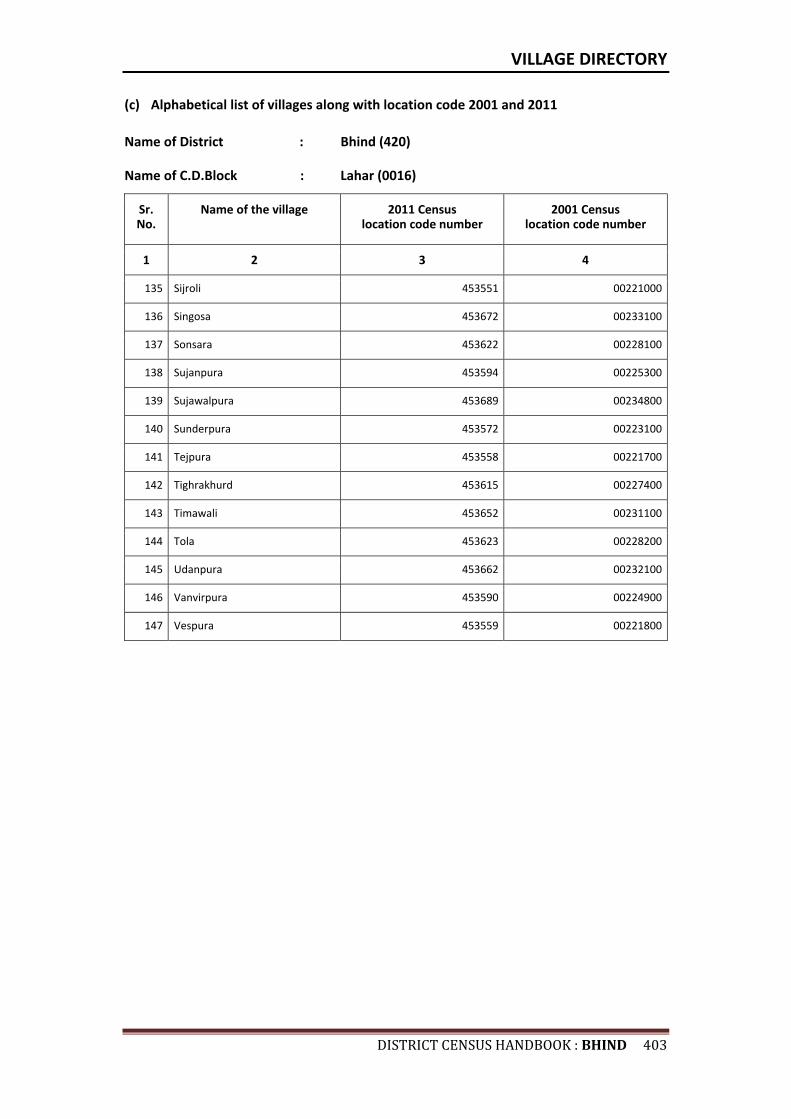
VILLAGE DIRECTORY
DISTRICTCENSUSHANDBOOK:BHIND403
(c) Alphabetical list of villages along with location code 2001 and 2011
Name of District : Bhind (420)
Name of C.D.Block : Lahar (0016)
Sr. No.
Name of the village 2011 Census location code number
2001 Census location code number
1 2 3 4
135 Sijroli 453551 00221000
136 Singosa 453672 00233100
137 Sonsara 453622 00228100
138 Sujanpura 453594 00225300
139 Sujawalpura 453689 00234800
140 Sunderpura 453572 00223100
141 Tejpura 453558 00221700
142 Tighrakhurd 453615 00227400
143 Timawali 453652 00231100
144 Tola 453623 00228200
145 Udanpura 453662 00232100
146 Vanvirpura 453590 00224900
147 Vespura 453559 00221800

Census of India 2011- Amenities and
Name of District : Bhind Location Code No : 420Name of CD Block : Lahar Location Code No : 0016
Pre-
Prim
ary
scho
ol (P
P)
Prim
ary
scho
ol (P
)
Mid
dle
scho
ol (M
)
Seco
ndar
y Sc
hool
(S)
Seni
or S
econ
dary
sch
ool (
SS)
Deg
ree
colle
ge o
f art
s s
cien
ce &
com
mer
ce (
ASC
)
Engi
neer
ing
colle
ge(E
C)
Med
ical
col
lege
(MC)
Man
agem
ent i
nstit
ute
(MI)
Poly
tech
nic
(Pt)
Voca
tiona
l tra
inin
g sc
hool
/IT
I
Non
-for
mal
trai
ning
cen
tre
(NFT
C)
Spec
ial s
choo
l for
dis
able
d (S
SD)
Oth
ers
(spe
cify
)
1 2 3 4 5 6 7 8 9 10 11 12 13 14 15 16 17 18 19 20
771 Badetar 453506 470 757 141 c 1 1 a c c c c c c c c c c
772 Gurira 453507 311.6 389 83 c 1 1 a c c c c c c c c c c
773 Parrayach 453508 467.3 866 147 c 1 1 a c c c c c c c c c
774 Dhohar 453509 538 902 177 c 1 1 c c c c c c c c c c c
775 Dolatpura Abbal 453510 137 0 0 --------------Un-inhabited--------------
776 Rawatpura Sani 453511 387 992 166 c 1 1 a c c c c c c c c c c
777 Rahawali Behad 453512 1112.9 1328 205 c 1 1 a c c c c c c c c c c
778 Singpura 453517 245.6 389 66 b 1 1 a b c c c c b c c c
779 Nakara 453518 185.6 556 128 b 2 a a b b c c c c b c c c
780 Malpura 453519 256.1 766 154 c 1 a a c c c c c c c c c c
781 Rahawali Ubari 453520 887.6 5273 939 c 2 2 1 1 c c c c c c c c c
782 Dhonpura 453521 320.2 826 141 c 1 1 c c c c c c c c c c c
783 Sikari Jagir 453522 255.4 2227 380 b 1 1 b b b c c c c b c c c
784 Kathghara Mafi 453523 106 202 46 a 1 a a a a c c c c a c c
785 Katha 453524 1210.7 4985 971 b 2 2 1 1 c c c c c c c c
786 Rari Shikarpura 453525 729.8 3212 736 1 4 3 c c c c
787 Barehat 453547 440.8 1632 298 1 2 1 1 c c c c
788 Jaganpura 453548 421 1633 339 2 2 1 c c c c
789 Badokhri 453549 464.7 1653 305 b 3 1 1 1 b c c c c b c c c
790 Kakora 453550 445 545 86 c 1 2 c c c c c c c c c c
791 Sijroli 453551 282.8 207 42 c 1 1 a c c c c c c c c c c
792 Madori 453552 819 1406 218 c 2 1 1 c c c c c c c c c c
793 Keshavgarh 453553 398.6 594 98 1 1 b b c c c c c c
794 Ajnar 453554 1048.7 2463 442 1 2 1 1 1 c c c c c c c
795 Rohani Singpura 453555 442.6 827 135 c 1 1 a a c c c c c c c c c
796 Mehra Buzurg 453556 675.1 2407 359 b 1 1 b b b c c c b c c c
Sr.N
o.
Nam
e of
vill
age
Loca
tion
code
no.
Tota
l are
a of
the
villa
ge (
in h
ecta
res
roun
ded
up to
one
dec
imal
pla
ce)
Tota
l pop
ulat
ion
( 201
1 ce
nsus
)
Num
ber
of h
ouse
hold
s (2
011
cens
us)
Number of educational amenities available. (If not available within the village , the distance range
code viz; a for < 5 Kms, b for 5-10 Kms and c for 10+ kms of nearest place where facility is available is given).
404
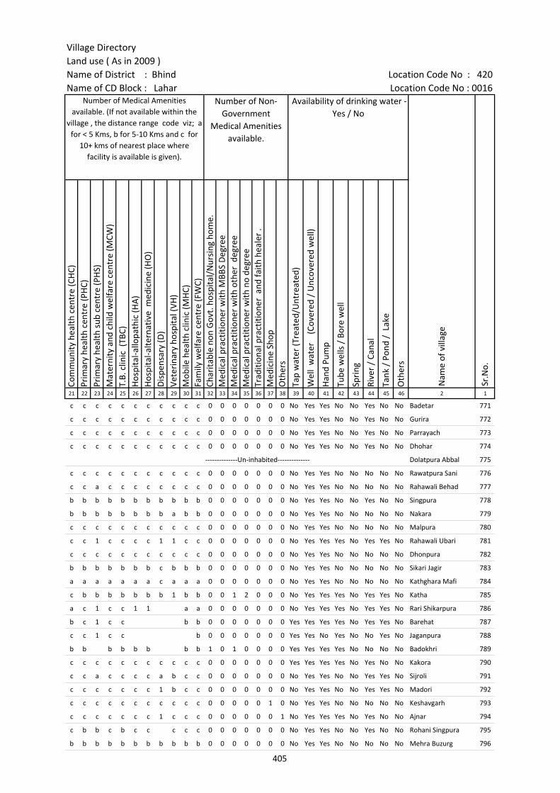
Village DirectoryLand use ( As in 2009 )Name of District : Bhind Location Code No : 420Name of CD Block : Lahar Location Code No : 0016
Com
mun
ity h
ealth
cen
tre
(CH
C)Pr
imar
y he
alth
cen
tre
(PH
C)Pr
imar
y he
alth
sub
cen
tre
(PH
S)M
ater
nity
and
chi
ld w
elfa
re c
entr
e (M
CW)
T.B.
clin
ic (
TBC)
Hos
pita
l-allo
path
ic (H
A)
Hos
pita
l-alte
rnat
ive
med
icin
e (H
O)
Dis
pens
ary
(D)
Vete
rina
ry h
ospi
tal (
VH)
Mob
ile h
ealth
clin
ic (M
HC)
Fam
ily w
elfa
re c
entr
e (F
WC)
Char
itabl
e no
n G
ovt.
hos
pita
l/N
ursi
ng h
ome.
Med
ical
pra
ctiti
oner
with
MBB
S D
egre
eM
edic
al p
ract
ition
er w
ith o
ther
deg
ree
Med
ical
pra
ctiti
oner
with
no
degr
eeTr
aditi
onal
pra
ctiti
oner
and
faith
hea
ler
.M
edic
ine
Shop
Oth
ers
Tap
wat
er (T
reat
ed/U
ntre
ated
)
Wel
l w
ater
(C
over
ed /
Unc
over
ed w
ell)
Han
d Pu
mp
Tube
wel
ls /
Bor
e w
ell
Spri
ng
Rive
r /
Cana
l
Tank
/ P
ond
/ L
ake
Oth
ers
21 22 23 24 25 26 27 28 29 30 31 32 33 34 35 36 37 38 39 40 41 42 43 44 45 46 2 1
c c c c c c c c c c c 0 0 0 0 0 0 0 No Yes Yes No No Yes No No Badetar 771
c c c c c c c c c c c 0 0 0 0 0 0 0 No Yes Yes No No Yes No No Gurira 772
c c c c c c c c c c c 0 0 0 0 0 0 0 No Yes Yes No No Yes No No Parrayach 773
c c c c c c c c c c c 0 0 0 0 0 0 0 No Yes Yes No No Yes No No Dhohar 774
--------------Un-inhabited-------------- Dolatpura Abbal 775
c c c c c c c c c c c 0 0 0 0 0 0 0 No Yes Yes No No No No No Rawatpura Sani 776
c c a c c c c c c c c 0 0 0 0 0 0 0 No Yes Yes No No No No No Rahawali Behad 777
b b b b b b b b b b b 0 0 0 0 0 0 0 No Yes Yes No No Yes No No Singpura 778
b b b b b b b b a b b 0 0 0 0 0 0 0 No Yes Yes No No No No No Nakara 779
c c c c c c c c c c c 0 0 0 0 0 0 0 No Yes Yes No No No No No Malpura 780
c c 1 c c c c 1 1 c c 0 0 0 0 0 0 0 No Yes Yes Yes No Yes Yes No Rahawali Ubari 781
c c c c c c c c c c c 0 0 0 0 0 0 0 No Yes Yes No No No No No Dhonpura 782
b b b b b b b c b b b 0 0 0 0 0 0 0 No Yes Yes No No No No No Sikari Jagir 783
a a a a a a a c a a a 0 0 0 0 0 0 0 No Yes Yes No No No No No Kathghara Mafi 784
c b b b b b b b 1 b b 0 0 1 2 0 0 0 No Yes Yes Yes No Yes Yes No Katha 785
a c 1 c c 1 1 a a 0 0 0 0 0 0 0 No Yes Yes Yes No Yes Yes No Rari Shikarpura 786
b c 1 c c b b 0 0 0 0 0 0 0 Yes Yes Yes Yes No Yes Yes No Barehat 787
c c 1 c c b 0 0 0 0 0 0 0 Yes Yes No Yes No No Yes No Jaganpura 788
b b b b b b b b 1 0 1 0 0 0 0 Yes Yes Yes Yes No No No No Badokhri 789
c c c c c c c c c c c 0 0 0 0 0 0 0 Yes Yes Yes Yes No Yes No No Kakora 790
c c a c c c c a b c c 0 0 0 0 0 0 0 No Yes Yes No No Yes Yes No Sijroli 791
c c c c c c c 1 b c c 0 0 0 0 0 0 0 No Yes Yes No No Yes Yes No Madori 792
c c c c c c c c c c c 0 0 0 0 0 1 0 No Yes Yes No No No No No Keshavgarh 793
c c c c c c c 1 c c c 0 0 0 0 0 0 1 No Yes Yes Yes No Yes No No Ajnar 794
c b b c b c c c c c 0 0 0 0 0 0 0 No Yes Yes No No Yes No No Rohani Singpura 795
b b b b b b b b b b b 0 0 0 0 0 0 0 No Yes Yes No No No No No Mehra Buzurg 796
Number of Medical Amenities available. (If not available within the
village , the distance range code viz; a for < 5 Kms, b for 5-10 Kms and c for
10+ kms of nearest place where facility is available is given).
Number of Non-Government
Medical Amenities available.
Availability of drinking water - Yes / No
Nam
e of
vill
age
Sr.N
o.
405
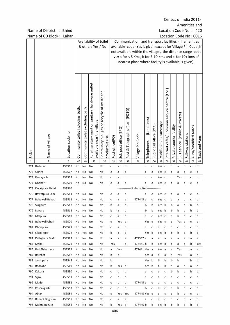
Census of India 2011- Amenities and
Name of District : Bhind Location Code No : 420Name of CD Block : Lahar Location Code No : 0016
Com
mun
ity to
ilet i
nclu
ding
bat
h.
Com
mun
ity to
ilet e
xclu
ding
bat
h.
Rura
l sa
nita
ry m
art o
r sa
nita
ry h
ardw
are
outle
t av
aila
ble
near
the
villa
ge.
Com
mun
ity b
io- g
as o
r re
cycl
e of
was
te fo
r pr
oduc
tive
use.
Post
off
ice(
PO)
Sub
post
off
ice
(SPO
)
Post
& T
eleg
raph
off
ice
(P&
TO)
Villa
ge P
in C
ode
Tele
phon
es
(L
and
lines
)
Publ
ic c
all o
ffic
e (P
CO)
Mob
ile p
hone
cov
erag
e
Inte
rnet
caf
es/
Com
mon
ser
vice
cen
tre
(CSC
)
Priv
ate
cour
ier
faci
lity
Bus
serv
ice
(Pub
lic &
Pri
vate
)
Railw
ay s
tatio
ns
Aut
o/M
odifi
ed A
utos
Taxi
s an
d Va
ns
1 2 3 47 48 49 50 51 52 53 54 55 56 57 58 59 60 61 62 63
771 Badetar 453506 No No No No c a c c c Yes c c a c c c
772 Gurira 453507 No No No No c a c c c Yes c c a c c c
773 Parrayach 453508 No No No No c a c c c Yes c c Yes c c c
774 Dhohar 453509 No No No No c a c c c Yes c c a c c c
775 Dolatpura Abbal 453510 --------------Un-inhabited--------------
776 Rawatpura Sani 453511 No No No No c a c c c Yes c c a c c c
777 Rahawali Behad 453512 No No No No c a a 477445 c c Yes c c a c c c
778 Singpura 453517 No No No No b a b b b Yes b b a c b b
779 Nakara 453518 No No No No b a b b b Yes b b b c b b
780 Malpura 453519 No No No No c a c c c Yes c c b c c c
781 Rahawali Ubari 453520 No No No No c Yes c Yes c Yes c c Yes c c c
782 Dhonpura 453521 No No No No c a c c c c c c c c c c
783 Sikari Jagir 453522 No Yes No No b a b Yes b Yes b b b c b b
784 Kathghara Mafi 453523 No No No No a a a 477557 a a a a a a a a a
785 Katha 453524 No No No No Yes b 477441 b b Yes b c a c b Yes
786 Rari Shikarpura 453525 No No No No a Yes 477441 Yes a Yes a a Yes a a
787 Barehat 453547 No No No No b b Yes a a a a Yes a a
788 Jaganpura 453548 No No No No b Yes b b b b b b b
789 Badokhri 453549 No No No No b Yes b Yes b b b a a a a a
790 Kakora 453550 No No No No c c c c c c c b b c b b
791 Sijroli 453551 No No No No c b c c c a c c c c c c
792 Madori 453552 No No No No c b c 477445 c c a c c c c c c
793 Keshavgarh 453553 No No No No c c c b c c c c b c c c
794 Ajnar 453554 No No No No c Yes Yes 477445 Yes c c c c b c c c
795 Rohani Singpura 453555 No No No No c a a a c c c c c c c c
796 Mehra Buzurg 453556 No No No No b Yes b 477445 b b Yes b b b c b b
Nam
e of
vill
age
Loca
tion
code
no.
Availability of toilet & others Yes / No
Communication and transport facilities (If amenities available code -Yes is given except for Village Pin Code ,If not available within the village , the distance range code
viz; a for < 5 Kms, b for 5-10 Kms and c for 10+ kms of nearest place where facility is available is given).
Sr.N
o.
406
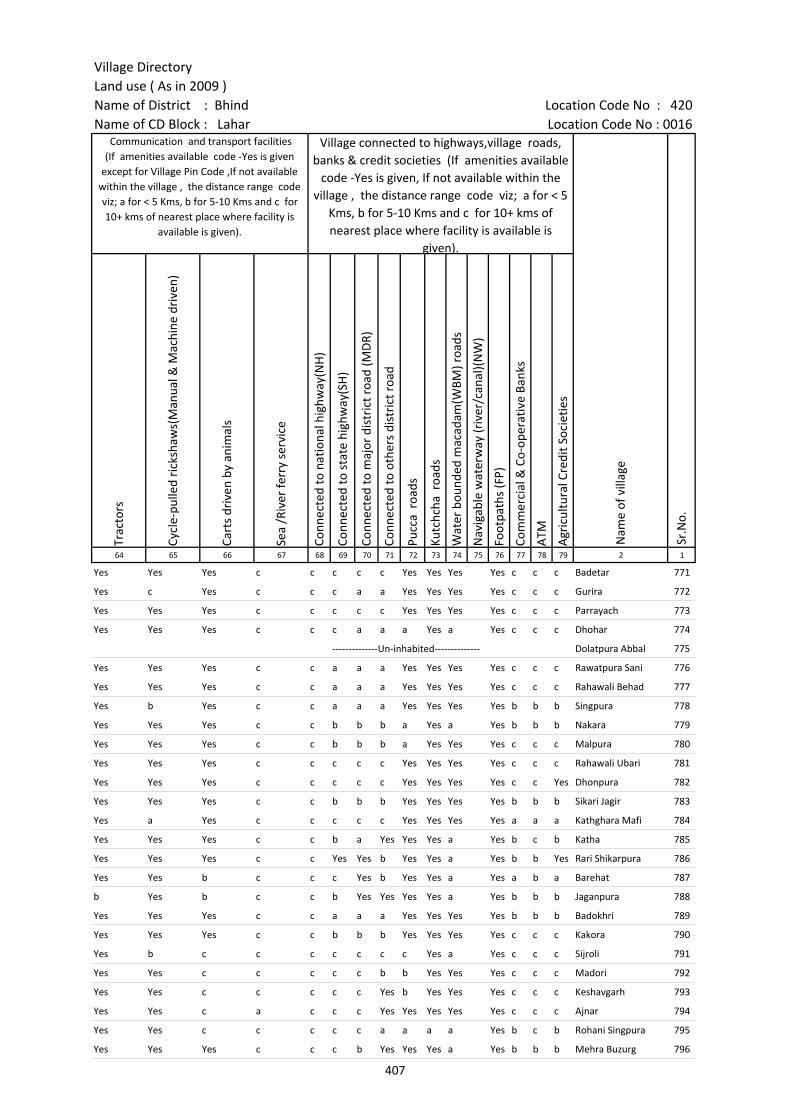
Village DirectoryLand use ( As in 2009 )Name of District : Bhind Location Code No : 420Name of CD Block : Lahar Location Code No : 0016
Trac
tors
Cycl
e-pu
lled
rick
shaw
s(M
anua
l & M
achi
ne d
rive
n)
Cart
s dr
iven
by
anim
als
Sea
/Riv
er fe
rry
serv
ice
Conn
ecte
d to
nat
iona
l hig
hway
(NH
)
Conn
ecte
d to
sta
te h
ighw
ay(S
H)
Conn
ecte
d to
maj
or d
istr
ict r
oad
(MD
R)
Conn
ecte
d to
oth
ers
dist
rict
roa
d
Pucc
a r
oads
Kutc
hcha
roa
ds
Wat
er b
ound
ed m
acad
am(W
BM) r
oads
Nav
igab
le w
ater
way
(riv
er/c
anal
)(N
W)
Foot
path
s (F
P)
Com
mer
cial
& C
o-op
erat
ive
Bank
s
ATM
Agr
icul
tura
l Cre
dit S
ocie
ties
64 65 66 67 68 69 70 71 72 73 74 75 76 77 78 79 2 1
Yes Yes Yes c c c c c Yes Yes Yes Yes c c c Badetar 771
Yes c Yes c c c a a Yes Yes Yes Yes c c c Gurira 772
Yes Yes Yes c c c c c Yes Yes Yes Yes c c c Parrayach 773
Yes Yes Yes c c c a a a Yes a Yes c c c Dhohar 774
--------------Un-inhabited-------------- Dolatpura Abbal 775
Yes Yes Yes c c a a a Yes Yes Yes Yes c c c Rawatpura Sani 776
Yes Yes Yes c c a a a Yes Yes Yes Yes c c c Rahawali Behad 777
Yes b Yes c c a a a Yes Yes Yes Yes b b b Singpura 778
Yes Yes Yes c c b b b a Yes a Yes b b b Nakara 779
Yes Yes Yes c c b b b a Yes Yes Yes c c c Malpura 780
Yes Yes Yes c c c c c Yes Yes Yes Yes c c c Rahawali Ubari 781
Yes Yes Yes c c c c c Yes Yes Yes Yes c c Yes Dhonpura 782
Yes Yes Yes c c b b b Yes Yes Yes Yes b b b Sikari Jagir 783
Yes a Yes c c c c c Yes Yes Yes Yes a a a Kathghara Mafi 784
Yes Yes Yes c c b a Yes Yes Yes a Yes b c b Katha 785
Yes Yes Yes c c Yes Yes b Yes Yes a Yes b b Yes Rari Shikarpura 786
Yes Yes b c c c Yes b Yes Yes a Yes a b a Barehat 787
b Yes b c c b Yes Yes Yes Yes a Yes b b b Jaganpura 788
Yes Yes Yes c c a a a Yes Yes Yes Yes b b b Badokhri 789
Yes Yes Yes c c b b b Yes Yes Yes Yes c c c Kakora 790
Yes b c c c c c c c Yes a Yes c c c Sijroli 791
Yes Yes c c c c c b b Yes Yes Yes c c c Madori 792
Yes Yes c c c c c Yes b Yes Yes Yes c c c Keshavgarh 793
Yes Yes c a c c c Yes Yes Yes Yes Yes c c c Ajnar 794
Yes Yes c c c c c a a a a Yes b c b Rohani Singpura 795
Yes Yes Yes c c c b Yes Yes Yes a Yes b b b Mehra Buzurg 796
Nam
e of
vill
age
Sr.N
o.
Communication and transport facilities (If amenities available code -Yes is given
except for Village Pin Code ,If not available within the village , the distance range code viz; a for < 5 Kms, b for 5-10 Kms and c for 10+ kms of nearest place where facility is
available is given).
Village connected to highways,village roads, banks & credit societies (If amenities available
code -Yes is given, If not available within the village , the distance range code viz; a for < 5
Kms, b for 5-10 Kms and c for 10+ kms of nearest place where facility is available is
given).
407

Census of India 2011- Amenities and
Name of District : Bhind Location Code No : 420Name of CD Block : Lahar Location Code No : 0016
Self-
Hel
p G
roup
(SH
G)
Publ
ic d
istr
ibut
ion
syst
em (P
DS)
sho
p
Man
dis
/ Re
gula
r m
arke
t
Wee
kly
Haa
t
Agr
icul
tura
l mar
ketin
g so
ciet
yIn
tegr
ated
Chi
ld D
evel
opm
ent S
chem
e (N
utri
tiona
l Ce
ntre
s)A
ngan
wad
i Cen
tre
(Nut
ritio
nal C
entr
es)
Oth
ers
(Nut
ritio
nal C
entr
es)
ASH
A (A
ccre
dite
d So
cial
Hea
lth A
ctiv
ist)
Com
mun
ity c
entr
e w
ith/w
ithou
t TV
Spor
ts F
ield
,
Spor
ts C
lub
/ Re
crea
tion
Cent
re
Cine
ma
/ Vi
deo
Hal
l
Publ
ic L
ibra
ry
Publ
ic R
eadi
ng R
oom
New
spap
er S
uppl
y
Ass
embl
y Po
lling
sta
tion
Birt
h &
Dea
th R
egis
trat
ion
Off
ice
1 2 3 80 81 82 83 84 85 86 87 88 89 90 91 92 93 94 95 96 97
771 Badetar 453506 Yes a c c c Yes Yes Yes Yes c c c c c c c Yes Yes
772 Gurira 453507 Yes a c c c c Yes a Yes c c c c c c a a b
773 Parrayach 453508 Yes Yes c c c c Yes Yes Yes c c c c c c c Yes Yes
774 Dhohar 453509 Yes a c c c c Yes Yes Yes c c c c c c c Yes Yes
775 Dolatpura Abbal 453510 --------------Un-inhabited--------------
776 Rawatpura Sani 453511 Yes Yes c c c c Yes Yes Yes c c c c c c c Yes b
777 Rahawali Behad 453512 Yes a c c c c Yes Yes Yes c c c c c c c Yes Yes
778 Singpura 453517 Yes a b b b b Yes a Yes b b b b b b b Yes a
779 Nakara 453518 Yes a b b b b Yes Yes Yes b b b b b b b a Yes
780 Malpura 453519 Yes a c c c c Yes Yes Yes c c c c c c c Yes Yes
781 Rahawali Ubari 453520 Yes Yes c Yes c c Yes Yes Yes c Yes c c Yes c Yes Yes Yes
782 Dhonpura 453521 Yes Yes Yes c c c Yes Yes Yes c c c c c c Yes Yes Yes
783 Sikari Jagir 453522 Yes Yes b b b b Yes Yes Yes b b b c b b Yes Yes Yes
784 Kathghara Mafi 453523 Yes a a a a a Yes a Yes a a a c a a a Yes a
785 Katha 453524 Yes Yes c Yes c c Yes Yes Yes c Yes c c c c Yes Yes Yes
786 Rari Shikarpura 453525 Yes Yes Yes Yes Yes a Yes Yes Yes Yes Yes Yes c b c Yes Yes Yes
787 Barehat 453547 Yes Yes Yes Yes Yes Yes Yes Yes Yes Yes Yes Yes Yes c c Yes Yes Yes
788 Jaganpura 453548 Yes b Yes Yes Yes b Yes Yes Yes b b Yes Yes c c Yes Yes Yes
789 Badokhri 453549 Yes a b b b b Yes Yes Yes b Yes b c b b Yes Yes Yes
790 Kakora 453550 Yes b c c c c Yes Yes Yes c c c c c c c Yes Yes
791 Sijroli 453551 a b c b c c a a a c c c c c c a a a
792 Madori 453552 Yes b c c c c Yes Yes Yes c Yes c c c c Yes Yes Yes
793 Keshavgarh 453553 Yes a c b c c Yes Yes Yes c Yes c c c c c Yes a
794 Ajnar 453554 Yes Yes c Yes c c Yes Yes Yes c Yes c c c c c Yes Yes
795 Rohani Singpura 453555 Yes b c c c c Yes Yes Yes c Yes c c c c c Yes Yes
796 Mehra Buzurg 453556 Yes b b b b b Yes Yes Yes b b b c c b b Yes Yes
Sr.N
o.
Nam
e of
vill
age
Loca
tion
code
no.
Availability of miscellaneous facilities (If amenities available code -Yes is given, If not available within the village , the distance range code viz; a for < 5 Kms, b
for 5-10 Kms and c for 10+ kms of nearest place where facility is available is given).
408
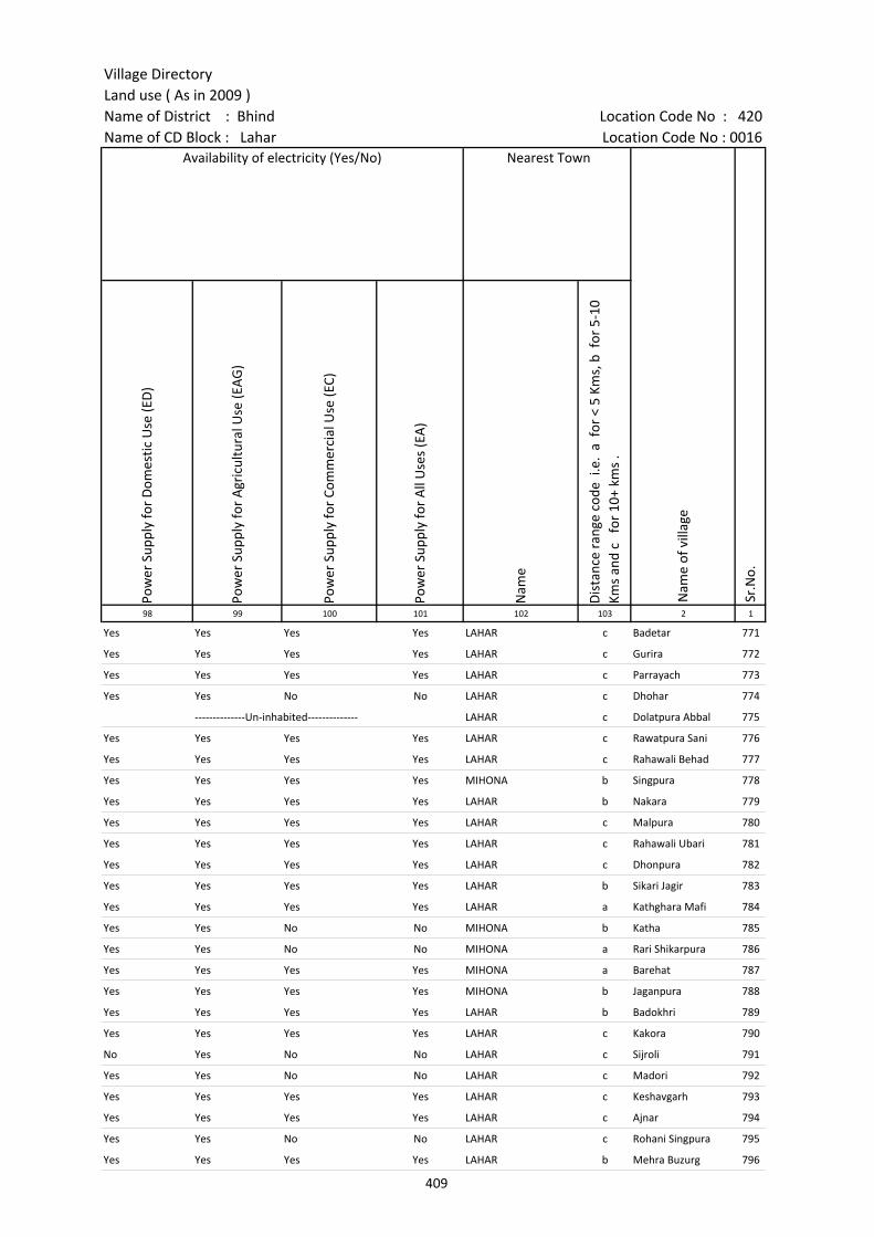
Village DirectoryLand use ( As in 2009 )Name of District : Bhind Location Code No : 420Name of CD Block : Lahar Location Code No : 0016
Pow
er S
uppl
y fo
r D
omes
tic U
se (E
D)
Pow
er S
uppl
y fo
r A
gric
ultu
ral U
se (E
AG
)
Pow
er S
uppl
y fo
r Co
mm
erci
al U
se (E
C)
Pow
er S
uppl
y fo
r A
ll U
ses
(EA
)
Nam
e
Dis
tanc
e ra
nge
code
i.e
. a
for
< 5
Kms,
b f
or 5
-10
Kms
and
c f
or 1
0+ k
ms
.98 99 100 101 102 103 2 1
Yes Yes Yes Yes LAHAR c Badetar 771
Yes Yes Yes Yes LAHAR c Gurira 772
Yes Yes Yes Yes LAHAR c Parrayach 773
Yes Yes No No LAHAR c Dhohar 774
--------------Un-inhabited-------------- LAHAR c Dolatpura Abbal 775
Yes Yes Yes Yes LAHAR c Rawatpura Sani 776
Yes Yes Yes Yes LAHAR c Rahawali Behad 777
Yes Yes Yes Yes MIHONA b Singpura 778
Yes Yes Yes Yes LAHAR b Nakara 779
Yes Yes Yes Yes LAHAR c Malpura 780
Yes Yes Yes Yes LAHAR c Rahawali Ubari 781
Yes Yes Yes Yes LAHAR c Dhonpura 782
Yes Yes Yes Yes LAHAR b Sikari Jagir 783
Yes Yes Yes Yes LAHAR a Kathghara Mafi 784
Yes Yes No No MIHONA b Katha 785
Yes Yes No No MIHONA a Rari Shikarpura 786
Yes Yes Yes Yes MIHONA a Barehat 787
Yes Yes Yes Yes MIHONA b Jaganpura 788
Yes Yes Yes Yes LAHAR b Badokhri 789
Yes Yes Yes Yes LAHAR c Kakora 790
No Yes No No LAHAR c Sijroli 791
Yes Yes No No LAHAR c Madori 792
Yes Yes Yes Yes LAHAR c Keshavgarh 793
Yes Yes Yes Yes LAHAR c Ajnar 794
Yes Yes No No LAHAR c Rohani Singpura 795
Yes Yes Yes Yes LAHAR b Mehra Buzurg 796
Availability of electricity (Yes/No) Nearest Town
Nam
e of
vill
age
Sr.N
o.
409
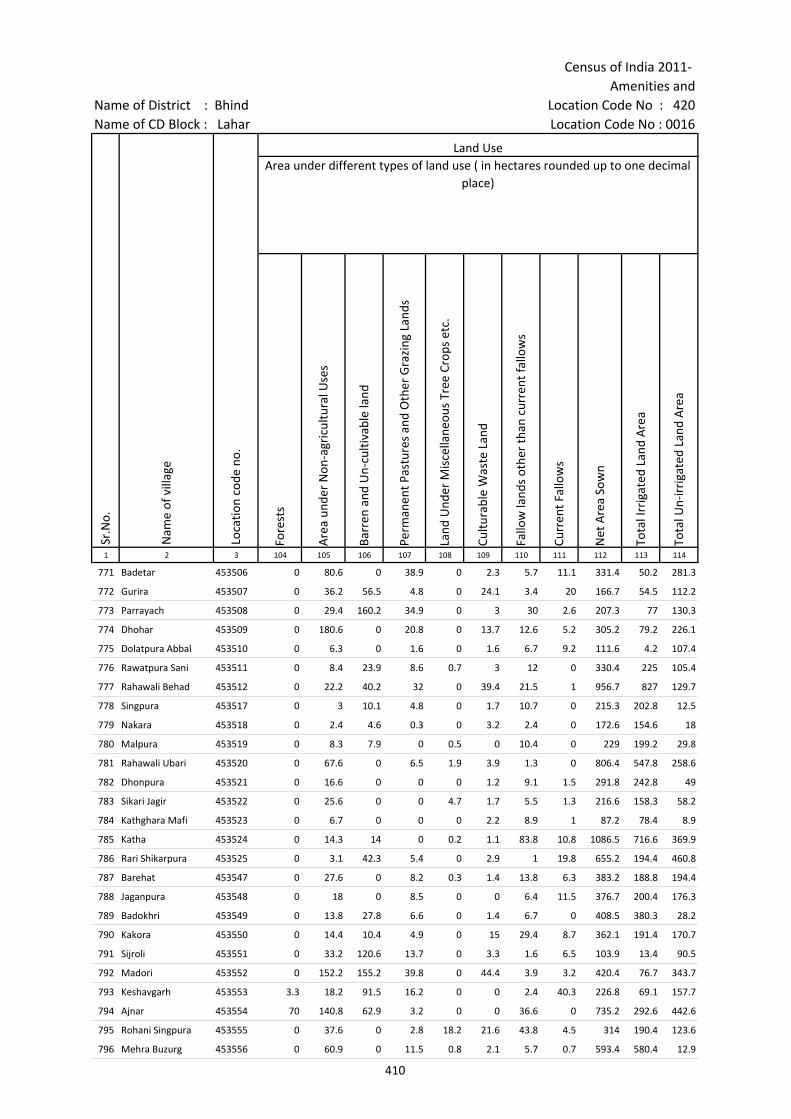
Census of India 2011- Amenities and
Name of District : Bhind Location Code No : 420Name of CD Block : Lahar Location Code No : 0016
Fore
sts
Are
a un
der
Non
-agr
icul
tura
l Use
s
Barr
en a
nd U
n-cu
ltiva
ble
land
Perm
anen
t Pas
ture
s an
d O
ther
Gra
zing
Lan
ds
Land
Und
er M
isce
llane
ous
Tree
Cro
ps e
tc.
Cultu
rabl
e W
aste
Lan
d
Fallo
w la
nds
othe
r th
an c
urre
nt fa
llow
s
Curr
ent F
allo
ws
Net
Are
a So
wn
Tota
l Irr
igat
ed L
and
Are
a
Tota
l Un-
irri
gate
d La
nd A
rea
1 2 3 104 105 106 107 108 109 110 111 112 113 114
771 Badetar 453506 0 80.6 0 38.9 0 2.3 5.7 11.1 331.4 50.2 281.3
772 Gurira 453507 0 36.2 56.5 4.8 0 24.1 3.4 20 166.7 54.5 112.2
773 Parrayach 453508 0 29.4 160.2 34.9 0 3 30 2.6 207.3 77 130.3
774 Dhohar 453509 0 180.6 0 20.8 0 13.7 12.6 5.2 305.2 79.2 226.1
775 Dolatpura Abbal 453510 0 6.3 0 1.6 0 1.6 6.7 9.2 111.6 4.2 107.4
776 Rawatpura Sani 453511 0 8.4 23.9 8.6 0.7 3 12 0 330.4 225 105.4
777 Rahawali Behad 453512 0 22.2 40.2 32 0 39.4 21.5 1 956.7 827 129.7
778 Singpura 453517 0 3 10.1 4.8 0 1.7 10.7 0 215.3 202.8 12.5
779 Nakara 453518 0 2.4 4.6 0.3 0 3.2 2.4 0 172.6 154.6 18
780 Malpura 453519 0 8.3 7.9 0 0.5 0 10.4 0 229 199.2 29.8
781 Rahawali Ubari 453520 0 67.6 0 6.5 1.9 3.9 1.3 0 806.4 547.8 258.6
782 Dhonpura 453521 0 16.6 0 0 0 1.2 9.1 1.5 291.8 242.8 49
783 Sikari Jagir 453522 0 25.6 0 0 4.7 1.7 5.5 1.3 216.6 158.3 58.2
784 Kathghara Mafi 453523 0 6.7 0 0 0 2.2 8.9 1 87.2 78.4 8.9
785 Katha 453524 0 14.3 14 0 0.2 1.1 83.8 10.8 1086.5 716.6 369.9
786 Rari Shikarpura 453525 0 3.1 42.3 5.4 0 2.9 1 19.8 655.2 194.4 460.8
787 Barehat 453547 0 27.6 0 8.2 0.3 1.4 13.8 6.3 383.2 188.8 194.4
788 Jaganpura 453548 0 18 0 8.5 0 0 6.4 11.5 376.7 200.4 176.3
789 Badokhri 453549 0 13.8 27.8 6.6 0 1.4 6.7 0 408.5 380.3 28.2
790 Kakora 453550 0 14.4 10.4 4.9 0 15 29.4 8.7 362.1 191.4 170.7
791 Sijroli 453551 0 33.2 120.6 13.7 0 3.3 1.6 6.5 103.9 13.4 90.5
792 Madori 453552 0 152.2 155.2 39.8 0 44.4 3.9 3.2 420.4 76.7 343.7
793 Keshavgarh 453553 3.3 18.2 91.5 16.2 0 0 2.4 40.3 226.8 69.1 157.7
794 Ajnar 453554 70 140.8 62.9 3.2 0 0 36.6 0 735.2 292.6 442.6
795 Rohani Singpura 453555 0 37.6 0 2.8 18.2 21.6 43.8 4.5 314 190.4 123.6
796 Mehra Buzurg 453556 0 60.9 0 11.5 0.8 2.1 5.7 0.7 593.4 580.4 12.9
Loca
tion
code
no.
Land UseArea under different types of land use ( in hectares rounded up to one decimal
place)
Sr.N
o.
Nam
e of
vill
age
410
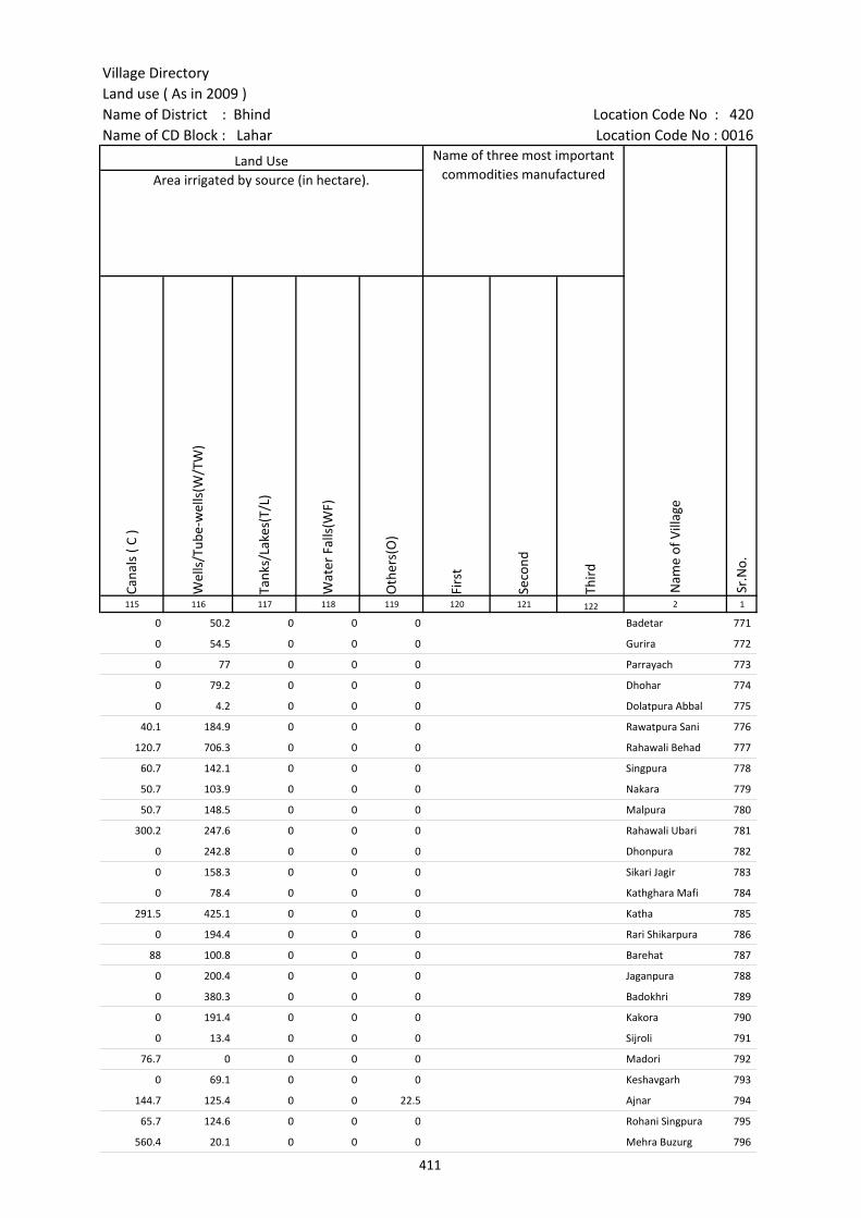
Village DirectoryLand use ( As in 2009 )Name of District : Bhind Location Code No : 420Name of CD Block : Lahar Location Code No : 0016
Cana
ls (
C )
Wel
ls/T
ube-
wel
ls(W
/TW
)
Tank
s/La
kes(
T/L)
Wat
er F
alls
(WF)
Oth
ers(
O)
Firs
t
Seco
nd
Thir
d 115 116 117 118 119 120 121 122 2 1
0 50.2 0 0 0 Badetar 771
0 54.5 0 0 0 Gurira 772
0 77 0 0 0 Parrayach 773
0 79.2 0 0 0 Dhohar 774
0 4.2 0 0 0 Dolatpura Abbal 775
40.1 184.9 0 0 0 Rawatpura Sani 776
120.7 706.3 0 0 0 Rahawali Behad 777
60.7 142.1 0 0 0 Singpura 778
50.7 103.9 0 0 0 Nakara 779
50.7 148.5 0 0 0 Malpura 780
300.2 247.6 0 0 0 Rahawali Ubari 781
0 242.8 0 0 0 Dhonpura 782
0 158.3 0 0 0 Sikari Jagir 783
0 78.4 0 0 0 Kathghara Mafi 784
291.5 425.1 0 0 0 Katha 785
0 194.4 0 0 0 Rari Shikarpura 786
88 100.8 0 0 0 Barehat 787
0 200.4 0 0 0 Jaganpura 788
0 380.3 0 0 0 Badokhri 789
0 191.4 0 0 0 Kakora 790
0 13.4 0 0 0 Sijroli 791
76.7 0 0 0 0 Madori 792
0 69.1 0 0 0 Keshavgarh 793
144.7 125.4 0 0 22.5 Ajnar 794
65.7 124.6 0 0 0 Rohani Singpura 795
560.4 20.1 0 0 0 Mehra Buzurg 796
Land Use Name of three most important commodities manufactured
Nam
e of
Vill
age
Sr.N
o.
Area irrigated by source (in hectare).
411

Census of India 2011- Amenities and
Name of District : Bhind Location Code No : 420Name of CD Block : Lahar Location Code No : 0016
Pre-
Prim
ary
scho
ol (P
P)
Prim
ary
scho
ol (P
)
Mid
dle
scho
ol (M
)
Seco
ndar
y Sc
hool
(S)
Seni
or S
econ
dary
sch
ool (
SS)
Deg
ree
colle
ge o
f art
s s
cien
ce &
com
mer
ce (
ASC
)
Engi
neer
ing
colle
ge(E
C)
Med
ical
col
lege
(MC)
Man
agem
ent i
nstit
ute
(MI)
Poly
tech
nic
(Pt)
Voca
tiona
l tra
inin
g sc
hool
/IT
I
Non
-for
mal
trai
ning
cen
tre
(NFT
C)
Spec
ial s
choo
l for
dis
able
d (S
SD)
Oth
ers
(spe
cify
)
1 2 3 4 5 6 7 8 9 10 11 12 13 14 15 16 17 18 19 20
Sr.N
o.
Nam
e of
vill
age
Loca
tion
code
no.
Tota
l are
a of
the
villa
ge (
in h
ecta
res
roun
ded
up to
one
dec
imal
pla
ce)
Tota
l pop
ulat
ion
( 201
1 ce
nsus
)
Num
ber
of h
ouse
hold
s (2
011
cens
us)
Number of educational amenities available. (If not available within the village , the distance range
code viz; a for < 5 Kms, b for 5-10 Kms and c for 10+ kms of nearest place where facility is available is given).
797 Chandawali No.2 453557 332.1 967 152 c 1 1 a b c c c c c c c c c
798 Tejpura 453558 198.7 974 179 c 1 1 a b b c c c b c c
799 Vespura 453559 194.4 752 128 a 2 2 1 c c a c c
800 Chhibawali No.1 453560 138.4 703 146 b 1 a a a c c b c c
801 Nanpura 453561 169.6 671 96 b 1 a a a b c c c c c c c
802 Mehari 453562 359 1046 193 b 1 1 b b b c c c c b c c c
803 Lalpura 453563 240.6 1269 252 1 2 1 b b 1 c c c c
804 Hirapura 453564 264.4 751 147 1 1 b b b c b c c c
805 Shyampura 453565 235.2 1520 271 1 1 a a a c c c c c c c c
806 Lapwaha 453566 468.4 2710 523 b 2 1 b b b c c c b b c c
807 Sijaripura 453567 170.6 126 35 a 1 a 1 a a c c c a c c c
808 Bahadurpura 453568 63 0 0 --------------Un-inhabited--------------
809 Chhidi 453569 168.6 635 150 1 a b b b c c c c b c c c
810 Bijpura 453570 309.3 1178 224 b 1 1 b b b c c c c c c c
811 Ruri 453571 165 551 88 1 1 a b b c c c c b c c c
812 Sunderpura 453572 122.3 1770 343 c 2 1 1 c c c c c c c c c
813 Karepura 453573 185.8 350 35 c 1 b b c c c c c c c c c
814 Badagaon No.1 453574 665.6 603 82 c 2 1 c c c c c c
815 Rohanijagir 453575 1186.5 2356 456 1 7 2 b b b c c c 1 c c c
816 Bhikampura 453576 321.7 1114 162 a 1 1 a a a c c c a c c c
817 Prithvipura 453577 596.6 1520 243 1 1 a a a c c c a c c c
818 Karila 453578 203.8 728 128 b 1 1 b b b c c c c c c c c
819 Bhatpura 453579 346.4 893 151 b 2 1 a 1 b c c c b c c
820 Adotpura 453580 323.3 1455 267 2 1 a a a c c c a c c c
821 Shahpura No.1 453581 202.6 478 78 a 1 a a a a c c c c a c c c
822 Kilampura 453582 110.5 186 34 a a a a c c c a c c c
412
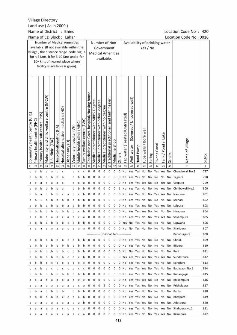
Village DirectoryLand use ( As in 2009 )Name of District : Bhind Location Code No : 420Name of CD Block : Lahar Location Code No : 0016
Com
mun
ity h
ealth
cen
tre
(CH
C)Pr
imar
y he
alth
cen
tre
(PH
C)Pr
imar
y he
alth
sub
cen
tre
(PH
S)M
ater
nity
and
chi
ld w
elfa
re c
entr
e (M
CW)
T.B.
clin
ic (
TBC)
Hos
pita
l-allo
path
ic (H
A)
Hos
pita
l-alte
rnat
ive
med
icin
e (H
O)
Dis
pens
ary
(D)
Vete
rina
ry h
ospi
tal (
VH)
Mob
ile h
ealth
clin
ic (M
HC)
Fam
ily w
elfa
re c
entr
e (F
WC)
Char
itabl
e no
n G
ovt.
hos
pita
l/N
ursi
ng h
ome.
Med
ical
pra
ctiti
oner
with
MBB
S D
egre
eM
edic
al p
ract
ition
er w
ith o
ther
deg
ree
Med
ical
pra
ctiti
oner
with
no
degr
eeTr
aditi
onal
pra
ctiti
oner
and
faith
hea
ler
.M
edic
ine
Shop
Oth
ers
Tap
wat
er (T
reat
ed/U
ntre
ated
)
Wel
l w
ater
(C
over
ed /
Unc
over
ed w
ell)
Han
d Pu
mp
Tube
wel
ls /
Bor
e w
ell
Spri
ng
Rive
r /
Cana
l
Tank
/ P
ond
/ L
ake
Oth
ers
21 22 23 24 25 26 27 28 29 30 31 32 33 34 35 36 37 38 39 40 41 42 43 44 45 46 2 1
Number of Medical Amenities available. (If not available within the
village , the distance range code viz; a for < 5 Kms, b for 5-10 Kms and c for
10+ kms of nearest place where facility is available is given).
Number of Non-Government
Medical Amenities available.
Availability of drinking water - Yes / No
Nam
e of
vill
age
Sr.N
o.
c a b c a c c c c c 0 0 0 0 0 0 0 No Yes Yes No No Yes Yes No Chandawali No.2 797
b b b b b b b b b b 0 0 0 0 0 0 0 No Yes Yes No No No No No Tejpura 798
a a a a a a a a a a 0 0 0 0 0 0 0 No Yes Yes Yes No No Yes No Vespura 799
b b b b b b a b b b 0 0 0 0 0 0 1 No Yes Yes No No No Yes No Chhibawali No.1 800
b b a b b b c a b c b 0 0 0 0 0 0 0 No Yes Yes No No Yes Yes No Nanpura 801
b b 1 b b b b b b b b 0 0 0 0 0 0 0 No Yes Yes No No No No No Mehari 802
b b b b b b b a b b b 0 0 0 0 0 0 0 No Yes Yes Yes No Yes Yes No Lalpura 803
b b b b b b b b b c b 0 0 0 0 0 0 0 No Yes Yes Yes No No No No Hirapura 804
a a b a a a c a a c a 0 0 0 0 0 0 0 No Yes Yes No No Yes Yes No Shyampura 805
b b b b b b b c b b b 0 0 0 0 0 0 0 Yes No Yes No No No No No Lapwaha 806
a a a a a a a c a a a 0 0 0 0 0 0 0 No No Yes No No No No No Sijaripura 807
--------------Un-inhabited-------------- Bahadurpura 808
b b b b b b b c b b b 0 0 0 0 0 0 0 No Yes Yes No No No No No Chhidi 809
b b b b b b b b b b b 0 0 0 0 0 0 0 No Yes Yes No No No No No Bijpura 810
b b b b b b b c b b b 0 0 0 0 0 0 0 No No Yes No No No No No Ruri 811
b b b b b b b c b c b 0 0 0 0 0 0 0 Yes Yes Yes Yes No Yes Yes No Sunderpura 812
c c b c c c c c c c c 0 0 0 0 0 0 0 No Yes Yes No No Yes No No Karepura 813
c c b c c c c c c c c 0 0 0 0 0 0 0 No Yes Yes Yes No Yes No No Badagaon No.1 814
b b b b b b b b b b b 0 0 0 0 0 0 0 No Yes Yes No No Yes No No Rohanijagir 815
a a a a a a a a a c c 0 0 0 0 0 0 0 No Yes Yes Yes No No No No Bhikampura 816
a a a a a a a a a c a 0 0 0 2 0 0 0 No Yes Yes Yes No No Yes No Prithvipura 817
b b a b b b b b b b 0 0 0 0 0 0 0 No Yes Yes No No No No No Karila 818
b b b b b b c c b a b 0 0 0 0 0 0 0 No Yes Yes No No No No No Bhatpura 819
a a a a a a a a a a b 0 0 0 0 0 0 0 No Yes Yes Yes No No Yes No Adotpura 820
a a a a a a c c a c a 0 0 0 0 0 0 0 No Yes Yes No No No Yes No Shahpura No.1 821
a a a a a a c a a c a 0 0 0 0 0 0 0 No Yes Yes No No Yes Yes No Kilampura 822
413
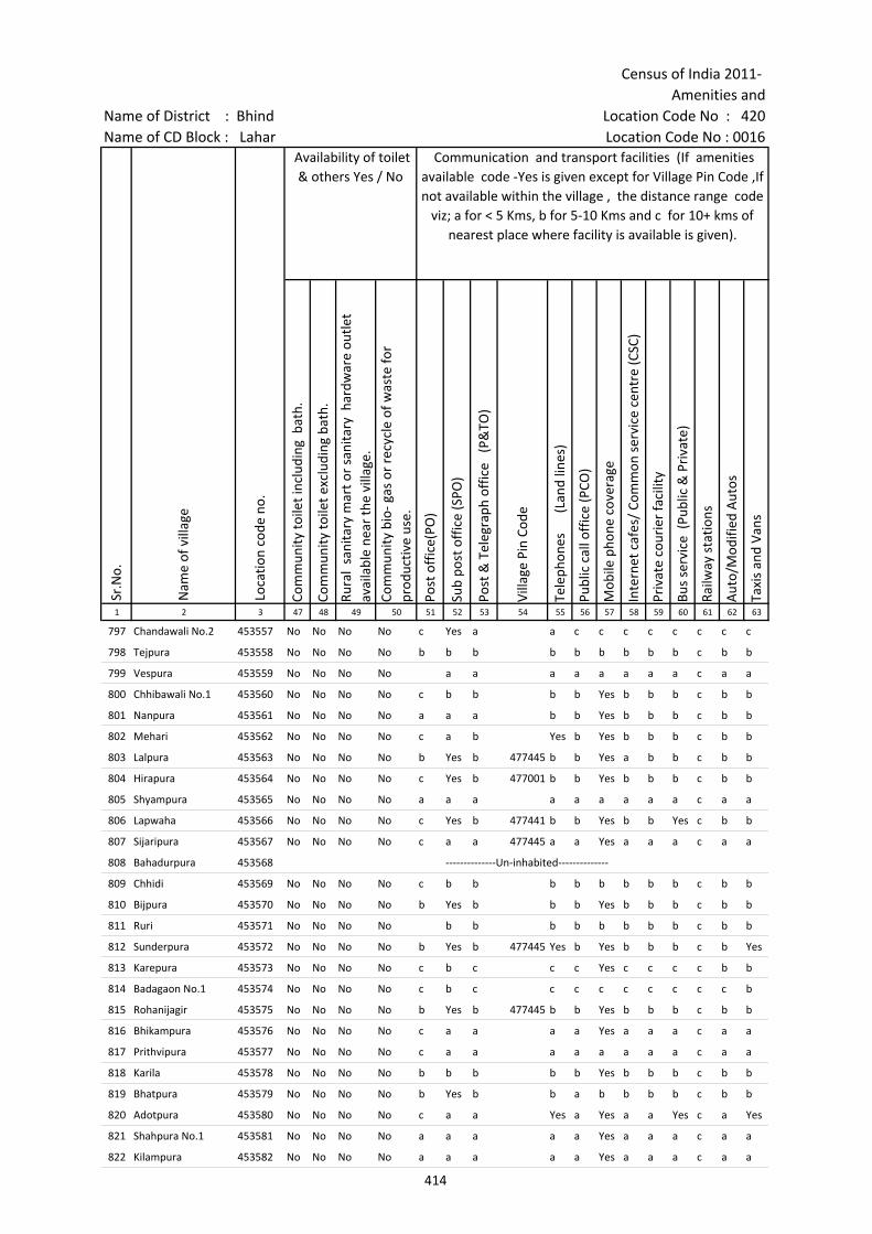
Census of India 2011- Amenities and
Name of District : Bhind Location Code No : 420Name of CD Block : Lahar Location Code No : 0016
Com
mun
ity to
ilet i
nclu
ding
bat
h.
Com
mun
ity to
ilet e
xclu
ding
bat
h.
Rura
l sa
nita
ry m
art o
r sa
nita
ry h
ardw
are
outle
t av
aila
ble
near
the
villa
ge.
Com
mun
ity b
io- g
as o
r re
cycl
e of
was
te fo
r pr
oduc
tive
use.
Post
off
ice(
PO)
Sub
post
off
ice
(SPO
)
Post
& T
eleg
raph
off
ice
(P&
TO)
Villa
ge P
in C
ode
Tele
phon
es
(L
and
lines
)
Publ
ic c
all o
ffic
e (P
CO)
Mob
ile p
hone
cov
erag
e
Inte
rnet
caf
es/
Com
mon
ser
vice
cen
tre
(CSC
)
Priv
ate
cour
ier
faci
lity
Bus
serv
ice
(Pub
lic &
Pri
vate
)
Railw
ay s
tatio
ns
Aut
o/M
odifi
ed A
utos
Taxi
s an
d Va
ns
1 2 3 47 48 49 50 51 52 53 54 55 56 57 58 59 60 61 62 63
Nam
e of
vill
age
Loca
tion
code
no.
Availability of toilet & others Yes / No
Communication and transport facilities (If amenities available code -Yes is given except for Village Pin Code ,If not available within the village , the distance range code
viz; a for < 5 Kms, b for 5-10 Kms and c for 10+ kms of nearest place where facility is available is given).
Sr.N
o.
797 Chandawali No.2 453557 No No No No c Yes a a c c c c c c c c
798 Tejpura 453558 No No No No b b b b b b b b b c b b
799 Vespura 453559 No No No No a a a a a a a a c a a
800 Chhibawali No.1 453560 No No No No c b b b b Yes b b b c b b
801 Nanpura 453561 No No No No a a a b b Yes b b b c b b
802 Mehari 453562 No No No No c a b Yes b Yes b b b c b b
803 Lalpura 453563 No No No No b Yes b 477445 b b Yes a b b c b b
804 Hirapura 453564 No No No No c Yes b 477001 b b Yes b b b c b b
805 Shyampura 453565 No No No No a a a a a a a a a c a a
806 Lapwaha 453566 No No No No c Yes b 477441 b b Yes b b Yes c b b
807 Sijaripura 453567 No No No No c a a 477445 a a Yes a a a c a a
808 Bahadurpura 453568 --------------Un-inhabited--------------
809 Chhidi 453569 No No No No c b b b b b b b b c b b
810 Bijpura 453570 No No No No b Yes b b b Yes b b b c b b
811 Ruri 453571 No No No No b b b b b b b b c b b
812 Sunderpura 453572 No No No No b Yes b 477445 Yes b Yes b b b c b Yes
813 Karepura 453573 No No No No c b c c c Yes c c c c b b
814 Badagaon No.1 453574 No No No No c b c c c c c c c c c b
815 Rohanijagir 453575 No No No No b Yes b 477445 b b Yes b b b c b b
816 Bhikampura 453576 No No No No c a a a a Yes a a a c a a
817 Prithvipura 453577 No No No No c a a a a a a a a c a a
818 Karila 453578 No No No No b b b b b Yes b b b c b b
819 Bhatpura 453579 No No No No b Yes b b a b b b b c b b
820 Adotpura 453580 No No No No c a a Yes a Yes a a Yes c a Yes
821 Shahpura No.1 453581 No No No No a a a a a Yes a a a c a a
822 Kilampura 453582 No No No No a a a a a Yes a a a c a a
414
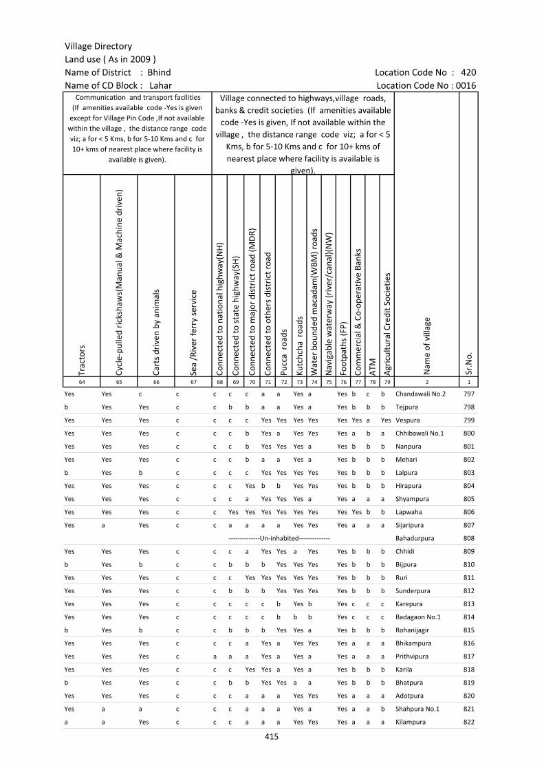
Village DirectoryLand use ( As in 2009 )Name of District : Bhind Location Code No : 420Name of CD Block : Lahar Location Code No : 0016
Trac
tors
Cycl
e-pu
lled
rick
shaw
s(M
anua
l & M
achi
ne d
rive
n)
Cart
s dr
iven
by
anim
als
Sea
/Riv
er fe
rry
serv
ice
Conn
ecte
d to
nat
iona
l hig
hway
(NH
)
Conn
ecte
d to
sta
te h
ighw
ay(S
H)
Conn
ecte
d to
maj
or d
istr
ict r
oad
(MD
R)
Conn
ecte
d to
oth
ers
dist
rict
roa
d
Pucc
a r
oads
Kutc
hcha
roa
ds
Wat
er b
ound
ed m
acad
am(W
BM) r
oads
Nav
igab
le w
ater
way
(riv
er/c
anal
)(N
W)
Foot
path
s (F
P)
Com
mer
cial
& C
o-op
erat
ive
Bank
s
ATM
Agr
icul
tura
l Cre
dit S
ocie
ties
64 65 66 67 68 69 70 71 72 73 74 75 76 77 78 79 2 1
Nam
e of
vill
age
Sr.N
o.
Communication and transport facilities (If amenities available code -Yes is given
except for Village Pin Code ,If not available within the village , the distance range code viz; a for < 5 Kms, b for 5-10 Kms and c for 10+ kms of nearest place where facility is
available is given).
Village connected to highways,village roads, banks & credit societies (If amenities available
code -Yes is given, If not available within the village , the distance range code viz; a for < 5
Kms, b for 5-10 Kms and c for 10+ kms of nearest place where facility is available is
given).
Yes Yes c c c c c a a Yes a Yes b c b Chandawali No.2 797
b Yes Yes c c b b a a Yes a Yes b b b Tejpura 798
Yes Yes Yes c c c c Yes Yes Yes Yes Yes Yes a Yes Vespura 799
Yes Yes Yes c c c b Yes a Yes Yes Yes a b a Chhibawali No.1 800
Yes Yes Yes c c c b Yes Yes Yes a Yes b b b Nanpura 801
Yes Yes Yes c c c b a a Yes a Yes b b b Mehari 802
b Yes b c c c c Yes Yes Yes Yes Yes b b b Lalpura 803
Yes Yes Yes c c c Yes b b Yes Yes Yes b b b Hirapura 804
Yes Yes Yes c c c a Yes Yes Yes a Yes a a a Shyampura 805
Yes Yes Yes c c Yes Yes Yes Yes Yes Yes Yes Yes b b Lapwaha 806
Yes a Yes c c a a a a Yes Yes Yes a a a Sijaripura 807
--------------Un-inhabited-------------- Bahadurpura 808
Yes Yes Yes c c c a Yes Yes a Yes Yes b b b Chhidi 809
b Yes b c c b b b Yes Yes Yes Yes b b b Bijpura 810
Yes Yes Yes c c c Yes Yes Yes Yes Yes Yes b b b Ruri 811
Yes Yes Yes c c b b b Yes Yes Yes Yes b b b Sunderpura 812
Yes Yes Yes c c c c c b Yes b Yes c c c Karepura 813
Yes Yes Yes c c c c c b b b Yes c c c Badagaon No.1 814
b Yes b c c b b b Yes Yes a Yes b b b Rohanijagir 815
Yes Yes Yes c c c a Yes a Yes Yes Yes a a a Bhikampura 816
Yes Yes Yes c a a a Yes a Yes a Yes a a a Prithvipura 817
Yes Yes Yes c c c Yes Yes a Yes a Yes b b b Karila 818
b Yes Yes c c b b Yes Yes a a Yes b b b Bhatpura 819
Yes Yes Yes c c c a a a Yes Yes Yes a a a Adotpura 820
Yes a a c c c a a a Yes a Yes a a b Shahpura No.1 821
a a Yes c c c a a a Yes Yes Yes a a a Kilampura 822
415

Census of India 2011- Amenities and
Name of District : Bhind Location Code No : 420Name of CD Block : Lahar Location Code No : 0016
Self-
Hel
p G
roup
(SH
G)
Publ
ic d
istr
ibut
ion
syst
em (P
DS)
sho
p
Man
dis
/ Re
gula
r m
arke
t
Wee
kly
Haa
t
Agr
icul
tura
l mar
ketin
g so
ciet
yIn
tegr
ated
Chi
ld D
evel
opm
ent S
chem
e (N
utri
tiona
l Ce
ntre
s)A
ngan
wad
i Cen
tre
(Nut
ritio
nal C
entr
es)
Oth
ers
(Nut
ritio
nal C
entr
es)
ASH
A (A
ccre
dite
d So
cial
Hea
lth A
ctiv
ist)
Com
mun
ity c
entr
e w
ith/w
ithou
t TV
Spor
ts F
ield
,
Spor
ts C
lub
/ Re
crea
tion
Cent
re
Cine
ma
/ Vi
deo
Hal
l
Publ
ic L
ibra
ry
Publ
ic R
eadi
ng R
oom
New
spap
er S
uppl
y
Ass
embl
y Po
lling
sta
tion
Birt
h &
Dea
th R
egis
trat
ion
Off
ice
1 2 3 80 81 82 83 84 85 86 87 88 89 90 91 92 93 94 95 96 97
Sr.N
o.
Nam
e of
vill
age
Loca
tion
code
no.
Availability of miscellaneous facilities (If amenities available code -Yes is given, If not available within the village , the distance range code viz; a for < 5 Kms, b
for 5-10 Kms and c for 10+ kms of nearest place where facility is available is given).
797 Chandawali No.2 453557 Yes b c c c c Yes Yes Yes c Yes c c c c c Yes Yes
798 Tejpura 453558 Yes a b b b b Yes Yes Yes b b b c c c b Yes a
799 Vespura 453559 Yes Yes a a Yes a Yes Yes Yes a Yes a c c c Yes Yes Yes
800 Chhibawali No.1 453560 Yes a b b a Yes Yes Yes Yes Yes Yes b c c c Yes Yes a
801 Nanpura 453561 Yes a b b b b Yes Yes Yes b b b c b b Yes Yes a
802 Mehari 453562 Yes b b b b b Yes Yes Yes b b b c c b b Yes a
803 Lalpura 453563 Yes Yes Yes b Yes Yes Yes Yes Yes b Yes Yes c b b Yes Yes Yes
804 Hirapura 453564 b a b b b b Yes Yes Yes b b b b b b b Yes Yes
805 Shyampura 453565 Yes a a a a a Yes Yes Yes a a a c a a Yes Yes Yes
806 Lapwaha 453566 Yes Yes b b b b Yes Yes Yes b b b c c b Yes Yes Yes
807 Sijaripura 453567 a b a a a a a a a a a a c c a Yes a a
808 Bahadurpura 453568 --------------Un-inhabited--------------
809 Chhidi 453569 Yes a b b b b Yes Yes Yes b a b a Yes a a Yes Yes
810 Bijpura 453570 Yes Yes b b b b Yes Yes Yes Yes b b b b b Yes Yes Yes
811 Ruri 453571 b b b b b b Yes Yes Yes b b b b Yes b b Yes Yes
812 Sunderpura 453572 Yes Yes b b b b Yes Yes Yes b b b c b b b Yes Yes
813 Karepura 453573 Yes c c c c c Yes a Yes b c b c c c c Yes b
814 Badagaon No.1 453574 Yes b c c c c Yes Yes Yes c c c c c c c b b
815 Rohanijagir 453575 Yes Yes b b b b Yes Yes Yes b b b b b b Yes Yes Yes
816 Bhikampura 453576 Yes a a a a a Yes Yes Yes a a a c a a a Yes Yes
817 Prithvipura 453577 Yes Yes a a a a Yes a Yes a a a c a a a Yes Yes
818 Karila 453578 Yes a b b b b Yes Yes Yes b b b c b b b a a
819 Bhatpura 453579 Yes Yes b b b b Yes Yes Yes b b a c c c b Yes Yes
820 Adotpura 453580 Yes Yes a a a a Yes Yes Yes a a a a a a Yes Yes Yes
821 Shahpura No.1 453581 a b a a a a Yes Yes Yes a a a c a a a a a
822 Kilampura 453582 a a a a a a a a Yes b a a c a a a a a
416
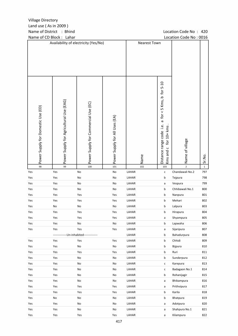
Village DirectoryLand use ( As in 2009 )Name of District : Bhind Location Code No : 420Name of CD Block : Lahar Location Code No : 0016
Pow
er S
uppl
y fo
r D
omes
tic U
se (E
D)
Pow
er S
uppl
y fo
r A
gric
ultu
ral U
se (E
AG
)
Pow
er S
uppl
y fo
r Co
mm
erci
al U
se (E
C)
Pow
er S
uppl
y fo
r A
ll U
ses
(EA
)
Nam
e
Dis
tanc
e ra
nge
code
i.e
. a
for
< 5
Kms,
b f
or 5
-10
Kms
and
c f
or 1
0+ k
ms
.98 99 100 101 102 103 2 1
Availability of electricity (Yes/No) Nearest Town
Nam
e of
vill
age
Sr.N
o.
Yes Yes No No LAHAR c Chandawali No.2 797
Yes Yes No No LAHAR b Tejpura 798
Yes Yes No No LAHAR a Vespura 799
Yes Yes No No LAHAR b Chhibawali No.1 800
Yes Yes Yes Yes LAHAR b Nanpura 801
Yes Yes Yes Yes LAHAR b Mehari 802
Yes No No No LAHAR b Lalpura 803
Yes Yes Yes Yes LAHAR b Hirapura 804
Yes Yes Yes Yes LAHAR a Shyampura 805
Yes Yes No No LAHAR b Lapwaha 806
Yes Yes Yes Yes LAHAR a Sijaripura 807
--------------Un-inhabited-------------- LAHAR b Bahadurpura 808
Yes Yes Yes Yes LAHAR b Chhidi 809
Yes Yes No No LAHAR b Bijpura 810
Yes Yes Yes Yes LAHAR b Ruri 811
Yes Yes No No LAHAR b Sunderpura 812
Yes Yes No No LAHAR c Karepura 813
Yes Yes No No LAHAR c Badagaon No.1 814
Yes Yes No No LAHAR b Rohanijagir 815
Yes Yes No No LAHAR a Bhikampura 816
Yes Yes Yes Yes LAHAR a Prithvipura 817
Yes Yes Yes Yes LAHAR b Karila 818
Yes No No No LAHAR b Bhatpura 819
Yes Yes No No LAHAR a Adotpura 820
Yes Yes No No LAHAR a Shahpura No.1 821
Yes Yes Yes Yes LAHAR a Kilampura 822
417
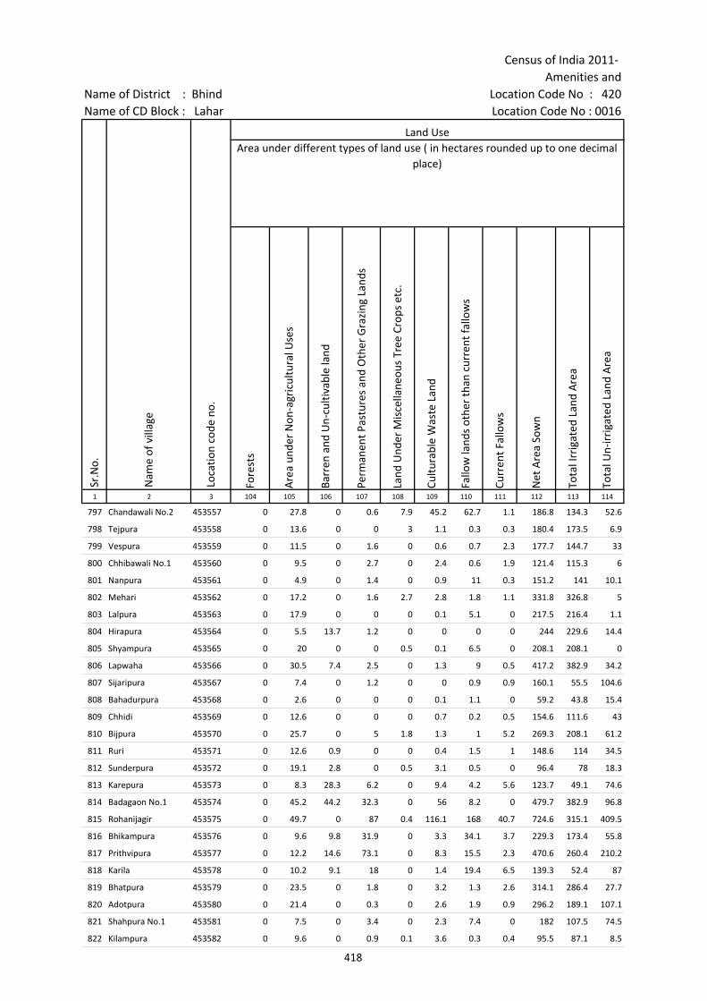
Census of India 2011- Amenities and
Name of District : Bhind Location Code No : 420Name of CD Block : Lahar Location Code No : 0016
Fore
sts
Are
a un
der
Non
-agr
icul
tura
l Use
s
Barr
en a
nd U
n-cu
ltiva
ble
land
Perm
anen
t Pas
ture
s an
d O
ther
Gra
zing
Lan
ds
Land
Und
er M
isce
llane
ous
Tree
Cro
ps e
tc.
Cultu
rabl
e W
aste
Lan
d
Fallo
w la
nds
othe
r th
an c
urre
nt fa
llow
s
Curr
ent F
allo
ws
Net
Are
a So
wn
Tota
l Irr
igat
ed L
and
Are
a
Tota
l Un-
irri
gate
d La
nd A
rea
1 2 3 104 105 106 107 108 109 110 111 112 113 114
Loca
tion
code
no.
Land UseArea under different types of land use ( in hectares rounded up to one decimal
place)
Sr.N
o.
Nam
e of
vill
age
797 Chandawali No.2 453557 0 27.8 0 0.6 7.9 45.2 62.7 1.1 186.8 134.3 52.6
798 Tejpura 453558 0 13.6 0 0 3 1.1 0.3 0.3 180.4 173.5 6.9
799 Vespura 453559 0 11.5 0 1.6 0 0.6 0.7 2.3 177.7 144.7 33
800 Chhibawali No.1 453560 0 9.5 0 2.7 0 2.4 0.6 1.9 121.4 115.3 6
801 Nanpura 453561 0 4.9 0 1.4 0 0.9 11 0.3 151.2 141 10.1
802 Mehari 453562 0 17.2 0 1.6 2.7 2.8 1.8 1.1 331.8 326.8 5
803 Lalpura 453563 0 17.9 0 0 0 0.1 5.1 0 217.5 216.4 1.1
804 Hirapura 453564 0 5.5 13.7 1.2 0 0 0 0 244 229.6 14.4
805 Shyampura 453565 0 20 0 0 0.5 0.1 6.5 0 208.1 208.1 0
806 Lapwaha 453566 0 30.5 7.4 2.5 0 1.3 9 0.5 417.2 382.9 34.2
807 Sijaripura 453567 0 7.4 0 1.2 0 0 0.9 0.9 160.1 55.5 104.6
808 Bahadurpura 453568 0 2.6 0 0 0 0.1 1.1 0 59.2 43.8 15.4
809 Chhidi 453569 0 12.6 0 0 0 0.7 0.2 0.5 154.6 111.6 43
810 Bijpura 453570 0 25.7 0 5 1.8 1.3 1 5.2 269.3 208.1 61.2
811 Ruri 453571 0 12.6 0.9 0 0 0.4 1.5 1 148.6 114 34.5
812 Sunderpura 453572 0 19.1 2.8 0 0.5 3.1 0.5 0 96.4 78 18.3
813 Karepura 453573 0 8.3 28.3 6.2 0 9.4 4.2 5.6 123.7 49.1 74.6
814 Badagaon No.1 453574 0 45.2 44.2 32.3 0 56 8.2 0 479.7 382.9 96.8
815 Rohanijagir 453575 0 49.7 0 87 0.4 116.1 168 40.7 724.6 315.1 409.5
816 Bhikampura 453576 0 9.6 9.8 31.9 0 3.3 34.1 3.7 229.3 173.4 55.8
817 Prithvipura 453577 0 12.2 14.6 73.1 0 8.3 15.5 2.3 470.6 260.4 210.2
818 Karila 453578 0 10.2 9.1 18 0 1.4 19.4 6.5 139.3 52.4 87
819 Bhatpura 453579 0 23.5 0 1.8 0 3.2 1.3 2.6 314.1 286.4 27.7
820 Adotpura 453580 0 21.4 0 0.3 0 2.6 1.9 0.9 296.2 189.1 107.1
821 Shahpura No.1 453581 0 7.5 0 3.4 0 2.3 7.4 0 182 107.5 74.5
822 Kilampura 453582 0 9.6 0 0.9 0.1 3.6 0.3 0.4 95.5 87.1 8.5
418
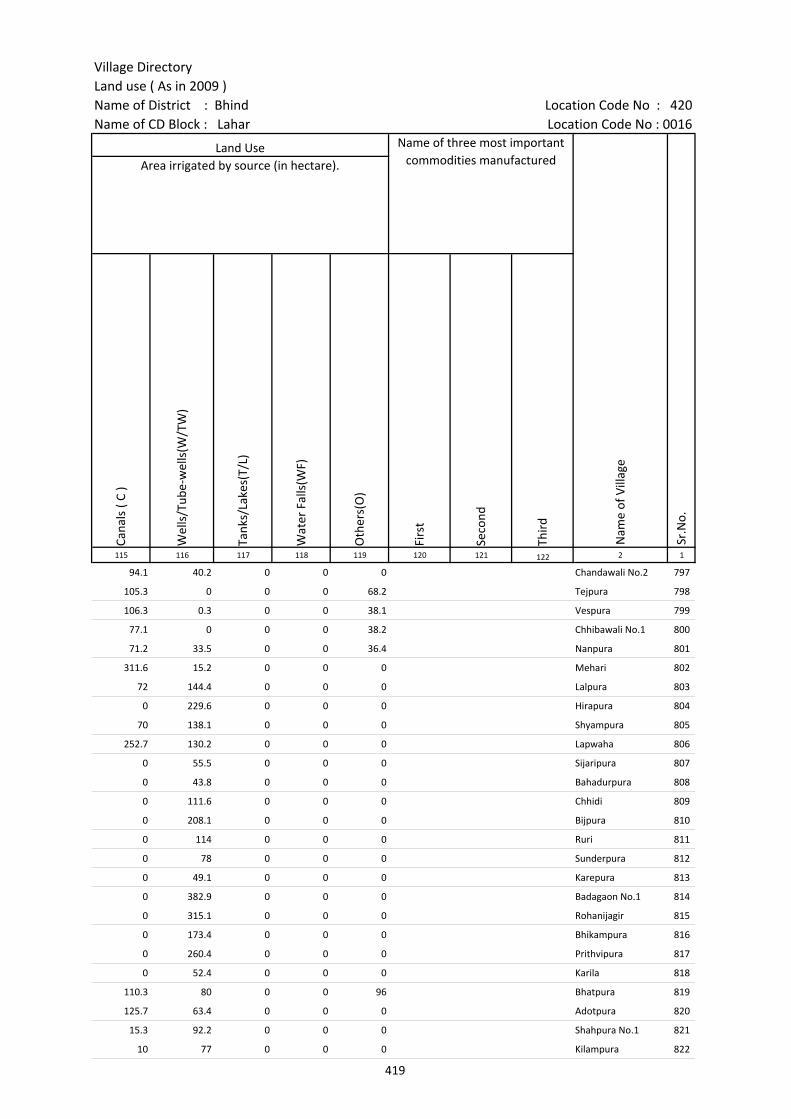
Village DirectoryLand use ( As in 2009 )Name of District : Bhind Location Code No : 420Name of CD Block : Lahar Location Code No : 0016
Cana
ls (
C )
Wel
ls/T
ube-
wel
ls(W
/TW
)
Tank
s/La
kes(
T/L)
Wat
er F
alls
(WF)
Oth
ers(
O)
Firs
t
Seco
nd
Thir
d 115 116 117 118 119 120 121 122 2 1
Land Use Name of three most important commodities manufactured
Nam
e of
Vill
age
Sr.N
o.
Area irrigated by source (in hectare).
94.1 40.2 0 0 0 Chandawali No.2 797
105.3 0 0 0 68.2 Tejpura 798
106.3 0.3 0 0 38.1 Vespura 799
77.1 0 0 0 38.2 Chhibawali No.1 800
71.2 33.5 0 0 36.4 Nanpura 801
311.6 15.2 0 0 0 Mehari 802
72 144.4 0 0 0 Lalpura 803
0 229.6 0 0 0 Hirapura 804
70 138.1 0 0 0 Shyampura 805
252.7 130.2 0 0 0 Lapwaha 806
0 55.5 0 0 0 Sijaripura 807
0 43.8 0 0 0 Bahadurpura 808
0 111.6 0 0 0 Chhidi 809
0 208.1 0 0 0 Bijpura 810
0 114 0 0 0 Ruri 811
0 78 0 0 0 Sunderpura 812
0 49.1 0 0 0 Karepura 813
0 382.9 0 0 0 Badagaon No.1 814
0 315.1 0 0 0 Rohanijagir 815
0 173.4 0 0 0 Bhikampura 816
0 260.4 0 0 0 Prithvipura 817
0 52.4 0 0 0 Karila 818
110.3 80 0 0 96 Bhatpura 819
125.7 63.4 0 0 0 Adotpura 820
15.3 92.2 0 0 0 Shahpura No.1 821
10 77 0 0 0 Kilampura 822
419

Census of India 2011- Amenities and
Name of District : Bhind Location Code No : 420Name of CD Block : Lahar Location Code No : 0016
Pre-
Prim
ary
scho
ol (P
P)
Prim
ary
scho
ol (P
)
Mid
dle
scho
ol (M
)
Seco
ndar
y Sc
hool
(S)
Seni
or S
econ
dary
sch
ool (
SS)
Deg
ree
colle
ge o
f art
s s
cien
ce &
com
mer
ce (
ASC
)
Engi
neer
ing
colle
ge(E
C)
Med
ical
col
lege
(MC)
Man
agem
ent i
nstit
ute
(MI)
Poly
tech
nic
(Pt)
Voca
tiona
l tra
inin
g sc
hool
/IT
I
Non
-for
mal
trai
ning
cen
tre
(NFT
C)
Spec
ial s
choo
l for
dis
able
d (S
SD)
Oth
ers
(spe
cify
)
1 2 3 4 5 6 7 8 9 10 11 12 13 14 15 16 17 18 19 20
Sr.N
o.
Nam
e of
vill
age
Loca
tion
code
no.
Tota
l are
a of
the
villa
ge (
in h
ecta
res
roun
ded
up to
one
dec
imal
pla
ce)
Tota
l pop
ulat
ion
( 201
1 ce
nsus
)
Num
ber
of h
ouse
hold
s (2
011
cens
us)
Number of educational amenities available. (If not available within the village , the distance range
code viz; a for < 5 Kms, b for 5-10 Kms and c for 10+ kms of nearest place where facility is available is given).
823 Adlispura 453583 58.6 573 91 a 1 a a a a c c c c a c c c
824 Chiroli 453584 147.9 1091 204 a 1 1 a a a c c c a c c c
825 Barha 453585 984.3 2358 405 b 1 1 1 b b c c c c c c c c
826 Semra 453586 150.5 224 42 c 1 a a c c c c c c c c c c
827 Herpura 453587 164.6 922 153 1 1 1 b b b c c c c b b c
828 Lagdua 453588 128.9 241 53 b 1 a b b c c c c c c c c
829 Lilwari 453589 341.2 1140 189 b 1 1 a b c c c c c c c c
830 Vanvirpura 453590 59.5 0 0 --------------Un-inhabited--------------
831 Girwasa 453591 839.5 2702 539 2 1 b a c c c c c c c
832 Baghawali 453592 196.2 573 87 b 1 1 b b c c c c c c c c
833 Dunda 453593 252.3 811 136 1 2 2 a a c c c c c c c c
834 Sujanpura 453594 228.8 313 46 a 1 a a a c c c c b c c c
835 Jaitpura (Aswar) 453595 405.4 2050 430 1 1 1 a a b c c c b c c c
836 Jamuha 453596 774.8 4219 788 b 3 2 1 b b c c c b c c c
837 Haluawapura 453597 318.2 689 109 b 1 1 b b b c c c b c c c
838 Mahua 453598 408 1182 283 b 1 1 1 b b c c c c b b c c
839 Dargawan 453599 198.1 0 0 --------------Un-inhabited--------------
840 Maseran 453600 572.9 1959 322 b 3 1 1 b b c c c c 1 c c c
841 Kaitha 453601 416.8 1017 165 b 1 1 b b c c c c c c c c
842 Chourai 453602 476.8 1304 267 1 2 a a b b c c c c b c c c
843 Devara 453603 77.4 418 80 c 1 a 1 c c c c c c c c c c
844 Akhdewa 453604 380 1647 308 1 1 b a c c c c c c c c c
845 Chiruli 453605 511.5 939 177 1 1 1 a a c c c c c c c c c
846 Ikmili 453606 290 808 156 1 1 c c c c c c c c c c
847 Lootampura 453607 253.6 1047 183 c 1 1 a a c c c c c c c c c
848 Aswar 453608 1147 6306 1119 c 7 6 2 1 c c c c c c c c 1
420
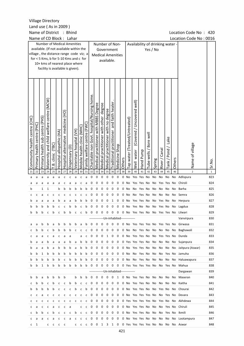
Village DirectoryLand use ( As in 2009 )Name of District : Bhind Location Code No : 420Name of CD Block : Lahar Location Code No : 0016
Com
mun
ity h
ealth
cen
tre
(CH
C)Pr
imar
y he
alth
cen
tre
(PH
C)Pr
imar
y he
alth
sub
cen
tre
(PH
S)M
ater
nity
and
chi
ld w
elfa
re c
entr
e (M
CW)
T.B.
clin
ic (
TBC)
Hos
pita
l-allo
path
ic (H
A)
Hos
pita
l-alte
rnat
ive
med
icin
e (H
O)
Dis
pens
ary
(D)
Vete
rina
ry h
ospi
tal (
VH)
Mob
ile h
ealth
clin
ic (M
HC)
Fam
ily w
elfa
re c
entr
e (F
WC)
Char
itabl
e no
n G
ovt.
hos
pita
l/N
ursi
ng h
ome.
Med
ical
pra
ctiti
oner
with
MBB
S D
egre
eM
edic
al p
ract
ition
er w
ith o
ther
deg
ree
Med
ical
pra
ctiti
oner
with
no
degr
eeTr
aditi
onal
pra
ctiti
oner
and
faith
hea
ler
.M
edic
ine
Shop
Oth
ers
Tap
wat
er (T
reat
ed/U
ntre
ated
)
Wel
l w
ater
(C
over
ed /
Unc
over
ed w
ell)
Han
d Pu
mp
Tube
wel
ls /
Bor
e w
ell
Spri
ng
Rive
r /
Cana
l
Tank
/ P
ond
/ L
ake
Oth
ers
21 22 23 24 25 26 27 28 29 30 31 32 33 34 35 36 37 38 39 40 41 42 43 44 45 46 2 1
Number of Medical Amenities available. (If not available within the
village , the distance range code viz; a for < 5 Kms, b for 5-10 Kms and c for
10+ kms of nearest place where facility is available is given).
Number of Non-Government
Medical Amenities available.
Availability of drinking water - Yes / No
Nam
e of
vill
age
Sr.N
o.
a a a a a a c c a c a 0 0 0 0 0 0 0 No Yes Yes No No No No No Adlispura 823
a a a a a a c a a c a 0 0 0 0 0 0 0 No Yes Yes No No Yes Yes No Chiroli 824
b 1 1 b b b b b b 0 0 0 0 0 0 0 No No Yes No No No No No Barha 825
c c a c c c c c c c c 0 0 0 0 0 0 0 No No Yes No No No No No Semra 826
b a a a a b a a b b b 0 0 0 0 1 0 0 No Yes Yes No No Yes No No Herpura 827
b b b b b c c b b c b 0 0 0 0 0 0 0 No Yes No No No Yes No No Lagdua 828
b b b c b c b b c c b 0 0 0 0 0 0 0 No Yes Yes No No Yes Yes No Lilwari 829
--------------Un-inhabited-------------- Vanvirpura 830
a a b b a b b b b a b 0 0 0 0 0 0 0 No Yes Yes Yes No Yes Yes No Girwasa 831
c b b c b b b b c c c 0 0 0 0 0 0 0 No No Yes No No No No No Baghawali 832
c a a c a c a a a c 0 0 0 1 0 0 0 No Yes Yes No No Yes Yes No Dunda 833
b a a b a a a b a b b 0 0 0 0 0 0 0 Yes Yes Yes No No No No No Sujanpura 834
b a a b a b b b a b b 0 0 0 0 0 0 0 No Yes Yes No No No No No Jaitpura (Aswar) 835
b b 1 b b b b b b b b 0 0 0 0 0 0 0 No No Yes No No No Yes No Jamuha 836
b b b b b b c b b b b 0 0 0 0 0 0 0 No No Yes No No No No No Haluawapura 837
b b 1 b b b b b b b b 0 0 0 0 0 0 0 Yes Yes Yes Yes No No Yes No Mahua 838
--------------Un-inhabited-------------- Dargawan 839
b b a b b b b b b b 0 0 0 0 0 1 0 No Yes Yes No No No No No Maseran 840
c b b c b c c b b c c 0 0 0 0 0 0 0 No Yes Yes No No No No No Kaitha 841
b b b b b c c c b c b 0 0 0 0 0 0 0 No Yes Yes No No Yes No No Chourai 842
c c a c c c c c c c c 0 0 0 0 0 0 0 No Yes Yes Yes No No Yes No Devara 843
c c c c c c c c c c c 0 0 0 0 0 0 0 Yes Yes Yes Yes No Yes No No Akhdewa 844
c a c c a c c a c c 0 0 0 0 0 0 0 No Yes Yes No No No Yes No Chiruli 845
c b b c b c c c b c c 0 0 0 0 0 0 0 No Yes Yes No No No Yes No Ikmili 846
c a a c a c c a c c c 0 0 0 0 0 0 0 No Yes Yes No No No No No Lootampura 847
c 1 c c c c c c c 0 0 1 3 1 0 0 Yes Yes Yes Yes No No No No Aswar 848
421

Census of India 2011- Amenities and
Name of District : Bhind Location Code No : 420Name of CD Block : Lahar Location Code No : 0016
Com
mun
ity to
ilet i
nclu
ding
bat
h.
Com
mun
ity to
ilet e
xclu
ding
bat
h.
Rura
l sa
nita
ry m
art o
r sa
nita
ry h
ardw
are
outle
t av
aila
ble
near
the
villa
ge.
Com
mun
ity b
io- g
as o
r re
cycl
e of
was
te fo
r pr
oduc
tive
use.
Post
off
ice(
PO)
Sub
post
off
ice
(SPO
)
Post
& T
eleg
raph
off
ice
(P&
TO)
Villa
ge P
in C
ode
Tele
phon
es
(L
and
lines
)
Publ
ic c
all o
ffic
e (P
CO)
Mob
ile p
hone
cov
erag
e
Inte
rnet
caf
es/
Com
mon
ser
vice
cen
tre
(CSC
)
Priv
ate
cour
ier
faci
lity
Bus
serv
ice
(Pub
lic &
Pri
vate
)
Railw
ay s
tatio
ns
Aut
o/M
odifi
ed A
utos
Taxi
s an
d Va
ns
1 2 3 47 48 49 50 51 52 53 54 55 56 57 58 59 60 61 62 63
Nam
e of
vill
age
Loca
tion
code
no.
Availability of toilet & others Yes / No
Communication and transport facilities (If amenities available code -Yes is given except for Village Pin Code ,If not available within the village , the distance range code
viz; a for < 5 Kms, b for 5-10 Kms and c for 10+ kms of nearest place where facility is available is given).
Sr.N
o.
823 Adlispura 453583 No No No No a a a a a Yes a a Yes c a a
824 Chiroli 453584 No No No No a a a Yes a Yes a a a c a a
825 Barha 453585 No No No No Yes b c 477445 b b b b b b c b b
826 Semra 453586 No No No No c a c c c c c c c c c c
827 Herpura 453587 No No No No b a b b b b b b a c b b
828 Lagdua 453588 No No No No c a b c Yes b c b c c b
829 Lilwari 453589 No No No No c a b c Yes b c b c c b
830 Vanvirpura 453590 --------------Un-inhabited--------------
831 Girwasa 453591 No No No No c c c 477446 Yes c Yes c c Yes c b Yes
832 Baghawali 453592 No No No Yes c b Yes b c Yes c b b c b b
833 Dunda 453593 No No No No a a a a c a c c a c c c
834 Sujanpura 453594 No No No No a a a a b a b b b c b b
835 Jaitpura (Aswar) 453595 No No No No Yes b a Yes Yes b b b c b a
836 Jamuha 453596 No No No No c b b 477445 b b Yes b b b b b b
837 Haluawapura 453597 No No No No b b b b b Yes b b b c b b
838 Mahua 453598 No No No Yes c b Yes 477445 b b b b b a c b b
839 Dargawan 453599 --------------Un-inhabited--------------
840 Maseran 453600 No No No No a a b b b Yes b b b c b b
841 Kaitha 453601 No No No No c a c a c Yes c c c c c c
842 Chourai 453602 No No No No Yes Yes Yes b Yes b b Yes c b b
843 Devara 453603 No No No No c c a 477447 c b c c c a c c c
844 Akhdewa 453604 No No No Yes Yes Yes 477446 Yes c Yes c c Yes c c c
845 Chiruli 453605 No No No No Yes a 477446 c c c a c a a c c
846 Ikmili 453606 No No No No b a b c c Yes c c Yes c c c
847 Lootampura 453607 No No No No c a a a c Yes a c a c c a
848 Aswar 453608 No No No No c Yes Yes 477446 Yes c Yes Yes c Yes c c Yes
422
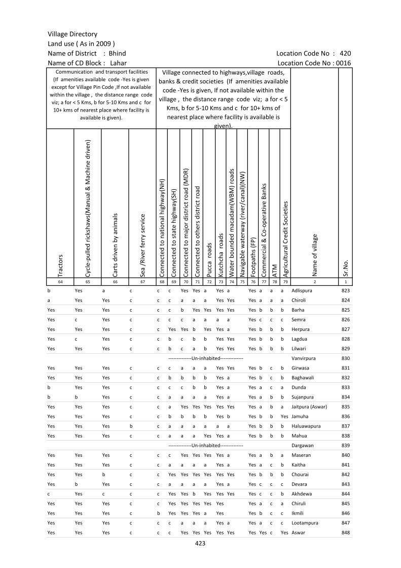
Village DirectoryLand use ( As in 2009 )Name of District : Bhind Location Code No : 420Name of CD Block : Lahar Location Code No : 0016
Trac
tors
Cycl
e-pu
lled
rick
shaw
s(M
anua
l & M
achi
ne d
rive
n)
Cart
s dr
iven
by
anim
als
Sea
/Riv
er fe
rry
serv
ice
Conn
ecte
d to
nat
iona
l hig
hway
(NH
)
Conn
ecte
d to
sta
te h
ighw
ay(S
H)
Conn
ecte
d to
maj
or d
istr
ict r
oad
(MD
R)
Conn
ecte
d to
oth
ers
dist
rict
roa
d
Pucc
a r
oads
Kutc
hcha
roa
ds
Wat
er b
ound
ed m
acad
am(W
BM) r
oads
Nav
igab
le w
ater
way
(riv
er/c
anal
)(N
W)
Foot
path
s (F
P)
Com
mer
cial
& C
o-op
erat
ive
Bank
s
ATM
Agr
icul
tura
l Cre
dit S
ocie
ties
64 65 66 67 68 69 70 71 72 73 74 75 76 77 78 79 2 1
Nam
e of
vill
age
Sr.N
o.
Communication and transport facilities (If amenities available code -Yes is given
except for Village Pin Code ,If not available within the village , the distance range code viz; a for < 5 Kms, b for 5-10 Kms and c for 10+ kms of nearest place where facility is
available is given).
Village connected to highways,village roads, banks & credit societies (If amenities available
code -Yes is given, If not available within the village , the distance range code viz; a for < 5
Kms, b for 5-10 Kms and c for 10+ kms of nearest place where facility is available is
given).
b Yes a c c c Yes Yes a Yes a Yes a a a Adlispura 823
a Yes Yes c c c a a a Yes Yes Yes a a a Chiroli 824
Yes Yes Yes c c c b Yes Yes Yes Yes Yes b b b Barha 825
Yes c Yes c c c c a a a a Yes c c c Semra 826
Yes Yes Yes c c Yes Yes b Yes Yes a Yes b b b Herpura 827
Yes c Yes c c b c b b Yes Yes Yes b b b Lagdua 828
Yes Yes Yes c c b c a b Yes Yes Yes b b b Lilwari 829
--------------Un-inhabited-------------- Vanvirpura 830
Yes Yes Yes c c c a a a Yes Yes Yes b c b Girwasa 831
Yes Yes Yes c c b b b b Yes a Yes b c b Baghawali 832
b Yes Yes c c c c b b Yes a Yes a c a Dunda 833
b b Yes c c a a a a Yes a Yes a b b Sujanpura 834
Yes Yes Yes c c a Yes Yes Yes Yes Yes Yes a b a Jaitpura (Aswar) 835
Yes Yes Yes c c b b b b Yes b Yes b b Yes Jamuha 836
Yes Yes Yes b c a a a a a a Yes b b b Haluawapura 837
Yes Yes Yes c c a a a Yes Yes a Yes b b b Mahua 838
--------------Un-inhabited-------------- Dargawan 839
Yes Yes Yes c c c Yes Yes Yes Yes a Yes a b a Maseran 840
Yes Yes Yes c c a a a a Yes a Yes a c b Kaitha 841
Yes Yes b c c Yes Yes Yes Yes Yes Yes Yes b b b Chourai 842
Yes b Yes c c a a a a Yes a Yes c c c Devara 843
c Yes c c c Yes Yes b Yes Yes Yes Yes c c b Akhdewa 844
Yes Yes Yes c c Yes Yes Yes Yes Yes Yes a c a Chiruli 845
Yes Yes Yes c b Yes Yes Yes a Yes Yes b c c Ikmili 846
Yes Yes Yes c c c a a a Yes a Yes a c c Lootampura 847
Yes Yes Yes c c c Yes Yes Yes Yes Yes Yes Yes c Yes Aswar 848
423

Census of India 2011- Amenities and
Name of District : Bhind Location Code No : 420Name of CD Block : Lahar Location Code No : 0016
Self-
Hel
p G
roup
(SH
G)
Publ
ic d
istr
ibut
ion
syst
em (P
DS)
sho
p
Man
dis
/ Re
gula
r m
arke
t
Wee
kly
Haa
t
Agr
icul
tura
l mar
ketin
g so
ciet
yIn
tegr
ated
Chi
ld D
evel
opm
ent S
chem
e (N
utri
tiona
l Ce
ntre
s)A
ngan
wad
i Cen
tre
(Nut
ritio
nal C
entr
es)
Oth
ers
(Nut
ritio
nal C
entr
es)
ASH
A (A
ccre
dite
d So
cial
Hea
lth A
ctiv
ist)
Com
mun
ity c
entr
e w
ith/w
ithou
t TV
Spor
ts F
ield
,
Spor
ts C
lub
/ Re
crea
tion
Cent
re
Cine
ma
/ Vi
deo
Hal
l
Publ
ic L
ibra
ry
Publ
ic R
eadi
ng R
oom
New
spap
er S
uppl
y
Ass
embl
y Po
lling
sta
tion
Birt
h &
Dea
th R
egis
trat
ion
Off
ice
1 2 3 80 81 82 83 84 85 86 87 88 89 90 91 92 93 94 95 96 97
Sr.N
o.
Nam
e of
vill
age
Loca
tion
code
no.
Availability of miscellaneous facilities (If amenities available code -Yes is given, If not available within the village , the distance range code viz; a for < 5 Kms, b
for 5-10 Kms and c for 10+ kms of nearest place where facility is available is given).
823 Adlispura 453583 a a a a a a Yes Yes Yes a a a c a a a a a
824 Chiroli 453584 a Yes a a a a Yes Yes Yes b Yes Yes c a a a Yes Yes
825 Barha 453585 Yes b b b b b Yes Yes Yes b b b c c c b Yes Yes
826 Semra 453586 Yes b c c c c Yes a a c c c c c c c a b
827 Herpura 453587 Yes b b b b b Yes Yes Yes b b b b b b b Yes b
828 Lagdua 453588 Yes a b b c c Yes a Yes Yes c b b b b b a b
829 Lilwari 453589 Yes a b b b Yes Yes Yes Yes Yes Yes c b b b b Yes b
830 Vanvirpura 453590 --------------Un-inhabited--------------
831 Girwasa 453591 Yes Yes c c b c Yes Yes Yes c c c c c c Yes Yes Yes
832 Baghawali 453592 Yes b c Yes b c Yes Yes Yes c Yes c c c c Yes Yes Yes
833 Dunda 453593 Yes a c a a c Yes c Yes c c c c c c c Yes a
834 Sujanpura 453594 Yes a b b b b Yes a Yes a a b b b b b a a
835 Jaitpura (Aswar) 453595 Yes Yes b b a b Yes Yes Yes b Yes b b b b Yes Yes Yes
836 Jamuha 453596 Yes Yes b b b b Yes Yes Yes b Yes b b b b b Yes Yes
837 Haluawapura 453597 a a b b b b Yes Yes Yes b b b b b b b Yes Yes
838 Mahua 453598 Yes Yes b b b b Yes Yes Yes b Yes b c b b Yes Yes Yes
839 Dargawan 453599 --------------Un-inhabited--------------
840 Maseran 453600 Yes Yes b b b b Yes Yes Yes Yes b Yes b c b b Yes Yes
841 Kaitha 453601 Yes a c c a c Yes Yes Yes c Yes c c c c c Yes a
842 Chourai 453602 b b b b b b Yes Yes Yes Yes Yes Yes Yes c Yes Yes Yes b
843 Devara 453603 Yes a c c c c Yes a Yes c b c c c c a Yes a
844 Akhdewa 453604 Yes Yes c c Yes c Yes Yes Yes c c c c c c Yes Yes Yes
845 Chiruli 453605 Yes a c a c c Yes Yes Yes c c c c c c c Yes a
846 Ikmili 453606 Yes b c b c c Yes Yes Yes c Yes c c c c c Yes b
847 Lootampura 453607 Yes a c a c c Yes Yes Yes c a c c c c a Yes Yes
848 Aswar 453608 Yes Yes c Yes c Yes Yes Yes Yes c Yes c c Yes c Yes Yes Yes
424
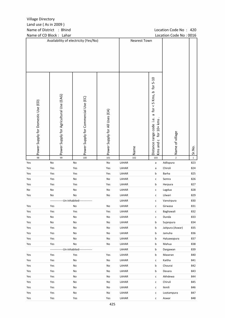
Village DirectoryLand use ( As in 2009 )Name of District : Bhind Location Code No : 420Name of CD Block : Lahar Location Code No : 0016
Pow
er S
uppl
y fo
r D
omes
tic U
se (E
D)
Pow
er S
uppl
y fo
r A
gric
ultu
ral U
se (E
AG
)
Pow
er S
uppl
y fo
r Co
mm
erci
al U
se (E
C)
Pow
er S
uppl
y fo
r A
ll U
ses
(EA
)
Nam
e
Dis
tanc
e ra
nge
code
i.e
. a
for
< 5
Kms,
b f
or 5
-10
Kms
and
c f
or 1
0+ k
ms
.98 99 100 101 102 103 2 1
Availability of electricity (Yes/No) Nearest Town
Nam
e of
vill
age
Sr.N
o.
Yes No No No LAHAR a Adlispura 823
Yes Yes Yes Yes LAHAR a Chiroli 824
Yes Yes Yes Yes LAHAR b Barha 825
Yes Yes No No LAHAR c Semra 826
Yes Yes Yes Yes LAHAR b Herpura 827
No No No No LAHAR c Lagdua 828
Yes No No No LAHAR c Lilwari 829
--------------Un-inhabited-------------- LAHAR c Vanvirpura 830
Yes Yes No No LAHAR c Girwasa 831
Yes Yes Yes Yes LAHAR c Baghawali 832
Yes No No No LAHAR c Dunda 833
Yes No No No LAHAR b Sujanpura 834
Yes Yes No No LAHAR b Jaitpura (Aswar) 835
Yes Yes No No LAHAR b Jamuha 836
Yes Yes No No LAHAR b Haluawapura 837
Yes Yes No No LAHAR b Mahua 838
--------------Un-inhabited-------------- LAHAR b Dargawan 839
Yes Yes Yes Yes LAHAR b Maseran 840
Yes Yes No No LAHAR c Kaitha 841
Yes Yes No No LAHAR b Chourai 842
Yes Yes No No LAHAR b Devara 843
Yes Yes No No LAHAR c Akhdewa 844
Yes Yes No No LAHAR c Chiruli 845
Yes Yes No No LAHAR c Ikmili 846
Yes Yes No No LAHAR c Lootampura 847
Yes Yes Yes Yes LAHAR c Aswar 848
425
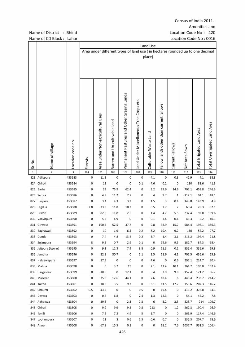
Census of India 2011- Amenities and
Name of District : Bhind Location Code No : 420Name of CD Block : Lahar Location Code No : 0016
Fore
sts
Are
a un
der
Non
-agr
icul
tura
l Use
s
Barr
en a
nd U
n-cu
ltiva
ble
land
Perm
anen
t Pas
ture
s an
d O
ther
Gra
zing
Lan
ds
Land
Und
er M
isce
llane
ous
Tree
Cro
ps e
tc.
Cultu
rabl
e W
aste
Lan
d
Fallo
w la
nds
othe
r th
an c
urre
nt fa
llow
s
Curr
ent F
allo
ws
Net
Are
a So
wn
Tota
l Irr
igat
ed L
and
Are
a
Tota
l Un-
irri
gate
d La
nd A
rea
1 2 3 104 105 106 107 108 109 110 111 112 113 114
Loca
tion
code
no.
Land UseArea under different types of land use ( in hectares rounded up to one decimal
place)
Sr.N
o.
Nam
e of
vill
age
823 Adlispura 453583 0 11.3 0 0 0 4.1 0 0.3 42.9 4.1 38.8
824 Chiroli 453584 0 13 0 0 0.1 4.6 0.2 0 130 88.6 41.3
825 Barha 453585 0 23 75.9 62.4 0 3.2 99.9 14.9 705.1 458.8 246.3
826 Semra 453586 0 4.9 11.2 7.7 0 4 9.7 1 112.1 94.1 18.1
827 Herpura 453587 0 3.4 4.3 3.3 0 1.5 3 0.4 148.8 143.9 4.9
828 Lagdua 453588 2.8 33.3 11.8 10.3 0 0.5 7.7 2 60.4 28.3 32.1
829 Lilwari 453589 0 82.8 11.8 2.5 0 1.4 4.7 5.5 232.4 92.8 139.6
830 Vanvirpura 453590 0 5.3 4.9 0 0 0.1 3.4 0.4 45.3 5.2 40.1
831 Girwasa 453591 0 100.5 52.5 37.7 0 9.8 38.9 15.7 584.4 198.1 386.3
832 Baghawali 453592 0 10 1.9 6.5 0.2 8.2 10.4 9.2 150 52.2 97.7
833 Dunda 453593 0 7.4 4.8 13.4 0.2 5.7 1.4 3.1 216.2 194.4 21.8
834 Sujanpura 453594 8 9.3 0.7 2.9 0.1 0 15.6 9.5 182.7 84.3 98.4
835 Jaitpura (Aswar) 453595 0 9.1 12.3 7.4 8.8 0.9 11.3 0.2 355.4 335.6 19.8
836 Jamuha 453596 0 22.3 30.7 0 1.1 2.5 11.6 4.1 702.5 636.6 65.9
837 Haluawapura 453597 0 17.9 0 0 0 4.6 0 0.6 295.1 214.7 80.4
838 Mahua 453598 0 0 3.2 19 0 2.1 12.4 10.1 361.2 193.8 167.4
839 Dargawan 453599 0 10.6 0 12.1 0 5.4 2.9 9.8 157.4 121.2 36.2
840 Maseran 453600 0 35.8 12.6 44.1 0 7.6 18.4 6 448.4 233.7 214.7
841 Kaitha 453601 0 18.8 3.5 9.3 0 3.1 11.5 17.2 353.6 207.3 146.2
842 Chourai 453602 0.5 43.2 0 0 0.5 0 19.4 0 413.2 378.8 34.3
843 Devara 453603 0 0.6 6.8 0 2.4 1.3 12.3 0 54.1 46.2 7.8
844 Akhdewa 453604 0 39.3 0 2.3 2.3 6 3.2 3.3 323.7 214 109.7
845 Chiruli 453605 0 9.9 9.9 9.5 0.8 213 0 1.2 267.3 190.4 76.9
846 Ikmili 453606 0 7.2 7.2 4.9 5 1.7 0 0 263.9 117.4 146.6
847 Lootampura 453607 0 11 3 0.6 1.3 0.6 0.7 0 236.3 207.7 28.6
848 Aswar 453608 0 67.9 15.5 0.1 0 0 18.2 7.6 1037.7 931.3 106.4
426
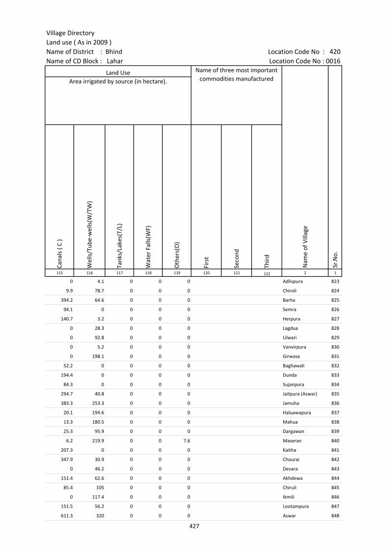
Village DirectoryLand use ( As in 2009 )Name of District : Bhind Location Code No : 420Name of CD Block : Lahar Location Code No : 0016
Cana
ls (
C )
Wel
ls/T
ube-
wel
ls(W
/TW
)
Tank
s/La
kes(
T/L)
Wat
er F
alls
(WF)
Oth
ers(
O)
Firs
t
Seco
nd
Thir
d 115 116 117 118 119 120 121 122 2 1
Land Use Name of three most important commodities manufactured
Nam
e of
Vill
age
Sr.N
o.
Area irrigated by source (in hectare).
0 4.1 0 0 0 Adlispura 823
9.9 78.7 0 0 0 Chiroli 824
394.2 64.6 0 0 0 Barha 825
94.1 0 0 0 0 Semra 826
140.7 3.2 0 0 0 Herpura 827
0 28.3 0 0 0 Lagdua 828
0 92.8 0 0 0 Lilwari 829
0 5.2 0 0 0 Vanvirpura 830
0 198.1 0 0 0 Girwasa 831
52.2 0 0 0 0 Baghawali 832
194.4 0 0 0 0 Dunda 833
84.3 0 0 0 0 Sujanpura 834
294.7 40.8 0 0 0 Jaitpura (Aswar) 835
383.3 253.3 0 0 0 Jamuha 836
20.1 194.6 0 0 0 Haluawapura 837
13.3 180.5 0 0 0 Mahua 838
25.3 95.9 0 0 0 Dargawan 839
6.2 219.9 0 0 7.6 Maseran 840
207.3 0 0 0 0 Kaitha 841
347.9 30.9 0 0 0 Chourai 842
0 46.2 0 0 0 Devara 843
151.4 62.6 0 0 0 Akhdewa 844
85.4 105 0 0 0 Chiruli 845
0 117.4 0 0 0 Ikmili 846
151.5 56.2 0 0 0 Lootampura 847
611.3 320 0 0 0 Aswar 848
427
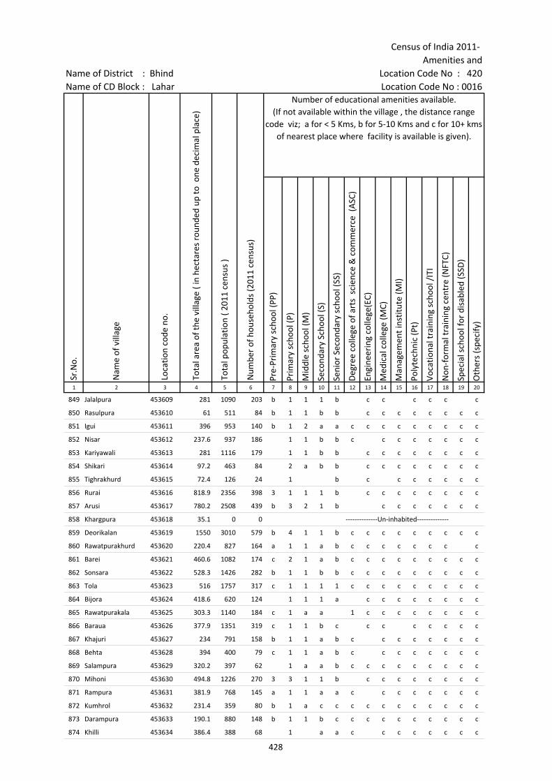
Census of India 2011- Amenities and
Name of District : Bhind Location Code No : 420Name of CD Block : Lahar Location Code No : 0016
Pre-
Prim
ary
scho
ol (P
P)
Prim
ary
scho
ol (P
)
Mid
dle
scho
ol (M
)
Seco
ndar
y Sc
hool
(S)
Seni
or S
econ
dary
sch
ool (
SS)
Deg
ree
colle
ge o
f art
s s
cien
ce &
com
mer
ce (
ASC
)
Engi
neer
ing
colle
ge(E
C)
Med
ical
col
lege
(MC)
Man
agem
ent i
nstit
ute
(MI)
Poly
tech
nic
(Pt)
Voca
tiona
l tra
inin
g sc
hool
/IT
I
Non
-for
mal
trai
ning
cen
tre
(NFT
C)
Spec
ial s
choo
l for
dis
able
d (S
SD)
Oth
ers
(spe
cify
)
1 2 3 4 5 6 7 8 9 10 11 12 13 14 15 16 17 18 19 20
Sr.N
o.
Nam
e of
vill
age
Loca
tion
code
no.
Tota
l are
a of
the
villa
ge (
in h
ecta
res
roun
ded
up to
one
dec
imal
pla
ce)
Tota
l pop
ulat
ion
( 201
1 ce
nsus
)
Num
ber
of h
ouse
hold
s (2
011
cens
us)
Number of educational amenities available. (If not available within the village , the distance range
code viz; a for < 5 Kms, b for 5-10 Kms and c for 10+ kms of nearest place where facility is available is given).
849 Jalalpura 453609 281 1090 203 b 1 1 1 b c c c c c c
850 Rasulpura 453610 61 511 84 b 1 1 b b c c c c c c c c
851 Igui 453611 396 953 140 b 1 2 a a c c c c c c c c c
852 Nisar 453612 237.6 937 186 1 1 b b c c c c c c c c
853 Kariyawali 453613 281 1116 179 1 1 b b c c c c c c c c
854 Shikari 453614 97.2 463 84 2 a b b c c c c c c c c
855 Tighrakhurd 453615 72.4 126 24 1 b c c c c c c c
856 Rurai 453616 818.9 2356 398 3 1 1 1 b c c c c c c c c
857 Arusi 453617 780.2 2508 439 b 3 2 1 b c c c c c c c
858 Khargpura 453618 35.1 0 0 --------------Un-inhabited--------------
859 Deorikalan 453619 1550 3010 579 b 4 1 1 b c c c c c c c c c
860 Rawatpurakhurd 453620 220.4 827 164 a 1 1 a b c c c c c c c c
861 Barei 453621 460.6 1082 174 c 2 1 a b c c c c c c c c c
862 Sonsara 453622 528.3 1426 282 b 1 1 b b c c c c c c c c c
863 Tola 453623 516 1757 317 c 1 1 1 1 c c c c c c c c c
864 Bijora 453624 418.6 620 124 1 1 1 a c c c c c c c c
865 Rawatpurakala 453625 303.3 1140 184 c 1 a a 1 c c c c c c c c
866 Baraua 453626 377.9 1351 319 c 1 1 b c c c c c c c c
867 Khajuri 453627 234 791 158 b 1 1 a b c c c c c c c c
868 Behta 453628 394 400 79 c 1 1 a b c c c c c c c c
869 Salampura 453629 320.2 397 62 1 a a b c c c c c c c c c
870 Mihoni 453630 494.8 1226 270 3 3 1 1 b c c c c c c c c
871 Rampura 453631 381.9 768 145 a 1 1 a a c c c c c c c c
872 Kumhrol 453632 231.4 359 80 b 1 a c c c c c c c c c c c
873 Darampura 453633 190.1 880 148 b 1 1 b c c c c c c c c c c
874 Khilli 453634 386.4 388 68 1 a a c c c c c c c c
428

Village DirectoryLand use ( As in 2009 )Name of District : Bhind Location Code No : 420Name of CD Block : Lahar Location Code No : 0016
Com
mun
ity h
ealth
cen
tre
(CH
C)Pr
imar
y he
alth
cen
tre
(PH
C)Pr
imar
y he
alth
sub
cen
tre
(PH
S)M
ater
nity
and
chi
ld w
elfa
re c
entr
e (M
CW)
T.B.
clin
ic (
TBC)
Hos
pita
l-allo
path
ic (H
A)
Hos
pita
l-alte
rnat
ive
med
icin
e (H
O)
Dis
pens
ary
(D)
Vete
rina
ry h
ospi
tal (
VH)
Mob
ile h
ealth
clin
ic (M
HC)
Fam
ily w
elfa
re c
entr
e (F
WC)
Char
itabl
e no
n G
ovt.
hos
pita
l/N
ursi
ng h
ome.
Med
ical
pra
ctiti
oner
with
MBB
S D
egre
eM
edic
al p
ract
ition
er w
ith o
ther
deg
ree
Med
ical
pra
ctiti
oner
with
no
degr
eeTr
aditi
onal
pra
ctiti
oner
and
faith
hea
ler
.M
edic
ine
Shop
Oth
ers
Tap
wat
er (T
reat
ed/U
ntre
ated
)
Wel
l w
ater
(C
over
ed /
Unc
over
ed w
ell)
Han
d Pu
mp
Tube
wel
ls /
Bor
e w
ell
Spri
ng
Rive
r /
Cana
l
Tank
/ P
ond
/ L
ake
Oth
ers
21 22 23 24 25 26 27 28 29 30 31 32 33 34 35 36 37 38 39 40 41 42 43 44 45 46 2 1
Number of Medical Amenities available. (If not available within the
village , the distance range code viz; a for < 5 Kms, b for 5-10 Kms and c for
10+ kms of nearest place where facility is available is given).
Number of Non-Government
Medical Amenities available.
Availability of drinking water - Yes / No
Nam
e of
vill
age
Sr.N
o.
c b b c b b b b 1 c c 0 0 0 0 0 0 0 No No Yes No No No No No Jalalpura 849
c b c c b b b c a c c 0 0 0 0 0 0 0 No Yes Yes No No No No No Rasulpura 850
a a a c a a c a a a c 0 0 0 0 0 0 0 No Yes Yes No No Yes Yes No Igui 851
c b b b b b c b b c b 0 0 0 0 0 0 0 Yes Yes Yes No No No Yes No Nisar 852
c c c c c c c c c c c 0 0 0 0 0 0 0 No Yes Yes No No No No No Kariyawali 853
c c a c c c c c c c c 0 0 0 0 0 0 0 No Yes Yes No No No No No Shikari 854
c c c c c b b c 0 0 0 0 0 0 0 No Yes Yes Yes No Yes Yes No Tighrakhurd 855
c b 1 c b b b c c 0 0 0 0 0 0 0 No Yes Yes Yes No No No No Rurai 856
c b 1 b b b c c b c c 0 0 0 0 0 0 0 Yes Yes Yes No No Yes Yes No Arusi 857
--------------Un-inhabited-------------- Khargpura 858
c b 1 c b c c 1 c c c 0 0 0 0 0 0 0 Yes Yes Yes Yes No Yes Yes No Deorikalan 859
c b a c b c c a c c c 0 0 0 0 0 0 0 No Yes Yes No No Yes No No Rawatpurakhurd 860
a a c c a c c c b a c 0 0 0 0 0 0 0 No Yes Yes No No No Yes No Barei 861
c b b c b c c b c c 0 0 0 0 0 0 0 No Yes Yes No No Yes Yes No Sonsara 862
c c c c c c c a c c 1 0 0 2 0 0 0 No Yes Yes No No Yes Yes No Tola 863
c 1 c c c c c c 0 0 1 0 0 0 0 No Yes Yes No No Yes No No Bijora 864
c c a c c c c c b c c 0 0 0 0 0 0 0 No Yes Yes No No Yes Yes No Rawatpurakala 865
c b 1 c b 1 b 1 1 c c 0 0 0 0 0 0 0 No Yes Yes No No No No No Baraua 866
c b a b b b c b c c c 0 0 0 0 0 0 0 No Yes Yes No No No Yes No Khajuri 867
c c a c c a b a a c c 0 0 0 0 0 0 0 No Yes Yes No No Yes No No Behta 868
c b a c b c c c c c c 0 0 0 0 0 0 0 No Yes Yes No No No No No Salampura 869
c c a c c a c c c c c 0 0 0 0 0 0 0 No Yes Yes No No No No No Mihoni 870
c b a b b b c b c c c 0 0 0 0 0 0 0 No Yes Yes No No No Yes No Rampura 871
c c c c c c c c c c 0 0 0 0 0 0 0 No Yes Yes No No Yes Yes No Kumhrol 872
c c b c c c c c c c c 0 0 0 0 0 0 0 No Yes Yes Yes No Yes Yes No Darampura 873
c c b c c c c c c c c 0 0 0 0 0 0 0 No Yes Yes No No Yes No No Khilli 874
429
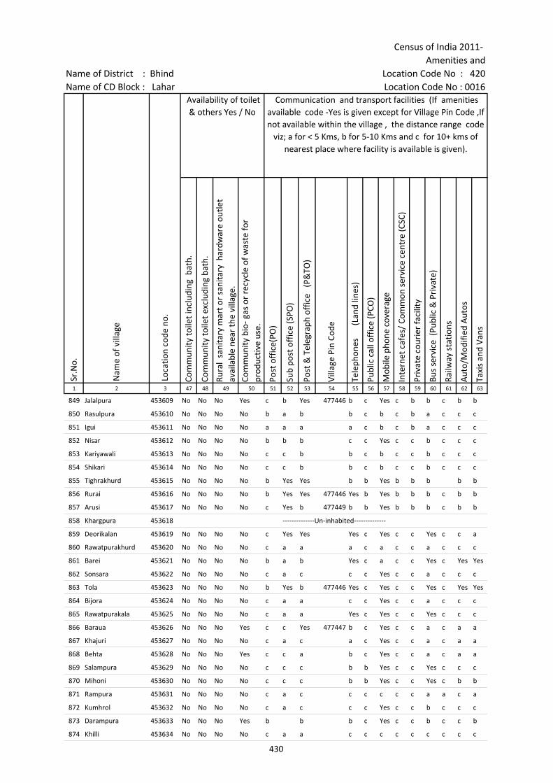
Census of India 2011- Amenities and
Name of District : Bhind Location Code No : 420Name of CD Block : Lahar Location Code No : 0016
Com
mun
ity to
ilet i
nclu
ding
bat
h.
Com
mun
ity to
ilet e
xclu
ding
bat
h.
Rura
l sa
nita
ry m
art o
r sa
nita
ry h
ardw
are
outle
t av
aila
ble
near
the
villa
ge.
Com
mun
ity b
io- g
as o
r re
cycl
e of
was
te fo
r pr
oduc
tive
use.
Post
off
ice(
PO)
Sub
post
off
ice
(SPO
)
Post
& T
eleg
raph
off
ice
(P&
TO)
Villa
ge P
in C
ode
Tele
phon
es
(L
and
lines
)
Publ
ic c
all o
ffic
e (P
CO)
Mob
ile p
hone
cov
erag
e
Inte
rnet
caf
es/
Com
mon
ser
vice
cen
tre
(CSC
)
Priv
ate
cour
ier
faci
lity
Bus
serv
ice
(Pub
lic &
Pri
vate
)
Railw
ay s
tatio
ns
Aut
o/M
odifi
ed A
utos
Taxi
s an
d Va
ns
1 2 3 47 48 49 50 51 52 53 54 55 56 57 58 59 60 61 62 63
Nam
e of
vill
age
Loca
tion
code
no.
Availability of toilet & others Yes / No
Communication and transport facilities (If amenities available code -Yes is given except for Village Pin Code ,If not available within the village , the distance range code
viz; a for < 5 Kms, b for 5-10 Kms and c for 10+ kms of nearest place where facility is available is given).
Sr.N
o.
849 Jalalpura 453609 No No No Yes c b Yes 477446 b c Yes c b b c b b
850 Rasulpura 453610 No No No No b a b b c b c b a c c c
851 Igui 453611 No No No No a a a a c b c b a c c c
852 Nisar 453612 No No No No b b b c c Yes c c b c c c
853 Kariyawali 453613 No No No No c c b b c b c c b c c c
854 Shikari 453614 No No No No c c b b c b c c b c c c
855 Tighrakhurd 453615 No No No No b Yes Yes b b Yes b b b b b
856 Rurai 453616 No No No No b Yes Yes 477446 Yes b Yes b b b c b b
857 Arusi 453617 No No No No c Yes b 477449 b b Yes b b b c b b
858 Khargpura 453618 --------------Un-inhabited--------------
859 Deorikalan 453619 No No No No c Yes Yes Yes c Yes c c Yes c c a
860 Rawatpurakhurd 453620 No No No No c a a a c a c c a c c c
861 Barei 453621 No No No No b a b Yes c a c c Yes c Yes Yes
862 Sonsara 453622 No No No No c a c c c Yes c c a c c c
863 Tola 453623 No No No No b Yes b 477446 Yes c Yes c c Yes c Yes Yes
864 Bijora 453624 No No No No c a a c c Yes c c a c c c
865 Rawatpurakala 453625 No No No No c a a Yes c Yes c c Yes c c c
866 Baraua 453626 No No No Yes c c Yes 477447 b c Yes c c a c a a
867 Khajuri 453627 No No No No c a c a c Yes c c a c a a
868 Behta 453628 No No No Yes c c a b c Yes c c a c a a
869 Salampura 453629 No No No No c c c b b Yes c c Yes c c c
870 Mihoni 453630 No No No No c c c b b Yes c c Yes c b b
871 Rampura 453631 No No No No c a c c c c c c a a c a
872 Kumhrol 453632 No No No No c a c c c Yes c c b c c c
873 Darampura 453633 No No No Yes b b b c Yes c c b c c b
874 Khilli 453634 No No No No c a a c c c c c c c c c
430
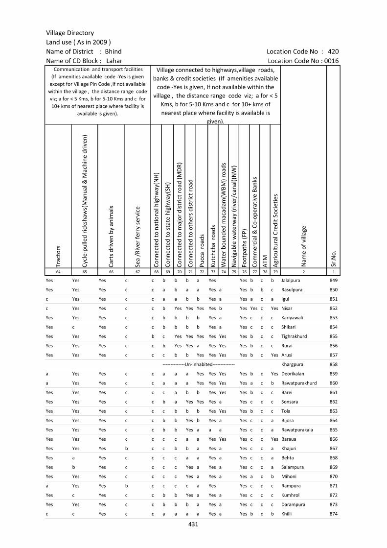
Village DirectoryLand use ( As in 2009 )Name of District : Bhind Location Code No : 420Name of CD Block : Lahar Location Code No : 0016
Trac
tors
Cycl
e-pu
lled
rick
shaw
s(M
anua
l & M
achi
ne d
rive
n)
Cart
s dr
iven
by
anim
als
Sea
/Riv
er fe
rry
serv
ice
Conn
ecte
d to
nat
iona
l hig
hway
(NH
)
Conn
ecte
d to
sta
te h
ighw
ay(S
H)
Conn
ecte
d to
maj
or d
istr
ict r
oad
(MD
R)
Conn
ecte
d to
oth
ers
dist
rict
roa
d
Pucc
a r
oads
Kutc
hcha
roa
ds
Wat
er b
ound
ed m
acad
am(W
BM) r
oads
Nav
igab
le w
ater
way
(riv
er/c
anal
)(N
W)
Foot
path
s (F
P)
Com
mer
cial
& C
o-op
erat
ive
Bank
s
ATM
Agr
icul
tura
l Cre
dit S
ocie
ties
64 65 66 67 68 69 70 71 72 73 74 75 76 77 78 79 2 1
Nam
e of
vill
age
Sr.N
o.
Communication and transport facilities (If amenities available code -Yes is given
except for Village Pin Code ,If not available within the village , the distance range code viz; a for < 5 Kms, b for 5-10 Kms and c for 10+ kms of nearest place where facility is
available is given).
Village connected to highways,village roads, banks & credit societies (If amenities available
code -Yes is given, If not available within the village , the distance range code viz; a for < 5
Kms, b for 5-10 Kms and c for 10+ kms of nearest place where facility is available is
given).
Yes Yes Yes c c b b b a Yes Yes b c b Jalalpura 849
Yes Yes Yes c c a b a a Yes a Yes b b c Rasulpura 850
c Yes Yes c c a a b b Yes a Yes a c a Igui 851
c Yes Yes c c b Yes Yes Yes Yes b Yes Yes c Yes Nisar 852
Yes Yes Yes c c b b b b Yes a Yes c c c Kariyawali 853
Yes c Yes c c b b b b Yes a Yes c c c Shikari 854
Yes Yes Yes c b c Yes Yes Yes Yes Yes Yes b c c Tighrakhurd 855
Yes Yes Yes c c b Yes Yes a Yes Yes Yes b c c Rurai 856
Yes Yes Yes c c c b b Yes Yes Yes Yes b c Yes Arusi 857
--------------Un-inhabited-------------- Khargpura 858
a Yes Yes c c a a a Yes Yes Yes Yes b c Yes Deorikalan 859
a Yes Yes c c a a a Yes Yes Yes Yes a c b Rawatpurakhurd 860
Yes Yes Yes c c c a b b Yes Yes Yes b c c Barei 861
Yes Yes Yes c c b a Yes Yes Yes a Yes c c c Sonsara 862
Yes Yes Yes c c c b b b Yes Yes Yes b c c Tola 863
Yes Yes Yes c c b b Yes b Yes a Yes c c a Bijora 864
Yes Yes Yes c c b b Yes a a a Yes c c a Rawatpurakala 865
Yes Yes Yes c c c c a a Yes Yes Yes c c Yes Baraua 866
Yes Yes Yes b c c b b a Yes a Yes c c a Khajuri 867
Yes a Yes c c c c a a Yes a Yes c c a Behta 868
Yes b Yes c c c c Yes a Yes a Yes c c a Salampura 869
Yes Yes Yes c c c c Yes a Yes a Yes a c b Mihoni 870
a Yes Yes b c c c c a Yes Yes c c c Rampura 871
Yes c Yes c c b b Yes a Yes a Yes c c c Kumhrol 872
Yes Yes Yes c c b b b a Yes a Yes c c c Darampura 873
c c Yes c c a a a a Yes a Yes b c b Khilli 874
431

Census of India 2011- Amenities and
Name of District : Bhind Location Code No : 420Name of CD Block : Lahar Location Code No : 0016
Self-
Hel
p G
roup
(SH
G)
Publ
ic d
istr
ibut
ion
syst
em (P
DS)
sho
p
Man
dis
/ Re
gula
r m
arke
t
Wee
kly
Haa
t
Agr
icul
tura
l mar
ketin
g so
ciet
yIn
tegr
ated
Chi
ld D
evel
opm
ent S
chem
e (N
utri
tiona
l Ce
ntre
s)A
ngan
wad
i Cen
tre
(Nut
ritio
nal C
entr
es)
Oth
ers
(Nut
ritio
nal C
entr
es)
ASH
A (A
ccre
dite
d So
cial
Hea
lth A
ctiv
ist)
Com
mun
ity c
entr
e w
ith/w
ithou
t TV
Spor
ts F
ield
,
Spor
ts C
lub
/ Re
crea
tion
Cent
re
Cine
ma
/ Vi
deo
Hal
l
Publ
ic L
ibra
ry
Publ
ic R
eadi
ng R
oom
New
spap
er S
uppl
y
Ass
embl
y Po
lling
sta
tion
Birt
h &
Dea
th R
egis
trat
ion
Off
ice
1 2 3 80 81 82 83 84 85 86 87 88 89 90 91 92 93 94 95 96 97
Sr.N
o.
Nam
e of
vill
age
Loca
tion
code
no.
Availability of miscellaneous facilities (If amenities available code -Yes is given, If not available within the village , the distance range code viz; a for < 5 Kms, b
for 5-10 Kms and c for 10+ kms of nearest place where facility is available is given).
849 Jalalpura 453609 Yes b c b b Yes Yes Yes Yes c Yes c c c c Yes Yes Yes
850 Rasulpura 453610 Yes b b b c b Yes Yes Yes b c c b b b b Yes b
851 Igui 453611 Yes a a a c c Yes Yes Yes c c c c c c Yes Yes Yes
852 Nisar 453612 Yes b b b c c Yes Yes Yes c Yes c c c c Yes Yes Yes
853 Kariyawali 453613 Yes Yes c b c Yes Yes Yes Yes c c c c c c c Yes Yes
854 Shikari 453614 Yes a c b c c Yes a a c c c c c c c a a
855 Tighrakhurd 453615 a a c b a b a a Yes Yes b b c c c a a b
856 Rurai 453616 Yes Yes Yes Yes Yes Yes Yes Yes Yes Yes Yes Yes Yes b c Yes Yes Yes
857 Arusi 453617 Yes Yes b c b c Yes Yes Yes Yes Yes c c b b b Yes Yes
858 Khargpura 453618 --------------Un-inhabited--------------
859 Deorikalan 453619 Yes Yes b b b c Yes Yes Yes c c c c c c c Yes Yes
860 Rawatpurakhurd 453620 Yes a b b b c Yes Yes Yes c c c c c c c Yes a
861 Barei 453621 Yes Yes c c c c Yes Yes Yes c a c c c c c Yes Yes
862 Sonsara 453622 Yes b c c c c Yes Yes Yes c Yes c c c c c Yes Yes
863 Tola 453623 Yes Yes c Yes c c Yes Yes Yes c Yes c c c c c Yes Yes
864 Bijora 453624 Yes a c c c c Yes Yes Yes c c c c c c c a a
865 Rawatpurakala 453625 Yes a c c c c Yes Yes Yes c c c c c c c Yes a
866 Baraua 453626 Yes Yes c c Yes c Yes Yes Yes c Yes c c c c b Yes Yes
867 Khajuri 453627 a a c c c c Yes Yes Yes c c c c c c c Yes a
868 Behta 453628 Yes a c c c c Yes a Yes c a c c c c b a a
869 Salampura 453629 Yes a c b a c Yes a Yes c c c c c c c a a
870 Mihoni 453630 Yes a c b a c Yes Yes Yes c c c c c c b Yes a
871 Rampura 453631 Yes a c c c c Yes Yes Yes c c c c c c c Yes Yes
872 Kumhrol 453632 Yes b c c c c Yes a Yes c c c c c c c b a
873 Darampura 453633 Yes Yes Yes Yes Yes Yes Yes Yes Yes Yes Yes Yes c c c a Yes Yes
874 Khilli 453634 a c c c c c Yes a Yes c a c c c c a Yes a
432

Village DirectoryLand use ( As in 2009 )Name of District : Bhind Location Code No : 420Name of CD Block : Lahar Location Code No : 0016
Pow
er S
uppl
y fo
r D
omes
tic U
se (E
D)
Pow
er S
uppl
y fo
r A
gric
ultu
ral U
se (E
AG
)
Pow
er S
uppl
y fo
r Co
mm
erci
al U
se (E
C)
Pow
er S
uppl
y fo
r A
ll U
ses
(EA
)
Nam
e
Dis
tanc
e ra
nge
code
i.e
. a
for
< 5
Kms,
b f
or 5
-10
Kms
and
c f
or 1
0+ k
ms
.98 99 100 101 102 103 2 1
Availability of electricity (Yes/No) Nearest Town
Nam
e of
vill
age
Sr.N
o.
Yes Yes Yes Yes LAHAR c Jalalpura 849
Yes No No No LAHAR c Rasulpura 850
Yes Yes Yes Yes LAHAR c Igui 851
Yes Yes Yes Yes LAHAR c Nisar 852
Yes Yes No No LAHAR c Kariyawali 853
Yes Yes No No LAHAR c Shikari 854
Yes No No No ALAMPUR b Tighrakhurd 855
Yes No No No ALAMPUR b Rurai 856
Yes Yes No No ALAMPUR b Arusi 857
--------------Un-inhabited-------------- ALAMPUR b Khargpura 858
Yes No No No LAHAR c Deorikalan 859
Yes No No No LAHAR c Rawatpurakhurd 860
Yes Yes No No LAHAR c Barei 861
Yes Yes No No LAHAR c Sonsara 862
Yes Yes No No LAHAR c Tola 863
Yes Yes No No LAHAR c Bijora 864
Yes Yes No No LAHAR c Rawatpurakala 865
Yes No No No LAHAR c Baraua 866
Yes No No No LAHAR c Khajuri 867
Yes No No No LAHAR c Behta 868
Yes Yes No No DABOH b Salampura 869
Yes Yes No No DABOH b Mihoni 870
Yes Yes No No LAHAR c Rampura 871
Yes Yes No No LAHAR c Kumhrol 872
Yes Yes Yes Yes LAHAR c Darampura 873
Yes No No No LAHAR c Khilli 874
433
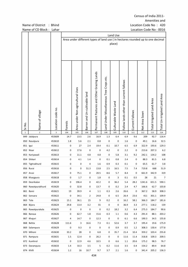
Census of India 2011- Amenities and
Name of District : Bhind Location Code No : 420Name of CD Block : Lahar Location Code No : 0016
Fore
sts
Are
a un
der
Non
-agr
icul
tura
l Use
s
Barr
en a
nd U
n-cu
ltiva
ble
land
Perm
anen
t Pas
ture
s an
d O
ther
Gra
zing
Lan
ds
Land
Und
er M
isce
llane
ous
Tree
Cro
ps e
tc.
Cultu
rabl
e W
aste
Lan
d
Fallo
w la
nds
othe
r th
an c
urre
nt fa
llow
s
Curr
ent F
allo
ws
Net
Are
a So
wn
Tota
l Irr
igat
ed L
and
Are
a
Tota
l Un-
irri
gate
d La
nd A
rea
1 2 3 104 105 106 107 108 109 110 111 112 113 114
Loca
tion
code
no.
Land UseArea under different types of land use ( in hectares rounded up to one decimal
place)
Sr.N
o.
Nam
e of
vill
age
849 Jalalpura 453609 14.7 13.5 2.6 16.9 1.3 6.4 6.9 9.6 209 92.7 116.4
850 Rasulpura 453610 1.8 5.6 2.1 0.8 0 0 1.6 0 49.1 16.6 32.5
851 Igui 453611 0 27 2.4 19.4 0.1 10.7 6.5 6.9 322.9 193.6 129.3
852 Nisar 453612 0 17.6 0 0 4.2 0 2.2 0 213.6 207.3 6.2
853 Kariyawali 453613 0 11.1 4.8 4.8 0 5.8 3.1 9.2 242.1 134.2 108
854 Shikari 453614 0 4.1 1.4 0 0.1 0.8 2.4 0 88.3 81.5 6.8
855 Tighrakhurd 453615 0 0 4 1.6 0.9 0.3 0.1 0 65.5 61.7 3.8
856 Rurai 453616 0 0 51.3 13.8 2.5 16.5 7.5 7.4 719.8 668 51.9
857 Arusi 453617 0 75.1 0 20.5 8.6 5.7 8.4 0 661.9 342.9 319
858 Khargpura 453618 0 1.7 0 1.8 0 3 0.1 0.5 28 21 7
859 Deorikalan 453619 0 196.4 0 42.2 0 36.2 5.4 28.2 1241.6 651.5 590.1
860 Rawatpurakhurd 453620 0 32.8 0 13.7 0 0.2 2.4 4.7 166.6 62.7 103.8
861 Barei 453621 19 39.9 4 1.1 0.3 2.6 26.6 0 367.2 58.9 308.3
862 Sonsara 453622 0 34.1 2 24.8 0 6.5 26.4 23.6 411 301.1 109.9
863 Tola 453623 15.1 36.1 15 9 0.2 0 16.2 58.1 366.3 184.7 181.6
864 Bijora 453624 29.8 13.4 3.2 55 0 0 36.9 3.3 277.1 118.2 159
865 Rawatpurakala 453625 0 0 0 0 0.2 18.2 3.2 6.4 275.3 184.7 90.6
866 Baraua 453626 0 62.7 1.8 15.6 0.3 1.1 0.6 4.3 291.4 88.1 203.2
867 Khajuri 453627 4 14.7 0 12.3 0 0 6.1 6.6 190.3 34.5 155.8
868 Behta 453628 111.6 3 16.6 7.3 0.1 52.6 3.7 3.7 195.4 19.6 175.9
869 Salampura 453629 0 9.3 0 0 0 0.9 0.5 1.2 308.3 130.4 177.8
870 Mihoni 453630 33.2 28 0 6.8 0 35.7 21.4 10.4 359.2 103.4 255.8
871 Rampura 453631 1.5 12.4 0 26.2 0 0 11.6 11.4 318.8 109.3 209.5
872 Kumhrol 453632 0 12.9 4.6 10.5 0 6.6 1.1 20.6 175.2 98.5 76.7
873 Darampura 453633 1.4 10.3 3.5 5 0.2 11.6 3.5 0.4 154.2 89.4 64.8
874 Khilli 453634 1.2 16 10.7 9.7 3.7 2.1 1.6 0 341.4 205.2 136.3
434

Village DirectoryLand use ( As in 2009 )Name of District : Bhind Location Code No : 420Name of CD Block : Lahar Location Code No : 0016
Cana
ls (
C )
Wel
ls/T
ube-
wel
ls(W
/TW
)
Tank
s/La
kes(
T/L)
Wat
er F
alls
(WF)
Oth
ers(
O)
Firs
t
Seco
nd
Thir
d 115 116 117 118 119 120 121 122 2 1
Land Use Name of three most important commodities manufactured
Nam
e of
Vill
age
Sr.N
o.
Area irrigated by source (in hectare).
92.7 0 0 0 0 Jalalpura 849
0 16.6 0 0 0 Rasulpura 850
193.6 0 0 0 0 Igui 851
72 135.3 0 0 0 Nisar 852
92.1 42 0 0 0 Kariyawali 853
0 81.5 0 0 0 Shikari 854
52.4 9.4 0 0 0 Tighrakhurd 855
647.8 20.2 0 0 0 Rurai 856
200 142.9 0 0 0 Arusi 857
18 3 0 0 0 Khargpura 858
448.4 203.1 0 0 0 Deorikalan 859
0 50.4 12.3 0 0 Rawatpurakhurd 860
0 58.9 0 0 0 Barei 861
0 301.1 0 0 0 Sonsara 862
0 184.7 0 0 0 Tola 863
0 118.2 0 0 0 Bijora 864
0 184.7 0 0 0 Rawatpurakala 865
0 88.1 0 0 0 Baraua 866
0 34.5 0 0 0 Khajuri 867
0 19.6 0 0 0 Behta 868
130.4 0 0 0 0 Salampura 869
0 103.4 0 0 0 Mihoni 870
0 109.3 0 0 0 Rampura 871
0 98.5 0 0 0 Kumhrol 872
30.4 59 0 0 0 Darampura 873
79.2 126 0 0 0 Khilli 874
435

Census of India 2011- Amenities and
Name of District : Bhind Location Code No : 420Name of CD Block : Lahar Location Code No : 0016
Pre-
Prim
ary
scho
ol (P
P)
Prim
ary
scho
ol (P
)
Mid
dle
scho
ol (M
)
Seco
ndar
y Sc
hool
(S)
Seni
or S
econ
dary
sch
ool (
SS)
Deg
ree
colle
ge o
f art
s s
cien
ce &
com
mer
ce (
ASC
)
Engi
neer
ing
colle
ge(E
C)
Med
ical
col
lege
(MC)
Man
agem
ent i
nstit
ute
(MI)
Poly
tech
nic
(Pt)
Voca
tiona
l tra
inin
g sc
hool
/IT
I
Non
-for
mal
trai
ning
cen
tre
(NFT
C)
Spec
ial s
choo
l for
dis
able
d (S
SD)
Oth
ers
(spe
cify
)
1 2 3 4 5 6 7 8 9 10 11 12 13 14 15 16 17 18 19 20
Sr.N
o.
Nam
e of
vill
age
Loca
tion
code
no.
Tota
l are
a of
the
villa
ge (
in h
ecta
res
roun
ded
up to
one
dec
imal
pla
ce)
Tota
l pop
ulat
ion
( 201
1 ce
nsus
)
Num
ber
of h
ouse
hold
s (2
011
cens
us)
Number of educational amenities available. (If not available within the village , the distance range
code viz; a for < 5 Kms, b for 5-10 Kms and c for 10+ kms of nearest place where facility is available is given).
875 Chirawali 453635 303 523 121 c 1 1 c c c c c c c c c c
876 Narol 453636 401.6 1209 280 c 1 1 a c c c c c c c c c
877 Dabhra 453637 258.7 962 253 1 1 c c c c c c c c c c c
878 Parenchha 453638 726.1 1357 254 b 1 1 b b c c c c c c c c c
879 Murawali 453639 609.6 2059 384 1 2 1 1 b c c c c c c c
880 Chhibawali No.2 453640 268.6 1662 276 a 1 1 a b c c c c c c c c
881 Salaiya 453641 269 1003 208 a 1 a a b c c c c c c c c
882 Phardua 453642 314.7 1732 337 a 1 1 a 1 b c c c c c c c
883 Kanksi 453643 212 16 1 c a a c c c c c c c c c
884 Larsa 453644 273.1 173 36 b 1 a a b b c c c c c c
885 Gangepura 453645 1168.1 2705 631 a 1 1 1 a c c c c c c c
886 Roor Jagdishpura 453646 372 903 228 a 1 1 1 a a c c c c c c
887 Shahpura No.2 453647 236.2 636 116 a 1 1 a a a c c c c a c c
888 Rarua No.2 453648 281.7 780 129 2 2 1 a a a c c c c a c c c
889 Bidra 453649 162.4 641 110 a 1 1 a a a c c c c c c c c
890 Bhaderi 453650 171.9 600 141 a 1 1 a a a c c c c c c c c
891 Naginpura 453651 54.4 0 0 --------------Un-inhabited--------------
892 Timawali 453652 53.4 267 65 1 a a a c c c c c c
893 Bhanpar 453653 182.8 651 129 a 1 1 a a c c c c c c
894 Kurthar 453654 457.7 1356 279 b 1 1 b b c c c b c c
895 Khurd 453655 223.8 792 146 c 1 a c c c c c c c c
896 Khuja 453656 313.9 1440 258 b 1 1 b b c c c c c c
897 Genthari 453657 653.8 1437 286 1 2 2 b b c c c c c c
898 Belma 453658 465.9 1034 190 b 1 1 b b c c c c c c
899 Chadraua 453659 207.8 844 130 1 1 1 a a b c c c c c c
900 Barthara 453660 682.4 2367 405 b 2 1 1 b b c c c c
436

Village DirectoryLand use ( As in 2009 )Name of District : Bhind Location Code No : 420Name of CD Block : Lahar Location Code No : 0016
Com
mun
ity h
ealth
cen
tre
(CH
C)Pr
imar
y he
alth
cen
tre
(PH
C)Pr
imar
y he
alth
sub
cen
tre
(PH
S)M
ater
nity
and
chi
ld w
elfa
re c
entr
e (M
CW)
T.B.
clin
ic (
TBC)
Hos
pita
l-allo
path
ic (H
A)
Hos
pita
l-alte
rnat
ive
med
icin
e (H
O)
Dis
pens
ary
(D)
Vete
rina
ry h
ospi
tal (
VH)
Mob
ile h
ealth
clin
ic (M
HC)
Fam
ily w
elfa
re c
entr
e (F
WC)
Char
itabl
e no
n G
ovt.
hos
pita
l/N
ursi
ng h
ome.
Med
ical
pra
ctiti
oner
with
MBB
S D
egre
eM
edic
al p
ract
ition
er w
ith o
ther
deg
ree
Med
ical
pra
ctiti
oner
with
no
degr
eeTr
aditi
onal
pra
ctiti
oner
and
faith
hea
ler
.M
edic
ine
Shop
Oth
ers
Tap
wat
er (T
reat
ed/U
ntre
ated
)
Wel
l w
ater
(C
over
ed /
Unc
over
ed w
ell)
Han
d Pu
mp
Tube
wel
ls /
Bor
e w
ell
Spri
ng
Rive
r /
Cana
l
Tank
/ P
ond
/ L
ake
Oth
ers
21 22 23 24 25 26 27 28 29 30 31 32 33 34 35 36 37 38 39 40 41 42 43 44 45 46 2 1
Number of Medical Amenities available. (If not available within the
village , the distance range code viz; a for < 5 Kms, b for 5-10 Kms and c for
10+ kms of nearest place where facility is available is given).
Number of Non-Government
Medical Amenities available.
Availability of drinking water - Yes / No
Nam
e of
vill
age
Sr.N
o.
c c b c c c c b c c 0 0 0 0 0 0 0 No Yes Yes No No Yes Yes No Chirawali 875
c c a c c c c c b c c 0 0 0 0 0 0 0 No Yes Yes Yes No Yes Yes No Narol 876
c c c c c c b c c c c 0 0 0 0 0 0 0 No No Yes No No Yes No No Dabhra 877
c b b b b c c c b c b 0 0 0 0 0 0 0 No No Yes No No Yes No No Parenchha 878
c b b b b b b b 1 c b 0 0 0 0 0 0 0 Yes Yes Yes Yes No Yes No No Murawali 879
c b 1 b b b b b a b b 0 0 0 0 0 0 0 No Yes Yes No No Yes Yes No Chhibawali No.2 880
c b a b b b b b b c b 0 0 0 0 0 0 0 No Yes Yes No No Yes Yes No Salaiya 881
c b b b b b b b b b b 0 0 0 0 0 0 0 No Yes Yes Yes No Yes No No Phardua 882
c c a c c c c c c c c 0 0 0 0 0 0 0 No No Yes No No Yes No No Kanksi 883
c b b b b c b b b c b 0 0 0 2 0 0 0 No Yes Yes No No No No No Larsa 884
c a 1 a a a a a a c a 0 0 0 0 0 0 0 No Yes Yes Yes No Yes No No Gangepura 885
c a b a a c a a a c a 0 0 0 0 0 0 0 No Yes Yes No No No No No Roor Jagdishpura 886
a a a a a a a a a a a 0 0 0 0 0 0 0 No Yes Yes No No No Yes No Shahpura No.2 887
c b a a b b b b b c b 0 0 0 0 0 0 0 No Yes Yes No No Yes No No Rarua No.2 888
c a a a a a c c a c a 0 0 0 0 0 0 0 No Yes Yes No No Yes No No Bidra 889
c a a a a a c c a c a 0 0 0 0 0 0 0 No Yes Yes No No Yes No No Bhaderi 890
--------------Un-inhabited-------------- Naginpura 891
c a a a a b c a 0 0 0 0 0 0 0 No Yes Yes No No Yes No No Timawali 892
c a a a a a a a a c a 0 0 0 0 0 0 0 No Yes Yes Yes No Yes No No Bhanpar 893
b b b b b c b b b c b 0 0 0 0 0 0 0 No Yes Yes No No Yes Yes No Kurthar 894
c c c c c c c c c c c 0 0 0 0 0 0 0 No Yes Yes No No Yes Yes No Khurd 895
c b b b b b b b b c c 0 0 0 0 0 0 0 No Yes Yes No No Yes Yes No Khuja 896
c b a b b b b b b c c 0 0 0 0 0 0 0 No Yes Yes Yes No Yes Yes No Genthari 897
c b b b b b b b b c c 0 0 0 0 0 0 0 No Yes Yes No No Yes Yes No Belma 898
a a a a a a a a a a a 0 0 0 0 0 0 0 No Yes Yes No No No Yes No Chadraua 899
c c b b c c c c b c c 0 0 0 0 0 0 0 No Yes Yes Yes No Yes Yes No Barthara 900
437

Census of India 2011- Amenities and
Name of District : Bhind Location Code No : 420Name of CD Block : Lahar Location Code No : 0016
Com
mun
ity to
ilet i
nclu
ding
bat
h.
Com
mun
ity to
ilet e
xclu
ding
bat
h.
Rura
l sa
nita
ry m
art o
r sa
nita
ry h
ardw
are
outle
t av
aila
ble
near
the
villa
ge.
Com
mun
ity b
io- g
as o
r re
cycl
e of
was
te fo
r pr
oduc
tive
use.
Post
off
ice(
PO)
Sub
post
off
ice
(SPO
)
Post
& T
eleg
raph
off
ice
(P&
TO)
Villa
ge P
in C
ode
Tele
phon
es
(L
and
lines
)
Publ
ic c
all o
ffic
e (P
CO)
Mob
ile p
hone
cov
erag
e
Inte
rnet
caf
es/
Com
mon
ser
vice
cen
tre
(CSC
)
Priv
ate
cour
ier
faci
lity
Bus
serv
ice
(Pub
lic &
Pri
vate
)
Railw
ay s
tatio
ns
Aut
o/M
odifi
ed A
utos
Taxi
s an
d Va
ns
1 2 3 47 48 49 50 51 52 53 54 55 56 57 58 59 60 61 62 63
Nam
e of
vill
age
Loca
tion
code
no.
Availability of toilet & others Yes / No
Communication and transport facilities (If amenities available code -Yes is given except for Village Pin Code ,If not available within the village , the distance range code
viz; a for < 5 Kms, b for 5-10 Kms and c for 10+ kms of nearest place where facility is available is given).
Sr.N
o.
875 Chirawali 453635 No No No No c a a c c Yes c c Yes c c c
876 Narol 453636 No No No No c Yes a c c c c c b c c c
877 Dabhra 453637 No No No No c Yes c 477447 c c c c c Yes c c c
878 Parenchha 453638 No No No No c Yes c b b b c c Yes c c b
879 Murawali 453639 No No No No b Yes b Yes c b b b Yes c c c
880 Chhibawali No.2 453640 No No No No Yes b b b Yes b b a c b b
881 Salaiya 453641 No No No No a b b b b Yes b b Yes c b b
882 Phardua 453642 No No No No b a c b b b b b a c a a
883 Kanksi 453643 No No No No c a c c c Yes c c a c c c
884 Larsa 453644 No No No No b b b b b b b b b b b b
885 Gangepura 453645 No No No No b Yes Yes 477449 Yes Yes Yes a a a c a a
886 Roor Jagdishpura 453646 No No No No c a a a a Yes a a a a a a
887 Shahpura No.2 453647 No No No No a a a a a Yes a a a c a a
888 Rarua No.2 453648 No No No No Yes 477335 b b Yes c b b c b b
889 Bidra 453649 No No No No a a a a c Yes a a a c c a
890 Bhaderi 453650 No No No No a a a a c Yes a a a c c a
891 Naginpura 453651 --------------Un-inhabited--------------
892 Timawali 453652 No No No No a c a c Yes c a a c a a
893 Bhanpar 453653 No No No No b a a a a Yes a a a c a a
894 Kurthar 453654 No No No No c Yes b 477449 b b Yes b b b b b b
895 Khurd 453655 No No No No b Yes c c c Yes c c b c b b
896 Khuja 453656 No No No No c b b 477449 b b Yes b b a c b b
897 Genthari 453657 No No No No c a b 477222 b b Yes b b Yes c b Yes
898 Belma 453658 No No No No c a b b b Yes b c Yes c b Yes
899 Chadraua 453659 No No No No a a a 477447 a a a a a a c a a
900 Barthara 453660 No No No No a a a 477447 b b Yes b a Yes c b Yes
438
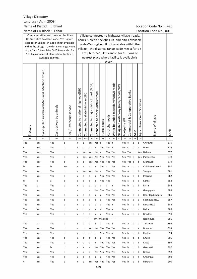
Village DirectoryLand use ( As in 2009 )Name of District : Bhind Location Code No : 420Name of CD Block : Lahar Location Code No : 0016
Trac
tors
Cycl
e-pu
lled
rick
shaw
s(M
anua
l & M
achi
ne d
rive
n)
Cart
s dr
iven
by
anim
als
Sea
/Riv
er fe
rry
serv
ice
Conn
ecte
d to
nat
iona
l hig
hway
(NH
)
Conn
ecte
d to
sta
te h
ighw
ay(S
H)
Conn
ecte
d to
maj
or d
istr
ict r
oad
(MD
R)
Conn
ecte
d to
oth
ers
dist
rict
roa
d
Pucc
a r
oads
Kutc
hcha
roa
ds
Wat
er b
ound
ed m
acad
am(W
BM) r
oads
Nav
igab
le w
ater
way
(riv
er/c
anal
)(N
W)
Foot
path
s (F
P)
Com
mer
cial
& C
o-op
erat
ive
Bank
s
ATM
Agr
icul
tura
l Cre
dit S
ocie
ties
64 65 66 67 68 69 70 71 72 73 74 75 76 77 78 79 2 1
Nam
e of
vill
age
Sr.N
o.
Communication and transport facilities (If amenities available code -Yes is given
except for Village Pin Code ,If not available within the village , the distance range code viz; a for < 5 Kms, b for 5-10 Kms and c for 10+ kms of nearest place where facility is
available is given).
Village connected to highways,village roads, banks & credit societies (If amenities available
code -Yes is given, If not available within the village , the distance range code viz; a for < 5
Kms, b for 5-10 Kms and c for 10+ kms of nearest place where facility is available is
given).
Yes Yes Yes c c c Yes Yes a Yes a Yes c c c Chirawali 875
c Yes Yes c c b b a Yes Yes a Yes c c c Narol 876
Yes Yes Yes c c Yes Yes Yes a Yes Yes Yes Yes c Yes Dabhra 877
Yes Yes Yes c c Yes Yes Yes Yes Yes Yes Yes Yes c Yes Parenchha 878
Yes Yes Yes c c c Yes Yes Yes Yes Yes Yes Yes c b Murawali 879
b Yes b Yes c a a a Yes a Yes Yes a c a Chhibawali No.2 880
Yes Yes Yes c c Yes Yes Yes a Yes Yes Yes a c b Salaiya 881
Yes Yes Yes c c c a a Yes Yes Yes Yes a c b Phardua 882
b c a c c c a a Yes Yes Yes c c a Kanksi 883
Yes b Yes c c c b b a a a Yes b c b Larsa 884
Yes Yes Yes c c c a Yes Yes Yes Yes Yes a c a Gangepura 885
Yes Yes Yes c c c a a a Yes Yes Yes a c a Roor Jagdishpura 886
Yes Yes Yes a c a a a a Yes Yes Yes a c a Shahpura No.2 887
Yes Yes Yes c c c b b a Yes a Yes b b b Rarua No.2 888
Yes Yes Yes c c b a a a Yes a Yes c c c Bidra 889
Yes Yes Yes c c b a a a Yes a Yes a c a Bhaderi 890
--------------Un-inhabited-------------- Naginpura 891
Yes b Yes c c c a a a Yes a Yes a c a Timawali 892
Yes Yes Yes c c c Yes Yes Yes Yes Yes Yes a c a Bhanpar 893
Yes Yes Yes c c b c c Yes Yes a Yes b c b Kurthar 894
Yes Yes Yes c c b c b a Yes Yes Yes c c c Khurd 895
Yes Yes Yes c c c a a Yes Yes Yes Yes b c b Khuja 896
Yes Yes b c c a a Yes Yes Yes Yes Yes b c b Genthari 897
Yes Yes Yes c c a a Yes Yes Yes Yes Yes b c b Belma 898
Yes Yes Yes b c a a a a Yes Yes Yes a c a Chadraua 899
c Yes Yes c c c Yes Yes Yes Yes Yes Yes b c b Barthara 900
439
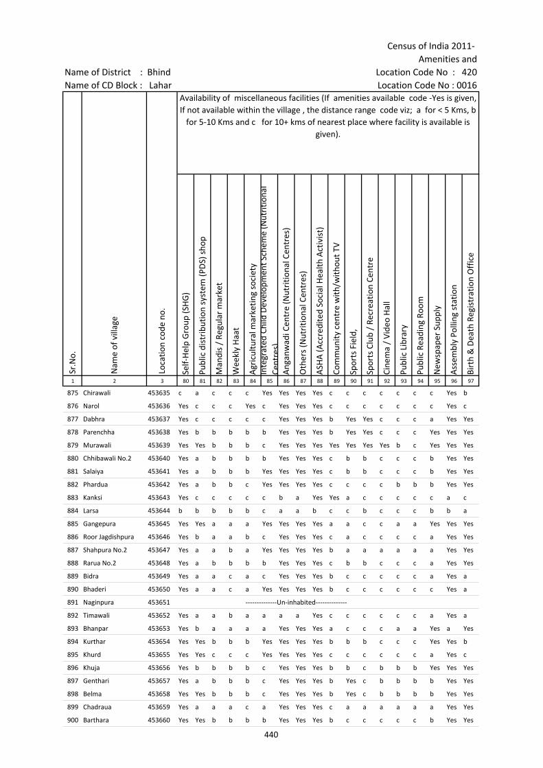
Census of India 2011- Amenities and
Name of District : Bhind Location Code No : 420Name of CD Block : Lahar Location Code No : 0016
Self-
Hel
p G
roup
(SH
G)
Publ
ic d
istr
ibut
ion
syst
em (P
DS)
sho
p
Man
dis
/ Re
gula
r m
arke
t
Wee
kly
Haa
t
Agr
icul
tura
l mar
ketin
g so
ciet
yIn
tegr
ated
Chi
ld D
evel
opm
ent S
chem
e (N
utri
tiona
l Ce
ntre
s)A
ngan
wad
i Cen
tre
(Nut
ritio
nal C
entr
es)
Oth
ers
(Nut
ritio
nal C
entr
es)
ASH
A (A
ccre
dite
d So
cial
Hea
lth A
ctiv
ist)
Com
mun
ity c
entr
e w
ith/w
ithou
t TV
Spor
ts F
ield
,
Spor
ts C
lub
/ Re
crea
tion
Cent
re
Cine
ma
/ Vi
deo
Hal
l
Publ
ic L
ibra
ry
Publ
ic R
eadi
ng R
oom
New
spap
er S
uppl
y
Ass
embl
y Po
lling
sta
tion
Birt
h &
Dea
th R
egis
trat
ion
Off
ice
1 2 3 80 81 82 83 84 85 86 87 88 89 90 91 92 93 94 95 96 97
Sr.N
o.
Nam
e of
vill
age
Loca
tion
code
no.
Availability of miscellaneous facilities (If amenities available code -Yes is given, If not available within the village , the distance range code viz; a for < 5 Kms, b
for 5-10 Kms and c for 10+ kms of nearest place where facility is available is given).
875 Chirawali 453635 c a c c c Yes Yes Yes Yes c c c c c c c Yes b
876 Narol 453636 Yes c c c Yes c Yes Yes Yes c c c c c c c Yes c
877 Dabhra 453637 Yes c c c c c Yes Yes Yes b Yes Yes c c c a Yes Yes
878 Parenchha 453638 Yes b b b b b Yes Yes Yes b Yes Yes c c c Yes Yes Yes
879 Murawali 453639 Yes Yes b b b c Yes Yes Yes Yes Yes Yes Yes b c Yes Yes Yes
880 Chhibawali No.2 453640 Yes a b b b b Yes Yes Yes c b b c c c b Yes Yes
881 Salaiya 453641 Yes a b b b Yes Yes Yes Yes c b b c c c b Yes Yes
882 Phardua 453642 Yes a b b c Yes Yes Yes Yes c c c c b b b Yes Yes
883 Kanksi 453643 Yes c c c c c b a Yes Yes a c c c c c a c
884 Larsa 453644 b b b b b c a a b c c b c c c b b a
885 Gangepura 453645 Yes Yes a a a Yes Yes Yes Yes a a c c a a Yes Yes Yes
886 Roor Jagdishpura 453646 Yes b a a b c Yes Yes Yes c a c c c c a Yes Yes
887 Shahpura No.2 453647 Yes a a b a Yes Yes Yes Yes b a a a a a a Yes Yes
888 Rarua No.2 453648 Yes a b b b b Yes Yes Yes c b b c c c a Yes Yes
889 Bidra 453649 Yes a a c a c Yes Yes Yes b c c c c c a Yes a
890 Bhaderi 453650 Yes a a c a Yes Yes Yes Yes b c c c c c c Yes a
891 Naginpura 453651 --------------Un-inhabited--------------
892 Timawali 453652 Yes a a b a a a a Yes c c c c c c a Yes a
893 Bhanpar 453653 Yes b a a a a Yes Yes Yes a c c c a a Yes a Yes
894 Kurthar 453654 Yes Yes b b b Yes Yes Yes Yes b b b c c c Yes Yes b
895 Khurd 453655 Yes Yes c c c Yes Yes Yes Yes c c c c c c a Yes c
896 Khuja 453656 Yes b b b b c Yes Yes Yes b b c b b b Yes Yes Yes
897 Genthari 453657 Yes a b b b c Yes Yes Yes b Yes c b b b b Yes Yes
898 Belma 453658 Yes Yes b b b c Yes Yes Yes b Yes c b b b b Yes Yes
899 Chadraua 453659 Yes a a a c a Yes Yes Yes c a a a a a a Yes Yes
900 Barthara 453660 Yes Yes b b b b Yes Yes Yes b c c c c c b Yes Yes
440
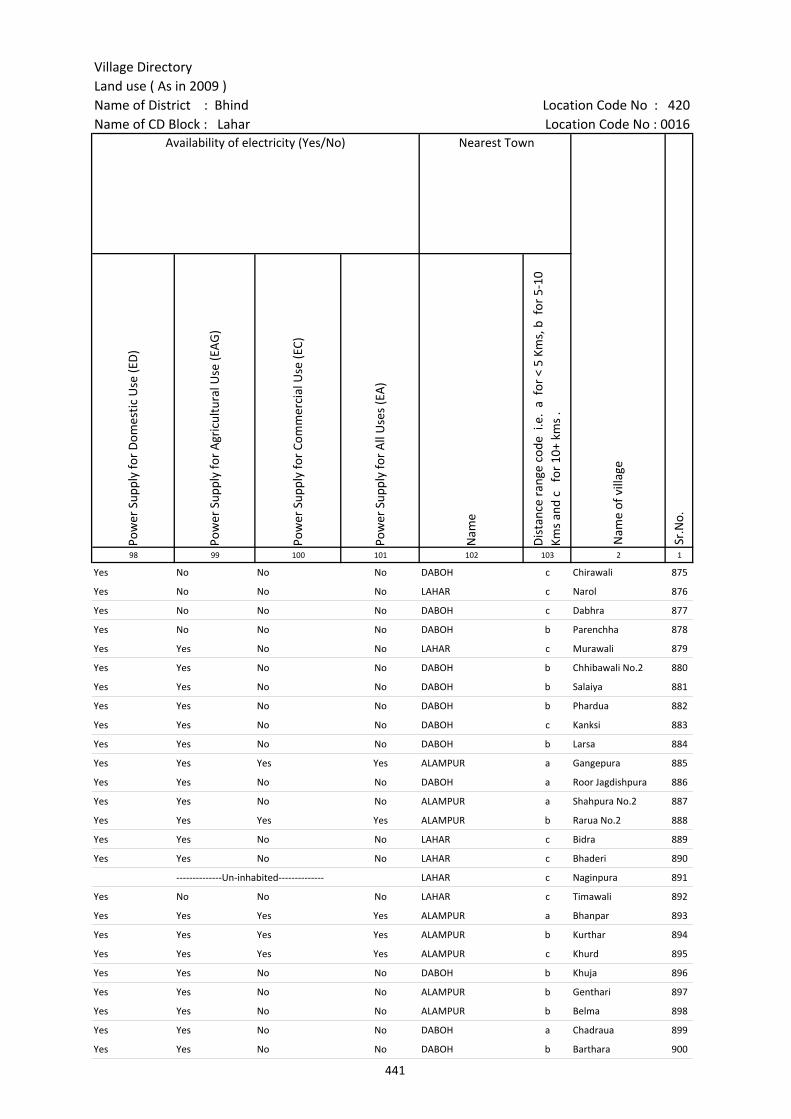
Village DirectoryLand use ( As in 2009 )Name of District : Bhind Location Code No : 420Name of CD Block : Lahar Location Code No : 0016
Pow
er S
uppl
y fo
r D
omes
tic U
se (E
D)
Pow
er S
uppl
y fo
r A
gric
ultu
ral U
se (E
AG
)
Pow
er S
uppl
y fo
r Co
mm
erci
al U
se (E
C)
Pow
er S
uppl
y fo
r A
ll U
ses
(EA
)
Nam
e
Dis
tanc
e ra
nge
code
i.e
. a
for
< 5
Kms,
b f
or 5
-10
Kms
and
c f
or 1
0+ k
ms
.98 99 100 101 102 103 2 1
Availability of electricity (Yes/No) Nearest Town
Nam
e of
vill
age
Sr.N
o.
Yes No No No DABOH c Chirawali 875
Yes No No No LAHAR c Narol 876
Yes No No No DABOH c Dabhra 877
Yes No No No DABOH b Parenchha 878
Yes Yes No No LAHAR c Murawali 879
Yes Yes No No DABOH b Chhibawali No.2 880
Yes Yes No No DABOH b Salaiya 881
Yes Yes No No DABOH b Phardua 882
Yes Yes No No DABOH c Kanksi 883
Yes Yes No No DABOH b Larsa 884
Yes Yes Yes Yes ALAMPUR a Gangepura 885
Yes Yes No No DABOH a Roor Jagdishpura 886
Yes Yes No No ALAMPUR a Shahpura No.2 887
Yes Yes Yes Yes ALAMPUR b Rarua No.2 888
Yes Yes No No LAHAR c Bidra 889
Yes Yes No No LAHAR c Bhaderi 890
--------------Un-inhabited-------------- LAHAR c Naginpura 891
Yes No No No LAHAR c Timawali 892
Yes Yes Yes Yes ALAMPUR a Bhanpar 893
Yes Yes Yes Yes ALAMPUR b Kurthar 894
Yes Yes Yes Yes ALAMPUR c Khurd 895
Yes Yes No No DABOH b Khuja 896
Yes Yes No No ALAMPUR b Genthari 897
Yes Yes No No ALAMPUR b Belma 898
Yes Yes No No DABOH a Chadraua 899
Yes Yes No No DABOH b Barthara 900
441
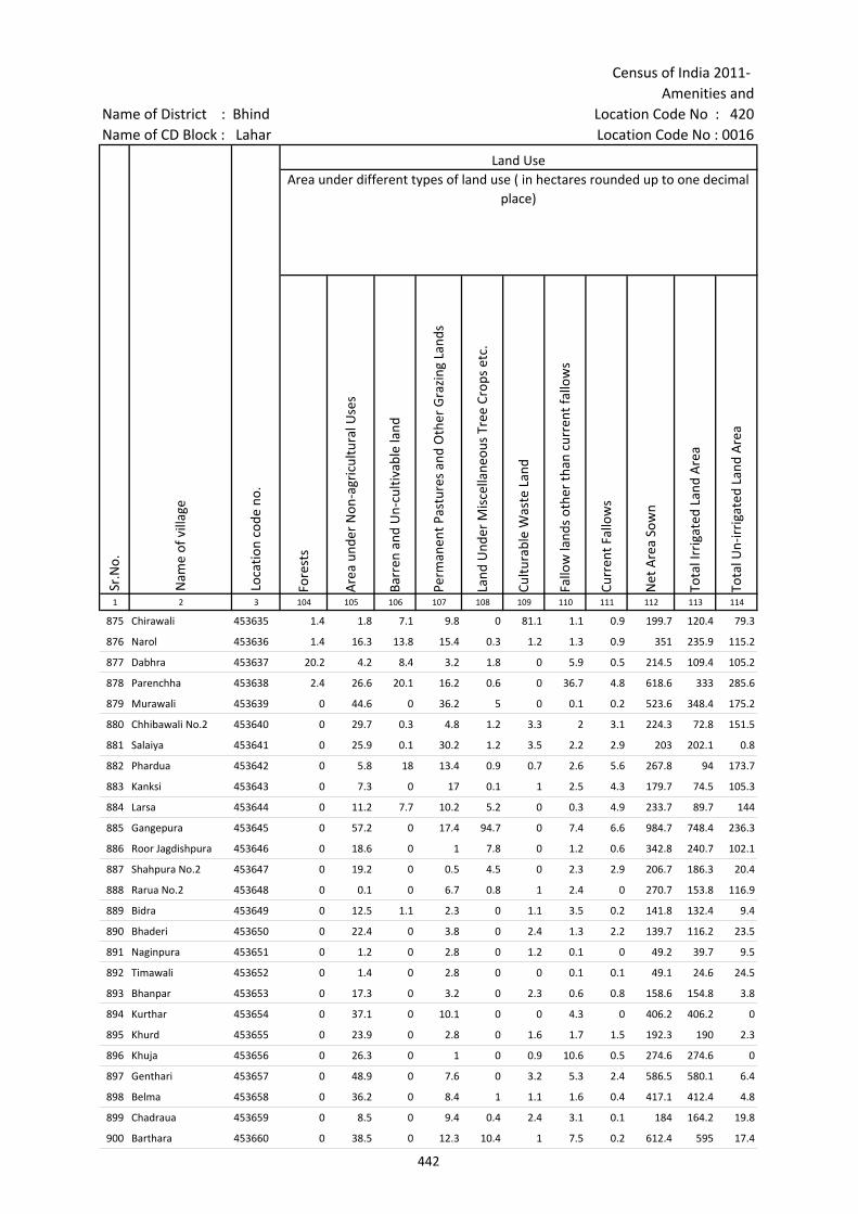
Census of India 2011- Amenities and
Name of District : Bhind Location Code No : 420Name of CD Block : Lahar Location Code No : 0016
Fore
sts
Are
a un
der
Non
-agr
icul
tura
l Use
s
Barr
en a
nd U
n-cu
ltiva
ble
land
Perm
anen
t Pas
ture
s an
d O
ther
Gra
zing
Lan
ds
Land
Und
er M
isce
llane
ous
Tree
Cro
ps e
tc.
Cultu
rabl
e W
aste
Lan
d
Fallo
w la
nds
othe
r th
an c
urre
nt fa
llow
s
Curr
ent F
allo
ws
Net
Are
a So
wn
Tota
l Irr
igat
ed L
and
Are
a
Tota
l Un-
irri
gate
d La
nd A
rea
1 2 3 104 105 106 107 108 109 110 111 112 113 114
Loca
tion
code
no.
Land UseArea under different types of land use ( in hectares rounded up to one decimal
place)
Sr.N
o.
Nam
e of
vill
age
875 Chirawali 453635 1.4 1.8 7.1 9.8 0 81.1 1.1 0.9 199.7 120.4 79.3
876 Narol 453636 1.4 16.3 13.8 15.4 0.3 1.2 1.3 0.9 351 235.9 115.2
877 Dabhra 453637 20.2 4.2 8.4 3.2 1.8 0 5.9 0.5 214.5 109.4 105.2
878 Parenchha 453638 2.4 26.6 20.1 16.2 0.6 0 36.7 4.8 618.6 333 285.6
879 Murawali 453639 0 44.6 0 36.2 5 0 0.1 0.2 523.6 348.4 175.2
880 Chhibawali No.2 453640 0 29.7 0.3 4.8 1.2 3.3 2 3.1 224.3 72.8 151.5
881 Salaiya 453641 0 25.9 0.1 30.2 1.2 3.5 2.2 2.9 203 202.1 0.8
882 Phardua 453642 0 5.8 18 13.4 0.9 0.7 2.6 5.6 267.8 94 173.7
883 Kanksi 453643 0 7.3 0 17 0.1 1 2.5 4.3 179.7 74.5 105.3
884 Larsa 453644 0 11.2 7.7 10.2 5.2 0 0.3 4.9 233.7 89.7 144
885 Gangepura 453645 0 57.2 0 17.4 94.7 0 7.4 6.6 984.7 748.4 236.3
886 Roor Jagdishpura 453646 0 18.6 0 1 7.8 0 1.2 0.6 342.8 240.7 102.1
887 Shahpura No.2 453647 0 19.2 0 0.5 4.5 0 2.3 2.9 206.7 186.3 20.4
888 Rarua No.2 453648 0 0.1 0 6.7 0.8 1 2.4 0 270.7 153.8 116.9
889 Bidra 453649 0 12.5 1.1 2.3 0 1.1 3.5 0.2 141.8 132.4 9.4
890 Bhaderi 453650 0 22.4 0 3.8 0 2.4 1.3 2.2 139.7 116.2 23.5
891 Naginpura 453651 0 1.2 0 2.8 0 1.2 0.1 0 49.2 39.7 9.5
892 Timawali 453652 0 1.4 0 2.8 0 0 0.1 0.1 49.1 24.6 24.5
893 Bhanpar 453653 0 17.3 0 3.2 0 2.3 0.6 0.8 158.6 154.8 3.8
894 Kurthar 453654 0 37.1 0 10.1 0 0 4.3 0 406.2 406.2 0
895 Khurd 453655 0 23.9 0 2.8 0 1.6 1.7 1.5 192.3 190 2.3
896 Khuja 453656 0 26.3 0 1 0 0.9 10.6 0.5 274.6 274.6 0
897 Genthari 453657 0 48.9 0 7.6 0 3.2 5.3 2.4 586.5 580.1 6.4
898 Belma 453658 0 36.2 0 8.4 1 1.1 1.6 0.4 417.1 412.4 4.8
899 Chadraua 453659 0 8.5 0 9.4 0.4 2.4 3.1 0.1 184 164.2 19.8
900 Barthara 453660 0 38.5 0 12.3 10.4 1 7.5 0.2 612.4 595 17.4
442
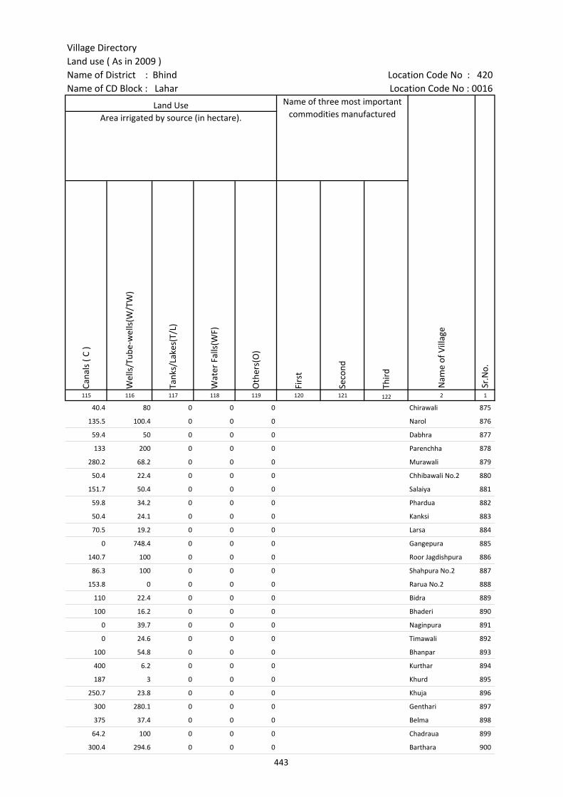
Village DirectoryLand use ( As in 2009 )Name of District : Bhind Location Code No : 420Name of CD Block : Lahar Location Code No : 0016
Cana
ls (
C )
Wel
ls/T
ube-
wel
ls(W
/TW
)
Tank
s/La
kes(
T/L)
Wat
er F
alls
(WF)
Oth
ers(
O)
Firs
t
Seco
nd
Thir
d 115 116 117 118 119 120 121 122 2 1
Land Use Name of three most important commodities manufactured
Nam
e of
Vill
age
Sr.N
o.
Area irrigated by source (in hectare).
40.4 80 0 0 0 Chirawali 875
135.5 100.4 0 0 0 Narol 876
59.4 50 0 0 0 Dabhra 877
133 200 0 0 0 Parenchha 878
280.2 68.2 0 0 0 Murawali 879
50.4 22.4 0 0 0 Chhibawali No.2 880
151.7 50.4 0 0 0 Salaiya 881
59.8 34.2 0 0 0 Phardua 882
50.4 24.1 0 0 0 Kanksi 883
70.5 19.2 0 0 0 Larsa 884
0 748.4 0 0 0 Gangepura 885
140.7 100 0 0 0 Roor Jagdishpura 886
86.3 100 0 0 0 Shahpura No.2 887
153.8 0 0 0 0 Rarua No.2 888
110 22.4 0 0 0 Bidra 889
100 16.2 0 0 0 Bhaderi 890
0 39.7 0 0 0 Naginpura 891
0 24.6 0 0 0 Timawali 892
100 54.8 0 0 0 Bhanpar 893
400 6.2 0 0 0 Kurthar 894
187 3 0 0 0 Khurd 895
250.7 23.8 0 0 0 Khuja 896
300 280.1 0 0 0 Genthari 897
375 37.4 0 0 0 Belma 898
64.2 100 0 0 0 Chadraua 899
300.4 294.6 0 0 0 Barthara 900
443

Census of India 2011- Amenities and
Name of District : Bhind Location Code No : 420Name of CD Block : Lahar Location Code No : 0016
Pre-
Prim
ary
scho
ol (P
P)
Prim
ary
scho
ol (P
)
Mid
dle
scho
ol (M
)
Seco
ndar
y Sc
hool
(S)
Seni
or S
econ
dary
sch
ool (
SS)
Deg
ree
colle
ge o
f art
s s
cien
ce &
com
mer
ce (
ASC
)
Engi
neer
ing
colle
ge(E
C)
Med
ical
col
lege
(MC)
Man
agem
ent i
nstit
ute
(MI)
Poly
tech
nic
(Pt)
Voca
tiona
l tra
inin
g sc
hool
/IT
I
Non
-for
mal
trai
ning
cen
tre
(NFT
C)
Spec
ial s
choo
l for
dis
able
d (S
SD)
Oth
ers
(spe
cify
)
1 2 3 4 5 6 7 8 9 10 11 12 13 14 15 16 17 18 19 20
Sr.N
o.
Nam
e of
vill
age
Loca
tion
code
no.
Tota
l are
a of
the
villa
ge (
in h
ecta
res
roun
ded
up to
one
dec
imal
pla
ce)
Tota
l pop
ulat
ion
( 201
1 ce
nsus
)
Num
ber
of h
ouse
hold
s (2
011
cens
us)
Number of educational amenities available. (If not available within the village , the distance range
code viz; a for < 5 Kms, b for 5-10 Kms and c for 10+ kms of nearest place where facility is available is given).
901 Bhavlhara 453661 264.9 0 0 --------------Un-inhabited--------------
902 Udanpura 453662 89.2 0 0 --------------Un-inhabited--------------
903 Roni 453663 135.5 912 182 b 1 1 b b c c c c c c c c
904 Davini 453664 213.3 670 120 a 1 1 a a c c c c c c
905 Bisanpura 453665 261.9 1401 262 b 2 1 b b c c c c c c
906 Dhanura 453666 134.8 262 51 b 1 a b b c c c c c c c c c
907 Durgapur 453667 179.3 970 213 b 2 1 1 1 b c c c c c c c
908 Bijpur 453668 1671 2425 504 b 1 1 b b c c c c c c c c c
909 Baghedi 453669 255.5 952 168 b 1 1 b b b c c c c c c c c
910 Kunwarpura No 2 453670 410.1 1056 219 a 1 a a a a c c c c c c c c
911 Amaha 453671 397.4 2945 591 a 2 2 a a a c c c c c c c c
912 Singosa 453672 299 658 134 b 1 1 b b c c c c c c c c c
913 Myapur 453673 106.6 0 0 --------------Un-inhabited--------------
914 Ladoli 453674 151.5 0 0 --------------Un-inhabited--------------
915 Gyanpura 453675 505.8 1079 167 2 2 1 1 b c c c c c c c c
916 Itora 453676 198.6 0 0 --------------Un-inhabited--------------
917 Marpura 453677 215.4 770 187 b 1 1 b b c c c c c c c c
918 Dadua 453678 248.5 994 224 b 1 1 b c c c c c c c c c
919 Andhiyari No2 453679 382.4 1493 281 b 2 1 1 b b c c c c c c c
920 Kishunpura 453680 35.6 0 0 --------------Un-inhabited--------------
921 Chhirenta 453681 171.2 0 0 --------------Un-inhabited--------------
922 Peepri 453682 366.9 812 148 b 1 1 a b 1 c c c c c c c c
923 Gadroli 453683 128.3 0 0 --------------Un-inhabited--------------
924 Kasal 453684 395.4 1122 206 b 1 a b b b c c c c c c c
925 Padri Khurd 453685 138.8 237 54 a 1 a a a c c c c c c c c
926 Aadupura 453686 44.3 0 0 --------------Un-inhabited--------------
444
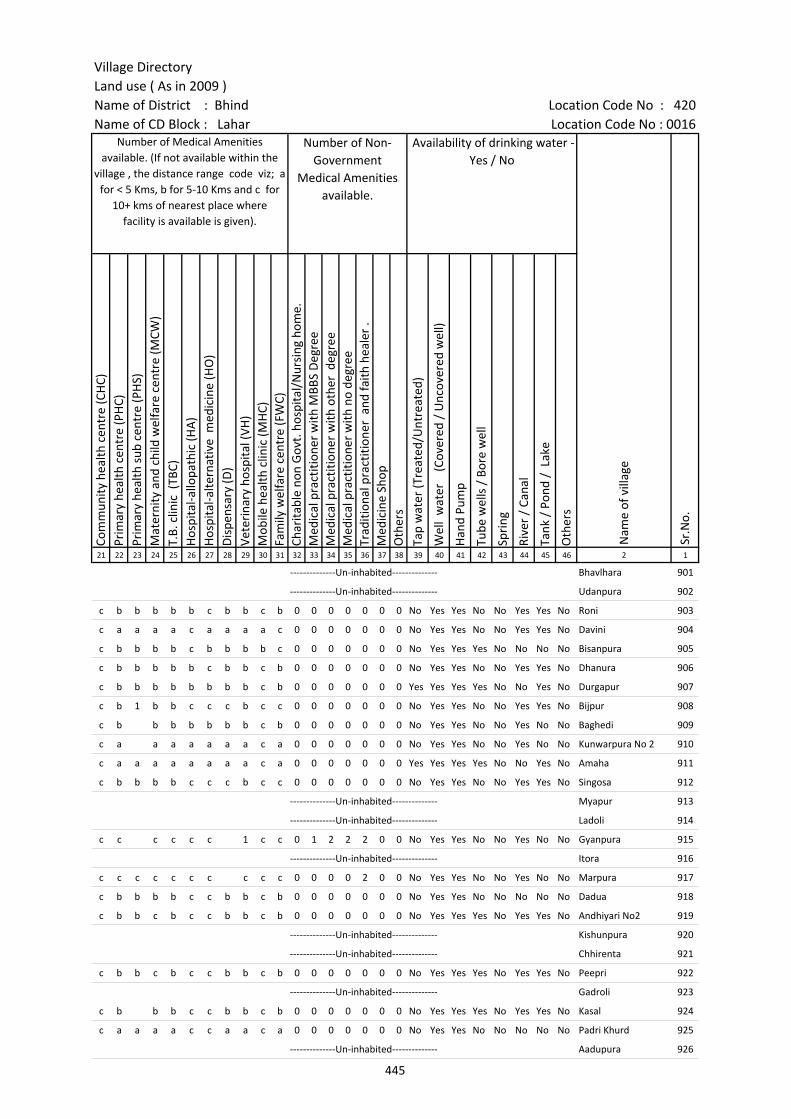
Village DirectoryLand use ( As in 2009 )Name of District : Bhind Location Code No : 420Name of CD Block : Lahar Location Code No : 0016
Com
mun
ity h
ealth
cen
tre
(CH
C)Pr
imar
y he
alth
cen
tre
(PH
C)Pr
imar
y he
alth
sub
cen
tre
(PH
S)M
ater
nity
and
chi
ld w
elfa
re c
entr
e (M
CW)
T.B.
clin
ic (
TBC)
Hos
pita
l-allo
path
ic (H
A)
Hos
pita
l-alte
rnat
ive
med
icin
e (H
O)
Dis
pens
ary
(D)
Vete
rina
ry h
ospi
tal (
VH)
Mob
ile h
ealth
clin
ic (M
HC)
Fam
ily w
elfa
re c
entr
e (F
WC)
Char
itabl
e no
n G
ovt.
hos
pita
l/N
ursi
ng h
ome.
Med
ical
pra
ctiti
oner
with
MBB
S D
egre
eM
edic
al p
ract
ition
er w
ith o
ther
deg
ree
Med
ical
pra
ctiti
oner
with
no
degr
eeTr
aditi
onal
pra
ctiti
oner
and
faith
hea
ler
.M
edic
ine
Shop
Oth
ers
Tap
wat
er (T
reat
ed/U
ntre
ated
)
Wel
l w
ater
(C
over
ed /
Unc
over
ed w
ell)
Han
d Pu
mp
Tube
wel
ls /
Bor
e w
ell
Spri
ng
Rive
r /
Cana
l
Tank
/ P
ond
/ L
ake
Oth
ers
21 22 23 24 25 26 27 28 29 30 31 32 33 34 35 36 37 38 39 40 41 42 43 44 45 46 2 1
Number of Medical Amenities available. (If not available within the
village , the distance range code viz; a for < 5 Kms, b for 5-10 Kms and c for
10+ kms of nearest place where facility is available is given).
Number of Non-Government
Medical Amenities available.
Availability of drinking water - Yes / No
Nam
e of
vill
age
Sr.N
o.
--------------Un-inhabited-------------- Bhavlhara 901
--------------Un-inhabited-------------- Udanpura 902
c b b b b b c b b c b 0 0 0 0 0 0 0 No Yes Yes No No Yes Yes No Roni 903
c a a a a c a a a a c 0 0 0 0 0 0 0 No Yes Yes No No Yes Yes No Davini 904
c b b b b c b b b b c 0 0 0 0 0 0 0 No Yes Yes Yes No No No No Bisanpura 905
c b b b b b c b b c b 0 0 0 0 0 0 0 No Yes Yes No No Yes Yes No Dhanura 906
c b b b b b b b b c b 0 0 0 0 0 0 0 Yes Yes Yes Yes No No Yes No Durgapur 907
c b 1 b b c c c b c c 0 0 0 0 0 0 0 No Yes Yes No No Yes Yes No Bijpur 908
c b b b b b b b c b 0 0 0 0 0 0 0 No Yes Yes No No Yes No No Baghedi 909
c a a a a a a a c a 0 0 0 0 0 0 0 No Yes Yes No No Yes No No Kunwarpura No 2 910
c a a a a a a a a c a 0 0 0 0 0 0 0 Yes Yes Yes Yes No No Yes No Amaha 911
c b b b b c c c b c c 0 0 0 0 0 0 0 No Yes Yes No No Yes Yes No Singosa 912
--------------Un-inhabited-------------- Myapur 913
--------------Un-inhabited-------------- Ladoli 914
c c c c c c 1 c c 0 1 2 2 2 0 0 No Yes Yes No No Yes No No Gyanpura 915
--------------Un-inhabited-------------- Itora 916
c c c c c c c c c c 0 0 0 0 2 0 0 No Yes Yes No No Yes No No Marpura 917
c b b b b c c b b c b 0 0 0 0 0 0 0 No Yes Yes No No No No No Dadua 918
c b b c b c c b b c b 0 0 0 0 0 0 0 No Yes Yes Yes No Yes Yes No Andhiyari No2 919
--------------Un-inhabited-------------- Kishunpura 920
--------------Un-inhabited-------------- Chhirenta 921
c b b c b c c b b c b 0 0 0 0 0 0 0 No Yes Yes Yes No Yes Yes No Peepri 922
--------------Un-inhabited-------------- Gadroli 923
c b b b c c b b c b 0 0 0 0 0 0 0 No Yes Yes Yes No Yes Yes No Kasal 924
c a a a a c c a a c a 0 0 0 0 0 0 0 No Yes Yes No No No No No Padri Khurd 925
--------------Un-inhabited-------------- Aadupura 926
445

Census of India 2011- Amenities and
Name of District : Bhind Location Code No : 420Name of CD Block : Lahar Location Code No : 0016
Com
mun
ity to
ilet i
nclu
ding
bat
h.
Com
mun
ity to
ilet e
xclu
ding
bat
h.
Rura
l sa
nita
ry m
art o
r sa
nita
ry h
ardw
are
outle
t av
aila
ble
near
the
villa
ge.
Com
mun
ity b
io- g
as o
r re
cycl
e of
was
te fo
r pr
oduc
tive
use.
Post
off
ice(
PO)
Sub
post
off
ice
(SPO
)
Post
& T
eleg
raph
off
ice
(P&
TO)
Villa
ge P
in C
ode
Tele
phon
es
(L
and
lines
)
Publ
ic c
all o
ffic
e (P
CO)
Mob
ile p
hone
cov
erag
e
Inte
rnet
caf
es/
Com
mon
ser
vice
cen
tre
(CSC
)
Priv
ate
cour
ier
faci
lity
Bus
serv
ice
(Pub
lic &
Pri
vate
)
Railw
ay s
tatio
ns
Aut
o/M
odifi
ed A
utos
Taxi
s an
d Va
ns
1 2 3 47 48 49 50 51 52 53 54 55 56 57 58 59 60 61 62 63
Nam
e of
vill
age
Loca
tion
code
no.
Availability of toilet & others Yes / No
Communication and transport facilities (If amenities available code -Yes is given except for Village Pin Code ,If not available within the village , the distance range code
viz; a for < 5 Kms, b for 5-10 Kms and c for 10+ kms of nearest place where facility is available is given).
Sr.N
o.
901 Bhavlhara 453661 --------------Un-inhabited--------------
902 Udanpura 453662 --------------Un-inhabited--------------
903 Roni 453663 No No No No c b c b a Yes c c Yes c a b
904 Davini 453664 No No No No c a a a a a a a a c a a
905 Bisanpura 453665 No No No No c b b b b Yes b b Yes c b b
906 Dhanura 453666 No No No No c b c b b Yes c c Yes c b b
907 Durgapur 453667 No No No No c Yes b Yes b Yes b b b c b b
908 Bijpur 453668 No No No No b Yes b 477447 Yes b Yes b c b c b b
909 Baghedi 453669 No No No No c b b b b Yes b b b c b b
910 Kunwarpura No 2 453670 No No No No c a a a a Yes a a a c a a
911 Amaha 453671 No No No No c Yes a Yes a Yes a a a c a a
912 Singosa 453672 No No No No b Yes b Yes b Yes b c b c b b
913 Myapur 453673 --------------Un-inhabited--------------
914 Ladoli 453674 --------------Un-inhabited--------------
915 Gyanpura 453675 No No No No b a a a c b b b b c c c
916 Itora 453676 --------------Un-inhabited--------------
917 Marpura 453677 No No No No b a a b c b b b b c c c
918 Dadua 453678 No No No No c c c Yes b b b c b c b b
919 Andhiyari No2 453679 No No No No c b b b b Yes b b Yes c b b
920 Kishunpura 453680 --------------Un-inhabited--------------
921 Chhirenta 453681 --------------Un-inhabited--------------
922 Peepri 453682 No No No No c b b Yes b Yes b b a c b b
923 Gadroli 453683 --------------Un-inhabited--------------
924 Kasal 453684 No No No No c b b b b Yes b c Yes c b b
925 Padri Khurd 453685 No No No No c c c a a Yes a c a c a a
926 Aadupura 453686 --------------Un-inhabited--------------
446
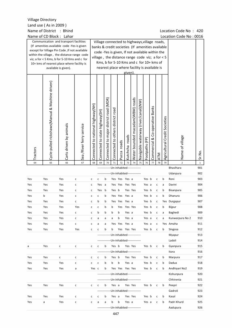
Village DirectoryLand use ( As in 2009 )Name of District : Bhind Location Code No : 420Name of CD Block : Lahar Location Code No : 0016
Trac
tors
Cycl
e-pu
lled
rick
shaw
s(M
anua
l & M
achi
ne d
rive
n)
Cart
s dr
iven
by
anim
als
Sea
/Riv
er fe
rry
serv
ice
Conn
ecte
d to
nat
iona
l hig
hway
(NH
)
Conn
ecte
d to
sta
te h
ighw
ay(S
H)
Conn
ecte
d to
maj
or d
istr
ict r
oad
(MD
R)
Conn
ecte
d to
oth
ers
dist
rict
roa
d
Pucc
a r
oads
Kutc
hcha
roa
ds
Wat
er b
ound
ed m
acad
am(W
BM) r
oads
Nav
igab
le w
ater
way
(riv
er/c
anal
)(N
W)
Foot
path
s (F
P)
Com
mer
cial
& C
o-op
erat
ive
Bank
s
ATM
Agr
icul
tura
l Cre
dit S
ocie
ties
64 65 66 67 68 69 70 71 72 73 74 75 76 77 78 79 2 1
Nam
e of
vill
age
Sr.N
o.
Communication and transport facilities (If amenities available code -Yes is given
except for Village Pin Code ,If not available within the village , the distance range code viz; a for < 5 Kms, b for 5-10 Kms and c for 10+ kms of nearest place where facility is
available is given).
Village connected to highways,village roads, banks & credit societies (If amenities available
code -Yes is given, If not available within the village , the distance range code viz; a for < 5
Kms, b for 5-10 Kms and c for 10+ kms of nearest place where facility is available is
given).
--------------Un-inhabited-------------- Bhavlhara 901
--------------Un-inhabited-------------- Udanpura 902
Yes Yes Yes c c c b Yes Yes Yes a Yes b c b Roni 903
Yes Yes Yes c c Yes a Yes Yes Yes Yes Yes a c a Davini 904
Yes Yes Yes c c Yes b Yes b Yes Yes Yes b c b Bisanpura 905
Yes b Yes c c c b Yes Yes Yes a Yes b c b Dhanura 906
Yes Yes Yes c c b b Yes Yes Yes a Yes b c Yes Durgapur 907
Yes Yes Yes Yes c c b b Yes Yes Yes Yes b c b Bijpur 908
Yes Yes Yes c c b b b b Yes a Yes b c a Baghedi 909
Yes Yes Yes c c a a a b Yes a Yes a c a Kunwarpura No 2 910
Yes Yes Yes c c a a Yes Yes Yes a Yes a c Yes Amaha 911
Yes Yes Yes Yes c c b b Yes Yes Yes Yes b c b Singosa 912
--------------Un-inhabited-------------- Myapur 913
--------------Un-inhabited-------------- Ladoli 914
a Yes c c c c b Yes b Yes Yes Yes b c b Gyanpura 915
--------------Un-inhabited-------------- Itora 916
Yes Yes c c c c b Yes b Yes Yes Yes b c b Marpura 917
Yes Yes Yes c c c b b b Yes a Yes b c b Dadua 918
Yes Yes Yes a Yes c b Yes Yes Yes Yes Yes b c b Andhiyari No2 919
--------------Un-inhabited-------------- Kishunpura 920
--------------Un-inhabited-------------- Chhirenta 921
Yes Yes Yes c c c b Yes a Yes Yes Yes b c b Peepri 922
--------------Un-inhabited-------------- Gadroli 923
Yes Yes Yes c c c b Yes a Yes Yes Yes b c b Kasal 924
Yes a Yes c c a a b b Yes a Yes a c b Padri Khurd 925
--------------Un-inhabited-------------- Aadupura 926
447
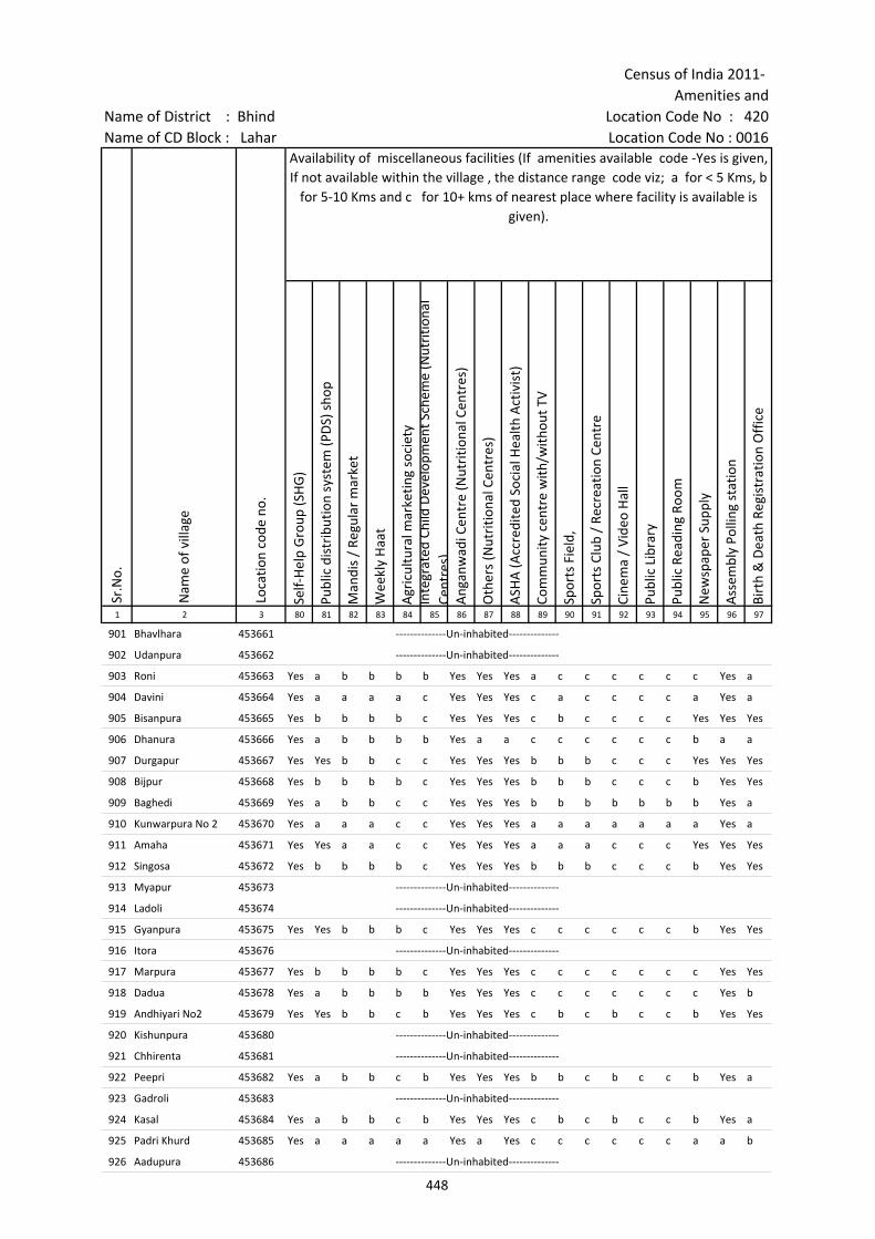
Census of India 2011- Amenities and
Name of District : Bhind Location Code No : 420Name of CD Block : Lahar Location Code No : 0016
Self-
Hel
p G
roup
(SH
G)
Publ
ic d
istr
ibut
ion
syst
em (P
DS)
sho
p
Man
dis
/ Re
gula
r m
arke
t
Wee
kly
Haa
t
Agr
icul
tura
l mar
ketin
g so
ciet
yIn
tegr
ated
Chi
ld D
evel
opm
ent S
chem
e (N
utri
tiona
l Ce
ntre
s)A
ngan
wad
i Cen
tre
(Nut
ritio
nal C
entr
es)
Oth
ers
(Nut
ritio
nal C
entr
es)
ASH
A (A
ccre
dite
d So
cial
Hea
lth A
ctiv
ist)
Com
mun
ity c
entr
e w
ith/w
ithou
t TV
Spor
ts F
ield
,
Spor
ts C
lub
/ Re
crea
tion
Cent
re
Cine
ma
/ Vi
deo
Hal
l
Publ
ic L
ibra
ry
Publ
ic R
eadi
ng R
oom
New
spap
er S
uppl
y
Ass
embl
y Po
lling
sta
tion
Birt
h &
Dea
th R
egis
trat
ion
Off
ice
1 2 3 80 81 82 83 84 85 86 87 88 89 90 91 92 93 94 95 96 97
Sr.N
o.
Nam
e of
vill
age
Loca
tion
code
no.
Availability of miscellaneous facilities (If amenities available code -Yes is given, If not available within the village , the distance range code viz; a for < 5 Kms, b
for 5-10 Kms and c for 10+ kms of nearest place where facility is available is given).
901 Bhavlhara 453661 --------------Un-inhabited--------------
902 Udanpura 453662 --------------Un-inhabited--------------
903 Roni 453663 Yes a b b b b Yes Yes Yes a c c c c c c Yes a
904 Davini 453664 Yes a a a a c Yes Yes Yes c a c c c c a Yes a
905 Bisanpura 453665 Yes b b b b c Yes Yes Yes c b c c c c Yes Yes Yes
906 Dhanura 453666 Yes a b b b b Yes a a c c c c c c b a a
907 Durgapur 453667 Yes Yes b b c c Yes Yes Yes b b b c c c Yes Yes Yes
908 Bijpur 453668 Yes b b b b c Yes Yes Yes b b b c c c b Yes Yes
909 Baghedi 453669 Yes a b b c c Yes Yes Yes b b b b b b b Yes a
910 Kunwarpura No 2 453670 Yes a a a c c Yes Yes Yes a a a a a a a Yes a
911 Amaha 453671 Yes Yes a a c c Yes Yes Yes a a a c c c Yes Yes Yes
912 Singosa 453672 Yes b b b b c Yes Yes Yes b b b c c c b Yes Yes
913 Myapur 453673 --------------Un-inhabited--------------
914 Ladoli 453674 --------------Un-inhabited--------------
915 Gyanpura 453675 Yes Yes b b b c Yes Yes Yes c c c c c c b Yes Yes
916 Itora 453676 --------------Un-inhabited--------------
917 Marpura 453677 Yes b b b b c Yes Yes Yes c c c c c c c Yes Yes
918 Dadua 453678 Yes a b b b b Yes Yes Yes c c c c c c c Yes b
919 Andhiyari No2 453679 Yes Yes b b c b Yes Yes Yes c b c b c c b Yes Yes
920 Kishunpura 453680 --------------Un-inhabited--------------
921 Chhirenta 453681 --------------Un-inhabited--------------
922 Peepri 453682 Yes a b b c b Yes Yes Yes b b c b c c b Yes a
923 Gadroli 453683 --------------Un-inhabited--------------
924 Kasal 453684 Yes a b b c b Yes Yes Yes c b c b c c b Yes a
925 Padri Khurd 453685 Yes a a a a a Yes a Yes c c c c c c a a b
926 Aadupura 453686 --------------Un-inhabited--------------
448
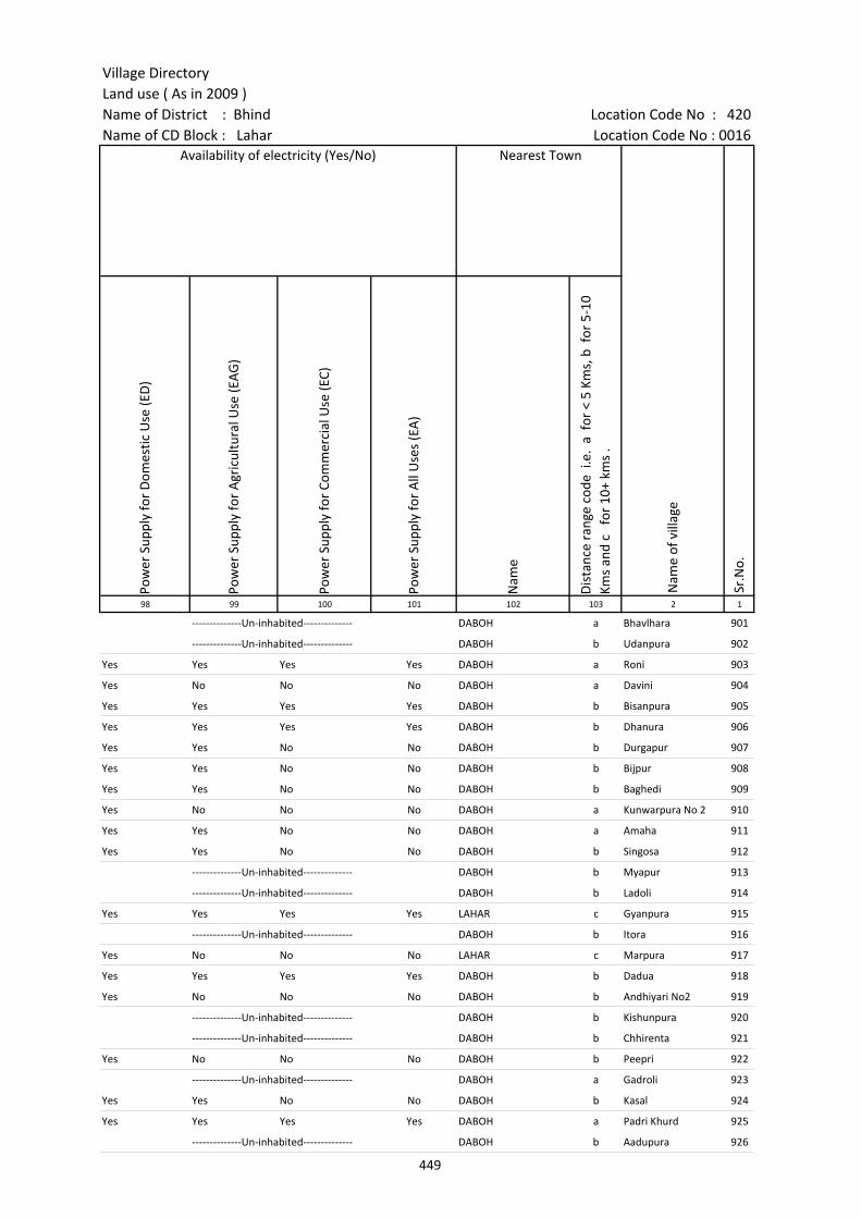
Village DirectoryLand use ( As in 2009 )Name of District : Bhind Location Code No : 420Name of CD Block : Lahar Location Code No : 0016
Pow
er S
uppl
y fo
r D
omes
tic U
se (E
D)
Pow
er S
uppl
y fo
r A
gric
ultu
ral U
se (E
AG
)
Pow
er S
uppl
y fo
r Co
mm
erci
al U
se (E
C)
Pow
er S
uppl
y fo
r A
ll U
ses
(EA
)
Nam
e
Dis
tanc
e ra
nge
code
i.e
. a
for
< 5
Kms,
b f
or 5
-10
Kms
and
c f
or 1
0+ k
ms
.98 99 100 101 102 103 2 1
Availability of electricity (Yes/No) Nearest Town
Nam
e of
vill
age
Sr.N
o.
--------------Un-inhabited-------------- DABOH a Bhavlhara 901
--------------Un-inhabited-------------- DABOH b Udanpura 902
Yes Yes Yes Yes DABOH a Roni 903
Yes No No No DABOH a Davini 904
Yes Yes Yes Yes DABOH b Bisanpura 905
Yes Yes Yes Yes DABOH b Dhanura 906
Yes Yes No No DABOH b Durgapur 907
Yes Yes No No DABOH b Bijpur 908
Yes Yes No No DABOH b Baghedi 909
Yes No No No DABOH a Kunwarpura No 2 910
Yes Yes No No DABOH a Amaha 911
Yes Yes No No DABOH b Singosa 912
--------------Un-inhabited-------------- DABOH b Myapur 913
--------------Un-inhabited-------------- DABOH b Ladoli 914
Yes Yes Yes Yes LAHAR c Gyanpura 915
--------------Un-inhabited-------------- DABOH b Itora 916
Yes No No No LAHAR c Marpura 917
Yes Yes Yes Yes DABOH b Dadua 918
Yes No No No DABOH b Andhiyari No2 919
--------------Un-inhabited-------------- DABOH b Kishunpura 920
--------------Un-inhabited-------------- DABOH b Chhirenta 921
Yes No No No DABOH b Peepri 922
--------------Un-inhabited-------------- DABOH a Gadroli 923
Yes Yes No No DABOH b Kasal 924
Yes Yes Yes Yes DABOH a Padri Khurd 925
--------------Un-inhabited-------------- DABOH b Aadupura 926
449
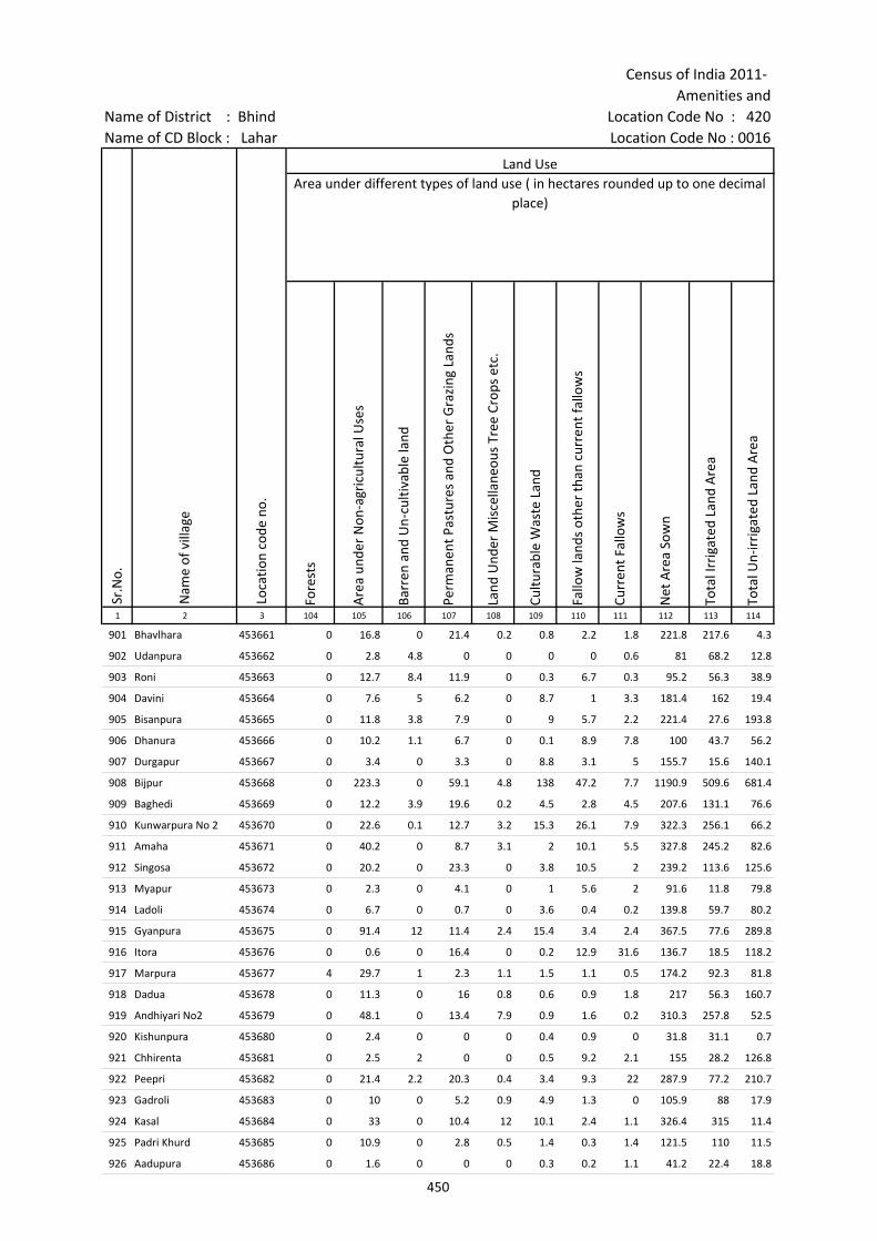
Census of India 2011- Amenities and
Name of District : Bhind Location Code No : 420Name of CD Block : Lahar Location Code No : 0016
Fore
sts
Are
a un
der
Non
-agr
icul
tura
l Use
s
Barr
en a
nd U
n-cu
ltiva
ble
land
Perm
anen
t Pas
ture
s an
d O
ther
Gra
zing
Lan
ds
Land
Und
er M
isce
llane
ous
Tree
Cro
ps e
tc.
Cultu
rabl
e W
aste
Lan
d
Fallo
w la
nds
othe
r th
an c
urre
nt fa
llow
s
Curr
ent F
allo
ws
Net
Are
a So
wn
Tota
l Irr
igat
ed L
and
Are
a
Tota
l Un-
irri
gate
d La
nd A
rea
1 2 3 104 105 106 107 108 109 110 111 112 113 114
Loca
tion
code
no.
Land UseArea under different types of land use ( in hectares rounded up to one decimal
place)
Sr.N
o.
Nam
e of
vill
age
901 Bhavlhara 453661 0 16.8 0 21.4 0.2 0.8 2.2 1.8 221.8 217.6 4.3
902 Udanpura 453662 0 2.8 4.8 0 0 0 0 0.6 81 68.2 12.8
903 Roni 453663 0 12.7 8.4 11.9 0 0.3 6.7 0.3 95.2 56.3 38.9
904 Davini 453664 0 7.6 5 6.2 0 8.7 1 3.3 181.4 162 19.4
905 Bisanpura 453665 0 11.8 3.8 7.9 0 9 5.7 2.2 221.4 27.6 193.8
906 Dhanura 453666 0 10.2 1.1 6.7 0 0.1 8.9 7.8 100 43.7 56.2
907 Durgapur 453667 0 3.4 0 3.3 0 8.8 3.1 5 155.7 15.6 140.1
908 Bijpur 453668 0 223.3 0 59.1 4.8 138 47.2 7.7 1190.9 509.6 681.4
909 Baghedi 453669 0 12.2 3.9 19.6 0.2 4.5 2.8 4.5 207.6 131.1 76.6
910 Kunwarpura No 2 453670 0 22.6 0.1 12.7 3.2 15.3 26.1 7.9 322.3 256.1 66.2
911 Amaha 453671 0 40.2 0 8.7 3.1 2 10.1 5.5 327.8 245.2 82.6
912 Singosa 453672 0 20.2 0 23.3 0 3.8 10.5 2 239.2 113.6 125.6
913 Myapur 453673 0 2.3 0 4.1 0 1 5.6 2 91.6 11.8 79.8
914 Ladoli 453674 0 6.7 0 0.7 0 3.6 0.4 0.2 139.8 59.7 80.2
915 Gyanpura 453675 0 91.4 12 11.4 2.4 15.4 3.4 2.4 367.5 77.6 289.8
916 Itora 453676 0 0.6 0 16.4 0 0.2 12.9 31.6 136.7 18.5 118.2
917 Marpura 453677 4 29.7 1 2.3 1.1 1.5 1.1 0.5 174.2 92.3 81.8
918 Dadua 453678 0 11.3 0 16 0.8 0.6 0.9 1.8 217 56.3 160.7
919 Andhiyari No2 453679 0 48.1 0 13.4 7.9 0.9 1.6 0.2 310.3 257.8 52.5
920 Kishunpura 453680 0 2.4 0 0 0 0.4 0.9 0 31.8 31.1 0.7
921 Chhirenta 453681 0 2.5 2 0 0 0.5 9.2 2.1 155 28.2 126.8
922 Peepri 453682 0 21.4 2.2 20.3 0.4 3.4 9.3 22 287.9 77.2 210.7
923 Gadroli 453683 0 10 0 5.2 0.9 4.9 1.3 0 105.9 88 17.9
924 Kasal 453684 0 33 0 10.4 12 10.1 2.4 1.1 326.4 315 11.4
925 Padri Khurd 453685 0 10.9 0 2.8 0.5 1.4 0.3 1.4 121.5 110 11.5
926 Aadupura 453686 0 1.6 0 0 0 0.3 0.2 1.1 41.2 22.4 18.8
450
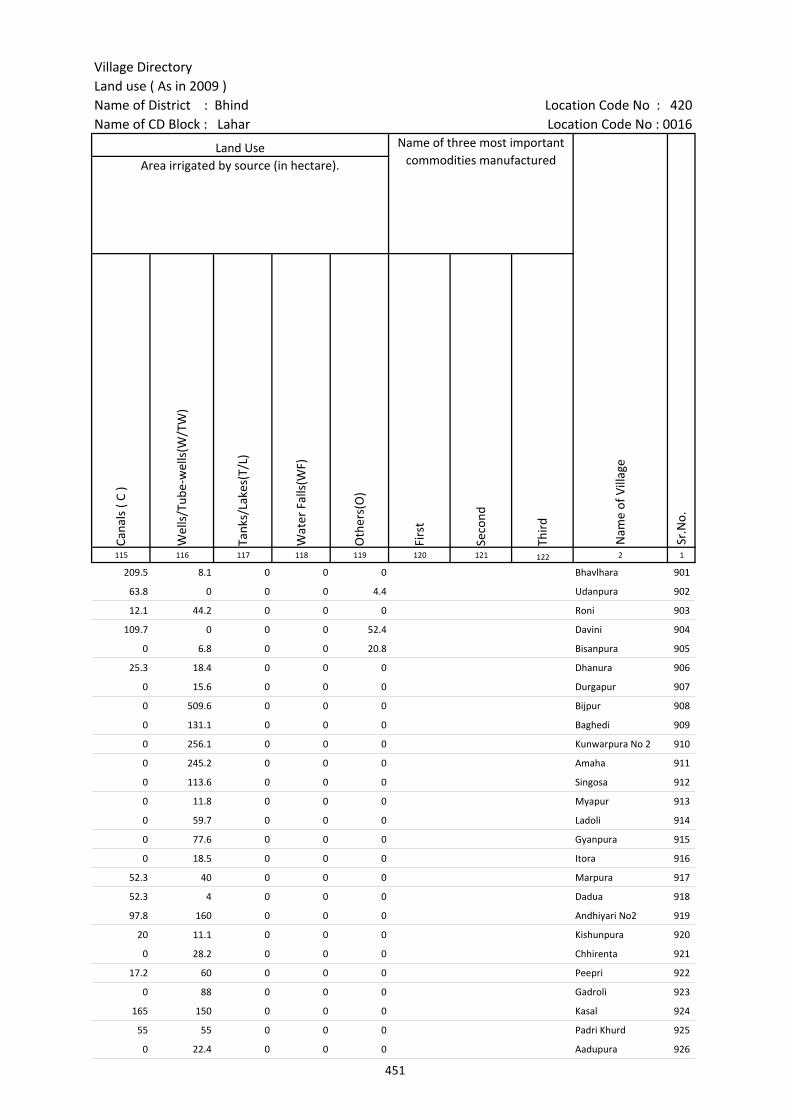
Village DirectoryLand use ( As in 2009 )Name of District : Bhind Location Code No : 420Name of CD Block : Lahar Location Code No : 0016
Cana
ls (
C )
Wel
ls/T
ube-
wel
ls(W
/TW
)
Tank
s/La
kes(
T/L)
Wat
er F
alls
(WF)
Oth
ers(
O)
Firs
t
Seco
nd
Thir
d 115 116 117 118 119 120 121 122 2 1
Land Use Name of three most important commodities manufactured
Nam
e of
Vill
age
Sr.N
o.
Area irrigated by source (in hectare).
209.5 8.1 0 0 0 Bhavlhara 901
63.8 0 0 0 4.4 Udanpura 902
12.1 44.2 0 0 0 Roni 903
109.7 0 0 0 52.4 Davini 904
0 6.8 0 0 20.8 Bisanpura 905
25.3 18.4 0 0 0 Dhanura 906
0 15.6 0 0 0 Durgapur 907
0 509.6 0 0 0 Bijpur 908
0 131.1 0 0 0 Baghedi 909
0 256.1 0 0 0 Kunwarpura No 2 910
0 245.2 0 0 0 Amaha 911
0 113.6 0 0 0 Singosa 912
0 11.8 0 0 0 Myapur 913
0 59.7 0 0 0 Ladoli 914
0 77.6 0 0 0 Gyanpura 915
0 18.5 0 0 0 Itora 916
52.3 40 0 0 0 Marpura 917
52.3 4 0 0 0 Dadua 918
97.8 160 0 0 0 Andhiyari No2 919
20 11.1 0 0 0 Kishunpura 920
0 28.2 0 0 0 Chhirenta 921
17.2 60 0 0 0 Peepri 922
0 88 0 0 0 Gadroli 923
165 150 0 0 0 Kasal 924
55 55 0 0 0 Padri Khurd 925
0 22.4 0 0 0 Aadupura 926
451
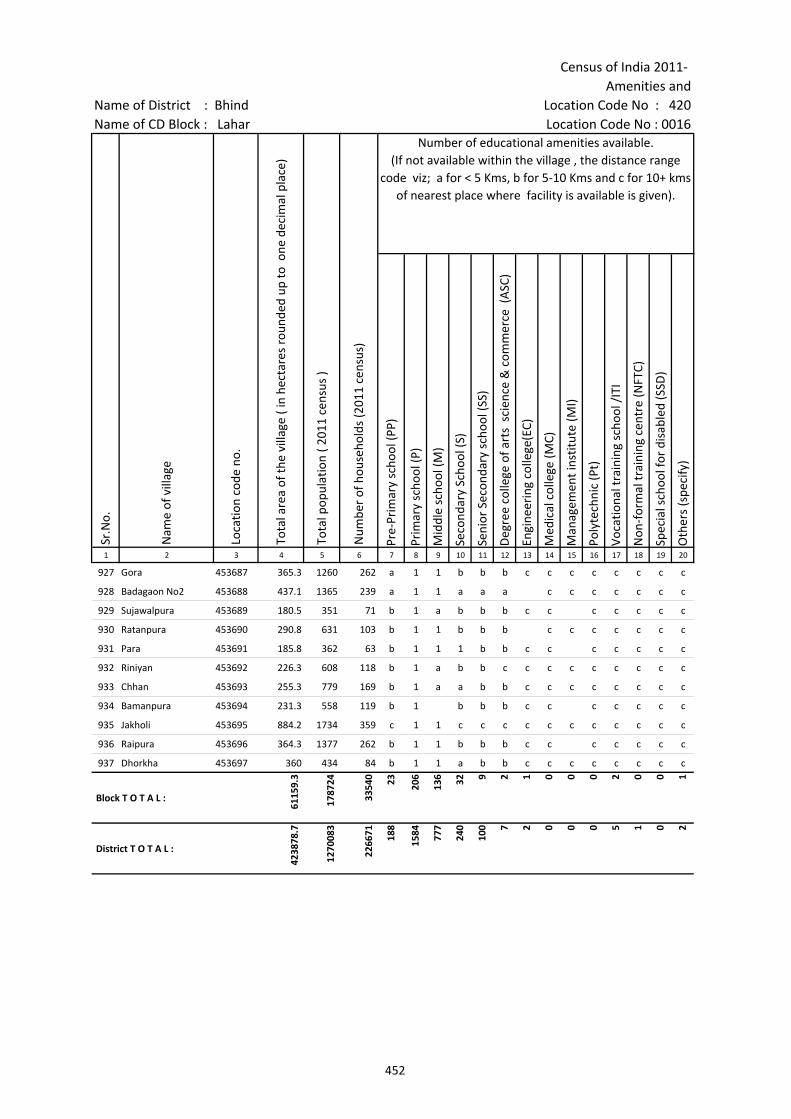
Census of India 2011- Amenities and
Name of District : Bhind Location Code No : 420Name of CD Block : Lahar Location Code No : 0016
Pre-
Prim
ary
scho
ol (P
P)
Prim
ary
scho
ol (P
)
Mid
dle
scho
ol (M
)
Seco
ndar
y Sc
hool
(S)
Seni
or S
econ
dary
sch
ool (
SS)
Deg
ree
colle
ge o
f art
s s
cien
ce &
com
mer
ce (
ASC
)
Engi
neer
ing
colle
ge(E
C)
Med
ical
col
lege
(MC)
Man
agem
ent i
nstit
ute
(MI)
Poly
tech
nic
(Pt)
Voca
tiona
l tra
inin
g sc
hool
/IT
I
Non
-for
mal
trai
ning
cen
tre
(NFT
C)
Spec
ial s
choo
l for
dis
able
d (S
SD)
Oth
ers
(spe
cify
)
1 2 3 4 5 6 7 8 9 10 11 12 13 14 15 16 17 18 19 20
Sr.N
o.
Nam
e of
vill
age
Loca
tion
code
no.
Tota
l are
a of
the
villa
ge (
in h
ecta
res
roun
ded
up to
one
dec
imal
pla
ce)
Tota
l pop
ulat
ion
( 201
1 ce
nsus
)
Num
ber
of h
ouse
hold
s (2
011
cens
us)
Number of educational amenities available. (If not available within the village , the distance range
code viz; a for < 5 Kms, b for 5-10 Kms and c for 10+ kms of nearest place where facility is available is given).
927 Gora 453687 365.3 1260 262 a 1 1 b b b c c c c c c c c
928 Badagaon No2 453688 437.1 1365 239 a 1 1 a a a c c c c c c c
929 Sujawalpura 453689 180.5 351 71 b 1 a b b b c c c c c c c
930 Ratanpura 453690 290.8 631 103 b 1 1 b b b c c c c c c c
931 Para 453691 185.8 362 63 b 1 1 1 b b c c c c c c c
932 Riniyan 453692 226.3 608 118 b 1 a b b c c c c c c c c c
933 Chhan 453693 255.3 779 169 b 1 a a b b c c c c c c c c
934 Bamanpura 453694 231.3 558 119 b 1 b b b c c c c c c c
935 Jakholi 453695 884.2 1734 359 c 1 1 c c c c c c c c c c c
936 Raipura 453696 364.3 1377 262 b 1 1 b b b c c c c c c c
937 Dhorkha 453697 360 434 84 b 1 1 a b b c c c c c c c c
Block T O T A L :
6115
9.3
1787
24
3354
0 23 206
136 32 9 2 1 0 0 0 2 0 0 1
District T O T A L :
4238
78.7
1270
083
2266
71 188
1584 77
7
240
100 7 2 0 0 0 5 1 0 2
452
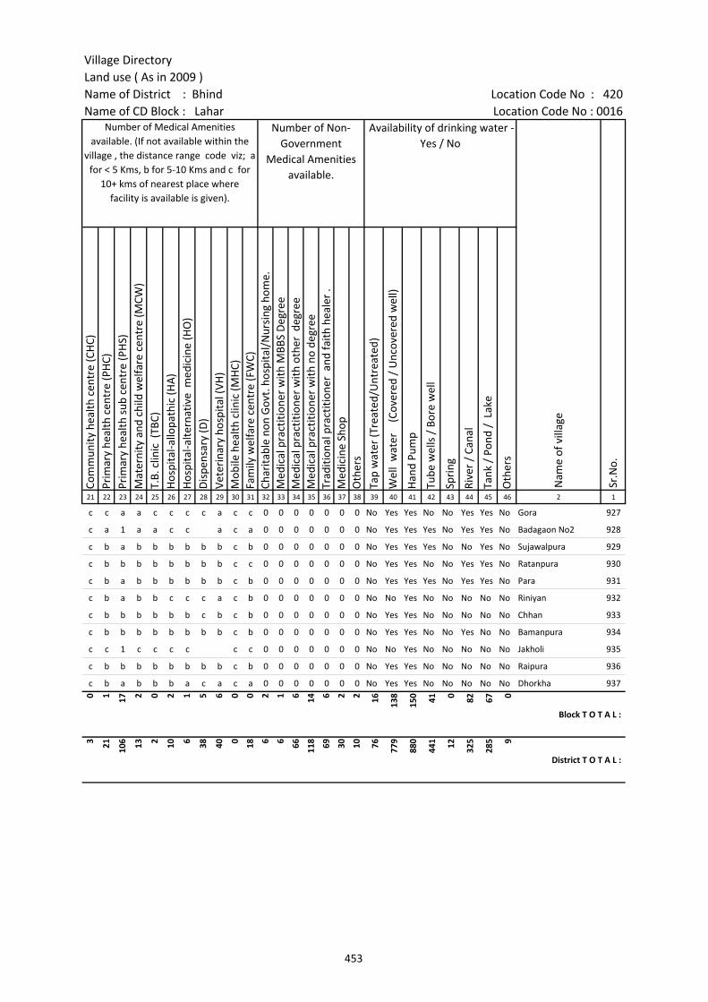
Village DirectoryLand use ( As in 2009 )Name of District : Bhind Location Code No : 420Name of CD Block : Lahar Location Code No : 0016
Com
mun
ity h
ealth
cen
tre
(CH
C)Pr
imar
y he
alth
cen
tre
(PH
C)Pr
imar
y he
alth
sub
cen
tre
(PH
S)M
ater
nity
and
chi
ld w
elfa
re c
entr
e (M
CW)
T.B.
clin
ic (
TBC)
Hos
pita
l-allo
path
ic (H
A)
Hos
pita
l-alte
rnat
ive
med
icin
e (H
O)
Dis
pens
ary
(D)
Vete
rina
ry h
ospi
tal (
VH)
Mob
ile h
ealth
clin
ic (M
HC)
Fam
ily w
elfa
re c
entr
e (F
WC)
Char
itabl
e no
n G
ovt.
hos
pita
l/N
ursi
ng h
ome.
Med
ical
pra
ctiti
oner
with
MBB
S D
egre
eM
edic
al p
ract
ition
er w
ith o
ther
deg
ree
Med
ical
pra
ctiti
oner
with
no
degr
eeTr
aditi
onal
pra
ctiti
oner
and
faith
hea
ler
.M
edic
ine
Shop
Oth
ers
Tap
wat
er (T
reat
ed/U
ntre
ated
)
Wel
l w
ater
(C
over
ed /
Unc
over
ed w
ell)
Han
d Pu
mp
Tube
wel
ls /
Bor
e w
ell
Spri
ng
Rive
r /
Cana
l
Tank
/ P
ond
/ L
ake
Oth
ers
21 22 23 24 25 26 27 28 29 30 31 32 33 34 35 36 37 38 39 40 41 42 43 44 45 46 2 1
Number of Medical Amenities available. (If not available within the
village , the distance range code viz; a for < 5 Kms, b for 5-10 Kms and c for
10+ kms of nearest place where facility is available is given).
Number of Non-Government
Medical Amenities available.
Availability of drinking water - Yes / No
Nam
e of
vill
age
Sr.N
o.
c c a a c c c c a c c 0 0 0 0 0 0 0 No Yes Yes No No Yes Yes No Gora 927
c a 1 a a c c a c a 0 0 0 0 0 0 0 No Yes Yes Yes No Yes Yes No Badagaon No2 928
c b a b b b b b b c b 0 0 0 0 0 0 0 No Yes Yes Yes No No Yes No Sujawalpura 929
c b b b b b b b b c c 0 0 0 0 0 0 0 No Yes Yes No No Yes Yes No Ratanpura 930
c b a b b b b b b c b 0 0 0 0 0 0 0 No Yes Yes Yes No Yes Yes No Para 931
c b a b b c c c a c b 0 0 0 0 0 0 0 No No Yes No No No No No Riniyan 932
c b b b b b b c b c b 0 0 0 0 0 0 0 No Yes Yes No No No No No Chhan 933
c b b b b b b b b c b 0 0 0 0 0 0 0 No Yes Yes No No Yes No No Bamanpura 934
c c 1 c c c c c c 0 0 0 0 0 0 0 No No Yes No No No No No Jakholi 935
c b b b b b b b b c b 0 0 0 0 0 0 0 No Yes Yes No No No No No Raipura 936
c b a b b b a c a c a 0 0 0 0 0 0 0 No Yes Yes No No No No No Dhorkha 937
0 1 17 2 0 2 1 5 6 0 0 2 1 6 14 6 2 2 16 138
150 41 0 82 67 0
Block T O T A L :
3 21 106 13 2 10 6 38 40 0 18 6 6 66 118 69 30 10 76 779
880
441 12 325
285 9
District T O T A L :
453
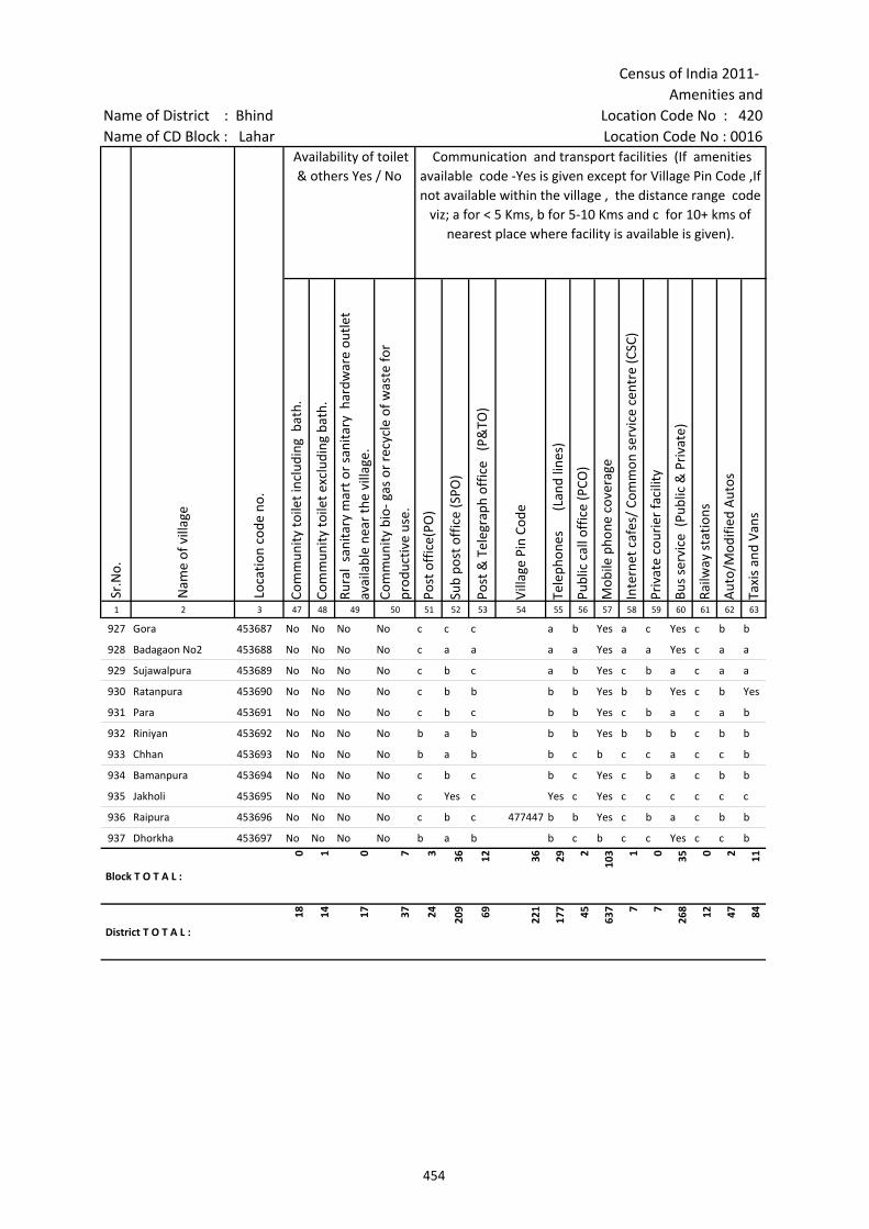
Census of India 2011- Amenities and
Name of District : Bhind Location Code No : 420Name of CD Block : Lahar Location Code No : 0016
Com
mun
ity to
ilet i
nclu
ding
bat
h.
Com
mun
ity to
ilet e
xclu
ding
bat
h.
Rura
l sa
nita
ry m
art o
r sa
nita
ry h
ardw
are
outle
t av
aila
ble
near
the
villa
ge.
Com
mun
ity b
io- g
as o
r re
cycl
e of
was
te fo
r pr
oduc
tive
use.
Post
off
ice(
PO)
Sub
post
off
ice
(SPO
)
Post
& T
eleg
raph
off
ice
(P&
TO)
Villa
ge P
in C
ode
Tele
phon
es
(L
and
lines
)
Publ
ic c
all o
ffic
e (P
CO)
Mob
ile p
hone
cov
erag
e
Inte
rnet
caf
es/
Com
mon
ser
vice
cen
tre
(CSC
)
Priv
ate
cour
ier
faci
lity
Bus
serv
ice
(Pub
lic &
Pri
vate
)
Railw
ay s
tatio
ns
Aut
o/M
odifi
ed A
utos
Taxi
s an
d Va
ns
1 2 3 47 48 49 50 51 52 53 54 55 56 57 58 59 60 61 62 63
Nam
e of
vill
age
Loca
tion
code
no.
Availability of toilet & others Yes / No
Communication and transport facilities (If amenities available code -Yes is given except for Village Pin Code ,If not available within the village , the distance range code
viz; a for < 5 Kms, b for 5-10 Kms and c for 10+ kms of nearest place where facility is available is given).
Sr.N
o.
927 Gora 453687 No No No No c c c a b Yes a c Yes c b b
928 Badagaon No2 453688 No No No No c a a a a Yes a a Yes c a a
929 Sujawalpura 453689 No No No No c b c a b Yes c b a c a a
930 Ratanpura 453690 No No No No c b b b b Yes b b Yes c b Yes
931 Para 453691 No No No No c b c b b Yes c b a c a b
932 Riniyan 453692 No No No No b a b b b Yes b b b c b b
933 Chhan 453693 No No No No b a b b c b c c a c c b
934 Bamanpura 453694 No No No No c b c b c Yes c b a c b b
935 Jakholi 453695 No No No No c Yes c Yes c Yes c c c c c c
936 Raipura 453696 No No No No c b c 477447 b b Yes c b a c b b
937 Dhorkha 453697 No No No No b a b b c b c c Yes c c b
Block T O T A L :
0 1 0 7 3 36 12 36 29 2
103 1 0 35 0 2 11
District T O T A L :
18 14 17 37 24 209 69 221
177 45 637 7 7
268 12 47 84
454
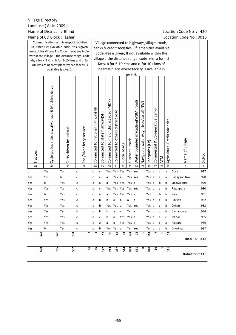
Village DirectoryLand use ( As in 2009 )Name of District : Bhind Location Code No : 420Name of CD Block : Lahar Location Code No : 0016
Trac
tors
Cycl
e-pu
lled
rick
shaw
s(M
anua
l & M
achi
ne d
rive
n)
Cart
s dr
iven
by
anim
als
Sea
/Riv
er fe
rry
serv
ice
Conn
ecte
d to
nat
iona
l hig
hway
(NH
)
Conn
ecte
d to
sta
te h
ighw
ay(S
H)
Conn
ecte
d to
maj
or d
istr
ict r
oad
(MD
R)
Conn
ecte
d to
oth
ers
dist
rict
roa
d
Pucc
a r
oads
Kutc
hcha
roa
ds
Wat
er b
ound
ed m
acad
am(W
BM) r
oads
Nav
igab
le w
ater
way
(riv
er/c
anal
)(N
W)
Foot
path
s (F
P)
Com
mer
cial
& C
o-op
erat
ive
Bank
s
ATM
Agr
icul
tura
l Cre
dit S
ocie
ties
64 65 66 67 68 69 70 71 72 73 74 75 76 77 78 79 2 1
Nam
e of
vill
age
Sr.N
o.
Communication and transport facilities (If amenities available code -Yes is given
except for Village Pin Code ,If not available within the village , the distance range code viz; a for < 5 Kms, b for 5-10 Kms and c for 10+ kms of nearest place where facility is
available is given).
Village connected to highways,village roads, banks & credit societies (If amenities available
code -Yes is given, If not available within the village , the distance range code viz; a for < 5
Kms, b for 5-10 Kms and c for 10+ kms of nearest place where facility is available is
given).
c Yes Yes c c c Yes Yes Yes Yes Yes Yes a c a Gora 927
Yes Yes b c c c a Yes a Yes Yes Yes a c a Badagaon No2 928
Yes b Yes c c a a Yes Yes Yes a Yes b b b Sujawalpura 929
Yes Yes Yes c c c Yes Yes Yes Yes Yes Yes b c b Ratanpura 930
Yes b Yes c c a a Yes Yes Yes a Yes b b b Para 931
Yes Yes Yes c c b b a a a a Yes b c b Riniyan 932
Yes Yes Yes c c b Yes Yes a Yes Yes Yes b c b Chhan 933
Yes Yes Yes b c b b a a Yes a Yes b c b Bamanpura 934
Yes Yes Yes c c c b a Yes Yes a Yes c c c Jakholi 935
Yes Yes Yes c c a a a Yes Yes a Yes b c a Raipura 936
Yes b Yes c c b Yes Yes a Yes Yes Yes b c b Dhorkha 937
128
128
131 3 1 12 30 62 71 142 76 0
152 7 0 13
Block T O T A L :
698
765
532 36 56 122
243
387
544
838
531 0
890 30 1
121
District T O T A L :
455
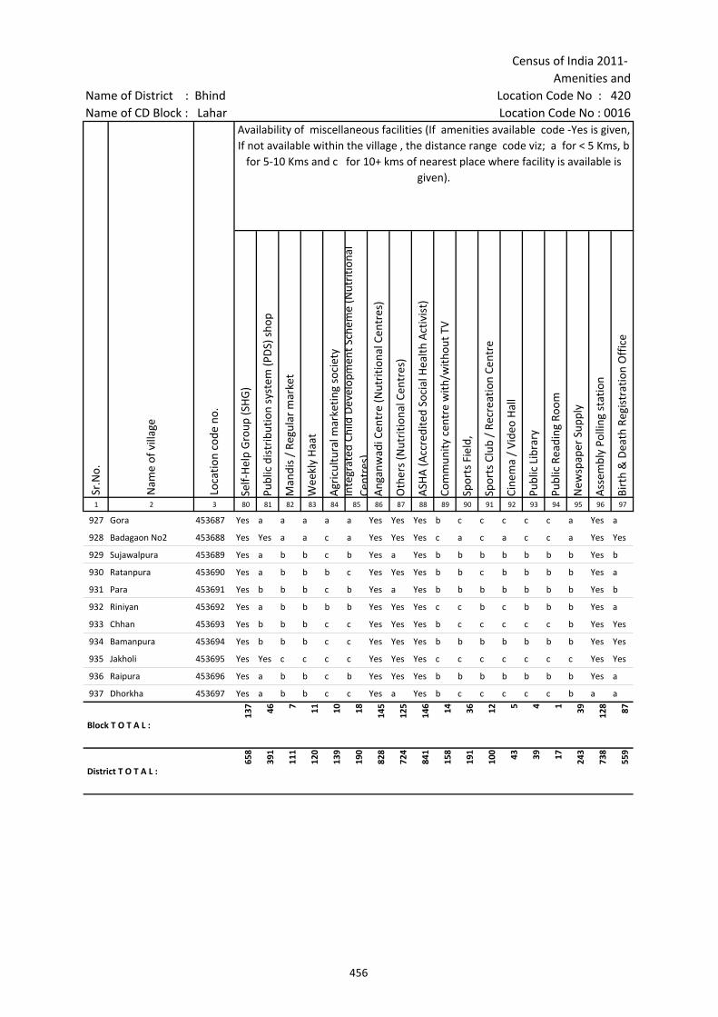
Census of India 2011- Amenities and
Name of District : Bhind Location Code No : 420Name of CD Block : Lahar Location Code No : 0016
Self-
Hel
p G
roup
(SH
G)
Publ
ic d
istr
ibut
ion
syst
em (P
DS)
sho
p
Man
dis
/ Re
gula
r m
arke
t
Wee
kly
Haa
t
Agr
icul
tura
l mar
ketin
g so
ciet
yIn
tegr
ated
Chi
ld D
evel
opm
ent S
chem
e (N
utri
tiona
l Ce
ntre
s)A
ngan
wad
i Cen
tre
(Nut
ritio
nal C
entr
es)
Oth
ers
(Nut
ritio
nal C
entr
es)
ASH
A (A
ccre
dite
d So
cial
Hea
lth A
ctiv
ist)
Com
mun
ity c
entr
e w
ith/w
ithou
t TV
Spor
ts F
ield
,
Spor
ts C
lub
/ Re
crea
tion
Cent
re
Cine
ma
/ Vi
deo
Hal
l
Publ
ic L
ibra
ry
Publ
ic R
eadi
ng R
oom
New
spap
er S
uppl
y
Ass
embl
y Po
lling
sta
tion
Birt
h &
Dea
th R
egis
trat
ion
Off
ice
1 2 3 80 81 82 83 84 85 86 87 88 89 90 91 92 93 94 95 96 97
Sr.N
o.
Nam
e of
vill
age
Loca
tion
code
no.
Availability of miscellaneous facilities (If amenities available code -Yes is given, If not available within the village , the distance range code viz; a for < 5 Kms, b
for 5-10 Kms and c for 10+ kms of nearest place where facility is available is given).
927 Gora 453687 Yes a a a a a Yes Yes Yes b c c c c c a Yes a
928 Badagaon No2 453688 Yes Yes a a c a Yes Yes Yes c a c a c c a Yes Yes
929 Sujawalpura 453689 Yes a b b c b Yes a Yes b b b b b b b Yes b
930 Ratanpura 453690 Yes a b b b c Yes Yes Yes b b c b b b b Yes a
931 Para 453691 Yes b b b c b Yes a Yes b b b b b b b Yes b
932 Riniyan 453692 Yes a b b b b Yes Yes Yes c c b c b b b Yes a
933 Chhan 453693 Yes b b b c c Yes Yes Yes b c c c c c b Yes Yes
934 Bamanpura 453694 Yes b b b c c Yes Yes Yes b b b b b b b Yes Yes
935 Jakholi 453695 Yes Yes c c c c Yes Yes Yes c c c c c c c Yes Yes
936 Raipura 453696 Yes a b b c b Yes Yes Yes b b b b b b b Yes a
937 Dhorkha 453697 Yes a b b c c Yes a Yes b c c c c c b a a
Block T O T A L :
137 46 7 11 10 18 145
125
146 14 36 12 5 4 1 39 128 87
District T O T A L :
658
391
111
120
139
190
828
724
841
158
191
100 43 39 17 243
738
559
456
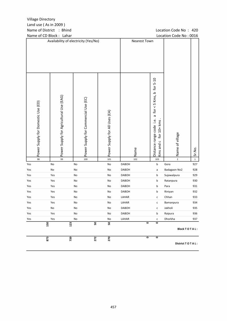
Village DirectoryLand use ( As in 2009 )Name of District : Bhind Location Code No : 420Name of CD Block : Lahar Location Code No : 0016
Pow
er S
uppl
y fo
r D
omes
tic U
se (E
D)
Pow
er S
uppl
y fo
r A
gric
ultu
ral U
se (E
AG
)
Pow
er S
uppl
y fo
r Co
mm
erci
al U
se (E
C)
Pow
er S
uppl
y fo
r A
ll U
ses
(EA
)
Nam
e
Dis
tanc
e ra
nge
code
i.e
. a
for
< 5
Kms,
b f
or 5
-10
Kms
and
c f
or 1
0+ k
ms
.98 99 100 101 102 103 2 1
Availability of electricity (Yes/No) Nearest Town
Nam
e of
vill
age
Sr.N
o.
Yes No No No DABOH b Gora 927
Yes No No No DABOH a Badagaon No2 928
Yes Yes No No DABOH b Sujawalpura 929
Yes Yes No No DABOH b Ratanpura 930
Yes Yes No No DABOH b Para 931
Yes Yes No No DABOH b Riniyan 932
Yes Yes No No LAHAR c Chhan 933
Yes Yes No No LAHAR c Bamanpura 934
Yes No No No DABOH c Jakholi 935
Yes Yes No No DABOH b Raipura 936
Yes Yes No No LAHAR c Dhorkha 937
150
123 50 50 0 0
Block T O T A L :
873
739
272
270 0 0
District T O T A L :
457
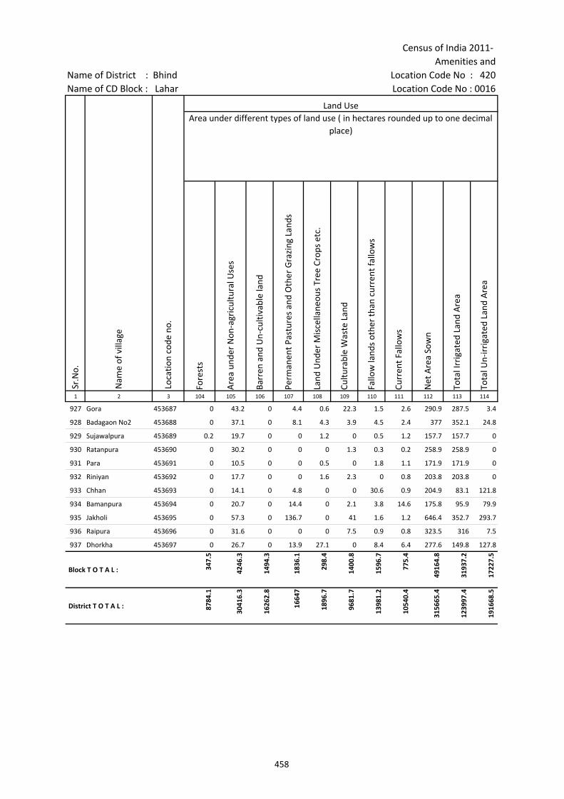
Census of India 2011- Amenities and
Name of District : Bhind Location Code No : 420Name of CD Block : Lahar Location Code No : 0016
Fore
sts
Are
a un
der
Non
-agr
icul
tura
l Use
s
Barr
en a
nd U
n-cu
ltiva
ble
land
Perm
anen
t Pas
ture
s an
d O
ther
Gra
zing
Lan
ds
Land
Und
er M
isce
llane
ous
Tree
Cro
ps e
tc.
Cultu
rabl
e W
aste
Lan
d
Fallo
w la
nds
othe
r th
an c
urre
nt fa
llow
s
Curr
ent F
allo
ws
Net
Are
a So
wn
Tota
l Irr
igat
ed L
and
Are
a
Tota
l Un-
irri
gate
d La
nd A
rea
1 2 3 104 105 106 107 108 109 110 111 112 113 114
Loca
tion
code
no.
Land UseArea under different types of land use ( in hectares rounded up to one decimal
place)
Sr.N
o.
Nam
e of
vill
age
927 Gora 453687 0 43.2 0 4.4 0.6 22.3 1.5 2.6 290.9 287.5 3.4
928 Badagaon No2 453688 0 37.1 0 8.1 4.3 3.9 4.5 2.4 377 352.1 24.8
929 Sujawalpura 453689 0.2 19.7 0 0 1.2 0 0.5 1.2 157.7 157.7 0
930 Ratanpura 453690 0 30.2 0 0 0 1.3 0.3 0.2 258.9 258.9 0
931 Para 453691 0 10.5 0 0 0.5 0 1.8 1.1 171.9 171.9 0
932 Riniyan 453692 0 17.7 0 0 1.6 2.3 0 0.8 203.8 203.8 0
933 Chhan 453693 0 14.1 0 4.8 0 0 30.6 0.9 204.9 83.1 121.8
934 Bamanpura 453694 0 20.7 0 14.4 0 2.1 3.8 14.6 175.8 95.9 79.9
935 Jakholi 453695 0 57.3 0 136.7 0 41 1.6 1.2 646.4 352.7 293.7
936 Raipura 453696 0 31.6 0 0 0 7.5 0.9 0.8 323.5 316 7.5
937 Dhorkha 453697 0 26.7 0 13.9 27.1 0 8.4 6.4 277.6 149.8 127.8
Block T O T A L : 347.
5
4246
.3
1494
.3
1836
.1
298.
4
1400
.8
1596
.7
775.
4
4916
4.8
3193
7.2
1722
7.5
District T O T A L : 8784
.1
3041
6.3
1626
2.8
1664
7
1896
.7
9681
.7
1398
1.2
1054
0.4
3156
65.4
1239
97.4
1916
68.5
458
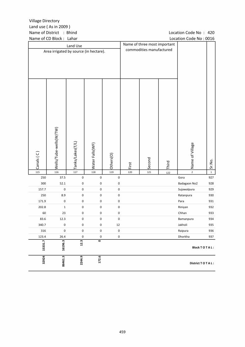
Village DirectoryLand use ( As in 2009 )Name of District : Bhind Location Code No : 420Name of CD Block : Lahar Location Code No : 0016
Cana
ls (
C )
Wel
ls/T
ube-
wel
ls(W
/TW
)
Tank
s/La
kes(
T/L)
Wat
er F
alls
(WF)
Oth
ers(
O)
Firs
t
Seco
nd
Thir
d 115 116 117 118 119 120 121 122 2 1
Land Use Name of three most important commodities manufactured
Nam
e of
Vill
age
Sr.N
o.
Area irrigated by source (in hectare).
250 37.5 0 0 0 Gora 927
300 52.1 0 0 0 Badagaon No2 928
157.7 0 0 0 0 Sujawalpura 929
250 8.9 0 0 0 Ratanpura 930
171.9 0 0 0 0 Para 931
202.8 1 0 0 0 Riniyan 932
60 23 0 0 0 Chhan 933
83.6 12.3 0 0 0 Bamanpura 934
340.7 0 0 0 12 Jakholi 935
316 0 0 0 0 Raipura 936
123.4 26.4 0 0 0 Dhorkha 937
1533
1.7
1619
6.3
12.3 0
Block T O T A L :
3292
4
8646
1.3
2244
.9
172.
6
District T O T A L :
459

Appendices to Village Directory
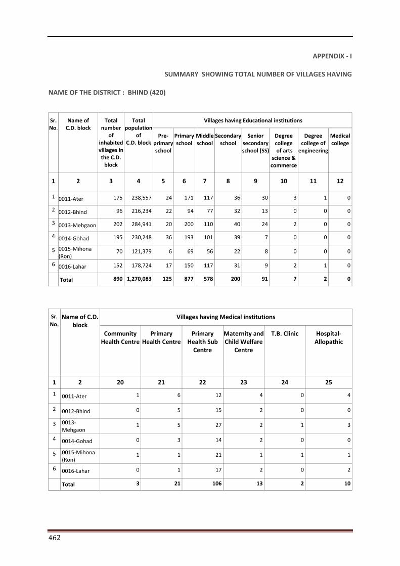
462
APPENDIX - I
SUMMARY SHOWING TOTAL NUMBER OF VILLAGES HAVING
NAME OF THE DISTRICT : BHIND (420)
Sr. No.
Name of C.D. block
Total number
of inhabited villages in the C.D.
block
Total population
of C.D. block
Villages having Educational institutions
Pre-primary school
Primary school
Middle school
Secondary school
Senior secondary school (SS)
Degree college of arts
science & commerce
Degree college of
engineering
Medical college
1 2 3 4 5 6 7 8 9 10 11 12
1 0011-Ater 175 238,557 24 171 117 36 30 3 1 0
2 0012-Bhind 96 216,234 22 94 77 32 13 0 0 0
3 0013-Mehgaon 202 284,941 20 200 110 40 24 2 0 0
4 0014-Gohad 195 230,248 36 193 101 39 7 0 0 0
5 0015-Mihona (Ron)
70 121,379 6 69 56 22 8 0 0 0
6 0016-Lahar 152 178,724 17 150 117 31 9 2 1 0
Total 890 1,270,083 125 877 578 200 91 7 2 0
Sr. No.
Name of C.D. block
Villages having Medical institutions
Community Health Centre
Primary Health Centre
Primary Health Sub
Centre
Maternity and Child Welfare
Centre
T.B. Clinic Hospital-Allopathic
1 2 20 21 22 23 24 25
1 0011-Ater 1 6 12 4 0 4
2 0012-Bhind 0 5 15 2 0 0
3 0013-Mehgaon
1 5 27 2 1 3
4 0014-Gohad 0 3 14 2 0 0
5 0015-Mihona (Ron)
1 1 21 1 1 1
6 0016-Lahar 0 1 17 2 0 2
Total 3 21 106 13 2 10
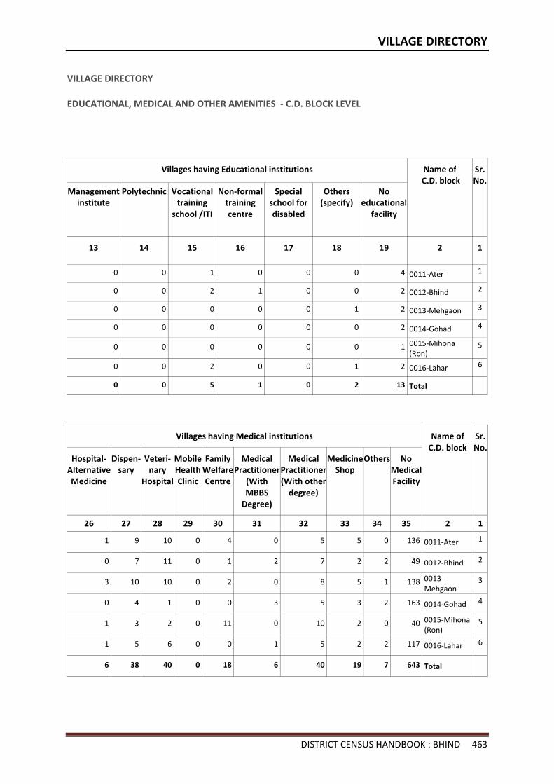
VILLAGE DIRECTORY
DISTRICT CENSUS HANDBOOK : BHIND 463
VILLAGE DIRECTORY
EDUCATIONAL, MEDICAL AND OTHER AMENITIES - C.D. BLOCK LEVEL
Villages having Educational institutions Name of C.D. block
Sr.No.
Management institute
Polytechnic Vocational training
school /ITI
Non-formal training centre
Special school for disabled
Others (specify)
No educational
facility
13 14 15 16 17 18 19 2 1
0 0 1 0 0 0 4 0011-Ater 1
0 0 2 1 0 0 2 0012-Bhind 2
0 0 0 0 0 1 2 0013-Mehgaon 3
0 0 0 0 0 0 2 0014-Gohad 4
0 0 0 0 0 0 1 0015-Mihona (Ron)
5
0 0 2 0 0 1 2 0016-Lahar 6
0 0 5 1 0 2 13 Total
Villages having Medical institutions Name of C.D. block
Sr.No.
Hospital-Alternative Medicine
Dispen- sary
Veteri-nary
Hospital
Mobile Health Clinic
Family Welfare Centre
Medical Practitioner
(With MBBS
Degree)
Medical Practitioner (With other
degree)
Medicine Shop
Others No Medical Facility
26 27 28 29 30 31 32 33 34 35 2 1
1 9 10 0 4 0 5 5 0 136 0011-Ater 1
0 7 11 0 1 2 7 2 2 49 0012-Bhind 2
3 10 10 0 2 0 8 5 1 138 0013-Mehgaon
3
0 4 1 0 0 3 5 3 2 163 0014-Gohad 4
1 3 2 0 11 0 10 2 0 40 0015-Mihona (Ron)
5
1 5 6 0 0 1 5 2 2 117 0016-Lahar 6
6 38 40 0 18 6 40 19 7 643 Total
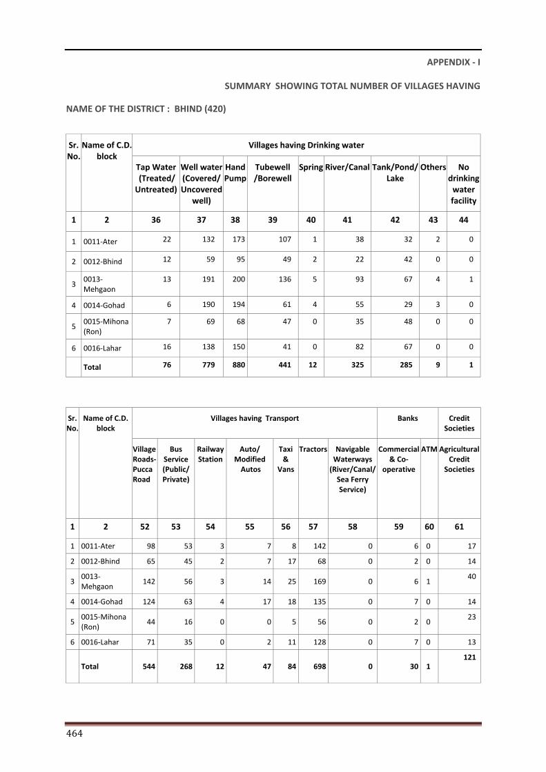
464
APPENDIX - I
SUMMARY SHOWING TOTAL NUMBER OF VILLAGES HAVING
NAME OF THE DISTRICT : BHIND (420)
Sr. No.
Name of C.D. block
Villages having Drinking water
Tap Water (Treated/ Untreated)
Well water (Covered/ Uncovered
well)
Hand Pump
Tubewell/Borewell
Spring River/Canal Tank/Pond/ Lake
Others No drinking
water facility
1 2 36 37 38 39 40 41 42 43 44
1 0011-Ater 22 132 173 107 1 38 32 2 0
2 0012-Bhind 12 59 95 49 2 22 42 0 0
3 0013-Mehgaon
13 191 200 136 5 93 67 4 1
4 0014-Gohad 6 190 194 61 4 55 29 3 0
5 0015-Mihona (Ron)
7 69 68 47 0 35 48 0 0
6 0016-Lahar 16 138 150 41 0 82 67 0 0
Total 76 779 880 441 12 325 285 9 1
Sr. No.
Name of C.D. block
Villages having Transport Banks Credit Societies
Village Roads-Pucca Road
Bus Service (Public/ Private)
Railway Station
Auto/ Modified
Autos
Taxi &
Vans
Tractors Navigable Waterways
(River/Canal/Sea Ferry Service)
Commercial & Co-
operative
ATM Agricultural Credit
Societies
1 2 52 53 54 55 56 57 58 59 60 61
1 0011-Ater 98 53 3 7 8 142 0 6 0 17
2 0012-Bhind 65 45 2 7 17 68 0 2 0 14
3 0013-Mehgaon
142 56 3 14 25 169 0 6 1 40
4 0014-Gohad 124 63 4 17 18 135 0 7 0 14
5 0015-Mihona (Ron)
44 16 0 0 5 56 0 2 0 23
6 0016-Lahar 71 35 0 2 11 128 0 7 0 13
Total 544 268 12 47 84 698 0 30 1 121
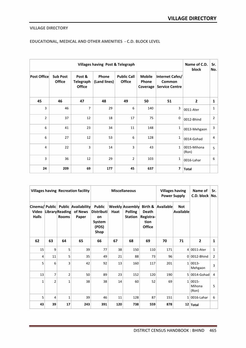
VILLAGE DIRECTORY
DISTRICT CENSUS HANDBOOK : BHIND 465
VILLAGE DIRECTORY
EDUCATIONAL, MEDICAL AND OTHER AMENITIES - C.D. BLOCK LEVEL
Villages having Post & Telegraph Name of C.D. block
Sr.No.
Post Office Sub Post Office
Post & Telegraph
Office
Phone (Land lines)
Public Call Office
Mobile Phone
Coverage
Internet Cafes/ Common
Service Centre
45 46 47 48 49 50 51 2 1
3 46 7 29 6 140 3 0011-Ater 1
2 37 12 18 17 75 0 0012-Bhind 2
6 41 23 34 11 148 1 0013-Mehgaon 3
6 27 12 53 6 128 1 0014-Gohad 4
4 22 3 14 3 43 1 0015-Mihona (Ron)
5
3 36 12 29 2 103 1 0016-Lahar 6
24 209 69 177 45 637 7 Total
Villages having Recreation facility Miscellaneous Villages having Power Supply
Name of C.D. block
Sr.No.
Cinema/ Video Halls
Public Library
Public Reading Rooms
Availability of News
Paper
Public Distributi
on System (PDS) Shop
Weekly Haat
Assembly Polling Station
Birth & Death
Registra-tion
Office
Available Not Available
62 63 64 65 66 67 68 69 70 71 2 1
15 9 5 39 77 38 150 110 171 4 0011-Ater 1
4 11 5 35 49 21 88 73 96 0 0012-Bhind 2
5 6 3 42 92 13 160 117 201 1 0013-Mehgaon
3
13 7 2 50 89 23 152 120 190 5 0014-Gohad 4
1 2 1 38 38 14 60 52 69 1 0015-Mihona (Ron)
5
5 4 1 39 46 11 128 87 151 1 0016-Lahar 6
43 39 17 243 391 120 738 559 878 12 Total
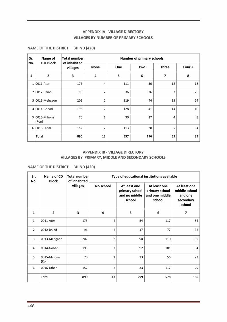
466
APPENDIX IA - VILLAGE DIRECTORY VILLAGES BY NUMBER OF PRIMARY SCHOOLS
NAME OF THE DISTRICT : BHIND (420)
Sr. No.
Name of C.D.Block
Total number of inhabited
villages
Number of primary schools
None One Two Three Four +
1 2 3 4 5 6 7 8
1 0011-Ater 175 4 111 30 12 18
2 0012-Bhind 96 2 36 26 7 25
3 0013-Mehgaon 202 2 119 44 13 24
4 0014-Gohad 195 2 128 41 14 10
5 0015-Mihona (Ron)
70 1 30 27 4 8
6 0016-Lahar 152 2 113 28 5 4
Total 890 13 537 196 55 89
APPENDIX IB - VILLAGE DIRECTORY VILLAGES BY PRIMARY, MIDDLE AND SECONDARY SCHOOLS
NAME OF THE DISTRICT : BHIND (420)
Sr. No.
Name of CD Block
Total number of inhabited
villages
Type of educational institutions available
No school At least one primary school and no middle
school
At least one primary school and one middle
school
At least one middle school
and one secondary
school
1 2 3 4 5 6 7
1 0011-Ater 175 4 54 117 34
2 0012-Bhind 96 2 17 77 32
3 0013-Mehgaon 202 2 90 110 35
4 0014-Gohad 195 2 92 101 34
5 0015-Mihona (Ron)
70 1 13 56 22
6 0016-Lahar 152 2 33 117 29
Total 890 13 299 578 186
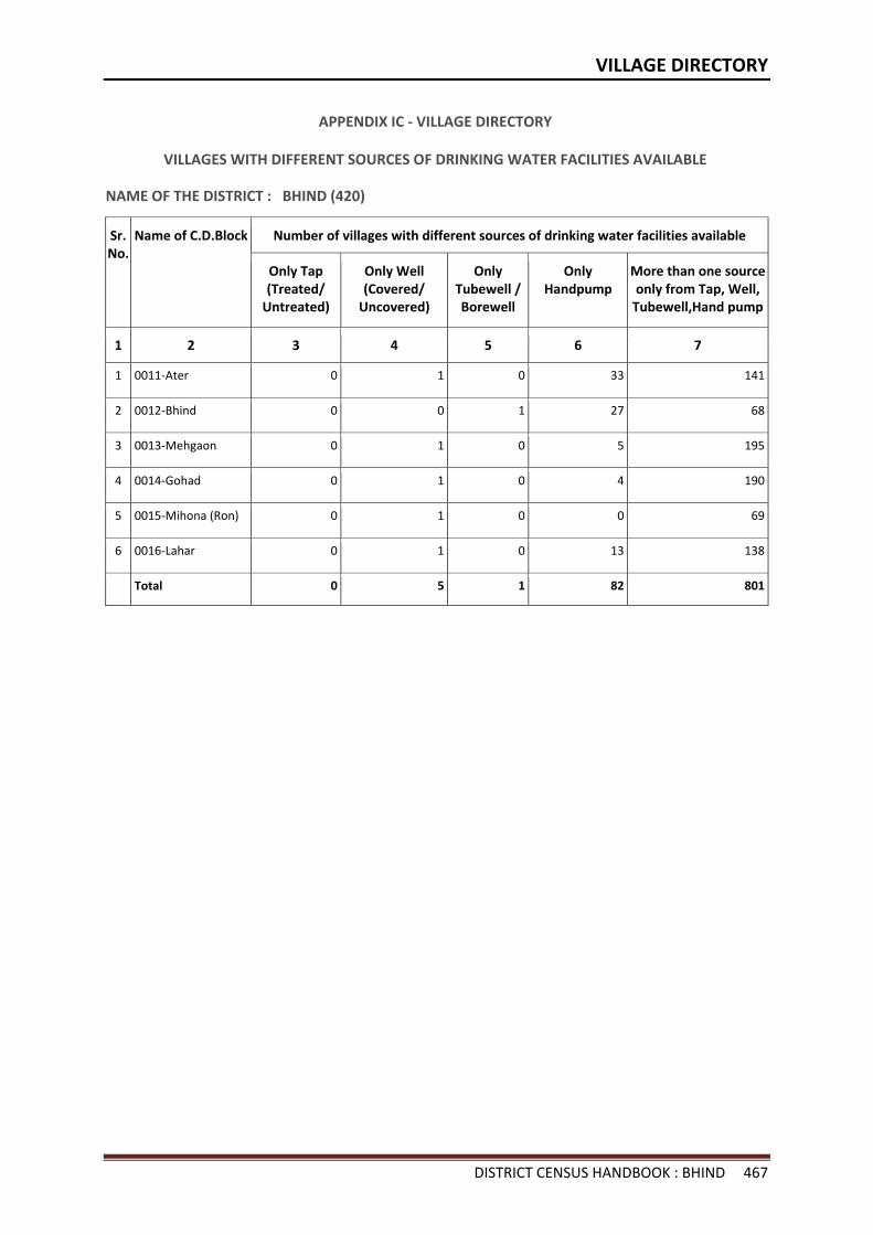
VILLAGE DIRECTORY
DISTRICT CENSUS HANDBOOK : BHIND 467
APPENDIX IC - VILLAGE DIRECTORY
VILLAGES WITH DIFFERENT SOURCES OF DRINKING WATER FACILITIES AVAILABLE
NAME OF THE DISTRICT : BHIND (420)
Sr. No.
Name of C.D.Block Number of villages with different sources of drinking water facilities available
Only Tap (Treated/
Untreated)
Only Well (Covered/
Uncovered)
Only Tubewell /Borewell
Only Handpump
More than one source only from Tap, Well,
Tubewell,Hand pump
1 2 3 4 5 6 7
1 0011-Ater 0 1 0 33 141
2 0012-Bhind 0 0 1 27 68
3 0013-Mehgaon 0 1 0 5 195
4 0014-Gohad 0 1 0 4 190
5 0015-Mihona (Ron) 0 1 0 0 69
6 0016-Lahar 0 1 0 13 138
Total 0 5 1 82 801
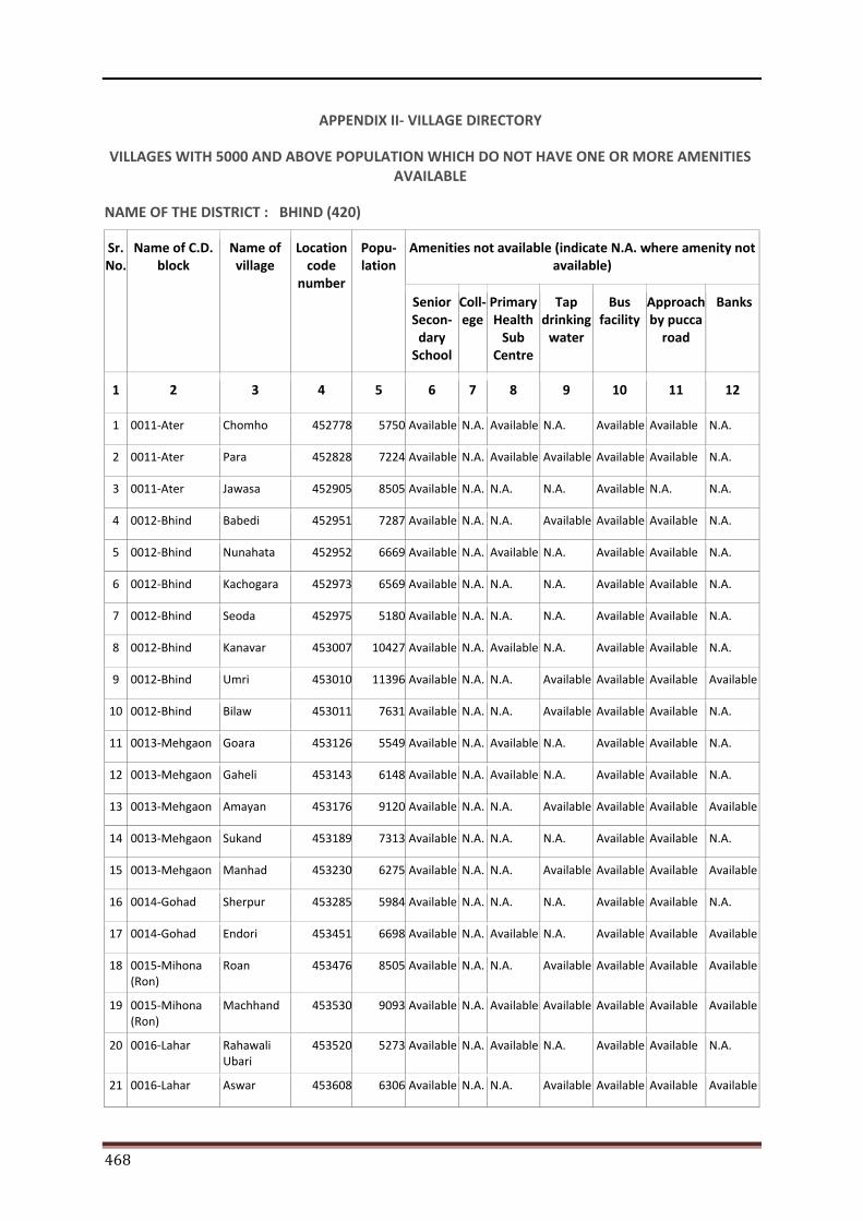
468
APPENDIX II- VILLAGE DIRECTORY
VILLAGES WITH 5000 AND ABOVE POPULATION WHICH DO NOT HAVE ONE OR MORE AMENITIES AVAILABLE
NAME OF THE DISTRICT : BHIND (420)
Sr. No.
Name of C.D. block
Name of village
Location code
number
Popu-lation
Amenities not available (indicate N.A. where amenity not available)
Senior Secon-
dary School
Coll-ege
Primary Health
Sub Centre
Tap drinking
water
Bus facility
Approach by pucca
road
Banks
1 2 3 4 5 6 7 8 9 10 11 12
1 0011-Ater Chomho 452778 5750 Available N.A. Available N.A. Available Available N.A.
2 0011-Ater Para 452828 7224 Available N.A. Available Available Available Available N.A.
3 0011-Ater Jawasa 452905 8505 Available N.A. N.A. N.A. Available N.A. N.A.
4 0012-Bhind Babedi 452951 7287 Available N.A. N.A. Available Available Available N.A.
5 0012-Bhind Nunahata 452952 6669 Available N.A. Available N.A. Available Available N.A.
6 0012-Bhind Kachogara 452973 6569 Available N.A. N.A. N.A. Available Available N.A.
7 0012-Bhind Seoda 452975 5180 Available N.A. N.A. N.A. Available Available N.A.
8 0012-Bhind Kanavar 453007 10427 Available N.A. Available N.A. Available Available N.A.
9 0012-Bhind Umri 453010 11396 Available N.A. N.A. Available Available Available Available
10 0012-Bhind Bilaw 453011 7631 Available N.A. N.A. Available Available Available N.A.
11 0013-Mehgaon Goara 453126 5549 Available N.A. Available N.A. Available Available N.A.
12 0013-Mehgaon Gaheli 453143 6148 Available N.A. Available N.A. Available Available N.A.
13 0013-Mehgaon Amayan 453176 9120 Available N.A. N.A. Available Available Available Available
14 0013-Mehgaon Sukand 453189 7313 Available N.A. N.A. N.A. Available Available N.A.
15 0013-Mehgaon Manhad 453230 6275 Available N.A. N.A. Available Available Available Available
16 0014-Gohad Sherpur 453285 5984 Available N.A. N.A. N.A. Available Available N.A.
17 0014-Gohad Endori 453451 6698 Available N.A. Available N.A. Available Available Available
18 0015-Mihona (Ron)
Roan 453476 8505 Available N.A. N.A. Available Available Available Available
19 0015-Mihona (Ron)
Machhand 453530 9093 Available N.A. Available Available Available Available Available
20 0016-Lahar Rahawali Ubari
453520 5273 Available N.A. Available N.A. Available Available N.A.
21 0016-Lahar Aswar 453608 6306 Available N.A. N.A. Available Available Available Available
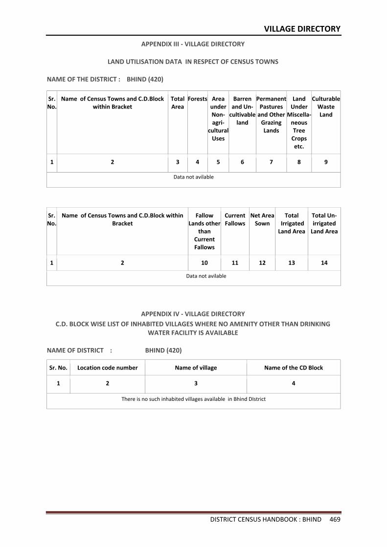
VILLAGE DIRECTORY
DISTRICT CENSUS HANDBOOK : BHIND 469
APPENDIX III - VILLAGE DIRECTORY
LAND UTILISATION DATA IN RESPECT OF CENSUS TOWNS
NAME OF THE DISTRICT : BHIND (420)
Sr. No.
Name of Census Towns and C.D.Block within Bracket
Total Area
Forests Area under Non- agri-
cultural Uses
Barren and Un-
cultivable land
Permanent Pastures
and Other Grazing Lands
Land Under
Miscella- neous Tree
Crops etc.
Culturable Waste Land
1 2 3 4 5 6 7 8 9
Data not avilable
Sr. No.
Name of Census Towns and C.D.Block within Bracket
Fallow Lands other
than Current Fallows
Current Fallows
Net Area Sown
Total Irrigated Land Area
Total Un-irrigated
Land Area
1 2 10 11 12 13 14
Data not avilable
APPENDIX IV - VILLAGE DIRECTORY C.D. BLOCK WISE LIST OF INHABITED VILLAGES WHERE NO AMENITY OTHER THAN DRINKING
WATER FACILITY IS AVAILABLE
NAME OF DISTRICT : BHIND (420)
Sr. No. Location code number Name of village Name of the CD Block
1 2 3 4
There is no such inhabited villages available in Bhind DIstrict
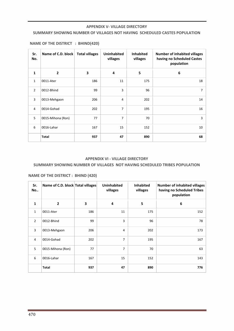
470
APPENDIX V- VILLAGE DIRECTORY SUMMARY SHOWING NUMBER OF VILLAGES NOT HAVING SCHEDULED CASTES POPULATION
NAME OF THE DISTRICT : BHIND(420)
Sr. No.
Name of C.D. block Total villages Uninhabited villages
Inhabited villages
Number of inhabited villages having no Scheduled Castes
population
1 2 3 4 5 6
1 0011-Ater 186 11 175 18
2 0012-Bhind 99 3 96 7
3 0013-Mehgaon 206 4 202 14
4 0014-Gohad 202 7 195 16
5 0015-Mihona (Ron) 77 7 70 3
6 0016-Lahar 167 15 152 10
Total 937 47 890 68
APPENDIX VI - VILLAGE DIRECTORY SUMMARY SHOWING NUMBER OF VILLAGES NOT HAVING SCHEDULED TRIBES POPULATION
NAME OF THE DISTRICT : BHIND (420)
Sr. No..
Name of C.D. block Total villages Uninhabited villages
Inhabited villages
Number of inhabited villages having no Scheduled Tribes
population
1 2 3 4 5 6
1 0011-Ater 186 11 175 152
2 0012-Bhind 99 3 96 78
3 0013-Mehgaon 206 4 202 173
4 0014-Gohad 202 7 195 167
5 0015-Mihona (Ron) 77 7 70 63
6 0016-Lahar 167 15 152 143
Total 937 47 890 776
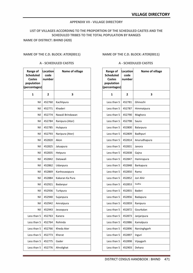
VILLAGE DIRECTORY
DISTRICT CENSUS HANDBOOK : BHIND 471
APPENDIX VII - VILLAGE DIRECTORY
LIST OF VILLAGES ACCORDING TO THE PROPORTION OF THE SCHEDULED CASTES AND THE SCHEDULED TRIBES TO THE TOTAL POPULATION BY RANGES
NAME OF DISTRICT: BHIND (420)
NAME OF THE C.D. BLOCK: ATER(0011)
A - SCHEDULED CASTES
Range of Scheduled
Castes population
(percentages)
Location code
number
Name of village
1 2 3
Nil 452760 Kachhpura
Nil 452771 Khaderi
Nil 452774 Nawali Brindawan
Nil 452784 Ranipura (Ater)
Nil 452785 Hulapura
Nil 452793 Naripura (Ater)
Nil 452820 Akon
Nil 452825 Jaluapura
Nil 452835 Hetpura
Nil 452842 Datawali
Nil 452862 Udanpura
Nil 452869 Kanhouwapura
Nil 452884 Kakaran Ka Pura
Nil 452921 Badanpur
Nil 452936 Turkpura
Nil 452940 Sujanpura
Nil 452942 Amratpura
Nil 452943 Jesoopura
Less than 5 452763 Kanera
Less than 5 452764 Rohinda
Less than 5 452766 Kheda Ater
Less than 5 452773 Kherat
Less than 5 452775 Gader
Less than 5 452776 Ahrolighat
NAME OF THE C.D. BLOCK: ATER(0011)
A - SCHEDULED CASTES
Range of Scheduled
Castes population
(percentages)
Location code
number
Name of village
1 2 3
Less than 5 452781 Ghinochi
Less than 5 452787 Himmatpura
Less than 5 452790 Maghora
Less than 5 452798 Saura
Less than 5 452800 Balarpura
Less than 5 452809 Badhpuri
Less than 5 452814 Anurudhapura
Less than 5 452831 Janora
Less than 5 452838 Gajna
Less than 5 452847 Hamirapura
Less than 5 452848 Barkapura
Less than 5 452850 Rama
Less than 5 452852 Jori Ahir
Less than 5 452853 Gadha
Less than 5 452855 Baderi
Less than 5 452856 Badapura
Less than 5 452859 Ranipura
Less than 5 452872 Gourkalan
Less than 5 452873 Janjaripura
Less than 5 452886 Kamalpura
Less than 5 452896 Narsinghgarh
Less than 5 452897 Inguri
Less than 5 452898 Vijaygarh
Less than 5 452903 Dehara
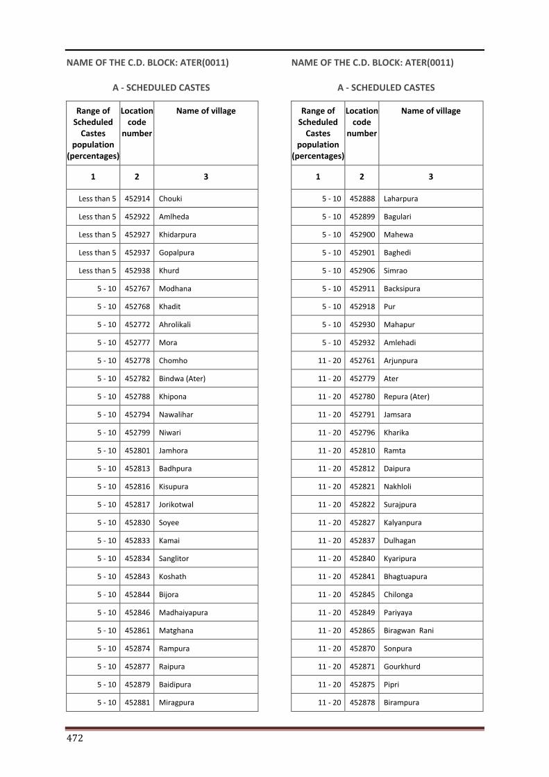
472
NAME OF THE C.D. BLOCK: ATER(0011)
A - SCHEDULED CASTES
Range of Scheduled
Castes population
(percentages)
Location code
number
Name of village
1 2 3
Less than 5 452914 Chouki
Less than 5 452922 Amlheda
Less than 5 452927 Khidarpura
Less than 5 452937 Gopalpura
Less than 5 452938 Khurd
5 - 10 452767 Modhana
5 - 10 452768 Khadit
5 - 10 452772 Ahrolikali
5 - 10 452777 Mora
5 - 10 452778 Chomho
5 - 10 452782 Bindwa (Ater)
5 - 10 452788 Khipona
5 - 10 452794 Nawalihar
5 - 10 452799 Niwari
5 - 10 452801 Jamhora
5 - 10 452813 Badhpura
5 - 10 452816 Kisupura
5 - 10 452817 Jorikotwal
5 - 10 452830 Soyee
5 - 10 452833 Kamai
5 - 10 452834 Sanglitor
5 - 10 452843 Koshath
5 - 10 452844 Bijora
5 - 10 452846 Madhaiyapura
5 - 10 452861 Matghana
5 - 10 452874 Rampura
5 - 10 452877 Raipura
5 - 10 452879 Baidipura
5 - 10 452881 Miragpura
NAME OF THE C.D. BLOCK: ATER(0011)
A - SCHEDULED CASTES
Range of Scheduled
Castes population
(percentages)
Location code
number
Name of village
1 2 3
5 - 10 452888 Laharpura
5 - 10 452899 Bagulari
5 - 10 452900 Mahewa
5 - 10 452901 Baghedi
5 - 10 452906 Simrao
5 - 10 452911 Backsipura
5 - 10 452918 Pur
5 - 10 452930 Mahapur
5 - 10 452932 Amlehadi
11 - 20 452761 Arjunpura
11 - 20 452779 Ater
11 - 20 452780 Repura (Ater)
11 - 20 452791 Jamsara
11 - 20 452796 Kharika
11 - 20 452810 Ramta
11 - 20 452812 Daipura
11 - 20 452821 Nakhloli
11 - 20 452822 Surajpura
11 - 20 452827 Kalyanpura
11 - 20 452837 Dulhagan
11 - 20 452840 Kyaripura
11 - 20 452841 Bhagtuapura
11 - 20 452845 Chilonga
11 - 20 452849 Pariyaya
11 - 20 452865 Biragwan Rani
11 - 20 452870 Sonpura
11 - 20 452871 Gourkhurd
11 - 20 452875 Pipri
11 - 20 452878 Birampura
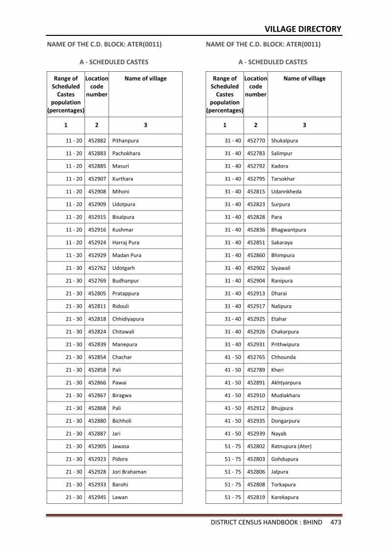
VILLAGE DIRECTORY
DISTRICT CENSUS HANDBOOK : BHIND 473
NAME OF THE C.D. BLOCK: ATER(0011)
A - SCHEDULED CASTES
Range of Scheduled
Castes population
(percentages)
Location code
number
Name of village
1 2 3
11 - 20 452882 Pithanpura
11 - 20 452883 Pachokhara
11 - 20 452885 Masuri
11 - 20 452907 Kurthara
11 - 20 452908 Mihoni
11 - 20 452909 Udotpura
11 - 20 452915 Bisalpura
11 - 20 452916 Kushmar
11 - 20 452924 Harraj Pura
11 - 20 452929 Madan Pura
21 - 30 452762 Udotgarh
21 - 30 452769 Budhanpur
21 - 30 452805 Pratappura
21 - 30 452811 Ridouli
21 - 30 452818 Chhidiyapura
21 - 30 452824 Chitawali
21 - 30 452839 Manepura
21 - 30 452854 Chachar
21 - 30 452858 Pali
21 - 30 452866 Pawai
21 - 30 452867 Biragwa
21 - 30 452868 Pali
21 - 30 452880 Bichholi
21 - 30 452887 Jari
21 - 30 452905 Jawasa
21 - 30 452923 Pidora
21 - 30 452928 Jori Brahaman
21 - 30 452933 Barohi
21 - 30 452945 Lawan
NAME OF THE C.D. BLOCK: ATER(0011)
A - SCHEDULED CASTES
Range of Scheduled
Castes population
(percentages)
Location code
number
Name of village
1 2 3
31 - 40 452770 Shukalpura
31 - 40 452783 Salimpur
31 - 40 452792 Kadora
31 - 40 452795 Tarsokhar
31 - 40 452815 Udannkheda
31 - 40 452823 Surpura
31 - 40 452828 Para
31 - 40 452836 Bhagwantpura
31 - 40 452851 Sakaraya
31 - 40 452860 Bhimpura
31 - 40 452902 Siyawali
31 - 40 452904 Ranipura
31 - 40 452913 Dharai
31 - 40 452917 Nalipura
31 - 40 452925 Etahar
31 - 40 452926 Chakarpura
31 - 40 452931 Prithwipura
41 - 50 452765 Chhounda
41 - 50 452789 Kheri
41 - 50 452891 Akhtyarpura
41 - 50 452910 Mudiakhara
41 - 50 452912 Bhujpura
41 - 50 452935 Dongarpura
41 - 50 452939 Nayab
51 - 75 452802 Ratnupura (Ater)
51 - 75 452803 Gohdupura
51 - 75 452806 Jalpura
51 - 75 452808 Torkapura
51 - 75 452819 Karekapura
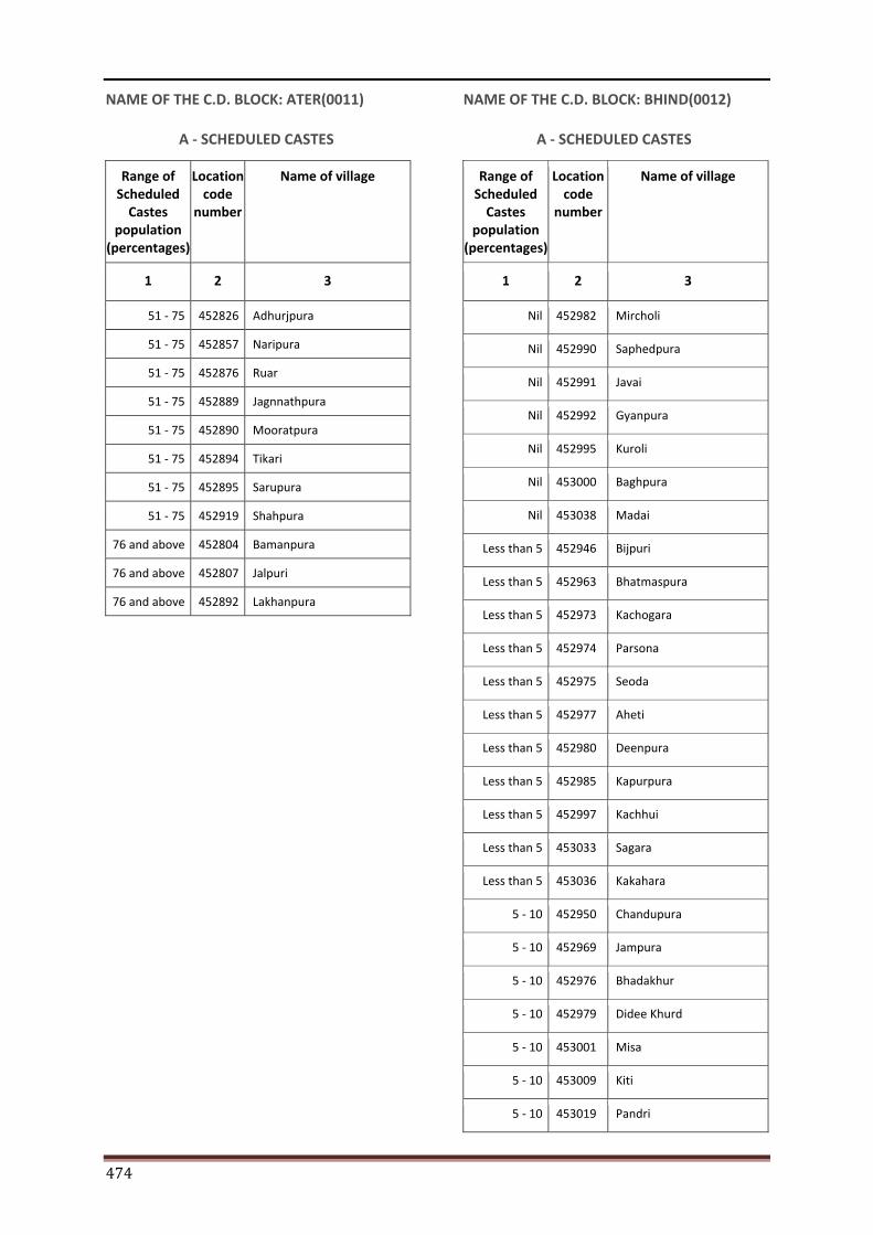
474
NAME OF THE C.D. BLOCK: ATER(0011)
A - SCHEDULED CASTES
Range of Scheduled
Castes population
(percentages)
Location code
number
Name of village
1 2 3
51 - 75 452826 Adhurjpura
51 - 75 452857 Naripura
51 - 75 452876 Ruar
51 - 75 452889 Jagnnathpura
51 - 75 452890 Mooratpura
51 - 75 452894 Tikari
51 - 75 452895 Sarupura
51 - 75 452919 Shahpura
76 and above 452804 Bamanpura
76 and above 452807 Jalpuri
76 and above 452892 Lakhanpura
NAME OF THE C.D. BLOCK: BHIND(0012)
A - SCHEDULED CASTES
Range of Scheduled
Castes population
(percentages)
Location code
number
Name of village
1 2 3
Nil 452982 Mircholi
Nil 452990 Saphedpura
Nil 452991 Javai
Nil 452992 Gyanpura
Nil 452995 Kuroli
Nil 453000 Baghpura
Nil 453038 Madai
Less than 5 452946 Bijpuri
Less than 5 452963 Bhatmaspura
Less than 5 452973 Kachogara
Less than 5 452974 Parsona
Less than 5 452975 Seoda
Less than 5 452977 Aheti
Less than 5 452980 Deenpura
Less than 5 452985 Kapurpura
Less than 5 452997 Kachhui
Less than 5 453033 Sagara
Less than 5 453036 Kakahara
5 - 10 452950 Chandupura
5 - 10 452969 Jampura
5 - 10 452976 Bhadakhur
5 - 10 452979 Didee Khurd
5 - 10 453001 Misa
5 - 10 453009 Kiti
5 - 10 453019 Pandri
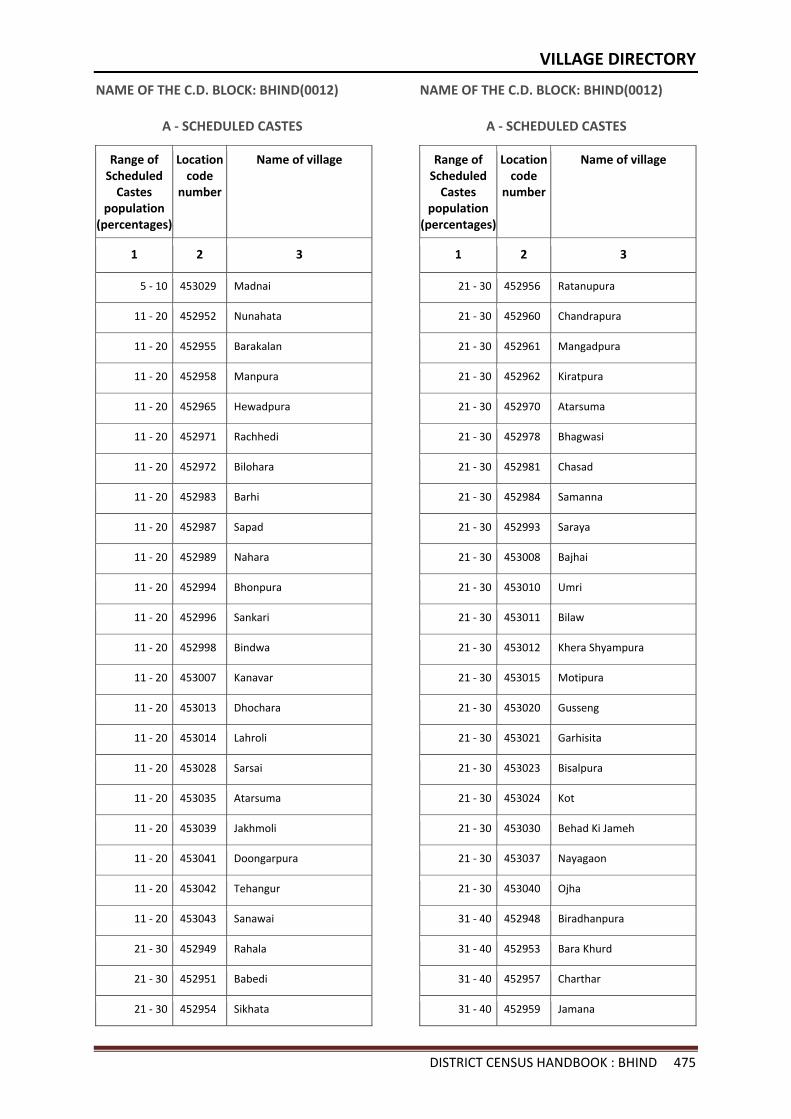
VILLAGE DIRECTORY
DISTRICT CENSUS HANDBOOK : BHIND 475
NAME OF THE C.D. BLOCK: BHIND(0012)
A - SCHEDULED CASTES
Range of Scheduled
Castes population
(percentages)
Location code
number
Name of village
1 2 3
5 - 10 453029 Madnai
11 - 20 452952 Nunahata
11 - 20 452955 Barakalan
11 - 20 452958 Manpura
11 - 20 452965 Hewadpura
11 - 20 452971 Rachhedi
11 - 20 452972 Bilohara
11 - 20 452983 Barhi
11 - 20 452987 Sapad
11 - 20 452989 Nahara
11 - 20 452994 Bhonpura
11 - 20 452996 Sankari
11 - 20 452998 Bindwa
11 - 20 453007 Kanavar
11 - 20 453013 Dhochara
11 - 20 453014 Lahroli
11 - 20 453028 Sarsai
11 - 20 453035 Atarsuma
11 - 20 453039 Jakhmoli
11 - 20 453041 Doongarpura
11 - 20 453042 Tehangur
11 - 20 453043 Sanawai
21 - 30 452949 Rahala
21 - 30 452951 Babedi
21 - 30 452954 Sikhata
NAME OF THE C.D. BLOCK: BHIND(0012)
A - SCHEDULED CASTES
Range of Scheduled
Castes population
(percentages)
Location code
number
Name of village
1 2 3
21 - 30 452956 Ratanupura
21 - 30 452960 Chandrapura
21 - 30 452961 Mangadpura
21 - 30 452962 Kiratpura
21 - 30 452970 Atarsuma
21 - 30 452978 Bhagwasi
21 - 30 452981 Chasad
21 - 30 452984 Samanna
21 - 30 452993 Saraya
21 - 30 453008 Bajhai
21 - 30 453010 Umri
21 - 30 453011 Bilaw
21 - 30 453012 Khera Shyampura
21 - 30 453015 Motipura
21 - 30 453020 Gusseng
21 - 30 453021 Garhisita
21 - 30 453023 Bisalpura
21 - 30 453024 Kot
21 - 30 453030 Behad Ki Jameh
21 - 30 453037 Nayagaon
21 - 30 453040 Ojha
31 - 40 452948 Biradhanpura
31 - 40 452953 Bara Khurd
31 - 40 452957 Charthar
31 - 40 452959 Jamana

476
NAME OF THE C.D. BLOCK: BHIND(0012)
A - SCHEDULED CASTES
Range of Scheduled
Castes population
(percentages)
Location code
number
Name of village
1 2 3
31 - 40 452964 Daboha
31 - 40 452999 Chhunchhari
31 - 40 453018 Pulawali
31 - 40 453025 Pewali
31 - 40 453026 Ishwari
31 - 40 453027 Rampura
31 - 40 453034 Puradumna
41 - 50 452967 Kumhrauwa
41 - 50 453002 Nahtoli
41 - 50 453006 Peeladanda
41 - 50 453016 Kharika
41 - 50 453032 Rora
41 - 50 453044 Dwar
51 - 75 452968 Laxmipura
51 - 75 453003 Singhpura
51 - 75 453022 Garhisultan
51 - 75 453031 Harki Jameh
76 and above 452947 Shalingpura
76 and above 452966 Khadar Gaughat
76 and above 452986 Jajepura
76 and above 453017 Akaha
NAME OF THE C.D. BLOCK: MEHGAON(0013)
A - SCHEDULED CASTES
Range of Scheduled
Castes population
(percentages)
Location code
number
Name of village
1 2 3
Nil 453047 Manikpura
Nil 453055 Alampura
Nil 453068 Surajpura
Nil 453129 Musawali
Nil 453133 Devari(Lawan)
Nil 453150 Sandasi Pura
Nil 453160 Kachhar
Nil 453173 Chandrapura
Nil 453181 Piproli
Nil 453188 Bhindada
Nil 453194 Kishanpura
Nil 453201 Chandeni
Nil 453207 Saipura
Nil 453241 Shreekapura
Less than 5 453057 Jarpura
Less than 5 453062 Gijurra
Less than 5 453073 Pratap Pura
Less than 5 453089 Raipura
Less than 5 453097 Parrawan
Less than 5 453109 Ekori
Less than 5 453114 Ajnol
Less than 5 453117 Sarsed
Less than 5 453125 Surawali
Less than 5 453128 Bharoli Kalan
Less than 5 453132 Depura
Less than 5 453135 Chhajupura
Less than 5 453147 Silaupura
Less than 5 453151 Adokhar
Less than 5 453152 Takpura
Less than 5 453163 Pura
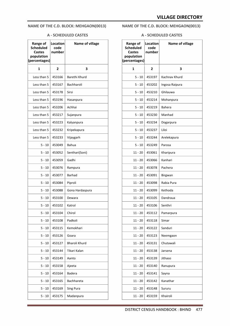
VILLAGE DIRECTORY
DISTRICT CENSUS HANDBOOK : BHIND 477
NAME OF THE C.D. BLOCK: MEHGAON(0013)
A - SCHEDULED CASTES
Range of Scheduled
Castes population
(percentages)
Location code
number
Name of village
1 2 3
Less than 5 453166 Barethi Khurd
Less than 5 453167 Bachharoli
Less than 5 453178 Sirsi
Less than 5 453196 Hasanpura
Less than 5 453206 Achhai
Less than 5 453217 Sujanpura
Less than 5 453223 Kalyanpura
Less than 5 453232 Kripekapura
Less than 5 453233 Vijaygarh
5 - 10 453049 Bahua
5 - 10 453052 Senthari(Soni)
5 - 10 453059 Gadhi
5 - 10 453076 Rampura
5 - 10 453077 Barhad
5 - 10 453084 Piproli
5 - 10 453088 Gona Hardaspura
5 - 10 453100 Dewara
5 - 10 453102 Katrol
5 - 10 453104 Chirol
5 - 10 453108 Padkoli
5 - 10 453115 Kemokhari
5 - 10 453126 Goara
5 - 10 453127 Bharoli Khurd
5 - 10 453144 Tikari Kalan
5 - 10 453149 Aanto
5 - 10 453158 Ajeeta
5 - 10 453164 Badera
5 - 10 453165 Bachhareta
5 - 10 453169 Sing Pura
5 - 10 453175 Madanpura
NAME OF THE C.D. BLOCK: MEHGAON(0013)
A - SCHEDULED CASTES
Range of Scheduled
Castes population
(percentages)
Location code
number
Name of village
1 2 3
5 - 10 453197 Kachnav Khurd
5 - 10 453202 Ingosa Raipura
5 - 10 453210 Ghilauwa
5 - 10 453214 Mohanpura
5 - 10 453219 Bahera
5 - 10 453230 Manhad
5 - 10 453234 Dogarpura
5 - 10 453237 Liloi
5 - 10 453244 Arelekapura
5 - 10 453249 Parosa
11 - 20 453061 Kharipura
11 - 20 453066 Kanhari
11 - 20 453078 Pachera
11 - 20 453091 Birgwan
11 - 20 453098 Rabia Pura
11 - 20 453099 Kethoda
11 - 20 453105 Dandraua
11 - 20 453106 Senthri
11 - 20 453112 Pamarpura
11 - 20 453118 Simar
11 - 20 453122 Sanduri
11 - 20 453123 Neemgaon
11 - 20 453131 Chutawali
11 - 20 453138 Jarsena
11 - 20 453139 Jithaso
11 - 20 453140 Ranupura
11 - 20 453141 Sayna
11 - 20 453142 Kanathar
11 - 20 453148 Sururu
11 - 20 453159 Khairoli
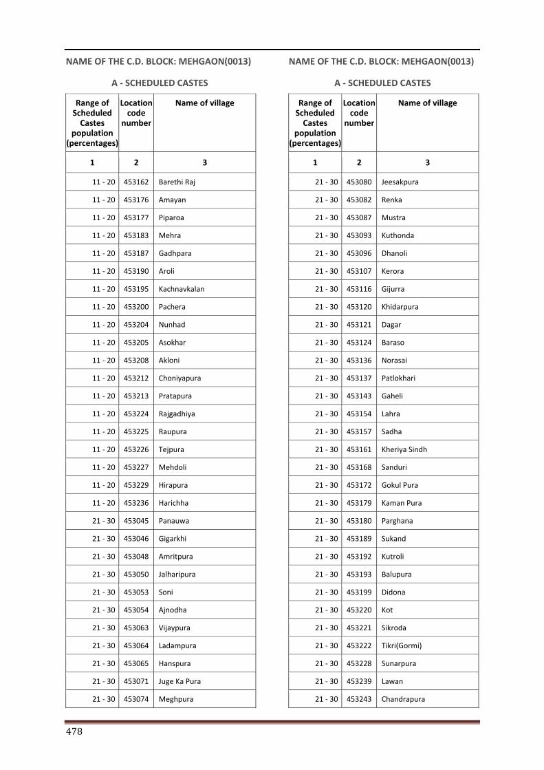
478
NAME OF THE C.D. BLOCK: MEHGAON(0013)
A - SCHEDULED CASTES
Range of Scheduled
Castes population
(percentages)
Location code
number
Name of village
1 2 3
11 - 20 453162 Barethi Raj
11 - 20 453176 Amayan
11 - 20 453177 Piparoa
11 - 20 453183 Mehra
11 - 20 453187 Gadhpara
11 - 20 453190 Aroli
11 - 20 453195 Kachnavkalan
11 - 20 453200 Pachera
11 - 20 453204 Nunhad
11 - 20 453205 Asokhar
11 - 20 453208 Akloni
11 - 20 453212 Choniyapura
11 - 20 453213 Pratapura
11 - 20 453224 Rajgadhiya
11 - 20 453225 Raupura
11 - 20 453226 Tejpura
11 - 20 453227 Mehdoli
11 - 20 453229 Hirapura
11 - 20 453236 Harichha
21 - 30 453045 Panauwa
21 - 30 453046 Gigarkhi
21 - 30 453048 Amritpura
21 - 30 453050 Jalharipura
21 - 30 453053 Soni
21 - 30 453054 Ajnodha
21 - 30 453063 Vijaypura
21 - 30 453064 Ladampura
21 - 30 453065 Hanspura
21 - 30 453071 Juge Ka Pura
21 - 30 453074 Meghpura
NAME OF THE C.D. BLOCK: MEHGAON(0013)
A - SCHEDULED CASTES
Range of Scheduled
Castes population
(percentages)
Location code
number
Name of village
1 2 3
21 - 30 453080 Jeesakpura
21 - 30 453082 Renka
21 - 30 453087 Mustra
21 - 30 453093 Kuthonda
21 - 30 453096 Dhanoli
21 - 30 453107 Kerora
21 - 30 453116 Gijurra
21 - 30 453120 Khidarpura
21 - 30 453121 Dagar
21 - 30 453124 Baraso
21 - 30 453136 Norasai
21 - 30 453137 Patlokhari
21 - 30 453143 Gaheli
21 - 30 453154 Lahra
21 - 30 453157 Sadha
21 - 30 453161 Kheriya Sindh
21 - 30 453168 Sanduri
21 - 30 453172 Gokul Pura
21 - 30 453179 Kaman Pura
21 - 30 453180 Parghana
21 - 30 453189 Sukand
21 - 30 453192 Kutroli
21 - 30 453193 Balupura
21 - 30 453199 Didona
21 - 30 453220 Kot
21 - 30 453221 Sikroda
21 - 30 453222 Tikri(Gormi)
21 - 30 453228 Sunarpura
21 - 30 453239 Lawan
21 - 30 453243 Chandrapura
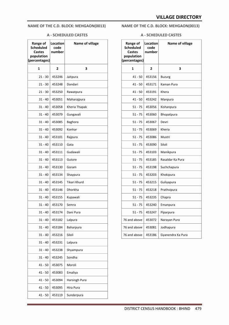
VILLAGE DIRECTORY
DISTRICT CENSUS HANDBOOK : BHIND 479
NAME OF THE C.D. BLOCK: MEHGAON(0013)
A - SCHEDULED CASTES
Range of Scheduled
Castes population
(percentages)
Location code
number
Name of village
1 2 3
21 - 30 453246 Jaitpura
21 - 30 453248 Dondari
21 - 30 453250 Rawatpura
31 - 40 453051 Maharajpura
31 - 40 453058 Kheria Thapak
31 - 40 453079 Gungavali
31 - 40 453085 Baghora
31 - 40 453092 Konhar
31 - 40 453101 Rajpura
31 - 40 453110 Gata
31 - 40 453111 Gudawali
31 - 40 453113 Gutore
31 - 40 453130 Goram
31 - 40 453134 Shaypura
31 - 40 453145 Tikari Khurd
31 - 40 453146 Dhorkha
31 - 40 453155 Kupawali
31 - 40 453170 Semra
31 - 40 453174 Dani Pura
31 - 40 453182 Lalpura
31 - 40 453184 Baharpura
31 - 40 453216 Siloli
31 - 40 453231 Lalpura
31 - 40 453238 Shyampura
31 - 40 453245 Sondha
41 - 50 453075 Moroli
41 - 50 453083 Emaliya
41 - 50 453094 Harsingh Pura
41 - 50 453095 Hira Pura
41 - 50 453119 Sunderpura
NAME OF THE C.D. BLOCK: MEHGAON(0013)
A - SCHEDULED CASTES
Range of Scheduled
Castes population
(percentages)
Location code
number
Name of village
1 2 3
41 - 50 453156 Buzurg
41 - 50 453171 Kaman Pura
41 - 50 453191 Khera
41 - 50 453242 Manpura
51 - 75 453056 Kishanpura
51 - 75 453060 Bhopatpura
51 - 75 453067 Devri
51 - 75 453069 Kheria
51 - 75 453086 Mustri
51 - 75 453090 Siloli
51 - 75 453103 Manikpura
51 - 75 453185 Rasaldar Ka Pura
51 - 75 453198 Suchchapura
51 - 75 453203 Khokipura
51 - 75 453215 Guliyapura
51 - 75 453218 Prathvipura
51 - 75 453235 Chapra
51 - 75 453240 Emanpura
51 - 75 453247 Piparpura
76 and above 453072 Narayan Pura
76 and above 453081 Jodhapura
76 and above 453186 Gyanendra Ka Pura
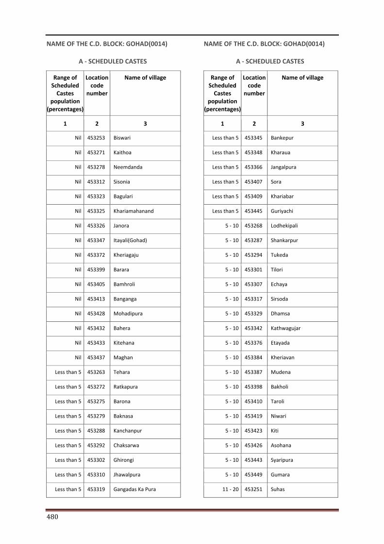
480
NAME OF THE C.D. BLOCK: GOHAD(0014)
A - SCHEDULED CASTES
Range of Scheduled
Castes population
(percentages)
Location code
number
Name of village
1 2 3
Nil 453253 Biswari
Nil 453271 Kaithoa
Nil 453278 Neemdanda
Nil 453312 Sisonia
Nil 453323 Bagulari
Nil 453325 Khariamahanand
Nil 453326 Janora
Nil 453347 Itayali(Gohad)
Nil 453372 Kheriagaju
Nil 453399 Barara
Nil 453405 Bamhroli
Nil 453413 Banganga
Nil 453428 Mohadipura
Nil 453432 Bahera
Nil 453433 Kitehana
Nil 453437 Maghan
Less than 5 453263 Tehara
Less than 5 453272 Ratkapura
Less than 5 453275 Barona
Less than 5 453279 Baknasa
Less than 5 453288 Kanchanpur
Less than 5 453292 Chaksarwa
Less than 5 453302 Ghirongi
Less than 5 453310 Jhawalpura
Less than 5 453319 Gangadas Ka Pura
NAME OF THE C.D. BLOCK: GOHAD(0014)
A - SCHEDULED CASTES
Range of Scheduled
Castes population
(percentages)
Location code
number
Name of village
1 2 3
Less than 5 453345 Bankepur
Less than 5 453348 Kharaua
Less than 5 453366 Jangalpura
Less than 5 453407 Sora
Less than 5 453409 Khariabar
Less than 5 453445 Guriyachi
5 - 10 453268 Lodhekipali
5 - 10 453287 Shankarpur
5 - 10 453294 Tukeda
5 - 10 453301 Tilori
5 - 10 453307 Echaya
5 - 10 453317 Sirsoda
5 - 10 453329 Dhamsa
5 - 10 453342 Kathwagujar
5 - 10 453376 Etayada
5 - 10 453384 Kheriavan
5 - 10 453387 Mudena
5 - 10 453398 Bakholi
5 - 10 453410 Taroli
5 - 10 453419 Niwari
5 - 10 453423 Kiti
5 - 10 453426 Asohana
5 - 10 453443 Syaripura
5 - 10 453449 Gumara
11 - 20 453251 Suhas
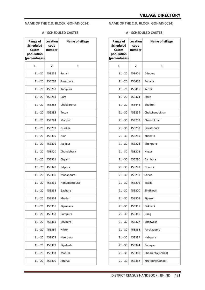
VILLAGE DIRECTORY
DISTRICT CENSUS HANDBOOK : BHIND 481
NAME OF THE C.D. BLOCK: GOHAD(0014)
A - SCHEDULED CASTES
Range of Scheduled
Castes population
(percentages)
Location code
number
Name of village
1 2 3
11 - 20 453252 Sunari
11 - 20 453262 Amarpura
11 - 20 453267 Kanipura
11 - 20 453281 Bara
11 - 20 453282 Chakbarona
11 - 20 453283 Teton
11 - 20 453284 Manpur
11 - 20 453299 Gurikha
11 - 20 453305 Alori
11 - 20 453306 Jyajipur
11 - 20 453320 Chandahara
11 - 20 453321 Bhyani
11 - 20 453328 Jatpura
11 - 20 453330 Madanpura
11 - 20 453335 Hanumantpura
11 - 20 453338 Baghora
11 - 20 453354 Khader
11 - 20 453356 Pipersana
11 - 20 453358 Rampura
11 - 20 453361 Bhypura
11 - 20 453369 Nibrol
11 - 20 453374 Neerpura
11 - 20 453377 Pipahada
11 - 20 453383 Madroli
11 - 20 453400 Jatarvai
NAME OF THE C.D. BLOCK: GOHAD(0014)
A - SCHEDULED CASTES
Range of Scheduled
Castes population
(percentages)
Location code
number
Name of village
1 2 3
11 - 20 453401 Adupura
11 - 20 453402 Padaria
11 - 20 453416 Keroli
11 - 20 453424 Jaret
11 - 20 453446 Bhadroli
21 - 30 453256 Chakchandokhar
21 - 30 453257 Chandokhar
21 - 30 453258 Jasrathpura
21 - 30 453269 Khaneta
21 - 30 453273 Bhonpura
21 - 30 453276 Nagor
21 - 30 453280 Bamhora
21 - 30 453289 Nonera
21 - 30 453291 Sarwa
21 - 30 453296 Tudila
21 - 30 453300 Sindhwari
21 - 30 453308 Piparoli
21 - 30 453315 Birkhadi
21 - 30 453316 Dang
21 - 30 453327 Bhagwasa
21 - 30 453336 Paratappura
21 - 30 453337 Habipura
21 - 30 453344 Badagar
21 - 30 453350 Chharenta(Gohad)
21 - 30 453352 Kiratpura(Gohad)
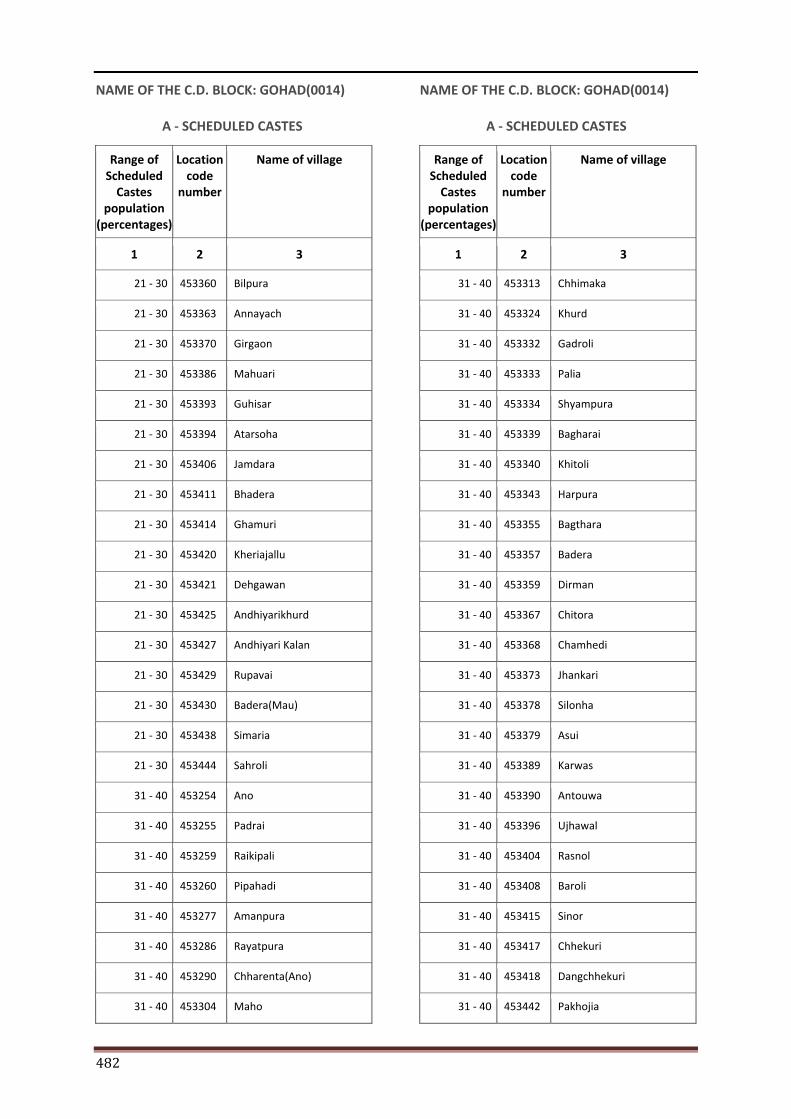
482
NAME OF THE C.D. BLOCK: GOHAD(0014)
A - SCHEDULED CASTES
Range of Scheduled
Castes population
(percentages)
Location code
number
Name of village
1 2 3
21 - 30 453360 Bilpura
21 - 30 453363 Annayach
21 - 30 453370 Girgaon
21 - 30 453386 Mahuari
21 - 30 453393 Guhisar
21 - 30 453394 Atarsoha
21 - 30 453406 Jamdara
21 - 30 453411 Bhadera
21 - 30 453414 Ghamuri
21 - 30 453420 Kheriajallu
21 - 30 453421 Dehgawan
21 - 30 453425 Andhiyarikhurd
21 - 30 453427 Andhiyari Kalan
21 - 30 453429 Rupavai
21 - 30 453430 Badera(Mau)
21 - 30 453438 Simaria
21 - 30 453444 Sahroli
31 - 40 453254 Ano
31 - 40 453255 Padrai
31 - 40 453259 Raikipali
31 - 40 453260 Pipahadi
31 - 40 453277 Amanpura
31 - 40 453286 Rayatpura
31 - 40 453290 Chharenta(Ano)
31 - 40 453304 Maho
NAME OF THE C.D. BLOCK: GOHAD(0014)
A - SCHEDULED CASTES
Range of Scheduled
Castes population
(percentages)
Location code
number
Name of village
1 2 3
31 - 40 453313 Chhimaka
31 - 40 453324 Khurd
31 - 40 453332 Gadroli
31 - 40 453333 Palia
31 - 40 453334 Shyampura
31 - 40 453339 Bagharai
31 - 40 453340 Khitoli
31 - 40 453343 Harpura
31 - 40 453355 Bagthara
31 - 40 453357 Badera
31 - 40 453359 Dirman
31 - 40 453367 Chitora
31 - 40 453368 Chamhedi
31 - 40 453373 Jhankari
31 - 40 453378 Silonha
31 - 40 453379 Asui
31 - 40 453389 Karwas
31 - 40 453390 Antouwa
31 - 40 453396 Ujhawal
31 - 40 453404 Rasnol
31 - 40 453408 Baroli
31 - 40 453415 Sinor
31 - 40 453417 Chhekuri
31 - 40 453418 Dangchhekuri
31 - 40 453442 Pakhojia
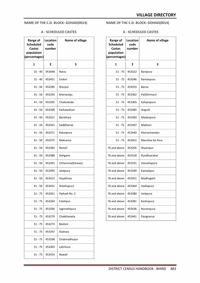
VILLAGE DIRECTORY
DISTRICT CENSUS HANDBOOK : BHIND 483
NAME OF THE C.D. BLOCK: GOHAD(0014)
A - SCHEDULED CASTES
Range of Scheduled
Castes population
(percentages)
Location code
number
Name of village
1 2 3
31 - 40 453448 Ratva
31 - 40 453451 Endori
41 - 50 453285 Sherpur
41 - 50 453293 Kheriaraiju
41 - 50 453295 Chaktukeda
41 - 50 453309 Kathawahazi
41 - 50 453311 Barathara
41 - 50 453341 Sad(Kheria)
41 - 50 453371 Ratanpura
41 - 50 453375 Makrenta
41 - 50 453382 Nenoli
41 - 50 453388 Dehgaon
41 - 50 453391 Chharenta(Karwas)
41 - 50 453395 Jalalpura
41 - 50 453412 Itayalimau
41 - 50 453431 Shekhupura
51 - 75 453261 Piphadi No. 2
51 - 75 453264 Fatehpur
51 - 75 453266 Jagnnathpura
51 - 75 453270 Chakkhaneta
51 - 75 453274 Beeloni
51 - 75 453297 Ekahara
51 - 75 453298 Chakmadhopur
51 - 75 453303 Lahchura
51 - 75 453314 Nawali
NAME OF THE C.D. BLOCK: GOHAD(0014)
A - SCHEDULED CASTES
Range of Scheduled
Castes population
(percentages)
Location code
number
Name of village
1 2 3
51 - 75 453322 Banipura
51 - 75 453346 Ramanpura
51 - 75 453353 Baroa
51 - 75 453362 Pali(Dirman)
51 - 75 453365 Kaliyanpura
51 - 75 453385 Angsoli
51 - 75 453392 Madanpura
51 - 75 453397 Makhori
51 - 75 453440 Kheriachandan
51 - 75 453452 Manohar Ka Pura
76 and above 453265 Shyampur
76 and above 453318 Rundhsarakar
76 and above 453331 Hanseliapura
76 and above 453349 Kamalapur
76 and above 453351 Madhogarh
76 and above 453364 Hadiapura
76 and above 453380 Jankpura
76 and above 453381 Keshopura
76 and above 453436 Nurampura
76 and above 453441 Dangnarua
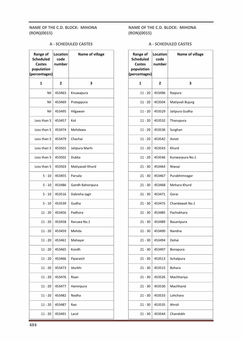
484
NAME OF THE C.D. BLOCK: MIHONA (RON)(0015)
A - SCHEDULED CASTES
Range of Scheduled
Castes population
(percentages)
Location code
number
Name of village
1 2 3
Nil 453463 Knuwapura
Nil 453469 Pratappura
Nil 453495 Hilgawan
Less than 5 453457 Kot
Less than 5 453474 Mehdawa
Less than 5 453479 Chachai
Less than 5 453501 Jaitpura Marhi
Less than 5 453502 Dubka
Less than 5 453503 Matiyavali Khurd
5 - 10 453455 Parsala
5 - 10 453486 Gandh Bahoripura
5 - 10 453516 Dabreha Jagir
5 - 10 453539 Gudha
11 - 20 453456 Padhora
11 - 20 453458 Raruwa No.1
11 - 20 453459 Mehda
11 - 20 453461 Mahayar
11 - 20 453465 Kondh
11 - 20 453466 Piparaich
11 - 20 453473 Idurkhi
11 - 20 453476 Roan
11 - 20 453477 Hamirpura
11 - 20 453482 Nodha
11 - 20 453487 Rao
11 - 20 453491 Larol
NAME OF THE C.D. BLOCK: MIHONA (RON)(0015)
A - SCHEDULED CASTES
Range of Scheduled
Castes population
(percentages)
Location code
number
Name of village
1 2 3
11 - 20 453496 Raipura
11 - 20 453504 Matiyvali Bujurg
11 - 20 453529 Jaitpura Gudha
11 - 20 453532 Thanupura
11 - 20 453536 Surghan
11 - 20 453542 Asnet
11 - 20 453543 Khurd
11 - 20 453546 Kunwarpura No.1
21 - 30 453464 Niwsai
21 - 30 453467 Purabhimnagar
21 - 30 453468 Mehara Khurd
21 - 30 453471 Gorai
21 - 30 453475 Chandawali No.1
21 - 30 453485 Pachokhara
21 - 30 453489 Basantpura
21 - 30 453490 Nandna
21 - 30 453494 Dohai
21 - 30 453497 Bonapura
21 - 30 453513 Achalpura
21 - 30 453515 Bohara
21 - 30 453526 Machhariya
21 - 30 453530 Machhand
21 - 30 453533 Lohchara
21 - 30 453535 Ahroli
21 - 30 453544 Chandokh
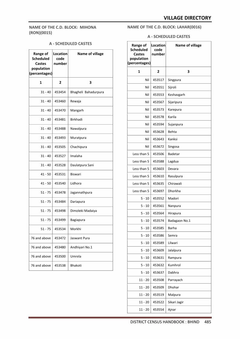
VILLAGE DIRECTORY
DISTRICT CENSUS HANDBOOK : BHIND 485
NAME OF THE C.D. BLOCK: MIHONA (RON)(0015)
A - SCHEDULED CASTES
Range of Scheduled
Castes population
(percentages)
Location code
number
Name of village
1 2 3
31 - 40 453454 Bhagheli Bahadurpura
31 - 40 453460 Rewaja
31 - 40 453470 Mangarh
31 - 40 453481 Birkhadi
31 - 40 453488 Nawalpura
31 - 40 453493 Muratpura
31 - 40 453505 Chachipura
31 - 40 453527 Imalaha
31 - 40 453528 Daulatpura Sani
41 - 50 453531 Biswari
41 - 50 453540 Lidhora
51 - 75 453478 Jagannathpura
51 - 75 453484 Dariapura
51 - 75 453498 Dimoleki Madaiya
51 - 75 453499 Bagiapura
51 - 75 453534 Morkhi
76 and above 453472 Jaswant Pura
76 and above 453480 Andhiyari No.1
76 and above 453500 Umrela
76 and above 453538 Bhakoti
NAME OF THE C.D. BLOCK: LAHAR(0016)
A - SCHEDULED CASTES
Range of Scheduled
Castes population
(percentages)
Location code
number
Name of village
1 2 3
Nil 453517 Singpura
Nil 453551 Sijroli
Nil 453553 Keshavgarh
Nil 453567 Sijaripura
Nil 453573 Karepura
Nil 453578 Karila
Nil 453594 Sujanpura
Nil 453628 Behta
Nil 453643 Kanksi
Nil 453672 Singosa
Less than 5 453506 Badetar
Less than 5 453588 Lagdua
Less than 5 453603 Devara
Less than 5 453610 Rasulpura
Less than 5 453635 Chirawali
Less than 5 453697 Dhorkha
5 - 10 453552 Madori
5 - 10 453561 Nanpura
5 - 10 453564 Hirapura
5 - 10 453574 Badagaon No.1
5 - 10 453585 Barha
5 - 10 453586 Semra
5 - 10 453589 Lilwari
5 - 10 453609 Jalalpura
5 - 10 453631 Rampura
5 - 10 453632 Kumhrol
5 - 10 453637 Dabhra
11 - 20 453508 Parrayach
11 - 20 453509 Dhohar
11 - 20 453519 Malpura
11 - 20 453522 Sikari Jagir
11 - 20 453554 Ajnar
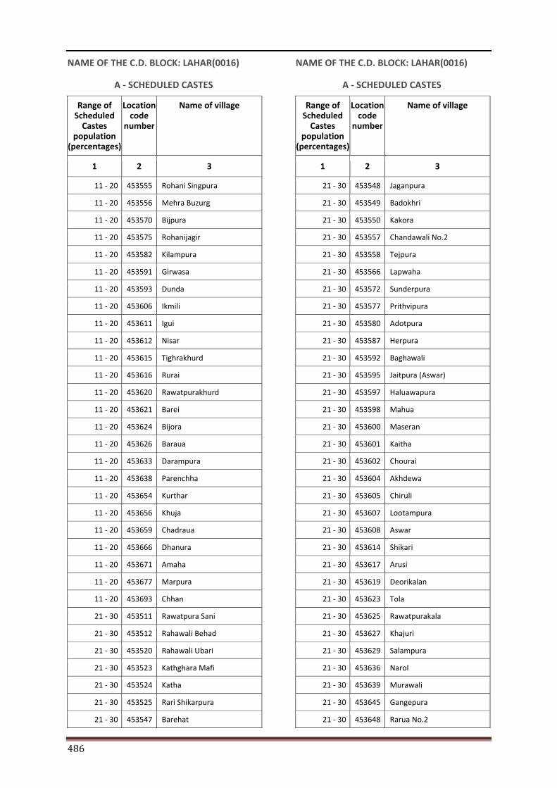
486
NAME OF THE C.D. BLOCK: LAHAR(0016)
A - SCHEDULED CASTES
Range of Scheduled
Castes population
(percentages)
Location code
number
Name of village
1 2 3
11 - 20 453555 Rohani Singpura
11 - 20 453556 Mehra Buzurg
11 - 20 453570 Bijpura
11 - 20 453575 Rohanijagir
11 - 20 453582 Kilampura
11 - 20 453591 Girwasa
11 - 20 453593 Dunda
11 - 20 453606 Ikmili
11 - 20 453611 Igui
11 - 20 453612 Nisar
11 - 20 453615 Tighrakhurd
11 - 20 453616 Rurai
11 - 20 453620 Rawatpurakhurd
11 - 20 453621 Barei
11 - 20 453624 Bijora
11 - 20 453626 Baraua
11 - 20 453633 Darampura
11 - 20 453638 Parenchha
11 - 20 453654 Kurthar
11 - 20 453656 Khuja
11 - 20 453659 Chadraua
11 - 20 453666 Dhanura
11 - 20 453671 Amaha
11 - 20 453677 Marpura
11 - 20 453693 Chhan
21 - 30 453511 Rawatpura Sani
21 - 30 453512 Rahawali Behad
21 - 30 453520 Rahawali Ubari
21 - 30 453523 Kathghara Mafi
21 - 30 453524 Katha
21 - 30 453525 Rari Shikarpura
21 - 30 453547 Barehat
NAME OF THE C.D. BLOCK: LAHAR(0016)
A - SCHEDULED CASTES
Range of Scheduled
Castes population
(percentages)
Location code
number
Name of village
1 2 3
21 - 30 453548 Jaganpura
21 - 30 453549 Badokhri
21 - 30 453550 Kakora
21 - 30 453557 Chandawali No.2
21 - 30 453558 Tejpura
21 - 30 453566 Lapwaha
21 - 30 453572 Sunderpura
21 - 30 453577 Prithvipura
21 - 30 453580 Adotpura
21 - 30 453587 Herpura
21 - 30 453592 Baghawali
21 - 30 453595 Jaitpura (Aswar)
21 - 30 453597 Haluawapura
21 - 30 453598 Mahua
21 - 30 453600 Maseran
21 - 30 453601 Kaitha
21 - 30 453602 Chourai
21 - 30 453604 Akhdewa
21 - 30 453605 Chiruli
21 - 30 453607 Lootampura
21 - 30 453608 Aswar
21 - 30 453614 Shikari
21 - 30 453617 Arusi
21 - 30 453619 Deorikalan
21 - 30 453623 Tola
21 - 30 453625 Rawatpurakala
21 - 30 453627 Khajuri
21 - 30 453629 Salampura
21 - 30 453636 Narol
21 - 30 453639 Murawali
21 - 30 453645 Gangepura
21 - 30 453648 Rarua No.2
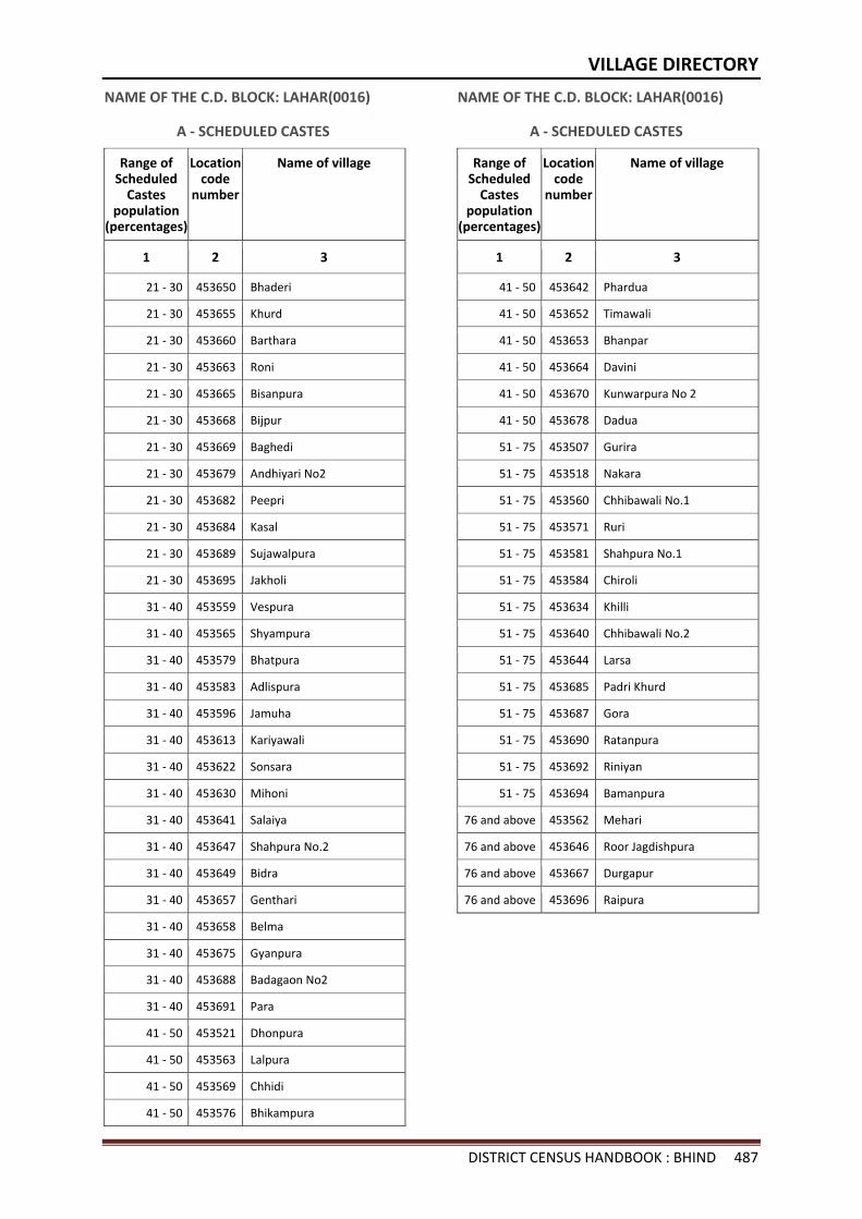
VILLAGE DIRECTORY
DISTRICT CENSUS HANDBOOK : BHIND 487
NAME OF THE C.D. BLOCK: LAHAR(0016)
A - SCHEDULED CASTES
Range of Scheduled
Castes population
(percentages)
Location code
number
Name of village
1 2 3
21 - 30 453650 Bhaderi
21 - 30 453655 Khurd
21 - 30 453660 Barthara
21 - 30 453663 Roni
21 - 30 453665 Bisanpura
21 - 30 453668 Bijpur
21 - 30 453669 Baghedi
21 - 30 453679 Andhiyari No2
21 - 30 453682 Peepri
21 - 30 453684 Kasal
21 - 30 453689 Sujawalpura
21 - 30 453695 Jakholi
31 - 40 453559 Vespura
31 - 40 453565 Shyampura
31 - 40 453579 Bhatpura
31 - 40 453583 Adlispura
31 - 40 453596 Jamuha
31 - 40 453613 Kariyawali
31 - 40 453622 Sonsara
31 - 40 453630 Mihoni
31 - 40 453641 Salaiya
31 - 40 453647 Shahpura No.2
31 - 40 453649 Bidra
31 - 40 453657 Genthari
31 - 40 453658 Belma
31 - 40 453675 Gyanpura
31 - 40 453688 Badagaon No2
31 - 40 453691 Para
41 - 50 453521 Dhonpura
41 - 50 453563 Lalpura
41 - 50 453569 Chhidi
41 - 50 453576 Bhikampura
NAME OF THE C.D. BLOCK: LAHAR(0016)
A - SCHEDULED CASTES
Range of Scheduled
Castes population
(percentages)
Location code
number
Name of village
1 2 3
41 - 50 453642 Phardua
41 - 50 453652 Timawali
41 - 50 453653 Bhanpar
41 - 50 453664 Davini
41 - 50 453670 Kunwarpura No 2
41 - 50 453678 Dadua
51 - 75 453507 Gurira
51 - 75 453518 Nakara
51 - 75 453560 Chhibawali No.1
51 - 75 453571 Ruri
51 - 75 453581 Shahpura No.1
51 - 75 453584 Chiroli
51 - 75 453634 Khilli
51 - 75 453640 Chhibawali No.2
51 - 75 453644 Larsa
51 - 75 453685 Padri Khurd
51 - 75 453687 Gora
51 - 75 453690 Ratanpura
51 - 75 453692 Riniyan
51 - 75 453694 Bamanpura
76 and above 453562 Mehari
76 and above 453646 Roor Jagdishpura
76 and above 453667 Durgapur
76 and above 453696 Raipura
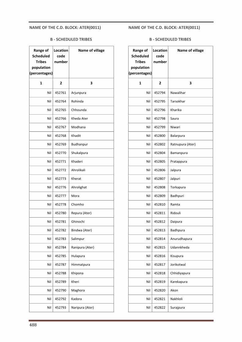
488
NAME OF THE C.D. BLOCK: ATER(0011)
B - SCHEDULED TRIBES
Range of Scheduled
Tribes population
(percentages)
Location code
number
Name of village
1 2 3
Nil 452761 Arjunpura
Nil 452764 Rohinda
Nil 452765 Chhounda
Nil 452766 Kheda Ater
Nil 452767 Modhana
Nil 452768 Khadit
Nil 452769 Budhanpur
Nil 452770 Shukalpura
Nil 452771 Khaderi
Nil 452772 Ahrolikali
Nil 452773 Kherat
Nil 452776 Ahrolighat
Nil 452777 Mora
Nil 452778 Chomho
Nil 452780 Repura (Ater)
Nil 452781 Ghinochi
Nil 452782 Bindwa (Ater)
Nil 452783 Salimpur
Nil 452784 Ranipura (Ater)
Nil 452785 Hulapura
Nil 452787 Himmatpura
Nil 452788 Khipona
Nil 452789 Kheri
Nil 452790 Maghora
Nil 452792 Kadora
Nil 452793 Naripura (Ater)
NAME OF THE C.D. BLOCK: ATER(0011)
B - SCHEDULED TRIBES
Range of Scheduled
Tribes population
(percentages)
Location code
number
Name of village
1 2 3
Nil 452794 Nawalihar
Nil 452795 Tarsokhar
Nil 452796 Kharika
Nil 452798 Saura
Nil 452799 Niwari
Nil 452800 Balarpura
Nil 452802 Ratnupura (Ater)
Nil 452804 Bamanpura
Nil 452805 Pratappura
Nil 452806 Jalpura
Nil 452807 Jalpuri
Nil 452808 Torkapura
Nil 452809 Badhpuri
Nil 452810 Ramta
Nil 452811 Ridouli
Nil 452812 Daipura
Nil 452813 Badhpura
Nil 452814 Anurudhapura
Nil 452815 Udannkheda
Nil 452816 Kisupura
Nil 452817 Jorikotwal
Nil 452818 Chhidiyapura
Nil 452819 Karekapura
Nil 452820 Akon
Nil 452821 Nakhloli
Nil 452822 Surajpura
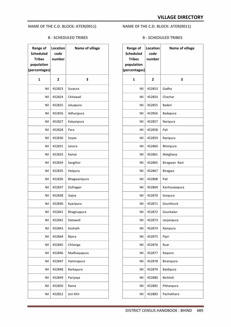
VILLAGE DIRECTORY
DISTRICT CENSUS HANDBOOK : BHIND 489
NAME OF THE C.D. BLOCK: ATER(0011)
B - SCHEDULED TRIBES
Range of Scheduled
Tribes population
(percentages)
Location code
number
Name of village
1 2 3
Nil 452823 Surpura
Nil 452824 Chitawali
Nil 452825 Jaluapura
Nil 452826 Adhurjpura
Nil 452827 Kalyanpura
Nil 452828 Para
Nil 452830 Soyee
Nil 452831 Janora
Nil 452833 Kamai
Nil 452834 Sanglitor
Nil 452835 Hetpura
Nil 452836 Bhagwantpura
Nil 452837 Dulhagan
Nil 452838 Gajna
Nil 452840 Kyaripura
Nil 452841 Bhagtuapura
Nil 452842 Datawali
Nil 452843 Koshath
Nil 452844 Bijora
Nil 452845 Chilonga
Nil 452846 Madhaiyapura
Nil 452847 Hamirapura
Nil 452848 Barkapura
Nil 452849 Pariyaya
Nil 452850 Rama
Nil 452852 Jori Ahir
NAME OF THE C.D. BLOCK: ATER(0011)
B - SCHEDULED TRIBES
Range of Scheduled
Tribes population
(percentages)
Location code
number
Name of village
1 2 3
Nil 452853 Gadha
Nil 452854 Chachar
Nil 452855 Baderi
Nil 452856 Badapura
Nil 452857 Naripura
Nil 452858 Pali
Nil 452859 Ranipura
Nil 452860 Bhimpura
Nil 452861 Matghana
Nil 452865 Biragwan Rani
Nil 452867 Biragwa
Nil 452868 Pali
Nil 452869 Kanhouwapura
Nil 452870 Sonpura
Nil 452871 Gourkhurd
Nil 452872 Gourkalan
Nil 452873 Janjaripura
Nil 452874 Rampura
Nil 452875 Pipri
Nil 452876 Ruar
Nil 452877 Raipura
Nil 452878 Birampura
Nil 452879 Baidipura
Nil 452880 Bichholi
Nil 452882 Pithanpura
Nil 452883 Pachokhara
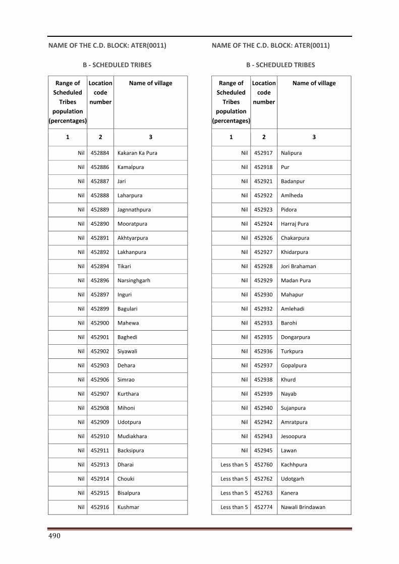
490
NAME OF THE C.D. BLOCK: ATER(0011)
B - SCHEDULED TRIBES
Range of Scheduled
Tribes population
(percentages)
Location code
number
Name of village
1 2 3
Nil 452884 Kakaran Ka Pura
Nil 452886 Kamalpura
Nil 452887 Jari
Nil 452888 Laharpura
Nil 452889 Jagnnathpura
Nil 452890 Mooratpura
Nil 452891 Akhtyarpura
Nil 452892 Lakhanpura
Nil 452894 Tikari
Nil 452896 Narsinghgarh
Nil 452897 Inguri
Nil 452899 Bagulari
Nil 452900 Mahewa
Nil 452901 Baghedi
Nil 452902 Siyawali
Nil 452903 Dehara
Nil 452906 Simrao
Nil 452907 Kurthara
Nil 452908 Mihoni
Nil 452909 Udotpura
Nil 452910 Mudiakhara
Nil 452911 Backsipura
Nil 452913 Dharai
Nil 452914 Chouki
Nil 452915 Bisalpura
Nil 452916 Kushmar
NAME OF THE C.D. BLOCK: ATER(0011)
B - SCHEDULED TRIBES
Range of Scheduled
Tribes population
(percentages)
Location code
number
Name of village
1 2 3
Nil 452917 Nalipura
Nil 452918 Pur
Nil 452921 Badanpur
Nil 452922 Amlheda
Nil 452923 Pidora
Nil 452924 Harraj Pura
Nil 452926 Chakarpura
Nil 452927 Khidarpura
Nil 452928 Jori Brahaman
Nil 452929 Madan Pura
Nil 452930 Mahapur
Nil 452932 Amlehadi
Nil 452933 Barohi
Nil 452935 Dongarpura
Nil 452936 Turkpura
Nil 452937 Gopalpura
Nil 452938 Khurd
Nil 452939 Nayab
Nil 452940 Sujanpura
Nil 452942 Amratpura
Nil 452943 Jesoopura
Nil 452945 Lawan
Less than 5 452760 Kachhpura
Less than 5 452762 Udotgarh
Less than 5 452763 Kanera
Less than 5 452774 Nawali Brindawan
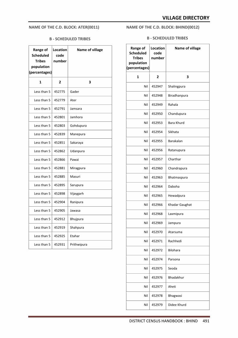
VILLAGE DIRECTORY
DISTRICT CENSUS HANDBOOK : BHIND 491
NAME OF THE C.D. BLOCK: ATER(0011)
B - SCHEDULED TRIBES
Range of Scheduled
Tribes population
(percentages)
Location code
number
Name of village
1 2 3
Less than 5 452775 Gader
Less than 5 452779 Ater
Less than 5 452791 Jamsara
Less than 5 452801 Jamhora
Less than 5 452803 Gohdupura
Less than 5 452839 Manepura
Less than 5 452851 Sakaraya
Less than 5 452862 Udanpura
Less than 5 452866 Pawai
Less than 5 452881 Miragpura
Less than 5 452885 Masuri
Less than 5 452895 Sarupura
Less than 5 452898 Vijaygarh
Less than 5 452904 Ranipura
Less than 5 452905 Jawasa
Less than 5 452912 Bhujpura
Less than 5 452919 Shahpura
Less than 5 452925 Etahar
Less than 5 452931 Prithwipura
NAME OF THE C.D. BLOCK: BHIND(0012)
B - SCHEDULED TRIBES
Range of Scheduled
Tribes population
(percentages)
Location code
number
Name of village
1 2 3
Nil 452947 Shalingpura
Nil 452948 Biradhanpura
Nil 452949 Rahala
Nil 452950 Chandupura
Nil 452953 Bara Khurd
Nil 452954 Sikhata
Nil 452955 Barakalan
Nil 452956 Ratanupura
Nil 452957 Charthar
Nil 452960 Chandrapura
Nil 452963 Bhatmaspura
Nil 452964 Daboha
Nil 452965 Hewadpura
Nil 452966 Khadar Gaughat
Nil 452968 Laxmipura
Nil 452969 Jampura
Nil 452970 Atarsuma
Nil 452971 Rachhedi
Nil 452972 Bilohara
Nil 452974 Parsona
Nil 452975 Seoda
Nil 452976 Bhadakhur
Nil 452977 Aheti
Nil 452978 Bhagwasi
Nil 452979 Didee Khurd
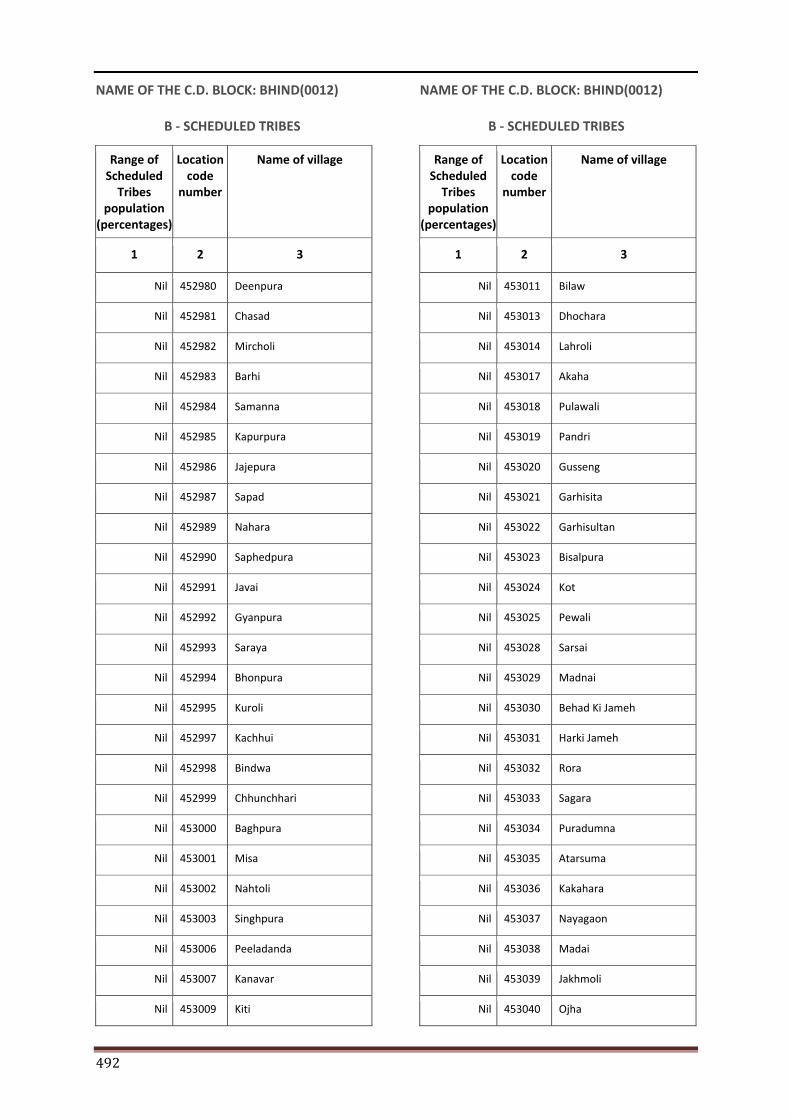
492
NAME OF THE C.D. BLOCK: BHIND(0012)
B - SCHEDULED TRIBES
Range of Scheduled
Tribes population
(percentages)
Location code
number
Name of village
1 2 3
Nil 452980 Deenpura
Nil 452981 Chasad
Nil 452982 Mircholi
Nil 452983 Barhi
Nil 452984 Samanna
Nil 452985 Kapurpura
Nil 452986 Jajepura
Nil 452987 Sapad
Nil 452989 Nahara
Nil 452990 Saphedpura
Nil 452991 Javai
Nil 452992 Gyanpura
Nil 452993 Saraya
Nil 452994 Bhonpura
Nil 452995 Kuroli
Nil 452997 Kachhui
Nil 452998 Bindwa
Nil 452999 Chhunchhari
Nil 453000 Baghpura
Nil 453001 Misa
Nil 453002 Nahtoli
Nil 453003 Singhpura
Nil 453006 Peeladanda
Nil 453007 Kanavar
Nil 453009 Kiti
NAME OF THE C.D. BLOCK: BHIND(0012)
B - SCHEDULED TRIBES
Range of Scheduled
Tribes population
(percentages)
Location code
number
Name of village
1 2 3
Nil 453011 Bilaw
Nil 453013 Dhochara
Nil 453014 Lahroli
Nil 453017 Akaha
Nil 453018 Pulawali
Nil 453019 Pandri
Nil 453020 Gusseng
Nil 453021 Garhisita
Nil 453022 Garhisultan
Nil 453023 Bisalpura
Nil 453024 Kot
Nil 453025 Pewali
Nil 453028 Sarsai
Nil 453029 Madnai
Nil 453030 Behad Ki Jameh
Nil 453031 Harki Jameh
Nil 453032 Rora
Nil 453033 Sagara
Nil 453034 Puradumna
Nil 453035 Atarsuma
Nil 453036 Kakahara
Nil 453037 Nayagaon
Nil 453038 Madai
Nil 453039 Jakhmoli
Nil 453040 Ojha
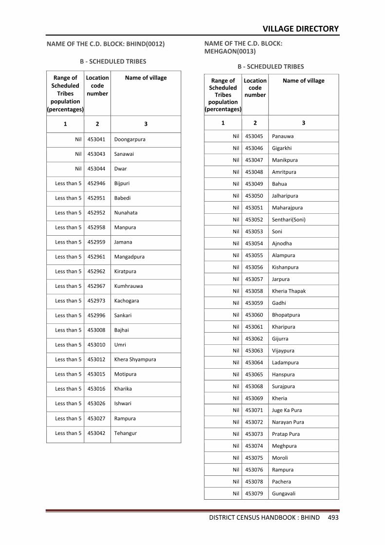
VILLAGE DIRECTORY
DISTRICT CENSUS HANDBOOK : BHIND 493
NAME OF THE C.D. BLOCK: BHIND(0012)
B - SCHEDULED TRIBES
Range of Scheduled
Tribes population
(percentages)
Location code
number
Name of village
1 2 3
Nil 453041 Doongarpura
Nil 453043 Sanawai
Nil 453044 Dwar
Less than 5 452946 Bijpuri
Less than 5 452951 Babedi
Less than 5 452952 Nunahata
Less than 5 452958 Manpura
Less than 5 452959 Jamana
Less than 5 452961 Mangadpura
Less than 5 452962 Kiratpura
Less than 5 452967 Kumhrauwa
Less than 5 452973 Kachogara
Less than 5 452996 Sankari
Less than 5 453008 Bajhai
Less than 5 453010 Umri
Less than 5 453012 Khera Shyampura
Less than 5 453015 Motipura
Less than 5 453016 Kharika
Less than 5 453026 Ishwari
Less than 5 453027 Rampura
Less than 5 453042 Tehangur
NAME OF THE C.D. BLOCK: MEHGAON(0013)
B - SCHEDULED TRIBES
Range of Scheduled
Tribes population
(percentages)
Location code
number
Name of village
1 2 3
Nil 453045 Panauwa
Nil 453046 Gigarkhi
Nil 453047 Manikpura
Nil 453048 Amritpura
Nil 453049 Bahua
Nil 453050 Jalharipura
Nil 453051 Maharajpura
Nil 453052 Senthari(Soni)
Nil 453053 Soni
Nil 453054 Ajnodha
Nil 453055 Alampura
Nil 453056 Kishanpura
Nil 453057 Jarpura
Nil 453058 Kheria Thapak
Nil 453059 Gadhi
Nil 453060 Bhopatpura
Nil 453061 Kharipura
Nil 453062 Gijurra
Nil 453063 Vijaypura
Nil 453064 Ladampura
Nil 453065 Hanspura
Nil 453068 Surajpura
Nil 453069 Kheria
Nil 453071 Juge Ka Pura
Nil 453072 Narayan Pura
Nil 453073 Pratap Pura
Nil 453074 Meghpura
Nil 453075 Moroli
Nil 453076 Rampura
Nil 453078 Pachera
Nil 453079 Gungavali
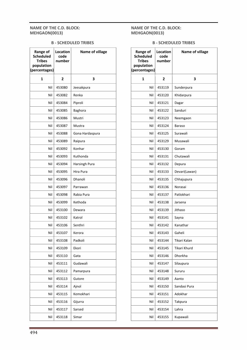
494
NAME OF THE C.D. BLOCK: MEHGAON(0013)
B - SCHEDULED TRIBES
Range of Scheduled
Tribes population
(percentages)
Location code
number
Name of village
1 2 3
Nil 453080 Jeesakpura
Nil 453082 Renka
Nil 453084 Piproli
Nil 453085 Baghora
Nil 453086 Mustri
Nil 453087 Mustra
Nil 453088 Gona Hardaspura
Nil 453089 Raipura
Nil 453092 Konhar
Nil 453093 Kuthonda
Nil 453094 Harsingh Pura
Nil 453095 Hira Pura
Nil 453096 Dhanoli
Nil 453097 Parrawan
Nil 453098 Rabia Pura
Nil 453099 Kethoda
Nil 453100 Dewara
Nil 453102 Katrol
Nil 453106 Senthri
Nil 453107 Kerora
Nil 453108 Padkoli
Nil 453109 Ekori
Nil 453110 Gata
Nil 453111 Gudawali
Nil 453112 Pamarpura
Nil 453113 Gutore
Nil 453114 Ajnol
Nil 453115 Kemokhari
Nil 453116 Gijurra
Nil 453117 Sarsed
Nil 453118 Simar
NAME OF THE C.D. BLOCK: MEHGAON(0013)
B - SCHEDULED TRIBES
Range of Scheduled
Tribes population
(percentages)
Location code
number
Name of village
1 2 3
Nil 453119 Sunderpura
Nil 453120 Khidarpura
Nil 453121 Dagar
Nil 453122 Sanduri
Nil 453123 Neemgaon
Nil 453124 Baraso
Nil 453125 Surawali
Nil 453129 Musawali
Nil 453130 Goram
Nil 453131 Chutawali
Nil 453132 Depura
Nil 453133 Devari(Lawan)
Nil 453135 Chhajupura
Nil 453136 Norasai
Nil 453137 Patlokhari
Nil 453138 Jarsena
Nil 453139 Jithaso
Nil 453141 Sayna
Nil 453142 Kanathar
Nil 453143 Gaheli
Nil 453144 Tikari Kalan
Nil 453145 Tikari Khurd
Nil 453146 Dhorkha
Nil 453147 Silaupura
Nil 453148 Sururu
Nil 453149 Aanto
Nil 453150 Sandasi Pura
Nil 453151 Adokhar
Nil 453152 Takpura
Nil 453154 Lahra
Nil 453155 Kupawali
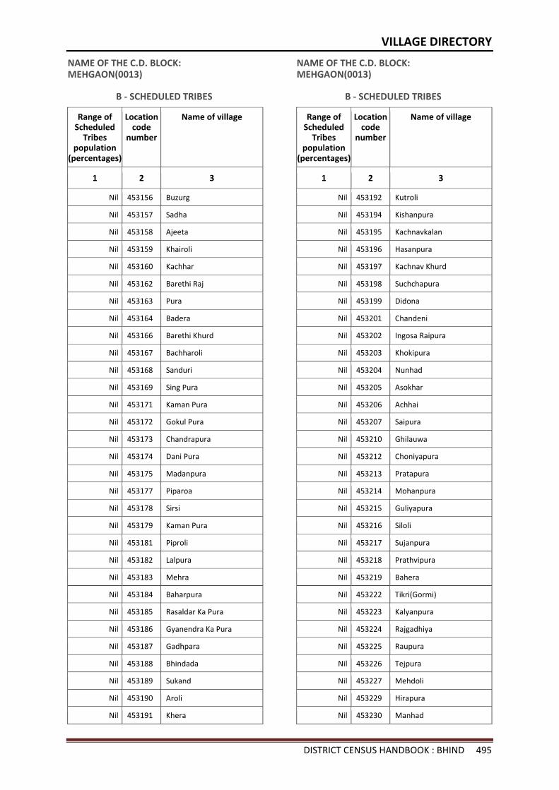
VILLAGE DIRECTORY
DISTRICT CENSUS HANDBOOK : BHIND 495
NAME OF THE C.D. BLOCK: MEHGAON(0013)
B - SCHEDULED TRIBES
Range of Scheduled
Tribes population
(percentages)
Location code
number
Name of village
1 2 3
Nil 453156 Buzurg
Nil 453157 Sadha
Nil 453158 Ajeeta
Nil 453159 Khairoli
Nil 453160 Kachhar
Nil 453162 Barethi Raj
Nil 453163 Pura
Nil 453164 Badera
Nil 453166 Barethi Khurd
Nil 453167 Bachharoli
Nil 453168 Sanduri
Nil 453169 Sing Pura
Nil 453171 Kaman Pura
Nil 453172 Gokul Pura
Nil 453173 Chandrapura
Nil 453174 Dani Pura
Nil 453175 Madanpura
Nil 453177 Piparoa
Nil 453178 Sirsi
Nil 453179 Kaman Pura
Nil 453181 Piproli
Nil 453182 Lalpura
Nil 453183 Mehra
Nil 453184 Baharpura
Nil 453185 Rasaldar Ka Pura
Nil 453186 Gyanendra Ka Pura
Nil 453187 Gadhpara
Nil 453188 Bhindada
Nil 453189 Sukand
Nil 453190 Aroli
Nil 453191 Khera
NAME OF THE C.D. BLOCK: MEHGAON(0013)
B - SCHEDULED TRIBES
Range of Scheduled
Tribes population
(percentages)
Location code
number
Name of village
1 2 3
Nil 453192 Kutroli
Nil 453194 Kishanpura
Nil 453195 Kachnavkalan
Nil 453196 Hasanpura
Nil 453197 Kachnav Khurd
Nil 453198 Suchchapura
Nil 453199 Didona
Nil 453201 Chandeni
Nil 453202 Ingosa Raipura
Nil 453203 Khokipura
Nil 453204 Nunhad
Nil 453205 Asokhar
Nil 453206 Achhai
Nil 453207 Saipura
Nil 453210 Ghilauwa
Nil 453212 Choniyapura
Nil 453213 Pratapura
Nil 453214 Mohanpura
Nil 453215 Guliyapura
Nil 453216 Siloli
Nil 453217 Sujanpura
Nil 453218 Prathvipura
Nil 453219 Bahera
Nil 453222 Tikri(Gormi)
Nil 453223 Kalyanpura
Nil 453224 Rajgadhiya
Nil 453225 Raupura
Nil 453226 Tejpura
Nil 453227 Mehdoli
Nil 453229 Hirapura
Nil 453230 Manhad
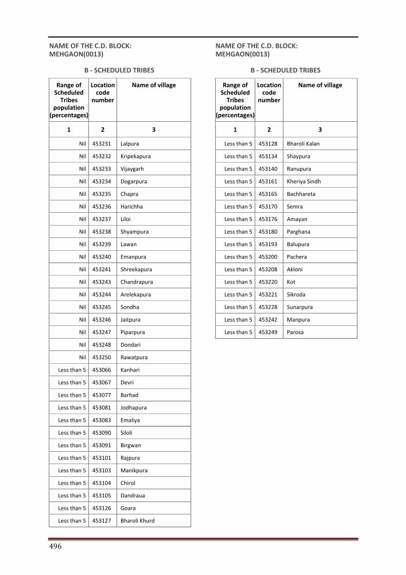
496
NAME OF THE C.D. BLOCK: MEHGAON(0013)
B - SCHEDULED TRIBES
Range of Scheduled
Tribes population
(percentages)
Location code
number
Name of village
1 2 3
Nil 453231 Lalpura
Nil 453232 Kripekapura
Nil 453233 Vijaygarh
Nil 453234 Dogarpura
Nil 453235 Chapra
Nil 453236 Harichha
Nil 453237 Liloi
Nil 453238 Shyampura
Nil 453239 Lawan
Nil 453240 Emanpura
Nil 453241 Shreekapura
Nil 453243 Chandrapura
Nil 453244 Arelekapura
Nil 453245 Sondha
Nil 453246 Jaitpura
Nil 453247 Piparpura
Nil 453248 Dondari
Nil 453250 Rawatpura
Less than 5 453066 Kanhari
Less than 5 453067 Devri
Less than 5 453077 Barhad
Less than 5 453081 Jodhapura
Less than 5 453083 Emaliya
Less than 5 453090 Siloli
Less than 5 453091 Birgwan
Less than 5 453101 Rajpura
Less than 5 453103 Manikpura
Less than 5 453104 Chirol
Less than 5 453105 Dandraua
Less than 5 453126 Goara
Less than 5 453127 Bharoli Khurd
NAME OF THE C.D. BLOCK: MEHGAON(0013)
B - SCHEDULED TRIBES
Range of Scheduled
Tribes population
(percentages)
Location code
number
Name of village
1 2 3
Less than 5 453128 Bharoli Kalan
Less than 5 453134 Shaypura
Less than 5 453140 Ranupura
Less than 5 453161 Kheriya Sindh
Less than 5 453165 Bachhareta
Less than 5 453170 Semra
Less than 5 453176 Amayan
Less than 5 453180 Parghana
Less than 5 453193 Balupura
Less than 5 453200 Pachera
Less than 5 453208 Akloni
Less than 5 453220 Kot
Less than 5 453221 Sikroda
Less than 5 453228 Sunarpura
Less than 5 453242 Manpura
Less than 5 453249 Parosa
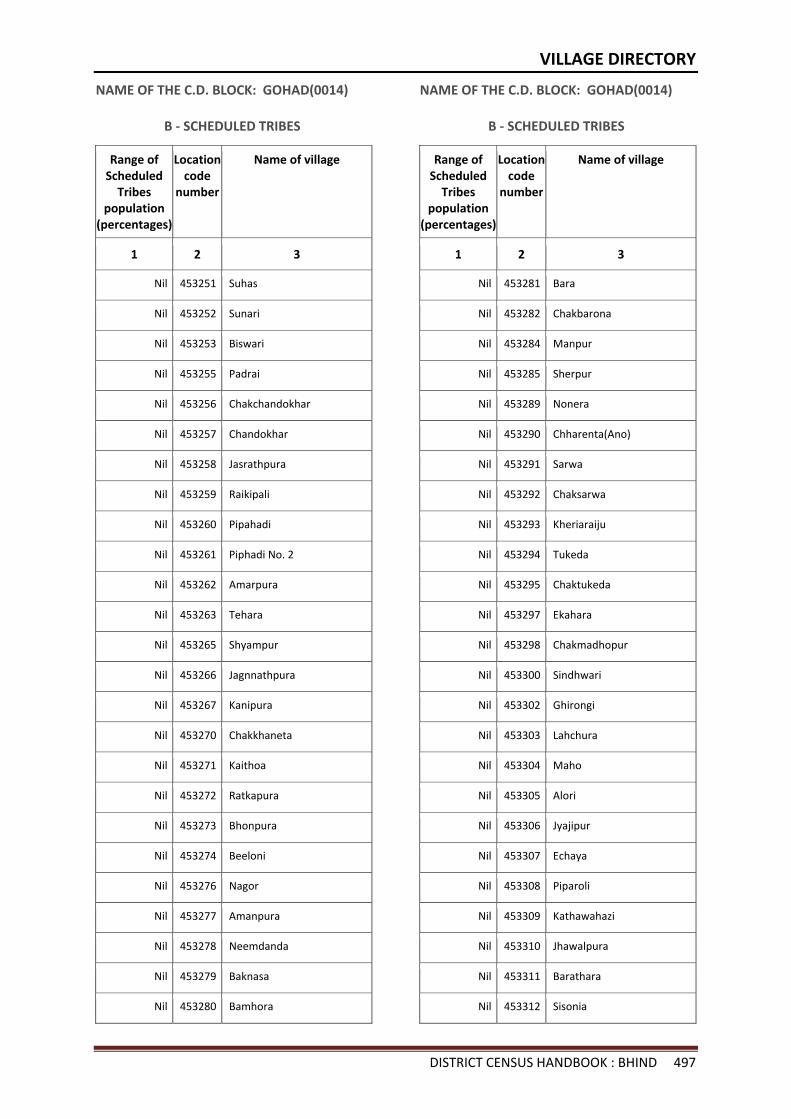
VILLAGE DIRECTORY
DISTRICT CENSUS HANDBOOK : BHIND 497
NAME OF THE C.D. BLOCK: GOHAD(0014)
B - SCHEDULED TRIBES
Range of Scheduled
Tribes population
(percentages)
Location code
number
Name of village
1 2 3
Nil 453251 Suhas
Nil 453252 Sunari
Nil 453253 Biswari
Nil 453255 Padrai
Nil 453256 Chakchandokhar
Nil 453257 Chandokhar
Nil 453258 Jasrathpura
Nil 453259 Raikipali
Nil 453260 Pipahadi
Nil 453261 Piphadi No. 2
Nil 453262 Amarpura
Nil 453263 Tehara
Nil 453265 Shyampur
Nil 453266 Jagnnathpura
Nil 453267 Kanipura
Nil 453270 Chakkhaneta
Nil 453271 Kaithoa
Nil 453272 Ratkapura
Nil 453273 Bhonpura
Nil 453274 Beeloni
Nil 453276 Nagor
Nil 453277 Amanpura
Nil 453278 Neemdanda
Nil 453279 Baknasa
Nil 453280 Bamhora
NAME OF THE C.D. BLOCK: GOHAD(0014)
B - SCHEDULED TRIBES
Range of Scheduled
Tribes population
(percentages)
Location code
number
Name of village
1 2 3
Nil 453281 Bara
Nil 453282 Chakbarona
Nil 453284 Manpur
Nil 453285 Sherpur
Nil 453289 Nonera
Nil 453290 Chharenta(Ano)
Nil 453291 Sarwa
Nil 453292 Chaksarwa
Nil 453293 Kheriaraiju
Nil 453294 Tukeda
Nil 453295 Chaktukeda
Nil 453297 Ekahara
Nil 453298 Chakmadhopur
Nil 453300 Sindhwari
Nil 453302 Ghirongi
Nil 453303 Lahchura
Nil 453304 Maho
Nil 453305 Alori
Nil 453306 Jyajipur
Nil 453307 Echaya
Nil 453308 Piparoli
Nil 453309 Kathawahazi
Nil 453310 Jhawalpura
Nil 453311 Barathara
Nil 453312 Sisonia
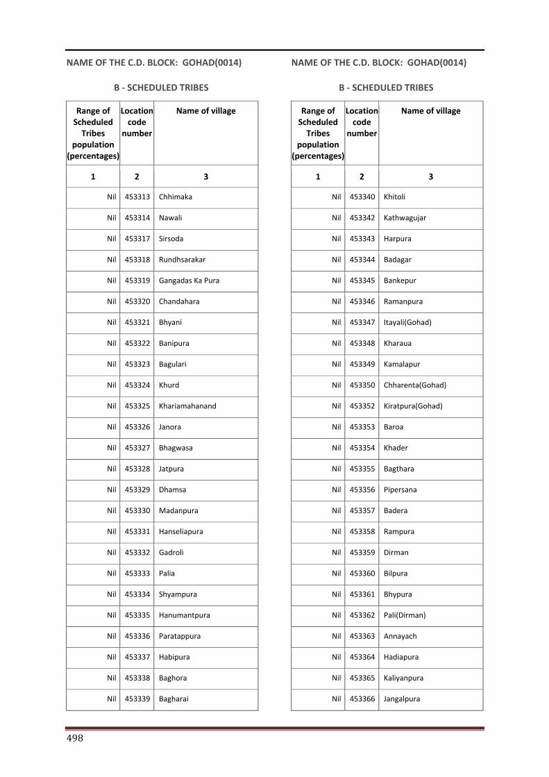
498
NAME OF THE C.D. BLOCK: GOHAD(0014)
B - SCHEDULED TRIBES
Range of Scheduled
Tribes population
(percentages)
Location code
number
Name of village
1 2 3
Nil 453313 Chhimaka
Nil 453314 Nawali
Nil 453317 Sirsoda
Nil 453318 Rundhsarakar
Nil 453319 Gangadas Ka Pura
Nil 453320 Chandahara
Nil 453321 Bhyani
Nil 453322 Banipura
Nil 453323 Bagulari
Nil 453324 Khurd
Nil 453325 Khariamahanand
Nil 453326 Janora
Nil 453327 Bhagwasa
Nil 453328 Jatpura
Nil 453329 Dhamsa
Nil 453330 Madanpura
Nil 453331 Hanseliapura
Nil 453332 Gadroli
Nil 453333 Palia
Nil 453334 Shyampura
Nil 453335 Hanumantpura
Nil 453336 Paratappura
Nil 453337 Habipura
Nil 453338 Baghora
Nil 453339 Bagharai
NAME OF THE C.D. BLOCK: GOHAD(0014)
B - SCHEDULED TRIBES
Range of Scheduled
Tribes population
(percentages)
Location code
number
Name of village
1 2 3
Nil 453340 Khitoli
Nil 453342 Kathwagujar
Nil 453343 Harpura
Nil 453344 Badagar
Nil 453345 Bankepur
Nil 453346 Ramanpura
Nil 453347 Itayali(Gohad)
Nil 453348 Kharaua
Nil 453349 Kamalapur
Nil 453350 Chharenta(Gohad)
Nil 453352 Kiratpura(Gohad)
Nil 453353 Baroa
Nil 453354 Khader
Nil 453355 Bagthara
Nil 453356 Pipersana
Nil 453357 Badera
Nil 453358 Rampura
Nil 453359 Dirman
Nil 453360 Bilpura
Nil 453361 Bhypura
Nil 453362 Pali(Dirman)
Nil 453363 Annayach
Nil 453364 Hadiapura
Nil 453365 Kaliyanpura
Nil 453366 Jangalpura
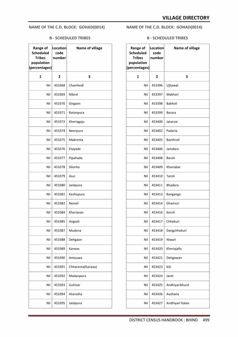
VILLAGE DIRECTORY
DISTRICT CENSUS HANDBOOK : BHIND 499
NAME OF THE C.D. BLOCK: GOHAD(0014)
B - SCHEDULED TRIBES
Range of Scheduled
Tribes population
(percentages)
Location code
number
Name of village
1 2 3
Nil 453368 Chamhedi
Nil 453369 Nibrol
Nil 453370 Girgaon
Nil 453371 Ratanpura
Nil 453372 Kheriagaju
Nil 453374 Neerpura
Nil 453375 Makrenta
Nil 453376 Etayada
Nil 453377 Pipahada
Nil 453378 Silonha
Nil 453379 Asui
Nil 453380 Jankpura
Nil 453381 Keshopura
Nil 453382 Nenoli
Nil 453384 Kheriavan
Nil 453385 Angsoli
Nil 453387 Mudena
Nil 453388 Dehgaon
Nil 453389 Karwas
Nil 453390 Antouwa
Nil 453391 Chharenta(Karwas)
Nil 453392 Madanpura
Nil 453393 Guhisar
Nil 453394 Atarsoha
Nil 453395 Jalalpura
NAME OF THE C.D. BLOCK: GOHAD(0014)
B - SCHEDULED TRIBES
Range of Scheduled
Tribes population
(percentages)
Location code
number
Name of village
1 2 3
Nil 453396 Ujhawal
Nil 453397 Makhori
Nil 453398 Bakholi
Nil 453399 Barara
Nil 453400 Jatarvai
Nil 453402 Padaria
Nil 453405 Bamhroli
Nil 453406 Jamdara
Nil 453408 Baroli
Nil 453409 Khariabar
Nil 453410 Taroli
Nil 453411 Bhadera
Nil 453413 Banganga
Nil 453414 Ghamuri
Nil 453416 Keroli
Nil 453417 Chhekuri
Nil 453418 Dangchhekuri
Nil 453419 Niwari
Nil 453420 Kheriajallu
Nil 453421 Dehgawan
Nil 453423 Kiti
Nil 453424 Jaret
Nil 453425 Andhiyarikhurd
Nil 453426 Asohana
Nil 453427 Andhiyari Kalan
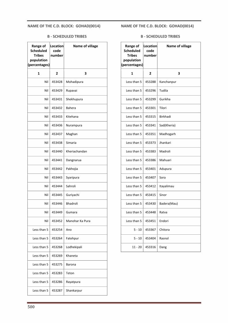
500
NAME OF THE C.D. BLOCK: GOHAD(0014)
B - SCHEDULED TRIBES
Range of Scheduled
Tribes population
(percentages)
Location code
number
Name of village
1 2 3
Nil 453428 Mohadipura
Nil 453429 Rupavai
Nil 453431 Shekhupura
Nil 453432 Bahera
Nil 453433 Kitehana
Nil 453436 Nurampura
Nil 453437 Maghan
Nil 453438 Simaria
Nil 453440 Kheriachandan
Nil 453441 Dangnarua
Nil 453442 Pakhojia
Nil 453443 Syaripura
Nil 453444 Sahroli
Nil 453445 Guriyachi
Nil 453446 Bhadroli
Nil 453449 Gumara
Nil 453452 Manohar Ka Pura
Less than 5 453254 Ano
Less than 5 453264 Fatehpur
Less than 5 453268 Lodhekipali
Less than 5 453269 Khaneta
Less than 5 453275 Barona
Less than 5 453283 Teton
Less than 5 453286 Rayatpura
Less than 5 453287 Shankarpur
NAME OF THE C.D. BLOCK: GOHAD(0014)
B - SCHEDULED TRIBES
Range of Scheduled
Tribes population
(percentages)
Location code
number
Name of village
1 2 3
Less than 5 453288 Kanchanpur
Less than 5 453296 Tudila
Less than 5 453299 Gurikha
Less than 5 453301 Tilori
Less than 5 453315 Birkhadi
Less than 5 453341 Sad(Kheria)
Less than 5 453351 Madhogarh
Less than 5 453373 Jhankari
Less than 5 453383 Madroli
Less than 5 453386 Mahuari
Less than 5 453401 Adupura
Less than 5 453407 Sora
Less than 5 453412 Itayalimau
Less than 5 453415 Sinor
Less than 5 453430 Badera(Mau)
Less than 5 453448 Ratva
Less than 5 453451 Endori
5 - 10 453367 Chitora
5 - 10 453404 Rasnol
11 - 20 453316 Dang
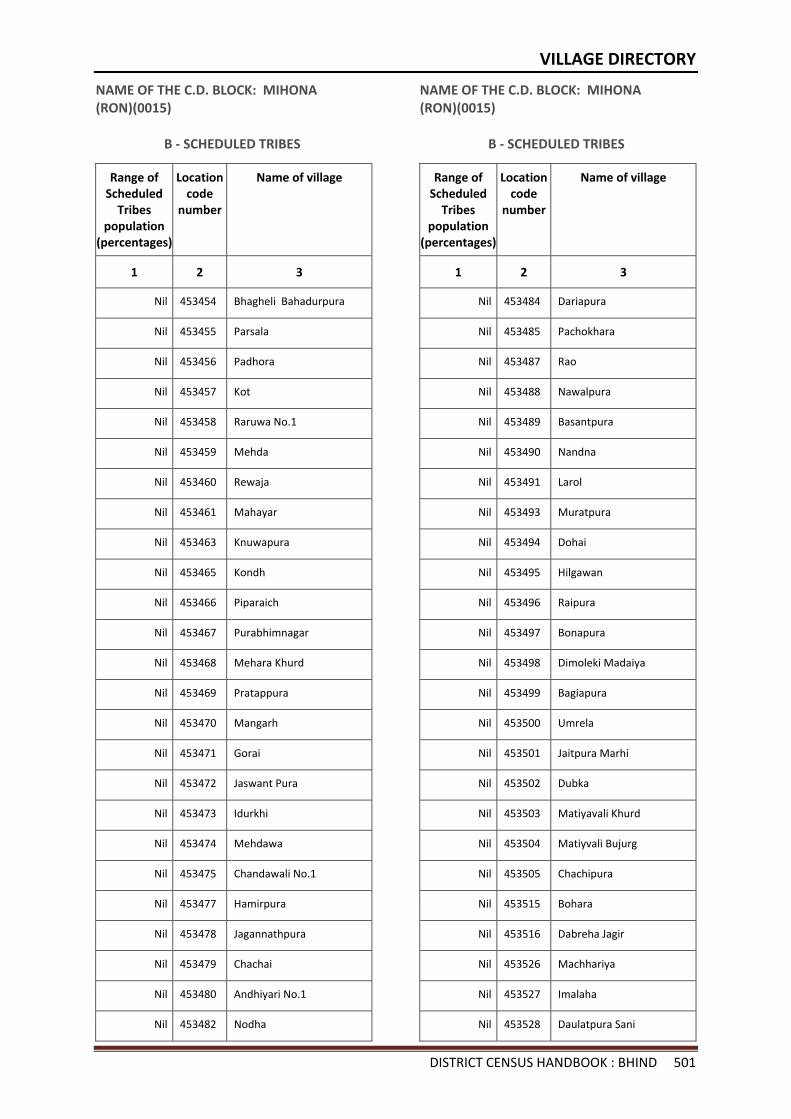
VILLAGE DIRECTORY
DISTRICT CENSUS HANDBOOK : BHIND 501
NAME OF THE C.D. BLOCK: MIHONA (RON)(0015)
B - SCHEDULED TRIBES
Range of Scheduled
Tribes population
(percentages)
Location code
number
Name of village
1 2 3
Nil 453454 Bhagheli Bahadurpura
Nil 453455 Parsala
Nil 453456 Padhora
Nil 453457 Kot
Nil 453458 Raruwa No.1
Nil 453459 Mehda
Nil 453460 Rewaja
Nil 453461 Mahayar
Nil 453463 Knuwapura
Nil 453465 Kondh
Nil 453466 Piparaich
Nil 453467 Purabhimnagar
Nil 453468 Mehara Khurd
Nil 453469 Pratappura
Nil 453470 Mangarh
Nil 453471 Gorai
Nil 453472 Jaswant Pura
Nil 453473 Idurkhi
Nil 453474 Mehdawa
Nil 453475 Chandawali No.1
Nil 453477 Hamirpura
Nil 453478 Jagannathpura
Nil 453479 Chachai
Nil 453480 Andhiyari No.1
Nil 453482 Nodha
NAME OF THE C.D. BLOCK: MIHONA (RON)(0015)
B - SCHEDULED TRIBES
Range of Scheduled
Tribes population
(percentages)
Location code
number
Name of village
1 2 3
Nil 453484 Dariapura
Nil 453485 Pachokhara
Nil 453487 Rao
Nil 453488 Nawalpura
Nil 453489 Basantpura
Nil 453490 Nandna
Nil 453491 Larol
Nil 453493 Muratpura
Nil 453494 Dohai
Nil 453495 Hilgawan
Nil 453496 Raipura
Nil 453497 Bonapura
Nil 453498 Dimoleki Madaiya
Nil 453499 Bagiapura
Nil 453500 Umrela
Nil 453501 Jaitpura Marhi
Nil 453502 Dubka
Nil 453503 Matiyavali Khurd
Nil 453504 Matiyvali Bujurg
Nil 453505 Chachipura
Nil 453515 Bohara
Nil 453516 Dabreha Jagir
Nil 453526 Machhariya
Nil 453527 Imalaha
Nil 453528 Daulatpura Sani
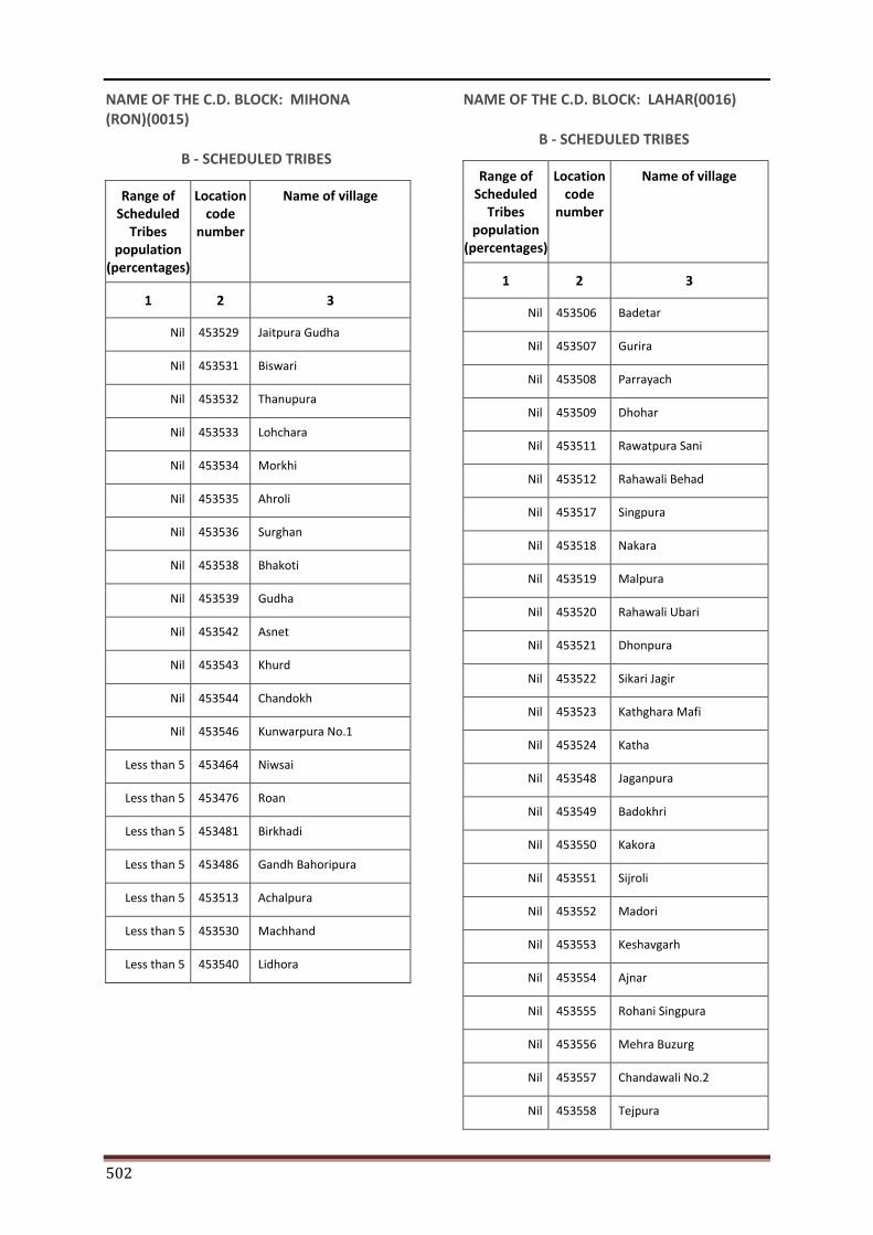
502
NAME OF THE C.D. BLOCK: MIHONA (RON)(0015)
B - SCHEDULED TRIBES
Range of Scheduled
Tribes population
(percentages)
Location code
number
Name of village
1 2 3
Nil 453529 Jaitpura Gudha
Nil 453531 Biswari
Nil 453532 Thanupura
Nil 453533 Lohchara
Nil 453534 Morkhi
Nil 453535 Ahroli
Nil 453536 Surghan
Nil 453538 Bhakoti
Nil 453539 Gudha
Nil 453542 Asnet
Nil 453543 Khurd
Nil 453544 Chandokh
Nil 453546 Kunwarpura No.1
Less than 5 453464 Niwsai
Less than 5 453476 Roan
Less than 5 453481 Birkhadi
Less than 5 453486 Gandh Bahoripura
Less than 5 453513 Achalpura
Less than 5 453530 Machhand
Less than 5 453540 Lidhora
NAME OF THE C.D. BLOCK: LAHAR(0016)
B - SCHEDULED TRIBES
Range of Scheduled
Tribes population
(percentages)
Location code
number
Name of village
1 2 3
Nil 453506 Badetar
Nil 453507 Gurira
Nil 453508 Parrayach
Nil 453509 Dhohar
Nil 453511 Rawatpura Sani
Nil 453512 Rahawali Behad
Nil 453517 Singpura
Nil 453518 Nakara
Nil 453519 Malpura
Nil 453520 Rahawali Ubari
Nil 453521 Dhonpura
Nil 453522 Sikari Jagir
Nil 453523 Kathghara Mafi
Nil 453524 Katha
Nil 453548 Jaganpura
Nil 453549 Badokhri
Nil 453550 Kakora
Nil 453551 Sijroli
Nil 453552 Madori
Nil 453553 Keshavgarh
Nil 453554 Ajnar
Nil 453555 Rohani Singpura
Nil 453556 Mehra Buzurg
Nil 453557 Chandawali No.2
Nil 453558 Tejpura
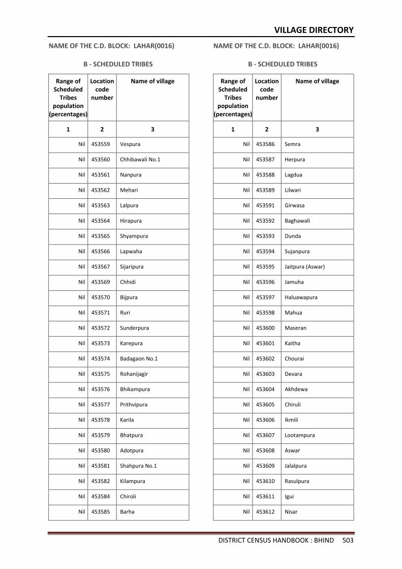
VILLAGE DIRECTORY
DISTRICT CENSUS HANDBOOK : BHIND 503
NAME OF THE C.D. BLOCK: LAHAR(0016)
B - SCHEDULED TRIBES
Range of Scheduled
Tribes population
(percentages)
Location code
number
Name of village
1 2 3
Nil 453559 Vespura
Nil 453560 Chhibawali No.1
Nil 453561 Nanpura
Nil 453562 Mehari
Nil 453563 Lalpura
Nil 453564 Hirapura
Nil 453565 Shyampura
Nil 453566 Lapwaha
Nil 453567 Sijaripura
Nil 453569 Chhidi
Nil 453570 Bijpura
Nil 453571 Ruri
Nil 453572 Sunderpura
Nil 453573 Karepura
Nil 453574 Badagaon No.1
Nil 453575 Rohanijagir
Nil 453576 Bhikampura
Nil 453577 Prithvipura
Nil 453578 Karila
Nil 453579 Bhatpura
Nil 453580 Adotpura
Nil 453581 Shahpura No.1
Nil 453582 Kilampura
Nil 453584 Chiroli
Nil 453585 Barha
NAME OF THE C.D. BLOCK: LAHAR(0016)
B - SCHEDULED TRIBES
Range of Scheduled
Tribes population
(percentages)
Location code
number
Name of village
1 2 3
Nil 453586 Semra
Nil 453587 Herpura
Nil 453588 Lagdua
Nil 453589 Lilwari
Nil 453591 Girwasa
Nil 453592 Baghawali
Nil 453593 Dunda
Nil 453594 Sujanpura
Nil 453595 Jaitpura (Aswar)
Nil 453596 Jamuha
Nil 453597 Haluawapura
Nil 453598 Mahua
Nil 453600 Maseran
Nil 453601 Kaitha
Nil 453602 Chourai
Nil 453603 Devara
Nil 453604 Akhdewa
Nil 453605 Chiruli
Nil 453606 Ikmili
Nil 453607 Lootampura
Nil 453608 Aswar
Nil 453609 Jalalpura
Nil 453610 Rasulpura
Nil 453611 Igui
Nil 453612 Nisar
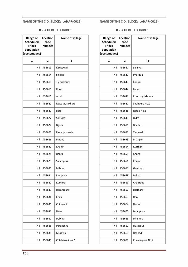
504
NAME OF THE C.D. BLOCK: LAHAR(0016)
B - SCHEDULED TRIBES
Range of Scheduled
Tribes population
(percentages)
Location code
number
Name of village
1 2 3
Nil 453613 Kariyawali
Nil 453614 Shikari
Nil 453615 Tighrakhurd
Nil 453616 Rurai
Nil 453617 Arusi
Nil 453620 Rawatpurakhurd
Nil 453621 Barei
Nil 453622 Sonsara
Nil 453624 Bijora
Nil 453625 Rawatpurakala
Nil 453626 Baraua
Nil 453627 Khajuri
Nil 453628 Behta
Nil 453629 Salampura
Nil 453630 Mihoni
Nil 453631 Rampura
Nil 453632 Kumhrol
Nil 453633 Darampura
Nil 453634 Khilli
Nil 453635 Chirawali
Nil 453636 Narol
Nil 453637 Dabhra
Nil 453638 Parenchha
Nil 453639 Murawali
Nil 453640 Chhibawali No.2
NAME OF THE C.D. BLOCK: LAHAR(0016)
B - SCHEDULED TRIBES
Range of Scheduled
Tribes population
(percentages)
Location code
number
Name of village
1 2 3
Nil 453641 Salaiya
Nil 453642 Phardua
Nil 453643 Kanksi
Nil 453644 Larsa
Nil 453646 Roor Jagdishpura
Nil 453647 Shahpura No.2
Nil 453648 Rarua No.2
Nil 453649 Bidra
Nil 453650 Bhaderi
Nil 453652 Timawali
Nil 453653 Bhanpar
Nil 453654 Kurthar
Nil 453655 Khurd
Nil 453656 Khuja
Nil 453657 Genthari
Nil 453658 Belma
Nil 453659 Chadraua
Nil 453660 Barthara
Nil 453663 Roni
Nil 453664 Davini
Nil 453665 Bisanpura
Nil 453666 Dhanura
Nil 453667 Durgapur
Nil 453669 Baghedi
Nil 453670 Kunwarpura No 2
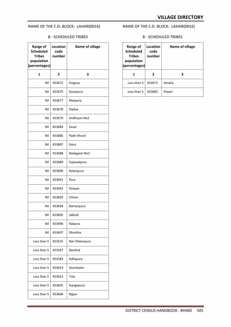
VILLAGE DIRECTORY
DISTRICT CENSUS HANDBOOK : BHIND 505
NAME OF THE C.D. BLOCK: LAHAR(0016)
B - SCHEDULED TRIBES
Range of Scheduled
Tribes population
(percentages)
Location code
number
Name of village
1 2 3
Nil 453672 Singosa
Nil 453675 Gyanpura
Nil 453677 Marpura
Nil 453678 Dadua
Nil 453679 Andhiyari No2
Nil 453684 Kasal
Nil 453685 Padri Khurd
Nil 453687 Gora
Nil 453688 Badagaon No2
Nil 453689 Sujawalpura
Nil 453690 Ratanpura
Nil 453691 Para
Nil 453692 Riniyan
Nil 453693 Chhan
Nil 453694 Bamanpura
Nil 453695 Jakholi
Nil 453696 Raipura
Nil 453697 Dhorkha
Less than 5 453525 Rari Shikarpura
Less than 5 453547 Barehat
Less than 5 453583 Adlispura
Less than 5 453619 Deorikalan
Less than 5 453623 Tola
Less than 5 453645 Gangepura
Less than 5 453668 Bijpur
NAME OF THE C.D. BLOCK: LAHAR(0016)
B - SCHEDULED TRIBES
Range of Scheduled
Tribes population
(percentages)
Location code
number
Name of village
1 2 3
Less than 5 453671 Amaha
Less than 5 453682 Peepri

ORGI-MADHYA PRADESH ENGLISH (10-2011)
2011
Directorate of Census Operations, Madhya PradeshMinistry of Home Affairs,
Janganana Bhawan,Arera Hills, Jail Road, Bhopal - 462004
Email : [email protected]: http://www.censusindia.gov.in
Section - II Town Directory
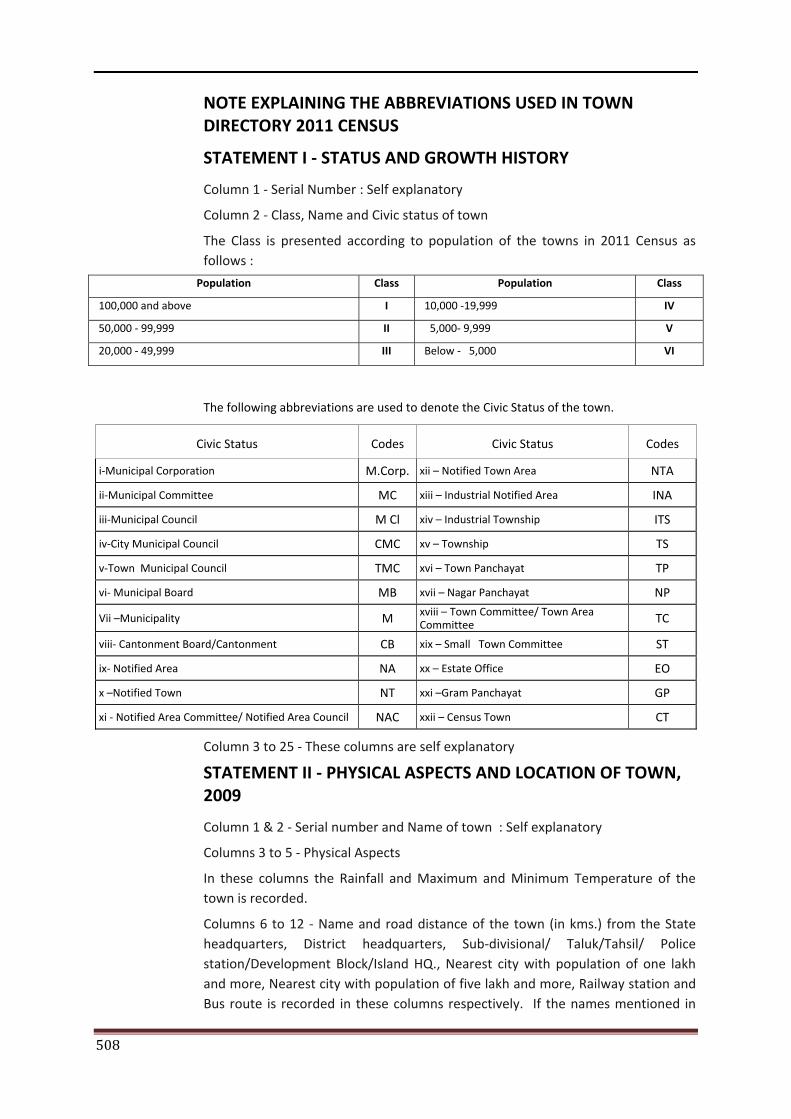
508
NOTE EXPLAINING THE ABBREVIATIONS USED IN TOWN DIRECTORY 2011 CENSUS
STATEMENT I - STATUS AND GROWTH HISTORY
Column 1 - Serial Number : Self explanatory
Column 2 - Class, Name and Civic status of town
The Class is presented according to population of the towns in 2011 Census as follows :
Population Class Population Class
100,000 and above I 10,000 -19,999 IV
50,000 - 99,999 II 5,000- 9,999 V
20,000 - 49,999 III Below - 5,000 VI
The following abbreviations are used to denote the Civic Status of the town.
Civic Status Codes Civic Status Codes
i-Municipal Corporation M.Corp. xii – Notified Town Area NTA
ii-Municipal Committee MC xiii – Industrial Notified Area INA
iii-Municipal Council M Cl xiv – Industrial Township ITS
iv-City Municipal Council CMC xv – Township TS
v-Town Municipal Council TMC xvi – Town Panchayat TP
vi- Municipal Board MB xvii – Nagar Panchayat NP
Vii –Municipality M xviii – Town Committee/ Town Area Committee TC
viii- Cantonment Board/Cantonment CB xix – Small Town Committee ST
ix- Notified Area NA xx – Estate Office EO
x –Notified Town NT xxi –Gram Panchayat GP
xi - Notified Area Committee/ Notified Area Council NAC xxii – Census Town CT
Column 3 to 25 - These columns are self explanatory
STATEMENT II - PHYSICAL ASPECTS AND LOCATION OF TOWN, 2009
Column 1 & 2 - Serial number and Name of town : Self explanatory
Columns 3 to 5 - Physical Aspects
In these columns the Rainfall and Maximum and Minimum Temperature of the town is recorded.
Columns 6 to 12 - Name and road distance of the town (in kms.) from the State headquarters, District headquarters, Sub-divisional/ Taluk/Tahsil/ Police station/Development Block/Island HQ., Nearest city with population of one lakh and more, Nearest city with population of five lakh and more, Railway station and Bus route is recorded in these columns respectively. If the names mentioned in
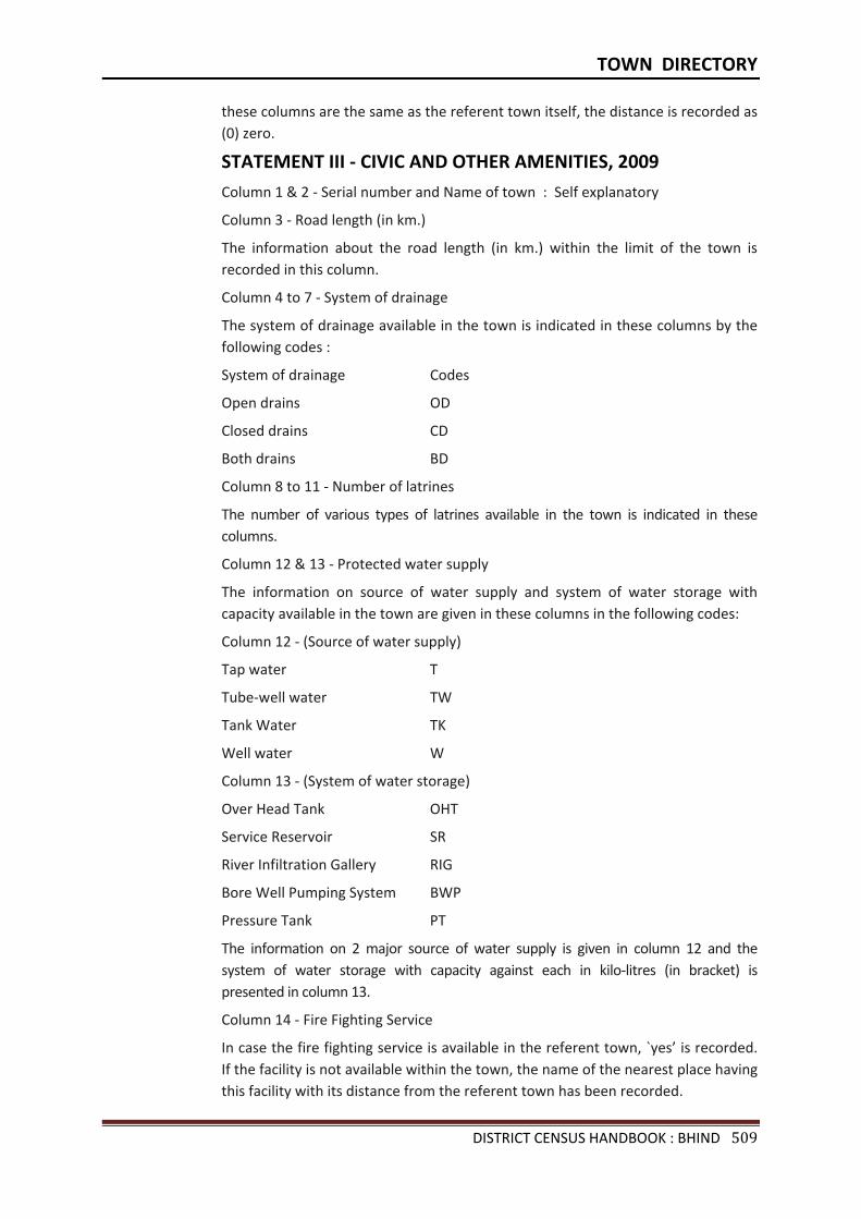
TOWN DIRECTORY
DISTRICT CENSUS HANDBOOK : BHIND 509
these columns are the same as the referent town itself, the distance is recorded as (0) zero.
STATEMENT III - CIVIC AND OTHER AMENITIES, 2009
Column 1 & 2 - Serial number and Name of town : Self explanatory
Column 3 - Road length (in km.)
The information about the road length (in km.) within the limit of the town is recorded in this column.
Column 4 to 7 - System of drainage
The system of drainage available in the town is indicated in these columns by the following codes :
System of drainage Codes
Open drains OD
Closed drains CD
Both drains BD
Column 8 to 11 - Number of latrines
The number of various types of latrines available in the town is indicated in these columns.
Column 12 & 13 - Protected water supply
The information on source of water supply and system of water storage with capacity available in the town are given in these columns in the following codes:
Column 12 - (Source of water supply)
Tap water T
Tube-well water TW
Tank Water TK
Well water W
Column 13 - (System of water storage)
Over Head Tank OHT
Service Reservoir SR
River Infiltration Gallery RIG
Bore Well Pumping System BWP
Pressure Tank PT
The information on 2 major source of water supply is given in column 12 and the system of water storage with capacity against each in kilo-litres (in bracket) is presented in column 13.
Column 14 - Fire Fighting Service
In case the fire fighting service is available in the referent town, `yes’ is recorded. If the facility is not available within the town, the name of the nearest place having this facility with its distance from the referent town has been recorded.
510
Column 15 to 19 - Electrification (Number of connections)
Different types of electric connections have been shown in these columns, i.e., Domestic, Industrial, Commercial, Road lighting (points) & others.
STATEMENT IV - MEDICAL FACILITIES, 2009
Column 1 & 2 - Serial number and Name of town : Self explanatory
Column 3 to 13 - The number of various medical institutions such as Hospitals, Dispensaries, Health Center, Family Welfare Center, Maternity and Child Welfare Center, Maternity Homes, T.B. Hospital/clinic, Nursing Homes, Charitable Hospital/Nursing Home, Mobile Health Clinic and Others as available in the town, are indicated in these columns (along with number of beds in brackets).
If a medical facility is not available in the town, the name of the nearest place and its distance in kilometers from the town where the facility is available is mentioned.
Column 14 - Veterinary Hospital
The Number of Veterinary Hospitals available in the town is given in this column.
Column 15 - Medicine Shop
The number of Medicine shops available in the town is given in this column.
STATEMENT V - EDUCATIONAL, RECREATIONAL AND CULTURAL FACILITIES, 2009
Column 1 & 2 - Serial number and Name of town : Self explanatory
Column 3 to 15 - Educational Facilities
The information on number of Primary school, Middle school, Secondary school, Senior Secondary school, Arts/Science/ Commerce colleges (of degree level and above), Medical colleges, Engineering colleges, Management Institute/Colleges, Polytechnics, Recognized Shorthand, Typewriting and vocational training Institutions, Non-formal Education Center (Sarva Shiksha Abhiyan Center), Special School for disabled and Others available in the town, are indicated in these columns.
If an educational facility is not available in the town, the name of the nearest place and its distance in kilometers from the town where the facility is available is mentioned.
Column 16 to 23 - Number of Social, Recreational and Culture Facilities :- The information on No. of Home Orphanage, Working women’s hostels (with No. of seats in bracket), No. of Old Age Home, Stadium, Cinema Theatre, Auditorium/Community halls, Public libraries and Reading rooms available in the town are given under these column.
STATEMENT VI - INDUSTRY AND BANKING, 2009
Column 1 & 2 - Serial number and Name of town : Self explanatory
Column 3 to 5 - Names of three most important commodities manufactured
The names of three most important commodities manufactured in the town are given under these columns.
TOWN DIRECTORY
DISTRICT CENSUS HANDBOOK : BHIND 511
Column 6 to 8 - Number of banks
The number of banks available in the referent town both Commercial and Co-operative banks are recorded against these columns.
Column 9 & 10 - Number of Agricultural and Non Agricultural Credit Societies
The number of Agricultural and Non Agricultural Credit Societies available in the referent town are given in these columns.
STATEMENT VII - CIVIC AND OTHER AMENITIES IN SLUMS, 2009
This statement VII provides information on civic and other amenities in all slums whether notified or not and for all towns having statutory bodies, like Municipality, Municipal Corporation, Town area committee etc.
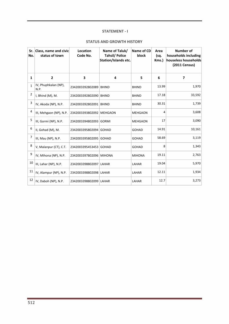
512
STATEMENT - I
STATUS AND GROWTH HISTORY
Sr. No.
Class, name and civic status of town
Location Code No.
Name of Taluk/ Tahsil/ Police
Station/Islands etc.
Name of CD block
Area (sq.
Kms.)
Number of households including houseless households
(2011 Census)
1 2 3 4 5 6 7
1 IV, Phuphkalan (NP), N.P.
2342003392802089 BHIND BHIND 13.99 1,970
2 I, Bhind (M), M. 2342003392802090 BHIND BHIND 17.18 33,592
3 IV, Akoda (NP), N.P. 2342003392802091 BHIND BHIND 30.31 1,739
4 III, Mehgaon (NP), N.P. 2342003393802092 MEHGAON MEHGAON 4 3,608
5 III, Gormi (NP), N.P. 2342003394802093 GORMI MEHGAON 17 3,090
6 II, Gohad (M), M. 2342003395802094 GOHAD GOHAD 14.91 10,161
7 III, Mau (NP), N.P. 2342003395802095 GOHAD GOHAD 58.69 3,119
8 V, Malanpur (CT), C.T. 2342003395453453 GOHAD GOHAD 8 1,343
9 IV, Mihona (NP), N.P. 2342003397802096 MIHONA MIHONA 19.11 2,763
10 III, Lahar (NP), N.P. 2342003398802097 LAHAR LAHAR 19.04 5,970
11 IV, Alampur (NP), N.P. 2342003398802098 LAHAR LAHAR 12.11 1,934
12 IV, Daboh (NP), N.P. 2342003398802099 LAHAR LAHAR 12.7 3,273
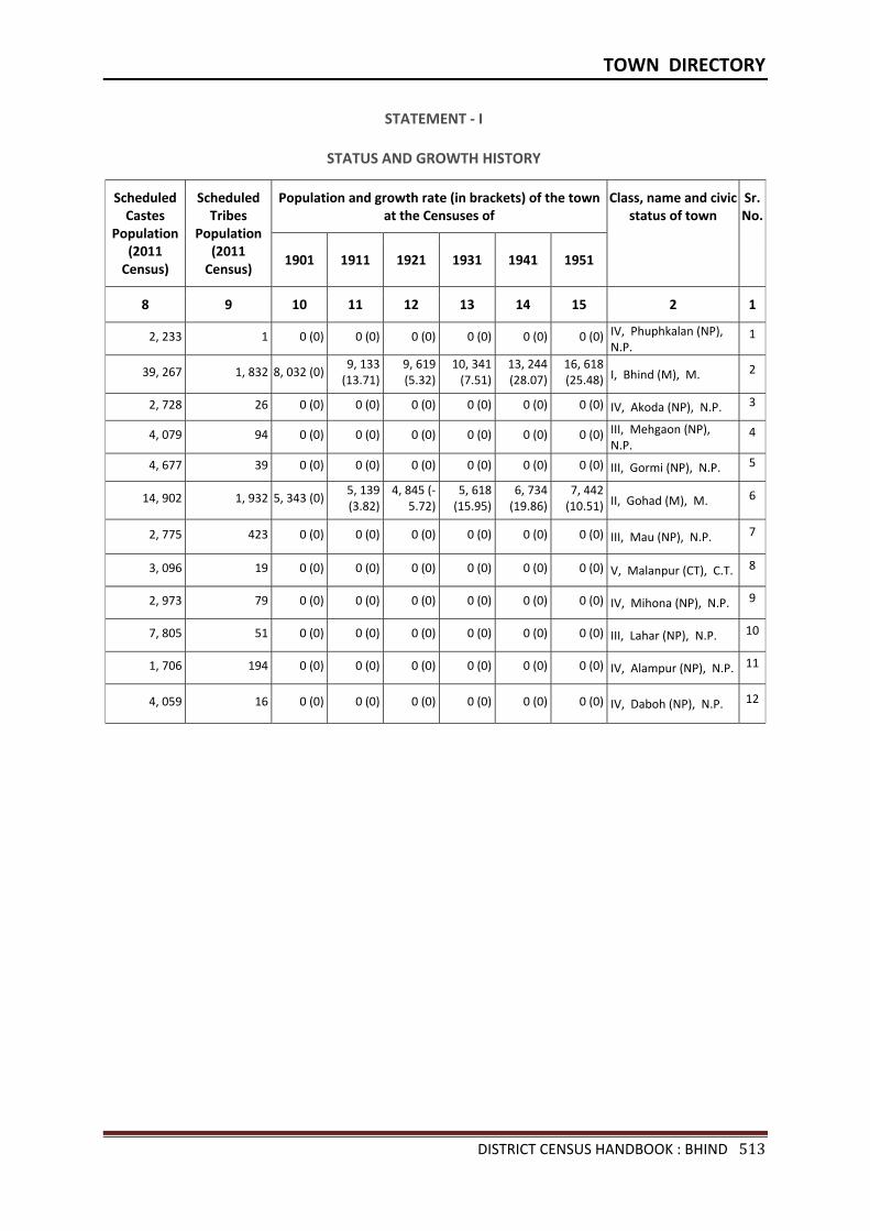
TOWN DIRECTORY
DISTRICT CENSUS HANDBOOK : BHIND 513
STATEMENT - I
STATUS AND GROWTH HISTORY
Scheduled Castes
Population (2011
Census)
Scheduled Tribes
Population (2011
Census)
Population and growth rate (in brackets) of the town at the Censuses of
Class, name and civic status of town
Sr.No.
1901 1911 1921 1931 1941 1951
8 9 10 11 12 13 14 15 2 1
2, 233 1 0 (0) 0 (0) 0 (0) 0 (0) 0 (0) 0 (0) IV, Phuphkalan (NP), N.P.
1
39, 267 1, 832 8, 032 (0) 9, 133
(13.71)9, 619 (5.32)
10, 341 (7.51)
13, 244 (28.07)
16, 618 (25.48) I, Bhind (M), M. 2
2, 728 26 0 (0) 0 (0) 0 (0) 0 (0) 0 (0) 0 (0) IV, Akoda (NP), N.P. 3
4, 079 94 0 (0) 0 (0) 0 (0) 0 (0) 0 (0) 0 (0) III, Mehgaon (NP), N.P.
4
4, 677 39 0 (0) 0 (0) 0 (0) 0 (0) 0 (0) 0 (0) III, Gormi (NP), N.P. 5
14, 902 1, 932 5, 343 (0) 5, 139 (3.82)
4, 845 (-5.72)
5, 618 (15.95)
6, 734 (19.86)
7, 442 (10.51) II, Gohad (M), M. 6
2, 775 423 0 (0) 0 (0) 0 (0) 0 (0) 0 (0) 0 (0) III, Mau (NP), N.P. 7
3, 096 19 0 (0) 0 (0) 0 (0) 0 (0) 0 (0) 0 (0) V, Malanpur (CT), C.T. 8
2, 973 79 0 (0) 0 (0) 0 (0) 0 (0) 0 (0) 0 (0) IV, Mihona (NP), N.P. 9
7, 805 51 0 (0) 0 (0) 0 (0) 0 (0) 0 (0) 0 (0) III, Lahar (NP), N.P. 10
1, 706 194 0 (0) 0 (0) 0 (0) 0 (0) 0 (0) 0 (0) IV, Alampur (NP), N.P. 11
4, 059 16 0 (0) 0 (0) 0 (0) 0 (0) 0 (0) 0 (0) IV, Daboh (NP), N.P. 12
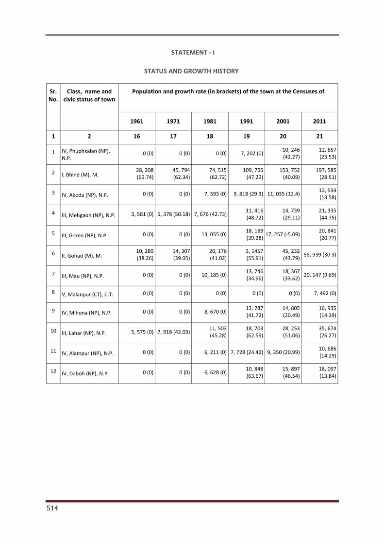
514
STATEMENT - I
STATUS AND GROWTH HISTORY
Sr. No.
Class, name and civic status of town
Population and growth rate (in brackets) of the town at the Censuses of
1961 1971 1981 1991 2001 2011
1 2 16 17 18 19 20 21
1 IV, Phuphkalan (NP), N.P.
0 (0) 0 (0) 0 (0) 7, 202 (0)10, 246 (42.27)
12, 657 (23.53)
2 I, Bhind (M), M. 28, 208 (69.74)
45, 794 (62.34)
74, 515 (62.72)
109, 755 (47.29)
153, 752 (40.09)
197, 585 (28.51)
3 IV, Akoda (NP), N.P. 0 (0) 0 (0) 7, 593 (0) 9, 818 (29.3) 11, 035 (12.4) 12, 534 (13.58)
4 III, Mehgaon (NP), N.P. 3, 581 (0) 5, 378 (50.18) 7, 676 (42.73)11, 416 (48.72)
14, 739 (29.11)
21, 335 (44.75)
5 III, Gormi (NP), N.P. 0 (0) 0 (0) 13, 055 (0)18, 183 (39.28)
17, 257 (-5.09) 20, 841 (20.77)
6 II, Gohad (M), M. 10, 289 (38.26)
14, 307 (39.05)
20, 176 (41.02)
3, 1457 (55.91)
45, 232 (43.79)
58, 939 (30.3)
7 III, Mau (NP), N.P. 0 (0) 0 (0) 10, 185 (0)13, 746 (34.96)
18, 367 (33.62)
20, 147 (9.69)
8 V, Malanpur (CT), C.T. 0 (0) 0 (0) 0 (0) 0 (0) 0 (0) 7, 492 (0)
9 IV, Mihona (NP), N.P. 0 (0) 0 (0) 8, 670 (0)12, 287 (41.72)
14, 805 (20.49)
16, 935 (14.39)
10 III, Lahar (NP), N.P. 5, 575 (0) 7, 918 (42.03)11, 503 (45.28)
18, 703 (62.59)
28, 253 (51.06)
35, 674 (26.27)
11 IV, Alampur (NP), N.P. 0 (0) 0 (0) 6, 211 (0) 7, 728 (24.42) 9, 350 (20.99) 10, 686 (14.29)
12 IV, Daboh (NP), N.P. 0 (0) 0 (0) 6, 628 (0)10, 848 (63.67)
15, 897 (46.54)
18, 097 (13.84)
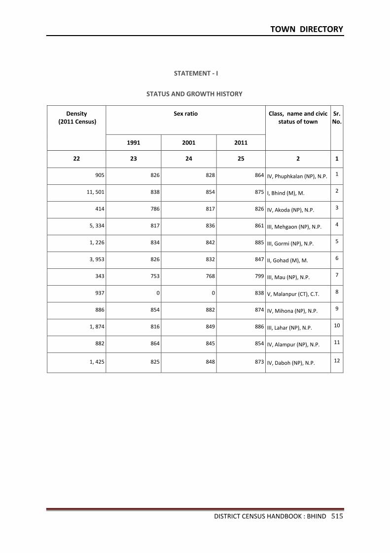
TOWN DIRECTORY
DISTRICT CENSUS HANDBOOK : BHIND 515
STATEMENT - I
STATUS AND GROWTH HISTORY
Density (2011 Census)
Sex ratio Class, name and civic status of town
Sr.No.
1991 2001 2011
22 23 24 25 2 1
905 826 828 864 IV, Phuphkalan (NP), N.P. 1
11, 501 838 854 875 I, Bhind (M), M. 2
414 786 817 826 IV, Akoda (NP), N.P. 3
5, 334 817 836 861 III, Mehgaon (NP), N.P. 4
1, 226 834 842 885 III, Gormi (NP), N.P. 5
3, 953 826 832 847 II, Gohad (M), M. 6
343 753 768 799 III, Mau (NP), N.P. 7
937 0 0 838 V, Malanpur (CT), C.T. 8
886 854 882 874 IV, Mihona (NP), N.P. 9
1, 874 816 849 886 III, Lahar (NP), N.P. 10
882 864 845 854 IV, Alampur (NP), N.P. 11
1, 425 825 848 873 IV, Daboh (NP), N.P. 12
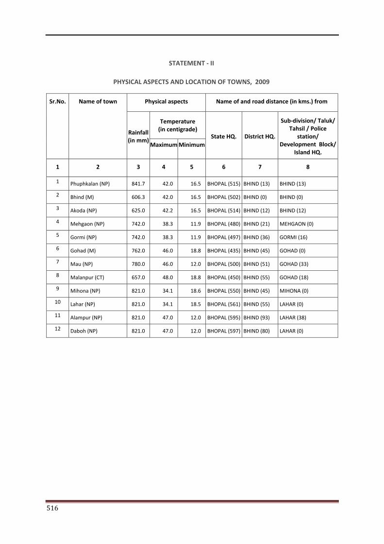
516
STATEMENT - II
PHYSICAL ASPECTS AND LOCATION OF TOWNS, 2009
Sr.No. Name of town Physical aspects Name of and road distance (in kms.) from
Rainfall (in mm)
Temperature (in centigrade)
State HQ. District HQ.
Sub-division/ Taluk/ Tahsil / Police
station/ Development Block/
Island HQ. Maximum Minimum
1 2 3 4 5 6 7 8
1 Phuphkalan (NP) 841.7 42.0 16.5 BHOPAL (515) BHIND (13) BHIND (13)
2 Bhind (M) 606.3 42.0 16.5 BHOPAL (502) BHIND (0) BHIND (0)
3 Akoda (NP) 625.0 42.2 16.5 BHOPAL (514) BHIND (12) BHIND (12)
4 Mehgaon (NP) 742.0 38.3 11.9 BHOPAL (480) BHIND (21) MEHGAON (0)
5 Gormi (NP) 742.0 38.3 11.9 BHOPAL (497) BHIND (36) GORMI (16)
6 Gohad (M) 762.0 46.0 18.8 BHOPAL (435) BHIND (45) GOHAD (0)
7 Mau (NP) 780.0 46.0 12.0 BHOPAL (500) BHIND (51) GOHAD (33)
8 Malanpur (CT) 657.0 48.0 18.8 BHOPAL (450) BHIND (55) GOHAD (18)
9 Mihona (NP) 821.0 34.1 18.6 BHOPAL (550) BHIND (45) MIHONA (0)
10 Lahar (NP) 821.0 34.1 18.5 BHOPAL (561) BHIND (55) LAHAR (0)
11 Alampur (NP) 821.0 47.0 12.0 BHOPAL (595) BHIND (93) LAHAR (38)
12 Daboh (NP) 821.0 47.0 12.0 BHOPAL (597) BHIND (80) LAHAR (0)
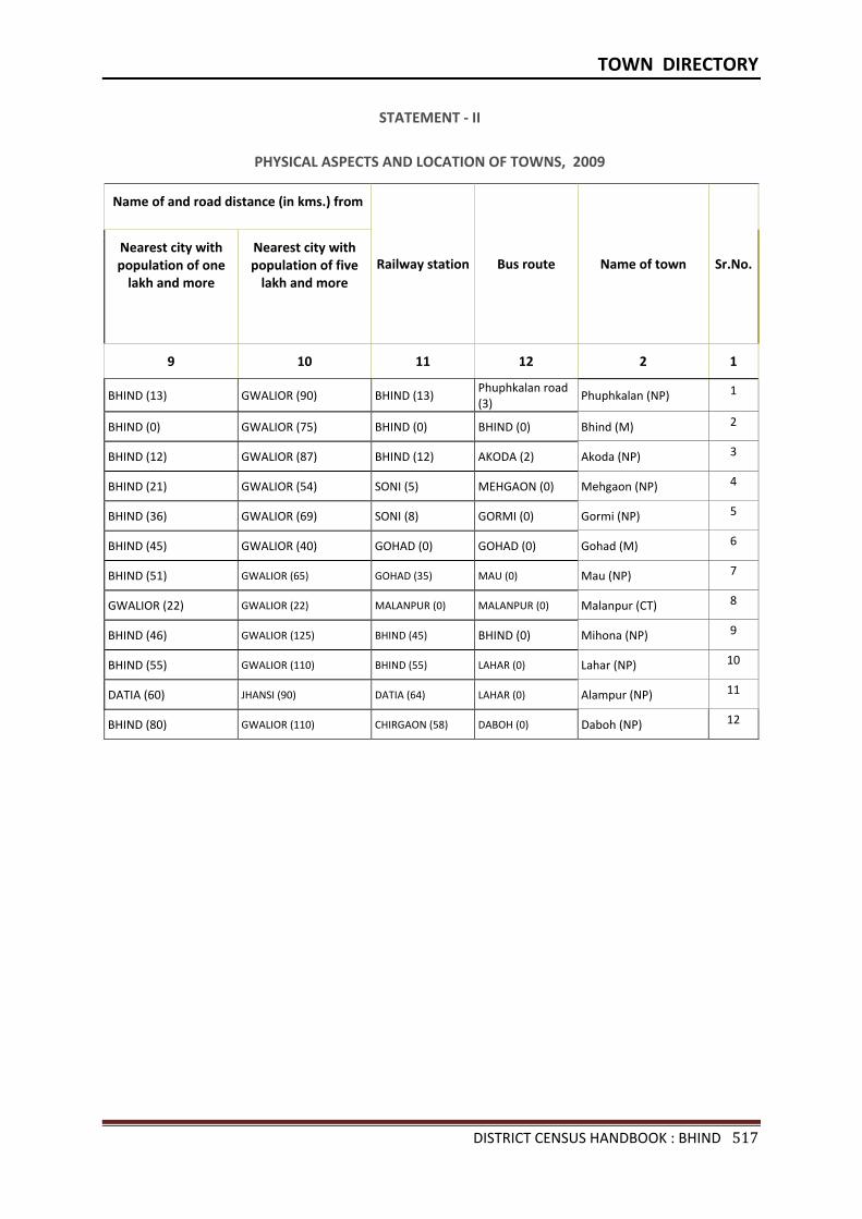
TOWN DIRECTORY
DISTRICT CENSUS HANDBOOK : BHIND 517
STATEMENT - II
PHYSICAL ASPECTS AND LOCATION OF TOWNS, 2009
Name of and road distance (in kms.) from
Railway station Bus route Name of town Sr.No.Nearest city with population of one
lakh and more
Nearest city with population of five
lakh and more
9 10 11 12 2 1
BHIND (13) GWALIOR (90) BHIND (13) Phuphkalan road (3)
Phuphkalan (NP) 1
BHIND (0) GWALIOR (75) BHIND (0) BHIND (0) Bhind (M) 2
BHIND (12) GWALIOR (87) BHIND (12) AKODA (2) Akoda (NP) 3
BHIND (21) GWALIOR (54) SONI (5) MEHGAON (0) Mehgaon (NP) 4
BHIND (36) GWALIOR (69) SONI (8) GORMI (0) Gormi (NP) 5
BHIND (45) GWALIOR (40) GOHAD (0) GOHAD (0) Gohad (M) 6
BHIND (51) GWALIOR (65) GOHAD (35) MAU (0) Mau (NP) 7
GWALIOR (22) GWALIOR (22) MALANPUR (0) MALANPUR (0) Malanpur (CT) 8
BHIND (46) GWALIOR (125) BHIND (45) BHIND (0) Mihona (NP) 9
BHIND (55) GWALIOR (110) BHIND (55) LAHAR (0) Lahar (NP) 10
DATIA (60) JHANSI (90) DATIA (64) LAHAR (0) Alampur (NP) 11
BHIND (80) GWALIOR (110) CHIRGAON (58) DABOH (0) Daboh (NP) 12
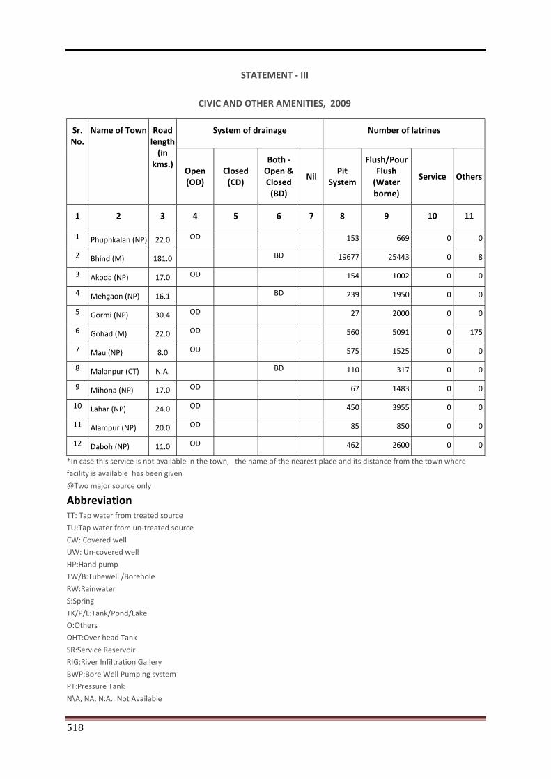
518
STATEMENT - III
CIVIC AND OTHER AMENITIES, 2009
Sr. No.
Name of Town Road length
(in kms.)
System of drainage Number of latrines
Open (OD)
Closed (CD)
Both -Open & Closed
(BD)
Nil Pit
System
Flush/Pour Flush
(Water borne)
Service Others
1 2 3 4 5 6 7 8 9 10 11
1 Phuphkalan (NP) 22.0 OD 153 669 0 0
2 Bhind (M) 181.0 BD 19677 25443 0 8
3 Akoda (NP) 17.0 OD 154 1002 0 0
4 Mehgaon (NP) 16.1 BD 239 1950 0 0
5 Gormi (NP) 30.4 OD 27 2000 0 0
6 Gohad (M) 22.0 OD 560 5091 0 175
7 Mau (NP) 8.0 OD 575 1525 0 0
8 Malanpur (CT) N.A. BD 110 317 0 0
9 Mihona (NP) 17.0 OD 67 1483 0 0
10 Lahar (NP) 24.0 OD 450 3955 0 0
11 Alampur (NP) 20.0 OD 85 850 0 0
12 Daboh (NP) 11.0 OD 462 2600 0 0
*In case this service is not available in the town, the name of the nearest place and its distance from the town where
facility is available has been given @Two major source only Abbreviation TT: Tap water from treated source TU:Tap water from un-treated source CW: Covered well UW: Un-covered well HP:Hand pump TW/B:Tubewell /Borehole
RW:Rainwater
S:Spring
TK/P/L:Tank/Pond/Lake
O:Others
OHT:Over head Tank
SR:Service Reservoir
RIG:River Infiltration Gallery
BWP:Bore Well Pumping system
PT:Pressure Tank
N\A, NA, N.A.: Not Available
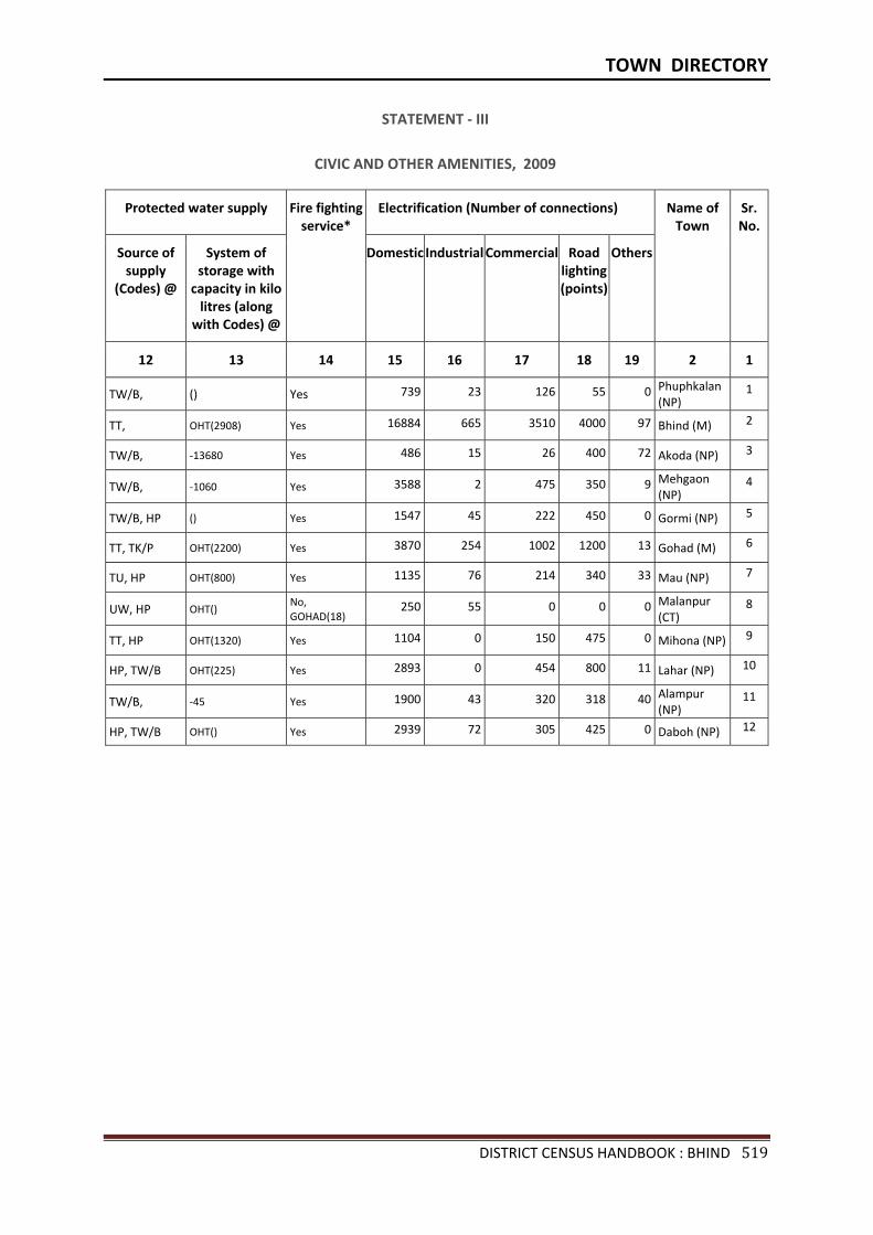
TOWN DIRECTORY
DISTRICT CENSUS HANDBOOK : BHIND 519
STATEMENT - III
CIVIC AND OTHER AMENITIES, 2009
Protected water supply Fire fighting service*
Electrification (Number of connections) Name of Town
Sr.No.
Source of supply
(Codes) @
System of storage with
capacity in kilo litres (along
with Codes) @
Domestic Industrial Commercial Road lighting (points)
Others
12 13 14 15 16 17 18 19 2 1
TW/B, () Yes 739 23 126 55 0 Phuphkalan (NP)
1
TT, OHT(2908) Yes 16884 665 3510 4000 97 Bhind (M) 2
TW/B, -13680 Yes 486 15 26 400 72 Akoda (NP) 3
TW/B, -1060 Yes 3588 2 475 350 9 Mehgaon (NP)
4
TW/B, HP () Yes 1547 45 222 450 0 Gormi (NP) 5
TT, TK/P OHT(2200) Yes 3870 254 1002 1200 13 Gohad (M) 6
TU, HP OHT(800) Yes 1135 76 214 340 33 Mau (NP) 7
UW, HP OHT() No, GOHAD(18)
250 55 0 0 0 Malanpur (CT)
8
TT, HP OHT(1320) Yes 1104 0 150 475 0 Mihona (NP) 9
HP, TW/B OHT(225) Yes 2893 0 454 800 11 Lahar (NP) 10
TW/B, -45 Yes 1900 43 320 318 40 Alampur (NP)
11
HP, TW/B OHT() Yes 2939 72 305 425 0 Daboh (NP) 12
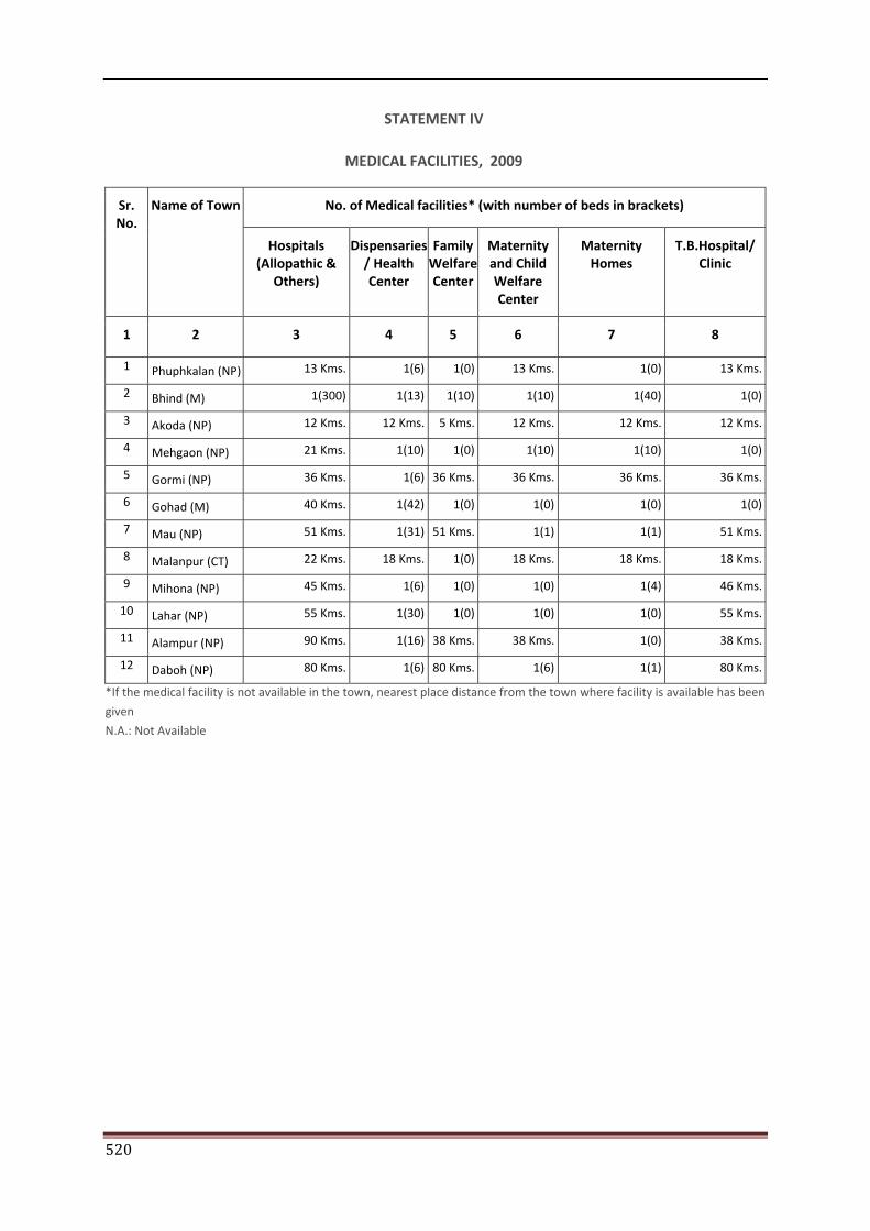
520
STATEMENT IV
MEDICAL FACILITIES, 2009
Sr. No.
Name of Town No. of Medical facilities* (with number of beds in brackets)
Hospitals (Allopathic &
Others)
Dispensaries / Health Center
Family Welfare Center
Maternity and Child Welfare Center
Maternity Homes
T.B.Hospital/ Clinic
1 2 3 4 5 6 7 8
1 Phuphkalan (NP) 13 Kms. 1(6) 1(0) 13 Kms. 1(0) 13 Kms.
2 Bhind (M) 1(300) 1(13) 1(10) 1(10) 1(40) 1(0)
3 Akoda (NP) 12 Kms. 12 Kms. 5 Kms. 12 Kms. 12 Kms. 12 Kms.
4 Mehgaon (NP) 21 Kms. 1(10) 1(0) 1(10) 1(10) 1(0)
5 Gormi (NP) 36 Kms. 1(6) 36 Kms. 36 Kms. 36 Kms. 36 Kms.
6 Gohad (M) 40 Kms. 1(42) 1(0) 1(0) 1(0) 1(0)
7 Mau (NP) 51 Kms. 1(31) 51 Kms. 1(1) 1(1) 51 Kms.
8 Malanpur (CT) 22 Kms. 18 Kms. 1(0) 18 Kms. 18 Kms. 18 Kms.
9 Mihona (NP) 45 Kms. 1(6) 1(0) 1(0) 1(4) 46 Kms.
10 Lahar (NP) 55 Kms. 1(30) 1(0) 1(0) 1(0) 55 Kms.
11 Alampur (NP) 90 Kms. 1(16) 38 Kms. 38 Kms. 1(0) 38 Kms.
12 Daboh (NP) 80 Kms. 1(6) 80 Kms. 1(6) 1(1) 80 Kms.
*If the medical facility is not available in the town, nearest place distance from the town where facility is available has been
given N.A.: Not Available
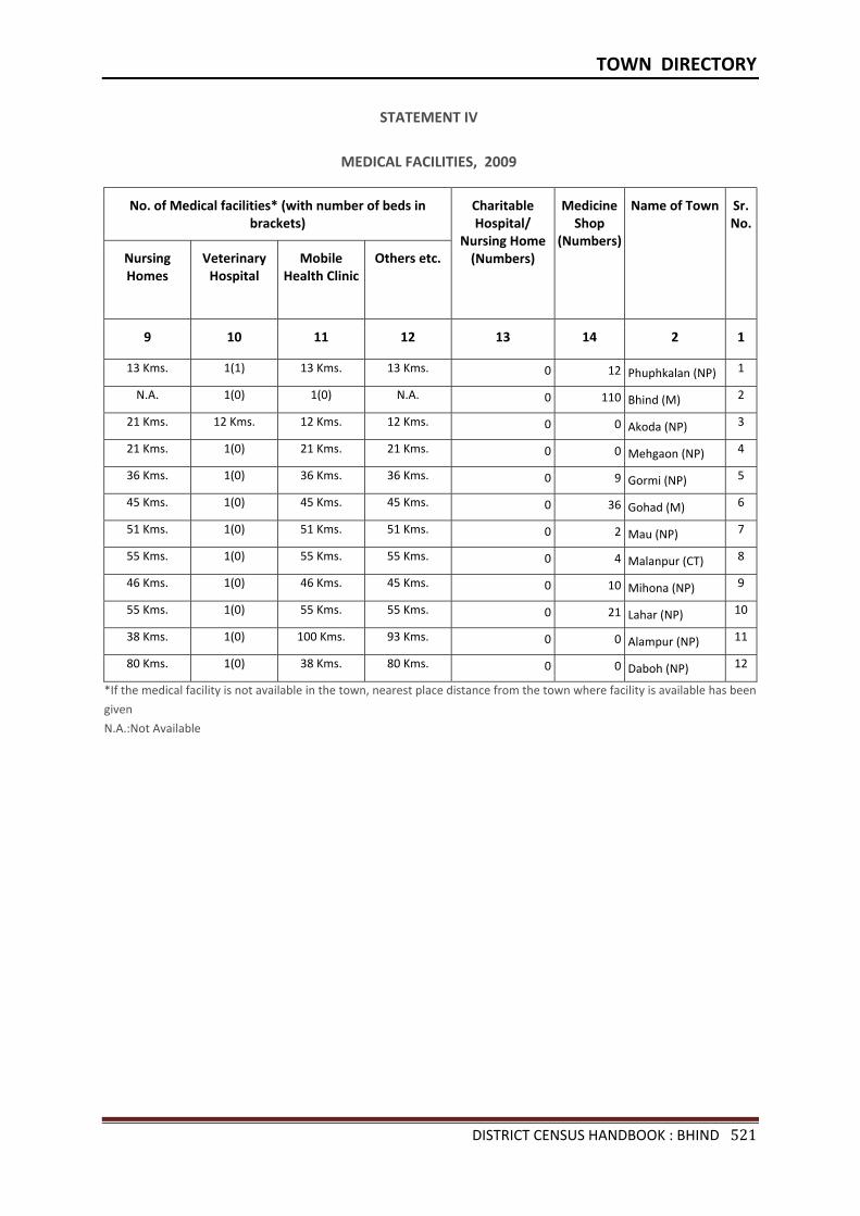
TOWN DIRECTORY
DISTRICT CENSUS HANDBOOK : BHIND 521
STATEMENT IV
MEDICAL FACILITIES, 2009
No. of Medical facilities* (with number of beds in brackets)
Charitable Hospital/
Nursing Home (Numbers)
Medicine Shop
(Numbers)
Name of Town Sr.No.
Nursing Homes
Veterinary Hospital
Mobile Health Clinic
Others etc.
9 10 11 12 13 14 2 1
13 Kms. 1(1) 13 Kms. 13 Kms. 0 12 Phuphkalan (NP) 1
N.A. 1(0) 1(0) N.A. 0 110 Bhind (M) 2
21 Kms. 12 Kms. 12 Kms. 12 Kms. 0 0 Akoda (NP) 3
21 Kms. 1(0) 21 Kms. 21 Kms. 0 0 Mehgaon (NP) 4
36 Kms. 1(0) 36 Kms. 36 Kms. 0 9 Gormi (NP) 5
45 Kms. 1(0) 45 Kms. 45 Kms. 0 36 Gohad (M) 6
51 Kms. 1(0) 51 Kms. 51 Kms. 0 2 Mau (NP) 7
55 Kms. 1(0) 55 Kms. 55 Kms. 0 4 Malanpur (CT) 8
46 Kms. 1(0) 46 Kms. 45 Kms. 0 10 Mihona (NP) 9
55 Kms. 1(0) 55 Kms. 55 Kms. 0 21 Lahar (NP) 10
38 Kms. 1(0) 100 Kms. 93 Kms. 0 0 Alampur (NP) 11
80 Kms. 1(0) 38 Kms. 80 Kms. 0 0 Daboh (NP) 12
*If the medical facility is not available in the town, nearest place distance from the town where facility is available has been
given N.A.:Not Available
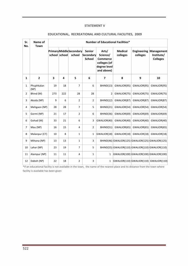
522
STATEMENT V
EDUCATIONAL, RECREATIONAL AND CULTURAL FACILITIES, 2009
Sr. No.
Name of Town
Number of Educational Facilities*
Primary school
Middle school
Secondary school
Senior Secondary
School
Arts/ Science/
Commerce colleges (of degree level and above)
Medical colleges
Engineering colleges
Management Institute/ Colleges
1 2 3 4 5 6 7 8 9 10
1 Phuphkalan (NP)
19 18 7 6 BHIND(13) GWALIOR(95) GWALIOR(95) GWALIOR(95)
2 Bhind (M) 273 222 28 28 2 GWALIOR(75) GWALIOR(75) GWALIOR(75)
3 Akoda (NP) 9 6 2 2 BHIND(12) GWALIOR(87) GWALIOR(87) GWALIOR(87)
4 Mehgaon (NP) 28 28 7 5 BHIND(21) GWALIOR(54) GWALIOR(54) GWALIOR(54)
5 Gormi (NP) 21 17 2 6 BHIND(36) GWALIOR(69) GWALIOR(69) GWALIOR(69)
6 Gohad (M) 33 21 6 3 GWALIOR(40) GWALIOR(40) GWALIOR(40) GWALIOR(40)
7 Mau (NP) 16 15 4 2 BHIND(51) GWALIOR(65) GWALIOR(65) GWALIOR(65)
8 Malanpur (CT) 10 8 1 1 GWALIOR(18) GWALIOR(18) GWALIOR(18) GWALIOR(18)
9 Mihona (NP) 13 13 1 3 BHIND(46) GWALIOR(125) GWALIOR(125) GWALIOR(125)
10 Lahar (NP) 23 19 7 5 BHIND(55) GWALIOR(110) GWALIOR(110) GWALIOR(110)
11 Alampur (NP) 11 11 4 1 1 GWALIOR(100) GWALIOR(100) GWALIOR(100)
12 Daboh (NP) 22 18 2 3 1 GWALIOR(110) GWALIOR(110) GWALIOR(110)
*If an educational facility is not available in the town, the name of the nearest place and its distance from the town where
facility is available has been given

TOWN DIRECTORY
DISTRICT CENSUS HANDBOOK : BHIND 523
STATEMENT V
EDUCATIONAL, RECREATIONAL AND CULTURAL FACILITIES, 2009
Number of Educational Facilities* Name of Town Sr. No.
Polytechnics Recognised Shorthand, Typewriting
and vocational training
Institutions
Non-formal Education
Center (Sarva Shiksha Abhiyan
Center)
Special School for Disabled
Others
11 12 13 14 15 2 1
BHIND(13) BHIND(13) BHIND(13) GWALIOR(88) GWALIOR(75) Phuphkalan (NP) 1
1 1 1 GWALIOR(75) GWALIOR(75) Bhind (M) 2
BHIND(12) BHIND(12) BHIND(12) GWALIOR(87) GWALIOR(87) Akoda (NP) 3
BHIND(21) BHIND(21) 1 GORMI(15) 3 Mehgaon (NP) 4
BHIND(36) BHIND(36) MEHGAON(16) BHIND(36) BHIND(36) Gormi (NP) 5
GWALIOR(40) GWALIOR(40) 1 GWALIOR(40) BHIND(45) Gohad (M) 6
BHIND(51) BHIND(51) BHIND(51) GWALIOR(65) GWALIOR(65) Mau (NP) 7
GWALIOR(18) GWALIOR(18) GWALIOR(18) GWALIOR(18) GWALIOR(18) Malanpur (CT) 8
BHIND(46) BHIND(46) 4 GWALIOR(125) GWALIOR(125) Mihona (NP) 9
GWALIOR(110) BHIND(55) 1 GWALIOR(110) 1 Lahar (NP) 10
GWALIOR(100) BHIND(93) LAHAR(38) GWALIOR(100) 16 Alampur (NP) 11
GWALIOR(110) BHIND(80) 1 GWALIOR(110) GWALIOR(110) Daboh (NP) 12
*If an educational facility is not available in the town, the name of the nearest place and its distance from the town where
facility is available has been given
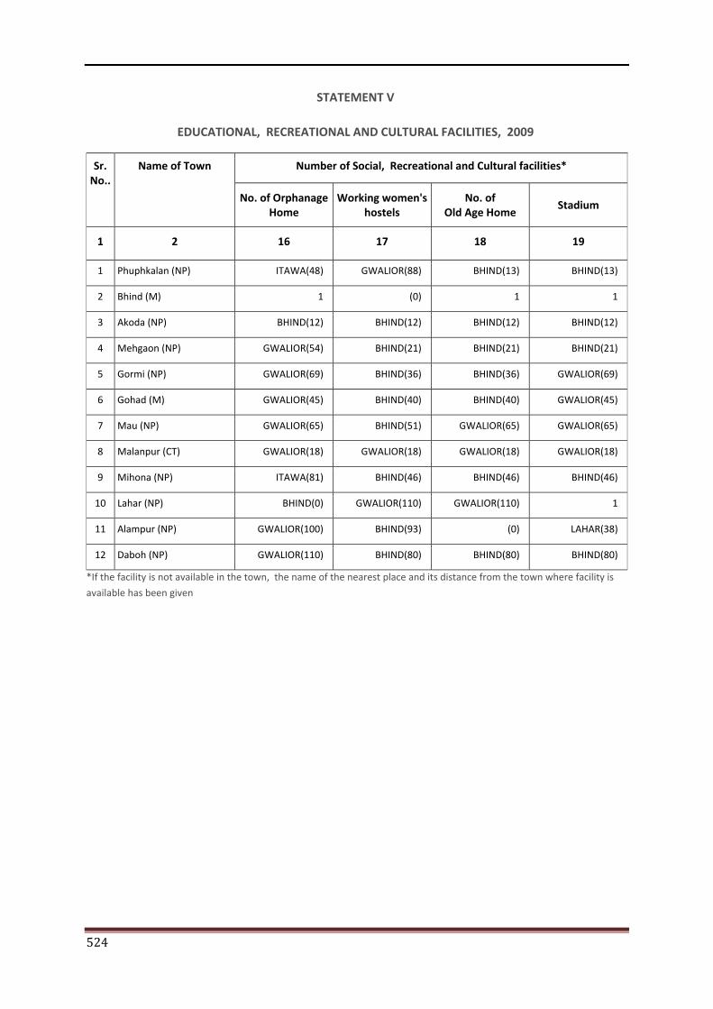
524
STATEMENT V
EDUCATIONAL, RECREATIONAL AND CULTURAL FACILITIES, 2009
Sr. No..
Name of Town Number of Social, Recreational and Cultural facilities*
No. of Orphanage Home
Working women's hostels
No. of Old Age Home
Stadium
1 2 16 17 18 19
1 Phuphkalan (NP) ITAWA(48) GWALIOR(88) BHIND(13) BHIND(13)
2 Bhind (M) 1 (0) 1 1
3 Akoda (NP) BHIND(12) BHIND(12) BHIND(12) BHIND(12)
4 Mehgaon (NP) GWALIOR(54) BHIND(21) BHIND(21) BHIND(21)
5 Gormi (NP) GWALIOR(69) BHIND(36) BHIND(36) GWALIOR(69)
6 Gohad (M) GWALIOR(45) BHIND(40) BHIND(40) GWALIOR(45)
7 Mau (NP) GWALIOR(65) BHIND(51) GWALIOR(65) GWALIOR(65)
8 Malanpur (CT) GWALIOR(18) GWALIOR(18) GWALIOR(18) GWALIOR(18)
9 Mihona (NP) ITAWA(81) BHIND(46) BHIND(46) BHIND(46)
10 Lahar (NP) BHIND(0) GWALIOR(110) GWALIOR(110) 1
11 Alampur (NP) GWALIOR(100) BHIND(93) (0) LAHAR(38)
12 Daboh (NP) GWALIOR(110) BHIND(80) BHIND(80) BHIND(80)
*If the facility is not available in the town, the name of the nearest place and its distance from the town where facility is
available has been given
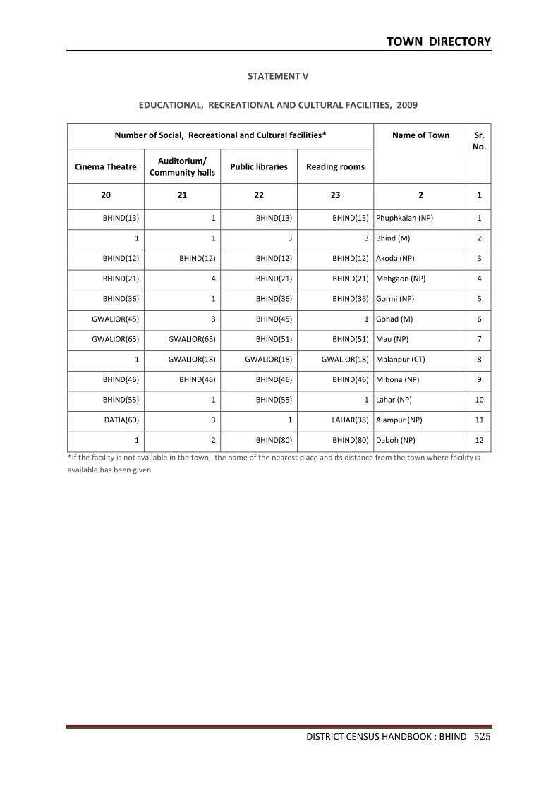
TOWN DIRECTORY
DISTRICT CENSUS HANDBOOK : BHIND 525
STATEMENT V
EDUCATIONAL, RECREATIONAL AND CULTURAL FACILITIES, 2009
Number of Social, Recreational and Cultural facilities* Name of Town Sr. No.
Cinema Theatre
Auditorium/ Community halls
Public libraries Reading rooms
20 21 22 23 2 1
BHIND(13) 1 BHIND(13) BHIND(13) Phuphkalan (NP) 1
1 1 3 3 Bhind (M) 2
BHIND(12) BHIND(12) BHIND(12) BHIND(12) Akoda (NP) 3
BHIND(21) 4 BHIND(21) BHIND(21) Mehgaon (NP) 4
BHIND(36) 1 BHIND(36) BHIND(36) Gormi (NP) 5
GWALIOR(45) 3 BHIND(45) 1 Gohad (M) 6
GWALIOR(65) GWALIOR(65) BHIND(51) BHIND(51) Mau (NP) 7
1 GWALIOR(18) GWALIOR(18) GWALIOR(18) Malanpur (CT) 8
BHIND(46) BHIND(46) BHIND(46) BHIND(46) Mihona (NP) 9
BHIND(55) 1 BHIND(55) 1 Lahar (NP) 10
DATIA(60) 3 1 LAHAR(38) Alampur (NP) 11
1 2 BHIND(80) BHIND(80) Daboh (NP) 12
*If the facility is not available in the town, the name of the nearest place and its distance from the town where facility is
available has been given
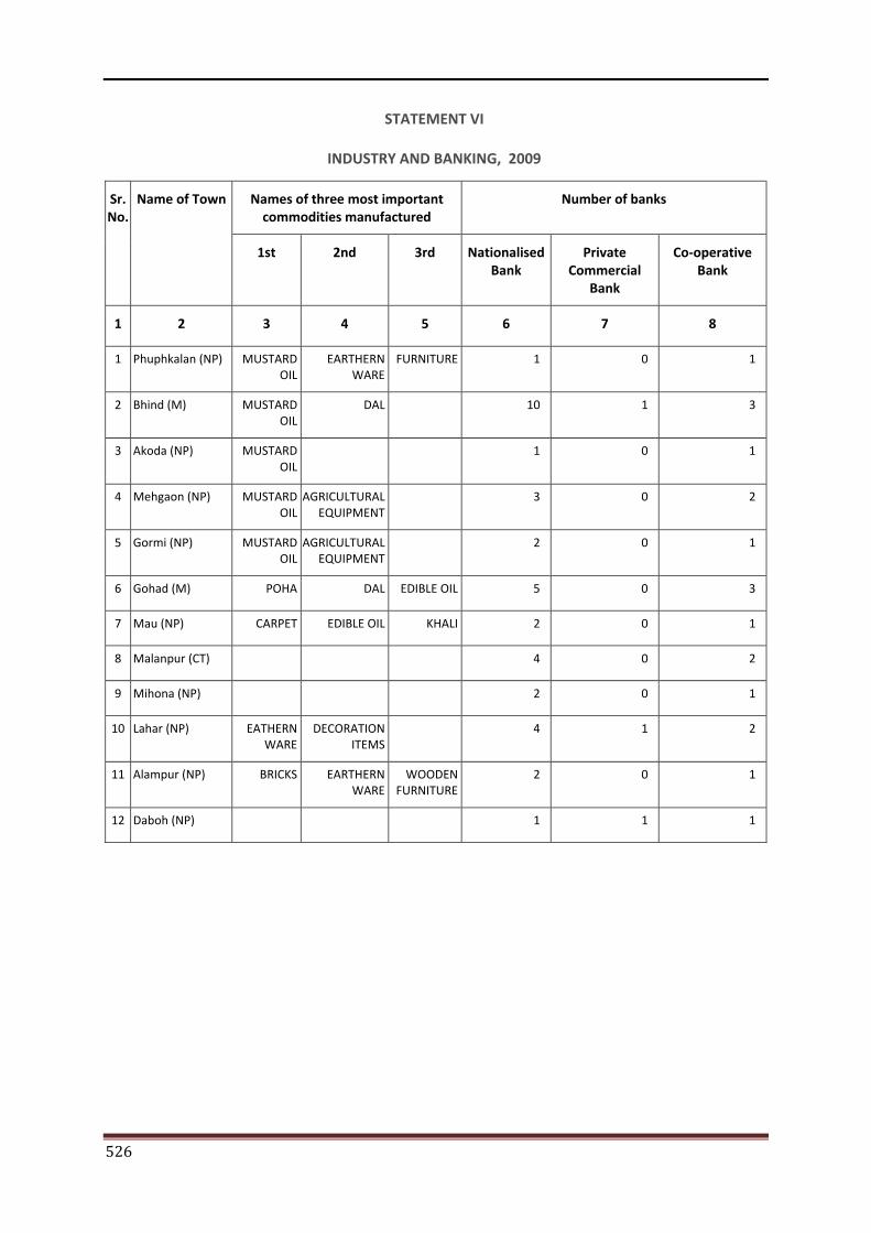
526
STATEMENT VI
INDUSTRY AND BANKING, 2009
Sr. No.
Name of Town Names of three most important commodities manufactured
Number of banks
1st 2nd 3rd Nationalised Bank
Private Commercial
Bank
Co-operative Bank
1 2 3 4 5 6 7 8
1 Phuphkalan (NP) MUSTARD OIL
EARTHERN WARE
FURNITURE 1 0 1
2 Bhind (M) MUSTARD OIL
DAL 10 1 3
3 Akoda (NP) MUSTARD OIL
1 0 1
4 Mehgaon (NP) MUSTARD OIL
AGRICULTURAL EQUIPMENT
3 0 2
5 Gormi (NP) MUSTARD OIL
AGRICULTURAL EQUIPMENT
2 0 1
6 Gohad (M) POHA DAL EDIBLE OIL 5 0 3
7 Mau (NP) CARPET EDIBLE OIL KHALI 2 0 1
8 Malanpur (CT) 4 0 2
9 Mihona (NP) 2 0 1
10 Lahar (NP) EATHERN WARE
DECORATION ITEMS
4 1 2
11 Alampur (NP) BRICKS EARTHERN WARE
WOODEN FURNITURE
2 0 1
12 Daboh (NP) 1 1 1
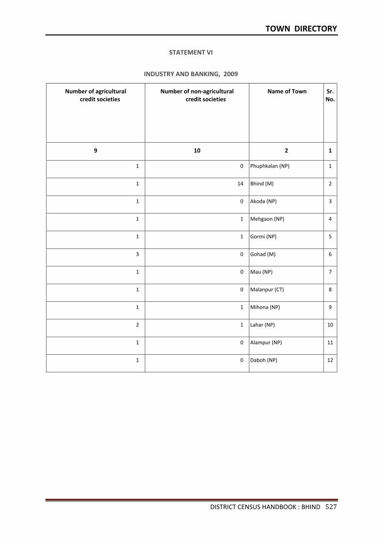
TOWN DIRECTORY
DISTRICT CENSUS HANDBOOK : BHIND 527
STATEMENT VI
INDUSTRY AND BANKING, 2009
Number of agricultural credit societies
Number of non-agricultural credit societies
Name of Town Sr. No.
9 10 2 1
1 0 Phuphkalan (NP) 1
1 14 Bhind (M) 2
1 0 Akoda (NP) 3
1 1 Mehgaon (NP) 4
1 1 Gormi (NP) 5
3 0 Gohad (M) 6
1 0 Mau (NP) 7
1 0 Malanpur (CT) 8
1 1 Mihona (NP) 9
2 1 Lahar (NP) 10
1 0 Alampur (NP) 11
1 0 Daboh (NP) 12
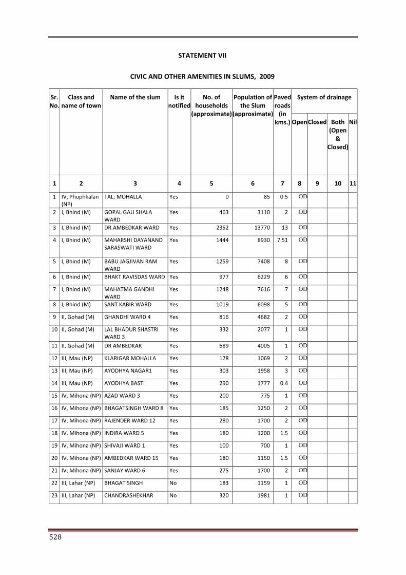
528
STATEMENT VII
CIVIC AND OTHER AMENITIES IN SLUMS, 2009
Sr. No.
Class and name of town
Name of the slum Is it notified
No. of households
(approximate)
Population of the Slum
(approximate)
Paved roads
(in kms.)
System of drainage
Open Closed Both (Open
& Closed)
Nil
1 2 3 4 5 6 7 8 9 10 11
1 IV, Phuphkalan (NP)
TAL; MOHALLA Yes 0 85 0.5 OD
2 I, Bhind (M) GOPAL GAU SHALA WARD
Yes 463 3110 2 OD
3 I, Bhind (M) DR.AMBEDKAR WARD Yes 2352 13770 13 OD
4 I, Bhind (M) MAHARSHI DAYANAND SARASWATI WARD
Yes 1444 8930 7.51 OD
5 I, Bhind (M) BABU JAGJIVAN RAM WARD
Yes 1259 7408 8 OD
6 I, Bhind (M) BHAKT RAVISDAS WARD Yes 977 6229 6 OD
7 I, Bhind (M) MAHATMA GANDHI WARD
Yes 1248 7616 7 OD
8 I, Bhind (M) SANT KABIR WARD Yes 1019 6098 5 OD
9 II, Gohad (M) GHANDHI WARD 4 Yes 816 4682 2 OD
10 II, Gohad (M) LAL BHADUR SHASTRI WARD 3
Yes 332 2077 1 OD
11 II, Gohad (M) DR AMBEDKAR Yes 689 4005 1 OD
12 III, Mau (NP) KLARIGAR MOHALLA Yes 178 1069 2 OD
13 III, Mau (NP) AYODHYA NAGAR1 Yes 303 1958 3 OD
14 III, Mau (NP) AYODHYA BASTI Yes 290 1777 0.4 OD
15 IV, Mihona (NP) AZAD WARD 3 Yes 200 775 1 OD
16 IV, Mihona (NP) BHAGATSINGH WARD 8 Yes 185 1250 2 OD
17 IV, Mihona (NP) RAJENDER WARD 12 Yes 280 1700 2 OD
18 IV, Mihona (NP) INDIRA WARD 5 Yes 180 1200 1.5 OD
19 IV, Mihona (NP) SHIVAJI WARD 1 Yes 100 700 1 OD
20 IV, Mihona (NP) AMBEDKAR WARD 15 Yes 180 1150 1.5 OD
21 IV, Mihona (NP) SANJAY WARD 6 Yes 275 1700 2 OD
22 III, Lahar (NP) BHAGAT SINGH No 183 1159 1 OD
23 III, Lahar (NP) CHANDRASHEKHAR No 320 1981 1 OD
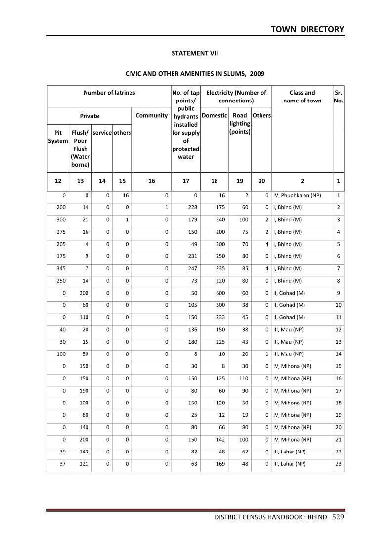
TOWN DIRECTORY
DISTRICT CENSUS HANDBOOK : BHIND 529
STATEMENT VII
CIVIC AND OTHER AMENITIES IN SLUMS, 2009
Number of latrines
No. of tap points/ public
hydrants installed
for supply of
protected water
Electricity (Number of connections)
Class and name of town
Sr.No.
Private Community Domestic Road lighting (points)
Others
Pit System
Flush/ Pour Flush
(Water borne)
service others
12 13 14 15 16 17 18 19 20 2 1
0 0 0 16 0 0 16 2 0 IV, Phuphkalan (NP) 1
200 14 0 0 1 228 175 60 0 I, Bhind (M) 2
300 21 0 1 0 179 240 100 2 I, Bhind (M) 3
275 16 0 0 0 150 200 75 2 I, Bhind (M) 4
205 4 0 0 0 49 300 70 4 I, Bhind (M) 5
175 9 0 0 0 231 250 80 0 I, Bhind (M) 6
345 7 0 0 0 247 235 85 4 I, Bhind (M) 7
250 14 0 0 0 73 220 80 0 I, Bhind (M) 8
0 200 0 0 0 50 600 60 0 II, Gohad (M) 9
0 60 0 0 0 105 300 38 0 II, Gohad (M) 10
0 110 0 0 0 150 233 45 0 II, Gohad (M) 11
40 20 0 0 0 136 150 38 0 III, Mau (NP) 12
30 15 0 0 0 180 225 43 0 III, Mau (NP) 13
100 50 0 0 0 8 10 20 1 III, Mau (NP) 14
0 150 0 0 0 30 8 30 0 IV, Mihona (NP) 15
0 150 0 0 0 150 125 110 0 IV, Mihona (NP) 16
0 190 0 0 0 80 60 90 0 IV, Mihona (NP) 17
0 100 0 0 0 150 120 50 0 IV, Mihona (NP) 18
0 80 0 0 0 25 12 19 0 IV, Mihona (NP) 19
0 140 0 0 0 80 66 80 0 IV, Mihona (NP) 20
0 200 0 0 0 150 142 100 0 IV, Mihona (NP) 21
39 143 0 0 0 82 48 62 0 III, Lahar (NP) 22
37 121 0 0 0 63 169 48 0 III, Lahar (NP) 23
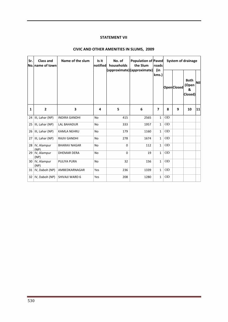
530
STATEMENT VII
CIVIC AND OTHER AMENITIES IN SLUMS, 2009
Sr. No.
Class and name of town
Name of the slum Is it notified
No. of households
(approximate)
Population of the Slum
(approximate)
Paved roads
(in kms.)
System of drainage
Open Closed
Both (Open
& Closed)
Nil
1 2 3 4 5 6 7 8 9 10 11
24 III, Lahar (NP) INDIRA GANDHI No 415 2565 1 OD
25 III, Lahar (NP) LAL BAHADUR No 333 1957 1 OD
26 III, Lahar (NP) KAMLA NEHRU No 179 1160 1 OD
27 III, Lahar (NP) RAJIV GANDHI No 278 1674 1 OD
28 IV, Alampur (NP)
BHARAV NAGAR No 0 112 1 OD
29 IV, Alampur (NP)
DHEMAR DERA No 0 19 1 OD
30 IV, Alampur (NP)
PULIYA PURA No 32 156 1 OD
31 IV, Daboh (NP) AMBEDKARNAGAR Yes 236 1339 1 OD
32 IV, Daboh (NP) SHIVAJI WARD 6 Yes 208 1280 1 OD
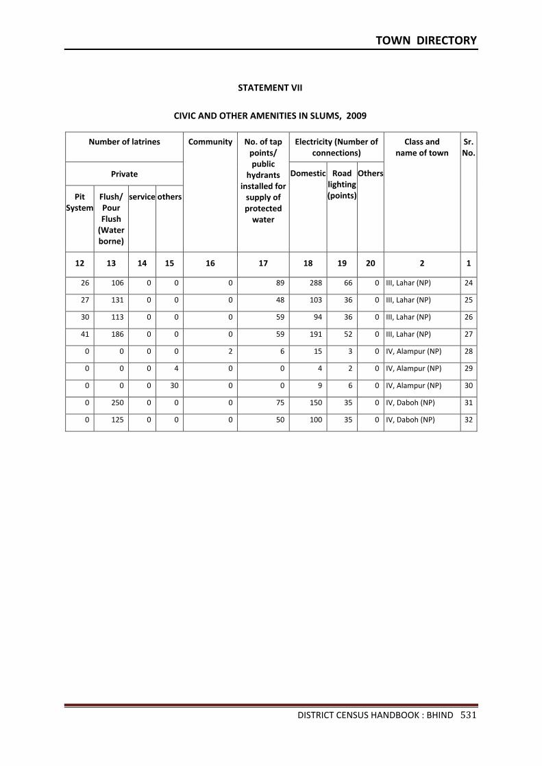
TOWN DIRECTORY
DISTRICT CENSUS HANDBOOK : BHIND 531
STATEMENT VII
CIVIC AND OTHER AMENITIES IN SLUMS, 2009
Number of latrines Community
No. of tap points/ public
hydrants installed for
supply of protected
water
Electricity (Number of connections)
Class and name of town
Sr.No.
Private Domestic Road lighting (points)
Others
Pit System
Flush/ Pour Flush
(Water borne)
service others
12 13 14 15 16 17 18 19 20 2 1
26 106 0 0 0 89 288 66 0 III, Lahar (NP) 24
27 131 0 0 0 48 103 36 0 III, Lahar (NP) 25
30 113 0 0 0 59 94 36 0 III, Lahar (NP) 26
41 186 0 0 0 59 191 52 0 III, Lahar (NP) 27
0 0 0 0 2 6 15 3 0 IV, Alampur (NP) 28
0 0 0 4 0 0 4 2 0 IV, Alampur (NP) 29
0 0 0 30 0 0 9 6 0 IV, Alampur (NP) 30
0 250 0 0 0 75 150 35 0 IV, Daboh (NP) 31
0 125 0 0 0 50 100 35 0 IV, Daboh (NP) 32
532
APPENDIX TO TOWN DIRECTORY
TOWNS SHOWING THEIR OUTGROWTH WITH POPULATION
Sr.No. Name of Town with Location Code
Population of Core Town
Name of Outgrowth Population of Outgrowth
1 2 3 4 5
Nil

ORGI-MADHYA PRADESH ENGLISH (10-2011)
2011
Directorate of Census Operations, Madhya PradeshMinistry of Home Affairs,
Janganana Bhawan,Arera Hills, Jail Road, Bhopal - 462004
Email : [email protected]: http://www.censusindia.gov.in


